Årsbok Yearbook 2007 - Polarforskningssekretariatet
146
Årsbok Yearbook 2007 Polarforskningssekretariatet Swedish Polar Research Secretariat
-
Upload
khangminh22 -
Category
Documents
-
view
0 -
download
0
Transcript of Årsbok Yearbook 2007 - Polarforskningssekretariatet

Polarforskningssekretariatet
Polarforskningssekretariatet är en statlig myndighet med uppgift att främja och samordna svensk polarforskning. Det innebär bl.a. att följa och planera forskning och utvecklingsarbete samt organisera och genomföra forskningsexpeditioner i Arktis och Antarktis. Polarforskningssekretariatet är förvaltningsmyndighet för lagen (2006:924) om Antarktis och prövar frågor om tillstånd för vistelse eller verksamhet i enlighet med lagen.
The task of the Swedish Polar Research Secretariat is to promote and co-ordinate Swedish polar research. This means e.g. to follow and plan research and development and to organise and lead research expeditions to the Arctic and Antarctic regions. The Swedish Polar Research Secretariat is the administrative authority for the Act on Antarctica (2006:924) and handles permit issues for visits or activities in accordance with the Act.
ISSN 1402-2613
ISBN 978-91-973879-7-2
Swedish P
olar Research Secretariat
Årsbok Yearbook 2007
Årsbok Yearbook 2007
Polarforskningssekretariatet Swedish Polar Research Secretariat

© Polarforskningssekretariatet 2008
Redaktör Sofia Rickberg
Produktion och grafisk form Jerhammar & Co Reklambyrå AB
www.jerhammar.se
Tryck NRS Tryckeri AB
Polarforskningssekretariatet
Box 50003
104 05 Stockholm
Tel 08-673 96 00
Fax 08-15 20 57
www.polar.se
ISSN 1402-2613
ISBN 978-91-973879-7-2
FotoDaniel Fredh s. 2–3, 9
Polarforskningssekretariatet s. 4, 5, 16, 18, 48
Martin Jakobsson s. 4, 8, 125
Pär Comstedt s. 7
Björn Eriksson s. 10
Radovan Krejci s. 10, 20, 49
Robert Schwarz s. 11
Dag Avango s. 12
Ingvar Eliasson s. 13, 20, 79
Johan Ström s. 14-15
Centrum för vetenskapshistoria,
Kungl. Vetenskapsakademien s. 16, 19
Station Alpine Joseph Fourier s. 17
Linnéherbariet,
Naturhistoriska Riksmuséet s. 17
Kartor del 1 Stig Söderlind
Engelsk språkgranskning del 3 och översättning av bildtexter del 1Amanda Roberts
Översättning del 1Proper English AB
Årsbok Yearbook 2007
Polarforskningssekretariatet Swedish Polar Research Secretariat
Omslag Cover Isbrytaren Oden anlöpte Antarktis för första
gången någonsin under 2007, efter många
framgångsrika expeditioner i Arktis.
During 2007, the icebreaker Oden made its
first ever voyage to Antarctica, following many
successful expeditions in the Arctic.
Innehållsförteckning Table of contentGlaciären Eqalorutsit kangigdlît sermiat kalvar
längst in i Bredefjord, även kallad Nordre
Sermilik, på södra Grönland.
The Eqalorutsit Kangigdlît Sermiat glacier calving
in the inner reaches of Bredefjord, also known
as Nordre Sermilik, on southern Greenland.

2 VERKSAMHETEN ACTIVITIES ÅRSBOK YEARBOOK 2007 3
Innehåll Content
Förord
4
Del ett Part one Verksamheten 2007 Activities 2007
Väsentliga uppgifter
43
Undertecknande
44
Bilaga 1
45
Bilaga 2
46
Foreword
5
Polaråret som gått
7
The past polar year
9
Anton Rolandson Martin
12
Anton Rolandson Martin
17
Noter
40

2 VERKSAMHETEN ACTIVITIES ÅRSBOK YEARBOOK 2007 3
SWEDARP 2006/07
49
Del tre Part three Forskarrapporter Cruise Reports
Innehållsförteckning Content
48
Del två Part two Årsredovisning 2007 Annual Report 2007
Resultatredovisning
22
Resultaträkning
36
Balansräkning
37
Anslagsredovisning
38
Tilläggsupplysningar
39
Innehållsförteckning
21
SWEDARCTIC 2007 LOMROG 2007
79 125

ÅRSBOK YEARBOOK 2007 5
2007 var året då polarområdena tillsammans
med Carl von Linné stod i fokus. Verksamheten
har i hög grad präglats av det Internationella
polaråret 2007–2008 (IPY), som i Sverige in-
vigdes den 1 mars på Icehotel i Jukkasjärvi. Den
internationella invigningen gick av stapeln i Paris
samma dag. Intresset för polarforskning har varit
och är stort. EU-parlamentet ägnade en hel dag i
Strasbourg åt att diskutera polarforskningen och
hur den berör Europas folk.
För att synliggöra polaråret för allmänheten
har åtta av de arktiska länderna samarbetat kring
en frimärksutgåva. Sekretariatet har tillsammans
med Posten tagit fram två frimärken efter för-
lagor av Svenerik Jakobsson och Johan Petterson,
vilka båda deltagit i polarexpeditioner genom
sekretariatets konstnärsprogram.
Installationen av ett multibeam-ekolodsystem
på isbrytaren Oden blev klart under våren, och
fartyget blev därmed ett av världens bäst utrust-
ade forskningsfartyg. I Köpenhamn besökte IPY:s
nationella beskyddare – de svenska och danska
tronföljarna – fartyget och därefter avseglade
Oden till ett av de mest svårtillgängliga områdena
på jorden: Ishavet norr om Grönland, där inga
ytgående fartyg tidigare har varit. De svenska
och danska forskarna inom forskningsprogram-
met LOMROG har där bedrivit vetenskapliga
undersökningar inom maringeologi, geofysik,
oceanografi och marinkemi. De högupplösta
bilder av havsbotten och dess underliggande
sedimentlager som det nya ekolodet möjliggjort,
har gett forskarna nya pusselbitar från delar av
Arktis som är i det närmaste outforskade.
Polarforskningssekretariatet har under året
framgångsrikt börjat med en internationell
tjänsteexport av sitt kunnande. Detta har bl.a.
möjliggjort expeditionen AGAVE, men det har
också inneburit ett delvis förändrat arbetssätt och
tagit mycket av personalens tid i anspråk.
Den gamla forskningsstationen Kinnvika på
Svalbard – som byggdes under Internationella
geofysiska året 1957–1958 och som bara använts
sporadiskt under nästan femtio år – har med
anledning av IPY åter tagits i fullt bruk. Trots
stormar och oväder har forskningen där varit
framgångsrik och den kommer att fortsätta två
säsonger till.
I slutet av november avslutades Odens långa
transitresa till Antarktis när isbrytaren för andra
gången gick till Antarktis i ett lyckat samarbete
med den amerikanske forskningsfinansiären
NSF. Den svenska gruppen inom den japansk-
svenska samarbetstraversen JASE påbörjade
ungefär samtidigt en sedan länge planerad
300 mil lång resa över högplatån för att möta
den japanska gruppen i juletid.
Året som gått har varit framgångsrikt för
polarforskningen och vi ser med tillförsikt och
spänning fram emot fortsättningen av IPY.
Förord
4 VERKSAMHETEN ACTIVITIES
Britt-Marie DanestigStyrelseordförande
Polarforskningssekretariatet
Bild övre vänster Figure top left
Under expeditionen LOMROG hade
isbrytaren Oden sällskap med den ryska
atomisbrytaren 50 let Pobedy.
During the LOMROG expedition the ice-
breaker Oden was accompanied by the
Russian nuclear icebreaker 50 let Pobedy.
Bild övre höger Figure top right
Gravör Martin Mörck, konstnär Johan
Petterson, informationssekreterare Eva
Grönlund och konstnär Svenerik Jakobsson,
som alla har arbetat med det svenska
frimärket för Internationella polaråret
2007–2008.
Engraver Martin Mörck, artist Johan
Petterson, information officer Eva Grönlund
and artist Svenerik Jakobsson, who have
worked together on the Swedish stamp
commemorating the International Polar
Year 2007–2008.
Bild nedre Figure bottom
Svalbardrenar i sommardräkt.
Svalbard reindeer with summer coats.

ÅRSBOK YEARBOOK 2007 5
2007 was a year in which the spotlight was on the
Polar Regions and Linnaeus. Our activities have
largely borne the imprint of the International
Polar Year 2007–2008 (IPY), which was inau-
gurated in Sweden on 1 March at the Icehotel in
Jukkasjärvi. The international inauguration took
place in Paris that same day. Interest in polar
research has been and remains strong. The EU
Parliament dedicated an entire day in Strasbourg
to discussing polar research and how it affects the
peoples of Europe.
To raise public awareness of the Internatio-
nal Polar Year, eight Arctic nations have come
together to collaborate on a stamp issue. Wor-
king together with the Swedish Postal Service,
the Secretariat has designed two stamps based
on original artwork by Svenerik Jakobsson and
Johan Petterson, both of whom have partici-
pated in polar expeditions under the auspices
of the Secretariat’s Artist Programme.
The installation of a multi-beam echo sound-
ing system on the icebreaker Oden was com-
pleted during the spring, making her one of the
best-equipped research vessels in the world. In
Copenhagen, IPY’s national patrons – the succes-
sors to the Swedish and Danish crowns – paid a
visit to the Oden, after which she set sail for one
of the most inaccessible regions on earth: the
Arctic Ocean north of Greenland, where no sur-
face vessel has ever been before. Swedish and
Danish researchers from the LOMROG research
program have conducted studies there in the fields
of marine geology, geophysics, oceanography
and marine chemistry. The high-resolution
pictures of the seabed and the underlying se-
diment layers made possible by the new echo
sounder have given researchers new pieces of the
puzzle from parts of the Arctic that are practically
unexplored.
During the year, the Swedish Polar Research
Secretariat successfully began exporting its know-
ledge services internationally. This made the
AGAVE expedition possible, but it has also
changed our working methods to some extent,
and demanded much of the staff’s time.
The old Kinnvika research station on Svalbard,
which was built during the International Geo-
physical Year (1957–1958) and has been used
only sporadically over the last fifty years, has
been restored to full use as part of the IPY activi-
ties. Despite storms and bad weather, the research
there has been successful, and will continue for
two more seasons.
The Oden concluded its long trip to the
Antarctic in late November, returning to the
region for the second time as part of a success-
ful cooperative arrangement with the American
research financier NSF. At roughly the same
time, the Swedish contingent of the Japanese–
Swedish cooperative expedition JASE set out
on its long-planned 3,000 kilometre trek across
the high plateau to meet the Japanese team in
Christmas time.
The past year has been a successful one for po-
lar research, and we look forward with confidence
and excitement to the continuation of the IPY.
Foreword
Britt-Marie DanestigChair of the Board
Swedish Polar Research Secretariat
Bild Figure
Invigningen av Internationella polaråret
2007–2008 firades 1 mars i Jukkasjärvi.
The inauguration of the International Polar
Year 2007–2008 was celebrated on 1
March in Jukkasjärvi.

6 VERKSAMHETEN ACTIVITIES ÅRSBOK YEARBOOK 2007 7

6 VERKSAMHETEN ACTIVITIES ÅRSBOK YEARBOOK 2007 7
En årsbok om polarforskning blir år 2007 till
stor del en krönika över det Internationella
polaråret (IPY, International Polar Year). Efter-
som IPY, i motsats till våra vanliga kalender-
år, sträcker sig från första mars 2007 ända till
sista februari 2009, blir denna skrivning sna-
rast något av en lägesrapport. Polarforskning
har uppmärksammats flitigt i media detta år.
Det gäller inte minst ett av polarforskningens
kärnområden – klimatet. Klimatets förändring
berör oss alla och illustrerar tydligt polarområ-
denas globala betydelse. Denna uppmärksam-
het har skapat möjlighet för forskningen att nå
ut till en ny publik och intresset för polarfärder
och den speciella miljö som vi möter i Arktis
och Antarktis fascinerar ständigt. Fascinatio-
nen för polarområdena och för rymden går
hand i hand.
Hur har då detta polarår och den pågående
uppmärksamheten kring klimatfrågan satt sin
prägel på forskningen och på Polarforsknings-
sekretariatets verksamhet? I mångt och mycket
är forskning ett mödosamt hantverk, där
dramatiska genombrott eller paradigmskiften
är sällsynta händelser. Polarforskarna sysslar i
allmänhet med långa tidsskalor inom områden
där data är bristfälliga och observationer glesa.
I det perspektivet har 2007 varit ett år med
”business as usual” där kontinuitet både bakåt
i tiden och med planer för framtiden präglat
verksamheten. Detta år har också inneburit
en intensiv period av arbete, där såväl resurser
som uppmärksamhet mobiliserats utöver det
vanliga. Det finns således mycket att berätta
om, vilket torde framgå av allt som redovisas
i denna årsbok.
Forskning stöds av teknik och tekniska inno-
vationer. Nya tekniska hjälpmedel ger forskarna
nya möjligheter att lösa gamla uppgifter med
nya metoder, som ibland ger upphov till nya
problemställningar. Det nya avancerade fler-
strålande multibeam-ekolodet som har installe-
rats på den svenska isbrytaren Oden har inne-
burit ett sådant tekniskt genombrott. Tekniken
är inte revolutionerande ny, men däremot är
det en stor utmaning och ett pionjärarbete att
Polaråret som gått
Anders KarlqvistChef
Polarforskningssekretariatet
Bild Figure
Från vänster till höger: Ingvar Eliasson släpper
en tofslunnefågel efter provtagning. Michail
Grudinin, ledare av den ryska gruppen under
expeditionen till Kommandörsöarna och förste
fågelfångare. Maria Pisareva, som höll nog-
grann ordning på märkning och förvaring av
de insamlade proverna. Anders Wallensten
i bakgrunden.
From left to right: Ingvar Eliasson releases a
Tufted puffin after sampling. Michail Grudinin,
expedition leader of the Russian team in
the Commander Islands and premiere bird
catcher. Maria Pisareva, who kept meticulous
control of the marking and storage of the
collected specimens. Anders Wallensten in
the background.

8 VERKSAMHETEN ACTIVITIES ÅRSBOK YEARBOOK 2007 9
applicera ett sådant instrument på en isbrytare
och att använda det i den arktiska packisen.
Det var således en stor händelse när Oden
under expeditionen LOMROG fick möjlighet
att kartlägga tidigare helt okända delar av den
arktiska bassängen. Projektet leddes av docent
Martin Jakobsson från Stockholms universitet,
som med finansiering av Wallenbergstiftelsen
och Vetenskapsrådet hade fått möjlighet att
införskaffa denna multibeam-anläggning. Ex-
peditionen kunde bokstavligen skriva historia
genom att rita om kartan över havsbotten – i
vilket det ingår att flytta på berg och introduce-
ra nya – samt kasta nytt ljus över den arktiska
glacialhistorien. Tidigare under sommaren
gick Oden på en färd med ett amerikanskt
forskningsprogram, Arctic Gakkel Vents –
AGAVE – med uppgift att undersöka varma
källor på havsbotten med avseende på liv av
olika slag. Livsformer i hydrotermala utsläpp är
kända från olika områden i världshaven, men
har tidigare inte studerats i Arktis. Kunskapen
kan ha bäring på vår förståelse av liv på andra
planeter i universum. Den särskilda teknik som
användes under expeditionen, i form av auto-
noma undervattensfarkoster, har rymdtekniska
applikationer, och var i detta sammanhang ett
högteknologiskt inslag som vi inte kommit i
kontakt med tidigare i svensk polarforskning.
Det internationella inslaget i Polarforsk-
ningssekretariatets verksamhet har varit bety-
dande. IPY har inspirerat, men internationali-
seringen kan också ses som ett tecken i tiden
och en tendens som av såväl vetenskapliga,
tekniska och resursmässiga skäl växer sig allt
starkare. Det praktiska samarbetet ackompan-
jeras av en livlig mötesverksamhet, där möten
som Arctic Science Summit Week, Antarktis-
fördraget, COMNAP och SCAR är årligt åter-
kommande händelser och innebär resande
till olika ställen i världen under alla tänkbara
årstider. Därtill fylls almanackan av det som på
diplomatisk jargong går under benämningen
”intersessional meetings”, dvs. arbetsgrupper
och förberedande aktiviteter som äger rum
mellan och inför större konferenser och för-
handlingar. För Polarforskningssekretariatets
del är det särskilt att notera de bilaterala relatio-
ner som etablerats med forskningsfinansiären
och -arrangören National Science Foundation
(NSF) i USA, samt det givande samarbete som
ägt rum genom LOMROG med De Nationale
Geologiske Undersøgelser for Danmark og
Grønland (GEUS) och indirekt med Ryssland,
genom charter av atomisbrytare från Mur-
mansk Shipping som support till isbrytaren
Oden under LOMROG-expeditionen.
Med NSF slöt Sverige i juli månad, genom
Polarforskningssekretariatet och Vetenskaps-
rådet, ett samarbetsavtal om polarforskning.
Isbrytaren Oden bidrar med isbrytning och
assistans för transporter till den amerikanska
forskningsbasen McMurdo. Den uppgiften
kombineras med forskning på färden från Syd-
amerika till Antarktis. Ett forskningsprogram i
mindre skala genomfördes säsongen 2006/07
och innevarande säsong 2007/08 har en större
grupp svenska och amerikanska forskare haft
tillfälle att utnyttja Oden som plattform för ma-
rin forskning i Bellingshausen- och Amundsen-
haven. Samarbetet kommer förhoppningsvis
att utvidgas ytterligare under kommande år. En
utmaning är att finna lämpliga former för att
synkronisera den logistiska och vetenskapliga
planeringen mellan forskningsorganisation-
erna i våra två länder.
Samarbetet med Japan kring den stora på-
gående glaciologiska traversen JASE (Japanese
Swedish Antarctic Expedition) är ett annat nytt
och spännande inslag i Polarforskningssekreta-
riatets verksamhet. Svenska glaciologer arbetar
efter en rutt från stationen Wasa österut, som
knyts ihop med japanernas färdväg från basen
Syowa och västerut. I tre månader är svenska
forskare och personal från Polarforsknings-
sekretariatet ute på denna expedition. Det
gemensamma forskningsprogrammet ingår
som en del i en serie traverser som genomförs
av ett antal länder under IPY.
Den samlade kunskapen om polarområdena,
och förmedling av denna kunskap, är också
ett viktigt inslag i IPY, även om forskningen
står i centrum under IPY. Polarforsknings-
sekretariatet har en lång tradition vad avser
utåtriktade aktiviteter och har med lärare,
skolor, konstnärer, media etc. under året varit
intensivt engagerat i olika IPY-projekt.
Under 2007 har det också firats att det är
300 år sedan den svenske vetenskapsmannen
Carl von Linné föddes. Linnéåret avslutades
med en ceremoni i Jukkasjärvi 15 december där
en symbolisk stafett överlämnades till Interna-
tionella polaråret, med uppdraget att inspirera
svenska ungdomar till att föra svensk polar-
forskning vidare i Linnés anda. Det är min
förhoppning att Polarforskningssekretariatet
och den verksamhet som redovisas i denna
årsbok också kan bidra i detta uppdrag.
Bild Figure
Helikoptern användes för att placera fors-
kare på isstationer och för isrekognoscering
under expeditionen LOMROG.
The helicopter was used to transfer resear-
chers to ice stations and for ice reconnais-
sance during the LOMROG expedition.
Bild Figure
En isbjörn i närheten av isbytaren Oden un-
der polarforskningsexpeditionen LOMROG.
A polar bear in the vicinity of the icebreaker
Oden during the LOMROG polar research
expedition.

8 VERKSAMHETEN ACTIVITIES ÅRSBOK YEARBOOK 2007 9
A yearbook about polar research in 2007
will tend largely to be a chronicle of the
International Polar Year (IPY). Because the
IPY, in contrast to our normal calendar year,
runs from March 1, 2007 to February 28,
2009, this edition is more in the nature of
a status report. Polar research has received
frequent media attention this year, and not
least with respect to one of the core areas of
polar research – the climate. Climate change
affects everyone, and clearly illustrates the
global importance of the polar regions. This
attention has created an opportunity for polar
research to reach out to a new audience and
fostered interest in polar expeditions, and
the special environments we encounter in
the Arctic and Antarctic are ever fascinating.
The fascination of the polar regions and
outer space go hand in hand.
How have the IPY and the ongoing atten-
tion given to climate issues influenced the
research and activities of the Swedish Polar
Research Secretariat? Research is, by and
large, a laborious craft, and dramatic break-
throughs and paradigm shifts are rare.
Polar researchers are generally concerned
with long time scales in fields where data
are lacking and observations scarce. From
that standpoint 2007 has been a year of
‘‘ business as usual”, and its research activi-
ties have been characterised by continuity
both backward in time and in terms of
plans for the future. The year has, however,
brought with it a period of intense work,
with both our resources and our attention
mobilised beyond the ordinary. As a result,
there is a lot to report, as should be evi-
dent from all the things presented in this
yearbook.
Research is supported by technology and
technical innovations. New technical tools
give researchers new means of solving old
problems with new methods, which some-
times give rise to new problem sets. The
advanced new multi-beam echo sounder that
has been installed on the Swedish icebrea-
ker Oden represents one such technological
breakthrough. The technology involved is
not revolutionary per se, but applying such
instrumentation on an icebreaker and using
it in the Arctic pack ice represents a major
challenge, and a pioneering effort. It was
thus a major event when, during the LOMROG
expedition, the Oden got an opportunity to
map heretofore entirely uncharted parts of the
Arctic basin. The project is headed by Senior
The past polar year
Anders KarlqvistDirector-General
Swedish Polar Research Secretariat
Bild Figure
Linda Randsalu och Dan Zwartz vid en
kalvande glaciär i Bredefjord på södra
Grönland.
Linda Randsalu and Dan Zwartz by a
calving glacier in Bredefjord on southern
Greenland.

10 VERKSAMHETEN ACTIVITIES ÅRSBOK YEARBOOK 2007 11
Bild Figure
Under AGAVE-expeditionen
användes fjärrstyrda robotar för att
undersöka havsbotten.
Remotely operated robots were used
during the AGAVE-expedition to
explore the ocean floor.
Lecturer Martin Jakobsson from Stockholm
University, who was able to procure the
multi-beam system with financing from the
Wallenberg Foundation and the Swedish
Research Council. The expedition was able
to literally write history by redrawing the
map of the seabed, which included moving
mountains and adding new ones, and shed
new light on the glacial history of the Arctic.
Earlier during the summer the Oden sailed
as part of an American research programme,
Arctic Gakkel Vents (AGAVE), whose mis-
sion is to study heat sources in the seabed to
look for life of various types. Such life forms
in hydrothermal vents are known from vari-
ous locations in the world’s oceans, but have
never been studied in the Arctic until now.
The knowledge gained could have a bearing
on our understanding of life on other plan-
ets in the universe. The specialised techno-
logy used during the expedition in the form
of autonomous underwater vehicles has
aerospace applications and, in this context,
represented a high-tech element with which
we had not previously come in contact in
Swedish polar research.
The Swedish Polar Research Secretariat’s
activities have had a significantly internatio-
nal flavour. The IPY has inspired this, but
the process of internationalisation can also
be viewed as a sign of the times, and repre-
sent a trend that will, for scientific, technical
and resource-related reasons, continue to
grow. The practical cooperation was accom-
panied by a lively slate of meetings that in-
cluded regular annual events such as Arctic
Science Summit Week, the Antarctic Treaty,
COMNAP and SCAR and involved travel to
all manner of places in the world through-
out the entire year. The almanac was also
full of what are referred to in diplomatic
jargon as ‘‘ intersessional meetings”, that is
work groups and preparatory activities that
take place between and in advance of major
conferences and negotiations. With respect
to the Swedish Polar Research Secretariat in
particular, we should note the bilateral rela-
tionships that have been established with
the National Science Foundation (NSF), a
research financier and organiser in the USA,
as well as the rewarding cooperation that has
occurred with the Geological Survey of Den-
mark and Greenland (GEUS) via LOMROG
and, indirectly, with Russia, through our
charter of an atom-powered icebreaker from
Murmansk Shipping to support the Oden
during the LOMROG expedition.
In July Sweden signed, via the Swedish
Bild Figure
Radovan Krejci omgiven av nyfikna
pingviner under sitt arbete vid den tyska
Antarktisstationen Neumayer.
Radovan Krejci surrounded by inqui-
sitive penguins during his work at the
German Antarctic station Neumayer.

10 VERKSAMHETEN ACTIVITIES ÅRSBOK YEARBOOK 2007 11
Bild Figure
Övervintrarna på Sydpolsstationen
2007. Längst till höger syns Sven
Lidström med en svensk flagga.
Overwinterers at the South Pole
station in 2007. At the far right
Sven Lidström is visible sporting a
Swedish flag.
Polar Research Secretariat and the Swedish
Research Council, a cooperative agreement
with the NSF regarding polar research. The
Oden is contributing icebreaking and sup-
port services for shipments to the American
McMurdo research base. This mission is
combined with research activities on the
voyage from South America to the Antarc-
tic. A smaller scale research programme
was completed during the 2006/07 season,
while the current 2007/08 season is giving
a larger group of Swedish and American
researchers opportunities to use the Oden as
a platform for marine research in the Bel-
lingshausen and Amundsen seas. This co-
operative relationship will hopefully conti-
nue to expand in the years ahead. One chal-
lenge we face is that of finding suitable ways
of synchronising logistical and scientific
planning between the research organisa-
tions in our two countries.
Our cooperation with Japan in the form of
the major glaciological traverse JASE (Japa-
nese Swedish Antarctic Expedition) curren-
tly under way is a new and exciting part of
the Swedish Polar Research Secretariat’s
activities. Swedish glaciologists are follo-
wing a route from the Wasa station eastward
that links with the Japanese route from the
Syowa base westward. Swedish researchers
and staff from the Swedish Polar Research
Secretariat will spend three months on this
expedition. The joint research programme is
part of a series of traverses being carried out
by a number of countries during the IPY.
The knowledge amassed about the polar
regions and the dissemination of that know-
ledge is another important part of the IPY,
even though it is the research that is the
main focal point of the year. The Swedish
Polar Research Secretariat has a long tra-
dition of outreach activities and, through
teachers, schools, artists, the media, etc., has
been heavily involved in various IPY projects.
2007 also marked the celebration of the
tercentenary of the birth of Swedish scien-
tist Linnaeus. The Linnaeus Year ended with
a ceremony in Jukkasjärvi on 15 December
at which a symbolic baton was passed to
the International Polar Year to help inspire
Sweden’s young people to push Swedish
polar research forward in the spirit of Lin-
naeus. It is my hope that the Swedish Polar
Research Secretariat and the activities re-
counted in this yearbook can also contribute
to advance that cause.

12 VERKSAMHETEN ACTIVITIES ÅRSBOK YEARBOOK 2007 13
Polarforskningen och dess utövare omges
av en historisk mystik. Emellertid gäller inte
det Sveriges första vetenskapliga polarfarare
Anton Rolandson Martin, som istället nästan
helt glömts bort. För att bäst beskriva Martin
bör han placeras i ett historiskt sammanhang
som omfattar nästan 500 år av internationella
expeditioner till Arktis. Under de sekler som
förflutit har anledningarna till polarfärder
förändrats väsentligt. Fram till och med 1700-
talet utfördes polarexpeditioner av köpmän och
valfångare, mestadels från England och Neder-
länderna. Syftet med färderna var i första hand
de naturtillgångar som fanns i Arktis – främst
valfångst – men också att försöka finna nya
sjövägar, dvs. handelsvägar, till andra kontinen-
ter. Nordostpassagen var en sådan färdväg som
lockade sjöfararna redan under 1500-talet.
Under 1700-talet börjar polarresandet att
få en vetenskaplig prägel. Fortfarande var de
ekonomiska motiven helt dominerande, men
under upplysningstidens vurm för vetenskap-
ens nyttoeffekter i samhället kom ekonomin
och naturvetenskapen att samordnas för att
skapa en allmän välfärd. På så sätt kom natur-
vetenskapsmän att följa med på resorna till
Arktis i syfte att noggrannare utforska polar-
trakterna. Vetenskapsmännen förväntades att
undersöka den arktiska naturens alla sidor och
göra valfångsten mer effektiv.
För svenskt vidkommande var den senare
delen av 1800-talet en riktig guldålder för
polarforskningsexpeditioner. Epoken inleddes
med Sven Lovéns och Otto Toréns undersök-
ningar på Spetsbergen efter fossiler i avsikt att
verifiera glacialteorier. Därefter följde en period
med framgångsrika svenska polarexpeditioner,
med framförallt Adolf Erik Nordenskjölds seg-
ling genom Nordostpassagen 1878–1880 som
höjdpunkt. En annan spektakulär händelse var
Andréexpeditionen 1897 under ledning av över-
ingenjören Salomon August Andrée från Grän-
na. Tillsammans med Nils Strindberg och Knut
Fraenkel hade han för avsikt att flyga över Nord-
polen med luftballongen Örnen, men expeditio-
nen misslyckades och deltagarna förolyckades.
1930 återfördes deras kroppar och begravdes
under högtidliga former i Stockholm.
En, som redan nämnts, ganska bortglömd
svensk polarfarare och pionjär var Anton
Rolandson Martin (1729–1785) född i Reval
(Tallinn) och student i Åbo under en av Carl
von Linnés första resande apostlar, Pehr Kalm.
Martin kom därefter att studera i Uppsala för
Linné själv och disputerade den 22 juni 1757
på en avhandling om mossarten Buxbaumia
”dess beskrifvning och naturalie historie”.
Den lyckade disputationen resulterade i en
förfrågan från Linné om Martin var villig
att resa med valfångstfartyg till ”Nårrpolen”,
som det stavades då, och där undersöka samt
hemföra naturalier. Martin blev Sveriges första
Anton Rolandson Martin – Linnélärjunge och Sveriges första polarforskare
Andreas Jemn Idéhistoriker och journaliststuderande
Lunds universitet
Bild Figure
Stranden vid Slettnesbukta på Svalbard.
I bakgrunden syns udden Kapp Martin,
döpt efter Linnélärjungen Anton Roland-
son Martin.
The beach at Slettnesbukta on Svalbard.
In the background Kapp Martin point is
visible, named after Linnaeus’s pupil,
Anton Rolandson Martin.

12 VERKSAMHETEN ACTIVITIES ÅRSBOK YEARBOOK 2007 13
Arktis-resande vetenskapsman då han följande
år, 1758, reste norrut med fartyget ”De Visser”,
(på svenska: Fiskaren), som köpts in av han-
delsmannen Peter Samuelsson Bagge i Gö-
teborg och Svenska Grönländska Kompaniet
i Hamburg. Mellan Martin och Andrée finns
vissa liknande personlighetsdrag som avspeg-
las i den vetenskapliga gärningen. Martin var
hängiven naturvetenskapen och ville bevisa
hur människan kunde exploatera naturen.
Andrée drevs av en förhoppning om att visa
hur den tekniskt upplysta människan kunde
resa över Nordpolen. För dem båda var polar-
expeditionerna produkter av en tidsanda. De
delade en stor tro till tekniska och vetenskap-
liga framsteg, men de skilda tidsåldrar de levde
i gav olika förutsättningar. En annan likhet
var att såväl Martin som Andrée drevs fram av
samtidens sociala och vetenskapliga krav och
deras personliga ärelystnad var säkert en av de
faktorer som gjorde dem till polarfarare.
Bakgrunden till den expedition Martin kom
att delta i stod att finna i Bagges vurm för den
svenska fiskerinäringens modernisering och
en förhoppning om valjakt. Han hade under
flera år försökt påverka Kungliga Vetenskaps-
akademiens sekreterare Pehr Wilhelm Warg-
entin om att denna skulle be Linné om hjälp
att finna en lämplig naturvetenskapsman.
Linné, som var av känslig natur, hade i sin tur
ett särskilt gott öga till den fattiga och märkliga
”finnen” Martin. Under studierna i Uppsala
hade Martin gjort sig känd som något av ett
spektakel, ständigt mager och med omaka skor
och för stor peruk drev han omkring i staden
och letade efter mossa att studera för sin av-
handling. Då Linné bad honom resa tvekade
han inte för en sekund.
De Visser lämnar Göteborg anonymt 17 april,
1758, visar lösen vid Elfsborg, seglar ”höger om
Vinga”, skriver Martin, ut mot Nordsjön och
vidare mot Arktis. När Andrée-expeditionen
reste från Göteborg 149 år senare var kajen
fylld av hurrande människor.
Valfångsten skedde uteslutande sommartid
och omkring 200 fartyg från flera olika nationer
användes, dock flest från England och Neder-
länderna. Det fartyg som Martin medföljde var
det enda svenska men det hade en holländsk
besättning då den specialkompetens som
krävdes för att segla i isen och fånga val inte
gick att uppbringa i Sverige. Före resan hade
Anton Rolandson Martin fått instruktioner av
Linné och ledamöterna i Kungliga Vetenskaps-
akademien i Stockholm, där man önskade sig
observationer om allt från vattentemperaturer
till naturalier och mineraler. Av Akademiens
sekreterare Pehr Wargentin fick Martin en
termometer som han senare råkade förstöra.
Kungliga Vetenskapsakademien har sedan
Martins resa varit en viktig aktör i den svenska
polarforskningen. Initiativ till Martins, Andrées
och Nordenskiölds resor förankrades i det nav
inom svensk vetenskap och forskning som
Akademien varit sedan dess instiftande 1738.
Fartyget rullade starkt och det blev värre ju
längre norrut man kom. Den 25 april passe-
rade man Island och Martin upplevde att han
kom allt längre in i ett ”mystiskt land” som han
skriver i sina självbiografiska anteckningar.
Havet skiftade färg och blev svartare medan
vågorna slog allt kraftigare. Under de följande
dagarna avlöste stormarna vararandra och
besättningen blev orolig. Men lugnet avlöste
stormen och allt blev stilla den 28 april, då De
Visser gungade sakta på ett öde men lugnt
hav. Samtidigt kröp termometern allt längre
ner och visade minusgrader under aprils sista
dagar. 5 maj passerades den norra polcirkeln.
Isens konturer liknade människor, björnar
och hus, tyckte Martin och reflekterade också
över hur djurlivet förändrades i takt med att
fartyget trängde allt längre norrut, där sälar och
fåglar blev vanligare att se från däcket. Kaptenen
ombord gav order om att hissa storseglet och
beordrade de två harpunerarna upp i stormas-
ten för att hålla utkik efter och varsla om isberg.
Farorna med arktiska seglatser var många och
besättningen var hela tiden uppmärksam på
att överge skeppet om de kolliderade med dri-
vande is. Om så skedde fanns två möjligheter
att undkomma, antingen i de små skeppsbåtar
som fanns ombord eller genom att nå fram till
ett isberg. Drivande is fanns såväl synligt ovan
havsytan såväl som under vattenytan, men den
sistnämnda var ofta större, hävdade Martin, och
givetvis än svårare att undvika.
Den 11 maj nådde De Visser 78° nordlig
latitud, kylan blev allt strängare och havet om-
kring dem började frysa till. Det blev så kallt
att de ombord på fartyget var tvungna att sätta
en glödgad ring kring tappen på brännvins-
behållaren. Martin konstaterade att klockorna
dessutom gick fem minuter långsammare vid
strängare kyla, men hur han kunde göra ett
sådant konstaterande är svårt att avgöra. Här
upptäcktes valar och ”anstalt gjorde för att
fånga dem”. Skeppsbåtarna sattes ut med en
styrman, fyra roddare och en harpunerare i
varje, men de fick vänta i vattnet i flera timmar
Bild Figure
En pälssälkoloni på Kommendörsöarna.
A fur seal colony on the Commander
Islands.
Bild Figure
En gråvingad trut spanar efter föda.
A glaucous-winged gull on the lookout
for food.

14 VERKSAMHETEN ACTIVITIES ÅRSBOK YEARBOOK 2007 15
innan två valar dök upp inom räckhåll. Den
ena dök ner under De Visser medan den andra
slog med stjärten så att en skeppsbåt nästan
förliste. Hela incidenten är ganska typisk för
denna expedition, där besättningen inte var
vidare kompetent till att fånga val men drevs
av vinstintresse. Emellertid hade ett engelskt
valfångstfartyg i närheten lyckats bättre och
Martin tilläts där observera slakten, som han
noggrant redovisade.
Fartyget De Visser, med Martin och besätt-
ning ombord, nådde som mest 80° nordlig
bredd vid Grönlands kust utan någon jaktlycka
för egen del. Därifrån seglade de mot Spetsber-
gen under försommarens pingsthelg, och på
fjärde dagen med den nya rutten blåste det upp
till storm. Martin berättar att hela havet kom i
gungning och att fartygets kapten navigerade
tappert för att undvika isbergen. Under tiden
låg Martin själv under däck med psalmboken
och inväntade slutet, men stormen bedarrade
slutligen. ”Den dagen glömmor vi aldrig”,
skriver han senare i sina självbiografiska
anteckningar, med tillägget att elva andra
valfångare hade förlist i samma storm.
Vid månadsskiftet juni–juli hade isen kring
Spetsbergen fortfarande inte smält denna
sommar, vilket skapade goda möjligheter
för Martin att umgås med besättningarna på
andra fartyg. Eftersom fartygen ankrade längs
isen var det som att ligga vid en mycket enslig
hamn, besättningarna kunde gå över isen till
varandra. På fångstfartyget Chatarina från
Nederländerna kunde besättningen visa upp
skinnen av två isbjörnar. ”Utmärkt” noterade
Martin i sin resedagbok, eftersom han av Linné
blivit ombedd att undersöka den vita polarbjör-
nen. Björnarna lockades till fartygen genom
valkött som lades på glöd. Då de ätit av köttet
lade de sig för att sova bakom någon isklippa,
varpå någon eller några ur besättningen pas-
sade på att skjuta dem. Martin skriver också att
om björnen inte dör av skottet tar den snö och
stoppar i såret för att därefter springa sin väg.
Det var heller inte helt ovanligt att besättnings-
män tog med sig isbjörnsungar ombord och
hem, eller sålde dem i närmaste hamn. Andra
djur som observeras på isen är polarräv och
Bild Figure
Utsikt från Zeppelinstationen i Ny-
Ålesund på Svalbard där man bl.a.
mäter aerosoler i luften.
The view from the Zeppelin station in
Ny-Ålesund on Svalbard, where one
activity of many is to measure atmo-
spheric aerosols.

14 VERKSAMHETEN ACTIVITIES ÅRSBOK YEARBOOK 2007 15
ismåsar. De sistnämnda jagades och infånga-
des i ganska stort antal för att ätas av skepps-
besättningarna. En viktig del i det uppdrag
Martin tilldelats av Vetenskapsakademien var
att undersöka samtliga aspekter av valfångst i
Arktis och bland annat möjligheterna att an-
vända kött som föda till sjöfolk.
De Visser ankrade sedan längs Grönlands-
kusten i sin jakt på val och i sin förundran över
naturen konstaterar Martin att isen liknar kris-
tall. En västanvind öppnade en passage genom
isen som De Visser utnyttjade för att åter segla
till Spetsbergen. Nätterna och dagarna flöt in
i varandra och Martin fick rimfrost i skägget,
hela upplevelsen av att vara unik och att kunna
göra en speciell vetenskaplig observation drev
honom i stor utsträckning framåt. När Spets-
bergen syntes föröver, bildade dess berg en
prismatisk vy och utgjorde bakgrund till sju
stora isberg som gav hela sceneriet en magni-
fik inramning. Martin noterade att de vid
Spetsbergen hade det bästa vädret under hela
resan, temperaturen stod över fryspunkten
hela tiden och ofta omkring +8 grader. Fartyget
ankrade på lämplig redd och därifrån kunde
Martin bege sig ut på exkursioner.
Ombord fanns det emellertid ett utbrett
missnöje mot företagets dåliga utkomst, ingen
fångst innebar uteblivna löner för matroserna.
Kaptenen var beredd att ge Martin tid och möj-
lighet att bese hela Spetsbergen, vilket de övri-
ga i besättningen inte gick med på. Till slut fick
matroserna sin vilja igenom och Martin tvinga-
des återvända till Göteborg efter att bara ha
tillbringat några timmar på fast mark på Spets-
bergen. Han hade i alla fall ägnat denna tid åt
noggranna och flitiga observationer som han
trodde att Linné skulle uppskatta. Med sig hem
hade han prover från valar, mossor, insekter
samt en död stormfågel som han tyckte mycket
om. I ett anfall av inställsamhet och generositet
skulle fågeln senare skänkas till Linné. Därtill
medförde Martin kontinuerliga termometriska
undersökningar, vattenprover och analyser av
mineraler; Vetenskapsakademiens ledamöter
hade inte glömt något inom naturvetenskapen
som borde undersökas när han väl befann sig
i Arktis. Nu började den långa resan hem till

16 VERKSAMHETEN ACTIVITIES ÅRSBOK YEARBOOK 2007 17
Uppsala men först måste De Visser angöra
Göteborg där man träffade en besviken entre-
prenör, Peter Samuelsson Bagge.
Martin reste direkt från Göteborg till Skåne
för att han ville besöka universitetet i Lund.
Där hade Linné själv studerat, och det vore
inte dumt att stoltsera med en vistelse i Lund
när han senare skulle samtala med honom
om resan. Bönderna skrattade åt honom när
han fotvandrade genom landet under skörde-
tid i augusti, iklädd sin slitna polarutrustning
och med en stor död stormfågel under armen.
Alla utom Martin var besvikna på resultatet
av expeditionen. Han var mycket belåten med
resan som hade gett honom en unik erfaren-
het och observationer som han var ensam
om bland Linnéanerna. Då Bagge fick reda
på att Martin var nöjd med den misslyckade
expeditionen blev han purken och skrev till
Wargentin den 16 september 1758: ”Att Herr
Martin äro nöider med resan är ett bevis på
spaka sinnelag.” Bagge tillade också att efter-
som Martin inte var särskilt dyr i drift kunde
han likväl skickas iväg igen följande sommar.
Tyvärr kom det inte till Martins kännedom
att man hade för avsikt att ge honom en yt-
terligare möjlighet att utforska Arktis. Istället
reste han till Norge för att undersöka sillens
vandringar och fjälljordbrukens förutsätt-
ningar. Om han känt till Bagges föresats hade
han alldeles säkert inväntat kommande års
expedition och stannat hemma i Uppsala för
att förbereda sig.
Efter en tids sjukdom i Stockholm återvän-
de Martin till Finland 1763. Anton Rolandson
Martin avled i Åbo 1785 i en ålder av 56 år, då
han var utblottad, utmattad och sjuklig, delvis
genom upprepade naturvetenskapliga expe-
riment på sig själv. Bland annat åt han flug-
svamp för att observera kroppens reaktioner
och temperaturväxlingar.
Skillnaden mellan Martin och de efterkom-
mande svenska upptäcktsresenärerna under
1800-talet är enorm. Martin dör för att sedan
glömmas bort, medan Nordenskjöld och
Andrée hyllas av hela nationen. Idag är detta
historia, men även de mindre lyckliga sådana
kan ge oss en bild av de sociala och kulturella
förutsättningarna som rådde under den
svenska polarforskningens inledningsperiod.
Bild Figure
De få växter som klarar sig i Nordost-
landets polaröken måste anpassa sig
till både kyla och torka.
The few plants that survive in the
Nordaustlandet polar desert have to be
adaptable to both cold and drought.
Bild Figure
Anton Rolandson Martins rapport till
Vetenskapsakademien om den fågel han
fört med sig från Svalbard.
Anton Rolandson Martin’s report to the
Royal Swedish Academy of Sciences on
the bird he had brought with him from
Svalbard.

16 VERKSAMHETEN ACTIVITIES ÅRSBOK YEARBOOK 2007 17
Polar research and explorers are enveloped
in a historical mystique. However, that is not
true of Sweden’s first scientific polar explorer,
Anton Rolandson Martin, who has been almost
entirely forgotten. To best understand Martin,
he should be put into a historical context that
extends over nearly 500 years of international
expeditions to the Arctic region. The reasons
for making polar expeditions have changed sig-
nificantly over the centuries. Up until the end
of the 1700s polar expeditions were conducted
by merchants and whale hunters, mainly from
England and the Netherlands. The primary aim
of those expeditions was to exploit the natural
resources found in the Arctic region, mainly
whales, but the explorers were also searching
for new sea lanes, trading routes that is, to
other continents. The Northeast Passage was
one such route that attracted seafarers as early
as the 1500s.
Polar travel began to take on a more scientific
cast during the 1700s. Financial motivations
were still dominant, but the Enlightenment’s
passion for the beneficial effects of science on
society led to a coordination of financial consi-
derations and the natural sciences in order to
promote the public welfare. Natural scientists
began to accompany Arctic explorers so that
they could study the polar region more careful-
ly. These scientists were expected to study every
aspect of the nature in the Arctic region, and to
help make whale hunting more efficient.
From a Swedish standpoint, the latter part of
the 1800s was a golden age for polar research
expeditions. The era began with Sven Lovén’s
and Otto Torén’s searches for fossils on Spits-
bergen to verify glacial theories. These were
followed by a period of successful Swedish
polar expeditions, highlighted by Adolf Erik
Nordenskjöld’s voyage through the Northeast
Passage in 1878–1880. Another spectacular
event was the André Expedition of 1897, con-
ducted under the leadership of chief engineer
Salomon August Andrée from Gränna. To-
gether with Nils Strindberg and Knut Fraenkel,
he had intended to fly over the North Pole in a
balloon, Örnen, (‘‘ The Eagle”) but the expedi-
tion was unsuccessful and the participants were
lost. Their bodies were recovered in 1930 and
given a ceremonial burial in Stockholm.
As noted above, one Swedish polar explorer
and pioneer who has been quite forgotten is
Anton Rolandson Martin (1729–1785), who
was born in Tallinn and studied in Åbo under
Anton Rolandson Martin – Linnaeus apprentice and Sweden’s first polar scientist
Andreas Jemn Researcher, History of ideas,
and student of journalism
Lund University
Bild Figure
Cochlearia groenlandica, vardagligt kallad
grönländsk skörbjuggsört, som den ser ut
levande och växande i naturen.
Cochlearia groenlandica, commonly
known as Greenland scurvy grass, as it
looks when thriving in its natural habitat.
Bild Figure
Den Cochlearia groenlandica som Anton
Rolandson Martin förde med sig från
Svalbard till Linné, och som nu finns på
Naturhistoriska Riksmuséet i Stockholm.
The Cochlearia groenlandica that Anton
Rolandson Martin retrieved from Svalbard
for Linnaeus, and which is now housed
in Stockholm at the Swedish Museum of
Natural History.

18 VERKSAMHETEN ACTIVITIES ÅRSBOK YEARBOOK 2007 19
one of Linnaeus’s early disciples, Pehr Kalm.
Martin later studied in Uppsala under Linnaeus
himself, defending a thesis on the moss species
Buxbaumia, ‘‘ its description and natural histo-
ry” there on 22 June 1757. The successful thesis
defence led Linnaeus to ask Martin if he would
be willing to travel along with a whaler to the
North Pole, and to study and bring back nature
specimens. Martin became Sweden’s first sci-
entific traveller to the Arctic the following year,
1758, when he travelled north with the ship De
Visser (‘‘ The Fisher”), which had been purcha-
sed by merchant Samuelsson Bagge of Gothen-
burg and the Swedish Greenland Company in
Hamburg. Martin and Andrée shared certain
similarities of personality that were reflected in
their scientific activities. Martin was devoted to
the natural sciences, and wanted to show how
man could exploit nature. Andrée was motiva-
ted by the hope of showing how technically
enlightened mankind could travel across the
North Pole. Polar expeditions were, for both
men, a product of the spirit of their times. They
shared a strong faith in technical and scientific
progress, although the different times in which
they lived entailed that they operated under dif-
ferent conditions and assumptions. Another si-
milarity was that both Martin and Andrée were
driven by the social and scientific demands of
their respective eras, and their desire for per-
sonal glory was certainly one of the factors that
made them become polar explorers.
The expedition in which Martin came to take
part was motivated by Bagge’s eagerness to
modernise the Swedish fishing industry, and by
hopes of a whale hunt. For several years he had
tried to convince the secretary of the Swedish
Royal Academy of Sciences, Pehr Wilhelm
Wargentin, to ask Linnaeus for help in finding
a suitable natural scientist. Linnaeus, who was
of a sensitive nature, had a special appreciation
for the impoverished and remarkable Finn,
Anton Rolandson Martin. During his studies
in Uppsala, Martin had become known as
something of a spectacle, running around the
city looking for mosses to study for his thesis,
painfully thin, wearing shoes that did not
match and an oversize wig. When Linnaeus
asked him to take the trip, Martin did not
hesitate for a second.
The De Visser left Gothenburg anonymously
on 17 April, 1758, displayed the countersign
at Elfsborg, and sailed ‘‘ to starboard around
Vinga,” writes Martin, heading out toward the
North Sea and on toward the Arctic. When the
André Expedition left Gothenburg 149 years
later, the wharf was filled with people cheering.
The whale harvest happened exclusively
during the summer months, and some 200
vessels from various other nations were in-
volved, although most of them came from
England or the Netherlands. The vessel that
Martin was on board was the only Swedish
one, although it had a Dutch crew because the
specialised expertise required to sail in the ice
and catch whales was not to be had in Sweden.
Linnaeus and the members of the Royal Swe-
dish Academy of Sciences in Stockholm gave
instructions to Anton Rolandson Martin before
he departed, as they wanted him to make obser-
vations of everything from water temperatures
to flora, fauna and minerals. Academy secretary
Pehr Wargentin obtained for Martin a thermo-
meter, which he later ended up breaking. Since
Martin’s voyage, the Royal Swedish Academy
of Sciences has been an important actor in
Swedish polar research. The impetus for the
expeditions made by Martin, Andrée and Nord-
enskiöld was rooted in the Swedish science and
research hub that the Academy has served as
since it was founded in 1738.
The vessel rolled heavily, and things got
worse the farther north she went. They passed
Iceland on 25 April, and Martin observed that
he was penetrating deeper and deeper into a
‘‘ mystical land,” as he described it in his auto-
biographical notes. The ocean changed colours,
turning blacker, as the waves continued to
increase in force. The storms followed one after
another over the ensuing days, and the crew
grew uneasy. But calm replaced the storms on
28 April, and everything became still, as the De
Visser rocked slowly across a desolate but peace-
ful sea. The thermometer continued to drop,
reading below zero in the last days of April. The
De Visser crossed the Arctic Circle on 5 May.
Martin thought that the contours of the ice
resembled people, bears and houses, and he
also reflected on how the fauna changed as the
vessel pushed ever farther northward, where
seals and birds were observed from the deck
with increasing frequency. The captain gave
the order to raise the mainsail, and ordered his
two harpooners to climb the mainmast and
stay on the lookout for icebergs. Sailing in the
Arctic posed many hazards, and the crew were
always ready to abandon the ship if it should
collide with driving ice. If it did, there were
two options available: one could escape in the
small lifeboats that were kept on board, or try to
Bild Figure
En vy över stationen Kinnvika på
Nordostlandet, Svalbard.
A view of Kinnvika station on Nord-
austlandet, Svalbard.
Bild Figure
En underkäke av fjällräv på Svalbard.
The lower jaw of an arctic fox on
Svalbard.

18 VERKSAMHETEN ACTIVITIES ÅRSBOK YEARBOOK 2007 19
reach an iceberg. Driving ice occurred both in
visible form above the ocean surface and below
it, but the latter ice formations were often big-
ger, according to Martin, and of course harder
to avoid.
The De Visser reached 78° north latitude on
11 May; the cold grew ever stronger, and the sea
around them began to freeze. It got so cold that
those on board were forced to put a red-hot ring
around the tap on the brandy container. Martin
noticed that the clocks also ran five minutes
slow in the severe cold, although it is difficult to
imagine how such an observation could actually
be made. Whales were spotted, and ‘‘ arrange-
ments made to capture them.” The ships were
put out with one steersman, four rowers and a
harpooner in each, but they had to sit and wait
in the water for several hours before two whales
finally surfaced within range. One dove beneath
the De Visser, while the other one struck the
water so hard with its tail that one of the boats
nearly capsized. The entire incident was fairly
typical of the expedition, as the crew was not re-
ally skilled in catching whales, although it was
driven by a desire for profit. However, a nearby
English whaler had better success, and Martin
was allowed to observe the slaughter, which he
described in detail.
With Martin and the crew onboard, the De
Visser reached 80° north along the coast of
Greenland without enjoying any hunting suc-
cess. From there they sailed toward Spitsbergen
during Whitsuntide in late spring, and a storm
blew up on their fourth day on the new course.
Martin reported that the entire ocean was rock-
ing, while the ship’s captain navigated bravely
to avoid icebergs. Martin himself stayed below
deck with his psalm book and waited for the
end, but the storm finally abated. ‘‘ We’ll never
forget that day,” he wrote later in his autobio-
graphical notes, adding that eleven other wha-
lers had been lost in that same storm.
The ice around Spitsbergen still had not
thawed by late June/early July of that summer,
giving Martin ample opportunity to socialise
with the crews from other vessels. Because the
ships were anchored along the ice, it was as
if they lay in a very isolated harbour, and the
crews could walk across the ice to one another.
The crew of the Dutch hunting ship Chatarina
showed off the skins of two polar bears. ‘‘ Excel-
lent” noted Martin in his trip log, as Linnaeus
had asked him to study the white polar bears.
The bears were lured to the vessels by putting
whale meat on glowing coals. After the bears
ate the meat, they lay down to sleep behind an
ice cliff, and the crew went and shot them. Mar-
tin also wrote that if a bear were not killed upon
Bild Figure
Illustration i Martins rapport till Veten-
skapsakademien.
An illustration in Martin’s report to the
Royal Swedish Academy of Sciences.

20 VERKSAMHETEN ACTIVITIES ÅRSBOK YEARBOOK 2007 21
being shot, it would take snow and plug up the
wound before running away. It was not uncom-
mon for crewmembers to take polar bear cubs
on board and then home, or to sell them in the
nearest port. Other animals that were observed
included polar foxes and ivory gulls. The gulls
were hunted and captured in fairly large num-
bers to be eaten by the ships’ crews. One of the
main tasks given Martin by the Royal Swedish
Academy of Sciences was to study all facets of
the Arctic whale hunt, including the possibili-
ties of using meat to feed seafarers.
The De Visser was later anchored along the
Greenland coast to hunt whales and, in his
wonderment at the natural surroundings,
Martin reported that the ice was like crystal.
A westerly wind opened a passage through the
ice, allowing the De Visser to sail to Spitsbergen
once again. The days and nights blurred into
one another, and Martin had rime in his beard;
he was driven largely by the entire experience
of being unique, and of being able to make his
own special scientific observations. At the sight
of Spitsbergen ahead of them, its mountains
formed a prismatic view against a backdrop of
seven large icebergs, which framed the entire
scene in a magnificent way. Martin noted that
they enjoyed the best weather of the whole voy-
age at Spitsbergen; the temperature remained
consistently above freezing, often reaching +8°.
The ship rode at anchor, and Martin was able to
get away on excursions from there.
However, dissatisfaction with the company’s
poor results was widespread on board, as the
lack of a catch meant less pay for the sailors.
The captain was prepared to give Martin time
and opportunity to see all of Spitsbergen, but
others among the crew were opposed. The wis-
hes of the sailors finally prevailed, and Martin
was forced to return to Gothenburg after having
spent only a few hours on solid land at Spits-
bergen. At least he had spent that time diligent-
ly making careful observations that he thought
Linnaeus would appreciate. He brought home
with him whale, moss and insect specimens,
plus a dead fulmar of which he thought a great
deal. The bird would later be given to Linnaeus
as a gift, in a surfeit of gratitude and generosity.
Martin also conducted continuous thermo-
metric tests, collected water samples and
analysed minerals; the members of the Royal
Swedish Academy of Sciences had omitted
nothing in terms of the aspects of natural
science Martin was to study while in the Arctic
region. Now began the long journey home to
Uppsala, but the De Visser first had to make
port at Gothenburg, where they were greeted by
a disappointed entrepreneur, Peter Samuelsson
Bagge.
Martin travelled directly from Gothenburg
to Skåne, as he wished to visit the university
in Lund. Linneaus had studied there, and it
would be a good idea to be able to boast a stay
in Lund when Martin later met with Linnaeus
to discuss the journey. The farmers laughed at
Martin as he roamed through the countryside
on foot during the August harvest, clad in his
threadbare polar gear, with a stuffed fulmar
under his arm.
Everyone except Martin was disappointed
with the results of the expedition. He was
highly pleased with the trip, which had afforded
him a unique experience and enabled him to
make observations that only he, among all of
Linnaeus’s disciples, could claim. When Bagge
heard that Martin was pleased with the failed
expedition, he grew sullen and wrote to War-
gentin on 16 September 1758: ‘‘ That Mr Martin
is pleased with the trip is evidence of a weak
disposition.” Bagge added that, because Martin
was not particularly costly to have along, he
could nevertheless ship out again the following
summer. Unfortunately, Martin never learned
of Bagge’s intention to give him another opp-
ortunity to research the Arctic regions. Martin
travelled instead to Norway to study herring
migrations and farming conditions in the
mountains. Had he known of Bagge’s inten-
tions, he would most certainly have looked
forward to the next year’s expedition and stayed
at home in Uppsala to make preparations.
After a period of illness in Stockholm, Martin
returned to Finland in 1763. Anton Rolandson
Martin died in Åbo in 1785 at the age of 56;
destitute, exhausted and sickly, partly as a result
of the repeated science experiments to which
he had subjected himself, including eating fly
agaric to observe his body’s reactions and temp-
erature changes.
The differences between Martin and the Swe-
dish explorers that followed during the 1800s
were enormous. Martin died and was forgot-
ten, while Nordenskjöld and Andrée won the
praises of the entire country. Today this is all
history, but even the less successful explorers
can give us an idea of the social and cultural
conditions that prevailed in the early days of
Swedish polar research.
Bild Figure
Moderna polarforskare använder ofta
flygplan istället för valfångstfartyg, här en
Dornier 228-200 turboprop i Antarktis som
ägs av tyska Alfred Wegener Institut.
Modern day polar researchers often use
airplanes instead of whalers, in this case a
Dornier 228-200 turboprop in Antarctica,
owned by the German Alfred Wegener
Institute.
Bild Figure
En fjällräv som håller koll på kameran.
A polar fox checking out the camera.

20 VERKSAMHETEN ACTIVITIES ÅRSBOK YEARBOOK 2007 21
Innehåll Årsredovisning 2007
ÅRSBOK 21
Resultatredovisning
22
Resultaträkning
36
Balansräkning
37
Undertecknande
44
45 1. Genomförda expeditioner 2005–2007 46 2. Planerade expeditioner 2007/08–2008/09
Anslagsredovisning
38
Tilläggsupplysningar och noter
39 Tilläggsupplysningar
39 Redovisningsprinciper
39 Upplysningar om avvikelser
39 Upplysningar om redovisning av tjänsteexport
39 Värderingsprinciper
39 Ersättningar och andra förmåner
39 Anställdas sjukfrånvaro
40 Noter
39
Väsentliga uppgifter
43
Bilagor
45
22 Ur regleringsbrev för 2007
22 Polaråret 2007
23 Organisation
23 Styrelsen
23 Intern organisation
23 Personal och kompetensförsörjning
23 Lokaler och infrastruktur
23 Miljöledning
23 Uppdrag
24 Verksamhetens intäkter och kostnader
24 Tjänsteexport
25 Verksamhetsgren Polarforskningsexpeditioner
25 Polarforskning – genomförda expeditioner
25 SWEDARCTIC 2005
26 SWEDARP 2005/06
26 SWEDARCTIC 2006
26 SWEDARP 2006/07
27 SWEDARCTIC 2007
29 Kostnader genomförda expeditioner 2005–2007
30 Polarforskning – planerade expeditioner
30 SWEDARP 2007/08
31 SWEDARCTIC 2008 och 2009
31 SWEDARP 2008/09 och 2009/10
31 Kostnader planerade expeditioner 2007–2009
32 Miljöverksamhet i polartrakterna
32 Tillstånd att vistas i Antarktis
33 Internationellt samarbete
34 Information och dokumentation
34 Kontaktverksamhet
35 Webbplats och trycksaker
35 Dokumentation
35 Övriga mål och återrapporteringskrav
35 Internationella polaråret

22 ÅRSREDOVISNING 2007
Resultatredovisning 2007
Ur regleringsbrev för 2007
Politikområde Verksamhetsområde Verksamhetsgren
Forskningspolitik Forskningens infrastruktur Polarforskningsexpeditioner
Mål: Sverige skall vara en ledande forskningsnation, där forskning bedrivs med hög vetenskaplig kvalitet.
Polarforskningssekretariatets verksamhetsområde – Forskningens infrastruktur
Mål: En effektiv infrastruktur som ger goda förutsättningar för forskning.
Återrapportering: Polarforskningssekretariatet skall redovisa en samlad bedömning av hur sekretariatets verksamhet
bidragit till målet för verksamhetsområdet.
POlARÅRET 2007 Målet för Polarforskningssekretariatets expeditionsverksamhet
är att tillhandahålla goda logistiska och operativa förutsätt-
ningar för polarforskning. Den huvudsakliga inriktningen
på verksamheten har varit planering och genomförande av
forskningsexpeditioner. Därigenom har Polarforsknings-
sekretariatet fortsatt med de långsiktiga åtaganden som krävs
för att svensk polarforskning skall kunna bedrivas på ett kost-
nadseffektivt sätt. Utvecklingen har gått mot allt mer tekniskt
stöd allteftersom forskningen blivit mer komplex och tekniskt
avancerad. Detta ställer ökade krav på teknisk kompetens hos
personalen, vilket delvis har mötts genom nyrekrytering och
genom projektanställningar för expeditioner.
Polarforskningssekretariatet har sedan 2006 ett tioårigt
samarbetsavtal med Sjöfartsverket om förhyrning av isbryta-
ren Oden. Oden har upprustats och moderniserats främst av-
seende elektronik och IT, för att ge forskarna effektivare hjälp-
medel. En genomgripande förändring på Oden gjordes våren
2007, när ett flerstråligt (multibeam-) ekolod installerades.
Detta instrument finansierades av Knut och Alice Wallenbergs
Stiftelse, Vetenskapsrådet och med stöd från Sjöfartsverket.
För drift och underhåll har Polarforskningssekretariatet en
viktig roll, i samarbete med forskare på Stockholms universitet.
För sekretariatet betyder det bland annat ett ökat engagemang
både personellt och för datahanteringen.
Odens attraktionskraft på den internationella marknaden,
delvis beroende på den nya multibeam-anläggningen, har
medfört en ökning av aktiviteter både i norr och i söder. Forsk-
ning med Oden som plattform har därför under det senaste
året expanderat till en mer eller mindre kontinuerlig verksam-
het året om. Det har betytt ett allt mer intensivt internationellt
engagemang med samarbetsavtal, samfinansiering med part-
ners från andra länder och forskningssamarbete. En stor del
av Odenexpeditionerna finansieras från externa källor, vilket
återspeglas i utvecklingen av Polarforskningssekretariatets
omslutning. Tjänsteexporten har under året varit nästan tre
gånger större än det statliga myndighetsanslagets storlek.
I juli undertecknade Polarforskningssekretariatet tillsam-
mans med Vetenskapsrådet ett samarbetsavtal om polarforsk-
ningssamarbete med National Science Foundation (NSF).
Kärnan i avtalet gäller utnyttjandet av Oden i Antarktis för
isbrytning till den amerikanska forskningsstationen McMurdo
och för marin forskning. Säsongen 2006/07 gjordes en
mycket lyckosam pionjärresa, som nu följdes upp med en ny
forskningsexpedition i svensk-amerikanskt samarbete. Syftet
är att detta arrangemang skall fortsätta under kommande år.
Oden tjänade också som plattform för två stora arktiska
expeditioner under sommaren 2007. I det ena fallet var fartyget
inhyrt av National Science Foundation, i det andra handlade det
om ett samarbete mellan svenska forskare och Danmarks og
Grønlands Geologiske Undersøgelse (GEUS) för maringeolo-
giska studier norr om Grönland. För denna senare expeditionen
hade också hyrts in en rysk isbrytare som isbrytarhjälp.
Samarbetet med Vetenskapsrådet (VR) för forskningspla-
nering och finansiering av forskning har skett genom olika
kanaler. Ämnesråden på VR har ett ansvar för kvalitetsgransk-
ning och finansiering av forskningsprojekt och flertalet av
polarforskningens program faller inom dessa ramar. Veten-
skapsrådets kommitté för forskningens infrastrukturer (KFI)
har ansvar för polarforskning och flera projekt bereds därför
inom KFI. Ett specifikt exempel är datahantering. Slutligen
ingår den Svenska kommittén för internationella polaråret
(IPY), under det Internationella polaråret fram till sista
februari 2009, i VR:s organisation. IPY-kommitténs insatser
har haft en betoning på utåtriktad verksamhet i enlighet med
IPY:s övergripande syften.
Polarforskningssekretariatets relationer med de forsk-
ningsplanerande och forskningsfinansierande delarna av
systemet har således varit mer mångfacetterat än tidigare.
Forskarkontakterna med andra mer tillämpade områden samt
näringsliv och samhälle har inte varit lika framträdande. Polar-
forskningssekretariatets insatser för utåtriktad verksamhet
har varit synnerligen intensiva och framgångsrika. IPY har
bidragit till att skapa goda förutsättningar för sådana insatser.
Även i det sammanhanget har kontakterna med VR och andra
forskningsorganisationer, nationellt och internationellt, varit
betydelsefulla.
Under 2007 har ett antal initiativ tagits av statsmakterna
som rör forskningspolitik, finansiering och myndighetsstruk-
tur. Dessa utredningar berör eller kan komma att beröra

Polarforskningssekretariatet på olika sätt. Vid årsskiftet
2007/08 blev Polarforskningssekretariatet en enrådighets-
myndighet, vilket innebär att myndighetens chef ensam har
ledningsansvaret och att styrelsen avskaffades. Andra åtgär-
der som kan påverka organisation och verksamhet torde bli
tydliggjorda i samband med den forskningsproposition, som
regeringen avser att lägga under 2008. Självfallet kommer då
också polarforskningens framtid att influeras av hur forsk-
ningsrådens och universitetssystemets organisation, resurser
och spelregler kommer att utformas. I denna årsredovisning
lämnas dessa framtidsperspektiv därhän.
Verksamheten under året och det som genomförts av
forskningsinsatser i Arktis och Antarktis under säsongen
2007/08, som redovisas i nästa års årsredovisning, uppfyller
väl de mål som Polarforskningssekretariatet har haft att verka
för. En fylligare presentation av innehållet i dessa aktiviteter
finns som vanligt att hämta i årsboken där också denna års-
redovisning kommer att ingå.
Organisation Styrelsen
Styrelsen med sju ledamöter inklusive chefen för sekreta-
riatet har under året haft sex styrelsesammanträden, varav
ett var telefonmöte och ett var per capsulam. Från och med
årsskiftet 2007/08 entledigades styrelsen i och med att myn-
digheten blev en enrådighetsmyndighet.
Intern organisation
Den interna organisationen är indelad i enheterna ledning,
administration, information och dokumentation, miljö och
logistik medan planeringen av expeditioner sker i projekt-
form.
Personal och kompetensförsörjning
De personella resurserna utgörs av en grupp tillsvidare-
anställd personal som kompletteras med extern kompetens
för att tillgodose särskilda bemanningsbehov, framför allt i
samband med genomförande av expeditioner. Sedan flera
år tillbaka har sekretariatet en grupp personer med specifik
kompetens som projektanställs för expeditioner eller anlitas
för andra särskilda uppgifter för att komplettera den fasta
personalens kompetens.
I december 2007 var 15 personer tillsvidareanställda, sex
kvinnor och nio män. En av dessa var tjänstledig för annat
arbete. Förutom den fasta personalen var 10 personer, tre
kvinnor och sju män anställda för särskilda projekt under
året eller som vikarie. Tre av dessa arbetar inom sekretariatet
för International Arctic Science Committee, som Polarforsk-
ningssekretariatet är värd för sedan 2006. Åldersfördelning-
en bland personalen, inklusive tillfälligt anställda och tjänst-
lediga är spridd mellan 27 och 64 år. Sjukfrånvaron har
under året varit på samma nivå som förra året, dvs. 0,8 %.
Vid rekrytering av fast eller tillfällig personal har det inte
varit några svårigheter att finna kompetent personal. Där-
emot har det varit svårare att bryta traditionella könsmönster
i yrkesgrupper. Vid rekrytering strävar sekretariatet efter
mångfald där medarbetarnas bakgrund,erfarenheter, kun-
skaper och personligheter kommer att berika verksamheten.
För de närmaste åren förutses en fortsatt efterfrågan på
teknikkompetens för att möta forskningens ökande krav på
tekniskt stöd samt IT, liksom att tjänsteexportverksamheten
ställer nya krav på teknisk kompetens. Under 2007, liksom
året innan, gjordes en förstärkning av sekretariatets IT-
funktion. Det förutses ett utökat behov av personal inom en-
heterna för information/kommunikation och administration.
Examensarbeten, praktikanter
Polarforskningssekretariatet fortsätter att erbjuda studenter
möjlighet att utföra examensarbeten inom olika områden.
Under 2007 har två studenter från Kungliga Tekniska hög-
skolan (KTH) arbetat med examensarbeten; ett inom geogra-
fiska informationssystem i Antarktis och ett inom miljööver-
vakning. Under året har en person haft sin arbetsträning/
praktik förlagd till sekretariatet.
lokaler och infrastruktur
Polarforskningssekretariatet har sina lokaler hos Kungl.
Vetenskapsakademien i Stockholm. Logistikenheten flyttade
hösten 2006 från Järfälla till Kräftriket inom Stockholms
universitets område. Syftet med flytten har framför allt varit
att anpassa lokalernas storlek till nuvarande logistikverksam-
het samt att få en ökad närhet mellan logistikenheten och
övriga enheter.
I Antarktis finns två svenska forskningsstationer, Wasa
och Svea, med infrastruktur i form av fordon, forsknings-
moduler och annan fältutrustning, som under 2006 för-
stärktes med en ny bandvagn. Investeringen var nödvändig
för att kunna genomföra den japansk-svenska expeditionen,
JASE (Japanese-Swedish Antarctic Expedition).
Utrustning som används ombord på Oden, bland annat
containrar som är avsedda för laboratorier och vinschar för
oceanografisk provtagning, förvaras mellan expeditionerna i
hamn i anslutning till fartyget.
Miljöledning
Polarforskningssekretariatet har som statlig myndighet fått
regeringens uppdrag att införa miljöledningssystem. Sekre-
tariatets miljöledningssystem har strukturerats i enlighet
med ISO 14 001 och regeringens riktlinjer. En miljöpolicy
har antagits under 2007 och en miljöplan med övergripande
miljömål håller på att tas fram. Dessa styrdokument är inte-
grerade till det sedan tidigare pågående miljöarbetet under
expeditioner som syftar till att minimera miljöpåverkan från
Polarforskningssekretariatets aktiviteter såväl i polartrak-
terna som i Sverige.
UppdragI regleringsbreven för 2006 och för 2007 har sekretariatet
fått regeringens uppdrag att upprätta en handlingsplan
för hur lokalerna, verksamheterna och informationen vid
ÅRSBOK YEARBOOK 2007 23

24 ÅRSREDOVISNING 2007
myndigheten skall bli tillgänglig för personer med funk-
tionshinder. Planen redovisades till Myndigheten för handi-
kappolitisk samordning (Handisam) i början av 2007. Ar-
bete med anpassning av informationen på webbplatsen (se
avsnitt Information och dokumentation) har prioriterats.
Verksamhetens intäkter och kostnaderIntäkterna och kostnaderna varierar stort mellan åren bero-
ende på expeditionernas storlek och inriktning. Forsknings-
satsningar med omfattande samordning och tung logistik
dominerar. Mindre krävande logistik och annat stöd är viktigt
för enstaka projekt och återkommande program. Finansiering
av de stora expeditionerna har under flera år möjliggjorts
genom att anslagssparande från ett år har fått användas under
ett senare år. Så var fallet under 2005 då sekretariatet dispone-
rade hela sitt anslagssparande från 2004 för Beringia 2005.
Under 2006 användes en stor del av anslaget för utgifter i
anslutning till Beringiaexpeditionen. Sekretariatet fick också
extra medel, 2 500 tkr från anslaget 26:11 Särskilda utgifter
för forskningsändamål för att täcka oförutsedda kostnader i
samband med 2005 års expedition. Av anslaget för 2007 har
2 351 tkr av utgifterna avsett Beringia 2005.
Ramanslag med anslagssparande (tkr)
2007 2006 2005 2004 2003
Ramanslag *31 766 25 526 25 203 25 080 24 169
Anslags-sparande frånföregående år -151 420 5 357 3 610 757
Disponibelt belopp 31 615 25 946 30 560 28 690 24 926
* 6 000 tkr i extra anslag 2007
Utgiftsprognoser för anslaget har, i enlighet med reglerings-
brevet, lämnats vid fem tillfällen till informationssystemet
Hermes. Övriga intäkter är bidrag från Utrikesdepartemen-
tet samt andra bidrag och avgiftsintäkter i enlighet med 4§
avgiftsförordningen. Sekretariatet har sedan 2006 haft möj-
lighet att bedriva tjänsteexport.
Verksamhetens intäkter exklusive anslaget (tkr)
2007 2006 2005 2004 2003
Bidrag från Utrikes- 160 160 160 160 165departementet
Bidrag från internatio- nella organisationer 149 0 448 34 465 723
Intäkter av avgifter enligt 4§ 178 821 4 598 387 54
Intäkter av tjänsteexport* 79 998 26 898 0 0 0
Övriga bidrag 1 897 3 781 0 0 254
Finansiella intäkter 961 42 88 280 212
Totalt 83 343 31 702 5 294 35 220 1 408
* Exkl. finansiella intäkter
De ekonomiska resurserna har under den senaste treårspe-
rioden utnyttjats maximalt eftersom flera stora expeditioner
har genomförts. Under 2007 har verksamhet bedrivits i Ant-
arktis genom SWEDARP 2006/07; Oden Southern Ocean
och Dronning Maud Land och i Arktis SWEDARCTIC 2007;
AGAVE och LOMROG samt en expedition till forskningssta-
tionen Kinnvika på Svalbard. Under året har expeditionerna
SWEDARP 2007/08 med expeditionerna JASE, Dronning
Maud Land samt Oden Southern Ocean till Antarktis plane-
rats och genomförandet startade i november 2007.
Expeditionsverksamheten är den helt dominerande verk-
samheten där ca 95 % av de totala kostnaderna hänförs till
planerade och genomförda expeditioner. I kostnaderna för
Internationellt samarbete ingår (från och med) 2006 kostna-
derna för sekretariatet för International Arctic Science Com-
mittee (IASC) som Polarforskningssekretariatet är värd för
och som finansieras av Vetenskapsrådet. Det internationella
arbetet har varit mer omfattande under året, liksom förra
året, beroende på aktivt deltagande i arbetet med Interna-
tionella polaråret samt andra internationella åtaganden, till
exempel arbete under och inför Antarktisfördragets årliga
möte (ATCM).
Verksamhetens kostnader (tkr)
2007 2006 2005 2004 2003
Expeditioner 115 551 20 846 53 223 54 230 14 524
Miljö 234 334 366 316 408
Internationellt samarbete 3 537 4 358 1 677 1 168 2 389
Information och dokumentation 2 238 2 455 1 850 2 885 2 248
Totalt 121 560 27 993 57 116 58 599 19 569
Tjänsteexport
Intäkterna har under året dominerats av tjänsteexportverk-
samheten som vida överstiger anslaget. Under 2006 fick
sekretariatet i regleringsbrevet möjlighet att bedriva tjänste-
export mot bakgrund av att de planerade samarbetena inom
expeditionsverksamheten med samutnyttjande och sam-
finansiering överstiger de möjligheter som 4§ avgiftsförord-
ningen ger statliga myndigheter, dvs. ”att tjänsteexporten
ska vara av tillfälligt natur och uppgå till mindre belopp”.
Bakgrunden till sekretariatets begäran till regeringen om
att få bedriva tjänsteexport var dels det planerade samar-
betet med National Science Foundation om förhyrning av
Oden i Antarktis under säsongen 2006/07, dels ett sam-
arbete med Danmarks og Grønlands Geologiske Under-
søgelse (GEUS) om en maringeologisk expedition till Arktis
sommaren 2007 och därefter preliminärt 2009 och 2011.
Tjänsteexporten har varit av två typer, dels samarbeten med
olika finansieringsgrad från samarbetspartnern och från

ÅRSBOK YEARBOOK 2007 25
VERKSAMhETSgREN POlARFORSKNINgS-ExPEDITIONER Mål 1: Polarforskningssekretariatet skall tillhandahålla logistik och
utrustning för planering och genomförande av polarforsk-
ningsexpeditioner av hög internationell klass.
Återrapportering: • vilka polarexpeditioner som sekretariatet bidragit till, för-
delade på expeditioner med svenskt respektive utländskt
logistikansvar,
• antalet expeditionsdeltagare, fördelade på forskare och
logistikpersonal, och uppdelade efter kön, och
• kostnaderna under året för varje planerad och genomförd
expedition, fördelad på personal och utrustning.
Återrapporteringen inom de olika verksamheterna skall där
så är möjligt ske i form av tidsserier över de tre senaste
budgetåren.
sekretariatet, dels renodlad tjänsteverksamhet. Expeditioner
som hänförs till tjänsteexport beskrivs under de olika forsk-
ningsprogrammen.
En ekonomisk resultatrapport för tjänsteexporten presen-
teras nedan. Tjänsteexporten med anknytning till Antarktis
går alltid över kalenderårsskiftet.
I årsredovisningen för 2006 hade sekretariatet inte re-
dovisat upplupna kostnader på 14 200 tkr avseende tjänste-
export. Detta fick till följd att årets kapitalförändring 2006
var för högt redovisad samt att kostnaderna avseende tjänste-
export var för lågt redovisade med motsvarande belopp.
Faktura avseende detta har kostnadsförts 2007 vilket medför
att de redovisade kostnaderna för 2007 avseende tjänste-
exporten är för högt redovisade med 14 400 tkr efter valuta-
omräkning samt att kapitalförändringen är för lågt redovisad.
Överskottet från verksamheten kommer att användas för
underhåll och nyanskaffning av sekretariatets utrustning
ombord på Oden.
Tjänsteexport (tkr)
Verksamhet Polarforsknings-expeditioner
+/- 2006
Intäkter 2007
Kost-nader 2007
+/- 2007
Ack +/- utgående
2007
DROMLAN 2005/06
10 0 0 0 10
Oden Southern Ocean 2006/07
14 113 28 654 41 645 -12 991 1 122
AGAVE 0 20 784 17 803 2 981 2 981
LOMROG 0 21 241 20 316 925 925
Oden Southern Ocean 2007/08
0 9 684 10 677 -993 -993
Totalt 14 123 80 363 90 441 -10 078 4 045
Polarforskning – genomförda expeditionerPolarforskningssekretariatet har i huvudsak två plattformar
för expeditionslogistik. Den ena är forskningsstationerna
Wasa och Svea tillsammans med fordon och annan infra-
struktur i Antarktis. Den andra är isbrytaren Oden, som är
tillgänglig för forskningsexpeditioner i polarområdena i och
med det tioåriga samarbetsavtalet med Sjöfartsverket.
Forskningsprogrammen SWEDARP (Swedish Antarctic
Research Programme) och SWEDARCTIC (Swedish Arctic
Research Programme) fastställs för varje säsong i samråd
med Vetenskapsrådets Polarforskningskommitté, som inför
Internationella polaråret ersatts av den Svenska kommittén
för internationella polaråret (IPY-kommittén). För 2005,
2006 och delvis för 2007 ligger prioriteringarna från Polar-
forskningskommittén till grund för expeditionsverksamhe-
ten. Fastställande av forskningsprogram och urval av delta-
gare i forskningsprojekt är en lång process som sker genom
en fortlöpande dialog med forskarsamhället och berörda
forskningsråd. Den vetenskapliga inriktningen bestäms av
forskningens egen dynamik så som den kommer till uttryck
i forskarnas idéer och val av forskningsområden. Expedi-
tionsplaneringen ställer stora krav på samarbete mellan
forskare, forskningsfinansiärer och internationella aktörer
inom polarforskning. De vetenskapliga prioriteringarna är
styrande för den forskning som utförs under expeditionerna.
Planeringen av expeditionsverksamhet kräver lång tid och
från idé till genomförande av en expedition är tidsrymden
ofta två till fyra år. Beslut behöver tas tidigt, likaså försäk-
ringar om tillräcklig finansiering av verksamheten.
En sammanfattning av genomförda expeditioner framgår
av bilaga 1, Genomförda expeditioner 2005–2007.
Samtliga expeditioner, oavsett om de är del av de svenska
programmen eller om de är tjänsteexport redovisas nedan.
Tidigare års expeditioner beskrivs kortfattat.
SWEDARCTIC 2005
Beringia 2005
Beringia 2005 var den mest omfattande och komplexa expe-
dition som sekretariatet genomfört. Expeditionen bestod av
sex olika delar och genomfördes med isbrytaren Oden, det
amerikanska forskningsfartyget Healy samt landbaserade
fältläger i Tjukotka, Kamtjatka och Alaska med samarbets-
partners från Ryssland, Kanada och USA. Totalt deltog drygt
200 forskare, personal, flyg- och fartygsbesättning från sam-
manlagt 15 nationer. Många olika forskningsdiscipliner var
representerade under Beringia 2005, bland annat ekologi,
evolution, klimatforskning, maringeologi och oceanografi.
Expeditionen har beskrivits i tidigare årsredovisningar och
i årsbok för 2005. Planering, genomförande och efterarbete
har genererat kostnader under flera år och den sista utbetal-
ningen som belastade anslaget gjordes 2007.

26 ÅRSREDOVISNING 2007
SWEDARP 2005/06 – logistikansvar och antal expeditionsdeltagare
Expedition logistikansvar Forskare logistik Totalt
Kvinnor Män Kvinnor Män
Dronning Maud Land Finland 0 0 0 0 0
AMANDA/IceCube USA 1 5 0 0 6
EPICA Tyskland 0 1 0 0 1
DROMLAN Sverige 0 0 1 1 2
SWEDARP 2005/06, övriga Argentina, Tyskland 1 4 0 0 5
Summa 2 10 1 1 14
SWEDARP 2005/06
Säsongen 2005/06 genomfördes ingen expedition till forsk-
ningsstationen Wasa. Däremot fick några projekt logistik-
stöd i samband med aktiviteter i Antarktis:
• Dronning Maud Land – monitoring i samarbete med
Finland
• AMANDA/IceCube – neutrinodetektion
• EPICA – klimathistoria
• Staten Island, sydöstra delen av Sydamerika – klimathistoria
DROMLAN
Dronning Maud Land Air Network, DROMLAN, bildades
2001 och har till syfte att försörja medlemsländerna Belgien,
Finland, Indien, Japan, Nederländerna, Norge, Ryssland,
Sydafrika, Sverige, Storbritannien och Tyskland med flyg-
transporter till, från och inom Dronning Maud Land i Ant-
arktis.
Under säsongen 2005/06 gjordes en flygning med
ett svenskt Herculesplan från Flygvapnet på uppdrag av
DROMLAN inom ramen för tjänsteexporten. Flygningen
gjordes från Kapstaden i Sydafrika till den norska forsk-
ningsstationen Troll.
Aktiviteterna inom DROMLAN redovisas under expedi-
tionsverksamheten eftersom samarbetet inom organisatio-
nen är en förutsättning för genomförande av expeditioner
till Dronning Maud Land.
SWEDARCTIC 2006
Sommaren 2006 genomförde sekretariatet inte några egna
expeditioner i Arktis eftersom resursutrymmet var mycket
begränsat efter Beringia 2005. Däremot lämnades stöd i
form av fält- och kommunikationsutrustning till expeditio-
ner där logistikansvaret hade tagits av andra länders polar-
organisationer eller av forskarna själva. Geografiska om-
råden och forskningsinriktning som fick stöd var:
• Wrangels ö – geologi
• Svalbard – industrihistoria
• Norra Grönland – klimatvariationer
• Östra Grönland – kvartärgeologi
• Svalbard – meteorologi
• Svalbard – paleontologi
SWEDARP 2006/07
Satsningen i Antarktis har i huvudsak varit inriktad på ak-
tiviteter i anslutning till stationen Wasa samt med mycket
kort varsel möjlighet till forskning i samband med isbryta-
ren Odens första resa till Antarktis.
Dronning Maud Land
Verksamheten i Dronning Maud Land säsongen 2006/07
var den första i en serie på tre säsonger avseende forsknings-
planering, kunskapsuppbyggnad och förberedelser kring
logistik samt utplacering och utprovning av material. Den
första säsongen vid forskningsstationen Wasa har varit inrik-
tad på det atmosfärsfysiska projektet Moveable Atmospheric
Radar in Antarctica (MARA), underhållsarbete på stationen
samt förberedelser inför kommande forskningsprogram,
bland annat Japanese-Swedish Antarctic Expedition (JASE).
Det tredje året blir en nedtrappning och avslutning av pro-
jekten. Forskare och logistikpersonal anlände med flyg från
Kapstaden via den ryska stationen Novolazarevskaja till
Wasa i november 2006.
Logistiskt sett var expeditionen 2006/07 indelad i två
etapper; den första var under två månader inriktad på under-
hållsarbeten på stationen. Dessutom utfördes transporter av
utrustning och förnödenheter mellan fartyget Ivan Papanin
och forskningsstationen Wasa samt den närbelägna finska
forskningsstationen Aboa. Bland annat forslades en ny
bandvagn, 25 ton bränsle och ytterligare 40 ton utrustning
till Wasa, en sträcka på 400 kilometer. Till fartyget trans-
porterades avfall från gångna säsonger från de svenska och
finska stationerna. Transporterna blev mycket tidsödande
beroende på bandvagnshaveri och lossnings- och lastnings-
svårigheter på grund av besvärliga is- och väderförhållanden.
De svenska och finska forskningsprogrammen strävar
efter ökad logistisk samordning för att vara kostnadseffek-
tiva och har under året samarbetat kring de omfattande
transporterna. Det finska programmet, FINNARP, svarade
SWEDARCTIC 2006 – logistikansvar och antal expeditionsdeltagare
Expedition logistik-ansvar
Forskare Totalt
Kvinnor Män
SWEDARCTIC 2006, övriga
Varierande 7 19 26

ÅRSBOK YEARBOOK 2007 27
för chartern av fartyg medan det svenska programmet ansva-
rade för landtransporter mellan fartyget och forskningssta-
tionerna Wasa och Aboa.
Under den andra delen av expeditionen installerade
forskarna från MARA-projektet en 50 m × 50 m meter stor
radarantenn, som under flera år skall studera partiklar och
vågor i atmosfären och troposfären samt vissa meteorolo-
giska fenomen över Antarktis.
Monitoringverksamheten fortsatte med utplacering och
underhåll av instrument på Wasa och Svea.
Den geodetiska utrustningen vid Svea har efter ett år
med goda resultat antagits som permanent observations-
punkt i ett pan-antarktiskt geodetiskt nätverk.
Ett långsiktigt meteorologiprojekt vid Wasa och Svea
fortsatte i samarbete med holländska forskare.
En flygning till stationen Svea gjordes för att i samarbete
med tyska Alfred-Wegener-Institut installera en seismograf,
som utgör ett första steg till att etablera en fullskalig seismo-
grafstation. Ännu en transport genomfördes från Svea för
underhåll av forskningsstationen och transport av de finska
forskarnas isprover.
Sekretariatet stödde även en forskare som deltog i ett
svensk-tysk-japanskt projekt, ANTSYO II/AGAMES, i
Dronning Maud Land där Tyskland och Japan ansvarade
för logistiken. Med avancerad instrumentering ombord
på flygplan studerades bland annat hur solinstrålningen
reflekteras och växelverkar med partiklar i troposfären.
Oden Southern Ocean
Säsongen 2006/07 gjorde isbrytaren Oden sin premiärtur till
Antarktis. Genom ett avtal med amerikanska National Science
Foundation, Polarforskningssekretariatet och Sjöfartsverket
fick Oden uppdraget att bryta en isränna fram till den ameri-
kanska forskningsstationen McMurdo. Isrännan är nödvän-
dig för fartyg som transporterar utrustning och förnöden-
heter till forskningsstationen vid Rosshavet. Genom avtalet
möjliggjordes även ett forskningsprogram under transiten
från Sydamerika till den antarktiska kontinenten. Svenska,
amerikanska och chilenska forskare arbetade med marin
forskning, främst kring koldioxidsystemet och biogeokemiska
processer i ytvattnet, marinbiologi bland annat med studier av
marina däggdjur, och havsisens utbredning samt ett projekt
om organiska miljögifter i havsvattnet. Ombord fanns även
ett program för utåtriktad verksamhet, där fyra lärare och en
journalist deltog i expeditionen.
AMANDA/IceCube
Den svenska forskningen inom det internationella projektet
IceCube har under säsongen 2006/07 fått fortsatt stöd.
Sekretariatet har sedan 1994 bidragit till uppbyggnad och
genomförande av neutrinodetektorn AMANDA vid Amundsen-
Scottbasen vid Sydpolen, det största vetenskapliga projektet
i Antarktis. Projektet är nu inne i en ny fas i och med ska-
pandet av den en kubikkilometer stora neutrinodetektorn
IceCube. I projektet deltog även en medarbetare vid Polar-
forskningssekretariatet som har tjänstledigt för att arbeta på
Sydpolen i 15 månader. Han är den andre svensken någon-
sin som har övervintrat på Sydpolen.
SWEDARCTIC 2007
Sommaren 2007 har varit mycket intensiv med ett omfat-
tande program för isbrytaren Oden med två komplexa
expeditioner som föregåtts av testturer. Även landbaserade
expeditioner har fått logistiskt stöd.
AGAVE – Arctic Gakkel Vents
AGAVE var sekretariatets andra stora uppdrag inom tjänste-
exportverksamheten efter Odens färd till Antarktis 2006/07.
National Science Foundation svarade även denna gång för
finansieringen och en forskargrupp från Woods Hole Oceano-
graphic Institution, USA ledde projektet som undersökte
livsformer i de hydrotermala utloppen från jordens kärna
på havsbotten. Studien genomfördes med en ny teknik – en
slags miniubåtar, eller ”autonomous underwater vehicles”
(AUV), som opererade under isen.
Planeringen av expeditionen påbörjades i början av
2007 – en ovanligt kort planeringstid. Projektet var mycket
teknikkrävande och använde sig av helt ny utrustning, vilket
också ställde särskilda krav på den befintliga infrastrukturen
ombord på Oden.
Under expeditionen ansvarade sekretariatet för expedi-
tionsledning, väderprognoser och istjänst. Fartyget förvänta-
des att driva medan provtagningsutrustningen sänktes ned,
för att då provtagaren nått botten driva en meter ovanför och
passera inom några meter från den beräknade platsen för
öppningen i havsbotten där utflödet sker.
SWEDARP 2006/07 – logistikansvar och antal expeditionsdeltagare
Expedition logistikansvar Forskare logistik Totalt
Kvinnor Män Kvinnor Män
Dronning Maud Land ANTSYO II/ AGAMES Tyskland 0 1 0 0 1
Dronning Maud Land Sverige 0 3 1 5 9
AMANDA/IceCube USA 0 9 0 0 9
Oden Southern Ocean Sverige 10 8 1 2 21
Summa 10 21 2 7 40

28 ÅRSREDOVISNING 2007
Sekretariatet ansvarade också för helikopter, IT, logistik,
läkare, multibeam-operatörer och CTD-tekniker.
Parallellt med arbetet med AGAVE pågick förberedel-
serna inför den svensk-danska expeditionen LOMROG,
Lomonosov Ridge off Greenland. De båda expeditionerna
var mycket logistikkrävande och hade ny utrustning som
inte tidigare prövats i arktiska förhållanden, varför de var
beroende av att göra tester innan expeditionen genomfördes.
Även det nyinstallerade multibeam-ekolodet behövde testas.
Sommaren 2007 genomfördes därför fyra expeditioner
inklusive tester av utrustning med isbrytaren Oden.
AGAVE finansierades helt av National Science Founda-
tion. I expeditionen deltog 30 forskare och forskningstekni-
ker. Polarforskningssekretariatets personal, inkl. helikopter-
personal uppgick till 9 personer.
LOMROG – Lomonosov Ridge off Greenland
Expeditionen LOMROG planerades och genomfördes i
samarbete med Danmarks og Grønlands Geologiske Under-
søgelse (GEUS) och svenska forskare. Expeditionen finan-
sierades delvis av GEUS, som en del inom tjänsteexporten,
delvis av anslagsmedel. Sekretariatet ansvarade för lednings-
funktion, IT-support, logistik, läkare och helikopter.
Expeditionens uppgift var att göra maringeologiska och
oceanografiska undersökningar i området norr om Grön-
land och mot Lomonosovryggen i den Arktiska bassängen.
De västligaste delarna av området är svårforcerade på grund
av mycket tjock flerårsis. För att nå de önskade områdena
chartrade sekretariatet, på uppdrag av GEUS, en rysk atom-
isbrytare ”50 let Pobedy” av det ryska statsägda företaget
Murmansk Shipping Company. Expeditionen kartlade tidi-
gare delvis okända områden på havsbottnen. De geologiska
undersökningarna åtföljdes av kemisk och fysisk oceano-
grafi, både i nya områden och som en uppföljning av
tidigare års provtagning mellan Grönland och Svalbard.
Kinnvika
Under det förra polaråret, International Geophysical Year
(IGY) 1957–58, etablerades den svensk-finsk-schweiziska
stationen Kinnvika på Nordostlandet, Svalbard. År 2007 ny-
startartades verksamheten där genom ett tvärvetenskapligt
projekt som under IPY utnyttjar stationen för expeditioner till
och kring glaciärerna Aust- och Vestfonna. Polarforsknings-
sekretariatet har ett huvudansvar för logistiken i projektet,
i samverkan med övriga deltagande länder, främst Finland,
Polen och Norge. En inledande vårkampanj 2007 följdes av en
större expedition i juli och augusti, då stationen togs i bruk och
skotrar, vindgeneratorer, proviant och en mängd utrustning
fraktades dit. Stationen kommer att användas för totalt fem
olika vinter- och sommarexpeditioner under Internationella
polaråret. Forskningen omfattar en rad områden såsom glacio-
logi, klimatförändringar, mikrobiologi och ekotoxikologi.
SWEDARCTIC 2007, övrigt
För den enskilda forskaren/forskargruppen är det ofta vik-
tigt med logistiskt stöd eller annat stöd för att kunna genom-
föra eller underlätta genomförandet av sitt projekt.
Polarforskningssekretariatet har under sommarsäsongen
2007 gett stöd till ett antal projekt genom lån av utrustning,
myndighetskontakter, rådgivning och liknande:
• Ett projekt som ursprungligen ingick i Beringia 2005
kunde genomföras som en egen expedition sommaren
2007. Det var en ekologisk-medicinsk undersökning av
fågelinfluensa och andra virus, bakterier och parasiter hos
vilda flyttfåglar på de svårtillgängliga Kommendörsöarna
utanför Kamtjatka i Ryssland. År 2005 avbröts förbere-
delserna på ett sent stadium eftersom forskarna inte fick
tillstånd för export av proverna. Forskarna har nu byggt
upp ett långsiktigt samarbete med Influensainstitutet i St.
Petersburg och en lyckad expedition genomfördes i sam-
verkan med det ryska institutet.
SWEDARCTIC 2007 – logistikansvar och antal expeditionsdeltagare
Expedition logistikansvar Forskare logistik Totalt
Kvinnor Män Kvinnor Män
Kinnvika Sverige 7 21 0 3 31
Test-AGAVE Sverige 2 23 2 8 35
Test-LOMROG Sverige 0 14 0 4 18
AGAVE Sverige 9 21 0 9 39
LOMROG Sverige 11 23 1 6 41
SWEDARCTIC 2007, övriga Varierande 12 28 0 0 40
Summa 41 130 3 30 204
Tidtabell för isbrytaren Oden sommaren 2007
Expedition Från–till Tidpunkt Anm.
Test-LOMROG och multibeam-test Landskrona–Tromsö 15 maj–26 maj Via Köpenhamn
Test-AGAVE Tromsö–Longyearbyen 27 maj–6 juni Norr om Svalbard
AGAVE Longyearbyen–Tromsö 30 juni–11 augusti Gakkelryggen
LOMROG Tromsö–Longyearbyen 11 augusti–17 september Norr om Grönland

ÅRSBOK YEARBOOK 2007 29
• På Zeppelin-stationen i Ny-Ålesund på Svalbard fortsätter
de svenska mätningarna av luftburna partiklar, svaveldioxid
och andra föroreningar.
• På Grönlands nordspets genomfördes en dansk-svensk ex-
pedition som undersökte långsiktiga klimatvariationer och
glaciärhistoria.
• På södra Grönland genomfördes ett projekt som syftar till
att rekonstruera isavsmältningshistorien i i Bredefjords-
området.
• På Västgrönland genomfördes ett arkeologiskt projekt om
handels- och utbytessystem, med isotopbaserade undersök-
ningar av täljsten.
• Vid Grönfjorden på Svalbard genomfördes en kartläggning
av historiska lämningar, vilket ingår i det långsiktiga svensk-
holländska projektet LASHIPA som studerar polarområdenas
industrihistoria.
• I Adventfjorden på Svalbard studerades bäckraviner, som en
SWEDARCTIC 2005, Beringia 2005 – kostnader (tkr)
2006 2005 2004 2000–2003
Summa
Personal 107 6 281 2 526 1 492 10 406
Utrustning 450 45 661 2 157 122 48 390
Totalt 557 51 942 4 683 1 614 58 796
jämförelse med strukturer som har observerats på planeten
Mars.
• Som ett led i förberedelserna för Antarktistraversen
JASE gjordes tester och utprovning i Tarfaladalen och
på Svalbard.
• Stöd lämnades till en studie av klimateffekter på rovfåglar
i Padjelanta nationalpark.
Kostnader genomförda expeditioner 2005–2007
Kostnaderna för expeditionerna varierar stort mellan åren
beroende på expeditionernas omfattning och inriktning.
Expeditionerna tenderar att bli allt mer personalkrävande
i takt med sekretariatets ökade teknikstöd till forskarna.
Kostnader för varje expedition redovisas fördelade på per-
sonal och utrustning. I kostnaden för personal ingår direkta
och indirekta gemensamma personalkostnader. I kostnaden
för utrustning ingår varor och tjänster, avskrivningar och
fördelade gemensamma övriga kostnader.
SWEDARP 2005/06 – kostnader (tkr)
Expedition Kostnad 2006 Kostnad 2005 Summa Totalt
Personal Utrustning Personal Utrustning Personal Utrustning
Dronning Maud Land 0 121 0 0 0 121 121
AMANDA/IceCube 3 1 2 1 5 2 7
DROMLAN 353 2 109 97 15 450 2 124 2 574
EPICA 3 1 0 0 3 1 4
SWEDARP 2005/06, övriga 41 22 0 0 41 22 63
Totalt 400 2 254 99 16 499 2 270 2 769
SWEDARP 2006/07 – kostnader (tkr)
Expedition Kostnad 2007 Kostnad 2006 Summa Totalt
Personal Utrustning Personal Utrustning Personal Utrustning
Dronning Maud Land 734 3 106 1 995 1 926 2 729 5 032 7 761
Oden Southern Ocean 75 41 674 708 11 197 783 52 871 53 654
AMANDA/IceCube 7 3 3 1 10 4 14
DROMLAN 30 21 158 79 188 100 288
SWEDARP 2006/07, övriga 0 0 79 45 79 45 124
Totalt 846 44 804 2 943 13 248 3 789 58 052 61 841
SWEDARCTIC 2006 – kostnader (tkr)
Expedition Kostnad 2007 Kostnad 2006 Totalt
Personal Utrustning Personal Utrustning
SWEDARCTIC 2006, övriga
0 5 54 31 90
Beringia 2005 var en mycket omfattande expedition, utgifterna
har belastat åren 2004–2007, medan kostnaderna i huvudsak
är under förberedelserna 2004 och genomförandet 2005.
Sommaren 2006 bestod verksamheten av logistiskt stöd.
DROMLAN 2005/06 är den största kostnadsposten och hänförs i stort sett helt till tjänsteexporten.
Säsongen 2006/07 har kostnader både under 2006 och 2007 eftersom aktiviteterna i Antarktis sker över årsskiftet.

30 ÅRSREDOVISNING 2007
Kostnaderna för expeditionerna sommaren 2007 redovisas nedan. AGAVE och delvis LOMROG är del av tjänsteexporten, se resultat-
rapporten ovan.
Polarforskning – planerade expeditionerEn sammanfattning av planerade expeditioner framgår av
bilaga 2, Planerade expeditioner 2007/08–2008/09.
I detta avsnitt redovisas expeditioner som pågick säsongen
2007/08 och som planeras till och med sommaren 2008.
Dessutom beskrivs långsiktiga planer och samarbeten inom
forskning, logistik och expeditioner liksom olika expedi-
tionsinitiativ. Vissa expeditioner kräver en lång framförhåll-
ning, andra kan genomföras med kortare planeringstider.
Hösten 2006 samlade sekretariatet ett trettiotal svenska
forskare med intresse för arbete i norra Sverige för att under-
söka möjligheten till samordning mellan olika projekt och
resurser. Under 2007 har planer växt fram för en gemen-
sam fältinsats under sommaren 2008, som kommer att
ledas och samordnas av sekretariatet. Projektet stöds även
av den svenska IPY-kommittén.
På liknande sätt samlades ett tjugotal svenska forskare
med intresse av forskning i Antarktis och möjligheten till
samordnade insatser kring isbrytaren Odens kommande
verksamhet i Antarktis. Den fortsatta planeringen kommer
att ske i samarbete med Vetenskapsrådet och amerikanska
National Science Foundation.
SWEDARP 2007/08
SWEDARP 2007/08 domineras av den japansk-svenska expe-
ditionen i Dronning Maud Land och av isbrytarexpeditionen
Oden Southern Ocean i samarbete med amerikanska forskare.
Dronning Maud Land
Under säsongen genomförs JASE, en japansk-svensk band-
vagnstravers som förberetts under sju år. Denna glaciolo-
giska expedition ingår i ITASE, International Trans-Antarctic
Scientific Expedition, ett internationellt nätverk av traverser
som kartlägger Antarktis. De övergripande frågeställning-
arna rör klimatvariationer under de senaste istiderna. Den
japansk-svenska expeditionen ska med hjälp av snö- och is-
radarsystem på bandvagnarna, fjärranalys samt provtagning
SWEDARCTIC 2007 – kostnader (tkr)
Expedition Kostnad 2007 Kostnad 2006 Summa Totalt
Personal Utrustning Personal Utrustning Personal Utrustning
AGAVE 1 211 16 592 0 0 1 211 16 412 17 623
LOMROG 1 468 29 205 517 211 1 985 29 595 31 580
Kinnvika 548 399 30 12 578 411 989
Norra Sverige 27 13 121 51 148 64 212
SWEDARCTIC 2007, övriga 146 85 80 32 226 117 343
Totalt 3 400 46 294 748 306 4 148 46 600 50 748
av is och snö undersöka processer såsom snöackumulation
och glaciärbildning, isrörelser, samt markförhållanden och
sjösystem under inlandsisen. Den svenska bandvagnskarava-
nen utgår från Wasa för att uppe på Antarktisplatån möta den
japanska expeditionen som utgår från den japanska stationen
Syowa. Efter utväxling av viss utrustning och personal vänder
karavanerna för att slutföra den cirka 65 dagar och 3 000 km
långa färden.
Atmosfärsfysikerna fortsätter förra säsongens framgångs-
rika datainsamling om meteorologiska fenomen, partiklar och
vågor i atmosfären och troposfären, med hjälp av radaranlägg-
ningen MARA vid Wasa. Samarbetet med det finska program-
met fortsätter i och med att de svenska deltagarna i MARA bor
vid den finska forskningsstationen Aboa.
För monitoringverksamheten sker underhåll av instrument
och insamling av loggade data vid Wasa och Svea. Travers-
teamet och de finska kollegorna vid Aboa kommer att se till
den geodetiska utrustningen vid Svea, liksom utrustningen
för meteorologi respektive seismologi vid Wasa och Svea.
IceCube
Polarforskningssekretariatet kommer under åren 2007–2009
att ge fortsatt stöd till de svenska forskarna inom det interna-
tionella projektet IceCube, en kubikkilometer stor neutrino-
detektor som skapas vid Amundsen-Scottbasen vid Sydpolen.
Oden Southern Ocean
Isbrytaren Oden återvänder till Antarktis, denna gång med
ett brett svensk-amerikanskt forskningsprogram. Det ameri-
kanska forskningsrådet National Science Foundation chartrar
Oden för att bryta en isränna till forskningsstationen McMurdo.
På överfarten från Sydamerika till McMurdo och under ytter-
ligare 20 forskardygn, totalt cirka 37 dagar, kommer svenska
och amerikanska forskare att i Amundsen- och Rosshaven
undersöka bl.a. koldioxidsystemet och biogeokemiska proces-
ser, halogenerade kolväten och ozonnedbrytning, persistenta
organiska miljögifter, kemosyntetiska organismer på valben,
marina bakterier och pikoplankton.

ÅRSBOK YEARBOOK 2007 31
SWEDARP 2007/08 – kostnader (tkr)
Expedition Kostnad 2007 Kostnad 2006 Beräknat 2008
Personal Utrustning Personal Utrustning Personal Utrustning
Dronning Maud Land inkl. JASE 1 299 4 751 96 98 2 000
Oden Southern Ocean 2 124 11 515 0 0 50 000
IceCube 3 1 0 0 0
DROMLAN 11 13 0 0 0
SWEDARP 2007/08, övriga 3 1 0 0 0
Totalt 3 440 16 281 96 98 52 000
SWEDARCTIC 2008 och 2009
ASCOS
Sommaren 2008 genomförs, med Oden som plattform, en
studie av molnbildning vid det inre av Arktiska oceanen.
Denna studie leds av svenska forskare men har deltagare
från ett flertal länder, främst USA, Finland, Schweiz och
Storbritannien. ASCOS, Arctic Summer Ocean-Cloud Study,
är ett tvärvetenskapligt forskningsprogram som inrymmer
oceanografi och marinbiologi i havet och i isen, atmosfär-
kemi, aerosolkemi och fysik samt meteorologi. Målet är att
förstå viktiga klimatprocesser i centrala Arktis med påverkan
på det globala klimatet.
International Siberian Shelf Study
I samarbete med ryska Vetenskapsakademien planerar svens-
ka forskare en studie av land-shelf-djupbassäng-systemet
längs den sibiriska ishavskusten. Expeditionen genomförs
sommaren 2008 med en rysk isbrytare och Polarforsknings-
sekretariatet bistår med planering, internationella avtal, ut-
rustning och mobilisering av fartyget samt utåtriktad verk-
samhet. De svenska projekten studerar klimatpåverkan och
flödet av organiska ämnen från de sibiriska floderna genom
att undersöka fysisk och kemisk oceanografi, växthusgaser,
marinbiologi, spårämnen och järnisotoper.
Kinnvika
Kinnvikaprojektet fortsätter med expeditioner under vårvin-
tern och under sommaren 2008. Eventuellt sker även verk-
samhet våren 2009 innan IPY-projektet avslutas sommaren
2009. Expeditionerna genomförs som ett samarbete mellan
Polarforskningssekretariatet, projektledningen vid Uppsala
universitet, polska Vetenskapsakademien och Arctic Center
i Finland. Samarbetet genererar också andra samarbeten,
exempelvis med universitetetscentret UNIS på Svalbard och
Norsk Polarinstitutt.
Arktiska Sverige (tidigare benämnt Norra Sverige)
Svenska forskare har ledande roller inom ett flertal IPY-
projekt som gäller landbaserad forskning i norra Sverige och
på Nordkalotten. I samarbete med svenska IPY-kommittén
kommer sekretariatet att sommaren 2008 medverka till en
övergripande kraftsamling kring de befintliga forsknings-
plattformarna i svenska fjällkedjan, från Abisko i norr till
Helagsfjällen i söder och med fältläger på strategiska platser.
Övrigt
Vid Zeppelinstationen i Ny-Ålesund på Svalbard fortsätter
under de kommande åren monitoringverksamheten och
atmosfärskemiska studier året runt. Det industrihistoriska
projektet LASHIPA fortsätter undersökningarna på Svalbard.
Projektet om bäckraviner på Svalbard kan förväntas fortsätta
sommaren 2008, liksom flera av de geologiska och arkeo-
logiska studier som inletts på Grönland. För sommaren 2009
finns även önskemål om expeditioner till Tajmyrhalvön för att
studera plattektonik och den Arktiska oceanens utvecklings-
historia, liksom en studie av Tajmyrs glaciationshistoria.
SWEDARP 2008/09 och 2009/10
Efter den stora kraftsamlingen kring bandvagnstraversen
2007/08 kommer verksamheten i Dronning Maud Land att vara
minimal under säsongen 2008/09. Verksamheten vid Wasa och
Svea avses framöver att i allt högre grad präglas av samarbete
med FINNARP och den närbelägna finska forskningsstationen
Aboa, i syfte att effektivisera resursutnyttjandet inom såväl forsk-
ning som logistik. Sekretariatet planerar för att monitoringverk-
samheten i huvudsak kan upprätthållas genom detta samarbete.
Studierna av atmosfärsfysik vid Wasa ligger nere 2008/09, för
att efter ytterligare en aktiv säsong 2009/10 troligen flyttas till
annan plats i Antarktis. NORMED, det medicinska samarbets-
programmet i Antarktis mellan Sverige, Norge och Finland, ger
ökad säkerhet och minskade kostnader för alla parter.
Det industrihistoriska projektet LASHIPA har uttryckt önske-
mål om att under säsongen 2008/09 genomföra en expedition
till Sydgeorgien, samt att 2009/10 genomföra arkeologiska
undersökningar på Deception Island i Sydshetlandsöarna.
Projektet IceCube vid Sydpolen byggs fortsatt ut under de
kommande åren, med medverkan från svenska forskare.
Under vintern 2008 kommer svenska och amerikanska fors-
kare att utarbeta ett gemensamt forskningsprogram för de
kommande årens expeditioner till Antarktis. Oden Southern
Ocean-expeditionerna planeras att årligen genomföras inom
ramen för samarbetsavtalet om forskningsinfrastruktur mel-
lan Sverige och USA och ett utökat framtida samarbete mellan
Polarforskningssekretariatet och Vetenskapsrådet.
Kostnader planerade expeditioner 2007–2009
Nedan presenteras planeringskostnader för kommande
expeditioner. Antarktisexpeditionerna belastar minst två
budgetår eftersom expeditionen sker över två budgetår.

32 VERKSAMHETEN ACTIVITIES ÅRSBOK YEARBOOK 2007 3332 ÅRSREDOVISNING 2007
MIlJÖVERKSAMhET I POlARTRAKTERNAMål 2: Polarforskningssekretariatet skall minimera den miljöpå-
verkan i polartrakterna som sker i samband med svenska
verksamheter.
Återrapportering: Polarforskningssekretariatet skall redovisa och utvärdera sitt
arbete för att skydda miljön i polartrakterna i samband med
svenska verksamheter och översiktligt beskriva den inter-
nationella miljöverksamheten. Sekretariatet skall redovisa
antalet ansökningar om tillstånd för vistelse i Antarktis och
antalet beviljade tillstånd fördelade på forskning respektive
annan verksamhet. Kostnaderna för verksamhet relaterad
till internationella åtaganden, för tillståndsprovning samt för
tillsyn över svensk verksamhet i Antarktis skall redovisas.
Tre miljökonsekvensbeskrivningar (MKB) har gjorts under
2007 för de svenska verksamheterna i Antarktis:
• för den japansk-svenska bandvagnstraversen, JASE
• för den marina forskningen ombord på Oden i Antarktis,
och
• för MARA-projektet (Moveable Atmospheric Radar in
Antarctica), en atmosfärsradar vid den svenska stationen
Wasa.
Miljöövervakningsprogrammet för de svenska forsknings-
stationerna i Antarktis håller på att revideras. En student
från Kungliga Tekniska högskolan i Stockholm har påbörjat
ett examensarbetarbete för att ta fram lämpliga indikatorer
och parametrar som skall ingå i miljöövervakningen.
Den internationella miljöverksamheten består i att delta
i arbetsgrupper som rör miljöfrågor inom COMNAP (Coun-
cil of Managers of National Antarctic Programs) och bistå
regeringskansliet med råd inför Antarktisfördragets årliga
konsultativa möten. Den praktiska internationella miljöverk-
samheten bestod under året till största delen av expeditions-
planering i samarbete mellan de länder som deltar på expe-
ditionerna som ordnas av Polarforskningssekretariatet.
Tillstånd att vistas i AntarktisDen nya lagen (SFS 2006:924) om Antarktis som trädde i
kraft den 1 oktober 2006 har inneburit att tillståndsproce-
duren har ändrats. Tidigare har Polarforskningssekretariatet
utfärdat ett svenskt tillstånd för samtliga svenska medborgare
som planerade att besöka Antarktis. Den nya proceduren
innebär alltjämt att alla svenska medborgare i Antarktis skall
ha tillstånd för att besöka Antarktis, men det behöver inte
nödvändigtvis vara ett svenskt tillstånd. Ett tillstånd utfärdat
av en stat som är medlem i Antarktisfördraget, gäller även
för svenska medborgare.
Tillståndsproceduren är dessutom fokuserad på aktivi-
tetens miljöpåverkan, inte på antalet deltagare och deras
nationalitet. Antalet utfärdade tillstånd har därför minskat
under 2007, och skall inte jämföras med tidigare års sta-
tistik, som är baserat på antalet personer. Under året har
två tillståndsärenden inkommit för svenska medborgare att
vistas i Antarktis, och tre tillståndsärenden har behandlat
Polarforskningssekretariatets egna aktiviteter (det vill säga
samma ärenden som för MKB ovan).
Ingen tillsynsverksamhet för svensk verksamhet i Ant-
arktis har förekommit under året. Däremot har en inspek-
tion i enlighet med Antarktisfördraget gjorts, som redovisas
under Internationellt samarbete nedan.
SWEDARCTIC 2008 – kostnader (tkr)
Expedition Kostnad 2007
Beräknat 2008
Personal Utrustning Personal Utrustning
ASCOS 175 89 23 500
International Siberian Shelf Study
0 0 1 000
Kinnvika 53 31 750
Arktiska Sverige 87 46 1 000
Totalt 315 166 27 250
Antal tillstånd och kostnad (tkr) för tillstånd 2005–2007
*2007 2006 2005
Forskning Övriga Forskning Övriga Forskning Övriga
Antalet tillstånd 3 2 57 120 10 144
Kostnad för tillstånd 9 20 55 103 10 34
Kostnad för tillsyn 17 58 19
* Statistiken för 2007 och tidigare år är inte jämförbara eftersom antalet tillstånd beräknas på annat sätt än tidigare då varje individ räknades.

32 VERKSAMHETEN ACTIVITIES ÅRSBOK YEARBOOK 2007 33ÅRSBOK YEARBOOK 2007 33
Representation i internationella organisationer 2007
Organisation/nätverk Uppgift
COMNAP – Council of Managers of National Antarctic Programs Ledamot
COMNAP Working groupsENAMNET – Energy Management Officers NetworkINFONET – Information Officers NetworkIPYCG – International Polar Year Coordinating GroupNAEON/AEON – (Nordic) Antarctic Environmental Officers NetworkSCALOP – Standing Committee on Antarctic Logistics and OperationsSTADM – Joint SCAR/COMNAP Steering Committee for Data ManagementTANGO – Working Group on Tourism and Non-Government Operations in Antarctica
Ledamot
OrdförandeLedamotLedamotLedamotLedamot
DROMlAN - Dronning Maud Land Air Network Ledamot
DROMLAN Operations Group Ledamot
DROMShIP – Dronning Maud Land Ship Network Ledamot
FARO – Forum of Arctic Research Operators Ledamot
IASC Regional Board – International Arctic Science Committee Ledamot
ISIRA – International Science Initiative in the Russian Arctic Ledamot
EPB – European Polar Board Styrelseledamot
EOC – Education Outreach Communication Taskforce Ledamot
EPC – European Polar Consortium Ledamot
INTERNATIONEllT SAMARBETE Mål 3: Polarforskningssekretariatet skall bidra till att svensk polarforsk-
ning ges goda förutsättningar till internationellt samarbete.
Återrapportering: Polarforskningssekretariatet skall översiktligt redovisa in-
ternationell verksamhet där sekretariatet medverkat och
internationella förhandlingar där sekretariatet deltar i en
rådgivande funktion.
Internationella polaråret (IPY) har stått på agendan för de
flesta internationella möten som ägt rum under året och
i vilka Polarforskningssekretariatet deltagit. Det arktiska
samarbetet har som vanligt haft fokus i Arctic Science Sum-
mit Week (ASSW) som i mars detta år hölls i Hanover, New
Hampshire, USA. IPY inleddes 1 mars 2007, en händelse
som manifesterades med invigningscermonier i många
länder. I Sverige skedde detta i Jukkasjärvi under stor bevak-
ning från medierna.
Antarktisfördragets årliga konsultativa möte hölls i New
Delhi i april och Polarforskningssekretariatet var represente-
rat med flera personer i rådgivande funktion till den svenska
delegationen. Vid mötet framlades också en rapport från
den inspektion som Sverige tillsammans med Frankrike och
USA gjorde i Antarktis i januari 2007. Vid denna inspektion
(enligt Antarktisfördragets och miljöprotokollets bestämmel-
ser) besöktes forskningsstationerna Dome Concordia och
Amundsen-Scott. Det är värt att notera att denna inspektion,
under Polarforskningssekretariatets operativa ledning, var
unik, dels genom sin multinationella sammansättning, dels
genom att de forskningsstationer som besöktes sällan eller
aldrig inspekterats.
COMNAP:s årliga möte hölls i Washington, DC, USA
i juli månad. I anslutning till mötet avhölls en ceremoni
på svenska ambassaden med undertecknandet av ett sam-
arbetsavtal om polarforskning mellan Sverige och USA.
Parter är National Science Foundation, Vetenskapsrådet och
Polarforskningssekretariatet. I centrum för detta avtal står
utnyttjandet av isbrytaren Oden för isbrytning till den ameri-
kanska forskningsstationen McMurdo i Antarktis och forsk-
ning under resan från Sydamerika till McMurdo. Den fram-
gångsrika insats som gjordes med Oden i december–januari
2006/07 upprepas med en ny expedition 2007/08, denna
gång med ett större svensk-amerikanskt forskningsprogram
ombord. Planeringen av denna expedition och strategi för
framtida bilaterala svensk-amerikanska satsningar har varit
ett betydande inslag i Polarforskningssekretariatets interna-
tionella engagemang.
Ett annat bilateralt projekt är bandvagnstraversen, JASE,
som genomförs tillsammans med Japan. Det är det första
organiserade polarforskningssamarbetet där en japansk och
en svensk grupp samordnar sin forskning och möts på polar-
platån efter att ha kört från respektive forskningsstation
Syowa och Wasa.
Internationellt samarbete inom expeditionsverksamheten
har som beskrivits ovan dessutom skett med framför allt
Danmark, Ryssland, Norge och Finland.
I övrigt har den europeiska verksamheten med European
Polar Board (ESF) och Polar Consortium inom EU upptagit
en betydande del av Polarforskningssekretariatets interna-
tionella engagemang. I detta, liksom i det bredare interna-
tionella samarbetet, spelar den nordiska samordningen en
väsentlig roll.
Sverige och Polarforskningssekretariatet är sedan 2006
värd för sekretariatet för International Arctic Science Com-
mittee (IASC) som finansieras av Vetenskapsrådet.

34 ÅRSREDOVISNING 2007
INFORMATION OCh DOKUMENTATION Mål 4: Utförare och användare av forskning samt en intresserad all-
mänhet skall genom Polarforskningssekretariatet ha god till-
gång till information om sekretariatets expeditionsverksamhet.
Återrapportering: Polarforskningssekretariatet skall redogöra för inriktning och
omfattning av informationsverksamheten samt kostnader
och målgrupp för respektive informationskanal. Sekretariatet
skall vidare analysera insatsernas effekt.
Information om Polarforskningssekretariatets expeditions-
verksamhet är tillgängligt för allmänheten och forskare via
olika informationskanaler, t.ex. webbplatsen www.polar.se,
årsbok, broschyrer, nyhetsbrev och pressmeddelanden. Mål-
grupper och samarbetspartner som prioriteras i arbetet med
att sprida information och kunskap om polarforskning är
lärare, barn och ungdomar, museer och kulturorganisationer
samt konstnärer.
Analysen av informationsverksamhetens effektivitet
görs bland annat i samarbete med de arrangörer av utåtrik-
tade aktiviteter som sekretariatet samarbetar med och där
Polarforskningssekretariatets deltagande ofta väcker stor
uppmärksamhet. Ett ökat intresse för polarforskningsfrågor
märks tydligt genom det ökade antalet frågor som ställs till
myndigheten. Frågorna är också mer specificerade än tidi-
gare, medvetenheten om betydelsen av dessa frågor har ökat
markant. Åtgången på trycksaker har också ökat och i sam-
band med en modernare webbplats kommer ett avancerat
statistikverktyg för antal besökare att börja användas.
KontaktverksamhetDeltagande i utställningar och mässor, lärarprogram och
konstnärsprogram samt kontakter med medier och den
intresserade allmänheten inryms i kontaktverksamheten.
Under isbrytaren Odens första antarktisexpedition, Oden
Southern Ocean, arbetade fyra lärare tillsammans med
forskarna ombord. Den internationella lärargruppen, från
Sverige, Chile och USA, genomförde telefonkonferenser till
skolor i respektive land. Genom det europeiska samarbetet
inom European Polar Board (EPB) kunde en tysk lärare
erbjudas plats ombord på Oden under en tvåveckors för-
beredande tur för AGAVE-forskarna i Norra ishavet. Inom
det amerikanska forskningsprogrammet deltog även en
amerikansk lärare genom PolarTREC-programmet. Inom
sekretariatets eget lärarprogram deltog en svensk lärare
i LOMROG-expeditionen och arbetade tillsammans med
maringeologerna ombord.
Internationella polarårets målsättning att öka kunskapen
om och förståelsen för polarområdena genomsyrar informa-
tionsarbetet. Under året har informationsenheten haft ett
nära samarbete med svenska IPY-kommitténs informatör
och med arbetsgruppen för utåtriktade aktiviteter, IPY-utåt.
Både Internationella polaråret och Linnéjubiléet arbetar för
att öka ungdomars intresse för naturvetenskap. Informa-
tionsenheten har under året samarbetat med jubileums-
sekretariatet för Linné2007 vilket bland annat resulterade
i tävlingen Polarresan där gymnasieelever bjöds in att tävla
med ett projektarbete med inriktning mot miljökemi som
ledande tema. De två vinnande eleverna fick motta sina pris
ur Kungens hand på Linnéjubileets avslutning i Jukkasjärvi
och kommer under sommaren 2008 att delta ombord på
isbrytaren Oden.
De populärvetenskapliga arrangemang som sekretariatet
deltar i sker ofta i samarrangemang med andra organisatio-
ner, och under 2007 var de extra många:
• Observatoriekullens dag
• Geologins dag
• ForskarFredag
• Forskartorget på Bok & Bibliotek
• Kunskapstorget på Skolforum
• Grenna museums föreläsningsserie med polarforskare
• Onsdagsakademin Tema: Polar, en föreläsningsserie vid
Stockholms universitet
• Arrangemanget Stora vattendagen på Kulturhuset i
Stockholm
Utställningen Alla tiders poler om aktuell svensk polarforsk-
ning producerades av Teknikens Hus i Luleå och byggde del-
vis på den utställning som togs fram 2005 av Polarforsknings-
sekretariatet och Tekniska museet. Utställningen invigdes på
svenska ambassaden i Washington, House of Sweden, som
ett av bidragen under temaperioden Water and Environment.
Under sommaren återkom utställningen till Luleå och vid två
tillfällen fick museibesökarna tillfälle att ha direktkontakt med
forskarna ombord på isbrytaren Oden i Arktis.
Årets expeditioner har haft en intensiv bevakning av me-
dier, både ombord och från redaktioner i Sverige och utom-
lands. En välbesökt presskonferens hölls ombord på isbry-
taren Oden i Köpenhamn inför avresan i maj mot Arktiska
oceanen. Journalister och filmare arbetade på isbrytaren
under expeditionerna Oden Southern Ocean, AGAVE och
LOMROG samt vid Kinnvikastationen på Svalbard. Forskare
och expeditionsledning har intervjuats av radiostationer via
satellittelefon från Arktis och Antarktis samt deltagit i TV-
kanalernas morgon-, nyhets- och vetenskapsprogram.
Under hösten utsågs en illustratör och författare till
konstnärsstipendiat som ska delta i SWEDARP 2007/08,
Oden Southern Ocean. I januari lanserades de nationella
IPY-frimärkena som producerats av Posten Frimärken i
samarbete med Polarforskningssekretariatet. Motiven har
tagits fram efter förlagor av två konstnärer som båda har
deltagit i expeditioner inom Polarforskningssekretariatets
konstnärsprogram.
Polarforskningssekretariatet representeras i internatio-
nella nätverk för utåtriktade aktiviteter, bl.a. inom European
Polar Board (EPB) och INFONET (Antarctic Information
Officers Network).

ÅRSBOK YEARBOOK 2007 35
Sekretariatet har också bidragit till svensk närvaro i en An-
tarktisutställning på Natural History Museum i London med
bilder, text och svenska polarforskares blå-gula profilplagg.
Webbplats och trycksakerUnder året har arbete pågått med att modernisera webb-
platsens layout samt att anpassa den enligt myndighetens
tillgänglighetsplan. En speciell sida med lättläst information
om myndigheten och dess verksamhet har också produce-
rats. Den nya layouten och den lättlästa informationen kom-
mer att publiceras under början av 2008.
Forskningsprogrammen SWEDARP 2006/07 och
SWEDARCTIC 2007 har presenterats på egna webbplatser
med beskrivning av forskningsprojekten, kartor samt rap-
porter och bilder från arbetet ombord och i fält. Regelbund-
na resebrev från den svenske övervintraren på Sydpolen har
också publicerats på webbplatsen.
I en film som gjordes under arbetsprocessen med IPY-
frimärkena berättar konstnärerna, gravören och en forskare
om sina arbeten. Filmen har publicerats på sekretariatets
webbplats.
Den japansk-svenska Antarktisexpeditionen, JASE, pre-
senterades i en trespråkig folder (engelska, svenska och
japanska) samt i en mindre vykortserie.
En rapport för den internationella inspektionsgrupp som
besökte forskningsstationerna Amundsen-Scott och Dome
Concordia för Antarktisfördragets räkning har producerats.
Informationsenheten deltog också i arbetet med en gemen-
sam nordisk IPY-tidskrift.
Årsboken för 2006 utkom i mars. Nyhetsbrevet Polar-
aktualiteter har utkommit med åtta nummer.
DokumentationSupplementet till Swedish Polar Bibliography för 2006
färdigställdes och publicerades under året på webbplatsen.
Supplementet innehåller vetenskapliga publikationer som
har med svensk polarforskning att göra, främst med an-
knytning till forskningsprogrammen SWEDARCTIC och
SWEDARP. Supplement för 2007 är under förberedelse och
inkluderar publikationer som inkommit till sekretariatet i
tryckt eller elektronisk form. Merparten av publikationerna
är från åren 2006 och 2007.
I Supplement för 2007 ingår fem doktorsavhandlingar,
som helt eller delvis bygger på data från SWEDARCTIC och
SWEDARP. Vissa publikationer bygger på data från flera
expeditioner och är sålunda dubbelklassade. Några av publi-
kationerna ingår även som delar i doktorsavhandlingarna.
Vissa av dem är accepterade för publicering i peer-rewied
tidskrifter under början av 2008.
ÖVRIgA MÅl OCh ÅTERRAPPORTERINgSKRAV Internationella polaråret Polarforskningssekretariatet skall redovisa hur och i vilken
omfattning sekretariatet medverkat i det internationella
polaråret (IPY).
Perioden 1 mars 2007–1 mars 2009 är utlyst till Interna-
tional Polar Year (IPY) av International Council for Science
(ICSU) och World Meteorological Organization (WMO) för
att sätta fokus på forskning i polarområdena. Det är också
125 år sedan det första Internationella polaråret 1882–83,
75 år sedan det andra och 50 år sedan det Internationella
geofysiska året 1957–58.
IPY genomsyrar nu hela Polarforskningssekretariatets
verksamhet, både i den egna expeditionsverksamheten
och i samverkan med andra nationer och internationella
organ. Den svenska verksamheten under IPY bygger på
expeditioner och samarbeten som planerats sedan länge,
samt på den svenska nationella IPY-strategin. Sverige har
identifierat forskningsstationerna Wasa och Svea i Ant-
arktis, isbrytaren Oden och forskningsstationerna Abisko
och Tarfala som viktiga svenska forskningsplattformar. För
både SWEDARP och SWEDARCTIC innebär 2007 och
2008 kulmen på de stora IPY-satsningarna, följt av mindre
fältverksamhet från hösten 2008 till hösten 2009.
Det Internationella polaråret innebär också en fortsätt-
ning på samfinansiering av expeditioner med andra länder
och möjligheten att bedriva tjänsteexport är av avgörande
betydelse.
Internationella polaråret har varit integrerat i all verk-
samhet under året avseende expeditionsverksamhet, miljö-
verksamhet, internationellt samarbete och information och
dokumentation. Personalen har varit aktiva i arbetsgrupper
och organisationer som arbetat med IPY-relaterad verksam-
het. Sekretariatet har också aktivt deltagit i Svenska kommit-
tén för internationella polaråret 2007–2008 och chefen för
sekretariatet ingår både i kommittén och i dess verkställande
utskott. Sekretariatet är också representerad i arbetsgruppen
för logistik och i arbetsgruppen för utåtriktade aktiviteter, IPY-
utåt (se avsnittet Information och dokumentation).
Information och dokumentation (tkr)
2007 2006 2005 2004
Kontaktverksamhet 597 557 406 1 204
Webbplats 424 291 282 198
Trycksaker 729 1 045 681 1 045
Bibliotek och dokumentation 488 562 481 437
Totalt 2 238 2 455 1 850 2 885

36 ÅRSREDOVISNING 2007
Resultaträkning
(tkr) Not 2007 2006
Verksamhetens intäkter
Intäkter av anslag 1 30 342 26 097
Intäkter av avgifter och andra ersättningar 2 80 220 27 720
Intäkter av bidrag 3 2 162 3 941
Finansiella intäkter 4 961 41
Summa 113 685 57 799
Verksamhetens kostnader
Kostnader för personal 5 -11 659 -9 280
Kostnader för lokaler -1 267 -1 190
Övriga driftkostnader 6 -106 507 -15 283
Finansiella kostnader 7 -961 -1 185
Avskrivningar och nedskrivningar -1 166 -1 055
Summa -121 560 -27 993
Verksamhetsutfall -7 875 29 806
Årets kapitalförändring 8 -7 875 29 806

ÅRSBOK YEARBOOK 2007 37
(tkr) Not 2007-12-31 2006-12-31
TIllgÅNgAR
Materiella anläggningstillgångar
Byggnader, mark och annan fast egendom 9 0 50
Maskiner, inventarier, installationer m.m. 10 5 021 5 915
Summa 5 021 5 965
Fordringar
Kundfordringar 11 156 14 307
Fordringar hos andra myndigheter 422 185
Övriga fordringar 18 5
Summa 596 14 497
Periodavgränsningsposter
Förutbetalda kostnader 373 311
Övriga upplupna intäkter 0 18
Summa 373 329
Avräkning med statsverket
Avräkning med statsverket 12 -390 151
Summa -390 151
Kassa och bank
Behållning räntekonto i Riksgäldskontoret 6 491 10 131
Kassa, postgiro och bank 13 3 303 1 823
Summa 9 794 11 954
SUMMA TIllgÅNgAR 15 394 32 896
KAPITAl OCh SKUlDER
Myndighetskapital
Balanserad kapitalförändring 14 10 451 -20 238
Kapitalförändring enligt resultaträkningen -7 875 29 806
Summa 2 576 9 568
Skulder m.m.
Lån i Riksgäldskontoret 15 4 979 5 965
Skulder till andra myndigheter 16 1 234 9 870
Leverantörsskulder 393 318
Övriga skulder 17 3 533 2 068
Summa 10 139 18 221
Periodavgränsningsposter
Upplupna kostnader 18 1 518 3 706
Oförbrukade bidrag 19 1 149 1 154
Övriga förutbetalda intäkter 20 11 247
Summa 2 678 5 107
SUMMA KAPITAl OCh SKUlDER 15 394 32 896
Balansräkning

38 ÅRSREDOVISNING 2007
Anslagsredovisning
Redovisning mot anslag
Anslag (tkr)
Not
Ing. över-förings-belopp
Årets till-delning enl.
regl. brev
Totaltdisponibelt
belopp
Utgifter
Utgåendeöverförings-
belopp
Uo 16 26:6 ap. 1
Ramanslag -151 31 766 31 615 31 225 390
Polarforskningssekretariatet
Summa 21 -151 31 766 31 615 31 225 390

ÅRSBOK YEARBOOK 2007 39
Tilläggsupplysningar och noter(Belopp i tusental kronor där ej annat anges)
TIlläggSUPPlySNINgARRedovisningsprinciperTillämpade redovisningsprinciper
Myndighetens redovisning följer god redovisningssed och
årsredovisningen är upprättad i enlighet med förordningen
(2000:605) om årsredovisning och budgetunderlag samt
ESV:s föreskrifter och allmänna råd till denna.
Bokföringen följer förordningen (2000:606) om myndig-
heters bokföring samt ESV:s föreskrifter och allmänna råd
till denna.
Efter brytdagen har fakturor överstigande 10 tkr bokförts
som periodavgränsningsposter.
Upplysningar om avvikelserAvvikelser från ekonomiadministrativa regler
I enlighet med regleringsbrevet för 2007 får Polarforsk-
ningssekretariatet ta ut avgifter för polarforskningsexpedi-
tioner utan den begränsning som följer av 4 § andra stycket
avgiftsförordningen (1992:191). Avgifterna skall beräknas så
att minst full kostnadstäckning uppnås.
Upplysningar om redovisning av tjänsteexportFr.o.m. 2006 driver Polarforskningssekretariatet tjänste-
export i enlighet med regeringsbeslut 2006-10-26, Ut-
bildnings- och kulturdepartementet U2006/6441/F, och
U2006/7054/F.
I årsredovisningen för år 2006 hade Polarforsknings-
sekretariatet inte redovisat upplupna kostnader på 14 243 tkr
avseende tjänsteexport. Detta fick till följd att årets kapital-
förändring 2006 var för högt redovisad samt att kostnaderna
avseende tjänsteexport var för lågt redovisade med mot-
svarande belopp. Faktura avseende detta har kostnadsförts
2007 vilket medför att de redovisade kostnaderna för 2007
avseende tjänsteexporten är för högt redovisade med 14 427 tkr
efter valutaomräkning samt att kapitalförändringen är för
lågt redovisad.
VärderingsprinciperAnläggningstillgångar
Som anläggningstillgångar redovisas byggnader samt maski-
ner och inventarier som har ett anskaffningsvärde om minst
10 tkr och en beräknad ekonomisk livslängd som uppgår till
lägst tre år.
Avskrivning under anskaffningsåret sker från den månad
tillgången tas i bruk
Tillämpade avskrivningstider
3 år Elektriska apparater
Datorer och kringutrustning
Övriga kontorsmaskiner
5 år Maskiner, fordon och inredning
Bostadsmodul
10 år Byggnader (stationen Wasa i Antarktis)
Tillämpad avskrivningstid för datorer gäller inte bärbara
datorer eller datorer som används under expeditioner. Dessa
kostnadsförs vid anskaffningstillfället. Avvikande avskriv-
ningstid, 10 år, gäller för en maskin inköpt 2005 samt ett
fordon köpt 2006.
Omsättningstillgångar
Fordringarna har tagits upp till det belopp som de efter
individuell prövning beräknas bli betalda.
Övriga omsättningstillgångar har tagits upp till an-
skaffningsvärdet enligt lägsta värdets princip.
Skulder
Skulderna har tagits upp till nominellt belopp.
Ersättningar och andra förmåner
Styrelseledamöter / andra styrelseuppdrag Ersättning
Britt-Marie DanestigLinköpings universitet (t.o.m. maj 2007)
6
Désirée EdmarInternationella meteorologiska institutet i Stockholm (t.o.m. juni 2007), Lärarhögskolan i Stockholm
3
håkan Jorikson 2
lars-Erik liljelundNaturvårdsverket, Skogsstyrelsen, Miljövårds- beredningen, MISTRA, NEFCO, EEA
2
Per TegnérRymdstyrelsen
2
Eva Olsson 2
ledande befattningshavare / styrelseuppdrag lön
Anders Karlqvist 676
Anställdas sjukfrånvaro
I tabellen redovisas anställdas totala sjukfrånvaro i förhål-
lande till den sammanlagda ordinarie arbetstiden. Vidare
redovisas andel av totala sjukfrånvaron under en samman-
hängande tid av 60 dagar eller mer. Sjukfrånvaron redovi-
sas i procent.
Sjukfrånvaro 2007 2006
Totalt 0,8 0,8
Andel 60 dagar eller mer 35,4 0,0
Sjukfrånvaro för kön och för olika åldersgrupper lämnas
inte när antalet anställda i grupperna är högst tio eller om
uppgiften kan hänföras till en enskild individ.

40 ÅRSREDOVISNING 2007
Noter
(tkr) Resultaträkning
2007 2006
Not 1 Intäkter av anslag
Intäkter av anslag 30 342 26 097
Summa 30 342 26 097
Differens 883 tkr jämfört med utgifter enligt anslagsredovisningen 2007 beror på korrigering av bokföringsfel tidigare år, 1995/96-2005, som har inträffat i samband med periodiseringar. Se även not 14.
2007 2006
Not 2 Intäkter av avgifter och andra ersättningar
Intäkter av avgifter enligt 4 § avgiftsförordningen 178 678
Intäkter av uppdragsverksamhet, tjänsteexport 79 998 26 899
Övriga intäkter av avgifter och andra ersättningar 44 143
Summa 80 220 27 720
Not 3 Intäkter av bidrag
Intäkter av bidrag från Utrikesdepartementet 160 160
Intäkter av bidrag från Vetenskapsrådet 1 673 1 361
Intäkter av bidrag från Kammarkollegiet 180 2 420
Intäkter av bidrag från internationella organisationer 149 0
Summa 2 162 3 941
Not 4 Finansiella intäkter
Ränteintäkter räntekonto i Riksgäldskontoret 521 32
Valutakursvinster 440 9
Summa 961 41
Not 5 Kostnader för personal
Lönekostnader (exkl. arbetsgivaravgifter, pensionspremier och andra avgifter enligt lag och avtal)
7 563 6 052
Övriga kostnader för personal 4 096 3 228
Summa 11 659 9 280
Not 6 Övriga driftkostnader
Hyra av isbrytaren Oden, Sjöfartsverket 85 373 9 487
Övriga driftkostnader 21 134 5 796
Summa 106 507 15 283
Av årets kostnader för hyra av isbrytaren Oden avser 14 427 tkr kostnader hänförliga till 2006 avseende tjänsteexporten.
Driftkostnaderna 2007 har varit betydligt högre än tidigare år mot bakgrund av att verksamheten, både inom den ordinarie expeditionsverksamheten och tjänsteexporten, varit betydligt mer omfattande under året än föregående år beroende på aktiviteter med anknytning till Internationella polaråret.
Not 7 Finansiella kostnader 2007 2006
Räntekostnader avseende räntekonto i Riksgäldskontoret 0 18
Räntekostnader avseende lån i Riksgäldskontoret 198 98
Valutakursförluster 763 1 069
Summa 961 1 185
Not 8 Årets kapitalförändring 2007 2006
Avgiftsfinansierad verksamhet, tjänsteexport, underskott -10 078 14 123
Periodiseringsdifferenser 2 203 15 683
Summa -7 875 29 806
Årets kapitalförändring avseende tjänsteexporten är för lågt redovisat 2007 med 14 427 tkr p.g.a. för lågt redovisade kostnader föregående år. Se även not 6.
Tjänsteexportens resultat borde ha varit ett underskott på 305 tkr år 2006 och ett överskott på 4 349 tkr år 2007.

ÅRSBOK YEARBOOK 2007 41
Noter
(tkr) Balansräkning
2007-12-31 2006-12-31
Not 9 Byggnader, mark och annan fast egendom
Ingående anskaffningsvärde 5 300 5 300
Summa anskaffningsvärde 5 300 5 300
Ingående ackumulerade avskrivningar -5 250 -5 190
Årets avskrivningar -50 -60
Summa ackumulerade avskrivningar -5 300 -5 250
Utgående bokfört värde 0 50
Not 10 Maskiner, inventarier, installationer m.m.
Ingående anskaffningsvärde 10 609 6 041
Årets anskaffningar 221 4 637
Årets utrangeringar, anskaffningsvärde -294 -69
Summa anskaffningsvärde 10 536 10 609
Ingående ackumulerade avskrivningar -4 694 -3 768
Årets avskrivningar -1 115 -995
Årets utrangeringar, ackumulerade avskrivningar 294 69
Summa ackumulerade avskrivningar -5 515 -4 694
Utgående bokfört värde 5 021 5 915
Not 11 Kundfordringar
Kundfordringar avseende tjänsteexport 0 14 243
Övriga kundfordringar 156 64
Summa 156 14 307
Not 12 Avräkning med statsverket
Ingående balans 151 -420
Avräknat mot statsbudgeten:
Anslag 31 225 26 097
Avräknat mot statsverkets checkräkning:
Anslagsmedel som tillförts räntekonto -31 766 -25 526
Utgående balans -390 151
Not 13 Kassa, postgiro och bank
Saldot avser behållning på valutakonton avseende International Arctic Science Committe, General Fund samt tjänsteexport.
3 303 1823
Summa 3 303 1823
Not 14 Balanserad kapitalförändring
Periodiseringsdifferenser 9 568 -20 238
Korrigering avseende tidigare år 883 0
Summa 10 451 -20 238
Korrigering avseende tidigare år, 1995/96-2005, enligt not 1.
2007-12-31 2006-12-31
Not 15 lån i Riksgäldskontoret
Avser lån för investeringar i anläggningstillgångar.
Ingående balans 5 965 2 383
Under året nyupptagna lån 180 4 637
Årets amorteringar -1 166 -1 055
Utgående balans 4 979 5 965
Beviljad låneram enligt regleringsbrev 6 000 6 000

42 ÅRSREDOVISNING 2007
Not 16 Skulder till andra myndigheter
Faktura Sjöfartsverket avseende hyra av Oden 762 9 487
Övriga skulder till andra myndigheter 472 383
Summa 1 234 9 870
Not 17 Övriga skulder
Personalens källskatt 230 247
Övriga skulder, avräkningskonto till valutakonto 3 303 1 821
Summa 3 533 2 068
Not 18 Upplupna kostnader
Slutbetalning avseende hyra av Oden i samband med Beringia 2005. 0 2 351
Upplupna semesterlöner och löner inklusive sociala avgifter 993 976
Övriga upplupna kostnader 525 379
Summa 1 518 3 706
Upplupna kostnader år 2006 borde ha varit 14 243 tkr högre (enligt balansdagens kurs). En faktura avseende kostnader för tjänsteexporten kostnadsfördes först under 2007.
Not 19 Oförbrukade bidrag
Bidrag som erhållits från annan statlig myndighet, Vetenskapsrådet och Forsk-ningsrådsnämnden
159 252
Bidrag som erhållits från icke-statliga organisationer, University Corporation for Atmospheric Research (UCAR) och Australian Antarctic Division
990 902
Summa 1 149 1 154
Not 20 Övriga förutbetalda intäkter
Förutbetalda intäkter från Australian Antarctic Division 0 236
Övriga förutbetalda intäkter 11 11
Summa 11 247
Resterande medel från Australian Antarctic Division redovisas under Oförbrukade bidrag fr.o.m. 2007.
Anslagsredovisning
Not 21 Polarforskningssekretariatet
Uo 16 26:6 ap. 1
Enligt regleringsbrev för 2007 disponerar Polarforskningssekretariatet en anslagskredit på 1 288 tkr.
6 000 tkr av tilldelade medel har anvisats på tilläggsbudget 2 för 2007 (regeringsbeslut U2007/7349/SAM) med anledning av Internationella polaråret. Enligt regleringsbrevet ska medlen användas till finansiering av operativa insatser inom polarforskning. Medlen har använts för att komplettera det ordinarie anslaget för finansieringen av expeditioner till Arktis och Antarktis.

ÅRSBOK YEARBOOK 2007 43
Väsentliga uppgifter(tkr) 2007 2006 2005 2004 2003
låneram Riksgäldskontoret
Beviljad 6 000 6 000 4 000 4 000 3 000
Utnyttjad 4 979 5 965 2 383 1 801 1 567
Kontokrediter Riksgäldskontoret
Beviljad 5 490 3 803 3 803 2 508 2 417
Maximalt utnyttjad 770 3 199 2 598 0 2 366
Räntekonto Riksgäldskontoret
Ränteintäkter 521 32 75 141 68
Räntekostnader 0 18 6 0 20
Avgiftsintäkter
Avgiftsintäkter som disponeras
Beräknat belopp enligt regleringsbrev * 29 900 50 050 0 0 0
Avgiftsintäkter * 79 998 26 899 0 0 0
Övriga avgiftsintäkter 222 821 4 598 387 54
Anslagskredit
Beviljad 1 288 1 276 0 752 363
Utnyttjad 0 151 0 0 0
Anslag
Ramanslag
Anslagssparande 390 0 420 5 357 3 610
varav intecknat 0 0 420 5 357 3 610
Bemyndiganden - Ej tillämpligt
Personal
Antalet årsarbetskrafter (st) 19 17 14 14 14
Medelantalet anställda (st) 23 17 15 15 14
Driftkostnad per årsarbetskraft** 6 286 1 515 4 108 4 054 1 376
Kapitalförändring
Årets - 7875 29 806 -21 682 -46 3 154
Balanserad*** 10 451 -20 238 1 444 1 490 -1 664
* Avser tjänsteexport fr.o.m. 2006** Antalet årsarbetskrafter och driftkostnad per årsarbetskraft påverkas av expeditionsverksamhetens omfattning respektive år.*** Differens 883 tkr avseende Balanserad kapitalförändring 2007 beror på korrigering av tidigare fel.

44 VERKSAMHETEN ACTIVITIES ÅRSBOK YEARBOOK 2007 4544 ÅRSREDOVISNING 2007
UndertecknandePolarforskningssekretariatet fastställer årsredovisningen för 2007 innehållande
resultatredovisning, resultaträkning, balansräkning, anslagsredovisning och övriga
finansiella delar den 18 februari 2008.
Stockholm den 18 februari 2008
Anders Karlqvist
Föreståndare

44 VERKSAMHETEN ACTIVITIES ÅRSBOK YEARBOOK 2007 45 ÅRSBOK YEARBOOK 2007 45
Bilaga 1
Genomförda expeditioner 2005–2007
År Program Expedition/projekt
Syfte Plats Deltagare Kv M
Samarbetspartners
2005 SWEDARCTIC Beringia 2005 Terrester och marin forskning
Nordvästpassagen, Tjuktjer-havet, Arktiska oceanen, Kamtjatka, Tjukotka, Alaska
61 124 USA, Ryssland, Kanada
2005/06 SWEDARP DML Monitoring Wasa och Svea, DML 0 0 Finland
2005/06 SWEDARP AMANDA/ IceCube
Neutrinodetektion Amundsen-Scott, Sydpolen 1 5 USA
2005/06 SWEDARP EPICA Klimathistoria Kohnen Station 0 1 Frankrike, Italien, Tyskland
2005/06 SWEDARP Staten Island Klimathistoria Staten Island 1 4 Argentina
2005/06 SWEDARP DROMLAN Logistiksamarbete Dronning Maud Land 1 1 Norge
2006 SWEDARCTIC CASP: Circum-Arctic Sediment Provenance
Geologi Wrangelön, Axel Heibergön, Grönland
3 5 Ryssland, Danmark
2006 SWEDARCTIC Grönland Klimatvariationer Grönland 0 3 Danmark
2006 SWEDARCTIC LASHIPA 3 Industrihistoria Svalbard 0 5
2006 SWEDARCTIC Sassendalen Paleontologi Svalbard 0 3
2006 SWEDARCTIC Grönland Kvartärgeologi Grönland 2 0
2006 SWEDARCTIC Zeppelin Meteorologi Ny-Ålesund, Svalbard 2 3 Norge
2006/07 SWEDARP DML-AGAMES/ ANTSYO II
Atmosfärskemi Wasa och Svea, DML 1 8 Tyskland, Japan
2006/07 SWEDARP DML-AWS Monitoring meteorologi Wasa och Svea, DML 0 1 Holland
2006/07 SWEDARP DML- DROMNET
Monitoring seismik Wasa och Svea, DML 0 2 Tyskland
2006/07 SWEDARP DML-GIANT Monitoring geodesi Svea, DML 0 0
2006/07 SWEDARP DML-MARA Atmosfärsfysik Wasa, DML 0 2
2006/07 SWEDARP AMANDA/ IceCube
Neutrinodetektion Amundsen-Scott, Sydpolen 0 9 USA
2006/07 SWEDARP Oden Southern Ocean
Marin kemi Södra ishavet 11 10 USA
2007 SWEDARCTIC Kinnvika vårvinter
Tvärvetenskap Nordostlandet, Svalbard 1 3 Polen, Finland, Norge
2007 SWEDARCTIC Kinnvika sommar
Tvärvetenskap Nordostlandet, Svalbard 6 18 Polen, Finland, Norge
2007 SWEDARCTIC Test-LOMROG Maringeologi, oceanografi Köpenhamn–Svalbard 0 18
2007 SWEDARCTIC LOMROG, Oden Maringeologi, oceanografi Svalbard, Grönland, Arktiska oceanen (Lomonosovryggen)
11 23 Danmark, Grönland
2007 SWEDARCTIC Test-AGAVE Hydro-termala källor Norra ishavet 4 31
2007 Tjänsteexport AGAVE, Oden Hydro-termala källor Arktiska oceanen (Gakkel-ryggen)
9 21 USA
2007 SWEDARCTIC Sydgrönlands glaciations-historia
Kvartärgeologi Bredefjorden, S Grönland 2 4 Australien, Danmark
2007 SWEDARCTIC Zeppelin Atmosfärskemi Ny-Ålesund, Svalbard 3 3 Norge
2007 SWEDARCTIC Kommendörs-öarna
Fågelsjukdomar Ryssland 1 3 Ryssland
2007 SWEDARCTIC SOAP Arkeologi Nuukfjorden, V Grönland 1 3 Danmark, Grönland
2007 SWEDARCTIC LASHIPA 4 Industrihistoria Grönfjorden, Svalbard 2 8 Holland, Ryssland
2007 SWEDARCTIC Bäckraviner Astrobiologi Adventfjorden, Svalbard 1 2
2007 SWEDARCTIC LongTerm Kvartärgeologi N Grönland 1 3 Danmark, Grönland
2007 SWEDARCTIC JASAT Glaciologi Tarfala 1 1
2007 SWEDARCTIC Rovfåglar och klimat
Ekologi Padjelanta, Sverige 0 1

ÅRSBOK YEARBOOK 2007 4746 ÅRSREDOVISNING 2007
Bilaga 2
Planerade expeditioner 2007/08–2008/09
År Program Expedition/ projekt Syfte Plats Samarbetspartners
2007/08 SWEDARP JASE Glaciologisk travers Wasa-Kohnen-Fuji, DML
Japan
2007/08 SWEDARP DML-MARA Atmosfärsfysik Wasa, DML
2007/08 SWEDARP DML-övrigt Monitoring meteoro-logi, seismik, geodesi
Wasa och Svea, DML Holland, Tyskland
2007/08 SWEDARP IceCube Neutrinodetektion Amundsen-Scott, Sydpolen
USA
2007/08 SWEDARP Oden Southern Ocean Tvärvetenskap Södra ishavet USA
2008 SWEDARCTIC ASCOS Meteorologi, atmo-sfärskemi
Arktiska oceanen
2008 SWEDARCTIC International Siberian Shelf Study
Oceanografi, marin kemi
Östra Sibiriens kust Ryssland
2008 SWEDARCTIC Arktiska Sverige Tvärvetenskap Norra Sverige
2008 SWEDARCTIC Kinnvika vårvinter Tvärvetenskap Nordostlandet, Svalbard
Polen, Finland, Norge
2008 SWEDARCTIC Kinnvika sommar Tvärvetenskap Nordostlandet, Svalbard
Polen, Finland, Norge
2008 SWEDARCTIC LASHIPA 6 Industrihistoria Grönfjorden, Svalbard Holland, Ryssland
2008 SWEDARCTIC Zeppelin Atmosfärskemi Ny-Ålesund, Svalbard Sverige
2008/09 SWEDARP Oden Southern Ocean Tvärvetenskap Södra ishavet USA

ÅRSBOK YEARBOOK 2007 47
Forskarrapporter Cruise Reports

48 VERKSAMHETEN ACTIVITIES ÅRSBOK YEARBOOK 2007 49
Innehåll Content Forskarrapporter Cruise Reports
95 Use of soapstone from the first settlement of Greenland until the present day lars larsson
99 Svalbard’s Caledonian Terranes revisited,
Nordaustlandet 2007 henning lorenz and David gee
101 Where the northernmost world ends – fieldwork on Johannes V. Jensen Land, northern Greenland, to re- solve its glacial and palaeoenvironmental history – part 2 Per Möller
106 KINNVIKA – A multidisciplinary and multinational platform for arctic warming and impact research during the fourth International Polar Year Veijo Pohjola and Ulf Jonsell
112 The Arctic Gakkel Vents (AGAVE) Expedition July 1–August 10, 2007
Robert Reves-Sohn
115 Could the Bredefjord area be the key to understanding the palaeoclimatic and glacial changes in southern Greenland?
Charlotte Sparrenbom
120 Properties of aerosol particles in Polar Regions and trends in background CO2 levels: Long-term monitoring and aircraft measurements Johan Ström
123 Effects of global warming on the reproductive biology of birds in Swedish sub-arctic areas Christer g. Wiklund
126 Map of LOMROG expedition route
127 Lomonosov Ridge off Greenland (LOMROG) 2007: Chemical and physical oceanography leif Anderson and göran Björk
130 Lomonosov Ridge off Greenland (LOMROG) 2007: Accumulation of mercury in the Arctic Ocean Katarina gårdfeldt
133 Lomonosov Ridge off Greenland (LOMROG) 2007: Coring and high-resolution geophysical mapping Martin Jakobsson
137 Lomonosov Ridge off Greenland (LOMROG) 2007: Danish Continental Shelf Project Christian Marcussen
142 Lomonosov Ridge off Greenland (LOMROG) 2007: Sea ice and climate
hans Ramløv and Søren Rysgaard
48 FORSKARRAPPORTER CRUISE REPORTS 2006
50 Ship-based observations and remotely sensed data for the evaluation of the carbon dioxide system in the Southern Ocean
Melissa Chierici
52 Deployment of a seismic recording station at Svea, Dronning Maud Land, Antarctica
Alfons Eckstaller
55 Variability of the carbon dioxide system, oxygen and biogeochemical processes in the Southern Ocean
Agneta Fransson
57 The neutrino telescope IceCube at the South Pole Per-Olof hulth
61 MARA – Moveable Atmospheric Radar for Antarctica Sheila Kirkwood
66 Antarctic tropospheric aerosol physical and chemical properties
Radovan Krejci
69 UU/IMAU AWS in Dronning Maud Land, 2006/07 activities
Paul Smeets
72 Oden Southern Ocean Expedition 2006/07 Brent Stewart
80 LASHIPA 4 – Natural resources and geo-politics from 1600 to the present, cases from Grønfjorden, Svalbard
Dag Avango and louwrens hacquebord
87 Finding Mars on Svalbard: A study of Martian gullies on Earth
Ella Carlsson
91 Joint Russian and Swedish investigations into zoonotic pathogens on the Commander Islands
Ingvar Eliasson
SWEDARP 2006/07 Cruise Reports
SWEDARCTIC 2007 Cruise Reports
LOMROG (Lomonosov Ridge off Greenland)
49
79
125
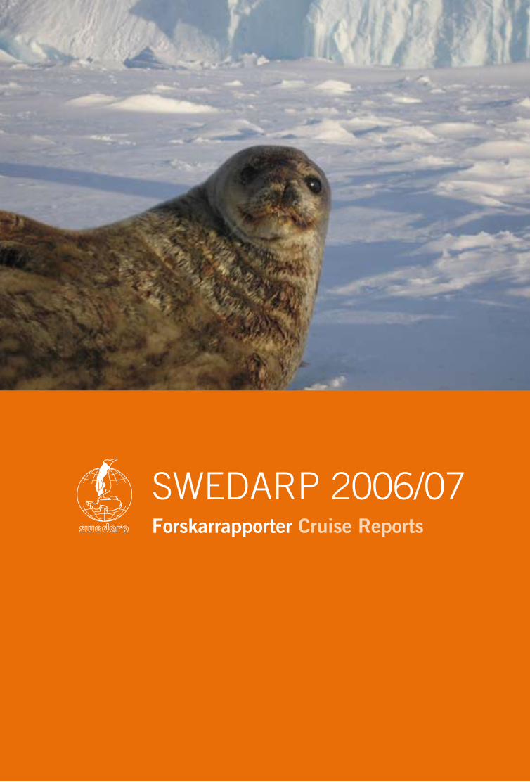
48 VERKSAMHETEN ACTIVITIES ÅRSBOK YEARBOOK 2007 49
Forskarrapporter Cruise Reports
SWEDARP 2006/07

50 FORSKARRAPPORTER CRUISE REPORTS SWEDARP 2006/07 ÅRSBOK YEARBOOK 2007 51
Ship-based observations and remotely sensed data for the evaluation of the carbon dioxide system in the Southern Ocean
AimThe overall aim for the proposed project is to
evaluate algorithms with multiple regression
for the estimation of surface water CO2 using
remotely sensed data together with ship-based
measurements of chlorophyll a, oxygen, sea
surface temperature and the fugacity of CO2
in the surface water (fCO2, collaboration with
Dr. Fransson [page 55]). Thus, the project will
give relevant information on the feedback
processes affecting the air–sea CO2 flux, and
provide necessary insight into how a changing
environment may alter the carbon cycle in the
Southern Ocean.
BackgroundRecent climate assessment reports (IPCC,
ACIA) have shown that the high-latitude
oceans are particularly sensitive to global
warming caused by the increased content of
greenhouse gases in the atmosphere induced
by anthropogenic activities. Polar oceans,
such as the seas surrounding Antarctica, play
a role as sinks of atmospheric carbon dioxide.
However, little is known regarding the temp-
oral and spatial variability of the processes
driving the CO2 system due to a lack of data
coverage. Remotely sensed data provides an
unprecedented sampling coverage and satelli-
te borne sensors provide near synoptic global
coverage of parameters such as wind speed
over the ocean, sea surface temperature, and
chlorophyll.
Methods and approachMeasurements on chlorophyll a (chl) fluor-
escence, dissolved oxygen (O2), sea surface
temperature (SST) and salinity (S) were per-
formed underway every minute from 14 to 26
December 2006 from Punta Arenas, Chile
to the Ross Sea, Antarctica onboard the ice-
breaker Oden. Surface seawater samples (~90
samples) were also taken for the determina-
tion of nutrients (phosphate, nitrate, silicic
acid), total dissolved inorganic carbon (CT)
and total alkalinity (AT). These samples were
preserved for post-cruise analyses at the
Project leader
Melissa ChiericiDepartment of Chemistry
University of Gothenburg
Figure 1
The variability of salinity (S), sea surface
temperature (SST, °C), chlorophyll a fluore-
scence (chl, µg/l) and oxygen (µmol/kg)
along the cruise track. Indications (dotted
lines) show the approximate locations of the
Sub Antarctic Zone (SAZ), Polar Zone (PZ),
Marginal Ice Zone (MIZ) and the Ross Sea
Polynya (RP) along the cruise track.
Project participant
Ingela hagströmUddevalla gymnasieskola

50 FORSKARRAPPORTER CRUISE REPORTS SWEDARP 2006/07 ÅRSBOK YEARBOOK 2007 51
Figure 2
Remotely sensed Chlorophyll a con-
centration (µg/l) for December 2006.
Department of Chemistry, Göteborg Uni-
versity in March 2007.
Remotely-sensed chlorophyll a (chl) data
provided by NASA, based on the merged
product from MODIS and SeaWiFS
(http://oceancolor.gsfc.nasa.gov), was down-
loaded after the cruise and will be compared
with ship-based measured chlorophyll and
on-line fluorescence for verification and algo-
rithm development. The chlorophyll a fluore-
scence sensor (Minitracka II) was checked
and calibrated against filtered and extracted
chlorophyll a after the cruise.
Preliminary resultsDuring our transit across the Drake Passage,
the oxygen concentration (O2) increased gra-
dually (Fig. 1), which was probably due to the
effect of increased solubility as the salinity
and temperature decreased (Fig. 1). In the Sub
Antarctic Zone (SAZ) the chlorophyll a fluore-
scence (chl) was generally low and between
0 and 1 µg/l. Dramatic changes were observed
as we entered the Polar frontal Zone (PZ),
where the chl and O2 drastically increased,
which suggests that the ship passed through
several phytoplankton blooms in this area. Chl
and oxygen concentrations decreased in the
Marginal Ice Zone (MIZ), indicating less bio-
logical production. However, in the MIZ, we
passed through large areas where the sea ice
was green-brown coloured, thus implying ex-
tensive sea ice algae production, which could
not be captured by underway measurements
at a depth of 8 m. Polynyas are known to be
sites for high biological activity, and in the
Ross Sea Polynya (RP), we found maximum
chl values of about 10 µg/l coinciding with
the highest oxygen concentrations of 400
µmol/kg found along the cruise track (Fig. 1).
Fartygsbaserade observationer och fjärranalysdata för utvärdering av koldioxidsystemet i Södra ishavetMålet med projektet ombord på Oden Southern Ocean 2006/07 var att finna algoritmer för att be-stämma koldioxidhalten i ytvattnen med hjälp av en kombination av satellitdata och fartygsbaserade mätningar på parametrar såsom klorofyll, temperatur, salthalt, syrgashalt, koldioxid. Under expedi-tionen Oden Southern Ocean 2006/07 mättes dessa parametrar varje minut under två veckors tid fram tills expeditionens slut i Rosshavet, Antarktis. Satellitdata av klorofyll och temperatur från dessa veckor har i efterhand erhållits från NASA och används tillsammans med multilinjär regression för att utvärdera algoritmer för att beräkna koldioxidhalten i ytvattnet. De beräknade värdena valideras gentemot uppmätta koldioxidhalter (samarbete med Dr. A Fransson [sid 55]).

52 FORSKARRAPPORTER CRUISE REPORTS SWEDARP 2006/07 ÅRSBOK YEARBOOK 2007 53
Deployment of a seismic recording station at Svea, Dronning Maud Land, Antarctica
IntroductionIn December 2006, a seismic recording sta-
tion was deployed at the Swedish research
facility Svea in western Dronning Maud Land
(DML). This project was established as part
of our DROMNET initiative and was realized
by cooperation between the Alfred Wegener
Institute and the Swedish Polar Research Sec-
retariat. DROMNET is intended to establish
a permanently operating large-scale regional
seismographic network in Dronning Maud
Land. Each station, whether permanently ope-
rating or operative during summer only, will
be equipped with a modern seismographic
broadband station (Fig. 1). These stations will
form the permanent backbone of DROMNET
while additional temporarily operating stations
deployed at variable locations will complement
the network.
The scientific backgroundThe international network of seismic moni-
toring stations is still rather wide meshed in
the whole of Antarctica. In greater Dronning
Maud Land there are currently only 5 seismo-
graphic stations in operation at a selection
of the permanently manned bases: Syowa
(Japan), Novolazarevskaya (Russia), Maitri
(India), Sanae IV (South Africa), Neumayer
(Germany). This sparse station density con-
stitutes a number of relatively severe limita-
tions to seismological research in Dronning
Maud Land. In particular, the monitoring of
local and regional seismotectonic activities,
and thus the investigation of geodynamic
neo-tectonics in Dronning Maud Land, are
considerably restricted by this handicap. Con-
sequently, it is possible that the deployment
of more seismograph stations in Dronning
Maud Land will facilitate the mapping of the
basic tectonic features, especially if evalua-
tion of seismic data is combined with other
geophysical data such as aeromagnetics and
aerogravity.
DROMNET is intended to make possible
the investigation of seismic activities and neo-
tectonic processes in DML in more detail on
a regional scale. Recordings from DROMNET
may also be used to provide further informa-
tion about the structure and physical proper-
ties of the Earth’s crust and upper mantle in
different tectonic regions. This will lead to a
better understanding of the tectonic evolution
of this region. These results are of particular
scientific importance as DML was the central
region for the disintegration of the former
supercontinent Gondwana. The scientific
goals can be summarized as follows:
• A detailed mapping of the seismotectonic
active areas may reveal the basic recent
neotectonic processes in DML.▪
• The examination of source mechanisms
Project participants
Alfons EckstallerAlfred Wegener Institute for
Polar and Marine Research
Bremerhaven, Germany
Christian Müller FIELAX GmbH
Bremerhaven, Germany
Ulf hedmanSwedish Polar Research Secretariat
Stockholm
Figure 1
Map of Dronning Maud Land showing
existing and possible future seismo-
graphic stations.

52 FORSKARRAPPORTER CRUISE REPORTS SWEDARP 2006/07 ÅRSBOK YEARBOOK 2007 53
may provide an insight into the relative
movement of tectonic blocks and units.▪
• The analysis of the interconnection bet-
ween postglacial lithospheric rebound
due to deglaciation and seismicity along
the continental margin will provide cons-
traints for models of mantle viscosity.▪
• A detailed imaging of crustal and litho-
spheric structures in different tectonic
units on a regional scale will become
realizable by the deployment of additional
temporary seismographic stations and
the application of suitable seismological
methods (receiver functions, inverse
waveform modelling).▪
• Seismic tomography may become feasible
and thus higher resolution models for the
Earth’s deeper interior may be derived.▪
• The combination of models for lithosphe-
ric structures from seismological investi-
gations with aeromagnetic and aerogravity
measurements in DML will enable a com-
prehensive mapping of derived basic tec-
tonic features on a regional scale. ▪
• New insights can be achieved in the tec-
tonic evolution of different tectonic units,
especially in consideration of seismic ani-
sotropy from shear-wave splitting analysis.
Implementation of the scientific equipmentOn the morning of 27 December 2006, the
equipment and personnel were carried by the
aircraft Polar 2 (a Dornier 228-200 turboprop
aircraft) via the Swedish station Wasa to Svea
for installation of the seismic recording system.
Seismic station information
Geogr. coordinates: 74°34.561’S
11°13.508’W
Elevation: 1 259 m
Geology: Gneiss
Start of recording: 27 December 2006
Sensor: Lennartz LE-3D/20s
Data acquisition: Reftek DAS-130
Sample rate: 40 sps continuous
Data storage: 2 × 2 GB flash discs
Site description
A site just beneath the Svea hut was chosen as
the best location for the seismometer (Fig. 2),
since the flat surface provided by the expo-
sed bedrock was particularly favourable for
installation. The seismometer was sheltered
with insulation foam and then completely
covered by rocks as protection against heavy
winds (Fig. 3). The insulation is intended to
retain some of the seismometers internal heat
dissipation and also reduce wind-induced
Figure 2
View of Svea from the north. The seismometer
is deployed as indicated by the arrow, in front of
and to the right of the rocky outcrop. The Reftek
data acquisition system including power supply
is housed inside the hut. The GPS-antenna for
time keeping is mounted on the roof of the hut.
Photo: Christian Müller.
Seismometer

54 FORSKARRAPPORTER CRUISE REPORTS SWEDARP 2006/07 ÅRSBOK YEARBOOK 2007 55
Installationen av en seismisk mätstation vid Svea, Dronning Maud land, AntarktisI december 2006 placerades en seismisk mätstation vid den svenska forskningsstationen Svea i västra Dronning Maud Land (DML) på Antarktis. Detta projekt började som en del av DROMNET-initiativet och förverkligades som ett samarbete mellan tyska Alfred Wegener Institute och Polarforskningssekretariatet. Tanken bakom DROMNET är att etablera ett permanent storskaligt och regionalt seismografiskt nätverk i Dronning Maud Land. Inom DROMNET-projektet inbegriper de vetenskapliga målen med placeringen vid Svea detektion av seismisk aktivitet och neotektoniska processer i DML. Dessutom kommer de seismografiska upptagningarna från Svea att användas för att ge ytterligare information om strukturer och fysiska egenskaper i jordskorpan och i övre jordmanteln under stationen.
noise. The Reftek DAS-130 recording station
was installed inside the hut and connected
to the hut’s solar charged power supply. The
system’s GPS antenna for time-control was
mounted on the roof of the hut and a cable
entrance in the roof of the hut was used for
GPS and seismometer cables. The cables were
fixed to the roof and seismometer cable was
buried by rocks.
In the late afternoon of 27 December 2006,
the seismograph system was put into opera-
tion. Disk capacities and chosen recording
parameters should allow a duration of ope-
ration of approximately 400 days. In case of
power shortage, the Reftek system will shut
itself down and start operation again when
sufficient power is resumed.
On 16 November 2007, the aircraft Polar 5
visited Svea to download the recorded seismic
data. Unfortunately, the acquisition system
recorded successfully for a period of only 41
days. The acquisition stopped for unknown
reasons on 5 February 2007, the ‘‘state of
health’’-logs however having reported no pro-
blem until immediately before termination
of data acquisition. Data acquisition has been
started again but since we now expect hard-
ware problems with the data acquisition sys-
tem our aim is to exchange the system at the
next possible visit. Figure 4 shows an example
of a regional earthquake recording in January
2007. Nevertheless, despite the early inter-
ruption of data acquisition, a large number
of earthquakes could be recorded including
several events that can be used for studying
the structure of the Earth’s crust and mantle.
Figure 3
The seismometer is deployed on solid rock. It
is protected by insulation foam, which was fit-
ted to the contours of the surrounding rocks.
Photo: Christian Müller.
Figure 4
Example of regional event recording:
A magnitude Mw = 6.2 earthquake with
epicentre near the South Sandwich
Islands recorded on 21 January 2007.

54 FORSKARRAPPORTER CRUISE REPORTS SWEDARP 2006/07 ÅRSBOK YEARBOOK 2007 55
Figure 1
The author filters the seawater sample for
nutrient analyses. Photo: Melissa Chierici.
Project leader
Agneta FranssonDepartment of Earth Sciences
Oceanography
University of Gothenburg
Variability of the carbon dioxide system, oxygen and biogeochemical processes in the Southern Ocean
Aim The aim of this project is to study the effect of
sea ice on the carbon dioxide (CO2) system and
dissolved oxygen in the surface waters of the
Southern Ocean as well as the biogeochemical
processes that drive this system during the
productive summer season. The ocean fronts,
the marginal ice zone, and the ice edge consti-
tute interesting areas of study because of the
relatively high level of biological production,
resulting in high biological CO2 uptake. As a
result of variations in sea-ice cover, caused by
the production and melting of sea-ice, a variable
environment is created for biological produc-
tion and CO2 fluxes. The CO2 gas exchange bet-
ween sea and atmosphere (sea–air) is estimated
and related to the physical and biological cha-
racteristics of the surface water. Furthermore,
the importance of sea ice for CO2 fluxes in the
sea–ice–air interface will be investigated.
BackgroundVariation in extension of The Southern Ocean
sea ice cover is largely attributed to melting in
summer and freezing again in winter. The sea-
sonality in sea ice conditions affects biological
production and CO2 fluxes. Due to the sea ice
melt in spring and summer, strong surface wa-
ter stratification is created, and in combination
with nutrient availability and sufficient light,
biological CO2 drawdown will take place. Pre-
viously, sea ice has been considered to act as a
protecting lid, preventing gas exchange between
water and atmosphere. However, recent studies
have indicated that sea ice is permeable to gases.
Ship-based workMeasurements commenced soon after de-
parting the Strait of Magellan in the austral
summer 2006 and proceeded successfully
onboard icebreaker Oden both in open water
and in sea ice until the McMurdo Sound. The
project used on-line, high-frequency measu-
rements of surface water partial pressure of
CO2 (pCO2), dissolved oxygen, chlorophyll
fluorescence (in collaboration with Dr. M.
Chierici), salinity and temperature. Samples
for total dissolved inorganic carbon (DIC),
total alkalinity (AT) and nutrients (phosphate,
nitrate, silicate) were collected and measured
on shore (Fig. 1). This project is closely coordi-
nated with Dr. Chierici’s project [page 50].
The automated pCO2 instrument was suc-
cessfully used for sea ice conditions for the
first time in the Arctic expedition Beringia
2005, and was now used for measurements
in the Southern Ocean. Seawater was pumped
with a flow rate of approx. 15 l/min into a CO2
equilibrator (tandem type combined with a
static mixer type manufactured by Kimoto
Electric Co., LTD (Kimoto and Harashima
Project participant
Ingela hagströmUddevalla gymnasieskola

56 FORSKARRAPPORTER CRUISE REPORTS SWEDARP 2006/07 ÅRSBOK YEARBOOK 2007 57
1993, Harashima et al. 1997), passing through
a thermosalinograph for continuous pCO2
measurements. The mole fraction of CO2
(xCO2) in dry air, expressed by part per mil-
lion (ppm), was continuously measured every
minute by a non-dispersive infrared detector
(NDIR, LiCOR®, model 6262, Lincoln, USA).
Four CO2 standard gases and zero gas (0, 250,
350, 450, 550 µatm) were used for calibration
and pCO2 in air was alternately measured
with the same instrument. Sea surface salinity
and temperature were continuously measured
and an oxygen sensor (Aanderaa) was used to
measure dissolved oxygen every minute. The
oxygen values were compared to the values
obtained from the discrete samples analysed
with the Winkler method.
Preliminary resultsAlong the sailing route, from open water to
marginal sea ice, variability in surface water
pCO2 and oxygen was observed using 1-minute
readings (Fig. 2). Preliminary analyses indicate
that there was a substantial decline in pCO2 and
increase in oxygen (Fig. 2) and correlative peaks
in chlorophyll a (Chl a) on the 17 and 18 Decem-
ber, suggesting that the ship passed through a
phytoplankton bloom. The most striking feature
Växlingar i koldioxidsystem, syre och biogeokemiska processer i Södra ishavetPolarhavet i Södra Oceanen har ett istäcke som varierar i storlek beroende på säsong, då isen bildas eller smälter. Denna variation påverkar förhållandena i ytvattnet för biologisk produktion och koldioxidflöden (CO2). Målsättningen med projektet är att studera effekten av havsis på CO2-systemet och löst syrgas i ytvattnet och de biogeokemiska processerna som styr detta system under sommarsäsongen. Genom kontinuerliga mätningar av ytvattnets partialtryck CO2 (pCO2), total alkalinitet och löst oorganiskt kol kunde CO2-systemet och CO2-flöden mellan hav och atmosfär bestämmas, från Punta Arenas (Chile) via Rosshavet till McMurdo Sound i Antarktis. Ytterligare mätningar av syrgashalt, klorofyll a, närsalter, salthalt och temp-eratur behövdes för att studera bl.a. biologisk produktion och fysiska processer. Preliminära resultat visar att pCO2, syrgas och klorofyll varierar från öppet hav till havsisområden. En minskning i pCO2 och ökad syrgas korrelerar med ökad klorofyll, vilket tyder på en planktonblomning. Övermättnaden av CO2 i havet i förhållande till i atmosfären vid ett tillfälle, då det var delvis istäckt, kan bero på en vertikal omblandning då vatten berikat med CO2 och näringsämnen kommer upp till ytan från undre vattenlager. Vid samma tidpunkt passerade vi isflak med många krabbätarsälar och adeliepingviner, vilka gynnas av produktionen av de djurplankton som lever av växtplankton under isen, som i sin tur gynnas av det näringsrika vattnet.
was the high pCO2 values, i.e. CO2 oversatura-
tion relative to the atmospheric level, observed
for the first time since departing from Punta
Arenas. It is probable that this was due to ver-
tical mixing of CO2-rich subsurface water with
the surface, which is confirmed by the low oxy-
gen values. The Chl a showed the lowest values
during the time period, indicating low primary
production. Coincident with this specific time
point, the ship also passed through an area of
pack ice and moderate densities of Crabeater
seals and Adelie penguins which are feeding on
zooplankton, which in turn feed on phytoplank-
ton living under the sea ice. In general, pCO2
was below atmospheric values, and the lowest
pCO2 values in combination with the highest
oxygen and Chl a values were measured in the
Ross Sea polynya, implying intense biological
CO2 drawdown.
Acknowledgement Swedish Research Council, Formas and US
National Science Foundation.
ReferencesHarashima, A., Tsuda, R., Tanaka, Y., Kimoto,
T., Tatsuta, H. and Furusawa, K. 1997.
Monitoring algal blooms and related bio-
geochemical changes with a flow-through
system deployed on ferries in the adjacent
seas of Japan. In: Monitoring Algal Blooms:
New Techniques for Detecting Large-Scale En-
vironmental Change. Kahru, M. and Brown,
C. (eds.). Springer-Verlag, pp. 85–112.
Kimoto, T. and Harashima, A. 1993. High
resolution time/space monitoring of the
surface seawater CO2 partial pressure by
ship-of-opportunity. In: Fourth International
Carbon Dioxide Conference Abstracts.
Carqueiranne, France, pp. 88–91.
Figure 2
Time series of 1-minute data from 17 to
21 December 2006 for partial pressure
of carbon dioxide (pCO2, ppm), dissolved
oxygen (O2, µmol/kg) and chlorophyll-a
fluorescence (Chl a, µg/l). Special featu-
res (phytoplankton bloom and upwelling)
are indicated with circles. The photo (by
Agneta Fransson) shows a crabeater seal
on an ice flow in the suggested upwelling
region.

56 FORSKARRAPPORTER CRUISE REPORTS SWEDARP 2006/07 ÅRSBOK YEARBOOK 2007 57
The neutrino telescope IceCube at the South Pole
The aim of IceCubeDuring the 1990s, the AMANDA collabo-
ration demonstrated the feasibility of using
transparent ice at large depths in Antarctica
for neutrino telescopes. The scientific goals
set for these telescopes are to use neutrino
particles from space to investigate the ‘‘dark
matter” of the Universe and to search for the
sources of the highest energy cosmic rays.
Neutrino particles are extremely penetrative
and interact very rarely with matter. It is an-
ticipated that the neutrinos are produced by
different violent processes in the Universe,
and the ability to detect high-energy neutrino
sources will open a new window through
which to study the Cosmos. In order to com-
pensate for the extremely low probability of
neutrinos interacting with matter very large
detectors have to be used. The neutrino tele-
scopes are sensitive to the Cherenkov light
emitted from electrically charged particles cre-
ated by neutrino interactions deep in the ice.
The transparent ice at the South Pole, where
the ice sheet is 2 900 m deep and extremely
transparent at large depths (Askebjer et al.
1997, Askebjer et al. 1998), is a very suitable
detector medium for a neutrino telescope.
The AMANDA neutrino telescope was con-
structed between 1995 and 2000, mainly at
depths of between 1 500 m and 2 000 m, and
the optical modules were deployed in holes
drilled by pressurized hot water. The AMANDA
detector has been successfully operative and
is registering data since February 2000. As
a result of the success of AMANDA the large
IceCube Neutrino Observatory is now under
construction at the same location.
The construction of IceCube began in
January 2005. The complete observatory will
consist of 4 800 optical modules deployed
between depths of 1 450 m and 2 450 m in
80 strings monitoring a volume of about 1
km3. The digital optical modules for IceCube
(DOMs) are considerably more advanced than
those used in AMANDA, digitising the photo-
multiplier signals and transmitting all infor-
mation in digital form to the surface. Timing
calibration, which was performed manually
and took several weeks for AMANDA, occurs
automatically every two seconds for the whole
IceCube array. On the surface above the neu-
trino telescope an air shower array, IceTop,
Figure 1
Mounting an IceCube optical module to
the main cable. The hole below the mo-
dule is 2 500 m deep and filled with water
up to about 50 m below snow surface.
Photo: National Science Foundation.
Swedish project leader
Per-Olof hulth*Department of Physics
Stockholm University
AlbaNova University Center
Other Swedish participants
gabriel gourie John henrik hulth gustav WikströmDepartment of Physics
Stockholm University
AlbaNova University Center
leif gustafsson Allan hallgrenDepartment of Nuclear and
Particle Physics
Uppsala University
* not participating in the field

58 FORSKARRAPPORTER CRUISE REPORTS SWEDARP 2006/07 ÅRSBOK YEARBOOK 2007 59
will detect air showers from cosmic rays inte-
racting in the atmosphere. The combination
of IceTop and the detectors in the ice will
allow calibration of IceCube using atmosphe-
ric muons as well as facilitate analysis of the
chemical composition of the incoming cosmic
rays. The AMANDA telescope is an integrated
part of the IceCube observatory following the
merger of the AMANDA collaboration with
the new IceCube collaboration in 2005.
The ice workPersonnel and scientific equipment are
transported by air from Christchurch, New
Zealand to the American base McMurdo on
Ross Island, and then to the Amundsen-Scott
station at the geographical South Pole by
Hercules aircraft. Heavy equipment can also
be transported by sea once a year arriving at
McMurdo in January–February.
The construction of the new IceCube Neutri-
no Observatory continued during the 2006/07
summer season. The drill for IceCube has a
heating power of 5 MW compared with 2 MW
for the AMANDA drill; it is more advanced
and is designed to drill a 60 cm diameter hole
in the ice down to 2 500 m in less than 40
hours. Despite the higher power and the larger
depth of the holes the consumption of fuel per
hole is less than for AMANDA. One IceCube
string with 60 optical modules was successfully
deployed in January 2005, and another eight
strings were deployed during the 2005/06
season. In the season 2006/07 the hot water
drill was slightly modified, based on experience
gained during the previous season, in order to
improve the performance. Thirteen new strings
were deployed, giving a total of 22 IceCube
strings in the ice of the 80 aimed for. In addition
ten new IceTop stations were successfully de-
ployed giving in total 26 running stations. The
equipped ice volume of the 22 IceCube strings is
already about five times larger than the volume
Figure 2
The IceCube laboratory building at the
South Pole. The cables enter the building
through the two towers. Picture taken in
April 2007 at full moon after the station
has been closed for the summer season
and when the Sun is below the horizon.
Photo: Sven Lidström (the first Swede in
40 years to overwinter at the South Pole).
• Aachen University, Germany
• University of Alaska, Anchorage, USA
• University of Gent, Belgium
• MPI Heidelberg, Germany
• Chiba University, Japan
• Clark-Atlanta University, USA
• University of Maryland, USA
• Université Libre de Bruxelles, Belgium
• Vrije Universiteit Brussels, Belgium
• University of Mons-Hainaut, Mons, Belgium
• University of California, Berkeley, USA
• Lawrence Berkeley National Laboratory, USA
• Bartol Research Institute, University of Delaware, USA
• University of Kansas, USA
• Southern University, Baton Rouge, USA
• Humboldt University, Berlin, Germany
• University of California, Irvine, USA
• Pennsylvania State University, USA
• University of Mainz, Germany
• University of Dortmund, Germany
• Stockholm University, Sweden
• Uppsala University, Sweden
• DESY-Zeuthen, Germany
• University of Wisconsin, Madison, USA
• University of Wisconsin-River Falls, USA
• University of Wuppertal, Germany
• Oxford University, UK
• Utrecht University, The Netherlands
• University of Canterbury, New Zealand
The IceCube project is a collaboration between:

58 FORSKARRAPPORTER CRUISE REPORTS SWEDARP 2006/07 ÅRSBOK YEARBOOK 2007 59
of AMANDA. The telescope is modular and
newly deployed strings are commissioned at the
end of the season. The sensitivity of the obser-
vatory to detect neutrinos will thus continuously
increase during the deployment period. The last
string of IceCube is expected to be deployed in
January 2011. For the next season, 2007/08, the
aim is to deploy another 14–18 strings.
During the season of 2006/07 Sweden con-
tributed with two technicians for the drilling
operation and three scientists for testing and de-
ployment of the modules. The Swedish scient-
ists also participated in the installation of acous-
tic detectors into the ice as a test for a possible
future extension of IceCube. While IceCube is
not expected to be large enough for the highest
energy neutrinos, by using an acoustic techni-
que it may be possible to monitor a larger volu-
me of ice than is possible with light detectors. A
test array with three strings, each having seven
transmitters and 7 × 3 sensors, were deployed at
seven depths between 80 m and 400 m in three
of the water filled IceCube holes immediately
after the optical modules had been deployed.
Swedish Sven Lidström, who has been a
driller for many years for AMANDA/IceCube,
was one of three IceCube personnel to remain
at the station over the winter season, arriving
at the South Pole at the end of October 2006
and staying until November 2007. In total,
54 people stayed over the winter season 2007
experiencing temperatures down to -75°C.
Preliminary resultsThe 22 IceCube strings are performing very
well and are registering data together with the
AMANDA array. A report on the performance of
the first string deployed (Achterberg et al. 2006a)
as well as the first results on atmospheric neutri-
nos amassed from the data taken by the 9-string
detector during 2006 (Achterberg et al. 2007a)
have already been published showing that the
new IceCube technology works very well.
The analysis of data taken by the AMANDA
telescope is still in progress. A general paper
on principles and first results was published in
Nature (Andrés et al. 2001). More than 4 000
neutrino candidates have been recorded, but
so far, no evidence for extraterrestrial neutrinos
has been found. About 30 scientific papers in
refereed journals have been published. These
include papers on:
• the search for neutrino point sources during
the five years AMANDA has been running
(Achterberg et al. 2007b)
• the search for neutrinos from dark matter an-
nihilations in the Sun and in the Earth (Acker-
mann et al. 2006b, Ackermann et al. 2006c)
• the ice properties in the AMANDA volume
(Ackermann et al. 2006d)
• the search for neutrinos from Gamma Ray
Bursts (GRB), which are the most powerful
explosions in the universe (Achterberg et al.
2006e, Achterberg et al. 2007c).
The acoustic test system has been functional and
data has been recorded continuously. Analysis
of the data is ongoing but while the noise level
appears to be favourable there still remain ques-
tions regarding the characterisation of the noise
and the acoustic properties of the ice.
Figure 3
Sven Lidström, the first Swede to over-
winter at the South Pole for 40 years.
Photo: Tomas Gustafsson.

60 FORSKARRAPPORTER CRUISE REPORTS SWEDARP 2006/07 ÅRSBOK YEARBOOK 2007 61
Neutrinoteleskopet IceCube vid SydpolenKonstruktionen av det nya neutrinobservatoriet IceCube pågår intensivt vid Amundsen-Scott stationen vid den geografiska sydpolen på Antarktis. Observatoriet byggs på samma plats som neutrinoteleskopet AMANDA som färdigställdes år 2000. Teleskopen består av en mängd ljusdetektorer som sänkts ned i isen på 1 500–2 500 meters djup med hjälp av en varmvattenborr. Totalt kommer en kubikkilometer av isen att instrumenteras med 4 800 ljusdetektorer. Dessa detektorer registrerar den mycket svaga ljusblixt som bildas då neutrinopartiklar kolliderar med en atom nere i isen. Teleskopen kan bestämma riktningen på den inkommande neutrinon inom någon grads noggrannhet. Målsättningen är att obser-vera neutriner från kosmiska källor som aktiva galaxer (AGN), gammablixtar (GRB), och universums mörka materia. Under säsongen 2006/07 installerades 13 nya detektorsträngar med 60 ljusdetektorer vardera. När säsongen avslutades bestod IceCube av 22 strängar av de planerade 80. De installerade ljusdetektorerna fungerar mycket bra och atmosfäriska neutriner har redan observerats. IceCube beräknas vara färdiginstallerat 2011.
Sverige bidrog med två borrare och tre forskare vid årets expedition. Ytterligare två svenskar var anställda av USA som borrare. En av dem, Sven Lidström, övervintrade på sydpolsbasen som första svensk på 40 år. Tillsammans med 53 andra övervintrare fick han uppleva 180 dagar av mörker och temperaturer på ned till -75°C.
ReferencesAchterberg et al. 2006a. First Year Perfor-
mance of the Icecube Neutrino Telescope.
Astroparticle Physics 26. 155–173.
Achterberg et al. 2006e. Limits on the High-
Energy Gamma and Neutrino Fluxes from
the SGR 1806-20 Giant Flare of 27 Decem-
ber 2004 with the AMANDA-II Detector.
Physical Review Letters 97. 221101.
Achterberg et al. 2007a. Detection of Atmo-
spheric muon neutrinos with the IceCube
9-string detector. Physical Review D76.
027101.
Achterberg et al. 2007b. Five Years of Sear-
ches for Point Sources of Astrophysical
Neutrinos with the AMANDA-II Neutrino
Telescope. Physical Review D75. 102001.
Achterberg et al. 2007c. Search for Neutrino-
induced Cascades From Gamma-Ray Bursts
with AMANDA. Astrophysical Journal
664. 397.
Ackermann et al. 2006b. Limits to the Muon
Flux from Neutralino Annihilations in the
Sun with the AMANDA Detector. Astropar-
ticle Physics 24. 459.
Ackermann et al. 2006c. Limits on the Muon
Flux from Neutralino Annihilations at the
Center of the Earth with AMANDA.
Astroparticle Physics 26. 129.
Ackermann et al. 2006d. Optical Properties of
Deep Glacial Ice at the South Pole. Journal
of Geophysical Research 111. D13203.
Andrés et al. 2001. Observation of High-Energy
Neutrinos Using Cerenkov Detectors Em-
bedded Deep in Antarctic Ice. Nature 410.
Askebjer et al. 1997. Optical Properties of the
South Pole Ice at Depths Between 0.8 and
1 km, AMANDA Collaboration: P. Askebjer
et al. Science 267.
Askebjer et al. 1998. Optical Properties of
Deep Ice at the South Pole: Absorption,
AMANDA collaboration. Applied Optics 36.

60 FORSKARRAPPORTER CRUISE REPORTS SWEDARP 2006/07 ÅRSBOK YEARBOOK 2007 61
MARA – Moveable Atmospheric Radar for Antarctica
MARA is an atmospheric radar which me-
asures echoes from dusty plasma close to the
summer mesopause (80–90 km heights),
and from small-scale structures in the air in
the troposphere and lowermost stratosphere
(300 m – ca 12,000 m heights). The echoes
can be used to measure wind profiles, to study
the characteristics of the dusty plasma, and
to study waves, turbulence and air-mass tem-
perature gradients. Examples of the measure-
ments are shown in Figures 3 and 4.
The summer mesopause, at polar latitudes,
is the coldest place in the Earth’s atmosphere,
with temperatures of -150°C or lower. Even
though the water content of the upper atmo-
sphere is very low, such extremely low tem-
peratures are enough to cause ice-clouds
to form. The clouds, known as noctilucent
clouds, can be seen from the ground when
the sun is just below the horizon – they are
then lit from underneath and the light, scat-
tered at a low angle, picks out the many waves
which cross the cloud layer. They are often ob-
served from moderately high northern latitu-
des (~ 50°–60°N), which are high enough for
the clouds to occur and low enough that the
sun is below the horizon during the summer
season. Noctilucent clouds are rarely seen
from the ground in the southern hemisphere
due to the lack of habitation at corresponding
southern latitudes.
It is expected that changes in the amounts
of carbon dioxide and methane in the atmo-
sphere will lead to changes in noctilucent
Project leader
Sheila KirkwoodSwedish Institute of Space Physics
Kiruna
Field team January/February 2007
hans Nilsson Ingemar WolfSwedish Institute of Space Physics
Kiruna
Other project participants
Peter Dalin Daria Mikhaylova Evgenia Belova, Swedish Institute of Space Physics
Kiruna
Figure 1
Hans Nilsson and Ingemar Wolf at work
setting up the MARA antenna field.
Photo: Hans Nilsson.

62 FORSKARRAPPORTER CRUISE REPORTS SWEDARP 2006/07 ÅRSBOK YEARBOOK 2007 63
clouds. Increased methane is expected to lead
to higher water vapour concentrations in the
upper atmosphere, where methane is broken
apart by ultraviolet radiation and the hydro-
gen released forms water vapour. At the same
time, increased carbon dioxide concentrations
will lead to increased radiative cooling of
the upper atmosphere and potentially lower
temperatures. Ground based observations
of noctilucent clouds have not found any
significant increase over the last 40 years
(Kirkwood et al. 2003 and 2007, Dalin et al.
2006) while analysis of satellite data (De-
Land et al. 2007) has suggested a significant
increase. However, the satellite-based results
depend on assumptions regarding the daily
(tidal) variation of clouds, which are hard
to test. Altogether it has become more and
more apparent that noctilucent clouds are
very sensitive not only to mean conditions
but also to atmospheric waves and tides,
and they provide a valuable tool to test our
understanding of the atmospheric response
to composition change in relation to those
waves, as well as in mean terms.
Atmospheric radars offer many advantages
over visual observation for studying noctilu-
cent clouds – they can observe regardless of
tropospheric weather, they can observe all
day round, they can be accurately calibrated,
and they provide simultaneous and collocated
information on winds and waves. They have
been used for more than a decade at Arctic
latitudes and the relationship between radar
echoes (PMSE – polar mesosphere summer
echoes) and noctilucent clouds is well esta-
blished and fairly well understood. Far fewer
observations have been made at Antarctic
latitudes. The first attempts to observe PMSE
in the Antarctic Peninsula were unsuccessful,
and even though later attempts did detect
some echoes, it was suggested that there is a
large difference in mean conditions between
the Arctic and Antarctica (Balsley et al. 1993,
Woodman et al. 1999). Since 2003 a radar
at the Australian Antarctic station Davis has
regularly observed PMSE and qualitative
comparisons have suggested that differences
between the hemispheres were not so large
(Morris et al. 2006 and 2007). Up to the end
of 2006, however, no quantitative comparison
between PMSE in the two hemispheres had
been made, neither regarding mean condi-
tions nor wave effects.
During August 2006, the MARA radar was
set up to measure PMSE in Kiruna, Sweden
(68°N, 21°E). This allowed an accurate cross-
calibration with the ESRAD radar in Kiruna,
which has been operating since 1996. After
further technical testing in September, MARA
was shipped to Antarctica where it reached
Wasa at the end of December. On 7 January
2007, work was started to install MARA at
Wasa. The radar consists of a control computer,
Figure 2
MARA antenna field – the radar electro-
nics is housed in the small module beside
the antenna field. Photo: Hans Nilsson.

62 FORSKARRAPPORTER CRUISE REPORTS SWEDARP 2006/07 ÅRSBOK YEARBOOK 2007 63
transmitter and receiver electronics, and a
large antenna field (in fact, 3 adjacent fields
each with a 4 × 4 array of dipole antennas).
The antennas are supported on an aluminium
framework, forming a grid with antennas
centred above each cross-point in the grid,
where there are also adjustable support legs
down to the ground. A ground-plane of wire
was stretched over the whole grid. Each squa-
re in the grid is 4 × 4 m and the antenna field
stretches over 36 m in both N–S and E–W
directions, all accurately aligned and levelled.
The computer and electronics are housed
in a small module adjacent to the antenna
field and power was provided during the field
campaign by a generator. Installation of the
radar took 11 days and data was collected on
16 days between 18 January and 5 February.
On 6 February the antennas and cables were
demounted and stored in the container. The
supporting framework was left in place to al-
low rapid start-up of operations next season.
Echoes from the dusty plasma close to the
mesosphere (PMSE) were detected which
were as strong as the strongest seen in Kiruna,
and the overall PMSE occurrence rates were
about 30% higher at Wasa (Figs. 3 and 5).
The results of this first accurately-calibrated
cross-comparison have been published in
Geophysical Research Letters in August
(Kirkwood et al. 2007). Preliminary results
from a cross-comparison with Davis (69°S,
78°E) show stronger and more frequent ec-
hoes at Wasa than at Davis (Fig. 4). This is in
qualitative agreement with a recently publis-
hed comparison between Davis and Ande-
nes (69°N, 16°E) that found less PMSE at
Davis than at Andenes (Latteck et al. 2007).
The comparison between Davis and Wasa
provides the first evidence that geographic,
rather than geomagnetic, latitude is the most
important influence on PMSE. (Davis is at a
higher geomagnetic latitude than Wasa and
it has been speculated that PMSE are most
sensitive to energetic particle precipitation,
which increases with geomagnetic rather
than geographic latitude. In the Arctic,
geomagnetic and geographic latitudes are
almost the same, whereas in Antarctica,
they are widely different due to the large
offset between the geographic and geo-
magnetic poles).
Echoes from the troposphere (Fig. 4) show
many features that are similar to those seen
in Kiruna. The strength of the radar echo
(upper panel) depends on humidity and (po-
tential) temperature gradients. Easily discer-
nable are the areas of increased power at an
altitude of between 8–10 km corresponding
to air immediately above the tropopause,
which varies between 8 and 10 km in altitu-
de. This is similar to the situation in Kiruna,
except that the tropopause is sometimes very
indistinct over Wasa. Wind speeds in the up-
per troposphere (middle panel) are relatively
low, while winds in the lower troposphere
are rather high. There is a period of higher
wind strength at all heights on 28–30 Janua-
ry, which is also characterized by high levels
of turbulence in the air (lowest panel). The
wind is from a different direction (northeast)
compared to the rest of the period (mostly
southwest), and measurements of vertical
wind (not shown) show strong waves in the
lower troposphere at this point in time. It
is probably that these are mountain waves
caused by Basen (the mountain on which
Wasa stands).
AcknowledgementsThis project has been made possible by grants
from the Knut and Alice Wallenberg Founda-
tion and from the Swedish Research Council,
and by technical and logistic support from the
Swedish Polar Research Secretariat and Swe-
dish Space Corporation, Esrange.
Figure 3
Radar echoes from the dusty plasma at
the mesopause (PMSE). The echoes are
so strong that only 100 Watts of radar
output power (average) were needed to
take these measurements.

64 FORSKARRAPPORTER CRUISE REPORTS SWEDARP 2006/07 ÅRSBOK YEARBOOK 2007 65
ReferencesBalsley, B.B., Woodman, R.F., Sarango, M.,
Urbina, J., Rodriguez, R., Ragaini, E.
and Carey, J. 1993. Southern hemisphere
PMSE: Where are they? Geophysical
Research Letters 20, 1983–1985.
Dalin, P., Kirkwood, S., Andersen, H.,
Hansen, O., Pertsev, N. and Romejko, V.
2006. Comparison of long-term Moscow
and Danish NLC observations: statistical
results. Annales Geophysicae. 24, 2841–2849.
DeLand, M.T., Shettle, E.P., Thomas, G.E.
and Olivero, J.J. 2007. Latitude-dependent
long-term variations in polar meso-
spheric clouds from SBUV version 3
PMC data. J. Geophys. Res. 112, D10315,
doi:10.1029/2006JD007857.
Kirkwood, S. and Stebel, K. The influence
of planetary waves on noctilucent cloud
occurrence over NW Europe. 2003.
J. Geophys. Res. 108(D8), 8440,
doi:10.1029/2002JD002357.
Kirkwood, S., Wolf, I., Nilsson, H., Dalin, P.,
Mikhaylova, D. and Belova, E. Polar meso-
sphere summer echoes at Wasa, Antarctica
(73°S): First observations and comparison
with 68°N. 2007. Geophys. Res. Lett. 34,
L15803, doi:10.1029/2007GL030516.
Kirkwood, S., Dalin, P. and Rechou A. Noctilu-
cent clouds observed from the UK and Den-
mark – trends and variations over 43 years.
In press August 2007. Annales Geophysicae.
Latteck, R., Singer, W., Morris, R.J., Holds-
worth, D.A. and Murphy, D.J. 2007. Ob-
servation of polar mesosphere summer
echoes with calibrated VHF radars at 69°
in the Northern and Southern Hemi-
sphere. Geophys. Res. Lett. 34, L14805,
doi:10.1029/2007GL030032.
Morris, R.J., Murphy, D.J., Vincent, R.A.,
Holdsworth, D.A., Klekociuk, A.R., and
Reid, I.M. 2006. Characteristics of the
wind, temperature and PMSE field above
Davis, Antarctica. J. Atmos. Sol. Terr. Phys.
68, 418–435.
Morris, R.J., Murphy, D.J., Klekociuk, A.R.
and Holdsworth, D.A. 2007. First complete
season of PMSE observations above Davis,
Antarctica, and their relation to winds and
temperatures. Geophys. Res. Lett. 34, L5805,
doi:10.1029/ 2006GL028641.
Woodman, R.F., Balsley, B.B., Aquino, F.,
Flores, L., Vasquez, E., Sarango, M.,
Huaman, M.M. and Soldi, H. 1999.
First observations of polar mesosphere
summer echoes in Antarctica. J. Geophys.
Res. 104, 22577–22590.
Figure 4a left
Measurements from the Antarctic tropo-
sphere between 24–31 January 2007.
The upper panel shows echo strength, the
middle panel wind speed and the lower
panel the level of turbulence in the air.
Figure 4b right
Similar to Fig. 4a, but for the Arctic
troposphere, also in late summer.

64 FORSKARRAPPORTER CRUISE REPORTS SWEDARP 2006/07 ÅRSBOK YEARBOOK 2007 65
MARA – en flyttbar atmosfärsradar för AntarktisMARA är en atmosfärsradar som mäter ekon från dammiga plasman (en blandning av jon/elektron plasma och laddade partiklar av is och/eller annat stoft) vid mesopausen (80–90 km höjd) samt ekon från troposfären och lägre stratosfären (300–12 000 m). Från radarekona kan man få information om vindprofiler, dammiga plasmans egenskaper, vågor, turbulens, samt temperaturgradienter i luftmassor. Ekona från mesopausen uppträder endast sommartid och är nära besläktade med nattlysande moln. Tidiga mätningar indikerade stor skillnad mellan norra och södra hemisfärerna, men genom att MARA först använts i Kiruna innan den skickades till Antarktis kan en god kvantitativ jämförelse göras. De mätningar som gjordes under SWEDARP 2006/07 visar att PMSE är ungefär lika starkt och ofta före-kommande vid Wasa som i Kiruna. En preliminär analys av radardatat från troposfären visar på många likheter med vad som ses över Kiruna. Dock tycks tropopausen oftare ha en otydlig signatur i radarda-tat över Wasa. Vindarna var oftast från sydväst. Under en period med kraftiga vindar från nordost sågs mycket turbulens och kraftiga vertikala vindar. Dessa vertikala vindar var sannolikt lävågor orsakade av Basen, det berg MARA och Wasa är placerat på.
Figure 5
Comparison of PMSE occurrence rates
at Kiruna (Sweden), Wasa and Davis
(Antarctica). (Davis data courtesy of R.
Morris, Australian Antarctic Division and
R. Latteck, IAP Kuhlungsborn).
66 FORSKARRAPPORTER CRUISE REPORTS SWEDARP 2006/07 ÅRSBOK YEARBOOK 2007 67
Antarctic tropospheric aerosol physical and chemical properties
AimThe joint German-Japanese-Swedish AGAMES
(Antarctic Trace Gas and Aerosol Airborne
Measurement Study) aircraft field experiment
was conducted during the Antarctic summer
season December/January 2006/07. It repre-
sents a unique effort by delivering the first
ever comprehensive atmospheric aerosol me-
asurements over Antarctica using an airplane
as an observational platform. The objectives
of the experiment are:
• Characterization of the tropospheric aero-
sol physical, chemical and optical proper-
ties, its vertical distribution, transport path-
ways and life cycle over coastal Antarctica
as well as above the continental ice sheet.
• Investigate composition and mixing state
of atmospheric aerosol by means of size
segregated volatility measurements and
single particle analysis.
• Investigate the origin of aerosol particles
deposited on the Antarctic Plateau with
special emphasis on the relative importan-
ce of local sources, long-range transport
and stratosphere-troposphere exchange.
• Investigate to what extent ground-based
long-term monitoring measurements at
Syowa, Neumayer, Troll, Aboa and Wasa/
Svea stations are representative on a regio-
nal/continental scale.
Further details about the AGAMES experiment
can be found at www.pa.op.dlr.de/aerosol/
agames/.
In general, aerosols consist of a mixture
of tiny particles suspended in the air, having
special physical and chemical properties that
depend on sources, transport and deposition
processes in the atmosphere as well as on
their size distribution and concentration.
Aerosol effects on atmospheric radiation
remain a point of major uncertainty in un-
derstanding past and present climates and in
predicting the future climate. The particles
have a direct influence on the atmosphere by
scattering and absorbing solar and terrestrial
short-wave and long-wave radiation. This
may lead to heating or cooling depending on
the aerosol properties, the surface albedo,
and the cloud cover. They also indirectly ef-
fect the radiation and the water budget of the
atmosphere by influencing cloud characte-
ristics. Furthermore they are part of many
heterogeneous chemical reaction chains.
With respect to climate, the importance of the
polar regions reaches far beyond our present
civilization as ice cores provide information
about long-term variations in aerosols and
trace gases.
To assess present, past and future impacts
of aerosols in a changing atmosphere we need
to understand the processes that determine
the physical and chemical character of the
aerosol particles at a particular place and time.
The knowledge about aerosol properties and
distribution over Antarctica is fairly limited
and based only on relatively few ground-based
measurements. They are mostly confined
to the coastal regions, which are to a large
degree influenced by marine aerosol origina-
ting from the surrounding Southern Ocean.
Origin and properties of the aerosol over the
Antarctic plateau, which reaches elevations of
more than 3 km, are much less clear. Gas to
particle conversion of the sulphur bearing ga-
ses of marine origin is likely to play a role, as
well as long-range transport of aerosol partic-
les via the middle and upper troposphere. The
aerosol vertical distribution in the Antarctic
Project leader
Andreas herberAlfred Wegener Institut
Bremerhaven, Germany
Swedish project leader
Radovan Krejci Department of Meteorology (MISU)
Stockholm University
Project participantsJohan Ström*Birgitta Noone* Department of Applied Environmental
Science (ITM)
Stockholm University
Ann-Christine Engvall* Department of Meteorology (MISU)
Stockholm University
Thomas garbrecht Optimare GmbH
Germany
Keiichiro hara Nagoya University
Nagoya, Japan
Naohiko hirasawaTakahashi yamanouchi* National Institute of Polar Research
Tokyo, Japan
Andreas Minikin German Aerospace Center (DLR)
Oberpffafenhofen, Germany
Andreas Stohl* Norwegian Institute for
Air Research (NILU)
Lilleström, Norway
Renatte Treffeisen Alfred Wegener Institute
Potsdam, Germany
*not participating in the field

66 FORSKARRAPPORTER CRUISE REPORTS SWEDARP 2006/07 ÅRSBOK YEARBOOK 2007 67
troposphere, and therefore aerosol transport
patterns and life cycle in general, cannot be
sufficiently described based on ground-based
observations alone. This gap in knowledge
also considerably limits the ability to decipher
Antarctic ice core records of past climate and
palaeoenvironments. Furthermore, detailed
understanding of the air–snow transfer of
aerosol particles requires knowledge of their
chemical composition as well as concentra-
tion and size distribution.
Research platforms and observationsThe AGAMES experiment took place in De-
cember 2006 and January 2007. The base for
the first half of the project was the German
Antarctic base Georg von Neumayer (70°39’S,
8°15’ W). The second half of the experiment
was based at the summer field camp S17
(69°01’S, 40°06’E) located approximately
30 km east of the Japanese station Syowa.
The aircraft used in this study was a Dor-
nier 228-200 turboprop (POLAR 2) belonging
to the Alfred Wegener Institute for Polar and
Marine Research (AWI) in Bremerhaven.
Altogether 36 flights were performed mainly
between Neumayer and Syowa between
20 December 2006 and 26 January 2007.
Measurements were also carried out during
ferry flights between Neumayer and Syowa
(Camp S17) with stops at the Russian station
Novolazarevskaya and the Belgian station
Belaren. Information in respect of the aerosol
properties and vertical distribution deep over
the continental ice sheet were obtained during
two flights operating with refuelling stops at the
German station Kohnen (75°S, 4°E) (Fig. 1).
Typical duration of the flights was between 2
and 3 hours with flights operating at an altitude
range from surface (Fig. 2) up to 7 300 m. In
total, almost 100 hours of airborne data is avai-
lable. With an average cruising speed of around
80 m/s a distance close to 30,000 km was
covered (Fig. 3).
The scientific instrumentation on board the
POLAR 2 aircraft delivered measurements of
aerosol number density for particles of vari-
ous sizes. Several instruments located inside
the cabin as well as mounted directly on the
aircraft wing delivered aerosol size distribu-
tion between 0.004 and 30 µm. In addition,
aerosol light scattering and light absorption
properties were also measured. Aerosol che-
mical composition was investigated in two
ways. The size dependent measurements of
the mixing state of aerosol particles were ac-
companied by filter sampling for consecutive
analysis of the single particle chemical com-
position using scanning and transmission
electron microscope techniques. Populations
of aerosol particles can be formed by aerosols
of the same composition (homogeneously
mixed aerosol) or by particles of different
composition (heterogeneously mixed aero-
sol). Information about the single particle
composition and mixing state can be used to
shed light on the origin and age of the aerosol
particles and to assist in assessing the degree
Figure 1
Refuelling the POLAR 2 aircraft during
a stop at Kohnen station at almost 3 km
altitude on the Antarctic continental ice
sheet. Aerosol probes mounted directly
under the wing are clearly visible as well
as the main aerosol inlet on top of the
cabin. Photo: Radovan Krejci.
Figure 2
Measurements in katabatic wind layer some
15 meters above ground in the vicinity of
Neumayer station. Photo: Radovan Krejci.

68 FORSKARRAPPORTER CRUISE REPORTS SWEDARP 2006/07 ÅRSBOK YEARBOOK 2007 69
AgAMES – flygburen forskning efter fysiska och kemiska egenskaper hos aerosoler i Antarktis troposfärAntarktis är det geografiska område som ligger längst bort från mänskliga utsläpp av gaser och partik-lar som påverkar vår miljö. Trots avståndet från källorna så är det just denna kontinent av snö och is som förväntas bli mest påverkad till följd av en förändring i klimatet. De luftburna partiklarnas, eller aerosolernas, betydelse för Jordens energibalans har på senare tid lyfts fram som en av de mest osäkra faktorerna när det gäller att förutse hur en förändring av atmosfärens sammansättning påverkar Jordens klimat. Partiklar deltar direkt i strålningsbalansen genom att absorbera och sprida ljus från solen, men aerosolen är även en integrerad del av molnbildningsprocessen. Partiklar i Antarktis är också av intresse ur ett historiskt perspektiv. Variationer av mängden stoft som lagrats i iskärnor som borrats upp på Antarktis har använts för att säga något om hur medelvinden har ändrats till följd av ett ändrat klimat. Trots att aerosolen kan hjälpa oss att förstå klimatet både framåt och bakåt i tiden så vet vi väldigt lite om de processer som bestämmer aerosolens egenskaper i en viss plats vid en viss tid.
Projektet syftar till att karakterisera aerosolen i Antarktis med avseende på dess fysikaliska och kemiska natur som funktion av höjden genom flygplansmätningar. Dessa observationer kopplas till fjärrmätningar från marken och från rymden, samt till långtidsövervakning av aerosolens egenskaper. De grundläggande frågorna är: Vad kontrollerar den naturliga aerosolens livscykel i Antarktis? Till vilken grad påverkas aerosolen i Antarktis av långväga transport?
of contribution from natural and anthropo-
genic sources, as well as local and long-range
transported aerosol.
Data analysis is currently in progress, but
already even at this early stage interesting
information about the Antarctic tropospheric
aerosol has become apparent. It has been
found that the vertical variability of aerosol
concentrations is relatively small if compared
to mid-latitude observations, but the vertical
distribution is less homogeneous than expec-
ted based on earlier data. Aerosol layers or
distinct vertical gradients in aerosol concen-
trations were observed during several flights.
This feature is especially pronounced for
accumulation mode particles (Fig. 4), where
strong enhancement was repeatedly observed
in the upper troposphere.
The AGAMES project represents an im-
portant contribution in our effort to better
understand atmospheric aerosol distribution
and properties and the role they play in the
climate system. Our long-term strategy is to
gain knowledge about their sources and sinks,
transport and transformation processes, and
their interactions with clouds and climate on
a global pole-to-pole scale.
The AGAMES experiment was funded
jointly by the Alfred Wegener Institute, Ger-
many, and the National Institute for Polar Re-
search, Japan. Swedish participants gratefully
acknowledge the support of the Swedish Polar
Research Secretariat. DLR was also supported
by the Deutsche Forschungsgemeinschaft.
Figure 3 top
The POLAR 2 aircraft flight tracks during
AGAMES project.
Figure 4 bottom
Vertical profiles of number concentrations
of accumulation mode particles (>0.26
µm) measured during 15 research
flights in the Neumayer area, Antarctica,
during AGAMES in December 2006.
Median number densities are indicated
by red spots. Shadowing indicates range
between lower and upper quartiles.

68 FORSKARRAPPORTER CRUISE REPORTS SWEDARP 2006/07 ÅRSBOK YEARBOOK 2007 69
UU/IMAU AWS in Dronning Maud Land, 2006/07 activities
Aim of the work Since 1997/98 IMAU has been operating
Automatic Weather Stations (AWS) in wes-
tern Dronning Maud Land, of which one is
situated close to Wasa (AWS 5) and another
near Svea (AWS 6). The locations of the
IMAU AWS are given in Table 1, page 71. The
data from the stations have a wide range of
applications, from model validation, energy
balance and mass balance calculations to
supporting logistic operations. Funding for
the operation of the AWS is secured until
2012. Data from AWS 5 and 6 are also avai-
lable on GTS (Global Telecommunication
System, used by weather forecasters to collect
meteorological data around the world) for
weather forecasting and logistics purposes.
Online data from the IMAU AWS data are
available from the website http://www.phys.
uu.nl/~wwwimau/research/ice_climate/aws/.
Fieldwork 2006/07 During the season 2006/07 the maintenance
of AWS 5 and 6 was planned to concur with
detailed meteorological measurements and an
isotope diffusion experiment close to AWS 5.
The AWS were visited by IMAU scientist Paul
Smeets, supported by personnel and vehicles
Project leaders
Michiel van den Broeke* Paul Smeets Institute for Marine and Atmospheric
Research (UU/IMAU)
Utrecht University, Netherlands
Project participants
Wim Boot* Carleen Reijmer* henk Snellen* Institute for Marine and Atmospheric
Research (UU/IMAU)
Utrecht University, Netherlands
Staff in the field from the Swedish
Polar Research Secretariat
* not participating in the field
Figure 1
Digging out the AWS and doing maintenance.
Photo: Paul Smeets.

70 FORSKARRAPPORTER CRUISE REPORTS SWEDARP 2006/07 ÅRSBOK YEARBOOK 2007 71
from the Swedish Polar Research Secretariat
(Fig. 1). The AWS memory modules were ex-
changed, battery packs replaced and the masts
extended. The wind and temperature/humidity
sensors were replaced and new snow tempera-
ture sensors were placed at depths of 0.05, 0.1,
0.2, 0.4 and 0.8 m below the surface (Fig. 1).
As well as the regular maintenance of the
AWS, additional experiments were performed
close to AWS 5 to aid interpretation of the
AWS data. During the field work an 11 m high
profile mast with 6 level wind speed and 5 level
temperature measurements was installed close
to AWS 5 by IMAU scientist Paul Smeets and
personnel from the Swedish Polar Research
Secretariat (Fig. 2). A turbulence sensor (sonic
anemometer) was mounted at AWS 5 to record
year-round eddy correlation measurements. A
similar set-up of meteorological measurements
was run during the same period by personnel
of the Finnish Meteorological Institute and the
University of Helsinki (i.e. Timo Vihma and
Roberta Pirazzini) close to Basen and benefi-
ting from mutual interests and collaboration,
IMAU scientist Paul Smeets was housed
during the fieldwork at the nearby Finnish
station Aboa. Combining a profile mast and a
turbulence sensor enables a detailed study of
the lower 10% of the Atmospheric Boundary
Layer (ABL), the so-called surface layer (SL).
For the isotope diffusion experiment a layer of
isotopically-enriched snow was sprayed on top
of the actual snow cover in a controlled fashion
in a small field (6 × 6 m) marked with stakes
close to AWS 5. After deposition the isotopic
peak signal of the artificial snow is gradually
damped over the years as a consequence of
isotope diffusion in firn. Drilling a small core
at regular intervals in the years to come will
enable us to study the temporal diffusion of
this layer into the firn (Fig. 2).
Throughout the season, location AWS 5 was
visited on a regular basis to collect data, check
the equipment or perform experiments. A
safe and comfortable stay was ensured by the
small shelter (Fig. 2) erected by personnel of
the Swedish Polar Research Secretariat. The
Swedish Polar Research Secretariat also faci-
litated transport between Wasa and AWS 5 of
all the equipment for the experiments.
Some resultsAWS 5 and 6 are the most reliable IMAU AWS
because persistent katabatic winds prevent ice
accretion. The data retrieved from both AWS
showed continuous time series without any
flaws. As a result, nearly continuous measure-
ment sequences are now available dating from
the beginning of 1998, i.e. covering about 9
years. As an example, Figure 3 shows the hour-
ly means of wind speed and temperature from
AWS 6. The clear annual cycle in temperature
is also reflected in the wind speed signal, with
higher values during winter. In winter we also
Figure 2
The 11 m tall mast close to AWS 5.
Photo: Paul Smeets.

70 FORSKARRAPPORTER CRUISE REPORTS SWEDARP 2006/07 ÅRSBOK YEARBOOK 2007 71
Automatiska väderstationer i Dronning Maud landDe automatiska väderstationerna AWS 5 (nära Wasa) och AWS 6 (nära Svea) levererar meteorologiska observationer nästan oavbrutet sedan 9 år tillbaka. AWS:erna sköts av Utrecht University i nära samarbete med Polarforskningssekretariatet. Under säsongen 2006/07 utfördes underhåll på båda väderstationerna och de teleskopiska masterna förlängdes. AWS 5 utrustades med en turbulenssen-sor för året-runt-mätningar för att underlätta tolkningen av data, och under säsongen gjordes också profilmätningar av vindhastigheter och temperatur vid en 11 m hög mast. För att förbättra förståelsen av stabila isotoper i iskärnor utfördes också ett experiment på isotopdiffusion vid AWS 5.
observe the largest temperature variations.
Periods with low wind speeds are associated
with a large negative long wave radiation
deficit and hence low temperatures. When
the wind speed is high, downward mixing of
warmer air from higher altitudes results in
much higher temperatures. During summer,
continuous incoming short wave radiation
partially compensates the long wave radiation
deficit, giving rise to much less temperature
variability. In Figure 4 we show preliminary
results for sensible heat fluxes derived from
the sonic anemometer and plotted against
those calculated from the AWS data. The data
shown were obtained during fair weather
periods and line up nicely along the 1:1 line.
However, more detailed observation reveals
a small offset when the fluxes are small. This
disagreement necessitates further study of the
combined data from AWS, the profile mast,
and sonic anemometer.
Data availabilityThe AWS data are available for research purpo-
ses free of charge (certain conditions apply when
data are used in publications: contact Michiel
van de Broeke). Those interested in working
with the data should contact Michiel van den
Broeke ([email protected]), Carleen Reijmer
([email protected]) or Paul Smeets
AcknowledgementsWe thank all those involved from the Swedish Polar
Research Secretariat in the 2006/07 maintenance
of AWS 5 and 6, and in the additional meteorologi-
cal and isotope experiments performed near AWS 5,
especially those that supported the field work. Also
many thanks to FINNARP and those who accom-
panied Paul’s stay at the Finnish station Aboa.
More informationFor more information about IMAU AWS and
online data, go to: http://www.phys.uu.nl/
~wwwimau/research/ice_climate/aws/.
Table 1. IMAU AWS locations in western Dronning Maud land, Antarctica.
AWS name location Coordinates and elevation
AWS 5 Camp Maudheimvidda 73º06’19’’S, 13º09’53’’W, 363 m a.s.l.
AWS 6 Svea Cross 74º08’89’’S, 11º31’06’’W, 1100 m a.s.l.
−40
−30
−20
−10
0
10
20
sen
sibl
e he
at fl
ux p
rofil
e/AW
S da
ta [W
m−2
]
−50 −40 −30 −20 −10 0 10 20−50
sensible heat flux sonic [Wm−2]
Figure 3 left
Hourly means of wind speed and
temperature from AWS 6 (Svea).
Figure 4 right
Preliminary results for sensible
heat fluxes.
72 FORSKARRAPPORTER CRUISE REPORTS SWEDARP 2006/07 ÅRSBOK YEARBOOK 2007 73
Oden Southern Ocean Expedition 2006/07
The United States National Science Foun-
dation (NSF) chartered the Swedish Polar
Icebreaker Oden in late 2006 to provide
ice-breaking support to cut a channel through
the seasonal fast ice in McMurdo Sound and
facilitate re-supply and refuelling by ship of the
U.S. Antarctic research base at McMurdo Sta-
tion on Ross Island in the western Ross Sea.
Though the Oden’s primary mission was to
establish the re-supply channel into McMurdo
Station in late December 2006 and early
January 2007, the ship’s transit from Punta
Arenas, Chile to McMurdo Sound provided
a platform of opportunity for scientists from
Sweden, the United States, and Chile to
conduct limited, collaborative ship-based re-
search through the Amundsen, Bellingshausen,
and Ross seas. The science programme
Chief Scientist
Brent S. StewartHubbs-SeaWorld Research Institute
San Diego, California, USA
Project participantsSWEDENEva grönlund Swedish Polar Research Secretariat
Stockholm
Agneta Fransson Department of Oceanography
Earth Science Centre
University of Gothenburg
Melissa ChiericiDepartment of Chemistry
University of Gothenburg
Ingela hagströmUddevalla gymnasieskola
USABrent S. StewartPamela K. yochemWilliam T. Everett Hubbs-SeaWorld Research Institute
San Diego, California, USA
Emily Miller Woods Hole Oceanographic Institution
Falmouth, Massachussetts, USA
hongjie xieBurcu Ozsoy Cicek Earth and Environmental Science
University of Texas
San Antonio, Texas, USA
Kevin Pedigo Raytheon Polar Services, Centennial
Colorado, USA
Cooper guest Raytheon Polar Services
Honomu, Hawaii, USA
Ute KadenHomer High School, USA
Valentine Kass Allan Miller U.S. National Science Foundation, USA
ChIlEVeronica VallejosChilean Antarctic Institute
Punta Arenas, Chile
Victor hernandez Santander Sandra Williams PintoUniversity of Concepción
Laboratory of Natural Products Chemistry
Concepción, Chile
Figure 1
Approximate transit route of the Oden
from South America to McMurdo
Station, Ross Island between 12 and
27 December 2006.

72 FORSKARRAPPORTER CRUISE REPORTS SWEDARP 2006/07 ÅRSBOK YEARBOOK 2007 73
consisted of nine research projects involving
17 scientists and technicians including 3 from
Sweden (2 on-board), 12 from the United
States (8 on-board), and 2 from Chile.
An extensive education and outreach pro-
gram was also developed and executed during
the expedition’s transit. It included five
educators (Ingela Hagström from Uddevalla
gymnasieskola in Sweden, Ute Kaden from
Homer High School in the U.S., Valentine
Kass and Allan Miller from the U.S. National
Science Foundation, and Sandra Williams
Pinto from the University of Concepción
in Chile) who collaborated with each other
on the various national activities, and one
science journalist (Daniel Grossman from
the United States). Nine satellite-linked te-
lephone calls and teleconferences were made
to the U.S. and to Sweden during the transit.
Two were PolarTREC tele-conferences with
schools in the U.S., three were direct calls
to U.S. schools which engaged a total of 19
schools throughout continental U.S. and
Alaska, three were direct calls to Swedish
schools and one was a direct call to a Chilean
school. The science journalist was interviewed
during a satellite phone call by an Australian
public radio science show on 22 December
and by a radio station in the United States
when the Oden arrived at McMurdo Station.
The public was allowed to follow the Oden’s
progress in real-time by opening this link
(www.novator.consult.se/GMS/Oden.kml)
with the free software Google Earth
(http://earth.google.com).
A reception for the crew, scientists, educators
and local media was hosted by the Antarctic
Institute of Chile (INACh) on 10 December
in anticipation of the Oden’s departure and
inauguration of the 2007–2009 International
Polar Year (IPY). A number of newspaper
stories subsequently appeared in the Chilean
press and press releases were issued by the
Chilean, Swedish, and U.S. national science
programs.
The Oden departed Punta Arenas, Chile,
on 12 December 2006, passed Cape Horn
on 14 December then crossed the Antarctic
Circle on early afternoon of 18 December,
followed by a festive crossing ceremony. The
Oden’s course continued well offshore and
outside of the pack ice from 18 through early
on 20 December owing to continued good
weather and the need to make good speed
for a timely arrival at the ice edge near Ross
Island. A small ice field was encountered on
20 December and traversed within several
hours. Waters remained clear of pack ice,
though large tabular icebergs were common,
until around just after midnight on 22 De-
cember when the eastern margin of the main
ice field of the Ross Sea and western Amund-
sen Sea was reached. Large tabular bergs
remained common until around 1300 hrs on
23 December when multi-year pack ice began
to dominate and icebergs became rare. The
pack ice increased through 23 December and
was extensive, mostly first year ice with pat-
ches of second and multi-year ice scattered,
until the Oden cleared the ice field into the
Figure 2
The education programme participants.
Photo: Mattias Peterson.
Figure 3
An Antarctic iceberg.
Photo: Ute Kaden.

74 FORSKARRAPPORTER CRUISE REPORTS SWEDARP 2006/07 ÅRSBOK YEARBOOK 2007 75
Ross Polynya late on 26 December. Several
Christmas celebrations were held on board
between 23 and 25 December.
The Oden arrived at the fast ice edge just
north of Cape Royds, Ross Island, around
1430 hrs on 27 December and immediately
began cutting the ship channel into McMurdo
Station until stopping just west of Cape Evans
and north of the Delbridge Islands at 1700 hrs
to receive a briefing delegation from McMurdo
Station. The ship then turned north, cut an-
other swath to the ice edge and then returned
south to cut a third swath arriving back just
off Cape Evans by 0600 hrs on 28 December.
All scientists and educators were transported
by helicopter from the Oden to McMurdo
station between 0830 hrs and 1100 hrs on
28 December, then departed McMurdo on a
C-17 jet flight to Christchurch, New Zealand
at ca 1430 hrs, arriving at Christchurch at ca
2200 hrs.
Science projects United States
Diversity, distribution, and relative abundance of
marine mammals, penguins, and seabirds from
South America to McMurdo Sound during the
2006 transit of the Icebreaker Oden.
Project Participants:
Brent S. Stewart, Ph.D., J.D. (P.I.)
Pamela K. Yochem, M.S., D.V.M. (Co-P.I.)
William T. Everett, M.S.
The aim of this project was to document the
diversity, distribution and relative abundance
of pinnipeds, cetaceans, seabirds, and pen-
guins using systematic distance sampling
methods during a platform-of-opportunity
expedition through a vast but poorly known
region of Antarctica. The surveys began
shortly after departing Punta Arenas and
continued virtually continuously through 26
December, with joint collaboration of the U.S.
and Chilean survey teams. Overall, sightings
were made of 29 species of seabirds and 7
species of marine mammals. The analyses
of these sighting data will involve correlating
them with ecological data collected by other
ship-based research projects (e.g. biological
and physical oceanographic data) and with
remotely-sensed data on geostrophic cur-
rents, sea ice characteristics, sea level height,
sea-surface temperature and chlorophyll
concentration. The data collected during
this expedition will also be compared with
regional biological and oceanographic data
available from previous studies conducted
along the Antarctic Peninsula and recent
research expeditions to various areas in the
Bellingshausen, Amundsen, and Ross Seas.
Moreover, the results will permit ad-hoc hypo-
thesis generation and testing of the biotic and
abiotic factors that affect and determine the
diversity, distribution, relative abundance, and
community structure of these predators in the
Drake Passage, along the Antarctic Peninsula,
and through the Bellingshausen, Amundsen,
and Ross Seas and provide a foundation and
guide for future directed marine scientific
research in west Antarctica. Analyses will
assess variability in the diversity, distributions
and relative abundances of marine mammals,
penguins and seabirds relative to variation in
ocean climate, ice distribution and concentra-
tion, and biological oceanography.
There was a substantial change in the sea-
bird fauna at the Antarctic Convergence and
another shift just south of the Antarctic Circle
and only snow petrels were common after the
pack ice was reached on 23 December. Marine
Figure 4
The crew, science team, educator, and
journalist participants of SWEDARP Oden
Southern Ocean Expedition 2006/07
(with Explorers Club Flag No. 84).
Photo: Brent Stewart.

74 FORSKARRAPPORTER CRUISE REPORTS SWEDARP 2006/07 ÅRSBOK YEARBOOK 2007 75
mammal sightings were rare from South Ame-
rica through the deep waters of the Bellings-
hausen and then Amundsen Abyssal Plains.
Relatively moderate numbers of crabeater seals
and Adelie penguins occurred throughout the
small pack ice field encountered on 20 Dec-
ember. Crabeater seals and Adelie penguins
were common again on pack ice floes (mostly
first year ice) beginning around 0430 hrs
(ca 0800 hrs local solar time) on 23 Dec-
ember and throughout the day. About a dozen
each of emperor penguins and Ross seals
were also seen through early afternoon on 23
December. Crabeater seals were common and
Ross seals were also relatively numerous in
the pack ice areas. Weddell seals were obser-
ved as the ship approached and then travelled
over the continental shelf. Adelie and empe-
ror penguins were also common and minke
whales and fin whales were seen on occasion
throughout the pack ice. Several killer whales
were observed at the fast ice edge in McMurdo
Sound on 28 December.
Primary and secondary production measure-
ments along the western Antarctic coastline on
the Oden platform of opportunity cruise.
Project participants:
Scott Gallager, Ph.D. (P.I.) (not on board)
Emily Miller (Co-P.I.)
Cooper Quest, Technician
The aim of this project was to conduct under-
way measurements of primary and secondary
production to establish a baseline for future
cruises and as support for the marine mam-
mal, sea bird and ice observations being con-
ducted concurrently. The underway seawater
stream was digitally sampled for temperature,
salinity, total chlorophyll, pH, dissolved oxy-
gen, CDOM fluorescence, nitrate, phosphate,
iron, and zoo and phytoplankton. Discrete
samples were also taken for total carbon,
micro-plankton, and pigment structure by
HPLC. A second system monitored water
nutrients (nitrates, phosphates, silicates, iron)
independently. MODIS remote sensing data
was independently obtained for the cruise
period to allow cross calibration with in situ
pigment data and then cross-referenced with
meteorological data recorded underway. The
overall goal is to understand how the sea ice
edge dynamics influence both primary and
secondary production and especially larval
krill dynamics.
Measurements of all nutrient elements remai-
ned constant throughout the transit voyage
except for silicates and phosphates, which
appeared to increase with distance from
South America. In particular there was an in-
teresting signal in temperature, conductivity,
dissolved oxygen, pH, nitrate, and chlorophyll
levels between 0600 hrs on 18 December
(GMT) and late evening 19 December. At that
time there were correlative spectral peaks in
the frequency of images made by the water
flow through the video plankton recorder.
Another signal in temperature, conductivity,
dissolved oxygen, pH, and chlorophyll levels
developed when the Oden entered the main
Amundsen and Ross pack ice field on 23
December and remained positive until obser-
vations ended on 27 December. There was an
increase in gelatinous plankton on 26 and 27
December as the Oden exited the pack ice and
entered the Ross Polynya.
Sea-ice observations in the Bellingshausen,
Amundsen, and Ross Seas.
Project Participants:
Stephen Ackley (P.I.) (not on board)
Hongjie Xie, Ph.D. (Co-P.I.)
Bercu Cicek (Co-P.I.)
The objective of this project was to collect
systematic, comparative observational data
on sea ice morphology and distribution as the
polar icebreaker Oden transited through the
Bellingshausen, Amundsen and Ross Seas.
The data collected included ice concentration,
ice type, ice thickness, floe size, topology,
and snow cover (snow type and thickness)
using the ASPeCt protocol standards. Meteo-
rological data, including sea temperature,
air temperature, true wind speed, true wind
direction, cloud cover (octas), and visibility,
were recorded and summarized and trans-
mitted every six hours to user websites for
weather forecasting and navigation assistance.
The first 4 parameters were obtained directly
from the instruments on the Oden (every 5
seconds) and averaged to approximately the
same time scale as concurrent ice observa-
tions. All collected data were entered into
the ASPeCt software program for detailed
statistical analysis and will be shared with
the research community through the ASPeCt
database. They will also be used to ground
truth and validate satellite-derived geophys-
ical products of sea ice like those from
Figure 8
The Oden just after arrival at the fast ice
edge in McMurdo Sound on 27 Decem-
ber. Photo: Ute Kaden.
Figures 6 and 7
Antarctic Circle crossing ceremony
aboard the Oden, 18 December 2006.
Photos: Ute Kaden.
Figure 5
An XBT being deployed. Photo: Allan Miller.
76 FORSKARRAPPORTER CRUISE REPORTS SWEDARP 2006/07 ÅRSBOK YEARBOOK 2007 77
AMSR-E/Aqua, ICESat, and MODIS, and
aimed at improving extant algorithms.
Real-time transfer of weather information
began on 17 December 2006 and transfers to
the NOAA tele-communication system were
made at six-hour intervals. The Oden traveled
through the pack ice zone of the Amundsen
and Ross seas from 23 to 26 December. Air
and water temperatures declined until the
pack ice was exited on 26 December when
water temperature increased. While in the
pack ice, average hourly seawater temperature
was -1.59°C (range -1.16 to -1.80) and average
hourly air temperature was -2.64°C (range
-1.17 to -4.65). The dominant sea ice encoun-
tered was first year ice, consisting mostly of
large floes, though multi-year ice and newly
formed ice were also present in the ice field.
Of 133 ice observations made, the average ice
concentration was 50%, ice thickness was
107,8 cm, and snow thickness was 30 cm.
Tracking Southern Ocean temperature fields.
Project Participants:
Stan Jacobs, Ph.D. (P.I.) (not on board)
Kevin Pedigo, Technician
The aim of this project was to map the ther-
mal field in the upper ocean during the spring
to summer transition of 2006/07. This work
complements transects that are more com-
monly occupied across the Drake Passage
along the WOCE SR3 line south of Tasmania,
and between New Zealand and the Ross Sea.
The project will provide the scientific coordi-
nation and subsequent analysis of expendable
bathythermograph (XBT) casts made in the
Southern Ocean from the icebreaker Oden
en route to the southwest Ross Sea during the
2006/07 austral summer. A large number of
XBTs were dropped along the transit track star-
ting when the Oden reached the sea ice edge.
The acquired data will be edited, cont-oured
and compared with historical observations
from the same region. Particular attention will
be paid to temporal and spatial changes in tem-
perature and mixed layer depth versus connec-
tions to seasonal and inter-annual variability of
the sea ice cover and the state of atmospheric
forcing. Measurements will be reported to the
appropriate archives, and provided to inte-
rested investigators with related Oden projects.
We anticipate results that could help to address
the nature of warming in the Southern Ocean,
along with the effectiveness of icebreakers-of-
opportunity to collect these data.
A total of 156 XBTs were deployed through
1700 hrs on 26 December with the last de-
ployment dropped just before the Oden exited
the pack ice. Most of the XBTs provided com-
plete records with only about 10% yielding
partial records owing to snagging of the trans-
mission wires on ice before they reached their
depth limits.
SOlO float studies of depth-structured
temperature and salinity profiles in the
Southern Ocean
Project Participants:
Breck Owens, Ph.D. (P.I.) (not on board)
Kevin Pedigo, Technician
The aim of this project was to deploy six SOLO
floats at two locations: near 60°S latitude, and
Figure 9
Swedish icebreaker Oden close to
McMurdo Station. Photo: Sven Lidström.

76 FORSKARRAPPORTER CRUISE REPORTS SWEDARP 2006/07 ÅRSBOK YEARBOOK 2007 77
close to the ice edge near 150°W longitude as
the Oden transits from South America to Mc-
Murdo Station. These floats measure tempera-
ture and salinity at particular depths. They record
profiles of seawater temperature and salinity to
approximately 1800 dbars (or 1800 m) every 10
days. Once the float is deployed, it immediately
descends to its maximum depth, takes a pro-
file, ascends to the surface and then transmits
the data using satellite communications. After
sending the data back the first time, the float
descends again to about 1 000 m, drifts for
about nine days, descends to 1 800 m and
records a profile as it ascends to the surface
and transmits the data to orbiting satellites.
Each float will repeat this latter cycle until the
batteries expire after about four to five years.
The first three floats deployed (at 59, 60 and
61°S) transmitted data via the Service Argos
Data Collection and Location System (DCLS)
while at the sea surface for about eight hours.
The second set of three floats used the Global
Positioning System (GPS) constellation of
satellites to calculate geographic location of
the float when at the surface and the Iridium
satellite system to transmit data back to users.
The data is processed within a few hours after
it is received and then transferred to the GTS
data system that distributes the meteorological
and oceanographic data to all weather and
climate prediction centres around the world.
The data are also sent to the Argo Global Data
Acquisition Centres (GDACs) and are available
at these websites: http://www.coriolis.eu.org//
cdc/argo.htm and http://www.usgodae.org/cgi-
bin/argo_select.pl.
Figure 10, 11 and 12
Crabeater seals.
Ross seal.
Weddell seal.
Photos: Brent Stewart.
The last (5th of 6; the 2nd SOLO failed before
deployment) of the SOLO floats was deployed
on 22 December.
Sweden
Variability of the carbon dioxide system, oxygen
and biogeochemical processes in the Southern
Ocean.
Project Participants:
Agneta Fransson, Ph.D. (P.I.) (See page 55)
Ship-based observations and remotely sensed
data for the evaluation of the carbon dioxide
system along the Marginal Ice Zone in the
Southern Ocean.
Project Participants:
Melissa Chierici, Ph.D. (P.I.). (See page 50)
Chile
Records of Antarctic marine vertebrates bet-
ween Magellan Strait and McMurdo Station
Project Participants:
Veronica Vallejos Marsten, M.S (P.I.)
The aim of this project was to document the
occurrence of marine mammals and seabirds
in the waters of western Antarctica from
South America to McMurdo Station, and par-
ticularly from Cape Horn to 90°W longitude,
by collaborating with a team of researchers
from the United States of America who plan-
ned to collect similar systematic data.
The Chilean and U.S. research teams func-
tioned as a single integrated collaborative
research effort for marine mammal and sea-
bird surveys (see summary above).
Table 1: geographic and hydrographic information
Station ID long W lat S Ext. temp (°C) Water temp (°C) Salinity
SO-1 77°27’ 61°21’ 2,7 3.6 33,94114
SO-2 84°37’ 63°42’ 0,7 1,4 33,89610
SO-3 93°70’ 65°54’ 0,4 0,7 33,87010
SO-Blank
SO-4 110°58’ 67°51’ -1,8 -0,5 33,69100
SO-5 115°53’ 67°47’ -2,0 -0,3 33,85960

78 FORSKARRAPPORTER CRUISE REPORTS SWEDARP 2006/07 ÅRSBOK YEARBOOK 2007 79
Expeditionen Oden Southern Ocean 2006/07USA:s stora forskningsfinansiär National Science Foundation (NSF) chartrade den svenska isbrytaren Oden under vintern 2006 och början av 2007 för att bryta en isränna, och därmed underlätta trans-porter till den amerikanska Antarktisstationen McMurdo. Transitresan 12–28 december 2006 från Punta Arenas i Chile till McMurdo-sundet utgjorde en unik möjlighet och en ny forskningsplattform för forskare från Sverige, USA och Chile. De utförde fartygsbaserad forskning i Amundsen-, Bellings-hausen- och Ross-haven. Expeditionsledningen bestod av Polarforskningssekretariatets egen personal och isbrytaren Oden, som för första gången seglade till Antarktis, hade sin ordinarie besättning ombord.
Forskningsprogrammet bestod av nio forskningsprojekt (inom marinzoologi, marinbiologi, marin- kemi, miljökemi, meteorologi och oceanografi) omfattade totalt 17 forskare och tekniker. Till detta knöts ett omfattande lärar- och informationsprogram som utfördes under expeditionens gång. Fem lärare från de tre medverkande forskningsländerna – däribland Ingela Hagström från Uddevalla gymnasieskola – samarbetade med varandra och med forskarna. En amerikansk vetenskapsjournalist deltog också. Lärarna genomförde nio satellittelefonsamtal och telefonkonferenser till USA och Sverige under resans gång. Två av dessa var kopplade till det amerikanska PolarTREC-programmet.
En webbsida togs fram av Polarforskningssekretariatet där man kunde följa Odens resa i realtid genom gratisprogrammet Google Earth, som visar jorden genom satellitbilder.
Persistent organic pollutants in remote areas:
Pesticide residues in the Southern Ocean
Project Participants:
Victor Hernandez-Santander (Co-P.I.)
Henrik Kylin (Co-P.I.) (not on board), Swedish
University of Agricultural Sciences, Depart-
ment of Environmental Assessment, Uppsala,
Sweden
The aim of this study was to collect samples
of organic compound pollutants along the
transit of the Oden through relatively unvi-
sited areas where anthropogenic impact is
presumed to be minor, to help understand
how these pollutants may be transported from
warm to cold areas. There are few data exis-
ting on persistent organic pollutants (POPs)
in seawater from the Southern Ocean. In
contrast to the Arctic, data from the Antarc-
tic is too sparse to allow temporal analyses.
Comparative data from both areas are needed
to develop and check models of the global
distribution of these pollutants. There has
been only one other campaign in West An-
tarctica to sample for these pollutants, in the
Australian sector in 1989–1990. Considering
the latest sampling on the African side on
these latitudes, we would expect 10–50 pg/l
of hexachlorohexanes (HCHs) in the stations
sampled in this track, before the convergence
point, between 77°21’ W longitude and 61°19’S
latitude through, perhaps, 170°W longitude
and 75°S latitude in the Ross Sea. The samp-
ling effort conducted during the Oden South-
ern Ocean Expedition therefore filled a gap in
the knowledge about the extent of pollution in
Antarctic systems.
The project collected measurements of
hexachlorohexane (HCH) residues in South-
ern Ocean surface waters during the transit of
the Oden from South America to McMurdo
Station. Solid phase extraction (SPE) was used
to pre-concentrate larger quantities of water
and then to dialyze and analyze them using
gas chromatography to qualify and quantify
their presence in these relatively poorly
known areas. Water samples were collected
via a fresh seawater inlet at the bottom of the
ship, at roughly 8 m below the surface. This
water was extracted by means of a SPE with
ENV+ cartridges (Polystyrene di-vinylbenzene
copolymer) in volumes of 10 l per sample.
The samples were pulled by the cartridge with
a peristaltic pump from a pressurized steel
can and then filtered with a Whatman filter,
47 mm in diameter, nominal cutoff 0,47 µm
(see summary of data in Table 1). Blank samp-
les were run with de-ionized water. The col-
lection of water samples continued through
26 December. The collection cartridges were
subsequently analyzed in laboratories in Chile
and in Sweden.
78 FORSKARRAPPORTER CRUISE REPORTS SWEDARP 2006/07 ÅRSBOK YEARBOOK 2007 79
Forskarrapporter Cruise Reports
SWEDARCTIC 2007

80 FORSKARRAPPORTER CRUISE REPORTS SWEDARCTIC 2007 ÅRSBOK YEARBOOK 2007 81
LASHIPA 4 – Natural resources and geo-politics from 1600 to the present, cases from Grønfjorden, Svalbard
Introduction – aim, questions, research problems, methods and theoretical approachesThe LASHIPA project (Large Scale HIstorical
Exploitation of Polar Areas) is an endorsed and
financed research project within the Interna-
tional Polar Year 2007–2008, with participants
from the Netherlands, Sweden, USA, Great
Britain, Norway and Russia (www.lashipa.nl).
The aim of the project is to explain the deve-
lopment of natural resource exploitation in
the polar areas from the 17th century until
today, and the ensuing consequences for the
geopolitical situation and the local environ-
ment. The main research questions are: why,
how and under what economical and geo-
political circumstances have the natural re-
sources in the Polar Regions been explored
and exploited? What was the role of the indu-
strial settlements and stations in this process?
What were the economic results and what were
the consequences for the natural environment
and the geopolitical situation? The project
seeks its explanations and understandings
from an international comparative and bi-polar
perspective, breaking away from national fram-
eworks common in previous research on polar
history. It is a multidisciplinary project, with
its emphasis on the disciplines of Historical
Archaeology and Industrial Archaeology
(Avango, Hacquebord et al. 2006).
The research is based both on documen-
tary evidence from the archives of com-
mercial companies and governments, and
on archaeological investigations of material
remains of the exploitation activities in the
polar areas. The LASHIPA project has se-
lected three areas as targets for case studies
– Spitsbergen in the Arctic (sealing, whaling
and hunting in the 17th and 20th century,
mining in the 20th–21st century, oil and gas
in the 20th century), and South Georgia and
Deception Island in the Antarctic (sealing
and whaling in the 20th century). These
areas have been focal points for internatio-
nal competition over both natural resources
and political influence through the course
of their history. Moreover, they contain rich
archaeological remains. Therefore, these are
areas where the research problems outlined
by the LASHIPA project can be addressed in
a limited geographical context.
The LASHIPA project has conducted three
Spitsbergen field campaigns previous to 2007:
In August 2004, the LASHIPA 1 expedition
mapped remains of mining camps in the Is-
fjorden region. In August 2005 the LASHIPA
2 expedition mapped remains of mining and
whaling sites at Bohemanneset and Grønfjord-
en. In August 2006 the LASHIPA 3 expedition
mapped whaling, hunting and mining stations
in various locations in the Isfjorden and
Project leaders
louwrens hacquebord Expedition leader and team leader
West Grønfjorden group
Dag Avango Team leader East Grønfjorden group
Arctic Centre/Groningen
Institute of Archaeology
University of Groningen
The Netherlands
Project participantsUlf gustafsson hidde De haas ypie Aalders (excavation leader) Sarah Drescher Erwin BolhuisBen Bekooy Arctic Centre/Groningen
Institute of Archaeology
University of Groningen
The Netherlands
Cameron hartnell Seth DePasqualIndustrial Archaeology
Department of Social Sciences
Michigan Technological University
Houghton, Michigan, USA
Figure 1
Field work areas of LASHIPA 4. 1) Advent-
fjorden, 2) Finneset, 3) Barentsburg, 4)
Kokerineset, 5) Russekeila, 6) Sandefjord-
neset and 7) Kap Laila.

80 FORSKARRAPPORTER CRUISE REPORTS SWEDARCTIC 2007 ÅRSBOK YEARBOOK 2007 81
Bellsund regions, in order to identify and se-
lect sites that could be used for archaeological
investigations during the International Polar
Year. At least three more field campaigns are
planned within the project: LASHIPA 5 at
Grønfjorden on Spitsbergen in the summer of
2008, LASHIPA 6 at South Georgia in March
2009 and LASHIPA 7 at South Shetland in
2010 (Avango, Martin et al. 2005; Avango and
Hacquebord 2006; Avango, Hacquebord et
al. 2007).
The data from the field campaigns are
used to deal with several of the main research
problems in the LASHIPA project. Two of
those concern transfer of technology and the
design of technology. We want to know what
strategies were used to adapt technology from
the temperate zone to the harsh natural con-
ditions of the polar areas and why? Closely
related problems concern the design of indu-
strial communities and the social organisa-
tion of production. Here, we are interested in
how different national actors tried to establish
social order under no-man’s-land conditions
and isolated geographical circumstances and
why they made the choices they did. Another
important research problem concerns the stra-
tegies employed by different actors to establish
and legitimize claims to natural resources, and
the manner in which they sought to achieve
national influence by using symbols and rituals
of possession in the polar landscapes. Finally,
an important research problem concerns the
impact of exploitation activities on the local
natural environment. Using a comparative
approach, we are studying different attitudes
towards natural resources before and after
the industrial revolution, and different ap-
proaches to the natural environment between
actors from different nations. What was the
impact of the different approaches to the
environment, and what can we learn from
this knowledge?
The specific objectives of the LASHIPA 4
expedition in August 2007 were to gather
archaeological evidence from whaling and
mining sites at Grønfjorden and Adventdalen.
The scientific aims were closely tied to the
overall objectives and research questions of
LASHIPA (described above), as well as to the
individual sub-projects of the participants
(PhD theses, post-doc projects etc. For more
information visit www.lashipa.nl). The expe-
dition team was subdivided into three task
groups – one mapping remains of mining in
Adventdalen, the second mapping remains
of whaling and mining on the east side of
Grønfjorden and the third conducting an
archaeological excavation of a hunters and
whaling station at Kokerineset on the western
side of the same fiord.
Fieldwork at the longyear and Advent ValleysThe fieldwork in Longyeardalen and Advent-
dalen was first and foremost a part of the
research of the team members from the
Michigan Technological University (MTU).
The team focused its efforts on the historical
remains of a US company, the Arctic Coal
Figure 2
Ypie Aalders, Seth DePasqual and Ulf
Gustafsson mapping remains of Arctic
Coal Company test pits at the northwes-
tern entrance of Adventdalen, as part of
the field research of LASHIPA participants
from MTU. Photo: Dag Avango.
Figure 3
Remains of the flensing plane at Finneset
whaling station. The whales were first pulled
up on to the floor for cutting, and then
further processed in the different production
units of the station. Photo: Dag Avango.

82 FORSKARRAPPORTER CRUISE REPORTS SWEDARCTIC 2007 ÅRSBOK YEARBOOK 2007 83
Company (ACC), which was active on Spits-
bergen between 1905 and 1916. Their investi-
gations built on the results of the LASHIPA 1
field campaign in 2004, when much of the
remains of the former Longyear settlement
and the ACC mine nr. 1 were documented.
This year’s survey efforts examined the way
the company analyzed the extension of the
coal seams in the landscape surrounding
Longyearbyen and how they were used for mi-
ning. The surveys covered large areas around
the Longyear and Advent Valleys, mapping
remains of prospecting mines and claim huts.
All finds were mapped using a TRIMBLE
GeoXT GPS and some structures were also
mapped with a Total Station.
Fieldwork on the east bank of grønfjordenThe LASHIPA team on the east side of Grøn-
fjorden consisted of Swedish, Dutch and Ame-
rican historians and archaeologists. The team
was stationed at the Research Station Barents-
burg (belonging to the Kola Science Centre of
the Russian Academy of Sciences). The team
worked in Barentsburg and its surroundings
from 5 to 23 August and consisted of Dr. Dag
Avango (project/team leader), doctoral students
Ulf Gustafsson, Hidde De Haas (all from Arctic
Centre, University of Groningen) and doctoral
student Cameron Hartnell and master student
Seth DePasqual (MTU). The team had a total of
five main tasks to accomplish in the field.
The first task was to document an early 20th
century whaling station at Finneset, as a part of
the PhD thesis work of Ulf Gustafsson. The sta-
tion was built in 1905, in the wake of the 1904
national ban on whaling on mainland Norway,
and was in operation until 1912 (and again in
1920 and 1926–27). During the course of these
years, the station at Finneset underwent several
technical and constructional changes.
The second fieldwork task at Finneset (and
part of the post-doc research of Dag Avango)
was to document the remains of a radio sta-
tion, erected in 1911 by the Norwegian tele-
graph company. The radio station provided the
first communication service between Spitsber-
gen and the Scandinavian mainland, and was
therefore of great importance to the mining
companies operating on Western Spitsbergen.
Moreover, the radio station were used by the
Norwegian government to strengthen its posi-
tion in the ongoing negotiations in the 1910s
about the legal status of Spitsbergen, which
was then a no-man’s-land. Firstly, the sites were
carefully surveyed, structures were identified
and functions established with the aid of his-
torical documents and photographs. Secondly,
all foundations and structures were measured
and sketched. Finally, all remains were mapped
with a TRIMBLE GeoXT GPS as well as with a
Total Station. Moreover, the stations were care-
fully photo documented.
The third task in the Finneset area was to
map the remains of coal mining on the hill
slopes between Finneset and Grøndalen, with a
special focus on the remains of the Arctic Coal
Company’s activities there between 1905 and
1913. Cameron Hartnell and Seth Depasqual
from MTU found several mine entrances in
the area. Two of them could be identified as
remains of Arctic Coal Company mines and
at least one as the remains of a mine used by
The Green Harbour Coal Company – another
mining company competing for the coal in the
area in the early 20th century. All mines (in-
cluding the remains of adjacent transport sys-
tems), coal stockpiles and house foundations
were documented with a TRIMBLE GeoXT
GPS. In addition, all remains of Arctic Coal
Company and Green Harbour Coal Company
activities were mapped with a Total Station.
The team on the east side of Grønfjorden
also had several tasks to accomplish in the
mining town of Barentsburg. As part of the
PhD thesis work of Hidde De Haas, the fourth
task was to map buildings, mines and mining
installations built and used by the Dutch coal
mining company Nederlandsche Spitsbergen
Compagnie (NESPICO). NESPICO was the
company that established Barentsburg and was
active there between 1921 and 1932. With the
Figure 4
Remains of the Finneset radio station –
an important asset for the mining and
whaling companies active on Spitsbergen
in the early 20th century and a valuable
tool for Norwegian diplomacy in the
struggle over the future status of the
no-man’s-land. Photo: Dag Avango.

82 FORSKARRAPPORTER CRUISE REPORTS SWEDARCTIC 2007 ÅRSBOK YEARBOOK 2007 83
help of historical photographs and maps,
Hidde De Haas and Dag Avango carefully sur-
veyed the entire mining town and found seve-
ral structures remaining from the NESPICO
mining period. A careful documentation was
made with GPS technology and digital ca-
meras, as well as measuring tape and sketch
blocks. In addition, some of the building re-
mains were documented with a Total Station.
The fifth task, as part of the comparative
research conducted by Dag Avango, was to
document standing buildings, mines and mi-
ning installations built and used by the Russian
company Trust Arktikugol, from the Second
World War to the present. The functions of the
buildings and technological systems were docu-
mented by description and digital photographs.
Archaeological research on Kokerineset and the west side of grønfjordenThe LASHIPA team on the west side of Grøn-
fjorden included three Dutch researchers:
Prof. Dr. Louwrens Hacquebord (expedition
and project leader), M.A. Ypie Aalders (exca-
vation leader), bachelor student Sara Drescher
and two technical assistants, Erwin Bolhuis
and photographer Ben Bekooy. Furthermore,
the team included five Russian researchers:
Prof. Dr. Vadim Starkov (Archaeologist, Rus-
sian team leader) Vitali Anufriev (Historian),
Dr. Victor Derzhavin (Archaeologist), Maxim
Derbenev (Technical assistant) and Vladimir
Prokurnov (Translator, assistant).
The Kokerineset site was discovered during
the LASHIPA 2 expedition in August 2005.
Traces of both whaling and hunting activities
were revealed. The site was preliminarily in-
terpreted as a whaling station from the 17th
century, overlayered by a Russian Pomor
hunter’s camp from the 18th and 19th century.
The objective of the excavation in August 2007
was not only to test this hypothesis, but also to
obtain information in regard of the way man
exploited natural resources in the High Arctic
during the pre-industrial period, and thus open
the possibility for comparison with exploitation
of natural resources in the region during the
industrial period. Moreover, the study should
provide an insight into the way people of two
totally different cultures (17th–18th century
European whalers and 18th–19th century Rus-
sian hunters) were exploiting natural resources
during the pre-industrial exploitation period of
Spitsbergen and into the nature of their contact
with each other.
Figure 6
Remains of the concrete foundation for
the coal crane of the Nederlandsche
Spitsbergen Compagnie from the mid-
1920s, re-used today for a conveyer belt
by the Russian mining company Trust
Arktikugol. Photo: Dag Avango.
Figure 5
Erwin Bolhuis mapping the Finneset
whaling station with a total station.
Photo: Dag Avango.
The archaeological research conducted at
Kokerineset was focused on the excavation and
documentation of the Pomor hunting station.
Two trenches of 10 m² each were set out at the
site of this hunting station. During the excava-
tion the remains of two log houses were unco-
vered. Both houses form part of a larger com-
plex of structures that were occupied during
different periods. The broad contours of these
structures can be traced in the landscape.
At least two culture layers could be distin-
guished. The finds of the lowest and oldest
culture layer consisted of (mostly black) potte-
ry shards, fragmented pieces of bone and pie-
ces of leather and metal. The find assemblage
of this layer indicates Pomor occupation. The
layer further consisted of a very compact layer
of bark and small pieces of wood that was
situated under the floor of the log houses, in-
dicating it was older. The second and younger
culture layer contained more pieces of glazed
ware that are likely to be of West-European
origin, which might indicate that the Pomors
bartered with the European whalers. This
layer belongs to the period when the two log
houses were built, probably the 19th century.
An interesting aspect was that the houses
were built on a terrace that has been extended
by the inhabitants towards the sea in subse-
quent periods. Because of this it is most plau-
sible that the youngest structures on the ter-
race are situated closest to the sea and that the
oldest structures are situated farthest inland.
To test this theory however more research at
the site will be needed.
An important aspect of the research was
the mapping of the topography of the area
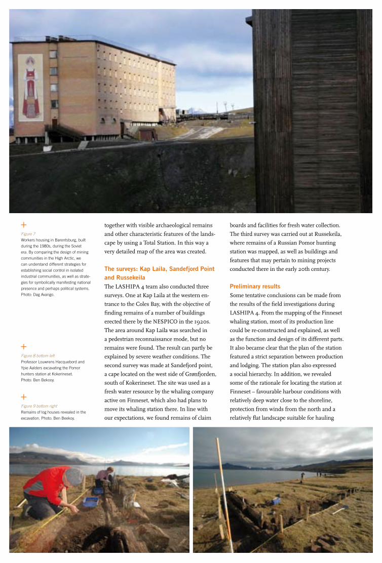
84 FORSKARRAPPORTER CRUISE REPORTS SWEDARCTIC 2007 ÅRSBOK YEARBOOK 2007 85
together with visible archaeological remains
and other characteristic features of the lands-
cape by using a Total Station. In this way a
very detailed map of the area was created.
The surveys: Kap laila, Sandefjord Point and RussekeilaThe LASHIPA 4 team also conducted three
surveys. One at Kap Laila at the western en-
trance to the Coles Bay, with the objective of
finding remains of a number of buildings
erected there by the NESPICO in the 1920s.
The area around Kap Laila was searched in
a pedestrian reconnaissance mode, but no
remains were found. The result can partly be
explained by severe weather conditions. The
second survey was made at Sandefjord point,
a cape located on the west side of Grønfjorden,
south of Kokerineset. The site was used as a
fresh water resource by the whaling company
active on Finneset, which also had plans to
move its whaling station there. In line with
our expectations, we found remains of claim
Figure 7
Workers housing in Barentsburg, built
during the 1980s, during the Soviet
era. By comparing the design of mining
communities in the High Arctic, we
can understand different strategies for
establishing social control in isolated
industrial communities, as well as strate-
gies for symbolically manifesting national
presence and perhaps political systems.
Photo: Dag Avango.
Figure 8 bottom left
Professor Louwrens Hacquebord and
Ypie Aalders excavating the Pomor
hunters station at Kokerineset.
Photo: Ben Bekooy.
boards and facilities for fresh water collection.
The third survey was carried out at Russekeila,
where remains of a Russian Pomor hunting
station was mapped, as well as buildings and
features that may pertain to mining projects
conducted there in the early 20th century.
Preliminary resultsSome tentative conclusions can be made from
the results of the field investigations during
LASHIPA 4. From the mapping of the Finneset
whaling station, most of its production line
could be re-constructed and explained, as well
as the function and design of its different parts.
It also became clear that the plan of the station
featured a strict separation between production
and lodging. The station plan also expressed
a social hierarchy. In addition, we revealed
some of the rationale for locating the station at
Finneset – favourable harbour conditions with
relatively deep water close to the shoreline,
protection from winds from the north and a
relatively flat landscape suitable for hauling
Figure 9 bottom right
Remains of log houses revealed in the
excavation. Photo: Ben Beekoy.

84 FORSKARRAPPORTER CRUISE REPORTS SWEDARCTIC 2007 ÅRSBOK YEARBOOK 2007 85
Figure 9
Survey along the riverbed at Sandefjord
Point on the southwest side of Grønfjorden,
in search of claim boards and remains of
water collecting devices. The river coming
down from the mountain was used as a
fresh water source for the Finneset whaling
station. Photo: Dag Avango.
whales on shore and for erecting buildings and
technical installations. Moreover, Grønfjorden
is one of the most accessible fiords on Spits-
bergen because of the relatively long length
of its ice-free season and its location near the
entrance to Isfjorden and the open sea.
Many of the same qualities are relevant for
understanding the rationale for locating the Nor-
wegian radio station at Finneset. The site was
within easy distance from most mining settle-
ments of scale on Spitsbergen in 1911 and a
natural place to stop over en route to or from
the European mainland. Last but not least, it
is well known that the Norwegian government
had political ambitions invested in the radio
station to further its goal to establish national
sovereignty over Spitsbergen. It is therefore
worth noting that Finneset was the neigh-
bourhood of several Norwegian companies,
guaranteeing the station access to a harbour
and to coal (for energy), as well as strengthe-
ning the impression of Norwegian effective
occupation in the area.
The investigations in Barentsburg also
yielded valuable results. It has been generally
believed that the remains of NESPICO’s Ba-
rentsburg are, with some notable exceptions,
impossible to find because of the massive de-
struction of the town in 1943 by the German
North Atlantic fleet. However, the survey yiel-
ded impressive and unexpected results. Re-
mains of numerous pre-war structures were
found and documented, which will facilitate
an understanding of the main production line
and the general plan of the community, with
the help of historic maps and photographs.
The mapping of Barentsburg also yielded
important data for understanding the develop-
ment of the town from the 1930s until today.
The different time layers of the settlement
revealed different Soviet architectural trends
over the course of the 20th century. Moreover, it
revealed different phases of re-construction and
investment, most likely reflecting fluctuations in
the relative importance of Spitsbergen in Rus-
sia – economically, politically and strategically.
However, at this point we cannot explain the
driving forces behind the different construction
phases without further archival research and
comparative analyses, nor the contextual mea-
nings or symbolic values of the buildings and
the settlement itself. These are important tasks
for further research.
Finally, the Kokerineset excavation yielded
important results as well as bases for a plan
for continued excavations of the site. The
excavation revealed the remains of two log
cabins and under those the remains of an ol-
der period of settlement. Both cultural layers
clearly indicate a Russian Pomor occupation.
However, the site was also used by European
whalers, which the remains of a blubber fur-
nace near the beach clearly shows. Most likely
these whalers were British, as is indicated by
its design. Apart from the furnace, the exca-
vation team found no further indication of a
European presence at Kokerineset in the 17th
and 18th centuries. Remains of whalers’ dwel-
lings are expected to be found to the north or
west of the 2007 excavation trenches.

86 FORSKARRAPPORTER CRUISE REPORTS SWEDARCTIC 2007 ÅRSBOK YEARBOOK 2007 87
lAShIPA 4 – Naturresurser och geopolitik från 1600-talet till våra dagarLASHIPA (Large Scale Historical Industrial exploitation of Polar Areas) är ett internationellt historisk-arkeologiskt forskningsprojekt inom ramen för Internationella polaråret (IPY) 2007–2008. Projektets syfte är att förklara utvecklingen av industri i polartrakterna från 1600-talet till idag, samt industrins konsekvenser för den geopolitiska situationen och för den lokala miljön där. Syftet med LASHIPA 4-expeditionen i augusti 2007 var nära knutet till projektets övergripande syfte, liksom till problem-ställningarna i de individuella delprojekten inom LASHIPA (doktorand- och post-doc-projekt etc. – se webbplatsen www.lashipa.nl för mer information).
Fältundersökningarna genomfördes av tre expeditionsgrupper vid olika lokaler på västra Spetsbergen. Vid Kokerineset, Grönfjorden, genomfördes en arkeologisk utgrävning av en fångststation (1600–1700- tal). På östra sidan av Grönfjorden dokumenterades lämningarna av en valfångststation, en radiostation samt ett antal gruvanläggningar och vid Adventfjorden kartlades lämningar av gruvdrift (1900-tal).
The fragments of glazed- and slipware found
in the upper layer point to barter between
Western European whalers and Russian Po-
mor hunters. However, it is also possible, but
not likely, that the Pomors brought the pottery
from their home countries where they also
engaged in barter with Europeans.
The animal bone material collected at the
site was analysed in Groningen in the autumn
of 2007. It provides some insight into which
species the Pomors hunted. However, it is a
relatively small sample. In order to answer
questions in regard of the seasons during
which the Pomors were hunting and the rela-
tive amounts of and uses for animals they kil-
led, more bone material needs to be collected
from a larger area. A cow bone and the Plum
stones found in the excavation make barter
between Pomors and the European whalers
appear very likely.
ReferencesAvango, D., Martin, P.E., Hacquebord, L.,
Oglethorpe, M., Martin, S., Nisser, M. and
Rossnes, G. 2005. Industrial Heritage in the
Arctic: Research and Training in Svalbard,
August 2004. Houghton: Groningen:
Stockholm.
Avango, D., Hacquebord, L. and Martin, P.E.
2006. ”The Lashipa Project: Industry, Geo-
politics and Environment in the Polar Areas
Through the Lens of Industrial Heritage.”
Proceedings of the TICCIH Congress 2006,
Terni, Italy. www.mnactec.com/TICCIH
Hacquebord, L. and Avango, D. 2007.
LASHIPA 3 – Industry and its impacts in
the polar areas from 1600 till present. In:
Rickberg, S. (ed.). Swedish Polar Research
Secretariat Yearbook 2006. Stockholm, Swe-
dish Polar Research Secretariat: 62–66.
Hacquebord, L. Avango, D., Gustafsson, U.
and Hartnell, C. 2007. LASHIPA 2:
archaeological field report. Groningen,
Arctic Center, University of Groningen.

86 FORSKARRAPPORTER CRUISE REPORTS SWEDARCTIC 2007 ÅRSBOK YEARBOOK 2007 87
Project leader
Ella Carlsson The Solar System Physics and Space
Technology research program
Swedish Institute of Space Physics
Kiruna
and
Division of Physics
Luleå University of Technology
Project participantshenrik JohanssonPhysics Department
Stockholm University
Andreas JohnssonEarth Sciences Centre
University of Gothenburg
Finding Mars on Svalbard:A study of Martian gullies on Earth
BackgroundWater is a prerequisite for life as we know
it. Without water the present life on Earth
would not exist. The quest for water on other
celestial bodies beyond Earth has therefore
become an imperative in space research. The
planet Mars has been known to harbour abun-
dances of frozen water trapped in its polar
caps and the regolith. However, due to the
low atmospheric pressure and temperature,
water cannot exist in a liquid and stable form
on the surface. The discovery of water-related
geological features, known as gullies (Malin
and Edgett 2000), constituted a turning point
in the debate regarding the existence of liquid
water on the Martian surface. The discovery
implied that water could exist on the surface
of Mars during favourable conditions. How-
ever, identifying the exact formation proces-
ses that have been involved in the formation
of these gullies has proved to be a point of
contention. Different models have been
proposed, including dry landslides (Treiman
2003), liquid carbon dioxide (Musselwhite
et al. 2001), snow melt (Christensen 2003),
melting ground ice (Costard et al. 2002), deep
aquifers (Gaidos 2001) and shallow water
aquifers (Mellon and Phillips 2001). So far the
science community only has access to remote
sensing data from satellites which, at present,
cannot for certain determine the true eroding
agent of the gullies.
Martian analogue gullies on EarthOn a scouting mission to Svalbard in 2006,
we found gullies that bear striking similarities
to the Martian gullies. The left side of Figure 1
shows a gully found on Svalbard (Adventfjor-
den) while the right side displays a typical
Martian gully. These gullies, which originate
from two different planets, exhibit the same
kind of characteristic features such as alcove,
channel and debris apron. The theatre-shaped
alcove tapers down slope where the V-shaped
channel commences. Many gullies on Sval-
bard have consolidated strata layers in the
alcove regions, which also have been detected
for some of the Martian alcoves. Moreover,
the channels of the gullies on Svalbard tend to
streamline around obstacles in the same way
as some of the Martian gullies do, which in-
dicates that water could be one of the eroding
agents on Mars as well. Another similarity is
the occurrence of debris aprons in the lower
part of the gullies that are triangle shaped,
broadening down slope.
MethodologyThe discovery of the similar morphology of
the gullies became the starting point of our
Expedition Svalbard 2007 and 2008. We
hypothesized that terrestrial gullies in the
polar regions could be an equitable analogue
for the Martian gullies due to the cold climate,
and a comparative analysis could help solve
Figure 1
The left side of the figure shows a ter-
restrial gully on Svalbard (Adventfjorden)
while the right side shows a Martian gully.
Left side photo: Ella Carlsson.
Right side photo: NASA/MSSS.

88 FORSKARRAPPORTER CRUISE REPORTS SWEDARCTIC 2007 ÅRSBOK YEARBOOK 2007 89
the discrepancies regarding the formation
mechanisms of the Martian gullies and shed
light on their true eroding agent.
In the study we will analyse satellite remo-
te sensing data of analogue gully locales on
Svalbard by using similar methodologies to
those used in previous studies of Martian gul-
lies (Heldmann et al. 2004 and 2007). The
results will then be compared with measure-
ments made in situ on Svalbard in order to
validate the conclusions drawn from the
satellite data. In addition, an extensive set of
measurements, which cannot be conducted
from orbit, will be made on site at Svalbard.
The knowledge gained from this comparison
will be used to make a qualitative evaluation
of the conclusions drawn from previous stu-
dies of gully formation on Mars, where only
remote sensing data is available.
Expedition Svalbard 2007 and 2008In the summer of 2007, as part of SWED-
ARCTIC 2007, we first flew to Longyearbyen
and initially set up camp at the camping site
close to the airport. On the other side of Ad-
ventfjorden we were sometimes able to discern
the gullies through the low clouds. We were
standing at the shore, admiring the view, eager
to reach the opposite side of the bay and begin
our study.
The first couple of days were spent making sure
that we had all the right equipment to survive
without support for two weeks in a polar envi-
ronment. We also checked our instruments to
see that everything was in order after the flight.
We were then transported to the other side
of Adventfjorden using a small open boat,
operated by the Norwegian Polar Institute.
We disembarked between Adventcity and
Hjorthamn and set up our tents some hund-
red meters from the shoreline. Even though
we could see Longyearbyen on the other side
of the fjord, we knew we were in the wild
and humble guests in the land of the mighty
polar bears.
During the next couple of days we climbed
the hills to reach the gullies. Initially, we
started to study a rather small gully (250 m),
which we named Idun, after one of the gods
from Norse mythology. After measuring
lengths, widths, depths and slope angles of
the different parts of the gully, we deployed
our data logging instruments. These loggers
are going to measure temperature, humidity
and water occurrence in the soil and air, for
the next twelve months. With the use of a
WADI device, which measures the magnetic
component of the electromagnetic field emit-
ted by long-distance radio transmitters, we
also looked for signs of underground structu-
res where water could be enclosed.
Little did we know that Idun was just a
precursor of what was to follow.
Not far from Idun we found another inte-
resting gully, which we named Balder, Idun’s
mythological brother. The gully Balder is
at least four times longer than Idun and in
some places, twice as steep so our explora-
tion of Balder was mixed with emotions of
fear and a sense of true happiness. It was a
remarkable experience for us to be able to
stand inside such a mighty gully, since the
larger part of our party had only studied gul-
lies on satellite images taken from high orbit
around Mars. Our ultimate goal in exploring
Balder was to closely observe the strata layers
in the upper part of the alcove of the gully,
from where the sapping water originated, but
due to the very active top layer of the gully we
found it impossible to reach this point, fea-
ring that this layer could collapse. We there-
fore decided to revisit Balder next year with
suitable climbing equipment (and helmets)
in order to lower ourselves down from the
top of the mountain.
Figure 2
Andreas Johnsson climbing up in the
gully he named Balder. Photo: Expedition
Svalbard 2007.
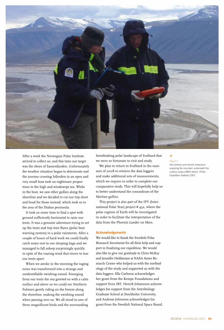
88 FORSKARRAPPORTER CRUISE REPORTS SWEDARCTIC 2007 ÅRSBOK YEARBOOK 2007 89
After a week the Norwegian Polar Institute
arrived to collect us, and this time our target
was the shore of Sassenfjorden. Unfortunately
the weather situation began to deteriorate and
the journey crossing Isfjorden in an open and
very small boat took on nightmare propor-
tions in the high and windswept sea. While
in the boat, we saw other gullies along the
shoreline and we decided to cut our trip short
and head for those instead, which took us to
the area of the Diabas peninsula.
It took us some time to find a spot with
ground sufficiently horizontal to raise our
tents. It was a genuine adventure trying to set
up the tents and trip wire flares (polar bear
warning system) in a polar rainstorm. After a
couple of hours of hard work we could finally
catch some rest in our sleeping bags and we
managed to fall asleep surprisingly quickly
in spite of the roaring wind that strove to tear
our tents apart.
When we awoke in the morning the raging
noise was transformed into a strange and
unidentifiable swishing sound. Emerging
from our tents the sea greeted us with a calm
surface and above us we could see Northern
Fulmars gently riding on the breeze along
the shoreline, making the swishing sound
when passing over us. We all stood in awe of
these magnificent birds and the surrounding
breathtaking polar landscape of Svalbard that
we were so fortunate to visit and study.
We plan to return to Svalbard in the sum-
mer of 2008 to retrieve the data loggers
and make additional sets of measurements,
which we require in order to complete our
comparative study. This will hopefully help us
to better understand the conundrum of the
Martian gullies.
This project is also part of the IPY (Inter-
national Polar Year) project # 432, where the
polar regions of Earth will be investigated
in order to facilitate the interpretation of the
data from the Phoenix Lander on Mars.
AcknowledgementsWe would like to thank the Swedish Polar
Research Secretariat for all their help and sup-
port in finalizing our expedition. We would
also like to give our gratitude to Chris McKay
and Jennifer Heldmann at NASA Ames Re-
search Center who helped us with the method-
ology of the study and supported us with the
data loggers. Ella Carlsson acknowledges
her grant from the Kempe Foundations and
support from IRF, Henrik Johansson acknow-
ledges his support from the Astrobiology
Graduate School at Stockholm University,
and Andreas Johnsson acknowledges his
grant from the Swedish National Space Board.
Figure 2
Ella Carlsson and Henrik Johansson
analyzing the mountain underneath the
surface using a WADI device. Photo:
Expedition Svalbard 2007.

90 FORSKARRAPPORTER CRUISE REPORTS SWEDARCTIC 2007 ÅRSBOK YEARBOOK 2007 91
Mars på Svalbard: en studie av marsianska bäckraviner på Jorden
Eftersom allt liv som vi känner till idag kräver vatten för att överleva, är ibland sökandet efter liv på andra planeter starkt förknippat med ett sökande efter vatten. Att det finns vatten i form av is på vår grannplanet Mars har varit känt under många år, men på grund av de låga temperaturerna och det mycket låga atmosfärstrycket är flytande vatten inte stabilt på ytan. Därför kom det som en stor över-raskning när amerikanska forskare år 2000 upptäckte bäckraviner i satellitfoton tagna på Mars yta. Sedan deras upptäckt har det pågått en stor debatt om huruvida vatten kan ha varit inblandad i bäck-ravinernas uppkomst. Frågan står fortfarande olöst, mycket p.g.a. att den enda information som finns tillgänglig är insamlat av satelliter. För att bättre förstå pålitligheten i de tolkningar som har gjorts har vi påbörjat en studie av bäckraviner på Svalbard.
På Svalbard finns bäckraviner som till utseendet är slående lika dem man har sett på Mars. Detta, tillsammans med det kalla polarklimatet, gör att vi tror oss kunna anta att Svalbard utgör en skälig analog för Mars. Syftet med vår studie är att utföra motsvarande satellitmätningar på bäckravinerna på Svalbard som man har gjort på deras motsvarigheter på Mars, samt komplettera dessa med mätningar gjorda på plats på Svalbard.
Under sommaren 2007 tillbringade vi två veckor på Svalbard där vi utförde mätningar och placerade ut instrument. Under sommaren 2008 planerar vi att återvända till Svalbard för att samla in instrumen-ten, samt utföra ytterligare mätningar, som vi behöver för att slutföra vår studie. Detta kommer förhopp-ningsvis att hjälpa till att sprida ljus över det mysterium som de marsianska bäckravinerna utgör.
ReferencesChristensen, P.R. 2003. Formation of recent
martian gullies through melting of exten-
sive water-rich snow deposits. Nature 422,
45–48.
Costard, F., Forget, F. and Mangold, N. and
Peulvast, J.P. 2002. Formation of recent
martian debris flows by melting of near-
surface ground ice at high obliquity.
Science 295, 110–113.
Gaidos, E.J. 2001. Cryovolcanism and the
recent flow of liquid water on Mars.
Icarus 153, 218–223.
Heldmann, J.L. and Mellon, M.T. 2004.
Observations of martian gullies and cons-
traints on potential formation mechanisms.
Icarus 168, 285–304.
Heldmann, J., Carlsson, E., Johansson, H.,
Mellon, M. and Toon, O. 2007. Observa-
tions of martian gullies and constraints
on potential formation mechanisms. Part
II: The northern hemisphere. Icarus 188,
324–344.
Malin, M.C. and Edgett, K.S. 2000. Evidence
for recent groundwater seepage and surface
runoff on Mars. Science 288, 2330–2335.
Mellon, M.T. and Phillips, R.J. 2001. Recent
gullies on Mars and the source of liquid
water. J. Geophys. Res. 106, 23165–23179.
Musselwhite, D.S., Swindle, T.D. and Lunine,
J.I. 2001. Liquid CO2 breakout and the for-
mation of recent small gullies on Mars.
Geophys. Res. Lett. 28, 1283–1285.
Treiman, A.H. 2003. Geologic settings
of martian gullies: Implications for
their origins. J. Geophys. Res. 108,
doi:10.1029/2002JE001900.

90 FORSKARRAPPORTER CRUISE REPORTS SWEDARCTIC 2007 ÅRSBOK YEARBOOK 2007 91
Principal investigators
(not participating in the expedition):
Björn OlsenDepartment of Infectious Diseases
Uppsala University Hospital, Uppsala
and Section for Zoonotic Ecology and
Epidemiology, Kalmar University, Kalmar
Oleg I. Kiselev Research Institute of Influenza
Russian Academy of Medical Sciences
St. Petersburg, Russia
Sven Bergström Department of Molecular Biology
Umeå University, Umeå
Expedition participants Ingvar Eliasson
(expedition leader Swedish group)
Department of Clinical Microbiology
and Immunology
Lund University Hospital, Lund
Pär ComstedtDepartment of Molecular Biology
Umeå University, Umeå
Anders WallenstenDepartment of Natural Sciences
Kalmar University, Kalmar
Michail grudinin (expedition leader Russian group)
Vladimir BlinovMaria PisarevaMarina StukovaJanna BuzitskayaResearch Institute of Influenza
Russian Academy of Medical Sciences
St. Petersburg, Russia.
Local supportNikolay N. PavlovKomandorskiy State Nature Biosphere
Reserve, Russia
Joint Russian and Swedish investigations into zoonotic pathogens on the Commander Islands
During the month of July 2007 a joint Rus-
sian and Swedish research expedition set out
to investigate the presence of microbial agents
of zoonotic potential in the fauna of the Com-
mander Islands, a small group of islands
bordering the Bering Sea in the North Pacific
Ocean. The geographic position of the Com-
mander Islands is of key interest as they are
isolated from the North East Asian mainland,
but are in close proximity to the North Ame-
rican continent forming a continuation of the
Aleutian chain of islands.
In December 2002 the Commander Is-
lands received the status of an international
biosphere reserve and are thus considered
a part of the world’s natural heritage. The
coastal waters of the islands are inhabited by
many species of whales and cetaceans, while
the islands themselves support large colonies
of fur seals and sea lions, great numbers
of sea otters as well as over 500,000 rare
northern birds. The islands host large popu-
lations of both migratory and stationary bird
species. Due to isolation, some populations
have even developed into subspecies found
only on these islands, such as subspecies of
Rock Sandpiper (Calidris ptilocnemis quarta),
Commander Rock Ptarmigan (Lagopus mutus
ridgwayi Stejneger) and Winter Wren (Troglody-
tes troglodytes pallescens Ridgw.). Many marine
birds such as auks, gulls, fulmars and shear-
waters come to the islands in thousands to
breed while others such as the emperor goose
use the islands as wintering ground.
In search of avian flu virusesThe expedition’s main focus of interest was to
screen for the presence of influenza viruses
among the large marine bird populations on
the islands. Influenza viruses exist in different
types and subtypes and cause disease in many
different species of animals (Webster et al.
1992, Stone 2000 and 2002, Wallensten
2007a). The seasonal and occasional pande-
mic (world wide) spread of influenza virus in
humans is of major public health importance.
The subject has received massive attention
since the start of the outbreak of highly pat-
hogenic avian influenza subtype H5N1 in
poultry in South East Asia in 2003. This out-
break has had an enormous negative impact
on the poultry industry worldwide. It has also
proved to be highly lethal when transmitted to
humans and has raised concerns over an im-
minent pandemic (Wallensten et al. 2007b).
Historically influenza pandemics have had a
devastating impact. The worst known pande-
mic, the Spanish Influenza of 1918, is thought
to have caused the death of more than 40 mil-
lion people (Oxford 2000). Although stable
lineages of influenza viruses exist in different
species such as humans, horses and pigs, all
influenza viruses in these species are thought
to have originated from those circulating in
wild birds (Ito and Kawaoka 2000). Wild
birds have been shown to harbour a multitude
of different influenza viruses but only a few
of these have been involved in outbreaks in
other species. Influenza viruses have been
isolated from several bird species, but are
most frequently isolated from dabbling ducks
such as mallards and in some parts of the
world from certain species of waders (Olsen et
al. 2006, Wallensten et al. 2007c). Influenza
viruses are isolated from these species around
the world and there has even been serological
evidence of infection in Antarctic penguins
(Wallensten et al. 2006). Very little is known
about the circulation in marine birds such
as shearwaters and auks although there have
Figure 1
Sea Otters were abundant in the coastal waters
of Bering Island. Photo: Ingvar Eliasson.

92 FORSKARRAPPORTER CRUISE REPORTS SWEDARCTIC 2007 ÅRSBOK YEARBOOK 2007 93
been sporadic reports (Wallensten et al. 2005,
Sazonov et al. 1977, Mackenzie et al. 1984,
Yamnikova et al. 2003), but the relevance of
these sporadic findings in marine birds in re-
lation to the total circulation of influenza viru-
ses in wild birds is still unclear. Many marine
bird species live nomadic lives at sea and are
therefore difficult to catch other than on their
breeding grounds. Therefore breeding places
such as the Commander Islands are ideal for
sampling marine birds. The relative isolation
of the Commander Islands from the main-
land East Asian migratory bird flyways and
the limited impact of poultry production also
make these islands interesting for sampling.
The current expedition aimed to fill the final
gap in an influenza screening project that was
part of the multidisciplinary research expedi-
tion named “Beringia 2005”, organized by the
Swedish Polar Research Secretariat in collabo-
ration with Russian and American authorities.
During Beringia 2005, sampling for influenza
took place on the Russian mainland further
north including Wrangel Island and also at the
Alaskan coast, in order to map the prevalence
of influenza viruses in the Bering Sea area.
Zoonotic gut bacteria and antibiotic resistanceHowever, influenza A viruses are not the only
agents of zoonotic potential that birds can
harbour and during both Beringia 2005 and
the current expedition, simultaneous samp-
ling for bacterial agents were also performed
in order to benefit studies on the preva-
lence of Campylobacter, Salmonella and Chla-
mydophila psittaci among wild birds. These
samples will also be used for studies on the
presence of antibiotic resistance in bacteria
from these remote echo systems. Previous
studies by Professor Olsen’s group have dis-
covered antibiotic resistance in bacteria from
other remote places such as the South Geor-
gian Islands, in spite of the limited human
presence on those islands (Olsen et al. 1996,
Palmgren et al. 2000, Broman et al. 2000).
Seabirds perpetuate specific bird-tick borrelia cyclesIn addition, ticks were collected from birds
and from the birds’ nests. Ticks will be ana-
lysed for the presence of Borrelia burgdorferi
sensu lato, tick-borne spirochetes that can cause
Lyme borreliosis in humans. Migratory birds
have been shown to act as long distance vectors
for Borrelia and different sea birds, nesting in
large colonies, are known to perpetuate specific
bird–tick Borrelia cycles with dedicated tick spe-
cies (Olsen, Jaenson et al. 1993, Olsen, Duffy
et al. 1995, Comstedt, Bergstrom et al. 2006).
Mapping Borrelia isolates from these remote
islands and comparing them to strains isolated
from birds and rodents as well as humans can
provide new knowledge on the global distribu-
tion and spread of the Borrelia spirochetes.
Field workThe expedition was carried out by participants
from the Institute of Influenza in Saint Peters-
burg and a joint Swedish crew with representa-
tives from Kalmar University, Lund University
and Umeå University. The team was fortunate
to have stable weather during the whole expe-
dition (not always the case on these misty and
cold islands) and with expert help from the
rangers of the reserve, they managed to cap-
ture and sample birds from both the east and
west coast of Bering Island, as well as from the
small Toporkov Island (for sampling sites, see
Fig. 2). In addition, a smaller number of speci-
mens were collected from black-headed gulls
in the river delta of Petropavlovsk. All together,
specimens from some 530 birds of different
key species were collected, as well as a large
number of ticks, mainly from birds’ nests.
As a side project, Dr. Marina Stukova also
Figure 2Bering Island and sampling sites. Bering Island (55°0’N, 166°15’E) is approximately 90 km long by 20 km wide, which makes it the largest of the Commander Islands. It is situated very close to the International Date Line. The island is treeless, foggy and prone to storms and earthquakes. The only popula-ted area is the small village Nikolskoye. The western sampling sites were reached by jeep and by foot, while the sites on the east side – as well as Toporkov Island – were only acces-sible by Zodiac (red lines). Old Harbour was not a sampling site but the starting point of the long Zodiac ride down to Peregryobnaya Bay via Buyan Bay. The hand-drawn map was hanging on the wall of the community centre in Nikolskoye. Otherwise, maps of this island are hard to come by.
Figure 3Larisa Zelenskaya in the tent. During our visit to Toporkov Island, we met two Russian ornithologists, Yuri Artukhin and Larisa Zelenskaya, stationed at this small island during the whole bird-nesting period. They were both very helpful, al-lowing us to use their tent for shelter and providing us with useful information on the bird population and on handling the birds. Photo: Ingvar Eliasson.

92 FORSKARRAPPORTER CRUISE REPORTS SWEDARCTIC 2007 ÅRSBOK YEARBOOK 2007 93
Figure 5
Tufted Puffin (Fratercula cirrhata),
captured at Toporkov Island. Photo:
Anders Wallensten.
Figure 4
Fur Seal colony at the North West
Rookery. Photo: Ingvar Eliasson.
performed voluntary blood sampling of the
local population at Bering Island for seroepide-
miological investigations.
All specimens were put in appropriate
protective media in the field, and then placed
in stainless steel dewars of liquid nitrogen at
a temperature of about -197°C. The dewars
provided a simple and effective means of
rapid freezing and safe storage during
fieldwork and transportation across the 11
time zones back to Sweden. Laboratory investi-
gations regarding Influenza viruses and Influ-
enza serology will be carried out as a collabo-
ration between Kalmar and Saint Petersburg,
while ticks and bacterial specimens will be
processed in Umeå and Kalmar, respectively.
All results will be published jointly and feed-
back on the outcome of the investigations also
provided to the Director of the Komandorskiy
State Nature Biosphere Reserve for reference.
In conclusion, this international, multi-
disciplinary research expedition may provide
new knowledge in several important areas of
research regarding silvatic zoonotic diseases,
i.e. infectious diseases and propagation of
infectious agents in wild animals that can
eventually affect humans. Knowledge about
the propagation of antibiotic-resistant bacteria
from human and agricultural sources back
into nature is also of major concern in the
context of the long-term usefulness of antibio-
tics in the battle against infectious diseases.
Supporting organisations Research Institute of Influenza
Russian Academy of Medical Sciences
Swedish Polar Research Secretariat
Royal Swedish Academy of Sciences
ReferencesBroman, T., Bergström, S., On, S.L.W., Palm-
gren, H., McCafferty, D.J., Sellin, M. and
Olsen, B. 2000. Isolation and characteriza-
tion of Campylobacter jejuni subsp. jejuni from
Macaroni penguins (Eudyptes chrysolophus)
in the subantarctic region. Applied and
Environmental Microbiology 66, 449–452.
Comstedt, P., Bergstrom, S. et al. 2006.
Migratory passerine birds as reservoirs
of Lyme borreliosis in Europe. Emerg.
Infect. Dis. 12(7), 1087–95.
Ito, T. and Kawaoka, Y. 2000. Host-range
barrier of influenza A viruses. Veterinary
Microbiology 74(1-2), 71–5.
Mackenzie, J.S., Edwards, E.C. et al. 1984.
Isolation of ortho- and paramyxoviruses
from wild birds in Western Australia, and
the characterization of novel influenza A
viruses. Australian Journal of Experimental
Biology & Medical Science 62(Pt 1), 89–99.
Olsen, B., Duffy, D.C. et al. 1995. Trans-
hemispheric exchange of Lyme disease
spirochetes by seabirds. J. Clin. Microbiol.
33(12), 3270–4.
Olsen, B., Jaenson, T.G. et al. 1993. A Lyme
borreliosis cycle in seabirds and Ixodes
uriae ticks. Nature 362(6418), 340–2.
Olsen, B., Bergström, S., McCafferty, D.J.,
Sellin, M., and Wiström, J. 1996. Salmo-
nella enteritidis in Antarctica: zoonosis in
man or humanosis in penguins? The Lancet
348, 1319–1320.
Olsen, B., Munster, V.J., Wallensten, A.,
Waldenström, J., Osterhaus, A.D. and
Fouchier, R.A. 2006. Global patterns of
influenza a virus in wild birds. Science
312(5772), 384–8.

94 FORSKARRAPPORTER CRUISE REPORTS SWEDARCTIC 2007 ÅRSBOK YEARBOOK 2007 95
Oxford, J.S. 2000. Influenza A pandemics of
the 20th century with special reference to
1918: virology, pathology and epidemiology.
Reviews in Medical Virology 10(2), 119–33.
Palmgren, H., McCafferty, D., Aspán, A.,
Broman, T., Sellin, M., Wollin, R., Berg-
ström, S. and Olsen, B. 2000. Salmonella
in sub-Antarctica: low heterogeneity in
salmonella serotypes in South Georgian
seals and birds. Epidemiology & Infection
125, 257–262.
Sazonov, A.A., Lvov, D.K. et al. 1977. Isola-
tion of an influenza virus, similar to A/
Port Chalmers/1/73 (H3N2) from a com-
mon murre at Sakhalin Island in U.S.S.R.
(Strain A/common murre/Sakhalin/1/74).
Archives of Virology 53(1–2), 1–7.
Stone, R. 2000. Canine Virus Blamed in Cas-
pian Seal Deaths. Science vol. 289, p. 2017.
Stone, R. 2002. Caspian Ecology Teeters on
the Brink. Science vol. 295, pp. 430–433.
Webster, R.G., Bean, W.J. et al. 1992. Evolu-
tion and ecology of influenza A viruses.
Microbiological Reviews 56(1), 152–79.
Wallensten, A., Munster, V.J., Elmberg, J.,
Osterhaus, A.D.M.E., Fouchier, R.A and
Olsen, B. 2005. Multiple gene segment
reassortment between Eurasian and Ameri-
can lineages of influenza A virus (H6N2) in
Guillemot (Uria aalge). Archives of Virology
Aug;150(8), 1685–92.
Wallensten, A., Munster, V.J., Osterhaus,
A.D.M.E., Waldenström, J., Bonnedahl, J.,
Broman, T., Fouchier, R.A.M. and Olsen, B.
2006. Mounting evidence for the presence
of influenza A virus in the avifauna of
the Antarctic region. Antarctic Science 18,
353–356.
Wallensten, A. 2007a. Influenza virus in wild
birds and mammals other than man. Micro-
bial Ecology in Health and Disease Volume
19, Issue 2, pages 122–139.
Wallensten, A., Waldenström, J., Olsen, B.
2007b. Fågelinfluensan, hönan, människan
och den förmodade döden. [Avian influ-
enza, the hen, the man and the presumed
death]. Läkartidningen Aug 8-21;104(32–33),
2240–3.
Wallensten, A., Munster, V.J., Latorre-
Margalef, N., Brytting, M., Elmberg, J.,
Fouchier, R.A., Fransson, T., Haemig, P.D.,
Karlsson, M., Lundkvist, A., Osterhaus,
A.D., Stervander, M., Waldenström, J. and
Olsen, B. 2007c. Surveillance of influenza
A virus in migratory waterfowl in northern
Europe. Emerging Infectious Diseases
Mar:13(3), 404–11.
Yamnikova, S.S., Gambaryan, A.S., Tuzikov,
A.B., Bovin, N.V., Matrosovich, M.N.,
Fedyakina, I.T., Grinev, A.A., Blinov, V.M.,
Lvov, D.K., Suarez, D.L. and Swayne, D.E.
2003. Differences between HA receptor-
binding sites of avian influenza viruses
isolated from Laridae and Anatidae. Avian
Disease vol. 47, No 3, pp. 1164–1168.
gemensamma ryska och svenska undersökningar av zoonotiska patogener på KommendörsöarnaKommendörsöarna är en isolerad ögrupp utanför Kamtjatka i östra Ryssland. Den är kanske mest känd för att den store polarforskaren kommendör Vitus Bering dog där under en dramatisk upptäckts-resa i området. Kommendörsöarna sjuder av djur- och fågelliv och på grund av dess isolerade läge finns flera endemiska arter. Sommaren 2007 genomförde vi med stöd av Polarforskningssekretariatet en svensk-rysk expedition till Kommendörsöarna för att kartlägga förekomsten av zoonotiska mikro-organismer hos framförallt havsfåglar. Avföringsprover samlades in för påvisande av influensavirus, Salmonella och Campylobacter och fästingar från fåglarna samlades in för att studera Borrelia- bakterier. Förekomsten av dessa organismer hos havsfåglar och vilken roll fåglarna spelar i sprid-ningen i naturen är i stort okänd.
Figure 6
The Red-legged kittiwake (Rissa brevi-
rostris), only breed on the Commander
Islands and a few more islands in the
Bering Sea. Photo: Ingvar Eliasson.
Figure 7, 8, 9, 10
Red-faced cormorant (Phalacrocorax
urile).
A large mixed colony, mainly consisting
of kittiwakes.
Red-legged kittiwake (Rissa brevirostris).
Bering Island’s Arctic fox (Alopex lagopus
beringensis) were abundant and often
curious. Photos: Ingvar Eliasson.

94 FORSKARRAPPORTER CRUISE REPORTS SWEDARCTIC 2007 ÅRSBOK YEARBOOK 2007 95
Swedish team
lars larsson (Team leader)Fredrik larsson Arne SjöströmKristian Kàm Tayanin Malin Thorén Department of Archaeology
and Ancient History, Lund University
International teamMartin Appelt (Project leader)SILA - The Greenland Research Centre
at the National Museum of Denmark
Copenhagen, Denmark
Mikkel Myrup The National Museum & Archives
of Greenland, Nuuk, Greenland
Clemens Pasda Department of Archaeology
Friederich-Schiller Universität
Jena, Germany
Use of soapstone from the first settlement of Greenland until the present day
BackgroundRecent research in archaeology has drastically
improved our perception of the prehistory
and history of the Arctic. These advances have
demonstrated that Arctic peoples possess rich,
interconnected and complex histories.
Movement is regarded as an important con-
cept both for describing changes in human so-
cieties and for understanding human relation-
ships with the natural and social environment.
Firstly, the concept of movement encompasses
human actions ranging from seasonal mobility
constituted by small-scale movements within a
region, to long-term, inter-regional migrations.
Secondly, it refers to the movement of resour-
ces and cultural artefacts through trade and ex-
change between regions that serves to level out
uneven resource distribution in both space and
time, and it can also symbolise social connections.
Participation in regional and inter-regional
communication networks is also central to
long-term Arctic history, as rational choices can
only be made with access to information about
the social and natural environments outside the
local and regional areas. These networks may
be embedded in trade or exchange, or based on
ideological or social connections and alliances.
The ultimate objective of the project is to
bring about an understanding of the dynamic
strategies of movement, communication, and
other social actions that Arctic peoples gene-
rate when interacting with their social, cul-
tural, and natural environments. These strate-
gies can operate at multiple levels, including
individual agents, families or households,
local groups, and all people of a given cultural
tradition. In particular, connections between
these levels are expected to be important in
identifying the multifarious life-strategies
employed by individuals and societies.
In cold climates, sources of heat have necessa-
rily been of major importance. In large areas
of Greenland soapstone was used in order to
make lamps and other containers that were
used for heating food as well as providing
light for the dwellings.
The western coast of Greenland was prima-
rily settled by members of the Saqqaq culture
at around 2500 BC and initially driftwood was
used for heating dwellings. However, when pri-
mary sources for fuelling fire were exhausted,
people started to make soapstone lamps filling
them with bladder oil from seals. Soapstone is
abundant in the Nuuk region of Western Green-
land, and of high quality while only a few
quarries have been identified in other parts of
Greenland, and consequently soapstone be-
came an important commodity for exchange.
It has been ascertained that raw material was
exchanged over long distances since we know
that special metamorphic slate, killiaq, was ex-
tensively used in the Nuuk region for making
tools although the source is located in Disco
Bay some 650 km to the north.
In 2005 a project was initiated with the pur-
pose of developing a new and more integrated
understanding of Arctic cultural history. The
Figure 1
A view of the small fjord Urjarassuit pavat
with the base camp for the archaeolo-
gists. Photo: Lars Larsson.
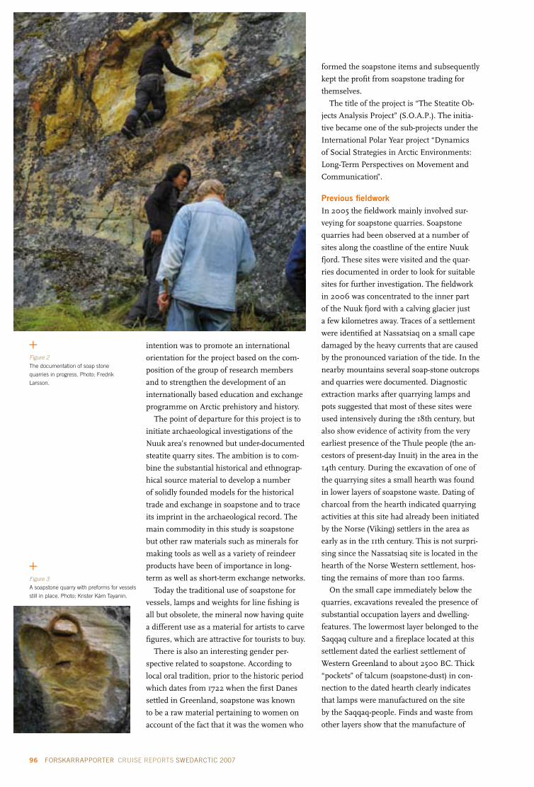
96 FORSKARRAPPORTER CRUISE REPORTS SWEDARCTIC 2007 ÅRSBOK YEARBOOK 2007 97
intention was to promote an international
orientation for the project based on the com-
position of the group of research members
and to strengthen the development of an
internationally based education and exchange
programme on Arctic prehistory and history.
The point of departure for this project is to
initiate archaeological investigations of the
Nuuk area’s renowned but under-documented
steatite quarry sites. The ambition is to com-
bine the substantial historical and ethnograp-
hical source material to develop a number
of solidly founded models for the historical
trade and exchange in soapstone and to trace
its imprint in the archaeological record. The
main commodity in this study is soapstone
but other raw materials such as minerals for
making tools as well as a variety of reindeer
products have been of importance in long-
term as well as short-term exchange networks.
Today the traditional use of soapstone for
vessels, lamps and weights for line fishing is
all but obsolete, the mineral now having quite
a different use as a material for artists to carve
figures, which are attractive for tourists to buy.
There is also an interesting gender per-
spective related to soapstone. According to
local oral tradition, prior to the historic period
which dates from 1722 when the first Danes
settled in Greenland, soapstone was known
to be a raw material pertaining to women on
account of the fact that it was the women who
formed the soapstone items and subsequently
kept the profit from soapstone trading for
themselves.
The title of the project is “The Steatite Ob-
jects Analysis Project” (S.O.A.P.). The initia-
tive became one of the sub-projects under the
International Polar Year project “Dynamics
of Social Strategies in Arctic Environments:
Long-Term Perspectives on Movement and
Communication”.
Previous fieldworkIn 2005 the fieldwork mainly involved sur-
veying for soapstone quarries. Soapstone
quarries had been observed at a number of
sites along the coastline of the entire Nuuk
fjord. These sites were visited and the quar-
ries documented in order to look for suitable
sites for further investigation. The fieldwork
in 2006 was concentrated to the inner part
of the Nuuk fjord with a calving glacier just
a few kilometres away. Traces of a settlement
were identified at Nassatsiaq on a small cape
damaged by the heavy currents that are caused
by the pronounced variation of the tide. In the
nearby mountains several soap-stone outcrops
and quarries were documented. Diagnostic
extraction marks after quarrying lamps and
pots suggested that most of these sites were
used intensively during the 18th century, but
also show evidence of activity from the very
earliest presence of the Thule people (the an-
cestors of present-day Inuit) in the area in the
14th century. During the excavation of one of
the quarrying sites a small hearth was found
in lower layers of soapstone waste. Dating of
charcoal from the hearth indicated quarrying
activities at this site had already been initiated
by the Norse (Viking) settlers in the area as
early as in the 11th century. This is not surpri-
sing since the Nassatsiaq site is located in the
hearth of the Norse Western settlement, hos-
ting the remains of more than 100 farms.
On the small cape immediately below the
quarries, excavations revealed the presence of
substantial occupation layers and dwelling-
features. The lowermost layer belonged to the
Saqqaq culture and a fireplace located at this
settlement dated the earliest settlement of
Western Greenland to about 2500 BC. Thick
“pockets” of talcum (soapstone-dust) in con-
nection to the dated hearth clearly indicates
that lamps were manufactured on the site
by the Saqqaq-people. Finds and waste from
other layers show that the manufacture of
Figure 2
The documentation of soap stone
quarries in progress. Photo: Fredrik
Larsson.
Figure 3
A soapstone quarry with preforms for vessels
still in place. Photo: Krister Kàm Tayanin.

96 FORSKARRAPPORTER CRUISE REPORTS SWEDARCTIC 2007 ÅRSBOK YEARBOOK 2007 97
Figure 4
Excavation of a small camp from the
earliest settlement of Western Greenland.
Photo: Krister Kàm Tayanin.
Figure 5
An arrowhead made of quartzite for rein-
deer hunting. Photo: Krister Kàm Tayanin.
soapstone artefacts was carried out well into
the 17th and 18th centuries. Several types of
artefacts from these later layers indicate that
Inuit connected to the Moravian Mission
station – called Uummannaq and located
some 40 km from Nassatsiaq – may well have
quarried the soapstone. A partly preserved
wooden and turf house can still be seen at the
site. The house was built in the early 1950s by
a well-known reindeer hunter and soapstone
carver and subsequently abandoned some-
time during the 1970s.
Fieldwork In 2007 the project reached its full potential
with a total of some 25 members from Den-
mark, Sweden, Germany, Switzerland, Ca-
nada and Greenland. A small fjord, Ujarassuit
pavat, a tributary fjord of the large Nuuk fjord,
became the main area of research since infor-
mation existed about a soapstone quarry in
the inner part of the small fjord. By surveying
the area a considerable number of quarries
were identified and later documented. This
area holds the largest outcrops of soapstone in
all Greenland, most of which have been exten-
sively quarried, leaving large heaps of waste
and the extracted area partly filled with water.
At a few locations traces of the use of a chain
saw proved that the quarries were still in use.
On the other side of the fjord a Norse farm
named Anavik is located. This is one of the
largest farms in the Western Settlement,
with several houses including a pack house
and a church. The church is one of only four
churches in the Western settlement, and
provides evidence of the prominent position
of the Anavik farm. This is further supported
by the presence of the heavily built pack
house, otherwise referred to in Greenlandic
archaeology as “safety deposit boxes”, as they
are thought to have been used for storing
especially valuable commodities. This type of
pack house is rare in Greenland. The farm is
located just a few kilometres from the inland
ice and the limited area suitable for grazing
is surprising given the seemingly high status
of the farm. However, a large ice-free region
immediately north of Anavik suggests that
reindeer hunting and fur-animal trapping,
for example arctic foxes, have been of major
importance, as was the case until recent years.
Furthermore, it is possible that the farm’s
position close to soapstone sources may also
have been important. Excavations at some of
the soapstone quarries show that large blocks
have been extracted by the Norse that were
suitable not only for vessels, but probably
also for building material. In some quarries
almost all soapstone has been extracted by the
Norse, while members of the preceding Thule
culture (1000–1700 AD) restricted quarrying
to removing soapstone in the exterior part of
the soapstone crops. As vessels of soapstone in
many cases replaced the clay vessels familiar in
Iceland and northern Scandinavia, the Norse
extraction may well have been highly profitable
for the members of the Anavik farm.
At a site close to the coastline and below
the quarries, heaps of soapstone refuse were
found. Preforms and broken pieces of soap-
stone show that intensive manufacture of
lamps and vessels was in progress during the
Thule culture and probably during periods of
the Dorset culture (500 BC–AD) and Saqqaq
culture (2500–800 BC). A site from the latter
culture was found at a cape (know by local
inhabitants as Putukkut Nuua) about 1 km

98 FORSKARRAPPORTER CRUISE REPORTS SWEDARCTIC 2007 ÅRSBOK YEARBOOK 2007 99
away although the only artefact made of
soapstone was a preform of a lamp. Finds
include a number of arrowheads that attest
to Puttukut Nuua’s use as a special-purpose
camp combined with reindeer hunting. The
same cape has later been used for different
purposes. A wall of stone may belong to a
Norse building and close to it three graves
were documented, one containing two indivi-
duals from the Thule culture. Even in spite of
climate change, localities with a good position
in relation to different resources have been
used over long periods of time. At the site of a
river estuary close to our camp a considerable
number of stone rings, the remains of sup-
ports for tents, were visible. The removal of
stones from such circles proves that the site
has been inhabited during the reindeer hun-
ting season for a large number of generations.
Användning av täljsten från den första bosättningen i grönland till idagEn viktig förutsättning för bosättningen i Grönland var att det existerade väl fungerade kontakter mellan olika grupper såväl inom en region som inom betydande delar av öns kustområden. Ett tydligt exempel på dessa kontakter är att vissa råvaror har förmedlats över betydande sträckor, exempelvis har vissa mineraler som använts vid redskapstillverkning utbytts över sträckor på mer än 650 km.
Det aktuella projektet har inriktats på täljsten. Det är ett viktigt material för framställning av lampor och kokkärl och förekommer rikligt runt Nuukfjorden på Västgrönland. Omfattande invente-ringar efter täljstensbrott har genomförts. Dessa har blivit föremål för dokumentation och begränsade arkeologiska undersökningar. Under 2007 undersöktes en ansamling av täljstensbrott i en bifjord inom Nuukfjordens inre del i närheten av landisen. De visade sig vara de mest omfattande som hit-tills har påträffats i Grönland.
Täljsten bröts redan av de äldsta bosättarna i Västgrönland (Saqqaqkulturen 2500–800 f.Kr.). Under nordborbosättningen (1000–1350 e.Kr.) har brytningen varit mycket omfattande. Även under Thulekulturen (1000–1700 e.Kr.) har brotten använts. Spår efter att täljsten har skurits fram med motorsåg visar på att förekomsten fortfarande utnyttjas. Utgrävningar av boplatser i täljstensbrottens närhet visade att föremål av täljsten har framställts på vissa lägerplatser medan andra utnyttjats vid renjakt som har varit omfattande i området.
Parts of tents and modern equipment show
that it is now used for recreational hunting.
The information accumulated over the
three years of work has been substantial and
has changed our perception of parts of the
cultural history of this region. The project
has also given rise to important theoretical
and methodological considerations on how to
bridge archaeology with other scientific disci-
plines, as well as revealing various uses of the
landscape over time. The next step is to analy-
se all the data – a task that will be significantly
inspired by the multi-facetted approaches
represented by the international mixture of
professors and students from six countries.
ReferencesAppelt, M., Myrup, M., Pasda, C. and Grøn-
now, B. 2005. The Steatite Objects Analysis
Project (S.O.A.P) – Travel and Project Report
2005. Feltrapport nr. 21. National museum
of Denmark.
Gulløv, H.C. (ed.). 2004. Grønlands for-
historie. København: Gyldendal.
Soapstone as a Prehistoric Export
Commodity: http://idw-online.de/pages/de/
news125697 (in German)
Fra fedstensbrud till køkkenmødding:
http://www.dpc.dk/graphics/Design/Danish/
Nyhedsrum/Polarfronten_online/PF%20305/
Fedstensbrud.pdf (in Danish)
Figure 6
The pack house from the Norse settlement
of Anavik. Photo: Krister Kàm Tayanin.

98 FORSKARRAPPORTER CRUISE REPORTS SWEDARCTIC 2007 ÅRSBOK YEARBOOK 2007 99
Swedish project leader
David gee Department of Earth Sciences
Uppsala University
Project participantsSWEDENgerhard Baxhenning lorenzDepartment of Earth Sciences
Uppsala University
Johan Barth Swedish Drillers’ Association, Lund
RUSSIAAlexander TebenkovAlexander Sirotkin Polar Marine Geosurvey Expedition
Lomonosov, Russia
Alexander larionov Karpinsky All-Russian Institute
of Geology (VSEGEI)
St. Petersburg, Russia
and others
Figure 1
The field camp in Innvika, innermost
Rijpfjorden. In the background part of the
Vestfonna icecap. Photo: Henning Lorenz.
Svalbard’s Caledonian Terranes revisited, Nordaustlandet 2007
Between 1990 and 1998 international geosci-
entific expeditions to northernmost Svalbard
have been carried out with the logistic support
of the Swedish Polar Research Secretariat
within the framework of the SWEDARCTIC
programme (see also cruise reports in the re-
spective yearbooks). During this period, scien-
tists from the Polar Marine Geosurvey Expedi-
tion in Lomonosov, Russia, have participated
in these expeditions establishing a long-term
collaboration that has resulted in a conside-
rable number of joint-publications. The aim
of this work was to gather knowledge about
the Precambrian and Caledonian tectonic
evolution of Svalbard’s eastern terranes and
to establish their relationships to each other,
to Greenland and other parts of the Eurasian
High Arctic. One fundamental result was the
finding that the Caledonian deformation and
metamorphism influenced the Nordaustlan-
det Terrane’s late Grenville age (ca 950 Ma)
basement and the unconformably overlying
Neoproterozoic sedimentary successions. The
intensity of this overprint increases eastwards
towards Kvitøya, the archipelago’s easternmost
island. Together with the evidence of the close
correlation of the eastern Svalbard terranes
with the East Greenland nappes, this indicates
that the main Caledonian suture is located
offshore, east of the Svalbard Archipelago.
In the late 1990s, the focus of our research
moved eastwards, and the expeditions visited
key areas in the Timanides, polar Urals, Tay-
myr, Severnaya Zemlya and Novaya Zemlya.
But after almost a decade central Nordaustlan-
det was revisited in order to investigate one
of the remaining major geological enigmas
of this area: the migmatite complex of central
Nordaustlandet in innermost Duvefjorden,
and the timing of intrusive episodes in the
area. This time the Swedish group was invited
to join the Russian operations, whose many
field parties covered large areas of northern
Svalbard for regional geological mapping in
collaboration with the Norwegian Polar Insti-
tute. The Swedish Polar Research Secretariat

100 FORSKARRAPPORTER CRUISE REPORTS SWEDARCTIC 2007 ÅRSBOK YEARBOOK 2007 101
provided equipment, weapons and weapon
training for the Swedish group.
Transport from Longyearbyen was orga-
nised with the Russian helicopter on one of
its regular flights to visit the Russian field
parties, to move camp and supply provisions,
and on 1 August the Swedish party joined the
Russian camp at Innvika (Fig. 1). Fieldwork
concentrated on the local stratigraphy of the
Neoproterozoic sedimentary successions (Fig. 4)
with the purpose to investigate how far these
were affected by the different intrusive pha-
ses (Fig. 3) (metamorphic grade and mig-
matisation) and the associated deformation
episodes, as well as the relationship of the
intrusive rocks to each other (relative age, Fig. 2).
Sampling for isotope age determinations of
the magmatic rocks and for detrital zircons
studies (sediment provenance) of the sedi-
mentary rocks complemented the survey.
However, the early approach of the winter
interfered with the helicopter schedule and
when on 13 August the weather situation
improved sufficiently for helicopter traffic,
the Swedish field party withdrew to Longyear-
byen, after visiting a selection of geological
key locations in northern Nordaustlandet
together with Russian colleagues.
Återbesök av Svalbards Kaledonska jordplattorMellan 1990 och 1998 genomfördes internationella geovetenskapliga expeditioner till Svalbards nordli-gaste delar, med logistikstöd från Polarforskningssekretariatet (se rapporter i årsböckerna). Forskare från det statliga ryska företaget Polar Marine Geosurvey Expedition har deltagit i expeditionerna och det långa samarbetet har gett upphov till en mängd gemensamma publikationer. Syftet med dessa expeditioner har varit att samla kunskap om Svalbards östra delar och att fastställa deras geologiska relation till varandra, till Grönland och andra delar av det eurasiska Högarktis.
Under det sena 1990-talet flyttades forskningsfokus österut och gruppen besökte Timaniderna, de polara Uralbergen, Tajmyr, Severnaja Zemlja och Novaja Zemlja. Därefter återbesöktes Nordostlandet för att undersöka en av de återstående geologiska gåtorna i området, nämligen migmatit-komplexet (av metamorft omvandlad bergart) i centrala Nordostlandet, i det innersta av Duvefjorden. Den här gången bjöds den svenska gruppen in att delta i den ryska expeditionen, som också samarbetade med Norsk Polarinstitutt. Polarforskningssekretariatet bidrog med utrustning, vapen och vapenträning för de svenska deltagarna.
Figure 2 top right
Augen gneiss intruded by a granite dyke.
Photo: Henning Lorenz.
Figure 3
Pieces of schists from the Svartrabbane group
“swim” in granite. Photo: Henning Lorenz.
Figure 4
Quartzites of the Murchisonfjorden supergroup
(foreground) unconformably overlie volcanics
of the Svartrabbane group (below snowfield). At
least the latter are involved in the migmatisation.
Photo: Henning Lorenz.

100 FORSKARRAPPORTER CRUISE REPORTS SWEDARCTIC 2007 ÅRSBOK YEARBOOK 2007 101
Swedish team
Per Möller (SWEDARCTIC PI)Nicolaj Krog larsen Department of Geology
GeoBiosphere Science Centre
Lund University
International team
Svend Funder (longTerm project PI)Kurt Kjær (longTerm project PI)Geological Museum
Natural History Museum
University of Copenhagen, Denmark
henriette C. linge Bjerknes Centre for Climate Research
Bergen University, Norway
Eiliv larsen Astrid lysåGeological Survey of Norway
Trondheim, Norway
Jaap van der MeerDepartment of Geography, Queen Mary
University of London, England
Where the northernmost world ends – fieldwork on Johannes V. Jensen Land, northern Greenland, to resolve its glacial and palaeo-environmental history – part 2
BackgroundIn recent years the importance of the Arctic
region for global climate change has often been
stressed both in the scientific community and
the media. It has been suggested that a cold
arctic region with an ice covered Arctic Ocean
is crucial for a north–south climate gradient
sufficiently steep to drive the meridional energy
exchange that is an integral part of the Earth’s
climate today, and that furthermore, rapid
greenhouse warming threatens to destroy this
phenomenon. However, the case for rapid chan-
ge rests to a large extent on satellite observations
and – in the case of rapidly diminishing sea ice
– from measurements made by nuclear subma-
rines over the last 30 years. There is therefore
a need for an assessment of the long-term “na-
tural” variability of such complex and powerful
agents as sea ice and glaciation along the Arctic
Ocean coast.
Greenland’s north coast constitutes the
northernmost area of land in the world, and one
of the few remaining coastlines that still faces
permanent sea-ice cover. Owing to its inacces-
sibility it is also among the world’s least explo-
red regions. The LongTerm project has been
launched in order to perform a broad-spectred
investigation of the interplay between climate,
sea-ice cover, and glaciation over a time scale
from the Holocene and back through the last
glacial cycle, with the aim of contributing to a
long-term record of variability and sensitivity of
this extreme environment. In the overall pro-
ject, the variation in conditions for Greenland’s
earliest cultures is also taken into consideration,
as well as the evolution of the fauna. However,
since there was no Swe-dish participation in
those aspects of the project they are not covered
in this particular re-port, which instead concen-
trates on the geo-logical programme.
LongTerm has been initiated by Svend Funder
and Kurt Kjær from the Geological Museum
in Copenhagen, Denmark, who also are the
principal project leaders. Due to the long-
standing cooperation between the Geological
Museum and the Department of Geology at
Copenhagen University, and the Department
of Geology at Lund University, a group of Swe-
dish glacial geologists was invited to take part
in the project’s work in 2006 and 2007, which
also forms a part of the research programme
SWEDARCTIC 2007. The LongTerm project is
a subproject within the umbrella project APEX
(Arctic Palaeoclimate and its EXtremes), which
has been named a “lead project” for IPY (In-
ternational Polar Year 2007–2009). A number
of other APEX projects have been established
during 2007 along the Eurasian and Green-
land Arctic Ocean coastlines (see for example
Jakobsson et al. in this yearbook p. 133), and are
planned to continue in 2008 and 2009.
Aim and scope The target area for fieldwork was the coastal
plain along the Arctic Ocean, its tributary
valleys and valley glaciers (Fig. 1). Featuring
altitudes below 100 m and a width of up to
20 km this coastal plain fringes the Arctic
Ocean for roughly 100 km in Johannes V.
Jensen Land. Unique to Greenland, the plain
Figure 1
Overview map of Greenland (A). Coloured
box indicates insert map (B), showing
the investigation areas for team 2 on the
northern coast of Johannes V. Jensen
Land.

102 FORSKARRAPPORTER CRUISE REPORTS SWEDARCTIC 2007 ÅRSBOK YEARBOOK 2007 103
probably originated as an ancient marine
abrasion terrace. It is covered by a continuous
layer of Quaternary sediment, and reconnais-
sance fieldwork in the snow-melt season has
indicated that this sediment provides a record
of glacial and marine events as well as sea level
change that date back more than 40,000 years
(Funder and Hjort 1980, Funder and Larsen
1982, Dawes 1986). The aim of the LongTerm
project is to study sediments, landforms and
lakes – as well as remains of former human
habitation – on the coastal plain and along val-
leys leading into the alpine mountains to the
south, supplemented with studies on proces-
ses along present glaciers. More specifically,
the project aims to:
• Establish a glaciation record for northern-
most Greenland, and to investigate the
dynamic interplay between alpine and ice
sheet glaciations and their sensitivity to
changes in sea ice cover.
This will be achieved by surveying present
valley glaciers and sedimentological processes
along their margins, combined with instal-
lation of data loggers. Further, traditional
field mapping of landforms and logging of
sediment sections, combined with analyses of
glacial geomorphological elements in satellite
imagery and aerial photographs will provide a
record of past glacier behaviour.
• Reconstruct the sea ice and sea level his-
tory of northernmost Greenland.
This will be achieved by studies of raised ma-
rine sediments on the coastal plain and wave-
to non-wave generated beaches. Important
information on these aspects is also provided
by dating driftwood as this gives an indication
of periods of open water along the coasts and
of partially open water along the passage in
the Arctic Ocean.
• Establish a precise chronology of the
environmental change.
Precise dating is a prerequisite for all types of
records. Here we use the same methods that
we developed during our QUEEN project in
northern Russia for dating similar records:
AMS 14C-dating of organic remains, OSL (Op-
tically Stimulated Luminescence) datings of
sediments, and exposure datings of rock and
boulder surfaces by 10Be and possibly other
cosmogenic nuclides.
The fieldworkThe LongTerm expedition in 2007 was part of
a field campaign set up by the Danish Polar
Centre with a logistic platform based on Sta-
tion Nord (Fig. 1B). The LongTerm field party
took the regular flight on 24 July from Copen-
hagen to Longyearbyen, Svalbard, and were
subsequently flown on the same and follo-
wing day in two groups across the Greenland
Sea to Station Nord by an Icelandic-chartered
Twin Otter. The original plan included heli-
copter transports to base camps. However, as
no landing permit was given for a chartered
Russian Antonov aircraft, planned to carry the
helicopter to Station Nord, this option had to
be eliminated at a late stage of planning. We
were thus totally dependent on Twin Otter
transport, which meant rethinking possible
landing/camp sites as compared to the origi-
nal expedition plan. The expedition members
were split up in three regional teams, of which
team 2 with the Swedish participants aimed
towards the northernmost Johannes V. Jensen
Land coast between Kap Morris Jessup and
Constable Bugt (Fig. 1B).
Beautiful weather awaited us at Station
Nord and team 2 was directly deployed in one
Twin Otter flight to the first field camp at Kap
Morris Jessup (Fig. 2). When turning to ap-
proach the tiny landing strip we realized that
we were not alone; a polar bear with cub were
taking a stroll along the beach! We set up camp
at 83°39.305’N, 33°23.949’W and hearing the
Twin Otter disappear behind the mountains in
the south, we realized we were the absolutely
northernmost men and women with solid
ground beneath our feet!
A week passed with the most fantastic Arc-
tic weather imaginable; just blue skies and a
slightly chilly wind from the permanent ice
cover in the north, holding the temperature
at a maximum of +4°C. However, just climbing
Figure 2
Twin Otter in for landing. Photo: Per Möller.

102 FORSKARRAPPORTER CRUISE REPORTS SWEDARCTIC 2007 ÅRSBOK YEARBOOK 2007 103
Figure 3
Camp along the Sifs River on a nice day.
Photo: Per Möller.
Figure 4
Who is watching who? Close encounter
with arctic hares in Sifs Valley. Photo:
Nikolaj K. Larsen.
some 50 m up on the valley slopes improved the
temperature considerably. Geologically speaking,
Kap Moris Jessup was a disappointment; the few
sections available were soon finished and we
decided to relocate to the Sifs Valley–Constable
Bugt area at the earliest possible occasion. We
had worked in that particular area during the
2006 field season, but unsolved scientific ques-
tions still remained in regard of the interaction
between large shelf-based ice in the north and
valley glacier expansions from the south.
At three o’clock in the morning on 1 August
we received a message: “The Twin Otter is
on its way”. All our equipment was hurriedly
packed and the tents were taken down in the
bitter cold night (-3°C, but the arctic summer
sun shone as usual in the blue sky). We were
more or less ready when the Twin Otter broke
through the low fog lying at the shoreline. At
eight o’clock in the morning the new camp was
ready in the Sifs Valley at 83°34.36’N, 32°1.55’W
(Fig. 1B) in beautiful morning sun (Fig. 3). The
camp was situated roughly 5 km from the coast
behind a prominent end moraine ridge, protec-
ting us somewhat from coastal fog and chilly
winds. The wildlife in Sifs Valley is plentiful, like
an Arctic “Garden of Eden”. Muskoxen are abun-
dant, from small herds with cows and calves, to
the lonely bull, sometimes being a bit aggressive
(but usually just “showing-off”). Geese arrived in
flocks of fifty to hundreds and arctic hare were
abundant and totally unafraid (Fig. 4).
What was planned to be a week or so of
hectic fieldwork before a new relocation,
turned out to be a prolonged stay until the
end of the expedition! The beautiful weather
just continued, peaking around 7 August with
strong warm winds from the south, a föhn wind
raising the temperature to an astonishing +22°C
two afternoons in a row! Two days later we start-
ed to see the result of the warm weather. At
five o’clock in the morning we woke up with
water in our tents. The camp was situated only
about 70 cm above Sifs River, and we could
see the water quickly rising, some 3–4 cm
per hour! The situation was such that 20 km
south of our camp the Sifs Glacier comes out
from an ice field, totally blocking the valley and
damming a lake at 217 m a.s.l. What we first
thought was just an enhanced melting due to
the föhn wind turned out to be much more se-
rious. The upper lake was actually overflowing
and had started to cut a large canyon through
the glacier snout in which we saw water cas-
cading down into our valley; we slowly realized
that we were in the middle of a so called “jökel-
lopp”! The next few days were a race against
time and rising water: three times we relocated
the camp to suitably higher positions and three
days later we saw the last gravel bar disappear
beneath the water that was by now 2.5 m higher
than before (Fig. 5). We carried our +1000 kg
camp equipment up the side of the valley 800
m from our first location. Most problematic
was that the landing strip for the Twin Otter
was submerged, and we didn’t know for how
long! Food supplies also started to dwindle, and
as planned re-supplying was not possible in the
ordinary manner, we were “food bombed” on
12 August, when a plane dropped canisters at
low altitude in the river. When opened, some
canisters turned out to be a nice mixture of
rice, muesli and mayonnaise! Otherwise the
mostly beautiful summer weather continued

104 FORSKARRAPPORTER CRUISE REPORTS SWEDARCTIC 2007 ÅRSBOK YEARBOOK 2007 105
and most of our planned geologic fieldwork
proceeded in an excellent fashion (Fig. 6).
On 15 August there was a dramatic weather
shift, and from this point on the weather was
characterized by the passage of a long row of
low pressure systems featuring strong winds,
rain and snow, with the occasional nice day in
between. On such nice days we had majestic
snow-covered mountains around us and also
snow far down in the valley, accumulated in
the lee of large boulders (Fig. 7). Team 1 was
actually worse off; five days of wind not below
25 m/s and the tents covered in one metre of
snow! On 25 August our kitchen tent finally
gave in and the toilet blew away, making camp
life less comfortable, to say the least. However,
the “rescue operation” had then started, which
involved the Twin Otter flying up from Iceland
to Station Nord, trying to get in between the
low-pressure passages in order to retrieve the
three teams from field. This turned out to be a
slow operation. After two more storms and one
failed attempt – just hearing the Twin Otter
high above us in the clouds – we were finally
picked up on 28 August as the last team. For-
tunately the river had abated the preceding few
days and the landing strip was useable again.
However, when approaching Station Nord the
clouds were down to ground level again, and
after one landing attempt the plane returned
north, heading for Kap Moltke to wait for bet-
ter weather. A small weather window turned
up the next day, and we just managed to slip
in below low clouds. Station Nord was like
heaven, with hot showers and cold beer after
almost six weeks in the field! After three more
days stuck at Station Nord due to the bad wea-
ther, we finally left in pleasant weather, flying
along the east Greenland coast down to Cons-
table Punt and then over the Greenland Sea
to Akureyri on Iceland. We landed at Kastrup
airport 1 September, just in time to start lectur-
ing on glacial geology the following day, which
was the first day of the autumn term! This
quite adventurous field season is described in
some more detail on www.geol.lu.se/personal/
prm/Blogg_Longterm_2007.htm.
Some scientific resultsEven though the expedition was not able to
follow the initial plans due to the described
difficulties, we were actually able to retrieve
some fantastic field data that will be published
in due course. From Sifs Valley we have firm
proof of a shelf glaciation, meaning a large ice
sheet moving along the coast from the west
and penetrating into the valleys leading
up to the alpine mountains in the south. At
deglaciation a marine environment – i.e. the
sea – penetrated into these valleys, but due to
Figure 5
In the middle of a jökellopp. Evacua-
tion of the second gravel bar that was
totally flooded within four hours! Photo:
Henriette Linge.
Figure 6
Per Möller logging excavated glacio-
lacustrine sediments in Sifs Valley.
Photo: Nicolaj K. Larsen.

104 FORSKARRAPPORTER CRUISE REPORTS SWEDARCTIC 2007 ÅRSBOK YEARBOOK 2007 105
Figure 7
White-clad mountains after an August
storm in Sifs Valley. Photo: Per Möller.
land uplift these gradually turned into dry land.
However – as opposed to the case today – some-
what later in the early Holocene the sea sur-
face was not covered by permanent sea ice, as
indicated from the occurrence of high-energy
beach ridges. What particularly astonished us
already during the 2006 field season, and for
which we gathered more proof in 2007, was
the indication of not just one but possibly two
valley glacier advances out of the Sifs Valley
(and other nearby valleys) towards the coast in
the early to middle Holocene. In this case it is
not cold climate that governs ice advances, but
moisture! The moisture source having been
provided by an open Arctic basin that later was
closed over. However, with global warming this
sea-ice cover is now rapidly shrinking over
the Arctic basin. So maybe we will not have
melting glaciers along the north Greenland
coast in the future, but instead glacier advances?
ReferencesDawes, P. 1986. Glacial erratics on the Arctic
Ocean margin of North Greenland; impli-
cations for an extensive ice-shelf. Geological
Society of Denmark, Bulletin 35, 59–69.
Funder, S. and Hjort, C. 1980. A reconnais-
sance of the Quaternary geology of eastern
North Greenland. Grønlands Geologiske
Undersøgelse, Report 99, 99–105.
Funder, S. and Larsen, O. 1982. Implications
of volcanic erratics in Quaternary deposits
of North Greenland. Geological Society of
Denmark, Bulletin 31, 57–61.
Grønnow, B. and Jensen, J.F. 2003.
The northernmost ruins of the globe.
Meddelelser om Grønland, Man and Society
29, 403 pp.
Hjort, C. et al. 1999. Eurasian ice sheets –
Taymyr Peninsula 1998. In: Grönlund, E.
(ed.). Polarforskningssekretariets årsbok 1998.
Stockholm: Polarforskningssekretariatet.
Hjort, C. et al. 2000. Eurasian ice sheets –
Taymyr Peninsula 1999. In: Grönlund, E.
(ed.). Polarforskningssekretariets årsbok 1999.
Stockholm: Polarforskningssekretariatet.
Där jorden tar slut – fältarbete på Johannes V. Jensen land om dess glaciala historia och miljöutveckling Löpsedlarna ropar ut: den arktiska bassängens havsis smälter på grund av den globala uppvärm-ningen och isbjörnarna är hotade! Mer viktigt är hur en framtida isfri arktisk bassäng påverkar det globala klimatet. Vår forskning påvisar en troligen isfri arktisk ocean under den tidiga delen av vår nuvarande mellanistid, och detta klarade björnarna av. Det gäller emellertid att förstå den naturliga variabiliteten av så komplexa saker som utbredningen av havsis och dess samverkan med landbase-rade istäcken för att kunna skilja ut människans påverkan i det hela. För detta måste vi ha kunskap om, och förståelse för, utvecklingen över en längre tidsperiod. Data för detta finns i våra geologiska arkiv, t.ex. i sedimentsekvenser blottade i flod- och kustskärningar eller i sjöbassängernas sediment. Vårt projekt LongTerm syftar till att samla information om just dessa saker. Projektet genomförde sin andra expedition under sommaren 2007 till det nordligaste landområdet på Moder Jord: Johannes V. Jensen Land på nordligaste Grönland (83.5° nordlig bredd; bara en 700 km lång promenad över havsisen till Nordpolen). Syftet med expeditionen var
1 att få data i tid och rum över variationerna av nordligaste Grönlands istäcken och det dynamiska samspelet mellan alpina och landisbaserade glaciationer och deras sensitivitet i förhållande till havsisutbredning,
2 att rekonstruera förändringar över tiden i havsnivåer och havsisutbredning för nordligaste Grönland, samt
3 att genom många och noggranna dateringar tidsbestämma dessa förändringar.
Expeditionen genomfördes med den danska Station Nord (81°43’N och 17°50’W) som bas, varifrån expeditionsmedlemmarna transporterades ut och senare omgrupperades med flygplan (Twin Otter som kan landa på helt obegripliga platser med 150 m start/landningssträcka). Den glacialgeologiska forskningen för de svenska deltagarna utfördes inom två olika områden (se Figur 1) och all insamlad data håller nu på att bearbetas!

106 FORSKARRAPPORTER CRUISE REPORTS SWEDARCTIC 2007 ÅRSBOK YEARBOOK 2007 107
KINNVIKA – A multidisciplinary and multinational platform for arctic warming and impact research during the fourth International Polar Year
BackgroundThe International Council for Science (ICSU)
has declared 2007–2009 the fourth Interna-
tional Polar Year, marking the 50-year anni-
versary of the last Polar Year. It is anticipated
that technical developments will permit many
novel ways to study the polar areas, and a spe-
cific focus will be upon concern that the global
warming we are witnessing today will bring
large effects to the polar areas. On the Nordic
horizon, representatives of the Nordic countries’
polar authorities have formulated this into a
question: will the Arctic survive in its present
form? And furthermore, how will changes in
the Arctic influence the global climate, and are
the signals read today truly persistent?
Records accumulated over the past decades
provide ample evidence that the warming of
the Arctic is a fact, the most striking change be-
ing characterized by the decrease of the Arctic
pack ice. Without doubt, the continuation of
this transgressive trend will have a significant
impact on Arctic ecosystems as well as on
human societies in the Artic region. According
to the predictions generated by models of the
Earth’s climate system, one of the most vulne-
rable regions of climatic change in the Arctic
is the northernmost Atlantic Ocean, an area
including the Greenland and Barents Seas, and
the adjacent Svalbard Archipelago. The reason
for this is the excess of heat from the tropics
that is advected by the North Atlantic Drift
up to latitudes of 80°N, which produces large
shifts in the edge of the Arctic Ocean pack ice
between cold and warm years, a phenomenon
further corroborated by the fact that the largest
pull-back of the Artic Ocean sea ice is normally
in this sector. Consequently, the Svalbard Ar-
chipelago provides a suitably strategic position
for the task of recording information on the
current direction of changes.
Since Svalbard forms the northernmost land
in the European sector of the Arctic, and Nord-
austlandet is the northernmost larger terrane
in Svalbard, it is likely that changes in progress
in this location will propagate southwards, both
as physical processes and as a result of eco-
nomical and political feedback, which makes
the changes occurring in this region of utmost
relevance for the Nordic countries. Important
scientific questions to focus on are:
• Climate change and impact research
• Climate- and environmental monitoring
• Mapping of bio- and geosystems
• The history of human activities and
settlements in the High Arctic
• Outreach and Education
Principal investigator
Veijo PohjolaDepartment of Earth Sciences
Uppsala University
Other Swedish participants
Ulf Jonsell (Swedish project participant)Department of Earth Sciences
Uppsala University
Elisabet Frerot Ulf Jacobson (Swedish outreach participants)Nyheterna, TV 4
Figure 1
Map of Svalbard, Nordaustlandet, the
ice cap Vestfonna and Kinnvika. ©Norsk
Polarinstitutt.

106 FORSKARRAPPORTER CRUISE REPORTS SWEDARCTIC 2007 ÅRSBOK YEARBOOK 2007 107
The Svalbard region has been the focus of
Nordic polar research for a considerable
length of time. The French corvette La Re-
cherche that navigated the Svalbard waters
between 1838 and 1840 carried a handful of
Nordic scientists, and with the expeditions
conducted by A.E. Nordenskiöld to Svalbard
during the first polar year 1882, research in
this area has been characterized by a tradition
of Nordic influence. From a Swedish perspec-
tive commitments during the two first polar
years were solidly focused on Svalbard. For
the third polar year in 1957, Swedish, Finnish
and Swiss scientists and authorities received
permission from the Norwegian Governor of
Svalbard to build a research station in Mur-
chinson Bay, then called the SFS-station after
the participating countries, and later re-
named as the Kinnvika station. The main
objectives for building the station on Nordaust-
landet were most probably similar to the objec-
tives we have today: to put a monitoring station
as far north as possible in the High Arctic. The
short distances to larger and seasonally ice-free
ports, and the relative warm conditions in the
west of Nordaustlandet, have been a deciding
factor both now, and then. This station dating
from the previous polar year has been used as
the centre of our polar year project and apart
from providing superior shelter from weather
and scavenging animals in comparison to tem-
porary camps, it also facilitates storage space
for long-time depots and the necessary work
shops for maintenance and scientific work.
We are today roughly 55 scientists engaged in
the KINNVIKA project. A majority of the atten-
dees are from the Nordic countries, and we also
have a strong component of Polish participants.
general project outline for IPy-KINNVIKA Our focus is on research activities that fall
within the framework of the IPY on the High
Arctic island of Nordaustlandet, the northern-
most major part of the Svalbard Archipelago.
The island is 90% ice-covered, and polar
desert and semi-desert ecosystems, under-
lain by continuous permafrost, dominate the
unglaciated terrain. Because of its position,
the climate in Nordaustlandet is substantially
more influenced by arctic air and therefore
more extreme than the other parts of Sval-
bard. We chose Nordaustlandet as our study
site for several reasons:
• Being the northernmost sizeable terrestrial
platform in the European sector of the
Arctic, Nordaustlandet is the area that will
first be subject to the large sets of changes
generated by warming that has already
been sensed and that is expected to conti-
nue in the future.
In contrast to a variety of extensive research
and monitoring activities in southern and
western Svalbard, very little research has
focused on the northeastern part of Svalbard
during the last decades. This is probably due
to difficult access and logistics. However,
large gradients in climatic and environmental
regimes across Svalbard are to be expected
while the relatively small impact of the hu-
man footprint in the area constitutes another
important reason to conduct an IPY project
on Nordaustlandet.
• Being farthest away from Eurasian pollu-
tant sources and from the influence of the
northeastern North Atlantic Drift, Kinnvika
can provide unique monitoring of meteoro-
logical and environmental parameters.
Several IPY programmes are active in the mo-
nitoring of meteorological and environmental
parameters. On Svalbard the sites established
for these activities are Hornsund, Longyear-
byen and Ny-Ålesund, all three located on the
island Spitsbergen. Kinnvika therefore offers
a complementary platform that will extend the
monitoring network over Svalbard, by adding
a northeastern tangent. Kinnvika constitutes
the location of most significant arctic influ-
ence among the various stations, which is
important for analysis of gradients across the
archipelago.
• Being sparsely studied, Nordaustlandet is
relatively poorly mapped in regard of eco-
systems, terrestrial deposits and geological
sequences.
Figure 2
Picture of the Kinnvika station from MS
Farm September 2005. Photo: Veijo
Pohjola.
11
SFSNPLUKCAND
12
7
15
Figure 3
The distribution of different nationalities
in the KINNVIKA project.

108 FORSKARRAPPORTER CRUISE REPORTS SWEDARCTIC 2007 ÅRSBOK YEARBOOK 2007 109
Nordaustlandet is a national park implemen-
ting the strictest environmental policy in
Svalbard, a factor that has restricted extensive
taxonomical and geological exploration on the
island. Consequently, while environmental
policy has preserved pristine environments, it
has also hampered the mapping of the area.
• Svalbard plays an important part in Nordic
polar history, and Nordaustlandet has fea-
tured as a centre for whaling and hunting
activities, as well as the early polar explora-
tion efforts.
Traces of these activities will be set in perspec-
tive to the environmental data we gather, and
in this way used as keys to understanding the
human activities of the past, and perhaps also
give a prediction of how human activities in this
Arctic archipelago may change in the future.
In general, our initiative provides a broad sci-
entific and logistic platform around which a
number of research and monitoring activities
may be performed in a truly interdisciplinary
manner. Due to difficult access and logistics
in this remote northern part of Svalbard as
compared to the southern and western areas,
we consider the framework of IPY ideal, if
not essential, for dedicated, effective, multi-
disciplinary and international research and
monitoring collaboration of Nordaustlandet.
Summary of KINNVIKA activities 2007Two KINNVIKA expeditions were launched in
2007, totally comprising 29 persons and 383
man-days at Kinnvika. Table 1 below show the
distribution of the participating personnel into
the thematic type of activities in KINNVIKA.
Table 1Atmo- and cryosphere 6
Biosphere 5
Environment 1
Geosphere 7
Outreach 4
Logistics 6
In this report we will provide a brief sum-
mary of the overall operations. More detailed
reports are found at www.kinnvika.net and
reports from the Swedish scientific teams are
included at the end of this report.
The first expedition was between 19 April
and 10 May and comprised four glaciologists:
Emilie Beaudon and John Moore from the
Finnish University of Lapland, and Veijo
Pohjola and Ulf Jonsell from Uppsala Uni-
versity, who were flown in and out by Airlift
helicopters from Longyearbyen. The bulk of
the equipment was shipped in by RV Lance by
the kind assistance of colleagues from Univer-
sity Centre in Svalbard (UNIS) one day earlier.
In short, the activities were focused on the ice
cap Vestfonna, where an automatic weather
station (AWS) and a large number of mass ba-
lance and ice velocity position markers were
installed. We also took snow samples in two
snow pits and drilled two shallow ice cores
(12 and 6 m deep) as a pilot study in order to
investigate the information potential in the
ice archives for planned deep ice core drillings
during spring 2008.
The second expedition was brought to
Kinnvika by the Polish ship RV Horyzont II
on 28 July and the last personnel were ship-
ped out from Kinnvika by MS Farm on 21
August. The summer expedition involved a
total of 26 persons. Seven helicopter flights,
from Airlift and from IB Oden/Kallaxflyg,
Figure 4
The Ice Cap Vestfonna, snowmobile
routes and the stations placed on the
ice cap during spring 2007. The arrow
marks the AWS described in the text.
Figure 5
Hourly mean air temperature, wind speed,
relative humidity wind direction from the
Vestfonna AWS (preliminary data).

108 FORSKARRAPPORTER CRUISE REPORTS SWEDARCTIC 2007 ÅRSBOK YEARBOOK 2007 109
Figure 6
6-hourly mean air temperatures from the
Vestfonna AWS (black line) and NCEP/
NCAR reanalysis surface temperature
(grey line) (preliminary data).
transported personnel between camps on
Nordaustlandet and between Longyearbyen
and Kinnvika. Most of the science projects
used Kinnvika as a base, but one of the pro-
jects utilized a satellite camp at Snaddvika ca
20 km southeast of Kinnvika. After the arrival
of RV Horyzont II in Kinnvika roughly 10
tonnes of cargo were unloaded and landed
at the beach for transport and storage in the
Kinnvika station, to form the backbone for the
coming expeditions. It is interesting to note
that this amount of cargo is dwarfed by the
500 tonnes that HMS Älvsnabben brought to
Kinnvika in 1957, to supply the station for one
year of activities during the previous polar year.
There were two outreach projects, which
were permanently based onboard the ship: A
team from Swedish TV4 made reportages of
the expedition, the old station and about the
status of global change in general for news
documentaries. They filmed the debarkation
of the equipment and setting the station to life,
as well as interviews with participating person-
nel. The reports were later aired on prime time
TV4 news over one week in the early autumn,
and the issues studied in Kinnvika were placed
as primary issues in the news hierarchy. The
other outreach project was part of a larger
approach making a full sized documentary
film about the interaction between humans
and nature in the High Arctic. A team from
the Finnish film production company WildFin
documented the initial stages of the build up
of the station, and they will probably be back in
the coming years to gather more footage.
When RV Horyzont II left Kinnvika the seven
different projects started their operations (see
www.kinnvika.net/images/20071004123606.
pdf for details):
• A study of black soot and microbes in cryo-
conite holes on the Vestfonna ice cap, by
Carl Egede Bøggild from UNIS and Andy
Hodson from University of Sheffield. The
aim was to study how small melt pools on
glacier ice interact with changes in albedo
and therefore influence glacier melt. Their
specific interest was to find how microbial
life and atmospherically derived soot deter-
mine the properties of the cryoconite holes.
• Vestfonna glaciology by Ulf Jonsell from
Uppsala University and Olli-Pekka Mattila
from Helsinki University. Ulf Jonsell and
Olli-Pekka Mattila conducted maintenance
on and downloaded data from the weather
station, surveyed the mass balance station
and installed spectrometers at the stations.
• Sedimentology and stratigraphy in Murchin-
son Bay, by the Helsinki University team
Veli-Pekka Salonen, Anu Kaakinen and
Frauke Kubischta. The team scouted and
mapped glacial stratigraphical sequences
along the coasts of Snaddvika and Heim-
bukta, and has reported at least three docu-
mented glacial advances in southeast Mur-
chinson Bay, over land that today is ice-free.
• Pollution in Kinnvika. The Kinnvika station
was sampled by Bartek Luks, from the Polish
Academy of Science to analyse the amount of
metallic and ionic contaminants. The aim is
to investigate how the level of contaminants
accumulated during the previous expeditions
has changed in comparison with levels recor-
ded during our expedition.
• The geodetical net of Kinnvika was survey-
ed and improved by Leszek Kolondra from
the University of Silesia, which will result
in the production of an orthophoto map of
Kinnvika and Vestfonna.
• Invertebrate and vegetation diversity of
Murchinson Bay was studied by Steve
Coulson, Elisabeth Cooper, María Luisa
Ávila Jiménez and Allison Bailey from
UNIS whose objective was to produce a
taxonomical map showing the occurrence
of flora and invertebrate species in the area.
The biology of Nordaustlandet is poorly
described and preliminary results indicate
far more life than is preliminarily assumed
by viewing this cold and barren High Arctic
landscape.
All the projects described above are ongoing
and we expect approximately 55 scientists to
be involved in KINNVIKA expeditions during

110 FORSKARRAPPORTER CRUISE REPORTS SWEDARCTIC 2007 ÅRSBOK YEARBOOK 2007 111
the coming two years. During the spring about
half of this number will be participating in
glaciological projects in the ice cap Vestfonna.
The rest are involved in projects that will be in
progress in Kinnvika next summer, partly ship-
borne projects utilizing RV Horyzont II, and
partly terrestrial projects.
glaciology on Vestfonna, by Ulf Jonsell and Veijo PohjolaThe glaciology projects on Vestfonna under
IPY-KINNVIKA are encompassed in the
overall project “State and fate of the ice cap
Vestfonna” which links the work within the
IPY project GLACIODYN and the focus on
the dynamic state of the Svalbard ice mas-
ses. Regional models predict that the average
warming over the High Arctic is likely to be
in the range of 5–7°C during the present cen-
tury. The current rate of sea level increase is
3.2 mm/yr, which is attributed to a large ex-
tent to the melting ice caps. In respect of the
projected increase in warming of the Arctic,
areas closer to the advection pathways of heat
will initially be more affected than areas more
isolated to the exchange of heat. Svalbard
constitutes such a sensitive area, due to the
proximity to the North Atlantic Drift, and may
be expected to display considerable changes
with future warming.
Svalbard is to a large extent glaciated, with
the amount of glaciation increasing towards
the northeastern part of the archipelago (Fig. 1),
due to the predominant easterly airflow during
precipitation events. The total ice coverage of
Svalbard constitutes twice the ice coverage on
the rest of Europe (including Iceland) and stores
~5 cm of global sea level. The largest proportion
of this ice is stored in the Nordaustlandet ice
caps Austfonna and Vestfonna.
Our group is made up of roughly 20 gla-
ciologists from different countries that will
focus on the glaciology of Vestfonna over the
polar year. This year’s expedition was to pave
the way for the larger expeditions, scout safe
routes and make basic installations that will
be utilized during coming years of activities.
These installations comprised one automatic
weather station (AWS) placed on the western
slope of Vestfonna at 330 m a.s.l. (Fig. 4). We
further drilled 29 aluminium stakes into the
accumulation and ablation areas of Vestfonna
to be used as markers to determine mass
changes over the ice cap during the runtime
of the project. These markers will also be
used to determine the ice flow of the ice cap,
as shown in Figure 4. The markers were me-
asured after drilling using differential GPS
to give positions with cm precision. We
also levelled the surface of Vestfonna during
the transport with snowmobiles between
the mass balance/GPS markers using kine-
matic GPS. This levelling “on the go” can
be compared with earlier measurements on
topogra-phic maps and from air borne laser
levelling that was conducted by colleagues in
Figure 7
Ulf Jonsell at the AWS on Vestfonna.
Photo: Veijo Pohjola.

110 FORSKARRAPPORTER CRUISE REPORTS SWEDARCTIC 2007 ÅRSBOK YEARBOOK 2007 111
KINNVIKA – en multidisciplinär och multinationell forskningsplattform för Arktis uppvärmning och påverkan under det fjärde Internationella polaråret Vid det förra internationella polaråret 1957–1958 upprättades en svensk-finsk-schweizisk forsknings-station på Nordostlandet, Svalbard. Stationen användes som en året-runt station under två år, och efter denna period som bas för ett antal svenska sommarexpeditioner. Inför det fjärde polaråret gick nordiska forskare samman i ett initiativ att använda stationen som bas för verksamheter under det nuvarande polaråret. Idag är vi 55 forskare från sju länder som är aktiva inom IPY-projektet KINNVIKA. Under 2007 hade vi två expeditioner till Kinnvika, den ena var en svensk-finsk glaciologisk expedition på fyra personer som under våren satte ut mätstationer som skall användas för arbetena på glaciären Väst-isen (eller Vestfonna) under perioden 2007–2010. Sommaren 2007 användes det polska forsknings-skeppet Horyzont II för att skeppa utrustning och förnödenheter till Kinnvika inför sommarens och den kommande vårens aktiviteter. Under sommaren 2007 var 26 personer aktiva med forskning och logistik vid den 50 år gamla stationen Kinnvika, som med detta väcktes upp ur sin törnrosasömn.
1996 and 2002. Preliminary data shows that
the summit of Vestfonna has decreased some
30 m since the previous polar year in 1957,
and that a third of this decrease may have
taken place during the last decade.
The AWS is equipped in order to obtain
data for energy balance calculations and
carries sensors for air temperature, relative
humidity, short and long wave radiation, wind
speed, wind direction, and relative surface
height. Snow and ice temperatures are me-
asured at even 0.5 m intervals down to 9 m
depth. The energy fluxes at the glacier surface
can be quantified from the AWS data and by
calibration with the measured ablation this
data will be used to construct an ablation
model for Vestfonna ice cap. The AWS was
revisited in early August and four months of
data was downloaded (Figure 5). Sensors and
loggers had been working properly and the
data is of very good quality. Powered up with
new batteries, we hope to have a full year of
data after the next field visit in April 2008. In
addition to the AWS, a temperature sensor
was installed in April at the summit of the ice
cap in order to obtain temperature lapse rates
on the ice cap, which will be used in forth-
coming distributed ablation modelling.
The constant ice temperature depth was
located at 8 m with a temperature of -7.0°C.
The ice above the constant temperature depth
increased on average 2.5°C during the period
of melt. In an ablation model of a cold glacier
(i.e. ice temperatures are below 0°C) the en-
ergy surplus at the glacier surface must be
apportioned between the ice heat flux and the
snow and ice melt flux. Results from prelimi-
nary energy balance calculations based on the
data available so far show that a proportionally
high energy flux is used for heating the ice,
probably because of substantial refreezing
of melt water at the ice surface with the sub-
sequent release of latent heat.
The meteorological data from the AWS
will, when longer time series are available, be
used to construct transfer functions between
reanalysis of meteorological data (i.e. historical
meteorological data processed and interpo-
lated into grid cells with modern forecasting
techniques). The objective is to reconstruct
historical ablation rates and mass balance
by driving the mass balance models with
reanalysis data. A preliminary comparison
between the NCEP/NCAR reanalysis surface
air temperature data (Kalnay et al. 1996) and
the so far available temperature series from
the AWS, show surprisingly good correlation
(Fig. 6), considering that the reanalysis data
is obtained from interpolation into 2.5°×2.5°
grid cells.
ReferencesKalnay, E., Kanamitsu, M. et al. 1996. The
NCEP/NCAR 40-year reanalysis project,
Bulletin of the American Meteorological
Society, 77 (3), 437–471.

112 FORSKARRAPPORTER CRUISE REPORTS SWEDARCTIC 2007 ÅRSBOK YEARBOOK 2007 113
The Arctic Gakkel Vents (AGAVE) Expedition July 1 – August 10, 2007
IntroductionThe AGAVE expedition had two sets of com-
plimentary objectives. The scientific objective
was to study the geological, chemical, and
biological characteristics of volcanic activity
and hydrothermal venting on the Gakkel
Ridge. The engineering objective was to de-
velop new technologies for deep-sea research
in ice-covered oceans. The expedition was an
International Polar Year (IPY) collaboration
between scientists from the USA, Sweden,
Germany and Japan (Fig. 1).
The Gakkel Ridge in the Eastern Arctic
Basin is the ultra-slow spreading end-member
in the global mid-ocean ridge (MOR) system.
The North American and Eurasian plates di-
verge at (full) rates of 3–7 mm/year along the
Gakkel Ridge, nearly two orders of magnitude
slower than the fast spreading end-member
(southern East Pacific Rise). This ultra-slow
divergence accounts for the specific geologic
nature of the ridge. Whereas a relatively uni-
form layer of crust is accreted at most MORs,
volcanic activity along the Gakkel Ridge is
focused into discrete areas. As a result, long
stretches of the ridge experience no volcanic
activity at all, with extension accommodated
via the exhumation of primitive mantle rocks,
while other sections represent massive volca-
nic centres. The impact of these variations on
hydrothermal processes is poorly understood,
but preliminary evidence suggests there may
be profound differences between hydrother-
mal discharge at ultra-slow ridges compared
to the rest of the MOR system, both in terms
of fluid chemistry and the distribution of vent
fields.
The biological organisms that inhabit deep-
sea vent fields have a biogeographic distri-
bution along the global MOR system. For
example, tubeworms are endemic to MORs in
the Pacific Ocean, while shrimp are endemic
to the Atlantic Ocean. Until now we have not
had the tools to discover what kind of orga-
nisms inhabit vent fields in the Arctic Ocean,
which is of particular interest because it is
hydrographically isolated from the rest of the
world’s oceans.
Chief Scientist
Robert Reves-Sohn Woods Hole Oceanographic Institution
Massachusetts, USA
Principal Investigators
Susan humphris Timothy Shank hanumant Singh Peter WinsorWoods Hole Oceanographic Institution
Massachusetts, USA
henrietta Edmonds The University of Texas Marine
Science Institute, Port Aransas
Texas, USA
Ko-ichi Nakamura National Institute of Advanced Industrial
Science and Technology, Tsukuba
Japan
Elisabeth helmke Ecological Chemistry, Alfred Wegener
Institute for Polar and Marine Research
Bremerhaven, Germany
Vera Schlindwein Geophysics, Alfred Wegener Institute
for Polar and Marine Research
Bremerhaven, Germany
Bengt liljebladh Department of Earth Sciences
University of Gothenburg
Principal Sponsors National Aeronautics and Space
Administration (NASA)
National Science Foundation (NSF)
Woods Hole Oceanographic Institution
(WHOI)
Figure 1
Group photo of all AGAVE participants.
Photo: Chris Linder.

112 FORSKARRAPPORTER CRUISE REPORTS SWEDARCTIC 2007 ÅRSBOK YEARBOOK 2007 113
In order to address these issues, the team
behind the AGAVE expedition developed new
technologies to enable deep-sea research in
the ice-covered Arctic Ocean. The ice cover
inhibits or precludes many of the standard
oceanographic and deep-sea technologies
employed to find and study hydrothermal
systems in the open ocean. In particular,
remotely operated vehicle (ROV) operations
are not presently feasible in ice-covered bo-
dies of water, and submersible operations are
considered too risky, owing to the difficulties
of recovery through the ice. The motivation to
develop novel under-ice survey capabilities is
not limited to missions on Earth. The search
for life on other planets includes the possibi-
lity of volcanically hosted vent fields beneath
the ice-covered ocean of Europa, a moon of
Jupiter. The search for vent fields under the
Arctic ice cap on Earth thus presents a techni-
cal analogy for similar missions on Europa.
To solve these problems the AGAVE expedi-
tion developed two new deep-sea robots (a.k.a.
AUVs – autonomous underwater vehicles),
called PUMA and JAGUAR (Fig. 2), which
can be deployed and recovered from an ice-
breaker within the ice pack. The AUVs dived
to depths of 4 200 m and performed a variety
of missions, including plume mapping and
high-resolution bathymetric mapping of the
Gakkel Ridge. Furthermore, the AUVs allo-
wed scientists to pinpoint the location where
hydrothermal fluids were discharging from
the deep seafloor.
Sample acquisition is a key scientific ob-
jective for hydrothermal research that is not
presently feasible with AUVs, and this neces-
sitated the development of the camera and
sampling platform (CAMPER) (Fig. 4). The
CAMPER was attached to the icebreaker via
an armoured, fibre-optic cable that allowed
scientists to ‘‘fly’’ the vehicle just above the
Figure 2 left
The PUMA AUV on the ship’s crane prior
to an under-ice mission. Photo: Björn
Eriksson.
Figure 3 right
Unconsolidated pyroclastic deposits
blanketing a pillow lava.
Figure 4
The CAMPER lowered into the pack ice
by crane from Oden’s aft deck. Photo:
Chris Linder.

114 FORSKARRAPPORTER CRUISE REPORTS SWEDARCTIC 2007 ÅRSBOK YEARBOOK 2007 115
Arctic gakkel Vents – AgAVE-expeditionen 1 juli–10 augusti 2007 AGAVE-expeditionen hade två kompletterande mål. Det naturvetenskapliga målet var att undersöka de geologiska, kemiska och biologiska egenskaperna i de hydrotermala utsläppen vid Gakkelryggen, en undervattensbergsrygg i Norra ishavet. Det teknologiska målet var att utveckla ny teknik för djup-havsforskning i istäckta hav, vilket också finns på Jupiters måne Europa. Teknikutvecklingen inför AGAVE kan vara ett första steg till motsvarande expeditioner dit.
Inför AGAVE utvecklades två nya djuphavsrobotar, eller AUV:er (autonomous underwater vehicles), som kan styras och tas upp från en isbrytare i packisen. AUV:erna tog prover, utförde kartläggningar och lokaliserade de hydrotermala utsläppen.
Under AGAVE-expeditionen gjordes en mängd upptäckter, men den största är nog att axialklyftan vid 85°E på Gakkelryggen är täckt av pyroklastiska avlagringar (material från vulkanutbrott), och det är den största enskilda pyroklastiska avlagringen som någonsin hittats på havsbotten.
Expeditionen var ett samarbete mellan forskare från USA, Sverige, Tyskland och Japan inom ramen för det Internationella polaråret 2007–2008.
rocky seafloor, and to acquire real-time imagery
and samples. The CAMPER imagery was fed
into the Oden’s computer network, allowing
scientists to watch the dives from anywhere on
the ship, including ‘‘ TV dinners’’ in the galley,
which were quite popular.
The AGAVE expedition made a number of
exciting discoveries on the Gakkel Ridge, and
one of the most surprising was the fact that the
axial valley at the 85°E segment is blanketed
in pyroclastic deposits – the largest uncon-
solidated deposits ever found on the seafloor
(Fig. 3). These deposits are caused by explosive
volcanic eruptions, which many scientists had
assumed were impossible in the deep ocean
because of the great pressures at such depths.
The AGAVE observations turn this idea upside
down, and demonstrate that volcanic activity
at the 85°E site has been accompanied by the
catastrophic discharge of magmatic volatiles.
These pyroclastic deposits are being analyzed
to determine their age and composition in or-
der to better understand this surprising result.
The deposits were found around a previously
unknown chain of volcanoes, which were na-
med the Asgard Chain – Oden, Thor, and Loke,
in honor of the outstanding scientific support
provided by the officers and crew of IB Oden.
Figure 5
The CAMPER wireline vehicle being
lowered over the side during a test dive
off Bear Island. Photo: Björn Eriksson.

114 FORSKARRAPPORTER CRUISE REPORTS SWEDARCTIC 2007 ÅRSBOK YEARBOOK 2007 115
Could the Bredefjord area be the key to understanding the palaeoclimatic and glacial changes in southern Greenland?
Background and aimA number of natural processes interact to
cause sea level changes. The sea level position
is at every point of time and space determined
by the volume and shape of the oceans, re-
distribution of water within the ocean basins
and vertical movements of the coastal areas.
These parameters are driven by internal Earth
processes such as movement in the mantle
and flexure or movement in the crust as well
as by external processes like ice sheet growth
and decay, sediment deposition in the oceans
basins (infilling) and on a smaller scale also
temperature changes of the ocean water. These
various processes act on different temporal and
spatial scales, thus creating a complex pattern
of local sea level changes.
During the transition from the Last Glacial
Maximum (LGM) to the Holocene period, large
and rapid climatic changes caused most of the
northern Hemisphere’s ice sheets to decay.
Although the Greenland ice sheet experienced
considerable reduction in its size during this
global deglaciation, it is today the only remain-
ing ice sheet in the northern Hemisphere.
The southern part of Greenland is a key
area in understanding the interplay between
the different Earth system components affec-
ting climate. In this area, many of these Earth
system components meet and interact with
each other in a complex manner. Studying
the area’s glacial history will give insights into
palaeoclimatic and sea level changes and sub-
sequent environmental responses. Knowledge
in regard to these changes is highly relevant
to predictions of future change in the global
climate.
The changing climate caused complete or
partial disappearance of the large continental
ice sheets following the Last Glacial Maximum
(LGM, ca. 22 ka BP). Significant vertical uplift
of the formerly ice-covered areas occurred
due to glacial-isostatic adjustment, which has
resulted in relative sea-level changes. Sea-level
changes outside ice-covered areas are largely
caused by the redistribution of water between
continents and ocean basins as a consequence
of glacial growth and decay. Observations of
relative sea-level fall since the LGM until the
present day from formerly glaciated regions
help to reconstruct local ice-volume changes
and their retreat/growth history.
A recent research project investigating sea-
level changes and modelling glacial-isostatic
adjustment showed that earlier ice sheet mo-
dels underestimate the ice thickness and/or
the extent of ice sheets in southern Greenland
during the LGM (Bennike et al. 2002, Spar-
renbom 2006).
Several ice sheet scenarios were tested and
the results suggest: that the margin of the
Project leaders
Charlotte J. Sparrenbom Swedish Geotechnical Institute
Malmö
Kurt lambeckResearch School of Earth Sciences
Australian National University
Canberra, Australia
Other participants
Svante Björck* linda RandsaluDaniel Fredh Quaternary Sciences
GeoBiosphere Science Centre
Lund University
Ole Bennike GEUS, Copenhagen, Denmark
Dan Zwartz Research School of Earth Sciences
Australian National University
Canberra, Australia
* not participating in the field
Figure 1
Maps showing the investigation area of
southwest Greenland (A), Bredefjord (B)
and the fourteen sites cored (C).

116 FORSKARRAPPORTER CRUISE REPORTS SWEDARCTIC 2007 ÅRSBOK YEARBOOK 2007 117
Greenland ice sheet extended all the way out
to the shelf edge during the LGM; that ice
sheet recession began early (ca. 22 000 cal.
years BP); and that the ice-margin recession
proceeded quickly (Sparrenbom 2006). By
12 000 cal. years BP, the ice margin was in-
land of the present-day outer coast and by
10 500 cal. years BP it had reached the pre-
sent margin. The ice sheet was smaller than
at present from 10 500 cal. years BP and
reached a minimum at 30 km inland of the
present-day margin at 9 000 cal. years BP.
The neo-glacial re-advance started before 6 500
cal. years BP and the present-day margin was
reached by 5 500 cal. year BP. The ice thick-
ness in central southern Greenland during
the LGM must have been of the order of
4 000–4 500 m (Sparrenbom 2006).
Recent data collected in the area around
Bredefjord (Sparrenbom et al. 2006a) could,
however, imply that the ice sheet was thinner
in this specific area and that the fjord acted as
a major drainage path for the southern part
of the Greenland Ice Sheet. Bredefjord is also
located in southwest Greenland, and in some
places reaches depths over 600 m. The Brede-
fjord region appears to be the key area for the
drainage of the ice sheet in the south but only
few data were available before the expedition
carried out in the summer of 2007.
This project aims to reconstruct the relative
sea-level history of the Bredefjord area (see
map in Fig. 1). This will enable us to model
the evolution of the southern part of the
Greenland Ice Sheet and the ice sheet draina-
ge mechanisms. To do this, we have cored and
retrieved sediment sequences from eleven
lakes and three marine basins.
Fieldwork To obtain records of past relative sea level
changes, we have cored sediments in small
local basins, i.e. lakes, lagoons and bays with
appropriate thresholds (see Fig. 2 for a view of
sites Ka3 and Ka4). During the course of their
development, the studied basins should have
been isolated/uplifted from the sea and/or
inundated by seawater. Basins situated below
the past marine limit have been isolated as a
consequence of land uplift following deglacia-
tion after LGM. Basins at low altitude have,
in their fairly recent history, been submerged.
This late relative sea level rise is a consequen-
ce of several processes: a mid-late Holocene
Greenlandic glacial growth, decay of the Ame-
rican inland ice sheet and/or ocean warming
(water expansion) and melting of non-polar
ice. Different kinds of evidence for a late gla-
cial and early Holocene regression and a late
Holocene submergence have already been
found at several sites from different parts of
Greenland (Sparrenbom et al. 2006a and
2006b, Bennike et al. 2002, Long et al. 1999
and Kuijpers et al. 1999).
During three weeks in August we worked
in the Tasiusaq–Kangerlua area in the inner
Figure 2
Sites 3 and 4 close to the Kangerlua
camp. Photo: Dan Zwartz.

116 FORSKARRAPPORTER CRUISE REPORTS SWEDARCTIC 2007 ÅRSBOK YEARBOOK 2007 117
part of Bredefjord. Our first “camp” was
established in the youth hostel in Tasiusaq
and our second camp at the farmhouse in
Kangerlua. Using a Russian corer, multiple
core sediment sequences were collected from
a total of fourteen basins at altitudes between
-5.5 m and 54 m. Two large Zodiacs and, on a
number of occasions, a speedboat, were used
for reconnaissance work in the area and for
the transportation of coring equipment and
people to the different coring sites (Fig. 3).
The bathymetry of the basins was investiga-
ted from a Zodiac with an echo sounder in
order to find suitable sites for coring and to
estimate threshold depths for the submarine
basins. Heights above sea level were measu-
red with differential GPS. A small specially
designed Zodiac, in which a funnel hole has
been constructed through the bottom, was
used as a coring platform. Transport on land
was mainly by foot, car and tractor.
Preliminary resultsBased on preliminary interpretations of the
fourteen multiple core sediment sequences
collected, ten or eleven sequences show iso-
lation contacts with marine sediments in the
bottom and with an upward transition into
brackish and freshwater deposits. This is
visible to the naked eye in terms of sediment
colours, grain-size, and macrofossils. General-
ly, the colours shift from greenish grey in the
marine segment, to more blackish dark-brown
signifying brackish conditions, and to lighter
brown colours in the fresh water depositio-
nal environment (Fig. 4). Both textures and
macrofossils reveal the same story and in the
marine sediments we find marine fossils, for
example marine algae and molluscs, while the
lake deposited sediments contain remains of
freshwater algae and freshwater bryozoans.
Our first results from the XRF core scanning
and macrofossil analyses are shown from site
Ta1 in Figures 5 and 6. The 14C-analyses show
that this site was isolated at ca. 8 900 cal.
years BP, which is younger than earlier re-
sults from the area have suggested (cf.
Sparrenbom et al. 2006).
In addition, two of the ten isolation se-
quences show at least one transgression close
to the top of the sedimentary column. To
establish the course of events properly, the
sediments from the other sites are currently
being analysed in detail in the laboratory and
more macrofossils are being selected for 14C
dating. Three of the sites will be presented as
two Master theses (D. Fredh and L. Randsalu)
in early 2008. The remaining analyses will be
completed in the winter-spring of 2008 and
will then be used for the ensuing geophysical
modelling.
We would like to thank the following for
financing the project:
The Australian Research Council, the Aus-
tralian National University and the Swedish
Polar Research Secretariat.
Figure 3
Linda Randsalu, Daniel Fredh and Ole
Bennike on reconnaissance in Bredefjord-
en in one of the large Zodiacs. Photo:
Dan Zwartz.

118 FORSKARRAPPORTER CRUISE REPORTS SWEDARCTIC 2007 ÅRSBOK YEARBOOK 2007 119
ReferencesBennike, O., Björck, S. and Lambeck, K.
2002. Estimates of South Greenland late-
glacial ice limits from a new relative sea
level curve. Earth and Planetary Science
Letters 197, 171–186.
Kuijpers, A., Abrahamsen, N., Hoffman, G.,
Hühnerbach, V., Konradi, P., Kuzendorf,
H., Mikkelsen, N., Thiede, J., Weinrebe,
W., and the shipboard scientific party of
RV Poseidon and surveyors of the Royal
Danish Administration for Navigation and
Hydrography. 1999. Climate change and
the Viking-age fjord environment of the
Eastern settlement, South Greenland. Geo-
logy of Greenland survey bulletin 183, 61–67.
Long, A., Roberts, D.H. and Wright, M.R.
1999. Isolation basin stratigraphy and
Holocene relative sea-level change on
Arveprinsen Ejland, Disko Bugt, West
Greenland. Journal of Quaternary Science
14 (4), 323–345.
Figure 4
Daniel Fredh and Charlotte Sparrenbom
discuss the sediments from one of the ten
isolation sequences retrieved during our
fieldwork. Note the grey sediment transi-
tion into blackish and brown sediments.
Photo: Dan Zwartz.
Sparrenbom, CA.J. 2006. Constraining the
southern part of the Greenland Ice Sheet
since the Last Glacial Maximum from re-
lative sea-level changes, cosmogenic dates,
and glacial-isostatic adjustment models.
Lundqua Thesis 56, 125 pp.
Sparrenbom, CA.J., Bennike, O., Björck, S.
and Lambeck, K. 2006a. Holocene relative
sea-level changes in the Qaqortoq area,
southern Greenland. Boreas 35(2), 171–187.
Sparrenbom, CA. J., Bennike, O., Björck, S.
and Lambeck, K. 2006b. Relative sea-level
changes since 15,000 cal. year BP in the
Nanortalik area, southern Greenland.
Journal of Quaternary Science 21(1), 29–48.
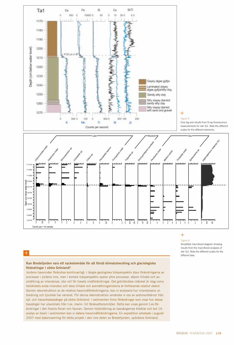
118 FORSKARRAPPORTER CRUISE REPORTS SWEDARCTIC 2007 ÅRSBOK YEARBOOK 2007 119
1170
1180
1190
1200
1210
1220
1230
1240
1250
1260
1270
Deph
(cm
bel
ow w
ater
leve
l)
0 20Counts per 1 ml sample
Chiron
omida
e ind
et.
0 6
Cladoc
era i
ndet.
0 2
Simoc
epha
lus sp
.
0 4
Cristatel
la sp
.
0 8
Chara
sp.
0 20
Plumatell
a rep
ens
0 2
Trich
optera in
det.
0 20 40
Tolyp
ella s
p.
0 10 20
Sarsc
yprid
opsis
acule
ata
0 4
Pectin
aria
indet.
0 2 4
Mytilus
eduli
s
0 2 4
Tricl
adida
inde
t.
0 2
Sphac
elaria
sp.
0 20 40
orga
noge
nous
mate
rial (%
)
Lake Brackish Sea
Kan Bredefjorden vara ett nyckelområde för att förstå klimatutveckling och glaciologiska förändringar i södra grönland? Jordens havsnivåer förändras kontinuerligt; i längre geologiska tidsperspektiv styrs förändringarna av processer i jordens inre, men i kortare tidsperspektiv spelar yttre processer, såsom tillväxt och av-smältning av inlandsisar, stor roll för havets nivåförändringar. Det grönländska istäcket är idag norra halvklotets enda inlandsis och dess tillväxt och avsmältningshistoria är fortfarande relativt okänd. Genom rekonstruktion av de relativa havsnivåförändringarna, kan vi analysera hur inlandsisens ut- bredning och tjocklek har varierat. För denna rekonstruktion använder vi oss av sedimentkärnor från sjö- och havsviksbassänger på södra Grönland. I sedimenten finns förändringar som visar hur dessa bassänger har utvecklats från t.ex. marin- till färskvattensmiljöer. Detta kan visas genom t.ex.för-ändringar i den fossila floran och faunan. Genom höjdmätning av bassängernas trösklar och kol-14-analys av fossil i sedimenten kan vi datera havsnivåförändringarna. En expedition arbetade i augusti 2007 med datainsamling för detta projekt i den inre delen av Bredefjorden, sydvästra Grönland.
Figure 6
Simplified macrofossil diagram showing
results from the macrofossil analyses of
site Ta1. Note the different scales for the
different taxa.
Figure 5
Core log and results from X-ray fluorescence
measurements for site Ta1. Note the different
scales for the different elements.

120 FORSKARRAPPORTER CRUISE REPORTS SWEDARCTIC 2007 ÅRSBOK YEARBOOK 2007 121
Properties of aerosol particles in polar regions and trends in background CO2 levels: Long-term monitoring and aircraft measurements
AimThe aim of the research is to combine long-
term monitoring observations and detailed
process studies to better understand the role
of aerosols and trace gases upon the Arctic
atmosphere and climate. An understanding
of these atmospheric constituents, their sour-
ces and sinks, transport and transformation
processes, is a prerequisite to being able to
make credible predictions of a future polar
atmosphere and climate.
The energy budget on Earth is largely de-
termined by the so-called greenhouse gases,
which occur naturally in the atmosphere. By
burning fossil fuel and changing the use of
land, humans alter the atmospheric concen-
tration of these gases, which results in the
warming of the climate. Whereas the green-
house gases warm the Earth, particles in the
atmosphere generally, but not always, have a
cooling effect on the climate. As the aerosols
tend to scatter more light than they absorb,
more aerosols in the atmosphere means that
more radiation from the sun is reflected back
to space. This means that less of the sun’s
radiation reaches the ground. Particles also
cool the planet through modifying the droplet
size distribution of clouds. Alternation of the
cloud droplets to smaller sizes makes the cloud
brighter, in other words scatters more radia-
tion back to space. Black particles such as soot
tend to warm the atmosphere. One particular
feature of black particles that has gained con-
siderable interest recently, is the effect these
particles have on the brightness of snow and
ice. By making the snow darker, these particles
enhance the melting of ice and snow.
By observing these trace gases and aerosols
on different temporal and spatial scales we work
to acquire a better understanding of the proces-
ses controlling their characteristics and their
influence on the Arctic atmosphere and climate.
Research platforms and observationsThe Zeppelin station
The long-term observations are conducted
at the Zeppelin station in Ny-Ålesund, Sval-
bard. The station is located at 78°54’N and
11°53’E, at about 475 m above mean sea level
on the Zeppelin Mountain ridge. Although
the station is owned by the Norwegian Polar
Research Institute, the two main users are
Stockholm University and the Norwegian
Project leader
Johan StrömDepartment of Applied Environmental
Science (ITM), Stockholm University
Project participants
Birgitta Noone Juri Waher Ulla WideqvistDepartment of Applied Environmental
Science (ITM), Stockholm University
Ann-Christine EngvallRadovan KrejciDepartment of Meteorology
Stockholm University
Figure 1
Data points depict the vertical distribution
of particle number density for the ASTAR
flight conducted 14 April 2007 (Brown:
particles larger than 260 nm in diameter,
orange; particles larger than 10 nm in
diameter).

120 FORSKARRAPPORTER CRUISE REPORTS SWEDARCTIC 2007 ÅRSBOK YEARBOOK 2007 121
Figure 2
Concentrations of elemental carbon
(black carbon) in melted snow and ice.
Institute for Atmospheric Research (NILU)
and the monitoring work is supported by the
Swedish Environmental Protection Agency.
The continuous observations at the Zeppe-
lin station include aerosol number density,
aerosol size distribution, aerosol light scat-
tering and light absorption properties, particle
carbon composition and gaseous CO2. Radon
222 is also observed in collaboration with
University of Heidelberg in Germany. For
more information about the monitoring work
at the Zeppelin station please visit www.itm.
su.se/zeppelin. For a current view from the
station looking down towards the village of
Ny-Ålesund, please visit www.nilu.no/
onlinebilder/zeppelin/zeppelin.jpg.
The Zeppelin station is also used for campaign-
based observations. During 2007 two
campaigns were conducted, one in spring and
one in summer. The main focus was to study
the temporal evolution of sulphur dioxide
(SO2). Photochemical processes convert SO2
to gaseous H2SO4 that may condense onto
pre-existing particles or actually nucleate to
form new particles. By observing the tracer
with high temporal resolution we may inter-
pret the data with respect to the source, which
may be both of natural or anthropogenic origin.
ASTAR – Airborne measurements
The international aircraft experiment ASTAR
2007 was conducted during March and April.
The main focus of ASTAR (Arctic Study of
Tropospheric Aerosols, Clouds and Radia-
tion) is to gain information about the vertical
distribution of aerosols and precursor gases.

122 FORSKARRAPPORTER CRUISE REPORTS SWEDARCTIC 2007 ÅRSBOK YEARBOOK 2007 123
Egenskaper hos aerosolpartiklar i polarområdena och trender i koldioxidhalter: långtidsövervakning och luftburna mätningar Temperaturökningen går dubbelt så snabbt i Arktis jämfört med resten av världen. Resultatet är högst påtagligt i bl.a. minskad utbredning av glaciärer och ändrade is- och markförhållanden. Orsaken till en förändring i temperaturen kan vara flera, men sedan industrialismens början har mänskliga aktiviteter ändrat atmosfärens sammansättning genom utsläpp av partiklar och gaser, vilket i sin tur förskjutit Jordens energibalans mot en högre medeltemperatur. Målet med vår forskning är att studera dessa klimatpåverkande ämnen som genom direkta eller indirekta processer påverkar Jordens energibalans och därmed atmosfärens temperatur. Vi gör detta dels genom att studera långa tids-serier observerade från Zeppelinstationen i Ny-Ålesund på Svalbard samt detaljerade rumsliga obser-vationer gjorda från flygplan. Förutom att de långa tidsserierna är det enda sättet att studera nutida trender så skapar det ett ramverk för att placera kortare mätkampanjer i ett större sammanhang.
The time period was chosen to capture some
of the anthropogenic pollutants that enter
the Arctic during late winter and spring, the
so-called Arctic Haze. The importance of
information in the vertical air column is il-
lustrated by data from the flight on 14 April
2007. Data for two particle size ranges are
presented. Data in brown show the number
density of particles with a diameter larger
than 260 nm in diameter and data in orange
show the number density of particles with
a diameter larger than 10 nm in diameter.
Note the layer of the larger particles around a
pressure of 600 hPa (roughly 4 km altitude),
which shows a concentration of about 3 times
what was observed near the surface. The
small particles form a layer around a pressure
of about 350 hPa (roughly 7 km altitude). The
number density in this layer is comparable to
the concentrations near the surface.
Snow sampling
As a collaborative effort with the Norwegian
Polar Institute, snow samples around Sval-
bard were collected and analyzed for the
content of elementary carbon (black carbon).
Figure 2 shows the median concentration
at the different locations. We note that the
Russian settlement Barentsburg influences
the amount of black carbon in the snow at
Linnebreen and that there appears to be an
east–west gradient in the concentrations.
More samples are under way and we also
intend to gather more information over time.
Participating organisations• Norwegian Polar Institute (NPI)
• University Centre in Svalbard (UNIS)
• Norwegian Institute for Air Research (NILU)
• National Institute of Polar Research, Japan (NIPR)
• Alfred Wegener Institute, Germany (AWI)
•Korea Polar Research Institute (KOPRI)
Supporting organisationsThe activities at the Zeppelin station are
mainly supported by the Swedish Environ-
mental Protection Agency with support from
the Swedish Polar Research Secretariat. A
contract from the Swedish Research Council
and support from the EU project ARCFAC
(European Centre for Arctic Environmental
Research in Ny-Ålesund) also made additional
campaign based observations possible.

122 FORSKARRAPPORTER CRUISE REPORTS SWEDARCTIC 2007 ÅRSBOK YEARBOOK 2007 123
Effects of global warming on the reproductive biology of birds in Swedish sub-arctic areas
BackgroundBirds are excellent indicators of environmen-
tal change, such as biologically important
effects of climate change, and consequently
studies of birds can be used to predict the
development over large areas. This project
there-fore aims to study effects of climate
change on the reproductive biology of birds
in Padjelanta, the most species-rich area of
the World Heritage Site Laponia in northern
Sweden. In Padjelanta, climatic factors limit
the distribution and breeding performance
of many bird species, which makes it easier
to quantify the effects of global warming on
reproduction, population dynamics and food
supply and predation.
Between 1971 and 1995, a number of studies
have been made of Fieldfares (Turdus pilaris),
Merlins (Falco columbarius), Hooded Crows
(Corvus corone) and the bird communities
in the birch forest and on the tundra. As the
current project focuses on the effects of global
warming on the reproductive biology of some
of the species included in the previous study
period, the present study thus comprises a
period of some 35 years, a period that is ade-
quately long to measure climatic effects in
biological systems. In 2007, the field studies
were mainly directed towards the collection
of data on the breeding phenology of Merlins
and Hooded Crows and the occurrence of new
species in the study area.
Project leader
Christer g. WiklundDepartment of Ecology
Swedish University of
Agricultural Sciences
Uppsala
Figure 1
The breeding phenology of the Merlin
Falco columbarius in the Staloluokta area,
central Padjelanta (Laponia) from 1976 to
1994. There is a significantly advancing
trend (p< 0.05) in the date of laying the
first egg.

124 FORSKARRAPPORTER CRUISE REPORTS SWEDARCTIC 2007 LOMROG ÅRSBOK YEARBOOK 2007 125
The fieldworkField studies were carried out throughout June
and early July 2007, in the surroundings of
Staloluokta, Padjelanta National Park, Laponia,
Sweden. During this year, it was unusually
hot and dry in the study area. The area was
searched for nesting Merlins and Hooded
Crows and the reproductive performance of
Merlins was studied by recording clutch
size, number of eggs hatched and nestling
survival until the chicks were at least 10 days
old. Earlier studies have indicated that chicks
normally survive to fledging age: among
several hundred nests controlled during the
period 1971 to 1995, there is only one record
indicating that chicks at this stage of deve-
lopment or older succumbed. Body mass and
the length of a primary were determined for
each chick on at least one occasion making
it possible to determine when the eggs had
hatched by using previous and detailed stu-
dies of chick growth. To estimate reproductive
performance by the Hooded Crow a sample
of the breeding population of Hooded Crows
can be used.
To estimate the exact location of nest sites
of both Merlins and Hooded Crows a Global
Positioning System (GPS) was used. The GPS
coordinates will be used to determine the den-
sities of breeding Merlins and breeding Hoo-
ded Crows in the study area. Furthermore,
the GPS coordinates will be used to calculate
the distance between the nest of a breeding
Effekter av global uppvärmning på reproduktionsbiologin hos fåglar i svenska Subarktis Under sommaren 2007 undersöktes området runt Staloluokta, Padjelanta Nationalpark, med avse-ende på häckande stenfalkar och kråkor. I undersökningsområdet häckade åtta par av stenfalk och 13 par av kråka. Sex av stenfalksparen producerade ungar som också blev flygfärdiga. Alla kråkparen producerade ungar, mellan 1 och 4 ungar per par. Under den tidigare undersökningsperioden kon-staterades att starten för stenfalkarnas äggläggning successivt hade tidigarelagts under 1980- och 1990-talen (se Fig. 1). När 2007 års data inkluderades i analysen fanns trenden kvar och den hade även stärkts. Starten för äggläggningen varierade dock mycket mellan olika stenfalkspar. Därför krävs ytterligare analyser av både äldre och nya data.
Merlin pair and the nearest breeding pair of
Hooded Crows. The Hooded Crows are the
most important predators on birds’ eggs and
chicks, including breeding Merlins, in this
area. In addition, the nests used by Merlins
for breeding are actually nests built by Hoo-
ded Crows and previous studies have showed
that Merlins prefer to use a nest of good qua-
lity for breeding, i.e. one-year-old crow nests.
ResultsIn the study area, 8 pairs of Merlins and 13
pairs of Hooded Crows were breeding. Two
Merlin pairs failed to produce chicks due to
predation before the eggs hatched. All Hoo-
ded Crow pairs produced fledglings, numbe-
ring between one and four chicks per pair.
An analysis of the start of the breeding
among Merlins has been made using data
from the first study period alone, which
shows a trend of clutch initiation starting suc-
cessively earlier during the 1980s and 1990s
(Fig. 1). In comparison with data from 2007
it appears that this trend remains and may
even be slightly more pronounced. However,
there was a large variation in the breeding
start among the Merlin pairs in 2007 and
therefore, a more careful analysis of the start
of laying in different territories is required
before reliable conclusions can be made on
how much earlier Merlins start to breed in the
early part of this century in comparison with
the 1970s.

124 FORSKARRAPPORTER CRUISE REPORTS SWEDARCTIC 2007 LOMROG ÅRSBOK YEARBOOK 2007 125
Forskarrapporter Cruise Reports
LOMROG 2007

126 FORSKARRAPPORTER CRUISE REPORTS SWEDARCTIC 2007 ÅRSBOK YEARBOOK 2007 127
LOMROG expedition route and scientific station work.

126 FORSKARRAPPORTER CRUISE REPORTS SWEDARCTIC 2007 ÅRSBOK YEARBOOK 2007 127
Principal investigators
leif g. Anderson Department of Chemistry
University of Gothenburg
göran Björk Department of Earth Sciences
University of Gothenburg
Project participants
Patrick Eriksson
Finnish Institute of Marine
Research
Helsinki Finland
Sofia hjalmarsson Sara Jutterstöm Anders OlssonDepartment of Chemistry
University of Gothenburg
Johanna Nilsson
Department of Earth Sciences
University of Gothenburg
Frank ZemlyakBedford Institute of Oceanography
Dartmouth, Nova Scotia, Canada
Lomonosov Ridge off Greenland (LOMROG) 2007: Chemical and physical oceanography
The oceanographic component of LOMROG
focuses on constraining and understanding the
pathways of the Atlantic water and deep water
across the Lomonosov Ridge, between the Eur-
asian Basin and Canadian Basin and through
the western Fram Strait. A deep water pathway
may exist between the Lomonosov Ridge
and the Northern Greenland shelf, and thus
knowledge of the shape of the seafloor in this
area is also of interest for the oceanography
programme. The LOMROG oceanography pro-
gramme is an extension of the 2005 scientific
programme conducted during the Healy-Oden
Trans-Arctic expedition (HOTRAX) in 2005
when oceanographic station work was carried
out from the icebreaker Oden and multibeam
mapping from USCGC Healy. The data from
HOTRAX showed that water overflow from the
Makarov Basin (part of the Canadian Basin)
to the Amundsen Basin (part of the Eurasian
Basin) takes place across a 1 870 m deep sill in
the central Lomonosov Ridge at about 88°25’N,
150°E (Björk et al. 2007). This water appears to
follow the Lomonosov Ridge slope southwards
towards Greenland but uncertainty remains in
regard of whether it can be traced on the south-
ernmost tip of the ridge and how the circula-
tion continues from this point and onwards.
Data acquisitionConductivity Temperature Depth (CTD) and
water sampling were carried out at 26 stations
covering parts of the western Eurasian Basin
and one station at the East Greenland conti-
nental margin. Water was collected using a
24-bottle rosette sampler equipped with 7.5 l
Niskin type bottles and a CTD (Sea Bird 911+)
(Fig. 1). When brought back onboard the ro-
sette was moved into a heated double contai-
ner as quickly as possible to avoid freezing
the samples. Water samples were immedia-
tely drawn for the individual parameters to
be determined in the following order: CFCs,
oxygen, dissolved inorganic carbon/pH/total
alkalinity, nutrients, oxygen-18, and salinity.
Number of samples analysed for the different
constituents are given in Table 1.
Shipboard processingThe CTD data were processed through the
standard Sea-Bird software routines (data
conversion, cell thermal mass, filter, loop edit,
derive and bin average). The final data is aver-
aged in 1 dbar bins. Salinities were also deter-
mined in each Niskin bottle using an Autosal
lab-salinometer. The temperature in the clean
room inside the laboratory on the foredeck
fluctuated significantly and therefore condi-
tions were not ideal for the salinity analyses,
but were nevertheless manageable. The final
bottle salinity data should be of good quality
with an accuracy of ±0.001 psu. The bottle
salinities were then compared with the CTD
bottle file data in order to check the accuracy
of the CTD system. The comparison with
bottle data showed an offset of about -0.0044
psu between the CTD and Autosal salinities,
inferring that the CTD sensor values were
too low. The final CTD data were corrected by
determining an average salinity offset using
bottles with salinity > 34.8 psu and excluding
outliers outside 1 SDA. One sample was then
identified (Station 20, 4 000 dbar) as having
identical offset as the average offset. The
Autosal conductivity for this sample was deter-
mined for the same temperature and pressure
when the bottle was tripped (P=4 000 dbar,
T=-0.6708°C). The Autosal conductivity divi-
ded by the CTD conductivity then gives a slope
correction of 1.000119, which has been used
Figure 1
The CTD/rosette sampler on its way back
from the water. Photo: Sofia Rickberg.

128 FORSKARRAPPORTER CRUISE REPORTS SWEDARCTIC 2007 LOMROG ÅRSBOK YEARBOOK 2007 129
Figure 2
Sara Jutterström collecting water for
the determination of DIC. Photo: Leif
Anderson.
Table 1. Station numbers with positions and bottom depth, and number of data per individual constituent and station.
Station latitude longitude Bottom depth CFC Oxygen Mercury DIC ph TA Nutrients O-18 Salinity1 79.121 3.411 5160 3 3 3 0 3 0 0 0 0
2 81.113 9.854 1573 15 15 10 13 15 14 15 0 15
3 86.968 10.168 4338 23 23 12 22 23 23 23 10 23
4 86.883 -44.628 3444 23 23 12 23 23 23 23 10 23
5 86.899 -48.236 1807 18 18 6 18 4 18 18 10 18
6 86.816 -53.826 967 16 16 4 16 16 16 16 10 16
7 85.892 -52.919 749 21 21 8 21 21 21 21 15 18
8 85.432 -52.383 1189 22 22 8 21 22 22 22 12 19
9 85.345 -48.708 2433 19 19 12 19 19 19 19 8 19
10 85.493 -46.189 3005 0 0 10 14 20 0
11 85.803 -11.723 3985 24 24 12 24 24 24 24 12 23
12 85.519 -14.178 3061 21 21 12 21 21 21 12 21
13 85.479 -13.865 2113 23 23 8 23 23 23 23 ? 23
14 85.410 -14.303 1340 19 19 0 19 19 19 19 10 19
15 85.294 -14.936 1004 17 17 0 17 17 17 17 10 17
16 85.269 -13.875 1074 20 20 10 20 20 20 19 12 19
17 85.212 -13.173 2473 22 22 12 22 22 22 22 12 20
18 85.211 -12.997 3360 23 24 12 24 24 24 24 12 21
19 85.041 -11.106 3890 24 24 0 24 24 24 12 24
20 84.790 -8.703 3989 24 24 0 24 23 24 11 24
21 84.531 -6.399 4081 24 24 12 24 24 24 24 12 24
22 84.369 -5.196 3915 24 24 0 24 24 23 24 12 24
23 84.154 -3.431 3003 22 22 0 22 22 22 22 12 22
24 84.074 -2.929 2616 21 21 11 21 21 21 21 12 21
25 83.911 -1.682 3139 23 24 0 24 24 24 24 12 24
26 83.273 0.651 3742 8
to post-process the data according to Sea-Bird
recommendations.
Water for chemical analysis was drawn from
water samplers directly after the rosette was
brought on board and analysed within hours
of sampling. The precisions given below were
computed as standard deviations of duplicate
analyses. Samples for CFCs were drawn from
the bottles on the rosette with glass syringes,
which were kept under cold water until analysis
(within a few hours). They were measured by
purge-and-trap extraction and pre-concentration,
gas chromatographic separation on a capillary
column, and electron capture detection calibra-
ted against a standard gas mixture. The preci-
sion was in the order of 1% and the accuracy
was about 0.02 pmol/kg. Oxygen was determi-
ned using automatic Winkler titration system,
precision ~1 µmol/kg. Total dissolved inorganic
carbon (DIC) was determined by a coulometric
titration method having a precision of ~1 µmol/
kg, with the accuracy set by calibration against
certified reference materials (CRM), supplied
by A. Dickson, Scripps Institution of Oceano-
graphy (USA). Total alkalinity (TA) was deter-
mined by potentiometric titration, precision
~1 µmol/kg, (Haraldsson et al. 1997), with the
accuracy set in the same way as for DIC. The
determination of pH was performed by the
use of a diode-array spectrophotometer using
a sulphonephtalein dye, m-cresol purple, as
indicator (Clayton and Byrne 1993, Lee and
Millero 1995), and measured in a 1 cm flowcell
thermostated to 15°C (pH15). The precision
and accuracy for the pH15 measurements were
±0.0005 and ±0.002 pH units, respectively.
pH in situ was calculated from TA, pH15 and
in situ temperature by using the CO2-system
program by Lewis and Wallace (1998). For
these calculations the carbon dioxide constants
of Roy et al. (1993 and 1994) were applied, and
the pH was on the total hydrogen ion scale.
The nutrients (phosphate, nitrate, and silicate)
were determined using a SMARTCHEM auto-
analyser applying standard analytical protocol
giving a precision near 1% at full scale.
Preliminary resultsThe observations at the Amundsen Basin
slope of the Lomonosov Ridge (Stations 4, 9
and 10) show a clear signal of Canadian Basin
Deep Water (CBDW) at around 2 000 m with
similar characteristics to a station (Station 41)
in the vicinity of the 1 870 m deep channel
in the central Lomonosov Ridge at about
88°25’N, 150°E found during the Beringia/
HOTRAX 2005 expedition (Björk et al. 2007)
(see also Figure 3 for some selected station
data). A vertically broad CBDW signal was
also clearly visible at the flanks of the Morris
Jesup Plateau (Stations 12, 17, 18 and 19).
A more vertically narrow and weaker signal
was observed over the western Amundsen
Basin (Stations 3 and 21–25). The observations

128 FORSKARRAPPORTER CRUISE REPORTS SWEDARCTIC 2007 LOMROG ÅRSBOK YEARBOOK 2007 129
Figure 3
Temperature and salinity data showing
the structure of the CBDW signal seen as
a temperature and salinity maximum at
around 2 000 m depth. The CBDW water
is also less ventilated (“older”) which is
seen in the oxygen and CFC-11 signals.
The Beringia/HOTRAX station 41 is from
the central Lomonosov Ridge, LOMROG
Station 4 is further towards Greenland
at the Amundsen Basin flank of the
ridge, and LOMROG Station 3 is from the
central Amundsen Basin.
lOMROg: Kemisk och fysisk oceanografiMålsättningen med det oceanografiska projektet under expeditionen Lomonosov Ridge off Greenland (LOMROG) var att samla information för att dels bättre förstå hur olika vattenmassor strömmar över Lomonosovryggen och efter Grönlands nordostkust mot de Nordiska haven, dels upprepa en del av de undersökningar som gjordes under expeditionen Arctic Ocean 1991. Motiveringen är att studera hur vattnen i den Arktiska oceanen samverkar med Nordatlanten i en tid av förändrat klimat, och om det finns förändringar som redan kan observeras norr om Grönland. För dessa undersökningar samlades djupprofiler från 26 stationer där vattenprover togs för bestämning av flera olika kemiska parametrar ombord på Oden. De första resultaten visar en tydlig signal av vatten från den Kanadensiska bassängen kring 2 000 m vattendjup efter Lomonosovryggen i den Eurasiska bassängen och på flanken av Morris Jesup-platån. Längs sektionen sydöst om Morris Jesup-platån är det tydligt hur signalen av antropogen koldioxid har växt till sig i de översta 2 000 metrarna. Denna signal är också tydlig i kemiska parame-trar som uttrycker hur länge sedan ett vatten var i kontakt med atmosfären, dvs. var vid ytan.
during LOMROG infer that the major inflow
of CBDW to the Amundsen Basin indeed oc-
curs at the central Lomonosov Ridge channel
and that the flow continues along the slope
of the ridge towards Greenland. The further
circulation follows the Greenland continental
slope towards the southeast to the Morris Jesup
Plateau where eventually some of the flow lea-
ves the continental slope, becomes interleaved,
and can be identified as a weak salinity maxi-
mum over the central Amundsen Basin.
ReferencesClayton, T.D. and Byrne, R.H. 1993. Spectro-
photometric seawater pH measurements:
total hydrogen ion concentration scale
calibration of m-cresol purple and at-sea
results. Deep-Sea Research I 40, 2115–2129.
Haraldsson, C., Anderson, L.G., Hassellöv,
M., Hulth, S. and Olsson, K. 1997. Rapid,
high-precision potentiometric titration of
alkalinity in the ocean and sediment pore
waters. Deep-Sea Research I 44, 2031–2044.
Lee, K. and Millero, F.J. 1995. Thermodyna-
mic studies of the carbonate system in sea-
water. Deep-Sea Research I 42, 2035–2061.
Lewis, E. and Wallace, D.W.R. 1998. Program
Developed for CO2 System Calculations.
ORNL/CDIAC-105. Carbon Dioxide Infor-
mation Analysis Center, Oak Ridge Natio-
nal Laboratory, U.S. Department of Energy,
Oak Ridge, Tennessee.
Roy, R.N., Roy, L.N., Vogel, K.M., Porter-Moo-
re, C., Pearson, T., Good, C.E., Millero, F.J.
and Campbell, D. 1993. The dissociation
constants of carbonic acid in seawater at
salinities 5-45 and temperatures 0–45°C.
Marine Chemistry 44, 249–267.
Roy, R.N., Roy, L.N., Vogel, K.M., Porter-Moore,
C., Pearson, T., Good, C.E., Millero, F.J. and
Campbell, D. 1994. Erratum for: the dis-
sociation constants of carbonic acid in sea
water at salinities 5–45 and temperatures
0–45 1C. Marine Chemistry 45, 337.
Björk G., Jakobsson, M., Rudel, B., Swift,
J.H., Anderson, L., Darby, D.A., Backman,
J., Coakley, B., Winsor, P., Polyak, L. and
Edwards, M. 2007. Bathymetry and deep-
water exchange across the central Lomono-
sov Ridge at 88°–89°N. Deep-Sea Research I
54, 1197–1208.

130 FORSKARRAPPORTER CRUISE REPORTS SWEDARCTIC 2007 LOMROG ÅRSBOK YEARBOOK 2007 131
Figure 1
Total Gaseous Mercury (TGM) measured
in air at 20 m above sea level during the
LOMROG expedition.
Lomonosov Ridge off Greenland (LOMROG) 2007: Accumulation of mercury in the Arctic Ocean
Emissions of mercuryAs a consequence of long-range transport of
manmade emissions into the atmosphere,
the Polar Regions are nowadays contami-
nated with highly neurotoxic mercury (Hg).
About 6 000 tonnes of Hg are present in the
atmosphere today, mainly originating from
anthropogenic emissions in the industrialized
part of the world. Mercury is one of the most
dangerous environmental pollutants, and
since it is an element, it cannot be destroyed.
Mercury poisoning of the planet could best
be reduced by curbing pollution from power
stations, since coal-fired power stations and
waste incinerators account for around 70
percent of new, quantified manmade mercury
emissions to the atmosphere (UNEP 2002).
Mercury is biomagnified in marine wildlifeThe most toxic form of mercury is mono-
methylmercury (MMHg), which is formed
in aquatic environments after deposition of
inorganic mercury. MMHg is bioaccumulated
in fish, and fish contaminated with MMHg is
hazardous to eat because MMHg passes the
blood brain barrier and the placenta in preg-
nant women, and can therefore be dangerous
to the foetus.
The level of Hg found in marine mammals
in the Canadian Arctic exceeds guideline limits
for Hg contamination of food for human con-
sumption. Moreover, Hg levels in Arctic ringed
seals and beluga whales have increased by a
factor of up to four over last the 25 years and
the levels recorded in indigenous people living
in the Arctic exceed those in people from more
temperate, industrial regions. In a study on
7-year-old children in the Faeroe Islands, it
has been shown that prenatal methyl mercury
exposure may lead to neuropsychological
dysfunctions, such as problems in language
acquisition, attention and memory deficit
(Grandjean 1997). According to exposure
data published by the U.S. Center for Disease
Control and Prevention, the number of babies
at risk in the U.S. could be as high as 300,000.
On a global scale, that number can be in-
creased to several million (UNEP 2002).
long-range transport and chemical trans-formation contributes to deposition of mercury in the ArcticAtmospheric deposition of Hg in the Arctic
is post-industrially driven, and high Hg con-
centrations in the upper layer of polar lake
sediments have been found (Steffen et al.
2007 and references therein). Ice core samp-
les confirm these results, and the same trends
are also observable in, for example, peat from
southern Greenland.
Enhanced mercury deposition is observed
in the arctic environment, and one important
factor influencing the deposition of the
species is so-called atmospheric mercury
depletion events (AMDE). These events oc-
cur during the polar spring and a substantial
amount of the global atmospheric Hg pool,
that is to say, approximately 300 tonnes per
year, is deposited in the arctic environment
(Ariya et al. 2004, Skov et al. 2004, Sommar
Principal investigator
Katarina gårdfeldt Center for Environment and
Sustainability, Chalmers and
University of Gothenburg
Project participants
Maria Andersson*Jonas Sommar* Oliver lindqvist*Department of Chemistry
University of Gothenburg
* not participating in the cruise

130 FORSKARRAPPORTER CRUISE REPORTS SWEDARCTIC 2007 LOMROG ÅRSBOK YEARBOOK 2007 131
et al. 2007). In addition to atmospheric deposi-
tion of Hg, the species may also enter the polar
basin via oceanic currents and river input.
However, while land based measurements of
Hg species are represented in literature, infor-
mation is lacking on the relative importance of
various sources of mercury to the polar basin
today. Our work contributes to an extensive in-
vestigation on water and air masses, aiming at
an assessment of mercury sources and sinks in
the Polar Basin. The measurements have been
conducted under the umbrella of the LOMROG
and Beringia expeditions, both arranged by the
Swedish Polar Research Secretariat in 2007
and 2005 respectively.
Mercury sampling in Arctic seawater and airTo estimate the input and accumulation of
mercury in Arctic marine waters, about 200
samples for determination of total mercury
(Hgtot) and MMHg were taken at some 20
stations along the LOMROG 2007 expedition
route, and around 500 samples were taken
for the same species at 48 stations during the
expedition Beringia 2005. Continuous mea-
surements of total gaseous mercury (TGM)
in air were also conducted during both expe-
ditions using a Tekran 2537A mercury vapour
detector, and a portable mercury analyser i.e.
LUMEX Mercury Analyzer RA-915+. Figure 1
presents data on concentrations of elemental
mercury in air recorded during the LOMROG
expedition over a period of 22 days, between
15 August and 6 September 2007. The aver-
age concentration of TGM during this period
was 1.3 ± 0.2 ng/m3. The data will be further
analysed with respect to a number of ambient
parameters, such as wind conditions and sea
ice coverage.
The mercury sampling in water was de-
signed as profile measurements at various
latitudinal sites at the LOMROG and Beringia
CTD water stations sites respectively, and
will be analysed in combination with data on
movements of the water masses. In addition,
a transect for sampling of surface water using
the water sample system in the boat were per-
formed when crossing the Greenland Sea from
76°44’N and 1°22’E to 78°06’N and 13°24’E off
the west coast of Svalbard. For each sample,
125 ml of seawater was collected in acid washed
Teflon bottles and these are currently being
analysed for Hgtot by purge and trap technique
as described in Gårdfeldt (2002). Determi-
nation of MMHg content in the samples is
conducted after derivatisation by an ethylating
agent using the gas chromatography CVAFS
technique as described in Lee et al. (1994).
During the Beringia 2005 expedition con-
tinuous measurements of dissolved gaseous
mercury (DGM) were performed using a
new method first described in Andersson
et al. (2007a). Part of the data from these
measurements is presented in Figure 2, and
is thoroughly described in Andersson et al.
(2007b and 2007c).
Multiphase investigations combining oceano-
graphy and mercury speciation, as performed
during the LOMROG 2007 and Beringia
2005 expeditions, comprise a unique series of
Hg sampling. The data archived will help to
assess the Hg sources, the accumulation and
the long-term fate of mercury in the polar eco-
system. Preliminary results from our measu-
rements show that the enhanced deposition
and river input of mercury species, in com-
bination with restricted evasion at northern la-
titudes compared to more southern latitudes,
result in an accumulation of mercury in the
polar water body. For example, the concentra-
tion of dissolved gaseous mercury is up to ten
times higher in the Arctic Basin compared to
the North Atlantic Ocean.
Figure 2
Continuous measurements of total
gaseous mercury in air (black line) and
dissolved gaseous mercury in surface
water (line in colours) during the ex-
peditions Beringia 2005 and LOMROG
2007. Schlitzer, R., Ocean Data View,
http://odv.awi-bremer-haven.de, 2004.

132 FORSKARRAPPORTER CRUISE REPORTS SWEDARCTIC 2007 LOMROG ÅRSBOK YEARBOOK 2007 133
ReferencesAndersson, M.E., Gårdfeldt, K. and Wäng-
berg, I. 2007a. A description of an automa-
tic continuous equilibrium system for me-
asurement of dissolved gaseous mercury.
Analytical and Bioanalytical Chemistry.
Andersson, M.E., Sommar, J. and Gårdfeldt, K.
and Lindqvist, O. 2007b. Accumulation of
mercury in the Arctic Ocean. Submitted to
Marine Chemistry.
Andersson, M.E., Sommar, J. and Gårdfeldt, K.
2007c. Air-Sea flux of volatile mercury over
the North Atlantic Ocean. Manuscript.
Ariya, P., Dastoor, A., Amyot, M., Schroeder,
W., Barrie, L., Anlauf, K., Raofie, F., Ryz-
hkov, A., Davignon, D., Lalonde, J. and
Steffen, A. 2004. The Arctic: A sink for
mercury, TELLUS B, 56 (5), 397–403.
Gårdfeldt, K., Horvat, M., Sommar, J., Kotnik,
J., Fajon, V., Wängberg, I. and Lindqvist,
O. 2002. Comparison of procedures for
measurements of dissolved gaseous mer-
cury in seawater performed on a Mediter-
ranean cruise. Analytical and Bioanalytical
Chemistry 374, 1002–1008.
Grandjean, P., Weihe, P., White, R., Debes,
F., Araki, S., Yokoyama, K., Murata, K.,
Sorensen, N., Dahl, R. and Jorgensen, P.
1997 Cognitive deficit in 7-year-old children
with prenatal exposure to methylmercury.
Neurotoxicology and Teratology 19, 417–428.
Lee, Y., Munthe, J. and Iverfeldt, Å. 1994.
Experiences on analytical procedures for
the determination of methylmercury in
environmental samples. Applied Organo-
metallic Chemistry 8, 659–664.
lOMROg: Ackumulationen av kvicksilver i Arktiska oceanenSom en följd av förbränning av kol och olja i världen sprids kvicksilver genom luften och årligen deponeras 100-tals ton av metallen i Arktis. Organiskt kvicksilver, som kan bildas efter deposition av luftburet kvicksilver, är mycket giftigt och bioackumuleras i fisk och däggdjur. Under de två expeditio-nerna Beringia 2005 och LOMROG 2007 har vi gjort mätningar på luft, vatten, snö och is som syftar till att uppskatta ackumulationen av kvicksilver i Arktis. Våra mätningar visar att halterna av vissa former av kvicksilver i Arktiska oceanen är kraftigt förhöjda jämfört med andra havsområden. Halten av löst gasformigt kvicksilver i ytvatten är t.ex. upp till 10 gånger så höga i den Arktiska bassängen som i norra Atlanten.
Skov, H., Christensen, J.H., Heidam, N.Z.,
Jensen, B., Wahlin, P. and Geernaert, G.
2004. Fate of elemental mercury in the Ar-
ctic during atmospheric depletion episodes
and the load of atmospheric mercury to the
Arctic. Environment Science and Technology
38, 2373–2382.
Sommar, J., Wangberg, L., Berg, T., Gard-
feldt, K., Munthe, J., Richter, A. Urba, A.
Wittrock, F. and Schroeder, W.H. 2007.
Circumpolar transport and air-surface
exchange of atmospheric mercury at Ny-
Ålesund (79°N), Svalbard, spring 2002.
Atmos. Chem. Phys. 7 (1), 151–166.
Steffen, A., Douglas, T., Amyot, M., Ariya,
P., Aspmo, K., Berg, T., Bottenheim, J.,
Brooks, S., Cobbett, F., Dastoor, A,. Dom-
mergue, A., Ebinghaus, R., Ferrari, C.,
Gardfeldt, K., Goodsite, M.E., Lean, D.,
Poulain, A., Scherz, C., Skov, H., Som-
mar, J. and Temme, C. 2007. A synthesis
of atmospheric mercury depletion event
chemistry linking atmosphere, snow and
water. Atmospheric Chemistry and Physics
Discussions 7, 10837–10931.
UNEP 2002. Global Mercury Assessment
report. Available on: http://www.chem.
unep.ch/mercury/Report/Final%20
Assessment%20report.htm

132 FORSKARRAPPORTER CRUISE REPORTS SWEDARCTIC 2007 LOMROG ÅRSBOK YEARBOOK 2007 133
Lomonosov Ridge off Greenland (LOMROG) 2007: Coring and high- resolution geophysical mapping
Introduction and backgroundThe Arctic Ocean north of Greenland is virtual-
ly unexplored due to predominantly heavy sea
ice conditions that have made the area by and
large inaccessible. Icebreakers have previously
never attempted to reach the southern tip of
the submarine Lomonosov Ridge that extends
towards the northern Greenland continental
margin. Among the scientific ice drift stations,
only the GreenICE camp in 2004 has investi-
gated a fragment of the southwesternmost
part of the ridge (Kristoffersen and Mikkelsen
2006). This ice-infested area of the Arctic Oce-
an was the focus for the Lomonosov Ridge off
Greenland (LOMROG) 2007 expedition as it is
probable that it holds answers to key questions
regarding ocean circulation and glacial history,
such as the question whether immense Antarc-
tic style ice shelves existed in the Arctic Ocean
during past glacial periods. Previous expedi-
tions to the Lomonosov Ridge with Swedish
icebreaker Oden in 1996 and the US nuclear
submarine Hawkbill in 1999 demonstrated
the occurrence of glacial ice grounding down
to 1 000 m present water depth at about 87°N
(Siberian side) on the ridge crest (Jakobsson
1999, Polyak et al. 2001). If this ice grounding
event resulted from a much debated (e.g. Mercer
1970), but supposedly coherent and large floa-
ting ice shelf, the Lomonosov Ridge north of
Greenland should also be scoured. To test the
hypothesis of a huge Arctic Ocean ice shelf,
LOMROG mapped the Lomonosov Ridge and
Morris Jesup Rise north of Greenland as well
as the Yermak Plateau north of Svalbard using
the new multibeam bathymetric sonar and
chirp subbottom profiling system installed on
the Oden during the spring of 2007 (Fig. 1). In
addition, sediment cores were taken from the
surveyed areas for palaeoceanographic studies,
and sediment samples were collected from
“dirty” patches of drifting ice floes for modern
provenance studies. With this material, the
history of the Arctic Ocean circulation and sea
ice cover will be addressed, such scientific ques-
tions being of particular relevance in the context
of the present trend of diminishing Arctic Ocean
sea ice cover, where September in the year of
2007 showed the aerially smallest extent ever
measured over the last 28 years (National Snow
and Ice data Center: http://nsidc.org).
However, it should be noted that in the
LOMROG operating area north of Greenland
severe sea ice conditions were encountered
with 10/10 ice cover and sometimes ~4 m thick
multiyear floes.
The second major component of the
LOMROG expedition consisted of the Danish
Continental Shelf Project (Marcussen et al. this
volume). This project collected seismic reflec-
tion profiles and bathymetry in order to acquire
the base data needed to eventually put forward
an Article 76 of United Nations Convention
of the Law of the Sea (UNCLOS) claim for a
new legal definition of Denmark’s continental
margin north of Greenland. Furthermore,
LOMROG included a number of scientific sub-
projects. These comprised studies of the return
flow of Atlantic water and deep water exchange
between the Eurasian and Amerasian Arctic
Ocean basins (Anderson et al. this volume),
the role of sea ice in the transport of CO2 from
the atmosphere to the ocean (Rysgaard et al.
this volume), distribution of mercury in the
atmosphere and ocean (Gårdfeldt et al. this
volume), and the Arctic Ocean gravity field
(Marcussen et al. this volume).
The LOMROG expedition constitutes a
project in the Arctic Palaeoclimate and its Ex-
tremes (APEX) research network programme
Principal investigator
Martin Jakobsson Department of geology and geochemistry
Stockholm University
Project participants
Dennis Darby Department of Ocean, Earth and
Atmospheric Sciences, Old Dominion
University, Virginia, USA
leonid Polyak
Byrd Polar Research Center, Ohio State
University, Columbus, Ohio, USA
Björn Eriksson Daniela hanslik Benjamin hell Markus Karasti ludvig löwemark Emma Sellén Åsa Wallin Department of geology and geochemistry
Stockholm University
Carin SjööFyrisskolan, Uppsala

134 FORSKARRAPPORTER CRUISE REPORTS SWEDARCTIC 2007 LOMROG ÅRSBOK YEARBOOK 2007 135
endorsed by the International Arctic Science
Committee (IASC) and the ICSU/WMO Joint
Committee for the International Polar Year
2007–2008 (IPY).
lOMROg ship based work and preliminary resultsDespite severe sea ice conditions Oden,
supported by the newest Russian nuclear
icebreaker 50 let Pobedy, managed to reach
the previously unexplored southernmost tip
of the Lomonosov Ridge north of Greenland
to conduct scientific work (See map p. 126
and Fig. 1). Large pressure ridges and thick
multiyear sea ice prevented mapping with
the multibeam and subbottom profiler along
straight predefined tracks. The surveys were
instead dictated by the few existing crack sys-
tems in the sea ice and openings in the large
pressure ridges that allowed 50 let Pobedy
and Oden to break through. Another problem
for the acoustic mapping was the crushed ice
in the wake of 50 let Podedy, which reduced
the data quality significantly, in addition to
the noise from the icebreaking. This ice slush
was pressed underneath the hull of Oden
and occasionally completely covered the hull-
mounted multibeam and subbottom acoustic
transducers. However, even though LOMROG
faced certain difficulties in the sea ice over
the Lomonosov Ridge, valuable geophysical
data were collected. In addition, six sediment
cores were retrieved from this area, both from
the shallow ridge crest and the slope towards
Amundsen Basin (see map p. 126). Prelimi-
nary analysis of the multibeam and subbot-
tom data show glacial erosion at water depths
shallower than approximately 800 m on the
Lomonosov Ridge and the sediment cores
retrieved from the glacially scoured sea floor
contained diamicton. A first hand analysis
seems to support the hypothesis of glacial ice
grounding on the shallow ridge crest.
The Lomonosov Ridge programme was
shortened due to damage of 50 let Pobedy’s
propeller blade in the hard ice conditions. The
next target for LOMROG was the Morris Jesup
Rise where Oden had to operate without sup-
port from the Russian nuclear icebreaker. The
sea ice cover was here 10/10 as in the Lomonosov
Ridge area, although large pressure ridges
were less abundant. A completely new multi-
beam survey technique was invented that pro-
ved very successful in extreme ice conditions.
This technique, named “pirouette surveying”,
involved Oden stopping and turning around
in a half circle while acquiring multibeam data
whenever an open to semi-open lead in the
pack ice was encountered (Fig. 4). The idea was
to cover a 360° sector around the ship equal to
the multibeam swath width, which was com-
monly between 3–4 times the water depths,
although sometimes we achieved a swath up to
5 times the water depth. Occasionally the ship
was rotated 360° to increase the resolution of
the mapped area underneath the ship. After
one “pirouette” was completed, Oden broke
ice using its full capacity to the end of the
multibeam swath coverage, where a new
pirouette was carried out. The Morris Jesup
Rise’s northern slope and shallow crest was
successfully mapped using this technique.
The data reveal large iceberg scours down to
a water depth of approximately 1 050 m, so far
the largest and deepest iceberg scours mapped
in the Arctic Ocean (Fig. 2). The coring pro-
gramme on the Morris Jesup Rise targeted
undisturbed sediment sections for palaeoceano-
graphic studies as well as the largest ice scour
ever mapped. The purpose of coring the ice
Figure 1
Overview of the coring operations on the
Oden’s aft deck. The up to 12 m long and
1.5-ton heavy piston corer was launched
using a cradle gliding on a rail mounted
on the aft deck. This new launching
system was installed just prior to the
expedition in Landskrona while Oden was
in dry dock. It proved to be excellent and
significantly reduced the coring station
times compared to previous expeditions.
Photo: Martin Jakobsson.
Figure 2
Leonid Polyak describing a section of a
sediment core. Photo: Martin Jakobsson.

134 FORSKARRAPPORTER CRUISE REPORTS SWEDARCTIC 2007 LOMROG ÅRSBOK YEARBOOK 2007 135
scour was to investigate the age of the ice-
grounding event that caused it. This can be
achieved by dating the sediments that accu-
mulated since the scouring event. The newly
installed chirp sonar profiler provided the
critical data in order to precisely locate optimal
coring sites. Altogether, four cores were retrie-
ved from the Morris Jesup Rise. All sediment
cores were directly logged on board Oden with
a Multi Sensor Track Core Logger (MSCL)
measuring sediment bulk density, p-wave
velocity and magnetic susceptibility. After core
logging, the cores were split and described.
After completion of the scientific programme
on the Morris Jesup Rise, an oceanographic
section across the western Fram Strait was
conducted. Conductivity Temperature Depth
(CTD) measurements and water sampling
were carried out along this section at regularly
spaced stations (see map p. 126 and Anderson
et al. this volume). The marine geological/
geophysical programme was working in close
cooperation with the oceanographic compo-
nent, for example, the CTD data are used to
calculate sound speed profiles of the water
column that, in turn, are used to calibrate the
multibeam sonar in order to get “true” depths of
the sea floor.
In 2005, the US icebreaker Healy crossed
the Yermak Plateau during the Healy-Oden
Trans Arctic Expedition (HOTRAX) and the
Beringia expedition and mapped portions
of the shallow crest with their Seabeam 2112
multibeam sonar (Darby et al. 2005, Jakobsson
et al. 2005). On the way to the next LOMROG
major survey area, the East Greenland Ridge,
Oden’s route was carefully offset to the Healy
2005 track on the Yermak Plateau in order to
extend the previous multibeam survey. The
new geophysical mapping data collected with
Oden’s EM120 multibeam and SBP120 chirp
sonar profiler revealed details that were pre-
viously not seen and further analysis may elu-
cidate the behaviour of the Barents and Kara
Sea ice sheet during previous glaciations.
The last area to be surveyed during the
LOMROG expedition was the East Greenland
Ridge (see map p. 126) where a large part
of the geophysical survey was carried out in
open sea with only some occasional scattered
ice floes. Only in the western part of the sur-
veyed area close to the shelf break, was ice-
breaking required in 7 to 9/10 sea ice cover.
The East Greenland Ridge survey was entirely
a part of the Danish Continental Shelf Project
and consequently those results are further
reported by Marcussen et al. (this volume).
The LOMROG expedition, which started
11 August in Tromsö, Norway, was completed
on 16 September in Longyearbyen, Svalbard.
The multibeam sonar and subbottom pro-
filer were operated continuously along the
Figure 3The new Russian nuclear icebreaker 50 let Podedy supporting Oden in the areas of the Arctic Ocean north of Greenland. Photo: Martin Jakobsson.
Figure 4Photo showing the data acquisition win-dow of Oden’s EM120 multibeam system. The example shows how bathymetric data was collected in a 360° sector around the ship, referred to as “pirouette surveying” (see text for explanation). This way of carrying out multibeam mapping worked well in hard ice conditions where the heavy ice breaking otherwise significantly disturbed the data acquisition. Photo: Martin Jakobsson.
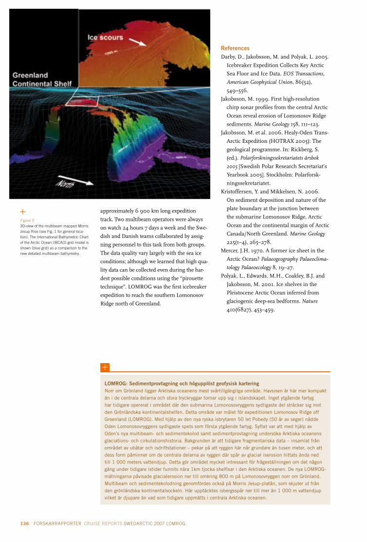
136 FORSKARRAPPORTER CRUISE REPORTS SWEDARCTIC 2007 LOMROG ÅRSBOK YEARBOOK 2007 137
approximately 6 900 km long expedition
track. Two multibeam operators were always
on watch 24 hours 7 days a week and the Swe-
dish and Danish teams collaborated by assig-
ning personnel to this task from both groups.
The data quality vary largely with the sea ice
conditions; although we learned that high qua-
lity data can be collected even during the har-
dest possible conditions using the “pirouette
technique”. LOMROG was the first icebreaker
expedition to reach the southern Lomonosov
Ridge north of Greenland.
ReferencesDarby, D., Jakobsson, M. and Polyak, L. 2005.
Icebreaker Expedition Collects Key Arctic
Sea Floor and Ice Data. EOS Transactions,
American Geophysical Union, 86(52),
549–556.
Jakobsson, M. 1999. First high-resolution
chirp sonar profiles from the central Arctic
Ocean reveal erosion of Lomonosov Ridge
sediments. Marine Geology 158, 111–123.
Jakobsson, M. et al. 2006. Healy-Oden Trans-
Arctic Expedition (HOTRAX 2005): The
geological programme. In: Rickberg, S.
(ed.). Polarforskningssekretariatets årsbok
2005 [Swedish Polar Research Secretariat’s
Yearbook 2005]. Stockholm: Polarforsk-
ningssekretariatet.
Kristoffersen, Y. and Mikkelsen, N. 2006.
On sediment deposition and nature of the
plate boundary at the junction between
the submarine Lomonosov Ridge, Arctic
Ocean and the continental margin of Arctic
Canada/North Greenland. Marine Geology
225(1–4), 265–278.
Mercer, J.H. 1970. A former ice sheet in the
Arctic Ocean? Palaeogeography Palaeoclima-
tology Palaeoecology 8, 19–27.
Polyak, L., Edwards, M.H., Coakley, B.J. and
Jakobsson, M. 2001. Ice shelves in the
Pleistocene Arctic Ocean inferred from
glaciogenic deep-sea bedforms. Nature
410(6827), 453–459.
lOMROg: Sedimentprovtagning och högupplöst geofysisk karteringNorr om Grönland ligger Arktiska oceanens mest svårtillgängliga område. Havsisen är här mer kompakt än i de centrala delarna och stora tryckryggar tornar upp sig i islandskapet. Inget ytgående fartyg har tidigare opererat i området där den submarina Lomonosovryggens sydligaste del sträcker sig mot den Grönländska kontinentalshelfen. Detta område var målet för expeditionen Lomonosov Ridge off Greenland (LOMROG). Med hjälp av den nya ryska isbrytaren 50 let Pobedy (50 år av seger) nådde Oden Lomonosovryggens sydligaste spets som första ytgående fartyg. Syftet var att med hjälp av Oden’s nya multibeam- och sedimentekolod samt sedimentprovtagning undersöka Arktiska oceanens glaciations- och cirkulationshistoria. Bakgrunden är att tidigare fragmentariska data – insamlat från området av ubåtar och isdriftstationer – pekar på att ryggen här når grundare än tusen meter, och att dess form påminner om de centrala delarna av ryggen där spår av glacial iserosion hittats ända ned till 1 000 meters vattendjup. Detta gör området mycket intressant för frågeställningen om det någon gång under tidigare istider funnits nära 1km tjocka shelfisar i den Arktiska oceanen. De nya LOMROG-mätningarna påvisade glacialerosion ner till omkring 800 m på Lomonosovryggen norr om Grönland. Multibeam och sedimentekolodning genomfördes också på Morris Jesup-platån, som skjuter ut från den grönländska kontinentalsockeln. Här upptäcktes isbergsspår ner till mer än 1 000 m vattendjup vilket är djupare än vad som tidigare uppmätts i centrala Arktiska oceanen.
Figure 53D-view of the multibeam mapped Morris Jesup Rise (see Fig. 1 for general loca-tion). The International Bathymetric Chart of the Arctic Ocean (IBCAO) grid model is shown (blue grid) as a comparison to the new detailed multibeam bathymetry.

136 FORSKARRAPPORTER CRUISE REPORTS SWEDARCTIC 2007 LOMROG ÅRSBOK YEARBOOK 2007 137
Lomonosov Ridge off Greenland (LOMROG) 2007: Danish Continental Shelf Project
Introduction and backgroundThe area north of Greenland is one of three
potential areas off Greenland for extension
of the continental shelf beyond 200 nautical
miles according to the United Nations Conven-
tion on the Law of the Sea (UNCLOS), article
76 (Marcussen et al. 2004). The technical data
needed for a submission to the Commission
on the Limits of the Continental Shelf (CLCS)
include geodetic, bathymetric, geophysical
and geological data. Acquisition of the neces-
sary data poses substantial logistical problems
due to the ice conditions in the area north of
Greenland.
As the Danish part of the LOMROG expedi-
tion was the first Danish ship borne activity in
the Arctic Ocean ever, one of the main goals of
the expedition was to test the data acquisition
concepts and especially the new reflection
seismic equipment on board Oden under
severe ice conditions (10/10 of several meters
thick multi-year sea ice under compression).
It was furthermore planned to acquire as
much bathymetric data as possible to support
the delineation of the foot of the continental
slope, to map the sediment thickness in the
Amundsen Basin and to investigate the bathy-
metric trough between the Lomonosov Ridge
and the Canada/Greenland shelf. The Cana-
dian Continental Shelf project participated
with a small bathymetric programme planned
in Canadian waters. Finally, acquisition of
gravity data was planned to support the map-
ping of the sediment thickness.
The Danish Continental Shelf Project
(www.a76.dk) funded half of the costs for
Oden and the full costs for the Russian
nuclear icebreaker 50 let Pobedy.
Principal investigator
Christian Marcussen Geological Survey of Denmark and
Greenland (GEUS)
Copenhagen, Denmark
Project participants
Dennis Anthony Morten Sølvsten Royal Danish Administration of
Navigation and Hydrography (RDANH)
Copenhagen, Denmark
Trine Dahl-Jensen Thomas Funck lars Rödel Thomas Vangkilde-PedersenGeological Survey of Denmark and
Greenland (GEUS)
Copenhagen, Denmark
Rene Forsberg Danish National Space Center (DNSC),
Technical University of Denmark
Copenhagen, Denmark
Timothy JanzenCanadian Hydrographic Services (CHS)
Burlington, Ontario, Canada
holger lykke-Andersen Per TrinhammerDepartment of Earth Science,
University of Aarhus
Århus, Denmark
Figure 1Seismic equipment used during the LOMROG cruise. Photos: Thomas Vangkilde-Pedersen.
Sercel 605 cu in. linear air gun cluster
Winch container
geometrics geoEel digital streamer
Inside view of recording container

138 FORSKARRAPPORTER CRUISE REPORTS SWEDARCTIC 2007 LOMROG ÅRSBOK YEARBOOK 2007 139
Table 1 Summary of acquisition parameters
Source 2 Sercel g and 1 Sercel gI gun
Chamber volume 605 cu inch (250 + 250 + 105)
Pressure 200 bar (3000 psi)
Mechanical delay 16 ms
Nominal tow depth 20 m
Streamer geometrics geoEel
Length of tow cable 43 m
Length of stretch section 50 m
No. of active sections 6 / 5 / 4 / 3
Length of active sections 300 / 250 / 200 / 150 m
No. of groups in each section 8
Total no. of groups 48 / 40 / 32 / 24
Group interval 6.25 m
No. of hydrophones in each group 8
Depth sensor In each section
Nominal tow depth 20 m
Acquisition system geometrics geoEel controller
Sample rate 1 ms
Low-cut filter Out
High-cut filter Anti-alias (=500 Hz)
Gain setting 6 dB
No. of recording channels 48 / 40 / 32 / 24
No. of auxiliary channels 4
Shot spacing 25 m
Record length Variable between 8.5 and 11 s
Figure 2Launching of the seismic equipment: Airgun cluster lower left and umbilical head above the two participants. Photo: Trine Dahl-Jensen.
Seismic data acquisitionThe seismic reflection equipment used during
the LOMROG cruise has been developed in co-
operation with the Department of Earth Science,
University of Aarhus, and is based on the expe-
rience gained by various people who have acqui-
red reflection seismic data in the Arctic Ocean
from icebreakers since 1991 (especially Yngve
Kristoffersen, Art Grantz and Wilfried Jokat).
The crucial issue of seismic data acquisi-
tion in ice covered waters is to protect the
seismic equipment from being damaged by
sea ice while simultaneously acquiring useful
data in this very noisy environment. It was
therefore decided to tow both airgun and
streamer at a suitable depth (approximately
20 meters below water surface), to ensure
that the equipment would stay clear from the
propeller wash behind the ship. However, at
such a large source depth the surface ghost
reflections will cause undesirable notches in
the source spectrum at 30 Hz and 60 Hz.
The seismic equipment is fully containe-
rized and consists of a winch container with
three winches, a compressor container, a
recording container and a storage container.
A heavy duty umbilical both feeds the airguns
with compressed air and connects with the
seismic streamer. For smooth launch and
retrieval of the equipment the winches and
Oden’s A-frame were used. Acquisition para-
meters are summarized in Table 1.
Due to the short length of the seismic
streamer, velocity information from the se-
dimentary units is very limited. However,
sediment velocities are important for the
documentation of the sediment thickness
of the extended continental shelf, if the 1%-
sediment-thickness formula (Gardiner line)
has to be applied. Therefore, sonobuoys were
deployed along the seismic lines to record the
seismic signals at larger offsets.
On-board processing (using ProMax soft-
ware) concentrated on the evaluation of data
quality, noise reduction and acquisition para-
meters. It showed that the noise level after
processing is acceptable considering the con-
ditions under which the data were acquired.
Analysis of subsets of the seismic data indica-
ted that a streamer with four sections instead
of six sections would provide record sections
with only slightly reduced data quality.
Seismic data acquisition started in the
Amundsen Basin, where an approximately
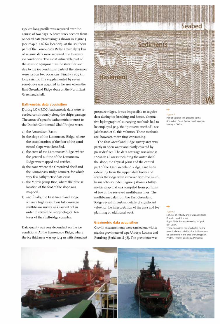
138 FORSKARRAPPORTER CRUISE REPORTS SWEDARCTIC 2007 LOMROG ÅRSBOK YEARBOOK 2007 139
Figure 3Part of seismic line acquired in the Amundsen Basin (water depth approx-imately 4 000 m).
Figure 4Left: 50 let Pobedy under way alongside Oden to break the ice. Right: 50 let Pobedy reversing to “pick up” Oden. These operations occurred often during seismic data acquisition due to the severe ice conditions in the area of investigation. Photos: Thomas Vangkilde-Pedersen.
130 km long profile was acquired over the
course of two days. A brute stack section from
onboard data processing is shown in Figure 3
(see map p. 126 for location). At the southern
part of the Lomonosov Ridge area only 15 km
of seismic data were acquired due to severe
ice conditions. The most vulnerable part of
the seismic equipment is the streamer and
due to the ice conditions parts of the streamer
were lost on two occasions. Finally a 165 km
long seismic line supplemented by seven
sonobuoys was acquired in the area where the
East Greenland Ridge abuts on the North East
Greenland shelf.
Bathymetric data acquisitionDuring LOMROG, bathymetric data were re-
corded continuously along the ship’s passage.
The areas of specific bathymetric interest to
the Danish Continental Shelf Project were:
a) the Amundsen Basin,
b) the slope of the Lomonosov Ridge, where
the exact location of the foot of the conti-
nental slope was identified,
c) the crest of the Lomonosov Ridge, where
the general outline of the Lomonosov
Ridge was mapped and verified,
d) the zone where the Greenland shelf and
the Lomonosov Ridge connect, for which
very few bathymetric data exist,
e) the Morris Jesup Rise, where the precise
location of the foot of the slope was
mapped,
f) and finally, the East Greenland Ridge,
where a high-resolution full-coverage
multibeam survey was carried out in
order to reveal the morphological fea-
tures of the shelf-ridge complex.
Data quality was very dependent on the ice
conditions. At the Lomonosov Ridge, where
the ice thickness was up to 4 m with abundant
pressure ridges, it was impossible to acquire
data during ice-breaking and hence, alterna-
tive hydrographical surveying methods had to
be employed (e.g. the “pirouette method”, see
Jakobsson et al. this volume). These methods
are, however, more time consuming.
The East Greenland Ridge survey area was
partly in open water and partly covered by
polar drift ice. The data coverage was almost
100% in all areas including the outer shelf,
the slope, the abyssal plain and the central
part of the East Greenland Ridge. Five lines
extending from the upper shelf break and
across the ridge were surveyed with the multi-
beam echo sounder. Figure 5 shows a bathy-
metric map that was compiled from portions
of two of the surveyed multibeam lines. The
multibeam data from the East Greenland
Ridge reveal important details of significant
value for the interpretation of the area and for
planning of additional work.
gravimetric data acquisitionGravity measurements were carried out with a
marine gravimeter of type Ultrasys Lacoste and
Romberg (Serial no. S-38). The gravimeter was

140 FORSKARRAPPORTER CRUISE REPORTS SWEDARCTIC 2007 LOMROG ÅRSBOK YEARBOOK 2007 141
mounted in the engine room close to the centre
of mass of Oden (Fig. 6). The system records
data every 10 sec, which after processing and
reference measurements in the harbours of
Tromsø and Svalbard yield gravity values at an
accuracy of approximately 1 mgal and 2–500 m
resolution, depending on the speed of Oden and
ice conditions.
As a complement to the marine gravity data,
the ship’s helicopter was used to make measu-
rements with land gravimeters along profiles
across the flanks of the Lomonosov Ridge and
the Morris Jesup Rise (Fig. 7).
Gravimeter data collected on Oden were
processed using the DNSC marine software
“eotvos”, that incorporates Eötvös corrections
from the ship’s GPS navigation (logged at 5 s
intervals), outlier and spike detection, and a
zero-phase filtering scheme. Some minor data
gaps occurred for a short period of time due to
some serial communications problems. How-
ever, most gaps were sufficiently short (a few
minutes) to allow interpolation.
Oden provided an excellent platform for ma-
rine gravity measurements, and measurements
in the ice were superior to data from many other
icebreakers or even submarines, in spite of the
irregular navigation with frequent course and
speed changes. The Ultrasys Lacoste Romberg
gravimeter employed proved stable and reliable
with only a small drift and the gravimetric data
collected will be useful both in connection with
the Danish UNCLOS project, as well as an
important new data contribution to the Arctic
Gravity Project (http://earth-info.nga.mil/
GandG/wgs84/agp/hist_agp.html).
The helicopter measurements were swift
and efficient, but limited by the range of the
helicopter and by the weather (frequent white-
out conditions). However, with a functioning
echo sounder and an increased operation range,
this could be an efficient way to collect relevant
additional geophysical data on future cruises.
Other activitiesA research project with the aim of investigating
and quantifying the importance of sea ice in
transporting carbon dioxide from the atmosphe-
re to the ocean in areas with different types of
sea ice has been associated with the Danish part
of the LOMROG cruise (see Rysgaard et al. this
volume for details). Furthermore a Danish film
crew (Suvi Helminen and Kenneth Sorento)
from STV Nature and Science was stationed
on board Oden during the LOMROG cruise to
document the project and the cruise.
ConclusionThe LOMROG cruise demonstrated that ac-
quisition of bathymetric and seismic data of
sufficient quality for substantiating a claim ac-
cording to article 76 of UNCLOS by a two ship
operation is possible under the severe ice con-
ditions that prevail in the area north of Green-
land, and data acquisition would not have been
feasible without the competent support from
the Russian nuclear icebreaker 50 let Pobedy.
ReferencesMarcussen, C., Christiansen, F.G., Dahl-
Jensen, T., Heinesen, M., Lomholt, S., Møl-
ler, J.J. and Sørensen, K. 2004. Exploring
for extended continental shelf claims off
Greenland and the Farœ Islands – geologi-
cal perspectives. Geological Survey of Den-
mark and Greenland Bulletin 4, 61–64.
Figure 5Top: Part of the bathymetric grid in the East Greenland Ridge area based on two of the surveyed multibeam lines. Bottom: Bathymetric profile – units in meters.
Figure 6Marine gravimeter mounted in the engine room on board Oden. Photo: Rene Forsberg.

140 FORSKARRAPPORTER CRUISE REPORTS SWEDARCTIC 2007 LOMROG ÅRSBOK YEARBOOK 2007 141
lOMROg: Det danska KontinentalsockelprojektetDen danska delen av expeditionen LOMROG var ett led i Kontinentalsockelprojektet, som har till uppgift att ta fram det tekniska underlaget för en eventuell utvidgning av det danska territoriella kontinentalsockelområdet norr om Grönland, utöver de 200 sjömil som man idag gör anspråk på i enlighet med FN:s Havsrättskonvention.
Isförhållandena i undersökningsområdet hör till de svåraste i den Arktiska oceanen och utgör en stor utmaning för datainsamlingen. Syftet med LOMROG var således att testa datainsamlingskoncep-tet under dessa svåra isförhållanden och speciellt den nyutvecklade seismiska utrustningen.
Under LOMROG expeditionen insamlades följande data:– Batymetriska data i Amundsenbassängen och upp på Lomonosovryggen, en batymetrisk kartlägg-
ning av yttersta spetsen på Morris Jesup-platån samt en kartläggning av det område där Östgrön-landsryggen möter den östgrönländska shelfen. Insamling av multibeamdata och subbottomprofiler har skett i tätt samarbete med de svenska forskningsgrupperna.
– Seismiska data längs en ca. 130 km lång profil i Amundsenbassängen, en 15 km lång profil på sydspetsen av Lomonosovryggen samt en 165 km lång profil vid Östgrönlandsryggen.
– Under hela expeditionen samlades kontinuerligt gravimetriska data samt gravimetriska punktdata med hjälp av Odens helikopter.
LOMROG-expeditionen har visat att insamling av batymetriska och seismiska data som kan användas i det danska Kontinentalsockelprojektet är möjligt trots de svåra isförhållanden som råder i området norr om Grönland. Datainsamlingen skulle dock inte ha varit möjligt utan den mycket kompetenta hjälpen från den ryska isbrytaren 50 let Pobedy.
Figure 7Location of the off-ship helicopter gravity profiles. Greenland at lower left.

142 FORSKARRAPPORTER CRUISE REPORTS SWEDARCTIC 2007 LOMROG ÅRSBOK YEARBOOK 2007 143
Lomonosov Ridge off Greenland (LOMROG) 2007: Sea ice and climate
The Arctic Ocean plays a critical part in global
oceanic circulation, in that it modulates the
formation of deep water in the North Atlantic
via ice formation. The extent of Arctic sea ice
undergoes seasonal changes with an average
maximum of 15 × 106 km2 and an average mi-
nimum of 8 × 10⁶ km2 (Gloersen and Camp-
bell 1991). Due to warming of the world oceans
(Levitus et al. 2000) the sea ice cover in the
Arctic has decreased by ~10% in extent since
the 1970s (Johannessen et al. 1999). Climate
change due to the anthropogenic greenhouse
emission is expected to be significant and
relatively large in the Arctic region compared
to other areas in the world and the consensus
view is that within 70 years, the average an-
nual temperature of the Arctic is predicted to
increase by at least 4°C and in some places by
more than 8°C. This increase implies that the
sea ice thickness and distribution in the Arctic
will decrease markedly and thus alter the heat
and mass exchange as well as ocean stratifica-
tion in the future and hence, research in sea
ice areas is urgently needed in order to obtain a
basic understanding of the processes and orga-
nisms being affected by the expected dramatic
alterations in sea ice distribution.
Deep-water formation in the Arctic Ocean
and the Greenland Sea contributes to the
overflow water in the Denmark Strait and
the Faroe Bank Channel (Buch et al. 1996,
Hansen et al. 2001), which constitutes the
origin of the North Atlantic Deep Water (Reid
and Lynn 1971). In addition, high-latitude
areas act as a sink for atmospheric CO2 and
thereby represent a direct pathway for CO2
exchange between the atmosphere and the
deep ocean (Takahashi et al. 2002). The
difference between pCO2 in surface water
and the overlying air represents the thermo-
dynamic driving potential for air-sea CO2
gas exchange, which influences the surface
concentrations of dissolved inorganic carbon
(DIC). Surface-water pCO2 levels are regu-
lated by temperature, salinity and DIC and
total alkalinity (TA) concentrations. DIC and
TA have hitherto been considered to be con-
trolled primarily by biological processes (i.e.
photosynthesis, respiration and calcification),
upwelling of subsurface water enriched in
respired CO2 and nutrients, and air–sea ex-
change (Takahashi et al. 2002). However, our
recent work suggests that besides oxygen,
DIC is also rejected from growing sea ice to-
gether with brine (Glud et al. 2002, Rysgaard
et al. 2007). In addition, we have observed
very low DIC and TA concentrations in Arctic
first-year and multi-year sea ice as well as sig-
nificant fractionation of DIC and TA compa-
red to surface-water conditions (Rysgaard et
al. 2007). Downward rejection of CO2 from
growing sea ice together with brine has not
been considered previously, and nor has the
resulting atmosphere-ice-ocean exchange of
carbon resulting from this sea-ice driven DIC
pump been quantified. Our first preliminary
model calculations show that this DIC pump
affects the surface-water pCO2 significantly
Project participants
hans Ramløv Section of Molecular and General Phy-
siologi, Department of Natural Sciences
Roskilde University, Roskilde, Denmark
Søren Rysgaard* (Principal Investigator)Center of Marine Ecology and Climate
Impact, Greenland Institute of Natural
Resources, Nuuk, Greenland
* not participating in the field
Figure 1Drilling ice cores with Kovacs drill at 85°N. Photo: Hans Ramløv.

142 FORSKARRAPPORTER CRUISE REPORTS SWEDARCTIC 2007 LOMROG ÅRSBOK YEARBOOK 2007 143
in the polar seas and potentially sequesters
large amounts of CO2 in the deep ocean.
Brine-mediated DIC transport into the deep
ocean may be significant in the global carbon
cycle, and variations in sea ice formation
under past climatic conditions might help
explain variations in atmospheric CO2 levels.
A number of studies have revealed that ice
algae can modify their environment in the sea
ice so that they are able to exploit the interior of
the sea ice as a habitat. The modifications are
presumed to be mediated by the algae synthe-
sizing ice active substances that at least can
inhibit the growth of the ice surrounding the
algae, but which possibly also widen the spaces
by a non-colligative melting of the ice surface
around the algae. The substances synthesized
by the ice algae have several properties in
common with the so called “antifreeze prote-
ins” that are synthesized by a number of cold
tolerant ectothermic animals. These proteins
can recognize ice surfaces and bind to them,
and are thereby able to inhibit the growth of
ice crystal. To understand the total CO2 budget
of the sea ice, investigations of these ice as-
sociated algae and their physiology is needed.
Likewise, future decrease in global sea ice
cover may reduce the world oceans’ capacity for
taking up atmospheric CO2. Assessing changes
in future sea ice conditions as projected by
climate models will allow for a more quanti-
tative analysis of this hypothesis. Thus, more
research on this process is urgently needed.
AimThe aim is to investigate and quantify the im-
portance of sea ice in transporting carbon diox-
ide from the atmosphere to the ocean in areas
with different types of sea ice. Furthermore,
our recent discoveries of anoxic conditions and
bacterial denitrification/anammox activity in
sea ice show that sea ice may play an important
role in the removal of nitrogen. More investi-
gations from multi-year sea ice are, however,
needed to increase our understanding of its
significance in the Arctic and its role in the
global nitrogen cycle. Furthermore, sea ice
formation may play a far more important role
in transporting carbon dioxide (CO2) from the
atmosphere to the ocean than previously as-
sumed. Our preliminary studies on first-year
sea ice from northeast Greenland and northern
Canada have indicated that ice growth during
winter rejects large amounts of CO2, which
sink together with dense brine to intermediate
and deep water layers. Subsequent sea ice melt
during summer enhances the uptake of CO2
from the atmosphere, as the resulting melt-
water is undersaturated with respect to CO2.
As the transport mechanism is dependent on
sea ice formation, future decrease in global sea
ice cover may reduce the oceanic capacity for
taking up atmospheric CO2.
During the LOMROG expedition, sea ice
samples were acquired by drilling ice cores
along the expedition path with the aim of me-
asuring the total concentration of inorganic
dissolved carbon (TIC or TCO2) and total alkali-
nity (TA). In addition to the physical and che-
mical measurements of the sea ice, the occur-
rence of algae in the ice was also investigated.
The reason for this is that the role of the algae,
concerning the chemical conditions in the
context of the CO2 in the ice, is not well known.
Thus it is of importance to investigate the algae
and their physiology. Ice algae synthesize some
substances that can modify the ice surface and
optimise the environment in the ice in which
the algae are found. It is therefore also one of
the aims of the present study to investigate the
algae and the synthesized substances.
MethodsIce coring
Different types of sea ice were collected using a
7 cm KOVACS ice core drill fitted with a battery
driven hand drill. 10 cm pieces from the top,
middle and bottom of the ice core were cut out
and transferred to plastic containers. Before col-
lecting the 10 cm pieces the temperature along
the core was measured at 10 cm intervals.
Physical measurements
The physical parameters air temperature,
snow depth, snow temperature (5 cm inter-
vals), ice surface temperature, ice density and
total ice salinity (melted ice core) were measu-
red at each drill hole and ice core piece.
Density of the core pieces was determined
from top, middle and bottom, where possible,
by measuring and weighing the core piece.
Preparation of ice cores for measurements
of TCO2, total alkalinity (TA), salinity and
chlorophyll a
The collected core pieces were taken to the
laboratory and cleaved. One half was transfer-
red to a gas proof plastic bag (Würgler bag
(Würgler Hansen et al. 2000)) and sealed. The
ice was melted in the bag and the melt water

144 FORSKARRAPPORTER CRUISE REPORTS SWEDARCTIC 2007 LOMROG
transferred to gas tight containers, preserved
with HgCl2 and then brought to the laboratory
in Nuuk (Greenland) where the final measure-
ments are to be done.
The other half was melted; some melt water
was transferred to a plastic vial for the measu-
re-ment of salinity and the rest was filtered
through a glass filter and the filter was there-
after frozen for the later determination of the
chlorophyll a content of the filtrate (i.e. the
ice). In addition to the ice cores, water samp-
les from 10 m depth were acquired from the
CTD that was operated by one of the Swedish
groups participating on the expedition (see
Andersson and Björk in this volume).
ReferencesBuch, E., Malmberg, S.-A. and Kristmanns-
son, S.S. 1996. Arctic Ocean deep water
masses in the western Iceland Sea. J.
Geophys. Res. 101, 11965–11973.
Gloersen, P. and Campbell, W.J. 1991. Recent
variations in Arctic and Antarctic sea-ice
covers. Nature 352, 33–36.
Glud, R.N., Rysgaard, S. and Kühl, M. 2002.
O2 dynamics and photosynthesis in ice al-
gal communities: Quantification by micro-
sensors, O2 exchange rates, 14C-incubations
and a PAM-flourometer. Aquat. Microb.
Ecol. 27, 301–311.
Hansen, B., Turell, W.R. and Østerhus, S.
2001. Decreasing overflow from the Nordic
seas into the Atlantic Ocean through the
Faroe Bank channel since 1950. Nature 411,
927–930.
Johannessen, O.M., Shalina, E.V. and Miles,
M.W. 1999. Satellite evidence for an Arctic
sea ice cover in transformation. Science
286, 1937–1939.
Levitus, S., Antonov, J.I., Boyer, T.P. and
Stephens, C. 2000. Warming of the world
ocean. Science 287, 2225–2229.
Reid, J. and Lynn, R. 1971. On the influence
of the Norwegian-Greenland and Weddel
Seas upon the bottom waters of the In-
dian and Pacific oceans. Deep-Sea Res. 18,
1063–1088.
Rysgaard, S., Glud, R.N., Sejr, M.K. and
Bendtsen, J. 2007. Inorganic carbon
transport during sea ice growth and decay:
A carbon pump in the polar seas. J Geophys.
Res. 112, doi 10.1029/2006JC003572.
Takahashi, T., Sutherland, S.C., Sweeney, C.,
Poisson, A., Metzl, N., Tilbrook, B., Bates,
N., Wannenkhof, R., Feeley, R.A., Sabine,
C., Olafsson, J. and Nojiri, Y. 2002. Global
sea-air CO2 flux based on climatological
surface ocean pCO2 and seasonal biological
and temperature effects. Deep-Sea Res. 49,
1601–1622.
Würgler Hansen, J., Thamdrup, B. and Jør-
gensen, B.B. 2000. Anoxic incubation of
sediment in gas tight plastic bags: a met-
hod for biogeochemical process studies.
Mar. Ecol Prog. Ser. 200, 273–282.
lOMROg: havsisen och klimatetDen Arktiska oceanen spelar en viktig roll i den globala havscirkulationen. Bl.a. påverkar den bildningen av bottenvattnet i Nordatlanten via isbildningen på hösten och vintern. På grund av den globala uppvärmningen har istäcket i den Arktiska oceanen krympt med ca 10 % sedan 1970-talet. Det förutspås att under de nästkommande 70 åren kommer temperaturen i den Arktiska oceanen att stiga med mellan 4ºC och 8ºC, och på det följer ett ytterligare minskande istäcke.
Då havsområden på höga breddgrader fungerar som magasin för atmosfärisk CO2, och då upp-rinnelsen i det nordatlantiska djupvattnet är ”överflödet” från djupvattnet i Danmarkssträdet och Kanalen vid Färöbanken, är dessa direkt medverkande till överföringen av atmosfärisk CO2 (koldioxid) till djuphavet. Den drivande kraften bakom utväxlingen av CO2 mellan luft och vatten är skillnaden i CO2-partialtrycket mellan vattnet och den överliggande luften. Ytvattnets CO2-partialtryck bestäms av temperatur, salinitet, upplöst oorganiskt kol (DIC) samt den totala alkaliniteten (TA). Tidigare har man antagit att DIC och TA kontrollerades av den fysiska nerkylningen av vattnet samt av biologiska proces-ser, men det har visat sig att CO2 skiljs ut under isbildningen och upplöses i det salta vattnet som blir till som en följd av fryskoncentrationen i fickor i isen (brine-bildning). Denna mekanism kan ge anled-ning till en stor förflyttning av mycket salt och CO2-berikat vatten till de djupliggande vattenlagren, som inte tidigare har funnits med i modellberäkningar över CO2-utväxlingen i Arktiska oceanen. Under LOMROG-expeditionen samlades 28 × 3 iskärnor, vari TA, DIC och salinitet blev undersökt. Ytterligare ett antal iskärnor samlades in och transporterades i fruset skick till Grönlands Naturinstitut. Där ska de användas till undersökningar av isens pH-värde, innehåll av kalciumkarbonat och isalgernas infly-tande på isens CO2-innehåll samt hur isalgerna påverkar isytan där de finns.
Figure 2Taking ice core samples for the measure-ment of CO2 and alkalinity in the sea ice at 85°N. Photo: Hans Ramløv.

Polarforskningssekretariatet
Polarforskningssekretariatet är en statlig myndighet med uppgift att främja och samordna svensk polarforskning. Det innebär bl.a. att följa och planera forskning och utvecklingsarbete samt organisera och genomföra forskningsexpeditioner i Arktis och Antarktis. Polarforskningssekretariatet är förvaltningsmyndighet för lagen (2006:924) om Antarktis och prövar frågor om tillstånd för vistelse eller verksamhet i enlighet med lagen.
The task of the Swedish Polar Research Secretariat is to promote and co-ordinate Swedish polar research. This means e.g. to follow and plan research and development and to organise and lead research expeditions to the Arctic and Antarctic regions. The Swedish Polar Research Secretariat is the administrative authority for the Act on Antarctica (2006:924) and handles permit issues for visits or activities in accordance with the Act.
ISSN 1402-2613
ISBN 978-91-973879-7-2
Swedish P
olar Research Secretariat
Årsbok Yearbook 2007
Årsbok Yearbook 2007
Polarforskningssekretariatet Swedish Polar Research Secretariat


![Emersonian : [Emerson College yearbook]](https://static.fdokumen.com/doc/165x107/6321be5e117b4414ec0b98a5/emersonian-emerson-college-yearbook.jpg)