In War Against Urme. Some Considerations on the Westward expansion of the Kingdom of Urartu
30
Transcript of In War Against Urme. Some Considerations on the Westward expansion of the Kingdom of Urartu
PROF. SERGI MAKALATIA
GORI
HISTORICAL-ETHNOGRAPHICAL MUSEUM
STUDIES IN
CAUCASIAN ARCHAEOLOGY
II
TBILISI
2014

EDITORIAL BOARD:
Dr. GIORGI MINDIASHVILI
(Editor in Chief)
Georgian National Museum,
Otar Lordkipanidze Centre of
Archaeological Research
Dr. ARSEN BOBOKHYAN
(Editor of the Volume)
Institute of Archaeology and Ethnography
Armenian Academy of Sciences
Yerevan State University
Dr. WALTER KUNTNER
University of Innsbruck
MA. THORSTEN RABSILBER
Deutsches Bergbau Museum,
Rühr-Universität Bochum
Dr. KOUROSH ROUSTAEI
Iranian Centre for Archaeological Research
Dr. SANDRA HEINSCH
University of Innsbruck
Dr. GURAM KVIRKVELIA
Georgian National Museum,
Otar Lordkipanidze Centre of
Archaeological Research
BA. TAMAR MELADZE
Ilia State University
MA. GIORGI KARELIDZE
Tbilisi State University
MA. DIMITRI NARIMANISHVILI
Kldekari Historical-Architechtural
Muzeum-Reserve
Tbilisi State University
MA. ZVIAD SHERAZADISHVILI
(Responsible Editor)
Prof. Sergi Makalatia
Gori Historical-Ethnographical Museum
Tbilisi State University
მისამართი. გორი, N 1400, კირიონ II-ის ქ. 12
Address. Gori, N 1400, Kirion II str. N 12.
© პროფ. სერგი მაკალათიას სახელობის გორის ისტორიულ-ეთნოგრაფიული მუზეუმი, 2014 © Prof. Sergi Makalatia Gori Historical-Ethnographical Museum, 2014
UDC (უაკ) 902(479)(051.2)
S-90
ISSN 2233-3517

CONTENTS
RÉMI BERTHON
Past, Current, and Future Contribution of
Zooarchaeology to the Knowledge of the Neolithic and
Chalcolithic Cultures in South Caucasus …………………………............................…….......... 4
DIANA ZARDARYAN
On the Origins of the Pottery Traditions
of the Kura-Araxes Culture ………………………………………………………….……….... 31
GIORGI MINDIASHVILI
Studies on Social Structure of Kura-Araxes Culture …………....…………..…………..…….. 41
DAVID KUPARADZE
DIMITRI PATARIDZE
Iron Ores and Manufacturing of Iron and
Steel in Old Georgia …………………………………………………...….……………..…...… 57
MANUEL CASTELLUCIA
Urartian Metalwork in Caucasian Graves ………………………………..…………............…. 83
ROBERTO DAN
GIORGIA NERI
In War against Urme:
Some Considerations Regarding the
Westward Expansion of the Kingdom of Urartu ……………………………..…….............… 115
MICHAEL HERLES
Some Considerations on the Fibulae
of the Cappadocian Delegation on the
Apadana Reliefs at Persepolis ……………………………………………….………....….…. 138
115
In War against Urme:
Some Considerations Regarding the
Westward Expansion of the Kingdom of Urartu
ROBERTO DAN
GIORGIA NERI
1
Sapienza University of Rome
“Take a look," said he, "at the mountains, and observe how impassable all of them are. The only
road is the one there, which you see, a steep one, too, and on that you can see the great crowd of
people who have taken possession of it and are guarding our way out.
(Chrisiforo’s answer to Senofonte on the difficult passage of the Herakol Dağ. Xen. Anab.
4.1.20).
The progression of the westward expansion achieved by Urartian Kings emerges clearly
from the analysis of sources at our disposal. In particular it is possible to recognize fundamental
differences in the conditions and modality of their territorial conquests, and hypothesize about
locations of various toponyms within this territory. Among the various areas subjugated by the
Urartians in their advance towards the west, the lands of Urme constitute an interesting
interlocutor. The importance of these lands accrues both by their geographical location and the
frequency of Urme toponyms appearing in the Assyrian Royal Inscriptions.
The Assyrian inscriptions reported that in 832 BC the Urartian King, Sarduri I, had crossed
the river Murat Su (Pl. IV) to repeal the Assyrian army led by Daijān-Aššur [RIMA III
A.O.102.14, 141B-146A], who was turtānu during the reign of Shalmaneser III. However, both
the Assyrian sources and those of Sarduri I fail to mention whether these lands were already part
of the Urartian Kingdom.
The beginning of the systematic westward expansion, analogous to what had occurred in
Transcaucasia, has to be ascribed to Minua [810-785/780 BC; for the chronological references
see Salvini, 2008: 23]. These conquests certainly involved the movement of armies through the
territories adjacent to the western shores of Lake Van. In this regard, the early years of Minua’s
reign can be dated to the first expedition against Alzi, in the area of modern Elâzığ [Nashef,
1982: 27]. Here, according to the Aznavurtepe [CTU A 5-11] inscription, a fortress was built
near the town of Qutume, though this site has not been archeologically identified. The
subjugation of this territory required two armed interventions. The second of which included

conquests over the territories of Ḫatti, the plains of Zaḫu, the valley of Eastern Ḫabur and ended
with the defeat of Qumenu (Kumme), which allowed them to reach the country of Aššur [CTU
A 5-9]. The main result of this aggressive action was crossing the Euphrates River where the
King established the first contact with Neo-Hittite states. The physical evidence of the Urartian
presence in these regions is given by two of Minua’s inscriptions: On the one hand the rock-cut
inscription of Palu, on the other the stele of Bağın. The inscription of Palu relates to the recently
completed military activities2. The Bağın inscription details the administrative organization of
these territories3.
Minua’s son and successor, Argišti I (785/780-756 BC), also played a major role in the
expansion of the Kingdom’s borders beyond the Euphrates River. In effect, as reported by his
inscriptions, during the IIIth year of his reign the Neo-Hittite states where included in the
Urartian kingdom. The presence beyond the Euphrates was made possible by the prior organized
actions of Minua, through which a degree of stability was achieved in the area of Elâzığ. This
may be contrasted to other regions, like for example Diaueḫi to the North and Urme in the
South-West, where they were unable to establish an immediate territorial control.
After Argišti’s reign, the western regions were again a target of interest, this time by Sarduri
II (756-ca. 730 BC). The first interventions of Sarduri II were against the country of Urme [CTU
A 9-3 I r. 22] and the country of Arme, known as Šubria in Assyrian texts [CTU A 9-1 Ld, r.
11]. The intense diplomatic contacts with the Neo Hittite States had provoked an Assyrian
reaction, which was currently under the rule of Tiglath-Pileser III (744–727 BC), and culminated
with the renowned pitched battle of Kištan and Ḫalpi (743 BC), in an area located to the south of
Malatya [Astour, 1979: 1-23; Dan, 2010 B: 334]. Following these events, during the reign of
Rusa I, no more information about the western area has been found in the records. This is likely
because their efforts were mainly involved in the regions north of the Araxes River and in the
Urmia Basin. However, due to the administrative records from the archive of Sargon II [See
SAA I and V], we know that the territories west of the Euphrates were still firmly in the hands
of Urartian governors.
The inscription of Kaleköy at Mazgirt is the only internal documentation regarding the
Urartian presence in the west during the VII century BC [CTU A 12-6]. Unfortunately this text,
which was left by Rusa II, is widely damaged and only a few lines are still legible. However, it
is still possible to recognize the names of the country of Ṣupa (Sophene in the classical sources)
and the city of Ḫusišili, which is not known in any other record4. The absence of warfare in this
area may be attributed to the degree of control achieved rather than an indication of lost
positions.
117
URME IN THE URARTIAN SOURCES
Among the western territories, Urme was one of the first antagonists for Urartian political
aspirations. The oldest military actions against this country are chronicled in the erratic stele of
Alazlı/Trmerd, commissioned by Minua to be erected in the recently defeated lands:
(…)5 [ . . . ] [the city of] Alaue, towards the [country of] Urmeuḫi[ . . ], [the city of] Alaue [ .
. ] I forced back, I destroyed the city of Uršani[ . . ], I occupied the country. From the country of
Urme(uḫi) …, I established(?), the country of Ai[ . . . ] . . , the countries [ . . . ] I went as far as [
. . . ] [ . . . ] the city of U[ . . . ]. I went to the country of Urme, I conquered the city of
Tarparakani (and) the city of Erimani[ . . . . . . ] . . . [ . . . ] [x+] 400 cities (= villages) I destroyed
and I set them on fire, fortresses, I came(?) I besieged the city of Qulmeri, I built a fortress, I
enslaved, I installed/ I made the place inhabited, I imposed upon the country tribute (…) [CTU
A 5-6 Ro, rr. 1-28, 1'-11'].
As narrated, the first stages of the expedition involved the regions in the vicinity of the city
of Ḫirḫime and the country of [x-x]lauḫi, followed by the cities of Alaue and Uršani. These
toponyms are mentioned only in this inscription. The last two are most probably fortresses
conquered by Minua at the beginning of the campaign and immediately before of the country of
Urmeuḫi.
The country of Urmeuḫi was initially believed to be a variation of Urme, which would place
it to the west of Šubria. However the current analysis locates Urmeuḫi in the western side of
Lake Van, presumably in the Varto area and therefore North-East of Šubria.
The sequence of events described above leads us to imagine that the march against Urmeuḫi
took place soon after the defeat of the countries of Hirhime and [x-x]lauḫi and immediately
before the descent towards Urme. To realize these accomplishments it is very likely that the
Urartian army would have started their march from a place already under Royal control, where
at least one important fortified centre was situated. This area could be identified with the Patnos
plain, which is a territory that had been under Urartian influence since the reign of Išpuini (ca.
830-820). Consequently, these fortresses could be identified with either Aznavurtepe/Aludiri or
Kancıklı, both of which were founded by Minua.
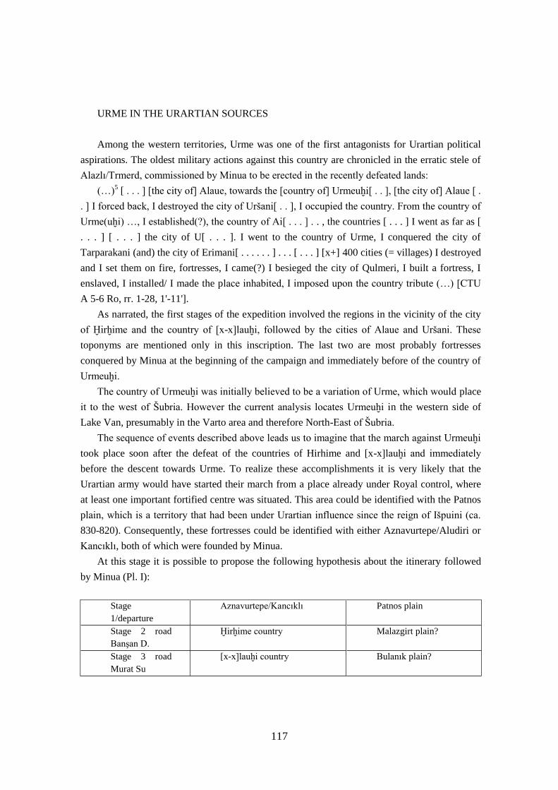
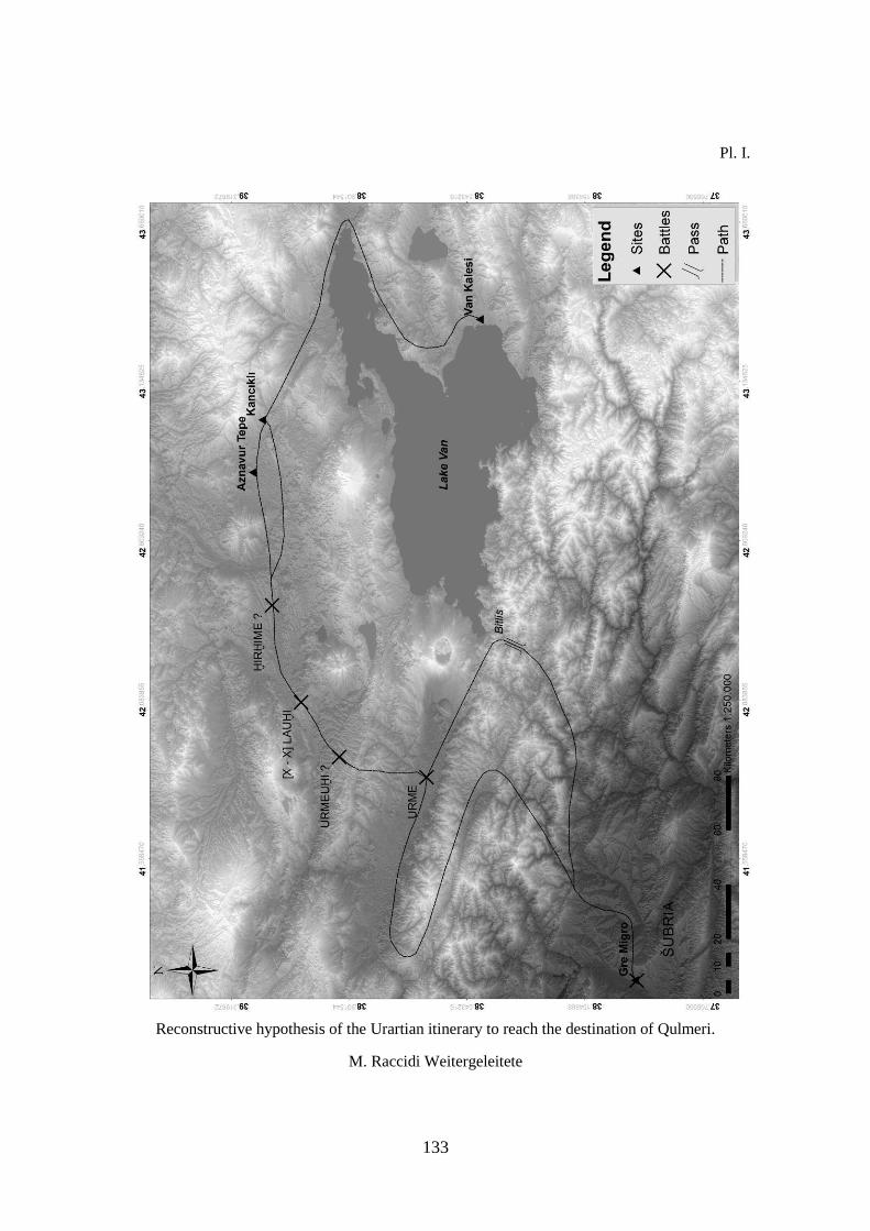
At this stage it is possible to propose the following hypothesis about the itinerary followed
by Minua (Pl. I):
Stage
1/departure
Aznavurtepe/Kancıklı Patnos plain
Stage 2 road
Banşan D.
Ḫirḫime country Malazgirt plain?
Stage 3 road
Murat Su
[x-x]lauḫi country Bulanık plain?
Stage 4 road
Murat Su
Alaue city, Uršani
and Urmeuḫi countries
+ Lacuna
Bulanık/Varto plain?
Stage 5 road
Murat Su
Urme country
Muş plain
Stage 6 road
Tauro
Šubria country and Qulmeri
city
Batman Suyu Valley
With the exception of Urme, after this campaign Urmeuḫi and the other toponyms do not
appear in subsequent inscriptions. These circumstances lead one to believe that Minua’s urgency
was to defeat Urmeuḫi in order to open up the road towards the valley of Murat Su. Urme on the
other hand, was not located in the immediate vicinity of the key road towards the Euphrates.
Therefore, most probably Urme became the subject of subsequent campaigns by the Kingdom of
Urartu.
After the defeat of Urmeuḫi, the country of Ai[x xx x] [CTU A 5-6 Ro (a), r. 11] and of
other toponyms possibly appearing in the gap of the inscription, Minua had reached Urme for
the first time, and the submission of this country was ended with the capture of the two cities,
Erimani and Tarparakani.
For the current work, the most interesting element in the inscription is the Qulmeri
expedition or Kullimeri in the Assyrian documents. Qulmeri is a city located in the country of
Arme/Šubria [Salvini, 1984: 29] and is probably identified with the site of modern Gre Migro6,
which is found in the eastern bank of the Batman Su’. This determination further supports that
the location of Urme is in the modern district of Muş, as this plain gives access to the only route
leading to the city of Qulmeri7, which are:
1) Approximately 170 km following along the valleys of: Billur Deresi, a tributary to Murat
Su, then Kelimosur Deresi, Şadak Deresi, Huyut Deresi, Urussuyu, Norşin Deresi and finally
Garzan (Zok) Suyum in the plain of Batman, which passes just 15 km from Gre Migro.
2) Approximately 130 km following the Bitlis Suyu valley, over the so-called Bitlis Mountain
pass, until Ziyaret/Veyselkarani to reach Garzan (Zok) Suyu, which again takes you down to
Gre Migro.
The possibility that Minua had built a fortress in the country of Qulmeri/Šubria and imposed
tribute upon these distant territories would appear as a literary tòpos. The archaeological absence
of Urartian remains and materials in that area support the improbability of a permanent control
over the country of Qulmeri [Parker, 2001: 231-233].
119
A second inscription by Minua on the stele of Muş tells us of additional operations against
Urme:
“Thanks to the Power of Ḫaldi, Minua, son of Išpuini, is gone out (to war). Ḫaldi marched in
front (of the troops). Minua [says: I conquered the country of X …]” “I imposed upon [the
country X] a tribute, I placed an inscription … nearby Qulmeri8”. Four countries beyond [“” I
arrived at(?)] the city of Atauni. I made war against the country of Urme, I conquered Urme
(and) I placed this inscription. Toward the country of Arḫi [“ (…) [Salvini, 2008: 196; CTU A 5-
7, Ro, rr. 1-7, l.d., rr. 1-8, Vo, rr. 1-8].
This inscription reports the route taken by the army in the opposite direction to that
described in CTU A 5-6. This time the first attack depicted is against the city of Qulmeri from
which only after passing through the city of Atuni, they reach Urme and then finally the country
of Arḫi. The preeminent element is the confirmation of the location of Urme in the Muş plain,
where the text comes from. The other toponyms mentioned appear exclusively in this context.
Taking these elements together the only consideration that can be advanced about the country of
Arḫi, which if one accepts the geographical succession of events and the toponyms mentioned,
may be reasonably centred in the North/North-West of the Muş plain.
The successor of Minua, Argišti I, was forced to confront once again Urme’s resistance to
subjugation, as inscribed on the annals of the Surb Sahak stele (Armenian Church in the city of
Van):
(…) Argišti says: in the same year, I have mobilized the troops again (?); I invoked the God
Ḫaldi, (my) Lord, the Storm God, the Sun God and all the gods of Biainili. Thanks to the
greatness of the Lord aliabadi the gods have listened to me. I waged war against/on the country
of Urme, I conquered Urme, [I assimilated] the country, [I reac]hed up to [. . . (. . .)” [Salvini,
2008: 329; CTU A 8-1, l.s., rr. 16-26].
Also in the accounts of Ḫorḫor (CTU A 8-3), in the XI year of his reign, interventions
against Urme are narrated:
Ḫaldi went off with his weapon/spear, he conquered the country of [Tar]iuni, a mountain
country, he won on the country of Urme (?)9 and he threw them [to the feet] of Argišti. Ḫaldi is
victorious(?), thanks to the greatness of Ḫaldi, Argišti says: I moved against Tari[uni], 11
fortresses …. fortified I conquered during the battle. The ṭeraini of Ḫaldi here …. Argišti, son of
Minua, [says]: Ḫaldi has invested to me both the strength(?) and the fighting [spirit], … I have
destroyed and set on fire [tot] fortresses, [I placed] an in[scription] there, I deported men and
women from there. Argišti says: in the same year10
, I have mobilized the troops again. I prayed
Ḫaldi, (my) Lord, the Storm God, the Sun God and (all) the gods of Biainili; for the greatness of
the Lord ali abadi the gods listened to me; [I?] went off to war against the country of Urme, I
conquered the country of Urme, I devastated its territories and I went as far as the country of [ . .
. ]; I set on fire [tot] villages, I deported men and women toward [tot] Bi[ainili], in all 24813
people-year, I killed some and I [carried away] the others, 25 horses, [x thousand +] 744 cattle

and 48825 sheep. Argišti, the son of Minua, says: for the God Ḫaldi I carried out these deeds in
one year (…) [Salvini, 2008: 344; CTU A 8-3 VI, rr. 1-11].
It seems unlikely that the first part of this text contains another reference to Urme. First of
all, the corruption of the inscription throws doubt on the reading of the mark itself. In addition,
Urme is associated with the mountain country of Tariu/Tariuni, which is generally cited
alongside Diaueḫi, and is therefore located to the North-West of Kars [Diakonoff et al. 1981: 83-
84], 230 km from the plain of Muş.
The second part of the inscription, which refers to martial activities in the following year,
presents a rich list of the spoils coming from Urme, made up of a large number of people and
livestock. The last historical mention of Urme is recorded under the reign of the son and
successor of Argišti, Sarduri II. In his annalistic texts, inscribed on the rock-cut niche of Hazine
Kapısı (CTU A 9-3) at the castle rock of Van, report their relations with Urme:
(…)In the same year I marched again towards the country of Urme, I conquered 11
strongholds and I destroyed them; I deported males and females from there, I took away 110
men and 6500 women, as well as 2000 warriors, 2538 cattle, 8000 sheep (…) [Salvini, 2008 :
420; CTU A 9-3 I, rr. 22-25].
Over the years it has been common to identify the toponym of Urme with Arme and as a
consequence with the territory Šubria [Borger, 1956: 133; Diakonov, 1984: 120, 167; Salvini,
1984: 29]. However, this theory does not take into consideration that both toponyms [KUR
ur-me-
ú-e CTU A 9-3 I, rr. 22 and KUR
ar-me-e CTU A 9-1, l.d., r. 11] appear simultaneously in the
annals of Sarduri II.
The identification of Urme with the country of Urumu from the Assyrian sources [Salvini,
1984: 29; Kosyan, 1997: 262; Sartori, 2000: 96] also seems unconvincing. In this case the
evidence for two distinct toponyms is more probable since Urumu (Urumu ša bītāni) is
approximately located in the vicinity of the Mountains of Kašiari [Liverani, 1992: 40-41].
The end of the presence of Urme in the inscriptions could indicate the conclusion of hostile
relations between the two countries, or at least they were no longer a convincing threat. It is
improbable to attribute the absence to a retreat, because their activities in the western area of the
upper Euphrates course are recorded until the time of Rusa II, as proven by the rock-cut
inscription at the fortress of Kaleköy [CTU A 12-6].
Further light on the historical events that took place in the last quarter of the VIII century
BC comes from Assyrian administrative texts at Nineveh during the period of Sargon II, a
contemporary of Rusa I. These texts confirm that Urme was subjugated by, and assimilated into
the Kingdom of Urartu. This most likely occurred either during the reign of Sarduri II or during
the first part of the reign of Rusa I. In fact, letters missive from Assyrian spies describes the
political relations between the country of Šubria and the country of Urartu [SAA V 32, SAA V
33]. For example, a Šubrian governor, a certain Yata, had the duty of controlling the enemy
121
cities along the border [SAA V 52]. By all appearances the independent political entity known
by the toponym Urme no longer exists during this period.
Considering all the data presented here in this discussion, we believe that the country of
Urme is most likely located in the territory of Muş, west of Lake Van. This identification leads
to interesting correlations with the archaeological data.
ARCHAEOLOGICAL DATA
The archaeological research activities in the Muş plain dates back to the beginning of
Urartian Studies, when Carl Friedrich Lehmann-Haupt [Lehmann - Haupt, 1926: 199-222],
followed by Waldemar Belck, first visited the region.
Later, in 1945 Kiliç İ. Kökten recorded the presence of some höyük [Kökten, 1947: 463-464
(79-93)]. During the summer of 1956 Charles A. Burney crossed these regions on horseback to
make a systematic investigation, though the Muş valley was only partially included in his final
work [Burney, 1957; Burney, 1958 and 1960; Russell, 1980].
Mitchell Rothman, elaborating on Burney's data, has identified a considerable number of
höyük, whose pottery has been dated from the Neolithic Period (Halaf culture) to the Middle
Ages [Rothman, 1993, Rothman, 1995, Rothman, 2004 and Rothman et al. 1997]. After these
surveys, the region was visited by Oktay Belli between 1981 and 1992, which was included in
his work: “Studies on metallurgic activities in Eastern Turkey” [Belli, 1986; Belli, 1991a; Belli,
1991b]. Then an important achievement was carried out between 1992 and 1998 by Aynur
Özfirat who analysed the area during the project entitled “Surveys on the 2nd
millennium BC
cultures in Eastern Turkey” [Özfirat, 1999; Özfırat, 2001]. More recently, three rock-cut
chambers at Yölgozler [Koçhan, 2009] and some unpublished fragments, thought lost, from the
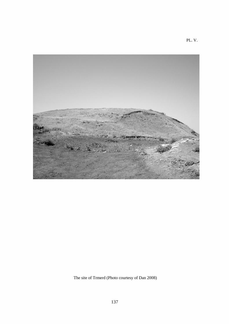
Alazlı/Trmerd stele [CTU A 5-6]11
were discovered (Pl. V).
In the present work we hypothesize that the Muş province is divided into two principal
areas: the districts of Muş and Varto.
This is in agreement with the geographical differences and also for the dissimilar settlement
modalities. The two regions have been the subjects of several archaeological surveys but
because of the absence of excavations, the ceramic data of this region are limited to surface
pottery [Rothman, 2004: 147], apart from the site of Kayalıdere [Lloyd et al. 1965; Burney,
1966]12
. The Muş plain is spread over approximately 92.000 ha. Several sites, mainly höyük,
have been identified at the centre and southern limit of the modern district (Pl. II). The ceramic
data is so scant that no site can be identified as being Urartian with absolute certainty13
.
The second area is the smaller Varto zone. Here the evidence of the Urartian presence is
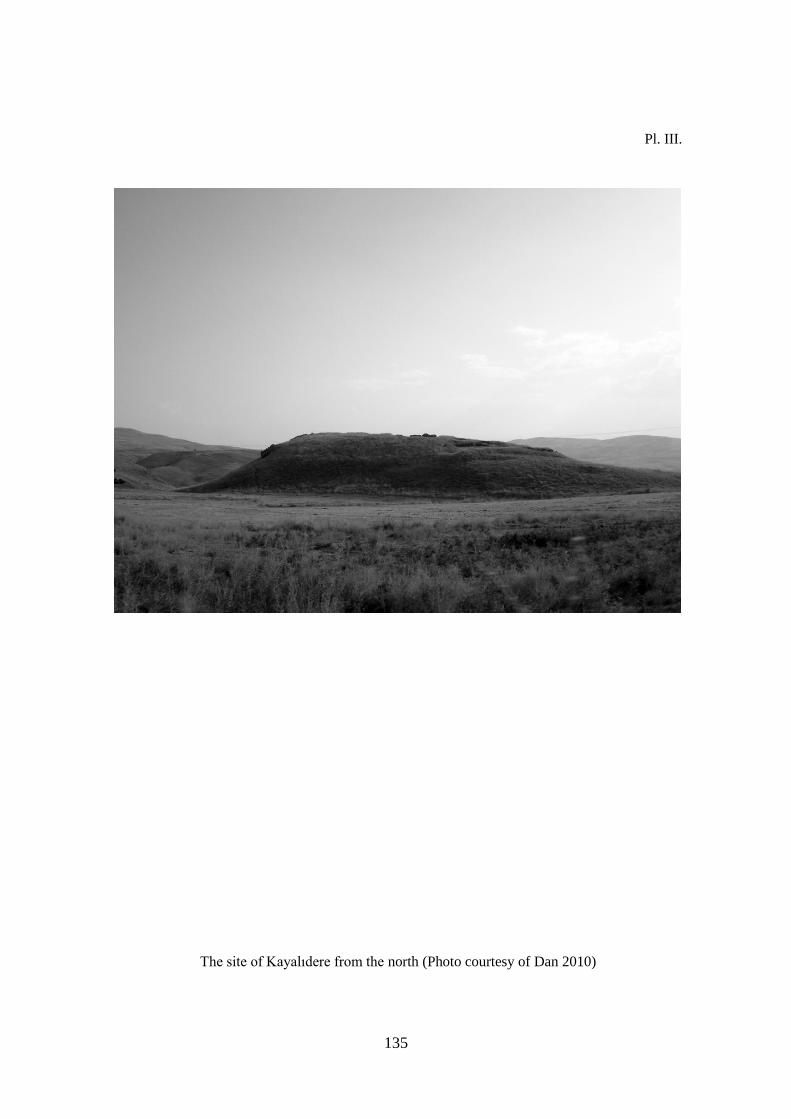
considerably more convincing. Following along the river Murat Su, the Kayalıdere fortress (Pl.
III) was strategically located between the two modern districts and on the westward leading
road. Certainly an additional reason is the exploitation of the cultivable countryside on the Muş
part, potentially a cultivable area of 2300 ha.
It is possible that Kayalıdere might be the Argištiḫinili mentioned in the Soğucak and
Kepenek inscription [CTU A 8-22]14
. Probably this city was on the King’s Plans to have a
stronger hold on the way that led to the west, which would make Kayalıdere the preeminent
economic and administrative centre of the region15
. The inscription reports:
To Ḫaldi, the Lord, Argišti, son of Minua, built to perfection this susi temple and a fortress.
I imposed to that the name Argištiḫinili. By the grace of the magnitude of Ḫaldi (I am) Argišti,
son of Minua, mighty king, king of Biainili, Lord of the city of Ṭušpa [CTU A 8-22].
In proximity to Kayalıdere, the fortresses of Varto Kale and Hinzo Kale and the Tepeköy
höyük may be found, all of which contain Urartian artefacts [Rothman, 2004: 129]. The dating
of the small fortress of Hirsizkale on the other hand is less certain16
. However, of particular
importance to us is the fortress at Varto Kale, because it is strategically located 15 km from what
in the current analysis is considered the main fortress.
This is in accordance with territorial planning in comparable regions of the Kingdom and in
particular like the one found in the plain of Van17
. The fortress of Varto Kale was certainly
intended to initiate control over the roads that started from Varto and led through the Peri Suyu
and Euphrates valleys, finishing in the plain of Erzincan.
In summary, the foundations of Kayalıdere, Hinzor and Varto Kale [Rothman, 2004: 129,
147] suggest a permanent Urartian control in the Varto district. Whereas the scarcity of Urartian
pottery in the Muş plain, which is primarily associated with multiphasic sites and more ancient
layers, leads one to believe in a clear delineation of the two districts.
CONCLUSIONS
The epigraphic evidence suggests that Urme was one of the main antagonists of the
westward expansion of the Kingdom of Urartu, because of the repeated offensive interventions
involving three generations of monarchs.
In addition, we can extrapolate from the sources that Urme is located in the modern area of
the Muş plain. For this identification the essential element comes from a text located in the
outskirts of the modern city of Muş.
In which the events described on the stele took place in the same area where it was found.
Though it is an erratic stele, it seems improbable that such a heavy artefact could be transported
very far away, given the large extent of the plain.
Excluding Urme itself, it is significant to consider that all the toponyms mentioned in this
inscription do not appear in subsequent Royal texts. It is logical to assume that those countries
and cities were no longer considered as obstacles for future expansion plans of the Urartian
Kingdom.

123
The location of Urme just described, can also be supported by archaeological evidence. In
general there are very few Urartian remains in what is considered to be one of the largest plains
of the Kingdom.
The sites where the Biainili Ware is found and identified are concentrated in the centre of
the Muş Plain [Rothman, 2004: 147]. The presence of this pottery is likely the result of a cultural
contact, production influence, and luxury goods importation due to interaction with Urartu.
This becomes more important in the area with the establishment of Kayalıdere. The Urartian
fortresses in the smaller Varto plain are not surprising, supporting the fact that this area
constituted the starting point of the Royal road towards the west, which in turn is populated by
many caravanserais18
.
As evidenced by the establishment of Kayalıdere and the entire system of fortresses
surrounding it19
, the region of Varto became part of the Urartian political orbit during the years
of Minua’s rule and was under firm control through the reign of Argišti I. Then it is possible to
conclude that the Muş Plain was not a stable part of the Urartian Kingdom.
The interest towards this region was mainly aimed at controlling the westward military
expansion and for the defence of access to central areas of the empire, for example Patnos was
certainly one of these centres. At the same time, the Muş area had represented an obstacle for the
establishment of political relations with the country of Šubria (Arme), on the other side of the
Taurus Mountains.
These circumstances are of particular interest, considering the size of the arable land and the
close proximity of the plain to the centre of the Kingdom. The archaeological and textual data
coming from Muş confirm and reinforce once again the anomaly of the Kingdom of Urartu in
the Near East political landscape during these centuries.
ომი ურმეს წინააღმდეგ:
ზოგიერთი მოსაზრება ურარტუს სამეფოს
დასავლეთ ექსპანსიის შესახებ
რობერტო დანი
ჯიორჯია ნერი
რომის „საპიენცას“ უნივერსიტეტი
რეზიუმე
ეპიგრაფიკული წყაროების მიხედვით, ურმე ურარტუს სამეფოს დასავლეთ
ექსპანსიის ერთ-ერთ უმთავრეს წინააღმდეგობას წარმოადგენდა. ამის მიზეზი მათი სამი
თაობის მონარქების პერმანენტული შეტევები იყო. აქვე დავამატებთ, რომ წერილობით
წყაროებზე დაყრდნობით შეიძლება განისაზღვროს, რომ ურმე მდებარეობდა
დღევანდელი მუშის დაბლობზე. ამის თქმის საშუალებას გვაძლევს ტექსტი, რომელიც
თანამდეროვე ქალაქ მუშის მიმდებარე ტერიტორიაზე აღმოჩნდა. იგი წარმოადგენს
სტელას და მასში აღწერილი მოვლენები იმავე ადგილას მოხდა, სადაც აღნიშნული
წარწერა იპოვეს. თუ გავითვალისწინებთ დაბლობის დიდ ფართობს, მაშინ
წარმოუდგენლად ჩანს, რომ ასეთი მძიმე არტეფაქტი გადაადგილებული იყოს შორ
მანძილზე. თვით ურმეს გამორიცხვის შემთხვევაში, მნიშვნელოვანია, რომ ყველა
ტოპონიმი რომლებიც ამ წარწერაშია მოხსენიებული არ, გვხვდება სამეფო ტექსტებში.
ლოგიკურია თუ ვივარაუდებთ, რომ აღნიშნული ქალაქები და ქვეყნები აღარ
წარმოადგენდნენ ურარტუს სამეფოსთვის წინააღმდეგობას, მისი მომავალი
ექსპანსიისათვის.
ურმეს ზემოთ მოყვანილი აღწერილობა გამყარებულია არქეოლოგიური მასალითაც.
ზოგადად, ურარტული კვალი ძალიან ცოტაა იმისათვის, რომ ერთ-ერთი უდიდესი
პლატო სამეფოს ნაწილად ჩაითვალოს.
ძეგლები სადაც ბიაინილისთვის დამახასიათებელი ჭურჭელია აღმოჩენილი,
კონცენტრირებულია მუშის დაბლობის ცენტრში. სავარაუდოდ, ამ ტიპის კერამიკული
პროდუქციის არსებობა კულტურული ურთიერთობების, პროდუქციის გავლენის და
ფუფუნების ნითების ურარტუს სამეფოდან იმპორტის შედეგია. აღნიშნული გარემოება
ამ ტერიტორიაზე უფრო მეტ მნიშვნელობას იძენს კაილიდერეს დაფუძნებით. უფრო
მცირე, ვარტოს დაბლობისთვის ურარტული სიმაგრეები უცხო არ არის, იმ ფაქტის
125
გათვალისწინებით, რომ ეს ტერიტორია იყო სამეფო გზის დასაწყისი, სადაც მრავალი
საქარავნო პუნქტი იყო აშენებული.
კაილიდერეს აშენებით და მთელი საფორტიფიკაციო სისტემის წყალობით, ვარტოს
რეგიონი მენუას მეფობის დროს გადაიქცა ურარტუს პოლიტიკური ორბიტის ნაწილად.
აღნიშნული ტერიტორია ძლიერი კონტროლის ქვეშ რჩებოდა არგიშთი I-ის დროსაც.
აქედან გამომიდინარე, შესაძლებელია ითქვას, რომ მუშის დაბლობი ურარტუს
არასტაბილურ რეგიონს წარმოადგენდა.
აღნიშნული რეგიონის მიმართ ინტერესი გამოწვეული იყო სამხედრო ექსპანსიის
დასავლეთ მიმართულებით წარმართვისათვის და იმპერიის ცენტრალური
ტერიტორიების დასაცავად, მაგალითისათვის დავასახელებთ პანტოსს, რომელიც ერთ-
ერთ ასეთ ცენტრი იყო. იმავდროულად, მუშის ტერიტორია ურარტუსათვის
წარმოადგენედა წინააღმდეგობას ერთის მხირვ, შუბრიას (არმეს) და მეორეს მხრივ
ტავრის მთიანეთს შორის პოლიტიკური ურთიერთობების ჩამოყალიბებისათვის. ეს
გარემოებები განსაკუთრებული ინტერესის საგანს წარმოადგენს, თუ მხედველობაში
მივიღებთ სახნავი მიწების სიდიდეს და ამ დაბლობის სიახლოვეს სამეფოს ცენტრთან.
მუშში აღმოჩენილი არქეოლოგიური და წერილობითი მონაცემები ადასტურებენ და
ამყარებენ ურარტუს სამეფოს სწრაფვას მახლობელი აღმოსავლეთის პოლიტიკურ
სივრცეში აღნიშნული საუკუნეების განმავლობაში.

NOTES:
1. First of all, the authors’ wish to give thanks to Professor Mirjo Salvini, Professor Mario
Liverani, Dr. Mattia Raccidi and Dr. Riccardo La Farina for precious suggestions and article
revision. Both authors carried out this work equally, specifically: Roberto Dan wrote pages
115-120 while Giorgia Neri wrote pages 121-125. The translation into English was carried
out by Giorgia Neri and Dr. Geoffrey P. F. Wood.
2. In the military campaign the city of Šebeteria was probably defeated, and perhaps Palu itself
[Lehmann- Haupt, 1928-1935: 58], Ḫuzana, is presumably located in the area of the Murat
Su [Diakonoff et al. 1981: 41-42] and Ṣupa/Sophene [Salvini, 1972: 105-107]. To consider
CTU A 5-5.
3. Titia was nominated Governor for the Šebeteria, Ḫuzana and Ṣupa areas [CTU A 5-8].
4. Dḫal-di-[x x x KUR ṣ]u-pa-a URU ḫu-si-ši-i-li [CTU A 12-6, r. 7].
5. The first part of the inscription is yet unpublished. Personal communication from Professor
Mirjo Salvini.
6. For the identification of the site see Kessler, 1995: 56-58. For the localization and for the
topographical aspect see Algaze, 1989.
7. See Harta Genel Müdürlüğü 1:200,000, Bitlis sheet (Hınıs).
8. The determinative is absent but the reading in CTU A 5-7, l.d., r.5 is the same of CTU A 5-
6, Ro r.5.
9. Uncertain reading.
10. Salvini, 2008: 344; CTU A 8-3 V, rr. 70-81.
11. Some of the parts of this inscription were found by Mirjo Salvini, during an epigraphic
survey in that region, in collaboration with the institute CNR-ICEVO. These fragments were
identified in the Alazlı/Trmerd village: the unpublished one in the village on the 6 August
2008; the other, published but known as missing, in a private garden in the same village in
the same day. Another fragment was discovered on the 7 August 2010; close to the farm
well know with the Yɩldɩzlar Mezrasɩ name. See Dan, 2010 A and Salvini, 2012: 258-260
(CTU IV A 5-6).
12. The presence of a rock staircase over one side of the Susi Temple might be indicate a later
settlement phase after the Urartian period.
13. Hirtadom is dated on the feeble pottery result of Russell [Russell, 1980: 48-49],
considered absolutely uncertain by Rothman [Rothman, 1995: 294; Rothman, 2004: 129];
twelve fragment of Urartian Ware were found nearby Bozbulut [Rothman, 2004: 168-169];
the Muş Höyük Ware is dated in olden or later period compared to the Urartian Period
[Rothman, 2004: 129], in spite of the stele retrieval, seems that there is no connection with
the site itself; the Kepenek Kalesi stele probably came from Kayalıdere [Dan, 2011] were
was found only mediaeval artifacts [Koçhan et al. 2003: 59]; at Türker Tepe, Üçdere,

127
Durugöze 1, Durugöze 2, Suboyo 1 and Yağmurlu the Urartian Ware is present but scant
[Rothman, 2004: 129], while the Urartian Ware at Suboyo 2 was in a first time confirmed by
Rothman [Rothman, 1995: 291, 294] and later was denied by he
himself [Rothman, 2004: 129]. The Urartian presence at Şeyhyusuf [Russell, 1980: 48-49]
was never confirmed [Rothman, 2004: 129]; the ceramic from the Gre Mezrasi necropolis
and at the Gravertepesi Höyük can only be assigned to the Middle Iron Age period [Özfirat,
1999: 7]. From Trmerd, where the Minua inscription was identified come five Urartian Ware
fragments [Rothman, 2004: 129, 170]. A Middle Iron Age Fortress was identified in the
northern part of the plain at the entrance of the Murat Valley, which connects Varto with
Muş; this fortress, named Çayırkale, does not contain artefacts that can be directly attributed
to Urartu [Özfirat, 1999: 3, 7, fig. 17]. The three rock-cut chambers at Yolgözler were dated
to the Urartian Period [Koçhan, 2009: 363].
14. Dan, 2011.
15. In the last part of the Ḫorḫor Annals can be probably find the mention of its
establishment [Salvini, in Dan, 2011].
16. The fortress can be date to the Middle Age Period [Cuinet, 1890-1895: 594; Sinclair, 1987:
289].
17. A ring of fortresses to protect the capital controlling any entrances in the Van plain. The
fortresses, mostly established by Išpuini and Minua, were Kalecik, Zivistan, Aşağı Anzaf,
Yukarı Anzaf, Kevenli, Kavuncu, Kiz Kalesi and Kıratlı [Dan, in press].
18. For this fortresses system, see Sevin, 1988.
19. Probably the fortress was still in existence until the first half of the VIIth Century BC. One
possible evidence of the Rusa II transit in this fortress is the presence of same decorative un-
inscribe sikkatu, very similar to those inscribe from Ayanis [Dan, 2011: 438].
BIBLIOGRAPHY:
Algaze G.
1989 A New Frontier: First Results of the Tigris-Euphrates Archaeological Reconnaissance
Project 1988.
Journal of Near Eastern Studies, vol. 48, pp. 241-281.
Astour M.
1979 The arena of Tiglath-pileser III’s campaign against Sarduri II (743 BC).
Assur, vol. 2, pp. 1-23.
Belli O.
1986 Untersuchungen zur Eisenmetallurgie in Hubuskia.
Anadolu Araştırmaları, vol. 10, pp. 271-308.
Belli O.
1991a Inscribed Metal Objects.
In: Merhav R. (ed.). Urartu. A Metalworking Centre in the First Millennium, pp. 43-49.
Jerusalem.
Belli O.
1991b Ore Deposits end Mining in Eastern Anatolia in the Urartian Period: Silver, Copper and
Iron.
In: Merhav R. (ed.). Urartu. A Metalworking Centre in the First Millennium, pp. 16-41,
Jerusalem.
Burney C. A.
1957 Urartian Fortresses and Town in the Van Region.
Anatolian Studies, vol. 7, pp. 38-53.
Burney C. A.
1958 Eastern Anatolia in the Chalcolithic and Early Bronze Age.
Anatolian Studies, vol. 8, 157-209.
Burney C. A., Lawson G. R. H.
1960 Measured Plans of Urartian Fortress.
Anatolian Studies, vol. 10, pp. 177-196.
Burney C. A.
1966 A First Season of Excavations at the Urartian Citadel of Kayalidere.
Anatolian Studies, vol. 16, pp. 55-111.
CTU = Salvini M. 2008
CTU IV = Salvini M. 2012
Cuinet V.
1890-1895 La Turquie d’Asie. Paris.
129
Dan R.
2010a Ricerche sui siti Urartei della provincia di Van e dintorni.
Studi Micenei ed Egeo-Anatolici, vol. 52, pp. 49-97.
Dan R.
2010b The Archaeological and Geographical Landscape of Urartu.
In: Matthiae P., Pinnock F., Nigro L., Marchetti N. (eds.), Acts of 6th International Congress on
the Archaeology of the Ancient Near East (ICAANE 6), vol. 3, pp. 331-340.
Dan R.
2011 Una fondazione di Argišti I, re di Urartu, sul corso del Murat Su (Eufrate Orientale)?, con
un addendum di Mirjo Salvini.
La Parola del Passato 66/381, pp. 431-441.
Dan R.
2012a Tra l’Eufrate e l’Arasse. Ricostruzione del paesaggio insediativo del Regno di Urartu.
Unpublished Thesis. Università La Sapienza di Roma.
Dan R.
2012b Nails in the Wall. The sikkatu in Urartian Toreutic Production.
In: Rossi, A., Basello, G.P. (eds.), Dariosh Studies II. Persepolis and its Settlements: Territorial
System and Ideology in the Achaemenid State, pp. 301-311.
Dan R.
(in press) A Defensive System of the IX-VIII Century BC: the Ring of Fortresses around Van
Kalesi (Tušpa).
De Martino S.
2006 (ed.) Storia d’Europa e del Mediterraneo. Il mondo antico. I. La Preistoria dell’uomo.
L’Oriente Mediterraneo.
Le Civiltà dell’Oriente mediterraneo, vol. II. Roma.
Diakonoff I. M., Kashkai S. M.
1981 Geographical Names According to Urartian Texts.
Répertoire Géographique des Textes Cunéiformes, Band 9, Wiesbaden.
Karg N.
1993-1997 Muş.
Reallexikon der Assyriologie, Band 8, pp. 441-444.
Kessler K.
1995 Šubria, Urartu and Aššur. Topographical Questions around the Tigris Sources.
In: Liverani M. (ed.), Neo-Assyrian Geography, Quaderni di Geografia Storica, vol. 5, pp. 55-
67. Roma.

Koçhan N., Sur C.
2003 Urartian Fortress of Muş-Kepenek
Journal of the Institute of Fine Arts, vol. 10, pp. 57-64. (In Turkish).
Muş-Kepenek Urartu Kalesi.
Güzel Sanatlar Enstitüsü Dergisi,
Koçhan N.
2009 Urartian Rock-cut Chambers in Korkut – Yolgözler/
Korkut - Yolgözler Urartu Kaya Mezarları.
In: Sağlamtimur, H. (eds.) Studies in Honour of Altan Çilingiroğlu-A life dedicated to Urartu on
the shores of the Upper Sea. pp. 361-365. (In Turkish).
Altan Çilingiroğlu’na Armağan. Yukarı Denizin Kıyısında Urartu Krallığı’na Adanmış Bir
Hayat. İstanbul.
Kökten İ. K.
1947 1945 Prehistory Studies for the Turkish Historical Society.
Bulletin, vol. 11, pp. 431-472. (In Turkish).
1945 Yılında Türk Tarih Kurumu Adına Yapılan Tarih Öncesi Araştırmaları.
Belleten.
Kosyan A.V.
1997 The Mushki Problem Reconsidered.
Studi Micenei ed Egeo-Anatolici, vol. 39, n. 2, pp. 253-266.
Lehmann - Haupt C. F.
1926 Armenien einst und jetzt II/1. Berlin und Leipzig.
Liverani M.
1992 Studies of the Annals of Ashurnasirpal II 2: Topographical Analysis. Rome.
Liverani M. (ed.)
1995 Neo-Assyrian Geography. Quaderni di Geografia Storica 5, Rome.
Lloyd S., Burney C. A.
1965 Excavations at the Urartian Citadel of Kayalidere (1965 Season).
Turkish Journal of Archaeology - Turkish Journal of History, Archaeology and Ethnography,
vol. 14, nn.1-2, pp. 217-222.
Kayalıdere Urartu Kalesi Kazısı
Türk Arkeoloji Dergisi – Türk Tarih, Arkeologya ve Etnografya Dergisi
Maniori F.
2010 Le campagne assire contro l’Urartu del 715 e 714 a.C.
Studi Micenei ed Egeo-Anatolici, vol. 52, pp. 177-251.
Nashef Kh.
1982 Die Orts und Gewässernamen der mittelbabylonischen und mittelassyrischen Zeit.
Répertoire Géographique des Textes Cunéiformes, Band 5, Wiesbaden.
131
Neri G.
2011 Contributi allo studio dell’espansione urartea verso occidente. Unpublished Thesis.
Università La Sapienza di Roma.
Özfırat A.
1999 1997 Survey in Bitlis-Muş: Bronze and Iron Ages.
Conference on Survey Results, vol. 16, Cilt 2, pp. 1-23. (In Turkish).
1997 Yılı Bitlis-Muş Yüzey Araştırması: Tunç ve Demir Çağları.
Araştırma Sonuçları Toplantısı
Özfırat A.
2001 Cultures of the East Anatolian Plateau: II Millennium BC. İstanbul. (In Turkish).
Doğu Anadolu yayla kültürleri: M.Ö. II. Binyıl.
Parker B. J.
2001 The Mechanics of Empire. The Northern Frontier of Assyria as a Case Study in Imperial
Dynamics. The Neo-Assyrian Text Corpus Project. Helsinki.
Parpola S.
1987 The Correspondence of Sargon II, Part I. (State Archive of Assyria 1). Helsinki.
Parpola S.
1990 The Correspondence of Sargon II, Part II. (State Archive of Assyria 5). Helsinki.
Pecorella P.E., Salvini M.
1984 Tra lo Zagros e l’Urmia. Ricerche storiche ed archeologiche nell’Azerbaigian Iraniano,
Incunabula Graeca, Vol LXXVIII, Roma.
Rothman M.
1993 Preliminary Report on the Archaeological Survey in the Arpaslan Dam Reservoir Area and
Muş Plain 1991.
Conference on Survey Results, vol. 10, pp. 269-295.
Araştirma Sonuçları Toplantısı
Rothman M.
1995 The Pottery of the Muş Plain and the Evolving Place of a High Border Land.
Conference on Survey Results, vol. 12, pp. 281-305.
Araştırma Sonuçları Toplantısı
Rothman M.
2004 Beyond the Frontiers: Muş in the Late Bronze Age to Roman Periods.
In: Sagona A. (ed.), A View from the Highlands, Archaeological Studies in Honour of Charles
Burney, Ancient Near Eastern Studies 12, pp. 121-178. Herent.
Rothman M., Kozbe G.
1997 Muş in the Early Bronze Age.
Anatolian Studies, vol. 47, pp. 105-206.
Russell H. F.
1980 Pre-Classical Pottery of Eastern Anatolia. British Archaeological Reports, International
Series 85. Oxford.
SAA 1 = Parpola S. 1987
SAA 5 = Parpola S. 1990
Sağlamtimur H., Abay E., Derin Z., Erdem A. Ü., Batmaz A., Dedeoğlu F., Erdalkıran M.,
Baştürk M. B.,Konakçı E.
2009 Studies in Honour of Altan Çilingiroğlu-A life dedicated to Urartu on the shores of the
Upper Sea. (In Turkish).
Archaeology and Art Publications
Altan Çilingiroğlu’na Armağan. Yukarı Denizin Kıyısında Urartu Krallığı’na Adanmış Bir
Hayat.
Arkeoloji ve Sanat Yayınları. İstanbul.
Sagona A.
2004 A View from the Highlands. Archaeological Studies in Honour of Charles Burney.
Ancient Near Eastern Studies 12. Herent.
Salvini M.
1984 Sui documenti scritti di Hasanlu.
In: Pecorella P.E., Salvini M. (eds.). Tra lo Zagros e l’Urmia. Ricerche storiche ed
archeologiche nell’Azerbaigian Iraniano. pp. 55-56. Roma.
Salvini M.
2006 Il Regno di Urartu (Biainili).
In: De Martino S. (ed.). Storia d’Europa e del Mediterraneo. Il mondo antico. I. La Preistoria
dell’uomo. L’Oriente Mediterraneo. vol. II Le Civiltà dell’Oriente mediterraneo, pp. 459-503.
Roma.
CTU = Salvini M.
2008 Corpus dei Testi Urartei. vol. I-III. Le iscrizioni su pietra e roccia. I testi. Documenta
Asiana VIII. Roma.
CTU IV = Salvini M.
2012 Corpus dei Testi Urartei. vol. IV. Iscrizioni su bronzi, argilla e altri supporti. Nuove
iscrizioni su pietra. Paleografia generale. Documenta Asiana VIII. Roma.
Sartori P.
2000 Preistoria e protostoria del popolo armeno secondo Igor M. D’jakonov.
Annali di Ca’ Foscari, vol. 39, pp. 77-106.
Sevin V.
1988 The Oldest Highway: between the regions of Van and Elazığ in Eastern Anatolia.
Antiquity, vol. 62, pp. 547-551.
Sinclair T.A.
1987 Eastern Turkey: an Archaeological and Architectural Survey. vol. I. London.
133
Pl. I.
Reconstructive hypothesis of the Urartian itinerary to reach the destination of Qulmeri.
M. Raccidi Weitergeleitete
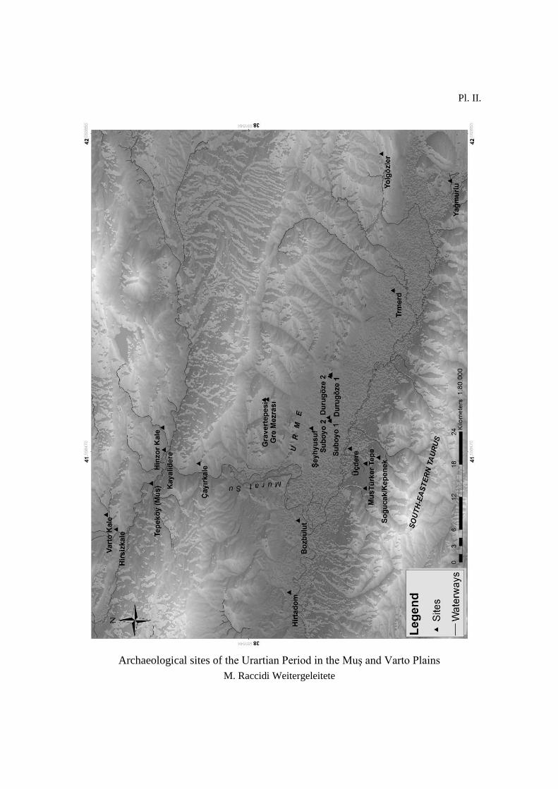
Pl. II.
Archaeological sites of the Urartian Period in the Muş and Varto Plains
M. Raccidi Weitergeleitete
135
Pl. III.
The site of Kayalıdere from the north (Photo courtesy of Dan 2010)
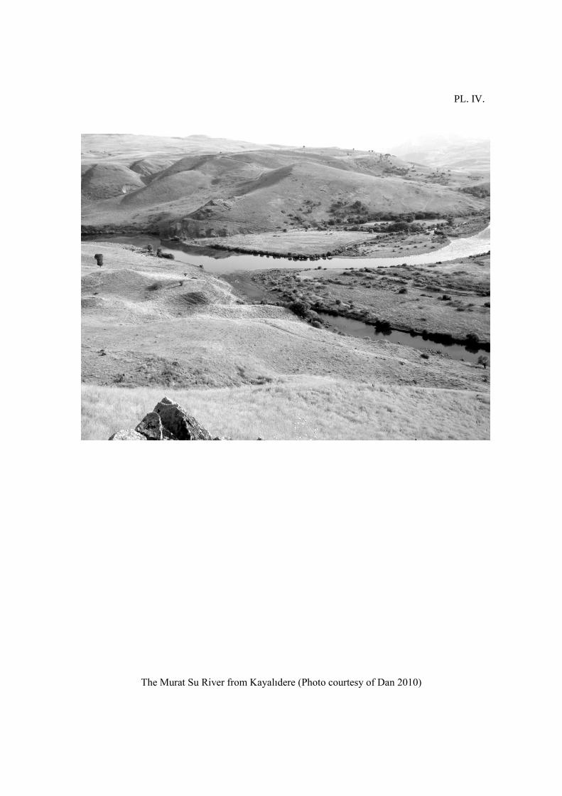
PL. IV.
The Murat Su River from Kayalıdere (Photo courtesy of Dan 2010)
137
PL. V.
The site of Trmerd (Photo courtesy of Dan 2008)
Prof. Sergi Makalatia
Gori
Historical-Ethnographical Museum
“Studies in Caucasian Archaeology”
Guide for Authors:
The Journal accepts researches, field reports, critiques, reviews, discussions about
metallurgy, funeral rituals, architecture, weapon and armory, experimental, landscape and social
archaeology, trade relations of the Caucasus and its neighboring countries.
The papers should concern from Paleolithic to Medieval period.
The authors are obliged to respect the style of citation in the journal.
Submitted papers will be sent to the experts for peer review.
In accordance with international standards of ethics, the names of experts are confidential.
The paper will be published only if it receives a positive assessment of experts.
The author is authorized to request to see the reviews.
The Editorial Board is authorized, if it is considered necessary, to return paper to the
subsequent processing without revising by reviewers.
The Editorial Board is authorized, if it considered necessary, to cancel the paper publishing
without revising by reviewers.
After the consideration of Editorial Board's remarks, the article will be given to reviewers.
The author is obliged to revise the article according to the request of the Editorial Board or
experts, otherwise the paper will not be published or will not be sent to the experts.
Sending the paper to the author to revise doesn't mean that the article is accepted to be
published.
The already revised paper will be again discused by Edditorial Board.
The Editorial Board reserves the right to remove already published article from the
electronic version of the journal if it turns out that by the publication of this material copyrights
and/or other generally accepted norms of scientific ethics have been violated. The Editorial
Board will notify about this fact the author and the organization where this work has been
performed.
If the author will not revise remarks made by the Editorial Board and the reviewers in
proposed period, the Editorial Board is authorized not to publish the article.
Position of the author of the article may not necessarily reflect the views of the Editorial
Board.
Authors and reviewers have a moral and ethical responsibility for the scientific quality and
content of publications.
The Editorial Board of the journal Studies in Caucasian Archaeology thanks the authors for
cooperation.

139
Article Requirements:
1. Article should be given in electronic version.
2. Article should have:
a) Cover, on which will be written: Name and surname of the author (it should be written on the
right upper corner, font 10, line spacing 1)
b) Working place, position/post, university, academic degree/education level (for Ph. D.
candidates) (it should be written on the right upper corner, font 10, line spacing 1)
c) Author contact coordinates (e-mail, it should be written on the right upper corner, font 10, line
spacing 1)
3. Article size: Microsoft Word Document A4 format paper 50 (maximum) pages (text,
summary, bibliography, description of the figures and plates, figures, plates)
4. Article on Microsoft Word Document A4 format paper should be signed:
a) Title in the center (print bold, font 12)
b) Text print Times New Roman, font size 11, line spacing 1. 2 cm. borders on each side
c) Summary, Print Times New Roman, font size 10, line spacing 1. Microsoft Word
Document A4 format 1 paper, which will be translated in Georgian.
d) Bibliography, print Times New Roman, font size 11, line spacing 1.
5. References in the text:
a) In square brackets should be given surname of the author, comma, publishing year, colon and
page number: e.g. Picchelauri Konstantin „Waffen der Bronzezeit aus Ost-Georgien“. Berlin,
1995. p. 121, pl. 70/2 will be as [Picchelauri, 1995: 121, pl. 70/2].
b) If the book has two or more authors, in square brackets should be written the name of the first
author, than et. al., publishing year, colon and page number. e.g. Nikolaishvili V., Sikharulidze
A., Inanishvili G., Iremashvli Sh. „A Fighting Parade Bronze Axe from Natakhtari“. In
Archaeology, Ethnology and Folkloristic of Caucasus. Tbilisi 2010 should be [Nikolaishvili et
al. 2010: 230].
c) If the author has two or more books and papers in the same year, after surname of the author
should be written A, B and etc. e.g. [Picchelauri A, 1995: 121, pl. 70/2].
d) Notes: After the sentence, if it is necessary to write some additional ideas, which usually are
placed in the footnotes, the author has to make numbered list of notes after the main text.
6. Figures and Plates in the text:
Figure and Plate frame: 210 mm x 297 mm.
Images should be provided in Greyscale, at 600 DPI resolutions.
a) For the Figures (graphic, drawing) and Plates (photo): the number of the figure should be
given in the rounded brackets (Fig. XV).
If it has several numbered images, the sub number should be given also. e.g. (Fig. XV/2)
b) Figures and Plates: the description of the figures and plates should be given separately.
note: After the description of the figures and plates, first figures and then plates should be
placed. They should have separate numbering.
7. List of the bibliography at the end of the article:
a) List of used literature should be sorted in alphabetical order.
b) For books/monographs: authors' surname and initials date of publication, title of the
book/monograph, place of publication.
e.g. Reference to a book or monograph:
PICCHELAURI K.
1995 Waffen der Bronzezeit aus Ost-Georgien. Berlin.
d) For Journal articles: authors' surname and initials, date of publication, title of article, full title
of the journal (italic), volume number (italic), issue (italic), page numbers (italic).
e) Examples:
e.g. Reference to a journal article:
SANDARS N. K.
1961 The First Aegean Swords and Their Ancestry.
American Journal of Archaeology, Vol. 65, No. 1, pp. 17-29.
f) For English, German, French or Italian literature the titles will be left in original language. For
Georgian, Armenian, Azerbaijani, Turkish and Russian or other languages the titles will be
transliterated and translated in English.
e.g. GOGADZE E.
1972 Periodization and Genesis of Trialeti Kurgan Culture. Tbilisi. (In Georgian).
Trialetis korghanuli kulturis periodizatsia da genezisi.
e.g. KUFTIN B. A.
1941 Archaeological Excavations in Trialeti. (In Russian).
Arkheologicheskie raskopki v Trialeti.
8. Please, send electronic versions of papers to