
Improvement, Widening & Upgradation of Jaglot ‒ Skardu Road
205
Improvement, Widening & Upgradation of Jaglot – Skardu Road ENVIRONMENT IMPACT ASSESSMENT STUDY REPORT September 2019 FINITE – CPM Joint Venture
-
Upload
khangminh22 -
Category
Documents
-
view
3 -
download
0
Transcript of Improvement, Widening & Upgradation of Jaglot ‒ Skardu Road

Improvement, Widening & Upgradation of
Jaglot – Skardu Road
ENVIRONMENT IMPACT
ASSESSMENT STUDY
REPORT
September 2019
FINITE – CPM Joint Venture

Improvement, Widening and Upgradation of Jaglot-Skardu Road
EIA Study Report
Improvement, Widening & Upgradation of
Jaglot – Skardu Road
ENVIRONMENT IMPACT
ASSESSMENT STUDY
REPORT
September 2019
Finite Engineering (Pvt.) Limited
Second Floor, Ghausia Plaza
China Chowk, Jinnah Avenue, Blue Area
Islamabad, Pakistan
Tel + 92 51 2604350
www.finite-engr.com
Finite Engineer (Pvt.) Limited & CPM Engineering Consultants has prepared this report in accordance with the requirements of the above stated project, and for
the sole and specific use of Finite Engineering (Pvt.) Limited, Frontier Works Organization (FWO) and project Client the NHA.
Any other persons who use any Information contained herein do so at their own risk.
© Finite Engineering (Pvt.) Limited 2018
FINITE – CPM Joint Venture

Improvement, Widening and Upgradation of Jaglot-Skardu Road
EIA Study Report
ii
Document history
Improvement, Widening & Upgradation of Jaglot – Skardu Road
CONDITIONAL SURVEY REPORT
This document has been issued and amended as follows:
Version Date Description Created by Verified
by Approved
by
01 02/10/18 First Issue to AER Mehwish
Akhtar
Shahid
Iqbal
Dr. Shahid
Nasir
02 29/05/19 Revised EIA Study Report to
NHA -do- -do- -do-
03 02/09/19Updated EIA Study Report to
GB-EPA -do- -do- -do-

Improvement, Widening and Upgradation of Jaglot-Skardu Road
EIA Study Report
iii
LIST OF TABLES VIII
LIST OF FIGURES X
LIST OF ABBREVIATIONS XI
GLOSSARY XIII
EXECUTIVE SUMMARY 1
1 INTRODUCTION 6
1.1 Project Background 6 1.2 Project Description 6 1.3 Project Location 7 1.4 Requirement of EIA for the Proposed Project 8 1.5 Objective of EIA Study 8 1.6 Legal Framework of Environmental and Social Considerations 8 1.7 The Proponent and the Consultant 9 1.8 Study Team 9 1.9 Scope of Study 10 1.10 Study Approach & Methodology 10 1.11 Components of the Report: 13
2 POLICY, LEGAL AND ADMINISTRATIVE FRAMEWORK 15
2.1 General 15 2.2 Existing Legislative Framework 15 2.2.1 Gilgit-Baltistan Environmental Protection Act, 2015 15 2.2.2 Pakistan Environmental Protection Act (PEPA) of 1997 16 2.2.3 Pakistan Environmental Protection Agency Review of IEE/ EIA Regulations, 2000 17 2.2.4 National Environmental Quality Standards (NEQS), 2000/ 2010 18 2.2.5 National Environment Policy, 2005 18 2.2.6 Environmental Assessment Guidelines 19 2.3 Other Relevant laws 19 2.3.1 Pakistan Environmental Protection Ordinance, 1983 19 2.3.2 National Conservation Strategy, 1992 20 2.3.3 Pakistan Penal Code, 1860 20 2.3.4 The Explosives Act, 1884 20 2.3.5 Land acquisition Act, 1894 20 2.3.6 Regulations of Mines and Oil Fields and Mineral Development Act, 1948 20 2.3.7 Motor Vehicle Rules, 1969 20 2.3.8 Cutting of Trees (Prohibition) Act, 1975 21 2.3.9 Highways Safety Ordinance, 2000 21 2.3.10 Labor laws 21 2.3.11 Canal and Drainage Act, 1873 21

Improvement, Widening and Upgradation of Jaglot-Skardu Road
EIA Study Report
iv
2.3.12 Project Implementation and Resettlement of Affected Persons Ordinance, 2000 21 2.3.13 The North-West Frontier Province Wild-Life Act, 1975 21 2.3.14 Antiquities Act, 1975 21 2.3.15 International Treaties & Conventions 22 2.3.16 Guidelines for Protected and Sensitive Areas 22 2.4 Environmental Administrative framework 22 2.4.1 Environmental Protection Agencies/Agency 23 2.4.2 Environmental Protection Council 23 2.4.3 Gilgit-Baltistan Sustainable Development Fund 24 2.4.4 Environmental Courts 24 2.4.5 Forest, Wildlife and Environment Department, Gilgit-Baltistan 24 2.4.6 Department of Inland Revenue, Gilgit-Baltistan 25
3 DESCRIPTION OF THE PROJECT 26
3.1 Present Status of Project Road 26 3.2 Description and Scope of the Project 26
Design Standards 27 3.3 Project Objectives 29 3.4 Project Alignment 30 3.5 Project Costs 30 3.6 Project Implementation schedule 31 3.7 Project Alternatives 31 3.8 Economic Assessment 31 3.9 Location of Camp Sites 32
4 DESCRIPTION OF BASELINE ENVIRONMENT 33
4.1 General 33 4.2 Physical Environment 33 4.2.1 Topography 33 4.2.2 Land Use 35 4.2.3 Crop Pattern 35 4.2.4 Land use along the Project Route 36 4.2.5 Forestation 38 4.2.6 Wetlands 39 4.2.7 Livelihood 40 4.2.8 Climate 40 4.2.8.1 Average temperature 41 4.2.8.2 Average Rainfall 42 4.2.8.3 Relative Humidity 43 4.2.9 Wind Speed 44 4.2.10 Seismology 46 4.2.11 Air & Noise Quality 47 4.2.11.1 Ambient Air Quality 47 4.2.11.2 Noise Level Monitoring 53 4.2.12 Surface Water & Ground Water 57 4.2.12.1 Surface Water 57 4.2.12.2 Water Quality 57

Improvement, Widening and Upgradation of Jaglot-Skardu Road
EIA Study Report
v
4.2.12.3 Groundwater 58 4.3 Biological Environment 61 4.3.1 Flora 61 4.3.1.1 Endangered Species of Flora 64 4.3.2 Fauna 64 4.3.2.1 Endangered Species of Fauna 65 4.3.3 Protected Areas 65 4.4 Socio- Economic Environment 65 4.4.1 Demography 66 4.4.2 Education 66 4.4.3 Literacy Rate 68 4.4.4 Religion 68 4.4.5 Languages 68 4.4.6 Health Facilities 69 4.4.7 Land Acquisition: 69
5 PUBLIC CONSULTATION AND STAKEHOLDER MEETING 70
5.1 General 70 5.2 Main Stakeholders 70 5.3 Issues Identified by Stakeholders 71 5.4 Stakeholder Meetings 81 5.5 Grievance Redressal 89
6 ANTICIPATED ENVIRONMENTAL IMPACTS AND MITIGATION
MEASURES 92
6.1 General 92 6.2 Description of Project Area of Influence (PAI) 92 6.3 Environmental Impact Matrix 92 6.4 Impact Assessment in Pre-Construction/Design Stage 95 6.4.1 Topography 95 6.4.2 Land Acquisition 95 6.4.2.1 Mitigations 96 6.4.3 Loss of Trees 96 6.4.3.1 Mitigations 96 6.4.4 Other Settlements 97 6.4.4.1 Mitigations 97 6.4.5 Changes in Land Value 97 6.4.5.1 Mitigations 98 6.4.6 Religious/Cultural Resources 98 6.4.6.1 Mitigations 98 6.4.7 Ecology 98 6.4.7.1 Mitigations 98 6.4.8 Social Disturbance 98 6.4.8.1 Mitigations 99 6.4.9 Public Utilities 99 6.4.9.1 Mitigations 99

Improvement, Widening and Upgradation of Jaglot-Skardu Road
EIA Study Report
vi
6.4.10 Surface/ Ground Water Resources 99 6.4.10.1 Mitigations 100 6.5 Impact Assessment during Construction stage 100 6.5.1 Construction Camps / Camp Sites 100 6.5.1.1 Mitigations 101 6.5.2 Movement & Operation of Construction Machinery 101 6.5.2.1 Highly Adverse Impact 101 6.5.2.2 Moderately Adverse Impact 101 6.5.2.3 Positive Impact 101 6.5.2.4 Mitigations 102 6.5.3 Flora 102 6.5.3.1 Mitigations 103 6.5.4 Fauna 103 6.5.4.1 Mitigations 103 6.5.5 Construction yards 104 6.5.5.1 Mitigations 104 6.5.6 Traffic Management 105 6.5.6.1 Mitigations 105 6.5.7 Waste 105 6.5.7.1 Mitigations 106 6.5.8 Blasting 106 6.5.8.1 Mitigations 106 6.5.9 Excavation & Embankment construction 106 6.5.9.1 Mitigations 106 6.5.10 Air Quality 107 6.5.10.1 Mitigations 107 6.5.11 Ground / Surface water 107 6.5.11.1 Mitigations 107 6.5.12 Noise 108 6.5.12.1 Mitigations 108 6.5.13 Employment 108 6.5.14 Health & Safety 108 6.5.14.1 Mitigations 109 6.6 Impact Assessment during Operation & Maintenance Stage 109 6.6.1 Mitigation Measures 110
7 ENVIRONMENT MANAGEMENT AND MONITORING PLAN (EMMP)
112
7.1 General 112 7.2 Institutional Responsibilities 112 7.2.1 Responsibilities of NHA 112 7.2.2 Responsibilities of Design & Supervision Consultant 113 7.2.3 Responsibilities of Contractor 114 7.3 Non-Compliance of the EMMP 115 7.4 Description of Environment Management and Monitoring Plan 116 7.5 Environmental Management and Monitoring Plan 124 7.6 Environmental Monitoring Plan & Mitigation Cost 124

Improvement, Widening and Upgradation of Jaglot-Skardu Road
EIA Study Report
vii
Plantation 125 Environmental Training Plan/cost 126
7.7 Implementation of EMMP 127 Reporting Mechanism 128 Non-Compliance of the EMMP 128
8 CONCLUSION AND RECOMMENDATIONS 129
8.1 Conclusion 129 8.2 Recommendations 130
ANNEX-A: REFERENCES
ANNEX-B: SURVEY QUESTIONNAIRE
ANNEX-C: CROSS-SECTION DRAWINGS
ANNEX-D: CULVERTS DATA
ANNEX-E: LIST OF MACHINERY
ANNEX-F: AIR QUALITY RESULTS
ANNEX-G: WATER TESTING RESULTS
ANNEX-H: SAMPLING LOCATIONS
ANNEX-I: CONCERNS OF GB-EPA
ANNEX-J STAKEHOLDERS MEETING PARTICIPANTS
ANNEX-K: STRUCTURES/ LAND DETAILS
ANNEX-L: LIST OF SETTLEMENTS
ANNEX-M: LOCATION MAP OF CONSTRUCTION CAMPS & PLANTS
ANNEX-N: LAYOUT MAP
ANNEX-O: TRAFFIC MANAGEMENT PLAN

Improvement, Widening and Upgradation of Jaglot-Skardu Road
EIA Study Report
viii
List of Tables
Table 1: Project Proponent and Consultant Information............................................................................... 2
Table 2: Project Proponent and Consultant Information............................................................................... 9
Table 3: Study Team ........................................................................................................................................... 9
Table 4: Scope of the Project ............................................................................................................................ 26
Table 5: Hydraulic Structures ......................................................................................................................... 27
Table 6: Technical Parameters of the Project Road....................................................................................... 27
Table 7: Pavement Design of Main Carriageway ......................................................................................... 28
Table 8: Items and their Quantity ................................................................................................................... 28
Table 9: Source of Items ................................................................................................................................... 28
Table 10: Item wise Cost in Percentage.......................................................................................................... 30
Table 11: Land Cover of Gilgit-Baltistan ....................................................................................................... 35
Table 12: Average Rate of Cereal Crops ........................................................................................................ 36
Table 13: Average Tate of Fruit Crops ........................................................................................................... 36
Table 14: Area and Demographic Indicators (Skardu District) .................................................................. 40
Table 15: Area and Demographic Indicators (Gilgit District) ..................................................................... 40
Table 16: Average Annual Climate Data of Gilgit and Skardu (1961-2009) ............................................. 41
Table 17: Average Monthly Climate of 50 Years Data of Gilgit and Skardu (1961-2009) ....................... 45
Table 18: Environmental Monitoring Schedule ............................................................................................ 47
Table 19: Air Quality - Methodologies ........................................................................................................... 48
Table 20: Air Quality - Monitoring Parameters (Gamba, Skardu) ............................................................. 49
Table 21: Air Quality - Monitoring Parameters (Shungus) ......................................................................... 51
Table 22: Air Quality - Monitoring Parameters (Dambudaas) ................................................................... 52
Table 23: Noise Level Monitoring (Dambudaas, Gamba Skardu and Shungus) ..................................... 55
Table 24: Water Sampling Sites ....................................................................................................................... 57
Table 25: Physical and Bacteriological Water Quality Results ................................................................... 59
Table 26: Chemical Water Quality Results ................................................................................................... 60
Table 27: Conclusions of Water Testing......................................................................................................... 61
Table 28: List of Prominent Fruit Trees Identified in Skardu and Gilgit District..................................... 62
Table 29: List of Wood Trees Identified in Skardu and Gilgit District ...................................................... 62
Table 30: List of Shrubs, Herbs and Medicinal Plants Identified in Gilgit and Skardu District ............ 63
Table 31: Demographic Indicators of Gilgit-Baltistan.................................................................................. 66
Table 32: Education Status of Gilgit-Baltistan (2015) ................................................................................... 67
Table 33: Government Schools Existing Along Both Sides of Jaglot-Skardu Road in District Skardu . 67
Table 34: Literacy Rate in Gilgit-Baltistan ..................................................................................................... 68
Table 35: Healthcare Facilities Available in Gilgit-Baltistan Region ......................................................... 69
Table 36: Consultations with Affected People/ Stakeholders ..................................................................... 71
Table 37: Issues and Problems of Stakeholders ............................................................................................ 71
Table 38: Survey Results .................................................................................................................................. 71
Table 39: Meeting with Stakeholder (PEPA) ................................................................................................. 82
Table 40: Impact Assessment Matrix for Construction Phase .................................................................... 93

Improvement, Widening and Upgradation of Jaglot-Skardu Road
EIA Study Report
ix
Table 41: Impact Assessment Matrix for Operational Phase ...................................................................... 94
Table 42: Land Acquisition for Improvement/Widening of J-S Road ....................................................... 95
Table 43: Total Trees within the ROW of the Project ................................................................................... 96
Table 44: Structures & People Affected by Project (RD 00+000 to RD 164+000) ....................................... 97
Table 45: Environmental Management and Monitoring Plan (Design/Preconstruction Stage) ........... 117
Table 46: Environmental Management and Monitoring Plan (Construction Stage) ............................. 118
Table 47: Environmental Management and Monitoring Plan (Operation Stage) .................................. 122
Table 48: EMMP Cost of Jaglot-Skardu Road (Divided into 4 Sections for Construction Purpose) ... 125

Improvement, Widening and Upgradation of Jaglot-Skardu Road
EIA Study Report
x
List of Figures
Figure 1: Location of the Proposed Project (Jaglot-Skardu Road) ................................................................ 7
Figure 2: Organizational Framework of GB-EPA ......................................................................................... 23
Figure 3: Alignment route of Project from start to end point ..................................................................... 30
Figure 4: Implementation Schedule of the Proposed Project Road ............................................................ 31
Figure 5: Topography/Landslides of the Project Area (Jaglot-Skardu Road) ........................................... 34
Figure 6: Cultivated Land along the Road ..................................................................................................... 35
Figure 7: Settlements/Structures along the Roadside ................................................................................... 38
Figure 8: Riverbed Plantation Covering 271 Acres of Land in Baltistan ................................................... 39
Figure 9: Average Maximum Temperature of Gilgit and Skardu Districts .............................................. 41
Figure 10: Average Minimum Temperature of Gilgit and Skardu Districts ............................................. 42
Figure 11: Average Rainfall of Gilgit and Skardu Districts ......................................................................... 43
Figure 12: Average Relative Humidity of Gilgit and Skardu Districts ...................................................... 43
Figure 13: Average Wind Speed of Gilgit and Skardu Districts ................................................................. 44
Figure 14: Seismic Zones of Pakistan.............................................................................................................. 46
Figure 15: Seismic Zones of Northern Areas ................................................................................................. 46
Figure 16: Air Quality Monitoring Using instrument AQM65 ................................................................... 48
Figure 17: Results of Air Quality at Gamba Skardu ..................................................................................... 50
Figure 18: Air Quality Monitoring at Gamba Skardu using AQM65......................................................... 50
Figure 19: Results of Air Quality at Shungus ................................................................................................ 51
Figure 20: Air Quality monitoring at Shungus using AQM65 .................................................................... 52
Figure 21: Results of Air Quality at Dambudaas .......................................................................................... 53
Figure 22: Air Quality Monitoring at Dambudaas using AQM65 .............................................................. 53
Figure 23: Noise Monitoring Day time at Project Site using Noise Meter................................................. 54
Figure 24: Noise Monitoring Night time at Project Site using Noise Meter.............................................. 54
Figure 25: Results of Noise level at Dambudaas ........................................................................................... 55
Figure 27: Results of Noise level at Shungus................................................................................................. 56
Figure 28: Results of Noise level at Gamba Skardu ...................................................................................... 56
Figure 29: Water Sample Collection from Various Sources ....................................................................... 58
Figure 30: Trees Along the Jaglot-Skardu Road ............................................................................................ 64
Figure 31: Interviews with Public/Project Affected People at Mehdiabad................................................ 78
Figure 32: Interviews with PAP at Chamachu .............................................................................................. 79
Figure 33: Interviews with PAP at Astak ....................................................................................................... 79
Figure 34: Interviews with PAP at Shungus .................................................................................................. 79
Figure 35: Interviews with PAP at Gamba .................................................................................................... 80
Figure 36: Interviews with PAP at Baghicha ................................................................................................. 80
Figure 37: Interview with PAP at Dambudaas.............................................................................................. 80
Figure 38: Meetings with the Concerned Departments ............................................................................... 89
Figure 39: Flow Chart of Proposed Redressal Mechanism .......................................................................... 91
Figure 40: Organizational set-up for implementation of EMMP .............................................................. 115
Figure 41: Organizational Chart for Implementation of EMMP ............................................................... 128

Improvement, Widening and Upgradation of Jaglot-Skardu Road
EIA Study Report
xi
List of Abbreviations
EIA Environmental Impact Assessment
EPA Environmental Protection Agency
IEE Initial Environmental Examination
NHA National Highway Authority
FWO Frontier Works Organization
AER Assistant to Employer’s Representative
PEPA Pakistan Environmental Protection Act
NEQS National Environmental Quality Standards
PAI Project Area of Influence
PAP Project Affected People
GB Gilgit Baltistan
AADT Annual Average Daily Traffic
ADT Annual Daily Traffic
NOC No Objection Certificate
GOP Government of Pakistan
WHO World Health Organization
USEPA United States Environmental Protection Agency
PPC Pakistan Penal Code
LAA Land Acquisition Act
MVE Motor Vehicle Examination
R&D Research & Development
LAC Land Acquisition Collector
NBS National Building Codes
AASHTO American Association of State Highway and Transportation Officials
ASTM American Society for Testing & Materials
ACI American Concrete Institute
RD Road
EIRR Economic Internal Rate of Return
NPV Net Present Value
WWF World Wildlife Fund
PMD Pakistan Meteorological Department
ROW Right of Way
NOx Nitrous Oxides
GSS Gas Semi-Conductors
TW Tap Water
SW Surface Water
AKRSP Agha Khan Rural Support Program
JICA Japan International Cooperation Agency
RFO Range Forest Officer
XEN Executive Engineer
EMMP Environmental Management & Maintenance Program

Improvement, Widening and Upgradation of Jaglot-Skardu Road
EIA Study Report
xii
O&M Operation & Maintenance
SSEMP Specific Site Environmental Management Plan
CC Construction Contractor
DSC Design and Supervision Consultant

Improvement, Widening and Upgradation of Jaglot-Skardu Road
EIA Study Report
xiii
Glossary Biodiversity
Biodiversity is the variability among living organisms from all sources, including terrestrial,
marine, and other aquatic ecosystems and the ecological complexes of which they are part;
this includes diversity within species, between species, and of ecosystems.
Deterioration
Deterioration is a term used to define the process of being gradually worse.
Renewable Resources
A renewable resource is a substance of economic value that can be replaced or replenished
in the same or less amount of time as it takes to draw the supply down. For example, solar
energy is powered by heat the sun never runs out.
Ecology
Ecology is a simple term used in biology to define the relationship of living organisms
with one another and their physical surrounding.
Protected Area
A protected area is a clearly defined geographical space, recognized, dedicated and
managed, through legal or other effective means, to achieve the long term conservation of
nature with associated ecosystem services and cultural values.
Endangered Species
An endangered species is a species which has been categorized as very likely to become
extinct.
Flora
Flora is biological name of plants (of particular regions or habitats).
Fauna
Fauna is biological name of animals (of particular region, habitat and geologic period).
Particulate Matter
Particulate matter is the term for solid or liquid particles found in the air. It is the sum of all
solid and liquid particles suspended in air many of which are hazardous. This complex
mixture includes both organic and inorganic particles, such as dust, pollen, soot, smoke,
and liquid droplets. These particles vary greatly in size, composition, and origin.
Ambient Air
Ambient air is atmospheric air in its natural state. It refers to any unconfined portion of the
atmosphere or outdoor air
Seismology
It is the study of earthquakes and seismic waves that move through and around the earth.
Wetlands
A wetland is an area of very wet, muddy land with wild plants growing in it.

Improvement, Widening and Upgradation of Jaglot-Skardu Road
EIA Study Report
1
Executive Summary
Jaglot-Skardu Road exists along the east bank of River Indus, running along
both sides of the river within Baltistan area. The road frequently suffers severe
damages caused by rainfall, flood and landslide. The road line crosses over
two main rivers, Gilgit River in the vicinity of Gilgit and Indus near Skardu.
The straight-line portion of the existing road is 3.8m - 4.2m wide whereas the
curved portion is 4.5m - 5.0m in width. The condition just meets the requirement
of one-way traffic. The vehicle running from one direction has to stop and give
way to the vehicle from the opposite direction; otherwise, the former vehicle
cannot get through unless the tires on one side tread on the shoulder.
In this project, it is planned to widen and improve the class as well as the
geometrical characteristics of the road. The total length of the road is 163.821 km.
Major objectives of the project are summarized as under:
Uninterrupted traffic flow & increase in capacity.
Elimination of delays and vehicle accidents.
Increase in safety and overall efficiency of transport system.
Saving in energy (fuel) consumption.
Reduced travelling time by up to 5 hours.
Better drainage and erosion control.
Project Location
The Project of Jaglot- Skardu Road is located in northeast of Pakistan i.e. Gilgit-
Baltistan province. It starts from Jaglot and ends at Skardu. Jaglot is situated
45km south east of Gilgit at the junction where Skardu and Gilgit ways split up
on the Karakoram Highway (KKH).
Skardu is the capital of Skardu District of Gilgit Baltistan region. It is located at
an altitude of 2500m in the Skardu valley which is 10 km wide and 40 km long.
Requirement of EIA for Proposed Project
(a) Environmental Impact Assessment (EIA) is compulsory for any venture
amounting t o more than PKRs. 50 Million as per Pakistan
Environmental Protection Act (PEPA-1997), and its amended version
(Gilgit-Baltistan Environmental Protection Act, 2015) adopted by GB-
EPA, which states that:
“No proponent of a Project shall commence construction or operation
unless he has filed with the Federal Agency an initial environmental
examination or, where the Project is likely to cause an adverse
environmental effect, an environmental impact assessment, and has
obtained approval from the Federal Agency in respect thereof.”
(b) According to Pakistan Environmental protection Agency (Review of IEE
and EIA) Regulations 2000, the proposed project falls under category D
(Transport) of Schedule II, which requires EIA before commencement of
construction.
All other rules and regulations/laws related to the project along with the
legal/administrative framework have been included in chapter 2 of this report.

Improvement, Widening and Upgradation of Jaglot-Skardu Road
EIA Study Report
2
The Proponent and Consultant
The proponent of the Project is NHA while Finite Engineering has been
engaged to prepare EIA. The addresses are given in Table 1, as under:
Table 1: Project Proponent and Consultant Information
Proponent Contact Address Consultant Contact Address
GM Design, National Highway Authority (NHA), 27 Mauve Area, G-9/1, Islamabad Tel: +92-51 9032901
Head Environment Division Office # 22, Second Floor, Ghausia Plaza, Main Jinnah Avenue, Blue Area, Islamabad Tel: +92-51-2604350 Fax: +92-51-2604351
The EIA study thus carried out is summarized as under:
Approach and Methodology
The study is based on data collected from primary source i.e. directly through
site survey and secondary source i.e. published information/ literature review.
Meetings were held with stakeholders. Consultant team visited the various
sites of the project area to collect data regarding base line profile for physical,
biological and socio-economic conditions. Brief discussions were held with
community members and wide range of project affected people along the
project road. The purpose of this approach was to obtain a fair and impartial
impression of people’s perceptions about the project and its environmental
impacts.
Base line status of Environmental/Social conditions
Baseline conditions of project area have been studied in relation to physical,
biological/ ecological and socioeconomic environments prevailing in the whole
project area. The description of these conditions is based on review of secondary
data obtained during stakeholder consultations, previous studies, site data
collected through field survey based on questionnaire prepared by the
Consultant which was conducted in the project area and its surroundings.
Overview of the different environmental conditions investigated during the
survey is summarized as under:
Physical Environment
a. Topography & Geology
The proposed project area is a highly mountainous road with a rolling and hilly
terrain. The Karakoram, Hindu Kush and the Himalayas are distributed in the
project area. The mountains are continuous with perennial snow or glacier on
high-altitude mountain peaks. The project lies in two Districts i.e. Skardu and
Gilgit (Jaglot). The road route spreads along the Indus valley except for the
section about 4 km near the starting point. The Indus is on the right of Jaglot-
Skardu Road all along before Ayub Bridge and on the left after Ayub Bridge.
The starting point, Jaglot, is near the Gilgit River at an altitude of around 1290m
whereas the end point, Skardu, is at an altitude of about 2230m. The whole route
tends to be low at the starting point, high at the end point, and on the upgrade

Improvement, Widening and Upgradation of Jaglot-Skardu Road
EIA Study Report
3
successively in general. This conclusion could also be drawn clearly from the
fact that the road runs from the lower reaches to the upper reaches along the
Indus.
b. Land & Land Use
Land uses in the project area can be classified as land under cultivation (small
farms) and small settlements comprising of mosques, dispensaries, hotels,
shops, houses etc. The cultivated areas are quite small but some of them would
be required for the proposed project. Also, some of the settlements along the
road would also be abolished and relocated.
c. Climate
The project area falls in two Districts namely Skardu and Gilgit (Jaglot).
Amongst the towns by which the project alignment passes, only Skardu and
Gilgit, have meteorological records. These records reflect the basic climatic
characteristics along the road.
Generally, the climate of the area is dominated by extreme cold winters with
heavy snowfall and hot summers. Temperature generally range from -2˚C to
40˚C. Data regarding rainfall/precipitation, relative humidity, wind
characteristics was also collected through secondary source and is included in
the report.
d. Air & Noise Quality
The data regarding air and noise quality of the project area is also included in
the report. Based on the data from the actual tests performed in the project area,
the results indicate that all the parameters at the selected points for air quality
are within the allowable limits of NEQS while for noise they slightly exceed the
limits during daytime.
e. Water Sources
Surface water is mainly available from the springs and streams in the area.
Water from River Indus, flowing through the project area, is also used for many
purposes.
Biological Environment
a. Flora
Flora of the project area includes wood trees, fruit trees, grasses, herbs, shrubs
and different medicinal plants. Majority of the wood trees include willow, pine,
and deodar. Fruit trees are dominated by apples, apricots and almonds.
Haplophyllum juss (a medicinal plant for fever treatment with vernacular/
English name as Plant of Mosquito) which was common in the past is now rare.
b. Fauna
Fauna of the project area includes snow leopards, woolly flying squirrel,
Markhors, Musk Deer, Brown Bears, Grey Wolf, and Red Fox etc. Birds include
the Golden Eagle, Lammergeyer, Griffon Vulture, Laggard Falcon, Peregrine
Falcon, Kestrel, Sparrow hawk and Snow cock.

Improvement, Widening and Upgradation of Jaglot-Skardu Road
EIA Study Report
4
Socio - Economic Environment
Assessment of socio – economic condition of the project area, forming an
important part of the base line environment, has been made on the basis of data
collected from secondary source (desk review of available reports, documents
etc.) and primary source (field survey).
A field survey was carried out to collect Socio-economic and cultural data
through semi – structured questionnaire and focused group interviews with
residents, shopkeepers, village heads, land owners, pedestrians, farmers &
laborers in the project area.
Anticipated Impacts & Mitigation Measures
The proposed project is expected to induce potential impacts on the physical,
biological and socio-economic environments in the project area of influence
(PAI). The significant environmental impact assessments in PAI together with
their mitigation measures during construction stage are summarized below:
Potential Impacts in PAI during Construction Stage
a. Loss of Agricultural Crops:
Acquisition of agricultural land would induce permanent but highly
adverse impact on crop production as a result of project
implementation.
Mitigation Measures:
Adequate compensation is provided to make up for the loss of
agricultural crops of various types to Project Affected Persons (PAP).
The worth of various crop types should be determined in consultation
with revenue department on market price.
b. Loss of Trees:
A highly negative impact of permanent nature to be caused by
proposed project is the loss of tress within the ROW of the road
alignment. A large number of trees of all types (wood and fruit
trees) are anticipated to be cut within the ROW of the project.
Mitigation Measures
Plantation of trees (in the ratio of 1 tree cut ≈ 10 trees) to
maintain/restore the landscape and forest cover in the project area.
Adequate compensation for the loss of trees including fruit trees
based on value to be determined by Revenue/Forest Department
should be paid to the land owner.
Environmental Management and Monitoring Plan
A framework for Environmental Management and Monitoring Plan (EMMP) is
prepared for all the potential environmental impacts induced due to
implementation of various project activities. The EMMP is formulated for
impacts in three stages of project implementation i.e. during pre-construction,
construction and operational stages.

Improvement, Widening and Upgradation of Jaglot-Skardu Road
EIA Study Report
5
Implementation of EMMP is estimated to cost approximately/roughly
PKR173 million excluding the cost of compensation to the Project Affected
People (PAP).
Conclusions
The major findings of the EIA study are concluded as under:
The project route alignment does not fall within any environmentally-
sensitive, protected area, or biological corridor of the country.
Trees/plants including fruit trees, herbs/shrubs etc. are likely to be
removed from within the existing road width in the project area.
Local residents affected due to earlier projects complained that they
have yet to be paid compensation for damages inflicted to their property
as well as loss of their livelihood. They pointed out with concern that
this time too they would face the same repercussions (i.e. non-
payment of compensation or delayed payment).
Recommendations
Major recommendations are summarized as under:
Prompt compensation should be paid to PAP. Moreover, the payment
in earlier cases should be expedited on top priority basis, so that their
confidence could be restored in concerned authorities.
Temporary labor camps should be developed at nearby locations and
should be facilitated with proper drainage facilities. EMMP is required
to implement in letter and spirit the measures suggested to avoid
damages to local dwellers near the project site.
Adequate provision in the project/budget should be made for the
amount to be incurred on EMMP/EMP.

Improvement, Widening and Upgradation of Jaglot-Skardu Road
EIA Study Report
6
1 Introduction
This report provides an Assessment of Environmental Impacts to be induced
by a project planned to be implemented for upgradation, widening and
improvement of the existing Jaglot-Skardu Road located in Northern Areas
of Gilgit Baltistan. The project brief including details of Environmental
Impact Assessment (EIA) are described below:
1.1 Project Background
Existing Jaglot-Skardu road was constructed as a strategic road providing link
between Northern areas and Pakistani borders of Kashmir. It also facilitates an
important trade link between Skardu and Sino-Pakistan border. The existing
road connects the Skardu District in Gilgit Baltistan region with Gilgit (the
capital of GB) in the North and Islamabad (the capital of Pakistan) in the South
via Karakoram Highway (KKH). The road takes off from Jaglot a town
situated 45 km away from Gilgit on south bound direction of KKH (i.e. N-
35) and terminates at Skardu after covering a distance of about 164 km. Jaglot-
Skardu road runs along the east bank of River Indus and has been constructed
by cutting the almost vertical face off mountains at both sides of the river in the
Baltistan area.
Presently, the traffic volume on Jaglot- Skardu road is more than 500 AADT. The
existing road is a single carriageway facility. There are dangerous blind curves
and sharp gradients, causing serious accidents and impediment to two- way
traffic. The incoming traffic either stops to let the other vehicle pass or other
vehicle has to cross with one side wheels on the shoulders. The average speed is
20-25 km. The road is subjected to heavy wear and tear due to frequent
rains, hill torrents and landslides and is presently in a very poor condition. It
is therefore proposed to undertake a project for upgradation and widening of
existing road as well as improvement of its road geometry.
1.2 Project Description
Jaglot-Skardu Road is formed along the east bank of Indus, by almost cutting
off all the mountains at both sides of the river within the Baltistan area. The
road frequently suffers severe damages caused by rainfall, floods and
landslides. The road line crosses over two main rivers, Gilgit River in the
vicinity of Gilgit and Indus near Skardu.
The straight-line portion of the existing road is 3.8m - 4.2m wide and the
curved portion 4.5m - 5.0m wide. The condition just meets the requirement of
one-way traffic. The vehicle running from one direction has to stop and give
way to the vehicle from the opposite direction otherwise; the former vehicle
cannot get through unless the tires on one side tread on the shoulder. This
increases the travelling time and also becomes a cause of fatal accidents along
the way. Also, the road is subjected to heavy wear and tear due to frequent
rains, hill torrents and landslides.
The project aims at improving, widening and upgrading the Jaglot-Skardu
road in terms of its class and the geometrical characteristics of the road. The
total length of the road is 163.821 km. The project also includes construction
of 37 new bridges and structures for drainage and erosion control. The project
of improvement, widening and upgradation of Jaglot- Skardu road holds

Improvement, Widening and Upgradation of Jaglot-Skardu Road
EIA Study Report
7
immense importance as it will result in reduced travelling time from 8 hours
to 3 hours concomitantly making the traffic smooth and safe. Moreover,
structures incorporated in the project for drainage and erosion control will also
prove to be effective in combatting the naturally occurring landslide induced
erosion and poor drainage constraints.
1.3 Project Location
The Project of Jaglot- Skardu Road is located in northeast of Pakistan i.e. Gilgit-
Baltistan province. Jaglot – Skardu Road starts from Jaglot and ends at Skardu.
Jaglot is located at the junction of three mightiest mountain ranges (Karakoram,
Hindukush and Himalayas) in the Gilgit District on the Karakoram Highway
(KKH). It is situated 45km south east of Gilgit at the point where Skardu Road
touches KKH.
Skardu is the capital of Skardu District of Gilgit Baltistan region. It is located at
an altitude of 2500m in the Skardu valley which is 10km wide and 40km long.
Skardu holds a strategic importance being the gateway for Karakoram Range of
8000m height.
Jaglot – Skardu Road is not only a unique road to connect Gilgit and Skardu, but
also Skardu and Islamabad. It also links Sino-Pakistan Border and thus has
attained an important strategic position.
The location map is shown in Figure 1, below:
Figure 1: Location of the Proposed Project (Jaglot-Skardu Road)

Improvement, Widening and Upgradation of Jaglot-Skardu Road
EIA Study Report
8
1.4 Requirement of EIA for the Proposed Project
Under PEPA-1997, Environmental Impact Assessment (EIA) is a mandatory
requirement for any project costing PKR 50 Million and above. PEPA- 1997
has been amended and adopted by Government of Gilgit-Baltistan through
an act called “Gilgit-Baltistan Environmental Protection Act (GB- EPA-2015)”,
which states that:
“No proponent of a Project shall commence construction or operation unless he
has filed with the Federal Agency an initial environmental examination or,
where the Project is likely to cause an adverse environmental effect, an
environmental impact assessment, and has obtained approval from the Federal
Agency in respect thereof.”
The project envisaging upgradation, widening and improvement of Jaglot-
Skardu Road, falls under category D (Other projects) specified in Schedule II of
Pak-EPA Review of IEE and EIA Regulations 2000. It therefore requires EIA
before implementation.
1.5 Objective of EIA Study
The assessment of the potential impacts of a proposed project on the
surrounding environment is termed as Environmental Impact Assessment
(EIA). All the long and short term, positive and negative impacts of the project
are taken into consideration in this report. An EIA study helps to predict the
effects of the project on the environment and suggests measures to mitigate the
impacts through an Environmental Management and Monitoring Plan
(EMMP).
The objective of this Environmental Impact Assessment (EIA) report is to
identify possible environmental impacts associated with the proposed
improvement, widening and upgradation of the Jaglot – Skardu road in
Gilgit-Baltistan.
Main objectives of EIA are as follows:
Identification of related laws applicable to the project and legal
requirement of EIA.
Development of baseline of present state of physical, biological and
operational environment of the project.
Assessment of potential environmental impacts during the project
planning, construction and operational phases
Proposal of mitigation measures.
Preparation of Environmental Management and Monitoring Plan.
1.6 Legal Framework of Environmental and Social Considerations
Pakistan Environmental Protection Agency established at Federal level was
responsible for monitoring and examination of environmental and social
considerations/aspects of a project. All over Pakistan PEPA’s functions and
environmental jurisdiction was administered through an Act called Pakistan

Improvement, Widening and Upgradation of Jaglot-Skardu Road
EIA Study Report
9
Environmental Protection Act of 1997. However, after the passage of the 18th
amendment, the powers and function of PEPA were relegated to the provinces,
wherein Provincial Environmental Protection Agency in each of the four
provinces was established to enforce regulation for protection of environment.
With the establishment of the GB Government/GB Legislative Assembly, PEPA-
1997 has been amended and approved as GB-Environmental Protection Act-
2015 by the GB Legislative Assembly. The rules and guidelines provided
under PEPA (Review of IEE and EIA) Regulations 2000 are applicable for the
projects being undertaken/ implemented in GB.
In the light of legal policies and legislations, ordinances, strategies, acts,
standards etc. considered for carrying out EIA are outlined in Section 2 of this
report.
1.7 The Proponent and the Consultant
The proponent of the Project is NHA while Finite Engineering has been
assigned the responsibility for the preparation of EIA as a part of complete
feasibility to be submitted to NHA. The addresses are given in Table below:
Table 2: Project Proponent and Consultant Information
Proponent Contact Address Consultant Contact Address
GM Design,
National Highway Authority
(NHA),
27 Mauve Area, G-9/1, Islamabad
Ph.: +92-51 9032901
Head Environment Division
Office # 202, Second Floor, Ghausia
Plaza, Main Jinnah Avenue, Blue Area,
Islamabad
Ph.: +92-51-2604350
Fax: +92-51-2604351
1.8 Study Team
A multidisciplinary team of experts was assigned to carry out this study. The
team comprises of the following:
Table 3: Study Team
Name Position
Shahid Iqbal Team Leader
Usman Haider Muhammadi Senior Environmental Scientist
Zufishan Anjum Environmental Scientist
Kifayat Ullah Geological Engineer
Asim Saeed Civil Engineer
Rana Bilal Civil Engineer
Mehwish Akhtar Environmental Engineer

Improvement, Widening and Upgradation of Jaglot-Skardu Road
EIA Study Report
10
1.9 Scope of Study
The scope of the EIA Study includes collection and scrutiny of data related to
physical, biological and socio-economic environment of the project area and
to prepare the baseline environmental profile. It also aims at the identification,
and assessment/evaluation of the potential environmental impacts to be
induced on short and long-term basis by the proposed project on its immediate
surroundings.
Considering the nature and extent/levels of the impacts, appropriate
mitigation measures along with the cost implications have been incorporated
in the EIA Report. This report would be submitted through National Highway
Authority to GB Environmental Protection Agency (GB- EPA) for approval,
after which NOC for the proposed project would be issued by the GB EPA
to the proponent of the project i.e. NHA. Subsequent to NOC, the Contractor
under the supervision of project proponent as well as consultants for
construction supervision (in this case is said to be CPM-Finite JV) would be
bound to follow the mitigation measures set forth in the EIA report during
the execution and operation of project activities on the site. The clearance
or NOC for the project would be obtained by NHA from GB-EPA.
1.10 Study Approach & Methodology
The study is based on data collected from primary source i.e. directly through
site survey and secondary source i.e. published information/ literature review
for which references are provided at Annex-A. For field/ site survey data,
questionnaire was formulated which is attached at Annex-B.
1.10.1 Study Approach
The study has been conducted in accordance with Gilgit-Baltistan
Environmental Protection Agency (EPA)/Pakistan Environmental Protection
Agency Guidelines provided in PEPA (Review of IEE and EIA) Regulations
2000 and other rules and GB-Environmental Protection Act 2015. The study is
aimed at finding the possible ways, for the protection, conservation,
restoration of the environment and the improvement of life of people through
sustainable means who are likely to be affected due to improvement, widening
and upgradation of Jaglot – Skardu Road. The study approach involves efforts
made to assess the potential impacts on Physical, Biological and Socio-
economic environment of the project area. The EIA study involves collection
of primary data through field surveys and site visits. The secondary data is
gathered by conducting meetings with officials of relevant Government
Departments. Discussions are held with stakeholders including government
officials and a wide range of end users in project area under District Gilgit and
Skardu. The main purpose of this approach was to obtain a fair impression
about the people’s perceptions of the project and its environmental impacts
along with proposed mitigation measures.
a. Methodology
EIA of the project is largely based on the information and data obtained in the
stakeholder meetings held to discuss and co-ordinate the project activities
and other issues highlighted by the local community and project affected

Improvement, Widening and Upgradation of Jaglot-Skardu Road
EIA Study Report
11
people (PAP). Besides, the following methodology was adopted for carrying out
the EIA study of the proposed Project:
b. Data Collection Planning
Data collection plan as well as schedule of meetings with all the GB
Departments based in Skardu was developed through consultation with EIA
Survey team, project engineering staff of the consultants/contractors. The plan
included identification of specific data requirements and their sources;
determining time schedules and responsibilities for their collection and
indicated the logistics and other supporting needs for the execution of the data
acquisition plan. The team members from the Consultants (Finite Engineering
(Pvt. Ltd.) with local experts carried out detailed site visits for obtaining
primary information about the physical environment, land use pattern and
socio-economic activities.
c. Data Collection
The data as planned by survey team was collected for Physical, Biological and
Socio-cultural environment. The Field survey of the project site was
conducted to collect data from the concerned departments through consultative
meetings and interviews based on questionnaires with general public/PAP.
The site visit to the project area along with its surroundings was carried out
with the help of locals who were more aware about ground realities. The
meetings were also held with the concerned stakeholders to seek information
regarding the base line environmental conditions data in the project area as
well as their comments on construction of the Jaglot- Skardu road. The
baseline profile including nature and type of environmental conditions
prevailing in the project area was established by sifting through the published
material provided by the stakeholders in the meeting.
Following activities were performed for data collection:
a. Site Reconnaissance.
b. Detailed site visits.
c. Review of Literature/ Secondary data source.
d. Public Consultations and interviews.
e. Field Observations & Findings.
f. Physical Environment
Physical environment includes geology, topography, soil, hydrology, and
drainage, and water, air and noise quality of the project area. A summary of data
collected is given below:
Geology/ Topography
The project area is a hilly, mountainous and a rolling terrain. The
geology/topography including soil investigations were studied to establish the
baseline condition of the project area. The likely impacts on topography to be
caused by the Project during the construction and operational phases were also
assessed. The secondary data from literature review/reports and meetings with
relevant departments was obtained for the geological assessment.

Improvement, Widening and Upgradation of Jaglot-Skardu Road
EIA Study Report
12
Climate
The Project Area can be climatically divided into summer and winter seasons.
Gilgit-Baltistan region is dominated by cold, extreme winters with a lot of
snowfall. According to Akbar et al. (2011), District Gilgit is covered with Snow
Mountains. The combination of three great mountains range is also situated
in this District. Maximum temperature ranges from -10 to above 40 °C. In
summer, temperature is hot whereas cold in winter. The rainfall ranges from
120 to 240 mm.
Located on the back of the Peak of Karakorum Mountains, Skardu has a frigid
cold climate in winter and pleasant in summer. Highest precipitation is
observed in April. A large amount of snowfall in the area is also very
common. Amongst the towns by which the project alignment passes, only
Skardu and Gilgit, have meteorological records. These records reflect the basic
climatic characteristics along the road. These records of Skardu basically reflect
the climatic characteristics along the road.
Air and Noise Quality
Ambient air quality measurements were considered essential to provide a
description of air pollution by incorporating baseline data against which
changes can be measured and to assess the potential impacts of the proposed
construction activities on air quality.
Water Quality
The objective of the water quality testing was to determine water quality before
construction. It has been observed that the surface water quality is expected to
be affected in the post construction period of proposed project. The extent of
surface water contamination around the project area was assessed based on the
test results of physical, chemical and microbiological parameters for surface
water.
Hydrology
The Jaglot-Skardu Road runs along the right bank of River Indus, up to Sapper
Shaheed bridge and thereafter along left bank of the river. The River crosses
between the Himalayas and Karakoram Mountains and takes in numerous
glaciers converges with the Gilgit River near Jaglot and then flows
southwestwards through Pakistan before emptying into the Arabian Sea near
Karachi. The proposed alignment mainly passes through mountainous region of
Karakorum ranges with steep slopes and high cliffs. There are several major and
minor water streams, and waterways crossing the alignment.
The objective of hydrological investigation is generally to analyze the flood from
the water stream crossings and assess the runoff flux of a certain recurrence
interval (also known as return period T) to Culverts and Bridges so as to adopt
appropriate design and take necessary protective measures through proposed
alignment.
There are many major and minor water crossing and natural streams, for which
hydraulic structures like bridges and culverts of various dimensions have been
proposed. These hydraulic structures have been designed on the basis of
Intensity–duration–frequency (IDF) relationship of rainfall amounts. For major
water crossing bridges have been proposed and for minor water crossings, box

Improvement, Widening and Upgradation of Jaglot-Skardu Road
EIA Study Report
13
culverts have been proposed. However, in cultivated areas pipe culverts are
provided.
Biological Environment
The biological environment of project area was studied by conducting a
survey in the project area, involving the locals. All other data was collected
from Government Departments such as GB-EPA and Forest/
Agricultural/Wildlife Office.
Socio-Cultural Environment
The Consultants utilized a combination of secondary data/reports, field
investigations, census data, structured interviews with PAP on site, maps, etc.
to generate the data required for description of the existing social environment
and assessment of the potential impacts due to the construction of the
proposed project. Data was collected on the following aspects as given below:
a. Demography
b. Education
c. Literacy Rate
d. Religion
e. Languages
f. Health Facilities
g. Land Acquisition
d. Identification and Evaluation of Environmental Impacts
The potential impacts of the proposed project on the physical, biological and
socio-economic environment prevalent in the project area have been assessed/
identified at the design, construction and operational phases.
e. Mitigation Measures and Implementation Arrangements under
Environmental Management and Monitoring Plan (EMMP)
The mitigation measures have been proposed to reduce/ control or avoid the
predicted impacts to be induced by the Project during design, execution and
maintenance phase. A work plan providing framework for EMMP has also
been formulated for the project.
1.11 Components of the Report:
This EIA Report has been prepared following the Pakistan Environmental
Protection Agency Guidelines adopted by GB-EPA for Environmental
Assessment. The report is formatted into the following sections:
Chapter 1: Introduction
The project background, need, location, objectives, methodology and need of
EIA study is provided in this chapter.
Chapter 2: Policy, Legal and Administrative Framework
This chapter provides an overview of National Legislation and Policy
Framework which applies to the proposed project. The project is expected to
obtain all the regulatory clearances and to also comply with the National/ Gilgit-

Improvement, Widening and Upgradation of Jaglot-Skardu Road
EIA Study Report
14
Baltistan legislations regarding environment in the region.
Chapter 3: Description of the Project
This delivers information regarding proposed project location, size,
components and major alternatives which are being considered.
Chapter 4: Environmental Baseline Profile
The environmental and social setting of the project is discussed in detail in this
chapter. It includes the physical, biological and social environment.
Chapter 5: Public Consultation
Major stakeholders and their related concerns are identified and discussed in
this chapter.
Chapter 6: Environmental Impacts and Mitigation Measures
This chapter identifies potential impacts due to the improvement, widening and
upgradation of the Jaglot-Skardu road. It also states the proposed mitigation
measures for adverse impacts on the project area.
Chapter 7: Environmental Management and Monitoring Plan
Institutional arrangements for the implementation of proposed mitigation
measures are outlined in this chapter.
Chapter 8: Conclusion and Recommendations
The major conclusions and the recommendations are mentioned in this chapter.

Improvement, Widening and Upgradation of Jaglot-Skardu Road
EIA Study Report
15
2 Policy, Legal and Administrative Framework
2.1 General
This section deals with the current legislation, policies and administrative
framework related to protection of environmental pollution/deterioration
and biodiversity in Pakistan particularly including GB. Under the
framework, it has become mandatory for the sectorial projects, listed herein,
to comply with all the legal procedures concerning environment enacted
through law in Pakistan. The Project for improvement, widening and
upgradation of Jaglot-Skardu Road (hereinafter termed as Jaglot-Skardu road
project) is required to undergo the Environmental Impact Assessment (EIA)
in accordance with the provisions stipulated in the legislation which is in
vogue both at federal and provincial (GB) level administered by relevant
EPA (in present case GB-EPA). Moreover, the relevant environmental
policy, guidelines formulated by Federal/Gilgit-Baltistan (as the case may
be) Environmental Protection Agencies as well as the appropriate
administrative frameworks has been duly incorporated in the section. In
addition, the role and responsibilities of the Proponent (in this case NHA),
the Ministry of Climate change (established after 18th Constitutional
Amendment described later) and other Agencies/Departments concerning
the Environmental Protection have also been described in brief in the
succeeding paragraphs.
As the Jaglot-Skardu Road Project is located in Gilgit-Baltistan, the
laws/regulations promulgated by the Government of Gilgit-Baltistan for
the protection of environment and the functions of GB-EPA have also
been highlighted in this section.
2.2 Existing Legislative Framework
Government of Pakistan (GOP) and Gilgit-Baltistan have promulgated laws/
acts, regulations and standards for the protection, conservation,
rehabilitation and improvement of the environment. In addition to this,
both have also developed environmental assessment procedures governing
developmental projects following the same lines. Gilgit Baltistan assembly
under Schedule 4 of “Gilgit-Baltistan (Empowerment and Self- Governance)
Order 2009” can make laws under 18th
amendment made in the
constitution of Islamic Republic of Pakistan. Gilgit Baltistan has its own
Environmental Protection Agency (GB-EPA), who is the responsible
authority for policy making on environmental protection according to the
Environmental Protection Act, 2015. Following are the excerpts of the laws
and procedures relevant to the proposed project as enacted/adopted by the
Government of GB.
2.2.1 Gilgit-Baltistan Environmental Protection Act, 2015
The Act was enacted in 2015, by repealing the Pakistan Environmental
Protection Act (1997). It provides the framework for establishment of the
Gilgit Baltistan Environmental Protection Council, establishment of Gilgit-
Baltistan Environmental Protection Agency, Establishment of the Gilgit-
Baltistan Sustainable Development Fund, Protection and Conservation of

Improvement, Widening and Upgradation of Jaglot-Skardu Road
EIA Study Report
16
Species, Conservation of Renewable Resources, Establishment of
Environmental Courts and Green Courts, Initial Environmental
Examination (IEE), and Environmental Impact Assessment (EIA) studies.
Section 16 of the Act stresses the need to carry out environmental impact
assessment study prior to construction or operation of any project enlisted
under Schedule I and II of GB-Environmental Protection Act, 2015.
This EIA study has been carried out in the light of policy guidelines of the
Preparation of IEE/EIA Reports under the procedures and practices
formulated by the Pak EPA/GB-EPA. The major provisions/clauses of this
Act are similar to that of Pakistan Environmental Protection Act, 1997. Minor
amendments/changes have been made viz:
The Name of Act has been changed into “Gilgit-Baltistan
Environmental Protection Act, 2015”.
For the words “Federal Government”, wherever occur, the word
“Government” shall be substituted indicating the Government of
Gilgit-Baltistan;
For the word “Council”, wherever occurs, the Gilgit-Baltistan
Environmental Protection Council shall be referred to.
All the other clauses, sub-clauses, sections and sub-sections are almost same.
In accordance with Clause 4 of The Regulations (of Review of IEE/ EIA
2000), an EIA for the proposed project needs to be submitted to Gilgit-
Baltistan Environmental Protection Agency for review and approval of EIA
Report.
2.2.2 Pakistan Environmental Protection Act (PEPA) of 1997
The above laws did not cover all the environmental issues. The penalties
under these laws were very small and became ineffective to control the
environmental degradation. However, Pakistan Environmental Protection
Act (PEPA) of 1997 was enacted repealing the Pakistan Environmental
Protection Ordinance, 1983. The PEPA 1997 provides the basic legal
framework for implementation of National Conservation Strategy 1992,
protection and conservation of species, wildlife habitats and biodiversity,
conservation of renewable resources, establishment of standards for the
quality of the ambient air, water soil, marine & noise pollution. The PEPA,
1997 has prescribed penalties for violating its provisions. Under the Act, Pak
EPA and Provincial EPAs have been vested with more powers to impose
penalties for possible breaches through the establishment of Environmental
Tribunals and appointment of Environmental Magistrate. According to the
18th Amendment in 1973 Constitution, the PEPA 1997 has been confined to
Federal Area and provinces have been allowed to formulate their own
legislations on subject of environment.
Assessment of Environment is mandatory under Section 12 of PEPA, 1997.
No project ensuing construction or any change in physical environment can
be implemented unless an Initial Environmental Examinations (IEE) or an
Environmental Impact Assessment (EIA) is conducted by the proponent of
the Project and approved by the EPA. The section 12(6) of the Act states that
this provision is applicable only to those categories of projects as provided
in Pakistan Environmental Protection Agency Review of IEE and EIA

Improvement, Widening and Upgradation of Jaglot-Skardu Road
EIA Study Report
17
Regulations, 2000.
2.2.3 Pakistan Environmental Protection Agency Review of IEE/ EIA
Regulations, 2000
Pakistan Environmental Protection Agency (Pak-EPA) under the powers
conferred upon it by the Act, formulated The Pakistan Environmental
Protection Agency Review of IEE and EIA Regulations, 2000 (hereinafter
termed as the Regulations). These were adopted by the GB-EPA. The
Regulations provide detailed guidelines to prepare reports regarding
IEE/EIA of a project and submit the same to the concerned EPA for their
review. Under the Regulations, the projects requiring IEE and EIA have
been categorized depending upon their potential to cause environmental
degradation on implementation. Project listed in Schedule-I are designated
as potentially less damaging to the environment and those listed in
Schedule-II as having more potential to make adverse effects on the
environment. Schedule-I projects require an IEE to be conducted, provided
they are not located in environmentally sensitive areas. For the schedule-II
projects, conducting an EIA is necessary. The Jaglot-Skardu Road Project
falls in the schedule-II, but not Section-D covering “Transport”, as the project
involved reconstruction and maintenance of the existing road. Since it was
more suited to Section J of schedule-II, hence an EIA has been conducted.
The Project, located in Gilgit-Baltistan, falls in the jurisdiction of GB-EPA.
Salient features of the regulation, relevant to the proposed Project are listed
below:
1. Categories of projects requiring IEE and EIA are issued through
two schedules attached with the Regulations.
2. A fee, depending on the cost of the project, has been imposed for
review of EIA and IEE.
3. The submittal is to be accompanied by an application in prescribed
format included as schedule IV of the Regulations.
4. The EPA is bound to conduct a preliminary scrutiny and reply
within 10 days of submittal of report a) confirming completeness, b)
asking for additional information, or c) requiring additional studies.
5. The EPA is required to make every effort to complete the review
process for IEE within 45 days and of the EIA within 90 days, of issue
of confirmation of completeness.
6. EPAs accord their approval subject to following conditions:
Before commencing construction of the project, the proponent is
required to submit an undertaking accepting the conditions.
Before commencing operation of the project, the proponent is
required to obtain from EPA a written confirmation of
compliance with approved conditions and requirements of the
EIA.
7. An EMP is required to be submitted with the request for obtaining
confirmation of compliance.
8. The EPAs are required to issue confirmation of compliance within
15 days of receipt of request and complete documentation.
9. The EIA approval will be valid for three years from the date of

Improvement, Widening and Upgradation of Jaglot-Skardu Road
EIA Study Report
18
accord.
10. A monitoring report is required to be submitted to the EPA after
completion of construction, followed by annual monitoring reports
during operations.
2.2.4 National Environmental Quality Standards (NEQS), 2000/ 2010
The Pakistan Environmental Protection Council first approved the National
Environmental Quality Standards (NEQS) in 1993. The NEQS revised later
in 1995, 2000 and 2010 respectively provide information on the permissible
limits for discharges of municipal and industrial effluent parameters and
industrial gaseous emissions in order to control environmental pollution.
The same NEQS were followed by the GB-EPA.
Drinking Water Quality Standards
In pursuance of the statutory requirement under clause (c) of sub-section (1)
of section (6) of the Pakistan Environmental Protection Act, 1997 (XXXIV of
1997), the Pakistan Environmental Protection Agency with prior approval of
the Pakistan Environmental Protection Council, has published the National
Standards for Drinking Water Quality in 2010. WHO Drinking water quality
guidelines and USEPA standards are being used for bench marking purpose
along with the National Standards for Drinking water quality since January,
2013.
Air Quality Standards
In pursuance of the statutory requirement under clause (e) of sub-section (1)
of section (6) of the Pakistan Environmental Protection Act, 1997(XXXIV of
1997), the Pakistan Environmental Protection Agency with prior approval
of the Pakistan Environmental Protection Council, has revised the NEQS
for Ambient Air in 2010, which became effective in January, 2013.
Noise Quality Standards
In pursuance of the statutory requirement under clause (c) of sub-section (1)
of section (6) of the Pakistan Environmental Protection Act, 1997 (XXXIV of
1997), the Pakistan Environmental Protection Agency with prior approval
of the Pakistan Environmental Protection Council, has revised the NEQS
for Noise in 2010. These standards have been established for four
different categories which include residential area, commercial area,
industrial area and silent zone. These standards vary according to the day
and night timing, day time hours are 6:00 am to 10:00 pm and night time
hours are 10:00 pm to 6:00 am. USEPA standards and World Bank
guidelines along with National Environmental Quality Standards for Noise
are being used as bench mark purpose since January, 2012.
2.2.5 National Environment Policy, 2005
In March, 2005 Government of Pakistan launched its National
Environmental Policy, which provides a framework for addressing the
environmental issues. Section 5 of the policy commits for integration of
environment into development planning as instrument for achieving the
objectives of National Environmental Policy. It further states in clause (b) of

Improvement, Widening and Upgradation of Jaglot-Skardu Road
EIA Study Report
19
subsection 5.1 that EIA related provisions of Environmental Protection Act,
1997, will be diligently enforced for all developmental projects. It also
provides broad guidelines to the Federal Government, Provincial
Governments, Federally Administered Territories and Local Governments
to address their environmental concerns and to ensure effective
management of their environmental resources.
2.2.6 Environmental Assessment Guidelines
Pak-EPA has also published environmental assessment procedures and
guidelines in October, 1997, which contains the following sets of
information relevant to the project proposed for EIA study.
Guidelines for Policy and Procedures
It describes environmental policy and administrative procedures to be
followed for filing environmental assessment reports by the proponents and
its review and approval by the concerned environmental protection
agency/department.
Guidelines for the Preparation / Review of Reports
These guidelines are developed to facilitate both the proponents and
decision makers to prepare reports (inclusive of all of the information
contained therein) and carry out their review so as to take informed
decisions.
Sectoral Guidelines: Major Road
These guidelines present issues/impacts commonly arising due to the
approaching road project, the mitigations to reduce/eliminate these impacts
and the need for environmental management and monitoring plan to
protect the environment.
Guidelines for Public Consultation
These guidelines deal with possible approaches to public consultation and
techniques for designing an effective program of consultation that involves all
major stakeholders and ensures that their concerns are incorporated in any
impact assessment study.
2.3 Other Relevant laws
2.3.1 Pakistan Environmental Protection Ordinance, 1983
Pakistan Environmental Protection Ordinance, 1983 was the first piece of
legislation designed specifically for the protection of the environment. In
1984, the promulgation of this ordinance was followed by the establishment
of the Federal EPA, the primary government institution dealing with
environmental issues. Provincial EPAs were also established at about the
same time. According to PEPO, 1983, IEE / EIA for all development projects
were essentially required, but could not be undertaken in the absence of
relevant regulations under that ordinance.

Improvement, Widening and Upgradation of Jaglot-Skardu Road
EIA Study Report
20
2.3.2 National Conservation Strategy, 1992
The Pakistan National Conservation Strategy, 1992 is the principal policy
document for environmental issues in the country that was developed and
approved by the Government of Pakistan. This strategy works on a ten-year
planning and implementation cycle. It deals with fourteen (14) core areas
such as maintaining soils in cropland, protecting watershed, conserving
biodiversity, managing urban waste, preserving the cultural heritages and
so on.
Project specific mitigation prescriptions cannot be expressed in the Strategy,
however, the principles of environmental protection, conservation and
management provided in the Strategy have to be used as guidelines during
the planning and execution of Project.
2.3.3 Pakistan Penal Code, 1860
This defines the penalties for violations concerning pollution of air, water
bodies and land. Protection of the environment with regards to toxic and
hazardous waste is also covered by the Pakistan Penal Code (PPC), 1860.
GB-EPA is mandated to monitor the transportation of hazardous materials
within the prescribed limits.
2.3.4 The Explosives Act, 1884
It provides regulations for handling, transportation and use of explosives.
The contractors have to abide by the regulation during quarrying and
blasting for construction and for other purposes.
2.3.5 Land acquisition Act, 1894
At present, the only legislation relating to acquisition and compensation of
private land for public purpose is the Land Acquisition Act (LAA) of 1894.
The LAA is, however, limited to a cash compensation policy for the
acquisition of land and built-up property, and damage to other assets, such
as crops, trees, and infrastructure. The LAA does not consider the
rehabilitation and resettlement of non-titled populations. Section 4 to 12 of
Land Acquisition Act, 1894 deal with the procedure of making an award i.e.
amount of compensation.
2.3.6 Regulations of Mines and Oil Fields and Mineral Development Act,
1948
This legislation provides regulatory procedures for the quarrying and
mining of construction material from state-owned as well as private land.
2.3.7 Motor Vehicle Rules, 1969
Motor Vehicle Rules 1969 (MVR 1969) define powers and responsibilities of
the Motor Vehicle Examiner (MVE). The establishment of MVE inspection
system is one of the regulatory measures that can tackle the ambient air
quality problems associated with the vehicular emissions during operation
phase.
Improvement, Widening and Upgradation of Jaglot-Skardu Road
EIA Study Report
21
2.3.8 Cutting of Trees (Prohibition) Act, 1975
This Act prohibits cutting or chopping of trees without permission of the
Forest Department, Gilgit-Baltistan.
2.3.9 Highways Safety Ordinance, 2000
This ordinance includes provisions for the licensing and registration of
vehicles and construction equipment; maintenance of road vehicles; traffic
control, offences, penalties and procedures; the establishment of a police
force for Motorways and National Highways charged with regulating and
controlling traffic on National Highways and keeping the highways clear of
encroachments.
2.3.10 Labor laws
Construction and operational activities during the course of the project may
affect occupational health and safety of workers. The health and safety issues
of the workforce during construction/operation of project need to be ensured
by the Employers in accordance with the relevant labor laws.
2.3.11 Canal and Drainage Act, 1873
This Act entails provisions for the prevention of pollution of natural or man-
made water bodies.
2.3.12 Project Implementation and Resettlement of Affected Persons
Ordinance, 2000
This ordinance will be used to safeguard the interests of persons and groups
involuntarily displaced from the existing places to new resettlement areas.
2.3.13 The North-West Frontier Province Wild-Life Act, 1975
The act emphasizes on the rules and regulations for the protection,
preservation, conservation and management of wildlife.
2.3.14 Antiquities Act, 1975
The Antiquities Act of 1975 ensures the protection of the cultural and
archeological resources of Pakistan.
The law prohibits new construction in the proximity of a protected antiquity
and allows the Government of Pakistan to prohibit excavation in any area
which is of archaeological significance. Under this Act, it is understood that all
project proponents are obliged to:
Ensure that no activity is undertaken in the proximity of a protected
areas without permission of the competent authority; and
In case any antiquities have been found or reported in any Project
Area it will be the responsibility of the proponent to report to the
department of Archaeology, Government of Pakistan.

Improvement, Widening and Upgradation of Jaglot-Skardu Road
EIA Study Report
22
2.3.15 International Treaties & Conventions
Pakistan is a member of several international organizations such as United
Nations Organization (UNO), Organization of the Islamic Conference (OIC),
South Asian Association for Regional Cooperation (SAARC), and the Economic
Cooperation Organization (ECO). The conventions, and obligations related to
the proposed Project are:
Convention on Biological Diversity, 1994
This convention is applicable to the projects for the conservation of
biological diversity and habitat restoration during project life.
The Rio Declaration, 1992
The declaration emphasis on the environmental protection during
project life.
Kyoto Protocol, 1992
It is applicable to the projects to reduce the emissions from project
construction activities.
The Basel Convention, 1989
This convention emphasis on the minimization of waste generation
and proper management during construction as well as operation
and maintenance phases.
Convention on the International Trade of Endangered Species
(CITES), 1975
This convention is applicable to the projects during construction and
operation phases to safeguard the endangered species (i.e. flora and
fauna).
UNESCO Convention on the Protection of Worlds Cultural and
Natural Heritage, 1975
This convention is applicable during construction phase of the
project to protect and conserve the cultural and heritage sites.
2.3.16 Guidelines for Protected and Sensitive Areas
The Guidelines for Protected Areas, 1997, identify officially reported protected
areas in Pakistan and provide checklists for environmental assessment
procedures to be carried out inside or near such sites. Environmentally
sensitive areas include, among others, archaeological sites, critical ecosystems,
biosphere reserves and natural parks, and wildlife sanctuaries and preserves.
2.4 Environmental Administrative framework
The Federal Ministry of Environment responsible for policy making on
environmental protection in Pakistan was dissolved after the promulgation
of 18th Amendment in the Constitution. Subsequently, the Ministry of
Climate Change has been established and authorized under the amended
Rules of Business to perform the same functions/assignment to safeguard &
control environmental pollution in the country and the Provincial
Governments have taken over the subject of Environment. Whereas
National Highway Authority (NHA) as a proponent of this Project is under
obligation to undertake EIA study carried out as per the stipulations of

Improvement, Widening and Upgradation of Jaglot-Skardu Road
EIA Study Report
23
governing authorities and in complete conformity with national and
provincial (including GB) regulations about environmental issues.
2.4.1 Environmental Protection Agencies/Agency
Pak EPA has been established at the Federal level and all other EPAs at
Provincial level. However, Gilgit-Baltistan has its own Environmental
Protection Agency that is headed by the Director General and it functions to
safeguard the environmental quality and acts against any non-conformities
that may be a threat to the environment. The organizational set-up is given
below:
Figure 2: Organizational Framework of GB-EPA
2.4.2 Environmental Protection Council
The Gilgit-Baltistan Environmental Protection Council is the apex decision-
making body of Gilgit-Baltistan. As per Gilgit-Baltistan Environmental
Protection Act 2015, the council has been set up under the chairmanship of
Chief Minister of Gilgit-Baltistan with Members from other relevant
Departments. Functions of the Council are listed below:
1. Co-ordination and supervision of the provisions of the Act and
other Laws related to the environment in the province.
2. Approval of comprehensive provincial environmental and
sustainable development policies, guaranteeing their
implementation within the framework of a conservation strategy
and sustainable development plan approved by the Government
as and when required.
3. Approval of the Gilgit-Baltistan Environmental Quality
Standards.
4. Provision of guidelines for the protection and conservation of

Improvement, Widening and Upgradation of Jaglot-Skardu Road
EIA Study Report
24
species, habitats, and biodiversity in general, and for the
conservation of renewable and non-renewable resources and new
emerging environmental challenges like Climate Change and its
mitigation.
5. Coordinating integration of the principles and concerns of
sustainable development into socio-economic and development
policies, plans and programs at the provincial, District and
local levels.
6. Consideration of the annual Gilgit-Baltistan Environment Report,
giving appropriate directions thereon and causing it to be laid
before the Provincial Assembly.
7. Dealing with inter-provincial and federal-provincial issues,
liaising and coordinating with other Provinces through
appropriate inter-provincial forums regarding formulation and
implementation of standards and policies relating to
environmental matters with an inter-provincial impact, and
8. Provision of guidelines for bio safety and for the use of
genetically modified organisms.
2.4.3 Gilgit-Baltistan Sustainable Development Fund
Gilgit-Baltistan Sustainable Development Fund has been established
following the guidelines of the GB-EPA, 2015. The fund is to be used to
financially aid and support projects aimed at environmental protection,
conservation, rehabilitation and improvement. It is administratively headed
by the Chief Secretary as the Chairperson along with members from other
relevant departments.
2.4.4 Environmental Courts
Government of GB exercises the power to formulate as many Environmental
Courts as it deems fit under the GB EPA, 2015. In case of more than one
Environmental Courts, it is mandatory to specify the territorial limits within
which their jurisdiction falls. An Environmental Court shall consist of a
Chairperson who is, or has been, or is qualified for appointment as a Judge
of the Session Court to be appointed after consultation with the Chief
Justice of the Chief Court and two members to be appointed by the
Government, of which at least one shall be a technical member with suitable
professional qualifications and experience in the environmental field as may
be prescribed.
2.4.5 Forest, Wildlife and Environment Department, Gilgit-Baltistan
The Project implementation will involve clearing of vegetation and trees
within the Right of Way (ROW). This might have a direct or indirect impact
on the wildlife of the project area as well. Therefore, the project contractors
will be responsible for acquiring a ‘No-Objection Certificate’ (NOC) from
the Forest, Wildlife and Environment Department, Gilgit-Baltistan on the
basis of the approved EIA. The application for the NOC will need to be
endorsed by the NHA. Tree avenue plantation will be carried out by NHA
itself or through work awarded to Forest, Wildlife and Environment

Improvement, Widening and Upgradation of Jaglot-Skardu Road
EIA Study Report
25
Department of Gilgit-Baltistan. NHA will also be responsible for liaising
with the aforesaid department regarding the types of trees to be planted and
other matters concerning plan for plantation as a measure to compensate for
the loss of trees and to mitigate the damages caused to the environment
during the course of the project.
2.4.6 Department of Inland Revenue, Gilgit-Baltistan
As p e r Land Acquisition Act (LAA) of 1894, the Department of Inland
Revenue (GB) is authorized to carry out the acquisition of private land or
built-up property for public purposes. For this purpose, the proponent of
the Project (i.e. NHA) needs to make a request in writing to the respective
District Administration to depute a Land Acquisition Collector (LAC) and
other revenue staff incorporating members from other relevant
departments, who will eventually be responsible for handling matters
related to land acquisition and the disbursement of compensation for the
respective provincial jurisdictions.

Improvement, Widening and Upgradation of Jaglot-Skardu Road
EIA Study Report
26
3 Description of the Project
3.1 Present Status of Project Road
Jaglot-Skardu road project provides mostly a mountainous route along
the valley and crosses over two main rivers-the Gilgit River in the vicinity
of Jaglot and the River Indus near Skardu. The road passes all along Indus
valley except for about 4 km section near the starting point at Jaglot town.
It traverses on the right bank of the Indus up to river crossing 142.35 km
away from the starting point at Sapper Shaheed Bridge (North of Skardu)
and thereafter runs on the left bank of the river up to end point at Skardu.
The road tends to run from low grade to higher grade from start to end point
respectively.
Almost all steep rocks/vertical mountains distributed along the Indus were
cut for the existing road. The width of exiting road alignment varies from
3.8m-4.2m in in the straight portion and 4.5m-5.0m in the curved portion
whilst the width of the shoulder on the mountain side is 0.5m-1.0m and
1.0m-1.5m on the river bank side. Only one-way traffic is allowed while the
vehicles running in opposite directions either stop to enable other vehicles
to pass or one side wheels move on the shoulder. The existing alignment
follows unacceptable steep gradient with dangerous curves where the
sights distance is unfavorable, frequently resulting in severe traffic
accidents. Due to repeated rainfall, slope torrents, and landslide/mudslide,
the road is worn out and is in very poor condition. The pavement has failed
due to inadequate thickness and poor maintenance. Major portion of the
road is eroded with cracks & potholes developed at places on the surface.
Moreover, the road edges in various reaches are broken and outward
shoulders are damaged due to rain water & lack of side support.
3.2 Description and Scope of the Project
Considering the present dilapidated condition of the Jaglot-Skardu road,
which has been continuously deteriorating unabated, it is proposed to widen
the road from single carriageway to dual carriageway, upgrade it to
highway standard and improve its geometry. The total length of the road is
164 km. The scope of the project including design criteria/standards are
summarized in Table 4, as under:
Table 4: Scope of the Project
Sr.
No. Description Remarks
1 Total Road Length 164 Km
2 Type of Terrain
30 Km Hilly
84 Km Mountainous
50 Km Rolling/plain
3 New Culverts Proposed 457 No Details can be seen in
Table 5
4 New Bridges Proposed 37 No -
Drawings of cross-section of hilly & plain areas are attached at Annex-C.

Improvement, Widening and Upgradation of Jaglot-Skardu Road
EIA Study Report
27
The total number of hydraulic structures i.e. bridges and culverts are shown
in the Table provided below:
Table 5: Hydraulic Structures
Sr. No. Structures No.
1 Bridges 37
2 Box Culverts 287
3 Pipe Culverts 170
List of Culverts and Bridges along the alignment/ RD is provided at Annex-D.
Design Standards
The codes that should be considered and adopted for Preliminary Design of
Bridge are as follows:
For Geometric Design AASHTO
For Material & Testing AASHTO & ASTM
For Structures AASHTO ACI
For Structural loads Class A or Class AA loading according to West
Pakistan Code of Practice for Highway Bridges and AASHTO. For deck
slab NHA abnormal load of 21 kips on a contact area of 300mm*600mm
shall be used. Structural analysis and design has been carried out using
SAP 2000 software.
For Seismic Design National Building Codes (NBC) and seismic zone
Map of Pakistan and AASHTO
Based on above, the geometric design/technical parameters are presented
below:
Table 6: Technical Parameters of the Project Road
Sr.
No.
Description / Design
Parameters Unit
As per Alternative Bid
Rolling Terrain (50
Km)
Hilly Terrain
(114 Km)
1. Design Speed Km/h 70-90 40-60
2. Formation Width m 12.3 9.1
3. Width of Travelled way
(Main carriageway) M 7.3 6.1
4.
Width of Shoulders in
Open fill area in Rocky
areas
m 2.5 m on Either
side
1.5 on Either
side
5. Cross slope
Carriageway Shoulders %
2
4
2
4
6. Max. Gradient % 2.5 11
Salient features of the pavement design standards are shown as under:

Improvement, Widening and Upgradation of Jaglot-Skardu Road
EIA Study Report
28
Table 7: Pavement Design of Main Carriageway
Pavement Structure for Rolling & Hilly Terrain
Asphaltic Wearing Coarse 05 cm
Asphaltic Base Coarse 08 cm
Aggregate Base Coarse 15 cm
Granular Sub Base 15 cm
Subgrade 30 cm
The quantities of various items of construction along with their sources, to
be used, during execution of proposed Project are indicated in Table 8, given
below:
Table 8: Items and their Quantity
Sr.
No. Items Quantity Unit
1. Earth Work 1028000 CM
2. Sub-Base & Base 701129 CM
3. Surface Coarse & Pavement 57000 CM
4. Sub-Structures 97281 CM
5. Drainage & Erosion Work 61612 CM
6. Bridges 68139 CM
7. Super Structures 1579460 CM
8. Culverts 5486 No.
9. Ancillary Work 92695 No.
10. General Items (Vehicles used by
Employees)
10 No.
Table 9: Source of Items
Sr.
No. Items Description
1. Source of Coarse
Aggregate
Coarse Aggregate from surrounding of the
project area in the range of 5 Km Radius
2. Source of Sand
Sand from River |Indus and Mountain Sand
available within the proximity of Project’s
concerned area
3. Source of Power
Supply
Generators with total installed capacity of
3700KW
List of machinery required for construction work is attached at Annex-E.
The requirement of water for construction activities as well as for the
consumption of camps is estimated at 4,50,000 liters per day, which is
proposed to be supplied through water pumps from existing water channels/
small tributaries of river Indus available in the project area.
It is estimated that 200 kg per day of solid waste and 9,000 liters per day (20%
of water consumption is considered to be converted into waste) of water
waste would be generated during the construction phase of the project. It may
be noted that estimation of solid waste quantity is based on standard
requirement of number of maximum persons available in the camps. The
actual requirement cannot be accessed as the staff / labors are continued to
move all along the length of the project road. Solid waste would be disposed

Improvement, Widening and Upgradation of Jaglot-Skardu Road
EIA Study Report
29
of at designated places and water in the septic tanks temporarily built for this
purpose.
Work force of about 3,256 staff including qualified and experienced Engineers
covering all disciplines of civil, mechanical, communications, mining and geo-
tech engineering along-with middle and lower level technicians and operators,
specialized in their fields are estimated to be mobilized for the implementation
of the project.
3.3 Project Objectives
Proposed project for widening and up-gradation including improved
geometry with better pavement surface would help remove the bottleneck
situation on the entire length of the road particularly the
impediments/operational or safety hazards posed on the alignment along
the vertical mountainous terrain, thus facilitating smooth/fast traffic flow on
Jaglot-Skardu road. The objectives expected to be achieved and the benefits
accrued on completion of the proposed project are summarized as under:
Saving in vehicle operating cost due to less traffic congestion, improved
pavement surface and better geometry of proposed project road
Elimination of delays in travel time due to increase in speed on the
proposed project road
Reduction of sharp curves due to widening/straightening of the
proposed project road and construction of retaining walls
To provide a safe, congestion free and high speed facility to the
commuters of the project area and tourists;
Generation of more economic and business activities in GB region and
enhancing trade links between Pakistan and China
Contributing towards the promotion of mining industry (such as
precious stones/gems etc.), tourism and other infrastructure;
Provision of more job opportunities to locals

Improvement, Widening and Upgradation of Jaglot-Skardu Road
EIA Study Report
30
3.4 Project Alignment
The project starts from Jaglot (RD 0+000) and ends in Skardu at (RD 165+894)
with a total length of 164 km. The alignment of the Road is given below:
Figure 3: Alignment route of Project from start to end point
3.5 Project Costs
Project is estimated to cost PKR 31,136.60 Million. The estimated cost of
constructing the road is estimated to be PKR31000.00 Million. The project is
planned to be completed in 36 months.
The Cost breakdown for different items (Percentage) is mentioned in the
Table below:
Table 10: Item wise Cost in Percentage
Sr.
No.
Items %age of Total
Cost
1. Earth Work 36.69%
2. Sub Base & Base Coarse 6.57%
3. Surface Corse & Pavement 6.23%
4. Bridges 2.09%
5. Culverts 3.20%
6. Drainage and Erosion Works 33.28%
7. Ancillary Works 6.52%
8. General Items including provisional sum 1.91%
9. Design review and update charges 1.00%
10. Quality control/assurance and Supervisory charges
and modification of design
(if required during execution)
2.53%

Improvement, Widening and Upgradation of Jaglot-Skardu Road
EIA Study Report
31
3.6 Project Implementation schedule
The project Implementation schedule is presented as under.
Figure 4: Implementation Schedule of the Proposed Project Road
3.7 Project Alternatives
Following alternatives of the proposed project have been taken into
consideration:
Do Nothing or Without Project
In do nothing case, the bottleneck in terms of existing dilapidated pavement
condition, drainage, and traffic congestion due to narrow road width and
bridges would continue to impede vehicle flow/movement, causing
significant delays in journey time and rise in environmental pollution.
Besides, road safety would continue to be compromised due to existing
sharp curves/bends, deteriorated slope protection structure /retaining walls,
and occurrence of landslides etc. It is therefore planned to undertake
improvement and widening of the Jaglot-Skardu road project.
Construction of New road on new alignment
Building a new road on a new alignment is not possible due to exceedingly
difficult mountainous terrain and severe weather conditions prevailing in
the project area. This option involves not only colossal amount of money
but also an exorbitant amount of time, thus rendering it a highly unlikely
alternative.
3.8 Economic Assessment
For the project to qualify as economically feasible, the EIRR must be at least
12% of Benefit Cost. Ratio must be greater than 1 and NPV must be positive.
These indicators are calculated on basis of benefits which would accrue to
the road users from the provision of improved road facility.

Improvement, Widening and Upgradation of Jaglot-Skardu Road
EIA Study Report
32
In case of Jaglot-Skardu, these indicators do not meet the feasibility criteria.
However, for such projects which are of strategic nature where the link is
important from defense point of view, the requirement of economic
feasibility may be relaxed and value judgment of decision makers becomes
more important.
Economic indicators of the project are given below:
Benefit/Cost Ration @12% Discount Rate = 0.022
Net present Value @12% Discount Rate = Rs.25,181.94 Million
Internal Rate of Return = -7.16%
3.9 Location of Camp Sites
For streamlining and better management of construction activities, the
Project road is proposed to be divided into 4 subcontracting sections with
length of each section at around 40 km.
Camp sites for contractor’s staff and construction machinery/equipment are
set up which are located adjacent to the main roads. A ccording to the
requirement, Solid waste disposal sites have been proposed by the Contractor
at following camp sites. The location of camps and other details are
described below:
Camp 1 is situated at Dhup Sarri (approximately at K8+700), which is
responsible for management of Construction of road sections
K0+000~A42+000; asphalt-concrete mixing station and concrete mixing
station are built in the neighborhood.
Camp 2 is situated at Ansar (approximately at K16+900)
Camp 3 is located at Shungus Village (approximately at K46+700),
which is responsible for management of construction of road sections &
living. Quarry, asphalt-concrete mixing station, concrete mixing station,
and hollow slab prefabrication yard are built in the neighborhood
Camp 4 is situated at Astak (approximately at K73+300) and comprises
of living area and constructions plants i.e. crush plant and asphalt plant.
Camp 5 is located at Dambudaas Village (approximately at K96+000),
which is responsible for management of construction of road sections
(A42+000~K107+900). Quarry, asphalt-concrete mixing station, concrete
mixing station and living area is built in the neighborhood.
Camp 6 is situated at Bisho (approximately at K121). Crush plant and
Asphalt plant is built in the camp area.
Camp 7 is situated at Kachura (approximately at 137+000) and includes
office living area.
Camp 8 is located at Gamba (approximately at K149+000),
accommodating Project Manager Department, Engineer’s Office, living
quarters, and major auxiliary facilities. It would be responsible for
management of construction of road sections K107+900~K156+476.
Quarry, asphalt-concrete mixing station, and concrete mixing station are
built in the neighborhood.

Improvement, Widening and Upgradation of Jaglot-Skardu Road
EIA Study Report
33
4 Description of Baseline Environment
4.1 General
This chapter describes the baseline conditions with respect to physical,
biological and socio-economic and cultural environment prevailing at
present in the project area of influence or simply termed as project area. The
baseline conditions include qualitative and quantitative information which
is gathered through primary and secondary data sources.
Project area is the longitudinal range of area along the entire road length of
164 km, located in the vicinity/right of way (ROW) of the proposed Jaglot-
Skardu Road (i.e. 6.15 m on either side from the central line of the road).
Primary data is collected directly through field/site surveys as well as
through consultative process i.e. stakeholder meetings and interviews with
the persons/public residing along the road within its ROW. For the proposed
project, a field survey of the Project area was conducted to collect
environmental data on physical, biological and socio-economic parameters.
Furthermore, interviews with local public were held and stakeholders/
institutional consultations were carried out to seek their opinion regarding
the implementation of the proposed Project.
As regards the qualitative environmental data pertaining to environmental
quality, samples were taken from 3 locations for testing air and noise quality
and from 7 locations for water quality test. Secondary data was gathered on
the basis of literature review and desk studies/report, available for Gilgit-
Baltistan including project area.
Data base thus established is used for the assessment/ management of
potential impacts during construction and operation of the proposed Jaglot-
Skardu Road Project. The EIA of the proposed Project covers a
comprehensive description of the project areas, including regional
resources, which are anticipated to be affected adversely or otherwise by the
implementation of the Project.
4.2 Physical Environment
4.2.1 Topography
Project area is located in Northern area i.e. Gilgit-Baltistan of Pakistan. Three
mountain ranges Karakoram, Hindu Kush, and Himalayas meet in the
project area. The road located at Karakoram Mountains belongs to the typical
mountain topography and landform. The mountains are continuous with
perennial snow or glacier on high-altitude mountain peaks.
The project road traverses along the valley starting from Jaglot and
terminating at Skardu. The Indus is on the right of Jaglot-Skardu Road all
along before Ayub Bridge and on the left of the Road after Ayub Bridge.
Topography revealed that site terrain is hilly, rolling and prone to natural
landslides and erosion. The starting point, Jaglot, near the Gilgit River
is at an altitude of around 1290m and the end point, Skardu about 2230m.

Improvement, Widening and Upgradation of Jaglot-Skardu Road
EIA Study Report
34
The whole route tends to be low at the starting point and on higher ground
at the end point. As such the road runs from the lower reaches to the upper
reaches along the Indus.
Road section of 16 km length passing through the Indus valley bottom is
almost rolling terrain near Skardu while steep canyons are distributed
along other sections. There are flat, small-areas and stable constructional
terraces at part of the villages and towns along the road only.
The mountain vegetation is extremely sparse and trees are found mostly in
villages. The mountains are partially eroded due to severe weather
conditions and landslides developed along the road, albeit are in a state of
equilibrium and can be disturbed/ imbalanced due to rain and snow. The
landside masses can be seen along the road as shown in the following
figures.
Figure 5: Topography/Landslides of the Project Area (Jaglot-Skardu Road)

Improvement, Widening and Upgradation of Jaglot-Skardu Road
EIA Study Report
35
4.2.2 Land Use
Land cover plays an important role in planning and management of land
resources. The land cover of Gilgit-Baltistan region has been tabulated
below:
Table 11: Land Cover of Gilgit-Baltistan
Total Area 72498 km2
Mountains 94 %
Land under cultivation 1 %
Forests 4 %
Rangelands 56 %
Cultivable waste 1%
Source: Mountain Agricultural Research Centre (MARC), Gilgit
Except for sporadic distribution of cultivated land partly appearing along
road sections crossing villages, there is almost no cultivated land along the
Road. Construction of the Project may require acquisition of cultivated
land. Due to subsistence/small land holdings, the cultivated
sources/agricultural production are scarce but are regarded as highly
valuable by the local residents. Considering the scarce availability of land
and demand of the locals, efforts need to be made to keep the requirement of
land acquisition as minimum as possible. Figure below shows the cultivated
land present along the roadside.
Figure 6: Cultivated Land along the Road
4.2.3 Crop Pattern
Though the cultivated lands are scarce in the region, the major crops grown
are Wheat, Barley, Maize, Buckwheat and Turnip. Other minor cultivation
includes vegetables of different sort. Average rate of cereal and fruit crops in
the project area are shown in Table 12 and Table 13, respectively.

Improvement, Widening and Upgradation of Jaglot-Skardu Road
EIA Study Report
36
Table 12: Average Rate of Cereal Crops
Sr. Crop Name Average
Production/Kanal Rate per kg
Total
amount/kanal
1. Wheat/Barley 5 Mds 40/kg 8000
2. Wheat/Barle
y Straw 10 Mds 800/Mods 8000
3. Maize for Grain 8 Mds 50/kg 16000
4. Maize for Fodder 15 Mds
800/ds 12000
5. Buckwheat 90 kg/kanal 200/kg 18000
Source: Deputy Director Agriculture Department, Skardu
Table 13: Average Tate of Fruit Crops
Sr. Fruit Trees Average
Production/Tree
Rate
per kg
Total
amount/ kanal
Average
Productive
life of tree
1. Apricot 450 kg 40/kg 18000 100 years
2. Apple 100 kg 100/kg 10000 70-80 years
3. Walnut 350 kg 200/kg 70000 150 years
4. Grapes
(zreshik) 100 kg dried 500/kg 50000 50-60 years
5. Grapes
(fresh) 80 kg 120/kg 9600 50-60 years
6. Almond
kaghzi 100 kg 500/kg 50000 30-40 years
7. Almond
katha 150 kg 300/kg 45000 50-60 years
Source: Deputy Director Agriculture Department, Skardu
4.2.4 Land use along the Project Route
The project area along the road is observed to have three main types of
surroundings: residential and commercial areas (including shops and small
markets), cultivated lands (including areas privately owned by inhabitants
on which different fruit trees and other crops are grown), and a high
mountain slope as well. Scattered houses, rooms, shops, flour mills, dry-
fruit factories, small hotels, mosques and dispensaries have been found.
Sparsely populated human settlements are located in the vicinity of the
project area.
The land terrain of the project area is observed to be mountainous and
rolling. Land acquisition is required for the project because the proposed
project aims to reconstruct and widen the existing Jaglot-Skardu road with

Improvement, Widening and Upgradation of Jaglot-Skardu Road
EIA Study Report
37
the addition of bridges to ensure smooth traffic flow and alleviate the
occurrences of deadly road accidents.
It is revealed from the survey of the area that structures including
residences, shops, mosques, madarsa’s and cultivated areas are likely to be
affected as a consequence of the proposed project. Moreover, some small
culverts or water channels constructed by the locals to derive water from
the natural springs for domestic purpose would also be demolished as a
result of the proposed project.
Structures and settlements such as shops, houses, mosques within the ROW
project area are shown in the figures below:
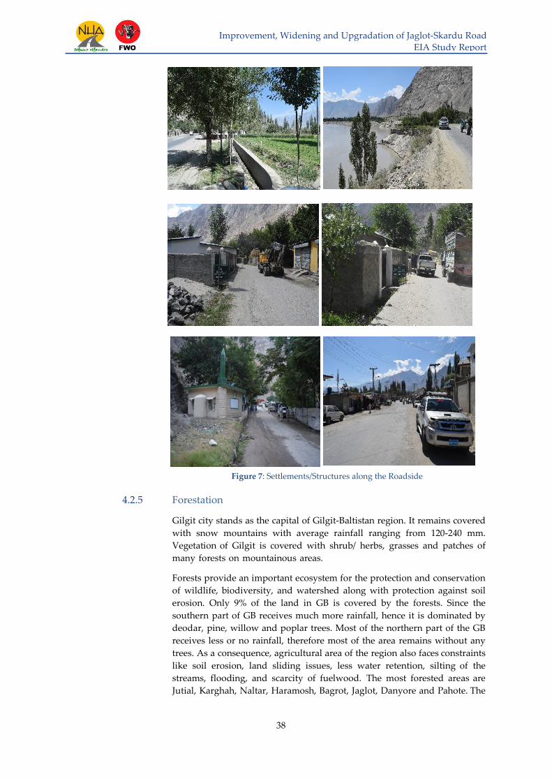
Improvement, Widening and Upgradation of Jaglot-Skardu Road
EIA Study Report
38
Figure 7: Settlements/Structures along the Roadside
4.2.5 Forestation
Gilgit city stands as the capital of Gilgit-Baltistan region. It remains covered
with snow mountains with average rainfall ranging from 120-240 mm.
Vegetation of Gilgit is covered with shrub/ herbs, grasses and patches of
many forests on mountainous areas.
Forests provide an important ecosystem for the protection and conservation
of wildlife, biodiversity, and watershed along with protection against soil
erosion. Only 9% of the land in GB is covered by the forests. Since the
southern part of GB receives much more rainfall, hence it is dominated by
deodar, pine, willow and poplar trees. Most of the northern part of the GB
receives less or no rainfall, therefore most of the area remains without any
trees. As a consequence, agricultural area of the region also faces constraints
like soil erosion, land sliding issues, less water retention, silting of the
streams, flooding, and scarcity of fuelwood. The most forested areas are
Jutial, Karghah, Naltar, Haramosh, Bagrot, Jaglot, Danyore and Pahote. The

Improvement, Widening and Upgradation of Jaglot-Skardu Road
EIA Study Report
39
commonly found trees along the area of interest included Picea smithiana, Pinus
wallichiana, Juniperus excelsa, Betula utilis,and Juniperus macropoda.
Skardu lies in the Baltistan region of Gilgit-Baltistan. Tree species commonly
found in the project vicinity included Pinus wallichiana, Pinus juniperus,
Juniperus excelsa, and Betula utilis. Fruit trees observed in the area consist of
apple, plum, cherry, apricots, pear, walnut, peach etc. Efforts of Forest
Department, Baltistan, were apparent in the form of Riverbed plantation
along the roadside covering an area of 271 acres. Due to the proposed
project, these tree species might get affected if not properly compensated
for. Riverbed plantation is shown in the Figure below:
Figure 8: Riverbed Plantation Covering 271 Acres of Land in Baltistan
4.2.6 Wetlands
According to World Wildlife Fund (WWF), wetland is a place that is
inundated by water that can be fresh water, saline water or both. Marshes,
ponds, edges of lakes, oceans and rivers etc., all come under wetlands. he
Himalayan, Karakorum and Hindu Kush mountain ranges consists of more
than two hundred high altitude wetlands in the region of Gilgit-Baltistan
and they are enacting key role in the local communities, livestock and
biodiversity of Gilgit Baltistan. These wetlands include Ulter Lake, Gahkuch
Marshland, Handrop Lake, Karfaq Lake, Naltar Lake, Qurumbar Lake,
Rama Lake, Rush Lake Shandoor Lake, Shimshal Pamir, Sheosar Lake and
Deosai National Park which are the most important in terms of their
ecology, biodiversity and eco-tourism. These wetlands are the main sources
of fresh water in the region with diverse and unique flora and fauna.
Therefore, there role and importance cannot be ignored while relating it
with climate change and eco-tourism on the one hand and their impact on
eco system in that particular area on the other. According to World Wildlife
Fund (WWF) Pakistan, high altitude wetlands of Gilgit-Baltistan harbor
around 230 species of Birds, 54 mammals, 20 fish species, 23 herpetic fauna,
and several floral species.

Improvement, Widening and Upgradation of Jaglot-Skardu Road
EIA Study Report
40
Climate Change is one of the serious threats to water availability for alpine
wetlands since increasing temperatures will increase the rate of glacier
shrinkage. In short there could be an increase in flows available in the Indus
system as the glaciers melt, even to the extent of increased risk of flooding
which is a common phenomenon in the whole region during summers. In
the longer term, because of reduced glaciers there could be less water
available for alpine lakes and the Indus River and its wetlands.
Pakistan is a member of the Ramsar Convention, an international agreement
on wetland protection signed in Ramsar, Iran in 1971. As of March 2013,
there are nineteen Ramsar sites, covering an area of 1,343,627 hectares
(3,320,170 acres) in Pakistan. However, not a single alpine wetland in the
whole Gilgit Baltistan is declared as Ramsar site. This negligence and lack of
commitment from GB Government might raise issues of wetland
degradation in the near future.
4.2.7 Livelihood
Socio economic data of Skardu and Gilgit Districts is shown in the Table 14
& 15 respectively:
Table 14: Area and Demographic Indicators (Skardu District)
Variable Details
Area 19,697 sq.km
Population 214,848
Sex Ratio (males per 100 females) 87*
Rural Population 87%*
Urban Population 13%*
Source: "Gilgit-Baltistan: Districts & Places – Population Statistics in Maps and Charts".
citypopulation.de. Retrieved 06 August 2018. (* = 1998 Census Report)
Table 15: Area and Demographic Indicators (Gilgit District)
Variable Details
Area 4208 sq.km
Population 145,272
Sex Ratio (males per 100 females) 115*
Rural Population 60.9%*
Urban Population 48.3%*
Literacy Ratio 72%**
Source: "Gilgit-Baltistan: Districts & Places – Population Statistics in Maps and Charts".
citypopulation.de. Retrieved 06 August 2018. (* = 1998 Census Report; **= AKRSP, JICA
study, 2010)
4.2.8 Climate
Gilgit-Baltistan areas have high mountains of Himalayas, Karakoram and
Hindukush ranges with over 8000m peaks. High altitude has dominant
influence on the climate of the region.
Gilgit-Baltistan areas (including the project road from Jaglot to Skardu) have

Improvement, Widening and Upgradation of Jaglot-Skardu Road
EIA Study Report
41
two seasons; extremely cold winter (October to March) and mild/dry
summer (April to September). However, hot weather prevails occasionally
during monsoon season from June to August. The average temperatures
during summer and winter with precipitation (rainfall/humidity) and wind
speed are presented as under:
Table 16: Average Annual Climate Data of Gilgit and Skardu (1961-2009)
Place
Avg. Annual
Temperature (˚C)
Avg. Avg. Annual
Annual Relative
Rainfall Humidity
(mm) (%)
Avg. Annual
Wind Speed
(Knots)
Highest Lowest
At 00
UTC*
At 12
UTC*
At 00
UTC*
At 12
UTC*
Gilgit 19.4 6.2 107.8 59.9 29.6 0.6 1.6
Skardu 14.9 4.1 172.7 50.8 29.6 0.6 2.3
*= Co-ordinated Universal Time
Source: Pakistan Meteorological Department (PMD)
4.2.8.1 Average temperature
Temperatures are normally higher during hot season (June-August) and
low in colder months (December-February) as illustrated below.
Source: Pakistan Meteorological Department (PMD)
Figure 9: Average Maximum Temperature of Gilgit and Skardu Districts

Improvement, Widening and Upgradation of Jaglot-Skardu Road
EIA Study Report
42
Source: Pakistan Meteorological Department (PMD)
Figure 10: Average Minimum Temperature of Gilgit and Skardu Districts
Analysis of monthly temperature data for Gilgit shows that the hottest month
is July with an average maximum temperature of 46.3˚C. December is the
coldest month of the year with an average minimum temperature of - 11.1˚C.
The months of May-September are hot with average temperature ranging
from 41.5˚C to 46.3˚C. While October to March are very cold with average
temperature ranging from -2.5˚C to -11.1˚C
Analysis of monthly temperature data for Skardu shows that the hottest
month is July and August with a maximum average temperature of 41˚C.
January is the coldest month of the year with minimum average temperature
of -24.1˚C. The months of June-August are hot with average temperature
ranging from 40˚C to 41˚C, while October to April are very cold with
average temperature ranging from -1.1˚C to -24.1˚C. The average monthly
temperature data for the given range of years (1961-2009) is given in Table
16.
4.2.8.2 Average Rainfall
Highest average rainfall is usually observed during the months of March
and May for Skardu and Gilgit respectively. The average monthly rainfall
data for the given range of years (1961-2009) is given in Table 16, and also
represented in graphical form below:
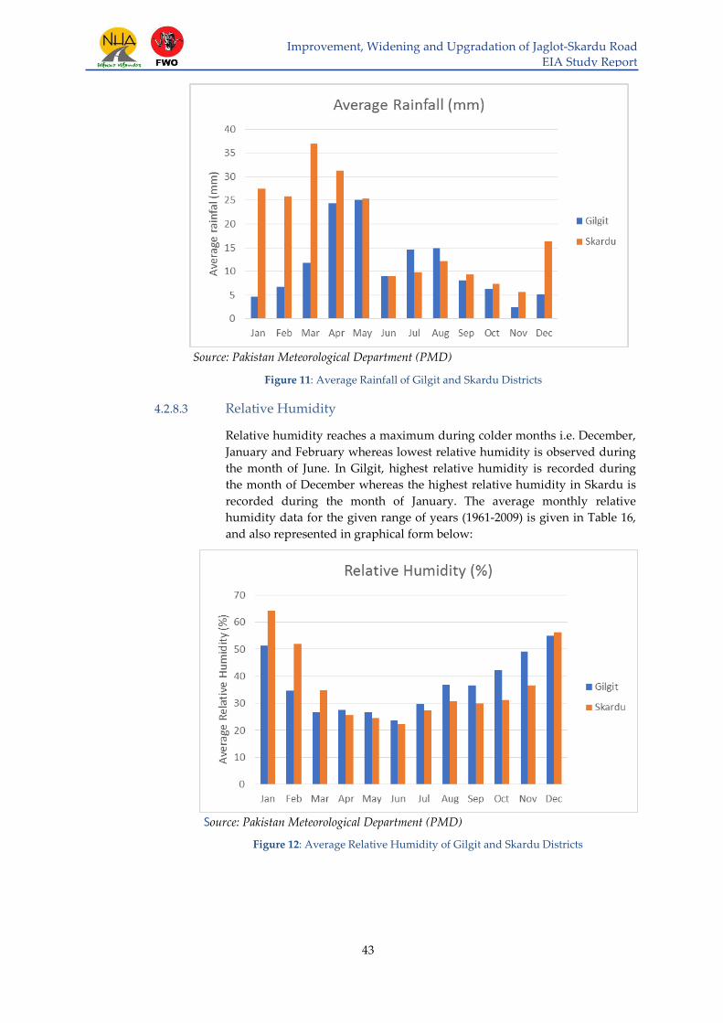
Improvement, Widening and Upgradation of Jaglot-Skardu Road
EIA Study Report
43
Source: Pakistan Meteorological Department (PMD)
Figure 11: Average Rainfall of Gilgit and Skardu Districts
4.2.8.3 Relative Humidity
Relative humidity reaches a maximum during colder months i.e. December,
January and February whereas lowest relative humidity is observed during
the month of June. In Gilgit, highest relative humidity is recorded during
the month of December whereas the highest relative humidity in Skardu is
recorded during the month of January. The average monthly relative
humidity data for the given range of years (1961-2009) is given in Table 16,
and also represented in graphical form below:
Source: Pakistan Meteorological Department (PMD)
Figure 12: Average Relative Humidity of Gilgit and Skardu Districts

Improvement, Widening and Upgradation of Jaglot-Skardu Road
EIA Study Report
44
4.2.9 Wind Speed
Maximum wind speed in both Skardu and Gilgit is observed during May
whereas lowest wind speed is generally experienced during autumn and
colder months. The average monthly wind speed data for the given range of
years (1961-2009) is given in Table 17, and also illustrated below:
Source: Pakistan Meteorological Department (PMD)
Figure 13: Average Wind Speed of Gilgit and Skardu Districts

Improvement, Widening and Upgradation of Jaglot-Skardu Road
EIA Study Report
45
Table 17: Average Monthly Climate of 50 Years Data of Gilgit and Skardu (1961-2009)
Gilgit Jan Feb Mar Apr May Jun Jul Aug Sep Oct Nov Dec 20-08-2018
Maximum Temperature (˚C) 17.5 22 29.4 37.2 41.5 43.5 46.3 43.8 41.6 36 28 24.5 36
Minimum Temperature (˚C) -10 -8.9 -3 1.1 3.9 5.1 10 9.8 3 -2.5 -8.5 - 11.1 23
Rainfall (mm) 4.6 6.7 11.8 24.4 25.1 8.9 14.6 14.9 8.1 6.3 2.4 5.1 4 %
Relative Humidity (%) 51.3 34.6 26.7 27.6 26.6 23.7 29.8 36.8 36.7 42.2 49.1 55 29
Wind Speed (knots) 0.7 1.6 2.9 3 3.4 3.1 2.9 2.5 2 1.1 0.5 0.4 6 km/h
Skardu Jan Feb Mar Apr May Jun Jul Aug Sep Oct Nov Dec 20-08-2018
Maximum Temperature (˚C) 13.9 16.7 24 29.6 34.4 40 41 41 38.2 31.2 22.9 16.2 27
Minimum Temperature (˚C) - 2.1 -20 - 1.5 -1.1 0.4 4 7.5 7 2.6 -4.2 -9.5 - 17.2 18
Rainfall (mm) 27.5 25.9 36.9 31.3 25.3 9 9.8 12.2 9.3 7.3 5.6 16.3 24 %
Relative Humidity (%) 64.3 52 34.9 25.6 24.6 22.3 27.3 30.7 29.9 31.2 36.6 56.2 46
Wind Speed (knots) 0.6 1.7 3.6 5.2 6.9 5.4 3.7 3.4 3.1 2.5 1 0.7 6 km/h
Source: Pakistan Meteorological Department (PMD)
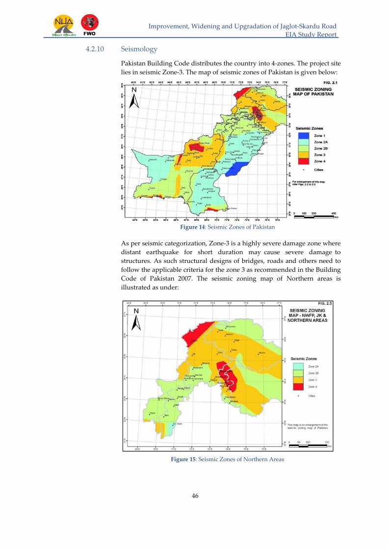
Improvement, Widening and Upgradation of Jaglot-Skardu Road
EIA Study Report
46
4.2.10 Seismology
Pakistan Building Code distributes the country into 4-zones. The project site
lies in seismic Zone-3. The map of seismic zones of Pakistan is given below:
Figure 14: Seismic Zones of Pakistan
As per seismic categorization, Zone-3 is a highly severe damage zone where
distant earthquake for short duration may cause severe damage to
structures. As such structural designs of bridges, roads and others need to
follow the applicable criteria for the zone 3 as recommended in the Building
Code of Pakistan 2007. The seismic zoning map of Northern areas is
illustrated as under:
Figure 15: Seismic Zones of Northern Areas

Improvement, Widening and Upgradation of Jaglot-Skardu Road
EIA Study Report
47
4.2.11 Air & Noise Quality
Finite Engineering (Pvt.) Ltd. engaged the services of ESPAK
(Environmental Services Pakistan), an approved laboratory by
Environmental Protection Department (EPD) of Punjab, to undertake
Environmental Monitoring of air & noise quality in the project area.
The main purpose of carrying out the environmental assessment is to check
the adverse impacts of the project related activities on the air and noise via
monitoring the ambient air quality of project area in compliance with the
National Environmental Quality Standards. The date, location and
parameters to check the air and noise pollution are provided in the Table
18 below:
Table 18: Environmental Monitoring Schedule
Monitoring Schedule
Date Location No. of Points Test Description
4-Aug-18 to
8-Aug-18
Gamba Skardu
(Latitude: 35.334665,
Longitude: 75.534997)
1
Ambient Air
Monitoring
Noise Level
Monitoring
Shengus (Latitude:
35.733331, Longitude:
74.799157)
1
Dambudaas (Latitude:
35.595261, Longitude:
75.229671)
1
For finalization of monitoring location on the above-mentioned sites,
following criteria has been used:
Area where project activities would be carried out
Present environmental conditions at the site
4.2.11.1 Ambient Air Quality
Ambient air quality monitoring is conducted at selected locations to assess
the concentration of priority pollutants Nitrogen dioxide (NO2), Sulphur
dioxide (SO2), Carbon monoxide (CO), Ozone (O3), PM2.5 and PM10.
Selection of sampling location was based on the environmental factors
including wind direction on the particular day and amount of turbulence in
the air etc.
Equipment/Instrument used for checking the air quality is shown below:

Improvement, Widening and Upgradation of Jaglot-Skardu Road
EIA Study Report
48
Figure 16: Air Quality Monitoring Using instrument AQM65
Reference method used for the measurements are included as Table 19
followed by a description of each parameter.
Table 19: Air Quality - Methodologies
Air Pollutant Methodologies Measurement
Range
Sampling
Duration
Oxides of Nitrogen Chemiluminescence 0-10 ppm 24 hours
Sulfur Dioxide
(SO2) UV fluorescence (UVF) 0-20 ppm 24hours
Carbon monoxide
(CO)
Non-Dispersive
Infrared Absorption
(NDIR)
0 – 300 ppm 24 hours
Particulate Matter
PM10, PM2.5
Spectrophotometry
(Nephelometer) 0-2000 ppm 24 hours
Ozone (O3) Non-dispersive UV
absorption 0-0.5 ppm 1 hour
Oxides of Nitrogen
Oxides of Nitrogen (NOx) were monitored using Chemiluminescent NO-
NO2 & NOx Analyzer. The analyzer measures NO, NO2 and NOx using
chemiluminescence (CLD) method with the help of chemical reaction
between NO and O3. Measurement range of the analyzer is 0-10 ppm.
Continuous data was recorded for 24hr.
Sulphur Dioxide (SO2)
Sulphur dioxide was monitored using UV Fluorescent SO2 Analyzer. The

Improvement, Widening and Upgradation of Jaglot-Skardu Road
EIA Study Report
49
SO2 analyzer measures SO2 using UV fluorescence method that operates on
the principle that when the SO2 molecules contained in the sample gas are
excited by ultraviolet radiation they emit a characteristic fluorescence. This
fluorescence is measured and the SO2 concentration is obtained from
changes in the intensity of the fluorescence. Measurement range of the
analyzer is 0-20 ppm. Continuous data was recorded for 24 hr.
Carbon Monoxide (CO)
Carbon monoxide (CO) was monitored using Non-dispersive Infrared CO
Analyzer. The analyzer measures CO concentration by measuring the
quantity of infrared light the sample gas absorbs as it flows through a multi-
reflection chamber. Measurement range of the analyzer is 0-300 ppm.
Continuous data was recorded for 24hr.
Particulate Matter (PM10 & PM2.5)
Monitoring of PM10 & PM2.5 was completed using a Nephelometer. A
sharp cut cyclone fitted to the inlet physically selects a target mass fraction.
The combination of Nephelometer and sharp cut cyclone ensures high
accuracy and durability. PM10 & PM2.5 sampling was conducted for the
period of 24 hours at identified monitoring location.
Ozone (O3)
The O3 analyzer module continuously measures ozone in ambient air. Air
is actively sampled by pump and travels through a glass and Teflon
coated inlet system to the analyzer module. The ozone analyzer module
incorporates a gas sensitive semiconductor (GSS) sensor. This sensor is
a tungsten oxide formulation that is particularly sensitive to ozone when
incorporated at elevated temperatures.
Results
Air Quality Monitoring at Gamba Skardu
Results of environmental testing of ambient air quality monitoring are
presented in Table 20 as under:
Table 20: Air Quality - Monitoring Parameters (Gamba, Skardu)
Sr.
No. Parameters
Avg.
Sampling
Time
Unit
NEQS
for
Ambient
Air
Average
Concentration
1 Sulfur Dioxide (SO2) 24 hr. μg/m3 120 0.91
2 Nitrogen Dioxide
(NO2) 24 hr. μg/m3 80 5.52
3 Nitric Oxide (NO) 24 hr. μg/m3 40 1.44
4 PM 2.5 24 hr. μg/m3 35 27.44
5 PM 10 24 hr. μg/m3 150 90.37
6 Carbon Monoxide
(CO) 24 hr. mg/m3 5 0.32
7 Ozone (O3) 24 hr. μg/m3 80 3.24

Improvement, Widening and Upgradation of Jaglot-Skardu Road
EIA Study Report
50
Detailed results of air quality are attached as Annex-F. A comparison of
NEQS vs average value of air quality parameters for Gamba Skardu is
illustrated in the Figure as under:
Figure 17: Results of Air Quality at Gamba Skardu
Results of the monitoring performed indicate that all parameters meet the
permissible limits of National Environmental Quality Standards. The
instrument used at the site for ambient air quality monitoring is shown as
under:
Figure 18: Air Quality Monitoring at Gamba Skardu using AQM65
Air Quality Monitoring at Shungus
Results of environmental testing of ambient air quality monitoring are
presented in Table 21 as under:

Improvement, Widening and Upgradation of Jaglot-Skardu Road
EIA Study Report
51
Table 21: Air Quality - Monitoring Parameters (Shungus)
Parameters
Avg.
Sampling
Time
Unit NEQS for
Ambient Air
Average
Concentration
1 Sulfur
Dioxide(SO2) 24 hr. μg/m3 120 0.80
2 Nitrogen Dioxide
(NO2) 24 hr. μg/m3 80 6.03
3 Nitric Oxide (NO) 24 hr. μg/m3 40 1.47
4 PM 2.5 24 hr. μg/m3 35 27.30
5 PM 10 24 hr. μg/m3 150 81.14
6 Carbon Monoxide
(CO) 24 hr. mg/m3 5 0.23
7 Ozone (O3) 24 hr. μg/m3 80 3.96
Detailed results are attached as Annex-F. A comparison of NEQS vs average
value of air quality parameters for Shungus is illustrated in the Figure
as under:
Figure 19: Results of Air Quality at Shungus
Results of the monitoring performed indicate that all parameters meet the
permissible limits of National Environmental Quality Standards. The
instrument used at the site for ambient air quality monitoring is shown as
under:

Improvement, Widening and Upgradation of Jaglot-Skardu Road
EIA Study Report
52
Figure 20: Air Quality monitoring at Shungus using AQM65
Air Quality Monitoring at Dambudaas
Results of environmental testing of ambient air quality monitoring are
presented in Table 22 as under:
Table 22: Air Quality - Monitoring Parameters (Dambudaas)
Sr.
No. Parameters
Avg.
Sampling
Time
Unit
NEQS for
Ambient
Air
Average
Concentration
1 Sulfur Dioxide
(SO2) 24 hr. μg/m3 120 0.96
2 Nitrogen Dioxide
(NO2) 24 hr. μg/m3 80 5.85
3 Nitric Oxide (NO) 24 hr. μg/m3 40 1.44
4 PM 2.5 24 hr. μg/m3 35 27.23
5 PM 10 24 hr. μg/m3 150 91.53
6 Carbon Monoxide
(CO) 24 hr. mg/m3 5 0.32
7 Ozone (O3) 24 hr. μg/m3 80 3.32
Detailed results are attached as Annex-F. A comparison of NEQS vs average
value of air quality parameters for Dambudaas is illustrated in the Figure as
under:

Improvement, Widening and Upgradation of Jaglot-Skardu Road
EIA Study Report
53
Figure 21: Results of Air Quality at Dambudaas
Results of the monitoring performed indicate that all parameters meet the
permissible limits of National Environmental Quality Standards. Equipment
used for Ambient Air Quality Monitoring at site is shown as under:
Figure 22: Air Quality Monitoring at Dambudaas using AQM65
4.2.11.2 Noise Level Monitoring
Noise level monitoring was conducted using Extech Sound Meter at the
same locations identified for air quality as mentioned in the Table 17 above.
All noise monitoring was conducted in accordance with the guidance set
out in standard methods. The Meters were calibrated and checked before
and after each measurement period by using sound level calibrator. The
sound meter used is shown as under:

Improvement, Widening and Upgradation of Jaglot-Skardu Road
EIA Study Report
54
Figure 23: Noise Monitoring Day time at Project Site using
Noise Meter
Figure 24: Noise Monitoring Night time at Project Site
using Noise Meter
Results
Noise quality measurements for all three sampling locations at day
and night time respectively are presented in Table 23 below:

Improvement, Widening and Upgradation of Jaglot-Skardu Road
EIA Study Report
55
Table 23: Noise Level Monitoring (Dambudaas, Gamba Skardu and Shungus)
Sr.
No
Monitoring
time
Dambudaas
Noise Level in
dB(A)
Gamba Skardu
Noise Level in
dB(A)
Shungus
Noise Level in
dB(A)
1 6:00 AM (Day) 30 37.9 42.6
2 9:00 AM (Day) 70.9 62.2 67
3 1:00 PM (Day) 40.6 51.6
57.2
4 5:00 PM (Day) 54.1 68.3 45
5 9:00 PM (Day) 40.8 65.2 49
6 12:00 AM
(Night) 30 60.4 37
NEQS (day time) Not More than 65 dB(A) Leq
NEQS (night time) Not More than 55 dB(A) Leq
The graphical illustration of a comparison between the averages measured
at each site viz-a-viz the NEQs for noise are presented as under:
Noise Level Monitoring at Dambudaas
For Dambudaas, all the measured noise values lied well within the
permissible limits (NEQS). The only time where the noise level exceeded the
NEQS was in the morning at 9 AM.
Figure 25: Results of Noise level at Dambudaas
Noise Level Monitoring at Shungus
From the results of monitoring performed at Shungus, it became evident
that noise pollution is not an environmental issue for Shungus. The only
time at which the Noise level exceeded the NEQS was in the morning.

Improvement, Widening and Upgradation of Jaglot-Skardu Road
EIA Study Report
56
Figure 26: Results of Noise level at Shungus
Noise Level Monitoring at Gamba Skardu
The results of monitoring performed at Gamba Skardu revealed that noise
levels were well within the permissible limits as defined by the NEQS. Only
during the evening and night time, it was observed that the noise levels
exceeded the NEQS.
Figure 27: Results of Noise level at Gamba Skardu

Improvement, Widening and Upgradation of Jaglot-Skardu Road
EIA Study Report
57
4.2.12 Surface Water & Ground Water
4.2.12.1 Surface Water
Sources of surface water include springs, streams and River Indus. Water
from the mentioned sources is used for various purposes including drinking
and domestic/agricultural purposes. Water was sampled from four sites in
the project area namely Astak, Dambudaas, Tungush and Hoto. Details are
enlisted in Table 24 below:
Table 24: Water Sampling Sites
Serial # Location Water Sample Collected
1 Astak Tap water & Surface water coming from a stream
2 Dambudaas Channel water coming from a spring & Tap water
3 Kachura Tap water & Surface Water
4 Bagcha Tap water & Surface Water
5 Shungus Tap water & Surface Water
6 Juglot Tap water
7 Heramosh Tap water
4.2.12.2 Water Quality
To check the water quality, Pakistan Council of Research in Water
Resources (PCRWR) was engaged. Samples for testing the water quality
taken from 4 locations in the project vicinity are presented in the figures
below:

Improvement, Widening and Upgradation of Jaglot-Skardu Road
EIA Study Report
58
Figure 28: Water Sample Collection from Various Sources
4.2.12.3 Groundwater
Survey of the project area revealed that groundwater was available near the
Skardu region only. However, this information was true only according to
the locals and was not confirmed by the respective department.
Testing & Results:
Samples for water quality of tap water (TW) and surface water (SW) have
been collected from 7 different locations and submitted for physical,
bacteriological and chemical testing to GB-EPA laboratory. The results are
summarized in Table 25 & 26 as under:

Improvement, Widening and Upgradation of Jaglot-Skardu Road
EIA Study Report
`
59
Table 25: Physical and Bacteriological Water Quality Results
S# Sampling Point
Analysis Parameters
Bacteriological
Parameters Physical Parameters
E. Coli pH Turbidity
Total
Dissolved
Solids
Electrical
Conductivity Temp. Color Odor Taste
1 S#1 Kachoora TW 0 col/ 100 ml 7.8 <5 NTU 258 ppm 369 µs 200˚ colorless odorless tasteless
2 S#2 Kachoora SW 0 col/ 100 ml 7.8 <5 NTU 310 ppm 491 µs 200˚ colorless odorless tasteless
3 S#3 Bagcha SW 0 col/ 100 ml 7.9 <5 NTU 380 ppm 570 µs 200˚ colorless odorless tasteless
4 S#4 Bagcha TW 0 col/ 100 ml 7.8 <5 NTU 331 ppm 498 µs 200˚ colorless odorless tasteless
Findings: Results show that the tested water samples are within the limits of National Standards for Drinking Water Quality of Pakistan
5 S#5 Dambudas TW 0 col/ 100 ml 8 <5 NTU 65 ppm 115 µs 200˚ colorless odorless tasteless
6 S#6 Dambudas SW 0 col/ 100 ml 7.8 <5 NTU 170 ppm 223 µs 200˚ colorless odorless tasteless
7 S#7 Astak TW 0 col/ 100 ml 7.2 <30 NTU 280 ppm 370 µs 200˚ colorless odorless tasteless
8 S#8 Astak SW 0 col/ 100 ml 6.8 <80 NTU 341 ppm 465 µs 200˚ colorless odorless tasteless
Findings: Results show that the turbidity of Astak TW and Astak SW is high which is against the National Standards for Drinking Water Quality of Pakistan.
9 S#9 Shungus TW 0 col/ 100 ml 7.1 <5 NTU 284 ppm 388 µs 200˚ colorless odorless tasteless
10 S#10 Shungus SW 0 col/ 100 ml 7.3 <5 NTU 270 ppm 305 µs 200˚ colorless odorless tasteless
11 S#11 Juglot TW 0 col/ 100 ml 8.1 <5 NTU 205 ppm 370 µs 200˚ colorless odorless tasteless
12
S#12 Heramosh
TW 0 col/ 100 ml
8.2 <5 NTU 345 ppm 572 µs 200˚ colorless odorless tasteless
Findings: Results show that the tested water samples are within the limits of National Standards for Drinking Water Quality of Pakistan.

Improvement, Widening and Upgradation of Jaglot-Skardu Road
EIA Study Report
`
60
Table 26: Chemical Water Quality Results
S# Sampling Point Analysis Parameters
As Hg Cu Al Fe Mn Cr6 Zn Ni B
1 S#1 Kachoora TW ND ND ND ND 0.02 ND 0.04 ND 0.1 0.1
2 S#2 Kachoora SW ND ND ND 0.01 0.03 ND 0.05 ND 0.1 0.2
3 S#3 Bagcha SW 0.01 ND ND 0.01 0.04 ND ND ND 0.2 ND
4 S#4 Bagcha TW ND ND ND ND 0.01 ND ND ND 0.1 ND
Findings: Results show that the concentration of Nickle is against National Standards for Drinking Water Quality of Pakistan.
5 S#5 Dambudas TW ND ND ND ND ND ND 0.02 ND 0.1 0.2
6 S#6 Dambudas SW ND ND ND ND ND ND 0.06 ND 0.2 0.3
7 S#7 Astak TW ND ND ND 0.01 0.02 ND 0.07 ND 0.1 ND
8 S#8 Astak SW ND ND ND 0.02 0.03 ND 0.1 ND 0.1 ND
Findings: Results shows that the concentration of Nickle and Chromium6 is against National Standards for Drinking Water Quality of Pakistan.
9 S#9 Shungus TW ND ND 0.6 ND ND ND 0.01 ND ND ND
10 S#10 Shungus SW ND ND 1.54 ND ND ND 0.02 ND ND ND
11 S#11 Juglot TW ND ND ND ND ND ND ND ND 0.1 ND
12 S#12 Heramosh TW ND ND ND 0.2 0.03 ND ND ND 0.1 ND
Findings: Results shows that the concentration of Nickle is against National Standards for Drinking Water Quality of Pakistan.
Details of water quality results are attached at Annex-G while details of sampling points are provided at Annex-H.

Improvement, Widening and Upgradation of Jaglot-Skardu Road
EIA Study Report
61
Testing & Results:
Conclusions for the water quality tests of TW and SW at 7 locations are
presented below in Table 27.
Table 27: Conclusions of Water Testing
Locations Results
Kachoora TW & SW Water is fit for drinking
Bagcha TW & SW Water is fit for drinking
Dambudas TW & SW Water is fit for drinking
Astak TW & SW Water is not fit for drinking because of the high
turbidity levels.
Shungus TW & SW Water is fit for drinking
Juglot TW Water is fit for drinking
Heramosh TW Water is fit for drinking
4.3 Biological Environment
The proposed Jaglot-Skardu Road Project is situated in two Districts of Gilgit-
Baltistan region; District Gilgit and District Skardu. The project area with its
vicinity, comprising of Rocky Mountains and valleys along the river Indus, is
rich in biodiversity which is adapted to the extreme variations in climate (-
2°C to 35°C) and geographical conditions. Biological environment prevailing
in the vicinity of the project road consists of Flora and Fauna. The Flora
includes vegetation and flowers that are found in human
settlements/agricultural fields along the river banks/shops and mountain
cliffs. The Fauna comprises of the wildlife habitat, endangered/rare species,
livestock etc. The details are described as under:
4.3.1 Flora
Vegetation appeared in different areas mentioned above is bundles together
as wood trees, fruit trees, shrubs/scrubs, herbs, grasses etc. The alpine
scrubs are found in small ravines and in the upper tops of the higher
mountains (Himalaya, Hindu Kush and Karakoram ranges). Mostly trees
grown near the project area include timber, firewood and fruit trees. As the
natural forests are scarce, the local residents have planted Poplar trees which
are utilized as timber and firewood. In addition to the crops, high alpine
plants and weeds (wild flower and plants) are found near agricultural
fields, along the roadside, stream/river banks and mountain tops.
There are so many varieties of roses, lilies, and pansies in Gilgit and Skardu.
Most of the fruit trees are found in the residential areas owned by people.
Apples, apricots, peaches, plums mulberry, walnuts and grapes are fully
ripe from June to October and almonds from October to March. Apart from
the fruit trees, many other tree species are also commonly found in the
Gilgit-Skardu regions including deodar, pine, poplar, and willow. These
floral species are an important habitat for the wildlife of the area and also

Improvement, Widening and Upgradation of Jaglot-Skardu Road
EIA Study Report
62
play a crucial role in landscaping and scenic beauty to the place.
The project area has a variety of trees, along the road (both sides) consisting
of the following major species as given below in Table 28, 29 & 30.
Table 28: List of Prominent Fruit Trees Identified in Skardu and Gilgit District
Sr. # English Name Scientific Name
1 Apple Malus domestica/ Malus sylvestris/ Malus
communis/ Pyrus malus
2 Peach Prunus persica
3 Pear Pyrus communis
4 Almond Prunus dulcis
5 Plum Prunus domestica
6 Apricot Prunus armeniaca
7 Grapes Vitis vinifera
Table 29: List of Wood Trees Identified in Skardu and Gilgit District
Sr. # English Name Scientific Name
1 Pine Pinus gerardiana/ Pinus pinea etc.
2 Poplar Populus alba
3 Deodar Cedrus deodara
4 Willow Salix alba/ Salix babylonica
5 Red Cedar Cedrella toona
6 Seeta Artemesia scoparia
7 Indian/Himalayan Juniper Juniperus macropoda
8 Himalayan White Pine Pinus wallichiana
9 Indian/West Himalayan
Spruce Picea smithiana
10 Turkestan Juniper Juniperus excelsa
11 Himalayan Birch Betula utilis

Improvement, Widening and Upgradation of Jaglot-Skardu Road
EIA Study Report
63
Table 30: List of Shrubs, Herbs and Medicinal Plants Identified in Gilgit and Skardu
District
Sr. # English Name Scientific Name
Shrubs
1 Pencil cedar Juniperus communis
2 Sea buckthorn Hippophaerhmnoides
3 Berberry Berberislycium
4 Tamarix Tamarixgallica
5 Wild rose Rosa webbiana
6 Goose berry Rebisalpestris
Herbs
1 Trifolium Trifoliumrepens
2 Dandelion Taraxacumofficinale
3 Wild thyme Thymus serphyllum
4 Berginia Berginiastracheyi
5 Mullein Verbescumthapsus
6 Wild strawberry Fragariavesca
7 Ephedra Epherdra intermedia
8 Cumin seed Cumiumcyminum
9 Coriander Coriandrumsativum
Medicinal Plants
1 Worm seed Artemisia aritime
2 Stinging nettle Urticadioica
3 Capper Capparisspinosa
4 Safflower Carthamustinctorious
5 Wild rue Peganumharmala
6 Sea buckthorn Hippophaerhamnoides
7 Curled sock Rumexhastatus
8 Puncture wine Triblusterristris
9 Thorn apple Datura stramonium
10 Horse mint Menthasylvestris
11 Chicory Cichoriumintybus
Source: WWF Gilgit Baltistan

Improvement, Widening and Upgradation of Jaglot-Skardu Road
EIA Study Report
64
A variety of fruit trees, wood trees, shrubs, herbs etc. prevalent in the project
area are shown in the figures below.
Figure 29: Trees along the Jaglot-Skardu Road
4.3.1.1 Endangered Species of Flora
No endangered or vulnerable species of flora have been reported in the
project area. However, it was reported that the species of Haplophyllum juss
(a medicinal plant for fever treatment with vernacular/ English name as
Plant of Mosquito) which was common in the past is now rare in Gilgit-
Baltistan area. As a result of the improvement, widening and upgradation
of the existing Jaglot-Skardu Road, a lot of species might get affected i.e.
their number might reduce. So, more plantation of all kinds of trees
including proper management/maintenance would be required in the
project area.
4.3.2 Fauna
According to Wildlife Conservation Society, Pakistan, Gilgit-Baltistan is also
an important stronghold for a range of spectacular and threatened wildlife
species, most notably the endangered snow leopard (Panthera uncia), flare-
horned Markhor (Capra falconeri falconeri), and woolly flying Squirrel
(Eupetaurus cinereus). It is also an important stronghold for the Ladakh Urial,
Improvement, Widening and Upgradation of Jaglot-Skardu Road
EIA Study Report
65
Marco Polo sheep, musk deer, Asiatic black and Himalayan brown Bears,
Himalayan lynx, leopard cat, otters, various threatened pheasants and a
host of other wildlife species.
The wildlife of Skardu (Baltistan) consists of Markhor, Ibex, and Snow
Leopard, including a variety of birds, namely Chakors, Partridges and
Ducks. Limited shooting and hunting are allowed to protect the species by
issuing permits by the local administration. The Himalayan Ibex,
Himalayan Brown Bear, Red Fox, Golden Marmot, Grey Wolf, the Ladakh
Urial, Tibetian blue Bears, wild horses, the Snow Leopard, and more than
124 local and migratory birds are living there. Birds include the Golden
Eagle, Lammergeyer, Griffon Vulture, Laggard Falcon, Peregrine Falcon,
Kestrel, Sparrow hawk and Snow cock. More than a hundred bird species
have been reported around the city. These species include migratory birds
for which GB region provides migratory routes as well as resident for
nesting & breeding. The attitudinal migratory birds descend from higher
altitudes during the winter months. Typical bird species found here
include Snow Partridge (Lerwa), Chukar (Alectoris chukar), Common Quail
(Coturnix), Common Hoopoe (Upupa epops), Common Swift (Apus), Rock
Pigeon (Columba livia) and Common Kestrel (Falco tinnunculus).
4.3.2.1 Endangered Species of Fauna
No Endangered or Critically Endangered bird has been reported in the Gilgit
City. The only bird included in the IUCN Red List is the European Roller
(Coracias garrulous), which is listed as Near Threatened. Endangered
animals include Musk Deer, Snow Leopard, Himalayan Ibex, Markhor,
Woolly flying squirrel and Brown bear.
4.3.3 Protected Areas
A protected area is an area of land dedicated to the protection and
maintenance of biological diversity of natural and associated cultural
resources managed through legal or other effective means. Under Pakistan’s
current provincial and territorial legislation, three categories of protected
areas have been established: Wildlife Sanctuaries, National Parks, and Game
Reserves, but no such land exists in the near vicinity of project area. Deosai
National Park declared as protracted area is situated 50 km away from
Skardu in the South that can be reached via kacha road.
4.4 Socio- Economic Environment
This provides baseline description regarding socio-economic and cultural
environment of the project area. It includes information regarding
population distribution, households, socio-economic status and livelihood
activities, state of education and health facilities. Assessment of socio –
economic condition of the project area, forming an important part of the
base line environment, has been made on the basis of data collected from
secondary source (desk review of available reports, documents etc.) and
primary source (field survey).
A field survey was carried out to collect Socio-economic and cultural data

Improvement, Widening and Upgradation of Jaglot-Skardu Road
EIA Study Report
66
through questionnaire and focused group interviews with residents,
shopkeepers, and village heads, land owners, pedestrians, farmers &
laborers, school teachers/employees in the project area.
Most people living in the villages surrounding the project area are
residents/locals, farmers, businessman, running their own shops/khokha/
laborers (skilled, semi-skilled and unskilled workers). Shalwar Kameez is
the common dress for males and Shalwar Kameez with Chaddar for
females. Shina is the common language spoken in the project area.
4.4.1 Demography
According to the 1998 census, the Gilgit population at the time was 0.88
million, projected rate of population growth in year 2013 is 1.301 million.
The annual growth rate is 2.56%. The average household size is 8.
According to the Planning and Development Department, Government of
Gilgit-Baltistan, “Gilgit-Baltistan at a Glance, 2013” the literacy rate is 60% in
2013. Population information of the region is given below in the Table 31.
Table 31: Demographic Indicators of Gilgit-Baltistan
Indicators Value Indicators Value
Total
Population 214,848
Population of Tehsil
Guttary 11,966
Population of
Tehsil Rundu 34,375
Population of
Tehsil Municipal
committee
28,023
Population of
Tehsil Skardu 55,215 Urban Population 13%
Population of
Tehsil Shigar 45,322 Rural Population 87%
Population of
Tehsil Kharmang 42,059
Sex ratio (number of
males over 100
females) at birth
87
Source: Hyogo Framework for Action (HFA) District Report – Skardu 2014)
4.4.2 Education
According to the Report of Alif Ailaan Pakistan District Education Rankings
2015, Skardu is ranked 14 out of 148 Districts in terms of education. For
facilities and infrastructure, the District is ranked 89 out of 148.
The people of Jaglot are tribal in nature and majority is Muslims. The
population of Jaglot, including the suburbs, is approximately 45,000 in 3200
houses, with an education rate of 52%. The educational institutions and
enrollment of students in GB are given below in Table 32.

Improvement, Widening and Upgradation of Jaglot-Skardu Road
EIA Study Report
67
Table 32: Education Status of Gilgit-Baltistan (2015)
Government Private
District Institutions Enrolment Institutions Enrolment
Gilgit 345 43188 160 21070
Skardu 505 44588 116 18575
As a result of the survey conducted in the project area, 10 schools were
found that were likely to be affected by the Proposed Project. Details
are given below in Table 33.
Table 33: Government Schools Existing Along Both Sides of Jaglot-Skardu Road in District Skardu
S.
No.
Name of School,
Village, Union
Council
Direction of
Roadside from
Gilgit to
Skardu
Approximate
effected area
Enrolment Likely effect
on Boys Girls Total
1
Girls Primary
School, Baghardo
Thang, Tormik
Right 84 rft (running
ft) 59 92 151
Boundary
wall/building
2
Boys Primary
School, Charee,
Tormik
Left 64 rft 9 15 24 Boundary wall
3
Girls Primary
School,
Charee,Tormik
Right 300 sq. feet 17 38 55 Area including
Boundary wall
4 Boys Middle School,
Charee, Tormik Right 150 rft 26 36 62 Boundary wall
5
Boys Primary
School, Tungus,
Tormik
Right 200 sq. feet 25 19 44 Area including
Boundary wall
6 Boys Middle School,
Taraq Thang, Ganji Left 1050 sq. feet 90 84 174
Area including
Boundary wall
7 Boys High School,
Talu, Ganji Right 200 sq. feet 170 82 252
Area including
Boundary wall
8
Boys Primary
School, Shungus,
Stak
Right 35 rft 48 48 96 Boundary wall
9 Boys Middle School,
Hoto, Chunda Right 220 sq. feet 142 125 267
Area including
Boundary wall
Gross Total of Students 586 539 1125
Source: Deputy Director Education, Skardu
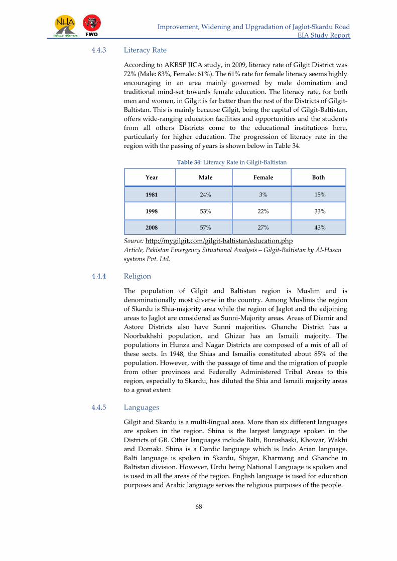
Improvement, Widening and Upgradation of Jaglot-Skardu Road
EIA Study Report
68
4.4.3 Literacy Rate
According to AKRSP JICA study, in 2009, literacy rate of Gilgit District was
72% (Male: 83%, Female: 61%). The 61% rate for female literacy seems highly
encouraging in an area mainly governed by male domination and
traditional mind-set towards female education. The literacy rate, for both
men and women, in Gilgit is far better than the rest of the Districts of Gilgit-
Baltistan. This is mainly because Gilgit, being the capital of Gilgit-Baltistan,
offers wide-ranging education facilities and opportunities and the students
from all others Districts come to the educational institutions here,
particularly for higher education. The progression of literacy rate in the
region with the passing of years is shown below in Table 34.
Table 34: Literacy Rate in Gilgit-Baltistan
Year Male Female Both
1981 24% 3% 15%
1998 53% 22% 33%
2008 57% 27% 43%
Source: http://mygilgit.com/gilgit-baltistan/education.php
Article, Pakistan Emergency Situational Analysis – Gilgit-Baltistan by Al-Hasan
systems Pvt. Ltd.
4.4.4 Religion
The population of Gilgit and Baltistan region is Muslim and is
denominationally most diverse in the country. Among Muslims the region
of Skardu is Shia-majority area while the region of Jaglot and the adjoining
areas to Jaglot are considered as Sunni-Majority areas. Areas of Diamir and
Astore Districts also have Sunni majorities. Ghanche District has a
Noorbakhshi population, and Ghizar has an Ismaili majority. The
populations in Hunza and Nagar Districts are composed of a mix of all of
these sects. In 1948, the Shias and Ismailis constituted about 85% of the
population. However, with the passage of time and the migration of people
from other provinces and Federally Administered Tribal Areas to this
region, especially to Skardu, has diluted the Shia and Ismaili majority areas
to a great extent
4.4.5 Languages
Gilgit and Skardu is a multi-lingual area. More than six different languages
are spoken in the region. Shina is the largest language spoken in the
Districts of GB. Other languages include Balti, Burushaski, Khowar, Wakhi
and Domaki. Shina is a Dardic language which is Indo Arian language.
Balti language is spoken in Skardu, Shigar, Kharmang and Ghanche in
Baltistan division. However, Urdu being National Language is spoken and
is used in all the areas of the region. English language is used for education
purposes and Arabic language serves the religious purposes of the people.

Improvement, Widening and Upgradation of Jaglot-Skardu Road
EIA Study Report
69
4.4.6 Health Facilities
There are 5 civil hospitals, 4 BHUs, 24 Dispensaries and 1 District
Headquarters Hospital in Gilgit. The average distance of vicinity from
health facility is 3.74 km, whereas the maximum distance is 20 km. The
following Table gives details of health facilities that are available in the
region.
Table 35: Healthcare Facilities Available in Gilgit-Baltistan Region
Type of Health Facility Gilgit-Baltistan Gilgit
Combines Military Hospitals 02 1
District Headquarter Hospital 05 1
Civil Hospital 21 4
Rural Health Centers 02 2
Basic Health Units 17 4
Dispensaries 118 30
First Aid Posts 133 26
MNCH Centers 91 7
TB Leprosy Centers 20 2
4.4.7 Land Acquisition:
Land Requirement has been estimated on following basis:
Length of Road: 164 km
Total Row Proposed: 24 m
ROW Already Available: 9 m
Balance Required: 15 m
Land Required : 2,460, 000 m2
Utilities:
Following utilities exist along the Jaglot-Skardu Road:
Electric Poles and Lines: More than 90% of the electric poles are existing
within the ROW so early planning and measures are required in order to
replace these poles.
Water Channels (Privately Constructed): Water channels were made by
the local people to facilitate their daily activities.

Improvement, Widening and Upgradation of Jaglot-Skardu Road
EIA Study Report
70
5 Public Consultation and Stakeholder Meeting
5.1 General
In this section generally, opinions of the people that may be affected by the
project are described. Environmental Impact Assessment (EIA) of
development projects is considered incomplete without involvement of
potentially affected and interested public. Generally, the stakeholders
include both, the group of people affected by the Project during its
implementation and the organizations i.e. government departments or
private entities concerned with socio-economic & environmental impact
assessment of the Project. Field social survey is conducted to take the views
of the project affected people through interviews/ consultation in the project
area.
The objective of social survey conducted at the project location is to share
information with stakeholder regarding the proposed project of
improvement, widening & upgradation of Jaglot – Skardu Road and its
socio-economic impact on the surrounding area. This is the way to provide
an opportunity to the public of that area to share their valuable suggestions
in the project design and implementation.
The other objective of the survey was to collect the socio-economic profile of
the residents, share with them the impacts of the proposed project, and
create awareness among them about the importance of proposed project
and seeking their suggestions through interviews based on a questionnaire.
During the survey, effort was made to take maximum number of interviews
as possible to gather wide range of information/ fair opinion of the majority
of local affected people. The information was collected with respect to
following:
Loss of land/ agriculture land
Loss of Structure (i.e. houses, schools, shops etc.)
Loss of agriculture production/crops etc.
Loss of trees and fruit trees
Effect on livelihood
Public facilities
Opinions of local and affected people regarding project
5.2 Main Stakeholders
During the field survey, the different stakeholders identified included
shopkeepers, local residents, hotel managers, farmers, teachers and masjid
imams. All the respondents from the public as well as
stakeholders/Government departments have different types of
risks/dangers exposed to the construction of the proposed project road. The
consultations with different categories are shown in Table 36 below:

Improvement, Widening and Upgradation of Jaglot-Skardu Road
EIA Study Report
71
Table 36: Consultations with Affected People/ Stakeholders
Sr.
No.
Category of PAP/ Stakeholders
1 Hotel Managers
2 Farmers
3 Shopkeepers
4 Teachers and Masjid Imams
5 Local Residents
6 Government Departments
5.3 Issues Identified by Stakeholders
Generally, a number of issues were brought out by the stakeholders defined
above. The broad issues expressed by each category of stakeholders are
summarized in the Table 37, as under:
Table 37: Issues and Problems of Stakeholders
Sr.
No Stakeholders Issues/ Problems
1 Hotel
Manager
Sewerage, Water Supply, Pollution, Dust and
Noise
2 Farmers Sewerage, Water Supply, Land compensation,
Dust
3 Shopkeepers Sewerage, Water Supply, Telephone facility,
Compensation
4 Residents Electricity, Sewerage, Water Supply, Telephone
facility, Road safety awareness,
5 Imam Masjid Sewerage, Water Supply, Traffic Congestion,
movement of people
6 Government
Departments
Detailed views/observations made during the
stakeholder meetings are stated in section 1.4.
Detailed particulars of PAP interviewed during the survey and the
issues/apprehensions expressed by them are reported in Table 38, below:

Improvement, Widening and Upgradation of Jaglot-Skardu Road
EIA Study Report
71
Table 38: Survey Results
Respondent’s Profile
Major Concern Raised/ View Name
Family
Size
Dwelling Type & Location Occupation
Type Location
Fidda Hussain
s/o Hassan
Muhammad
10 Shop Astana Chungi Shop keeper
The respondent was of the view that construction of road is necessary for travelling from
Skardu to Gilgit. However, road must be equipped with other facilities like proper
drainage system, as the traffic is being faced with severe problem of water accumulation
during winter/ snow season. Pedestrian and animal crossing should also be provided
along with proper signs affixed on the road.
Ali Muhammad
s/o Ali Naqi 14 Shop
Gale bus stand,
Ghamba Shop keeper
Along with the construction of road other facilities like water supply to local people must
be ensured.
M. Hassan s/o
Ghluam Nabi 14 Shop
Gale bus stand,
Ghamba Shop keeper In addition to water supply, health facilities to local people must be ensured.
Arshad
Hussasin s/o
Ghluam
Muhammad
14 Shop Gale bus stand,
Ghamba Shop keeper
The road should be constructed with provision of improved/ additional facilities i.e.
sewerage, water supply, electricity schools and hospitals and road safety signs.
Asif Ali s/o M.
Jafar Ali 14 Shop
Gale bus stand,
Ghamba Shop keeper
The respondent was in favor of road and had a view that Jaglot – Skardu road would save
time and reduce the prices of the commodities. However, other facilities like water supply
must also be provided to local people.
Zahid Hussain
s/o Imtiaz
Hussain
26 Shop Sadiqabad,
Ghamba Shop keeper Government must provide prompt compensation in case of damage to property.
Qambar Ali s/o
Haji Raheem 12 House Hotto Local resident
The road should be constructed but new road should be equipped with modern facilities
like cat eyes, speed breakers and side barriers. Road safety must be ensured because
people, on newly constructed road, drive with high speed which can cause accidents.
Along with road, culverts must be provided and drainage of water must be ensured.

Improvement, Widening and Upgradation of Jaglot-Skardu Road
EIA Study Report
72
Sher
Muhammad s/o
Haji Raza Ali
10 House Hotto Local resident
The respondent had a view that besides provision of road safety, trauma centers need to
be set up along road side must be ensured to provide first aid or treatment to the people
injured during accidents. Along with road culverts must be provided and drainage of
water must be ensured.
Haji Mehmood
s/o Saifullah
Muhmmad
12 House Hotto Local resident Along with road culverts must be provided and drainage of water must be ensured.
Haji Ahsen s/o
Haji Hassan 11 Shop Hotto Shop keeper
Road safety signs especially at sharp bends along with pedestrian/animal crossings need
to be provided for the safe driving and avoiding accidents.
Muhammad
Sadiq s/o Haji
Ali
13 Shop Hotto Shop keeper New road must be equipped with modern facilities like cat eyes, speed breakers and side
barriers.
Ali Hussain s/o
Rehmat Ullah 15 Shop Hotto Shop keeper
Apart from the facilities, it is also important to launch campaign among the people about
road safety, traffic signs and safe driving techniques.
Akbar Ali s/o
Muhmmad
Asghar
12 Farm Hotto Farmer
Land erosion because of the river must be controlled. Road safety signs must be provided
alongside the road to stop vehicle drivers from over speeding. Proper warning signs for
reducing speed at sharp bends/curves in mountain terrain needs to be installed which
could be seen far away from the curve.
Haji
Muhammad s/o
Haji Hussain
14 Farm Hotto Farmer
Authorities must refrain from establishing a new ROW for the road. They must use the
old road alignment. Also they should stop land erosion by adopting proper techniques
because of river cutting.
Sajid Ali s/o
Muhammad Ali 25 Farm Hotto Farmer
Along with new road facilities like water drainage, hospitals and educations centers must
be established. The proposed improvement of road must be carried out on existing
alignment to avoid damage to the property or keep the loss minimum level.

Improvement, Widening and Upgradation of Jaglot-Skardu Road
EIA Study Report
73
Rehmat Ali s/o
Wasil Khan 18 Shop Kachura Tailor
A proper system for drainage and water supply must be ensured along with the
construction of road. Everyone adversely affected from the proposed construction must
get due compensation from the government of Pakistan/GB without any delay and
authorities must ensure that businesses of local people must not be affected during the
construction of the road from Jaglot to Skardu.
Shareef s/o
Saeed Khan 12 Farm Shukar Ababd Farmer Road would only benefit people if their houses, lands and trees are not disturbed at all.
Farman Ali s/o
Muhammad
Kazim
15 Farm Shukar Ababd Farmer
The respondent was totally against the construction of road. He had a point of view that
road construction is a total loss for community. Government promised but never provided
any compensation before to the people affected due to earlier bridge projects and this time
also the government would do the same.
Asghar Ali s/o
Muhammad
Muraad
18 Farm Shukar Ababd Farmer
Residential buildings, shops, agricultural lands and trees must not be damaged during
construction of the road. There should not be any loss of property, agricultural
output/fields and trees.
Abadul Raheem
s/o Abdullah 11 House Shukar Ababd Local resident
The Government should pay attention to provide health, education and drinking water
facilities first rather than constructing the road.
Fidda
Muammad s/o
Hussain Ali
8 Shop Soordas Shop keeper
Road project would be very beneficial. However, the local may lose their livelihood due
to damage caused to their trees/fruit trees and property due to construction of the road.
Authorities must pay compensation even before starting the construction.
Muhammad
Nazir s/o Abdul
Jalil
5 House Soordas Local resident
Road project would be very beneficial but along with the construction of the road,
authorities must make efforts to educate/train people about the traffic and safety rules to
avoid accidents.
Muhamamd
Ameen s/o Haji
Mirza Hussaiin
7 House Serri Local resident The respondent was completely in favor of the road and had a view that road network is
a lifeline for any country therefore this project must be completed at any cost.

Improvement, Widening and Upgradation of Jaglot-Skardu Road
EIA Study Report
74
Mutahir
Hussain s/o Haji
Suleman
22 Farm Serri Farmer
Many issues will resolve but some issues that may arise include the destruction of water
channels, houses, shops and agricultural lands in the vicinity of the project area.
Therefore, proper measures must be taken to secure the property of the local people.
Manzoor
Hussain s/o
Rasool
Muhammad
11 House Serri Local resident Proper measures must be taken to protect existing water channels, houses, shops,
agricultural land/crop and trees including the fruit trees.
Muhammad
Ishaq s/o Sher
Muhammad
12 Farm Garbidas Farmer
Livelihood of the people in Garbidas is totally dependent on crops and fruits. If new road
destroys agricultural lands and fruit trees then a handsome amount in the form of
compensation must be paid so that a new business can be started by the PAP to secure
their livelihood.
Babar Ali s/o
Fida Ali 7 House Garbidas Local resident
Along with the new road, new hospitals and education centers must be established. Road
safety campaigns must be launched so to avoid frequent accidents.
Muhammad
Essa s/o Hussain 7 Shop Tungush Shop keeper
The project must not be constructed unless and until authorities pay to PAP the adequate
compensation for the loss of their property, lands, crops, and fruit/wood trees.
Muhammad
Hassan s/o
Hussain
13 Shop Tungush Shop keeper PAP need payment/compensation due to loss/damage of their property. So, the
authorities should pay first before the execution of the project.
Ahmad Hussain
s/o Sultan Ali 10 House Tungush Local resident
Blasting must be stopped or must be done in a way where no damage can be inflicted to
property and life of PAP. The warning notice needs to be issued to the public before
blasting. Property must not be demolished during the construction of road. Contractor
must follow the existing ROW for the road and must not include houses and water
channels in the new ROW.
Ali Chou s/o
Hassan 22 Hotel Baghicha Hotel Manager
The respondent was in favor of road construction but had a view that compensation must
be paid according to present value of land and property and compensation for fruit trees
must be between Rs 40,000 to Rs 100,000.

Improvement, Widening and Upgradation of Jaglot-Skardu Road
EIA Study Report
75
Liaqat Ali s/o
Ali Chou 11 Farm Baghicha Farmer
The respondent was in favor of road construction but had a view that compensation must
be paid according to present value of land and property and trees/ fruit trees. The
compensation of agricultural land and fruit trees are more than the ordinary land /wood
trees.
Ahmad Khan s/o
Ali Chou 32 Hotel Baghicha Hotel Owner
The respondent was in favor of road construction but had a view that compensation must
be provided according to present value of land and property. The trees compensation
must be made based on the age and output of the fruit trees.
Ismaeil s/o
Abdullah 16 Farm Baghicha Farmer
The respondent was in favor of the road and had a view that road network is a lifeline for
any country therefore this project must be completed at any cost.
Shujat Nasir
Hussain s/o
Ibrahim
14 Farm Baghicha Farmer The respondent was in favor of the road and had a view that road network is a lifeline for
any country therefore this project must be completed at any cost.
Ghulam Haider
s/o Ghulam Ali 36 Shop Dambo Das Shop Keeper
Compensation must be according to the present price of the property. In Dambudaas one
shop of about 3 marla area costs 14 lac but government pays only 2 lac price which is very
less. Road construction is no doubt very important for our area but livelihood earning and
income is more important than a road.
Sher Ali s/o
Ghulam Ali 36
Shop
and
House
Dambo Das
Local resident
and business
owner
Road, hospitals, water supply and school structures are needed in the community. Also
government must provide us with the compensation for our property that will come
within the ROW.
Asim s/o Ali
Muhammad 9
Shop
and
House
Dambo Das
Local resident,
business
owner & Imam
masjid
Road, hospitals, water supply and school structures are needed in the community. Also
government must provide us with the compensation for our property that will come
within the ROW. Mosques must be reconstructed if gets damaged during the process of
road construction.

Improvement, Widening and Upgradation of Jaglot-Skardu Road
EIA Study Report
76
Mirza
Muhammad s/o
Ali Muhammad 12
Farm Dambo Das Farmer
Trees and animals are not safe because of the blasting. If any of the property of anyone in
the area comes within the ROW then compensation according to the land revenue must
be made to the stakeholder.
Tariq Husain s/o
Hazrat Khan 22 Shop Mehdi Abad Shop Keeper
School staff is not available in our area. Hospitals facilities do not exist. In case of any
emergency people can’t reach to the nearest hospital in time because of very poor road
condition. It is hoped that a new road when completed would help solve these problems.
Ahmad s/o
Hassan 10 Shop Tarikho Shop keeper
Water supply, schools, hospitals and drainage are the major issues. Construction of road
is important for the local people which may bring development and prosperity in the area.
Zulfiqar Ali s/o
Ghulam
Muhammad
34 Shop Tarikho Shop keeper
Respondent was of the view that construction of the project road should be followed by
building/providing other facilities e.g. schools, hospitals, drinking water, cottage
industries/employment etc.
Muhammad
Bashir s/o
Muhammad Ali
9 Shop Tarikho Shop keeper The respondent expressed his apprehension about the compensation, which in many
earlier cases is either delayed considerably or not paid so far.
Mubarik s/o
Muhammad Ali 13 House Tarikho Local resident
Drinking water, education, health and transport are the basic necessities for life. If the
construction of the road can provide all of these to the people then there is no issue in the
construction of this road but if this deprives people from their lands and provides no
benefit then this road must remain the same as it is in its present condition. He also added
that if government is about to take their lands for road then their demand for adequate
and prompt compensation must be met before the start of construction activities.
Haji Ghulam
Abas s/o Ali
Muhamad
6 Shop Astak Shop keeper Jaglot-Skardu Road provides the linkage between Skardu and other cities of the country.
Hence, it is important that Jaglot-Skardu road links the area with other via KKH.

Improvement, Widening and Upgradation of Jaglot-Skardu Road
EIA Study Report
77
Muhammad
Raza s/o Haji Ali 12 Shop Astak Shop keeper The road on completion would facilitate fast movement of people and goods in the area.
Amir Hayat s/o
Khichou 12 House Chamachu Local resident
Hospital and school staff is missing. Road should at least make it easy for us to reach to
the other destinations for utilizing these facilities. In addition to this, the construction of
road may create river/land erosion and this may cause flooding of the area. This aspect
should be looked into carefully and practical solution provided to tackle the problem.
Nasir Hussain
s/o Nasir
Hussain
10 House Chamachu Local resident Hospital and school staff is missing. Road should at least make it easy for us to reach to
the other destinations for utilizing these facilities.
Muhammad
Sharif s/o
Ghulam Akbar
40 Hotel Shangus
Chairman &
Business
owner
Dust pollution due to Shangus crush plant is causing breathing problems especially for
children. No medical aid is being provided to the people affected by the dust. Dust allergy
is very common during monsoon among the people because of the crush plant. Fruits,
especially cherry are badly affected by the dust. Other than this issue problems related to
drinking water, sewerage system and education are very common in this area.
Muhammad
Riaz s/o Dolat
Shah
15 Hotel Shangus Hotel manager
Following are the problems being faced by the locals.
Drinking water is not easily available
Education institutes are working without staff
Hospitals and dispensaries are non-existent in the area
Drainage system has not been provided
Working of crush plants causing severe respiratory diseases must be removed from the
populated areas. Furthermore, its construction near the populated areas should be
stopped/banned in future during the construction of the road.

Improvement, Widening and Upgradation of Jaglot-Skardu Road
EIA Study Report
78
The photographs taken during the field survey/interviews with the PAP at
different locations are exhibited as under:
Figure 30: Interviews with Public/Project Affected People at Mehdiabad

Improvement, Widening and Upgradation of Jaglot-Skardu Road
EIA Study Report
79
Figure 31: Interviews with PAP at Chamachu
Figure 32: Interviews with PAP at Astak
Figure 33: Interviews with PAP at Shungus

Improvement, Widening and Upgradation of Jaglot-Skardu Road
EIA Study Report
80
Figure 34: Interviews with PAP at Gamba
Figure 35: Interviews with PAP at Baghicha
Figure 36: Interview with PAP at Dambudaas

Improvement, Widening and Upgradation of Jaglot-Skardu Road
EIA Study Report
81
5.4 Stakeholder Meetings
The objective of the meeting with main stakeholder was to discuss and seek
their opinion pertaining to environmental impacts in terms of damages and
loss of property, land, structures, agricultural output, crops and livelihood
as well as Government property/land, trees induced by the proposed project
for improvement, widening & upgradation of Jaglot – Skardu Road.
Stakeholder meetings were arranged on 23rd July, 2018 with the help of
District Commissioner Skardu. In the meetings, important information was
shared regarding environmental and safety provisions in the project design
and to protect the surrounding communities and safeguard the interest of
PAP from the expected impacts of improvement and widening of the road
construction.
Consultative Meetings held with the officials of various departments of
Skardu in DC office are summarized in the following Table:

Improvement, Widening and Upgradation of Jaglot-Skardu Road
EIA Study Report
82
Table 39: Meeting with Stakeholder (PEPA)
Sr.
No Date Department
Name of
official Designation Observation/ Comments
1 July 23, 2018
Forest
Department
Skardu
Mr. Sher Ali Range Forest Officer
(RFO)
Trees are the major contributors towards the beauty of the land as well as
control of environmental pollution in Skardu. The fruit trees along the roadside
mostly add to the landscape but are also important source of income/livelihood
in the area. Therefore we must try to avoid cutting of these trees during the
construction of road.
There are numerous benefits to the people of Skardu region attached with the
construction of road.
Forest department of Skardu has divided the region into different Range Forest
Officers (RFOs) and each RFO has the responsibility to administer his/her area.
Value of Wood trees cut are measured with respect to its diameter while all
the other trees in terms of their weight.
There is no reserve forest in the District Skardu. However, an artificially made
riverbed forest has been planted in Kachura near Skardu to protect the land
from erosion of River Indus.
Forest department has the following procedure to determine the cost of a tree:
o Cost of cutting down a tree
o Make pieces of the wooden log
o Weigh each of those pieces
o Determine the cost of the tree based on its weight.
Revenue department of District Skardu has already fixed the prices of the
trees according to the rules and regulations.
Revenue department determines the cost on the basis of following categories
of trees:
o Large size trees classified as Kallan
o Medium size trees as Miyana
o Small size trees
Forest department is completely in favor of the construction of Jaglot to
Skardu road. However, the contractor/consultant must give top priority to

Improvement, Widening and Upgradation of Jaglot-Skardu Road
EIA Study Report
83
issue relating to tree removal/cutting along Jaglot-Skardu road to save the
serene environment of Skardu region.
In this regard, the contractor/consultant should ensure to keep better co-
ordination with the Forest Department and provision of timely information to
them much before it is required to for cut down any tree so that the forest
department official may take necessary steps to save that single tree or trees.
It has been observed that in some areas tree have been cut down without
giving any notice to forest department of Skardu which must be stopped in
the future.
2 July 23, 2018
Agriculture
Department
Skardu
Mr. Zahid
Ali Khan Deputy Director (DD)
Construction of road between Skardu and Jaglot will bring many opportunities
on the development and employment to the people of region.
Economy of the region would be improved, especially the crop import and
export from and to the other regions of Pakistan would likely be increased.
More goods between the two cities; Gilgit and Skardu, would be moved at a
faster speed to the desired destination in less time.
If any agricultural land gets disturbed by the construction of road then the
owner of that land must be paid compensation in accordance with the criteria
laid down by the Revenue & Land Department of Skardu and that too would
be made immediately without any delay.
3 July 23, 2018
Wildlife
Department
Skardu
Mr. Inayat Ali Range Forest Officer
(RFO)
Brown Bear, Snow Leopard and Markhor (National Animal of Pakistan) are
the wild life animals that are commonly found in the vicinity of the Jaglot –
Skardu road.
Wildlife Department of Skardu has declared a region near Baghicha as
Community Control Hunting (CCH) area where hunting of Markhor is
banned/prohibited. After the declaration of CCH the number of Markhors in
the region has started increasing.
Mushknaba deer (Musk Deer) commonly known as Qastoori Hiran is among
the endangered species and wildlife department is taking measures to prevent
its killing in the region.

Improvement, Widening and Upgradation of Jaglot-Skardu Road
EIA Study Report
84
4 July 23, 2018
Building & Road
Department
Skardu
Mr. Taj
Muhammad
Executive Engineer
(XEN)
Construction cost of building in Skardu differs with the type of construction
e.g. RCC structures are costly than the structures that simply are made of
blocks, new structures differ in their construction cost than the old ones.
Construction cost in Skardu varies approximately from PKR 600 to PKR 3000
per square feet. Usually the old structures cost PKR 1500 per square foot and
new structures cost PKR 3000 per square foot approximately.
Sewerage system of the Skardu city is in the control of PWD department and
needs to be improved.
Many NGOs are working on the water supply systems in the villages along
the road line.
PWD after the construction of educational institutes hand them over to the
education department and if any of the educational institute or school is
expected to be damaged due to the construction of the road, the matter would
directly be dealt by the Education Department of Skardu.
5 July 23, 2018
Water & Power
Department
Skardu
Mr.
Muhammad
Qadeer
Executive Engineer
(XEN)
Currently Skardu has 2 megawatt (MW) electricity to supply to the whole
Skardu District.
7–8 hours of load shedding is observed inside Skardu city.
Department of Water & Power is being faced many issues due to Jaglot-
Skardu road construction. Among these issues, the most common is the
damage/dismantling of electric poles along the roadside caused by the
construction. These affected poles need to be relocated on urgent basis to
avoid any uninterrupted power supply wherever space is available in the
area/ across the River. In this connection, close coordination with the
Department and provision of timely information regarding construction
activities must be ensured, enabling the Department to take preventive
measures beforehand and to avoid the electricity break down in the area.
Electric poles are the government assets and these assets must be saved by the
contractor at any cost.
Electric supply is the need of the hour and the contractor has to take the

Improvement, Widening and Upgradation of Jaglot-Skardu Road
EIA Study Report
85
responsibility to ensure that the electric supply to the people must not be
disturbed during the construction phase.
If any of the electric pole gets damaged or needs to be relocated then an
amount must be paid by the governing authority to the department of Water
& Power Skardu on urgent basis.
Compensation amount must include the cost of rehabilitation as well.
6 July 23, 2018
Rep. of GB-
EPA /
Disaster
Management
Department
Skardu
Mr.
Shehzad
Baig
Assistant Director
(AD)
AD NDMA informed the stakeholder meeting that GB-EPA, time and again,
conveyed their comments to the District Administration as well as in the meeting
with FWO. He delivered a letter to GB-EPA containing their comments on JSR
project, a copy of which is attached as Annex-I. Almost all the observations made
by GB-EPA have been covered in the Chapter 6 (Anticipated Environmental
Impacts & Mitigation Measures) of the Report. However, the points are
summarized as under:
Heavy machinery deployed for the construction of the road in the area, has
reduced the bearing capacity of the Saper Shaheed Bridge. The bridge was
able to bear more load in the past. However, now it could only take 16 tons of
load which causes slow movement of goods. Alternative for the SS Bridge
must be constructed on the priority basis.
River Indus is causing soil erosion near the road alignment for which remedial
measures must be taken on priority basis.
For the operation of Hotu Crush Plant, excavation is carried out near the
residential area, which lies in the vicinity of Shigri Kallan Nullah. The rain
flood common in GB region in Nullah may cause soil erosion/mud sliding,
resulting in settlement or destruction of nearby building. The contractor
should direct the concerned staff to stop further excavation and retaining wall
should be constructed on high priority basis to avoid soil erosion.
7 July 23, 2018
Social Welfare
Organization
Skardu
Mr.
Muhammad
Bashir
Head
Road network is a life line to any region.
In the region of Skardu NGOs are working for the welfare of communities on
small and large basis.
Construction of road can only be beneficial to the people if a campaign is
launched to create awareness regarding road usage and safety among the
people in the area.
8 July 23, 2018
Mines & Mineral
Department
Skardu
Mr.
Mohammad
Ishaq
Representative Stones like Termaline, Topaz, Carmine and Quartz are found in the mountains
along with the road side.

Improvement, Widening and Upgradation of Jaglot-Skardu Road
EIA Study Report
86
9 July 23, 2018 Livestock
Department
Skardu
Dr. Fida
Hussain Deputy Director (DD)
Livestock such as horses, cows, bulls, yaks, sheep, donkey and goats are
among the most commonly found animals in the region.
Food for the livestock is dependent on the grass/green fields, herbs and shrubs
which grow only on the rainwater and springs. Contractors need to ensure
protection of these areas.
Natural springs can possibly be affected by the waste material of roads, if not
properly dumped.
Movement of livestock along road may become a cause of accidents especially
in winter when the animals (i.e. sheep, lambs, cows) descend from the
mountain tops covered with snow in winter. Therefore there is a need to put
speed breakers and road signs. Alternatively, pedestrian/animal crossings may
be provided (if possible) along the road.
Smoke emission because of fast moving vehicles will become a cause of
breathing issues for animals. Hence, awareness campaign for maintaining
vehicles in good condition must be initiated.
10 July 23, 2018
Industrial
Department
Skardu
Mr. Ghulam
Muhammad
Administration
In-charge
Industry of Skardu will be among the top benefited departments with the
construction of Jaglot – Skardu road.
Industrial department has been working for the last 5years on the training of
men and women to gain the skills in the field of:
o Stitching
o Mobile repairing
o Plumbing
o Building electrical works
400 to 500 people have been engaged in this program.
Most commonly found industry in Skardu is:
o Flour mill
o Dry fruit industry
o Marble fable
The only issue with the road construction is the disturbance of water supply to
these factories because many water channels would be disturbed or damaged
during construction activities. This issue needs proper care and attention of
the contractor.

Improvement, Widening and Upgradation of Jaglot-Skardu Road
EIA Study Report
87
11 July 23, 2018
Revenue
Department
Skardu
Mr. Muhammad
Hassan Distt. Qanongo
Whole area of Skardu is divided into parts for the survey of the estimated land
damages because of the construction the road. Areas of Ghamba, Hoto,
Kachura, and SS Bridge are under one team and the whole Rondu division is
under the responsibility of the second team.
Each Survey team comprises of officials from the following departments:
o Forest Department, Skardu
o PWD, Skardu
o Water & Power, Skardu
o Frontier Works Organization (FWO), Contractor
o National Highway Authority (NHA), Client
Notified rate of land is dependent on the type and place of the land.
Revenue Department has specified different rates for different trees:
o Fruit Trees:
PKR 400 for small plants
PKR 4000 for small size trees
PKR 5000 for medium size trees
PKR 5500 for Large size trees
o Wood Trees:
PKR 300 for small plants
PKR 3000 for small size trees
PKR 3500 for medium size trees
PKR 4000 for Large size trees
Cost for an agricultural field is dependent on the type of the crop that grows
on that specific land.
According to the notification of 2015 the rate of land was:
o PKR 0.4 million/kanal for agricultural land
o PKR 0.3 million/kanal for barren land
In the past Revenue Department has provided the compensation to the
effected people and exchange of land has never been observed here.
Revenue Department of Skardu is following Land Acquisition Act 1894.
Cost of land is also dependent on the union wise distribution of the area as
well; land price in Hoto is PKR 0.25 million per kanal while in Ghamba is PKR

Improvement, Widening and Upgradation of Jaglot-Skardu Road
EIA Study Report
88
0.6 Million per kanal.
Land occupied by educational institutes is the property of education
department of Skardu and it would be dealt according to the policies of the
education department of Skardu.
A committee comprising of members of various departments is constituted by
the Deputy Commissioner Skardu to acquire land process for Gilgit Skardu
road. The committee will ensure the measurement of land, structures, trees
and water channels to be affected due to construction of Gilgit-Skardu Road.
A list of the Committee members is attached as Annex-J.
12 July 23, 2018
Education
Department
Skardu
Mr.
Ghulam
Mohamma
d Nasiri
Deputy Director (DD)
Education department of Skardu has never faced an issue which involves the
shifting of schools because of road construction therefore the education
department would assess the situation and prepare certain policies to deal
with such a situation.
Site/land for the construction of schools is provided by the District government.
If any of the school structure gets damaged or needs to be relocated then it
would become difficult for the education department to adjust the increasing
number of students in schools.
Education department would contact District government for further actions.

Improvement, Widening and Upgradation of Jaglot-Skardu Road
EIA Study Report
89
Pictures of meetings with the concerned Departments are given below.
Figure 37: Meetings with the Concerned Departments
5.5 Grievance Redressal
This section describes mechanism to receive and facilitate the resolution of issues
& grievances raised by the project affected people (PAP). The mechanism would
allow PAP to appeal against adverse impacts/decisions or project activity which
may be emanated from process of Land acquisition or compensation of other
assets.
PAP would be fully informed of the project activities by the Contractor or his
representative engineer executing the construction work. The main objective is
to streamline the procedures for addressing complaints and socials problems,
disputes (verbally or in writing) during project implementation or at the time of

Improvement, Widening and Upgradation of Jaglot-Skardu Road
EIA Study Report
90
compensation.
This mechanism thus is of significant importance as it facilitates the procedures
thereby allowing PAP to safeguard their interest by preventing/ reducing risks/
damage to their properties and other livelihood sources which are likely to be
adversely affected by project activities. In dealing with the disputes or concerns
of the affected communities, the procedure followed would make the project
authorities accountable to the affected people, enabling them to comprehend and
resolve the issue/problems at local level in a transparent manner without
hampering the project implementation process.
In order to provide an accessible mechanism to PAP for addressing their
complaints and disputes, Grievance Redressal Committee (GRC) is proposed to
be constituted in the project area. The GRC would comprise the following
members:
Project Director (EALS), NHA : Chairman/ Convener
Environmental Engineer (AER) : Member
Environmental Engineer (Contractor) : Member
Representative of PAP : Member
The PAP/ local community would register their complaints formally at the
field level in PD office. The PD would forward the complaint to
Environmental Engineer of the consultant/contractor, who would review
the complaints and resolve the grievance as per provision of EMMP within
a week. If the issue remains unresolved within the specified period, it may
be referred to GRC for final decision. Alternatively, the PAP may approach
the GRC directly for the resolution of their issue. The GRC may decide the
disputed matter in a month’s time. The decision of GRC must be in
accordance with the provisions made and procedures laid down in the
EMMP.
In case the Grievance Redressal System does not satisfy the PAP/ local
community, they may take up the matter with higher authorities or relevant
government department for its resolution. At this stage, if relief/ remedy are
not provided for resolution of PAP’s concerns, then they may submit their
complaint to GB-EPA. The Grievance Redressal Mechanism is shown in the
flow chart below:

Improvement, Widening and Upgradation of Jaglot-Skardu Road
EIA Study Report
91
Figure 38: Flow Chart of Proposed Redressal Mechanism

Improvement, Widening and Upgradation of Jaglot-Skardu Road
EIA Study Report
92
6 ANTICIPATED ENVIRONMENTAL
IMPACTS AND MITIGATION MEASURES
6.1 General
This section presents potential impacts to be made on the baseline conditions of
physical, biological and socio-economic environments in the project area of
influence (PAI) during design, pre-construction, construction and operational
phases of the proposed project. Based on the field survey/secondary source
data, departmental consultations/ meetings, and relevant design/hydrology
study, the impact analysis is carried out to assess the anticipated effects along
with mitigation measures preventing/reducing the damages caused due to
implementation of the project.
6.2 Description of Project Area of Influence (PAI)
Prior to identifying impact analysis of the proposed, it is considered imperative
to define the PAI. The area under influence by the project activities, which have
been used to identify environmental baseline information, impacts assessment
and mitigation measures described briefly as under:
PAI mainly refers to Right of Way (ROW) along the project alignment/
route where direct impacts are anticipated due to construction of the road
and other structures. For this project, ROW of varying width w.r.t land use
(9 m in hilly terrain and 12.3 m in other areas) is taken to construct road of
164 km long joining Jaglot to Skardu.
6.3 Environmental Impact Matrix
This matrix involves the screening of impacts on environment due to project
activities in the preliminary stage for impact assessment. The proposed project
would affect different types of environment in the region. The affected
environment, either positive or negative in nature, is prepared in matrix form
during construction and operation phases and is enlisted in Table 40 & 41
respectively with the description of impact activities, as under:
Negligible/ No Impact: The impact which is insignificant or has
negligible influence on natural and socio-economic environment.
Low Adverse Impact: The impact which has a slight/little influence on the
natural and socio-economic environment
Medium Adverse Impact: The impact which is significant and can be
eliminated or mitigated after applying the appropriate measures.
High Adverse Impact: The impact which is greatly damaging and can be
partially but not fully mitigated by applying the measures.

Improvement, Widening and Upgradation of Jaglot-Skardu Road
EIA Study Report
93
Table 40: Impact Assessment Matrix for Construction Phase
Sr.
No.
Physical Environment Biological
Environment Socioeconomic Environment
To
po
gra
ph
y
So
il E
rosi
on
/
Co
nta
min
atio
n
Lan
dsc
ape
Air
qu
alit
y
Hy
dro
log
y a
nd
Dra
inag
e
Gro
un
d W
ater
Qu
alit
y
Hab
itat
Ch
ang
e
Veg
etat
ion
An
imal
Mo
vem
ent
Hea
lth
& S
afet
y f
or
Pu
bli
c &
Wo
rker
Dis
rup
tio
n o
f P
ub
lic
Uti
liti
es
Em
plo
ym
ent
Po
pu
lati
on
Dis
turb
ance
Cu
ltu
ral/
Rel
igio
n V
alu
es
No
ise
& V
ibra
tio
n
Lo
cal
Eco
no
mic
s/B
enef
its
to c
ou
ntr
y
Tra
ffic
Man
agem
ent
1. Construction camps, workshops etc. O LA O LA O LA O O LA LA O LB LA O LA LB O
2. Excavation operations LA LA LA MA LA O LA LA LA LA LA MB LA O MA LB LA
3. Transportation of construction Material O LA O LA LA O O O LA LA O LB LA O MA LB LA
4. Use of construction materials etc. O LA O LA O LA O O O LA O O O O LA LB LA
5. Earthwork/concrete work operations LA LA LA LA O LA LA O LA LA LA MB LA LA MA MB LA
6. Operation of Concrete Batch Plant O LA LA HA O O O O O LA O MB O O MA MB O
7. Disposal of Waste water O MA LA MA LA LA O O O LA O MB LA O MA LB O
8. Solid Waste Management O LA LA LA LA LA O O O LA O LB O O O O O
9. Storage of oil/diesel O LA O LA O LA O O O LA LA LB LA O O O O
Legend: O = No Impact LA = Low Adverse
MA = Medium Adverse HA = High Adverse
LB = Low Benefit MB = Medium Benefit
HB = High Benefit

Improvement, Widening and Upgradation of Jaglot-Skardu Road
EIA Study Report
94
Table 41: Impact Assessment Matrix for Operational Phase
Sr.
No.
Physical Environment Biological
Environment Socioeconomic Environment
To
po
gra
ph
y
So
il E
rosi
on
/
Co
nta
min
atio
n
Lan
dsc
ape
Air
qu
alit
y
Hy
dro
log
y a
nd
Dra
inag
e
Gro
un
d W
ater
Qu
alit
y
Hab
itat
Ch
ang
e
Veg
etat
ion
An
imal
Mo
vem
ent
Hea
lth
& S
afet
y f
or
Pu
bli
c &
Wo
rker
Dis
rup
tio
n o
f P
ub
lic
Uti
liti
es
Em
plo
ym
ent
Po
pu
lati
on
Dis
turb
ance
Cu
ltu
ral/
Rel
igio
n V
alu
es
No
ise
& V
ibra
tio
n
Lo
cal
Eco
no
mic
s/B
enef
its
to c
ou
ntr
y
Tra
ffic
Man
agem
ent
1. Construction camps, workshops etc. O O O O O O O O O O O O LA O O LB O
2. Excavation operations LA/ O O O O O O O LA O O O O LA O O LB LA
3. Transportation of construction Material O O O LA O O O O O LA O O LA O LA LB LA
4. Use of construction materials etc. O LA O LA O O O O O LA O O O O LA LB LA
5. Earthwork/concrete work operations LA/ O O O O O O O O O LA O O LA O LA MB LA
6. Operation of Concrete Batch Plant O O O LA O O O O O O O O O O O MB O
7. Disposal of Waste water O LA O O LA O O O O O O O LA O O LB O
8. Solid Waste Management O O O O LA O O O O LA O O O O O O O
9. Storage of oil/diesel O O O O O O O O O LA O O LA O O O O
Legend: O = No Impact LA = Low Adverse
MA = Medium Adverse HA = High Adverse
LB = Low Benefit MB = Medium Benefit
HB = High Benefit

Improvement, Widening and Upgradation of Jaglot-Skardu Road
EIA Study Report
95
6.4 Impact Assessment in Pre-Construction/Design Stage
Impacts predicted during Pre-construction/Design Stage and the suggested
mitigation measures are described here.
6.4.1 Topography
The topography in the project area would change but only to
some extent due to the construction of project related structures
such as embankments, bridges, culverts, retaining walls etc.
Visual changes to the topography would be of permanent but
slightly adverse in nature and need no mitigation measures
except that the project design must consider aesthetic concerns.
6.4.2 Land Acquisition
Land acquisition for the improvement/widening of Jaglot-Skardu
road is one of the major projects and the related impacts would
cause disturbance for the local residents of the areas which may
also include damages to their property/structures.
The project area includes scattered population with most of the
fertile land alongside the road and land acquisition would cause
loss of livelihood/earnings (in terms of loss of trees/fruit trees)
and thus may create socio-economic problems for the local
communities.
As per data received from FWO encroachment in terms of
effected number of houses, shops, school buildings, trees,
mosques etc. are found within the proposed ROW of the Jaglot-
Skardu road. An area of land measuring 46.29 acres from RD
00+000 to RD 144+552 is estimated to be acquired. The details are
as under:
Table 42: Land Acquisition for Improvement/Widening of J-S Road
RD Land Area (Acres) *25% Un-
foreseen Trees
*25% Un-
foreseen Details
00+000 to
144+552
Private
Land
Structures Agricultural
Land 37.13 2163 2704
Private Land includes
shops, houses, small
buildings, trees, mosques,
etc. 7.9 21.8
113+410 to
144+552 Civil Land 2.06 2.58 2810 3512
Civil Land includes
boundary wall, road, civil
buildings etc.
133+400 to
144+000
Un-
designed
Civil Land
5.26 6.58 0 0 Un-designed land includes
bridges, and unconstructed
structures.
42+000 to
144+552 37.02 46.29 4973 6216

Improvement, Widening and Upgradation of Jaglot-Skardu Road
EIA Study Report
96
*Note: Provision of 25% extra land is made due to the fact that the project
involves widening of Jaglot – Skardu Road by cutting steep mountains
through blasting. Since the project lies in the steep mountainous terrain, the
widening operation will not result in homogeneous land recovery. In order
to carryout smooth implementation of the project, unforeseen land
acquisition of 25% is added along the project based on actual site requirement.
6.4.2.1 Mitigations
Careful alignment and route selection in the project design to
minimize the impacts by avoiding the land/residences of local
people.
Project affected people to be displaced needs adequate
compensation & resettlement.
Resettlement at new sites (if any), may bring improvement in
quality of life of PAP, which may be considered to be a positive
impact of the project.
Adequate Compensation based on revenue record or market
value for agriculture land and structures including shops,
mosques etc.
6.4.3 Loss of Trees
A highly negative impact of permanent nature is to be caused by proposed
project is the loss of tress within the ROW of the road alignment. Around
6319 trees including fruit trees and non-fruit trees are estimated to be cut or
removed within the ROW of the proposed project road. The details are
given as under:
Table 43: Total Trees within the ROW of the Project
RD Fruit
Trees
Non-Fruit
Trees Sub Total
25%
Unforeseen
00+000 to 42+000 665 210 875 1094
42+000 to 111+141 0 0 0 0
113+410 to 144+552 552 3628 4180 5225
The size and type of trees to be cut can be determined at the project execution
stage.
6.4.3.1 Mitigations
Ten saplings in lieu of loss of a tree of each type should be planted
in Project Area.
Adequate compensation for the loss of trees including fruit trees
based on value to be determined by Revenue/Forest Department

Improvement, Widening and Upgradation of Jaglot-Skardu Road
EIA Study Report
97
should be paid to the land owner.
6.4.4 Other Settlements
As per data compiled by FWO, the other settlements include structures,
shops, mosques, etc. found to be encroached within the ROW are
summarized as under:
Table 44: Structures & People Affected by Project (RD 00+000 to RD 164+000)
Structures Number
Houses 325
Estimated effected population (@ 10 persons per
household) 3250
Shops 171
Estimated effected people (@ 2 persons per shop) 342
Mosques 18
Schools 2
Graveyards 3
Electric Poles 656
Telephone Poles 39
Others 18
Details of structures/ land along-with RD is provided in the land utility folder
and attached herewith at Annex-K.
List of settlements along the ROW is also provided at Annex-L.
6.4.4.1 Mitigations
Efforts need to be made as much as possible to avoid the
damages to the structures and other settlements etc. However,
in case it is essentially required to remove the settlements,
adequate compensation based on market value or the value
estimated by the Revenue/ Building Department of Gilgit
Baltistan, may be made to the affected people.
6.4.5 Changes in Land Value
One of the positive impacts induced by the project is that the value of
land and property is likely to be increased, especially in the villages
where little or no infrastructure exists.
Land owner would have a chance to sell their lands on higher rates and
thus able to open new businesses for earning livelihood.

Improvement, Widening and Upgradation of Jaglot-Skardu Road
EIA Study Report
98
6.4.5.1 Mitigations
Adequate compensation is provided to make up for the loss of
agricultural crops of various types to Project Affected Persons
(PAP).
The worth of various crop types should be determined in
consultation with revenue department on market price
6.4.6 Religious/Cultural Resources
In the vicinity of project area there lies mosques, a shrine and a
monument. By upgradation of Jaglot-Skardu Road it is anticipated that
these religious and physical cultural resource may be affected.
6.4.6.1 Mitigations
In design of road, road alignment must be adjusted keeping in
view the location of religious and physical cultural resources.
If unavoidable, a suitable alternate site must be allocated to the
affected mosques, shrines and monuments.
6.4.7 Ecology
The proposed project would be constructed on an area which involves
vegetation, river bed forest and water bodies. All of these would be adversely
affected due to the construction of road and project, causing negative impact
on the ecology of the region such as: the cutting of trees within of ROW of the
road is a highly adverse impact to environment.
As a result of land acquisition and land clearing loss of vegetation would
occur.
Solid waste that would generate as a result of construction is a potential
threat to the blockage of water channels.
6.4.7.1 Mitigations
The efficient technical design measures must be used to avoid or
minimize removal of trees and flora.
The alignment of project and its activities must be designed to
minimize the effect on local fauna and biologically sensitive
areas.
6.4.8 Social Disturbance
Due to the proposed land acquisition/agricultural fields, settlement of
residents would be an issue, which would be causing inconvenience and
disturbance to PAP. This impact is permanent and moderate adverse in

Improvement, Widening and Upgradation of Jaglot-Skardu Road
EIA Study Report
99
nature.
6.4.8.1 Mitigations
Project alignment needs to be selected so as to avoid/minimize
the relocation/disturbance to the local people.
The provision of alternate routes must be planned to carry out
daily activities of the locals. A survey has been conducted in the
light of public consultation to get local’s opinion on the project
alignment and its activities. It would help in implementing
accurate mitigation measures to facilitate locals with their
livelihood.
6.4.9 Public Utilities
Due to the proposed project, public utilities affected may create disruption of
public services and economics. This impact is however temporary and
moderate adverse in nature. However, majority of locals rely on private water
channels for water consumption which would be affected. The other public
futilities including electric poles are inside the ROW and would be
dismantled or damaged resulting in power shut down in the area.
6.4.9.1 Mitigations
Water channels should be avoided/saved while preparing the
alignment/design.
The project alignment and boundary must incorporate technical
design measures for public utilities.
The public utilities need to be relocated before the
commencement of work.
It is worthwhile to mention that WAPDA in Public Consultation
meeting informed that all existing electric poles along the road
are proposed to be shifted across the River Indus.
6.4.10 Surface/ Ground Water Resources
The project has an extensive network of drainage channels/ Nullahs falling in
to the Rivers Indus. Most of the water used by the local public is coming from
Nullahs and springs. People have made their own water channels to guide
water to their agricultural lands and to their residences. Construction of the
proposed project would affect these water channels and water sources. As the
proposed alignment is running along the rivers, so the surface water may get
contaminated due to the surface runoff during construction and operation
phase. Ground water may also get contaminated from the wastewater
generation from the construction camps.

Improvement, Widening and Upgradation of Jaglot-Skardu Road
EIA Study Report
100
6.4.10.1 Mitigations
Proper design of bridges on Nullahs to accommodate design
flows.
To control the surface water runoff and sedimentation loading,
cut of drains, cascades, chutes and sedimentation ponds should
be incorporated in the design.
Planning of location of construction camps must be at an
appropriate distance from the surface water bodies
Provision of sufficient sizes of drains to take design flows.
Provision of box culverts to control flood damages and provision
of safety of embankments in the road design.
6.5 Impact Assessment during Construction stage
Implementation of proposed project would involve the following construction
activities:
Construction Camps / Camp Sites
Movement & Operation of construction machinery.
Flora
Fauna
Construction yards
Traffic management
Waste
Blasting
Excavation
Air Quality
Ground / Surface water
Noise
Employment
Health & Safety
The potential impacts during project implementation have been described as
under:
6.5.1 Construction Camps / Camp Sites
Construction of site camps would result in loss of vegetation and assets
on selected land and dissatisfaction of rehabilitation measures. It would
be a temporary low adverse impact.
Noise level increase at a single location and associated disturbance to
wildlife and human receptors.
Temporary visual intrusion would occur.
Waste generation/ chemical or oil slippage affecting water contamination
quality.

Improvement, Widening and Upgradation of Jaglot-Skardu Road
EIA Study Report
101
6.5.1.1 Mitigations
Efforts should be made at the design phase to minimize the
cutting and removal of the existing trees and plants.
Contractor must provide a rehabilitation & removal plan after
completion of project.
Waste management plan must be formulated and implemented.
Locations of construction Camps and Plants along with the layout maps
showing solid and liquid waste disposal sites are provided at Annex-M and
Annex-N respectively.
6.5.2 Movement & Operation of Construction Machinery
Construction Vehicles carrying plant machinery & materials are expected
to generate substantial heavy traffic volume on Road. The operation of
heavy traffic volume may induce adverse but temporary impacts and
cause traffic issues in the project area devised as under:
6.5.2.1 Highly Adverse Impact
Traffic congestion & delays may occur, hampering the movement of local
vehicles and people and thus may cause inconvenience to daily life
activities.
There may be major safety risks/challenges including accidents on the
project site. The impacts & accidents involving human/animal life
(injuries/deaths) are highly adverse in nature.
Heavy construction traffic especially carrying rock material may cause
damage to existing public utilities especially to the electric poles.
Damaging affect is considered to be highly adverse in nature.
The vehicle operation in project area would result in loss of
vegetation/trees, shrub/scrub forest etc. which is a highly adverse impact.
6.5.2.2 Moderately Adverse Impact
Moderately adverse environmental pollution/degradation of following
types may occur due to heavy traffic movement and the operation of
construction machinery in the project area:
Dust pollution & smoke emission damaging the air quality.
Noise Pollution causing inconvenience and disturbance to local
people.
Loss of trees, shrubs, vegetation etc. as a result of constructing
road using extended ROW for widening of the Jaglot-Skardu
road.
6.5.2.3 Positive Impact Construction machinery operators and vehicle drivers would be
hired from the local communities which would provide

Improvement, Widening and Upgradation of Jaglot-Skardu Road
EIA Study Report
102
livelihood to many families.
6.5.2.4 Mitigations
To avoid traffic jams and delays, traffic management plan must
be formulated during design phase needs to be implemented
during construction.
Signage/sign posts labeled with Urdu/local language needs to be
displayed throughout the project site and advertised in all the
localities to avoid/control the traffic safety issues and accidents in
the project area.
Provision of pedestrian/animal crossings alongside road needs to
be made to avoid accidents.
Axle load limit should be strictly followed by the construction
vehicles to control damage to existing structures. Violation in this
regard should be penalized in accordance to fine stipulated in the
regulations.
Environmental degradation due to dust or other air pollutants
need to be controlled/mitigated by sprinkling water on the road
section used by construction vehicles.
As a rule, the construction vehicle operation needs to be
conducted in day time.
Low noise making construction machinery/vehicles as well as
noise proof sheer block at densely populated site in the project
area need to be used to mitigate/control noise pollution and avoid
disturbance to the local population.
Plantation of saplings (1 cut tree to be replaced with 10 trees)
along with grass and other vegetation should be undertaken to
recover the loss in the project area. Similarly, the loss of
agricultural crops within the construction route/ROW needs to
be properly compensated.
Movement of construction vehicle & equipment needs to be
halted or minimized to the extent possibly during wet weather
conditions/ snow to control/avoid damage to top soil and surface
water contamination with the slurry/mud as well as accidents.
6.5.3 Flora
Trees are the most important member of an ecosystem which improves
environment in variety of ways. About 6319 trees belonging to different
species and different age groups will be cut during the construction
of Jaglot-Skardu Road.
Installment of Camp sites and camp yards involves removal of trees and
vegetation.
Widening of road would require extra area for road construction, thereby

Improvement, Widening and Upgradation of Jaglot-Skardu Road
EIA Study Report
103
damaging more trees on the sides of the existing road.
During the entire construction period, dust laden polluted air will form
a dust film on the leaves, thus blocking sunshine and stomata, thereby
hindering photosynthesis process and cause quaintly causing
detrimental effect on the plant health.
During the construction activities, the contractor’s workers may damage
the vegetation including trees.
6.5.3.1 Mitigations
An awareness campaign targeted on the neighborhood farmers
shall be run to popularize the planting of trees.
The contractor’s staff and labor will be strictly directed not to
damage any vegetation such as trees or bushes. They will use the
paths and tracks for movement and will not be allowed to
trespass through farmlands.
Construction vehicles, equipment and machinery will remain
confined within their designated areas of movement.
Camp sites and asphalt plants would be established on
waste/barren land rather than on forested or agriculturally
productive land.
6.5.4 Fauna
Due to the implementation of the proposed Road Project, the free
movement of fauna would be disturbed.
Reptiles like snakes and lizards, living in the holes or underground shall
either get killed or move to the adjacent areas.
Another impact on the fauna of the project area would be the probable
dislocation of the birds/animals from their nests and burrows.
Trees provide resting and nesting places to the animals and birds, so the
cutting of the trees would have negative affect on fauna.
Due to the leakages/spills from the construction equipment/machinery
the local ponds/water storages and water courses where the
animals/birds drink water may get contaminated; thus,
affecting/endangering the fauna of the project area.
6.5.4.1 Mitigations
Plantation of large number of trees along the proposed road
project to regain the ecological habitat.
New and good condition machinery with minimum noise should
be utilized in construction.
Contractor must ensure that there should be no hunting and
trapping of animal would be carried out during construction.
Borrow pits must be fenced properly so that no animal would fall

Improvement, Widening and Upgradation of Jaglot-Skardu Road
EIA Study Report
104
into them.
6.5.5 Construction yards
Construction yards/camps need to be constructed at the site away from
residential areas to store equipment, machinery/ vehicles& their parking, batch
mixing, fabrication etc. Map showing the location of construction camps
established on the project site is attached. The potential significant
environmental impacts of both moderately negative & positive in nature
expected to be induced during these activities are identified as follows:
Clearing of sites for construction yards/camps would entail loss of land,
trees, landscape/vegetation, crops & other habitats
Movement of construction material/machinery, vehicles/equipment etc.
including power generation & crush, concrete and asphaltic plant
operation would create air and noise pollution
Development of residential facilities for workers may cause local
drainage/ sewage/ sanitation ( if any in the project area), & oil spillage
problems and pose threat to surface water quality and resulting in health
issues
Improper storage of waste material as a result of batch mixing,
prefabrication, shuttering may also induce health, water supply, hygienic
problems including spread of contiguous diseases.
6.5.5.1 Mitigations
Mitigation measures for loss of land, trees, vegetation, and
agricultural production are the same as mentioned above during
preconstruction stage. However, a plan determining the
establishment of number of construction camps in project area to
assess their need should be prepared to make adequate
compensation for the environmental losses (as indicated above).
The plan needs to include removal & rehabilitation of site upon
completion by reinstating temporary facilities (if any) to pre-
existing/original conditions particularly at places in project area.
Plan should also envisage proposals for landscaping in areas of
high vegetation value which warrant site-specific landscape
restoration measures.
Deterioration of air & noise quality due to operation of
construction plants, movement of construction machinery,
equipment, material storage etc. can be controlled if handled
carefully by the contractor. The dust in air can be reduced/
mitigated by perpetually sprinkling water in & around the camp
sites and also with the use of anti-dust instruments.
Emissions from power generators and construction machinery

Improvement, Widening and Upgradation of Jaglot-Skardu Road
EIA Study Report
105
are important point sources at the construction sites. Proper
maintenance and repair of power generation plant needs to be
carried out to minimize the hazardous emissions.
The burning of solid waste in the open or the camps as well
should be strictly banned.
Allowing for the existing drainage/sewerage facilities, if any, new
system needs to be properly designed to avoid contamination of
surface/drinking water and thus avoid health hazards & safety
issues.
Proper waste disposal facilities including treatment need to be
provided near/at the site camps to protect the local dwellers and
other habitat from health risks including threats of epidemic
diseases.
6.5.6 Traffic Management
During the construction phase of the project, improper traffic
management may cause inconvenience to the people passing through the
project area. This impact is temporary and moderate adverse in nature.
Movement of kettle on the road would be risk factor in causing road side
accidents.
No alternative route is available except the JSR. Hence, the traffic to/ from
Jaglot has to be stopped during construction hours for a minimum period
of time (15 minutes approximately).
6.5.6.1 Mitigations
Proper traffic management plan has been formulated (Annex-O)
and announced before the construction work to avoid traffic
jams/public inconvenience and accidents.
Security personnel on both directions are deployed to ensure
safety both for humans and vehicles.
Appropriate measures are being taken such as use of whistles,
cones etc. for proper coordination to avoid traffic jams for long
hours as well as accidents.
To avoid any severe damage/ accident during night time,
construction work is only done during day time.
Pedestrian/animal crossing with labor proper sign in local
language may be provided/ installed.
6.5.7 Waste
Different kind of waste would be generated during construction activities.
Moreover, construction waste would also be generated during construction
phase. The waste if not collected and disposed of properly would affect the
aesthetics of area. It would lead to generation of odor, attracting disease

Improvement, Widening and Upgradation of Jaglot-Skardu Road
EIA Study Report
106
vectors and contamination to water bodies.
6.5.7.1 Mitigations
Proper waste management plan shall be designed including provision of
waste collection vehicles/equipment, defining collection frequencies,
allocating personnel and defining safe disposal options/sites.
6.5.8 Blasting
Blasting may be required for the generation of construction material.
Blasting may be required where the alignment is passing through the
hills. Blasting would generate short-term impacts such as noise and
vibration, and long-term potential impacts on land stability.
6.5.8.1 Mitigations
To minimize the short term impacts, control blasting should take
place at predetermined times notified to communities and local
residents.
To minimize the long term impacts, geological and soil conditions
should be carefully assessed to avoid blasting in sensitive
locations.
6.5.9 Excavation & Embankment construction
For the clearance of ROW excavation is required which would result in
the change of edaphic characteristics of soil. Loss of fertile top soil may
affect adversely on the agriculture of the project area.
Excavation near the residential area may result in settlement of houses.
Machinery engaged in excavation would cause noise and air pollution.
Excavation may result in the formation of ditches resulting in water
accumulation during rains and floods.
Change in landscape/Topography as a result of constructing
embankment/ retaining walls.
6.5.9.1 Mitigations
Burrow pits would not be located on agricultural land unless
unavoidable.
Contractor needs approval before excavation.
Removed top soil needs to be stored and used for filling/
rehabilitation process elsewhere with the approval of local
authorities.
Use of water sprinklers or other anti-dust devices would help in
minimizing the dust/air pollution.
To avoid water accumulation excavated areas must be treated so

Improvement, Widening and Upgradation of Jaglot-Skardu Road
EIA Study Report
107
to provide a water removal mechanism.
Mitigation measures for adverse impact of embankments on
landscaping & retaining walls to avoid erosion.
6.5.10 Air Quality
Air quality would be affected by dust emissions from construction machinery,
asphalt plants and vehicular traffic. Emissions may be carried over longer
distances depending upon the wind speed, direction, temperature of
surrounding air and atmospheric stability.
The sources of air pollution during the construction phase would be:
Transport of construction material and other construction activities on
site that generate dust pollution and ambient air quality.
Quarry areas that generate dust during crushing & air pollutants.
Asphalt plants that generate toxic emissions which contain un-burnt
Carbon particles, Sulfur compounds and dust from batch preparation.
Respiratory diseases in a locality due to dust of crush plants.
The above mentioned impacts are however high adverse in nature but limited
to project construction phase only.
6.5.10.1 Mitigations
Regular water sprinkling on the Site should be carried out to
suppress excessive dust emission.
Concrete mixing plants, Asphalt plant and crush plants should be
installed away from the local communities.
Vehicles used for construction should be tuned properly and
regularly to control emission of exhaust gases.
6.5.11 Ground / Surface water
Surface water might get contaminated due to the disposal of construction
waste generated during the construction activity. This contamination of
water may not only disturb the aquatic life (especially in the lakes of the
area) but this would also cause health issue for the local people.
The slippage of various materials/chemicals like fuel, lubricant and other
oil products, which are used during the construction phase, may
contaminate water, if they are not handled properly.
During construction phase the sanitary waste generated from the labor’s
camps has a potential to contaminate water as well. This impact is
temporary and minor negative in nature.
6.5.11.1 Mitigations
Construction yards and the storage yards for construction
machinery must be located away from the water bodies &

Improvement, Widening and Upgradation of Jaglot-Skardu Road
EIA Study Report
108
populated areas.
Water usage for construction purposes must be in such a way that
water availability and supply to nearby communities remains
unaffected.
Regular water quality monitoring must be ensured.
Waste must be collected, stored and dumped to allocated sites.
Contractor to ensure that construction debris or waste must not
find its way to water channels or resources.
6.5.12 Noise
Noise is a by-product of human activity, and area of exposure increases
as function of mobility and construction activities.
On a project site main source of noise pollution is the heavy machinery
such as bulldozers, excavators, stabilizers, concrete mixing plant,
pneumatic drills, stone crushers asphalt plants and other equipment.
Noise generation is likely to affect/damage the noise receptors especially
in the area of 10 – 50 m from the construction site.
6.5.12.1 Mitigations
Heavy machinery hammers and drills should not be used during
the night without prior approval of the Client.
All the work equipment must be provided with a silencer to
control the noise emission.
If applicable make use of low noise machinery for construction
activities must be ensured.
Batching plants crush plants and asphalt mixing plants must be
installed away from the populated areas.
Worker should be provided with ear plugs and other safety
equipment.
6.5.13 Employment
Proposed project is 164 km in length, connecting Jaglot to Skardu and
involves extensive construction works. This would create a large number of
job vacancies for the laborers and semi-skilled local people and allow them to
enhance their skills and capacities. This is a moderate positive impact.
6.5.14 Health & Safety
The construction activities and vehicular movement at construction sites
may result in road side accidents particularly inflicting local
communities who are not familiar with presence of heavy equipment.
Chances of water contamination because of construction activities.
The Labor works with different transmittable diseases may cause spread

Improvement, Widening and Upgradation of Jaglot-Skardu Road
EIA Study Report
109
out of those diseases in the local residents.
The borrow pit areas located near the residential areas may cause
accident for the people moving near to those areas and dust emission by
the operation of crush plants can be a cause of breathing problems for
locals.
Health risks and workers safety problems may result at the workplace if
the working conditions provide unsafe and/or unfavorable working
environment due to storage, handling and transport of hazardous
construction material.
6.5.14.1 Mitigations
Efforts must be made to create awareness of road safety among
the drivers operating heavy machinery and the local people using
road for travelling.
Borrow areas should be fenced and banned for the movement of
locals and crush plants must be provided with anti-dust
equipment to control dust emission.
Setting up speed limits in close consultation with the local traffic
management staff.
Timely public notification on planned construction works.
Providing basic medical training to specified work staff and basic
medical service and supplies to workers.
Source of water should be selected carefully so that it may not
disturb public water availability.
Batching plants must be installed away from the populated areas.
Discharge of any waste to the upstream of the public water
supply must be restricted and water quality must be monitored
on regular basis.
6.6 Impact Assessment during Operation & Maintenance Stage
Anticipated impacts assessed during operation and maintenance of the
proposed Jaglot-Skardu Road project along with their mitigation measures
are identified as under:
Road traffic flow on road would emit air pollutant & dust in the air
resulting in deterioration of air quality along the road, which is
expected to increase with the increase of road traffic. This being high
adverse impact, has Global Warming potential due to generation of
more Greenhouse gas emission
Traffic volume would also result in degradation of noise quality along
the road. The noise level would be higher with the increase in traffic
flow. The worsening noise quality especially at day time has
potentially high negative impact and therefore can be a cause of
concern for the migratory birds.

Improvement, Widening and Upgradation of Jaglot-Skardu Road
EIA Study Report
110
Enhanced vehicular movement and speed in the long run may result
in road safety issues like traffic accidents. This impact is permanent but
moderately adverse in nature, since the frequency of accidents may be
lowered, but their intensity may be quite severe due to enhanced
speeds at which vehicles would move.
Project is not likely to entail significant adverse impact on flora during
its O&M stage. It is anticipated that growth of saplings, planted in lieu
of the trees to be removed in the proposed project, may be adversely
affected due to lack of maintenance.
The Project activities would bring some negative impacts on the fauna
of the project area such as the uneasiness of movement and increased
probability of accidents, if the animals/livestock approach the
proposed road. This impact is medium adverse but permanent in
nature.
No major adverse impact on surface and drinking water is anticipated
during the operational phase. However, occasional oil spills due to any
road accident may be risky to the traffic flow/pedestrians.
More landslides/ flood during rains and snow would hinder the
movement of traffic on road. Landslide has the capability of blocking
whole road for days.
6.6.1 Mitigation Measures
Roadside green areas need to be developed through vegetation &
plantation which should be properly looked after & maintained in terms
of their water requirement & nutrients during operation stage. This
would have positive impacts in terms of improved air quality by
reducing greenhouse gas emissions/hazardous air pollutants and better
landscaping
Plantation of new trees and their proper maintenance in the long run
would serve as a noise barrier to the surroundings and thus help
mitigating the higher noise level.
Improved landscaping in the areas where possible along the road would
have significant impact on roadside bird habitats including migratory
birds and to other animals as well.
Proper maintenance of newly planted saplings in place of trees cut in the
project area would also have positive impact on flora & fauna.
An awareness campaign needs to be launched to get the population/
farmers in the project area to familiarize with the benefits of tree
plantation.
Provision of animal/ livestock crossings, sign boards and speed limits
after appropriate distances to facilitate their movement.
Emergency plan should be prepared and made readily available to meet
accidents involving oil spills.

Improvement, Widening and Upgradation of Jaglot-Skardu Road
EIA Study Report
111
Equipment /Machinery for the removal of the debris must be present in
the vicinity of the areas prone to land slide. Emergency contact number
of the concern authorities must be advertised so that in any emergency
situation the affected people may contact at that number for seeking help.
Improvement, Widening and Upgradation of Jaglot-Skardu Road
EIA Study Report
112
7 ENVIRONMENT MANAGEMENT AND
MONITORING PLAN (EMMP)
7.1 General
This section demonstrates the work plan for managing and monitoring
identified social and environmental impacts on the proposed project during
construction and operation phase. The work plan aim towards the
formulation of EMMP on the basis of Environmental Impacts. EMMP is
prepared by fulfilling the requirements of Pak EPA. The scope of EMMP is
to;
Provide the impacts associated with construction and operational
phase along with the mitigation measures.
Prepare monitoring plan for all the possible impacts on environment
due to Jaglot-Skardu Road project
Measures to mitigate the potential impacts.
Exhibit the responsibilities of major stakeholders involved in project
which are Project Proponent, Contractor, and Design & Supervision
Consultant (In this project DSC is defined as CPM-Finite JV) and other
contractual staff.
Suggesting construction and project activities which are favorable for
sustainable environment.
Outlining the key standards, references, activities and their frequencies
to ensure smooth transition of project activities and operation
7.2 Institutional Responsibilities
Following functionaries would be involved in the implementation of EMP:
EALS (NHA)
Environmental Engineer (EE)/ Officer of Design & Supervision
Consultant (In this project, DSC is defined as CPM- Finite JV)
Environmental Engineer/Officer of Construction Contractor (CC) The
duties/responsibilities of the functionaries are discussed below
(organogram provided in Figure 40):
7.2.1 Responsibilities of NHA
NHA (EALS) would be responsible for the environmental management and
supervisory affairs during the construction phase of the proposed Project.
Director Environment (EALS) would designate the Deputy Director
Environment who would look after the environmental related issues during
the construction phase. The responsibilities of DD Environment are as
follows:

Improvement, Widening and Upgradation of Jaglot-Skardu Road
EIA Study Report
113
Coordinating and planning of activities of EALS;
Monitoring progress of the project as per planned schedule of activities;
Exercising oversight over the implementation of environmental
mitigation measures by the contractor;
Guiding the Environmental Specialist by providing appropriate
environmental advice and solutions;
Documenting the experience in implementation of the environmental
process
Preparing training materials and implementing programs;
Maintaining interfaces with the other lined departments/ stakeholders;
and
Reporting to the GB-EPA on status of EMP implementation.
7.2.2 Responsibilities of Design & Supervision Consultant
Environmental Engineer/specialist of DSC would oversee the performance
of contractor to make sure that the contractor is carrying out the work in
accordance with EMP as mentioned in the contract documents. The
Environmental Engineer/Specialist would also provide assistance to the
Contractor’s Staff to implement EMP. Package wise Site Specific
Environmental Management Plan (SSEMP) would be prepared by the
contractor under the supervision of EE of DSC. The SSEMP would be approved
by the EALS (NHA). EE of DSC would provide guidance to the contractor’s
EE for implementing each of the activity as given in EMP. EE of DSC would
be responsible for record keeping providing instruction through the
“Resident Engineer (RE)” for corrective actions and would ensure the
compliance of various statutory and legislative requirements. EE would
maintain the close coordination with the contractor and EALS for successful
implementation with environmental safeguard measures. However, overall
responsibilities of EE of DSC are as follows:
Directly reporting to the RE;
Discussing various environmental issues and environmental mitigation
enhancement and monitoring actions with all concerned directly or
indirectly;
Review contractor’s SSEMP as part of their work program;
Inspect, supervise and monitor all the construction and allied activities
related to the EMP for the project;
Visiting construction sites including incomplete construction work

Improvement, Widening and Upgradation of Jaglot-Skardu Road
EIA Study Report
114
sites, where there are no contractor’s activities, active construction work
sites, completed areas of work sites as well as ancillary sites such as
borrow areas, quarries, asphalt and crusher sites, hot mix plant sites,
construction camps and work shop areas etc. to ensure contractors
compliance with EMP stipulations and conditions of statutory bodies;
Assist the RE to ensure the environmental sound engineering practices;
Assisting contractor and EALS in all matters related to public contacts
including public consultation pertaining to environmental and
community health & safety issues;
Assisting EALS to carry out environmental monitoring;
Organizing training to the EE of contractor and field staff; and preparing
and submitting monthly and quarterly environmental progress/
compliance reports to the EALS.
7.2.3 Responsibilities of Contractor
Site Environmental Engineer of contractor would carry out the
implementation of the mitigation measures at construction site. Contractor
would be bound through contract documents to appoint the Site
Environmental Engineer/Specialist with relevant educational background
and experience. The responsibilities of EE of Contractor are as follows:
EE of contractor would prepare SSEMP, monitoring plan, traffic
control/diversion plan, and asphalt and batching plant area plans and
would submit all the plans to the EE of DSC.
EE of contractor would be responsible for the implementation of EMP
and to take effective measures against corrective actions plan;
EE would prepare the compliance reports as per schedule and would
submit it to the DSC;
Provision of proper Personal Protective Equipment (PPEs) to the
workers that includes breathing equipment in overalls in dust and
blasting areas, face shields for flying particles, helmets, goggles, footwear
in areas where expose to falling, rolling and piercing objects, hearing
protection like ear buds and ear muffs in noisy areas and train them for
their proper use; and
EE would conduct the environmental and health & safety trainings to
the workers /labor.

Improvement, Widening and Upgradation of Jaglot-Skardu Road
EIA Study Report
115
Figure 39: Organizational Set-Up for Implementation of EMMP
7.3 Non-Compliance of the EMMP
The implementation of the proposed SSEMP involves inputs from various
functionaries as discussed earlier. The contractor would be primarily
responsible for ensuring implementation of the mitigation measures
proposed in the EMP, which would be part of the contract documents. The
provision of the environmental mitigation cost would be made in the total
cost of project, for which contractor would be paid on the basis of monthly
compliance reports. However, if the contractor fails to comply with the
implementation of EMP and submission of the monthly compliance reports,
NHA (EALS) would be responsible for enforcing compliance of contractor
with the terms of the contract, including adherence to the EMP. For minor
infringements, an incident which causes temporary but reversible damage,
the contractor would be given 48 hours to rectify the problem and to restore
the environment. If restoration is done satisfactorily during this period, no
further actions would be taken. If it is not done during this period, NHA
(EALS) would arrange for another contractor to do the restoration, and
deduct the cost from the offending contractor’s next payment. For major
infringements, causing a long-term or irreversible damage, there would be a
financial penalty up to 1% of the contract value in addition to the cost for
restoration activities.

Improvement, Widening and Upgradation of Jaglot-Skardu Road
EIA Study Report
116
7.4 Description of Environment Management and Monitoring Plan
Every project envisages certain impacts to the environment which must be
controlled to have a safer and sustainable environment. Jaglot-Skardu Road
Project would affect the physical, socio-economic, biological, air, noise, water
and waste disposal of region. The study has been performed to control and
monitor the impacts in every possible manner. It results in preparing an
EMMP plan to monitor impacts identified during design, construction and
operational stages in chapter 6; as highlighted in Tables 45, 46, and 47
respectively.

Improvement, Widening and Upgradation of Jaglot-Skardu Road
EIA Study Report
117
Table 45: Environmental Management and Monitoring Plan (Design/Preconstruction Stage)
Environmental Management Plan (Design/Preconstruction stage)
Sr.
No. Aspect Project Impact Mitigation Measures Responsibility
1
Topography
&
Landscaping
Visual changes to
Topography/landscape, Soil
erosion
Adequate aesthetic feature close to original perceptions of landscaping need to be incorporated in
the project design to ensure minimum visual changes, degradation of topography/soil erosion CC, DSC
2
Land
acquisition
and clearing
Loss of land, structure, crops,
trees and resettlement
The road alignment is so designed to avoid and minimize acquisition of agricultural, residential and
commercial land as well as cutting/removal of trees. Resettlement of Project Affected People (PAP)
if required should be undertaken in consultation with relevant authorities/displaced persons.
However, adequate compensation based on Revenue Department’s estimate or market price needs
to be paid for loss of land, structure or shops & crops
GB Land Department, CC, DSC
3 Resettlement
issues
Relocation of household,
commercial buildings The road is designed in such a manner that resettlement and tree removal should be avoided. CC, DSC, NHA
4 Social
Disturbance
Impediments in Exit/Entry
and movement for the
residents and loss of
commercial activities.
The road design should provide alternate pathways to the extent possible to allow the movement of
the locals unhindered and ensure their privacy. CC, DSC
5 Safety
Concerns
Traffic hazard in the
construction and operation
stages
Traffic management plan/ safety measures, if any, may be prepared in this stage to ensure protection
in construction/operation stage.
CC & local Traffic
Police Authority
6
Physical and
Cultural
resources
Difficulty for people to visit
public places; mosques,
shrines, schools and
graveyards.
Involve technical design features to avoid any interference with public places and provide some
alternate walk ways and pedestrian/animal crossings to the locals to get to these places. CC, DSC
7 Ecology
Loss of vegetation,
tree/shrubs & destruction of
natural water channels
Effective technical design for the protection of natural water channels and springs must be prepared
and road alignment must be designed to preserve vegetation /shrubs to the extent possible. CC, DSC
8 Flora
(Vegetation)
Cutting of trees falling
within the ROW
Alignment needs to be properly designed in such a manner that minimum trees should be cut
/removed. Ten saplings need to be planted in place of removal of each tree.
CC, NHA under
oversight of forest
department, GB.

Improvement, Widening and Upgradation of Jaglot-Skardu Road
EIA Study Report
118
Table 46: Environmental Management and Monitoring Plan (Construction Stage)
Environmental Management Plan (Construction Stage )
S. No Aspect Project Impact and Removal of
Structures/ houses Mitigation Measures Responsibility
1 Land acquisition and
resettlement
Acquisition of private land may result in
change in topography & creating
economic and social issue unease among
the residents of Project area
Compensation cost to be paid to the PAP/land owner by providing sufficient
budget in project cost. The affected persons need to be resettled if required, as
per agreement with the contractor.
NHA, Contractor
2 Site clearing,
leveling/tree cutting
Loss of vegetation, soil erosion &
instability of the soil and surface water
pollution
Assure minimum disturbance to native flora during construction
especially where the asphalt, batching and crushing plants would be
installed.
Install temporary erosion control features.
Use machinery for clearing without damaging avoidable plants and
trees.
CC, DSC,
NHA/AER
3 Material extraction
and excavation
Change in landscape may occur
by quarry and borrow areas
Air pollution
Formation of ditches and water
accumulation.
Flooding & damaging
residential area near Nullah.
Damage to top soil in
agricultural fields.
Select environmentally sound source for material extraction and
restore the whole area after excavation.
Control blasting must be done at predetermined site.
Excavation (especially in Nullah near Hoto) needs to be stopped to
prevent the potential threat of flood to nearby residential area.
Use water sprinklers or other anti-dust devices to avoid dust emission
& air pollutants.
Refill the excavated areas with the other materials so that the issue of
ditches and water accumulation can be avoided.
Construction of retaining walls to avoid flooding of residential area
near Nullah.
Inform farmers/cultivators in advance for crop/tree cutting.
Proper disposal of top soil material in consultation with local
authorities for filling the area where required.
Proper signs and staff deployment for traffic management on the road
during movement of construction machinery.
CC, DSC,
NHA/AER

Improvement, Widening and Upgradation of Jaglot-Skardu Road
EIA Study Report
119
4
Use of heavy
machinery for
construction
Existing soil structure may get
damaged
Noise pollution
Water sprinkling before movement of heavy machinery.
Less use of heavy machinery.
Regular maintenance of the construction machines.
Noise control instruments must be installed on the machines.
Well maintained and QC passed equipment must be used for the
construction works.
DSC, NHA/AER,
CC, Local Traffic
Police Authority.
5 Vehicular movement
Hindrance in the movement of
local transport.
Time delays.
Traffic safety concerns.
Effective traffic management plan must be enforced with the help of
local traffic police.
Use of properly designed sign boards.
Local traffic control police staff must be present at all times for the
smooth handling and controlling of traffic flow during construction.
CC staff must also be trained about controlling and guiding the traffic
flow.
Create awareness among the locals residing alongside/near the road
to take precautionary measures during movement of heavy
machinery/equipment
DSC, NHA/AER,
CC & Local
traffic police
4 Air Quality
Dust emission from construction
machinery and crush plants as well as
vehicular traffic and air pollutants
emission from asphaltic plants
Dust control should be conducted by equipping asphalt, hot mix and
batching plants with fabric filters or wet scrubbers to reduce the level
of dust emissions.
Water should be sprinkled regularly across road tracks at the
construction site.
It should be ensured that haul trucks carrying asphalt concrete mix
and/ or aggregate fill materials are kept covered with tarpaulin to help
contain construction material being transported between sites.
The NEQS and Pak EPA standards should be enforced by undertaking
air/water/noise quality tests where ever applicable to gaseous
emissions generated due to construction vehicles, equipment and
machinery. Construction workers should be properly equipped with
dust masks.
Establishing Concrete plants away from residential and green areas.
CC, DSC, Police
department and
NHA/AER
5 Noise
Noise Pollution due to increased
vehicular mobility and construction
activities
Low noise making machinery/plants equipped with suitable in–built
damping techniques and appropriate muffling devices need to be
utilized along with noise proof sheer block at densely populated sites
in project area.
CC, DSC, Police
Department and
NHA/AER

Improvement, Widening and Upgradation of Jaglot-Skardu Road
EIA Study Report
120
Noisy works should be confined to normal working hours in day time.
The construction workers should be equipped with suitable hearing
protection like ear muffs.
Concrete mixing should be located away from residential areas.
6 Flora (Vegetation) &
Fauna
Cutting of road trees fruit trees, crop and
other vegetation due to Project related
construction activities
Plantation of indigenous siblings/species of trees along with
grass/vegetation needs to be undertaken.
Compensation cost to be paid to land owner for the cut down wooden
trees/ fruit trees, crop etc.
Construction traffic needs to be organized at day time only to avoid
obstruction to the movement of animals/ birds as well as to the
nesting/breeding of migratory birds.
NHA/AER
7
Disposal of
Construction waste
disposal material
(wastewater, oil,
chemical, solid waste
etc.)
Contamination of soil and
surface water sources
Unhygienic conditions
resulting in health hazards
Wastewater effluent from contractor’s workshop/ camp sites and
equipment of washing yards needs to be passed through gravel/sand
beds to remove oil/grease contaminants before discharging into
natural streams/ water channels.
Training of the work force in the storage and handling of materials
and chemicals that can potentially cause soil contamination.
Solid waste generated during construction and in camp sites needs to
be properly treated and safely disposed of at demarcated waste
disposal sites.
Avoid blockage of water channels/ during disposal of solid waste/
waste water.
CC & DSC,
NHA/AER
8 Running Crush plants
and Asphalt plants
Dust emission causing health
problems.
Effect on the bio-physical
environment.
Install crush plants away from the public areas.
Make use of water sprinklers and anti-dust equipment.
Mixers and other equipment use in asphalt plants must be sealed and
must be according to the existing standards.
Provide masks to project personnel’s/ staff working in plants.
CC &
DSC,NHA/AER
9
Surface water and
Natural water
channels
Contaminated by the drainage/sewage
& disposal of construction waste to be
caused by construction/labor camps
The surface water reserves and natural water channels need to be
adequately protected from any source of contamination such as the
construction, sanitation and oily spillage that may degrade its potable
quality.
CC, DSC, &
NHA/AER

Improvement, Widening and Upgradation of Jaglot-Skardu Road
EIA Study Report
121
The solid waste should be disposed of at designated landfill sites to
maintain/sustain the water quality for domestic requirements and
avoid blockage of natural stream and water channels.
10 Public Utilities Relocation of certain utilities in such as
electric poles in ROW
Close coordination with the concerned departments (i.e. PWD of
Gilgit-Baltistan) to evade inconvenience to the residents of the project
area.
Electric poles removed would be re-located/ re-installed at suitable
sites along the river banks/ mountain side to avoid land slide, soil
erosion. If so, proper retaining structures to strengthen the site need
to be constructed
CC, DSC, Police
Department,
NHA/AER
11
Risk of infectious
diseases/health and
safety hazards
Spread of infectious diseases by
construction workers
Unhygienic conditions/health
hazards to be caused during
asphaltic concrete pavement
work
Accidents to workers at the
construction site
The contractor should be well informed about the risk of infectious
diseases such as HIV/AIDS and hepatitis.
Workers should be trained in construction & safety procedures and
all workers should be equipped with hard boots, helmets, gloves and
protective masks.
Persons other than workers involved in operation of asphaltic plant
should not be allowed to enter in such premises
Proper training of the contractor’s staff for handling / providing the
emergency & first aid during an un-towards incidents.
Training
Professional for
environmental
management and
monitoring hired
by CC, DSC, and
NHA

Improvement, Widening and Upgradation of Jaglot-Skardu Road
EIA Study Report
122
Table 47: Environmental Management and Monitoring Plan (Operation Stage)
Environmental Management Plan (Operation stage)
S. No Aspect Project Impact Mitigation Measures Responsibility
1 Vehicular
movement Possibility of road accidents
Enforcement of speed limits.
Installation of road signs and enforcement of penalties to the
violators.
Provision of designated pedestrian/ animal cramping if possible
Local Traffic police, O&M staff of Contractor/NHA
2 Road
Maintenance
Use of heavy machinery.
Oil spillage may occur which
may result in severe accidents.
Land Slide/ road.
Road administration project must be formed.
Emergency response team must be organized for any accident,
road blockage due to land/ road slide.
To avoid oil spilling, a departmental coordination must be
ensured.
Avoid using heavy machinery.
District governments of Gilgit & Skardu, Maintenance Contractor & NHA maintenance
3
Flora
(Vegetation) &
Fauna
Newly installed saplings can be
damaged.
Accidents may occur because of
the moving animals on the road.
Saplings installed in place of cut trees must be protected and
maintained throughout all the construction and maintenance
phases of the project.
Awareness campaigns to educate people must be organized by the
Contractor District Administration governments local NGO’s.
Road safety signs must be properly maintained.
Speed limits must be ensured.
High speed vehicles must be monitored to avoid accidents on
roads especially near crowded communities.
District governments of Gilgit & Skardu, Forest/Agricultural departments Maintenance Contractor & NGO’s, NHA
2 Noise Noise increase due to increase in traffic
volume
Setting up of a system to monitor noise level in the project area in
accordance with NEQS. Or noise testing at least three times a year.
Provision of adequate noise barriers such as hedges and
indigenous tree species.
The height of boundary walls of sensitive receptors such as
schools, college and any hospital can be raised along the project
corridor.
NHA, Maintenance
Contractor

Improvement, Widening and Upgradation of Jaglot-Skardu Road
EIA Study Report
123
3 Air Quality Air Pollution caused by increased traffic
levels.
Setting up a system to monitor air quality in the Project Area in accordance
with NEQS. Or quality testing must be carried out three times a year.
Help identifying special measures for the owners and occupants of the
affected premises to grow hedges and vegetation to reduce air pollution.
NHA, local Councilors,
Maintenance contractor
4
Surface water
and Natural
water resources
As a result improvement of widening of
road, movement of people through this
area would increase which results in the
construction of new hotels and
commercial businesses. This movement of
people can pollute the natural water
sources of the area by throwing garbage
and other waste products in the way of
natural water channels.
The locals and commuters shall be well informed of risks involved in
throwing garbage into water bodies. Sign boards shall be used to warn
people against waste disposal in water along with launching awareness
campaigns by different NGO’s on the issue.
Maintenance contractor,
NHA and Tourism
departments with help of
NGO’s

Improvement, Widening and Upgradation of Jaglot-Skardu Road
EIA Study Report
124
7.5 Environmental Management and Monitoring Plan
A framework for Environmental Management and Monitoring Plan
(EMMP) is prepared for all the potential environmental impacts induced
due to implementation of various project activities. The EMMP is
formulated for impacts in three stages of project implementation i.e.
during pre-construction, construction and operational stages. The
methodology followed for preparing the EMMP consists of the following
guidelines:
Suggesting mitigation/protection measures for identified impacts
for the project activity/ environmental component,
Recommending mitigation and compensation measures for the
potential
impacts identified,
Evolving a mechanism for monitoring the proposed mitigation
measures,
Estimating cost required for implementation of mitigation and
monitoring measures, and
Identifying responsibilities of various agencies involved in the
project for implementation and monitoring of mitigation measures.
7.6 Environmental Monitoring Plan & Mitigation Cost
Monitoring of environmental impacts and mitigation measures during
construction and operation stages form an essential part of the
EMMP. The objectives are:
Monitor changes in the environment during various stages of the
project execution with respect to baseline conditions; and
Manage environmental issues arising from construction works
through compliance of mitigation measures.
Develop a monitoring mechanism to assess the performance of
mitigation measures proposed for potential impacts.
Environmental monitoring plan thus formulated along with mitigation
cost, is presented as under:

Improvement, Widening and Upgradation of Jaglot-Skardu Road
EIA Study Report
125
Table 48: EMMP Cost of Jaglot-Skardu Road (Divided into 4 Sections for Construction Purpose)
Sr. No. Particulars Basis Responsibility Cost (Rs.)
1
Four (4)dedicated
Environmental
Engineer/specialist
4 person for 48 months @Rs100,000
(4*48*100000) CC 19,200,000
2
Provision of
Personal Protective
Equipment (PPE) i.e.
Safety & Health
Equipment For
Workers
Provision for 600 employees :
dust masks, safety, shoes, gloves,
plugs, safety helmets and safety
jackets (Hi Vis) and provision of
dust bins, warning tap, safety
cones, safety sign boards and water
sprinkling
CC 19,000,000
3 Environmental Monitoring Cost
Dust Pollution Sprinkling water@Rs10000/section
twice/day/year(4*10000*4*365) CC 58,400,000
Air quality
12samples@ 50000/sample for 4
years construction & one year
operation
CC 600,000
Noise level
Procurement of 4 noise meters @
50000 each for
construction/operation of project
(4years)
CC 100,000
Water quality
Surface water, ground water,
Turbidity
(12 samples for 4 years @ 35000 per
sample)
CC 420,000
4 Soil contamination
Arrangements for careful collection
and disposal of solid wastes, oils,
lubricants etc.(L.S)
CC 16,000,000
Sub Total 113,720,000
Plantation
About 6319 plants, vegetation etc. consisting of wood & fruit trees, herbs shrubs,
weeds etc. falling within ROW of the proposed Jaglot-Skardu road would likely to
be removed during construction. It is proposed to plant saplings of similar type
as per following criteria in the median of the road after its improvement.
One tree removed, equivalent to Plantation of 10 saplings alongside the
road and its surroundings
Cost of 63190 (estimated) plants@ Rs. 100 per plant including 1500
maintenance cost for 3 years = Rs 101,104,000

Improvement, Widening and Upgradation of Jaglot-Skardu Road
EIA Study Report
126
Environmental Training Plan/cost
Training of professional and managerial staff is an important aspect to develop
better understanding and insight towards the Environmental pollution, their
impacts and requirements of EIA and EMMP. The training would also provide
an opportunity to the project personnel, already familiar with the environmental
and social consideration, to upgrade their knowledge pertaining to
management/monitoring practices to be followed properly for handling
mitigation measures to overcome potential Impacts/issues during all three stages
of project implementation. In a nutshell the environmental training ensures to
introduce that project on execution and operational/maintenance stages would
not result in degradation of Environment but help achieving goals set for
sustainable development in the overall economic policies of the country.
Under the overall supervision of the project proponent (in this case EALS of
NHA), the Environmental engineer of contractor/Environmental specialist of NHA
would be mainly responsible to impart training to all project personnel on
environmental and social issues and their mitigation measures proposed in the
EIA to effectively implement the EMP. The NHA would also provide training to
the contractor’s environmental/project engineers and staff to highlight/incorporate
environmentally benign working practices for implementation of EMP so as to
reduce the environmental impacts at the site.
For the purpose of imparting training, the training course needs to be designed
as under:
Introduce broad principles of Environmental Laws/Regulations,
Define common terminology& National Environmental Quality
Standards,
Help create awareness/knowhow about parameters regarding
dust/pollution control through testing/monitoring air quality, water
quality and noise quality and
Promote more sustainable environmental practices within the
workplace.
The training modules should also take care of methodology for
o Launching campaign for social awareness among the general public
/project affected people and
o Keeping the project staff and labors informed regarding health and
safety related issues on the construction site and utilization of
personal protection equipment.
A Week long training needs to be organized to cover the program
mentioned above. The contractor’s Environmental engineer would be
liable to train employees/ labors. The training should cover the following
aspects/topics specific to site conditions.

Improvement, Widening and Upgradation of Jaglot-Skardu Road
EIA Study Report
127
How the activities of staff/labors, the materials/products they use/create,
can damage the environment.
The contactor’s staff and labors should be aware of basic sanitation and
health care process, how to handle these issues, how to avoid malaria &
other contiguous diseases, basic & site specific hazards and
How to use person protection equipment, safety devices, firefighting tools,
and first aid kit and make arrangements for evacuation during
emergency/fire.
The environmental training cost is provided in lump sum at Rs. 1,000,000. Cost
Summary
Overall cost relating to Mitigation & Monitoring including plantation and training
is summarized as under:
Environmental Monitoring Cost: Rs. 113,720,000
Plantation of trees: Rs. 101,104,000
Environmental Training: Rs. 1,000,000
Total: Rs. 215,824,000
Contingencies @ 5%: Rs. 10,791,200
Grand Total: Rs. 226,615,200
Say Rs. 226.5 million
Note: EMMP Cost excludes the Compensation cost on account of loss/damage to
property, house/shops, other structures trees, fruit trees, crops etc. during
construction of the project
7.7 Implementation of EMMP
Following personnel/staff would be involved in the implementation of EMMP:
Project Director or Representative from NHA to oversee the EMMP
implementation
Environmental Engineer from Supervision Consultant
Site Environmental Engineer of the Contractor
Contractor would be liable under the contract to implement the suggested
mitigation measures in the EMMP. The EMMP is required to be included as a
clause in the contract documents.
Organizational setup for implementation of EMMP is presented in Figure 40, below:

Improvement, Widening and Upgradation of Jaglot-Skardu Road
EIA Study Report
128
Figure 40: Organizational Chart for Implementation of EMMP
Reporting Mechanism
Progress reporting related to environmental activities would be the responsibility
of the Environmental Engineer of CC. Environmental Engineer would also be
responsible for submitting a monthly EMMP compliance report for the project
to the GB-EPA.
Non-Compliance of the EMMP
Contractor would be mainly responsible for ensuring implementation of the
mitigation measures proposed in the EMMP, which should form part of the
contract documents. The provision of the environmental mitigation cost needs to
be made in the total cost of project. However, if the contractor fails to comply
with the implementation of EMMP and submission of the monthly compliance
reports, action deems necessary under the agreement would be taken against
him accordingly.

Improvement, Widening and Upgradation of Jaglot-Skardu Road
EIA Study Report
129
8 Conclusion and Recommendations
8.1 Conclusion
Environmental Impact Assessment (EIA) study was conducted for the proposed
project for upgradation, widening and improvement of existing Jaglot- Skardu
Road. In the process of EIA preparation standard procedures were followed
which included field surveys, verification and assessment of anticipated impacts
together with their mitigation measures. NHA and other concerned
departments/officials of District Skardu were also contacted for consultations
and collection of data. The EIA study of the proposed project reveals that there
are no highly significant adverse impacts on natural, physical and socio-
economic environments associated with the implementation of project along the
entire route of 164 km long Jaglot- Skardu road. The major impacts are
concluded as under:
The project route alignment does not fall within any environmentally-
sensitive, protected area, or biological corridor of the country.
Road alignment of 30 km falls in hilly region & 84 km falls in mountainous
region within the very hard mountainous terrain. At places the widening of
road can only be possible through considerable rock cutting or constructing
tunnel through the mountains to avid sharp bends or raising embankment on
river side.
Approximately 3500 people are likely to be affected including their houses,
shops, school walls, and other structures that are found within existing
ROW/road width which would be damaged/dismantled or adversely affected.
Potential Impacts on water quality, air pollution and disturbance to
households due to noise, dust & air pollutants emanating from
vehicle/machineries movements and asphaltic plant are mostly associated
with construction activities and would adversely affect the environment. The
impacts are temporary in nature and can be managed and mitigated.
Around 6319 trees/plants including fruit trees, herbs/shrubs etc. are likely to
be removed from within the existing road width in the project area.
Local residents affected due to earlier projects complained that they have yet
to be paid compensation for damage inflicted to their property as well as loss
of their livelihood. It was pointed out with concern that this time too they
would face the same problem (i.e. non-payment of compensation or delayed
payment).
Social issues such as safety of workers and general public, security and social
problems including disturbance to local residents, risk of communicable
diseases are of temporary nature and can be controlled.
Local dwellers living in the project area of influence have expressed their
concern regarding disturbance to their movement and intrusion to their

Improvement, Widening and Upgradation of Jaglot-Skardu Road
EIA Study Report
130
privacy especially that of women which needs to be properly addressed and
taken care of during project execution.
An EMMP has been provided which clearly outline impacts and mitigation
measures and defined monitoring responsibilities to monitor the activities on
the part of environmental engineers/specialists from CC in close coordination/
supervision of PD/EALS (NHA)/AER.
In overall conclusion, the proposed project is considered environment friendly
and would least affect adversely the existing social and ecosystem of project
areas.
8.2 Recommendations
Construction of the proposed road should proceed once the potential
environmental and social impacts associated with it, are reduced/controlled
through the implementation of appropriate mitigation measures suggested in
the EIA Study including EMMP for the project.
This opinion is based on the nature and extent of the proposed project, the local
level of disturbance predicted because of the construction and operation of the
proposed project, the findings of this EIA and the understanding of the level of
significance of potential impacts.
Major recommendations are summarized as under:
Prompt compensation should be paid to PAP. Moreover, the payment in
earlier cases should be expedited on top priority basis, so that their confidence
could be restored in concerned authorities.
Temporary labor camps should be developed to the nearby location and
should be facilitated with proper drainage facilities.
Soil contamination, water contamination, air pollution and high noise levels
should be controlled with the use of good engineering practices/techniques as
well as the machinery/plant equipped with the controlling devices using
different laboratory tests for water, air and noise quality during construction
and operation of the project.
Contractor should develop plan such as traffic management, arrange
pedestrian/animal crossings, solid waste management, and material
management etc. before starting the construction activities.
Contractor should adopt some suitable timing for the construction activities
so as to cause the least disturbance to the local community particularly women
considering their movement during peak hours.
EMMP is required to implement in letter and spirit the measures suggested to
avoid damage to local dwellers near the project site.
Adequate provision in the project/budget should be made for the amount to
be incurred on EMMP/EMP.

Improvement, Widening and Upgradation of Jaglot-Skardu Road
EIA Study Report
131
Training should be provided to professional staff at site for promoting a better
understanding and knowledge/awareness regarding environmental quality
standards as well as for the use of devices to carry out the air, noise and water
quality tests during the construction and operation of the project.

Improvement, Widening and Upgradation of Jaglot-Skardu Road
EIA Study Report
132
ANNEX-A
References
NHA & FWO Contract Document for Improvement, Upgradation and
Widening of Jaglot – Skardu Road (164km) on Supplier/ buyer Credit Basis
(EPC/ Turnkey) – June, 2017
NHA: PC-1 for Improvement, Widening and Upgradation of Jaglot-Skardu
Road Project – 2015-16
Gilgit Baltistan Environmental Protection Act – 2015
USAID: Pakistan Emergency Situational Analysis – A Profile of District Gilgit -
November, 2012
Pakistan Environmental Protection Agency Review of IEE/ EIA Regulations, -
2000
Pakistan Environmental Protection Act - 1997

Improvement, Widening and Upgradation of Jaglot-Skardu Road
EIA Study Report
133
ANNEX-B
Survey Questionnaire
Serial No.
Date:
Name of Surveyor :
Name of Respondent :
CNIC of Respondent :
Contact No. of Respondent :
Survey Area :
Address :
Father’s Name :
Age :
Education :
Respondent’s status in family
a. Head of household b. Housewife c. Retired Elderly
d. A child of the Head e. Others(specify)
Family Members (a. Total persons, b. Adult men persons)
Total Earning Members
Q.1. Type of Dwelling
a. Concrete (Pacca) b. Bricks (Semi Pacca) c. Tin-shed
d. Special Material e. Others(specify)
Q.2. Name of Tehsil, Village, Union Council
Q.3. Languages spoken in the Village

Improvement, Widening and Upgradation of Jaglot-Skardu Road
EIA Study Report
134
Q.4. Accessibility from main road to village
a. Kacha Track
b. Un metalled Road
c. Metalled Road
d. Other
Q.5. Distance from tarred road to Village: km
Q.6. Approximate population of the village:
Q.7. Total number of houses:
Q.8. Educational facilities available in the village
Sr. No. Facilities Yes No Govt. Private Boys Girls Co-Education
1. Primary School
2. Middle School
3. High School
4. College
5. Vocational Training
6. Deeni Madrassa
7. Others (Specify)
Q.9. Institutional Facilities available in the village
Sr. No. Facilities Yes No Govt. Private Name
1. Hospitals
2. Dispensary
3. Basic Health Unit
4. Post office
5. Mosque
6. Banks
7. Others
Q.10. Means of Transport available in the village
Local Intercity
Public Transport Public Transport
Private Transport Private Transport
Pedestrian Pedestrian
Others Others
Q.11. Civic Facilities available in the village
Sr. No. Facilities Yes No Remarks
1. Line Drainage System
2. Street Lights
3. Grocery Shops
4. Recreational/ Games Facilities

Improvement, Widening and Upgradation of Jaglot-Skardu Road
EIA Study Report
135
5. Medical Store
6. Graveyards
7. Electricity
8. Telephone
9. Public water Supply
10. Others
Q. 12. Source of water in the village
Storage Pit
Channel
Spring
Nullah
Others
Q.13. Details of Affected Property
Type of affected property
a. Land b. Structure c. Land & Structure
Offset from the Outer Edge of Existing ROW:
Located at (RS/LS):
Q.14. In case of affected land provide following details:
Type of Land Total Land Owned (Kanals)
(within and outside this village)
Detail of Property
1. Agriculture
2. Commercial
3. Residential
4. Grazing Land
5. Forest Land
6. Waste Land
7. Others (specify)
Q.15. If structures specify category of the structure:
Commercial
Residential
Dera
School
Others (specify)
Year of construction:
Q.16. Detail of affected Trees/Crops:
Sr. No. Description
e.g. Crop
Type
Privately Owned Government
No. Value (Rs.) Age (Years) No. Age (Years)

Improvement, Widening and Upgradation of Jaglot-Skardu Road
EIA Study Report
136
Q.17. Nature of water supply:
Public Mode of supply of water a. Self-carried
b. Tapped
c. By Channel
d. By Tanker Private
Q.18. Common diseases in village
a. Common Cold b. Diarrhea c. Typhoid
d. Stomach Worms e. TB f. Malaria
g. Goiter h. Dysentery i. Hepatitis
j. Others
Q.19. What are the units of measurements for agricultural land?
a. Marlas b. Acres c. Sq. feet
d. Kanals e. Jarib f. Sq. Haath
g. Others
Q.20. What is the system of irrigation in the area?
a. Canal
b. Tube Wells
c. Rain
d. Others
Q.21. What is the average land ownership in your village/area?
Q.22. How much land do you own?
Q.23. What are the major crops in your area?
a. Wheat b. Rice c. Sugarcane
d. Maize e. Cotton f. Others
Q.24. What is average yield of crop in your area?
Q.25. What are the units of measurements of agricultural produce?
a. Kg b. Haa c. Maunds

Improvement, Widening and Upgradation of Jaglot-Skardu Road
EIA Study Report
137
d. Sinn e. Others
Q.26. Who is the influential in your village?
Head of the Tribe Councilors
Religious Scholars Head of the Families
Government Servants Numberdar
Others
Q.27. What types of trees are in your area?
Fruit Trees
Forest/Wood Trees
Q.28. What kind of animals are in your village?
Q.29. What types of Birds/migrated Birds are in your village?
Q.30. Are there any endangered or rare species in this area?
Q.31. What kind of industry exist in your village?
Q.32. What is the rate of crop in this village and surrounding areas?
Q.33. What is the rate of land per Kanal?
Q.34. Are there any waste disposal facilities?

Improvement, Widening and Upgradation of Jaglot-Skardu Road
EIA Study Report
138
Q.35. What are the major problems in your area
Sr. No. Type of Problems Proposed Solution
1.
2.
3.
4.
5.
Q.36. Do rock carvings/historical places exist in the village
a. Yes b. No
Q.37. If Yes
Sr. No. Name Number Location
A Rock Carvings
B Historical Ruins
C Old Graveyards
D Others (specify)
Q.38. How the matters related to property dispute about the control and consumption of natural sources of
the area are settled?
Head of the Tribe Jirgah
Council of Ulemahs Head of the Families
Government Officials Others
Comments of the Interviewer:

1
1
FINITE ENGINEERING (Pvt.) Limited
CONSTRUCTI
ON ISSUE
Schedule of Grouted Stone RipRap Drain
SrNo Srart RD End RD
Length(m)
1 KM 94+400 KM 94+750 250
2 KM 96+700 KM 97+100 400
3 KM 120+900 KM 123+400 3500
4 KM 136+300 KM 136+500 500
ANNEX-C

TOP COVER
FINITE ENGINEERING (Pvt.) Limited
CONSTRUCTI
ON ISSUE
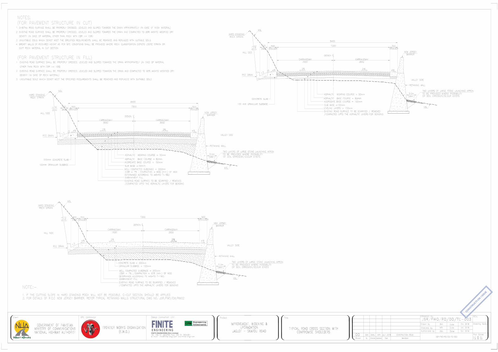
FINITE ENGINEERING (Pvt.) Limited
CONSTRUCTI
ON ISSUE

FINITE ENGINEERING (Pvt.) Limited
CONSTRUCTI
ON ISSUE
CLIMBING LANE SECTION
Sr No Start RD End RD LENGTH
1 KM 68+050 KM 68+850 0.800
2 KM 93+400 KM 94+400 1.000
Total 1.8 Km

List of Proposed Bridges
Sr. No. Station Proposed Bridge Span Arrangement
1 1+450 18m + 67.5m + 13.5m
2 10+250 3 x 25m
3 16+200 1 x 35m
4 17+000 3 x 20m
5 17+850 1 x 35m
6 18+125 1 x 40m
7 18+650 1 x 35m
8 21+850 1 x 40m
9 25+075 1 x 18m
10 25+050 1 x 25m
11 26+350 1 x 17m
12 30+650 1 x 30m
13 34+075 1 x 11m
14 37+150 1 x 28m
15 49+270 1 x 54m
16 49+500 1 x 40m
17 52+575 1 x 35m
18 56+700 1 x 24m
19 59+000 1 x 35m
20 64+320 1 x 10m
21 72+300 1 x 23m
22 75+200 1 x 18m
23 93+375 1 x 25m
24 95+600 1 x 30m
25 97+600 1 x 40m
26 98+570 TBC*
27 99+775 1 x 35m
28 105+225 TBC**
29 107+700 2 x 40m
30 112+470 1 x 45m
31 114+470 1 x 30m
32 117+300 1 x 25m
33 127+000 1 x 67.5m
34 130+250 1 x 25m
35 134+150 1 x 25m
36 134+600 27m + 81m + 27m
37 147+650 1 x 11m
Annex-D

Sr. No. Chainage No. of Pipes Diameter (mm)
1 20+525 1 600
2 20+715 1 600
3 20+815 1 600
4 20+875 1 600
5 21+050 1 600
6 21+400 1 600
7 21+480 1 600
8 21+525 1 600
9 21+600 1 600
10 21+645 1 600
11 21+690 1 600
12 21+750 1 600
13 21+800 1 600
14 22+240 1 600
15 22+330 1 600
16 22+560 1 600
17 26+420 1 600
18 26+550 1 600
19 26+620 1 600
20 26+760 1 600
21 26+880 1 600
22 27+040 1 600
23 27+100 1 600
24 27+260 1 600
25 27+405 1 600
26 27+440 1 600
27 27+470 1 600
28 27+540 1 600
29 27+685 1 600
30 27+765 1 600
31 27+805 1 600
32 27+865 1 600
33 27+945 1 600
34 30+355 1 600
35 30+490 1 600
36 30+760 1 600
37 30+955 1 600
Continued
List of Proposed Culverts (Pipe Culverts)

38 31+065 1 600
39 82+020 1 600
40 86+600 1 600
41 84+750 1 600
42 94+600 1 600
43 102+420 1 600
44 107+055 1 600
45 107+145 1 600
46 107+195 1 600
47 107+210 1 600
48 107+250 1 600
49 107+260 1 600
50 107+320 1 600
51 107+370 1 600
52 107+380 1 600
53 108+210 1 600
54 112+915 1 600
55 113+920 1 600
56 117+210 1 600
57 123+720 1 600
58 124+150 1 600
59 124+470 1 600
60 124+585 1 600
61 124+850 1 600
62 124+950 1 600
63 125+020 1 600
64 125+190 1 600
65 125+850 1 600
66 126+040 1 600
67 126+070 1 600
68 126+155 1 600
69 126+170 1 600
70 126+225 1 600
71 126+310 1 600
72 126+370 1 600
73 126+435 1 600
74 126+470 1 600
75 126+500 1 600
76 126+550 1 600
77 126+745 1 600
78 126+820 1 600

79 127+780 1 600
80 127+900 1 600
81 127+975 1 600
82 128+375 1 600
83 128+450 1 600
84 128+545 1 600
85 128+600 1 600
86 128+720 1 600
87 128+835 1 600
88 129+035 1 600
89 129+135 1 600
90 129+180 1 600
91 130+235 1 600
92 130+600 1 600
93 130+715 1 600
94 131+005 1 600
95 133+010 1 600
96 133+030 1 600
97 133+060 1 600
98 133+320 1 600
99 133+425 1 600
100 133+625 1 600
101 136+500 1 600
102 136+585 1 600
103 136+695 1 600
104 137+715 1 600
105 137+730 1 600
106 137+750 1 600
107 137+780 1 600
108 137+825 1 600
109 138+320 1 600
110 138+850 1 600
111 139+970 1 600
112 141+290 1 600
113 141+560 1 600
114 142+100 1 600
115 142+660 1 600
116 143+040 1 600
117 143+900 1 600
118 144+710 1 600
119 144+975 1 600

120 145+935 1 600
121 146+390 1 600
122 146+480 1 600
123 147+510 1 600
124 147+610 1 600
125 147+720 1 600
126 148+015 1 600
127 149+680 1 600
128 149+790 1 600
129 149+950 1 600
130 149+965 1 600
131 149+980 1 600
132 150+390 1 600
133 150+650 1 600
134 150+930 1 600
135 151+150 1 600
136 151+165 1 600
137 151+205 1 600
138 151+245 1 600
139 151+275 1 600
140 151+285 1 600
141 151+610 1 600
142 151+905 1 600
143 151+950 1 600
144 152+065 1 600
145 152+130 1 600
146 152+410 1 600
147 152+495 1 600
148 152+500 1 600
149 152+505 1 600
150 152+740 1 600
151 152+895 1 600
152 153+050 1 600
153 153+095 1 600
154 153+155 1 600
155 153+395 1 600
156 153+410 1 600
157 153+580 1 600
158 153+625 1 600
159 153+970 1 600
160 154+275 1 600

161 154+450 1 600
162 154+650 1 600
163 154+655 1 600
164 154+690 1 600
165 154+695 1 600
166 154+700 1 600
167 154+905 1 600
168 155+115 1 600
169 155+160 1 600
170 155+675 1 600

List of Proposed Culverts (Box Culverts)
Sr. No. STATION (Design) Proposed Culverts
No. of Cells Size (m x m)
1 0+960 1 1.5x1.5
2 1+335 1 1.5x1.5
3 1+900 1 1.5x1.5
4 2+165 1 1.5x1.5
5 2+475 1 1.5x1.5
6 3+030 1 2.0x1.5
7 3+565 1 1.5x1.5
8 3+915 1 1.5x1.5
9 4+860 1 1.5x1.5
10 4+895 1 1.5x1.5
11 5+150 1 1.5x1.5
12 5+415 1 1.5x1.5
13 5+590 1 1.5x1.5
14 6+070 1 1.5x1.5
15 6+442 1 1.5x1.5
16 6+505 1 1.5x1.5
17 9+040 1 1.5x1.5
18 9+139 1 1.5x1.5
19 9+530 1 1.5x1.5
20 9+737 1 1.5x1.5
21 9+875 1 1.5x1.5
22 10+555 1 1.5x1.5
23 10+706 1 1.5x1.5
24 11+300 1 1.5x1.5
25 11+585 1 1.5x1.5
26 11+700 1 1.5x1.5
27 12+400 1 2.0x1.5
28 12+645 1 1.5x1.5
29 12+895 1 1.5x1.5
30 13+240 1 1.5x1.5
31 13+930 1 1.5x1.5
32 14+015 2 1.5x1.5
33 14+235 1 1.5x1.5
34 14+535 1 1.5x1.5
35 14+630 1 1.5x1.5
36 15+753 1 1.5x1.5
37 15+925 1 1.5x1.5
38 16+515 1 1.5x1.5
Continued

39 16+591 1 1.5x1.5
40 16+815 2 2.0x2.0
41 17+521 1 1.5x1.5
42 17+710 2 1.5x1.5
43 17+860 3 2.0x1.5
44 18+005 1 1.5x1.5
45 18+960 1 1.5x1.5
46 19+165 1 1.5x1.5
47 19+306 1 1.5x1.5
48 19+887 1 1.5x1.5
49 20+105 1 1.5x1.5
50 20+317 1 1.5x1.5
51 20+355 1 1.5x1.5
52 20+623 1 1.5x1.5
53 20+630 1 1.5x1.5
54 20+905 2 1.5x1.5
55 21+210 1 1.5x1.5
56 22+000 1 1.5x1.5
57 22+560 2 2.5x2.0
58 22+765 3 1.5x1.5
59 23+018 1 1.5x1.5
60 23+335 1 1.5x1.5
61 23+560 1 1.5x1.5
62 24+220 1 1.5x1.5
63 24+501 1 1.5x1.5
64 24+630 2 2.0x2.0
65 25+095 1 1.5x1.5
66 25+555 1 1.5x1.5
67 25+945 3 2.0x1.5
68 25+969 1 1.5x1.5
69 28+135 1 1.5x1.5
70 28+490 3 2.0x2.0
71 29+145 3 2.0x1.5
72 29+419 1 1.5x1.5
73 30+050 1 1.5x1.5
74 32+920 1 1.5x1.5
75 32+955 1 1.5x1.5
76 33+170 1 1.5x1.5
77 33+930 1 1.5x1.5
78 34+021 1 1.5x1.5
79 34+175 1 1.5x1.5
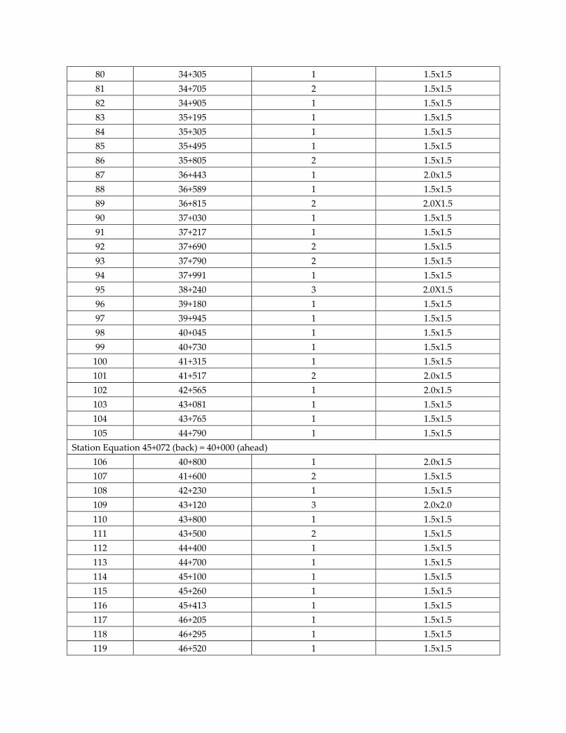
80 34+305 1 1.5x1.5
81 34+705 2 1.5x1.5
82 34+905 1 1.5x1.5
83 35+195 1 1.5x1.5
84 35+305 1 1.5x1.5
85 35+495 1 1.5x1.5
86 35+805 2 1.5x1.5
87 36+443 1 2.0x1.5
88 36+589 1 1.5x1.5
89 36+815 2 2.0X1.5
90 37+030 1 1.5x1.5
91 37+217 1 1.5x1.5
92 37+690 2 1.5x1.5
93 37+790 2 1.5x1.5
94 37+991 1 1.5x1.5
95 38+240 3 2.0X1.5
96 39+180 1 1.5x1.5
97 39+945 1 1.5x1.5
98 40+045 1 1.5x1.5
99 40+730 1 1.5x1.5
100 41+315 1 1.5x1.5
101 41+517 2 2.0x1.5
102 42+565 1 2.0x1.5
103 43+081 1 1.5x1.5
104 43+765 1 1.5x1.5
105 44+790 1 1.5x1.5
Station Equation 45+072 (back) = 40+000 (ahead)
106 40+800 1 2.0x1.5
107 41+600 2 1.5x1.5
108 42+230 1 1.5x1.5
109 43+120 3 2.0x2.0
110 43+800 1 1.5x1.5
111 43+500 2 1.5x1.5
112 44+400 1 1.5x1.5
113 44+700 1 1.5x1.5
114 45+100 1 1.5x1.5
115 45+260 1 1.5x1.5
116 45+413 1 1.5x1.5
117 46+205 1 1.5x1.5
118 46+295 1 1.5x1.5
119 46+520 1 1.5x1.5

120 46+625 1 1.5x1.5
121 47+000 3 2.5x2.5
122 47+080 1 2.0x1.5
123 47+310 3 2.0x1.5
124 47+425 2 1.5x1.5
125 48+125 3 1.5x1.5
126 48+300 1 1.5x1.5
127 48+529 1 1.5x1.5
128 50+035 1 1.5x1.5
129 50+399 1 1.5x1.5
130 50+670 1 1.5x1.5
131 50+970 1 1.5x1.5
132 51+285 1 1.5x1.5
133 51+330 1 1.5x1.5
134 51+425 2 2.0x1.5
135 51+700 1 1.5x1.5
136 52+080 1 1.5x1.5
137 52+850 1 1.5x1.5
138 53+115 2 2.0x1.5
139 53+720 1 1.5x1.5
140 54+115 1 1.5x1.5
141 54+170 1 1.5x1.5
142 54+325 1 1.5x1.5
143 54+450 1 1.5x1.5
144 54+590 1 1.5x1.5
145 54+670 1 1.5x1.5
146 54+730 3 2.0x2.0
147 54+980 2 2.0x1.5
148 55+585 1 1.5x1.5
149 56+030 1 1.5x1.5
150 57+565 2 2.0x1.5
151 57+645 3 2.0x1.5
152 59+070 1 1.5x1.5
153 59+705 1 1.5x1.5
154 60+410 1 2.0x1.5
155 60+646 1 1.5x1.5
156 61+250 2 2.0x1.5
157 61+285 1 1.5x1.5
158 61+370 2 2.0x2.0
159 62+485 1 1.5x1.5
160 62+930 1 1.5x1.5

161 63+420 2 2.0x1.5
162 63+782 1 1.5x1.5
163 65+183 1 1.5x1.5
164 65+734 1 1.5x1.5
165 65+815 3 2.0x2.0
166 67+054 1 1.5x1.5
167 67+670 3 2.0x2.0
168 68+059 1 1.5x1.5
169 70+808 1 1.5x1.5
170 73+899 1 1.5x1.5
171 74+665 1 2.0x1.5
172 75+505 1 1.5x1.5
173 75+810 1 1.5x1.5
174 76+291 1 1.5x1.5
175 76+710 1 2.0x1.5
176 78+135 1 1.5x1.5
177 79+345 1 1.5x1.5
178 81+065 1 1.5x1.5
179 82+895 1 1.5x1.5
180 83+775 3 2.5x2.5
181 84+391 1 1.5x1.5
182 85+117 1 1.5x1.5
183 86+150 1 1.5x1.5
184 86+290 3 2.0x2.0
185 86+681 1 1.5x1.5
186 86+910 1 1.5x1.5
187 86+940 1 1.5x1.5
188 87+560 1 1.5x1.5
189 87+885 1 1.5x1.5
190 88+070 1 1.5x1.5
191 88+199 1 1.5x1.5
192 89+590 1 1.5x1.5
193 92+030 1 2.0x1.5
194 92+356 1 1.5x1.5
195 92+950 1 1.5x1.5
196 95+775 1 1.5x1.5
197 95+970 1 1.5x1.5
198 95+985 1 1.5x1.5
199 96+025 1 1.5x1.5
200 96+171 1 1.5x1.5
201 96+365 1 1.5x1.5

202 97+690 1 1.5x1.5
203 97+761 1 1.5x1.5
204 97+820 1 1.5x1.5
205 97+955 3 2.5x2.0
206 98+045 1 1.5x1.5
207 98+090 3 2.5x2.5
208 99+265 1 1.5x1.5
209 99+845 1 1.5x1.5
210 100+022 1 1.5x1.5
211 100+709 1 1.5x1.5
212 101+420 1 1.5x1.5
213 101+892 1 1.5x1.5
214 103+410 1 1.5x1.5
215 104+853 1 1.5x1.5
216 106+079 1 1.5x1.5
217 106+882 1 1.5x1.5
218 107+505 1 1.5x1.5
219 107+610 1 2.0x1.5
220 107+790 1 2.0x1.5
221 107+840 1 1.5x1.5
222 108+684 1 1.5x1.5
223 109+125 1 2.0x1.5
224 109+702 1 1.5x1.5
225 110+391 1 1.5x1.5
226 111+375 1 1.5x1.5
227 111+500 2 2.0x2.0
228 112+725 1 1.5x1.5
229 112+833 1 1.5x1.5
230 113+172 1 1.5x1.5
231 113+625 2 1.5x1.5
232 114+042 1 1.5x1.5
233 114+320 3 2.0x2.0
234 114+862 1 1.5x1.5
235 116+470 1 1.5x1.5
236 116+620 1 1.5x1.5
237 116+776 1 1.5x1.5
238 117+000 1 1.5x1.5
239 117+899 1 1.5x1.5
240 118+561 1 1.5x1.5
241 118+920 2 2.5x2.0
242 119+130 1 1.5x1.5

243 120+788 1 1.5x1.5
244 122+338 1 1.5x1.5
245 122+944 1 1.5x1.5
246 124+320 2 1.5x1.5
247 124+500 2 2.0x1.5
248 124+655 2 2.0x1.5
249 125+105 2 2.0x2.0
250 126+590 2 2.0x2.0
251 126+660 1 1.5x1.5
252 128+014 1 1.5x1.5
253 128+880 1 1.5x1.5
254 128+935 3 2.0x1.5
255 130+086 1 1.5x1.5
256 130+696 1 1.5x1.5
257 130+920 1 1.5x1.5
258 132+160 1 1.5x1.5
259 132+660 1 1.5x1.5
260 133+735 1 1.5x1.5
261 135+300 1 1.5x1.5
262 135+530 1 1.5x1.5
263 135+700 1 1.5x1.5
264 135+800 1 1.5x1.5
265 136+300 1 1.5x1.5
266 136+340 1 1.5x1.5
267 137+038 1 1.5x1.5
268 137+120 1 1.5x1.5
269 137+688 1 1.5x1.5
270 139+110 3 2.0x2.0
271 139+693 1 1.5x1.5
272 142+235 1 1.5x1.5
273 143+655 1 1.5x1.5
274 143+910 3 2.0x2.0
275 143+930 1 1.5x1.5
276 144+662 1 1.5x1.5
277 151+420 3 2.5x2.5
278 152+251 1 1.5x1.5
279 154+863 1 1.5x1.5
280 155+760 1 1.5x1.5
281 155+810 1 1.5x1.5
282 155+935 1 1.5x1.5
283 156+020 1 1.5x1.5

284 156+085 1 1.5x1.5
285 156+230 1 1.5x1.5
286 156+420 1 1.5x1.5
287 156+460 1 1.5x1.5

List of Machinery
Sr. No RD
Name of Machine As per Site From To
1
0+000 164+000
Excavator 56
2 Air-Compressor 42
3 Dyna Mazda 12
4 Concrete Mixer 23
5 Dozer 7
6 Loader 32
7 Tractor Trolleys 42
8 Dumper 49
9 Generator 17
10 Bulldozer 1
11 Water Pump 7
12 Fuel Bozer 4
13 Grader 11
14 Roller 12
15 Water Bozer 24
16 Vehicles 43
Total 382
ANNEX-E

ANNEX‐F
Results of Air Quality Monitoring at Gamba
Sr. No.
Date ‐ Time CO NO NO2 SO2 O3 PM2.5 PM10
mg/m3 μg/m3 μg/m3 μg/m3 μg/m3 μg/m3 μg/m3
1 8/5/2018 15:08 0.21 1.22 5.59 0.56 2.19 24.21 71.36
2 8/5/2018 16:08 0.28 1.80 6.63 0.92 5.19 29.03 73.89
3 8/5/2018 17:08 0.17 1.31 5.75 0.69 3.18 28.08 83.98
4 8/5/2018 18:08 0.19 1.43 5.97 0.74 3.70 26.66 86.68
5 8/5/2018 19:08 0.22 1.49 6.06 0.78 3.89 26.95 80.21
6 8/5/2018 20:08 0.21 1.48 6.04 0.77 3.85 26.88 76.67
7 8/5/2018 21:08 0.26 1.64 6.32 0.85 4.48 27.88 90.65
8 8/5/2018 22:08 0.29 1.07 5.16 0.75 2.43 23.47 98.68
9 8/5/2018 23:08 0.30 1.10 6.44 1.24 3.97 31.21 96.72
10 8/6/2018 0:08 0.44 1.55 6.22 1.15 3.70 29.87 102.04
11 8/6/2018 1:08 0.36 1.28 5.63 0.95 3.00 26.47 95.70
12 8/6/2018 2:08 0.28 1.33 5.71 0.98 3.10 26.97 96.60
13 8/6/2018 3:08 0.58 2.05 5.78 1.71 3.08 28.79 83.72
14 8/6/2018 4:08 0.50 1.75 5.03 1.34 2.83 26.69 98.77
15 8/6/2018 5:08 0.53 1.70 5.09 1.23 2.87 26.52 91.17
16 8/6/2018 6:08 0.42 1.45 4.59 0.77 2.55 24.19 92.88
17 8/6/2018 7:08 0.61 1.90 4.32 0.53 2.39 22.92 99.43
18 8/6/2018 8:08 0.64 1.98 5.65 0.70 2.52 23.72 84.47
19 8/6/2018 9:08 0.36 1.55 5.25 0.99 3.47 31.44 97.43
20 8/6/2018 10:08 0.15 1.07 5.04 0.78 2.95 28.80 91.85
21 8/6/2018 11:08 0.14 1.04 5.02 0.76 2.91 28.60 93.07
22 8/6/2018 12:08 0.16 1.09 5.06 0.80 2.96 28.87 91.96
23 8/6/2018 13:08 0.12 0.98 5.00 0.73 2.81 28.10 92.26
24 8/6/2018 14:08 0.30 1.33 5.19 1.12 3.65 32.25 98.64
AVERAGE 0.32 1.44 5.52 0.91 3.24 27.44 90.37
MINIMUM 0.12 0.98 4.32 0.53 2.19 22.92 71.36
MAXIMUM 0.64 2.05 6.63 1.71 5.19 32.25 102.04
NEQS 5 40 80 120 80.00 35.00 150.00

Results of Air Quality Monitoring at Shengus
Sr. No.
Date ‐ Time CO NO NO2 SO2 O3 PM2.5 PM10
mg/m3 μg/m3 μg/m3 μg/m3 μg/m3 μg/m3 μg/m3
1 8/6/2018 20:03 0.33 1.56 6.32 0.97 4.61 28.10 70.86
2 8/6/2018 21:03 0.29 1.82 5.77 0.65 3.18 25.81 76.62
3 8/6/2018 22:03 0.13 1.16 5.48 1.00 3.05 25.60 83.31
4 8/6/2018 23:03 0.14 1.18 5.50 1.00 2.86 27.54 82.26
5 8/7/2018 0:03 0.30 1.80 6.81 0.99 5.83 30.06 77.22
6 8/7/2018 1:03 0.22 1.60 6.38 0.65 4.84 28.48 72.16
7 8/7/2018 2:03 0.26 1.81 6.77 0.63 5.69 28.79 86.34
8 8/7/2018 3:03 0.17 1.22 5.77 0.65 3.33 26.03 84.72
9 8/7/2018 4:03 0.25 1.66 6.37 0.63 4.61 28.10 70.86
10 8/7/2018 5:03 0.27 1.76 6.57 0.90 5.06 28.82 73.23
11 8/7/2018 6:03 0.30 1.88 6.77 0.97 5.52 29.55 75.57
12 8/7/2018 7:03 0.16 1.22 5.60 0.63 2.86 27.54 82.26
13 8/7/2018 8:03 0.17 1.35 5.83 0.70 3.38 26.11 84.97
14 8/7/2018 9:03 0.18 1.41 5.95 0.73 3.65 26.55 75.68
15 8/7/2018 10:03 0.28 1.91 6.85 0.96 5.69 28.79 86.34
16 8/7/2018 11:03 0.14 1.29 5.72 0.66 3.15 25.75 83.82
17 8/7/2018 12:03 0.19 1.33 5.81 0.69 3.33 26.03 84.72
18 8/7/2018 13:03 0.22 1.69 6.45 0.86 4.79 24.38 71.91
19 8/7/2018 14:03 0.12 1.10 5.38 0.75 3.78 26.76 79.67
20 8/7/2018 15:03 0.27 1.73 6.50 0.89 4.90 28.56 72.35
21 8/7/2018 16:03 0.11 1.02 5.23 0.54 2.01 26.18 77.80
22 8/7/2018 5:03 0.36 1.25 5.55 0.87 2.89 28.91 102.93
23 8/7/2018 6:03 0.44 1.49 6.09 1.10 3.54 29.07 92.76
24 8/7/2018 7:03 0.30 1.09 5.18 0.73 2.46 23.59 98.91
AVERAGE 0.23 1.47 6.03 0.80 3.96 27.30 81.14
MINIMUM 0.11 1.02 5.18 0.54 2.01 23.59 70.86
MAXIMUM 0.44 1.91 6.85 1.10 5.83 30.06 102.93
NEQS 5 40 80 120 80.00 35.00 150.00

Results of Air Quality Monitoring at Dambudaass
Sr. No.
Date ‐ Time CO NO NO2 SO2 O3 PM2.5 PM10
mg/m3 μg/m3 μg/m3 μg/m3 μg/m3 μg/m3 μg/m3
1 8/4/2018 9:44 0.11 1.18 8.35 1.15 3.67 28.48 91.26
2 8/4/2018 10:44 0.14 1.16 8.34 1.16 3.59 28.41 83.45
3 8/4/2018 11:44 0.22 1.92 8.91 1.20 4.67 31.00 99.55
4 8/4/2018 12:44 0.11 1.02 5.23 0.54 4.01 26.18 77.77
5 8/4/2018 13:44 0.19 1.35 5.81 0.70 3.33 26.03 77.31
6 8/4/2018 14:44 0.14 1.19 5.55 0.62 4.15 27.36 89.03
7 8/4/2018 15:44 0.28 1.70 6.41 0.56 2.16 24.15 71.16
8 8/4/2018 16:44 0.16 1.36 5.84 0.71 3.43 26.21 85.23
9 8/4/2018 17:44 0.14 1.52 6.12 0.78 4.03 27.17 81.00
10 8/4/2018 18:44 0.21 1.45 6.00 0.94 5.21 29.05 87.05
11 8/4/2018 19:44 0.43 1.43 5.97 1.05 3.41 28.32 91.37
12 8/4/2018 20:44 0.28 1.05 5.09 0.89 2.96 26.15 95.18
13 8/4/2018 21:44 0.29 1.04 5.08 0.88 2.95 26.11 97.78
14 8/4/2018 22:44 0.35 1.22 5.26 0.75 2.53 23.98 99.66
15 8/4/2018 23:44 0.47 1.52 6.16 1.14 3.64 29.42 93.40
16 8/5/2018 0:44 0.45 1.45 5.04 0.67 2.29 22.75 105.19
17 8/5/2018 1:44 0.65 2.04 5.78 1.58 3.11 28.40 95.66
18 8/5/2018 2:44 0.53 1.72 5.13 1.25 2.88 26.72 91.63
19 8/5/2018 3:44 0.55 1.75 5.16 1.30 2.92 29.84 99.06
20 8/5/2018 4:44 0.61 1.79 5.26 1.38 2.98 27.24 100.13
21 8/5/2018 5:44 0.56 1.77 5.21 1.34 2.95 26.99 99.51
22 8/5/2018 6:44 0.37 1.41 4.47 0.66 2.47 23.82 92.04
23 8/5/2018 7:44 0.39 1.53 5.28 1.01 3.44 31.32 97.21
24 8/5/2018 8:44 0.15 1.03 5.03 0.76 2.87 28.45 96.14
AVERAGE 0.32 1.44 5.85 0.96 3.32 27.23 91.53
MINIMUM 0.11 1.02 4.47 0.54 2.16 22.75 71.16
MAXIMUM 0.65 2.04 8.91 1.58 5.21 31.32 105.19
NEQS 5 40 80 120 80.00 35.00 150.00


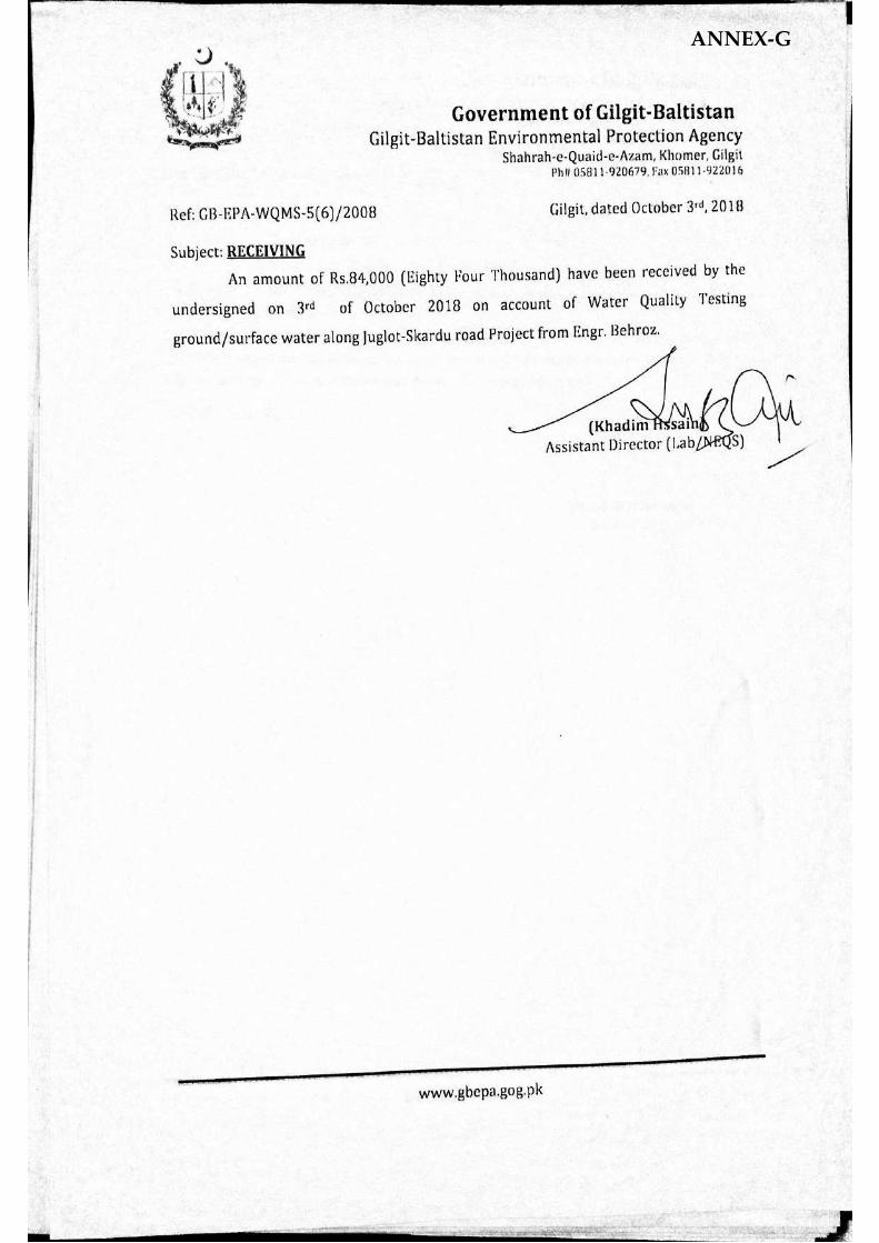
ANNEX-G


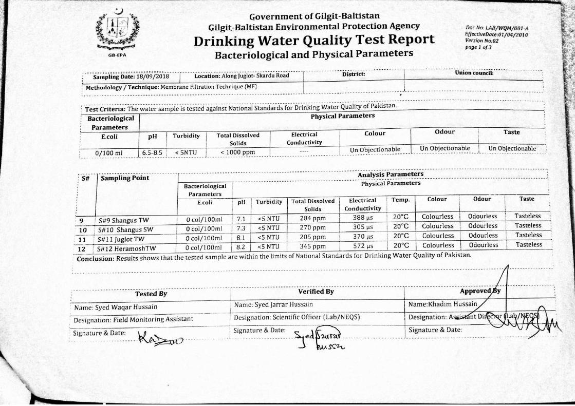


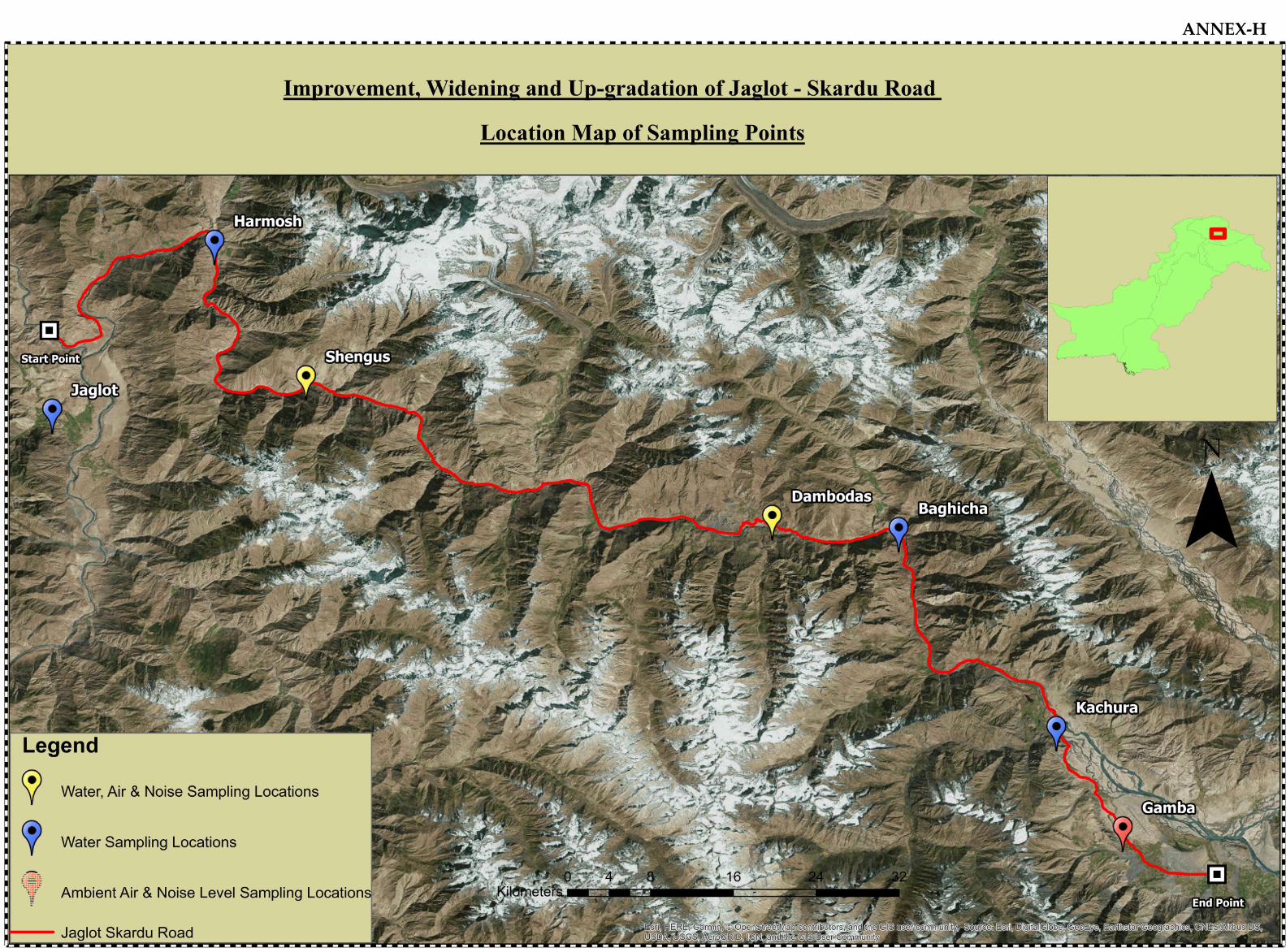
ANNEX-H

ANNEX-I


Sr. No.
Name (Designation and Department with office
address)
Contact No.
Email address Signature PTCL Mobile No.
1. Abdul Latif Shaikh (AD)
NHA 03555744766
2. Shahid Hussain Qureshi AER 0306212666
3.
Zahid Ali Khan (Deputy
Director Agriculture
Skurdu) 03445952262
4. Inayat Ali
5. Wildlife (Range Forset
Officer) 03555224536
6. Mohammad Ishaq
(Mines and Minerals) 03119806493
7. Dr. Fida Hussain (DD
Livestock) 03555552120
8. Muhammad Qader (E
Engineer) 03101555725
9. Taj Muhammad (XEN
B&R) 03555550357
10. Shair Ali (RFO (???) 03556055307
11. Muhammad Bashir
(SWO) 03418995340
12. Najaf Ali (SDO HQ) 03469555801
13. Shehzad Burg (Assistant
Director) 03555551581
14. Major Adnan (SCO)
15.
Ghulam Muhammad
(Industrial department)
Incharge Skd (Admin) 03465394435
16.
Mohd. Hassan (DK‐
District Qanomgi)
Revenue Department 03465530875
17. Ghulam Muhammad
Nasir (DDE Skd) 960009 035551871
18. Iftikhar Hussain (AEO) 03555555770
19. Akhtar Hussain (Dy
DEO) 03555037872
Representatives from the Concerned Departments for Stakeholder Meeting
ANNEX-J

Scanned Attendance Sheet of the Representatives from various Departments


Agricultural Land Residential
Buildings
Commercial
Buildings
Mosques (Religeous
Places) Areas Electric Poles Telephones Poles
Sq. M Sq. M Sq. M Sq. M No. No.
KM 00+000 KM 10+000 0 249 0 25 1 0
KM 10+000 KM 20+000 0 297 0 49 13 0
KM 20+000 KM 30+000 858 1273 1832 30 47 7
KM 30+000 KM 40+000 2447 1123 403 0 4 0
KM 40+000 KM 50+000 0 137 113 93 0 0
KM 50+000 KM 60+000 0 121 13 16 4 0
KM 60+000 KM 70+000 0 214 0 0 55 0
KM 70+000 KM 80+000 0 1195 10 37 23 0
KM 80+000 KM 90+000 532 1254 268 62 0 0
KM 90+000 KM 100+000 6603 2529 3637 105 56 0
KM 100+000 KM 110+000 6647 243 374 0 122 0
KM 110+000 KM 120+000 18839 1085 109 12 109 0
KM 120+000 KM 130+000 0 942 304 0 29 0
KM 130+000 KM 140+000 18980 735 84 105 54 0
KM 140+000 KM 150+000 33320 442 666 0 30 9
KM 150+000 KM 155+476 0 4886 631 37 109 23
88226 16725 8444 571 656 39
Start RD End RD
Total
Annex-K

Settlement's Names Design RD Existing RD
Hanuchal KM 22+100 21+700
Sassi KM 26+600 26+100
Shahbtot KM 30+100 29+700
Shungus KM 47+000 51+900
Maloopa KM 68+000 73+650
Astak KM 72+300 78+000
Triko KM 86+300 92+200
Dambodas KM 95+500 102+100
Baghicha KM 107+000 113+800
Tungush KM 112+500 119+400
Garbidas KM 117+700 124+200
Chari KM 126+000 133+100
Kachura KM 135+800 143+150
Hoto KM 145+800 152+550
Gamba KM 149+200 156+650
Skardu KM 155+600 163+150
Annex-L
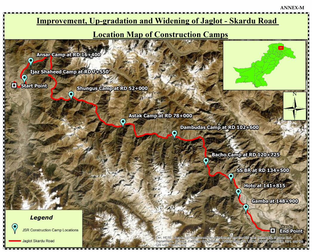
ANNEX-M


2
CAMP LAYOUT
Bdy/Wall
Fence
Offices
Soldiers
Mess
MT/Plt
Officers
Living
Soldiers
LivingToilets
M/ Gate
Car parking
Mosque
POL Shed
OP-2
OP-3
OP-4
OP-1
Stores
Septic
Tank
Garbage
Disposal Point
Officers
Wash Room
Cook
House
W/Tank
*
ANNEX-N

ANNEX-O