Imaging Sarajevo, Recomposing the city and territory
12
the next urban question Valentina Bandieramonte, Chiara Cavalieri, Irene Guida, Kaveh Rashidzadeh eds. Q6 the next urban question Q6 officina edizioni the next urban question 40206 € 30,00 Q1 Scenari, a cura di Maria Chiara Tosi Q2 New Territories, a cura di Paola Viganò Q3 Comment vivre ensemble, a cura di Paola Pellegrini e Paola Viganò Q4 Storie del futuro, di Paolo Bozzuto, Andrea Costa, Lorenzo Fabian, Paola Pellegrini Q5 Landscapes of urbanism, a cura di Viviana Ferrario, Angelo Sampieri, Paola Viganò Q6 The Next Urban Question, a cura di Valentina Bandieramonte, Chiara Cavalieri, Irene Guida, Kaveh Rashidzadeh This volume explores the multifaceted aspects of the next urban question. Today, after the growing crises and uncertainties that have introduced great challenges to the ways we are used to living in the urban world, a new ‘urban question’ needs to be identified in three main aspects, as Bernardo Secchi states, and Paola Viganò affirms – namely, the growing distance between the rich and the poor, the mobility crises and the environmental risks. All these three aspects are to be engaged with research by design, adopting an approach that, on the first matter, entails defining the issue of spatial justice, questioning the ways social opportunity is spatially distributed and seeking other ways to foster equitable forms of spatial differentiation in light of the right to the city. That, secondly, entails broaching the mobility question that, in a broader sense, poses a threat as new (neo liberal) governance models introduce new, harder lines of inclusion and exclusion between plugged and unplugged, connected and bypassed groups and individuals. That, on the third matter, entails raising the issue of a democratic solution to tackle the environmental crisis and face climate change as well as demanding a critical review of the ways in which urbanism has began to encroach on the ecological agenda. And that finally, entails accepting the fact these three aspects demand a new engagement of design on different scales, building new arenas of designerly research and original knowledge production. Taking up this engagement requires reflection on the epistemological status of design, on the role of design in the exploration of alternative futures, on its capacity to bring about effective change. This book is a collection of essays originally presented in the VI international PhD seminar “Urbanism and Urbanisation” at the Iuav, University of Venice, in October 2011, scientifically peer reviewed by a substantial network of scholars in urbanism. 9 788860 491220 9788860491220 ISBN
Transcript of Imaging Sarajevo, Recomposing the city and territory

the next urban questionValentina Bandieramonte, Chiara Cavalieri, Irene Guida, Kaveh Rashidzadeh eds.
Q6 the next urban question
Q6officina edizioni
the n
ext urban
qu
estion40206€ 30,00
Q1 Scenari, a cura di Maria Chiara TosiQ2 New Territories, a cura di Paola ViganòQ3 Comment vivre ensemble, a cura di Paola
Pellegrini e Paola ViganòQ4 Storie del futuro, di Paolo Bozzuto, Andrea
Costa, Lorenzo Fabian, Paola PellegriniQ5 Landscapes of urbanism, a cura di Viviana
Ferrario, Angelo Sampieri, Paola ViganòQ6 The Next Urban Question, a cura di Valentina
Bandieramonte, Chiara Cavalieri, Irene Guida, Kaveh Rashidzadeh
This volume explores the multifaceted aspects of the next urban question. Today, after the growing crises and uncertainties that have introduced great challenges to the ways we are used to living in the urban world, a new ‘urban question’ needs to be identified in three main aspects, as Bernardo Secchi states, and Paola Viganò affirms – namely, the growing distance between the rich and the poor, the mobility crises and the environmental risks. All these three aspects are to be engaged with research by design, adopting an approach that, on the first matter, entails defining the issue of spatial justice, questioning the ways social opportunity is spatially distributed and seeking other ways to foster equitable forms of spatial differentiation in light of the right to the city. That, secondly, entails broaching the mobility question that, in a broader sense, poses a threat as new (neo liberal) governance models introduce new, harder lines of inclusion and exclusion between plugged and unplugged, connected and bypassed groups and individuals. That, on the third matter, entails raising the issue of a democratic solution to tackle the environmental crisis and face climate change as well as demanding a critical review of the ways in which urbanism has began to encroach on the ecological agenda. And that finally, entails accepting the fact these three aspects demand a new engagement of design on different scales, building new arenas of designerly research and original knowledge production. Taking up this engagement requires reflection on the epistemological status of design, on the role of design in the exploration of alternative futures, on its capacity to bring about effective change.This book is a collection of essays originally presented in the VI international PhD seminar “Urbanism and Urbanisation” at the Iuav, University of Venice, in October 2011, scientifically peer reviewed by a substantial network of scholars in urbanism.
9 788860 491220
9788860491220ISBN

Università Iuav di Venezia
PhD program in Urbanism, School of Doctorate Studies, Iuav University of VeniceCordinator: Paola ViganòFaculty members: Roberto Masiero, Marcello Mamoli, Munarin Stefano, Tosi Chiara, Paola ViganòCristina Bianchetti, Luc Baboulet, Michiel DehaeneFranco Mancuso, Giusa Marcialis, Bernardo Secchi, Mirko ZardiniTutors: Lorenzo Fabian, Viviana Ferrario, Fabrizio Paone, Paola Pellegrini, Andrea Petrecca, Angelo Sampieri
Iuav, Scuola di dottorato, Palazzo Badoer, Veneziawww.iuav.it/Didattica1/SCUOLA_DI_/index.html
The Next Urban Question. Themes, Approaches, ToolsVI PhD Seminar Urbanism&UrbanizationVenice 27/29 October 2011
uu2011.blogspot.it
Quaderno del Dottorato in Urbanistica n 6 - settembre 2013
the next urban questionValentina Bandieramonte Chiara Cavalieri Irene Guida Kaveh Rashidzadeh eds.

CONTENTS
THE NEXT URBAN QUESTIONPaola Viganò
on spatial justiceIntroduction Kaveh Rashidzadeh
Spatiality of Injustice and the Geography of Evils Kaveh Rashidzadeh
What is Trialectics? Genealogy of a theory of space Daniele Vazquez The Space “in-between Things”: Some observations about justice and the project of landscape and open space Monica Bianchettin Del Grano “Wir wollen die IBA bei uns!” A brief history of the Internationale Bauausstellung Berlin in Kreuzberg Davide Cutolo The Squatted New Town: Modernism meets informality, Venezuelan cases Simone Rots The Question of Public Space in Mexico City’s Informal AreasCaterina Pregazzi Informal Construction and Poverty: Case study of Dugi RatIvana Katuric Imaging Sarajevo: Recomposing the city and territory Armina Pilav Excessive Otherness: Thick city as just cityOrit Shmueli, Iris Aravot
p. 11
16
19
29
39
49
61
71
85
99
109
99
on s
pacia
l ju
stic
e
Imaging Sarajevo
Recomposing the city and territory
Armina Pilav1
This is a paper about the city of Sarajevo as a fundamental and constituent part of a rapidly urbanizing territory undergoing transition. The transition from a socialist system of governance and production of space (1945-92), the onset of war and subsequent destruction of existing social and spatial formations (1992-95) - an act of planned urbicide - was followed by postwar social and spatial manipulations that have led to conditions for the creation of a new society, a new city, and an emerging territory. The aims of this paper are to explore imaging process of Sarajevo’s citizens after the territorial division of the city imposed by the Dayton peace agreement in 1995, and to reflect on the concept of recomposition of the cities ongoing postwar transformations. The creators of the division of Bosnia and Herzegovina into two entities were using a map scale of 1:600 000. Result of this political act is the inter-entity boundary line, which cuts through houses, lands, dwelling blocks, and city public green zones dividing them in two. As the case study of spatial division and (in)justice I will take Sarajevo’s inter-entity boundary line crossing the Dobrinja neighborhood. The paper also intends examining if and in what way the processes of the imaging of divided Dobrinja by its citizens can give any contribution to the discussion on spatial and social justice.
INTRODUCTIONSarajevo drew world attention during the XIV Winter Olympic Games in 1984 and subsequently, almost a decade later, when the Bosnian war started in 1992. In spatial terms, these two events radically transformed Sarajevo’s urban form and image, fueling and influencing the way its citizen’s envisage the city today. With its Ottoman and Austro-Hungarian legacy, Sarajevo has always been seen as a place where east and west met, an intersection that is still visible within the urban layout and architecture of the city. During Tito’s Yugoslavia, the image of Sarajevo was held up as the representation of the Yugoslavian dream of brotherhood and unity; multi-national Bosnia-Herzegovina was an example of “Yugoslavia on a small scale” (Dizdareviü 2000, p.27). Today, as a result of the Dayton Peace Accords2, Sarajevo is divided between two entities: the Federation of Bosnia-Herzegovina and the Republic of Srpska, subject to the two parallel-opposing administrations of Bosnian Federation Sarajevo and East Sarajevo. Mine is the wish to highlight the fact that contemporary Sarajevo is the encounter of two different cultural and administrative territories that contain several real and imagined cities: Ottoman, Austro-Hungarian, Olympic, Socialist, Postwar, multicultural, physically fragmented, contested, build-it-yourself, and others. With all its hybridisation Sarajevo is a puzzle city, where “the image of the puzzle is not composed, it is recomposed” (Ampoux 1997, p.73) again and again. In this or in any other complex urban environment, the “contestation inside cities”
left: [fig.1] Political Map of Bosnia and Herzegovina from 2002. Black line is IEBL through Bosnia and Herzegovina. Source: [online] available at <http://www.vmapas.com/Europa/Bosnia-Erzegovina/Mappa_Politica_Bosnia-Erzegovina_2002.jpg/maps-it.html> [accessed 25 may 2013].
100
(Harvey 1997, p.27) and spatial justice become an urban subject, such as planning or imagining the city. Sarajevo’s territory has always been a part of contested worlds (Phillips 2005, p.3). Using the inter entity boundary line that passes through Dobrinja as a case study, this article examines how people imagine this space in relation to how dual governance effects its political organization; and ponders on whether the process of imaging can contribute to the discussion about this or any other contested space, and if the space can be a just space.
IMAGING PROCESS FOR RECOMPOSING THE CITY AND TERRITORYThe process – “something going on: proceeding”3 in and above the city. I assume that the imaging process contains all kinds of happenings in and above the city; it is rooted in the past while forging the present or future of our cities. Imaginating is the citizen’s intentionally directed process of ‘imaginating’ the city, grounded in “verbal and non-verbal signs” (Lefebvre 1992, p.48). I assume that each person (citizen) is able to project a series of images that are related to their experience of a certain space. These are processes of image making done using different media to express our thoughts or experiences in relation to our city. In these processes, the body relies on already existing city and territorial space and creates different images of urban scenarios for the new space. According to Bernardo Secchi: “Scenarios and strategies (…) are not the ways of representing a “weak philosophy”; on the contrary they are conceptual places where the confrontation between a multitude of strong rationalities in partial or radical opposition to each other are built” (Secchi 2000, p.172). The imaging process can rely on the real world as well as the imaginary world. Even if Susan Sontag in her book ‘On Photography’ states: “In the real world, something is happening and no one knows what is going to happen next. In the image-world, it has happened and it will forever happen in that way” (Sontag 2005, p.131). It is easy to think that imaging processes start from images, but images could also be the result of imaging process, while the process of imaginating relates the image and the imaging process in both cases. Besides photographic images of the city, I will also consider image creating through writing poetry, a tourist guide, making a film, writing a story, crossing the city, making an art work, making an urban and architectural project about the city, recycling the existing architectural objects while changing their shape and meanings, etc. All these activities are interrelated; they rely on the common material base – city and territory, where the imaging process helps break up the city and territory in a given way, in order to put the parts back together again. During the field research in Sarajevo and for this specific paper, I have chosen one single element related to the imaging process of the city and territory that I will present in the following text with a micro story. Results of this process could be used for the recomposing of the city of Sarajevo and its territory. In this case the selected element as the material base within the city and territory of the citizens’ imaging process is the inter entity boundary line (IEBL) passing through Sarajevo’s Dobrinja neighborhood.
ONE SEGMENT OF THE SARAJEVO’S INTER-ENTITY BOUNDARY LINE AS A CASE STUDYBordering Bosnia and Herzegovina
“During the war we learned about the boundaries of our homeland. Tito gave her AVNOJ4 borders. According to them Bosnia is heart shaped. Clinton gave her Dayton’s borders. These borders look like a cancerogenous bloodstream” (Jergoviü 2006, p.36), as in [fig.1].

101
on s
pacia
l ju
stic
e
Politically and administratively, the Dayton Peace Agreement started the construction of a new Bosnia-Herzegovina based on ethnic divisions. The creators of the peace accord who divided Bosnia into two entities, the Federation of Bosnia-Herzegovina and the Republic of Srpska, were using a map scale of 1:600 ,000. “This document defines our constitutional and social identity. A clumsy division of the Bosnian-Herzegovinian world and Bosnian-Herzegovina as a country into two approximate parts, which had previously never existed as a political and geographical expression of Bosnian-Herzegovinian history, but that as a map, defines our present and our future (…)” (ûurak 2011, p. 21). The International community that is still present in our territory followed the implementation of the Dayton Peace Agreement5. The manner in which Bosnia-Herzegovina was divided exacerbated the already conflictual administration of the two entities. A major sore is the inter-entity boundary line that passes through Sarajevo’s Dobrinja I and IV blocks, with one part belonging to Sarajevo, the capital of the Federation of Bosnia and Herzegovina, and the other to East Sarajevo in the Republic of Srpska.
Dobrinja Inter Entity Boundary Line (IEBL)6
“Unlike limits, which suggest a connotation of finality, boundaries are there to be negotiated. They exclude as well as include. They mark transformation between sanity and insanity, health and illness, life and death, between acquaintance and friendship, friendship and love” (King 2007, pp. I-I4). Dobrinja is one of the biggest of Sarajevo’s neighborhoods, built in 1983 (Dobrinja I and II) and 1989 (Dobrinja III, IV and V). The area is named after the river Dobrinja that runs through it. It
[fig.2] Satellite image of Sarajevo, inter entity boundary line shaded. Source: elaborated by the author.
Dobrinja in FBiH
Park Suma Mojmilo
IEBL
Part of Dobrinja in Republic of Srpska

102
was built primarily as a residential area for athletes participating in the Winter Olympic Games held in 1984 in Sarajevo. Immediately after the Olympics, the flats were allocated to the citizens of Sarajevo. Dobrinja has around 40,000 inhabitants. It is located in the municipality of Novi Grad. During the Bosnian war (1992-1996) Dobrinja was cut off from the rest of the city. Due to constant shelling and fire from the front line, there was a great loss of life among the civilian population and much destruction, especially in the area of Dobrinja IV and V. Today, Dobrinja lies carved in two by the Inter Entity Boundary Line (IEBL), making it a place of division and differences. A result of the Dayton peace agreement, the IEBL was drawn up to pass through the housing blocks of Dobrinja IV and I [fig.2], dividing flats in such as way that in some instances the balcony and kitchen lie in East Sarajevo (Republic of Srpska), while the bathroom and other rooms are located in the Bosnian administered main part of the city.Throughout the war period people migrated to Sarajevo from all corners of the country. Thus families from other parts of Sarajevo or from its outlying areas came to inhabit the apartments divided by the inter-entity boundary line in Dobrinja I and IV. The examination of this specific urban site contributes to the discussion on how on the one hand people remember, live and imagine this space and the political organisation as a result of dual governance of the divided city. The Dayton agreement stipulated that ”seven hundred flats in Dobrinja IV and I would be assigned to the Federation of Bosnia and Herzegovina, while four hundred would go to the Republic of Srpska”7.
According to this agreement the Republic of Srpska was to return part of the area assigned to it by the agreement over to the Federation of Bosnia and Herzegovina in 1996. Implementation of the inter-entity boundary line (IEBL) was also monitored by the Office of High Representative (OHR)8
and by the NATO-led Stabilization Force (SFOR)9, which had the authority to correct it if necessary. Six years after the signing of the peace agreement, the political representatives of the two entities could still not find a solution for Dobrinja, neither did the commander of SFOR do anything to correct the inter-entity boundary line. The pre-war population of Dobrinja IV and I were putting pressure on the local OHR authorities to help them to return to their dwellings, because most of them had been forced to evacuate their homes during the war. This was in accordance with Annex 7 of the Dayton peace agreement10. In the first lines of the Article I: Rights of Refugees and Displaced Person of Annex 7 is written: “All refugees and displaced persons have the right to freely return to their homes of origin. They shall have the right to have restored to them property of which they were deprived in the course of hostilities since 1991 and to be compensated for any property that cannot be restored to them”. Indeed new families who moved in during the war into the others’ dwellings carried out illegal upgrading by adding new spaces in the attics of the building, and converting the common basements into flats [fig.3]. Due to the extenuating to-ing and fro-ing of the local and international administrations, Dobrinja residents lived in a continuing state of uncertainty, neglect and urban decay.To solve this problem High Representative Wolfgang Petrich on 5th February 2001 named Diarmuid P. Sheridan independent arbitrator for the Dobrinja IEBL. The arbitrator had two months time to draw up the IEBL for Dobrinja IV and I. He held numerous meetings with politicians and citizens from both sides before announcing his resolution regarding the case. The arbitrator states that he was not satisfied how the “parties had executed the agreements in Paris and whether they realised the full import of the divisory line as it had been drawn out. I am not satisfied and have not been from a very early stages, that the particular line and its course can be feasibly

103
on s
pacia
l ju
stic
e
upheld. I think that in both cases, in relation to the confrontation line and the line as drawn, the doctrine of mistake is of particular significance as the black line in [fig.3]. If I might quote from a letter received from a citizen of Dobrinja he says, “I ask you, Mr. Sheridan, not to draw any divisory line that divides buildings, flats, bedrooms, living-rooms hallways and bathrooms which would be a most primitive form of behaviour indeed”. I find myself in total agreement with those sentiments”11. Dividing the Dobrinja neighborhood into two entities also brought about many infrastructural problems. Electricity, heating and the water supply all came from the respective station in the Bosnian Federation. The waste from Republic of Srpska part of Dobrinja could not be driven to the city dump in Sarajevo. This part of district was without streetlights for a very long period.“I have become convinced that the almost exclusively persons from the Federation side were dispossessed of their homes and the only matter that my conscience allows me to do is to restore them accordingly. To do this, it is necessary for me to declare and acknowledge that the blocks of flats and the school should be contained within the IEBL line that I propose to have drawn and to this end I wish to refer to the map prepared by Major Bachelor which indicates my decision”12. Following the resolution issued by the arbitrator, and the drawing of the new inter-entity boundary line, the Bosnian Federation was given the two residential blocks, one in Dobrinja IV and one in Dobrinja I [fig.3 and 4].Sarajevo’s municipality of Novi Grad founded a working team that was supposed to implement
[fig.3] The grey line is the inter entity boundary line under the Dayton peace agreement from 1995. The black line is the line that was decided by arbitrator Diarmuid P. Sheridan from 2001. Source: Part of the Sarajevo town plan for Dobrinja from the Faculty of Architecture Sarajevo. Drawing and comparison of the two lines on the map by the author.
N

104what arbitrator Sheridan decided for Dobrinja13. One of the first steps was to go and visit the area, dealing with inhabitants from the “other side” and with residents who knew that they had to vacate the ‘other’ peoples dwellings in a matter of days. Besides the destruction due to the war, that part of the neighborhood had acquired a rural image, green areas had been turned into vegetable gardens, and chicken coops and stables for livestock had been built in front of the buildings. The team for implementation of the arbitrator’s resolution was coordinated by two women, who prior to the arbitrator’s decision decided to visit the “other side” and go to the local coffee bars to talk to people, and the most important thing for them was that they wanted to prove freedom of movement. After the arbitrator’s decision, the working team started to note down and assume the future needs of the neighborhood, so that everything could be normalized. The Sarajevo authorities nominated a team of experts to deal with issues of communal infrastructure that were not dividable. Many meetings were held between the two administrations and the results were as follows: the Republic of Srpska was to take responsibility for the sewage and electricity system; the trolleybus route was to be shortened compared to the pre-war route; responsibility for outdoor cleaning was to be shared between the two entities. After they reached agreement on infrastructure, the implementation of the arbitrator’s decision continued with the returning of the apartments to the pre-war owners. The team in charge for the implementation of the IEBL advocated a permanent dialogue between pre-war and the new users of the flats. According to the working team implementation of the property laws in Dobrinja I and IV was done ten times faster than in other regions. It has been said the way they finally came to an agreement on the level of local authorities as well as among residents of Dobrinja I and IV was one of the good examples of the implementation of institutional
[fig.4] The back of the building that was divided in two by IEBL which runs through the flats. The fence is the only physical sign of the inter entity boundary line which divides a garage between the two entities. Source: picture by the author, 2011.
105
on s
pacia
l ju
stic
e
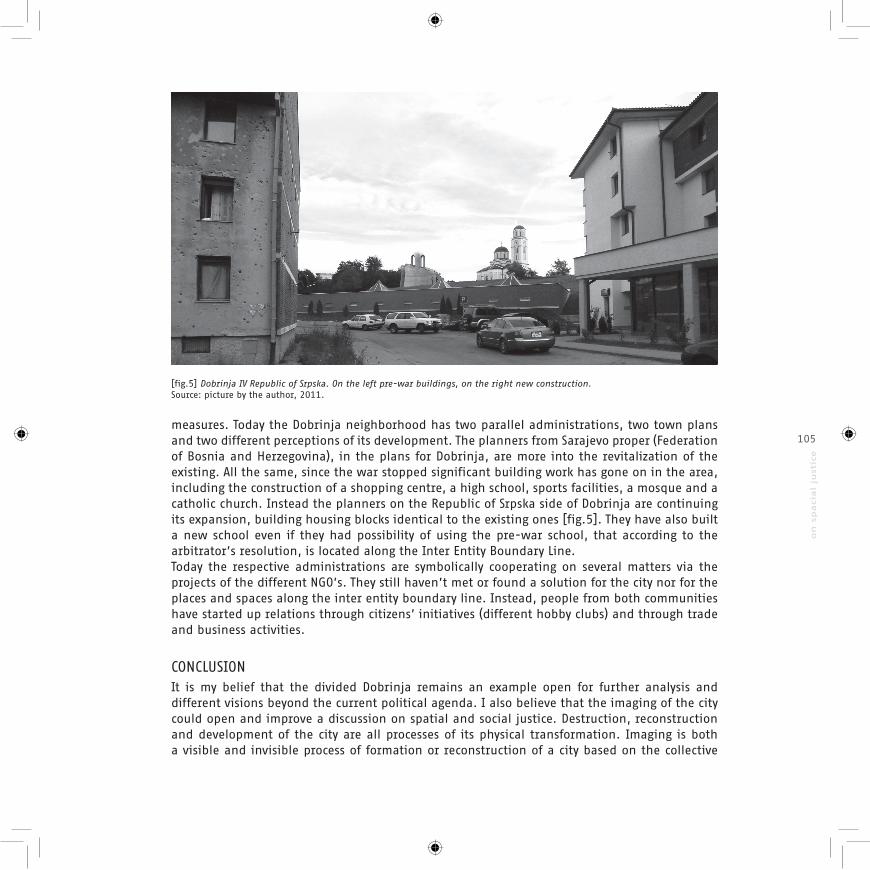
measures. Today the Dobrinja neighborhood has two parallel administrations, two town plans and two different perceptions of its development. The planners from Sarajevo proper (Federation of Bosnia and Herzegovina), in the plans for Dobrinja, are more into the revitalization of the existing. All the same, since the war stopped significant building work has gone on in the area, including the construction of a shopping centre, a high school, sports facilities, a mosque and a catholic church. Instead the planners on the Republic of Srpska side of Dobrinja are continuing its expansion, building housing blocks identical to the existing ones [fig.5]. They have also built a new school even if they had possibility of using the pre-war school, that according to the arbitrator’s resolution, is located along the Inter Entity Boundary Line.Today the respective administrations are symbolically cooperating on several matters via the projects of the different NGO’s. They still haven’t met or found a solution for the city nor for the places and spaces along the inter entity boundary line. Instead, people from both communities have started up relations through citizens’ initiatives (different hobby clubs) and through trade and business activities.
CONCLUSIONIt is my belief that the divided Dobrinja remains an example open for further analysis and different visions beyond the current political agenda. I also believe that the imaging of the city could open and improve a discussion on spatial and social justice. Destruction, reconstruction and development of the city are all processes of its physical transformation. Imaging is both a visible and invisible process of formation or reconstruction of a city based on the collective
[fig.5] Dobrinja IV Republic of Srpska. On the left pre-war buildings, on the right new construction. Source: picture by the author, 2011.
106
memory, personal needs and imaginary events of its citizens concerning the space they live in. Bosnian architect Ivan Štraus in 1992 gave an interview for the magazine ‘Svijet’/’World’ during which a journalist asked him: “Are you afraid of the possibility of waking up one morning in a divided Sarajevo, separated from your neighbors and friends?” His answer was: “No, I am not afraid. I deeply believe in the power of Sarajevo, and that of the already proven state of mind of its genuine inhabitants. I believe in its citizens” (Štraus 1995, p.20). Štraus’ statement in 1992 imagined postwar differently to how it is today. He and probably many other citizens’ never conceived of Sarajevo remaining a divided city at war’s end, on the other hand, a journalist with his question predicted just that. This could be defined as an imaging process of the city that gives us two possible future scenarios of an undivided or divided city of Sarajevo. Finally, from the Dobrinja case we learned that politicians not only made mistakes while they were dividing our living space, but they imagined complicated and unwieldy solutions. Perhaps it was because they lacked the right instruments during the negotiation phase or simply that they didn’t think about the effects their solutions would have on our future. While the administrations in both entities were slow to implement any changes in the IEBL running through Dobrinja I and IV, people continued to live their lives in the contested spaces, constantly building, changing, renovating, even if without proper authorization [fig.3]. In the postwar areas, imaging can help the process of the reappropriation of the city’s places and spaces. One of Sarajevo’s young poets now living in one of the divided Dobrinja flats wrote about divided square in front of his building: “Sodden concrete installation, reinforced discorded inter entity boundary line, echo-acoustic wasteland on the William Shakespeare Square”14. It is important to remember that ordinary people have their own way of imagining space, while politicians and planners perceive things differently to ordinary citizens. I mentioned different examples related to the Dobrinja neighborhood that analyze its post-war situation in different ways, such as: poetry, working maps of its divisions, citizens’ upgrading of the existing buildings, their letters to the authorities, etc. All these examples are results of the citizen’s imaging process of Dobrinja and they could recompose it in many different ways.
REFERENCESAmphoux, P., 1997. Domino, Fragment and Puzzle, Three Figures of the Contemporary Architecture (Domino, Frammento e Puzzle, tre figure dell’architettura contemporanea). European 4, pp.69–75.ûurak, N., 2011. Report from Peripheral Country: Grammar of Geopolitics (Izvještaj iz periferne zemlje: Gramatika geopolitike), Sarajevo: Faculty of Political Sciences, University of Sarajevo.
Dizdareviü, R., 2000. From Death of Tito to Death of Yugoslavia, Testimonies (Od smrti Tita do smrti Jugoslavie, Svjedocenja), Sarajevo: Svjetlost.Harvey, D., 2008. The Right to the City. New York, pp.23–40.Jergoviü, M., 2006. Borders (Granice). In: Historical Reading Book I (Historijska þitanka I). Zagreb: V.B.Z., pp. 36–38.King, Anthony, D., 2007. Boundaries, Networks and Cities. In: Urban Imaginaries, Locating the

107
on s
pacia
l ju
stic
e
Modern City. Mineapolis: University of Minnesota Press.Lefebvre, H., 1992. The Production of Space, Maiden, Oxford, Carlton: Blackwell Publishing.Phillips, M., ed., 2005. Contested Worlds: an introduction to human geography, Hants, Burlington: Ashgate.Secchi, B., 2000. The First Lesson of Urbanism (Prima lezione di urbanistica), Rome-Bari: Laterza.Sontag, S., 2005. On Photography. In: New York: Rosetta Books.Straus, I., 1995. Architect and Barbarians, Sarajevo: Medjunarodni centar za mir.Viganò, P., 1999. Elementary City (La città elementare), Geneva-Milan: Skira.
Notes:1 Armina Pilav is a PhD Candidate in Urbanism at the Iuav, Venice.2 Various sources (21/11/95-20/11/05), The History of Dayton Accord, December 12, 2005. http://www.setimes.com/cocoon/setimes/xhtml/en_GB/dayton/setimes/special/dayton/history/feature-01. [15.05.2013]. The Dayton Peace Accord was an initiative launched by the United States in the autumn of 1995. Proximity negotiations between the warring parties, represented by Serbian President Slobodan Milosevic, Croatian President Franjo Tudjman, and Bosnian President Alija Izetbegovic, opened at the Wright-Patterson Air Force Base in Dayton, Ohio on 1 November 1995. The three Balkan presidents formally signed the document on 14 December 1995 in Paris. 3 http://www.merriam-webster.com/dictionary/process4 During the second session of AVNOJ (Anti-Fascist Council of the People’s Liberation of Yugoslavia) in Jajce in Bosnia and Herzegovina on 29th November 1943, its members decided on the Federalization of Yugoslavia. Until its dissolution, the countries involved were: Slovenia, Bosnia and Herzegovina, Croatia, Serbia, Macedonia, Montenegro, and two autonomous provinces Kosovo and Vojvodina.5 The Office of the High Representative (OHR) is an ad hoc international institution responsible for overseeing the implementation of civilian aspects of the accord ending the war in Bosnia and Herzegovina
http://www.ohr.int/ohr-info/gen-info/default.asp?content_id=38519 [accessed 20 may 2012]. The role of SFOR (Operation Joint Guard / Operation Joint Forge) was to stabilize the peace in Bosnia and Herzegovina. This operation was brought to a successful end on 2 December 2005, when there was the launch of the European Union’s follow-on EUFOR. http://www.nato.int/sfor/ [accessed 25 may 2012].6 In the paper, the acronym IEBL stands for the Inter Entity Boundary Line.7 Amer Kapetanovic, “Sakacenje metropole”, Archive Dani, 194 (2001).8 Office of the High Representative (OHR) is an ad hoc international institution responsible for overseeing the implementation of civilian aspects of the accord ending the war in Bosnia and Herzegovina http://www.ohr.int/ohr-info/gen-info/default.asp?content_id=38519 [accessed 20 May 2013]9 The role of SFOR (Operation Joint Guard / Operation Joint Forge) was to stabilize the peace in Bosnia and Herzegovina. This operation was brought to a successful end on 2 December 2005, when the European Union’s follow-on EUFOR was launched. <http://www.nato.int/sfor/ [accessed 28 May 2013].10 Annex 7:Agreement on Refugees and Displaced Person, Dayton Peace Agreement, December 12, 1995<http://www.ohr.int/dpa/default.asp?content_id=375 [accessed 20 May 2013].11 Diarmuid P. Sheridan, “Arbitration Award for Dobrinja I and IV”, OHR Background documents, April 17, 2001.<http://www.ohr.int/other-doc/dobrinja-arbtr/default.asp?content_id=3563 [accessed 28 May 2013].12 Diarmuid P. Sheridan, “Arbitration Award for Dobrinja I and IV”, OHR Background documents, April 17, 2001.<http://www.ohr.int/other-doc/dobrinja-arbtr/default.asp?content_id=3563 [accessed 28 May 2013].13 The following is based on information from the interview given by one of the coordinators of the team from Sarajevo municipality of Novi Grad for the implementation of the new Inter Entity Boundary Line passing through Dobrinja I and IV. 14 This is a new book of poems by Srdjan Mršiü about Sarajevo entitled “The Sky over Warsaw”, where Warsaw is a methapor for Sarajevo. The book has not yet been published, but I was allowed to see a working copy of his poetry for the purposes of my PhD research.