I4_SEG_2_3_4_EIS_Update_dr... - I-4 Beyond the Ultimate
485
Evaluation and Assessment of the I-4 Ultimate and Beyond the Ultimate 2002 FEIS and RODs (2002 and 2005) Orange County (75280), Seminole County (77160), Volusia County (79110), Florida September 2016
-
Upload
khangminh22 -
Category
Documents
-
view
1 -
download
0
Transcript of I4_SEG_2_3_4_EIS_Update_dr... - I-4 Beyond the Ultimate

Evaluation and Assessment of the I-4 Ultimate and Beyond the Ultimate 2002 FEIS and RODs (2002 and
2005)
Orange County (75280), Seminole County (77160), Volusia County (79110), Florida
September 2016

Evaluation and Assessment of the I-4 Ultimate and Beyond the Ultimate 2002 FEIS and RODs (2002 and 2005)
SR 400 (I-4) Project Development and Environment (PD&E) Study | FM No.: 432100-1-22-01 1
.

Evaluation and Assessment of the I-4 Ultimate and Beyond the Ultimate 2002 FEIS and RODs (2002 and 2005)
SR 400 (I-4) Project Development and Environment (PD&E) Study | FM No.: 432100-1-22-01 2
Table of Contents Summary Page Summary of Project 11 Major Environmental Impacts 13 Land Use Impacts 15 Displacements and Relocations 15 Wetlands 15 Threatened and Endangered Species 15 Essential Fish Habitat 15 Noise 16 Contamination 16 Floodplains and Floodways 16 Utilities 16 Recommended Alternative 17 1.0 Purpose and Need for the Proposed Action 20 1.1 Purpose of the Proposed Action 20 1.2 Project History and Background 21 1.3 Description of Project 23 1.3.1 Description of Proposed Action 26 1.3.2 Project Study Information 35 1.4 Project Need 35 1.5 Other Related Projects and Studies 37 2.0 Alternatives Including Proposed Action 40 2.1 No Action (No-Build) Alternative 41 2.2 Transportation System Management and Operations 42 2.3 Multi-Modal Alternatives 42 2.3.1 Transit 43 2.3.2 Bicycles and Pedestrians 44 2.4 Build Alternatives 45 2.4.1 Pond Sites 53 2.4.2 Design Speed 70 2.4.2 Design Traffic 70 3.0 Affected Environment and Environmental Consequences 80 3.1 Sociocultural Conditions 82 3.1.1 Population and Community Growth Characteristics 83 3.1.2 Regional Growth Impacts 87 3.1.3 Economic Conditions 88 3.1.1.1 Employment Opportunity Impacts 89 3.1.1.2 Income Impacts 90 3.1.1.3 Regional Economic Impacts 90 3.1.4 Land Use and Development Activity 90

Evaluation and Assessment of the I-4 Ultimate and Beyond the Ultimate 2002 FEIS and RODs (2002 and 2005)
SR 400 (I-4) Project Development and Environment (PD&E) Study | FM No.: 432100-1-22-01 3
3.1.5 Displacements and Relocations 92 3.1.6 Neighborhood and Community Cohesion 101 3.1.6.1 Mitigation 113 3.1.7 Environmental Justice 114 3.1.8 Protection of Children 116 3.1.9 Title VI and VII 116 3.2 Cultural Resources 117 3.2.1 Archeological and Historic Resources 118 3.2.2 Section 4(f) 155 3.2.3 Bicycle, Trail, Pedestrian, and Greenway Facilities 160 3.3 Natural Resources 163 3.3.1 Water Resources 163 3.3.1.1 Groundwater 164 3.3.1.2 Sole Source Aquifers 166 3.3.1.3 Surface Water 166 3.3.1.4 Water Quality 167 3.3.1.5 Outstanding Florida Waters (OFW) 168 3.3.1.6 Wild and Scenic Rivers 169 3.3.1.7 Aquatic Preserves 169 3.3.2 Biotic Communities 170 3.3.2.1 Wetlands 170 3.3.2.1.1 Wetland Mitigation 186 3.3.2.2 Uplands 188 3.3.3 Threatened and Endangered Species 195 3.3.3.1 Threatened and Endangered Flora and Significant Habitat 195 3.3.3.2 Threatened and Endangered Fauna and Significant Habitat 196 3.3.3.3 Threatened and Endangered Species Impacts 209 3.3.4 Essential Fish Habitat 228 3.3.4.1 Managed Fisheries and Associated Species 229 3.3.4.2 Habitat Areas of Particular Concern 230 3.3.4.3 Delineation of Essential Fish Habitat within the Project 230 3.3.4.4 Essential Fish Habitat Impacts 231 3.4 Physical Environment 235 3.4.1 Air Quality 235 3.4.1.1 Existing Air Quality Conditions 237 3.4.1.2 Air Quality Analysis 237 3.4.2 Noise Study 241 3.4.2.1 Noise Criteria 242 3.4.2.2 Methodology for Measurement and Modeling 243 3.4.2.3 Noise Impacts 250 3.4.2.4 Construction Noise and Vibration 260 3.4.3 Contamination 260

Evaluation and Assessment of the I-4 Ultimate and Beyond the Ultimate 2002 FEIS and RODs (2002 and 2005)
SR 400 (I-4) Project Development and Environment (PD&E) Study | FM No.: 432100-1-22-01 4
3.4.3.1 Methodology 260 3.4.3.2 Potential Contamination Impacts 261 3.4.4 Floodplains and Regulatory Floodways 293 3.4.5 Soils 305 3.4.6 Drainage and Hydrology 311 3.5 Utilities and Railroads 325 3.5.1 Railroads 392 3.6 Navigation 393 3.7 Required Permits 393 3.8 Construction Impacts 394 3.9 Indirect and Cumulative Effects 394 3.9.1 Indirect Effects 394 3.9.2 Cumulative Effects 395 3.10 Relationship Between Local Short-Term Uses of Man’s Environment and the 396 Maintenance and Enhancement of Long Term Productivity 3.11 Irreversible and Irretrievable Commitments 396 3.12 Probable Adverse Environmental Effects Which Cannot Be Avoided 397 4.0 Commitments 405 4.1 Recommendations 413 5.0 List of Preparers 416 6.0 Comments and Coordination 421 6.1 Public Involvement 421 6.2 Agency Coordination 425 7.0 Appendix

Evaluation and Assessment of the I-4 Ultimate and Beyond the Ultimate 2002 FEIS and RODs (2002 and 2005)
SR 400 (I-4) Project Development and Environment (PD&E) Study | FM No.: 432100-1-22-01 5
List of Tables Table S.1 – Environmental Impacts 14 Table 3.1 – Environmental Impacts 81 Table 3.2 – Segment 2 Community Demographics 84 Table 3.3 – Segment 3 Community Demographics 85 Table 3.4 – Segment 4 Community Facilities and Services 86 Table 3.5 – Right-of-way Acquisition for Roadway Improvements in Segment 2 94 Table 3.6 – Right-of-way Acquisition for Stormwater Facilities in Segment 2 95 Table 3.7 – Right-of-way Acquisition for Roadway Improvements in Segment 3 95 Table 3.8 – Right-of-way Acquisition for Stormwater Facilities in Segment 3 97 Table 3.9 – Potential Relocations in Segment 3 98 Table 3.10 – Right-of-Way Acquisition for Roadway Improvements in Segment 4 98 Table 3.11 – Right-of-Way Acquisition for Stormwater Facilities and Floodplain Compensation 100 in Segment 4 Table 3.12 – I-4 Ultimate Summary of Community Facilities 102 Table 3.13 – Segment 2 Community Facilities and Services 104 Table 3.14 – Segment 3 Community Facilities and Services 106 Table 3.15 – Segment 4 Community Facilities and Services 110 Table 3.16 – I-4 Ultimate Potential Effects to Historic Resources 119 Table 3.17 – Previously Recorded Cultural Resources within One Mile of the I-4 Segment 2 APE 121 Table 3.18 – Parcels along the Segment 2 APE that Contain Resources Constructed 123 between 1971 and 1974. Table 3.19 – Results of Phase I Archaeological Survey of the 25 Existing and Proposed Ponds 127 for the I-4 Segment 2 APE Table 3.20 – Previously Recorded Cultural Resources within the I-4 Segment 3 APE 128 Table 3.21 – Historic Resources Recorded within the I-4 Segment 3 APE 131 Table 3.22 – Parcels along the I-4 Segment 3 APE that Contain Resources Constructed 132 between 1971 and 1974. Table 3.23 – Results of Phase I Archaeological Survey of the 31 Existing and Proposed Ponds 145 for the I-4 Segment 3 APE Table 3.24 – Previously Recorded Cultural Resources within the I-4 Segment 4 APE 146 Table 3.25 – Historic Resources Recorded within the I-4 Segment 4 APE 150 Table 3.26 – Parcels along the I-4 Segment 4 APE that Contain Resources Constructed 154 between 1971 and 1974. Table 3.27 – Results of Phase I Archaeological Survey of the 40* Existing and Proposed Ponds 155 for the I-4 Segment 4 APE Table 3.28 – Segment 3 Potential Section 4(f) Sites 158 Table 3.30 – Summary of Jurisdictional Wetlands and Surface Waters in Segment 2 174 Table 3.31 – Summary of Proposed Impacts to Wetlands/Other Surface Waters 175 Table 3.32 – Summary of Jurisdictional Wetlands and Surface Waters in Segment 3 178

Evaluation and Assessment of the I-4 Ultimate and Beyond the Ultimate 2002 FEIS and RODs (2002 and 2005)
SR 400 (I-4) Project Development and Environment (PD&E) Study | FM No.: 432100-1-22-01 6
Table 3.33 – Summary of Proposed Impacts to Wetlands/Other Surface Waters 180 Table 3.34 – Summary of Jurisdictional Wetlands and Surface Waters in Segment 4 183 Table 3.35 – Summary of Proposed Impacts to Jurisdictional Wetlands or Other Surface Waters 184 Table 3.36 – Mitigation Bank Service Areas and Credit Availability 187 Table 3.37 – Protected Wildlife Potentially Occurring in Segment 2 197 Table 3.38 – Protected Plants Potentially Occurring in Segment 2 199 Table 3.39 – Protected Wildlife Potentially Occurring in Segment 3 201 Table 3.40 – Protected Plants Potentially Occurring in Segment 3 202 Table 3.41 – Protected Wildlife Potentially Occurring in Segment 4 204 Table 3.42 – Protected Plants Potentially Occurring in Segment 4 206 Table 3.43 – Protected Wildlife Species Observed within I-4 Segment 2 Corridor 210 Table 3.44 – Protected Wildlife Species Observed within I-4 Segment 3 Corridor 213 Table 3.45 – Protected Wildlife Species Observed within I-4 Segment 4 Corridor 216 Table 3.46 – EFH Species Occurrence within I-4 Segment 4 229 Table 3.47 – EFH UMAM Analysis 233 Table 3.48 – National Ambient Air Quality Standards 235 Table 3.49 – Predicted Worst-Case Carbon Monoxide Levels for the I-4 Segments near College Park 239 John Young Parkway, and SR 408 for 2010 and 2020 Table 3.50 – Typical Noise Levels 241 Table 3.51 – FHWA Noise Abatement Criteria 1998 242 Table 3.52 – FHWA Noise Abatement Criteria June 2010 243 Table 3.53 – Potential Contamination Sites by Risk Rating and Type 261 Table 3.54 – List of Potential Contamination Sites for I-4 PD&E Section 2 261 Table 3.55 – Summary of Potential Contamination Site Impacts for I-4 Ultimate 265 Table 3.56 – Potential Contamination Ratings for Pond Sites in Segment 2 269 Table 3.57 – Regulatory Status & Rating of Potential Contamination Sites in Segment 2 269 Table 3.58 – Potential Contamination Ratings for Pond Sites in Segment 3 275 Table 3.59 – Regulatory Status & Rating of Potential Contamination Sites in Segment 3 276 Table 3.60 – Potential Contamination Ratings for Pond Sites in Segment 4 286 Table 3.61 – Regulatory Status & Rating of Potential Contamination Sites in Segment 4 287 Table 3.62 – Description of Soil Types in Orange County 306 Table 3.63 – Description of Soil Types in Seminole County 307 Table 3.64 – Description of Soil Types in Volusia County 307 Table 3.65 – Segment 2 Soil Types 308 Table 3.66 – Segment 3 Soil Types 309 Table 3.67 – Segment 4 Soil Types 310 Table 3.68 – Summary of Recommended Pond and FPC Sites 317 Table 3.69 – Summary of Recommended Pond and FPC Sites 320 Table 3.70 – Summary of Recommended Pond and FPC Sites 324 Table 3.71 – Major Utilities for I-4 PD&E Section 2 325 Table 3.72 – Segment 2 Major Utilities 331 Table 3.73 – Segment 3 Major Utilities 349

Evaluation and Assessment of the I-4 Ultimate and Beyond the Ultimate 2002 FEIS and RODs (2002 and 2005)
SR 400 (I-4) Project Development and Environment (PD&E) Study | FM No.: 432100-1-22-01 7
Table 3.74 – Segment 4 Major Utilities 365 Table 3.75 – Segment 2 Proposed Utility Impacts 384 Table 3.76 – Segment 3 Proposed Utility Impacts 387 Table 3.77 – Segment 4 Proposed Utility Impacts 389 Table 3.78 – Required Permits/Approvals 393 Table 3.79 – Segment 2 Alternatives Evaluation Matrix 398 Table 3.80 – Segment 3 Alternatives Evaluation Matrix 400 Table 3.81 – Segment 4 Alternatives Evaluation Matrix 402 Table 6.1 – Agency Meetings 426
List of Figures
Figure 1.1 – I-4 BtU Project Segments 25 Figure 1.2 – Segment 2 28 Figure 1.3 – Proposed Typical Section (6+4 with rail envelope) – E. of Central Florida Parkway to SR 528 29 Figure 1.4 – Proposed Typical Section (6+4 without rail envelope) – SR 528 to W. of SR 435 29 Figure 1.5 – Segment 3 30 Figure 1.6 – Segment 3 Proposed Typical Sections 31 Figure 1.7 – Segment 4 32 Figure 1.8 – Segment 4 Proposed Typical Section 33 Figure 1.9 – Proposed Rhode Island Avenue Typical Section 33 Figure 1.10 – Typical Sections from Original PD&E Study 34 Figure 2.1 – Segment 2 Pond Sites 57 Figure 2.2 – Segment 3 Pond Sites 63 Figure 2.3 – Segment 4 Pond Sites 69 Figure 3.1 – Segment 2 Community Facilities and Services 105 Figure 3.2 – Segment 3 Community Facilities and Services (Sheet 1 of 2) 108 Figure 3.3 – Segment 3 Community Facilities and Services (Sheet 2 of 2) 109 Figure 3.4 – Segment 4 Community Facilities and Services (Sheet 1 of 2) 111 Figure 3.5 – Segment 4 Community Facilities and Services (Sheet 2 of 2) 112 Figure 3.6 – Previously Recorded Resources in the Vicinity of the I-4 Segment 2 APE 122 Figure 3.7 – Newly Recorded Historic Resources within Southern Portion of I-4 125 Segment 2 APE (Sheet 1 of 2) Figure 3.8 – Newly Recorded Historic Resources within Northern Portion of I-4 126 Segment 2 APE (Sheet 2 of 2) Figure 3.9 – Previously Recorded Resources in the Vicinity of the I-4 Segment 3 APE, southern half 129 Figure 3.10 – Previously Recorded Resources in the Vicinity of the I-4 Segment 3 APE, northern half 130 Figure 3.11 – Recorded Historic Resources within I-4 Segment 3 APE (Sheet 1 of 5) 140 Figure 3.12 – Recorded Historic Resources within I-4 Segment 3 APE (Sheet 2 of 5) 141 Figure 3.13 – Recorded Historical Resources within 1-4 Segment 3 APE (Sheet 3 of 5) 142

Evaluation and Assessment of the I-4 Ultimate and Beyond the Ultimate 2002 FEIS and RODs (2002 and 2005)
SR 400 (I-4) Project Development and Environment (PD&E) Study | FM No.: 432100-1-22-01 8
Figure 3.14 – Recorded Historic Resources within I-4 Segment 3 APE (Sheet 4 of 5) 143 Figure 3.15 – Recorded Historic Resources within I-4 Segment 3 APE (Sheet 5 of 5) 144 Figure 3.16 – Previously Recorded Resources in the Vicinity of the I-4 Segment 4 APE, southern half 148 Figure 3.17 – Previously Recorded Resources in the Vicinity of the I-4 Segment 4 APE, northern half 149 Figure 3.18 – Recorded Historic Resources within I-4 Segment 4 APE (Sheet 1 of 3) 151 Figure 3.19 – Recorded Historic Resources within I-4 Segment 4 APE (Sheet 2 of 3) 152 Figure 3.20 – Recorded Historic Resources within I-4 Segment 4 APE (Sheet 3 of 3) 153 Figure 3.21 – Section 4(f) Properties 159 Figure 3.22 – Florida Aquifers 1 164 Figure 3.23 – Sole Source Aquifer Boundaries 166 Figure 3.24 – Segment 2 Potential Wetland and Surface Water Impacts 177 Figure 3.25 – Segment 3 Potential Wetland and Surface Water Impacts 182 Figure 3.26 – Segment 4 Potential Wetland and Surface Water Impacts 186 Figure 3.27 – Segment 2 Listed Species Observations 212 Figure 3.28 – Segment 3 Listed Species Observations 215 Figure 3.29 – Segment 4 Listed Species Observations 218 Figure 3.30 – SAFMC Jurisdictional Boundaries 229 Figure 3.31 – EFH Limits within Segment 4 231 Figure 3.32 – EFH Mitigation 234 Figure 3.33 – Segment 2 Air Quality Selected Intersection 239 Figure 3.34 – Segment 3 Air Quality Selected Intersection 240 Figure 3.35 – Segment 4 Air Quality Selected Intersection 240 Figure 3.36 – Segment 2 Noise Sensitive Areas 246 Figure 3.37 – Segment 3 Noise Sensitive Areas 248 Figure 3.38 – Segment 4 Noise Sensitive Areas 250 Figure 3.39 – Segment 2 Reasonable and Feasible Noise Barrier Walls 255 Figure 3.40 – Segment 3 Reasonable and Feasible Noise Barrier Walls 257 Figure 3.41 – Segment 4 Reasonable and Feasible Noise Barrier Walls 259 Figure 3.42 – Segment 2 Potential Contamination Sites 274 Figure 3.43 – Segment 3 Potential Contamination Sites 285 Figure 3.44 – Segment 4 Potential Contamination Sites 292 Figure 3.45 – Segment 2 FEMA Flood Insurance Map 299 Figure 3.46 – Segment 3 FEMA Flood Insurance Map 301 Figure 3.47 – Segment 4 FEMA Flood Insurance Map 304

Evaluation and Assessment of the I-4 Ultimate and Beyond the Ultimate 2002 FEIS and RODs (2002 and 2005)
SR 400 (I-4) Project Development and Environment (PD&E) Study | FM No.: 432100-1-22-01 9
Summary

Evaluation and Assessment of the I-4 Ultimate and Beyond the Ultimate 2002 FEIS and RODs (2002 and 2005)
SR 400 (I-4) Project Development and Environment (PD&E) Study | FM No.: 432100-1-22-01 10
Summary of Project This summary highlights the findings for the State Road 400 (SR 400/Interstate 4 (I-4)) Project Development and Environment (PD&E) Study Evaluation and Assessment of the I-4 Ultimate and Beyond the Ultimate 2002 Final Environmental Impact Statement (FEIS) and Records of Decision (2002 and 2005). This summary is intended to provide an understanding of the Project, the environmental review process, the changes from the previous I-4 PD&E Study – Section 2 FEIS from 2002, and the environmental effects of the Project.
FHWA, in consultation with FDOT, has prepared this updated document for the proposed improvements to I-4 in Orange County, Seminole County, and Volusia County, Florida. Originally conducted as the I-4 PD&E Study – Section 2, the project was proposed to widen I-4 to six General Use Lanes (GULs) and two High Occupancy Vehicle (HOV) lanes (6 GUL + 2 HOV lanes) within the full project study area (from south of SR 528 to SR 472) and Preferred Alternative (from SR 435 (Kirkman Road) to SR 414 (Maitland Boulevard)) limits. A 44-foot rail corridor was included in the median in portions of the study area and Auxiliary lanes supplement the GULs where necessary. The project was modified prior to the 2005 ROD changing the HOV lanes to express lanes, adding 2 more express lanes (one in each direction), and extending the northern terminus into Seminole County at SR 434.
The project limits of the current SR 400 PD&E project, herein referred to as I-4 Beyond the Ultimate (BtU) PD&E Study, include a total of approximately 43 miles of roadway sections east and west of the I-4 Ultimate project. The I-4 Ultimate project consists of reconstruction, to include new express lanes, for the section of I-4 which extends from west of SR 435 (Kirkman Road) to east of SR 434, and construction began in early 2015. The current I-4 BtU project has been divided into the following five segments:
• Segment 1: SR 400 (I-4) from West of CR 532 (Polk/Osceola County Line) to West of SR 528 Beachline Expressway - Osceola County (92130) and Orange County (75280)
• Segment 2: SR 400 (I-4) from West of SR 528 Beachline Expressway to West of SR 435 Kirkman Road - Orange County (75280)
• Segment 3: SR 400 (I-4) from 1 Mile East of SR 434 to East of SR 15-600/US 17-92 (Seminole/Volusia County Line) - Seminole County (77160)
• Segment 4: SR 400 (I-4) from East of SR 15-600/US 17-92 (Seminole/Volusia County Line) to ½ Mile East of SR 472 - Volusia County (79110)
• Segment 5: SR 400 (I-4) from West of SR 25/US 27 to West of CR 532 (Polk/Osceola County Line) Polk County (16320)
Only the areas that were part of the original I-4 PD&E Study – Section 2 (BtU Segments 2, 3, 4, and the I-4 Ultimate Section) are discussed in this update (See Location Map on page 23). Segments 1 and 5 of the I-4 BtU project lie outside of the project limits of the original PD&E Study and are not included in this document.
The original I-4 PD&E Study – Section 2 FEIS identified any potential impacts from the project and the measures for mitigation to offset the impacts. The major areas in which impacts resulted from the proposed improvements included Neighborhoods, Community Facilities, Neighborhood and Community Cohesion, Environmental Justice, Cultural and Historic Resources, Section 4(f) Properties, Visual Impacts, and Noise. With the exception of Visual Impacts and Noise which occur throughout, the remaining impacts were all to occur within the I-4 Ultimate Section, specifically within the project segments south of Downtown Orlando, at or around the I-4 / SR 408 Interchange, within Downtown Orlando, or

Evaluation and Assessment of the I-4 Ultimate and Beyond the Ultimate 2002 FEIS and RODs (2002 and 2005)
SR 400 (I-4) Project Development and Environment (PD&E) Study | FM No.: 432100-1-22-01 11
just north of Downtown Orlando. The Record of Decision (December 2002) addressed the impacts to the Ultimate Section from south of Kirkman Road (SR 435) to north of Maitland Boulevard (SR 414), while the Record of Decision from December 8, 2005 addressed the impacts to the project based upon extending the northern terminus to north of SR 434, modifying the HOV lanes to Special Use Lanes (SUL) Express Lanes (EL), and increasing the number of Express Lanes from 2 to 4 (2 in each direction). For those impacts that were proposed in the original study and addressed in the RODs, summaries are provided in this document in Section 3. The I-4 BtU concept involves the build-out of I-4 to its ultimate condition through Central Florida, including segments in Polk, Osceola, Orange, Seminole and Volusia Counties (the Polk and Osceola segments are not part of this document). The BtU Preferred Alternative proposes three General Use Lanes with the addition of two new Express Lanes in each direction, resulting in a total of ten dedicated lanes, matching the approved concept for the I-4 Ultimate from west of Kirkman Road (SR 435) to north of SR 434 that is currently under construction. For the purposes of the study, the project was broken into geographic segments on either side of the I-4 Ultimate project, as described below. Each of the segments has typical sections designed to meet the needs of the project, though all are consistent with the project design of 6 general use lanes and 4 express lanes. Some portions of the project contain additional right-of-way requirements for future rail needs, or additional auxiliary lanes as determined necessary. The individual segments are described below and shown on the Project Segment Maps in Section 1:
Segment 2 The project limits for segment 2 are within a 3.9-mile segment of I-4 which extends from west of SR 528 (MP 5.650) to west of SR 435 (Kirkman Road) [MP 9.528] in Orange County. Although, the interstate is a designated east-west corridor, the alignment follows a north-south orientation through the majority of Segment 2. The study area in this section from west of SR 528 to west of SR 435 (Kirkman Road) includes the interchanges at SR 528, Sand Lake Road, and Universal Boulevard.
Two mainline typical sections are proposed for I-4 Segment 2. The typical section from the begin project limits east of Central Florida Parkway to SR 528 includes a 44-foot rail envelope in the median within a minimum 300 foot right-of-way (6 GUL + 4 express lanes with rail envelope). The typical section from SR 528 to west of SR 435 does not include the rail corridor and also has a proposed minimum 300 foot right-of-way (6 GUL + 4 Express lanes without rail envelope). Both typical sections have a design speed of 70 miles per hour (mph) and will include three 12-foot general use lanes with a 10-foot inside shoulder and a 12-foot outside shoulder (10-foot paved) and two 12-foot express lanes with a 4-foot inside shoulder and a 10-foot outside shoulder, in each direction. A barrier wall between adjacent shoulders will separate the express lanes from the general use lanes. Additionally, up to three auxiliary lanes in either direction of travel will be provided in some areas.
Segment 3 The project limits for segment 3 are within an approximately 10-mile segment of I-4 which extends from east of SR 434 (Milepost 4.050) to east of US 17-92 (Milepost 14.135) in Seminole County (herein referred to as I-4 Segment 3).
The section of I-4 from the begin project limits to just south of Lake Mary Boulevard will have three GUL and one auxiliary lane in each direction, resulting in a 12-lane section (6 GUL + 2 Aux + 4 Express Lanes) through this portion of the corridor. Although, the interstate is a designated east-west corridor, the alignment follows a southwest to northeast orientation through the limits of Segment 3. The study area in this section from east of SR 434 to east of US 17-92

Evaluation and Assessment of the I-4 Ultimate and Beyond the Ultimate 2002 FEIS and RODs (2002 and 2005)
SR 400 (I-4) Project Development and Environment (PD&E) Study | FM No.: 432100-1-22-01 12
includes the interchanges at Lake Mary Boulevard, CR 46A, SR 417 (Central Florida Greeneway)/SR 429 (future Wekiva Parkway), SR 46 and US 17-92.
Segment 4 The project limits for segment 4 are within an approximately ten (10) mile segment of I-4 which extends from east of US 17-92 to east of SR 472, from Milepost 0.086 to 10.227 in Volusia County (herein referred to as I-4, Segment 4). Although, the interstate is a designated east-west corridor, the alignment follows a southwest to northeast orientation through the limits of Segment 4. This section from east of US 17-92 to east of SR 472 includes the bridge over the St. Johns River and the interchanges at Dirksen Drive/Debary Avenue, Saxon Boulevard and SR 472/Howland Boulevard. The I-4 Six Laning and St. Johns River Bridge Replacement Project was constructed after the completion of the original PD&E Study and included two new bridges that will accommodate the BtU GUL lanes and the substructure for the proposed SULs. The BtU project only includes the columns and bridge deck required for the SUL Express Lanes. A new interchange with I-4 providing direct access only to the express lanes is proposed to be constructed at Rhode Island Avenue, approximately halfway between Saxon Boulevard and SR 472, with the Rhode Island Avenue extension. The existing typical section for the I-4 mainline consists of three 12-foot travel lanes in each direction. The outside and inside shoulders are 12 feet wide with 10 feet paved. The median width varies from 37 feet to 375 feet and the existing right-of-way (ROW) varies from 300-feet to 630-feet. The typical section in the proposed condition will have three 12-foot general use travel lanes with a 10-foot inside and 12-foot outside shoulder and two 12-foot express lanes with a 4-foot inside and 10-foot outside shoulder, in each direction. A barrier wall between adjacent 10-foot shoulders will separate the express lanes from the general use lanes. A 44-foot transit corridor will be provided in the median for the entire length of Segment 4 and, auxiliary lanes in both the eastbound and westbound directions will be provided in some areas.
Impacts that are a typical part in many projects in areas such as land use, right-of-way acquisition, wetlands and surface waters, and drainage were also documented during the original study and addressed in the RODs. For the BtU project, impacts in these areas are anticipated to occur in association with the proposed roadway, interchange, and pond site improvements. Many of the impacts proposed for the BtU study differ from those that were proposed in the original study and are analyzed in this document. Additionally, due to changes in areas such as regulatory policy, listed species status, or the level of documentation since the original study and documents were completed, there are impacts proposed by the BtU that were not considered in the original study. Impacts to Essential Fish Habitat and the Florida Scrub-jay were analyzed and addressed for this project. Details on all of the impacts associated with the BtU project are documented in Section 3.
Major Environmental Impacts The original FEIS identified the potential effects on the social, cultural, natural, and physical environment that would result from the construction of the I-4 improvement project. Full descriptions and details can be found in the original FEIS, while summaries of those impacts are provided in Section 3 of this document. Through the institution of feasible measures applicable to each situation, every effort would be made to minimize the impacts. The potential impacts based upon the current design for the I-4 BtU project are shown on the table and descriptions below and in detail in Section 3 of this document.

Evaluation and Assessment of the I-4 Ultimate and Beyond the Ultimate 2002 FEIS and RODs (2002 and 2005)
SR 400 (I-4) Project Development and Environment (PD&E) Study | FM No.: 432100-1-22-01 13
Table S.1 – Environmental Impacts
Environmental Impacts Impact Category Identified as an
impact in FEIS Identified in
Approved RODs Identified as an impact in BtU
Section Discussed
Social Impacts
Land Use and Development Activity X X X 3.1.4
Neighborhood and Community Cohesion X X 3.1.6
Displacements and Relocations X X X 3.1.5
Community Effects X X 3.1.1 Title VI and VII Consideration 3.1.9 Population and Community
Growth 3.1.1
Economic Conditions 3.1.3 Environmental Justice X X 3.1.7 Protection of Children 3.1.8
Cultural Impacts
Section 4(f) Lands X X 3.2.2 Historic Sites/Districts X X 3.2.1
Archeological Sites 3.2.1 Parks and Recreation Areas 3.2.2
Pedestrian/Bicycle/Trail Facilities X X 3.2.3
Natural Environment
Surface Waters 3.3.1 Groundwater 3.3.1 Water Quality 3.3.1
Wetlands X X X 3.3.2 Aquatic Preserves 3.3.1
Outstanding Florida Waters 3.3.1 Wild and Scenic Rivers 3.3.1
Floodplains X X X 3.4.4 Wildlife and Habitat X 3.3.3
Essential Fish Habitat X 3.3.4 Visual/Aesthetics X X 3.1.6
Physical Environment
Noise X X X 3.4.2 Air 3.4.1
Construction X X X 3.8 Contamination X X X 3.4.3
Navigation 3.6 Utilities and Railroads X X X 3.5

Evaluation and Assessment of the I-4 Ultimate and Beyond the Ultimate 2002 FEIS and RODs (2002 and 2005)
SR 400 (I-4) Project Development and Environment (PD&E) Study | FM No.: 432100-1-22-01 14
Land Use Impacts The I-4 BtU project is not expected to alter future land use designation as established in the previous study. The majority of the project corridor had already been developed at the time of the previous study, with even more development occurring in the ensuing years. Right-of-way acquisitions for the project are primarily proposed for stormwater ponds, as the roadway expansion has been designed to utilize the existing right-of-way wherever possible. Impacts to land use may occur due to access changes resulting from the addition of and removal of ramps along the interstate. Indirect land use impacts may occur due to residents moving away from their homes as the interstate and stormwater ponds encroach on neighborhoods in some locations.
Displacements and Relocations The I-4 BtU project will require impacts to parcels in all three segments as follows: Segment 2 will impact 29 parcels (approximately 25 acres), while Segment 3 will impact 53 parcels (approximately 43 acres), and Segment 4 will impact 140 parcels (approximately 71 acres). This project has been developed without regard to race, color, national origin, age, sex, religion, disability, or family status.
Wetlands The I-4 BtU project preliminary estimates suggest that 4.43 acres of jurisdictional wetlands and 9.32 acres of other surface waters will be impacted by the proposed project in Segment 2, 11.86 acres of jurisdictional wetland communities and 6.75 acres of other surface waters will be impacted in Segment 3, and 68.61 acres of jurisdictional wetland communities and 45.24 acres of other surface waters will be impacted by the proposed I-4 improvements and Rhode Island Avenue extension in Segment 4. Mitigation to offset the impacts will be provided, with the types and amounts to be determined during the permitting process.
Threatened and Endangered Species The I-4 BtU project has identified occupied Florida scrub-jay habitat within Segment 4 and the state-threatened gopher tortoise occurs throughout the project corridor. Consultation with USFWS to address proposed impacts to occupied Florida scrub-jay habitat has resulted in the determination that the project will impact 4.68 acres of occupied habitat in Segment 4 and provide mitigation to the Volusia County portion of the Nature Conservancy Umbrella Plan to offset these impacts at a two to one ratio. A Biological Opinion to address the potential impacts for all federally listed species was issued on July 5, 2016 to formally address the impacts and is included with this update documenting the results.
Essential Fish Habitat (EFH) Research and analysis conducted during the I-4 BtU Study indicated that a portion of Segment 4 is considered to be within the South Atlantic Fishery Management Council’s (SAFMC) area of jurisdiction. Only one of the representative managed species (White shrimp (Litopenaeus setiferus)) has a potential for occurrence in the project area.
The project proposes to expand the current six-lane configuration to the ultimate ten-lane design which will impact areas on both sides of the highway at Lake Monroe and the St. Johns River. The expansion of the travel lanes and the addition of treatment swales are anticipated to impact both EFH and non-EFH wetlands along the corridor. The project will impact approximately 33.36 acres of herbaceous wetlands and 5.03 acres of forested wetlands associated with Lake Monroe and the St. Johns River, and additional non-EFH wetlands in other areas.

Evaluation and Assessment of the I-4 Ultimate and Beyond the Ultimate 2002 FEIS and RODs (2002 and 2005)
SR 400 (I-4) Project Development and Environment (PD&E) Study | FM No.: 432100-1-22-01 15
Mitigation is being proposed to offset the EFH impacts, and would involve adding connections between Lake Monroe and the wetlands west of I-4. This will be accomplished via the addition of an approximately 100-foot long bridged section in each direction. Staff from the National Marine Fisheries Service has reviewed the EFH Assessment and project plans and approved the concept design, impacts, and mitigation proposal in a letter dated June 16, 2016, which is included in this update.
Noise During the Noise Studies for the I-4 BtU project, noise related impacts were predicted for all three segments.
• Segment 2 contained eight (8) Noise Sensitive Areas (NSAs), with 77 potential noise-sensitive sites with predicted traffic noise impacts. Two noise barriers were considered reasonable and feasible in this segment; a 22-foot tall wall at the Monterey Lakes Apartments and a 14-foot tall wall at the Sea Isle Luxury Apartments.
• Segment 3 contained fifteen (15) NSAs, with 140 potential noise-sensitive sites with predicted traffic noise impacts. One noise barrier was considered reasonable and feasible in this segment; a 10-foot or 12-foot tall barrier at the Pine Bay Drive Subdivision.
• Segment 4 contained eight (8) NSAs, with 400 potential noise sensitive sites with predicted traffic noise impacts. Two noise barriers were considered reasonable and feasible in this segment; a 14-foot tall barrier along the shoulder of westbound I-4 at Dirksen Drive and a 16-foot tall barrier at the right-of-way between Enterprise Road and Haversham Road.
Contamination The I-4 BtU Study identified potential contamination sites within Segments 2, 3, and 4 that may have existed at the time of the original study or occurred after the completion of the study.
• Segment 2 could require partial or total right-of-way acquisition of 8 Medium Risk sites and has 4 Medium Risk Pond sites.
• Segment 3 could require partial or total right-of-way acquisition of 13 Medium Risk sites and 1 High Risk site, and has 6 Medium Risk Pond sites and 2 High Risk Pond sites.
• Segment 4 could require partial or total right-of-way acquisition of 8 Medium Risk sites and has 6 Medium Risk Pond sites.
Floodplains and Floodways The I-4 BtU Study identified floodplain impacts in Segments 3 and 4 but not in Segment 2. Segment 3 is anticipated to have impacts to 6.43 acre-feet of floodplains, while Segment 4 will have 65.01 acre-feet of floodplain impacts.
Utilities A number of additional utility lines have been identified within the project corridor during the current I-4 BtU Study.
• Segment 2 has 274 utilities identified within the project corridor. • Segment 3 has 289 utilities identified within the project corridor. • Segment 4 has 244 utilities identified within the project corridor.
Most utility companies have the capability to adjust their services without causing major inconveniences to the customers. As a result, mitigation measures, to the maximum extent feasible, will include the following:

Evaluation and Assessment of the I-4 Ultimate and Beyond the Ultimate 2002 FEIS and RODs (2002 and 2005)
SR 400 (I-4) Project Development and Environment (PD&E) Study | FM No.: 432100-1-22-01 16
• Maintaining utility connections in temporary locations; • Minimizing the time without service; • Installing alternative or new service before disconnecting the existing service; and • Allowing service disruption only during periods of non-usage or minimum usage.
Recommended Alternative The alternatives analysis will focus primarily on the interchanges and pond sites, since the proposed mainline typical section (three general use lanes and two express lanes in each direction) will be consistent with the approved (ROD December 2005) typical section that is being implemented for the Ultimate Section from SR 435 (Kirkman Road) to SR 434. Although the configuration of the lanes (6 GUL + 4 Express) is a change from the design in the original project FEIS (6 GUL + 2 SUL/HOV), the footprint of the proposed roadway mainline remains essentially the same. The primary changes in design result from interchanges and pond sites that were not evaluated in the original study. Segment 2 For Segment 2, two typical sections are proposed: the typical section that includes a 44-foot rail envelope west of SR 528 (Beachline Expressway) which is shown in Figure 1.3, and the typical section which does not include a rail envelope from SR 528 to south of Kirkman Road (SR 435) which is shown in Figure 1.4. A high speed rail corridor has been preserved in the median of I-4, west of the Beachline Expressway. At the Beachline, the rail corridor turns towards the east and follows the Beachline Expressway. Build alternatives were evaluated for the interchanges at SR 528 and Sand Lake Road. No changes or new interchanges are proposed for Adventure Way or Universal Boulevard, which were under construction during the original study. The original design proposed interchange concepts for the Beachline Expressway (SR 528) and Sand Lake Road, as does the I-4 BtU.
Segment 3 Build alternatives will be evaluated for the CR 46A, SR 417/Wekiva Parkway, SR 46, and US 17-92 interchanges and the EE Williamson Road overpass bridge. Generally, the typical section will be consistent throughout Segment 3 and will have six 12-foot general use travel lanes (3 in each direction with 10-foot inside and 12-foot outside shoulders) and four 12-foot express lanes (2 in each direction with 4-foot inside and 10-foot outside shoulders). The section of I-4 from the begin project limits (north of SR 434) to just south of Lake Mary Boulevard will have three GUL and one auxiliary lane in each direction, resulting in a 12-lane section (6 GUL + 2 Aux + 4 EL) through this portion of the corridor. The proposed mainline typical sections are shown in Figure 1.6. As part of the evaluation of Segment 3, additional typical section alternatives were considered for the north/east segments of the I-4 BtU corridor, including reversible traffic lane alternatives:
• 6 GUL + 2 EL Alternative - Six general use lanes and two express lanes (one in each direction), no reversible lanes • 6 GUL +3 EL Alternative - Six general use lanes and three express lanes (one in each direction with a center
reversible “zipper” lane) • 6 GUL + 4 EL & 6 GUL + 2 EL - Six general use lanes and four express lanes from east of SR 434 (Begin Project
Station 2043+71.32) to the slip ramps west of Dirksen Drive to east of SR 472 (End Project Station 3118+46.00)

Evaluation and Assessment of the I-4 Ultimate and Beyond the Ultimate 2002 FEIS and RODs (2002 and 2005)
SR 400 (I-4) Project Development and Environment (PD&E) Study | FM No.: 432100-1-22-01 17
The footprint of the original concept for the mainline remains essentially the same in the BtU concept, with the exception that the original included a 44-foot rail envelope which has been eliminated from the BtU design. The original concept proposed reconfigured interchanges for Lake Mary Boulevard, CR 46A, SR 46, and US 17/92. The interchange with the (at the time) proposed SR 417 (Central Florida Greeneway) was scheduled for construction in 2002/2003. Subsequent to the completion of the FEIS design, the SR 417 project was completed, which had some modifications to the interchanges at CR 46A and SR 46, and in addition, a newly designed interchange was constructed at SR 46. In addition, the I-4 Six-laning and St. Johns Bridge Project was constructed which included new off-ramps to US 17/92. The I-4 BtU project proposes new interchange concepts at Lake Mary Boulevard, CR 46A, SR 417 / Wekiva Parkway, SR 46, and US 17/92. The Wekiva Parkway interchange will be constructed under the Wekiva Parkway Design-Build project that is currently under development and construction (FDOT FPN 240200-4). The interchange will be built to accommodate the express lanes along I-4 with minimal reconstruction during the Beyond the Ultimate construction. Segment 4 Build alternatives were evaluated for the Dirksen Drive, Saxon Boulevard, and SR 472 interchanges, and the proposed Rhode Island Avenue Extension and interchange. In general, the mainline typical section will be consistent throughout Segment 4 and will have six 12-foot general use travel lanes (3 in each direction with 10-foot inside and 12-foot outside shoulders) and four 12-foot express lanes (2 in each direction with 4-foot inside and 10-foot outside shoulders). A single 12-foot auxiliary lane will be provided in some areas in the eastbound direction and up to two auxiliary lanes will be provided in some locations in the westbound direction. The proposed mainline typical section is shown in Figure 1.8. As part of the evaluation of Segment 4, additional typical section alternatives were considered for the north/east segments of the I-4 BtU corridor, including reversible traffic lane alternatives:
• 6 GUL + 2 EL Alternative - Six general use lanes and two express lanes (one in each direction), no reversible lanes • 6 GUL + 3 EL Alternative - Six general use lanes and three express lanes (one in each direction with a center
reversible “zipper” lane) • 6 GUL + 4 EL & 6 GUL + 2 EL - Six general use lanes and four express lanes from east of SR 434 (Begin Project
Station 2043+71.32) to the slip ramps west of Dirksen Drive (Station 2710+01.89) and six general use lanes and two express lanes from west of Dirksen Drive to east of SR 472 (End Project Station 3118+A 46.00)
The footprint of the original design concept for the mainline remains essentially the same in the BtU concept. The original concept proposed reconfigured interchanges at Dirksen Drive / DeBary Avenue, Saxon Boulevard, and SR 472. The I-4 Six Laning and St. Johns River Bridge Project would construct the bridge substructure and superstructure for the proposed GUL’s and the substructure for the HOV lanes. The I-4 BtU project proposes alternative concepts for the interchanges at Dirksen Drive / DeBary Avenue, Saxon Boulevard, SR 472, and the proposed Rhode Island Extension.

Evaluation and Assessment of the I-4 Ultimate and Beyond the Ultimate 2002 FEIS and RODs (2002 and 2005)
SR 400 (I-4) Project Development and Environment (PD&E) Study | FM No.: 432100-1-22-01 18
Section 1

Evaluation and Assessment of the I-4 Ultimate and Beyond the Ultimate 2002 FEIS and RODs (2002 and 2005)
SR 400 (I-4) Project Development and Environment (PD&E) Study | FM No.: 432100-1-22-01 19
1.0 Purpose and Need for the Action This section outlines the purpose of the proposed project and summarizes the need for the transportation improvements in the I-4 Beyond the Ultimate Project Study Area.
1.1 Purpose of the Proposed Action The Federal Highway Administration (FHWA), in consultation with the Florida Department of Transportation (FDOT), is proposing to upgrade the mobility and safety of the existing I-4 corridor servicing the Orlando Metropolitan area. FDOT is conducting an update for the PD&E studies for the extension of proposed express lanes for the State Road 400 (SR 400)/Interstate 4 (I-4) project originally conducted as the I-4 PD&E Study – Section 2 from west of SR 528 (Beachline Expressway) in Orange County to just east of SR 472 in Volusia County, covering a distance of 43 miles. The findings were presented in the FEIS for I-4 from SR 528 (Beachline Expressway) to SR 472 [FPN 242486, 242592 and 242703 (2002)]. However, due to financial constraints identified during the 2020 Long Range Transportation Plan (LRTP) updates for MetroPlan Orlando and Volusia County, the entirety of the project could not be included in the cost feasible plans for 2020, so the project advanced for environmental action was limited to the Preferred Alternative, a 15.4 mile segment from south of Kirkman Road (SR 435) to just north of Maitland Boulevard (SR 414). This Record of Decision (ROD) was issued on December 5, 2002. An additional 2.5 miles was added to the project from just north of Maitland Boulevard in Orange County to just north of SR 434 in Seminole County, and a ROD was issued adding this section to the Preferred Alternative (now referred to as the I-4 Ultimate Section) on December 18, 2005. The specific purpose of the I-4 PD&E Study – Section 2 was to enhance the mobility on the Interstate in the primary commuter area of the Orlando Metropolitan area, serving the developed business districts of Orlando, Maitland, Altamonte Springs, and Lake Mary. The south terminus of the original study at SR 528 (Beachline Expressway) represents a system-to-system connection with I-4, including access to intermodal facilities such as the Orlando International Airport (OIA), Port Canaveral, and the Taft rail yards. This point was established as the southern (western) terminus of the project due to the change in the traffic characteristics here: the interchange at SR 528 indicated a predominance of tourist-related traffic on I-4 to the south, while a mixture of tourist-related resort traffic and residential traffic were more pronounced. The northern terminus of the original study at SR 472 represented the proposed end of the high-occupancy vehicle (HOV) system on I-4, which would be used to access the Orlando metropolitan area to the south. Residential development in western Volusia County increased commuting patterns into Seminole and Orange Counties near the SR 472 interchange. Traffic patterns at the SR 472 interchange indicated a fairly high demand to and from the west. These factors led to the selection of SR 472 as the northern terminus. The specific purpose of the Preferred Alternative (from south of Kirkman Road (SR 435) to north of SR 434) was to improve mobility within the tourist related development in Orange County, Orlando Central Business District (CBD), and the commuter areas of Orlando, Maitland, and Altamonte Springs. The project would enhance the connectivity between I-4 and SR 408. The project limits were identified based upon the traffic influence area of the tourist related development in Orange County, Orlando CBD, and the commuters traveling to the Orlando Metropolitan area. The selection of the southern and northern termini for the Ultimate Section of the project were based upon the projected 2020 traffic volumes for the HOV lanes. The southern terminus at Kirkman Road would provide tourists and residents increased mobility into and out of the Orlando CBD. Having HOV lanes from south of Kirkman Road through the Orlando CBD and into northern Orange County would increase the movement of tourists, commuters, and goods into and out of the tourist-related development in the Orlando Metropolitan area. The traffic analyses conducted during the original

Evaluation and Assessment of the I-4 Ultimate and Beyond the Ultimate 2002 FEIS and RODs (2002 and 2005)
SR 400 (I-4) Project Development and Environment (PD&E) Study | FM No.: 432100-1-22-01 20
study (1996) indicated that the HOV lanes would operate at acceptable levels of service (LOS C and D) in 2020. The northern terminus at Maitland Boulevard would provide northern Orange County and Seminole County commuters direct access to the HOV lanes. Traffic patterns analyzed during the original study (1996) indicated that the majority of commuters to and from northern Orange County and southern Seminole County access I-4 from the slip ramps located north of Lee Road and Maitland Boulevard. Providing HOV lanes from north of Maitland Boulevard would enable northern Orange County and Seminole County commuters increased mobility when traveling to the Orlando Metropolitan area. Project 2020 traffic analyses indicated that the HOV lanes would operate at LOS C and D in this area. The specific purpose of the I-4 BtU project is to provide the improvements to the full project area originally considered in the FEIS which will allow the project to proceed as originally intended to provide the necessary benefits for the travel needs in the metro Orlando area.
1.2 Project History and Background The I-4 PD&E Study – Section 2 was a direct outgrowth of prior transportation planning activities in the study area. In November 1989, FDOT completed a Master Plan for improvements to I-4 from the Polk / Osceola County Line to US 17-92 in Seminole County. The original I-4 Master Plan proposed highway improvements through 2010. The Master Plan recommended that the existing roadway be widened up to 16 lanes with an envelope for transit in the median. In addition, it recommended modifications to several interchanges. The Master Plan was approved by METROPLAN ORLANDO, formerly the Orlando Urban Area MPO, in November 1989.
As tourism and population continued to grow within the State of Florida, travel demand surpassed interstate capacity in many sections of the state’s 1,500-mile system. To address the expansion and preservation of the state’s interstate system, FDOT established an Interstate Highway Policy in November 1991. The Policy ensured that Florida’s interstate system adequately serves the needs of both commercial and personal mobility within the framework of environmental preservation, restoration of air quality, and support of growth management goals.
The Interstate Highway Policy represented a profound change from the traditional single mode planning orientation of the past by promoting urban interstate highways as multi-modal corridors and optimizing the movement of people rather than the flow of vehicles. Under the Policy, the number of lanes is limited to no more than six general purpose lanes and up to four special purpose lanes. Public transportation modes, including buses and light rail transit (LRT) and ride-sharing strategies such as HOV lanes are encouraged as long-term solutions to urban mobility challenges. In addition, interstate corridors allow high-speed and high volume traffic movements to facilitate commerce and long distance trips through the provision of additional right-of-way within the corridor for high speed rail, where appropriate.
In March 2001, FDOT consolidated a number of policies including the Interstate Highway Policy into a new streamlined policy entitled “Florida Intrastate Highway System (FIHS) Program Development Procedure.” The policy states that the construction of additional lanes on the intrastate highway system is set forth in Chapter 335.02(3) of the Florida Statutes. Chapter 335.02(3) states “In determining the number of lanes for any regional corridor or section of highway on the State Highway System to be funded by the Department with state or federal funds, the Department shall evaluate all alternatives and seek to achieve the highest degree of efficient mobility for corridor users.”
Guided by the Interstate Highway Policy, FDOT completed the I-4 Multi-Modal Master Plan (MMMP) for the 73-mile I-4 corridor through Central Florida in October 1996. The I-4 MMMP limits extended from the Polk/Osceola County line to

Evaluation and Assessment of the I-4 Ultimate and Beyond the Ultimate 2002 FEIS and RODs (2002 and 2005)
SR 400 (I-4) Project Development and Environment (PD&E) Study | FM No.: 432100-1-22-01 21
Interstate 95 in Volusia County. The I-4 MMMP was developed to identify the specific components of the I-4 improvements through 2020.
FHWA participated in the development of the I-4 MMMP in an advisory role but did not formally approve the MMMP; so therefore, it does not constitute a Federal action or endorsement. The I-4 PD&E Study – Section 2 DEIS and subsequent FEIS, together with their required circulation and review was intended as the Federal action for the project.
The I-4 MMMP was performed using a three tier analysis, in which a broad range of alternatives were evaluated and narrowed. Tier 1 dealt with a broad array of potential investment strategies, including roadway investments outside the I-4 corridor. Nine alternatives were selected for further analysis in Tier 2.
Tier 2 was conducted as a Major Investment Study (MIS), in accordance with Federal Law. The recommended design concept and scope were adopted by both METROPLAN ORLANDO and the Volusia County MPO. Tier 3 refined the basic Tier 2 design concept and scope into a Master Plan, which adheres to the FDOT Interstate Highway Policy.
In September 1995, METROPLAN ORLANDO and the Volusia County MPO voted to adopt the I-4 MIS design concept and scope. In December 1995, both MPO’s approved their respective 2020 Long Range Transportation Plans (LRTPs), which included the recommended I-4 MIS improvements to the I-4 corridor. As a result of the recommendations presented in the I-4 MMMP and MIS, FDOT elected to go forward with the next phase of the I-4 corridor facility development process through four closely coordinated studies. This included 3 PD&E studies for the I-4 highway sections and the production a Preliminary Engineering Report (PER) and an EIS for the LRT system. The LRT and I-4 studies represent freestanding projects capable of independent operation.
In 1996, FDOT, in consultation with FHWA, initiated the I-4 PD&E Study – Section 2. FDOT proposed to widen I-4 to six general use lanes and two HOV lanes (6 GUL + 2 HOV lanes) within the Ultimate Project and Preferred Alternative limits. A 44-foot rail corridor was provided in the median in portions of the project. The HOV lanes would be separated from the general use lanes by barriers throughout the project limits, with access provided through the use of slip ramps, direct flyovers, and HOV-only interchanges. This concept was carried forward through the PD&E process and resulted in a DEIS and FEIS being completed though the Record of Decision was never approved for the full project, as previously discussed.
The original I-4 PD&E Study – Section 2 FEIS was prepared to address comments, issues, and concerns identified during the study and public hearing comment period for the DEIS; revise the DEIS to include the Preferred Alternative; identify avoidance or mitigation measures for adverse social, economic, and environmental impacts; and complete the environmental review process under the National Environmental Policy Act (NEPA). This update document includes an environmental and engineering analysis of the current design concept, which includes six GULs and four express lanes operating under a variable price toll plan (6 GUL + 4 express lanes) in comparison to the original design concept, which showed six general use lanes (GULs) and two high occupancy vehicles (HOV) lanes (6 GUL + 2 HOV lanes). Other changes from the original concept being analyzed include stormwater management, access plan and interchange configurations. This update to the FEIS covers all the changes in the project since the original study as well as changes in policy, procedures, and regulations since the date of the original document. The original I-4 PD&E Study – Section 2 FEIS identified any proposed significant impacts from the project and the measures for mitigation to offset the impacts. The major areas in which impacts were proposed included

Evaluation and Assessment of the I-4 Ultimate and Beyond the Ultimate 2002 FEIS and RODs (2002 and 2005)
SR 400 (I-4) Project Development and Environment (PD&E) Study | FM No.: 432100-1-22-01 22
Neighborhoods, Community Facilities, Neighborhood and Community Cohesion, Environmental Justice, Cultural and Historic Resources, Section 4(f) Properties, Visual Impacts, and Noise. With the exception of Visual Impacts and Noise which occur throughout, the remaining impacts were all to occur within the I-4 Ultimate Section, specifically within the project segments south of Downtown Orlando, at or around the I-4 / SR 408 Interchange, within Downtown Orlando, or just north of Downtown Orlando. The Record of Decision (December 2002) addressed the impacts to the Ultimate Section from south of Kirkman Road (SR 435) to north of Maitland Boulevard (SR 414), while the Record of Decision from December 8, 2005 addressed the impacts to the project based upon extending the northern terminus to north of SR 434, modifying the HOV lanes to express lanes, and increasing the number of SUL lanes from 2 to 4 (2 in each direction). The preparation and approval of the FEIS is required prior to obtaining the ROD and subsequently Location and Design Concept Acceptance (LDCA). The ROD is the formal environmental approval action allowing the project to move forward into the next phase of design and construction. The PD&E Study includes those engineering services required for location/design studies, including consideration of all social, economic, and environmental impacts and mitigation of those impacts as required by FHWA and FDOT’s PD&E Manual (FDOT, 1988 and revisions), along with the required environmental documents, engineering reports, preliminary plans, and public involvement. The study has been conducted in accordance with the PD&E Manual, which incorporates the requirements of NEPA, Federal law and executive orders, applicable federal regulations included in the Federal Highway Administration-Aid Policy Guide, and applicable State of Florida laws and regulations including Chapter 339.155 of the Florida Statutes.
1.3 Description of Project FHWA, in consultation with FDOT, has prepared this updated document for the proposed improvements to I-4 in Orange County, Seminole County, and Volusia County, Florida. Originally conducted as the I-4 PD&E Study – Section 2, the project was proposed to widen I-4 to six GULs and two HOV lanes (6 GUL + 2 HOV lanes) within the Ultimate project and Preferred Alternative limits. A 44-foot rail corridor was included in the median in portions of the study area. Auxiliary lanes supplement the GULs where necessary. The project was modified prior to the 2005 ROD changing the HOV lanes to express lanes, adding 2 more express lanes, and extending the northern terminus into Seminole County at SR 434.
The project limits of the current SR 400 PD&E project, herein referred to as I-4 Beyond the Ultimate (BtU) PD&E Study, include a total of approximately 43 miles of roadway sections east and west of the I-4 Ultimate project. The I-4 Ultimate project consists of reconstruction, to include new express lanes, for the section of I-4 which extends from west of SR 435 (Kirkman Road) to east of SR 434, and construction began in early 2015. The current I-4 BtU project has been divided into the following five segments:
• Segment 1: SR 400 (I-4) from West of CR 532 (Polk/Osceola County Line) to West of SR 528 Beachline Expressway - Osceola County (92130) and Orange County (75280)
• Segment 2: SR 400 (I-4) from West of SR 528 Beachline Expressway to West of SR 435 Kirkman Road - Orange County (75280)
• Segment 3: SR 400 (I-4) from 1 Mile East of SR 434 to East of SR 15-600/US 17-92 (Seminole/Volusia County Line) - Seminole County (77160)
• Segment 4: SR 400 (I-4) from East of SR 15-600/US 17-92 (Seminole/Volusia County Line) to ½ Mile East of SR 472 - Volusia County (79110)

Evaluation and Assessment of the I-4 Ultimate and Beyond the Ultimate 2002 FEIS and RODs (2002 and 2005)
SR 400 (I-4) Project Development and Environment (PD&E) Study | FM No.: 432100-1-22-01 23
• Segment 5: SR 400 (I-4) from West of SR 25/US 27 to West of CR 532 (Polk/Osceola County Line) Polk County (16320)
Only the areas that were part of the original I-4 PD&E Study – Section 2 (BtU Segments 2, 3, 4, and the I-4 Ultimate Section) are discussed in this update (See Loctaion Map on page 25). Segments 1 and 5 of the I-4 BtU project lie outside of the project limits of the original PD&E Study and are not included in this document.

Evaluation and Assessment of the I-4 Ultimate and Beyond the Ultimate 2002 FEIS and RODs (2002 and 2005)
SR 400 (I-4) Project Development and Environment (PD&E) Study | FM No.: 432100-1-22-01 24
Figure 1.1: I-4 BtU Project Segments

Evaluation and Assessment of the I-4 Ultimate and Beyond the Ultimate 2002 FEIS and RODs (2002 and 2005)
SR 400 (I-4) Project Development and Environment (PD&E) Study | FM No.: 432100-1-22-01 25
1.3.1 Description of Proposed Action FDOT is proposing to reconstruct and widen I-4 as part of the I-4 BtU concept. This involves the build-out of I-4 to its ultimate condition through Central Florida, including segments in Polk, Osceola, Orange, Seminole and Volusia Counties. The BtU Preferred Alternative proposes the addition of two new express lanes in each direction, resulting in a total of ten dedicated lanes, matching the approved concept for the I-4 Ultimate from south of Kirkman Road (SR 435) to north of SR 434 that is currently under construction. For the purposes of the study, the project was broken into geographic segments on either side of the I-4 Ultimate project, as described in Section 1.3. Each of the segments has typical sections designed to meet the needs of the project, though all are consistent with the project design of 6 general use lanes and 4 express lanes. Some portions of the project contain additional right-of-way requirements for future rail needs, or additional auxiliary lanes as determined necessary. The individual segments are described below and shown on the Project Segment Maps following the descriptions:
Segment 2 The project limits for segment 2 are within a 3.9-mile segment of I-4 which extends from west of SR 528 (MP 5.650) to west of SR 435 (Kirkman Road) [MP 9.528] in Orange County, as shown in Figure 1.2. Although, the interstate is a designated east-west corridor, the alignment follows a north-south orientation through the majority of Segment 2. The study area in this section from west of SR 528 to west of SR 435 (Kirkman Road) includes the interchanges at SR 528, Sand Lake Road, and Universal Boulevard.
Two mainline typical sections are proposed for I-4 Segment 2. The typical section from the begin project limits east of Central Florida Parkway to SR 528 includes a 44-foot rail envelope in the median within a minimum 300 foot right-of-way (6 GUL + 4 express lanes with rail envelope). The typical section from SR 528 to west of SR 435 does not include the rail corridor and also has a proposed minimum 300 foot right-of-way (6 GUL + 4 Express lanes without rail envelope). Both typical sections have a design speed of 70 miles per hour (mph) and will include three 12-foot general use lanes with a 10-foot inside shoulder and a 12-foot outside shoulder (10-foot paved) and two 12-foot express lanes with a 4-foot inside shoulder and a 10-foot outside shoulder, in each direction. A barrier wall between adjacent shoulders will separate the express lanes from the general use lanes. Additionally, up to three auxiliary lanes in either direction of travel will be provided in some areas. Figure 1.3 and Figure 1.4 illustrate the proposed mainline typical sections for I-4 Segment 2.
Segment 3 The project limits for segment 3 are within an approximately 10-mile segment of I-4 which extends from east of SR 434 (Milepost 4.050) to east of US 17-92 (Milepost 14.135) in Seminole County (herein referred to as I-4 Segment 3), as shown in Figure 1.5.
The section of I-4 from the begin project limits to just south of Lake Mary Boulevard will have three GUL and one auxiliary lane in each direction, resulting in a 12-lane section (6 GUL + 2 Aux + 4 Express Lanes) through this portion of the corridor. Although, the interstate is a designated east-west corridor, the alignment follows a southwest to northeast orientation through the limits of Segment 3. The study area in this section from east of SR 434 to east of US 17-92 includes the interchanges at Lake Mary Boulevard, CR 46A, SR 417 (Central Florida Greeneway)/SR 429 (future Wekiva Parkway), SR 46 and US 17-92. Figure 1.6 illustrates the proposed mainline typical sections for I-4 Segment 3.

Evaluation and Assessment of the I-4 Ultimate and Beyond the Ultimate 2002 FEIS and RODs (2002 and 2005)
SR 400 (I-4) Project Development and Environment (PD&E) Study | FM No.: 432100-1-22-01 26
Segment 4 The project limits for segment 4 are within an approximately ten (10) mile segment of I-4 which extends from east of US 17-92 to east of SR 472, from Milepost 0.086 to 10.227 in Volusia County (herein referred to as I-4, Segment 4) and as shown in Figure 1.7. Although, the interstate is a designated east-west corridor, the alignment follows a southwest to northeast orientation through the limits of Segment 4. The study area in this section from east of US 17-92 to east of SR 472 includes the interchanges at Dirksen Drive/Debary Avenue, Saxon Boulevard and SR 472/Howland Boulevard. A new interchange with I-4 providing direct access only to the express lanes is proposed to be constructed at Rhode Island Avenue, approximately halfway between Saxon Boulevard and SR 472, with the Rhode Island Avenue extension. The existing typical section for the I-4 mainline consists of three 12-foot travel lanes in each direction. The outside and inside shoulders are 12 feet wide with 10 feet paved. The median width varies from 37 feet to 375 feet and the existing right-of-way (ROW) varies from 300-feet to 630-feet. The typical section in the proposed condition will have three 12-foot general use travel lanes with a 10-foot inside and 12-foot outside shoulder and two 12-foot express lanes with a 4-foot inside and 10-foot outside shoulder, in each direction. A barrier wall between adjacent 10-foot shoulders will separate the express lanes from the general use lanes. A 44-foot transit corridor will be provided in the median for the entire length of Segment 4 and, auxiliary lanes in both the eastbound and westbound directions will be provided in some areas. The I-4 proposed typical section is shown in Figure 1.8.

Evaluation and Assessment of the I-4 Ultimate and Beyond the Ultimate 2002 FEIS and RODs (2002 and 2005)
SR 400 (I-4) Project Development and Environment (PD&E) Study | FM No.: 432100-1-22-01 27
Figure 1.2: Segment 2

Evaluation and Assessment of the I-4 Ultimate and Beyond the Ultimate 2002 FEIS and RODs (2002 and 2005)
SR 400 (I-4) Project Development and Environment (PD&E) Study | FM No.: 432100-1-22-01 28
Figure 1.3: Proposed Typical Section (6 GUL +4 EL with rail envelope) – E. of Central Florida Parkway to SR 528
Figure 1.4: Proposed Typical Section (6 GUL +4 EL without rail envelope) – SR 528 to W. of SR 435

Evaluation and Assessment of the I-4 Ultimate and Beyond the Ultimate 2002 FEIS and RODs (2002 and 2005)
SR 400 (I-4) Project Development and Environment (PD&E) Study | FM No.: 432100-1-22-01 29
Figure 1.5: Segment 3

Evaluation and Assessment of the I-4 Ultimate and Beyond the Ultimate 2002 FEIS and RODs (2002 and 2005)
SR 400 (I-4) Project Development and Environment (PD&E) Study | FM No.: 432100-1-22-01 30
Typical Section SR 400 (Interstate 4) MP 4.725 to MP 7.843 (Seminole County) Station 2079+37.95 to Station 2244+00.00
Design Speed = 70 MPH
Typical Section SR 400 (Interstate 4) MP 7.843 to MP 14.178 (Seminole County) Station 2244+00.00 to Station 2578+48.33
Design Speed = 70 MPH
Figure 1.6: Segment 3 Proposed Typical Sections

Evaluation and Assessment of the I-4 Ultimate and Beyond the Ultimate 2002 FEIS and RODs (2002 and 2005)
SR 400 (I-4) Project Development and Environment (PD&E) Study | FM No.: 432100-1-22-01 31
Figure 1.7: Segment 4

Evaluation and Assessment of the I-4 Ultimate and Beyond the Ultimate 2002 FEIS and RODs (2002 and 2005)
SR 400 (I-4) Project Development and Environment (PD&E) Study | FM No.: 432100-1-22-01 32
Figure 1.8: Segment 4 Proposed Typical Section
An extension to Rhode Island Avenue is being proposed as part of the SR 400 (I-4) BtU PD&E project. The limits of improvement extend approximately 1 ¼ miles from the existing east end of Rhode Island Avenue at Veterans Memorial Parkway in Orange City to Normandy Boulevard in Deltona. The current proposed extension follows the same alignment proposed in plans that were completed by Volusia County in 2009. The County has purchased right of way for the previously proposed alignment. Any additional parcels will be acquired under the I-4 Beyond the Ultimate project. The proposed Rhode Island Avenue typical section consists of a four-lane urban roadway divided by a 22-foot landscaped median, with two 12-foot travel lanes and a 4-foot bike lane in each direction. Eight-foot wide sidewalks, which will be separated from the bike lane by a landscaped buffer, will be provided on both sides of the roadway. The proposed direct connect interchange at I-4 will provide direct access from the I-4 eastbound express lanes to Rhode Island Avenue and from Rhode Island Avenue to the I-4 westbound express lanes. The Rhode Island Avenue extension and interchange improvements are intended to increase connectivity in this region by providing access between I-4 and US 17-92 (S. Volusia Avenue) to the west and Normandy Boulevard to the east. Figure 1.9 illustrates the proposed typical section for the Rhode Island Avenue extension.
Figure 1.9 - Proposed Rhode Island Avenue Typical Section
For reference, the original approved typical section from the I-4 PD&E Study – Section 2 is provided in Figure 1.10.

Evaluation and Assessment of the I-4 Ultimate and Beyond the Ultimate 2002 FEIS and RODs (2002 and 2005)
SR 400 (I-4) Project Development and Environment (PD&E) Study | FM No.: 432100-1-22-01 33
Figure 1.10 Typical Sections from Original PD&E Study

Evaluation and Assessment of the I-4 Ultimate and Beyond the Ultimate 2002 FEIS and RODs (2002 and 2005)
SR 400 (I-4) Project Development and Environment (PD&E) Study | FM No.: 432100-1-22-01 34
1.3.2 Project Study Information Information on the conceptual design of the proposed improvements is contained in the I-4 Beyond the Ultimate PD&E Study Preliminary Engineering Reports for Segments 2, 3, and 4 (August 2016), while information on the drainage improvements and stormwater management facilities are contained in the I-4 Beyond the Ultimate PD&E Study Pond Siting Reports for Segments 2, 3, and 4 (August 2016). Other technical reports prepared separately for each segment include:
• Air Quality Report • Conceptual Stage Relocation Plan • Contamination Screening Evaluation Report • Cultural Resource Assessment Survey • Endangered Species Biological Assessment • Location Hydraulic Report • Noise Study Report • Pavement Type Selection Report • Preliminary Geotechnical Engineering Investigation for Ponds • Value Engineering Study Draft Report • Wetland Evaluation Report
Additional technical reports prepared for the entire project area include:
• Concept of Operations Report • Lighting Justification Report • Reversible Express Lanes Evaluation Report • Systems Access Modification Report
Reports or Technical Memorandum that were prepared for individual areas of the project or specific project Segments included:
• Essential Fish Habitat Technical Memorandum (Segment 4) • Florida Sand Skink Survey Technical Memorandum (Segment 2) • Florida Scrub-jay Survey Technical Memorandum (Segment 4) • St. Johns River Multiuse Bridge Concept Report (Segments 3 and 4) • Structural Evaluation Study for I-4 over US 17/92 and the St. Johns River (Segments 3 and 4)
1.4 Project Need The proposed improvements to I-4 include widening the existing six lane divided urban interstate to a ten lane divided highway in order to improve traffic operations, enhance connectivity and improve mobility by providing travel choices to the motoring public. I-4 is an east-west limited access freeway which links the west and east coasts of Florida, from I-275 in Tampa to I-95 in Daytona Beach. I-4 spans across six counties in Central Florida, traversing many cities including Lakeland, Orlando, Altamonte Springs, and Sanford. I-4 is a critical component of Florida’s Strategic Intermodal System (SIS) which links seaports, rail, airports and other intermodal facilities. This aspect of I-4’s significance is evidenced through connectivity provided by major junctions with I-275 and I-75 in the Tampa Bay area, SR 429 (Daniel Webster

Evaluation and Assessment of the I-4 Ultimate and Beyond the Ultimate 2002 FEIS and RODs (2002 and 2005)
SR 400 (I-4) Project Development and Environment (PD&E) Study | FM No.: 432100-1-22-01 35
Western Beltway), SR 417 (Central Florida Greeneway), SR 528 (Beachline Expressway), Florida’s Turnpike, SR 408 (Spessard Lindsay Holland East-West Expressway) in Central Florida, and I-95 on the east coast.
I-4 serves as the primary corridor for the movement of people and freight between major population, employment and activity centers in the Central Florida region. When the entire Interstate was fully opened in the early 1960’s, it was designed to serve intrastate and interstate travel by providing a critical link between the east and west coasts of Central Florida. Although this role continues to be a crucial transportation function of I-4, the highway also serves large volumes of local and commuter traffic with shorter trip distances. Today, the highway serves as the primary link between hotel/resort complexes and tourist attractions such as Walt Disney World, Universal Studios, Sea World, the International Drive Resort Area and Downtown Orlando. Since I-4 is the only north-south limited access facility that is centrally located between the predominant employment centers and the major suburbs to the north, it has become the primary commuting corridor in the Central Florida metropolitan area.
Growth in Central Florida over the past decades has made it difficult for the transportation system to accommodate travel demand. Additionally, traffic congestion and crash incidents have resulted in major delays on the Interstate as well as other arterials surrounding the corridor. Increased congestion levels are experienced outside of the typical morning and afternoon rush-hour periods, affecting mobility levels for more hours of the day and impacting other non-commuter/non-weekday travel. The congestion on I-4 is further evidenced by the less than desirable levels of service on the Interstate as well as the crossroads.
Projections of future population and employment in the region indicate that travel demand will continue to increase well into the future. The ability to accommodate the new travel patterns resulting from growth must be provided to sustain the region's economy. Without the improvements, extremely congested conditions are expected to occur for extended periods of time in both the morning and evening peak periods. Due to these congested conditions, user travel times will continue to increase, the movement of goods through the urban area will be slower, and the deliveries of goods within the urban area will be forced to other times throughout the day.
The need for improvements to I-4 is illustrated by the important transportation roles I-4 serves to the Central Florida region and the State of Florida. If no improvements are made to the Interstate, a loss in mobility for the area's residents, visitors, and commuters can be expected, resulting in a severe threat to the continued viability of the economy and the quality of life.
In addition, the I-4 Ultimate Project, which was the subject of the approved ROD’s resulting from the original FEIS for the project is currently under construction. The design of the I-4 BtU project will be consistent with the mainline typical section design for the I-4 Ultimate. The primary need for the I-4 BtU project is to provide continuity with the I-4 Ultimate section through Orlando and the surrounding areas. Without the I-4 BtU project which is connected to both the eastern and western ends of the I-4 Ultimate project, the continuity in travel will be lost significantly altering the ability to travel through Central Florida.
The alignment and termini of the proposed improvements was determined during the original PD&E study and is not changed during this update.

Evaluation and Assessment of the I-4 Ultimate and Beyond the Ultimate 2002 FEIS and RODs (2002 and 2005)
SR 400 (I-4) Project Development and Environment (PD&E) Study | FM No.: 432100-1-22-01 36
1.5 Other Related Projects and Studies The original I-4 PD&E Study – Section 2 identified several related transportation studies that were planned at that time within the I-4 Ultimate project study area. These projects included the PD&E Study for Segment 1 of the I-4 BtU project (which is currently undergoing a project re-evaluation and update in concurrence with this DEIS effort), the Central Florida Light Rail System (CFLRTS) Study, the I-4 PD&E Study for Section 3 from SR 472 to I-95 in Volusia County which is currently under construction as a Design – Build Project, and a number of additional projects along I-4 that have been completed since the study was conducted. These include a number of auxiliary lane construction projects, interchange improvements, and capacity improvements as listed below.
• Auxiliary lanes from SR 535 to SR 528 • Auxiliary lanes from SR 528 to SR 482 (Sand Lake Road) • Auxiliary lanes from SR 435 (Kirkman Road) to Florida’s Turnpike • Auxiliary lanes from US 441 (Orange Blossom Trail) to Maitland Boulevard • John Young Parkway Interchange Improvements • Six laning from CR 532 to US 192 • Six laning from Lake Mary Boulevard to US 17-92 • SR 417 (Central Florida Greeneway) New Interchange Construction • I-4 Six laning and St. Johns River Bridge Reconstruction • SR 472 Interchange Improvements • I-4 Pedestrian Bridge Overpass for the Seminole-Wekiva Trail • Florida’s Turnpike from Kissimmee-St. Cloud to SR 50 • SR 528 (Beachline Expressway) Widening from I-4 to McCoy Road • SR 408 (East/West Expressway) Widening from Kirkman Road (SR 435) to Tampa Avenue • SR 408 (East/West Expressway) Widening from Tampa Avenue to I-4 • SR 408 (East/West Expressway) Widening from Rosalind Avenue to SR 436 • Westwood Connector over SR 528 to the Orange County Convention Center • Lake Destiny Drive/Kennedy Boulevard Realignment • Markham Woods Road/Douglas Avenue Realignment • Rhode Island Extension from Veterans Memorial Parkway to Normandy Boulevard
Projects that are currently under study, design, or construction within the I-4 BtU project study area include:
• SR 528 / Beachline Expressway Widening Express Lanes – This widening project along the western 8-mile segment of the SR 528 / Beachline Expressway will involve adding 4 lanes from I-4 (Mile Post 0) to Florida’s Turnpike (Mile Post 4) raising the total lanes from 4 to 8, and will add 2 lanes from Florida’s Turnpike to McCoy Road (Mile Post 8) raising the total lanes to 6. The new capacity will be Express Lanes, which are an innovative, long term congestion management tool which allows a driver to choose the Express Lanes for more predictable travel times. The project construction began in FY 2015.
• SR 482 (Sand Lake Road) Widening from west of Turkey Lake Road to Universal Boulevard – This project involves the widening of Sand Lake Road from a 4-lane to a 6-lane roadway, with associated drainage improvements, bike paths, and sidewalks on both sides of the roadway. Improvements to International Drive are also proposed for this project, which was let for construction in May 2016.

Evaluation and Assessment of the I-4 Ultimate and Beyond the Ultimate 2002 FEIS and RODs (2002 and 2005)
SR 400 (I-4) Project Development and Environment (PD&E) Study | FM No.: 432100-1-22-01 37
• I-4 Westbound Rest Area Improvements – The project includes the reconstruction of the westbound I-4 Rest Area site (Facility #50222) located at mile marker 94 westbound in Seminole County. Plans and documents will be prepared to demolish the existing Rest Area Facilities and construct new Rest Area buildings, fixtures, and equipment, including automobile and truck parking areas, interior circulation roadways, site amenities, sidewalks, utility connections, construction of entrance and exit ramps, and construction of stormwater management systems. The project was expected to begin in FY 2016, but was canceled.
• Wekiva Parkway (SR 429 Extension) – The 25-mile tolled expressway will provide travel alternatives and relieve US 441, SR 46 and other area roads of traffic congestion resulting from growth and travel between Orange, Lake and Seminole Counties. Section 8 is being conducted as a Design-Build Project from Orange Boulevard to east of Rinehart Road and includes a new I-4 / SR 417 interchange with the Wekiva Parkway. The Design-Build project is anticipated to start in 2019.
• SR 472 from east of Dr. Martin Luther King Beltway to west of Graves Avenue – This project consists of the milling and resurfacing of SR 472 from east of Dr. Martin Luther King Beltway to west of Graves Avenue, including the existing turn lanes. Additionally, the existing west bound left turn onto I-4 west bound will be extended to provide more storage for turning vehicles. The project is expected to let for construction in late 2016.
• I-4 Widening from SR 44 to East of I-95 – The project consists of the widening of I-4 (SR 400) from 4 to 6 lanes from east of SR 44 to west of I-95, and reconfiguration of the I-4 and US 92 Interchange. The existing left-hand exit from eastbound I-4 to US 92 will be changed to a right-hand exit. Three wildlife crossings are also being constructed as part of the project. The project is currently under construction with an expected completion date of November 2016.

Evaluation and Assessment of the I-4 Ultimate and Beyond the Ultimate 2002 FEIS and RODs (2002 and 2005)
SR 400 (I-4) Project Development and Environment (PD&E) Study | FM No.: 432100-1-22-01 38
Section 2

Evaluation and Assessment of the I-4 Ultimate and Beyond the Ultimate 2002 FEIS and RODs (2002 and 2005)
SR 400 (I-4) Project Development and Environment (PD&E) Study | FM No.: 432100-1-22-01 39
2.0 Alternatives Including Proposed Action Four Alternatives were carried forward as part of the original I-4 PD&E Study – Section 2 Ultimate project. These included the No Action, Transportation Systems Management and Operations (TSMO), Mass Transit, and the Recommended Build Alternative. The analysis resulted in the Recommended Build Alternative being selected as the Preferred Alternative in the original FEIS. The discussion on alternatives from the original document in summary:
The No Action (No Build) Alternative included the highway facilities likely to exist in 2020, which contained the existing highway network plus the highway improvements that were identified in METROPLAN ORLANDO’S 2020 LRTP Update and the Volusia County MPO’s 2020 LRTP Refinement. The No Action Alternative did not fulfill the purpose and need of the Ultimate Project as established in Chapter 1 of the I-4 PD&E Study – Section 2 FEIS (August 2002). The No Action Alternative would not be able to accommodate the anticipated growth in traffic volumes in the project study area.
The TSMO Alternative involved low capital cost transportation improvements designed to maximize the utilization and efficiency of the present system. TSMO options were considered during the development of the I-4 PD&E Study – Section 2 project. Options that were considered under the TSMO Alternative included traffic signal improvements, intersection/interchange improvements, HOV lanes, ridesharing programs, provision for transit, ramp-to-ramp auxiliary lanes, Intelligent Transportation Systems (ITS), and demand pricing. Since the Ultimate Project did not preclude the use of TSMO measures to enhance the operations of the interstate facility, several of the TSMO strategies were incorporated into the proposed improvements for the preferred alternative. This made further evaluation of the TSMO Alternative as a separate alternative no longer necessary.
The CFLRTS project was initiated as a result of the I-4 MIS recommended design and scope. The project consisted of a new Light Rail Transit (LRT) system extending from Central Florida Parkway in Orange County to Longwood in Seminole County. Input received during the DEIS for this project caused the project to adjust the limits of the proposed LRT system from Central Florida Parkway to the Loch Haven / Princeton Street area. The proposed I-4 PD&E Study – Section 2 included provisions for the inclusion of rail services and bus systems within the corridor. A 44-foot rail corridor was set aside in areas within the project limits for rail service, and provisions were made to allow buses to use HOV lanes. The Mass Transit Alternative was not carried forward for further evaluation, since the CFLRTS project was assessed as a separate action and was a free-standing project capable of independent operation.
The Recommended Build Alternative was identified as a result of the financial constraints identified in the 2020 LRTP Update performed by METROPLAN ORLANDO and the Volusia County MPO of the I-4 proposed improvements. The limits of the Ultimate improvements were reduced from the original 43-mile project corridor to extending from Kirkman Road (SR 435) to Maitland Boulevard (SR 414). The improvements included six general use lanes, three in each direction, with two HOV lanes (one in each direction), with auxiliary lanes between interchanges as needed for traffic operations. The Reconstruction of arterial interchanges along the I-4 mainline were proposed at Kirkman Road (SR 435), Orange Blossom Trail (US 441), Michigan Street, Kaley Avenue, Anderson Street, South Street, Robinson Street (SR 526), Amelia Street, Colonial Drive (SR 50), Ivanhoe Boulevard, Princeton Street (SR 438), Par Street, Fairbanks Avenue (SR 426), Lee Road (SR 423), and Maitland Boulevard (SR 414). Additional viable Ultimate Build Alternatives were proposed within the preferred alternative limits as part of the DEIS including the Kaley / Michigan Stormwater Treatment Alternatives, I-4 / SR 408 Interchange and Downtown Access Alternatives, I-4 / SR 50 (Colonial Drive) Alternatives, and College Park Typical Section and Stormwater Treatment Alternatives. The alternatives analysis for these additional viable

Evaluation and Assessment of the I-4 Ultimate and Beyond the Ultimate 2002 FEIS and RODs (2002 and 2005)
SR 400 (I-4) Project Development and Environment (PD&E) Study | FM No.: 432100-1-22-01 40
alternatives resulted in the selection of a preferred alternative to be included with the overall project Preferred Alternative.
The Preferred Alternative was carried forward in the study with the completion of the I-4 PD&E Study – Section 2 FEIS in 2002. The Record of Decision (December 2002) addressed the 15.4 miles of multi-lane improvements for I-4 from south of Kirkman Road (SR 435) to north of Maitland Boulevard (SR 414) with the Preferred Alternative design of 6 General Use Lanes (3 in each direction) with 2 barrier-separated HOV lanes (1 in each direction). The improvements also included a 44-foot rail corridor in portions of the project, auxiliary lanes between interchanges as needed for traffic operations, and the reconstruction of a number of interchanges along the corridor. A subsequent Record of Decision was issued in December 2005 extending the eastern project limits from Maitland Boulevard (SR 414) to north of SR 434, and revising the 2 HOV lanes to 4 Special Use Express Lanes (2 in each direction). A project Re-evaluation was completed earlier in 2005 approving the change from SUL/HOV lanes to Express Lanes. This change occurred after the completion of the original FEIS and was addressed in the 2005 ROD, though the FEIS was not modified.
The I-4 BtU Study has carried this approved Preferred Alternative forward with 6 General Use Lanes (3 in each direction) and 4 Express Lanes (2 in each direction) under a variable price toll plan to be consistent with the design approved in the 2005 ROD which is currently under construction.
The update described herein adheres to the PD&E Study process by examining the various concepts considered for this project. As the Recommended Build Alternative was selected as the Preferred Alternative in the original study, that remains the case for the I-4 BtU Study. A comparison of the Build Alternative with the No-Build Alternative is presented, though the alternatives analysis will focus primarily on the newly proposed interchanges and pond sites. The alternatives for the interchanges include no modifications to the existing interchange geometry (No Build), Transportation System Management and Operations (TSMO), Multimodal and Study (Build) Alternatives. The following sections describe in greater detail each of the alternatives proposed for the I-4 BtU project and the advantages and disadvantages of each.
2.1 No Action (No-Build) Alternative The No-Build Alternative assumes no changes to I-4 within the project corridor beyond currently planned and programmed projects already committed within Metro Plan Orlando’s 2040 Long Range Transportation Plan and the Fiscal Year 2015/16 to 2019/20 Transportation Improvement Program. The No-Build Alternative forms the basis of the comparative analysis for each of the viable Study Alternatives. The benefits of the No-Build Alternative are the absence of construction-related and short-term operational impacts associated with the Build Alternatives. However, long-term benefits accrued from serving future traffic demands will not be realized with this alternative. Operating conditions are anticipated to worsen with time, while further increasing delays and congestion. Specifically, the No-Build Alternative will offer no benefits to address existing or future traffic congestion anticipated on I-4. Distinct advantages and disadvantages associated with the No-Build Alternative are as follows.
Advantages:
• No impedance to traffic flow during construction • No expenditure of funds for design, right of way acquisition, or construction • No impact to the adjacent natural, social, physical and cultural environments

Evaluation and Assessment of the I-4 Ultimate and Beyond the Ultimate 2002 FEIS and RODs (2002 and 2005)
SR 400 (I-4) Project Development and Environment (PD&E) Study | FM No.: 432100-1-22-01 41
• No disruption to existing/future land uses due to construction-related activities
Disadvantages:
• Increase in traffic congestion and road user costs, unacceptable level of service and an increase in accidents associated with an increase in travel times and traffic volumes due to excessive delays
• Increase in carbon monoxide levels and other air pollutants caused by an increase in traffic congestion • Increase in maintenance costs due to roadway and structure deterioration • Increase in emergency service response time in addition to an increase in evacuation time during weather
emergencies as a result of heavy congestion • Increase in delays to evacuation procedures throughout the state • Increase in safety-related accidents due to heavy congestion • New traffic congestion at the termini of the I-4 Ultimate Section
The No-Build Alternative shall remain a viable alternative through the study, though with the I-4 Ultimate section currently under construction, the No-Build Alternative is only viable for the I-4 BtU project area. The final selection of an alternative will not be made until all impacts are considered and responses to the public hearing comments have been evaluated.
2.2 Transportation System Management and Operations Transportation System Management and Operations (TSMO) Alternatives are defined as low capital cost transportation improvements designed to maximize the utilization and efficiency of the existing transportation system through improved system management. The various forms of TSMO activities include:
• Traffic signal improvements • Intersection/interchange improvements • Widening of parallel arterials • Ridesharing programs • Transit • ITS • Ramp-to-ramp auxiliary lanes
Although the implementation of TSMO strategies would certainly aid in localized operation of the existing roadway, the projected traffic volumes for the design year 2040 require I-4 to be widened to provide the additional capacity necessary to maintain or improve the existing and future levels of service. Therefore, the TSMO Alternative is not considered a viable alternative and no further evaluation of the TSMO Alternative will be conducted during this study.
2.3 Multi-Modal Alternatives The project study area including arterial streets crossing I-4 is served by different modes of travel, both motorized and non-motorized. Increased connectivity for bicycle, pedestrian and transit users are an objective of the project. Multi-modal improvements are not a viable alternative to the build alternative.

Evaluation and Assessment of the I-4 Ultimate and Beyond the Ultimate 2002 FEIS and RODs (2002 and 2005)
SR 400 (I-4) Project Development and Environment (PD&E) Study | FM No.: 432100-1-22-01 42
2.3.1 Transit Segment 2 A corridor for the future Florida High Speed Rail (FHSR) has been set aside in the median of I-4 within a portion of Segment 2. The rail corridor is located within the median of I-4 from Tampa to SR 528 (Beachline Expressway), where it would then turn east and be located within the SR 528 right of way. Design plans (60% Submittal) for the FHSR project were completed in 2011 and the project was discontinued.
Public transit is provided by LYNX bus service which operates several routes within the I-4 corridor, including along the Beachline Expressway, Central Florida Parkway, Universal Boulevard, Turkey Lake Road, Sand Lake Road and Kirkman Road. Service is provided via the following fixed routes:
• Link 21 - Universal Studios • Link 37 - Pine Hills/Florida Mall • Link 38 - Downtown Orlando/SeaWorld • Link 50 - Downtown Orlando/Magic Kingdom
Non-stop express service along I-4 includes the following Link routes:
• Link 300 - Downtown Orlando/Hotel Plaza • Link 301 - Pine Hills/Animal Kingdom • Link 302 - Rosemont/Magic Kingdom • Link 303 - Washington Shores/Disney Hollywood Studios • Link 304 - Rio Grande/Vistana Resort • Link 305 - Metrowest/All Star Resorts
Other services provided by LYNX and pertinent to the I-4 Segment 2 corridor include: ACCESS LYNX and SunRail connections. Phase One of the SunRail commuter rail line began operations in May 2014. The Phase One line extends from DeBary in the North, through Downtown Orlando and terminates at Sand Lake Road in the South. Commuter rail service is provided at the stations every 30 minutes during morning and evening peak hours and every 2.5 hours during mid-day service on weekdays. Connectivity to other transit opportunities such as the existing Amtrak operations in Winter Park and Orlando’s LYNX bus system is another feature of the SunRail. The ACCESS LYNX program provides complementary service for eligible individuals who are not able to use the regular fixed route bus service because of a disability or other limitations. Connectivity to SunRail is provided through numerous Link routes that travel along Sand Lake Road, between I-4 and the SunRail station located to the east on Sand Lake Road at SR 527 (S. Orange Avenue). Commuter assistance is also provided through vanpool program which includes cost sharing, enabling participants to save money as well as time. The LYNX pre-tax savings program offers transit users tax incentives for participation in its Vanpool or Bus Pass programs.
The LYNX Vision 2030 (Final Report, October 2011) study identifies the SR 528 corridor from Walt Disney World (WDW) to Orlando International Airport (OIA) as a potential future Bus Rapid Transit (BRT) corridor. This 16.3-mile corridor extends from OIA to WDW along Sand Lake Road, SR 528 and I-4. Any improvements proposed as part of the Build Alternatives for I-4 Segment 2, will not preclude future LYNX transit plans.

Evaluation and Assessment of the I-4 Ultimate and Beyond the Ultimate 2002 FEIS and RODs (2002 and 2005)
SR 400 (I-4) Project Development and Environment (PD&E) Study | FM No.: 432100-1-22-01 43
Segment 3 The I-4 Segment 3 corridor has several transit opportunities available to the community. Near the I-4 Segment 3 corridor, SunRail stations with parking facilities exist approximately 2.5 miles east of I-4, along SR 46 in Sanford and along Lake Mary Boulevard in Lake Mary. Future expansion plans near the I-4 Segment 3 corridor include extension of the commuter rail service to the north, between DeBary and DeLand. Connectivity to other transit opportunities such as the existing Amtrak operations in Sanford is another feature of the SunRail. Bus transit options in this corridor include the LYNX Bus service along I-4 (Link 200 - Volusia County/Downtown Orlando/I-4), SR 46 (Link 46W - West SR 46/ Seminole Towne Center) and Lake Mary Boulevard (Link 45 - Lake Mary).
Segment 4 The I-4, Segment 4 corridor has several transit opportunities available to the community. Approximately 1.5 miles north of the I-4 Segment 4 corridor “Begin Project” limits, a SunRail station with parking facilities exists along US 17-92 in DeBary. Future expansion plans near the I-4, Segment 4 corridor include extension of the commuter rail service to the North, between DeBary and DeLand. Connectivity to other transit opportunities such as the existing Amtrak operations in Sanford and Volusia County’s public transportation system (Votran) is another feature of SunRail.
Bus transit options in this corridor include the LYNX bus service along I-4 (I-4 Express/Route 200 - Volusia County/Downtown Orlando/I-4) and Votran bus routes along Saxon Boulevard (Route 23 – Orange City/ Deltona) and Enterprise Road (Routes 21/22 – Deltona). There are two Park and Ride lots in the vicinity of I-4 within the project limits: the Debary Avenue Park and Ride lot, and the Saxon Boulevard Park and Ride lot, which is also the northern terminus of Link 200.
2.3.2 Bicycles and Pedestrians In accordance with Florida Statute 335.065, bicycle and pedestrian accommodations will be given full consideration in the planning of the facilities and upgrades. Segment 2 Bicycle lanes currently do not exist along Sand Lake Road, Turkey Lake Road, Adventure Way or Universal Boulevard. However, 7-foot bicycle lanes are being proposed with the planned improvements to Sand Lake Road on both the north and south sides of the roadway between Turkey Lake Road and International Drive. The Turkey Lake Road realignment area will not include bicycle lanes due to constricted right of way and the inability to provide connectivity due to the absence of existing bicycle lanes along the facility, in the project study corridor. However, a 10-foot sidewalk in lieu of a bike lane will be provided along the west side of Turkey Lake Road, as requested by Orange County. Pedestrian accommodations do exist along Sand Lake Road, Turkey Lake Road and Universal Boulevard. The proposed build alternatives include further bicycle and pedestrian accommodations. Additionally, grade separated pedestrian crossings are being proposed by private landowners at the intersection of Sand Lake Road and International Drive. At the time of this study, the pedestrian bridges are only conceptual in nature.
Segment 3 There are no designated bicycle lanes currently on the cross streets within Segment 3 in the vicinity of I-4; however, there are undesignated bicycle lanes/paved shoulders along CR 46A, SR 46 and US 17-92. Pedestrian accommodations exist along EE Williamson Road, CR 46A, SR 46 and US 17-92. The Cross Seminole Trail crosses I-4 to the south of CR 46A utilizing a pedestrian bridge overpass. Additionally, a new trail crossing under I-4 at the SR 46 bridge has recently been

Evaluation and Assessment of the I-4 Ultimate and Beyond the Ultimate 2002 FEIS and RODs (2002 and 2005)
SR 400 (I-4) Project Development and Environment (PD&E) Study | FM No.: 432100-1-22-01 44
constructed which connects to the Cross Seminole Trail at the Rinehart Road and SR 46 intersection, just east of I-4. The proposed build alternatives will include further bicycle and pedestrian accommodations at Lake Mary Boulevard and CR 46A.
The Coast to Coast Connector (C2C) trail, part of the Florida Greenways and Trails System Plan, is a multi-use trail that extends 275 miles across Central Florida, between the Gulf of Mexico and the Atlantic Ocean. Although the Connector is 75% complete, several gaps exist along the route. An effort to close the current gaps in the trail is currently under way and one of the gaps remaining in the trail is the crossing of the St. Johns River between Seminole and Volusia County. The crossing is planned to occur at the current sites of Lake Monroe Wayside Park in Seminole County and the Spring to Spring Trail at Lake Monroe Park in Volusia County. The I-4 BtU project will include provisions to accommodate the multi-use trail at the St. Johns River crossing, closing this gap in the Coast to Coast Connector. Details on the various alternatives developed and evaluated for the multi-use path at the river crossing are provided in St. Johns River Multi-Use Bridge Concept Report, (November 2014).
Segment 4 There are no designated bicycle lanes currently on the cross streets within Segment 4. Pedestrian accommodations exist along Enterprise Road, Saxon Boulevard, Graves Road and SR 472. A trail is currently under construction along Dirksen Drive and crosses under I-4 at the interchange. Bicycle routes identified on the Volusia Transportation Planning Organization (TPO) Volusia County Bicycling Map include an on-road route on Dirksen Drive/Debary Avenue, east and west of I-4, a side path along the south side of Saxon Boulevard, west of I-4 and an on-road route along Graves Avenue, east and west of I-4. The current plans for Rhode Island Avenue show an eight foot wide sidewalk and 4-foot bike lanes along both sides of the roadway. The proposed build alternatives will include additional bicycle and/or pedestrian accommodations at Saxon Boulevard and SR 472.
2.4 Build Alternatives As outlined previously, the project purpose is to add express lanes to increase capacity and develop and evaluate viable interchange alternatives to enhance the ability of the roadways to meet anticipated traffic demands, improve safety, and serve existing and future land uses along the I-4 corridor. The alternatives analysis will focus primarily on the interchanges and pond sites, since the proposed mainline typical section (three general use lanes and two express lanes in each direction) will be consistent with the approved (ROD December 2005) typical section that is being implemented for the Ultimate Section from SR 435 (Kirkman Road) to SR 434. Although the configuration of the lanes (6 GUL + 4 Express) is a change from the design in the original project FEIS (6 GUL + 2 SUL/HOV), the footprint of the proposed roadway mainline remains essentially the same. The primary changes in design result from interchanges and pond sites that were not evaluated in the original study. The design concept plans for the project are provided in the Appendix for reference. Strategies which will be implemented into the Build Alternatives include: a demand management tool which utilizes a variable price tolling plan to maintain LOS D in the express lanes, an electronic toll collection system, ramp to ramp auxiliary lanes to facilitate merge/diverge maneuvers from the freeway, preservation of a rail corridor within the median of the interstate, dedicated turn lanes at intersections within the corridor study area and enhanced pedestrian and bicycle facilities along arterial crossroads.

Evaluation and Assessment of the I-4 Ultimate and Beyond the Ultimate 2002 FEIS and RODs (2002 and 2005)
SR 400 (I-4) Project Development and Environment (PD&E) Study | FM No.: 432100-1-22-01 45
Segment 2 For Segment 2, two typical sections are proposed: the typical section that includes a 44-foot rail envelope west of SR 528 (Beachline Expressway) which was previously shown in Figure 1.3, and the typical section which does not include a rail envelope from SR 528 to south of Kirkman Road (SR 435) which was previously shown in Figure 1.4. A high speed rail corridor has been preserved in the median of I-4, west of the Beachline Expressway. At the Beachline, the rail corridor turns towards the east and follows the Beachline Expressway. Build alternatives were evaluated for the interchanges at SR 528 and Sand Lake Road. No design changes or new interchanges are proposed for the Adventure Way or the Universal Boulevard interchanges, which were under construction during the original study. The original design proposed interchange concepts for the Beachline Expressway (SR 528) and Sand Lake Road, as does the I-4 BtU.
Beachline Expressway Interchange The Preferred Alternative for the Beachline Expressway from the FEIS design was a three-level, three-leg, system to system design with flyover ramps. Two-lane ramps serving the GUL’s would be provided for the primary movements connecting the Beachline and I-4, and Turkey Lake Road would need to be re-aligned in the portion near the Sand Lake Hospital.
The Recommended Alternative for I-4 BtU maintains the freeway terminal junction design while providing direct connection to the SR 528 express lanes. I-4 exit ramps for westbound general use and express lanes will remain separate, and fly over I-4 and the ramps from SR 528 westbound to I-4 westbound. The I-4 westbound general use ramp will merge with the I-4 eastbound to SR 528 eastbound general use ramp. The I-4 westbound express lane ramp will merge with the I-4 eastbound to SR 528 eastbound express lane ramp. The SR 528 westbound general use lanes will split to eastbound and westbound ramps to I-4. The SR 528 westbound express lanes will also split to eastbound and westbound ramps to I-4. Right-of-way will have to be acquired along the southwest quadrant of the interchange. Turkey Lake Road will have to be realigned due to the widening of I-4. The Recommended Alternative proposed in the I-4 BtU for the Beachline Expressway will tie in to the improvements currently under construction for the Beachline Expressway (SR 528 Widening from I-4 to Florida’s Turnpike, FPN 406090-5-52-01). The project will widen the existing four-lane expressway to an eight-lane facility by adding four express toll lanes within the median of SR 528.
Sand Lake Road Interchange The Preferred Alternative from the original design maintained the existing configuration while adding on-ramps and merge lanes to provide for a five-lane section to the Beachline Expressway. No additional road alignment or right-of-way would be required.
The Recommended Alternative for I-4 BtU proposes a Diverging Diamond Interchange (DDI) with a loop ramp in the northwest quadrant for westbound Sand Lake Road traffic to access Turkey Lake Road south of the interchange. Additionally, the I-4 westbound off ramp will split into two ramps north of Sand Lake Road. One ramp will continue to the Sand Lake Road DDI and the other will merge with the loop ramp from westbound Sand Lake Road. The two merged ramps will continue to the south until they intersect Turkey Lake Road. This additional ramp will eliminate the left turn movement from westbound Sand Lake Road onto southbound Turkey Lake Road. Additionally, a third northbound through lane will be added on Turkey Lake Road adjacent to the existing Phillips Crossing and Phillips Village shopping centers, south of Sand Lake Road, which will require some right-of-way to construct. This interchange concept will tie in to the planned improvements for Sand Lake Road (SR 482 Widening from Turkey Lake Road to Universal Boulevard, FPN

Evaluation and Assessment of the I-4 Ultimate and Beyond the Ultimate 2002 FEIS and RODs (2002 and 2005)
SR 400 (I-4) Project Development and Environment (PD&E) Study | FM No.: 432100-1-22-01 46
407143-4-52-01). The proposed Sand Lake Road project will widen the existing four-lane roadway to a six-lane facility with exclusive turn lanes, drainage improvements, bike paths and sidewalks on both sides.
Adventure Way Interchange No interchange alternatives were evaluated for Adventure Way under the I-4 BtU. The existing one-lane west bound off ramp will continue to connect to the I-4 general use lanes. The westbound on ramp will continue to connect to the two-lane on ramp from Kirkman Road southbound to I-4 westbound.
Universal Boulevard Interchange No interchange alternatives were evaluated for Universal Boulevard under the I-4 BtU. The existing two-lane eastbound off ramp will continue to connect to the I-4 general use lanes. The two-lane eastbound on ramp will continue to connect to the I-4 eastbound general use lanes. Segment 3 Build alternatives will be evaluated for the CR 46A, SR 417/Wekiva Parkway, SR 46, and US 17-92 interchanges and the EE Williamson Road overpass bridge. Generally, the typical section will be consistent throughout Segment 3 and will have six 12-foot general use travel lanes (3 in each direction with 10-foot inside and 12-foot outside shoulders) and four 12-foot express lanes (2 in each direction with 4-foot inside and 10-foot outside shoulders). The section of I-4 from the begin project limits (north of SR 434) to just south of Lake Mary Boulevard will have three GUL and one auxiliary lane in each direction, resulting in a 12-lane section (6 GUL + 2 Aux + 4 EL) through this portion of the corridor. The proposed mainline typical sections were previously shown in Figure 1.6. As part of the evaluation of Segment 3, additional typical section alternatives were considered for the north/east segments of the I-4 BtU corridor, including reversible traffic lane alternatives:
• 6 GUL + 2 EL Alternative - Six general use lanes and two express lanes (one in each direction), no reversible lanes • 6 GUL +3 EL Alternative - Six general use lanes and three express lanes (one in each direction with a center
reversible “zipper” lane) • 6 GUL + 4 EL & 6 GD UL + 2 EL - Six general use lanes and four express lanes from east of SR 434 (Begin Project
Station 2043+71.32) to the slip ramps west of Dirksen Drive to east of SR 472 (End Project Station 3118+46.00) Detailed analysis of the typical section alternatives evaluated for Segment 3 are provided in the supplemental report titled Reversible Express Lanes Evaluation - Segment 3 (1 Mile East of SR 434 to East of US 17/92) in Seminole County and Segment 4 (East of SR 15/600-US 17-92 to 1/2 mile East of SR 472) in Volusia County (November 2014). The footprint of the original design concept for the mainline remains essentially the same in the BtU concept, with the exception that the original included a 44-foot rail envelope which has been eliminated from the BtU design. The original design proposed interchange concepts for Lake Mary Boulevard, SR 46A, SR 46, and US 17/92. The interchange with the (at the time) proposed SR 417 (Central Florida Greeneway) was scheduled for construction in 2002/2003. Subsequent to the completion of the FEIS design, the SR 417 project was completed, which had some modifications to the interchanges at SR 46A and SR 46, and in addition, a newly designed interchange was constructed at SR 46. In addition, the I-4 Six-laning and St. Johns Bridge Project was constructed which included new off-ramps to US 17/92.

Evaluation and Assessment of the I-4 Ultimate and Beyond the Ultimate 2002 FEIS and RODs (2002 and 2005)
SR 400 (I-4) Project Development and Environment (PD&E) Study | FM No.: 432100-1-22-01 47
The I-4 BtU project proposes new interchange concepts at Lake Mary Boulevard, SR 46A, SR 417 / Wekiva Parkway, SR 46, and US 17/92. The Wekiva Parkway interchange will be constructed under the Wekiva Parkway Design-Build project that is currently under development and construction (FDOT FPN 240200-4). The interchange will be built to accommodate the express lanes along I-4 with minimal reconstruction during the Beyond the Ultimate construction. Lake Mary Boulevard Interchange The Preferred Alternative identified in the original PD&E study (I-4 PD&E Study – Section 2, Final Environmental Impact Statement FEIS, August 2002) for the Lake Mary Boulevard interchange maintained the existing partial cloverleaf design with the proposed I-4 improvements. Proposed modifications to the interchange included improvements to ramp gore areas and merging of the two I-4 westbound on ramps into a single ramp before connecting to I-4.
The Recommended Alternative proposes modifying the existing partial cloverleaf interchange to an at-grade DDI. A DDI is designed so that each direction of the crossing roadway traffic is split and then crosses over itself. The traffic will temporarily drive on the left hand side of the roadway and cross back over on the other side of the interchange. In order to avoid wrong way movements through this type of interchange, the opposite directions of the roadway are intersected at an angle that is large enough to appear to the driver as if they are making a through movement and that the other side of the roadway is an intersecting street. This alternative includes a new two-way, east-west connector roadway approximately 1/4 mile south of Lake Mary Boulevard. The eastbound connector road will spur off the I-4 eastbound off-ramp and terminate at a new signalized intersection at Lake Emma Road. The westbound connector road begins at Lake Emma Road and continues west until it splits and crosses over the I-4 eastbound off-ramp. The left spur will provide access to the I-4 eastbound general use lanes and the right spur will run parallel to Lake Mary Boulevard and over I-4 before connecting to the I-4 westbound general use lanes. Additional right-of-way will be required along the new connector road between Lake Emma Road and the I-4 eastbound off ramp.
CR 46A Interchange The Preferred Alternative identified in the original PD&E study/FEIS for the CR 46A interchange proposed modifying the full access diamond with loop ramp for the I-4 westbound to CR 46A movements to allow for the continuation of the westbound C-D ramp from SR 46 and providing a 2-lane eastbound off ramp. West of the interchange, the C-D ramp would merge with the I-4 westbound on ramp from CR 46A.
The Recommended Alternative from the I-4 BtU proposes a Diverging Diamond Interchange (DDI). The proposed I-4 exit ramp movements will be signalized and provide triple lefts and triple right turn lanes onto CR 46A. This design changes the signal operations at the eastbound ramp terminal from a three-phase to two-phase cycle, as the left turn movements from the crossroad to the on ramp are now free flow movements. CR 46A will be widened to three through lanes in each direction between International Parkway and east of Rinehart Road and bike lanes have been provided along CR 46A through the interchange. To the west of the interchange, modifications include elimination of the westbound dual left lanes at CR 46A and Colonial Center Parkway; I-4 westbound will be accessed by the westbound lanes of the DDI. To the east of the interchange, modifications include elimination of eastbound and westbound left turn lanes at the intersection of CR 46A and Rinehart Road. Eastbound traffic on CR 46A destined to the north will have the option to go straight through and make a U-turn on CR 46A to return to the intersection and make a right turn onto northbound Rinehart Road. The other option for eastbound traffic is to turn right onto Rinehart Road and make a U-turn at a new, proposed median opening south of the intersection. Westbound traffic destined to the south would have to turn right onto Rinehart Road and access the existing median opening which will be modified to accommodate U-

Evaluation and Assessment of the I-4 Ultimate and Beyond the Ultimate 2002 FEIS and RODs (2002 and 2005)
SR 400 (I-4) Project Development and Environment (PD&E) Study | FM No.: 432100-1-22-01 48
turns for a larger design vehicle. This alternative will require additional right-of-way at several locations including along CR 46A, Colonial Center Parkway and the I-4 westbound off ramp. SR 417 / Wekiva Parkway Interchange The Preferred Alternative identified in the original PD&E study for the SR 417 (Central Florida GreeneWay) interchange proposed modifying ramp junctions to and from I-4 to connect to the reconstructed freeway. The I-4 westbound to SR 417 ramp junction would be moved east to approximately 2,100 feet west of SR 46. This ramp would merge with the SR 46 to SR 417/I-4 C-D ramp and form a three-lane facility adjacent to I-4. The interchange constructed was modified slightly from this design and included loop ramps to the west of I-4, a braided ramp system in both directions for access to SR 46 in the eastbound direction and SR 46A in the westbound direction, and a direct on-off ramp from SR 417 to International Parkway west of I-4. The Wekiva Parkway was not included in the original PD&E Study as it had not been advanced to design at the time and did not have any concepts to consider. The Recommended Alternative from the I-4 BtU proposes to have the eastbound express exit ramp go under the eastbound general use lanes and merge with the single lane off ramp from the general use lanes. From there, the two lane ramp splits: the right lane goes to southbound SR 417 and left lane goes to westbound Wekiva Pkwy via a proposed loop ramp. Northbound SR 417 has a two lane exit ramp that will provide two lanes to merge into the eastbound I-4 general use lanes and will have one lane taper off and braid over northbound and southbound SR 417 and then contra flow between the SR 417 southbound ramp and southbound SR 417 lanes. This single lane ramp will provide access to International Pkwy and to westbound I-4 general use lanes. The single lane ramp from southbound SR 417 will merge with the two lane ramp from northbound SR 417 to form a 3 lane ramp. The left lane of the ramp will braid over the eastbound general use lanes and merge into the eastbound express lanes. The other two lanes will merge into the eastbound general use lanes. The westbound express lane exit will travel under the westbound general use lanes and the westbound C-D system. The ramp will split: the right split will combine with the exit ramp off of the C-D system and merge into westbound Wekiva Pkwy and the left split will merge into the westbound C-D system and will have access to southbound SR 417 via the existing loop ramp, CR 46A, or the westbound general use lanes. There is a one lane exit ramp off of eastbound Wekiva Pkwy that will split. The right split will merge in with the contra flow ramp from northbound SR 417 and will merge into the westbound general use lanes. The right split will ramp up and braid over eastbound and westbound Wekiva Pkwy. Then it will ramp under and across all of I-4 and merge with the two lane ramp from northbound SR 417. From here the left lane will ramp off and braid over the eastbound general use lanes and merge into the eastbound express. The other two lanes will merge into the eastbound general use lanes. Additional right-of-way requirements for the Wekiva Parkway interchange will be purchased under the Wekiva Parkway Project. Some additional right-of-way will be required for the modified I-4 / SR 417 interchange. SR 46 Interchange The Preferred Alternative identified in the original PD&E study/FEIS for the SR 46 interchange proposed maintaining the full access diamond with I-4 eastbound to SR 46 movement provided via a C-D ramp that exits just east of CR 46A. Proposed modifications would add a loop ramp for SR 46 westbound to I-4 westbound; this loop ramp would begin the westbound C-D roadway that would serve the SR 46, SR 417 and CR 46A interchanges and realigning Oregon Street in the northwest quadrant. Portions of this design concept were constructed under a separate project after the completion of the study but prior to the I-4 BtU study.

Evaluation and Assessment of the I-4 Ultimate and Beyond the Ultimate 2002 FEIS and RODs (2002 and 2005)
SR 400 (I-4) Project Development and Environment (PD&E) Study | FM No.: 432100-1-22-01 49
The Recommended Alternative from I-4 BtU will leave the existing interchange as it is with a widening of eastbound SR 46 for an additional left turn lane from eastbound SR 46 to eastbound I-4. The existing 2-lane eastbound C-D road between CR 46A and SR 46 will be removed. A new 2-lane exit ramp will be added for I-4 eastbound general use traffic to SR 46. The 1-lane eastbound on ramp will connect to the I-4 eastbound general use lanes. The SR 46 and I-4 eastbound ramp connection intersection will be changed so that there are two left turn lanes from SR 46 eastbound onto I-4 eastbound and will continue to have three through lanes. The westbound I-4 general use will have a 2-lane exit ramp connecting to SR 46 around the outside of the loop ramp in the northeast quadrant. The 1-lane SR 46 westbound loop on ramp will connect to the I-4 westbound C-D road. No additional right of way will be required for this concept. US 17-92 Interchange The Preferred Alternative identified in the original PD&E study/FEIS for the US 17-92 interchange proposed maintaining the full access partial cloverleaf design with all movements occurring at US 17-92 occurring as they are today, instead of being split between US 17-92 and Orange Boulevard. The US 17/92 to eastbound I-4 and westbound I-4 to US 17/92 ramps were constructed as part of the I-4 Six Laning and St. Johns River Bridge Project. The Recommended Alternative from I-4 BtU is a Tight Urban Diamond Interchange (TUDI) that realigns US 17-92 to directly align with Monroe Road. The existing US 17-92 roadway that travels to Downtown Sanford, Florida will be renamed and will remain but will tee into the new US 17-92 alignment. The new alignment of US 17-92 will provide grade separation between US 17-92 and SunRail. The existing at grade crossing of Monroe Road and SunRail will be eliminated in this alternative. A new road will be added to connect Orange Boulevard and School Street to the east of the new US 17-92 and existing Monroe Road alignments. The existing westbound single lane off ramp and on ramp will connect to the general use lanes. The existing eastbound single lane off ramp and on ramp will also connect to the general use lanes. Additional right of way will be required to construct the new extension of Orange Blvd. to Monroe Rd. and the new US 17/92 alignment. EE Williamson Road Bridge Alternatives In addition, the existing overpass of EE Williamson over I-4 will need to be redesigned to meet the project needs. The original PD&E Study Preferred Alternative proposed a reconstruction of this overpass to accommodate the wider typical section. The Recommended Alternative for I-4 BtU proposes a new bridge section over I-4 which replaces the two existing bridges with a single bridge that will carry both highway and pedestrian traffic. The proposed bridge will accommodate one 11-foot travel lane in each direction with a 14-foot two-way left turn lane. In addition, 6-foot and 10-foot sidewalks are proposed on the south and north sides of the road, respectively. No additional right of way is required to construct this alternative. Segment 4 Build alternatives were evaluated for the Dirksen Drive, Saxon Boulevard, and SR 472 interchanges, and the proposed Rhode Island Avenue Extension and interchange. In general, the mainline typical section will be consistent throughout Segment 4 and will have six 12-foot general use travel lanes (3 in each direction with 10-foot inside and 12-foot outside shoulders) and four 12-foot express lanes (2 in each direction with 4-foot inside and 10-foot outside shoulders). A single 12-foot auxiliary lane will be provided in some areas in the eastbound direction and up to two auxiliary lanes will be provided in some locations in the westbound direction. The proposed mainline typical section was previously shown in

Evaluation and Assessment of the I-4 Ultimate and Beyond the Ultimate 2002 FEIS and RODs (2002 and 2005)
SR 400 (I-4) Project Development and Environment (PD&E) Study | FM No.: 432100-1-22-01 50
Figure 1.8. As part of the evaluation of Segment 4, additional typical section alternatives were considered for the north/east segments of the I-4 BtU corridor, including reversible traffic lane alternatives:
• 6 GUL + 2 EL Alternative - Six general use lanes and two express lanes (one in each direction), no reversible lanes • 6 GUL + 3 EL Alternative - Six general use lanes and three express lanes (one in each direction with a center
reversible “zipper” lane) • 6 GUL + 4 EL & 6 GUL + 2 EL - Six general use lanes and four express lanes from east of SR 434 (Begin Project
Station 2043+71.32) to the slip ramps west of Dirksen Drive (Station 2710+01.89) and six general use lanes and two express lanes from west of Dirksen Drive to east of SR 472 (End Project Station 3118+A 46.00)
Detailed analysis of the typical section alternatives evaluated for Segment 4 are provided in the supplemental report titled Reversible Express Lanes Evaluation - Segment 3 (1 Mile East of SR 434 to East of US 17/92) in Seminole County and Segment 4 (East of SR 15/600-US 17-92 to 1/2 mile East of SR 472) in Volusia County (November 2014). The footprint of the original design concept for the mainline remains essentially the same in the BtU concept. The original design proposed interchange alternatives at Dirksen Drive / DeBary Avenue, Saxon Boulevard, and SR 472. The I-4 Six Laning and St. Johns River Bridge Project would construct the bridge substructure and superstructure for the proposed GUL’s and the substructure for the HOV lanes. Additionally, that project would construct the Ultimate improvements to the I-4 mainline, with the exception of the HOV pavement to a point approximately 900 feet north of the St. Johns River Bridge. The I-4 BtU project proposes alternative concepts for the interchanges at Dirksen Drive / DeBary Avenue, Saxon Boulevard, SR 472, and the proposed Rhode Island Extension. Dirksen Drive / DeBary Avenue The Preferred Alternative identified in the original PD&E study for the Dirksen Drive/Debary Avenue interchange proposed maintaining the existing interchange concept with widening of the I-4 eastbound exit ramp to two lanes. No new right-of-way would be required for this alternative.
The Recommended Alternative for I-4 BtU would maintain the existing I-4 westbound on and off ramps as they are today. The I-4 eastbound on ramp would also be maintained as it is today. The I-4 eastbound off ramp would be modified so that the current off ramp only serves motorists that wish to head westbound on Dirksen Drive. A new 1-lane exit ramp from the I-4 eastbound general use lanes which will connect directly to eastbound Dirksen Drive is proposed. This alternative will impact the park and ride lot that is currently located just east of the interchange. A new park and ride lot is proposed on a vacant parcel located on the west side of the interchange. Additional right of way will need to be purchased to construct this alternative. Saxon Boulevard Interchange Alternatives The Preferred Alternative identified in the original PD&E study for the Saxon Boulevard interchange proposed maintaining the existing full access partial cloverleaf interchange concept with minor ramp gore modifications and reconstruction to consolidate the two I-4 eastbound exit ramps to a single off-ramp.

Evaluation and Assessment of the I-4 Ultimate and Beyond the Ultimate 2002 FEIS and RODs (2002 and 2005)
SR 400 (I-4) Project Development and Environment (PD&E) Study | FM No.: 432100-1-22-01 51
The Recommended Alternative for I-4 BtU proposes a modified alignment of the interchange and will widen Saxon Boulevard on the south side from four through lanes to six through lanes from the park and ride lot, west of I-4 to Normandy Boulevard, east of I-4. The original northern edge of the roadway would remain the same and the southern edge of the roadway will move by 24 feet, while the ponds will be added to the southern side of the roadway. Additional right-of-way will be needed only on the south side of Saxon Boulevard to accommodate the additional roadway width and proposed pond sites. The existing loop ramps and outer connector ramps in the northwest and southwest quadrants will remain providing connections to and from the I-4 westbound general use lanes. The existing single-lane eastbound off ramp in the southeast quadrant and I-4 eastbound loop off ramp in the northeast quadrant will be modified due to proposed ponds in both quadrants. Both eastbound ramps are single-lane off ramps that will flare to two lanes and align at a single signalized intersection with Saxon Boulevard. The free-flow right turn from the I-4 eastbound loop ramp will be eliminated. Additional right-of-way will be needed in the southeast quadrant for the new off ramp and floodplain compensation pond, along the south side of Saxon Boulevard to accommodate the additional roadway width and along the north side for proposed ponds.
SR 472 Interchange Alternatives The Preferred Alternative identified in the original PD&E study for the SR 472 Boulevard interchange proposed maintaining the existing interchange concept with minor modifications to the ramp gore areas on I-4 and addition of dual left turn lanes for the SR 472 westbound to I-4 westbound entrance ramp. The eastbound on-ramp and off-ramp at SR 472 was re-designed and constructed under a separate project in 2003/2004. The Recommended Alternative for the BtU is a diverging diamond interchange (DDI). A DDI is designed so that each direction of the crossing roadway traffic is split and then crosses over itself. The traffic will temporarily drive on the left hand side of the roadway and then cross back over on the other side of the interchange. In order to avoid wrong way movements through this type of interchange, the opposite directions of the roadway are intersected at an angle that is large enough to appear to the driver as if they are making a through movement and that the other side of the roadway is an intersecting street. This design changes the terminals of the interchange from three phase cycles to two phase cycles as the left turn movements from the roadway are now free flow movements. For this interchange, the I-4 off-ramp movements are signalized due to high volumes and short weaving distance available. The right turn movements onto I-4 are also signal controlled due to the high volume of left hand movements and short merging distances available. Bike lanes have been provided along SR 472 through the interchange. Improvements to the Kentucky Avenue and Graves Avenue intersections with SR 472 are also incorporated into this alternative. The improvements to the intersections are in the form of additional turn lanes and additional through lanes at the intersections to improve traffic flow. Dual left turn lanes as well as two through lanes will be provided for all legs of the SR 472 and Kentucky Avenue intersection. A right turn lane will be added, providing dual right lanes from northbound Kentucky Avenue onto eastbound SR 472. A dedicated right turn lane will be added at eastbound SR 472 to southbound Graves Avenue and an additional left turn lane, resulting in dual left lanes, will be provided for westbound SR 472 to southbound Graves Avenue traffic. Additional right of way will be required along Graves Avenue, Kentucky Avenue, SR 472 and along I-4 for this interchange concept. Rhode Island Avenue Interchange Alternative An extension to Rhode Island Avenue is being proposed as part of the SR 400 (I-4) BtU PD&E project. This was not proposed during the original PD&E Study. The limits of improvement are from the existing east terminus of Rhode Island Avenue at Veterans Memorial Parkway in Orange City, extending eastward approximately 1¼ miles to Normandy

Evaluation and Assessment of the I-4 Ultimate and Beyond the Ultimate 2002 FEIS and RODs (2002 and 2005)
SR 400 (I-4) Project Development and Environment (PD&E) Study | FM No.: 432100-1-22-01 52
Boulevard in Deltona. The current proposed extension follows the same alignment proposed in plans that were previously completed by Volusia County in 2009. The County has purchased right of way for the previously proposed alignment; any additional parcels will be acquired under the I-4 BtU project. The proposed Rhode Island Avenue typical section consists of a four-lane urban roadway divided by a 22-foot landscape median, with two 12-foot travel lanes and a 4-foot bike lane in each direction. Eight-foot wide sidewalks, which will be separated from the bike lane by a landscape buffer, will be provided on both sides of the roadway. A direct connect interchange is proposed at I-4 which will provide direct access from the I-4 eastbound express lanes to Rhode Island Avenue and from Rhode Island Avenue to the I-4 westbound express lanes. The Rhode Island Avenue extension and interchange improvements are intended to increase connectivity in this region by providing access between I-4 and US 17-92 (S. Volusia Avenue) to the west and Normandy Boulevard to the east. A new direct access interchange to the I-4 express lanes is being considered for the future Rhode Island Avenue extension that will also provide a connection between Veterans Memorial Parkway and Normandy Boulevard. Direct access to the express lanes will be provided from a single intersection on the Rhode Island Avenue Bridge. A single lane off-ramp will connect the I-4 eastbound express lanes to Rhode Island Avenue and a single lane on-ramp will provide direct access from Rhode Island Avenue to the I-4 westbound express lanes. A new park and ride facility will be added along Normandy Boulevard to the south of Rhode Island Avenue. To date, Volusia County has purchased 74% of the parcels required to accommodate the future roadway and interchange. The remaining 26% of the parcels still need to be purchased in order to build the roadway. Additional right of way will also need to be purchased along Normandy Boulevard to accommodate the additional lanes needed for turning movements.
2.4.1 Pond Sites Stormwater management systems will be provided for each basin to provide the adequate stormwater treatment and attenuation required by the local and state regulatory rules. The project contains 56 drainage basins (10 in Segment 2, 22 in Segment 3, and 24 in Segment 4) with 94 existing or proposed pond sites being utilized to achieve water quality treatment and attenuation.
Segment 2 Twenty potential stormwater management facilities were evaluated for this segment; four are existing facilities which were previously permitted and are being modified or enlarged to meet the requirements of the project, while two are existing and will be utilized with no modifications. Eleven new pond sites (Ponds 200B, 205C, 205D, and 206A are outside of the right-of-way; Ponds 201, 202A, 202B, 202C, 202D, 206, and 206B are within the existing right-of-way) are proposed. These ponds, along with three alternative ponds (Ponds 200A, 205A, and 205B) are shown on Figure 2.1 and described in detail below.
The existing pond sites that will not require modifications are pond sites 207 and 208.
Pond Site 207 Pond Site 207 is an existing pond site located on the west side of the off-ramp from I-4 westbound to Sand Lake Road. The pond contains some natural vegetation along its edges such as primrose willow, Carolina willow, and cattail, as well as landscaped plantings including pine, bald cypress, maple, and live oak. This pond site is not being reconfigured or altered for the project.

Evaluation and Assessment of the I-4 Ultimate and Beyond the Ultimate 2002 FEIS and RODs (2002 and 2005)
SR 400 (I-4) Project Development and Environment (PD&E) Study | FM No.: 432100-1-22-01 53
Pond Site 208 Pond Site 208 is an existing pond site located west of I-4, between the off-ramp from I-4 westbound to Universal Studios and the on-ramp from Universal to I-4. The pond site contains some natural vegetation along its edges such as cattail and arrowhead, and planted cypress ringing the entire edge of the pond. This pond site is not being reconfigured or altered for this project. The existing pond sites that will require modifications for project include ponds 203A, 203B, 204A, and 204B.
Pond Site 203A Pond Site 203A is located within the interchange of SR 528 at International Drive, on the south side of SR 528 adjacent to the off ramp from SR 528 to International Drive. This pond site was permitted during the construction of this interchange and is being slightly reconfigured to meet the needs of this project. It is primarily a forested system, with a mixture of pines, palmetto, bays, and a thick edge of Brazilian Pepper.
Pond Site 203B Pond Site 203B is located within the same interchange as Pond 203A, only slightly east between the off-ramp from SR 528 and the on-ramp to SR 528 from International Drive. This pond was permitted during the construction of the interchange and will be slightly reconfigured to meet the needs of this project. Much of the pond is covered in pine, with a heavy edge of Brazilian pepper surrounding the site.
Pond Site 204A Pond Site 204A is located within the interchange of SR 528 at International Drive, on the north side of SR 528 adjacent to the on-ramp to SR 528 westbound from International Drive. This pond was permitted during the construction of the interchange and will be slightly reconfigured to meet the needs of this project. The pond is primarily pines, though there is an area of open water in the southwestern corner of the site.
Pond Site 204B Pond Site 204B is located within the same interchange as Pond 204A, only slightly east between the off-ramp from SR 528 westbound to International Drive and the on-ramp to SR 528 from International Drive. This pond was permitted during the construction of this interchange and will be slightly reconfigured to meet the needs of this project. The pond is a mixture of pine, saw palmetto, wax myrtle, and bays with a heavy edge of Brazilian pepper, especially on the south and western sides.
Newly proposed ponds include ponds 200A, 200B, 201, 202A, 202B, 202C, 202D, 205A, 205B, 205C, 205D, 206, 206A, and 206B.
Pond Site 200A Pond Site 200A is located south of the SR 528 Interchange and west of Turkey Lake Road just south of the Post Office. This is an alternative pond site. This pond site is located on an abandoned development site, where some existing paved paths/roads were identified, and the vegetation had been recently mown. Vegetation observed included pasture grasses, prickly pear cactus, long leaf pine, and cabbage palm.

Evaluation and Assessment of the I-4 Ultimate and Beyond the Ultimate 2002 FEIS and RODs (2002 and 2005)
SR 400 (I-4) Project Development and Environment (PD&E) Study | FM No.: 432100-1-22-01 54
Pond Site 200B (Recommended) Pond Site 200B is located adjacent to Pond Site 200A to the south along Turkey Lake Road. This is a recommended pond site. The terrain is sloping from south to north, with a depressional wetland in the northeast corner. The remainder of the site, which has been previously cleared, consists of scattered sand pine, saw palmetto, and a wide variety of opportunistic pioneer species.
Pond Site 201 Pond Site 201 is located along the east side of Turkey Lake Road adjacent to the SR 528 flyover on-ramp to I-4 westbound. The pond is located at the bottom of the fill slope supporting the on-ramp at the SR 528 / I-4 interchange. The area is primarily wetland, with a mix of pines, red maple, bay, and Brazilian pepper as the dominant vegetation. The area becomes drier at the north and south ends, though a heavy cover of vines dominates the herbaceous vegetation, limiting the use for fauna.
Pond Site 202A Pond Site 202A is located within the SR 528 / I-4 interchange, between the eastbound SR 528 off-ramp from I-4 eastbound and the through lanes on I-4 eastbound. It is currently a densely covered upland consisting of longleaf pine, live oak, saw palmetto, scrub oak, and yaupon holly.
Pond Site 202B Pond Site 202B is located within the infield of the same interchange just to the east of Pond Site 202A. It consists of mowed grasses, with no other habitat types identified.
Pond Site 202C Pond Site 202C is an existing wet pond within the SR 528 / I-4 interchange that will be reconfigured to meet the needs of this project.
Pond Site 202D Pond Site 202D is located within the SR 528 / I-4 interchange in the area below the existing ramp from SR 528 westbound to I-4 westbound. The site consists entirely of mowed grass which is bisected by the asphalt ramp.
Pond Site 205A Pond Site 205A is located along the western side of Turkey Lake Road, north of the SR 528 interchange, in an undeveloped parcel near Boo Boo’s Lake. This is an alternative pond site. The site is primarily composed of Live Oak, with some overgrown herbaceous species such as dog fennel and various pasture grasses making up most of the ground cover.
Pond Site 205B Pond Site 205B is located northwest of Pond Site 205A, on the north side of Boo Boo’s Lake. This is an alternative pond site. The site is primarily composed of live oak, with a healthy ground cover of pioneer species, such as dog fennel and ragweed, and numerous species of pasture grasses. Cogon grass was also present over a large area on the site.
Pond Site 205C (Recommended) Pond Site 205C is located along the western side of Turkey Lake Road, north of the SR 528 interchange, in an undeveloped parcel near Boo Boo’s Lake. This is a recommended pond site. The site is primarily composed of live oak,

Evaluation and Assessment of the I-4 Ultimate and Beyond the Ultimate 2002 FEIS and RODs (2002 and 2005)
SR 400 (I-4) Project Development and Environment (PD&E) Study | FM No.: 432100-1-22-01 55
with some overgrown herbaceous species such as dog fennel and various pasture grasses making up most of the ground cover.
Pond Site 205D (Recommended) Pond Site 205D is located to the west of I-4 and Turkey Lake Road, south of Wal-Mart Supercenter #4332. This is a recommended pond site. The site is primarily composed of live oak and laurel oak, with numerous Brazilian pepper and saw palmetto with some ear pod trees.
Pond Site 206 Pond Site 206 is located at the interchange of I-4 and Sand Lake Road in the northwestern quadrant, adjacent to the on-ramp to I-4 westbound from Sand Lake Road, and the off-ramp from I-4 westbound to Sand Lake Road. This is an existing dry pond that was permitted during the design of this interchange, and will be converted to a wet pond for the purposes of this project. The site is primarily open grass, though a rim-ditch is found along the perimeter to convey run-off, and the area in the southeastern portion contains wetland vegetation such as Carolina willow, primrose willow, and Brazilian pepper.
Pond Site 206A Pond Site 206A is located to the southwest of the interchange of I-4 and Sand Lake. This is a proposed new pond site. The site is primarily open grass with some slash pine and cabbage palm along the northeastern portion of the site.
Pond Site 206B Pond Site 206B is located at the interchange of I-4 and Sand Lake Road in the northwestern quadrant, partially overlapping the existing ramp from westbound I-4 to Sand Lake Road. This is a proposed new pond site. The site is primarily open grass which is bisected by paved asphalt.

Evaluation and Assessment of the I-4 Ultimate and Beyond the Ultimate 2002 FEIS and RODs (2002 and 2005)
SR 400 (I-4) Project Development and Environment (PD&E) Study | FM No.: 432100-1-22-01 56
Figure 2.1 – Segment 2 Pond Sites

Evaluation and Assessment of the I-4 Ultimate and Beyond the Ultimate 2002 FEIS and RODs (2002 and 2005)
SR 400 (I-4) Project Development and Environment (PD&E) Study | FM No.: 432100-1-22-01 57
Segment 3 Thirty-one potential stormwater management facilities were evaluated for this segment, ten are existing facilities which were previously permitted and are not being changed. Fifteen are existing facilities which were previously permitted and are being modified or enlarged to meet the requirements of the project. Five new pond sites and one new swale are proposed in several areas and are shown on Figure 2.2 and described in detail below.
The existing pond sites that will not require modifications are pond sites HH, II, 307, 312, 313, 313A, 314, 315, 316, and 317B.
Pond Site HH Pond Site HH is located north of the SR 434 interchange, on the east side of the right-of-way opposite the westbound rest area. This is an existing pond site. The existing site is a stormwater catchment pond dominated by Bahia grass with mixed herbaceous species. The eastern portion of the pond site is composed of planted pines, some laurel oak, and a few planted cypress trees.
Pond Site II Pond Site II is located north of the SR 434 interchange, at the northern part of the westbound rest area. This is an existing stormwater facility consisting of three separate basins. The existing site is partially the paved ramp for the entrance to the rest area and partially the existing stormwater feature. The site is dominated by Bahia grass with mixed herbaceous species and several pines and oaks along the ramp.
Pond Site 307 Pond Site 307 is located along the eastern edge of the right-of-way, north of Lake Mary Boulevard, in an undeveloped area. This is an existing pond and no modifications or expansions are proposed. There is evidence that the site is being used by off-road recreational vehicles as a driving area. The pond is mostly exposed dirt with Bahia grass, but the surrounding berm is heavily vegetated with Bahia grass and various weed species.
Pond Site 312 Pond Site 312 is located south of the interchange with State Road 46, on the west side of the right-of-way. This is an existing pond and no modifications or expansions are proposed. The sloped rim of the pond primarily consists of mowed Bahia grass and other herbaceous species. The pond is mostly open water with a few patches of willow, cattail, and torpedo grass along the edges.
Pond Site 313 Pond Site 313 is located within the interchange with SR 46, in the northwest quadrant. This is an existing pond and no modifications or expansions are proposed. The sloped rim of the pond primarily consists of mowed Bahia grass and other herbaceous species. The pond is mostly open water with a few patches of cattail, alligator weed, and torpedo grass along the edges.
Pond Site 313A Pond Site 313A is located within the interchange with SR 46, in the northwest quadrant. This is an existing pond and no modifications or expansions are proposed. The sloped rim of the pond primarily consists of mowed Bahia grass and other herbaceous species. The pond is mostly open water with sparse patches of cattails, alligator weed, and torpedo grass along the edges.

Evaluation and Assessment of the I-4 Ultimate and Beyond the Ultimate 2002 FEIS and RODs (2002 and 2005)
SR 400 (I-4) Project Development and Environment (PD&E) Study | FM No.: 432100-1-22-01 58
Pond Site 314 Pond Site 314 is located north of the interchange with SR 46, on the east side of the right-of-way. This is an existing pond and no modifications or expansions are proposed. The sloped rim of the pond primarily consists of mowed Bahia grass and other herbaceous species. The perimeter of the pond is primarily cattail, and the rest of the pond is almost entirely hydrilla, which can be seen from the surface.
Pond Site 315 Pond Site 315 is located north of the interchange with SR 46, on the west side of the right-of-way along North Oregon Street. This is an existing pond and no modifications or expansions are proposed. The sloped rim of the pond primarily consists of unmaintained Bahia grass and other herbaceous species. Some patches of cogon grass were observed along the dry edges of the pond. The perimeter of the pond is almost entirely cattails, and a large percentage of the rest of the pond is hydrilla.
Pond Site 316 Pond Site 316 is located south of the interchange with US 17/92, on the east side of the right-of-way along North Elder Road. This is an existing pond and no modifications or expansions are proposed. The sloped rim of the pond primarily consists of unmaintained Bahia grass and other herbaceous species. There is a swath of open water completely around the edge of the pond, but the rest of the pond consists almost entirely of cattails.
Pond Site 317B Pond Site 317B is located east of the roadway in the southwest quadrant of the intersection of the eastbound I-4 ramp and Monroe Road with US 17/92. This pond site consists of two separate existing basins and no modifications or expansions are proposed. The existing basins are composed of open water with a mix of cattail, reeds, sedges, torpedo grass, primrose, fire flag, and alligator weed encroaching from the margins.
The existing pond sites that will require modifications for project include ponds 300, 301, 302, 303A1, 303A2, 304, 305, 305A, 306, 308, 309, 310, 311, 317C, and 318A.
Pond Site 300 Pond Site 300 is located north of the SR 434 interchange, and south of the eastbound rest area on the east side of the right-of-way. A pond is already present on the site, but expansion of the pond into the forested area to its east is proposed. The current pond site is dominated by Bahia grass with mixed herbaceous species. The area for the proposed expansion of the pond site consists primarily of oak forest.
Pond Site 301 Pond Site 301 is located north of the SR 434 interchange, at the south end of the eastbound rest area on the east side of the right-of-way. An expansion of the existing pond has been proposed. The pond site is primarily maintained Bahia grass, but is surrounded by oak forest and patches of planted palmettos.
Pond Site 302 Pond Site 302 is located north of the SR 434 interchange, across the roadway from the eastbound rest area on the west side of the right-of-way. An expansion of the existing pond has been proposed. The pond site is primarily maintained Bahia grass, with several oak trees growing in the southwest corner of the site.

Evaluation and Assessment of the I-4 Ultimate and Beyond the Ultimate 2002 FEIS and RODs (2002 and 2005)
SR 400 (I-4) Project Development and Environment (PD&E) Study | FM No.: 432100-1-22-01 59
Pond Site 303A1 (Recommended) Pond Site 303A1 is located south of the interchange with Lake Mary Boulevard, just north of the eastbound rest area, on the east side of the right-of-way. This site is part of a proposed expansion of the existing Pond Site 303-A2. The site consists of un-maintained Bahia grass and other herbaceous species.
Pond Site 303A2 Pond Site 303A2 is located south of the interchange with Lake Mary Boulevard, just north of the eastbound rest area, on the east side of the right-of-way. This is an existing pond that had been proposed to be re-graded and possibly combined with Pond Site 303-A1 as described above. The pond site is entirely mowed Bahia grass.
Pond Site 304 Pond Site 304 is located south of the interchange with Lake Mary Boulevard, on the west side of the right-of-way. This is an existing pond proposed to be enlarged and re-graded. The pond site is entirely maintained Bahia grass.
Pond Sites 305 and 305A Pond Sites 305 and 305A are located within the interchange with Lake Mary Boulevard, in the southeast quadrant. This is an existing pond that has will be expanded and split into two proposed ponds. The sloped rim of the pond primarily consists of mowed Bahia grass and other herbaceous species. The bottom of the pond, which was dry and had been mowed when it was observed, consists of torpedo grass, arrowhead, and pennywort.
Pond Site 306 Pond Site 306 is located within the interchange with Lake Mary Boulevard, in the northwest quadrant. This is an existing pond that has been proposed to be enlarged and reconfigured. The pond site is primarily maintained Bahia grass, with some planted live oak and cabbage palm along the margins of the pond.
Pond Site 308 Pond Site 308 is located along the eastern edge of the right-of-way, north of Lake Mary Boulevard, in an undeveloped area. The existing pond has been proposed to be re-graded and enlarged. There is evidence that the site is being used by off-road recreational vehicles as a driving area. The existing pond primarily consists of un-maintained Bahia grass and various weed species with some wax myrtle and saltbush. The pond is proposed to be expanded to the north and northeast of the existing pond into an area of abandoned citrus grove which is primarily composed of live oak, cabbage palm, fallow citrus trees and Brazilian pepper with patches of mixed weedy vegetation.
Pond Site 309 Pond Site 309 is located within the interchange with CR 46A, in the southwest quadrant. This is an existing pond which has been proposed to be re-graded and expanded. The sloped rim of the pond primarily consists of mowed Bahia grass and other herbaceous species. The pond is almost entirely surrounded by cattails, torpedo grass, and a few willow. Hydrilla and white water lily were observed in portions of the open water.
Pond Site 310 Pond Site 310 is located within the interchange with CR 46A, in the southeast quadrant. This is an existing pond proposed to be enlarged and re-graded. The sloped rim of the pond primarily consists of mowed Bahia grass and other herbaceous species. The pond is almost entirely covered with cattails and white water lily, with some willow and primrose along the edges.

Evaluation and Assessment of the I-4 Ultimate and Beyond the Ultimate 2002 FEIS and RODs (2002 and 2005)
SR 400 (I-4) Project Development and Environment (PD&E) Study | FM No.: 432100-1-22-01 60
Pond Site 311 Pond Site 311 is located within the interchange with CR 46A, in the northeast quadrant. This is an existing pond proposed to be regraded. The sloped rim of the pond primarily consists of mowed Bahia grass and other herbaceous species. The majority of the pond is open water, but it is mostly surrounded by cattails, with patches of torpedo grass and white water lily.
Pond Site 317C Pond Site 317C is located east of the roadway between Orange Boulevard and the ramps from Monroe Road to eastbound I-4, just north of the railroad tracks. This is an existing pond which is proposed to be modified. The existing pond is almost entirely vegetated with primrose and willow, with heavy growth of planted cypress, broomsedge, and salt bush growing along the edges.
Pond Site 318A Pond Site 318A is located east of the roadway north of School Street. This is an existing pond which is proposed to be modified. The existing pond is composed of open water with heavy growth of hydrilla, a mix of primrose, torpedo grass, cattail, and alligator weed growing in a thick band along the edges, and mowed Bahia grass on the sloped banks.
Newly proposed ponds include ponds FPC 300A, FPC 300B, 303B2, 317A, and 318B.
Pond Site FPC 300A (Recommended) Pond Site FPC 300A is located north of the SR 434 interchange, and south of the eastbound rest area on the east side of the right-of-way. The site is proposed as a new floodplain compensation pond. The majority of the site is forested with oaks, but a patch of cleared sand and Bahia grass is located at the northwest corner of the proposed site.
Pond Site FPC 300B Pond Site FPC 300B is located north of the SR 434 interchange and south of the eastbound rest area on the west side of the right-of-way. The site is proposed as a new floodplain compensation pond. The pond is located behind residential houses on Sunshine Tree Boulevard and just south of the soccer field at Markham Woods Church and Christian Academy. The area is primarily forested with oak and cabbage palm, but is very overgrown with air potato vines. The vegetation is very dense with no open areas and limited ground cover.
Pond Site 303B2 Pond Site 303B2 is located south of the interchange with Lake Mary Boulevard, just north of the eastbound rest area, on the west side of the right-of-way. This is a proposed new pond site. The site is generally sloping up-gradient to the northeast and is primarily vegetated with maintained Bahia, mixed weed species, and scattered cabbage palms. A billboard is present on the site, and there is an unmaintained asphalt service road that leads from the south side of the site to the middle.
Swale 313A Swale 313A is located at South Oregon Avenue, just south of North Towne Road, to the east of the roadway. This is a proposed new swale. The existing site is primarily paved roadway with some landscaped vegetation to the east and a mix of grasses, sedges, and various weedy herbaceous species on either side of the South Oregon Avenue.

Evaluation and Assessment of the I-4 Ultimate and Beyond the Ultimate 2002 FEIS and RODs (2002 and 2005)
SR 400 (I-4) Project Development and Environment (PD&E) Study | FM No.: 432100-1-22-01 61
Pond Site 317A Pond Site 317A is located west of the roadway at the US 17/92 interchange. This is a proposed new pond site. The existing site is composed partially of the exit and entrance ramps of I-4 westbound, and existing stormwater pond, and an area of floodplain forest. The ramps are bordered by landscaped bushes and trees with mowed grasses. The existing pond is primarily open water surrounded by cattail, primrose, willow, and sedges with mowed grasses along the berms and near the roadway. The floodplain forest area comprises approximately the northern half of the proposed pond site and is composed primarily of cabbage palm with some live oak, red maple, slash pine, sweetgum, and hackberry.
Pond Site 318B Pond Site 318B is located east of the roadway along the eastern side of Monroe Street, to the north of School Street. This is a proposed new pond site. The existing site is composed of patches of open unmaintained grasses and dog fennel with areas of thick vegetation composed primarily of salt bush, castor bean, and blackberry.

Evaluation and Assessment of the I-4 Ultimate and Beyond the Ultimate 2002 FEIS and RODs (2002 and 2005)
SR 400 (I-4) Project Development and Environment (PD&E) Study | FM No.: 432100-1-22-01 62
Figure 2.2 – Segment 3 Pond Sites

Evaluation and Assessment of the I-4 Ultimate and Beyond the Ultimate 2002 FEIS and RODs (2002 and 2005)
SR 400 (I-4) Project Development and Environment (PD&E) Study | FM No.: 432100-1-22-01 63
Segment 4 Forty three potential stormwater management facilities were evaluated for this segment; twelve are existing facilities which were previously permitted and are being modified or enlarged to meet the requirements of the project, while four are existing and will be utilized with no modifications. Twenty four new pond sites, two new treatment swales and one stormwater vault are proposed and are shown on Figure 2.3 and described in detail below
The existing pond sites that will not require modifications are pond sites 400, D, 413, and 414.
Pond Site 400 – Pond Site 400 is located west of I-4 to the north of the St. Johns River. This is a recommended pond site. The current pond site has very little open water and is dominated by cattail with some primrose and climbing hemp vine along the edges. The sloped rim of the pond primarily consists of mowed Bahia grass and other herbaceous species.
Pond Site D – Pond Site D is located to the east of I-4, along the western edge of Normandy Boulevard and is proposed as part of the Rhode Island Avenue extension. The current site consists entirely of mowed Bahia grass and weedy herbaceous species. The edge of the pond site is comprised primarily of sand pine with some scrub live oak, palmetto, and turkey oak.
Pond Site 413 – Pond Site 413 is located south of the intersection of Graves Avenue and SR 472. This pond site is primarily Bahia grass with other herbaceous species and has large open patches of bare sand. The majority of the perimeter of the pond site is vegetated with scrub live oak, sand pine, palmetto, and gopher apple. A family of three scrub jays was observed utilizing and defending the majority of this pond site.
Pond Site 414 – Pond Site 414 is located to the northeast of the Cassadaga Road overpass. This pond site is primarily mowed Bahia grass with some patches of cogon grass and other herbaceous species.
The existing pond sites that will require modifications for project include ponds 402A, 405A, 405B, 406A, 407A, 408, 408 (ALT), 409A1, 409A2, 410, 411, and 418.
Pond Site 402A – Pond Site 402A is located to the west of I-4, within the interchange with Dirksen Drive. This is a recommended pond site. The current pond site is surrounded by patches of cattail, primrose, and torpedo grass with some planted cypress and sweetgum along the edges. Dense patches of hydrilla dominate the open water portion of the pond site. The rim of the pond primarily consists of mowed Bahia grass and other herbaceous species.
Pond Site 405A – Pond Site 405A is located within the southwest quadrant of the Saxon Boulevard interchange. This is a recommended pond site. The pond site has shallow standing water with vegetation consisting primarily of cattail, willow, and white water lily along with a patch of pickerel weed and arrowhead at the southwest part of the site.
Pond Site 405B – Pond Site 405B is located within the southwest quadrant of the Saxon Boulevard interchange. This is a recommended pond site. The pond site has shallow standing water with vegetation consisting primarily of cattail, willow, and white water lily.
Pond Site 406A – Pond Site 406A is located within the northwest quadrant of the Saxon Boulevard interchange. This is a recommended pond site. The central part of the pond site consists of mowed torpedo grass and other herbaceous species. The western part of the pond site consists of a patch of wax myrtle, salt bush, and slash pine with some planted cypress. The eastern and northern portions of the pond site are dominated by sand pine.

Evaluation and Assessment of the I-4 Ultimate and Beyond the Ultimate 2002 FEIS and RODs (2002 and 2005)
SR 400 (I-4) Project Development and Environment (PD&E) Study | FM No.: 432100-1-22-01 64
Pond Site 407A – Pond Site 407A is located within the northeast quadrant of the Saxon Boulevard interchange. The pond site consists primarily of torpedo grass with rattlebox and other herbaceous species along the sloped banks.
Pond Site 408 – Pond Site 408 is located on the north side of Saxon Boulevard, to the east of I-4. This is a recommended pond site. This current pond site is primarily un-vegetated and semi-wet, with the sloped rim consisting primarily of mowed Bahia grass.
Pond Site 408 (Alternative) - Pond Site 408 is located on the north side of Saxon Boulevard, to the east of I-4. This current pond site is primarily un-vegetated and semi-wet, with the sloped rim consisting primarily of mowed Bahia grass. Three quarters of the pond will be constructed over an existed commercial shopping plaza that consists of several businesses.
Pond Site 409A1– Pond Site 409A1 is located on the east side of I-4, north of Saxon Boulevard. This pond is recommended. The pond site is mostly mowed Bahia grass and other herbaceous species. A stand consisting of sand pine and scrub live oak is located along the southern, eastern, and northern end of the fence within the designated right-of-way.
Pond Site 409A2 – Pond Site 409A2 is located on the east side of I-4, north of Saxon Boulevard. This alternative pond site is mostly mowed Bahia grass and other herbaceous species. A stand consisting of sand pine and scrub live oak is located along the southern, eastern, and northern end of the fence within the designated right-of-way.
Pond Site 410 – Pond Site 410 is located to the east of I-4, within SR 472 interchange. This pond site is primarily mowed Bahia grass.
Pond Site 411 – Pond Site 411 is located to the east of I-4, within SR 472 interchange. This pond site is primarily mowed Bahia grass with sand pine and saw palmetto along the western edge.
Pond Site 418 – Pond Site 418 is located to the west of Dr. Martin Luther King Jr. Beltway, between SR 472 and Cassadaga Road. This pond site is primarily comprised of sand pine with some scrub live oak, laurel oak, and palmetto.
Newly proposed ponds include ponds 401, 402B, 402C, 402D, 402E, 402F, FPC 403, 403, 406B, FPC 407, 407B, 407C, Stormwater Vault 408, 408 B, 408-D1, 409B1, A, 412, 415, 416, 417, B, B1, and C.
Pond Site 401 – Pond site 401 is a proposed new pond site located west of I-4, south of the Dirksen Drive/Debary Avenue interchange. This is an existing FDOT borrow pit that has been proposed as an alternative to the treatment swales (Treatment Swales 401-A and 401-B). The existing borrow pit is primarily open water lined with cabbage palm and cattails.
Pond Site 402B – Pond Site 402B is a proposed new pond site located to the east of I-4, within the interchange with Debary Avenue. This is a recommended pond site. The current site is densely forested with slash pine, water oak, and cabbage palm, with elderberry, wax myrtle and various herbaceous species along the edges.
Pond Site 402C – Pond Site 402C is a proposed new pond site located to the east of I-4, within the interchange with Debary Avenue. This is a recommended pond site. The current site is densely forested with slash pine, water oak, and cabbage palm, with elderberry, wax myrtle and various herbaceous species along the edges.

Evaluation and Assessment of the I-4 Ultimate and Beyond the Ultimate 2002 FEIS and RODs (2002 and 2005)
SR 400 (I-4) Project Development and Environment (PD&E) Study | FM No.: 432100-1-22-01 65
Pond Site 402D – Pond Site 402D is a proposed new pond site located to the west of I-4, within the interchange with Dirksen Drive. This is a recommended pond site. The current site is densely forested with slash pine, and water oak.
Pond Site 402E – Pond Site 402E is a proposed new pond site located to the east of I-4, within the interchange with Debary Avenue. This is a recommended pond site. The current site is densely forested with slash pine, and water oak.
Pond Site 402F – Pond Site 402F is a proposed new pond site located to the east of I-4, northwest of the ramp from westbound I-4 to Dirksen Drive This is a recommended pond site. The current site is primarily standing water overgrown with willow, primrose, and elderberry. The northwest edge of the proposed pond site is composed of slash pine, sweet bay, Dahoon holly, camphor tree and Chinese tallow.
Pond Site FPC 403 – Pond Site FPC 403 is a proposed new floodplain compensation pond located to the west of I-4, between the northern edge of an existing lake and the southern terminus of Goddard Drive. This is a recommended pond site. The current site is primarily a mix of dense vegetation primarily comprised of laurel oak, scrub live oak, slash pine, cabbage palm and saw palmetto.
Pond Site 403 – Pond Site 403 is a proposed new pond site located within the I-4 median between the Enterprise Road overpass and the Saxon Boulevard interchange. This is a recommended pond site. The current site consists of four vegetated basins surrounded by mowed berms with an area of open water near the center of the proposed pond. The central portion of the site consists of an existing pond which is primarily open water with several large patches of white water lily and is surrounded by a mix of cattails, willow, and various weedy herbaceous species. The vegetated basins to the north and south of the central pond consist primarily of planted cypress and red maple with large patches of cogon grass with some salt bush, willow, wax myrtle, and cattails.
Pond Site 406B – Pond Site 406B is a proposed new pond site located within the northwest quadrant of the Saxon Boulevard interchange. The current site is densely forested with sand pine, with some scrub live oak and palmetto in the understory.
Pond Site FPC 407 – Pond Site FPC 407 is a proposed new floodplain compensation pond located within the southeast quadrant of the Saxon Boulevard interchange. This is a recommended floodplain compensation pond. The pond site consists primarily of cabbage palm, slash pine, and laurel oak with rattlebox, Cogon grass, and other herbaceous species along the edge of the existing right-of-way fence.
Pond Site 407B – Pond Site 407B is a proposed pond site located within the northeast quadrant of the Saxon Boulevard interchange. The current site is primarily mowed Bahia grass with a patch of un-mowed primrose and willow at the west end of the pond site.
Pond Site 407C – Pond Site 407C is a proposed pond site located within the northeast quadrant of the Saxon Boulevard interchange. The current site is densely forested with sand pine with some scrub live oak and palmetto.
Stormwater Vault 408 – The Stormwater Vault pond is located along the north side of Saxon Boulevard, to the east of I-4, northwest of the intersection of Saxon Boulevard and Finland Drive, which is the recommended alternative. The current site is entirely single-family residential houses with mowed lawns and ornamental landscaping.

Evaluation and Assessment of the I-4 Ultimate and Beyond the Ultimate 2002 FEIS and RODs (2002 and 2005)
SR 400 (I-4) Project Development and Environment (PD&E) Study | FM No.: 432100-1-22-01 66
Pond Site 408B – Pond Site 408B is an alternative pond site located along the south side of Saxon Boulevard, to the east of I-4, between Finland Drive and Diane Terrace. The current site is entirely single-family residential houses.
Pond Site 408D1 – Pond Site 408-D1 is an alternative pond site located along the south side of Saxon Boulevard, to the east of I-4, between Diane Terrace and Normandy Boulevard. The current site is entirely single-family residential houses.
Pond Site 409B1 – Pond Site 409B1 is a proposed new pond site located to the west of I-4, between Saxon Boulevard and the Graves Avenue overpass, which is the recommended alternative. The current site is primarily slash pine and live oak with some palmetto and cabbage palm.
Pond Site A – Pond Site A is a proposed new pond site located to the west of I-4, to the south of the proposed Rhode Island Avenue extension. The current site is primarily scrub live oak and palmetto with some rusty lyonia, slash pine, and cabbage palm.
Pond Site B – Pond Site B is an alternative pond site located to the west of I-4, along the southern edge of the proposed Rhode Island Avenue extension. This pond site is recommended. The current site is primarily scrub live oak, sand pine, and palmetto with some turkey oak, fetterbush, and aster.
Pond Site B1 – Pond Site B1 is located to the west of I-4, along the southern edge of the proposed Rhode Island Avenue extension and is the recommended alternative for this pond site. The current site is primarily scrub live oak, sand pine, and palmetto with some turkey oak, fetterbush, and aster.
Pond Site C – Pond Site C is located to the east of I-4, along the southern edge of the proposed Rhode Island Avenue extension. The current site is dominated by sand pine with some scrub live oak, palmetto, turkey oak, fetterbush, and rusty lyonia.
Pond Site 412 – Pond Site 412 is a proposed new pond site located to the northeast of the SR 472 interchange. This pond site is primarily live oak with some cabbage palm and palmetto.
Pond Site 415 – Pond Site 415 is a proposed new pond site located to the north of SR 472, between Kentucky Avenue/Dr. Martin Luther King Jr. Beltway and I-4. This pond site is heavily wooded and composed primarily of laurel oak and palmetto with some longleaf and slash pines along the edges.
Pond Site 416 – Pond Site 416 is located to the west of Kentucky Avenue, between Graves Avenue and SR 472. This pond site is primarily comprised of sand pine with some scrub live oak, laurel oak, and palmetto.
Pond Site 417 – Pond Site 417 is a proposed new pond site located to the southwest of the Kentucky Avenue/Dr. Martin Luther King Jr. Beltway and SR 472. This pond site is primarily comprised of mixed pines, laurel oak, and palmetto.
Two new treatment swale alternatives are proposed adjacent to the roadway along the causeway across Lake Monroe and the Debary Bayou.
Treatment Swale 401A – Treatment Swale 401A is a proposed new treatment swale alternative located parallel to I-4 on the western side of the right-of-way between the St. Johns River Bridge and the Padgett Creek Bridge. The existing right-of-way is paved up to the boundary fence at this location, but the other side of the fence is heavily vegetated with a mix

Evaluation and Assessment of the I-4 Ultimate and Beyond the Ultimate 2002 FEIS and RODs (2002 and 2005)
SR 400 (I-4) Project Development and Environment (PD&E) Study | FM No.: 432100-1-22-01 67
of vegetation which includes cabbage palm, marshmallow, willow, wax myrtle, elm, ash, Chinese tallow, salt bush, and elderberry.
Treatment Swale 401B – Treatment Swale 401B is a proposed new treatment swale located parallel to I-4 on the eastern side of the right-of-way between the St. Johns River Bridge and the Padgett Creek Bridge. This is a recommended treatment swale. The existing right-of-way is paved up to the boundary fence at this location, but the other side of the fence is heavily vegetated with a mix of vegetation which includes cabbage palm, marshmallow, willow, wax myrtle, elm, ash, Chinese tallow, salt bush, and elderberry.

Evaluation and Assessment of the I-4 Ultimate and Beyond the Ultimate 2002 FEIS and RODs (2002 and 2005)
SR 400 (I-4) Project Development and Environment (PD&E) Study | FM No.: 432100-1-22-01 68
Figure 2.3 – Segment 4 Pond Sites

Evaluation and Assessment of the I-4 Ultimate and Beyond the Ultimate 2002 FEIS and RODs (2002 and 2005)
SR 400 (I-4) Project Development and Environment (PD&E) Study | FM No.: 432100-1-22-01 69
2.4.2 Design Speed The design speed for the original PD&E Study varied depending on the section. For the urban sections (those within the Ultimate Section) the design speed varied from 45 mph to 60 mph. For the segments south and north of the Ultimate Section, the design speed was 60 mph and 70 mph, respectively. The design speed of I-4 (general use lanes and express lanes) is 70 mph. The design speed for the additional roadway facilities are as follows:
Segment 2 The design speed for SR 528 (Beachline Expressway) is 70 mph. The existing and proposed design speed of Sand Lake Road is 40 mph. The design speed of Adventure Way and Universal Boulevard were not evaluated since the concepts shown in this study tie in to the ramps at the gore locations.
Segment 3 The design speed for SR 417 / Wekiva Parkway is 70 mph, and the design speed for US 17/92 is 60 mph. The design speed for Lake Mary Boulevard and SR 46 is 50 mph, while the design speed for CR 46A is 45 mph. Segment 4 The design speed of Dirksen Drive is unavailable, but the posted speed is 35 mph. The design speed of Enterprise Road, Saxon Boulevard and Graves Road is 45 mph. The design speed of SR 472 is 50 mph and the design speed of the proposed Rhode Island Avenue extension is 40 mph.
2.4.3 Design Traffic Development of project traffic for I-4 and surrounding arterials within the study limits of Segment 2 was based on the procedures outlined in the Methodology Letter of Understanding (MLOU) (October 2014 Update) and are provided in the I-4 SAMR Re-Evaluation – Traffic Volumes Development Report (June 2015) prepared for this project. Both of these documents are included as part of the Technical Memorandum I-4 Systems Access Management Report Re-evaluation South Section - Operational Analysis (May 2016) prepared for this project.
Development of project traffic for I-4 and surrounding arterials within the study limits of Segment 3 and 4 was based on the procedures outlined in the Methodology Letter of Understanding (MLOU) (October 2014 Update) that is provided as an Appendix to the I-4 Beyond the Ultimate Systems Access Modification Report (SAMR) Re-Evaluation: I-4 Beyond The Ultimate Project North Section – from East of SR 434 to East of SR 472 (April 2016) prepared for this project.
Segment 2 Future Traffic Volumes Travel demand modeling using the Central Florida Regional Planning Model (CFRPM version 5.01) was utilized to forecast Directional Design Hour Volumes (DDHV) for the I-4 Segment 2 project. The future traffic forecasts were determined for 2020 (opening year), 2030 (interim year) and 2040 (design year) for two build alternatives: Original Build and Modified Build. The Original Build alternative refers to the preferred interchange alternatives identified in the original I-4 SAMR dated April 2000 and approved by FHWA in June 2000 with subsequent update in 2003. The Modified Build alternative refers to the proposed interchange concepts developed as part of the current I-4 SAMR Reevaluation.
The traffic volume outputs generated by the model represent Peak Season Weekday Average Daily Traffic (PSWADT). A Model Output Conversion Factor (MOCF) was used to convert the PSWADT to Average Annual Daily Traffic (AADT). A MOCF of 0.98 for I-4 and arterials in Orange County was used for this study.

Evaluation and Assessment of the I-4 Ultimate and Beyond the Ultimate 2002 FEIS and RODs (2002 and 2005)
SR 400 (I-4) Project Development and Environment (PD&E) Study | FM No.: 432100-1-22-01 70
Design Traffic Factors Due to the unique nature of the I-4 Segment 2 corridor and the corresponding multi-hour traffic peaking characteristics, a peak spreading methodology was developed to determine design traffic for this project as described in the I-4 SAMR Re-Evaluation – Traffic Volumes Development Report (June 2015). The use of peak spreading is needed in this section of the I-4 BtU corridor due to the high volume to capacity (v/c) ratios that result from using the FDOT standard “K” and “D” factor approach.
K Factor The K factor is used to convert the 24-hour AADT estimate to an hourly volume (DHV-Design Hour Volume). It is the ratio of the AADT that occurs during the design hour for the design year. Standard K-factors have been adopted by FDOT based on area and facility type with consideration to typical peak periods of the day. However for the I-4 Segment 2 project, DHVs were determined based on the use of a peak spreading methodology as described in detail in the supplemental technical memorandum, I-4 SAMR Re-Evaluation – Traffic Volumes Development Report (June 2015) prepared for this project.
D-Factor The Directional Distribution (D) is the percentage of total, two-way design traffic traveling in the peak direction. The design traffic factors were derived from all the count stations in Orange County for I-4 and the arterial roadways. T-Factor The percentage of trucks (T) using a roadway is the most critical factor in pavement design. The T-factor used in traffic analysis for I-4 Segment 2 traffic was 5.4% for the AM peak hour and 3.0% for the PM peak hour.
Intersection/Interchange Traffic Volumes The directional design hour volumes (DDHV) along I-4 and future turning movement volumes for the project intersections and interchanges were developed using the peak spreading methodology as described in the technical memorandum, I-4 SAMR Re-Evaluation – Traffic Volumes Development Report (June 2015). Peak period (five-hour) volumes were developed for the South Section of the I-4 BtU corridor which includes I-4 Segment 2. Future 2040 peak hour volumes were developed by applying appropriate peak spreading factors to the five-hour peak period volumes.
Intersection Operational Analysis As part of the development of interchange alternatives for I-4 Segment 2, traffic operational analyses of the intersections within or near the proposed interchange improvements were completed for No Build and Build alternatives. Some alternatives were removed from further consideration due to roadway geometric design constraints, operational deficiencies, inter-agency coordination indicating other preferences and/or being cost-prohibitive and no further traffic analysis was completed. Peak hour operational analysis of intersections/interchanges was completed using Synchro or VISSIM-version 5.4 software.
Sand Lake Road Interchange Four interchange alternatives were developed for the SR 482 interchange. Traffic operational analyses based on Directional Peak Period Traffic volumes developed for the I-4 Systems Access Modification Report (SAMR) update were completed for the four Build alternatives as well as the No-Build alternative:
1. No-Build (existing interchange configuration)

Evaluation and Assessment of the I-4 Ultimate and Beyond the Ultimate 2002 FEIS and RODs (2002 and 2005)
SR 400 (I-4) Project Development and Environment (PD&E) Study | FM No.: 432100-1-22-01 71
2. Alternative 1 - Base Partial cloverleaf with loop ramp in Northwest quadrant 3. Alternative 2 - Diverging Diamond Interchange (DDI) 4. Alternative 3 - Single Point Diamond Urban Interchange (SPUI) 5. Alternative 4 - DDI with loop ramp in Northwest quadrant
AM and PM peak hour intersection analyses were completed using VISSIM for the No-Build condition. The results of the No-Build operational analyses indicating that adjacent intersections beyond the ramp terminals at the interchange were failing. Alternatives 1-3 were dismissed from further evaluation since they do not include further improvements beyond the interchange and along the remainder of the SR 482 study area corridor. Results of the intersection analyses indicate that all intersections along the corridor improve in operations for Alternative 4 when compared to the No-Build Alternative.
Operational analyses was further evaluated using network-wide performance measures to compare the No-Build and Alternative 4 Build conditions. Results of the network-wide performance measures indicate that the corridor improves in operations for Alternative 4 when compared to the No-Build Alternative. SR 528 Interchange Seven interchange alternatives were developed for the SR 528 interchange. During development of the SR 528 alternatives, the project team, consisting of the design consultant and FDOT staff, coordinated extensively with the Florida’s Turnpike Enterprise (FTE) to ensure continuity between the I-4 BtU project and the SR 528/Beachline Expressway Widening (FPID 406090-5) project that will add two express lanes in each direction between I-4 and Florida’s Turnpike Mainline. Alternatives 1-4 were eliminated due to cost and constructability issues. Alternative 5, which provides for direct connection between I-4 and SR 528 express lanes through an open access weave zone, was recommended for further evaluation and refinement. The FTE, in coordination with the project team, developed Alternatives 6 and 7 which built upon the concepts developed in Alternative 5. Alternative 6 provides direct connection between I-4 and SR 528 express lanes with continuous express lanes, and includes ingress/egress slip ramps between I-4 and International Drive interchanges along SR 528. Alternative 7 provides direct connection between I-4 and SR 528 express lanes with braided ramps to International Drive. Traffic operational analyses for Alternatives 5, 6 and 7 were completed by FTE utilizing 2040 project traffic and microsimulation analysis. Various Measures of Effectiveness (MOEs) including speed, density and percent demand served were evaluated for all three alternatives. The initial MOEs indicated low travel speeds and queues extending along the I-4 mainline from SR 528 upstream to the next interchange to the south (SR 535). Thus, the three alternatives were evaluated for mitigated measures including widening the ramps. In the mitigated scenarios, Alternative 5 reported the lowest speeds along SR 528 during the PM peak period along with unfavorable weave conditions between the I-4 and International Drive interchanges. Alternatives 6 and 7 provided acceptable operating conditions along the same corridor limits with Alternative 7 having slightly improved weaving conditions. However, Alternative 7 had other disadvantages including higher cost and accessibility issues from key interchanges to the SR 528 express lanes. Based on these considerations, Alternative 6 was selected for further evaluation. Alternative 6 was further refined to develop Alternative 6B, which would provide an improved weave zone in the eastbound direction. The peak period performance measures for all alternatives have detailed analysis is provided in Technical Memorandum: Evaluation of the Proposed Ultimate S.R. 528 (Beachline Expressway) and I-4 Interchange Configurations – Alternatives 5, 6 and 7 (November 2014).

Evaluation and Assessment of the I-4 Ultimate and Beyond the Ultimate 2002 FEIS and RODs (2002 and 2005)
SR 400 (I-4) Project Development and Environment (PD&E) Study | FM No.: 432100-1-22-01 72
Intersection Improvements Intersection improvements, such as exclusive turn lanes and additional through lanes, based on the traffic operations analyses are proposed at or adjacent to the interchange at Sand Lake Road, including the Sand Lake Road intersections with Turkey Lake Road to the west of I-4 and with International Drive to the east of I-4. Segment 3 Future Traffic Volumes Travel demand modeling using the Central Florida Regional Planning Model (CFRPM version 5.01) was utilized to forecast Directional Design Hour Volumes (DDHV) for the I-4 Segment 3 project. The future traffic forecasts were determined for 2020 (opening year), 2030 (interim year) and 2040 (design years) for two build alternatives: Original Build and Modified Build. The Original Build alternative refers to the preferred interchange alternatives identified in the original I-4 SAMR dated April 2000 and approved by FHWA in June 2000 with subsequent update in 2003. The Modified Build alternative refers to the proposed interchange concepts developed as part of the current I-4 SAMR Reevaluation.
The traffic volume outputs generated by the model represent Peak Season Weekday Average Daily Traffic (PSWADT). A Model Output Conversion Factor (MOCF) was used to convert the PSWADT to Average Annual Daily Traffic (AADT). The Base year for the CFRPM is 2005. A MOCF of 0.98 for I-4 and 0.97 for arterial streets in Seminole County was used for this study.
Design Traffic Factors DDHV for I-4 Segment 3 were produced by applying K and D factors to the AADT projections from the CFRPM model. The FDOT standard “K” and “D” factor approach was used to develop the DDHVs for I-4 Segment 3.
K Factor The K factor is used to convert the 24-hour AADT estimate to an hourly volume (DHV-Design Hour Volume). It is the ratio of the AADT that occurs during the design hour for the design year. Standard K-factors have been adopted by FDOT based on area and facility type with consideration to typical peak periods of the day. The K-factor used in the analysis for I-4 Segment 3 traffic was 9.0 for I-4 and arterial streets in Seminole County.
D-Factor The Directional Distribution (D) is the percentage of total, two-way design traffic traveling in the peak direction. The D-factors used in the analysis for I-4 Segment 3 traffic was 54.30 for the Interstate and 53.10 for arterials in Seminole County.
Intersection/Interchange Traffic Volumes Traffic volumes for intersections and interchanges within the I-4 Segment 3 corridor were developed for both Original Build and Modified Build conditions based on the procedures outlined in the MLOU (October 2014 Update). The CFRPM model was used to develop the existing, 2020 and 2030 forecasts. Year 2040 forecasts were developed by determining a growth rate from 2030 to 2035 (forecast year of the model) and using that growth rate to extrapolate volumes from 2030 to 2040. For the Original Build scenario, year 2040 peak hour volumes were adjusted based on reasonable growth rates for localized movements, current land-use patterns and future projected developments, population growth rate and, if needed, peak hour capacity of the proposed roadway configurations. Traffic volumes for the Modified Build scenario were developed based on the Original Build volumes. The redistribution of traffic between the Original Build

Evaluation and Assessment of the I-4 Ultimate and Beyond the Ultimate 2002 FEIS and RODs (2002 and 2005)
SR 400 (I-4) Project Development and Environment (PD&E) Study | FM No.: 432100-1-22-01 73
and Modified Build was performed based on the current proposed interchange and freeway configurations. The resulting design year 2040 DDHVs for the Modified Build scenario, which is pertinent to the current reevaluation study.
Intersection Operational Analysis As part of the development of interchange alternatives for I-4 Segment 3, traffic operational analyses of the intersections within or near the proposed interchange improvements were completed for No Build and Build alternatives. Some alternatives were removed from consideration due to roadway geometric design constraints or other critical evaluation criteria and no further traffic analysis was completed. Peak hour operational analysis of intersections/ interchanges was completed using Synchro or VISSIM-version 5.4 software.
Lake Mary Boulevard Interchange Five alternatives were considered for the traffic operational analysis of the Lake Mary Boulevard interchange:
• Alternative 1 - No-Build • Alternative 2 - Single Point Urban Interchange (SPUI) • Alternative 3 - Grade separated DDI (GS DDI) • Alternative 4 - No-Build + Pedestrian Overpass across I-4 with additional free northbound right lane
at I-4 EB Ramps intersection and exclusive 2nd eastbound right lane at Lake Emma Road intersection; and
• Alternative 5 - DDI with additional ramp intersection on Lake Emma Road.
During the development of interchange alternatives, Alternative 3 (GSDDI) was eliminated due to geometric constraints, cost and pedestrian access issues; therefore, operational analysis was not evaluated for this alternative. Alternative 5 was developed after the initial operational evaluations of Alternatives 1 through 4.
Review of the remaining three alternatives was conducted for the Lake Mary Boulevard interchange for the analysis year 2040. Based on the operational analysis, Alternative 4 provides better operational performance among the three alternatives; however adjacent intersections on Lake Emma Road and International Parkway were operating poorly.
After reviewing the results of the analysis of Alternative 4, Alternative 5 was developed to provide improved operational performance for the study area. A detailed PM peak hour operational analysis was conducted for Alternative 4 and Alternative 5 using micro simulation software VISSIM version 5.4. The results indicate that intersection operations are significantly improved in Alternative 5 when compared to Alternative 4. It is noted that the differences in delay values are due to values being extracted from Synchro versus VISSIM.
CR 46A Interchange Traffic operational analyses were completed for seven CR 46A interchange options; due to operational deficiencies and constructability issues, only four alternatives were considered:
• No-Build • Alternative 1 - CR 46A widening to six lanes • Alternative 2 - CR 46A, contraflow lanes and restricted movements at Rinehart Road • Alternative 3 – DDI with express left turns on Rinehart Road

Evaluation and Assessment of the I-4 Ultimate and Beyond the Ultimate 2002 FEIS and RODs (2002 and 2005)
SR 400 (I-4) Project Development and Environment (PD&E) Study | FM No.: 432100-1-22-01 74
A separate AM and PM peak hour intersection analysis for the study area intersections was completed in VISSIM for the study intersections along CR 46A; the intersection delay and LOS summary is shown. Network-wide performance was also evaluated for all of the alternatives. Based on the intersection operational analyses and network wide performance parameters, Alternatives 2 and 3 provide similar operational benefits when compared to the No-Build Alternative.
SR 46 Interchange Three alternatives were considered for the SR 46 interchange evaluation:
• No Build • Alternative 1 - No-Build + second eastbound left turn lane at eastbound ramps intersection • Alternative 2 – Alt. 1 + Slip Ramp from I-4 eastbound off ramp at SR 46 to N Towne Road/Towne
Center Boulevard
Review of the three alternatives was conducted for SR 46 interchange for the analysis year 2040. Based on the operational analysis, Alternative 2 provides better operational performance among the alternatives.
US 17-92 Interchange Although eight alternatives were developed for the US 17-92 interchange, only six alternatives were considered for traffic operational modeling of the US 17-92 interchange. Two alternatives were not modeled as they were geometrically constrained and not considered viable. The following alternatives were considered for the US 17-92 interchange evaluation:
• No-Build • Original Build – FHWA approved alternative • Alternative 1 – Partial cloverleaf with US 17-92 realigned • Alternative 2 – Grade Separated Diverging Diamond Interchange • Alternative 3 • Alternative 4
Review of four alternatives in addition to No-Build and Original Build was conducted for the US 17-92 interchange for the analysis year 2040. Based on the operational analysis, the results indicate that alternatives 1, 2 and 4 all perform equally better when compared to the No-Build.
Intersection Improvements Intersection improvements based on the concept plans are proposed at or adjacent to the interchanges at Lake Mary Boulevard, CR 46A, SR 46 and US 17-92 within Segment 3.
Segment 4 Future Traffic Volumes Travel demand modeling using the Central Florida Regional Planning Model (CFRPM version 5.01) was utilized to forecast Directional Design Hour Volumes (DDHV) for the I-4 Segment 4 project. The future traffic forecasts were determined for 2020 (opening year), 2030 (interim year) and 2040 (design years) for two build alternatives: Original Build and Modified Build. The Original Build Alternative refers to the preferred interchange alternatives identified in the original I-4 SAMR dated April 2000 and approved by FHWA in June 2000, with a subsequent update in 2003. The

Evaluation and Assessment of the I-4 Ultimate and Beyond the Ultimate 2002 FEIS and RODs (2002 and 2005)
SR 400 (I-4) Project Development and Environment (PD&E) Study | FM No.: 432100-1-22-01 75
Modified Build Alternative refers to the proposed interchange concepts developed as part of the current I-4 SAMR Reevaluation. The traffic volume outputs generated by the model represent Peak Season Weekday Average Daily Traffic (PSWADT). A Model Output Conversion Factor (MOCF) was used to convert the PSWADT to Average Annual Daily Traffic (AADT). A MOCF of 0.97 for I-4 and 0.94 for arterial streets in Volusia County was used for this study, according to the MLOU.
Design Traffic Factors DDHV for I-4 Segment 4 were produced by applying K and D factors to the AADT projections from the CFRPM model. The FDOT standard “K” and “D” factors were generally used to develop the DDHVs for I-4 Segment 4.
K Factor The K factor is used to convert the 24-hour AADT estimate to an hourly volume (DHV-Design Hour Volume). It is the ratio of the AADT that occurs during the design hour for the design year. Standard K-factors have been adopted by FDOT based on area and facility type with consideration to typical peak periods of the day. The K-factor used in the analysis for I-4 Segment 4 traffic for the Interstate’s general use lanes and arterials was 9.0. Based upon input from FDOT and Florida’s Turnpike Enterprise, a K factor of 9.7% was used for the express lanes.
D-Factor The Directional Distribution (D) is the percentage of total, two-way design traffic traveling in the peak direction. The D-factor used in the analysis for I-4 Segment 4 traffic was 54.30 for the Interstate and 62.50 for arterials in Volusia County.
Intersection/Interchange Traffic Volumes Traffic volumes for intersections and interchanges within the I-4 Segment 4 corridor were developed for both Original Build and Modified Build conditions based on the procedures outlined in the Methodology Letter of Understanding (October 2014 Update). The CFRPM model was used to develop the existing, 2020 and 2030 forecasts. Year 2040 forecasts were developed by determining a growth rate from 2030 to 2035 (forecast year of the model) and using that growth rate to extrapolate volumes from 2030 to 2040.
Year 2040 peak hour volumes were adjusted to reflect existing traffic patterns while ensuring 2040 volumes are higher than existing traffic counts. Volumes were also adjusted based on reasonable growth rates for localized movements, current land-use patterns and future projected developments and population growth rate for Seminole and Volusia Counties. Traffic forecast refinement for the I-4 and Wekiva Parkway interchange was based on the information found in Preliminary Engineering Report for the Wekiva Parkway (SR 429)/SR 46 Realignment, and the Wekiva Parkway Traffic and Revenue Study (2012). The resulting design year 2040 DDHVs for I-4 Segment 4, for the Modified Build scenario which is pertinent to the current reevaluation study.
Intersection Operational Analysis As part of the development of interchange alternatives for I-4 Segment 4, traffic operational analyses were completed for the intersections within or near the proposed interchange improvements for No-Build and Build alternatives. Some alternatives were removed from further consideration due to roadway geometric design constraints, operational deficiencies, inter-agency coordination indicating other preferences and/or being cost-prohibitive, and no further traffic analysis was completed. Peak hour operational analysis of intersections/interchanges was completed using Synchro or VISSIM-version 5.4 software.

Evaluation and Assessment of the I-4 Ultimate and Beyond the Ultimate 2002 FEIS and RODs (2002 and 2005)
SR 400 (I-4) Project Development and Environment (PD&E) Study | FM No.: 432100-1-22-01 76
Dirksen Drive Interchange Two alternatives were considered for the Dirksen Drive interchange traffic operations evaluation:
• No-Build - Existing + Four lanes on Dirksen Drive, west of the interchange • Alternative 1 – Free Flow Ramp at I-4 eastbound ramp terminus. This alternative includes the
following additional improvements at the adjacent intersections: o a free flow right lane onto the westbound on-ramp (requires 2 receiving lanes before
merging to 1 in order to maintain free flow movement with opposing eastbound lefts) with a 3rd continuous westbound lane between the ramp terminals,
o dual eastbound left turns at the Deltona Boulevard intersection and o dual southbound right turn lanes on Deltona Boulevard.
Review of the two alternatives was conducted for the Dirksen Drive interchange for the analysis year 2040. Based on the operational analysis, Alternative 1 provides better operational performance, ultimately improving mobility throughout the Dirksen Drive corridor.
Saxon Boulevard Interchange Six alternatives were considered for the Saxon Boulevard interchange traffic operations evaluation:
• Alternative 1 – No-Build • Alternative 2 – Single Point Diamond Interchange • Alternative 3 – Saxon Boulevard six lane Widening (Left alignment) • Alternative 4 – Saxon Boulevard six lane Widening (Center alignment) • Alternative 5 – Saxon Boulevard six lane Widening (Right alignment) • Alternative 6 – Saxon Boulevard six lane Widening (Right alignment w/I4 EB off-ramps to Saxon
Boulevard aligned)
Alternative 3, 4 and 5 are geometric variations of the same alternative; therefore, for the purpose of operational analysis, these alternatives were treated as one.
Peak-hour intersection analysis was conducted for the PM peak hour as this dictates operational conditions at the interchange. Intersection Delay and LOS was determined for the Saxon Boulevard interchange and adjacent intersections for the analysis year 2040. Based on the operational analyses, Alternatives 3, 4, 5 and 6 perform better than the No-Build Alternative. However, Alternative 6 provides additional safety benefits, as it brings ramp movements from I-4 to east and west of Saxon Boulevard to a signal control and ultimately avoids weaving between I-4 eastbound off-ramp to Saxon Boulevard westbound and Saxon Boulevard westbound to I-4 westbound on ramp movements.
SR 472 Interchange Six alternatives were considered for the SR 472 interchange traffic operations evaluation:
• Alternative 1 – No-Build • Alternative 2 – Loop Ramp • Alternative 3 – Single Point Diamond Interchange (SPDI) • Alternative 4 – Westbound Double Left Turns • Alternative 5 – Single Point Diamond Interchange (SPDI) with U-turns

Evaluation and Assessment of the I-4 Ultimate and Beyond the Ultimate 2002 FEIS and RODs (2002 and 2005)
SR 400 (I-4) Project Development and Environment (PD&E) Study | FM No.: 432100-1-22-01 77
• Alternative 6 – Diverging Diamond Interchange (DDI)
Peak hour operational analysis using VISSIM (ver. 5.4) microsimulation software was completed along the SR 472 corridor. The results of the No-Build operational analysis indicated that the interchange was failing at the adjacent intersections beyond the ramp terminals, therefore Alternatives 2 and 4, which do not significantly alter geometry at the interchange, were removed from further consideration. Additionally, FDOT has indicated a preference to avoid U-turns on State roads; therefore Alternative 5 was also dismissed. Interchange operations analyses for Alternatives 3 and 6, in addition to the No-Build Alternative was completed. Based on the results of the traffic operational analyses, both the SPDI and DDI interchange alternatives provide improved performance over the No-Build alternative, with the DDI providing enhanced operations during the AM Peak Hour.
Intersection Improvements Intersection improvements within Segment 4, based on the traffic operations analyses, are proposed at or adjacent to the interchanges at Dirksen Drive, Saxon Boulevard and SR 472 and shown on the concept plans. Additionally, new direct access connections to and from the express lanes are proposed at the location of the future Rhode Island Avenue alignment.

Evaluation and Assessment of the I-4 Ultimate and Beyond the Ultimate 2002 FEIS and RODs (2002 and 2005)
SR 400 (I-4) Project Development and Environment (PD&E) Study | FM No.: 432100-1-22-01 78
Section 3

Evaluation and Assessment of the I-4 Ultimate and Beyond the Ultimate 2002 FEIS and RODs (2002 and 2005)
SR 400 (I-4) Project Development and Environment (PD&E) Study | FM No.: 432100-1-22-01 79
3.0 Affected Environment and Environmental Consequences This chapter will combine the descriptions of the various environmental conditions that exist within the project area and the potential effects from the project. This discussion will revisit the conditions as presented in the original PD&E Study and FEIS, documenting those that were approved for the I-4 Ultimate in the 2002 and 2005 RODs, and describe the conditions and potential impacts identified during the I-4 BtU Study which were not addressed or identified in the earlier study. Those areas of impact that were determined to be significant in the FEIS and approved in the RODs will be documented but no additional analysis will be provided if they are not included in the BtU Study. Those areas of impact that were identified as part of the BtU that were not approved previously will be the focus of the analysis. The Council on Environmental Quality (CEQ) regulations at 40 CFR § 1502.15 require that an EIS “shall succinctly describe the environment of the area(s) to be affected or created by the alternatives under consideration. The descriptions shall be no longer than is necessary to understand the effects of the alternatives. Data and analyses in a statement shall be commensurate with the importance of the impact, with less important material summarized, consolidated, or simply referenced.” The level of information provided for each resource is proportionate to that resource’s potential to be affected by the project. The original I-4 PD&E Study – Section 2 described the conditions of the project area within the study area and established the baseline conditions in order to determine the anticipated environmental consequences for the Build Alternative at the time. The environmental consequences of the project resulting from the construction within the Ultimate Section were approved in the 2002 and 2005 RODs. The I-4 BtU PD&E Study provides an update to the existing and anticipated future conditions within the study corridor based upon the most recent information from the project. The potential effects on the social, cultural, and natural environment that would result from the construction of the BtU Project in comparison to the No-Build Alternative. The specific issues analyzed in this Chapter include those related to Socioeconomic Conditions, Cultural Resources, Natural Resources, Physical Environment, Utilities and Railroads, and Navigation, as well as the Required Permits, Construction Impacts, Indirect and Cumulative Impacts, Relationships between Local Short-Term Uses of Man’s Environment and the Maintenance and Enhancement of Long-Term Productivity, and any Irreversible and Irretrievable Commitments.
As part of the process, direct, indirect, and cumulative effects were evaluated for the project and are defined as follows:
• Direct effects are caused by the action and occur at the same time and place. • Indirect effects are caused by the action but occur later in time or are further removed in distance, but must be
reasonably foreseeable. • Cumulative effects result from the incremental impacts of the action when added to past, present, and
reasonable foreseeable future actions. Table 3.1 identifies the Environmental Impacts as identified previously in the PD&E Study/FEIS, those that were approved in the RODs, and those that have been identified in the BtU Study.

Evaluation and Assessment of the I-4 Ultimate and Beyond the Ultimate 2002 FEIS and RODs (2002 and 2005)
SR 400 (I-4) Project Development and Environment (PD&E) Study | FM No.: 432100-1-22-01 80
Table 3.1 Environmental Impacts
Environmental Impacts Impact Category Identified as an
impact in FEIS Identified in
Approved RODs Identified as an impact in BtU
Section Discussed
Social Impacts
Land Use and Development Activity X X X 3.1.4
Neighborhood and Community Cohesion X X 3.1.6
Displacements and Relocations X X X 3.1.5
Community Effects X X 3.1.1 Title VI and VII Consideration 3.1.9 Population and Community
Growth 3.1.1
Economic Conditions 3.1.3 Environmental Justice X X 3.1.7 Protection of Children 3.1.8
Cultural Impacts
Section 4(f) Lands X X 3.2.2 Historic Sites/Districts X X 3.2.1
Archeological Sites 3.2.1 Parks and Recreation Areas 3.2.2
Pedestrian/Bicycle/Trail Facilities X X 3.2.3
Natural Environment
Surface Waters 3.3.1 Groundwater 3.3.1 Water Quality 3.3.1
Wetlands X X X 3.3.2 Aquatic Preserves 3.3.1
Outstanding Florida Waters 3.3.1 Wild and Scenic Rivers 3.3.1
Floodplains X X X 3.4.4 Wildlife and Habitat X 3.3.3
Essential Fish Habitat X 3.3.4 Visual/Aesthetics X X 3.1.6
Physical Environment
Noise X X X 3.4.2 Air 3.4.1
Construction X X X 3.8 Contamination X X X 3.4.3
Navigation 3.6 Utilities and Railroads X X X 3.5

Evaluation and Assessment of the I-4 Ultimate and Beyond the Ultimate 2002 FEIS and RODs (2002 and 2005)
SR 400 (I-4) Project Development and Environment (PD&E) Study | FM No.: 432100-1-22-01 81
3.1 Sociocultural Conditions The Sociocultural Effects (SCE) Evaluation is the process of determining and evaluating the effects a transportation action may have on a community and the quality of life of the citizenry. A community is defined as a geographic, manmade or natural boundary comprised of people and places which may share similar social, cultural, economic, and political or other characteristics. The original study presented the summary of the population, economic, and land use for the project in 1996 with growth projections for 2020 for the state, tri-county-area, and project study areas. The project was evaluated relative to the effects of the transportation action on the community and quality of life of the citizens within. The original PD&E Study evaluated the Preferred Alternative, the approximately 15 mile segment from Kirkman Road to north of Maitland Boulevard (which was subsequently extended to north of SR 434 making it approximately 21 miles), and the full project limits of approximately 43 miles from SR 528 to SR 472 in Volusia County. This segment is now referred to as the I-4 Ultimate and is currently under construction.
The results of the original PD&E Study indicated that substantial local and regional project impacts would result from the construction of the I-4 improvements relative to the No-Build Alternative. The project was evaluated relative to the effects of the transportation action on the community and quality of life of the citizens within. This included evaluations of the Population and Community Growth Characteristics, Economic Conditions, Land Use and Development Activity, Displacements and Relocations, Community Effects, Neighborhood and Community Cohesion, Environmental Justice, Protection of Children, and Title VI and VII effects.
During the BtU Study, the SCE study area was established for the project by evaluating project plans, land use maps, local government comprehensive plans and other relevant resources. This project has been developed without regard to race, color, national origin, age, sex, religion, disability, or family status.
Segment 2 Segment 2 is located within the U.S. Census designated Orlando-Kissimmee Metropolitan Statistical Area. In this metro area, the corridor lies almost entirely within the U.S. Postal Service (USPS) zip code boundary of 32819 in unincorporated Orange County, with an approximately ¾ mile portion of the segment in the north end of the corridor in the City of Orlando. Nearby communities adjacent to the corridor include Tangelo Park to the east and Doctor Phillips to the west, both of which are outside of ½ mile of the project corridor. Segment 3 Segment 3 is located in Seminole County which is within the U.S. Census designated Orlando-Kissimmee-Sanford Metropolitan Statistical Area. In this metro area, the corridor lies within U.S. postal zip codes 32750 and 32779 in Longwood, 32746 in Lake Mary and Heathrow and 32771 in Sanford. For the majority of the limits of improvements, the west side of the corridor is in unincorporated Seminole County, while the majority of the east side of the corridor is within or adjacent to the city limits of Lake Mary, Sanford or Longwood. The community of Heathrow lies to the west of the corridor about midway through the project limits. Segment 4 Segment 4 is located in Volusia County which is within the U.S. Census designated Deltona-Daytona Beach-Ormond Beach Metropolitan Statistical Area. In this metro area, the corridor lies primarily within U.S. postal zip codes 32713 in DeBary, 32725 in Deltona, and 32763 in Orange City. At the northern end of the project area, a small portion of the segment is adjacent to postal zip codes 32724 in DeLand and 32744 in Lake Helen.

Evaluation and Assessment of the I-4 Ultimate and Beyond the Ultimate 2002 FEIS and RODs (2002 and 2005)
SR 400 (I-4) Project Development and Environment (PD&E) Study | FM No.: 432100-1-22-01 82
3.1.1 Population and Community Growth Characteristics This section provides a summary of the potential impacts to population, employment, and regional growth. In 1996, the tri-county area had a population of approximately 1.5 million, representing approximately 11 percent of Florida’s total population. In the same year, the Ultimate project study area contained a population of approximately 211,000 representing approximately 14 percent of the population of the tri-county area. The Preferred Alternative study area contained a population of approximately 85,000, representing approximately 40 percent of the Ultimate project’s total population. Generally, Orange County had a higher, more densely structured resident population than Seminole and Volusia Counties. Population Impacts As it was reported in the original study, in general, the tri-county area population was growing rapidly and has a diverse ethnicity and age constituency. The region’s growth was anticipated to be greater than any other area in Florida through 2020. Impacts to the local and regional population due to the Ultimate project include direct use impacts related to physical and environmental impacts, and indirect and cumulative impacts that may occur as a consequence of the proposed impacts. A high number of residential and business property impacts and relocations were expected due to the expansion. The Ultimate project would impact populations from various neighborhoods located adjacent to the I-4 corridor. Neighborhoods with direct use impacts included the following:
• Angebilt • Holden Heights • Holden-Parramore • College Park • North Orange
Indirect and Cumulative impacts would result from the acquisition of properties within these neighborhoods and communities adjacent to I-4. The Ultimate project would require the acquisition of properties for the roadway improvements and stormwater retention ponds. Acquisitions would potentially result in land use changes for properties located adjacent to the proposed I-4 right-of-way. Other indirect and cumulative impacts may be positive due to the enhanced access and mobility attributed to the project. Existing access would be modified at several interchanges along the Ultimate project corridor, most significantly at SR 408 (East/West Expressway) and the Kaley-Michigan interchanges. Alternate routes, where feasible would be provided to compensate for the changes in access. Where access is eliminated, changes in traffic patterns would result.
For the I-4 BtU PD&E Study, population characteristics are as follows: Segment 2 Orange County is the fifth most populous County in the State of Florida; with a 2014 population estimate of 1.2 million, the County represents approximately six percent of the total State population. According to the U.S. Census Bureau, Orange County experienced a growth rate of 6.9% during the three-year period between 2010 and 2013, with a population increase of approximately 79,000. Over the ten year period between the 2000 Census and the 2010 Census, the County population increased at a rate of approximately 2.8% per year from approximately 900,000 to 1.15 million.

Evaluation and Assessment of the I-4 Ultimate and Beyond the Ultimate 2002 FEIS and RODs (2002 and 2005)
SR 400 (I-4) Project Development and Environment (PD&E) Study | FM No.: 432100-1-22-01 83
The population projection for Orange County for the year 2040 is approximately 1.84 million, a projected increase of approximately 50% over a 27-year period.
With a 2014 estimated population of 255,636, the City of Orlando is ranked as the fourth largest city in Florida, and represents approximately 21% of the total population of Orange County. Based on data compiled by the University of Florida Bureau of Economic and Business Research (BEBR), the City of Orlando ranks fourth in growth amongst all Florida cities with population greater or equal to 50,000, between 2010 and 2014. The growth projections for the City indicate an estimated population of 345,000 by 2040.
Demographic statistics specific to the area surrounding the I-4 Segment 2 corridor were obtained from the U.S. Census Bureau’s American Community Survey (ACS). The U.S. Census Bureau has developed Zip Code Tabulation Areas (ZCTAs) to represent USPS zip code service areas. Since USPS zip codes can cross state, county, census tract and census block boundaries, the Bureau has developed the ZCTAs to provide a correlation between postal zip codes and census bureau geographic boundaries. The demographic data for Orange County and U.S. Census ZCTA 32819 is summarized in Table 3.2.
Table 3.2. – Segment 2 Community Demographics Community Characteristic Orange County ZCTA 32819 Total Population 1,145,956 24,976
% White 63.6 72.2 % Black Or African American 20.8 12.8 % Other 15.6 15.0 % Hispanic Or Latino (Of Any Race) 26.9 14.6 % 65 Years And Over 9.7 12.1 % High School Graduate Or Higher 86.9 92.4 % Bachelor's Degree Or Higher 30.0 43.9 % Speak English Less Than "Very Well" 12.7 8.6 % Employed (Age 16 And Over) 62.8 60.6 % Unemployed 7.2 4.2
Commuting To Work % Car, Truck, Or Van -- Drove Alone 80.2 79.8 % Car, Truck, Or Van – Carpooled 9.8 9.1 % Public Transportation (Excluding Taxicab) 2.7 1.6 Mean Travel Time To Work (Minutes) 26.3 22.7
Average Household Size 2.72 2.75 Average Family Size 3.31 3.20 Median Household Income (Dollars) 49,731 65,526 Mean Household Income (Dollars) 68,054 97,743 Per Capita Income (Dollars) 25,494 35,997 Income Below the Poverty Level
% All People 14.9 11.2 % 65 Years And Over 10.0 5.9 % Under 18 Years 19.8 12.7
Segment 3 Based on the 2010 Census, Seminole County is the 13th most populous County in the State of Florida. With a 2014 population estimate of 437,086, the County represents approximately two percent of the total State population.

Evaluation and Assessment of the I-4 Ultimate and Beyond the Ultimate 2002 FEIS and RODs (2002 and 2005)
SR 400 (I-4) Project Development and Environment (PD&E) Study | FM No.: 432100-1-22-01 84
Seminole County population grew by 3.4% between 2010 and 2014 with a population increase of approximately 14,400. According to the US Census, the County population increased by 15.8% from 365,199 to 422,718 over the ten year period from 2000 - 2010. The population projection for Seminole County for the year 2040 is 541,100, an increase of approximately 24% over a 26-year period. Demographic statistics specific to the area surrounding the I-4 Segment 3 corridor were obtained from the U.S. Census Bureau’s ACS. The socioeconomic demographic data for Seminole County and the ZCTAs in the study area is summarized in Table 3.3.
Table 3.3 – Segment 3 Community Demographics Community Characteristic
Seminole County
ZCTA 32746
ZCTA 32750
ZCTA 32771
ZCTA 32779
Total Population 422,718 40,571 22,713 49,481 27,556 % White 78.2 80.8 86.4 58.7 89.3 % Black Or African American 11.1 6.9 4.5 31.2 3.2 % Other 10.7 12.3 9.1 10.1 7.5 % Hispanic Or Latino (Of Any Race) 17.1 14.5 14.3 14.1 9.1 % 65 Years And Over 12.0 11.0 15.7 10.4 15.1 % High School Graduate Or Higher 91.1 94.8 90.7 85.6 94.5 % Bachelor's Degree Or Higher 34.0 43.2 28.9 28.2 50.1 % Speak English Less Than "Very Well" 5.9 5.0 4.2 4.5 4.3 % Employed (Age 16 And Over) 61.9 65.7 59.7 59.2 58.8 % Unemployed 6.0 5.0 6.5 7.6 5.0
Commuting To Work % Car, Truck, Or Van -- Drove Alone 84.2 84.2 84.6 84.3 83.9 % Car, Truck, Or Van – Carpooled 7.0 6.0 5.3 7.5 5.5 % Public Transportation (Excluding Taxicab) 0.5 0.2 0.4 0.7 0.1
Mean Travel Time To Work (Minutes) 25.7 24.2 24.8 25.3 26.7 Average Household Size 2.77 2.86 2.83 2.70 2.78 Average Family Size 3.37 3.42 3.33 3.44 3.20 Median Household Income (Dollars) 58,908 75,515 60,951 46,984 83,895 Mean Household Income (Dollars) 79,008 99,889 76,891 69,323 123,005 Per Capita Income (Dollars) 29,894 36,460 28,284 26,964 45,474 Income Below the Poverty Level
% All People 10.0 6.5 5.6 16.1 5.1 % 65 Years And Over 8.6 2.3 5.7 20.7 5.7 % Under 18 Years 12.5 11.3 4.5 20.9 5.0
Source: U.S. Census Bureau, 2010 Census

Evaluation and Assessment of the I-4 Ultimate and Beyond the Ultimate 2002 FEIS and RODs (2002 and 2005)
SR 400 (I-4) Project Development and Environment (PD&E) Study | FM No.: 432100-1-22-01 85
Segment 4 Volusia County is the 11th most populous County in the State of Florida. With a 2012 population estimate of 497,145, the County represents 2.6% percent of the total State population. Volusia County population grew by 0.5% between 2010 and 2012 with a population increase of approximately 2,500 from 494,593 to 497,145. Over the ten year period from 2000-2010, the County population increased by 11.6% from 443,343 in 2000 to 494,593 in 2010. The population projection for Volusia County for the year 2040 is approximately 590,000, an increase of 19% over a 28-year period. Demographic statistics specific to the area surrounding the I-4, Segment 4 corridor were obtained from the U.S. Census Bureau’s ACS. The socioeconomic demographic data for Volusia County and the ZCTAs in the study area is summarized in Table 3.4.
Table 3.4: Segment 4 Community Demographics
Community Characteristic Volusia County
ZCTA 32713
ZCTA 32725
ZCTA 32763
ZCTA 32724
ZCTA 32744
Total Population 494,593 19,491 44,905 21,263 31,826 3,588 % White 82.5 90.5 77.9 87.9 83.0 88.8 % Black Or African American 10.5 4.0 9.6 5.2 8.5 7.3 % Other 7.0 5.5 12.5 6.9 8.5 3.9 % Hispanic Or Latino (Of Any Race) 11.2 9.2 30.6 15.1 12.6 4.2 % 65 Years And Over 21.1 22.5 15.6 22.0 20.9 18.8 % High School Graduate Or Higher 87.5 90.7 83.8 87.6 86.0 88.7 % Bachelor's Degree Or Higher 20.8 26.3 15.6 14.8 25.0 17.9 % Speak English Less Than "Very Well"
4.4 1.5 9.5 4.8 5.8 0.9
% Employed (Age 16 And Over) 50.1 52.6 52.9 49.5 49.4 58.8 % Unemployed 5.2 4.2 5.8 5.7 4.3 6.7
Commuting To Work % Car, Truck, Or Van -- Drove Alone
82.3 85.1 84.1 78.7 83.9 78.6
% Car, Truck, Or Van – Carpooled 7.8 6.1 8.4 13.0 7.6 6.5 % Public Transportation (Excluding Taxicab)
1.0 0.0 0.6 0.4 0.3 0.0
Mean Travel Time To Work (Minutes)
25.1 29.2 31.2 26.0 27.0 30.4
Average Household Size 2.44 2.43 2.77 2.31 2.53 2.56 Average Family Size 3.05 2.86 3.25 3.10 3.16 2.90 Median Household Income (Dollars) 44,169 58,463 47,564 37,959 45,003 56,772 Mean Household Income (Dollars) 58,334 68,604 55,121 47,042 59,856 58,414 Per Capita Income (Dollars) 24,536 29,396 20,969 20,958 24,143 24,164 Income Below the Poverty Level
% All People 15.0 4.4 12.0 18.9 18.9 9.3 % 65 Years And Over 8.3 5.5 8.3 13.5 8.5 8.1 % Under 18 Years 23.4 3.3 18.1 30.0 34.6 14.5

Evaluation and Assessment of the I-4 Ultimate and Beyond the Ultimate 2002 FEIS and RODs (2002 and 2005)
SR 400 (I-4) Project Development and Environment (PD&E) Study | FM No.: 432100-1-22-01 86
The I-4 BtU Study did not identify any direct, indirect, or cumulative population impacts. There are no designated neighborhoods identified within the BtU corridor with anticipated direct impacts from the proposed project (though there are potentially 45 residential relocations associated with the mainline (19), Saxon Boulevard (25), and Dirksen Drive (1)). The BtU project as proposed will result in modifications of the interchanges at multiple locations which will result in access changes. Land use changes from the acquisition of property adjacent to I-4 for stormwater ponds will also occur. All of the potential population impacts discussed in the original PD&E Study were to occur within the Ultimate Project footprint, which was addressed in the 2002 and 2005 RODs and is already under construction.
The No-Build Alternative for the BtU would not affect the population impacts already incurred by the I-4 Ultimate Project, and would have no real affect in comparison to the I-4 BtU project which does not anticipate any population impacts.
3.1.2 Regional Growth Impacts Both the improvements proposed during the original PD&E Study and those from the BtU Project address the Interstate Highway Policy’s goals and objectives, as outlined in Section 1. I-4 carries the greatest number of people and vehicles of any transportation facility in the region. Within the Ultimate project, I-4 connects to SR 408 (East/West Expressway) and Florida’s Turnpike. Travelers on I-4 can access I-75 through Florida’s Turnpike to travel north toward Ocala, Gainesville, and the State of Georgia, or utilize Florida’s Turnpike to travel south to West Palm Beach, Ft. Lauderdale, and Miami.
The BtU project area also includes the interchange with SR 528 (Beach Line Expressway) to access Florida’s east coast and Interstate 95, as well as the south and north interchanges with SR 417 which makes a loop around the eastern side of Orlando, and SR 429, which circumvents Orlando on the west side and connects to Florida’s Turnpike, and eventually will connect back to I-4 via the Wekiva Parkway.
Future growth in the region was focused on the Ultimate project corridor’s six activity centers in the developed business districts of International Drive, Orlando, Winter Park, Maitland, Altamonte Springs, and Lake Mary. I-4 serves all of these activity centers and is directly related to the economic development of those areas. The Ultimate project was expected to encourage and support growth within the activity centers and help to discourage urban sprawl. This was especially true for Orange County, which was expected to have the largest growth in population and employment in Central Florida. The BtU project area also includes an activity center with the Tourist Corridor, including the Walt Disney World Resort, Sea World Orlando, and US 192 / Kissimmee Maingate, and the activity center in Volusia County with Deltona and DeLand.
The anticipated impacts from the project on the regional population and labor force are considered positive and are consistent with regional growth management plans. The central Florida area has been growing significantly over the past 15 years since the original PD&E Study was completed. The proposed I-4 BtU project will be implemented to keep up with the growth and provide better level of service than exists currently.
Without improvements in levels of service, the No-Build Alternative would be less supportive of growth at the regional activity centers. The region’s gross economy could, in time, gradually slow its projected growth in employment if activities such as tourism are not supported by transportation improvements to effectively transport residents, tourists, and employees to and from entertainment venues, the Orlando CBD, and other areas of activity. This is especially true with the addition of the BtU segments, which include improvements to I-4 within the Tourist Corridor.

Evaluation and Assessment of the I-4 Ultimate and Beyond the Ultimate 2002 FEIS and RODs (2002 and 2005)
SR 400 (I-4) Project Development and Environment (PD&E) Study | FM No.: 432100-1-22-01 87
3.1.3 Economic Conditions In 1996, the Ultimate project study area had almost one-third (27 percent) of the total employment in the tri-county area. From 1996 to 2020, employment in the tri-county area was expected to increase by 68 percent. In that same period, the employment in the Ultimate project study area was projected to increase approximately 65 percent. Orange County was expected to account for almost two-thirds of the increase in the tri-county area employment growth, increasing by 71 percent. Although Orange County is the center for population and economic growth for the tri-county and Ultimate project study areas, Seminole County had the highest projected increase in employment in both the tri-county and Ultimate project study areas (80 percent and 112 percent, respectively). In 1996, employment in Volusia County was approximately 174,520. Through 2020, Volusia County employment increased 48 percent. Within the Ultimate project study area, the employment growth in Volusia County was projected to increase 87 percent from 1996 to 2020. Tourism is the leading industry in the tri-county area, as evidenced by the fact that services and retail trade account for over half the employment in the region. In 1990, the services and retail trade sectors accounted for 61 percent of all employment for Orange County. In Seminole and Volusia Counties, these sectors accounted for 59 percent of the employment. Manufacturing, the third largest employment sector, accounted for ten percent of the employment for Orange County, 12 percent for Seminole County, and 11 percent for Volusia County.
For the I-4 BtU PD&E Study, the economic data is updated as follows: Segment 2 According to the City of Orlando Economic Development Department’s Growth Management Plan 2013-2040 Growth Projections Report (June 30, 2014), the total employment in Orange County for 2010 was approximately 820,000. Total employment in the County is projected to increase by 67% over 30 years, with an estimated employment of 1,370,000 in 2040. The 2010 employment in Orlando was approximately 240,000 and the 2040 employment projection is approximately 340,000.
Segment 3 The total employment in Seminole County for 2014 was approximately 189,000. The employment is projected to increase by about 2% per year, with an estimated employment of 218,000 in 2022. The top employment industries in Seminole County for 2014 consisted of: Trade, Transportation & Utilities (20.6%), Professional & Business Services (16.1%), Education & Health Services (11.3%) and Leisure & Hospitality (9.5%).
Segment 4 The total employment in Volusia County for 2012 was approximately 170,000. The employment is projected to increase by 1.7% per year, with an estimated employment of 195,000 in 2020. The top employment industries in Volusia County for 2012 were: Education & Health Services (19.1%), Trade, Transportation & Utilities (17.6%), Leisure & Hospitality (12.8%), Government (12.4%) and Professional & Business Services (10.1%). From the I-4 BtU Study, employment statistics were updated as follows:
The top industries for employment of the population aged 16 years and over within Orange County (Segment 2) are:

Evaluation and Assessment of the I-4 Ultimate and Beyond the Ultimate 2002 FEIS and RODs (2002 and 2005)
SR 400 (I-4) Project Development and Environment (PD&E) Study | FM No.: 432100-1-22-01 88
• arts, entertainment, and recreation and accommodation and food services (18.9%), • educational services and health care and social assistance (18.6%), • professional, scientific and management and administrative and waste management services (13.9%) and • retail trade (12.7%)
For Seminole County (Segment 3):
• educational services and health care and social assistance (22.2%), • professional, scientific and management and administrative and waste management services (15.1%), • retail trade (12.6%), • finance and insurance, real estate and rental and leasing (9.6%) and • arts, entertainment, and recreation and accommodation and food services (9.5%)
For Volusia County (Segment 4):
• educational services and health care and social assistance (23%), • retail trade (15.6%), • arts, entertainment, and recreation and accommodation and food services (11.7%) and • professional, scientific and management and administrative and waste management services (10.4%)
The Ultimate project as originally designed would provide the opportunity for tourist and commuter vehicles with two or more passengers to use HOV lanes, increasing mobility within the study area. The change in design with the BtU Project exchanges the HOV lanes for Express Lanes, which does not restrict the vehicles to more than a single passenger. The addition of the express lanes will increase mobility for motorists to get to SR 408, SR 528, Florida’s Turnpike, SR 417, I-95, and the OIA. With increased mobility on I-4, it is possible that OIA may experience an increase in travelers, though the airport continues to increase in travelers annually, according to the most recent published information. Increased mobility brings additional economic development to the region as people and businesses decide to move to the region. If no improvements are made to the interstate, a loss in mobility for the area’s residents, visitors, and employees can be expected, resulting in a severe threat to the continued viability of the economy and the quality of life.
With the No-Build Alternative, no benefits to address existing or anticipated future traffic congestion on I-4 would be realized. Operating conditions would likely continue to worsen further increasing delays and congestion along the BtU project corridor impacting tourist travel and the workers supporting tourism. Additionally, since the I-4 Ultimate project would have been constructed, no continuity with that section of improvements would exist for the regional users of the highway.
3.1.3.1 Employment Opportunity Impacts The specific purpose of the Ultimate project was to improve mobility on the interstate in the primary commuter shed of the Orlando metropolitan area. The Ultimate project improvements will serve the developed business districts of Orlando, Maitland, and Altamonte Springs. The BtU project improvements will also serve the business districts of Lake Mary and DeLand/Deltona to the north, and the Tourist Corridor and Dr. Phillips to the south. The proposed project improvements will affect employment opportunities by enhancing access and mobility. The BtU project improvements will afford the opportunity for residents of Seminole and Volusia Counties to commute to the activity centers along I-4 from the north, and the residents of Polk County and Celebration from the south, which may provide enhanced career

Evaluation and Assessment of the I-4 Ultimate and Beyond the Ultimate 2002 FEIS and RODs (2002 and 2005)
SR 400 (I-4) Project Development and Environment (PD&E) Study | FM No.: 432100-1-22-01 89
opportunities. Adverse economic effects to existing businesses may result from the construction phase of the proposed projects for the entire project corridor.
3.1.3.2 Income Impacts As addressed in the original study, an increase in mobility because of the improvements may provide residents with wider, more diverse, and higher paying employment opportunities. In addition, more income would be generated by construction of the Ultimate project such as construction related employment. Construction expenditures would occur over a number of years, directly creating new demand for construction materials and jobs. These direct impacts will then lead to indirect or secondary impacts, as the production of output by firms in other industries increases to supply the demand for inputs to the construction industry. Both the direct and indirect impacts of construction expenditures cause firms in all industries to employ more workers to meet increases in demand; this leads to induced impacts as the additional wages and salaries paid to workers to create higher consumer spending.
Right-of-way purchases for the proposed improvements would reduce the property tax base of Orange, Seminole, and Volusia Counties and local jurisdictions along the project corridor. The estimated value of the ad valorem loss by alternative was calculated during the original PD&E Study. When divided among the various jurisdictions, the impact on any one jurisdiction is relatively small. It was anticipated that the loss in ad valorem tax revenues would be offset by the increases in property values for the land adjacent to the I-4 interchanges.
3.1.3.3 Regional Economic Impacts A determination of benefit to cost ratios was performed during the original PD&E Study and was documented in the I-4 SAMR (April 2000). The primary purpose was to define in economic terms the net benefits that could be expected to result if the proposed I-4 improvements were undertaken. The analysis compared the cost of implementing the improvement against the road user benefits that would be expected to accrue from having the improvements in place. The benefits were then compared to the cost of the project. Costs were for engineering, right-of-way, construction, maintenance, and rehabilitation. Benefits were defined as the realized user benefits and salvage value costs. It was noted that in addition, the project would incur a regional benefit realized by the overall transportation system. Those benefits were calculated based upon an overall system improvements (reduction in overall vehicle miles traveled and travel times) calculated from a comparison of the regional model output with and without the improvements. The results of the study demonstrated that the project would be a sound economic investment of public dollars. The economic benefits derived from traveling on the improved interstate system would more than offset the costs of construction and maintaining the facility. The project would benefit the overall region through travel and result in timesaving costs through improved travel conditions throughout the regional system.
When the I-4 BtU project is considered, the region would receive increased benefits due to the connectivity with the Ultimate project providing a larger improved interstate system in Central Florida. If the No-Build Alternative were implemented, this increase in connectivity would not only be lost, but a significant increase in congestion and traffic delays would occur at both ends of the Ultimate corridor without a corresponding increase in capacity.
3.1.4 Land Use and Development Activity The existing land use in 1996 over the 43-mile stretch of I-4 extending from SR 528 to SR 472 was characterized by diverse land use patterns, including densely developed areas and vacant tracts of land.

Evaluation and Assessment of the I-4 Ultimate and Beyond the Ultimate 2002 FEIS and RODs (2002 and 2005)
SR 400 (I-4) Project Development and Environment (PD&E) Study | FM No.: 432100-1-22-01 90
A review of the potential impacts from the project to land use, activity centers, developments of regional impact, land use planning, and joint land use development was part of the original PD&E Study. The results of the study indicated that the Ultimate project was not expected to significantly alter future land use designation as established in the regional and local government comprehensive plans.
Of the six major activity centers along the Ultimate project corridor, the project may have some beneficial and adverse impacts to the activity centers. In general, the improvements should increase the movement of goods and people to the activity centers, thus providing beneficial impacts to businesses within those areas. Access to some of the activity centers will change with the improvements. The access changes may affect the movement of motorists to businesses located within the activity centers. During construction all of the activity centers may experience short-term adverse impacts.
Short-term impacts due to construction are the only expected adverse impacts to Developments of Regional Impact (DRI) within the project corridor. Several DRI’s were located in the Ultimate project area. The Ultimate project was evaluated and found to be consistent with the regional and local government comprehensive plans goals and objectives. Each independent comprehensive plan has a common transportation goal to create an efficient multi-modal transportation system that will promote increased public safety and greater economic viability, in coordination with existing and future land use activities.
The Land Use and Development Activity areas that occur within the footprint of the I-4 BtU are described below:
Segment 2 The proposed I-4 Segment 2 improvements are within a segment of the Interstate that is characterized heavily by tourist/visitor activity and related hospitality-driven businesses and facilities. Attractions include Universal Studios Theme Park and Sea World Entertainment Park in the I-4/ Republic Drive Community Redevelopment Area (CRA) and Wet-n-Wild Water Park near the northern end of the corridor. The east side of the corridor is adjacent to the International Drive CRA which includes the Orange County Convention Center, the Pointe Orlando Shopping and Entertainment complex and numerous lodging facilities, ranging from small hotels to large-scale resorts.
A review of aerial photographs and land use/zoning maps indicates that the primary uses along the corridor are commercial (retail and general) with some PD (Planned Development). There are few existing parcels with residential uses within 500 feet of the centerline of the proposed corridor. These properties, which are located on the west side of I-4 approximately ¾ mile south of Sand Lake Road, are currently zoned R-CE (Rural Country Estate) are lakefront lots developed with single family residential use. Within one-half mile of the proposed corridor’s centerline, a few residential developments exist along the west side of the corridor as follows:
• Toscana Units 1 & 2 (Townhomes and Condos) • Spring Lake Villas (Single Family Residences) • Sand Lake Private Residences Condos (Multi-Family) • Westgate Resort (Condominium Time Share )
Segment 3 Existing community resources within the I-4 Segment 3 project study area were identified as part of the sociocultural analysis. The existing patterns of social activity revolve heavily around the businesses and commercial centers in this

Evaluation and Assessment of the I-4 Ultimate and Beyond the Ultimate 2002 FEIS and RODs (2002 and 2005)
SR 400 (I-4) Project Development and Environment (PD&E) Study | FM No.: 432100-1-22-01 91
corridor. The International Parkway and Lake Mary Boulevard corridors consist of many, large office complexes which are home to several national corporations. The business corridors are surrounded by residential communities including several golf course/country club communities in this area of I-4. Numerous community resources exist to serve the residential and workforce population in this region.
Segment 4 Existing community resources within the I-4, Segment 4 project study area were identified as part of the sociocultural analysis. Present day communities in this area are primarily comprised of residential developments with supporting shopping and entertainment facilities. Some newer development is occurring at the northern end of the project in areas along SR 472 / Howland Boulevard.
The analysis of potential impacts to Land Use and Development Activity from the project concluded that the project was not expected to significantly alter future land use designation as established in the regional and local government comprehensive plans. Although there is vacant land within portions of Segment 3 and Segment 4, only minimal right-of-way will be needed for pond sites. Many of the proposed pond sites are modifications of existing ponds and only in basins where no other alternative exists does the project propose ponds that require new right-of-way. Additional minor impacts to future land use may also occur due to access changes resulting from the addition of and removal of ramps along the interstate. Indirect land use impacts may occur due to residents moving away from their homes as the interstate and stormwater ponds encroach on neighborhoods.
Nothing in the proposed I-4 BtU project is inconsistent with these plans, which have been updated since the original study.
With the No-Build Alternative, any impacts to Land Use and Development Activity as a result of the project would not occur. However, potential impacts to Land Use may still occur due to increased traffic and congestion, visual and aesthetic impacts due to increased traffic, and potential commercial or industrial development in areas with frontage along I-4.
3.1.5 Displacements and Relocations Displacement results from right-of-way acquisition, and requires permanent removal or relocation of existing land uses. Right-of-way acquisition for the Ultimate project involved some partial or complete purchase of parcels on land with resulting displacement of residential and non-residential land uses. FDOT would acquire all rights-of-way needed for the proposed Ultimate project. Under the requirements of federal law and state statute, property owners would be paid fair market value for their property, and provided assistance in finding replacement business sites and dwellings. FDOT had proceeded with advanced right-of-way acquisition for a number of the parcels affected by the Ultimate project. A relocation program for the residential and business properties was put together and was detailed in the Conceptual Stage Relocation Plan (April 2001). Since the Ultimate project is currently under construction, all of the right-of-way acquisitions affecting displacement have already occurred or are still ongoing and do not need to be revisited.
For the I-4 BtU project, right-of-way acquisition for the proposed improvements involves partial or complete purchase of parcels within the project study area which may result in displacement of residential and non-residential land uses.
In order to minimize the unavoidable effects of Right of Way acquisition and displacement of people, the Florida Department of Transportation will carry out a Right of Way and Relocation Program in accordance with Florida Statute

Evaluation and Assessment of the I-4 Ultimate and Beyond the Ultimate 2002 FEIS and RODs (2002 and 2005)
SR 400 (I-4) Project Development and Environment (PD&E) Study | FM No.: 432100-1-22-01 92
339.09 and the Uniform Relocation Assistance and Real Property Acquisition Policies Act of 1970 (Public Law 91-646 as amended by Public Law 100-17).
The Florida Department of Transportation provides advance notification of impending Right of Way acquisition. Before acquiring Right of Way, all properties are appraised on the basis of comparable sales and land use values in the area. Owners of property to be acquired will be offered and paid fair market value for their property rights.
No person lawfully occupying real property will be required to move without at least 90 days written notice of the intended vacation date, and no occupant of a residential property will be required to move until decent, safe and sanitary replacement housing is made available. “Made available” means that the affected person has either by himself obtained and has the right of possession of replacement housing, or that the Florida Department of Transportation has offered the relocatee decent, safe and sanitary housing which is within his financial means and available for immediate occupancy.
At least one relocation specialist is assigned to each highway project to carry out the Relocation Assistance and Payments program. A relocation specialist will contact each person to be relocated to determine individual needs and desires, and to provide information, answer questions, and give help in finding replacement property. Relocation services and payments are provided without regard to race, color, religion, sex, or national origin.
All tenants and owner-occupant displacees will receive an explanation regarding all options available to them, such as (1) varying methods of claiming reimbursement for moving expenses; (2) rental replacement housing, either private or publicly subsidized; (3) purchase of replacement housing; and (4) moving owner-occupied housing to another location.
Financial assistance is available to the eligible relocatee to:
• Reimburse the relocatee for the actual reasonable costs of moving from homes, businesses, and farm operations acquired for a highway project.
• Make up the difference, if any, between the amount paid for the acquired dwelling and the cost of a comparable decent, safe and sanitary dwelling available on the private market, as determined by the department.
• Provide reimbursement of expenses, incidental to the purchase of a replacement dwelling.
• Make payment for eligible increased interest cost resulting from having to get another mortgage at a higher interest rate. Replacement housing payments, increased interest payments, and closing costs are limited to $31,000 combined total.
A displaced tenant may be eligible to receive a payment, not to exceed $7,200, to rent a replacement dwelling or room, or to use as down payment, including closing costs, on the purchase of a replacement dwelling.
The brochures that describe in detail the Florida Department of Transportation’s Relocation Assistance Program and Right of Way acquisition program are “Residential Relocation Under the Florida Relocation Assistance Program”, “Relocation Assistance Business, Farms and Non-profit Organizations”, “Sign Relocation Under the Florida Relocation Assistance Program”, “Mobile Home Relocation Assistance”, and “Relocation Assistance Program Personal Property

Evaluation and Assessment of the I-4 Ultimate and Beyond the Ultimate 2002 FEIS and RODs (2002 and 2005)
SR 400 (I-4) Project Development and Environment (PD&E) Study | FM No.: 432100-1-22-01 93
Moves”. All of these brochures are distributed at all public hearings and made available upon request to any interested persons.
Comparable replacement housing for sale and rent is available in the Orlando area. However, there may be some last resort rent supplements and last resort replacement housing payments necessary. Last resort housing payments would be used in order to place the relocatees in decent, safe, and sanitary housing, if necessary. Should last resort housing be constructed, the housing would be available before the displacees are required to vacate their dwellings. There are numerous residential lots available for new construction within the Orlando area. Details on the lot size ranges and pricing information can be found in the Conceptual Stage Relocation Plans for Segments 2, 3, and 4 conducted for the project.
FDOT will ascertain exactly how many households actually require Last Resort Housing or rent supplements during the development of the Relocation Needs Assessment Survey during the Right of Way acquisition phase of project development.
Segment 2 The proposed improvements to I-4 Segment 2 will follow the existing alignment and will require right-of-way for the roadway mainline, interchange improvements and stormwater management facilities. The anticipated right-of-way impacts involve full or partial acquisition of 29 parcels for a total of approximately 25 acres; some parcels may be impacted by both roadway and stormwater acquisitions. The right-of-way required for the roadway improvements for the recommended alternative, includes partial or full acquisition of 18 parcels totaling approximately 9.2 acres; the parcels impacted are listed in Table 3.5 and shown on the design concept plans located in the Appendix.
Table 3.5 - Right-of-way Acquisition for Roadway Improvements in Segment 2 Parcel ID Alternative Size (Acres)*
35-23-28-0000-00-061 Sand Lake Road Alternative 4 1.55 35-23-28-7113-01-000 Sand Lake Road Alternative 4 0.05 35-23-28-0000-00-010 Sand Lake Road Alternative 4 0.02 35-23-28-7117-01-000 Sand Lake Road Alternative 4 0.00 35-23-28-0000-00-042 Sand Lake Road Alternative 4 0.01 35-23-28-0000-00-053 Sand Lake Road Alternative 4 0.08 35-23-28-7825-00-010 Sand Lake Road Alternative 4 0.00 35-23-28-7825-00-011 Sand Lake Road Alternative 4 0.03 35-23-28-0000-00-009 Sand Lake Road Alternative 4 0.00 35-23-28-0000-00-016 Sand Lake Road Alternative 4 0.00 35-23-28-7825-00-012 Sand Lake Road Alternative 4 0.07 11-24-28-0000-00-022 SR 528 Alternative 6 0.00 11-24-28-7878-01-000 SR 528 Alternative 6 0.25 11-24-28-0000-00-014 SR 528 Alternative 6 0.01 11-24-28-0000-00-013 SR 528 Alternative 6 0.87 11-24-28-0000-00-010 SR 528 Alternative 6 1.41 11-24-28-0000-00-004 SR 528 Alternative 6 0.61
- SR 528 Alternative 6 4.18 Total right-of-way required: 9.16
*Area proposed for take; -County or other municipality-owned, no parcel ID available

Evaluation and Assessment of the I-4 Ultimate and Beyond the Ultimate 2002 FEIS and RODs (2002 and 2005)
SR 400 (I-4) Project Development and Environment (PD&E) Study | FM No.: 432100-1-22-01 94
The right-of-way required for stormwater facilities (full or partial acquisition), based on the recommended pond sites as determined in the Pond Siting Report (December 2015) is 16.02 acres. Table 3.6 shows the right-of-way required for recommended pond site alternatives 200B, 205C and 205D.
Table 3.6 - Right-of-way Acquisition for Stormwater Facilities in Segment 2 Pond Number Parcel ID Size (Acres)
200B 11-24-28-0000-00-004 6.40 205C 02-24-28-0000-00-005 4.91 205D 35-23-28-0000-00-029 0.47 205D 35-23-28-0000-00-028 0.32 205D 35-23-28-0000-00-031 0.30 205D 35-23-28-0000-00-027 0.31 205D 35-23-28-0000-00-033 0.41 205D 35-23-28-0000-00-039 0.43 205D 35-23-28-0000-00-038 0.71 205D 35-23-28-0000-00-037 0.79 205D 35-23-28-0000-00-041 0.58 205D 35-23-28-0000-00-025 0.39
Total right-of-way required: 16.02
The recommended alternative for I-4 Segment 2 is anticipated to impact two parcels which are developed/occupied and may require full or partial acquisitions, involving potential relocation of one existing residence (approximately 0.54-acre parcel) and one publicly-owned facility (approximately 6.8-acre parcel). Additional information pertaining to the potentially displaced properties, including resources available to facilitate relocation and socio-economic impacts to the surrounding neighborhoods are identified in the Conceptual Stage Relocation Plan SR 400 (I-4) Segment 2: West of SR 528 (Beachline Expressway) to West of SR 435 (Kirkman Road) (January 2016), prepared for this project.
Segment 3 The proposed improvements to I-4 Segment 3 will follow the existing alignment and will require right-of-way for the roadway mainline improvements, stormwater management facilities and floodplain compensation sites. The right-of-way impacts and acquisition of parcels at the I-4 and SR 429 (Wekiva Parkway)/SR 417 interchange are being handled as part of the Wekiva Parkway project. The total anticipated right-of-way impacts involve full or partial acquisition of 53 parcels for a total of approximately 43 acres; some parcels may be impacted by both roadway and stormwater acquisitions. The proposed roadway improvements are anticipated to impact 49 parcels, with approximately 18.6 acres of right-of-way required, as shown in Table 3.7 and shown on the design concept plans located in the Appendix.
Table 3.7: Right-of-way Acquisition for Roadway Improvements in Segment 3
Parcel ID Roadway Alternative Size (Acres)
06-20-30-300-002G-0000 Mainline 0.001
07-20-30-5MK-0000-0020 Mainline 0.661
07-20-30-300-005D-0000 Mainline 0.188
06-20-30-300-032C-0000 Mainline 0.132
06-20-30-300-0140-0000 Mainline 0.595

Evaluation and Assessment of the I-4 Ultimate and Beyond the Ultimate 2002 FEIS and RODs (2002 and 2005)
SR 400 (I-4) Project Development and Environment (PD&E) Study | FM No.: 432100-1-22-01 95
Table 3.7: Right-of-way Acquisition for Roadway Improvements in Segment 3
Parcel ID Roadway Alternative Size (Acres)
06-20-30-300-016D-0000 Mainline 0.201
06-20-30-509-0000-0010 Mainline 0.169
06-20-30-508-0000-01A0 Mainline 0.034
06-20-30-300-002D-0000 Mainline 0.102
06-20-30-300-002B-0000 Mainline 0.091
06-20-30-300-002E-0000 Mainline 0.009
06-20-30-300-002F-0000 Mainline 0.001
29-19-30-300-0060-0000 Mainline 0.03
29-19-30-300-005C-0000 Mainline 0.006
29-19-30-300-007F-0000 Mainline 0.009
29-19-30-300-007E-0000 Mainline 0.055
29-19-30-300-007G-0000 Mainline 0.039
29-19-30-300-007C-0000 Mainline 0.021
16-19-30-5AB-0A00-0010 Mainline 0.127
06-20-30-300-002X-0000 Mainline 0.03
18-20-30-300-012A-0000 Lake Mary Boulevard 0.726
18-20-30-510-0000-0030 Lake Mary Boulevard 1.183
18-20-30-300-0120-0000 Lake Mary Boulevard 1.331
18-20-30-510-0000-0050 Lake Mary Boulevard 0.991
06-20-30-300-032B-0000 CR 46A 0.02
31-19-30-509-0000-0150 CR 46A 0.181
31-19-30-509-0D00-0000 CR 46A 0.39
31-19-30-509-0000-0140 CR 46A 0.056
31-19-30-509-0000-0120 CR 46A 0.184
31-19-30-509-0C00-0000 CR 46A 2.693
32-19-30-301-008E-0000 CR 46A 0.097
06-20-30-300-002S-0000 CR 46A 0.023
06-20-30-300-002L-0000 CR 46A 0.052
06-20-30-300-002Q-0000 CR 46A 0.036
06-20-30-300-002R-0000 CR 46A 0.097
31-19-30-509-0000-0020 CR 46A 0.105
31-19-30-509-0000-0010 CR 46A 0.058
31-19-30-507-0000-0030 CR 46A 0.008
31-19-30-510-0000-0020 CR 46A 0.052
31-19-30-510-0000-0030 CR 46A 0.018
16-19-30-300-002A-0000 US 17-92 5.341
21-19-30-502-0700-0000 US 17-92 0.046

Evaluation and Assessment of the I-4 Ultimate and Beyond the Ultimate 2002 FEIS and RODs (2002 and 2005)
SR 400 (I-4) Project Development and Environment (PD&E) Study | FM No.: 432100-1-22-01 96
Table 3.7: Right-of-way Acquisition for Roadway Improvements in Segment 3
Parcel ID Roadway Alternative Size (Acres)
21-19-30-502-0300-0000 US 17-92 0.01
21-19-30-502-0400-0000 US 17-92 0.002
16-19-30-5AC-0000-013B US 17-92 0.136
16-19-30-5AC-0000-025C US 17-92 1.226
16-19-30-5AC-0000-025B US 17-92 0.176
16-19-30-5AC-0000-025A US 17-92 0.193
16-19-30-5AC-0000-0250 US 17-92 0.375
16-19-30-5AC-0000-0240 US 17-92 0.292
Total right-of-way required: 18.6
The right-of-way required for stormwater facilities and floodplain compensation (full or partial acquisition), based on the recommended pond sites as determined in the Pond Siting Report (December 2015), is approximately 25 acres from 13 parcels, as shown in Table 3.8. Details on the proposed drainage system for the recommended alternative are provided in the supplemental Pond Siting Report (December 2015).
Table 3.8 - Right-of-way Acquisition for Stormwater Facilities in Segment 3 Pond Name Parcel ID Size (Acres)
300 25-20-29-503-0A00-0000 3.46 25-20-29-510-000-0070 0.58
303-A1 24-20-29-512-0000-0020 4.39 308 07-20-30-5MK-0000-0020 7.71
317A 16-19-30-300-002A-0000 3.53
318A 16-19-30-5AC-0000-025A 0.01 16-19-30-5AC-0000-0250 0.01 16-19-30-5AC-0000-0240 2.03
318B
16-19-30-5AC-0000-025C 1.60 16-19-30-5AC-0000-025B 0.40 16-19-30-5AC-0000-025A 0.24 16-19-30-5AC-0000-0250 0.02
FPC 300-A 25-20-29-300-0050-0000 1.14 Total right-of-way required: 25.12
The recommended alternative for I-4 Segment 3 is anticipated to impact four parcels which are developed / occupied and may involve displacement of existing residences or commercial businesses. The four parcels total approximately five acres in size, with proposed right-of-way acquisition (full or partial) of approximately three acres, as shown in Table 3.9. The remaining impacted parcels that are developed / occupied are expected to be partial acquisitions involving right-of-way acquisitions of approximately 10% or less of the total parcel. Additional information pertaining to the potentially displaced properties, including resources available to facilitate relocation and socio-economic impacts to the surrounding neighborhoods are identified in the Conceptual Stage Relocation Plan - Segment 3: SR 400 (I-4) from One Mile East of SR 434 to East of SR 15-600/US 17-92 (Seminole/Volusia County Line) [January 2016], prepared for this project.

Evaluation and Assessment of the I-4 Ultimate and Beyond the Ultimate 2002 FEIS and RODs (2002 and 2005)
SR 400 (I-4) Project Development and Environment (PD&E) Study | FM No.: 432100-1-22-01 97
Table 3.9 - Potential Relocations in Segment 3
Parcel ID Location Parcel Size (Acres)
Proposed ROW Acquisition (Acres)
25-20-29-300-0050-0000 1486 Northridge Dr., Longwood, FL 32750 3.37 1.14 16-19-30-5AC-0000-025A 811 Monroe Rd., Sanford, FL 32771 0.44 0.44 16-19-30-5AC-0000-0250 805 Monroe Rd., Sanford, FL 32771 0.40 0.40 18-20-30-510-0000-0050 3700 Lake Emma Rd., Lake Mary, FL 32746 0.99 0.99
Total: 5.21 2.98
Segment 4 The proposed improvements to I-4 Segment 4 will follow the existing alignment and will require right-of-way for the roadway improvements (including mainline, interchange alternatives, crossroad improvements and park and ride facility), stormwater management facilities and floodplain compensation sites. The right-of-way acquisition required for the roadway improvements for the preferred alternatives includes 116 parcels totaling approximately 31 acres, as shown in Table 3.10. The right-of-way acquisition required for stormwater facilities and floodplain compensation, based on the recommendations in the Pond Siting Report (August 2016) is approximately 39 acres from 24 parcels as summarized in Table 3.11 and shown on the design concept plans located in the Appendix.
Table 3.10 - Right-of-Way Acquisition For Roadway Improvements in Segment 4 Roadway Alternative Parcel ID1 Size2 (Acres)
Dirksen Drive Alternative 2 02-19-30-01-00-0010 0.002 Dirksen Drive Alternative 2 02-19-30-01-00-0020 0.017 Dirksen Drive Alternative 2 02-19-30-01-00-0030 0.058 Dirksen Drive Alternative 2 02-19-30-01-00-0040 0.084 Dirksen Drive Alternative 2 02-19-30-01-00-0140 0.040 Dirksen Drive Alternative 2 02-19-30-00-00-02603 1.975
I-4 Mainline Rail Center 02-19-30-00-00-0220 1.740 I-4 Mainline Rail Center 02-19-30-00-00-0042 0.089 I-4 Mainline Rail Center 25-18-30-00-00-0052 0.014 I-4 Mainline Rail Center 13-18-30-01-00-0002 0.001 I-4 Mainline Rail Center 13-18-30-01-00-0950 0.000 I-4 Mainline Rail Center 18-18-31-00-00-0060 0.070 I-4 Mainline Rail Center 13-18-30-00-00-0010 0.009 I-4 Mainline Rail Center 02-19-30-00-00-0002 0.003 I-4 Mainline Rail Center Parcel ID not available 0.018 I-4 Mainline Rail Center 34-18-30-52-00-0001 0.395 I-4 Mainline Rail Center 23-18-30-01-14-0017 0.044 I-4 Mainline Rail Center 13-18-30-01-00-0960 0.016 I-4 Mainline Rail Center 07-18-31-05-09-0030 0.015 I-4 Mainline Rail Center 07-18-31-05-08-0040 0.012 I-4 Mainline Rail Center 07-18-31-05-07-0040 0.007 I-4 Mainline Rail Center 07-18-31-05-06-0050 0.000 I-4 Mainline Rail Center 06-18-31-04-00-0600 0.028 I-4 Mainline Rail Center 06-18-31-04-00-0590 0.204 I-4 Mainline Rail Center 06-18-31-04-00-0510 0.033 I-4 Mainline Rail Center 25-18-30-08-00-0200 0.006 I-4 Mainline Rail Center 25-18-30-08-00-0080 0.000 I-4 Mainline Rail Center 23-18-30-05-00-0140 0.024 I-4 Mainline Rail Center Parcel ID not available 0.207 I-4 Mainline Rail Center Parcel ID not available 0.033 I-4 Mainline Rail Center Parcel ID not available 0.174 I-4 Mainline Rail Center Parcel ID not available 0.049

Evaluation and Assessment of the I-4 Ultimate and Beyond the Ultimate 2002 FEIS and RODs (2002 and 2005)
SR 400 (I-4) Project Development and Environment (PD&E) Study | FM No.: 432100-1-22-01 98
Table 3.10 - Right-of-Way Acquisition For Roadway Improvements in Segment 4 Roadway Alternative Parcel ID1 Size2 (Acres)
I-4 Mainline Rail Center 13-18-30-01-00-0630 0.006 I-4 Mainline Rail Center Parcel ID not available 0.010 I-4 Mainline Rail Center Parcel ID not available 0.006 I-4 Mainline Rail Center 3418305200A060 0.036 I-4 Mainline Rail Center 3418305200A090 0.036 I-4 Mainline Rail Center 3418305200A080 0.036 I-4 Mainline Rail Center 3418305200A070 0.036 I-4 Mainline Rail Center 3418305200B160 0.036 I-4 Mainline Rail Center 3418305200B080 0.036 I-4 Mainline Rail Center 3418305200C060 0.036 I-4 Mainline Rail Center 3418305200C050 0.036 I-4 Mainline Rail Center 3418305200C120 0.036 I-4 Mainline Rail Center 3418305200C110 0.036 I-4 Mainline Rail Center 3418305200D010 0.051 I-4 Mainline Rail Center 3418305200A050 0.036 I-4 Mainline Rail Center 3418305200A040 0.036 I-4 Mainline Rail Center 3418305200A030 0.036 I-4 Mainline Rail Center 3418305200A020 0.036 I-4 Mainline Rail Center 3418305200A010 0.036 I-4 Mainline Rail Center 3418305200A120 0.036 I-4 Mainline Rail Center 3418305200A110 0.036 I-4 Mainline Rail Center 3418305200A100 0.036 I-4 Mainline Rail Center 3418305200C030 0.036 I-4 Mainline Rail Center 3418305200C040 0.036 I-4 Mainline Rail Center 3418305200C020 0.036 I-4 Mainline Rail Center 3418305200C100 0.036 I-4 Mainline Rail Center 3418305200C090 0.036 I-4 Mainline Rail Center 3418305200C010 0.036 I-4 Mainline Rail Center 3418305200C070 0.036 I-4 Mainline Rail Center 3418305200C080 0.036
Rhode Island Avenue 18-18-31-00-00-0033 6.848 Rhode Island Avenue 13-18-30-02-01-0100 0.701 Rhode Island Avenue 13-18-30-02-01-0100 0.817 Rhode Island Avenue 13-18-30-02-01-0100 2.103 Rhode Island Avenue 13-18-30-02-01-0100 0.543
Saxon Boulevard Alternative 6 24-18-30-02-00-0010 0.221 Saxon Boulevard Alternative 6 24-18-30-02-00-0020 0.051 Saxon Boulevard Alternative 6 24-18-30-02-00-0030 0.123 Saxon Boulevard Alternative 6 23-18-30-01-20-0010 4.031 Saxon Boulevard Alternative 6 30-18-31-03-25-0450 0.012 Saxon Boulevard Alternative 6 30-18-31-03-25-0440 0.210 Saxon Boulevard Alternative 6 30-18-31-03-25-0430 0.220 Saxon Boulevard Alternative 6 30-18-31-03-25-0420 0.224 Saxon Boulevard Alternative 6 30-18-31-03-25-0410 0.196 Saxon Boulevard Alternative 6 30-18-31-03-37-0170 0.243 Saxon Boulevard Alternative 6 30-18-31-03-37-0160 0.203 Saxon Boulevard Alternative 6 30-18-31-03-37-0150 0.237 Saxon Boulevard Alternative 6 30-18-31-03-37-0140 0.242 Saxon Boulevard Alternative 6 30-18-31-03-37-0130 0.233 Saxon Boulevard Alternative 6 30-18-31-03-37-0120 0.235 Saxon Boulevard Alternative 6 30-18-31-03-37-0110 0.235 Saxon Boulevard Alternative 6 30-18-31-03-37-0100 0.235 Saxon Boulevard Alternative 6 30-18-31-03-37-0090 0.298 Saxon Boulevard Alternative 6 30-18-31-03-36-0200 0.470

Evaluation and Assessment of the I-4 Ultimate and Beyond the Ultimate 2002 FEIS and RODs (2002 and 2005)
SR 400 (I-4) Project Development and Environment (PD&E) Study | FM No.: 432100-1-22-01 99
Table 3.10 - Right-of-Way Acquisition For Roadway Improvements in Segment 4 Roadway Alternative Parcel ID1 Size2 (Acres)
Saxon Boulevard Alternative 6 30-18-31-03-36-0190 0.222 Saxon Boulevard Alternative 6 30-18-31-03-36-0180 0.227 Saxon Boulevard Alternative 6 30-18-31-03-36-0170 0.211 Saxon Boulevard Alternative 6 30-18-31-03-36-0160 0.211 Saxon Boulevard Alternative 6 30-18-31-03-36-0150 0.211 Saxon Boulevard Alternative 6 30-18-31-03-36-0140 0.211 Saxon Boulevard Alternative 6 30-18-31-03-36-0130 0.247 Saxon Boulevard Alternative 6 30-18-31-03-36-0120 0.266 Saxon Boulevard Alternative 6 Parcel ID not available 0.008 Saxon Boulevard Alternative 6 30-18-31-03-25-0460 0.001
SR 472 Alternative 5 06-18-31-00-00-0130 0.918 SR 472 Alternative 5 06-18-31-00-00-0150 0.871 SR 472 Alternative 5 06-18-31-04-00-0542 0.223 SR 472 Alternative 5 06-18-31-04-00-0430 0.112 SR 472 Alternative 5 Parcel ID not available 0.053 SR 472 Alternative 5 06-18-31-00-00-0132 0.230 SR 472 Alternative 5 01-18-30-02-06-0130 0.017 SR 472 Alternative 5 01-18-30-02-06-0180 0.015 SR 472 Alternative 5 01-18-30-02-06-0200 0.018 SR 472 Alternative 5 01-18-30-02-09-0240 0.004 SR 472 Alternative 5 01-18-30-02-09-0210 0.007 SR 472 Alternative 5 06-18-31-04-00-0180 0.017 SR 472 Alternative 5 01-18-30-00-00-0030 0.042 SR 472 Alternative 5 01-18-30-00-00-0250 0.833 SR 472 Alternative 5 01-18-30-02-10-0130 0.032 SR 472 Alternative 5 01-18-30-02-10-0180 0.028 SR 472 Alternative 5 01-18-30-02-10-0200 0.021 SR 472 Alternative 5 01-18-30-02-08-0160 0.243 SR 472 Alternative 5 01-18-30-02-07-0160 0.067 SR 472 Alternative 5 01-18-30-02-07-0200 0.056
Total right-of-way required: 30.94 1Parcel ID not available- County or other municipality-owned . 2Area proposed for take. 3For park and ride facility.
Table 3.11 - Right-of-Way Acquisition for Stormwater Facilities and Floodplain Compensation in Segment 4 Pond Designation Parcel ID Size (Acres)
Treatment Swale 401-B 02-19-30-00-00-0002 12.64 402F 02-19-30-00-00-0042 3.12
Vault 408 30-18-31-03-66-0160 0.22 30-18-31-03-66-0150 0.23 30-18-31-03-66-0140 0.23 30-18-31-03-66-0130 0.23
409-A1 13-18-30-03-09-0190 0.20 13-18-30-03-19-0210 0.23 13-18-30-03-17-0210 0.05 Volusia County 0.36
409-B1 13-18-30-02-25-0010 0.80 Volusia County 0.22
412 06-18-31-00-00-0130 4.20 415 06-18-31-04-00-0170 1.59 416 01-18-30-00-00-0030 2.75 417 01-18-30-00-00-0250 1.33
01-18-30-02-10-0130 0.71

Evaluation and Assessment of the I-4 Ultimate and Beyond the Ultimate 2002 FEIS and RODs (2002 and 2005)
SR 400 (I-4) Project Development and Environment (PD&E) Study | FM No.: 432100-1-22-01 100
Table 3.11 - Right-of-Way Acquisition for Stormwater Facilities and Floodplain Compensation in Segment 4 Pond Designation Parcel ID Size (Acres)
01-18-30-02-10-0180 0.06 01-18-30-02-10-0200 0.06
B1 18-18-31-00-00-0060 0.50 13-18-30-00-00-0010 2.33 Volusia County 0.09
C 18-18-31-00-00-0033 3.33 Subtotal right-of-way required: 35.48
Floodplain Compensation Pond Designation Parcel ID Size (Acres)
403 25-18-30-00-00-0055 3.88 Subtotal right-of-way required: 3.88
Total right-of-way required: 39.36
The recommended alternative for I-4 Segment 4 is anticipated to result in potential displacement of 45 residences and one commercial/business property (most of which occur along Saxon Boulevard). Additional information pertaining to the displaced properties including resources available to facilitate relocation and socio-economic impacts to the surrounding neighborhoods are identified in the Conceptual Stage Relocation Plan SR 400 (I-4) Segment 4: East of SR 15-600/US 17-92 to East of SR 472 (January 2016) prepared for this project.
With the No-Build Alternative, no displacements or relocations would result as the project as proposed would not occur.
3.1.6 Neighborhoods and Community Cohesion Residential land uses and established neighborhoods within the Ultimate project study area were identified during the original study. Approximately 225 neighborhoods and subdivisions were documented within one-half mile of I-4 between SR 528 in Orange County and SR 472 in Volusia County. Eighty-eight of those neighborhoods would be potentially impacted by the project as proposed at that time. The Socioeconomic and Environment Report (August 2000) provided detailed descriptions of the neighborhoods with potential involvement. Of particular concern were several neighborhoods just south of Downtown Orlando and at the SR 408 / I-4 Interchange that are within high minority and low income census tracts, as identified in Section 3.1.1.
An assessment was also performed during the original PD&E Study to identify impacts to the community facilities within the Ultimate project study areas. Community facilities and services documented in 1996 within at least one half-mile if the interstate included schools; higher education facilities; day care facilities; churches and cemeteries; social service agencies; medical facilities; community centers; government buildings; and sheriff, police, fire protection, and emergency medical services. A total of 635 community facilities were identified along the corridor during the original study. The highest concentration (a total of 339 facilities) was in Ultimate Segment 2 which has several well-established neighborhoods with a high low-income and minority population. These facilities are important in shaping a neighborhood’s identity and sense of togetherness. Table 3.12 taken from the original PD&E Study identified the potentially impacted community facilities within the Ultimate project area:

Evaluation and Assessment of the I-4 Ultimate and Beyond the Ultimate 2002 FEIS and RODs (2002 and 2005)
SR 400 (I-4) Project Development and Environment (PD&E) Study | FM No.: 432100-1-22-01 101
Table 3.12 - I-4 Ultimate Summary of Community Facilities
Type I-4 Ultimate
No. of Impacted Facilities No. of Relocations Schools 2 0
Day Care 2 2 Churches 6 1
Cemeteries 0 0 Social Services 3 3
Community Centers 1 1 Government 0 0
Medical 3 2 Police and Fire 0 0
Total 17 9
An assessment was performed to identify impacts to neighborhoods and the communities in the Ultimate project study. Specific information on the relocations and displacements was previously discussed, including the fact that all neighborhood related impacts were to occur within the Ultimate project study area, which is currently under construction. In terms of how any impacts related to neighborhood and community cohesion, the issues that were examined were:
• Physical Barriers – Does the action create a physical barrier that separates or splits integral community facilities? • Access Changes – Will the proposed action decrease neighborhood or community access? • Land Impacts – Does the project create large pieces of vacant lands within the community that are out of
context to the neighborhood function? • Community Services – Does the project directly or indirectly impact community facilities that are important to
the functionality and operation of the community?
The original I-4 PD&E Study identified neighborhood and community cohesion impacts at several locations:
The neighborhoods of Angebilt and Holden Heights, two neighborhoods located between John Young Parkway and SR 408, would be significantly impacted by the project.
Angebilt – Minimal physical barrier impacts would occur, though access changes due to the closure of several streets would occur, and land use changes due to these street closures could affect traffic circulation. Increased visual and noise impacts due to land impacts for ponds would also occur. Both residential and commercial land acquisitions could affect community services, as a social service operation and place of worship would be acquired.
Holden Heights – Minimal physical barrier impacts would occur, though access changes were expected. Street closures would block access to Orange Blossom Trail at 30th street, while access would be blocked to Kaley Avenue from Avondale Avenue, as well as from both sides at Tallokas Avenue. The Kaley-Michigan Interchange would increase accessibility to Michigan Street and decrease cut-through traffic along Kaley, which may enhance economic development and quality of life in the neighborhood. Land impacts would include the direct use impact of several residences, one commercial building, and one community service facility. The land acquired for roadway and ponds would result in buildings and landscaping being removed, which in turn exposes a portion of the neighborhood to increased views of I-4. The proposed ponds would be fenced and considered limited access. The proposed impacts include areas considered as

Evaluation and Assessment of the I-4 Ultimate and Beyond the Ultimate 2002 FEIS and RODs (2002 and 2005)
SR 400 (I-4) Project Development and Environment (PD&E) Study | FM No.: 432100-1-22-01 102
urban blight adjacent to the I-4 corridor and would not impact current renewal efforts by the community. The impacts included the direct loss of the Holden Heights Community Center and the limited-access relocation of Lois’ Learning Center.
The Holden-Parramore Neighborhood (including Griffin Park Historic District and Carter Street) would be significantly impacted by the proposed SR 408 / I-4 Interchange. The Orlando Commercial Business District, a large commercial district, would also be significantly impacted by this portion of the project.
Holden-Parramore – The Holden-Parramore/Griffin Park community was targeted as part of the City of Orlando and Orlando Housing Authority’s redevelopment program under the Federal Hope VI Application in coordination with the Parramore Heritage Development Corporation, Community Redevelopment Agency, and the Downtown Development Board. The objective of the redevelopment proposed by Orlando was to reunite the Holden-Parramore, Griffin Park, and Carter Street neighborhoods, thereby improving the opportunities for social interaction, economic development, and quality of life for its residents. The configuration of the SR 408/I-4 interchange ramp at the time of the original PD&E already presented a physical barrier resulting in the isolation of the Griffin Park Historic District and the Carter Street neighborhood. The proposed new interchange would eliminate the barrier and open the area to redevelopment as proposed by the City of Orlando. Access changes would result from the project to improve traffic operations within this area that has been severely restricted by the current SR 408 interchange configuration. Access to Gore street from Avondale Avenue will be reopened, while Callahan Drive will be turned into a cul-de-sac and eliminate access to Division Avenue at this location. Additionally, the I-4 westbound exit ramp to Gore Street will be eliminated decreasing cut-through traffic to adjacent neighborhoods. An I-4 westbound on-ramp will be provided. The Gore Street ramp will result in the closure of Avondale Avenue from Columbia Street to Miller Street. Properties along Conroy Street, Indiana Street, and Grand Avenue will be accessed via Parramore Avenue. Access along Long Street will be either blocked or restricted in several areas, and the creation of several cul-de-sacs will remove existing access. The acquisition of landlocked parcels will result in the separation of homes, which will affect the overall identity of this area. Land impacts for ponds and roadway improvements due to acquisitions will result in building being torn down and landscaping being removed exposing portions of the neighborhood to increased views of I-4. Direct use impacts of single family residences, multi-family residences, and commercial buildings will incur. Community services impacts include the direct use impacts of the Tuberculosis Shelter managed by the Coalition for the homeless, the Lakeside Alternatives, the Bethel Baptist Church, and the direct use of the community and recreational area of Griffin Park.
Orlando Central Business District – Community cohesion measures are not significant as this area consists primarily of commercial and industrial sites. Physical barriers will result due to widening of I-4 increasing the distance between the west and east sides of I-4, which is perceived to discourage pedestrians from accessing the business on either side. Access changes will be minimal, though areas adjacent to existing interchanges may experience less exposure to I-4 traffic. The closing of several ramps may also affect the access to certain areas. Community service impacts include the direct use impact of the Orlando Day Nursery. Additionally, Magnolia Towers, a multi-story retirement facility adjacent to SR 408 will also be impacted, as the parking area will be directly affected. No land impacts are expected.
The College Park neighborhood is also expected to have community cohesion impacts. This neighborhood was originally split by the construction of I-4 in the early 1960’s. The right-of-way in this section is very narrow. Physical barrier impacts to these neighborhoods would be minimal. Access changes would occur to this neighborhood with the improvements. Traffic circulation patterns along Cornell Avenue may be altered due to the closure of the street at Par

Evaluation and Assessment of the I-4 Ultimate and Beyond the Ultimate 2002 FEIS and RODs (2002 and 2005)
SR 400 (I-4) Project Development and Environment (PD&E) Study | FM No.: 432100-1-22-01 103
Street and the acquisition of right-of-way along Cornell south of Princeton Street. Direct use of residences, commercial buildings, and several community service facilities will cause land impacts. This will also mean increased exposure to I-4. The community service facilities impacts included Matthews Park, Templo Evangelistico Del Nazareno Church, Calvary Assembly of God, and Killarney Elementary School.
There are very few other neighborhoods located within the Ultimate project study area and therefore community cohesion impacts were not expected to be significant in any other portion of the project area.
Those community facilities and services identified during the I-4 BtU PD&E Study are as follows:
Segment 2 Existing community resources within the I-4 Segment 2 project study area were identified as part of the sociocultural analysis. The existing patterns of social activity revolve heavily around tourist and visitor activity in this corridor. The International Drive corridor, parallel to I-4 in the project’s vicinity, is a large focal point of this community. Numerous community resources exist to serve the visiting population as well as the surrounding residential communities and neighborhoods. Table 3.13 provides a list of the locations of existing community facilities and services in the I-4 study area. Figure 3.1 illustrates the locations of community facilities and services.
Table 3.13 – Segment 2 Community Facilities and Services
Community Facility/Service Address
Location
Within 500 feet of I-4
Within ½ mile of I-4
School/College/Daycare Facilities CCLC at Orlando 7113 Wallace Rd, Orlando Student Leadership University 7380 W Sand Lake Rd, Orlando
Westgate Children’s Learning & Development Center 7450 Sandlake Commons Blvd, Orlando
Webster University 6750 Forum Dr, Orlando Health/Safety Facilities
Dr. P. Phillips Hospital 9400 Turkey Lake Rd, Orlando
Central Florida Behavioral Hospital 6601 Central Florida Pkwy, Orlando
Orlando Police Department (International Dr. Team Office) 6731 S Kirkman Rd, Orlando Orange County Sheriff's Office Sector V 6825 Westwood Blvd, Orlando
Religious Facilities Ebon Temple Inc 7001 Wallace Rd, Orlando The Church of Life 7468 Universal Blvd, Orlando
Parks/Recreation Orange Tree Golf Club 7450 Woodgreen Dr, Orlando Marriott’s Grande Pines Golf Club 6351 International Dr, Orlando
Other Community Facilities YMCA Aquatic and Family Center 8422 International Dr, Orlando United States Post Office 10450 Turkey Lake Rd, Orlando Pointe Orlando 9101 International Dr, Orlando

Evaluation and Assessment of the I-4 Ultimate and Beyond the Ultimate 2002 FEIS and RODs (2002 and 2005)
SR 400 (I-4) Project Development and Environment (PD&E) Study | FM No.: 432100-1-22-01 104
Figure 3.1 – Segment 2 Community Facilities and Services

Evaluation and Assessment of the I-4 Ultimate and Beyond the Ultimate 2002 FEIS and RODs (2002 and 2005)
SR 400 (I-4) Project Development and Environment (PD&E) Study | FM No.: 432100-1-22-01 105
There are no neighborhoods directly adjacent to I-4 within this segment, though some residential properties exist on Turkey Lake Road to the west of I-4. The proposed roadway improvements will be contained within the existing ROW with the exception of interchanges. Some of the pond sites will be on properties acquired along Turkey Lake Road, including one abandoned residence. No physical barrier impacts are anticipated. Access changes will result from the proposed interchanges at SR 528 and Sand Lake Road, and new traffic patterns will be generated, though not in any neighborhoods. Land impacts include acquisitions for pond sites. The US Post Office Turkey Lake Branch is expected to have direct use impacts for the acquisition of right-of-way for the re-alignment of a portion of Turkey Lake Road at this location. A portion of the parking lot is proposed to be used for the road realignment. Segment 3 Existing community resources within the I-4 Segment 3 project study area were identified as part of the sociocultural analysis. The existing patterns of social activity revolve heavily around the businesses and commercial centers in this corridor. The International Parkway and Lake Mary Boulevard corridors consist of many, large office complexes which are home to several national corporations. The business corridors are surrounded by residential communities including several golf course/country club communities in this area of I-4. Numerous community resources exist to serve the residential and workforce population in this region. Table 3.14 provides a list of the locations of existing community facilities and services in the I-4 Segment 3 study area. Community resources which serve the residential population in this region are also illustrated in Figure 3.2 and Figure 3.3.
Table 3.14 – Segment 3 Community Facilities and Services
Community Facility/Service Address Location
Within 500 feet of I-4
Within ½ mile of I-4
School/College/Daycare Facilities Woodlands Elementary School 1420 E E Williamson Rd, Longwood ITT Technical Institute 1400 South International Pkwy, Lake Mary Remington College Of Nursing 660 Century Pt., Lake Mary Seminole State College Of Florida - Heathrow Campus 1055 AAA Dr., Heathrow Baby Days Infant Care 109 S Pressview Ave, Longwood Gracekids Academy 1767 W. SR 434, Longwood La Petite Academy #146-Lake Mary 3850 Lake Emma Rd, Lake Mary Ladybird Academy #2 185 Timacuan Blvd, Lake Mary Lake Mary Child Care 875 Wallace Court, Suite 1001, Lake Mary Legacy Academy For Children 3050 International Parkway, Lake Mary Little Pros Academy Of Heathrow 1032 AAA Drive, Lake Mary Longwood Huntington Learning Center 1907 W State Road 434, Longwood Markham Woods Christian Academy 1675 Dixon Rd, Longwood RHMC Mother's Morning Out 1525 West State Road 434, Longwood Rowe Family Day Care Home 135 Des Pinar Ln, Longwood Royal Academy Of Learning Inc 1001 Greenwood Blvd, Lake Mary Sanlando Christian School 1894 West State Road 434, Longwood Seminole Community Private School System 4009 School St., Sanford Sommerville Kids Klub 1665 EE Williamson Road, Longwood St. Peter's Preschool Kindergarten 700 Rinehart Rd., Lake Mary Star Child Academy - Crystal Creek 1701 Shandwick Ct, Longwood The Neighborhood Preschool 301 Markham Woods Rd, Longwood
Health/Safety Facilities Seminole County Fire Department & Rescue Station #34 4905 Wayside Dr., Sanford Sanford Police Department – Substation 200 Towne Center Circle, Sanford

Evaluation and Assessment of the I-4 Ultimate and Beyond the Ultimate 2002 FEIS and RODs (2002 and 2005)
SR 400 (I-4) Project Development and Environment (PD&E) Study | FM No.: 432100-1-22-01 106
Table 3.14 – Segment 3 Community Facilities and Services
Community Facility/Service Address Location
Within 500 feet of I-4
Within ½ mile of I-4
Lake Mary Fire Department & Rescue Station #37 911 Wallace Ct., Lake Mary US Drug Enforcement Administration - Orlando District Office 300 International Pkwy., Heathrow
Religious Facilities Providence Missionary Baptist 4561 Douglas St, Lake Monroe Rose Hill Missionary Baptist Church 1161 Moton Ave, Sanford First Baptist Church of Lake Monroe 691 Monroe Rd, Lake Monroe Holy Cross Lutheran Church 780 N Sun Dr, Lake Mary St Peter's Episcopal Church 700 Rinehart Rd, Lake Mary Reality The Church 600 Rinehart Road, Lake Mary Neighborhood Alliance Church 301 Markham Woods Road, Longwood Markham Woods Church of Seventh-day Adventists 505 Markham Woods Rd, Longwood Sanlando United Methodist Church 1890 W. SR 434, Longwood Rolling Hills Moravian Church 1525 W. SR 434, Longwood Church on the Living Edge 555 Markham Woods Rd, Longwood Wekiva Assembly of God 1675 Dixon Rd, Longwood Iglesia De Dios Pentecostal 975 Markham Woods Rd, Longwood Orlando North Community Church 7 Wooden Shoe Ln, Longwood
Parks/Recreation Lake Monroe Wayside Park 4150 U.S. 17/92, Sanford Central Florida Zoo and Botanical Gardens 3755 Seminole Blvd, Sanford Bookertown Park 4640 Richard Allen St. , Sanford Heathrow Country Club 1200 Bridgewater Dr., Heathrow Seminole-Wekiva Trail Seminole County
Government Facilities U.S. Post Office #46 755 Monroe Rd, Lake Monroe Lake Mary Municipal Services Complex 911 Wallace Ct., Lake Mary Economic Development 1055 AAA Dr, Suite 145, Heathrow Tourism Development Office 1000 AAA Dr, Lake Mary U.S. Post Office Headquarters, Southern Region 800 Rinehart Rd, Lake Mary
Other Community Facilities Amstar Stadium 12 Movie Theater 950 Colonial Grand Ln, Lake Mary Seminole Town Center Movie Theater 430 Towne Center Cir, Sanford Seminole State College Of Florida Library 1055 AAA Dr, Suite 145, Heathrow Joyful Music and Dance Studios 105 Commerce Street #109, Lake Mary Arthur Murray Dance Studio 120 International Pkwy #176, Lake Mary Extreme Dance 4932 Florida 46, Sanford
Neighborhoods exist along both sides of the road between SR 434 and Lake Mary Boulevard, though these areas are not located within high minority or poverty level census tracts. Existing sound barriers are located along the eastbound side of I-4 between SR 434 and EE Williamson Road, which already decreases visual and noise impacts from the project. No additional physical barriers would be created as I-4 already bisects neighborhoods on both sides. No access changes would result to the neighborhoods as no roads will be closed, no new ramps or interchanges are proposed, and no additional exits are proposed. Land will be acquired for pond sites, though not in any neighborhoods. No community service facilities are expected to be impacted by the project.

Evaluation and Assessment of the I-4 Ultimate and Beyond the Ultimate 2002 FEIS and RODs (2002 and 2005)
SR 400 (I-4) Project Development and Environment (PD&E) Study | FM No.: 432100-1-22-01 107
Figure 3.2 – Segment 3 Community Facilities and Services (Sheet 1 of 2)

Evaluation and Assessment of the I-4 Ultimate and Beyond the Ultimate 2002 FEIS and RODs (2002 and 2005)
SR 400 (I-4) Project Development and Environment (PD&E) Study | FM No.: 432100-1-22-01 108
Figure 3.3 – Segment 3 Community Facilities and Services (Sheet 2 of 2)

Evaluation and Assessment of the I-4 Ultimate and Beyond the Ultimate 2002 FEIS and RODs (2002 and 2005)
SR 400 (I-4) Project Development and Environment (PD&E) Study | FM No.: 432100-1-22-01 109
Segment 4 Existing community resources within the I-4, Segment 4 project study area were identified as part of the sociocultural analysis. Present day communities in this area are primarily comprised of residential developments with some supporting shopping and entertainment facilities. Table 3.15 provides a list and Figures 3.4 and 3.5 illustrate the locations of existing community facilities and services in the I-4, Segment 4 study areas which serve the residential population in this region.
Table 3.15: Segment 4 Community Facilities and Services
Community Facility/Service Address Location
Within 500 feet of I-4
Within ½ mile of I-4
School/College/Daycare Facilities La Petite Academy - Deltona 698 Deltona Blvd, Deltona The Reading Edge Academy 2975 Enterprise Rd, DeBary Learning Bridge Academy 2411 E. Graves Ave, Orange City
Health/Safety Facilities Volusia County Sheriff's Office - Civil Office 1200 Deltona Blvd, Suite 44, Deltona Deltona Fire Department & Rescue Station #62 320 Diamond St, Deltona
Religious Facilities Debary Congregation Jehovah's 201 Toms Rd, DeBary Deltona Alliance Church 921 Deltona Blvd, Deltona One Kingdom Fellowship 777 Deltona Blvd, Deltona Liv It Church 885 South CR Beall Blvd, DeBary Deliverance Centre of Life 517 Deltona Boulevard, Deltona Dunamis Community & Outreach Ministries 1079 Matanzas St, Lake Helen
Parks/Recreation Lake Monroe Wayside Park 4150 U.S. 17/92, Sanford Central Florida Zoo and Botanical Gardens 3755 Seminole Blvd, Sanford Lake Monroe Park 975 U.S. 17/92, DeBary Orange City Golf Club LLC 1715 Monastery Rd, Orange City
Government Facilities US Post Office 944 Deltona Blvd, Deltona
Other Community Facilities V Music Academy 634 Deltona Blvd, Deltona Studio 13 Dance Academy 1200 Deltona Blvd, Deltona Deltona Memorial Funeral Home 1295 Saxon Blvd, Orange City
This segment is predominantly rural with pockets of residential and commercial land uses. No impacts to designated neighborhoods are proposed. No additional physical barrier impacts are proposed. Sound barriers already exist along the eastbound side of I-4 both north and south of Saxon Boulevard, and along westbound I-4 south of Graves Avenue reducing visual and noise impacts. Access change impacts may result from the addition of the new interchange for Express Lanes at Rhode Island Avenue, as the extension of Rhode Island Avenue to Veterans Memorial Parkway to the west and Normandy Boulevard to the east will increase traffic in these areas, however neither of these areas is within a neighborhood. No street closures or re-routing of traffic is expected to occur to any of the adjacent neighborhoods. Land impacts as a result of acquisitions for pond sites are expected and acquisitions as a result of improvements to Saxon Boulevard where proposed residential impacts are anticipated. Many of the pond site locations are on vacant property and will limit access to these sites when turned into ponds. No community facilities are expected to be impacted in this segment.

Evaluation and Assessment of the I-4 Ultimate and Beyond the Ultimate 2002 FEIS and RODs (2002 and 2005)
SR 400 (I-4) Project Development and Environment (PD&E) Study | FM No.: 432100-1-22-01 110
Figure 3.4 – Segment 4 Community Facilities and Services (Sheet 1 of 2)

Evaluation and Assessment of the I-4 Ultimate and Beyond the Ultimate 2002 FEIS and RODs (2002 and 2005)
SR 400 (I-4) Project Development and Environment (PD&E) Study | FM No.: 432100-1-22-01 111
Figure 3.5– Segment 4 Community Facilities and Services (Sheet 2 of 2)

Evaluation and Assessment of the I-4 Ultimate and Beyond the Ultimate 2002 FEIS and RODs (2002 and 2005)
SR 400 (I-4) Project Development and Environment (PD&E) Study | FM No.: 432100-1-22-01 112
With the No-Build Alternative, no impacts to neighborhoods or community services would result directly from the project. Increased traffic on both I-4 and local streets may result and disrupt the normal neighborhood and community services as a secondary result of the project not going forward.
3.1.6.1 Mitigation During the original PD&E, FDOT conducted over 400 meetings with jurisdictions, neighborhoods, agencies, and special interest groups in order to gather public input. As a result, proposed mitigation measures including noise walls, urban design guidelines, pedestrian enhancements, and relocation efforts would help minimize the impacts to residential and non-residential properties, and improve the quality of life in each affected neighborhood. Some of the mitigation measures included:
The Kaley-Michigan Exfiltration Alternative was chosen because it had the least number of impacts to residents and businesses.
The SR 408 Interchange Alternative 2B1 was chosen because it provided access to Downtown Orlando with the Amelia Street ramps. In addition, the alternative reconfigures the interchange to eliminate the physical barrier between the Griffin Park and Holden-Parramore neighborhoods and open the area to redevelopment. Alternative 2B1 also provides for a westbound Gore Street on-ramp for better access to I-4 from the neighborhoods.
The SR 50 Alternative 2 minimizes impacts to community facilities such as the Salvation Army Community Center and historic resources such as Colonial Garage.
The Typical C Alternative with Exfiltration minimizes impacts to residents and businesses. In addition, access is maintained to Pinehurst Avenue which in turn maintains access to Calvary Assembly of God.
In the vicinity of the I-4 / SR 408 interchange, urban design treatments may include:
• Ensuring that bridge structures are architecturally compatible with the design and with all other design elements;
• Reducing visual effect of retaining walls and noise walls using landscaping, texture, color, or lighting; • Providing landscaping where possible; • Including aquatic plantings and fountains for stormwater treatment ponds; • Painting the right-of-way fence to blend into the surrounding context; • Incorporating public art into appropriate areas; • Placing utilities underground, where feasible; and • Ensuring that color and finish of sign columns compliment surrounding vertical structure elements.
It was anticipated that the interstate improvements, combined with the proposed mitigation plans and design amenities, would help stimulate the urban renewal process in some depressed areas along the I-4 corridor, facilitating new development. This would be fueled in part, by better neighborhood and community access, improved safety and mobility, provision for maintaining public services, and enhancements to visual and audible environments. The proposed improvements were intended to increase property values and improve the quality of life for area residents. As the Ultimate project is currently under construction, all mitigation measures that were approved have or are being implemented during the construction phase of the project.

Evaluation and Assessment of the I-4 Ultimate and Beyond the Ultimate 2002 FEIS and RODs (2002 and 2005)
SR 400 (I-4) Project Development and Environment (PD&E) Study | FM No.: 432100-1-22-01 113
For the I-4 BtU project, no significant adverse community cohesion impacts are anticipated and therefore no additional mitigation measures are being proposed. However, such additional design elements such as barrier walls, sound barriers where noise studies have demonstrated are reasonable and feasible, and landscaping are being included in the concept design to improve the visual and audible effects of the project.
3.1.7 Environmental Justice An environmental justice analysis for the I-4 PD&E Study – Section 2 was prepared in compliance with Executive Order 12898, Environmental Justice and the U.S. Department of Transportation (USDOT) Order on Environmental Justice. Environmental Justice is an integral part of federal agency policy that provides guidelines to review proposed impacts of a project on the surrounding community to determine the extent of the impacts on particular populations. The executive order requires that “each federal agency shall make achieving environmental justice part of its mission by identifying and addressing, as appropriate, disproportionately high and adverse human health or environmental effects of its program, policies, and activities on minority populations and low-income populations.” The federal guidance for evaluating environmental justice issues found in Guidance for Federal Agencies on Key Terms in Executive Order 12898, which was developed by the Interagency Working Group on Environmental Justice, August 1995. Supplementing this guidance is the EPA Guidance for Incorporating Environmental Justice Concerns in EPA’s NEPA Compliance Analysis (April 1998).
The analysis focused on the populations located within the area potentially affected by the proposed I-4 improvements. In accordance with the USDOT Order, the analysis identified areas of significant minority and low-income populations and investigated the location of significant impacts in relation to these populations. High concentrations of minority persons and/or persons with incomes below the poverty level were found along I-4 near Downtown Orlando and within the Eatonville area between Lee Road and Maitland Boulevard.
The following definitions are relevant to the environmental justice discussion.
Target Population: populations targeted for evaluation under the environmental justice executive order. Target populations are composed of minority and low-income populations. The census block groups and neighborhoods containing the target populations previously identified.
Minority: minority is defined as ethnically and racially nonwhite. Census data identify White, Black or African American, American Indian or Alaska Native, Native Hawaiian or Other Pacific Islander, and Other as races. Hispanics may fall into any of the above races; however, persons of Hispanic Origin, regardless of races, are considered minority in this evaluation.
Low-income: persons below the poverty level, as defined by the Census Bureau, are considered low-income.
An environmental justice impact would occur if a target population were disproportionately and adversely affected by a human health impact or risk (bodily impairment, illness, or death) or by an environmental impact (ecological, cultural, economic, or social) caused by the project. Specifically, an environmental justice impact would occur if the following two conditions were met:
1. The percentage of the target population in the affected area (i.e., the project corridor) is meaningfully greater than the percentage of the target population in the general population in the general population or other

Evaluation and Assessment of the I-4 Ultimate and Beyond the Ultimate 2002 FEIS and RODs (2002 and 2005)
SR 400 (I-4) Project Development and Environment (PD&E) Study | FM No.: 432100-1-22-01 114
appropriate comparison area. Environmental Justice guidelines recognize that determining “meaningfully greater” is a subjective process. In this analysis, if the percentage of the minority and low-income population is at least 50 percent and 25 percent, respectively, then the target population is meaningfully greater.
2. Human health or environmental impacts disproportionately and adversely affect this target population. Disproportionately high and adverse effect on minority and low-income populations means an adverse effect that: (1) is predominantly borne by a minority population and/or a low-income population, or (2) will be suffered by the minority population and/or low-income population and is appreciably more severe or greater in magnitude than the adverse effect that will be suffered by the non-minority population and/or non low-income population. When determining whether impacts are disproportionately high and adverse, agencies are to consider (a) whether there exists a potential for disproportionate impact, (b) whether affected communities have been sufficiently involved in the decision making process, and (c) whether communities currently or historically have suffered from cumulative or multiple adverse exposures to environmental and health risks or hazards.
For the Ultimate project corridor, thirty-two of the 140 census tract block groups have disproportionately large minority or low-income populations. Nineteen of these census block groups (within 10 neighborhoods) have direct use impacts. Six of these census blocks in the neighborhoods of Angebilt, Holden Heights, and Holden-Parramore are identified as targeted populations. These six census blocks are all located within the Downtown Orlando segment [from West of John Young Parkway to East of SR 50 (Colonial Drive)] of the Ultimate project.
It was determined that the impacts would be in the form of visual, to neighborhoods and community services, and acquisitions, and that the previously described mitigation measures that can and will be implemented would not result in adverse and disproportionate Environmental Justice impacts. In addition to the previously described mitigation measures, FDOT would continue the community outreach during project design and construction to ensure community concerns would be addressed. Specifically, FDOT would continue to provide a telephone hotline to receive and respond to neighborhood concerns. In particular, the service should be available during active construction periods so that residents have an opportunity to express concerns over any acute problems that may arise in their neighborhoods. The hotline should be available 24 hours a day if construction is planned for evening and early morning hours. An information booth should be set up in the construction vicinity to provide a communication line between construction management and residents. It could disseminate information regarding specific construction activities as well as provide residents with the opportunity to express their concerns about construction activity. Finally, FDOT would provide for direct mailings or community postings of any construction activity that is anticipated to be a particular nuisance (e.g., to inform residents of the period of pile driving in their neighborhood).
There will be no adverse effects as there were no areas of significant minority populations and/or low-income populations identified within the I-4 BtU segments. The I-4 BtU project would not have any direct use, indirect use, or cumulative impacts that would be considered Environmental Justice impacts. This project has been developed without regard to race, color, national origin, age, sex, religion, disability, or family status.
With the No-Build Alternative, no Environmental Justice impacts would occur.

Evaluation and Assessment of the I-4 Ultimate and Beyond the Ultimate 2002 FEIS and RODs (2002 and 2005)
SR 400 (I-4) Project Development and Environment (PD&E) Study | FM No.: 432100-1-22-01 115
3.1.8 Protection of Children Executive Order 13045 seeks to reduce environmental health and safety risks to children. This executive order requires federal agencies, as part of their programs and policies, to address these risks and ensure federal standards take into account special risks to children. The order states that a growing body of scientific knowledge demonstrates that children may suffer disproportionately from environmental health and safety risks. These risks arise because a child’s neurological, immunological, digestive, and other bodily functions are still developing; children eat more food, drink more fluids, and breathe more air relative to their body weight than adults. Children’s size and weight may diminish their protection from standard safety features and children’s behavior patterns may make them more susceptible to accidents because they are less able to protect themselves.
For the purpose of evaluating impacts to children, persons under the age of sixteen were considered children due to the fact that at a minimum until this age, they are still developing and growing. An impact under this Executive Order would occur if the following two conditions are met: (1) there is disproportionate representations of children in a given census block group, and (2) the census block group is expected to suffer disproportionate environmental impacts.
During the original PD&E Study, twenty-two of the 140 census tract block groups along the Ultimate project corridor had disproportionately large populations of children. Nineteen of these census block groups, within 10 neighborhoods, would incur direct use impacts to residential areas. The census block groups occurred within the neighborhoods of Angebilt, Holden Heights, Holden-Parramore, and Griffin Park, which have been identified as targeted populations and all occur within the Ultimate segment in and around Downtown Orlando.
The identified mitigation measures for those facilities involved active efforts by the relocation team to identify replacement sites within the same general area. Despite the mitigation measures proposed, the target neighborhoods would continue to suffer a substantial and disproportionate loss of community services including those that directly benefit children. Although the preferred alternative would have these impacts, it was still the alternative supported by the City of Orlando and other local agencies, and would promote the redevelopment and reconnection of the Holden-Parramore, Griffin Park, and Carter Street neighborhoods.
As the Ultimate Project is currently under construction, measures to address these potential impacts have been or are currently being implemented based upon the findings in the original document.
No census block groups with disproportionate representations of children or losses to services impacting children have been identified within the I-4 BtU project area, and no impacts to children are expected from the proposed project.
With the No-Build Alternative, no direct impacts to children would occur.
3.1.9 Title VI and VII Effects Title VI of the Civil Rights Act of 1964, provides that no person shall on the grounds of race, color, age, religion, sex, national origin, marital status, handicap, or family composition be excluded from participation in, or be denied the benefits of, or be otherwise subject to discrimination under any program of the Federal, State, or local government. Title VIII of the Civil Rights Act of 1968 guarantees each person equal opportunity in housing.
The I-4 PD&E Study – Section 2 project was developed in accordance with the Civil Rights Act of 1964, as amended by the Civil Rights Act of 1968.

Evaluation and Assessment of the I-4 Ultimate and Beyond the Ultimate 2002 FEIS and RODs (2002 and 2005)
SR 400 (I-4) Project Development and Environment (PD&E) Study | FM No.: 432100-1-22-01 116
The I-4 BtU PD&E Study adheres to Civil Rights Act of 1964, as amended by the Civil Rights Act of 1968.
With the No-Build Alternative, no Title VI or VII impacts would occur.
3.2 Cultural Resources Section 106 of the National Historic Preservation Act (NHPA) of 1966 (Public Law 89-665, as amended), as implemented by 36 CFR Part 800 (Protection of Historic Properties), protects those properties that are listed or determined eligible for inclusion in the National Register of Historic Places (NRHP). In addition, Section 4(f) of the Department of Transportation Act of 1966, as amended (49 U.S.C. 303) protects historic and / or cultural resources of national, state, or local significance and other natural public features from conversion to highway use unless there is no prudent or feasible alternative. During the original PD&E Study, a Cultural Resource Assessment and Research Design was prepared in accordance with Section 106, Section 4(f), Chapter 267 of the Florida Historical Resources Act, and Part 2, Chapter 12 (Archeological and Historic Properties) of FDOT’s PD&E Manual (revised). A reconnaissance survey was conducted for the purpose of providing information to assist in the avoidance of NRHP-listed or potentially eligible properties or National Register Landmark properties. The reconnaissance included all significant historic, architectural, archeological, and cultural resources within the defined Area of Potential Effects (APE) for the project.
Previous Cultural Resource Assessment Studies (CRAS) had shown that potential visual effects were the most far reaching. Accordingly, the APE for the project was defined as the area within which potential visual effects of the I-4 PD&E Study – Section 2 proposed improvements could be observed. As a result, the APE for historic structures and districts took into consideration the area within which potential visual effects of the improvement could be observed. Initially, this area was based on the existing vertical alignment of I-4. However, as the project progressed, it became apparent that certain alternatives might elevate portions of I-4, and these alternatives required further evaluation. The preliminary APE was expanded in areas where elevating I-4 was being considered adjacent to significant or potentially significant individual resources and / or districts. In addition, the APE was expanded to include areas around interchanges and potential stormwater management facilities, as necessary.
The APE was reviewed by representatives of the State Historic Preservation Office (SHPO), FHWA, and FDOT during a visual reconnaissance of the project area in March 1997. Comments made at that meeting were incorporated into a presentation of the preliminary APE in February 1998. The revised APE was reviewed by SHPO in April 1998.
Once the APE was approved, all historic resources within the APE were identified and reviewed with FDOT, FHWA, and SHPO. A Cultural Resource Committee (CRC) was formed to review potentially adverse effects to cultural and historic/Section 4(f) resources. FDOT, FHWA, and SHPO are members of the CRC.
In April 2002, an addendum to the 1999 CRAS report was developed and reviewed with SHPO. The CRAS Addendum describes the research considerations and methodology and survey results for the historic resources located within the enlarged APE.
The I-4 BtU PD&E Study conducted updated CRASs for each segment (Segments 2, 3, and 4) of the project. These CRASs serve as an addendum to three previous reports: the 1997 report by Archaeological Consultants Inc. (ACI) titled Cultural Resource Assessment Survey, Interstate 4 Section 3 Project Development and Environment Study from SR 472 to West of I-95 in Volusia County, Florida (Florida Master Site File [FMSF] Survey No. 5249) (ACI 1997), the 1998 report by ACI titled I-4 (S.R. 400) Project Development and Environmental Study from C.R. 532 (Osceola-Polk Line Road) to S.R. 528 (Beeline

Evaluation and Assessment of the I-4 Ultimate and Beyond the Ultimate 2002 FEIS and RODs (2002 and 2005)
SR 400 (I-4) Project Development and Environment (PD&E) Study | FM No.: 432100-1-22-01 117
Expressway) in Osceola and Orange Counties, Florida (Florida Master Site File [FMSF] Survey No. 5287) (ACI 1998a), and a subsequent report titled Cultural Resource Assessment Survey, Interstate 4 Section 2 Project Development and Environment Study from Bee Line Expressway (S.R. 528) to S.R. 472 Interchange, Orange, Seminole, and Volusia Counties, Florida (FMSF Survey No. 5707) (ACI and Janus Research 1999). The regional prehistory and history of the current project area are consistent with those described in the previous reports and were not repeated in the current study. The purpose of these surveys was to update the previous I-4 corridor studies, which involves locating, identifying, and bounding archaeological resources within proposed pond locations, and updating the inventory of historic structures and potential districts within the project APE. Previously undocumented resources identified in the APE were assessed for their potential for listing in the NRHP.
The CRAS for each segment defined an APE for the purpose of the study to include the existing right-of-way along I-4 extending to the back or side property lines of parcels adjacent to the corridor, limited to a distance of no more than 100 meters (330 feet) from the proposed ROW. The APE also includes the proposed pond site footprints plus a 100-foot buffer surrounding them. Archeological surveys were conducted within the proposed pond footprints, and the architectural study included the entire APE. Field investigations consisted of pedestrian surface inspection and the excavation of shovel tests within the footprint of the proposed ponds.
The updated CRAS reports were conducted to comply with Section 106 of the National Historic Preservation Act (as amended) and its implementing regulation 36 CFR Part 800 (Protection of Historic Properties). All work was performed in accordance with Part 2, Chapter 12, of the FDOT PD&E Manual (revised January 1999) and the Cultural Resource Management Handbook (revised November 2004) and is consistent with the Florida Division of Historical Resources (FDHR) recommendations for such projects as stipulated in the FDHR’s Cultural Resource Management Standards & Operations Manual, Module Three: Guidelines for Use by Historic Preservation Professionals. The CRAS studies also comply with Chapter 267 of the Florida Statutes and Rule Chapter 1A-46, Florida Administrative Code.
3.2.1 Archeological and Historical Resources The FMSF search and literature review conducted during the I-4 PD&E Study – Section 2 identified nine archeological sites located within or immediately adjacent to the APE. However, only five of these nine sites were actually located within or immediately adjacent to the APE. Four sites were located in project segment 4 of the original study which is part of the Preferred Alternative. These sites were best described as sparse lithic and artifact scatters. Due to the limited and mundane nature of the artifacts and lack of features, none of these sites were considered eligible for listing in the NRHP. The other identified site was the Lake Monroe Outlet Midden (8V00053) located on the north bank of Lake Monroe. This site was determined eligible for listing on the NRHP in 1999.
Background research, including the Cultural Resource Assessment Corridor Analysis (ACI 1998) and a review of the FMSF and the NRHP, indicated that there were more than 400 historic resources located within or immediately adjacent to the APE. As a result of the research and fieldwork, over 900 historic resources were recorded. Twenty of these sites are listed or determined eligible for listing in the NRHP. In addition, most are also designated as local historic landmarks. Two other resources, the Lake Cherokee Historic District and the Orlando Downtown Historic District were specially certified by NPS and therefore were also considered NRHP eligible. Most of the sites are located in the downtown Orlando area, where major development occurred early in the history of this region.

Evaluation and Assessment of the I-4 Ultimate and Beyond the Ultimate 2002 FEIS and RODs (2002 and 2005)
SR 400 (I-4) Project Development and Environment (PD&E) Study | FM No.: 432100-1-22-01 118
Historic resources with the greatest potential to be impacted or adversely affected by the original proposed I-4 Ultimate Project included 19 NRHP-listed, NHRP-eligible, or NRHP-contributing cultural resources – six historic districts and 13 individual properties. Effects to historic districts or individual resources within the Ultimate project corridor were to be primarily visual and associated with the introduction of new ramps, noise walls, and in some areas, elevated general use or HOV lanes. The possibility did exist for direct use impacts to several cultural resources however. Final determinations of mitigation measures for the protection of historic resources occurred during the FEIS phase of the project, incorporating all of the requirements mandated by Section 106 and Section 4(f) in the process.
During the public meetings held as part of the public comment period for the DEIS, the College Park Neighborhood Association and the area residents raised concerns regarding impacts to historic buildings along Peachtree Road in the vicinity of SR 50 (West Colonial Drive) west of I-4, an area which was not included in the APE. In response to a request from the College Park Neighborhood Association and the proximity of the proposed improvements to the Peachtree Road residences, the project team and the CRC formed during the project study determined that the APE required expansion to include all the properties along SR 50 and Peachtree Road from I-4 to Edgewater Drive. This would incorporate any area where potential effects could occur due to changes to the SR 50 interchange.
Impacts to historic properties and districts listed on or eligible for listing on NRHP were evaluated. Potential proximity Impacts were identified a well as the direct use of resources. Proximity impacts included those that can be quantified (such as noise, water runoff, etc.) and those that lend themselves to qualitative analysis (such as visual intrusion, access, etc.). In addition, potential effects to historic resources listed in on or eligible for listing on the NRHP were evaluated based on criteria developed by the Advisory Council on Historic Preservation (ACHP) as defined in 36 CFR Part 800.5. Determinations of no adverse effect were made for each historic resource listed on or eligible for listing on the NRHP within the APE. A summary of the potential effects to historic resources is shown in Table 3.16 below.
Table 3.16 - I-4 Ultimate Potential Effects to Historic Resources
FSF No. Historic Resource NRHP Status Summary Description of Impacts
Determination of Effect
Segment 1 No historic resources were identified in this segment
Segment 2 8OR4306 Griffin Park Historic District NRHP Listed in 1996 Visual/Noise/Direct Use Adverse Effect 8OR258 Lake Cherokee Historic District NPS Certified in 1982 Visual/Noise/Direct Use No Adverse Effect
8OR111 Peckham-Phillips House at 135 N. Lucerne Circle NRHP Listed in 1979 Visual No Adverse Effect
8OR8731 Downtown Orlando Historic District NPS Certified in 1982 Visual/Direct Use No Adverse Effect 8OR25 Old Orlando Railroad Depot NRHP Listed in 1976 No Impacts
8OR20 Bumby Hardware Determined Eligible in 1999 No Impacts
8OR183 Harry P. Leu Inc. / 100 W. Livingston Street
Determined Eligible in 1999 Direct Use No Adverse Effects
8OR1293 Woodford James Maxey House Determined Eligible in 1999 Visual/Noise No Adverse Effects
8OR1947 Dr. W.M. Wells House Determined Eligible in 1999 No Impacts
8OR8699 Parramore Avenue and Conley Street Historic District
Determined Eligible in 1999 Visual/Noise No Adverse Effects
8OR110 J.J. Bridges House NHRP Listed in 1984 No Impacts
8OR3394 Masonry Vernacular Building, 116 America Street
Determined Eligible in 1999 No Impacts

Evaluation and Assessment of the I-4 Ultimate and Beyond the Ultimate 2002 FEIS and RODs (2002 and 2005)
SR 400 (I-4) Project Development and Environment (PD&E) Study | FM No.: 432100-1-22-01 119
Table 3.16 - I-4 Ultimate Potential Effects to Historic Resources
FSF No. Historic Resource NRHP Status Summary Description of Impacts
Determination of Effect
8OR3377 Westminster Retirement Determined Eligible in 1999 No Impacts
8OR9088 Greenwood Cemetery Determined Eligible in 1999 No Impacts
Alternative SR 50-2 Northern Alignment
8OR3447 Colonial Garage / 62-70 W. Colonial Drive
Determined Eligible in 1998 No impacts
8OR177 Judge Cheney House / 715 N. Garland Avenue
Determined Eligible in 1998 Access No Adverse Effects
Segment 3 Alternative C - Exfiltration
8OR8483 College Park Historic District Determined Eligible in 1999 Visual/Noise/Direct Use Adverse Effect
8OR8498 Folk Victorian Style Residence, 2739 Riddle Drive
Determined Eligible in 1998 No Impacts
Segment 4 Alternative C
8OR9101 Eatonville Historic District NHRP Listed in 1998 Visual No Adverse Effects Segment 5
No historic resources were identified in this Segment Segment 6
No historic resources were identified in this Segment
FDOT committed to provide a higher level of urban design treatment for publicly sensitive historic resources that have potential impacts due to the proposed improvements and a determination of “no adverse effect”. These publicly sensitive historic resources include Lake Cherokee Historic District, Peckham-Phillips House, Downtown Orlando Historic District, Woodford James Maxey House, Parramore Avenue and Conley Street Historic District, and Eatonville Historic District. Higher levels of urban design may include:
• Ensuring that bridge structures are architecturally compatible with the design and with all other design elements;
• Reducing visual effect of retaining walls and noise walls using landscaping, texture, color, or lighting; • Providing landscaping where possible • Including aquatic plantings and fountains for stormwater treatment ponds; • Painting the right-of-way fence to blend into the surrounding context; • Incorporating public art into appropriate areas; • Placing utilities underground, where feasible; and • Ensuring that color and finish of sign columns compliment surrounding vertical structure elements.
Potential impacts to historic resources were reviewed with SHPO on January 30, 2001 and April 23, 2002. Comments made by SHPO during those meetings have been incorporated into the document. Three determinations of effect were identified at the January 30, 2001 meeting, which was reduced to two determinations of effect at the April 23, 2002 meeting. The reduction was due to the elimination of the Carter Street Historic District from inclusion in the NRHP. Subsequent to the April 23, 2002 meeting, SHPO performed a field review of historic resources within the project area in May 2002. As a result of the field review, SHPO signed a concurrence letter indicating that the Project will have an

Evaluation and Assessment of the I-4 Ultimate and Beyond the Ultimate 2002 FEIS and RODs (2002 and 2005)
SR 400 (I-4) Project Development and Environment (PD&E) Study | FM No.: 432100-1-22-01 120
adverse effect on two historic resources. A determination of no effect was made if the proposed improvements would have no impact on the identified resource either by direct use or constructive use. A determination of no adverse effect was made if there were some direct or constructive use but it would not impact the integrity of the historic resource. A determination of adverse effect was made for those resources that would be impacted by the proposed improvements.
For the I-4 BtU PD&E Study, the following Archaeological and Historical information was identified during the updated study:
Segment 2 Current data from the FMSF were reviewed in order to identify previously recorded cultural resources within one mile of the project APE. According to the FMSF, 27 cultural resource surveys have been conducted within one mile of the I-4 Segment 2 APE. The FMSF indicates that five historic structures, 12 archaeological sites, and one linear resource have been recorded within one mile of the project APE (Figure 3.6). Of these, four archaeological sites (8OR01271, 8OR06095, 8OR08763, and 8OR09624) are located within the current APE (Table 3.17). Two of these sites, 8OR08763 and 8OR01271, overlap portions of the proposed pond footprints (Ponds 205D and the Turkey Lake Road Pond). No other previously recorded resources overlap the proposed pond footprints.
Table 3.17 - Previously Recorded Cultural Resources within One Mile of the I-4 Segment 2 APE Historic Structures
FMSF No. Address Year Built Surveyor Evaluation SHPO Evaluation 8OR06192 Pole Barn on south side of Big Sand Lake ca. 1950 Ineligible Ineligible 8OR06193 Water Tower on south side of Big Sand Lake ca. 1950 Ineligible Ineligible 8OR06194 Pole Barn Site 2 on south side of Big Sand Lake ca. 1950 Ineligible Ineligible 8OR06195 Unknown Structure on south side of Big Sand Lake ca. 1950 Ineligible Ineligible 8OR09607 11001 Turkey Creek Road ca. 1926 Ineligible Ineligible Archaeological Sites
FMSF No. Name Time Period Surveyor Evaluation SHPO Evaluation
8OR00483 Prentiss Prehistoric–ceramic; St. Johns I; St. Johns II, AD 800–1500 Not evaluated Not evaluated
8OR01271 Turkey Lake Road Prehistoric–aceramic Ineligible Not evaluated 8OR01272 I-4 Ramp C Prehistoric–aceramic Ineligible Not evaluated 8OR02088 Turkey Lake Prehistoric–unspecified Ineligible Not evaluated 8OR02225 Lake Willis Site Prehistoric–aceramic; prehistoric–unspecified Ineligible Ineligible 8OR06095 Big Sand Lake Prehistoric–unspecified Ineligible Ineligible
8OR06110 Sand lake Archaic–unspecified; St. Johns I; St. Johns Ia; St. Johns Ib Ineligible Ineligible
8OR08152 Lake Willis West Prehistoric–ceramic; St. Johns I; St. Johns II, AD 800–1500 Ineligible Ineligible
8OR08763 Platinum Nile Prehistoric–aceramic Ineligible Not evaluated
8OR09102 Universal City Late Archaic; Orange; prehistoric–ceramic; prehistoric–unspecified; St. Johns, AD 700–1500 Ineligible Not evaluated
8OR09177 Two Sherd Site Prehistoric–unspecified Ineligible Not evaluated 8OR09624 Kearsten Hill Site Prehistoric–aceramic Ineligible Not evaluated Resource Groups
FMSF No. Name Period of Significance SHPO Evaluation 8OR09766 Serona Village Historic Canal American–Twentieth century Ineligible
Bolded resources are located within the project APE.
The FMSF review indicated that five historic structures (8OR06192, 8OR06193, 8OR06194, 8OR6195, and 8OR09607) have been previously recorded within one mile of the project APE. None of these are eligible for listing in the NRHP.

Evaluation and Assessment of the I-4 Ultimate and Beyond the Ultimate 2002 FEIS and RODs (2002 and 2005)
SR 400 (I-4) Project Development and Environment (PD&E) Study | FM No.: 432100-1-22-01 121
Figure 3.6 - Previously Recorded Resources in the Vicinity of the I-4 Segment 2 APE

Evaluation and Assessment of the I-4 Ultimate and Beyond the Ultimate 2002 FEIS and RODs (2002 and 2005)
SR 400 (I-4) Project Development and Environment (PD&E) Study | FM No.: 432100-1-22-01 122
Site 8OR01271 is located at the southern end of the project APE and was originally recorded during an archaeological resource assessment survey of the I-4/Turkey Lake Road Interchange completed in 1989 by FDOT (FMSF Survey No. 1881). The site consists of a single debitage flake resulting from stone tool manufacture or maintenance and was recommended ineligible for listing in the NRHP (FDOT 1989). 8OR01271 overlaps the western tip of existing Turkey Lake Road Pond. No additional impacts are proposed in the vicinity of the site.
Site 8OR06095 is also located at the southern end of the project APE. It was originally recorded by SEARCH in 2005 during a Phase I CRAS for the Big Sand Lake Condominium project (FMSF Survey No. 12521). The site consists of two chert flakes that are not temporally or culturally diagnostic and was determined ineligible for listing in the NRHP (SEARCH 2005).
Sites 8OR08763 and 8OR09624 were originally recorded by ACI and Janus Research in 1999 during a CRAS for the I-4 PD&E from west of SR 528 to east of SR 472 in Orange, Seminole, and Volusia Counties (FMSF Survey No. 5707). Site 8OR08763 overlaps with the eastern portion of Pond 205D. 8OR08763 consists of three non-decortication flakes made from chert that originated from the Upper Withlacoochee quarry cluster of west-central Florida. The flakes were thermally altered and did not display any edge damage or other indication of use as tools. While the SHPO has not evaluated 8OR08763, the surveyor recommended the site as ineligible for NRHP listing (ACI and Janus Research 1999, FMSF Survey No. 5707). The current survey encountered no cultural materials associated with 8OR08763.
8OR09624 is located to the north of SR 528. Site 8OR09624 consists of one non-decortication flake that is not thermally altered and displays no edge damage or other indication of use as a tool. The flake is made from chert that originated from one of the several Crystal River Formation quarry clusters in central Florida. The site has not been evaluated by the SHPO; however, the surveyors recommended the site as not eligible (ACI and Janus Research 1999, FMSF Survey No. 5707).
The current architectural survey resulted in the identification of two historic structures (8OR10249, 9036 Turkey Lake Road and 8OR10250, 4700 International Drive) constructed before 1971 within the APE. Both resources lack the architectural distinction and significant historical associations necessary to be considered for listing in the NRHP and are recommended ineligible. No potential NRHP districts were identified due to the lack of concentration of historic structures.
In addition, examination of the Orange County Property Appraiser’s records indicated that nine structures are located with the APE that date from 1971 to 1974. Depending on the progression of the project (i.e., how much time elapses between the current study and the eventual design/construction of the project), it may become necessary to inventory and assess these resources. Table 3.18 documents the parcels along the APE with historic resources from between 1971 and 1974. Figures 3.7 and 3.8 show the location of the newly discovered potential historic resources within the southern and northern portions of Segment 2, respectively.
Table 3.18 - Parcels along the Segment 2 APE that Contain Resources Constructed between 1971 and 1974. Parcel Number Address Date Preliminary Evaluation*
12-24-28-9249-00-010 Places of Learning – Sea World Marketing (6817 Westwood Boulevard) ca. 1973 Not eligible
25-23-28-7135-00-011 Quality Inn Hotel International (7600 International Drive) ca. 1972 Not eligible 25-23-28-0000-00-029 Edwin Watts Golf (7024 International Drive) ca. 1973 Not eligible 25-23-28-5404-02-010 Howard Johnson Inn (6603 International Drive) ca. 1972 Not eligible

Evaluation and Assessment of the I-4 Ultimate and Beyond the Ultimate 2002 FEIS and RODs (2002 and 2005)
SR 400 (I-4) Project Development and Environment (PD&E) Study | FM No.: 432100-1-22-01 123
25-23-28-5404-02-020 International Palms Resort Building 1 (6515 International Drive) ca. 1973 Not eligible 25-23-28-5404-02-020 International Palms Resort Building 2 (6515 International Drive) ca. 1974 Not eligible 25-23-28-5404-02-040 Rosen Inn (6327 International Drive) ca. 1973 Not eligible 25-23-28-2001-01-010 The Metropolitan Express (6323 International Drive) ca. 1973 Not eligible 25-23-28-5404-02-060 Monumental Hotel (6233 International Drive) ca. 1974 Not eligible Notes: *Based on desktop analysis

Evaluation and Assessment of the I-4 Ultimate and Beyond the Ultimate 2002 FEIS and RODs (2002 and 2005)
SR 400 (I-4) Project Development and Environment (PD&E) Study | FM No.: 432100-1-22-01 124
Figure 3.7 – Newly Recorded Historic Resources within Southern Portion of I-4 Segment 2 APE (Sheet 1 of 2)

Evaluation and Assessment of the I-4 Ultimate and Beyond the Ultimate 2002 FEIS and RODs (2002 and 2005)
SR 400 (I-4) Project Development and Environment (PD&E) Study | FM No.: 432100-1-22-01 125
Figure 3.8 – Newly Recorded Historic Resources within Northern Portion of I-4 Segment 2 APE (Sheet 2 of 2)

Evaluation and Assessment of the I-4 Ultimate and Beyond the Ultimate 2002 FEIS and RODs (2002 and 2005)
SR 400 (I-4) Project Development and Environment (PD&E) Study | FM No.: 432100-1-22-01 126
During the current field investigation, two Archaeological Occurrences (AOs) were identified, one each in Ponds 205A and 205B. These AOs do not meet the criteria for significance required for inclusion in the NRHP. These archeological occurrences do not meet the criteria for significance required for inclusion in the NRHP. No further archaeological surveys are recommended for the project based upon the results of this investigation. Table 3.19 below documents the shovel tests conducted during the field investigation.
Table 3.19 - Results of Phase I Archaeological Survey of the 25 Existing and Proposed Ponds for the I-4 Segment 2 APE
Pond Acreage No. of Shovel Tests
Comment/Condition Results
200A 4.07 20 Interchange of I-4 and SR 528 No archaeological sites or cultural material 200B 4.26 16 Interchange of I-4 and SR 528 No archaeological sites or cultural material 201 5.08 20 Interchange of I-4 and SR 528 No archaeological sites or cultural material 202A 2.89 3 Interchange of I-4 and SR 528 No archaeological sites or cultural material 202B 0.84 1 Interchange of I-4 and SR 528 No archaeological sites or cultural material 202C 6.10 6 Interchange of I-4 and SR 528 No archaeological sites or cultural material 202D 1.71 2 Interchange of I-4 and SR 528 No archaeological sites or cultural material
203A 6.39 4 Within the interchange of International Drive and SR 528 No archaeological sites or cultural material
203B 1.98 3 Within the interchange of International Drive and SR 528 No archaeological sites or cultural material
204A 6.19 6 Within the interchange of International Drive and SR 528 No archaeological sites or cultural material
204B 2.41 3 Within the interchange of International Drive and SR 528 No archaeological sites or cultural material
205A 6.27 38 Former orange grove, west of Turkey Lake Road Archaeological Occurrence 1 (AO 1) 205B 5.48 22 Former orange grove, west of Turkey Lake Road Archaeological Occurrence 2 (AO 2) 205C 3.68 10 Former orange grove, west of Turkey Lake Road No archaeological sites or cultural material
205D 3.02 10 West of Turkey Lake Road Previously recorded 8OR08763; no evidence of site encountered
206 3.12 6 Within ramp at intersection of I-4 and SR 482 No archaeological sites or cultural material 206A 0.66 2 Within ramp at intersection of I-4 and SR 482 No archaeological sites or cultural material 206B 0.85 2 Within ramp at intersection of I-4 and SR 482 No archaeological sites or cultural material 207 2.24 3 Expanding and regrading existing pond No archaeological sites or cultural material 208 1.41 1 Expanding and regrading existing pond No archaeological sites or cultural material F32 5.14 0 Existing pond – no modification No archaeological sites or cultural material F33 5.26 0 Existing pond – no modification No archaeological sites or cultural material F34 7.60 0 Existing pond – no modification No archaeological sites or cultural material F35 3.85 0 Existing pond – no modification No archaeological sites or cultural material Turkey Lake Road Pond 2.36 0 Existing pond – no modification Previously recorded 8OR01271; no evidence of
site encountered Total 92.82 178
The CRAS reports for Segments 2, 3, and 4 were submitted to FHWA and SHPO under a single transmittal letter from FDOT dated February 25, 2016. On April 13, 2016, the Florida Department of State’s Division of Historic Resources (DHR) provided comments (via email) to the FDOT regarding the submitted CRAS reports. DHR had no comments regarding the results or conclusions of the Segment 2 CRAS. Furthermore, SHPO concurred with the Segment 2 CRAS report in a letter dated May 23, 2016.

Evaluation and Assessment of the I-4 Ultimate and Beyond the Ultimate 2002 FEIS and RODs (2002 and 2005)
SR 400 (I-4) Project Development and Environment (PD&E) Study | FM No.: 432100-1-22-01 127
Segment 3 Current data from the FMSF were reviewed in order to identify previously recorded cultural resources within one mile of the project APE. According to the FMSF, 72 cultural resources surveys have been conducted within one mile of the I-4 Segment 3 APE, including 39 surveys within the current project APE. Figures 3.9 and 3.10 display previously recorded recourses identified during those preceding surveys in the vicinity of the current APE. These surveys resulted in the recordation of ten archaeological sites, ten historic structures, two resource groups, two historic bridges, and one historic cemetery within the I-4 Segment 3 APE (Table 3.20). Of these, only the CSX Railroad (8SE02138) and the Lake Monroe Bridge (8SE00077) have been determined eligible for NRHP inclusion by the Florida SHPO (Jackson 1992; SEARCH 2012). The Farmland Historic Scatter (8SE01720), which was determined ineligible by the Florida SHPO, overlaps the northern edge of Pond 317C. No other previously recorded resources overlap the proposed pond footprints.
Table 3.20 - Previously Recorded Cultural Resources within the I-4 Segment 3 APE Archaeological Sites
FMSF No. Name Time Period Surveyor Evaluation SHPO Evaluation 8SE00080 NN St. Johns II, AD 800–1500 Ineligible Ineligible 8SE00571 Seminole Mall 2 Twentieth-century American, 1900–present Not evaluated Not evaluated 8SE01130 Oak Lake St. Johns II Ineligible Ineligible 8SE01131 Notorious St. Johns I, 700 BC–AD 800 Ineligible Ineligible 8SE01132 Grace Lake St. Johns I, 700 BC–AD 800 Ineligible Ineligible 8SE01134 Leftover Site St. Johns II, AD 800–1500 Ineligible Ineligible
8SE01135 Lake Stern Twentieth-century American, 1900–present; Spanish-American War, 1898–1916 Ineligible Ineligible
8SE01658 Pine Lake Prehistoric–unspecified; St. Johns, 700 BC– AD 1500 Ineligible Not evaluated
8SE01720 Farmland Historic Scatter Twentieth-century American, 1900–present Ineligible Ineligible
8SE02337 Colonial Town Park Bomar Site Twentieth-century American, 1900–present Ineligible Ineligible
Historic Structures FMSF No. Address Year Built Surveyor Evaluation SHPO Evaluation
8SE01189 999 Monroe Road 1916 Ineligible/Demolished Not evaluated 8SE01739 800 Monroe Road Ca. 1925 Ineligible/Demolished Not evaluated 8SE01740 805 Monroe Road 1930 Ineligible Not evaluated 8SE01741 811 Monroe Road 1930 Ineligible Ineligible 8SE01742 997 Monroe Road 1920 Ineligible/Demolished Ineligible 8SE01779 4335 Yamacrow Cove Ca. 1950 Demolished Ineligible 8SE01780 4331 Yamacrow Cove Ca. 1950 Demolished Ineligible 8SE02082 4024 School Street 1930 Ineligible/Demolished Ineligible 8SE02083 4030 School Street 1930 Ineligible/Demolished Ineligible 8SE02191 5650 Orange Boulevard Ca. 1946 Ineligible Ineligible
Resource Groups, Bridges, and Cemeteries FMSF No. Name Period of Significance/Year Built SHPO Evaluation
8SE02138 CSX Railroad Twentieth-century American, 1900–present Eligible 8SE01953 State Road 46 Twentieth-century American, 1900–present Ineligible 8SE00077 Lake Monroe Bridge 1934 Eligible 8SE02755 ACL Railroad Bridge 1940 Ineligible 8SE02326 Paola Church Cemetery 1877 Not evaluated
Bolded resources are eligible for NRHP inclusion.

Evaluation and Assessment of the I-4 Ultimate and Beyond the Ultimate 2002 FEIS and RODs (2002 and 2005)
SR 400 (I-4) Project Development and Environment (PD&E) Study | FM No.: 432100-1-22-01 128
Figure 3.9 - Previously Recorded Resources in the Vicinity of the I-4 Segment 3 APE, southern half

Evaluation and Assessment of the I-4 Ultimate and Beyond the Ultimate 2002 FEIS and RODs (2002 and 2005)
SR 400 (I-4) Project Development and Environment (PD&E) Study | FM No.: 432100-1-22-01 129
Figure 3.10 - Previously Recorded Resources in the Vicinity of the I-4 Segment 3 APE, northern half

Evaluation and Assessment of the I-4 Ultimate and Beyond the Ultimate 2002 FEIS and RODs (2002 and 2005)
SR 400 (I-4) Project Development and Environment (PD&E) Study | FM No.: 432100-1-22-01 130
The current architectural survey resulted in the identification of 30 historic resources constructed before 1971 located within the I-4 Segment 3 APE (Table 3.21). Fifteen resources were previously recorded (8SE00077/8VO07174, 8SE01189, 8SE01739, 8SE01740, 8SE01741, 8SE01742, 8SE01779, 8SE01780, 8SE02082, 8SE02083, 8SE01953, 8SE02138, 8SE02191, 8SE02326, and 8SE02755), and 15 resources (8SE02807–8SE02820 and 8SE02823) are newly recorded. Of these, two (8SE02138 [CSX Railroad] and 8SE02823 [ACL Railroad Bridge over the St. Johns River]) are recommended eligible for NRHP inclusion. One additional resource (8SE02326 [Paola Church Cemetery]) presents insufficient information to make an eligibility determination, and another (8SE00077 [Lake Monroe Bridge]) was previously determined eligible but has since been altered. The reviewer contends that the Lake Monroe Bridge still conveys its engineering significance and is still eligible for the NRHP. The northernmost portion of 8SE02138 (CSX Railroad) is a contributing segment to the overall CSX Railroad system and is eligible for listing in the NRHP under Criterion A based on its association with the development of railroads in Central Florida and its support of the citrus industry. The remaining portions of 8SE02138 within the APE are not contributing elements to the overall CSX Railroad system and are not eligible for listing in the NRHP. The architectural survey did not identify sufficient evidence to make an NRHP eligibility recommendation for the Paola Cemetery (8SE02326). The cemetery once supported approximately 50 graves; however, only 10 headstones remain. There are conflicting accounts regarding whether additional burials are still present at the cemetery. SEARCH recommends avoidance of 8SE02326; however, if avoidance is not possible, additional research and field investigations may be necessary. The Lake Monroe Bridge (8SE00077) was determined eligible for listing in the NRHP on December 12, 1985; however, the field survey verified that the current bridge carrying US 17/US 92/SR 15 over the St. Johns River (FDOT Bridge No. 770070) was constructed in 1994 and replaced the previous 1934 bridge. The main swing span of the original 1934 bridge is now preserved in the Lake Monroe Wayside Park, to the east of the current US 17 bridge. The NRHP eligibility for Resource 8SE00077/8VO07174 was reassessed because it was relocated from its historic location. Even taking into consideration the relocation of the bridge and the removal of the approaches, the Lake Monroe Bridge (8SE00077) remains eligible for listing in the NRHP under Criterion C, based on its engineering significance and as an example of engineering for a swing through-truss bridge. Fifteen newly recorded historic resources (8SE02807–8SE02820 and 8SE02823/8VO09431) were recorded during this study. Resource 8SE02823/8VO09431 (ACL Railroad Bridge over the St. Johns River) is a rolling-lift bascule bridge that is a unique style of bridge and is specifically mentioned in the Florida’s Historic Railroad Resources Multiple Property Nomination Form (Johnston and Mattick 2001:F-61). Resource 8SE02823/8VO09431 is recommended eligible under Criterion C on the local level as an example of a rolling-lift bascule bridge that was constructed after World War II. Its period of significance is its construction date, ca. 1964, and its boundary includes the bridge only. Table 3.21 – Historic Resources Recorded within the I-4 Segment 3 APE
FMSF No. Original/Update Address Architectural Style Build Date
NRHP Status
8SE00077 Update Lake Monroe Bridge Swing Bridge 1934 Eligible 8SE01740 Update 805 Monroe Road Frame Vernacular ca. 1930 Not eligible

Evaluation and Assessment of the I-4 Ultimate and Beyond the Ultimate 2002 FEIS and RODs (2002 and 2005)
SR 400 (I-4) Project Development and Environment (PD&E) Study | FM No.: 432100-1-22-01 131
FMSF No. Original/Update Address Architectural Style Build Date
NRHP Status
8SE01741 Update 811 Monroe Road Frame Vernacular ca. 1930 Not eligible 8SE01953 Update SR 46 NA ca. 1925 Not eligible 8SE02138 Update CSX Railroad NA ca. 1886 Eligible 8SE02191 Update 5650 Orange Boulevard Frame Vernacular ca. 1946 Not eligible
8SE02326 Update Paola Church Cemetery (aka. Banana Lake Cemetery)
NA ca. 1877 Insufficient information
8SE02755 Update ACL Railroad Bridge Slab Bridge ca. 1940 Not eligible 8SE02807 Original 128 Lake Oaks Boulevard Ranch (Plain) ca. 1958 Not eligible 8SE02808 Original 1486 Northridge Drive Frame Vernacular ca. 1953 Not eligible 8SE02809 Original 5335 Wilson Road Ranch (Plain) ca. 1963 Not eligible 8SE02810 Original 5425 Wilson Road Frame Vernacular ca. 1960 Not eligible
8SE02811 Original 5435 Wilson Road Masonry Vernacular
ca. 1956 Not eligible
8SE02812 Original 4941 Woodruff Springs Road Frame Vernacular ca. 1957 Not eligible 8SE02813 Original 121 N. Henderson Lane Neoclassical Revival ca. 1963 Not eligible 8SE02814 Original 125 S. Henderson Lane Frame Vernacular ca. 1958 Not eligible 8SE02815 Original 155 S. Henderson Lane Frame Vernacular ca. 1940 Not eligible 8SE02816 Original 4377 W SR 46 Frame Vernacular ca. 1965 Not eligible 8SE02817 Original 4357 W SR 46 Bungalow ca. 1920 Not eligible 8SE02818 Original 1080 N. Elder Road Frame Vernacular ca. 1967 Not eligible 8SE02819 Original 4300 Orange Boulevard Ranch (Plain) ca. 1958 Not eligible
8SE02820 Original Oaklawn Memorial Park Cemetery
NA ca. 1941 Not eligible
8SE02823/ 8VO09431
Original ACL Railroad Bridge over St. Johns River
Bascule Bridge ca. 1964 Eligible
In addition to the aforementioned historic resources constructed prior to 1971, the study examined the Seminole County Property Appraiser’s records, which indicated that 334 structures are located within the APE that date from 1971 to 1974 (Table 3.22, Figures 3.11 – 3.15). Depending on the progression of the project (i.e., depending on how much time elapses between the current study and the eventual design/construction of the project), it may become necessary to inventory and assess these resources.
Table 3.22 - Parcels along the I-4 Segment 3 APE that Contain Resources Constructed between 1971 and 1974.
Parcel Number Address Date Preliminary Evaluation Based on Desktop Analysis
02212951600000390 105 Ichabod Trail 1971 Not eligible 0121295CK270G0080 446 Homer Avenue 1971 Not eligible 02212951600000010 100 Ichabod Trail 1971 Not eligible 112129525000000B0 112 W Citrus Street 1971 Not eligible 02212951600000370 305 Raven Rock Lane 1971 Not eligible 30173600000236 2290 Saragossa Avenue 1971 Not eligible 31183006080230 1158 W Embassy Drive 1971 Not eligible 31183010020440 1030 W Embassy Drive 1971 Not eligible 0121295CK220D0010 1910 W 434 1972 Not eligible 29193030000500000 4650 W SR 46 1972 Not eligible 13202930000200000 5649 Lake Mary Boulevard 1972 Not eligible 02212951600000380 303 Raven Rock Lane 1972 Not eligible

Evaluation and Assessment of the I-4 Ultimate and Beyond the Ultimate 2002 FEIS and RODs (2002 and 2005)
SR 400 (I-4) Project Development and Environment (PD&E) Study | FM No.: 432100-1-22-01 132
Table 3.22 - Parcels along the I-4 Segment 3 APE that Contain Resources Constructed between 1971 and 1974.
Parcel Number Address Date Preliminary Evaluation Based on Desktop Analysis
35202950300000190 2 Dutchman Cove 1972 Not eligible 30182401000010 1297 Saxon Boulevard 1972 Not eligible 31183010020300 1112 W Embassy Drive 1972 Not eligible 31183022200010 980 W Embassy Drive 1972 Not eligible 0221295040000131A 131 Springwood Circle #A 1973 Not eligible 0221295040000106B 106 Springwood Circle #B 1973 Not eligible 0221295040000161A 161 Springwood Circle #A 1973 Not eligible 0221295040000142F 142 Springwood Circle #F 1973 Not eligible 0221295040000132B 132 Springwood Circle #B 1973 Not eligible 0221295040000146C 146 Springwood Circle #C 1973 Not eligible 0221295040000149C 149 Springwood Circle #C 1973 Not eligible 0221295040000127G 127 Springwood Circle# G 1973 Not eligible 0221295040000134B 134 Springwood Circle# B 1973 Not eligible 0221295040000151D 151 Springwood Circle #D 1973 Not eligible 0221295040000121B 121 Springwood Circle #B 1973 Not eligible 0221295040000144C 144 Springwood Circle #C 1973 Not eligible 0221295040000113C 113 Springwood Circle #C 1973 Not eligible 0221295040000128C 128 Springwood Circle #C 1973 Not eligible 0221295040000167B 167 Springwood Circle #B 1973 Not eligible 0221295040000146B 146 Springwood Circle #B 1973 Not eligible 0221295040000139B 139 Springwood Circle #B 1973 Not eligible 0221295040000112B 112 Springwood Circle #B 1973 Not eligible 0221295040000118A 118 Springwood Circle #A 1973 Not eligible 0221295040000164B 164 Springwood Circle #B 1973 Not eligible 0221295040000127A 127 Springwood Circle #A 1973 Not eligible 0221295040000176C 176 Springwood Circle #C 1973 Not eligible 0221295040000177A 177 Springwood Circle #A 1973 Not eligible 0221295040000127B 127 Springwood Circle #B 1973 Not eligible 0221295040000128A 128 Springwood Circle #A 1973 Not eligible 0221295040000139A 139 Springwood Circle #A 1973 Not eligible 0221295040000142C 142 Springwood Circle #C 1973 Not eligible 0221295040000157C 157 Springwood Circle #C 1973 Not eligible 0221295040000133A 133 Springwood Circle #A 1973 Not eligible 0221295040000105D 105 Springwood Circle #D 1973 Not eligible 0221295040000148B 148 Springwood Circle #B 1973 Not eligible 0221295040000125A 125 Springwood Circle #A 1973 Not eligible 0221295040000142B 142 Springwood Circle #B 1973 Not eligible 0221295040000110A 110 Springwood Circle #A 1973 Not eligible 0221295040000134F 134 Springwood Circle #F 1973 Not eligible 0221295040000174C 174 Springwood Circle #C 1973 Not eligible 0221295040000120B 120 Springwood Circle #B 1973 Not eligible 0221295040000117C 117 Springwood Circle #C 1973 Not eligible 0221295040000116B 116 Springwood Circle #B 1973 Not eligible 0221295040000166D 166 Springwood Circle #D 1973 Not eligible 0221295040000134A 134 Springwood Circle #A 1973 Not eligible 0221295040000162D 162 Springwood Circle #D 1973 Not eligible 35202950300000130 4 Katrina Cove 1973 Not eligible 0221295040000112A 112 Springwood Circle #A 1973 Not eligible 0221295040000164C 164 Springwood Circle #C 1973 Not eligible 0221295040000102B 102 Springwood Circle #B 1973 Not eligible 0221295040000125C 125 Springwood Circle #C 1973 Not eligible 0221295040000104B 104 Springwood Circle #B 1973 Not eligible 0221295040000133B 133 Springwood Circle #B 1973 Not eligible

Evaluation and Assessment of the I-4 Ultimate and Beyond the Ultimate 2002 FEIS and RODs (2002 and 2005)
SR 400 (I-4) Project Development and Environment (PD&E) Study | FM No.: 432100-1-22-01 133
Table 3.22 - Parcels along the I-4 Segment 3 APE that Contain Resources Constructed between 1971 and 1974.
Parcel Number Address Date Preliminary Evaluation Based on Desktop Analysis
0221295040000130B 130 Springwood Circle #B 1973 Not eligible 0221295040000156C 156 Springwood Circle #C 1973 Not eligible 0221295040000144B 144 Springwood Circle #B 1973 Not eligible 0221295040000162A 162 Springwood Circle #A 1973 Not eligible 0221295040000113D 113 Springwood Circle #D 1973 Not eligible 0221295040000141H 141 Springwood Circle #H 1973 Not eligible 0221295040000163A 163 Springwood Circle #A 1973 Not eligible 0221295040000134E 134 Springwood Circle #E 1973 Not eligible 0221295040000102A 102 Springwood Circle #A 1973 Not eligible 0221295040000141D 141 Springwood Circle #D 1973 Not eligible 0221295040000156B 156 Springwood Circle #B 1973 Not eligible 0221295040000108C 108 Springwood Circle #C 1973 Not eligible 0221295040000137F 137 Springwood Circle #F 1973 Not eligible 0221295040000135G 135 Springwood Circle #G 1973 Not eligible 0221295040000135B 135 Springwood Circle #B 1973 Not eligible 0221295040000138C 138 Springwood Circle #C 1973 Not eligible 0221295040000135C 135 Springwood Circle #C 1973 Not eligible 0221295040000147C 147 Springwood Circle #C 1973 Not eligible 0221295040000136F 136 Springwood Circle #F 1973 Not eligible 0221295040000172C 172 Springwood Circle #C 1973 Not eligible 0221295040000114C 114 Springwood Circle #C 1973 Not eligible 0221295040000137C 137 Springwood Circle #C 1973 Not eligible 0221295040000138F 138 Springwood Circle #F 1973 Not eligible 0221295040000141F 141 Springwood Circle #F 1973 Not eligible 0221295040000137E 137 Springwood Circle #E 1973 Not eligible 0221295040000141E 141 Springwood Circle #E 1973 Not eligible 0221295040000136E 136 Springwood Circle #E 1973 Not eligible 0221295040000138D 138 Springwood Circle #D 1973 Not eligible 0221295040000129D 129 Springwood Circle #D 1973 Not eligible 0221295040000137A 137 Springwood Circle #A 1973 Not eligible 0221295040000141G 141 Springwood Circle #G 1973 Not eligible 0221295040000141B 141 Springwood Circle #B 1973 Not eligible 0221295040000137G 137 Springwood Circle #G 1973 Not eligible 0221295040000163B 163 Springwood Circle #B 1973 Not eligible 0221295040000136H 136 Springwood Circle #H 1973 Not eligible 0221295040000137H 137 Springwood Circle #H 1973 Not eligible 0221295040000135A 135 Springwood Circle #A 1973 Not eligible 0221295040000136A 136 Springwood Circle #A 1973 Not eligible 0221295040000141A 141 Springwood Circle # A 1973 Not eligible 0221295040000136C 136 Springwood Circle #C 1973 Not eligible 0221295040000161B 161 Springwood Circle #B 1973 Not eligible 0221295040000163D 163 Springwood Circle #D 1973 Not eligible 0221295040000135D 135 Springwood Circle #D 1973 Not eligible 0221295040000138G 138 Springwood Circle #G 1973 Not eligible 0221295040000154A 154 Springwood Circle #A 1973 Not eligible 0221295040000172B 172 Springwood Circle #B 1973 Not eligible 0221295040000167D 167 Springwood Circle #D 1973 Not eligible 0221295040000176D 176 Springwood Circle #D 1973 Not eligible 0221295040000151C 151 Springwood Circle #C 1973 Not eligible 0221295040000137B 137 Springwood Circle #B 1973 Not eligible 0221295040000137D 137 Springwood Circle #D 1973 Not eligible 0221295040000136D 136 Springwood Circle #D 1973 Not eligible 0221295040000171C 171 Springwood Circle #C 1973 Not eligible

Evaluation and Assessment of the I-4 Ultimate and Beyond the Ultimate 2002 FEIS and RODs (2002 and 2005)
SR 400 (I-4) Project Development and Environment (PD&E) Study | FM No.: 432100-1-22-01 134
Table 3.22 - Parcels along the I-4 Segment 3 APE that Contain Resources Constructed between 1971 and 1974.
Parcel Number Address Date Preliminary Evaluation Based on Desktop Analysis
0221295040000158B 158 Springwood Circle #B 1973 Not eligible 0221295040000141C 141 Springwood Circle #C 1973 Not eligible 0221295040000175A 175 Springwood Circle #A 1973 Not eligible 0221295040000128D 128 Springwood Circle #D 1973 Not eligible 0221295040000149A 149 Springwood Circle #A 1973 Not eligible 0221295040000136B 136 Springwood Circle #B 1973 Not eligible 0221295040000135H 135 Springwood Circle #H 1973 Not eligible 0221295040000138A 138 Springwood Circle #A 1973 Not eligible 0221295040000138E 138 Springwood Circle #E 1973 Not eligible 0221295040000135E 135 Springwood Circle #E 1973 Not eligible 0221295040000135F 135 Springwood Circle #F 1973 Not eligible 0221295040000138B 138 Springwood Circle #B 1973 Not eligible 0221295040000138H 138 Springwood Circle #H 1973 Not eligible 0221295040000136G 136 Springwood Circle #G 1973 Not eligible 0221295040000164D 164 Springwood Circle #D 1973 Not eligible 35202950300000210 145 Tarrytown Trail 1973 Not eligible 0221295040000142E 142 Springwood Circle #E 1973 Not eligible 0121295CK670A0130 101 E Highland Street 1973 Not eligible 0221295040000107C 107 Springwood Circle #C 1973 Not eligible 0221295040000162C 162 Springwood Circle #C 1973 Not eligible 0221295040000150A 150 Springwood Circle #A 1973 Not eligible 0221295040000119C 119 Springwood Circle #C 1973 Not eligible 0221295040000104C 104 Springwood Circle #C 1973 Not eligible 0221295040000134C 134 Springwood Circle #C 1973 Not eligible 0221295040000152C 152 Springwood Circle #C 1973 Not eligible 0221295040000178C 178 Springwood Circle #C 1973 Not eligible 0221295040000168B 168 Springwood Circle #B 1973 Not eligible 0221295040000130A 130 Springwood Circle #A 1973 Not eligible 0221295040000148A 148 Springwood Circle #A 1973 Not eligible 0221295040000101B 101 Springwood Circle #B 1973 Not eligible 0221295040000169B NA 1973 Not eligible 0221295040000124B 124 Springwood Circle #B 1973 Not eligible 0221295040000105A 105 Springwood Circle #A 1973 Not eligible 0221295040000178A 178 Springwood Circle #A 1973 Not eligible 0221295040000134D 134 Springwood Circle #D 1973 Not eligible 0221295040000124A 124 Springwood Circle #A 1973 Not eligible 0221295040000175D 175 Springwood Circle #D 1973 Not eligible 0221295040000109B 109 Springwood Circle #B 1973 Not eligible 0221295040000132A 132 Springwood Circle #A 1973 Not eligible 0221295040000142A 142 Springwood Circle #A 1973 Not eligible 0221295040000118D 118 Springwood Circle #D 1973 Not eligible 0221295040000144A 144 Springwood Circle #A 1973 Not eligible 0221295040000147D 147 Springwood Circle #D 1973 Not eligible 0221295040000142H 142 Springwood Circle #H 1973 Not eligible 0221295040000140A 140 Springwood Circle #A 1973 Not eligible 0221295040000134H 134 Springwood Circle #H 1973 Not eligible 0221295040000170B 170 Springwood Circle #B 1973 Not eligible 0221295040000173B 173 Springwood Circle #B 1973 Not eligible 0221295040000117A 117 Springwood Circle # A 1973 Not eligible 0221295040000155A 155 Springwood Circle #A 1973 Not eligible 0221295040000165C 165 Springwood Circle #C 1973 Not eligible 0221295040000170A 170 Springwood Circle #A 1973 Not eligible 0221295040000126D 126 Springwood Circle #D 1973 Not eligible

Evaluation and Assessment of the I-4 Ultimate and Beyond the Ultimate 2002 FEIS and RODs (2002 and 2005)
SR 400 (I-4) Project Development and Environment (PD&E) Study | FM No.: 432100-1-22-01 135
Table 3.22 - Parcels along the I-4 Segment 3 APE that Contain Resources Constructed between 1971 and 1974.
Parcel Number Address Date Preliminary Evaluation Based on Desktop Analysis
0221295040000163C 163 Springwood Circle #C 1973 Not eligible 0221295040000149D 149 Springwood Circle #D 1973 Not eligible 0221295040000109A 109 Springwood Circle #A 1973 Not eligible 0221295040000173D 173 Springwood Circle #D 1973 Not eligible 0221295040000158D 158 Springwood Circle #D 1973 Not eligible 35202950300000140 3 Katrina Cove 1973 Not eligible 0221295040000111B 111 Springwood Circle #B 1973 Not eligible 0221295040000107A 107 Springwood Circle #A 1973 Not eligible 0221295040000123A 123 Springwood Circle #A 1973 Not eligible 0221295040000120C 120 Springwood Circle #C 1973 Not eligible 0221295040000170C 170 Springwood Circle #C 1973 Not eligible 0221295040000144E 144 Springwood Circle #E 1973 Not eligible 0221295040000153C 153 Springwood Circle #C 1973 Not eligible 0221295040000165D 165 Springwood Circle #D 1973 Not eligible 0221295040000161C 161 Springwood Circle #C 1973 Not eligible 0221295040000166C 166 Springwood Circle #C 1973 Not eligible 0221295040000113B 113 Springwood Circle #B 1973 Not eligible 0221295040000114A 114 Springwood Circle #A 1973 Not eligible 0221295040000128B 128 Springwood Circle #B 1973 Not eligible 0221295040000127C 127 Springwood Circle #C 1973 Not eligible 0221295040000166B 166 Springwood Circle #B 1973 Not eligible 0221295040000144H 144 Springwood Circle #H 1973 Not eligible 0221295040000144F 144 Springwood Circle #F 1973 Not eligible 35202950300000230 149 Tarrytown Trail 1973 Not eligible 0221295040000145C 145 Springwood Circle #C 1973 Not eligible 0221295040000166A 166 Springwood Circle #A 1973 Not eligible 0221295040000140B 140 Springwood Circle #B 1973 Not eligible 0221295040000167A 167 Springwood Circle #A 1973 Not eligible 0221295040000177C 177 Springwood Circle #C 1973 Not eligible 0221295040000152A 152 Springwood Circle #A 1973 Not eligible 0221295040000116D 116 Springwood Circle #D 1973 Not eligible 0221295040000115B 115 Springwood Circle #B 1973 Not eligible 0221295040000129A 129 Springwood Circle #A 1973 Not eligible 0221295040000119A 119 Springwood Circle #A 1973 Not eligible 0221295040000157A 157 Springwood Circle #A 1973 Not eligible 0221295040000147A 147 Springwood Circle #A 1973 Not eligible 0221295040000177B 177 Springwood Circle #B 1973 Not eligible 0221295040000134G 134 Springwood Circle #G 1973 Not eligible 0221295040000107D 107 Springwood Circle #D 1973 Not eligible 0221295040000157D 157 Springwood Circle #D 1973 Not eligible 0221295040000125B 125 Springwood Circle #B 1973 Not eligible 0221295040000105C 105 Springwood Circle #C 1973 Not eligible 0221295040000165A 165 Springwood Circle #A 1973 Not eligible 0221295040000172A 172 Springwood Circle #A 1973 Not eligible 35202950300000220 147 Tarrytown Trail 1973 Not eligible 0221295040000173A 173 Springwood Circle #A 1973 Not eligible 0221295040000171B 171 Springwood Circle #B 1973 Not eligible 0221295040000104A 104 Springwood Circle #A 1973 Not eligible 0221295040000154C 154 Springwood Circle #C 1973 Not eligible 0221295040000127D 127 Springwood Circle #D 1973 Not eligible 0221295040000155D 155 Springwood Circle #D 1973 Not eligible 0221295040000176A 176 Springwood Circle #A 1973 Not eligible 0221295040000149B 149 Springwood Circle #B 1973 Not eligible

Evaluation and Assessment of the I-4 Ultimate and Beyond the Ultimate 2002 FEIS and RODs (2002 and 2005)
SR 400 (I-4) Project Development and Environment (PD&E) Study | FM No.: 432100-1-22-01 136
Table 3.22 - Parcels along the I-4 Segment 3 APE that Contain Resources Constructed between 1971 and 1974.
Parcel Number Address Date Preliminary Evaluation Based on Desktop Analysis
0221295040000157B 157 Springwood Circle #B 1973 Not eligible 0221295040000119D 119 Springwood Circle #D 1973 Not eligible 0221295040000101A 101 Springwood Circle #A 1973 Not eligible 0221295040000172D 172 Springwood Circle #D 1973 Not eligible 0221295040000161D 161 Springwood Circle #D 1973 Not eligible 0221295040000108B 108 Springwood Circle #B 1973 Not eligible 0221295040000145D 145 Springwood Circle #D 1973 Not eligible 0221295040000119B 119 Springwood Circle #B 1973 Not eligible 3520295020E000040 132 Lake Oaks Boulevard 1973 Not eligible 0221295040000127F 127 Springwood Circle #F 1973 Not eligible 0221295040000118C 118 Springwood Circle #C 1973 Not eligible 0221295040000150D 150 Springwood Circle #D 1973 Not eligible 0221295040000145B 145 Springwood Circle #B 1973 Not eligible 0221295040000152B 152 Springwood Circle #B 1973 Not eligible 0221295040000115A 115 Springwood Circle #A 1973 Not eligible 0221295040000118B 118 Springwood Circle #B 1973 Not eligible 0221295040000116C 116 Springwood Circle #C 1973 Not eligible 0221295040000168A 168 Springwood Circle #A 1973 Not eligible 0221295040000142G 142 Springwood Circle #G 1973 Not eligible 0221295040000114D 114 Springwood Circle #D 1973 Not eligible 0221295040000154D 154 Springwood Circle #D 1973 Not eligible 311930300004A0000 5205 Wilson Road 1973 Not eligible 0221295040000153A 153 Springwood Circle #A 1973 Not eligible 0221295040000174D 174 Springwood Circle #D 1973 Not eligible 0221295040000170D 170 Springwood Circle #D 1973 Not eligible 0221295040000164A 164 Springwood Circle #A 1973 Not eligible 0221295040000153D 153 Springwood Circle #D 1973 Not eligible 35202950300000180 3 Dutchman Cove 1973 Not eligible 0221295040000144G 144 Springwood Circle #G 1973 Not eligible 0221295040000120A 120 Springwood Circle #A 1973 Not eligible 0221295040000126B 126 Springwood Circle #B 1973 Not eligible 0221295040000178B 178 Springwood Circle #B 1973 Not eligible 0221295040000115C 115 Springwood Circle #C 1973 Not eligible 0221295040000162B 162 Springwood Circle #B 1973 Not eligible 0221295040000154B 154 Springwood Circle #B 1973 Not eligible 0221295040000126C 126 Springwood Circle #C 1973 Not eligible 0221295040000127E 127 Springwood Circle #E 1973 Not eligible 0221295040000169A 169 Springwood Circle #A 1973 Not eligible 0221295040000146D 146 Springwood Circle #D 1973 Not eligible 0221295040000147B 147 Springwood Circle #B 1973 Not eligible 0221295150A000010 1781 Robert Street 1973 Not eligible 0221295040000106C 106 Springwood Circle #C 1973 Not eligible 0221295040000106D 106 Springwood Circle #D 1973 Not eligible 0221295040000117D 117 Springwood Circle #D 1973 Not eligible 0221295040000122B 122 Springwood Circle #B 1973 Not eligible 0221295040000156D 156 Springwood Circle #D 1973 Not eligible 0221295040000156A 156 Springwood Circle #A 1973 Not eligible 0221295040000144D 144 Springwood Circle #D 1973 Not eligible 0221295040000176B 176 Springwood Circle #B 1973 Not eligible 0221295040000151A 151 Springwood Circle #A 1973 Not eligible 0221295040000115D 115 Springwood Circle #D 1973 Not eligible 0221295040000110B 110 Springwood Circle #B 1973 Not eligible 0221295040000158C 158 Springwood Circle #C 1973 Not eligible

Evaluation and Assessment of the I-4 Ultimate and Beyond the Ultimate 2002 FEIS and RODs (2002 and 2005)
SR 400 (I-4) Project Development and Environment (PD&E) Study | FM No.: 432100-1-22-01 137
Table 3.22 - Parcels along the I-4 Segment 3 APE that Contain Resources Constructed between 1971 and 1974.
Parcel Number Address Date Preliminary Evaluation Based on Desktop Analysis
0221295040000175C 175 Springwood Circle #C 1973 Not eligible 0221295040000175B 175 Springwood Circle #B 1973 Not eligible 0221295040000126A 126 Springwood Circle #A 1973 Not eligible 0221295040000153B 153 Springwood Circle #B 1973 Not eligible 0221295040000145A 145 Springwood Circle #A 1973 Not eligible 0221295040000178D 178 Springwood Circle #D 1973 Not eligible 0221295040000104D 104 Springwood Circle #D 1973 Not eligible 0221295040000116A 116 Springwood Circle #A 1973 Not eligible 0221295040000129B 129 Springwood Circle #B 1973 Not eligible 0221295040000148D 148 Springwood Circle #D 1973 Not eligible 0221295040000106A 106 Springwood Circle #A 1973 Not eligible 0221295040000108D 108 Springwood Circle #D 1973 Not eligible 0221295040000152D 152 Springwood Circle #D 1973 Not eligible 0221295040000105B 105 Springwood Circle #B 1973 Not eligible 0221295040000131B 131 Springwood Circle #B 1973 Not eligible 0221295040000108A 108 Springwood Circle #A 1973 Not eligible 0221295040000171A 171 Springwood Circle #A 1973 Not eligible 0221295040000150C 150 Springwood Circle #C 1973 Not eligible 0221295040000121A 121 Springwood Circle #A 1973 Not eligible 0221295040000146A 146 Springwood Circle #A 1973 Not eligible 0221295040000117B 117 Springwood Circle #B 1973 Not eligible 02212930000500000 2025 W SR 434 1973 Not eligible 0221295040000173C 173 Springwood Circle #C 1973 Not eligible 0221295040000111A 111 Springwood Circle #A 1973 Not eligible 0221295040000113A 113 Springwood Circle #A 1973 Not eligible 0221295040000142D 142 Springwood Circle #D 1973 Not eligible 0221295040000114B 114 Springwood Circle #B 1973 Not eligible 0221295040000177D 177 Springwood Circle #D 1973 Not eligible 0221295040000125D 125 Springwood Circle #D 1973 Not eligible 0221295040000127H 127 Springwood Circle #H 1973 Not eligible 0221295040000155B 155 Springwood Circle #B 1973 Not eligible 0221295040000123B 123 Springwood Circle #B 1973 Not eligible 0221295040000120D 120 Springwood Circle #D 1973 Not eligible 0221295040000150B 150 Springwood Circle #B 1973 Not eligible 0221295040000107B 107 Springwood Circle #B 1973 Not eligible 0221295040000174A 174 Springwood Circle #A 1973 Not eligible 0221295040000148C 148 Springwood Circle #C 1973 Not eligible 0221295040000122A 122 Springwood Circle #A 1973 Not eligible 0221295040000155C 155 Springwood Circle #C 1973 Not eligible 0221295040000171D 171 Springwood Circle #D 1973 Not eligible 0221295040000151B 151 Springwood Circle #B 1973 Not eligible 0221295040000158A 158 Springwood Circle #A 1973 Not eligible 0221295040000129C 129 Springwood Circle #C 1973 Not eligible 0221295040000165B 165 Springwood Circle #B 1973 Not eligible 31183003390070 1705 W Apache Circle 1973 Not eligible 31183003390010 1943 Saxon Boulevard 1973 Not eligible 31183003360200 1698 Diane Terrace 1973 Not eligible 31183022200060 950 W Embassy Drive 1973 Not eligible 31183022200070 944 W Embassy Drive 1973 Not eligible 31193050100001830 1575 Metz Avenue 1974 Not eligible 0121295CK300G0210 1931 Hobson Street 1974 Not eligible 30182301190190 1492 Florida Avenue 1974 Not eligible 31183003390040 1961 Saxon Boulevard 1974 Not eligible

Evaluation and Assessment of the I-4 Ultimate and Beyond the Ultimate 2002 FEIS and RODs (2002 and 2005)
SR 400 (I-4) Project Development and Environment (PD&E) Study | FM No.: 432100-1-22-01 138
Table 3.22 - Parcels along the I-4 Segment 3 APE that Contain Resources Constructed between 1971 and 1974.
Parcel Number Address Date Preliminary Evaluation Based on Desktop Analysis
31183006070120 1354 W Evans Circle 1974 Not eligible 31183010020480 1006 W Embassy Drive 1974 Not eligible 31183010020340 1088 W Embassy Drive 1974 Not eligible 31183022200080 938 W Embassy Drive 1974 Not eligible

Evaluation and Assessment of the I-4 Ultimate and Beyond the Ultimate 2002 FEIS and RODs (2002 and 2005)
SR 400 (I-4) Project Development and Environment (PD&E) Study | FM No.: 432100-1-22-01 139
Figure 3.11 – Recorded Historic Resources within I-4 Segment 3 APE (Sheet 1 of 5)

Evaluation and Assessment of the I-4 Ultimate and Beyond the Ultimate 2002 FEIS and RODs (2002 and 2005)
SR 400 (I-4) Project Development and Environment (PD&E) Study | FM No.: 432100-1-22-01 140
Figure 3.12 – Recorded Historic Resources within I-4 Segment 3 APE (Sheet 2 of 5)

Evaluation and Assessment of the I-4 Ultimate and Beyond the Ultimate 2002 FEIS and RODs (2002 and 2005)
SR 400 (I-4) Project Development and Environment (PD&E) Study | FM No.: 432100-1-22-01 141
Figure 3.13 – Recorded Historical Resources within 1-4 Segment 3 APE (Sheet 3 of 5)

Evaluation and Assessment of the I-4 Ultimate and Beyond the Ultimate 2002 FEIS and RODs (2002 and 2005)
SR 400 (I-4) Project Development and Environment (PD&E) Study | FM No.: 432100-1-22-01 142
Figure 3.14 – Recorded Historic Resources within I-4 Segment 3 APE (Sheet 4 of 5)

Evaluation and Assessment of the I-4 Ultimate and Beyond the Ultimate 2002 FEIS and RODs (2002 and 2005)
SR 400 (I-4) Project Development and Environment (PD&E) Study | FM No.: 432100-1-22-01 143
Figure 3.15 – Recorded Historic Resources within I-4 Segment 3 APE (Sheet 5 of 5)

Evaluation and Assessment of the I-4 Ultimate and Beyond the Ultimate 2002 FEIS and RODs (2002 and 2005)
SR 400 (I-4) Project Development and Environment (PD&E) Study | FM No.: 432100-1-22-01 144
During the current field investigation, no artifacts were recovered and no archaeological sites or occurrences were identified. Table 3.23 below documents the shovel tests performed during the field investigations for this project.
Table 3.23 - Results of Phase I Archaeological Survey of the 31 Existing and Proposed Ponds for the I-4 Segment 3 APE
Pond Acreage
Number of
Shovel Tests
Comment/Condition Results
II* 0.37 4 New/proposed pond North of SR 434 No archaeological sites or cultural material II South* 0.55 5 New/proposed pond North of SR 434 No archaeological sites or cultural material II North* 0.74 6 New/proposed pond North of SR 434 No archaeological sites or cultural material HH 2.43 14 New/proposed pond North of SR 434 No archaeological sites or cultural material
300 4.50 9 Expansion of existing pond North of E. E. Williamson Road No archaeological sites or cultural material
FPC 300-A 0.68 4 New/proposed pond North of E. E. Williamson Road No archaeological sites or cultural material FPC 300-B 0.83 3 New/proposed pond North of E. E. Williamson Road No archaeological sites or cultural material 301 2.03 3 Minor expansion of existing pond No archaeological sites or cultural material 302 2.02 2 Minor expansion of existing pond No archaeological sites or cultural material
303-A1 5.41 13 New/proposed pond West of Skyline Drive; disturbance noted No archaeological sites or cultural material
303-A2 1.80 1 Minor expansion of existing pond No archaeological sites or cultural material
303-B2 1.46 7 New/proposed pond West of Skyline Drive; disturbance noted No archaeological sites or cultural material
304 3.20 2 Minor expansion of existing pond No archaeological sites or cultural material 305 6.96 - Existing pond-to be split No archaeological sites or cultural material 305A 10.48 - Existing pond-to be split No archaeological sites or cultural material
306 7.91 3 Changes to existing pond within the interchange of I-4 and Lake Mary Blvd No archaeological sites or cultural material
307 1.80 - Existing pond-no change No archaeological sites or cultural material 308 8.67 21 Expansion of existing pond No archaeological sites or cultural material 309 13.54 5 Minor expansion of existing pond No archaeological sites or cultural material 310 6.23 - Existing pond-no change No archaeological sites or cultural material 311 2.65 - Existing pond-no change No archaeological sites or cultural material 312 6.38 - Existing pond-no change No archaeological sites or cultural material Swale 313A 1.80 9 New/proposed pond South of N. Towne Road No archaeological sites or cultural material
313 3.78 - Existing pond-no change No archaeological sites or cultural material 313A 1.44 - Existing pond-no change No archaeological sites or cultural material 314 9.89 - Existing pond-no change No archaeological sites or cultural material 315 4.51 - Existing pond-no change No archaeological sites or cultural material 316 10.08 - Existing pond-no change No archaeological sites or cultural material 317A 8.07 6 Expansion of existing pond No archaeological sites or cultural material 317B 2.02 5 Minor expansion of existing pond No archaeological sites or cultural material 317C 1.65 8 New/proposed pond North of Orange Boulevard No archaeological sites or cultural material 318A 2.04 0 Minor expansion of existing pond No archaeological sites or cultural material 318B 2.26 5 New/proposed pond East of Monroe Road No archaeological sites or cultural material Total 139.5 135 Notes: *Ponds II, II South, and II North are three (3) interconnected ponds and are counted as one pond.
As stated above, the CRAS reports for Segments 2, 3, and 4 were submitted to FHWA and SHPO under a single transmittal letter from FDOT dated February 25, 2016. On April 13, 2016, DHR provided comments (via email) to the FDOT regarding the submitted CRAS reports (DHR concurrence from May 23, 2016). Regarding the Segment 3 CRAS, DHR provided the following comment for clarity:

Evaluation and Assessment of the I-4 Ultimate and Beyond the Ultimate 2002 FEIS and RODs (2002 and 2005)
SR 400 (I-4) Project Development and Environment (PD&E) Study | FM No.: 432100-1-22-01 145
SHPO does not concur on one eligibility determination (SE2755) and has a clarification on eligibility for another resource (SE2823/VO9431). Per precedence with other similar linear resources in the state, railroad bridges should be considered contributing resources to the overall railroad line if they date to the period of significance for the railroad line. Therefore, railroad bridge SE2755 (ACL over Soda Water Creek) is eligible for the NRHP as a contributing resource to the NRHP-eligible CSX Railroad line (SE2138). Secondly, SHPO finds that the railroad bridge SE2823/VO9431 (ACL over St. John’s River) is both individually eligible and eligible as a contributing resource to the NRHP-eligible CSX Railroad line (SE2138). (The report only states it is eligible and does not clarify if it is eligible as contributing resource or individually).
SEARCH prepared an informal memo to DHR on May 19, 2016 to note the precedent regarding railroad bridges. Furthermore, this memo reinforced that the proposed project activities will have no effect on the significant resource 8SE02755.
DHR’s comments also included questions regarding field methodology for the archaeological survey within Segment 3. SEARCH’s May 19 memo provided DHR with additional information to further explain the field methodology and additional information on the current field conditions. SEARCH recommended no further work and SHPO concurred with SEARCH’s recommendations in their concurrence letter dated May 23, 2016. Segment 4 Current data from the FMSF were reviewed in order to identify previous surveys and recorded cultural resources within one mile of the I-4 Segment 4 APE. According to the FMSF, 56 cultural resources surveys have been conducted within one mile, including 19 within the current project APE. These surveys resulted in the recordation of six archaeological sites, three historic structures, and one linear resource within the I-4 Segment 4 APE (Table 3.24).
In addition to the resources presented in Table 3.25, the FMSF indicates that 262 historic structures, 32 archaeological sites, eight resource groups, three bridges, and three cemeteries have been recorded within one mile of the APE (Figures 3.16 and 3.17). While three of these structures (8VO04667, 8VO04669, and 8VO04670) are located within the APE, none overlap with the proposed pond footprints.
Table 3.24 - Previously Recorded Cultural Resources within the I-4 Segment 4 APE
Archaeological Sites FMSF No. Name Time Period Surveyor Evaluation SHPO Evaluation
8VO01970 Fanny Dugan Steamboat Wreck Nineteenth-century American, 1821–1899 Not evaluated Not evaluated
8VO00053 Lake Monroe Outlet Midden Orange, Mount Taylor and St. Johns; AD 800–1500 Ineligible Eligible
8VO00054 Du Barry Creek Midden Shell midden with unidentified pottery Not evaluated Not evaluated 8VO00451 Dean Sligh Paleoindian, 10,000–8500 BC Not evaluated Not evaluated 8VO07177 Elijah Watson House Nineteenth-century American, 1821–1899 Not evaluated Not evaluated
8VO07178 Frederick Debary Citrus Packing House Nineteenth-century American, 1821–1899 Not evaluated Not evaluated
Historic Structures FMSF No. Address Year Built Surveyor Evaluation SHPO Evaluation

Evaluation and Assessment of the I-4 Ultimate and Beyond the Ultimate 2002 FEIS and RODs (2002 and 2005)
SR 400 (I-4) Project Development and Environment (PD&E) Study | FM No.: 432100-1-22-01 146
Table 3.24 - Previously Recorded Cultural Resources within the I-4 Segment 4 APE 8VO04667 421 Debary Ave. Ca. 1926 Ineligible Ineligible 8VO04669 451 Debary Ave. Ca. 1929 Ineligible Ineligible 8VO04670 511 Debary Ave. Ca. 1930 Ineligible Ineligible
Resource Groups FMSF No. Name Period of Significance/Year Built SHPO Evaluation
8VO08914 Enterprise Branch, ACSJ&IR Railroad Nineteenth-/twentieth-century American, 1821–present Ineligible Notes: Bolded resources are eligible for NRHP inclusion.
The Lake Monroe Outlet Midden (8VO00053) is a large Middle to Late Archaic site located on the banks of Lake Monroe. It was first recorded by John Goggin of the University of Florida in the early 1950s prior to the construction of the interstate. In 1998 Janus Research conducted a Phase I CRAS of 8VO00053, which identified an undisturbed portion of the site (ACI and Janus Research 2000). Based on this study, 8VO00053 was determined to be potentially eligible for NRHP inclusion under Criterion D. Site 8VO00053 was mitigated by ACI and Janus Research in 1999. Isolated human skeletal remains were identified during Phase III, but no evidence of in situ burials was found. The site was determined to have been an activity site that included lithic tool production and marine resource procurement (ACI and Janus Research 2000).

Evaluation and Assessment of the I-4 Ultimate and Beyond the Ultimate 2002 FEIS and RODs (2002 and 2005)
SR 400 (I-4) Project Development and Environment (PD&E) Study | FM No.: 432100-1-22-01 147
Figure 3.16 - Previously Recorded Resources in the Vicinity of the I-4 Segment 4 APE, southern half

Evaluation and Assessment of the I-4 Ultimate and Beyond the Ultimate 2002 FEIS and RODs (2002 and 2005)
SR 400 (I-4) Project Development and Environment (PD&E) Study | FM No.: 432100-1-22-01 148
Figure 3.17 – Previously Recorded Resources in the Vicinity of the I-4 Segment 4 APE, northern half

Evaluation and Assessment of the I-4 Ultimate and Beyond the Ultimate 2002 FEIS and RODs (2002 and 2005)
SR 400 (I-4) Project Development and Environment (PD&E) Study | FM No.: 432100-1-22-01 149
The current architectural survey resulted in the identification of 23 historic resources constructed during or before 1970 located within the I-4 Segment 4 APE. The Atlantic Coast, St. Johns & Indian River Railway (8VO08914), later the Enterprise Branch of the former Florida East Coast Railway, was previously recorded, and the remaining 22 resources are newly recorded. None of the 23 resources display sufficient integrity to meet the minimum criteria for listing in the NRHP. Additionally, the FMSF has three previous structures (8VO04667, 8VO04669, and 8VO04670) plotted within the APE, but according to the FMSF resource form maps, all three are plotted incorrectly and exist outside of the current APE. During the architectural history survey conducted as part of this project, it was discovered that two of the three structures (8VO04667 and 8VO04670) have been demolished. A letter indicating the demolished status of 8VO04667 and 8VO04670 was submitted to the FMSF as part of this report. Table 3.25 and Figures 3.18 through 3.20 document the historic resources recorded within the Segment 4 APE.
Table 3.25: Historic Resources Recorded within the I-4 Segment 4 APE
FMSF No. Original/ Update Address Architectural Style Build Date NRHP Status
8VO08914 Update Atlantic Coast, St. Johns& Indian River (ACSJ&IR) Railway Railroad 1885 Not eligible
8VO09411 Original Orange City RV Resort Resource Group Resource Group ca. 1969 Not eligible
8VO09412 Original 280 Dirksen Drive Masonry Vernacular ca. 1954 Not eligible 8VO09413 Original 278 Dirksen Drive Masonry Vernacular ca. 1953 Not eligible 8VO09414 Original 276 Dirksen Drive Masonry Vernacular ca. 1963 Not eligible 8VO09415 Original 354 Lake Crescent Drive Ranch (Compact) ca. 1964 Not eligible 8VO09416 Original 300 Lake Shore Drive Ranch (Plain) ca. 1964 Not eligible 8VO09417 Original 355 DeBary Avenue Ranch (Plain) ca. 1961 Not eligible 8VO09418 Original 105 Cardinal Drive Ranch (Plain) ca. 1955 Not eligible 8VO09419 Original 103 Cardinal Drive Ranch (Plain) ca. 1955 Not eligible 8VO09420 Original 1136 W. Embassy Drive Ranch (Plain) ca. 1967 Not eligible 8VO09421 Original 1150 W. Embassy Drive Ranch (Plain) ca. 1964 Not eligible 8VO09422 Original 1166 W. Embassy Drive Masonry Vernacular ca. 1966 Not eligible 8VO09423 Original 1174 W. Embassy Drive Ranch (Bungalow) ca. 1965 Not eligible 8VO09424 Original 1184 W. Embassy Drive Ranch (Plain) ca. 1966 Not eligible 8VO09425 Original 1324 W. Evans Circle Ranch (Duplex) ca. 1964 Not eligible
8VO09426 Original RV Resort Recreation Building (2300 Graves Avenue) Masonry Vernacular ca. 1969 Not eligible
8VO09427 Original 981 Cassadaga Road Ranch (Plain) ca. 1959 Not eligible 8VO09435 Original 1924 Saxon Boulevard Masonry Vernacular ca. 1967 Not eligible 8VO09452 Original 344 Lake Crescent Drive Ranch (Compact) ca. 1962 Not eligible 8VO09453 Original 248 Dirksen Drive Masonry Vernacular ca. 1962 Not eligible 8VO09459 Original 253 Mansion Boulevard Ranch (Contemporary) ca. 1961 Not eligible 8VO09675 Original 790 Deltona Boulevard Masonry Vernacular ca. 1970 Not eligible

Evaluation and Assessment of the I-4 Ultimate and Beyond the Ultimate 2002 FEIS and RODs (2002 and 2005)
SR 400 (I-4) Project Development and Environment (PD&E) Study | FM No.: 432100-1-22-01 150
Figure 3.18 –Recorded Historic Resources within I-4 Segment 4 APE (Sheet 1 of 3)

Evaluation and Assessment of the I-4 Ultimate and Beyond the Ultimate 2002 FEIS and RODs (2002 and 2005)
SR 400 (I-4) Project Development and Environment (PD&E) Study | FM No.: 432100-1-22-01 151
Figure 3.19 – Recorded Historic Resources within I-4 Segment 4 APE (Sheet 2 of 3)

Evaluation and Assessment of the I-4 Ultimate and Beyond the Ultimate 2002 FEIS and RODs (2002 and 2005)
SR 400 (I-4) Project Development and Environment (PD&E) Study | FM No.: 432100-1-22-01 152
Figure 3.20 – Recorded Historic Resources within I-4 Segment 4 APE (Sheet 3 of 3)

Evaluation and Assessment of the I-4 Ultimate and Beyond the Ultimate 2002 FEIS and RODs (2002 and 2005)
SR 400 (I-4) Project Development and Environment (PD&E) Study | FM No.: 432100-1-22-01 153
In addition to the aforementioned historic resources constructed during or before 1970, the Volusia County Property Appraiser’s records were examined, which indicated that 27 structures are located within the APE that date from 1971 to 1974 (Table 3.26). Depending on the progression of the project (i.e., how much time elapses between the current study and the eventual design/construction of the project), it may become necessary to inventory and assess these resources.
Table 3.26 - Parcels along the I-4 Segment 4 APE that Contain Resources Constructed between 1971 and 1974.
Parcel Number Address Date Preliminary Evaluation
Based on Desktop Analysis 30-18-31-22-20-0130 938 W. Embassy Drive 1974 Not eligible 30-18-31-22-20-0070 944 W. Embassy Drive 1973 Not eligible 30-18-31-22-20-0060 950 W. Embassy Drive 1973 Not eligible 30-18-31-22-20-0010 980 W. Embassy Drive 1972 Not eligible 30-18-31-10-02-0480 1006 W. Embassy Drive 1974 Not eligible 30-18-31-10-02-0440 1030 W. Embassy Drive 1971 Not eligible 30-18-31-10-02-0340 1088 W. Embassy Drive 1974 Not eligible 30-18-31-10-02-0300 1112 W. Embassy Drive 1972 Not eligible 30-18-31-06-08-0230 1158 W. Embassy Drive 1971 Not eligible 30-18-31-06-07-0120 1354 W. Evans Circle 1974 Not eligible 24-18-30-01-00-0010 1297 Saxon Boulevard 1973 Not eligible 31-18-30-03-39-0070 1705 Apache Circle 1973 Not eligible 31-18-30-03-36-0200 1698 Diane Terrace 1973 Not eligible 31-18-30-03-39-0040 1961 Saxon Boulevard 1974 Not eligible 31-18-30-03-39-0010 1943 Saxon Boulevard 1973 Not eligible 31-18-30-03-38-0070 1935 Saxon Boulevard 1973 Not eligible 31-18-30-03-37-0170 1668 N. Normandy Boulevard 1972 Not eligible 30-8-31-03-036-0060 540 Fairhaven Street 1972 Not eligible 30-8-31-03-036-0050 550 Fairhaven Street 1974 Not eligible 30-18-31-03-37-0040 632 Fairhaven Street 1971 Not eligible 30-18-31-03-25-0400 1679 N. Normandy Boulevard 1973 Not eligible 30-18-31-03-25-0410 1689 N. Normandy Boulevard 1973 Not eligible 30-18-31-03-25-0420 1878 Saxon Boulevard 1973 Not eligible 30-18-31-03-25-0430 1872 Saxon Boulevard 1972 Not eligible 30-18-31-03-25-0440 1866 Saxon Boulevard 1972 Not eligible 30-18-31-03-25-0450 1860 Saxon Boulevard 1973 Not eligible 30-18-31-03-25-0480 1842 Saxon Boulevard 1972 Not eligible
Current archaeological field investigations consisted of pedestrian surface inspection and the excavation of 120 shovel tests within the footprint of the proposed ponds and 46 shovel tests within the Rhode Island Avenue Extension. No artifacts were recovered from any of the shovel tests, and no archaeological sites or occurrences were identified. No further archaeological survey is recommended for the proposed ponds or proposed road extension corridor. Table 3.27 provides a summary of the results of the archaeological field investigations.

Evaluation and Assessment of the I-4 Ultimate and Beyond the Ultimate 2002 FEIS and RODs (2002 and 2005)
SR 400 (I-4) Project Development and Environment (PD&E) Study | FM No.: 432100-1-22-01 154
Table 3.27 - Results of Phase I Archaeological Survey of the 40* Existing and Proposed Ponds for the I-4 Segment 4 APE
Pond Acreage No.of Shovel Tests Comment/Condition Results
400 27.27 - Existing pond – no modification No archaeological sites or cultural material 401 16.52 - Existing pond – no modification No archaeological sites or cultural material 402A 5.82 - Existing pond – no modification No archaeological sites or cultural material 402B 3.71 12 New/proposed pond No archaeological sites or cultural material 402C 2.09 13 New/proposed pond No archaeological sites or cultural material 402D 0.82 3 New/proposed pond No archaeological sites or cultural material 402E 0.64 4 New/proposed pond No archaeological sites or cultural material 402F 2.40 - New/proposed pond No archaeological sites or cultural material 403 14.10 22 New/proposed pond No archaeological sites or cultural material FPC 403 1.32 - New/proposed pond No archaeological sites or cultural material 405A 3.65 - Expanding and regrading existing pond No archaeological sites or cultural material 405B 0.74 - Expanding and regrading existing pond No archaeological sites or cultural material 406A 4.90 - Expanding and regrading existing pond No archaeological sites or cultural material 406B 2.93 5 New/proposed pond No archaeological sites or cultural material FPC 407 3.42 10 New/proposed pond No archaeological sites or cultural material 407A 4.49 - Expanding and regrading existing pond No archaeological sites or cultural material 407B 0.70 2 Expanding and regrading existing pond No archaeological sites or cultural material 407C 1.66 4 New/proposed pond No archaeological sites or cultural material 408 2.38 - Expanding and regrading existing pond No archaeological sites or cultural material 408-D1 3.22 - New/proposed pond – area fully developed No archaeological sites or cultural material 408B 3.74 2 New/proposed pond – area heavily developed No archaeological sites or cultural material 408-Alt 4.74 1 New/proposed pond– area fully developed No archaeological sites or cultural material SSV 408 0.87 - Proposed storage vault– area fully developed No archaeological sites or cultural material A 6.55 9 New/proposed pond No archaeological sites or cultural material FPC Pond A 0.92 - New/proposed pond No archaeological sites or cultural material
B 1.89 4 New/proposed pond No archaeological sites or cultural material B1 1.75 2 New/proposed pond No archaeological sites or cultural material C 2.20 4 New/proposed pond No archaeological sites or cultural material D 1.57 - Existing pond – No modification No archaeological sites or cultural material 409-A1 6.73 - Expanding and regrading existing pond No archaeological sites or cultural material 409-A2 8.16 3 Expanding and regrading existing pond No archaeological sites or cultural material 409-B1 3.02 7 New/proposed pond No archaeological sites or cultural material 410 3.82 - Expanding and regrading existing pond No archaeological sites or cultural material 411 2.80 - Expanding and regrading existing pond No archaeological sites or cultural material 412 2.44 3 New/proposed pond No archaeological sites or cultural material 413 2.77 - Existing pond – no modification No archaeological sites or cultural material 414 14.53 - Existing pond – no modification No archaeological sites or cultural material 415 0.71 2 New/proposed pond No archaeological sites or cultural material 416 1.61 4 New/proposed pond No archaeological sites or cultural material 417 1.72 4 New/proposed pond No archaeological sites or cultural material 418 1.24 - Expanding and regrading existing pond No archaeological sites or cultural material Total 175.56 120 Notes: *Pond count does not include SSV 408 or Treatment Swales.
The FHWA transmittal letter from FDOT dated February 25, 2016, included the results of the Segment 4 CRAS (DHR concurrence from May 23, 2016). DHR’s comments provided to FDOT on April 13, 2016, included questions regarding field methodology for the archaeological survey within Segment 4. SEARCH prepared an informal memo addendum to FDOT and DHR on May 19, 2016 (SEARCH informal memo dated 5/19/16) to further explain the field methodology and provide additional information on the current field conditions.

Evaluation and Assessment of the I-4 Ultimate and Beyond the Ultimate 2002 FEIS and RODs (2002 and 2005)
SR 400 (I-4) Project Development and Environment (PD&E) Study | FM No.: 432100-1-22-01 155
SEARCH recommended no further work and SHPO concurred with SEARCH’s recommendations in their concurrence letter dated May 5, 2016 (DHR concurrence from May 23, 2016).
Summary As a result of the studies, no eligible resources are located within the proposed pond APE’s. Furthermore, there will be no adverse effects to identified eligible resources along the corridor. Within Segment 3, the northernmost portion of 8SE02138 (CSX Railroad) is a contributing segment to the overall CSX Railroad system and is eligible for listing in the NRHP under Criterion A, however the portions of 8SE02138 within the APE are not contributing elements to the overall CSX Railroad system and are not eligible for listing in the NRHP. Resource 8SE02823/8VO09431 (ACL Railroad Bridge over the St. Johns River) and Resource 8SE00077 (The Lake Monroe Bridge) are eligible resources under Criterion C, but neither bridge will be impacted by the current project. Resource 8SE02326 (Paola Cemetery) was not fully investigated during this CRAS, but no right-of-way will be taken from the cemetery as part of this proposed project, and therefore no further archaeological survey is recommended at this time. A Cultural Resource Assessment, conducted in accordance with the procedures contained in 36 CFR Part 800 and including background research and a field survey coordinated with the State Historic Preservation Officer (SHPO), was performed for the project. The CRAS reports for Segments 2, 3, and 4 were submitted to FHWA and SHPO under a single transmittal letter from FDOT dated February 25, 2016. As a result of the assessment, 55 properties, including sites 8OR10249, 8OR10250, 8SE00077/8VO07174, 8SE01189, 8SE01739, 8SE01740, 8SE01741, 8SE01742, 8SE01779, 8SE01780, 8SE02082, 8SE02083, 8SE01953, 8SE02138, 8SE02191, 8SE02326, 8SE02755, 8SE02807-8SE02820, 8SE02823, 8VO08914, 8VO09411, 8VO09412, 8VO09413, 8VO09414, 8VO09415, 8VO09416, 8VO09417, 8VO09418, 8VO09419, 8VO09420, 8VO09421, 8VO09422, 8VO09423, 8VO09424, 8VO09425, 8VO09426, 8VO09427, 8VO09435, 8VO09452, 8VO09453, 8VO09439, and 8VO09675 were identified. The Federal Highway Administration, after application of the National Register Criteria of Significance, found that the site(s) 8SE00077 (Lake Monroe Bridge), 8SE02138 (CSX Railroad), 8SE02823 (ACL Railroad Bridge over St. Johns River) were eligible for listing on the National Register of Historic Places, and the remaining resources were not eligible for listing. The SHPO rendered the same opinion (DHR concurrence from May 23, 2016). Furthermore, SHPO determined that SE2755 is eligible for the NRHP as a contributing resource to 8SE02138. SHPO also determined that resource 8SE02823 is individually eligible for the NRHP and contributes to 8SE02138. Based on the fact that no archaeological or historical sites or properties are expected to be encountered during subsequent project development, the Federal Highway Administration, after consultation with the SHPO, has determined that no National Register properties would be impacted. The SHPO coordination and concurrence letters are included in the Comments and Coordination section of this document. With the No-Build Alternative, no direct impacts to cultural resources would occur.
3.2.2 Section 4(f) Section 4(f) of the Department of Transportation (DOT) Act of 1966 [Title 49, USC, Section 1653(f)] amended and codified in Title 49, USC, Section 303, declares it a national policy to make a special effort to preserve the natural beauty of the countryside, including public parks and publicly owned recreation areas, wildlife and waterfowl refuges, public and private archeological and historic sites. Historic sites are those eligible for or listed on the NRHP. During the I-4

Evaluation and Assessment of the I-4 Ultimate and Beyond the Ultimate 2002 FEIS and RODs (2002 and 2005)
SR 400 (I-4) Project Development and Environment (PD&E) Study | FM No.: 432100-1-22-01 156
PD&E Study – Section 2 in 1997, 98 publicly and privately owned park and recreation facilities were identified within one half mile of the I-4 corridor. Of these, 47 publicly owned parks and recreation facilities were assessed for Section 4(f) evaluations, six of which were considered potential 4(f) resources. Additionally, the study identified 44 existing or proposed bicycle or trail facilities that either cross I-4 or are linked to facilities that cross I-4 within the project area.
Section 4(f) prohibits FDOT and FHWA from approving projects that require the use of resources protected under Section 4(f) unless two criteria are met: 1) there is no feasible and prudent alternative to such use, and 2) the project includes all possible efforts to minimize harm resulting from such use. Because the subject project is a transportation project involving federal funds, it is subject to compliance with Section 4(f).
Section 4(f) requirements may not apply to the restoration, rehabilitation, or maintenance of transportation facilities listed in or eligible for the NRHP if such work would not adversely affect the historic qualities of the resource and if SHPO and the Advisory Council concur with the exemption from Section 4(f) requirements. A Section 4(f) use occurs when one of the following conditions is met:
1. A protected resource is permanently acquired for a transportation project 2. A temporary use of the protected resource is considered adverse (i.e. preservation of the resource would be
impeded) 3. There is constructive use of the protected resource
A Section 4(f) evaluation was conducted as part of the I-4 PD&E Study – Section 2. The results were assembled in the Final Section 4(f) Evaluation Report (August 2002). One park and 19 historic resources were evaluated as part of the Section 4(f) analyses. Four of the historic resources and two Historic Districts (Griffin Park Historic District and College Park Historic District) would be directly impacted by the project.
For the I-4 BtU PD&E Study, potential Section 4(f) resources are as follows:
Segment 2 No Section 4(f) properties have been identified within the Segment 2 project corridor.
Segment 3 Publicly owned lands have been identified along the project study area corridor, near the end of Segment 3. The corridor is located in the environmentally sensitive area adjacent to both sides of I-4 near Lake Monroe. However, neither the improvements nor the acquisitions are anticipated to impact publicly owned lands. One park, two trails and three historic resources (either newly or previously recorded) have been identified as potential Section 4(f) properties within the I-4 Segment 3 corridor study area (Figure 3.21). No potential NRHP districts were identified due to the lack of concentration of historic structures. Table 3.29 provides a summary of the potential Section 4(f) properties. The project will not have any direct impacts to these properties. The Seminole-Wekiva Trail runs adjacent to I-4 and the project will not encroach upon the trail. The Cross Seminole Trail crosses over I-4 via a pedesetrian bridge which will not be altered. The proposed interchange concept at US 17/92 will not impact Lake Monroe Wayside Park. There will be no change in access, visual impacts, noise, or other from the project.

Evaluation and Assessment of the I-4 Ultimate and Beyond the Ultimate 2002 FEIS and RODs (2002 and 2005)
SR 400 (I-4) Project Development and Environment (PD&E) Study | FM No.: 432100-1-22-01 157
Table 3.28: Segment 3 Potential Section 4(f) Sites
Site/Name Location Section 4(f) Property Type
Lake Monroe Wayside Park North side of the existing US 17-92 alignment, west of I-4 Park or Recreational
Facility
Cross Seminole Trail* Follows an east/west alignment, crossing over I-4 approximately 1/2 mile south of
CR 46A; extends east approximately 0.4 mile from the Seminole-Wekiva Trail over I-4, to Rinehart Road.
Park or Recreational Facility
Seminole-Wekiva Trail* Follows a north/south alignment west of the Interstate; extends approximately 7.7
miles between the CR 46A & International Parkway and the SR 434 & Markham Woods Road intersections
Park or Recreational Facility
FMSF No. 8SE00077/ 8VO07174 Lake Monroe Bridge NRHP-eligible swing
through-truss bridge FMSF No. 8SE02138 CSX Railroad (Northern segment near Monroe Road and crossing under I-4) NRHP Eligible FMSF No. 8SE02823/
8VO09431 ACL Railroad Bridge over St. Johns River NRHP-eligible rolling-lift bascule bridge
FMSF No. 8SE02326 Paola Church Cemetery (also called Banana Lake Cemetery) Insufficient
information for NRHP eligibility
Abbreviations/Notes: FMSF – Florida Master Site File NRHP – National Register of Historic Places ACL- Atlantic Coast Line *Portions of trail within study area are designated as part of the Florida Natural Scenic Trail.

Evaluation and Assessment of the I-4 Ultimate and Beyond the Ultimate 2002 FEIS and RODs (2002 and 2005)
SR 400 (I-4) Project Development and Environment (PD&E) Study | FM No.: 432100-1-22-01 158
Figure 3.21 – Section 4(f) properties

Evaluation and Assessment of the I-4 Ultimate and Beyond the Ultimate 2002 FEIS and RODs (2002 and 2005)
SR 400 (I-4) Project Development and Environment (PD&E) Study | FM No.: 432100-1-22-01 159
Segment 4 Two potential Section 4(f) properties near to the project were identified within the Segment 4 project area (Gemini Springs Park and Lake Monroe Park). Gemini Springs Park is located west of I-4 on the south side of Dirksen Drive, while Lake Monroe Park is located on the north side of the St. Johns River to the west of I-4. The project is not proposing to impact these properties. There will be no change in access, visual impacts, noise, or other from the project. Indirect Section 4(f) impacts were not found along this segment of I-4. The proposed project will not use any property considered to be a 4(f) resource. With the No-Build Alternative, no direct impacts to Section 4(f) properties would occur.
3.2.3 Bicycle, Trail, Pedestrian and Greenway Facilities According to Florida Statute, pedestrians and bicycles are prohibited on limited-access interstate facilities such as I-4 and SR 408. In compliance with Section 109(n) of 23 USC, the proposed project will provide bicyclists a reasonable alternative to the existing facility. Consult FHWA’s Bicycle Policy for further details. Bikeway, trail, pedestrian, and greenway facilities are located throughout the project study area on crossroads and roadways adjacent to I-4. These facilities are categorized by use. Bikeways facilities include bike lanes, bike routes, and/or paved shoulders. Trail facilities include paved multiple use trails for walking, bicycling, and skating, and unpaved multiple use trails for hiking, horseback riding, and off-road bicycling. Pedestrian facilities relate to sidewalks crossing I-4 and sidewalks in areas adjacent to I-4 within the study area. Greenway facilities are corridors of protected open space that are managed for conservation and/or recreation. Forty-four existing or proposed facilities that cross I-4 and / or are linked to facilities that cross I-4 are documented within the project study area.
During the original PD&E Study, bicycle, trail, pedestrian, and greenway facilities were documented within the project area, and proposed impacts were examined. In compliance with Section 109(n) of 23 USC, the proposed project would provide bicyclists and pedestrians a reasonable alternative to the existing facilities, which would meet the design standards of the FDOT Bicycle Facilities Planning and Design Handbook (February 1998). For the Ultimate Project, 20 proposed bicycle facilities, 6 existing bicycle facilities, and 3 proposed trails were to be impacted by the project. There is one pedestrian bridge that crosses I-4 between Kaley Street and SR 408 which would be impacted by the project. This overpass will not be rebuilt as part of the project, though FDOT has committed to provide funding for a sidewalk and pedestrian facilities that allow for pedestrian access from the current overpass location to the Gore Street underpass. Mitigation measures include provisions for future development of bikeway, trail, pedestrian, and greenway facilities on cross streets. Future road widening projects within the state have been recommended to include roadway facilities to accommodate bicycle and pedestrian traffic. All interstate overpasses proposed for reconstruction as part of the project have been designed to ensure that all cross streets will have sufficient room to incorporate proposed bikeway, trail, pedestrian, and greenway facilities during future cross street improvement projects. In addition, cross street overpasses proposed for reconstruction would be designed to accommodate proposed bikeway, trail, pedestrian, and greenway facilities. Construction of the proposed improvements were not expected to have significant long-term impacts to any of the bikeway or trail facilities existing or proposed along the corridor. FDOT committed to installing a fence around the limited access right-of-way and stormwater ponds adjacent to the I-4 corridor for the protection of trail users. Any additional fencing requested would be coordinated with local jurisdictions and FDOT during the design phase of the project. All negative impacts to any of the facilities would only be temporary during construction. Temporary re-

Evaluation and Assessment of the I-4 Ultimate and Beyond the Ultimate 2002 FEIS and RODs (2002 and 2005)
SR 400 (I-4) Project Development and Environment (PD&E) Study | FM No.: 432100-1-22-01 160
routings could be required due to construction activities. A public involvement program would be implemented and maintained during the construction phase to ensure information regarding construction issues reaches the public and to accommodate questions or concerns during construction.
For the I-4 BtU, bicycle, trail, and greenways within the vicinity of each segment were documented as follows: Segment 2 Bicycle lanes currently do not exist along Sand Lake Road, Turkey Lake Road, Adventure Way or Universal Boulevard. However, 7-foot bicycle lanes are being proposed with the planned improvements to Sand Lake Road on both the north and south sides of the roadway between Turkey Lake Road and International Drive. The Turkey Lake Road realignment area will not include bicycle lanes due to constricted right-of-way and the inability to provide connectivity due to the absence of existing bicycle lanes along the facility, in the project study corridor. However, a 10-foot sidewalk in lieu of a bike lane will be provided along the west side of Turkey Lake Road, as requested by Orange County. No trail facilities or greenways were documented. Pedestrian accommodations do exist along Sand Lake Road, Turkey Lake Road and Universal Boulevard. The proposed build alternatives include further bicycle and pedestrian accommodations. Additionally, grade separated pedestrian crossings are being proposed by a developer at the intersection of Sand Lake Road and International Drive. At the time of this study, the pedestrian bridges are only conceptual in nature.
Segment 3 I-4 and Lake Mary Boulevard Interchange No crosswalks, sidewalks or bicycle lanes are currently present at the ramp terminals of the I-4 and Lake Mary Boulevard interchange.
Cross Seminole Trail The Seminole County Cross Seminole Trail is a 23-mile long paved, multi-use recreational trail which crosses over I-4 approximately 1/2 mile south of CR 46A. The Cross Seminole Trail connects to the 14-mile Seminole Wekiva Trail just west of I-4 and to the 6.5-mile Cady Way Trail in Winter Park which continues on to Orange County. Within the I-4 Segment 3 project area, the Cross Seminole trail extends east from the pedestrian overpass at I-4 for approximately 0.4 mile to Rinehart Road. The trail follows a north/south alignment parallel to Rinehart Road for approximately three miles to Greenway Boulevard where it turns east to continue into other parts of Seminole County. There is one trailhead which provides parking at the northeast corner of Rinehart Road/Greenwood Boulevard and Lake Mary Boulevard, approximately one mile east of I-4.
Seminole Wekiva Trail The Seminole Wekiva Trail is a 14-mile paved recreational trail which follows a north/south alignment west of the Interstate and extends from Markham Road to the north to SR 436 to the south, entirely within Seminole County. Within the I-4 Segment 3 project area, the Seminole Wekiva Trail extends approximately 7.7 miles between the CR 46A and International Parkway and the SR 434 and Markham Woods Road intersections. There is one minor trailhead with parking located at the Southeast corner of Markham Woods Road and Long Pond Road, approximately 2/3 mile west of I-4. The Seminole Wekiva Trail connects to two pedestrian overpasses within the project area: Cross Seminole Trail/I-4 Overpass located approximately ½ mile south of CR 46A and EE Williamson Road/I-4 Overpass. The pedestrian overpass at EE Williamson Road is a separate bridge structure on the north side of the bridge carrying EE Williamson Road over I-4. A concrete barrier with pedestrian/bike railing separates the multi-use path from the roadway.

Evaluation and Assessment of the I-4 Ultimate and Beyond the Ultimate 2002 FEIS and RODs (2002 and 2005)
SR 400 (I-4) Project Development and Environment (PD&E) Study | FM No.: 432100-1-22-01 161
I-4 and CR 46A (H.E. Thomas Jr. Parkway) Interchange At the I-4 and CR 46A interchange, continuous sidewalks and paved shoulders/unmarked bicycle lanes are present on the north and south sides of the road along CR 46A between Colonial Center Parkway, west of I-4, and Rinehart Road, east of I-4. The sidewalks on the CR 46A overpass are separated from the travel lanes by jersey barriers and shielded by chain link fencing on the outside. Crosswalks are present on all four approaches at the Colonial Center Parkway and CR 46A and at the Rinehart Road and CR 46A intersections located approximately 1/4 mile west and 0.2 mile east of I-4, respectively. At the ramp terminal located east of I-4, crosswalks are present only on the ramp entry and exit approaches; there are no crosswalks on CR 46A at this location.
I-4 and SR 417 Interchange No crosswalks, sidewalks or bicycle lanes are present at the I-4 and SR 417 interchange because it is a system-to-system interchange.
I-4 and SR 46 Interchange A 14-foot sidewalk is present along the south side of SR 46, from 0.3 mile west of I-4 and continuing east for approximately 0.25 mile to Towne Center Boulevard. At Towne Center Boulevard, the sidewalk becomes 5’ and continues on the south side of the road for several miles east of the Interstate, providing connectivity to the Cross Seminole Trail at the Rinehart Road and SR 46 intersection. Sidewalk is discontinuous on the north side of SR 46 in the immediate vicinity of the interchange; a 6’ sidewalk is present for approximately 500 feet east of the I-4 eastbound on ramp and a 12’ sidewalk exists for approximately 0.35 mile, from west of North Elder Road to Monroe Road. Crosswalks are present on the south approach (exit ramp) of the I-4 eastbound ramp terminal and on the entrance ramp from SR 46 eastbound to I-4 westbound. Bicycles are accommodated by 5-foot unmarked lanes along the north and south sides of SR 46.
I-4 and US 17-92 Interchange Near the I-4 and US 17-92 interchange, crosswalks are present on the east and north approaches of the US 17-92 and I-4 East Ramp/Monroe Road intersection and a 10’ sidewalk is present along the north side of US 17-92 between the I-4 east and west ramp terminals. Paved shoulders/unmarked bicycle lanes exist along both sides of US 17-92 east and west of the I-4 eastbound and westbound ramps, respectively.
Segment 4 I-4 and Dirksen Drive/Debary Avenue Interchange Segment 2B of the Volusia County Spring to Spring trail, in the vicinity of the Dirksen Drive/Debary Avenue interchange, is a 0.9-mile segment which extends from Mansion Drive to Deltona Boulevard. The paved trail is an 8- to 12-foot wide multi-use trail designed for both bicycles and pedestrians. The Spring to Spring trail will be continuous for over 26 miles from Green Springs Park to DeLeon Springs State Park once all of the segments have been constructed by the end of 2017. There are no trail heads located within Segment 2B of the Spring to Spring trail. There are no other pedestrian or bicycle facilities such as sidewalks and bike lanes at this interchange.
I-4 and Saxon Boulevard Interchange Currently, there is a sidewalk on both the northern and southern sides of Saxon Boulevard but no bike lanes along the roadway, east and west of I-4. This configuration is consistent throughout the approximately 1.2-mile study limit along

Evaluation and Assessment of the I-4 Ultimate and Beyond the Ultimate 2002 FEIS and RODs (2002 and 2005)
SR 400 (I-4) Project Development and Environment (PD&E) Study | FM No.: 432100-1-22-01 162
Saxon Boulevard and is consistent with the typical section of the current reconstruction of Saxon Boulevard to the west of I-4.
I-4 and SR 472 Interchange The existing interchange at SR 472 has a sidewalk on the north side of SR 472 along the westbound lanes. The westbound bridge over I-4 has a sidewalk to allow pedestrians to cross I-4. There are currently no bike lanes along SR 472.
Coast to Coast Connector (C2C) The Coast to Coast Connector (C2C) trail, part of the Florida Greenways and Trails System Plan, is a multi-use trail that extends 275 miles across Central Florida, between the Gulf of Mexico and the Atlantic Ocean. Although the Connector is 75% complete, several gaps exist along the route. An effort to close the current gaps in the trail is currently under way and one of the gaps remaining in the trail is the crossing of the St. Johns River between Seminole and Volusia County. The crossing is planned to occur at the current sites of Lake Monroe Wayside Park in Seminole County and the Spring to Spring Trail at Lake Monroe Park in Volusia County. The I-4 BtU project will include provisions to accommodate the multi-use trail at the St. Johns River crossing, closing this gap in the Coast to Coast Connector.
The I-4 BtU project does not propose to permanently impact any bicycle, greenway, or trail facilities. No bicycle lanes currently exist along the cross streets within the project area, though several proposed bicycle lanes are proposed to be constructed along Sand Lake Road, Lake Mary Boulevard, CR 46A, Dirksen Drive, Saxon Boulevard, and SR 472. The Cross Seminole Trail currently crosses I-4 via a pedestrian bridge overpass south of CR 46A, while a new crossing for the trail under I-4 at the SR 46 bridge has recently been constructed. There is also a trail under construction along Dirksen Drive that crosses under I-4 at the interchange. Temporary impacts at the trail crossings under I-4 at these two locations may occur during construction. The Cross Seminole Trail overpass will not be impacted or altered under the proposed improvements.
Pedestrian facilities exist along most of the major cross streets at the interchanges within the study corridor. No permanent impacts to the pedestrian facilities are expected with the project. The build alternative includes further pedestrian accommodations at the major interchanges such as Sand Lake Road, Lake Mary Boulevard, CR 46A, Saxon Boulevard, and SR 472. Temporary closings and re-routings of the pedestrian facilities at the interchanges is expected during the construction phase of the project. The Cross Seminole Trail overpass will be retained in its current configuration with the proposed project. With the No-Build Alternative, no bicycle, pedestrian, greenway, or trail impacts would occur. However, the commitments from this project to include future design considerations for these amenities would also not occur.
3.3 Natural Resources
3.3.1 Water Resources Water resources include groundwater, surface water, water quality, Outstanding Florida Waters (OFW), wild and scenic rivers, and aquatic preserves. The I-4 PD&E Study – Section 2 was analyzed for involvement with water resources in 1997 while the I-4 BtU PD&E Study has updated the potential involvement with the project as described in the following sections.

Evaluation and Assessment of the I-4 Ultimate and Beyond the Ultimate 2002 FEIS and RODs (2002 and 2005)
SR 400 (I-4) Project Development and Environment (PD&E) Study | FM No.: 432100-1-22-01 163
3.3.1.1 Groundwater The Ultimate project study area contains groundwater in both the Surficial and Floridan aquifers. In Orange County, the groundwater is contained within the Floridan aquifer, which consists mainly of the Subsurface and part of the Overlain by confining bed breached by sinkholes. In Seminole County, the Ultimate project study area contains groundwater within the Florida aquifer that consists of both Subsurface and Overlain by confining bed breached by sinkholes. The Ultimate project study area for Volusia County contains groundwater within the Undifferentiated Surficial aquifer and Floridan aquifer. Groundwater is the subsurface water in the zone of saturation where all the openings of the soil or rock are completely filled with water.
Surficial Aquifer The surficial aquifer is composed of unconsolidated sands, clay, hardpan, and shell. Its permeability, thickness, and productivity vary. In most parts of Orange County, the base of the surficial aquifer is approximately 40 feet below the land surface. The water table conforms in a general way to the configuration of the land surface, but it is at greater depths under hills and may be at the land surface in low swampy areas. The surface water table is not a stable surface but moves up and down in response to variations in rates of recharge and discharge. It also varies in response to changes in stage of lakes, streams, and canals. Generally, seasonal water table fluctuations range from a few feet in flat areas to 15 feet or more in hilly areas. Changes in water levels in lakes and wetlands are fairly accurate indicators of fluctuations in the water table.
Floridan Aquifer The Floridan aquifer system is one of the world’s most productive aquifers. The approximate thickness of the Floridan aquifer for the Ultimate project study area within Volusia and Seminole Counties is 2,000 – 2,400 feet. The Floridan aquifer within the Orange County study area is approximately 2,400 – 2,800 feet thick. The elevation of the top of the Floridan aquifer within Ultimate project area for all three counties is in the range of 50 to 100 feet below the ground surface.
The Floridan aquifer system in Central Florida is composed of all or parts of the Cedar Key Formation, Oldsmar Formation, Avon Park Formation, Ocala Limestone, and the base of the Hawthorn Group. The confining beds are usually the clay and clayey sand of the Hawthorne Formation of Miocene Age. The confining unit of the Floridan aquifer along the Ultimate project corridor is thin, less than 100 feet thick, breached, or both. There are two isolated locations within the Ultimate project study area (in the southern parts of Seminole and Orange Counties) where the confining unit of the Floridan aquifer is greater than 100 feet thick and not breached.
Figure 3.22 - Florida Aquifers 1

Evaluation and Assessment of the I-4 Ultimate and Beyond the Ultimate 2002 FEIS and RODs (2002 and 2005)
SR 400 (I-4) Project Development and Environment (PD&E) Study | FM No.: 432100-1-22-01 164
Groundwater Movement and Discharge In the I-4 BtU project study area, the potentiometric surface has a large area of high aquifer pressure in the Green Swamp as well as a smaller potentiometric high in Volusia County. Numerous lows, or depressions, in the surface are related to spring discharge, to seepage to the St. Johns River valley or the ocean, and to pumping from wells. Water from the Floridan aquifer may also move upward and discharge along faults and fractures or other geologic structural anomalies in limestone and dolomite formations near the St. Johns River. Approximately 30 percent of the total discharge from the Floridan aquifer in Central Florida was by upward leakage and about 70 percent was to springs.
Groundwater Recharge In Volusia County, the majority of the Ultimate project study area lies within a very low to moderate recharge zone for the Floridan aquifer, which averages two to ten inches per year. This low to moderate recharge generally occurs where the confining beds are less than 25 feet thick or are breached. In Seminole and Orange Counties, the majority of the Ultimate project study area lies within a high recharge zone for the Floridan aquifer, which is estimated at 10 to 20 inches per year.
Springs A spring is defined as a source of groundwater discharge that comes from underground flow systems such as the Floridan aquifer. Springs can vary in size from the largest (classified as first magnitude) with a flow in excess of 65 million gallons per day to the smallest (eighth magnitude) with a flow of less than 80 gallons per day. There are 3 natural springs located within close proximity to the I-4 corridor in Seminole County. These springs are Sanlando Springs, Palm Springs, and Starbuck Springs, which are located approximately one half mile to the west of I-4 south of EE Williamson Road. Both Sanlando Springs and Starbuck Springs are classified as second magnitude springs, while Palm Springs is classified as a third magnitude spring.
Groundwater Impacts The effect of the I-4 Ultimate project on groundwater was determined to be minimal. The proposed project would not affect groundwater recharge rates within the Ultimate project area since the additional impervious area to be constructed would be adjacent to the existing roadway. The project would adhere to all state requirements for providing stormwater treatment and attenuation per Section 40C-4.302 F.A.C., and local agency regulations that were more stringent. The proposed stormwater management system would be maintained to remain in compliance with state and local agency permitting requirements.
Groundwater resources within the Ultimate project corridor would be protected according to the requirements of EPA and the local and state agencies having jurisdiction. Surface runoff discharges to groundwater will be avoided, since the stormwater management systems will be constructed to provide the required stormwater treatment and attenuation. Prior to design and construction activities, further coordination with FDEP will be initiated to develop action plans with respect to existing interceptor wells, bridge pilings, borings, stormwater ponds, and other related construction activities. FDOT is also committed to repairing and/or replacing any interceptor wells damaged and/or disturbed due to construction activities.
Management practices that describe spill response procedures and methods to minimize the potential for impacts due to spills will be developed during design and further finalized in construction in accordance with requirements and regulations of EPA and the local and state agencies having jurisdiction. The EPA requires a National Pollutant Discharge

Evaluation and Assessment of the I-4 Ultimate and Beyond the Ultimate 2002 FEIS and RODs (2002 and 2005)
SR 400 (I-4) Project Development and Environment (PD&E) Study | FM No.: 432100-1-22-01 165
Elimination System (NPDES) General Permit for construction activities that require more than five acres of land disturbance. The Ultimate project would adhere to the permit requirements by establishing best management practices and implementing a stormwater management plan.
The I-4 BtU project assessed the potential for impacts to groundwater during the study and determined that only minimal impacts would occur. The design of stormwater management facilities for this project is governed by the rules and criteria set forth by the South Florida Water Management District (SFWMD), the St. Johns River Water Management District (SJRWMD), and the FDOT. These criteria were drawn from the 2014 SFWMD Basis of Review for Environmental Resource (ERP BOR), the 2010 SJRWMD Applicant’s Handbook: Management and Storage of Surface Waters (MSSW) and Applicant’s Handbook: Regulation of Stormwater Management Systems (RSMS), March 2010 FDEP Stormwater Quality Applicant’s Handbook (SQAH), and the 2015 FDOT Drainage Manual. The project commits to adhere to all of the pertinent regulations governing stormwater treatment and attenuation, and will be required to apply for permits from the appropriate water management districts in order to construct the necessary stormwater management systems. The project will also be required to apply for an NPDES permit for construction and any de-watering permits as necessary.
3.3.1.2 Sole Source Aquifers There are two locations within the Ultimate project study area that have been designated by the US Environmental Protection Agency (EPA) as “sole source aquifers”, under Section 1424(e) of the Safe Drinking Water Act, as amended (EPA 1990). The EPA defines a sole or principal source aquifer as one which supplies at least 50 percent of the drinking water consumed in the area overlying the aquifer. EPA guidelines also stipulate that these areas can have no alternative drinking water source(s) which could physically, legally, and economically supply all those who depend upon the aquifer for drinking water. For convenience, all designated sole or principal source aquifers are usually referred to simply as "sole source aquifers.” All of Volusia County is part of the Volusia-Floridan Sole Source Aquifer. The designated area includes all of Volusia County and portions of Flagler and Putnam Counties and extends approximately 1,450 square miles. Major cities in the area include Ormond Beach, Daytona Beach, New Smyrna Beach and Deland. At least 150 public water systems withdraw drinking water from the aquifer. The southern half of Orange County is located within the Stream Flow and Recharge Source Zone of the Biscayne Sole Source Aquifer. The Biscayne Aquifer is the sole source of drinking water for over 3 million people in southeast Florida. The project does not propose impacts to any sole source aquifers.
3.3.1.3 Surface Water All of the surface waters within the Ultimate project area are classified as Class III water bodies per Chapter 62-302, Florida Administrative Code (F.A.C.) Surface Water Quality Standards, (FDEP 2010). A Class III surface water for the State of Florida is designated by the FDEP for the following uses: fish consumption, recreation, propagation and maintenance of a healthy, well-balanced population of fish and wildlife. A water body may be designated as an OFW or an Outstanding National Resource Water in addition to being classified as Class I, Class II, or Class III.
Figure 3.23: Sole Source Aquifer Boundaries

Evaluation and Assessment of the I-4 Ultimate and Beyond the Ultimate 2002 FEIS and RODs (2002 and 2005)
SR 400 (I-4) Project Development and Environment (PD&E) Study | FM No.: 432100-1-22-01 166
The Ultimate Project included the construction of stormwater management systems that would provide water quality treatment and attenuation for the additional and existing impervious areas within the project study areas per local and state regulations. The water quality impacts in relation to surface waters would be temporary and associated with construction. The proposed improvements would not have any significant long-term effect on the quality of surface waters within the Ultimate project corridor. BMP’s would be maintained in accordance with Section 40C-4.301 and 40C-4.302, F.A.C., and will be used to minimize water quality impacts during construction and achieve a no-net effect on water quality in the system.
Avoidance, minimization, and compensation measures would be conducted during the design phase of the project to avoid surface and groundwater quality impacts. A stormwater management plan would be established and implemented during construction in accordance with the EPA NPDES General Permit for construction projects with greater than five acres of land disturbance. As required by local and state agencies, stormwater management systems, such as stormwater ponds, are required to be constructed initially, and may serve as sedimentation basins during construction if necessary. As the project is currently under construction, the BMP’s associated with the project are being implemented and subject to compliance with the regulatory agencies who have issued permits for the project.
The I-4 BtU project has prepared a revised stormwater management system plan detailed in the three separate Pond Siting Reports prepared for the study. The systems were designed with the latest regulatory guidelines provided by the state water management districts in conjunction with FDEP. BMP’s during construction will be implemented to minimize impacts to surface waters.
With the No-Build Alternative, no direct impacts to surface waters or ground waters would occur.
3.3.1.4 Water Quality Groundwater The natural quality of groundwater in Florida varies widely, depending on location, aquifer, and depth which the water is obtained. The Ultimate project study area lies within the moderate level of the Floridan aquifer for thickness and, therefore is between the best quality found in the Sand and Gravel aquifers (in Northwestern Florida) and the boulder zone of Floridan aquifer (in coastal and southeastern Florida), which is the equivalent to seawater. The original PD&E Study concluded that the project would not have any significant effect on the long-term quality of groundwater when implemented.
Surface Water As previously described, all of the surface waters within the study area are classified as Class III water bodies under FDEP state classification. This designation requires adherence to less stringent water quality standards than does a Class II designation; however, it does require protection of water quality for public recreation and the propagation and maintenance of fish and wildlife populations.
There are no OFWs within the project study area, though the Wekiva River, located to the west of I-4 north of SR 434 and west of Markham Woods Road is the closest. Drainage basins that intersection I-4 between SR 434 and EE Williamson ultimately discharge to the Wekiva River and are subject to the special criteria set forth by the St. Johns River Water Management District (SJRWMD) for the protection of the Wekiva River.

Evaluation and Assessment of the I-4 Ultimate and Beyond the Ultimate 2002 FEIS and RODs (2002 and 2005)
SR 400 (I-4) Project Development and Environment (PD&E) Study | FM No.: 432100-1-22-01 167
During the original I-4 PD&E Study – Section 2, it was documented that the St. Johns River Basin within the SJRWMD boundaries has experienced water quality problems due to pumping of poor quality water from agricultural areas into canals; runoff from agricultural and cattle grazing lands; and runoff and sewage effluents from Orlando. Dissolved oxygen was sometimes so low that fish kills resulted. The elevated nitrogen and phosphorus levels in the St. Johns River downstream occasionally resulted in algae blooms and fish kills. The lakes in the upper Kissimmee River Basin with the South Florida Water Management District (SFWMD) boundaries were noted as moderately polluted from agricultural and urban runoff, seepage from septic tanks, and in some cases direct discharge of untreated sewage. Water quality was poorest in the vicinity of Orlando and in East Lake Tohopekaliga and improves somewhat as water moves through the system to Lake Kissimmee. The project would not have any significant effect on the long-term quality of surface waters when constructed. Short-term, construction-related impacts would be minimized to the maximum extent possible through the use of BMP’s, control of surface water runoff, and strict adherence to FDOT’s Standard Specifications for Road and Bridge Construction.
The I-4 BtU is not expected to have any significant effect on surface water quality if implemented. As with the I-4 Ultimate project, short-term construction-related impacts would be minimized utilizing the methods described above.
With the No-Build Alternative, no water quality impacts would occur.
Public Drinking Water Supply Wells There are two public drinking water supply wells located within the study area of the project in Seminole County. These wells are the Heathrow and I-4 Industrial Area / Lake Monroe wells. The Heathrow public drinking water supply consists of three wells located on the west side of I-4 just north of Lake Mary Boulevard. This well supply unit was constructed by Seminole County in 1984, long after construction of I-4 and was working on adopting a well head protection plan that would require an 11,640.5 foot buffer around these drinking water supply wells. The I-4 Industrial Park / Lake Monroe public drinking water supply wells contain two wells located on the east side of I-4 just north of SR 46 and south of the Cracker Barrel Restaurant (located at 200 Hickman Drive). This well unit was constructed in the late 1970’s, again after the initial construction of I-4.
There were no public drinking water supply wells located within the Ultimate project study area during the project study, so there were not any anticipated impacts to drinking water quality for the project.
No project related impacts are expected, though it is recommended that the wells be identified on the I-4 BtU construction plans and specification documents to ensure that the project contractor is aware of the locations. Coordination with Seminole County during design should be undertaken to ensure that all proposed plans do not have impacts on the drinking water supply in these two locations.
3.3.1.5 Outstanding Florida Waters An Outstanding Florida Water (OFW) is a water designated worthy of special protection because of its natural attributes. This special designation is applied to certain waters, and is intended to protect existing good water quality. Outstanding National Resource Waters are designated as those being of such exceptional recreational or ecological significance that water quality should be maintained and protected under all circumstances. No degradation of water quality, other than that allowed in subsections 62-4.242(2) and (3), F.A.C., is to be permitted in Outstanding Florida Waters and Outstanding National Resource Waters, respectively, notwithstanding any other FDEP rules or provisions under Section 316 of the Federal Clean Water Act that allow water quality lowering.

Evaluation and Assessment of the I-4 Ultimate and Beyond the Ultimate 2002 FEIS and RODs (2002 and 2005)
SR 400 (I-4) Project Development and Environment (PD&E) Study | FM No.: 432100-1-22-01 168
There are no OFWs located within the Ultimate project study area, and therefore no impacts would result from the project.
The nearest OFW to the I-4 BtU project is the Wekiva River, which is approximately 2.5 miles to the west of I-4, north of SR 434 and west of Markham Woods Road (to the southwest of the begin project point for Segment 3). The river itself is not within the project area and does not cross I-4. The Wekiva River Protection Area is defined in Section 369.303(9) F.A.C. and includes the Wekiva River System and its surrounding wetlands and watershed. The Wekiva River System is defined as the Wekiva River, the Little Wekiva River, Black Water Creek, Rock Springs Run, and Seminole Creek. No construction will occur within the protection area, though the stormwater system for I-4 will ultimately discharge into the Little Wekiva River and is therefore being designed according to the OFW criteria as set forth by the 2010 SJRWMD Applicant’s Handbook: Management and Storage of Surface Waters (MSSW) and Applicant’s Handbook: Regulation of Stormwater Management Systems (RSMS) Sections 14.13 and 11.2.
No impacts to this OFW will occur as a result of the BtU project.
3.3.1.6 Wild and Scenic Rivers The Wild and Scenic Rivers Act, 16 USC 1274, establishes requirements applicable to water resource projects affecting wild, scenic, or recreational rivers within the National Wild and Scenic Rivers system as well as rivers designated on the National Rivers Inventory to be studied for inclusion in the national system. Under the Act, a federal agency may not assist, through loan, grant, license, or otherwise, the construction of a water resources project that would have a direct and adverse effect on the values for which a river in the National System or study river on the National Rivers Inventory was established, as determined by the Secretary of the Interior for rivers under jurisdiction of the Department of the Interior and by the Secretary of Agriculture for rivers under the jurisdiction of the Department of Agriculture.
The Wekiva River, which is listed (as one of the two in Florida) on the NPS Southeastern Rivers Inventory for Wild and Scenic Rivers, is 2.5 miles to the west of I-4 and is not located within the project area. No construction activity will occur within the Wekiva River Protection Area and no impacts related to the project will occur to the river.
3.3.1.7 Aquatic Preserves Aquatic preserves were established through the Aquatic Preserve Act of 1975 (Section 258.36, Florida Statutes) to preserve lands in their natural or existing condition forever for the benefit of future generations due to their exceptional aesthetic, biological, and scientific value. The Wekiva River Aquatic Preserve was established under this rule and is located to the west of the project area north of SR 434. The aquatic preserve includes all the sovereign submerged lands in Wekiwa Spring Run, the final one mile reach of Rock Spring Run, the entire Wekiva River (from its beginning at the confluence of Rock Springs Run and Wekiwa Spring Run to where it joins the St. Johns River), the lower three miles of Black Water Creek, the lower four mile reach of the Little Wekiva River, and 19 miles of the St. Johns River flowing downstream (north) from the Interstate 4 bridge near Sanford to the State Road 44 bridge near DeLand. The aquatic preserve designation also includes Lake Beresford and several backwater sloughs connected to the St. Johns River. In total, over 64 miles of rivers, streams, and sloughs as well as the 795-acre Lake Beresford are included within the aquatic preserve boundaries. The only portion of the aquatic preserve that would come into contact with the project area is at the I-4 Bridge over the St. Johns River.
No impacts to Aquatic Preserves were anticipated with the project in the original PD&E Study.

Evaluation and Assessment of the I-4 Ultimate and Beyond the Ultimate 2002 FEIS and RODs (2002 and 2005)
SR 400 (I-4) Project Development and Environment (PD&E) Study | FM No.: 432100-1-22-01 169
For the I-4 BtU project, the Wekiva River Aquatic Preserve located to the west of I-4 contains the portion of the St. Johns River west of I-4 at the bridge crossing north of US 17-92 at the terminus of Segment 3 / begin point of Segment 4. No impacts to the aquatic preserve are anticipated, as the construction required for the project improvements to widen the bridge have already been permitted under a separate project, and the bridge substructure has already been constructed. This project will have no impacts to the aquatic preserve.
3.3.2 Biotic Communities Per Part 2, Chapter 18 of the FDOT PD&E Manual, Presidential Executive Order 11990, and FHWA Technical Advisory T6640.8A, the project was subject to extensive assessments of wetland and natural resources during the studies for the Ultimate corridor and the BtU corridor. During the original I-4 PD&E Study – Section 2, project ecologists identified and delineated all uplands, wetlands, and surface water features located within the Ultimate project study area during many field reviews conducted from October 1996 through May 1997. The width of the study area was defined as 600 feet beyond each side of the existing right-of-way in order to plan for an ultimate design typical section. At the interchanges proposed for improvements, a similar distance from the existing right-of-way edge was reviewed.
At the time of the original I-4 Ultimate PD&E Study, the land use within the study corridor was characterized by commercial and residential development and fragmented natural (upland and wetland) communities. Impacts related to the project were anticipated to the natural communities, including approximately 82 acres of wetlands within the Ultimate project area. Impact estimates were calculated to the proposed right-of-way line from the design at that time, so the total acreage likely presented a worst-case scenario. The impacts would have been potentially reduced during design and permitting based upon safe and sound engineering and construction constraints.
For the I-4 BtU PD&E Study, the land use of the project corridor was updated and similar studies were carried out for the project corridor from April 2013 through November 2015.
3.3.2.1 Wetlands During the original PD&E Study, all the wetlands were delineated within the study corridor for each segment and identified on the study tables and exhibits. Detailed information on the wetlands is available in the Wetland Evaluation Report (May 2000).
Wetlands are regulated and protected under state and federal regulatory programs. Within the State of Florida, activities conducted in wetlands are regulated by the State of Florida under Part IV, Chapter 373, Florida Statutes (FS). The USACE administers Section 404 of the CWA (33 CFR 320-332) which regulates discharge of fill into wetlands and waters of the United States. Wetlands are defined in Subsection 373.019(17) FS, as “those areas that are inundated or saturated by surface water or groundwater at a frequency and duration sufficient to support, and under normal circumstances do support, a prevalence of vegetation typically adapted for life in saturated soils.” The Clean Water Act , 33 CFR Part 328 defines wetlands as “those areas that are inundated or saturated by surface or groundwater at a frequency and duration sufficient to support, and that under normal circumstances do support, a prevalence of vegetation typically adapted for life in saturated soil conditions. Wetlands generally include swamps, marshes, bogs, and similar areas.”
Wetland boundaries were determined using preliminary roadway typical section and plans, aerial photographs, and field reviews during the original PD&E Study. The boundaries of all wetlands within the right-of-way were photo-interpreted on aerial photographs (at a scale of 1 inch = 200 feet) based upon assessments that were conducted in the field. During

Evaluation and Assessment of the I-4 Ultimate and Beyond the Ultimate 2002 FEIS and RODs (2002 and 2005)
SR 400 (I-4) Project Development and Environment (PD&E) Study | FM No.: 432100-1-22-01 170
the field review, each wetland was visually inspected and a delineation of the wetland boundary was marked on the project aerials. Approximate wetland boundaries were determined using the US Army Corps of Engineers Wetlands Delineation Manual (1987) and the State of Florida Unified Method for delineating wetlands. Both methods use a combination of field observations on the presence of wetland vegetation, hydric soils, and hydrology to approximate the jurisdictional wetland boundary. Several sources of information were used to locate and identify the project wetlands, including
• Project aerials rectified scale (1 inch = 200 feet) (1996) • Orange County Property Appraiser’s Aerials (1 inch = 300 feet) (1994) • Seminole County Property Appraiser’s Aerials (1 inch = 200 feet) (1995) • Volusia County Property Appraiser’s Aerials (1 inch = 200 feet) (1994) • Multi-modal Master Plan, Tier 3, delineations on aerials (1 inch = 200 feet) • Natural Resource Conservation Service (NRCS) Soil Surveys for Orange County (1957 and 1989), Seminole
County (1966 and 1990), and Volusia County (1980) • US Fish and Wildlife Service (USFWS) National Wetland Inventory (NWI) maps (1 inch = 2,000 feet)
Each wetland was classified in accordance with the USFWS Classification of Wetlands and Deepwater Habitats of the United States (Cowardin et al, 1979) referred to as the National Wetland Inventory, and in accordance with the Florida Land Use, Cover and Forms Classification System (FLUCFCS) developed by the Florida Department of Transportation (FDOT, 1985). In addition to the wetland delineation and classification, other field observations included dominant species, hydrologic information, physical attributes, surrounding land use, observed wildlife species, and the general condition of the wetland. These field data were collected as per the FDOT’s PD&E Manual, Part 2, Chapter 18 (FDOT, 4/24/2013) for establishing a baseline description of the project wetlands. All the data were recorded on wetland evaluation data sheets. Wetland areas were then calculated from photo-interpreted delineations.
Most of the wetlands within the Ultimate project study corridor were previously disturbed. The degree of disturbance generally correlates with the surrounding land use type along that portion of the corridor, whether it is highly urbanized or rural/agriculture. Types of disturbances observed include fragmentation by development and / or roadway construction, ditching to drain or diverting surface water from wetlands, and livestock grazing. The 1996-1997 field reviews and mapping of wetlands resulted in the identification of 290 individual wetland sites (including ditches and stormwater ponds) within the I-4 study corridor. These wetlands were grouped into four dominant types: forested, open water, emergent marshes, and scrub-shrub. The complete list of wetlands and proposed impacts due to the roadway and pond construction was detailed in the Wetland Evaluation Report (May 2000), including general descriptions of the typical dominant floral species, physical attributes, hydrologic contiguity, and the WET 2 analysis and results. Eighty-two acres of wetlands were anticipated to be impacted by the preferred design of the original Ultimate project. Of these impacts, some were expected to be considered as temporary impacts during construction, with the remainder being permanent impacts.
The following is a summary of the wetland impacts for the approximately 82 acres of wetland impacts:
• 36% of the total impacts will be due to the construction of stormwater ponds • 51% of the total wetland impacts will be to man-made wetlands

Evaluation and Assessment of the I-4 Ultimate and Beyond the Ultimate 2002 FEIS and RODs (2002 and 2005)
SR 400 (I-4) Project Development and Environment (PD&E) Study | FM No.: 432100-1-22-01 171
• Forested wetlands account for 7% of the total impacts • Open water accounts for 32% of the total impacts • Freshwater marsh accounts for 27% of the total impacts • Shrub wetlands accounts for 34% of the total impacts • Secondary and cumulative impacts were not anticipated to any significant extent
For the I-4 BtU project, the jurisdictional extent of onsite wetlands and other surface water systems, within the project corridor, were evaluated through the review of current and historic aerial photography of the study area and ground-truth activities. Current and historical information reviewed included infrared digitally orthorectified quadrangle maps (DOQ’s), U.S. Geological Survey Topographic Maps, National Wetlands Inventory (NWI) Maps, and NRCS Soil Survey Maps. Jurisdictional limits were identified and limits established in general accordance with the 1987 Corps of Engineers Wetlands Delineation Manual (Technical Report Y-87-1), the November 2010 Regional Supplement to the Corps of Engineers Wetland Delineation Manual: Atlantic Gulf Coastal Plan Region and the State of Florida’s Delineation of the Landward Extent of Wetlands and Surface Waters (Chapter 62-340, F.A.C.). The landward extent of surface water systems were recognized to be at the top-of-bank for ditches with side slopes of 1-foot vertical to 4-feet horizontal or steeper or using biological indicators of seasonal high for jurisdictional systems with side slopes flatter than 1-foot vertical to 4-feet horizontal. In the event wetland boundaries differed between the federal and state agency’s methods, the more “wetland inclusive” extent was used to define that particular wetland system’s boundary. Wetlands and surface waters observed were classified using the FDOT’s FLUCFCS and the USFWS classification system Classification of Wetlands and Deepwater Habitats of the United States (Cowardin, et. al, 1979).
Ground-truth activities of wetland and other surface waters were conducted along the project corridor from April to June 2013, June to October 2013, June 2014, and September and November 2015 using handheld Global Positioning Systems (GPS) devices to approximate each system’s limits. In the field, wetland and surface water systems were generally delineated from the western project limits to the eastern project limits. The existing ROW of Interstate 4 and all proposed stormwater pond areas were the focus of field activities and the study. Individual Wetland Evaluation Reports in accordance with the PD&E Manual, Part 2, Chapter 18 (FDOT, 4/24/2013) were prepared to reevaluate the jurisdictional limits of wetlands and surface waters within each segment of the project, assess the potential for wetland and other surface water impacts and provide conceptual mitigation using the Uniform Mitigation Assessment Method (UMAM).
For each segment, jurisdictional systems were identified from west to east and were classified as either Wetland (WL-#) or Other Surface Water (SW-#) and included the direction of corresponding I-4 travel lanes (i.e. East (E) or West (W)). The term ‘other surface water’ generally identifies stormwater ponds, ditches, or swales, associated with the existing drainage systems of Interstate 4.
The I-4 BtU project identified 132 individual wetland sites (including ditches and stormwater ponds) within the project corridor. Wetlands were grouped into either forested or herbaceous systems, open water, and upland cut (man-made ditches and swales) drainage features.

Evaluation and Assessment of the I-4 Ultimate and Beyond the Ultimate 2002 FEIS and RODs (2002 and 2005)
SR 400 (I-4) Project Development and Environment (PD&E) Study | FM No.: 432100-1-22-01 172
Forested Forested wetlands are characterized by woody vegetation dominating the canopy. They can be subdivided based upon the dominant species being either hardwood, coniferous, or mixed, and grouped into habitats such as lake swamp, slough, mixed hardwoods, cypress, wet pine flatwoods, or forested mixed. The initial construction of I-4 served to bisect many of the forested systems, leaving remnant wetlands severed from historical larger contiguous systems. Many opportunistic species such as elderberry (Sambucus canadensis) and primrose willow (Ludwigia peruvania) have taken hold on the outer edges of these systems further degrading the quality. Hardwoods may include varying compositions of hardwood species such as red maple (Acer rubrum), sweetgum (Liquidambar styraciflua), black gum (Nyssa sylvatica), red bay (Persea borbonia), sweetbay (Magnolia virginiana), sugarberry (Celtis laevigata), water oak (Quercus nigra), and American elm (Ulmus americanus). Mixed hardwood / conifer systems include hardwood species in combination with conifer species such as cypress and / or slash pines (Pinus elliotti). Needle-leafed deciduous trees, specifically bald cypress and pond cypress, dominate Cypress wetlands. Common associates of these systems include red maple, sweet bay, dahoon holly (Ilex cassine), and water oak. The shrub layer is typically dominated by buttonbush (Cephalanthus occidentalis), wax myrtle (Myrica cerifera), and elderberry. The herbaceous layer commonly includes redroot (Lachnanthes caroliniana), primrose willow, cinnamon fern (Osmunda cinnamomea), swamp fern (Blechnum serrulatum), and lizard’s tail (Saururus cernuus). Herbaceous Much of herbaceous systems are emergent marsh wetland systems within the corridor. They occur typically as isolated or contiguous depressional systems that are dominated by emergent vegetation. The marsh systems can be further divided into two types of systems: marsh and wet prairie. The marsh systems tend to have a longer hydroperiod and typically contain standing water for a majority of the year. Wet prairies have shorter hydroperiods and support a slightly different suite of vegetative species which are better suited to those conditions. Deep marshes within the project corridor are dominated by pickerelweed (Pontederia cordata), redroot, bidens (Bidens alba), rushes (Rhynchospora sp.), coinwort (Centella asiatica), arrowhead (Sagittaria sp.). Cattail (Typha sp.), wild taro (Colocasia esculentum), and primrose willow are common nonnative species that occur within these systems. Wet prairies are typically shallow with a short hydroperiod and are commonly found interspersed within pine flatwoods. Sedges (Carex sp.), beakrush, fleabane (Pluchea rosea), foxtail (Setaria sp.) redroot, yellow-eyed grass (Xyris sp.), and blue maidencane (Amphicarpum muhlenbergianum) commonly are found in wet prairies. Open Water This category is composed primarily of lakes, with stormwater ponds, reservoirs, canals, streams, and the St. Johns River. Lake systems are deepwater habitats that are typically depressional and often have wetland vegetation within the littoral zone. Most of the lakes have historically been modified along the shorelines by development or other human activity. Canal and riverine systems are those typically contained within a channel, which is either natural or artificially created and contains at least periodic moving water. Stormwater ponds are designed to provide a place for stormwater runoff to be contained and are man-made features not subject to jurisdictional regulatory criteria under state or federal rules. St. John’s River / Lake Monroe The largest lake and river within the project corridor is the Lake Monroe / St. John’s River system. This lake / river complex is relatively undisturbed with a large floodplain area consisting of forested, shrub, and marsh wetland systems

Evaluation and Assessment of the I-4 Ultimate and Beyond the Ultimate 2002 FEIS and RODs (2002 and 2005)
SR 400 (I-4) Project Development and Environment (PD&E) Study | FM No.: 432100-1-22-01 173
providing habitat for significant local wildlife populations. The complex is a large open water lake with the river running through it, used for both recreation and commerce. The large floodplain and deep channel offer the potential to provide water treatment functions. Some development has taken place affecting the shoreline and floodplain, though significant portions remain natural and undisturbed. Ditches The ditches within the project study area range from deep dredged ditches containing water year round to shallow swales that only convey water during rain events. The landward extent of surface water systems were recognized to be at the top-of-bank for ditches with side slopes of 1-foot vertical to 4-feet horizontal or steeper or using the seasonal high for swales with side slopes flatter than 1-foot vertical to 4-feet horizontal. The habitat quality is typically low, which is the result of periodic mowing, dredging, or herbicidal control to maintain the conveyance ability of the ditches. Upland Cut Ditches: These systems are best characterized as Streams and Waterways, upland-cut (FLUCFCS 5130) and are of low quality. Dominant vegetation inhabiting these systems include mock bishop’s-weed (Ptilimnium capillaceum), bidens, sedges, pennywort (Hydrocotyle sp.), primrose willow, cattail, torpedo grass (Panicum repens), fleabane (Erigeron quercifolius), bahiagrass (Paspalum notatum), bacopa (Bacopa sp.), maidencane (Panicum hemitomon), duck potato (Sagittaria lancifolia), and beak rush (Rhynchospora sp.). During site reconnaissance, these systems were either inundated or saturated and vegetated by hydrophytes. These ditches are cut through uplands and function as conveyance of stormwater runoff from existing travel lanes, access ramps and open lands within the existing ROW. Swales: The swales are cut through upland soils and are vegetated by bahia grass, fleabane, pennywort, bacopa, bidens, carpetweed (Phyla nodiflora), mock bishop’s-weed, spikerush (Eleocharis spp.) and torpedo grass. Surrounding land uses include roads and highways, access ramps, ditches, wetlands, commercial developments, lakes, stormwater ponds, open land and upland forests. Segment 2 The wetland survey identified 4.43 acres of jurisdictional wetlands and 9.32 acres of other surface waters within the proposed right-of-way and pond sites that comprise the project area for Segment 2 (Table 3.30).
Table 3.30 Summary of Jurisdictional Wetlands and Surface Waters in Segment 2
ID USFWS Classification*
FLUCFCS Code** Total Area within ROW (acres)
Description/ Vegetation Summary
SW-1(E) PEM2E 5130 2.60 Upland-cut ditch SW-2(E) PEM2E 5130 0.28 Upland-cut ditch SW-3(E) PEM2E 5130 0.17 Upland-cut ditch SW-5(E) PEM2E 5130 0.06 Upland-cut ditch SW-6(E) PEM2E 5130 0.18 Upland-cut swale SW-7(E) PEM2E 5130 0.24 Upland-cut ditch SW-8(E) PEM2E 5130 0.73 Upland-cut ditch SW-9(E) PEM2E 5130 0.17 Upland-cut ditch
SW-10(E) PEM2E 5130 0.15 Upland-cut swale SW-11(E) PEM2E 5130 0.26 Upland-cut swale SW-12(E) PEM2E 5130 0.25 Upland-cut ditch SW-13(E) PEM2E 5130 0.51 Upland-cut ditch SW-14(E) PEM2E 5130 0.25 Upland-cut swale

Evaluation and Assessment of the I-4 Ultimate and Beyond the Ultimate 2002 FEIS and RODs (2002 and 2005)
SR 400 (I-4) Project Development and Environment (PD&E) Study | FM No.: 432100-1-22-01 174
ID USFWS
Classification* FLUCFCS Code** Total Area within ROW
(acres) Description/ Vegetation
Summary SW-15(E) PEM2E 5130 0.17 Upland-cut ditch SW-16(E) PEM2E 5130 0.30 Upland-cut swale SW-18(E) PEM2E 5130 0.21 Upland-cut ditch SW-1(W) PEM2E 5130 1.50 Upland-cut swale SW-2(W) PEM2E 5130 0.48 Upland-cut swale SW-3(W) PEM2E 5130 0.03 Upland-cut ditch SW-4(W) PEM2E 5130 0.78 Upland-cut swale WL-1(W) PFO4A 6170 0.66 Mixed Wetland
Hardwoods WL-2(W) PFO4A 6170 3.77 Mixed Wetland
Hardwood WL-3(W) L2EMH 5230 0.00 Lakes WL-4(W) L2EMH 5210 0.00 Lakes
Total Acreage 13.75 *United States Fish and Wildlife Service (USFWS) Classifications: L2EMH: Lacustrine/Littoral/Emergent/Permanently Flooded; PEM2E:Palustrine/Emergent/Nonpersistent/Seasonally Flooded/Saturated PFO14E: Palustrine/Forested/Broad Leaved Deciduous/Needle-Leaved Evergreen/Seasonally Flooded/Saturated. **Florida Land Use Cover and Forms Classification System (FLUCFCS): 5130 (Streams and Waterways); 5210 (Lakes larger than 500 acres); 5230 (Lakes larger than 10 acres but less than 100 acres); and 6170 (Mixed Wetland Hardwoods).
Approximately 4.43 acres of jurisdictional wetlands and 9.32 acres of other surface waters will be impacted by the proposed project in Segment 2 as proposed. These estimates are based on field assessment of jurisdictional limits and preliminary plan preparation for design. Impacts to jurisdictional areas will be refined as design details are finalized. The impact areas, quality of each system and likelihood of requiring mitigation for adverse impacts are depicted in Figure 3.24 and summarized in Table 3.31. Impacts to other surface waters and wetlands during construction will also be classified as temporary or permanent, depending on the proposed level of disturbance. The type and level of mitigation for impacts will be based on the final impact acreages, the nature of disturbance (temporary or permanent) and the overall quality of the systems.
Table 3.31 Summary of Proposed Impacts to Wetlands/Other Surface Waters in Segment 2
ID FLUCFCS Code Total Area within ROW (acres) Proposed Impacts (acres)
Quality (UMAM)* Mitigation
Requirements (Y, N, N/A)
Wetlands WL-1(W) 6170 0.66 0.66 Low Y WL-2(W) 6170 3.77 3.77 Low Y WL-3(W) 5230 0.00 0.00 Moderate N/A WL-4(W) 5210 0.00 0.00 Moderate N/A
Subtotal Acres 4.43 Subtotal Impacts 4.43
Other Surface Waters (Upland-Cut Ditches and Swales) SW-1(E) 5130 2.60 2.60 Low N/A SW-2(E) 5130 0.28 0.28 Low N/A SW-3(E) 5130 0.17 0.17 Low N/A SW-5(E) 5340 0.06 0.06 Low N/A SW-6(E) 5340 0.18 0.18 Low N/A SW-7(E) 5130 0.24 0.24 Low N/A SW-8(E) 5130 0.73 0.73 Low N/A SW-9(E) 5130 0.17 0.17 Low N/A
SW-10(E) 5130 0.15 0.15 Low N/A

Evaluation and Assessment of the I-4 Ultimate and Beyond the Ultimate 2002 FEIS and RODs (2002 and 2005)
SR 400 (I-4) Project Development and Environment (PD&E) Study | FM No.: 432100-1-22-01 175
Table 3.31 Summary of Proposed Impacts to Wetlands/Other Surface Waters in Segment 2
ID FLUCFCS Code Total Area within ROW (acres) Proposed Impacts (acres)
Quality (UMAM)* Mitigation
Requirements (Y, N, N/A)
SW-11(E) 5130 0.26 0.26 Low N/A SW-12(E) 5130 0.25 0.25 Low N/A SW-13(E) 5130 0.51 0.51 Low N/A SW-14(E) 5130 0.25 0.25 Low N/A SW-15(E) 5130 0.17 0.17 Low N/A SW-16(E) 5130 0.30 0.30 Low N/A SW-18(E) 5130 0.21 0.21 Low N/A SW-1(W) 5130 1.50 1.50 Low N/A SW-2(W) 5130 0.48 0.48 Low N/A SW-3(W) 5130 0.03 0.03 Low N/A SW-4(W) 5130 0.78 0.78 Low N/A
Subtotal Acres 9.32 Subtotal Impacts 9.32
Project Total 13.75 13.75 * UMAM scores: Low - between 0 and 0.49, Moderate - between 0.50 and 0.79 and High - 0.8 or better.

Evaluation and Assessment of the I-4 Ultimate and Beyond the Ultimate 2002 FEIS and RODs (2002 and 2005)
SR 400 (I-4) Project Development and Environment (PD&E) Study | FM No.: 432100-1-22-01 176
Figure 3.24 – Segment 2 Potential Wetland and Surface Water Impacts

Evaluation and Assessment of the I-4 Ultimate and Beyond the Ultimate 2002 FEIS and RODs (2002 and 2005)
SR 400 (I-4) Project Development and Environment (PD&E) Study | FM No.: 432100-1-22-01 177
Segment 3 The wetland survey identified 27.85 acres of jurisdictional wetlands and 7.82 acres of other surface waters within the proposed right-of-way and pond sites that comprise the project area for Segment 3 (Table 3.32).
Table 3.32 Summary of Jurisdictional Wetlands and Surface Waters in Segment 3
ID USFWS Classification* FLUCFCS Code** Total Area within
ROW (acres) Description/ Vegetation Summary
SW-2(E) L1AB34 5240 0.00 Open water/emergent/submerged vegetation
SW-3(E) PEM2E 5130 0.31 Upland-cut ditch/emergent vegetation
SW-5(E) L2EM2/PFO4A 5230/6170 1.32 Grass Lake/emergent and submerged vegetation/mixed forested wetland fringe
SW-6(E) PEM2E 5130 0.02 Upland-cut ditch/herbaceous
SW-17(E) PEM2E 5130 0.04 Upland-cut ditch/willow/emergent/herbaceous
SW-18(E) PEM2E 5130 0.33 Upland-cut ditch/herbaceous
SW-19(E) PEM2E 5130 0.06 Swale/emergent/herbaceous
SW-20(E) PEM2E
5130 0.11 Upland-cut ditch/emergent/herbaceous
SW-21(E) PEM2E 5130 0.02 Swale/emergent/herbaceous
SW-22(E) PEM2E 5130 0.02 Upland-cut ditch/emergent/herbaceous
SW-22A(E) PEM2E 5130 0.02 Upland-cut ditch/herbaceous
SW-22B(E) PEM2E 5130 0.41 Upland-cut ditch/herbaceous
SW-24(E) PEM2E 5130 0.16 Upland-cut ditch/emergent/herbaceous
SW-27(E) PEM2E 5130 0.41 Upland-cut ditch/emergent/herbaceous
WL-1(E) PFO67E 6170 0.07 Mixed wetland hardwoods fringe
WL-1A(E) PEM1E 6410 0.91 Freshwater marsh
WL-2(E) PEM1E 6410 0.00 Freshwater marsh
WL-2A(E) PSS67E 6180 0.00 Willow and elderberry wetland
WL-3(E) PFO67E 6170 4.83 Mixed wetland hardwoods
WL-4(E) PFO67E 6170 0.43 Mixed wetland hardwoods
WL-5(E) PF067E 6170 2.33 Mixed wetland hardwoods
WL-6(E) PFO67E 6170 0.58 Mixed wetland hardwoods
SW-4(W) PEM2E 5130 0.15 Swale/herbaceous
SW-10(W) PEM2E 5130 0.08 Upland-cut ditch/depression/herbaceous
SW-10A(W) PEM2E 5130 0.02 Upland-cut ditch/depression/herbaceous
SW-10B(W) PEM2E 5130 0.12 Upland-cut ditch/depressional area/herbaceous
SW-11(W) PEM2E 5130 0.32 Swale/herbaceous

Evaluation and Assessment of the I-4 Ultimate and Beyond the Ultimate 2002 FEIS and RODs (2002 and 2005)
SR 400 (I-4) Project Development and Environment (PD&E) Study | FM No.: 432100-1-22-01 178
ID USFWS Classification* FLUCFCS Code** Total Area within
ROW (acres) Description/ Vegetation Summary
SW-12(W) PEM2E 5130 0.50 Upland-cut ditch/emergent/herbaceous
SW-15(W) PEM2E 5130 1.78 Upland-cut ditch/depression/herbaceous
SW-16(W) PEM2E 5130 0.09 Swale/herbaceous
SW-17A(W) PEM2E 5130 0.00 Upland-cut ditch/shrub/emergent/herbaceous
SW-17B(W) PEM2E 5130 0.08 Canal/forested bank/emergent/floating
SW-18(W) PEM2E 5130 0.09 Swale/herbaceous
SW-19(W) PEM2E 5130 0.80 Upland-cut ditch/emergent/herbaceous
SW-21(W) PEM2E 5130 0.41 Upland-cut ditch/herbaceous/emergent
SW-22(W) PEM2E 5130 0.07 Swale/herbaceous
SW-23(W) PEM2E 5130 0.07 Upland-cut ditch/herbaceous/emergent
WL-1(W) PFO67E 6170 0.07 Mixed wetland hardwoods
WL-2(W) PFO67E 6170 0.09 Mixed wetland hardwoods
WL-3(W) PFO67E 6170 11.06 Mixed wetland hardwoods
WL-4(W) PFO36F 6210 5.14 Cypress dome
WL-5(W) PFO67E 6170 2.35 Streams and lake swamps
Total Acreage 35.67
*US Fish and Wildlife Service (USFWS) CLASSIFICATIONS: PEM2E: Palustrine/Emergent/Non-persistent/Seasonally Flooded/Saturated PUBHx: Palustrine/Unconsolidated Bottom/Permanently flooded/Excavated L2EM2: Lacustrine/Littoral/Emergent/Non-persistent PFO67E: Palustrine/Forested/Deciduous/Evergreen/Seasonally flooded/Saturated PFO36F: Palustrine/Forested/Broad-Leaved Evergreen/Deciduous/Semipermanently Flooded PFO4A: Palustrine/Forested/Needle-Leaved Evergreen/Temporarily Flooded PEM1H: Palustrine/Emergent/Persistent/Permanently Flooded PEM1E: Palustrine/Emergent/Persistent/Seasonally Flooded/Saturated PSS67E: Palustrine/Scrub-Shrub/Deciduous/Evergreen/Seasonally Flooded/Saturated PFO67H: Palustrine/Forested/Deciduous/Evergreen/Permanently Flooded L1AB34: Lacustrine/Limnetic/Aquatic Bed/Rooted Vascular/Floating Vascular
**Florida Land Use Cover and Forms Classification System (FLUCFCS Code): 5130: Streams and Waterways (Ditch/Swale) 5230: Lakes larger than 10 acres, but less than 100 acres 5240: Lakes less than 10 acres verify this system 5330: Reservoirs larger than 10 acres, but less than 100 acres 5340: Reservoirs less than 10 acres 6170: Mixed wetland hardwoods 6180: Willow and elderberry 6210: Cypress 6410: Freshwater marshes
Approximately 11.86 acres of jurisdictional wetland communities and 6.75 acres of other surface waters and 11.86 acres will be impacted by proposed improvements. The impact areas and quality of each system are illustrated in Figure 3.25 and summarized in Table 3.33. The recommended design improvements at the I-4 and US 17-92 interchange will result in minor secondary wetland impacts. Cumulative impacts to the habitat functions and values of wetlands and other surface waters are not anticipated to result.

Evaluation and Assessment of the I-4 Ultimate and Beyond the Ultimate 2002 FEIS and RODs (2002 and 2005)
SR 400 (I-4) Project Development and Environment (PD&E) Study | FM No.: 432100-1-22-01 179
Table 3.33: Summary of Proposed Impacts to Wetlands/Other Surface Waters
ID FLUCFCS Code Total Area within ROW (acres) Proposed Impacts (acres) Quality
(UMAM)*
Mitigation Requirements (Y, N,
N/A) Wetlands
WL-1(E) 6170 0.07 0.07 Low Y WL-1A (E) 6410 0.91 0.00 Moderate N/A WL-2(E) 6410 0.00 0.00 Low N/A
WL-2A(E) 6180 0.00 0.00 Low N/A WL-3(E) 6170 4.83 0.00 Moderate N/A WL-4(E) 6150 0.43 0.00 Moderate N/A WL-5(E) 6170 2.33 0.00 Moderate N/A WL-6(E) 6170 0.58 0.00 Moderate N/A WL-1(W) 6170 0.07 0.00 Moderate N/A WL-2(W) 6170 0.09 0.00 Moderate N/A WL-3(W) 6170 11.06 11.06 Moderate Y WL-4(W) 6210 5.14 0.73 Moderate Y WL-5(W) 6170 2.34 0.00 Moderate N/A
Subtotal Acres 27.85 Subtotal Impacts
11.86
Other Surface Waters (Lakes, Upland-Cut Ditches and Swales)
SW-2(E) 5240 0.00 0.00 Low N/A SW-3(E) 5130 0.31 0.31 Low N SW-5(E) 5230/6170 1.32 1.32 Moderate Y SW-6(E) 5130 0.02 0.02 Low N
SW-17(E) 5130 0.04 0.04 Low N SW-18(E) 5130 0.33 0.33 Low N SW-19(E) 5130 0.06 0.06 Low N SW-20(E) 5130 0.11 0.11 Low N SW-21(E) 5130 0.02 0.02 Low N SW-22(E) 5130 0.02 0.02 Low N
SW-22A(E) 5130 0.02 0.02 Low N SW-22B(E) 5130 0.41 0.00 Low N/A SW-24(E) 5130 0.16 0.00 Low N/A SW-27(E) 5130 0.41 0.00 Low N/A SW-4(W) 5130 0.15 0.15 Low N
SW-10(W) 5130 0.08 0.08 Low N SW-10A(W) 5130 0.02 0.02 Low N SW-10B(W) 5130 0.12 0.12 Low N SW-11(W) 5130 0.32 0.32 Low N SW-12(W) 5130 0.50 0.50 Low N SW-15(W) 5130 1.78 1.78 Low N SW-16(W) 5130 0.09 0.09 Low N
SW-17A(W) 5130 0.00 0.00 Low N/A SW-17B(W) 5130 0.08 0.00 Low N/A SW-18(W) 5130 0.09 0.09 Low N SW-19(W) 5130 0.80 0.80 Low N SW-21(W) 5130 0.41 0.32 Low N SW-22(W) 5130 0.07 0.09 Low N SW-23(W) 5130 0.07 0.07 Low N
Subtotal Acres 7.82 Subtotal Impacts
6.75

Evaluation and Assessment of the I-4 Ultimate and Beyond the Ultimate 2002 FEIS and RODs (2002 and 2005)
SR 400 (I-4) Project Development and Environment (PD&E) Study | FM No.: 432100-1-22-01 180
Table 3.33: Summary of Proposed Impacts to Wetlands/Other Surface Waters
ID FLUCFCS Code Total Area within ROW (acres) Proposed Impacts (acres) Quality
(UMAM)*
Mitigation Requirements (Y, N,
N/A) Project Total 35.67 18.61
* UMAM scores: Low - between 0 and 0.49, Moderate - between 0.50 and 0.79 and High - 0.8 or better.

Evaluation and Assessment of the I-4 Ultimate and Beyond the Ultimate 2002 FEIS and RODs (2002 and 2005)
SR 400 (I-4) Project Development and Environment (PD&E) Study | FM No.: 432100-1-22-01 181
Figure 3.25: Segment 3 Potential Wetland and Surface Water Impacts

Evaluation and Assessment of the I-4 Ultimate and Beyond the Ultimate 2002 FEIS and RODs (2002 and 2005)
SR 400 (I-4) Project Development and Environment (PD&E) Study | FM No.: 432100-1-22-01 182
Segment 4 The wetland survey identified 68.61 acres of jurisdictional wetlands and 83.72 acres of other surface waters within the proposed right-of-way and pond sites that comprise the project area for Segment 4 (Table 3.34). Table 3.34 Summary of Jurisdictional Wetlands and Surface Waters in Segment 4
Summary of Jurisdictional Wetlands and Other Surface Waters
ID USFWS Classification*
FLUCFCS Code**
Total Area Within ROW (acres) Description
SW-1(E) L2UB/EMH 5210 1.39 Lakes larger than 500 acres
SW-1A(E) L2UB/EMH 5210 0.12 Lakes larger than 500 acres
SW-3(E) PEM2E 5130 0.28 Upland-cut swale
SW-4(E) PEM2E 5130 0.06 Upland-cut swale
SW-5(E) L2EMC 5230 0.49 Lakes larger than 10 acres less than 100 acres
SW-6(E) PEM2E 5130 0.07 Upland-cut ditch
SW-7(E) PEM2E 5130 0.46 Upland-cut ditch
SW-1(W) L2EMH 5210 0.00 Lakes larger than 500 acres
SW-2(W) PEM2E 5130 2.22 Upland-cut ditch
SW-3(W) L2EMH 5330 56.46 Reservoirs larger than 10 acres less than 100 acres
SW-3A(W) L2EMH 5210 0.22 Lakes larger than 500 acres
SW-5(W) PEM2E 5130 0.02 Upland-cut ditch
SW-6(W) PEM2E 5130 0.93 Upland-cut ditch
SW-8(W) L2EMH 5230 1.22 Lakes larger than 10 acres less than 100 acres
SW-9(W) PSSCx 5340 6.64 Reservoir, less than 10 acres
SW-10(W) PEM2E 5130 1.4 Upland-cut ditch
SW-11(W) PAB4H 5340 5.70 Reservoir, less than 10 acres
SW-12(W) PSSCx 5340 2.84 Reservoir, less than 10 acres
SW-13(W) PEM2E 5130 1.07 Upland-cut swale
SW-14(W) PSSCx 5340 1.22 Reservoir, less than 10 acres
SW-15(W) PSSCx 5340 0.44 Reservoir, less than 10 acres
SW-16(W) PEM1A 5230 0.47 Lakes larger than 10 acres less than 100 acres
WL-1(E) PFO14E 6150 31.91 Streams and Lake Swamp (Bottomland)
WL-2(E) PFO67E 6170 8.84 Mixed Wetland Hardwoods
WL-3(E) PEM1C 6170 0.35 Mixed Wetland Hardwoods
WL-4(E) PSS67E 6180 0.58 Willow and Elderberry

Evaluation and Assessment of the I-4 Ultimate and Beyond the Ultimate 2002 FEIS and RODs (2002 and 2005)
SR 400 (I-4) Project Development and Environment (PD&E) Study | FM No.: 432100-1-22-01 183
Summary of Jurisdictional Wetlands and Other Surface Waters
ID USFWS Classification*
FLUCFCS Code**
Total Area Within ROW (acres) Description
WL-1(W) PEM1C 6410 0.00 Freshwater Marsh
WL-2(W) PFO67E 6170 0.00 Mixed Wetland Hardwoods
WL-3(W) PFO67C 6150 19.58 Streams and Lakes Bottomland
WL-3A(W) PFO67E 6170 1.85 Mixed Wetland Hardwood
WL-3B(W) PSS7H 6180 1.76 Willow and Elderberry
WL-4(W) PEM1C 6410 1.99 Freshwater Marsh
WL-5(W) PEM2E 6180 0.45 Willow and Elderberry
WL-6(W) PEM2E 6430 0.00 Wet Prairie
WL-6A(W) PEM2E 6430 0.00 Wet Prairie
WL-6B(W) PEM2E 6430 1.30 Wet Prairie
Total Acreage: 152.33 **Florida Land Use Cover and Forms Classification System (FLUCFCS): 5210 (Lakes larger than 500 acres) 5230 (Lakes larger than
10 acres, but less than 100 acres) 5340 (Reservoirs less than 10 acres which are dominant features) 5130 (Streams and Waterways) 6150 (Stream and Lake Swamp (Bottomland)) 6410 (Freshwater Marsh) 6170 (Mixed Wetland Hardwoods) 6180 (Willow and Elderberry) 6430 (Wet Prairie)
*United States Fish and Wildlife Service (USFWS) Classifications:
L2UB/EMH: Lacustrine/Littoral/Unconsolidated Bottom/Emergent/Permanently Flooded; L2EMH: Lacustrine/Littoral/Emergent/Permanently Flooded; PEM2E:Palustrine/Emergent/Nonpersistent/Seasonally Flooded/Saturated, L2EMC: Lacustrine/Littoral/Emergent/Seasonally Flooded; L2EMH: Lacustrine/Littoral/Emergent/Permanently Flooded, PSSCx: Palustrine/Scrub-shrub/Seasonally Flooded/Excavated; PAB4H: Palustrine/Aquatic Bed/Floating Vascular/Permanently Flooded, PEM1A/G: Palustrine/Emergent/Persistent/Temporarily Flooded/Intermittently Exposed; PFO14E: Palustrine/Forested/Broad Leaved Deciduous/Needle-Leaved Evergreen/Seasonally Flooded/Saturated; PEM1C: Palustrine/Emergent/Persistent/Seasonally Flooded, PSS67E: Palustrine/Scrub-shrub/Deciduous/Evergreen/Seasonally Flooded/Saturated; PFO67E: Palustrine/Forested/Deciduous/Evergreen/Seasonally Flooded/Saturated;PFO67C: Palustrine/Forested/Deciduous/Evergreen/Seasonally Flooded;PSS7H: Palustrine/Scrub-Shrub/Evergreen/Permanently Flooded
Approximately 68.61 acres of jurisdictional wetland communities and 45.24 acres of other surface waters will be impacted by the proposed I-4 improvements and Rhode Island Avenue extension. The wetland and surface water impact areas and quality of each system are illustrated in Figure 3.26 and summarized in Table 3.35.
Table 3.35: Summary of Proposed Impacts to Jurisdictional Wetlands or Other Surface Waters
ID FLUCFCS Code
Total Area within ROW
(acres)
Proposed Impacts (acres)
Quality (UMAM)*
Mitigation Requirements (Y, N, N/A)**
Wetlands WL-1(E) 6150 31.91 31.91 Moderate Y
WL-2(E) 6170 8.84 8.84 Low Y
WL-3(E) 6170 0.35 0.35 Low N
WL-4(E) 6180 0.58 0.58 Low Y
WL-1(W) 6410 0.00 0.00 Moderate N/A

Evaluation and Assessment of the I-4 Ultimate and Beyond the Ultimate 2002 FEIS and RODs (2002 and 2005)
SR 400 (I-4) Project Development and Environment (PD&E) Study | FM No.: 432100-1-22-01 184
ID FLUCFCS Code
Total Area within ROW
(acres)
Proposed Impacts (acres)
Quality (UMAM)*
Mitigation Requirements (Y, N, N/A)**
WL-2(W) 6170 0.00 0.00 Low N/A
WL-3(W) 6150 19.58 19.58 Moderate Y
WL-3A(W) 6170 1.85 1.85 Low Y
WL-3B(W) 6180 1.76 1.76 Low Y
WL-4(W) 6410 1.99 1.99 Low Y
WL-5(W) 6180 0.45 0.45 Low Y
WL-6(W) 6430 0.00 0.00 Low N/A
WL-6A(W) 6430 0.00 0.00 Moderate N/A
WL-6B(W) 6430 1.30 1.30 Moderate Y
Subtotal Area 68.61
Subtotal Impact 68.61
Other Surface Waters (Lakes, Upland-Cut Ditches and Swales, Reservoirs)
SW-1(E) 5210 1.39 0.00 Moderate N/A
SW-1A(E) 5210 0.12 0.12 Moderate Y
SW-3(E) 5130 0.28 0.28 Low N
SW-4(E) 5130 0.06 0.06 Low N
SW-5(E) 5230 0.49 0.49 Moderate Y
SW-6(E) 5130 0.07 0.07 Low N
SW-7(E) 5130 0.46 0.46 Low N
SW-1(W) 5210 0.00 0.00 Moderate N/A
SW-2(W) 5130 2.22 2.22 Low N
SW-3(W) 5330 56.46 19.37 Moderate Y
SW-3A(W) 5210 0.22 0.22 Moderate Y
SW-5(W) 5130 0.02 0.02 Low N
SW-6(W) 5130 0.93 0.93 Low N
SW-8(W) 5230 1.22 1.22 Moderate Y
SW-9(W) 5340 6.64 6.64 Low Y
SW-10(W) 5130 1.4 1.4 Low N
SW-11(W) 5340 5.70 5.70 Low Y
SW-12(W) 5340 2.84 2.84 Low Y
SW-13(W) 5130 1.07 1.07 Low N
SW-14(W) 5340 1.22 1.22 Low Y
SW-15(W) 5340 0.44 0.44 Low Y
SW-16(W) 5230 0.47 0.47 Moderate Y
Subtotal Area 83.72
Subtotal Impact 45.24
Project Total 152.33 113.85 *Low= UMAM Score between 0 and 0.49 Moderate= UMAM Score between 0.50 and 0.79 High= UMAM Score of 0.80 or better. **Y = Jurisdictional/Mitigation Required N = Jurisdictional/No Mitigation Required N/A = No Impacts Anticipated

Evaluation and Assessment of the I-4 Ultimate and Beyond the Ultimate 2002 FEIS and RODs (2002 and 2005)
SR 400 (I-4) Project Development and Environment (PD&E) Study | FM No.: 432100-1-22-01 185
Figure 3.26: Segment 4 Potential Wetland and Surface Water Impacts

Evaluation and Assessment of the I-4 Ultimate and Beyond the Ultimate 2002 FEIS and RODs (2002 and 2005)
SR 400 (I-4) Project Development and Environment (PD&E) Study | FM No.: 432100-1-22-01 186
With the No-Build Alternative, no direct impacts to wetlands would occur.
3.3.2.1.1 Wetland Mitigation When the original study examined the wetland impacts, mitigation was proposed to offset the impacts pursuant to Section 373.4137 F.S. to satisfy all mitigation requirements of Part VI, Chapter 373, F.S. and 33 U.S.C. Section 1344. The use of this for mitigation was coordinated with USACE, SJRWMD, and SFWMD during the study via sit-down meetings and field reviews with agency staff. When permit applications would be submitted during the design phase, impacts would be refined by design changes and the avoidance and minimization process. Coordination with regulatory agencies would continue throughout the process until the permits were issued. As the project is currently under construction, permits for the activities have been issued by the appropriate regulatory agencies, and specific mitigation to offset any authorized impacts has been carried out.
For the I-4 BtU Study area, an assessment of the wetland impacts under UMAM was conducted, and preliminary mitigation options were identified.
Mitigation requirements are based on a compilation of wetland parameters including quality, type, function and size. Impacts to wetlands and other surface waters will be avoided and minimized to the maximum extent possible while maintaining safety, sound engineering, and construction practices. Primarily, avoidance and minimization efforts are related to the proposed stormwater management pond locations and the widening of the I-4 ROW.
A mitigation plan that offsets adverse impacts will be developed and implemented prior to construction activities. Adverse wetland impacts that may result from the construction of this project will be mitigated, satisfying the requirements of Part IV Chapter 373, F.S. and 33 U.S.C.s.1344. Compensatory mitigation for this project will be completed through the use of mitigation banks and/or any other mitigation options that satisfy state and federal requirements. Currently, mitigation banking opportunities are available within the region.
Mitigation Bank service areas and mitigation credit availability for the Shingle Creek Basin of the Kissimmee River Hydrologic Basin, the Wekiva River, Lake Jesup, the St. Johns River (Canaveral Marshes to Wekiva) Basin Mitigation, and St. Johns River (Wekiva to Walaka) Basins are provided in Table 3.36.
Table 3.36: Mitigation Bank Service Areas and Credit Availability Mitigation Bank (MB) Mitigation Service areas Credit Availability*
REEDY CREEK MB Shingle Creek Basin 60 Forested federal/state credits FLORIDA MB Shingle Creek Basin 400 federal credits
HATCHENIHA RANCH MB Shingle Creek Basin
50 forested state credits (Pending ACOE permit-have an internal agreement with
Florida mitigation bank to use federal credits)
SOUTHPORT MB Shingle Creek Basin 170 Forested credits-limited herbaceous both state and federal credits
SHINGLE CREEK MB Shingle Creek Basin 15.76
LAKE MONROE MB ST. JOHNS RIVER (CANAVERAL MARSHES TO WEKIVA) 47.05
BARBERVILLE MB ST. JOHNS RIVER (CANAVERAL MARSHES TO WEKIVA) 4.28
COLBERT CAMERON MB ST. JOHNS RIVER (CANAVERAL MARSHES TO WEKIVA) & LAKE JESUP 139.83
FARMTON NORTH MB ST. JOHNS RIVER (CANAVERAL MARSHES TO WEKIVA) & LAKE JESUP 927.49

Evaluation and Assessment of the I-4 Ultimate and Beyond the Ultimate 2002 FEIS and RODs (2002 and 2005)
SR 400 (I-4) Project Development and Environment (PD&E) Study | FM No.: 432100-1-22-01 187
Table 3.36: Mitigation Bank Service Areas and Credit Availability Mitigation Bank (MB) Mitigation Service areas Credit Availability*
FARMTON SOUTH MB ST. JOHNS RIVER (CANAVERAL MARSHES TO WEKIVA) & LAKE JESUP 447.88
FARMTON WEST MB ST. JOHNS RIVER (CANAVERAL MARSHES TO WEKIVA) & LAKE JESUP 10.04
TM ECON MB (PHASE I, II, III) UMAM
ST. JOHNS RIVER (CANAVERAL MARSHES TO WEKIVA) & LAKE JESUP 399.35
TM ECON MB (PHASE IV) ST. JOHNS RIVER (CANAVERAL MARSHES TO WEKIVA) & LAKE JESUP 164.83
BLACKWATER CREEK MB ST. JOHNS RIVER (CANAVERAL MARSHES TO WEKIVA) & WEKIVA RIVER 17.83
WEKIVA RIVER MB WEKIVA RIVER & A PORTION OF ST.
JOHNS RIVER (CANAVERAL MARSHES TO WEKIVA)
41.5
TOSOHATCHEE MB ST. JOHNS RIVER (CANAVERAL MARSHES TO WEKIVA)
32.54 (General Wetlands)
LAKE MONROE MB ST. JOHNS RIVER (CANAVERAL MARSHES TO WEKIVA)
47.05 (General Wetlands)
BARBERVILLE MB ST. JOHNS RIVER (CANAVERAL
MARSHES TO WEKIVA) & ST JOHNS RIVER (WEKIVA TO WALAKA)
4.28 (Forested and Herbaceous)
COLBERT CAMERON MB ST. JOHNS RIVER (CANAVERAL MARSHES TO WEKIVA)
139.83 (General Wetlands)
FARMTON NORTH MB ST. JOHNS RIVER (CANAVERAL
MARSHES TO WEKIVA) & ST JOHNS RIVER (WEKIVA TO WALAKA)
656.00 (Forested and Herbaceous)
FARMTON SOUTH MB ST. JOHNS RIVER (CANAVERAL
MARSHES TO WEKIVA) & ST JOHNS RIVER (WEKIVA TO WALAKA)
447.88 (Forested and Herbaceous)
FARMTON WEST MB ST. JOHNS RIVER (CANAVERAL
MARSHES TO WEKIVA) & ST JOHNS RIVER (WEKIVA TO WALAKA)
10.04 (General Wetlands)
TM ECON MB PHASES 1, 2 & 3
ST. JOHNS RIVER (CANAVERAL MARSHES TO WEKIVA)
399.35 (General Wetlands)
TM ECON MB PHASE IV
ST. JOHNS RIVER (CANAVERAL MARSHES TO WEKIVA)
164.83 (General Wetlands)
BLACKWATER CREEK MB ST JOHNS RIVER (WEKIVA TO WALAKA) 17.83 (Forested and Herbaceous)
*Based on June 2014 mitigation credit ledger data.
3.3.2.2 Uplands The primary land use within the Ultimate project study corridor is characterized by commercial and residential development with fragmented natural communities. The original I-4 PD&E Study – Section 2 identified the following upland land uses within the study corridor: Undeveloped land within urban areas (1910), Other open land (1940), Improved pasture (2110), Citrus groves (2210), tree nurseries (2410), Other open lands (rural) (2600), Fallow crop land (2610), Herbaceous (3100), Palmetto prairies (3210), Other shrubs and brush (3290), Other shrubs and brush / disturbed lands (3290 / 7400), Pine flatwoods (4110), Longleaf pines (4120), Longleaf pines-xeric oak / sand pine (4120 / 4130), Sand pine / xeric oak (4130 / 4210), Sand pine (4130), Pine – Mesic Oak (4140), Slash pine and mesic shrub (4150), Other pines (4190), Xeric oak (4210), Oak – Pine – Hickory (4230), Temperate hardwoods (4250), Live oak (4270), Cabbage palm (4280), Hardwood-conifer mixed (4340), Mixed hardwoods (4380), Other hardwoods (4390), Coniferous plantation (4410), Disturbed lands (7400), and Electric power transmission lines (8320).
The potential impacts to natural upland communities that presented potential habitat for listed species were documented. Significant natural uplands that were documented within or adjacent to the study area included the

Evaluation and Assessment of the I-4 Ultimate and Beyond the Ultimate 2002 FEIS and RODs (2002 and 2005)
SR 400 (I-4) Project Development and Environment (PD&E) Study | FM No.: 432100-1-22-01 188
Wekiva River Protection Area west of I-4 in Seminole County, a potential wildlife movement corridor adjacent to Lake Monroe at the St. Johns River, and scrub habitat in Volusia County. The proposed project was determined to not have any impacts to any upland that had the potential for listed species.
The I-4 BtU PD&E Study identified the following upland land use types within the study corridor:
Segment 2 Residential (1000-1300) – This range of land use codes consists of areas containing low, medium, and high density residential housing. These areas are found west of Turkey Lake Road, between SR 528 and Kirkman Road. The most densely populated areas are in the Toscana Development north of Sand Lake Road, and in the Sand Lake Town Homes and Sand Lake Residences near the Dr. P. Phillips Hospital. This land use has a low likelihood for wildlife occurrence.
Commercial and Services (1400) – This land use was observed throughout the project corridor along Turkey Lake Road, International Drive, Sand Lake Road, and Kirkman Road. It includes numerous types of businesses in strip malls and as stand-alone establishments throughout the corridor. This land use has a low likelihood for wildlife occurrence.
Retail Sales and Services (1410) – This land use was observed throughout the project corridor which consisted of office complexes, shopping centers, and other service/retail oriented businesses along the adjacent roadways. Big-box stores like Wal-Mart and Whole Foods are located on Turkey Lake Road, and numerous other stores and restaurants can be found along the corridor. This land use has a low likelihood for wildlife occurrence.
Professional Services (1430) – Medical offices, dental offices, banks, and other professional offices are located along Turkey Lake Road and Sand Lake Road in the project area. This land use has a low likelihood for wildlife occurrence.
Tourist Services (1450) – There are a number of hotels and resorts located along the corridor, especially along International Drive to the east of I-4. The Westgate Lakes Resort is located on Turkey Lake Road near the SR 528 interchange, and there are three resort hotels associated with Universal Studios Orlando on Kirkman Road. This land use has a low likelihood for wildlife occurrence.
Institutional (1700) – This land use consisted of the Orange County Convention Center located at the SR 528 / I-4 Interchange in the northeast quadrant. The convention center is a large sprawling complex, with numerous parking lots and limited natural habitat. This land use has a low likelihood for wildlife occurrence.
Medical and Health Care (1740) – The Dr. P. Phillips Hospital is located on the western side of Turkey Lake Road north of the SR 528 interchange. The hospital is set back off the road, and is composed of a number of buildings with multiple parking lots. This land use has a low likelihood for wildlife occurrence.
Community Recreational Facilities (1860) – The YMCA Aquatic and Family Center is located on the western side of International Drive south of Sand Lake Road and abuts I-4. The complex is enclosed by a roof and has several pools, though sections of the roof are open or removed. This land use has a low likelihood for wildlife occurrence.
Other Recreational (1890) – The Air Florida Helicopter facility is a tourist attraction offering helicopter rides over the local area and is located on the western side of International Drive, adjacent to I-4, south of Sand Lake Road.

Evaluation and Assessment of the I-4 Ultimate and Beyond the Ultimate 2002 FEIS and RODs (2002 and 2005)
SR 400 (I-4) Project Development and Environment (PD&E) Study | FM No.: 432100-1-22-01 189
Helicopters are taking off and landing several times per hour every day of the week, and the site offers little available habitat for wildlife. This land use has a low likelihood for wildlife occurrence.
Inactive land (1920) – This land use consists of undeveloped open land. There are several hundred acres of inactive land on the Universal Studios property between Turkey Lake Road and I-4. This land use has a moderate likelihood for wildlife occurrence.
Herbaceous- Dry Prairie (3100) – This land use consists of open, dry treeless areas containing grasses, forbs, sedges, rushes and other herbaceous vegetation. This habitat was observed within the central median between Kirkman Road and Sand Lake Road, and at the SR 528 interchange. This land use has a high likelihood for wildlife occurrence.
Pine Flatwoods (4110) – This land use consists of natural pine flatwoods, and is located at the SR 528 interchange on the southeast side of I-4. Dominant vegetation in this community consists of slash pine and saw palmetto. This land use has a high likelihood for wildlife occurrence.
Sand Pine (4130) – This pine community grows on deep, infertile deposits of marine sands and clays. It consists of densely-stocked, pure, even-aged stands of sand pine, with no other canopy species. The sand pine found within the project corridor occurs at the interchange of I-4 eastbound with SR 528, along the right-of-way in the southeastern corner and within the center of interchange, and has a high likelihood for wildlife.
Upland Hardwood Forests (4200) – Vegetation within this land use consisted of oaks, pine, and other shrubs. This habitat was mostly observed on the west side of Turkey Lake Road south of Sand Lake Road. This land use has a high likelihood for wildlife occurrence.
Live Oak (4270) – The dominant vegetation within this land use consisted of live oaks and was observed along the western side of Turkey Lake Road near the residential and hospital areas. This land use has a moderate likelihood for wildlife occurrence.
Roads and Highways (8140) – This land use designates all major and minor roads throughout the project corridor. This land use has a low likelihood for wildlife occurrence.
Segment 3 Residential (1000-1300) – This range of land use codes consists of areas containing low, medium, and high density residential housing. These areas are found on both sides of the right-of-way from the vicinity of SR 434 to just south of Emma Oaks Trail, west of the right-of-way from the vicinity of East Crowley Circle to West Lake Mary Boulevard, small town home communities along International Parkway, at the south end of North Oregon Street, and along the west of the right-of-way, south of Orange Boulevard. The most densely populated areas are in the Huntington Pointe Subdivision south of Emma Oaks Trail, the Notting Hill Condominiums off of West Lake Mary Boulevard, and several town home communities. This land use has a low likelihood for wildlife occurrence.
Commercial and Services (1400) – This land use was observed over a large portion of the project corridor along SR 434, West Lake Mary Boulevard, CR 46A, and SR 46. It includes numerous types of businesses in malls, strip malls and as stand-alone establishments along the corridor. Numerous automobile dealerships are located between CR 46A and just north of SR 46. This land use has a low likelihood for wildlife occurrence.

Evaluation and Assessment of the I-4 Ultimate and Beyond the Ultimate 2002 FEIS and RODs (2002 and 2005)
SR 400 (I-4) Project Development and Environment (PD&E) Study | FM No.: 432100-1-22-01 190
Retail Sales and Services (1410) – This land use was observed over a large portion of the project corridor which consisted of office complexes, shopping centers, and other service/retail oriented businesses along the adjacent roadways. Big-box stores like Gander Mountain, Home Depot, Target and Sam’s Club are located along the corridor, and numerous other stores and restaurants can be found from West Lake Mary Boulevard to SR 46. This land use has a low likelihood for wildlife occurrence.
Professional Services (1430) – Medical offices, dental offices, veterinary offices, banks, and other professional offices are located throughout the corridor, primarily at the SR 434 interchange and between West Lake Mary Boulevard and SR 46. This land use has a low likelihood for wildlife occurrence.
Tourist Services (1450) – There are a number of hotels located along the corridor, especially along Greenwood Boulevard to the east of I-4, at Lake Mary Boulevard, and at the CR 46a and SR 46 Interchanges. This land use has a low likelihood for wildlife occurrence.
Institutional (1700) – This land use consists of schools and institutions such as ITT Technical Institute, Wekiva Christian School, and The Remington College of Nursing. This land use has a low likelihood for wildlife occurrence.
Improved Pasture (2110) – This category of land use consists of land which has been cleared, tilled, reseeded with specific grass types and periodically improved with brush control and fertilizer application. A large swath of land on the western side of I-4 between the SR 417 interchange and SR 46 has been converted to improved pasture. This land use has a moderate likelihood for wildlife occurrence.
Herbaceous- Dry Prairie (3100) – This land use consists of open, dry treeless areas containing grasses, forbs, sedges, rushes and other herbaceous vegetation. This habitat was observed within several areas between SR 434 and EE Williamson Boulevard. This land use has a high likelihood for wildlife occurrence.
Pine Flatwoods (4110) – This land use consists of natural pine flatwoods, and is located along I-4 between SR 46 and US 17/92. This land use has a high likelihood for wildlife occurrence.
Hardwood-Conifer Mixed (4340) – Vegetation within this land use consists of oaks, pine, and other species with no clear canopy dominance between hardwoods and conifers. Several patches were observed between SR 434 and Lake Mary Boulevard. This land use has a high likelihood for wildlife occurrence.
Roads and Highways (8140) – This land use designates all major and minor roads throughout the project corridor. This land use has a low likelihood for wildlife occurrence, though the right-of-way does support habitat for gopher tortoise burrows in some locations.
Water Supply Plants (8330) – There is a water supply plant west of the westbound lanes of I-4 north of Lake Mary Boulevard off of International Parkway. This land use has a low likelihood for wildlife occurrence.
Sewage Treatment Facilities (8340) – There is a sewage treatment facility east of I-4 between SR 434 and EE Williamson Boulevard. This land use has a low likelihood for wildlife occurrence.

Evaluation and Assessment of the I-4 Ultimate and Beyond the Ultimate 2002 FEIS and RODs (2002 and 2005)
SR 400 (I-4) Project Development and Environment (PD&E) Study | FM No.: 432100-1-22-01 191
Segment 4 Residential (1000-1300) – This range of land use codes consists of areas containing low, medium, and high density residential housing. These areas are found primarily in the central portion of the project corridor on both sides of the right-of way from Dirksen Drive and Debary Avenue to Saxon Boulevard. This land use was also observed north of Saxon Boulevard on the east side of the right-of-way, and south of Graves Avenue on the west side of the right-of-way. The majority of dwellings along the project corridor consist of single family homes. The most densely populated areas are the Orange City RV Resort and an area of homes along Deltona Boulevard. This land use has a low likelihood for wildlife occurrence.
Commercial and Services (1400) – This land use was observed primarily around the interchanges with Dirksen Drive/Debary Avenue, and Saxon Boulevard and along Deltona Boulevard and Enterprise Road. It includes numerous types of businesses in malls, strip malls and as stand-alone establishments along the corridor. This land use has a low likelihood for wildlife occurrence.
Retail Sales and Services (1410) – This land use was observed in several portions of the project corridor, primarily along Deltona Boulevard and Enterprise Road. It consists of shopping centers, and other service/retail oriented businesses along the adjacent roadways. This land use has a low likelihood for wildlife occurrence.
Professional Services (1430) – Medical offices, dental offices, veterinary offices, and other professional offices are located along the corridor, primarily along Deltona Boulevard and Enterprise Road. This land use has a low likelihood for wildlife occurrence.
Tourist Services (1450) – Two hotels were identified along the project corridor, one at the interchange with Dirksen Drive/Debary Avenue, and one at the interchange with Saxon Boulevard. This land use has a low likelihood for wildlife occurrence.
Cemeteries (1480) – Two cemeteries were identified along the project corridor, one along Enterprise Road to the east of I-4, and one along Saxon Boulevard to the west of I-4. This land use has a low likelihood for wildlife occurrence.
Other Light Industrial (1550) – Two small light industrial facilities were identified along the project corridor. One was along Enterprise Road to the east of I-4, and the other was along Graves Avenue to the east of I-4. This land use has a low likelihood for wildlife occurrence.
Institutional (1700) – This land use consists of schools and institutions such as Deltona Middle School, several places of worship along Deltona Boulevard, and a fire station along Diamond Street. This land use has a low likelihood for wildlife occurrence.
Golf Courses (1820) – This land use was only observed to the west of I-4 at the Orange City RV Resort. This land use has a moderate likelihood for wildlife occurrence.
Parks and Zoos (1850) – This land use consists of recreational facilities that are either parks or zoos. Lake Monroe Park to the west of I-4 along the St. Johns River was the only representative of this land use identified. This land use has a moderate likelihood for wildlife occurrence.

Evaluation and Assessment of the I-4 Ultimate and Beyond the Ultimate 2002 FEIS and RODs (2002 and 2005)
SR 400 (I-4) Project Development and Environment (PD&E) Study | FM No.: 432100-1-22-01 192
Community Recreational Facilities (1860) – This land use is represented by Bill Keller Park, which is a recreational sport facility located off of Colomba Road, west of the right-of-way. This land use has a low likelihood for wildlife occurrence.
Open Land (1900) – This land use consists of undeveloped land within urban areas and inactive land with street patterns but without structures. Several small areas of this land use were observed along the central portion of the project corridor. This land use has a low likelihood for wildlife occurrence.
Improved Pasture (2110) – This category of land use consists of land which has been cleared, tilled, reseeded with specific grass types and periodically improved with brush control and fertilizer application. A large swath of land on the western side of I-4 just north of the SR 472 interchange has been converted to improved pasture. This land use has a moderate likelihood for wildlife occurrence.
Herbaceous- Dry Prairie (3100) – This land use consists of open, dry treeless areas containing grasses, forbs, sedges, rushes and other herbaceous vegetation. This habitat was observed in one small patch of land on the western side of I-4 just north of the Enterprise Road overpass. This land use may also be used to describe some areas surrounding reservoirs in this project corridor. This land use has a high likelihood for wildlife occurrence.
Shrub and Brushland (3200) – This land use consists of primarily shrubs and brush species. A few small patches of this land use were observed along the project corridor and portions of the Rhode Island Avenue extension. This land use has a high likelihood for wildlife occurrence.
Mixed Upland Non-forested (3300) – This land use is described as not being dominated by any species and may be comprised of multiple species. It was observed in a small area to the north and south of Graves Avenue, on the west side of I-4. This land use has a high likelihood for wildlife occurrence.
Pine Flatwoods (4110) – This land use consists of natural pine flatwoods. It was observed along a thin strip of land along Florida Avenue, west of the right-of-way and several other small patches along the project corridor. This land use has a high likelihood for wildlife occurrence.
Longleaf Pine - Xeric Oak (4120) – This land use is described as being dominated by longleaf pine and has a mid-story canopy of blue-jack oak, turkey oak, post oak, and other dry site tolerant oaks and hardwoods. It was observed in a small area to the southwest of the Graves Avenue overpass. This land use has a high likelihood for wildlife occurrence.
Sand Pine (4130) – This land use consists of upland forest communities dominated by sand pine. It was observed along the majority of the project corridor on both sides of the right-of-way north of Saxon Boulevard, within the proposed right-of-way for the Rhode Island Avenue extension east of I-4, and in other small isolated patches south of Saxon Boulevard. This land use has a high likelihood for wildlife occurrence.
Xeric Oak (4210) – This land use upland oak communities which occupy similar habitat as the Longleaf Pine – Xeric Oak community except that the pines, if present, are not the dominant species. The vegetation typically consists of a mid-story canopy of blue-jack oak, turkey oak, post oak, and other dry site tolerant oaks and hardwoods. It was observed along portions of the proposed Rhode Island Avenue extension, including Pond Site A. There is a high likelihood for wildlife in this land use.

Evaluation and Assessment of the I-4 Ultimate and Beyond the Ultimate 2002 FEIS and RODs (2002 and 2005)
SR 400 (I-4) Project Development and Environment (PD&E) Study | FM No.: 432100-1-22-01 193
Hardwood-Conifer Mixed (4340) – Vegetation within this land use consists of oaks, pine, and other species with no clear canopy dominance between hardwoods and conifers. This land use was observed along a large portion of the northern portion of the corridor, especially around the SR 472 interchange and areas on the west side of I-4 to the north of Saxon Boulevard. Other smaller areas of this land use were observed in isolated patches between Dirksen Drive/Debary Avenue and Saxon Boulevard. This land use has a high likelihood for wildlife occurrence.
Coniferous Plantations (4410) – This land use consists almost exclusively of pine forests artificially generated by planting seedling stock or seeds. Two small isolated patches of this land use were identified to the west of the right-of-way. This land use has a moderate likelihood for wildlife occurrence.
Disturbed Lands (7400) – This land use is defined as those areas which have been changed due primarily to human activities other than mining. An area of exposed sand which is used for driving off-road vehicles was observed east of I-4 just south of the Graves Avenue overpass. This land use may also be used to describe some earthen berms surrounding reservoirs in this project corridor. This land use has a low likelihood for wildlife occurrence.
Rural Land in Transition without Positive Indicators of Intended Activity (7410) – This land use was observed in one area to the east of I-4, just south of Graves Avenue. This land use has a moderate likelihood for wildlife occurrence.
Railroads (8120) – This land use designates all railroad facilities and lines. A railroad bridge crosses the St. Johns River to the west of I-4, and the railroad line extends to the north, away from the right-of-way. This land use has a low likelihood for wildlife occurrence.
Roads and Highways (8140) – This land use designates all major and minor roads throughout the project corridor. This land use has a low likelihood for wildlife occurrence, though the right-of-way does support habitat for gopher tortoise burrows in some locations.
Communications (8200) – This land use designates all communications structures. A radio tower and an associated building were observed east of I-4 along Lake Monroe. This land use has a low likelihood for wildlife occurrence.
Electrical Power Facilities (8310) – This land use designates power plants, including the FPL Sanford Plant along the St. Johns River and the Duke Energy Florida Turner Plant #B off of Debary Avenue. This land use has a low likelihood for wildlife occurrence.
Electrical Power Transmission Lines (8320) – There are electrical power transmission lines that cross the St. Johns River just west of I-4. There are also lines that cross I-4 at the Dirksen Drive/Debary Avenue and Saxon Boulevard interchanges. This land use has a low likelihood for wildlife occurrence.
Water Supply Plants (8330) – There is a water supply plant east of I-4 to the north of Firwood Drive, off of Normandy Boulevard. This land use has a low likelihood for wildlife occurrence.
The I-4 BtU PD&E Study reviewed the natural upland communities occurring along the project corridor and the changes in land use that have occurred since the original study. The BtU segments to the north of the Ultimate section contain more natural undeveloped land than the Ultimate project area, especially Segment 4 in Volusia County. Several upland dependent listed species have the potential to occur within the project area and are further described in Section 3.3.3 below. The primary impact to uplands will come from stormwater ponds. Many of the ponds were designed to be

Evaluation and Assessment of the I-4 Ultimate and Beyond the Ultimate 2002 FEIS and RODs (2002 and 2005)
SR 400 (I-4) Project Development and Environment (PD&E) Study | FM No.: 432100-1-22-01 194
placed in areas that have already been impacted, avoiding direct impact to natural communities. Due to the configuration of the drainage basins, some impacts to natural uplands cannot be avoided. The project was designed to be contained within the existing right-of-way wherever possible, further limiting the impacts to adjacent natural uplands.
With the No-Build Alternative, no direct impacts to uplands would occur.
3.3.3 Threatened and Endangered Species The Federal Endangered Species Act of 1973 (ESA) defines an endangered species as “any species which is in danger of extinction throughout all or a significant portion of its range.” The Act also defines a threatened species as “any species which is likely to become an endangered species within the foreseeable future throughout all or a significant portion of its range.” The ESA protects species listed as endangered or threatened on a national basis. The current list of federally protected wildlife is provided within the 50 CFR part 17.11 Endangered and Threatened Wildlife, as published on August 12, 2016. The current list of federally protected plants is provided within 50 CFR part 17.12 Endangered and Threatened Plants, as published August 12, 2016.
State-listed species are protected under Article IV, Section 9 of the Constitution of the State of Florida, and are classified as Endangered, Threatened, or Species of Special Concern. An Endangered species is a species native to Florida that is in danger of extinction throughout all or a significant portion of its range within Florida. A Threatened species is a species native to Florida that is likely to become endangered in Florida in the foreseeable future. Species of Special Concern are those species native to Florida for which biological research has documented a decline in population that could threaten the species if the decline continues unchecked, or those species native to Florida that occur in such small numbers or with such a restricted distribution that they could easily become threatened within the state. Chapter 68A-27.003-.005 Florida Administrative Code (FAC), updated January 2013, lists protected wildlife species regulated by the State of Florida. Plant species listed in Chapter 5B-40.0055, FAC, adopted April 22, 2004, are regulated by the State of Florida and are classified as Endangered, Threatened, or Commercially Exploited.
The original I-4 PD&E Study – Section 2 assessed the project corridor for threatened and endangered species based upon the regulatory listings at that time. The Land Use within the Ultimate project study corridor was characterized by commercial and residential development and fragmented natural communities. Remnant natural communities along the corridor could provide suitable habitat for some protected vegetative and wildlife species.
The I-4 BtU PD&E Study included updated evaluations of the project study area for listed species based upon the most current regulatory listings. The listed species information from both the original study and BtU update are described below.
3.3.3.1 Threatened and Endangered Flora and Significant Habitat During the original study, 64 federally and state listed threatened and endangered plant species were identified as potentially occurring within the vicinity of the Ultimate project study corridor. Details on these species and their potential for occurrence within the project study area were contained in the Endangered Species Biological Assessment Report (May 2000). Seven of the potential species were observed within or near the project corridor, including 2 federally listed species:
• Pigeon wing (sandhill) butterfly pea (Clitoria fragrans) – Threatened

Evaluation and Assessment of the I-4 Ultimate and Beyond the Ultimate 2002 FEIS and RODs (2002 and 2005)
SR 400 (I-4) Project Development and Environment (PD&E) Study | FM No.: 432100-1-22-01 195
• McFarlin’s (scrub) lupine (Lupinus aridorum) – Endangered
and 5 state listed species:
• Garberia (Garberia heterophylla) – Threatened • Nodding (drooping; scrub) pinweed (Lechea cernua) – Threatened • Cinnamon fern (Osmunda cinnomomea) – Commercially exploited • Royal fern (Osmunda regalis) – Commercially exploited • Common (stiff-leafed) wild pine (Tillandsia fasciculata) – Endangered
The McFarlin’s lupine was identified west of Turkey Lake Road near SR 528, while the garberia and butterfly pea were observed at the northwest corner of I-4 at Saxon Boulevard; both locations were outside of the Ultimate study area.
The I-4 BtU PD&E Study identified 69 state or federally listed plant species with the potential to occur within Orange County (12 federal, 57 state), 44 with the potential to occur in Seminole County (1 federal, 43 state), and 57 with the potential to occur in Volusia County (2 federal, 55 state). No federally listed plant species were identified during the field surveys conducted during 2013, 2014, or 2015 for the project, while only one state listed plant was observed. Project biologists identified garberia, which is locally common, within the scrubby areas adjacent to I-4 north of Saxon Boulevard.
3.3.3.2 Threatened or Endangered Fauna and Significant Habitat During the original I-4 PD&E Study – Section 2, any general wildlife observations made by project biologists along with a discussion of those species listed as Threatened or Endangered and their potential for occurrence was described in the Endangered Species Biological Assessment Report (May 2000). Many of the protected wildlife species were considered as wetland-dependent: i.e. relying on the wetland for nesting, denning, foraging, or breeding. The ability of a wetland to support these species is related to being structurally diverse, the amount of foraging potential, and the amount of site disturbance from outside sources. Five federally listed and eight state listed animal species were either observed or had a high potential for occurrence within the Ultimate project corridor.
Federally listed species included:
• Eastern indigo snake (Drymarchon corais couperi) – Threatened • Florida scrub-jay (Aphelocoma coerulescens coerulescens) – Threatened • Bald eagle (Haliaeetus leucocephalus) – Threatened • Wood stork (Mycteria americana) – Endangered • West Indian (Florida) manatee (Trichechus manatus) – Endangered
and state listed species were:
• American alligator (Alligator mississippiensis) – Species of Special Concern • Gopher tortoise (Gopherus polyphemus) – Species of Special Concern • Limpkin (Aramus guarana) – Species of Special Concern • Little blue heron (Egretta caerulea) – Species of Special Concern • Snowy egret (Egretta thula) – Species of Special Concern

Evaluation and Assessment of the I-4 Ultimate and Beyond the Ultimate 2002 FEIS and RODs (2002 and 2005)
SR 400 (I-4) Project Development and Environment (PD&E) Study | FM No.: 432100-1-22-01 196
• Tricolored (Louisiana) heron (Egretta tricolor) – Species of Special Concern • White ibis (Eudocimus albus) – Species of Special Concern • Florida black bear (Ursus americanus floridanus) – Threatened
Gopher tortoise burrows were observed in the area of Turkey Lake Road and Sand Lake Road, near the eastbound I-4 rest area north of SR 434, and along both sides of the right-of-way between SR 434 and SR 46. Florida black bear road kills were reported near Lake Mary Boulevard, between CR 46A and SR 46, and near the I-4 Bridge over the St. Johns River. Wading birds were observed within Lake Concord and Lake Ivanhoe in Downtown Orlando. Bald eagles were observed along the southern shore of Lake Monroe, and a wood stork was observed foraging in a road side marsh south of Lake Monroe. Florida scrub-jays were observed at the SR 472 interchange during surveys conducted for the project.
The I-4 BtU PD&E Study identified 38 state or federally listed plant species with the potential to occur within Orange County (10 federal, 28 state), 30 with the potential to occur in Seminole County (7 federal, 23 state), and 33 with the potential to occur in Volusia County (7 federal, 26 state).
The following tables represent the Listed Species with the potential to occur within the three segments of the I-4 BtU project area.
Segment 2
Table 3.37: Protected Wildlife Potentially Occurring in Segment 2 Protected wildlife species with the potential to occur in Segment 2 in Orange County, Florida.
Species Name Common Name FFWCC USFWS FNAI FCREPA Likelihood of
Occurrence Habitat
Alligator mississippiensis
American alligator
T (S/A) T(S/A) S4 mod Various aquatic habitats
Aphelocoma coerulescens
Florida scrub-jay
T T S3 T low Scrub and scrubby flatwoods
Aramus guarana Limpkin SSC S3 SSC mod Swamps, forested floodplains, mangrove swamps & marshes
Athene cunicularia floridana
Florida burrowing owl
SSC S3 low Dry prairie, sandhill, ruderal areas
Calidris canutus rufa
Red knot T low shorelines
Cyprinodon variegatus hubbsi
Lake Eustis pupfish
SSC S2 SSC low White, sandy beaches with sparse Panicum stands
Drymarchon corais couperi
Eastern indigo snake
T T S3 SSC low Wide variety of habitats
Egretta caerulea Little blue heron SSC S4 SSC obs Marshes, ponds, lakes, meadows, streams & mangroves
Egretta thula Snowy egret SSC S3 SSC mod Marshes, lakes, ponds and shallow, coastal habitats
Egretta tricolor Tricolored heron SSC S4 SSC mod Marshes, ponds and rivers
Eudocimus albus White ibis SSC S4 SSC obs Marshes, mangroves, lakes and estuaries
Falco sparverius paulus
Southeastern American kestrel
T S3 T low Open, or partly open habitats with scattered trees

Evaluation and Assessment of the I-4 Ultimate and Beyond the Ultimate 2002 FEIS and RODs (2002 and 2005)
SR 400 (I-4) Project Development and Environment (PD&E) Study | FM No.: 432100-1-22-01 197
Protected wildlife species with the potential to occur in Segment 2 in Orange County, Florida.
Species Name Common Name FFWCC USFWS FNAI FCREPA Likelihood of
Occurrence Habitat
Gopherus polyphemus
Gopher tortoise T S3 T obs Sandhills, scrub, hammocks, dry prairies, flatwoods, & ruderal
Grus canadensis pratensis
Florida sandhill crane
T S2S3 T obs Shallow wetlands, freshwater marshes and wet prairies
Lampropeltis extenuatum
Short-tailed snake
T S3 T low Longleaf pine-turkey oak, sand pine scrub and xeric hammocks
Mycteria americana Wood stork T T S2 T obs Marshes, swamps, streams and mangroves
Neoseps (=Plestidon) reynoldsi
Sand skink T T S2 T mod Scrub, sandhills, and scrubby flatwoods
Picoides borealis Red-cockaded woodpecker
T E S2 E low Open, mature pine woodlands
Pituophis melanoleucus mugitus
Florida pine snake
SSC S3 SU low Sandhills, scrubby flatwoods, xeric hammocks & ruderal habitats
Platalea ajaja Roseate spoonbill
SSC S2 R low Marshes, swamps, ponds, rivers and lagoons
Podomys floridanus Florida mouse SSC S3 T low Scrub, flatwoods and longleaf pine-turkey oak sandhills
Polyborus plancus audubonii
Crested caracara
T T S2 low Open country, dry prairie, pasture lands
Pteronotropis welaka
bluenose shiner SSC S3S4 SSC low riverine; quiet pools
Rana (=lithobates) capito
Gopher frog SSC S3 T low Xeric uplands and pine flatwoods
Rostrhamus sociabilis plumbeus
Florida snail kite E E S2 E low Subtropical freshwater marshes, lakes, ponds
Rynchops niger Black skimmer SSC S3 SSC low Coastal beaches and salt marshes
Sciurus niger shermani
Sherman's fox squirrel
SSC S3 T low Longleaf pine-turkey oak sandhills, mesic flatwoods, & baygalls
Sterna antillarum Least tern T S3 T low Open, flat beaches, river and lake margins
Trichechus manatus latirostris
Florida manatee E E S2 E low Spring-runs, alluvial streams, and coastal estuaries
Notes: FFWCC = Florida Fish and Wildlife Conservation Commission E= Endangered; T= Threatened; SSC= Species of Special Concern USFWS = US Fish and Wildlife Service E= Endangered; T= Threatened; (S/A)= Similarity of Appearance; (E/P)= Experimental Population; *CH = Critical Habitat; C= Candidate for Listing FNAI = Florida Natural Areas Inventory

Evaluation and Assessment of the I-4 Ultimate and Beyond the Ultimate 2002 FEIS and RODs (2002 and 2005)
SR 400 (I-4) Project Development and Environment (PD&E) Study | FM No.: 432100-1-22-01 198
Table 3.38: Protected Plants Potentially Occurring in Segment 2 Protected plant species with the potential to occur in Segment 2 in Orange County, Florida. Species Name Common Name FDA USFWS FNAI Likelihood of
Occurrence Habitat
Asclepias curtissii Curtiss' milkweed E S3 low Sandhills and scrub Bonamia grandiflora Florida bonamia,
Scrub morning glory
E T S3 low Sand pine scrub
Calopogon multiflorus Many-flowered grass pink
T S2S3 low Pine flatwoods, esp. recently burned
Centrosema arenicola Sand butterfly pea
E S2 low Sandhills and scrubby flatwoods
Chionanthus pygmaeus Pygmy fringe tree
E E S3 low scrub, sandhill, xeric hammock, primarily on Lake Wales Ridge
Clitoria fragrans Scrub Pigeon-wing
E T S3 low Dry sandhills and scrub
Deeringothamnus pulchellus
Beautiful pawpaw
E E S1 low Pinelands
TaDrosera intermedia
Water sundew T S3 low Pinelands, woods and bogs
Encyclia tampensis Butterfly orchid CE low Mangrove, cypress and hardwood swamps; hammocks
Epidendrum conopseum Greenfly orchid CE low Moist hammocks, cypress and hardwood swamps; epiphytic
Eriogonum longifolium var. gnaphalifolium
Scrub buckwheat E T S3 low Sandhill, oak-hickory scrub, pineland & turkey-oak areas
Garberia heterophylla Garberia T low Sand pine and oak scrub Harrisella filiformis Orchid T low Cypress and hardwood
swamps, old citrus groves; epiphytic
Illicium parviflorum Yellow star anise E S2 low Wet woods and swamps Lechea cernua Nodding
Pinweed T S3 mod deep sands with scrub
oaks (historic dunes) Lilium catesbaei Catesby's lily T S3 low Moist pine flatwoods and
savannahs Lobelia cardinalis Cardinal flower T low Streams, riverbanks and
spring runs Lupinus aridorum Scrub lupine E E S1 mod Sand pine scrub Lycopodiella cernua Nodding
clubmoss CE low Wet pinelands
Matelea floridana Florida milkweed; panhandle anglepod
E S2 low Upland hardwood and mixed forests
Monotropa hypopithys Pinesap E S1 low Deciduous woods; parasitic on tree roots
Najas filifolia Narrowleaf Naiad T S1 low Nemastylis floridana Fall-flowering
ixia; celestial lily E S2 low Swamps, marshes and
wet pine flatwoods Nolina atopocarpa Florida beargrass T S3 low Dry pinelands and shell
middens Nolina brittoniana Britton's
beargrass E E S2 low Dry pinelands and sand
pine scrub Ophioglossum palmatum Hand adder's
tongue fern E S2 low Hammocks; epiphytic on
Sabal palmetto Osmunda cinnamomea Cinnamon fern CE obs Wet woods and swamps

Evaluation and Assessment of the I-4 Ultimate and Beyond the Ultimate 2002 FEIS and RODs (2002 and 2005)
SR 400 (I-4) Project Development and Environment (PD&E) Study | FM No.: 432100-1-22-01 199
Protected plant species with the potential to occur in Segment 2 in Orange County, Florida. Species Name Common Name FDA USFWS FNAI Likelihood of
Occurrence Habitat
Osmunda regalis Royal fern CE mod Wet woods and swamps Panicum abscissum Cutthroat grass E S3 low Paronychia chartacea Crystal Lake
nailwort E T S1 low Sand pine scrub
Pecluma (=Polypodium) plumula
Polypody fern E S2 low Hammocks; epiphytic
Pecluma (=Polypodium) ptilodon
Swamp plume polypody
E S2 low Hammocks
Pinguicula caerulea Blue butterwort T low Wet, acid pinelands Platanthera blephariglottis
Large white fringed orchid
T low Marshes, and wet, open, grassy areas
Platanthera cristata Golden fringed orchid; crested fringed orchid
T low Marshes and wet, pine flatwoods
Platanthera flava Southern tubercled orchid; gypsy-spikes
T low Cypress and hardwood swamps
Platanthera integra Orange rain orchid
E S3S4 low Marshes and wet, pine flatwoods
Platanthera nivea Snowy orchid; bog torch
T low Wet pine flatwoods
Pogonia ophioglossoides Rose pogonia T low Marshes and wet, pine flatwoods
Polygala lewtonii Lewton's milkwort
E E S3 low Dry, oak woods
Polygonella myriophylla Small's jointweed; woody wireweed; sandlace
E E S3 low Sand pine scrub
Prunus geniculata Scrub plum E E S3 low Sand pine scrub Pteroglossaspis ecristata Wild coco; giant
orchid T S2 low Sand pine scrub and
sandhills Rhapidophyllum hystrix Needle palm CE low Wet to mesic woods and
hammocks Salix floridana Florida willow E S2 low Wet woods and stream
banks Sarracenia minor Hooded
pitcherplant T low Wet, open, acid pinelands
and bogs Scaevola plumieri Inkberry T low Coastal strands Spiranthes brevilabris var. floridana
Florida ladies' tresses
E low Pine flatwoods
Spiranthes laciniata Lace-lip ladies' tresses; lace-lip spiral orchid
T low Marshes and cypress swamps
Spiranthes longilabris Long-lip ladies' tresses
T low Marshes and wet pine flatwoods
Spiranthes tuberosa Little ladies' tresses; little pearl twist
T low Pine flatwoods
Stylisma abdita Scrub stylisma E S2S3 low Dry pinelands and scrub Tillandsia utriculata Giant wild pine E low Hammocks and cypress
swamps; epiphytic Triphora trianthophora Nodding pogonia T low Hammocks Warea amplexifolia Clasping warea E E S1 low Dry pinelands and
sandhills

Evaluation and Assessment of the I-4 Ultimate and Beyond the Ultimate 2002 FEIS and RODs (2002 and 2005)
SR 400 (I-4) Project Development and Environment (PD&E) Study | FM No.: 432100-1-22-01 200
Protected plant species with the potential to occur in Segment 2 in Orange County, Florida. Species Name Common Name FDA USFWS FNAI Likelihood of
Occurrence Habitat
Zamia pumila Florida coontie CE low Hammocks, pinelands and Indian middens
Notes: FDA = Florida Department of Agriculture E= Endangered; T= Threatened; CE= Commercially Exploited USFWS = US Fish and Wildlife Service E= Endangered; T= Threatened FNAI = Florida Natural Areas Inventory S1= Critically Imperiled Due to Extreme Rarity; S2= Imperiled Due to Rarity; S3= Very Rare and Local; S4= Apparently Secure; SH= Historical Occurrence; ?= Tentative Ranking Likelihood of Occurrence Low= Low likelihood; Mod= Moderate likelihood; High= High likelihood; Obs= Observed by Stantec; Obs*= Observed by Others Source: Stantec Endangered Species Database, 2014.
Segment 3
Table 3.39: Protected Wildlife Potentially Occurring in Segment 3 Protected wildlife species with the potential to occur in Segment 3 in Seminole County, Florida.
Species Name Common Name FFWCC USFWS FNAI FCREPA Likelihood of
Occurrence Habitat
Alligator mississippiensis
American alligator
T (S/A) T(S/A) S4 mod Various aquatic habitats
Aphelocoma coerulescens
Florida scrub-jay
T T S3 T low Scrub and scrubby flatwoods
Aramus guarana Limpkin SSC S3 SSC obs Swamps, forested floodplains, mangrove swamps & marshes
Calidris canutus rufa
Red knot T T S2 E low coastal
Drymarchon corais couperi
Eastern indigo snake
T T S3 SSC mod Wide variety of habitats
Egretta caerulea Little blue heron
SSC S4 SSC mod Marshes, ponds, lakes, meadows, streams and mangroves
Egretta thula Snowy egret SSC S3 SSC mod Marshes, lakes, ponds and shallow, coastal habitats
Egretta tricolor Tricolored heron
SSC S4 SSC mod Marshes, ponds and rivers
Eudocimus albus White ibis SSC S4 SSC obs Marshes, mangroves, lakes and estuaries
Falco sparverius paulus
Southeastern American kestrel
T S3 T mod Open, or partly open habitats with scattered trees
Gopherus polyphemus
Gopher tortoise
T C S3 T obs Sandhills, scrub, hammocks, dry prairies, flatwoods, and ruderal
Grus canadensis pratensis
Florida sandhill crane
T S2S3 T obs Shallow wetlands, freshwater marshes and wet prairies

Evaluation and Assessment of the I-4 Ultimate and Beyond the Ultimate 2002 FEIS and RODs (2002 and 2005)
SR 400 (I-4) Project Development and Environment (PD&E) Study | FM No.: 432100-1-22-01 201
Protected wildlife species with the potential to occur in Segment 3 in Seminole County, Florida.
Species Name Common Name FFWCC USFWS FNAI FCREPA Likelihood of
Occurrence Habitat
Lampropeltis extenuatum
Short-tailed snake
T S3 T low Longleaf pine-turkey oak, sand pine scrub and xeric hammocks
Mycteria americana Wood stork T T S2 E high Marshes, swamps, streams and mangroves
Picoides borealis Red-cockaded woodpecker
T E S2 E low Open, mature pine woodlands
Pituophis melanoleucus mugitus
Florida pine snake
SSC S3 SU low Sandhills, scrubby flatwoods, xeric hammocks & ruderal habitats
Platalea ajaja Roseate spoonbill
SSC S2 R mod Marshes, swamps, ponds, rivers and lagoons
Podomys floridanus Florida mouse SSC S3 T mod Scrub, flatwood, longleaf pine-turkey oak sandhills, & hammocks
Pteronotropis welaka
Bluenose Shiner
SSC S4 SSC low Riverine; quiet, weedy pools and holes
Rana(=Lithobates) capito
Gopher frog SSC S3 T mod Xeric uplands and pine flatwoods
Sciurus niger shermani
Sherman's fox squirrel
SSC S3 T low Longleaf pine-turkey oak sandhills, mesic flatwoods, & baygalls
Sternula antillarum Least tern T S3 T low Open, flat beaches, river and lake margins
Trichechus manatuslatirostris
Florida manatee
E E, *CH S2 E low Spring-runs, alluvial streams, and coastal estuaries
Notes: FFWCC = Florida Fish and Wildlife Conservation Commission E= Endangered; T= Threatened; SSC= Species of Special Concern USFWS = US Fish and Wildlife Service E= Endangered; T= Threatened; (S/A)= Similarity of Appearance; (E/P)= Experimental Population; *CH = Critical Habitat; C = Candidate for Listing FNAI = Florida Natural Areas Inventory S1= Critically Imperiled Due to Extreme Rarity; S2= Imperiled Due to Rarity; S3= Very Rare and Local; S4= Apparently Secure; SH= Historical Occurrence; ?= Tentative Ranking FCREPA = Florida Committee on Rare and Endangered Plants and Animals E= Endangered; T= Threatened; SSC= Species of Special Concern; R= Rare; SU= Status Undetermined Likelihood of Occurrence Low= Low likelihood; Mod= Moderate likelihood; High= High likelihood; Obs= Observed by Stantec; Obs*= Observed by Others
Table 3.40: Protected Plants Potentially Occurring in Segment 3 Protected plant species with the potential to occur in Segment 3 in Seminole County, Florida.
Species Name Common Name FDA USFWS FNAI Likelihood of
Occurrence Habitat
Calopogon multiflorus Many-flowered grass pink
T S2S3 low Pine flatwoods, esp. recently burned
Centrosema arenicola Sand butterfly pea
E S2 low Sandhills and scrubby flatwoods

Evaluation and Assessment of the I-4 Ultimate and Beyond the Ultimate 2002 FEIS and RODs (2002 and 2005)
SR 400 (I-4) Project Development and Environment (PD&E) Study | FM No.: 432100-1-22-01 202
Chionanthus pygmaeus Pygmy fring tree E E S1 low scrub and high pineland Ctenitis submarginalis Comb fern E low Wet hammocks Cucurbita okeechobeensis
Okeechobee gourd
E E S1 obs Hammocks
Dennstaedtia bipinnata Cuplet fern E S1 low Dense hammocks Encyclia tampensis Butterfly orchid CE low Mangrove, cypress and
hardwood swamps; hammocks
Epidendrum conopseum Greenfly orchid CE low Moist hammocks, cypress and hardwood swamps; epiphytic
Garberia heterophylla Garberia T low Sand pine and oak scrub
Harrisella filiformis Orchid T low Cypress and hardwood swamps, old citrus groves; epiphytic
Illicium parviflorum Yellow star anise
E S2 low Wet woods and swamps
Lechea cernua Nodding pinweed
T S3 low Scrub
Lechea divaricata Spreading pinweed; pine pinweed
E S2 low Pinelands
Lilium catesbaei Catesby's lily T S3 low Moist pine flatwoods and savannahs
Lobelia cardinalis Cardinal flower T low Streams, riverbanks and spring runs
Lycopodiella cernua Nodding clubmoss
CE low Wet pinelands
Nemastylis floridana Fall-flowering ixia; celestial lily
E S2 low Swamps, marshes and wet pine flatwoods
Nolina atopoarpa Florida beargrass
E S2 low Wet pine flatwoods
Ophioglossum palmatum Hand adder's tongue fern
E S2 low Hammocks; epiphytic on Sabal palmetto
Osmunda cinnamomea Cinnamon fern CE obs Wet woods and swamps
Osmunda regalis Royal fern CE obs Wet woods and swamps
Pecluma (=Polypodium) plumula
Polypody fern E S2 low Hammocks; epiphytic
Pecluma (=Polypodium) ptiliodon
swamp plume fern
E S2 low Hammocks
Pinguicula caerulea Blue butterwort T low Wet, acid pinelands Platanthera blephariglottis
Large white fringed orchid
T low Marshes, and wet, open, grassy areas
Platanthera cristata Golden fringed orchid
T low Marshes and wet, pine flatwoods
Platanthera flava Southern tubercled orchid
T low Cypress and hardwood swamps
Platanthera nivea Snowy orchid; bog torch
T low Wet pine flatwoods
Pogonia ophioglossoides Rose pogonia T low Marshes and wet, pine flatwoods
Pteroglossaspis ecristata Wild coco; giant orchid
T S2 low Sand pine scrub and sandhills
Pycnanthemum floridanum
Florida mountain mint
T S3 low Wet pine flatwoods, wet prairies

Evaluation and Assessment of the I-4 Ultimate and Beyond the Ultimate 2002 FEIS and RODs (2002 and 2005)
SR 400 (I-4) Project Development and Environment (PD&E) Study | FM No.: 432100-1-22-01 203
Rhapidophyllum hystrix Needle palm CE low Wet to mesic woods and hammocks
Rhododendron canescens
Pink azalea CE low Streambanks and swamp margins
Salix floridana Florida willow E S2 low Wet woods and stream banks
Sarracenia minor Hooded pitcherplant
T low Wet, open, acid pinelands and bogs
Scaevola plumieri Inkberry T low Coastal strands Spiranthes laciniata Lace-lip ladies'
tresses T low Marshes and cypress
swamps Spiranthes longilabris Long-lip ladies'
tresses T low Marshes and wet pine
flatwoods Spiranthes tuberosa Little ladies'
tresses T low Pine flatwoods
Tillandsia utriculata Giant wild pine E mod Hammocks and cypress swamps; epiphytic
Zamia pumila Florida coontie CE low Hammocks, pinelands and Indian middens
Zephyranthes atamasca Rain lily T low Wet pine flatwoods and meadows
Zephyranthes simpsonii Simpson's zephyr lily
T S2S3 low Wet pine flatwoods and meadows
Notes: FDA = Florida Department of Agriculture E= Endangered; T= Threatened; CE= Commercially Exploited USFWS = US Fish and Wildlife Service E= Endangered; T= Threatened FNAI = Florida Natural Areas Inventory S1= Critically Imperiled Due to Extreme Rarity; S2= Imperiled Due to Rarity; S3= Very Rare and Local; S4= Apparently Secure; SH= Historical Occurrence; ?= Tentative Ranking Likelihood of Occurrence Low= Low likelihood; Mod= Moderate likelihood; High= High likelihood; Obs= Observed by Stantec; Obs*= Observed by Others Source: Stantec Endangered Species Database, 2014.
Segment 4
Table 3.41: Protected Wildlife Potentially Occurring in Segment 4 Protected wildlife species with the potential to occur in Segment 4 of Volusia County, Florida. Species Name Common Name FFWCC USFWS FNAI FCREPA Likelihood of
Occurrence Habitat
Alligator mississippiensis
American alligator
T (S/A) T(S/A) S4 high Various aquatic habitats
Aphelocoma coerulescens
Florida scrub-jay T T S3 T observed Scrub and scrubby flatwoods
Aramus guarana Limpkin SSC S3 SSC moderate Swamps, forested floodplains, mangrove swamps & marshes
Charadrius melodus
Piping plover T T S2 E low Breeds on beach dunes

Evaluation and Assessment of the I-4 Ultimate and Beyond the Ultimate 2002 FEIS and RODs (2002 and 2005)
SR 400 (I-4) Project Development and Environment (PD&E) Study | FM No.: 432100-1-22-01 204
Drymarchon corais couperi
Eastern indigo snake
T T S3 SSC moderate Wide variety of habitats
Egretta caerulea Little blue heron SSC S4 SSC observed Marshes, ponds, lakes, meadows, streams & mangroves
Egretta rufescens Reddish egret SSC S2 R low Marine and estuarine tidal swamps
Egretta thula Snowy egret SSC S3 SSC observed Marshes, lakes, ponds and shallow, coastal habitats
Egretta tricolor Tricolored heron SSC S4 SSC moderate Marshes, ponds and rivers
Eudocimus albus White ibis SSC S4 SSC observed Marshes, mangroves, lakes and estuaries
Falco sparverius paulus
Southeastern American kestrel
T S3 T moderate Open, or partly open habitats with scattered trees
Gopherus polyphemus
Gopher tortoise T C S3 T observed Sandhills, scrub, hammocks, dry prairies, flatwoods, & ruderal
Grus americana Whooping crane E/P SNR low marshes, open habitats
Grus canadensis pratensis
Florida sandhill crane
T S2S3 T observed Shallow wetlands, freshwater marshes and wet prairies
Haematopus palliatus
American oystercatcher
SSC S2 T low Sandy and rocky coasts and islands
Mycteria americana
Wood stork T T S2 E observed Marshes, swamps, streams and mangroves
Notophthalmus perstriatus
Striped newt C S2S3 R low Sinkhole ponds in sandhills, marsh & bay ponds in flatwoods
Picoides borealis Red-cockaded woodpecker
T E S2 E low Open, mature pine woodlands
Pituophis melanoleucus mugitus
Florida pine snake
SSC S3 SU moderate Sandhills, scrubby flatwoods, hammocks & ruderal habitats
Platalea ajaja Roseate spoonbill
SSC S2 R moderate Marshes, swamps, ponds, rivers and lagoons
Podomys floridanus
Florida mouse SSC S3 T low Scrub, flatwoods and longleaf pine-turkey oak sandhills
Pteronotropis welaka
Bluenose Shiner SSC S4 SSC low Riverine; quiet, weedy pools and holes
Rana (=Lithobates) capito
Gopher frog SSC S3 T moderate Xeric uplands and pine flatwoods

Evaluation and Assessment of the I-4 Ultimate and Beyond the Ultimate 2002 FEIS and RODs (2002 and 2005)
SR 400 (I-4) Project Development and Environment (PD&E) Study | FM No.: 432100-1-22-01 205
Sciurus niger shermani
Sherman's fox squirrel
SSC S3 T low Longleaf pine-turkey oak sandhills, mesic flatwoods, & baygalls
Sternula antillarum Least tern T S3 T low Open, flat beaches, river and lake margins
Trichechus manatus latirostris
Florida manatee E E S2 E *CH moderate Spring-runs, alluvial streams, and coastal estuaries
Notes: FFWCC = Florida Fish and Wildlife Conservation Commission E= Endangered; T= Threatened; SSC= Species of Special Concern USFWS = US Fish and Wildlife Service E= Endangered; T= Threatened; (S/A)= Similarity of Appearance; (E/P)= Experimental Population; C = Candidate for Listing; *CH = Critical Habitat FNAI = Florida Natural Areas Inventory S1= Critically Imperiled Due to Extreme Rarity; S2= Imperiled Due to Rarity; S3= Very Rare and Local; S4= Apparently Secure; SH= Historical Occurrence; ?= Tentative Ranking FCREPA = Florida Committee on Rare and Endangered Plants and Animals Likelihood of Occurrence Low= Low likelihood; Mod= Moderate likelihood; High= High likelihood; Obs= Observed by Stantec; Obs*= Observed by Others Source: Stantec Endangered Species Database, 2014.
Table 3.42: Protected Plants Potentially Occurring in Segment 4 Protected plant species with the potential to occur in Segment 4 in Volusia County, Florida.
Species Name Common Name FDA USFWS FNAI Likelihood
of Occurrence
Habitat
Acrostichum aureum Golden leather fern
T S3 moderate Brackish and freshwater marshes
Asplenium erosum Auricled spleenwort
E S2 low Hammocks
Asplenium denttum American toothed spleenwort
E S1S2 low Hammocks and swamps
Calopogon multiflorus Many-flowered grass pink
E S2S3 low Pine flatwoods, esp. recently burned
Centrosema arenicola Sand butterfly pea E S2 moderate Sandhills and scrubby flatwoods Chamaesyce cumulicola Sand dune
spurge E S2 moderate Coastal dunes and scrub
Conradina grandiflora Large-flowered rosemary
E S3 low Pinelands
Cucurbita okeechobeensis
Okeechobee gourd
E E S1 moderate Hammocks
Deeringothamnus rugelii Rugel's pawpaw E E S1 low Wet pine flatwoods Encyclia tampensis Butterfly orchid CE low Mangrove, cypress and
hardwood swamps; hammocks Epidendrum conopseum Greenfly orchid CE low Moist hammocks, cypress and
hardwood swamps; epiphytic Garberia heterophylla Garberia T observed Sand pine and oak scrub Harrisiaeriophora Indian River
prickly apple E E S1 low Coastal Hammocks, scrubby
flatwoods Harrisella filiformis Orchid T low Cypress and hardwood

Evaluation and Assessment of the I-4 Ultimate and Beyond the Ultimate 2002 FEIS and RODs (2002 and 2005)
SR 400 (I-4) Project Development and Environment (PD&E) Study | FM No.: 432100-1-22-01 206
Protected plant species with the potential to occur in Segment 4 in Volusia County, Florida.
Species Name Common Name FDA USFWS FNAI Likelihood
of Occurrence
Habitat
swamps, old citrus groves; epiphytic
Hartwrightia floridana Florida hartwrightia
T S2 low Acid, seepage areas
Helianthus carnosus Lakeside sunflower
E S1S2 low Wet flatwoods
Illicium parviflorum Yellow star anise E S2 low Wet woods and swamps Lantana depressa Verbena E S1 low Rocky pinelands Lechea cernua Nodding pinweed T S3 low Scrub Lechea divaricata Spreading
pinweed; pine pinweed
E S2 low Pinelands
Lilium catesbaei Catesby's lily T S3 low Moist pine flatwoods and savannahs
Lobelia cardinalis Cardinal flower T low Streams, riverbanks and spring runs
Lycopodiella cernua Nodding clubmoss
CE low Wet pinelands
Myrcianthes fragrans Simpson's ironwood; Simpson's stopper
T S3 low Coastal hammocks
Nemastylis floridana Fall-flowering ixia; celestial lily
E S2 low Swamps, marshes and wet pine flatwoods
Nolina atopocarpa Florida beargrass T S3 low Dry pinelands and shell middens
Ophioglossum palmatum
Hand adder's tongue fern
E S2 low Hammocks; epiphytic on Sabal palmetto
Osmunda cinnamomea Cinnamon fern CE observed Wet woods and swamps Osmunda regalis Royal fern CE observed Wet woods and swamps Pecluma (=Polypodium) plumula
Polypody fern E S2 low Hammocks; epiphytic
Pecluma (=Polypodium) ptilodon
Swamp plume polypody
E S2 low Hammocks
Peperomia humilis Terrestrial peperomia; pepper
E S2 low Limestone grottos
Pinguicula caerulea Blue butterwort T low Wet, acid pinelands Platanthera blephariglottis
Large white fringed orchid
T low Marshes, and wet, open, grassy areas
Platanthera cristata Golden fringed orchid
T low Marshes and wet, pine flatwoods
Platanthera flava Southern tubercled orchid;gypsy-spikes
T low Cypress and hardwood swamps
Platanthera nivea Snowy orchid; bog torch
T low Wet pine flatwoods
Pogonia ophioglossoides
Rose pogonia T low Marshes and wet, pine flatwoods
Pteroglossaspis ecristata
Wild coco; giant orchid
T S2 low Sand pine scrub and sandhills
Rhapidophyllum hystrix Needle palm CE low Wet to mesic woods and hammocks

Evaluation and Assessment of the I-4 Ultimate and Beyond the Ultimate 2002 FEIS and RODs (2002 and 2005)
SR 400 (I-4) Project Development and Environment (PD&E) Study | FM No.: 432100-1-22-01 207
Protected plant species with the potential to occur in Segment 4 in Volusia County, Florida.
Species Name Common Name FDA USFWS FNAI Likelihood
of Occurrence
Habitat
Rhododendron canescens
Pink azalea CE low Streambanks and swamp margins
Sarracenia minor Hooded pitcherplant
T low Wet, open, acid pinelands and bogs
Scaevola plumieri Inkberry T low Coastal strands Schwalbaea americana American
chaffseed E E S1 low Dry, oak woods and pinelands
Spiranthes brevilabris var. floridana
Florida ladies' tresses
E low Pine flatwoods
Spiranthes laciniata Lace-lip ladies' tresses
T low Marshes and cypress swamps
Spiranthes longilabris Long-lip ladies' tresses
T low Marshes and wet pine flatwoods
Spiranthes tuberosa Little ladies' tresses; little pearl twist
T low Pine flatwoods
Tephrosia angustissima Curtiss' hoary pea E S1 low Coastal strands Tillandsia utriculata Giant wild pine E low Hammocks and cypress
swamps; epiphytic Verbena maritima Coastal vervain E low Coastal dunes and pinelands Verbena tampensis Tampa vervain E low Moist pinelands Zamia pumila Florida coontie CE low Hammocks, pinelands and
Indian middens Zephyranthes atamasca Rain lily T low Wet pine flatwoods and
meadows Zephyranthes simpsonii Simpson's zephyr
lily T S2S3 low Wet pine flatwoods and
meadows Notes: FDA = Florida Department of Agriculture E= Endangered; T= Threatened; CE= Commercially Exploited USFWS = US Fish and Wildlife Service E= Endangered; T= Threatened FNAI = Florida Natural Areas Inventory S1= Critically Imperiled Due to Extreme Rarity; S2= Imperiled Due to Rarity; S3= Very Rare and Local; S4= Apparently Secure; SH= Historical Occurrence; ?= Tentative Ranking Likelihood of Occurrence Low= Low likelihood; Mod= Moderate likelihood; High= High likelihood; Obs= Observed by Stantec; Obs*= Observed by Others Source: Stantec Endangered Species Database, 2014.
Project biologists observed the following species during the field investigations of 2013, 2014, and 2015:
In Segment 2, American alligators, great egret, little blue heron, white ibis, gopher tortoise, Florida sandhill crane, wood stork, Osprey, and glossy ibis were observed in the project corridor. In Segment 3, limpkin, snowy egret, little blue heron, white ibis, gopher tortoise, Florida sandhill crane, Florida black bear, and osprey were observed. In Segment 4, Florida scrub-jay, great egret, southern bald eagle, wood stork, limpkin, snowy egret, little blue heron, white ibis, gopher tortoise, Florida sandhill crane, Florida black bear, and osprey were observed.

Evaluation and Assessment of the I-4 Ultimate and Beyond the Ultimate 2002 FEIS and RODs (2002 and 2005)
SR 400 (I-4) Project Development and Environment (PD&E) Study | FM No.: 432100-1-22-01 208
Species-specific surveys were conducted in each segment based upon the results of the general wildlife survey. For all three segments, surveys for gopher tortoises and their burrows were conducted in accordance with the FFWCC technical publication titled Gopher Tortoise Permitting Guidelines, April 2008, revised April 2013 (and subsequently revised in February 2015). Gopher tortoise burrows were identified in each segment. For Segment 2, because the project area occurs within the USFWS Consultation Area for sand skinks, a skink cover board survey was performed according to the USFWS Survey Protocol for Peninsular Florida for the Sand Skink and Blue-tailed Mole Skink (USFWS 2012) during April and May of 2014 over areas of soil coverage within the project footprint that were identified as “swimmable soils” suitable for skinks. The results of the survey are documented in the Sand Skink Survey Technical Memo Report (August 2014) which is located in Appendix E of the Endangered Species Biological Assessment Report for Segment 2 (December 2015). No sand skinks or signs of sand skinks were observed during either the pedestrian survey or the cover board survey. No survey for Florida scrub-jays was conducted as no potential suitable habitat remained within the project study area. For Segment 3, no species specific surveys were conducted (aside from gopher tortoises) as no potential suitable habitat remains within the project study area. For Segment 4, surveys were conducted for the Florida scrub-jay in accordance with the techniques outlined by the FFWCC (Florida Scrub-Jay Survey Guidelines, updated 08/24/2007) in October of 2014. A total of 101 stations were established along the entire roadway corridor and pond sites. Additional design work after the completion of this survey necessitated a supplemental survey of four additional pond sites in April 2015, bringing the total number of stations to 119. Scrub-jays were observed at 15 of the survey stations and comprise five (5) separate families of which four (4) intersect with the existing or proposed FDOT right-of-way for the project. The remaining scrub-jays observed are either outside the right-of-way or were single incidental observations. The results of the survey are detailed in the Florida Scrub-jay Survey Technical Memorandum (July 2015) which is located in Appendix E of the Endangered Species Biological Assessment Report for Segment 4 (December 2015).
3.3.3.3 Threatened and Endangered Species Impacts Potential impacts to listed species were described in the original PD&E Study based upon the surveys and studies conducted during the project analysis. Seven (7) listed plant species were identified within the project study area; though no impacts to any listed plant species were anticipated from the project. Protected wildlife species were documented during the field studies including bald eagle, Florida scrub-jay, gopher tortoise, wood stork, and West Indian manatee; though no impacts were anticipated within the Ultimate project area.
FDOT committed to continued coordination with federal, state, and local agencies during the permitting phases of the project. In addition, prior to construction activities, FDOT committed to having a qualified biologist survey all the undeveloped lands within the project area footprint, to determine the presence or absence of the previously identified flora species. If new or existing occupied plants were found, the locations of the individual plants would be marked and FDOT would contact USFWS within three days to consult on the potential removal and relocation of the plants to a suitable habitat. Where federally protected fauna species are determined to be present, the timing and location of construction activities occurring would be in accordance with accepted regulatory guidelines where applicable, and would take place as established with agencies during the permitting process.

Evaluation and Assessment of the I-4 Ultimate and Beyond the Ultimate 2002 FEIS and RODs (2002 and 2005)
SR 400 (I-4) Project Development and Environment (PD&E) Study | FM No.: 432100-1-22-01 209
Since the project is currently under construction and the necessary state and federal permits were secured, any impacts to threatened or endangered species were addressed during that process.
Since the original study occurred, several regulatory changes have been made affecting listed species in Florida, including the removal of the bald eagle from the Endangered Species list, the change in status of federally protected species such as the wood stork (from Endangered to Threatened), the change in status of the gopher tortoise to state-threatened and the subsequent implementation of the gopher tortoise permitting program, and the implementation of several joint programmatic keys addressing potential impacts to federally listed species. With these changes, the I-4 BtU project was subjected to a detailed updated study concerning listed species.
New Endangered Species Biological Assessment Reports (ESBAs) were prepared following guidelines presented in the PD&E Manual, Part 2, Chapter 27 (FDOT, 10/1/91) to identify wildlife species of known or potential occurrence and natural habitat types along the project corridor and to document potential project-related impacts. Particular attention has been given to species that have been provided regulatory protection such as federal or state listed endangered, threatened, or otherwise sensitive species, as well as suitable habitat for those species.
The study area for the project corridor included all potential pond sites, the existing right of way of I-4 and a buffer of 500 feet beyond the boundary of the current right of way. The methodology used to conduct the wildlife assessment included research of existing records and review of literature published by the Florida Natural Areas Inventory (FNAI), the Florida Committee on Rare and Endangered Plants and Animals (FCREPA), the Florida Fish and Wildlife Conservation Commission (FFWCC), the U.S. Fish and Wildlife Service (USFWS) and other relevant scientific publications.
Segment 2 Fifty-two (52) species of animals and 56 species of plants have been identified as potentially occurring in Orange County, though suitable habitat may not be available for all of them along the project corridor. Of these, 10 are federally listed animals, 12 are federally listed plants, 28 are state listed animals and 56 are state listed plants.
Field surveys were conducted within all suitable habitats in the proposed widening area and proposed stormwater pond sites to assess potential impacts to federal and state listed species. These surveys also included: gopher tortoise surveys (April-June 2013, April 2014, January 2015) and sand skink survey (April-May 2014). A formal scrub-jay survey was not conducted as the previously identified locations for scrub-jay habitat in the original PD&E study, FEIS for I-4 from SR 528 to SR 472 [FPN 242486, 242592 and 242703 (2002)], have since been developed and no potential habitat was currently identified. During the field investigation, individuals or evidence of at least 21 different mammal, bird and reptile species were identified along the project corridor. Of these 21 species, the following appear on protected species lists as shown in Table 3.43.
Table 3.43: Protected Wildlife Species Observed within I-4 Segment 2 Corridor
Species FFWCC USFWS FNAI FCREPA American alligator T(S/A) T(S/A) S4 -
Great egret - - S4 SSC Little blue heron SSC - S4 SSC
White ibis SSC - S4 SSC Gopher tortoise T - S3 T
Florida sandhill crane T - S2S3 T Wood stork T T S2 T

Evaluation and Assessment of the I-4 Ultimate and Beyond the Ultimate 2002 FEIS and RODs (2002 and 2005)
SR 400 (I-4) Project Development and Environment (PD&E) Study | FM No.: 432100-1-22-01 210
Osprey* - - - - Glossy ibis - - S2 SSC
Notes:
FFWCC E= Endangered; T= Threatened; SSC= Species of Special Concern USFWS E= Endangered; T= Threatened; (S/A)= Similarity of Appearance; (E/P)= Experimental Population; *CH = Critical Habitat; C= Candidate for Listing FNAI S1= Critically Imperiled Due to Extreme Rarity; S2= Imperiled Due to Rarity; S3= Very Rare and Local; S4= Apparently Secure; SH= Historical Occurrence;
?= Tentative Ranking FCREPA E= Endangered; T= Threatened; SSC= Species of Special Concern; R= Rare; SU= Status Undetermined *Protected federally under the Migratory Bird Treaty Act (MBTA) and is on the state list as SSC for only Monroe County.
Additional wildlife species observed during the field investigations included:
• Cuban brown anole • Cattle egret • Red tailed hawk • Red shouldered hawk • Killdeer • Black vulture • American crow • Blue jay • Mockingbird • Common grackle • Eastern gray squirrel
Of the 21 observed species, only the gopher tortoise and wood stork would merit protective or other measures to address with the project. Other listed species with protective or other measures are the sand skink, bald eagle and Indigo snake (assessment directly related to gopher tortoise burrows). Figure 3.27 shows the potential involvement of the gopher tortoise as a result of the project. Segment 2 resides entirely within two wood stork core foraging areas, including Lawne Lake and Gatorland, however the limits of these areas are not depicted on the figure. Observations of other species were not included on the figure as they are ephemeral species and not related to protective (or other) measures.
Numerous other wildlife and plant species, many of which are protected, have the potential to occur in Orange County. Although evidence of the occurrence of those species was not observed during field inspections of the existing right of way or proposed pond sites, suitable habitat might exist in those areas. Details of the field surveys including species identification, soils and land use types, habitat locations and potential impacts to federal or state listed species and other sensitive species are included in the Segment 2 Endangered Species Biological Assessment (February 2015).

Evaluation and Assessment of the I-4 Ultimate and Beyond the Ultimate 2002 FEIS and RODs (2002 and 2005)
SR 400 (I-4) Project Development and Environment (PD&E) Study | FM No.: 432100-1-22-01 211
Figure 3.27: Segment 2 Listed Species Observations

Evaluation and Assessment of the I-4 Ultimate and Beyond the Ultimate 2002 FEIS and RODs (2002 and 2005)
SR 400 (I-4) Project Development and Environment (PD&E) Study | FM No.: 432100-1-22-01 212
Segment 3 Forty-five (45) species of animals and 43 species of plants have been identified as potentially occurring in Seminole County, though suitable habitat may not be available for all of them along the project corridor. Of these, 7 are federally listed animals, 2 are federally listed plants, 23 are state listed animals and 43 are state listed plants. During the field investigations conducted in potential impact areas such as proposed pond site areas and the existing right of way, individuals or evidence of at least 46 different mammal, bird, and reptile species were identified.
A scrub-jay survey was conducted during the original PD&E Study [Final Environmental Impact Statement (FEIS) for I-4 from SR 528 Beachline Expressway to SR 472, May 2000 with field work from 1996 – 1998] within this alignment corridor. Due to development that has occurred since the previous surveys were conducted, no potential habitat was identified in any of the previously identified locations, nor in any other area within this segment of the project. As such, no formal scrub-jay survey was conducted.
A gopher tortoise survey was conducted in April, May, and June of 2013 and April 2015 in accordance with the FWC technical publication titled Gopher Tortoise Permitting Guidelines, April 2008, revised February 2015. Habitats that were suspected of supporting tortoise populations because of the nature of the vegetation, hydrology and soils, were selected for the survey, as well as cleared areas within the right of way and along the right of way fence line with suitable soil conditions. Survey methods were developed to cover 100% of the suitable habitat within the right of way and 50% of suitable habitat within each proposed pond site.
The following observed species appear on protected species lists developed by the USFWS, the FWC, FNAI or FCREPA:
Table 3.44: Protected Wildlife Species Observed within I-4 Segment 3 Corridor
Species FFWCC USFWS FNAI FCREPA Limpkin SSC - S3 SSC
Snowy egret SSC - S3 SSC Little blue heron SSC - S4 SSC
White ibis SSC - S4 SSC Gopher tortoise T - S3 T
Florida sandhill crane T - S2S3 T Florida black bear - - S2 T
Osprey* - - - - American swallow-tailed kite - - S2 T
Notes:
FFWCC E= Endangered; T= Threatened; SSC= Species of Special Concern USFWS E= Endangered; T= Threatened; (S/A)= Similarity of Appearance; (E/P)= Experimental Population; *CH = Critical Habitat; C= Candidate for Listing FNAI S1= Critically Imperiled Due to Extreme Rarity; S2= Imperiled Due to Rarity; S3= Very Rare and Local; S4= Apparently Secure; SH= Historical Occurrence;
?= Tentative Ranking FCREPA E= Endangered; T= Threatened; SSC= Species of Special Concern; R= Rare; SU= Status Undetermined *Protected federally under the Migratory Bird Treaty Act (MBTA) and is on the state list as SSC for only Monroe County.
Additional wildlife species observed during the field investigations included:
• red-winged blackbird • red-tailed hawk • armadillo • pied-billed grebe
• mottled duck • red-shouldered hawk • opossum • raccoon
• mallard duck • green heron • catbird • Florida cooter

Evaluation and Assessment of the I-4 Ultimate and Beyond the Ultimate 2002 FEIS and RODs (2002 and 2005)
SR 400 (I-4) Project Development and Environment (PD&E) Study | FM No.: 432100-1-22-01 213
• anhinga • coyote • American coot • grackle
• green anole • turkey vulture • common gallinule • gray squirrel
• Cuban brown anole • six-lined racerunner • black-necked stilt • barred owl
• Florida soft-shell turtle • black racer • loggerhead shrike • eastern cottontail
• great egret • rock dove • river otter
• great blue heron • American crow • brown water snake
• cattle egret • black vulture • cormorant
Numerous other wildlife and plant species, many of which are protected, have the potential to occur within Seminole County. Although evidence of the occurrence of those species was not observed during field inspections of the existing right of way or proposed pond sites, suitable habitat exists in those areas. Observations of species protected under state or federal regulations were documented as shown in Figure 3.28. Segment 3 lies within the 15-mile Core Foraging Area of two wood stork colonies (Lawne Lake and Hontoon Island as shown on the figure. Details of the field surveys including species identification, soils and land use types, habitat locations and potential impacts to federal or state-listed species and other sensitive species are included in the Segment 3 Endangered Species Biological Assessment (April 2015) prepared for this project.

Evaluation and Assessment of the I-4 Ultimate and Beyond the Ultimate 2002 FEIS and RODs (2002 and 2005)
SR 400 (I-4) Project Development and Environment (PD&E) Study | FM No.: 432100-1-22-01 214
Figure 3.28: Segment 3 Listed Species Observations

Evaluation and Assessment of the I-4 Ultimate and Beyond the Ultimate 2002 FEIS and RODs (2002 and 2005)
SR 400 (I-4) Project Development and Environment (PD&E) Study | FM No.: 432100-1-22-01 215
Segment 4 Sixty-eight (68) species of animals and 64 species of plants have been identified as potentially occurring within Volusia County, though suitable habitat may not be available for all of the species along the project corridor. Of these species, 7 are federally listed animals, 4 are federally listed plants, 26 are state listed animals and 55 are state listed plants. During the field investigation, individuals or evidence of at least forty different mammal, bird and reptile species were identified along the project corridor. Of those species, the following species appear on protected species lists developed by the USFWS, the FFWCC, FNAI or FCREPA:
Table 3.45: Protected Wildlife Species Observed within I-4 Segment 4 Corridor
Species FFWCC USFWS FNAI FCREPA Florida scrub-jay T T S3 T
Great egret - - S4 SSC Southern bald eagle - - S3 T
Wood stork T T S2 E Limpkin SSC - S3 SSC
Snowy egret SSC - S3 SSC Little blue heron SSC - S4 SSC
White ibis SSC - S4 SSC Gopher tortoise T - S3 T
Florida sandhill crane T - S2S3 T Florida black bear - - S2 T
Osprey* - - - - American swallow-tailed kite - - S2 T
Notes:
FFWCC E= Endangered; T= Threatened; SSC= Species of Special Concern USFWS E= Endangered; T= Threatened; (S/A)= Similarity of Appearance; (E/P)= Experimental Population; *CH = Critical Habitat; C= Candidate for Listing FNAI S1= Critically Imperiled Due to Extreme Rarity; S2= Imperiled Due to Rarity; S3= Very Rare and Local; S4= Apparently Secure; SH= Historical
Occurrence; ?= Tentative Ranking FCREPA E= Endangered; T= Threatened; SSC= Species of Special Concern; R= Rare; SU= Status Undetermined *Protected federally under the Migratory Bird Treaty Act (MBTA) and is on the state list as SSC for only Monroe County.
Additional wildlife species observed during the field investigations included:
• Red-winged blackbird • Black racer • River otter
• Anhinga • Rock dove • Wild turkey
• Green anole • American crow • Cormorant
• Cuban brown anole • Black vulture • Raccoon
• Great blue heron • Armadillo • Florida cooter
• Cattle egret • Opossum • Grackle
• Red-shouldered hawk • Catbird • Gray squirrel
• Green heron • American coot • Barred owl
• Turkey vulture • Common gallinule • Feral pig
• Six-lined racerunner • Pocket gopher

Evaluation and Assessment of the I-4 Ultimate and Beyond the Ultimate 2002 FEIS and RODs (2002 and 2005)
SR 400 (I-4) Project Development and Environment (PD&E) Study | FM No.: 432100-1-22-01 216
Numerous other wildlife and plant species, many of which are protected, have the potential to occur in Volusia County. Although evidence of the occurrence of those species was not observed during field inspections of the existing right-of-way or proposed pond sites, suitable habitat exists in those areas. The listed species identified during the field investigation along the project corridor are shown in Figure 3.29. Segment 4 resides entirely within one wood stork core foraging area, Hontoon Island; however the limits of this area are not depicted on the figure. Details of the field surveys including species identification, soils and land use types, habitat locations and potential impacts to federal or state-listed species and other sensitive species are included in the Segment 4 Endangered Species Biological Assessment (December2014) prepared for this project.
Federally Listed Species On December 17, 2015 a coordination meeting occurred with the USFWS, Federal Highway Administration (FHWA), FDOT District Five and project consultants to review the I-4 BtU segments and discuss the potential for project effects to the species described below. The ESBAs for Segments 2, 3 and 4 along with an initial request for informal consultation letter were provided to USFWS. The following is a description of the species that have the potential to be affected by one or more of the BtU Segments 2, 3, and 4, as well as the proposed Section 7 effects determinations discussed during the coordination meeting:
Reptiles
Sand Skink (Neoseps reynoldsi) – The sand skink is listed as Threatened by both the USFWS and Florida Fish and Wildlife Conservation Commission (FFWCC). The three most important factors in determining the presence of skinks are location, elevation, and suitable soils. Sand skinks occur on sandy ridges of interior Central Florida, including Orange County, typically at elevations of 82 feet above sea level and higher. They occur in excessively drained, well-drained, and moderately well-drained sandy soils, with suitable soil types. These soil types typically support scrub, sandhill, or xeric hammock natural communities, though these may be degraded by impacts to overgrown scrub, pine plantation, citrus grove, old field, or pasture. Skinks have been documented to occur in all these degraded conditions where soil types are suitable, regardless of vegetative cover. This makes habitat condition of secondary importance in determining if skinks are present. If a site has suitable soils at the appropriate elevation within the counties where skinks are known to occur, there is a likelihood of presence, and potential effects to skinks should be considered.
Because Segment 2 occurs within the USFWS Consultation Area for sand skink, both a pedestrian survey and full cover board survey were conducted between April 10 and May 6, 2014. No skinks or signs of skinks were observed within any of the survey areas. A memorandum documenting the survey results was submitted to the USFWS to determine if project impacts to the sand skink would occur. The USFWS advised (email from Jane Monaghan dated October 22, 2014) that due to the fact that no direct or indirect observations of sand skinks were made during the survey, a finding of may affect, not likely to adversely affect for the sand skink would be appropriate. USFWS staff agreed that no further surveys for the sand skink would be required for the project.
Eastern Indigo Snake (Drymarchon corais couperi) – The eastern indigo snake, listed by both the FFWCC and the USFWS as Threatened, is a habitat generalist, using a variety of habitats from mangrove swamps to xeric uplands. These snakes are cold-sensitive and require gopher tortoise burrows, other animal holes, or stumps for protection during winter months. They require large tracts of natural, undisturbed habitat, and prefer to forage in and around wetlands for their preferred prey – other snakes.

Evaluation and Assessment of the I-4 Ultimate and Beyond the Ultimate 2002 FEIS and RODs (2002 and 2005)
SR 400 (I-4) Project Development and Environment (PD&E) Study | FM No.: 432100-1-22-01 217
Figure 3.29: Segment 4 Listed Species Observations

Evaluation and Assessment of the I-4 Ultimate and Beyond the Ultimate 2002 FEIS and RODs (2002 and 2005)
SR 400 (I-4) Project Development and Environment (PD&E) Study | FM No.: 432100-1-22-01 218
Numerous gopher tortoise burrows were located throughout the general project area (all three segments), and the potential for indigo snakes is moderate, though no indigo snakes were observed during field studies. During the construction phase of the project, FDOT will implement the USFWS Standard Protection Measures for the Eastern Indigo Snake, which contain specific provisions requiring the construction contractor to develop and implement an education plan concerning avoidance of eastern indigo snakes, as well as conduct post-construction reporting.
An effects determination was made by utilizing the USFWS Programmatic Key for the Eastern Indigo Snake (January 2010, updated August 2013). In accordance with this key, all three segments will implement the Standard Protection Measures for the Eastern Indigo Snake (USFWS, 2013) and will have all permits conditioned such that all active and inactive gopher tortoise burrows will be excavated prior to site manipulation in the vicinity of the burrow.
Segment 2 will not impact more than 25 acres of xeric habitat (scrub, sandhill, or scrubby flatwoods), nor does it contain more than 25 active or inactive gopher tortoise burrows, yielding a may affect, not likely to adversely affect determination for this segment individually. Segment 3 will not impact more than 25 acres of xeric habitat, but does have more than 25 active and inactive gopher tortoise burrows. Segment 3 is located in a highly urbanized area with little contiguous habitat that would support the eastern indigo snake, and the closest documented sighting is located approximately six miles to the northwest. In previous coordination with the USFWS (email from Jane Monaghan dated December 11, 2013), they advised that they would support a finding of may affect, not likely to adversely affect for this segment. Segment 4 may impact more than 25 acres of xeric habitat and may contain more than 25 active or inactive gopher tortoise burrows. Although this segment does receive a may effect determination using the key, there have been no eastern indigo snakes observed during any of the field reviews, the closest documented sighting is approximately four miles to the northwest, and all active and inactive gopher tortoise burrows will be excavated prior to construction. For these reasons, Segment 4 may qualify for a may affect, not likely to adversely affect determination.
When all the segments are combined (though they may be constructed at separate times), the project may impact more than 25 acres of xeric habitat and contains more than 25 active and inactive gopher tortoise burrows. However, since the segments individually may qualify for may affect, not likely to adversely affect determinations, a may affect, not likely to adversely affect determination may be appropriate for the project as a whole.
Avians
Crested caracara (Polyborus plancus audubonii = Caracara cheriway) – The crested caracara is listed by both the USFWS and the FFWCC as Threatened. These large raptors inhabit Florida’s prairies and rangelands, and forage on many kinds of insects, fish, reptiles, birds, and mammals. They will feed on live captured prey, but also on carrion. Nests are usually constructed within cabbage palms. Sensitivity to human disturbance varies in this species, with many tolerating human activities, especially when human influence is already present within their home range. If a caracara nest is found to be within the project area, management practices outlined within the Habitat Management Guidelines for Audubon’s Crested Caracara in Central and Southern Florida should be employed.
Segment 2 occurs at the northernmost edge of the USFWS Consultation Area for this species in Central Florida, though no nesting or foraging habitat has been documented within the project corridor. No caracara or their nests have been observed or were documented within the project corridor either during the current study or during the previous PD&E Study (May 2000). Therefore, this project will have no effect on this species.

Evaluation and Assessment of the I-4 Ultimate and Beyond the Ultimate 2002 FEIS and RODs (2002 and 2005)
SR 400 (I-4) Project Development and Environment (PD&E) Study | FM No.: 432100-1-22-01 219
Snail Kite (Rostrhamus sociabilis plumbeus) – The snail kite is listed as Endangered by both the USFWS and the FFWCC. This non-migratory, medium-sized raptor utilizes large open freshwater marsh habitats and lakes with shallow water. Nests are usually located in a low tree or shrub at the water’s edge, and the main staple of their diet is the apple snail.
All three segments occur within the USFWS Consultation Area for the snail kite, though no observations have been documented within or near these segments. Nesting snail kites have been documented well to the east of Segment 2 in Kissimmee at both Lake Tohopekaliga and East Lake Toho. No adequate nesting or foraging habitat is located adjacent to the project area, within the proposed right-of-way or pond sites of Segments 2, 3, or 4. Therefore, this project will have no effect on this species.
Red-Cockaded Woodpecker (Picoides borealis) – This species is listed as Endangered by the USFWS and FFWCC. The colonial red-cockaded woodpecker (RCW) is a habitat specialist, requiring stands of over-mature pine that have contracted the red-heart disease. RCW’s require diseased trees for cavity building, which they use for nest and roost cavities. Preferred pine stands need to have a fairly open canopy, with a sparse subcanopy to allow easy flight. RCWs must also have ample foraging habitat consisting of younger pines surrounding the cavity trees.
No suitable nesting habitat was observed in the impact area within the project limits. Segment 2 occurs near to (within 3.5 miles of) an area designated by USFWS as “Occurrence Area”; though the original PD&E Study indicated no suitable habitat or any documented RCW sightings within the proposed right-of-way or pond sites. No suitable habitat or any documented sightings were noted for Segments 3 or 4 during the current field studies. Therefore, this project will have no effect on this species.
Wood Stork (Mycteria americana) – The wood stork, now listed as Threatened by the USFWS, is the only true species of stork nesting in the United States. Feeding areas for wood storks include marshes, pools or ditches in which fish congregate. This species typically nests in mixed woodlands comprised of such overstory species as cypress, gum, and southern willow; pond apple and mangrove swamps may also be utilized for nesting.
Based upon the updated colony map prepared by the USFWS in June 2014, Segment 2 is located within the Core Foraging Areas (CFA - 15 miles from an active nesting colony in Central Florida) of two wood stork colonies (Lawne Lake, Gatorland); Segment 3 is located within the CFA of two wood stork colonies (Lawne Lake, Hontoon Island); and Segment 4 is located within one CFA (Hontoon Island). A wood stork was observed within the Segment 2 project area during field surveys, though foraging areas are available throughout the study area, which include drainage features, small water bodies, stormwater ponds, and the wetlands and shoreline associated with Lake Monroe and the St. John’s River.
Utilizing the Corps of Engineers and U. S. Fish and Wildlife Service Effect Determination Key for the Wood Stork in Central and North Peninsular Florida (2008), the project is not within 2,500 feet of an active colony site, will likely impact Suitable Foraging Habitat (SFH) of greater than 0.5 acres, and is located within the CFA of three wood stork colonies (Lawne Lake, Gatorland, and Hontoon Island). Additionally, FDOT commits to provide SFH compensation within the Service Area of a Service-approved wetland mitigation bank(s) within the CFA, and the Project is not contrary to the Service’s Habitat Management Guidelines for the Wood Stork in the Southeast Region and in accordance with the Clean Water Act section 404(b)(1) guidelines. There are numerous currently permitted mitigation banks that include the project corridor within the bank service area that have credits available to offset impacts to SFH (nine banks covering Segment 2, five banks covering Segment 3, and six banks covering Segment 4). The FDOT will coordinate with the permitting agencies during the permitting phase of the project on compensatory mitigation and minimization of impacts

Evaluation and Assessment of the I-4 Ultimate and Beyond the Ultimate 2002 FEIS and RODs (2002 and 2005)
SR 400 (I-4) Project Development and Environment (PD&E) Study | FM No.: 432100-1-22-01 220
to suitable foraging habitat. These actions should result in no net loss of foraging habitat; therefore, the project may affect, but is not likely to adversely affect the wood stork.
Florida Scrub-Jay (Aphelocoma coerulescens coerulescens) – The Florida scrub-jay, listed as Threatened by both the FFWCC and USFWS, is an endemic species found in Florida scrub habitats. This gregarious jay is a habitat specialist and typically lives in scrub and scrubby flatwoods habitats.
During the original PD&E Study, surveys were conducted for scrub-jays in Segment 2 in two areas near Sand Lake Road and I-4. Since then, both of these areas have been developed and no longer contain any scrub or scrub-like habitat. Regardless, cursory surveys for scrub-jays were conducted in April and May of 2013 and April and May of 2014 to evaluate the presence of this species. No scrub-jays were observed within any proposed right-of-way or pond site areas of Segment 2.
Several stations were sampled for the presence of scrub-jays within Segment 3 during the original PD&E Study at the Lake Mary Boulevard interchange: four stations along the I-4 westbound right-of-way south of Lake Mary Boulevard, and two stations along the off-ramp from I-4 eastbound to Lake Mary Boulevard. Field investigations conducted during the present study indicated that these areas no longer contained any suitable habitat. The areas along I-4 westbound have been developed into multi-family residential units with no natural vegetation remaining, and the area along the eastbound off-ramp has been developed (into a Gander Mountain store), with planted pines as a buffer from the road. Regardless, cursory surveys for scrub-jays were conducted in September 2013 to evaluate the presence of this species. No scrub-jays were observed within any proposed right-of-way or pond site areas of Segment 3.
Within Segment 4, numerous stations were sampled for the presence of scrub-jays at the Saxon Boulevard and SR 472 interchanges, and along both sides of I-4 between the interchanges. Cursory surveys for scrub-jays were conducted in September 2013 to evaluate the presence of this species. During these surveys, at least four scrub-jays were observed responding to a call-back recording north of Saxon Boulevard adjacent to I-4 eastbound, and two more responded when the call was played in the northeastern quadrant of the interchange at SR 472. Two scrub-jays were observed at Pond Site 409 A1/A2 as well. A full five-day scrub-jay survey was conducted in October 2014, to ascertain the population size and potential territory size of the scrub-jays within this segment; a supplemental survey of four additional pond sites was conducted in April 2015.
Based on the results of these formal surveys (Segment 4), scrub-jays were observed at 15 of the 119 stations. These scrub-jays comprise five separate families, of which four intersect with the existing or proposed FDOT right-of-way, including pond sites. Impacts to occupied habitat would occur at three of the locations: Family 1 at the westbound I-4 off-ramp to Saxon Boulevard would impact 0.90 acres of occupied territory; Family 2 along eastbound I-4 at Pond Site 409 A1/A2 would impact 1.22 acres of occupied territory; and Family 3 along I-4 eastbound at Pond Site 409 A1/A2 would impact 2.56 acres of occupied territory. The remaining scrub-jays either occur at a pond site that is not going to have any physical changes (Family 5), occur outside the right-of-way (Family 4), or were single incidental observations. Detailed analysis is provided in the Florida Scrub-jay Survey Technical Memorandum prepared for FDOT (Appendix E, Segment 4 ESBA). The proposed widening and stormwater ponds may have a direct impact on scrub-jays or scrub-jay habitat. Therefore, based on these survey results (Segment 4), this project may affect the Florida scrub-jay.
Southern Bald Eagle (Haliaeetus leucocephalus) – The southern bald eagle was delisted by both the USFWS and FFWCC, though it is still protected under the Bald and Golden Eagle Protection Act and the Migratory Bird Treaty Act. The

Evaluation and Assessment of the I-4 Ultimate and Beyond the Ultimate 2002 FEIS and RODs (2002 and 2005)
SR 400 (I-4) Project Development and Environment (PD&E) Study | FM No.: 432100-1-22-01 221
USFWS issued the National Bald Eagle Management Guidelines in May 2007 while Florida adopted a Bald Eagle Management Plan (BEMP) in April 2008, written closely to follow the federal guidelines. The BEMP provides guidelines and recommendations to help people avoid violating state and federal eagle laws, and also outlines strategies to maintain the Florida population of bald eagles at or above current levels. Bald eagles almost always nest in the tops of living or dead tall trees along or very near lakes and rivers; these water bodies provide fish, typically their preferred food. Bald eagles generally avoid areas with extensive human activity, so management guidelines must be considered before any construction can be initiated within 660 feet of an active bald eagle nest.
Eleven bald eagle nests are recorded to be in the general vicinity (within one mile) of the project corridor: four within Segment 2 (OR014, OR015, OR047 and OR077), three within Segment 3 (SE 029, SE 030, and SE 069), and four within Segment 4 (SE061, VO014, VO073, and VO012). However, none of these nests is located within 660 feet of the proposed right-of-way or any of the proposed pond sites. For that reason, the project will have no effect on the southern bald eagle.
Mammals
Florida Manatee (Trichechus manatus latirostris) - This species is listed as Endangered by both the USFWS and the FFWCC and has designated critical habitat along the St. Johns River and within the western and northern shores of Lake Monroe (Segment 4). These herbivores are found in various types of freshwater, brackish, and marine environments, feeding on the wide range of aquatic vegetation that these habitats provide. Shallow seagrass beds, with ready access to deep channels, are generally preferred feeding areas. Manatees use springs and freshwater runoff sites for drinking water; secluded canals, creeks, embayments, and lagoons for resting, cavorting, mating, calving and nurturing their young; and open waterways and channels as travel corridors. They occupy different habitats during various times of the year, with a focus on warm water sites during winter. Industrial warm water discharges and deep-dredged areas are used as wintering sites, and stormwater/freshwater discharges provide manatees with drinking water.
The impacts proposed along the roadway at Lake Monroe (Segment 4) will not directly impact the lake but rather the adjacent wetlands which are largely inaccessible to the manatee. Therefore, according to the Corps of Engineers, Jacksonville District, and the State of Florida Effect Determination Key for the Manatee in Florida (April 2013), this project may affect, but is not likely to adversely affect the Florida manatee.
Federally listed plant species
Within Segment 2, a review of agency databases and field review of the project area indicate that there have been few reported occurrences of federally listed plant species. Twelve federally listed species have the potential to occur within Orange County, though not all habitat types are represented within the project area. Information from the previous PD&E Study (May 2000) indicated that one listed plant was observed, the scrub lupine (Lupinus aridorum). The observation was made west of Turkey Lake Road, to the west of the SR 528 Interchange at westbound I-4. Follow up protected plant field surveys covering the area of proposed right-of-way widening and pond sites were conducted in May 2013 and April 2014 (and in January 2015) by project botanists and other biologists. No federally listed plant species were identified within the proposed widening impact area or pond sites during the field investigations.
Within Segment 3, a review of agency databases and field review of the project area indicate that there have been few reported occurrences of federally listed plant species. USFWS currently shows that one federally listed species has been

Evaluation and Assessment of the I-4 Ultimate and Beyond the Ultimate 2002 FEIS and RODs (2002 and 2005)
SR 400 (I-4) Project Development and Environment (PD&E) Study | FM No.: 432100-1-22-01 222
demonstrated to have the potential to occur within Seminole County, the pygmy fringe tree (Chionanthus pygmaeus), though other sources have listed the potential for the Okeechobee gourd (Cucurbita okeechobeensis) to occur. Information from the previous PD&E Study (May 2000) indicated that no listed plants were observed in this segment. Follow up protected plant field surveys covering the area of proposed right-of-way widening and pond sites were conducted in May 2013 and April 2015 by project botanists and other biologists. No federally listed plant species were identified within the proposed widening impact area or pond sites during the field investigations; though a potential sighting of the Okeechobee gourd was reported in the floodplain between I-4 and the Wayside Park boat ramp, outside of the proposed project area near the St. Johns River. Confirmation was not definitively made as the observation was not made during flowering season; however, there is no appropriate habitat for this species within the project right-of-way or proposed pond sites.
Within Segment 4, a review of agency databases and field review of the project area indicate that there have been few reported occurrences of federally listed plant species. USFWS currently shows that two federally listed species have been demonstrated to have the potential to occur within Volusia County, the Okeechobee gourd and Rugel’s pawpaw (Deeringothamnus rugelii). Information from the previous PD&E Study (May 2000) indicated that one listed plant was observed in this segment. Vegetation surveys conducted in 1997 by project scientists identified pigeon wings (Clitoria fragrans) in some scrubby areas outside of the right-of-way at the Saxon Boulevard and SR 472 interchanges. This plant is not listed as occurring within Volusia County according to current information provided on the USFWS website. A follow up protected plant field survey covering the area of proposed right-of-way widening and pond sites was conducted in May 2013 by project botanists and other biologists. Habitat for both pigeon wings and Rugel’s pawpaw does exist along the project corridor, though considerable changes to the land uses where previous sightings were made have occurred since 1997. No federally listed plant species were identified within the proposed widening impact area or pond sites during the field investigations.
For Segments 2, 3 and 4, no federally listed plants were observed during any of the field reviews; therefore, no direct or indirect impacts to federally listed plant species are likely to occur. Thus, a finding of may affect, not likely to adversely affect is applicable for any of the federally listed plant species described above.
USFWS Consultation Results In a letter dated February 28, 2016, USFWS concurred with the determinations of may affect, not likely to adversely affect for the sand skink, eastern indigo snake, wood stork, Florida manatee, and listed plant species. Previously at the meeting conducted December 17, 2015, USFWS staff concurred with the “no effect” determinations for the crested caracara, snail kite, and red-cockaded woodpecker. A separate package requesting formal consultation on the Florida scrub-jay was submitted by FHWA to USFWS on February 19, 2016. A Biological Opinion dated July 5, 2016 was issued by USFWS to address the project impacts and corresponding mitigation measures to the Florida Scrub-Jay. A copy of the concurrence letter and Biological Opinion can be found in the Comments and Coordination section of this document.
As a result of the consultation with USFWS for threatened and endangered species, FDOT has agreed to the following commitments:
• The project identified occupied 4.68 acres of Florida scrub-jay habitat which is proposed to be impacted. FDOT commits to provide compensatory mitigation to offset the potential impacts to occupied territory in the form of contribution to The Nature Conservancy fund for the West Volusia County Metapopulation at a ratio of 2:1 in

Evaluation and Assessment of the I-4 Ultimate and Beyond the Ultimate 2002 FEIS and RODs (2002 and 2005)
SR 400 (I-4) Project Development and Environment (PD&E) Study | FM No.: 432100-1-22-01 223
accordance with the USFWS Florida Scrub-Jay Umbrella Habitat Conservation Plan, as described in the Biological Opinion issued by USFWS on July 5, 2016 for this project.
• FDOT commits to include a construction commitment to prevent clearing and grubbing within the areas of occupied scrub-jay habitat during nesting season (March 1 – June 30) to avoid any potential harm to individual birds should they be present. These areas will be identified on the project exhibits in the ESBA and EIS Update and will be identified on the design plans.
• Unauthorized take of Florida-scrub-jays associated with the proposed activities should be immediately reported by notifying the Jacksonville Ecological Services Field Office at (904) 731-3336. If a dead Florida scrub-jay is found in the project area, the specimen should be thoroughly soaked in water and frozen for later analysis of cause of death.
• Eastern indigo snake habitat has been identified within the project limits. The project will utilize the US Fish and Wildlife Service Standard Protection Measures for the Eastern Indigo Snake, at the US Fish and Wildlife Service Link:http://www.fws.gov/northflorida/IndigoSnakes/20130812_Eastern_indigo_snake_Standard_Protection_Measures.htm.
• During permitting, all potential gopher tortoise habitat that could be impacted by the project will be systematically surveyed according to the current guidelines published by the Florida Fish and Wildlife Conservation Commission. If gopher tortoise burrows are found, all practicable design measures will be employed to avoid impacts to the burrows. For burrows which cannot be avoided, a permit will be obtained from FWC for relocation of gopher tortoises and commensals, and relocation will be performed at a time as close as practicable to the start of construction activities at the site of the burrows.
• During permitting, FDOT will coordinate with the permitting agencies to quantify and provide compensation for any unavoidable impacts to wood stork suitable foraging habitat (SFH). Mitigation for these impacts will be provided within the service area of a USFWS-approved wetland mitigation bank that provides an amount of habitat and foraging function equivalent to that of the impacted SFH in accordance with the Corps of Engineers and U.S. Fish and Wildlife Service Effect Determination Key for the Wood Stork in Central and North Peninsular Florida.
• As required by FDOT Standard Specifications, the construction of equipment staging areas for storage of oils, greases, fuel, road bed material, and equipment maintenance will be sited in previously disturbed areas not adjacent to any streams, wetlands, or surface water bodies. The staging areas will be surveyed for listed species prior to their use. Also as required by FDOT Standard Specifications, if protected species are identified unexpectedly within the construction area during construction, coordination will be initiated with the appropriate resource agencies to avoid or mitigate impacts.
State Listed Species Project information and species lists were also forwarded to FFWCC’s Conservation Planning Services for review and comment on state listed species. The following documents the potential involvement of the project with state-listed species:

Evaluation and Assessment of the I-4 Ultimate and Beyond the Ultimate 2002 FEIS and RODs (2002 and 2005)
SR 400 (I-4) Project Development and Environment (PD&E) Study | FM No.: 432100-1-22-01 224
Mammals Florida Mouse (Podomys floridanus) - This mouse, listed as a Species of Special Concern by the FFWCC, is one of the two mammal species that are endemic to Florida. It typically lives within gopher tortoise burrows in fire-maintained, xeric uplands. Sub-optimal habitat exists in the xeric uplands that contain gopher tortoise burrows, such as mesic flatwoods, sand pine scrub, and sand pine plantations. Several gopher tortoise burrows were located within the project area, but no Florida mice were observed during field surveys. If gopher tortoise burrows are proposed to be impacted, then the relocation of gopher tortoises and their burrow commensals will be conducted prior to construction. Because of this, the project is not likely to adversely affect the Florida mouse.
Sherman’s Fox Squirrel (Sciurus niger shermani) - The Sherman's fox squirrel, listed by the FFWCC as a Species of Special Concern, is the largest of the three fox squirrel subspecies that occur in Florida. They have large ranges that can span over 80 acres. Optimum habitat for this subspecies is predominantly longleaf pine-turkey oak sandhills, although they are also reported to occur in mesic forested areas, as well. Some potential habitat is present within the project area, although Sherman’s fox squirrels were not observed during the site investigations for this project. The amount of potential habitat for this species impacted by the project will be minimal. Therefore, the proposed project is not likely to adversely affect the Sherman’s fox squirrel.
Florida Black Bear (Ursus americanus floridanus) - The Florida black bear is a very wide-ranging species formerly listed as Threatened by the FWC. Preferred habitat of the black bear includes dense forest, both upland and wetland, but the bear is often encountered in other areas during its seasonal movements. The bear was removed from the list in August 2012 after the approval of the Florida Black Bear Management Plan. The plan was implemented to set a strategy in place to address challenges in bear management, to manage for a sustainable bear population state-wide, and reduce human-bear conflicts. Going forward, FWC will continue to engage with landowners and regulating agencies to guide future land use to be compatible with the objectives of the Bear Management Plan. The plan divides the state into seven Bear Management Units (BMUs) which support the seven sub-populations of bear across the state. The project occurs within the Central BMU, which includes Alachua, Bradford, Brevard, Clay, Flagler, Lake, Marion, Orange, Putnam, Seminole, St. Johns, Sumter and Volusia counties and contains the Ocala/St. Johns subpopulation, named after the Ocala National Forest and St. Johns River watershed. The Central BMU is the only BMU with a subpopulation estimated at 1,000 bears (the highest in the state), which is one of the criteria that determine a species risk for extinction. Evidence of bear passage was observed during field surveys (black fur on fences, tracks at Pond Site 300-B). Numerous calls to FWC come in every year related to bear sightings in Longwood, especially to the west of the project corridor that is adjacent to the Wekiva River Management Area, and 22 bear road kills in Segment 3 of I-4 have been recorded since 1989. Black bears are common in Volusia County, especially to the north of Segment 4 where additional bear kills on the I-4 have been recorded. As no further fragmentation of bear habitat is proposed, the project is not likely to adversely affect the Florida black bear
Reptiles Florida Pine Snake (Pituophis melanoleucus mugitus) – This snake, listed as a Species of Special Concern by the FFWCC, is another tortoise burrow commensal organism, utilizing both tortoise burrows and also the tunnels of pocket gophers for feeding and shelter. Preferred habitat of the pine snake is xeric uplands, and to a lesser extent, flatwoods and other mesic uplands. Some habitat is available within the project, especially where gopher tortoise burrows were observed

Evaluation and Assessment of the I-4 Ultimate and Beyond the Ultimate 2002 FEIS and RODs (2002 and 2005)
SR 400 (I-4) Project Development and Environment (PD&E) Study | FM No.: 432100-1-22-01 225
(see Figures 3.26 – 3.28). Both the pocket gophers and the pine snakes live nearly their whole lives underground and are very hard to observe directly. Earth work in suitable habitat may impact subterranean pine snakes. As a precaution, the construction contractor will be advised to the potential presence of the species and its protected status, and a plan similar to the protection plan for the eastern indigo snake will be implemented during construction. With implementation of the aforementioned precautionary guidelines and the relocation of commensal organisms from gopher tortoise burrows if impacted, the project is not likely to adversely affect this species.
Gopher Tortoise (Gopherus polyphemus) - The occurrence of this species, listed as Threatened by the FFWCC (and designated as a Candidate species for listing by the USFWS), is a key factor in the determination of habitat suitability for certain other listed species because of the large number of other animals that use tortoise burrows for one or more of their life requisites. While it is common to find gopher tortoise burrows in most types of upland communities, the preferred habitats include xeric uplands and disturbed, ruderal areas. Six gopher tortoise burrows were observed within pond site 200A in Segment 2. Approximately 140 burrows were observed along the corridor within the right of way and proposed potential ponds sites of Segment 3. Approximately 30 burrows were observed in Segment 4 (see Figure 3.28). It is likely that impacts to these areas cannot be avoided; therefore relocation of the tortoises and their commensals will be necessary. A conservation permit should be applied for from the FWC, and the relocation of any burrows to be impacted should be carried out within 30 days of construction. As FDOT will make the commitment to relocate all potentially impacted gopher tortoise burrows, the project may affect but not likely adversely affect the gopher tortoise.
Short-tailed snake (Stilosoma extenuatum) – The short-tailed snake, listed as Threatened by the FFWCC, belongs to a monotypic genus that is endemic to Florida. Rarely seen due to its earth-burrowing tendencies, it is restricted to xeric uplands, primarily longleaf pine-turkey oak sandhills and sand pine scrub, for its habitat requirements. Herpetologist Paul Moler (FFWCC - retired) reports short-tailed snakes occur in a wider range of ecosystems than indicated in the scant literature on the species, and may be found where prey (small snakes) and loose soils occur in North-Central Florida. Suitable habitat (sand pine scrub) is not present on this project, nor was any of these snakes observed during any field surveys. Due to the lack of xeric habitat, it is anticipated that this project will have no effect on the short-tailed snake.
Amphibians Gopher Frog (Rana capito) – The gopher frog, listed by the FFWCC as a Species of Special Concern, is a gopher tortoise burrow commensal organism, using tortoise burrows for shelter. Prime gopher frog habitat includes xeric uplands, especially longleaf pine-turkey oak associations with nearby (i.e. within one mile) seasonally flooded marshes or ponds. Field biological surveys have shown that gopher tortoise burrows were located within pond site 200-A though no gopher frogs were observed. If gopher tortoise burrows are impacted, then this species could be impacted as well, though the excavation of any potentially occupied burrows and the relocation of any gopher tortoises and their burrow commensals should offset any impacts to this species. Therefore, the project is not likely to adversely affect the gopher frog.
Avian Florida Burrowing Owl (Speotyto cunicularia) - The Florida burrowing owl is listed as a Species of Special Concern by the FFWCC. The breeding range of the Florida burrowing owl includes Orange County. Preferred habitats are treeless areas on well-drained soil where herbaceous ground cover is fairly short, such as dry prairies and edges of depressional marshes during the dry season. Florida burrowing owls have also been observed along canal banks, pastures, golf

Evaluation and Assessment of the I-4 Ultimate and Beyond the Ultimate 2002 FEIS and RODs (2002 and 2005)
SR 400 (I-4) Project Development and Environment (PD&E) Study | FM No.: 432100-1-22-01 226
courses, mowed residential lawns, and airports (Rodgers, 1996). No Florida burrowing owls or their burrows were observed during the field surveys and no direct or indirect impacts are anticipated for this species. Therefore, the project is not likely to adversely affect the Florida burrowing owl.
Florida Sandhill Crane (Grus canadensis pratensis) – This non-migratory subspecies, listed as Threatened by the FFWCC, can often be seen foraging in improved pastures, open fields and along the roadside. During the winter months, it is distinguished from its migratory northern cousins by its smaller size and more delicate stature. Sandhill cranes nest in freshwater marshes and feed in adjacent fields and pastures. Some adequate nesting habitat is found within the freshwater marshes located adjacent to the project corridor, and foraging habitat was found within the project limits. Sandhill cranes were observed flying over the project area several times during multiple surveying events, however were not observed foraging or nesting within the project area. The proposed project is not likely to adversely affect the sandhill crane.
Southeastern American Kestrel (Falco sparverius paulus) – This resident subspecies of the kestrel, listed as Threatened by the FFWCC, can be distinguished from its cousin, F. s. sparverius, a winter migrant, by its smaller size. The Southeastern kestrel requires three components for optimal habitat: large, open fields for foraging, snags for nesting, and snags, fence lines or telephone poles as perching sites from which to hunt. No kestrels were observed along the project corridor, nor within any pond sites or along the portion of the project to be widened. Therefore, this project is not likely to adversely affect this species.
Least tern (Sterna antillarum) – Historically, least terns nested on sandy beaches and lakeshores, but presently, they nest almost exclusively on man-made substrates such as spoil islands and gravel rooftops. This small tern, listed as Threatened by the FFWCC, is still fairly common in localized areas. However, none have been reported in the project study area. Prime nesting areas are minimal, so this species has only a low possibility of occurring along the project corridor, therefore the proposed project will have no effect on the least tern.
Wading Birds – Wading bird rookeries were not observed and are not known to occur within or adjacent to the study area. Potential foraging habitat for limpkin, little blue heron, roseate spoonbill, white ibis, reddish egret, tri-colored heron, and snowy egret, all classified as Species of Special Concern (SSC) by the FFWCC, occurs within the limits of the study area. Both little blue heron and white ibis were observed during field surveys. No wetlands providing critical foraging or nesting habitat for these avian species will be impacted by the proposed project and indirect impacts to wading birds are not anticipated. Therefore, the proposed project is not likely to adversely affect the wading bird population in the region.
State Listed Plant Species A review of available information revealed that there are 57 state listed plant species in Orange County, 43 state listed plant species in Seminole County, and 55 state listed plant species in Volusia county that have the potential to occur within the habitats located within the project area. During the previous PD&E Study (Endangered Species Biological Assessment, May 2000), nodding pinweed was observed along Turkey Lake Road in Segment 2, and Garberia was observed within the scrubby areas north of Saxon Boulevard in Segment 4. Improvements to Turkey Lake Road since this study have eliminated the habitat areas that this plant occurred in, and no evidence of the plant was observed during the field surveys in May 2013. Garberia is locally common in this area of Volusia County and was identified during

Evaluation and Assessment of the I-4 Ultimate and Beyond the Ultimate 2002 FEIS and RODs (2002 and 2005)
SR 400 (I-4) Project Development and Environment (PD&E) Study | FM No.: 432100-1-22-01 227
listed plant surveys conducted in May 2013. No additional state listed species were identified in field surveys. The project is not likely to adversely affect state listed plant species.
The proposed project will avoid and minimize impacts to wildlife and their habitat to the greatest practicable extent. Unavoidable impacts will be mitigated through a combination of actions designed to enhance local and regional ecological and hydrologic connectivity where possible. Those actions constitute the current recommendations developed and refined by staff and consulting environmental scientists representing various federal and state agencies and nongovernmental organizations, using the most current record and project specific scientific information available. The FDOT routinely reevaluates PD&E Study results and commitments prior to and during the project design phase, and again prior to right of way acquisition and construction. Therefore, the wildlife and habitat recommendations proposed will be subject to reevaluation in the future. Appropriate modifications to the recommended actions may be made in the event that the latest science, design constraints or other relevant changes in circumstance so dictate.
Letters dated September 16, 2013, December 10,2013, and February 12, 2015 from FFWCC Conservation Planning Services provided concurrence to the effects determinations with the caveat that the project commit to re-surveying prior to construction to update the species inventory (copies of the letters can be found in the Comments and Coordination section of this document). FDOT is providing the commitment to relocate all gopher tortoise burrows within the right-of-way and pond sites prior to any clearing and grubbing activity and will re-survey the corridor during permitting to update the findings of this study. As a result, the project is not anticipated to impact any state listed plant or wildlife species.
With the No-Build Alternative, no direct impacts to state or federally listed species would occur.
3.3.4 Essential Fish Habitat The Magnuson-Stevens Fishery Conservation and Management Act (16 USC 1801 et seq. Public Law 104-208) reflects the Secretary of Commerce and Fishery Management Council’s authority and responsibilities for the protection of essential fishery habitat. The Act specifies that each federal agency shall consult with the Secretary with respect to any action authorized, funded, or undertaken, or proposed to be authorized, funded, or undertaken, by such agency that may adversely affect any EFH identified under this Act. EFH is defined by the Act as “…those waters and substrate necessary to fish for spawning, breeding, feeding, or growth to maturity.” Three fishery management councils - the Gulf of Mexico, South Atlantic, and U.S. Caribbean - are responsible for identifying EFH for federally managed species in the southeast United States. Also, highly migratory species, such as tunas, billfish, and sharks, are managed by NMFS and have EFH designations in these areas of the Southeast as well. Federal agencies are required to consult with NMFS when their activities, including permits and licenses they issue, may adversely affect EFH and respond to NMFS recommendations for protecting and conserving EFH. NMFS must also include measures to minimize the adverse effects of fishing gear and fishing activities on EFH as well. An analysis for EFH was not conducted during the original I-4 PD&E Study and no information on EFH was included in the FEIS. Research and analysis conducted during the I-4 BtU Study indicated that the project is considered to be within the South Atlantic Fishery Management Council’s (SAFMC) area of jurisdiction (Figure 3.30 below). The SAFMC designates thirteen habitats as EFH for federally managed species divided into estuarine areas and marine areas. The estuarine areas include: estuarine emergent wetlands, estuarine scrub / shrub mangroves, submerged aquatic vegetation, oyster reefs & shell banks, intertidal flats, palustrine emergent & forested wetlands, aquatic beds, and estuarine water column.

Evaluation and Assessment of the I-4 Ultimate and Beyond the Ultimate 2002 FEIS and RODs (2002 and 2005)
SR 400 (I-4) Project Development and Environment (PD&E) Study | FM No.: 432100-1-22-01 228
Marine areas include live / hard bottoms, coral and coral reefs, artificial / manmade reefs, sargassum, and water column. These habitats are EFH because larvae and juveniles concentrate and feed extensively and shelter within these areas. Coordination with NMFS staff indicated that the St. Johns River and Lake Monroe were considered EFH habitat at the project locations.
Figure 3.30: SAFMC Jurisdictional Boundaries
3.3.4.1 Managed Fisheries and Associated Species The Magnuson-Stevens Act required that each Fishery Management Council amend their existing Fishery Management Plans (FMPs) to identify and describe EFH for each species under management. The SAFMC has identified and described EFH for 33 representative managed species and the coral complex. The project area has been reviewed to determine if EFH for the managed species are present. The project area has also been reviewed to determine if EFH for these managed species are present. EFH and the managed species that have the potential for occurrence within the project area are summarized in Table 3.46. Only one of the representative managed species has a potential for occurrence in the project area. The potential occurrence determination has been made because: 1) these species utilize the EFH found within the study area, i.e., estuarine waters, at some stage in their life cycles, and 2) corresponding EFH identified and described in species management plans is found within the study area. Species were not included in the analyses if required habitat conditions were absent within the study area.
Table 3.46: EFH Species Occurrence within I-4 Segment 4
SPECIES POTENTIAL OCCURRENCE IN PROJECT AREA COMMENT
White shrimp (Litopenaeus setiferus) Moderate Found in estuarine areas. EFH for the
Shrimp FMP is found in project area.

Evaluation and Assessment of the I-4 Ultimate and Beyond the Ultimate 2002 FEIS and RODs (2002 and 2005)
SR 400 (I-4) Project Development and Environment (PD&E) Study | FM No.: 432100-1-22-01 229
3.3.4.2 Habitat Areas of Particular Concern Habitat Areas of Particular Concern (HAPC) are defined as specific subsets of EFH that provide extremely important ecological functions or are especially vulnerable to degradation. Councils may designate a specific habitat area as an HAPC based on one or more of the following reasons: importance of the ecological function provided by the habitat, extent to which the habitat is sensitive to human-induced environmental degradation, whether, and to what extent, development activities are, or will be, stressing the habitat type and rarity of the habitat type (NMFS, 2007). There are no HAPCs within or adjacent to the project site.
3.3.4.3 Delineation of Essential Fish Habitat Within the Project As previous discussions with NMFS staff (Brandon Howard) had indicated that both Lake Monroe and the St. Johns River were considered EFH at the project location, Stantec Biologists conducted field investigations to identify those areas with direct connections to Lake Monroe and the St. Johns River in August of 2013. In order to determine if the wetlands would meet the classification of EFH, it was hypothesized that wetlands with a direct connection extending to the limits of the seasonal high water levels would be considered EFH. GPS points were taken in order to map out the limits of the EFH based upon the field identified seasonal high water marks. Historic aerials were consulted to identify the lake levels and contour levels prior to construction of I-4 to further elucidate the areas classified as EFH. The limits of the EFH, which lie between the 3.5 foot and 5.0 foot contours, were then overlain on current aerial photos to be provided to NMFS staff for verification at the coordination meeting on September 16, 2013 (See Figure 3.31). Habitat types identified that would meet the classification of EFH included palustrine emergent & forested wetlands, submerged aquatic vegetation, and water column.

Evaluation and Assessment of the I-4 Ultimate and Beyond the Ultimate 2002 FEIS and RODs (2002 and 2005)
SR 400 (I-4) Project Development and Environment (PD&E) Study | FM No.: 432100-1-22-01 230
Figure 3.31: EFH Limits within Segment 4

Evaluation and Assessment of the I-4 Ultimate and Beyond the Ultimate 2002 FEIS and RODs (2002 and 2005)
SR 400 (I-4) Project Development and Environment (PD&E) Study | FM No.: 432100-1-22-01 231
3.3.4.4 Essential Fish Habitat Impacts The project proposes to expand the current six-lane configuration to the ultimate ten-lane design which will impact areas on both sides of the highway at Lake Monroe and the St. Johns River. The expansion of the travel lanes and the addition of treatment swales are anticipated to impact both EFH and non-EFH wetlands along the corridor. Wetland areas associated with Lake Monroe and the St. Johns River that are adjacent to the roadway and fall within the 3.5’ and 5.0’ contours as previously described are classified as EFH. Impacts were quantified by utilizing these EFH mapped layers produced during the field investigations with the proposed roadway and drainage files provided during the study. The project will impact approximately 33.36 acres of herbaceous wetlands and 5.03 acres of forested wetlands associated with Lake Monroe and the St. Johns River, and additional non-EFH wetlands in other areas.
Potential indirect effects associated with this project could include water quality degradation from stormwater runoff or roadway spills, changes in hydrology, edge effect impacts from filling wetlands, habitat fragmentation and potential changes in wildlife utilization, increased constraints on implementing prescribed burning management plans, and creation of a conduit/corridor (roadway) for exotic/invasive species range expansion.
Appropriate construction controls and BMPs should be implemented to ensure protection of marine resources. Construction BMPs should incorporate, but not be limited to: working within adjacent areas devoid of marine resources, instituting BMPs to reduce direct impacts to emergent marsh systems, adequate turbidity controls, continual monitoring for presence of wildlife species in the work area, and removal of all construction debris and equipment at completion of the project.
The project has been refined during the PD&E process to avoid and minimize impacts to wetlands where practical while still managing to achieve the goals of the project. As this project is a widening of an existing roadway, the potential for various alternative alignments is reduced. Since the area in question occurs on an existing crossing with Lake Monroe to the east and DeBary Bayou to the west, any widening is going to cause impacts. The necessity of also including stormwater management treatment further increases the potential for impacts. The design engineers have suggested utilizing the existing borrow pit adjacent to the roadway, and enlarging an existing pond site to provide as much treatment as possible. Avoiding impacts to marine resources will require implementing BMPs associated with works in waters of the state. Different seasonal conditions will relate to various species presence and water depths available for construction activities.
Mitigation is being proposed to offset the EFH impacts, and would involve adding connections between Lake Monroe and the wetlands west of I-4. Historic aerial photos indicate that a direct connection between the two sides existed during periods of high water near the center of the causeway, and at Padgett Creek at the northern end of the crossing where the bridge is today. The high water levels from the aerials were identified and compared with the current conditions to identify potential areas where connections might be considered during the future expansion of I-4. As a result, the design will incorporate bridge placements in each direction at the location of the historic connection along the roadway in this area as shown on the mitigation map (See Figure 3.32).
Wetland functions will be improved with the bridge, primarily improving access and habitat, which will be more reflective of a floodplain swamp with a longer and more stable hydroperiod than currently exists. The water environment will be improved by providing a new source for flow in and out of the system. This will also allow an additional connection for aquatic species dependent on water levels. The effects will be most pronounced during dry
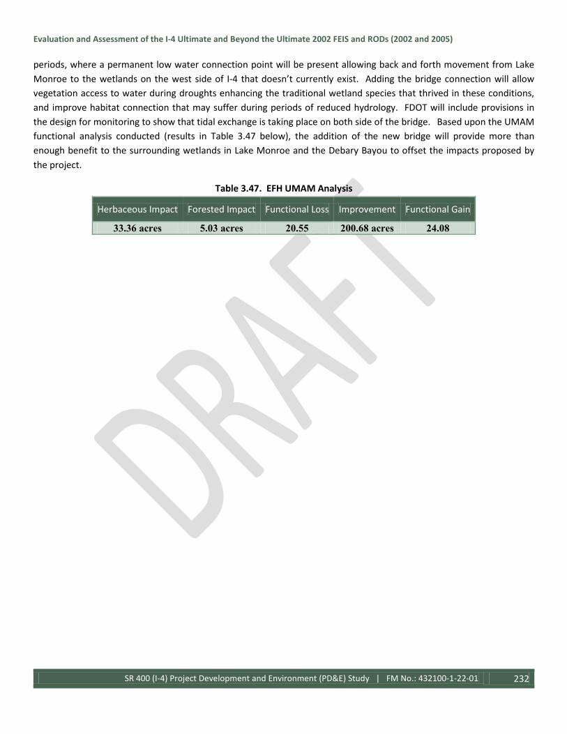
Evaluation and Assessment of the I-4 Ultimate and Beyond the Ultimate 2002 FEIS and RODs (2002 and 2005)
SR 400 (I-4) Project Development and Environment (PD&E) Study | FM No.: 432100-1-22-01 232
periods, where a permanent low water connection point will be present allowing back and forth movement from Lake Monroe to the wetlands on the west side of I-4 that doesn’t currently exist. Adding the bridge connection will allow vegetation access to water during droughts enhancing the traditional wetland species that thrived in these conditions, and improve habitat connection that may suffer during periods of reduced hydrology. FDOT will include provisions in the design for monitoring to show that tidal exchange is taking place on both side of the bridge. Based upon the UMAM functional analysis conducted (results in Table 3.47 below), the addition of the new bridge will provide more than enough benefit to the surrounding wetlands in Lake Monroe and the Debary Bayou to offset the impacts proposed by the project.
Table 3.47. EFH UMAM Analysis
Herbaceous Impact Forested Impact Functional Loss Improvement Functional Gain
33.36 acres 5.03 acres 20.55 200.68 acres 24.08

Evaluation and Assessment of the I-4 Ultimate and Beyond the Ultimate 2002 FEIS and RODs (2002 and 2005)
SR 400 (I-4) Project Development and Environment (PD&E) Study | FM No.: 432100-1-22-01 233
Figure 3.32: EFH Mitigation

Evaluation and Assessment of the I-4 Ultimate and Beyond the Ultimate 2002 FEIS and RODs (2002 and 2005)
SR 400 (I-4) Project Development and Environment (PD&E) Study | FM No.: 432100-1-22-01 234
Coordination relating to EFH and potential impacts took place during the study with staff from NMFS. The draft Essential Fish Habitat Technical Memorandum (June 2015) was submitted for review and comment. Based upon the comments received, the proposed improvements were modified to reflect the bridge structures described previously and the UMAM analysis addressing the impacts and mitigation was revised. Upon review of this new information, NMFS staff concurred with the analysis and provided approval of the design and authorization of the proposed impacts in the letter dated June 16, 2016, with the provision that FDOT would commit to a monitoring program to assess tidal exchange at the bridge locations and allow resource agencies to assess performance standards and provide a basis for corrective actions if necessary. The consultation has been completed in accordance with the Magnuson-Stevens Fishery Conservation and Management Act. A copy of the letter can be found in the Comments and Coordination of this document.
With the No-Build Alternative, no impacts to Essential Fish Habitat would occur.
3.4 Physical Environment The physical environment of the project area was analyzed for parameters such as Air Quality, Noise and Vibration, and Contamination and Hazardous Materials. The original study documented the physical environment within the Ultimate Project Area and is expanded upon to include the Beyond the Ultimate project area for this report. Significant changes to the project corridor have occurred since the original study and will be addressed in the following sections.
3.4.1 Air Quality Under the Clean Air Act, as amended in 1990, it was required that the EPA establish National Ambient Air Quality Standards (NAAQS) (under 40 CFR part 50) to protect public health, the environment, and the quality of life from outdoor air pollution. There are two types of national ambient air quality standards. Primary standards provide public health protection, including protecting the health of "sensitive" populations such as asthmatics, children, and the elderly. Secondary standards provide public welfare protection, including protection against decreased visibility and damage to animals, crops, vegetation, and buildings. The EPA set standards for six principal pollutants, which are called “criteria” pollutants. Periodically, the standards are reviewed and may be revised. The current standards are listed below. Units of measure for the standards are parts per million (ppm) by volume, parts per billion (ppb) by volume, and micrograms per cubic meter of air (µg/m3). The six criteria pollutants include ozone (O3), carbon monoxide (CO), nitrogen dioxide (NO2), sulfur dioxide (SO2), particulate matter equal to or less than 10 microns in diameter (PM10) and 2.5 microns in diameter (PM2.5), and lead (Pb). The NAAQS shown in Table 3.48 represent the maximum levels of background pollution that are considered safe, with an adequate margin of safety, to protect public health and welfare. Transportation sources, particularly motor vehicles, are the primary source of CO, NO2, and Volatile Organic Compounds (VOC’s).
Table 3.48 – National Ambient Air Quality Standards
Pollutant
[links to historical tables of
NAAQS reviews]
Primary/
Secondary Averaging Time Level Form
Carbon Monoxide (CO) primary 8 hours 9 ppm Not to be exceeded more than once per
year 1 hour 35 ppm
Lead (Pb)
primary and
secondary
Rolling 3 month
period 0.15 μg/m3 (1) Not to be exceeded

Evaluation and Assessment of the I-4 Ultimate and Beyond the Ultimate 2002 FEIS and RODs (2002 and 2005)
SR 400 (I-4) Project Development and Environment (PD&E) Study | FM No.: 432100-1-22-01 235
Pollutant
[links to historical tables of
NAAQS reviews]
Primary/
Secondary Averaging Time Level Form
Nitrogen Dioxide (NO2)
primary 1 hour 100 ppb 98th percentile of 1-hour daily maximum
concentrations, averaged over 3 years
primary and
secondary 1 year 53 ppb (2) Annual Mean
Ozone (O3)
primary and
secondary 8 hours 0.070 ppm (3)
Annual fourth-highest daily maximum 8-
hour concentration, averaged over 3 years
Particle Pollution
(PM)
PM2.5
primary 1 year 12.0 μg/m3 annual mean, averaged over 3 years
secondary 1 year 15.0 μg/m3 annual mean, averaged over 3 years
primary and
secondary 24 hours 35 μg/m3 98th percentile, averaged over 3 years
PM10 primary and
secondary 24 hours 150 μg/m3
Not to be exceeded more than once per
year on average over 3 years
Sulfur Dioxide (SO2)
primary 1 hour 75 ppb (4) 99th percentile of 1-hour daily maximum
concentrations, averaged over 3 years
secondary 3 hours 0.5 ppm Not to be exceeded more than once per
year Source: EPA National Ambient Air Quality Standards at http://www3.epa.gov/ttn/naaqs/criteria.html Accessed February 24, 2016 (1) In areas designated nonattainment for the Pb standards prior to the promulgation of the current (2008) standards, and for which implementation plans to attain or maintain the current (2008) standards have not been submitted and approved, the previous standards (1.5 µg/m3 as a calendar quarter average) also remain in effect. (2) The level of the annual NO 2 standard is 0.053 ppm. It is shown here in terms of ppb for the purposes of clearer comparison to the 1-hour standard level. (3) Final rule signed October 1, 2015, and effective December 28, 2015. The previous (2008) O 3 standards additionally remain in effect in some areas. Revocation of the previous (2008) O 3 standards and transitioning to the current (2015) standards will be addressed in the implementation rule for the current standards. (4) The previous SO 2 standards (0.14 ppm 24-hour and 0.03 ppm annual) will additionally remain in effect in certain areas: (1) any area for which it is not yet 1 year since the effective date of designation under the current (2010) standards, and (2)any area for which implementation plans providing for attainment of the current (2010) standard have not been submitted and approved and which is designated nonattainment under the previous SO 2 standards or is not meeting the requirements of a SIP call under the previous SO 2 standards (40 CFR 50.4(3)), A SIP call is an EPA action requiring a state to resubmit all or part of its State Implementation Plan to demonstrate attainment of the require NAAQS.
Criteria Pollutants Air quality is affected by stationary sources (industrial development) and mobile sources (motor vehicles). Air quality at a given location is a function of several factors, including the quantity and type of pollutants emitted locally and regionally, and the dispersion rates of pollutants in the region. Primary factors affecting pollutant dispersion are wind speed and direction, atmospheric stability, temperature, the presence or absence of inversions, and topography. Transportation sources, particularly motor vehicles, are the primary source of CO, oxides of nitrogen (NOx), and VOCs. In the presence of heat and sunlight, NOx and VOCs chemically react to form O3. NO2 is one of a group of highly reactive gasses known as NOx.
Air pollution is of concern because of its demonstrated impacts on human health. Of special concern are the respiratory effects of these criteria pollutants and their potential toxic effects, as described below.
Ozone (O3): Ozone is a strong oxidizer and an irritant that affects the lung tissues and respiratory functions. Exposure to O3 can impair the ability to perform physical exercise; can result in symptoms such as tightness in the chest, coughing, and wheezing; and can ultimately result in asthma, bronchitis, and emphysema. The majority of ground-level O3 is formed as a result of complex photochemical reactions in the atmosphere involving VOCs, NOx, and high temperatures (typically referred to as Photochemical Smog).

Evaluation and Assessment of the I-4 Ultimate and Beyond the Ultimate 2002 FEIS and RODs (2002 and 2005)
SR 400 (I-4) Project Development and Environment (PD&E) Study | FM No.: 432100-1-22-01 236
Carbon Monoxide (CO): CO is a colorless, odorless, poisonous gas produced by incomplete burning of carbon in fuel. The health threat from CO is most serious for those who suffer from cardiovascular disease, particularly those with angina and peripheral vascular disease.
Nitrogen Dioxide (NO2): NO2 is a highly reactive gas that can irritate the lungs, cause bronchitis and pneumonia, and lower resistance to respiratory infections. Repeated exposure to high concentrations of NO2 may cause acute respiratory disease in children. Because NO2 is an important precursor in the formation of O3, control of NO2 emissions is an important component of overall pollution reduction strategies. The two primary sources of NO2 in the U.S. are fuel combustion and transportation.
Sulfur Dioxide (SO2): SO2 is emitted primarily from stationary source coal and oil combustion, steel mills, refineries, pulp and paper mills, and non-ferrous smelters. High concentrations of SO2 may aggravate existing respiratory and cardiovascular disease; asthmatics and those with emphysema or bronchitis are the most sensitive to SO2 exposure. SO2 also contributes to acid rain, which can lead to the acidification of lakes and streams and damage vegetation.
Particulate Matter (PM10 and PM2.5): PM is a mixture of tiny particles that vary greatly in shape, size, and chemical composition; their composition may include metals, soot, soil, and dust. PM10 includes larger, coarse particles, whereas PM2.5 includes smaller, fine particles. Sources of coarse particles include crushing or grinding operations, and dust from paved or unpaved roads. Sources of fine particles include all types of combustion activities (motor vehicles, power plants, wood burning) and certain industrial processes. Exposure to PM10 and PM2.5 levels exceeding current standards can result in increased lung- and heart-related respiratory illness. The EPA has concluded that finer particles are more likely to contribute to health problems than those greater than 10 microns in diameter.
Airborne Lead (Pb): Airborne Pb can be inhaled directly or ingested indirectly by consuming lead contaminated food, water, or non-food materials such as dust or soil. Fetuses, infants, and children are most sensitive to Pb exposure. Pb has been identified as a factor in high blood pressure and heart disease. Exposure to Pb has declined dramatically in the last 10 years as a result of the reduction of Pb in gasoline and paint, and the elimination of Pb from soldered cans.
Greenhouse Gases: Greenhouse gases include water vapor, CO2, CH4 (methane), N2O (nitrous oxide), ground-level O3, and fluorinated gases such as chlorofluorocarbons and hydro-chlorofluorocarbons. These gases trap heat in the atmosphere and regulate the Earth’s temperature. Global climate change is a transformation in the average weather of the Earth, which is measured by changes in temperature, wind patterns, and precipitation. Scientific consensus has identified human-related emission of greenhouse gases above natural levels as a significant contributor to global climate change (NCADAC 2013).
3.4.1.1 Existing Air Quality Conditions Ambient air monitoring stations have been set up to allow environmental agencies to determine compliance with the NAAQS and to evaluate the effectiveness of pollution control measures. Each of the counties within the Ultimate project study area (Orange, Seminole, and Volusia) has ambient air monitors operated both by the FDEP and county environmental agencies. Data collected from the 1998 monitoring programs were assembled during the original I-4 PD&E study. Using this data, it was determined that ozone is the critical pollutant of concern in the I-4 study area. Because of the nature of ozone formation under a photochemical reaction with precursor pollutants that are typically emitted in urban centers of a metropolitan area and transported to areas surrounding the urban center, it can be an area-wide phenomenon. Elevated levels of O3 are often considered regional in nature and not restricted to the study

Evaluation and Assessment of the I-4 Ultimate and Beyond the Ultimate 2002 FEIS and RODs (2002 and 2005)
SR 400 (I-4) Project Development and Environment (PD&E) Study | FM No.: 432100-1-22-01 237
area. There were no violations of the NAAQS for O3 in the Orlando area for the several years prior to 1999. Under the Clean Air Act, all areas within states are designated with respect to the NAAQS as either attainment, non-attainment, or unclassifiable. At the time of the original PD&E Study in 1999, Orange, Seminole, and Volusia Counties have been designated as attainment areas for all criteria pollutants.
A review of the NAAQS criteria in 2016 indicates some minor changes in the standards for the criteria pollutants since the 1999 PD&E, though the entire study area is designated as attainment for all criteria pollutants.
3.1.1.2 Air Quality Analysis The original PD&E Study documented the air quality and potential impacts related to the project. Specifically, the analysis investigated the generation and dispersion of CO, the primary pollutant emitted from motor vehicles. The results were used to indicate whether motor vehicle emissions associated with the proposed improvements would contribute to violations of the NAAQS for CO. FDOT issued guidelines for determining which of the criteria air pollutants need to be analyzed to evaluate the air quality impact of the roadway project. According to the FDOT PD&E Manual, CO levels must be considered for every project. Conversely, hydrocarbon (i.e. VOC) emissions did not need to be modeled because of the attainment status of the study area.
In accordance with FDOT guidelines, the proposed I-4 improvements for the Ultimate project were subjected to a graphical screening test that makes several conservative worst-case assumptions about the meteorology, traffic, and site conditions. The screening test used these assumptions in the MOBILE Series Model and CALINE3 models to produce a series of curves that can be used to determine critical distance for receptors. The critical distance is the closest a receptor can be to a given intersection or link without significant air quality impact. The premise of this approach was that CO concentrations elsewhere along the project corridor would be lower than these worst-case screening locations. Traffic data and aerial photography showing the concept design were reviewed to identify areas having a combination of heavy traffic volumes, low vehicular speeds, and neighboring reasonable receptor sites. Receptor sites are areas where the public has routine access and may spend one to several hours. The links along I-4 that were selected for analysis – College Park, John Young Parkway, and SR 408 (East/West Expressway) – have traffic volumes greater than 10,000 vehicles per hour (vph) and thereby automatically fail the screening test.
Per Part 2, Chapter 16 of the PD&E Manual, the computer models used in the micro-scale analysis were the latest FHWA-approved MOBILE Series Model and CAL3QHC CO dispersion model. Traffic input parameters, provided by Orange County, included peak hour volumes, vehicular speeds, and vehicle. Meteorological inputs included wind speed, wind direction, and atmospheric stability. Orange County had two CO monitors, and the average background concentration of CO obtained from the local air quality authority was 0.75 parts per million (ppm). The modeling was concentrated at the sections of the Ultimate project with the greatest projected air pollution (i.e. College Park, John Young Parkway, and SR 408). The modeling of worst-case traffic and meteorological data were conducted for the peak one-hour period. To account for the long-term variation in traffic and meteorological data over time, persistence factors were used to convert the one-hour modeled conditions to comparable worst-case, eight-hour conditions. In this way, the results could be compared to the NAAQS, which were based on one-hour and eight-hour averaging times for CO. The full modeling results for the Build and No Action conditions for the years 2010 and 2020 were documented in the Air Quality Report (April 2000). The results of the modeling predicted that CO concentrations would be within the standards for both the Build and No Action conditions in 2010 and 2020 as shown on Table 3.49 below, and would therefore not have a significantly impact on air quality.

Evaluation and Assessment of the I-4 Ultimate and Beyond the Ultimate 2002 FEIS and RODs (2002 and 2005)
SR 400 (I-4) Project Development and Environment (PD&E) Study | FM No.: 432100-1-22-01 238
The Ultimate project occurs in an area that has been designated as attainment for the ozone standards under the criteria provided in the CAAA. The Ultimate project is in conformance with the State Implementation Plan because they will not cause violations of the NAAQS.
Table 3.49: Predicted Worst-Case Carbon Monoxide Levels for the I-4 Segments near College Park, John Young Parkway, and SR 408 for 2010 and 2020
I-4 Section Year Alternative Receptora Total Impactb
(CO Concentration in ppm) NAAQS Violationc
1-hour 8-hour
College Park 2010
Build 8 12.9 6.2 No No Action 8 11.6 5.6 No
2020 Build 8 9.9 4.8 No
No Action 8 9.4 4.6 No
SR 408 (East/West Expressway
2010 Build 4 7.7 3.9 No No Action 9 6.7 3.4 No
2020 Build 4 7.0 3.5 No
No Action 4 5.0 2.6 No
John Young Parkway
2010 Build 8 7.6 3.8 No
No Action 13 8.0 4.0 No
2020 Build 13 6.3 3.2 No
No Action 13 5.2 2.7 No aCollege Park was modeled with 12 receptors, E/W with 13, and John Young with 12. Receptor 8 at College Park is different from Receptor 8 at John Young Parkway bIncludes background concentration of 0.75 parts per million (ppm) provided from local data in the EPA AIRS database. cThe NAAQS for CO are as follows: 35 ppm for 1 hour and 9 ppm for 8 hours.
For the I-4 BtU PD&E Study, the proposed project segments were reviewed for air quality impacts consistent with the most current guidance provided by the FHWA. Orange County, Seminole County, and Volusia County are currently designated as being attainment for the following air pollutants: ozone, nitrogen dioxide, particulate matter (2.5 microns in size and 10 microns in size), sulfur dioxide, carbon monoxide and lead.
Segment 2 of the project was subjected to a carbon monoxide (CO) screening model (as part of the Air Quality Analysis Technical Memorandum completed in February 2015) that makes various conservative worst-case assumptions related to site conditions, meteorology and traffic. The FDOT’s screening model, CO Florida 2012 (released March 12, 2012) uses the latest United States Environmental Protection Agency (USEPA) – approved software (MOVES 2010a and CAL3QHC2) to produce estimates of one-hour and eight-hour CO at default air quality receptor locations. The one-hour and eight-hour estimates can be directly compared to the one-hour and eight-hour National Ambient Air Quality Standards (NAAQS) for CO that are 35 parts per million (ppm) and 9 parts per million (ppm), respectively.
The roadway intersection forecast to have the highest total approach traffic volume (for both the Build and No-Build scenarios) is the intersection of Sand Lake Road and Turkey Lake Road (Figure 3.33). The design hour volumes for Build and No-Build scenarios for the opening year (2020) and the design year (2040) were evaluated.
Figure 3.33: Segment 2 Air Quality Selected Intersection

Evaluation and Assessment of the I-4 Ultimate and Beyond the Ultimate 2002 FEIS and RODs (2002 and 2005)
SR 400 (I-4) Project Development and Environment (PD&E) Study | FM No.: 432100-1-22-01 239
Estimates of CO were predicted for the default receptors which are located 10 feet to 150 feet from the edge of the roadway. Based on the results from the screening model, the highest project-related CO one-hour and eight-hour levels are not predicted to meet or exceed the one-hour or eight-hour National Ambient Air Quality Standards (NAAQS) for this pollutant with either the Build or No-Build alternatives. As such, the project “passes” the screening model.
Segment 3 of the project was subjected to the FDOT’s screening model, CO Florida 2012, (as part of the Air Quality Analysis Technical Memorandum completed in April 2015) to produce estimates of one-hour and eight-hour CO at default air quality receptor locations.
The roadway intersection forecast to have the highest total approach traffic volume (for both the Build and No-Build scenarios) is the intersection of Lake Mary Boulevard and Lake Emma Road/Primera Boulevard (Figure 3.34). The Build and No-Build scenarios for the opening year (2020) and the design year (2040) were evaluated (for design hour volumes).
Estimates of CO were predicted for the default receptors which are located 10 feet to 150 feet from the edge of the roadway. Based on the results from the screening model, the highest project-related CO one-hour and eight-hour levels are not predicted to meet or exceed the one-hour or eight-hour NAAQS for this pollutant with either the Build or No-Build alternatives. As such, the project “passes” the screening model.
Segment 4 of the project was subjected to FDOT’s screening model, CO Florida 2012 (as part of the Air Quality Analysis Technical Memorandum completed in June 2015) to produce estimates of one-hour and eight-hour CO at default air quality receptor locations.
The roadway intersection forecast to have the highest total approach traffic volume (for both the Build and No-Build scenarios) is the intersection of the western I-4 ramps at SR 472 (Figure 3.35). However, this intersection is located in a mostly natural wooded area and is not near any CO reception sites. Although the intersection of the eastern I-4 ramps at Debary Avenue is not projected to have the highest total approach traffic volume for this project segment (for both the Build and No-Build scenarios), it was selected as the intersection to analyze based on its proximity to CO reception sites and relatively high volume of vehicles per hour (vph). The Build and No-Build scenarios for the opening year (2020) and the design year (2040) were evaluated (for design hour volumes).
Estimates of CO were predicted for the default receptors which are located 10 feet to 150 feet from the edge of the roadway. Based on the results from the screening model, the highest project-related CO one-hour and eight-hour levels are not predicted to
Figure 3.34: Segment 3 Air Quality Selected Intersection
Figure 3.35: Segment 4 Air Quality Selected Intersection

Evaluation and Assessment of the I-4 Ultimate and Beyond the Ultimate 2002 FEIS and RODs (2002 and 2005)
SR 400 (I-4) Project Development and Environment (PD&E) Study | FM No.: 432100-1-22-01 240
meet or exceed the one-hour or eight-hour NAAQS for this pollutant for either the Build or No-Build alternatives. As such, the project “passes” the screening model.
The project is located in an area which is designated attainment for all of the National Ambient Air Quality Standards under the criteria provided in the Clean Air Act. Therefore, the Clean Air Act conformity requirements do not apply to the project. Therefore, the project will not have negative impacts on air quality as a result of the proposed improvements.
With the No-Build Alternative, no Air Quality impacts would occur.
3.4.2 Noise Study The project was subject to an analysis for noise impacts and an inventory of the noise sensitive land uses within the study area. Noise studies were conducted during the original PD&E Study and again during the BtU Study. Noise is defined as a sound that is undesirable because it interferes with communication or it is annoying (EPA 1976). Sound levels are measured in decibels (dB), which is a unit of measurement based on a logarithmic scale (where a 10 dB increase in sound levels corresponds to a doubling of the perceived loudness). Since the human ear does not respond equally to all frequencies, measured sound levels are adjusted or weighted to correspond to the frequency response of human hearing and the human perception of loudness. The weighted sound level is typically measured and reported in single number units called A-weighted decibels (dBA). “A-weighting” adjusts the sound level at different frequencies to approximate the human ear’s sensitivity because sounds are not heard equally well. A-weighted sound levels are commonly used in measurement of community environmental noise. Traffic and other noises found in communities tends to fluctuate from moment to moment so noise levels over a stated period of time (1 hour) are typically
represented by the “equivalent sound level”, Leq, which is the average noise over the one hour period and is shown as
Leq(h).
The average human’s ability to perceive changes in noise levels has been well documented in studies. Changes in noise levels of less than 3 dBA will be barely perceived by most listeners, where a 10 dBA change is normally perceived as a doubling or halving of the noise level. With this in mind, most noise criteria have been based upon the principle that changes in noise levels are likely to cause annoyance when it exceeds the ambient noise. In other words, the level of annoyance depends upon the noise that exists before the start of a new noise-generating project or an expansion of an existing project, as is the case with I-4. Community noise levels vary greatly depending upon the surrounding land uses, but usually range between 45 dBA (the typical daytime level in a quiet living room) and 85 dBA (the approximate noise level near a sidewalk adjacent to heavy traffic). The table below shows the relationship between typical noise levels and common indoor / outdoor activities.
Table 3.50 – Typical Noise Levels COMMON OUTDOOR
ACTIVITIES NOISE LEVEL
DB(A) COMMON INDOOR
ACTIVITIES
Jet Fly-over at 1000 ft Gas Lawn Mower at 3 ft Diesel Truck at 50 ft, at 50 mph
---110--- ---100--- ---90--- ---80---
Rock Band Food Blender at 1 m (3 ft) Garbage Disposal at 1 m (3 ft)

Evaluation and Assessment of the I-4 Ultimate and Beyond the Ultimate 2002 FEIS and RODs (2002 and 2005)
SR 400 (I-4) Project Development and Environment (PD&E) Study | FM No.: 432100-1-22-01 241
Noise Urban Area (Daytime) Gas Lawn Mower at 100 ft Commercial Area Heavy Traffic at 300 ft Quiet Urban Daytime Quiet Urban Nighttime Quiet Suburban Nighttime Quiet Rural Nighttime Lowest Threshold of Human Hearing
---70--- ---60--- ---50--- ---40--- ---30--- ---20--- ---10--- ---0---
Vacuum Cleaner at 10 ft Normal Speech at 3 ft Large Business Office Dishwasher Next Room Theater, Large Conference Room (Background) Library Bedroom at Night, Concert Hall (Background) Lowest Threshold of Human Hearing
Source: California Dept. of Transportation Technical Noise Supplement, Oct. 1998, Page 18.
3.4.2.1 Noise Criteria Noise criteria set forth by FHWA established guidelines for evaluating traffic noise impacts with respect to various land uses and activity categories. When traffic noise associated with a roadway project is predicted to approach or exceed the criteria, noise abatement must be considered. FHWA Noise Abatement Criteria at the time of the original PD&E Study were utilized during that noise study, and are shown in Table 3.51.
Table 3.51 – FHWA Noise Abatement Criteria 1998
ACTIVITY CATEGORY HOURLY A-WEIGHTED SOUND LEVEL (DBA) DESCRIPTION OF ACTIVITY CATEGORY LEQ (H) L 10 (H)
A 57 (exterior) 60 (exterior) Lands on which serenity and quiet are of extraordinary significance and serve as important public need and where the
preservation of those qualities is essential if the area is to continue to serve its intended purpose.
B 67 (exterior) 70 (exterior) Picnic Areas, recreation areas, playgrounds, active sports areas, parks, residences, motels, hotels, schools, churches, libraries, and
hospitals C 72 (exterior) 75 (exterior) Developed lands, properties, or activities not included in
Categories A or B above. D - - Undeveloped Lands E 52 (interior) 55 (interior) Residences, motels, hotels, public meeting rooms, schools,
churches, libraries, hospitals, and auditoriums. Source: Title 23 of the Code of Federal Regulations (CFR) Part 772, Procedures for Abatement of Highway Traffic Noise and Construction Noise, Federal Highway Administration, Washington DC.
FDOT considers a traffic noise impact to occur when predicted project-related noise levels approach the FHWA abatement criteria, or substantially exceed existing levels. During the noise study utilizing these noise criteria, FDOT defined “approach” as 2 dBA; if the FHWA criteria for Activity Category B is 67 dBA, a site predicted to experience a noise level of 65 dBA would be considered impacted.
Changes to FHWA Noise Abatement Criteria were enacted in June 2010 which revised the previous criteria. Changes primarily concerned the Activity Categories rather than the sound level thresholds for abatement. The revised FHWA Noise Abatement Criteria are shown in the table below. Additionally, FDOT redefined ‘approach’ as within 1.0 dB(A) of the FHWA criteria.

Evaluation and Assessment of the I-4 Ultimate and Beyond the Ultimate 2002 FEIS and RODs (2002 and 2005)
SR 400 (I-4) Project Development and Environment (PD&E) Study | FM No.: 432100-1-22-01 242
Table 3.52 – FHWA Noise Abatement Criteria June 2010
NOISE ABATEMENT CRITERIA [Hourly A-Weighted Sound Level-decibels (dB(A))]
Activity Category
Activity Leq(h)1 Evaluation location
Description of activity category FHWA FDOT
A 57 56 Exterior Lands on which serenity and quiet are of extraordinary significance and serve an important public need and where the preservation of those qualities is essential if the area is to continue to serve its intended purpose.
B2 67 66 Exterior Residential C2 67 66 Exterior Active sports areas, amphitheaters, auditoriums, campgrounds, cemeteries, day
care centers, hospitals, libraries, medical facilities, parks, picnic areas, places of worship, playgrounds, public meeting rooms, public or nonprofit institutional structures, radio studios, recording studios, recreational areas, Section 4(f) sites, schools, television studios, trails, and trail crossings.
D 52 51 Interior Auditoriums, day care centers, hospitals, libraries, medical facilities, places of worship, public meeting rooms, public or nonprofit institutional structures, radio studios, recording studios, schools, and television studios.
E2 72 71 Exterior Hotels, motels, offices, restaurants/bars, and other developed lands, properties or activities not included in A-D or F.
F - - - Agriculture, airports, bus yards, emergency services, industrial, logging, maintenance facilities, manufacturing, mining, rail yards, retail facilities, shipyards, utilities (water resources, water treatment, electrical), and warehousing.
G - - - Undeveloped lands that are not permitted. Part 2, Chapter 17 of PD&E Manual (5/24/2011) (Based on Table 1 of 23 CFR Part 772) 1 The Leq(h) Activity Criteria values are for impact determination only, and are not design standards for noise abatement measures. 2 Includes undeveloped lands permitted for this activity category. Note: FDOT defines that a substantial noise increase occurs when the existing noise level is predicted to be exceeded by 15 decibels or more as a result of the transportation improvement project. When this occurs, the requirement for abatement consideration will be followed.
Noise impacts are also considered to occur when noise levels are predicted to increase substantially, yet not approach or exceed the FHWA criteria. Substantial increases primarily occur when proposed roadway improvements are planned in the vicinity of noise sensitive areas where existing noise levels are relatively low, or the proposed improvements change the noise propagation environment. FDOT considers a 15 dBA increase to be substantial.
3.4.2.2 Methodology for Measurement and Modeling The original noise study conducted for the I-4 Ultimate PD&E identified 51 noise sensitive areas (with a total of 10,732 residential sites) that may be impacted by the proposed project. These areas were described in detail in the Noise Study Report (April 2001) completed for the project. During the study, ambient noise levels were monitored at a total of 30 locations within the study limits in accordance with the procedures described in the FWHA report, Measurement of Highway-Related Noise. Of those 30 locations, 19 were used for noise model validation. These sites included residential, commercial, and other land use types representative of typical conditions within the Ultimate project

Evaluation and Assessment of the I-4 Ultimate and Beyond the Ultimate 2002 FEIS and RODs (2002 and 2005)
SR 400 (I-4) Project Development and Environment (PD&E) Study | FM No.: 432100-1-22-01 243
corridor. The criteria for monitoring selection included land use, existing ambient noise, number of sensitive receivers in the area, and the site’s potential sensitivity to changes in noise.
Traffic related noise levels were monitored at each site for three 10-minute periods using Metrosonics db-3100 sound level meters. The meters were placed on a tripod at a height of five feet. The position of the meter was dictated by the limited-access right-of-way line, location of the frontage road, and the location of the noise sensitive site. Calibration checks were performed on the sound level meters before and after the sampling event using a Metrosonics CL-304 calibrator. Traffic conditions including traffic volume, vehicle mix, and travel speeds were also recorded simultaneously during the monitoring period. The data along with other roadway/receiver site condition factors were used as input to validate the version of STAMINA 2.1 noise prediction computer model approved for use in Florida. The data input confirmed the computer model’s ability to accurately predict the traffic noise levels.
In addition to the model validation sites selected, the public involvement process identified eight additional sites where noise issues may be particularly sensitive. Those sites were not used for model validation, but were included in the analysis for the study. Predicted existing and future-year noise levels for the previously identified noise sensitive areas were evaluated using the FDOT approved computer version of the STAMINA 2.1 computer model. A total of 10,372 sites were represented in the modeling effort.
For the I-4 BtU Noise Study, the study was conducted utilizing the revised regulations established by FHWA in 23 CFR 772 and the procedures established in Part 2, Chapter 17 “Noise”, of the FDOT PD&E Manual. The Federal Highway Administration’s (FHWA) Traffic Noise Modeling (TNM) Version 2.5 computer program was used to determine if noise abatement was warranted, and, if so, considered reasonable and feasible for any noise-sensitive sites. This model is the latest version of TNM and was used as required by 23 CFR 772. The model estimates the acoustic intensity at noise receptor sites based upon the roadway design and is influenced by vehicle speed and type. TNM 2.5 predicted noise levels are reported in dB(A) Leq(h). To validate TNM, potential noise receptor sites were identified throughout the project corridor. A noise-sensitive receptor is defined as “any property (owner occupied, rented, or leased) where frequent exterior human use occurs.” Information that was loaded into the noise model to predict existing and projected noise levels includes: roadway geometry; vehicle types, volumes, and speeds; existing barrier and buffer information, propagation path; and, climatic conditions.
Noise data collection was conducted separately for each of the three segments included in the I-4 BtU project. In order to collect data on existing noise levels throughout the project area, field monitoring was conducted by four noise monitoring specialists in accordance with the FHWA’s guidance document “Measurement of Highway-Related Noise.” QuestTM Model M-28 Noise Logging Dosimeters were used to collect sound levels at the location. Sound levels are measured and calculated in decibels (dB), which is a unit of measure used to determine sound intensities. The decibel levels were measured on an A-weighted scale (dBA), which is the frequency of sound that is heard by a human ear. The average sound level over a one-hour period is considered the Level Equivalent (Leq), and is used in the noise modeling process. The dosimeter was calibrated on site just prior to the onset of sampling to ensure accuracy and mounted on a tripod at a height of approximately 5 feet which is standard and equivalent to the average height of the human ear. Noise readings were taken 3 separate times at 15-minute intervals during both the morning (10:00 – 11:30) and afternoon (1:00 – 3:00), periods of non-peak traffic activity along the project corridor.

Evaluation and Assessment of the I-4 Ultimate and Beyond the Ultimate 2002 FEIS and RODs (2002 and 2005)
SR 400 (I-4) Project Development and Environment (PD&E) Study | FM No.: 432100-1-22-01 244
In order to gauge traffic volumes during the monitoring periods, traffic counts of the number and type of vehicles traveling in each direction at the monitoring station were recorded. Traffic counts were taken simultaneously during each of the 3 noise recording events. Vehicles were categorized as either 1) passenger cars or light trucks, 2) medium trucks (box or panel trucks with one double-axle) or 3) heavy trucks (two or more double-axles) and motorcycles. Field notes were collected to record general weather and environmental conditions, and all unusual or otherwise noteworthy sound events. Traffic speeds for passing vehicles were determined by the use of a daily calibrated radar gun and recording the resulting speeds during timed monitoring runs.
The speeds used in the TNM modeling program for the model validation were based on the average observed speeds of 60 mph for cars, and 55 mph for trucks during the data collection. Level of Service C volumes at speeds of 65 mph was utilized to model the worst case scenario for future noise projections.
Design files supplied by HNTB were used to establish the input parameters for modeling the roadway, including vertical and horizontal geometry and ground elevations.
For Segment 2, readings were taken on May 28, 2013, at the location on the west side of Turkey Lake Road within the right of way at an abandoned development driveway approximately 28 feet from the outside of the southbound travel lane. The location provided clear site lines to observe traffic on both I-4 and Turkey Lake Road. The right-of-way adjacent to I-4 is mown grass, separated from Turkey Lake Road via a 6-foot chain link fence. Vegetation along the fence and Turkey Lake Road was grass or low weedy vegetation, with no trees or any natural or man-made obstructions to affect the noise readings.
The project was broken up into geographic noise sensitive areas to facilitate the analysis of traffic related noise impacts. Eight (8) noise sensitive areas that have the potential to be impacted by the project were identified (Figure 3.36). The potentially impacted noise-sensitive sites identified for this segment consist of hotels, resorts, multi-family residences within the Sand Lake Private Residences, Sand Lake Village, McKinley at Monterey Lakes, and Sea Isle, and single-family residences at Toscana. One single family residence that appears abandoned is located directly on Turkey Lake Road, several hundred feet south of the Wal-Mart. The Orange County Building Department was contacted for all approved building permits within the developments along the project corridor. The properties identified during this search were all modeled as existing receptors in the TNM runs. The noise sensitive areas within the study area present several different types of sites to model within TNM: multi-family buildings with external balconies were modeled using several points to represent similar receptors at different locations in the building, while single family residences were modeled using a point to represent each site. Hotels with no external balconies were represented only by areas of common outdoor usage (pools, outdoor recreation areas). Multi-story buildings were modeled using representative points on the ground floor, first floor, and second floor where appropriate. First floor receptor sites were modeled 5 feet above ground level, while second and third story receptors were modeled at 15 and 25 feet above ground level. There are no additional noise-sensitive sites such as golf courses, libraries, or other areas that require quiet conditions within the study area.

Evaluation and Assessment of the I-4 Ultimate and Beyond the Ultimate 2002 FEIS and RODs (2002 and 2005)
SR 400 (I-4) Project Development and Environment (PD&E) Study | FM No.: 432100-1-22-01 245
Figure 3.36 – Segment 2 Noise Sensitive Areas

Evaluation and Assessment of the I-4 Ultimate and Beyond the Ultimate 2002 FEIS and RODs (2002 and 2005)
SR 400 (I-4) Project Development and Environment (PD&E) Study | FM No.: 432100-1-22-01 246
For Segment 3, readings were taken on July 25, 2013 at the noise validation location on the east side of I-4 at the right-of-way line adjacent to the power sub-station approximately 1 mile south of the Lake Mary Boulevard Interchange. The location provided clear site lines to observe traffic on both sides of I-4. The right-of-way adjacent to I-4 is mowed grass, with some planting and landscape vegetation in areas with slopes leading up to the chain link fence. The project was broken up into geographic noise sensitive areas to facilitate the analysis of traffic related noise impacts. Fifteen (15) noise sensitive areas that have the potential to be impacted by the project were identified (Figure 3.37). The potentially impacted noise-sensitive sites identified for this segment consist of single family residences, hotels, multi-family residences, churches, television broadcast studios, medical offices, recreation areas, and county trails. The Seminole County Building Department was contacted for all approved building permits within the developments along the project corridor. The properties identified during this search were all modeled as existing receptors in the TNM runs. The noise sensitive areas within the study area present several different types of sites to model within TNM: multi-family buildings with external balconies were modeled using several points to represent similar receptors at different locations in the building, while single family residences were modeled using a point to represent each site. Hotels with no external balconies were represented only by areas of common outdoor usage (pools, outdoor recreation areas). Multi-story buildings were modeled using representative points on the ground floor, first floor, and second floor where appropriate. First floor receptor sites were modeled 5 feet above ground level, while second and third story receptors were modeled at 15 and 25 feet above ground level. There are no additional noise-sensitive sites such as golf courses, libraries, or other areas that require quiet conditions within the study area.

Evaluation and Assessment of the I-4 Ultimate and Beyond the Ultimate 2002 FEIS and RODs (2002 and 2005)
SR 400 (I-4) Project Development and Environment (PD&E) Study | FM No.: 432100-1-22-01 247
Figure 3.37 – Segment 3 Noise Sensitive Areas

Evaluation and Assessment of the I-4 Ultimate and Beyond the Ultimate 2002 FEIS and RODs (2002 and 2005)
SR 400 (I-4) Project Development and Environment (PD&E) Study | FM No.: 432100-1-22-01 248
For Segment 4, the readings were taken on July 25, 2013 at the location was on the west side of westbound I-4 south of Saxon Boulevard at the eastern end of Brokenshire Drive within the right of way near the fence. The location provided clear sight lines to observe traffic on I-4. The right-of-way adjacent to I-4 is mown grass, vegetation along the fence was grass or low weedy vegetation, with no trees or any natural or man-made obstructions to affect the noise readings.
The project was broken up into geographic noise sensitive areas to facilitate the analysis of traffic related noise impacts. Eight (8) noise sensitive areas that have the potential to be impacted by the project were identified and shown on Noise Sensitive Areas map Figure 3.38. The potential noise-sensitive sites identified for this segment consist of hotels, Bill Keller Park, the Deltona Memorial Gardens Cemetery, multi-family residences at the Riverside Condominiums, and single-family residences along both sides of the roadway including the Rhode Island Extension. The Volusia County Building Department was contacted for all approved building permits within the developments along the project corridor. The properties identified during this search were all modeled as existing receptors in the TNM runs. The noise sensitive areas within the study area present several different types of sites to model within TNM: multi-family buildings with external balconies were modeled using several points to represent similar receptors at different locations in the building, while single family residences were modeled using a point to represent each site. Hotels with no external balconies were represented only by areas of common outdoor usage (pools, outdoor recreation areas). Multi-story buildings were modeled using representative points on the ground floor, first floor, and second floor where appropriate. First floor receptor sites were modeled 5 feet above ground level, while second and third story receptors were modeled at 15 and 25 feet above ground level, respectively. There are no additional noise-sensitive sites such as active golf courses, libraries, or other areas that require quiet conditions within the study area.

Evaluation and Assessment of the I-4 Ultimate and Beyond the Ultimate 2002 FEIS and RODs (2002 and 2005)
SR 400 (I-4) Project Development and Environment (PD&E) Study | FM No.: 432100-1-22-01 249
Figure 3.38 – Segment 4 Noise Sensitive Areas

Evaluation and Assessment of the I-4 Ultimate and Beyond the Ultimate 2002 FEIS and RODs (2002 and 2005)
SR 400 (I-4) Project Development and Environment (PD&E) Study | FM No.: 432100-1-22-01 250
3.4.2.3 Noise Impacts A noise analysis was conducted during the original I-4 PD&E Study – Section 2 according to the approved methodology and criteria in place at that time. The basic goals of the noise criteria for highway projects are to minimize the adverse noise impacts on the community and to provide feasible and reasonable noise control where necessary and appropriate. The traffic noise abatement criteria, against which the project traffic noise levels were evaluated, are extracted from 23 CFR 772, Procedures for Abatement of Highway Traffic Noise and Construction Noise, FHWA, Washington D.C. The criterion applicable for residences, churches, schools, recreational uses, and similar areas was an exterior hourly equivalent sound level (Leq) from the project that approaches or exceeds 67 dBA. The criterion for other developed lands such as commercial and industrial uses was an exterior Leq that approaches or exceeds 72 dBA. FDOT considered the approach criteria to mean noise levels within 2 dBA of the appropriate FHWA Criteria.
For the analysis at that time, locations predicted to experience a noise level of 65 dBA were considered to be impacted. Existing and future-year noise levels were predicted for the noise sensitive areas using the FDOT-approved PC version of the STAMINA 2.1 noise prediction model. Hourly traffic volumes and truck factors were based on the traffic analysis performed for the project. To simulate worst-case conditions, LOS C conditions or demand traffic volumes, whichever is less, are usually modeled. The traffic analysis indicated that the majority of the modeled roadways would function at LOS D or worse for the existing, no-build, and build conditions. Traffic volume assignments are provided in the I-4 PD&E Study – Section 2 Noise Study Report (April 2001). A ten percent truck factor was used for the I-4 mainline and ramps west of John Young Parkway and east of US 17-92. A five percent truck factor was used for the I-4 mainline and ramps from east of John Young Parkway to US 17-92, and a five percent truck factor was also applied to all arterial roads. Truck volumes were evenly split between medium and heavy trucks for all roadway segments. Speeds simulated in the model were based on existing speed limits. A speed of 55 mph was assigned to I-4 and the interchange on-ramps. Off-ramps were assigned a speed of 35 mph, and arterial roads were assigned a speed of 40 mph.
The noise study was conducted in accordance with the PD&E Manual, Part 2, Chapter 17 to assess the potential noise impacts associated with the project alternatives. A total of 10,732 sites were modeled as part of the noise study. The Noise Study Report (April 2001) presented the predicted noise levels and impacts at each modeled receptor location. The predicted noise level at each noise sensitive site was compared to the impact criteria. A total of 1,494 noise sensitive sites were predicted to experience traffic noise impacts as a result of implementing the proposed project.
In accordance with 23 CFR, Part 772, noise abatement measures were evaluated for the noise sensitive sites predicted to approach or exceed FHWA criteria. Abatement measures considered included traffic management, modifications to roadway alignment, land use controls, and construction of permanent noise barriers within the limited access right-of-way along I-4. Feasibility and reasonableness were considered when evaluating abatement measures. The feasibility of providing noise abatement primarily addresses engineering considerations (such as physical constraints, drainage and accessibility considerations, safety and maintenance requirements, and utility impacts). Reasonableness addresses the use of common sense and good judgment when considering noise abatement. Factors such as noise abatement benefits, ability to provide a substantial noise reduction, cost of abatement, aesthetic considerations, community desires, establishment of local controls to limit incompatible land uses, absolute noise levels, predicted change in noise levels, adjacent development, and environmental impacts of construction were all considered.
Traffic management measures that would limit motor vehicle type, travel speeds, traffic volumes, and/or time of operation sometimes are used as noise abatement measures. Since I-4 is a major route by which many travelers go

Evaluation and Assessment of the I-4 Ultimate and Beyond the Ultimate 2002 FEIS and RODs (2002 and 2005)
SR 400 (I-4) Project Development and Environment (PD&E) Study | FM No.: 432100-1-22-01 251
through central Florida, limiting speeds, vehicle type and truck use would severely alter the usage, and therefore are not reasonable noise abatement measures for this project.
Shifting the alignment would reduce noise impacts to one side of the facility, but would result in increased environmental impacts, a greater number of relocations, and increased construction and right-of-way costs and is therefore not reasonable for noise abatement on this project.
Noise barriers reduce noise levels by blocking the sound path between a roadway and a noise sensitive site. To be effective, noise barriers must be long, continuous, and sufficiently high. When noise barriers are evaluated to reduce noise levels, feasibility and reasonableness are considered. The feasibility of providing noise abatement primarily addresses engineering considerations (physical constraints, drainage and accessibility considerations, safety and maintenance requirements, and utility impacts). Reasonableness addresses the use of common sense and good judgment when considering noise abatement.
FDOT established 21 reasonableness and feasibility factors that were to be evaluated relative to each abatement measure. Each factor was weighed before reasonableness and feasibility would be determined for any individual barrier location. Those factors were as follows:
• Relationship of future levels to the abatement criteria • Insertion loss • Safety • Community desires • Accessibility • Land use stability • Local controls • Views of officials with jurisdiction in the area • Noise level increase from existing to future and no-build conditions • Antiquity • Constructability • Maintainability • Aesthetics • Right-of-way needs • Total cost / cost per benefited receiver • Utilities • Drainage • Special land use considerations • Other environmental impacts • Additional considerations
Each NSA within the Ultimate project study area was evaluated using the 21 reasonableness and feasibility factors. Thirteen noise barriers were determined to be reasonable and feasible within the Ultimate project area. FDOT committed to the implementation of reasonable and feasible noise abatement in the noise sensitive areas identified in the report, contingent upon the project meeting these conditions:

Evaluation and Assessment of the I-4 Ultimate and Beyond the Ultimate 2002 FEIS and RODs (2002 and 2005)
SR 400 (I-4) Project Development and Environment (PD&E) Study | FM No.: 432100-1-22-01 252
1. Detailed noise analyses during the final design process support the need for abatement. 2. Reasonable cost analyses indicate that the economic cost of the barriers would not exceed the guidelines. 3. Community input regarding desires, types, heights, and locations of barriers was solicited by FDOT. 4. Preferences regarding compatibility with adjacent land uses, particularly as addressed by officials having
jurisdiction over such land uses, has been noted. 5. Safety and engineering aspects as related to the roadway user and the adjacent property owner have been
reviewed. 6. Any mitigating circumstances found in Part 2, Chapter 17-4.6.1 of the PD&E Manual have been analyzed.
Several of the noise barriers identified as reasonable and feasible during the study were constructed as part of separate projects on I-4 between the time when the original PD&E Study occurred and the I-4 BtU PD&E Study. In those places within the Ultimate project area where a barrier was deemed reasonable and feasible during the study and a barrier had not yet been constructed, additional noise analysis during the design/build phase would determine if the barrier was to be constructed as a part of the project.
The 11 proposed noise barriers that were deemed as reasonable and feasible were reassessed during the design/build project phase for the Ultimate. The first noise study update was completed in July 2013. The results showed that the 11 noise barriers remain feasible and reasonable or have already been constructed (i.e., NSAs 2-E, 2-F, 2-H, 2-I, 2-J, 3-B, 3-C, 3-D, 3-E, 3-F, and 4-C) and are recommended for further consideration and public input. Three noise barriers along SR 408 (i.e., NSAs 2-I, 2-J, and 2-H) have been constructed as have the noise barriers for NSAs 4-I and 4-J located north of SR 434 and east of I-4, and did not need to be reassessed. Five additional noise barriers (for NSAs 2-BB, 2-B, 3-G, 3-H, and 4-G) were also considered feasible and cost reasonable during this reassessment and are recommended for public input. The I-4 Ultimate Project will impact 2 existing noise barriers previously constructed for NSAs 2-H and 4-I and will require replacement noise barriers to be constructed when it is constructed. Fifteen noise barriers were recommended to be carried forward for construction in the 2013 study.
An additional update was completed in April 2015. This update included all the design changes and reassessed all of the noise barriers previously recommended for further consideration and recommended 8 of the 11 locations from the original study (the other 3 were already constructed). The 2015 Updated Study recommended noise barriers at 16 locations including one barrier that would replace an existing noise barrier. The sixteen barriers represent 7 of the 11 locations that were recommended in the original study and have not yet been constructed (NSAs 2-E, 2-F, 3-B, 3-C, 3-D, 3-E, and 4-C), at 8 additional areas (2-AA, 2-B, 2-BB, 3-G, 3-H, 4-B, 4-G, and 4-I), and a replacement barrier for NSA 2-H if it will be directly impacted. FDOT has committed to reconstructing those noise barriers found reasonable and feasible.
An additional update to the noise study was conducted to analyze the proposed design concept and design changes related to the direct connect ramps to and from Florida’s Turnpike. The results of this update did not recommend any new barriers in the locations that may be impacted by this change. The noise evaluation is ongoing and subject to modifications based upon I-4 Mobility Partners’ design and community input.
I-4 BtU Changes to FHWA Noise Abatement Criteria were enacted in June 2010 which revised the previous criteria. Additionally, the traffic noise modeling program used to predict future noise impacts is different from that which was used in the original study. The I-4 BtU project was subject to an updated noise study during the PD&E project utilizing the new

Evaluation and Assessment of the I-4 Ultimate and Beyond the Ultimate 2002 FEIS and RODs (2002 and 2005)
SR 400 (I-4) Project Development and Environment (PD&E) Study | FM No.: 432100-1-22-01 253
criteria and guidelines. Noise study reports were completed for Segments 2, 3, and 4 based on the procedures established in Part 2, Chapter 17, “Noise,” of the FDOT PD&E Manual. The NSR’s were prepared to document predicted noise levels associated with the I-4 BtU improvements and to determine if noise levels will be likely to increase, if noise-sensitive receivers are (or will be) within the project area and if noise impacts will occur. If noise levels reach or exceed 66 decibels (dB), or increase 15 dB over existing noise, noise abatement must be considered. The FHWA’s Traffic Noise Modeling (TNM) Version 2.5 computer program was used to determine if noise abatement was warranted, and if so, considered reasonable and feasible for any noise-sensitive sites. The noise analysis was prepared using guidance based on regulatory material found in 23 Code of Federal Regulations (CFR), Part 772, and entitled “Procedures for Abatement of Highway Traffic Noise and Construction Noise” for FDOT noise assessments, regardless of funding. This regulation, pursuant to Rule Chapter 335.17, Florida Statutes (F.S.), is available from the FHWA and FDOT.
For Segment 2 [NSR completed in February 2015], eight (8) NSAs that have the potential to be impacted by the project were identified within the study corridor as shown in Figure 3.35. Seventy seven (77) potential noise-sensitive sites were predicted to be impacted for the study segment, and consist of: hotels, resorts, multi-family residences within the Sand Lake Private Residences, Sand Lake Village, McKinley at Monterey Lakes, Sea Isle and single-family residences at Toscana. One single family residence that appears abandoned is located directly on Turkey Lake Road, several hundred feet south of the Wal-Mart. The TNM analysis of noise sensitive areas predicted no sites to be impacted within NSA C, NSA D or NSA H.
The results of the noise barrier analysis indicate that two noise barriers will provide the best noise abatement and meet the requirements as reasonable and feasible and are recommended for further consideration and public input. The recommended barriers for the two sites within Noise Sensitive Area A (Figure 3.39) include:
• a 22-foot tall, 440-foot long ground mounted barrier (estimated cost $290,000) for the McKinley at Monterey Lakes Apartments and
• a 14-foot tall, 931-foot long shoulder-mounted barrier (estimated cost $390,000) for the Sea Isle Luxury Apartments.
The barrier analysis also indicated that no reasonable or feasible measures are achievable for the remaining impacted sites within the impacted NSAs. The barrier at the McKinley at Monterey Lakes Apartments was identified as being reasonable and feasible during the original PD&E Study, and is still recommended for further consideration in the BtU Study.

Evaluation and Assessment of the I-4 Ultimate and Beyond the Ultimate 2002 FEIS and RODs (2002 and 2005)
SR 400 (I-4) Project Development and Environment (PD&E) Study | FM No.: 432100-1-22-01 254
Figure 3.39: Segment 2 Reasonable and Feasible Noise Barrier Walls

Evaluation and Assessment of the I-4 Ultimate and Beyond the Ultimate 2002 FEIS and RODs (2002 and 2005)
SR 400 (I-4) Project Development and Environment (PD&E) Study | FM No.: 432100-1-22-01 255
For Segment 3 [NSR completed June 2015], fifteen (15) NSAs that have the potential to be impacted by the project were identified within the study corridor as shown in Figure 3.36. One hundred forty potential noise-sensitive sites were predicted to be impacted for the study segment, and consist of: churches, condominiums, single-family homes, parks, commercial and medical/office facilities, senior living facility and hotels. The TNM analysis of noise sensitive areas predicted no sites to be impacted within NSA I, NSA J, NSA K or NSA M.
The results of the noise barrier analysis indicate that one noise barrier will provide the best noise abatement and meet the requirements as reasonable and feasible and is recommended for further consideration and public input. The recommended barriers for the Pine Bay Drive Subdivision within Noise Sensitive Area D (Figure 3.40) include either:
• a 12-foot tall, 1,713-foot long ground-mounted barrier (estimated cost $616,756 with), or • a 10-foot tall, 1,746-foot long shoulder-mounted barrier (estimated cost $523,857)
The barrier analysis also indicated that no reasonable or feasible measures are achievable for the remaining impacted sites within the impacted NSAs.
This barrier location was not identified as reasonable and feasible in the original study, however, the barrier within this segment that was identified as reasonable and feasible (along eastbound I-4 from north of SR 434 to just south of EE Williamson Road) was constructed during a separate project after the completion of the original study.

Evaluation and Assessment of the I-4 Ultimate and Beyond the Ultimate 2002 FEIS and RODs (2002 and 2005)
SR 400 (I-4) Project Development and Environment (PD&E) Study | FM No.: 432100-1-22-01 256
Figure 3.40: Segment 3 Reasonable and Feasible Noise Barrier Walls

Evaluation and Assessment of the I-4 Ultimate and Beyond the Ultimate 2002 FEIS and RODs (2002 and 2005)
SR 400 (I-4) Project Development and Environment (PD&E) Study | FM No.: 432100-1-22-01 257
For Segment 4 [NSR completed in January 2015], eight (8) NSAs that have the potential to be impacted by the project were identified (Figure 3.37). Four hundred (400) potential noise sensitive sites were predicted to be impacted for the study segment, and consist of condominiums, single family homes, hotels, an RV resort, day care facilities, parks, a cemetery, and commercial and medical/office facilities. Only NSA E had no predicted noise impacts based upon the TNM analysis.
The results of the noise barrier analysis indicated that two noise barriers are recommended for further consideration and public input for I-4, Segment 4. The recommended barrier for Noise Sensitive Area A (BRA A1, located on the west side of I-4, north and south of Dirksen Drive) is:
• a 14-foot tall, 898-foot long shoulder-mounted barrier (estimated cost $377,057)
For Noise Sensitive Area C (BRA C3, located on the east side of I-4 between Enterprise Road and just north of Haversham Road), the recommended barrier is:
• a 16-foot tall, 1,266 foot-long ground-mounted barrier (estimated cost $607,719)
The existing barriers BRA C1/C2, BRA F1, and BRA G will all provide sufficient abatement and meet the requirements as reasonable and feasible for the proposed project. The noise sensitive and benefited receiver areas are shown on Figure 3.41.
The existing noise barriers are assumed to remain as is and assumed to not be impacted by construction activities. Should their removal, in whole or in part, be required to affect construction, they will be replaced with a barrier of the same dimensions as soon as is practical during construction.
FDOT is committed to the construction of feasible and reasonable noise abatement measures at the noise impacted location described above contingent upon the following conditions:
Cost analysis indicates that the cost of the barriers will not exceed the cost-reasonable criterion. Community input regarding types, heights, and locations of the noise barriers is provided to the District Office. Safety and engineering aspects as related to the roadway user and the adjacent property owner have been
reviewed and any conflicts or issues resolved.
Neither of the barriers identified as reasonable and feasible was recommended in the original study, however, several locations where barriers were recommended have already been constructed (eastbound north of Enterprise Road, eastbound north of Saxon Boulevard, westbound south of Graves Avenue).
With the No-Build Alternative, no direct highway-related noise impacts would occur as a result of the project. However, highway noise impacts may still result if the increased traffic volumes projected occur and travel at free-flow speeds.

Evaluation and Assessment of the I-4 Ultimate and Beyond the Ultimate 2002 FEIS and RODs (2002 and 2005)
SR 400 (I-4) Project Development and Environment (PD&E) Study | FM No.: 432100-1-22-01 258
Figure 3.41: Segment 4 Reasonable and Feasible Noise Barrier Walls

Evaluation and Assessment of the I-4 Ultimate and Beyond the Ultimate 2002 FEIS and RODs (2002 and 2005)
SR 400 (I-4) Project Development and Environment (PD&E) Study | FM No.: 432100-1-22-01 259
3.4.2.4 Construction Noise and Vibration Construction activities for any of the proposed improvements will have temporary noise impacts for those residents and travelers within the immediate vicinity of the project. Noise and vibration impacts will be caused by heavy equipment movement and construction activities such as pile driving and vibratory compaction. Noise control measures should be implemented according to the FDOT's Standard Specifications for Road and Bridge Construction to minimize or eliminate some potential construction noise and vibration impacts. Section 335, F.S., exempts FDOT from compliance with local ordinances. FDOT policy is to follow the requirement of local ordinances to the extent that is reasonable. However, should unanticipated noise or vibration issues arise during the construction process, the Project Engineer, in coordination with the District Noise Specialist will investigate additional methods of controlling these impacts.
3.4.3 Contamination For the original I-4 Ultimate PD&E Study, a contamination screening evaluation study was completed in August 1998 and amended in May 1999. The results of the study are documented in detail in the Contamination Screening Evaluation Report (August 1998) and in the I-4 PD&E Study SR 408 (East/West Expressway) Contamination Screening Evaluation Report (May 1999). The study was conducted according to the methodology as described in Chapter 22 of the FDOT PD&E Manual.
3.4.3.1 Methodology The FHWA Technical Advisory T6640.8A, dated October 30, 1987 provides the following guidelines for conducting a contamination screening:
“Hazardous waste sites are regulated by the Resource Conservation and Recovery Act (RCRA) and the Comprehensive Environmental Response, Compensation, and Liability Act (CERCLA). During early planning, the location of permitted and non-regulated hazardous waste sites should be identified. Early coordination with the appropriate Regional Office of the EPA and the appropriate State agency will aid in identifying known or potential hazardous waste sites. If known or potential waste sites are identified, the locations should be clearly marked on a map showing their relationship to the alternatives under consideration. If a known or potential hazardous waste site is affected by an alternative, information about the site, the potential involvement, impacts and public health concerns of the affected alternative(s) and the proposed mitigation measures to eliminate or minimize impacts or public health concerns should be discussed in the Draft EIS. If the recommended alternative impacts a known or potential hazardous waste site, the Final EIS should address and resolve the issues raised by the public and government agencies.”
The presence of soil and / or groundwater contamination or hazardous substances within existing or proposed right-of-way can have a significant adverse impact on the cost and schedule to complete a transportation improvement project. Contaminated groundwater drawn into the dewatering system during construction could require special treatment and permitting prior to disposal. Contaminated soil unearthed during construction may require treatment and disposal and would not be usable for backfill. Therefore, early identification of potential contamination sites which could adversely impact the proposed project provides valuable information for the alternatives evaluation, design, right-of-way acquisition, and construction phases.
The contamination screening evaluation identified any known and potential hazardous material and petroleum contamination sites along the project corridor, evaluated their potential to impact the proposed project, and provided recommendations for additional investigations where required. For the purpose of the contamination screening

Evaluation and Assessment of the I-4 Ultimate and Beyond the Ultimate 2002 FEIS and RODs (2002 and 2005)
SR 400 (I-4) Project Development and Environment (PD&E) Study | FM No.: 432100-1-22-01 260
evaluation, the limits of the investigation were defined as approximately 300 feet on each side of the proposed Ultimate project corridor.
The information compiled from the screening evaluation was assessed according to risk evaluation guidelines developed by FDOT and described in the PD&E Guidelines. Using the FDOT risk rating system, each identified site was assigned a rating of “No”, “Low”, “Medium”, or “High” based upon the information collected during the screening process. The risk rating assigned to a site indicates the potential for petroleum contamination or hazardous material involvement, which could adversely impact the proposed project.
3.4.3.2 Potential Contamination Impacts As a result of the data collection efforts and field reconnaissance conducted as part of the screening process, a total of 255 sites were identified within the Ultimate project study area, of which 123 were rated “Low” or were far enough away from the alignment to be of no concern to the project. Twenty-nine sites were given a potential rating of “Medium” and 103 were assigned a rating of “High” for having potential petroleum or hazardous material contamination. The following table presents a breakdown of the 132 sites ranked “Medium” or “High”.
Table 3.53: Potential Contamination Sites by Risk Rating and Type Site Rating Contamination Type Total
Petroleum Hazardous Material Both Medium 19 2 8 29
High 57 4 42 103 Total 76 6 50 132
Table 3.54 lists the potential contamination sites utilizing the numbers assigned in the Contamination Screening Evaluation Report prepared for the original PD&E Study (August 1998) and the facility name as they occur from south to north along the project corridor. Sites located along SR 408 (East/West Expressway) have the designation “EW” following their number for reference. The nature of the potential contamination of each site is also listed in the table.
Table 3.54: List of Potential Contamination Sites for I-4 PD&E Section - 2 FACILITY NAME ADDRESS SITE
RATING HAZARDOUS
(H) OR PETROLEUM
(P)
NATURE OF POTENTIAL
CONTAMINATION
SEGMENT 1 16 SHELL STATION 6942 SAND LAKE ROAD HIGH H/P LUST 18 CHEVRON #42157 6908 SAND LAKE ROAD MED H/P LUST 19 7-ELEVEN FOOD STORE
#2968 7329 SAND LAKE ROAD HIGH P LUST
23 TEXACO #025-0073 6941 SAND LAKE ROAD HIGH H/P LUST 27 7-ELEVEN FOOD STORE
#2131 7967 TURKEY CREEK ROAD HIGH P LUST
38 ORLANDO MGPC,INC. 5901 AMERICAN WAY HIGH P LUST 40 EXXON #40262 6855 GRAND NATIONAL DRIVE HIGH H/P LUST
SEGMENT 2 2EW CITY OF ORLANDO LIFT
STATION E. SOUTH STREET HIGH H/P UST
4EW FORMER GAS STATION 1204 SOUTH STREET HIGH H/P UST 8EW FORMER GAS STATION 701 S. PARRAMORE STREET HIGH P LUST
10EW CITGO 520 S. ORANGE BLOSSOM TRAIL HIGH H/P UST 11EW UNION 76-PERSAD 707 S. ORANGE BLOSSOM TRAIL HIGH P LUST,UST

Evaluation and Assessment of the I-4 Ultimate and Beyond the Ultimate 2002 FEIS and RODs (2002 and 2005)
SR 400 (I-4) Project Development and Environment (PD&E) Study | FM No.: 432100-1-22-01 261
12EW COMFORT INN DOWNTOWN
720 S. ORANGE BLOSSOM TRAIL HIGH P LUST,UST
16EW FORMER CITY ENGINEERING YARD
1300 SOUTH STREET HIGH H/P UST
17EW FORMER RESIDENCE NW CORNER LUCERNE CIRCLE/ROSALIND AVENUE
HIGH H/P UST
18EW FORMER RESIDENCE NW CORNER LUCERNE CIRCLE/SOUTH ORANGE AVENUE
HIGH H/P UST
20EW FORMER FOAM RUBBER WAREHOUSE
SW CORNER ANDERSON STREET/GARLAND AVENUE
HIGH H/P UST
21EW FORMER CLEANERS NW CORNER GRACE ROAD/CSX HIGH H/P UST 22EW FORMER TEXAS OIL CO. NW CORNER GRACE ROAD/CSX HIGH H/P UST 23EW FORMER CITY PIPE YARD ACROSS FROM CSX/CARTER STREET HIGH H/P UST 24EW FORMER CLEANERS NW CORNER AMERICA STREET/S.
HUGHEY AVENUE HIGH H/P UST
25EW FORMER BRAKE SHOE BONDING PLANT
NORTH OF ATLANTA AVENUE/AMERICA STREET
HIGH H/P UST
26EW FORMER CLEANERS NORTH OF CARTER STREET/WEST OF HUGHEY AVENUE
HIGH H/P UST
27EW FORMER GAS STATION UNDER ST 408, EAST OF ORANGE BLOSSOM TRAIL
HIGH H/P UST
28EW FORMER GAS STATION UNDER ST 408, WEST OF ORANGE BLOSSOM TRAIL
HIGH H/P UST
118 3400 SUPERPLEX 3400 S. ORANGE BLOSSOM TRAIL HIGH P LUST 143 GLASSMAN 2930 ORANGE BLOSSOM TRAIL HIGH P LUST 146 EXPLOSIVE SOUNDS INC. 1234 W 29TH STREET HIGH P LUST 171 FEDERAL EXPRESS CORP-
MCO 635 W. MICHIGAN STREET MED H/P LUST
194 MERITA BAKERIES DEPOT-ORL
2200 S DIVISION AVENUE HIGH P LUST
200 MOBIL #02-CP7 1901 TALLOKAS AVENUE MED H/P LUST 201 CONRAD YELVINGTON
DISTRIB. 410 W. KALEY AVENUE MED P LUST
204 TEXACO #025-283 515 W. KALEY AVENUE HIGH H/P LUST 215 COMMERCIAL IRON &
METAL CO. INC 317 & 415 W. KALEY AVENUE MED H/P LUST
220 SUNSHINE BISCUITS,INC. 1825 S. DIVISION AVENUE HIGH P UST 221 FLORIDA STEEL
CORPORATION 1818 ATLANTA AVENUE HIGH P UST
236 FLORIDA CARBONIC 510 18TH STREET HIGH P UST 237 CURTIN PROPERTY 512 18TH STREET HIGH P LUST 240 A-1 BLOCK CORP. 1617 S. DIVISION AVENUE MED P LUST 242 SPRINGLOCK
SCAFFOLDING 1600 S. DIVISION AVENUE HIGH P UST
245 ARCHITECTURAL SHEET METAL
519 CONROY STREET HIGH P LUST
246 AUTOWERKS HAUS INC. 527 CONROY STREET HIGH H/P LUST 249 RINKER MATERIALS
CORP.-K 1406 ATLANTA AVENUE HIGH P LUST
253 SCHROEDER SERVICES 520 INDIANA STREET HIGH P UST 254 SALANO, DANIEL 521 INDIANA STREET HIGH P LUST 276 NATIONAL LINEN SERVICE 1213 S. DIVISION STREET HIGH H/P LUST 279 MID STATE PLUMBING
INC. 1125 ATLANTA AVENUE HIGH P LUST
281 HANCOCK SOD 1034 S. PARRAMORE AVENUE HIGH P UST 284 AIRPORT LIMOUSINE
SERVICE 400 W. PIEDMONT STREET HIGH H/P LUST

Evaluation and Assessment of the I-4 Ultimate and Beyond the Ultimate 2002 FEIS and RODs (2002 and 2005)
SR 400 (I-4) Project Development and Environment (PD&E) Study | FM No.: 432100-1-22-01 262
300 CENTER FOR DRUG FREE LIVING
712 W. GORE STREET HIGH P LUST
301 ON MARK MINI MART 626 W. GORE STREET HIGH P UST 304 MEARS TRANSPORTATION
GROUP 324 W. GORE STREET HIGH H/P LUST
317 MISHALANIE/PHIL 718 S. HUGHEY AVENUE HIGH P UST 320 MID FLORIDA POOL&
REPAIRS CO. 714 FRANKLIN LANE MED P UST
329 FLORIDA TERRAZZO INC. 440 S. HUGHEY AVENUE HIGH P UST 333 ORLANDO REFINISHERS 300 W. SOUTH STREET HIGH P LUST 337 LINDBERG HEAT
TREATING COMPANY 316 S. HUGHEY STREET HIGH H/P UST
356 OPH CLEANERS, INC. 383 W. CHURCH STREET HIGH H UST 384 CENTURY PLAZA 135 W. CENTRAL BOULEVARD HIGH P UST 394 TRAILWAYS BUS SYSTEM-
OLD 30. N HUGHEY STREET HIGH P LUST
403 FEDERAL BUILDING-US COURT
80 N. HUGHEY AVENUE MED P UST
409 CHICONE PROPERTIES 101 N. GARLAND AVENUE HIGH P LUST 455 GREYHOUND BUS LINES 300 W. AMELIA STREET MED P LUST 461 MEK MOTORS 501 N. GARLAND AVENUE MED P LUST 462 CONSOLIDATED ELECTRIC
SUP 523 N. GARLAND AVENUE MED P LUST
469 REED MOTORS INC. 601 N. GARLAND AVENUE HIGH H/P LUST 475 SENTINEL
COMMUNICATIONS CO. 633 N. ORANGE AVENUE MED H
479 ACME GLASS 100 W. COLONIAL DRIVE HIGH P LUST 487 UPTOWN ORLANDO 700 N. ORANGE AVENUE HIGH P LUST
487A NORTHERN ORLANDO DOWNTOWN SITE
N.E.QUADRANT OF ORANGE AVE.& SR 50
HIGH H/P
488 WALKUP EXTERMINATING INC.
770 N. ORANGE AVENUE HIGH P LUST
492 ANDERSON, GARCIA B. TRUST
806 N. ORANGE AVENUE HIGH P LUST
498 BRAUN AMC, JEEP, RENAULT, INC.
911 N. ORANGE AVENUE MED P LUST
SEGMENT 3 499 DANCE JEEP EAGLE INC. 1000 N. ORANGE AVENUE MED H LUST 500 FORMER BRAUN
CADILLAC 1000 N. ORANGE AVENUE MED P LUST
502 ORLANDO CITY LIFT STATION
1000 N. ORANGE AVENUE MED P UST
528 SPUR #2261 PRINCETON 300 E. PRINCETON STREET HIGH P UST 529/530 EXXON #5417 206 E. PRINCETON STREET HIGH H/P LUST
533 JAMES SERVICE CENTER INC. SHELL STATION
235 E. PRINCETON STREET MED H/P LUST
544 LIL CHAMP FOOD STORE #99
123 KING STREET HIGH P UST
550 MASSEY SERVICES INC. 3210 CLAY STREET MED P UST 552 TEXACO FOOD MART
#103-08 325 E. PAR STREET MED P LUST
553 LINKS AUTOMOTIVE 130 E. PAR STREET HIGH P LUST 556 CALVARY ASSEMBLY OF
GOD 1099 CLAY STREET/1199 CLAY
STREET MED P UST
565 SUNWAY MARKET 822 FORMOSA AVENUE HIGH P LUST 566 CUMBERLAND FARMS
#0926 800 FORMOSA AVENUE HIGH P UST

Evaluation and Assessment of the I-4 Ultimate and Beyond the Ultimate 2002 FEIS and RODs (2002 and 2005)
SR 400 (I-4) Project Development and Environment (PD&E) Study | FM No.: 432100-1-22-01 263
592 SUNOCO 2324 FAIRBANKS AVENUE HIGH H/P LUST 593 MOBIL #03A62 2324 W. FAIRBANKS AVENUE HIGH H/P LUST 599 NORT NORTHAM
COLLECTION 2650 W. FAIRBANKS AVENUE HIGH P LUST
604 AMOCO #429 2325 W. FAIRBANKS AVENUE HIGH H/P LUST 606 GILES PROPERTY 2617 W. FAIRBANKS AVENUE HIGH P LUST
SEGMENT 4 612 MOBIL #02-JJG 2701 LEE ROAD & I-4 HIGH H/P LUST 614 CHEVRON #42155 2626 LEE ROAD HIGH H/P LUST 617 AAMCO TRANSMISSION 600 LEE ROAD MED P UST 620 TEXACO #0025-004 610 LEE ROAD HIGH H/P LUST 624 MOBIL #02-CQQ 630 LEE ROAD & I-4 HIGH H/P LUST 646 APPLIED ELECTRONIC
TECHNOLOGY 257 LAKE DESTINY DRIVE HIGH H -
647 7-ELEVEN FOOD STORE #2560
351 N. LAKE DESTINY DRIVE HIGH P LUST
657 BRUMLIK PROPERTY 300 S. WYMORE ROAD HIGH P LUST 670 SHELL STATION SR 436 & I-4 HIGH H/P UST 675 CHEVRON #47972 I-4 & HIGHWAY 436 HIGH P LUST 683 AMOCO #461-
ALTAMONTE FOOD 109 E. ALTAMONTE DRIVE HIGH H/P LUST
691 MOBIL #02-H3B 201 W. HIGHWAY 436 HIGH H/P LUST 713 TRI-STATE MOTOR
TRANSIT C 510 DOUGLAS AVENUE HIGH P LUST
714 FL CONVOY, INC. 510 DOUGLAS AVENUE HIGH P LUST 715 US POOL CONSTRUCTION 510 DOUGLAS AVENUE HIGH P UST 723 ALTAMONTE SPRINGS OP
CTR 607 N. DOUGLASS AVENUE HIGH H
724 FLORIDA POWER CORP-ALTAMONTE
607 DOUGLAS AVENUE HIGH P UST
739 MOBIL #02-DMG 2040 W. SR 434 MED H/P LUST 741 EXXON #5252 2010 SR 434 HIGH H/P LUST
741A SIEMENS/CITY OF LAKE MARY SITE
400 RINEHART ROAD HIGH H/P -
743 CHEVRON #47974 I-4 & SR 434 HIGH H/P LUST 745 MOBIL #02-H5R 1999 W. SR 434 HIGH H/P LUST 746 SHELL STATION 1998 SR 434 & I-4 HIGH P UST
SEGMENT 5 787 MOBIL #02-DHW 125 S. OREGON AVENUE MED P LUST 789 MOBIL #02-D68 101 OREGON AVENUE HIGH P UST 790 AMOCO #60331-ACA #089 4800 SR 46 WEST HIGH P LUST 791 NORTHGATE
WEST/SEMINOLE SR 46 & OREGON AVENUE HIGH P LUST
793 CHEVRON #47968-HALL'S SR 46 & I-4 MED P LUST 794 CATHYS FRUIT STAND I-4 &SR 46 HIGH P LUST 795 SPEEDWAY #9859 4730 HIGHWAY 46 HIGH P LUST
SEGMENT 6 796B FRED'S TIRE UPSALA ROAD AND ORANGE BLVD. MED UNKNOWN - 848 DELTONA BEST WESTERN
MOTEL 481 DELTONA BLVD MED P UST
856 CUMBERLAND FARMS #0988
785 DELTONA BLVD MED P UST
857 DELTONA BP #24521 790 DELTONA BLVD HIGH H/P LUST 861 AMOCO- DELTONA 801 DELTONA BLVD HIGH H/P LUST 863 CIRCLE K #4385 819 DELTONA BLVD MED H/P UST

Evaluation and Assessment of the I-4 Ultimate and Beyond the Ultimate 2002 FEIS and RODs (2002 and 2005)
SR 400 (I-4) Project Development and Environment (PD&E) Study | FM No.: 432100-1-22-01 264
866 LIL CHAMP FOOD STORE #121
880 DELTONA BLVD HIGH H/P LUST
867 DELTONA BLVD CHEVRON 900 DELTONA BLVD MED H/P LUST 873 BROWNING'S
CONVENIENCE STORE 2123 SAXON BLVD HIGH P UST
879 ALTERATIONS UNLIMITED & C
2411 E. GRAVES AVENUE HIGH H/P UST
A review of Sanborn File Maps revealed a total of 13 former gas stations, dry cleaners, and other commercial sites, including a City Engineering Yard at 1300 South Street, which were demolished to construct SR 408 (East/West Expressway). There were no tank closure requirements at the time of the demolitions (late 1960’s to 1970) and, therefore a potential exists that petroleum and hazardous material contamination may exist beneath SR 408. Based upon the location (beneath embankment fill or bridges used to construct SR 408), these former facilities have been assigned a contamination risk potential of “High”. These facilities are designated as 2EW through 28EW.
Applying the risk rating categories in the evaluation process, these sites were determined to have some potential for hazardous material or petroleum contamination impacts to the proposed project. Businesses that maintain underground storage tanks (UST) for petroleum products or sites that previously contained USTs constitute the vast majority of these sites. The majority of these sites are listed as leaking underground storage tanks (LUSTs). Regulatory agency records are sometimes limited in information; therefore, a LUST designation does not confirm the absence or presence of an underground storage tank. If regulatory agency files identify that contaminated soil and/or groundwater or hazardous materials exist on a site, this information is included in the table. Where this information is not included, it can be assumed that the existence or extent of contamination is not known.
Regulatory databases were reviewed for any changes in regulatory status of previously documented sites and to identify any new potential contamination sites that may affect the project. At the time of the original document, no changes or new sites were identified.
After analysis of the preferred alignment, it was determined that the project would require partial or total right-of-way acquisition of 24 Medium or High rated sites as shown in Table 3.55. It should be noted that the findings of the contamination screening and evaluation were based upon preliminary information only and were not intended to replace more detailed studies such as individual site assessments and subsurface soil and groundwater investigations. Potential contamination sites may extend beyond those identified in the report because of limited historical and regulatory information, illegal dumping practices, and a lack of compliance with storage tank registration and hazardous waste generator programs. Finally, the identification of a site in the report does not indicate necessarily that the site contains contamination, but only that there is the potential for contamination to occur.
Table 3.55: Summary of Potential Contamination Site Impacts for I-4 Ultimate
Contamination Site No. Name Address Site
Rating
Hazardous (H) or Petroleum
(P)
Nature of Potential
Contamination
Type of Impact Full
(F) or Partial (P)
Roadway (R) or Pond
(P)
17EW Former Residence
NW Quadrant of Lucerne Cir / Rosalind
Ave. High H/P UST P R

Evaluation and Assessment of the I-4 Ultimate and Beyond the Ultimate 2002 FEIS and RODs (2002 and 2005)
SR 400 (I-4) Project Development and Environment (PD&E) Study | FM No.: 432100-1-22-01 265
Table 3.55: Summary of Potential Contamination Site Impacts for I-4 Ultimate
Contamination Site No. Name Address Site
Rating
Hazardous (H) or Petroleum
(P)
Nature of Potential
Contamination
Type of Impact Full
(F) or Partial (P)
Roadway (R) or Pond
(P)
18EW Former Residence
NW Quadrant of Lucerne Cir/ S.
Orange Ave High H/P UST F R
19EW Former Residence
NW Quadrant of Lucerne Cir/ S.
Orange Ave. High H/P UST F R
20EW Former Foam
Rubber Warehouse
SW Quadrant of Anderson St./ Garland
Ave. High H/P UST F R
21EW Former Cleaners NW Quadrant Grace Rd./CSX High H/P UST F
Beneath Existing
I-4
22EW Former Texas Oil. Co
NW Quadrant Grace Rd./CSX High H/P UST P R
23EW Former City Pipe Yard
Across from CSX/Carter St. High H/P UST F R
24EW Former Cleaners NW Quadrant of
America St./S. Hughey Ave.
High H/P UST F R
25EW Former Brake Shoe Bonding
Plant
North of Atlanta Ave./American St. High H/P UST F
Beneath Existing
I-4
26EW Former Cleaners North of Carter
St./West of Hughey Ave.
High H/P UST F Beneath Existing
I-4
27EW Former Gas Station
Under SR 408, East of Orange Blossom Trail High H/P UST F
Beneath Existing SR 408
28EW Former Gas Station
Under SR 408, West of Orange Blossom
Trail High H/P UST F
Beneath Existing SR 408
253 Schroeder Services 520 Indiana St. High P UST P R
254 Salano, Daniel 521 Indiana St. High P LUST P R 317 Mishalanie, Phil 718 S. Hughey Ave. High P UST P R
320 Mid Florida Pools & Repairs 714 Franklin Ln. Medium P UST P R
329 Florida Terrazzo Inc. 440 S. Hughey Ave. High P UST F R
333 Orlando Refinishers 300 W. South St. High P LUST P R
337 Lindberg Heat Treating Co. 316 S. Hughey Ave. High H/P UST P R
487 Uptown Orlando 700 N. Orange Ave. High P LUST P R
487A Northern Orlando
Downtown Site
NE Quadrant of Orange Ave &
Colonial Drive (SR 50) High H/P _ P _
723
Altamonte Springs
Operations Center
607 Douglas Ave. High H _ P R, Park
and Ride Lot

Evaluation and Assessment of the I-4 Ultimate and Beyond the Ultimate 2002 FEIS and RODs (2002 and 2005)
SR 400 (I-4) Project Development and Environment (PD&E) Study | FM No.: 432100-1-22-01 266
Table 3.55: Summary of Potential Contamination Site Impacts for I-4 Ultimate
Contamination Site No. Name Address Site
Rating
Hazardous (H) or Petroleum
(P)
Nature of Potential
Contamination
Type of Impact Full
(F) or Partial (P)
Roadway (R) or Pond
(P)
724 Florida Power Corp. 607 Douglas Ave High P UST P
R, Park and
Ride Lot 741 Exxon #5252 2010 SR 434 High H/P LUST F R
The recommendations from the CSER were that all sites within the 600-foot corridor rated No or Low for potential contamination be revisited during final design prior to project right-of-way acquisition and construction. The examination should include an updated review of agency files and the public record to determine if any significant change in status has occurred since the report was prepared. Additionally, a Phase II site assessment would be conducted during the design phase of the project for those sites identified as having a potential to affect the project. Select sampling of the soil and groundwater will be conducted at those sites to help determine the absence or presence of contamination. At a minimum, soil and groundwater investigations will be conducted at those sites affected by project right-of-way acquisition to determine if additional, more in depth testing would be required to identify the actual extent of contamination. A preferred method of testing would be determined on a site-by-site basis during final design.
Resolution of problems associated with contamination would be coordinated with the appropriate regulatory agencies and, prior to right-of-way acquisition, appropriate action would be taken, where applicable. All right-of-way acquisitions were completed and certified for the I-4 Ultimate project by November 17, 2015. Phase II contamination investigations have been completed for each design segment of the I-4 Ultimate project (by 2010). Regulatory assessments of properties within ¼ mile of the I-4 Ultimate corridor were performed in July 2013. Sites that required further work were addressed in the RFP and project scope for the the I-4 Ultimate Design/Build Construction Project to be handled by the Concessionaire. With the construction phase of the project underway, the Concessionare is managing, handling, treating, and remediating both previously identified contaminated materials and encountered unknown contaminated materials in accordance with the Contract Documents and Concessionaire’s approved Contamination Management Plan.
BtU Project The I-4 BtU PD&E Study conducted an update of the contamination potential along the project corridor and documented the results in three separate Contamination Screening Evaluation Reports as part of the project. The CSERs were completed in accordance with Part 2, Chapter 22 (January 17, 2008 revision) of the PD&E Manual and contain results from a physical site investigation of the project corridor, a limited investigation of properties along the corridor adjacent to the ROW as viewed from areas of public access, a review of Florida Department of Environmental Protection (FDEP) files, records from Orange County, Seminole County, Volusia County, and available environmental databases.
The CSERs incorporate the FDEP’s Oculus Database information to locate available regulatory agency information pertaining to hazardous materials. The following files were searched for any sites with hazardous or petroleum material records and/or violations: Comprehensive Environmental Response, Compensation, and Liability Information System (CERCLIS), Toxic Site Directory (TSD), Generators (GEN), Emergency Response Notification System (ERNS), National Priority List (NPL), Resource Conservation and Recovery Information System (RCRIS), Facility Index System (FINDS), RCRA

Evaluation and Assessment of the I-4 Ultimate and Beyond the Ultimate 2002 FEIS and RODs (2002 and 2005)
SR 400 (I-4) Project Development and Environment (PD&E) Study | FM No.: 432100-1-22-01 267
Administrative Action Tracking System (RAATS), Registered Underground Storage Tanks (UST), Leaking Registered Underground Storage Tanks (LUST), Toxic Release Inventory (TRI), State Superfund Sites, Solid Waste Facilities, and Orange, Seminole, and Volusia County records.
A contamination potential rating was given for each potential pond site and that of each property within the proposed project limits. The contamination rating system is divided into four degrees of risk: No, Low, Medium, and High. This system expresses the degree of concern for potential contamination problems. Known problems may not necessarily present a high cause for concern if the regulatory agencies are aware of the situation and actions, where necessary, are either complete or are underway, and these actions will not have an adverse impact on the proposed project. Definitions of the risk ratings are as follows:
• No risk: This rating means that after review of available information, there was nothing to indicate that contamination would be a problem. It is possible that contaminants could have been handled on the property; however, all information indicates problems should not be expected.
• Low risk: This rating means that the former or current operation has a hazardous waste generator identification number, or deals with hazardous materials; however, based on all the available information, there is no reason to believe there would be any involvement with contamination in relation to the project.
• Medium risk: This rating means that after reviewing all available information, indications were found that identify known soil and/or water contamination and that the problem does not need remediation, is being remediated, or that continued monitoring is required.
• High risk: This rating means that after review of all available information, there is a potential for contamination problems. Further assessment would be required after alignment selection to determine the actual presence or absence and/or levels of contamination and the need for remedial action.
During the course of field investigations and research, interviews with available property owners, site managers, and a representative of the FDEP were conducted to ascertain any additional relevant information to assist with the evaluation of potential risk ratings. Prior to the site inspection, a review of the FDEP Oculus Database was conducted to determine locations of contaminated sites. Sanborn Fire Insurance maps, were not reviewed since the project area was rural in nature during the time that they were printed. The corridor was inspected along the ROW via vehicular survey. The survey also included a limited visual inspection of the adjacent properties and properties within ½ a mile of the roadway. Pond sites were inspected via pedestrian transects. Any observed potential hazardous or petroleum sources were noted.
For Segment 2, a detailed site inspection was conducted of the I-4 corridor and proposed pond sites in April, May, and June 2013, and February 2015. Aerial photos from 1947-2012 were reviewed to identify any potential activities that may have shown that contamination from hazardous or petroleum substance generation, storage, or transportation may have occurred within the project area. Historic aerial photographs were reviewed using the State University System of Florida, Publication of Archival Library & Museum Materials website.
Twenty potential stormwater management facilities were evaluated for this segment, six are existing facilities which were previously permitted and are being modified or enlarged to meet the requirements of the project. A contamination potential rating for each pond site within the proposed project limits is shown in Table 3.56 below using the same system for ranking other contamination sites as described in the methodology section above.

Evaluation and Assessment of the I-4 Ultimate and Beyond the Ultimate 2002 FEIS and RODs (2002 and 2005)
SR 400 (I-4) Project Development and Environment (PD&E) Study | FM No.: 432100-1-22-01 268
Table 3.56: Potential Contamination Ratings for Pond Sites in Segment 2 Pond Site # Contamination Source Rating
200A (Alternate) NRC Low 200B (Recommended) NRC Low
201 NRC Low 202A NRC Low 202B NRC Low 202C NRC Low 202D NRC Low 203A NRC Low 203B NRC Low 204A NRC Low 204B NRC Low
205A (Alternate) EDB, Misc. Debris Med. 205B (Alternate) EDB, Misc. Debris Med.
205C (Recommended) EDB, Misc. Debris Med. 205D (Recommended) EDB, Misc. Debris, Structures Med.
206 NRC Low 206A NRC Low 206B NRC Low 207 NRC Low 208 NRC Low
Table Notes: No Reported Contamination (NRC), Ethylene Dibromide (EDB)
A total of one hundred twenty four sites or properties within 0.50 miles of the current I-4 right-of-way were identified as being potential handlers of hazardous materials or having some type of involvement with potential contamination by searches in the FDEP contamination database or by field inspections. Of these sites, none had a high risk rating and nine had a medium risk rating including Sites 7, 17, 37, 65, 66, 73, 74, 98, and 115. The remaining one hundred and fifteen sites identified received a no risk or low risk rating. Table 3.57 below lists an assigned site number corresponding with the facility name and location.
Table 3.57: Regulatory Status & Rating of Potential Contamination Sites in Segment 2 Site # Facility Name Site ID/ Facility ID/SQG
Facility ID Location off ROW (miles)
Contamination Source
Regulatory Status
Rating
1 Marriot Cyprus Pines Golf Course Maintenance Facility
FLR000108118 .26 SE NHR NRC Low
2 Dr. Phillips Community Park, formerly Orange County Trap and
Skeet Club
FLR000097584 .6 SW* NHR (LQG) PHMC Low
3 7-Eleven Store #35277 48/9812949 .29 E UST ICOM Low 4 CVS Pharmacy #5400 FLR000191544 .31 E SQG NRC Low 5 Hilton Garden Inn NDB .19 E NHR NRC No 6 Renaissance Resort SeaWorld 48/9100915 .27 E AST, LUST ICOM Low 7 Places of Learning SeaWorld Orlando
Marketing 48/9046692 .02 E UST, AST (visual) PCI Med.
8 SeaWorld Parks and Entertainment Administration Office
NDB .03 E NHR NRC No
9 SeaWorld of Florida Inc., Florida Festival
FLR000149609 .42 SE SQG ICOM Low
10 Newkirk Skoob LP, formerly Houghton Mifflin Hancourt
48/8627980 .47 SE AST, LUST SAO Low
11 Double Tree International, formerly Sheraton World Resort
FLD984242701 .32 SE CESQG NRC Low

Evaluation and Assessment of the I-4 Ultimate and Beyond the Ultimate 2002 FEIS and RODs (2002 and 2005)
SR 400 (I-4) Project Development and Environment (PD&E) Study | FM No.: 432100-1-22-01 269
Site # Facility Name Site ID/ Facility ID/SQG Facility ID
Location off ROW (miles)
Contamination Source
Regulatory Status
Rating
12 Cell Tower with Diesel Generator A NDB .32 SE AST (visual) NRC Low 13 Texaco Redimart 48/9102998, 29496696 .32 SE UST, LUST CPO Low/
Med. 14 Ciao Italia Restaurant NDB .32 SE NHR NRC No 15 Westwood Dry Clean Inc. FLD982148629,
48/9500191, 29571250 .33 SE SQG NRC Low
16 FDOT Diesel Power Generator A NDB 0 AST (visual) NRC Low 17 Groundwater Contamination Plume
#48263254 NDB 0 EDB PCI Med.
18 Orange County Convention Center West Building
FLD132980335, 48/9101508
.08 E AST, LUST, SQG ICOM Low
19 Days Inn Civic Center NDB .37 NE NHR NRC No 20 7-Eleven Store #34881, formerly
Exxon RAS #44417 FLR000054916,
48/9801643 .49 NE UST, (CESQG) NRC Low
21 Walgreens #12340, formerly Mobil #11220
FLD984203992, 48/8521731, 29499002
.38 NE LUST CRD Low
22 GT Specialists Spill Site 48/9806206 0 Spill NFA Low 23 Westgate Lakes Resort and Spa NDB .05 W AST (visual) NRC Low 24 Peabody Orlando FLD982156143,
48/9202658, 29432255 .36 E LAST, SQG CPO Low
25 Nasir Alar MD NDB .18 W NHR NRC No 26 Sand Lake Cancer Center NDB .15 W NHR NRC No 27 OHPG Orlando Heart Center FLR000196501 .17 W CESQG NRC Low 28 S A Neurology LLC NDB .18 W NHR NRC No 29 Gowani Medical Associates MD NDB .18 W NHR NRC No 30 Multiple Doctors’ Offices A NDB .05 W NHR NRC No 31 Dr. P. Phillips Hospital FLR000176305,
48/9101769 .25 W UST, SQG ICOM Low
32 Rosen Plaza Hotel NDB .08 E AST (visual) NRC Low 33 Multiple Doctors’ Offices B NDB 0.2 W NHR NRC No 34 Sand Lake Imaging, Quest
Diagnostics NDB .08 W NHR NRC No
35 Multiple Doctors’ Offices C NDB .27 W NHR NRC No 36 Central Florida Investments Inc. Sand
Lake 48/9046035 .42 W AST NRC Low
37 Vacant Lots, FDOT Proposed Pond Sites 205A, 205B, and 205C
NDB .04 W EDB, Misc. Debris PCI Med.
38 Ming Court, listed as Top Tree Service
NDB .16 E NHR NRC No
39 Pizza Hut NDB .16 E NHR NRC No 40 Wonderworks NDB .15 E NHR NRC No 41 Rosen Inn at Pointe Orlando NDB .02 E AST (visual) NRC Low 42 FDOT Diesel Power Generator B NDB 0 AST (visual) NRC Low 43 Air Florida Helicopter INC NDB .02 E AST (visual) NRC Low 44 Former Debernardi Printing NDB .28 W NHR NRC No 45 Embassy Suites NDB .02 E AST (visual) NRC Low 46 Lakeside Medical NDB .19 E NHR NRC No 47 Wal-Mart Supercenter #4332 FLR000138677,
48/9809167 .06 W AST, SQG ICOM Low
48 Sonesta ES Suites, formerly Summerfield Suites Hotel
FLR000011213 .17 E SQG ICOM Low
49 Former site of the Butcher Shop Steakhouse
NDB .18 E NHR NRC No
50 Radisson Hotel NDB .03 E NHR NRC Low 51 YMCA NDB .02 E NHR NRC Low

Evaluation and Assessment of the I-4 Ultimate and Beyond the Ultimate 2002 FEIS and RODs (2002 and 2005)
SR 400 (I-4) Project Development and Environment (PD&E) Study | FM No.: 432100-1-22-01 270
Site # Facility Name Site ID/ Facility ID/SQG Facility ID
Location off ROW (miles)
Contamination Source
Regulatory Status
Rating
52 Paris Nails and Spa NDB .05 W NHR NRC Low 53 Ramada Inn NDB .04 E NHR NRC No 54 Former site of Dream Cars Unlimited
Inc. NDB 0.2 E NHR NRC No
55 Embassy Suites Hotel 48/9700998 .02 E AST, (UST) NFA Low 56 Image Nails NDB .06 W NHR NRC Low 57 Comfort Inn NDB .05 E NHR NRC No 58 Walgreens #3254 NDB .13 E CESQG NRC Low 59 Wyndham Orlando Resort FLD084729482,
48/8737273 .18 E AST, (UST), SQG ICOM Low
60 Cell Tower with Diesel Generator B NDB .13 W AST (visual) NRC Low 61 Whole Foods Market Bay Hill 48/9810262 .07 W AST ICOM Low 62 Faesch Enterprises LLC NDB .38 W NHR NRC No 63 Vinod Arora CPA NDB .12 W NHR NRC No 64 Multiple Doctors’ Offices D NDB .12 W NHR NRC No 65 CIRCLE K #2708960 FLD000604827,
48/8513378, 29440814 .07 E LUST NFA, ICOM Med.
66 Checkers Restaurant, former Chevron #42157
FLD984209080, 48/8512747, 29440736
.1 E LUST CRD Med.
67 International Bazaar, former Haji A Inc.
48/9500218 .13 E No Listing NRC Low
68 Orange County Utilities Dr Phillips PS #3151
48/9100604 .42 W AST ICOM Low
69 Offices at Rialto, formerly Days Inn 48/9045604 .17 W LUST NFA Low 70 Chevron Sand Lake MCS PC #136 FLD984209080,
48/9400272 .1 W LUST ICOM Low
71 7-Eleven Food Store #29682
48/8943462, 29444058 0.05 W UST ICOM Low
72 FDOT Right-of-way, former 7-Eleven Food Store #21315
48/8512588, 29438358 0 LUST PCI Low
73 Circle K #2709741, former Texaco #24-025-0073
48/8513497, 29440833 0.05 E LUST ICOM Med.
74 Vacant Lot, former 7-Eleven Store #34885 and Exxon Service Station #4-
6941
48/8513342 .13 E LUST ICOM Med.
75 Orlando Trade Center 48/9200207 .42 E No Listing NRC Low 76 Southeast Great Health Solution NDB .38 W NHR NRC No 77 Drury Inn Hotel NDB .02 W NHR NRC No 78 Rosen Medical Center NDB .01 E NHR NRC No 79 Vacant Lot, former Fun’n Wheels
Family Fun Park 48/8512935 .27 E LUST, (AST) VCA Low
80 Quality Inn International NDB .02 E CESQG NRC Low 81 Former Rock on Ice!, W P Pallis
Company FLR000045062 .29 E SQG ICOM, PCI Low
82 Majestic Gift Shop NDB .22 E NHR NRC No 83 Discount Club Cleaners NDB .05 W NHR NRC Low 84 Bay Hill First Nail NDB .05 W NHR NRC Low 85 Tire Kingdom #956 FLR000180752 .13 W CESQG NRC Low 86 Gift Galley, formerly Gala Gifts NDB .19 E NHR NRC No 87 K Mart #3478 FLR000151464 .05 W CESQG NRC Low 88 24 Hour Dentist Inc. NDB .18 E NHR NRC No 89 Fantasy Nails NDB .15 E NHR NRC Low 90 Former USA Films Brasil Inc. NDB .19 E NHR NRC No 91 Taj Punjabi Indian Restaurant, former
International Dry Cleaners FLD982103327 .19 E No Listing NRC Low

Evaluation and Assessment of the I-4 Ultimate and Beyond the Ultimate 2002 FEIS and RODs (2002 and 2005)
SR 400 (I-4) Project Development and Environment (PD&E) Study | FM No.: 432100-1-22-01 271
Site # Facility Name Site ID/ Facility ID/SQG Facility ID
Location off ROW (miles)
Contamination Source
Regulatory Status
Rating
92 Loews Hotels at Universal Studios Escape
FLR000058669, 48/9801969
0.02 W AST, SQG NRC Low
93 Magical Midway, former Wonderworks
48/9803961 .18 E AST ICOM Low
94 Orlando City Lift Station #29 48/8841639 .49 SE LAST ICOM Low 95 World Café NDB .14 SE NHR NRC No 96 Wet 'n Wild, former Site of Power
Concrete Products Company 48/8838632, 29443626 .43 SE LUST CRD Low
97 International Palms Resort NDB .03 S - NRC No 98 Multiple Shops, formerly E Z Food
Mart and Mr. Grocer 48/8513202, 29440799 .13 S LUST CRD Med.
99 Rosen Inn NDB .03 S NHR NRC No 100 International Golf 48/8841402 .16 S No Listing NRC No 101 Wet 'N Wild FLD982169682 0.19 SE SQG NRC Low 102 Orlando Monumental Movieland
Hotel NDB .03 S NHR PCI Low
103 Days Inn International NDB .26 SE NHR NRC No 104 Chevron International, former Shell 48/9202534 .36 SE UST ICOM Low 105 Walgreens #2839 NDB .13 SE CESQG NRC Low 106 Alamo Rent A Car NDB .28 S NHR NRC No 107 Office Depot #533 NDB .23 SE NHR NRC No 108 Del Taco, formerly Exxon #40262 FLD984196196,
48/8627545 .29 SE LUST, SQG NFA Low
109 Hess #09328 48/9804299 .47 SE UST ICOM Low 110 Orlando Utility Commission SW
Water Plant 48/9802917 .36 NE AST, (UST) ICOM Low
111 I-Fly NDB .08 S NHR NRC No 112 Universal Shops NDB .01 S NHR NRC Low 113 Buffalo-Orlando 3 LLC Parcel NDB .13 S AST (visual) NRC Low 114 Super 8 Motel NDB .14 S CESQG NRC Low 115 Homewood Suites and Hilton Garden
Inn, formerly Orlando Malibu Grand Prix
48/8839335, 29443650 .10 S LUST CRD Med.
116 Fun Spot Attraction Park Orlando NDB .13 SE CESQG NRC Low 117 Former International Station 48/9801991 .26 SE LAST CRD Low 118 Irving Mechanical NDB .36 N NHR NRC No 119 Prime Outlets NDB .11 SE NHR NRC No 120 Hyatt Place Orlando NDB .06 N NHR NRC Low 121 Double Tree by Hilton Universal 48/9813200 .3 NE AST NRC Low 122 In Charge Institute NDB .36 NE NHR NRC No 123 Former Delta Orlando Resort FLD984200915 .38 NE SQG NRC Low 124 Major Plaza 48/9202808 .44NE UST ICOM Low
Table Notes: *Distance from ROW displays approximate location of lead in Big Sand Lake; distance to the park is 0.77 Miles. Parentheses around contamination sources indicate the source is closed or a former label. Table Abbreviations: Not in FDEP database (NDB), In Compliance (ICOM), Site Assessment Ongoing (SAO), No Reported Contamination (NRC), Contamination Reported (CRD), Voluntary Cleanup Agreement (VCA), No Further Action (NFA), Possible Heavy Metal Contamination (PHMC), Possible Contamination Issue (PCI), Cleanup Ongoing (CPO)
The 124 identified sites and the proposed pond sites and their corresponding risk rating are shown on Figure 3.42.
A groundwater contamination plume of ethylene dibromide (EDB) which encompasses sixteen other listed sites, including pond sites 205A, 205B, 205C and 205D, was identified in the project corridor. These are the only four pond sites within the groundwater contamination plume and were the only pond sites identified as having a medium risk

Evaluation and Assessment of the I-4 Ultimate and Beyond the Ultimate 2002 FEIS and RODs (2002 and 2005)
SR 400 (I-4) Project Development and Environment (PD&E) Study | FM No.: 432100-1-22-01 272
rating for contamination. In addition to the contamination plume, discarded debris such as building materials and shingles were discovered at pond sites 205A, 205B and 205C, which are combined with other adjacent vacant land. A structure, along with discarded or abandoned containers and other potential sources of contamination, was found at pond site 205D.

Evaluation and Assessment of the I-4 Ultimate and Beyond the Ultimate 2002 FEIS and RODs (2002 and 2005)
SR 400 (I-4) Project Development and Environment (PD&E) Study | FM No.: 432100-1-22-01 273
Figure 3.42: Segment 2 Potential Contamination Sites

Evaluation and Assessment of the I-4 Ultimate and Beyond the Ultimate 2002 FEIS and RODs (2002 and 2005)
SR 400 (I-4) Project Development and Environment (PD&E) Study | FM No.: 432100-1-22-01 274
For Segment 3, a detailed site inspection was conducted of the I-4 corridor and proposed pond sites in May, June, July, and October 2013, and April 2015. Aerial photos from 1940-2013 were reviewed to identify any potential activities that may indicate that contamination from hazardous or petroleum substance generation, storage, or transportation may have occurred within the project area. Historic aerial photographs were reviewed using the State University System of Florida, Publication of Archival Library & Museum Materials website.
Thirty-one potential stormwater management facilities were evaluated for this segment, ten are existing facilities which were previously permitted and are not being modified or enlarged to meet the requirements of the project. A contamination potential rating for each pond site within the proposed project limits is shown in Table 3.58 below using the same system for ranking other contamination sites as described in the methodology section above.
Table 3.58: Potential Contamination Ratings for Pond Sites in Segment 3 Pond Site # Contamination Source Rating
HH NRC Low II NRC Low
300 EDB Med. FPC 300A (Recommended) EDB Med.
FPC 300B EDB Med. 301 NRC Low 302 NRC Low
303A1 (Recommended) NRC Low 303A2 NRC Low 303B2 NRC Low
304 NRC Low 305 NRC Low 306 NRC Low 307 PHMC High 308 PHMC High 309 NRC Low 310 NRC Low 311 NRC Low 312 NRC Low 313 NRC Low
313A NRC Low Swale 313A PCI Med.
314 NRC Low 315 NRC Low 316 NRC Low
317A NRC Low 317B NRC Low 317C NRC Low 318A NRC Low 318B NRC Low
Table Notes: No Reported Contamination (NRC), Ethylene Dibromide (EDB), Possible Heavy Metal Contamination (PHMC), Potential Contamination Issue (PCI)
A total of two hundred and ninety four sites within the study area were identified as being potential handlers of hazardous materials or having some type of involvement with potential contamination. Of these sites, two had a high risk rating including sites 155 and 227, fourteen had a medium risk rating including Sites 7, 41, 120, 128, 137, 209, 218, 219, 220, 226, 228, 259, 276, and 280, and two had a Low/Medium risk rating including Sites 203 and 258. The

Evaluation and Assessment of the I-4 Ultimate and Beyond the Ultimate 2002 FEIS and RODs (2002 and 2005)
SR 400 (I-4) Project Development and Environment (PD&E) Study | FM No.: 432100-1-22-01 275
remaining two hundred and seventy six sites identified received a no risk or low risk rating. Table 3.59 below lists an assigned site number corresponding with the facility name and location.
Table 3.59: Regulatory Status & Rating of Potential Contamination Sites in Segment 3 Site # Facility Name Site ID/ Facility ID/SQG
Facility ID Location off ROW (miles)
Contamination Source
Regulatory Status
Rating
1 Scan Design Building, listed as Danka Office Imaging Company
NDB .49 S NHR, EDB NRC No
2 Cordell, Mitchell MD OB/GYN NDB .44 S NHR, EDB NRC No 3 Former Site of The Pain Institute NDB .43 S NHR, EDB NRC No 4 Vanderschaaf Chiropractic Clinic NDB .43 S CESQG, EDB NRC No 5 Private Residence listed as The
Bumper Doctor of Orlando NDB .44 SW NHR, EDB NRC No
6 Dr. Warren L Spencer DDS NDB .41 S NHR, EDB NRC No 7 Groundwater Contamination Plume
#59263142 NDB 0 EDB CRD Med.
8 Grainger FLR000073353, 59/9102138
.37 S NHR, Spill EDB
PCI Low
9 Site listed as GQH Global Quality Healthcare
NDB .39 S NHR, EDB NRC No
10 Sihle Insurance Group NBD .37 S AST, EDB NRC Low 11 3D Systems Inc. FLD982143232 .45 SW SQG NRC Low 12 Cal Comp and Seminole Sports
Physical Therapy FLD984232157 .42 SW CESQG NRC Low
13 Maitland Health Counseling SVC NDB .23 SW NHR, EDB NRC No 14 Porter Orthodontics NDB .23 S NHR, EDB NRC No 15 Multiple Doctors' Offices A NDB .24 SW NHR, EDB NRC No 16 Tranz Nails & Spa NDB .22 SW No Listing, EDB NRC Low 17 Oh, Cheryl I MD NDB .33 SW NHR, EDB NRC No 18 Waste Pro of Florida Inc. NDB .19 SW NHR, EDB NRC No 19 Rolling Hills Golf Club NDB .22 SE No Listing, EDB NRC Low 20 7-Eleven Store #34851 FLD984204537,
59/8516697, 29360333 .06 W SQG, UST, Spill
EDB NFA Low
21 Former Site of Exxon #4-5252 FLD984185546, 59/8516608
.02 W CESQG, LUST EDB
NFA Low
22 FDOT Right-of-Way, former Hess #09517
FLD984210211, 59/8516751, 29360993
.02 W SQG, LUST EDB
SAO Low
23 Joel Crossman NDB .14 E No Listing, EDB NRC No 24 Former site of BP #15312 59/8516679, 29357555 .02 E LUST, EDB SAO Low 25 Sanlando United Methodist Church,
listed as Julie Tomlin NDB .22 E NHR, EDB NRC No
26 Former Site of Mobil #11256 FLD984205583, 59/8521814, 29362671
.01 E SQG, UST, Spill EDB
SAO Low
27 Former Site of R & R Truck Sales Inc. NDB .14 E NHR, EDB NRC No 28 Private Residence listed as Class Act
Clean and Laundry Service NDB .26 SE NHR, EDB NRC No
29 Private Residence listed as Magic Triangle
NDB .1 E NHR, EDB NRC No
30 Site listed as Medic 7 Transport NDB .06 E NHR NRC No 31 Capital Cleaners, formerly Brantley 2
Tailoring & Dry Cleaning 59/9500627 .49 SE No Listing NRC Low
32 Former Site of Comfortable Care Dental Group
NDB .45 SE NHR NRC No
33 Former Site of Alliance Medical Group Inc.
NDB .49 SE NHR NRC No

Evaluation and Assessment of the I-4 Ultimate and Beyond the Ultimate 2002 FEIS and RODs (2002 and 2005)
SR 400 (I-4) Project Development and Environment (PD&E) Study | FM No.: 432100-1-22-01 276
Site # Facility Name Site ID/ Facility ID/SQG Facility ID
Location off ROW (miles)
Contamination Source
Regulatory Status
Rating
34 Private Residence listed as Randolph Gas Service
NDB .21 SE NHR NRC No
35 Private Residence listed as Rainbow Pest Control Services
NDB .32 SE NHR NRC No
36 Watson Realty Corporation NDB .48 SE NHR NRC No 37 Gerald Collier NDB .08 E NHR NRC No 38 Lawrence Heath NDB .22 E NHR NRC No 39 Private Residence listed as Manny's
Van Lines NDB .13 E NHR NRC No
40 Utilities of Florida Des Pinar WTP &WWTP
59/8631321 .12 E LAST, (UST) PCI Low
41 Groundwater Contamination Plume #59263136
NDB 0 EDB CRD Med.
42 A Touch of Class by Sandra NDB .43 E NHR NRC No 43 Private Residence listed as Max
Aarons Trucking NDB .04 E NHR, EDB NRC No
44 Private Residence listed as David Gomez Towing
NDB .31 E NHR NRC No
45 Cell Tower with Diesel Powered Generator A
NDB .05 W AST, EDB NRC Low
46 Private Residence listed as Wood N Things
NDB .35 E NHR NRC No
47 Private Residence listed as Desert Palms Trucking by Larry
NDB .16 E NHR NRC No
48 Private Residence listed as Roger Bellow Jr. Transportation
NDB .2 E NHR NRC No
49 Markham Woods Cleaners, Metz Motor Cars, Vral Body Shop
NDB .14 W NHR, EDB NRC Low
50 Markham Woods Animal Hospital NDB .05 W NHR, EDB NRC Low 51 Debra Alder Photography NDB .34 W NHR, EDB NRC No 52 Ray Hemly's Painting NDB .39 E NHR NRC No 53 Private Residence listed as Saint's
111 All Florida Sealcoat NDB .1 W NHR, EDB NRC No
54 Bolling Farms 59/8516560 .19 E AST NRC Low 55 Private Residence listed as Hagen
Homes Inc. NDB .33 E NHR NRC No
56 Cell Tower with Natural Gas Powered Generator A
NDB 0 E No Listing NRC Low
57 Private Residence listed as Eyeseeimages by Toya Flewellyn
NDB .4 W NHR, EDB NRC No
58 Angel Crespo NDB .16 E NHR NRC No 59 Private Residence listed as K M
Performance Parts & Accessories NDB .16 E NHR NRC No
60 Emerys Erection & Dismantling NDB .13 W NHR NRC No 61 Sprint-Nextel Lake Mary MSO 59/9803616 .24 E LAST NFA Low 62 Recotan Corporation A FLR000041772 .5 E SQG NRC Low 63 AREP Lake Mary FLR000131953 .5 E SQG, (CESQG) NRC Low 64 Leisure Bay Inc. 59/9808321 .5 E Spill NFA Low 65 Myrtle Lake Progress Energy
Substation NDB .1 E No Listing NRC Low
66 Cell Tower with Natural Gas Powered Generator B
NDB .15 E No Listing NRC Low
67 Cell Tower with Diesel Powered Generator A
NDB .15 E No Listing NRC Low
68 Jon Feazell Civil War & Antiques NDB .44 W NHR NRC No

Evaluation and Assessment of the I-4 Ultimate and Beyond the Ultimate 2002 FEIS and RODs (2002 and 2005)
SR 400 (I-4) Project Development and Environment (PD&E) Study | FM No.: 432100-1-22-01 277
Site # Facility Name Site ID/ Facility ID/SQG Facility ID
Location off ROW (miles)
Contamination Source
Regulatory Status
Rating
69 York International Corporation FL0001021609 .04 E SQG NRC Low 70 Cell Tower with Diesel Powered
Generator B NDB .28 E No Listing NRC Low
71 Sewage Treatment Facility Lake Mary NDB .1 E No Listing NRC No 72 AT&T Mobility Location 59/9602632 .41 E AST NRC Low 73 Seminole County Public Schools,
formerly Dorez Corporation FLD982171118 .41 E NHR, (SQG) NRC Low
74 Island Dental Supply NDB .49 E NHR NRC No 75 Physician Associates of Florida PA NDB .07 E NHR NRC Low 76 AutoPower Corporation, formerly
Ligonier Ministries and Perkin Elmer Corporation
FLD984175828 .41 E SQG NRC Low
77 WOFL TV 59/8842229 .01 E AST NRC, ICOM Low 78 Curascript Specialty Distribution FLR000185587,
59/9810539 .43 E NHR, AST NRC Low
79 Faro Technologies FLR000185579, 59/9806967
.33 E to .56 E SQG NRC, ICOM Low
80 Wesco Turf Supply NDB .39 E CESQG NRC Low 81 Private Residence listed as J A M
Transportation Company NDB .06 W NHR NRC No
82 Priority Healthcare Corporation FLR000094706 .33 E SQG, AST NRC, ICOM Low 83 Good Life Broadcasting 59/9807523 .01 E AST ICOM Low 84 Quantum Technology Inc. FLD982081051 .27 E SQG NRC Low 85 Florida Ear & Balance Center NDB .14 E NHR NRC No 86 Progressive Communication FLR000090902 .37 E SQG NRC Low 87 Recotan Corporation B, formerly
Calibron Inc. FLD982125387 .37 E SQG NRC Low
88 Duke Energy NDB .01 E AST NRC Low 89 CSDV Limited Partnership 59/9700805 .15 E AST NRC, ICOM Low 90 Florida Polymers Inc. FLD982108367 .32 E SQG NRC Low 91 Spectrum Industries Inc. FLD096651781 .32 E SQG NRC Low 92 Scholastic Book Fairs NDB .01 E AST NRC Low 93 Lake Emma Corporate Office Park FLD004078051,
FLR000138883, 59/9300248, 59/9600402
.38 E CESQG, (SQG), AST
PCI Low
94 Filutowski Cataract and Lasik Institute and Lake Mary Surgical
Center
NDB .01 E CESQG, AST NRC Low
95 Oakmonte Village 59/9813336 .04 W AST NRC, ICOM Low 96 AHS Information Services, formerly
Sunbelt Systems Concepts Inc. 59/9806619 .19 E AST NFA, ICOM Low
97 La Quinta Inn & Suites NDB .03 E NHR NRC No 98 Lake Mary Family Medicine and
Pediatric Associates of Central Florida
NDB .48 E NHR NRC No
99 The Douglas Center and Access Transport Services Inc.
NDB .43 E NHR NRC No
100 Lake Mary Dental NDB .48 E NHR NRC No 101 Homestead Studio Suites NDB .06 E CESQG NRC No 102 Weeks Realty LP NDB .1 E NHR NRC No 103 Extended Stay America Florida Inc. NDB .06 E NHR NRC No 104 F Doio Painting by Frank Dori NDB .16 W NHR NRC No 105 Harold Kennedy NDB .28 E NHR NRC No 106 Private Residence listed as Painted
Illusions NDB .43 E NHR NRC No
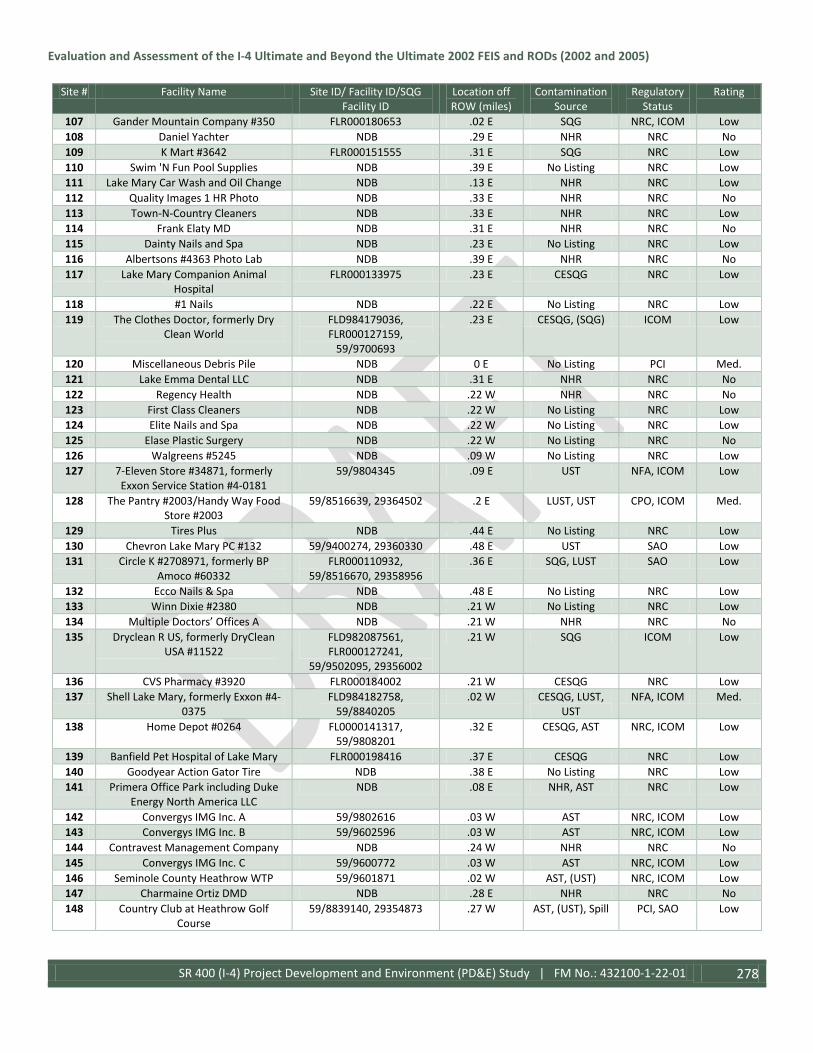
Evaluation and Assessment of the I-4 Ultimate and Beyond the Ultimate 2002 FEIS and RODs (2002 and 2005)
SR 400 (I-4) Project Development and Environment (PD&E) Study | FM No.: 432100-1-22-01 278
Site # Facility Name Site ID/ Facility ID/SQG Facility ID
Location off ROW (miles)
Contamination Source
Regulatory Status
Rating
107 Gander Mountain Company #350 FLR000180653 .02 E SQG NRC, ICOM Low 108 Daniel Yachter NDB .29 E NHR NRC No 109 K Mart #3642 FLR000151555 .31 E SQG NRC Low 110 Swim 'N Fun Pool Supplies NDB .39 E No Listing NRC Low 111 Lake Mary Car Wash and Oil Change NDB .13 E NHR NRC Low 112 Quality Images 1 HR Photo NDB .33 E NHR NRC No 113 Town-N-Country Cleaners NDB .33 E NHR NRC Low 114 Frank Elaty MD NDB .31 E NHR NRC No 115 Dainty Nails and Spa NDB .23 E No Listing NRC Low 116 Albertsons #4363 Photo Lab NDB .39 E NHR NRC No 117 Lake Mary Companion Animal
Hospital FLR000133975 .23 E CESQG NRC Low
118 #1 Nails NDB .22 E No Listing NRC Low 119 The Clothes Doctor, formerly Dry
Clean World FLD984179036, FLR000127159,
59/9700693
.23 E CESQG, (SQG) ICOM Low
120 Miscellaneous Debris Pile NDB 0 E No Listing PCI Med. 121 Lake Emma Dental LLC NDB .31 E NHR NRC No 122 Regency Health NDB .22 W NHR NRC No 123 First Class Cleaners NDB .22 W No Listing NRC Low 124 Elite Nails and Spa NDB .22 W No Listing NRC Low 125 Elase Plastic Surgery NDB .22 W No Listing NRC No 126 Walgreens #5245 NDB .09 W No Listing NRC Low 127 7-Eleven Store #34871, formerly
Exxon Service Station #4-0181 59/9804345 .09 E UST NFA, ICOM Low
128 The Pantry #2003/Handy Way Food Store #2003
59/8516639, 29364502 .2 E LUST, UST CPO, ICOM Med.
129 Tires Plus NDB .44 E No Listing NRC Low 130 Chevron Lake Mary PC #132 59/9400274, 29360330 .48 E UST SAO Low 131 Circle K #2708971, formerly BP
Amoco #60332 FLR000110932,
59/8516670, 29358956 .36 E SQG, LUST SAO Low
132 Ecco Nails & Spa NDB .48 E No Listing NRC Low 133 Winn Dixie #2380 NDB .21 W No Listing NRC Low 134 Multiple Doctors’ Offices A NDB .21 W NHR NRC No 135 Dryclean R US, formerly DryClean
USA #11522 FLD982087561, FLR000127241,
59/9502095, 29356002
.21 W SQG ICOM Low
136 CVS Pharmacy #3920 FLR000184002 .21 W CESQG NRC Low 137 Shell Lake Mary, formerly Exxon #4-
0375 FLD984182758,
59/8840205 .02 W CESQG, LUST,
UST NFA, ICOM Med.
138 Home Depot #0264 FL0000141317, 59/9808201
.32 E CESQG, AST NRC, ICOM Low
139 Banfield Pet Hospital of Lake Mary FLR000198416 .37 E CESQG NRC Low 140 Goodyear Action Gator Tire NDB .38 E No Listing NRC Low 141 Primera Office Park including Duke
Energy North America LLC NDB .08 E NHR, AST NRC Low
142 Convergys IMG Inc. A 59/9802616 .03 W AST NRC, ICOM Low 143 Convergys IMG Inc. B 59/9602596 .03 W AST NRC, ICOM Low 144 Contravest Management Company NDB .24 W NHR NRC No 145 Convergys IMG Inc. C 59/9600772 .03 W AST NRC, ICOM Low 146 Seminole County Heathrow WTP 59/9601871 .02 W AST, (UST) NRC, ICOM Low 147 Charmaine Ortiz DMD NDB .28 E NHR NRC No 148 Country Club at Heathrow Golf
Course 59/8839140, 29354873 .27 W AST, (UST), Spill PCI, SAO Low

Evaluation and Assessment of the I-4 Ultimate and Beyond the Ultimate 2002 FEIS and RODs (2002 and 2005)
SR 400 (I-4) Project Development and Environment (PD&E) Study | FM No.: 432100-1-22-01 279
Site # Facility Name Site ID/ Facility ID/SQG Facility ID
Location off ROW (miles)
Contamination Source
Regulatory Status
Rating
149 Defalco Advertising Inc. FLD984242974 .19 W CESQG NRC Low 150 Bellsouth Telephone Inc. #39280 59/9103085 .01 W (UST) NRC Low 151 Lake Emma Animal Hospital FLR000133835 .39 E NHR NRC Low 152 SAP/MI Homes/Syniverse NDB .11 W AST NRC Low 153 American Automobile Association 59/9300256 .17 W AST, UST NFA, ICOM Low 154 Emergency Generator on
International Parkway NDB .01 W AST NRC Low
155 Advanced Solar Photonics LLC, formerly Siemens and Stromberg-
Carlson
FLR000175653, FLD061989448, 29355283
.22 E CESQG, (SQG) EDB
PCI, PHMC High
156 Maria Tartibi NDB .41 E NHR, AST NRC Low 157 Chase Bank NDB .18 W AST NRC Low 158 Cell Tower with Natural Gas Powered
Generator C .38 E No Listing NRC Low
159 Seminole State College NDB .26 W AST NRC Low 160 Lake Mary Fire Station 37 NDB .36 E AST NRC Low 161 Porter Paints NDB .47 E NHR NRC No 162 Florida Vein Care and Cosmetic
Center FLR000133967 .47 E NHR NRC No
163 Dr. Kevin T Bonn DMD FLR000133942 .47 E NHR NRC No 164 Logan Eye Care LLC , formerly Lake
Mary Chiropractic Center, Skyemed, and Sphynx Health Inc.
FLR000133884 .47 E NHR, CESQG NRC No
165 Dunn Cordoba and Savastano Orthodontics
FLR000133959 .47 E NHR NRC No
166 Precision Play Media Group NDB .02 W AST NRC Low 167 Charisma Media, formerly Numa
Corporation FLD086233111 .37 E SQG NRC Low
168 Seminole County Utilities Generator NDB .34 W AST NRC Low 169 21ST Century Insurance 59/9803702 .07 E AST NRC, ICOM Low 170 ABB Power T & D Company Inc. FLR000055293 .16 E SQG NRC Low 171 Symantec A NDB .05 W AST NRC Low 172 Colonial Center Heathrow 901
Building 59/9802223 .07 W AST ICOM Low
173 Symantec B 59/9807998 .16 W AST NRC, ICOM Low 174 US Postal Service FL6180000121,
59/9101549, 59/9808404 .04 E CESQG, (SQG),
AST, (UST), Spill NFA, ICOM Low
175 Groundwater Contamination Plume #59263123
NDB .42 E EDB CRD Low
176 Leslie's Pool Supplies NDB .37 E NHR NRC No 177 Publix Super Market #833 59/9809833 .38 E AST NRC Low 178 For Your Nails plus Tan NDB .39 E No Listing NRC Low 179 Orchid Cleaners NDB .39 E No Listing NRC Low 180 CVS Pharmacy #3270 FLR000187724 .2 E SQG NRC Low 181 AT&T, formerly Bellsouth Telephone
Inc. #301BH 59/9805384 .39 W AST NRC Low
182 Florida Cancer Specialists FLR000177337 .22 E CESQG NRC Low 183 Marriott Orlando Lake Mary 59/9804875 .05 W AST NRC, ICOM Low 184 Golden Touch Dry Cleaners NDB .06 W No Listing NRC Low 185 Oaklawn Funeral Home & Cemetery 59/8840620 .23 E AST NRC Low 186 Colonial Town Park Unlisted Sites NDB .18 W AST NRC Low 187 Publix Super Market #1304 59/9812625 .2 W AST NRC, ICOM Low 188 BNY Investment Management
Services LLC 59/9804745 .13 W AST NRC Low
189 Dr. Tim Tiralosi DMD NDB .18 W NHR NRC No

Evaluation and Assessment of the I-4 Ultimate and Beyond the Ultimate 2002 FEIS and RODs (2002 and 2005)
SR 400 (I-4) Project Development and Environment (PD&E) Study | FM No.: 432100-1-22-01 280
Site # Facility Name Site ID/ Facility ID/SQG Facility ID
Location off ROW (miles)
Contamination Source
Regulatory Status
Rating
190 Pershing LLC 59/9809571 .27 W AST NRC, ICOM Low 191 Sanford Infiniti NDB .08 E No Listing NRC Low 192 Autonation Acura FLR000109017 .22 E CESQG, AST NRC Low 193 Sam's Club #4785 FLR000092007 .34 E CESQG NRC Low 194 Sam's Gas #4785 59/9804907 .22 E UST NRC Low 195 Platinum Nails and Spa NDB .34 E No Listing NRC Low 196 Autonation Honda Sanford FLR000109033 .15 E CESQG, AST NRC Low 197 Mercedes-Benz of North Orlando FLR000109025 .21 E CESQG, AST ICOM Low 198 David Maus Toyota FLR000136432,
59/9808377 .14 SE SQG, AST NRC, ICOM Low
199 Carmax #7247 59/9806029 .33 E AST NRC, ICOM Low 200 Seminole Powersports FLR000118786 .35 E SQG NRC Low 201 David Maus Chevrolet NDB .05 SE No Listing NRC Low 202 Evolution Auto NDB .38 E No Listing NRC Low 203 Granite Construction Company 59/9803316 .13 E LAST, AST, Spill PCI, PHMC Low/Med. 204 Target #1966 FLR000126706 .3 E SQG NRC Low 205 Koi Nails and Spa NDB .5 E No Listing NRC Low 206 Fields Chrysler Jeep Dodge Ram NDB .11 NE No Listing NRC Low 207 Sears Auto Center NDB .1 E No Listing NRC Low 208 Seminole Towne Center Mall NDB .06 E No Listing NRC Low 209 JSK Trucking Inc. Spill Site 59/9805593, 29369193 0 E Spill CRD Med. 210 Dillard's Department Store 59/9502869, 59/9502808 .09 E AST ICOM Low 211 Gateway Plaza, former Site of
Northgate West, Seminole Farms Trust IV
59/9401441 .29 E LUST NFA Low
212 Autonation Ford Sanford FLR000047449, 59/9701000
.16 W CESQG, AST NRC Low
213 Former Site of Stuckey's Pecans Shoppe
59/8516755 .03 E UST NFA Low
214 Top Dog Express Car Wash and Oil Change
NDB .45 E No Listing NRC Low
215 FPL Rinehart Substation FLR000082602 .42 E SQG NRC Low 216 Seminole County Fire Station #34 59/9812484 .1 W AST NRC, ICOM Low 217 Cell Tower with Diesel Powered
Generator E NDB .05W AST NRC Low
218 IHOP Restaurant, formerly Mobil #02-DHW
59/8516633, 29361001 .05 E LUST SAO Med.
219 7-Eleven Store #34832, formerly Mobil Service Station #02-D68, Mobil
On-the-Run
FLD984205542, 59/9600569
.07 E UST NFA, ICOM Med.
220 Cathy's Fruit Stand 59/9103487 .08 E LUST CRD, SAO Med. 221 CVS Pharmacy #5195 FLR000190538 .31 E SQG NRC Low 222 Tire Kingdom #121 FLR000130559 .46 E SQG NRC Low 223 Pinch-A-Penny NDB .22 W No Listing NRC No 224 7-Eleven Food Store #33347 59/9805508 .16 W UST NFA Low 225 FDOT Right-of-Way, former BP
Amoco #60331 FLD984214395,
59/8516703, 29360995 .02 W SQG, LUST, Spills CPO, SAO Low
226 Sunshine Food Mart #306, formerly Sunoco #0613-4043 and Speedway
#9859
FLD000654046, 59/8944030, 59/8516662,
29361689
.06 E SQG, LUST SAO Med.
227 Sunshine Food Mart #345, formerly Chevron #47968
59/8516753, 29358231 .09 E LUST CRD High
228 Days Inn #54 59/8516597, 29358235 .09 E LUST CRD, SAO Med. 229 Racetrac #686 59/9803380 .37 E UST NRC Low

Evaluation and Assessment of the I-4 Ultimate and Beyond the Ultimate 2002 FEIS and RODs (2002 and 2005)
SR 400 (I-4) Project Development and Environment (PD&E) Study | FM No.: 432100-1-22-01 281
Site # Facility Name Site ID/ Facility ID/SQG Facility ID
Location off ROW (miles)
Contamination Source
Regulatory Status
Rating
230 BJ's Wholesale Club #133 at West Lake Super Center
FLR000142356, 59/9804239
.45 SE CESQG, AST, UST
NRC, ICOM Low
231 Your Neighborhood Cleaners NDB .27 W No Listing NRC Low 232 La Beaute Nails & Spa NDB .22 W No Listing NRC Low 233 Seminole County Lake Monroe WTP 59/9806004 .18 E AST NRC, ICOM Low 234 Former Site of SMT Sanford LLC and
ABB Inc. FLD099694572 .18 E SQG, (LQG) PCI Low
235 Mathews Associates Inc. NDB .21 E SQG NRC Low 236 Diamonds Electric Signs and Lighting FLR000140285 .3 E NHR NRC Low 237 PoliceCars Orlando FLR000161125 .3 E NHR NRC Low 238 A & S Electropolishing FLR000140327 .3 E SQG NRC Low 239 Cordeida Light, formerly Spun Brass
Inc. FLR000140335 .3 E NHR NRC Low
240 Former Site of Superior Screen Printing and Kid U Noting
FLD982092900, FLD984198291
.3 E SQG NRC Low
241 Gas Facility at Andre Court NDB .08 E No Listing NRC Low 242 Former Site of Street Customz Inc.,
and Thoroughbred Powerboats Inc. FLD984246751 .29 E CESQG NRC Low
243 Former Site of Macedo Motorsports FLR000161117 .29 E NHR NRC Low 244 Action Label Co Inc., formerly Gale
Products Inc. FLD175832195 .29 E CESQG NRC Low
245 Direct Furnishings, Duke Properties FLR000081869 .29 E CESQG (LQG) PCI Low 246 Furniture Design Gallery FLR000082248 .28 E CESQG NRC Low 247 Oglesby Construction Inc., formerly
Haley Construction Inc. FLR982150005,
59/9802954 .07 E (SQG), AST NRC, ICOM Low
248 Emulsion Engineering Inc., formerly Orlando Rivet & Manufacturing
Company
FLD041413220 .29 E SQG NRC Low
249 Five R Truck and Trailer NDB .06 E No Listing NRC Low 250 Former Site of Highway Valets Inc. FLD106496318 .19 E SQG NRC Low 251 Circuitronics Corporation, formerly
Environmental Technology Inc. FLD981856347 .28 E CESQG, (SQG) NRC Low
252 Audi North Orlando NDB .04 W No Listing NRC Low 253 Bill Heard Chevrolet FLR000073544,
59/9804210 .05 W SQG, AST PCI Low
254 Cell Tower with Diesel Powered Generator F
NDB .09 E AST NRC Low
255 Sanford Harley Davidson NDB .03 E No Listing NRC Low 256 High Reach 2, formerly Nations Rent
#61 FLD984245183 .14 E SQG NRC Low
257 Life Gas NDB .22 E No Listing NRC Low 258 Former site of Mathews Associates
Inc. FLD039565791, 29354566 .13 E SQG PCI Low/Med.
259 Velocity Powerboats, formerly Yamaha Golf Cart Corporation
FLR000092445 .04 E SQG, Spills PCI Med.
260 Tecta America, formerly General Works LLC
FLR000160333 .45 SE SQG NRC Low
261 Art Sensations Inc., formerly Flo-Rite Paints Inc.
FLD183071851 .17 E CESQG, Spills PCI Low
262 Go Electronics, formerly J & S Ink FLD984239954 .16 E SQG, AST NRC Low 263 Omega Medical Imaging, formerly
Emtek Products Inc. and C & S X-Ray Systems
FLD984262121, FLR000041665
.11 E SQG NRC Low
264 Powerplay Motorsports NDB .16 SE No Listing NRC Low 265 Maronda Systems FLD984249193 .5 SE SQG PCI Low

Evaluation and Assessment of the I-4 Ultimate and Beyond the Ultimate 2002 FEIS and RODs (2002 and 2005)
SR 400 (I-4) Project Development and Environment (PD&E) Study | FM No.: 432100-1-22-01 282
Site # Facility Name Site ID/ Facility ID/SQG Facility ID
Location off ROW (miles)
Contamination Source
Regulatory Status
Rating
266 RX Plus Pharmacy 59/9810662 .42 SE AST NRC Low 267 Advantage Medical Systems LLC FLR000192773 .25 SE CESQG NRC Low 268 Shields Environmental Inc. FLR000175778 .26 SE CESQG NRC Low 269 Omnicare of Central Florida FLR000190629 .26 SE CESQG NRC Low 270 Pro Build, formerly Maronda Systems 59/8944661 .48 SE AST NRC Low 271 Wharton Smith Corporate Office FL0000442350,
59/9810762 .23 SE CESQG, AST NRC Low
272 Florida Rock Industries 59/9803703 .13 SE AST NRC Low 273 Sanford Waterfront Economic
Enhancement Area BF590807000 .04 E Brownfield PCI Low
274 Bass & Swaggerty Raymond 59/8838827 .41 SE AST NRC Low 275 CSX Transportation Inc. FLR000199687 .05 E NHR NRC Low 276 The Pantry #2406 59/9046077, 29358240 .09 E LUST CPO, SAO Med. 277 Donnie Myers RV Service LLC NDB .01 E No Listing NRC Low 278 La Mesa RV Center Inc. NDB .04 W No Listing NRC Low 279 Former Site of Jean's Furniture 59/9803611 .14 E UST NRC Low 280 Miracle Marble and Acryl Group Inc. FLD982125775,
FLD982084675 .04 W SQG, Spills PCI Med.
281 Florida Metal Polishing Inc. and Ocean State Production Services Inc.
FLD981749211, FLR000096305
.03 W CESQG, SQG, (LQG)
NRC Low
282 The Briar Team 59/9601051, 59/8841440 .29 W AST NRC Low 283 Acme Metal NDB .3 W No Listing NRC Low 284 Former Site of William L. Strop Auto
Body FLD984169797 .3 W SQG NRC Low
285 Former Site of Rex Meyer Yachts Inc. FLD984181370 .3 W SQG, AST NRC Low 286 Florida Detroit Diesel Allison North
Inc., formerly Coastal Power Products Inc.
FLD981866502 59/8631411
.31 W SQG, AST NFA Low
287 Seminole County Port Authority of Sanford
FLD982174849, 59/8840097
.17 W NHR, AST PCI Low
288 ETUS Inc. FLR000009720 .12 W SQG ICOM Low 289 Water Specialists Technologies LLC FLR000108647 .12 W CESQG PCI Low 290 FDOT Diesel Powered Generator NDB 0 E No Listing NRC Low 291 Featherlite Coaches Inc. FLR000005777 .25 W SQG, (CESQG) NRC Low 292 Marinas LLC, formerly Hidden Harbor
Marina FLD982092082,
59/9047018 .28 NW SQG, LUST ICOM Low
293 Initial Marine Corporation FLD984188375 .22 NW SQG NRC Low 294 FPL Sanford Plant FLD000807784
64/8516621 .48 NW CESQG, AST VCA, ICOM Low
Table Abbreviations: Not in FDEP database (NDB), In Compliance (ICOM), Site Assessment Ongoing (SAO), No Reported Contamination (NRC), Contamination Reported (CRD), Voluntary Cleanup Agreement (VCA), No Further Action (NFA), Possible Heavy Metal Contamination (PHMC), Possible Contamination Issue (PCI), Cleanup Ongoing (CPO), Above ground storage tank (AST) Leaking above ground storage tank (LAST), Underground storage tank (UST), Leaking underground storage tank (LUST), Non-handler (NHR), Conditionally exempt small quantity generator (CESQG), Small quantity generator (SQG), Large quantity generator (LQG).
The 294 identified sites and the proposed pond sites and their corresponding risk rating are shown on Figure 3.43.
Pond sites were inspected via pedestrian transects and rated for their potential to have contamination. Out of the 33 pond sites, six were given medium risk rating, two were given a high risk rating and the remaining 25 were given a low risk rating.

Evaluation and Assessment of the I-4 Ultimate and Beyond the Ultimate 2002 FEIS and RODs (2002 and 2005)
SR 400 (I-4) Project Development and Environment (PD&E) Study | FM No.: 432100-1-22-01 283
Three sites were identified as groundwater contamination plumes of ethylene dibromide (EDB) and encompass 33 other listed contamination sites, in addition to pond sites 300 and 300-B. Pond Site 300-A is located adjacent to a delineated groundwater contamination plume, and all three were given a medium risk rating. In addition to the contamination plume, discarded debris such as labeled and unlabeled bottles and canisters were discovered at the pond site in the southeast quadrant of the interchange at Lake Mary Boulevard, which was also given a medium risk rating. Pond sites 308 and 309 were given high risk ratings based upon their location near a listed contamination site and the potential for heavy metal contamination. Swales 313A, 313B and 313C were given medium risk rating based on their proximity to four listed sites that are known contamination sites which may not have been cleaned up.
Based on historic aerials, land use in the area before the construction of I-4 consisted of rural citrus groves, row crop farms, and pasture land. Potential contamination impacts from these activities include additional EDB contamination from the citrus groves, pesticide/herbicide/fertilizer contamination from the farms, and arsenic contamination from potential cattle dips associated with the pastures. However, the existence, exact location, and severity of these potential sources of contamination are mostly unknown.

Evaluation and Assessment of the I-4 Ultimate and Beyond the Ultimate 2002 FEIS and RODs (2002 and 2005)
SR 400 (I-4) Project Development and Environment (PD&E) Study | FM No.: 432100-1-22-01 284
Figure 3.43: Segment 3 Potential Contamination Sites

Evaluation and Assessment of the I-4 Ultimate and Beyond the Ultimate 2002 FEIS and RODs (2002 and 2005)
SR 400 (I-4) Project Development and Environment (PD&E) Study | FM No.: 432100-1-22-01 285
For Segment 4, a detailed site inspection was conducted of the I-4 corridor and proposed pond sites in April, May, and June 2013, and March, October, and November 2014. Aerial photos from 1943-2014 were reviewed to identify any potential activities that may indicate that contamination from hazardous or petroleum substance generation, storage, or transportation may have occurred within the project area. Historic aerial photographs were reviewed using the State University System of Florida, Publication of Archival Library & Museum Materials website.
Forty three potential stormwater management facilities were evaluated for this segment including all preferred and not preferred alternatives; twelve are existing facilities which were previously permitted and are being modified or enlarged to meet the requirements of the project, while four are existing and will be utilized with no modifications. Twenty four new pond sites and two new treatment swales (Swales 401-A & 401-B) and one stormwater vault are proposed. A contamination potential rating for each pond site within the proposed project limits is shown in Table 3.60 below using the same system for ranking other contamination sites as described in the methodology section above.
Table 3.60: Potential Contamination Ratings for Pond Sites in Segment 4 Pond Site # Contamination Source Rating
400 NRC Low 401 NRC Low
TS 401A NRC Low TS 401B NRC Low
402A NRC Low 402B NRC Low 402C NRC Low 402D NRC Low 402E NRC Low 402F NRC Low
FPC 403 NRC Low 403 NRC Low
405A NRC Low 405B NRC Low 406A NRC Low 406B NRC Low
FPC 407 NRC Low 407A NRC Low 407B NRC Low 407C NRC Low 408 PCI Med.
408 (ALT) PCI Med. Stormwater Vault 408 PCI Med.
408B PCI Med. 408D1 PCI Med. 409-A1 NRC Low 409-A2 NRC Low 409-B1 NRC Low
A NRC Low B NRC Low
B1 NRC Low C NRC Low D NRC Low
410 NRC Low 411 NRC Low 412 NRC Low 413 NRC Low

Evaluation and Assessment of the I-4 Ultimate and Beyond the Ultimate 2002 FEIS and RODs (2002 and 2005)
SR 400 (I-4) Project Development and Environment (PD&E) Study | FM No.: 432100-1-22-01 286
Pond Site # Contamination Source Rating 414 NRC Low 415 NRC Low 416 NRC Low 417 PCI Med. 418 NRC Low
Table Notes: No Reported Contamination (NRC), Possible Contamination Issue (PCI)
A total of one hundred thirty three sites within the study area were identified as being potential handlers of hazardous materials or having some type of involvement with potential contamination. Of these sites, none had a high risk rating, but eight had a medium risk rating including Sites #33, #40, #73, #74, #105, #107, #110, and #111. The remaining one hundred twenty five sites identified received a no risk or low risk rating. Table 3.61 below lists an assigned site number corresponding with the facility name and location.
Table 3.61: Regulatory Status & Rating of Potential Contamination Sites in Segment 4 Site # Facility Name Site ID/ Facility ID/SQG Facility
ID Location off ROW (miles)
Contamination Source
Regulatory Status
Rating
1 FPL Sanford Plant FLD000807784, 64/8516621 .48 NW CESQG, AST NFA, ICOM Low 2 City of DeBary Brownfield Area BF641401000 .41 NW Brownfield NRC Low 3 FDOT Vacant Property, formerly
DeBary Tank No. 3 64/9803356 .55 NW LUST CRD Low
4 Granite Construction Site 64/9804633 .61 NW AST NRC Low 5 DeBary Radiator FLD984220327 .73 NW CESQG NRC Low 6 Clayton & Sons Salvage Yard FLR000074088 .67 NW CESQG ICOM Low 7 Adkins Trick Repair, formerly
Sunbelt Auto Carriers FLD982106858 .79 NW CESQG NRC Low
8 Private Residence listed as Rich Frary Home Improvement Inc.
NDB .49 NW No Listing NRC No
9 Duke Energy Florida Turner Plant #B FLD000623033, 64/9100061, 29360978
.5 SE CESQG, LAST CRD/NFA Low
10 Private Residence listed as Certified Renovations LLC
NDB .14 E No Listing NRC No
11 The Pantry and Kangaroo Express #1269
FLD984199257, 64/9063998 .06 W SQG, LUST NFA Low
12 Lil Sammy's Food Mart 64/9600926, 29359951 .17 E LUST CPO Low 13 Deltona LS #5 Generator NDB .09 E AST NRC Low 14 Travelodge, formerly Deltona Best
Western Motel 64/8517347 .05 E No Listing NRC Low
15 FDOT Diesel Powered Generator NDB 0 E AST NRC Low 16 Private Residence listed as Allgood
Towing LLC NDB .08 W No Listing NRC No
17 City of Deltona, formerly Harbor Branch Environmental
NDB .43 E AST NRC Low
18 Deltona Middle School NDB .48 E NHR NRC No 19 Joseph Thomas DPM PA NDB .03 E CESQG NRC Low 20 Site listed as Mike Jones Painting NDB .08 E No Listing NRC No 21 Physicians Injury Care Center NDB .03 E NHR NRC No 22 Sunbelt Micro Electronics Inc. FLD982127714 .44 E SQG NRC Low 23 Private Residence listed as Midnight
Welding & Fabricating NDB .28 W NHR NRC No
24 Private Residence listed as M C Framing
NDB .08 E NHR NRC No
25 Private Residence listed as Frank Jones Towing Service
NDB .08 E NHR NRC No

Evaluation and Assessment of the I-4 Ultimate and Beyond the Ultimate 2002 FEIS and RODs (2002 and 2005)
SR 400 (I-4) Project Development and Environment (PD&E) Study | FM No.: 432100-1-22-01 287
Site # Facility Name Site ID/ Facility ID/SQG Facility ID
Location off ROW (miles)
Contamination Source
Regulatory Status
Rating
26 City of DeBary Bill Keller Park NDB 0.18 W No Listing NRC Low 27 Private Residence listed as Richard
Crews Painting Corporation NDB .25 E No Listing NRC No
28 Private Residence listed as Prophotos
NDB .31 W NHR NRC No
29 Deltona Fountains Plaza Multiple Businesses
64/9700238 .09 E NHR, No Listing NRC Low
30 Deltona Discount Market, formerly Deltona Citgo and Cumberland
Farms #0988
FLD984224998, 64/8517320 .15 E SQG, UST NRC, ICOM Low
31 Deltona Shell, formerly First Coast Energy #2519 and Amoco Service
Station #60134
FLD984214403, 64/8841506, 64/8517545, 29367121
.18 E SQG, LUST CRD, ICOM Low
32 David All DDS NDB .1 E CESQG NRC Low 33 Muffler Man, formerly Shell First
Coast Energy #3101 and Deltona BP #24521
FLD984209163, 64/8517346, 29361984
.13 E SQG, LUST CRD Med.
34 Bessette Family Chiropractic NDB .17 E CESQG NRC Low 35 Circle K #4385 FLD984254466, 64/8622861 .19 E CESQG SAO, ICOM Low 36 Justin Square Plaza Multiple
Businesses FLD981030711 .12 E NHR, No Listing NRC Low
37 Andy's Seven LLC, Lil Sammy's Food Mart, formerly Lil Champ Food
Stores
FLD984199240, 64/8631469 .1 E SQG, LUST NFA, ICOM Low
38 Deltona Food Station, formerly Deltona Chevron
FLD984208421, 64/8517348 .1 E SQG, LUST NFA, ICOM Low
39 Michael Zerivitz DDS NDB .1 E NHR NRC No 40 Weeks Seafood Delivery Spill Site 64/9805552, 29361984 0 Spill, PHMC SAO, PCI Med. 41 OC Collision Center, formerly Joe's
Body Shop FLD984252536 .42 W CESQG NRC Low
42 Residential Building Supply 64/8735301 .37 W UST NRC Low 43 Enterprise Industrial Park Multiple
Businesses NDB .06 W NHR, AST, No
Listing NRC Low
44 Private Residence listed as Jose's Auto Detailing
NDB .03 E No Listing NRC Low
45 Private Residence listed as Lockhart Painting Services Inc.
NDB .24 E NHR NRC No
46 Private Residence listed as C & V Painting & Remodeling LLC
NDB .03 E No Listing NRC No
47 Private Residence listed as Jesse M Powers
NDB .08 E NHR NRC No
48 Site listed as Pell's Citrus & Nursery NDB .23 W NHR NRC No 49 Ace Air Conditioning, formerly Pool
World of Volusia Inc. NDB .31 W NHR NRC No
50 Private Residence listed as All Site Home Improvement
NDB .22 W NHR NRC No
51 Nancy's Nails NDB .35 W No Listing NRC Low 52 Private Residence listed as D & R
Painting & Home Remodeling NDB .03 E No Listing NRC Low
53 Deltona Boulevard Economic Development Zone
BF641204000 .1 E Brownfield NRC Low
54 Deltona Plaza Multiple Businesses FLR000037929, 64/9802118 .17 E SQG, NHR, No Listing
NRC Low
55 Private Residence listed as R White Photography LLC
NDB .11 W NHR NRC No

Evaluation and Assessment of the I-4 Ultimate and Beyond the Ultimate 2002 FEIS and RODs (2002 and 2005)
SR 400 (I-4) Project Development and Environment (PD&E) Study | FM No.: 432100-1-22-01 288
Site # Facility Name Site ID/ Facility ID/SQG Facility ID
Location off ROW (miles)
Contamination Source
Regulatory Status
Rating
56 Humberto A Dominguez MD NDB .42 W NHR NRC No 57 Maria Suarez DDS NDB .41 W CESQG NRC Low 58 Private Residence listed as Robert
Rosenberger Enterprises NDB .44 E NHR NRC No
59 Cordoba Orthodontics NDB .44 W NHR NRC No 60 Joseph V Calderone DMD NDB .42 W NHR NRC No 61 Deltona Utilities 64/8517344 .18 E UST, AST NRC Low 62 Private Residence listed as Chris
Bailey Painting NDB .49 E NHR NRC No
63 Private Residence listed as Mike Gerkin
NDB .3 E NHR NRC No
64 Private Residence listed as Paint on Demand Inc.
NDB .35 E NHR NRC No
65 Private Residence listed as Fernando Auto Electric
NDB .49 E NHR NRC No
66 E Z Play Internet Café, formerly Crown Cleaners
FLR000098004, 64/9809541 .03 S SQG NRC Low
67 Allure Nail Spa NDB .02 S No Listing NRC Low 68 Walgreens #07241 FLR000119149 .30 E CESQG NRC Low 69 Florida Injury/Cape Vista Dental NDB .33 W NHR NRC Low 70 Circle K #5979 64/9804253 .01 SW LUST NFA, ICOM Low 71 RaceTrac #641 64/9801812 .01 SW UST NRC, ICOM Low 72 Saxon Square Plaza Multiple
Businesses FLD984171132,
FLR000149179, 64/9810791 .01 N SQG, NHR, No
Listing NRC Low
73 Deltona Citgo, formerly Chevron Saxon Boulevard and Expert Car
Care
64/8731593 .02 E LUST NFA, ICOM Med.
74 Saxon Plaza Multiple Businesses NDB .01 N No Listing NRC Med. 75 Deltona Memorial Gardens
Maintenance Facility NDB .06 NW AST NRC Low
76 Cell Tower with Diesel Generator NDB .02 N AST NRC Low 77 Lowes #467 64/9802592 .45 NW AST NRC Low 78 Florida Hospital Fish Memorial FLR0000382895, 64/9401735,
64/8631442 .24 NW AST NRC Low
79 Wal-Mart Supercenter #563 FLR000156026, 64/9805749 .26 W SQG, AST NRC, ICOM Low 80 Private Residence listed as D & T
Tires Inc. NDB .13 E NHR NRC No
81 Private Residence listed as RS Painting Solutions Inc.
NDB .15 NE NHR NRC No
82 Private Residence listed as Carmen Torres Affordable Construction
NDB .03 E NHR NRC No
83 Private Residence listed as JNF Improvements & Services Inc.
NDB .08 E NHR NRC No
84 Private Residence listed as Niaples Painting
NDB .19 NE NHR NRC No
85 Private Residence listed as Miracle Brothers Site Development
Corporation
NDB .04 E NHR NRC No
86 Home Depot #6323 FLR000112011 .36 W CESQG NRC Low 87 Private Residence listed as Hauling
for Cheap NDB .09 E NHR NRC No
88 Private Residence listed as New World Painting
NDB .35 E No Listing NRC No
89 Private Residence listed as Don's Acrylic Decking Inc.
NDB .37 E NHR NRC No

Evaluation and Assessment of the I-4 Ultimate and Beyond the Ultimate 2002 FEIS and RODs (2002 and 2005)
SR 400 (I-4) Project Development and Environment (PD&E) Study | FM No.: 432100-1-22-01 289
Site # Facility Name Site ID/ Facility ID/SQG Facility ID
Location off ROW (miles)
Contamination Source
Regulatory Status
Rating
90 Private Residence listed as GD Painting
NDB .09 E NHR NRC No
91 Private Residence listed as SDQ Air & Mechanical Inc.
NDB .28 E NHR NRC No
92 Private Residence listed as Jimmy's Auto Detailing
NDB .22 E NHR NRC No
93 Private Residence listed as Creations
NDB .16 E NHR NRC No
94 Private Residence listed as Reliable Painting
NDB .15 E NHR NRC No
95 Private Residence listed as The Immaculate Reign
NDB .43 E NHR NRC No
96 Private Residence listed as Arnaldo Torres LLC
NDB .14 E NHR NRC No
97 Private Residence listed as Reliable Computers
NDB .05 E NHR NRC No
98 Four Towns Wastewater Treatment Plant
FLA011118 .38 SW (RI) AST NRC Low
99 Florida Gas Transmission Company Gas Pipeline
NDB .06 W, 0.0 (RI)
No Listing NRC Low
100 Halifax Health Hospice Care Center 64/8837872 .37 S (RI) AST NRC Low 101 Private Residence listed as Eric Ray
Frankton NDB .04 E NHR NRC No
102 Private Residence listed as Chico Kools Technologies
NDB .33 SE (RI) NHR NRC No
103 Deltona Utilities Vicksburg Facility 64/8943588 .48 SE (RI) AST NRC Low 104 City of Deltona WTP #17 64/9807020 .05 E AST NRC, ICOM Low 105 Vacant Wooded Parcels NDB 0.0 (RI) Solid
Waste/Illicit dumping
NRC Med.
106 CNH Structural LLC NDB .37 SW (RI) NHR NRC No 107 Harty Tractor Services Inc. including
Land Clearing Debris Site 64/9806496, 64/29547 .12 W (RI) AST, Landfill NRC Med.
108 Cell Tower with Diesel Powered Generator
NDB .31 SW (RI) AST NRC Low
109 Orange City Area Debris Staging Area
64/98383 0.0 S (RI) Solid Waste NRC Low
110 The Pines Golf Club and Maintenance Facility
NDB .02 W, .01 N (RI)
No Listing NRC Med.
111 G.E.L. Corporation Site 64/83730 .12 W (RI) Landfill CRD Med. 112 Aquaticart Designs and Pioneer
Woodcraft Corporation NDB .36 NW (RI) NHR NRC No
113 Harry’s Towing Services Inc. FLR000169458, 64/9801127 .35 NW (RI) UST, AST NRC Low 114 Stephen’s Motorworks Inc.,
formerly Servello & Son Inc. NDB .35 NW (RI) NHR NRC No
115 Santiago Auto Body, Formerly Garland Transmissions
NDB .34 NW (RI) NHR NRC No
116 Site listed as West Volusia Welding NDB .32 NW (RI) CESQG NRC Low 117 Juan Carlos Auto Repair, formerly
IFEC Auto Repair and MC Auto Repair
NDB .29 NW (RI) CESQG NRC Low
118 Keller’s Storage & Work Shop, formerly Harris Mobile Recycling
FL0000917542 .27 NW (RI) CESQG NRC Low
119 Multiple Businesses located at 1070 Shadick Drive
FLR000167221, FLD984247080 .23 NW (RI) CESQG NRC Low

Evaluation and Assessment of the I-4 Ultimate and Beyond the Ultimate 2002 FEIS and RODs (2002 and 2005)
SR 400 (I-4) Project Development and Environment (PD&E) Study | FM No.: 432100-1-22-01 290
Site # Facility Name Site ID/ Facility ID/SQG Facility ID
Location off ROW (miles)
Contamination Source
Regulatory Status
Rating
120 Gator Radiator LLC NDB .21 NW (RI) NHR NRC Low 121 Chinchor Electric Inc. NDB .37 NW (RI) NHR NRC Low 122 Universal Packaging & Machinery
Sales Corporation FLD982144065 .36 NW (RI) SQG NRC Low
123 A&J Auto Repair, formerly RC Auto Sales Inc.
NDB .30 NW (RI) NHR NRC No
124 Former Site of Attachment Sales Inc.
NDB .27 NW (RI) NHR NRC No
125 John Knox Village 64/8837872 .41 N (RI) LUST CRD Low 126 Private Residence listed as Hancock
Painting NDB .26 W NHR NRC No
127 Orange City RV Resort and site listed as Ed Young's Painting &
Pressure Cleaning
NDB .06 W NHR NRC Low
128 RaceTrac #2334 64/9814086 .15 E UST NRC Low 129 Orange City Village Square Plaza
Multiple Businesses 64/9500543 .05 W NHR, No Listing NRC Low
130 Maschmeyer Concrete Deltona, formerly Inland Materials Inc.
FLR000093336, 64/8626138 .12 E CESQG, AST NRC, ICOM Low
131 Cemex Orange City Ready-Mix Plant 64/8839244 .62 NW UST, AST NRC, ICOM Low 132 Kobrin Builders Supply Inc. 64/8839147 .57 NW AST NRC Low 133 Sieg & Ambachtsheer Inc. FLR000150375 .46 NW CESQG NRC, PCI Low
Table Abbreviations: Not in FDEP database (NDB), In Compliance (ICOM), Site Assessment Ongoing (SAO), No Reported Contamination (NRC), Contamination Reported (CRD), Further Action (NFA), Possible Heavy Metal Contamination (PHMC), Possible Contamination Issue (PCI), Cleanup Ongoing (CPO), Above ground storage tank (AST) Leaking above ground storage tank (LAST), Underground storage tank (UST), Leaking underground storage tank (LUST), Non-handler (NHR), Conditionally exempt small quantity generator (CESQG), Small quantity generator (SQG), Rhode Island Avenue extension (RI).
The 133 identified sites and the proposed pond sites along with their corresponding risk rating are shown on Figure 3.44.
Based on historic aerials, land use in the Segment 4 area before the construction of I-4 consisted of natural lands with some pastures and citrus groves. Potential contamination impacts from these activities include ethylene dibromide and pesticide/herbicide/fertilizer contamination from the citrus groves, and arsenic contamination from railroad right of ways or potential cattle dips associated with the pastures. However, the existence, exact location and severity of these potential sources of contamination are mostly unknown.
Based upon the results of the investigation, it is recommended that all Medium and High rated sites have Phase II site assessments conducted prior to any project right-of-way acquisition or construction. FDOT committed to conduct this testing and had a contractor perform the testing during 2014 and 2015 in coordination with the FDOT District 5 Environmental Management Office. In addition, all bridges and other structures which will require possible demolition or retrofit should be tested for asbestos containing materials, metals-based paint or any other hazardous materials prior to construction. Should any parcels containing medical facilities, doctor offices, hospitals, or drug stores be acquired, they should be tested for asbestos, metals-based paint, x-ray equipment, lead-lined walls, chemicals, and pharmaceuticals prior to demolition. If petroleum-containing or hazardous materials, and/or contaminated soils/groundwater are encountered during performance of construction activities, appropriate activities should be immediately taken to protect site worker safety and (if possible) to prevent the spread of contamination to otherwise non-impacted media. It is recommended that any excavation, demolition or dewatering activities within or adjacent to any of the identified medium risk pond sites should require soil, groundwater, and hazardous material testing before construction.

Evaluation and Assessment of the I-4 Ultimate and Beyond the Ultimate 2002 FEIS and RODs (2002 and 2005)
SR 400 (I-4) Project Development and Environment (PD&E) Study | FM No.: 432100-1-22-01 291
Figure 3.44: Segment 4 Potential Contamination Sites

Evaluation and Assessment of the I-4 Ultimate and Beyond the Ultimate 2002 FEIS and RODs (2002 and 2005)
SR 400 (I-4) Project Development and Environment (PD&E) Study | FM No.: 432100-1-22-01 292
BtU Contamination Summary The I-4 BtU Study identified potential contamination sites within Segments 2, 3, and 4 that may have existed at the time of the original study or occurred after the completion of the study. Segment 2 could require partial or total right-of-way acquisition of 8 Medium Risk sites and has 4 Medium Risk Pond sites. Segment 3 could require partial or total right-of-way acquisition of 13 Medium Risk sites and 1 High Risk site, and has 6 Medium Risk Pond sites and 2 High Risk Pond sites. Segment 4 could require partial or total right-of-way acquisition of 8 Medium Risk sites and has 6 Medium Risk Pond sites. This proposed project contains no known significant contamination.
With the No-Build Alternative, no direct impacts relating to contamination would occur as a result of the project being implemented. However, sources of contamination identified within the project area would remain, and the potential for other sources of contamination being identified is still there despite the project not moving forward.
3.4.4 Floodplains and Regulatory Floodways Executive Order 11988, Floodplain Management, USDOT Order 5650.2, Floodplain Management and Protection, and FHPM 6-7-3-2 and 23 CFR 650A provide protection, analysis, mitigation, and documentation of floodplains and floodways. The intent of these regulations is to avoid or minimize encroachments within the 100-year (base) floodplain, where practicable, and to avoid supporting land use development that is incompatible with floodplain values.
The original PD&E Study project corridor contains two distinct varieties of base floodplain involvement: 100-year floodplain associated with lake basins, and cross culverts. Information on the floodplains associated with lake basins was determined using Federal Emergency Management Area (FEMA) Flood Insurance Rate Maps (FIRM) for Orange, Seminole, and Volusia Counties; the Orange County Lake Index; as well as available basin and watershed studies. The base flood for cross culverts was determined by utilizing FDOT construction plans, available basin and watershed studies, and an analysis of each culvert in its existing condition. The analysis of each of these existing floodplain types can be found in the Location Hydraulics Report (August 2000).
Floodplains are sparsely present along the majority of the I-4 corridor and heavily present near the St. Johns River and Lake Monroe. There are two regulated floodways along the Ultimate project study corridor: Shingle Creek and the St. Johns River. The floodplain involvement for this study is presented by segment as follows:
Ultimate Segment 1 The floodplains were determined using the City of Orlando FEMA FIRM, Community Panel Number 120186 0020D, and Orange County Panel 120179 0375C. The majority of Ultimate Segment 1 is situated above the 100-year base floodplain with the exception of:
• A Zone “A” floodplain located at the I-4/Kirkman Road interchange and is an isolated floodplain area not associated with any water body. Two existing cross culverts (#6 and #7) are located north of the current interchange, which were documented to exhibit minor flooding in the past.
• A Zone “A” floodplain located north of the I-4/Kirkman Road interchange associated with culvert #7 described above.
• A Zone “A2” floodplain located at Shingle Creek, which is a FEMA regulated floodway.

Evaluation and Assessment of the I-4 Ultimate and Beyond the Ultimate 2002 FEIS and RODs (2002 and 2005)
SR 400 (I-4) Project Development and Environment (PD&E) Study | FM No.: 432100-1-22-01 293
Ultimate Segments 2 and 3 The floodplains were determined using the City of Orlando FEMA FIRM, Community Panel Number 120186 0015D and Orange County Panel 120179 0200B. No history of flooding is recorded for these floodplains. Ultimate Segments 2 and 3 are located above the 10-year base floodplain with the exception of:
• The Clear Lake and Lake Catherine floodplains located at the I-4/John Young Parkway interchange near the I-4 corridor and will not be impacted in the proposed condition.
• A Zone “A3” floodplain associated with Lake Concord. • A Zone “A3” floodplain associated with Lake Ivanhoe. • The Lake Fairview floodplain located at the I-4/Fairbanks Avenue interchange which will not be
impacted in the future condition.
Ultimate Segments 4 and 5* The floodplains were determined using FEMA FIRM Community Panels 120184 0005B for the City of Maitland, 120290 0010B for the City of Altamonte Springs, and Seminole County Panels 120289 0030B, -0040C, -0110B, -0120B, and -0130B. There have been historical cyclic flooding problems associated with Cranes Roost and Grace Lake. The majority of Ultimate Segments 4 and 5 are located above the 100-year base floodplain with the exception of:
• The Lake Killarney, Lake Bell, and the unnamed depressional area floodplains located at the I-4/Lee Road interchange which will not be impacted in the future condition.
• The Hungerford Lake, Lake Lucien, and Lake Destiny floodplains located south of the I-4/Maitland Boulevard interchange which will not be impacted by the proposed improvements.
• The Lake Destiny floodplain located north of the I-4/Maitland Boulevard interchange which will not be impacted in the future condition.
• A Zone “A6” floodplain is associated with Cranes Roost, just north of the I-4/SR 436 interchange. There is a history of flooding problems associated with Cranes Roost, which are directly related to the fact that the flood stages are controlled via a pumping station. The water from the pumping station discharges to the Little Wekiva River and is subject to stringent pumping constraints to maintain a minimum pollution loading at its outfall. Therefore, when any permitted pumping, stage, or turbidity threshold is met, the pumping operation must cease, which increases the surface elevation in Cranes Roost and causes the flooding problems.
• A Zone “A3” floodplain is associated with Grace Lake, just north of the EE Williamson overpass. During the original construction of I-4, Grace Lake was bisected by the interstate and hydraulically connected by a cross culvert (structure #24). During higher stages, the lake fills to its original bank line by backing into structure 24 and flooding the lake remnant west of I-4. This flooding was part of the I-4 original design and does not affect the interstate during these high stage events. The Trout Lake floodplain north of I-4/Paola Road interchange will not be impacted in the proposed condition.
• A Zone "A" floodplain is located north of the I-4/SR 46 interchange and is associated with the Lockhart-Smith Canal.

Evaluation and Assessment of the I-4 Ultimate and Beyond the Ultimate 2002 FEIS and RODs (2002 and 2005)
SR 400 (I-4) Project Development and Environment (PD&E) Study | FM No.: 432100-1-22-01 294
Ultimate Segment 6* The floodplains were determined using FEMA FIRM Community Panel 120184 0030B for Seminole County and Panels 125155 0475C and 125155 0600C for Volusia County. There have been historical cyclic flooding problems at Saxon Boulevard. The majority of Ultimate Segment 6 is located above the 100-year base floodplain with the exception of:
• A Zone “C” floodplain located at the I-4/US 17-92 interchange associated with the Lake Monroe floodplain.
• Zone “A” floodplains located at the I-4/US 17-92 interchange associated with the Lake Monroe floodplain.
• The St. Johns River is considered a FEMA regulated floodway. • A Zone “A” floodplain located through the Lake Monroe ‘flats’ between US 17-92 and Dirksen
Drive/DeBary Avenue. The original construction of I-4 bisected this existing floodplain. No flooding of I-4 has been recorded through this area; however, areas along the Lake Monroe perimeter have experienced higher flood stages due to increased development within the historical 100-year floodplain.
• A Zone “A” floodplain located at the I-4/Saxon Boulevard interchange which is associated with Trout Lake. There is a history of flooding problems at this interchange that are not directly related to the floodplain or the existing cross culvert, which hydraulically connects Trout Lake to Goose Lake. The recorded flooding took place during 1994-1995 in which a combination of events occurred that affected the interchange and the surrounding areas. During that time, above average rainfall and an increase in the potentiometric surface elevation of the Floridan Aquifer reduced the recharge rate to the aquifer from Goose and Trout Lakes. As a result, the static water surface elevation in both of these lakes increased with each rainfall event and portions of the interchange ramps were encroached; the I-4 mainline remained flood free. This is a cyclic event and during normal conditions, recharge to the aquifer provides adequate recovery for these lakes.
• The Mallard Lake floodplain located north of the I-4/Saxon Boulevard interchange will not be impacted in the proposed conditions.
*A portion of Ultimate Segment 4 and all of Ultimate Segments 5 and 6 are located to the north of the end limits of the approved Ultimate project currently under construction. The original PD&E Study determined that the proposed improvements to I-4 would minimally impact several floodplains and floodways along the corridor. The impacts were described generally as follows:
• The impact of the proposed improvements is minimal and will be mitigated as appropriate. The likelihood of flood risk is minimized due to the stringent culvert hydraulic analysis and proposed floodplain impact mitigation proposed.
• No adverse impacts on natural and beneficial floodplain values are anticipated since the majority of improvements are confined within the existing roadway corridor. Additionally, mitigation is proposed where necessary.
• The improvements to the interstate will not encourage developments within the base floodplain since they occur within a limited access facility that provides controlled entrance and exit points.

Evaluation and Assessment of the I-4 Ultimate and Beyond the Ultimate 2002 FEIS and RODs (2002 and 2005)
SR 400 (I-4) Project Development and Environment (PD&E) Study | FM No.: 432100-1-22-01 295
• There are no records of traffic interruption due to flooding on the existing mainline and the facility will continue to provide flood-free access; therefore, the floodplain impacts associated with the improvements will not adversely affect the operation of emergency services.
• Floodplain impacts have been minimized and avoided where practical by using shoulder gutters, closed drainage systems, retaining walls, and bridges.
A Location Hydraulics Report (August 2000) that provides an in-depth study of the floodplain and floodway impacts has been prepared for this study. The subsequent segment discussions provide a general description of those floodplain and floodway impacts as well as restoration and / or mitigation measures for the impact areas.
Replacement drainage structures for the Ultimate project would be limited to hydraulically equivalent structures. The limitations to the hydraulic equivalency being proposed are basically due to restrictions imposed by the geometrics of design, existing development, cost feasibility, or practicability. An alternative encroachment location is not considered in this category since it defeats the project purpose or is economically unfeasible. Since flooding conditions in the project area are inherent in the topography of are a result of other outside contributing sources, and there is no practical alternative to totally eradicate flood impacts or even reduce them in any significant amount, existing flooding will continue, but not be increased. The proposed structures will be hydraulically equivalent to or greater than the existing structures, and backwater surface elevations are not expected to increase. As a result, the Ultimate project will not affect existing flood heights or floodplain limits. The Ultimate project will not result in any new or increased adverse environmental impacts. There will be no significant change in the potential for interruption or termination of emergency services or emergency evacuation routes. Therefore, it was determined that the encroachment would not be significant.
The total area of impact within the Ultimate project section was calculated at 46.04 acre feet over four primary areas. Additional minimal impacts at 3 locations would be equal to the volume of new bridge piers. The impacts area as follows:
Ultimate Segment 1 Between Kirkman Road and John Young Parkway, there are two floodplain impacts and one floodway impact within this portion of Segment 1. The two floodplain impact areas (Area A and B) would result in approximately 29.33 acre-feet and 1.98 acre-feet, respectively. These are minimal impacts when compared to the overall floodplain with which they are associated. Compensation will be provided in the proposed stormwater management ponds. A third impact (Area C) would result in approximately 8.70 acre-feet of displaced floodplain volume associated with Shingle Creek (A FEMA regulated floodway). The crossing of Shingle Creek would include the placement of bridge piles within the floodway to accommodate the roadway widening. The piles will be placed and oriented so that no impact to this floodway will occur. Compensation for the displaced volume at this site will be provided in proposed stormwater management ponds. Ultimate Segments 2 and 3 There are two floodplain impacts in these segments associated with Lake Concorde and Lake Ivanhoe, which are expected to be minimal. To minimize the impacts to these lakes, the proposed mainline improvements and additional ramps will be bridged instead of built on fill; therefore, the impacts within the floodplains will be equal to the volume of the bridge piers. Excavating fill adjacent to the interstate will compensate for this minimal fill volume.

Evaluation and Assessment of the I-4 Ultimate and Beyond the Ultimate 2002 FEIS and RODs (2002 and 2005)
SR 400 (I-4) Project Development and Environment (PD&E) Study | FM No.: 432100-1-22-01 296
Ultimate Segment 4* There are two floodplain impacts within this segment (Areas F and G) which are located at Cranes Roost and Grace Lake. The impacts to Cranes Roost are minimal and equal to the volume of bridge piers for the proposed bridge. Excavating existing fill adjacent to I-4 will provide compensation for the bridge piers. Approximately 6.03 acre-feet of displaced volume is expected to the floodplain associated with Grace Lake as a result of the improvements. Compensation is expected to be provided at Pond CP-1. The compensation is not designed to improve the historic flooding on the west side of I-4, but will maintain the current high water elevation for a 100-year storm event. Ultimate Segment 5* There is one floodplain impact within this segment (Area N), where approximately 0.26 acre-feet is expected to be displaced and is insignificant in total. No separate floodplain compensation/mitigation is proposed. Ultimate Segment 6* Seven impact areas are anticipated within the segment: (Areas O, P, Q, R, S, and T), which are located at the I-4/US 17-92 interchanges and adjacent to I-4 through the Lake Monroe floodplain and total approximately 289.17 acre-feet in impact volume, and one at Trout Lake near Saxon Boulevard totaling 2.85 acre-feet. *A portion of Ultimate Segment 4 and all of Ultimate Segments 5 and 6 are located to the north of the end limits of the approved Ultimate project currently under construction. The displaced volume increases the static Lake Monroe floodplain elevation by 0.018 feet over the total floodplain area and is considered insignificant. Several techniques are proposed to further minimize the impacts of the project: retaining walls, bridges, and enclosed stormwater systems. The St. Johns River is considered a regulated floodway, though no impacts to the floodway are anticipated as part of the project. (As part of the I-4 Six Laning and St. Johns River Bridge project, the substructure and superstructure for the general use lanes will be constructed. In addition the foundation for the HOV lanes would be constructed, limiting construction within the floodway to that one time) To minimize the impacts at Trout Lake, it is proposed to provide shoulder gutter and a closed storm sewer system. Compensation for this minimal impact is to be provided in the proposed retention ponds within the I-4 / Saxon Boulevard interchange since there is excess volume available according to the preliminary design. For the I-4 BtU PD&E Study, three separate Location Hydraulic Reports were completed which analyzed the potential floodplain and floodways within the three segments of the project area. Some changes in the FEMA FIRM maps occurred since the previous PD&E Study was conducted. The results of the floodplain analysis for the three segments within the BtU Study Area are discussed below. BtU Segment 2 Floodplains are sparsely present adjacent to some proposed ponds within the study limits; however, no floodways are located within the project area. The floodplains that are present alongside of the ponds are associated lakes or conveyance to those lakes. There will be no impacts to the existing floodplains or regulatory floodways as a result of this project. The FEMA FIRM maps for Orange County were updated in 2009. According to FEMA Map Nos. 12095C0405F AND 12095C0415F, none of the roadway or the existing ponds within this segment are located in the 100-year

Evaluation and Assessment of the I-4 Ultimate and Beyond the Ultimate 2002 FEIS and RODs (2002 and 2005)
SR 400 (I-4) Project Development and Environment (PD&E) Study | FM No.: 432100-1-22-01 297
floodplain. The proposed ponds 200-A, 200-B, 205-A and 205-B are adjacent to the 100-year floodplain, however, there is no impact to the floodplain. There are no regulatory floodways within the project corridor.
The Geographical Information System (GIS) and FEMA FIRM data identified two floodplain zones present within the project study area. These zones are shown on figure 3.45 below and identified as follows:
• Zone A – Area of 1% annual chance of flood (100-year flood), no base flood elevation determined; and • Zone AE – Area of 1% annual chance of flood (100-year flood), base elevation determined.
There are three existing structures which act as cross drains within the study area. The structures exist at mile posts 7.409 (station 1434+46), milepost 8.028 (station 1467+13), and milepost 8.545 (station 1494+90). Through hydraulic analysis, it was determined that all three cross drains need to be upsized.

Evaluation and Assessment of the I-4 Ultimate and Beyond the Ultimate 2002 FEIS and RODs (2002 and 2005)
SR 400 (I-4) Project Development and Environment (PD&E) Study | FM No.: 432100-1-22-01 298
Figure 3.45: Segment 2 FEMA Flood Insurance Map

Evaluation and Assessment of the I-4 Ultimate and Beyond the Ultimate 2002 FEIS and RODs (2002 and 2005)
SR 400 (I-4) Project Development and Environment (PD&E) Study | FM No.: 432100-1-22-01 299
BtU Segment 3 Floodplains are sparsely present within the study limits; however, no floodways are located within the project area. The 6.43 acre-feet of impacts associated with the roadway widening will be compensated for in existing pond sites and/or proposed floodplain compensation ponds. The FEMA FIRM maps were updated in 2007 for Seminole County and are reflected on Figure 3.46 below. According to FEMA Map Numbers 12117C0055F, 12117C0065F, 12117C0135F, and 12117C0155F, portions of the roadway and the existing pond within Basin 300 are located in the 100-year floodplain of Grace Lake. The roadway widening will impact the floodplain on both sides of the roadway.
There are two existing structures which act as cross drains within the study area, located at milepost 5.471 (station 2120+87) and milepost 5.731 (station 2134+09). The cross drain located at Milepost 5.471 is located within the 100-year floodplain. Through hydraulic analysis, it was determined that the existing cross drains will not create any adverse impacts. Therefore, the cross drain will not require upsizing. The remaining cross drain located at Milepost 5.731 will require a change in slope to function adequately.

Evaluation and Assessment of the I-4 Ultimate and Beyond the Ultimate 2002 FEIS and RODs (2002 and 2005)
SR 400 (I-4) Project Development and Environment (PD&E) Study | FM No.: 432100-1-22-01 300
Figure 3.46: Segment 3 FEMA Flood Insurance Map

Evaluation and Assessment of the I-4 Ultimate and Beyond the Ultimate 2002 FEIS and RODs (2002 and 2005)
SR 400 (I-4) Project Development and Environment (PD&E) Study | FM No.: 432100-1-22-01 301
BtU Segment 4 Floodplains are present within the study limits; however, no floodways are located within the project area. The floodplains that are present are located in Zone A and Zone AE. Compensation will be provided for the impacts to the 100-year floodplain as a result of this project. The FEMA FIRM maps were updated in 2014 for Volusia County and are shown on Figure 3.47 below. According to FEMA Map Nos. 12127C0730G, 12127C0735H, 12127C0620H and 12127C0610H, large portions of the roadway and several ponds lie within the 100-year floodplain. Based on the FEMA floodplain lines, the roadway widening will impact the floodplain on both sides of the roadway.
• Basin 400 – Based on the FEMA floodplain lines, the roadway widening within Lake Monroe Floodplain will impact the floodplain on both sides of the roadway and are located in Zone AE of the floodplain with an elevation of 9 feet NAVD. The roadway impacts the floodplain for a total of 55.75 acre-feet. The westbound impacts occur from Station 2634+00 to 2752+00. The eastbound impacts occur from Station 2640+00 to 2752+00. Compensation for the two basins will be provided in Pond 400 for this impact for a total of 64.58 acre-feet of compensation.
• Basin 403 – Based on FEMA floodplain lines, a small portion of the widening will impact the Gasline Lake Floodplain. The floodplain at Gasline Lake is classified as Zone A. Based on available contours the elevation for the floodplain is approximately 40 feet NAVD. The westbound portion of the shoulder will impact the Lake Gasline floodplain from Station 2842+20 to Station 2848+20 for a total of 2.41 acre-feet of impacts. A floodplain compensation pond (FPC 403) has been added adjacent to Lake Gasline to compensate for the fill to the floodplain from Station 2847+00 to 2849+00. Additional right-of-way will be required for floodplain compensation pond FPC 403 with an acquisition of one parcel.
• Basin 405 – Based on the FEMA FIRM map, the roadway right-of-way is located within the 100-year floodplain of Goose Lake and Trout Lake at Station 2905+00. An existing culvert hydraulically connects the two lakes. Goose Lake lies within Zone A and Trout Lake lies within Zone AE with an elevation of 26 NAVD. The ramps and ponds within the southwest quadrant of the Saxon Boulevard Interchange are located within this floodplain. Previously, SR 400 (I-4) was widened from four lanes to six lanes and compensation was provided in the existing ponds. Additional pavement and fill is not proposed within this area; therefore, no floodplain impacts are anticipated.
• Basins 407 & 408 – Based on FEMA floodplain lines, a small portion of the widening will impact the Trout Lake Floodplain. The floodplain at Trout Lake is classified as Zone A. Based on permit application number 42-127-3037-AN, the elevation for the floodplain is approximately 24.3 feet NAVD. The I-4 eastbound off-ramp to Saxon Blvd. will impact the Lake Trout floodplain for approximately 645 ft. for a total of 6.85 acre-feet of impacts. A floodplain compensation pond (FPC 407) has been added adjacent to Lake Trout providing 7.04 acre-feet of compensation area to compensate for the fill to the floodplain from Station 2908+00 to 2912+00. Additional right-of-way will be required for the proposed ramp alignment.
• Basin A (Rhode Island Avenue – A portion of proposed right-of-way along Rhode Island Avenue lies within the 100-year floodplain from Station 26+82 to Station 32+18. The floodplain is classified as Zone A and has a determined elevation of 17.86 NAVD (Permit No. 111974-1). Compensation for Rhode Island Avenue is provided in a compensation pond that is adjacent to Pond A. The floodplain pond lies within the existing Volusia County right-of-way.

Evaluation and Assessment of the I-4 Ultimate and Beyond the Ultimate 2002 FEIS and RODs (2002 and 2005)
SR 400 (I-4) Project Development and Environment (PD&E) Study | FM No.: 432100-1-22-01 302
There are three cross drains within the study area located at 6.169 (station 2904+29), milepost 6.960 (station 2946+25), and milepost 7.556 (station 2988+72.86). The existing cross drains have been evaluated for headwater impacts to see if replacement is necessary. Due to the proposed widening, the cross drains will require total replacement. Through hydraulic analysis, it was determined that the cross drains will be extended in length and the will all remain 36 inches in size.
Nearly all of the impacts described for the previous study were to occur within the Ultimate project area, with only those impacts proposed within Ultimate Segments 4, 5, and 6 occurring within the BtU project area. The resulting design of the BtU project has eliminated some of these impacts, and those that are still expected to occur as a result of the project are described below.
Segment 2 According to FEMA Map Nos. 12095C0405F and 12095C0415F, none of the roadway or the existing ponds within this segment is located in the 100-year floodplain. The proposed ponds 200A, 200B, 205A, 205B, 205C and 205D are adjacent to the 100-year floodplain; however, there is no impact to the floodplain. There are no regulatory floodways within the project corridor.
Segment 3 According to FEMA Map No. 12117C0135F, portions of the roadway and the proposed pond within Basin 300 (Pond E in Permit No. 22434-1) are located in the 100-year floodplain.
Based on the FEMA floodplain lines, the roadway widening will impact the floodplain on both sides of the roadway. The widening of the westbound lanes will impact the floodplain from Station 2116+00 to 2124+00 and is located in Zone AE of the floodplain with an elevation of 66.00 ft NAVD. The widening of the eastbound lanes will impact the floodplain from Station 2106+50 to 2124+50 and is located in Zone AE of the floodplain with an elevation of 66.00 ft NAVD. The pond berm for Pond 300 will also impact the floodplain and is located in Zone AE of the floodplain with an elevation of 66.00 ft NAVD. Although the pond berm causes an impact to the floodplain, the area of cut between the existing ground and the design high water will result in the pond providing compensation for the floodplain impacts. The roadway impacts the floodplain for a total of 6.43 ac-ft.
Two alternatives were evaluated for the floodplain compensation pond in this basin. Based on input provided at the public involvement meeting, individual meetings with property owners and other considerations, it was determined that FPC Pond 300-A has the least amount of impacts. Additional right of way will be required for floodplain compensation pond, FPC 300-A, with acquisition of one parcel.
Segment 4 According to FEMA Map Nos. 12127C0730G, 12127C0735H, 12127C0620H and 12127C0610H, large portions of the roadway and several ponds lie within the 100-year floodplain. Based on the FEMA floodplain lines, the roadway widening within the Lake Monroe Floodplain will impact the floodplain on both sides of the roadway and are located in Zone AE of the floodplain with an elevation of 9 feet NAVD. The roadway impacts the floodplain for a total of 55.75 acre-feet. The westbound impacts occur from Station 2634+00 to Station 2752+00 and the eastbound impacts occur from Station 2640+00 to Station 2752+00. Compensation for impacts to these two basins will be provided in Pond 400, for a total of 64.58 acre-feet of compensation.

Evaluation and Assessment of the I-4 Ultimate and Beyond the Ultimate 2002 FEIS and RODs (2002 and 2005)
SR 400 (I-4) Project Development and Environment (PD&E) Study | FM No.: 432100-1-22-01 303
Figure 3.47: Segment 4 FEMA Flood Insurance Map

Evaluation and Assessment of the I-4 Ultimate and Beyond the Ultimate 2002 FEIS and RODs (2002 and 2005)
SR 400 (I-4) Project Development and Environment (PD&E) Study | FM No.: 432100-1-22-01 304
Based on FEMA floodplain lines, a small portion of the widening will impact the Gasline Lake Floodplain. The floodplain at Gasline Lake is classified as Zone A. Based on available contours, the elevation for the floodplain is approximately 40 feet NAVD. The westbound portion of the shoulder will impact the Lake Gasline floodplain from Station 2842+20 to Station 2848+20 for a total of 2.41 acre-feet of impacts. A floodplain compensation pond (FPC 403) has been added adjacent to Lake Gasline to compensate for the fill to the floodplain from Station 2847+00 to 2849+00. Additional right-of-way will be required for floodplain compensation pond FPC 403 with an acquisition of one parcel.
Based on the FEMA FIRM map, the roadway right-of-way is located within the 100-year floodplain of Goose Lake and Trout Lake at Station 2905+00. An existing culvert hydraulically connects the two lakes. Goose Lake lies within Zone A and Trout Lake lies within Zone AE with an elevation of 26 NAVD. The ramps and ponds within the southwest quadrant of the Saxon Boulevard Interchange are located within this floodplain. Previously, SR 400 (I-4) was widened from four lanes to six lanes and compensation was provided in the existing ponds. Additional pavement and fill is not proposed within this area; therefore, no floodplain impacts are anticipated.
The floodplain at Trout Lake is classified as Zone A. Based on permit application number 42-127-3037-AN, the elevation for the floodplain is approximately 24.3 feet NAVD. The I-4 eastbound off-ramp to Saxon Blvd. will impact the Lake Trout floodplain for approximately 645 ft. for a total of 6.85 acre-feet of impacts. A floodplain compensation pond (FPC 407) has been added adjacent to Lake Trout providing 7.04 acre-feet of compensation area to compensate for the fill to the floodplain from Station 2908+00 to 2912+00. Additional right-of-way will be required for the proposed ramp alignment.
A portion of proposed right-of-way along Rhode Island Avenue lies within the 100-year floodplain from Station 26+82 to Station 32+18. The floodplain is classified as Zone A and has a determined elevation of 17.86 NAVD (Permit No. 111974-1). Compensation for Rhode Island Avenue is provided in a compensation pond that is adjacent to Pond A. The floodplain pond lies within the existing Volusia County right-of-way.
Additional information including detailed floodplain impacts and compensation calculations are presented in the Pond Siting Reports and Location Hydraulic Reports prepared for Segments 2, 3, and 4 for the project.
With the No-Build Alternative, no direct impacts to floodplains or floodways would occur.
3.4.5 Soils A preliminary geotechnical investigation was performed to conceptually evaluate roadway, stormwater management, and structure improvement constraints. The purpose was to review readily available published information regarding anticipated geotechnical conditions within the Ultimate project study area as well as to evaluate groundwater conditions at potential pond locations. The information reviewed for this study included the US Department of Agriculture (USDA) Soil Conservation Service (SCS) Soil Survey for Orange, Seminole, and Volusia Counties, Florida; the US Geological Survey (USGS) quadrangle maps for this area; and available topographic maps from Orange County, Seminole County, SJRWMD, and SFWMD. Additional details are available in the Soils Investigation Report (1998) prepared for this project, which includes results of field tests performed in conjunction with the project. Additional information on regional geology and hydrology in Orange, Seminole, and Volusia Counties was summarized in the Socioeconomic and Environment Report (May 2000) prepared in conjunction with the project.

Evaluation and Assessment of the I-4 Ultimate and Beyond the Ultimate 2002 FEIS and RODs (2002 and 2005)
SR 400 (I-4) Project Development and Environment (PD&E) Study | FM No.: 432100-1-22-01 305
Orange County, Florida The ground surface ranges from approximate elevations of +115 to +140 feet National Geodetic Vertical Datum (NGVD) at the beginning of the project (near SR 528). The topography in this area slopes to the west due to the influence of Big Sand Lake. From this point, the project alignment gradually levels out to an elevation of approximately +100 feet NGVD. This elevation is relatively constant throughout Downtown Orlando and continues to the end of the Orange/Seminole County border.
Soil strata were separated into groups by materials with different usage (i.e. AASHTO classification, and FDOT Index 505 usage (January 1998)) and any materials that may require special consideration (e.g., soils that may be difficult to excavate, deleterious organic soils). The following table presents a description of the soil types generally found in Orange County.
Table 3.62 – Description of Soil Types in Orange County STRATA NO. DESCRIPTION CLASSIFICATION
AASHTO *Index 505 1 Light gray to grayish brown fine sand A-3 S 2 Reddish-brown, dark brown to dark grayish-brown fine sand A-3 S 3 Brown to grayish-brown silty fine sand A-2-4 S 4 Dark brown silty fine sand with trace organics A-2-4 S 5 Dark brown fine sand with clay, silty clayey fine sand to clayey fine sand A-2-6, A-2-7 P 6 Grayish-brown to greenish-gray sandy clay to clay A-6, A-7-6 H 7 Dark brown organic silty fine sand to organic silty clay A-8 M
*S = Select, P = Plastic, H = High Plastic, M = Muck Organics
According to FDOT Standard Index 505, Strata 1 through 4 is classified as S (Select) and is suitable material for construction of the roadway improvements. However, due to the percent fines, Strata 3 and 4 materials may retain excess moisture and may be difficult to dry and compact. Stratum 5 is plastic material and should be removed from beneath permanent structures in accordance with Index 500. This material may be placed above the existing water level at the time of construction to within 4 feet of the proposed base. It should be placed uniformly in the lower portion of the embankment for some distance along the project rather than full depth for shorter distances. All of Stratum 6 shall be treated as high plastic material and should be removed in accordance with Index 500. This material may be used within the project limits as indicated in Index 500 only when excavated from within the project limits and is not to be used when obtained from outside the project limits. Stratum 7 is highly organic soil and shall be removed in accordance with Index 500. Results of organic content tests conducted on retrieved samples from the organic stratum (Stratum 7) indicated organic content ranging from 5 to 46 percent. The removal of muck, if encountered, as well as any other soils deemed unacceptable (i.e., plastic or high plastic), should be accomplished in accordance with FDOT Standard Index 500 unless otherwise indicated on the plans. The material may then be used as indicated in FDOT Standard Index 505.
The measured groundwater levels were encountered at depths ranging from +0.1 foot above ground surface to 17 feet below existing ground. However, groundwater was not encountered in many of the boreholes. The absence of groundwater data at these borings indicates that groundwater was not encountered within the vertical reaches of these borings on the dates drilled. This does not necessarily mean that groundwater would not be encountered at these locations or within the vertical reaches of these boreholes at some other time. Fluctuations in groundwater levels should be anticipated throughout the year primarily due to seasonal variations in rainfall and other relevant factors that may vary from the time the borings were conducted.

Evaluation and Assessment of the I-4 Ultimate and Beyond the Ultimate 2002 FEIS and RODs (2002 and 2005)
SR 400 (I-4) Project Development and Environment (PD&E) Study | FM No.: 432100-1-22-01 306
Seminole County The ground surface elevation along the Ultimate project corridor ranges from approximately elevation +100 to +115 feet NGVD from the Orange/Seminole County line to the southern limits of Altamonte Springs. The ground surface elevation dips to approximately +75 feet NGVD through Altamonte Springs to Longwood. Near Lake Mary Boulevard, the ground surface ranges between +50 to +60 feet NGVD. From Lake Mary Boulevard to Paola Road, the ground surface ranges from +65 to +80 feet NGVD. From Paola Road, the ground surface elevation dips down to approximately elevation +5 feet NGVD at Lake Monroe.
The soil types generally found in Seminole County are shown in the Table below.
Table 3.63 – Description of Soil Types In Seminole County STRATA NO. DESCRIPTION CLASSIFICATION
AASHTO *Index 505 1 Light brown to grayish brown fine sand A-3 S 2 Reddish-brown, dark brown to dark grayish-brown fine sand A-3 S 3 Brown to grayish-brown silty fine sand A-2-4 S 4 Dark brown silty fine sand with trace organics A-2-4 S 5 Dark brown fine sand with clay, silty clayey to clayey fine sand A-2-6 P 6 Grayish-brown to greenish-gray sandy clay to clay A-6, A-7-5, A-7-6 P,H 7 Dark brown organic silty fine sand to organic silty clay A-8 M
*S = Select, P = Plastic, H = High Plastic, M = Muck Organics
Organic content tests conducted on samples retrieved from the organic stratum (Stratum 7) indicated organic contents ranging from 9 to 30 percent.
The measured groundwater levels were encountered at depths ranging from one to 15.5 feet below existing ground. However, groundwater was not encountered in many of the boreholes.
Volusia County The ground surface elevation along the Ultimate project corridor ranges from approximately elevation +5 to +10 feet NGVD from the Seminole/Volusia County line to the north edge of Lake Monroe. The ground surface ranges from elevation +25 to +50 feet NGVD from north of Lake Monroe to approximately one mile south of SR 472. From this point, the ground surface elevation increases to elevation +60 to +75 feet NGVD to the intersection with SR 472.
The soil types generally found in Volusia County are shown below.
Table 3.64 – Description of Soil Types in Volusia County STRATA NO. DESCRIPTION CLASSIFICATION
AASHTO *Index 505 1 Light gray to grayish brown fine sand A-3 S 2 Reddish-brown, dark brown to dark grayish-brown fine sand A-3 S 3 Brown to grayish-grown silty fine sand A-2-4 S 4 Dark brown silty fine sand with trace organics A-2-4 S 5 Dark brown fine sand with clay, silty clayey to clayey fine sand A-2-6 P 6 Grayish-brown to greenish-gray sandy clay to clay A-6, A-7-5, A-7-6 P, H 7 Dark brown organic silty fine sand to organic silty clay A-8 M
*S = Select, P = Plastic, H = High Plastic, M = Muck Organics

Evaluation and Assessment of the I-4 Ultimate and Beyond the Ultimate 2002 FEIS and RODs (2002 and 2005)
SR 400 (I-4) Project Development and Environment (PD&E) Study | FM No.: 432100-1-22-01 307
Results of organic tests conducted on retrieved samples from the organic stratum (Stratum 7) indicated organic contents ranging from 5 to 15 percent. The groundwater level was measured in the boreholes on the day drilled following stabilization of the down-hole water level. The measured groundwater levels were encountered at depths ranging from 0.3 to 15.7 feet below existing ground. However, groundwater was not encountered in many of the boreholes. For the I-4 BtU PD&E Study, an updated geotechnical review was conducted for each of the three BtU segments to evaluate stormwater management in the project corridor study area. Details of the review are located in three separate documents titles Report of Preliminary Geotechnical Engineering Investigation for Ponds prepared for this project. The details for each segment are discussed below. Segment 2 A large portion of the corridor segment is classified as Urban Land, which includes areas of developed land with buildings, streets and other types of impervious ground cover. Based on the NRCS survey, the soils within the project area are characterized as sands with variable silt content. The seasonal high water table levels for the majority of soils, in locations investigated along the project corridor, range from 0.5 to 3.5 feet below the existing ground surface. The predominant types of soils found in the study area and their corresponding properties are summarized in the table below.
Table 3.65 - Segment 2 Soil Types
Soil Name Depth (in)
Soil Description
Soil Classification (AASHTO)
Seasonal High Groundwater
Depth (ft)
Hydrologic
Group Archbold Fine Sand, 0 to 5
percent slopes 0 - 80 Fine sand, sand A-3 3.5 – 5.0 A
Basinger Fine Sand, depressional
0 – 7 7 - 80
Fine sand Fine sand, sand
A-3 A-2-4, A-3 +2.0 - 0.0 A/D
Candler Fine Sand, 5 to 12 percent slopes
0 – 69 Fine sand, sand A-3
>6 A 69 – 80 Fine sand, sand A-3, A-2-4
Apopka fine sand, 5 to 12 percent slopes
0 – 69 Fine sand, sand A-3
69 – 80 Sandy clay loam, sandy loam
A-4, A-6, A-2-4, A-2-6
Immokalee Fine Sand
0 – 5 5 – 35
35 – 67 67 - 80
Fine sand Fine sand, sand Fine sand, sand Fine sand, sand
A-3 A-3
A-2-4, A-3 A-3
0.5 - 1.0 B/D
Pomello Fine Sand, 0 to 5 percent slopes
0 -3 3 - 40
40 – 55 55 -80
Fine sand Fine sand, sand Fine sand, sand Fine sand, sand
A-3 A-3
A-2-4, A-3 A-3
2.0 -3.5 A
St. Johns Fine Sand
0 – 12 12 – 24 24 – 44 44 – 80
Fine sand Fine sand, sand Fine sand, sand Fine sand, sand
A-3 A-3
A-2-4, A-3 A-3
0.5 - 1.0 B/D
St. Lucie Fine Sand (0 to 5 percent slopes)
0 – 2 2 - 80
Fine sand Fine sand, sand
A-3 A-3 >6 A
Smyrna fine sand 0 – 27 27 – 80
Fine sand, sand Fine sand, sand
A-2-4, A-3 A-3 0.5 – 1.5 A/D
Tavares Fine Sand (0 to 5 percent slopes)
0 – 6 6 – 80
Fine sand Fine sand, sand
A-3 A-3 3.5 – 6.0 A

Evaluation and Assessment of the I-4 Ultimate and Beyond the Ultimate 2002 FEIS and RODs (2002 and 2005)
SR 400 (I-4) Project Development and Environment (PD&E) Study | FM No.: 432100-1-22-01 308
Table 3.65 - Segment 2 Soil Types
Soil Name Depth (in)
Soil Description
Soil Classification (AASHTO)
Seasonal High Groundwater
Depth (ft)
Hydrologic
Group Tavares Fine Sand (0 to 5
percent slopes) 0 – 80 Fine sand, sand A-3 3.5 – 6.0 A
Millhopper fine sand, 0 to 5 percent slopes
0 – 64 Fine sand, sand A-3, A-2-4
5.0 – 5.5 A 64 – 76
Sandy loam, loamy sand,
loamy fine sand A-2-4
76 – 80 Sandy clay loam,
sandy loam, fine sandy loam
A-4, A-2-4
Urban Land - - - - A
Soil boring information, permeability test results and detailed soil survey information can be found in the Report of Preliminary Geotechnical Engineering Investigation for Ponds, Segment 2: State road 400 (SR 400)/Interstate 4 (I-4) from West of SR 528 (Beachline Expressway) to West of SR 435 (Kirkman Road) (December 2015), completed for this project.
Segment 3 Review of the USGS Forest City, Casselberry and Sanford, Florida Quadrangle maps indicates that the natural ground surface elevation for the proposed ponds in Segment 3 ranges from approximately +60 feet NGVD to +75 feet NGVD and for the proposed swale, +30 feet NGVD. Based on the NRCS survey, the soils within the area of the proposed ponds in Segment 3 are characterized as sands with variable silt content (A-3, A-2-4). For the majority of the soils within the proposed pond footprints, the soil survey lists seasonal high water table levels at depths greater than 6 feet below the existing ground surface. However, the estimated seasonal high groundwater levels do not account for changes in groundwater due to development and are only relevant for the soil’s natural, undisturbed condition. The soils in the vicinity of the proposed swales are generally classified as urban land with no estimated groundwater levels. However, the surrounding natural soils typically have shallow seasonal high groundwater levels within about one foot of the natural ground. The predominant types of soils found in the study area and their corresponding soil properties are summarized in the table below.
Table 3.66 – Segment 3 Soil Types
Soil Name Depth (in) Soil Description Soil Classification
(AASHTO)
Seasonal High Ground-water
Depth (ft)
Hydrologic
Group Astatula fine sand, 0 to 5
percent slopes 0 - 4 4 - 80
Fine sand Fine sand, sand
A-3 A-3
>6 A Apopka fine sand, 0 to 5
percent slopes 0 – 64 64 - 80
Fine sand Sandy clay loam,
sandy loam, sandy clay
A-3 A-6, A-2-4, A-2-6, A-4
Astatula fine sand 5 to 8 percent slopes
0 - 3 3 - 80
Fine sand Fine sand, sand
A-3 A-3
>6 A Apopka fine sand, 5 to 8
percent slopes 0 - 65 65 - 80
Fine sand Sandy clay loam,
sandy loam, sandy clay
A-3 A-2-6, A-4, A-6, A-2-4
Astatula fine sand, 8 to 12 percent slopes
0 - 3 3 - 80
Fine sand Fine sand, sand
A-3 A-3 >6 A

Evaluation and Assessment of the I-4 Ultimate and Beyond the Ultimate 2002 FEIS and RODs (2002 and 2005)
SR 400 (I-4) Project Development and Environment (PD&E) Study | FM No.: 432100-1-22-01 309
Apopka fine sand, 8 to 12 percent slopes
0 - 65 65 - 80
Fine sand Sandy clay loam,
sandy loam, sandy clay
A-3 A-2-6, A-4, A-6, A-2-4
Myakka fine sand
0 - 28 28 – 45
45 - 80
Fine sand, sand Fine sand, sand, loamy
fine sand Fine sand, sand
A-3 A-2-4, A-3
A-3
0.5 - 1.5 A/D
EauGallie fine sand
0 - 18 18 - 41 41 – 60
60 - 80
Fine sand Fine sand, sand
Sandy clay loam, sandy loam,
fine sandy loam Loamy sand, sand,
loamy fine sand
A-3 A-2-4, A-3
A-2-6, A-2-4
A-2-4, A-3
Urban Land - - - - -
Subsurface exploration to evaluate soil and groundwater conditions at the pond and swale locations generally consisted of performing 2 machine auger borings to a depth of 20 feet below the existing ground surface, along with one field permeability test at each of the proposed pond locations and one boring along with one field permeability test at each of the swale locations. The pond borings generally encountered fine sands with varying amounts of silt (A-3, A-2-4) to the boring termination depths of 10 to 20 feet below the existing ground surface. The majority of the soils encountered in the pond borings appear suitable for use as roadway embankment in accordance with Index 505 of the FDOT Standard. Detailed soil boring information, permeability test results and soil survey information can be found in the Report of Preliminary Geotechnical Engineering Investigation for Ponds – Segment 3 (December 2015) completed for this project.
Segment 4 Based on review of the NRCS soil survey map, the soils within the area of the proposed ponds in Segment 4 are characterized as sands with variable silt content (A-3, A-2-4, A-2-6). However, the soils within the proposed treatment swales are characterized as clayey soils (A-6, A-7). For the majority of the soils within the pond and treatment swale footprints the soil survey lists seasonal high water table levels at depths ranging from the ground surface to greater than 6 feet below the existing ground surface. However, the estimated seasonal high groundwater levels do not account for changes in groundwater due to development and are only relevant for the soil’s natural, undisturbed condition. The predominant types of soils found in the study area and their corresponding properties are summarized in the table below.
Table 3.67: Segment 4 Soil Types
Soil Name
Depth (in) Soil Description AASHTO Soil
Classification
Seasonal High Groundwater
Depth (ft)
Hydrologic Group
Astatula fine sand, 0 to 8 percent slopes 0 - 95 Fine sand A-3 > 6.0 A
Astatula fine sand, 8 to 17 percent slopes 0 - 80 Fine sand A-3 > 6.0 A

Evaluation and Assessment of the I-4 Ultimate and Beyond the Ultimate 2002 FEIS and RODs (2002 and 2005)
SR 400 (I-4) Project Development and Environment (PD&E) Study | FM No.: 432100-1-22-01 310
Table 3.67: Segment 4 Soil Types
Soil Name
Depth (in) Soil Description AASHTO Soil
Classification
Seasonal High Groundwater
Depth (ft)
Hydrologic Group
Bluff sandy clay loam
0 - 14 14 – 68
68 - 99
Sandy clay loam Sandy clay loam, sandy
clay Clay, sandy clay
A-6, A-7 A-7, A-6
A-7, A-6
0.0 - 0.5 D
Cassia fine sand
0 - 28 28 – 36
36 - 80
Fine sand Sand, fine sand, loamy
sand Sand, fine sand
A-3 A-2-4, A-3
A-3
1.5 - 3.5 C
Immokalee sand 0 - 34
34 - 43 43 - 85
Fine sand, sand Fine sand, sand Fine sand, sand
A-3 A-2-4, A-3
A-3 0.0 - 0.5 B/D
Orsino fine sand, 0 to 5 percent slopes
0 - 30 30 - 80
Fine sand Sand, fine sand
A-3 A-3 3.5 - 5.0 A
Paola fine sand, 0 to 8 percent slopes
0 - 26 26 - 80
Fine sand, sand Sand, fine sand
A-3 A-3 > 6.0 A
Pomona fine sand, depressional
0 - 53 53 – 61
61 - 70
Sand, fine sand Fine sandy loam, sandy
clay loam Sand
A-2-4, A-3 A-2, A-4, A-6
A-4, A-6, A-2
+2.0 - 0.0 B/D
Quartzipsamments, gently sloping 0 - 80 Fine sand A-3 > 6.0 A
Smyrna fine sand
0 - 17 17 – 27
27 - 80
Fine sand Sand, fine sand, loamy
fine sand Sand, fine sand
A-2-4, A-3 A-2-4, A-3
A-3
0.0 - 1.0 A/D
Tavares fine sand, 0 to 5 percent slopes 0 - 80 Fine sand A-3 3.5 - 6.0 A
Wabasso fine sand
0 - 24 24 - 35
35 - 39 39 - 80
Fine sand, sand Fine sand, loamy fine
sand, sand Fine sand, sand
Sandy clay loam, fine sandy loam, sandy loam
A-3 A-2-4, A-3
A-3
A-2-4, A-2-6
0.0 - 1.0 B/D
Soil boring information, permeability test results and detailed soil survey information can be found in the Report of Preliminary Geotechnical Engineering Investigation for Ponds – Segment 4 (January 2015) completed for this project.
3.4.6 Drainage and Hydrology The I-4 Ultimate PD&E Project study area lies within two water management district boundaries and three counties. The limits of the SFWMD within the project area extend from SR 528 (Beachline Expressway) north to approximately US 441 (Orange Blossom Trail). The SJRWMD has jurisdiction over the project from US 441 to SR 472. The existing drainage conditions and drainage basins for the Ultimate project study area are discussed by segment below.
Ultimate Segment 1 Existing drainage characteristics associated with this segment include both median and roadside ditches to convey runoff (both onsite and offsite) to ditch bottom inlets or end treatments. Both the onsite and offsite flow is routed

Evaluation and Assessment of the I-4 Ultimate and Beyond the Ultimate 2002 FEIS and RODs (2002 and 2005)
SR 400 (I-4) Project Development and Environment (PD&E) Study | FM No.: 432100-1-22-01 311
under the interstate via cross culverts. These culverts discharge offsite. The general flow of runoff in this segment is as follows:
• Between SR 528 and just north of Sand Lake Road, the runoff from the I-4 right-of-way discharges into Big Sand Lake, Little Sand Lake, and Spring Lake.
• Between just north of Sand Lake Road and Florida’s Turnpike, the runoff from the I-4 right-of-way discharges into Shingle Creek via a series of canals.
• From Florida’s Turnpike to John Young Parkway, the runoff from I-4 right-of-way discharges into the Shingle Creek System.
• From John Young Parkway to the end of Segment 1, the runoff from I-4 right-of-way discharges into Lake Catherine, which is a land-locked system.
Ultimate Segments 2 and 3 The existing drainage characteristics associated with these segments include the conveyance of runoff via roadside ditches and storm sewer into nearby lakes. The general flow of runoff from and through the existing I-4 right-of-way is as follows:
• Between John Young Parkway and US 441, the runoff from the I-4 right-of-way discharges into Lake Catherine, which is a land-locked system.
• From US 441 to just south of SR 408, runoff from the right-of-way discharges into Lake Holden, which is a land-locked system.
• At SR 408, runoff from the right-of-way discharges into Clear Lake. • Between SR 408 and Robinson Street, the run-off from the right-of-way discharges into the Lake Lucerne
system, Lake Cherokee, and Lake Greenwood. • From just north of SR 408 through College Park to Par Street, runoff discharges into the Lake Concord, Lake
Ivanhoe, and Lake Formosa systems (which comprise part of the Howell Branch Basin). • Between Par Street and Lee Road, runoff discharges into Little Lake Fairview and the Lake Fairview system,
which ultimately discharges into the Little Wekiva River.
Ultimate Segments 4 and 5* Existing drainage characteristics associated with these segments include both median and roadside ditches to convey runoff (both onsite and offsite) to ditch bottom inlets or end treatments. Both the onsite and offsite flow is routed under the interstate via cross culverts. These culverts discharge offsite. The general flow of runoff in these segments is as follows:
• Between Lee Road and Kennedy Boulevard, the runoff from the I-4 right-of-way discharges via a borrow pit into Lake Bell, and ultimately Lake Killarney.
• From Kennedy Boulevard to just north of Maitland Boulevard, the runoff from the I-4 right-of-way discharges into Lake Lucien.
• Between Maitland Boulevard and SR 436, the runoff discharges into North Lake, a land-locked basin. • Between SR 436 and south of Central Parkway, the runoff from the right-of-way discharges into Cranes Roost.
Cranes Roost is treated as a land-locked basin since it discharges into the Little Wekiva River via hydraulic pumping only during high water levels.

Evaluation and Assessment of the I-4 Ultimate and Beyond the Ultimate 2002 FEIS and RODs (2002 and 2005)
SR 400 (I-4) Project Development and Environment (PD&E) Study | FM No.: 432100-1-22-01 312
• Between south of Central Parkway and SR 434, the runoff discharges into an unnamed lake east of I-4, which is a land-locked basin.
• Between SR 434 and Longwood-Markham Woods Road, the runoff from I-4 flows overland into the Little Wekiva River, which is a designated Outstanding Florida Water at this location.
• Between Longwood-Markham Woods Road and Dixon Road, the runoff discharges into Grace Lake, a land-locked basin.
• Between Dixon Road and 7,000 feet north of Longwood-Markham Woods Road, the runoff discharges into Lake Myrtle, which is a land-locked basin.
• Between 7,000 feet north of Longwood-Markham Woods Road and Lake Mary Boulevard, the runoff discharges into a series unnamed land-locked depressions.
• Between Lake Mary Boulevard and Orange Boulevard, the runoff from the I-4 right-of-way discharges into Lake Monroe via the Lockhart-Smith Canal or the Elder Ditch system, which ultimately drains to the St. Johns River.
• Between Orange Boulevard and the high point of the bridge over the St. Johns River, the runoff from I-4 discharges into Lake Monroe and the St. Johns River.
Ultimate Segment 6* Existing drainage characteristics associated with this segment includes both median and roadside ditches conveying onsite and offsite runoff. The general patterns of runoff flow in this segment are as follows:
• Between US 17-92 and 3,500 feet north of Enterprise Road, the runoff from the I-4 right-of-way discharges into Lake Monroe.
• From 3,500 feet north of Enterprise Road to Saxon Boulevard, the runoff discharges into either Goose Lake (to the west of I-4) or Trout Lake (to the east of I-4), both of which are land-locked lakes.
• Between Saxon Boulevard and 4,700 feet south of SR 472, the runoff from the I-4 right-of-way discharges into Lake Mallard and a series of depressional areas, all of which are land-locked.
• Between 4,700 feet south of SR 472 and the end of the project, runoff discharges into unnamed depressional areas adjacent to the interstate and area considered land-locked.
* A portion of Ultimate Segment 4 and all of Ultimate Segments 5 and 6 are located to the north of the end limits of the approved Ultimate project currently under construction.
The Ultimate project study area within the SFWMD jurisdiction discharges into the Big Sand Lake Basin and the Shingle Creek Basin. The study area within the SJRWMD jurisdiction ultimately discharges into the St. Johns River or land-locked basins. There are no tidally influenced areas within this study area.
Various drainage studies have been used in developing and identifying the drainage patterns and basins, including the Clear Lake Basin Study, Little Lake Fairview Basin Study, City of Orlando Drainage Well Study, and the Little Wekiva River Study. These reports document existing drainage problems, structures and outfalls, and recommend proposed improvements. The existing drainage basin conditions at the time of the study are discussed in more detail in the Pond Siting Report (August 2000).

Evaluation and Assessment of the I-4 Ultimate and Beyond the Ultimate 2002 FEIS and RODs (2002 and 2005)
SR 400 (I-4) Project Development and Environment (PD&E) Study | FM No.: 432100-1-22-01 313
There are 43 major cross drains providing conveyance for I-4 within the Ultimate project study area. Details pertaining to the impact on these cross culverts in the proposed (extended) condition have been addressed in the Location Hydraulics Report (August 2000).
Stormwater management systems will be provided for each basin to provide the adequate stormwater treatment and attenuation required by the local and state regulatory rules (detailed in the Pond Siting Report (August 2000)). It will be the responsibility of FDOT to maintain the proposed stormwater management facilities unless other arrangements are made. The approach to the stormwater management for the Ultimate project was initially a traditional one with stormwater ponds consisting of either wet detention ponds or dry retention ponds depending on the existing ground elevation. When sufficient right-of-way was not available within the basin required for a traditional or regional pond approach, minor adjustments to the standard design criteria for ponds were investigated in accordance with local and state agencies and FDOT standards. When these minor design adjustments did not provide an acceptable alternative, two options were considered: (1) an exfiltration system design instead of traditional stormwater ponds, or (2) an exfiltration system design in combination with traditional stormwater ponds. A combination stormwater alternative consisting of traditional ponds and exfiltration system was used in cases where right-of-way was available within existing or proposed I-4 for a traditional stormwater pond, but not sufficient to meet the entire basin requirements. This alternative is being recommended in some basins in lieu of total exfiltration due to high maintenance requirements for these types of systems.
An underdrain system was included as part of the exfiltration system for planning purposes due to high water table elevations in parts of the project corridor. It was not included in the exfiltration system in Downtown Orlando where I-4 has elevated typical sections.
The proposed drainage design will incorporate the use of shoulder gutter and storm sewer to convey runoff to the water management facilities to reduce the impacts to right-of-way, wetlands, and floodplains. If conveyance ditches can be employed without excess impacts, they will be used where appropriate. The recommended stormwater management systems for this project consist of stormwater ponds and exfiltration systems.
For the I-4 BtU PD&E Study, the drainage basins and patterns were analyzed for changes in hydrology or regulatory changes from the water management districts. Existing drainage characteristics in the study area were determined by reviewing FDOT construction plans, the Straight Line Diagrams of Road Inventory, SFWMD and SJRWMD drainage and permitting files, USGS Quadrangle Maps, GIS maps, and FEMA FIRM maps. Field reviews were also conducted along the corridor. The study area for Segment 2 lies within the jurisdiction of SFWMD, while Segments 3 and 4 lie within the jurisdiction of SJRWMD. This project, as proposed, will make many improvements to the water quality along the roadway corridor.
Segment 2 The project is separated into ten drainage basins; all of the basins are open. The basins consist of the pond sites and the full right-of-way. The stormwater runoff from the roadway is collected by roadside ditches and cross drains that either discharge to an existing pond or treatment swale for treatment, or discharge directly to the outfall, untreated. Most of the basins discharge to either Big Sand Lake or Little Sand Lake, which both outfall to Shingle Creek. Shingle Creek is not classified as an OFW. None of the basins discharge to a nutrient impaired water.

Evaluation and Assessment of the I-4 Ultimate and Beyond the Ultimate 2002 FEIS and RODs (2002 and 2005)
SR 400 (I-4) Project Development and Environment (PD&E) Study | FM No.: 432100-1-22-01 314
There are three basins (Basins 200, 201 and 202) within the project that discharge to the Central Florida Parkway Canal, which flows to Shingle Creek. In Basin 200, the treatment for the two lanes that were added during the I-4 Auxiliary project was compensated for in dry treatment swales in another area of the original project. In Basin 201, the stormwater runoff from the westbound roadway and ramps discharges untreated and the stormwater runoff from the eastbound lanes flows to the existing pond. In Basin 202, the stormwater runoff from the westbound roadway and ramps discharges untreated and the stormwater runoff from the eastbound lanes flows to an existing pond.
There are two basins (Basins 203 and 204) that serve SR 528 and the corresponding ramps and do not include any runoff from I-4. In Basin 203, the stormwater runoff from the roadway is collected by roadside ditches and flows east, where it discharges untreated to Newover Canal. Basin 204 includes runoff from a portion of International Drive and Back of House Road. Back of House Road was intended as a temporary road that was built by Orange County to provide an entrance and exit for delivery trucks and shuttle buses. In Basin 204, the stormwater runoff from the roadway is collected by a series of ditches and storm sewer systems that flow to an existing pond, which discharges to Newover Canal.
There is one basin (Basin 205) that discharges to smaller lakes that discharge to Big Sand Lake and ultimately, to Shingle Creek. The stormwater runoff from the roadway on I-4 and the ramps to Sand Lake Road is collected by roadside ditches and cross drains that discharge untreated to two cross drains.
There are two basins (Basins 206 and 207) that discharge to Little Sand Lake and ultimately to Shingle Creek. Two existing ponds were constructed for treatment and attenuation. The stormwater runoff from the roadway is collected by roadside ditches and cross drains that flow to the existing ponds. In Basin 207, the existing pond was constructed over a sinkhole.
In Basin 208, the stormwater runoff from the roadway is collected by roadside ditches and cross drains that flow to an existing pond. Only ramps, not the I-4 mainline, are treated in the existing pond. The pond discharges east to the I-4 median swale, which ultimately drains to Shingle Creek.
In the final basin (Basin 209), the stormwater runoff from the roadway is collected by roadside ditches and cross drains that flow to the future ponds in the I-4 Ultimate project. The ponds are located at the Kirkman Road Interchange, east/north of the project terminus. The ponds were designed as interconnected wet detention ponds and discharge to Shingle Creek.
There are three cross drains within the study area.
The stormwater runoff from the new impervious areas will be treated in existing and proposed stormwater facilities. In the existing condition, numerous areas along Segment 2 receive no stormwater runoff treatment or attenuation and discharge directly to an outfall; therefore, any treatment to the new impervious areas is expected to improve water quality in this corridor. The stormwater runoff will be collected by storm sewer systems and roadside ditches. The water quality treatment and attenuation will be achieved through the expansion and construction of offsite ponds, some of which will require acquisition of additional right-of-way.
The stormwater will be routed to existing and proposed stormwater ponds. There are a total of ten basins within the project limits. In areas with poor soils and high water table, only wet detention ponds were considered. The ponds

Evaluation and Assessment of the I-4 Ultimate and Beyond the Ultimate 2002 FEIS and RODs (2002 and 2005)
SR 400 (I-4) Project Development and Environment (PD&E) Study | FM No.: 432100-1-22-01 315
were sized based on the assumption that most of the offsite runoff would be drained through separate systems. For a majority of the ponds, the location of where the proposed basins begin and end is the same as the existing condition. The location of the outfall in the proposed condition is the same as in the existing. None of the basins discharge to an OFW or a nutrient impaired water.
The following is a summary of the findings documented in the Location Hydraulic Report (December 2015) and the Pond Siting Report (December 2015). These documents contain more detailed information regarding the drainage along the project corridor.
There are three basins (Basins 200, 201 and 202) within the project that discharge to the Central Florida Parkway Canal, which flows to Shingle Creek. Basin 200 needs one pond for treatment and attenuation, but has two alternatives. The recommended alternative is Pond 200B, which will impact one parcel for a total of 6.06 acres. Basin 201 requires one pond (Pond 201) for treatment and attenuation. Basin 202 requires four ponds (Ponds 202A, 202B, 202C and 202D) for treatment and attenuation. Ponds 201, 202A, 202B, 202C and 202D are located within the FDOT’s existing right-of-way; therefore, no additional right-of-way is required for these ponds.
There are two basins (Basins 203 and 204) that serve SR 528 and the corresponding ramps and do not include any runoff from I-4. Both basins require two ponds each (Ponds 203A, 203B, 204A and 204B), for treatment and attenuation. All of the proposed ponds are already permitted, but they have not been constructed yet. The ponds will need to be reconfigured to accommodate the new ramp alignments and will discharge to the cross drain at the Newover Canal. All of the roadway east of this cross drain will continue to flow east to the future ponds. No additional right-of-way is required for any of the recommended ponds.
There is one basin (Basin 205) that discharges to smaller lakes that discharge to Big Sand Lake and ultimately to Shingle Creek. Basin 205 needs two ponds for treatment and attenuation, but has three alternatives. The recommended alternatives are Ponds 205C and 205D, which will impact 11 parcels for a total of 9.62 acres.
There are two basins (Basins 206 and 207) that discharge to Little Sand Lake and ultimately to Shingle Creek. Basin 206 needs three ponds for treatment and attenuation. Pond 206 is an existing pond that was reconfigured to accommodate the new ramp alignment. Ponds 206A and 206B are proposed ponds that are located within the FDOT’s existing right-of-way; therefore, no additional right-of-way is required for these ponds. Pond 207 is an existing pond that does not need to be expanded or regraded. No additional right-of-way is required for any of the recommended ponds.
Basin 208 only encompasses the ramps, not the I-4 mainline. Pond 208 is an existing pond that does not need to be expanded or regraded. The pond will continue to discharge east to the I-4 median swale, which ultimately drains to Shingle Creek.
In the final basin (Basin 209), the stormwater runoff from the roadway is collected by roadside ditches and cross drains that flow to the future ponds in the I-4 Ultimate project. The ponds are located at the Kirkman Road Interchange, east/north of the project terminus. The ponds were designed as interconnected wet detention ponds and discharge to Shingle Creek. Additional information on proposed drainage patterns is presented in the Pond Siting Report (December 2015).

Evaluation and Assessment of the I-4 Ultimate and Beyond the Ultimate 2002 FEIS and RODs (2002 and 2005)
SR 400 (I-4) Project Development and Environment (PD&E) Study | FM No.: 432100-1-22-01 316
The Pond Siting Report, Segment 2 (December 2015) evaluated the alternatives and identified the recommended pond sites which are shown on the Concept Plans in Appendix A. Table 3.68 lists the recommended pond alternatives and pond construction costs for I-4 Segment 2.
Table 3.68 - Summary of Recommended Pond and FPC Sites Recommended Pond Alternative Total Pond Cost*
200B $9,460,182
201 $938,679
202A,B,C,D $1,445,764
203A & 203B $22,860
204A & 204B $22,860
205C $8,533,822
205D $8,196,224
206 & 206B $653,352
207 $0
208 $0
F32-F35** $0
Total = $29,273,743
*Total pond cost, as determined in the Pond Siting Report Segment 4 (December 2015), includes stormwater management facility construction costs, costs associated with wetland impacts and parcel acquisition costs. When there are no proposed changes, the pond cost is $0. **Future ponds by others, located at the Kirkman Road interchange.
Segment 3 The project is separated into 22 basins in the existing condition, which includes the pond sites and the full roadway right-of-way. There are 24 ponds that were constructed for treatment and attenuation of the runoff. The stormwater runoff from the roadway is collected by roadside ditches and cross drains that either discharge to an existing pond for treatment and attenuation, or discharge directly to the outfall untreated. The Wekiva River Hydrologic Basin is considered an OFW and Lake Monroe is a nutrient impaired water body.
The first nine basins (Basin HH to 306) are located within the Wekiva Recharge Protection Basin and the Wekiva River Hydrologic Basin. The basin limits start at one mile east of SR 434 and ends just north of the I-4 and Lake Mary Boulevard interchange. The basins include nine existing ponds that were constructed for treatment and attenuation. The first two ponds (Ponds HH & II) are located within the Richie Green Rest Area in Longwood and discharge to the Little Wekiva River, which is an OFW. Ponds 300, 301, 302, 303 and 304 are land-locked and discharge to either Grace Lake or existing depressional areas. The existing ponds were designed as dry retention ponds, for interim improvements only. Ponds 305 and 306 discharge to the Heathrow Development stormwater management system, which is an open basin.

Evaluation and Assessment of the I-4 Ultimate and Beyond the Ultimate 2002 FEIS and RODs (2002 and 2005)
SR 400 (I-4) Project Development and Environment (PD&E) Study | FM No.: 432100-1-22-01 317
There are two basins (Basins 307 to 308) that are located within the Lake Emma Basin, which is land-locked. The basin limits start north of Lake Mary Boulevard and end just south of CR 46A. The basins include two existing ponds, which were designed as dry retention ponds and constructed for treatment and attenuation.
The next three basin limits (Basins 309-311) start from CR 46A and extend to the I-4 and SR 417 interchange. The basins are considered land-locked and include four existing ponds that were constructed for treatment and attenuation. Three of the four existing ponds (Ponds 309, 310 and 311) were designed as wet detention ponds and Pond 309A was designed as a dry retention pond.
Basin 312 begins at the existing I-4 and SR 417 interchange (future I-4 and Wekiva Parkway/SR 429 interchange) and continues north along the I-4 corridor. The basin includes one existing pond that was constructed for treatment and attenuation. The existing pond was designed as a wet detention pond and ultimately discharges to the Lockhart-Smith Canal.
The next three basins (Basins 313-315) begin at SR 46 and continue north along the I-4 corridor. The basins include four existing ponds that were constructed for treatment and attenuation. The existing ponds (Ponds 313, 313A, 314 and 315) were designed as wet detention ponds and ultimately discharge to the Lockhart-Smith Canal.
The final three basins (Basins 316-318) begin north of SR 46 and continue north along the I-4 corridor to the US 17-92 bridge at the St. Johns River. Basin 318 also includes CR 15, School Street and Orange Boulevard. The basins include five existing ponds that were constructed for treatment and attenuation. The existing ponds (Ponds 316, 317A, 317B, 317C and 318) were designed as wet detention ponds and ultimately discharge to Lake Monroe, which is a nutrient impaired water body.
There are two existing cross drains within the study area. In addition to the cross drains, there are several other drainage structures to convey onsite drainage, such as ditch bottom inlets, roadside swales and driveway culverts.
The stormwater runoff from both the new and existing impervious areas will be treated in existing and proposed stormwater facilities. The stormwater runoff will be collected by storm sewer systems and roadside ditches. The water quality treatment and attenuation will be achieved through the expansion and construction of offsite ponds and treatment swales, some of which will require acquisition of additional right-of-way. The stormwater will be routed to existing and proposed stormwater ponds and treatment swales. There are a total of 22 basins within the project limits. In areas with poor soils and high water table, only wet detention ponds were considered. The ponds were sized based on the assumption that most of the offsite runoff would be drained through separate systems. For a majority of the ponds, the location of where the proposed basins begin and end is the same as the existing condition. The location of the outfall in the proposed condition is the same as the existing. Basins HH to 306 are located within the Wekiva Recharge Protection Basin and the Wekiva River Hydrologic Basin. Basins 316, 317 and 318 outfall to Lake Monroe, which is a nutrient impaired body of water. The following is a summary of the findings documented in the Location Hydraulic Report (December 2015) and the Pond Siting Report (December 2015). These documents contain more detailed information regarding the drainage along the project corridor.

Evaluation and Assessment of the I-4 Ultimate and Beyond the Ultimate 2002 FEIS and RODs (2002 and 2005)
SR 400 (I-4) Project Development and Environment (PD&E) Study | FM No.: 432100-1-22-01 318
There are nine (9) basins (Basin HH to 306) within the project that ultimately discharge to the Wekiva River Hydrologic Basin. The first two basins have two existing ponds (Ponds HH and II) that do not need to be expanded or regraded. The existing ponds were designed to provide treatment and attenuation for the additional runoff generated by the proposed improvements. Ponds HH and II are located within the FDOT’s existing right-of-way; therefore, no additional right-of-way is required. Basins 300, 301, 302, 303, 304, 305 and 306 require the existing ponds to be expanded and regraded to provide treatment and attenuation for the additional runoff generated by the proposed improvements. Pond 301, 302, 304, 305 and 306 modifications are within the FDOT’s existing right-of-way or drainage easement; therefore, no additional right-of-way is required. Pond 300 and 303-A1 modifications require additional right-of-way to provide treatment and attenuation for the additional runoff generated by the proposed improvements. The basin limits for Basin 305 and Basin 306 have been modified from the original basin limits to accommodate for the proposed improvements to Lake Mary Boulevard. The location of the pond outfall is maintained in the proposed condition. There are two basins (Basins 307 to 308) that ultimately discharge to the Lake Emma basin which is land-locked. Basin 307 does not require any modifications to existing Pond 307 to provide treatment and attenuation for the additional runoff generated by the proposed improvements. Pond 307 is located within the FDOT’s existing right-of-way; therefore, no additional right-of-way is required. Basin 308 limits for the proposed condition will be extended to the north by 1,250 feet and requires the existing pond to be expanded and regraded to provide treatment and attenuation for the additional runoff generated by the proposed improvements. Pond 308 is located within an FDOT drainage easement and the modifications will require additional right-of-way. Basins 309, 310 and 311 treat runoff from CR 46A and extend to the I-4 and SR 417 interchange. In the proposed condition, Basin 309 will be reduced by 1,250 feet. Basin 309 has two existing ponds (Ponds 309 and 309A) that will be combined into one wet detention pond, Pond 309. The pond modifications are within the FDOT’s existing right-of-way; therefore, no additional right-of-way is required. Basins 310 and 311 have two existing ponds (Ponds 310 & 311) that will be expanded and regraded. The pond modifications are within the FDOT’s existing right-of-way; therefore, no additional right-of-way is required. Basins 309, 310 and 311 are considered land-locked. There is one basin (Basin 312) that is within the future I-4 and Wekiva Parkway (SR 429) interchange. The basin includes Pond 312 that was constructed for treatment and attenuation. Although Pond 312 was recently constructed and designed to accommodate the current I-4 Ultimate roadway expansion, the proposed improvements to I-4 and the Wekiva Parkway (SR 429) project will impact this pond; therefore, modifications to this pond will be made by others during the design of the Wekiva Parkway (SR 429) project. Basin 313A treats runoff from the eastbound ramp to SR 46, the ramp to Towne Road, North Oregon Avenue and a small portion of SR 46 from east of I-4. The basin includes a proposed swale (Swale 313A). Swale 313A is proposed within the existing right-of-way and therefore no additional right-of-way is required. Basin 313A discharges to Lockhart-Smith Canal, which is an open basin. The next three basins (Basins 313-315) begin at SR 46 and continue north along the I-4 corridor. None of the three basins require any modifications to the existing ponds (Pond 313, 314 and 315) to provide treatment and attenuation for

Evaluation and Assessment of the I-4 Ultimate and Beyond the Ultimate 2002 FEIS and RODs (2002 and 2005)
SR 400 (I-4) Project Development and Environment (PD&E) Study | FM No.: 432100-1-22-01 319
the additional runoff generated by the proposed improvements. All three ponds are located within the FDOT’s existing right-of-way; therefore, no additional right-of-way is required. The ponds ultimately discharge to the Lockhart-Smith Canal as in the existing condition. The final three basins (Basins 316-318), north of SR 46 to the US 17-92 bridge at the St. Johns River, ultimately discharge to Lake Monroe, which is a nutrient impaired water body. Basin 316 does not require any modifications to the existing pond (Pond 316) to provide treatment and attenuation for the additional runoff generated by the proposed improvements. Basin 317 has three existing ponds (Ponds 317A, 317B and 317C); Pond 317A will be expanded (requiring additional right-of-way) and Pond 317C will be reduced and regraded to accommodate the proposed alignment. No modifications will be necessary for Pond 317B. Pond 317B and 317C are within the FDOT’s existing right-of-way; therefore, no additional right-of-way is required. Basin 318 includes School Street, Monroe Road and Orange Boulevard. Basin 318 requires modifications to an existing pond (Pond 318A) and a new proposed pond (Pond 318B) to provide treatment and attenuation for the additional runoff generated by the proposed improvements. The Pond Siting Report (December 2015) evaluated the alternatives and identified the recommended pond sites. Table 3.69 lists the recommended pond alternatives and pond construction costs for I-4 Segment 3.
Table 3.69 - Summary of Recommended Pond and FPC Sites Basin Designation Recommended Alternative Total Pond Cost*
HH** Pond HH** $0.00 II** Pond II** $10,022.10 300 Pond 300 $3,007,104.38 301 Pond 301 $147,266.67 302 Pond 302 $125,013.85 303 Pond 303-A1 $3,716,649.82 304 Pond 304 $83,427.13 305 Pond 305 & Pond 305A $487,590.53 306 Pond 306 $438,650.15 307 Pond 307 $0.00 308 Pond 308 $4,077,912.13 309 Ponds 309 $447,713.40 310 Pond 310 $384,903 311 Pond 311 $100,238.78 312 Ponds 312 $0.00 313 Ponds 313 & 313A $0.00
313A Swale 313A $94,893.26 314 Pond 314 $0.00 315 Pond 315 $0.00 316 Pond 316 $0.00 317 Ponds 317A, 317B & 317C $1,707,940 318 Ponds 318A & 318B $2,061,693.36
FPC 300 FPC 300-A $493,518.55 Total: $17,384,537.11
*Total pond cost, as determined in the Pond Siting Report (December 2015), includes stormwater management facility construction costs, costs associated with wetland impacts and parcel acquisition costs. **Existing basins and corresponding pond sites; SJRWMD Permit No. 4-117-22434-3.

Evaluation and Assessment of the I-4 Ultimate and Beyond the Ultimate 2002 FEIS and RODs (2002 and 2005)
SR 400 (I-4) Project Development and Environment (PD&E) Study | FM No.: 432100-1-22-01 320
Segment 4 The project is separated into twenty-four basins in the existing condition, which includes the pond sites and the full roadway right-of-way. There are fifteen ponds and several treatment swales that were constructed for treatment and attenuation of runoff. The stormwater runoff from the roadway is collected by roadside ditches and cross drains that either discharge to an existing pond or treatment swale for treatment and attenuation, or discharge directly to the outfall untreated.
The first four basins (Basins 400 – 403) are from the St. Johns River Bridge to north of Dirksen Drive. The basins include two existing ponds and several existing dry treatment swales that were constructed for treatment and attenuation. The first existing pond (Basin 400) is located within the coastal plain of Lake Monroe and was sized for both floodplain compensation and the ultimate condition. The second existing pond (Basins 402 and 403) is located within the infield area at the Dirksen Interchange and was designed for interim improvements only. The treatment swales are located south of Padgett Creek within the coastal plain of Lake Monroe. All of these basins ultimately discharge to the St. Johns River and are the only open basins within the project.
There are six basins (Basins 405 – 408D1), from north of Dirksen Drive through the Saxon Boulevard Interchange, that ultimately discharge to Trout Lake, which is land-locked. The basins include five existing ponds and several existing dry treatment swales that were constructed for treatment and attenuation. The dry treatment swales are located within the bifurcated area south of Saxon Boulevard. Two of the existing ponds (Basin 405) are located within the southwest infield area of the Saxon Boulevard Interchange and they serve as wetland mitigation sites as well. Two of the other existing ponds are located within the northwest (Basin 406) and northeast (Basin 407) infield areas of the interchange. The final existing pond (Basin 408) is located east of the interchange and receives runoff from the I-4 ramps and a large portion of Saxon Boulevard. The remaining runoff from Saxon Boulevard that does not discharge into the existing pond flows directly to Trout Lake.
The next five basins (Basins 409 – 413) are from north of Saxon Boulevard to the SR 472 Interchange and are all closed. The basins include seven existing ponds that were constructed for treatment and attenuation. The first existing pond (Basin 409) is located east of I-4 between the Saxon Boulevard Interchange and the SR 472 Interchange and discharges to Lake Mallard. Four of the existing ponds (Basins 410, 411 and 413) are located on the east side of I-4 at the SR 472 Interchange and they discharge into a series of depressional areas east of I-4. Two of the existing ponds (Basin 412) are located on the west side of I-4 at the SR 472 Interchange and they discharge into a series of depressional areas west of I-4.
The final I-4 mainline basin (Basin 414) starts at SR 472 and continues north to 3,955 feet outside of the project limits and includes an existing pond which is also located outside of the project limits. The existing pond was designed for the ultimate condition and as a closed basin with no outfall.
There are four basins (Basins 415-418) along SR 472 west of I-4 and at the intersection of Kentucky Avenue/ Martin Luther King Jr. Beltway and SR 472. Existing Pond 418 is located along Martin Luther King Jr. Beltway just north of SR 472. The existing pond was designed as a closed basin with no outfall. Ponds 416 and 417 were permitted but never built.
There are three basins (Basins A-C) along Rhode Island Avenue from Veterans Memorial Parkway eastward to Normandy Blvd. and one basin (Basin D) along Normandy Blvd. just north and south of the Rhode Island / Normandy Blvd.

Evaluation and Assessment of the I-4 Ultimate and Beyond the Ultimate 2002 FEIS and RODs (2002 and 2005)
SR 400 (I-4) Project Development and Environment (PD&E) Study | FM No.: 432100-1-22-01 321
intersection. There is an existing pond (Basin D) along Normandy Blvd. and was designed as a closed basin with no outfall. Ponds A, B and C along Rhode Island Avenue were permitted but never built.
There are three existing cross drains within the study area. In addition to the cross drains, there are several other drainage structures to convey onsite drainage, such as ditch bottom inlets, roadside swales and driveway culverts.
The stormwater runoff from both the new and existing impervious areas will be treated in existing and proposed stormwater facilities. The stormwater runoff will be collected by storm sewer systems and roadside ditches. The water quality treatment and attenuation will be achieved through the expansion and construction of offsite ponds, treatment swales and a stormwater vault, some of which will require acquisition of additional right-of-way. The stormwater will be routed to existing and proposed stormwater ponds. There are a total of twenty-two (22) basins within the project limits. In areas with poor soils and high water table, only wet detention ponds were considered. The ponds were sized based on the assumption that most of the offsite runoff would be drained through separate systems. For a majority of the ponds, the location of where the proposed basins begin and end is the same as the existing condition. The location of the outfall in the proposed condition is the same as the existing. None of the basins discharge to an OFW. The following is a summary of the findings documented in the Location Hydraulic Report (August 2016) and the Pond Siting Report (August 2016). These documents contain more detailed information regarding the drainage along the project corridor. There are four basins (Basins 400 – 403) within the project that ultimately discharge to the St. Johns River. The first basin has one pond (Pond 400), which is an existing pond that does not need to be expanded and regraded. Pond 400 will continue to provide floodplain compensation. Basin 401 will have dry treatment swales (Treatment Swale 401-B) east of I-4 along a majority of the basin to provide treatment. Treatment Swale 401-B requires 12.64 acres of additional right-of-way. Pond 400 and Treatment Swales 401-B discharge to Class III waters and provide treatment volume equivalent to requirements for discharge into OFW, in order to provide compensating treatment for areas that are not captured and brought to the pond and swales. Basin 402 requires one existing pond and five proposed ponds for treatment and attenuation of the runoff. All of the ponds for Basin 402 are located within the infield areas of the Dirksen Drive Interchange, with the exception of Pond 402F. Pond 402F will require 3.12 acres of additional right-of-way. Basin 403 has one pond (Pond 403), which is located within the bifurcated area. Basin 404 has been combined with basin 403 in the proposed condition to accommodate for the I-4 Ultimate conditions. These are the only open basins within the project. No additional right-of-way is required for any of the remaining recommended ponds and treatment swales. There are four basins (Basins 405 – 408A) within the project that ultimately discharge to Trout Lake, which is land-locked. Basin 405 has two existing ponds (Ponds 405A and 405B) which provide treatment and attenuation for the westbound portion of I-4. The ponds will have to be reduced in size to provide adequate clearance for the roadway. Ponds 405A and 405B will continue to serve as wetland mitigation sites as well. Basin 406 has two ponds (Ponds 406A and 406B) that provide treatment and attenuation for Saxon Boulevard and I-4. Pond 406A is an existing pond that needs to be regraded and expanded; whereas, Pond 406B is a new pond.

Evaluation and Assessment of the I-4 Ultimate and Beyond the Ultimate 2002 FEIS and RODs (2002 and 2005)
SR 400 (I-4) Project Development and Environment (PD&E) Study | FM No.: 432100-1-22-01 322
Basin 407 and Basin 408 have been combined to accommodate for portions of Saxon Boulevard and I-4 improvements (Basin 407-408). Basin 408A has a proposed vault that will accommodate the runoff for the remaining portion of the Saxon Boulevard improvements. Basin 407-408 has three existing ponds (Pond 407, 407A and 408) that will be expanded and regraded with one proposed pond (Pond 407C). The expansion of Pond 408 will not require additional right-of-way. Vault 408, located east of Pond 408 and north of Saxon Boulevard, is a proposed alternative that will accommodate the runoff from Saxon Boulevard and will require acquisition of four parcels. The vault will function as a temporary underground storage area for roadway runoff. Once the vault reaches its design capacity, a pump and a force main system will direct the excess runoff to an existing City of Deltona wastewater treatment plant for treatment and irrigation reuse. This will be a joint undertaking between FDOT and the City of Deltona. There is one basin (Basin 409) within the project that discharges to Lake Mallard, which is land-locked. The basin was separated into two for the recommended pond alternatives. Pond 409-A1 is an existing pond that needs to be regraded and expanded within the existing right-of-way. Pond 409-B1 is needed for treatment and attenuation and is located west of I-4, within existing right-of-way. There are three basins (Basins 410, 411 and 413) within the project that discharge into a series of depressional areas east of I-4, which are land-locked. Basin 410 requires one pond (Pond 410) for treatment and attenuation. Pond 410 is an existing pond that needs to be regraded and expanded. The amount of runoff for Basin 411 only requires one pond (Pond 411), which is an existing pond that needs to be expanded and regraded. Basin 413 includes one existing pond that does not need to be expanded or regraded. No additional right-of-way is required for any of the recommended ponds. There is one basin (Basin 412) within the project that discharges into a series of depressional areas west of I-4, which is land-locked. The two existing ponds will be removed in the proposed condition due to the widening. Basin 412 requires one pond for treatment and attenuation. Pond 412 is located just west of the northwest quadrant of the I-4 and SR 472 interchange. Additional right-of-way for the pond is needed. Basin 414 starts at SR 472 and continues north to 3,955 feet outside of the project limits. The runoff for Basin 414 necessitates the need for one pond (Pond 414). Pond 414 is an existing pond that is also located outside of the project limits. Pond 414 was designed for the ultimate condition; therefore, regrading and expansion is not needed. The pond discharges to a series of depressional areas east and west of I-4, which are considered land-locked. The pond was designed as a closed basin with no outfall. Additional information on proposed drainage patterns is presented in the Pond Siting Report (August 2016). There are four basins (Basins 415-418) along SR 472 west of I-4 and at the intersection of Kentucky Avenue/Martin Luther King Jr. Beltway and SR 472. Existing Pond 418 will need to be expanded and regraded within the existing right-of-way. Pond 416 requires one pond for treatment and attenuation and 417 requires one pond for treatment and attenuation. Both ponds require additional right-of-way. There are three basins (Basins A-C) along Rhode Island Avenue from Veterans Memorial Parkway eastward to Normandy Boulevard and one basin (Basin D) along Normandy Boulevard just north and south of the Rhode Island/Normandy Boulevard intersection. There is an existing pond (Basin D) along Normandy Blvd. and was designed as a closed basin with no outfall. Regrading and expansion is not needed for the pond. Basins A, B and C along Rhode Island Avenue require one pond per basin for treatment and attenuation. All three ponds require additional right-of-way.

Evaluation and Assessment of the I-4 Ultimate and Beyond the Ultimate 2002 FEIS and RODs (2002 and 2005)
SR 400 (I-4) Project Development and Environment (PD&E) Study | FM No.: 432100-1-22-01 323
The Pond Siting Report (August 2016) evaluated the alternatives and identified the recommended pond sites. Table 4.70 lists the recommended pond alternatives and pond construction costs for I-4 Segment 4.
Table 3.70: Summary of Recommended Pond and FPC Sites Recommended Pond Alternative Total Pond Cost*
Pond 400 $0 Swale 401-B $2,136,769 Pond 402A $1,619 Pond 402B $997,430 Pond 402C $609,810 Pond 402D $105,002 Pond 402E $126,126 Pond 402F $1,198,747 Pond 403 $4,188,643
Pond 405A $38,726 Pond 405B $55,563 Pond 406A $200,346 Pond 406B $341,648 Pond 407A $217,219 Pond 407B $191,486 Pond 407C $474,966 Pond 408 $82,219
Stormwater Storage Vault 408 $6,190,965 Pond 409-A1 $621,048 Pond 409-B1 $398,642
Pond A & FPC A $883,205 Pond B1 $292,865 Pond C $1,092,464 Pond D $0
Pond 410 $220,079 Pond 411 $29,142 Pond 412 $741,015 Pond 413 $0 Pond 414 $3,929 Pond 415 $785,609 Pond 416 $357,325 Pond 417 $650,058 Pond 418 $43,316
FPC 403 $1,652,932
FPC 407 $446,265 Total = $21,186,535
*Total pond cost, as determined in the Pond Siting Report Segment 4 (December 2015), includes stormwater management facility construction costs, costs associated with wetland impacts and parcel acquisition costs. When there are no proposed changes, the pond cost is $0.
With the No-Build Alternative, the associated drainage improvements would not occur.
3.5 Utilities and Railroads Existing utilities within the Ultimate project area includes electrical transmission lines, gas lines, water mains, sanitary sewer pipes, cable television lines, telecommunication lines, railroads, high-speed rail, and FDOT Surveillance and

Evaluation and Assessment of the I-4 Ultimate and Beyond the Ultimate 2002 FEIS and RODs (2002 and 2005)
SR 400 (I-4) Project Development and Environment (PD&E) Study | FM No.: 432100-1-22-01 324
Motorists Information Systems (SMIS) structures. Of the 46 utility companies contacted for this study, 37 have existing utilities located within the Ultimate project study area. Major utilities were assessed as part of this report. Minor utilities, such a water and electrical lines serving individual buildings, have been excluded from this analysis. The table below summarizes the major utilities potentially impacted by the project. The Utility Impact Report (September 1998) prepared for this project contains more detailed information regarding the existing utilities and location plan sheets that with potential involvement from the project.
Table 3.71. – Major Utilities Identified in I-4 PD&E Study – Section 2
Type of Utility Owner Location Electric FPC Aerial, runs west along back parking lot of Convention Center, then
north along I-4 right-of-way at Mile Post72.7, then crosses over I-4 right-of-way at Mile Post 72.4
Telephone BellSouth Buried, runs north along International Dr. from Westwood Blvd to Hawaiian Ct.
Cable TV CVI Aerial, runs north along Turkey Lake Rd. right-of-way from Central Florida Parkway to Wallace Rd. with buried segments near State Rd
528, Mile Post 72.5 and Mile Post 73.2 Electric FPC Buried, runs north along the east I-4 right-of-way from Mile Post 72.7
to 100 south of Sand Lake Rd west, then crosses under I-4 right-of-way to Turkey Lake Rd.
Electric FPC Aerial, runs west from International Dr. over I-4 right-of-way, then north to Turkey Lake Rd.
Cable TV Time Warner Communications
Aerial, runs from International Dr toward I-4, then runs south along Access Rd east of Ramp and then east
Cable TV Time Warner Communications
Aerial, crosses over Kirkman Rd at Mile Post 75.3, then north along Grand National Dr west, then crosses over I-4 right-of-way at Mile
Post76 and along I-4 right-of-way to Kirkman Rd and north Electric OUC Buried, runs west along Oak Ridge Rd, then north under I-4 right-of-
way at Mile Post 75.9 Electric OUC Buried, runs under Kirkman Rd to feed median, then crosses under the
northbound I-4 on-ramp, then crosses under I-4 right-of-way at Mile Post 75.8
Electric FPC Aerial, runs north-east along I-4 right-of-way to run north-west along west Turnpike right-of-way
Electric FPC Aerial, runs north-west along west Turnpike right-of-way over I-4 right-of-way
Cable TV Time Warner Communications
Buried, runs north along Vineland Rd under I-4 right-of-way to Americana Blvd. Aerial, runs east from American Blvd
Cable TV Time Warner Communications
Buried, runs north under Vineland Rd from the Florida Turnpike to Mile Post 76.7 Aerial, from Mile Post 76.6 to L.B. McLeod Rd
Segments 2 and 3 Electric OUC Aerial, runs south-east at Mile Post 78.3 from Vineland Rd over I-4
right-of-way and connects to power line along I-4 right-of-way Cable TV Time Warner
Communications Buried, runs east along L. B. McLeod Rd. Aerial at surfside Rd and
continues east Cable TV Time Warner
Communications Aerial, runs south along Clear Way, then east along Surfside Rd to L.B
McLeod Rd, then to Rio Grande Rd, then north Cable TV Time Warner
Communications Buried, runs south under I-4 right-of-way from L.B. McLeod Rd. to 33rd St west, splits and runs west 4000 along 33rd St and east to Rio Grande
Rd. west Electric OUC Aerial, runs south along Nashville Rd over I-4 right-of-way and
continues Electric OUC Aerial, runs south along Nashville Rd over I-4 right-of-way and then
both 300 east and 300 west along 33rd St.

Evaluation and Assessment of the I-4 Ultimate and Beyond the Ultimate 2002 FEIS and RODs (2002 and 2005)
SR 400 (I-4) Project Development and Environment (PD&E) Study | FM No.: 432100-1-22-01 325
Table 3.71. – Major Utilities Identified in I-4 PD&E Study – Section 2 Type of Utility Owner Location
Cable TV Time Warner Communications
Buried, runs east along L.B McLeod Rd from Station 1150 to Rio Grande Ave, then north along Rio Grande Ave
Cable TV Time Warner Communications
Buried, runs east along Michigan St under I-4 right-of-way and continues east
Cable TV Time Warner Communications
Buried, runs north-south along Westmoreland Dr from I-4 right-of-way, north of I-4
Cable TV Time Warner Communications
Aerial, runs south along Westmoreland Dr to I-4 right-of-way, south of I-4
Telephone BellSouth Aerial, runs east along 29th St to I-4 right-of-way Cable TV Time Warner
Communications Aerial, runs east along 19th St to West I-4 right-of-way
Cable TV Time Warner Communications
Aerial, runs east along 18th St to I-4 right-of-way
Electric OUC Aerial, runs east along 18th St from Parramore Ave to within 100 of I-4 right-of-way east from I-4 right-of-way along 18th St. to Division Ave
Electric OUC Aerial, runs east along Miller St. over I-4 right-of-way and continues east
Electric OUC Substation east of I-4 Railroad CSX Runs north-south under SR 408 right-of-way, ,100' from I-4 right-of-
way Cable TV Time Warner
Communications Aerial, runs east along 20th St. to I-4 right-of-way
Telecommunications LDDS Buried, runs east-west along SR 408 south right-of-way Telephone AT&T Buried, runs east-west along SR 408 north right-of-way Telephone World Communication Buried, runs east-west along SR 408 north right-of-way Telephone World Communication Buried, runs east-west along SR 408 south right-of-way Cable TV Time Warner
Communications Aerial, runs east along Miller St to I-4 right-of-way
Cable TV Time Warner Communications
Aerial, runs east along Conroy St from Parramore St to Avondale Ave
Cable TV Time Warner Communications
Buried, runs east along Indiana St from Parramore St to Avondale Ave
Telecommunications LDDS Buried, runs along south side of ST 408 from Sunset Dr to Parramore Ave
Cable TV Time Warner Communications
Aerial, runs east-west along Yale St to east I-4 right-of-way from west I-4 right-of-way and continues
Cable TV Time Warner Communications
Buried, runs east along Orlando St from Formosa Ave to west I-4 right-of-way
Telephone AT&T Buried, runs north-south along Dade Ave from Evans St. to the Oaks Apartments, then east to Orange Ave
Electric OUC Aerial, runs east-west along Hazel St over I-4 right-of-way and continues east, then north and south along west I-4 right-of-way and
north and south along Dade Ave Cable TV Time Warner
Communications Aerial, runs east-west along Hazel St to west I-4 right-of-way, then
north along I-4 right-of-way to Massey Pelham Rd Cable TV Time Warner
Communications Aerial, runs east along King St to west I-4 right-of-way
Cable TV Time Warner Communications
Aerial, runs east along Evans St to east I-4 right-of-way, continues to Dade St
Cable TV Time Warner Communications
Buried, runs east from Formosa St to west I-4 right-of-way then west along Massey Pelham Place Rd
Cable TV Time Warner Communications
Buried, runs east from Formosa Ave to west I-4 right-of-way along Orlando St
Telephone AT&T Aerial, runs east-west along Dartmouth Rd over I-4 right-of-way and continues

Evaluation and Assessment of the I-4 Ultimate and Beyond the Ultimate 2002 FEIS and RODs (2002 and 2005)
SR 400 (I-4) Project Development and Environment (PD&E) Study | FM No.: 432100-1-22-01 326
Table 3.71. – Major Utilities Identified in I-4 PD&E Study – Section 2 Type of Utility Owner Location
Cable TV Time Warner Communications
Buried, runs east along Harmon Rd. from Formosa Ave to I-4 right-of-way
Cable TV Time Warner Communications
Aerial, runs east-west along Minnesota Ave from west I-4 right-of-way to the west
Cable TV Time Warner Communications
Aerial, runs east-west along Crander Ave from west I-4 right-of-way to the west
Cable TV Time Warner Communications
Buried, runs west along Fairbanks Ave from Formosa Ave, under I-4 and continues west
Cable TV Time Warner Communications
Aerial, runs north along Formosa Ave from Par Ave to Michigan Ave
Cable TV Time Warner Communications
Aerial, runs east-west along Oglesby Ave from West I-4 right-of-way to the west
Segment 4 and 5 Cable TV Time Warner
Communications Aerial, runs east-west along Fairbanks Ave over I-4 right-of-way and
continues Cable TV Time Warner
Communications Buried, runs north along Allen Ave from east I-4 right-of-way to
Wellington Blvd Electric FPC Aerial, runs east-west along Franklin Rd over I-4 right-of-way and
continues west Data Time Warner
Communications Aerial, runs east-west at Station 409 under I-4 right-of-way and
continues Electric FPC Aerial, runs from Lake Killarney over I-4 right-of-way to Courtyard St Electric FPC Aerial, runs east-west along Lee Rd over I-4 right-of-way and
continues to Wymore Rd west, then north to Kennedy Blvd Electric FPC Aerial, runs east-west along Fairbanks Ave over I-4 right-of-way and
continues to Wymore, then Buried, runs north along Wymore Rd from Fairbanks to Lee Rd
Cable TV Time Warner Communications
Buried, runs east-west along Kennedy Blvd under I-4 right-of-way and south along Wymore Rd
Electric FPC Aerial, runs east-west along Kennedy Blvd over I-4 right-of-way and continues
Data Time Warner Communications
Buried, runs east-west along Kennedy Blvd from Gabriel Ave to east I-4 right-of-way, then north along Wymore Rd
Electric FPC Aerial, runs east from Lucien Way over I-4 right-of-way and continues east to substation at Mile Post 89.1
(3 phase) Electric FPC Aerial, runs east from Lucien Way over I-4 right-of-way TO
SUBSTATION AT Mile Post 89.1 (2 phase) Substation FPC Power substation east of I-4 Cable TV Time Warner
Communications Buried, runs from west I-4 right-of-way to east I-4 right-of-way at
Station 2177 Data Time Warner
Communications Buried, runs north-south along Maitland Blvd under I-4 right-of-way, 1100 south of Maitland Blvd, and continues north and south along
Wymore Rd Cable TV Time Warner
Communications Buried, runs north along Wymore Rd from Station 2160 to Sandspur
Rd, then East along Sandspur Rd. Electric FPC Aerial, runs north along Wymore Rd from Station 2160 to Substation,
and continues north along Wymore Rd under Maitland Blvd to Station 2215
Electric FPC Aerial, runs east-west along SR 436, over I-4 right-of-way and continues (south side)
Electric FPC Aerial, runs east-west along SR 436, over I-4 right-of-way and continues (north side)

Evaluation and Assessment of the I-4 Ultimate and Beyond the Ultimate 2002 FEIS and RODs (2002 and 2005)
SR 400 (I-4) Project Development and Environment (PD&E) Study | FM No.: 432100-1-22-01 327
Table 3.71. – Major Utilities Identified in I-4 PD&E Study – Section 2 Type of Utility Owner Location
Cable TV Time Warner Communications
Aerial, runs east-west along Altamonte Commerce Blvd, then crosses over I-4 right-of-way to Raymond Ave, runs north along Douglas Ave
to SR 434 Electric FPC Aerial runs East-West along Altamonte Commerce Blvd then crosses
over I-4 right-of-way to Raymond Ave, branches off South to Camera #43
Electric FPC Aerial runs North- East from Central Parkway over I-4 right-of-way, and continues North- East
Electric FPC Aerial runs West 500' South of State Rd 434, from Raymond St over I-4 right-of-way and continues southwest to Douglas Ave
Water Plant Sanlando Utilities Water Treatment Plant east of I-4 Electric FPC Aerial runs east-west along EE Williamson Rd over I-4 right-of-way
and continues Electric FPC Aerial runs north 2200 feet along EE Williamson Rd. then crosses
west over I-4 right-of-way Electric FPC Aerial, runs east at Mile Post 96.4 crosses over I-4 right-of-way and
continues Cable TV TCI Buried, runs east-west along Sandpond Rd under I-4 right-of-way and
continues Electric FPC Buried, runs east-west along Lake Mary Blvd under I-4 right-of-way
and continues Electric FPC Buried, runes east-west along Lake Mary Blvd under I-4 right-of-way
and continues Water Plant Seminole County Water Treatment Plant west of I-4
Wastewater Plant Seminole County Water Treatment Plant west of I-4 Electric FPC Aerial, runs north-east along back parking lot of Seminole Towne
Center under I-4 right- of-way at Mile Post 102.2 and continues north to Oregon Ave
Cable TV Time Warner Communications
Aerial, runs north-east along Wayside Dr. to Oregon Ave for 200 feet, then crosses under I-4 right-of-way to State Road 46 and continues
east Segment 6
Electric FPC Aerial, runs north along easement and crosses over I-4 right-of-way at Mile Post 103.5 and continues north
Electric FPC Aerial, runs north along easement and crosses over I-4 right-of-way at Mile Post 103.5 and continues north
Telephone Bellsouth Buried, runs east along Orange Blvd and crosses under I-4 right-of-way and continues to Upsala Rd
Telephone Bellsouth Buried, runs east along Orange Blvd and crosses under I-4 right-of-way and continues to Upsala Rd
Railroad CSX Transportation Parallel to Orange Blvd, and crosses I-4 and continues northwest and east
Electric FPL Aerial. Runs north along Upsala Rd then crosses under I-4 right-of-way at Station 2970, continues north under US 17-92 right-of-way and St.
Johns River Telephone AT&T Aerial. Runs north along Upsala Rd then crosses under I-4 right-of-way
at Station 2970, continues north under US 17-92 right-of-way and St. Johns River
Electric FPC Aerial, runs east-west parallel and 300 north of and parallel to Dirksen Drive/DeBary Ave right-of-way over I-4 right-of-way and continues
Electric FPC Aerial, runs east-west 350 north of and parallel to Dirksen Drive/DeBary Ave right-of-way over I-4 right-of-way and continues
Electric FPC Aerial, runes east-west 400 north of and parallel to Dirksen Drive/DeBary Ave right-of-way and over I-4 right-of-way and continues

Evaluation and Assessment of the I-4 Ultimate and Beyond the Ultimate 2002 FEIS and RODs (2002 and 2005)
SR 400 (I-4) Project Development and Environment (PD&E) Study | FM No.: 432100-1-22-01 328
Table 3.71. – Major Utilities Identified in I-4 PD&E Study – Section 2 Type of Utility Owner Location
Electric FPC Aerial, runs east-west along Saxon Blvd over I-4 right-of-way and continues
Electric FPL Aerial, runs east-west parallel and 300 North of Saxon Blvd right-of-way over I-4 right-of-way and continues
Electric FPL Aerial, runs east-west parallel and 300 North of Saxon Blvd right-of-way over I-4 right-of-way and continues
Electric FPC Aerial, runs east at Mile Post 101.1 over I-4 right-of-way, then north along I-4 right-of-way to Saxon Blvd and continues east
Electric FPL Aerial, runs east-west in easement at Mile Post 111.9 over I-4 right-of-way and continues
Electric FPC Aerial, runs east-west in easement at Mile Post 111.9 over I-4 right-of-way and continues north to Graves Ave
Telephone AT&T Buried, runs along north side of SR 408 from Church St to McFall Ave Telephone World Communication Buried, runs along north side of SR 408 from Church St to McFall Ave
and crosses SR 408 at Tampa Ave toll plaza Telephone World Communication Buried, runs along south side of SR 408 from Sunset Dr to Parramore
Ave Telephone, Bellsouth Bellsouth Buried, runs north along Tampa Ave from Carter St to West South St
Telephone, AT&T AT&T Buried, runs east along nourished SR 408 right-of-way from Garland Ave to Liberty Ave
Telecommunications LDDS Buried, runs east along south side SR 408 from Garland Ave to Rosalind Ave
Telephone World Communication Buried, runs east along nourished SR 408 right-of-way from Garland Ave to Mills Ave
Telephone World Communication Buried, runs east along south side SR 408 right-of-way from Garland Ave to Mills Ave
Telephone Bellsouth Buried, runs southeast from the south end of Garland Ave, under SR 408 right-of-way to Lucien Circle
Telephone Bellsouth Buried, runs south along CSX RR from Pine St to Anderson St Telephone Bellsouth Aerial, runs north along Rosalind Ave from south St to Pine St Telephone Bellsouth Buried, runs east along South St from Rosalind Ave to 150 ft east of
Delaney Ave Telephone AT&T Buried, runes east and follows SR 408 ramp to Delaney Ave Telephone World Communication Buried, runs east along nourished SR 408 right-of-way from Mills Ave
to Primrose Dr. Telephone World Communication Buried, runs east along south side SR 408 right-of-way from Mills Ave
to Primrose Dr Telephone MCI Buried, runs north along CSX Railroad right-of-way to Concord St then
east Electric OUC Substation east of I-4 Railroad Florida Central Runs west 200 south and parallel to Pitman Rd from CSXT Railroad
under I-4 right-of-way and continues west Telephone Bellsouth Buried, runs north along Garland Ave from the SR 408 right-of-way to
South St Telephone World Communication Buried, runs east-west along the east SR 408 right-of-way Telephone MCI Buried, runs north under SR 408 right-of-way along CSXT Railroad to
Concord St Cable TV Time Warner
Communications Buried, runs west along Amelia St from CSXT Railroad to Garland, then
north on Garland Ave to Concord St Cable TV Time Warner
Communications Buried, runs east-west along Concord St under I-4 right-of-way and
continues east and west Cable TV Time Warner
Communications Buried, runs along Concord St under I-4 right-of-way and continues
east and west Cable TV Time Warner
Communications Buried, runs west along Ivanhoe Blvd under I-4 right-of-way from
Orange Ave and continues east and west

Evaluation and Assessment of the I-4 Ultimate and Beyond the Ultimate 2002 FEIS and RODs (2002 and 2005)
SR 400 (I-4) Project Development and Environment (PD&E) Study | FM No.: 432100-1-22-01 329
Table 3.71. – Major Utilities Identified in I-4 PD&E Study – Section 2 Type of Utility Owner Location
Cable TV Time Warner Communications
Buried, runs along Ivanhoe Blvd between Chamber of Commerce and Gateway Center
Railroad CSXT Runs north-south along Gertrude Ave parallel to east I-4 right-of-way from SR 408 right-of-way to Orange Ave
Telephone Bellsouth Buried, runs east along Concord St from CSXT Railroad Telephone Bellsouth Buried, runs east along Concord St from CSXT Railroad Cable TV Time Warner
Communications Aerial, runs south along north Shore Ter from New Hampshire St to
Ivanhoe Blvd Electric OUC Aerial, runs east-west along Ivanhoe Blvd over I-4 right-of-way to north
Shore Lane Cable TV Time Warner
Communications Buried runs east-west along New Hampshire St under I-4 right-of-way
and continues east and west Telephone Bellsouth Buried runs east-west along New Hampshire St under I-4 right-of-way
and continues east and west Cable TV Time Warner
Communications Aerial, runs east-west along Vanderbilt St to and continues
Cable TV Time Warner Communications
Buried, runs east along Smith St from Formosa Ave to west I-4 right-of-way
Telephone Bellsouth Aerial, runs west along Rollins St from Formosa Ave to west I-4 right-of-way then east I-4 right-of-way to Dade Ave
Cable TV Time Warner Communications
Aerial, runs east along Winter Park St form Formosa Ave to west I-4 right-of-way
Telephone AT&T Buried, runs east-west along Winter Park St under I-4 right-of-way and continues east and west
Telephone AT&T Buried, runs from the east along Ivanhoe Blvd to east I-4 right-of-way, then north along I-4 right-of-way to New Hampshire St
Cable TV Time Warner Communications
Buried, runs north along Cornell Ave from New Hampshire St to Princeton St
The utility companies provided the project team with plans of existing and proposed utilities. The locations of the utilities were provided on the location plan sheets with the Utility Impact Report. Further coordination with the utility companies would occur prior to and during the design of the proposed project.
The cost of the potential relocation of utilities was not determined at the time as the utility companies declined to disclose that information to the project team at that time. Mitigation measures, if utility companies were unable to alter the facilities without inconvenience to customers, would include:
• Maintaining utility connections in temporary locations • Minimizing the time without service • Installing alternative service before disconnecting the existing service • Allowing service disruption only during periods of non-usage or minimum usage.
Since the I-4 Ultimate project is currently under construction, any potential utility conflicts would have been addressed in order for construction to proceed.
The I-4 BtU PD&E Study re-evaluated the potential utility involvement with the project corridor during the study. There have been considerable changes to the project corridor including the addition of a number of new utility lines located within or adjacent to the corridor. The utilities located within the right-of-way were identified through the use of

Evaluation and Assessment of the I-4 Ultimate and Beyond the Ultimate 2002 FEIS and RODs (2002 and 2005)
SR 400 (I-4) Project Development and Environment (PD&E) Study | FM No.: 432100-1-22-01 330
existing plans and by sending plans to all of the utility companies identified via the Sunshine State One call system. The following tables documented the results of the utility investigation.
Segment 2
Table 3.72 – Segment 2 Major Utilities Type of Utility Utility Owner Type of Facility Limits Offset / Side
Communication American Traffic Solutions 2" Conduit
Crossing at intersection of International Dr. &
Kirkman Rd. West side of intersection
Communication American Traffic Solutions 2" Conduit
Crossing at intersection of International Dr. &
Kirkman Rd. East side of intersection
Communication American Traffic Solutions
Underground Telephone
Crossing at intersection of International Dr. &
Kirkman Rd. East side of intersection
Communication American Traffic Solutions
Underground Telephone
From 240-ft north to 240-ft south of intersection of
International Dr. & Kirkman Rd.
East side of road
Communication ATT Underground Fiber Optic
Crossing at intersection of Sand Lake Rd &
International Dr. West side of intersection
Communication ATT Underground Fiber Optic
From intersection of Sand Lake Rd & I-4 eastbound
ramp to Sand Lake Rd east to intersection of
International Dr. & Sand Lake Rd
South side of road
Communication ATT Underground Fiber Optic
From I-4 westbound ramp to Kirkman Rd northbound
to 730-ft south of intersection of Major Blvd
& Kirkman Rd
East side of road
Communication ATT Underground Fiber Optic
Two crossings of Kirkman Rd 730-ft south of
intersection of Major Blvd & Kirkman Rd
N/A
Communication ATT Underground Fiber Optic
From 490-ft north to 1360-ft north of intersection of
International Dr. & Kirkman Rd
East side of intersection
Communication Comcast Aerial Fiber Optic
From 230-ft east of intersection of Della Dr. & Sand Lake Rd east on Sand Lake Rd to 470-ft east of
intersection of Dr. Phillips Blvd & Sand Lake Rd
South side of road
Communication Comcast Aerial Fiber Optic From 350-ft west of the
intersection of Turkey Lake Rd & Sand Lake Rd
North side of road
Communication Comcast Aerial Fiber Optic Crossing at intersection of
Turkey Lake Rd. & Sand Lake Rd.
West side of intersection

Evaluation and Assessment of the I-4 Ultimate and Beyond the Ultimate 2002 FEIS and RODs (2002 and 2005)
SR 400 (I-4) Project Development and Environment (PD&E) Study | FM No.: 432100-1-22-01 331
Table 3.72 – Segment 2 Major Utilities Type of Utility Utility Owner Type of Facility Limits Offset / Side
Communication Comcast Aerial Fiber Optic
From 750-ft west of intersection of
International Dr. & Sand Lake Rd to intersection of
Universal Blvd & Sand Lake Rd
North side of road
Communication Comcast Aerial Fiber Optic Crossing at intersection of Universal Blvd & Sand Lake
Rd East side of intersection
Communication Comcast Aerial Fiber Optic
From intersection of Universal Blvd & Sand Lake Rd east on Sand Lake Rd to
250-ft west to station 135+00 on Sand Lake Road
Center of road
Communication Comcast Underground Fiber Optic
Crossing of I-4 Corridor at Sand Lake Rd, I-4 Corridor
underpass West side of underpass
Communication Comcast Underground Fiber Optic
From 890-ft west to 230-ft east of intersection of Della
Dr. & Sand Lake Rd. South side of road
Communication Comcast Underground Fiber Optic
Crossing 470-ft east of intersection of Dr. Phillips
Blvd & Sand Lake Rd N/A
Communication Comcast Underground Fiber Optic
From 470-ft east of intersection of Dr. Phillips
Blvd & Sand Lake Rd on Sand Lake Rd to 290-ft west of intersection of Turkey Lake Rd & Sand
Lake Rd
North side of road
Communication Comcast Underground Fiber Optic
Crossing of Sand Lake Rd 750-ft west of intersection of International Dr. & Sand
Lake Rd
N/A
Communication Level 3 Communication Aerial Fiber Optic
Crossing of Sand Lake Rd. 670-ft west of intersection of International Dr. & Sand
Lake Rd.
N/A
Communication Level 3 Communication Aerial Fiber Optic
Crossing at intersection of International Dr. & Sand
Lake Rd. North side of intersection
Communication Level 3 Communication Aerial Fiber Optic
Crossing at intersection of Canada Ave. & Sand Lake
Rd. North side of intersection
Communication Level 3 Communication Aerial Fiber Optic
From intersection of Canada Ave. & Sand Lake Rd. to station 135+00 on
Sand Lake Road
Varies from north to center to south side of road
Communication Level 3 Communication Aerial Fiber Optic
From 370-ft east of intersection of Universal Blvd. & Sand Lake Rd. to station 132+50 on Sand
Lake Road
Center of road
Communication Level 3 Communication Aerial Fiber Optic Crossing on Sand Lake Rd.
at station 132+50 N/A

Evaluation and Assessment of the I-4 Ultimate and Beyond the Ultimate 2002 FEIS and RODs (2002 and 2005)
SR 400 (I-4) Project Development and Environment (PD&E) Study | FM No.: 432100-1-22-01 332
Table 3.72 – Segment 2 Major Utilities Type of Utility Utility Owner Type of Facility Limits Offset / Side
Communication Level 3 Communication
3-1.25" Underground
Fiber Optic
Crossing at intersection of Turkey Lake Rd. & Sand
Lake Rd. North side of intersection
Communication Level 3 Communication
3-1.25" Underground
Fiber Optic
Crossing at SR 528, International Dr.
Underpass West side of underpass
Communication Level 3 Communication
3-1.25" Underground
Fiber Optic
From intersection of Turkey Lake Rd. & Sand
Lake Rd. to 500-ft west of intersection of
International Dr. & Sand Lake Rd. on Sand Lake Rd.
North side of road
Communication Level 3 Communication
3-1.25" Underground
Fiber Optic
Crossing 500-ft west of intersection of
International Dr. & Sand Lake Rd.
West of intersection
Communication Level 3 Communication
3-1.25" Underground
Fiber Optic
From 500-ft west of intersection of
International Dr. & Sand Lake Rd. to intersection of Universal Blvd & Sand Lake
Rd. on Sand Lake Rd.
South side of road
Communication Level 3 Communication
3-1.25" Underground
Fiber Optic
Crossing at intersection of Universal Blvd. & Sand
Lake Rd. West side of intersection
Communication Level 3 Communication
3-1.25" Underground
Fiber Optic
Crossing at intersection of Universal Blvd. & Sand
Lake Rd. West side of intersection
Communication Level 3 Communication
3-1.25" Underground
Fiber Optic
Crossing at intersection of Carrier Dr. & Universal Blvd South side of intersection
Communication Level 3 Communication
3-1.25" Underground
Fiber Optic
From 600-ft south of intersection of
International Dr. & Kirkman Rd. to Intersection
of Carrier Dr. & Kirkman Rd.
East side of road
Communication Level 3 Communication
3-1.25" Underground
Fiber Optic
Crossing at intersection of Vineland Rd. & Kirkman Rd North side of intersection
Communication Level 3 Communication
1.25" Underground
Fiber Optic
Crossing 1850-ft east of SR 528, I-4 Underpass N/A
Communication Level 3 Communication
1.25" Underground
Fiber Optic
Crossing 1900-ft east of SR 528, I-4 Underpass N/A
Communication Level 3 Communication
2-1.25" Underground
Fiber Optic
Crossing at intersection of International Dr. &
Universal Blvd. South side of intersection
Communication SmartCity Solutions
Unknown Size Underground
Fiber Optic
Crossing at SR 528, International Dr.
Underpass East side of underpass

Evaluation and Assessment of the I-4 Ultimate and Beyond the Ultimate 2002 FEIS and RODs (2002 and 2005)
SR 400 (I-4) Project Development and Environment (PD&E) Study | FM No.: 432100-1-22-01 333
Table 3.72 – Segment 2 Major Utilities Type of Utility Utility Owner Type of Facility Limits Offset / Side
Communication TW Telecom 2.25"
Underground Fiber Optic
Two Crossings at intersection of
International Dr. & Universal Blvd
South side of intersection
Communication Verizon (MCI) Unknown Size Underground
Fiber Optic
Crossing at intersection of Universal Blvd & Sand Lake
Rd East side of intersection
Communication Verizon (MCI) Unknown Size Underground
Fiber Optic
Crossing at intersection of Carrier Dr. & Universal Blvd East side of intersection
Communication Verizon (MCI) Unknown Size Aerial Fiber Optic
From end of project limit on Universal Blvd north to intersection of Carrier Dr.
& Universal Blvd
East side of road
Communication Verizon (MCI) Unknown Size Aerial Fiber Optic
From 1120-ft north of intersection of
International Dr. & Kirkman Rd north to I-4
Corridor
East side of road
Communication Verizon (MCI) Unknown Size Aerial Fiber Optic
From 730-ft north of Kirkman Rd, I-4 Corridor north to intersection of
Major Blvd & Kirkman Rd
East side of road
Communication Verizon (MCI) Unknown Size Aerial Fiber Optic
Crossing at intersection of Vineland Rd. & Kirkman Rd South side of intersection
Communication Verizon (MCI) Unknown Size Aerial Fiber Optic
Crossing at intersection of Vineland Rd. & Kirkman Rd West side of intersection
Electricity Duke Energy Distribution
13 KV Underground
Electric
From 1090-ft west of to 730-ft west of
International Dr., SR 528 underpass
North side of road
Electricity Duke Energy Distribution
13 KV Underground
Electric
Two crossings of SR 528 Corridor at International
Dr., SR 528 underpass West side of underpass
Electricity Duke Energy Distribution
13 KV Underground
Electric
From 1000-ft east of to 1750-ft east of
International Dr., SR 528 underpass
South side of road, following ramp
Electricity Duke Energy Distribution
13 KV Underground
Electric
Three crossings of SR 528 Corridor 2070-ft east of International Dr., SR 528
underpass
N/A
Electricity Duke Energy Distribution
13 KV Underground
Electric
From 880-ft west of intersection to intersection of Della Dr. & Sand Lake Rd
on Sand Lake Rd
South side of road
Electricity Duke Energy Distribution
13 KV Underground
Electric
From intersection of Della Dr. & Sand Lake Rd east to intersection of Dr. Phillips
Blvd & Sand Lake Rd on Sand Lake Rd
North side of road
Electricity Duke Energy Distribution
13 KV Underground
Electric
Two lines from 900-ft west of to intersection of Dr.
Phillips Blvd & Sand Lake Rd on Sand Lake Rd
North side of road

Evaluation and Assessment of the I-4 Ultimate and Beyond the Ultimate 2002 FEIS and RODs (2002 and 2005)
SR 400 (I-4) Project Development and Environment (PD&E) Study | FM No.: 432100-1-22-01 334
Table 3.72 – Segment 2 Major Utilities Type of Utility Utility Owner Type of Facility Limits Offset / Side
Electricity Duke Energy Distribution
13 KV Underground
Electric
From station 1339+00 on I-4 Corridor east to 1970-ft feet west of Sand Lake Rd,
I-4 Corridor underpass
West side of road
Electricity Duke Energy Distribution
13 KV Underground
Electric
From 2120-ft west of to Sand Lake Rd & I-4 Corridor underpass on I-4 Corridor
East side of road
Electricity Duke Energy Distribution
13 KV Underground
Electric
From Sand Lake Rd, I-4 Corridor underpass east on
I-4 for 3290-ft East side of road
Electricity Duke Energy Distribution
13 KV Underground
Electric
From 120-ft east of SR 528 westbound ramp to I-4 westbound east on I-4
Corridor for 1540-ft
East side of road
Electricity Duke Energy Distribution
13 KV Underground
Electric
Crossing at intersection of Sand Lake Rd & I-4
westbound to Sand Lake Rd
Diagonally across intersection
Electricity Duke Energy Distribution
7.2 KV Underground
Electric
Two lines from 730-ft west of to 250-ft west of
International Dr., SR 528 underpass
North side of road
Electricity Duke Energy Distribution
7.2 KV Underground
Electric
Crossing of Sand Lake Rd, 300-ft west of intersection of Della Dr. & Sand Lake Rd
N/A
Electricity Duke Energy Distribution
7.2 KV Underground
Electric
From 300-ft west of to intersection of Della Dr. &
Sand Lake Rd North side of road
Electricity Duke Energy Distribution
7.2 KV Underground
Electric
Crossing at intersection of Della Dr. & Sand Lake Rd North side of intersection
Electricity Duke Energy Distribution
120 V Underground
Electric
Crossing of Sand Lake Rd, 300-ft west of intersection of Della Dr. & Sand Lake Rd
N/A
Electricity Duke Energy Distribution
120 V Underground
Electric
From 300-ft west of to intersection of Della Dr. &
Sand Lake Rd North side of road
Electricity Duke Energy Distribution
120 V Underground
Electric
From 880-ft west of to intersection of Della Dr. &
Sand Lake Rd South side of road
Electricity Duke Energy Distribution
120 V Underground
Electric
Crossing of Sand Lake Rd, 500-ft east of intersection of Dr. Phillips Blvd & Sand
Lake Rd
N/A
Electricity Duke Energy Distribution
120 V Underground
Electric
From intersection of Dr. Phillips Blvd & Sand Lake Rd east on Sand Lake Rd
for 1370-ft
North side of road
Electricity Duke Energy Distribution
120 V Underground
Electric
From 500-ft east of to 1600-ft east of intersection of Dr. Phillips Blvd & Sand
Lake Rd
South side of road
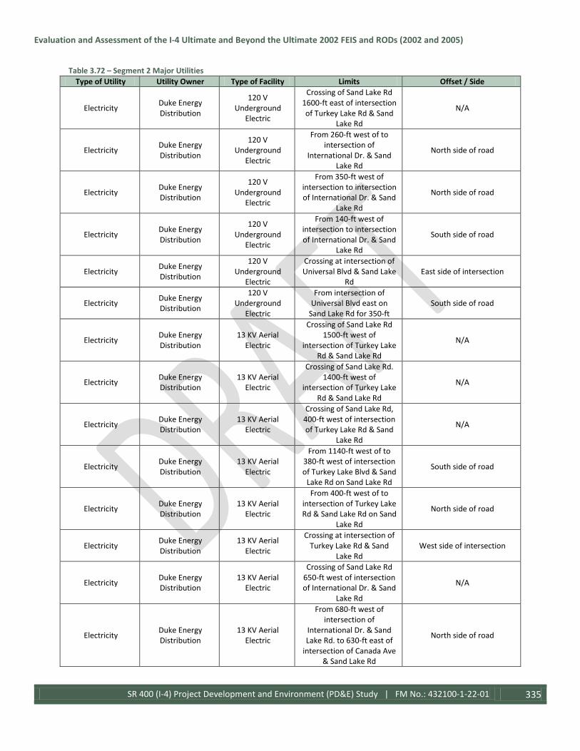
Evaluation and Assessment of the I-4 Ultimate and Beyond the Ultimate 2002 FEIS and RODs (2002 and 2005)
SR 400 (I-4) Project Development and Environment (PD&E) Study | FM No.: 432100-1-22-01 335
Table 3.72 – Segment 2 Major Utilities Type of Utility Utility Owner Type of Facility Limits Offset / Side
Electricity Duke Energy Distribution
120 V Underground
Electric
Crossing of Sand Lake Rd 1600-ft east of intersection of Turkey Lake Rd & Sand
Lake Rd
N/A
Electricity Duke Energy Distribution
120 V Underground
Electric
From 260-ft west of to intersection of
International Dr. & Sand Lake Rd
North side of road
Electricity Duke Energy Distribution
120 V Underground
Electric
From 350-ft west of intersection to intersection of International Dr. & Sand
Lake Rd
North side of road
Electricity Duke Energy Distribution
120 V Underground
Electric
From 140-ft west of intersection to intersection of International Dr. & Sand
Lake Rd
South side of road
Electricity Duke Energy Distribution
120 V Underground
Electric
Crossing at intersection of Universal Blvd & Sand Lake
Rd East side of intersection
Electricity Duke Energy Distribution
120 V Underground
Electric
From intersection of Universal Blvd east on
Sand Lake Rd for 350-ft South side of road
Electricity Duke Energy Distribution
13 KV Aerial Electric
Crossing of Sand Lake Rd 1500-ft west of
intersection of Turkey Lake Rd & Sand Lake Rd
N/A
Electricity Duke Energy Distribution
13 KV Aerial Electric
Crossing of Sand Lake Rd. 1400-ft west of
intersection of Turkey Lake Rd & Sand Lake Rd
N/A
Electricity Duke Energy Distribution
13 KV Aerial Electric
Crossing of Sand Lake Rd, 400-ft west of intersection of Turkey Lake Rd & Sand
Lake Rd
N/A
Electricity Duke Energy Distribution
13 KV Aerial Electric
From 1140-ft west of to 380-ft west of intersection of Turkey Lake Blvd & Sand
Lake Rd on Sand Lake Rd
South side of road
Electricity Duke Energy Distribution
13 KV Aerial Electric
From 400-ft west of to intersection of Turkey Lake Rd & Sand Lake Rd on Sand
Lake Rd
North side of road
Electricity Duke Energy Distribution
13 KV Aerial Electric
Crossing at intersection of Turkey Lake Rd & Sand
Lake Rd West side of intersection
Electricity Duke Energy Distribution
13 KV Aerial Electric
Crossing of Sand Lake Rd 650-ft west of intersection of International Dr. & Sand
Lake Rd
N/A
Electricity Duke Energy Distribution
13 KV Aerial Electric
From 680-ft west of intersection of
International Dr. & Sand Lake Rd. to 630-ft east of
intersection of Canada Ave & Sand Lake Rd
North side of road

Evaluation and Assessment of the I-4 Ultimate and Beyond the Ultimate 2002 FEIS and RODs (2002 and 2005)
SR 400 (I-4) Project Development and Environment (PD&E) Study | FM No.: 432100-1-22-01 336
Table 3.72 – Segment 2 Major Utilities Type of Utility Utility Owner Type of Facility Limits Offset / Side
Electricity Duke Energy Distribution
13 KV Aerial Electric
Crossing at intersection of International Dr. & Sand
Lake Rd West side of road
Electricity Duke Energy Distribution
13 KV Aerial Electric
Crossing at intersection of Canada Ave & Sand Lake
Rd North side of road
Electricity Duke Energy Distribution
13 KV Aerial Electric
Crossing at intersection of Universal & Sand Lake Rd West side of intersection
Electricity Duke Energy Distribution
13 KV Aerial Electric
Crossing at intersection of Universal Blvd & Sand Lake
Rd North side of intersection
Electricity Duke Energy Distribution
13 KV Aerial Electric
Crossing at intersection of Vineland Rd & Kirkman Rd South side of intersection
Electricity Duke Energy Distribution
13 KV Aerial Electric
Two crossings at intersection of Vineland Rd
& Kirkman Rd North side of intersection
Electricity Duke Energy Distribution
7.2 KV Aerial Electric
Crossing of SR 528, 2200-ft east of International Dr.,
SR 528 underpass N/A
Electricity Duke Energy Distribution
120 V Aerial Electric
From 880-ft west of to 540-ft west of intersection
of Della Dr. & Sand Lake Rd. on Sand Lake Road
North side of road
Electricity Duke Energy Transmission
69 KV Underground
Electric
Two crossings of Sand Lake Rd 370-ft east of
intersection of Universal Blvd & Sand Lake Rd
N/A
Electricity Duke Energy Transmission
230 KV Aerial Electric
Crossing of Kirkman Rd 130-ft north of intersection
of Windhover Dr. & Kirkman Rd
Diagonally across road
Electricity Duke Energy Transmission
69 KV Aerial Electric
Two crossings of SR 528 Corridor 1900-ft east of International Dr., SR 528
underpass
N/A
Electricity Duke Energy Transmission
69 KV Aerial Electric
Two crossings of SR 528 Corridor 1960-ft east of International Dr., SR 528
underpass
N/A
Electricity Duke Energy Transmission
69 KV Aerial Electric
From 370-ft east of intersection east to 720-ft
east of Kirkman northbound, Sand Lake Rd
underpass
Center of road
Electricity Duke Energy Transmission
69 KV Aerial Electric
From intersection of Universal Blvd & Sand Lake
Rd east 1600-ft on Sand Lake Rd.
North side of road
Electricity Duke Energy Transmission
69 KV Aerial Electric
Two crossings of Kirkman Rd 140-ft north of
intersection of Windhover Dr. & Kirkman Rd
Diagonally across road

Evaluation and Assessment of the I-4 Ultimate and Beyond the Ultimate 2002 FEIS and RODs (2002 and 2005)
SR 400 (I-4) Project Development and Environment (PD&E) Study | FM No.: 432100-1-22-01 337
Table 3.72 – Segment 2 Major Utilities Type of Utility Utility Owner Type of Facility Limits Offset / Side
Intelligent Transportation
Systems
Florida Department of Transportation
Intelligent Transportation Systems Cable
From east side of Central Florida Pkwy, I-4
Underpass east to Kirkman Rd, I-4 Overpass
North side of road
Intelligent Transportation
Systems
Florida Department of Transportation
Intelligent Transportation Systems Cable
From east side of Central Florida Pkwy, I-4
Underpass east to Kirkman Rd, I-4 Overpass
South side of road
Intelligent Transportation
Systems
Florida Department of Transportation
Intelligent Transportation Systems Cable
Two crossings of I-4, 800-ft west of I-4 westbound
ramp to SR 528 eastbound N/A
Intelligent Transportation
Systems
Florida Department of Transportation
Intelligent Transportation Systems Cable
From 800-ft west of I-4 westbound ramp, following I-4 eastbound ramp to SR
528 eastbound
South side of ramp
Intelligent Transportation
Systems
Florida Department of Transportation
Intelligent Transportation Systems Cable
From 800-ft west of I-4 westbound ramp, following I-4 eastbound ramp to SR
528 eastbound
North side of ramp
Intelligent Transportation
Systems
Florida Department of Transportation
Intelligent Transportation Systems Cable
Crossing of I-4 westbound ramp to SR 528 eastbound, 380-ft west of end of ramp.
Diagonally across road
Intelligent Transportation
Systems
Florida Department of Transportation
Intelligent Transportation Systems Cable
From end of I-4 ramps to SR 528 eastbound east to International Dr., SR 528
underpass
South side of road
Intelligent Transportation
Systems
Florida Department of Transportation
Intelligent Transportation Systems Cable
Crossing at SR 528, International Dr.
Underpass West side of underpass
Intelligent Transportation
Systems
Florida Department of Transportation
Intelligent Transportation Systems Cable
Crossing of International Dr. at intersection of International Dr. &
International Dr. ramp to SR 528 eastbound
North side of intersection
Intelligent Transportation
Systems
Florida Department of Transportation
Intelligent Transportation Systems Cable
Crossing of International Dr. at intersection of International Dr. &
International Dr. ramp to SR 528 eastbound
West side of intersection
Intelligent Transportation
Systems
Florida Department of Transportation
Intelligent Transportation Systems Cable
Three crossings of International Dr. at
intersection of International Dr. &
International Dr. ramp to SR 528 eastbound
East side of intersection
Intelligent Transportation
Systems
Florida Department of Transportation
Intelligent Transportation Systems Cable
From 870-ft west of to 60-ft west of West Entrance
Dr. & SR 528 overpass along SR 528
Center of road
Intelligent Transportation
Systems
Florida Department of Transportation
Intelligent Transportation Systems Cable
Crossing of SR 528 westbound ramp to I-4
eastbound, 670-ft west of West Entrance Dr. & SR
528 overpass along SR 528
N/A

Evaluation and Assessment of the I-4 Ultimate and Beyond the Ultimate 2002 FEIS and RODs (2002 and 2005)
SR 400 (I-4) Project Development and Environment (PD&E) Study | FM No.: 432100-1-22-01 338
Table 3.72 – Segment 2 Major Utilities Type of Utility Utility Owner Type of Facility Limits Offset / Side
Intelligent Transportation
Systems
Florida Department of Transportation
Intelligent Transportation Systems Cable
Four Crossings at intersection of Destination Pkwy & International Dr.
North side of intersection
Intelligent Transportation
Systems
Florida Department of Transportation
Intelligent Transportation Systems Cable
Crossing at intersection of Destination Pkwy &
International Dr. South side of intersection
Intelligent Transportation
Systems
Florida Department of Transportation
Intelligent Transportation Systems Cable
Two crossings at intersection of Destination Pkwy & International Dr.
East side of intersection
Intelligent Transportation
Systems
Florida Department of Transportation
Intelligent Transportation Systems Cable
From 220-ft south of to intersection of Destination Pkwy & International Dr.
on International Dr.
East side of road
Intelligent Transportation
Systems
Florida Department of Transportation
Intelligent Transportation Systems Cable
From intersection of International Dr. &
International Drive ramp to SR 528 eastbound east to end of project limits on SR
528
South side of road
Intelligent Transportation
Systems
Florida Department of Transportation
Intelligent Transportation Systems Cable
Crossing of I-4, 5750-ft west of Sand Lake Rd, I-4
Underpass N/A
Intelligent Transportation
Systems
Florida Department of Transportation
Intelligent Transportation Systems Cable
Crossing of I-4 at Sand Lake Rd, I-4 Underpass East side of underpass
Intelligent Transportation
Systems
Florida Department of Transportation
Intelligent Transportation Systems Cable
From 300-ft east of intersection of Turkey Lake Rd & Sand Lake Rd east to intersection of Universal
Blvd & Sand Lake Rd.
North side of road
Intelligent Transportation
Systems
Florida Department of Transportation
Intelligent Transportation Systems Cable
Crossing at intersection of Universal Blvd & Sand Lake
Rd Diagonal across intersection
Intelligent Transportation
Systems
Florida Department of Transportation
Intelligent Transportation Systems Cable
Crossing at intersection of Universal Blvd & Sand Lake
Rd West side of intersection
Intelligent Transportation
Systems
Florida Department of Transportation
Intelligent Transportation Systems Cable
Crossing at intersection of International Dr. & Sand
Lake Rd West side of intersection
Intelligent Transportation
Systems
Florida Department of Transportation
Intelligent Transportation Systems Cable
Crossing of Sand Lake Rd 190-ft west of intersection
of Sand Lake Rd & International Dr.
Diagonally across road
Intelligent Transportation
Systems
Florida Department of Transportation
Intelligent Transportation Systems Cable
Crossing of Sand Lake Rd 200-ft west of intersection
of Sand Lake Rd & International Dr.
Diagonally across road
Intelligent Transportation
Systems
Florida Department of Transportation
Intelligent Transportation Systems Cable
Crossing of I-4 eastbound lanes, 3000-ft east of Sand
Lake Rd, I-4 underpass N/A
Intelligent Transportation
Systems
Florida Department of Transportation
Intelligent Transportation Systems Cable
From 2750-ft east of to 3000-ft east of Sand Lake
Rd, I-4 underpass along I-4 Center of road

Evaluation and Assessment of the I-4 Ultimate and Beyond the Ultimate 2002 FEIS and RODs (2002 and 2005)
SR 400 (I-4) Project Development and Environment (PD&E) Study | FM No.: 432100-1-22-01 339
Table 3.72 – Segment 2 Major Utilities Type of Utility Utility Owner Type of Facility Limits Offset / Side
Intelligent Transportation
Systems
Florida Department of Transportation
Intelligent Transportation Systems Cable
Crossing of I-4 eastbound lanes at Adventure Way
exit N/A
Intelligent Transportation
Systems
Florida Department of Transportation
Intelligent Transportation Systems Cable
Crossing of I-4 eastbound lanes 1350-ft west of
Universal Blvd, I-4 overpass N/A
Intelligent Transportation
Systems
Florida Department of Transportation
Intelligent Transportation Systems Cable
From 1350-ft west of to 1390-ft east of intersection
of Universal Blvd, I-4 overpass, along I-4.
Center of road
Intelligent Transportation
Systems
Florida Department of Transportation
Intelligent Transportation Systems Cable
Crossing of Universal Blvd at intersection of I-4 eastbound ramp to
Universal Blvd
Diagonally across road
Intelligent Transportation
Systems
Florida Department of Transportation
Intelligent Transportation Systems Cable
Crossing at intersection of Universal Blvd & International Dr.
North side of intersection
Intelligent Transportation
Systems
Florida Department of Transportation
Intelligent Transportation Systems Cable
Three Crossings at intersection of Universal Blvd & International Dr.
East side of intersection
Intelligent Transportation
Systems
Florida Department of Transportation
Intelligent Transportation Systems Cable
Crossing of I-4, 1090-ft west of Kirkman Rd, I-4
Overpass N/A
Intelligent Transportation
Systems
Florida Department of Transportation
Intelligent Transportation Systems Cable
From 1210-ft west of to intersection of Kirkman Rd,
I-4 Overpass on I-4
South side of Westbound lanes
Intelligent Transportation
Systems
Florida Department of Transportation
Intelligent Transportation Systems Cable
Crossing of Universal Blvd, 1610-ft south of
intersection of Universal Blvd & Hollywood Way
N/A
Natural Gas Teco Peoples Gas 4" Natural Gas Main
Crossing at SR 528, International Dr.
Underpass West side of intersection
Natural Gas Teco Peoples Gas 4" Natural Gas Main
Crossing at intersection of International Dr. & Sand
Lake Rd. West side of intersection
Natural Gas Teco Peoples Gas 4" Natural Gas Main
From station 2+00 on Sand Lake Rd. to intersection of International Dr. & Sand
Lake Rd.
South side of road
Natural Gas Teco Peoples Gas 4" Natural Gas Main
From intersection of International Dr. & Sand
Lake Rd. to intersection of Canada Ave. & Sand Lake
Rd., on Sand Lake Rd.
Center of road
Natural Gas Teco Peoples Gas 4" Natural Gas Main
Crossing at intersection of International Dr. &
Universal Blvd. North side of intersection
Natural Gas Teco Peoples Gas 4" Natural Gas Main
From intersection of International Dr. &
Universal Blvd. south on Universal Blvd. for 425-ft
West side of road
Natural Gas Teco Peoples Gas 4" Natural Gas Main
Crossing at intersection of Vineland Rd. & Kirkman Rd North side of intersection

Evaluation and Assessment of the I-4 Ultimate and Beyond the Ultimate 2002 FEIS and RODs (2002 and 2005)
SR 400 (I-4) Project Development and Environment (PD&E) Study | FM No.: 432100-1-22-01 340
Table 3.72 – Segment 2 Major Utilities Type of Utility Utility Owner Type of Facility Limits Offset / Side
Natural Gas Teco Peoples Gas 4" Natural Gas Main
From intersection of Vineland Rd. & Kirkman Rd.
to intersection of Major Blvd. & Kirkman Rd.
East side of road
Natural Gas Teco Peoples Gas 4" Natural Gas Main
Crossing at intersection of Major Blvd. & Kirkman Rd. East side of intersection
Natural Gas Teco Peoples Gas 4" Natural Gas Main
Crossing at intersection of International Dr. &
Kirkman Rd. North side of intersection
Natural Gas Teco Peoples Gas 4" Natural Gas Main
From 400-ft north of intersection of
International Dr. & Kirkman Rd. to 1025-ft south of intersection of
International Dr. & Kirkman Rd. on Kirkman
Rd.
West side of road
Natural Gas Teco Peoples Gas 4" Natural Gas Main
Crossing 560-ft south of intersection of
International Dr. & Kirkman Rd.
South of intersection
Natural Gas Teco Peoples Gas 4" Natural Gas Main
From 560-ft south to 1050-ft south of intersection of
International Dr. & Kirkman Rd.
East side of road
Teco Peoples Gas 4" Natural Gas Main
From 340-ft west of intersection to intersection of International Dr. & Sand
Lake Rd.
North side of road
Natural Gas Teco Peoples Gas 2" Natural Gas Main
Crossing 1120-ft west of intersection of Della Dr. &
Sand Lake Rd. West of intersection
Natural Gas Teco Peoples Gas 2" Natural Gas Main
Crossing at intersection of Della Dr. & Sand Lake Rd. East side of intersection
Natural Gas Teco Peoples Gas 2" Natural Gas Main
Crossing 270-ft west of Little Sand Lake on Sand
Lake Rd. N/A
Natural Gas Teco Peoples Gas 2" Natural Gas Main
Crossing 440-ft west of intersection of Turkey Lake
Rd. & Sand Lake Rd. N/A
Television BrightHouse Networks
Underground CATV
Crossing at SR 528, International Dr.
Underpass West side of underpass
Television BrightHouse Networks
Underground CATV
From station 2+00 on Sand Lake Rd east to
intersection of Della Dr. & Sand Lake Rd
South side of road
Television BrightHouse Networks
Underground CATV
Crossing at intersection of Della Dr. & Sand Lake Rd West side of intersection
Television BrightHouse Networks
Underground CATV
Crossing at intersection of Della Dr. & Sand Lake Rd North side of intersection

Evaluation and Assessment of the I-4 Ultimate and Beyond the Ultimate 2002 FEIS and RODs (2002 and 2005)
SR 400 (I-4) Project Development and Environment (PD&E) Study | FM No.: 432100-1-22-01 341
Table 3.72 – Segment 2 Major Utilities Type of Utility Utility Owner Type of Facility Limits Offset / Side
Television BrightHouse Networks
Underground CATV
From intersection of Della Dr. & Sand Lake Rd east to
1800-ft west of intersection of Turkey Lake
Rd & Sand Lake Rd
North side of road
Television BrightHouse Networks
Underground CATV
From 1260-ft west of to 400-ft west of intersection of Turkey Lake Rd & Sand
Lake Rd
North side of road
Television BrightHouse Networks
Underground CATV
From 400-ft west of to intersection of Turkey Lake Rd & Sand Lake Rd on Sand
Lake Rd
South side of intersection
Television BrightHouse Networks
Underground CATV
Crossing at intersection of Turkey Lake Rd & Sand
Lake Rd West side of intersection
Television BrightHouse Networks
Underground CATV
Crossing of I-4 Corridor at Sand Lake Rd underpass South side of underpass
Television BrightHouse Networks
Underground CATV
Crossing at intersection of Frontage Rd & Sand Lake
Rd South side of intersection
Television BrightHouse Networks
Underground CATV
From 580-ft west of to intersection of Universal
Blvd & Sand Lake Rd South side of road
Television BrightHouse Networks
Underground CATV
From station 2+00 to Station 4+90 on Sand Lake
Road North side of road
Television BrightHouse Networks
Underground CATV
From intersection of Hollywood Way &
Universal Blvd north 1600-ft on Hollywood Way
West side of road
Television BrightHouse Networks
Underground CATV
Crossing of Universal Blvd 710-ft south of intersection of Major Blvd & Universal
Blvd
N/A
Television BrightHouse Networks
Underground CATV
Crossing at intersection of International Dr. &
Universal Blvd South side of intersection
Television BrightHouse Networks
Underground CATV
Crossing at intersection of International Dr. &
Universal Blvd. East side of intersection
Television BrightHouse Networks
Underground CATV
From 1370-ft south of to intersection of
International Dr. & Universal Blvd
East side of road
Television BrightHouse Networks
Underground CATV
From 990-ft south of to intersection of
International Dr. & Kirkman Rd
West side of road
Television BrightHouse Networks
Underground CATV
Crossing of Kirkman Rd 480-ft south of intersection
of International Dr. & Kirkman Rd
N/A

Evaluation and Assessment of the I-4 Ultimate and Beyond the Ultimate 2002 FEIS and RODs (2002 and 2005)
SR 400 (I-4) Project Development and Environment (PD&E) Study | FM No.: 432100-1-22-01 342
Table 3.72 – Segment 2 Major Utilities Type of Utility Utility Owner Type of Facility Limits Offset / Side
Television BrightHouse Networks
Underground CATV
Crossing at intersection of International Dr. &
Kirkman Rd. West side of intersection
Television BrightHouse Networks
Underground CATV
From intersection of International Dr. &
Kirkman Rd north for 680-ft on Kirkman Rd
West side of road
Television BrightHouse Networks
Underground CATV
From 500-ft south of to intersection of
International Dr. & Kirkman Rd
East side of intersection
Television BrightHouse Networks
Underground CATV
From intersection of International Dr. &
Kirkman Rd north for 550-ft on Kirkman Rd
East side of road
Television BrightHouse Networks
Underground CATV
From 940-ft south to intersection of Major Blvd
& Kirkman Rd East side of road
Television BrightHouse Networks
Underground CATV
Crossing at intersection of Major Blvd & Kirkman Rd East side of intersection
Television BrightHouse Networks
Underground CATV
Crossing at Sand Lake Rd, I-4 Corridor underpass South side of underpass
Television BrightHouse Networks
Underground CATV
From station 1353+00 on the I-4 Corridor to station
1387+50 on the I-4 Corridor.
West side of road
Television BrightHouse Networks Aerial CATV
From intersection of Della Dr. & Sand Lake Rd east to
1500-ft west of intersection of Turkey Lake
Rd & Sand Lake Rd
South side of road
Television BrightHouse Networks Aerial CATV
From 400-ft west of to intersection of Turkey Lake Rd & Sand Lake Rd on Sand
Lake Rd
North side of road
Television BrightHouse Networks Aerial CATV
From 1770-ft west to 1260-ft west of intersection of Turkey Lake Rd & Sand
Lake Rd
North side of road
Television BrightHouse Networks Aerial CATV
Crossing of Sand Lake Rd, 400-ft west of intersection of Turkey Lake Blvd & Sand
Lake Rd
N/A
Television BrightHouse Networks Aerial CATV
Crossing of Sand Lake Rd 650-ft west of intersection of International Dr. & Sand
Lake Rd
N/A
Television BrightHouse Networks Aerial CATV
From 650-ft west of intersection of
International Dr. & Sand Lake Rd east to 1560-ft east of intersection of
Universal Blvd & Sand Lake Rd
North side of road

Evaluation and Assessment of the I-4 Ultimate and Beyond the Ultimate 2002 FEIS and RODs (2002 and 2005)
SR 400 (I-4) Project Development and Environment (PD&E) Study | FM No.: 432100-1-22-01 343
Table 3.72 – Segment 2 Major Utilities Type of Utility Utility Owner Type of Facility Limits Offset / Side
Television BrightHouse Networks Aerial CATV
From 420-ft west of intersection of
International Dr. & Sand Lake Rd east to 560-ft west of intersection of Universal
Blvd & Sand Lake Rd
South side of road
Television BrightHouse Networks Aerial CATV
Crossing at intersection of Universal Blvd & Sand Lake
Rd
East side to center of intersection
Television BrightHouse Networks Aerial CATV
From intersection of Universal Blvd & Sand Lake
Rd east 900-ft on Sand Lake Rd
Center of road
Television BrightHouse Networks Aerial CATV
Crossing of Sand Lake Rd west bound 900-ft east of intersection of Universal
Blvd & Sand Lake Rd
N/A
Television BrightHouse Networks Aerial CATV
From intersection of Carrier Dr. & Universal Blvd north 850-ft on Universal
Blvd
East side of road
Television BrightHouse Networks Aerial CATV Crossing at intersection of
Carrier Dr. & Universal Blvd North side of intersection
Television BrightHouse Networks Aerial CATV Crossing at intersection of
Carrier Dr. & Universal Blvd Diagonally across intersection
Television BrightHouse Networks Aerial CATV
From 180-ft south of to intersection of Carrier Dr.
& Universal Blvd West side of road
Television BrightHouse Networks Aerial CATV
From 1040-ft south of to intersection of Carrier Dr.
& Kirkman Rd West side of road
Television BrightHouse Networks Aerial CATV Crossing at intersection of
Carrier Dr. & Kirkman Rd South side of road
Television BrightHouse Networks Aerial CATV
From intersection of Carrier Dr. & Kirkman Rd
north 870-ft north on Kirkman Rd
West side of intersection
Television BrightHouse Networks Aerial CATV
From intersection of International Dr. &
Kirkman Rd north 2870-ft north on Kirkman Rd
East side of road following ramp
Television BrightHouse Networks Aerial CATV
From 1680-ft south to 940-ft south of intersection of Major Blvd & Kirkman Rd
East side of road following ramp
Television BrightHouse Networks Aerial CATV Crossing at intersection of
Vineland Rd & Kirkman Rd North side of intersection
Television BrightHouse Networks Aerial CATV
From 1260-ft east of SR 528 ramp to I-4 westbound
to 1470-ft west of Sand Lake Rd, I-4 Corridor
underpass
West side of road

Evaluation and Assessment of the I-4 Ultimate and Beyond the Ultimate 2002 FEIS and RODs (2002 and 2005)
SR 400 (I-4) Project Development and Environment (PD&E) Study | FM No.: 432100-1-22-01 344
Table 3.72 – Segment 2 Major Utilities Type of Utility Utility Owner Type of Facility Limits Offset / Side
Wastewater/ Storm water City of Orlando 16" Force Main
From station 9+00 on Universal Blvd to
intersection of International Dr. &
Universal Blvd
West side of road
Wastewater/ Storm water City of Orlando 16" Force Main
Crossing at intersection of International Dr. &
Universal Blvd. West side of intersection
Wastewater/ Storm water City of Orlando 14" Force Main Crossing of I-4 at
Adventure Way Exit East side of exit
Wastewater/ Storm water City of Orlando 24" Sanitary Main
From 1830-ft east of to station 1579+00 on Segment 2, toward
Kirkman Rd
West side of road
Wastewater/ Storm water City of Orlando 24" Sanitary Main
From 1800-ft south to intersection of intersection
of Universal Blvd & International Dr.
Center of road
Wastewater/ Storm water City of Orlando 24" Sanitary Main
Crossing at intersection of Universal Blvd & International Dr.
South side of intersection
Wastewater/ Storm water City of Orlando 24" Sanitary Main
Crossing at intersection of Universal Blvd & International Dr.
East side of intersection
Wastewater/ Storm water City of Orlando 20" Sanitary Main
Crossing at intersection of Major Blvd & Universal
Blvd South side of intersection
Wastewater/ Storm water City of Orlando 18" Sanitary Main
Crossing at intersection of Hollywood Way &
Universal Blvd Center of intersection
Wastewater/ Storm water City of Orlando 18" Sanitary Main
From intersection of Hollywood Way &
Universal Blvd north to intersection of Major Blvd
& Universal Blvd
Center of road
Wastewater/ Storm water City of Orlando 15" Sanitary Main
From station 9+00 to station14+00 on Universal
Blvd Center of road
Wastewater/ Storm water City of Orlando 10" Sanitary Main
Crossing of Universal Blvd 920-ft north of intersection
of Carrier Dr. & Universal Blvd
From center of road to west side of road
Wastewater/ Storm water City of Orlando 10" Sanitary Main
Crossing at intersection of Major Blvd & Universal
Blvd South side of road
Wastewater/ Storm water City of Orlando 8" Sanitary Main Crossing at intersection of
Carrier Dr. & Universal Blvd Center of intersection
Wastewater/ Storm water City of Orlando 8" Sanitary Main
Crossing of Universal Blvd 300-ft north of intersection
of Carrier Dr. & Universal Blvd
From center of road to east side of road
Wastewater/ Storm water City of Orlando 8" Sanitary Main
Crossing of Universal Blvd 170-ft north of intersection
of Carrier Dr. & Universal Blvd
From center of road to west side

Evaluation and Assessment of the I-4 Ultimate and Beyond the Ultimate 2002 FEIS and RODs (2002 and 2005)
SR 400 (I-4) Project Development and Environment (PD&E) Study | FM No.: 432100-1-22-01 345
Table 3.72 – Segment 2 Major Utilities Type of Utility Utility Owner Type of Facility Limits Offset / Side
Wastewater/ Storm water City of Orlando 8" Sanitary Main
Crossing of Universal Blvd 500-ft north of intersection
of Hollywood Way & Universal Blvd
From center of road to west side of road
Wastewater/ Storm water City of Orlando 8" Sanitary Main
Crossing of Universal Blvd 250-ft north of intersection
of Hollywood Way & Universal Blvd
From center of road to west side of road
Wastewater/ Storm water
Orange County Utilities
4" Abandoned Force Main
Crossing 350-ft east of intersection of
International Dr. & Sand Lake Rd.
East of intersection
Wastewater/ Storm water
Orange County Utilities 48" Force Main
Crossing 2050-ft east of SR 528, International Dr. Underpass on SR 528
N/A
Wastewater/ Storm water
Orange County Utilities 42" Force Main
Crossing 3000-ft north of SR 528, I-4 Overpass on I-4
Corridor N/A
Wastewater/ Storm water
Orange County Utilities 24" Force Main
Crossing 175-ft east of intersection of I-4 west
bound ramp to Sand Lake Rd.
East of intersection
Wastewater/ Storm water
Orange County Utilities 24" Force Main
From intersection of Canada Ave. & Sand Lake Rd. to station 136+00 on
Sand Lake Road
Varies from north to center of road
Wastewater/ Storm water
Orange County Utilities 24" Sanitary Main
From station 2+00 Sand Land Rd. to 400-ft east of
intersection of International Dr. & Sand
Lake Rd. on Sand Lake Rd.
Varies from north to center of road
Wastewater/ Storm water
Orange County Utilities 14" Force Main
Crossing at intersection of International Dr. & Sand
Lake Rd. West side of intersection
Wastewater/ Storm water
Orange County Utilities 8" Force Main
Crossing at intersection of Canada Ave. & Sand Lake
Rd. East side of intersection
Wastewater/ Storm water
Orange County Utilities 6" Force Main Crossing at intersection of
Della Dr. & Sand Lake Rd. West side of road
Wastewater/ Storm water
Orange County Utilities 4" Force Main Crossing on Sand Lake Rd.
at Little Sand Lake N/A
Wastewater/ Storm water
Orange County Utilities 4" Force Main
Crossing at intersection of International Dr. & Sand
Lake Rd. West side of intersection
Wastewater/ Storm water
Orange County Utilities 20" Sanitary Main
Crossing at intersection of Dr. Phillips Blvd. & Sand
Lake Rd. West side of intersection
Wastewater/ Storm water
Orange County Utilities 20" Sanitary Main
Crossing 290-ft east of intersection of Dr. Phillips
Blvd. & Sand Lake Rd. East of intersection
Wastewater/ Storm water
Orange County Utilities 20" Sanitary Main Crossing on Sand Lake Rd.
at Little Sand Lake N/A
Wastewater/ Storm water
Orange County Utilities 20" Sanitary Main
Crossing 310-ft east of intersection of Turkey Lake
Rd. & Sand Lake Rd. East of intersection

Evaluation and Assessment of the I-4 Ultimate and Beyond the Ultimate 2002 FEIS and RODs (2002 and 2005)
SR 400 (I-4) Project Development and Environment (PD&E) Study | FM No.: 432100-1-22-01 346
Table 3.72 – Segment 2 Major Utilities Type of Utility Utility Owner Type of Facility Limits Offset / Side
Wastewater/ Storm water
Orange County Utilities
Varying Size Force Main
From 330-ft west of intersection of Dr. Phillips
Blvd & Sand Lake Rd to 380-ft west of intersection of Turkey Lake Rd. & Sand
Lake Rd.
North side of road
Water American Traffic Solutions
Unknown Size Water Main
Crossing at intersection of International Dr. &
Kirkman Rd. South side of intersection
Water City of Orlando 24" Reclaim Main Crossing at intersection of
Major Blvd & Universal Blvd
South side of intersection
Water City of Orlando 20" Reclaim Main Crossing at intersection of
Hollywood Way & Universal Blvd
Center to south side of intersection
Water City of Orlando 20" Reclaim Main
From intersection of Hollywood Way &
Universal Blvd north to intersection of Major Blvd
& Universal Blvd
Center of road
Water City of Orlando 4" Reclaim Main
Crossing of Universal Blvd 600-ft north of intersection
of Hollywood Way & Universal Blvd
N/A
Water City of Orlando 4" Reclaim Main
Crossing of Universal Blvd 470-ft north of intersection
of Hollywood Way & Universal Blvd
N/A
Water Orlando Utilities Commission 20" Water Main
Crossing at intersection of Major Blvd. & Universal Blvd on Universal Blvd
South side of intersection
Water Orlando Utilities Commission 20" Water Main
Crossing at Universal Blvd. Bridge, 350-ft north of
intersection of Major Blvd. & Universal Blvd
West side of road
Water Orlando Utilities Commission 16" Water Main
Crossing at SR 528, International Dr.
Underpass Center of underpass
Water Orlando Utilities Commission 16" Water Main
From 340-ft north to 550-ft south of intersection of
International Dr. & Kirkman Rd.
Center of road
Water Orlando Utilities Commission 16" Water Main
Crossing 450-ft south of intersection of
International Dr. & Kirkman Rd.
From center to east side of road
Water Orlando Utilities Commission 16" Water Main
Crossing 340-ft north of intersection of
International Dr. & Kirkman Rd.
From center to east side of road
Water Orlando Utilities Commission 16" Water Main
Crossing 820-ft south of intersection of Major Blvd & Kirkman Rd. on Kirkman
Rd.
N/A

Evaluation and Assessment of the I-4 Ultimate and Beyond the Ultimate 2002 FEIS and RODs (2002 and 2005)
SR 400 (I-4) Project Development and Environment (PD&E) Study | FM No.: 432100-1-22-01 347
Table 3.72 – Segment 2 Major Utilities Type of Utility Utility Owner Type of Facility Limits Offset / Side
Water Orlando Utilities Commission 12" Water Main
Crossing 2100-ft north of Sand Lake Rd., I-4 Overpass
on I-4 Corridor N/A
Water Orlando Utilities Commission 12" Water Main
Crossing 160-ft south of intersection of Vineland Rd. & Universal Blvd. on
Universal Blvd.
South of intersection
Water Orlando Utilities Commission 12" Water Main
From intersection of international Dr. &
Universal Blvd to 580-ft south on Universal Blvd.
East side of road
Water Orlando Utilities Commission 12" Water Main Crossing at intersection of
Major Blvd. & Kirkman Rd. North side of intersection
Water Orlando Utilities Commission 8" Water Main
From intersection of Hollywood Way &
Adventure Way to end of I-4 west bound to Adventure
Way ramp
South side of road
Water Orlando Utilities Commission 8" Water Main
Crossing 270-ft west of end of I-4 westbound ramp to
Adventure Way on Adventure Way
N/A
Water Orlando Utilities Commission 8" Water Main
Crossing at intersection of International Dr. &
Universal Blvd. South side of intersection
Water Orange County Utilities
Abandoned Water Main,
Unknown Size
From station 2+00 on Sand Land Rd. to 550-ft west of
intersection of Turkey Lake Rd. & Sand Lake Rd.
Center of road
Water Orange County Utilities 36" Reclaim Main
Crossing 5300-ft north of SR 528, I-4 Overpass on I-4
Corridor N/A
Water Orange County Utilities 16" Reclaim Main
From station 2+00 on Sand Land Rd. to intersection of
Turkey Lake Rd. & Sand Lake Rd.
North side of road
Water Orange County Utilities 12" Reclaim Main
Crossing at SR 528, International Dr.
Underpass East side of underpass
Water Orange County Utilities 12" Reclaim Main
Crossing 2000-ft east of SR 528, International Dr. Underpass on SR 528
N/A
Water Orange County Utilities 12" Reclaim Main
Crossing 2000-ft east of SR 528, International Dr. Underpass on SR 528
N/A
Water Orange County Utilities 12" Reclaim Main Crossing at intersection of
Della Dr. & Sand Lake Rd. East side of intersection
Water Orange County Utilities 12" Water Main
From 2700-ft south to 2100-ft south of SR 528, I-4
Overpass on I-4 Corridor West side of road

Evaluation and Assessment of the I-4 Ultimate and Beyond the Ultimate 2002 FEIS and RODs (2002 and 2005)
SR 400 (I-4) Project Development and Environment (PD&E) Study | FM No.: 432100-1-22-01 348
Segment 3
Table 3.73 – Segment 3 Major Utilities Type of Utility Owner of Utility Type of Facility Limits Offset/Side
Communications ATT 6.5" Underground Fiber Optic
Crossing at intersection of Markham Woods Blvd &
Lake Mary Blvd
East side of intersection
Communications ATT Unknown Size Underground Fiber Optic
From intersection of Markham Woods Blvd &
Lake Mary Blvd east on Lake Mary Blvd for 700-ft
South side of intersection
Communications ATT Unknown Size Underground Fiber Optic
Crossing at intersection of Primera Blvd & Lake Mary
Blvd
West side of intersection
Communications ATT Unknown Size Underground Fiber Optic
Crossing on SR 417, 1520-ft east of Rinehart Rd, SR 417
underpass N/A
Communications ATT Unknown Size Underground Fiber Optic
Crossing at intersection of Monroe Rd & SR 46
West side of intersection
Communications ATT Unknown Size Underground Fiber Optic
Crossing of I-4 Corridor at Orange Blvd, I-4 underpass
Center of underpass
Communications ATT Unknown Size Underground Fiber Optic
From 200-ft north of intersection of Barwick Rd & US 17-92 to 260-ft west of
intersection of I-4 east bound ramp to US 17-92 &
US 17-92
North/west side of road
Communications ATT Unknown Size Underground Fiber Optic
From 200-ft north of intersection of Barwick Rd & US 17-92 to intersection of Old Deland Rd & US 17-92
East side of road
Communications ATT Unknown Size Underground Fiber Optic
Crossing US 17-92 at I-4 Main Corridor Overpass
West side of overpass
Communications ATT Unknown Size Underground Fiber Optic
From west side of US 17-92, I-4 Overpass to intersection of Monroe Rd & US 17-92
South side of road
Communications ATT Varying Size Underground Fiber Optic
Two Crossings at intersection of Rinehart Rd & CR 46a
East side of intersection
Communications ATT 25 Pair Underground Fiber Optic
From intersection to 930-ft east of intersection of
Primera Blvd & Lake Mary Blvd
North side of road
Communications ATT 50 Pair Underground Fiber Optic
From 760-ft west of to intersection of N Sun Dr. &
Lake Mary Blvd North side of Road
Communications ATT 144 Pair Underground Fiber Optic
From intersection of Rinehart Rd & CR 46A east to
end of project limits on CR 46A
South side of road
Communications ATT 200 Pair Underground Fiber Optic
From intersection of to 470-ft east of intersection of
Rinehart Rd & CR 46A South side of road
Communications ATT 200 Pair Underground Fiber Optic
Crossing of CR 46A 470-ft east of intersection of Rinehart Rd & CR46A
N/A
Communications ATT 600 Pair Underground Fiber Optic
Crossing at intersection of S Sun Dr. & Lake Mary Blvd
East side of intersection

Evaluation and Assessment of the I-4 Ultimate and Beyond the Ultimate 2002 FEIS and RODs (2002 and 2005)
SR 400 (I-4) Project Development and Environment (PD&E) Study | FM No.: 432100-1-22-01 349
Table 3.73 – Segment 3 Major Utilities Type of Utility Owner of Utility Type of Facility Limits Offset/Side
Communications ATT 600 Pair Underground Fiber Optic
From intersection of N Sun Dr. & Lake Mary Blvd east to intersection of Rinehart Rd &
Lake Mary Blvd
North side of road
Communications ATT 600 Pair Underground Fiber Optic
Crossing of SR 417 at Rinehart Rd underpass
East side of underpass
Communications ATT 2-4" Underground PVC Duct Bank
From 1130-ft east of to Towne Center Blvd
underpass of SR 417 South side of road
Communications ATT 2-4" Underground PVC Duct Bank
Crossing of SR 417 at Towne Center Blvd underpass
West side of underpass
Communications ATT 6-4" PVC Duct Bank
From intersection of Markham Woods & Lake
Mary Blvd east to intersection of International
Pkwy & Lake Mary Blvd
South side of road
Communications ATT 9-4" PVC Duct Bank Crossing of I-4 at Lake Mary Blvd overpass
South side of overpass
Communications ATT 9-4" PVC Duct Bank
From intersection of I-4 east bound ramp to Lake Mary Blvd east to intersection of Lake Emma Rd & Lake Mary
Blvd
South side of road
Communications ATT 12-4" PVC Duct Bank Crossing at intersection of
Lake Emma Rd & Lake Mary Blvd
West side of intersection
Communications ATT 16-4" PVC Duct Bank Crossing of I-4 2690-ft east of Lake Mary, I-4 overpass N/A
Communications ATT 18-4" PVC Duct Bank Crossing at intersection of International Pkwy & Lake
Mary Blvd
West side of intersection
Communications ATT Unknown Size PVC Duct Bank
From 450-ft east of intersection of Lake Emma
Rd & Lake Mary Blvd east to intersection of Rinehart Rd &
Lake Mary Blvd
Center of road
Communications ATT Unknown Size PVC Duct Bank
Crossing at intersection of Rinehart Rd & Lake Mary
Blvd
West side of intersection
Communications CenturyLink Underground Copper Cable
From 13720-ft to 11030-ft south of Lake Mary, I-4
overpass East side of road
Communications CenturyLink Underground Fiber Optic Cable
Crossing of I-4 Corridor, north side of E.E. Williamson
overpass
North side of overpass
Communications CenturyLink Underground Fiber Optic Cable
Crossing of I-4 Corridor, north side of E.E. Williamson
overpass
North side of overpass
Communications Comcast Communications
Unknown Size Underground Fiber Optic
Crossing of I-4 Corridor at Orange Blvd, I-4 underpass
Center of underpass
Communications Comcast Communications
Unknown Size Underground Fiber Optic
From 260-ft west of intersection of US 17-92
ramp to I-4 west bound & US 17-92 & Monroe Rd & US 17-
92
South side of road

Evaluation and Assessment of the I-4 Ultimate and Beyond the Ultimate 2002 FEIS and RODs (2002 and 2005)
SR 400 (I-4) Project Development and Environment (PD&E) Study | FM No.: 432100-1-22-01 350
Table 3.73 – Segment 3 Major Utilities Type of Utility Owner of Utility Type of Facility Limits Offset/Side
Communications Embarq Communications
Unknown Size Underground Fiber Optic
Crossing on I-4 Corridor, 9320-ft south of Lake Mary
Blvd, I-4 overpass N/A
Communications Embarq Communications
Unknown Size Underground Fiber Optic
Crossing on I-4 Corridor, 2640-ft north of Lake Mary
Blvd, I-4 overpass N/A
Communications FPL Fibernet Unknown Size Underground Fiber Optic
Crossing at the EE. Williamson, I-4 Overpass
North side of overpass
Communications FPL Fibernet Unknown Size Aerial Fiber Optic
Crossing of SR 417, 1350-ft west of Towne Center Blvd,
SR 417 underpass N/A
Communications Level 3 12-1.25" Underground Fiber Optic
Crossing 700-ft south of intersection of Barwick Rd &
US 17-92 N/A
Communications Level 3 3-1.25" Underground Fiber Optic
Crossing at intersection of Primera Blvd & Lake Mary
Blvd
West side of intersection
Communications Level 3 3-1.25" Underground Fiber Optic
Crossing at intersection of Primera Blvd & Lake Mary
Blvd
East side of intersection
Communications TW Telecom Fiber Optic Cable From International Pkwy to Primera Blvd on Lake Mary
Blvd North side of road
Communications TW Telecom Fiber Optic Cable Crossing of I-4 at Lake Mary Blvd overpass
North side of overpass
Communications TW Telecom Fiber Optic Cable Crossing at intersection of Primera Blvd & Lake Mary
Blvd
West side of intersection
Communications TW Telecom Fiber Optic Cable Crossing at intersection of Business Center Dr. & CR
46A
East side of intersection
Communications TW Telecom Fiber Optic Cable Crossing at intersection of International Pkwy & Lake
Mary Blvd
North side of intersection
Communications TW Telecom Fiber Optic Cable Crossing at intersection of I-4 eastbound ramp to CR 46A &
CR 46A
East side of intersection
Communications TW Telecom Fiber Optic Cable
From intersection of I-4 west bound ramp to CR 46A & CR
46A to intersection of Rinehart Rd & CR 46A
South side of road
Communications TW Telecom Fiber Optic Cable Crossing at intersection of Rinehart Rd & CR 46A
South side of intersection
Communications TW Telecom Fiber Optic Cable Crossing at CR 46A overpass of I-4
South side of overpass
Electricity Duke Energy Distribution 13 KV Aerial Electric Crossing of I-4 Corridor E.E.
Williamson Overpass East side of
overpass
Electricity Duke Energy Distribution 13 KV Aerial Electric Crossing at entrance of 7-11
on Lake Mary Blvd South side of road
Electricity Duke Energy Distribution 7.2 KV Aerial Electric
Crossing of I-4 Corridor 2330-ft east of E.E.
Williamson Overpass N/A
Electricity Duke Energy Distribution 7.2 KV Aerial Electric
From 1500-ft to 5000-ft east of E.E. Williamson Overpass
on I-4 Corridor West side of road

Evaluation and Assessment of the I-4 Ultimate and Beyond the Ultimate 2002 FEIS and RODs (2002 and 2005)
SR 400 (I-4) Project Development and Environment (PD&E) Study | FM No.: 432100-1-22-01 351
Table 3.73 – Segment 3 Major Utilities Type of Utility Owner of Utility Type of Facility Limits Offset/Side
Electricity Duke Energy Distribution 7.2 KV Aerial Electric
Crossing of Lake Mary Blvd, 1790-ft west of intersection of International Pkwy & Lake
Mary Blvd
N/A
Electricity Duke Energy Distribution
13 KV Underground Electric
From 400-ft west to E.E. Williamson Overpass on I-4
Corridor West side of road
Electricity Duke Energy Distribution
13 KV Underground Electric
Two Crossings of I-4 Corridor, 9340-ft west of Lake Mary, I-4 Overpass
N/A
Electricity Duke Energy Distribution
13 KV Underground Electric
Crossing of I-4 Corridor, 5380-ft west of Lake Mary, I-
4 Overpass N/A
Electricity Duke Energy Distribution
13 KV Underground Electric
Three Crossings of I-4 Corridor, 2680-ft east of Lake
Mary, I-4 Overpass N/A
Electricity Duke Energy Distribution
13 KV Underground Electric
Crossing at intersection of Markham Woods Blvd &
Lake Mary Blvd
South side of intersection
Electricity Duke Energy Distribution
13 KV Underground Electric
From intersection of Markham Woods Blvd &
Lake Mary Blvd east to 130-ft west of intersection of I-4 westbound ramp to Lake
Mary Blvd & Lake Mary Blvd
North side of road
Electricity Duke Energy Distribution
13 KV Underground Electric
From intersection of Markham Woods Blvd & Lake Mary Blvd east to
intersection of International Pkwy & Lake Mary Blvd
South side of road
Electricity Duke Energy Distribution
13 KV Underground Electric
Crossing of Lake Mary Blvd, 2440-ft west of intersection of International Pkwy & Lake
Mary Blvd
N/A
Electricity Duke Energy Distribution
13 KV Underground Electric
Crossing at intersection of International Pkwy & Lake
Mary Blvd
North side of intersection
Electricity Duke Energy Distribution
13 KV Underground Electric
Crossing 180-ft east of intersection of International
Pkwy & Lake Mary Blvd N/A
Electricity Duke Energy Distribution
13 KV Underground Electric
From 320-ft west to intersection of Lake Emma
Rd & Lake Mary Blvd South side of road
Electricity Duke Energy Distribution
13 KV Underground Electric
Two crossings at intersection of Lake Emma Rd & Lake
Mary Blvd.
South side of intersection
Electricity Duke Energy Distribution
13 KV Underground Electric
Crossing at intersection of Primera Blvd & Lake Mary
Blvd
North side of intersection
Electricity Duke Energy Distribution
13 KV Underground Electric
From intersection of Primera Blvd & Lake Mary Blvd east to station 138+00 on Lake
Mary Blvd
North side of road
Electricity Duke Energy Distribution
13 KV Underground Electric
From 350-ft east to intersection of Lake Emma
Rd & Lake Mary Blvd South side of road

Evaluation and Assessment of the I-4 Ultimate and Beyond the Ultimate 2002 FEIS and RODs (2002 and 2005)
SR 400 (I-4) Project Development and Environment (PD&E) Study | FM No.: 432100-1-22-01 352
Table 3.73 – Segment 3 Major Utilities Type of Utility Owner of Utility Type of Facility Limits Offset/Side
Electricity Duke Energy Distribution
13 KV Underground Electric
From intersection of Lake Emma Blvd & Lake Mary Blvd
east to station 138+00 on Lake Mary Blvd
South side of road
Electricity Duke Energy Distribution
13 KV Underground Electric
Crossing at intersection of N. Sun Dr. & Lake Mary Blvd
North side of intersection
Electricity Duke Energy Distribution
13 KV Underground Electric
Crossing at intersection of N. Sun Dr. & Lake Mary Blvd
South side of intersection
Electricity Duke Energy Distribution
13 KV Underground Electric
From intersection to 500-ft east of intersection of N. Sun
Dr. & Lake Mary Blvd North side of road
Electricity Duke Energy Distribution
13 KV Underground Electric
Crossing at intersection of Rinehart Rd & Lake Mary
Blvd
North side of intersection
Electricity Duke Energy Distribution
13 KV Underground Electric
Crossing at intersection of Rinehart Rd & Lake Mary
Blvd
South side of intersection
Electricity Duke Energy Distribution
13 KV Underground Electric
Multiple crossings at intersection of Rinehart Rd &
Lake Mary Blvd
East side of intersection
Electricity Duke Energy Distribution
13 KV Underground Electric
Two lines from Lake Mary Overpass to 2760-ft east of
Lake Mary, I-4 Overpass on I-4 Corridor
West side of road
Electricity Duke Energy Distribution
7.2 KV Underground Electric
Crossing at intersection of Markham Woods Blvd &
Lake Mary Blvd
West side of intersection
Electricity Duke Energy Distribution
7.2 KV Underground Electric
From 240-ft west to intersection of International
Pkwy & Lake Mary Blvd
South side of intersection
Electricity Duke Energy Distribution
7.2 KV Underground Electric
From 160-ft east of intersection of International Pkwy & Lake Mary Blvd to
150-ft west of intersection of I-4 westbound ramp to Lake Mary Blvd & Lake Mary Blvd
North side of road
Electricity Duke Energy Transmission 230 KV Aerial Electric
Crossing of I-4 Corridor, 9380-ft west of Lake Mary Blvd, I-4 Corridor Overpass
N/A
Electricity Duke Energy Transmission 230 KV Aerial Electric
Crossing of I-4 Corridor, 9400-ft west of Lake Mary Blvd, I-4 Corridor Overpass
N/A
Electricity Duke Energy Transmission 230 KV Aerial Electric
Diagonal Crossing of I-4 Corridor, from 1560-ft west of to 730-ft east of SR 46, I-4
Underpass
Diagonally across road
Electricity Duke Energy Transmission 230 KV Aerial Electric
Two Crossings of I-4 Corridor, 2420-ft west of US
17-92, I-4 underpass N/A
Electricity Duke Energy Transmission 230 KV Aerial Electric Crossing at intersection of
Rinehart Rd & CR 46A East side of intersection
Electricity Duke Energy Transmission 230 KV Aerial Electric
Crossing of CR 46A, 190-ft east of intersection of Rinehart Rd & CR 46A
N/A

Evaluation and Assessment of the I-4 Ultimate and Beyond the Ultimate 2002 FEIS and RODs (2002 and 2005)
SR 400 (I-4) Project Development and Environment (PD&E) Study | FM No.: 432100-1-22-01 353
Table 3.73 – Segment 3 Major Utilities Type of Utility Owner of Utility Type of Facility Limits Offset/Side
Electricity Duke Energy Transmission 230 KV Aerial Electric
Crossing of CR 46A, 210-ft east of intersection of Rinehart Rd & CR 46A
N/A
Electricity Duke Energy Transmission 230 KV Aerial Electric
Crossing of SR 417, 1350-ft west of Towne Center Blvd,
SR 417 underpass N/A
Electricity Duke Energy Transmission 230 KV Aerial Electric
Two Crossings of SR 417, 1180-ft west of Towne
Center Blvd, SR 417 underpass
N/A
Electricity Duke Energy Transmission 230 KV Aerial Electric
Crossing of SR 46, 690-ft east of intersection of N. Oregon
St. & SR 46 N/A
Electricity Duke Energy Transmission 230 KV Aerial Electric
Crossing of SR 46, 270-ft west of intersection of Hickman Dr. & SR 46
N/A
Electricity Duke Energy Transmission 230 KV Aerial Electric
Crossing of SR 46, 220-ft west of intersection of Hickman Dr. & SR 46
N/A
Electricity Florida Power and Light 13 KV Aerial Electric Crossing at intersection of
Rinehart Rd & CR 46A West side of intersection
Electricity Florida Power and Light 13 KV Aerial Electric
From 500-ft east to 1320-ft east of intersection of
Rinehart Rd & CR 46A on west bound CR 46A
South side of road
Electricity Florida Power and Light 13 KV Aerial Electric
From 1440-ft east of intersection of Rinehart Rd & CR 46A east bound CR 46A, east to station 139+00 on CR
46A
South side of road
Electricity Florida Power and Light 13 KV Aerial Electric Crossing at intersection of
Banana Lake Rd & CR 46A Diagonally across
intersection
Electricity Florida Power and Light 13 KV Aerial Electric
Crossing at intersection of International Pkwy & Wekiva
Pkwy
East side of intersection
Electricity Florida Power and Light
13 KV Underground Electric
From 85-ft west of intersection of Bright
Meadow Dr. & CR 46A
West of intersection
Electricity Florida Power and Light
13 KV Underground Electric
Crossing at intersection of Bright Meadow Dr.& CR 46A
South side of intersection
Electricity Florida Power and Light
13 KV Underground Electric
Crossing 500-ft east of intersection of Bright
Meadow Dr. & CR 46A N/A
Electricity Florida Power and Light
13 KV Underground Electric
Crossing 770-ft west of intersection of Lake Como
Dr. & CR 46A N/A
Electricity Florida Power and Light
13 KV Underground Electric
Crossing 610-ft west of intersection of Lake Como
Dr. & CR 46A N/A
Electricity Florida Power and Light
13 KV Underground Electric
Crossing of I-4 Corridor, 2980-ft south of CR 46A, I-4
overpass
North side of pedestrian overpass
Electricity Florida Power and Light
13 KV Underground Electric
Crossing of I-4 Corridor 3030-ft south of CR 46A, I-4
overpass
South of pedestrian overpass
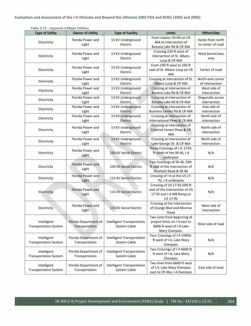
Evaluation and Assessment of the I-4 Ultimate and Beyond the Ultimate 2002 FEIS and RODs (2002 and 2005)
SR 400 (I-4) Project Development and Environment (PD&E) Study | FM No.: 432100-1-22-01 354
Table 3.73 – Segment 3 Major Utilities Type of Utility Owner of Utility Type of Facility Limits Offset/Side
Electricity Florida Power and Light
13 KV Underground Electric
From station 10+00 on CR 46A to intersection of
Banana Lake Rd & CR 46A
Varies from north to center of road
Electricity Florida Power and Light
13 KV Underground Electric
Crossing 230-ft west of intersection of St. Albans
Loop & CR 46A
West bound lane only
Electricity Florida Power and Light
13 KV Underground Electric
From 230-ft west to 100-ft east of St. Albans Loop on CR
46A Center of road
Electricity Florida Power and Light
13 KV Underground Electric
Crossing at intersection of St. Albans Loop & CR 46A
North east corner of intersection
Electricity Florida Power and Light
13 KV Underground Electric
Crossing at intersection of Banana Lake Rd & CR 46A
West side of intersection
Electricity Florida Power and Light
13 KV Underground Electric
Crossing at intersection of Banana Lake Rd & CR 46A
Diagonally across intersection
Electricity Florida Power and Light
13 KV Underground Electric
Crossing at intersection of Business Center Rd & CR 46A
East side of intersection
Electricity Florida Power and Light
13 KV Underground Electric
Crossing at intersection of International Pkwy & CR 46A
North side of intersection
Electricity Florida Power and Light
13 KV Underground Electric
Crossing at intersection of Colonial Center Pkwy & CR
46A
North side of intersection
Electricity Florida Power and Light
13 KV Underground Electric
Crossing at intersection of Lake George Dr. & CR 46A
North side of intersection
Electricity Florida Power and Light 230 KV Aerial Electric
Three Crossings of I-4, 5720-ft north of the SR 46, I-4
underpass N/A
Electricity Florida Power and Light 230 KV Aerial Electric
Two Crossings of SR 46, 590-ft east of the intersection of
Rinehart Road & SR 46 N/A
Electricity Florida Power and Light 115 KV Aerial Electric Crossing of I-4 at the US 17-
92, I-4 underpass N/A
Electricity Florida Power and Light 115 KV Aerial Electric
Crossing of US 17-92,500-ft east of the intersection of US
17-92 and I-4 WB Ramp to US 17-92
N/A
Electricity Florida Power and Light 115 KV Aerial Electric
Crossing at the intersection of Orange Blvd and Monroe
Road
West side of intersection
Intelligent Transportation System
Florida Department of Transportation
Intelligent Transportation System Cable
Two Lines from beginning of project limits on I-4 east to
6600-ft west of I-4 Lake Mary Overpass.
West side of road
Intelligent Transportation System
Florida Department of Transportation
Intelligent Transportation System Cable
Four Crossings of I-4 10900-ft west of I-4, Lake Mary
Overpass N/A
Intelligent Transportation System
Florida Department of Transportation
Intelligent Transportation System Cable
Two Crossings of I-4 6600-ft ft west of I-4, Lake Mary
Overpass N/A
Intelligent Transportation System
Florida Department of Transportation
Intelligent Transportation System Cable
Two lines from 6600-ft west of I-4, Lake Mary Overpass
east to CR 46a, I-4 Overpass East side of road

Evaluation and Assessment of the I-4 Ultimate and Beyond the Ultimate 2002 FEIS and RODs (2002 and 2005)
SR 400 (I-4) Project Development and Environment (PD&E) Study | FM No.: 432100-1-22-01 355
Table 3.73 – Segment 3 Major Utilities Type of Utility Owner of Utility Type of Facility Limits Offset/Side
Intelligent Transportation System
Florida Department of Transportation
Intelligent Transportation System Cable
Crossing of I-4 at Lake Mary Blvd overpass
West side of overpass, runs through Lake
Mary Barrier Wall
Intelligent Transportation System
Florida Department of Transportation
Intelligent Transportation System Cable
From the intersection of International Pkwy east to
end of project limits on Lake Mary Blvd
South side of road
Intelligent Transportation System
Florida Department of Transportation
Intelligent Transportation System Cable
Crossing of I-4 at CR 46a overpass
West side of overpass
Intelligent Transportation System
Florida Department of Transportation
Intelligent Transportation System Cable
From CR 46a on I-4 east to 2380-ft west of SR 46a
underpass West side of road
Intelligent Transportation System
Florida Department of Transportation
Intelligent Transportation System Cable
Crossing of I-4 2380-ft west of SR 46a underpass N/A
Intelligent Transportation System
Florida Department of Transportation
Intelligent Transportation System Cable
From 2380-ft west of SR 46a east to 4000-ft west of
Orange Blvd, I-4 Underpass East side of road
Intelligent Transportation System
Florida Department of Transportation
Intelligent Transportation System Cable
From I-4, SR 417 underpass on SR 417, east to Towne
Center Rd, SR 417 underpass South side of road
Intelligent Transportation System
Florida Department of Transportation
Intelligent Transportation System Cable
Crossing of SR 417 at Towne Center Blvd underpass
East side of underpass
Intelligent Transportation System
Florida Department of Transportation
Intelligent Transportation System Cable
From Towne Center Blvd, SR 417 underpass east to end of
project limits on SR 417 North side of Road
Intelligent Transportation System
Florida Department of Transportation
Intelligent Transportation System Cable
Two Crossings of I-4, 4000-ft west of Orange Blvd, I-4
Underpass N/A
Intelligent Transportation System
Florida Department of Transportation
Intelligent Transportation System Cable
From 4000-ft west of Orange Blvd, I-4 underpass east to Orange Blvd, I-4 underpass
West side of road
Intelligent Transportation System
Florida Department of Transportation
Intelligent Transportation System Cable
Crossing at I-4, Orange Blvd underpass
West side of underpass
Intelligent Transportation System
Florida Department of Transportation
Intelligent Transportation System Cable
Two lines on I-4 from I-4, Orange Blvd, underpass east to I-4, US 17-92, underpass
East side of road
Intelligent Transportation System
Florida Department of Transportation
Intelligent Transportation System Cable
From the intersection of Monroe Rd & Orange Blvd north to the intersection of
Monroe Blvd & US 17-92
East side of road
Intelligent Transportation System
Florida Department of Transportation
Intelligent Transportation System Cable
From US 17-92 east to end of project limits of Segment
Three along I-4 East side of road
Intelligent Transportation System
Florida Department of Transportation
Intelligent Transportation System Cable
Two crossings of I-4 at US 17-92, I-4 underpass
West side of underpass
Intelligent Transportation System
Florida Department of Transportation
Intelligent Transportation System Cable
Crossing of US 17-92, 1320-ft west of intersection of US 17-92 and Monroe Road
N/A
Intelligent Transportation System
Florida Department of Transportation
Intelligent Transportation System Cable
From end of project limits on US 17-92 east to 1320-ft east
of intersection of US 17-92 and Monroe Road
North side of Road
Natural Gas Florida Public Utilities 6" Natural Gas Main Crossing on I-4 Corridor,
5410-ft south of Lake Mary Blvd, I-4 overpass
N/A

Evaluation and Assessment of the I-4 Ultimate and Beyond the Ultimate 2002 FEIS and RODs (2002 and 2005)
SR 400 (I-4) Project Development and Environment (PD&E) Study | FM No.: 432100-1-22-01 356
Table 3.73 – Segment 3 Major Utilities Type of Utility Owner of Utility Type of Facility Limits Offset/Side
Natural Gas Florida Public Utilities 6" Natural Gas Main
From intersection of Tournament Dr. & Lake Mary
Blvd to intersection of International Way & Lake
Mary Blvd on Lake Mary Blvd
South side of road
Natural Gas Florida Public Utilities 6" Natural Gas Main Crossing at intersection of International Way & Lake
Mary Blvd
West side of intersection
Natural Gas Florida Public Utilities 6" Natural Gas Main Crossing at intersection of Rinehart Rd & Lake Mary
Blvd
West side of intersection
Natural Gas Florida Public Utilities 6" Natural Gas Main
From 670-ft west of intersection of Business
Center Dr. & Lake Mary Blvd to intersection of
International Pkwy & Lake Mary Blvd
South side of road
Natural Gas Florida Public Utilities 6" Natural Gas Main Crossing at intersection of International Pkwy & CR 46A
South side of intersection
Natural Gas Florida Public Utilities 4"-6" Natural Gas Main From intersection of N.
Oregon St & SR 46 to east to station 141+00 on SR 46
North side of road
Natural Gas Florida Public Utilities 4" Natural Gas Main Crossing at intersection of Markham Woods Blvd &
Lake Mary Blvd
East side of intersection
Natural Gas Florida Public Utilities 4" Natural Gas Main
From intersection of Markham Woods Blvd &
Lake Mary Blvd to intersection of Tournament
Dr. & Lake Mary Blvd
North side of road
Natural Gas Florida Public Utilities 4" Natural Gas Main Crossing at intersection of
Tournament Dr. & Lake Mary Blvd
West side of intersection
Natural Gas Florida Public Utilities 4" Natural Gas Main Crossing at intersection of Rinehart Rd & Lake Mary
Blvd
North side of intersection
Natural Gas Florida Public Utilities 4" Natural Gas Main
From intersection of Rinehart Rd & Lake Mary
Blvd east to station 138+00 on Lake Mary Blvd
North side of road
Natural Gas Florida Public Utilities 4" Natural Gas Main Crossing of SR 417 at Towne Center Blvd underpass
West side underpass
Natural Gas Florida Public Utilities 4" Natural Gas Main From station 10+00 on SR 46 to intersection of Terracina
Dr. & SR 46 North side of road
Natural Gas Florida Public Utilities 4" Natural Gas Main Crossing at intersection of N. Oregon St & SR 46
North side of intersection
Natural Gas Florida Public Utilities 4" Natural Gas Main Crossing at intersection of Hickman Dr. & SR 46
East side of intersection
Natural Gas Florida Public Utilities 4" Natural Gas Main Crossing 330-ft west of
intersection of Central Park Dr. & SR 46
N/A
Natural Gas Florida Public Utilities 2" Natural Gas Main
From 130-ft west to 300-ft east of intersection of
International Way & Lake Mary Blvd
South side of road

Evaluation and Assessment of the I-4 Ultimate and Beyond the Ultimate 2002 FEIS and RODs (2002 and 2005)
SR 400 (I-4) Project Development and Environment (PD&E) Study | FM No.: 432100-1-22-01 357
Table 3.73 – Segment 3 Major Utilities Type of Utility Owner of Utility Type of Facility Limits Offset/Side
Natural Gas Florida Public Utilities 2" Natural Gas Main Crossing at intersection of International Way & Lake
Mary Blvd
South side of intersection
Natural Gas Florida Public Utilities 2" Natural Gas Main Crossing at intersection of Primera Blvd & Lake Mary
Blvd
East side of intersection
Natural Gas Florida Public Utilities 2" Natural Gas Main
From intersection of Primera Blvd & Lake Mary Blvd to
410-ft west of intersection of N. Sun Dr. & Lake Mary Blvd
North side of road
Natural Gas Florida Public Utilities 2" Natural Gas Main Crossing at intersection of N. Sun Dr. & Lake Mary Blvd
South side of intersection
Natural Gas Florida Public Utilities 2" Natural Gas Main From 450-ft west to 600-ft east of N. Sun Dr. & Lake
Mary Blvd South side of road
Natural Gas Florida Public Utilities 2" Natural Gas Main Crossing 150-ft west of
intersection of International Pkwy & CR 46A
N/A
Natural Gas Florida Public Utilities 2" Natural Gas Main Crossing at intersection of Townpark Ave & CR 46A
East side of intersection
Natural Gas Florida Public Utilities 2" Natural Gas Main Crossing 260-ft west of intersection of Colonial Center Pkwy & CR 46A
N/A
Natural Gas Florida Public Utilities 2" Natural Gas Main
From 190-ft west of intersection of Colonial
Center Pkwy & CR 46A to intersection of Rinehart Rd &
CR 46A
South side of road
Natural Gas Florida Public Utilities 2" Natural Gas Main Crossing at intersection of Rinehart Rd & SR 46
East side of intersection
Natural Gas Florida Public Utilities 2" Natural Gas Main Crossing at intersection of Monroe Rd & SR 46
East side of intersection
Natural Gas Florida Public Utilities 1.25" Natural Gas Main From Towne Center Blvd, SR 417 underpass east to 500-ft
east of Towne Center Blvd North side of road
Natural Gas Florida Gas Transmission 12.75" Natural Gas Main
Crossing of SR 46 and SR 46 ramp to I-4 west bound 180-
ft east of I-4 west bound ramp to SR 46
N/A
Natural Gas Florida Gas Transmission 3.5" Natural Gas Main Crossing of I-4 460-ft north
of the SR 46, I-4 Overpass N/A
Television Bright House Networks 55" Underground CATV
From north side to south side of US 17-92 bridge crossing St. John's River
West side of bridge
Television Bright House Networks Unknown Size Aerial CATV
From 940-ft west of intersection of Bright
Meadow Dr. & CR 46A on east bound CR 46A, east to station 141+00 on CR 46A
South side of intersection
Television Bright House Networks Unknown Size Aerial CATV
From station 10+00 on SR 46 to 500-ft east of intersection of N. Hendersen Ln & SR 46
North side of road
Television Bright House Networks Unknown Size Aerial CATV
From intersection of Terracina Dr. & SR 46 to 270-ft west of intersection of N.
Oregon St & SR 46
North side of road

Evaluation and Assessment of the I-4 Ultimate and Beyond the Ultimate 2002 FEIS and RODs (2002 and 2005)
SR 400 (I-4) Project Development and Environment (PD&E) Study | FM No.: 432100-1-22-01 358
Table 3.73 – Segment 3 Major Utilities Type of Utility Owner of Utility Type of Facility Limits Offset/Side
Television Bright House Networks Unknown Size Aerial CATV
From 450-ft west to 630-ft west of intersection of Hickman Dr. & SR 46
North side of road
Television Bright House Networks Unknown Size Aerial CATV Crossing at intersection of
Sewell Rd & SR 46 West side of intersection
Television Bright House Networks Unknown Size Aerial CATV
From 250-ft east of intersection of Towne Center Blvd & SR 46 east to station
141+00 on SR 46
South side of road
Television Bright House Networks Unknown Size Aerial CATV Crossing at intersection of
Elder Rd & SR 46 East side of intersection
Television Bright House Networks Unknown Size Aerial CATV Crossing at intersection of
Monroe Rd & SR 46 West side of intersection
Television Bright House Networks
Unknown Size Underground CATV
From intersection of Markham Woods Blvd &
Lake Mary Blvd to intersection of International
Pkwy & Lake Mary Blvd
South side of road
Television Bright House Networks
Unknown Size Underground CATV
Crossing 280-ft west of intersection of International
Pkwy & Lake Mary Blvd N/A
Television Bright House Networks
Unknown Size Underground CATV
Crossing of I-4 Corridor, 5450-ft south of Lake Mary
Blvd, I-4 overpass N/A
Television Bright House Networks
Unknown Size Underground CATV
From station 10+00 on Lake Mary Blvd west on Lake
Mary Blvd for 520-ft South side of road
Television Bright House Networks
Unknown Size Underground CATV
Crossing on I-4 Corridor, 4370-ft north of Lake Mary
Blvd, I-4 overpass N/A
Television Bright House Networks
Unknown Size Underground CATV
From station 10+00 on CR 46A to intersection of St.
Albans Loop & CR 46A North side of road
Television Bright House Networks
Unknown Size Underground CATV
Crossing at intersection of Orange Blvd & CR 46A
East side of intersection
Television Bright House Networks
Unknown Size Underground CATV
Crossing at intersection of Banana Lake Rd & CR 46A
South side of intersection
Television Bright House Networks
Unknown Size Underground CATV
From intersection of Orange Blvd & CR 46A to
intersection of International Pkwy & CR 46A
North side of road
Television Bright House Networks
Unknown Size Underground CATV
Crossing at intersection of International Pkwy & CR 46A
West side of intersection
Television Bright House Networks
Unknown Size Underground CATV
Crossing at intersection of International Pkwy & CR 46A
North side of intersection
Television Bright House Networks
Unknown Size Underground CATV
Crossing at intersection of International Pkwy & CR 46A
East side of intersection
Television Bright House Networks
Unknown Size Underground CATV
From intersection of International Pkwy & CR 46A
to intersection of Colonial Center Pkwy & CR 46A
North side of road
Television Bright House Networks
Unknown Size Underground CATV
Crossing at intersection of I-4 west bound ramp to CR 46A
& CR 46A
East side of intersection

Evaluation and Assessment of the I-4 Ultimate and Beyond the Ultimate 2002 FEIS and RODs (2002 and 2005)
SR 400 (I-4) Project Development and Environment (PD&E) Study | FM No.: 432100-1-22-01 359
Table 3.73 – Segment 3 Major Utilities Type of Utility Owner of Utility Type of Facility Limits Offset/Side
Television Bright House Networks
Unknown Size Underground CATV
Crossing at intersection of I-4 west bound ramp to CR 46A & CR 46A to intersection of
Rinehart Rd & CR 46A
South side of road
Television Bright House Networks
Unknown Size Underground CATV
Crossing at intersection of Rinehart & CR 46A
West side of intersection
Television Bright House Networks
Unknown Size Underground CATV
Crossing at intersection of Rinehart & CR 46A
South side of intersection
Television Bright House Networks
Unknown Size Underground CATV
Crossing at intersection of International Pkwy & Wekiva
Pkwy
East side of intersection
Television Bright House Networks
Unknown Size Underground CATV
Crossing on SR 417, Rinehart Rd & SR 417 underpass
East side of underpass
Television Bright House Networks
Unknown Size Underground CATV
From 500-ft east of intersection of N. Henderson Ln & SR 46 to 250-ft west of intersection of Lake Forest
Blvd & SR 46
North side of road
Television Bright House Networks
Unknown Size Underground CATV
From 550-ft west of intersection of Lake Forest
Blvd & SR 46 to intersection of Terracina Dr. & SR 46
North side of road
Television Bright House Networks
Unknown Size Underground CATV
Crossing at intersection of N. Oregon St & SR 46
West side of intersection
Television Bright House Networks
Unknown Size Underground CATV
From intersection of Wayside Dr. & SR 46 to
intersection of Upsala Rd & SR 46
South side of road
Television Bright House Networks
Unknown Size Underground CATV
From 450-ft west of intersection of Hickman Dr.
& SR 46 to 380-ft of intersection of N. Elder Rd &
SR 46
North side of road
Television Bright House Networks
Unknown Size Underground CATV
Crossing at intersection of Monroe Rd & SR 46
West side of intersection
Television Bright House Networks
Unknown Size Underground CATV
From south side of US 17-92 bridge crossing St. John's River to intersection of Monroe Rd & US 17-92
South side of road
Wastewater/ Storm Water Lake Mary Utilities 8" Sanitary Main From station 10+00 on Lake
Mary Blvd east for 650-ft Varies from north to center of road
Wastewater/ Storm Water Lake Mary Utilities 4" Sanitary Main
From intersection east of Primera Blvd & Lake Mary
Blvd intersection to intersection of N. Sun Dr. &
Lake Mary Blvd
North side of road
Wastewater/ Storm Water
Seminole County Utilities
Unknown Size Sanitary Water Main
Crossing at intersection of International Pkwy & Lake
Mary Blvd
West side of intersection
Wastewater/ Storm Water
Seminole County Utilities
Unknown Size Sanitary Water Main
Crossing at intersection of International Pkwy & Lake
Mary Blvd
North side of intersection
Wastewater/ Storm Water
Seminole County Utilities
Unknown Size Sanitary Water Main
Crossing at intersection of Markham Woods Rd & Lake
Mary Blvd
North side of intersection

Evaluation and Assessment of the I-4 Ultimate and Beyond the Ultimate 2002 FEIS and RODs (2002 and 2005)
SR 400 (I-4) Project Development and Environment (PD&E) Study | FM No.: 432100-1-22-01 360
Table 3.73 – Segment 3 Major Utilities Type of Utility Owner of Utility Type of Facility Limits Offset/Side
Wastewater/ Storm Water
Seminole County Utilities
Unknown Size Sanitary Water Main
From intersection of Markham Woods Rd & Lake Mary Blvd to intersection of International Pkwy & Lake
Mary Blvd
North side of road
Wastewater/ Storm Water
Seminole County Utilities
Unknown Size Sanitary Water Main
From intersection of Keenwicka Dr. & CR 46A to intersection of St. Albans
Loop & CR 46A
Center/north side of road
Wastewater/ Storm Water
Seminole County Utilities
Unknown Size Sanitary Water Main
Crossing at intersection of St. Albans Loop & CR 46A
East side of intersection
Wastewater/ Storm Water
Seminole County Utilities
Unknown Size Sanitary Water Main
Crossing at intersection of Orange Blvd & CR 46A
West side of intersection
Wastewater/ Storm Water
Seminole County Utilities
Unknown Size Sanitary Water Main
Crossing at intersection of Orange Blvd & CR 46A
South side of intersection
Wastewater/ Storm Water
Seminole County Utilities
Unknown Size Sanitary Water Main
Crossing at intersection of Rinehart Rd & CR 46A
East side of intersection
Wastewater/ Storm Water
Seminole County Utilities
Unknown Size Sanitary Water Main
Crossing at intersection of International Pkwy & Wekiva
Pkwy
Diagonally across intersection
Wastewater/ Storm Water
Seminole County Utilities
Unknown Size Sanitary Water Main
Crossing at intersection of International Pkwy & Wekiva
Pkwy
Center of intersection
Wastewater/ Storm Water
Seminole County Utilities
Unknown Size Sanitary Water Main
From Intersection of International Pkwy & Wekiva Pkwy to beginning of Wekiva
Pkwy on SR 417
North side of road
Wastewater/ Storm Water
Seminole County Utilities
Unknown Size Sanitary Water Main
Crossing of I-4 Corridor 2040-ft west of SR 417
underpass N/A
Wastewater/ Storm Water
Seminole County Utilities
Unknown Size Sanitary Water Main
Crossing of SR 417 at Rinehart Rd underpass
East side of underpass
Wastewater/ Storm Water
Seminole County Utilities
Unknown Size Sanitary Water Main
Crossing of SR 46 270-ft west of intersection of Hickman
Dr. & SR 46 N/A
Wastewater/ Storm Water
Seminole County Utilities
Unknown Size Sanitary Water Main
From station 10+00 on SR 46 east to SR 46 west bound ramp to I-4 west bound
North side of road
Wastewater/ Storm Water
Seminole County Utilities
Unknown Size Sanitary Water Main
Crossing at SR 46 west bound ramp to I-4 west
bound Center of ramp
Wastewater/ Storm Water
Seminole County Utilities
Unknown Size Sanitary Water Main
Crossing at intersection of N. Oregon St & SR 46
East side of intersection
Wastewater/ Storm Water
Seminole County Utilities
Unknown Size Sanitary Water Main
Two Crossings of I-4 Corridor at Orange Blvd & US 17-92
underpasses
Center/east side of underpass
Water Lake Mary Utilities City of Sanford Crossing of I-4 Corridor at Orange Blvd, I-4 underpass
East side of underpass
Water Lake Mary Utilities 20" Water Main Crossing at intersection of Rinehart Rd. & Lake Mary
Blvd
East side of intersection
Water Lake Mary Utilities 16" Water Main
From intersection of Primera Blvd & Lake Mary Blvd west to station 138+00 on Lake
Mary Blvd
Varies from center to south side of
road

Evaluation and Assessment of the I-4 Ultimate and Beyond the Ultimate 2002 FEIS and RODs (2002 and 2005)
SR 400 (I-4) Project Development and Environment (PD&E) Study | FM No.: 432100-1-22-01 361
Table 3.73 – Segment 3 Major Utilities Type of Utility Owner of Utility Type of Facility Limits Offset/Side
Water Lake Mary Utilities 12" Water Main From 5900-ft to 5500-ft
south of Lake Mary Blvd, I-4 overpass
East side of road
Water Lake Mary Utilities 12" Water Main Crossing at intersection of Primera Blvd & Lake Mary
Blvd
East center of intersection
Water Lake Mary Utilities 12" Water Main Crossing at intersection of N. Sun Dr. & Lake Mary Blvd
East side of intersection
Water Lake Mary Utilities 12" Water Main Crossing at intersection of Rinehart Rd & Lake Mary
Blvd
West side of intersection
Water Lake Mary Utilities 12" Water Main From intersection of
Rinehart Rd & CR 46A east to station 139+00 on CR 46A
Varies from center to south side of
road
Water Lake Mary Utilities 8" Water Main
Crossing on Lake Mary Blvd, 425-ft east of intersection of
Primera Blvd & Lake Mary Blvd
N/A
Water Lake Mary Utilities 8" Water Main Crossing on Lake Mary Blvd,
240-ft west of intersection of N. Sun Dr. & Lake Mary Blvd
N/A
Water Lake Mary Utilities 8" Water Main Crossing on Lake Mary Blvd, 240-ft east of intersection of N. Sun Dr. & Lake Mary Blvd
N/A
Water Lake Mary Utilities 8" Water Main Crossing on Lake Mary Blvd, 700-ft east of intersection of N. Sun Dr. & Lake Mary Blvd
N/A
Water Lake Mary Utilities 8" Water Main
Crossing on Lake Mary Blvd, 490-ft west of intersection of
Rinehart Rd. & Lake Mary Blvd
N/A
Water Lake Mary Utilities 8" Water Main Crossing at intersection of Rinehart Rd. & Lake Mary
Blvd
North side of intersection
Water Lake Mary Utilities 8" Water Main
Crossing on Lake Mary Blvd, 450-ft east of intersection of
Rinehart Rd & Lake Mary Blvd
N/A
Water Lake Mary Utilities 8" Water Main Crossing on Lake Mary Blvd,
500-ft west to station 138+00 Lake Mary Blvd
N/A
Water Lake Mary Utilities 6" Water Main Crossing at intersection east of Primera Blvd & Lake Mary
Blvd intersection
East side of intersection
Water Lake Mary Utilities Unknown Size Reclaim Main
Crossing at intersection of Primera Blvd & Lake Mary
Blvd
West side of intersection
Water Lake Mary Utilities Unknown Size Reclaim Main
From intersection of Primera Blvd & Lake Mary Blvd west to station 139+00 on Lake
Mary Blvd
South side of road
Water Lake Mary Utilities Unknown Size Reclaim Main
Crossing on Lake Mary Blvd, 460-ft east of intersection of
Rinehart Rd & Lake Mary Blvd
N/A

Evaluation and Assessment of the I-4 Ultimate and Beyond the Ultimate 2002 FEIS and RODs (2002 and 2005)
SR 400 (I-4) Project Development and Environment (PD&E) Study | FM No.: 432100-1-22-01 362
Table 3.73 – Segment 3 Major Utilities Type of Utility Owner of Utility Type of Facility Limits Offset/Side
Water Lake Mary Utilities Unknown Size Reclaim Main
Crossing on I-4 Corridor, 2920-ft south of CR 46A, I-4
overpass
South of pedestrian overpass
Water Lake Mary Utilities Unknown Size Reclaim Main
Crossing at intersection of Rinehart Rd & CR 46A
South east corner of intersection
Water Sanlando Utilities 24" Water Main Crossing 13750-ft south of Lake Mary Blvd, I-4 Overpass N/A
Water Seminole County Utilities
Unknown Size Water Main
Crossing of I-4 Corridor, 4810-ft west of Lake Mary
Blvd Overpass N/A
Water Seminole County Utilities
Unknown Size Water Main
Crossing at intersection of Markham Woods Rd & Lake
Mary Blvd
Center of intersection
Water Seminole County Utilities
Unknown Size Water Main
From intersection of Markham Woods Rd & Lake Mary Blvd to intersection of International Pkwy & Lake
Mary Blvd
North side of road
Water Seminole County Utilities
Unknown Size Water Main
Crossing at intersection of International Pkwy & Lake
Mary Blvd
East side of intersection
Water Seminole County Utilities
Unknown Size Water Main
Crossing 280-ft east of intersection of International
Pkwy & Lake Mary Blvd N/A
Water Seminole County Utilities
Unknown Size Water Main
From intersection of International Pkwy & Lake
Mary Blvd to intersection of I-4 East Bound Ramp to Lake Mary Blvd & Lake Mary Blvd
South side on road
Water Seminole County Utilities
Unknown Size Water Main
From 280-ft east to intersection of International
Pkwy & Lake Mary Blvd North side of road
Water Seminole County Utilities
Unknown Size Water Main
From intersection of Lake Emma Rd & Lake Mary Blvd to intersection of Sun Dr. &
Lake Mary Blvd
South side of road
Water Seminole County Utilities
Unknown Size Water Main
Crossing of I-4 Corridor at Cross Seminole Trail
Overpass
West side of overpass
Water Seminole County Utilities
Unknown Size Water Main
Crossing at intersection of Keenwicka Dr. & CR 46A
West side of intersection
Water Seminole County Utilities
Unknown Size Water Main
From intersection of Keenwicka Dr. & CR 46A to
intersection of International Pkwy & CR 46A
South side of road
Water Seminole County Utilities
Unknown Size Water Main
Crossing at intersection of St. Albans Loop & CR 46A
East side of intersection
Water Seminole County Utilities
Unknown Size Water Main
Crossing at intersection of Orange Blvd & CR 46A
East side of intersection
Water Seminole County Utilities
Unknown Size Water Main
Crossing at intersection of Lake George Dr. & CR 46A
East side of intersection
Water Seminole County Utilities
Unknown Size Water Main
Crossing at intersection of International Pkwy & CR 46A
West side of intersection
Water Seminole County Utilities
Unknown Size Water Main
Crossing at intersection of International Pkwy & CR 46A
South side of intersection

Evaluation and Assessment of the I-4 Ultimate and Beyond the Ultimate 2002 FEIS and RODs (2002 and 2005)
SR 400 (I-4) Project Development and Environment (PD&E) Study | FM No.: 432100-1-22-01 363
Table 3.73 – Segment 3 Major Utilities Type of Utility Owner of Utility Type of Facility Limits Offset/Side
Water Seminole County Utilities
Unknown Size Water Main
From intersection to 320-ft east of International Pkwy &
Lake Mary Blvd South side of road
Water Seminole County Utilities
Unknown Size Water Main
From station 10+00 on SR 46 east to SR 46 west bound ramp to I-4 west bound
North side of road
Water Seminole County Utilities
Unknown Size Water Main
Crossing at intersection of International Pkwy & SR 46
West side of intersection
Water Seminole County Utilities
Unknown Size Water Main
Crossing at intersection of N. Oregon St. & SR 46
East side of intersection
Water Seminole County Utilities
Unknown Size Water Main
Crossing of SR 46 270-ft west of intersection of Hickman
Dr. & SR 46 N/A
Water Seminole County Utilities
Unknown Size Water Main
Crossing at SR 46 west bound ramp to I-4 west
bound Center of ramp
Water Seminole County Utilities
Unknown Size Water Main
Crossing at intersection of Orange Blvd & Kastner Pl.
East side of intersection
Water Seminole County Utilities
Unknown Size Water Main
From 1200-ft west of I-4 overpass on Orange Blvd to intersection of Orange Blvd
& Kastner Pl.
North side of road
Water Seminole County Utilities
Unknown Size Water Main
Crossing 100-ft east of intersection of Orange Blvd
& Kastner Pl.
Center/east side of underpass
Water Seminole County Utilities
Unknown Size Water Main
Two Crossings of I-4 Corridor at Orange Blvd & US 17-92
underpasses
Center/east side of underpass
Water Seminole County Utilities
Unknown Size Reclaim Water Main
Crossing of I-4 Corridor, 4810-ft west of Lake Mary
Blvd Overpass N/A
Water Seminole County Utilities
Unknown Size Reclaim Water Main
Crossing at intersection of Markham Woods Rd & Lake
Mary Blvd
East side of intersection
Water Seminole County Utilities
Unknown Size Reclaim Water Main
From 350-ft east of intersection of Markham
Woods Rd & Lake Mary Blvd to intersection of
International Pkwy & Lake Mary Blvd
North side of road
Water Seminole County Utilities
Unknown Size Reclaim Water Main
Crossing 280-ft east of intersection of International
Pkwy & Lake Mary Blvd N/A
Water Seminole County Utilities
Unknown Size Reclaim Water Main
From 280-ft east to intersection of International
Pkwy & Lake Mary Blvd North side of road
Water Seminole County Utilities
Unknown Size Reclaim Water Main
Crossing at intersection of Primera Blvd & Lake Mary
Blvd
West side of intersection
Water Seminole County Utilities
Unknown Size Reclaim Water Main
Crossing of I-4 Corridor at Cross Seminole Trail
Overpass
West side of overpass
Water Seminole County Utilities
Unknown Size Reclaim Water Main
From intersection of Keenwicka Dr. & CR 46A to
intersection of International Pkwy & CR 46A
North side of road

Evaluation and Assessment of the I-4 Ultimate and Beyond the Ultimate 2002 FEIS and RODs (2002 and 2005)
SR 400 (I-4) Project Development and Environment (PD&E) Study | FM No.: 432100-1-22-01 364
Table 3.73 – Segment 3 Major Utilities Type of Utility Owner of Utility Type of Facility Limits Offset/Side
Water Seminole County Utilities
Unknown Size Reclaim Water Main
Crossing at intersection of International Pkwy & CR 46A
East side of intersection
Water Seminole County Utilities
Unknown Size Reclaim Water Main
Crossing at intersection of Wekiva Pkwy & International
Pkwy
West side of intersection
Water Seminole County Utilities
Unknown Size Reclaim Water Main
Crossing at intersection of Bernini Way & SR 46
West side of intersection
Segment 4
Table 3.74: Segment 4 Major Utilities Type of Utility Utility Owner Type of Facility Limits Offset/ Side
Communications AT&T 48 PR Aerial Fiber Optic
Cable
From 1050-ft east of intersection of Enterprise Rd & Saxon Blvd east to
290-ft west of intersection of Medical Center Dr. &
Saxon Blvd
North side of road
Communications AT&T 48 PR Aerial Fiber Optic
Cable
From 330-ft east of intersection of Veterans Memorial Pkwy & Saxon
Blvd east on Saxon Blvd to intersection of I-4
southbound ramp to Saxon Blvd & Saxon Blvd
North side of road
Communications AT&T 48 PR Aerial Fiber Optic
Cable
Crossing of Saxon Blvd 440-ft east of intersection of Saxon Blvd ramp to I-4 northbound & Saxon Blvd
N/A
Communications AT&T
25-600 PR Underground
Fiber Optic Cable
From end of project limits on Dirksen Dr. east to
intersection of Dirksen Dr. and I-4 southbound ramp
to Dirksen Dr.
North side of road
Communications AT&T
900 PR Underground
Fiber Optic Cable
From intersection of N Rd & Debary Ave. east to end
of project limits South side of road
Communications AT&T
900 PR Underground
Fiber Optic Cable
Crossing at intersection of N Rd. & Debary Ave West side of intersection
Communications AT&T
600 PR Underground
Fiber Optic Cable
Crossing at intersection of Palm Rd & Dirksen Dr. West side of intersection
Communications AT&T
600 PR Underground
Fiber Optic Cable
Crossing at intersection of Sunrise Blvd & Dirksen Dr. East side of intersection

Evaluation and Assessment of the I-4 Ultimate and Beyond the Ultimate 2002 FEIS and RODs (2002 and 2005)
SR 400 (I-4) Project Development and Environment (PD&E) Study | FM No.: 432100-1-22-01 365
Table 3.74: Segment 4 Major Utilities Type of Utility Utility Owner Type of Facility Limits Offset/ Side
Communications AT&T
600 PR Underground
Fiber Optic Cable
From intersection of Palm Rd & Dirksen Drive to
intersection of Deltona Blvd & Debary Ave.
South side of road
Communications AT&T
300 PR Underground
Fiber Optic Cable
From intersection of Deltona Rd & Debary Ave
east to intersection of Maple Ave & Debary Ave
South side of road
Communications AT&T
300 PR Underground
Fiber Optic Cable
From intersection of N Rd & Dirksen Dr. east to end
of project limits North side of road
Communications AT&T
200 PR Underground
Fiber Optic Cable
From intersection of Maple Ave & Debary Ave east to
1370-ft east of intersection of entrance to utility plant
entrance & Debary Ave.
South side of road
Communications AT&T
100 PR Underground
Fiber Optic Cable
From intersection of entrance to utility plant
entrance to intersection of N Rd & Debary Ave.
South side of road
Communications AT&T
100 PR Underground
Fiber Optic Cable
Crossing at intersection of Enterprise Rd & Dirksen Rd East side of intersection
Communications AT&T
100 PR Underground
Fiber Optic Cable
From intersection of Enterprise Rd & Debary
Ave east to intersection N Rd and Debary Ave
North side of road
Communications AT&T
50 PR Underground
Fiber Optic Cable
Crossing at intersection of N Rd. & Debary Ave. East side of intersection
Communications AT&T
48 PR Underground
Fiber Optic Cable
Crossing at intersection of Enterprise Rd & Saxon Blvd West side of intersection
Communications AT&T
48 PR Underground
Fiber Optic Cable
From intersection of to 1050-ft east of Enterprise
Rd & Saxon Blvd North side of road
Communications AT&T
48 PR Underground
Fiber Optic Cable
From 290-ft west of intersection of Medical
Center Dr. east to 330-ft east of intersection of
Veterans Memorial Pkwy & Saxon Blvd
North side of road
Communications AT&T
48 PR Underground
Fiber Optic Cable
From intersection of I-4 southbound ramp to Saxon Blvd & Saxon Blvd east to intersection of Saxon Blvd
ramp I-4 northbound & Saxon Blvd
North side of road

Evaluation and Assessment of the I-4 Ultimate and Beyond the Ultimate 2002 FEIS and RODs (2002 and 2005)
SR 400 (I-4) Project Development and Environment (PD&E) Study | FM No.: 432100-1-22-01 366
Table 3.74: Segment 4 Major Utilities Type of Utility Utility Owner Type of Facility Limits Offset/ Side
Communications AT&T
Unknown Size Underground
Fiber Optic Cable
Crossing at intersection of I-4 southbound ramp to
Dirksen Dr. & Dirksen Dr. West side of intersection
Communications AT&T Corporation
6.5" Underground
Fiber Optic
From Station 10+00 on Saxon Blvd to intersection
of Veterans Memorial Pkwy & Saxon Blvd
South side of road
Communications AT&T Corporation
6.5" Underground
Fiber Optic
Crossing at intersection of Veterans Memorial Pkwy &
Saxon Blvd East side of intersection
Communications AT&T Corporation
6.5" Underground
Fiber Optic
Crossing at intersection of N. Kentucky Ave & SR 472 East side of intersection
Communications BrightHouse Networks
Unknown Size Aerial Fiber
Optic
From intersection of Enterprise Rd & Saxon Blvd
to 500-ft west of intersection of Veterans Memorial Pkwy & Saxon
Blvd
South side of road
Communications BrightHouse Networks
Unknown Size Aerial Fiber
Optic
Crossing of Saxon Blvd, 150-ft west of intersection
of Medical Center Rd & Saxon Blvd
N/A
Communications BrightHouse Networks
Unknown Size Aerial Fiber
Optic
From 150-ft west of intersection of Medical
Center Dr. & Saxon Blvd to 660-ft west of intersection of I-4 west bound ramp to
Saxon Blvd
North side of road
Communications BrightHouse Networks
Unknown Size Aerial Fiber
Optic
Crossing of Saxon Blvd, 670-ft west of intersection of I-4 west bound ramp to Saxon Blvd & Saxon Blvd
N/A
Communications BrightHouse Networks
Unknown Size Aerial Fiber
Optic
Crossing at intersection of Wolf Pack Run & SR 472 West side of intersection
Communications BrightHouse Networks
Unknown Size Aerial Fiber
Optic
From intersection of Wolf Pack Run & SR 472 east to station 134+00 on SR 472
North side of road
Communications BrightHouse Networks
Unknown Size Aerial Fiber
Optic
Crossing of Saxon Blvd, at intersection of Red Fox
Run & Saxon Blvd East side of intersection
Communications BrightHouse Networks
Unknown Size Underground
Fiber Optic
From 130-ft west of intersection of Palm Rd & Dirksen Dr. to intersection of Dirksen Dr. ramp to I-4 east bound & Dirksen Dr.
North side of road
Communications BrightHouse Networks
Unknown Size Underground
Fiber Optic
From 150-ft west of intersection of Palm Rd & Dirksen Dr. to intersection of I-4 west bound ramp to Dirksen Dr. & Dirksen Dr.
South side of road

Evaluation and Assessment of the I-4 Ultimate and Beyond the Ultimate 2002 FEIS and RODs (2002 and 2005)
SR 400 (I-4) Project Development and Environment (PD&E) Study | FM No.: 432100-1-22-01 367
Table 3.74: Segment 4 Major Utilities Type of Utility Utility Owner Type of Facility Limits Offset/ Side
Communications BrightHouse Networks
Unknown Size Underground
Fiber Optic
Crossing at intersection of I-4 west bound ramp to
Dirksen Dr. & Dirksen Dr. West side of intersection
Communications BrightHouse Networks
Unknown Size Underground
Fiber Optic
From 1730-ft south to 1000-ft north of Enterprise
Rd on I-4 Corridor West side of road
Communications BrightHouse Networks
Unknown Size Underground
Fiber Optic
Crossing at intersection of Veterans Memorial Pkwy &
Saxon Blvd East side of intersection
Communications BrightHouse Networks
Unknown Size Underground
Fiber Optic
From 430-ft west of intersection of I-4 west
bound ramp to SR 472 east to station 134+00 on SR
472
North side of road
Communications BrightHouse Networks
Unknown Size Underground
Fiber Optic
From intersection of E. Graves Ave to intersection
of Forest Edge Dr. & SR 472
South side of road
Communications BrightHouse Networks
Unknown Size Underground
Fiber Optic
Crossing at intersection of Forest Edge Dr. & Saxon
Blvd West side of intersection
Communications CenturyLink
Underground Fiber
Optic/Copper Cable of Varying
Strand Count
From intersection of Enterprise Rd & Saxon Blvd to intersection of I4 west
bound ramp to Saxon Blvd & Saxon Blvd
North side of road
Communications CenturyLink
Underground Fiber
Optic/Copper Cable of Varying
Strand Count
From intersection of Enterprise Rd & Saxon Blvd to intersection of Medical Center Dr. & Saxon Blvd
South side of road
Communications CenturyLink
Underground Fiber
Optic/Copper Cable of Varying
Strand Count
Crossing at intersection of Broward Ave & Saxon Blvd South side of intersection
Communications CenturyLink
Underground Fiber
Optic/Copper Cable of Varying
Strand Count
Crossing at intersection of Broward Ave & Saxon Blvd East side of intersection
Communications CenturyLink
Underground Fiber
Optic/Copper Cable of Varying
Strand Count
From intersection of Broward Ave & Saxon Blvd
to 660-ft west of intersection of I-4 west
bound ramp to Saxon Blvd & Saxon Blvd
South side of intersection
Communications CenturyLink
Underground Fiber
Optic/Copper Cable of Varying
Strand Count
Crossing at intersection of I-4 west bound ramp to Saxon Blvd & Saxon Blvd
West side of intersection

Evaluation and Assessment of the I-4 Ultimate and Beyond the Ultimate 2002 FEIS and RODs (2002 and 2005)
SR 400 (I-4) Project Development and Environment (PD&E) Study | FM No.: 432100-1-22-01 368
Table 3.74: Segment 4 Major Utilities Type of Utility Utility Owner Type of Facility Limits Offset/ Side
Communications CenturyLink
Underground Fiber
Optic/Copper Cable of Varying
Strand Count
From intersection of I-4 west bound ramp to Saxon
Blvd & Saxon Blvd to intersection of W. Apache
Circle & Saxon Blvd
South side of road
Communications CenturyLink
Underground Fiber
Optic/Copper Cable of Varying
Strand Count
Crossing 350-ft west of intersection of I-4 west
bound ramp to Saxon Blvd & Saxon Blvd
N/A
Communications CenturyLink
Underground Fiber
Optic/Copper Cable of Varying
Strand Count
From 350-ft west to intersection of intersection of I-4 west bound ramp to Saxon Blvd & Saxon Blvd
South side of road
Communications CenturyLink
Underground Fiber
Optic/Copper Cable of Varying
Strand Count
Crossing 120-ft west of intersection of W. Apache
Circle & Saxon Blvd N/A
Communications CenturyLink
Underground Fiber
Optic/Copper Cable of Varying
Strand Count
Crossing at intersection of N. Normandy Blvd & Saxon
Blvd West side of intersection
Communications CenturyLink
Underground Fiber
Optic/Copper Cable of Varying
Strand Count
From intersection of N. Normandy Blvd & Saxon Blvd to intersection of Falmouth Ave & Saxon
Blvd
South side of road
Communications CenturyLink
Underground Fiber
Optic/Copper Cable of Varying
Strand Count
Crossing of Saxon Blvd, 200-ft west of intersection of Falmouth Ave & Saxon
Blvd
N/A
Communications CenturyLink
Underground Fiber
Optic/Copper Cable of Varying
Strand Count
Crossing at intersection of Trinidad Ave & Saxon Blvd West side of intersection
Communications CenturyLink
Underground Fiber
Optic/Copper Cable of Varying
Strand Count
From intersection of Trinidad Ave & Saxon Blvd
to 200-ft east of intersection of
Templewood Ave & Saxon Blvd
South side of road
Communications CenturyLink
Underground Fiber
Optic/Copper Cable of Varying
Strand Count
Crossing at intersection of Boxham Ave & Saxon Blvd East side of intersection

Evaluation and Assessment of the I-4 Ultimate and Beyond the Ultimate 2002 FEIS and RODs (2002 and 2005)
SR 400 (I-4) Project Development and Environment (PD&E) Study | FM No.: 432100-1-22-01 369
Table 3.74: Segment 4 Major Utilities Type of Utility Utility Owner Type of Facility Limits Offset/ Side
Communications CenturyLink
Underground Fiber
Optic/Copper Cable of Varying
Strand Count
From 1840-ft west of intersection to intersection
of N. Kentucky Ave & SR 472
South side of road
Communications CenturyLink
Underground Fiber
Optic/Copper Cable of Varying
Strand Count
From 1000-ft west to 380-ft west of intersection of N.
Kentucky Ave & SR 472 North side of road
Communications CenturyLink
Underground Fiber
Optic/Copper Cable of Varying
Strand Count
Crossing 380-ft west of intersection of N. Kentucky
Ave & SR 472 N/A
Communications CenturyLink
Underground Fiber
Optic/Copper Cable of Varying
Strand Count
Crossing at intersection of N. Kentucky Ave & SR 472 North side of intersection
Communications CenturyLink
Underground Fiber
Optic/Copper Cable of Varying
Strand Count
Crossing at intersection of N. Kentucky Ave & SR 472 East side of intersection
Communications CenturyLink
Underground Fiber
Optic/Copper Cable of Varying
Strand Count
From 520-ft west of to intersection of N. Edge Dr.
& Howland Blvd South side of road
Communications CenturyLink
Underground Fiber
Optic/Copper Cable of Varying
Strand Count
From intersection of Forest Edge Dr. & Howland Blvd
to station 134+00 on Howland Blvd
North side of road
Communications CenturyLink
Underground Fiber
Optic/Copper Cable of Varying
Strand Count
From intersection of Forest Edge Dr. & Howland Blvd
to 420-ft west of intersection of Wolf Pack
Run & Howland Blvd
South side of road
Communications CenturyLink
Underground Fiber
Optic/Copper Cable of Varying
Strand Count
Crossing of Howland Blvd, 420-ft west of intersection
of Wolf Pack Run & Howland Blvd
N/A
Communications CenturyLink
Underground Fiber
Optic/Copper Cable of Varying
Strand Count
Crossing at intersection of Wolf Pack Run & Howland
Blvd East side of intersection

Evaluation and Assessment of the I-4 Ultimate and Beyond the Ultimate 2002 FEIS and RODs (2002 and 2005)
SR 400 (I-4) Project Development and Environment (PD&E) Study | FM No.: 432100-1-22-01 370
Table 3.74: Segment 4 Major Utilities Type of Utility Utility Owner Type of Facility Limits Offset/ Side
Communications CenturyLink
Underground Fiber
Optic/Copper Cable of Varying
Strand Count
From intersection of to 270-ft east of Wolf Pack
Run & Howland Blvd intersection
South side of road
Communications CenturyLink
Underground Fiber
Optic/Copper Cable of Varying
Strand Count
From intersection of Roseapple Ave & Howland Blvd east to station 134+00
on Howland Blvd
South side of road
Communications CenturyLink
Underground Fiber
Optic/Copper Cable of Varying
Strand Count
Crossing at intersection of Red Fox Run & Howland
Blvd East side of intersection
Communications FPL Fibernet Unknown Size Underground
Fiber Optic
Crossing of the I-4 Corridor, 460-ft east of
Saxon, I-4 Overpass N/A
Communications FPL Fibernet Unknown Size Underground
Fiber Optic
Crossing at the intersection of Enterprise Rd and Saxon
Blvd East side of intersection
Communications Sunesys Unknown Size Underground
Fiber Optic
I-4 crossing south side of Enterprise Rd overpass South side of overpass
Communications Sunesys Unknown Size Underground
Fiber Optic
From intersection of E. Graves Ave to intersection
of Forest Edge Dr. & SR 472
South side of road
Communications Sunesys Unknown Size Underground
Fiber Optic
Crossing at intersection of Forest Edge Dr. & Saxon
Blvd West side of intersection
Communications Sunesys Unknown Size
Aerial Fiber Optic
From intersection of Forest Edge Dr. & Saxon Blvd. to intersection of Wolf Pack
Run & Saxon Blvd
North side of road
Communications Sunesys Unknown Size
Aerial Fiber Optic
Crossing at intersection of Wolf Pack Run & Saxon
Blvd West side of intersection
Communications Sunesys 2-2"
Underground Fiber Optic
Crossing I-4 Corridor at Graves Ave overpass North side of overpass
Communications TW Telecom Underground
Fiber Optic Cable
From intersection of Medical Center Dr. &
Saxon Blvd to intersection of Veterans Memorial
Pkwy & Saxon Blvd
North side of road
Electricity Duke Energy Distribution
13 KV Aerial Electric
From station 10+00 on Dirksen Dr. east to intersection of I-4
westbound ramp to Dirksen Dr. & Dirksen Dr.
North side of road
Electricity Duke Energy Distribution
13 KV Aerial Electric
Crossing at intersection of Palm Rd & Dirksen Dr. East side of intersection

Evaluation and Assessment of the I-4 Ultimate and Beyond the Ultimate 2002 FEIS and RODs (2002 and 2005)
SR 400 (I-4) Project Development and Environment (PD&E) Study | FM No.: 432100-1-22-01 371
Table 3.74: Segment 4 Major Utilities Type of Utility Utility Owner Type of Facility Limits Offset/ Side
Electricity Duke Energy Distribution
13 KV Aerial Electric
Crossing of Dirksen Dr. 320-ft west of intersection of Palm Rd & Dirksen Dr.
N/A
Electricity Duke Energy Distribution
13 KV Aerial Electric
From Dirksen Dr. I-4 Overpass east to
intersection of Lakefront Ct. & Debary Ave
North side of road
Electricity Duke Energy Distribution
13 KV Aerial Electric
Crossing at intersection of I-4 eastbound ramp to
Dirksen Dr. & Dirksen Dr. North side of intersection
Electricity Duke Energy Distribution
13 KV Aerial Electric
Two Crossings 210-ft west of intersection of Lakefront
Ct & Debary Ave N/A
Electricity Duke Energy Distribution
13 KV Aerial Electric
Crossing of Debary Ave 220-ft west of intersection of Enterprise Rd & Debary
Ave
N/A
Electricity Duke Energy Distribution
13 KV Aerial Electric
Crossing of I-4 Corridor at Enterprise Rd, I-4 overpass East side of overpass
Electricity Duke Energy Distribution
13 KV Aerial Electric
Crossing of I-4 Corridor 2140-ft west of Saxon Blvd,
I-4 overpass N/A
Electricity Duke Energy Distribution
13 KV Aerial Electric
Crossing of I-4 Corridor at Graves Ave, I-4 overpass North side of overpass
Electricity Duke Energy Distribution
13 KV Aerial Electric
From Graves Ave, I-4 Overpass east 1260-ft on I-
4 Corridor West side of road
Electricity Duke Energy Distribution
13 KV Aerial Electric
Crossing at intersection of Enterprise Rd & Saxon Blvd North side of intersection
Electricity Duke Energy Distribution
13 KV Aerial Electric
Crossing at intersection of Enterprise Rd & Saxon Blvd East side of intersection
Electricity Duke Energy Distribution
13 KV Aerial Electric
Crossing at intersection of Boxham Ave & Saxon Blvd East side of intersection
Electricity Duke Energy Distribution
13 KV Aerial Electric
Crossing 110-ft west of intersection of Veterans Memorial Pkwy & Saxon
Blvd
N/A
Electricity Duke Energy Distribution
13 KV Aerial Electric
From intersection of Treadgill Pl. & Saxon Blvd
east to 410-ft west of intersection of I-4
westbound ramp to Saxon Blvd & Saxon Blvd
North side of road
Electricity Duke Energy Distribution
13 KV Aerial Electric
Crossing at intersection of W. Finland Dr. & Saxon
Blvd West side of intersection
Electricity Duke Energy Distribution
13 KV Aerial Electric
Crossing at intersection of W. Finland Dr. & Saxon
Blvd South side of intersection
Electricity Duke Energy Distribution
13 KV Aerial Electric
Crossing of Saxon Blvd from intersection to 170-ft
east of W. Finland Dr. & Saxon Blvd
Diagonally across road

Evaluation and Assessment of the I-4 Ultimate and Beyond the Ultimate 2002 FEIS and RODs (2002 and 2005)
SR 400 (I-4) Project Development and Environment (PD&E) Study | FM No.: 432100-1-22-01 372
Table 3.74: Segment 4 Major Utilities Type of Utility Utility Owner Type of Facility Limits Offset/ Side
Electricity Duke Energy Distribution
13 KV Aerial Electric
Crossing of Saxon Blvd from 170-ft east to 360-ft east of intersection of W. Finland Dr. & Saxon Blvd
Diagonally across road
Electricity Duke Energy Distribution
13 KV Aerial Electric
From 140-ft west to 270-ft east of intersection of W. Apache Cir. & Saxon Blvd
South side of road
Electricity Duke Energy Distribution
13 KV Aerial Electric
Crossing of Saxon Blvd from 165-ft west of to intersection of Diane Terrace & Saxon Blvd
Diagonally across road
Electricity Duke Energy Distribution
13 KV Aerial Electric
From 260-ft west of intersection of Exotic
Terrace & Saxon Blvd east to station 134+50 on Saxon
Blvd
North side of road
Electricity Duke Energy Distribution
13 KV Aerial Electric
Crossing at intersection of N. Normandy Blvd & Saxon
Blvd West side of intersection
Electricity Duke Energy Distribution
13 KV Aerial Electric
Crossing of Saxon Blvd 120-ft east of intersection
of N. Normandy Blvd & Saxon Blvd
N/A
Electricity Duke Energy Distribution
13 KV Aerial Electric
Crossing of Saxon Blvd 120-ft west of intersection of Falmouth Ave & Saxon
Blvd
N/A
Electricity Duke Energy Distribution
13 KV Aerial Electric
Crossing of Saxon Blvd 210-ft west of intersection
of Bamboo Ct. & Saxon Blvd
N/A
Electricity Duke Energy Distribution
13 KV Aerial Electric
Crossing at intersection of Bamboo Ct. & Saxon Blvd West side of intersection
Electricity Duke Energy Distribution
13 KV Aerial Electric
Crossing at intersection of Trinidad Ave & Saxon Blvd West side of intersection
Electricity Duke Energy Distribution
13 KV Aerial Electric
Crossing of Saxon Blvd 150-ft east of intersection
of Templewood Ave & Saxon Blvd
N/A
Electricity Duke Energy Distribution
13 KV Aerial Electric
From station 10+00 on SR 472 east to 1070-ft west of
intersection of I-4 westbound ramp to SR 472
& SR 472
North side of road
Electricity Duke Energy Distribution
13 KV Aerial Electric
Crossing of SR 472 1130-ft west of intersection of Martin Luther King Jr.
Beltway & SR 472
N/A
Electricity Duke Energy Distribution
13 KV Aerial Electric
Crossing at intersection of Martin Luther King Jr.
Beltway & SR 472 East side of intersection
Electricity Duke Energy Distribution
13 KV Aerial Electric
Crossing at intersection of Forest Edge Dr. & Howland
Blvd West side of intersection

Evaluation and Assessment of the I-4 Ultimate and Beyond the Ultimate 2002 FEIS and RODs (2002 and 2005)
SR 400 (I-4) Project Development and Environment (PD&E) Study | FM No.: 432100-1-22-01 373
Table 3.74: Segment 4 Major Utilities Type of Utility Utility Owner Type of Facility Limits Offset/ Side
Electricity Duke Energy Distribution
13 KV Aerial Electric
From intersection of Forest Edge Dr. & Howland Blvd east to station 134+00 on
Howland Blvd
North side of road
Electricity Duke Energy Distribution
13 KV Aerial Electric
Crossing of Howland Blvd, 500-ft west of intersection
of Wolf Pack Run & Howland Blvd
N/A
Electricity Duke Energy Distribution
13 KV Aerial Electric
Crossing at intersection of Wolf Pack Run & Howland
Blvd West side of intersection
Electricity Duke Energy Distribution
13 KV Aerial Electric
Crossing of Howland Blvd 300-ft west of intersection
of Wolf Pack Run & Howland Blvd
N/A
Electricity Duke Energy Distribution
7.2 KV Aerial Electric
Crossing of Dirksen Dr. 750-ft east of intersection of Mansion Blvd & Dirksen
Dr.
N/A
Electricity Duke Energy Distribution
7.2 KV Aerial Electric
Crossing at intersection of Mansion Blvd & Dirksen
Dr. West side of intersection
Electricity Duke Energy Distribution
7.2 KV Aerial Electric
Crossing of Dirksen Dr. 1100-ft east of intersection of Clara Vista St & Dirksen
Dr.
N/A
Electricity Duke Energy Distribution
7.2 KV Aerial Electric
Crossing at intersection of Clara Vista St & Dirksen Dr. West side of intersection
Electricity Duke Energy Distribution
7.2 KV Aerial Electric
Crossing of Debary Ave 330-ft east of intersection of Deltona Blvd & Debary
Ave
N/A
Electricity Duke Energy Distribution
7.2 KV Aerial Electric
Crossing of Debary Ave 250-ft east of intersection of Deltona Blvd & Debary
Ave
N/A
Electricity Duke Energy Distribution
7.2 KV Aerial Electric
Crossing at intersection of Lakefront Ct & Debary Ave Diagonally across intersection
Electricity Duke Energy Distribution
7.2 KV Aerial Electric
From 220-ft west of to intersection of Enterprise
Rd & Debary Ave on Debary Ave
North side of road
Electricity Duke Energy Distribution
7.2 KV Aerial Electric
Crossing 850-ft west of intersection of N. Rd &
Debary Ave N/A
Electricity Duke Energy Distribution
7.2 KV Aerial Electric
Crossing of Debary Ave 90-ft west of intersection of N.
Rd & Debary Ave N/A
Electricity Duke Energy Distribution
7.2 KV Aerial Electric
Crossing at intersection of Main St & Debary Ave East side of intersection
Electricity Duke Energy Distribution
7.2 KV Aerial Electric
From 850-ft west to 650-ft east of intersection of N.
Rd & Debary Ave South side of road

Evaluation and Assessment of the I-4 Ultimate and Beyond the Ultimate 2002 FEIS and RODs (2002 and 2005)
SR 400 (I-4) Project Development and Environment (PD&E) Study | FM No.: 432100-1-22-01 374
Table 3.74: Segment 4 Major Utilities Type of Utility Utility Owner Type of Facility Limits Offset/ Side
Electricity Duke Energy Distribution
7.2 KV Aerial Electric
Crossing of Saxon Blvd 730-ft west of intersection of W. Finland Dr. & Saxon
Blvd
N/A
Electricity Duke Energy Distribution
7.2 KV Aerial Electric
Crossing at intersection of Roseapple Ave & Howland
Blvd West to center of intersection
Electricity Duke Energy Distribution
7.2 KV Aerial Electric
Crossing at intersection of Red Fox Run & Howland
Blvd East side of intersection
Electricity Duke Energy Distribution
120 V Aerial Electric
Crossing of Dirksen Dr. 160-ft east of intersection of Mansion Blvd & Dirksen
Dr.
N/A
Electricity Duke Energy Distribution
120 V Aerial Electric
Crossing at intersection of Deltona Blvd & Debary Ave East side of intersection
Electricity Duke Energy Distribution
120 V Aerial Electric
Crossing of Debary Ave 430-ft east of intersection of Main St & Debary Ave
N/A
Electricity Duke Energy Distribution
120 V Aerial Electric
Crossing of Debary Ave 580-ft east of intersection of Main St & Debary Ave
N/A
Electricity Duke Energy Distribution
120 V Aerial Electric
Crossing of Debary Ave 210-ft east of intersection
of Veterans Memorial Pkwy & Saxon Blvd
N/A
Electricity Duke Energy Distribution
120 V Aerial Electric
Crossing of Saxon Blvd 330-ft east of intersection of Enterprise Rd & Saxon
Blvd
N/A
Electricity Duke Energy Distribution
120 V Aerial Electric
Crossing of Saxon Blvd 1220-ft east of intersection
of Veterans Memorial Pkwy & Saxon Blvd
N/A
Electricity Duke Energy Distribution
120 V Aerial Electric
Crossing of Saxon Blvd 660-ft west of intersection of I-4 westbound ramp to
Saxon
N/A
Electricity Duke Energy Distribution
120 V Aerial Electric
Crossing at intersection of Forest Edge Dr. & SR 472 North side of intersection
Electricity Duke Energy Distribution
120 V Aerial Electric
Crossing of Howland Blvd 170-ft west of intersection of Red Fox Run & Howland
Blvd
N/A
Electricity Duke Energy Distribution
Unknown Size Aerial Electric
Crossing at intersection of Sunrise Blvd & Dirksen Dr. East side of intersection
Electricity Duke Energy Distribution
Unknown Size Aerial Electric
Crossing of Saxon Blvd 210-ft east of intersection of Tiffin Ave & Saxon Blvd
N/A
Electricity Duke Energy Distribution
13 KV Underground
Electric
Crossing of I-4 Corridor at Dirksen Dr., I-4 Underpass North side of underpass

Evaluation and Assessment of the I-4 Ultimate and Beyond the Ultimate 2002 FEIS and RODs (2002 and 2005)
SR 400 (I-4) Project Development and Environment (PD&E) Study | FM No.: 432100-1-22-01 375
Table 3.74: Segment 4 Major Utilities Type of Utility Utility Owner Type of Facility Limits Offset/ Side
Electricity Duke Energy Distribution
13 KV Underground
Electric
Crossing of Saxon Blvd from intersection of
Enterprise Rd & Saxon Blvd to 260-ft east of
intersection
Diagonally across road
Electricity Duke Energy Distribution
13 KV Underground
Electric
Crossing of Saxon Blvd 520-ft west of intersection of I-4 westbound ramp to Saxon Blvd & Saxon Blvd
N/A
Electricity Duke Energy Distribution
13 KV Underground
Electric
From 520-ft west of to 360-ft west of intersection of I-4 westbound ramp to Saxon Blvd & Saxon Blvd
South side of road
Electricity Duke Energy Distribution
7.2 KV Underground
Electric
Crossing of Dirksen Dr. at intersection of I-4
westbound ramp to Dirksen Dr. & Dirksen Dr.
East side of intersection
Electricity Duke Energy Transmission
115 KV Aerial Electric
Crossing of Debary Ave, 850-ft west of intersection of Enterprise Rd & Debary
Ave
N/A
Electricity Duke Energy Transmission
115 KV Aerial Electric
Crossing of Debary Ave, 800-ft west of intersection of Enterprise Rd & Debary
Ave
N/A
Electricity Duke Energy Transmission
115 KV Aerial Electric
Three crossings of Debary Ave, 650-ft west of
intersection of Enterprise Rd & Debary Ave
N/A
Electricity Duke Energy Transmission
115 KV Aerial Electric
Two crossings of Debary Ave, 250-ft west of
intersection of Enterprise Rd & Debary Ave
N/A
Electricity Duke Energy Transmission
115 KV Aerial Electric
From 330-ft east of intersection of Enterprise Rd & Saxon Blvd east on Saxon Blvd to 760-ft east
of intersection of Veterans Memorial Pkwy & Saxon
Blvd
North side of road
Electricity Duke Energy Transmission
115 KV Aerial Electric
From intersection of Enterprise Rd & Saxon Blvd
east to intersection of Veterans Memorial Pkwy &
Saxon Blvd
North side of road
Electricity Duke Energy Transmission
115 KV Aerial Electric
From intersection of I-4 westbound to Saxon Blvd westbound & Saxon Blvd east to intersection of W. Finland Dr. & Saxon Blvd
North side of road
Electricity Duke Energy Transmission
115 KV Aerial Electric
Diagonal crossing of Saxon Blvd, from intersection to 400-ft east of W. Finland
Dr. & Saxon Blvd
Diagonal across road

Evaluation and Assessment of the I-4 Ultimate and Beyond the Ultimate 2002 FEIS and RODs (2002 and 2005)
SR 400 (I-4) Project Development and Environment (PD&E) Study | FM No.: 432100-1-22-01 376
Table 3.74: Segment 4 Major Utilities Type of Utility Utility Owner Type of Facility Limits Offset/ Side
Electricity Duke Energy Transmission
115 KV Aerial Electric
Diagonal crossing of Saxon Blvd, from 150-ft west of intersection of W. Apache
Circle & Saxon Blvd to intersection of Diane Terrace & Saxon Blvd
Diagonal across road
Electricity Duke Energy Transmission
115 KV Aerial Electric
From intersection of Diane Terrace & Saxon Blvd east
on Saxon Blvd to 130-ft east of intersection of Exotic Terrace & Saxon
Blvd
North side of road
Electricity Duke Energy Transmission
115 KV Aerial Electric
Diagonal crossing of Saxon Blvd, 130-ft east of
intersection of Exotic Terrace & Saxon Blvd east
to intersection of N. Normandy Blvd & Saxon
Blvd
Diagonal across road
Electricity Duke Energy Transmission
115 KV Aerial Electric
Diagonal crossing of Saxon Blvd, from intersection to 450-ft east of intersection
of N. Normandy Blvd & Saxon Blvd
Diagonal across road
Electricity Duke Energy Transmission
115 KV Aerial Electric
Diagonal crossing of Saxon Blvd, from 390-ft west to
230-ft west of intersection of Falmouth Ave & Saxon
Blvd
Diagonal across road
Electricity Duke Energy Transmission
115 KV Aerial Electric
Diagonal Crossing of Saxon Blvd, from 230-ft east to
490-ft east of intersection of Falmouth Ave & Saxon
Blvd
Diagonal across road
Electricity Duke Energy Transmission
115 KV Aerial Electric
From 620-ft west of intersection of Trinidad
Ave & Saxon Blvd east on Saxon Blvd to 160-ft east
of intersection of Templewood Ave & Saxon
Blvd
North side of road
Electricity Duke Energy Transmission
115 KV Aerial Electric
Diagonal Crossing of Saxon Blvd, 400-ft west of to 40-ft east of intersection of
Fruitland Ave & Saxon Blvd
Diagonal across road
Electricity Duke Energy Transmission
115 KV Aerial Electric
From 500-ft west of to intersection of Forest Edge
Dr. & SR 472 South side of road
Electricity Duke Energy Transmission
115 KV Aerial Electric
Diagonal Crossing of Howland Blvd from
intersection to 400-ft east of intersection of Forest Edge Dr. & Saxon Blvd
Diagonal across road

Evaluation and Assessment of the I-4 Ultimate and Beyond the Ultimate 2002 FEIS and RODs (2002 and 2005)
SR 400 (I-4) Project Development and Environment (PD&E) Study | FM No.: 432100-1-22-01 377
Table 3.74: Segment 4 Major Utilities Type of Utility Utility Owner Type of Facility Limits Offset/ Side
Electricity Duke Energy Transmission
115 KV Aerial Electric
Crossing of Howland Blvd, 800-ft west of intersection of Red Fox Run & Howland
Blvd
N/A
Electricity Duke Energy Transmission
115 KV Aerial Electric
From 800-ft west of to 530-ft west of intersection of Red Fox Run & Howland
Blvd
South side of road
Electricity Duke Energy Transmission
115 KV Aerial Electric
Two Crossings of I-4 Corridor, Enterprise Rd, I-4
Corridor Overpass East side of overpass
Electricity Duke Energy Transmission
115 KV Aerial Electric
Six crossing of I-4 Corridor, between 320-ft east and
550-ft east of Debary Ave, I-4 Corridor underpass
N/A
Electricity Duke Energy Transmission
115 KV Aerial Electric
Crossing of I-4 Corridor, 6850-ft west of SR 472, I-4
overpass N/A
Electricity Duke Energy Transmission
115 KV Aerial Electric
From 6850-ft west of SR 472, I-4 overpass east on I-
4 to Graves Ave, I-4 Corridor overpass
East side of road
Electricity Duke Energy Transmission
69 KV Aerial Electric
Two crossings at intersection of Enterprise
Rd & Saxon Blvd East side of intersection
Electricity Florida Power and Light
230 KV Aerial Electric
Two Crossings of I-4 Corridor, 350-ft north of
the Saxon Blvd, I-4 Overpass
N/A
Electricity Florida Power and Light
115 KV Aerial Electric
Crossing at the intersection of Wolf Pack Run and
Howland Blvd East side of the intersection.
Electricity Florida Power and Light
115 KV Aerial Electric
Crossing of I-4 Corridor, 700-ft north of the Saxon
Blvd, I-4 Overpass N/A
Intelligent Transportation
System
Florida Department of Transportation
Intelligent Transportation System Cable
From Seminole/Volusia County Line east for 6790-
ft on I-4
East side of road, attached to bridge over Lake Monroe
Intelligent Transportation
System
Florida Department of Transportation
Intelligent Transportation System Cable
Crossing of I-4 1590-ft east of Seminole/Volusia
County Line N/A
Intelligent Transportation
System
Florida Department of Transportation
Intelligent Transportation System Cable
Crossing of I-4 6790-ft east of Seminole/Volusia
County Line N/A
Intelligent Transportation
System
Florida Department of Transportation
Intelligent Transportation System Cable
From 6790-ft east of Seminole/Volusia County
Line east to Dirksen Dr., I-4 underpass
West side of road, attached to Padgett Creek Bridge
Intelligent Transportation
System
Florida Department of Transportation
Intelligent Transportation System Cable
Crossing of I-4 at Dirksen Dr., I-4 underpass
Center of underpass, attached to bridge

Evaluation and Assessment of the I-4 Ultimate and Beyond the Ultimate 2002 FEIS and RODs (2002 and 2005)
SR 400 (I-4) Project Development and Environment (PD&E) Study | FM No.: 432100-1-22-01 378
Table 3.74: Segment 4 Major Utilities Type of Utility Utility Owner Type of Facility Limits Offset/ Side
Intelligent Transportation
System
Florida Department of Transportation
Intelligent Transportation System Cable
Crossing at the intersection of Dirksen Dr. & I-4
eastbound ramp to Dirksen Dr.
Diagonal across intersection
Intelligent Transportation
System
Florida Department of Transportation
Intelligent Transportation System Cable
From intersection of Debary Ave ramp to I-4
east bound & Debar Ave east along ramp for 1400-
ft (end of ramp to I-4)
East side of road
Intelligent Transportation
System
Florida Department of Transportation
Intelligent Transportation System Cable
From Dirksen Dr. I-4 underpass east on I-4 to SR
472, I-4 overpass East side of road
Intelligent Transportation
System
Florida Department of Transportation
Intelligent Transportation System Cable
Crossing at SR 472, I-4 overpass
East side of overpass, attached to bridge
Intelligent Transportation
System
Florida Department of Transportation
Intelligent Transportation System Cable
Crossing of I-4 eastbound ramp to Saxon Blvd & I-4
overpass N/A
Intelligent Transportation
System
Florida Department of Transportation
Intelligent Transportation System Cable
Crossing of I-4, 4010-ft west of Saxon Blvd, I-4
overpass N/A
Intelligent Transportation
System
Florida Department of Transportation
Intelligent Transportation System Cable
From 4680-ft west of to 4010-ft west of Saxon Blvd,
I-4 overpass on I-4 West side of road
Natural Gas Florida Gas Transmission
8.625" Natural Gas Main
From 175-ft west of intersection of Marsh
Landing Cir. & Dirksen Dr. to intersection of Palm Rd
& Dirksen Dr.
North side of road
Natural Gas Florida Gas Transmission
8.625" Natural Gas Main Out of
Service
From 140-ft west of intersection of Palm Rd. & Dirksen Dr. east to station
134+50 on Debary Ave.
South side of road
Natural Gas Florida Gas Transmission
6.625" Natural Gas Main
Crossing at intersection of Broward Ave & Saxon Blvd East side of intersection
Natural Gas Florida Gas Transmission
6.625" Natural Gas Main
Crossing at intersection of Palm Rd & Dirksen Dr. North side of intersection
Natural Gas Florida Public Utilities
6" Natural Gas Main
From intersection of Enterprise Rd & Saxon Blvd to intersection of Treadgill
Pl. & Saxon Blvd
North side of road
Natural Gas Florida Public Utilities
6" Natural Gas Main
From intersection of Palm Rd & Dirksen Dr. to
intersection of Deltona Blvd & Debary Ave
North side of road
Natural Gas Florida Public Utilities
4" Natural Gas Main
Crossing at intersection of Enterprise Rd & Saxon Blvd East side of intersection
Natural Gas Florida Public Utilities
2" Natural Gas Main
Crossing at intersection of Boxham Ave & Saxon Blvd N/A
Natural Gas Florida Public Utilities
1.25" Natural Gas Main
From intersection of Boxham Ave. & Saxon Blvd
to 150-ft west of intersection of Treadgill Pl
& Saxon Blvd
South side of road

Evaluation and Assessment of the I-4 Ultimate and Beyond the Ultimate 2002 FEIS and RODs (2002 and 2005)
SR 400 (I-4) Project Development and Environment (PD&E) Study | FM No.: 432100-1-22-01 379
Table 3.74: Segment 4 Major Utilities Type of Utility Utility Owner Type of Facility Limits Offset/ Side
Natural Gas Florida Public Utilities
1.25" Natural Gas Main
Crossing at intersection of Palm Rd & Dirksen Dr. East side of intersection
Water City of Deltona Unknown Size Water Main
From 190-ft west to 260-ft east of intersection of
Sunrise Blvd & Dirksen Dr. North side of road
Water City of Deltona Unknown Size Water Main
Crossing of Dirksen Dr., 260-ft east of intersection of Sunrise Blvd & Dirksen
Dr.
N/A
Water City of Deltona Unknown Size Water Main
From intersection of Debary Ave ramp to I-4
east bound & Debary Ave east for 190-ft
South side of road
Water City of Deltona Unknown Size Water Main
Crossing of Debary Ave, 190-ft east of intersection of Debary Ave ramp to I-4 east bound & Debary Ave
N/A
Water City of Deltona Unknown Size Water Main
From 330-ft west to intersection of Deltona
Blvd & Debary Ave. North side of road
Water City of Deltona Unknown Size Water Main
Crossing at intersection of Debary Ave & Deltona Blvd North side of intersection
Water City of Deltona Unknown Size Water Main
From intersection of Deltona Blvd & Debary Ave to intersection of Welcome
Center Dr. & Debary Ave
North side of road
Water City of Deltona Unknown Size Water Main
Crossing of Debary Ave, 160-ft west of intersection
of World Center Dr. & Debary Ave
N/A
Water City of Deltona Unknown Size Water Main
From 160-ft west of intersection of Welcome Center Dr. & Debary Ave east to station 134+50 on
Debary Ave
South side of road
Water City of Deltona Unknown Size Water Main
Crossing at intersection of Lakefront Dr. & Debary
Ave South side of intersection
Water City of Deltona Unknown Size Water Main
Crossing at intersection of Enterprise Rd & Debary
Ave West side of intersection
Water City of Deltona Unknown Size Water Main
Crossing at intersection of Main St & Debary Ave South side of intersection
Water City of Deltona Unknown Size Water Main
Crossing at intersection of W. Finland Dr. & Saxon
Blvd West side of intersection
Water City of Deltona Unknown Size Water Main
From 730-ft west to 410-ft west of intersection of W. Finland Dr. & Saxon Blvd
North side of road
Water City of Deltona Unknown Size Water Main
From intersection to 200-ft east of intersection of W. Finland Dr. & Saxon Blvd
North side of road

Evaluation and Assessment of the I-4 Ultimate and Beyond the Ultimate 2002 FEIS and RODs (2002 and 2005)
SR 400 (I-4) Project Development and Environment (PD&E) Study | FM No.: 432100-1-22-01 380
Table 3.74: Segment 4 Major Utilities Type of Utility Utility Owner Type of Facility Limits Offset/ Side
Water City of Deltona Unknown Size Water Main
Crossing at intersection of W. Finland Dr. & Saxon
Blvd North side of intersection
Water City of Deltona Unknown Size Water Main
Crossing at intersection of W. Apache Cir & Saxon
Blvd North side of intersection
Water City of Deltona Unknown Size Water Main
From intersection of W. Apache Cir & Saxon Blvd to 310-ft west of intersection
of N. Normandy Blvd & Saxon Blvd
North side or road
Water City of Deltona Unknown Size Water Main
Crossing at intersection of Diane Terrace & Saxon
Blvd West side of intersection
Water City of Deltona Unknown Size Water Main
Crossing at intersection of N. Normandy Blvd & Saxon
Blvd West side of intersection
Water City of Deltona Unknown Size Water Main
Crossing at intersection of N. Normandy Blvd & Saxon
Blvd North side of intersection
Water City of Deltona Unknown Size Water Main
From intersection of N. Normandy Blvd & Saxon Blvd to intersection of
Bamboo Ct & Saxon Blvd
North side of road
Water City of Deltona Unknown Size Water Main
Crossing at intersection of Falmouth Ave & Saxon
Blvd West side of intersection
Water City of Deltona Unknown Size Water Main
Crossing at intersection of Bamboo Ct & Saxon Blvd West side of intersection
Water City of Deltona Unknown Size Water Main
Crossing at intersection of Bamboo Ct & Saxon Blvd West side of intersection
Water City of Deltona Unknown Size Water Main
From intersection of Bamboo Ct & Saxon Blvd to 150-ft east of intersection
of Templewood Ave & Saxon Blvd
South side of road
Water City of Deltona Unknown Size Water Main
Crossing at intersection of Trinidad Ave & Saxon Blvd West side of intersection
Water Volusia County 14" Reclaim Water Main
Crossing at intersection of Wolf Pack Run & Howland
Blvd East side of intersection
Water Volusia County 14" Reclaim Water Main
From intersection of Wolf Pack Run & Howland Blvd
to intersection of Roseapple Ave & Howland
Blvd
North side of road
Water Volusia County 12" Reclaim Water Main
Crossing of I-4 Corridor, 6570-ft south of SR 472, I-4
overpass N/A
Water Volusia County 16" Water Main Crossing at intersection of
Martin Luther King Jr. Beltway & SR 472
West side of intersection

Evaluation and Assessment of the I-4 Ultimate and Beyond the Ultimate 2002 FEIS and RODs (2002 and 2005)
SR 400 (I-4) Project Development and Environment (PD&E) Study | FM No.: 432100-1-22-01 381
Table 3.74: Segment 4 Major Utilities Type of Utility Utility Owner Type of Facility Limits Offset/ Side
Water Volusia County 16" Water Main
From intersection of Martin Luther King Jr.
Beltway to intersection of E. Graves Ave & Howland
Blvd
South side of road
Water Volusia County 16" Water Main
From 300-ft west of intersection of Forest Edge Dr. & Howland Blvd east to intersection of Wolf Pack
Run & Howland Blvd
South side of road
Water Volusia County 12" Water Main Crossing at intersection of E. Graves Ave & Howland
Blvd West side of intersection
Water Volusia County 12" Water Main
Crossing 390-ft east of intersection of Martin
Luther King Jr. Beltway & SR 472
N/A
Water Volusia County 12" Water Main
Crossing 1060-ft east of intersection of Martin
Luther King Jr. Beltway & SR 472
N/A
Water Volusia County 12" Water Main
From intersection of Wolf Pack Run & Howland Blvd
to intersection of Roseapple Ave & Howland
Blvd
South side of road
Water Volusia County 12" Water Main
From intersection of Wolf Pack Run & Howland Blvd east to station 134+00 on
Howland Blvd
South side of road
Water Volusia County 12" Water Main Crossing at intersection of Roseapple Ave & Howland
Blvd West side of intersection
Water Volusia County 10" Water Main
From intersection of Boxham Ave & Saxon Blvd
to 300-ft west of intersection of west bound
Saxon Blvd ramp to I-4 West Bound & Saxon Blvd
South side of road
Water Volusia County 10" Water Main Crossing at intersection of Broward Ave & Saxon Blvd South side of intersection
Water Volusia County 10" Water Main
From intersection of Forest Edge Dr. & Howland Blvd
to intersection of Wolf Pack Run & Howland Blvd
South side of intersection
Water Volusia County 10" Water Main Crossing at intersection of Forest Edge Dr. & Howland
Blvd East side of intersection
Wastewater/ Stormwater City of Deltona Unknown Size
Sanitary Main
Crossing 290-ft east of intersection of Sunrise Blvd
& Dirksen Dr. N/A
Wastewater/ Stormwater City of Deltona Unknown Size
Sanitary Main
From 290-ft east to 420-ft east of intersection of
Sunrise Blvd & Dirksen Dr. North side of road

Evaluation and Assessment of the I-4 Ultimate and Beyond the Ultimate 2002 FEIS and RODs (2002 and 2005)
SR 400 (I-4) Project Development and Environment (PD&E) Study | FM No.: 432100-1-22-01 382
Table 3.74: Segment 4 Major Utilities Type of Utility Utility Owner Type of Facility Limits Offset/ Side
Wastewater/ Stormwater City of Deltona Unknown Size
Sanitary Main
From intersection of Debary Ave ramp to I-4
east bound & Debary Ave east for 190-ft
South side of road
Wastewater/ Stormwater City of Deltona Unknown Size
Sanitary Main
Crossing of Debary Ave, 190-ft east of intersection of Debary Ave ramp to I-4 east bound & Debary Ave
N/A
Wastewater/ Stormwater City of Deltona Unknown Size
Sanitary Main
From 340-ft east of intersection of Enterprise Rd & Debary Ave east to
station 134+50 on Debary Ave
North side of road
Wastewater/ Stormwater City of Deltona Unknown Size
Sanitary Main Crossing at intersection of
Main St. & Debary Ave West side of road
Wastewater/ Stormwater Volusia County 10" Force Main
Crossing at intersection of Roseapple Ave & Howland
Blvd North-center of intersection
Wastewater/ Stormwater Volusia County 10" Force Main
Crossing 200-ft east of intersection of Roseapple
Ave & Howland Blvd N/A
Wastewater/ Stormwater Volusia County 8" Force Main Crossing of I-4 Corridor at
Graves Ave & I-4 Overpass South side of overpass
Wastewater/ Stormwater Volusia County 8" Force Main
From 630-ft west to 220-ft west of intersection of
Broward Ave & Saxon Blvd South side of road
Wastewater/ Stormwater Volusia County 8" Force Main
From intersection to 440-ft east of intersection to
Veterans Memorial Pkwy & Saxon Blvd
South side of road
Wastewater/ Stormwater Volusia County 8" Force Main
Crossing at intersection of E. Graves Ave & Howland
Blvd West side of intersection
Wastewater/ Stormwater Volusia County 6" Force Main
Crossing at intersection of Wolf Pack Run & Howland
Blvd West side of intersection
Wastewater/ Stormwater Volusia County 6" Force Main
From 220-ft east of intersection Wolf Pack Run
& Howland Blvd east to station 134+00 on
Howland Blvd
North side of road
Wastewater/ Stormwater Volusia County 6" Force Main
Crossing at intersection of Red Fox Run & Howland
Blvd South-center of intersection
Wastewater/ Stormwater Volusia County Force Main of
Varying Size
From intersection of Martin Luther King Jr.
Beltway east to station 134+00 on Howland Blvd
North side of road
Utility impacts were carefully evaluated when considering the proposed roadway improvements and stormwater pond locations. The location of overhead utilities, existing power poles and access issues were also evaluated to minimize impacts. However, smaller gas lines and other buried utilities may involve relocation. Utility Impact Assessment Reports

Evaluation and Assessment of the I-4 Ultimate and Beyond the Ultimate 2002 FEIS and RODs (2002 and 2005)
SR 400 (I-4) Project Development and Environment (PD&E) Study | FM No.: 432100-1-22-01 383
(Segment 2 May 2015, Segment 3 and 4 August 2015) have been prepared and submitted under separate cover detailing the anticipated impacts from the project. The impacts are described below:
Segment 2 Table 3.75 provides a summary of potential utility impacts associated with the proposed improvements in the I-4 Segment 2 corridor for the recommended alternative. Exact locations of existing utilities will be determined in the design of the proposed improvements. Coordination with the known utility companies during the final design phase will assist in minimizing relocation adjustments and disruptions of service to the public.
Table 3.75 – Segment 2 Proposed Utility Impacts
Type of Utility Utility Owner Type of Facility Limits Offset/Side Relocation
Communication ATT Underground Fiber
Optic
From intersection of Sand Lake Rd & I-4 eastbound ramp to Sand Lake Rd east to intersection of International Dr. & Sand
Lake Rd
South side of road
Yes, adjust to run parallel to
road
Communication Comcast Aerial Fiber Optic Crossing at intersection of Turkey Lake
Rd. & Sand Lake Rd. West side of intersection
Yes, relocation of poles required
Communication Comcast Underground Fiber
Optic Crossing of I-4 Corridor at Sand Lake Rd,
I-4 Corridor underpass West side of underpass
Yes, adjust for bridge
improvements
Communication Comcast Underground Fiber
Optic From Sand Lake Rd to Central Florida
Parkway on Turkey Lake Rd East side of Road
Yes, adjust to run parallel to proposed road
Communication Comcast Underground Fiber
Optic
Crossing of Sand Lake Rd 750-ft west of intersection of International Dr. & Sand
Lake Rd N/A
Yes, extend across
proposed Sand Lake Rd.
Communication Level 3
Communication Aerial Fiber Optic
Crossing of Sand Lake Rd. 670-ft west of intersection of International Dr. & Sand
Lake Rd. N/A
Yes, extend across
proposed Sand Lake Rd.
Communication Level 3
Communication 3-1.25" Underground
Fiber Optic
From intersection of Turkey Lake Rd. & Sand Lake Rd. to 500-ft west of
intersection of International Dr. & Sand Lake Rd. on Sand Lake Rd.
North side of road
Yes, adjust for bridge
improvements
Communication Level 3
Communication 3-1.25" Underground
Fiber Optic
From 500-ft west of intersection of International Dr. & Sand Lake Rd. to
intersection of Universal Blvd & Sand Lake Rd. on Sand Lake Rd.
South side of road
Yes, adjust to run parallel to
road

Evaluation and Assessment of the I-4 Ultimate and Beyond the Ultimate 2002 FEIS and RODs (2002 and 2005)
SR 400 (I-4) Project Development and Environment (PD&E) Study | FM No.: 432100-1-22-01 384
Table 3.75 – Segment 2 Proposed Utility Impacts
Type of Utility Utility Owner Type of Facility Limits Offset/Side Relocation
Electricity Duke Energy Distribution
13 KV Underground Electric
Two lines running from 1000-ft east of to 1750-ft east of International Dr., SR
528 underpass
South side of road, following
ramp
Yes, adjust to run parallel to
ramp
Electricity Duke Energy Distribution
13 KV Underground Electric
From station 1339+00 on I-4 Corridor east to 1970-ft feet west of Sand Lake
Rd, I-4 Corridor underpass
West side of road
Yes, adjust to run parallel to
road
Electricity Duke Energy Distribution
13 KV Underground Electric
From 2120-ft west of to Sand Lake Rd & I-4 Corridor underpass on I-4 Corridor
East side of road Yes, adjust to run parallel to
road
Electricity Duke Energy Distribution
13 KV Underground Electric
From Sand Lake Rd, I-4 Corridor underpass east on I-4 for 3290-ft
East side of road Yes, adjust to run parallel to
road
Electricity Duke Energy Distribution
13 KV Underground Electric
Crossing at intersection of Sand Lake Rd & I-4 westbound to Sand Lake Rd
Diagonally across intersection
Yes, extend across
proposed Sand Lake Rd.
Intelligent Transportation
Systems
Florida Department of Transportation
Intelligent Transportation Systems Cable
From east side of Central Florida Pkwy, I-4 Underpass east to Kirkman Rd, I-4
Overpass
North side of road
Yes, adjust to run parallel to
road
Intelligent Transportation
Systems
Florida Department of Transportation
Intelligent Transportation Systems Cable
From east side of Central Florida Pkwy, I-4 Underpass east to Kirkman Rd, I-4
Overpass
South side of road
Yes, adjust to run parallel to
road
Intelligent Transportation
Systems
Florida Department of Transportation
Intelligent Transportation Systems Cable
Two crossings of I-4, 800-ft west of I-4 westbound ramp to SR 528 eastbound
N/A Yes, adjust to run parallel to
road
Intelligent Transportation
Systems
Florida Department of Transportation
Intelligent Transportation Systems Cable
From 800-ft west of I-4 westbound ramp, following I-4 eastbound ramp to
SR 528 eastbound
North side of ramp
Yes, adjust to run parallel to the proposed
ramp
Intelligent Transportation
Systems
Florida Department of Transportation
Intelligent Transportation Systems Cable
Crossing of I-4 westbound ramp to SR 528 eastbound, 380-ft west of end of
ramp.
Diagonally across road
Yes, adjust to run
perpendicular to road
Intelligent Transportation
Systems
Florida Department of Transportation
Intelligent Transportation Systems Cable
From 870-ft west of to 60-ft west of West Entrance Dr. & SR 528 overpass
along SR 528 Center of road
Yes, adjust to run parallel to
road

Evaluation and Assessment of the I-4 Ultimate and Beyond the Ultimate 2002 FEIS and RODs (2002 and 2005)
SR 400 (I-4) Project Development and Environment (PD&E) Study | FM No.: 432100-1-22-01 385
Table 3.75 – Segment 2 Proposed Utility Impacts
Type of Utility Utility Owner Type of Facility Limits Offset/Side Relocation
Intelligent Transportation
Systems
Florida Department of Transportation
Intelligent Transportation Systems Cable
Crossing of SR 528 westbound ramp to I-4 eastbound, 670-ft west of West
Entrance Dr. & SR 528 overpass along SR 528
N/A Yes, extend
across street
Intelligent Transportation
Systems
Florida Department of Transportation
Intelligent Transportation Systems Cable
Crossing of I-4 at Sand Lake Rd, I-4 Underpass
East side of underpass
Yes, extend across
proposed Sand Lake Rd.
Intelligent Transportation
Systems
Florida Department of Transportation
Intelligent Transportation Systems Cable
From 300-ft east of intersection of Turkey Lake Rd & Sand Lake Rd east to intersection of Universal Blvd & Sand
Lake Rd.
North side of road
Yes, adjust to accommodate
ramp and bridge
improvements
Intelligent Transportation
Systems
Florida Department of Transportation
Intelligent Transportation Systems Cable
Crossing of I-4 eastbound lanes, 3000-ft east of Sand Lake Rd, I-4 underpass
N/A
Yes, extend across
proposed I-4 Corridor
Intelligent Transportation
Systems
Florida Department of Transportation
Intelligent Transportation Systems Cable
From 2750-ft east of to 3000-ft east of Sand Lake Rd, I-4 underpass along I-4
Center of road Yes, adjust to run parallel to
road
Television BrightHouse
Networks Underground CATV
Crossing of I-4 Corridor at Sand Lake Rd underpass
South side of underpass
Yes, adjust to accommodate
ramp and bridge
improvements
Television BrightHouse
Networks Underground CATV
Crossing at Sand Lake Rd, I-4 Corridor underpass
South side of underpass
Yes, adjust for bridge
improvements
Television BrightHouse
Networks Underground CATV
From station 1353+00 on the I-4 Corridor to station 1387+50 on the I-4
Corridor
West side of road
Yes, adjust to run parallel to
road
Television BrightHouse
Networks Aerial CATV
Crossing of Sand Lake Rd 650-ft west of intersection of International Dr. & Sand
Lake Rd N/A
Yes, relocation of poles required
Television BrightHouse
Networks Aerial CATV
From 420-ft west of intersection of International Dr. & Sand Lake Rd east to 560-ft west of intersection of Universal
Blvd & Sand Lake Rd
South side of road
Yes, adjust to run parallel to
road

Evaluation and Assessment of the I-4 Ultimate and Beyond the Ultimate 2002 FEIS and RODs (2002 and 2005)
SR 400 (I-4) Project Development and Environment (PD&E) Study | FM No.: 432100-1-22-01 386
Table 3.75 – Segment 2 Proposed Utility Impacts
Type of Utility Utility Owner Type of Facility Limits Offset/Side Relocation
Wastewater/ Storm water
Orange County Utilities
42" Force Main Crossing 3000-ft north of SR 528, I-4
Overpass on I-4 Corridor N/A
Yes, extend across
proposed I-4 and provide steel casing
Wastewater/ Storm water
Orange County Utilities
16" Force Main Crossing 175-ft east of intersection of I-
4 west bound ramp to Sand Lake Rd. East of
intersection
Yes, extend across
proposed Sand Lake Rd.
Wastewater/ Storm water
Orange County Utilities
Varying Size Force Main
From 330-ft west of intersection of Dr. Phillips Blvd & Sand Lake Rd to 380-ft
west of intersection of Turkey Lake Rd. & Sand Lake Rd.
North side of road
Yes, Relocation
from center of road from
Turkey Lake Road to
International Drive
Water Orange County
Utilities 12" Water Main
From 2700-ft south to 2100-ft south of SR 528, I-4 Overpass on I-4 Corridor
West side of road
Yes, adjust to run parallel to
road
Segment 3 Table 3.76 provides a summary of potential utility impacts associated with the proposed improvements for the recommended alternative in the I-4 Segment 3 corridor. Exact locations of existing utilities will be determined in the design of the proposed improvements. Coordination with the known utility companies during the final design phase will assist in minimizing relocation adjustments and disruptions of service to the public.
Table 3.76: Segment 3 Proposed Utility Impacts Type of Utility Utility Owner Type of Facility Limits Offset/Side Relocation Required
Communications ATT 9-4" PVC Duct
Bank
From intersection of I-4 east bound ramp to Lake Mary Blvd east to
intersection of Lake Emma Rd & Lake Mary Blvd
South side of road
Yes, adjust to run parallel to road
Communications CenturyLink Underground Copper Cable
From 13720-ft to 11030-ft south of Lake Mary, I-4 overpass
East side of road Yes, adjust to run parallel to road
Communications TW Telecom Fiber Optic
Cable Crossing at intersection of I-4
eastbound ramp to CR 46A & CR 46A East side of intersection
Yes, adjust to run parallel to road
Communications TW Telecom Fiber Optic
Cable
From intersection of I-4 west bound ramp to CR 46A & CR 46A to
intersection of Rinehart Rd & CR 46A
South side of road
Yes, adjust to run parallel to road

Evaluation and Assessment of the I-4 Ultimate and Beyond the Ultimate 2002 FEIS and RODs (2002 and 2005)
SR 400 (I-4) Project Development and Environment (PD&E) Study | FM No.: 432100-1-22-01 387
Table 3.76: Segment 3 Proposed Utility Impacts Type of Utility Utility Owner Type of Facility Limits Offset/Side Relocation Required
Communications TW Telecom Fiber Optic
Cable Crossing at CR 46A overpass of I-4
South side of overpass
Yes, adjust for bridge improvements
Electricity Duke Energy Distribution
13 KV Aerial Electric
Crossing at entrance of 7-11 on Lake Mary Blvd
South side of road
Yes, relocation of poles required
Electricity Duke Energy Distribution
7.2 KV Aerial Electric
From 1500-ft to 5000-ft east of E.E. Williamson Overpass on I-4 Corridor
West side of road
Yes, adjust to run parallel to road
Electricity Duke Energy Distribution
13 KV Underground
Electric
Two lines from Lake Mary Overpass to 2760-ft east of Lake Mary, I-4 Overpass
on I-4 Corridor
West side of road
Yes, adjust to run parallel to road
Electricity Duke Energy Distribution
7.2 KV Underground
Electric
From 160-ft east of intersection of International Pkwy & Lake Mary Blvd to
150-ft west of intersection of I-4 westbound ramp to Lake Mary Blvd &
Lake Mary Blvd
North side of road
Yes, adjust to run parallel to road
Electricity Duke Energy Transmission
230 KV Aerial Electric
Diagonal Crossing of I-4 Corridor, from 1560-ft west of to 730-ft east of SR 46,
I-4 Underpass
Diagonally across road
Yes, relocation of poles required
Electricity Florida Power
and Light 13 KV Aerial
Electric Crossing at intersection of International
Pkwy & Wekiva Pkwy East side of intersection
Yes, relocation of poles required
Electricity Florida Power
and Light 115 KV Aerial
Electric Crossing at the intersection of Orange
Blvd and Monroe Road West side of intersection
Yes, adjust poles to be outside of
proposed roadway
Intelligent Transportation
System
Florida Department of Transportation
Intelligent Transportation System Cable
Two Lines from beginning of project limits on I-4 east to 6600-ft west of I-4
Lake Mary Overpass.
West side of road
Yes adjust to be parallel to the proposed road
Intelligent Transportation
System
Florida Department of Transportation
Intelligent Transportation System Cable
Two lines from 6600-ft west of I-4, Lake Mary Overpass east to CR 46a, I-4
Overpass East side of road
Yes, adjust to run parallel to road
Intelligent Transportation
System
Florida Department of Transportation
Intelligent Transportation System Cable
Crossing of I-4 at CR 46a overpass West side of
overpass
Yes, extend across proposed I-4
Corridor
Intelligent Transportation
System
Florida Department of Transportation
Intelligent Transportation System Cable
From CR 46a on I-4 east to 2380-ft west of SR 46a underpass
West side of road
Yes, adjust to run parallel to road
Intelligent Transportation
System
Florida Department of Transportation
Intelligent Transportation System Cable
Crossing of I-4 2380-ft west of SR 46a underpass
N/A Yes, extend across
proposed I-4 Corridor

Evaluation and Assessment of the I-4 Ultimate and Beyond the Ultimate 2002 FEIS and RODs (2002 and 2005)
SR 400 (I-4) Project Development and Environment (PD&E) Study | FM No.: 432100-1-22-01 388
Table 3.76: Segment 3 Proposed Utility Impacts Type of Utility Utility Owner Type of Facility Limits Offset/Side Relocation Required
Intelligent Transportation
System
Florida Department of Transportation
Intelligent Transportation System Cable
From 2380-ft west of SR 46a east to 4000-ft west of Orange Blvd, I-4
Underpass East side of road
Yes, adjust to run parallel to road
Intelligent Transportation
System
Florida Department of Transportation
Intelligent Transportation System Cable
From I-4, SR 417 underpass on SR 417, east to Towne Center Rd, SR 417
underpass
South side of road
Yes, adjust to run parallel to road
Intelligent Transportation
System
Florida Department of Transportation
Intelligent Transportation System Cable
From 4000-ft west of Orange Blvd, I-4 underpass east to Orange Blvd, I-4
underpass
West side of road
Yes, adjust to run parallel to road
Intelligent Transportation
System
Florida Department of Transportation
Intelligent Transportation System Cable
Crossing at I-4, Orange Blvd underpass West side of underpass
Yes, extend across proposed I-4
Corridor
Natural Gas Florida Public
Utilities 2" Natural Gas
Main
From 190-ft west of intersection of Colonial Center Pkwy & CR 46A to
intersection of Rinehart Rd & CR 46A
South side of road
Yes, adjust for bridge improvements
Natural Gas Florida Public
Utilities 1.25" Natural
Gas Main
From Towne Center Blvd, SR 417 underpass east to 500-ft east of Towne
Center Blvd
North side of road
Yes, adjust to run parallel to road
Television Bright House
Networks
Unknown Size Underground
CATV
From intersection of Wayside Dr. & SR 46 to intersection of Upsala Rd & SR 46
South side of road
Yes, adjust for bridge improvements
Wastewater/
Storm Water
Seminole County Utilities
Unknown Size Sanitary Water
Main
Crossing of I-4 Corridor 2040-ft west of SR 417 underpass
N/A Yes, extend across
proposed I-4 Corridor
Wastewater/
Storm Water
Seminole County Utilities
Unknown Size Sanitary Water
Main
Two Crossings of I-4 Corridor at Orange Blvd & US 17-92 underpasses
Center/east side of underpass
Yes, extend across proposed I-4
Corridor
Segment 4 Table 3.77 provides a summary of potential utility impacts associated with the proposed improvements for the recommended alternative in the I-4 Segment 4 corridor. Exact locations of existing utilities will be determined in the design of the proposed improvements. Coordination with the known utility companies during the final design phase will assist in minimizing relocation adjustments and disruptions of service to the public.
Table 3.77: Segment 4 Proposed Utility Impacts Type of Utility Utility Owner Type of Facility Limits Offset/Side Relocation
R i d
Communications AT&T 48 PR Aerial Fiber Optic
Cable
From 330-ft east of intersection of Veterans Memorial Pkwy & Saxon Blvd east on Saxon
Blvd to intersection of I-4 southbound ramp to Saxon Blvd & Saxon Blvd
North side of road
Yes, relocation of poles required
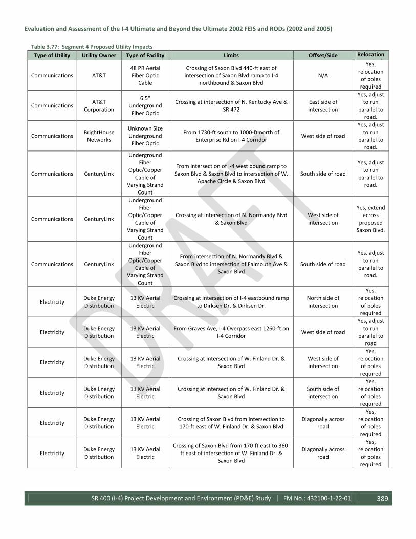
Evaluation and Assessment of the I-4 Ultimate and Beyond the Ultimate 2002 FEIS and RODs (2002 and 2005)
SR 400 (I-4) Project Development and Environment (PD&E) Study | FM No.: 432100-1-22-01 389
Table 3.77: Segment 4 Proposed Utility Impacts Type of Utility Utility Owner Type of Facility Limits Offset/Side Relocation
R i d
Communications AT&T 48 PR Aerial Fiber Optic
Cable
Crossing of Saxon Blvd 440-ft east of intersection of Saxon Blvd ramp to I-4
northbound & Saxon Blvd N/A
Yes, relocation of poles required
Communications AT&T Corporation
6.5" Underground
Fiber Optic
Crossing at intersection of N. Kentucky Ave & SR 472
East side of intersection
Yes, adjust to run
parallel to road.
Communications BrightHouse Networks
Unknown Size Underground
Fiber Optic
From 1730-ft south to 1000-ft north of Enterprise Rd on I-4 Corridor West side of road
Yes, adjust to run
parallel to road.
Communications CenturyLink
Underground Fiber
Optic/Copper Cable of
Varying Strand Count
From intersection of I-4 west bound ramp to Saxon Blvd & Saxon Blvd to intersection of W.
Apache Circle & Saxon Blvd South side of road
Yes, adjust to run
parallel to road.
Communications CenturyLink
Underground Fiber
Optic/Copper Cable of
Varying Strand Count
Crossing at intersection of N. Normandy Blvd & Saxon Blvd
West side of intersection
Yes, extend across
proposed Saxon Blvd.
Communications CenturyLink
Underground Fiber
Optic/Copper Cable of
Varying Strand Count
From intersection of N. Normandy Blvd & Saxon Blvd to intersection of Falmouth Ave &
Saxon Blvd South side of road
Yes, adjust to run
parallel to road.
Electricity Duke Energy Distribution
13 KV Aerial Electric
Crossing at intersection of I-4 eastbound ramp to Dirksen Dr. & Dirksen Dr.
North side of intersection
Yes, relocation of poles required
Electricity Duke Energy Distribution
13 KV Aerial Electric
From Graves Ave, I-4 Overpass east 1260-ft on I-4 Corridor West side of road
Yes, adjust to run
parallel to road
Electricity Duke Energy Distribution
13 KV Aerial Electric
Crossing at intersection of W. Finland Dr. & Saxon Blvd
West side of intersection
Yes, relocation of poles required
Electricity Duke Energy Distribution
13 KV Aerial Electric
Crossing at intersection of W. Finland Dr. & Saxon Blvd
South side of intersection
Yes, relocation of poles required
Electricity Duke Energy Distribution
13 KV Aerial Electric
Crossing of Saxon Blvd from intersection to 170-ft east of W. Finland Dr. & Saxon Blvd
Diagonally across road
Yes, relocation of poles required
Electricity Duke Energy Distribution
13 KV Aerial Electric
Crossing of Saxon Blvd from 170-ft east to 360-ft east of intersection of W. Finland Dr. &
Saxon Blvd
Diagonally across road
Yes, relocation of poles required

Evaluation and Assessment of the I-4 Ultimate and Beyond the Ultimate 2002 FEIS and RODs (2002 and 2005)
SR 400 (I-4) Project Development and Environment (PD&E) Study | FM No.: 432100-1-22-01 390
Table 3.77: Segment 4 Proposed Utility Impacts Type of Utility Utility Owner Type of Facility Limits Offset/Side Relocation
R i d
Electricity Duke Energy Distribution
13 KV Aerial Electric
From 140-ft west to 270-ft east of intersection of W. Apache Cir. & Saxon Blvd South side of road
Yes, relocation of poles required
Electricity Duke Energy Distribution
13 KV Aerial Electric
Crossing of Saxon Blvd from 165-ft west of to intersection of Diane Terrace & Saxon Blvd
Diagonally across road
Yes, relocation of poles required
Electricity Duke Energy Distribution
13 KV Aerial Electric
Crossing of Saxon Blvd 120-ft east of intersection of N. Normandy Blvd & Saxon Blvd N/A
Yes, relocation of poles required
Electricity Duke Energy Distribution
7.2 KV Aerial Electric
Crossing of Saxon Blvd 730-ft west of intersection of W. Finland Dr. & Saxon Blvd N/A
Yes, relocation of poles required
Electricity Duke Energy Distribution
7.2 KV Underground
Electric
Crossing of Dirksen Dr. at intersection of I-4 westbound ramp to Dirksen Dr. & Dirksen Dr.
East side of intersection
Yes, relocation
of line parallel to
I-4 Corridor
Electricity Duke Energy Transmission
115 KV Aerial Electric
Diagonal crossing of Saxon Blvd, from intersection to 400-ft east of W. Finland Dr. &
Saxon Blvd Diagonal across road
Yes, relocation of poles required
Electricity Duke Energy Transmission
115 KV Aerial Electric
Diagonal crossing of Saxon Blvd, from 150-ft west of intersection of W. Apache Circle &
Saxon Blvd to intersection of Diane Terrace & Saxon Blvd
Diagonal across road
Yes, relocation of poles required
Electricity Duke Energy Transmission
115 KV Aerial Electric
Diagonal crossing of Saxon Blvd, 130-ft east of intersection of Exotic Terrace & Saxon Blvd east to intersection of N. Normandy Blvd &
Saxon Blvd
Diagonal across road
Yes, relocation of poles required
Electricity Duke Energy Transmission
115 KV Aerial Electric
Diagonal crossing of Saxon Blvd, from intersection to 450-ft east of intersection of N.
Normandy Blvd & Saxon Blvd Diagonal across road
Yes, relocation of poles required
Electricity Duke Energy Transmission
115 KV Aerial Electric
From 500-ft west of to intersection of Forest Edge Dr. & SR 472 South side of road
Yes, relocation of poles required
Electricity Duke Energy Transmission
115 KV Aerial Electric
From 6850-ft west of SR 472, I-4 overpass east on I-4 to Graves Ave, I-4 Corridor overpass East side of road
Yes, adjust to run
parallel to road.
Intelligent Transportation
System
Florida Department of Transportation
Intelligent Transportation System Cable
From Seminole/Volusia County Line east for 6790-ft on I-4
East side of road, attached to bridge over Lake Monroe
Yes, adjust to run
parallel to road
Intelligent Transportation
System
Florida Department of Transportation
Intelligent Transportation System Cable
Crossing of I-4 1590-ft east of Seminole/Volusia County Line N/A
Yes, extend across
proposed I-4 Corridor

Evaluation and Assessment of the I-4 Ultimate and Beyond the Ultimate 2002 FEIS and RODs (2002 and 2005)
SR 400 (I-4) Project Development and Environment (PD&E) Study | FM No.: 432100-1-22-01 391
Table 3.77: Segment 4 Proposed Utility Impacts Type of Utility Utility Owner Type of Facility Limits Offset/Side Relocation
R i d Intelligent
Transportation System
Florida Department of Transportation
Intelligent Transportation System Cable
Crossing of I-4 6790-ft east of Seminole/Volusia County Line N/A
Yes, extend across
proposed I-4 Corridor
Intelligent Transportation
System
Florida Department of Transportation
Intelligent Transportation System Cable
From 6790-ft east of Seminole/Volusia County Line east to Dirksen Dr., I-4 underpass
West side of road, attached to Padgett
Creek Bridge
Yes, attach to
proposed bridge
Intelligent Transportation
System
Florida Department of Transportation
Intelligent Transportation System Cable
From intersection of Debary Ave ramp to I-4 east bound & Debar Ave east along ramp for
1400-ft (end of ramp to I-4) East side of road
Yes, relocation
to avoid on ramp
Intelligent Transportation
System
Florida Department of Transportation
Intelligent Transportation System Cable
From Dirksen Dr. I-4 underpass east on I-4 to SR 472, I-4 overpass East side of road
Yes, adjust to run
parallel to road
Intelligent Transportation
System
Florida Department of Transportation
Intelligent Transportation System Cable
Crossing of I-4, 4010-ft west of Saxon Blvd, I-4 overpass N/A
Yes, relocation
to accommodate pond
Intelligent Transportation
System
Florida Department of Transportation
Intelligent Transportation System Cable
From 4680-ft west of to 4010-ft west of Saxon Blvd, I-4 overpass on I-4 West side of road
Yes, adjust to run
parallel to road
Water City of Deltona Unknown Size Water Main
From intersection of N. Normandy Blvd & Saxon Blvd to intersection of Bamboo Ct &
Saxon Blvd North side of road
Yes, relocate to run parallel
to road
Water Volusia County 16" Water Main
From intersection of Martin Luther King Jr. Bellway to intersection of E. Graves Ave &
Howland Blvd South side of road
Yes, adjust to run
parallel to the road.
Wastewater/ Storm Water
Volusia County
Force Main of Varying Size
From intersection of Martin Luther King Jr. Bellway east to station 134+00 on Howland
Blvd North side of road
Yes, adjust to run
parallel to road.
With the No-Build Alternative, no direct impacts to utilities would occur as a result of the project.
3.5.1 Railroads Existing railroads have been evaluated along with the utilities located within the Ultimate project area. The railroad lines documented within the project footprint are referenced in Table 3.71 above.
The potential for involvement with railroads were again reviewed during the I-4 BtU Study. There are not any railroads located within Segment 2, but there is one at-grade rail/highway crossing within the limits of Segment 3, approximately 800 feet east of I-4 at Monroe Road. There is also one grade separated crossing, located just north of Orange Boulevard where the I-4 Bridge over Orange Boulevard also spans over the railroad. In this region, this rail corridor is known as the Central Florida Rail Corridor and is owned by the Florida Department of Transportation. The tracks are primarily used by the SunRail commuter trains; other users include CSXT and Florida Central Railroad (FCEN), for freight transportation and Amtrak intercity passenger rail service. There are no at grade rail/highway crossings within the limits of Segment 4.

Evaluation and Assessment of the I-4 Ultimate and Beyond the Ultimate 2002 FEIS and RODs (2002 and 2005)
SR 400 (I-4) Project Development and Environment (PD&E) Study | FM No.: 432100-1-22-01 392
An abandoned rail corridor runs parallel to Dirksen Drive and the section that was within the FDOT right-of-way has been purchased by FDOT.
There are not any anticipated impacts to the railroads within the project area.
3.6 Navigation The original I-4 PD&E Study examined the potential navigation related issues with the project. I-4 crosses the St. Johns River/Lake Monroe at the Seminole/Volusia County line, which is located just north of the I-4/US 17-92 interchange. The St. Johns River is considered to be a navigable waterway. There are several public and private facilities located downstream within one-half mile of the crossing. These facilities include Wayside Park and Dock, Port of Sanford, Hidden Harbor Marina, and Lake Monroe Park. In addition, major cargo was transported on the river through this area. Types of cargo include fertilizer, oil and gasoline, phosphate rock, cement, motor vehicles, paper, and fruit. The majority of the marine traffic consists of sailboats, cabin cruisers, pontoon boats, and small outboard motorboats.
The proposed project will not block access of any vessel presently using local service facilities during construction. In addition, the proposed bridge will provide the minimum clearances mandated by the USCG in order to provide safe, efficient passage of the largest of these vessels. It is noted that the St. Johns River Bridge substructure and the superstructure for the general use lanes and the substructure for the HOV lanes (now Express Lanes) were being advanced as part of the I-4 Six Laning and St. Johns River Bridge Project. Therefore, the minimum horizontal and vertical clearances for the bridge superstructure for the HOV lanes (now Express Lanes) will most likely be established as part of the St. Johns River Bridge project.
At the time of the original PD&E Study, potential navigation related issues were evaluated. Construction activities for the proposed I-4 / St. Johns River Bridge replacement were expected to have air, noise, water quality, vehicular and marine traffic flow, and visual impacts for those residents, travelers, and recreational users within the immediate vicinity of the Ultimate project. However, the construction of the widening of the St. Johns River Bridge was completed during the I-4 Six Laning and St. Johns River Bridge project, which included the substructure and superstructure required for the expansion design in the I-4 BtU project. Because of this, there will be no navigation impacts associated with the project.
The I-4 BtU PD&E Study re-examined the potential navigation related issues with the project. The only navigable crossing within the project area remains the crossing at the St. Johns River/Lake Monroe, just north of the US 17-92 interchange. The crossing occurs at the northern terminus of Segment 3 and the southern begin point of Segment 4. Since the original PD&E Study, the I-4 Six Laning Project was constructed, and a new bridge was part of the project. Additionally, the substructure to support the BtU Express Lanes was constructed during this project, and no new “in-water” construction for the bridge will be associated with the BtU project.
Padgett Creek, a small tributary of Lake Monroe is navigable at the northern end of Lake Monroe located in Segment 4 that has an existing bridge crossing. The bridge will be replaced as a part of the project. In addition, a new bridge section of approximately 100 feet will be installed along the roadway adjacent to Lake Monroe to provide a new connection between Lake Monroe and the DeBary Bayou. This is not intended to create a new navigable crossing for any type of boat traffic or commercial traffic.

Evaluation and Assessment of the I-4 Ultimate and Beyond the Ultimate 2002 FEIS and RODs (2002 and 2005)
SR 400 (I-4) Project Development and Environment (PD&E) Study | FM No.: 432100-1-22-01 393
3.7 Required Permits The construction and operation of the proposed improvements to I-4 will require permits from federal and state agencies prior to the construction of the BtU project. Those permits would be required for wetland impacts, stormwater discharge, treatment, and attenuation, and water use as shown in Table 3.78. Due to FDOT having sovereign immunity from local permits within its jurisdiction, the project would not require permits from Orange County, Seminole County, or Volusia County. With the project complying with all federal and state regulations concerning impacts to wetlands and water resources, it would satisfy the county ordinances pertaining to those types of impacts. It is not likely that any additional authorization will be required for Sovereign Submerged Lands since the St. Johns River Bridge project was completed during the previous six-laning project, though coordination with State Lands of FDEP will confirm that during permitting. Since the Ultimate project is currently under construction, all required permits have either already been secured or are in the process of review for that segment, while the applications for the permits for the segments of the I-4 BtU will be submitted during the design phases.
Table 3.78 - Required Permits/Approvals Agency Permit / Approval
US Army Corps of Engineers Federal Dredge and Fill Section 404b permit
St. Johns River Water Management District / South Florida Water Management District
Environmental Resource Permit (ERP), Clean Water Act Section 401 Water Quality Certification, Water Use / Consumptive Use
(Dewatering) Permit
Florida Department of Environmental Protection National Pollutant Discharge Prevention and Elimination System (NPDES) Permit
US Fish and Wildlife Service Endangered Species Act Section 7 Consultation Florida Fish and Wildlife Conservation Commission Gopher Tortoise Conservation Permit
Florida State Historic Preservation Officer National Historic Preservation Act Section 106 Compliance
National Marine Fisheries Service Magnuson-Stevens Fishery Conservation and Management Act – Essential Fish Habitat
3.8 Construction Impacts The construction activities for the project will result in temporary air, noise, water quality, traffic flow, and visual impacts for those residents, businesses, and travelers within the vicinity of the construction areas of the proposed improvements. In addition, consideration of construction staging needs, disposal of materials, and required borrow materials are important. The level, type, and degree of construction impacts will vary as a function of several key characteristics including the type of construction (demolition, excavation, fill, bridge structures, utilities, pavement, etc.), the proximity of sensitive land uses to construction (residential, commercial, hospitals, schools, churches, etc.), the traffic volumes in and around the construction site (traffic control complexities, safety, project phasing), and the locations of haul routes (borrow sites, fabrication yards, asphalt plants, disposal areas, etc.). Given these factors, it is not possible to provide specific details of the exact location, level, or extent of impacts. With the scope of the proposed improvements over such a wide geographic area, it is expected that the construction impacts will be extensive and spread throughout the entire project area.
3.9 Indirect and Cumulative Effects
3.9.1 Indirect Effects The original PD&E Study assessed the project for indirect impacts; i.e. effects that, in turn, cause a reaction that have additional consequences to the human environment. The general areas where such indirect issues would occur included

Evaluation and Assessment of the I-4 Ultimate and Beyond the Ultimate 2002 FEIS and RODs (2002 and 2005)
SR 400 (I-4) Project Development and Environment (PD&E) Study | FM No.: 432100-1-22-01 394
Air Quality (emissions associated with project-related traffic that may cause regional air quality impacts and contribute to exceedance of the NAAQS) and Land Use (land use changes that would occur due to the degradation of the community fabric adjacent to the project, or due to the enhanced access and mobility attributed to the project).
The impacts associated with Air Quality were based upon increased vehicle emissions from trucks and construction equipment and the project being a cause for additional particulate matter in the area. In comparing the projected year 2020 travel characteristics assessing the Build alternative versus the No-Build alternative, the results indicated that the project would not contribute to regional air quality impacts compared to the No-Build.
Indirect land use effects represent a common concern related to highway improvements. First, there is the inducement of land use outside of the central cities due to increased capacity and mobility provided by the Build alternatives. This effect was not anticipated to result in major changes of land use given the extensive growth management planning required for all local governments. Specifically, local government comprehensive plans set the future land uses within the region, which represent a fairly significant commitment on how and what development would occur in the corridor. These plans also include and recognize the LRTP improvements as a part of the land use efforts. It was not anticipated that the Ultimate project would induce measurable new or different land uses beyond those represented in the local government comprehensive plans. It is, however, reasonable to expect that development may occur at a faster pace with the enhanced mobility of the proposed improvements versus the No-Build alternative.
The second land use effect is based upon the fact that the proposed roadway improvements would be closer to the existing right-of-way limits on I-4 in some areas, and in other areas, the roadway would actually directly use new right-of-way on existing residential and commercial properties. In a few isolated areas, the I-4 Build alternative would impact access to existing properties, requiring more circuitous routing to and from these properties. It is expected that these proposed improvements along with the noise and / or visual effects would result in some owner-occupied existing residential properties located directly adjacent to I-4 migrating away from the project area.
The I-4 BtU PD&E Study was assessed for indirect effects as well during the study. Although similar situations exist, it is not anticipated that any indirect effects to air quality would occur from the project other than those temporary impacts described previously. The project area is “in attainment” and is not expected to cause indirect regional impacts. Land use impacts would be similar as previously described from the Ultimate project, though in the 15 years since the study was completed, additional development has occurred all along the corridor, while the metropolitan Orlando area has spread out over a greater area and populations have risen significantly leading to higher traffic usage on the roadway. There is not expected to be any significant impacts to residential areas, so the anticipated indirect effects of residential migration is not as likely as was anticipated for the Ultimate segment. Indirect impacts to wetlands would likely result from the project, though these would be considered during the permitting process and would have the appropriate compensatory mitigation provided to offset the impacts.
3.9.2 Cumulative Effects The Ultimate PD&E Study analyzed the potential cumulative effects the proposed project based upon all of the projects that were or would be a cumulative effect to the proposed I-4 improvements and listed all of the independent projects and studies within the FEIS. The evaluation criteria included the business and residential impacts, cultural resource and historic structures impacted, natural environment and physical environment impacts, and the noise impacts. The results

Evaluation and Assessment of the I-4 Ultimate and Beyond the Ultimate 2002 FEIS and RODs (2002 and 2005)
SR 400 (I-4) Project Development and Environment (PD&E) Study | FM No.: 432100-1-22-01 395
of the analysis indicted that the cumulative effects would not have major local, regional, or national impact to the human environment.
When looking at the I-4 BtU improvements, this does not significantly change the analysis.
3.10 Relationship Between Local Short-Term Uses of Man’s Environment and the Maintenance and Enhancement of Long-Term Productivity The Ultimate project improvements to I-4 as well as the I-4 BtU project would clearly involve impacts to the human environment within the greater Orlando metropolitan area. The types and general extent of the impacts to the socioeconomic, cultural, natural, and physical environments have been detailed within the document. The primary impacts included those to the existing land use (residential and commercial) and to natural systems. Those impacts would be mitigated through appropriate actions defined through the commitments included in this document. The impacts attributed to the Ultimate project and I-4 BtU project, along with the associated actions to minimize or mitigate the impacts, are balanced with the benefits derived through enhancement of long-term productivity associated with improving I-4, likely the most critical transportation link in Central Florida, with commensurate improvement in travel time and travel efficiency.
During the original study, METROPLAN ORLANDO and the Volusia County MPO’s 2020 LRTPs identified improvements to I-4 as a top priority for the region to enhance connectivity and mobility. Furthermore, each of the study area local government Comprehensive Plans clearly identified (both then and now) improvements to I-4 as an important priority to serve sustained positive economic conditions for the region. Enhancement of the efficiency and safety of I-4 through focusing on the movement of people and goods within the corridor has required careful consideration of the type of improvement, the operation of the facility, and the design criteria applied to both the Ultimate and BtU projects. Through these efforts, it is concluded that the local short-term impacts and the use of resources associated with the implementation of the project is consistent with the maintenance and enhancement of long-term productivity within the region that will be realized with the proposed improvements.
3.11 Irreversible and Irretrievable Commitments During the original study, it was determined that the implementation of the Ultimate project would involve the commitment of a range of natural, physical, human, and fiscal resources. The I-4 BtU project would also involve a similar if not larger commitment of resources. Land used in the construction of the projects is considered an irreversible commitment during the time period that the land is used for a highway facility. However, if a greater need arises for use of the land or if the highway facility is no longer needed, the land can be converted to another use. At present, there is no reason to believe that such a conversion will ever be necessary or desirable.
Considerable amounts of fossil fuels, labor, and highway construction materials such as cement, aggregate, and bituminous materials will be expended. Additionally, large amounts of labor and natural resources will be used in the fabrication and preparation of construction materials for the projects. These materials will generally not be retrievable. However, they are not in short supply and their use will not have an adverse effect upon continued availability of these resources. Any construction will also require a substantial one-time expenditure of both state and federal funds, which are not retrievable. The commitment of these resources is based on the concept that residents in the immediate area, state, and region will benefit by the improved quality of the transportation system. These benefits will consist of

Evaluation and Assessment of the I-4 Ultimate and Beyond the Ultimate 2002 FEIS and RODs (2002 and 2005)
SR 400 (I-4) Project Development and Environment (PD&E) Study | FM No.: 432100-1-22-01 396
improved accessibility and safety, savings in time, and greater availability of quality services, which are anticipated to outweigh the commitment of these resources.
For the I-4 BtU Project, a similar commitment of resources is expected, and with a larger project area serving a greater portion of Central Florida, the benefits of the improved transportation corridor are expected to outweigh the commitment of resources.
3.12 Probable Adverse Environmental Effects Which Cannot Be Avoided During the original study, it was determined that the Preferred Alternative for the I-4 Ultimate Project would clearly involve impacts to the human environment within the greater Orlando metropolitan area. The socioeconomic, cultural, natural, and physical impacts have been documented in detail within the original FEIS and summarized in this document. The level of impacts for the proposed improvements varies; however the types and general extent of the build alternative impacts were similar. The primary impacts to the human environment included uses of existing land use such as residential, commercial, and natural systems. Those impacts would be mitigated through appropriate actions defined through commitments included in the environmental action.
When examining the potential impacts from the I-4 BtU project, similar types of impacts were anticipated to the natural and physical environments within the project area, though cultural and socioeconomic impacts are not anticipated. This is mainly related to the project location of the I-4 Ultimate Project in Downtown Orlando, whereby the I-4 BtU project is proposed both north and south of Orlando, where similar cultural and socioeconomic situations were not encountered. Mitigation to offset the proposed impacts has also been defined through commitments in this document.
In both cases, the impacts caused by the Preferred Alternative, along with the associated actions to minimize or mitigate the impacts, are balanced with the benefits derived through enhancement of long-term productivity associated with improving I-4, likely the most critical transportation link in Central Florida, with commensurate improvements in travel time and efficiency.
The improvements proposed in the I-4 Ultimate were identified as a top priority in both MetroPlan Orlando and the Volusia County MPO 2020 LRTPs to enhance connectivity and mobility. Since the I-4 Ultimate is currently under construction, the proposed I-4 BtU project which will match that configuration is seen as essential to provide the connectivity and sustained transportation needs for the region.
Enhancement of the mobility and safety of I-4 through focusing on the movement of people and goods within both the Ultimate and Beyond the Ultimate project corridors required careful consideration of the type of improvement, the operation of the facilities, and the design criteria applied to the Preferred Alternatives. Through that effort, it is concluded that the local short-term impacts and the use of resources associated with the implantation of the project is consistent with the maintenance and enhancement of long-term productivity within the region, which will be realized with the proposed improvements.
The I-4 BtU PD&E Study estimated the impacts for the proposed Preferred Alternative to the Human Environment, Natural Environment, and Project Costs as shown on Tables 3.79, 3.80, and 3.81.

Evaluation and Assessment of the I-4 Ultimate and Beyond the Ultimate 2002 FEIS and RODs (2002 and 2005)
SR 400 (I-4) Project Development and Environment (PD&E) Study | FM No.: 432100-1-22-01 397
Table 3.79 – Segment 2 Alternatives Evaluation Matrix
Summary of Impacts‡ No Build
I-4 Mainline
SR 482 (Sand Lake Road) Interchange Alternative SR 528 (Beachline Expressway) Interchange Alternative 1 2 3 4 1 2 3 4 5 6 7
Base Parclo w/loop ramp in NW
quadrant; some ramp modifications
DDI SPUI
DDI w/loop ramp in
NW quadrant
Freeway Terminal Junction
w/separate direct connect ramps for ELs & GULs and four-level
bridge
Freeway Terminal Junction
w/combined direct connect
ramps for ELs & GULs
Multi-level Diverging Diamond
Interchange
Freeway Terminal Junction
w/separate direct connect ramps for ELs
& GULs; I-4 alignment
shifted west
Freeway Terminal Junction
w/combined direct connect
ramps for ELs & GULs; I-4
alignment shifted west
Freeway Terminal Junction w/separate direct connect ramps & direct connection to the SR 528 ELs
Freeway Terminal
Junction w/ combined ramps
& a direct connection to International
Drive
Roadway ROW Acquisition (Acres) 0.00 0 0 0 0 1.82 4.51 4.09 4.04 3.44 7.17 7.34 7.98
Pond ROW Acquisition (Acres)1 0.0 16.0 n/a n/a n/a 0.0 n/a n/a n/a n/a n/a 0.0 n/a
Impacted Noise Sensitive Sites 0 77 0 0 0 0 0 0 0 0 0 0 0
Wetland (WL & Surface Water (SW)
Impacts2 (acres)
0.00
WL- 0.00 SW- 1.8
(low quality)
WL - 0.00 SW- 2.01 (low
quality)
WL - 0.00 SW- 2.01
(low quality)
WL - 0.00 SW- 2.01
(low quality)
WL - 0.00 SW- 2.01
(low quality)
WL- 4.43 (low quality)
SW- 5.51 (low quality)
WL- 4.43 (low quality)
SW- 5.51 (low quality)
WL- 4.43 (low quality)
SW- 5.51 (low quality)
WL- 4.43 (low quality)
SW- 5.51 (low quality)
WL- 4.43 (low quality)
SW- 5.51 (low quality)
WL- 4.43 (low quality)
SW- 5.51 (low quality)
WL- 4.43 (low quality)
SW- 5.51 (low quality)
Floodplain Impacts (ac-ft.) 0 0 0 0 0 0 0 0 0 0 0 0 0
Section 4(f) Properties 0 0 0 0 0 0 0 0 0 0 0 0 0
Potential Historic Sites3 0
Two historic
structures (NRHP
ineligible)
0 0 0 0 0 0 0 0 0 0 0
Potential Contamination (Sites) 0
10 Low Risk
3 Med. Risk4
8 Low 4 Med.
8 Low 4 Med.
8 Low 4 Med.
8 Low 4 Med.
4 Low 1 Low/Med.
4 Low 1 Low/Med.
4 Low 1 Low/Med.
4 Low 1 Low/Med.
4 Low 1 Low/Med.
4 Low 1 Low/Med.
4 Low 1 Low/Med.
Potential Contamination
(Ponds)5,6 0
3 Low (200A,
200B, 208) 4 Med. (205A, 205B, 205C, 205D)
4 Low (206, 206A, 206B, 207)
4 Low (206, 206A, 206B,
207)
4 Low (206, 206A, 206B, 207)
4 Low (206, 206A,
206B, 207)
9 Low (201, 202A, 202B, 202C, 202D, 203A, 203B, 204A, 204B)
9 Low (201, 202A, 202B, 202C, 202D, 203A, 203B, 204A, 204B)
9 Low (201, 202A, 202B, 202C, 202D, 203A, 203B, 204A, 204B)
9 Low (201, 202A, 202B, 202C, 202D, 203A, 203B, 204A, 204B)
9 Low (201, 202A, 202B, 202C, 202D, 203A, 203B, 204A, 204B)
9 Low (201, 202A, 202B, 202C, 202D, 203A, 203B, 204A,
204B)
9 Low (201, 202A, 202B, 202C, 202D, 203A, 203B, 204A, 204B)
Potential to Improve Traffic Operations Low High Low Low Low High n/a7 n/a7 n/a7 n/a7 Low High Medium
Pedestrian Accommodations Yes n/a Yes Yes Yes Yes n/a n/a n/a n/a n/a n/a n/a

Evaluation and Assessment of the I-4 Ultimate and Beyond the Ultimate 2002 FEIS and RODs (2002 and 2005)
SR 400 (I-4) Project Development and Environment (PD&E) Study | FM No.: 432100-1-22-01 398
Table 3.79 – Segment 2 Alternatives Evaluation Matrix
Summary of Impacts‡ No Build
I-4 Mainline
SR 482 (Sand Lake Road) Interchange Alternative SR 528 (Beachline Expressway) Interchange Alternative 1 2 3 4 1 2 3 4 5 6 7
Base Parclo w/loop ramp in NW
quadrant; some ramp modifications
DDI SPUI
DDI w/loop ramp in
NW quadrant
Freeway Terminal Junction
w/separate direct connect ramps for ELs & GULs and four-level
bridge
Freeway Terminal Junction
w/combined direct connect
ramps for ELs & GULs
Multi-level Diverging Diamond
Interchange
Freeway Terminal Junction
w/separate direct connect ramps for ELs
& GULs; I-4 alignment
shifted west
Freeway Terminal Junction
w/combined direct connect
ramps for ELs & GULs; I-4
alignment shifted west
Freeway Terminal Junction w/separate direct connect ramps & direct connection to the SR 528 ELs
Freeway Terminal
Junction w/ combined ramps
& a direct connection to International
Drive
Bicycle Accommodations No n/a Yes Yes Yes Yes n/a n/a n/a n/a n/a n/a n/a
Parcels Impacted 0 12 0 0 0 11 9 9 8 6 7 7 12
Relocations 0 1 0 0 0 0 1 1 1 1 1 1 1
Constructability N/A High High High High High High High High High High High High
Bridges (Area, SF) 0 123,083 38,368 51,919 78,280 60,417 233,398 224,750 390,332 346,893 183,627 246,829 245,957
Construction Cost8 $0 $127.2M $14.9M $29.7M $31.0M $32.4M $110.4M $106.7M $160.9M $141.6M $100.1M $123.3M $139.5M
Notes: This document is a working draft; data provided is a work in progress and may be updated or replaced. ‡This table illustrates impacts from the proposed improvements for the I-4 Mainline build alternative and comparatively shows any additional impacts from the various interchange alternative options. Alternative # - designates the recommended alternative. Abbreviations: Parclo-Partial Cloverleaf DDI- Diverging Diamond Interchange, SPUI- Single-Point Urban Interchange, ROW– Right-of-Way, ac-ft– acre-feet, SSV- Stormwater Storage Vault, SF- square feet. 1Based on preferred pond sites as determined in the Pond Siting Report (December 2015). 2Low Quality, UMAM score between 0 and 0.49. 3Historic sites constructed before 1971 within APE (Area of Potential Effect), which includes existing ROW along I-4 and within 330’ from proposed ROW and proposed pond footprints plus 100’ buffer. 4One of these sites is a Ground Water Contamination Plume which contains numerous other sites in addition to ponds 205A, 205B, 205C & 205D. 5All pond sites listed are recommended, except Ponds 200A, 205A & 205B which are pond alternatives. 6Based on Level 2 CIAR, asbestos debris will require special handling, characterization and disposal provisions at Pond sites 205B & 205C; Pond sites 206, 206A & 206B considered high risk based on potential groundwater impacts at the historical 7-Eleven facility located near pond site 206. 7Some alternatives were removed from further consideration due to roadway geometric design constraints, operational deficiencies, inter-agency coordination indicating other preferences and/or being cost-prohibitive, and no further traffic analysis was completed. 8Construction costs are preliminary as determined by the Engineer’s Estimate included in Appendix C; shown in millions of dollars.

Evaluation and Assessment of the I-4 Ultimate and Beyond the Ultimate 2002 FEIS and RODs (2002 and 2005)
SR 400 (I-4) Project Development and Environment (PD&E) Study | FM No.: 432100-1-22-01 399
Table 3.80: Segment 3 Alternatives Evaluation Matrix
Summary of Impacts1
No-Build I-4 Mainline
Lake Mary Boulevard CR 46A SR 46 US 17-92 Alt. 1 Alt. 2 Alt. 3 Alt. 4 Alt. 1 Alt. 2 Alt. 3 Alt. 1 Alt. 2 Alt. 1 Alt. 2 Alt. 3 Alt. 4 Alt. 5 Alt. 6 Alt. 7 Alt. 8
Base SPUI GS - DDI DDI w/Lake Emma Road Connector
Base Geometry CFI DDI Base w/
Left Turn
Ramp Spur from I-4 EB
to Roundabout
Base Diamond SPUI Diamond Loop SPUI - T Partial
Cloverleaf GS - DDI Elevated TUDI
Roadway ROW Area to be
acquired (Acres) 0 2 0 0 0 4.2 0 2 4.2 0 0 0 9.8 9.8 9.8 4.7 13.4 8.4 7.8
Pond ROW Area to be acquired
(Acres)2 0 17.27 n/a n/a n/a 0 n/a n/a 0 0 n/a n/a n/a n/a n/a n/a n/a n/a 7.84
Wetland Impacts (Acres) 0
0.07 - Wetlands
0 0 0 0 0 0 0 0 0 4.47 6.17 6.28 6.25 4.05 3.59 4.60
6.60 Wetlands
6.75 –Surface Waters
4.46 -Stormwater
Pond Floodplain
Impacts 0 6.43 ac-ft. n/a n/a n/a 0 n/a 0 0 0 n/a n/a n/a n/a n/a n/a n/a n/a 0
Impacted Noise Sensitive Sites 0
140 Noise Sensitive
Sites 0 0 0 0 0 0 0 0 0 0 0 0 0 0 0 0
Section 4(f) Properties 0
One park, two trails
and 4 historic resources (3
NRHP eligible)
0 0 0 0 0 0 0 0 0 0 0 0 0 0 0 0 0
Potential Historic Sites 0
30 historic structures
constructed before 1971 within APE3, of which 3 are NRHP
eligible
0 0 0 0 0 0 0 0 0 0 0 0 0 0 0 0 0
Number of Potential
Contamination Sites & Risk Rating
0
19 - Low 2 – Low 2 – Low 2 – Low 4 – Low
2 – Low 2 – Low 2 – Low
4 – Low 4 – Low
1 – Low 1 – Low 1 – Low 1 – Low
2 – Low 6 – Low 4 – Low 3 – Low 2 - Med 3 – Med 3 – Med 3 – Med 3 – Med 7 – Med 7 – Med 1 – Med 2 – Med 2 – Med 1 – Med 1 - High 1 – High 1 – High
Pond 3004, FPC 300-A4,
FPC 300-B4 & Swale 313A -
Med

Evaluation and Assessment of the I-4 Ultimate and Beyond the Ultimate 2002 FEIS and RODs (2002 and 2005)
SR 400 (I-4) Project Development and Environment (PD&E) Study | FM No.: 432100-1-22-01 400
Table 3.80: Segment 3 Alternatives Evaluation Matrix
Summary of Impacts1
No-Build I-4 Mainline
Lake Mary Boulevard CR 46A SR 46 US 17-92 Alt. 1 Alt. 2 Alt. 3 Alt. 4 Alt. 1 Alt. 2 Alt. 3 Alt. 1 Alt. 2 Alt. 1 Alt. 2 Alt. 3 Alt. 4 Alt. 5 Alt. 6 Alt. 7 Alt. 8
Base SPUI GS - DDI DDI w/Lake Emma Road Connector
Base Geometry CFI DDI Base w/
Left Turn
Ramp Spur from I-4 EB
to Roundabout
Base Diamond SPUI Diamond Loop SPUI - T Partial
Cloverleaf GS - DDI Elevated TUDI
Pond 3075, 3085 - High
Potential to Improve Traffic
Operations6 Low High Low Medium -6 High Low High High High High Low -6 -6 -6 -6 High High High
Pedestrian Accommodations
Some Areas No Yes Yes Yes Yes Yes Yes Yes Yes Yes Yes Yes Yes Yes Yes Yes Yes Yes
Bicycle Accommodations No7 No Yes Yes Yes Yes Yes Yes Yes Yes Yes Yes Yes Yes Yes Yes Yes Yes Yes
Parcels Impacted 0 23 0 0 0 4 0 13 16 0 0 0 7 7 7 7 19 11 10 Relocations 0 0 0 0 0 1 0 0 0 0 0 0 0 0 0 0 4 2 2
Constructability High High High Low High High High High High High High High High High High High Low High Bridges Area (SF) 0 113,013 86,471 52,000 71,273 67,340 47,084 133,116 135,990 17,818 17,818 65,039 97,930 169,106 149,458 176,641 340,059 548,164 367,330
Construction Cost8 None $229 M $31 M $26 M $35 M $47 M $26 M $59 M $59 M $10 M $11 M $23 M $42 M $63 M $59 M $67 M $125 M $183 M $131 M Notes:
Data provided is a work in progress and may be updated or replaced. Abbreviations: CFI - Continuous Flow Intersection, DDI - Diverging Diamond Interchange, GS DDI - Grade Separated Diverging Diamond Interchange, SPUI - Single Point Urban Interchange, TUDI- Tight Urban Diamond Interchange, APE – Area of Potential Effect, NRHP - National Register of Historic Places. Alt. # - Designates the recommended alternative. 1Table illustrates impacts from the proposed improvements to I-4 for the build alternative and comparatively shows any additional impacts from the various interchange alternative options. 2Recommended pond sites as determined in the Pond Siting Report, December 2015. 3APE includes area within existing ROW along I-4, within 330’ from proposed ROW and proposed pond footprints plus 100’ buffer. 4Within or near Ground Water Contamination Plume. 5Proximity to known Contamination Site #155 which involves heavy metals. 6Traffic operational analyses were not completed for alternatives that were dismissed from further consideration due to geometric/design constraints, operational deficiencies, inter-agency coordination indicating other preferences and/or being cost-prohibitive. 7Existing conditions provide paved shoulders/unmarked bicycle lanes in some locations. 8Construction costs are preliminary as determined by the Engineer’s Estimate included in Appendix C; shown in millions of dollars.

Evaluation and Assessment of the I-4 Ultimate and Beyond the Ultimate 2002 FEIS and RODs (2002 and 2005)
SR 400 (I-4) Project Development and Environment (PD&E) Study | FM No.: 432100-1-22-01 401
Table 3.81: Segment 4 Alternatives Evaluation Matrix
Summary of Impacts1
No-Build I-4 Mainline
Dirksen Drive Saxon Boulevard Rhode Island Avenue SR 472
Alt. 1 Base
Interchange
Alt. 2 EB Free-
flow Right Turn Lane
Alt. 1 Base
Interchange
Alt. 2 SPDI
Alt. 3 6-lane
Widening (Left
alignment)
Alt. 4 6-lane
Widening (Center
alignment)
Alt. 5 6-lane
Widening (Right
alignment)
Alt. 6 6-lane
Widening (Right
alignment w/I4 EB off-
ramps to Saxon Blvd.
aligned)
Alt. 1 Base
Interchange
Alt. 1 Loop Ramp
Alt. 2 SPDI
Alt. 3 WB
Double Left Turn
Lanes
Alt. 4 SPDI
with U-Turns
Alt. 5 Diverging Diamond
Interchange (DDI)
Roadway ROW Area to be
acquired (Acres) 0 3.92 0.00 2.17 0.07 0.55 1.76 1.75 2.07 9.73 11.0 27.85 2.92 0.35 2.92 3.80
Pond ROW Area to be acquired
(Acres)2 0 18.37 n/a 3.12 n/a n/a 11.64 11.64 11.64 0.91 6.25 n/a n/a n/a n/a 11.0
Impacted Noise Sensitive Sites 0 399 0 0 0 0 0 0 0 0 0 0 0 0 0 0
Wetland Impacts (Acres) 0
54.51 (low and moderate
quality wetlands)
12.80 12.80 0 0 0 0 0 0 1.30 0 0 0 0 0
Floodplain Impacts (ac-ft) 0 58.16 0 0 0 0 0 0 0 6.85 5.99 0 0 0 0
Potential Contamination
Sites4 0
Sites: 6-No Risk
17-Low risk 5-Medium risk
Ponds: 36-Low risk
6-Medium risk: 408, 408 (Alt),
408B, SSV, 408D1 and 417
Sites: 3-Low
Sites: 3-Low
Sites: 5-Low
2-Medium
Sites: 5-Low
2-Medium
Sites: 5-Low
2-Medium
Sites: 5-Low
2-Medium
Sites: 5-Low
2-Medium
Sites: 5-Low
2-Medium
Sites: 1-Low
1-Medium Ponds: 6-Low:
A, B, B1, C, D and 409B1
Sites: 3-Low
Sites: 3-Low
Sites: 3-Low
Sites: 3-Low
Sites: 3-Low
Section 4(f) 0 0 0 0 0 0 0 0 0 0 0 0 0 0 0 0
Potential Historic Sites3 0 23; None are
NRHP eligible 0 0 0 0 0 0 0 0 0 0 0 0 0 0

Evaluation and Assessment of the I-4 Ultimate and Beyond the Ultimate 2002 FEIS and RODs (2002 and 2005)
SR 400 (I-4) Project Development and Environment (PD&E) Study | FM No.: 432100-1-22-01 402
Table 3.81: Segment 4 Alternatives Evaluation Matrix
Summary of Impacts1
No-Build I-4 Mainline
Dirksen Drive Saxon Boulevard Rhode Island Avenue SR 472
Alt. 1 Base
Interchange
Alt. 2 EB Free-
flow Right Turn Lane
Alt. 1 Base
Interchange
Alt. 2 SPDI
Alt. 3 6-lane
Widening (Left
alignment)
Alt. 4 6-lane
Widening (Center
alignment)
Alt. 5 6-lane
Widening (Right
alignment)
Alt. 6 6-lane
Widening (Right
alignment w/I4 EB off-
ramps to Saxon Blvd.
aligned)
Alt. 1 Base
Interchange
Alt. 1 Loop Ramp
Alt. 2 SPDI
Alt. 3 WB
Double Left Turn
Lanes
Alt. 4 SPDI
with U-Turns
Alt. 5 Diverging Diamond
Interchange (DDI)
Potential to Improve Traffic
Operations Low High Low High Low Medium High High High High High5 Low Medium Low Medium High
Pedestrian Accommodations Yes n/a Yes Yes Yes Yes Yes Yes Yes Yes Yes Yes Yes Yes Yes Yes
Bicycle Accommodations No n/a Yes Yes No No No No No No Yes Yes Yes Yes Yes Yes
Parcels Impacted 0 54 1 7 3 7 63 63 50 33 8 9 11 8 11 21
Potential Relocations 0 19 0 2 0 1 37 37 45 25 0 0 0 0 0 0
Constructability n/a High High High High Medium High High High High High High Medium High Medium Medium
Bridges (Area, SF) 0 285,558 0 1,088 44,998 47,398 45,227 45,227 44,565 44,565 39,860 31,182 61,392 38,231 61,392 39,732
Construction Cost6 None $275.0M $0.35M $2.9M $23.9M $25.5M $24.1M $24.3M $25.7M $26.3M $72.5M $12.9M $28.1M $14.9M $34.0M $28.8M Notes: This document is a working draft; data provided is a work in progress and may be updated or replaced.
Abbreviations: Alt.- Alternative, EB- eastbound, SPDI- Single-Point Diamond Interchange, DDI- Diverging Diamond Interchange, ROW– Right-of-Way, ac-ft– acre-feet, SSV- Stormwater Storage Vault, SF- square feet. Alt. # - designates the preferred/recommended alternative. 1Table illustrates impacts from the proposed improvements to I-4 mainline for the build alternative and comparatively shows any additional impacts from the various interchange alternative options. 2Based on recommended pond sites as determined in the Pond Siting Report, Segment 4 (August 2016). 3Historic resources constructed during or before 1970 within the APE (Area of Potential Effect) which includes areas 330’ from proposed ROW and pond footprints plus 100’ buffer. 4Within 1/2 mile of Roadway ROW 5New proposed interchange will provide greater connectivity within the local region. 6Construction costs are preliminary as determined by the Engineer’s Estimate included in Appendix D; shown in millions of dollars.

Evaluation and Assessment of the I-4 Ultimate and Beyond the Ultimate 2002 FEIS and RODs (2002 and 2005)
SR 400 (I-4) Project Development and Environment (PD&E) Study | FM No.: 432100-1-22-01 403
Section 4

Evaluation and Assessment of the I-4 Ultimate and Beyond the Ultimate 2002 FEIS and RODs (2002 and 2005)
SR 400 (I-4) Project Development and Environment (PD&E) Study | FM No.: 432100-1-22-01 404
4.0 Commitments and Recommendations The original FEIS from the PD&E study contained commitments to minimize impacts on the human environment as a result of the proposed project being recommended for Location and Design Concept acceptance. The commitments were broken up into specific categories of potential consequences and documented the impacts described in Section 3 and the mitigation measures proposed to offset the impacts from the proposed project. They primarily addressed the impacts within the Ultimate Section and are a part of the project currently under construction. The summaries of the commitments are as follows:
• Land Use Impacts – The project proposed approximately 97 acres of right-of-way for the project and had committed to mitigation measures for relocations under the FDOT relocation program. The project is currently under construction. All right-of-way acquisitions were completed and certified by 11/17/2015.
• Displacements and Relocations – Right-of-way impacts were proposed to 362 parcels, which included 111 full acquisitions and 251 partial acquisitions, most of which (244) were non-residential. To minimize the effects of right-of-way acquisition and displacement of people, FDOT committed to carry out a right-of-way and relocation program in accordance with Florida Statute 339.09 and the Uniform Relocation Assistance and Real Property Acquisition Policy Act of 1970 (Public Law 91-646 as amended by Public Law 100-17). As a part of this program, FDOT provided advanced notification of impending right-of-way acquisition, an appraisal based upon comparable sales and land values in the area, and offers to property owners a fair market value sales price for property rights. The project is under construction. This relocation policy has and continues to be followed for the I-4 Ultimate Design-Build Construction project. All right-of-way acquisitions were completed and certified by 11/17/2015.
• Community Facilities – The project proposed impacts to 17 community facilities including 9 relocations. The neighborhood impacts were to be evaluated on a case-by-case basis and several mitigation measures were proposed. FDOT committed to mitigation through the relocation program described above. Additionally, urban design amenities would be implemented along the corridor, and noise walls that were determined to be reasonable and feasible in the noise study would be constructed adjacent to the Holden Heights, Holden-Parramore, and College Park neighborhoods along the I-4 corridor should they be approved in the final noise evaluation which would include an assessment of the desires of the benefited receptors. The project is under construction. FDOT acquired possession of the Holden Heights Community Center from Orange County on July 24, 2015 and the building has since been demolished. FDOT provided relocation benefits and Orange County has relocated their community services to a new location. Urban design amenities have been included in the design plans, in forms such as retaining walls, landscaping and noise barriers. FDOT has coordinated with the City of Orlando’s Downtown Review Board on aesthetic treatment for bridges and retaining walls, for example. This also has been addressed through aesthetic agreements with the local jurisdictions and was included in the I-4 Ultimate Design/Build Construction RFP as governing relations. These are being carried out by the Concessionaire.
• Neighborhood and Community Cohesion – Neighborhood and Community Cohesion impacts were expected to be significant within the Downtown Orlando portion of the Ultimate project, especially in the vicinity of the I-4/SR 408 interchange. FDOT committed to mitigation measures including noise walls, urban design guidelines, pedestrian enhancements, and relocation efforts to help minimize impacts and improve the quality of life in each affected neighborhood. The urban design treatments were detailed in the Urban Design Guidelines Report (February 2000) and also in Section 4.1.1.6.1 of the FEIS. With the removal of the Kaley Street pedestrian

Evaluation and Assessment of the I-4 Ultimate and Beyond the Ultimate 2002 FEIS and RODs (2002 and 2005)
SR 400 (I-4) Project Development and Environment (PD&E) Study | FM No.: 432100-1-22-01 405
overpass, FDOT committed to coordinate with the City of Orlando during the design process to determine the location of sidewalk and pedestrian facilities to provide access to the Gore Street underpass. The project is under construction. The relocation benefits were provided for the Holden Heights Community Center. Urban design amenities were included in the plans as described previously. Noise barriers deemed reasonable and feasible either have or will be constructed with the project. Pedestrian facilities have been incorporated into the I-4 Ultimate Design-Build Construction Project.
• Environmental Justice – The proposed project was determined to result in disproportionate environmental justice impacts primarily due to the large number of individual impacts within Downtown Orlando, which has a relatively high number of minority and low-income residents. FDOT committed to take measures to relocate noted community services within the effected neighborhoods. Those impacts that could be mitigated for (as described above) would not translate into adverse and disproportionate Environmental Justice impacts. Additionally, FDOT committed to continue the community outreach program during project design and construction to ensure community concerns would continue to be addressed. The recommended measures included providing a telephone hotline to receive and respond to neighborhood concerns, setting up an information booth in the vicinity of the construction to provide a communication line between construction management and residents, and providing for direct mailings or community postings on any construction activity that is anticipated to be a particular nuisance. The project is under construction and the relocation of community services was included in the design where feasible. FDOT public outreach has been ongoing since the project was awarded for design and construction and includes the website I4ultimate.com and social media sites on Twitter, Facebook, and YouTube. The Public Involvement Program is on-going and will continue through construction completion. FDOT has a Public Involvement Consultant in place and I4 Mobility Partners has an outreach plan and public outreach personnel in place for public outreach as well as coordination with the local governments and resource agencies.
• Historic Resources – It was determined that the project would impact two historic resources: Griffin Park Historic District and College Park Historic District. A Memorandum of Agreement (MOA) was developed between SHPO, FHWA, and FDOT regarding adverse effects to cultural resources and suitable mitigation measures during the study. Mitigation measures were coordinated according to the Section 106 process and the agreed upon commitments with SHPO and the appropriate consulting parties as documented in the MOA. In addition, FDOT committed to provide a higher level of urban design treatment for publicly sensitive historic resources that have potential impacts due to the proposed improvements and a determination of no adverse effect. During the design phase, FDOT would coordinate with the Urban Design Committee, which consists of representatives from each of the jurisdictions potentially impacted by the proposed improvements. Coordination with the Urban Design Committee has been a part of the design and urban design treatments are being included where feasible. All of the right-of-way has been acquired. The structures have been documented and the documents were submitted to the National Park Service per the MOA. The buildings have all been demolished or moved per the MOA. The MOA Status Report that provides details for each case has been completed, and was accepted and distributed to all parties in October 2013. The MOA will continue to be adhered to throughout the duration of the construction project.
• Section 4(f) Impacts – Both the Griffin Park Historic District and College Park Historic Districts described above would be adversely impacted, as well as the Harry P. Leu, Inc. and the Downtown Orlando Historic District. FDOT committed to the mitigation measures described above for impacts to Historic Resources and provided

Evaluation and Assessment of the I-4 Ultimate and Beyond the Ultimate 2002 FEIS and RODs (2002 and 2005)
SR 400 (I-4) Project Development and Environment (PD&E) Study | FM No.: 432100-1-22-01 406
the details of avoidance alternatives and measures to minimize harm to 4(f) facilities in the Section 4(f) Evaluation Report (August 2002). Coordination with the Urban Design Committee has been a part of the design and urban design treatments are being included where feasible. As described above, all of the right-of-way has been acquired and the buildings have all been demolished or moved. The MOA will continue to be adhered to throughout the duration of the construction project.
• Bicycle, Greenway, and Trail Facilities – The project was anticipated to impact 28 existing and proposed bicycle, greenway, and trail facilities. The project included provisions for future development of bikeway, trail, and greenway facilities on cross streets. All interstate and cross street overpasses proposed for reconstruction were designed to ensure that there would be sufficient room to incorporate bikeway, trail, and greenway facilities during future improvement projects. FDOT committed to implementing a public involvement program during the construction phase to ensure that information regarding construction issues reached the public and would accommodate questions or concerns. FDOT public outreach has been ongoing since the project was awarded for design as described above.
• Pedestrian Facilities – The project would impact 72 sidewalk facilities that either cross or are adjacent to I-4, as well as the pedestrian overpass north of Kaley Avenue. As discussed above, the project was designed to include provisions for future development of pedestrian facilities on cross streets and overpasses. Since the pedestrian overpass will not be reconstructed, FDOT committed to provide funding for sidewalk and pedestrian facilities that allow for pedestrian access from the current overpass location to the Gore Street underpass and would coordinate with the City of Orlando during the design phase to determine the location of the sidewalk and pedestrian facilities. FDOT also committed to installing a fence around the limited access right-of-way and stormwater ponds adjacent to the I-4 corridor for the protection of pedestrian users. The project design includes pedestrian improvements in this location and fencing of the right-of-way and ponds.
• Groundwater – The effect of the project on groundwater resources would be minimal. FDOT committed to adhering to all state requirements for providing stormwater treatment and attenuation per Section 40C-4.302 F.A.C., or local agency regulations if more stringent. The proposed stormwater management systems would be maintained to remain in compliance with state and local agency permitting requirements. Groundwater resources will be protected according to the requirements of EPA and the local and state agencies having jurisdiction. Prior to design and construction activities, further coordination with FDEP will be initiated to develop action plans with respect to existing interceptor wells, bridge pilings, borings, stormwater ponds, and other related construction activities. FDOT is also committed to repairing and/or replacing any interceptor wells damaged and/or disturbed due to construction activities. Management practices that describe spill response procedures and methods to minimize the potential for impacts due to spills will be developed during design and further finalized in construction in accordance with the requirements and regulations of EPA and the local and state agencies having jurisdiction. FDOT commits to securing an NPDES General Permit for construction activities that require more than five acres of land disturbance and will adhere to the permit requirements by establishing BMP’s and implementing a stormwater management plan. The design plans include the stormwater and attenuation requirements per Section 40C-4.302 F.A.C. and any local agency regulations that are more stringent as required through the permits that have been obtained or are being secured for sections not yet under construction. Best Management Practices have been incorporated into the design plans and permits and have been or will be implemented during construction.

Evaluation and Assessment of the I-4 Ultimate and Beyond the Ultimate 2002 FEIS and RODs (2002 and 2005)
SR 400 (I-4) Project Development and Environment (PD&E) Study | FM No.: 432100-1-22-01 407
• Surface Water – The surface water impacts will be temporary and associated with construction and will not have any significant long-term effects on the quality of surface waters within the project area. FDOT committed to maintain BMP’s in accordance with Section 40C-4.301 and 40C-4.302, F.A.C., and would be used to minimize water quality impacts during construction and achieve a no-net effect on water quality in the system. As required by local and state agencies, stormwater management systems, such as stormwater ponds, would be constructed initially, and may serve as sedimentation basins during construction if necessary. The design plans include the stormwater and attenuation requirements per Section 40C-4.302 F.A.C. and any local agency regulations that are more stringent as required through the permits that have been obtained or are being secured for sections not yet under construction. Best Management Practices have been incorporated into the design plans and permits and have been or will be implemented during construction.
• Water Quality – The project would not have any significant long-term effect on water quality in either surface waters or groundwater. Short-term, construction-related impacts would be minimized to the maximum extent possible through the use of BMP’s, control of surface water runoff, and strict adherence to FDOT’s Standard Specifications for Road and Bridge Construction. BMPs are included in the design and are being implemented during construction.
• Wetlands – The project anticipated impacting approximately 82 acres of wetlands for the construction of the proposed improvements. FDOT committed to provide wetland mitigation pursuant to Section 373.4137 F.S. to satisfy all mitigation requirements of Part VI, Chapter 373 F.S. and 33 U.S.C. Section 1344, per the coordination efforts during the study with USACE, SJRWMD, and SFWMD. Permit applications would be submitted during the design phase, where impacts to wetlands would be minimized to the greatest extent possible. Permits have been secured and mitigation measures for all unavoidable impacts to wetlands have been implemented.
• Threatened and Endangered Species – No significant impacts to regional populations of protected plant and animal species were anticipated as a result of the project. FDOT committed to continued coordination with federal, state, and local agencies during the permitting phases of the project. In addition, prior to construction activities, FDOT committed to having a qualified biologist survey all the undeveloped lands within the project area footprint, to determine the presence or absence of the previously identified flora species. If new or existing occupied plants were found, the locations of the individual plants would be marked and FDOT would contact USFWS within three days to consult on the potential removal and relocation of the plants to a suitable habitat. Where federally protected fauna species are determined to be present, the timing and location of construction activities would be in accordance with accepted regulatory guidelines where applicable, and as established with agencies during the permitting process. Listed species surveys were conducted during the design phase, coordination with USFWS on the potential impacts from the project was carried out. In places where the state-threatened gopher tortoise had created burrows, relocation of these burrows was carried out under Florida Fish and Wildlife Conservation Commission Permit GTC-16-00022 issued 1/29/2016 and amended 3/18/2016.
• Visual – Visual impacts were anticipated throughout the project corridor. FDOT committed to mitigating for visual impacts through the use of Urban Design improvements as described in the Urban Design Guidelines (February 2000) and previously in Section 4.1.1.6.1 of the FEIS. Urban design improvements were being included in the design as described.
• Noise – A total of 1,494 noise sensitive sites were predicted to experience traffic noise impacts from the proposed improvements. FDOT committed to implementing reasonable and feasible noise abatement measures

Evaluation and Assessment of the I-4 Ultimate and Beyond the Ultimate 2002 FEIS and RODs (2002 and 2005)
SR 400 (I-4) Project Development and Environment (PD&E) Study | FM No.: 432100-1-22-01 408
at NSA 2-E, 2-F, 2-H, 2-I, 2-J, 3-B, 3-C, 3-D, 3-E, and 3-F as identified in the Noise Study Report (April 2001) contingent upon meeting the following conditions during the final design phase of the project: (1) A detailed noise analysis during the final design process supports the need for abatement; (2) Reasonable cost analyses indicate that the economic cost of the barriers will not exceed the guidelines; (3) Community input regarding desires, types, heights, and locations of barriers has been solicited by FDOT; (4) Preferences regarding the compatibility with adjacent land uses, particularly as addressed by official having jurisdiction over such land uses, has been noted; (5) Safety and engineering aspects as related to the roadway user and the adjacent property owner have been reviewed; and (6) Any mitigating circumstances found in Part 2, Chapter 17-4.6.1 of FDOT’s PD&E Manual have been analyzed. The 11 proposed noise barriers were reassessed utilizing the current noise model. The 11 noise barriers remain feasible and reasonable or have already been constructed (i.e., NSAs 2-E, 2-F, 2-H, 2-I, 2-J, 3-B, 3-C, 3-D, 3-E, 3-F, and 4-C) and are recommended for further consideration and public input. Three noise barriers along SR 408 (i.e., NSAs 2-I, 2-J, and 2-H) have been constructed as have the noise barriers for NSAs 4-I and 4-J located north of SR 434 and east of I-4, so did not need to be reassessed. Five additional noise barriers for NSAs 2-BB, 2-B, 3-G, 3-H, and 4-G were also considered feasible and cost reasonable and are recommended for public input. The project will impact 2 existing noise barriers previously constructed for NSAs 2-H and 4-I and will require replacement noise barriers to be constructed when the I-4 Ultimate Project is constructed. FDOT is committed to reconstructing those noise barriers found reasonable and feasible. A Traffic Noise Study Update was completed in July 2013, and an addendum to this study was completed in April 2015. This update included all the design changes and reassessed all of the noise barriers previously recommended for further consideration and recommended 8 of the 11 locations from the original study (the other 3 were already constructed). Fifteen noise barriers were recommended to be carried forward for construction in the 2013 study. The 2015 Updated Study recommended noise barriers at 16 locations including one barrier that would replace an existing noise barrier. The sixteen barriers represent 7 of the 11 locations that were recommended in the original study and have not yet been constructed (NSAs 2-E, 2-F, 3-B, 3-C, 3-D, 3-E, and 4-C), at 8 additional areas (2-AA, 2-B, 2-BB, 3-G, 3-H, 4-B, 4-G, and 4-I), and a replacement barrier for NSA 2-H if it will be directly impacted. An additional update was conducted to analyze the proposed design concept and design changes related to the direct connect ramps to and from Florida’s Turnpike. The results of this update did not recommend any new barriers in the locations that may be impacted by this change. The noise evaluation is ongoing and subject to modifications based upon I-4 Mobility Partners’ design and community input.
• Contamination – The project could require partial or total acquisition of 21 Medium or High rated sites. It was recommended that all sites within the 600-foot corridor rated No or Low for potential contamination be revisited during final design prior to project right-of-way acquisition and construction. The examination should include an updated review of agency files and the public record to determine if any significant change in status occurred since the report was prepared. In addition, a Phase II site assessment would be conducted during the final design phase of the project for those sites identified as having a potential to affect the project. At a minimum, soil and groundwater sampling would be conducted at those sites affected by project right-of-way acquisition to help determine the absence or presence of contamination and if additional testing would be required. Resolution of problems associated with contamination would be coordinated with the appropriate regulatory agencies and, prior to right-of-way acquisition, appropriate action would be taken, where applicable. Additionally, FDOT committed to obtaining the necessary permits for storage of hazardous wastes associated with the construction of the project if necessary. All right-of-way acquisition has been completed. The Phase II contamination investigations have been completed. Regulatory assessments of properties within ¼ mile of the

Evaluation and Assessment of the I-4 Ultimate and Beyond the Ultimate 2002 FEIS and RODs (2002 and 2005)
SR 400 (I-4) Project Development and Environment (PD&E) Study | FM No.: 432100-1-22-01 409
Ultimate corridor were performed in July 2013. Any site that required further work was addressed in the Design/Build Construction Project RFP to be handled by the Concessionaire. As the project is under construction currently, the Concessionaire is managing, handling, treating, and remediating both previously identified contaminated materials and encountered unknown contaminated materials in accordance with the Contract Documents and Concessionaire’s approved Contamination Management Plan. A Health and Safety Plan and a Hazardous Materials Management Plan were developed for the project the requirements of both were incorporated into the I-4 Ultimate construction project. The Concessionaire has developed the Plans and will utilize them during the Design/Build Construction Phase, as needed.
• Floodplains – The project would affect approximately 40 acre-feet of floodplains and one regulated floodway, and would mitigate using the following measures: (1) Stormwater management ponds; and (2) Excavating existing fill adjacent to the interstate. Potential impacts to Shingle Creek, a regulated floodway, would be mitigated during design including building a bridge over the creek, with the piles placed within the floodway to accommodate the roadway widening. The piles would be placed and oriented so that no impact to the floodway would occur. A hydraulic analysis would be conducted during final design to determine if there would be any encroachment into the floodway due to the bridge piers. Any impacts to the floodway would be permitted through Orange County and FEMA. Mitigation measures for floodplain impacts are being included in the design, including the construction of a bridge over Shingle Creek and construction of ponds. A full Hydraulic Recommendation Report was prepared for the bridge and was accepted by Orange County, SJRWMD, USACOE, and FEMA. The permits for this project requiring floodplain mitigation have been secured.
• Utilities – The proposed improvements would impact 113 existing utilities within the corridor. Most utility companies have technologies to alter facilities without inconveniences to the customers, however, to the extent feasible, FDOT committed to mitigation measures for utility disruptions including (1) maintaining utility connections in temporary locations; (2) minimizing the time without service; (3) installing alternative service before disconnecting the existing service; and (4) allowing service disruption only during periods of non-usage or minimum usage. The utility plan was incorporated into the design and included in the RFP for the I-4 Ultimate Design/Build project to be implemented by the Concessionaire.
• Required Permits – FDOT committed to obtaining required permits from the federal and state regulatory agencies prior to the construction of the proposed project for wetland impacts, stormwater discharge, treatment and attenuation. Permits have been secured from both state and federal agencies for the project.
• Construction Impacts – Construction activities for the proposed improvements will result in temporary impacts to air, noise, water quality, traffic flow, and visual impacts for those residents, businesses, and travelers within the vicinity of the construction areas of the proposed improvements. They will be minimized to the maximum extent possible by adherence to all state and local regulations and the FDOT’s Standard Specifications for Road and Bridge Construction. The project is currently under construction and subject to compliance to all local, state, and federal regulations and the use of FDOT’s Standard Specifications for Road and Bridge Construction.
• Special Use Lanes – FDOT is committed to reassess and define the appropriate operational use for the special use lanes (SUL’s) based on technical, regulatory, and public input as implementation of the Ultimate improvements I-4 progress. Such re-assessments will include transportation and mobility effects as well as any environmental impact changes. The project modified the SUL lanes from HOV to Variable Tolled Express in the approved ROD in 2005 and they have been included in the design plans for the project. The express lanes will be constructed by the Concessionaire during the construction phase of the project.

Evaluation and Assessment of the I-4 Ultimate and Beyond the Ultimate 2002 FEIS and RODs (2002 and 2005)
SR 400 (I-4) Project Development and Environment (PD&E) Study | FM No.: 432100-1-22-01 410
• Cogon grass – Prior to construction, the project limits would be inspected for the presence of cogon grass (Imperata cylindrica). If infestations were found, they would be eradicated with the “Soil Sterilization Treatment” under the provisions of Section 579 of FDOT’s Standard Specifications for Road and Bridge Construction. Section 579 of the Standard Specifications referenced in the original commitment has been deleted. Treatment of cogon grass is covered under Section 7-1.3 “Introduction or Release of Prohibited Aquatic Plants, Plant Pests, or Noxious Weeds.”
These commitments all applied to the Ultimate Section, which is currently under construction.
To minimize impacts of the I-4 BtU Project on the environment, FDOT is committed to the following mitigation measures for impacts resulting from the Recommended Alternative.
1. Displacements and Relocations – FDOT will carry out a relocation assistance program in accordance with The Uniform Relocation Assistance and Real Property Acquisition Policies Act of 1970, Public Law 91-646, as amended, for Federal and Federally Assisted Programs (23 CFR and 49 CFR, Part 24, Sections 334.048, 339.09 and 421.55, Florida Statutes Rule 14-66, Florida Administrative Code).
2. Cultural Resources - FDOT commits to documenting any structures that reach historic age prior to
project completion as part of a supplemental CRAS.
3. Wildlife and Habitat – The utilization of the following specific wildlife and habitat commitments and mitigation measures for unavoidable impacts are recommended to minimize the overall impacts to wildlife from this project: a. As required by FDOT Standard Specifications, the construction equipment staging areas for
storage of oils, greases, fuel, road bed material and equipment maintenance will be sited in previously disturbed areas not adjacent to any streams, wetlands, or surface water bodies. The staging areas will be surveyed for listed species prior to their use. Also as required by FDOT Standard Specifications, if protected species are identified unexpectedly within the construction area during construction, coordination will be initiated with the appropriate resource agencies to avoid or mitigate impacts.
b. Eastern indigo snake habitat has been identified within the project limits. Utilize the US Fish and Wildlife Service (USFWS) Standard Protection Measures for the Eastern Indigo Snake, at the US Fish and Wildlife Service Link: http://www.fws.gov/northflorida/IndigoSnakes/20130812_Eastern_indigo_snake_Standard_Protection_Measures.htm
c. During permitting, all potential gopher tortoise habitat that could be impacted by the project will be systematically surveyed according to the current guidelines published by the Florida Fish and Wildlife Conservation Commission (FFWCC). If gopher tortoise burrows are found, all practicable design measures will be employed to avoid impacts to the burrows. For burrows which cannot be avoided, a permit will be obtained from FFWCC for relocation of gopher

Evaluation and Assessment of the I-4 Ultimate and Beyond the Ultimate 2002 FEIS and RODs (2002 and 2005)
SR 400 (I-4) Project Development and Environment (PD&E) Study | FM No.: 432100-1-22-01 411
tortoises and commensals, and relocation will be performed at a time as close as practicable to the start of construction activities at the site of the burrows.
d. During permitting, FDOT will coordinate with the permitting agencies to quantify and provide compensation for any unavoidable impacts to wood stork suitable foraging habitat (SFH). Mitigation for these impacts will be provided within the service area of a USFWS-approved wetland mitigation bank that provides an amount of habitat and foraging function equivalent to that of the impacted SFH in accordance with the Corps of Engineers and U.S. Fish and Wildlife Service Effect Determination Key for the Wood Stork in Central and North Peninsular Florida.
e. During permitting, FDOT will re-survey for listed species to ensure no changes have occurred since the completion of the PD&E Study.
f. FDOT will incorporate the findings from the Biological Opinion from USFWS addressing impacts to listed species for the project, including the providing of compensatory mitigation to offset impacts to occupied scrub-jay habitat in Segment 4 at a ratio of 2:1 to the Nature Conservancy Umbrella Plan mitigation fund.
4. Wetlands – The following commitments are proposed to ensure that the project does not result in
adverse impacts to wetland communities and the functions they provide: a. During the permitting process, FDOT will coordinate with federal and state agency personnel to
ensure minimization and reduction of adverse wetland impacts have been explored to the fullest extent of the project while meeting engineering standards and practice.
b. Wetland impacts (direct and secondary) that will result from the construction of this project will be mitigated pursuant to requirements of Part IV. Chapter 373, F.S. and 33 U.S.C.s.1344, as appropriate. Where feasible, the FDOT is committed to minimize direct, secondary, and temporary impacts.
c. During the development of the final design, a Quality Enhancement Strategies (QES) plan addressing the avoidance and minimization for losses of waters of the United States and alternative design changes to minimize wetland impacts (without jeopardizing safety) will be committed by others.
5. Contamination – Project commitments to address potential contamination sites include:
a. FDOT commits to conducting Level II Contamination Screenings on all Medium and High Risk Rated sites before establishing a final determination. This will include investigating previous PD&E Studies and Design Projects covering the project area and its surroundings.
b. All bridges and other structures which will require possible demolition or retrofit should be tested for asbestos containing materials, lead-based paint or any other hazardous materials prior to construction.
c. Should any parcels containing medical facilities, doctor offices, hospitals, or drug stores be acquired, they should be tested for asbestos, lead-based paint, x-ray equipment, lead-lined walls, chemicals and pharmaceuticals prior to demolition.

Evaluation and Assessment of the I-4 Ultimate and Beyond the Ultimate 2002 FEIS and RODs (2002 and 2005)
SR 400 (I-4) Project Development and Environment (PD&E) Study | FM No.: 432100-1-22-01 412
6. Noise – FDOT is committed to the construction of feasible and reasonable noise abatement measures at Sea Isle, McKinley at Monterey Lakes, Pine Bay Drive, Riverside Drive Apartments, and Kettering Road as shown on the Noise Maps contingent upon the following conditions: Cost analysis indicates that the cost of the noise barriers will not exceed the cost-reasonable
criterion. Community input supporting types, heights and locations of noise barriers is provided to the
District Office. Safety and engineering aspects as related to the roadway user and the adjacent property owner
have been reviewed and any conflicts or issues resolved.
Any additional commitments will be completed after the public hearing.
4.1 Recommendations Segment 2
The FDOT recommends improvements to widen the 3.9 mile segment of I-4 from west of SR 528 (Beachline Expressway) to west of SR 435 (Kirkman Road) in Orange County. This recommendation was developed based on engineering and environmental analysis conducted as part of the PD&E Update/Re-evaluation studies, community input and coordination with local governments and other agencies.
The recommended improvements, as shown in the Concept Plans for six General Use Lanes and four express lanes throughout the project limits, interchange modifications, grade-separated ramps, ramp-to-ramp auxiliary lanes, intersection modifications and/or other improvements. As a result of the Public Hearing, environmental and engineering analyses and interagency coordination, the Recommended Alternative is recommended for Location Design Concept Acceptance by the FHWA.
Typical Section The recommended mainline typical section for I-4 BtU Segment 2 will have a total of ten dedicated lanes (6 general use lanes + 4 express lanes) and a design speed of 70 miles per hour (mph) within a minimum 300-foot right-of-way. A future rail corridor has been preserved in the median of I-4 from the begin project limits north to SR 528, where the rail corridor alignment turns east to continue along the north side of SR 528. Auxiliary lanes or slip ramp connections will be provided to enter or exit the express lanes along both the I-4 and SR 528 corridors.
Interchanges The recommended alternative for I-4 BtU Segment 2 provides grade separations and/or interchanges at two locations:
• SR 528 (Systems Interchange), • SR 482 (Diverging Diamond Interchange)
Bridges A total of thirteen bridge structures are required for the I-4 BtU Segment 2 recommended alternative. Eleven new bridges are proposed to be constructed along the corridor and two existing bridges will remain. The majority are multiple span structures while three bridges are single span structures. Four existing bridges will be demolished and replaced to support the proposed improvements.

Evaluation and Assessment of the I-4 Ultimate and Beyond the Ultimate 2002 FEIS and RODs (2002 and 2005)
SR 400 (I-4) Project Development and Environment (PD&E) Study | FM No.: 432100-1-22-01 413
Drainage Stormwater management the recommended alternative for I-4 BtU Segment 2 will involve collection of runoff by storm sewer systems or roadside ditches and routing to existing or proposed stormwater ponds. There are a total of ten basins within the project limits which will require 21 existing or proposed ponds to achieve water quality treatment and attenuation of project runoff.
Segment 3
The FDOT recommends improvements to the 10.1 mile segment of I-4 from east of SR 434 to east of SR 15-600/US 17-92 (Seminole/Volusia County Line) in Seminole County. This recommendation was developed based on engineering and environmental analysis conducted as part of the PD&E Update/Re-evaluation studies, community input and coordination with local governments and other agencies.
The recommended improvements, as shown in the Concept Plans, provide for six General Use Lanes and four express lanes, interchange modifications, grade-separated ramps, ramp-to-ramp auxiliary lanes, intersection modifications and/or other improvements. As a result of the Public Hearing, environmental and engineering analyses and interagency coordination, the Recommended Alternative is recommended for Location Design Concept Acceptance by the FHWA.
Typical Section Two mainline typical sections are recommended for I-4 BtU Segment 3. The majority of the I-4 Segment 3 corridor will have a total of ten dedicated lanes (6 general use lanes + 4 express lanes). The section of I-4 from the begin project limits to just south of Lake Mary Boulevard will have three GUL and one auxiliary lane in each direction, resulting in a 12-lane section (6 GUL + 2 Aux + 4 EL) through this portion of the corridor. Both typical sections provide a design speed of 70 miles per hour (mph) within a minimum 300-foot right-of-way.
Interchanges The recommended alternative for I-4 BtU Segment 3 provides grade separations and/or interchanges at six locations:
• EE Williamson Road (overpass), • Lake Mary Boulevard (Diverging Diamond Interchange), • CR 46A (Diverging Diamond Interchange), • SR 417 (Seminole Expressway)/SR 429 (Systems Interchange), • SR 46 (Partial Cloverleaf), and • US 17-92 (Tight Urban Diamond Interchange)
Bridges/Structures The recommended alternative for I-4 BtU Segment 3 provides 25 existing, newly constructed or reconstructed bridges, the majority of which are multiple span structures except for the I-4 bridges over SR 46 and the proposed Lake Emma Ramp bridges at the Lake Mary Boulevard interchange, which are single span structures. The existing pedestrian bridge at EE Williamson Road over I-4 will be demolished; pedestrian accommodations will be provided in the proposed bridge section replacing the existing bridge structures. The structures carrying I-4 eastbound and westbound over US 17-92 and the St. Johns River will be widened with substructure retrofit. Additionally, an existing box culvert located approximately 0.7 mile east of SR 46 where I-4 goes over an outfall ditch will need to be extended.

Evaluation and Assessment of the I-4 Ultimate and Beyond the Ultimate 2002 FEIS and RODs (2002 and 2005)
SR 400 (I-4) Project Development and Environment (PD&E) Study | FM No.: 432100-1-22-01 414
Drainage Stormwater management the recommended alternative for I-4 BtU Segment 3 will involve collection of runoff by storm sewer systems or roadside ditches and routing to existing or proposed stormwater ponds. There are a total of 22 basins within the project limits which will require 26 existing or proposed ponds and one swale to achieve water quality treatment and attenuation of project runoff. Additionally, one floodplain compensation pond is proposed to compensate for floodplain impacts.
Segment 4
The FDOT recommends improvements to the ten (10) mile segment of I-4 which extends from east of US 17-92 to east of SR 472 in Volusia County. This recommendation was developed based on engineering and environmental analysis conducted as part of the PD&E Update/Re-evaluation studies, community input and coordination with local governments and other agencies.
The recommended improvements, as shown in the Concept Plans, provide for six General Use Lanes and four express lanes throughout the project limits, interchange modifications, grade-separated ramps, ramp-to-ramp auxiliary lanes, intersection modifications and/or other improvements. As a result of the Public Hearing, environmental and engineering analyses and interagency coordination, the Recommended Alternative is recommended for Location Design Concept Acceptance by the FHWA.
Typical Section The recommended mainline typical section for I-4 BtU Segment 4 will have a total of ten dedicated lanes (6 general use lanes + 4 express lanes), a 44’ transit corridor in the median and a design speed of 70 miles per hour (mph) within a minimum 300-foot right-of-way.
Interchanges The recommended alternative for I-4 BtU Segment 4 provides grade separations and/or interchanges at seven locations:
• Padgett Creek (I-4 overpass), • Dirksen Drive (Partial Cloverleaf Interchange), • Enterprise Road (overpass), • Saxon Boulevard (Partial Cloverleaf Interchange), • Rhode Island Avenue (Partial Interchange with direct connects to I-4 Westbound ELs and from I-4
Eastbound ELs), • Graves Avenue (overpass) and • SR 472 (Diverging Diamond Interchange)
Two new park and ride lots are proposed as part of the I-4 BtU Segment 4 recommended alternative. One will be located on the south side of Dirksen Drive, approximately 1,050 feet west of I-4 to replace the existing park and ride lot on the east side of the Interstate that will be eliminated with the construction of the new I-4 eastbound free flow right turn off ramp. Another park and ride lot is proposed to be constructed on the west side of Normandy Boulevard, approximately 500 feet south of Rhode Island Avenue.

Evaluation and Assessment of the I-4 Ultimate and Beyond the Ultimate 2002 FEIS and RODs (2002 and 2005)
SR 400 (I-4) Project Development and Environment (PD&E) Study | FM No.: 432100-1-22-01 415
Bridges A total of thirteen bridge structures are required for the recommended alternative for I-4 BtU Segment 4; all are multiple span structures. Nine existing bridges will be replaced and one existing bridge will remain along the corridor. One new bridge is proposed to be constructed at the new Rhode Island Avenue partial interchange. The two bridges for I-4 eastbound and I-4 westbound over US 17-92/St. Johns River will be widened to accommodate the new express lanes.
Drainage Stormwater management for the recommended alternative for I-4 BtU Segment 4 will involve collection of runoff by storm sewer systems or roadside ditches and routing to existing or proposed stormwater ponds. There are a total of 22 basins within the project limits which will require 31 existing or proposed ponds, one stormwater vault and one swale to achieve water quality treatment and attenuation of project runoff. Additionally, two floodplain compensation ponds are proposed to compensate for floodplain impacts.
5.0 List of Preparers The original DEIS and FEIS documents were prepared by URS and CH2M Hill. Details on the individual members of the team and their roles can be found in the original documents.
This Evaluation and Assessment of the I-4 Ultimate and Beyond the Ultimate 2002 FEIS and RODs (2002 and 2005) has been prepared by the project team tasked with the PD&E Study. The lead author of this document is Mike Drauer of Stantec Consulting, Inc. with the support of all of the team members who participated in the preparation of the PD&E reports listed on the attached table.
Federal Highway Administration:
Cathy Kendall, AICP Senior Environmental Specialist
Florida Department of Transportation:
Beata Stys-Palasz, P.E. Senior Project Manager
William G. Walsh Environmental Manager
Catherine B. Owen, M.S. Environmental Specialist IV

Evaluation and Assessment of the I-4 Ultimate and Beyond the Ultimate 2002 FEIS and RODs (2002 and 2005)
SR 400 (I-4) Project Development and Environment (PD&E) Study | FM No.: 432100-1-22-01 416
I4 Beyond the Ultimate PD&E EIS Update - Segments 2, 3 and 4
LIST OF PREPARERS
Document Organization Lead Author
Title Education Professional Experience
Co-Author Title Education Professional Experience
AQA Air Quality Analysis Technical Memorandum Stantec Mike
Holdsworth Environmental
Scientist
M.S. Conservation Biology, B.S.
Natural Resources Management
7 years experience in professional
environmental field.
John Moore Jr., P.E.
Program Manager /
Transportation Engineer
B.S. Civil Engineering
30 years in project
development and
environmental studies.
CIAR Contamination Impact Assessment Report
Geotechnical and
Environmental Consultants,
Inc.
Richard P. McCormick,
P.G.
Senior Geologist
Masters of Business
Administration, B.S. in Geology
and Environmental
Sciences
24 years experience in
environmental consulting and
geology
CON-OPS Concept of Operations HNTB Corporation
Sam Moss, PE
Transportation Engineer
M.S. Civil Engineering
5 years of experience in
civil engineering
n/a
CRAS
Technical Memorandum: Cultural Resource
Assessment Survey of Proposed 400 (SR
400)/Interstate 4 (I-4)
SEARCH Melissa M. Dye, MA,
RPA
Principal Investigator
M.A. Maritime Archaeology
15 years in Cultural
Resource Management
Michael Arbuthnot,
MA, RPA
Project Manager
M.A. Maritime Archaeology
14 years in Cultural
Resource Management
CSER Contamination
Screening Evaluation Report
Stantec Mike Holdsworth
Environmental Scientist
M.S. Conservation Biology, B.S.
Natural Resources Management
7 years experience in professional
environmental field.
John Moore Jr., P.E.
Program Manager /
Transportation Engineer
B.S. Civil Engineering
30 years in project
development and
environmental studies.
CSRP Conceptual Stage Relocation Plan
HNTB Corporation
Deepika K. Fields, PE
Transportation Engineer
B.S. Civil Engineering
10 years experience in
traffic engineering
and transportation
planning.
n/a
EFH Essential Fish Habitat Technical Memorandum Stantec Matthew
Leonard Environmental
Scientist B.S. Marine
Biology
14 years in professional
environmental field
Mike Drauer
Senior Project Manager /
Environmental Scientist
M.S. Biological Sciences, B.S.
Biology
16 years in professional
environmental field

Evaluation and Assessment of the I-4 Ultimate and Beyond the Ultimate 2002 FEIS and RODs (2002 and 2005)
SR 400 (I-4) Project Development and Environment (PD&E) Study | FM No.: 432100-1-22-01 417
I4 Beyond the Ultimate PD&E EIS Update - Segments 2, 3 and 4
LIST OF PREPARERS
Document Organization Lead Author
Title Education Professional Experience
Co-Author Title Education Professional Experience
ESBA Endangered Species Biological Assessment Stantec Mike
Drauer
Senior Project Manager /
Environmental Scientist
M.S. Biological Sciences, B.S.
Biology
16 years in professional
environmental field
Mike Holdsworth
Environmental Scientist
M.S. Conservation Biology, B.S.
Natural Resources Management
7 years experience in professional
environmental field.
GEOTECHNICAL REPORTS
Report of Preliminary Geotechnical Engineering
Investigation for Ponds
Geotechnical and
Environmental Consultants,
Inc.
Christopher P. Meyer,
P.E.
Senior Geotechnical
Engineer
M.S. Geotechnical Engineering, B.S. Civil Engineering
25 years experience in geotechnical engineering
LHR Location Hydraulic Report
HNTB Corporation
Sanam Rai, PE
Drainage Engineer
B.S. Civil Engineering
13+ years experience in
Drainage Design
Luz D. Phillip Drainage Designer
M.S. Civil Engineering, B.S. Civil Engineering
6 years experience in
Drainage Design and 1 year of
roadway design support
LJR Lighting Justification Report
HNTB Corporation
Deepika K. Fields, PE
Transportation Engineer
B.S. Civil Engineering
10 years experience in
traffic engineering
and transportation
planning
Colleen Jarrell, PE
Transportation Engineer
B.S. Environmental Engineering
22 years experience in
traffic engineering
and transportation
planning
NSR Noise Study Report Stantec Mike Drauer
Senior Project Manager /
Environmental Scientist
M.S. Biological Sciences, B.S.
Biology
16 years in professional
environmental field
John Moore Jr., P.E.
Program Manager /
Transportation Engineer
B.S. Civil Engineering
30 years in project
development and
environmental studies.
PER Preliminary Engineering Report
HNTB Corporation
Robert Denney, PE
Transportation Engineer
M.S. Transportation
Engineering
18 years experience in
transportation engineering
Deepika K. Fields, PE
Transportation Engineer
B.S. Civil Engineering
10 years experience in
traffic engineering and transportation
planning.

Evaluation and Assessment of the I-4 Ultimate and Beyond the Ultimate 2002 FEIS and RODs (2002 and 2005)
SR 400 (I-4) Project Development and Environment (PD&E) Study | FM No.: 432100-1-22-01 418
I4 Beyond the Ultimate PD&E EIS Update - Segments 2, 3 and 4
LIST OF PREPARERS
Document Organization Lead Author
Title Education Professional Experience
Co-Author Title Education Professional Experience
Colleen Jarrell, PE
Transportation Engineer
B.S. Environmental Engineering
22 years experience in
traffic engineering and transportation
planning
Alan Marchman,
PE
Structural Engineer
M.S. Structural Engineering, B.S. Civil Engineering
8 years experience in
bridge and transportation
related structural
design
Anthony Miller Engineer II B.S. Civil
Engineering
4 years experience in
roadway design.
Sam Moss, PE
Transportation Engineer
M.S. Civil Engineering
5 years of experience in
civil engineering
Luz D. Phillip Drainage Designer
M.S. Civil Engineering, B.S. Civil Engineering
6 years experience in
Drainage Design and 1 year of
roadway design support
Sanam Rai, PE
Drainage Engineer
B.S. Civil Engineering
13+ years experience in
Drainage Design
PSR Pond Siting Report HNTB Corporation
Sanam Rai, PE
Drainage Engineer
B.S. Civil Engineering
13+ years experience in
Drainage Design
Luz D. Phillip Drainage Designer
M.S. Civil Engineering, B.S. Civil Engineering
6 years experience in
Drainage Design and 1 year of
roadway design support
PTSR Pavement Type Selection Report
HNTB Corporation
Robert Denney, PE
Transportation Engineer
M.S. Transportation
Engineering
18 years experience in
transportation engineering
Deepika K. Fields, PE
Transportation Engineer
B.S. Civil Engineering
10 years experience in
traffic engineering and transportation
planning

Evaluation and Assessment of the I-4 Ultimate and Beyond the Ultimate 2002 FEIS and RODs (2002 and 2005)
SR 400 (I-4) Project Development and Environment (PD&E) Study | FM No.: 432100-1-22-01 419
I4 Beyond the Ultimate PD&E EIS Update - Segments 2, 3 and 4
LIST OF PREPARERS
Document Organization Lead Author
Title Education Professional Experience
Co-Author Title Education Professional Experience
REVERSIBLE Reversible Express Lanes Evaluation
HNTB Corporation
Deepika K. Fields, PE
Transportation Engineer
B.S. Civil Engineering
10 years experience in
traffic engineering
and transportation
planning
SOUTH SECTION SAMR
I-4 Beyond the Ultimate Systems Access
Modification Report (SAMR) Re-Evaluation: I-
4 Beyond the Ultimate Project South Section – from West of US 27 to
West of SR 435 (Kirkman Road)
Kittelson & Associates,
Inc.
Karl Passetti, PE, PMP
Senior Principal Engineer
MS Civil Engineering, Texas
A&M University MBA , Rollins
College BS Civil
Engineering, Pennsylvania State
University
18 years experience in
traffic engineering
and transportation
planning
Ryan Cunningham,
PE
Senior Engineer
MS Civil Engineering
(Transportation Systems),
University of Central Florida
BS Civil Engineering, University of
Central Florida
10 years experience in
traffic engineering and transportation
planning
NORTH SECTION SAMR
I-4 Beyond the Ultimate Systems Access
Modification Report (SAMR) Re-Evaluation: I-
4 Beyond the Ultimate Project North Section – from East of SR 434 to
East of SR 472
Kittelson & Associates,
Inc.
Karl Passetti, PE, PMP
Senior Principal Engineer
MS Civil Engineering, Texas
A&M University MBA , Rollins
College BS Civil
Engineering, Pennsylvania State
University
18 years experience in
traffic engineering
and transportation
planning
Ryan Cunningham,
PE
Senior Engineer
MS Civil Engineering
(Transportation Systems),
University of Central Florida
BS Civil Engineering, University of
Central Florida
10 years experience in
traffic engineering and transportation
planning
SAND SKINK Orange County Sand Skink Memo Stantec Matthew
Leonard Environmental
Scientist B.S. Marine
Biology
14 years in professional
environmental field
Mike Holdsworth
Environmental Scientist
M.S. Conservation Biology, B.S.
Natural Resources Management
7 years experience in professional
environmental field.
SCRUB-JAY Florida Scrub-Jay Survey Technical Memorandum Stantec Matthew
Leonard Environmental
Scientist B.S. Marine
Biology
14 years in professional
environmental field
Mike Holdsworth
Environmental Scientist
M.S. Conservation Biology, B.S.
Natural Resources Management
7 years experience in professional
environmental field.

Evaluation and Assessment of the I-4 Ultimate and Beyond the Ultimate 2002 FEIS and RODs (2002 and 2005)
SR 400 (I-4) Project Development and Environment (PD&E) Study | FM No.: 432100-1-22-01 420
I4 Beyond the Ultimate PD&E EIS Update - Segments 2, 3 and 4
LIST OF PREPARERS
Document Organization Lead Author
Title Education Professional Experience
Co-Author Title Education Professional Experience
SJR
SR 400 (I-4) Over US 17-92 and St. Johns River Structural Evaluation
Study
HNTB Corporation
Alan Marchman,
PE
Structural Engineer
M.S. Structural Engineering, B.S. Civil Engineering
8 years experience in
bridge and transportation
related structural
design
UIR Utility Impact Report HNTB Corporation
Alaa Mourad
Roadway Designer
B.S. Civil Engineering
4 years experience in
civil engineering
Mark Bacal Roadway Designer
B.S. Civil Engineering
4 years experience in
transportation engineering.
WER Wetland Evaluation Report
3E Consultants,
Inc.
Maurice L. Pearson
Senior Scientist
M.A. Organizational
Management, B.S. Biology
23 years experience in ecological and
natural resources
management
Kendra Tremain
Project Scientist
B.S. Marine Biology
12 years experience in ecological and
natural resources
management

Evaluation and Assessment of the I-4 Ultimate and Beyond the Ultimate 2002 FEIS and RODs (2002 and 2005)
SR 400 (I-4) Project Development and Environment (PD&E) Study | FM No.: 432100-1-22-01 421
6.0 Comments and Coordination For the original PD&E Study, FDOT conducted an extensive interagency coordination and consultation effort, and public participation process. Beginning with an Advanced Notification Package defining the project and describing anticipated issues and impacts and continuing until the Public Hearing was held on June 26, 27, and 28, 2001, this process was carried out to fully identify, address, and resolve all project-related issues identified through the Public Involvement Program (PIP) process. The results are detailed in Chapter 6 of the original FEIS and in the Public Hearing Summary (July 2002) prepared for the project.
6.1.1 Public Involvement A comprehensive Public PIP was initiated as part of this PD&E Study. This program is in compliance with Part 1, Chapter 11 of the FDOT PD&E Manual which details various federal, state and local regulations including Section 339.155, Florida Statutes; Council of Environmental Quality (CEQ) Regulations for implementing the procedural provisions of the National Environmental Policy Act (NEPA) and 23 Code of Federal Regulations (CFR) 771.
Segment 2 The public involvement program for I-4, Segment 2 included the publication of newsletters, meetings with government agencies, community outreach meetings and an Alternatives Public Workshop. A project website, www.i4express.com, was also developed to disseminate updated information about the project and allow the public to communicate with the project team and/or provide comments.
The Alternatives Public Workshop was held on Thursday, January 30, 2014, from 5:30 p.m. to 7:30 p.m. at the DoubleTree Hotel, 10100 International Drive. An invitational letter was mailed to property owners located within at least 300-ft on either side of the current project corridor, public officials, organizations and individuals interested in the project. An advertisement was placed in the Orlando Sentinel (full circulation) and a press release was distributed by FDOT to local media outlets. The Alternatives Public Workshop was held in an open house format with project display boards and an automated presentation which gave an overview of the proposed project, including a summary of the engineering and environmental considerations in development of the proposed alternatives. Twenty citizens and thirteen project team members signed in at the public meeting. Project team attendees included the FDOT Project Manager, staff from FDOT Right-of-way and Environmental Management Offices, Metropolitan Planning Organization liaison and the project consultants. Public comment forms were made available to attendees, however no written comments were received during or after the meeting. Verbal comments/questions received during the public meeting consisted of discussions of future visions/development plans near the Sand Lake Road and International Drive intersection, questions regarding animal crossing and keeping the high speed rail envelope within the corridor. No opposition against the project was received during the meeting.
Several additional meetings were held to discuss the proposed project improvements and PD&E study, as follows.
Meetings with Orange County:
• Orange County Partnering Meeting (August, 12 2014) – Presented alternative concepts to Orange County staff for both Sand Lake Road and SR 528

Evaluation and Assessment of the I-4 Ultimate and Beyond the Ultimate 2002 FEIS and RODs (2002 and 2005)
SR 400 (I-4) Project Development and Environment (PD&E) Study | FM No.: 432100-1-22-01 422
• Orange County Management Presentation (February 9, 2015) – Presented recommended alternative to Orange County management for Segments 1 and 2
Meetings with Florida’s Turnpike Enterprise (FTE):
• Beachline and I-4 Coordination Meeting (February 7, 2014) – Discussed alternative concepts for the I-4/SR 528 interchange and collected information on the proposed widening for SR 528 by FTE
• I-4/Beachline Ramp Widening - Coordination (March 25, 2014) - Meeting to discuss the proposed interim ramp improvement for I-4 and SR 528/Beachline interchange concept- and traffic-wise
• FTE Coordination Meeting (May 2, 2014) – Discussion on proposed improvement concepts for SR 417 & SR 429 interchanges
• D-5/FTE Coordination Meeting, Beyond I-4 Ultimate PD&E (June 30, 2014)- Discussion on proposed improvement concepts for the SR 528/I-4 Interchange
• I-4/Beachline Interchange Future Traffic (July 17, 2014) – Discussion on traffic volumes to be used in the analysis for the SR 528 Interchange Operational Analysis Report (IOAR) being prepared by FTE
• I-4 and SR 528 Interchange Coordination (December 5, 2014) – FTE presented their recommended alternative for the SR 528 section of the I-4 improvements.
Segment 3 The public involvement program for I-4 Segment 3 included the publication of newsletters, meetings with government agencies, community outreach meetings and an Alternatives Public Workshop. A project website, www.i4express.com, was also developed to disseminate updated information about the project and allow the public to communicate with the project team and/or provide comments.
The Alternatives Public Workshop was held on Thursday, March 20, 2014, from 5:30 p.m. to 7:30 p.m. at Hyatt Place, 1255 S. International Parkway in Lake Mary. An invitational letter was mailed to property owners located within at least 300 feet on either side of the current project corridor and, to public officials, organizations and individuals interested in the project. An advertisement was placed in the Orlando Sentinel (full circulation) and a press release was distributed by FDOT to local media outlets. The Alternatives Public Workshop was held in an open house format with project display boards and an automated presentation which gave an overview of the proposed project, including a summary of the engineering and environmental considerations in development of the proposed alternatives. Forty-three citizens and fifteen project team members signed in at the public meeting. Project team attendees included the FDOT Project Manager, staff from FDOT Right-of-Way, Consultant Project Management and Environmental Management Offices and the project consultants. Public comment forms were made available to attendees; three written comments were received during or after the meeting. These comments consisted of one comment in favor of the express lane connection to EE Williamson Boulevard, one comment requesting noise walls and once comment opposed to the express lane connection at EE Williamson Boulevard and opposed to the location of pond 300B.
Several additional meetings were held to discuss the proposed project improvements and PD&E study, as follows.
Meetings with Seminole County:
• Meeting with Seminole County staff (Brett Blackadar and Shad Smith) to discuss coordination with County projects along I-4 (June 6, 2013)

Evaluation and Assessment of the I-4 Ultimate and Beyond the Ultimate 2002 FEIS and RODs (2002 and 2005)
SR 400 (I-4) Project Development and Environment (PD&E) Study | FM No.: 432100-1-22-01 423
• Meeting with Seminole County staff to present proposed alternative improvements prior to Public Workshop (February 13, 2014)
• Meeting with Seminole County staff to discuss the results of the EE Williamson direct connect analysis (July 14, 2014)
• Coordination meeting with Seminole County staff to present recommended alternative concepts along Segment 3 (March 3, 2015)
Meetings with Florida’s Turnpike Enterprise (FTE):
• FTE Coordination Meeting (May 1, 2015) – Review the proposed I-4/SR 417/Wekiva Parkway interchange.
Other Meetings:
• Attended and presented the potential EE Williamson direct connect concept to the Markham Woods HOA group (May 6, 2014)
• Coordination meeting with Duke Energy staff to discuss potential utility impacts on the I-4 alignments (October 27, 2014)
• Coordination meeting with Florida Gas Transmission staff to discuss potential utility impacts on the I-4 alignments (October 30, 2014)
• Coordination meeting with City of Lake Mary staff to present recommended alternative concepts along Segment 3 (March 20, 2015)
Segment 4 The public involvement program for I-4, Segment 4 included the publication of newsletters, meetings with government agencies, community outreach meetings and an Alternatives Public Workshop. A project website, www.i4express.com, was also developed to disseminate updated information about the project and allow the public to communicate with the project team and/or provide comments.
The Alternatives Public Workshop was held on Thursday, April 24, 2014 from 5:30 p.m. to 7:30 p.m. at Deltona City Hall located at 2345 Providence Boulevard, Deltona, Florida 32725. An invitational letter was mailed to property owners located within at least 300 feet on either side of the current project corridor, public officials, organizations and individuals interested in the project. The Alternatives Public Workshop was held in an open house format with project display boards and an automated presentation which gave an overview of the proposed project, including a summary of the engineering and environmental considerations in development of the proposed alternatives. FDOT staff and project team members were available to provide information and address comments as needed. Fifty-two citizens and seventeen project team members signed in at the public meeting. Projects team attendees included the FDOT Project Manager, Right-of-Way and Environmental Management Office staff and the project consultants. Public comment forms were made available to attendees; four written comments were received during or after the meeting. These comments consisted of keeping the rail envelope, having rail access at the interchange of I-4 and SR 472, indicating a preference for interchange alternatives and concern about the distance between a home and I-4 travel lanes. No opposition against the project was received during the meeting.

Evaluation and Assessment of the I-4 Ultimate and Beyond the Ultimate 2002 FEIS and RODs (2002 and 2005)
SR 400 (I-4) Project Development and Environment (PD&E) Study | FM No.: 432100-1-22-01 424
Several additional meetings, which included presentations describing the proposed project and PD&E study, were held to discuss the proposed improvements:
• River to Sea TPO on September 25, 2013 - The Consultant Project Manager for FDOT gave a presentation on the I-4 BtU Managed Lanes project and an update on the PD&E Study. Information was provided on: consideration of zipper lanes along I-4 from SR 434 to SR 472 (Segments 3 & 4 of the I-4 BtU corridor), public involvement for the project, development of preferred alternatives and review of access points in the surrounding roadway network. Discussion ensued following the presentation and included the following topics: widening of local roads (such as Saxon Boulevard), impacts of SunRail on the I-4 BtU project, rail corridor through Volusia County and electric power grid corridor. FDOT stated that various options were being evaluated and considerations as part of the study include: funding for improvements that would be required to local roadways as a result of FDOT actions, SunRail passenger use and impacts on I-4 widening, preservation of the rail corridor through I-4 Segments and possible elimination of the electrical power grid corridor.
• City of DeBary City Council Meeting on May 7, 2014 - A presentation, which provided an update on the plans to widen I-4, was made by the FDOT District 5 Director of Transportation Development.
• River to Sea TPO on May 28, 2014 - The FDOT District 5 Director of Transportation Development provided information on the I-4 BtU PD&E Study. It was identified that while a rail envelope was preserved in the I-4 Corridor from SR 472 to Daytona Beach, none was provided south of SR 472 towards Orlando. The Volusia County Council requested that the rail envelope be continued from SR 472 to the County line and FDOT committed to doing so. The FDOT Project Manager for I-4 BtU gave a presentation on the I-4 managed use lanes project. Following the presentation, discussion ensued regarding the options for the corridor including preservation of a rail envelope through the Volusia County portion of the I-4 BtU corridor. Additional discussion included commentary on public involvement throughout the process, the value of the rail corridor with respect to connectivity through Orlando and coordination between FDOT and local public agencies. FDOT staff responded to TPO Board questions with additional information provided on: Alternatives Analysis for rail corridor options connecting Daytona Beach to SunRail, the impact of preserving the rail envelope including replacement of the SR 472 bridge to fit the rail corridor, providing local agencies with the presentations made at the TPO Board meeting and continued public involvement efforts by FDOT to keep the public updated on the project.
• River to Sea TPO on November 26, 2014 - The FDOT District 5 Director of Transportation Development provided information on the I-4 BtU Managed Lanes Project. Specific topics presented to the TPO Board were: widening of Saxon Boulevard to six lanes, evaluation of a park and ride lot as part of the Rhode Island Avenue extension and a DDI as the preferred alternative for the SR 472 interchange. The TPO Board was also presented alternatives including cost and right-of-way impacts for the I-4 Managed Lanes Project which included: with and without a rail corridor and the terminal point and number of express lanes (one or two express lanes between Dirksen Drive and Rhode Island Avenue). Discussion ensued regarding the need for managed lanes through Volusia County and preservation of rail corridor without connectivity to surrounding areas. A motion was carried unanimously to review and approve a resolution in the January, 2015 TPO Board meeting to maintain the rail envelope in the I-4 Corridor.

Evaluation and Assessment of the I-4 Ultimate and Beyond the Ultimate 2002 FEIS and RODs (2002 and 2005)
SR 400 (I-4) Project Development and Environment (PD&E) Study | FM No.: 432100-1-22-01 425
Public Hearings for each section of the I-4 BtU are being scheduled for October or November of 2016.
6.1.2 Agency Coordination Meetings were held with various agencies to review the project and identify environmental issues. Environmental issues discussed included drainage, wetlands, threatened and endangered species, essential fish habitat, and historic and archeological resources. Table 6.1 shows the agency coordination meetings that have taken place.
Table 6.1: Agency Meetings
Meeting Date Agency Itinerary April 23, 2013 SJRWMD Discuss project and drainage approach June 6, 2013 SFWMD Discuss project and drainage approach
September 16, 2013 USACOE,
NMFS Discuss project, wetlands, and EFH
September 16, 2013 NMFS (field) Review EFH and potential mitigation options November 13, 2013 SJRWMD Discuss project, wetlands, mitigation options, drainage approach
December 17, 2015 USFWS, FHWA Discuss project, potential impacts to listed species, formal consultation
May 11, 2016 USFWS, FHWA Discuss formal consulation for scrub jay
Numerous phone calls and emails with agency staff were exchanged during the project to coordinate the potential environmental impacts and reach a satisfactory conclusion to any impacts that were proposed to result from the project. If necessary, letters of concurrence, authorization, or approval were obtained for the project and are included below. These include concurrence from SHPO for Cultural Resources as documented in Section 3.2, a Biological Opinion from USFWS addressing the formal consultation for impacts to Florida Scrub-jays and concurrence of no additional impacts to listed species as detailed in Section 3.3, concurrence and approval of the concept design for impacts to Essential Fish and Habitat and mitigation to offset the impacts as detailed in Section 3.3.4.

Evaluation and Assessment of the I-4 Ultimate and Beyond the Ultimate 2002 FEIS and RODs (2002 and 2005)
SR 400 (I-4) Project Development and Environment (PD&E) Study | FM No.: 432100-1-22-01 426
7.0 Appendix

June 16, 2016 F/SER47:BH/pw
(Sent via Electronic Mail) William G. Walsh, Environmental Administrator
Florida Department of Transportation, District 5
719 South Woodland Boulevard
Deland, Florida 32720
Dear Mr. Walsh:
NOAA’s National Marine Fisheries Service (NMFS) reviewed the Florida Department of
Transportation’s (FDOT) essential fish habitat (EFH) assessment, dated May 12, 2016. FDOT, District 5,
proposes to impact 38.4 acres of tidal freshwater wetlands and 34.27 acres of non-tidal wetlands to
reconstruct and widen Interstate 4 (I-4) to ten lanes from east of U.S. 17 to east of State Road 472 in
Volusia County. As the nation’s federal trustee for the conservation and management of marine,
estuarine, and anadromous fishery resources, the NMFS provides following comments and
recommendations pursuant to authorities of the Fish and Wildlife Coordination Act and Magnuson-
Stevens Fishery Conservation and Management Act (Magnuson-Stevens Act).
History
The NMFS attended an interagency site inspection and meeting on September 16, 2013. By email dated
December 15, 2015, the NMFS provided FDOT with informal comments to a draft EFH assessment and
recommended FDOT construct a bridge to reconnect historical tidal areas to tidal waters in lieu of
culverts. This connection existed prior to construction of I-4.
Essential Fish Habitat within the Project Area
Wetlands riparian to Lake Monroe, the St. Johns River, and Padgett Creek and sand and mud bottom
within these waterbodies are EFH. The South Atlantic Fishery Management Council (SAFMC)
designates tidally influenced palustrine freshwater wetlands and sand/mud bottom as EFH for white
shrimp (Litopenaeus setiferus). These habitats are EFH because larvae and juveniles concentrate, feed
extensively, and shelter within these habitats. As a consequence, growth rates are high and predation
rates are low, which makes these habitats effective nursery areas for shrimp. The SAFMC provides
detailed information on EFH in amendments to fishery management plans and in Fishery Ecosystem Plan
of the South Atlantic Region (available at www.safmc.net).
Impacts to Essential Fish Habitat
The FDOT proposes to impact 38.4 acres of tidal freshwater wetlands to widen I-4. Close coordination
between the NMFS, FDOT, and FDOT’s consultants has occurred throughout the planning and
programming phases of this project. The FDOT will follow the recommendation the NMFS provided and
use a bridge in lieu of culverts to reconnect tidal areas on each side of I-4. The bridge would be a twin-
span and 100 feet in length. The new bridge would enhance 200.68 acres of tidal freshwater wetlands.
After completion, FDOT would monitor water movement on both sides of the bridge to ensure tidal
exchange occurs. For the impacts to non-tidal wetlands, the FDOT proposes to mitigate at a federally
approved mitigation bank or through the Saint Johns River Water Management District’s FDOT
Mitigation plan (373.4137, Florida Statute). This statute provides a mechanism by which FDOT provides
funds to the Water Management Districts to perform mitigation.

2
Conclusion
The NMFS views the loss of 38.4 acres of tidal freshwater wetlands as a significant impact to EFH.
Expansion of I-4 has significant public benefits. The compensatory mitigation (i.e., enhancement of tidal
wetlands) the FDOT proposes is expected to offset the loss, and the FDOT has committed to a monitoring
program to allow resource agencies to assess performance standards and the need corrective actions.
Accordingly, the NMFS does not object to FDOT performing the work and greatly appreciates the efforts
the FDOT has taken to address the EFH impacts.
We appreciate the opportunity to provide these comments. Please direct related correspondence to the
attention of the NMFS liaison in our West Palm Beach Field Office, located at 400 North Congress
Avenue, Suite 110, West Palm Beach, FL 33401. Brandon Howard also is available to assist with this
project and can be reached by telephone at (225) 389-0508, or by email at [email protected].
Sincerely,
/ for
Virginia M. Fay
Assistant Regional Administrator
Habitat Conservation Division
cc: COE, [email protected]
FWS, [email protected]
EPA, [email protected]
F/SER4, [email protected]
F/SER47, [email protected]


www.searchinc.com
MEMO To: Catherine Owen, District Cultural Resources Coordinator (FDOT, District 5)
From: Melissa Dye, MA, RPA (SEARCH); Benjamin Roberts, MHP (SEARCH)
CC: Beth Chambless, MS (SEARCH)
Date: 5/19/2016
Re: SR 400 (I-4) Beyond the Ultimate Project Development & Environment Study (FM# 432100-1-22-01); Segments 2, 3 and 4. Responses to FDHR Comments on Technical Memorandum CRAS reports
On April 13, 2016, the Florida Department of State’s Division of Historic Resources (DHR) provided comments (via email) to the Florida Department of Transportation (FDOT) regarding the recently submitted cultural resource assessment survey (CRAS) reports prepared by SEARCH in support of the SR 400 (I-4) Beyond the Ultimate Project Development & Environment Study in District 5. This memo was prepared to address the DHR’s comments, which were provided to FDOT by Ginny Jones, Transportation Compliance Reviewer. 1.) I have noticed in all of these Beyond I-4 memos there was included a section providing a list
of structures that are outside of the survey dates and suggested NR evaluations. While I understand that this is important information for planning for future project updates/re-evaluations, I would prefer that this information not be included in any reports to SHPO. Perhaps that information would best be kept internal. Please only include resources that are being officially evaluated in the current report. These current reports do not need to be changed, but please remove this section in future reports.
SEARCH removed this section from the Segment 1 final CRAS and is preparing a memo for FDOT so that they might have all this information in one location as the project continues to develop. 2.) Segment 3 Tech Memo:
SHPO does not concur on one eligibility determination (SE2755) and has a clarification on eligibility for another resource (SE2823/VO9431). Per precedence with other similar linear resources in the state, railroad bridges should be considered contributing resources to the overall railroad line if they date to the period of significance for the railroad line. Therefore, railroad bridge SE2755 (ACL over Soda Water Creek) is eligible for the NRHP as a contributing resource to the NRHP-eligible CSX Railroad line (SE2138). Secondly, SHPO finds that the railroad bridge SE2823/VO9431 (ACL over St. John’s River) is both individually eligible and eligible as a contributing resource to the NRHP-eligible CSX Railroad line (SE2138). (The report only states it is eligible and does not clarify if it is eligible as contributing resource or individually).

2
SEARCH will make note of the precedent regarding railroad bridges. Furthermore, the proposed project activities will have no effect on the significant resource 8SE02755. 3.) Segment 3 Tech Memo:
-page 26 – Pond 300: provide more information on why there are so many “no digs” -page 30 – Pond 317A: provide more information on why there are so many “no digs” -page 58 – Paola Cemetery SE 2326 – What was the methodology for determining the boundaries?
Pond 300: Soils in the eastern side of Pond 300 were indicated as very poorly drained on the NRCS soil map and determined to be inundated during pedestrian survey. The adjacent wooded area contained slightly better soils (poorly drained) and was extensively shovel tested producing no artifacts. In my professional opinion, no further archaeological testing is necessary for Pond 300. Pond 317A: The soils are mapped as very poorly drained on the NRCS soil map, and the location of the pond is depicted as wetland on the USGS quad map. A pedestrian inspection of Pond 317A was conducted and no cultural material was identified. In my professional opinion, no further archaeological testing is necessary for Pond 317A. Paola Cemetery SE02326: This cemetery was previously recorded and the previous site form defined the cemetery boundary by the parcel boundaries. SEARCH architectural historians recorded the current conditions of the cemetery, but did not attempt to redefine the previous boundary. 4.) Segment 4 Tech Memo:
-pages 26-33: provide more detail on why shovel tests were not conducted in the following ponds: 402F; 409-A1; FPC Pond A; FPC 403; 408-D1; 4008B
Pond 402F: Soils were indicated as poorly and very poorly drained on the NRCS soil map and determined to be inundated during pedestrian survey. In my professional opinion, no further archaeological testing is necessary for Pond 402F. Pond 409-A1: This pond was pedestrian inspected and the surface showed evidence of disturbance associated with construction of the existing pond; shovel testing concentrated on more intact area to the southeast (Pond 409-A2). In my professional opinion, no further archaeological testing is necessary for Pond 409-A1. FPC Pond A: This pond was pedestrian inspected and the surface showed evidence of disturbance. The probability of cultural deposits was considered low as exemplified by the nine negative shovel tests to the west in better drained soils. In my professional opinion, no further archaeological testing is necessary for FPC Pond A.

3
FPC 403: This pond was pedestrian inspected, and crew documented dense wetland vegetation and inundated conditions, despite the moderately well drained soils shown on the NRCS soil map. In my professional opinion, no further archaeological testing is necessary for FPC 403. Pond 408-D1: This proposed pond is in a residential area; heavily developed by houses and utilities associated with houses. No shovel testing could be conducted safely. In my professional opinion, no further archaeological testing is necessary for Pond 408-D1. Pond 408B: This proposed pond is in residential area; heavily developed by houses and utilities associated with houses. Shovel testing could only be safely conducted in the two undeveloped wooded lots. In my professional opinion, no further archaeological testing is necessary for Pond 408B. 5.) Segment 4 Tech Memo:
-page 52-53: Were there no other historic-aged structures within the portion of VO9411 (Orange City RV Park) within the APE besides VO9426? Trailers should be recorded if they fall within the survey dates.
SEARCH confirms that, based on the field survey, no other historic structures are present within the portion of 8VO09411 that falls within the I-4 Segment 4 APE.


Evaluation and Assessment of the I-4 Ultimate and Beyond the Ultimate 2002 FEIS and RODs (2002 and 2005)
SR 400 (I-4) Project Development and Environment (PD&E) Study | FM No.: 432100-1-22-01 426
7.0 Appendix