I-94 St. Michael to Albertville Environmental Assessment ...
71
Environmental Assessment Worksheet I-94 St. Michael to Albertville Project S.P. 8680-172 Cities of St. Michael and Albertville Wright County, Minnesota Proposer & RGU: Minnesota Department of Transportation (MnDOT) March 2018
-
Upload
khangminh22 -
Category
Documents
-
view
0 -
download
0
Transcript of I-94 St. Michael to Albertville Environmental Assessment ...

Environmental Assessment
Worksheet
I-94 St. Michael to Albertville Project
S.P. 8680-172
Cities of St. Michael and Albertville
Wright County, Minnesota
Proposer & RGU: Minnesota Department of Transportation (MnDOT)
March 2018

I-94 St. Michael to Albertville Project i Minnesota Department of Transportation
Table of Contents
EAW Item 1: Project Title ...................................................................................................... 1
EAW Item 2: Proposer ........................................................................................................... 1
EAW Item 3: RGU ................................................................................................................... 1
EAW Item 4: Reason for EAW Preparation ........................................................................ 2
EAW Item 5: Project Location .............................................................................................. 2
EAW Item 6: Project Description ......................................................................................... 3
EAW Item 7: Cover Types.................................................................................................... 16
EAW Item 8: Permits and Approvals Required ............................................................... 17
EAW Item 9: Land Use ........................................................................................................ 18
EAW Item 10: Geology, Soils and Topography/Land Forms ......................................... 20
EAW Item 11: Water Resources ........................................................................................ 23
EAW Item 12: Contamination/Hazardous Materials/ Wastes ..................................... 31
EAW Item 13: Fish, Wildlife, Plant Communities, and Sensitive Ecological Resources
(Rare Features) ........................................................................................................ 33
EAW Item 14: Historic properties ...................................................................................... 36
EAW Item 15: Visual ............................................................................................................ 37
EAW Item 16: Air ................................................................................................................. 37
EAW Item 17: Noise ............................................................................................................ 52
EAW Item 18: Transportation ............................................................................................ 57
EAW Item 19: Cumulative Potential Effects .................................................................... 62
EAW Item 20: Other Potential Environmental Effects ................................................... 64

I-94 St. Michael to Albertville Project ii Minnesota Department of Transportation
Appendices
APPENDIX A: Figures
APPENDIX B: Agency Correspondence
APPENDIX C: Wetland Impact Assessment and Two-Part Finding
APPENDIX D: Traffic Noise Analysis Report

I-94 St. Michael to Albertville Project iii Minnesota Department of Transportation
List of Figures
Figure 1 State Location Map ...........................................................................................Appendix A
Figure 2 Project Location Map .......................................................................................Appendix A
Figure 3 USGS Project Location Map ...........................................................................Appendix A
Figure 4A Project Layout Sheet 1 of 5 ...........................................................................Appendix A
Figure 4B Project Layout Sheet 2 of 5 ...........................................................................Appendix A
Figure 4C Project Layout Sheet 3 of 5 ...........................................................................Appendix A
Figure 4D Project Layout Sheet 4 of 5 ..........................................................................Appendix A
Figure 4E Project Layout Sheet 5 of 5 ...........................................................................Appendix A
Figure 5 Albertville Existing Land Use Map .................................................................Appendix A
Figure 6 St. Michael Existing Land Use Map ................................................................Appendix A
Figure 7 Farmland and Highly Erodible Land Classifications ....................................Appendix A
Figure 8 Floodplains .........................................................................................................Appendix A

I-94 St. Michael to Albertville Project iv Minnesota Department of Transportation
List of Tables
Table 1. Project Magnitude (1) ........................................................................................................... 12
Table 2. I-94 Existing and 2040 No Build Alternative Traffic Volumes ................................... 14
Table 3. I-94 Operations Analysis Level of Service (LOS) Results ............................................ 14
Table 4. I-94/TH 241 Interchange Operations Traffic Analysis Level of Service (LOS)
Results .................................................................................................................................................. 15
Table 5. Cover Types (1), (2) ................................................................................................................. 16
Table 6. Permits and Approvals ....................................................................................................... 17
Table 7. Soil Types ............................................................................................................................. 21
Table 8. DNR Public Water Basins, Watercourses, and Wetlands Within 500 Feet of the
Project Limits ...................................................................................................................................... 23
Table 9. MPCA 303d Impaired Waters within One Mile of the Project Limits ....................... 24
Table 10. Aquatic Resource Impacts ............................................................................................... 29
Table 11. Wetland Impacts by Community Type .......................................................................... 29
Table 12. Intersection Volumes for the 2040 Build Alternative (Vehicles Per Day) ............... 45
Table 13. Typical Construction Equipment Noise Levels at 50 feet .......................................... 53
Table 14. Traffic Noise Analysis Results (1) .................................................................................... 56
Table 15. 2040 No Build Alternative and 2040 Build Alternative Average Daily Traffic
Volumes ............................................................................................................................................... 58
Table 16. Eastbound I-94 LOS Results (2040 No Build Alternative and 2040 Build
Alternative) .......................................................................................................................................... 60
Table 17. Westbound I-94 LOS Results (2040 No Build Alternative and 2040 Build
Alternative) .......................................................................................................................................... 60
Table 18. I-94/TH 241 Interchange Operational Traffic Analysis LOS Results ...................... 61
Table 19. Project Related Environmental Effects and Geographic Extent ............................... 62
H:\Projects\09000\9222\EP\Reports\4_EAW\5_Final\8680-172_I-94_EAW_180223.docx

I-94 St. Michael to Albertville Project 1 Minnesota Department of Transportation
Environmental Assessment Worksheet
This Environmental Assessment Worksheet (EAW) form and EAW Guidelines are
available at the Environmental Quality Board’s website at:
http://www.eqb.state.mn.us/EnvRevGuidanceDocuments.htm.
The EAW form provides information about a project that may have the potential for
significant environmental effects. The EAW Guidelines provide additional detail and
resources for completing the EAW form.
Cumulative potential effects can either be addressed under each applicable EAW Item, or
can be addresses collectively under EAW Item 19.
Note to reviewers: Comments must be submitted to the RGU during the 30-day comment
period following notice of the EAW in the EQB Monitor. Comments should address the
accuracy and completeness of information, potential impacts that warrant further
investigation and the need for an EIS.
1 EAW Item 1: Project Title
I-94 St. Michael to Albertville Project
2 EAW Item 2: Proposer
Contact Person: Daniel Anderson
Title: Transportation District Engineer
Address: 7694 Industrial Park Road
City, State, ZIP: Baxter, MN 56425-8096
Phone: 218-828-5703
Email: [email protected]
3 EAW Item 3: RGU
Contact Person: Claudia Dumont
Title: Project Manager
Address: 3725 12th Street North
City, State, ZIP: St. Cloud, MN 56303
I-94 St. Michael to Albertville Project 2 Minnesota Department of Transportation
Phone: 320-223-6530
Email: [email protected]
4 EAW Item 4: Reason for EAW Preparation (Check one)
Required: Discretionary:
EIS Scoping Citizen petition
Mandatory EAW RGU discretion
Proposer initiated
If EAW or EIS is mandatory give EQB rule category subpart number(s) and
name(s):
The proposed project includes construction of additional lanes on Interstate 94 (I-94)
from west of County State Aid Highway (CSAH) 19 in Albertville to Trunk Highway
(TH) 241 in St. Michael, a length of approximately 4.6 miles. The proposed project
meets a mandatory EAW threshold under Minnesota Rule 4410.4300 subp 22 (B) – for
construction of additional travel lanes on an existing road for a length of one or more
miles.
5 EAW Item 5: Project Location
County: Wright and Hennepin1
City/Township: St. Michael, Albertville, and Rogers
PLS (¼, ¼, Section, Township, Range): Sections 5, 6, 8 and 9, Township 120 N, Range
23 W; Section 1, Township 120 N, Range 24 W; Sections 35 and 36, Township 121 N,
Range 24 W
Watershed (81 major watershed scale): North Fork Crow River Watershed and
Mississippi River – St. Cloud Watershed
GPS Coordinates: Not applicable (N/A)
1 The project limits would extend approximately 1,100 feet to the east of Wright County/Hennepin County boundary
between the TH 241 interchange and the Crow River.
I-94 St. Michael to Albertville Project 3 Minnesota Department of Transportation
Tax Parcel Number: N/A
At a minimum attach each of the following to the EAW:
• County map showing the general location of the project
See Figure 1, Appendix A (State Location Map) and Figure 2, Appendix A (Project
Location Map).
• U.S. Geological Survey 7.5 minute, 1:24,000 scale map indicating project
boundaries (photocopy acceptable)
See Figure 3, Appendix A (USGS Map).
• Site plans showing all significant project and natural features. Pre-
construction site plan and post- construction site plan.
See Figure 4A through Figure 4E, Appendix A.
6 EAW Item 6: Project Description
6.1 Project Summary
Item 6.a. Provide a project summary of 50 words or less to be published in the EQB
Monitor (Approximately 50 words).
The Minnesota Department of Transportation (MnDOT) proposes reconstruction of
Interstate 94 (I-94) from west of County State Aid Highway (CSAH) 19 in Albertville to
Trunk Highway (TH) 241 in St. Michael. The project also includes replacement of the I-94
bridges over CSAH 19, construction of an eastbound collector-distributor road between
CSAH 19 and CSAH 37, construction of an additional travel lane on eastbound and
westbound I-94 between CSAH 37 and TH 241, reconstruction of the I-94/TH 241
interchange, and construction of stormwater basins.
6.2 Complete Description of the Proposed Project
Item 6.b. Give a complete description of the proposed project and related new
construction. Attach additional sheets as necessary. Emphasize: 1) construction,
operation methods and features that will cause physical manipulation of
the environment or will produce wastes, 2) modifications to existing
equipment or industrial processes and significant demolition, 3)
removal or remodeling of existing structures, and 4) timing and duration
of construction activities.

I-94 St. Michael to Albertville Project 4 Minnesota Department of Transportation
1) Construction, Operation Methods and Features That Will Cause Physical
Manipulation of the Environment or Will Produce Wastes.
I-94 (West of CSAH 19)
The existing I-94 roadway west of CSAH 19 is a rural section roadway. Roadside ditches are
along the outside shoulder of eastbound and westbound I-94. A center median ditch
separates the eastbound and westbound travel lanes.
The proposed design involves reconstruction of I-94 to include an urban section roadway
with curb and gutter to the inside, and includes shifting the alignment of eastbound I-94 to
the north towards the center median. The exit to a proposed eastbound collector-distributor
road would begin west of the I-94/CSAH 19 interchange. The eastbound collector-
distributor road would provide access for eastbound I-94 traffic destined to either CSAH 19
or CSAH 37. A third through lane would be constructed on eastbound I-94 beginning
approximately 3,300 feet (0.6 miles) west of CSAH 19. The eastbound I-94 exit ramp to
CSAH 19 and entrance ramp from CSAH 19 to westbound I-94 would be reconstructed.
This design was identified to accommodate the eastbound collector-distributor road and
construction staging, providing MnDOT with the ability to maintain four lanes of traffic on
I-94 during construction.
The existing I-94 bridges over CSAH 19 would be demolished and reconstructed as one
bridge with no gap between the eastbound and westbound lanes. The proposed I-94 bridge
would be constructed as a single-span structure (i.e., no bridge piers under the bridge deck
adjacent to CSAH 19). The proposed I-94 bridge over CSAH 19 would be constructed to
not preclude a future third lane on westbound I-94, and not preclude future turn-lane
improvements on CSAH 19 under I-94. The eastbound collector-distributor road would be
carried across the I-94 bridge over CSAH 19.
Reconstruction of I-94 west of CSAH 19 would involve filling in the center median,
compacting fill material, and constructing new pavement. Existing pavement along
eastbound I-94 and the CSAH 19 interchange ramps would be removed. Concrete barriers
would be constructed in the center median between the eastbound and westbound I-94
travel lanes, and between the eastbound I-94 travel lanes and the collector-distributor road.
Exhibit 1 illustrates the proposed I-94 typical section west of CSAH 19. Exhibit 2 illustrates
the proposed I-94 typical section on the bridge over CSAH 19.

I-94 St. Michael to Albertville Project 5 Minnesota Department of Transportation
Exhibit 1. Proposed I-94 Typical Section (West of CSAH 19)
Exhibit 2. Proposed I-94 Typical Section (I-94 Bridge Over CSAH 19)

I-94 St. Michael to Albertville Project 6 Minnesota Department of Transportation
I-94 (CSAH 19 to CSAH 37)
I-94 Mainline The existing I-94 roadway between CSAH 19 and CSAH 37 is a rural section roadway with a
center median ditch. A raised median with curb and gutter separates the westbound
collector-distributor road from the I-94 travel lanes. A ditch is located along the south side
of I-94 adjacent to the eastbound travel lanes.
The proposed design involves shifting the westbound and eastbound I-94 travel lanes
toward the center median and reconstructing I-94 as a urban section roadway towards the
inside. A new third lane would be constructed along eastbound I-94. The existing westbound
I-94 collector-distributor road between CSAH 19 and CSAH 37, and existing interchange
ramps at CSAH 37 to and from westbound I-94, would not be affected by the project. This
design was identified to not preclude a future third lane along westbound I-94 between
CSAH 19 and CSAH 37.
Reconstruction of I-94 between CSAH 19 and CSAH 37 would involve filling in the center
median, compacting fill material, and constructing new pavement for the inside shoulders,
the eastbound and westbound travel lanes, and outside shoulders. New ditches would be
graded along the outside shoulder of westbound I-94 and the outside shoulder of the
eastbound collector-distributor road to convey stormwater runoff. A concrete barrier would
be constructed in the center median between the eastbound and westbound I-94 travel lanes.
Eastbound Collector-Distributor Road The proposed design includes an eastbound collector-distributor road along the south side
of eastbound I-94 between CSAH 19 and CSAH 37. A new entrance ramp from CSAH 19
would merge with the eastbound collector-distributor road east of the CSAH 19 interchange.
The entrance ramp from CSAH 37 to eastbound I-94 would merge with the eastbound
collector-distributor road east of the CSAH 37 interchange. The eastbound collector-
distributor road would then merge with the proposed third lane on eastbound I-94 east of
the CSAH 37 interchange.
Construction of the eastbound collector-distributor road between CSAH 19 and CSAH 37
would involve removal of existing topsoil and excavating material from under the proposed
roadway, placing and compacting new material for the new roadway embankment, and
placing pavement for the new roadway. A median barrier would separate the eastbound
collector-distributor road from the eastbound I-94 travel lanes. Exhibit 3 illustrates the I-94
typical section between CSAH 19 and CSAH 37.
Construction of the proposed eastbound collector-distributor road between CSAH 19 and
CSAH 37 includes construction of a new interchange ramp from CSAH 19 to eastbound
I-94, and reconstruction of the CSAH 37 interchange ramps to and from eastbound I-94.
This would include removing the existing pavement, constructing new embankments, and
placing new pavement for the interchange ramps.

I-94 St. Michael to Albertville Project 7 Minnesota Department of Transportation
I-94 (CSAH 37 to TH 241)
The proposed design for I-94 between the CSAH 37 and TH 241 interchanges includes
reconstruction of the existing travel lanes and construction of a new third lane in each
direction. Reconstruction of the existing travel lanes on eastbound and westbound I-94
between CSAH 37 and TH 241 would involve demolition and removal of the existing
pavement. New pavement would be constructed for westbound I-94 along its existing
alignment. The eastbound I-94 travel lanes would be shifted to the north towards the
westbound lanes. Construction of the eastbound I-94 travel lanes would involve compacting
fill material for the new road embankment and constructing new pavement.
Construction of the additional lanes on eastbound and westbound I-94 between CSAH 37
and TH 241 would involve filling in the center median, compacting fill material for the new
travel lanes and inside shoulders, and constructing new pavement. A concrete barrier would
be constructed in the center median between the eastbound and westbound travel lanes.
New storm sewer would be installed to convey stormwater runoff from I-94 to proposed
stormwater features. Exhibit 4 illustrates the I-94 typical section between CSAH 37 and
TH 241.
I-94/TH 241 Interchange
The existing I-94/TH 241 interchange is a standard diamond interchange. The proposed
design includes reconstructing the I-94/TH 241 interchange to include a loop ramp in the
northwest quadrant of the interchange. The proposed loop ramp would provide a free-flow
movement from westbound I-94 to westbound TH 241 into St. Michael.
Reconstruction of the I-94/TH 241 interchange would involve demolishing the existing
bridge over I-94. Constructing the new TH 241 bridge over I-94 would involve excavating
and placing new fill material along the north and south sides of the freeway, constructing
new bridge abutments, and constructing a new bridge pier in the middle of the freeway.
The existing interchange ramps in the northwest, southwest, and southeast quadrants of the
interchange would be removed and new pavement would be constructed for these ramps to
match the new interchange configuration. The existing exit ramp from westbound I-94 to
TH 241 in the northeast quadrant of the interchange was reconstructed in 2015 and would
remain in-place. A new loop ramp for westbound I-94 to southbound TH 241 would be
constructed in the northwest quadrant of the interchange. Constructing the new loop ramp
would involve placing and compacting new material for the ramp embankment and
constructing new pavement for the ramp and shoulders.
The existing four-lane TH 241 highway would be reconstructed south of the interchange to
the railroad crossing. CSAH 36 would be reconstructed as a four-lane highway with a
concrete center median, tapering into the existing two-lane county highway alignment
approximately 0.24 miles north of the interchange.

I-94 St. Michael to Albertville Project 8 Minnesota Department of Transportation
Exhibit 3. Proposed I-94 Typical Section (West of CSAH 19 to East of CSAH 37)
Exhibit 4. Proposed I-94 Typical Section (East of CSAH 37 to TH 241)

I-94 St. Michael to Albertville Project 9 Minnesota Department of Transportation
Stormwater Management
The proposed project would include construction of stormwater best management practices
(BMPs) throughout the project area, including wet ponds and a dry pond. Proposed
stormwater BMPs would be located at five locations along the project corridor:
• A wet pond would be constructed in MnDOT right of way in the northeast quadrant
of the I-94/CSAH 19 interchange;
• A wet pond would be constructed in the southwest quadrant of the I-94/CSAH 37
interchange outside of exiting MnDOT right of way. Additional land would be
graded adjacent to the wet pond for rate control (i.e., temporarily store runoff until
water can be conveyed to Hunter’s Lake along the north side of I-94);
• A wet pond would be constructed in MnDOT right of way in the southeast quadrant
of the I-94/CSAH 37 interchange;
• A wet pond would be constructed in MnDOT right of way along the south side of
I-94 between the highway and railroad, approximately 0.5 miles west of the I-94/
TH 241 interchange; and
• A wet pond and dry pond would be constructed in MnDOT right of way in the
northwest quadrant of the I-94/TH 241 interchange.
It is anticipated that excavated materials from wet pond and dry pond construction would be
used elsewhere on the project. Any material that is not reused will be disposed of in
accordance with MnDOT specifications identified in the construction contract.
Other Project Activities
Other construction activities would include installing guardrail, installing signs, re-
striping/painting traffic lanes, and re-installing traffic signals at the I-94/TH 241 ramp
terminal intersections. Permanent right of way would be acquired along the westbound
entrance ramp from TH 241 to westbound I-94, along CSAH 36 north of the TH 241
interchange, along the south side of I-94 adjacent to the proposed eastbound collector-
distributor road, and in the southwest quadrant of the I-94/CSAH 37 interchange.
Temporary construction easements, if necessary, would be identified as part of the final
design process.
Maintenance of Traffic During Construction
Four lanes of traffic would be maintained on I-94 during project construction (two lanes in
each direction) matching existing conditions. The project would be constructed in three
stages. A preliminary construction staging plan is summarized below.
• Construct the eastbound collector-distributor road between CSAH 19 and CSAH 37
and the southern portion of the I-94 bridge over CSAH 19.

I-94 St. Michael to Albertville Project 10 Minnesota Department of Transportation
• Existing shoulders on I-94 from west of CSAH 19 to TH 241 are not designed to
carry traffic. Therefore, the first stage of construction would include strengthening
and widening the existing shoulders on eastbound I-94 between CSAH 37 and
TH 241, on a segment of westbound I-94 west of CSAH 19, and on a segment of
westbound I-94 east of CSAH 37. The shoulder strengthening and widening is
necessary to accommodate traffic shifts while maintaining four-lanes of traffic during
construction.
• In stage two, shift eastbound I-94 traffic to the newly constructed eastbound
collector-distributor road between CSAH 19 and CSAH 37. Westbound I-94 traffic
is on the existing westbound I-94 lanes east of the CSAH 37 interchange. All traffic
would use the widened eastbound I-94 lanes between CSAH 37 and TH 241.
• Construct the eastbound I-94 lanes from west of the CSAH 19 interchange to east of
the CSAH 37 interchange, and construct the westbound I-94 lanes from the
CSAH 37 interchange to the TH 241 interchange.
• In stage three, shift westbound I-94 traffic to the eastbound lanes from west of the
CSAH 19 interchange to east of the CSAH 37 interchange. Eastbound I-94 traffic
would also use the eastbound lanes from west of CSAH 19 to east of CSAH 37. The
eastbound collector-distributor road between CSAH 19 and CSAH 37 would be
complete and operational. East of CSAH 37, all traffic would shift to the westbound
I-94 lanes to the TH 241 interchange.
• Construct the westbound I-94 lanes from west of the CSAH 19 interchange to east
of the CSAH 37 interchange, and construct the eastbound I-94 lanes from east of
the CSAH 37 interchange to the TH 241 interchange.
• Temporary crossovers would be constructed throughout the project corridor to shift
traffic between the eastbound I-94 lanes and westbound I-94 lanes. Temporary
crossovers would also be constructed at the CSAH 19, CSAH 37 and TH 241
interchanges to maintain access during construction.
The I-94/TH 241 interchange would remain open during interchange reconstruction;
however, short duration ramp closures may be necessary at certain times during
construction. The western half of the interchange would be constructed first while the
existing TH 241 bridge remains open to traffic. Traffic on TH 241 would be reduced to one-
lane in each direction. Once the western portion of the I-94/TH 241 interchange is
constructed, traffic would be shifted to the new bridge, the existing TH 241 bridge would be
demolished, and the eastern portion of the new TH 241 interchange would be constructed.
Access to businesses adjacent to the I-94/TH 241 interchange will be maintained during
construction.
The existing westbound collector-distributor road between CSAH 19 and CSAH 37 in
Albertville will remain open during construction and accessible from the existing exit east of
the CSAH 37 interchange.

I-94 St. Michael to Albertville Project 11 Minnesota Department of Transportation
CSAH 19 will remain open to traffic during construction. Temporary lane closures and
flagging operations would be utilized as necessary to facilitate construction of the I-94
bridges, I-94 interchange ramps, and proposed CSAH 19 turn lanes.
Stormwater management features will be constructed as early as possible to provide
treatment of runoff and sediment control during construction.
Final construction staging plans, maintenance of traffic, and temporary detours, if necessary,
will be developed as part of the transportation management plan (TMP) during the final
design process.
2) Modifications to Existing Equipment or Industrial Processes.
The project does not modify existing equipment of industrial processes.
3) Significant Demolition, Removal or Remodeling of Existing Structures.
The project includes the demolition, removal, and reconstruction of three bridges along the
I-94 project corridor:
• Westbound I-94 bridge over CSAH 19 (MnDOT Bridge No. 86817) in Albertville;
and
• Eastbound I-94 bridge over CSAH 19 (MnDOT Bridge No. 86818) in Albertville;
and
• TH 241 bridge over I-94 (MnDOT Bridge No. 86812) in St. Michael.
The eastbound and westbound I-94 bridges over CSAH 19 would be reconstructed as a
single structure. The eastbound and westbound lanes would be separated by a concrete
median barrier (see I-94 bridge over CSAH 19 typical section in Exhibit 2). The TH 241
bridge over I-94 would be reconstructed on an alignment to the west of and parallel to the
existing bridge. The new TH 241 bridge would be constructed with two westbound lanes
and two eastbound lanes separated by a raised center median.
Vibrations are expected to result from any pile driving necessary for bridge construction and
sheet piling. While vibration is often a nuisance during roadway projects, actual damage to
nearby structures is rare. Construction vibrations may be perceptible and possibly annoying
to occupants of buildings within the vicinity of the project area. Any necessary building
susceptibility studies will be completed prior to construction following MnDOT standard
practices.
4) Timing and Duration of Construction Activities.
The timing and duration of construction activities will be determined in the future as part of
the final design process. The project is not currently programmed for construction.

I-94 St. Michael to Albertville Project 12 Minnesota Department of Transportation
Preliminary engineering and design are being completed now to advance project readiness in
anticipation of future funding.
The project may be constructed in phases depending upon funding availability. Potential
project phases include:
• Reconstruction of I-94 between CSAH 37 and TH 241, construction of the
additional travel lane on eastbound and westbound I-94 between CSAH 37 and
TH 241, and reconstruction of the I-94/TH 241 interchange.
• Reconstruction of I-94 from west of the CSAH 19 interchange to CSAH 37,
including reconstruction of the I-94 bridges over CSAH 19.
• Construction of the eastbound collector-distributor road between CSAH 19 and
CSAH 37.
6.3 Project Magnitude Data
Item 6.c. Project Magnitude Data
Table 1 lists project magnitude data (total project acreage and linear project length).
Table 1. Project Magnitude (1)
Total project acreage Approximately 172 acres (1)
Linear project length (I-94) Approximately 5.0 miles
Linear project length (CSAH 19) Approximately 0.2 miles
Linear project length (TH 241) Approximately 0.3 miles
Linear project length (CSAH 36) Approximately 0.2 miles
Number and type of residential units N/A
Commercial building area (in square feet) N/A
Industrial building area (in square feet) N/A
Institutional building area (in square feet) N/A
Other uses – specify (in square feet) N/A
Structure height(s) N/A
(1) Total project acreage includes the approximate area within the preliminary design construction limits.

I-94 St. Michael to Albertville Project 13 Minnesota Department of Transportation
6.4 Project Purpose
Item 6.d. Explain the project purpose; if the project will be carried out by a governmental
unit, explain the need for the project and identify its beneficiaries.
Project Purpose
The purpose of this project is to improve pavement conditions on I-94 between CSAH 19
and TH 241; serve traffic volume demand patters between I-94 and the CSAH 19 and
CSAH 37 interchanges; improve mobility on I-94 between the CSAH 37 and TH 241
interchanges; and reduce congestion at the I-94/TH 241 interchange.
Project Need
MnDOT and its partners have identified several factors justifying the need for the I-94 St.
Michael to Albertville Project. These needs are summarized below.
• Pavement Conditions. The existing pavement for the project segment of I-94
between TH 241 and CSAH 19 was originally constructed in the early 1970’s and is
approaching nearly 50 years old. Numerous pavement maintenance, rehabilitation,
and preservation projects have been completed along this segment of I-94 to
temporarily improve ride quality and prolong the life of the pavement. However,
these activities do not address underlying pavement conditions. A longer-term
solution is needed to address pavement conditions and preserve the transportation
asset.
• I-94/CSAH 19/CSAH 37 Interchanges. CSAH 19 currently has partial access to and
from the west of I-94. A westbound collector-distributor road between CSAH 19
and CSAH 37 was constructed in 2012 providing access from I-94 to CSAH 19 from
the east. There is no access from CSAH 19 to eastbound I-94. The next full access
interchange to I-94 to the east of CSAH 19 is at CSAH 37. CSAH 37 runs through
downtown Albertville and connects with CSAH 19 south of I-94.
CSAH 37 serves the traffic demand patterns between CSAH 19 and eastbound I-94.
A sizeable proportion of the traffic (approximately 80 percent based on future traffic
volumes) coming to and from I-94 in the City of Albertville has an origin or
destination at CSAH 19. Most of this traffic is coming to and from the east. As
noted above, access to eastbound I-94 at CSAH 19 does not currently exist. This
requires CSAH 37 to function as a “distributor” road for the CSAH 19 traffic
demand to eastbound I-94. This traffic demand pattern is projected to eventually
result in delays and congestion at the CSAH 19/37 intersection and along CSAH 37
between CSAH 19 and the I-94/CSAH 37 interchange. 2
2 Albertville and St. Michael, Minnesota. Northeast Wright County I-94 Interchange Access Request. Chapter 2.0. Regional
Transportation Needs. Prepared by Short Elliot Hendrickson, Inc. November 10, 2006.

I-94 St. Michael to Albertville Project 14 Minnesota Department of Transportation
• I-94 Mobility and Congestion. Table 2 lists existing (year 2015) and future (year 2040
No Build Alternative) traffic volumes on the I-94 project corridor. Daily traffic
volumes on I-94 in St. Michael and Albertville are projected to increase in the range
of approximately 11,700 vehicles per day (vpd) to 22,800 vpd by year 2040.
Table 2. I-94 Existing and 2040 No Build Alternative Traffic Volumes
From To I-94 Daily Traffic Volumes
Vehicles Per Day
Existing Conditions
I-94 Daily Traffic Volumes
Vehicles Per Day
2040 No Build Alternative
TH 101 TH 241 70,600 97,000
TH 241 CSAH 37 60,200 83,000
CSAH 37 CSAH 19 43,600 55,300
CSAH 19 MnROAD Facility 52,700 73,000
An operational traffic analysis was conducted as part of the I-94 St. Michael to
Albertville Project. A future year 2040 CORSIM traffic model was developed
incorporating programmed highway improvements and forecast 2040 traffic
volumes. The CORSIM modeling results are measured in terms of a Level of Service
(LOS). LOS is a grading system ranging from A to F, which describes the range of
congestion on the freeway. LOS A is representative of free-flow conditions, where
drivers are virtually unaffected by the presence of other traffic, whereas LOS F
represents a break-down in traffic flow and congested conditions.
Peak period travel patterns for the project segment of I-94 are predominately
eastbound during the morning and westbound during the afternoon. Therefore, the
traffic operations analysis results emphasize eastbound I-94 operations for the
morning peak hour and westbound I-94 operations for the afternoon peak hour.
Table 3 lists the eastbound (a.m. peak hour) and westbound (p.m. peak hour) I-94
operations analysis results for 2040 No Build Alternative conditions.
Table 3. I-94 Operations Analysis Level of Service (LOS) Results
CORSIM Modeling
Location:
From
CORSIM Modeling
Location:
To
Eastbound I-94
2040 No Build
Alternative
AM Peak Hour
Westbound I-94
2040 No Build
Alternative
PM Peak Hour
MnROAD CSAH 19 C D
CSAH 19 CSAH 37 B C
CSAH 37 TH 241 E E
TH 241 TH 101 C C

I-94 St. Michael to Albertville Project 15 Minnesota Department of Transportation
Traffic operations on eastbound and westbound I-94 between and CSAH 37 and
TH 241 are projected to worsen to LOS E under 2040 No Build Alternative
conditions. The segment of eastbound I-94 east of the CSAH 37 entrance ramp is
projected to experience congestion during the a.m. peak hour as traffic merges onto
the freeway. The segments of westbound I-94 at the CSAH 37 and TH 241
interchanges are projected to experience congestion during the p.m. peak hour as
traffic enters and exits the freeway.
• I-94/TH 241 Interchange Operations. An intersection operations analysis for the
I-94 ramp terminal intersections with TH 241 was conducted as part of the I-94 St.
Michael to Albertville Project. Intersection operations results are also measured in
terms of a LOS grading system ranging from A to F, which describes the delay per
vehicle, or additional travel time experienced by each vehicle, through an
intersection. In general, LOS A through LOS D is considered satisfactory by most
motorists.
Table 4 lists the traffic analysis results for future year 2040 No Build conditions
during the a.m. peak hour and p.m. peak hour.
Table 4. I-94/TH 241 Interchange Operations Traffic Analysis Level of Service (LOS) Results
Intersection 2040 No Build
Alternative
LOS Results
AM Peak Hour
2040 No Build
Alternative
Worst Approach
Delay (seconds
per vehicle)
AM Peak Hour
2040 No Build
Alternative
LOS Results
PM Peak Hour
2040 No Build
Alternative
Worst Approach
Delay (seconds
per vehicle)
PM Peak Hour
I-94 EB Ramps &
TH 241
D/F 150 E/F 312
I-94 WB Ramps &
TH 241
C/E 72 F/F 120
Overall intersection LOS is listed first, followed by the worst approach LOS.
The current geometric configuration of the I-94/TH 241 interchange would not be
able to accommodate year 2040 traffic volumes. The eastbound I-94 ramps/TH 241
intersection would operate at an overall LOS E during the p.m. peak hour under
2040 No Build conditions. Delays on the eastbound I-94 ramp are anticipated to
increase nearly 10-fold from 36 seconds under existing conditions to greater than
300 seconds under 2040 No Build conditions. The westbound I-94 ramps/TH 241
intersection would operate at an overall LOS F under 2040 No Build conditions. The
traffic queue on the westbound I-94 ramp is also expected to extend down the ramp
onto I-94, affecting interstate operations.

I-94 St. Michael to Albertville Project 16 Minnesota Department of Transportation
Project Beneficiaries
The proposed project would benefit all users of the I-94 corridor. The pavement
rehabilitation would improve pavement conditions and ride quality. The eastbound collector-
distributor road would improve access to I-94 and improve mobility on local roadways
between the CSAH 19 and CSAH 37 interchanges. The additional lanes between CSAH 37
and TH 241 would improve mobility along I-94. The I-94/TH 241 interchange
improvements would reduce congestion and delays at the ramp terminal intersections and
improve mobility along I-94.
6.5 Future Stages of Development
Item 6.e. Are future stages of this development including development on any other
property planned or likely to happen?
Yes No
If yes, briefly describe future stages, relationship to present project, timeline and
plans for environmental review.
Not applicable.
7 EAW Item 7: Cover Types
Estimate the acreage of the site with each of the following cover types
before and after development:
Table 5 lists cover types before the project and after the project.
Table 5. Cover Types (1), (2)
Cover Type Before (acres) After (acres)
Wetlands and Other Aquatic Resources 9.4 0
Wooded/Forest 1.4 0
Brush/Grassland 4.5 0
Cropland 0.3 0
Lawn/Landscaping 91.2 64.3
Impervious Surface 65.2 103.9
Other (Stormwater Features) 0 3.8
Total 172.0 172.0
(1) Cover types analysis assumes that all areas within preliminary design construction limits would be converted to
transportation uses (e.g., lawn/landscaping, impervious surface, stormwater features).
(2) Cover types analysis assumes areas for proposed stormwater features based on current regulatory requirements as
described in EAW Item 11.b.ii.

I-94 St. Michael to Albertville Project 17 Minnesota Department of Transportation
8 EAW Item 8: Permits and Approvals Required
List all known local, state and federal permits, approvals, certifications
and financial assistance for the project. Include modifications of any
existing permits, governmental review of plans and all direct and indirect
forms of public financial assistance including bond guarantees, Tax
Increment Financing and infrastructure. All of these final decisions are
prohibited until all appropriate environmental review has been completed.
See Minnesota Rules, Chapter 4410.3100.
Table 6 lists anticipated permits and approvals required for the project.
Table 6. Permits and Approvals
Unit of Government Type of Application Status
Federal
Federal Highway Administration
(FHWA)
Interstate Access Modification
Request (IAMR)
To be completed
FHWA National Environmental Policy Act
(NEPA) decision
To be completed
U.S. Army Corps of Engineers
(USACE)
Section 404 of the Clean Water
Act
To be completed
MnDOT Cultural Resources Unit
(CRU) on behalf of FHWA
Section 106
(Historic/Archaeological)
Determination
Completed
MnDOT Office of Environmental
Stewardship (OES) on behalf of
FHWA
Section 7 Endangered Species Act
Determination
Completed
State
Minnesota Department of Natural
Resources (DNR)
Temporary Water Appropriation
Permit
To be acquired by contractor if
necessary
MnDOT Environmental Assessment
Worksheet
Completed
MnDOT EIS Need Decision To be completed
MnDOT Wetland Conservation Act
(Boundary Approval/Public Road
Project Notification)
To be completed
Minnesota Pollution Control Agency
(MPCA)
Section 401 Certification To be completed
MPCA National Pollutant Discharge
Elimination System (NPDES)
Permit
To be completed
Local
City of St. Michael Municipal Consent To be completed
City of Albertville Municipal Consent To be completed

I-94 St. Michael to Albertville Project 18 Minnesota Department of Transportation
Cumulative potential effects may be considered and addressed in response to individual EAW Item Nos. 9-
18, or the RGU can address all cumulative potential effects in response to EAW Item No. 19. If addressing
cumulative effect under individual items, make sure to include information requested in EAW Item No. 19.
9 EAW Item 9: Land Use
9.1 Describe Existing Land Use, Plans and Zoning
Item 9.a.i. Existing land use of the site as well as areas adjacent to and near the site,
including parks, trails, prime or unique farmlands.
Existing Land Use
MnDOT’s highway right of way is located adjacent to a many different land
uses in Albertville and St. Michael, including residential, retail commercial,
business/office, industrial, transportation (railroad right of way), and
agricultural/open space uses. Figure 5, Appendix A illustrates the existing
land uses in the City of Albertville. Figure 6, Appendix A illustrates the existing land uses in
the City of St. Michael.
Parks and Trails
There are no parks adjacent to the project segment of I-94. Parks within the general vicinity
of the study area in Albertville include Linwood Park, Linfield Park, Winter Park, and
Westwind Park. Parks within the general vicinity of the study area in St. Michael include
Becker Big Woods, Gutzwiller Park, and Preserve Park. Trails are located along CSAH 19
and CSAH 37 in Albertville. A trail is also located along Oakwood Parkway and 50th Street
Northwest in St. Michael, south of I-94. At the east project limits is the Crow River State
Water Trail.
Prime or Unique Farmlands
Prime and unique farmlands are located adjacent to MnDOT’s highway right of way. Lands
along the north and south sides of I-94 between CSAH 37 and TH 241 are currently in
agricultural uses. Figure 7, Appendix A illustrates prime and unique farmlands within the
study area.
Item 9.a.ii. Plans. Describe planned land use as identified in comprehensive plan (if
available) and any other applicable plan for land use, water, or resources management
by a local, regional, state, or federal agency.
The City of Albertville’s proposed land use map (January 18, 2010) and the City of St.
Michael’s comprehensive land use plan (November 13, 2012) were reviewed for lands

I-94 St. Michael to Albertville Project 19 Minnesota Department of Transportation
adjacent to the I-94 corridor. Undeveloped areas are located in Albertville and St. Michael
adjacent to I-94 between the CSAH 37 and TH 241 interchanges. Undeveloped land in
Albertville along the I-94 corridor east of CSAH 37 is guided towards industrial and
commercial uses. Undeveloped land in St. Michael along the I-94 corridor west of TH 241 is
guided towards commercial, business/office park, and industrial uses.
Item 9.a.iii. Zoning, including special districts or overlays such as shoreland, floodplain,
wild and scenic rivers, critical area, agricultural preserves, etc.
The Albertville zoning map illustrates a shoreland overlay district adjacent to School Lake
and Mud Lake. School Lake and Mud Lake are located along the north side of I-94 between
CSAH 19 and CSAH 37. MnDOT’s highway right of way between CSAH 19 and CSAH 37
is located with the Albertville shoreland overlay district.
No special zoning districts are indicated on the St. Michael zoning map adjacent to the I-94
project corridor. A 100-year floodplain and floodway are located adjacent to the Crow River
at the I-94/TH 241 interchange in St. Michael. MnDOT’s highway right of way is located
within the 100-year floodplain boundary. The City of St. Michael zoning code establishes
guidelines for development within floodway and flood fringe districts.
9.2 Compatibility with Nearby Land Uses, Zoning and Plans
Item 9.b. Discuss the project’s compatibility with nearby land uses, zoning and plans
listed in Item 9a above, concentrating on implications for environmental effects.
The project is located within MnDOT highway right of way, except for land adjacent to
CSAH 36 north of the TH 241 interchange. The project would require right of way
acquisition from adjacent properties to accommodate the reconstructed TH 241 interchange
and the connection back to the existing CSAH 36 alignment. Affected properties are
currently zoned for commercial and general agriculture uses. The proposed right of way
acquisition consists of strip takings adjacent to the existing roadway and would not preclude
future development on affected properties.
Erosion control measures following MnDOT best management practices and as required by
National Pollutant Discharge Elimination System (NPDES) permitting will be implemented
during project construction. The proposed stormwater management plan provides water
quality treatment for runoff prior to discharge to Mud Lake. These measures provide
compatibility for the portion of the project within the Albertville shoreland overlay district.
Figure 8, Appendix A shows the Federal Emergency Management Agency (FEMA) flood
insurance rate map (FIRM) for St. Michael (Community Panel No. 270534 0032 C).
According to the FEMA map, the 100-year flood elevation at I-94 west of the Crow River is
between 871 feet and 870 feet. The existing I-94 roadway elevation is located above the
FEMA 100-year flood elevation. Design plans from the 2015 I-94 construction between

I-94 St. Michael to Albertville Project 20 Minnesota Department of Transportation
St. Michael and Rogers identifies the 100-year basic flood headwater elevation at the I-94
bridges over the Crow River at 874.44 feet. Based on this elevation, an area along the
TH 241 east ramps at I-94 would be below the 100-year flood elevation.
Using the FEMA 100-year flood elevation, the proposed project would result in a transverse
floodplain encroachment along eastbound I-94 of approximately 650 feet. Using the 100-
year flood elevation from the 2015 I-94 design plans, the proposed project would result in a
transverse floodplain encroachment along eastbound I-94 of approximately 1,000 feet. Fill
below the 100-year flood elevation would be from reconstruction of the TH 241 entrance
ramp to eastbound I-94 and construction of an adjacent acceleration lane. It is not practical
to avoid this transverse encroachment because the proposed project is located along an
existing highway and floodplains are located within and adjacent to the existing MnDOT
highway right of way. Compensatory floodplain storage would be provided in the southeast
quadrant of the I-94/TH 241 interchange. This area is hydraulically connected to the
floodplain by an existing culvert under the TH 241 entrance ramp to eastbound I-94.
The project does not include federal-aid funding. MnDOT has adopted a policy for State-
funded projects to follow the requirements of Executive Order 11988 – Floodplain
Management. EAW Item 20 (Other Potential Environmental Effects) includes a floodplain
assessment.
The proposed project is located outside of the FEMA floodway boundary. Impacts to the
Crow River floodway are not anticipated.
9.3 Measures to Mitigate Any Potential Incompatibility
Item 9.c. Identify measures incorporated into the proposed project to mitigate any
potential incompatibility as discussed in Item 9b above.
No incompatibility with existing or planned land use is anticipated; therefore, no mitigation
is required.
10 EAW Item 10: Geology, Soils and Topography/Land
Forms
10.1 Geology Underlying the Project Area
Item 10.a. Describe the geology underlying the project area and identify
and map any susceptible geologic features such as sinkholes, shallow
limestone formations, unconfined/shallow aquifers, or karst conditions.
Discuss any limitations of these features for the project and any effects
the project could have on these features. Identify any project designs or
I-94 St. Michael to Albertville Project 21 Minnesota Department of Transportation
mitigation measures to address effects to geologic features.
According to the Minnesota Geological Survey (MGS) Geologic Atlas of Wright County, the
surficial soils in the project area consist primarily of till deposited by glacial ice and
mudflows as the glacial ice retreated. Peat soils are located near the TH 241 interchange in
St. Michael. In general, bedrock depths vary from approximately 150 feet to 350 feet below
ground surface.
According to information available from the Minnesota Department of Natural Resources
(DNR), the project is not located within a karst-prone region.3 No mitigation measures to
address geologic features are required.
10.2 Soils and Topography
Item 10.b. Describe the soils on the site, giving NRCS (SCS) classifications and
descriptions, including limitations of soils. Describe topography, any special site
conditions relating to erosion potential, soil stability or other soils limitations, such as
steep slopes, highly permeable soils. Provide estimated volume and acreage of soil
excavation and/or grading. Discuss impacts from project activities (distinguish
between construction and operational activities) related to soils and topography.
Identify measures during and after project construction to address soil limitations
including stabilization, soil corrections or other measures. Erosion/sedimentation
control related to stormwater runoff should be addressed in response to Item 11.b.ii.
Project area topography varies from relatively flat at the west end of the corridor in
Albertville to gently rolling in the area between CSAH 37 and TH 241. Elevations range
from approximately 960 feet above sea level at the west end of the corridor to approximately
870 feet above sea level at the east end of the corridor at the Crow River.
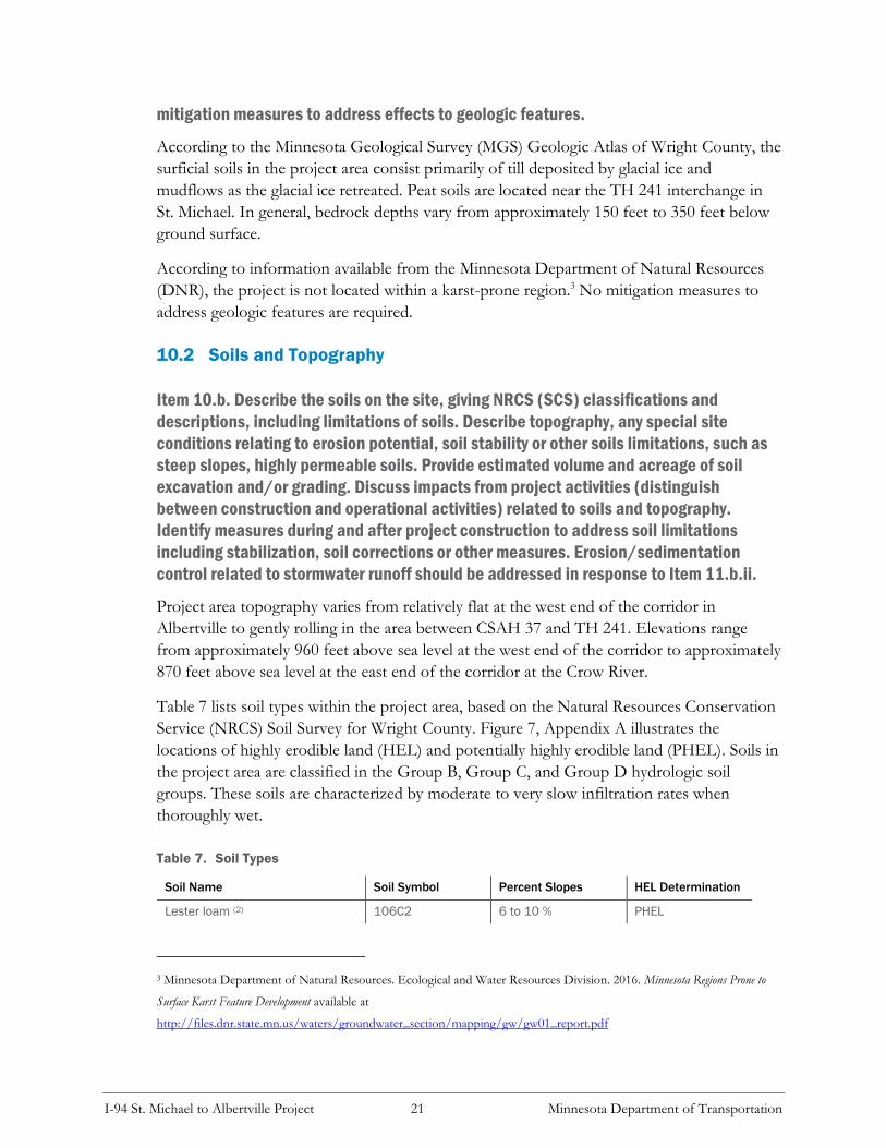
Table 7 lists soil types within the project area, based on the Natural Resources Conservation
Service (NRCS) Soil Survey for Wright County. Figure 7, Appendix A illustrates the
locations of highly erodible land (HEL) and potentially highly erodible land (PHEL). Soils in
the project area are classified in the Group B, Group C, and Group D hydrologic soil
groups. These soils are characterized by moderate to very slow infiltration rates when
thoroughly wet.
Table 7. Soil Types
Soil Name Soil Symbol Percent Slopes HEL Determination
Lester loam (2) 106C2 6 to 10 % PHEL
3 Minnesota Department of Natural Resources. Ecological and Water Resources Division. 2016. Minnesota Regions Prone to
Surface Karst Feature Development available at
http://files.dnr.state.mn.us/waters/groundwater_section/mapping/gw/gw01_report.pdf

I-94 St. Michael to Albertville Project 22 Minnesota Department of Transportation
Soil Name Soil Symbol Percent Slopes HEL Determination
Lester loam (1) 106D2 10 to 16 % HEL
Lester loam (1) 106E 16 to 22 % HEL
Hamel loam (3) 414 0 to 2 % NHEL
Hamel-Glencoe complex (3) 740 0 to 2 % NHEL
Udorthents, loamy (cut and fill
land) (1)
1016 Udorthents, loamy
(cut and fill land)
NHEL
Klossner, Okoboji, and Glencoe
soils, ponded (1)
1080
0 to 1 %
NHEL
Cordova loam (3) 1156 0 to 2 % NHEL
Fordum loam (1) 1378 0 to 2 %, occasionally
flooded
NHEL
Lester-Malardi complex (2) 1023C 6 to 12 % PHEL
Angus-Cordova complex (4) 1094B 0 to 5 % NHEL
Angus loam (4) 1362B 2 to 6 % NHEL
Elkriver fine sandy loam (2) D3A 0 to 2 %, occasionally
flooded
NHEL
Water (1) W Water NHEL
Source: U.S. Department of Agriculture (USDA). Natural Resources Conservation Service (NRCS). Soil Survey for Wright County,
Minnesota and Hennepin County, Minnesota.
HEL = highly erodible land. PHEL = Potentially highly erodible land. NHEL = Not highly erodible land.
(1) Not prime farmland
(2) Farmland of statewide importance
(3) Prime farmland if drained
(4) All areas are prime farmland
The acreage of soil excavation and/or grading for the proposed project is approximately 172
acres (i.e., area within preliminary construction limits). The estimated volume of soil
excavation and/or grading is approximately 277,500 cubic yards.4 Project area soils do not
present any situations that would require unique soil stabilization methods, soil correction,
or other measures. Poor soils along the I-94 roadway would be excavated and replaced with
material suitable for the roadway subgrades.
A Stormwater Pollution Prevention Plan (SWPPP) will be developed for this project
following MnDOT standard best management practices for erosion control and stormwater
management. These best management practices will be maintained throughout project
construction. All disturbed areas will be revegetated in accordance with the SWPPP and
related permitting requirements (see EAW Item 11.b.ii).
NOTE: For silica sand projects, the EAW must include a hydrogeologic investigation assessing the potential
groundwater and surface water effects and geologic conditions that could create an increased risk of potentially
significant effects on groundwater and surface water. Descriptions of water resources and potential effects from
4 Assumes excavation up to one foot over the entire project area within preliminary construction limits.

I-94 St. Michael to Albertville Project 23 Minnesota Department of Transportation
the project in EAW Item 11 must be consistent with the geology, soils and topography/land forms and
potential effects described in EAW Item 10.
11 EAW Item 11: Water Resources
11.1 Surface Water and Groundwater Features
Item 11.a. Describe surface water and groundwater features on or near the site in a.i.
and a.ii. below.
Item 11.a.i. Surface water - lakes, streams, wetlands, intermittent channels, and
county/judicial ditches. Include any special designations such as public waters,
trout stream/lake, wildlife lakes, migratory waterfowl feeding/resting lake, and
outstanding resource value water. Include water quality impairments or special
designations listed on the current MPCA 303d Impaired Waters List that are within 1
mile of the project. Include DNR Public Waters Inventory number(s), if any.
DNR Public Waters
Four Minnesota Department of Natural Resources (DNR) Public Water
basins, watercourses, or wetlands were identified within 500 feet of the
project limits (see Table 8 and DNR correspondence in Appendix B).
Table 8. DNR Public Water Basins, Watercourses, and Wetlands Within 500 Feet
of the Project Limits
Surface Water DNR Public Water Number
Crow River and Crow River Oxbow N/A (public water watercourse)
Unnamed Wetland 86041500
Hunters (Mud) Lake 86002600
School Lake 86002500
Aquatic Resources
The project area consists of an assortment of wetlands, roadside wetland ditches (wet
ditches), and tributaries. Wetland boundaries within MnDOT highway right of way limits
were field delineated in summer 2016 using a Level 2, routine, on-site determination method.
Wetlands and roadside wetland ditches within center median were identified using a Level 1,
routine, off-site determination method. A supplemental wetland delineation was completed
in summer 2017 for areas outside of MnDOT right of way at I-94 and CSAH 37 in
Albertville. A total of 85 aquatic resources or portions thereof were identified within the
investigation area. Figure C2 through Figure C6 in Appendix C illustrates delineated wetland
boundaries and other aquatic resources in the project area.

I-94 St. Michael to Albertville Project 24 Minnesota Department of Transportation
MPCA 303d Impaired Waters List
Table 9 lists the four impaired waters within one mile of the project limits. These four
aquatic resources are identified on the Minnesota Pollution Control Agency’s (MPCA) 303d
Impaired Waters list.
Table 9. MPCA 303d Impaired Waters within One Mile of the Project Limits
Waterbody Name Beneficial Use
(Biology and
Recreation,
Consumption)
Impairment Cause TMDL Plan DNR Public Water
Number
School Lake Aquatic
Recreation
Nutrient/eutrophication
biological indicators
N/A 86002500
Hunters (Mud)
Lake
Aquatic
Recreation
Nutrient/eutrophication
biological indicators
N/A 86002600
Foster Lake Aquatic
Recreation
Nutrient/eutrophication
biological indicators
N/A 86000100
Crow River Aquatic Life
Aquatic
Recreation
Aquatic
macroinvertebrate
assessments
Fishes bioassessments
Dissolved oxygen,
turbidity
Fecal coliform
North Fork
Crow and Lower
Crow TMDL
N/A (public water
watercourse)
Item 11.a.ii. Groundwater - aquifers, springs, seeps. Include: 1) depth to
groundwater; 2) if project is within a MDH wellhead protection area; 3) identification
of any onsite and/or nearby wells, including unique numbers and well logs if
available. If there are no wells known on site or nearby, explain the methodology
used to determine this.
Wellhead Protection Areas (WHPA) and Drinking Water Supply Management Areas (DWSMA)
There are no wellhead protection areas (WHPA) or drinking water supply management areas
(DWSMA) within the preliminary construction. The Albertville/St. Michael/Hanover Joint
Powers Board WHPA and DWSMA are located south of I-94 in Albertville and St. Michael.
The Joint Powers Board WHPA is located approximately 0.8 miles south of I-94, whereas
the Joint Powers Board DWSMA is located approximately 0.2 miles south of I-94. The
Otsego West WHPA and DWSMA are located approximately 0.5 mile north of I-945
5 Source: Minnesota Department of Health. Environmental Health Division. Source Water Protection Unit. February 19,
2015. Wellhead Protection Areas, Geospatial Data and Drinking Water Management Supply Areas, Geospatial Data
available at http://www.health.state.mn.us/divs/eh/water/swp/maps/.

I-94 St. Michael to Albertville Project 25 Minnesota Department of Transportation
Wells
A search of the Minnesota County Well Index (CWI) indicates that many wells are located
along the I-94 project corridor.6 These wells are located outside of the MnDOT highway
right of way and preliminary construction limits. The depth of the wells ranged from 75 feet
to 250 feet. Most of these wells were for commercial or domestic uses.
Impacts to wells are not anticipated. If any unused or unsealed wells are discovered in the
project area during construction, they will be sealed in accordance with Minnesota Rules
Chapter 4725.
11.2 Effects From Project Activities on Water Resources and Measure to
Minimize or Mitigate the Effects
Item 11.b. Describe effects from project activities on water resources and measures to
minimize or mitigate the effects in Item b.i. through Item b.iv. below.
Item 11.b.i. Wastewater - For each of the following, describe the sources, quantities
and composition of all sanitary, municipal/domestic and industrial wastewater
produced or treated at the site.
1) If the wastewater discharge is to a publicly owned treatment facility, identify any pretreatment measures
and the ability of the facility to handle the added water and waste loadings, including any effects on, or
required expansion of, municipal wastewater infrastructure.
Not applicable. The proposed project would not generate wastewater.
2) If the wastewater discharge is to a subsurface sewage treatment systems (SSTS), describe the system used,
the design flow, and suitability of site conditions for such a system.
Not applicable.
3) If the wastewater discharge is to surface water, identify the wastewater treatment methods and identify
discharge points and proposed effluent limitations to mitigate impacts. Discuss any effects to surface or
groundwater from wastewater discharges
Not applicable.
Item 11.b.ii. Stormwater - Describe the quantity and quality of stormwater runoff at
the site prior to and post construction. Include the routes and receiving water bodies
for runoff from the site (major downstream water bodies as well as the immediate
receiving waters). Discuss any environmental effects from stormwater discharges.
6 Source: Minnesota Department of Health. 2016. Minnesota Well Index available at https://apps.health.state.mn.us/cwi/.

I-94 St. Michael to Albertville Project 26 Minnesota Department of Transportation
Describe stormwater pollution prevention plans including temporary and permanent
runoff controls and potential BMP site locations to manage or treat stormwater
runoff. Identify specific erosion control, sedimentation control or stabilization
measures to address soil limitations during and after project construction.
Existing Conditions
Much of the stormwater runoff from the project segment of I-94 currently drains into the
center median ditch and outside shoulder ditches. Storm sewer and culvert connections
across eastbound and westbound I-94 convey stormwater runoff from the center median to
the outside, as well as from one side of the highway to another.
There are few existing stormwater BMP’s along the project segment of I-94. An existing
two-cell wet pond system is located along the north side of I-94 west of the CSAH 37
interchange. These ponds treat stormwater runoff from the westbound collector distributor
road between CSAH 19 and CSAH 37.
Stormwater runoff from the project corridor is conveyed to several different receiving water
bodies, including: School Lake, Hunters (Mud) Lake, the Mississippi River, and the Crow
River.
Proposed Stormwater Management Plan
The proposed project would increase the amount of impervious surface area within the
project area by approximately 38.7 acres compared to existing conditions. Existing drainage
patterns will be maintained to the extent that is feasible. The existing center median ditches
from CSAH 19 to west of TH 241 would be filled to accommodate the reconstruction of
I-94 and the proposed additional lanes between CSAH 37 and TH 241. Soil borings were
collected in the project area, and piezometers were installed at proposed pond locations.
Results of the soil borings indicate that soils in the project area are not well-suited for
infiltration. Piezometer readings also indicates shallow ground water elevations in the project
area. Therefore, the proposed stormwater management plan for the project does not include
infiltration. The proposed stormwater management plan for the project is summarized
below.
• Stormwater runoff from I-94 west of the CSAH 19 interchange would follow
existing drainage patterns, discharging to wetlands along the north side I-94 between
the freeway and commercial land uses. This water is conveyed through storm sewer
under CSAH 19 and discharges to School Lake. A ditch would be constructed along
the entrance ramp from CSAH 19 to westbound I-94 to direct some of the highway
runoff away from the wetlands and to and existing ditch along the westbound
collector-distributor road to avoid overloading the existing drainage system.
• Stormwater runoff from the I-94/CSAH 19 interchange area would be conveyed to a
proposed wet pond in the northeast quadrant of the interchange. Runoff from this

I-94 St. Michael to Albertville Project 27 Minnesota Department of Transportation
wet pond would be conveyed to an existing ditch along the north side of the
westbound I-94 collector-distributor road, prior to discharge to School Lake.
• Stormwater runoff from the proposed eastbound collector-distributor road and the
I-94 segment between CSAH 19 and CSAH 37 would be conveyed to a proposed
wet pond in the southwest quadrant of the I-94/CSAH 37 interchange. Additional
land would be graded adjacent to this wet pond to temporarily store runoff for rate
control. Runoff would then be conveyed under I-94 existing wet ponds located
north of I-94 and west of CSAH 37, prior to discharge to Hunters (Mud) Lake.
• Stormwater runoff from the south side of the CSAH 37 interchange area would be
conveyed to a proposed wet pond in the southeast quadrant of the I-94/CSAH 37
interchange. Runoff from this wet pond would be conveyed to the adjacent wetland
complex on the north side of I-94. This wetland ultimately discharges to the
Mississippi River. This wet pond would be designed to maximize runoff storage
volume and maintain existing discharge rates from MnDOT’s highway right of way.
• A storm sewer trunk line would be constructed in the middle of I-94 from east of
CSAH 37 to TH 241. A proposed wet pond would be constructed along the south
side of I-94, approximately 0.5 miles west of the I-94/TH 241 interchange.
Stormwater runoff from I-94 east of CSAH 37 would be discharged to this wet
pond, and then conveyed back into the storm sewer trunk line in I-94. This runoff,
along with runoff from I-94 west of TH 241, would be conveyed to a proposed dry
pond and wet pond in the northwest quadrant of the I-94/TH 241 interchange, prior
to discharge to the Crow River.
A detailed drainage overview map was prepared for the project corridor. This map illustrates
existing culverts; existing ditch flow; aquatic resources (including delineated wetland
boundaries); proposed culverts and storm sewer; proposed drainage boundaries and flow
directions; discharge points; and proposed BMPs. A copy of this drainage overview map is
available from the MnDOT Project Manager (see contact information in EAW Item 2).
The proposed project would not contribute to the impairment of receiving waters. The
proposed stormwater management system will support the identified roadway
improvements, providing water quality treatment, volume control, and rate control. Figure
4A through Figure 4E, Appendix A illustrate the locations of proposed wet ponds and dry
ponds. Stormwater BMPs will be designed and constructed to meet NPDES regulatory
requirements.
Stormwater Pollution Prevention Plans
A SWPPP will be developed for this project in conjunction with the NPDES permit. The
SWPPP will include MnDOT best management practices for erosion control, sedimentation
control, and stabilization measures.

I-94 St. Michael to Albertville Project 28 Minnesota Department of Transportation
Item 11.b.iii. Water appropriation - Describe if the project proposes to appropriate
surface or groundwater (including dewatering). Describe the source, quantity,
duration, use and purpose of the water use and if a DNR water appropriation permit
is required. Describe any well abandonment. If connecting to an existing municipal
water supply, identify the wells to be used as a water source and any effects on, or
required expansion of, municipal water infrastructure. Discuss environmental effects
from water appropriation, including an assessment of the water resources available
for appropriation. Identify any measures to avoid, minimize, or mitigate
environmental effects from the water appropriation.
If temporary dewatering is necessary during project construction, groundwater appropriation
permits would be obtained from the DNR for temporary dewatering activities. Any
groundwater appropriations will be treated prior to discharge as per NPDES permitting
requirements.
The project would not involve other water uses (e.g., connection to municipal water system,
expansion of municipal water infrastructure).
Item b.iv. Surface Waters
a) Wetlands - Describe any anticipated physical effects or alterations to wetland features such as draining,
filling, permanent inundation, dredging and vegetative removal. Discuss direct and indirect environmental
effects from physical modification of wetlands, including the anticipated effects that any proposed wetland
alterations may have to the host watershed. Identify measures to avoid (e.g., available alternatives that were
considered), minimize, or mitigate environmental effects to wetlands. Discuss whether any required
compensatory wetland mitigation for unavoidable wetland impacts will occur in the same minor or major
watershed, and identify those probable locations.
Physical Effects or Alterations to Aquatic Resources A total of 85 aquatic resources or portions thereof totaling 23.67 acres were identified within
the delineation investigation area. Figure C2 through Figure C6 in Appendix C illustrate
aquatic resources in the project area. A copy of the complete wetland delineation reports are
available for review from the MnDOT project manager (see contact information in EAW
Item 2).
The proposed project would result in approximately 9.40 acres of permanent aquatic
resource impacts, including 6.84 acres of wetland impacts, 2.29 acres of wet ditch impacts,
and 0.27 acres of tributary impacts. Table 10 summarizes anticipated aquatic resource
impacts by resource type. Table 11 summarizes anticipated wetland impacts by wetland
community type. The Wetland Impact Assessment and Two-Part Finding form in Appendix
C describes sequencing (avoidance, minimization, and mitigation) and anticipated aquatic
resource impacts by individual resource.

I-94 St. Michael to Albertville Project 29 Minnesota Department of Transportation
Table 10. Aquatic Resource Impacts
Aquatic Resource Type Aquatic Resource Impacts (acres) Compensatory Mitigation
Requirements
Wetlands 6.84 acres Minimum 2:1 replacement
Wet Ditches (within center median
and to the outside)
2.29 acres Assumes none
Tributaries 0.27 acres
(approx. 850 feet)
Mitigation to be determined
Total 9.40 acres --
Table 11. Wetland Impacts by Community Type
Wetland Type Classification
(Circular 39)
Wetland Type Classification
(Eggers & Reed)
Permanent Wetland Impacts
(acres)
1 Seasonally Flooded Basin 0.33
2 Fresh Wet Meadow 2.91
3 Shallow Marsh 2.53
4 Deep Marsh 0.46
5 Open Water Wetland 112 sf
6 Shrub Swamp 0.60
Total 6.84 acres
Impacts to aquatic resources are regulated by the Minnesota Wetland Conservation Act
(WCA) and by the USACE under Section 404 of the Clean Water Act (CWA). It is
anticipated that wetlands will be replaced at a 2:1 ratio within Bank Service Area 7 (BSA 7).
Wet ditches would not require mitigation provided that the ditch is replaced and there is no
loss of function. In most cases, wet ditches would be reconstructed along eastbound and
westbound I-94 along the outside of the fill slope. The specific wetland bank credits will be
determined through consultation with the USACE and the MnDOT Office of
Environmental Stewardship (OES).
Tributaries Three tributaries would be impacted by the project totaling approximately 0.27 acres: a
tributary in the northeast quadrant of the I-94/CSAH 19 interchange that discharges to
School Lake (Aquatic Resource ID “E”, see Figure C2, Appendix C); a tributary that crosses
I-94 between CSAH 37 and TH 241 (Aquatic Resource ID “D”, see Figure C5, Appendix
C); and a tributary along the north side of I-94 east of the TH 241 interchange (Aquatic
Resource ID “C”, see Figure C5 and Figure C6, Appendix C). These three tributaries are not
classified as DNR public waters.

I-94 St. Michael to Albertville Project 30 Minnesota Department of Transportation
Approximately 95 percent of the tributary impacts of the project are to the one tributary
along the north side of I-94 east of the TH 241 interchange (Aquatic Resource ID “C”,
approximately 0.26 acre). Impacts to tributaries would result from fill slope construction.
Compensatory mitigation for impacts to tributaries will be determined through consultation
with the USACE and the MnDOT OES.
DNR Public Waters Four DNR Public Water basins, watercourses, or wetlands were identified within 500 feet of
the project limits (see Table 8). The project would not result in fill below the ordinary high
water level (OHWL) of School Lake, Hunters (Mud) Lake, and an unnamed wetland
southeast of the I-94/CSAH 37 interchange.
The eastern terminus of the project is the I-94 bridges over the Crow River. The Crow River
oxbow north and south of I-94 and east of TH 241 is part of the Crow River public water
watercourse. The DNR identified an OHWL for the Crow River oxbow of 859 feet.
The proposed project includes reconstruction of the TH 241 entrance ramp to eastbound
I-94. An acceleration lane would be constructed along eastbound I-94 between the entrance
ramp from TH 241 and the bridge over the Crow River. The proposed fill slope south of the
eastbound I-94 acceleration lane would result in fill below the OHWL elevation of 859 feet.
The impact below the OHWL elevation of 850 feet, based on preliminary design
construction limits, is anticipated to be less than 0.01 acre.
The preliminary design for the project includes a fill slope that varies from 1:4 to 1:3 along
the south side of eastbound I-94 adjacent to the Crow River oxbow. This fill slope will be
steepened in final design to avoid fill impacts below the OHWL elevation of 859 feet.
Therefore, a DNR public waters work permit is not anticipated for the project.
b) Other surface waters - Describe any anticipated physical effects or alterations to surface water features
(lakes, streams, ponds, intermittent channels, county/judicial ditches) such as draining, filling, permanent
inundation, dredging, diking, stream diversion, impoundment, aquatic plant removal and riparian alteration.
Discuss direct and indirect environmental effects from physical modification of water features. Identify
measures to avoid, minimize, or mitigate environmental effects to surface water features, including in-water
Best Management Practices that are proposed to avoid or minimize turbidity/sedimentation while physically
altering the water features. Discuss how the project will change the number or type of watercraft on any water
body, including current and projected watercraft usage.
No temporary or permanent water body impacts are anticipated because of the proposed
project. The proposed project would not impact School Lake or Hunters (Mud) Lake in
Albertville. The proposed project would not alter the existing eastbound and westbound I-94
bridges over the Crow River in St. Michael. The project would not change the number or
type of watercraft on any water body. Use of the Crow River State Water Trail would not be
affected by the project.

I-94 St. Michael to Albertville Project 31 Minnesota Department of Transportation
12 EAW Item 12: Contamination/Hazardous Materials/
Wastes
12.1 Pre-Project Site Conditions
Item 12.a. Pre-Project Site Conditions. Describe existing contamination
or potential environmental hazards on or in close proximity to the project
site such as soil or ground water contamination, abandoned dumps,
closed landfills, existing or abandoned storage tanks, and hazardous
liquid or gas pipelines. Discuss any potential environmental effects from
pre-project site conditions that would be caused or exacerbated by project construction
and operation. Identify measures to avoid, minimize or mitigate adverse effects from
existing contamination or potential environmental hazards. Include development of a
Contingency Plan or Response Action Plan.
Contaminated Properties
MnDOT’s Contaminated Materials Management Team (CMMT) reviewed the Minnesota
Pollution Control Agency (MPCA) and Minnesota Department of Agriculture (MDA)
databases to check for known contaminated sites in the project area. The databases searched
included: leaking underground storage tank facilities, landfills, salvage yards, voluntary
investigation and cleanup (VIC) sites, Superfund sites and dump sites. Based on the database
review, there is one closed leaking underground storage tank site and one former MDA spill
site within approximately 500 feet of the project area.
Given the nature and location of the project area, the proposed project was identified by
CMMT to have a low to medium risk of impacting potentially contaminated sites. CMMT
will review proposed wet pond and dry pond excavation plans and determine if Phase II
drilling investigations are necessary. During a Phase II investigation, sites are evaluated to
determine the extent and magnitude of potentially contaminated soil and groundwater and
their potential to be impacted by project construction.
Any impacts from contaminated properties established during Phase II investigations will be
mitigated by modifying the project design where warranted and/or avoiding encountering
contaminated materials during construction. If contaminated materials cannot be avoided, a
plan will be developed to properly handle and treat any contaminated materials encountered
during project construction in accordance with applicable state and federal regulations.
Regulated Materials/Wastes
The project would include demolition of the I-94 bridges over CSAH 19 in Albertville and
the TH 241 bridge over I-94 in St. Michael. Building structures in the southwest quadrant of
the I-94/CSAH 37 interchange also would be demolished as part of the project.

I-94 St. Michael to Albertville Project 32 Minnesota Department of Transportation
Asbestos and regulated waste surveys for the TH 241 bridge over I-94 and the I-94 bridges
over CSAH 19 were completed in August 2016. Asbestos, mercury, and polychlorinated
biphenyls (PCBs) were not detected. Lead paint and lead plates were observed on each
bridge, and treated guardrail posts and blocks are located at the bridge approaches. Copies of
the asbestos and regulated waste survey reports are available for review from the MnDOT
Project Manager (see contact information in EAW Item 3).
MnDOT will complete a regulated materials assessment for each building in the southwest
quadrant of I-94/CSAH 37 prior to demolition. MnDOT will identify and properly handle
and dispose of all regulated materials/wastes that are part of building structures.
Regulated materials/waste will be managed on this project in accordance with MnDOT
special provisions.
12.2 Project Related Generation/Storage of Solid Wastes
Item 12.b. Describe solid wastes generated/stored during construction and/or
operation of the project. Indicate method of disposal. Discuss potential environmental
effects from solid waste handling, storage and disposal. Identify measures to avoid,
minimize or mitigate adverse effects from the generation/storage of solid waste
including source reduction and recycling.
The disposal of solid waste generated by clearing the construction area is a common
occurrence associated with road construction projects. During project construction,
excavation of soil would need to occur within the construction limits. Future design studies
will consider selection of grade-lines and locations to minimize excess materials, and
consideration will be given to using excess materials on the proposed project or other nearby
projects. If the material is suitable, all excavated material would be reused onsite for
construction of ramps and roadway embankments. Any excess soil material that is not
suitable for use on the project site would become the property of the contractor and will be
disposed of in accordance with state and federal requirements in place at the time of project
construction.
Excess materials and debris from this project such as concrete and asphalt will be disposed
of in accordance with MnDOT specifications. In particular, excess materials and debris will
not be placed in wetlands or floodplains.
12.3 Project Related Use/Storage of Hazardous Materials
Item 12.c. Describe chemicals/hazardous materials used/stored during construction
and/or operation of the project including method of storage. Indicate the number,
location and size of any above or below ground tanks to store petroleum or other
materials. Discuss potential environmental effects from accidental spill or release of
hazardous materials. Identify measures to avoid, minimize or mitigate adverse effects

I-94 St. Michael to Albertville Project 33 Minnesota Department of Transportation
from the use/storage of chemicals/hazardous materials including source reduction
and recycling. Include development of a spill prevention plan.
The project would not include permanent hazardous materials storage. No above- or below-
ground storage tanks are planned for permanent use in conjunction with this project.
Temporary storage tanks for petroleum products may be located in the project area for
refueling equipment during roadway construction. Appropriate measures will be taken
during construction to avoid spills that could contaminate groundwater or surface water in
the project area. In the event a leak or spill occurs during construction, it will be responded
to in accordance with MPCA containment and remedial action procedures.
12.4 Project Related Generation/Storage of Hazardous Materials
Item 12.d. Project related generation/storage of hazardous wastes - Describe
hazardous wastes generated/stored during construction and/or operation of the
project. Indicate method of disposal. Discuss potential environmental effects from
hazardous waste handling, storage, and disposal. Identify measures to avoid, minimize
or mitigate adverse effects from the generation/storage of hazardous waste including
source reduction and recycling.
Not applicable. The project would not generate or store hazardous waste. Temporary
storage of fuel for construction equipment is discussed above in Item 12.c.
13 EAW Item 13: Fish, Wildlife, Plant Communities, and
Sensitive Ecological Resources (Rare Features)
13.1 Fish and Wildlife Resources
Item 13.a. Describe fish and wildlife resources as well as habitats and vegetation on or
in near the site.
Wildlife Resources
Most of the land within the preliminary construction limits have experienced
some type of previous disturbance. Land within the project limits have been
converted to transportation uses. Residential, commercial, agricultural, and
industrial developments have substantially altered the land adjacent to the
study area. In general, wildlife species found in the project area are those
species adapted to live in areas of mixed development and fragmented or partially
fragmented habitats.

I-94 St. Michael to Albertville Project 34 Minnesota Department of Transportation
Fisheries Resources
There are several DNR public waters within or near the project area (see Table 8 in EAW
Item 11). School Lake and Hunters (Mud) Lake are located along the north side of I-94
between CSAH 37 and CSAH 19 in Albertville. The Crow River is located near the eastern
project terminus east of the I-94/TH 241 interchange in St. Michael.
13.2 Rare Features
Item 13.b. Describe rare features such as state-listed (endangered, threatened or
special concern) species, native plant communities, Minnesota County Biological
Survey Sites of Biodiversity Significance, and other sensitive ecological resources on or
within close proximity to the site. Provide the license agreement number (LA-) and/or
correspondence number (ERDB) from which the data were obtained and attach the
Natural Heritage letter from the DNR. Indicate if any additional habitat or species survey
work has been conducted within the site and describe the results.
MnDOT has a liaison with the Department of Natural Resources (DNR) who performs
Natural Heritage Information System (NHIS) reviews for trunk highway projects; therefore,
no LA or ERDB number has been assigned. See DNR correspondence in Appendix B.
A search of the NHIS database was conducted to identify rare features within the project
area. The NHIS database comprises locational records of rare plants, animals, and other
features including native plant communities, sites of biodiversity, geologic features, and
animal aggregations. To ensure protection of these features, specific location information is
not provided in this EAW. The EAW identifies the rare features in the project area and
describes measures to avoid, minimize, or mitigate impacts to these resources.
State Listed Threatened and Endangered Species
One state-listed species was identified in the NHIS review. Blanding’s turtle (Emydoidea
blandingii), a state-listed threatened species, has been previously reported in the project area.
MCBS Native Plant Communities
There are no known Minnesota County Biological Survey (MCBS) native plant communities
within a one-mile radius of the project area.
MCBS Sites of Biodiversity Significance
One MCBS site of biodiversity significance is located near the study area. A Sugar Maple
Forest (Big Woods) site is located approximately 0.3 miles south of I-94 in the southwest
quadrant of CSAH 18 (50th Street Northeast) and CSAH 22 (Naber Avenue Northeast). This
site is classified as a site of moderate biodiversity significance. See DNR correspondence in
Appendix B.

I-94 St. Michael to Albertville Project 35 Minnesota Department of Transportation
Federally Listed Threatened and Endangered Species
According to the U.S. Fish and Wildlife Service (USFWS) County Distribution of Federally-
Listed Threatened, Endangered, Proposed, and Candidate Species (revised October 2016),
the project is within the distribution range of the northern long-eared bat (Myotis
septentrionalis). The northern long-eared bat (Myotis septentrionalis) is a federally-listed threatened
species. See MnDOT Office of Environmental Stewardship (OES) correspondence in
Appendix B.
13.3 Impacts of the Project
Item 13.c. Discuss how the identified fish, wildlife, plant communities, rare features
and ecosystems may be affected by the project. Include a discussion on introduction
and spread of invasive species from the project construction and operation. Separately
discuss effects to known threatened and endangered species.
Fisheries Resources
The project area is located adjacent to three DNR public waters (School Lake, Hunters
(Mud) Lake, Crow River). No in-water work is anticipated with the project; however,
stormwater runoff from the project discharges to these waters. Work adjacent to these
waters will need to incorporate fish spawning restriction dates into the project construction
schedule.
Plant Communities/Rare Features
The proposed project would be constructed within existing MnDOT highway right of way and
would not directly or indirectly impact the Sugar Maple Forest (Big Woods) site located south of
I-94 in St. Michael.
Threatened and Endangered Species
Blanding’s turtles (Emydoidea blandingii), a state-listed threatened species, have been reported
in the project vicinity. Blanding’s turtles require both upland and wetland habitats to
complete their life cycle. There is the possibility that Blanding’s turtles could be encountered
during construction as they undertake their seasonal movements between upland and
wetland habitats.
The project is within the range of the northern long-eared bat (Myotis septentrionalis), a
federally-listed threatened species. The project will involve the replacement of several
existing highway bridges. There are no documented maternity roost trees or hibernacula in
the project area. MnDOT, acting as the non-federal agency for FHWA, has determined that
the project would result in a may affect, but will not cause a prohibited incidental take of the
northern long-eared bat (Myotis septentrionalis). See MnDOT OES correspondence in
Appendix B.

I-94 St. Michael to Albertville Project 36 Minnesota Department of Transportation
Introduction and Spread of Invasive Species from Project Construction and
Operation
There is no in-water work associated with the proposed project. The project would not introduce
aquatic invasive species (AIS) into nearby water bodies.
During the construction phase of the project, MnDOT best management practices will be
used to reduce the spread of invasive species to or from the project location. Native seed
mixes will be used for re-vegetation as specified in the Stormwater Pollution Prevention Plan
(SWPPP). Contractors will be required to follow all specifications related to re-vegetation
and vegetation management as identified in the construction contract.
13.4 Measures to Avoid, Minimize, or Mitigate Adverse Effects
Item 13.d. Identify measures that will be taken to avoid, minimize, or mitigate adverse
effects to fish, wildlife, plant communities, and sensitive ecological resources.
Threatened and Endangered Species
Blanding’s turtles (Emydoidea blandingii), a state-listed threatened species, have been reported
in the project vicinity, and may be encountered during construction. MnDOT will provide
the DNR’s Blanding’s Turtle Fact Sheet to all contractors working on the site so that the
appropriate measures can be followed if Blanding’s turtles are encountered during
construction.
Wildlife Resources
The use of erosion control blanket will be limited to “bio-netting” or “natural netting” type
products (category 3N or 4N). Plastic mesh netting will not be allowed on the project.
Fisheries Resources
The MPCA NPDES general permit for authorization to discharge stormwater associated
with construction activities (permit MN R10001) recognizes the DNR “work in water
restrictions” during specified fish migration and spawning time frames for areas adjacent to
water. There are DNR Public Waters within the project vicinity. During the restriction
period, all exposed soil areas that are within 200 feet of the water’s edge and that drain to
these waters must have erosion prevention stabilization activities initiated immediately after
soil disturbing activity has ceased (and be completed within 24 hours).
14 EAW Item 14: Historic properties
Describe any historic structures, archeological sites, and/or traditional cultural
properties on or in close proximity to the site. Include: 1) historic designations, 2)
known artifact areas, and 3) architectural features. Attach letter received from the

I-94 St. Michael to Albertville Project 37 Minnesota Department of Transportation
State Historic Preservation Office (SHPO). Discuss any anticipated effects to
historic properties during project construction and operation. Identify measures that
will be taken to avoid, minimize, or mitigate adverse effects to historic properties.
The proposed project was review by MnDOT Cultural Resources Unit (CRU) staff for
potential impacts to historic resources. MnDOT CRU determined that there would be no
historic properties affected by the proposed project (see MnDOT CRU correspondence in
Appendix B).
15 EAW Item 15: Visual
Describe any scenic views or vistas on or near the project site. Describe any project
related visual effects such as vapor plumes or glare from intense lights. Discuss the
potential visual effects from the project. Identify any measures to avoid, minimize, or
mitigate visual effects.
The project area is a freeway corridor. The proposed project would widen the existing
roadway; construct a new eastbound collector-distributor road between CSAH 19 and
CSAH 37; and replace the I-94/TH 241 interchange within the established highway right of
way limits. Existing structures outside of MnDOT right of way in the southwest quadrant of
the I-94/CSAH 37 interchange would be demolished and a new stormwater basin would be
constructed. The project area does not include scenic vistas or views. The project would not
introduce visual effects beyond the proposed roadway infrastructure improvements.
The project segment of I-94 between TH 241 in St. Michael and CSAH 19 in Albertville
currently does not have highway lighting. The proposed project would not include the
installation of highway lighting. Interchange lighting at CSAH 19, CSAH 37, and TH 241
would be maintained.
16 EAW Item 16: Air
16.1 Stationary Source Emissions
Item 16.a. Stationary source emissions - Describe the type, sources, quantities and
compositions of any emissions from stationary sources such as boilers or exhaust
stacks. Include any hazardous air pollutants, criteria pollutants, and any greenhouse
gases. Discuss effects to air quality including any sensitive receptors, human health or
applicable regulatory criteria. Include a discussion of any methods used assess the
project’s effect on air quality and the results of that assessment. Identify pollution
control equipment and other measures that will be taken to avoid, minimize, or mitigate
adverse effects from stationary source emissions.
Not applicable.

I-94 St. Michael to Albertville Project 38 Minnesota Department of Transportation
What is National Ambient Air
Quality Standards (NAAQS)?
The United States Environmental
Protection Agency (US EPA)
establishes maximum allowable
levels of six important air
pollutants. These limits are called
NAAQS, and exceedances of
those limits may be harmful to
human health. Air pollution has
regional consequences, therefore
regions are classified as attainment
(complying with the limits), not-
attainment (not complying with
the limits), or maintenance (has
now improved and complies, and
therefore has to maintain
compliance for 20 years before
being classified as attainment).
16.2 Vehicle Emissions
Item 16.b. Describe the effect of the project’s traffic generation on air emissions.
Discuss the project’s vehicle-related emissions effect on air quality. Identify measures
(e.g. traffic operational improvements, diesel idling minimization plan) that will be
taken to minimize or mitigate vehicle-related emissions.
Motorized vehicles affect air quality by emitting airborne
pollutants. Changes in traffic volumes, travel patterns, and roadway
locations affect air quality as the number of vehicles and the
congestion levels in a given area change. The adverse impacts this
project could have on air quality have been analyzed by addressing
criteria pollutants, a group of common air pollutants regulated by
the EPA on the basis of criteria (information on health and/or
environmental effects of pollution). The criteria pollutants identified by the EPA are ozone,
particulate matter, carbon monoxide, nitrogen dioxide, lead, and sulfur dioxide. Potential
impacts resulting from these pollutants are assessed by comparing the project’s projected
concentrations to National Ambient Air Quality Standards (NAAQS).
In addition to the criteria air pollutants, the EPA also regulates air toxics. The FHWA
provides guidance for the assessment of Mobile Source Air Toxic (MSAT) effects for
transportation projects in the National Environmental Policy Act (NEPA) process. A
quantitative evaluation of MSATs has been performed for this
project, as documented below. The scope and methods of the
analysis performed were developed in collaboration with the
Minnesota Department of Transportation (MnDOT), the
Minnesota Pollution Control Agency (MPCA), and the FHWA.
Ozone
Ground-level ozone is a primary constituent of smog and is a
pollution problem throughout many areas of the United States.
Exposures to ozone can make people more susceptible to
respiratory infections, can result in lung inflammation, and can
aggravate respiratory diseases, such as asthma. Ozone is not
emitted directly from vehicles but is formed as volatile organic
compounds (VOCs) and nitrogen oxides (NOx) react in the
presence of sunlight. Transportation sources emit NOx and
VOCs and can, therefore, affect ozone concentrations.
However, due to the phenomenon of atmospheric formation
of ozone from chemical precursors, concentrations are not
expected to be elevated near a particular roadway.

I-94 St. Michael to Albertville Project 39 Minnesota Department of Transportation
The MPCA, in cooperation with various other agencies, industries, and groups, has
encouraged voluntary control measures for ozone concentrations and has begun developing
a regional ozone modeling effort. Ozone concentrations in the lower atmosphere are
influenced by a complex relationship of precursor concentrations, meteorological conditions,
and regional influences on background concentrations. MPCA states in the document, The
Air We Breathe. The State of Minnesota’s Air Quality (2017, page 27), that:
On October 1, 2015, the EPA strengthened the ozone standard to 70 parts per billion
(ppb), down from the 2008 standard of 75 ppb. All areas of Minnesota currently meet the
new standard – but some parts of the state are close. Measured ozone levels in some areas
of the state are now within 85% or more of the level of the ozone standard, placing these
areas at greater risk for violating the standard in the future. While emissions that help
form ozone are decreasing, warmer summers and more frequent wildfires may cause both
fine-particle levels and ozone levels to rise.
Additionally, the State of Minnesota is classified by the EPA as an "ozone attainment area,"
which means that Minnesota has been identified as a geographic area that meets the national
health-based standards for ozone levels. Because of these factors, a quantitative ozone
analysis was not conducted for this project.
Particulate Matter
Particulate matter (PM) is the term for particles and liquid droplets suspended in the air.
Particles come in a wide variety of sizes and have been historically assessed based on size,
typically measured by the diameter of the particle in micrometers. PM2.5, or fine particulate
matter, refers to particles that are 2.5 micrometers or less in diameter. PM10 refers to
particulate matter that is 10 micrometers or less in diameter.
Motor vehicles (i.e., cars, trucks, and buses) emit direct PM from their tailpipes, as well as
from normal brake and tire wear. Vehicle dust from paved and unpaved roads may be re-
entrained, or re-suspended, in the atmosphere. In addition, PM2.5 can be formed in the
atmosphere from gases such as sulfur dioxide, nitrogen oxides, and VOCs. PM2.5 can
penetrate the human respiratory system's natural defenses and damage the respiratory tract
when inhaled. Numerous scientific studies have linked particle pollution exposure to a
variety of problems, including:
• Premature death in people with heart or lung disease;
• Nonfatal heart attacks;
• Irregular heartbeat;
• Aggravated asthma;
• Decreased lung function; and,
• Increased respiratory symptoms, such as irritation of the airways, coughing or
difficulty breathing.

I-94 St. Michael to Albertville Project 40 Minnesota Department of Transportation
Source: https://www.epa.gov/pm-pollution/health-and-environmental-effects-
particulate-matter-pm
In 2012, the MPCA enrolled in EPA’s voluntary Advance Programs for particulate matter.
This program helps the states achieve voluntary emission reductions to lower concentrations
of this pollutant. The program aims at helping state and local governments reduce air pollution
in areas that currently meet federal standards for fine particles. As researchers better
understand the health impacts of air pollutants, EPA reviews and strengthens national air
quality standards. These programs help the states stay ahead of changes to the national
standards. Without continued improvements in air quality, Minnesota is at risk for violating
air quality standards in the future. Partners in the Clean Air Minnesota Program, including
MnDOT, have committed to reducing man-made fine particulate matter (PM2.5) by 10%
from 2011 levels.
In January 2013, the EPA issued a final rule revising the annual health NAAQS for fine
particles (PM2.5) to be 12.0 micrograms per cubic meter (µg/m3) as the annual PM2.5 standard.
The EPA retained the 24-hour PM2.5 standard at a level of 35 µg/m3 (the EPA issued the 24-
hour standard in 2006). The agency also retained the existing standards for coarse particle
pollution (PM10). The NAAQS 24-hour standard for PM10 is 150 µg/m3, which is not to be
exceeded more than once per year on average over three years.
Source: https://www.epa.gov/pm-pollution/2012-national-ambient-air-quality-standards-
naaqs-particulate-matter-pm
The Clean Air Act conformity requirements include the assessment of localized air quality
impacts of federally-funded or federally-approved transportation projects that are deemed to
be projects of air quality concern located within PM2.5 nonattainment and maintenance areas.
This project is not considered one of air quality concern. This is supported, in part, by the
designation of the State of Minnesota as an unclassifiable/ attainment area for PM. This
means that Minnesota has been identified as a geographic area that meets or exceeds the
national standards for the reduction of PM levels, and therefore is exempt from performing
PM analyses.
Nitrogen Dioxide (Nitrogen Oxides)
Nitrogen oxides, or NOx, is the generic term for a group of highly reactive gases, including
Nitrogen Dioxide (NO2), all of which contain nitrogen and oxygen in varying amounts.
Nitrogen oxides are formed when fuel is burned at high temperatures, as in a combustion
process. The primary sources of NOx are motor vehicles, electric utilities, and other
industrial, commercial, and residential sources that burn fuels. The MPCA's report, The Air
We Breathe. The State of Minnesota’s Air Quality (2017, page 21), indicates that gasoline light-
duty vehicles and trucks and diesel on-road heavy-duty trucks, delivery trucks, and buses
account for approximately 40% of NOx emissions in Minnesota. In addition to being a
precursor to ozone, NOx can contribute to potential health effects, including cardiovascular
effects (chest tightness, heart attacks, stroke); respiratory effects (wheezing, cough, asthma

I-94 St. Michael to Albertville Project 41 Minnesota Department of Transportation
attacks, infections, reduced lung function); and irritation (scratchy throat, runny nose, watery
eyes, excess mucus).
Exhibit 5 shows that Minnesota currently meets federal nitrogen dioxide standards (Source:
MPCA. Annual Air Monitoring Network Plan for Minnesota, 2018. July 2017. Figure 21: Average
Annual NO2 Concentrations compared to the NAAQS, 2016). In the MPCA’s report Annual
Air Monitoring Network Plan for Minnesota, 2018 (July 2017), the following statement is made
on page 33 about NO2:
A monitoring site meets the annual NAAQS for NO2 if the annual average is less than
or equal to 53 ppb. Minnesota averages ranged from 5 ppb at Flint Hills Refinery 423 to
13 ppb at the Near Road I-35/I-94 site (962); therefore, Minnesota currently meets the
annual NAAQS for NO2 (Figure 21).
Exhibit 5. Average Annual NO2 Concentrations Compared to the NAAQS
In the Annual Air Monitoring Network Plan for Minnesota, 2018, it states the following about the
1-hr NO2 Standard (Source: MPCA. Annual Air Monitoring Network Plan for Minnesota, 2018.
July 2017. Page 35):
On January 22, 2010 the EPA finalized revisions to the NO2 NAAQS. As part of
the standard review process, the EPA retained the existing annual NO2 NAAQS, but
also created an additional one-hour standard. The new one-hour NAAQS is intended to
protect against adverse health effects associated with short-term exposures to elevated NO2.
To meet this standard, the three-year average of the annual 98th percentile daily maximum
one-hour NO2 concentration must not exceed 100 ppb. Minnesota averages ranged from
26 ppb at Flint Hills Refinery 423 to 46 ppb at Blaine (6010); therefore, all Minnesota
sites currently meet the one-hour NAAQS for NO2 (Figure 22).

I-94 St. Michael to Albertville Project 42 Minnesota Department of Transportation
Exhibit 6 depicts the 2012-2014 1-hour NO2 concentrations at Minnesota sites compared to
the 1-hour NO2 NAAQS (Source: MPCA. Annual Air Monitoring Network Plan for Minnesota,
2018. July 2017. Figure 22: 1-hour NO2 Concentrations compared to the NAAQS, 2014-
2016).
Exhibit 6. 1-Hour NO2 Concentrations Compared to the NAAQS
The EPA's regulatory announcement, EPA420-F-99-051 (December 1999), describes the
Tier 2 standards for tailpipe emissions, and states:
The new tailpipe standards are set at an average standard of 0.07 grams per mile for
nitrogen oxides for all classes of passenger vehicles beginning in 2004. This includes all
light-duty trucks, as well as the largest SUVs. Vehicles weighing less than 6000 pounds
will be phased-in to this standard between 2004 and 2007.
As newer, cleaner cars enter the national fleet, the new tailpipe standards will significantly
reduce emissions of nitrogen oxides from vehicles by about 74 percent by 2030. The
standards also will reduce emissions by more than 2 million tons per year by 2020 and
nearly 3 million tons annually by 2030.
Within the project area, it is unlikely that NO2 standards will be approached or exceeded
based on the relatively low ambient concentrations of NO2 in Minnesota and on the long-
term trend toward reduction of NOx emissions. Because of these factors, a specific analysis
of NO2 was not conducted for this project.
Sulfur Dioxide
Sulfur dioxide (SO2) and other sulfur oxide gases (SOx) are formed when fuel containing
sulfur, such as coal, oil, and diesel fuel, is burned. Sulfur dioxide is a heavy, pungent,

I-94 St. Michael to Albertville Project 43 Minnesota Department of Transportation
colorless gas. Elevated levels can impair breathing, can lead to other respiratory symptoms,
and at very high levels, can aggravate heart disease. People with asthma are most at risk
when SO2 levels increase. Once emitted into the atmosphere, SO2 can be further oxidized to
sulfuric acid, a component of acid rain.
Exhibit 7 shows MPCA monitoring for ambient SO2 concentrations. Ambient SO2
concentrations were at less than 20 percent of the federal standards over the 3-year period
from 2014 through 2016 (Source: MPCA. Annual Air Monitoring Network Plan for Minnesota,
2018. July 2017. Figure 24: 1-hour SO2 Concentrations Compared to the NAAQS, 2014-
2016). MPCA also states that approximately 57 percent of SO2 emissions released into the air
in Minnesota are generated by electric utilities (Source: MPCA. 2016 Pollution Report to the
Legislature. April 2016. Page 22). A much smaller proportion is of the total SO2 released into
the air in Minnesota is attributable to on-road mobile sources. The MPCA has concluded
that long-term trends in both ambient air concentrations and total SO2 emissions in
Minnesota indicate steady improvement.
Exhibit 7. 1-Hour SO2 Concentration Compared to the NAAQS
Exhibit 7 shows that Minnesota currently meets federal SO2 standards (source: MPCA.
Annual Air Monitoring Network Plan for Minnesota, 2018. July 2017. Figure 24: 1-hour SO2
concentrations compared to the NAAQS). In the MPCA’s report Annual Air Monitoring
Network Plan for Minnesota, 2018 (July 2017), the following statement is made on page 37
about SO2:
On June 2, 2010, the EPA finalized revisions to the primary SO2 NAAQS. EPA
established a new one-hour standard, which is met if the three-year average of the annual
99th percentile daily maximum one-hour SO2 concentration is less than 75 ppb. Previous
standards were revoked under the new rule. Minnesota averages from 2014-2016 ranged

I-94 St. Michael to Albertville Project 44 Minnesota Department of Transportation
from 2 ppb at Rochester (5008) to 12 ppb at Flint Hills Refinery (420); therefore, all
Minnesota sites currently meet the one-hour NAAQS for SO2 (Figure 24).
Emissions of sulfur oxides from transportation sources are a small component of overall
emissions and continue to decline due to the desulphurization of fuels. Additionally, the
project area is classified by the EPA as a "sulfur dioxide attainment area," which means that
the project area has been identified as a geographic area that meets the national health-based
standards for sulfur dioxide levels. Because of these factors, a quantitative analysis for sulfur
dioxide was not conducted for this project.
Lead
Due to the phase out of leaded gasoline, lead is no longer a pollutant associated with
vehicular emissions.
Carbon Monoxide
Carbon monoxide (CO) is the traffic-related pollutant that has been of concern in the Twin
Cities Metropolitan area. In 1999, the EPA re-designated all of Hennepin, Ramsey, Anoka,
and portions of Carver, Scott, Dakota, Washington, and Wright counties as a maintenance
area for CO. This means the area was previously classified as a nonattainment area but has
now been found to be in attainment. This area includes the project area, which is located in
Wright County. Evaluation of CO for assessment of air quality impacts is required for
environmental approval in NEPA documents.
Air Quality Conformity
The EPA issued final rules on transportation conformity (40 CFR 93, Subpart A) which
describe the methods required to demonstrate State Implementation Plan (SIP) compliance
for transportation projects. It requires that transportation projects meeting criteria to be
classified as regionally significant be included in a regional emissions analysis approved as
part of a conforming Long Range Transportation Policy Plan (LRTPP) and four-year
Transportation Improvement Program (TIP). This project is not currently included in the
Metropolitan Council’s 2018-2021 TIP for the Twin Cities Metropolitan Area; however at such
time it is added, a conformity analysis will be completed to demonstrate compliance with the
SIP.
On November 8, 2010, the EPA approved a limited maintenance plan request for the Twin
Cities maintenance area. Under a limited maintenance plan, the EPA has determined that
there is no requirement to project emissions over the maintenance period and that "an
emission budget may be treated as essentially not constraining for the length of the
maintenance period. The reason is that it is unreasonable to expect that our maintenance
area will experience so much growth within this period that a violation of CO National
Ambient Air Quality Standard (NAAQS) would result" (US EPA Limited Maintenance Plan
Option for Nonclassifiable CO Nonattainment Areas, October 6, 1995). Therefore, no
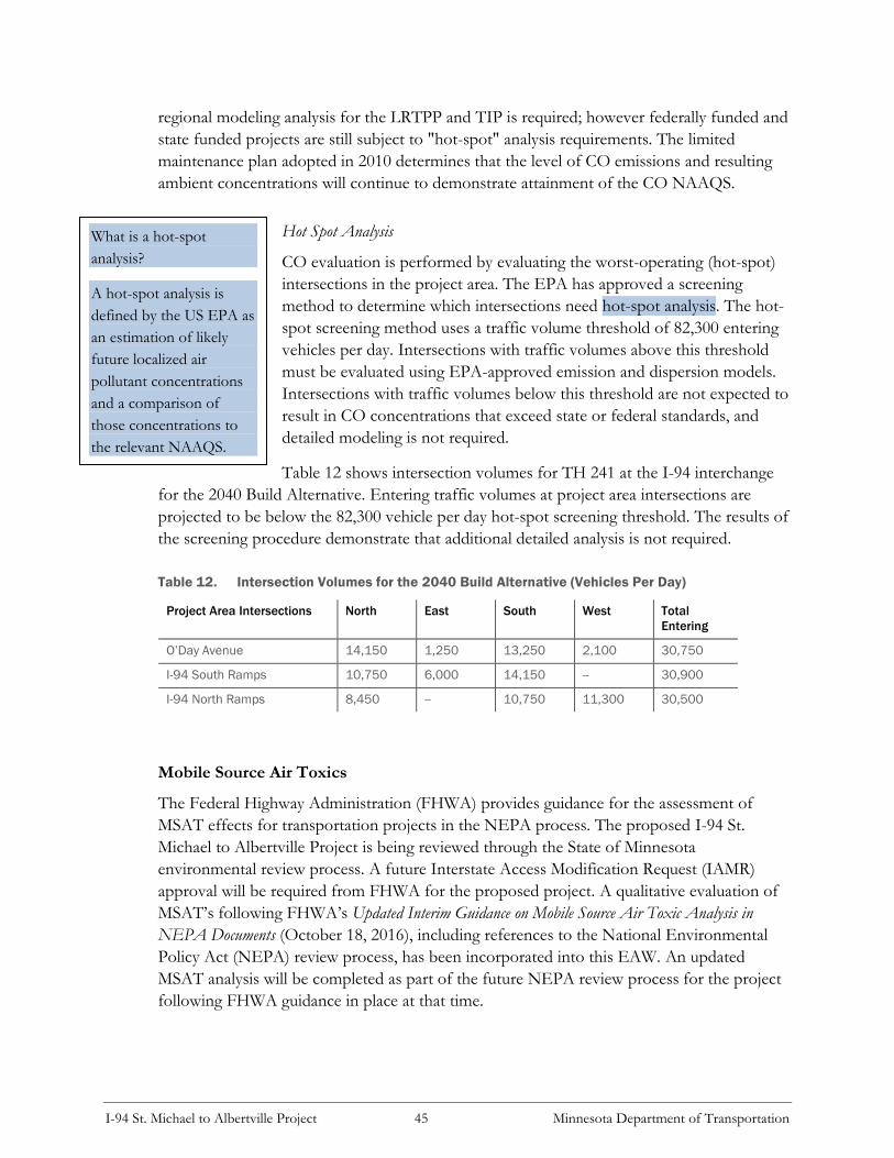
I-94 St. Michael to Albertville Project 45 Minnesota Department of Transportation
What is a hot-spot
analysis?
A hot-spot analysis is
defined by the US EPA as
an estimation of likely
future localized air
pollutant concentrations
and a comparison of
those concentrations to
the relevant NAAQS.
regional modeling analysis for the LRTPP and TIP is required; however federally funded and
state funded projects are still subject to "hot-spot" analysis requirements. The limited
maintenance plan adopted in 2010 determines that the level of CO emissions and resulting
ambient concentrations will continue to demonstrate attainment of the CO NAAQS.
Hot Spot Analysis
CO evaluation is performed by evaluating the worst-operating (hot-spot)
intersections in the project area. The EPA has approved a screening
method to determine which intersections need hot-spot analysis. The hot-
spot screening method uses a traffic volume threshold of 82,300 entering
vehicles per day. Intersections with traffic volumes above this threshold
must be evaluated using EPA-approved emission and dispersion models.
Intersections with traffic volumes below this threshold are not expected to
result in CO concentrations that exceed state or federal standards, and
detailed modeling is not required.
Table 12 shows intersection volumes for TH 241 at the I-94 interchange
for the 2040 Build Alternative. Entering traffic volumes at project area intersections are
projected to be below the 82,300 vehicle per day hot-spot screening threshold. The results of
the screening procedure demonstrate that additional detailed analysis is not required.
Table 12. Intersection Volumes for the 2040 Build Alternative (Vehicles Per Day)
Project Area Intersections North East South West Total
Entering
O’Day Avenue 14,150 1,250 13,250 2,100 30,750
I-94 South Ramps 10,750 6,000 14,150 -- 30,900
I-94 North Ramps 8,450 -- 10,750 11,300 30,500
Mobile Source Air Toxics
The Federal Highway Administration (FHWA) provides guidance for the assessment of
MSAT effects for transportation projects in the NEPA process. The proposed I-94 St.
Michael to Albertville Project is being reviewed through the State of Minnesota
environmental review process. A future Interstate Access Modification Request (IAMR)
approval will be required from FHWA for the proposed project. A qualitative evaluation of
MSAT’s following FHWA’s Updated Interim Guidance on Mobile Source Air Toxic Analysis in
NEPA Documents (October 18, 2016), including references to the National Environmental
Policy Act (NEPA) review process, has been incorporated into this EAW. An updated
MSAT analysis will be completed as part of the future NEPA review process for the project
following FHWA guidance in place at that time.

I-94 St. Michael to Albertville Project 46 Minnesota Department of Transportation
Controlling air toxic emissions became a national priority with the passage of the Clean Air
Act Amendments (CAAA) of 1990, whereby Congress mandated that the EPA regulate 188
air toxics, also known as hazardous air pollutants. The EPA has assessed this expansive list
in their latest rule on the Control of Hazardous Air Pollutants from Mobile Sources (Federal
Register, Vol. 72, No. 37, page 8430, February 26, 2007), and identified a group of 93
compounds emitted from mobile sources that are listed in their Integrated Risk Information
System (IRIS) (http://www.epa.gov/iris/). In addition, EPA identified nine compounds
with significant contributions from mobile sources that are among the national and regional-
scale cancer risk drivers or contributors and non-cancer hazard contributors from the 2011
National Air Toxics Assessment (NATA) (https://www.epa.gov/national-air-toxics-
assessment). These are 1,3-butadiene, acetaldehyde, acrolein, benzene, diesel particulate matter (diesel
PM), ethylbenzene, formaldehyde, naphthalene, and polycyclic organic matter. While FHWA considers
these the priority mobile source air toxics, the list is subject to change and may be adjusted
in consideration of future EPA rules.
Motor Vehicle Emissions Simulator (MOVES) 7
According to EPA, MOVES2014 is a major revision to MOVES2010 and improves upon it
in many respects. MOVES2014 includes new data, new emissions standards, and new
functional improvements and features. It incorporates substantial new data for emissions,
fleet, and activity developed since the release of MOVES2010. These new emissions data are
for light- and heavy-duty vehicles, exhaust and evaporative emissions, and fuel effects.
MOVES2014 also adds updated vehicle sales, population, age distribution, and vehicle miles
travelled (VMT) data. MOVES2014 incorporates the effects of three new Federal emissions
standard rules not included in MOVES2010. These new standards are all expected to impact
MSAT emissions and include Tier 3 emissions and fuel standards starting in 2017 (79 FR
60344), heavy-duty greenhouse gas regulations that phase in during model years 2014-2018
(79 FR 60344), and the second phase of light duty greenhouse gas regulations that phase in
during model years 2017-2025 (79 FR 60344). Since the release of MOVES2014, EPA has
released MOVES2014a. In the November 2015 MOVES2014a Questions and Answers
Guide (https://www.epa.gov/moves/moves2014a-latest-version-motor-vehicle-emission-
simulator-moves), EPA states that for on-road emissions, MOVES2014a adds new options
requested by users for the input of local VMT, includes minor updates to the default fuel
tables, and corrects an error in MOVES2014 brake wear emissions. The change in brake
wear emissions results in small decreases in PM emissions, while emissions for other criteria
pollutants remain essentially the same as MOVES2014.
7 FHWA. October 18, 2016. Updated Interim Guidance on Mobile Source Air Toxic Analysis in NEPA Documents available at
http://www.fhwa.dot.gov/environment/air_quality/air_toxics/policy_and_guidance/msat/index.cfm.

I-94 St. Michael to Albertville Project 47 Minnesota Department of Transportation
Using EPA’s MOVES2014a model, as shown in Exhibit 8, FHWA estimates that even if
VMT increases by 45 percent from 2010 to 2050 as forecast, a combined reduction of 91
percent in the total annual emissions for the priority MSAT is projected for the same time
period.
Exhibit 8. FHWA Projected National MSAT Emission Trends 2010-2050 For Vehicles Operating
On Roadways Using EPA’s MOVES2014a Model
Source: EPA MOVES2014a model runs conducted by FHWA, September 2016.
Note: Trends for specific locations may be different, depending on locally derived information representing vehicle-miles
travelled, vehicle speeds, vehicle mix, fuels, emission control programs, meteorology, and other factors.

I-94 St. Michael to Albertville Project 48 Minnesota Department of Transportation
Diesel PM is the dominant component of MSAT emissions, making up 50 to 70 percent of
all priority MSAT pollutants by mass, depending on calendar year. Users of MOVES2014a
will notice some differences in emissions compared with MOVES2010b. MOVES2014a is
based on updated data on some emissions and pollutant processes compared to
MOVES2010b, and also reflects the latest Federal emissions standards in place at the time of
its release. In addition, MOVES2014a emissions forecasts are based on lower VMT
projections than MOVES2010b, consistent with recent trends suggesting reduced
nationwide VMT growth compared to historical trends.
MSAT Research
Air toxics analysis is a continuing area of research. While much work has been done to assess
the overall health risk of air toxics, many questions remain unanswered. In particular, the
tools and techniques for assessing project-specific health outcomes as a result of lifetime
MSAT exposure remain limited. These limitations impede the ability to evaluate how
potential public health risks posed by MSAT exposure should be factored into project-level
decision-making within the context of NEPA.
Nonetheless, air toxics concerns continue to arise on highway projects during the NEPA
process. Even as the science emerges, the public and other agencies expect FHWA to
address MSAT impacts in its environmental documents. The FHWA, EPA, the Health
Effects Institute, and others have funded and conducted research studies to try to more
clearly define potential risks from MSAT emissions associated with highway projects. The
FHWA will continue to monitor the developing research in this field.
NEPA Context
The NEPA requires, to the fullest extent possible, that the policies, regulations, and laws of
the Federal Government be interpreted and administered in accordance with its
environmental protection goals, and that Federal agencies use an interdisciplinary approach
in planning and decision-making for any action that adversely impacts the environment (42
U.S.C. 4332). In addition to evaluating the potential environmental effects, FHWA must also
take into account the need for safe and efficient transportation in reaching a decision that is
in the best overall public interest (23 U.S.C. 109(h)). The FHWA policies and procedures for
implementing NEPA are contained in regulation at 23 CFR Part 771.
Incomplete or Unavailable Information for Project Specific MSAT Health Impacts Analysis
When an agency is evaluating reasonably foreseeable significant adverse effects on the
human environment in an environmental impact statement and there is incomplete or
unavailable information, the agency shall always make clear that such information is lacking.
The FHWA has prepared the following summary to demonstrate current limitations in
evaluating MSAT effects.

I-94 St. Michael to Albertville Project 49 Minnesota Department of Transportation
In FHWA’s view, information is incomplete or unavailable to credibly predict the project-
specific health impacts due to changes in mobile source air toxic (MSAT) emissions
associated with a proposed set of highway alternatives. The outcome of such an assessment,
adverse or not, would be influenced more by the uncertainty introduced into the process
through assumption and speculation rather than any genuine insight into the actual health
impacts directly attributable to MSAT exposure associated with a proposed action.
The Environmental Protection Agency (EPA) is responsible for protecting the public health
and welfare from any known or anticipated effect of an air pollutant. They are the lead
authority for administering the Clean Air Act and its amendments and have specific statutory
obligations with respect to hazardous air pollutants and MSAT. The EPA is in the continual
process of assessing human health effects, exposures, and risks posed by air pollutants. They
maintain the Integrated Risk Information System (IRIS), which is “a compilation of
electronic reports on specific substances found in the environment and their potential to
cause human health effects” (EPA, https://www.epa.gov/iris/). Each report contains
assessments of non-cancerous and cancerous effects for individual compounds and
quantitative estimates of risk levels from lifetime oral and inhalation exposures with
uncertainty spanning perhaps an order of magnitude.
Other organizations are also active in the research and analyses of the human health effects
of MSAT, including the Health Effects Institute (HEI). A number of HEI studies are
summarized in Appendix D of FHWA’s Updated Interim Guidance on Mobile Source Air
Toxic Analysis in NEPA Documents. Among the adverse health effects linked to MSAT
compounds at high exposures are: cancer in humans in occupational settings; cancer in
animals; and irritation to the respiratory tract, including the exacerbation of asthma. Less
obvious is the adverse human health effects of MSAT compounds at current environmental
concentrations (HEI Special Report 16, https://www.healtheffects.org/publication/mobile-
source-air-toxics-critical-review-literature-exposure-and-health-effects) or in the future as
vehicle emissions substantially decrease.
The methodologies for forecasting health impacts include emissions modeling; dispersion
modeling; exposure modeling; and then final determination of health impacts – each step in
the process building on the model predictions obtained in the previous step. All are
encumbered by technical shortcomings or uncertain science that prevents a more complete
differentiation of the MSAT health impacts among a set of project alternatives. These
difficulties are magnified for lifetime (i.e., 70 year) assessments, particularly because
unsupportable assumptions would have to be made regarding changes in travel patterns and
vehicle technology (which affects emissions rates) over that time frame, since such
information is unavailable.
It is particularly difficult to reliably forecast 70-year lifetime MSAT concentrations and
exposure near roadways; to determine the portion of time that people are actually exposed at
a specific location; and to establish the extent attributable to a proposed action, especially
given that some of the information needed is unavailable.

I-94 St. Michael to Albertville Project 50 Minnesota Department of Transportation
There are considerable uncertainties associated with the existing estimates of toxicity of the
various MSAT, because of factors such as low-dose extrapolation and translation of
occupational exposure data to the general population, a concern expressed by HEI (Special
Report 16, https://www.healtheffects.org/publication/mobile-source-air-toxics-critical-
review-literature-exposure-and-health-effects). As a result, there is no national consensus on
air dose-response values assumed to protect the public health and welfare for MSAT
compounds, and in particular for diesel PM. The EPA states that with respect to diesel
engine exhaust, “[t]he absence of adequate data to develop a sufficiently confident dose-
response relationship from the epidemiologic studies has prevented the estimation of
inhalation carcinogenic risk (https://www.epa.gov/iris).”
There is also the lack of a national consensus on an acceptable level of risk. The current
context is the process used by the EPA as provided by the Clean Air Act to determine
whether more stringent controls are required in order to provide an ample margin of safety
to protect public health or to prevent an adverse environmental effect for industrial sources
subject to the maximum achievable control technology standards, such as benzene emissions
from refineries. The decision framework is a two-step process. The first step requires EPA
to determine an “acceptable” level of risk due to emissions from a source, which is generally
no greater than approximately 100 in a million. Additional factors are considered in the
second step, the goal of which is to maximize the number of people with risks less than 1 in
a million due to emissions from a source. The results of this statutory two-step process do
not guarantee that cancer risks from exposure to air toxics are less than 1 in a million; in
some cases, the residual risk determination could result in maximum individual cancer risks
that are as high as approximately 100 in a million. In a June 2008 decision, the U.S. Court of
Appeals for the District of Columbia Circuit upheld EPA’s approach to addressing risk in its
two-step decision framework. Information is incomplete or unavailable to establish that even
the largest of highway projects would result in levels of risk greater than deemed acceptable
(https://www.cadc.uscourts.gov/internet/opinions.nsf/284E23FFE079CD5985257800005
0C9DA/$file/07-1053-1120274.pdf).
Because of the limitations in the methodologies for forecasting health impacts described, any
predicted difference in health impacts between alternatives is likely to be much smaller than
the uncertainties associated with predicting the impacts. Consequently, the results of such
assessments would not be useful to decision makers, who would need to weigh this
information against project benefits, such as reducing traffic congestion, accident rates, and
fatalities plus improved access for emergency response, that are better suited for quantitative
analysis.
Qualitative MSAT Analysis
A qualitative analysis provides a basis for identifying and comparing the potential differences
among MSAT emissions, if any, from the various alternatives. The qualitative assessment
presented below is derived in part from a study conducted by FHWA entitled A Methodology
for Evaluating Mobile Source Air Toxic Emissions Among Transportation Project Alternatives, found at:

I-94 St. Michael to Albertville Project 51 Minnesota Department of Transportation
https://www.fhwa.dot.gov/environment/air_quality/air_toxics/research_and_analysis/mo
bile_source_air_toxics/msatemissions.cfm.
According to FHWA guidance, a highway widening project is considered minor if the design
year traffic is predicted to be less than 140,000 – 150,000 vehicles per day (vpd). Table 14 in
EAW Item 18 summaries forecast (year 2040) traffic volumes for the project corridor.
Because the design year (2040) Build Alternative projection for annual average daily traffic
(AADT) would not exceed 150,000 vpd within the project corridor, a qualitative MSAT
analysis, rather than a quantitative MSAT analysis, is warranted for the I-94 St. Michael to
Albertville Project.
For the purposes of assessing impacts of the I-94 St. Michael to Albertville Project, the
alternatives compared will be the No Build Alternative and the proposed Build Alternative.
EAW Item 6 describes the Build Alternative in detail.
For each alternative in this EAW, the amount of MSAT emitted would be proportional to
the vehicle miles traveled, or VMT, assuming that other variables such as fleet mix are the
same for each alternative. The VMT values within the project corridor would be
proportional to the average daily traffic volumes, or ADT. The ADT estimated for the Build
Alternative is slightly higher than that for the No Build Alternative, because the additional
capacity increases the efficiency of the roadway and attracts rerouted trips from elsewhere in
the transportation network. Refer to Table 14 (see EAW Item 18). This increase in ADT
would lead to higher MSAT emissions for the Build Alternative along the I-94 corridor,
along with a corresponding decrease in MSAT emissions along the parallel routes. The
emissions increase is offset somewhat by lower MSAT emission rates due to increased
speeds; according to the EPA’s MOVES2014 model, emissions of all of the priority MSAT
decrease as speed increases.
The estimated ADT under No Build Alternative and Build Alternative differ by 2,500 vpd
for the segment of I-94 between CSAH 19 and CSAH 37, and by 6,000 vpd for the segment
between CSAH 37 and TH 241 (see Table 14, EAW Item 18). It is expected there would be
no appreciable difference in overall MSAT emissions among the various alternatives. Also,
regardless of the alternative chosen, emissions will likely be lower than present levels in the
design year as a result of EPA's national control programs that are projected to reduce
annual MSAT emissions by over 90 percent between 2010 and 2050 (Updated Interim Guidance
on Mobile Source Air Toxic Analysis in NEPA Documents, Federal Highway Administration,
October 12, 2016). Local conditions may differ from these national projections in terms of
fleet mix and turnover, ADT growth rates, and local control measures. However, the
magnitude of the EPA-projected reductions is so great (even after accounting for ADT
growth) that MSAT emissions in the study area are likely to be lower in the future in nearly
all cases.
The additional travel lanes contemplated as part of the project will have the effect of moving
some traffic closer to nearby homes, schools, and businesses; therefore, under each
alternative there may be localized areas where ambient concentrations of MSAT could be

I-94 St. Michael to Albertville Project 52 Minnesota Department of Transportation
higher under the Build Alternative than the No Build Alternative. The localized increases in
MSAT concentrations would likely be most pronounced along the expanded roadway
sections that would be built along I-94 between CSAH 37 and TH 241. However, the
magnitude and the duration of these potential increases compared to the No Build
Alternative cannot be reliably quantified due to incomplete or unavailable information in
forecasting project-specific MSAT health impacts. In sum, when a highway is widened, the
localized level of MSAT emissions for the Build Alternative could be higher relative to the
No Build Alternative, but this could be offset due to increases in speeds and reductions in
congestion (which are associated with lower MSAT emissions). Also, MSAT will be lower in
other locations when traffic shifts away from them. However, on a regional basis, EPA's
vehicle and fuel regulations, coupled with fleet turnover, will over time cause substantial
reductions that, in almost all cases, will cause region-wide MSAT levels to be significantly
lower than today.
16.3 Dust and Odors
Item 16.c. Describe sources, characteristics, duration, quantities, and intensity of dust
and odors generated during project construction and operation. (Fugitive dust may be
discussed under item 16a). Discuss the effect of dust and odors in the vicinity of the
project including nearby sensitive receptors and quality of life. Identify measures that
will be taken to minimize or mitigate the effects of dust and odors.
The proposed project will not generate substantial odors during construction. Potential
odors will likely include exhaust from diesel engines and fuel storage. Dust generated during
construction will be minimized through standard dust control measures such as applying
water to exposed soils and limiting the extent and duration of exposed soil conditions.
Construction contractors will be required to control dust and other airborne particulates in
accordance with the construction contract specifications. After construction is complete,
dust levels are anticipated to be minimal because all soil surfaces exposed during
construction will be in permanent cover (i.e., paved or re-vegetated areas).
17 EAW Item 17: Noise
Describe sources, characteristics, duration, quantities, and intensity of noise
generated during project construction and operation. Discuss the effect of noise in
the vicinity of the project including 1) existing noise levels/sources in the area, 2)
nearby sensitive receptors, 3) conformance to state noise standards, and 4) quality of
life. Identify measures that will be taken to minimize or mitigate the effects of noise.
The following question format will answer the EAW question in relation to highway projects
and summarizes the findings in the Traffic Noise Analysis Report provided in Appendix D.

I-94 St. Michael to Albertville Project 53 Minnesota Department of Transportation
17.1 Construction Noise
Will there be noise during construction?
Construction activities associated with the proposed project would result in increased noise
levels relative to existing conditions. These impacts would primarily be associated with
construction equipment and pile driving. Table 13 shows peak noise levels monitored at 50
feet from several types of construction equipment. This equipment is usually used during site
grading/site preparation, which is usually the loudest phase of the roadway construction
process.
Table 13. Typical Construction Equipment Noise Levels at 50 Feet
Equipment Type Manufacturers
Sampled
Total Number of
Models in Sample
Peak Noise Level (dBA)
Range Average
Backhoes 5 6 74-92 83
Front Loaders 5 30 75-96 85
Dozers 8 41 65-95 85
Graders 3 15 72-92 84
Scrapers 2 27 76-98 87
Pile Drivers N/A N/A 95-105 101
Source: United States Environmental Protection Agency and Federal Highway Administration.
What can be done to reduce the annoyance associated with construction noise?
Elevated noise levels are, to a degree, unavoidable for this type of project. MnDOT will
require that construction equipment be properly muffled and in proper working order. While
MnDOT and its contractor(s) are exempt from local noise ordinances, it is the practice to
require contractor(s) to comply with applicable local noise restrictions and ordinances to the
extent that is reasonable. Advanced notice will be provided to affected communities of any
planned abnormally loud construction activities. The duration of construction will be
determined during the final design of the project.
Any associated high-impact equipment noise, such as pile driving, pavement sawing, or jack
hammering, will be unavoidable with construction of the proposed project. Pile driving noise
is associated with any bridge construction. High-impact noise construction activities will be
limited in duration to the greatest extent possible.
It is anticipated that night construction may be required to expedite construction, minimize
traffic impacts, and improve safety. Noisy work at night for I-94 and TH 241 construction
will be limited as much as possible, but may need to occur periodically. Construction or
maintenance activities that are generally prohibited during 8:30 p.m. and 7:00 a.m. include
pile driving/removal, concrete pavement demolition, pavement sawing, concrete crushing
operations, and jack hammering. There will be times when noise producing operations will
I-94 St. Michael to Albertville Project 54 Minnesota Department of Transportation
What is noise, what is a decibel,
and what is a dBA?
Noise is defined as unwanted
sound. Decibel is the unit of
measure used to quantify sound
pressure level (SPL). The terms
sound and noise are often
interchangeable, although noise is
considered unwanted sound.
The human hearing organs do not
hear all frequencies of sound
equally; we hear some frequencies
better than others. The A-
weighting scale was created to
apply more emphasis or weighting
on the frequencies we hear best,
and to de-emphasize or apply less
weighting to frequencies we don’t
hear well.
have to occur at night because of the need for pavement to cure or be sawed, or lanes
closures that allow access to the work area.
17.2 Traffic Noise Analysis
Traffic Noise Analysis Report
The following is a summary of the I-94 St. Michael to Albertville
Traffic Noise Analysis Report. The complete traffic noise analysis
report is included in Appendix D. This report includes
background information on noise, information regarding traffic
noise regulations (i.e., MPCA noise standards), a discussion of
the traffic noise analysis methodology, documentation of the
potential traffic noise impacts associated with the proposed
project, and an evaluation of noise abatement measures.
As described in EAW Item 6, the project is not programmed
for construction. A traffic noise analysis is required because the
project meets the criteria for a mandatory EAW under
Minnesota Rules. This traffic noise analysis addresses
Minnesota state noise standards and follows current Minnesota
Statewide Highway Noise Policy (effective date: June 15, 2015).
A traffic noise analysis will also be completed as part of the
future NEPA process for the proposed project to address
FHWA requirements.
How is traffic noise regulated in Minnesota?
The MPCA is the state agency responsible for enforcing state noise rules (see Appendix D,
Table 1, Minnesota State Noise Standards). The MPCA noise standards are different for
daytime and nighttime. MPCA defines daytime as 7:00 A.M.
to 10:00 P.M. and nighttime as 10:00 P.M. to 7:00 A.M. The
state noise standards also take into account the differing noise
sensitivities of different land uses such as residential uses,
commercial uses, or industrial uses. Minnesota state noise
standards apply to the outdoor environment (i.e., exterior
noise levels). The MPCA noise standards apply to traffic noise
from certain highways, including I-94 and the I-94/TH 241
interchange.
Under State rules, noise impacts are determined based on land
use activities and predicted loudest hourly L10 and L50 noise
levels under future conditions. For example, for residential
land uses (Noise Area Classification 1, or NAC-1), the state
What are L10 and L50?
Measured traffic noise levels are
characterized as a function of
time. One way to do that is to use
a statistical term such as the
percent of time a noise level is
exceeded. The L10 level is the
noise level exceeded 10 percent of
the time (typically a one hour
period). The L50 level is the noise
level exceeded 50 percent of the
time.

I-94 St. Michael to Albertville Project 55 Minnesota Department of Transportation
daytime noise standards are 65 dBA (L10) and 60 dBA (L50). The state nighttime standards
for NAC-1 are 55 dBA (L10) and 50 dBA (L50). We use the term receptor to mean a
discrete location of a noise sensitive area(s) for any of the land uses defined in Minnesota
State Noise Standards (Minnesota Rule 7030). Receptor locations where modeled traffic
noise levels are projected to exceed the State daytime and/or nighttime standards must be
evaluated for noise abatement feasibility and reasonableness.
How are traffic noise impacts determined?
Traffic noise is evaluated by modeling the traffic noise levels during the hours of the day
and/or night that have the loudest traffic noise levels. The traffic noise model uses existing
and forecasted traffic volumes, as well as characteristics of the roadway and surrounding
environment, to calculate traffic noise levels at representative receptor locations. Modeled
traffic noise levels are then compared to state daytime and nighttime noise standards. If
modeled traffic noise levels are projected to exceed state daytime and/or nighttime noise
standards under the Build Alternative, then a traffic noise impact is identified and noise
abatement measures (e.g., noise walls) are considered.
How was traffic noise evaluated on this project?
Traffic noise levels were modeled for existing conditions, the future 2040 No Build
Alternative, and the future 2040 Build Alternative using the “MINNOISEV31” model, a
version of the FHWA “STAMINA” model adapted by MnDOT. Traffic noise levels were
modeled at nearly 450 representative receptor locations within the project area. These
modeled receptor locations represent residential, commercial, restaurant, industrial, and
recreational (parks and trails) uses. Additional details regarding the traffic noise analysis
modeling methodology are described in the Traffic Noise Analysis Report in Appendix D.
What were the results of the traffic noise analysis?
Table 14 provides a summary of the noise level ranges and number of receptors that exceed
state daytime and nighttime standards for existing conditions, the 2040 No Build Alternative,
and the 2040 Build Alternative. The analysis shows that under the 2040 No Build
Alternative, modeled traffic noise levels (daytime and nighttime) are projected to increase by
0.9 dBA to 2.8 dBA (L10) over existing conditions. Modeled noise levels under the 2040
Build Alternative (daytime and nighttime) are projected to increase by 0.2 dBA to 2.9 dBA
(L10) compared to existing conditions.

I-94 St. Michael to Albertville Project 56 Minnesota Department of Transportation
What is MnDOT’s Noise
Reduction Design Goal?
MnDOT’s Noise Policy
establishes a noise reduction
design goal of at least 7 dBA. This
design goal must be achieved at a
minimum of one benefited
receptor for each proposed noise
abatement measure to be
considered reasonable. This goal
provides that even though the
minimum noise reduction
required for receptors to be
considered as benefited is 5 dBA a
minimum 7 dBA reduction must
be achieved for at least one
benefited receptor.
Table 14. Traffic Noise Analysis Results (1)
Modeled Year Existing Conditions 2040 No Build
Alternative
2040 Build Alternative
Number of Receptors
Exceeding State Daytime
Standards
L10 = 256 receptors
L50 = 329 receptors
L10 = 285 receptors
L50 = 376 receptors
L10 = 294 receptors
L50 = 382 receptors
Number of Receptors
Exceeding State
Nighttime Standards
L10 = 394 receptors
L50 = 419 receptors
L10 = 409 receptors
L50 = 429 receptors
L10 = 416 receptors
L50 = 433 receptors
Modeled Noise Level
Ranges (L10, Daytime)
54.7 dBA to 85.9 dBA 55.8 dBA to 87.0 dBA 55.8 dBA to 88.7 dBA
Modeled Noise Level
Ranges (L50, Daytime)
52.2 dBA to 78.7 dBA 53.6 dBA to 80.2 dBA 53.9 dBA to 81.3 dBA
Modeled Noise Level
Ranges (L10, Nighttime)
54.8 dBA to 84.8 dBA 55.9 dBA to 85.8 dBA 55.8 dBA to 88.0 dBA
Modeled Noise Level
Ranges (L50, Nighttime)
52.4 dBA to 77.7 dBA 53.7 dBA to 79.2 dBA 53.9 dBA to 82.5 dBA
(1) Includes modeled noise level results for trail receptor locations along CSAH 19, CSAH 37, and Barthel Industrial Drive in
Albertville, at the Preserve Park along 50th Street Northeast in St. Michael, and the proposed trail along TH 241.
What noise abatement measures were considered?
Noise abatement measures were evaluated along the project
area where modeled traffic noise levels are projected to exceed
state daytime and/or nighttime noise standards. In order for a
noise abatement measure to be proposed as part of a project, it
must be both feasible and reasonable as established in the
Minnesota Statewide Highway Noise Policy (effective date:
June 15, 2015).
Feasibility
Noise abatement measures must meet acoustic and engineering
feasibility criteria to be proposed. For a noise abatement
measure to be considered acoustically feasible, it must provide a
substantial reduction in noise, defined as a 5 dBA reduction by
at least one impacted receptor per proposed barrier.
Engineering feasibility addresses whether it is possible to design
and construct a proposed noise abatement measure. Potential
constructability factors could include safety, topography,
drainage, utilities and maintenance.

I-94 St. Michael to Albertville Project 57 Minnesota Department of Transportation
What is MnDOT’s Noise Wall
Cost Effectiveness?
Cost effectiveness threshold of
$43,500 per individual benefited
receptor has been established as
part of MnDOT’s 2015 Noise
Policy, based on an estimated
construction cost of $20/sq. ft. for
noise walls. The cost effectiveness
threshold and basis for
construction cost estimate will be
tracked and the cost effectiveness
number will be updated every five
years.
Reasonableness
Three reasonableness factors or “tests” must be met for a noise
abatement measure to be considered reasonable: 1) noise
reduction design goal of 7 dBA is met for at least one receptor,
2) cost effectiveness criteria of $43,500 per individual benefited
receptor must be met, and 3) the viewpoint of benefited
residents and property owners.
Noise Wall Analysis Results
Noise walls were assessed at all locations along the I-94 project
corridor where future (2040) modeled noise levels were
projected to exceed state daytime or nighttime standards.
The noise wall analysis was completed for 20 potential noise
wall locations along the I-94 project corridor. None of the
modeled noise walls analyzed meet MnDOT’s feasibility and
reasonableness criteria; therefore, no noise walls are proposed as part of the I-94 St. Michael
to Albertville Project. The I-94 St. Michael to Albertville Traffic Noise Analysis Report in
Appendix D includes locations of modeled noise walls and additional details of the noise
wall analysis.
18 EAW Item 18: Transportation
18.1 Traffic-Related Aspects of Project Construction and Operation
Item 18.a. Describe traffic-related aspects of project construction and operation.
Include: 1) existing and proposed additional parking spaces, 2) estimated total average
daily traffic generated, 3) estimated maximum peak hour traffic generated and time of
occurrence, 4) indicate source of trip generation rates used in the estimates, and 5)
availability of transit and/or other alternative transportation modes.
1) Existing and proposed additional parking spaces.
Not applicable. The project will not add parking spaces.
2) Estimated total average daily traffic generated.
Not applicable. The proposed project will not generate new trips in the same way as a new
residential or commercial development because I-94, the eastbound collector-distributor
road, and the I-94/TH 241 interchange are not a destination or end points like a
neighborhood or business.

I-94 St. Michael to Albertville Project 58 Minnesota Department of Transportation
Table 15 lists the change in traffic volumes along I-94 from west of CSAH 19 to east of
TH 241 under the 2040 Build Alternative in comparison to the 2040 No Build Alternative.
Table 15. 2040 No Build Alternative and 2040 Build Alternative Average Daily Traffic Volumes
From To 2040 No Build
Alternative
Vehicles Per Day
2040 Build
Alternative
Vehicles Per Day
Change
(2040 Build – 2040
No Build)
CSAH 19 MnROAD Facility 73,000 74,400 1,400
CSAH 37 CSAH 19 55,300 57,800 2,500
TH 241 CSAH 37 83,000 89,000 6,000
TH 101 TH 241 97,000 99,000 2,000
3) Estimated maximum peak hour traffic generated and time of occurrence.
As noted above, the proposed project will not generate new trips. Peak period travel patterns
on the I-94 project corridor are predominately in the eastbound direction during the a.m.
peak hour and in the westbound direction during the p.m. peak hour. The a.m. peak hour
represents approximately eight to 10 percent of average daily traffic volumes. The time of
the a.m. peak hour is approximately 6:15 a.m. to 7:15 a.m. The p.m. peak hour represents
approximately six percent of average daily traffic volumes, and occurs between 4:00 p.m. and
5:00 p.m.
4) Indicate source of trip generation rates used in the estimates.
Future (year 2040) travel demand forecasts were developed using the Metropolitan Council’s
regional travel demand model (RTDM) dated January 2014, with supplemental information
from MnDOT’s Collar County model. Traffic forecasts were developed using the guidelines
identified in the Twin City Travel Demand Forecasts Prepared for MnDOT Metro: Model and
Parameters for Adjustments to Model Inputs, April 10, 2006.
5) Availability of transit and/or other alternative transportation modes.
There are no bus transit routes that currently use the I-94 project segment between St.
Michael and Albertville.
There is one official park-and-ride facility located along I-94 in Albertville near the CSAH 19
interchange. The facility is owned by the City of Albertville and has 40 spaces. There is no
transit service to this site. The Albertville park-and-ride is used as a carpool/vanpool facility.
There are no park-and-ride facilities in St. Michael.
Trailblazer Transit provides public transportation with bus services in Sibley, McLeod, and
Wright counties, including the study area in St. Michael and Albertville.

I-94 St. Michael to Albertville Project 59 Minnesota Department of Transportation
Sidewalks and trails are located throughout the study area on local routes near I-94. There is
no existing non-motorized facility along TH 241 or CSAH 37 over I-94 in St. Michael and
Albertville, respectively. A trail is located along the west side of CSAH 19 under I-94 in
Albertville.
18.2 Effect on Traffic Congestion
Item 18.b. Discuss the effect on traffic congestion on affected roads and describe any
traffic improvements necessary. The analysis must discuss the project’s impact on the
regional transportation system. If the peak hour traffic generated exceeds 250 vehicles
or the total daily trips exceeds 2,500, a traffic impact study must be prepared as part of
the EAW. Use the format and procedures described in the Minnesota Department of
Transportation’s Access Management Manual, Chapter 5 (available at:
http://www.dot.state.mn.us/accessmanagement/resources.html) or a similar local
guidance.
The following discussion demonstrates how I-94 mobility, CSAH 37 operations, and
I-94/TH 241 traffic operations would improve with the proposed project in comparison to
having no improvement in the corridor.
How was traffic analyzed for the I-94 St. Michael to Albertville Project?
I-94 Traffic Analysis
A traffic analysis using the CORSIM traffic model was completed for the I-94, St. Michael to
Albertville Project. One of the results of the CORSIM traffic model is level of service (LOS).
LOS is a qualitative measurement used to describe traffic density, generally in terms of speed
and travel time, maneuverability, comfort, and convenience. LOS ratings range from LOS A
(best) to LOS F (worst).
I-94/TH 241 Interchange Traffic Analysis
A traffic operations analysis using the VISSIM traffic model was completed for the I-94/TH
241 interchange ramp terminal intersections. The VISSIM modeling results are also
measured in terms of a Level of Service (LOS). The LOS grading system for intersection
operations ranges from A to F, which describes the delay per vehicle, or additional travel
time experienced by each vehicle, through an intersection.
Will the proposed project improve mobility along the I-94 corridor?
The traffic modeling analyzed the Build Alternative traffic operations for the forecast (year
2040) conditions. The 2040 Build Alternative CORSIM modeling included the proposed
additional lanes on I-94 between CSAH 37 and TH 241 and the proposed I-94/TH 241
interchange reconstruction. Table 16 lists the results of the CORSIM analysis for eastbound

I-94 St. Michael to Albertville Project 60 Minnesota Department of Transportation
I-94 for the 2040 No Build Alternative and 2040 Build Alternative. Table 17 lists the results
of the CORSIM analysis for westbound I-94 for the 2040 No Build Alternative and the 2040
Build Alternative.
Table 16. Eastbound I-94 LOS Results (2040 No Build Alternative and 2040 Build Alternative)
CORSIM
Modeling
Location: From
CORSIM
Modeling
Location: To
2040 No Build
Alternative
A.M. Peak Hour
2040 No Build
Alternative
P.M. Peak Hour
2040 Build
Alternative
A.M. Peak Hour
2040 Build
Alternative
P.M. Peak Hour
MnROAD CSAH 19 C B C B
CSAH 19 CSAH 37 B B C B
At EB I-94 exit
to CSAH 37
-- B B C B
At CSAH 37
entrance to EB
I-94
-- F C C B
CSAH 37 TH 241 E B C B
TH 241 TH 101 C B D B
Table 17. Westbound I-94 LOS Results (2040 No Build Alternative and 2040 Build Alternative)
CORSIM
Modeling
Location: From
CORSIM
Modeling
Location: To
2040 No Build
Alternative
A.M. Peak Hour
2040 No Build
Alternative
P.M. Peak Hour
2040 Build
Alternative
A.M. Peak Hour
2040 Build
Alternative
P.M. Peak Hour
TH 101 TH 241 A C A C
At TH 241
entrance to WB
I-94
-- B E A C
TH 241 CSAH 37 B E A C
At WB I-94 exit
to CSAH 37
-- B E A C
CSAH 37 CSAH 19 A C A C
CSAH 19 MnROAD
Facility
B D B D
The CORSIM modeling shows that the LOS would improve on the I-94 project corridor
under 2040 Build Alternative conditions compared to the 2040 No Build Alternative. The
project segment of I-94 from CSAH 19 to TH 241 would operate at LOS C or better under
the 2040 Build Alternative during the a.m. and p.m. peak hours.
Eastbound I-94 Between TH 241 and TH 101
The proposed additional lane on eastbound I-94 between CSAH 37 and TH 241 increases
the volume of traffic that can get through the project area to the I-94/TH 101 interchange in

I-94 St. Michael to Albertville Project 61 Minnesota Department of Transportation
Rogers. This additional throughput increases the density of vehicles on eastbound I-94
between TH 241 and TH 101, resulting in a reduction in average speeds (approximately 5
miles per hour) under the 2040 Build Alternative compared to the 2040 No Build
Alternative.
Will the proposed project improve CSAH 37 traffic operations?
The traffic operations analysis completed as part of the 2006 Northeast Wright County I-94
Interchange Access Request showed that year 2030 traffic operations on CSAH 37 would
improve to LOS D or better under a.m. and p.m. peak hours with both the I-94 eastbound
and westbound collector-distributor roads between CSAH 19 and CSAH 37. The forecast
traffic volume on the eastbound collector-distributor was projected to be greater 1,100
vehicles during the a.m. peak hour, and approaching 1,000 vehicles during the p.m. peak
hour. Most of this traffic would otherwise be on CSAH 37 under the No Build Alternative.
Will the proposed project improve I-94/TH 241 traffic operations?
The traffic modeling analyzed traffic operations at the ramp terminal intersections under the
Build Alternative traffic operations for the forecast (year 2040) conditions. Table 18 lists the
results of the VISSIM analysis for the I-94/TH 241 ramp terminal intersections under the
2040 No Build Alternative and 2040 Build Alternative.
Table 18. I-94/TH 241 Interchange Operational Traffic Analysis LOS Results
Intersection 2040 No Build
Alternative
LOS Results
AM Peak Hour
2040 No Build
Alternative
LOS Results
PM Peak Hour
2040 Build
Alternative
LOS Results
AM Peak Hour
2040 Build
Alternative
LOS Results
PM Peak Hour
I-94 EB Ramps &
TH 241
D/F E/F B/C B/D
I-94 WB Ramps &
TH 241
C/E F/F A/A A/A
Overall intersection LOS is listed first, followed by the worst approach LOS.
The I-94/TH 241 ramp terminal intersections are projected to operate at LOS B or better
under the 2040 Build Alternative. Intersection delays would decrease substantially compared
to 2040 No Build Alternative conditions. The loop ramp in the northwest quadrant of the
interchange provides a free-flow movement for westbound I-94 to westbound TH 241
traffic, reducing the probability of traffic queues extending back down the ramp and
impacting I-94 operations.

I-94 St. Michael to Albertville Project 62 Minnesota Department of Transportation
18.3 Measures to Minimize or Mitigate Project-Related Transportation
Effects
Item 18.c. Identify measures that will be taken to minimize or mitigate project related
transportation effects.
Not applicable.
19 EAW Item 19: Cumulative Potential Effects
(Preparers can leave this item blank if cumulative potential effects are addressed under the applicable EAW Items)
19.1 Geographic Scales and Timeframes
Item 19.a. Describe the geographic scales and timeframes of the project related
environmental effects that could combine with other environmental effects resulting in
cumulative potential effects.
Cumulative effects result from the incremental impact of the proposed project added to
other past, present, and reasonably foreseeable future actions, regardless of what agency or
person undertakes such other actions. The geographic area considered for cumulative
potential effects is the area proximate to the project limits. The projects considered are
planned or programmed for construction between 2018 and 2021.
Table 19 summarizes project related environmental effects that could combine with other
environmental effects and the geographic extent of the anticipated impacts.
Table 19. Project Related Environmental Effects and Geographic Extent
EAW Item Topic/Issue Project-Related
Environmental Effects
Geographic Extent
EAW Item 10 Erosion and
Sedimentation Control
Disturbed
ground/exposed soils
during construction.
Throughout project area
EAW Item 11 Stormwater and Aquatic
Resources • Increase in impervious
surface area.
• Impacts to aquatic
resources.
• See EAW Item 11 for a
discussion of aquatic
resource sequencing
Throughout project area
EAW Item 12 Existing Contamination/
Potential Environmental
Hazards
• One closed leaking
underground storage
tank site.
• One former MDA spill
site within
approximately 500 feet
Throughout project area

I-94 St. Michael to Albertville Project 63 Minnesota Department of Transportation
EAW Item Topic/Issue Project-Related
Environmental Effects
Geographic Extent
of the project area.
• Low to medium risk of
impacting potentially
contaminated sites.
EAW Item 13 Rare Species Potential to encounter
Blanding’s turtle
(Emydoidea blandingii)
within project area.
Throughout project area
EAW Item 17 Construction and Traffic
Noise • Temporary construction
noise impacts.
• Modeled traffic noise
levels would exceed
State daytime and
nighttime standards.
Throughout project area
EAW Item 18 Transportation • Increase in traffic
volumes on I-94
compared to the 2040
No Build Alternative.
• Improved mobility and
traffic operations
compared to 2040 No
Build Alternative.
Throughout project area
19.2 Reasonably Foreseeable Future Projects
Item 19.b. Describe any reasonably foreseeable future projects (for which a basis of
expectation has been laid) that may interact with environmental effects of the proposed
project within the geographic scales and timeframes identified above.
The MnDOT 2018-2021 State Transportation Improvement Program (STIP), the Wright County
website, the Albertville website, and the St. Michael website were reviewed to identify
present and other reasonably foreseeable future projects near the I-94 St. Michael to
Albertville project limits. Present and reasonably foreseeable future projects identified in the
study area are listed below.
• Wright County. CSAH 19 from Lamplight Drive to north of 70th Street in Albertville
(SP 086-619-034). Extend multilane roadway. Programmed for fiscal year 2020.
• City of Albertville. 70th Street Northeast (MSAS 112) from CSAH 19 to Maciver
Avenue. Reconstruction with pedestrian/bicycle trail and improvements at the
CSAH 19/70th Street Northeast intersection. Programmed for fiscal year 2019.
• City of Albertville. Mall of Entertainment. Proposed retail, entertainment,
business/office, and residential development northwest of the Albertville Outlet Mall
on the north side of I-94. Alternative Urban Areawide Review (AUAR) completed in
2017. The initial construction phase could be completed in 2019.

I-94 St. Michael to Albertville Project 64 Minnesota Department of Transportation
• City of St. Michael. Tributary on Foster Lake. Residential development north of I-94
and west of CSAH 36. Initial residential construction began in 2016. Future phases
planned.
19.3 Nature of Cumulative Potential Effects
Item 19.c. Discuss the nature of the cumulative potential effects and summarize any
other available information relevant to determining whether there is potential for
significant environmental effects due to these cumulative effects.
Past actions that have occurred recently in the project area include the construction of the
westbound collector-distributor road between CSAH 19 and CSAH 37, pavement
rehabilitation projects on the project segment of I-94, and reconstruction of I-94 to the east
from TH 241 to TH 101 in St. Michael and Rogers. These actions were considered as part of
the existing conditions in the project area.
Environmental effects resulting from the proposed I-94 St. Michael to Albertville Project are
described in EAW Item 7 through EAW 18. The other present and reasonably foreseeable
future projects may also impact these same resources. Future development is taken into
consideration in the traffic analysis, and the cumulative impact of future transportation
improvements should result in improved traffic conditions. Impacts from the other projects
listed above would be addressed via federal and state regulatory permitting and approval
processes; therefore, they would be individually mitigated to ensure minimal cumulative
impacts occur.
Considering the types of other projects listed above, and considering regulatory permitting
and approval processes, the proposed project along with other reasonably foreseeable
actions would have a minimal cumulative impact upon the environment.
20 EAW Item 20: Other Potential Environmental Effects
If the project may cause any additional environmental effects not addressed by items 1 to 19, describe the effects here, discuss the how the environment will be affected, and identify measures that will be taken to minimize and mitigate these effects.
Floodplain Assessment
A 100-year floodplain and floodway are located adjacent to the Crow River at the I-94/
TH 241 interchange in St. Michael. The proposed project is located outside of the FEMA
floodway boundary. Impacts to the Crow River floodway are not anticipated.
MnDOT’s highway right of way is located within the 100-year floodplain boundary. This
floodplain would be impacted by reconstruction of the TH 241 entrance ramp to eastbound
I-94 and construction of an adjacent acceleration lane. The proposed project would result in
a transverse floodplain encroachment along eastbound I-94 of approximately 650 feet based

I-94 St. Michael to Albertville Project 65 Minnesota Department of Transportation
on the FEMA 100-year flood elevation. The proposed project would result in a transverse
floodplain encroachment along eastbound I-94 of approximately 1,000 feet based on the
100-year flood elevation from the 2015 I-94 design plans.
There is no significant potential for interruption of a transportation facility. The proposed
acceleration lane along eastbound I-94 would be constructed above the floodplain elevation.
Impacts on the natural environment would be minimal. The project would be constructed
within existing MnDOT right of way. No significant increased risk of flooding would result
because additional storage would be constructed in the southeast quadrant of the I-94/
TH 241 interchange. This area is hydraulically connected to the floodplain by a culvert
under the TH 241 entrance ramp to eastbound I-94. The project would not cause
incompatible floodplain development because the project does not provide new access to
the floodplain area associated with the Crow River. Therefore, no significant floodplain
impacts are expected.
Right of Way and Relocation
The project would require approximately 8.1 acres of new highway right of way affecting
eight parcels. The project would not result in any relocations.
Acquisitions will be conducted in accordance with the Uniform Relocation Assistance and
Real Property Acquisition Policies Act of 1970, as amended.