HOLLAND BECKETT - Lower Kaituna River
61
IN THE HIGH COURT OF NEW ZEALAND TAURANGA REGISTRY I TE KOTI MATUA 0 AOTEAROA TAURANGA MOANA ROHE IN THE MATTER OF AND IN THE MATTER CIV-2011-485-794 the Marine and Coastal Area (Takutai Moana) Act 2011 of applications by COLIN FRANCIS REEDER AND ORS on behalf of NGA POTIKI A TAMAPAHORE TRUST for orders recognising Protected Customary Rights and Customary Marine Title AFFIDAVIT OFGEOFFREY PINCKNEY FORD ON BEHALF OF FORD LAND HOLDINGS PTY LIMITED INTERESTED PARTY IN THE PROCEEDINGS SWORN ly MAY 2021 HOLLAND BECKETT Solicitor: Solicitor: LAW Laura Murphy Vanessa Hamm 525 Cameron Road DX HP40014 Private Bag 12011 Tauranga 3143 Telephone: (07) 578 2199 Facsimile: (07) 578 8055 Email: laura. murphy(5)hobec. co. nz Email: vanessa. hamm@hobec.co. nz
-
Upload
khangminh22 -
Category
Documents
-
view
9 -
download
0
Transcript of HOLLAND BECKETT - Lower Kaituna River

IN THE HIGH COURT OF NEW ZEALANDTAURANGA REGISTRY
I TE KOTI MATUA 0 AOTEAROATAURANGA MOANA ROHE
IN THE MATTER OF
AND
IN THE MATTER
CIV-2011-485-794
the Marine and Coastal Area (TakutaiMoana) Act 2011
of applications by COLIN FRANCIS REEDERAND ORS on behalf of NGA POTIKI ATAMAPAHORE TRUST for ordersrecognising Protected Customary Rightsand Customary Marine Title
AFFIDAVIT OFGEOFFREY PINCKNEY FORD ON BEHALF OFFORD LAND HOLDINGS PTY LIMITED
INTERESTED PARTY IN THE PROCEEDINGS
SWORN ly MAY 2021
HOLLAND BECKETT
Solicitor:
Solicitor:
LAW
Laura MurphyVanessa Hamm
525 Cameron Road
DX HP40014Private Bag 12011Tauranga 3143
Telephone: (07) 578 2199Facsimile: (07) 578 8055
Email: laura. murphy(5)hobec. co. nzEmail: [email protected]. nz

I, Geoffrey Pinckney Ford, of Sydney, Australia, swear:
1. My full name is Geoffrey Pinckney Ford. I am a director of Ford Land
Holdings Pty Limited which owns the farm 'The Sandhills' at Papamoa
which forms part of the Te Tumu Future Urban Zone.
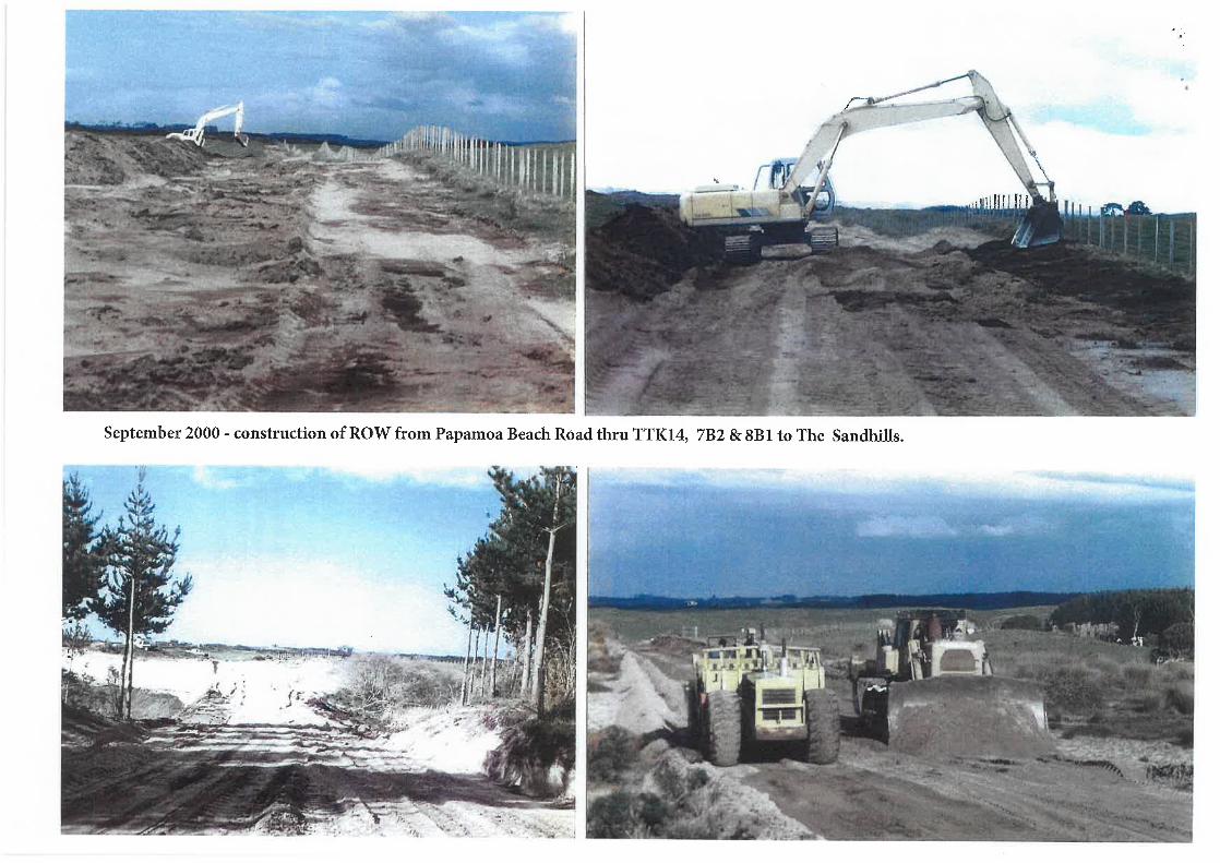
2. I was born in the Te Puke Maternity Hospital on 23 December 1946 and
then went on to live in the old Ford homestead situated on Ford Road,
Maketu (the Ford Road Farms). My father owned both farms on either
side of Ford Road, Maketu near Ford's Landing (Otaiparia) and The
Sandhills (Te Tumu) on the northern side of the Kaituna River.
3. An aerial plan of the area with various locations referred to in this
affidavit is attached at Exhibit A.
4. Having grown up in Te Puke, I studied in Auckland and travelled to the UK
for further education and returned via Australia to work as a Junior Wool
Buyer. My wife Dianne, son George and I reside in Australia but return
home every couple of months to The Sandhills although this has not been
possible during the recent COVID-19 pandemic.
Scope and purpose of affidavit
5. I am authorised to provide this affidavit on behalf of Ford Land Holdings
Pty Limited (Ford) who is one of the main land owners within the Te Tumu
Future Urban Zone.
6. TheTeTumu Kaituna 14 Trust (the Trust), Carrus Corporation Limited and
Ford are interested parties in these proceedings due to the claims by
multiple parties of customary marine title to the coastal marine area
adjacent to Te Tumu.
MEW-873709-14-642-1
^

.
i-zw-tl-eoieis-iww
sepn|3ui ue|d qiMojgijeais sql .sAeM9|3A3 pue sAe/v\>)|e/v\ /sp|3ysuods
/s|ooq3s 'iU9LuAo|dLU3 jo^ jaiea ||!M i\ -BJIUSD UMOI pasodojd e
punoje A^!unLuaio3 3|qeuieisns e Suipiinq eiiqM 'jepejeqo |ejni.eu s,e9je
eqi SAjasajd pue iseo3 eqi 'jSAiy euniie» 341 padsaj ||!M i.u3Ludo|3A3p
pasodojd eqi 'SZOZ/^ZOZ u! 1-ieis o^ guiaiie iu9Ludo|3A3p lei^uspissj
qiiM '9|do3d QOS'ST A|3ieujixojdde jo^ Suisnoq MSU apiAojd ||!M nujni ei.
OT
.
jesA siqi j9}e| jn330 01 papadxa si q3iq/v\ pue| sql 9uoz-9j 01 |puno3
A^!3 e§uejneiAq a§ueq3 ue|d e uo luspuadep si nujni 31^0 }U3Ludo|aA9Q .s
.
sue|d iu9Ludo|aA3p ueqjn sjninj. s,eguejnei
ui p3pn|3Uj uaaq seq uaqi 33uis pue iu3Ludo|3Aap jo^ ue|d jesA QS
3qi ui p3pn|3ui se/v\ ntuni 31 'uoigsj aqi ^o q^MOJ§ 341. aSeueLU 01^QOZ
ui diqsjeu^jed ,qi/v\oj9ijeujs, aqi paaijo^ |i3uno3 leuoigsy Aiu3|d o Aeg
pue |i3uno3 PJJ^SIQ Aiu9|d o Aeg ujaiss/w '|i3uno3 Ai!3 e§uejnei usq/w -g
auoz ueqjn ajninj niuni ai aqi
.
naini ai joj. ssassv leiseo^ o soueijoduji sqi (^)
fnujnj_ ai ie GBJV BUUEIAI |eiseo3 aqi. ui SBIIIMIDV -04^0 (s)
.'in3 euniie>| sql o AJOISIH aqi (p)
feeje naini ei 341. qii Ajoisiq A|iLuej. A|A| (3)
'diqsuoiieiBj s,pjoj pue snjje3 'ISPJI BLJI (q)
fsuoz ueqjn ajninj naini 91 aqi (e)
:sj3uetu §UIMO||O^ eqi ssejppe ||i/v\ iiAepi^e siqi Y

the future Kaituna Link which will provide connectivity to the Western
Bay of Plenty.
11. Tauranga City Council estimates that approximately 400 hectares of the
740 hectares of land at Te Tumu could be developed. The balance would
be protected in order to preserve its natural and ecological importance
and the cultural history of the area, and protect the community from
natural hazards.
12. The area has been subject to Structure Planning by Tauranga City Council.
The Draft Structure Plan map is attached at Exhibit B.
The Trust, Carrus and Ford
13. The Trust, Carrus and Ford are the three main landowners of Te Tumu.
There are several smaller privately-owned general land holdings including
8B1, a Maori Trust, who make up the remainder of the land.
14. The Trust owns the land which is closest to Papamoa/ with Carrus in the
middle and Ford closest to the Kaituna River Mouth and Maketu. The
Sandhill's boundary is the Mean High Water Springs on the Coast and we
have riparian rights on the Kaituna River. A map showing which entities
own which areas is attached at Exhibit C.
15. Ford is a private family company and the family have owned The Sandhills
since 1911.
16. Since the inclusion of Te Tumu in SmartGrowth's 50 year development
plan, the Te Tumu landowners have worked together closely as a group
to ensure the right planning outcomes are made for Te Tumu and the
wider Bay of Plenty.
t4MEW-87370S-14-642-1

Family History with Te Tumu
17. I am the grandson of George and Mabel Ford who settled at Maketu in
1907 and the son of Edward John (Jack) Ford. My grandparents lived
temporarily in the gully leading up to what is known as Town Point,
Maketu in a tent and cooked in a camp oven before acquiring their first
farm.
18. The first farm my grandparents bought was from the Singleton Family in
1907 at 309 Kelly Road, Maketu. I believe this was sold in 1910 to JH
Palmer.
19. On 21 December 1911, my grandfather leased from the Crown 217 acres
on a perpetual lease arrangement. The land was poor sandy soil, covered
in ferns and lupins. Manuka and rushes were in the low lying areas that
had moisture from the winter rains and high tides.
20. These 217 acres were later purchased by my grandfather and this was to
become the cornerstone for the establishment of "The Sandhills" at
Papamoa which is now part of 640 acres and has extensive frontage to
the coast of approximately three kilometres and the Kaituna River of
approximately three kilometres. The Sandhills is marked on Exhibit C as
the area owned by 'Ford Land Holdings Pty Ltd'. This land is still owned
by my family and is within the Te Tumu Future Urban Zone.
21. From 1911, The Sandhills grew in land area as further parcels of land were
acquired by my grandfather, my father and myself. For many years/ legal
access to this land as per the Crown advertisement was by 'two miles
formed dray road along the Beach'.
22. There was no other legal access to The Sandhills. The choice of access
was to walk along the beach (at low tide) from the Mount or Maketu or
MEW-873709-14-642-1
rfr

take the Scow to Tauranga from Maketu or at Otaiparia (Ford's Landing)
accessed via Ford Road. Most provisions arrived via scow and were
unloaded at Ford's Landing.
23. The Sandhills were used to rest dairy herd from the Ford Road Farms,
which was across the river at Maketu. Each dry season the whole dairy
herd would be swum from the Ford Road Farms across the Kaituna River
to The Sandhills.
24. This was always an exciting day and it was always done in the morning
when the tide would be just on high tide before it started to go out (no
current) and the herd would swim across. There was a lead cow and the
herd just followed. There was always a rowing boat downstream in case
any of the animals got into difficulty but this never happened and it was
a relief when it was completed successfully. To my knowledge nobody
other than my father swam the herd across the Kaituna River.
Unfortunately, there are no photos of this event.
25. In the 1930's my father built a floating bridge to run sheep from the Ford
Road Farms to The Sandhills. This was like a sheep race, floating on forty-
four-gallon drums. These forty-four-gallon drums were plentiful as this is
what petrol was transported in. The location of the bridge is noted on the
map at Exhibit D and photos are attached at Exhibit E.
26. My father started school at Maketu. As a young man he was manager of
Flaxland Developments Ltd, and continued to work with his father on the
farms. On the death of his father in 1928, he continued to own/manage
all of the Ford Family farming operations including the Ford Road Farms
on either side of Ford Road, Maketu and The Sandhills.
27. My father oversaw all the flax lands owned/leased by this company, in
the Lower Kaituna and Rangitaiki Plains area. He managed the labour,
cutting of the flax and sending it to the mills.
^MEW-S73709-14-642-1

28. There was a barge on the Kaituna River that had been used in the flax
industry by my father and after this industry closed in the late 1920's the
barge was still used to transport farm machinery from the Ford Road
Farms on Ford Road, Maketu to The Sandhills. Attached as Exhibit F is a
1930's photo of the barge-pontoon on the Kaituna River. Unloading
occurred opposite the Regional Council Pump Station on 'The Sandhills'
which we called the 'Willow Paddock' because at that time Willow trees
had been planted all along the riverbank to assist with flood control and
to stop erosion. This is also where our boat ramp is located, photos of
which are included at Exhibit F.
29. Prior to the Taylors purchasing their farm in 1952 from Managhs the land
at Te Tumu had been associated with Bell Estates and the growing of
tobacco and the flax industry using Bell Road for access.
30. Following the depression and end of the flax trade at Te Tumu/ Te Tumu
was all farming land with dry stock and sheep up until the 1950's when
George and Marjorie Whiteside (George owned the butcher shop in Te
Puke and Papamoa) bought approximately five to ten acres from Taylors
before they subdivided their farm.
31. At the end of Marjorie Lane, George Whiteside's land adjoined the Trust
land which he leased and farmed sheep and cattle for approximately 21
years. Since the Trust took back the land from George Whiteside they
have managed and improved the land with grazing, some forestry was
planted and from time to time seasonal produce such as asparagus and
melons has also been planted on the Trust lands.
32. On his land George Whiteside built a holiday bach in the early 1950s, that
the Whiteside's called 'The Look Out' because it was on top of a sand
dune and was exposed but also had great views up and down the beach.
MEW-873709-14-642-1^A-

8
This was the only house at Te Tumu until the Taylors built their
farmhouse. This was before the Taylor subdivision and Papamoa Road
was built and the roads consisted of unmade farm tracks.
33. Photos of what Papamoa looked like in the 1950's and 60's are attached
at Exhibit G. One of the photos shows the Four Square Store which is on
the corner of Parton Road. I believe Parton Road was constructed in the
I960's, when the Simpsons commenced their subdivision to create road
connectivity.
34. Manv times over the years, I and my family were regular visitors to
Whiteside's home including being on the beach collecting pipis and
during these times I never saw anyone on the beach.
35. The only known report I have of anybody whitebaiting in the area is a
statement given to Dianne and I by Marjorie Whiteside in 2005. Marjorie
was the oldest living resident of Papamoa at the time, and I questioned
her on this point and was told by her "that at times in the 1960's people
used to whitebait at Taylor Road, as this is where the Wairakei Drain used
to drain out".
36. There was no legal access to The Sandhills or Te Tumu Maori Trusts being
TTK14, 7B2 and 8B1 until I obtained a legal right of way working with
Malcolm Short, Chairman ofTe Tumu Kaituna 14 Trust, to provide legal
access from the end of Papamoa Beach Road to the boundary of The
Sandhills and this was approved by the Maori Land Court on 2nd October
1998.
37. This access benefitted all owners who were land-locked in the Te Tumu
Block. It was a long process which required approval from Tauranga City
Council and the Maori Land Court.
MEW-873709-14-642-1
^

38. This right of way is ten metres wide and services 7B1, 7B2 and 8B1 along
with The Sandhills. It was constructed by the Ford Family, at its expense
in 2000. Attached as Exhibit H are photos of the right of way under
construction in September 2000.
39. I have visited all of the Te Tumu land including all of the Maori Trust land,
which was teased to George Whiteside, the Milburn/Flaxland
development's property and The Sandhills and I never saw any people on
the beach until after the 1980/s and then only on 4WD quad bikes to go
fishing. It is too far for people to walk being at least six kilometres to the
Kaituna River Cut from the end of Papamoa Beach Road.
40. I assume the reason for this lack of people was the lack of access and it
was not an inviting place to come to. No roads were present until the
right of way was formed in 2000 and a lot of the dunes were covered in
lupins, bracken and manuka. The area was off the beaten track and not
accessible to the general public given it was and still is private land being
farmed.
41. Regarding the river mouth, the Kaituna River was not used for transport
in my lifetime, other than the barge owned by the Wills Brothers who
owned half of Motiti Island and used the barge to transport cattle to and
from the Island. This was moored at Fords Landing, as shown on Exhibit
I. We had picnics on the riverbanks, and regularly the Fords would travel
up the river in a 12 ft motorboat to check our boundaries and ensure that
there were no issues with fencing, stock etc. I therefore have first-hand
knowledge of the vegetation on the riverbanks and the lack of anyone
else boating or accessing the Kaituna River until well after the 1981
Diversion.
42. I do not recall seeing anybody else in the area in boats rowing up the river
or a paddling canoe or a dingy with a motor on the Kaituna River until
recent times, post 1990's. It was only in the shooting season when th
MEW-873709-14-642-1 ^

10
Fords and our friends spent time on the river in our own boats. I don't
believe the Hickson's or Whiteside's owned a boat. It was only in recent
time, post 1990's, following the 1981 Kaituna River Diversion that boating
access increased thanks to improved boat ramp access.
43. Willows were removed on the southern side of the river and stopbanks
installed so that vehicles could drive along it and the river became more
accessible.
The History of the Kaituna Cut
44. In the 1880's the Crown decided that the swamp land of the lower
Kaituna River should be made available for European Settlement.
45. In 1884 drainage of the Te Tumu Swamp began and the area was found
to be very suitable for crops. In 1906, the first meeting of the newly
formed Tumu-Kaituna Drainage Board was held and trustees elected. The
Board was formed to drain the land to the east of the Kaituna River.
46. In April 1919, the Kaituna River Board was formed for the purpose of
dredging and lowering the Kaituna River to assist with draining the
surrounding swamps. In 1922, residents in the lower Kaituna District had
a working bee to make a cut into the sea at Te Tumu to assist with flood
protection after a number of heavy floods.
47 In 1922, a number of cuts were made on The Sandhills and involved the
'ox bow' being cut off opposite what is now the Lower Kaituna Wetlands.
The cut made where the river now flows was still in Ford ownership and
on our title until approximately 1980 when the river bed was transferred
to the Crown. This title is attached to this affidavit at Exhibit J.
\^
MEW-873709-U-642-1

11
48. Aerial photos showing the original path of the river and with the 'oxbow'
removed are attached at Exhibit K.
49 Dredging of the shallows of the Maketu estuary and the old Ongatoro
outlet channel through The Sandhills at Maketu occurred in 1926-27 and
on 3 November 1927, the official opening of the Kaituna River Diversion
was held. A photo of this event is attached at Exhibit L. Unfortunately,
this effort was defeated by nature and the opening ceased.
50. In 1955, following further significant flooding of the Kaituna River, the
Government approved a subsidy for the Kaituna flood protection scheme
at Te Tumu where efforts had previously failed which is now known as
the 'Kaituna Cut'.
51. The Kaituna Cut construction was carried out by the Auckland firm of
Wilson and Rothery, and they accessed The Sandhills by travelling along
Bell Road across the Trust's land and part of the Carrus/Hickson land,
across 8B1 block and finally into The Sandhills along the current farm
track through to the Cut. The construction track had cattle stops
constructed so the truck drivers did not have to open numerous gates.
52. This was the greatest period of disruption to the dunes as tonnes of sand
were removed and metal sheet piles were used to construct the groyne
to ensure the river mouth remained open and did not block with the
shifting sand. The construction of the outlet also led to destroying the
remains of the Te Tumu Observation Pa which was in the low dunes and
according to my father 'in the middle of the cut'. A historic map showing
the location of the Pa and a plotted field note overlay showing the same
are attached at Exhibit M.
53. At this time, there were truckloads of boulders and rocks transported to
the construction site, some of which are still there today on our land and
MEW-873709-14-642-1
r4

12
protecting the cut with further refurbishment works taking place over the
years.
54 On 1 February 1957, the diversion of the Kaituna River through a new
outlet at Te Tumu was opened. Photos showing the river before the cut
was made and after are attached at Exhibit K, with additional images from
1939, 1948 and 1959 showing the changes made at Te Tumu at Exhibit N.
55. On completion of the construction of the 1957 Kaituna Cut, all the cattle
stops were removed on The Sandhills and replaced with locked gates. This
has always been a farming area that has been fenced with gates locked,
preventing public access to the area and for stock safety.
56. In 1981, further river diversion works were undertaken which were
intended to protect the adjacent lower Kaituna lands from flooding. The
works included further straightening of the Kaituna River, creating Ford
Island and straightening of some of the river's tributaries and
construction of stop banks on the southern side of the river. This was to
bring in additional farming land to which a rate was paid on the land to
fund the construction. This converted swamp land to very productive
farm lands. A recent photo of the Kaituna Cut area from 2014 showing
the surrounding farm land is attached at Exhibit 0.
57. On completion of the 1981 Kaituna River Diversion more boat traffic
eventuated on the Kaituna River from boats launched on the Bell Road
boat ramp and the Ford Road boat ramp. Also, this is where the Motiti
Barge was moored when at Maketu. Photos of the barge as referenced
above are shown at Exhibit I.
58. A new stopbank was built on the southern side of the Kaituna River as a
result of the 1981 Diversion to reduce flooding of the Lower Kaituna Area.
This gave the public access to the river particularly in the whitebaiting
season. During the whitebaiting season there was an increase in people
MEW-873709-14-642-1^\

13
on the southern side of the Kaituna River, thanks to the stopbank which
could be driven along for several kilometres.
59. The establishment of the groyne at the Te Tumu Cut has also created a
popular fishing spot for the community.
Other Activities in the Coastal Marine Area at Te Tumu
60. Within the Coastal Marine Area as defined by the Agreement dated 1
August 2008 between the Department of Conservation/ the Bay of Plenty
Regional Council/ the Western Bay of Plenty District Council, Tauranga
City Council, Whakatane District Council and Opotiki District Council (the
Coastal Marine Area), there are a number ofwhitebaiting stands in the
Coastal Marine Area but only two are legal. The two legal stands are on
Ford Island and I believe that the Bay of Plenty Regional Council are
looking to remove these stands.
61. The Ford Family, during my lifetime, have had whitebait stands at Ford
Landing, The Sandhills, Ford Island and also near the Paroa Flax Mill.
Exhibit P shows my wife Dianne whitebaiting on The Sandhills in 2007.
62. From time to time, we have also had whitebaiters setting up illegal stands
on The Sandhills and Ford Island. This is a continual problem.
63. At times throughout the farming of The Sandhills and on other parts of
the Coastal Marine Area adjacent to Te Tumu, the beach fronting on to
the farm land was used for moving cattle between different areas of
farms.
64. During the winter and in the summer when feed was short, we would put
several hundred cattle in The Sandhill's dunes and they would graze from
The Sandhill's beach boundary with 8B1 Trust down to the Kaituna Cu
M-MEW-873709-14-642-1

14
moving up and down the dunes for a month or more at a time. A photo
of this grazing in 2009 is attached at Exhibit Q.
65. The beach was also another way of getting to the Mount and Tauranga.
This was either on horseback or walking. My father as a teenager would
be sent by my grandfather to go along the beach to bring back rams that
would have been delivered to the Mount Wharf by boat. He would then
walk them back along the beach. My father would stay overnight with
Jimmy Dixon, who had 1100 acres at Domain Road, as it was too far to
walk in one day, especially with stock.
66. The flax millers also used the beach for access. There was the flax
manager's house on the western side of the Kaituna River Cut (on The
Point, at The Sandhills) of which some concrete footing/ being part of the
swimming pool, remains. When I was a boy, before The Te Tumu Cut was
completed in 1957 the house was still standing but with the completion
of the cut it slowly fell away. The location of the house has been marked
on a survey prepared by Stratum Surveyors as shown at Exhibit A.
67 It was only after Greg Clarkes' Royal Palm Beach Estate Subdivision in
1993 that the public generally started coming along The Sandhills
coastline on quad bikes to go fishing off the beach. Generally, it is too far
to walk from Marjorie Lane to the river mouth being six kilometres one
way.
68. In 2004 a Beaches Bylaw was first introduced in relation to Tauranga
beaches by the Tauranga City Council. The Bylaw has been updated on
multiple occasions since 2004, but all versions of the bylaw have
permitted all-terrain vehicles to be driven for recreational fishing
purposes with the permission of the council to the east of Karewa Parade.
^
MEW-873709-14-642-1

15
69. Karewa Parade is the beach front road which is situated at the end of the
Papamoa East area/ adjoining Kaituna 14 Trust's land.
70. The current bylaw further states that vehicles should be driven below the
high tide line, except when it is unsafe to do so. A copy of the Beaches
Bylaw 2018 is attached at Exhibit R.
71. We now have the public ignoring the signs saying 'not to take quad bikes'
into the dynes. Deep tracks have broken down the dunes in 8B1 and The
Sandhills where the public ride their bikes -this is all private property to
the Mean Highwater Springs. Photos showing a quad bike on the beach
and the tracks left on The Sandhills sand dunes in August 2009 are at
Exhibit S.
72. They have cut fences and removed barricades that we have put in place.
Occasionally, we have heard gun shots on the dunes in the duck hunting
season.
The Importance of Coastal Access for Te Tumu
73. Te Tumu is one of the key locations for urban growth in Tauranga. In time,
it will be developed into high quality residential housing, with a mix of
low, medium and high density with amenity.
74. A significant part of the amenity of the area will be its coastal character
and access to coastal activities, similar to Papamoa and Mount
Maunganui.
^
MEW-873709-14-642-1

16
Summary
75. In summary, I have outlined above my relationship with Te Tumu,
explained the Te Tumu Future Urban Zone and Carrus, Ford and Te
Tumu's relationship, the history of the Kaituna Cut, other activities in the
Coastal Marine Area at Te Tumu and the importance of Coastal Access for
TeTumu.
76. These are my recollections of a lifetime of involvement in Te Tumu and
one of the few people still living who have been involved in the changes
at Papamoa and Te Tumu and the Lower Kaituna River over the past 74
years.
SWORN atTauranga
this ig-f^ day of May2021 before me:
A Solicitor of the High Court of New Zealand
Hilary Moyna AndersonSolicitorTauranga
MEW-873709-14-642-1

"ft ^.,
o3
/
1^
UJIU
IIIh< 0 0^i£s ^CO Q; SM UJ ^J > UJ5 0 <
This is the exhibit marked with the letter "A" of theannexed Affidavit of GEOFFREY PINCKNEY FORDSWORN at Tauranga this /8»- day of May 2021before me:
/^A^A^v^--lie
T.sw^
QI51<§
QsC£^PlLLI
A Solicitor of the High Court of New Zealand

FQRD_LANDBUILDING FOR THE LOMGTERM
PLAN SCALED &GOGGLE
CONTACT: 07 573 7717A 15.02,13 DS FOR INFORMATION PURPOSES
No, Dala By IssuBflOTiEion
COPYRIGHT-STRATUM CONSULTANTS LTD THIS DOCUMENT SHALL BE USED ONLY FOR THE PURPOSE FOR WHICH ITWAS SUPPLIED AND NO PARTIS TO BE REPRODUCED IM ANY FORM WITHOUTTHEWRITTEN PERMISSION OF STRATUM CONSULTANTS LTD. .
01 Planners I Engineers I Surveyors

^
B"fa
>
's0
t
^83.9,
I
M_CDI
i'^i'&'i
s'
..»-'
a-
I.0.^(D
ico
0)^0vz
2.
c
33
(QM
w
en
2. ^;
co
M
IIrsISs. CT'-<. ?¥
S'3ol51^s?
.n S.
^11^2^ I
^II-'.0
?
Ico
i
^'V.
EtoabtthWrttandB
Mi;<?i{ Inilustry Biislnc^Arr. -! tNIBA) /Tr^cfr. SuE4j !kJs
Li^hl. indii,l. t(tal, '. ni3ll niaiiiifac'.nKnf, aiid huildfng iinpc&yfm^iit.i-t'nu-t^.
Po'jsil'lc in&dic. il pi &tiiKL
CiiniiriPicial t)ffi(-t^, ilclii: lndtisi:ri.i|, rcadi ; supptifii s and convftnlcnrc
fet-ill (foi servii'ing MIBA worifcis)Post. iL.le [nulutuiiction cortimi.inity centre (, ilt:t'i i),inv- lai ~3lion. <;
illu^rated subjt-cr ro lh<? foc-itioii/d^liwry ol the w:i\\U preL 'iiict)
N&iplibourhoud Ceiii. rc
Lical Cp.nrrf;
EducflLian
5 3 y Primal y Sf.hool - 12 68Ha
6 liSf.ronij.irySrlioot- 11.3SHJ
Cult.ui^l Ctinirt:
CjmpGioiintfs
Residt-ntial - Low dtnsity ISilw per/H.1
R^tdt-tirial - Low r. o Medliint dfnslry Odw pcr/H?
RcMdeiinal - Mediuni d^^iiy 25dw psr/Ha
Resldeiinal-High density > I 3Sdw|jt-l/H.l
Plsnty
Acrivp Riisrrvii - 20 OHa
P,is*;ivt:' Rti--f:rvi; / Draiiu^/StormwsiE-rTr'iflUneiir. ^inGliislv'.; ufTCCi on'-cry inr*; in^ppfng). Exi.cnt; r. '.'' he i-onfinned.
Utilise opiion LWO. ihe SriCondai/Ai[yii.»i ro^d rein.itn'; strai^lti: :indiRiiiovt's iht: Inir. rnst v[<w ;& Ltu: Kiitun^ in)fi. ^voiir[!ig a [arp'rie^idenU3l pi^Linci f<n ihii K^itiina Rivfr.
Th" uL-<t&n'jion of'Th^ Buul-vaid' contiiiLiii-s iirtt.. Lh^- Fold hnclhcj ljjng^wiih ;in cspbnfldr road tli. 'ir nins paralfrl with rht- Waii-^kp) SucaiiiCuirfdor. The- t-'. pl. ipade !03tf pi c>vide's a publjc iiiiei-fac'i'. lt-iat is itot
R&tlli pl lV3[l<;(1d Vln A ICC. lt su-E-tir tic:twor!<.Thr'rc )s minimal liTip. irr 10 rlic
uiideiiyi i^, iiruciuie and rtisiilcnti^l pryclnci. ^/iihin rjtf; Ford laiidhiildiitj?r.ithf-r a l.llgf'r . it'f. ) f'fitldpti. il prf'clncc is t(p:itftd with fc'dijCt'dinicrsectjon*,.
A (. uiiiicct. vd. efdcieni i c-siclcnirjf bk.ck p,ittfini 1*> usr,)blit ;licd 10 Eiiyiin:
ni3?<iniun) fto.'fbility crG^Ung d(vt;rslry'and housine chuic? within ihfCLirniiiuDliy Future proofiii^,Altt:rnAr. lv{: ReLlrt'mciir Living opT ion-; arc provicffd. Tlii'; opnon pl.icc'.
the vDbgt isW.iirakei Siri^ini c&rndoi. pro'/idiiig ^ni^nif:/ wj ^lcum.ii.e
ini&i-face soluiioiis for vil), ig£ prlntp/puhlic in[i?yat:(diLK.iit.upa Lini<
Posstbtf futu>eru'<d link toTaiininga E.isi Link via BL-II Ro-dd.
Posslblf tutui r inai-ina, fiirrht'r invesitgaTion roi-iuiicd.
^
'\Structure Plan Option One
~-BT^,
.^
rpsgroup.com.au

Ml'<'?d lni 1u';iry Biisln&s''Ari;-i (MIBA) /Ti-^df Supplies
Li^ht indiiiii iril, '. niaft maiKifacLui ing and buifL llng (inprovrirn^itl
L~f;n(;rfS.
Possible rnedlc. il pi fciinct
Coniinetcisl offirf;., llglit Indusifl^t. trad'; supptifti*; anil convc:rieu!l [for /li-fng MIBA wodfcr-i)
Possibly muIUiuticnon L'unirnunity ccntru (.iltffii. uiv>- lo^tianiltustraipd .;ub]-.-CT 10 the focatifjii/dplivury ol the ir>c-tllc.il prc't
Neipliboiirhood Centre
Local Ccncrr:
EducatiDii
5 3 x Pi Imai y School - 12. 681-la
6 lK St.ronitarySrilo.. l- 11. 35H3
CultLiifil Ckntft-
Cainf. Gioimits
Rcsidtsninl - Low [lensity tSdw [-"r/H.i
P^slde'nrilif - Low ^ Medlufd dc-'i>slry 20dw pfir/Ha
Rc&ldsnLiaf - Meciiiini deiisdy ^Sclw pur/Ha
Rt;sidennsf . Hi^h densii)' >13Sdw pe-r/H,i
1 ncr)
Acrivc R^survG - 20.0Ha
P.is'jivf Reserve / Oraifu^H/ Stormv/^ifri-Tiefltmfc-ni (ificlusjvt; cifTCCfon^traiiirs in^pplng}. Extent t'-' hd confinned.
Un!iff e uption two, (. he Sycondar/ Aruiri. il i-o^d i-eiii.ims straj^iu. and
rciiiovps ihf; intRt-nal '/IHW lo EliK Kaituii^ InfE'r. fflvoiirfng a fargt-ric^idc'nt)3l pK'citici on the KriiLuna Rjvtii-.
Thf:> cxlenskin of'Thi:- Boul^v^rd' continuirs iiicu ihf Foid bndlioldingswith ^n cspl.-imdf rosd rli.ir riin<> pai-allfl with th^ WairflkeJ Srjpain
Corridor. Thi:- L-s[jl.]nadu load pruvldfs a public iiiic-i-fa':*l, ihat is DDIsetiii pi ivaiisKd {s A loc. il sLTft'r networl<. Th?ro Is minfm^t (inpncr to r.lift
uDdp'-lyi ii^ £Truciuifc ;ind reskfeniiril prt'dnct wiihiii difi ford biidltolding';,rathei 3 iargf'r .ir^-i rKsldeii-il rcf. lnct ^ i. iea[Rd v/ith roducetiiiiiefsecilc-ns.
A L-ontKiCtL-d. e-fHcieiit tesidtintnl bluck (-attein )'> rabfit;liyd 10 E'oHiirt:Dij^iniiiut flpii. lbility cr-r^cfng diversity and lioiising choice within ilifcomiiiuiiliy. Fuluifc- proofiii^.
Aittirn^r.fvt: Retiri-'mi'nr Living options yti pravidcrf. Till': opnon [>l,>ci?r-clievtlfa^t'yW.ilr.tkci Siruani corndai, providing .inieinity and filttmfltt;iritCi-fAcc' ^ofutioiis lor vill. igc prfvarp/rj ul-ilff: iniep'atl&ii.
K.iiuin.1 Link
Possiblf fuiuii- n^cl link toTuininga East Link via Bt, ll Road.
Possiblf tutui p in^rina, fiiri+itT invc'stlg^rion !t-qu!rr.;<l.
^
Plenty
Structure Plan Option One
^--/'%^'/^^
rpsgroup.com.au

Laiul uv/n?rshi|> lilwks
TaTUmuKajfali ' 7B1 Thlrt
T.»TUmuKaltur 7B2T»-urt
TUrruKaituna14Thut
TeTUmuKaltuna 8B1 That
Totera Rarm Parts.Joint VBrtum
(Hick n mllyandC";i--.. "Cari's^raUon) n
Fordprr Limit
.wniiT*
TbTUmuKalta 11B2-miat
TellimuKaltaina 16 Trust
Cats (Hlflhrtw)JmUad
This is the exhibit marked with the letter "C" of theannexed Affidavit of GEOFFREY PINCKNEY FORDSWORN at Tauranga this I&T^^ day of May 2021before me:
. Htery Moyns ^^rsonW> Anderson
%uran;A Solicitor of the High Court of New Zealand

pue|B9Z
WO
N p
iJnoQ 4611-1 e
^ p
JOIP
!|O§ v
Q?j^ ?41^E. s
<
uosjaDuv^uA
o^iXiejtt-j
i *.
(X?
^^
.:.'... %^v&
/f,?
:auu ejo
jaq
I.ZOZ Ae|^| p
Aep -
^ )
siqi e6uejnei »e NdOAAS
f a
uo
=i A
SN
Yio
Nid
Aa
yd
do
ao
p liA
epy^v pexeuue9Lll i°
I. Q
,. -19U
9| 9
MI 4
1!^
p9
>lJBLU
liqiq
xs sq
} si S
IL|I
E-~
T""--""""T
- "^
'S
^' .
^."r"'
...:^'-
^
f^SW
'i
;'W^il.
lJ/:'.:^.
.!. %
%^'' .
^:".. ':'' '. '.
'.- :. .' '';';"/-:'''
ilytt''®
;^..&
..^;-
^^
-...
^^f§
^"^
''~':'';^
-^:^
y'::i':'":".
' ; /"
- '
^^K
iyS
y^:
:'^.
'.v'&
.
^^i^j4tO^ i
11
<j
;-.i^_
.-*1.' '.^
^;.' ;:^
!!.
;,^
l..^.:"
^ .
^. u
t^i .
""..'-
.i-*-T
^--
3tj
t
tt-N<T
. -!^^:
'^1^
'.^.^P
l.'s
\^^'\: ~:.':f
"""|S
;^.. -
^ff^
^
. 3S... ,f^/-.
"'&^^^^^^s^r'-"
-:/^^<
^'^
M'' . ..'
'.^S
tf^K
^'
f'''^
^W
i'^.^^'
.r^ .
m'^
^'^
y:'t^
.%
^^'y
'-"."'
'ys^^^
^%
%^--
i^-ff-r.
^-- ^
y. -^'^
':'y'
a iia
iHxa
»a\\

EX
HIB
IT D
^^\^
"i.
--^^r'.,..
;.' .^
-'":.' 'y
-^y
^^.y-
^.."
"c';^
r
^r-
f^^'
"'^
**'?
''<«'M
^S^'
A^.
'' '
/' "^
*^^^"
''.^&
?.&
^^e^t...
^ ^S
^^^ '.^"^t^
^^,
.^i^
M^'1
^'^
'-,. :^
^f^
'^"'
^.&
^f
r'^&
..''^
.^".
^ ..''*,:'^
.
^\^-
-^'
.".?
>
^-^
'\.
sss^^
.
-^jS
f^/ «
:.. -^^
.^ -
~^^
;';-^
%^l
:^%
fe...
T^
T.'.
^-:;;^
-'%N
SC
..;;
;',:
"S?
::^,.
. ' '
'1:^
>;^
£.;
^:.
%"^
,
^.^
<?--.
.-sf^
Xr-
^ ".
"..^
.^,'
^t
ft ?
:.' ^
'
-<^ i^
^^i^ '.?
h^";
I-^..
;:?
y.;~
'g?-te
,,'..,
^
"'>
-.'.:
-'^;.
A^^.
:.....
E y
t
Is->
- l
:^1
il
.. -
M
.^-
^'M
CT
A'.
i;f:./
s^.
J> H -M t
1^
ti^-
S-P
^^:
'"%
.''' 1
I ^^ 1^
^F.
.^.f
...i
-^ x.^g
t i
.^^
i?^3
^ji|^
^%p
"i^
^ ^
^~
.
' .:^s^^"' . .
&^'f^xy'"
.i-~
r"^ ,
<..<,
.;.
u.:/-,
.y-
^.,^
^,-^
t.s._.
^-"
:y-
-.- ' .
'.^'
- ^^
.
t.;^
.l~
:_ .
;
^J's
1^'^
/Wi. ^
/v'y
/^'&
"\ on s'%
>.""
~^'%
-^
1. .
.
^i
1^
^r^
.^^
^ y . ^
r^
f^s .
-^
^ ^
^.^ .
"^
ste ^
2 ^
/^
?y^
/.w
I y 3 r r
.
N>.
t.

\\ ^
This is the exhibit marked with the letter "E" of theannexed Affidavit of GEOFFREY PINCKNEY FORDSWORN at Tauranga this (r^~ day of May 2021before me:
Httar'y'Moyna Ar.uerson-:1
Taumr'tea
A Solicitor of the High Court of New Zealand

w«(.;
*'
^ .^~}!W^:. :......-
^..^y'^yy

\\ f
.art
Exhibit:
1930s Ford Pontoon/Barge on the Kaituna River shifting posts from Te Tumu toThe Sandhills.
This is the exhibit marked with the letter "F" of theannexed Affidavit of GEOFFREY PINCKNEY FORDSWORN at Tauranga this /<^3L day of May 2021before me:
HstaFy' Ujoyna AndersonS'Qlictor..'%<vran£-3".
A Solicitor of the High Court of New Zealand

(i?
The boat ramp at The Sandhills

\\
This is the exhibit marked with the letter "G" of theannexed Affidavit of GEOFFREY PINCKNEY FORDSWORN at Tauranga this i ST^- day of May 2021before me:
Hliary i^oyria Anderson
Solicitor
Taurg':-(gia
A Solicitor of the High Court of New Zealand


^
I
*ti"
I
&c
^0
M'00ogr^M
^
1i
IMcd
IIs^§
^
This is the exhibit marked with the letter "H" of theannexed Affidavit of GEOFFREY PINCKNEY FORDSWORN at Tauranga this (t^ day of May 2021before me:
^/\^J^^^-Mite%iM0Na, And'So^oltor. ''" ; ' ^~-Ta^illn ' ..,
A Solicitor of the High Court of New Zealand ,
., », ;;!!. !'I
September 2000 - construction of ROW from Papamoa Beach Road thru TTK14, 7B2 & 8B1 to The Sandhms.

^
I
r.< w. ,>
Motiti Barge moored at The Ford Road boat ramp, Maketu
This is the exhibit marked with the letter "I" of theannexed Affidavit of GEOFFREY PINCKNEY FORDSWORN at Tauranga this / "TL day of May 2021before me:
Hilary Woyna^ndersonSotloltor'fawcnga
A Solicitor of the High Court of New Zealand

APRIL 20, 2001 - GEOFF FORD LOADING 40 CATTLE ONTO THE MOTITI BARGE - THE YARDSWERE BUILT AS PART OF THE 1981 KAITUNA RIVER DIVERSION. BARGE BELOW HEADINGOUT THROUGH THE ^CTIU'CUT.

\\ J"
?.<*.*
.:.s^*.^
^
COMPUTER FREEHOLD REGISTERUNDER LAND TRANSFER ACT 1952
Historical Search Copy
.
^"^'^.; , :x...
%
iij</m«':'-'>
^ZE^
^3~R. W. Muir
Registrar-GeneraIof Land
Identifier SA3A/1070Land Registration District South AucklandDate Issued 18 May 1964
Part-Cancelled
Prior References
SA607/63
Estate Fee SunpleArea 28.2015 hectares more or less
Legal Description Sectioa 3 Block VI Te Tumu SurveyDistrict
Original ProprietorsFord Land Holdings PTY Limited
Interests
H377212 Compensation Certificate by The Minister of Works and Development - 17. 11. 1981 at 10. 30 amH973404 Gazette Notice acquu-ing part within land (3. 3200 ha) for soil conservation and river confa-ol purposesand vesting the same in The Bay of Plenty Regional Council - 22. 8. 1990 at 10.23 amAppurtenant hereto is a roadway and water, electricity and telecommunications easements created by MaoriLand Court Order 6399684. 1 - 29.4.2005 at 9:00 am
This is the exhibit marked with the letter "J" of theannexed Affidavit of GEOFFREY PINCKNEY FORDSWORN at Tauranga this / day of May 2021before me:
Wiia^NoynaAnderson
A Solicitor of the High Court of New Zealand
Transaction Id 25230673
Client Reference 11711
Historical Search Copy Dated 7/07/09 11:26 am, Page lofl

Reference:Certificate No. S«26b049
yV. Vol. 607 Folio 65Transfer No.
'AE5TTMENBPAEi
CERTIFIC TE OF I LE U DER
Land »nd ]
REGISTER'.. ''' '
ER C
tB;St^ Certificate dated the 18th day of May > one thousand nine hundred and sixty foiunder the seal of the District Land Registrar of the eit t ion District of South lAuclcland being a Certificateof Grant, WITNES5ETH that EDWARD _McS6iB?£^ Te Puke, faraep.
is seised of an estate in fee-simple (subject to such reservations, restrictions, encumbrances, liens, and interests as are. notimemorials undenvritten or endorsed hereon) in the land hereinafter described, delineated with bold black lines on the plan herthe several admeasureinents a little more or le?s, which said land was originally acquired by the atooy&naflied
as from the 24th day of December, one thousand nine hundred and sixty threeunder Sections 2 and 3 Land Laws AnaencLaent Act, 1926. . :that is to say: All that parcel of land containing 69 ACRES 2 R06DS 30 FERCHES more OP less bellSection 3 Block VI Te Tumu Survey District.
/^^. fe'C'
;Q; .?.>.-"- --L». I"
\,
S. A4.55M TransferGordon Water ePublic Acco2. 4. 1969 at c.
ison
angad
A. L.
y- "^//Auc^pl
->'
'~p~ Assistant Land Re is trap
. 377212 CoBgxneation Certificate by t MiniiVbrks and Development entered 17, 11. 1981 at 1<
,
uwfor'A.L
S. 592580 Transfer toPord of Sydney st -«produced 22. 2. 9^ "'
e Pinclaiey H. 973404 Gazette Noti. ce acquiring partalesmas.
TeTumu S. JD """A.r. S.
within land (3. 3200 ha) for soilconservation and river control purposesand vesting the same in The Bay of PlentyRegional Council - 22. 8. 1990 at 10. 23 o'c
MET AREA IS^y. ^Q/5' ^
A. L. R.
B. 030816. 1 Transfer to'Ford Land. Holdinc
Limited - 15. 7. -1991 at 9. 02 o'<''/^for A. L. R.
^ -^p.
/4^
<^ .".^ 69-2-30
^>^-
^
.-f\
ts: ^
^t ^.~I
Keservecf u^der-Sec. £Z9 Zan^^c^ , 9^4
H 973 4-04-
V/
0 ,4230
» ^274
Z8.ZQI5- ^. 5 ZOO H979404.

.^ K
^.fff.
This is the exhibit marked with the letter "K" of theannexed Affidavit of GEOFFREY PINCKNEY FORDSWORN at Tauranga this (t^ day of May 2021before me:
H?W^^Ntory Moyn^AndersonSofteitoK"
ii^in0
A Solicitor of the High Court of New Zealand

'^ ':
;'l.^
. -h
,.t.f.
.^
/
/
?^r.<' *V
\:/
^\/

\\ L'
Uk»^--^. »-Llt VJ*.;* "*/.) M» >t^rou) »j» -*9<i»)if'9m<ri ..s ^irvv»tv f f*^ ^^ >' .tiwt^xiMften* i*; *u<mi tu'.w I»K-^ ~r ^tiwitl t*-r*i1 '-.-» »<\f* *'*. !«*..
'» CTEAIAXU
Opening of the Ongatoro (Te Tumu/Kaituna) Cut, Maketu, 3 Nov 1927Auckland Weekly News, 17 Nov 1927, Photograph by John WelshImage courtesy of the Auckland Library Heritage Collection, Ref. AWNS-19271117-37-1
htt : tauran ahistorical.blo s ot. com search label Te%20Puke
This is the exhibit marked with the letter "L" of theannexed Affidavit of GEOFFREY PINCKNEY FORDSWORN at Tauranga this f S^ day of May 2021before me:
Hilary- Me-yna AndersonSoticttor .
Tauranga
A Solicitor of the High Court of New Zealand

>
ft CrtB^cl. li). l. l. snor,? '.»c. n.j'T''7umu
JJ. '^iy^v. tt'^ ^l<^i. <;n ?.'^^. t. I^V^.>rt^*.".. E<'il:'i "'.. . tl tl-^tW-. l"-.t.ttl-. f », (,, ; "<»,.
C /^ft-iflni-ffc t\r, n^-'<- -Fr»^1' ^.<--i- ^cfr
L^tcd ^^..S-fflC' f. rf*f»-/, K «sf;rSi>*.c~ . '.'. niiw. rf-i<i i>-d ..^»^, ;... pit. <.. I.
^ A.. ^< + '^^Attttft
^ Hert\prf< ^ ^f-vt.hf. .oTh .>->-jp rrn<:. Sr. I. R:^ ^. <' . ;..>'<. "< ni, ". - Ci;ta.
-I- <, >..,- t .<. K- . » ^ r-,.;,s
^ l^l -'. i.i'is .. A«,-(<NS i>l.'->.?) r> li a , t< h» h, nl-i. -.-... »(<..< ., » fii*,!-lc.'... ^ a<»'f
».s* '.''-...; i4''i?^i?'«; . - '.""'-'I-T-'/'J- ^/. ^ Tc'i*-I* - ". riiift-tK^tr. >. ~, "Sn \\- C'>-ff;i;:-.-Y*t &t4*"'d h/iirt,. w^^-.s^^i! w<^ .';,
^. ]]., n <> C Pi. <, !, t'«l.^ T?l ., ; 'V.^ltKfii. -f^i <.<S;. -... !;(. "s .-" 'TK'''
\-
//
^.J-
"'.rfct. ^s
r ^»
^\^^LPff-A!\l<lt- *'- ./
-.^^. ^^wy"J'!"p
%.. .. c-y^v ' ?^
11'ii v-'f... nii, », ^"u,s ^* I"
^.,/«- .-Tor. *..
This is the exhibit marked with the letter "M" of theannexed Affidavit of GEOFFREY PINCKNEY FORDSWORN at Tauranga this (^{^ day of May 2021before me:
<KA^3^A Solicitor of the High Court of New Zealand
Hiiasy. ^oyRa Anderson»r
"auryiga

. -//
^'c
"-"-,.
ML 3994 FIELDTRAVERSE AND OFFSE
FIXES
^
/?
^>a^\^
\AERIAL PHOT OGLE
FQRD. LANDOL)!t. OlN(3 r'OR rHL-' LONG TE. F'T.I
PLAN OF KAITUNA RIVER & TE TUMUAS PER ML 3994 FIELDNOTES
DRAWN: DS
CHECKED:
DESIGNED: DS
SURVEYED:
OFFICE: TE PUKE
B CONTACT: 07 573 7717A 12.02,13 DS FOR INFORMATION PURPOSES
No. Dale Sy Issiiefflev'Gion
COPYRIGHT - STRATUM CONSULTANTS LTD THIS DOCUMENT SHALL BE USED ONLY FOR THE PURPOSE FOR WHICH IT WAS SUPPLIED AND NO PARTIS TO BE REPRODUCED IN ANY FORM WITHOUT THE WRITTEN PERMISSION OF STRATUM CONSULTANTS LTD.
ORIGINAL DWS. SIZE A3
SCALE: 1 : 2000
DRAWING No,
404202-T-S-D001SHEET No.
14ISSUEA
CO NSU LTANTS
Planners I Engineers I Survoyon

'\v ^ rr
/^
This is the exhibit marked with the letter "N" of theannexed Affidavit of GEOFFREY PINCKNEY FORDSWORN at Tauranga this /^fu day of May 2021before me:
Htery Moyna'Aneie®
HAv^Ac^A Solicitor of the High Court of New Zealand

'~~"^&.
^
m,
.
%^awM. ^: ^^^Wi^^^S^^,.
wf^^v^^S^^yt ^^!". ' .%S^. ?.:^
^". ^''"^. sf,. . - ''Si. '-^S':. ; " ~-¥*'L^ .'!KSS^.. 'i":. '' '^"" . "^^Sy,
^-;". '^^:11'^;^. -^^%'....^T-
M^" '

/'
-»
'. 'f
'^
/
y
®rs-^'

\\
0
This is the exhibit marked with the letter "0" of theannexed Affidavit of GEOFFREY PINCKNEY FORDSWORN at Tauranga this (<^- day of May 2021before me:
Hiiary Mayna AndeiaSolicitor on
A Solicitor of the High Court of New Zealand


\\
p
October 2007 - Dianne Ford whitebaiting at The Sandhills
This is the exhibit marked with the letter "P" of the
annexed Affidavit of GEOFFREY PINCKNEY FORDSWORN at Tauranga this i - day of May 2021before me:
Hiiai-y; Moyna AndeisonS.oileitor
-feymnga
A Solicitor of the High Court of New Zealand

\\
Q
August 2009 - Cattle grazing The Sandhills Dunes
^
This is the exhibit marked with the letter "Q" of theannexed Affidavit of GEOFFREY PINCKNEY FORDSWORN at Tauranga this / S^~ day of May 2021before me:
Hilary Moyna Anderson
Taui-anga
A Solicitor of the High Court of New Zealand

^'
BE CHESBYLA ? 2018
First adopted
Revisions/amendments
Review date
Engagement required
Associated documents
Relevant legislation
2004
Tauran^a. City
Minute reference M04/105.3
16 December 2007 Minute references M07/101.41 December 2008 M08/137.0117 August 2010 M10/61.12
This bylaw to be reviewed ten years after date of adoption.
Special Consultative Procedure
Street Use and Public Places BylawDog Control Bylaw 2008Speed Limit Bylaw 2009
This bylaw was made under Local Government Act 2002.
1. TITLE
1. 1 This bylaw is the Beaches Bylaw 2018.
2. COMMENCEMENT
2. 1 This bylaw comes into force on 1 December 2018.
3. APPLICATION
3. 1 This bylaw applies to Tauranga.
4.
4.1
4.2
4.3
5.
5.1
PURPOSE
The purpose of this bylaw is to enable the safe, recreational use ofTaurangabeaches.
This bylaw is to manage public safety and nuisance issues arising from use of
f This is the exhibit marked with the letter "R" of theBay of Plen; annexed Affidavit of GEOFFREY PINCKNEY FORD 3 and..seabed- or i SWORN at Tauranga this (^^ day of May 2021 e li9htin9 of
before me:fires.
DEFINITIOIj
For the purj
Nljaiy Moypa AndersonSoiieitor.
A Solicitor of the High Court of New Zealand
Beaches Bylaw 2018Objective Number: A8668918
Page 1 21/11/2018

E CHESBYL 018
First adopted 2004 Minute reference
Tauran^a Cfy
M04/105.3
Revisions/amendments 16 December 2007 Minute references M07/101.41 December 2008 M08/137.0117 August 2010 M10/61.12
Review date This bylaw to be reviewed ten years after date of adoption.
Engagement required Special Consultative Procedure
Associated documents Street Use and Public Places BylawDog Control Bylaw 2008Speed Limit Bylaw 2009
Relevant legislation This bylaw was made under Local Government Act 2002.
1. TITLE
1. 1 This bylaw is the Beaches Bylaw 201 8.
2. COMMENCEMENT
2. 1 This bylaw comes into force on 1 December 2018.
3. APPLICATION
3. 1 This bylaw applies to Tauranga.
4. PURPOSE
4. 1 The purpose of this bylaw is to enable the safe, recreational use of Taurangabeaches.
4. 2 This bylaw is to manage public safety and nuisance issues arising from use ofTauranga beaches.
4. 3 Bay of Plenty Regional Council rules to ensure protection of the foreshore andseabed, or to manage air quality, may apply to vehicles on beaches or the lighting offires.
5. DEFINITIONS
5. 1 For the purposes of this bylaw the following definitions apply:
Beaches Bylaw 2018Objective Number: A8668918
Page 1 21/11/2018

Term Definition
Act
All-terrainVehicles (ATVs)
Approved
Authorised Officer
Bathing
Beach
Bylaw
Coastal beach
Council
Craft
Dune
License
Longline fishingoff the beach
Refers to the Local Government Act 2002.
Means vehicle (with or without motorcycle controls and equipment)that:-
(a) is principally designed for off-road use; and(b) has 3 or more wheels; and(c) has an engine capacity exceeding 50 ml; and(d) has a gross weight ofless than 1 000 kg.
Approved in writing by the Council, either by resolution of the Council orby any authorised officer of the Council.
Refers to any officer of the Council or any other person authorised underthe Local Government Act 2002 and authorised by the Council toadminister and enforce its bylaws.
Refers to swimming and sunbathing.
Refers to any land in Tauranga adjacent to any seacoast or lakesidewhich is part of the foreshore, or is land contiguous to and used inconnection with the foreshore, and to which the public has a right ofaccess. For the purposes of this bylaw, the beach includes the foreshorewhich is the parts of the bed, shore or banks of tidal water between meanhigh water springs and mean low water springs.
Refers to the Tauranga City Council Beaches Bylaw 2018.
Refers to any beach from, and including, Mauao, Mt Maunganui MainBeach to the Kaituna River.
Refers to Tauranga City Council - the elected member body representingTauranga.
Refers to any ship, boat or other machine or vessel used or able to beused by any person on, or in, the sea.
Refers to areas of undulating contour above mean high water springs,where there is a marked change in landform from a gently sloping beachto rolling sand hills or where a line of vegetation cover starts. The areacan be considered 'wild and undeveloped'. The landward extent of sanddunes can be characterised at a point where the soil type changes andsand dune vegetation is less dominant.
Refers to a permit or other authority from the Council.
Refers to fishing from the beach using long lines fitted with multiple hooksregardless of device (for example kontiki, kite, drone) used to deploy theline.
Beaches Bylaw 2018Objective Number: A8668918
Page 2 21/11/2018

Term Definition
Marae community (Either rural or urban) is as contained in the Tauranga City Plan.zone
Motorcycle
Offence
Owner
Person
Sign
Structure
Vehicle
Wharf
Shall have the same meaning as defined in the Land Transport Act 1998(or subsequent amendment).
Includes any act or omission in relation to this bylaw or any part thereoffor which any person is liable to prosecution.
Of any property, or as applied to any land, building, or premises, meansany person for the time being entitled to receive the rent of such property,land, building, or premises, and where any such person is absent fromNew Zealand, shall include their attorney or agent, or any other personacting for them or on their behalf.
Includes a corporation sole and also a body of persons, whethercorporate or unincorporated.
Means any display or device whether or not placed on land or affixed to abuilding, stationary vehicle or structure, intended to attract attention forthe purposes of directing, identifying, and informing, or adveri:ising, andwhich is visible from a public place.
Is any permanent or temporary works which are not part of the naturalbeach environment.
Shall have the same meaning as defined in the Land Transport Act 1998or subsequent amendments.
Is a permanent or floating waterfront structure which is purpose designedfor the berthing of marine vessels and includes every wharf, quay, jetty,pier, pontoon or other structure under the control of the Council fromwhich passengers or goods may be taken on board or landed from anyvessel or boat.
6. VEHICLES
6. 1 No person shall on any part of the beach, except as allowed in Sections 6. 2, 6. 3 or6.4:
(1) Drive any land yacht, all-terrain vehicle or other vehicle in a manner which isor might be dangerous, or which causes or might cause inconvenience to anyperson in the area.
(2) Bring or ride any motorcycle thereon.
(3) Bring or drive any vehicle thereon except to launch a craft or remove it fromthe water 50 metres either side of a boat ramp, boat launching facility, or fromthe vehicle access points at Harrison's Cut, Papamoa Domain, and Taylor'sReserve.
(4) Leave any trailer thereon other than boat trailers during launching orretrieving of boats only.
Beaches Bylaw 2018Objective Number: A8668918
Page 3 21/11/2018

6. 2 All-terrain vehicles may be driven on the beach for recreational fishing purposes withthe permission of Council provided they use the vehicle access point between 105and 107 Karewa Parade. All-terrain vehicles shall only be ridden on the beach east ofKarewa Parade (to or from the Kaituna River).
6. 3 Vehicles must be driven in accordance with the Speed Limit Bylaw 2009 (orsubsequent amendments), and to ensure the safety and consideration of others inthe area.
6. 4 Vehicles may be driven on the beach for the purposes of setting up and running ofevents on the beach, but only if permitted by the Council and in accordance with thatpermission.
6.5 All vehicles should be driven below the high tide line (except when unsafe to do so)and must not be driven on the dunes.
6. 6 Nothing in this paragraph shall apply to any police vehicle, fire appliance, ambulance,government service, surf life saving or Council vehicles or other vehicle authorised byCouncil to drive on the beach.
7. CRAFT
7. 1 Craft may be moored, secured, anchored or left on the beach but Council mayrequire them to be removed if they are deemed to be causing a safety or nuisanceissue, or impacting on the wider public enjoyment of the beach.
8. HIRING OF CRAFT
8. 1 The Council may permit the use of any defined part of the beach for the hiring,storing, launching, and recovery of particular types of waterborne craft madeavailable for public hire.
8.2 All persons carrying out one or more of the activities outlined in section 8. 1, or usingthe beach for any commercial activity, must have a license to do so.
8. 3 Any such permission may include an administration fee and such conditions as maybe desirable in the interests of the safety and convenience of the public, includingthat of bathers in particular.
9. LONGLINE FISHING
9. 1 Longline fishing off the beach (regardless of method of deployment) is not permittedbetween the hours of 10:00am and 5:00pm from 15 December to 15 February
9.2 Fishing is not permitted within 300 metres of any flagged lifeguard area.
10. HORSES ON BEACHES
10. 1 No person may ride, drive or lead a horse on the following beaches as shown on themap at schedule one:
. Any beach at Mauao
. The main Mt Maunganui beach from Moturiki to, and including, the base ofMauao
. Any beach at Moturiki
. Waikorire (Pilot Bay) from the base of Mauao to Salisbury Wharf
Beaches Bylaw 2018Objective Number: A8668918
Page 4 21/11/2018

. Any beach within 1 00 metres directly in front of and adjoining any land at meanhigh water springs classified as Marae Community Zone (as identified in theTauranga City Plan and shown on the maps in schedule two), unless the horseis at a walking pace.
10.2 Council may, by resolution, define further beaches where horses are prohibited.10.3 Access by horses with their riders to those coastal beaches where horses are
permitted, must be via a Council-controlled vehicle access or any other accessdesignated for that purpose.
10. 4 Any person in control of a horse on the beach must remove any faeces deposited bytheir horse and dispose of it in a hygienic manner away from the beach.
11. REMOVAL OF MATERIAL
11. 1 No person shall remove, for commercial, landscaping or building purposes, anystone, shingle, sand, boulders, silt, mud, shell or other material from any part of thebeach or foreshore except pursuant to a licence issued by the Council or if otherwiseauthorised by law.
12. PROTECTIVE WORKS
12. 1 No person shall interfere with or remove any portion of any protective works, groynesor other structures erected on the beach or foreshore for the control of sand orshingle or for the prevention of erosion.
13. LIFESAVING EQUIPMENT
13. 1 No person shall interfere with or remove, destroy or damage any sign, navigationstructure or aid, or any lifebuoy or lifesaving apparatus erected or maintained on thebeach or on any wharf, jetty or landing place thereon.
14. STRUCTURES
14. 1 No person shall commence, make or construct any work, or place any pile or otherstructure whatsoever in, on, over, through or across the beach without first havingobtained a licence from the Council.
14. 2 No person shall maintain or continue to use, or permit to remain on any part of thebeach any structure without being the holder of a current licence to do so.
14.3 Every applicant for a licence to erect a structure or to maintain an existing structureon the beach or to renew a previous licence shall with the application pay theprocessing fee and provide the information required.
14.4 Any licence may be cancelled for any breach of any relevant clause of this Bylaw.
14.5 The licence holder shall at all times keep the structure in good repair, appearanceand condition and if necessary the Council may order the licence holder to undertakeremedial works to its satisfaction.
14.6 No licence holder shall make charges for the use of a structure unless they are firstapproved by the Council or unless the licence is granted for commercial use.
Explanatory note: Temporary sun protection structures and children's sandcastles arenot defined as structures for the purpose of this bylaw.
Beaches Bylaw 2018Objective Number: A8668918
Page5 21/11/2018

15. PROHIBITION OF BATHING
15.1
15.2
The Council may, for the purposes of public health and safety, prohibit bathing onany beach or any portion of the beach under its control.
The Council may, for this purpose, erect signs defining the limits within which bathingshall be confined.
16 BERTHS
16. 1 No owner or person in charge of any vessel or boat shall, except in case ofemergency, cause, or allow such vessel or boat to occupy a berth alongside anywharf or to lie off a wharf with a line or mooring attached thereto, unless such vesselor boat shall first have been licensed by the Council to occupy such berth. Thissection shall not apply to any wharf determined by Council to be a public wharf inaccordance with section 16. 3.
16.2 The person in charge of any vessel or boat occupying a berth must adhere to allstated safety signage.
16. 3 Council may, by resolution, determine any wharf, or part thereof to be a public wharffor the specific purpose of casual picking up and setting down of passengers fromprivate vessels or boats. Permission is not specifically required to use these berthsfor these purposes.
16.4 Nothing in clauses 16. 1, 16.2, and 16.3 shall override conditions relating to publicaccess set under a resource consent.
17. AIRCRAFT
17. 1 No person shall (except in case of emergency) land or attempt to land on the beach,or become airborne or waterborne from the beach, or ride along the beach, anymotorised aircraft (excluding drones), without the permission of Council. In all cases,the person must ensure that all other statutory requirements are also complied with.
17. 2 Recreational non-motorised aircraft may land on, take off from and ride along thebeach except when it is dangerous or might cause inconvenience to any person inthe area. In all cases, the person must ensure that all other statutory requirementsare also complied with.
18 FIRES
18. 1 Fires may be lit between the hours of Sam and 10pm. All fires must be below the hightide mark, be less than one metre in diameter and must be under supervision at alltimes. The person lighting the fire must ensure that the materials being burnt arewholly combustible, that there is some form of extinguishment available, and the fireis fully extinguished with water before leaving the beach. All litter and debris must beremoved.
Explanatory note: Fire and Emergency New Zealand have legislative authority to prohibitfires in open air and prohibit or restrict other activities if fire conditionsexist or is necessary for fire control regardless of provisions in thisbylaw.
Beaches Bylaw 2018Objective Number A8668918
Page6 21/11/2018

19. OFFENCES AND PENALTIES
19. 1 Every person who breaches the terms of this Bylaw commits an offence. And further,every person commits a breach under this Bylaw who:
i. Fails, refuses or neglects to comply with any notice duly given to that personunder this Bylaw;
ii. Obstructs or hinders any Authorised Officer of the Council or other Councilappointed person in performing any duty or in exercising any power under thisBylaw.
19. 2 The infringement fee for a breach of clause 6, except for a parking offence, is $150.
19. 3 Subject to any provision to the contrary, any person guilty of an offence against thisBylaw shall be subject to the penalties set out in Section 242(4) of the LocalGovernment Act 2002, and is liable on summary conviction to a fine not exceeding$20,000.
20. LICENCES
20. 1 The form of any application for and grant of any permission, licence or approvalrequired under this Bylaw will be determined by the Council.
20.2 The Council may attach to any permission, approval or licence any terms orconditions as it thinks fit.
20. 3 No application for a licence from the Council, and no payment of or receipt for anyfee paid in connection with such application or licence, shall confer any right,authority or immunity on the person making such application or payment.
20.4 Suspending or Revoking Licences
(a) The Council may revoke or suspend a licence granted under this bylaw if itreasonably believes the licence holder:
i. has acted or is acting in breach of the licence; or
ii. is unfit in any way to hold such a licence.
(b) The Council may require the licence holder to attend a hearing to explainwhy the licence should not be revoked or suspended. The Council mayrevoke or suspend the licence at its discretion. If either;
i. the licence holder does not attend the hearing; or
ii. if after the hearing the Council is satisfied the licence holder has beenin breach of the licence or is unfit to hold the licence.
(c) The Council may suspend any licence granted under this bylaw for a periodnot exceeding 72 hours during the staging of any special event, by giving thelicence holder 10 days' notice in writing. The Council may suspend any suchlicence for the purposes of protecting the public from nuisance or forprotecting, promoting or maintaining public health and safety
Beaches Bylaw 2018Objective Number: A8668918
Page? 21/11/2018

21. DISPENSING POWERS
21. 1 The Council may waive full compliance with any provision of this Bylaw in a casewhere the Council is of the opinion that full compliance would needlessly causeharm, loss, or inconvenience to any person or business without any correspondingbenefit to the community. The Council may in its discretion pose conditions of anysuch waiver
Beaches Bylaw 2018Objective Number: A8668918
PageS 21/11/2018

Schedule one: Horses on beaches
^^
%..
LegendMarae Communfty Zone
..NT" No Horses Allowed
.!7-
.>;
. ;.^.^
h'ff- . ^y?-
. - ^.'
.;f
. c:i:
. ^. ^.i^:V'My-
^
^.. ^^..^.? -'' -'-''' *.
ywawaa,_.. ~, ' .. ,^'. '^. -".'-:''v-.
'.^. ^.
..^-"i/{1W u. ^^ n'JJH-.
: ^ ' ' i^L ^^^ '-rf;'^S3WWff-/;'
. :::^;'KK"y^ , ;. ¥^-^;^'3;i:^. ?¥'-r ; lr i""( "-. s"
f. i-'$ ' ' 7 '>. .; , '. "-i;. "^
,':. !. ;ut
.
%c-^^'
\': '-r^'fi-
*n»». E<ai«KB.T(. iA4> Areas of the beach where Horses are Not Permitted. Tauraotf Cffy Council - W-^-E
Beaches Bylaw 2018Objective Number: A8668918
Page 9 21/11/2018

Schedule two: Marae community zones
;uiw>rttpwwa>ma
I'ttaiaOowuaySin.
Awat. Sca)ii>^M. 5)2 (»tA4) Hairini Marae-r.wmntfCllyCnmc*.
.
W--flf^E ^. ^^'^. ^"^''^^^
-^1
j MBOK nnn»iiy
Acp»<»-^it»-. r?. >aa faiAi^ Hungahungatoroa Marae" Twrwg* Ctiy CotMtcff.
Beaches Bylaw 2018Objective Number: A8668918
Page 10 21/11/2018

AOSTO& Scaia; 1:1.323 iatA4i Maungatapu Marae. Tuaanyi CifyCouflca - w-
^^CT. Scat*:1. 2. &70 IB!'M? Tahuwhakatiki Marae- Taunnfla Cfly CotwcB . W-^-E
Beaches Bylaw 2018Objective Number: A8668918
Page 11 21/11/2018

AppfOK. Scaitt'lA-KM (atM) Waikari Marae- r.wrangrCAy Ceirnd?- "-4"6
'^<>fc«waft»to»tut*w
UKW Ca-x-t»n3aa»
ApFnu. Sofa1;), 6t£ (=tA4jt WhareroaMarae. r»urane» Cfy ounc</. W-.^-E 1''-:-
Beaches Bylaw 2018Objective Number: A8668918
Page 1221/11/2018

\\
s
August 2009 - 4WD Dune bike damage to The SandhUls dunes
-*.. ^ : . *i. fe--*-r,, '," n?
This is the exhibit marked with the letter "S" of theannexed Affidavit of GEOFFREY PINCKNEY FORDSWORN at Tauranga this / -^ day of May 2021before me:
Sojtojto?
A Solicitor of the High Court of New Zealand