Sensitivity of C-Band SAR Polarimetric Variables to the ... - MDPI
Upload
khangminh22Category
view
0download
0
November 2014 11A.3
High Temporal Resolution Polarimetric Radar Observations of the20 May 2013 Newcastle-Moore, Oklahoma EF-5 Tornado using the PX-1000
James M. Kurdzo1,2, David J. Bodine3, Boon Leng Cheong2, and Robert D. Palmer1,2
1Advanced Radar Research Center, University of Oklahoma, Norman, Oklahoma2School of Meteorology, University of Oklahoma, Norman, Oklahoma
3Advanced Studies Program, National Center for Atmospheric Research, Boulder, Colorado
ABSTRACT
On 20 May 2013, the cities of Newcastle and Moore, Oklahoma were impacted by a long-track violent tornado that was ratedas an EF-5 on the enhanced Fujita scale by the National Weather Service. A plethora of radar systems in and around theNorman/Oklahoma city area observed this tornado and its parent supercell at varying distances and with varying scanningstrategies and capabilities. Despite a relatively sustained long track, damage surveys revealed a number of small-scale debrisfeatures that hint at storm-scale processes that occurred over very short time periods. The University of Oklahoma AdvancedRadar Research Center’s PX-1000 transportable, polarimetric, X-band weather radar was operating in a single-elevation PPIscanning strategy at the OU Westheimer airport throughout the duration of the tornado, collecting high spatial and temporalresolution polarimetric data every 20 s at ranges as close as 10 km and heights below 500 m AGL. This unique dataset containsthe only known polarimetric radar observations of the Newcastle-Moore tornado at such high temporal resolution, providing theopportunity to analyze and study fine-scale phenomena occurring on very rapid time scales. This paper specifically analyzes aseries of debris ejections and rear flank downdraft surges that both preceded and followed a distinctive loop of the core tornadicvortex as it weakened over the Moore Medical Center before rapidly accelerating and re-strengthening to the east. The gustfront structure, debris/hydrometeor microphysics, and ZDR arc breakdown are explored as strong evidence for a “failed occlu-sion.” A conceptual description and illustration of the failed occlusion hypothesis is provided, and its implications are discussed.
1. Introduction
The 20 May 2013 EF5 tornado that af-fected Moore, Oklahoma was observed by numer-ous radar systems in and around the Oklahoma Cityarea with varying spatial/temporal resolutions, dis-tances/angles to the storm, and capabilities. TheUniversity of Oklahoma Advanced Radar ResearchCenter’s PX-1000 transportable, polarimetric, X-band radar combined temporal resolution of 20 s andoversampled spatial resolution of 30 m in range and1◦ in azimuth with high-quality polarimetric esti-mates and relatively close range to form a distinctperspective regarding fine-scale phenomena in thestorm.
The Moore storm was the subject of the mostdetailed storm survey in National Weather Service(NWS) history, consisting of more than 4,200 dam-age indicators (Atkins et al. 2014; Burgess et al.2014). Of particular interest in the damage surveyresults was the path of the tornado in the vicinity
Corresponding author address: James M. Kurdzo,Advanced Radar Research Center, University of Oklahoma,3190 Monitor Avenue, Norman, OK 73019.E-mail: [email protected]
of the Moore Medical Center (MMC), where a dis-tinct loop was observed. During analysis of PX-1000data, a number of fine-scale shifts in the track of thetornado were discovered that were not readily appar-ent in the damage survey. This study analyzes thesetrack shifts, forward speed changes, debris ejections(and their relation to rear-flank gust front surges orRFGFSs), and polarimetric tornadic debris signa-tures (TDSs; Ryzhkov et al. (2002, 2005)) in orderto differentiate/compare each of the observed shiftinstances with the observed loop at the MMC.
Comparisons between RFGFSs and mesocy-clone structure have been a common research themein recent years (Adlerman et al. 1999; Finley andLee 2004; Adlerman and Droegemeier 2005; Skin-ner et al. 2014), as has the comparison betweenRFGFSs and ongoing tornadic debris (Houser 2013;Houser et al. 2014). The Moore storm displayednumerous instances of RFGFSs and subsequent de-bris ejections, however these surges occurred onextremely rapid time scales and did not result intornadogenesis or tornadic dissipation. The singleinstance of near-occlusion is of particular interestamong the RFGFSs. Section 2 of this paper presents
1
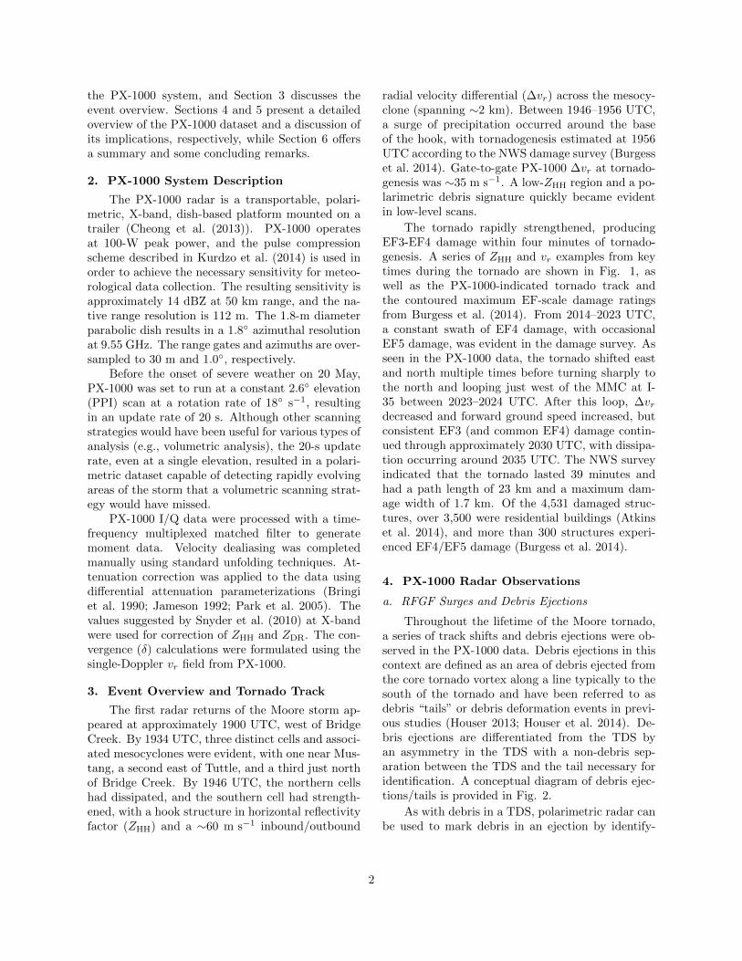
the PX-1000 system, and Section 3 discusses theevent overview. Sections 4 and 5 present a detailedoverview of the PX-1000 dataset and a discussion ofits implications, respectively, while Section 6 offersa summary and some concluding remarks.
2. PX-1000 System Description
The PX-1000 radar is a transportable, polari-metric, X-band, dish-based platform mounted on atrailer (Cheong et al. (2013)). PX-1000 operatesat 100-W peak power, and the pulse compressionscheme described in Kurdzo et al. (2014) is used inorder to achieve the necessary sensitivity for meteo-rological data collection. The resulting sensitivity isapproximately 14 dBZ at 50 km range, and the na-tive range resolution is 112 m. The 1.8-m diameterparabolic dish results in a 1.8◦ azimuthal resolutionat 9.55 GHz. The range gates and azimuths are over-sampled to 30 m and 1.0◦, respectively.
Before the onset of severe weather on 20 May,PX-1000 was set to run at a constant 2.6◦ elevation(PPI) scan at a rotation rate of 18◦ s−1, resultingin an update rate of 20 s. Although other scanningstrategies would have been useful for various types ofanalysis (e.g., volumetric analysis), the 20-s updaterate, even at a single elevation, resulted in a polari-metric dataset capable of detecting rapidly evolvingareas of the storm that a volumetric scanning strat-egy would have missed.
PX-1000 I/Q data were processed with a time-frequency multiplexed matched filter to generatemoment data. Velocity dealiasing was completedmanually using standard unfolding techniques. At-tenuation correction was applied to the data usingdifferential attenuation parameterizations (Bringiet al. 1990; Jameson 1992; Park et al. 2005). Thevalues suggested by Snyder et al. (2010) at X-bandwere used for correction of ZHH and ZDR. The con-vergence (δ) calculations were formulated using thesingle-Doppler vr field from PX-1000.
3. Event Overview and Tornado Track
The first radar returns of the Moore storm ap-peared at approximately 1900 UTC, west of BridgeCreek. By 1934 UTC, three distinct cells and associ-ated mesocyclones were evident, with one near Mus-tang, a second east of Tuttle, and a third just northof Bridge Creek. By 1946 UTC, the northern cellshad dissipated, and the southern cell had strength-ened, with a hook structure in horizontal reflectivityfactor (ZHH) and a ∼60 m s−1 inbound/outbound
radial velocity differential (∆vr) across the mesocy-clone (spanning ∼2 km). Between 1946–1956 UTC,a surge of precipitation occurred around the baseof the hook, with tornadogenesis estimated at 1956UTC according to the NWS damage survey (Burgesset al. 2014). Gate-to-gate PX-1000 ∆vr at tornado-genesis was ∼35 m s−1. A low-ZHH region and a po-larimetric debris signature quickly became evidentin low-level scans.
The tornado rapidly strengthened, producingEF3-EF4 damage within four minutes of tornado-genesis. A series of ZHH and vr examples from keytimes during the tornado are shown in Fig. 1, aswell as the PX-1000-indicated tornado track andthe contoured maximum EF-scale damage ratingsfrom Burgess et al. (2014). From 2014–2023 UTC,a constant swath of EF4 damage, with occasionalEF5 damage, was evident in the damage survey. Asseen in the PX-1000 data, the tornado shifted eastand north multiple times before turning sharply tothe north and looping just west of the MMC at I-35 between 2023–2024 UTC. After this loop, ∆vrdecreased and forward ground speed increased, butconsistent EF3 (and common EF4) damage contin-ued through approximately 2030 UTC, with dissipa-tion occurring around 2035 UTC. The NWS surveyindicated that the tornado lasted 39 minutes andhad a path length of 23 km and a maximum dam-age width of 1.7 km. Of the 4,531 damaged struc-tures, over 3,500 were residential buildings (Atkinset al. 2014), and more than 300 structures experi-enced EF4/EF5 damage (Burgess et al. 2014).
4. PX-1000 Radar Observations
a. RFGF Surges and Debris Ejections
Throughout the lifetime of the Moore tornado,a series of track shifts and debris ejections were ob-served in the PX-1000 data. Debris ejections in thiscontext are defined as an area of debris ejected fromthe core tornado vortex along a line typically to thesouth of the tornado and have been referred to asdebris “tails” or debris deformation events in previ-ous studies (Houser 2013; Houser et al. 2014). De-bris ejections are differentiated from the TDS byan asymmetry in the TDS with a non-debris sep-aration between the TDS and the tail necessary foridentification. A conceptual diagram of debris ejec-tions/tails is provided in Fig. 2.
As with debris in a TDS, polarimetric radar canbe used to mark debris in an ejection by identify-
2

Fig. 1. EF-scale damage ratings (colored shading, from Burgess et al. (2014)), vortex center track fromPX-1000 ∆vr data (dotted black line), PX-1000 observation times (black dots), and sample ZHH and vr datafrom different times/locations along the tornado track shown in top/bottom frames (denoted by circles andtimes A-H).
3
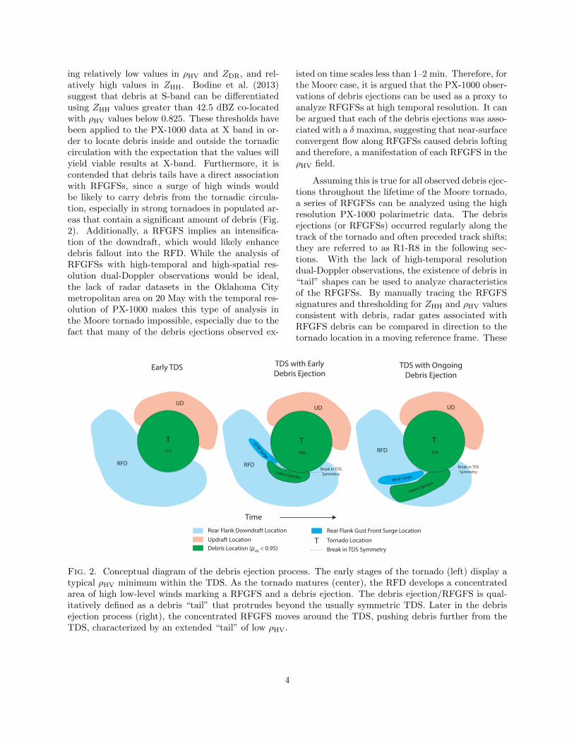
ing relatively low values in ρHV and ZDR, and rel-atively high values in ZHH. Bodine et al. (2013)suggest that debris at S-band can be differentiatedusing ZHH values greater than 42.5 dBZ co-locatedwith ρHV values below 0.825. These thresholds havebeen applied to the PX-1000 data at X band in or-der to locate debris inside and outside the tornadiccirculation with the expectation that the values willyield viable results at X-band. Furthermore, it iscontended that debris tails have a direct associationwith RFGFSs, since a surge of high winds wouldbe likely to carry debris from the tornadic circula-tion, especially in strong tornadoes in populated ar-eas that contain a significant amount of debris (Fig.2). Additionally, a RFGFS implies an intensifica-tion of the downdraft, which would likely enhancedebris fallout into the RFD. While the analysis ofRFGFSs with high-temporal and high-spatial res-olution dual-Doppler observations would be ideal,the lack of radar datasets in the Oklahoma Citymetropolitan area on 20 May with the temporal res-olution of PX-1000 makes this type of analysis inthe Moore tornado impossible, especially due to thefact that many of the debris ejections observed ex-
isted on time scales less than 1–2 min. Therefore, forthe Moore case, it is argued that the PX-1000 obser-vations of debris ejections can be used as a proxy toanalyze RFGFSs at high temporal resolution. It canbe argued that each of the debris ejections was asso-ciated with a δ maxima, suggesting that near-surfaceconvergent flow along RFGFSs caused debris loftingand therefore, a manifestation of each RFGFS in theρHV field.
Assuming this is true for all observed debris ejec-tions throughout the lifetime of the Moore tornado,a series of RFGFSs can be analyzed using the highresolution PX-1000 polarimetric data. The debrisejections (or RFGFSs) occurred regularly along thetrack of the tornado and often preceded track shifts;they are referred to as R1-R8 in the following sec-tions. With the lack of high-temporal resolutiondual-Doppler observations, the existence of debris in“tail” shapes can be used to analyze characteristicsof the RFGFSs. By manually tracing the RFGFSsignatures and thresholding for ZHH and ρHV valuesconsistent with debris, radar gates associated withRFGFS debris can be compared in direction to thetornado location in a moving reference frame. These
UD
T
Break in TDS
Symmetry
Debris Ejection
Early TDS TDS with Early
Debris EjectionTDS with Ongoing
Debris Ejection
Rear Flank Downdraft Location
Updraft Location
Debris Location (ρHV
< 0.95)
Tornado Location
Break in TDS Symmetry
T
Time
UD
RFD
T
RFD
RFGF Surge
TDS TDS
Rear Flank Gust Front Surge Location
UD
T
Break in TDS
SymmetryDebris Ejection
RFD
RFGF Surge
TDS
Fig. 2. Conceptual diagram of the debris ejection process. The early stages of the tornado (left) display atypical ρHV minimum within the TDS. As the tornado matures (center), the RFD develops a concentratedarea of high low-level winds marking a RFGFS and a debris ejection. The debris ejection/RFGFS is qual-itatively defined as a debris “tail” that protrudes beyond the usually symmetric TDS. Later in the debrisejection process (right), the concentrated RFGFS moves around the TDS, pushing debris further from theTDS, characterized by an extended “tail” of low ρHV.
4
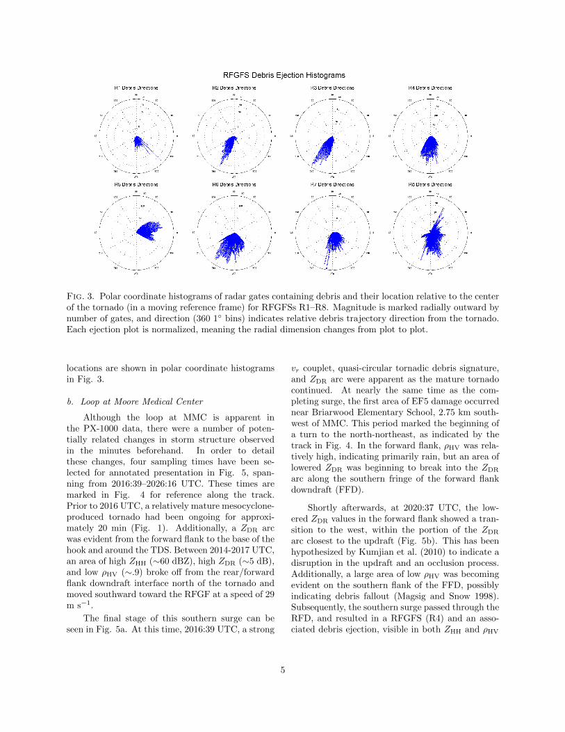
Fig. 3. Polar coordinate histograms of radar gates containing debris and their location relative to the centerof the tornado (in a moving reference frame) for RFGFSs R1–R8. Magnitude is marked radially outward bynumber of gates, and direction (360 1◦ bins) indicates relative debris trajectory direction from the tornado.Each ejection plot is normalized, meaning the radial dimension changes from plot to plot.
locations are shown in polar coordinate histogramsin Fig. 3.
b. Loop at Moore Medical Center
Although the loop at MMC is apparent inthe PX-1000 data, there were a number of poten-tially related changes in storm structure observedin the minutes beforehand. In order to detailthese changes, four sampling times have been se-lected for annotated presentation in Fig. 5, span-ning from 2016:39–2026:16 UTC. These times aremarked in Fig. 4 for reference along the track.Prior to 2016 UTC, a relatively mature mesocyclone-produced tornado had been ongoing for approxi-mately 20 min (Fig. 1). Additionally, a ZDR arcwas evident from the forward flank to the base of thehook and around the TDS. Between 2014-2017 UTC,an area of high ZHH (∼60 dBZ), high ZDR (∼5 dB),and low ρHV (∼.9) broke off from the rear/forwardflank downdraft interface north of the tornado andmoved southward toward the RFGF at a speed of 29m s−1.
The final stage of this southern surge can beseen in Fig. 5a. At this time, 2016:39 UTC, a strong
vr couplet, quasi-circular tornadic debris signature,and ZDR arc were apparent as the mature tornadocontinued. At nearly the same time as the com-pleting surge, the first area of EF5 damage occurrednear Briarwood Elementary School, 2.75 km south-west of MMC. This period marked the beginning ofa turn to the north-northeast, as indicated by thetrack in Fig. 4. In the forward flank, ρHV was rela-tively high, indicating primarily rain, but an area oflowered ZDR was beginning to break into the ZDR
arc along the southern fringe of the forward flankdowndraft (FFD).
Shortly afterwards, at 2020:37 UTC, the low-ered ZDR values in the forward flank showed a tran-sition to the west, within the portion of the ZDR
arc closest to the updraft (Fig. 5b). This has beenhypothesized by Kumjian et al. (2010) to indicate adisruption in the updraft and an occlusion process.Additionally, a large area of low ρHV was becomingevident on the southern flank of the FFD, possiblyindicating debris fallout (Magsig and Snow 1998).Subsequently, the southern surge passed through theRFD, and resulted in a RFGFS (R4) and an asso-ciated debris ejection, visible in both ZHH and ρHV
5
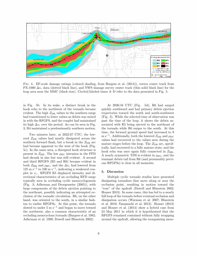
Fig. 4. EF-scale damage ratings (colored shading, from Burgess et al. (2014)), vortex center track fromPX-1000 ∆vr data (dotted black line), and NWS damage survey center track (thin solid black line) for theloop area near the MMC (black star). Circled/labeled times A–D refer to the data presented in Fig. 5.
in Fig. 5b. In its wake, a distinct break in thehook echo to the northwest of the tornado becameevident. The high ZDR values in the southern surgehad transitioned to lower values as debris was mixedin with the RFGFS, and the couplet had maintainedits high ∆vr over the period. As can be seen in Fig.3, R4 maintained a predominantly southern motion.
Two minutes later, at 2022:37 UTC, the low-ered ZDR values had mostly dissipated across thesouthern forward flank, but a break in the ZDR archad become apparent to the west of the hook (Fig.5c). In the same area, a disrupted hook structure ispresent in ZHH. The low ρHV intrusion in the FFDhad shrunk in size but was still evident. A secondand third RFGFS (R5 and R6) became evident inboth ZHH and ρHV, and the ∆vr had lowered from125 m s−1 to 100 m s−1, indicating a weakened cou-plet in vr. RFGFS R5 displayed intensity and di-rectional characteristics of an occluding RFD surgetypically seen in occluding cyclic mesocyclogenesis(Fig. 3; Adlerman and Droegemeier (2005)), withlarge components of the debris ejection pointing tothe northeast, possibly indicating an attempted oc-clusion of the tornadic circulation. R6, on the otherhand, was oriented to the south, in a similar fash-ion to earlier RFGFSs. At this point, the tornadoslowed to under 5 m s−1 and began to move towardthe northwest, also a common characteristic of anoccluding mesocyclone/tornado (Burgess et al. 1982;Adlerman et al. 1999; Dowell and Bluestein 2002).
At 2026:16 UTC (Fig. 5d), R6 had surgedquickly southward and had primary debris ejectiontrajectories toward the south and south-southwest(Fig. 3). While the selected time of observation waspast the time of the loop, it shows the debris as-sociated with R5 being ejected to the northeast ofthe tornado while R6 surges to the south. At thistime, the forward ground speed had increased to 9m s−1. Additionally, both the lowered ZDR and ρHV
values had recovered to the values seen during themature stages before the loop. The ZDR arc, specif-ically, had recovered to a fully mature state, and thehook echo was once again fully connected in ZHH.A nearly symmetric TDS is evident in ρHV, and theremnant debris tail from R6 (and presumably previ-ous RFGFSs) is clear in all moments.
5. Discussion
Multiple cyclic tornado studies have presenteddissipating tornadoes that move along or near theocclusion point, resulting in motion toward the“rear” of the updraft (Dowell and Bluestein 2002;Houser 2013). In some cases, this has led to a nearlyfull loop of the tornado before eventual occlusion anddissipation occurs (Wurman et al. 2007; Bluesteinet al. 2010; Tanamachi et al. 2012). Houser (2013)and Houser et al. (2014) show a hybrid case from24 May 2011 in which it is hypothesized that theRFGFS remained contained without fully wrappingaround the updraft, allowing the reorganizing meso-
6
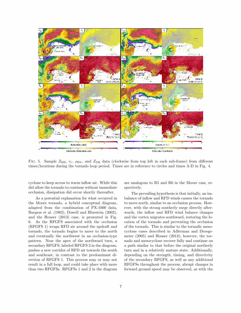
Fig. 5. Sample ZHH, vr, ρHV, and ZDR data (clockwise from top left in each sub-frame) from differenttimes/locations during the tornado loop period. Times are in reference to circles and times A-D in Fig. 4.
cyclone to keep access to warm inflow air. While thisdid allow the tornado to continue without immediateocclusion, dissipation did occur shortly thereafter.
As a potential explanation for what occurred inthe Moore tornado, a hybrid conceptual diagram,adapted from the combination of PX-1000 data,Burgess et al. (1982), Dowell and Bluestein (2002),and the Houser (2013) case, is presented in Fig.6. As the RFGFS associated with the occlusion(RFGFS 1) wraps RFD air around the updraft andtornado, the tornado begins to move to the northand eventually the northwest in an occlusion-typepattern. Near the apex of the northward turn, asecondary RFGFS, labeled RFGFS 2 in the diagram,pushes a new corridor of RFD air towards the southand southeast, in contrast to the predominant di-rection of RFGFS 1. This process may or may notresult in a full loop, and could take place with morethan two RFGFSs. RFGFSs 1 and 2 in the diagram
are analogous to R5 and R6 in the Moore case, re-spectively.
The prevailing hypothesis is that initially, an im-balance of inflow and RFD winds causes the tornadoto move north, similar to an occlusion process. How-ever, with the strong southerly surge directly after-wards, the inflow and RFD wind balance changesand the vortex migrates southward, restoring the lo-cation of the tornado and preventing the occlusionof the tornado. This is similar to the tornadic meso-cyclone cases described in Adlerman and Droege-meier (2005) and Houser (2013); however, the tor-nado and mesocyclone recover fully and continue ona path similar to that before the original northerlyturn and in a relatively mature state. Additionally,depending on the strength, timing, and directivityof the secondary RFGFS, as well as any additionalRFGFSs throughout the process, abrupt changes inforward ground speed may be observed, as with the
7
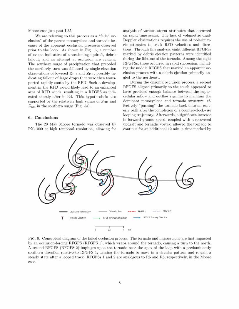
Moore case just past I-35.
We are referring to this process as a “failed oc-clusion” of the parent mesocyclone and tornado be-cause of the apparent occlusion processes observedprior to the loop. As shown in Fig. 5, a numberof events indicative of a weakening updraft, debrisfallout, and an attempt at occlusion are evident.The southern surge of precipitation that precededthe northerly turn was followed by single-elevationobservations of lowered ZHH and ZDR, possibly in-dicating fallout of large drops that were then trans-ported rapidly south by the RFD. Such a develop-ment in the RFD would likely lead to an enhancedarea of RFD winds, resulting in a RFGFS as indi-cated shortly after in R4. This hypothesis is alsosupported by the relatively high values of ZHH andZDR in the southern surge (Fig. 5a).
6. Conclusions
The 20 May Moore tornado was observed byPX-1000 at high temporal resolution, allowing for
analysis of various storm attributes that occurredon rapid time scales. The lack of volumetric dual-Doppler observations requires the use of polarimet-ric estimates to track RFD velocities and direc-tions. Through this analysis, eight different RFGFSsmarked by debris ejection patterns were identifiedduring the lifetime of the tornado. Among the eightRFGFSs, three occurred in rapid succession, includ-ing the middle RFGFS that marked an apparent oc-clusion process with a debris ejection primarily an-gled to the northeast.
During the ongoing occlusion process, a secondRFGFS aligned primarily to the south appeared tohave provided enough balance between the super-cellular inflow and outflow regimes to maintain thedominant mesocyclone and tornado structure, ef-fectively “pushing” the tornado back onto an east-erly path after the completion of a counter-clockwiselooping trajectory. Afterwards, a significant increasein forward ground speed, coupled with a recoveredupdraft and tornadic vortex, allowed the tornado tocontinue for an additional 12 min, a time marked by
T
T
T
T
T T
T
Low-Level Re!ectivity Tornado Path RFGFS 1 RFGFS 2
RFGF 1 Primary Direction RFGF 2 Primary DirectionTornado Location
0 0.5 1 km
Fig. 6. Conceptual diagram of the failed occlusion process. The tornado and mesocyclone are first impactedby an occlusion-forcing RFGFS (RFGFS 1), which wraps around the tornado, causing a turn to the north.A second RFGFS (RFGFS 2) impinges upon the tornado near the apex of the loop with a predominantlysouthern direction relative to RFGFS 1, causing the tornado to move in a circular pattern and re-gain asteady state after a looped track. RFGFSs 1 and 2 are analogous to R5 and R6, respectively, in the Moorecase.
8
consistent EF3 and common EF4 damage. This pro-cess, referred to as a failed occlusion, is thought tohave been a result of a hybrid cyclic RFD process notyet seen in the literature. This hypothesis does nottake into account thermodynamic data (which arenot available for the storm in question), but servesas one possible explanation for the observations.
Acknowledgments.
This work was supported by the National Sci-ence Foundation under grant AGS1303685. The au-thors would like to thank Don Burgess and Jeff Sny-der for their detailed review of the dataset and analy-sis techniques. Greg Stumpf, Rick Smith, and GabeGarfield provided valuable discussions regarding theNWS damage survey of the 20 May Moore tornado.
REFERENCES
Adlerman, E. J. and K. K. Droegemeier, 2005: Thedependence of numerically simulated cyclic meso-cyclogenesis upon environmental vertical windshear. Mon. Wea. Rev., 133 (12), 3595–3623.
Adlerman, E. J., K. K. Droegemeier, and R. Davies-Jones, 1999: A numerical simulation of cyclicmesocyclogenesis. J. Atmos. Sci., 56 (13), 2045–2069.
Atkins, N. T., K. M. Butler, K. R. Flynn, and R. M.Wakimoto, 2014: An integrated damage, visual,and radar analysis of the 2013 Moore OklahomaEF5 tornado. Bull. Amer. Meteor. Soc., in press.
Bluestein, H. B., M. M. French, I. PopStefanija,R. T. Bluth, and J. B. Knorr, 2010: A mobile,phased-array Doppler radar for the study of se-vere convective storms. Bull. Amer. Meteor. Soc.,91 (5), 579–600.
Bodine, D. J., M. R. Kumjian, R. D. Palmer, P. L.Heinselman, and A. V. Ryzhkov, 2013: Tornadodamage estimation using polarimetric radar. Wea.Forecasting, 28 (1), 139–158.
Bringi, V. N., V. Chandrasekar, N. Balakrishnan,and D. S. Zrnic, 1990: An examination of propa-gation effects in rainfall on radar measurements atmicrowave frequencies. J. Atmos. Oceanic Tech-nol., 7, 829–840.
Burgess, D., et al., 2014: 20 May 2013 Moore, Okla-homa tornado: Damage survey and analysis. Wea.Forecasting, 29 (5), 1229–1237.
Burgess, D. W., V. T. Wood, and R. A. Brown, 1982:Mesocyclone evolution statistics. Preprints, 12thConf. on Severe Local Storms, San Antonio, TX,Amer. Meteor. Soc., 422–424.
Cheong, B. L., R. Kelley, R. D. Palmer, Y. Zhang,M. Yeary, and T.-Y. Yu, 2013: PX-1000: Asolid-state polarimetric X-band weather radar andtime-frequency multiplexed waveform for blindrange mitigation. IEEE Trans. Instrum. Meas.,62 (11), 3064–3072.
Dowell, D. C. and H. B. Bluestein, 2002: The 8June 1995 Mclean, Texas, storm. Part I: Obser-vations of cyclic tornadogenesis. Mon. Wea. Rev.,130 (11), 2626–2648.
Finley, C. A. and B. D. Lee, 2004: High resolutionmobile mesonet observations of RFD surges in theJune 9 Basset, Nebraska supercell during ProjectANSWERS 2003. Preprints, 22nd Conf. on SevereLocal Storms, Hyannis, MA, Amer. Meteor. Soc.,P11.3.
Houser, J. B., 2013: Observations of supercell tor-nado evolution using a mobile, rapid-scan, X-bandradar. Ph.D. thesis, University of Oklahoma.
Houser, J. B., H. B. Bluestein, and J. C. Snyder,2014: Rapid-scan, polarimetric, Doppler-radarobservations of tornadogenesis and tornado dissi-pation in a tornadic supercell: The “El Reno, Ok-lahoma” storm of 24 May 2011. Mon. Wea. Rev.,accepted pending revisions.
Jameson, A. R., 1992: The effect of temperature onattenuation-correction schemes in rain using po-larization propagation differential phase shift. J.Appl. Meteor., 31 (9), 1106–1118.
Kumjian, M. R., A. V. Ryzhkov, V. M. Mel-nikov, and T. J. Schuur, 2010: Rapid-scan super-resolution observations of a cyclic supercell witha dual-polarization WSR-88D. Mon. Wea. Rev.,138 (10), 3762–3786.
Kurdzo, J. M., B. L. Cheong, R. D. Palmer,G. Zhang, and J. Meier, 2014: A pulse compres-sion waveform for improved-sensitivity weatherradar observations. J. Atmos. Oceanic Technol.,in press.
9
Magsig, M. A. and J. T. Snow, 1998: Long-distancedebris transport by tornadic thunderstorms. PartI: The 7 May 1995 supercell thunderstorm. Mon.Wea. Rev., 126 (6), 1430–1449.
Park, S. G., V. N. Bringi, V. Chandrasekar,M. Maki, and K. Iwanami, 2005: Correction ofradar reflectivity and differential reflectivity forrain attenuation at X band. Part I: Theoreticaland empirical basis. J. Atmos. Oceanic Technol.,22, 1621–1632.
Ryzhkov, A., D. Burgess, D. Zrnic, T. Smith, andS. Giangrande, 2002: Polarimetric analysis of a 3May 1999 tornado. Preprints, 21st Conf. on Se-vere Local Storms, San Antonio, TX, Amer. Me-teor. Soc., 14.2.
Ryzhkov, A. V., T. J. Schurr, D. W. Burgess, andD. Zrnic, 2005: Polarimetric tornado detection. J.Appl. Meteor. Climatol., 44, 557–570.
Skinner, P. S., C. C. Weiss, M. M. French, H. B.Bluestein, P. M. Markowski, and Y. P. Richard-son, 2014: VORTEX2 observations of a low-level mesocyclone with multiple internal rear-flank downdraft momentum surges in the 18 May2010, Dumas, Texas supercell. Mon. Wea. Rev.,142 (8), 2935–2960.
Snyder, J. C., H. B. Bluestein, G. Zhang, andS. J. Frasier, 2010: Attenuation correction andhydrometeor classification of high-resolution, X-band, dual-polarized mobile radar measurementsin severe convective storms. J. Atmos. OceanicTechnol., 27 (12), 1979–2001.
Tanamachi, R. L., H. B. Bluestein, J. B. Houser,S. J. Frasier, and K. M. Hardwick, 2012: Mobile,X-band, polarimetric Doppler radar observationsof the 4 May 2007 Greensburg, Kansas, tornadicsupercell. Mon. Wea. Rev., 140 (7), 2103–2125.
Wurman, J., Y. Richardson, C. Alexander, S. Wey-gandt, and P. F. Zhang, 2007: Dual-Doppler andsingle-Doppler analysis of a tornadic storm under-going mergers and repeated tornadogenesis. Mon.Wea. Rev., 135 (3), 736–758.
10
Copyright © 2022 FDOKUMEN