HGS Bulletin Volume 47 No.8 (April 2005) - Houston ...
72
Volume 47 Number 8 HGS H O U S T O N G E O L O G I C A L 1923 B ulletin Houston Geological Society April 2005 The Trident Discovery: Play Opener of the Perdido Foldbelt, Deepwater Northwestern Gulf of Mexico Page 23 Thrust Faulted Ridge Slide Scar Thrust Faulted Ridge Plate Boundary Canyon Indian Ocean Seafloor near the Site of the December 26, 2004 Sumatra Earthquake
-
Upload
khangminh22 -
Category
Documents
-
view
1 -
download
0
Transcript of HGS Bulletin Volume 47 No.8 (April 2005) - Houston ...

Volume 47 Number 8
HGSHO
US
T
ON
GEOLOG
ICA
L
1923 BulletinHouston Geological Society
April 2005
The Trident Discovery:Play Opener of thePerdido Foldbelt,
Deepwater NorthwesternGulf of Mexico
Page 23
Thrust Faulted Ridge
Slide Scar
Thrust FaultedRidge
PlateBoundary
Canyo
n
Indian Ocean Seafloornear the Site of the
December 26, 2004Sumatra Earthquake
\

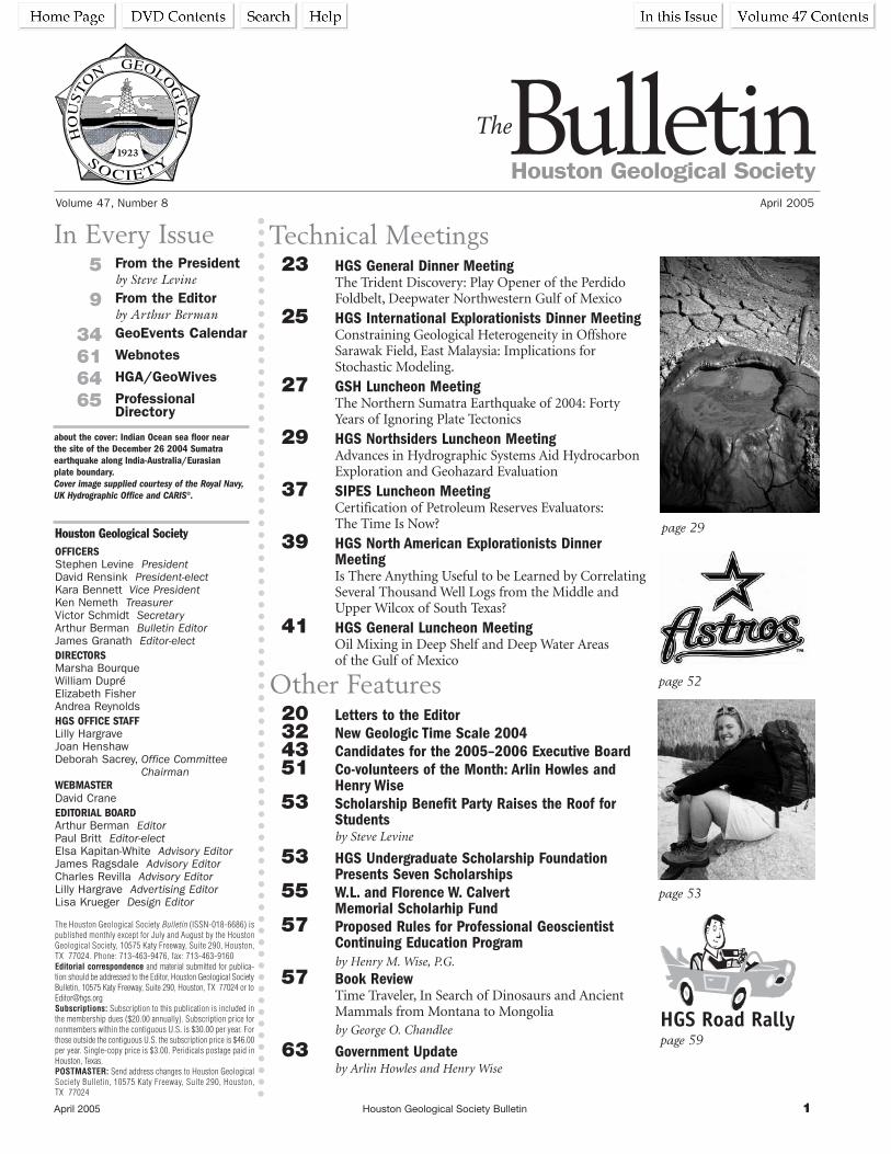
April 2005 Houston Geological Society Bulletin 1
HO
US
TO
NGEOLO
GIC
AL
1923
Volume 47, Number 8 April 2005
Houston Geological SocietyBulletinThe
In Every Issue5 From the President
by Steve Levine
9 From the Editor by Arthur Berman
34 GeoEvents Calendar
61 Webnotes
64 HGA/GeoWives
65 Professional Directory
Technical Meetings23 HGS General Dinner Meeting
The Trident Discovery: Play Opener of the PerdidoFoldbelt, Deepwater Northwestern Gulf of Mexico
25 HGS International Explorationists Dinner MeetingConstraining Geological Heterogeneity in OffshoreSarawak Field, East Malaysia: Implications forStochastic Modeling.
27 GSH Luncheon MeetingThe Northern Sumatra Earthquake of 2004: FortyYears of Ignoring Plate Tectonics
29 HGS Northsiders Luncheon MeetingAdvances in Hydrographic Systems Aid HydrocarbonExploration and Geohazard Evaluation
37 SIPES Luncheon MeetingCertification of Petroleum Reserves Evaluators:The Time Is Now?
39 HGS North American Explorationists DinnerMeetingIs There Anything Useful to be Learned by CorrelatingSeveral Thousand Well Logs from the Middle andUpper Wilcox of South Texas?
41 HGS General Luncheon MeetingOil Mixing in Deep Shelf and Deep Water Areas of the Gulf of Mexico
Other Features20 Letters to the Editor32 New Geologic Time Scale 200443 Candidates for the 2005–2006 Executive Board51 Co-volunteers of the Month: Arlin Howles and
Henry Wise 53 Scholarship Benefit Party Raises the Roof for
Studentsby Steve Levine
53 HGS Undergraduate Scholarship Foundation Presents Seven Scholarships
55 W.L. and Florence W. Calvert Memorial Scholarhip Fund
57 Proposed Rules for Professional GeoscientistContinuing Education Programby Henry M. Wise, P.G.
57 Book Review Time Traveler, In Search of Dinosaurs and AncientMammals from Montana to Mongoliaby George O. Chandlee
63 Government Update by Arlin Howles and Henry Wise
page 52
page 53
page 59
page 29Houston Geological SocietyOFFICERSStephen Levine PresidentDavid Rensink President-electKara Bennett Vice PresidentKen Nemeth TreasurerVictor Schmidt SecretaryArthur Berman Bulletin EditorJames Granath Editor-electDIRECTORSMarsha BourqueWilliam DupréElizabeth Fisher Andrea Reynolds HGS OFFICE STAFFLilly HargraveJoan HenshawDeborah Sacrey, Office Committee
ChairmanWEBMASTERDavid CraneEDITORIAL BOARDArthur Berman EditorPaul Britt Editor-electElsa Kapitan-White Advisory EditorJames Ragsdale Advisory EditorCharles Revilla Advisory EditorLilly Hargrave Advertising EditorLisa Krueger Design Editor
The Houston Geological Society Bulletin (ISSN-018-6686) is published monthly except for July and August by the HoustonGeological Society, 10575 Katy Freeway, Suite 290, Houston, TX 77024. Phone: 713-463-9476, fax: 713-463-9160Editorial correspondence and material submitted for publica-tion should be addressed to the Editor, Houston Geological SocietyBulletin, 10575 Katy Freeway, Suite 290, Houston, TX 77024 or [email protected]: Subscription to this publication is included inthe membership dues ($20.00 annually). Subscription price fornonmembers within the contiguous U.S. is $30.00 per year. Forthose outside the contiguous U.S. the subscription price is $46.00per year. Single-copy price is $3.00. Peridicals postage paid inHouston, Texas.POSTMASTER: Send address changes to Houston GeologicalSociety Bulletin, 10575 Katy Freeway, Suite 290, Houston, TX 77024
about the cover: Indian Ocean sea floor near the site of the December 26 2004 Sumatraearthquake along India-Australia/Eurasian plate boundary.Cover image supplied courtesy of the Royal Navy,UK Hydrographic Office and CARIS©.

2 Houston Geological Society Bulletin April 2005

April 2005 Houston Geological Society Bulletin 3
Board of Directors 2004–05http://www.hgs.org/about_hgs/leadership.asp
President (P) Steve Levine Conoco Phillips 281-293-3896 [email protected] (PE) Dave Rensink Apache Corp. 713-296-6332 [email protected] (VP) Kara Bennett Pratt Geosciences 832-452-3747 [email protected] (T) Ken Nemeth Schlumberger 713-513-2327 [email protected] (S) Victor Schmidt Offshore Magazine 713-963-6217 [email protected] (E) Arthur Berman Petroleum Reports.com 713-557-9076 [email protected] Jim Granath Granath & Associates 281-558-3783 [email protected] 03–05 (Dl) Marsha Bourque Consultant 713-789-9525 [email protected] 03–05 (D2) Andrea Reynolds Shell International E&P 281-544-2481 [email protected] 04–06 (D3) Elizabeth Fisher Fugro-Jason 281-859-5377 [email protected] 04–06 (D4) Bill Dupré University of Houston 713-723-8490 [email protected]
Committee Chairperson Phone Email Board Rep. AAPG Delegate Foreman Tom McCarroll 832-366-1623 [email protected] D1Academic Liaison Sherrie Cronin 832-636-3113 [email protected] D1
Alison Henning 713-868-5755 [email protected] Lilly Hargrave 713-463-9476 [email protected] EAdvisory John Biancardi 713-528-1460 [email protected] PArrangements Lee Boatner 713-586-5728 [email protected] VPAwards Mike Deming 281-589-6093 [email protected] D1Ballot Don Scherer 713-723-8484 [email protected] PCalvert Fund Carl Norman 713-461-7420 [email protected] PEContinuing Ed Jonathan Jee 281-391-8362 [email protected] D3Directory Dean Gilbert 281-448-6188 [email protected] TEEarth Sc. Wk-ESW Gen. Martha McRae 713-869-2045 [email protected] D3Earth Sc. Wk-Logistics Jennifer Burton 832-636-8357 [email protected] D3Emerging Technology James Brenneke 713-789-2444 [email protected] VPEng. Council of Houston Claudia Ludwig 713-723-2511 [email protected] D1Eng. Council of Houston Richard Howe 713-467-2900 [email protected] D1Env. & Eng. Geology Bruce Woodhouse 281-600-1095 [email protected] VPExhibits Mac McKinney 281-353-0661 [email protected] D2Field Trips Howard White 281-618-6058 [email protected] D3Finance Cheryl Desforges 713-816-9202 [email protected] TFishing Tournament Bobby Perez 281-240-1234 [email protected] D2Foundation John Adamick 713-860-2114 [email protected] PEFund RaisingGlobal Climate Change Jeffrey Lund 713-960-0971 [email protected] D1Golf Tournament Allan Filipov 281-275-7649 [email protected] D4Government Affairs Arlin Howles 281-808-8629 [email protected] D2
Henry Wise 281-867-9131 [email protected] Night Linda Sternbach 713-953-7849 [email protected] D4HistoricalHouston Energy Council Sandi Barber 281-366-3014 [email protected] PHouston Geol. Auxiliary Sally Blackhall 281-370-7807 [email protected] PE
Margaret Eisenhardt Jones 281-558-3171 [email protected] PEInternational Ex. Chair Steve Henry 281-556-9276 [email protected] VPInternational Ex. Co-Chair Al Danforth 713-780-8622 [email protected] VPInternational Ex. Programs Ian Poyntz 281-587-9985 [email protected] VPLibrary Bill Anderson 713-333-5217 [email protected] D3Membership Matt Bognar 832-351-8510 [email protected] SMuseum of Nat. Sc. Inda Immega 713-661-3494 [email protected] D3N. American Expl. Steve Earle 713-840-1980 [email protected] VPNeoGeos Natalie Uschner 713-513-2300 ext. 5923 [email protected] VPNew Publications Tom Fiorito 713-275-7711 [email protected] D4
Bill Rizer 832-252-6141 [email protected] D4Nominations Craig Dingler 281-930-2394 [email protected] PNorthSiders Frank Walles 281-673-6055 [email protected] VP
Gary Coburn 281-782-7021 [email protected] VPOffice Management Deborah Sacrey 713-812-0588 [email protected] PEPersonnel Placement Mike Cline 713-665-5449 [email protected] D2Public Relations Valdis Budrevics 281-543-6740 [email protected] D1Publication Sales Tom Mather 281-556-9539 [email protected] SRemembrances Bill Robbins 713-647-3506 [email protected] SScouting George Krapfel 713-989-7433 [email protected] D2Shrimp Peel Lee Shelton 832-351-8814 [email protected] D4Skeet Shoot Tom McCarroll 832-366-1623 [email protected] D4Tennis Tournament Ross Davis 713-659-3131 [email protected] D3Vendor’s Corner Joe Lynch 713-839-2921 [email protected] TEWebsite Bill Osten 281-293-3160 [email protected] D2

4 Houston Geological Society Bulletin April 2005
Any laboratorAny laboratory can generate data from core samples. Buty can generate data from core samples. Butwhen that data is being used to determine your company’when that data is being used to determine your company’ssnext move, it had better be accurate.next move, it had better be accurate.
At OMNI Laboratories, we have refined the scienceAt OMNI Laboratories, we have refined the scienceof gathering information from core and we have sharpenedof gathering information from core and we have sharpenedthe art of evaluating it. Our facilities are on the cutting edgethe art of evaluating it. Our facilities are on the cutting edge..Our proprietarOur proprietary technologies provide comprehensive profilesy technologies provide comprehensive profilesof rocks and reserof rocks and reservoirs. And our staff of scientists is simplyvoirs. And our staff of scientists is simplyunsurpassed.unsurpassed.
The result? YThe result? You get precise data plus trustworthyou get precise data plus trustworthyinterpretations. So that the decision you make…the directioninterpretations. So that the decision you make…the directionyou take…is exactly where you need to go.you take…is exactly where you need to go.
At OMNI, WAt OMNI, We’ve Got The Answers.e’ve Got The Answers.
Data Determines Direction.Data Determines Direction.
How good is yours?How good is yours?
Eight locations in the U.S. and South America • Headquarters: Houston, TX • 832-237-4000 • www.omnilabs.com

April 2005 Houston Geological Society Bulletin 5
President’sLetterby Steve Levine
Courtbouillon (coo-be-yon) to those unfortunate few uniniti-
ated in Louisiana cuisine, is a spicy soup or stew made with
fish fillets (redfish, red snapper, catfish, etc.), tomatoes, onions,
and vegetables. The cook must first prepare a fine roux of
vegetable oil and flour in a large heavy skillet. Add onions, fresh
vegetables, pepper, salt, other spices and keeps stirring. Let it
simmer for 1 to 2 hours before adding the fish filets. Continue
cooking on low heat until the fish is done. Courtbouillon is
served with white rice or mashed potatoes. Great redfish court-
bouillon is hard to beat. Two things are for certain—it is essential
that someone keeps a close eye on that skillet at all times, and that
the ingredients are fresh.
The Houston Geological Society works with a
variety of ingredients as well. The HGS Board
is busy in the kitchen overseeing the skillet of
42 committees trying not to burn the roux or
let it simmer too long. We mull issues such as
the budget, website advancements, populating
the calendar, awards, Bulletin updates, office
needs, etc. Occasionally we have brief
moments to look away from the skillet to
modify the recipe (brainstorm), but generally
the best ideas come from the members at large
and from the committees themselves.
We are privileged that our skillet contains so many committees
that provide quality ingredients for our members. Please take a
few minutes to read about a few of these achievements and how
they have spiced up the HGS.
Continuing Education Committee The Continuing Education Committee has transformed itself in a
short time span from being “barely there” to an incredibly vibrant
group. Led early in the year by Jonathan Jee (prior to his transfer
to Malaysia) and currently by Cheryl Desforges, this team that
has organized 3 terrific short courses and has 2 more scheduled.
These include:
1. “The Petroleum Reserves-Avoiding Write-downs” Mini-series:
Part 1- “An Overview of Definitions and Reporting
Requirements” by John Hodgin and Thomas Wagenhofer
2. “The Petroleum Reserves-Avoiding Write-downs” Mini-series:
Part 2 - “An Overview of Recommended Geologic Practices” by
Dan Tearpock
3. “Rock-Based Integration: Geologic Interpretation of the
Integration of Seismic and Petrophysical Data” by Roger Young
and Gordon Van Swearingen
4. “An Overview of Recommended Engineering Practices” by Bill
Kazmann and Ed Travis (May 20)
5. “An Overview of Recommended Petrophysical Practices” by
Bill Price (Sept./Oct.)
Dick Easterwood of Dominion Exploration and Production
stepped forward to contribute funds for the
purchase of equipment for the HGS to tape
these and future continuing education courses.
Thomas Smith of Seismic Micro-Technology,
offered to sponsor the reproduction of the
DVDs, as well as to provide expertise of the
process. Fugro Jason also offered financial
backing, which we hope to utilize for the pur-
chase of additional equipment. HGS member
Mike Allison graciously volunteered to pro-
vide the labor and technical expertise to
produce the DVD. Mike has done a remarkable
job after many hours of toil to make the first of
the series of DVD’s. With these two financial offers, the DVD
preparation should produced at no cost to the HGS, so revenue
from the sale of the DVDs can be used for other HGS programs.
So if you missed these great short courses, the first of several
DVDs should be available for purchase at a bargain price by the
AAPG Convention in June.
Ad Hoc “Community Involvement” CommitteeAn ad hoc “Community Involvement” committee led by Cathy
Ferris was formed to generate ideas to expand our presence in the
community through service projects, further our interaction with
local K-12 students (in coordination with the Academic Liaison
Committee), and to identify social events that could cast a
larger net across our membership and to bring new members
into the fold.
Our Society Is Like a Courtbouillon
We are privileged
that our skillet contains
so many committees
that provide quality
ingredients for our
members.
President’s Letter continued on page 7

6 Houston Geological Society Bulletin April 2005
RPS Cambrian
For further details call (281) 877 9400 or visit us at www.rpsplc.com
RPS Energy, incorporating RPS Cambrian, RPS Hydrosearch and RPS TimeTrax,offers a wide range of added value solutions to the world-wide oil and gas industry.
Our expertise and experience, gained over 25 years, provides us with a solid foundation to part-ner with clients in support of their upstream activities.
Solutions for yourresourcing needs…

April 2005 Houston Geological Society Bulletin 7
President’s Letter continued from page 5 ________________________________________________________________________________________________________________________
1. Home repair projects to provide community service and to
make the HGS more visible in the community. The HGS will
assist in a “Keep 5 Alive” service project on Saturday, April 2
at the 177 year-old Evergreen Negro Cemetery with partners
ConocoPhillips and Wheatley High School senior students.
2. Social events such as sports or entertainments events such as
the “Rockets Night Out” held in March and the “HGS Astros
Night” scheduled for Thursday, April 21, are direct responses
to these recommendations.
3. Adding “K-12 Teacher Resources” to the HGS website to assist
in our partnership with local schools. Bill Osten is working
with our Webmaster Dave Crane to add this component.
4. Other ideas included sponsoring and running a field trip for
some Houston Area high school students and the HGS man-
ning a water stop for a selected Houston Area race such as the
Houston Marathon in January, 2006.
First Annual Scholarship Benefit The scholarship benefit committee worked very hard to make the
first Scholarship Benefit Party “Scholarship Rock Dance” held at
the Petroleum Club on February 5, 2005 a success. Preparations
required acquiring silent auction items, decorating, and selling
tickets. A total of $3500 was raised which will be matched by the
AAPG-GCAGS to bring our total to $7000 for the HGS
Foundation and W.L. Calvert Memorial scholarship funds. More
details of this event will be in the May Bulletin.
Below are just a few of the terrific volunteers from the above-
mentioned committees. Space does not allow me to mention the
many other worthwhile projects and committees that make our
spicy recipe one of best.
Continuing Education Committee: Cheryl Desforges, Mike
Allison, Jonathan Jee, Donna Davis, Henry Wise, George Klein,
Selim Shaker, Huw James, Edgar Guevara, Thomas Tucker, Dave
Hixon, Henry Wise, and Matthew Cowan
Ad Hoc Community Involvement Committee: Cathy Ferris,
Jennifer Burton, Sherrie Cronin, Tom Miskelly, and Bill Osten.
Scholarship Benefit Committee: Deborah Sacrey, Marsha
Bourque, Andrea Reynolds, Mary Kae Dingler, Carl Norman,
Natalie Ushner, and Steve Levine
Now I had better hurry back to that skillet before my courtbouil-
lon overcooks. n

8 Houston Geological Society Bulletin April 2005

April 2005 Houston Geological Society Bulletin 9
After 12 years of siege, the
armies of King Priam awoke
one morning to find their Greek
opponents gone from the Plain of
Troy. A giant wooden horse stood
alone outside the city. Priam and
his men decided to bring the horse
inside the walls of Troy to celebrate
their victory over the Greeks. Not
all of Priam’s men, however, agreed
with the decision.
Chief among the king’s counselors
was an elder named Laöcoon*.
Laöcoon and his sons urged Priam
to reconsider the decision and to
investigate the situation more fully
before bringing the horse into the
city. It seemed peculiar, Laöcoon
argued, and out of character that
the Greeks had departed for no
apparent military reason and had
left behind a gift. In addition, he
thought he heard sounds coming
from inside the horse. Laöcoon and
his sons were killed by the Trojans.
The horse was brought into the city
and the Greek soldiers concealed
within the horse emerged, sacked
Troy, and won the Trojan War.
In my February “From the Editor” (Berman, 2005), I was critical
of the leaders of the Indian Ocean nations for doing nothing to
prepare their people for the possi-
bility of a tsunami. The Malay
Archipelago, on the eastern margin
of the Indian Ocean, is the most
active earthquake region in the
world and undersea earthquakes
are the principal cause of tsunamis.
While no one could predict when
or where an earthquake might
occur large enough to produce a
deadly tsunami, the plate tectonic
model clearly underscored the
probability of such an event
around the Archipelago.
As a result of that article, I
received many letters from people
around the world including
the Hungarian Ambassador to
Indonesia, Dr. György Busztin. I
published Dr. Busztin’s first letter
in the March 2005 Bulletin. In it
he asked me to help him commu-
nicate to Indonesian leaders what
the earth science community
knew about earthquakes and
tsunamis so he might influence
creation of greater awareness in
that devastated country.
In a subsequent letter, Dr. Busztin described what he had seen in
Banda Aceh, the capitol of the most heavily damaged part of
Indonesia, following the tsunami. He wrote:
“Banda Aceh itself, the provincial capital, is like a cake cut in half.
The part of the city exposed to the sea literally disappeared, with
nothing remaining but the debris of buildings covered by mud, or
not even that. Houses reduced to their foundations. Cars look like
a giant has stepped upon them, even huge lorries squeezed into
grotesque forms. A mid-size drilling tower sits in the middle of
one destroyed suburb, planted there
Article and Photos by Arthur E. Berman,[email protected]
Letters From Jakarta:Indian Ocean Nations Select a Tsunami Warning System
Editor’sLetter
Editor’s Letter continued on page 10
If there ever were a situation and
opportunity to demonstrate the value
and relevance of geology in a practical,
meaningful way, this is it!
It is not too late to modify the decision
made in late January 2005 by the
Association of Southeast Asian Nations.
The Houston Geological Society should
take the lead in calling for a meeting of
world experts on earthquakes, tsunamis
and disaster planning. The goal of this
meeting would be to help the nations of the
Indian Ocean in their difficult and com-
plex task of planning for the inevitability
of future earthquake and tsunami threats.
HGS Guest Night will be June 11, 2005 at the Museum of Natural Science. The topic will be tsunamis and earthquakes, explained by Dr. David Applegate of the USGS.
* Laöcoon is the root for the English word laconic, meaning terse or
concise, often used to refer to someone who says little but, when he
speaks, is worth listening to. He is known for the famous quote,
“When Greeks bring gifts, I fear them, gifts and all."(Virgil, The
Aeneid, Book II, 59-70) Myth accounts for his death by snakes sent
by Poseidon or Athena. My interpretation is that he was killed by his
fellow Trojans.

10 Houston Geological Society Bulletin April 2005
by the tsunami. Large boats were taken inland to the distance of a
kilometer.
“Your article has reached top destinations. The beneficiaries
requested not to be named, for obvious reasons. The reactions
I had were—obviously—muted. One decision maker was slightly
irritated by your comments. He argued no contingency plan can
deal with a situation where you can only guess when the calami-
ty will take place, give or take a few decades.
“As I see it, your article is a great eye-opener and should be treat-
ed with due respect. The problem of prevention and contingency
planning is essentially money. You cannot relocate people to a
safe distance from the sea, nor build tsunami-proof structures
without adequate funding. The reconstruction effort now under
way will certainly take into consideration the looming danger of
a new tidal wave, but how will you prevent people from slowly
moving back to the seaside, with the sense of imminent danger
fading away? For those making a living from the sea—fishermen,
prawn and seaweed cultivators, etc.—there is not much alterna-
tive to living on the shore. Unless they are settled in places made
disaster proof, but that needs more resources than are possibly
available.
“Someone I can’t remember, a scientist of renown, once said:
humanity can always foresee the impending catastrophe, can
never avert it, but always survives it. A great truth. But no conso-
lation for those who didn’t make it this time.”
Later, he sent me a letter reporting on an important meeting
of the Association of Southeast Asian Nations (ASEAN) in
Phuket, Thailand January 28-29, 2005. Approximately 50
nations, including those most affected by the December 2004
tsunami, decided to accept a UNESCO (United Nations
Educational, Scientific and Cultural Organization) plan for a
tsunami early warning center for the Indian Ocean region. The
plan entails implementing a detection system of deep ocean
buoys and tethered bottom-moored pressure recorders (BPR)
similar to the U.S.’s Deep Ocean Assessment and Reporting of
Tsunamis (DART) network in the northeastern Pacific Ocean.
The Indian Ocean tsunami alert system would include shared use
of satellite-based weather forecasting data, hazard maps and
disaster-response strategies at a community level. The estimated
cost for the plan is about $30 million but only $8 million has
been pledged to-date by UNESCO nations. In the best case
scenario, the alert system would be operational in 18 months, but
structural and political barriers, commercial and national rival-
ries, as well as financial pressures resulting from the 2004
tsunami, are likely to delay implementation considerably.
Probably the plan’s greatest obstacle is complacency among the
Indian Ocean nations. These countries resisted pressure to join
the existing tsunami alert network in the Pacific because of self-
interest, financial constraints and no sense of urgency. When the
December 2004 tsunami struck the region, basic communication
protocols with the World Meteorological Organization’s Global
Telecommunication System were not in place. These protocols
could have warned affected areas within 30 minutes of the
Sumatra earthquake using existing seismological technology and
not requiring specific Southeast Asian detection systems. There
were several reports of workers in earthquake and tsunami mon-
itoring stations around the world who knew there was tsunami
danger to the Indian Ocean region. They did nothing because
they did not know whom to call.
Smart People Make Bad DecisionsTwo key questions arise from the tsunami that killed more than
250,000 people in the Indian Ocean region in December 2004.
First, why did leaders of these nations fail to implement the most
basic tsunami alert system, namely a telephone tree linked to the
Pacific warning system? In my February “From the Editor” I
criticized these leaders for ignoring the well-known history of
earthquake and tsunami danger in both the Malay Archipelago
and Bay of Bengal (Berman, 2005).
Second, now that the worst-case scenario has occurred, why do
these same leaders, who chose to do nothing and spend no
money beforehand, elect to rush headlong into the most expen-
sive and technologically risky plan available, namely, duplicating
the U.S. DART system?
The answer to both questions lies, I believe, in the psychology of
group behavior. The people of Troy awoke one morning after 11
years of siege to the sudden departure of their Greek oppressors.
On the plain beyond the city walls they saw something both
beautiful and tantalizing. Southeast Asia awoke on the morning
of December 26, 2004 to the aftermath of the deadliest tsunami
in human history. Instead of a wooden horse, they saw a sophis-
ticated and expensive ocean alert system on the horizon of the
Pacific Ocean. With no more investigation than Priam conducted
on the horse, the leaders of ASEAN decided to bring the DART
system into their city.
The problems with DART include that it is to-date largely
unproven, would cost millions of dollars and take many years to
implement, may not provide sufficient warning time to protect
inhabitants, and ignores the more effective and immediate alter-
natives of awareness training and implementation of a simple,
inexpensive alert mechanism. At present, only half of the DART
sensors are functioning in the Pacific due to equipment failure.
Editor’s Letter continued from page 9 ________________________________________________________________________________________________________________________________E
dito
r’sLe
tter

April 2005 Houston Geological Society Bulletin 11
History is full of astonishing examples of how great states and
institutions often consciously pursued policies and strategies that
were not in their best interests, and sometimes led to their down-
fall. The Trojan horse is the archetypal example of the tendency
for smart people to make bad decisions.
In her 1984 book The March of Folly: From Troy to Vietnam,
popular historian Barbara Tuchman describes several outrageous
examples of smart people who made poor or ill-informed deci-
sions (Conway, 1998). The Catholic Church managed to lose half
of Christendom in the 16th century because seven Renaissance
popes consistently ignored advice to abandon secular endeavors
and end corrupt practices within the Church. The British Empire
lost America in a war of independence that no one in the North
American colony initially wanted or supported, due to failure to
adopt minimal measures to satisfy the clear and simple requests
from the colonists. During the decade leading up to World
War II, the Japanese Empire convinced itself to attack Pearl
Harbor as the best way to avoid violating its cardinal strategy of
not becoming involved in a war with the United States!
During the 20 years that I spent in the corporate oil business, I saw
equally impressive examples of smart people pursuing strategies
and making decisions that made no sense for their companies.
During the 1970s, for example, Amoco was among the most suc-
cessful major oil companies in the United States. Amoco lead the
domestic industry with major play discoveries in the Wyoming-
Utah Thrust Belt and the Louisiana Tuscaloosa Trend. The
company found new production in under-explored basins all
along the Union Pacific land grant in the Rocky Mountains.
In the mid-1980s, Amoco decided to forsake domestic explo-
ration and to become a global E&P company. No one in
management seriously investigated if this was a good idea, if the
shift from domestic to global activity made sense for the compa-
ny, or if Amoco had the right capabilities or experience to
compete in the international arena. The company subsequently
destroyed billions of dollars of value by entering into long-term
exploration commitments in areas that were quickly found not to
have functioning petroleum systems. When the company was
bought by BP in 1999, many observers were stunned, though I
cannot imagine why.
The Dynamics of ConsensusJerry Harvey of George Washington University described the
dynamics of consensus in his famous story “The Trip to Abilene.”
In the parable, a family decided to drive 50 miles to Abilene for
lunch even though no one really wanted to go. After a long,
uncomfortable round trip and a mediocre lunch, everyone was
unhappy with the decision and blamed someone else in the
group for the idea to go to Abilene in the first place.
Harvey and a generation of organizational development experts
have used the Abilene Paradox as an example of how the consensus
process often produces poor decisions. Harvey’s hypothesis is that
people often agree to do something contrary to their best interests
out of desire to fit in, and avoid being left out or alone. He further
suggests that most people believe that any decision or action is
better than no action at all. The obvious problem here is that
incomplete information can lead to poorly informed decisions.
“The need to act together, to be seen as cohesive, overrides the
need to be explicit about group assumptions, desires, opinions,
and even facts,” comments Kathryn Deiss (1999). “Harvey calls
this ‘action anxiety’ and he believes it works in close conjunction
with another piece of the paradox puzzle: negative fantasies.
These are fantasies each individual harbors of what they think
would happen if they actually spoke their minds and offered their
desires or opinions to the group.”
In 1961, James Stoner conducted a series of experiments to test
the assumption that group decisions result in diminished risk.
Stoner presented a series of situations to individuals and asked
them to make decisions based on the risk they perceived in each.
He then repeated the process using the same scenarios and the
same subjects, but this time in groups of test subjects instead of
individuals. In his experiments, people were willing to accept
higher risk levels when making a decision as members of a group,
and they were less willing to take risk when making a decision
on their own. His experiments found that group decisions are
significantly more risky than the mean of the individual group
members’ prior decisions (Martirossian, 2001).
Subsequent research generally supported Stoner’s work but noted
important excursions in which some group decisions were more
cautious than that of the individuals. The explanation is found in
two concepts: group polarization and group investment.
Group polarization means that when an individual goes into a
group discussion with a clear and strong position, that opinion
tends to be enhanced during the dialogue process and may be
adopted as the group decision. An individual with preexisting
strong views is often capable of producing a group decision either
riskier or more cautious than the average of individual decisions.
Group investment becomes a factor in decision making when the
group feels that too much has already been invested to quit. This
is the well-known notion of “throwing good money after bad.”
Once the group has begun the process of bad decision making,
further bad decisions are easily justified. Group investment can
also become a factor if a particular situation is already so
advanced prior to the group meeting that any decision is
probably too little or too late.
Edi
tor’s
Lett
er
Editor’s Letter continued on page 12

12 Houston Geological Society Bulletin April 2005
I will add another factor based on my personal experience with
decision making in oil companies. I believe that, in a group,
personal motivation can be masked by company slogans and
mission-vision-value statements such that pursuit of selfish gains
may be disguised to seem to be in the best interest of the company.
This is, of course, partly the fault of the company for allowing
individual gain to be different than general company benefit.
There is, of course, a broader message in an exploration and
production environment in which exploration risk is evaluated
by groups of risk experts. It is probable that decisions that emerge
from a group like this reduce the risk of a particular prospect or
play. Whether they are good decisions is another matter. The
appearance of risk committees in major oil companies seems to
coincide with the failure to replace reserves by exploration. I
cannot say that the two are causally related, but 50 years of
studies in the psychology of group decisions suggests that this
possibility be considered.
Deep Ocean Assessment and Reporting of Tsunamis(DART)The technology for tsunami detection and warning that is
favored for the Indian Ocean region is modeled after the U.S.
DART array of tethered buoys and bottom pressure recorders
(BPR) in the Pacific Ocean (Figure 1). BPR’s detect pressure vari-
ation in water depths as great as 6,000 meters (Figure 2).
Information is sent every hour to a geostationary satellite. The
key technology lies in the ocean bottom apparatus that includes a
quartz-strain water pressure sensor.
The DART system uses a Digiquartz© Broadband Depth
Sensor—a quartz force transducer—to detect minute
pressure changes related to ocean waves and currents. The
technology is identical to the quartz strain gauges used in
oil and gas well MDT (Modular Formation Dynamics
Tester) pressure measurements. When force is exerted on
the crystal, electric charges are formed on the crystal sur-
face in proportion to the rate of change of that force
(Figure 3). To make use of the device, a charge amplifier is
required to integrate the electric charges to give a signal
that is proportional to the applied force and big enough
to measure. The first transducers to apply the piezoelec-
tric effect for measurement used naturally grown quartz
but today mostly artificial quartz is used.
DART bottom-moored pressure recorders are capable of
detecting deep ocean tsunamis with amplitudes as small
as 0.5 cm in water depth up to 6 km (Milburn et al.,
1996). Buoys transmit wave pressure information every
hour. A tsunami automatically triggers them to transmit
at least once per minute for four hours. Each buoy costs
about $260,000 to buy and deploy and about $200,000 a year to
maintain.
Data is then relayed via a NOAA-GOES (National Oceanographic
and Atmospheric Administration Global Earth Observation
System) link to ground stations in Hawaii and Alaska that process
and prepare the signals for dissemination to the NOAA Tsunami
Warning Centers, the National Data Buoy Center and Pacific
Marine Environmental Lab. NOAA geophysicists use the data to
determine the size of the wave, what areas may be at risk, and if a
watch or warning is necessary.
Warning centers also receive seismological data routed through
the National Earthquake Information Center in Golden,
Colorado, and information from a series of tidal gauges spread
along the Pacific Coast. Officials at the Pacific Tsunami Warning
Center near Honolulu monitor the Pacific Basin and have agree-
ments with 25 countries to provide warning data. Officials at the
West Coast and Alaska Tsunami Warning centers issue alerts to
Pacific Coast states and Canada.
Moment Magnitude Scale (Mw)Most press reports on earthquakes incorrectly refer to earthquake
measurements as Richter scale magnitudes, in the same way that
they often refer to tsunamis as tidal waves. Earthquake magni-
tudes are expressed in terms of the Moment Magnitude Scale or
“Mw”. The Richter Scale has not been used in earthquake
seismology for nearly forty years.
Editor’s Letter continued from page 11 ________________________________________________________________________________________________________________________________E
dito
r’sLe
tter
Figure 1. Distribution of DART Buoys (Modified from Deep-ocean Assessment andReporting of Tsunamis (DART))
©pe
trol
eum
repo
rts.
com

April 2005 Houston Geological Society Bulletin 13
During the 1930s, Charles Richter developed the earthquake
magnitude scale that bears his name. Like most good geophysi-
cists, he focused on peak seismic amplitude. Richter’s scale
compared the peak amplitude of an earthquake with a calibra-
tion amplitude, plus a distance correction based on the local
velocity field (a function of the geology) to derive what he called
the local magnitude (ML):
ML = log A-log Ao,
where A is the amplitude recorded on the seismogram and Ao is
the amplitude observed for a reference event.
Richter’s local magnitude scale was developed specifically for
calibrating earthquakes in southern California, was valid only for
one type of seismometer, and has not been used by professional
seismologists for decades (Zhu, 2003).
Earthquakes are complex events and are not well described by a
single number or a single attribute, such as amplitude. At the
very least, a seismic event is made up of a surface or compres-
sional wave and of a body or Rayleigh wave. Richter’s peak
seismic amplitude method was biased toward surface waves. This
is because small earthquakes have relatively small rupture areas
that produce a strong short period (high-frequency) signal. Large
earthquakes have large rupture areas that are relatively depleted
in high frequency signal. Deeply focused earthquakes do not
generate strong surface waves and, while some earthquakes last
longer than others, their peak amplitudes may be the same. In
addition, surface wave magnitude measurements “saturate”; that
is, no matter how large an earthquake may be, there is an upper
limit to the magnitude of its surface wave response.**
To address these concerns, the moment magnitude scale was
developed in the 1960s. It is related to the total energy released by
a fault rupture. Mw is a physical quantity proportional to the slip
on the fault times the area of the fault surface that slips. The
moment magnitude is a calibrated proportion of the seismic
moment quantity Mo, which is the product of fault rupture area,
fault slip and shear modulus:
Mo = M (shear modulus) x A (rupture area) x D (slip offset)
The moment magnitude Mw is calculated by applying a calibra-
tion moment and a distance correction, in much the same
manner that Richter converted peak amplitude to a magnitude
value. The advantage of the Richter method is that an earth-
quake’s magnitude can be quickly determined because surface
wave maximum amplitude is the only input required. Moment
magnitude requires more information about the rupture’s
properties. Therefore, initial Mw determinations are estimates
based on assumptions mostly about rupture area and slip.
On February 6, 2005, a team at Northwestern University
announced that the magnitude of the December 2004 Sumatra
earthquake was three times greater than initially estimated.
The earthquake’s magnitude is now determined to have been
Mw = 9.3, rather than the 9.0 magnitude initially reported.
Edi
tor’s
Lett
er
Editor’s Letter continued on page 14
Figure 2. DART Deep Ocean Buoy Configuration (Modified fromDeep-ocean Assessment and Reporting of Tsunamis (DART))
Figure 3. Piezoelectric Effect (Modified from Djurisic, 2005) **body waves also have an upper saturation limit.
©pe
trol
eum
repo
rts.
com
©pe
trol
eum
repo
rts.
com
14 Houston Geological Society Bulletin April 2005
“The rupture zone was much larger than previously thought,”
said Seth Stein and Emile Okal, professors of geological sciences
at Northwestern’s Weinberg College of Arts and Sciences.
"The initial calculations that it was a 9.0 earthquake did not take
into account what we call slow slip, where the fault, delineated by
aftershocks, shifted more slowly. The additional energy released
by slow slip along the 1,200-kilometer long fault played a key role
in generating the devastating tsunami" (Fellman, 2005).
This makes the December 2004 Sumatra Earthquake the second
largest earthquake ever recorded, exceeded only by the 9.5 magni-
tude May 1960 earthquake in Chile.
1960 Chilean Earthquake and Resulting Tsunami The U.S. DART tsunami detection system grew out of the Pacific
Tsunami Warning System established in 1948. Both were
designed and implemented largely as a result of tsunamis that
affected Hawaii in 1946 and 1960. The 1960 Chilean earthquake,
the largest ever measured, occurred along the coast of Chile near
the town of Maullín on May 22, 1960. The earthquake and tsunami
that followed took more than 2,000 lives in Chile and caused
property damage estimated at $550 million (1960 dollars). The
only warning of the earthquake were reports of a series of some-
what smaller tremors (Mw = 8.0) the previous day in an area
about 150 km to the north of Maullín.
The 1960 Chile earthquake occurred along a 1000-km portion of
a subduction zone where the western margin of the South
American Plate overrides the Nazca Plate. The effects of the 1960
Chilean earthquake and tsunami were felt all around the Pacific,
killing 61 people in Hawaii and 122 in Japan. Tsunami ampli-
tudes of up to 25 m were reported.
The greatest damage in the United States from this tsunami was in
the area of Hilo, on the northeastern part of the island of Hawaii.
The story of that event is, I believe, instructive in understanding
and evaluating the warning and response process for past and
future tsunamis, not to mention other large-scale natural disasters.
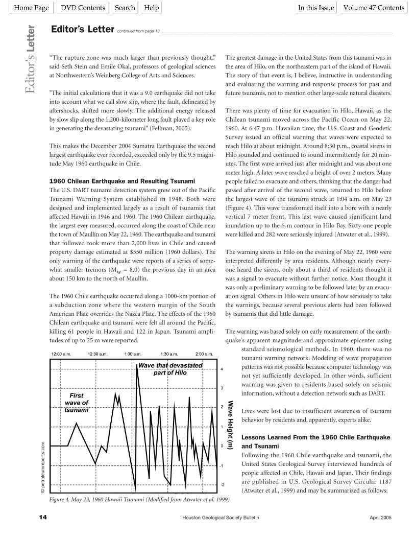
There was plenty of time for evacuation in Hilo, Hawaii, as the
Chilean tsunami moved across the Pacific Ocean on May 22,
1960. At 6:47 p.m. Hawaiian time, the U.S. Coast and Geodetic
Survey issued an official warning that waves were expected to
reach Hilo at about midnight. Around 8:30 p.m., coastal sirens in
Hilo sounded and continued to sound intermittently for 20 min-
utes. The first wave arrived just after midnight and was about one
meter high. A later wave reached a height of over 2 meters. Many
people failed to evacuate and others, thinking that the danger had
passed after arrival of the second wave, returned to Hilo before
the largest wave of the tsunami struck at 1:04 a.m. on May 23
(Figure 4). This wave transformed itself into a bore with a nearly
vertical 7 meter front. This last wave caused significant land
inundation up to the 6-m contour in Hilo Bay. Sixty-one people
were killed and 282 were seriously injured (Atwater et al., 1999).
The warning sirens in Hilo on the evening of May 22, 1960 were
interpreted differently by area residents. Although nearly every-
one heard the sirens, only about a third of residents thought it
was a signal to evacuate without further notice. Most thought it
was only a preliminary warning to be followed later by an evacu-
ation signal. Others in Hilo were unsure of how seriously to take
the warnings, because several previous alerts had been followed
by tsunamis that did little damage.
The warning was based solely on early measurement of the earth-
quake’s apparent magnitude and approximate epicenter using
standard seismological methods. In 1960, there was no
tsunami warning network. Modeling of wave propagation
patterns was not possible because computer technology was
not yet sufficiently developed. In other words, sufficient
warning was given to residents based solely on seismic
information, without a detection network such as DART.
Lives were lost due to insufficient awareness of tsunami
behavior by residents and, apparently, experts alike.
Lessons Learned From the 1960 Chile Earthquakeand TsunamiFollowing the 1960 Chile earthquake and tsunami, the
United States Geological Survey interviewed hundreds of
people affected in Chile, Hawaii and Japan. Their findings
are published in U.S. Geological Survey Circular 1187
(Atwater et al., 1999) and may be summarized as follows:
Editor’s Letter continued from page 13 ________________________________________________________________________________________________________________________________E
dito
r’sLe
tter
Figure 4. May 23, 1960 Hawaii Tsunami (Modified from Atwater et al, 1999)
©pe
trol
eum
repo
rts.
com

April 2005 Houston Geological Society Bulletin 15
For areas affected by earthquake:
• Expect earthquakes to lower coastal land: a large earthquake can
leave nearby coastal areas lowered, allowing tidal water to flood
them.
• Don’t count on the roads: when fleeing a tsunami caused by a
nearby earthquake, you may find roads broken or blocked.
• Heed natural warnings: an earthquake may serve as a warning
that a tsunami is coming, and so may a rapid fall or rise in
coastal waters.
• Many will survive the earthquake: in coastal areas, the earth-
quake may kill fewer people than the tsunami that follows.
For all coastal areas:
• Heed official warnings: play it safe, even if warnings seem
ambiguous or you think the danger has passed.
• Abandon belongings: save your life, not your possessions.
• Head for high ground and stay there: move uphill or at least
inland, away from the coast.
• Expect many waves: the next wave may be bigger, and the
tsunami may last for hours.
• Go to an upper floor or roof of a building: if unable to reach
high ground, go to an upper story of a sturdy building or get on
its roof.
• Climb a tree: as a last resort, climb up a strong tree if trapped
on low ground.
• Something that floats: if swept up by a tsunami, look for some-
thing to use as a raft.
• Expect waves to leave debris: a tsunami will leave behind sand,
the remains of houses and bodies.
Limitations of DART and Seismological WarningSystemsAn average of five tsunamis affects the Pacific Ocean every year.
Tsunamis caused about 50,000 deaths over the past 100 years
before the December 2004 tsunami. U.S. coastal communities
receive shore-based seismic data and information from coastal
sea level stations. According to NOAA, these have resulted in a
75% false alarm rate (Milburn et al., 1996). An earthquake
magnitude of 7.5, or 7.0 for the Aleutian Island region, is used to
trigger a tsunami warning for the United States.
Based on my research, Mw = 8.0 is considered a threshold value
for tsunami generation, though there are salient examples—the
1998 New Guinea earthquake and tsunami—where smaller
earthquakes (Mw = 7.0) produced deadly tsunamis. Earthquake
magnitude does not have a direct relationship to tsunami genera-
tion because fault rupture area and water displacement are the
key factors. For example, it is possible that a very large magnitude
earthquake with a strong shear component might not produce a
tsunami due to minimal vertical fault displacement. It is equally
possible that a relatively small magnitude earthquake with strong
vertical displacement might produce a tsunami. In any event, the
false alarm rate is one of the chief justifications for DART system
development and use. At the same time, earthquake magnitude is
routinely monitored by a vast network of monitoring stations
around the world and provides a rapid indication of seismic
events capable of generating tsunamis.
I do not want to dwell on the limitations of the DART system, but
it is important to recognize its capabilities for Southeast Asia and
for our own coastlines. In 1985, the idea for DART was formed
and steps were taken to prove that the sensors could detect and
provide a meaningful early warning for tsunamis. In 1997, the
National Tsunami Hazard Mitigation Program provided funding
for DART development. Following successful tests, the system
was put into operation in October 2003.
“It’s more complicated than you might imagine,” said Eddie N.
Bernard, director of NOAA’s Pacific Marine Environmental
Laboratory in Seattle, Washington, where the warning system was
developed, designed and built (Goldman, 2003).
“There are six tsunameters deployed in the Pacific Ocean today,”
Bernard said, offering the ‘bare minimum’ of an early warning
system.
Edi
tor’s
Lett
er
©pe
trol
eum
repo
rts.
com
Editor’s Letter continued on page 16
Time (Hours) before and after EarthquakeFigure 5. Gulf of Alaska Earthquake March 6, 1988 22:36 UTC, Mw=7.6 (modified from Milburn et al, 1996)

16 Houston Geological Society Bulletin April 2005
“We probably need more like 20. The failure of any one instru-
ment,” Bernard said, “could leave a big enough hole in the
detection network to create a serious delay in alerting communi-
ties of an oncoming tsunami.”
Bernard’s comments underscore the first limitation of DART. The
warning network is only as effective as its areal distribution. Six
BPR’s are insufficient for the U.S. West Coast and 20 would be
better. How many sensors would be appropriate for Southeast
Asia? Equipment failure in an under-equipped network further
compromises the effectiveness of the warning array.
Recently, the Bush Administration recommended a $37 million
supplement to NOAA and the USGS to enhance tsunami detec-
tion capabilities (Wise and Howles, in press). The purpose of the
recommendation is to increase to 25 the number of buoys and
BPR’s in the Pacific and to place 12 buoys in the Atlantic and
Caribbean.
What has been the success of DART? Despite the NOAA citation
of five Pacific tsunamis each year, there is only one referenced
success for DART technology, and it is a negative example. On
November 17, 2003 an Aleutian earthquake (Mw =7.5) was
determined by DART methods not to be a tsunami-producing
event. This reportedly saved Hawaii $68 million in lost business
compared to a 1986 false alarm.
The current DART configuration was not operational until 2003,
though an array of four bottom pressure recorders has operated
in the Pacific since 1986. What about the other on-average five
tsunamis per year in the Pacific from 1986 to 2004? I find no
mention of whether these resulted in warnings or were deter-
mined to be false alarms.
Figure 5 shows data from one BPR unit located approximately
1000 km from the epicenter of a 1988 earthquake in the Aleutian
Island region of Alaska. Two types of waves were detected: seismic
surface waves that induced vertical motion of the sea floor, and
tsunami waves that caused displacement of the sea surface
(Milburn et al., 1996). DART pressure read-
ings and interpreted tsunami indicators
were not measured until 1.5 hours after the
earthquake occurred (Figure 5). There is no
mention of how much time elapsed between
measurement and data transmission,
processing and interpretation. This may
have been adequate for a warning to Hawaii,
4000 km from the Aleutian epicenter, but
it would have been useless for any of the
hardest hit Indian Ocean countries on
December 26, 2004.
A second limitation of the DART system is that data is only sent
every hour (Perera, 2005). Had there been, for instance, a DART
sensor in the Indian Ocean near the 2004 Sumatra earthquake
epicenter, it might not have transmitted data until after the ensuing
tsunami had already struck Aceh province and, possibly, at about
the same time the wave arrived on the shores of Thailand.
"Our goal is to have results (a tsunami prediction) in 15 minutes
or less" after an earthquake, said Titov, a mathematician and
computer modeler who is working on tsunami forecasting
among a small, elite group of tsunami researchers at the National
Oceanic and Atmospheric Administration’s Pacific Marine
Environmental Laboratory in Seattle at Sand Point (Paulson,
2004).
A third limitation of DART is equipment failure, already alluded
to in Bernard’s comments above. In late January, 2005 two of the
three DART buoys near Alaska were not working and one of the
two off the U.S. Pacific Northwest coast was not transmitting
data.
"Batteries can die, leakages can occur in the instrumentation
package on the bottom, the buoy can have failure with rough seas
—mechanically, things break," said David Oppenheimer, a U.S.
Geological Survey seismologist involved in tsunami monitoring
(Paulson, 2005).
I was unable to learn what type of processing is required once
data has been received by NOAA ground stations in Alaska and
Hawaii or what kind of communication protocols must be enacted
before warnings are triggered. Is information from one BPR
sufficient to determine tsunami strength and direction and to
decide whether a warning is necessary?
It seems obvious that DART is, at best, unproven and is, at worst,
inadequate. It is, like its military analogue the “Star Wars Missile
Defense System”, a great idea…if it only worked. DART technology
has great promise but is not the solution for the Indian Ocean or
any other region in its current state of development.
Editor’s Letter continued from page 15 ________________________________________________________________________________________________________________________________E
dito
r’sLe
tter
Figure 6. Tsunami Terminology (Modified from The December 26, 2004 Indian Ocean Tsunami)
©pe
trol
eum
repo
rts.
com

April 2005 Houston Geological Society Bulletin 17
Tsunami Detection and Warning IssuesThe December 2004 Sumatra earthquake was the second
strongest ever recorded and the tsunami it triggered was the
deadliest in the history of the world. Prevailing opinion in the
press and among world leaders is that earthquakes and tsunamis
are unpredictable and are, therefore, outside the scope of normal
emergency planning. It is statistically unlikely that another
massive earthquake or tsunami will affect Southeast Asia for a
while, though there were magnitude 6.5 and 7.0 tremors else-
where in Indonesia during February 2005. This does not reduce
the importance of taking steps to be better prepared for the
inevitable next earthquake and tsunami in the Indian Ocean.
A tsunami warning system has been selected by ASEAN based on
the DART model. The plan presented by UNESCO also includes
access to international disaster response plans and strategies,
hazard and weather forecasting capabilities, and tide and seismic
monitoring data. Hopefully, the same plan will include critical
protocols to permit communication of key information that
could be used to warn inhabitants in case of a tsunami. These are
positive and necessary measures that will provide somewhat
greater security to the region than what currently exists.
The most immediate and effective measure that can be taken to
avoid future loss of life from tsunamis is awareness training. The
1960 Hilo event showed that early warning is not enough.
People need to understand what a tsunami is, how to recognize
signs of a tsunami, what to do in the event of an alert, and what
steps are most likely to minimize danger of injury or death. Leaders
in the Indian Ocean should simplify and distribute translations of
USGS Circular 1187 to residents and community officials.
The most important thing to understand about tsunamis is:
• every meter that a person moves inland from the coastline
exponentially improves the chance of survival. The force of a
tsunami decreases with every meter it advances onto land.
• Every meter above sea level that a person can climb exponen-
tially improves the chance of survival.
The USGS International Tsunami Survey Team (ITST) recently
assessed the affect of the 2004 tsunami on Sri Lanka. Inundation
distance (Figure 6)—the distance from the shoreline to the limit
of tsunami penetration—varied from less than 50 m to more
than 1 km (The December 26, 2004 Indian Ocean Tsunami,
2005). This means that if a person can move one km from the
shoreline, he will likely experience no flooding.
Run-up elevation—the elevation above sea level of a tsunami at
the limit of penetration (Figure 6)—measured by the Sri Lanka
ITST varied from less than 3 m to more than 12 m. This means
that if a person can get 3 to 12 meters above sea level, he will like-
ly experience no flooding.
In low-lying coastal areas, the most effective way for people to be
safe is to climb to an upper floor or the roof of a sturdy building.
Municipal governments can quickly identify and designate build-
ings as tsunami shelters. A modest program of signs, pamphlets and
media publicity can educate people about the locations of shelters
nearest their homes and work. In small communities where tall or
sturdy buildings do not currently exist, alternatives should be
discussed and considered; if there is sufficient topographic relief,
areas with high ground could be designated as shelter sites.
Evacuation routes should likewise be marked and publicized so that
people can move outside the inundation distance if sufficient warn-
ing is feasible or if multistory buildings or topographic shelter sites
are not available. If possible, transport vehicles could be dedicated at
designated congregation points to facilitate rapid evacuation.
Above all, people must be educated and drilled about the impor-
tant basics for tsunami survival found in U.S. Geological Survey
Circular 1187. This information should be summarized in signs,
passed out in pamphlets, publicized in local media, and taught in
local meetings and in schools. In tourist centers, such as the
coastal area of Thailand, this information should be given to all
visitors on hotel check-in and should be reinforced with signs
and other methods of public communication.
Telephone protocols must be implemented immediately among
designated emergency agencies and international earthquake and
tsunami monitoring centers and networks. Had such protocols
have been in effect at the time of the December 2004 tsunami
in Southeast Asia, many people could have been warned. As it
was, many workers were aware of the danger but did not know
whom to call.
A siren network should be immediately planned and implemented
throughout the coastal areas of tsunami-prone regions. Sirens
should be activated by dedicated agencies of the government
based on a combination of seismological, meteorological and
other means including buoy sensor networks. It will be necessary
to establish threshold criteria that would trigger a siren alert. This
will not be without risk of false alarms or of injury resulting from
possible panic during an alert. These are important factors, but
the alternative of no warning is clearly unacceptable.
Decision Dynamics for Tsunami Warning SystemsHow are we to understand the decision making process that has
lead to the current state of affairs in the Indian Ocean region
following the death of at least 250,000 people in the tsunami of
December 2004?
Edi
tor’s
Lett
er
Editor’s Letter continued on page 18
18 Houston Geological Society Bulletin April 2005
Edi
tor’s
Lett
er
The absence of a tsunami warning system or even the most basic
communication protocols in Southeast Asia was due principally
to apathy by the governments of that region. I made the point in
my February “From the Editor” (Berman, 2005) that this situa-
tion arose, in part, due to an ignorance or unwillingness to
acknowledge 40 years of advances in understanding of plate
tectonics. It is now clear that leaders in Indian Ocean countries
consistently resisted suggestions from local and international
sources to implement some kind of warning system.
The principal reason for the state of affairs in December 2004 was
the absence of urgency. A tsunami struck part of Indonesia in
1994 but its affects were not widespread in the region. The last
serious tsunami resulted from the explosion of Krakatoa in 1883.
After the worst tsunami disaster in history, the leaders of Southeast
Asia undoubtedly felt compelled to make a rapid decision to avoid
criticism for taking no previous action on tsunami warning
measures. Not knowing what they should do, they approved the
first and only plan that was presented, without investigating if it
was appropriate for their situation or if it would even work.
They decided to bring the horse inside their city walls.
They embarked on the road to Abilene.
The leaders of the Indian Ocean region almost
certainly believed that, under the circumstances, any
decision was better than no decision. There were
probably many at the ASEAN meeting in Phuket who
had questions about DART technology, its cost and
how it compared to other approaches to tsunami
warning. I imagine that the momentum to make a
decision presented a daunting obstacle to analyzing
the situation appropriately. Acting in a group, the
Association of Southeast Asia Nations made a
decision that involved higher risk and cost than most
group members would have made individually.
No one wanted the fate of Laöcoon.
Speculation on Alternative Modes of TsunamiGenesis and Behavior A different mechanism has been recently suggested
for tsunami generation and propagation. What follows
is highly speculative at the present but I mention and
summarize the basics for completeness. I direct the
interested reader to the February 15 issue of EOS for
details (The Indian Ocean Disaster, 2005).
Information gathered during the December 2004
tsunami has prompted questions and re-thinking of causal
modes for tsunamis and explanation of their destructive power.
Tsunamis are caused by water column displacement during
submarine earthquakes. Models assume that fault slip during an
earthquake causes seafloor upheaval that, in turn, displaces the
overlying water column (Berman, 2005).
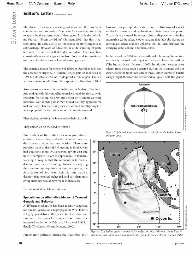
In the case of the 2004 Sumatra earthquake, however, the rupture
was deeply focused and might not have displaced the seafloor
(The Indian Ocean Disaster, 2005). In addition, certain areas
where great destruction occurred during the tsunami did not
experience large amplitude surface waves. Other sources of kinetic
energy might, therefore, be considered to explain both the genesis
Editor’s Letter continued from page 17 ________________________________________________________________________________________________________________________________
©pe
trol
eum
repo
rts.
com
©pe
trol
eum
repo
rts.
com
Figure 7. Spheroidal oscillations in the Earth. (from the Indian OceanDisaster, 2005)
Figure 8. The Indian ocean tsunami of December 26, 2004. 5the map shows lines ofmaximum and minimum tsunami intensity (from the Indian Ocean Disaster, 2005)

April 2005 Houston Geological Society Bulletin 19
Edi
tor’s
Lett
er
of tsunamis and the mechanism for their propagation.
It is possible that a powerful, deep-seated earthquake may pro-
duce free oscillations in the Earth similar to those that result from
striking a bell with a hammer or flicking a water-filled balloon
with your finger. Ringing a bell is an example of normal mode
oscillation in which all particles move with the same frequency
and phase. The bell rhythmically deforms in separate oscillation
directions that produce ringing. Similarly, spheroidal vibrations in
the Earth induced by deep rupture may excite oscillations of the
seafloor that displace sea water to produce tsunamis (Figure 7).
Along parts of Sri Lanka, Bangladesh and the Cocos Islands, the
December 2004 tsunami caused great destruction yet measured
wave amplitudes were very small. For example, the coastal town
of Galle, Sri Lanka was completely destroyed, yet the peak-to-
trough amplitude of the tsunami wave that struck there was only
42 cm (The Indian Ocean Disaster, 2005). Explanation may be
found in generation of internal waves.
The strongly directional propagation pattern of the 2004 tsunami
is inconsistent with models that would predict patterns parallel to
Sumatra coast along the trend of earthquake aftershocks (Figure
8). The wavelength of tsunami waves is much greater than the
depth of the ocean so there should be significant internal water-
column forces resulting from interactions with the ocean bottom.
If the water column consists of layers of different densities, the
interface between layers can undergo wave motion known as
internal waves (Figure 9). “This mechanism could enable a wave-
guide in the ocean and transmit tsunami energy at minimal
dissipation. Because internal waves are produced by tidal currents
flowing over the sloping seafloor, and the gradients tend to slope
normal to the coast, such a mechanism will be directional nor-
mally to the trench” (The Indian Ocean Disaster, 2005).
What Should Be DoneMost people do not understand geological processes and only pay
attention to them when our restless Earth creates peril for
humans. Natural disaster produces great, if temporary, interest in
how the Earth works. Political leaders struggle to quickly learn
basic information so they can take action and relieve the pressure.
Earth scientists can play a unique and important
role at this moment in the history of the Earth
because we understand the geological processes that
most do not.
The world needs what we know.
If there ever were a situation and opportunity to
demonstrate the value and relevance of geology in a
practical, meaningful way, this is it!
It is not too late to modify the decision made in late January 2005
by the Association of Southeast Asian Nations. The Houston
Geological Society should take the lead in calling for a meeting of
world experts on earthquakes, tsunamis and disaster planning.
The goal of this meeting would be to help the nations of the
Indian Ocean in their difficult and complex task of planning for
the inevitability of future earthquake and tsunami threats.
Why the HGS? The Houston Geological Society is small enough to
act quickly, unlike more cumbersome national or international
organizations. The HGS has already decided to dedicate Guest
Night this year (June 11, 2005) to tsunami and earthquake aware-
ness with USGS expert Dr. David Applegate’s lecture, “Magnitude 9
Tsunamis and Earthquakes: Learning from Indonesia’s Experience.”
We are the largest local geological society in the world and,
as such, have credentials to offer assistance. We are a broadly
based earth science society and not, for example, a specifically
petroleum- or environmental-based organization. Most of all, we
have always been a bellwether group unafraid of setting a new
direction in spite of risk.
I expect that I will receive more letters from Jakarta. I plan to
send this article to György Busztin. I hope he will continue to ask
me questions about the science of earthquakes and tsunamis and
the technology we have to minimize danger and loss of life. Some
have criticized my efforts as simplistic, presumptuous or just
naïve. Perhaps they are right though I feel that the alternative of
doing and saying nothing is unacceptable.
The medieval philosopher Hillel asked, “If not now, when? If not
me, whom?”
Please join me. n
BibliographyThe bibliography for this article may be found in the Bulletin
Web version: /www.hgs.org/2005/April
Figure 9. Internal waves
©pe
trol
eum
repo
rts.
com
20 Houston Geological Society Bulletin April 2005
“Letters to the Editor” has been abridged.
See the Bulletin Web version for their full
text: /www.hgs.org/2005/April
Art: The more research I do, the more
amazed I am by what the early submarine
cable guys achieved. They really had no
idea what they were doing for about ten
years, until the commission of inquiry into
the numerous (and expensive) failures of
the late 1850s published its report in 1861.
This comprehensive report of the first ever
inquiry into an industrial failure is a
landmark document in the history of tech-
nology, somewhat unappreciated, I fear.
The entire document of 520 legal-size
pages is on line at: http://www.bopcris.ac.
uk/bopall/ref5136.html
Between the commissioners and the wit-
nesses, the cast of characters includes just
about every businessman, engineer and
scientist involved in the cable and electrical
industries at that time. It makes interesting
reading.
Incidentally, I sent your article to a 40-
something friend in Boston who has a
keen interest in science and technology,
and she just emailed me: “This was the best
article on plate tectonics I have ever read. I
remember being fascinated by it in school.
Surprisingly, it was being taught tentatively,
and like something ‘new’ even then.”
Regards,
Bill Burns
————
Arthur - I enjoyed your HGS Bulletin arti-
cle about the Sumatra earthquake, really
an incredible earthquake. As it is the first
megathrust to have occurred since estab-
lishment of the global seismic network,
there will be intense research on the event.
In fact the American Geophysical Union
(AGU) has already organized a special ses-
sion at its spring meeting in New Orleans
in May.
Sieh has studied coral growth patterns and
has been able to map uplift associated with
the 1833 and 1861 earthquakes, probably
the last Sumatran megathrusts. He realized
the dangers and was just starting to distrib-
ute information brochures to the local
population. He gave a talk at the December
2004 AGU meeting “Mitigating the effects
of large subduction-zone earthquakes in
Western Sumatra” just 12 days before the
quake. There is a fascinating series of letters
written by Sieh from the field when he
travelled to the area in January to service
his GPS array. See http://today.caltech.edu/
today/story-display.tcl?story%5fid=5903
for the first in a series of seven (the others
are linked from this one). There were very
few tsunami casualties on Simeulue.
There was another article about Indian
Ocean tsunamis published last year. The
September 2004 issue of AusGeo News, a
magazine published by Geoscience
Australia, has an article on tsunami threat
to NW Australia. They did some modeling
of the 1833 earthquake and concluded that
this particular one didn’t cause much of a
tsunami in Australia, but the article, like
yours, points out the danger of ignoring
plate tectonics.
Best regards
Ian Norton
ExxonMobil Upstream Research Company
P.O. Box 2189
Houston, TX 77252-2189
Ph 713-431-4240 Fax 713-431-6193
————
Hi Arthur,
I want to thank you for the two great articles
in the February Bulletin. The in-depth cov-
erage of the SE Asian tsunami was simply a
masterpiece! Also, your interview with Dr.
Roy Dokka was equally thought-provoking
and presented many insights to the prob-
lems of coastal subsidence and its
quantification. As a 45-year resident of the
city of New Orleans, I am always concerned
about subsidence and flooding problems.
Incidentally, I am active with LSU, presently
serving as chairman of the College of Basic
Sciences Development Council, and as a
representative of the Geology and
Geophysics Alumni. I've known Roy Dokka
for many years and have carefully followed
his research.
Thanks again for the two great articles!
Ed Picou
A 25-year member of the HGS
————
Dear Mr. Berman.
I like to congratulate you to your article in
the February 2005 HGS Bulletin “The
Sumatra Earthquake of 2004: Forty Years
of Ignoring Plate Tectonics.” The article
brings a welcome fresh wind to the Society
Bulletin and is well placed because our
society is not a Houston Petroleum-
Geological Society that many assume, but
a Geological Society; and so we can and
should discuss general/alternate non-
petroleum geology as well. I am a
petroleum geologist but just love to see
more from other fields.
The only thing is that it appears highly
questionable to what degree plate tectonics
or their acceptance have anything to do
with this earthquake and its horrible effect
on people; at least it appears that we do
not yet have the right answers here. Why is
this earthquake just on a dot along a
multi-1,000 mile zone within a basically
identical geological framework? It would
seem that a point-like event occurred, like
the uplift of a magmatically-driven body
of rocks (not necessarily tectonically driv-
en magmatics, as your model requires).
This would be in line with volcanic-mag-
matic events elsewhere in onshore
Sumatra through the Tertiary.
And, subduction-related melting of basic
crust can hardly ever lead to magmatism
of granite, as you explain for Krakatau
acidics. Therefore, we may need another
explanation for the magmatism in
Sumatra and elsewhere.
As one result of these thoughts one can
hardly see “articulation of the plate tecton-
ic model” would “prepare…. citizens for
the inevitability of an event like this…..”.
Let
ters
toth
eEd
itor Letters to the
Editor

April 2005 Houston Geological Society Bulletin 21
Let
ters
toth
eEd
itor
EXPLORATION DATA SERVICESof the GULF COAST
H REGIONAL GEOLOGICAL MAPS OF THE GULF OF MEXICO• Two pertinent horizons• 1≤ = 4000¢ scale• Maintained up-to-date• 85-95% of all wells correlated• Combined subsurface and geophysical interpretation • Producing horizons in all fields noted• Pipelines & fairways• Available for a small monthly fee/service area
H CROSS-SECTIONS• Regional network• Available for a minimal monthly fee
H WELL INFORMATION ON COMPUTER• Well identification information including API number• Legal surface and bottomhole locations• Tops & Faults - measured & TVD depths• Formation at TD• Initial Perforations• Available to customers of the mapping service• Download to your workstation
P.O. BOX 1480 • LIVINGSTON, TX 77351
(936) 646-4639 • FAX: (936) 646-4284
GEOSCIENCE JOBS & PERSONNEL AVAILABLE!Job Seekers:
During the past year, the HGS Jobs Hotline website has averaged over 30 positions per month.New ads are being posted almost every day!
Employers:Get free listings, and a large response from qualified candidates, for your ads. Our website averages nearly 11,000 website “hits” per month.
Current Jobs page at: http://www.hgs.org/en/jobs/search.aspContact info:
Mike Cline at T/X Resources – Chairman, HGS Personnel Placement Committee • (713) 665-5449 • [email protected]
Plate tectonics or not, people know
tsunamis for hundreds of years, and the
guilt of Indian Ocean-surrounding coun-
tries (for not having tsunami warning
system in place) lies more in their lack of
acceptance of available technology that can
be applied for sufficient tsunami warnings;
it is not that they know nothing about
plate tectonics (may be it would even be
better for them if they don’t) and therefore
presumably have not organized a tsunami
warning system.
This brings me to another point—are plate
tectonics really valid today? Is this a theory
that is proven or useful? I doubt that it is.
In no case known to me are there unique
one-sided data or facts that prove the plate
tectonic theory as real, thus as useful.
We only can detect relative movements of
plates, which leave always questions unan-
swered: It may not be subduction of the
oceanic plate but obduction of the conti-
nental plate that is the basic mechanism
(why else are there mantle domes and their
final collapse as main tectonic events caus-
ing such regional features as Alboran
Sea/Rif/Subbetics, Hungarian Plains/
Carpathians, Black Sea, northern Gulf of
Mexico/Ouachitas, Michigan Basin……?).
A synthesis of marine magnetics in the
Southern Atlantic was published by the
Canadian Geophysical Society; it practically
killed plate tectonic symmetry of anomalies
and probably because of this was never
mentioned again to my knowledge.
Areal interpretations of marine magnetic
fields offshore Alaska and offshore
Greenland years ago showed the presence
not of linear magnetic anomalies in oceans
as had been published, but showed the pres-
ence of numerous positive and negative
elongate anomalies of magnetic basement
just like we see everywhere on land.
Thanks again for your article, it still opens
up the world of general geology. Too bad
that it needs the terrible earthquake of
December 26, 2004 to shake some of
responsible people and governments up.
Sincerely
J. Chris Pratsch
e-mail: [email protected]

22 Houston Geological Society Bulletin April 2005
C A N C E L L E D
NEW

April 2005 Houston Geological Society Bulletin 23
The successful drilling and discovery of significant hydrocar-
bons during 2001 at the Trident #1 wildcat in the Perdido
Foldbelt of the Alaminos Canyon area proved the exploration
viability of this deepwater frontier in the northwestern Gulf of
Mexico. The well also set a new world record for water depth, at
9,687' (2,953 m), and was the first announced discovery in the
Paleogene of the deepwater Gulf. Trident #1 reached a measured
depth of 20,500' (6,248 m) in hemipelagic shales of the Lower
Paleocene Midway Formation.
The Perdido Foldbelt is characterized by water depths reaching
more than 10,000' (3,000 m) and difficult drilling conditions
exacerbated by a low pore pressure to fracture gradient margin in
some prospects. The successful drilling of Trident helped to
increase industry’s understanding of how to effectively manage
the drilling of these features.
Geologic insights gained from Trident #1 include the discovery of
high-quality light oil, the recognition of multiple hydrocarbon
source rocks, the age of key seismic markers, and the presence of
abundant and well-developed deep-marine sandstone reservoirs
in the Upper Paleocene portion of the Wilcox Formation. Pre-drill
prediction of reservoir presence utilized several seismic-based
techniques, which have since been refined and improved with the
calibration of well log data to the seismic response.
Exploration activity in the Perdido Foldbelt has steadily increased
over the past three years and additional discoveries have been
made. Because of the extreme water depths, remote location and
technological challenges, cooperation amongst all operators will
help ensure the economic development of this prolific trend by
the end of the decade. n
Biographical SketchJON BLICKWEDE is currently senior
a dv i s ing ge o lo g i s t w i th Uno ca l
Corporation in Sugar Land, Texas,
focusing on regional studies in the
deepwater Gulf of Mexico and assisting
with new ventures evaluations in Latin
America. He earned a BS degree in geol-
ogy from Tufts University in 1977 and a
MS in earth sciences from the
University of New Orleans in 1981.
The successful drilling of Trident helped
to increase industry’s understanding of
how to effectively manage the drilling of
these features.
HGS General Evening Meeting
Monday, April 11, 2005Westchase Hilton • 9999 WestheimerSocial Period and Poster Session 5:30 – 7:00 p.m.Presentation 7:00 p.m
Cost: $23 Preregistered members; $28 Nonmembers & Walk-ups
The HGS prefers that you make your reservations on-line throughthe HGS website at www.hgs.org. If you have no Internet access, youcan e-mail [email protected], or call the office at 713-463-9476(include your name, e-mail address, meeting you are attending, phonenumber and membership ID#).
by Jon F. Blickwede, Michael J. DiMarco, Eddie Doré,Barry L. Gouger, James G. Hawkins, John W. Hidore, GarryJones, John Sanclemente, Art Trevena and Skip Walden Unocal CorporationSugar Land, Texas
The Trident Discovery: Play Opener of the PerdidoFoldbelt, Deepwater Northwestern Gulf of MexicoThe article has been abridged. See the Bulletin Web version for the full abstract and images: /www.hgs.org/2005/April
The April HGS General Evening Meeting will be a cocktail and hors d'oeuvres meeting followed by theater-styletechnical presentation. Please join us in experimenting with our meeting format and tell us if you like it.
Poster Session
Preliminary 3D Basin Model of the US Portion of thePerdido Foldbelt, Deepwater Northwestern Gulf of
Mexicoby Marek Kacewicz, Jon F. Blickwede, Elizabeth A. Johnson and Tim E. Smith
Unocal Corporation Sugar Land, Texas

24 Houston Geological Society Bulletin April 2005
April 2005 Houston Geological Society Bulletin 25
D18 field is located about 20 km offshore from the coast of
Bintulu, on Borneo island of East Malaysia. The field is
located in the oil-rich Balingian province, at about 100 ft of
water. Regional and local structural elements define the field to
be about 40 sq.km in area, with approxi-
mately 1400 ft relief in the structure top of
main reservoir unit (Cycle 2). A preliminary
review of data and previous work and core
descriptions in this study led to identifica-
tion of key factors in the distribution of
hydrocarbons. Eighty percent of oil has been
produced from distributary channels and
mouth bars of “Cycle 2” unit (C2M3.0–
C2M3.4). Although exploration efforts
started in 1920 in Balingian province, D18
hydrocarbons were discovered in 1981, with
the first discovery Well D18-1, drilled on crest of roughly
WNW–ESE trending anticline. Development drilling and previ-
ous field reviews divided the field into 21 fault-bound blocks
separated by an interconnected fault network. Production
declined over 19 years, with many wells currently idling.
Preliminary data analysis, geochemical reports and RFT meas-
urements in the field suggest that D18 field is vertically and later-
ally heterogeneous. A comprehensive re-evaluation of geology is
considered before any further development activity.
D18 structure is one of the WNW–ESE trending anticlines
formed as a result of transpressional tectonics in the Tertiary fore-
land basin, formed due to southward thrusting of Rajang oceanic
crust under West Borneo basement. The sediment source for the
Sarawak basins in general is believed to be Rajang Group, an
accretionary prism formed as a result of subduction of Luconia
block of South China Sea under the West Borneo basement.
Sequence development is related to simpler rules that govern the
net effect in accommodation. A tentative high-resolution
sequence stratigraphic model, constrained by biostratigraphy
and palynology is constructed, which enabled a chronostrati-
graphic framework for reservoirs despite
the intense deformation of stratigraphic
units. Majority of the production is com-
ing from the transgressive systems tract
(C2M3.0–C2M3.4 reservoirs) below the
mid-Cycle 2 Maximum Flooding Surface
(MFS).
Biographical SketchS H A R M A
DRONAMRAJU
received MSc
from Indian Institute of Technology,
Kharagpur (1984) and MS from
Texas A&M University (1997). He
worked with ONGC, India, as
Exploration Geologist, Fugro as
Offshore Geohazards Specialist, and
Landmark Graphics-Halliburton as
Consultant. In the last two years his work is focused on South
East Asia. As Principal Consultant to Petronas-Carigali
(Malaysia) on offshore brownfield assessments, he was responsi-
ble for revising the geology and sequence stratigraphy, revising
and building reservoir models, and assessing hydrocarbon poten-
tial of fields in South China Sea.
He is an active member of AAPG, SEG and HGS. As a member
for Continuing Education Committee of HGS he has organized
several courses covering topics such as coal bed methane, geo-
pressures and reservoir modeling.
by Sharma Vc. Dronamraju consulting geologist
Constraining Geological Heterogeneity in OffshoreSarawak Field, East Malaysia: Implications for
Stochastic ModelingThe article has been abridged. See the Bulletin Web version for the full abstract and images: /www.hgs.org/2005/April
International Explorationists Dinner Meeting
Monday, April 18, 2005Westchase Hilton • 9999 WestheimerSocial 5:30 p.m., Dinner 6:30 p.m.
Cost: $25 Preregistered members; $30 Nonmembers & Walk-ups
The HGS prefers that you make your reservations on-line throughthe HGS website at www.hgs.org. If you have no Internet access, youcan e-mail [email protected], or call the office at 713-463-9476.(include your name, e-mail address, meeting you are attending, phonenumber and membership ID#).
Preliminary data analysis,
geochemical reports and
RFT measurements in the
field suggest that D18 field
is vertically and laterally
heterogeneous.

26 Houston Geological Society Bulletin April 2005
ANNOUNCEMENT AND CALL FOR PAPERS
The 4th HGS/PESGB International Conference on African E&P
Path to DiscoveryMarriott Houston Westchase • 2900 Briarpark Drive, Houston
7–8 September 2005This annual conference, which alternates between London and Houston, has become estab-lished as the primary technical E&P conference on Africa. Scheduled for 7–8 September 2005in Houston, there will be a two-day program of talks along with poster presentations andexhibits from sponsoring companies. The conference covers all aspects of African E&P, withparticular emphasis on new ideas for exploration, the geology of the continent, application ofemerging technologies and case histories of discoveries.
The conference series, organised jointly by members of the International Explorationists Groupof the Houston Geological Society (HGS) and the Petroleum Exploration Society of GreatBritain (PESGB), will convene this year at the Marriott Houston Westchase (formerlyAdam’s Mark), which provides a spacious venue for posters and sponsors’ exhibits in additionto an excellent facility for the two-day program of talks. The Marriott will also offer substan-
tial discount for hotel rooms as the conference Headquarters Hotel.
The intention this year is to limit the program to two days by selecting the very best talks. Although the Deadlinefor Abstracts is May 31, submit a topic as soon as possible to ensure being considered.
Several abstracts and inquiries from sponsors have already been received; please submit topics or abstracts as soonas possible for consideration of the Technical Program Committee by email to [email protected].
Special thanks are due Exploration Consultants Limited (ECL) for their continuing support by committing to preparethe CD of the 2005 conference proceedings.
Details of the program, registration and hotel rooms will be maintained at the HGS website www.HGS.org in the EventCalendar for 7–8 September 2005.
Committee:Houston: Al Danforth, Steve Henry and Ian PoyntzLondon: Ray Bate, Duncan MacGregor, Mike Lakin and Val Clure
22nd Annual HGS SKEET SHOOT
Saturday, June 18, 2005Greater Houston Gun Club
6702 McHard Road, Missouri City This tournament is a 50 target event. Shells are provided, however, you must bring eye and ear protection.Greater Houston Gun Club and National Skeet Shooting Association safety rules will be in effect. Winningshooters will be determined by the Lewis class system. Door prizes will be awarded by blind drawing after theconclusion of shooting. All competitors are automatically entered into the door prize drawing, but you mustbe present at the time of the drawing to win.
BBQ lunch will be provided from 11:30 a.m. until 1:30 p.m. Refreshments will be available throughout the day.
IMPORTANT!!WE ARE LIMITED TO 160 SHOOTERS IN FOUR ROTATIONS. ENTRY FEE IS $60 PER SHOOTER
FOR REGISTRATIONS RECEIVED BY FRIDAY, JUNE 10. AFTER JUNE 10,REGISTRATION WILL BE STRICTLY ON A “SPACE AVAILABLE” BASIS AND THE ENTRY FEE
WILL BE $80 PER SHOOTER. REGISTER EARLY!!
For more information, contact: Tom McCarroll at 832-366-1623 ext. 205 or [email protected].

April 2005 Houston Geological Society Bulletin 27
The December 26, 2004 Northern Sumatra Earthquake has
been recently recalculated to be magnitude Mw = 9.3, mak-
ing it the second largest earthquake in recorded history along
with Maullín, Chile (1960). Due to the magnitude of the
December 2004 earthquake and ensuing tsunami, these types of
events are widely viewed as beyond the range of scientific pre-
dictability or probability.
More disturbing than the presumption that the Sumatra earth-
quake and tsunami were beyond probabilistic determination is
the nearly universally held notion that what is needed is a deep-
ocean-buoy monitoring and warning system, like the Deep
Ocean Assessment and Reporting of Tsunamis (DART) network
in the United States and Japan. The DART system is extremely
expensive and has never been proven to predict a tsunami. Initial
tsunami waves arrived in 15–30 minutes of the earthquake in
Aceh Province, Sumatra, one hour in Thailand, and two hours in
Sri Lanka and India. The frequency of DART transmission (once
every hour) and associated processing time is inadequate to have
provided meaningful warning for any of the areas most affected
by the 2004 tsunami in the Indian Ocean.
In the case of the tsunami that destroyed Hilo, Hawaii, following
the 1960 Maullín, Chile earthquake, ample warning was provided
from seismological information alone, yet many deaths and
injuries occurred due to lack of awareness about the behavior of
tsunamis.
Tsunami detection is, after all, a second derivative approach.
Why not focus on the causal mechanism—earthquake—which is
something we can measure very effectively and quickly? I believe
that an appropriate, immediate response to the Indian Ocean
tsunami disaster should focus on.
1. Immediate awareness training about tsunamis for all coastal
residents of the Indian Ocean region,
2. Immediate implementation of a seismological first-warning
system that uses existing monitoring stations in the region
along with an inexpensive network of coastal sirens, and
3. Assessment of the feasibility and cost benefit of a deep-ocean-
buoy tsunami warning system like the U.S. DART network. n
Biographical SketchARTHUR E. BERMAN is Director of
PetroleumReports.com and current
editor of the Houston Geological
Society Bulletin. He has an MS in geolo-
gy from The Colorado School of Mines
and has worked in the petroleum
industry since 1978 doing geological
and seismic interpretation.
GSH Luncheon Meeting
by Arthur E. Berman Director PetroleumReports.com and Houston Geological Society Bulletin Editor
The Northern Sumatra Earthquake of 2004:Forty Years of Ignoring Plate Tectonics
The article has been abridged. See the Bulletin Web version for the full abstract and images: /www.hgs.org/2005/April
Tuesday, April 19, 2005Westchase Hilton • 9999 WestheimerSocial 11:30 a.m., Lunch 11:45 a.m.
Cost: Members before 4/14/05 – $22, after 4/14/05 – $27;Nonmembers & Walk-ups $27
Reservations: GSH Office 713-463-9477, fax: 713-963-9160,E-mail [email protected] or online reservations www.gsxtx.org

28 Houston Geological Society Bulletin April 2005
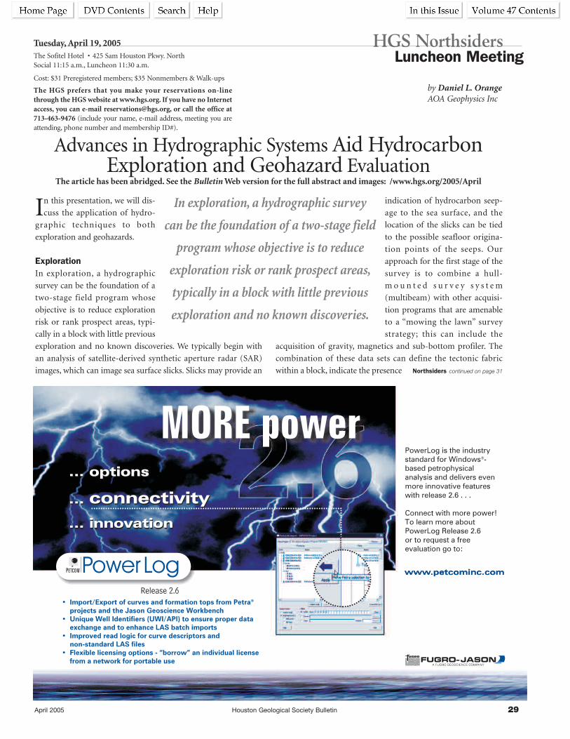
April 2005 Houston Geological Society Bulletin 29
In this presentation, we will dis-
cuss the application of hydro-
graphic techniques to both
exploration and geohazards.
ExplorationIn exploration, a hydrographic
survey can be the foundation of a
two-stage field program whose
objective is to reduce exploration
risk or rank prospect areas, typi-
cally in a block with little previous
exploration and no known discoveries. We typically begin with
an analysis of satellite-derived synthetic aperture radar (SAR)
images, which can image sea surface slicks. Slicks may provide an
indication of hydrocarbon seep-
age to the sea surface, and the
location of the slicks can be tied
to the possible seafloor origina-
tion points of the seeps. Our
approach for the first stage of the
survey is to combine a hull-
m o u n t e d s u r v e y s y s t e m
(multibeam) with other acquisi-
tion programs that are amenable
to a “mowing the lawn” survey
strategy; this can include the
acquisition of gravity, magnetics and sub-bottom profiler. The
combination of these data sets can define the tectonic fabric
within a block, indicate the presence
Advances in Hydrographic Systems Aid HydrocarbonExploration and Geohazard Evaluation
The article has been abridged. See the Bulletin Web version for the full abstract and images: /www.hgs.org/2005/April
by Daniel L. OrangeAOA Geophysics Inc
HGS Northsiders Luncheon Meeting
Tuesday, April 19, 2005The Sofitel Hotel • 425 Sam Houston Pkwy. NorthSocial 11:15 a.m., Luncheon 11:30 a.m.
Cost: $31 Preregistered members; $35 Nonmembers & Walk-ups
The HGS prefers that you make your reservations on-linethrough the HGS website at www.hgs.org. If you have no Internetaccess, you can e-mail [email protected], or call the office at713-463-9476 (include your name, e-mail address, meeting you areattending, phone number and membership ID#).
In exploration, a hydrographic survey
can be the foundation of a two-stage field
program whose objective is to reduce
exploration risk or rank prospect areas,
typically in a block with little previous
exploration and no known discoveries.
Northsiders continued on page 31

30 Houston Geological Society Bulletin April 2005

April 2005 Houston Geological Society Bulletin 31
Kevin J. McMichael
First City Tower 713-655-97001001 Fannin, Suite 777 Fax 713-655-9709Houston, TX 77002 [email protected]
Tauber Exploration & Production Co.
Seeking Ready to Drill Prospects
Texas and Louisiana Gulf Coast
Contact: Tim Tade or David Voight
(O) 713-869-5656 (F) 713-869-1997
55 Waugh Drive, Suite 601 • Houston, Texas 77007
16945 Northchase, Suite 1600, Houston, TX 77060
of volcanics or the location of thick basin sequences, image shal-
low faults and provide an indication of fluids at and immediately
below the mud-line.
The process of seepage elevates subsurface geochemical bound-
aries that are normally buried to, or near to, the sediment-water
interface. Cores that contain evidence of hydrocarbons may pro-
vide direct samples of the fluids present in a basin without
drilling and may provide information regarding source, maturity,
and degradation. The distribution of seeps on the seafloor may
provide information about the extent of the hydrocarbon system
or information regarding migration conduits.
GeohazardsFor deep water geohazard applications, there have been two
trends that have revolutionized deepwater geohazard surveys and
interpretations. First, there have been improvements in the
acquisition systems themselves, allowing for very high frequency
(high resolution) acquisition in water up to 4000m deep.
Secondly, there have been dramatic improvements in delivery
platforms, including the commercial availability of autonomous
underwater vehicles (AUVs) that get the sensors close to the
seafloor without the need for a tether for deepwater surveys.
Summary: Geophysical systems that can be used to evaluate the impedance/
roughness and the shape (bathymetry) of the seafloor, and to identi-
fy zones of potential fluid expulsion, range from near-bottom, high
frequency (up to 100s of kHz) to regional hydrographic survey sys-
tems (10s of Hz), to exploration seismic data (10s to <100 Hz).
In deep water, the application of hydrographic survey technolo-
gies to exploration may have a disproportionately high impact
due to the high cost of drilling, and the comparitively low cost of
surveying and sampling. The high cost of facilities and drilling in
deep water also drives high-resolution acquisition of hydro-
graphic data from near-seafloor platforms, and integration of
these data with high-resolution seismic surveys and geotechnical
boreholes. 100% maps of the seafloor, for both exploration and
geohazards, allows for more robust process-oriented interpreta-
tions to be made of a field area, reducing exploration risk or
improving the geohazard evaluation. n
Biographical SketchDANIEL L. ORANGE is President and CEO of AOA Geophysics Inc.,
with offices in Houston, Austin, and Moss Landing, California.
He is also a research associate at the University of California,
Santa Cruz. He is a marine geologist and geophysicist with
bachelor's and master's degrees from MIT, and a PhD from U.C.
Santa Cruz. He is also chairman of the AAPG Program
Committee for the Offshore Technology Conference, where he is
working to increase the geoscience component of the meeting.
Northsiders continued from page 29 ______________________________________________________________________________________________________________________________________

32 Houston Geological Society Bulletin April 2005
New Geologic Time Scale 2004by Ian Davison, Earthmoves Ltd.
The article has been abridged. See the Bulletin Web version for the full text: /www.hgs.org/2005/April
Anew geologic time scale is to be officially published in
February 2005 (Gradstein et al. 2004). A brief explanatory
note has already been posted on the official website of the
International Commission on Stratigraphy at http://www.stratig-
raphy.org/scale04.pdf.
A large number of specialists working with astronomical cycles,
radiogenic and stable isotopes, stratigraphy, palaeontology, mag-
netic polarity reversals and geomathematics have co-operated on
the mammoth task of incorporating all the new data that has been
acquired since the time scale that was published by Harland et al.
(1990). A few highlights of the new timescale are listed below:
• Nearly 50 of the 90+ Phanerozoic stage boundaries are now
defined, compared with 15 in 1990.
• More accurate and more precise age dating, has over 200 Ar/Ar
and U/Pb dates ( > 50% were not avail-
able for GTS 89)
• 40Ar-39Ar ages have had to be recom-
puted due to the revised ages for
laboratory monitor standards.
• Orbital tuning of cyclic sedimentary
sequences has been employed. For
example, the Neogene astronomical
scale is directly tied to the Present giving
an accuracy of 20 k yr (assuming the
cycles are all correctly identified).
• Improved mathematical/statistical tech-
niques were used to combine zones,
polarity chrons, stages and ages to calcu-
late the time scale.
This new time scale represents a great step
forward in our geological knowledge, and
we are greatly indebted to its authors for
the time and effort spent on this unprece-
dented collaborative project. It is hoped
that individuals, companies and organiza-
tions will adopt the new timescale as soon
as possible. Otherwise we are left to grap-
ple with using a confusion of different
out-dated timescales which can be more
than 10 million years different at certain
stage boundaries. A comparison of these
differences is available at www.stratigra-
phy.org, to see just how far out you may be
using an outdated scale. The World Wide
Web and e-mail should help ensure that
all geologists are aware of this important
new development in geology, even before
it is officially published, so please pass the
message on to your colleagues.
Wall charts of the new timescale can be
purchased at the Commission for the
Geological Map of the World website
address: http://ccgm.free.fr/index_
gb.html n
2.8255
535
540
260
265
275
280
285
290
295
300
305
310
315
320
270
325
330
335
345
350
355
360
365
370
375
380
385
390
340
395
400
405
415
420
425
430
435
440
445
450
455
460
410
465
470
475
485
490
495
500
505
510
515
520
525
530
480
Penn-
sylv
ania
nM
issis
sip
pia
n
Carb
onifero
us
Devonia
nS
ilurian
Ord
ovic
ian
Perm
ian
Cam
brian
Late
Late
Mid
dle
Early
Middle
Early
PALEOZOIC
PHANEROZOIC
25
30
35
40
45
50
55
60
65
Eocene
Pale
oce
ne
Olig
ocene
Danian
Selandian
Thanetian
Ypresian
Lutetian
Bartonian
Priabonian
RupelianE
E
E
M
M
L
L
L
Chattian
5
0
10
15
20
AGE(Ma)
AGE(Ma)Stage
Mio
cene
Plio
cene
E
E
M
L
L
Aquitanian
Burdigalian
Langhian
Serravallian
Tortonian
Messinian
Zanclean
Piacenzian
Pleisto-cene
Epoch
Gelasian
PolarityChron
1.81
0.78
1.01
1.73
1.92
4.35
2.05
2.32
4.46
2.6
5.37
5.5
3.3
3.2
8.2
7.2
2.9
3.0
3.8
Durationm.y.
Neogene
gP
ale
ogene
g
CENOZOICPeriod AGE
(Ma)AGE(Ma)
Pridoli
Ludlow
Wenlock
Llandovery
Lopingian
Guada-
lupian
Cisuralian
Furongian
Middle
Early
Late
Middle
Early
Late
Middle
Early
Epoch PolarityChron
PolarityChron
Durationm.y.PeriodAGE
(Ma)AGE(Ma)StageEpoch
Durationm.y.
MESOZOICPeriod
411.2
416.0418.7
422.9
428.2
501
318.1
345.3
326.4
374.5
385.3
391.8
397.5
407.0
443.7445.6
260.4
265.8
275.6
284.4
294.6
303.9306.5
311.7
421.3
426.2
436.0439.0
455.8
460.9
468.1471.8
478.6
488.3
513
542.0
268.0270.6
299.0
65.5
58.7
55.8
37.2
28.4
61.7
48.6
40.4
33.9
23.03
20.43
15.97
13.65
5.33
3.60
7.25
11.61
1.81
2.59
6.6
5.42.22.6
5
8.8
10.2
4.4
4.92.6
5.2
6.4
3
8.3
18.9
13.9
15.3
10.8
6.5
5.7
9.5
4.2
4.82.72.61.6
3.32
7.8
4.71.9
5.1
10.2
7.2
3.7
6.8
9.7
10
29
14.7
70
75
80
85
95
100
105
110
115
120
125
130
135
140
90
145
150
155
165
170
175
180
185
190
195
200
205
210
160
215
220
225
235
240
245
250
230
Cre
taceous
Campanian
Santonian
Turonian
Coniacian
Albian
Aptian
Berriasian
Tithonian
Kimmeridgian
Oxfordian
Callovian
Bathonian
Bajocian
Aalenian
Toarcian
Pliensbachian
Sinemurian
Hettangian
Rhaetian
Norian
Carnian
Ladinian
Anisian
Barremian
Valanginian
Hauterivian
Olenekian
Maastrichtian
Cenomanian
Jura
ssic
Triassic
Carboniferous Devonian Silurian OrdovicianPermian CambrianNeogenee Cretaceous Jurassic Triassic
Late
Late
Late
Middle
Middle
Early
Early
Early
65.5
70.6
83.5
85.8
89.3
93.5
99.6
112.0
125.0
130.0
136.4
140.2
145.5
150.8
155.7
161.2
164.7
167.7
171.6
175.6
183.0
189.6
196.5
199.6
203.6
216.5
228.0
237.0
245.0
249.7
5.1
12.9
2.3
3.5
4.2
6.1
12.4
13.0
5.0
6.4
3.8
5.3
5.3
3.7
6.7
3.5
3.0
3.9
4.0
7.4
6.6
6.9
3.1
4.0
12.9
11.5
9.0
8.0
4.7
1.3251.0
416 443.7359.2 488.3 542 Ma29965.523 145.5 199.6 251
GEOLOGIC TIME SCALE
Paleogene
0
CanadianArctic
Greece,Italy,
Austriaand
Turkey
Famennian
Givetian
Eifelian
Tremadocian
Lochkovian
Pragian
Darriwilian
Changhsingian
Wuchiapingian
CapitanianWordianRoadian
Kungurian
Artinskian
Sakmarian
Asselian
GzhelianKasimovian
Moscovian
Bashkirian
Serpukhovian
Visean
Tournaisian
Frasnian
Emsian
Homerian
Telychian
Aeronian
Rhuddanian
Paibian
Stage
Sheinwoodian
LudfordianGorstian
Induan
ICS
251.0
For details see "A Geologic Time Scale 2004" by F. M.
Gradstein, J. G. Ogg, A. G. Smith, et al. (2004) with
Cambridge University Press, and the official website of
the International Commission on Stratigraphy (ICS)
under www.stratigraphy.org .
"Saya
n(R
n)
hyp
erc
hro
n"
253.8
359.2
nodata
mixedpolarity
mixedpolarity
mixedpolarity
W-A
ustr
alia
(schem
atic)
Tik
hvin
ian
Superz
one
Debalts
evi
an
Superz
one
Kart
am
yshia
nS
uperz
one
C30
Cre
tace
ou
sN
orm
al-P
ola
rity
Su
pe
r-C
hro
n("
Cre
tace
ou
sQ
uie
tZ
on
e")
M"-1r"(ISEA)
M0rM1
M3
M5/M10
M11
M16M17
C31
C32
C33
C34
M12/M15
M18/M21
M22M23/M25
S-S
witz
er-
lan
d,
N-I
taly
Fra
nce
,S
pain
,S
witz
erland
westernAustria
M26/M32M33/M37
E24/
E18
E17E16E15
E14
E13
E12/E10E9E8
E7
E6/E2
Albania,Greece,Poland
EnglandFrance
SouthernSpain
SouthernSwitzer-
land
C1
C3
C4
C5
C6
C7
C8
C9
C10
C11
C12
C17
C18
C20
C22
C23
C25
C26
C27
C28
C29
C19
C21
C24
C2
C13/C16
Holocene
Copyright © 2004 International Commission on Stratigraphy
This chart is copyright protected; no reproduction of any
parts may take place without written permission by the ICS.
Hirnantian

April 2005 Houston Geological Society Bulletin 33

34 Houston Geological Society Bulletin April 2005
Reservations:The HGS prefers that you make your reservations on-line through the HGS website atwww.hgs.org. If you have no Internet access, you can e-mail [email protected], or call theoffice at 713-463-9476. Reservations for HGS meetings must be made or cancelled by thedate shown on the HGS Website calendar, normally that is 24 hours before hand or on thelast business day before the event. If you make your reservation on the Website or by email,an email confirmation will be sent to you. If you do not receive a confirmation, check with [email protected]. Once the meals are ordered and name tags and lists are prepared, nomore reservations can be added even if they are sent. No shows will be billed.
GSH LuncheonMeeting
“The Northern Sumatra Earthquake of 2004:Forty Years of Igoring Plate Tectonics”
See page 27Northsiders Luncheon
Meeting“Advances in Hydrographic Systems Aid
Hydrocarbon Exploration and GeohazardEvaluation” See page 29
NOWyou can make
your reservations on-line at
www.hgs.org
S u n d a y M o n d a y T u e s d a y
April 2005W e d n e s d a y
3
10
17
6
11
19
26 272524
12 13
[email protected] 24-hour wellsite service hotline: 713-328-2121
NO ONE HAS MORE WAYS TO OPTIMIZE YOUR RESERVOIR.
HGS Executive Board Meeting
4 5
18 20International Explorationists Dinner
Meetingby Sharma Vc. Dronamraju,
“Constraining Geological Heterogeneity inOffshore Sarawak Field, East Malaysia:Implications for Stochastic Modeling”
See page 25
North AmericanExplorationists Dinner
Meetingby Marc Edwards
“Is There Anything Useful to be Learned byCorrelating Several Thousand Well Logs from
the Middle and Upper Wilcox of SouthTexas?”
See page 39
HGS General Luncheon Meeting
by Harold Illich“Oil Mixing in the Deep Shelf and Deep
Water Areas of the Gulf of Mexico”See page 41
PHI OIL HISTORYSYMPOSIUM
Petroleum History InstituteMorgantown, WV
AAPG SW SECTIONMEETING
Budding New TechnologiesFredricksburg, TX
HGS General Evening Meeting
by Jon Blickwede“Trident Discovery: Play Opener of the
Perdido Foldbelt, Deepwater NorthwesternGulf of Mexico”
See page 23

April 2005 Houston Geological Society Bulletin 35
T h u r s d a y
1 2
8
15 16
29 30
GEOEVENTS
2322
S a t u r d a yF r i d a y
Upcoming GeoEventsMay 9HGS General Dinner MeetingCindy Yeilding, “How WorkstationsKilled Geology”5:30 p.m.,Westchase Hilton May 12HGA Auxiliary LuncheonBriar ClubMay 16International ExplorationistsMeeting “Libya”5:30 p.m., Westchase HilitonMay 17Northsiders Luncheon MeetingLarry Zara, “The Wilcox - Outcropto Deep Water”5:30 p.m., Sofitel HotelMay 17Environmental and EngineeringMeeting5:30 p.m., Guadalajara HaciendaRestaurantMay 20HGS Reserves Course Part IIIWilliam M. Kazmann Petroleum Reserves—AvoidingWrite-downs: Overview ofRecommended EngineeringPractices8:00 a.m., Marathon OilCorporation, Edward P. TravisConference CenterSee page 50May 25HGS General Luncheon MeetingPat Gratton “Barnett Shale Play:Big and Getting Bigger”11:15 a.m., Petroleum Club
9
21
14
7
28
Members Pre-registered Prices:General Dinner Meeting . . . . . . . . .$25Nonmembers walk-ups. . . . . . . . . . . $33Env. & Eng. . . . . . . . . . . . . . . . . . . .$25Luncheon Meeting . . . . . . . . . . . . .$30Nonmembers walk-ups. . . . . . . . . . . $33International Explorationists . . . . . .$25North American Expl. . . . . . . . . . . .$25Emerging Technology . . . . . . . . . . . .$25
GeoWives Spring Field Trip
See page 64
NeoGeos Galveston Beach Cleanup
Menard Park, Galveston TX
HGS Road RallyUniversity of Houston
See page 59
SIPES Luncheon Meeting
by Dan Tearpock“Certification of Petroleum Reserves
Evaluators”See page 37
HGS Astros NightSee page 52

36 Houston Geological Society Bulletin April 2005
VeritasExploration Services
> Rock Property Petrophysics
> Geological Modeling
> Integrated Interpretation
> AVO Analysis
> Pre & Poststack Inversions
> Stochastic Inversions
> Seismic Constrained Reservoir
Modeling
> Reservoir Simulation
> PSDM Model Building
> FastTrac™ Exploration
Enhance decision making and reduce risk
by applying advanced technologies needed to solve your most
difficult reservoir problems.
Veritas Exploration Services (VES) offers a complete line of
integrated exploration & development interpretation services,
and software backed by a technical staff with worldwide
industry experience.
Projects to discuss? Contact Veritas Exploration Services at
832.351.8525.
www.veritasdgc.com
Success from seismic to reservoir simulation

April 2005 Houston Geological Society Bulletin 37
During the past 2 years there has been a lot of publicity regard-
ing reserves writedowns and concerns about the reliability of
reserves disclosures. Reserves are an important part of everyday life
in the energy industry. Beginning with Enron, the recent major
reserves writedowns and the passing of the Sarbanes-Oxley Act by
the United States Congress in 2002, not to mention investor confi-
dence in our oil and gas industry, the time has come to explore the
establishment of a certification program for both petroleum
geoscience and engineering reserves evaluators. An exploratory
intersociety committee has been formed by the American
Associations of Petroleum Geologists (AAPG) and the Society of
Petroleum Engineering Evaluators (SPEE) to evaluate establishing a
voluntary program for the Certification of Petroleum Reserves
Evaluators. The intent of a certification program is to improve the
industry reserves estimation process and the ultimate reserves
numbers. It has the potential to provide the financial community
with a greater confidence in the estimates of oil and gas reserves and
the opportunity to develop better standards in both reserves
estimation and disclosure.n
Biographical SketchDANIEL J. TEARPOCK Chairman/CEO is Chief Executive Officer of
Subsurface Consultants & Associates, LLC (SCA). He is the co-
author of three textbooks, Applied Subsurface Geological Mapping
(1991), Quick Look Techniques For Prospect Evaluations (1994) and
Applied Subsurface Geological Mapping With Structural Methods
(2002) and numerous technical articles. He holds a bachelor’s
degree in geology from Bloomsburg University, 1970; and a mas-
ter’s in geology from Temple University, 1977. He is a Certified
Petroleum Geologist and State of Texas Licensed Geologist.
SIPES Luncheon Meeting
by Daniel J. TearpockChairman/CEO Subsurface Consultants & Associates, LLC.
Certification of Petroleum Reserves Evaluators:The Time Is Now!
The article has been abridged. See the Bulletin Web version for the full abstract and images: /www.hgs.org/2005/April
Thursday, April 21, 2005Petroleum Club • 800 Bell (downtown)Social 11:30 a.m., Lunch 11:45 a.m.
Cost: $30 for members and affiliates pre-registered by 12 noon Tuesday 19thJanuary (No-shows will be billed.). $35 for non-members, guests, and walk-ups.
Make reservations by telephone (713-651-1639), Fax (713-951-9659), Web-site(www.sipes-houston.org), or e-mail ([email protected]) to B. K. Starbuck-Buongiorno by 12 noon Tuesday before the meeting.
Image-Driven™
GX TECHNOLOGY
An I/O Company
For more information, call David Wegner at AIM Geophysical 713.464.6263.
Announcing the Newest 3D Survey in the Western Gulf of Mexico
Galveston/Brazos 3D Survey Available Now for the August Lease Sale!
GalvestonBrazos
• 64 blocks of full fold, 3D Pre-STM dataprocessed & imaged by GX Technology
• Offset: 8,800 m (29,000 feet) • Record Length: 13 seconds• Bin Size: 12.5 m x 20 m• Fold: 59• 3D Kirchhoff Migration: curved ray,
turning ray with anisotropy
2.0 sec
8.5 sec

38 Houston Geological Society Bulletin April 2005
For more information contact James Bogardus at 281-679-2209 or Chuck Ward at 281-679-2220
PGS OnshoreSeamless Coverage
<< Ultra Long 12,500m Offsets<< 12.5m CDP Interval<< 125/250 fold
(Onshore/Offshore)<< 20 Second Records
~10,000
ft
~7000
ft
~5000
ft
~3500
ft
~2000
ft
~600ft
~200ft
<< Wave Equation - PSDM<< VO Technology
Don’t Drill Blind CallPGS Onshore
P G S M A R I N E G E O P H Y S I C A L N S A
10550 RICHMOND AVENUE n HOUSTON, TX 77042 n TEL: 713-781-4000 n FAX 713-266-0455
P G S O N S H O R E
738 Highway 6 South, Suite 900 n HOUSTON, TX 77079 n TEL: 281-589-6732 n FAX 281-752-2444
Our next generation acquisitionand processing program isbased on the most sophisticat-ed technology available, HD3D,to give you every possibleadvantage and more definitiveanswers, including:<< HD3D 6.25m x 25m bins<< 9000+m offsets<< 14 second records<< 72 fold<< True Amplitude 3D PreSTM<< 3D PreSDM
Onshore – Transition Zone –
Marine
<< Kirchhoff PSTM<< Kirchhoff PSDM
<< Multi-Client 3D<< High Density 3D (HD3D)<< Seafloor Seismic 3D-4C<< 4D Technology
The PGS Gulf of Mexico Library: Watch for our HD3DTM Program
Acquisition Completed

April 2005 Houston Geological Society Bulletin 39
by Marc B. EdwardsConsulting Geologists, Inc.Houston, Texas
North American ExplorationistsDinner Meeting
Monday, April 25, 2005Westchase Hilton • 9999 WestheimerSocial 5:30 p.m., Dinner 6:30 p.m.
Cost: $25 Preregistered members; $30 Nonmembers & Walk-ups
The HGS prefers that you make your reservations on-linethrough the HGS website at www.hgs.org. If you have no Internetaccess, you can e-mail [email protected], or call the office at713-463-9476. (include your name, e-mail address, meeting you areattending, phone number and membership ID#).
Now that thousands of feet of Wilcox sand have been
encountered in a handful of wells in the Perdido and
Mississippi Fan foldbelts in the deepwater Gulf of Mexico, the
onshore Wilcox has new relevance.
After correlating several thousand wells from the Middle and
Upper Wilcox of South Texas and creating numerous maps and
cross sections, has any additional light been shed on the stratigra-
phy, facies and shelf margin architecture of the updip Wilcox?
Familiar Wilcox deltas along the basin margin and the submarine
fan deposits encountered on the deepwater basin floor are enor-
mous areas of deep potential, both onshore and offshore.
Attempting to delineate the sediment fairways across the slope
and predicting the nature of sands within those fairways addresses
two geological risk factors that concern this evolving play.
Biographical SketchMarc B. Edwards, is president of Marc B. Edwards Consulting
Geologists, Inc., Houston, Texas. He has been an independent
consulting geologist based in Houston for 20+ years. Prior to
that, he worked for the Norwegian Continental Shelf Institute in
Oslo and Trondheim, Norway, and for the Bureau of Economic
Geology in Austin. He holds a BS degree in geology from The
City College, New York, and a PhD from Oxford University.
Is There Anything Useful to be Learned by CorrelatingSeveral Thousand Well Logs from the Middle and Upper
Wilcox of South Texas?The article has been abridged. See the Bulletin Web version for the full abstract and images: /www.hgs.org/2005/April

40 Houston Geological Society Bulletin April 2005
Houston - Jeff RoweT: +1 713 369 [email protected]
Calgary - Jim GenereuxT: +1 403 777 [email protected]
High resolution aeromagnetic data coverage throughout western Texas.For more information, visit www.fugroairborne.com or contact us.
NON-EXCLUSIVE AEROMAGNETIC AND GRAVITY DATA AND INTERPRETATION
Mexico
Texas
Gulf of Mexico
WEST TEXAS SURVEYS
WEST TEXAS SURVEYS
PCI PaleoControl, Inc.Drilling Wells - Data Bases - Proprietary Paleo
Loyd Tuttle Jim Thorpe
[email protected] DrakeBob Liska
PCI
Houston, Texas 713-849-0044

April 2005 Houston Geological Society Bulletin 41
Oil-oil mixing in deeper water areas of the Gulf of Mexico
Basin is demonstrated using geochemical data obtained
from more than 1300 oils. Oils that are compositionally interme-
diate between well characterized end-member families, and oils
that have experienced bacterial alteration but contain “fresh”
gasoline-range chemistries, are interpreted to have originated
through oil-oil mixing. Some oils possess both compositional
patterns.
Oils possessing compositions similar to those occurring naturally
have been produced in the laboratory by mixing Cretaceous oils
from shale-rich sources occurring in the basin with Jurassic oils
from carbonate-rich sources. The map distribution of composi-
tionally intermediate oils additionally supports a mixing
interpretation.
“Fresh” oils derived from Gulf of Mexico Cretaceous sources tend
to contain minor amounts of sulfur and moderate to high API
gravities. Oils from Jurassic sources tend to have larger sulfur
contents and lower average gravities. Mixing of these end mem-
bers can be viewed as degrading the quality of the Cretaceous
oils, or as improving the quality of the Jurassic oils.
Occurrence of mixed oils indicates overlap of petroleum systems,
a phenomenon directly impacting exploration risk. Additionally,
total oil volumes might be anticipated to be greater in basinal
areas where the Cretaceous and Jurassic systems overlap.
Mixing resulting from multiple migration-accumulation
episodes may mainly characterize basins where the principal vec-
tor of fluid movement is vertical rather than lateral. n
Biographical SketchHAROLD ILLICH has thirty-six years of
experience in petroleum exploration,
basin analysis, and exploration geo-
chemistry. At GeoMark Research, he has
lead or been a member of teams respon-
sible for the evaluation of oil and rock
geochemical data for numerous basins
on a world-wide basis. Before joining
GeoMark, he worked for Oryx Energy
Company or its predecessors.
Harold holds a BS from the University of Texas at Austin and a
MS from the University of Montana.
HGS General Luncheon Meeting
Oil Mixing in Deep Shelf and Deep Water Areas of the Gulf of Mexico
The article has been abridged. See the Bulletin Web version for the full abstract and images: /www.hgs.org/2005/April
Wednesday, April 27, 2005Petroleum Club • 800 Bell (downtown)Social 11:15 a.m., Lunch 11:45 a.m.
Cost: $30 with advance reservations, $35 for walk-ins, space available($15 for Emeritus and Honorary).
The HGS prefers that you make your reservations on-line through the HGSwebsite at www.hgs.org. If you have no Internet access, you can e-mail [email protected], or call the office at 713-463-9476 (include your name,e-mail address, meeting you are attending, phone number and membership ID#).
by Harold Illich, John Zumberge,and Stephen BrownGeoMark ResearchHouston, Texas
Effective March 30th, the price of the HGS General Luncheon increased to $30 and $35 ($15 for Emeritus and Honorary).
Occurrence of mixed oils indicates overlap
of petroleum systems, a phenomenon direct-
ly impacting exploration risk. Additionally,
total oil volumes might be anticipated to be
greater in basinal areas where the
Cretaceous and Jurassic systems overlap.
ENDEAVOR NATURAL GAS, LLCSeeking Drill-Ready Prospects
Texas and Louisiana Gulf CoastEast Texas • North Louisiana
Contact: Bruce Houff(O) 713 658-8555 • (F) 713 658-0715
(Email) [email protected] Louisiana, Suite 3350 • Houston, Texas 77002

42 Houston Geological Society Bulletin April 2005

April 2005 Houston Geological Society Bulletin 43
Steven Brachman
Education:
BS Geology, Eastern Illinois University
MS Geology, Pennsylvania State
University
Experience:1997–present Pogo Producing Company1995–1997 Southwestern Energy1993–1995 Araxas Exploration1992–1993 Independent Consulting Geologist1990–1992 Wintershall Energy1984–1990 SOHIO/BP Exploration1981–1984 Gulf Oil
Professional Affiliations:HGSAAPG (CPG #4279) Onshore Exploration Independents (OEI)Registered Geologist - Texas
Professional Awards:2001 HGS Distinguished Service Award
Professional Activities:2001–2004 AAPG - DPA Advisory Board2000–present AAPG House of Delegates2000 GCAGS Convention Academic Liaison
Committee Chairman1997–2001 HGS Finance Committee Chairman1995 AAPG Convention Volunteer Committee
Chairman1993–1994 HGS Secretary1992–1993 HGS Treasurer1991–1992 HGS Treasurer-Elect1991 GCAGS Convention Personnel Placement
Committee Chairman1988–1991 HGS Personnel Placement Committee Chairman
Comments:When Paul Hoffman called a few weeks ago, I thought he wasgoing to ask me if I wanted to look at a prospect his companywas showing. Instead, I was surprised when he asked me toaccept the Society’s nomination for President. After a great dealof thought, I agreed. To be nominated for President of the HGSis a tremendous honor, and not one that I take lightly. I believethat the job of President encompasses more than just leadershipof the Board of Directors. It requires an understanding of howthe HGS functions and a vision
Kara Bennett
Education:
BS Geology, Florida Atlantic
University
MS Geology, University of Florida
Experience:2000–present Consulting Geologist, International and
Domestic1997–2000 Geologist, Landmark1994–1997 Consulting Geologist, International1989–1994 Senior Exploration Geologist, Amoco1988 Summer Intern, Mobil1987 Summer Intern, Amoco1982–1985 Senior Geologist, Gulf Oil1980–1981 Geophysicist, U.S. Geological Survey1979–1980 Uranium Geologist, Bendix
Professional Affiliations:AAPG, HGS, EAGE, Registered Texas Geologist
Honors and Awards:HGS President’s Award
Professional Activities:2004–2005 HGS Vice President2003–2005 HGS Advisory Committee2004–2006 AAPG 2006 Convention Continuing Education
Chairman2004 APPEX Continuing Education Course Organizer2000–2004 HGS Continuing Education Committee,
Chairman 2002–20042002–2005 AAPG House of Delegates2000–2003 Producer of HGS videos, Legends in Wildcatting1996–2000 HGS Personnel Committee-Initiated and main-
tained Jobs Hotline Web site1998–2000 HGS Bulletin Editor-Elect, Editor
Comments:The HGS is the world’s largest local geological society and oneof the most long-lived, currently in its 82nd year. It has reachedthese milestones because it serves a very useful purpose, to con-nect geoscientists in Houston to each other both in the technicaland social arenas.
We support students with scholarships, foster public educationthrough Earth Science Week and the HMNS VolunteerGeologists programs, provide networking opportunities andexcellent talks at 60+ technical
Candidates for the 2005–2006 Executive Board
President-Elect (two candidates)
Steven Brachman continued on page 51
Ballots for the 2005–2006 Candidates will be mailed separately. Pleaase take time to read the candidates’ profiles and vote for your
Executive Board members.
Kara Bennett continued on page 51

44 Houston Geological Society Bulletin April 2005
Steven A. Earle
Education:
BS Geosciences, University of Arizona
MBA, Houston Baptist University
Experience:2003–present Sabco Oil and Gas, Geophysicist2000–2003 BP, Senior Geophysicist1994–2000 Vastar, Senior Geophysicist1980–1994 Arco Oil and Gas, Area Geophysicist1974–1980 Amoco, Geophysicist
Professional Affiliations:HGS, AAPG, SEG, GSH
Professional Activities:2002–Present Chairman, North American Explorationists2003–Present AAPG House of Delegates
Comments:I consider myself most fortunate to work in the exciting field ofexploration geology and alongside of so many excellent peopleduring my career. So it is truly an honor to run for office in sucha vibrant Society. If elected, it would be my privilege to serve asyour Vice President and continue the tradition of bringing out-standing talks to the entire geological community. I look forwardto tackling the challenges of maintaining the HGS as the premierorganization that it is. n
Linda R. Sternbach
Education:
BS Geology, Syracuse University, 1981
MS Geology, Rensselear Polytechnic,
1984
Experience:2002-present Kerr-McGee Oil and Gas, senior geophysicist, Gulf
of Mexico1998–2002 Globex Energy, geophysical advisor–West Africa,
Australia1997–1998 British-Borneo, consulting geophysicist1996–1997 Agip Petroleum, consulting geophysicist1995–1996 Coherence Technology, consulting geophysicist1993–1995 Pennzoil, sequence stratigraphy consultant 1984–1993 ARCO Oil and Gas, staff geologist, GOM
Professional Affiliations:HGS, SEG, GSH, AAPG (CPG#5286), SIPES affiliate, registeredgeophysicist, Texas
Honors and Awards:2003 HGS President’s Award1995 HGS “Rising Star” Award
Professional Activities, HGS:2003–2005 HGS Guest Night—(2005-Tsunami theme; 2004-
Mars Rover theme; 2003-Apollo 17 theme)2002–2004 Technical Program chair and co-chair,
International Explorationists’ Group 2000–2001 SIPES Continuing Education chairman2000–2001 HGS/GSH Directory, chairman1999–2000 SIPES Technical Program chairman1999–2000 International Group, treasurer1998–2002 SEG Leading Edge magazine, Editorial Board 1997–1998 HGS Bulletin Editor 1996–1997 HGS Bulletin, Editor-Elect1994–1995 Poster Session, chairman
CommentsAs a long-time member of HGS (since 1985), I am honored to beasked to run for Vice-President. My chief goal, if elected, wouldbe to present the HGS membership with an exciting program ofspeakers. I believe that topics that will draw members to meet-ings are case studies of oil and gas fields, new discoveries, andtalks on new technological advances that members can use inexploration and production.
I have experience putting together technical programs as part ofthe International Explorationists’ Group, and with the SIPESorganization. I am also proud
Candidates for the 2005–2006 Executive Board (continued)
Vice-President (two candidates)
Linda R. Sternbach continued on page 49
HGS Earth Science Teacher ofthe Year Award
It is time to nominate this year’s HGS Teacher of the Year.The winner will receive a $1000 cash award from the HGSand will represent the HGS at the Section level of theGCAGS. The GCAGS Teacher of the Year winner will receiveanother $1000 and be nominated to the national level ofAAPG. The AAPG Teacher of the Year will be granted $5000plus an all expense paid trip to the 2006 AAPG nationalconvention to receive the award. If your nominee is interest-ed in pursuing this award, have them check out the GCAGSand AAPG for details, qualifications and forms. Forms andother required materials need to be sent to AwardsChairperson at the HGS Office by May 1, 2005. For moreinformation go to the GCAGS web site at:www.gcags.org/teacheroftheYear.htm and the AAPG site at:foundation.aapg.org/tchr_of_year_award/index.cfm.

April 2005 Houston Geological Society Bulletin 45
Candidates for the 2005–2006 Executive Board (continued)
Susan M. Black
Education:
MS Degree in Geology, Texas Tech
University
BS Degree in Geology, Texas A&M
University
Experience:2003–present Newfield Exploration Co., Geologist2001–2002 Contour Energy, Sr. Staff Geologist1992–2001 Wagner & Brown, Ltd., FX Consulting, Hardy Oil
& Gas USA Inc., Enron Oil & Gas Company,Consultant
1985–1991 Energy Development Corporation, Geologist
1980–1985 Superior Oil Company (Mobil Oil Company),Geologist
Professional Affiliations:Licensed Professional Geoscientist, State of Texas # 1265AAPG Certified Petroleum Geologist, # 4376HGS
Professional Activities:1991–present HGS Undergraduate Scholarship Committee
Comments:I am very honored to be nominated for the position of Secretaryof the Houston Geological Society. Throughout my career as ageoscientist in Houston the HGS has been a source of support,pride and good friends. As a member of the UndergraduateScholarship Committee for a number of years, I have seen howHGS takes an active role in encouraging our future geoscientistswith scholarships, mentoring, and educational programs. As aconsultant I also benefited from the educational programs,seminars, and networking opportunities that HGS provides. Iwant to work within the HGS to help maintain the high level ofeducational and mentoring programs that those before me havedeveloped and supported. This is an excellent opportunity togive back to the geoscience community that has so richly supported me throughout my career. n
Secretary (two candidates)
Beverly BlakeneyDeJarnett
Education:
MS Geology, Pennsylvania State
University
BS Geology, minor in French,
University of WyomingExperience:2003–present Research Associate, University of Texas, Bureau of
Economic Geology’s Houston Research Center1992–present Consulting sedimentologist (BBD Consulting)1986–1992 Geologist, Union Pacific Resources Company,
Fort Worth, TX, and Denver, CO
Professional Affiliations:HGS, AAPG, SEPM, RMAG, RMS-SEPM
Honors and Awards:SEPM Excellence of Oral Presentation Award - AAPG/SEPMAnnual Meeting, 1986
Professional Activities:2004 SEPM Short Course/Field Trip Chairman for
AAPG/SEPM Annual Meeting1998–1999 President, Fort Worth Geological Society1997–1998 President-elect, Fort Worth Geological Society1996–1997 Treasurer, Fort Worth Geological Society1997 SEPM Short Course/Field Trip Chairman for
AAPG/SEPM Annual Meeting
Comments:I am honored to be asked to run for secretary of HGS and feelstrongly about serving my local geological society. HGS providesso many benefits to its members, and I am grateful for the top-quality technical presentations, the continuing educationcourses, and the many opportunities for networking and socializing with fellow geoscientists. I have a lot of experienceserving as an officer for a geological society and would workdiligently with the other officers of HGS to ensure that HGScontinues to provide its members with the excellent quality ofprograms and services its members have come to expect. At theend of the day, it feels good to be able to give something back tothe society. n
Call for OTC VolunteersThe HGS and GSH are locating for several volunteers to assist the Arrangements Committee
for the upcoming OTC Conference from May 2 through May 5. A half-day volunteer will receive full registration for the convention and a free parking pass good for the entire convention.
Please contact Lynn Coyle at 281-578-6397 daytime, or 281-491-2294 evenings, or email [email protected] or Claudia Ludwig at 713-723-2511 or email at [email protected].

46 Houston Geological Society Bulletin April 2005
Cheryl Desforges
Education:
MBA Finance/International
Business/Decision & Information
Sciences, University of Houston
MS Physical Science/Geology, University
of Houston CL
BS Geology, Texas Christian University
Experience:2004–present Ryder Scott Company / Consultant1998–2004 Randall & Dewey, Inc.1995–1998 Environmental Evaluation Partners, Inc.,President1989–1995 Consultant in both the Petroleum and
Environmental Industries1982–1989 J.M. Huber Corp.1979–1981 Diamond Shamrock Corp.1977–1979 Sonat Exploration Co.1975–1977 Atlantic-Richfield Co.
Honors and Awards:1990 Arthur J. Ehlmann Award for TCU Geology
Alumni1974 Sigma Gamma Epsilon, geology honor society,
University of Houston1974 Gayle Scott Award for the Outstanding Geology
Senior, Texas Christian University
Professional Affiliations:Licensed Professional Geoscientist, State of Texas # 2174American Association of Petroleum Geologists - Certified
Petroleum Geologist #2925American Institute of Professional Geologists - Certified
Professional Geologist #4851Geological Society of AmericaHouston Geological SocietySociety of Exploration GeophysicistSociety of Petroleum Engineers
Professional Activities:2004–2005 HGS Finance Committee Chairman2003–2005 HGS Continuing Education Committee,
Chairman 2004-20052002 Volunteer Liaison Committee AAPG Convention1985–1989 HGS Publication Sales Committee Chairman1982–1984 AIPG Screening Committee Comments:I would be honored to serve as Treasurer-Elect and subsequentlyas Treasurer of the HGS. I recognize the need for a constantstream of funds to finance programs which benefit our member-ship. However, while sustaining
Michael C. Allison
Education:
MS Geology. University of Tennessee at
Knoxville
BS Geology. University of Miami at
Coral Gables
Experience:2005–present GDM, Geoscienist and Cy-Fair College, Geology
Instructor2000–2004 Landmark Graphics, R&D Product Geoscientist1999–2000 Chevron, Project Manager, GOM Y2K
Contingency Project 1997–1999 Chevron, IT Manager1992–1997 Western Australia Petroleum, Supervisor,
Exploration Computer Support1990–1992 Chevron, Senior Geologist1987–1990 Chevron, Petroleum Geologist1985–1987 Chevron, Development Geologist1993–1985 Gulf Oil, Development Geologist
Professional Affiliations:AAPG, HGS and GSH
Professional Activities:2004–Present HGS Northsiders Treasurer2004–Present HGS Continuing Education Committee
Comments:It would be an honor to serve as the Treasurer-elect of the HGS.As the largest local geological society in the world, the HGS has avery important role to play here in Houston and throughout theworld. It is a privilege to be a member and volunteer in this greatorganization. I look forward to being actively involved with theHGS for many years to come. n
Candidates for the 2005–2006 Executive Board (continued)
Treasurer-Elect (2 candidates)
Cheryl Deforges continued on page 49

April 2005 Houston Geological Society Bulletin 47
Candidates for the 2005–2006 Executive Board (continued)
Michael Demimg
Education
MS Geology, University of Missouri
(Rolla)
BS Earth Science, Northwest Missouri
State University
Experience:2004–present Swift Energy2003–2004 Burning Dog Exploration2000–2003 Phillips1999–2000 Consultant1978–1999 Amoco Reduction Co.
Professional Affiliation:AAPG, HGS, SIPES, Tulsa GS, NAPE
Professional Activities:1991–1997 Chairperson, HGS Membership Committee1997–1998 HGS Treasurer-elect1998–1999 HGS Treasurer1999–2000 HGS Poster Sessions1999–2000, 2003–2005 AAPG House of Delegates2000–2002 Chairperson, Tulsa Geol. Society, Continuing
Education2003–2004 Chairperson, HGS Awards Committee
Comments:I find the HGS is the best way to keep in contact with former co-workers, meeting new people, keeping up with trends in theindustry, and always learning new things. So when asked if Iwould run for HGS Director, how could I say no? The HGS isone of those organizations where an individual can really make adifference. If elected, I will strive to do my part in keeping theHGS an effective volunteer organization. n
James D. (Jim) Doyle
Education:
BS Geology, University of Texas at
Austin
MA Geology, University of Texas at
Austin
PhD Geology, Colorado School of
Mines
Experience:2002–present Eni Petroleum1999–2002 Consultant1985–1999 Sohio/BP Exploration1980–1985 Scientific Software Intercomp1976–1979 Cities Service Co.1974 Cities Service Co,
Professional Affiliations:HGS, AAPG, AAPG CPG # 5660, Texas Licensed ProfessionalGeologist # 3460
Professional Activities:1996–2003 Emerging Technologies Committee, committee
chairman 2002–2003
Comments:Over the course of my career, I have benefited very much fromthe programs sponsored by the HGS. It is an honor to be askedto run for the Board of Directors. If elected, it will be a privilegeto serve. n
Director (four candidates) Vote for two candidates
HGS Guest Night will be June 11, 2005
at the Museum of Natural Science.
The topic will be tsunamis and earthquakes
explained by Dr. David Applegate of the USGS.

48 Houston Geological Society Bulletin April 2005
George E. Kronman
Education:
MBA (1987), University of Houston,
BS Geology (1976) and MS Geology
(1979), State University of New York
Experience:2000–present Landmark Consulting and Services, Director,
Prospect Generation/Field Development1997–2000 Andersen Business Consulting1980–1997 Amoco
Professional Affiliations:HGS, AAPG CG#3922, SPE, GSA, Sigma XI, Texas PG# 5388
Honors and Awards:1990–1991 HGS Distinguished Service Award1987–1988 HGS President's Award
Professional Activities:1993–1998 AAPG International Liaison Committee1993–1998 AAPG House of Delegates1992–1994 AAPG Bulletin Associate Editor1991 GCAGS Convention Awards Chairman1989–1991 HGS Bulletin Editor1988–1989 HGS Bulletin Committee1988 AAPG National Convention Matson Award
Committee Co-chairman1986–1988 HGS Undergraduate Scholarship Committee
Trustee1985–1988 HGS Awards Committee Chairman1982–1984 HGS Boy Scouts Committee1982 GCAGS Convention Associate Editor
Comments:The Houston Geological Society is uniquely positioned to helpgeoscientists in the Houston area learn more, expand their pro-fessional contacts and become more productive. I am honored tobe asked to run for the Director position on the Executive Board.If elected, I pledge to use all my skills to help the HGS serve itsmembership. n
Erik P. Mason
Education:
BA Geology, Principia College
MS Geology, Oklahoma State University
Experience:2002–present Shell E&P, Houston, Exploration Team Leader,
Western Deepwater Gulf of Mexico1988–2002 Shell E&P, New Orleans2001–2002 Area Exploration Manager, Western Gulf of
Mexico 1996–2001 Staff and Senior Staff Geologist, Western and
Eastern Gulf of Mexico Exploration 1988–1996 Senior and Staff Geologist, Production1982–1988 Phillips Petroleum, Houston, Bartlesville
Professional Affiliations:HGS, AAPG, NOGS, AAPG Certified Petroleum Geologist
Honors and Awards:2000 AAPG Certificate of Merit (Hedberg Conference
co-convener),2000 AAPG Certificate of Merit (general chairman,
AAPG Convention in New Orleans)1999–2000 New Orleans Geological Society Outstanding
Service Award 1998 AAPG Certificate of Merit (Reservoir
Development Committee chairman)1995 New Orleans Geological Society President’s Award 1994–1995 Houston Geological Society “Best Speaker”1992–1993 New Orleans Geological Society “Best Paper”1987 Houston Geological Society Presidents Award
Professional Activities:HGS (member since 1984)2003 APPEX Advisory committee 1986–1987 Chairman, Continuing Education Committee 1984–1987 Continuing Education Committee New Orleans Geological Society (member since 1989)1996–1999 AAPG delegate representing NOGS 1997–1998 Vice President 1995–1997 Continuing Education Committee, chairmanAAPG (member since 1981, CPG, EMD, DEG, DPA)2003–2004 Vice President 2000–2001 Budget Review and Finance Committee1999–2000 General chairman, Convention and Annual
Meeting, New Orleans 1999 Hedberg Conference co-convener, Horizontal
Wells - Focus on the Reservoir
Candidates for the 2005–2006 Executive Board (continued)
Director (four candidates) Vote for two candidates
Erik P. Mason continued on page 49

April 2005 Houston Geological Society Bulletin 49
Candidates for the 2005–2006 Executive Board (continued)
William D. “Bill” Rizer
Education:
1970 BS geology - Boston College -
Chestnut Hill, MA
1976 MS geophysics - Boston College -
Chestnut Hill, MA
2002 Certificate On-line
Documentation - Houston
Community College - Houston, TX
Experience1997–present Geoscience and Technical Writing Consultant -
W. D. Rizer Consulting, Houston, TX1983–1997 Senior Research Scientist - Conoco, Inc.,
Houston, TX1976–1983 Research Geologist - Cities Service Co., Tulsa, OK
Professional AffiliationsAAPG, SEG, SPE, AGU, Sigma Xi, STC, AAP, ISRM
Recent AwardsSEG Best Paper in Geophysics, 1995Co-Chairman of the New Publications Committee, HGS,2001-presentInvited keynote speaker, Edinburgh Anisotropy ProjectWorkshop, 1999
Comments:The position of Editor, HGS Bulletin, is at once both intimidat-ing and inviting. It will most certainly be a challenge to continuedelivering the level of excellence that the Bulletin has achievedthese past few years and to which we readers have grown accus-tomed. But, the editorship also presents the opportunity to contribute to the Society, the science, and the Houston community.
The Bulletin is an excellent vehicle for informing the member-ship of new advances and techniques in geology as well asrelevant advances in geophysics and engineering. The editorshipoffers exciting possibilities for partnering and interaction withsister organizations like GSH and SPE.
There is much that we geologists, as both scientists and educatedcitizens, have to offer our community. The Bulletin is an excel-lent platform for promoting our discipline and advancingunderstanding of geology, particularly as it affects our commu-nity. These are all reasons why I welcome the opportunity toserve as Editor. n
Editor-Elect (one candidate) continued from page 44
Linda R. Sternbach — Candidate for Vice President
continued from page 46
Cheryl Deforges — Candidate for Treasurer
continued from page 48
Erik P. Mason — Candidate for Director
of the attendance of more than 400 people at the last three yearsof Guest Night, and have used that experience to learn aboutevent planning, advertising, and meeting budgets. I would lookforward to working with the HGS Board and the HGS specialinterest groups on improving technical meetings and increasingattendance at lunches and dinners. n
our desired program level, our society is currently experiencing aperiod of unexpected negative financial pressures. In the positionof Treasurer-elect, through collaboration with our members andfinancial advisors, I will strive to identify and implement innova-tive income ideas, while maintaining conservative fiscalresponsibility of our existing funds. n
1998–2004 Convention Coordinating Committee (committee
chairman 2001–2004)
1996–2001 Technical Program Committee
1993–2000 Reservoir Development Committee (committee
chairman 1997–1998)
Technical session co-chair at Annual meetings in San Diego
(1996), Dallas (1997), Denver (2001), Houston (2002) and the
International Conferences in Birmingham (1999) and Cancun
(2004)
1996 GCSEPM Research Conference Program Advisory
Committee Member
Comments:
It is an honor to be a candidate for the HGS Board of Directors.
If elected, it would be a privilege to serve the society.
The Houston Geological Society is the largest local geological
society in the world with a focus on serving the membership.
HGS members are energetic, enthusiastic and unselfish in the
time and effort they dedicate to the society. The large numbers of
excellent technical and professional programs offered by HGS are
an indication of that dedication. If elected I would serve with
energy and enthusiasm contributing in whatever ways could help
the membership the most. Having recently served on the AAPG
Executive Committee during a time when AAPG is struggling to
grow and change provides a background that may be beneficial
as HGS continues to grow and change. n

50 Houston Geological Society Bulletin April 2005
HGS CONTINUING EDUCATION COMMITTEE PRESENTS
Part Three of the Mini-seriesPetroleum Reserves—Avoiding Write-downs:
An Overview of Recommended Engineering Practicesby
William M. Kazmann and Edward P. Travis LaRoche Petroleum Consultants, LTD
Friday, May 20, 2005 • 8 a.m. – 4 p.m.Registration Table opens at 7:30 a.m.
Marathon Oil Corporation Conference Center5555 San Felipe Road • Houston, TX 77056
Reserve write-downs in 2003 and 2004 have increased attention of financial analysts, investors, ratingagencies, banks, the U.S. SEC and corporate boards to the process of estimating and reporting reserves.
Both geologic and engineering technical errors can contribute to erroneous reserve estimates.
• Learn basic reservoir evaluation techniques from performance to volumetric analysis.
• Learn which common engineering errors contribute to the inaccuracy of reserves estimates.
• Learn the recommended engineering practices to avoid these reserve pitfalls.
• Learn the fundamentals of economic evaluations and their impact on reserve volumes.
Register at www.hgs.org or find a registration form on the HGS Website: /www.hgs.org/2005/April
“The Place to Go”For GOM Gravity Data and Interpretations
Complete, NewData Coverage
PSDM Support3D Modeling
Fugro Robertson Inc.(Formerly Fugro-LCT)GRAVITY AND MAGNETICSBrian Anderson – Dave SchwartzTel: 713-369-6100 www.fugro-lct.com

April 2005 Houston Geological Society Bulletin 51
Candidates for the 2005–2006 Executive Board (continued)
meetings a year, provide inexpensive, high-quality continuingeducation programs, sponsor Technofest and the AfricaSymposium, publish a superb monthly Bulletin, provide one ofthe most consistently active, useful job-hunting web sites in thegeosciences, and have a wide range of social events and fundrais-ers. We do it all with a tiny but hardworking office staff and alarge and vibrant group of volunteers.
The essential role of the HGS in connecting geoscientists to eachother will become even more valuable in the future, as fewerindividual geoscientists with greater responsibilities have moredemands on their time, and as the business continues to moveinto a “free-agent” system. I believe it is important to reach outto a younger generation of geoscientists as those who wentbefore reached out to us, and to mentor the geoscientists whowill follow us. I believe it is valuable to work together as volun-teers, and to provide the volunteers and committee chairsencouragement to be creative and find new ways to make theorganization useful.
I am honored to be nominated as President-elect, and laterPresident. In that role, I will encourage our Board, committeesand office staff to continue the excellent work they currently doand provide the logistical and creative support to allow them todo it, within a framework of fiscal responsibility. I will also askour members to look into the future and volunteer to recruitand mentor the next generation. I am grateful for the opportu-nity to serve in such an important manner, and I will do my bestto ensure that HGS remains a vigorous and useful organizationinto the future. n
Kara Bennett — Candidate for President-Electcontinued from page 43 continued from page 43
Steven Brachman — Candidate for President-Elect
as to how the Society should continue to evolve. After three yearson the Board as Treasurer and Secretary, as well as eight years asa Committee Chair, I have been privileged to observe and helpshape how our Society operates.
Needless to say, the HGS does face some serious issues, mostlycentered on our shrinking membership. I believe that it isincumbent for the Board, and therefore the President, to thor-oughly understand the differences between what can be doneand what we would like to do, and make sure that the formerdoes not get sacrificed for the latter.
Regardless of any future uncertainties, the HGS offers a greatvariety of technical and social opportunities for its members toparticipate. It also contains a tremendous group of volunteersthat makes all of our varied activities possible. I believe that thePresident and the Board shoulder a shared responsibilitytowards the volunteers and the membership, to ensure that theHGS remains a viable and vibrant Society. I am privileged to beconsidered for another leadership position in the HGS. n
This month’s Co-volunteer of the Month is Arlin Howles. Arlin is the Vice President and Principal
Geoscientist for Tidewater Environmental Services, Inc., where he performs management of hydrogeologic
and geologic investigations, hazardous waste site remedial investigations and feasibility studies. Additional
responsibilities include groundwater monitoring system planning and installation, aquifer testing and analysis,
and assessment of contaminant transport as well as representing clients and negotiating with local, state and fed-
eral regulatory agencies.
Arlin received a Bachelor’s degree in geology from Edinboro State University, and a Master’s degree in geology andgeophysics from the University of South Carolina and did post-graduate studies at Wright State University. n
Co-volunteer of the Month: Arlin Howles
This month’s Co-volunteer of the Month is Henry Wise. Henry is the Technical Services Manager at Eagle
Construction & Environmental Services, L.P. where he performs environmental site assessments, remedia-
tion and emergency response to spills, leaks and other releases. Henry is co-chairman of the HGS Government
Affairs Committee and writes “Governmental Update” for the HGS Bulletin along with Arlin Howles. He is also
a founding member of the Environmental & Engineering Geology Group (back when it was only a committee)
and is on the Continuing Education Committee.
Henry received his Bachelor’s degree in geology from Boston University in 1975 and his Master’s degree in geol-ogy from The University of Texas at El Paso in 1977. n
Co-Volunteer of the Month: Henry Wise

52 Houston Geological Society Bulletin April 2005
Geochemistry Solutionsfrom the Experts
With an average of 22 years experience,Westport geochemists have the knowledge andexpertise to solve reservoir development andmanagement issues.Our multi-disciplined staff can address a broadrange of issues including:
Defining and understanding the petroleum systemsUnderstanding petroleum riskProduction geochemistry
- Reservoir continuity- Partitioning of commingled production
Petroleum chemistryOil quality distribution
6700 Portwest Drive; Houston TX 77024Tel: 713.479.8400 [email protected]: 713.864.9357 www.westport1.com © 2004 Halliburton. All rights reserved.

April 2005 Houston Geological Society Bulletin 53
Scholarship Benefit Party Raises the Roof for StudentsThe article has been abridged. See the Bulletin Web version for the full text /www.hgs.org/2005/April
The first annual Scholarship Benefit “Rock Dance” held on
February 5 was a rousing success. Over 110 participants
enjoyed terrific food and great music at the 43rd floor rooftop of
the Petroleum Club. Everyone appeared to have a wonderful
time. Over 50 silent auction items were bid upon
netting $3500 in donations. With the combined matching contri-
bution from the AAPG-GCAGS, over $7000 will be donated to
the W.L. Calvert Memorial and HGS Foundation scholarship
funds. The scholarship fundraiser committee comprising Marsha
Bourque, Deborah Sacrey, Carl Norman, Andrea Reynolds, Mary
Kae Dingler, Natalie Uschner and I enjoyed putting this event
together. We are already eyeing plans for an even bigger and
better event in 2006. Additional volunteers to assist in this
worthy cause are most welcome.
Just because this event is concluded does not mean that the
fundraising for the HGS scholarships is over. We shall continue
throughout the year because the AAPG-GCAGS will match our
contributions up to $10,000. What an achievement if we can
reach such a target!
Thanks go to all of those that attended this inaugural event and
to the donors of silent auction items. Special thanks are to those
that gave up so much time and effort to make this happen from
the Scholarship Benefit Committee. n
A2D-TGS/Nopec
Alley Theater
Bill Howell - Spartan Energy
Brandon Pierce “Calvin Murphy
Basketball USA”
Cellarini Energy Staffing
Ciro’s Italian Restaurant
Continental Airlines
Core Lab
Cypresswood Golf Club
Deborah Sacrey - Auburn
Energy
The “Derailers” band
Elizabeth Fisher
George Klein
H&H Music
Hearthstone Country Club
Hilton Americas-Houston Hotel
Houston Astros
Houston Ballet
Houston Comets
Houston Grand Opera
Houston Rockets
Houston Symphony
Houston Texans Improv
Comedy Theater
James and Bonnie-Milne
Andrews
Janet Combes
Julie Gill
Kingwood Country Club
Law Offices of James F. Andrews
Michael and Marsha Bourque
Old Orchard Golf Club
Petroleum Club of Houston
Radio City Music Theater
Ray Benson of “Asleep at the
Wheel” band
Red Volkeart of “Merle
Haggard” band
Sherrie Sartain
Stephen and Stephanie Levine
Tasteful Expressions
Ted Roddy
These kind sponsors and fellow HGS members provided the silent auction items to make this event a success. We thank you and are grateful for your generosity.
HGS Undergraduate Scholarship Foundation Presents Seven Scholarships
The article has been abridged. See the Bulletin Web version for the full text and images: /www.hgs.org/2005/April
The HGS Undergraduate Scholarship Foundation has been providing scholarships to deserving students since 1984. To date, over
$108,000 in scholarships have been awarded. This year the Foundation awarded seven scholarships totaling $10,500. Chairman
John Adamick presented scholarship winners at the February 7 HGS dinner meeting. Universities in the undergraduate scholarship
program are Lamar University, Sam Houston State University, Stephen F. Austin State University, Rice University, Texas A&M
University, the University of Houston, and the University of Texas.
Prior to the dinner meeting, several of the students and professors also participated in a tour at Unocal. The purpose of the tour was
to show the students what it is like to be a petroleum geologist in today’s industry. Many thanks are extended to Unocal for generous-
ly hosting this event. The Foundation intends to make the tour a regular part of our scholarship program and invite other local
companies to participate. If you believe that your company might like to host students in the future, please contact John Adamick at
Melissa Halick Heather Berglund Anne Herrin Nivedita Thiagarajan
University of Texas University of Houston Texas A&M University Rice University
Marcy Stonecipher Lynn Holik Shawn Miller
Stephen F. Austin State Sam Houston State University Lamar University

54 Houston Geological Society Bulletin April 2005

April 2005 Houston Geological Society Bulletin 55
Continuing Education Announcement“Petroleum Reserves - Avoiding Write-downs Part 4:
An Overview of Recommended Petrophysical Practices” is being planned for next September. Obtainingaccurate net pay counts from correct petrophysicalanalysis is one of the basic ingredients of accuratereserve estimations. Learn about red flags and pit-falls, as well as how to avoid them. This course willreview actual case histories from the real world.Watch the HGS Bulletin and website for the publica-tion of the exact date and location of this course,as arrangements are finalized.
TBPG Exam Newsby Dave Crane
The article has been abridged. See the Bulletin Web version forthe full text: /www.hgs.org/2005/April
Two examinations are required to obtain a Professional
Geoscientist license in Texas:
• The Fundamentals of Geology Examination (8:00 a.m. to noon,
110 questions)
• The Practice of Geology Examination (1:00.p.m. to 5:00 p.m.,
80 questions)
To request registration for either portion of the exam from
TBPG, applicants must submit:
• TBPG license application,
• 3 professional reference forms,
• 2 personal reference forms, and,
• Resume that reflects at least five years of work experience and
30 hours of course work in geology. Work experience is waived
on the first part of the examination. n
Contract and Full Time Exploration and Production StaffGeoscience, Management, Reservoir Engineers, Landmen,
Information Technology, ProductionWe can provide you with the RIGHT people with the RIGHT skills and
the RIGHT experience at the RIGHT price, time and location!Why spend all your scarce management time looking for staff when we
can do it for you? Founded in 1999, GeoExperts is staffed and led by E&Pprofessionals with decades of experience in the worldwide oil industry
3300 South Gessner, Suite 120 • Houston TX 77063Tel: 713-953-0823, ext. 13, Fax: 713-2953-1642
(we also have offices in Canada, London and West Africa)www.geoexperts.com
W.L. and Florence W. Calvert Memorial Scholarhip Fund The article has been abridged. See the Bulletin Web version for the full text: /www.hgs.org/2005/April
The W.L. and Florence W. Calvert Memorial Scholarship Fund provides scholarships to graduate students from nearby universities.
Each year a total of over $10,000 worth of scholarships are presented to deserving individuals. The HGS and the Memorial
Scholarship Fund Board gratefully acknowledge the following contributions to the Fund in 2004. The three categories of contributions
are Patron ($500 or more), Donor ($100 to $500), and Contributor (less than $100). nDonors: Contributors:
Justine Boccanera(in memory of D. Van Siclen)
Arthur Mullenax
Daniel L. SmithZinn Petroleum Company
Steve AdamsRobert AlexanderMichael M. AndersonAntoine InternationalLawrence BaldwinJack R. BanttariKenneth BeeneyOrville R. BergGeorge R. BoleSteven BrachmanMichael W. BrennanArthur W. BrowningBW PetrophysicsMartin Cassidy Chelsea Energy David W. ChildersChristopher K. ClarkRobey H. ClarkPaola Dattilo
G.M. DowLynn DuncanD. Burt DunnFayette Exploration
(in memory of ClydeHarrison)
Richard FillonJohn E. FrostPatrick T. GordonKirk HansenWayne Harris
(in memory of SteveHarris)
Arch W. HeltonGary HuxfordJamex, Inc.James JanssenRobert KaufmannJohn Klein
Tako KoningLabyrinth ConsultingStephen D. Levine
(in memory of JerryThornburg)
Jeffery W LundClaudio D. ManzolilloJohn MaxwellTom D. Mooney
(in memory of TomMooney)
Craig MooreSidney MoranDavid MortonJohn PolasekPratt Geoscience ServicesWalter PuseyJames RagsdaleJohn Ross
John C. ScheldtWilliam SchroeterTheresa F. Schwarzer
(in memory of R.Schwarzer)
Arthur E Jr SmithDaniel L. Smith George T SmithFrank SonnenbergAmy E. SullivanMichael SweetMark A. TaylorEdwin L. Trice
(in memory of E. L.Trice, Jr)
Randall W. WellsWilliams Geological
(in memory of JuneLathon)
56 Houston Geological Society Bulletin April 2005

Proposed Rules for Professional Geoscientist
Continuing Education Programby Henry M. Wise, P.G.
The article has been abridged. See the Bulletin Web version for the full text: /www.hgs.org/2005/April
The Texas Board of Professional Geoscientists (TBPG)
will require continuing education to maintain a
Professional Geoscientist (PG) license.
The proposed rule will require 15 professional develop-
ment hours (PDH) per year plus a minimum of one PDH
per year in the area of professional ethics, roles and
responsibilities of PGs, or review on-line of the Texas
Geoscientist Practice Act and Board Rules.
If you have specific questions as to whether a particular
course, article, software, etc., qualifies for PDH and how
much, discuss it with the TBPG. n
April 2005 Houston Geological Society Bulletin 57
Book Review George O. Chandlee Source Environmental Sciences, Inc.
Novacek, M., 2002, Time Traveler, In Search of Dinosaurs and Ancient Mammals from Montana to Mongolia, 365 pp., Farrar, Strauss,
and Giroux, $26.00.The article has been abridged. See the Bulletin Web version for the full text: /www.hgs.org/2005/April
Depictions of time travel are often found in the realm of sci-
ence fiction. As an example, consider H.G. Wells classic
story of time travel in the “Time Machine” and other similar
works. Michael Novacek’s book is appropriately titled because in
a sense time travel is possible in the
field of geoscience. This book is part-
ly autobiographical, travelogue and
natural history, combining elements
of all three into enjoyable reading
material. It is also entertaining to
non-geoscientists because it offers
insight into the driving forces to be a
geoscientist and to illuminate what
motivates “rock-hounds.”
Novacek is currently curator of ver-
tebrate paleontology at the American
Museum of Natural History (AMNH) in New York City. The
book focuses on the events that led to his career as a vertebrate
paleontologist and to his adventures in the field searching for
dinosaurs, mammals and extinct animals. (Novacek is also the
author of Dinosaurs of the Flaming Cliffs in 1996. This book was
listed by the New York Times as a Notable Book of the Year.)
Novacek begins his paleontological fieldwork in the western
United States and in Mexico. During fieldwork in Baja California,
there is a meeting with a cowboy
“with dirty sheepskin chaps” in an
adobe tavern, armed with a holster
that “opened around the sweat-pol-
ished ivory handle of a pistol”
(quotes from the book). The crew
was able to desert the bar quickly
without incident as a result of crafty
handling of the encounter.
Novacek descr ibes seeing the
Flaming Cliffs for the first time. It felt
very natural to be at the foot of these
spectacular outcrops where the Andrews expedition had uncov-
ered the fabulous vertebrate fossils during the Central Asiatic
Expeditions of the 1920s. These cliffs “were familiar; they felt like
home” and, as readers, we can appreciate how it must have been
to stand at the base of these famous, prodigiously productive
fossil cliffs. n
The announcement has been abridged. See the BulletinWeb version for the full text: /www.hgs.org/2005/April
Adult Education ProgramsBehind-the-scenes tour
Gold! Natural Treasure, Cultural ObsessionApril 5, May 10, June 7, 6 p.m.
Hands-On Class—Jewelry MakingTuesday, April 12, 6 p.m.
For more information or to purchase ticketsvisit www.hmns.org or call 713-639-4629
51 N. Knightsgate CircleThe Woodlands, Texas 77382
Office: (281) 367-1885 • Cell: (281) 788-9887E-mail: [email protected]
DAN SHAUGHNESSY

58 Houston Geological Society Bulletin April 2005
TAKING DRILL-READYPROSPECTS
CONTACT: DAN KELLOGG x103DENNIS FERSTLER x104
[email protected](713) 655-1221 TEL(713) 951-0079 FAX
1201 LOUISIANA, SUITE 3310HOUSTON, TEXAS 77002
HUNTER 3-D
Daniel C. Huston
6001 Savoy, Suite 110 • Houston, TX 77036
(713) 981-4650 • (281) 242-0639
E-mail:[email protected]:www.hunter3dinc.com
3-D Seismic Interpretation, Gravity/Magnetics,
Hampson/Russell Inversion / AVO analysis.
Holly Hunter Huston
CASH BUYERWants to Purchase
Producing Royalty & ORRContact: David Ewing
Ewing Exploration CompanyVoice 281.565.1884 Fax 281.565.1921
E-mail: [email protected]

The announcement has been abridged. See the Bulletin Web version for the full text: /www.hgs.org/2005/April
vrroooom!!. . . . . . . . . . . . . . . . . . . . . . . . . . . . . . . . . . . . . . . . . . . . . . . . . . . . . . . . .
HGS Annual Road RallySaturday April 23, 2005 at 9:00 a.m.
A team or individual is given a packet with clues directing travel by car to secret cultural, historical, and geological sitesin and around Houston. The team that answers the most questions based on the sites/clues and does it in the least
mileage wins a trophy.
Coffee and donuts and a souvenir tee-shirt are included. The course takes 3 to 4 hours to complete and ends in a socialevent where trophies are awarded (meal/drinks not included).
WHEN Saturday April 23, 2005 at 9:00 a.m.
HOW?? Fill out the registration form below and send in a check for $30.00 per participant made to HGS with thememo line noting “HGS Road Rally.” Please mail to: HGS, 10575 Katy Freeway, Suite 290, Houston, Texas 77024. Please
mail by April 9, 2004.
START FORMING TEAMS NOWIf you want information on how to volunteer
please contact Diane Yeager 713-646-1138 or 281-486-1732.
Register at www.hgs.org or find a registration form on the HGS Website : /www.hgs.org/2005/April
. . . . . . . . . . . . . . . . . . . . . . . . . . . . . . . . . . . . . . . . . . . . . . . . . . . . . . . . . vrroooom!!
April 2005 Houston Geological Society Bulletin 59
GET READY FOR THE 5th ANNUAL GSH/HGS SALTWATERFISHING TOURNAMENT 2005
Saturday, June 25, 2005Teakwood Marina, Village of Tiki Island • Galveston, Texas
The announcement has been abridged. See the Bulletin Web version for the full text: /www.hgs.org/2005/April
This year’s Fishing Tournament will be held on Saturday, June 25, at the Teakwood Marina, Village of Tiki Island, Galveston, Texas.
We are looking forward to a big event this summer and we encourage full family participation.
Trophies will be awarded for the heaviest individual Redfish (Non-Tagged), Speckled Trout and
Flounder for the Anglers, Junior Anglers and Lady Anglers. Trophies will also be awarded for the
heaviest individual Stringer: 1 Redfish, 3 Speckled Trout and 1 Flounder.
Registration fee includes: launch fee, GSH/HGS fishing cap, Fish Fry meal after weigh-in, refreshments,
trophies and DOOR PRIZES.
The Geophysical Society of Houston and the Houston Geological Society are non-profit organizations serving the geophysical
industry. Corporate and individual contributions are appreciated and will be acknowledged on several sponsor boards and banners
at the weigh-in station and marina. All contributors will be recognized in their respective organization newsletters following the
tournament. This is a great way to entertain friends, family, business associates and clients. So spread the word!
Register at www.hgs.org or find a registration form on the HGS Website : /www.hgs.org/2005/April
For more information, please contact:Bobby Perez (HGS & GSH) • 281-240-1234 ext. 219 Office • 281-240-4997 Fax • 281-787-2106 Cell • 281-495-8695 Home
E-mail addresses: [email protected] or [email protected]

60 Houston Geological Society Bulletin April 2005
w w w . p a l e o d a t a . c o m
6619 Fleur de Lis Dr.New Orleans, LA 70124-1429(504) 488-3711 (504) 488-6292 [email protected]
Arthur S. Waterman Norman S. Vallette Michael W. Center Albert F. Porter, Jr. William H. McKee Joshua D. Miller Thomas M Reilly
NEW COMPREHENSIVE GULF BASINDEPOSYSTEM PROJECT
wDeposystem maps of 60 sequences from Jurassic to Recent for the entire Gulf Basin.
by Richard H. Fillon, PhD. in association with Paleo-Data, Inc.
wAge database of over 200,000 wells from Onshore LA, TX, AL, MS, FL, and Offshore GOM evaluated and integrated in a unified framework.
RemembrancesSince the last report from the Remembrances Committee (02/17/05), our geological community has lost the following members:
CLYDE DAVID MARTIN passed away on November 9, 2004, at the age of 78. He served in the U.S. Army Air Corps during WorldWar II and then completed his BS in Geological Engineering in 1950 from Texas A&M. During his long career Clyde worked forSunray Oil Company, General Crude Oil Company, SOHIO, and BP. He was an Active Member of the HGS and AAPG. A dona-tion will be made to Texas A&M Association of Former Students.
JAMES E. MCCORMICK passed away on February 2, 2005, at the age of 77. After serving in the U.S. Army Air Corps during WorldWar II, Jim earned a B.A. in Geology from Boston University. He began his career in 1953 as a geologist with Sun Oil Company.He retired as the President and COO of Oryx Energy in 1992. Jim was an Emeritus Member of the HGS. A memorial donationwill be made to the M.D. Anderson Cancer Center.
STEPHEN G. STARR passed away on February 14, 2005, at the age of 71. Stephen served in the U.S. Army for four years prior topursuing his education at Wayne State University. He earned a B.A. in 1961 and a M.S. in 1964, both in Geology and Geophysics.As a geophysicist, Stephen traveled the globe, becoming an extremely well respected expert in his field. He was a member of theSEG and AAPG organizations and was always willing and ready to help others. In the eighties downturn he directed his energiesto putting the younger men and women in his field back to work, encouraging them to go back to school, if necessary, to com-plete degrees and worked tirelessly finding them opportunities for success. In his professional and personal life many weretouched and all were the better for it. Education was of utmost importance to Stephen. He was an Active Member of the HGS,GSH, AAPG, and SEG. A donation will be made to the George Bush Heart Center.
LAWRENCE JULIAN VITTRUP passed away on February 19, 2005, at the age of 94. Larry attended Texas A&M College and finished atThe University of Oklahoma in 1932 with a B.S. in Geology. He began a 21 year association with The Texas Company (Texaco),interrupted by four years of service in the U.S. Army during World War II. Larry spent the next 40 years as a successful Texas GulfCoast geologist and oil operator. He was an Emeritus Member of the HGS and AAPG. A donation will be made to WestminsterUnited Methodist Church in Houston.

April 2005 Houston Geological Society Bulletin 61
It is a lot of trouble to search the HGS or GSH Websites fre-
quently to see what’s new. And how do you know where to
look so you won’t miss something? Wouldn’t it be nice if you
could just look in the corner of your computer screen and see a
list of what has been posted recently? Now you can! It’s called
Really Simple Syndication (RSS) or, variously, RDF Site Summary
or Rich Site Summary. Whatever the name, it’s a way to syndicate
the changes made on any website. All you need is a Feed Reader,
sometimes called an Aggregator, and subscriptions (feed links) to
as many sites as you like. Virtually all subscriptions are free and,
so far, they are free from ads and spam.
Here are some sample web references for RSS:
Definitions: (with links at http://hgs.org/2005/April/WebNotes/)
• Current list of readers
• Current list of popular feeds
• HGS feed. (XML file used by feed readers. Includes HGS.)
• GSH feed. (Includes HGS and SPE-GCS)
• SPE-GCS feed
• Wired article “A Scan of the Headline Scanners”
• And don’t forget that Google is your friend.
There are many, many feed readers available, most are free and
some not. There are so many to choose from that, rather than
make a recommendation, I will tell you that I started with
KlipFolio and am too lazy to change. The best way I can describe
any RSS reader is to show you what mine looks like at the
moment. (Hint: Click on the illustration to enlarge it, then you
may have to resize it to be able to read the text clearly. Mouse-
over the lower right corner to see the expansion symbol.)
In the illustration, there are a variety of local weather and general
news feeds on the left. The HGS feed is in the upper right and
GSH is just below it. The feed in the lower right is my son-in-
law’s blog.
In KlipFolio, the HGS and GSH entries are in three sequences
(Events, Articles, and GeoJobBank), with the oldest posting first.
The HGS site is showing 50 unread
entries and the GSH site has 15. You
can keep any entry visible and delete
those that don’t interest you. Other
readers may present things in different
order and some even show the topic
(Event, etc.) in a separate column.
In the expanded illustration, I placed
the mouse icon over the General
Dinner entry in the HGS feed and it
popped up to give me a basic overview
of the talk. A similar expansion is pos-
sible for any posting on these feeds.
Read up on RSS. Look for the RSS feed
logo on your favorite websites. You’ll
find RSS simple to install and use.
Dave Crane
HGS/GSH Webmaster
713/789-5916
RSS Feeds and Feed ReadersDAVE CRANE

62 Houston Geological Society Bulletin April 2005

April 2005 Houston Geological Society Bulletin 63
Government Updateby Henry M. Wise, P.G. and Arlin Howles, P.G.
The article has been abridged. See the Bulletin Web version for the full text: /www.hgs.org/2005/April
Report on February 7, 2005 TBPG Meeting The Texas Board of Professional Geoscientists (TBPG) met on February 7, 2005.Many topics were discussed, including Continuing Education.
From the Texas Register Four bills have been introduced to the Texas Legislature that involve groundwater. The first is House Bill(HB) 653 and it's senate companion, SB 141. These bills relate to the regulation of subdivision of land under the jurisdiction of certaincounties. HB 653 can be found at: http://www.capitol.state.tx.us/tlo/79R/billtext/HB00653I.HTMSB 141can be found at: http://www.capitol.state.tx.us/tlo/79R/billtext/SB00141I.HTMSB 343 relates to county authority to regulate the placement of water wells in unincorporated areas of the county, providing a penalty.SB 343 can be found at: http://www.capitol.state.tx.us/tlo/79R/billtext/SB00343I.HTMSB 344 relates to the notice, hearing, rulemaking, and permitting procedures for groundwater conservation districts. SB 344 can befound at: http://www.capitol.state.tx.us/tlo/79R/billtext/SB00344I.HTM
TCEQ Updates Texas Water Quality Management Plan The TCEQ announces the availability of the draft January 2005 Updateto the Water Quality Management Plan for the State of Texas. The Water Quality Management Plan (WQMP) is developed and prom-ulgated in accordance with the requirements of the Federal Clean Water Act, §208. A copy of the draft January 2005 WQMP update maybe found on the TCEQ's Web site located at http://www.tnrcc.state.tx.us/permitting/waterperm/wqmp/index.html. A copy of the draftmay also be viewed at the TCEQ Library, Building A, 12100 Park 35 Circle, Austin, Texas.
US Congress Committee Members Announced Leadership of the House Energy and Commerce Committee, which oversees pro-grams in the Department of Energy, EPA, and NIH, remains with Chairman Joe Barton (R-TX) and ranking minority member JohnDingell (D-MI). Rep. Sherwood Boehlert (R-NY) retained his post as Chairman of the House Science Committee and Rep. Bart Gordon(D-TN) will again serve as the committee's ranking Democrat. Rep. Richard Pombo (R-CA) retained his post as Chairman of the HouseResources Committee.
Sen. Ted Stevens (R-AK), the new chairman of the Committee on Commerce, Science and Transportation, formally recently approved a newsubcommittee structure by creating a new climate change panel, an oceans subcommittee, and a disaster prevention and prediction body.The disasters panel comes partly in response to the Dec. 26 tsunami tragedy in Southeast Asia that left more than 225,000 people dead. BothStevens and Inouye come from states hit by tsunamis and have had a longtime interest in tsunami and other disaster warning systems. Inrelated news, Stephen Johnson took charge of U.S. EPA on January 26, 2005. And finally, the full Senate confirmed Samuel Bodman asenergy secretary by a unanimous voice vote on January 31st.
Earthquake and Tsunami Brings Natural Hazards Mitigation to Forefront Following the massive earthquake and tsunami ofDecember 26, 2004, which claimed over 225,000 lives from Indonesia to Somalia, the Bush administration has committed to expandingthe nation's tsunami detection and warning capabilities. A new proposal called for $37 million to enhance USGS and NOAA operationsand incorporate them into a Global Earth Observation System of Systems (GEOSS) involving the cooperation of 50 countries.
IUGS Statement Promotes Applied Knowledge of All Natural Hazards The International Union of Geological Sciences (IUGS)issued a resolution mid-January in response to heightened public awareness of natural hazards following the December 26thEarthquake and Tsunami.
Senate Moves Forward on “Clear Skies” Senator James Inhofe (R-OK), Chairman of the Senate Environment and Public Works(EPW) Committee and a cosponsor of Bush's plan known as the Clear Skies initiative, S. 131, introduced the bill on January 24, 2005.
Senators Press White House on Oil and Gas Research Funds Six members of the Senate Energy and Natural ResourcesCommittee are urging the White House not to cut funds for Energy Department oil and gas research programs aimed at boostingdomestic production.
DOE Explores Savings on Natural Gas Through Renewable Energy Programs In a report released in early January, theDepartment of Energy found that improving energy efficiency and increasing the use of renewable energy could significantly lower the costof natural gas.
Education/Evolution Update In January 2005, members of state legislatures returned to their capitols and began introducing legis-lation that reflects their policy priorities. Not surprisingly given the increased public profile of evolution education, legislators in manystates have introduced measures that would require disclaimers be placed in textbooks, require that intelligent design/creationism betaught along side evolution, or requiring that science teachers “teach the controversy.”

64 Houston Geological Society Bulletin April 2005
HGA and GeoWives NewsHGA by Vicky Pickering, Third Vice President
The ladies of HGA are experiencing a busy time in Houston
with the 2004-2005 calendar year drawing to a close in May. On
Thursday, May 12, 2005 we will have our Business Luncheon and
enjoy musical entertainment by “The Kingsmen,” a barbershop
chorus. We will meet at the Briar Club. Members please watch
for your invitation in the mail and get your reservations in early.
The party is being planned by Lois Matuzsak and her talented
committee.
Remember, we have two bridge groups. “Cinco-Mas” plays
bridge on the second Thursday of each month at the Junior
League. Call Audrey Tompkins at 713-686-0005 for reservations
and information. The Petroleum Club Ladies Bridge Group
meets on the third Wednesday of each month. Call Daisy Wood
at 713-977-7319 for reservations.
We would like to invite all wives of HGS members, widows of
HGS members and female geologists who are members of HGS
to join the Houston Geological Auxiliary for the coming year
2005–2006. Membership forms are found in the Bulletin.
GeoWivesGeoWives Spring Field Trip
The GeoWives Spring Field Trip is Thursday, April 14 to
Nacogdoches Texas—the oldest town in Texas. The first
European settlement was founded in 1779 by Antonio Gil
Y’Barbo, a prominent Spanish trader. He laid out a town site and
built a two-story stone home known now as the Old Stone Fort
which we will visit. Of course, the Nacogdoche Indians had a
village here many centuries earlier. Continuing our study of Sam
Houston, we will visit the Adolphus Sterne home (built 1830).
Houston was baptized as a Catholic on the porch of this house
soon after he arrived in Texas in order to be eligible to own land
under the Mexican government. After our lunch we will con-
clude our day with a guided tour of other historical sites.
We will leave from Memorial Drive Presbyterian Church at
8:00 a.m. and return about 5:30 p.m. Your check made to
GeoWives for $18 and sent to Janet Steinmetz by April 9 is your
reservation. This includes lunch, snacks, entrance fees, guide and
transportation. All members of GeoWives, HGA and HGS are
invited. Guests are welcome. Questions to Martha Lou Broussard
or Linnie Edwards.
May Business Meeting
Our annual business meeting will be Thursday, May 19, at
Cohen House, the faculty club at Rice University. Please keep this
date available. More information to come.
You are invited to become a member ofHouston Geological Auxiliary
2005–2006 dues are $20.00make check payable to Houston Geological Auxiliary and mail to: Margaret Jones • 1407 Lakecliff Dr • Houston, Texas 77077
HGA YEARBOOK INFORMATIONLast Name First Name Name Tag
Spouse Name Name Tag HGS Members Company
Home Phone Business Phone Business Fax( ) ( ) ( )
Street Address City Zip
Birthday, Month, Day ONLY Email Address Home Fax( )
As a member you are invited to join
GeoWives2005–2006 dues are $7.50
make check payable to GeoWives and mail to:Dene Grove
12715 PebblebrookHouston, Texas 77024
Please provide the following
Name: ______________________________________________
Sreet Address: ________________________________________
__________________________________________________
City/State/Zip: ______________________________________
Telephone: __________________________________________
email: ______________________________________________
I will help plan a GeoWives activity
I will serve on a committee
Notification / Phone Committee
Courtesy / Hostess
My home is available for a meeting

April 2005 Houston Geological Society Bulletin 65
SED-STRAT Geoscience Consultants, Inc Supporting the extraction industry to find commercial oil and
natural gas and adding value to their assets using integrated geological analysis
George D. Klein, PhD TX Registered Geologist #440
AAPG-DPA Certified Petroleum Geologist #5662
7318 Glendale Dr. (MC-96) (281) 937-9436Sugar Land, TX, USA FAX: (281) 937-9456E-mail: [email protected]
Professional Directory

66 Houston Geological Society Bulletin April 2005
Seismic Data Processing SeisUP©
Systems
SalesReed Haythorne
Norm StagerDave SpauldingWilliam Zepeda
Place Your Business Card Here!$125.00 for 10 issues
713-463-9476
Wavefront LLC Oil & Gas Consultation since 1996
Steven “Eric” GetzIT Support Consultation (Geophysical & Geological)
Network, Workstation, and Software SupportSeismic Data Loading
Seismic ModelingSynthetic Seismogram Construction
(713) 305-5089 SMT [email protected] Microsoft Certified

April 2005 Houston Geological Society Bulletin 67
811 Dallas Suite 1020
Houston, Texas 77002
JAMES B. BENNETTGeology
RANDALL SCHOTTGeophysics
Bus. (713)650-1378
3-D Seismic Interpretation, FTG Gravity Modeling,Seismic Inversion and AVO analysis
6001 Savoy, Suite 110 • Houston, Texas 77036 (713) 981-4650 • (281) 242-0639
E-mail: [email protected]: www.hunter3dinc.com
P.O. BOX 140637BOISE, ID 83714
BUS. 208-854-1037RES. 208-854-1038FAX. 208-854-1029
JAMES S. CLASSENLooking for close-in deals
ARK-LA-TEX LOG LIBRARY400 TRAVIS, SUITE 500 • SHREVEPORT, LA 71101-3113
(318) 227-1641 • FAX (318) 227-1642 WWW.ARKLATEXLOGLIBRARY.COMELECTRIC LOG AND COMPLETION CARD COVERAGE:
LOUISIANA • EAST TEXAS • MISSISSIPPI • SOUTHERN ARKANSAS SOUTHEASTERN STATES
• PRIVATE WORK ROOMS • LOG & MAP COPIER• IHS/DWIGHTS - CD/ROMS PRODUCTION DATA • COMPUTERIZED LOG DATA BASE
• CALL IN OR FAX DATA RETRIEVAL SERVICE • EXTENSIVE INDUSTRY REFERNCE & TECHICAL MATERIAL
• BAR CODED CHECKIN/OUTCALL FOR INFORMATION ON CORPORATE AND INDIVIDUAL
MEMBERSHIPS OR DAILY USER RATESMARILYN KILBOURNE, MANAGER
Data digitizing, drafting & computer graphics
7171 HWY 6 NORTH # 202Houston, TX 77095 Tel/Fax: (281) [email protected] Cell : (281) 935-4830
Place Your Business Card Here!$125.00 for 10 issues
713-463-9476

68 Houston Geological Society Bulletin April 2005
7500 SAN FELIPE, SUITE 250HOUSTON, TEXAS 77063
Geosolutions & Interpretations, LLCGeology Geophysics Engineering
Phone: (281) 679 0942Fax: (281) 679 0952Mobile: (281) 772 5826800 Tully Rd, Suite 240KHouston, TX, 77079
E_Mail: [email protected]://www.geointerpretations.com
Gerardo JagerPresident
10575 Katy Freeway, Suite 290Houston, Texas 77024www.hgs.org
Office: 713-463-9476Office Fax: 713-463-9160
Lilly HargraveAdvertising Coordinator
Place Your Business Card Here!$125.00 for 10 issues
713-463-9476


H O U S T O NG E O L O G I C A L S O C I E T Y
10575 Katy Freeway, Suite 290 • Houston, TX 77024
PeriodicalsU.S. Postage
PAIDHouston, Texas
INTERPRETATION MODELING SIMULATION PRODUCTION & PROCESS
Maximum reservoir performance
Roxar’s integrated technology solutionsand services help companies of all sizesrealize the full economic potential oftheir oil and gas resources.
• Innovative modelingand simulation software
• Downhole monitoringand control systems
• Reservoir productionmultiphase metering
• Reservoir and productionconsultancy
Roxar’s leading-edge technology solu-tions from reservoir interpretationthrough to production & processmeet the changing needs of users inmanaging the entire reservoir lifecycle.
Want to make themost of your valuableoil and gas reserves?
WELL & COMPLETION