Harbours and Maritime Networks as Complex Adaptive Systems – Thematic introduction
84
HARBOURS AND MARITIME NETWORKS AS COMPLEX ADAPTIVE SYSTEMS – Thematic introduction Workshop "Theory and Models", SPP 1630 „Häfen von der Römischen Kaiserzeit bis zum Mittelalter“ J. Preiser-Kapeller, RGZM/ÖAW 1
Transcript of Harbours and Maritime Networks as Complex Adaptive Systems – Thematic introduction

HARBOURS AND MARITIME NETWORKS AS COMPLEX
ADAPTIVE SYSTEMS – Thematic introduction
Workshop "Theory and Models",
SPP 1630
„Häfen von der Römischen Kaiserzeit bis zum Mittelalter“
J. Preiser-Kapeller, RGZM/ÖAW 1

2

3

Institutions and Disciplines
4

Some (possible) topics of discussion
• Social and environmental complexity: some concepts
• Decision-making in a complex environment: establishing and maintaining harbours
• Navigation in a complex environment: the emergence of sailing routes
• Creating complex networks: harbours as nodes, routes as ties
5

SOCIAL AND ENVIRONMENTAL COMPLEXITY: SOME CONCEPTS
Hans Nickl, „10 Minutes in front of the Centre Pompidou“ 6

Patterns of past human activity in space: The emergence of trail patterns
on an open space at Stuttgart University (cf. Helbing et. al., 1997)
• Human agency and Emergence • Path dependency (or not) and
Stigmergy: The principle is that the trace left in the environment by an action stimulates the performance of a next action, by the same or a different agent. In that way, subsequent actions tend to reinforce and build on each other, leading to the spontaneous emergence of coherent, apparently systematic activity.
7

Tracing paths on the sea: artefacts, shipwrecks and landing sites
Benthos. Digital Atlas of Ancient Waters: http://awmc.unc.edu/wordpress/benthos/ 8

Communities/societies and environment
9

Climate, chaos, non-linearity and complexity: „strange“ attractors and Butterfly-effects
10
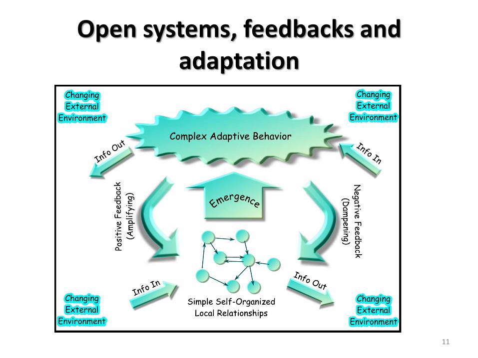
Open systems, feedbacks and adaptation
11
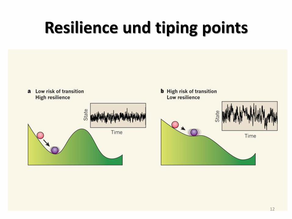
Resilience und tiping points
12

Bottom up – Agent based modelling
From: Vanek et. al., Agent-based Model of Maritime Traffic in Piracy-affected Waters, 2013.
13

Top down – master equations
(From: Pablo L. Durango-Cohen, Maintenance and Repair Decision Making for Infrastructure Facilities without a Deterioration Model, 2004)
14

Signatures of complexity
15
16
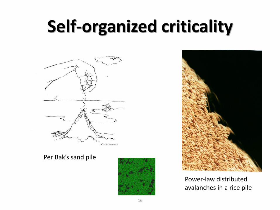
Self-organized criticality
Per Bak’s sand pile
Power-law distributed avalanches in a rice pile

Unequal, skewed distributions
17

The frequency of degree values (= number of links per node) in networks
18

The „Zipf Law“ (George Kingsley Zipf, 1902-1950)
P(r) = P(l)/rZ
19

Rank-size distributions, „Zipf´s Law“ and settlement hierarchies (cf. Preiser-Kapeller – Mitsiou, 2010)
20

DECISION-MAKING IN A COMPLEX ENVIRONMENT: ESTABLISHING AND MAINTAINING HARBOURS
21

Anchorage, Harbour, Port (cited from Th. Tartaron, Maritime Networks in the Mycenaean World, 2013)
• “An anchorage is any coastal location at which a vessel can be brought to a safe landing position, by any means including being pulled up onto a sandy shore, lying at anchor in shallow offshore waters, or being moored to a natural feature or an artificial construction such as a quay or jetty. There is no necessary implication in this term of the existence of durable, artificial constructions to accommodate vessels, or of a permanent settlement associated with these activities. Many anchorages, past and present, are used episodically, often tied seasonally to environmental conditions and agricultural calendars and providing temporary safe haven in times of danger at sea.
• The term harbor carries the stronger implication that certain coastal locations are earmarked for the role of accommodating maritime traffic. The morphological attributes of harbors range from entirely natural embayments with few or no artificial constructions to enhance their maritime functions, to fully artificial harbors fashioned by means of breakwaters, quays, and elaborate drainage and maintenance systems. Still, there is no requirement that a permanent settlement accompany a harbor, although the greater the maritime traffic or the number of artificial enhancements, the more likely that this will be the case.
• The connotation of the term port, finally, is of the existence of a “port town,” thus a permanent settlement with a primary function as a major node in a maritime network. The port town typically possesses more than the bare essentials to accommodate maritime traffic: there may be complex facilities for storage, recording, and exchange of commodities; processing of raw materials; transshipment to interior regions or further seaward destinations; and quartering of crews for short- or longer-term residence. “ 22

Topographic typology of ancient anchorages
23 from: Tartaron, 2013

Searching for Prehistoric Aegean Harbors (TARTARON – ROTHAUS – PULLEN, 2003)
• Environmental determinants: relief, usable area for agriculture, access to water
• Cultural determinants: typical parameters of landscape utilization in resp. period
• Harbor determinants: protection from wind, bathymetry
24

Challenges of nature: erosion, aggradation
25 from: Tartaron, 2013

Typology of ancient harbour sites (Marriner/Morhange, 2007)
26

Typology of ancient harbour sites (Marriner/Morhange, 2007)
27

The site of Aulis (M. Ghilardi et al. / Journal of Archaeological Science 40, 2013)
28

The site of Ampurias (Spain) (Marriner/Morhange, 2007)
29

Increased sedimentation in ancient harbour basins (cultural inputs, accentuated coastal progradation due to human activity) (Marriner/Morhange, 2007, p. 152: 1-2 mm/y vs. 10-20 mm/y)
30 from: Tartaron, 2013

Intended and unintended consequences
• How did local populations modify their coastal environment? Either (a) indirectly, through the production of increased sediment yields; and (b) directly, by modifying their natural environment to produce low energy basins. Recent work from the Levantine coast indicates that these impacts were relatively moderate during the Bronze Age and reached their apogee during the Roman period. (Marriner/Morhange, 2007, p. 180)
• In the face of rapid accumulation rates, maintaining a navigable water column, or draught depth, engendered clear management strategies. (Marriner/Morhange, 2007, p. 146) 31

The Ancient Harbour Parasequence (N. Marriner, C. Morhange / Earth-Science Reviews 80, 2007)
32

Factors for harbour layout • The layout of a port depends on navigation conditions (winds and waves) and
on the types of ship that use it. The size of the ships defines the acceptable wave-induced disturbance and the possible need to build a breakwater providing protection against swell and storms. The number of ships using the port dictates the length of quays and the area of the basins required. The ships' draught defines the depth at the quayside and thus the height and structure of the quay. Locally available materials (wood, stone and mortar) and construction methods define the specific structures for a region and historical period. (Marriner/Morhange, 2007, p. 146)
• An appreciation of the design of ships is also central to understanding the navigational capabilities of vessels and hence the routes likely to be preferred and the requirements for ports en route. It is important to recognize whether there was a direct relationship between the building of ports and the location of major shipping lanes, or whether the construction of a port can lead to a shift in shipping routes. A comprehension of ship desing is also crucial, because it can point at an early stage to possible problems in anchoring inside ports. (Gertwagen, 2000)
• Cf. Kristin Ilves, Do Ships shape the Shore?, The International Journal of Nautical Archaeology 2012.
33

Innovation and diffusion: the Roman invention of hydraulic concrete (ca. 200 BC)
Roman Maritime Concrete Study (ROMACONS; Christopher Brandon, Robert L. Hohlfelder, John Peter Oleson et Charles Stern)
34

Dredging in ancient
harbours (Morhange/Marriner,
2010)
35
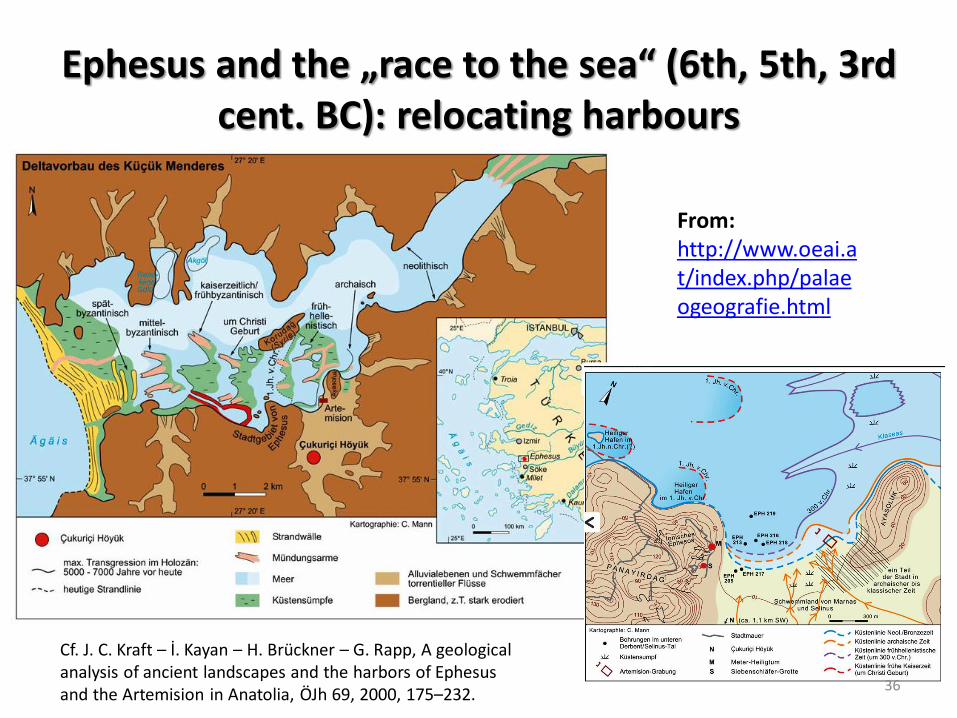
Ephesus and the „race to the sea“ (6th, 5th, 3rd cent. BC): relocating harbours
36
Cf. J. C. Kraft – İ. Kayan – H. Brückner – G. Rapp, A geological analysis of ancient landscapes and the harbors of Ephesus and the Artemision in Anatolia, ÖJh 69, 2000, 175–232.
From: http://www.oeai.at/index.php/palaeogeografie.html

The correlation of infrastructur investments and demographic and economic trajectories
(Marriner, Morhange, 2007)
37
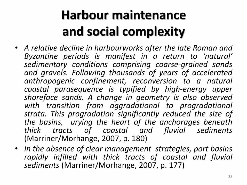
Harbour maintenance and social complexity
• A relative decline in harbourworks after the late Roman and Byzantine periods is manifest in a return to ‘natural’ sedimentary conditions comprising coarse-grained sands and gravels. Following thousands of years of accelerated anthropogenic confinement, reconversion to a natural coastal parasequence is typified by high-energy upper shoreface sands. A change in geometry is also observed with transition from aggradational to progradational strata. This progradation significantly reduced the size of the basins, urying the heart of the anchorages beneath thick tracts of coastal and fluvial sediments (Marriner/Morhange, 2007, p. 180)
• In the absence of clear management strategies, port basins rapidly infilled with thick tracts of coastal and fluvial sediments (Marriner/Morhange, 2007, p. 177)
38

Fields of action, purposes and motivations (Cetin & Cerit, 2010; Huy et. al, Dynamic MCDM: The Case of Urban Infrastructure
Decision Making, http://cbafiles.unl.edu/public/cbainternal/facStaffUploads/huychaeolson3.pdf)
39

Centre, local community, environment and the harbour of Candia on Crete, 13th-15th cent.
(Gertwagen, 2000)
40

The harbour of Candia on Crete, 1204-1505 (after Gertwagen, 2000)
„Why, for example, did some coastal settlements flourish as commercial towns without artifical ports?“ (Horden – Purcell, 2000) 41

NAVIGATION IN A COMPLEX ENVIRONMENT: ROUTES AND SAILING PERIODS
“The environmental conditions for navigation in the Aegean Sea are produced by complex interactions of atmospheric, hydrospheric, and lithospheric (terrestrial) forces operating at different scales, i.e., global; basin-scale (Mediterranean); sub-basin-scale (the eastern or western basin of the Mediterranean, or one of its constituent bodies of water such as the Aegean Sea); mesoscale (e.g., contained within the Aegean); or microscale (local)” (from: Tartaron, 2013)
42

Regional scale: Circulations and gyres (Papageorgiou, 2008; Tartaron, 2013)
43 from: Tartaron, 2013

Local scale: eddies
44 from: Tartaron, 2013

Local scale: sea breezes, land breezes, topography, waves and winds
45
from: Tartaron, 2013

A complex interplay: the Thermaic Gulf
Donald Olson and colleagues (2007) describe the effects of eddies in the large Thermaic Gulf (with Thessaloniki located at its head). Some of the Black Sea Water flow enters the gulf, creating a dense pattern of eddies, dominated by cyclones at the mouth of the bay and anticyclones within it. The anticyclonic rotation forms a rim current that is intensified by the inflow of three major rivers (the Axios, the Aliakmon, and the Loudias) into the gulf. The current is further complicated by the effects of two northerly winds, the meltemi and the local vardari, a strong northwesterly valley wind that blows irregularly from the Axios (ancient Vardar) river valley, as well as a sea breeze that forces strong diurnal surface currents within the gulf. Contexts such as the Thermaic Gulf amply demonstrate multiscalar atmospheric, hydrospheric, and terrestrial forces interacting to create local conditions that are highly malleable and distinctly seasonal (Kourafalou and Barbopoulos 2003). (from: Tartaron, 2013)
46

The spatial distribution of wind speed and wave height (on average)
47 from: Soukissian et. al., 2008

„Black Swans“ – „extreme events“
48 from: Soukissian et. al., 2008

A rank size distribution of wind speeds (from: Soukissian et. al., 2008)
49

A rank size distribution of wave heights (from: Soukissian et. al., 2008)
50
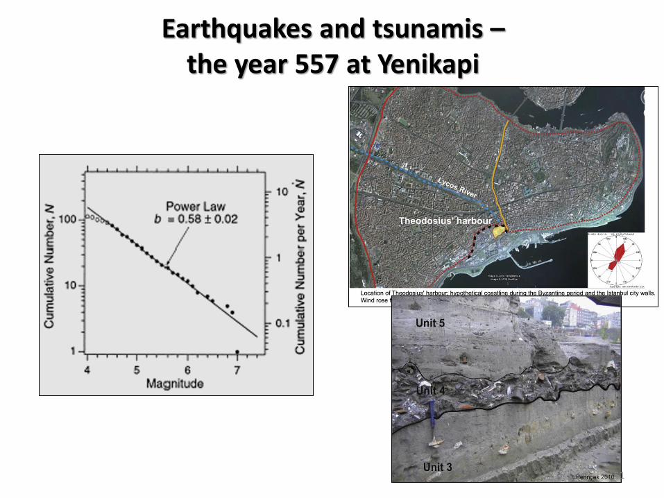
Earthquakes and tsunamis – the year 557 at Yenikapi
51

Cost surface analysis and optimal paths on sea (Indruszewski & Barton, 2008; Leidwanger, 2013)
52 from: Tartaron, 2013

Environment and sea routes: determinism?
• There can be little doubt that environmental factors strongly influenced the routes that sea travelers followed around the Aegean in the Bronze Age. Winds, currents, topography, and seasonal weather patterns combined with technologies of shipbuilding, propulsion, and navigation to give shape to a range of possible routes and seasonal schedules. If these factors were sufficiently determinative, certain well-traveled sea lanes could be formalized over long periods of time, with a consequently strong impact on the pattern of social relations. (From: Tartaron, 2013)
53

Environment and sea routes: determinism? (PAPAGEORGIOU, 2009)
54 from: Tartaron, 2013

Environmental complexity <-> social complexity
• Thus, it is plainly inadequate to map maritime interactions based solely on environmental factors. It is the human response, operating within the opportunities and constraints of natural environment and socioeconomic milieu, which is decisive. (from: Tartaron, 2013)
55
From: B. Russell, ‘Lapis transmarinus: stone-carrying ships and the maritime distribution of stone in the Roman empire’, in: Maritime Archaeology and Ancient Trade in the Mediterranean. OCMA 7, ed. by D. J. Robinson and A. I. Wilson

Political and economic factors: the position of Crete within late medieval searoutes (Gertwagen, 2000)
56

CREATING COMPLEX NETWORKS: HARBOURS AS NODES, ROUTES AS TIES
57

The overlapping of itineraries and the modelling of networks (from: Ducruet et. al., 2010)
58

The Atlantic liner
shipping network (from:
Ducruet et. al., 2010)
59

60 (from: Ducruet et. al., 2010)

The same properties of the network
at various scales
61
(from: Ducruet et. al., 2010)

Modelling historical networks: the Orbis-project in Stanford (Scheidel et. al.)
62
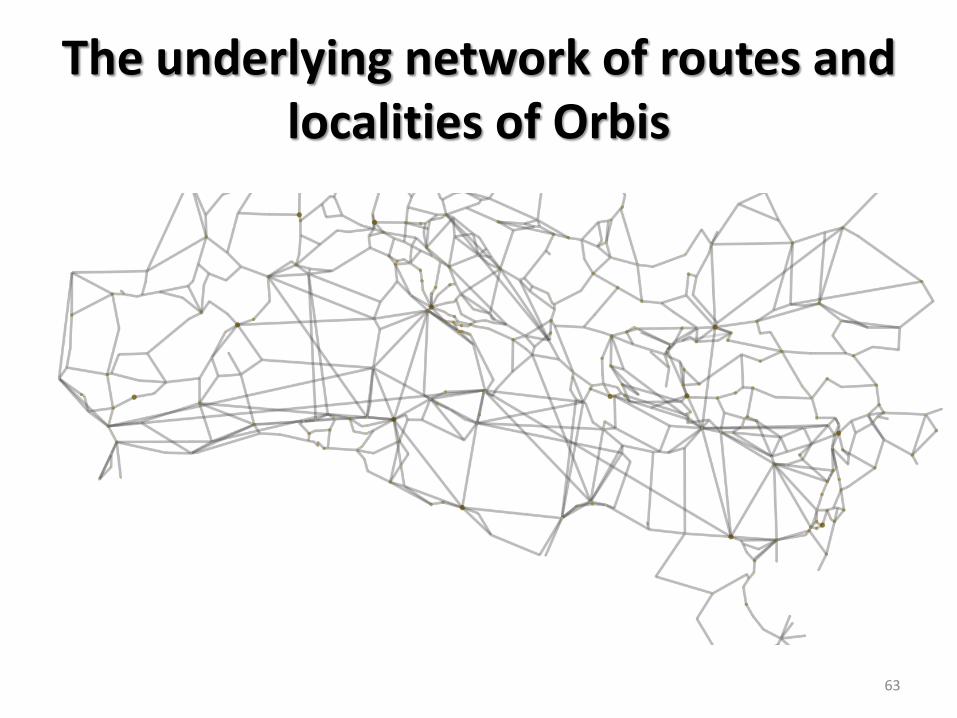
The underlying network of routes and localities of Orbis
63

The basis for the maritime route network: Arnaud, 2005
64

Determining the relative centrality of nodes within the network of Orbis
65

Modelling maritime interaction in the Aegean Bronze Age: the cost and attractiveness of
connections (KNAPPETT, EVANS, RIVERS, 2008)
66

Modelling maritime contacts across the early medieval North Sea (Sindbæk 2012)
67

The significance of „small worlds“ and local maritime connections
• More importantly, such long-distance connections were dwarfed in quantity by dense networks of local and regional maritime connections among Mycenaean communities. The latter routes and relationships have received little attention, but they must have dominated the use of anchorages, large and small, on Aegean coasts. There were many shades of activity in the spectrum between local and international interaction. Local and microregional maritime networks are best expressed by the concept of the “small world” (Broodbank 2000: 175–210), composed of communities bound together by intensive, habitual interactions due to geography, traditional kinship ties, or other factors. There may be a high level of interdependence and communities may come to think of themselves as forming a natural entity, defined by the dense web of connections that supports a combination of political, social, and economic relationships. Small worlds are nested within larger regional and interregional economic and sometimes political networks. (from: Tartaron, 2013)
68

The significance of „small worlds“ and local maritime connections
• The durability of short-distance relations results from several factors that are typically absent in large-scale, cross-cultural contacts: (1) they are easier to maintain from a practical point of view, since distances and environmental obstacles are less inhibitive; (2) they are often founded on long-established and deeply embedded social ties; and (3) the communities they bind may be less susceptible to changing political fortunes if they lie outside the mainstream of momentous historical events. (From: Tartaron, 2013)
69

Dense clusters and connections between them
70
(from: Tartaron, 2013)

Landing sites as contact zones between sea and land
From: K. Ilves, Is there an Archaeological Potential for a Sociology of Landing Sites?, 2011 71

Networks into the hinterland
72

The mobility of individuals and objects from inland to the sea
From: Bridge, The International Journal of Nautical Archaeology (2011) 40.2: 417–423
73

Local maritime traffic systems and their connections with the wider hinterland: the Ambrakian and
Pagasetic Gulfs (Preiser-Kapeller, 2013)
74

The relative centrality of localities within the entire network: betweenness
(cf. also Veikou, 2012, for routes and localities in Epirus)
75

The identification of hierarchies and structurally equivalent localities
76
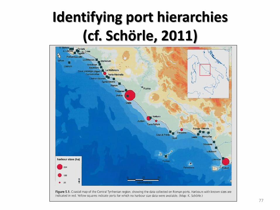
Identifying port hierarchies (cf. Schörle, 2011)
77
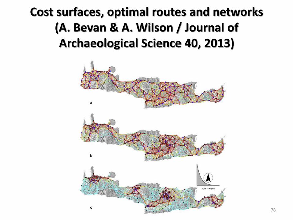
Cost surfaces, optimal routes and networks (A. Bevan & A. Wilson / Journal of Archaeological Science 40, 2013)
78
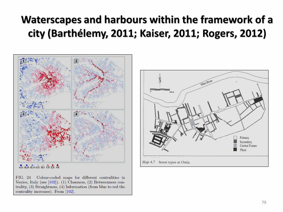
Waterscapes and harbours within the framework of a city (Barthélemy, 2011; Kaiser, 2011; Rogers, 2012)
79

Some (possible) topics of discussion
• Social and environmental complexity: some concepts
• Decision-making in a complex environment: establishing and maintaining harbours
• Navigation in a complex environment: the emergence of sailing routes
• Creating complex networks: harbours as nodes, routes as ties
80

References • Algan, O., Holocene coastal change in the ancient harbor of Yenikapı–İstanbul and its impact on cultural history. Quaternary
Research 76 (2011) 30–45.
• Ambraseys, N., Earthquakes in the Mediterranean and Middle East. A Multidisciplinary Study of Seismicity up to 1900. Cambridge 2009.
• Arnaud, P., Les routes de la navigation antique. Itinéraires en Méditerranée. Paris 2005.
• Arnaud, P., Ancient sailing routes and trade patterns: the impact of human factors, in: Robinson - Wilson 2011, 61-80.
• Barthélemy, M., Spatial Networks. Physics Reports 499 (2011) 1-101.
• Benthos. Digital Atlas of Ancient Waters: http://awmc.unc.edu/wordpress/benthos/
• Bevan, A., and Wilson, A., Models of settlement hierarchy based on partial evidence. Journal of Archaeological Science 40 (2013) 2415-2427.
• Bridge, M., Resource Exploitation and Wood Mobility in Northern European Oak: dendroprovenancing of individual timbers from the Mary Rose (1510/11–1545). The International Journal of Nautical Archaeology (2011) 40.2, 417–423.
• Campbell, B. M. S., Nature as historical protagonist: environment and society in pre-industrial England. Economic History Review 63/2 (2010) 281–314.
• Cetin, C. K., and Cerit, A. G., Organizational effectiveness at seaports: a systems approach. Maritime Policy & Management: The flagship journal of international shipping and port research, 37:3, 195-219
• Ducruet, C., Rozenblat, C., and Zaidi, F., Ports in multi-level maritime networks: evidence from the Atlantic (1996–2006). Journal of Transport Geography 18 (2010) 508–518.
• Durango-Cohen, P. L., Maintenance and Repair Decision Making for Infrastructure Facilities without a Deterioration Model. Journal of Infrastructure Systems, Vol. 10, No. 1, March 1, 2004, 1-8.
• Gertwagen, R. The Concept of Ports in the Medieval Eastern Mediterranean: Construction and Maintenance on Crete to the End of the Fifteenth Century. International Journal of Maritime History 12/1 (2000) 177-241.
• Ghilardi, M., et. al., Geoarchaeology of Ancient Aulis (Boeotia, Central Greece): human occupation and Holocene landscape changes. Journal of Archaeological Science 40 (2013) 2071-2083.
• Heinz, G., and Mees, A. W., Web based statistical data processing, in: F.J. Melero / P. Cano / J. Revelles (eds.), Fusion of cultures. Abstracts of the XXXVIII Annual Conference on Computer Applications and Quantitative Methods in Archaeology, CAA 2010 (Granada 2010), 375-377.
• Helbing, D., Keltsch, J., and P. Molnár, Modelling the evolution of human trail systems. Nature 388 (1997) 47-50.
• Horden, P., and Purcell, N., The Corrupting Sea. A Study of Mediterranean History. Malden – Oxford 2000.
81

References • Ilves, K., Is there an Archaeological Potential for a Sociology of Landing Sites? Journal of Archaeology and Ancient History,
2011, No. 2, 1-31.
• Ilves, K., Do Ships Shape the Shore? An Analysis of the Credibility of Ship Archaeological Evidence for Landing Site Morphology in the Baltic Sea. The International Journal of Nautical Archaeology, Volume 41, Issue 1 (2012), 94–105.
• Indruszewski, G., and Barton, C. M., Simulating Sea Surfaces for Modeling Viking Age Seafaring in the Baltic Sea, in: Digital Discovery: Exploring New Frontiers in Human Heritage. CAA 2006. Computer Applications and Quantitative Methods in Archaeology. Proceedings of the 34th Conference, Fargo, United States, April 2006, edited by Jeffrey T. Clark and Emily Hagemeister, 616-630.
• Juneja, M., and Mauelshagen, F., Disasters and Pre-industrial Societies: Historiographic Trends and Comparative Perspectives. The Medieval History Journal 10/1&2 (2007) 1–31.
• Kaiser, A., Roman Urban Street Networks. New York – London 2011.
• Karagianni, F., The Development of the Cities during the Transition from Late Antiquity to the Early Christian Era: http://www.ni.rs/byzantium/doc/zbornik7/PDF-VII/10%20Flora%20Karagianni.pdf.
• Karagianni, F., OLKAS. From Aegean to the Black Sea. Medieval Ports in the Maritime Routes of the East: http://www.blacksea-bc.net/index.php/eng/content/download/12657/322937/file/Flora%20Karagianni%20-%20OLKAS.%20From%20Aegean%20to%20the%20Black%20Sea.%20Medieval%20Ports%20in%20the%20Maritime%20Routes%20of%20the%20East.pdf. (cf. also http://www.olkas.net/).
• Knappett, C. (ed.), Network-Analysis in Archaeology. New Approaches to Regional Interaction. Oxford 2013.
• Knappet, C., Evans, T., and R. Rivers, Modelling maritime interaction in the Aegean Bronze Age. Antiquity 82 Number: 318 , 1009–1024.
• Leidwanger, J., Modeling distance with time in ancient Mediterranean seafaring: a GIS application for the interpretation of maritime connectivity. Journal of Archaeological Science 40 (2013) 3302-3308.
• Luterbacher, J., et. al. A Review of 2000 Years of Paleoclimatic Evidence in the Mediterranean, in: P. Lionello (ed.), The Climate of the Mediterranean region: from the past to the future. Amsterdam 2012, 87–185.
• Marriner, N., and Morhange, C., Geoscience of ancient Mediterranean harbours. Earth-Science Reviews 80 (2007) 137-194.
• McCormick, M., et. al., Climate Change during and after the Roman Empire: Reconstructing the Past from Scientific and Historical Evidence. Journal of Interdisciplinary History 43, 2 (2012) 169–220.
• Mees, A. W., The internal organisation of terra sigillata (samian) workshops, in: M. Fulford / E. Durham (eds.), Seeing Red: new economic and social perspectives on terra sigillata. Institute of Classical Studies, London 2013. Supplement 102: Vol. 10, 66-96.
82

References • Morhange, C., and Marriner, N., Mind the (stratigraphic) gap: Roman dredging in ancient Mediterranean harbours. Bollettino
di Archeologia online I 2010: http://151.12.58.75/archeologia/bao_document/articoli/4_Morhange_Marriner_paper.pdf.
• Oleson, J. P., et al., The ROMACONS Project: a Contribution to the Historical and Engineering Analysis of Hydraulic Concrete in Roman Maritime Structures. The International Journal of Nautical Archaeology (2004) 33.2, 199–229.
• Oleson, J. P, Brandon, Ch, and Hohlfelder, R. L., Technology, Innovation and Trade: Research into the engineering characteristics of Roman Maritime Concrete, in: Robinson - Wilson 2011, 107-119.
• Papageorgiou, D., The Marine Environment and Its Influence On Seafaring and Maritime Routes in the Prehistoric Aegean. European Journal of Archaeology August/December 2008 vol. 11 no. 2-3, 199-222.
• Preiser-Kapeller; J, and Mitsiou, E., Hierarchies and fractals: ecclesiastical revenues as indicator for the distribution of relative demographic and economic potential within the cities and regions of the Late Byzantine Empire in the early 14th century. Byzantina Symmeikta 20 (2010), 245-308 (online: http://www.byzsym.org/index.php/bz/article/view/993/937)
• Preiser-Kapeller, J. Networks of border zones – multiplex relations of power, religion and economy in South-eastern Europe, 1250-1453 CE, in: Proceedings of the 39th Annual Conference of Computer Applications and Quantitative Methods in Archaeology, "Revive the Past" (CAA) in Beijing, China. Amsterdam 2012, p. 381-393 (online: http://oeaw.academia.edu/JohannesPreiserKapeller/Papers)
• Preiser-Kapeller, J., Mapping maritime networks of Byzantium. Aims and prospects of the project “Ports and landing places at the Balkan coasts of the Byzantine Empire”. Working paper for the conference “Olkas. From Aegean to the Black Sea. Medieval Ports in the Maritime Routes of the East”, Thessalonike, December 2013 (online: http://oeaw.academia.edu/JohannesPreiserKapeller/Byzantine-Ports-Project)
• Robinson, D., and Wilson, A. (eds), Maritime Archaeology and Ancient Trade in the Mediterranean (Oxford Centre for Maritime Archaeology Monograph 6). Oxford 2011.
• Rogers, A., Water and the Urban Fabric: a study of towns and waterscapes in the Roman period in Britain. The International Journal of Nautical Archaeology 41/2 (2012) 327–339.
• Scheidel, W., et. al., ORBIS: The Stanford Geospatial Network Model of the Roman World: http://orbis.stanford.edu/.
• Schmidts, Th., Akteure und Organisation der Handelsschifffahrt in den nordwestlichen Provinzen des Römischen Reiches. Mainz 2011.
• Schörle, K., Constructing Port Hierarchies: Harbours of the central Tyrrhenian Coast, in: Robinson - Wilson 2011, 93-106.
83

References
• Sindbæk, S.M., The Small World of the Vikings. Networks in Early Medieval Communication and Exchange', Norwegian Archaeological Review 40 (2007), 59-74.
• Sindbæk, S.M., Viking Disruptions or Growing Integration?: Contextualising Communication Networks in the 10th Century North Sea, in: Raumbildung durch Netzwerke ?: Der Ostseeraum zwischen Wikingerzeit und Spätmittelalter aus archäologischer und geschichtswissenschaftlicher Perspektive, ed. Sunhild Kleingärtner; Gabriel Zeilinger. Bonn 2012, 19-38.
• Sindbæk, S.M., Broken links and black boxes: material affiliations and contextual network synthesis in the Viking world, in: Knappett 2013, 71-94.
• Soukissian, T., et. al., Assessment of the Wind and Wave Climate of the Hellenic Seas Using 10-Year Hindcast Results. The Open Ocean Engineering Journal, 2008, 1, 1-12.
• Tartaron, T., Maritime Networks in the Mycenaean World. Cambridge 2013. • Tartaron, T., Rothaus, R., and Pullen, D., Searching for Prehistoric Aegean Harbors with GIS, Geomorphology, and
Archaeology. Athena Review 4 (2003) 27-36. • Vanek, O., et. al., Agent-based Model of Maritime Traffic in Piracy-affected Waters. Transportation Research Part C:
Emerging Technologies 36, November 2013, 157–176. • Veikou, M., Byzantine Epirus. A Topography of Transformation. Settlements of the Seventh-Twelfth Centuries in
Southern Epirus and Aetoloacarnania, Greece (The Medieval Mediterranean 95). Leiden 2012. • Veikou, M., Byzantine Histories, Settlement Stories: Kastra, “Isles of Refuge”, and “Unspecified Settlements” as In-
between or Third Spaces, in: T. Kioussopoulou (ed.), Οι βυζαντινές πόλεις, 8ος-15ος αιώνας, Προοπτικές της έρευνας και νέες ερμηνετικές προσεγγίσεις. Rethymno 2012, 159-205.
• Wilson, A., Developments in Mediterranean Shipping and Maritime Trade from the Hellenistic Period to 1000 AD, in: Robinson - Wilson 2011, 33-59.
84