Habitat Models and Social Systems in Middle Bronze Age central north-western Transylvania. State of...
84
Polish AcAdemy of sciences — crAcow brAnch commission of ArchAeology AcTA ArchAeologicA cArPAThicA VOL. XLVIII crAcoViAe mmXiii 2013
Transcript of Habitat Models and Social Systems in Middle Bronze Age central north-western Transylvania. State of...
Polish AcAdemy of sciences — crAcow brAnchcommission of ArchAeology
AcTA ArchAeologicA cArPAThicA
VOL. XLVIII
crAcoViAe mmXiii
2013

Polish AcAdemy of sciences — crAcow brAnchcommission of ArchAeology
Editor in Chief: Zenon wo�niAK
Editors: PAwe£ VAlde-nowAK, mArcin woŁosZyn
Editorial Secretary: PAwe£ JArosZ
Editorial Committee: JAn chochorowsKi, sylwesTer cZoPeK, mAreK gedl (chairman),
nAndor KAlicZ, JAn mAchniK, KArol PieTA, PeTre romAn, AndrZeJ ¯AKi
editor’s Address: s³awkowska street 17, 31-016 cracow, Poland
Home page: www.archeo.pan.krakow.pl/AAC.htm
editing work, especially verifying the bibliography was made possible by hospitality offered by geisteswissenschaftliches Zentrum geschichte und Kultur ostmitteleuropas (gwZo), leipzig
All articles published in AAc have to obtain approval of european specialists not relatedwith the editorial office. we are grateful to the following specialists for reviewing the contributions
published in volume no. 48 (2013)JoZef báTorA (Archeologický ustav, slovenská akadémia vied), slovakia, nitra
JAn bemmAnn (Vor- und frühgeschichtliche Archäologie, rheinische friedrich-wilhelms- Universität), germany, bonn
JArosŁAw bodZeK (instytut Archeologii, Uniwersytet Jagielloński), Poland, cracowiVAn cheben (Archeologický ustav, slovenská akadémia vied), slovakia, nitra
fAlKo dAim (römisch-germanisches Zentralmuseum), germany, mainzlUcynA domAńsKA (instytut Archeologii, Uniwersytet Łódzki), Poland, Łódź
mArKo diZdAr (institut za Arheologiju), croatia, ZagrebgAbriel fUseK (Archeologický ustav, slovenská akadémia vied), slovakia, nitra
ÉVA gArAm (magyar nemzeti múzeum), hungary, budapestlesZeK KAJZer (instytut Archeologii, Uniwersytet Łódzki), Poland, Łódź
mAcieJ KArwowsKi (instytut Archeologii, Uniwersytet rzeszowski), Poland, rzeszów TobiAs l. Kienlin (institut für Ur- und frühgeschichte Universität zu Köln), germany, colognerenATA mAdydA-legUTKo (instytut Archeologii, Uniwersytet Jagielloński), Poland, cracow
michAŁ PArcZewsKi (instytut Archeologii, Uniwersytet rzeszowski), Poland, rzeszówPeTer c. rAmsl (institut für orientalische und europäische Archäologie, Österreichische
Akademie der wissenschaften), Austria, ViennaAUrel rUsToiU (institutul de Arheologie si istoria Artei Academia româna), romania,
cluj-napocamichAl sliVKA (Katedra Archeológie, Univerzita Komenského v bratislave filozofická
fakulta), slovakia, bratislavahAns georg sTePhAn (institut für Kunstgeschichte und Archäologien europas,
martin-luther -Universität halle-wittenberg), germany, halle, wittenbergmiKlós TAKács (régészeti intézete, mTA), hungary, budapest
dAVid g. wigg-wolf (römisch-germanische Kommission), germany, frankfurt am mainJoZef ZáboJníK (Archeologický ustav, slovenská akadémia vied), slovakia, nitra
Pl issn 0001-5229
language editors: Anna Kinecka (english), doris wollenberg (german)
© copyright by the Authors, Polish Academy of sciencesKraków 2013
5Habitat Models and social systeMs...
Zsolt Molnár, József-Gábor NaGy
Habitat Models and Social Systems in Middle Bronze Age central north-western
Transylvania. State of research1
A b s T r A c T
Zs. molnár, J.-g. nagy 2013. Habitat Models and Social Systems in Middle Bronze Age central north-western Transylvania. State of research. Acc 48: 5–86.
The existence of fortifications is attached to the emergence of formalized territorial units of a quasi-political nature. The current paper examines middle bronze Age settlement sites, metal finds and natural resources of central north-western Transylvania.
our aim is to investigate the differences, transformations and the dynamics of settlement systems in the study area during the middle bronze Age using cartographic documents and data relating to the landscape around the sites (using satellite images, aerial photographs and geo-physical measurements) stored in a geographic information system (gis).
The research also draws on macro-regional palaeoenvironmental data on central north-west-ern romania. modelling the territories of Transylvanian prehistoric communities provides informa-tion about the division of space and possible land use strategies. A uniformly general model cannot be applied in case of the Transylvanian middle bronze Age settlement system. The settle-ment founding culture’s different characteristics, the special topographical and ecological conditions of the distribution areas determined the quality of the established settlement network.
There is evidence that middle bronze Age chiefdoms form peer polities controlling territories of different size along one or a larger number of river valleys. our approach reflects the current stage of research of the subject; the future field research is expected to bring in new, more con-clusive evidence in this matter.
K e y w o r d s: Transylvania, settlement pattern, cost distance, gis, landscape archaeology
received: 6.12.2012; revised: 6.1.2014; revised: 6.1.2014; Accepted: 7.1.2014
1 The present paper would not have been written without support from the cncsis Te Program: Aero-Archaeological research in Transylvania. modern Theoretical models and applied interdisciplinary investigations, code Te_50/304.
A c T A A r c h A e o l o g i c A c A r P A T h i c A
Vol. XlViii, 2013 Pl issn 0001-5229
A r T i c l e s
6 Zsolt Molnár, JóZsef-Gábor naGy
ArgUmenT for An APProAch
in recent decades issues related to the middle bronze Age otomani-gyula-varsánd2 and wietenberg3 cultures was addressed in several archaeological studies written by researchers from romania as well as by authors from oth-er countries. even though the study of the habitat and settlement system has been pursued with energy by bronze Age scholars, many questions — e.g., social organisation of central and north-western Transylvanian middle bronze Age communities and settlement system models — remain unanswered.
A study of the complex relationships existing in the middle bronze Age — an ambitious and challenging — may be expected to help improve our under-standing and refine our interpretations of social and economic behaviour of human communities. in an attempt to grasp the nature of social and political organisation within societies of early europe, prehistorians have offered mul-tiple explanations of social and economic differences by developing a number of theoretical models and concepts4. without debating theoretical approaches it is worthwhile noting that most of the socio-political models developed for the bronze Age are dominated by a top-down approach and involve an ex-trapolation from the strict archaeological record accepting a series of related anthropological concepts5.
from our point of view a top-down approach model does not necessary mean a politically and economically heavily centralized society. The premise of the social model proposed here is that tells (otomani culture) and fortified hilltop settlements (wietenberg culture) are the power and economic centres on their territory (s t e w a r d 1955, 9ff., 51, 178ff.; w h i t e 1959, 17ff.). if tells are considered as more than multi-layer settlements, but a ‘package’ connecting together central settlement structure, social, economic and certain environmen-tal factors, this expanded definition can be used to classify the territories of all the cultures of the middle bronze Age in the carpathian basin. in this sense the notion of a central site (or of a multi-layer, fortified settlement) reflects the same phenomenon and can be used as synonymous (f i s c h l, h e l l e b r a n d t, r e b e n d a 2011, 108; f i s c h l, r e m é n y i 2013, 726ff.; f i s c h l, K i e n l i n 2013, 28). A uniformly general model cannot be applied in case of the Transyl-
2 This group of issues is addressed in: b ó n a 1975, 120ff.; m á t h é 1988, 27ff.; b a d e r 1998, 43ff.; T h o m a s 2008, 15ff.; g a n c a r s k i 1999 (ed.); g a n c a r s k i 2002 (ed.); s t e i n e r 2003, 83ff.; P r z y b y ł a, b l a j e r 2008, 52ff.; n é m e t i, m o l n á r 2012, 10ff.; g ó r s k i 2012, 89ff.
3 relevant monographs: c h i d i o ş a n 1980; A n d r i ţ o i u 1992; b o r o f f k a 1994; A n d r i-ţ o i u, r u s t o i u 1997.
4 recently published reviews: r e n f r e w 1982, 5ff.; r e n f r e w 1986, 1ff.; s h a n k s, T i l l e y 1987, 41ff.; m o l n á r, Ţ o c a 2011, 119ff.; h a r d i n g 2013, 378ff.;
5 for a hierarchical approach see: K r i s t i a n s e n 1998, 371, 374, 412; K r i s t i a n s e n 2000, 9; g o g â l t a n 2005, 38; h a r d i n g 2006, 113ff.; g o g â l t a n 2010, 13ff.; d a n i 2009, 21; for a second opinion and a different approach see: K i e n l i n 2012, 15ff.; K i e n l i n 2012a, 251ff.; b r i n k 2013, 434.
7Habitat Models and social systeMs...
vanian middle bronze Age settlement system. The settlement founding culture’s different characteristics, the special topographical and ecological conditions of the distribution areas determined the quality of the established settlement network6. The analysis of the central north-western Transylvanian settlement system is important — despite the archaeological data deficiency of the current stage of research — because the differences and possible relations between the central site and the countryside may reflect a similar social hierarchy (s h e n-n a n 1986, 119ff.; f i s c h l, r e m é n y i 2013, 729).
The bronze Age society investigation toolkit consists of archaeological mod-els and theoretical models of society offered by modern comparative anthropol-ogy (w a s o n 1994, 16f; s h a n k s, T i l l e y 1987, 137).
Over the last few decades important exhaustive reviews were published on the emergence of chiefdom and middle range society concepts and their interpretations7. in the carpathian basin the hierarchical organization of bronze Age chiefdom societies or the extent of socio-economic control are still open questions. The institutionalization of group-controlled hierarchies is the optimal means of exercising and retaining power. in case of central north-western Transylvania this process is connected to the existence of bands of warriors with various numbers of members and networked power strategies (J o h ns o n 1982, 389ff., 409ff., fig. 21:1, Table 21:1, fig. 4). The networked power strategies are based on the personal system of kinship, trade partner-ship and alliances. mutual gifts meant the base for the retention of the rela-tions system. This type of social organization strategies bring together the members of a community in a unified ideological and economic unit. There is room within this system also for mutual co-operation and competing rivalry (e a r l e 2002, 18). bronze weapons, regarded as elements of the prestige goods category, and fortifications — the result of community labour, are primary indicators of social hierarchy in our study area (f i r t h 1973, 77ff.; h a l a s 2002, 351ff.). The panorama of bronze Age society outlined by Kristian Kris-tiansen and Thomas larsson, with its system of cross-regional connections, strong intercultural influences in the elite-centred ideology, crystallized power and religious institutions, and the expression of status symbols, is tempting and definitely a subject for debate (K r i s t i a n s e n 1998, 58ff.; K r i s t i a n-s e n 2004, 180ff.; K r i s t i a n s e n, l a r s s o n 2005, 8ff., 161ff., 225ff.; see critique: n o r d q u i s t, w h i t t a k e r 2007, 75ff.). for the time being in Tran-sylvanian research we have no sufficient archaeological evidence for a similar panorama of society.
6 same opinions for other geographic areas: d a n i 2009, 17ff.; f i s c h l, h e l l e b r a n d t, r e b e n d a 2011, 108; f i s c h l, r e b e n d a 2012, 494ff.; s z e v e r é n y i, K u l c s á r 2012, 336; f i s c h l, K i e n l i n 2013, 6ff.
7 c a r n e i r o 1981, 39ff., f e i n m a n, n e i t z e l 1984, 37ff.; e a r l e 1987, 279ff.; K r i s t i a n-s e n 1998, 44ff.; v a n c r e v e l d 1999, 2ff.; c o b b 2000, 5ff.; h a a s 2001, 6f.; e a r l e 2001, 105ff.; e a r l e 2002, 43ff.; P a r k i n s o n 2006, 23ff.
8 Zsolt Molnár, JóZsef-Gábor naGy
The fortifications of the better known otomani tells may be interpreted as evidence on the existence of a central authority. The network of fortified settle-ments operating as symbols of the power system in practice protected and con-trolled the adjacent areas8. The fortification of carei-bobald, otomani-cetăţuie/Várhegy, sălacea-dealul Vida/Vida-domb, săcuieni-cetatea boului/Ökörvár tells, and the maintenance of defensive ditches required significant manpower and proper central co-ordination9. The work volume and the magnitude of mobilized manpower are measures of social control, indicating the power of the leader of the the power of the community leaders (e a r l e 1991, 85; d e m a r r a i s et al. 1996, 18; T h r a n e 2009, 15). The existence of a social hierarchy and of a group of warriors is suggested by a great number of bronze weapons and jew-ellery unearthed in north-western Transylvania and north-western romania10. in central Transylvania the number of bronze finds interpreted as prestige goods is much more modest (s o r o c e a n u 2012, 24ff.). The carrying of weap-ons is the warrior elite’s means of individual and collective identity expression, and also represents a new symbolic means of exercising power (e a r l e 2000, 39ff.; e a r l e, K r i s t i a n s e n 2010, 9f; e a r l e 2013, 357; f i s c h l, r e m é n y i 2013, 732). in the carei Plain and eriu Valley at the epicentre of the otomani-gyulavarsánd culture complex11 however, there is only a small number of metal artefacts that may be interpreted conclusively as prestige goods. At the present stage of research not a single sword is recorded in the Carei Plain and the eriu Valley, and only seven daggers belonging to the middle bronze Age are known12. nevertheless this apparently modest number of finds may could gain new meaning if we consider that 258 graves excavated at gemeinlebarn f yielded no more than seven daggers (n e u g e b a u e r 1991, 16ff.; h a r d i n g 2007, 57) or that only 30 daggers are known from the füzesabony culture area (T h o m a s 2008, 234 footnote 238). imported by whatever means these symbolically charged objects undergo a transformation of meaning, “getting a new identity”. Through these weapons the bearers differentiate themselves from other elites and from non-elite social groups (s t e i n 1999, 66; A r n o l d 2000, 28f; A l d e n d e r f e r 2010, 22ff.; d a r ó c z i 2011, 117; e a r l e 2013,
8 for views on this subject see: r e n f r e w, b a h n 1999, 197; h a r d i n g 2000, 274, 294ff.; s a h l q v i s t 2001, 89; d u f f y 2008, 129ff.; r e m é n y i 2003, 55ff.; o t t e r b e i n 2004, 12ff., 118ff.; K r i s t i a n s e n, l a r s s o n 2005, 225ff.; n e u s t u p n ý 2006, 2ff.; c h a p m a n, g a y d a r -s k a, h a r d y 2006, 20ff.; h a r d i n g 2007, 32, 40, 147ff.; P a r k i n s o n, d u f f y 2007, 100, 125; g o g â l t a n 2008, 39; T h r a n e 2009, 13ff.; e a r l e, K r i s t i a n s e n 2010, 14ff.; e a r l e, K o l b 2010, 75, 85; n é m e t i, m o l n á r 2012, 53.
9 o r d e n t l i c h 1973, 26ff., 110ff.; b a d e r 1978, 128; g o g â l t a n 2008, 45; n é m e t i, m o l-n á r 2012, 53.
10 on bronze metallurgy in western romania and north-western Transylvania see: h ä n s e l 1998, 21; g o g â l t a n 1999, 128ff., 195ff.; m o l n á r 2011, 272ff.; g ă v a n 2012, 57ff.
11 on the notion and terminology of the otomani-gyulavarsánd culture complex: n é m e t i, m o l n á r 2012, 10ff.
12 detailed analysis: m o l n á r 2011, 295ff. it needs to be emphasised that the discovered daggers represent different types that were not produced locally.
9Habitat Models and social systeMs...
357). ethnographic examples demonstrate that the existence of different iden-tities and special-status social groups is not a prerequisite of a strongly hier-archical society (h o d d e r 1979, 448ff.). The existence of prestige objects does not necessarily reflect a stratified and complex social structure distinguished by a set of strict rules. in this sense the so-called sanctuary discovered at sălacea in 1968 is evidence only on organized ritual life13. The participation of communi-ty members at repetitive, collective social activities helps to create and maintain a social memory with specific key markers and communal identity, playing an essential role in contacts with foreigners (c h a p m a n 1997a, 1ff.; c h a p m a n 1997b, 33, 41; c h a p m a n 1997c, 141; w h i t t l e 2010, 38; d a r ó c z i 2011, 22; d a r ó c z i 2012, 200). without debating the complex subject of bronze Age spirituality14, we are unable to separate the cult building identified at sălacea — a unique structure discovered on otomani-gyulavarsánd territory suspected of significant social and ritual functions — by virtue of its dimen-sions or topographic position, from other buildings (o r d e n t l i c h 1972, 71, 83, fig. 5–6; c h i d i o ş a n, o r d e n t l i c h 1975, 15ff.; b a d e r 1990, 182ff.; g o g â l t a n 2012, 16)15.
To conclude, the image which unfolds from data available to us is of a more modest society than the one outlined by K. Kristiansen. The investi-gated chiefdoms of central north-western Transylvania seem to be closer to the tribal/segmented societies than to the complex, strongly hierarchical chiefdoms. The analyzed social formations can be included in the category of so called hill fort chiefdoms (e a r l e 1997, 12f.). nevertheless, investigating the settle-ment system — with proper criticism — the use of hierarchical models might shift the current deadlock of the romanian research. from a methodological point of view — even if sometimes it is difficult to consider hilltop settlements and tells investigated here as ‘central’ in terms of economic and social control exercised over adjacent ‘dependent’ sites on possible lower ranks, the scientific correctness makes us apply as strictly as possible the elected theoretical mod-els. no doubt, to archeologically prove the outlined models will be the task of the future research.
13 on this subject see: r e n f r e w 1985, 14; r a p p a p o r t 1999, 24ff.; b r ü c k 1999, 317, 325. rituals can be detached from an exclusively religious context and employed also for non-religious processes. in case of such archaeological approach the focus is shifted to the significance of ritual practices (well framed repeated public action based on generally accepted cultural knowledge) for social communication and how it helps social groups to generate, present and negotiate differences (b e r t e m e s, b i e h l 2001, 12ff.; i n s o l l 2004, 34ff. on the history of research; m a r c u s 2007, 9ff.; r e n f r e w 2007, 109ff.; g r a m s c h, m e i e r 2013, 193ff.).
14 A synthetic article on the ritual aspects of bronze Age tells in the carpathian basin: g o g â l t a n 2012, 7ff.
15 This building may have been a “cult house”, interpreted as a sacred ancestral precinct, site of rituals and commemoration (V a n d k i l d e 2013, 169ff.).
10 Zsolt Molnár, JóZsef-Gábor naGy
reseArch goAls And meThodology
The current paper presents — based on archaeological data — two middle bronze Age habitat models discernible in central and north-western Transyl-vania. our focus is on the internal logic of the settlements and settlement clusters identified in the carei Plain, eriu Valley and someşul mic river basin attempting to understand the construction of social space. Through the study of settlement networks, modelling the territories of interacting polities and possible communication routes we try to sketch the habitat features of the studied region. habitat models proposed here are based on the theoreti-cal background of the peer polity interaction theory. The peer polity interac-tion concept includes an area’s overall economic and social relations system of the independent, politically equivalent territorial units (including imitation and competition, the exchange of goods and information, or war). structural changes and uniformity process of the socio-political units within the region are the result of long-term interactivity. in an ecological sense, some of the common features could have evolved independently in the adaptation process of the region (r e n f r e w 1982, 5f; r e n f r e w 1986, 1ff.; s h a n k s, T i l l e y 1987, 41ff.). The research had an interdisciplinary character. in our approach to investigate the social transformations and the dynamics of the settlements, next to the results of archaeological excavation and surveys we used informa-tion about the landscape and environment16 of the study area (satellite images, aerial photographs and geophysical measurements) stored in a gis database.
during the research databases were used with information acquired from fieldwalking and excavations overlaid on military topographic maps and ortho-photo-plans. To detect traces of human activity, oblique aerial photographs were also used. The data were digitized, and the maps were standardized in stereo ‘70 reference system17. in interpreting the spatial distribution of settlements we have taken into account the central place theory set of ideas, that there is a correlation between the size and the function of settlements (J o h n s o n 1972, 769ff.; c o l l i s 1986, 38f; g r a n t 1986, 13ff.; K i p f e r 2000, 102). The distribution of archaeological sites is modelled directly by the socio-cultural and economic needs of the community, allowing the functional interpretation of archaeological phenomena (w i l l e y 1953, 1).
To define the hinterlands of bronze Age settlements in the carei Plain — eriu Valley and the someşul mic basin we used cost surface based models corroborated with the establishment of the viewshed areas18. Most gis pro-
16 review papers on the concepts: s m y n t y n a 2006, 85ff.17 The data were analyzed using various gis programs. by georeferencing and vectorizating
raster digitized maps we obtained a digital terrain model (f l o r e a, Ş t e f a n 2011, 221).18 changes in the size and shape of settlements territory may reflect socio-economic changes
and environmental use (P o s l u s c h n y 2010, 313). cost analysis as a method of studying the cultural landscape has been criticized. Although influenced by vegetation of the area and weather conditions, viewshed analysis provides useful information about the reasons for founding a settle-ment in a given area (g a y d a r s k a 2007, 22).

11Habitat Models and social systeMs...
grams can calculate cost distance or least cost path based on the cost surface model (c o n o l l y, l a k e 2006, 213ff.; h e r z o g, P o s l u s c h n y 2011, 221ff.). Although different algorithms may be used to calculate slope (K v a m m e 1992, 129; c o n o l l y, l a k e 2006, 215ff.), they are not discussed in archaeological papers19. modelling the territories and possible routes of communication helped us reconstruct the possible role of fortifications in a region (w h e a t l e y 1995, 171ff.; P o s l u s c h n y 2008, 167).
The cost surface analysis was generated basing on a reclassification of slopes in five categories20. in Arcgis software we used the cost allocation calculation on the bronze Age tells and fortifications considered micro-regional power centres. if slope values and related cost surface are lower, the coverage enlarges. The territories controlled by different centres delimited using cost surface analysis were compared with the area of influence defined using the Thiessen polygon21 method and XTENT22 model (fig. 7:1–2; 8:1; 15:1–2; 16:1).
Viewshed, cost surface and shortest possible route analysis were made for the most important fortresses with the help of spatial Analyst module of Arc-gis (fig. 8:2; 9:1–2; 10:1–2; 16:2)23. The spatial analyses used in the study were based on a digital elevation model derived from the well-known srTm (shuttle radar topography mission) model. first, contour lines were generated with a 20 m interval, and next a dem was created with the Arcinfo — Topogrid-tool. These were used to create a Tin model of the study area. As the studied region is very large we used a resolution of 50 m for the resulting grid. All other raster based analyses were made with the same resolution.
19 The algorithm is based on empirical data from soldiers passing distances over different types of terrain. A model where speed is calculated in km/hour was created (g o r e n f l o, g a l e 1990, 240ff.).
20 Values were defined depending on the increase of the slope (1 for slopes between 0–2o, 2 for slopes 5–10o, 5 for slopes 10–30o, a value of 100 for slopes with maximum 30o, and for the course of someşul mic and eriu rivers which represents a major barrier in the area a value of 10000 was given).
21 The spatial distribution of settlements can be seen as an adaptation of communities to environmental conditions (b i n t l i f f 1988, 129ff.; b i n t l i f f 2013, 62ff.). The problems with the territorial analysis made using Thiessen polygons is that this method does not take into account natural barriers (river crossings or mountain areas), the size or importance of the sites as the territory is divided into identical polygons (d u c k e, K r o e f g e s 2008, 246). where the boundaries of the territories cannot be determined accurately, a way of reconstruction is possible by locating the central points of each territory (K i p f e r 2000, 563).
22 for socio-political conditions — based on archaeological data — spatial containment models, see: r e n f r e w 1981, 269ff.; g r a n t 1986, 19ff.; r e n f r e w, b a h n 1999, 172ff. Application of XTenT model in gis makes possible territorial modelling and partitioning, sites hierarchy and their weight integration, realistic distance models and topographic features within a compact, official framework (d u c k e, K r o e f g e s 2008, 247). The method takes into account the size of the settlements and the distance between them as factors determining the areas of influence of the power centres. According to the users of the model the influence of the central space decreases every km with 0.5–3% reduction (r e n f r e w, l e v e l 1979, 149ff.).
23 next to meeting other criteria, based on viewshed analyses, a fortification can be identi-fied as a power centre, or not, with control over a micro-region (P o s l u s c h n y 2008, 167). The topographical characteristics of points — height, slope, aspect — were extracted from the dem with the help of extract Values to Points command of the spatial Analyst Tool.

12 Zsolt Molnár, JóZsef-Gábor naGy
The catchment area of the settlements has to be searched around the site within a radius covered in a day (from 1–2 km24 to 5–6 km)25. our delimitations take into account the different patterns of production and economic exploita-tion of the environment (c h i s h o l m 1962, 47ff.; c h i s h o l m 1979, 47ff.)26. Agricultural potential estimates are based on analysis of the catchment areas of settlements (b i n f o r d 1982, 6f; r e n f r e w, b a h n 1999, 242) calculated using gis program based on euclidean distances between sites (c o n o l l y, l a k e 2006, 209ff.).
The shortest routes of communication between different fortifications sus-pected of being micro-regional power centres (fig. 12:2; 13:1–2; 18:2; 19:1–2) were measured using Spatial Analyst tools. The Cost Allocation analysis method was used from the Distance menu27.
chronologicAl frAmeworK
in the chronological system of Paul reinecke the middle bronze Age represents the sequence rb A2 (g o g â l t a n 1999, 16ff., 42f; f i s c h l, r e m é n y i 2013, 726). The periodization of the middle bronze Age used here mostly follows the model developed by istván bóna, which is a good starting point for a more detailed chronological and cultural analysis of the period (bóna 1992, 17). At the current stage of research — from a chronological point of view — the mid-dle bronze Age tripartite division corresponds to the otomani and wietenberg culture development phases (mb i: otomani i/ wietenberg i; mb ii: otomani ii/ wietenberg ii; mb iii: otomani iii/ wietenberg iii).
chronologically the first phase of the middle bronze Age (mb i) precedes the Apa-hajdusámson type bronze hoard finds period. The mbA i concurrent with the final phase of period A1 in central european chronology begins some-
24 in the so-called face to face societies with a low level of social stratification and a limited population of 150–200 people the catchment zone radius will be less than the average 1–2 km (b i n t l i f f 2013, 65).
25 introduced in by c. Vita-finzi and e. higgs in 1970 “site catchment” represents the maxi-mum area of motion exploited with limited costs. Analysis is made of the natural resources of an area in order to reconstruct a community’s subsistence mode (V i t a - f i n z i, h i g g s 1972, 28; r e n f r e w, b a h n 1999, 258ff.; b i n t l i f f 2013, 61ff.). hinterland delimitation is difficult because the economic use of farthest seating land is ineffective (b i n f o r d 1982, 6ff.; r e n f r e w, b a h n 1999, 242; P o s l u s c h n y 2010, 315).
26 for the application of the ethno-archaeological model and critique, see: s t o n e 1991, 343ff., P o s l u s c h n y 2010, 315ff.
27 The resulting regions — which show some resemblance to the Thiessen polygons — were transformed to vector format. for the shortest path analyses a high value was added arbitrarily to the cost surface along the someşul mic and eriu valleys. The influence of this “wall” is observable on the shortest path images. The cost weighted and the direction surfaces were created for the most important fortresses as being the starting points, with the spatial Analyst à Distance à cost weighted module. on these surfaces a shortest Path analysis was performed for the other important fortresses.
13Habitat Models and social systeMs...
time after 2100 bc and ends around 1900 bc (V u l p e 1996, 43; g o g â l t a n 1999, 75).
The second phase of the middle bronze Age (mb ii) based on the hajdúsám-son bronze hoard horizon and the gold find from cófalva/Ţufalău (m o z s o l i c s 1968, 54ff., Pl. 2–3) corresponds to the period A2 in of the bronze Age in cen-tral european chronology. The dendrochronological evidence shows that this historical period begins around 2000–1900 bc (b e c h e r, K r a u s e, K r o m e r 1989, 440). in the international literature with the typo-chronological and sty-listic analysis of the artefacts the chronological interval is well outlined. during mb ii are seen for the first time the well-known otomani ii — gyulavarsánd artefacts, the shapes of which — despite the observed changes in form and ornamentation — are organically related to the preceding period (otomani i). The dating of otomani ii pottery using imported wietenberg ii pottery and other assorted artefacts became more accurate28.
The beginning of the third phase of the middle bronze Age (mb iii) is set to 1700 bc (f o r e n b a h e r 1993, 253) and is traditionally dated around 1600 bc (w a r r e n, h a n k e y 1989, 169; g o g â l t a n 1999, 76). sabine gerloff considers that this phase of the bronze Age is between 1650–1500 bc (g e r-l o f f 1993, 80ff.). broadly, this phase takes in periods A3 and b1 in central european chronology (f o r e n b a h e r 1993, 251ff.).
The geogrAPhic And economic feATUres of The sTUdy AreAs
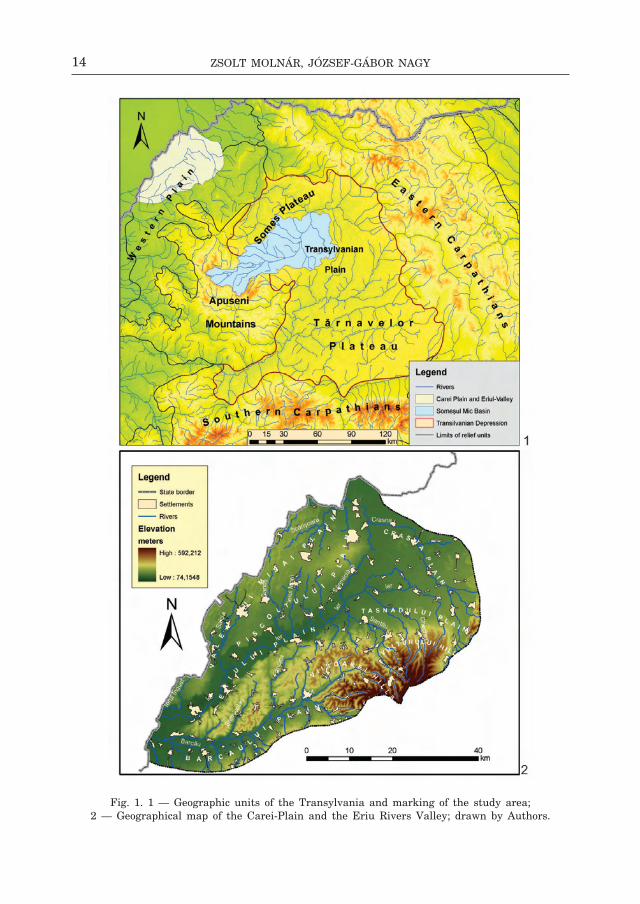
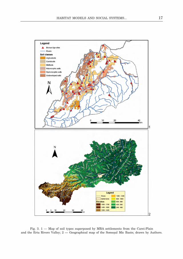
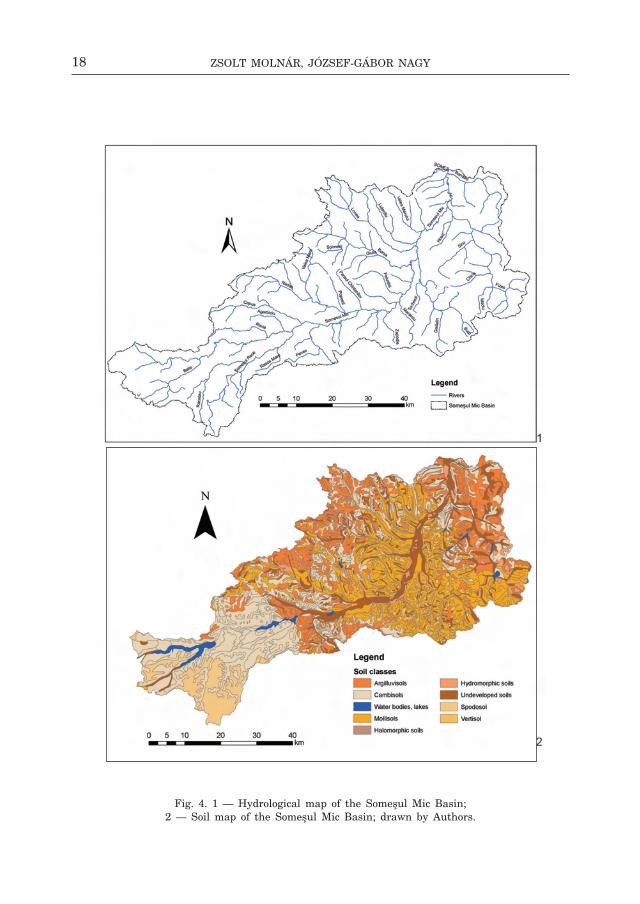
we chose as our study area two micro-regions with different geographic and cultural characteristics: the carei Plain and the eriu Valley in north-western Transylvania inhabited by otomani communities, and the basin of the someş river in central Transylvania occupied by wietenberg communities (fig. 1:1).
The carei Plain stretches on the eastern half of the nyírség, with an aver-age elevation of 150–160 m, towering above the neighbouring eriu Plain with a 30–40 m height difference.
The eriu Plain forms a transition towards the hill-country, its higher parts reaching the limit of Tăsnad hills. The study area once bordered on its eastern side by the Vermeş marsh; a swampy area wedged between the continental dunes of the eriu Plain, on the west, the marshy floodplain of the crasna river, with, to the north-east europe’s largest eutrophic swamp with an area of 400 km2, until its drainage in the 1890s — the ecedea swamp (g e o g r a f i a
28 for the central Transylvanian classical wietenberg culture period, material culture and chronology, see: c h i d i o ş a n 1974, 153ff.; b o r o f f k a 1994, 246ff.; d a r ó c z i 2012a, 52. c14 data were published for the second phase of the culture (wietenberg ii / wietenberg b) from oarţa de sus (K a c s ó 2004, 60, note 143; 1610–1445 bc), and for the third phase (wietenberg iii / wietenberg b) from sighişoara — cartierul Viilor site (P o p a, b o r o f f k a 1996, 56, note 40; 1685–1524 bc).
14 Zsolt Molnár, JóZsef-Gábor naGy
fig. 1. 1 — geographic units of the Transylvania and marking of the study area; 2 — geographical map of the carei-Plain and the eriu rivers Valley; drawn by Authors.

15Habitat Models and social systeMs...
fig. 2. 1 — hydrological map of the carei-Plain and the eriu rivers Valley; 2 — soil map of the carei-Plain and the eriu rivers Valley; drawn by Authors.
16 Zsolt Molnár, JóZsef-Gábor naGy
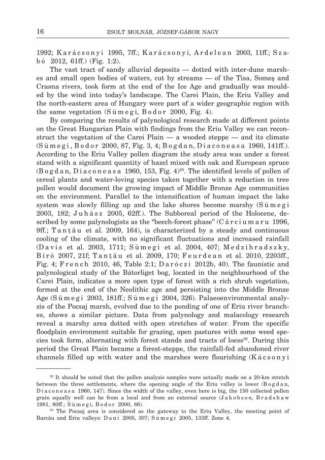
1992; K a r á c s o n y i 1995, 7ff.; K a r á c s o n y i, A r d e l e a n 2003, 11ff.; s z a- b ó 2012, 61ff.) (fig. 1:2).
The vast tract of sandy alluvial deposits — dotted with inter-dune marsh-es and small open bodies of waters, cut by streams — of the Tisa, someş and crasna rivers, took form at the end of the ice Age and gradually was mould-ed by the wind into today’s landscape. The carei Plain, the eriu Valley and the north-eastern area of hungary were part of a wider geographic region with the same vegetation (s ü m e g i, b o d o r 2000, fig. 4).
by comparing the results of palynological research made at different points on the great hungarian Plain with findings from the eriu Valley we can recon-struct the vegetation of the carei Plain — a wooded steppe — and its climate (s ü m e g i , b o d o r 2000, 87, fig. 3, 4; b o g d a n, d i a c o n e a s a 1960, 141ff.). According to the eriu Valley pollen diagram the study area was under a forest stand with a significant quantity of hazel mixed with oak and european spruce (b o g d a n, d i a c o n e a s a 1960, 153, fig. 4)29. The identified levels of pollen of cereal plants and water-loving species taken together with a reduction in tree pollen would document the growing impact of middle bronze Age communities on the environment. Parallel to the intensification of human impact the lake system was slowly filling up and the lake shores become marshy (s ü m e g i 2003, 182; J u h á s z 2005, 62ff.). The subboreal period of the holocene, de-scribed by some palynologists as the “beech-forest phase” (c â r c i u m a r u 1996, 9ff.; T a n ţ ă u et al. 2009, 164), is characterized by a steady and continuous cooling of the climate, with no significant fluctuations and increased rainfall (d a v i s et al. 2003, 1711; s ü m e g i et al. 2004, 407; m e d z i h r a d s z k y, b í r ó 2007, 21f; T a n ţ ă u et al. 2009, 170; f e u r d e a n et al. 2010, 2203ff., fig. 4; f r e n c h 2010, 46, Table 2:1; d a r ó c z i 2012b, 40). The faunistic and palynological study of the bátorliget bog, located in the neighbourhood of the carei Plain, indicates a more open type of forest with a rich shrub vegetation, formed at the end of the neolithic age and persisting into the middle bronze Age (s ü m e g i 2003, 181ff.; s ü m e g i 2004, 326). Palaeoenvironmental analy-sis of the Pocsaj marsh, evolved due to the ponding of one of eriu river branch-es, shows a similar picture. data from palynology and malacology research reveal a marshy area dotted with open stretches of water. from the specific floodplain environment suitable for grazing, open pastures with some weed spe-cies took form, alternating with forest stands and tracts of loess30. during this period the great Plain became a forest-steppe, the rainfall-fed abandoned river channels filled up with water and the marshes were flourishing (K á c s o n y i
29 it should be noted that the pollen analysis samples were actually made on a 20-km stretch between the three settlements, where the opening angle of the eriu valley is lower (b o g d a n, d i a c o n e a s a 1960, 147). since the width of the valley, even here is big, the 150 collected pollen grain equally well can be from a local and from an external source (J a k o b s o n, b r a d s h a w 1981, 80ff.; s ü m e g i, b o d o r 2000, 86).
30 The Pocsaj area is considered as the gateway to the eriu Valley, the meeting point of barcău and eriu valleys: d a n i 2005, 307; s ü m e g i 2005, 133ff. Zone 4.
17Habitat Models and social systeMs...
fig. 3. 1 — map of soil types superposed by mbA settlements from the carei-Plain and the eriu rivers Valley; 2 — geographical map of the someşul mic basin; drawn by Authors.
18 Zsolt Molnár, JóZsef-Gábor naGy
fig. 4. 1 — hydrological map of the someşul mic basin; 2 — soil map of the someşul mic basin; drawn by Authors.

19Habitat Models and social systeMs...
1994–1995, 195ff.; w i l l i s 1997, 200; b e r g l u n d 2003, 9). The size of the floodplain changed depending on the precipitation. Decomposing organic mat-ter from the vegetation, soil erosion, the soil and organic matter washing in from the high bank in the carei Plain — characteristic for the forest-steppe zone (b a d e a et al. 1983, 618; c i u t ă 2009, 67) — led to the formation of a thicker deposit of absorbent soil with a humus content of more than 7%, poor in mineral salts and phosphates (K a r á c s o n y i 1995, 8; g h i n e a 2002, 363). The significant amounts of cereal and trampled weed pollen discovered in palynology profiles highlights the use of ploughing in agriculture (s ü m e g i 2005, 133). The archaeological and archaeozoological data also show that the region’s large livestock grazing and agricultural cultures by clearing the for-est obtained tracts of land for extensive grazing and crop cultivation31. Forest clearance documented by cyclical changes in the proportion of tree pollen not only made it easier to hunt game and to rear livestock more efficiently, but also furnished the fuel32 necessary to metallurgy33 and in pottery production.
The second micro-zone investigated from the geological point of view be-longs to the structural unit of the Transylvanian depression34, formed at the end of the cretaceous (m u t i h a c 1990, 376). The evolution of the current relief and terraces forming are the result of oscillatory tectonic movements and gradual deepening of the erosion base in the someşul mic basin (c r i s t e a, b a c i u, g a f t a 2002, 17) (fig. 3:2). The morphological features of the area are reflected given by the axis of someşul mic 1–2 km wide corridor at the level of the floodplain and the first terrace. The someşul mic Valley corridor is characterized by an accumulative relief consisting of two levels: a lower level
31 for archaeobotanical and archaeozoological studies, see: o r d e n t l i c h 1968, 141ff.; c â r -c i u m a r u 1996, 94f, 144; c i u t ă 2009, 104 (otomani-földvár fortified site in the eriu Valley); c â r c i u m a r u 1996, 68, 94; c i u t ă 2009, 102ff. (carei-bobald tell in the carei Plain). for the archaeozoological data of the area, see: b a d e r 1978, 131ff.; h a i m o v i c i 1987, 37ff.; e l s u s i 2002, 243ff.; b i n d e a 2008, 95ff.; The archaeozoological studies have shown however that the samples are too general, pastoralist modalities, the bred animal species and their quantitative indicators, as well as the communities’ dietary preferences have changed in every settlement (b ö k ö n y i 1988, 124; g á l 2005, 150).
32 for bronze Age logging and environmental change, see: b e h r e 1988, 633ff., s ü m e g i 1999, 196; s ü m e g i, b o d o r 2000, 87; s ü m e g i 2003, 206; s ü m e g i 2004, 330; s ü m e g i 2005, 133ff.; f ă r c a ş, T a n ţ ă u 2004, 230ff.; J u h á s z 2005, 63, T a n ţ ă u et al. 2009, 172; f e u r d e a n et al. 2010, 2203ff.
33 for the raw material deposits of western romania and their exploitation during the bronze Age, see: P a p a l a s 2008, 96ff.; g ă v a n 2012, 60ff.
34 The Transylvanian basin is surrounded by the carpathian and Apuseni mountains. The central area consists of alternating plates of neogene origin — with the average elevation of 200–700 m — fragmented by rivers that have shaped the form of hills (b a d e a, n i c u l e s c u, s e n c u 1976). in this region three geographic areas can be distinguished. The northern consists of someşul mare and mic valleys, with an average elevation of 500–700 m. it extends north-east and south-west to the carpathian mountains and north-west — to the someş Plain. The region is characterized by short, broad valleys and flat surfaces. south of this region are the Transylvanian Plain and the Târnavelor Plateau.
20 Zsolt Molnár, JóZsef-Gábor naGy
with an elevation of 2–3 m, subject to flooding, called the floodplain35, and a second, higher level with an elevation of 4–6 m, built by sand, gravel and colluvial materials (carried from the slopes) in various degrees of solidification and covered by herbaceous vegetation.
soils in the someşul mic basin (fig. 4:2) are quite diverse. The more ele-vated areas of the floodplain have the most fertile soils, formed by haplic and luvic chernozems. The most common local soils are haplic luvisoils, occupying most of the more stable slopes, and albic luvisols that appear insular on the interfluves. Alluvial soils in general typical for the someş floodplain are rep-resented by typical fluvisols, mollic and gleyic fluvisols (feneş floodplain) (s ă s ă r a n, V r e m i r 2009, 20).
The peat bog in the wellspring area of the someşul cald river (ic Ponor) yielded evidence on limited human impact on forests between the years 5100 and 3200–2750 cal. bP (b o d n a r i u c et al. 2002, 1485). Pollen spectra from Upper someşul mic suggest a change in the weather which led to the with-drawl of human communities from higher lying areas, a general phenomenon throughout europe (l i m b r e y 1987, 251ff.). recent palynological research in the Apuseni mountains has shaped a new chronology of the forest evolution in the area36.
The richness of the natural resources in the someşul mic Valley (fig. 5:1) influenced the distribution of human settlements and communities economy. in the study area and its vicinity copper deposits occur at băişoara, Pietroasa and someşul rece (b o r o f f k a 2009, 141, nos. 6, 142, no. 28)37, silver and gold at băişoara (b o r o f f k a 2009, 141, no. 6), someşul rece38 and Valea căpuşului39. There is evidence that salt mining and trade (b o r o f f k a 2006, 71ff.)40 are closely linked to mining and bronze metallurgy (h a r d i n g 2000, 253f; r o t e a 2004, 7ff.). The presence of settlements near to the salt deposits was not
35 on the origin and evolution of the someşul mic floodplain, see: P o s e a, P o p e s c u, i e l e-n i c z 1974.
36 in 4800 bP beech (Fagus) quickly spread; hazelnut (Corylus), spruce (Picea) and other deciduous trees become less common, as indicated by reduced pollen values. starting from 4000 bP until the present beech (Fagus) dominated the forests and the number of the other deciduous trees such as elm (Ulmus), spruce (Picea) and hazel (Corylus), except for hornbeam (Carpinus) and oak (Quercus), becomes reduced. between 4500 and 2750 cal bP. deforestation and agriculture were limited (f e u r d e a n, w i l l i s, A s t a l o ş 2009, 971ff.).
37 mineral resources from someşul rece at dealul mieilor and Valea seacă were exploited in the nineteenth century (m u r e ş a n 1971, 28; b o r o f f k a 2009, 142, no. 36).
38 This area was mined in 1961–1962 for its low content of gold and silver (m u r e ş a n 1971, 28; b o r o f f k a 2009, 142, no. 36).
39 mineral resources from the căpuşului basin exposed by erosion contain reduced noble metals, small reserves that are not attractive economically (m u r e ş a n 1971, 28).
40 iulian marţian recalls evidence on prehistoric salt mining on the bank of the salca stream and in the rompaş area near the town of dej (m a r ţ i a n 1903, 285ff.). rock salt extraction facilitated the transport and was used in preserving food, leather processing, animal husbandry and everyday consumption.

21Habitat Models and social systeMs...
fig. 5. 1 — geological map of the someşul mic basin (after r ă i l e a n u et al. 1968); 2 — density, Thiessen-polygons and cost surface analysis of the mb i sites
from the carei-Plain and the eriu rivers Valley; drawn by Authors.

22 Zsolt Molnár, JóZsef-Gábor naGy
accidental (w i t t e n b e r g e r 2008, 14ff.)41. Salt deposits are significant in the area investigated here, the area of contact between the Apuseni mountains, Transylvanian Plateau and someş Plain42. mines in the area were worked both for local daily consumption and long-distance exchange43.
The economy of communities of the someşul mic basin is agro-pastoralist. Analysis of animal bone assemblages from central Transylvania documents specialization of large-scale animal husbandry44. The cattle which had a high economic value may have had a status role as well45. The complex relationship between agriculture and animal husbandry is proved by the fact that a gradual transition from arable agriculture and livestock increase happened in parallel46. The soils of the region could have been excellent crop land according to that period (r ă i l e a n u et al. 1968; J a k a b 2004, 164ff.). “multi-pronged” agricul-tural activities (g y u l a i 2001, 92f; g y u l a i 2008, 125) are evidenced by the use of bone tools in land cultivation, quern-stones and charred cereal grains47. The economically exploited “collection areas” adapted to the local geographic environment, mostly irregular in shape (b i n f o r d 1982, 6f; K u n a 1991, 332f; r e n f r e w, b a h n 1999, 242; s ü m e g i 2009, 474) must be sought within
41 salt is one of the main resources available and easy to exploit, in the form of springs, wells, saline streams overlying salt deposits, many of which are exploited nowadays: Valea flo-rilor, cojocna, corpadea, căianu mic, boju, morişti, iuriu de câmpie, Pata, sântioana, cătina, dâmbu, Şărmăşel, Vaida-cămăraş, Şomcutu mic, bonţida, mănăstirea, codor, buneşti, mănăşturel, Tăuşeni, silivaş, gheorghieni-Valea mare, bonţ-fântâna sărată (w i t t e n b e r g e r 2008, 14).
42 found at cara, cojocna, ocna dejului, Pata, Valea florilor, sic, nireş-Unguraş, gheo-rghieni-dealul curmătura, nicula, bonţ, săcălaia, Petreşti-salatiu, Jucu de sus, corpadea, boju, Pintic, dezmir, Apahida, mica, gădălin, băiţa, nima, sânmarghita, gherla (d r ă g ă n e s c u 2006, 13; w i t t e n b e r g e r 2008, 14).
43 salt exploitation seems trans-cultural as demonstrated by the technological similarity and discontinuity of archaeological remains in the salt mine area. during the late bronze Age the wietenberg (iV) and the noua cultures exploit the Transylvanian salt resources (w i t t e n b e r g e r 2008, 21ff.; c a v r u c 2010, 28). gáva culture communities took control during the late bronze Age and at the onset of the early iron Age (c a v r u c 2010, 8). salt was transported from the Transyl-vanian Plain and the Plateau west down the someş and mureş rivers (c a v r u c 2010, 10, 13ff.).
44 Animal husbandry economy of wietenberg communities is evidenced by finds from derşida, mintiu gherlii cluj-napoca, oarţa de sus and Peştera cauce (m e ş t e r, l a z a r o v i c i 2000, 191ff.; m e ş t e r, P o p, l a z a r o v i c i, b i n d e a 2005, 115ff.; b i n d e a 2005, 64, e l s u s i 2005, 95ff.; b i n d e a 2008, 85ff.). The wild animal bone variation rate attests the decline of foraging and hunting and its complementary role occupied in the economy of the bronze Age communities (b i n d e a, K e l e m e n 2011, 66).
45 given examples from history and ethnography it is possible that in the period cattle steal-ing was considerable (c o m a r o f f 1992, 108ff.; w r i g h t 2004, 74; s z a b ó 2004, 151; T h r a n e 2009, 18).
46 An important criterion of the transition to arable agriculture is to ensure an appropriate number of draft animals and winter feeding. The possession of a great herd of livestock is essen-tial to ensure soil fertility of cultivated areas (s h e r a t t 1997, 74f, 219; r e m é n y i 2003, 53).
47 Archaeobotanical data from the area: einkorn (Triticum monococcum), bread wheat (Triticum aestivum sp. vulgare) and rye (Saecale cereale) also occurs at other wietenberg sites (c â r c i u m a r u 1996, 144ff.), from the cluj-napoca str. banatului site, however in the g1 pit sesame (Sesanum indicum), chickpeas (Cicer arietinum) and buckwheat (Fagopyrum sagitattum) were discovered as well (r o t e a, w i t t e n b e r g e r 1999, 9ff.; c i u t ă 2009, 72, 104).
23Habitat Models and social systeMs...
a maximum radius of a day’s walking (5–6 km) close to the central settlement48. chisholm’s economic land use model localizes the agriculturally used lands within a 700 m/1–2 km radius circle from the central settlement (c h i s h o l m 1979, 47ff.)49. members of the community who engaged in agriculture carried out their daily activities and then returned to their place of residence.
in both micro-regions their social and economic base unit consists of coop-erating multi-family household units50. The cooperative system of the domestic units could have been the basic level of decision-making for the course of everyday life51. At this level enough sufficient labour and means of production can be mobilized for the implementation of larger scale activities, possibly to perform more work taking place at the same time52. The central and northern-western Transylvanian bronze Age communities gradually transiting to arable agriculture take in possession new economically exploitable land. behind the economic changes are hidden the general social and structural transformations of the middle bronze Age (b r ü c k 2000, 275ff.).
The seTTlemenT sysTem in cenTrAl And norTh-wesTern TrAnsylVAniA
A common feature of these micro-regions is that they have excellent soil and vegetation conditions. The settlements of middle bronze Age communities made excellent use of the natural environment of the carei Plain, the eriu river region, as well as the someşul mic Valley, colonizing both the geomorphological formations safe from flooding rising island-like from their mosaic-like floodplain environment, and the river terraces53. The sites are concentrated along the
48 The “community area” term and theory (n e u s t u p n ý 1991, 326) found in the literature — based on the prehistoric social and economic theories — attributes to the cultural landscape a mosaic spatial structure. The common economic space theory highlights the economic and social system characteristics of the studied population and the community behaviours in this direction.
49 for application of the ethno-archaeological model and critique, see: s t o n e 1991, 343ff.50 for the concept of subsistence and political economy, see: J o h n s o n, e a r l e 2000, 23ff.51 A review paper on the subject of households and household archaeology: K a l l a 2013, 9ff.
The cooperation of domestic units goes beyond the co-ordination of daily living practical activities (P a d d e r 1993, 114; b r a n d o n, b r a i l e 2004, 4ff.). for small-group dynamics and task-oriented decision-making mechanisms and benefits, see: J o h n s o n 1982, 392ff., figure 21:2–3.
52 Ploughing, sowing is a time and labour intensive activity. The intensive cultivation of “in-field” growing areas (manuring, horticulture) located in the immediate vicinity of the settlement and in parallel “outfield” area extensive farming calls for more and more invested work and manpower (b i n t l i f f 2013, 65; g o d s e n d 2013, 115). with the bronze Age “transversal ploughing” regularly shaped plots could be economically cultivated. estimates found in the literature on the size of plots worked by each individual household unit of 600 m2 seem to be acceptable (l i n d q u i s t 1974, 29; b r a d l e y 1978, 267, 270; w r i g h t 2004, 74; m c i n t o s h 2006, 119ff.; e a r l, K o l b 2010, 64).
53 most sites in the two micro-regions are located on good quality mollisoils and hydromorphic soils excellent for agriculture (fig. 2:2; 3:1–2).
24 Zsolt Molnár, JóZsef-Gábor naGy
larger rivers (eriu, someş) and their tributaries in case of both territories rich in water networks (fig. 2:1; 4:1). These rivers also served as routes of infor-mation flow and goods exchange, the regional boundaries of social interaction and spatial reference points for the communities (o ’ s h e a 2011, 162ff.). in addition to particular social and economic processes, the natural environment and its spatial organization also had a decisive role in the emergence of cen-tral places and the pattern of the settlement network (s ü m e g i, K e r t é s z, r u d n e r 2003, 56)54. The creation of enclosures, or other forms of barrier, is a special way of defining space. strongly connected to the more general question of the creation of landscape55, its causes are social, political and economic. The existence of fortifications is linked to the creation of formalized territorial units of a quasi-political nature (h a r d i n g 2006, 97, 107)56. in various geographic regions, besides the tells or fortified settlements conventionally treated as “power centres” and the surrounding “satellite-settlements” definitely forming a common economic unit with these, we have found chains of scattered, open settlements (fig. 5:2; 6:1–2; 14:1–2)57. These settlement chains can be regarded as “social units” of the age58. however, beyond these general statements — at the present state of research — it cannot be proved that the multi-layer, some-times fortified settlements within the scattered settlement chains in the area of
54 The tell settlements in the carpathian basin — with a long and deep stratigraphic sequence — were spread within a well-defined ecologic zone (on eco-zones see also s ü m e g i, b o d o r 2000, 87, fig. 3–4, 6; d a r ó c z i 2012, 44f, Plate 3, 5). The distribution range of tells takes in the part of the great hungarian Plain with sufficient geographic conditions for long term inhabitation. The environment was waterlogged and the existing drier areas do not permit to extend the settle-ments horizontally. As a result, the environment “forced” the emergence of multi-layer settlements (f i s c h l, r e m é n y i 2013, 728, fig. 2, 731).
55 on this topic see: T i l l e y 1994; d a r v i l l 1997; c h a p m a n 1997; n e u s t u p n ý 1998; J o h n s t o n 1998; A s h m o r e, K n a p p 1999 (eds.); m e i e r 2006 (ed.); A r n o l d u s s e n 2008.
56 The ambition to exclusively control the economically exploited region, the defence of the territory is an organic part of human behaviour. The complex-function fortifications are also bound-ary markers, elements of territorial behaviour, in the sense that they marked those parts of the land for which special treatment was intended from those parts that were in a broad sense un-modified. rather than a well-defined demarcation a prehistoric border more likely had the form of a “no-man’s land” bordered by rivers, swampy floodplains or marshes (s a h l q v i s t 2001, 89; h a r d i n g 2006, 112; T h r a n e 2009, 13ff.).
57 it is an interesting idea that when landscape is colonized the first pioneer community exploits the full catchment area (with 5 km radius) and as population grows new colonists enter the region and the initial settlement network would enlarge. in the second phase, if the population of each village is low and the logistic capacity is poor a further demographic growth will result in a series of interstitial settlements filling the territory with daughter-settlements. in each generation the living area of the community was shared between old and newly established daughter-settlements. in conclusion the integrative settlement units (clusters or a supercluster) with their smaller territories (5 km, 3.5, 2.5 km radius catchments) represent an agro-pastoral settlement network stabilised at one of the modular scales of its territorial development (b i n t l i f f 2013, 64).
58 in her analysis of wietenberg settlement system in inner Transylvania laura dietrich suggests that a single settlement unit contained several fortified and open settlements (d i e t r i c h 2010, 202).

25Habitat Models and social systeMs...
fig. 6. 1 — density, Thiessen-polygons and cost surface analysis of the mb ii sites from the carei-Plain and the eriu rivers Valley; 2 — density, Thiessen-polygons
and cost surface analysis of the mb iii sites from the carei-Plain and the eriu rivers Valley; drawn by Authors.
26 Zsolt Molnár, JóZsef-Gábor naGy
a central settlement would have acted as local, micro-regional centres. in most cases, the data are insufficient, since our knowledge is limited to information acquired from separate episodes of field research. if any archaeological research was made, it only comprised smaller settlement parts. Therefore we can only undertake a macro-level study of the settlement network.
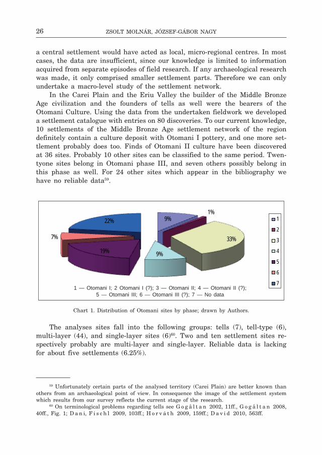
in the carei Plain and the eriu Valley the builder of the middle bronze Age civilization and the founders of tells as well were the bearers of the otomani culture. Using the data from the undertaken fieldwork we developed a settlement catalogue with entries on 80 discoveries. To our current knowledge, 10 settlements of the middle bronze Age settlement network of the region definitely contain a culture deposit with otomani i pottery, and one more set-tlement probably does too. finds of otomani ii culture have been discovered at 36 sites. Probably 10 other sites can be classified to the same period. Twen-tyone sites belong in otomani phase iii, and seven others possibly belong in this phase as well. for 24 other sites which appear in the bibliography we have no reliable data59.
chart 1. distribution of otomani sites by phase; drawn by Authors.
The analyses sites fall into the following groups: tells (7), tell-type (6), multi-layer (44), and single-layer sites (6)60. Two and ten settlement sites re-spectively probably are multi-layer and single-layer. reliable data is lacking for about five settlements (6.25%).
59 Unfortunately certain parts of the analysed territory (carei Plain) are better known than others from an archaeological point of view. in consequence the image of the settlement system which results from our survey reflects the current stage of the research.
60 on terminological problems regarding tells see g o g â l t a n 2002, 11ff., g o g â l t a n 2008, 40ff., fig. 1; d a n i, f i s c h l 2009, 103ff.; h o r v á t h 2009, 159ff.; d a v i d 2010, 563ff.
9%1%
33%
9%19%
7%
22% 1
2
3
4
5
6
71 — Otomani I; 2 Otomani I (?); 3 — Otomani II; 4 — Otomani II (?);
5 — Otomani III; 6 — Otomani III (?); 7 — No data
27Habitat Models and social systeMs...
chart 2. distribution of otomani settlements by type; drawn by Authors.
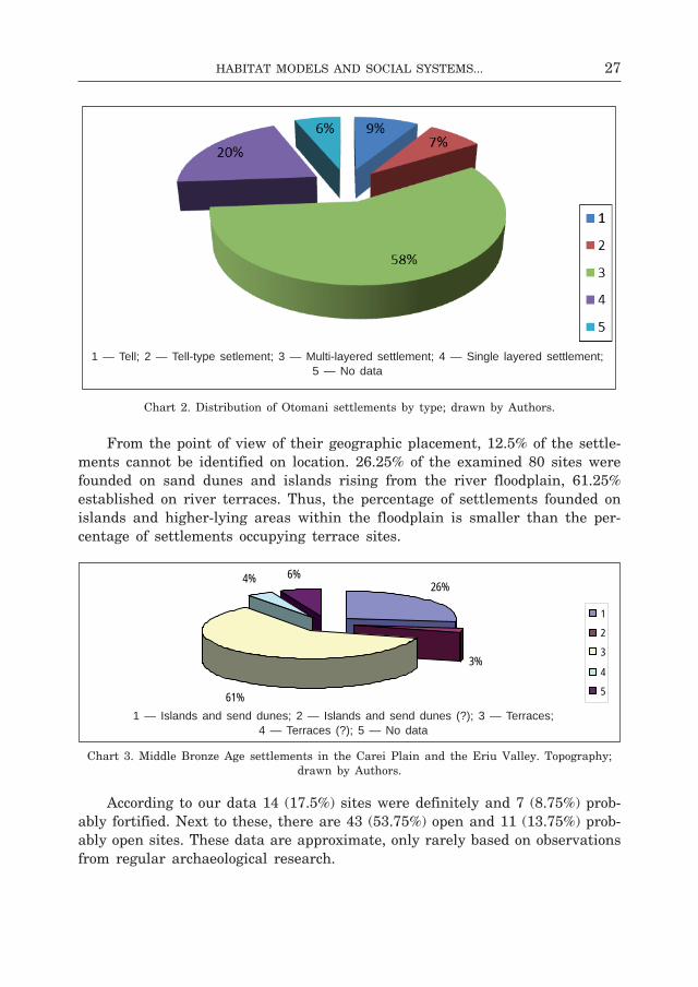
From the point of view of their geographic placement, 12.5% of the settle-ments cannot be identified on location. 26.25% of the examined 80 sites were founded on sand dunes and islands rising from the river floodplain, 61.25% established on river terraces. Thus, the percentage of settlements founded on islands and higher-lying areas within the floodplain is smaller than the per-centage of settlements occupying terrace sites.
chart 3. middle bronze Age settlements in the carei Plain and the eriu Valley. Topography; drawn by Authors.
According to our data 14 (17.5%) sites were definitely and 7 (8.75%) prob-ably fortified. next to these, there are 43 (53.75%) open and 11 (13.75%) prob-ably open sites. These data are approximate, only rarely based on observations from regular archaeological research.
26%
3%
61%
4% 6%
1
2
3
4
5
1— Islands and send dunes; 2 — Islands and send dunes (?); 3 — Terraces; 4 — Terraces (?); 5 — No data
1 — Tell; 2 — Tell-type setlement; 3 — Multi-layered settlement; 4 — Single layered settlement; 5 — No data
1 — Islands and send dunes; 2 — Islands and send dunes (?); 3 — Terraces; 4 — Terraces (?); 5 — No data

28 Zsolt Molnár, JóZsef-Gábor naGy
chart 4. middle bronze Age fortified and open settlements in the carei Plain and the eriu Valley; drawn by Authors.
Looking at the map, even at a first glance, we could distinguish two ma-jor settlement groups, one of them in the carei Plain and the other in the eriu Valley (fig. 5:2; 6:1–2). The map of the density clusters of otomani i settlement system in the carei Plain and the eriu Valley reveals two smaller bronze Age settlement clusters, each with approximately three units (fig. 5:2)61.
At the present stage of research it appears that during this phase individual settlements were scattered across the landscape and there is no conclusive evidence on more complex structures. during otomani phase ii, the number of settlements increased and the settlement network of the region also shows a more complex image. in the central area of eriu Valley a bronze Age super-cluster took form comprising four settlement clusters and a smaller unit62. In
61 The otomani–sălacea–Valea lui mihai axis based cluster contains two relatively small units; the middle bronze Age settlement cluster around Valea lui mihai may be counted as a third unit. The identification of the exact location and chronology of the latter is uncertain: 1. the area around otomani, with the centre at otomani-cetăţuie tell (no. 45), with three annex settlements of uncertain classification: otomani-Înainte de insulă (no. 47); Tarcea-holmul mare tell-type settlement (no. 64), and galoşpetreu-la vii (no. 35); 2. the area around sălacea, with the centre at sălacea-dalul Vida tell (no. 58) and its annex settlement of Pir-cetate (no. 48) and the multi-layer settlements of Andrid-curtea cAP (no. 2), with the uncertainly classified Pir-roszgáz (no. 50). 3. The unit with the centre at Valea lui mihai is quite uncertain since we do not know its chronology and exact location. The following may be included here: Valea lui mihai-groapa cu lut (no. 70–71); -grădina lui dienes (no. 72); -la păşune (no. 73); -la izvoare (no. 74); -la vii (no. 75). Three more loosely-structured units on the carei Plain are conceivable: two found near carei–moftinu mic, and another similar small unit found on the edge of the carei Plain, in the area of berea–sanislău–foieni. All three are characterized by a small number of settlements, and the chronology of the sites is also problematic at times. The existence of units around berea–sanislău–foieni and moftinu mic is definitely questionable. There is archaeological evidence only to confirm the existence of carei-bobald tell (no. 14) and the adjoining open site carei-bobald i2 (no. 15).
62 The otomani–sălacea–Valea lui mihai axis-based supercluster contains four larger set-tlement clusters. 1. the surroundings of otomani, with the centre at otomani-cetăţuie tell (no. 45), and three annex settlements of uncertain classification: otomani-Înainte de insulă (no. 47); cheşereu-Viezurişte (no. 24), Tarcea-holmul mare tell-type settlement (no. 64), and Tarcea-
18%
9%
53%
14%6%
12345
1-Fortified settlement; 2-Fortified settl.(?); 3-Plain settlement; 4-Plain settl. (?); 5-No data ; 1 — Fortified settlement; 2 — Fortified settlement (?); 3 — Plain settlement;
4 — Plain settlement (?); 5 — No data
29Habitat Models and social systeMs...
the southern part of eriu Valley there are two smaller settlement units, one central, and one consisting of an open site. These smaller units probably had their centre in the fortified settlements at cadea-dealul chel and roşiori-cetatea de pământ63. in the immediate vicinity of săcuieni-cetatea boului tell no other settlement can be found. The case is the same for Tiream-holmul cânepii tell64. Two larger settlement clusters were then taking shape in the carei Plain. The first comprises eight open settlements on the sanislău-berea-Foieni axis65, while the second, somewhat larger cluster, on the carei-căpleni-moftinu mic axis, with twelve sites, may be divided into three distinct sub-groups (fig. 6:1)66.
in otomani phase iii, with the decreasing number of settlements, the inte-grative units of the settlements are much more clearly outlined. in the central part of eriu Valley the bronze Age supercluster of four settlement clusters is preserved67. on the southern part of eriu Valley there is only a smaller settle-
dealul mare (no. 62) and Tarcea-dealul de mijloc (no. 63) multi-layer settlements, and two bronze findings; 2. the neighbourhood of sălacea, with the centre at sălacea-dealul Vida tell (no. 58) and the adjoining Pir-cetate (no. 48) and Andrid-dealul taurilor (no. 1), Andrid-curtea cAP (no. 2) and Andrid-sub holmul mare (no. 3) multi-layer settlements, and the uncertainly classified Pir-roszgáz (no. 50). 3. The Valea lui mihai centre unit is quite uncertain because its timing and exact location is unknown. The followings can be included here: Valea lui mihai-groapa cu lut (nos. 70–71); -grădina lui dienes (no. 72); -la păsune (no. 73); -la izvoare (no. 74); -la vii (no. 75). 4. the galoşpetreu-Văşad axis-based settlement cluster, including galoşpetreu-Pădurea frater (no. 34), galoşpetreu-la vii (no. 35), galoşpetreu-Podul cu cinci găuri (no. 36), galoşpetreu-malul ganaşului (no. 37), and two other settlements difficult to localize, Văşad (no. 76) and Văşad-dealul Viilor (no. 77).
63 The first unit is the cadea-dealul chel (no. 13) fortified settlement, and the diosig-colonie (no. 31) open site.
64 A similar phenomenon is found in the neighbouring valley of barcău, where there are also no open sites connected to a tell (d a n i 2009, 18; d a n i, f i s c h l 2009, 108ff.).
65 The cluster comprises: ciumeşti-Via Veche (no. 25); ciumeşti-la păşune (no. 26); sanislău-la hârburi (no. 55); sanislău-lângă heleşteu (no. 56); berea-grădina florilor (no. 8); berea-Pârâul Turcului (no. 9); berea-Togul evreului (no. 11); foieni-lângă podul peste canal (no. 33).
66 The first sub-group includes: carei-bobald tell (no. 14) and multi-layer open sites carei-bobald i2 (no. 15), carei-bobald ii (no. 17), carei-bobald Vi (no. 18) and carei-spitz (no. 19). The second sub-group consists of the fortified, tell-type, site căpleni-drumul căminului (no. 21), and the attached open site căpleni-malul canalului de irigaţie (no. 20). sub-group three con-tains the single- or multi-layer open sites of domăneşti (no. 32), moftinu mare-gădina lui bota (no. 41), moftinu mic-curtea parohiei reformate (no. 42), moftinu mic-hanul messzelátó (no. 43) and moftinu mic-ograda sediului fostei cAP (no. 44).
67 The supercluster on the otomani–sălacea–Valea lui mihai axis comprises four larger set-tlement clusters: 1. the neighbourhood of otomani, with the centre at the fortified site otomani-cetăţuiea de pământ (no. 46), the “afterlife” of otomani-cetăţuie tell (no. 45), and the attached Tarcea-holmul mare tell-type settlement (no. 64); 2. the neighbourhood of sălacea, with sălacea-dalul Vida tell (no. 58) and the multi-layer settlements Pir-cetate (no. 48), Andrid-curtea cAP (no. 2) and Andrid-sub holmul mare (no. 3), and the vaguely classified Pir-roszgáz (no. 50); 3. no conclusions can be drawn on the basis of the vaguely classified settlements of the Valea lui mihai unit, we have listed unchanged the sites marked in the bibliography for all three periods. 4. galoşpetreu-Văşad axis-based settlement cluster, including galoşpetreu-la vii (no. 35), Văşad-dealul Viilor (no. 77) and Văşad-cartierul Ţiganilor (no. 78).

30 Zsolt Molnár, JóZsef-Gábor naGy
ment unit, consisting of the fortified settlement of roşiori-cetatea de pământ and an open site68. we find no other settlement in the immediate vicinity of săcuieni-cetatea boului tell in this period either. The case is similar for the Tiream-holmul cânepii tell. The two former larger settlement clusters of carei Plain somewhat transformed. The first, on the axis of sanislău–berea–foieni, comprises eight open sites69, while the second, larger settlement cluster on the carei-moftinu mic axis, containing eight sites, may be divided into two well defined sub-groups (fig. 6:2)70. These can be regarded as the social and economic integrative units of the analyzed territory.
The “tell society” in the carei Plain and the eriu Valley is made of hier-archical communities with a sedentary life and a rural economy. The settlement system is structured on sites of various sizes and well organized from a social point of view. The tells could be considered power and economical centres. in the investigated area of the carei Plain and the eriu Valley we have six tell settlements: berveni-halmos, carei-bobald, Tiream-holmul cânepii, sălacea-dealul Vida, otomani-cetăţuie, săcuieni-cetatea boului71. Analysing the set-tlement system we used the XTenT model72. If we accept the hypothesis that the tells represent social, economic and political centres of a region then the settlements positioned outside the inland territory of their areas of influence must be considered relatively independent from a “political” point of view. in the opinion of c. renfrew and P. bahn the XTenT model is the first repre-sentation of a political reality73. fully aware that to use the XTenT model and to assume the existence of local hierarchies without having a very solid ar-chaeological base is to engage in a controversial scheme we controlled the results from the first model using the Thiessen polygons and cost surface analysis. in all three cases the control-areas of the tells contain the same set-tlements.
68 The small unit could be formed of the fortification of roşiori-cetatea de pământ (no. 54) and the settlement of mihai barvui (no. 39), known only from the bibliography.
69 The cluster includes: ciumeşti-Via Veche (no. 25); sanislău-lângă heleşteu (no. 56); berea-Pârâul Turcului (no. 9); berea-Togul sf.gheorghe (no. 10); foieni-lângă podul peste canal (no. 33).
70 The first sub-group includes: the carei-bobald tell (no. 14) and the multi-layer open sites of carei-bobald i 2a (no. 16), carei-bobald Vi (no. 18) and carei-spitz (no. 19). The second sub-group contains the open sites of domăneşti (no. 32), moftinu mare-gădina lui bota (no. 41), moftinu mic-hanul messzelátó (no. 43) and moftinu mic-ograda sediului fostei cAP (no. 44).
71 The berveni-halmos tell was investigated by T. Kienlien and l. marta. The results of the geomagnetic surveys are encouraging, but — for the moment — do not lend themselves to define using XTenT modelling the control area of the berveni-halmos tell positioned on the bank of the former ecedea marsh. for this reason it is left out from our maps. for the other five tells the extent of the settlements are well known because of regular archaeological excavations. in their case an XTENT modelling is possible.
72 broadly speaking under the XTenT model the size of the spheres of influence is assumed as directly proportional to the surface of a settlement. for applied methodology see: m o l n á r, i m e c s 2006, 30.
73 r e n f r e w, b a h n 1999, 172ff. on socio-political models see: r e n f r e w 1981, 269ff.
31Habitat Models and social systeMs...
we used mathematical calculations to outline potential areas of influence of settlements carei-bobald and Tiream-holmul cânepii (fig. 7:1–2; 8:1)74. The territory of the Tiream tell merges into the influence area of carei-bobald, so these settlements, according to theory, cannot be regarded as “politically” in-dependent units. on the basis of settlement archaeology data and theoretical models it seems that there was a hierarchically structured chiefdom consisting of several regional units in the carei Plain. The real power centre of the area is the carei tell surrounded by its satellite-settlements. in otomani phase ii the influence area of carei tell75 contained two tells76, a single-layer open set-tlement77, seven multi-layer open settlements78, one multi-layer fortified settle-ment79, and three other sites only known from bibliography80. These are com-plemented by multi-layer sites (3) about which we do not know if they were fortified (fig. 7:2)81. The number of settlements decreases in otomani phase iii, next to the central site we are aware only of two tells82, two multi-layer open settlements83, two single-layer open settlements84 and two settlements known only from literature (fig. 8:1)85. in eriu Valley there are two territo-rial units. The area centred on sălacea-dealul Vida is situated in the central and northern part of the river valley. The second sub-unit, centred on săcuieni tell, occupies the central and southern (towards barcău river) part of eriu Valley. The two areas of influence intersect at the central part of the river valley. The settlements in the intersection area were considered to belong to the first or second centre depending on their position86. Thus the area of
74 Carei-bobald (r = 12310 m), Tiream-holmul cânepii (r = 3692 m). The scale of berveni-halmos tell is unknown, therefore it is impossible to specify its possible area of influence. for a detailed presentation of the issue see m o l n á r, i m e c s 2006, 29ff.; n é m e t i, m o l n á r 2007, 22ff.
75 The sites berea-grădina cu flori (no. 8), berea-Togul evreului (no. 11), ciumeşti-Via Veche (no. 25), ciumeşti-la păşune (no. 26), sanislău-la hârburi (no. 55), Urziceni-Vatra satului (no. 68) in the immediate neighbourhood of the circle we outlined, but just outside it were, in our opinion, also subordinated to carei-bobald tell.
76 Tiream-holmul cânepii (no. 66), berveni-halmos (no. 12) (?).77 Urziceni-drumul careiului (no. 69).78 berea-grădina cu flori (no. 8), carei-bobald i.1b (no. 15), carei-bobald ii (no. 17), carei-
bobald Vi (no. 18), carei-spitz (no. 19), căpleni-malul canalului de irigaţie (no. 20), sanislău-la hârburi (no. 55).
79 căpleni-drumul căminului (no. 21).80 berea-Togul evreului (no. 11), Urziceni-Vatra satului (no. 68), moftinu mic-hanul messze-
látó (no. 43).81 ciumeşti-Via Veche (no. 25), ciumeşti-la păşune (no. 26), moftinu mic-curtea parohiei
reformate (no. 42).82 Tiream-holmul cânepii (no. 66), berveni-halmos (no. 12) (?).83 carei-bobald Vi (no. 18), carei-spitz (no. 19).84 carei-bobald i.2a (no. 16), Urziceni-drumul careiului (no. 69).85 Urziceni-Vatra satului (no. 68), moftinu mic-hanul messzelátó (no. 43).86 The settlements Şimian-locul grădinilor (no. 61), Tarcea-dealul mare (no. 62) and Tarcea-
dealul de mijloc (no. 63) in the intersection area belong to the influence area of the sălacea tell, while cheşereu-dealul episcopului (no. 23) and cresturi-cetate (no. 28) to the area of influence of săcuieni tell.

32 Zsolt Molnár, JóZsef-Gábor naGy
fig. 7. 1 — Thiessen-polygons, XTenT and cost surface analysis of the mb i sites from the carei-Plain and the eriu rivers Valley; 2 — Thiessen-polygons, XTenT
and cost surface analysis of the mb ii sites from the carei-Plain and the eriu rivers Valley; drawn by Authors
.

33Habitat Models and social systeMs...
fig. 8. 1 — Thiessen-polygons, XTenT and cost surface analysis of the mb iii sites from the carei-Plain and the eriu rivers Valley; 2 — Thiessen-polygons, visibility
and cost surface analysis of the mb i sites from the carei-Plain and the eriu rivers Valley; drawn by Authors
.
34 Zsolt Molnár, JóZsef-Gábor naGy
sălacea-dealul Vida in Otomani phase II consisted of a tell87, two single-layer open settlements88, three multi-layer fortified settlements89, six settlements known only from literature90 and four multi-layer sites for which we have no information whether they were fortified (fig. 7:2)91. In Otomani phase III there were in the same area three multi-layer open settlements92, two multi-layer fortified ones93, and three others known only from bibliography94. finally, there were three multi-layer sites, their status — fortified or open — unknown due to the deficiency of archaeological research (fig. 8:1)95.
few sites are identified in the influence area of săcuieni-cetatea boului96, although the size of its territory is close to that of sălacea tell. in otomani phase ii this micro-region contained two single-layer open settlements97 and two multi-layer fortified settlements98, three others known only from litera-ture99, and a single-layer site without a record of its fortified/open status (fig. 7:2)100. Tiberius bader claimed that săcuieni-cetatea boului was one of the settlements abandoned at the beginning of otomani phase iii (b a d e r 1978, 36), presumably in a process similar to the one known from sălacea-dealul Vida101. in this part of eriu Valley we are aware of only one multi-layer forti-fied settlement102 and three other settlements, known only from publications (fig. 8:1)103.
it is notable that in otomani phase ii the number of settlements increased both in the carei Plain and the eriu Valley, which may be linked to the spa-
187 The dominance area of otomani-cetăţuie tell is small. The site lies in the immediate vi-cinity of sălacea tell. it cannot be discounted that its territory was gradually incorporated by the sălacea centre. The same process could have happened for Tiream and carei-bobald.
188 cehăluţ-fântâna tătarilor (no. 22), Şimian-locul grădinilor (no. 61). 1
189 Andrid-dealul taurilor (no. 1), Andrid-curtea cAP (no. 2), dindeşti-cetate (no. 30).190 Andrid-sub holmul mare (no. 3), galoşpetreu-la podul cu cinci găuri (no. 36), Văşad (no.
76), galoşpetreu-Pădurea frater (no. 34), Tarcea-dealul mare (no. 62), Tarcea-dealul de mijloc (no. 63).
91 galoşpetreu-Pe malul drept al ganaşului (no. 37), Pir-cetate (no. 48), Pişcolt-ógát (no. 52), Văşad-dealul Viilor (no. 77).
192 Pir-cetate (no. 48), Văşad-dealul Viilor (no. 77), Văşad-cartierul Ţiganilor (no. 78).193 Andrid-curtea cAP (no. 2), dindeşti-cetate (no. 30). 1
194 Andrid-sub holmul mare (no. 3), Valea lui mihai-groapa cu lut (no. 71), Pir-Várgánc (no. 49).195 Pişcolt-curtea bisericii reformate (no. 51).196 The small number of settlements in the influence area of the săcuieni tell can also be
explained by the little research undertaken in this area. Another obvious explanation would be that this was an underpopulated territory.
97 cadea-dealul chel (no. 13), mihai bravu (no. 39). 98 roşiori-cetatea de pământ (no. 54), silindru-füzék (no. 60). 99 cresturi-cetate (no. 28), diosig-cartierul Ţiganilor (no. 31), sânicolaul de munte-dealul
bătrânilor (no. 59).100 cheşereu-dealul episcopului (no. 23).101 The analysis of finds held by the museum in săcuieni revealed that otomani phase iii
pottery appeared in the uppermost layer. 102 roşiori-cetatea de pământ (no. 54).103 Adoni-cetatea de pe insulă (no. 5), mihai bravu (no. 39), sânicolaul de munte-dealul
bătrânilor (no. 59).

35Habitat Models and social systeMs...
tial dynamics of settlements or to demographic change. The size of the terri-tories controlled by three power centres named earlier was approximately similar.
in otomani phase iii some of the settlements where gradually abandoned by the otomani communities, especially those in the eriu Valley. This was due probably to the climatic and environmental change, and economic factors as well. we cannot exclude the fact that the settlement at otomani-cetatea de pământ may have taken over the central role held earlier by the tell settle-ments at sălacea and săcuieni104. despite this fact in mb iii the real centre of power in the carei Plain and the eriu Valley apparently was the tell at carei-bobald.
Areas of influence in the carei Plain and eriu Valley of middle bronze Age date identified using cost surface analysis and Thiessen polygons contain the same settlements, with only a minimal difference, as areas defined using XTenT (fig. 7:1–2; 8:1). This concurrence of different methods would confirm that the view afforded by modelling is close to the situation as it was during prehistory even if does not fully overlap.
in the basin of someşul mic river there is a significant number of ar-chaeological sites attributed to the wietenberg culture. The 53 open settle-ments and necropolises mapped are located in valleys and on terraces (fig. 14:1–2). Thirteen smaller fortifications of bronze Age date were identi-fied on from promontories with steep slopes connected by natural access paths (fig. 15:1)105.
The density of settlements dated to the end of middle bronze Age in the area of various settlements (cluj-napoca-floreşti-gilău or gherla) is prob-ably connected to the dynamics of settlements determined by economic factors (fig. 18:1)106. during field research only the supposed surface of the settlements was measured, indicated by pottery distribution. in the absence of more regu-lar research, for the fortifications the natural limits of the settlements were measured, with the surface protected by elements of fortification. The size and form of fortifications varies according to geographic conditions. Although the elements of fortification were adapted to field conditions, certain changes across
104 Archaeological finds dated to mb phase iii only appear sporadically. we know from the research of i. ordentlich that in the late phase ii and early phase iii of otomani culture the population of the tell moved to the nearby island (otomani-cetăţuiea de pământ).
105 The problem of wietenberg culture fortifications has been discussed by researchers in the past: c h i d i o ş a n 1980, 81; b o r o f f k a 1994, 100. The attribution of various fortifications to wietenberg culture on the basis of surface observations is controversial (r o t e a 1993, 36; r o t e a 1998, 24).
106 These are mostly settlements dated to wietenberg phase iii (r o t e a 1998, 23). The eco-nomic factors taken into consideration in the area of interest are: the extensive use of fields and rich salt resources (r o t e a 1993, 34). field research results show that is someşul mic Valley most sites are small, scantily organized agricultural settlements. where archaeological investigation was made in the past the archaeological complexes show no indication of any well-defined social division.
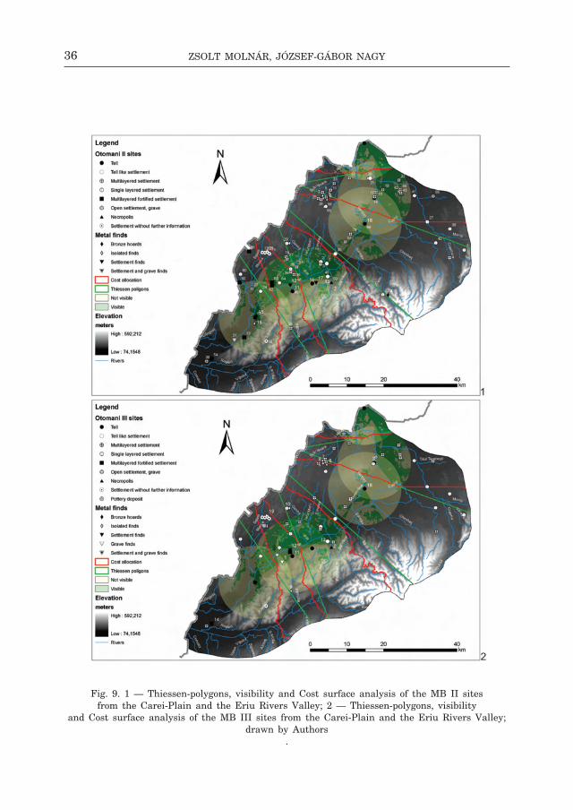
36 Zsolt Molnár, JóZsef-Gábor naGy
fig. 9. 1 — Thiessen-polygons, visibility and cost surface analysis of the mb ii sites from the carei-Plain and the eriu rivers Valley; 2 — Thiessen-polygons, visibility
and cost surface analysis of the mb iii sites from the carei-Plain and the eriu rivers Valley; drawn by Authors
.
37Habitat Models and social systeMs...
fig. 10. 1 — XTenT and visibility analysis of the mb i sites from the carei-Plain and the eriu rivers Valley; 2 — XTenT and visibility analysis of the mb ii sites
from the carei-Plain and the eriu rivers Valley; drawn by Authors.
38 Zsolt Molnár, JóZsef-Gábor naGy
fig. 11. 1 — XTenT and visibility analysis of the mb iii sites from the carei-Plain and the eriu rivers Valley; 2 — The contingency of the mb ii sites and the bronze objects
discovered in the carei-Plain and the eriu rivers Valley; drawn by Authors.
2
39Habitat Models and social systeMs...
fig. 12. 1 — The contingency of the mb iii sites and the bronze objects discovered in the carei-Plain and the eriu rivers Valley; 2 — density of mb i sites and shortest
possible route analysis in the carei-Plain and the eriu rivers Valley; drawn by Authors.
40 Zsolt Molnár, JóZsef-Gábor naGy
fig. 13. 1 — density of mb ii sites and shortest possible route analysis in the carei-Plain and the eriu rivers Valley; 2 — density of mb iii sites and shortest possible route analysis
in the carei-Plain and the eriu rivers Valley; drawn by Authors.
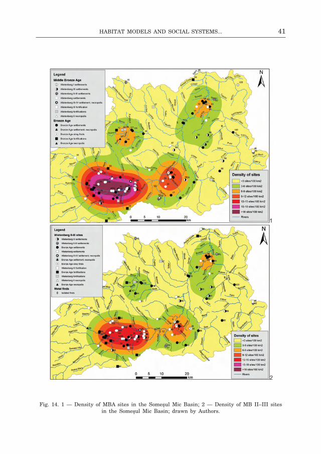
41Habitat Models and social systeMs...
fig. 14. 1 — density of mbA sites in the someşul mic basin; 2 — density of mb ii–iii sites in the someşul mic basin; drawn by Authors.
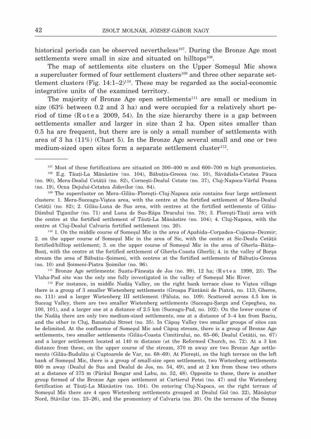
42 Zsolt Molnár, JóZsef-Gábor naGy
historical periods can be observed nevertheless107. during the bronze Age most settlements were small in size and situated on hilltops108.
The map of settlements site clusters on the Upper someşul mic shows a supercluster formed of four settlement clusters109 and three other separate set-tlement clusters (fig. 14:1–2)110. These may be regarded as the social-economic integrative units of the examined territory.
The majority of bronze Age open settlements111 are small or medium in size (63% between 0.2 and 3 ha) and were occupied for a relatively short pe-riod of time (r o t e a 2009, 54). in the size hierarchy there is a gap between settlements smaller and larger in size than 2 ha. open sites smaller than 0.5 ha are frequent, but there are is only a small number of settlements with area of 3 ha (11%) (chart 5). in the bronze Age several small and one or two medium-sized open sites form a separate settlement cluster112.
107 most of these fortifications are situated on 300–400 m and 600–700 m high promontories.108 e.g. Tăuţi-la mănăstire (no. 104), băbuţiu-grecea (no. 10), săvădisla-cetatea Păuca
(no. 90), mera-dealul cetăţii (no. 82), corneşti-dealul cetate (no. 37), cluj-napoca-Vârful Peana (no. 19), ocna dejului-cetatea Jidovilor (no. 84).
109 The supercluster on mera–gilău–floreşti–cluj-napoca axis contains four large settlement clusters: 1. mera-suceagu-Viştea area, with the centre at the fortified settlement of mera-dealul cetăţii (no. 82); 2. gilău-luna de sus area, with centres at the fortified settlements of gilău-dâmbul Ţiganilor (no. 71) and luna de sus-râpa dracului (no. 78); 3. floreşti-Tăuţi area with the centre at the fortified settlement of Tăuţi-la mănăstire (no. 104); 4. cluj-napoca, with the centre at cluj-dealul calvaria fortified settlement (no. 20).
110 1. on the middle course of someşul mic in the area of Apahida–corpadea–cojocna–dezmir; 2. on the upper course of someşul mic in the area of sic, with the centre at sic-dealu cetăţii fortified/hilltop settlement; 3. on the upper course of someşul mic in the area of gherla–băiţa–bonţ, with the centre at the fortified settlement of gherla-coasta gherlii; 4. in the valley of borşa stream the area of băbuţiu–Şoimeni, with centres at the fortified settlements of băbuţiu-grecea (no. 10) and Şoimeni-Piatra Şoimilor (no. 96).
111 bronze Age settlements: suatu-fâneaţa de Jos (no. 99), 12 ha; (r o t e a 1998, 23). The Vlaha-Pad site was the only one fully investigated in the valley of someşul mic river.
112 for instance, in middle nadăş Valley, on the right bank terrace close to Viştea village there is a group of 3 smaller wietenberg settlements (groapa fântânii de Piatră, no. 113; gherce, no. 111) and a larger wietenberg iii settlement (Păluta, no. 109). scattered across 4.5 km in suceag Valley, there are two smaller wietenberg settlements (suceagu-Şarga and cepegheu, no. 100, 101), and a larger one at a distance of 2.5 km (suceagu-Pad, no. 102). on the lower course of the nadăş there are only two medium-sized settlements, one at a distance of 3–4 km from baciu, and the other in cluj, banatului street (no. 35). in căpuş Valley two smaller groups of sites can be delimited. At the confluence of someşul mic and căpuş stream, there is a group of bronze Age settlements, two smaller settlements (gilău-coasta cimitirului, no. 65–66; dealul cetăţii, no. 67) and a larger settlement located at 140 m distance (at the reformed church, no. 72). At a 3 km distance from these, on the upper course of the stream, 370 m away are two bronze Age settle-ments (gilău-budulău şi cuptoarele de Var, no. 68–69). At floreşti, on the high terrace on the left bank of someşul mic, there is a group of small-size open settlements, two wietenberg settlements 600 m away (dealul de sus and dealul de Jos, no. 54, 49), and at 2 km from these two others at a distance of 375 m (Pârâul bongar and labu, no. 52, 48). opposite to these, there is another group formed of the bronze Age open settlement at cartierul fetei (no. 47) and the wietenberg fortification at Tăuţi-la mănăstire (no. 104). on entering cluj-napoca, on the right terrace of someşul mic there are 4 open wietenberg settlements grouped at dealul gol (no. 22), mănăştur nord, stăvilar (no. 23–26), and the promontory of calvaria (no. 20). on the terraces of the someş

43Habitat Models and social systeMs...
chart 5. size of bronze Age and middle bronze Age settlements in someşul mic basin.
Chart 6. size evolution of wietenberg settlements, phases i–ii and ii/iii–iV; drawn by Authors.
on the territory of cluj there are four other wietenberg settlements (casa bocskai, Unirii square, Victor babeş street, cireşilor street, no. 25, 29, 33, 32). Also in cluj there are two other settle-ments: grădina botanică-sere (early wietenberg, no. 30) and cimitirul central (wietenberg iii, no. 31). At Apahida there is a group of 4 open settlement (the right bank of someş, Platoul chibaia, lacul cocor, Tău măerului, no. 7–9), with other isolated finds from the bronze Age. scat-tered at various distances from this centre, there are 4 wietenberg settlements at the intersection of Apahida-gherla-mociu, sânnicoară-lab (no. 89) and dezmir-Tăuşor (no. 42), corpadea-ciungu (no. 38), and 3 bronze Age settlements (cara-după Pădure, boju, cojocna-cetate, no. 17, 13, 36). in the neighbourhood of gherla town there is a group of 3 open settlements (gherla-house, no. 356, lunca, dealul coper, no. 64, 62, 63) and a small bronze Age fortification (gherla-coasta gherlii). in the perimeter of this group there are 3 wietenberg settlements (băiţa-dealul sărăzaia, gherla-Pietriş, mintiu gherlii-ciuleneş, no. 12, 61, 83), and in the area of iclod there are 2 bronze Age open settlements (Şcoala, moara fcn, no. 75–76). in borşa Valley 4 open settlements are grouped (ciumăfaia-the reformed church, Vultureni-Ambrozie, -Ştiubei, făureni, no. 18, 117–118, 44), with a bronze Age cemetery (Vechea-ciutaia, no. 106) and two wietenberg settlements (Şoimeni-la cruce, măcicaşu-Pocornea, no. 95, 81) dispersed in the area.
37%
18%17%
11%
5%4% 3% 2% 3%0%
>0,5 ha >1 >2 >3 >4 >5 >6 >7 ≥10
0
5
10
15
20
25
30
>0,5 >1 >2 >3 >4 >5 >6 >10>25 ha
Wietenberg I–II
>0.5 ha >1 >2 >3 >4 >5 >6 >7 ≥10
44 Zsolt Molnár, JóZsef-Gábor naGy
The topographic setting, surface area, duration, function and character of the settlements are influenced by a great many geographic, economic and stra-tegic factors (r o t e a 1993, 34). looking at the geographic distribution of mid-dle bronze Age settlements (chart 7) we may find that they are predomi-nantly located on the first river terraces (36%) or in higher parts of valleys (32%)113, on hill slopes (30%) and, less frequently, on hilltops114. Only a few open settlements were established on alluvial areas or other more elevated forms of relief of the riverside115.
chart 7. geographic distribution of middle bronze Age settlements in someşul mic basin; drawn by Authors.
chart 8. geographic distribution of settlements in wietenberg culture, phases ii–iii/iV; drawn by Authors.
113 r o t e a 1993, 36. e.g.: cluj-banatului street (no. 35), Palatca-Togul lui mândruşcă (no. 86).114 K o v á c s 1913, 1ff.; r o t e a 1998, 25. e.g.: Pălatca-sub Pădure, corpadea-csungu.115 n a g y 2011, 276. e.g.: sânnicoară-lab (no. 89); iclod-Şcoală (no. 75) and iclod-moara
fcn (no. 76).
43%
33%
22%2%
Terrace Valley Hill Promontory
Terrace Valley Hill Promotory
Terrace Valley Hill Promotory
30%
2%
32%
36%
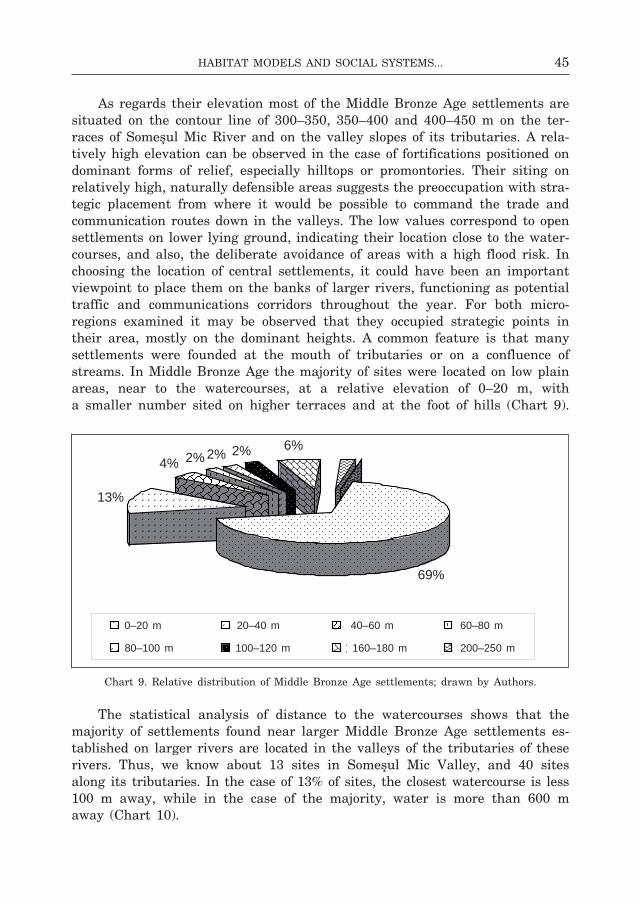
45Habitat Models and social systeMs...
As regards their elevation most of the middle bronze Age settlements are situated on the contour line of 300–350, 350–400 and 400–450 m on the ter-races of someşul mic river and on the valley slopes of its tributaries. A rela-tively high elevation can be observed in the case of fortifications positioned on dominant forms of relief, especially hilltops or promontories. Their siting on relatively high, naturally defensible areas suggests the preoccupation with stra-tegic placement from where it would be possible to command the trade and communication routes down in the valleys. The low values correspond to open settlements on lower lying ground, indicating their location close to the water-courses, and also, the deliberate avoidance of areas with a high flood risk. in choosing the location of central settlements, it could have been an important viewpoint to place them on the banks of larger rivers, functioning as potential traffic and communications corridors throughout the year. for both micro- regions examined it may be observed that they occupied strategic points in their area, mostly on the dominant heights. A common feature is that many settlements were founded at the mouth of tributaries or on a confluence of streams. in middle bronze Age the majority of sites were located on low plain areas, near to the watercourses, at a relative elevation of 0–20 m, with a smaller number sited on higher terraces and at the foot of hills (chart 9).
chart 9. relative distribution of middle bronze Age settlements; drawn by Authors.
The statistical analysis of distance to the watercourses shows that the majority of settlements found near larger middle bronze Age settlements es-tablished on larger rivers are located in the valleys of the tributaries of these rivers. Thus, we know about 13 sites in someşul mic Valley, and 40 sites along its tributaries. in the case of 13% of sites, the closest watercourse is less 100 m away, while in the case of the majority, water is more than 600 m away (chart 10).
69%
4% 2% 2% 2% 6%
13%
0-20 m 20-40 m 40-60 m 60-80 m
80-100 m 100-120 m 160-180 m 200-250
0–20 m 20–40 m 40–60 m 60–80 m
80–100 m 100–120 m 160–180 m 200–250 m
69%
13%
4% 2% 2% 2% 6%

46 Zsolt Molnár, JóZsef-Gábor naGy
chart 10. distribution of middle bronze Age settlements in relation to a watercourse; drawn by Authors.
chart 11. distribution of middle bronze Age settlements in relation to soil type; drawn by Authors.
The distribution of settlements in relation to soil type116 (chart 11) shows that the majority of bronze Age sites are placed on cambisols, undeveloped soils117 and mollisols118, excellent for crop farming119, and less frequently on
116 The distribution of settlements according to soil types also indicates the possible ratio of crop farming to cattle breeding in the community’s economy.
117 soils with weakly developed horizons due to the short time of paedogenesis process, not reaching to a dynamic balance with the surrounding environmental conditions.
118 dark coloured soils, saturated in basis, occupying large surfaces of semi-humid — semi-arid regions (types: chernozem, light brown soil, grey soils).
119 settlements rarely occupy areas with cambisol, a soil type of beech forests on high hills and lower parts of mountains (types: brown and acid brown soils), argilluvisoils, rich in clay, in the area of oak forests on lower hills, and vertisoils, a heavy, clayey soil formed on swelling clay, with clay content >35%, and clayey minerals with 2:1 type network 50%. it swells and shrinks with changing humidity.
8%
32%
24%
6%
26%
4%
Argilluvisols Cambisols MollisolsHydromorphic soils Undeveloped soils Vertisol
13%
8%
9%
13%
6% 4%
47%
0-100 m 100-200 m 200-300 m 300-400 m400-500 m 500-600 m > 600 m
13%
8%
9%
13%
6% 4%
47%
0-100 m 100-200 m 200-300 m 300-400 m400-500 m 500-600 m > 600 m
13%
8%
9%
13%
6% 4%
47%
0-100 m 100-200 m 200-300 m 300-400 m400-500 m 500-600 m > 600 m
0–100 m 100–200 m 200–300 m 300–400 m
400–500 m 500–600 m >600 m
13%
8%
9%
13%
6% 4%
47%
0-100 m 100-200 m 200-300 m 300-400 m400-500 m 500-600 m > 600 m
13%
8%
9%
13%
6% 4%
47%
0-100 m 100-200 m 200-300 m 300-400 m400-500 m 500-600 m > 600 m
13%
8%
9%
13%
6% 4%
47%
0-100 m 100-200 m 200-300 m 300-400 m400-500 m 500-600 m > 600 m
13%
8%
9%
13%
6% 4%
47%
0-100 m 100-200 m 200-300 m 300-400 m400-500 m 500-600 m > 600 m
13%
8%
9%
13%
6% 4%
47%
0-100 m 100-200 m 200-300 m 300-400 m400-500 m 500-600 m > 600 m
13%
8%
9%
13%
6% 4%
47%
0-100 m 100-200 m 200-300 m 300-400 m400-500 m 500-600 m > 600 m
13%
8%
9%
13%
6% 4%
47%
0-100 m 100-200 m 200-300 m 300-400 m400-500 m 500-600 m > 600 m
47Habitat Models and social systeMs...
argilluvisols and hydromorphic soils120. it seems that the economic usefulness of areas chosen for habitation was a primary criterion. most sites were in areas of fertile soil although there are territorial differences suggesting the knowledge of, and adaptation to, local conditions.
CONCLuSIONS
The mapping of topographic data proved that the middle bronze Age commu-nities of central and north-western Transylvania living within the social frame-work of chiefdom clustered into geographically well delimited complex integra-tive structural units121. A comparative analysis of the size and structure of these integrative units reveals temporal changes and spatial differences in the settlement pattern in the analyzed territories.
in the carei Plain and the eriu Valley we find a settlement system with four settlement clusters and a smaller unit and two larger settlement clusters. The basic type of settlement chains usually comprises 4–5 fortified or open sites of various size. The settlement chains mostly contain multi-layer settlements, which is the result of the geographic conditons of the micro-region (fig. 5:2; 6:1–2). on the upper course of someşul mic there is a supercluster of four settlement clusters. we may regard it as the focal point of the analyzed ter-ritory. The settlement system contains four other settlement clusters on the middle and the lower someşul mic river. The middle bronze Age settlement clusters, easily identified, consist of one or two smaller fortified centres and a chain of adjoining open sites. The basic type of settlement chains in the territory usually comprises 4–5 open sites of various sizes (fig. 14:1–2). in both cases, the settlement clusters are stable social and economic units held together by corporative power strategies122. This proves that the number of sites in a settlement cluster does not change significantly over time, and the number of settlement clusters does not vary. At the current stage of research, mb i is the period during which mostly individual settlements spread across the landscape and the existence of significant structures cannot be proved at the moment (fig. 5:2; 14:1).
The structural complexity of the settlement clusters in the investigated period is high, two levels of cluster formation can be traced in both territories: the organization of various settlement chains into clusters, and the grouping
120 A soil type formed under the influence of ground water found in the soil profile or water coming from precipitations stagnating in the soil profile for a lengthy period of time.
121 distribution maps reflect the current state of research which may be expected to change dramatically with input from new research.
122 The vast majority of social interactions and daily activities would be on village and house-hold level (g y u c h a, P a r k i n s o n 2007, 44).
48 Zsolt Molnár, JóZsef-Gábor naGy
of settlement clusters into superclusters. Two larger territorial units may be outlined on the basis of the number and spatial distribution of middle bronze Age sites: the carei Plain and eriu Valley. The distribution of sites in north-western Transylvania is uniform, although it seems that the centre of the set-tlement system is the middle part of eriu Valley. This is where a supercluster comprising several settlement clusters came into being in mb ii, lasting until the end of the middle bronze Age (fig. 6:1). The supercluster of eriu Valley was still preserved in mb iii while the tells considered the power centres of the area were gradually abandoned. in opposition to this, the tells of carei Plain survived. This hints at a complex situation, which — so it seems — cannot be explained by hierarchical models.
The centre of the settlement system of central Transylvania is on the upper-middle course of someşul mic river. The territory on the lower someşul mic rive has fewer settlements. The size differences between the settlement clusters are greater. The number of settlements of the eight middle bronze Age integrative unit settlement clusters did not change significantly (fig. 14:1–2).
influence areas determined using the Thiessen polygon method and cost surface analysis of tells and fortifications regarded as territorial centres are similar for both micro-regions. The minor territorial differences seen on the maps are the result of methodological differences of analytic methods applied. Analyses show that there were 6 bronze Age territorial units of various size in north-western Transylvania and 13 in central Transylvania. Projecting the territorial divisions onto the maps of density clusters of the settlement system we obtain an image which takes into account both the environmental conditions and the patterns of the settlement network consequently, one that is closer to reality (fig. 5:2; 6:1–2; 17:1–2). As a result of the comparison, the influence areas of the tells berveni, carei and Tiream in the carei Plain and those of otomani and sălacea can be merged. The three large units thus formed — on the basis of the sites contained and the viewshed areas — can be equated with the territorial delimitations made using the XTenT method. in the analyzed north-western Transylvanian micro-region there could have been three large chiefdoms each made up of a number of territorial sub-units and medium-sized settlement clusters (fig. 7:1–2; 8:1).
The middle bronze Age territories with the centres at băbuţiu-grecea and Şoimeni-cetatea Şoimilor settlements in the valley of borşa stream in someşul mic Valley can be merged. The influence areas of the fortified settlements of Tăuţi-la mănăstire and cluj-napoca-Vârful Peana on the upper course of someşul mic can also be assumed to have formed one unit. The neighbourhood of the fortified settlement of corneşti in the valley of lonea stream contains no other settlement, therefore it cannot be regarded as a territorial centre. The middle bronze Age influence areas of someşul mic Valley, determined using the cost surface analysis and Thiessen polygons, suggest two patterns of territorial organization. Presumably, there were five chiefdoms during the
49Habitat Models and social systeMs...
bronze Age,123 of roughly the same size, and with a settlement chain of bi-modal (?) distribution which functioned on the principle of peer-polity interaction (fig. 15:1–2; 16:1; 17:1–2)124.
At the time of writing neither the comparison made of the siting of cem-eteries in the carei Plain and the eriu Valley as well as someşul mic Valley relative to bronze Age influence areas nor the study of the correlation between settlements and bronze objects (fig. 11:2; 12:1; 18:1) have yielded any re-sults125.
The analysis of viewshed areas of bronze Age tells and fortifications offers new data for reconstructing the territorial organization systems of the region. The neighbouring middle bronze Age fortified settlements are within seeing
123 The hierarchy of the leaderships or the degree of their autonomy is hard to assess. The leaderships of someşul mic Valley may be grouped on the basis of the size of their territories and the number of settlements in their influence area. cost surface and Thiessen polygon analyses roughly delineate influence areas of the same size. An exception are the smaller micro-regions on the Upper someşul mic with centres at Tăuţi-la mănăstire (no. 104) and luna de sus-râpa dracului (no. 78). This might hint at the less important position that these leaderships had in the power system of the region. moreover, it cannot be excluded that what we face is only the technical solution deriving from the methodological criteria of the two applied methods of analysis. The analyses were conducted on the fortified centres. in opposition to other parts of the exam-ined territory, there are seven fortifications close to each other on the upper course of someşul mic. The earthworks of Tăuţi-la mănăstire and luna de sus-râpa dracului are surrounded by other fortifications, therefore the influence areas determined by geographic information systems are much smaller due to their delimitations. in the case of leaderships with relatively equal sizes the influence area with the centre gherla-coasta gherlii contains 14 open sites and 18 salt sites; the cluj-napoca-dealul calvaria (no. 20) centre area 31 settlements and 10 salt sites; the mera-dealul cetăţii (no. 82) centre area 5 settlements; băbuţiu-grecea (no. 10) and Şoimeni-Piatra Şoimilor (no. 96) centre area 6 settlements, 1 cemetery and 1 salt site; the feldioara-dealul cetăţii (no. 46) centre area 5 settlements and 5 salt sites, etc. The territory with the centre at gilău-dâmbul Ţiganilor (no. 71) contains 6 settlements, a cemetery and 1 copper site, but its territory extends towards the valley of someşul rece not investigated by our project. in smaller influence areas we also find sources of raw materials, as proved by the salt extraction site in the territory with centres at Tăuţi-la mănăstire (no. 104) and cluj-napoca-Vârful Peana (no. 19). The smaller influence area centred on luna de sus-râpa dracului (no. 78) contains just as many open sites (5) as the larger micro-regions. it seems that we have here a loose alliance system of occasionally rivalling leaderships of various sizes, socially independent and exploiting their own resources, functioning on the basis of peer-polity interaction.
124 The break between the number of open sites of settlement chains (the influence area with gherla-coasta gherlii centre contains 14 open sites, the cluj-napoca-dealul calvaria (no. 20) centre area 31 settlements, while the other areas contain 1–5 open sites) suggests bimodal distribution, but it cannot be excluded that bimodality is not an indicator of social differences and only the reflection of the research status in the territory and the strategy of data collection. of these, based on their territory, inhabitants and resources, emerge the leaderships with the centres of cluj-napoca-dealul calvaria and gherla-coasta gherlii. The settlement density of the supercluster on the upper course of someşul mic, the spatial distribution of earthworks and set-tlements suggests that there may have been a micro-regional alliance system.
125 The maps of the straight line distance of mbA sites from the metal finds show us the majority of the bronzes are discovered near the major settlement blocks. without making a closer analysis of bronze objects discovered in the study, we only wish to note that the majority of the recorded finds are weapons and ornaments.
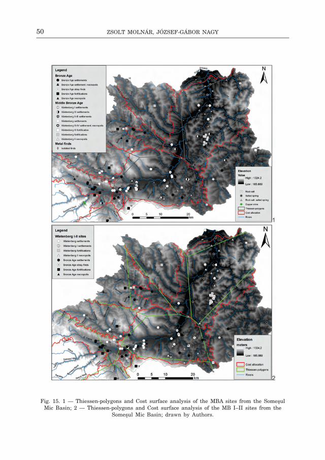
50 Zsolt Molnár, JóZsef-Gábor naGy
fig. 15. 1 — Thiessen-polygons and cost surface analysis of the mbA sites from the someşul mic basin; 2 — Thiessen-polygons and cost surface analysis of the mb i–ii sites from the
someşul mic basin; drawn by Authors.

51Habitat Models and social systeMs...
fig. 16. 1 — Thiessen-polygons and cost surface analysis of the mb ii–iii sites from the someşul mic basin; 2 — Thiessen-polygons, visibility and cost surface analysis of the mbA
sites from the someşul mic basin; drawn by Authors.

52 Zsolt Molnár, JóZsef-Gábor naGy
fig. 17. 1 — density, Thiessen-polygons and cost surface analysis of the mbA sites from the someşul mic basin; 2 — density, Thiessen-polygons and cost surface analysis
of the wietenberg ii–iV sites from the someşul mic basin; drawn by Authors.

53Habitat Models and social systeMs...
fig. 18. 1 — The contingency of the mbA sites, natural resources and the bronze objects discovered in the someşul mic basin; 2 — The mbA settlement system and shortest possible
route analysis in the someşul mic basin; drawn by Authors.

54 Zsolt Molnár, JóZsef-Gábor naGy
fig. 19. 1 — density of mbA sites, natural resources and shortest possible route analysis in the someşul mic basin; 2 — density of mbA sites, visibility and shortest possible route
analysis in the someşul mic basin; drawn by Authors.

55Habitat Models and social systeMs...
distance from each other126. They are sited in strategic points in the analyzed territory allowing observation and control over the main routes leading to and crossing the valleys of eriu, crasna and someşul mic. The entrance areas of side valleys opening into the main routes were also within the viewshed areas, sometimes for several kilometres. The common goal was probably the defense of the carei Plain and the eriu Valley127 and the someşul mic Valley128. In both regions the middle bronze Age settlement network is visible in its vast majority from one of the fortified centres. To control these was therefore not particularly difficult (fig. 8:2; 9:1–2; 10:1–2). The operation of the power system of bronze Age chiefdoms in central Transylvania was aided by the fact that, in addition to larger settlement clusters, the territories rich in subsoil re-sources were also visible from the fortifications (fig. 16:2)129.
The bronze Age routes connecting the power centres of the carei Plain and the eriu Valley and the valley of the someşul mic, generated by gis on
126 There is a similar situation in different territories on the Tisza river. The tells are spaced 5 to 10 kms apart (f i s c h l, r e m é n y i 2013, 731).
127 The viewshed areas of the săcuieni-cetatea boului tell makes it possible to command the lower course of eriu and parts of the streams of sălcia and mouca, flowing from nyírség region. This route is closed by the fortified settlements of Şilindru-füzék (no. 60) and Şimian-locul grădinilor (no. 61). The fortifications of roşiori-cetatea de pământ (no. 54), cadea-dealul chel (no. 13) and săcuieni-cetatea boului (no. 57) close down the lower course of eriu. The viewshed areass of otomani-cetăţuie and sălacea-dealul Vida tells extend not only to eriu Valley, but also to the side valleys of ganoş, ierul morii, Zimoiaş, făncica and sărvăzel streams. occasionally, the mouths of these tributaries are closed down by fortified settlements (e.g. dindeşti-cetate; no. 30) The Tiream-holmul cânepii tell (no. 66) controlled the upper course of the eriu and the area of cubic, checheţ and santău streams, flowing from crasna. The viewshed areass of carei-bobald and berveni-halmos tells (no. 14 and no. 12 respectively) command the whole valley of the crasna.
128 The viewshed areass of băbuţiu-grecea (no. 10) and Şoimeni-Piatra Şoimilor (no. 96) fortifications offer viewshed over the largest part of borşa Valley and its tributaries. corneşti-dealul cetate (no. 37) in the valley of lonea stream controlled one of the important routes coming from someşul mare area towards the someşul mic Valley. The ocna dejului-cetatea Jidovilor (no. 84) fortification had the same function, with its viewshed extending over the confluence area of someşul mare and someşul mic rivers. in its extension lies the viewshed areas of the fortification of gherla-coasta gherlii, covering the lower course of someşul mic, rich in minerals. feldioara-dealul cetăţii (no. 46) settlement controlled the eastern entrance to someşul mic Valley, through the valleys of râul morii and catina streams. The upper entrance of someşul mic Valley and the mouths of the important tributaries of someşul mic (the streams of nadăs, căpuş, feneş, and gârbău) were visible from the seven earthworks found in this region.
129 The settlement clusters of the supercluster along the gilău–floreşti-cluj-napoca axis are almost completely visible from one of the seven earthworks of the territory. The majority of salt sites and settlement chains on the lower course of someşul mic, as well as lengthy sections of the river valley itself are visible from the gherla-coasta gherlii fortified settlement. An exception are the salt sites and settlements around Apahida-cojocna which belonged to the leadership centred on cluj-napoca-dealul calvaria (no. 20), but fell outside the viewshed areas of the central fortified settlement. salt mining could only be indirectly controlled from there. The four bronze Age settle-ments around the nine salt sites in the neighbourhood of sic formed a closed unit. The settlements belong to the territory of the gherla-coasta gherlii leadership, but fall outside the viewshed areas of the central fortification. in case of settlements with a thin culture deposit surrounding the salt sites it can be assumed that these were temporary settlements connected to salt mining.

56 Zsolt Molnár, JóZsef-Gábor naGy
the basis of the relief patterns of these territories, have a similar organization system. This is partly due to the methodology applied.
The main route of the carei Plain and the eriu Valley runs down the valleys of the crasna and the eriu rivers. its two ends, according to the gis model, were the berveni-halmos and sălacea-dealul Vida tells. The model also outlines another alternative route, which connects the berveni-halmos and săcuieni-cetatea boului tells crossing the settlement supercluster of eriu Val-ley, not crossing other central settlements. The latter runs down the valleys of the Valea neagră and the ganaş on the border of the nyírség region and the carei Plain, then continues the south following the valley of the eriu. The relief pattern of the territory makes both routes conceivable although the main route leading through crasna and eriu valleys seems more probable. it is a fact however that this route is visible and can be controlled its entire length from the central settlements (fig. 12:2; 13:1–2). during the middle bronze Age the main route of central Transylvania follows the valley of someşul mic to its middle course, crosses the most densely populated area of the region’s super-cluster, crosses the salt sites, and then follows the river valley again. its two ends are the fortified settlements of luna de sus-râpa dracului and ocna dejului-cetatea Jidovilor. The existence of two of the three side routes near the main route is probable. both of them connect the fortified settlement of mera-dealul cetăţii situated on the edge of the settlement epicentre of someşul mic Valley, with the lower course of the river. we may find several settlements and salt sites along the supposed shorter side routes (fig. 18:2; 19:1–2). At the current stage of research the existence of a route connecting the chiefdom centred on feldioara-dealul cetăţii with the lower course of someşul mic, rich in salt, cannot be proved as yet.
in conclusion it may be said that two kinds of settlement-network models may be traced in central and north-western Transylvania, relatively distinct, not only due to their adaptation to local environmental conditions, but also in their exercise of power and social structures. The settlement system of the peer-polity units of the carei Plain and the eriu Valley is more centralized than that of the someşul mic Valley although both are built on similar social and economic structures.
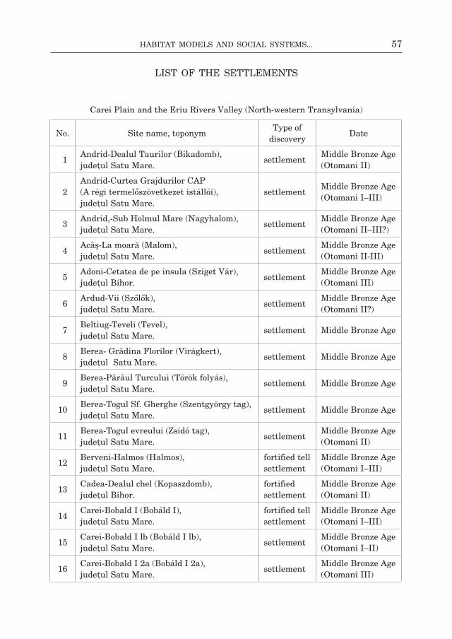
57Habitat Models and social systeMs...
No. site name, toponymType of
discoveryDate
11Andrid-dealul Taurilor (bikadomb), judeţul satu mare.
settlementmiddle bronze Age (otomani ii)
12Andrid-curtea grajdurilor cAP (A régi termelőszövetkezet istállói), judeţul satu mare.
settlementmiddle bronze Age (otomani i–iii)
13Andrid,-sub holmul mare (nagyhalom), judeţul satu mare.
settlementmiddle bronze Age (otomani ii–iii?)
14Acâş-la moară (malom), judeţul satu mare.
settlementmiddle bronze Age (otomani ii-iii)
15Adoni-cetatea de pe insula (sziget Vár), judeţul bihor.
settlementmiddle bronze Age (otomani iii)
16Ardud-Vii (szőlők), judeţul satu mare.
settlementmiddle bronze Age (otomani ii?)
17beltiug-Teveli (Tevel), judeţul satu mare.
settlement middle bronze Age
18berea- grădina florilor (Virágkert), judeţul satu mare.
settlement middle bronze Age
19berea-Pârâul Turcului (Török folyás), judeţul satu mare.
settlement middle bronze Age
10berea-Togul sf. gherghe (szentgyörgy tag), judeţul satu mare.
settlement middle bronze Age
11berea-Togul evreului (Zsidó tag), judeţul satu mare.
settlementmiddle bronze Age (otomani ii)
12berveni-halmos (halmos), judeţul satu mare.
fortified tell settlement
middle bronze Age (otomani i–iii)
13cadea-dealul chel (Kopaszdomb), judeţul bihor.
fortified settlement
middle bronze Age (otomani ii)
14carei-bobald i (bobáld i), judeţul satu mare.
fortified tell settlement
middle bronze Age (otomani i–iii)
15carei-bobald i lb (bobáld i lb), judeţul satu mare.
settlementmiddle bronze Age (otomani i–ii)
16carei-bobald i 2a (bobáld i 2a), judeţul satu mare.
settlementmiddle bronze Age (otomani iii)
carei Plain and the eriu rivers Valley (north-western Transylvania)
LIST OF THE SETTLEMENTS
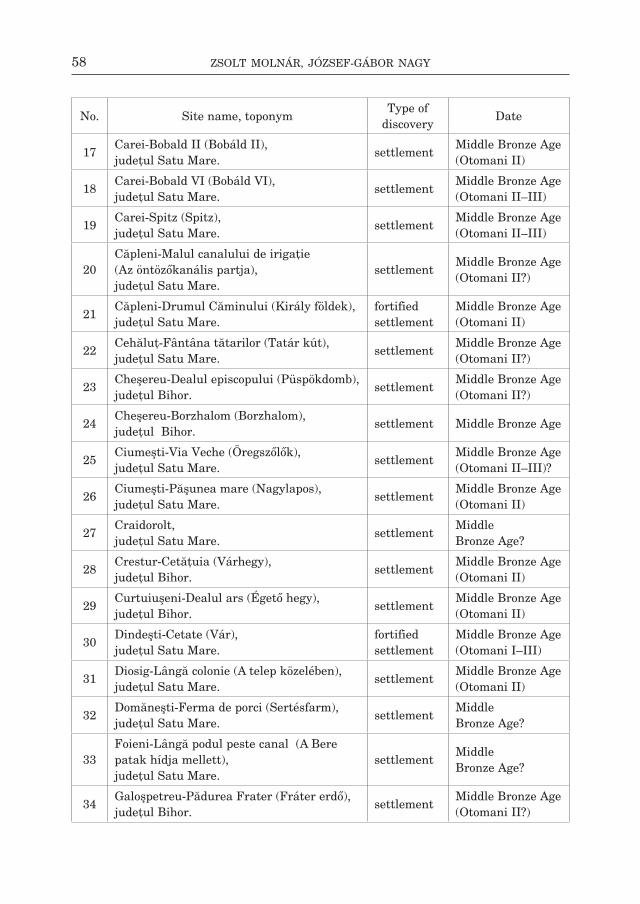
58 Zsolt Molnár, JóZsef-Gábor naGy
No. site name, toponymType of
discoveryDate
17carei-bobald ii (bobáld ii), judeţul satu mare.
settlementmiddle bronze Age (otomani ii)
18carei-bobald Vi (bobáld Vi), judeţul satu mare.
settlementmiddle bronze Age (otomani ii–iii)
19carei-spitz (spitz), judeţul satu mare.
settlementmiddle bronze Age (otomani ii–iii)
20căpleni-malul canalului de irigaţie (Az öntözőkanális partja), judeţul satu mare.
settlementmiddle bronze Age (otomani ii?)
21căpleni-drumul căminului (Király földek), judeţul satu mare.
fortified settlement
middle bronze Age (otomani ii)
22cehăluţ-fântâna tătarilor (Tatár kút), judeţul satu mare.
settlementmiddle bronze Age (otomani ii?)
23cheşereu-dealul episcopului (Püspökdomb), judeţul bihor.
settlementmiddle bronze Age (otomani ii?)
24cheşereu-borzhalom (borzhalom), judeţul bihor.
settlement middle bronze Age
25ciumeşti-Via Veche (Öregszőlők), judeţul satu mare.
settlementmiddle bronze Age (otomani ii–iii)?
26ciumeşti-Păşunea mare (nagylapos), judeţul satu mare.
settlementmiddle bronze Age (otomani ii)
27craidorolt, judeţul satu mare.
settlementMiddle bronze Age?
28crestur-cetăţuia (Várhegy), judeţul bihor.
settlementmiddle bronze Age (otomani ii)
29curtuiuşeni-dealul ars (Égető hegy), judeţul bihor.
settlementmiddle bronze Age (otomani ii)
30dindeşti-cetate (Vár), judeţul satu mare.
fortified settlement
middle bronze Age (otomani i–iii)
31diosig-lângă colonie (A telep közelében), judeţul satu mare.
settlementmiddle bronze Age (otomani ii)
32domăneşti-ferma de porci (sertésfarm), judeţul satu mare.
settlementMiddle bronze Age?
33foieni-lângă podul peste canal (A bere patak hídja mellett), judeţul satu mare.
settlementMiddle bronze Age?
34galoşpetreu-Pădurea frater (fráter erdő), judeţul bihor.
settlementmiddle bronze Age (otomani ii?)
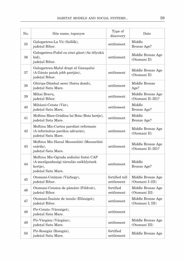
59Habitat Models and social systeMs...
No. site name, toponymType of
discoveryDate
35galoşpetreu-la Vii (szőlők), judeţul bihor.
settlementMiddle bronze Age?
36galoşpetreu-Podul cu cinci găuri (Az ötlyukú híd), judeţul bihor.
settlementmiddle bronze Age (otomani ii)
37galoşpetreu-malul drept al ganaşului (A gánás patak jobb partján), judeţul bihor.
settlementmiddle bronze Age (otomani ii)
38ghirişa-dâmbul serei (széra domb), judeţul satu mare.
settlementmiddle bronze Age?
39mihai bravu, judeţul bihor.
settlementmiddle bronze Age (otomani ii–iii)?
40mihăeni-cetate (Vár), judeţul satu mare.
settlementMiddle bronze Age?
41moftinu mare-grădina lui bota (bota kertje), judeţul satu mare.
settlementMiddle bronze Age?
42moftinu mic-curtea parohiei reformate (A református parókia udvarán), judeţul satu mare.
settlementmiddle bronze Age (otomani ii)
43moftinu mic-hanul messzelátó (messzelátó csárda), judeţul satu mare.
settlementmiddle bronze Age (otomani ii–iii)?
44
moftinu mic-ograda sediului fostei cAP (A mezőgazdasági társulás székhlyének kertje), judeţul satu mare.
settlementMiddle bronze Age?
45otomani-cetăţuie (Várhegy), judeţul bihor.
fortified tell settlement
middle bronze Age (otomani i–iii)
46otomani-cetatea de pământ (földvár), judeţul bihor.
fortified settlement
middle bronze Age (otomani iii)
47otomani-Înainte de insula (elősziget), judeţul bihor.
settlementmiddle bronze Age (otomani i; iii)
48Pir-cetate (Vársziget), judeţul satu mare.
settlement
49Pir-Várgánc (Várgánc), judeţul satu mare.
settlementmiddle bronze Age (otomani iii)
50Pir-roszgáz (roszgáz), judeţul satu mare.
fortified settlement
middle bronze Age

60 Zsolt Molnár, JóZsef-Gábor naGy
No. site name, toponymType of
discoveryDate
51Pişcolt-lângă biserica reformată (A református templom mellett), judeţul satu mare.
settlementmiddle bronze Age (otomani iii)
52Pişcolt-Zónat sau ógát (Zónat vagy ógát), judeţul satu mare.
settlementmiddle bronze Age (otomani i–ii)
53Portiţa-Vis-a-vis de cimitir (A temetővel szemben), judeţul satu mare.
settlementMiddle bronze Age?
54roşiori-cetatea de pământ (földvár), judeţul bihor.
fortified settlement
middle bronze Age (otomani ii–iii)
55sanislău-la hârburi (cserepes), judeţul satu mare.
settlementmiddle bronze Age (otomani ii)
56sanislău-lângă heleşteu (A halastó mellett), judeţul satu mare.
settlementMiddle bronze Age?
57săcuieni-cetatea boului (Ökörvár), judeţul bihor.
fortified tell settlement
middle bronze Age (otomani i–iii)
58sălacea-dealul Vida (Vida domb), judeţul bihor.
fortified tell settlement
middle bronze Age (otomani i–iii)
59sânicolaul de munte-dealul bătrânilor (Öregdomb), judeţul bihor.
settlementmiddle bronze Age (otomani ii–iii)?
60Şilindru-füzék (füzék), judeţul bihor.
fortified settlement
middle bronze Age (otomani ii)
61Şimian-locul grădinilor (Kerthelyek), judeţul bihor.
fortified settlement
middle bronze Age (otomani ii)
62Tarcea-dealul mare (nagydomb), judeţul bihor.
settlementmiddle bronze Age (otomani ii)
63Tarcea-dealul de mijloc (Középhegy), judeţul bihor.
fortified settlement
middle bronze Age (otomani ii)
64Tarcea-holmul mare (nagyhalom), judeţul bihor.
settlementMiddle bronze Age?
65Terebeşti, judeţul satu mare.
settlementMiddle bronze Age?
66Tiream-holmul cânepii (Kendereshalom), judeţul satu mare.
tell settlement
middle bronze Age (otomani ii–iii)
67Unimăt-dâlboci (dalbócs), judeţul satu mare.
settlementlate bronze Age i (cehăluţ group)
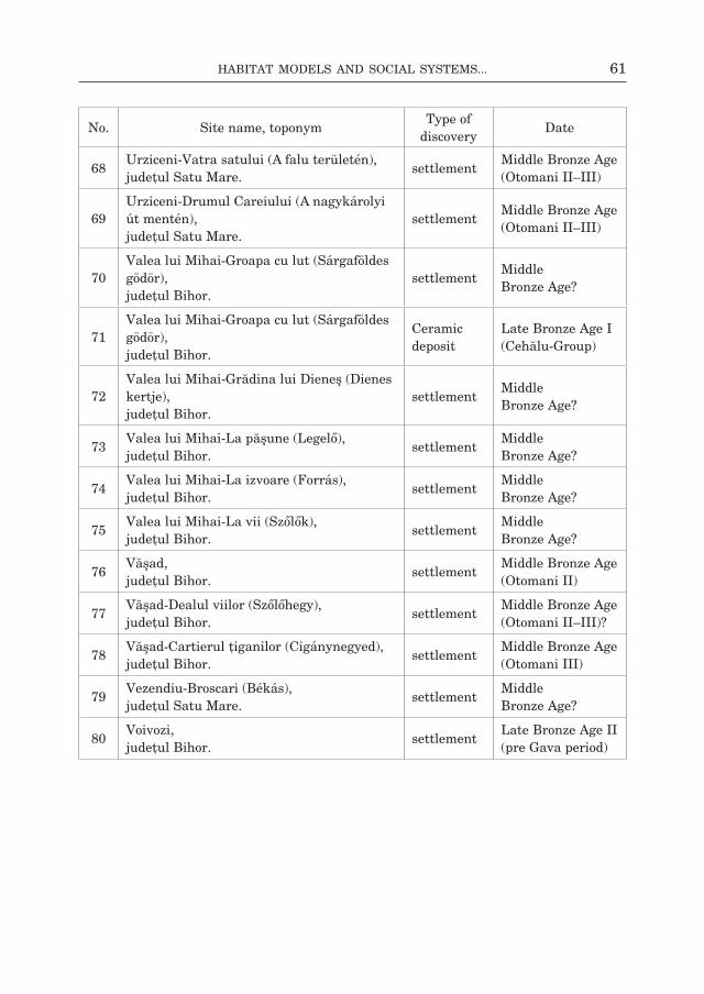
61Habitat Models and social systeMs...
No. site name, toponymType of
discoveryDate
68Urziceni-Vatra satului (A falu területén), judeţul satu mare.
settlementmiddle bronze Age (otomani ii–iii)
69Urziceni-drumul careiului (A nagykárolyi út mentén), judeţul satu mare.
settlementmiddle bronze Age (otomani ii–iii)
70Valea lui mihai-groapa cu lut (sárgaföldes gödör), judeţul bihor.
settlementMiddle bronze Age?
71Valea lui mihai-groapa cu lut (sárgaföldes gödör), judeţul bihor.
Ceramic deposit
late bronze Age i (cehălu-group)
72Valea lui mihai-grădina lui dieneş (dienes kertje), judeţul bihor.
settlementMiddle bronze Age?
73Valea lui mihai-la păşune (legelő), judeţul bihor.
settlementMiddle bronze Age?
74Valea lui mihai-la izvoare (forrás), judeţul bihor.
settlementMiddle bronze Age?
75Valea lui mihai-la vii (szőlők), judeţul bihor.
settlementMiddle bronze Age?
76Văşad, judeţul bihor.
settlementmiddle bronze Age (otomani ii)
77Văşad-dealul viilor (szőlőhegy), judeţul bihor.
settlementmiddle bronze Age (otomani ii–iii)?
78Văşad-cartierul ţiganilor (cigánynegyed), judeţul bihor.
settlementmiddle bronze Age (otomani iii)
79Vezendiu-broscari (békás), judeţul satu mare.
settlementMiddle bronze Age?
80Voivozi, judeţul bihor.
settlementlate bronze Age ii (pre gava period)

62 Zsolt Molnár, JóZsef-Gábor naGy
someşul mic-basin (central Transylvania)
No. site name, toponymType of
discoveryDate
11Apahida-râtul Viţeilor (bornyúk rétje, réti Östelep, rét), judeţul cluj.
settlement, incineration grave
late bronze Age (wietenberg iV/noua culture), early iron Age (ha b1)
12Apahida-râtul satului, judeţul cluj.
settlement, necropolis
late bronze Age (wietenberg/noua i culture), Early Iron Age
13Apahida-intersecţia Apahida-gherla-mociu, centru, judeţul cluj.
settlementbronze Age (wietenberg culture)
14Apahida-Şcoala, judeţul cluj.
isolated find bronze Age
15Apahida-malul drept al somesului mic, judeţul cluj.
settlement bronze Age?
16Apahida-malul gârlei, judeţul cluj.
isolated find bronze Age
17Apahida-Platoul chibaia, râtul satului, judeţul cluj.
settlementbronze Age, Early Iron Age
8, 9Apahida-lacul cocor (darvas tó, Tóparti őstelep), Tău maerului, judeţul cluj.
settlement bronze Age
10băbuţiu-grecea, judeţul cluj.
fortified settlement
bronze Age
11baciu-centru, căminul cultural, judeţul cluj.
settlementbronze Age, Early Iron Age
12băiţa-dealul sărăzaia, judeţul cluj.
settlementbronze Age (wietenberg culture), Early Iron Age
13boju, judeţul cluj.
settlement bronze Age
14bonţ-la răzor, judeţul cluj.
settlement; bronze Age (wietenberg culture)
15căprioara-sălişte, judeţul cluj.
settlementmiddle bronze Age (otomani, wietenberg ii–iii)
16căpuşu mare-cânepişte, judeţul cluj.
settlement, necropolis;
bronze Age (mbA to lbA transition)

63Habitat Models and social systeMs...
No. site name, toponymType of
discoveryDate
17cara-după Pădure, judeţul cluj.
settlement bronze Age
18ciumăfaia-biserica reformată, judeţul cluj.
settlement bronze Age
19cluj-napoca-Vf. Peana, judeţul cluj.
fortified settlement
bronze Age
20cluj-napoca-dealul calvaria, judeţul cluj.
settlementbronze Age, early iron Age (ha c)
21cluj-napoca-becaş i-ii, la iepure, la Vest de iepure, Ţâţoasa, judeţul cluj.
settlementlate bronze Age i (wietenberg iV culture), Early Iron Age
22cluj-napoca-mănăştur-dealul gol (Kopaszdomb), judeţul cluj.
settlementbronze Age (wietenberg culture), Early Iron Age
23,26
cluj-napoca-mănăştur nord-marele stăvilar (nagygát)-la stăvilar-Zăgazul someşului, judeţul cluj.
settlementbronze Age (wietenberg culture), early iron Age (ha c–d)
24cluj-napoca-cluj-mănăştur, Şcoala nr. 7, judeţul cluj.
settlementlate bronze Age i (wietenberg iV culture), early iron Age (ha A2–b1)
25cluj-napoca-str. matei corvin, nr. 4, casa bocskay, judeţul cluj.
isolated findbronze Age (wietenberg culture), early iron Age (ha c)
27cluj-napoca-Valea caldă, obiectiv 10, judeţul cluj.
settlementbronze Age (wietenberg culture), Early Iron Age
28cluj-napoca-hoia (hoja tető), judeţul cluj.
settlementlate bronze Age i (wietenberg, noua culture)
29cluj-napoca-Piaţa Unirii (fosta Piaţa libertăţii), judeţul cluj.
settlementbronze Age (wietenberg culture)
30cluj-napoca-grădina botanică-sere, judeţul cluj.
settlementbronze Age (early wietenberg culture)
31cluj-napoca-cimitirul central (házsongárd), judeţul cluj.
settlementmiddle bronze Age iii (wietenberg culture iii)
32cluj-napoca-strada cireşelor nr.55, judeţul cluj.
fortified settlement?
bronze Age (wietenberg culture)
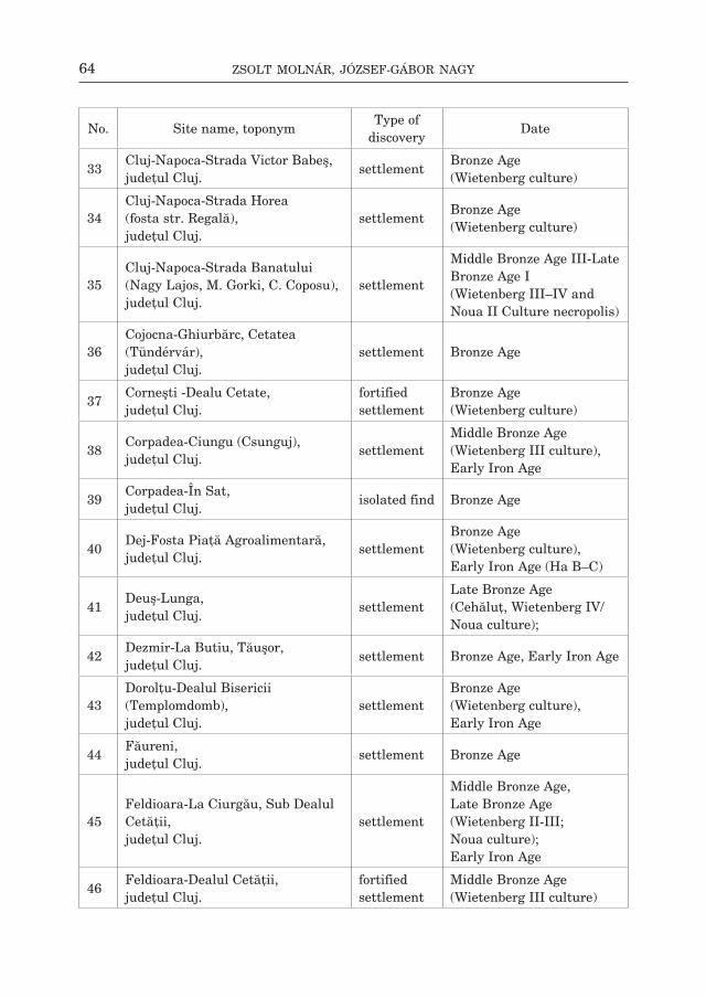
64 Zsolt Molnár, JóZsef-Gábor naGy
No. site name, toponymType of
discoveryDate
33cluj-napoca-strada Victor babeş, judeţul cluj.
settlement bronze Age (wietenberg culture)
34cluj-napoca-strada horea (fosta str. regală), judeţul cluj.
settlementbronze Age (wietenberg culture)
35cluj-napoca-strada banatului (nagy lajos, m. gorki, c. coposu), judeţul cluj.
settlement
middle bronze Age iii-late bronze Age i (wietenberg iii–iV and noua ii culture necropolis)
36cojocna-ghiurbărc, cetatea (Tündérvár), judeţul cluj.
settlement bronze Age
37corneşti -dealu cetate, judeţul cluj.
fortified settlement
bronze Age (wietenberg culture)
38corpadea-ciungu (csunguj), judeţul cluj.
settlementmiddle bronze Age (wietenberg iii culture), Early Iron Age
39corpadea-În sat, judeţul cluj.
isolated find bronze Age
40dej-fosta Piaţă Agroalimentară, judeţul cluj.
settlementbronze Age (wietenberg culture), early iron Age (ha b–c)
41deuş-lunga, judeţul cluj.
settlementlate bronze Age (cehăluţ, wietenberg iV/ noua culture);
42dezmir-la butiu, Tăuşor, judeţul cluj.
settlement bronze Age, early iron Age
43dorolţu-dealul bisericii (Templomdomb), judeţul cluj.
settlementbronze Age (wietenberg culture), Early Iron Age
44făureni, judeţul cluj.
settlement bronze Age
45feldioara-la ciurgău, sub dealul cetăţii, judeţul cluj.
settlement
middle bronze Age, late bronze Age (wietenberg ii-iii; noua culture); Early Iron Age
46feldioara-dealul cetăţii, judeţul cluj.
fortified settlement
middle bronze Age (wietenberg iii culture)

65Habitat Models and social systeMs...
No. site name, toponymType of
discoveryDate
47floreşti-cetate; cetatea fetei, Vârful cetăţii (leányvár), judeţul cluj.
settlementbronze Age, Early Iron Age
48floreşti-lab (láb), judeţul cluj.
settlementbronze Age (wietenberg culture), early iron Age (ha A2–b1)
49floreşti-dealul din Jos (Alsóhegy), groapa lui Parip (Páripgödre), judeţul cluj.
settlementbronze Age (wietenberg culture)
50floreşti-Poligon, la cazărmi, judeţul cluj.
settlement
middle bronze Age iii, late bronze Age i (wietenberg iV culture), Early Iron Age
51floreşti-str. cloşca, nr. 63, judeţul cluj.
settlement bronze Age
52floreşti-Pârăul bongar, judeţul cluj.
settlement bronze Age
53floreşti (szászfenes)-cartierul cetatea fetei, judeţul cluj.
settlementbronze Age, Early Iron Age
54floreşti-dealul din sus (felsőhegy), judeţul cluj.
settlementbronze Age (wietenberg culture), early iron Age (ha b1)
55floreşti-Polus center, judeţul cluj.
settlement, necropolis
late bronze Age ii (wietenberg/ noua culture), cugir-band group, bronze Age iii (ha A1–A2)
56fundătura-Tabla Popii, Şesul mare, judeţul cluj.
settlement
late bronze Age (wietenberg culture iV/ noua), Early Iron Age
57gheorghieni-dealul cetăţii (Várhegy),
settlementmiddle bronze Age (wietenberg ii–iii), Early Iron Age
58, 59
gheorghieni-Valea mare, judeţul cluj.
necropolis
middle bronze Age (wietenberg ii, noua culture); settlement, early iron Age (ha c–d)

66 Zsolt Molnár, JóZsef-Gábor naGy
No. site name, toponymType of
discoveryDate
60gherla-ferma Zootehnica-ciurea, judeţul cluj.
settlement bronze Age
61gherla-Pietriş, Şapte cruci, judeţul cluj.
settlementbronze Age (wietenberg culture), Early Iron Age
62gherla-lunca, judeţul cluj.
settlement bronze Age
63gherla-dealul coper, judeţul cluj.
settlementbronze Age, Early Iron Age
64gherla-casa nr. 356, feature 6, judeţul cluj.
settlementbronze Age, Early Iron Age
65, 66
gilău-coasta cimitirului (Vereşmort), judeţul cluj.
settlement bronze Age
67gilău-Avicola, Parcul castelului banffy, dealul cetăţii, judeţul cluj.
settlement bronze Age
68gilău-budulău, judeţul cluj.
settlement bronze Age
69gilău-cuptoare de Var, groapa de Var, malul roşu, judeţul cluj.
settlement bronze Age
70gilău-dealul borzaş (borzás), chişter, Valea Jistii, judeţul cluj.
settlementearly bronze Age (wietenberg culture)
71gilău-dâmbul Ţiganilor (cigányok dombja), Pădurea oraşului, judeţul cluj.
fortified settlement
bronze Age
72gilău-biserica reformată, judeţul cluj.
settlementbronze Age, Early Iron Age
73gilău-blocuri, judeţul cluj.
settlementlate bronze Age i (wietenberg iV, noua culture)
74gârbău-faţa (Verőfény), Zsip, judeţul cluj.
settlementlate bronze Age i (wietenberg iV), Early Iron Age
75iclod-Şcoala, judeţul cluj.
settlement bronze Age

67Habitat Models and social systeMs...
No. site name, toponymType of
discoveryDate
76iclod-moara fcn şi curtea muzeului, judeţul cluj.
settlementbronze Age, Early Iron Age
77livada-Peste Pârâu, judeţul cluj.
settlementbronze Age, Early Iron Age
78
luna de sus-Şanţul/râpa dracului, groapa lui Puri, ierdegarca (Ördögárok), judeţul cluj.
fortified settlement
early bronze Age?
79luna de sus-dealul rotund, judeţul cluj.
settlementlate bronze Age (wietenberg iV), Early Iron Age
80luna de sus-la deal, judeţul cluj.
settlementlate bronze Age, (wietenberg iV), Early Iron Age
81măcicaşu-Pocornea (Verőfény), judeţul cluj.
settlementbronze Age (wietenberg culture), early iron Age (ha A2–b1)
82mera-dealul cetăţii, judeţul cluj.
fortified settlement
bronze Age
83mintiu gherlii-ciuleneş, judeţul cluj.
settlement
middle bronze Age (wietenberg ii–iii, noua culture), Early Iron Age
84ocna dejului-cetatea Jidovilor, judeţul cluj.
fortified settlement
bronze Age
85Pălatca-Tog, judeţul cluj.
settlement bronze Age
86Pălatca-Togul lui mândruşcă, judeţul cluj.
settlement
late bronze Age (wietenberg iii, iV, noua culture), Early Iron Age
87răscruci-Pârâul borşa, judeţul cluj.
settlementbronze Age (wietenberg culture), Early Iron Age
88răscruci-dealu Prunilor, judeţul cluj.
settlementmiddle bronze Age (wietenberg iii culture), Early Iron Age

68 Zsolt Molnár, JóZsef-Gábor naGy
No. site name, toponymType of
discoveryDate
189sânnicoară-Şcoală-lab (láb), judeţul cluj.
settlement, incineration grave
late bronze Age i (wietenberg, noua culture), early iron Age (ha A2–b1)
190săvădisla-cetatea Păuca (Póka vára), judeţul cluj.
fortified settlement
bronze Age, Early Iron Age
191sic-dorna mare (nagyudvarnok), judeţul cluj.
settlement bronze Age
192sic-Toba de Jos (Alsótoba), judeţul cluj.
settlement bronze Age
193sic-depozitele cAP, lacul geaca (gyeketó), judeţul cluj.
settlementmiddle bronze Age (wietenberg iii culture)
194
sic-Valea bistriţei (beszterce völgy), fântâna lui Vice (Vicekútja), judeţul cluj.
settlementbronze Age (wietenberg culture)
195Şoimeni-Pârâul făncica, la cruce, judeţul cluj.
settlementbronze Age (wietenberg culture), Early Iron Age
196Şoimeni-Piatra Şoimilor, judeţul cluj.
fortified settlement
bronze Age
197someşul rece-cetate (Várhegy), judeţul cluj.
settlement
bronze Age (wietenberg culture), early iron Age (ha A2–b1, ha b–c).
198stolna-Podurile domneşti, judeţul cluj.
settlementmiddle bronze Age (wietenberg iii)
199suatu-fânaţele de Jos, judeţul cluj.
settlement
early and middle bronze Age (wietenberg i, wietenberg iii), early iron Age (ha A2–b1)
100 suceagu-cepegheu (csepegő), judeţul cluj.
settlementbronze Age (wietenberg culture), early iron Age (ha A2–b1)
101suceagu-Şarga (sárga), judeţul cluj.
settlementbronze Age (wietenberg culture, early iron Age (ha A2–b1)
102suceagu-Pad, judeţul cluj.
settlement bronze Age

69Habitat Models and social systeMs...
No. site name, toponymType of
discoveryDate
103Ţaga-fostul sat ghiolţ (göc), judeţul cluj.
settlementbronze Age, early iron Age (ha b1)
104Tăuţi-la mănăstire, judeţul cluj.
fortified settlement
bronze Age (wietenberg culture)
105Unguraş-dealul cetăţii, judeţul cluj.
settlementbronze Age (early wietenberg culture), Early Iron Age
106Vechea-Apreşu de Jos, ciutaia, lunga, ferma lui Americanu, judeţul cluj.
settlementlate bronze Age (post wietenberg iV/ noua culture);
107Vechea-ciutaia, judeţul cluj.
necropolis bronze Age
108Viştea-fântâna cu Tărâţe (Korpáskút, Kiskutverme), judeţul cluj.
settlement
late bronze Age i (wietenberg iV, noua culture), Early Iron Age
109Viştea-Păluta (Palota, Pad), judeţul cluj.
settlement
late bronze Age ii–iii (wietenberg iV/ noua culture), Early Iron Age
110Viştea-spini, judeţul cluj.
settlementbronze Age, Early Iron Age
111Viştea-gherce, răchita, judeţul cluj.
settlementbronze Age (wietenberg culture), Early Iron Age
112Viştea-coasta bercului lupilor (farkasberek), judeţul cluj.
settlementlate bronze Age i (wietenberg iV), Early Iron Age
113Viştea-groapa fântânii de Piatră, judeţul cluj.
settlementbronze Age (wietenberg culture), early iron Age;
114Viştea-râtul mic (Kisrét), judeţul cluj.
settlementlate bronze Age i (wietenberg/ noua culture), early iron Age;
115Vlaha-Pad, judeţul cluj.
settlement
late bronze Age ii–iii (wietenberg iV/ noua culture), settlement, grave, early iron Age (ha b2–b3, ha d)
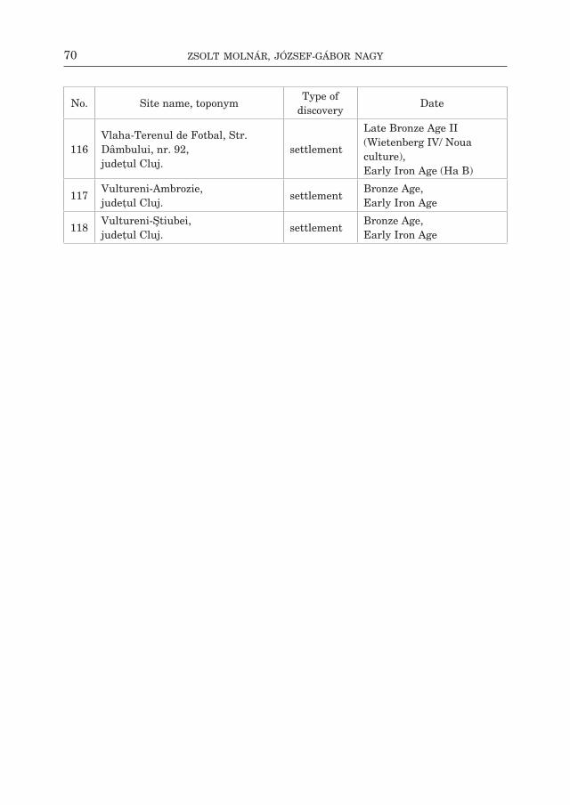
70 Zsolt Molnár, JóZsef-Gábor naGy
No. site name, toponymType of
discoveryDate
116Vlaha-Terenul de fotbal, str. dâmbului, nr. 92, judeţul cluj.
settlement
late bronze Age ii (wietenberg iV/ noua culture), early iron Age (ha b)
117Vultureni-Ambrozie, judeţul cluj.
settlementbronze Age, Early Iron Age
118Vultureni-Ştiubei, judeţul cluj.
settlementbronze Age, Early Iron Age

71Habitat Models and social systeMs...
bibliogrAPhy
A l d e n d e r f e r M. 2010 Gimme that old time religion: rethinking the role of religion in the emergence of social inequality, [in:] g.m. feinman, d.T. Price (eds.), Pathways to power: new perspectives on the emergence of social inequality, fundamental issues in Archaeology, new york– dordrecht–heidelberg–london, p. 77–94A n d r i ţ o i u i. 1992 Civilizaţia tracilor din sud-vestul Transilvaniei în epoca bronzului, bibliotheca Thraco- logica 2, bucureşti.A n d r i ţ o i u i., r u s t o i u A. 1997 Sighişoara-Wietenberg. Descoperirile preistorice şi aşezarea dacică, bibliotheca Thraco- logica 23, bucureşti.A r n o l d J. e. 2000 Revisiting power, labor rights, and kinship: archaeology and social theory, [in:] m.b. schiffer, J.e. Arnold (eds.), social theory in archaeology, p. 14–30.A r n o l d u s s e n s. 2008 A living landscape, Bronze Age settlement sites in the Dutch river area (c. 2000–800 BC), Leiden.A s h m o r e w., K n a p p A.b. 1999 Archaeologies of Landscape: contemporary perspectives, Malden.b a d e a l., n i c u l e s c u gh., s e n c u V. 1976 Harta geomorfologică, direcţia Topografică militară, bucureşti.b a d e a l., g â ş t e s c u P., b e r i n d e i i., V e l c e a V., b o g d a n o., d o n i s ă i., d r a g o m i r e s-c u s., f l o r e a n., n i c u l e s c u gh., c u c u - P o p o v a A., n e d e l c u e., r u s u Al., s e n c u V. 1983 Geografia României, geografia fizică i, bucureşti.b a d e r T. 1978 Epoca bronzului în nord-vestul Transilvaniei. Cultura pretracică şi tracică, bucureşti. 1990 Bemerkungen über ägäischen Einflüsse auf die alt- und mittelbronzezeitliche Entwiecklung im Donau-Karpatenraum, [in:] Orientalisch-Ägäische Einflüsse in der europäischen Bronzezeit. Ergebnisse eines Kolloquiums, monographien römisch-germanisches Zen- tralmuseum 15, bonn, p. 181–205. 1998 Bemerkungen zur Bronzezeit im Karpatenbecken Otomani–Füzesabony komplex. Überblick und Fragestellung, Jahresschrift für mitteldeutsche Vorgeschichte 80, p. 43–108.b e c h e r b., K r a u s e r., K r o m e r b. 1989 Zur absoluten Chronologie der frühen Bronzezeit, germania 67:2, p. 421–442.b e h r e K. e. 1988 The role of men in European vegetation history, [in:] b. huntley, T. webb (eds.), Vegeta- tion History, handbook of Vegetation science 7, 3rd edition, dordrecht, p. 633–672.b e r g l u n d b. e. 2003 Human impact and climate changes synchronous events and a causal link?, Quaternary international 105, p. 7–12.b e r t e m e s f., b i e h l P. f. 2001 The Archaeology of Cult and Religion. An Introduction, [in:] f. bertemes, P.f. biehl, h. meller (eds.), The Archaeology of Cult and Religion, budapest, p. 11–26.b i n d e a d. 2005 Zooarchaeological aspects regarding the economic life of pre- and proto-historical sites from Transylvania, [in:] P.h. daim (eds.), Honorem Silvia Marinescu-Bîlcu. Cultură şi Civilizaţie la Dunărea de Jos XII, călăraşi, p. 63–84. 2008 Arheozoologia Transilvaniei în Pre- şi Protoistorie, cluj-napoca.
72 Zsolt Molnár, JóZsef-Gábor naGy
b i n d e a d., K e l e m e n i. 2011 Archaeozoological aspects concerning the economic life during Late Bronze Age in Pălatca, Acta musei napocensis 45–46 (2008–2009), p. 53–74.b i n f o r d l. r. 1982 The Archaeology of Place, Journal of Anthropological Archaeology 1, p. 5–31.b i n t l i f f J. 1988 Site Patterning: Separating Environmental, Cultural and Preservation Factors, [in:] J. bint- liff, d. A. davidson, e. g. grant (eds.), Conceptual Issues in Environmental Archaeology, edinburgh, p. 129–144. 2013 Catchmants, Settlement Chambers and Demography: Case Studies and General Theory in the Greek Landscape from Prehistory to Early Modern Times, [in:] s. bergerbrant, s. sabatini (eds.), Counterpoint: Essays in Archaeology and Heritage Studies in Honour of Professor Kristian Kristiansen, bAr international series 2508, oxford, p. 61–70.b o d n a r i u c A., b o u c h e t t e A., d e d o u b a t J. J., o t t o T., f o n t u g n e m., J a l u t g. 2002 Holocene vegetational history of the Apuseni mountains, central Romania, Quaternary science reviews 21, p. 1465–1488.b o g d a n A., d i a c o n e a s a b. 1960 Problema Eriului în lumina analizelor de polen, studia Universitatis babeş-bolyai 2, cluj-napoca, p. 141–155.b ó n a i. 1975 Die mittlere Bronzezeit Ungarns und ihre Südöstlichen Beziehungen, Archeologia hun- garica 49, budapest. 1992 Bronzezeitlichen Tell Kulturen in Ungarn, [in:] w. meier-Arendt (ed.), Bronzezeit in Un- gar, Forschungen in Tell - Siedlungen an Donau und Theiss, frankfurt am main, p. 9–39.b o r o f f k a n. 1994 Die Wietenberg-Kultur. Ein Beitrag zur Erforschung der Bronzezeit in Südosteuropa, Universitätforschungen zur prähistorischen Archäologie 19, bonn. 2006 Resursele minerale din România şi stadiul actual al cercetărilor privind mineritul preis- toric, Apulum 43:1, p. 71–94. 2009 Mineralische Rohstoffvorkommen und der Forschungsstand des urgeschichtlichen Berg- baues in Rumänien/Mineral resources and the state of research on prehistoric mining in Romania, [in:] m. bartelheim–h. stäuble (eds.), Die wirtschaftlichen Grundlagen der Bronzezeit Europas, The Economic Foundations of the European Bronze Age, forschun- gen zur Archäometrie und Altertumswissenschaft 4, rahden, p. 119–146.b ö k ö n y i s. 1988 Animal remains from Bronze Age tells of the Berettyó Valley, [in:] T. Kovács, i. stanczik (eds.), Bronze Age Tell Settlements of the Great Hungarian Plain 1. inventaria Praehis- toria hungariae 1, budapest, p. 123–135.b r a d l e y r. 1978 Prehistoric Field Systems in Britain and North-West Europe — A Review of Some Recent Work, world Archaeology 9:3, p. 265–280.b r a n d o n J. c., b r a i l e K. s. 2004 introduction: household chores; or, the chore of defining the household, [in:] K. s. braile, J. c. brandon (eds.), Household Chores and Household Choices, Theorizing the domestic sphere in historical Archaeology, Tuscaloosa, p. 1–12.b r i n k K. 2013 Houses and Hierarchies: Economic and Social Relations in the Late Neolithic and Early Bronze Age of Southernmost Scandinavia, european Journal of Archaeology 16:3, p. 433–458.b r ü c k J. 1999 Ritual and rationality: Some problems of interpretation in European archaeology, euro- pean Journal Archaeology 2:3, p. 313–344.
73Habitat Models and social systeMs...
2000 Settlement, Landscape and Social Identity: The Early-Middle Bronze Age Transition in Wessex, Sussex and the Thames Valley, oxford Journal of Archaeology 19:3, p. 273– 300.c â r c i u m a r u m. 1996 Paleoetnobotanica. Studii în Preistoria şi protoistoria României (Istoria Agriculturii din România), iaşi. c a r n e i r o r. 1981 The chiefdom as precursor of the state, [in:] g. d. Jones, r. r. Kautz (eds.), The Transi- tion to statehood in the new world, cambridge, p. 37–79.c a v r u c V. 2010 consideraţii privind schimbul cu sare în mileniile Vi–ii Î. hr. În spaţiul carpa- to-dunărean, Tyragetia s.n. 4:1 (19), p. 7–34.c h a p m a n J. c. 1997a “Landscape in Flux and Colonisation of Time”, [in:] J.c. chapman, P.m. dolukhanov (eds.), Landscapes in Flux. Central and Eastern Europe in Antiquity, colloquia Pontica 3, oxford, p. 1–21. 1997b “Places as Timemarks — the Social Construction of Prehistoric Landscapes in Eastern Hungary”, [in:] g. nash (ed.), Semiotics of Landscape. Archaeology of Mind, bAr inter- national series 661, oxford, p. 31–45. 1997c “Places as Timemarks — the Social Construction of Prehistoric Landscapes in Eastern Hungary”, [in:] J. c. chapman, P. m. dolukhanov (eds.), Landscapes in Flux. Central and Eastern Europe in Antiquity, colloquia Pontica 3, oxford, p. 137–161.c h a p m a n J., g a y d a r s k a b., h a r d y h. 2006 Does enclosure make a difference? A view from the Balkans, [in:] A. harding, s. sievers, n. Venclová (eds.), Enclosing the Past: inside and outside in prehistory, sheffield Ar- chaeological monographs 15, sheffield, p. 20–43.C h i s h o l m M. 1962 Rural Settlement and Land Use, london. 1979 Rural settlement and land use: An essay in location, 3rd Edition, london. c h i d i o ş a n n. 1974 Sincronismele apusene ale culturii Wietenberg stabilite pe baza importurilor ceramice, crisia 4, p. 153–176. 1980 Contribuţii la istoria tracilor din nord-vestul României, Aşezarea Wietenberg de la Derşi- da, oradea.c h i d i o ş a n n., o r d e n t l i c h i. 1975 Un templu-megaron din epoca bronzului descoperit la Sălacea, crisia 5, p. 15–26.c i u t ă b. 2009 Cultivarea Plantelor în Pre- şi Protoistoria Bazinului Intracarpatic din România. Ana- lize statistice şi spaţiale efectuate asupra macroresturilor vegetale, [in:] s. A. luca (ed.), bibliotheca brukenthal 34, Alba iulia.c o b b c. r. 2000 From Quarry to Cornfield: The political Economy of Mississippian Hoe Production, Tusca- loosa. c o l l i s J. 1986 Central Theory is Death. Long Live the Central Place, [in:] e. grant (ed.), Central Places, Archaeology and History, sheffield, p. 37–39.c o m a r o f f J. l. 1992 Ethnography and the Historical Imagination, boulder.c o n o l l y J., l a k e m. 2006 Geographical Information Systems in Archaeology, cambridge manuals in Archaeology, cambridge.
74 Zsolt Molnár, JóZsef-Gábor naGy
C r i s t e a V., b a c i u c., g a f t a d. (eds.) 2002 Municipiul Cluj Napoca şi zona periurbană: Studii ambientale, cluj-napoca.d a n i J. 2005 The Pocsaj area in the Bronze Age, [in:] e. gál-imola, J-P sümegi (eds.), Enviromental Archaeology in North-Eastern Hungary, Varia Archaeologica hungarica 19, budapest, p. 301–318. 2009 A Berettyó-völgy középső bronzkori erődített tell-településeinek társadalmi vonatkozásai, debrecen, p. 17–21.d a n i J., f i s c h l K. P. 2009 A Berettyó-vidék középső bronzkori telljei (Topográfi ai megközelítés), Tisicum 19, p. 103– 118.d a r ó c z i T. T. 2011 Associations of Archaeological finds in Middle Bronze Age Centers of the Eastern Carpa- thian-Basin — Aspects of Power, Acta Terrae septemcastrensis 10, p. 114–140. 2011a Anamorphosis in Archaeology. Aspects of Phenomenology and Perception, [in:] o-m Tã- maş (eds.), interpretations of Anthropogenic material culture, Transylvanian review 20, supplement 2:1, p. 17–31. 2012 Death, Disposal and Social Memory — Towards a Definition of Funerary Landscapes, [in:] w. bebermeier, r. hebenstreit, e. Kaiser, J. Krause (eds.), Landscape Archaeology. Proceedings of the International Conference Held in Berlin, 6th–8th June 2012, Journal for Ancient studies, special volume 3, berlin, p. 199–207. 2012a From “diachronic judgement” to the Theory of Possible Types of Symmetry: An Investi- gation into Cycladic and Transylvanian Bronze Age Relations, Acta musei napocensis 47–48:i, 2010–2011 (2012), p. 47–61. 2012b Environmental Changes During the Holocene in Transylvania, A csíki székely múzeum Évkönyve 8, p. 27–58.d a r v i l l T. 1997 Neolithic landscapes: identity and definition, [in:] P. Topping (ed.), Neolithic Landscapes, oxbow monograph 86, oxford, p. 1–13.d a v i d w. 2010 Nascita e crollo dellà civiltà dei Tell dell`antica età del Bronzo nel Bacino Carpatico ed indizi di possibili, analoghi fenomeni culturali coevi nella regione dell’Allto e Medio Da- nubio nella prima metà del II millennio A.C. Sciencze Dell`Antichità, storia Archeologia Antropologia 15, p. 563–594.d a v i s b.A.s. et al. 2003 The temperature of Europe during the Holocene reconstructed from pollen data, Quater- nary science reviews 22, p. 1701–1716.d e m a r r a i s e., c a s t i l l o l. J., earle T. 1996 Ideology, Materialization, and Power Strategies, current Anthropology 37:1, p. 15–31.D i e t r i c h L. 2010 Eliten der frühen und mittleren Bronzezeit im südöstlichen Karpatenbecken, Prähisto- rische Zeitschrift 85, p. 191–206.d r ă g ă n e s c u l. 2006 Sarea gemă din extra- şi intracarpaticul României, [in:] V. cavruc, A. chiricescu (eds.), Sarea, Timpul şi Omul. Catalogul expoziţiei, sfântu gheorghe, p. 13–14.d u c k e b., K r o e g e s P. c. 2008 From Points to Areas: Constructing Territories from Archaeological Site Patterns Using an Enhanced Xtent Model, [in:] A. Posluschny, K. lambers, i. herzog (eds.), Layers of Perception. Proceedings of the 35th International Conference on Computer Applications and Quantitative Methods in Archaeology (CAA), Berlin, April 2–6, 2007, Kolloquien zur Vor- und frühgeschichte 10, bonn, p. 245–251.

75Habitat Models and social systeMs...
d u f f y P. r. 2008 A Körös-vidék bronzkori tell társadalmai, [in:] m. emília (ed.), Körös-menti évezredek. Régészeti Ökológiai és Településtörténeti Kutatások a Körös-vidéken, gyulai Katalógusok 13, gyula, p. 107–148.E a r l e T. 1987 Chiefdoms in archaeological and ethnohistorical perspective, Annual review of Anthro- pology 16, p. 279–308. 1991 Propety rights and evolution of chiefdoms, [in:] T. earle (ed.), Chiefdoms: Power, Eco- nomy, and Ideology, cambridge, p. 71–99. 1997 How Chiefs Come to Power. The Political Economy of Prehistory, stanford. 2000 Archaeology, Property, and Prehistory, Annual review of Anthropology 29, p. 39–60. 2001 Institutionalization of Chiefdoms. Why Landscape are Built, [in:] J. haas (ed.), From Leaderd to Rulers, new york, p. 105–124. 2002 Bronze Age Economics. The beginnings of Political Economies, cambridge. 2013 The 3m: materiality, materialism and materialization, [in:] s. bergerbrant, s. sabatini (eds.), Counterpoint: Essays in Archaeology and Heritage Studies in Honour of Professor Kristian Kristiansen, bAr international series 2508, oxford, p. 353–360.e a r l e T., K r i s t i a n s e n K. 2010 Introduction: Theory and Practice in the Late Prehistory of Europe, [in:] T. earle, K. Kris- tiansen (eds.), Organizing Bronze Age Societies. The Mediterranean, Central Europe, and Scandinavia Compared, cambridge, p. 1–34.e a r l e T., K o l b m. J. 2010 Regional Settlement Patterns, [in:] T. earle, K. Kristiansen (eds.), Organizing Bronze Age Societies. The Mediterranean, Central Europe, and Scandinavia Compared, cam- bridge, p. 57–86.e l s u s i g. 2002 Cercetări arheozoologice în aşezarea de epoca bronzului de la Carei-“Bobald” (judeţul Satu Mare), Thraco dacica 23:1–2, p. 243–265. 2005 cercetări arheozoologice (Archaeozoological researches in the cauce cave), [in:] s.A. luca (ed.), Cercetări arheologice în Peştera Cauce (II) (sat Cerişor, comuna Lelese, judeţul Hunedoara), bibliotheca septemcastrensis 5, sibiu.f ă r c a ş s., T a n ţ ă u i. 2004 The Human Presence in Pollen Diagrams from Romanian Carpathians, Antaeus 27, p. 227–234.F e i n m a n g., n e i t z e l J. 1984 Too many types: An overview of sedentary prestate societies in the Americas, [in:] m. schif- fer (ed.), Archaeology method and Theory 7, new york, p. 39–102.f e u r d e a n A. n., willis K. J., A s t a l o ş c. 2009 Legacy of the past land-use changes and management on the ‘natural’ upland forest composition in the Apuseni Natural Park, Romania, The holocene 19:6, p. 967–981.f e u r d e a n A., w i l l i s K., P a r r c. l., T a n ţ ă u i., f ă r c a ş s. 2010 Post-glacial patterns in vegetation dynamics in Romania: homogenization or differentia- tion? Journal of biogeography 37, p. 2197–2208.f i r t h r. 1973 Symbols. Private and Public, london. f i s c h l K. P., h e l l e n b r a n d t m., r e b e n d a J. 2011 A Füzesabony i kultúra települése Emőd–Istvánmajor (M30/36. lh.) és Emőd–Karola Sző- lők területén, A herman ottó múzeum Évkönyve 40, p. 105–129.f i s c h l K. P., r e b e n d a J. 2012 Early Bronze Age (RB A1–A2, about 2300–1500 cal BC) Settlement Structure at the Northern Part of the Great Hungarian Plain. A Case Study: Mezőcsát-Pástidomb, [in:]
76 Zsolt Molnár, JóZsef-Gábor naGy
P. Anreiter, e. bánffy, l. bartosiewicz, w. meid, c. metzner-nebelsick (eds.), Archaeolog- ical, Cultural and Linguistic Heritage. Festschrift for Erzsébet Jerem in Honour of her 70th Birthday, budapest, p. 487–497.f i s c h l K. P., r e m é n y i l. 2013 Interpretation Possibilities of the Bronze Age Tell Sites in the Carpathian Basin, [in:] A. An- ders, g. Kulcsar, g. Kalla, V. Kiss, g. V. szabo (eds.), Moments in Time Papers Presented to Pal Raczky on His 60th Birthday, Ősregeszeti Tarsasag/Prehistoric society 1, budapest, p. 725–738.f i s c h l K. P., K i e n l i n T. l. 2013 Result s of a Systematic Survey Programme on the Hat van Sites of Emőd–Nagyhalom and Tard–Tatárdomb in Northern Hungary, Acta Archaeologica Academiae scientiarum hungaricae 64:1, p. 5–32.f l o r e a m. st., ª t e f a n c. e. 2011 Bringing the past into the present. Restoring landscape around archaeological sites with the help of old maps, [in:] s. mills, P. mirea (eds.), The Lower Danube in Prehistory: Landscape Changes and Human-Environment Interactions. Proceedings of the Interna- tional Conference, Alexandria, 3–5 November 2010, bucureşti, p. 221–232.f o r e n b a h e r s. 1993 Radiocarbon dates and absolute chronology of the Central European Bronze Age, Antiq- uity 67, p. 218–220, p. 235–256.F r e n c h Ch. 2010 The Palaeo-Environments of Bronze Age Europe, [in:] T. earle, K. Kristiansen (eds.), Organizing Bronze Age Societies. The Mediterranean, Central Europe, and Scandinavia Compared, cambridge, p. 34–56.g a n c a r s k i J. (ed.) 1999 Die Otomani-Füzesabony Kultur — Entwicklung, Chronologie, Wirtschaft. Materialen der archaologischen Konferenz, Dukla, 27–28.11.1997, Krosno. 2002 Miedzy Mykenami a Baltykiem. Kultura Otomani-Füzeabony, Krosno–warszawa.g a y d a r s k a b. 2007 Landscape, material culture and society in South East Bulgaria, oxford. g á l e. 2005 Animal remains from archaeological excavations in north-eastern Hungary, [in:] e. gál- imola, J-P. sümegi (eds.), Enviromental Archaeology in North-Eastern Hungary, Varia Archaeologica hungarica 19, budapest, p. 127–174.g ă v a n A. 2012 Metallurgy and Bronze Age Tell-Settlements from Western Romania (I), ephemeris napocensis 22, p. 57–90.g e o g r a f i a 1992 geografia româniei 3, [in:] l. badea, d. buga, g. cioflica (eds.), bucureşti. g e r l o f f s. 1993 Zu Fragen mittelmeerländischer Kontakte und absoluter Chronologie der Frühbronzezeit in Mittel–und Westeuropa, Praehistorische Zeitshrift 68:1, p. 58–102.g h i n e a d. 2002 Enciclopedia geografică a României, [in:] d. ghinea (ed.), bucureşti.g o d s e n c. 2013 Fields, [in:] s. bergerbrant, s. sabatini (eds.), Counterpoint: Essays in Archaeology and Heritage Studies in Honour of Professor Kristian Kristiansen, bAr international series 2508, oxford, p. 111–117.g o g â l t a n f. 1999 Bronzul timpuriu şi mijlociu în Banatul românesc şi pe cursul inferior al Mureşului. I. Cronologia şi descoperirile de metal, bibliotheca historica et archaeologica banatica 23, Timişoara.
77Habitat Models and social systeMs...
2002 Die Tells der Bronzezeit im Karpatenbecken. Terminologische Fragen, [in:] c. cosma, A. rustoiu (eds.), Interregionale und Kulturelle Betiehungen im Karpatenraum, 2 jah- rthausend V. Chr.–1 jahrthausend N Chr., cluj-napoca, p. 11–47. 2005 Funcţia socială şi economică a tell-urilor epocii bronzului din Bazinul Carpatic. I. As- pecte teoretice, [in:] c. cosma, A. rustoiu (eds.), Comerţ şi civilizaţie. Transilvania în contextul schimburilor comerciale şi culturale în antichitate, cluj-napoca, p. 11–43. 2008 Fortified Bronze Age Tell Settlements in the Carpathian Basin. A general overview, [in:] J. czebreszuk, s. Kadrow, J. müller (eds.), Defensive Structures from Central Europe to the Aegean in the 3rd and 2nd millenia BC., studien zur Archäologie in ostmitteleuropa 5, Poznań–bonn, p. 39–56. 2010 Die Tells und der Urbanisierungsprozess, [in:] b. horejs, T. l. Kienlin (eds.), Siedlung und Handwerk. Studien zu sozialen Kontexten in der Bronzezeit. Beiträge zu den Sitzun- gen der Arbeitsgemeinschaft Bronzezeit auf der Jahrestagung des Nordwestdeutschen Verbandes für Altertumsforschung in Schleswig 2007 und auf dem Deutschen Archäolo- genkongress in Mannheim 2008, Universitätsforschungen zur Prähistorischen Archäolo- gie 194, bonn, p. 13–46. 2012 Ritual Aspects of the Bronze Age Tell-Settlements in the Carpathian Basin. A Methodo- logical Approach, ephemeris napocensis 22, p. 7–56.g o r e n f l o l. J., g a l e n. 1990 Mapping Regional Settlement in Information Space, Journal of Anthropological Archae- ology 9, p. 240–274.g ó r s k i J. 2012 Transcarpathian elements in the Trzciniec culture. Wanderings of people or ideas?, [in:] r. Kujovský, V. mitaš (eds.), Václav Furmánek a Doba Bronzová. Zborník k sedemde- siatym narodeninám, Archaeologica slovaca monographiae 13, nitra, p. 89–97.g r a m s c h A., m e i e r T. 2013 An Archaeological Outline of Ritual Dynamics and Social Space, [in:] s. bergerbrant, s. sabatini (eds.), Counterpoint: Essays in Archaeology and Heritage Studies in Honour of Professor Kristian Kristiansen, bAr international series 2508, oxford, p. 193–198.g r a n t e. 1986 Hillforts, Central Places and Territories, [in:] e. grant (ed.), Central Places, Archaeology and History, sheffield, p. 13–26. 2013 An Archaeological Outline of Ritual Dynamics and Social Space, [in:] s. bergerbrant, s. sabatini (eds.), Counterpoint: Essays in Archaeology and Heritage Studies in Honour of Professor Kristian Kristiansen, bAr international series 2508, oxford, p. 193–198.g y u c h a A., P a r k i n s o n w. A. 2007 A késő Neolitikum-kora Rézkor átmeneti időszakának társadalomszerkezeti változásai az Alföldön. Rekonstrukciós kísérlet, Archaeológiai Értesítő 132:1, p. 37–81.g y u l a i f. 2001 Archeobotanika. A kultúrnövények története a Kárpát-medencében a régészeti-növénytani vizsgálatok alapján, budapest. 2008 Történeti agrobiodiverzitás a Kárpát-medencében, [in:] J. erzsébet, m. Zsolt, c. fuzsina (eds.), Oktatónapok Százhalombattán. Előadások a környezetrégészet, az örökségvédelem és az információs technológia régészeti alkalmazása köréből, ePoch módszertani füzetek, budapest, p. 121–128.h a a s J. 2001 Cultural Evolution and Political Centralisation, [in:] J. haas (ed.), From Leaderd to Rul- ers, new york, p. 3–13.h a i m o v i c i s. 1987 Studiul paleofaunei din aşezarea eponimă a culturii Otomani — epoca bronzului, crisia 17, p. 37–54.
78 Zsolt Molnár, JóZsef-Gábor naGy
H a l a s E. 2002 Symbolism and Social Phenomena. Toward the Integration of Past and Current Theo- retical Approaches, european Journal of social Theory 5:3, p. 351–366.h ä n s e l b. 1998 Die Bronzezeit als erste europäische Epoche [in:] b. hänsel (ed.), Mensch und Umwelt in der Bronzezeit Europas. Man and Environment in European Bronze Age, Abschlußta- gung der Kampagne des europarates: die bronzezeit: das erste goldene Zeitalter eu- ropas, an der freien Universität berlin, 17–19. märz 1997, Kiel, p. 19–26.H a r d i n g A. F. 2000 European Societies in the Bronze Age, cambridge. 2006 enclosing and excluding in bronze Age europe, [in:] A. harding, s. sievers, n. Venclová (eds.), Enclosing the Past: inside and outside in prehistory, sheffield Archaeological monographs 15, sheffield, p. 97–115. 2007 Warriors and Weapons in Bronze Age Europe, Archaeolingua series minor 25, budapest. 2013 World Systems, Cores, and Peripheries in Prehistoric Europe, european Journal of Ar- chaeology 16:3, p. 378–400.h e r z o g A. i., P o s l u s c h n y g. 2011 Tilt–Slope-depentdent Least Cost Path Calculations Revisited, [in:] e. Jerem, f. redo, V. szeverenyi (eds.), On the Road to Reconstructing the Past. Proceedings of the 36th
Conference on Computer Applications and Quantitative Methods in Archaeology, Buda- pest, 2–6 April 2008, budapest, p. 221–227.H o o d e r I. 1979 Economic and Social Stress and Material Culture Patterning, American Antiquity 44:3, p. 446–454.h o r v á t h f. 2009 Comments on the Tells in the Carpathian Basin: Terminology, Classification and For- mation, [in:] f. draşovean, d. l. ciobotariu, m. maddison (eds.), Ten Years After: The Neolithic of the Balkans as Uncovered by the Last Decade of Research. Procedings of the Conference held at the Museum of Banat on November 9th–10th, 2007, bibliotheca historica et Archaeologica banatica 49, Timişoara, p. 159–165.I n s o l l T. 2004 Archaeology, Ritual, Religion, london–new york.J a k a b s. 2004 Termőföldünk az őstelevény (talajismertető), marosvásárhely.J a k o b s o n g. l., b r a d s h a w r. h. w. 1981 The selection of sites for paleovegetational studies, Quaternary research 16:1, p. 80–96.J o h n s o n g. A. 1972 A test of the utility of Central Place Theory in Archaeology, [in:] P. J. Ucko, r. Tringham, g. w. dimbleby (eds.), Man. Settlement and Urbanism, london, p. 769–785. 1982 Organizational Structure and Scalar Stress, [in:] c. renfrew, m. rowlands, b.A. seg- raves-whallon (eds.), Theory and Explanation in Archaeology: the Southampton Confer- enc, new york, p. 389–421.J o h n s o n g. A., e a r l e T. 2000 Introduction, [in:] g. A. Johnson, T. earle (eds.), The evolution of human societies: from foraging group to agrarian state, stanford, p. 1–37.J o h n s t o n r. 1998 Approaches to the perception of landscape, Archaeological dialogues 5:1, p. 54–68.J u h á s z i. 2005 detecting anthropogenic impacts in the paleobotanical samples from csaroda nyírestó, [in:] e. gál-imola, J-P. sümegi (eds.), Enviromental Archaeology in North-Eastern Hun- gary, Varia Archaeologica hungarica 19, budapest, p. 55–65.K a c s ó c. 2004 Mărturii arheologice, baia mare.

79Habitat Models and social systeMs...
K a l l a g. 2013 A háztartások régészete mint kutatási probléma, [in:] A. Anders, g. Kalla, V. Kiss, g. Kulcsár, g.V. szabó (eds.), MΩMΩΣ VII, Őskoros kutatók VII. Összejövetele 2011. március 16–18, Százhalombatta, Ősrégészeti levelek 13, budapest, p. 9–36.K a r á c s o n y i c. 1994–1995 Date istorice despre apele şi lucrările de hidroamelioraţii efectuate în nord-vestul României (cu referiri la modificările microclimatice edatice şi biocenotive survenite în urma acestor lucrări), stcomsatumare 11–12, p. 195–233. 1995 flora şi vegetaţia judeţului satu mare, satu mare.K a r á c s o n y i K., A r d e l e a n g. 2003 A hajdani Ecsedi-láp és az Ecsedi-síkság földrajzni viszonyai, lecsapolásának története, flórája és faunája, szatmárnémeti.K i e n l i n T. l. 2012 Beyond Elites: An Introduction, [in:] T. l. Kienlin, A. Zimmermann (eds.), Beyond Elites. Alternatives to Hierarchical Systems in Modelling Social Formations, International Con- ference at the Ruhr-Universität Bochum, Germany, October 22–24, Teil 1, Universitäts- forschungen zur prähistorischen Archäologie Aus dem institut für Archäologische wis- senschaften der Universität bochum, fach Ur- und frühgeschichte 215, bonn, p. 15–32. 2012a Patterns of Change, or: Perseomments on the Interpretation of Late Neolithic and Bronze Age Tell Settlements in the Carpathian Basin, [in:] T. l. Kienlin, A. Zimmermann (eds.), Beyond Elites. Alternatives to Hierarchical Systems in Modelling Social Formations, International Conference at the Ruhr-Universität Bochum, Germany, October 22–24, Teil 1, Universitätsforschungen zurprähistorischen Archäologie Aus dem institut für Archäologische wissenschaften der Universität bochum, fach Ur- und frühgeschichte 215, bonn, p. 251–310.K i p f e r b. A. (ed.) 2000 Encyclopedic Dictionary of Archaeology, new york.K o v á c s i. 1913 A korpádi őstelep, dolgozatok 4, p. 1–17.K r i s t i a n s e n K. 1998 Europe before history, cambridge. 2000 The emergence of European Communities: household, settlement and territory in Later Prehistory (2300–300 BC), [in:] i. Poroszlai, m. Vicze (eds.), Százhalombatta Archaeologi- cal Expedition (SAX) Annual Report 1, százhalombatta, p. 7–12. 2004 Institutions and Material Culture: Towards an Intercontextual Archaeology, [in:] e. de- marrais, ch. gosden, c. renfrew (eds.), Rethinking materiality: the engagement of mind with the material world, cambridge, p. 179–193.K r i s t i a n s e n K., l a r s s o n T. b. 2005 The Rise of Bronze Age Society. Travels, Transmissions and Transformations, cambridge.K u n a m. 1991 The structuring of prehistoric landscape, Antiquity 65, p. 332–347.K v a m m e K. l. 1992 Terrain Form Analysis of archaeological location through Geographic Information Sys- tems, [in:] g. lock, J. moffet (eds.), CAA 91: Computer Applications and Quantitative Methods in Archaeology 1991, bAr international series s577, p. 127–136.l i m b r e y s. 1987 Farmers and Farmland: Aspects of Prehistoric Land-Use in the Severn Basin, [in:] K. J. gregory, J. lewin, J. b. Thornes (eds.), Palaeohydrology in Practice: A river basin analy- sis, chichester, p. 251–267.l i n d q u i s t s. o. 1974 The development of the agrarian landscape on Gotland during the Early Iron Age, nor- vegian Archaeological review 7:1, p. 6–32.
80 Zsolt Molnár, JóZsef-Gábor naGy
M a r c u s J. 2007 Rethinking ritual, [in:] e. Kyriakidis (ed.), The Archaeology of ritual. University of Cali- fornia, cotsen Advanced seminars 3, los Angeles, p. 43–76.m a r ţ i a n i. 1903 Régi telepek és lelhelyekről a királyhágóntúli területen, Archaeológiai Értesítő 23, p. 283– 287.m á t h é sz. m. 1988 Bronze Age tells in the Berettyó-Valley, [in:] T. Kovács, i. stanczik (eds.), Bronze Age Tell Settlements of the Great Hungarian Plain 1, inventaria Praehistorica hungariae 1, p. 27–122.m c i n t o s h J. 2006 Handbook to Life in Prehistoric Europe, new york.m e d z i h r a d s z k y Zs., b í r ó K. T. 2007 Balaton környéki erdők a holocénben, [in:] J. gömori (ed.), Az Erdő és a Fa Régészete és Néprajza (Kézművesipar-történeti megközelítésben), Anyagi kultúra a Kárpát-medencé- ben 2, sopron, p. 19–25.m e i e r T. (ed.) 2006 Landscape ideologies, Archaeolingua series minor 22, budapest.m e ş t e r m., l a z a r o v i c i gh. 2000 Sondajul arheologic de la Mintiu Gherlei-Ciuleneş, banatica 15:1, p. 191–205.m e ş t e r m., P o p d., l a z a r o v i c i gh., b i n d e a d. 2005 Mintiu-Gherlei — Campania 2000. Raport arheologic, Angustia 9, p. 113–120.m o l n á r Zs. 2011 Die Bronzemetallurgie in den Otomani-Gemeinschaften von der Carei-Ebene und dem Eriul-Tal, Acta Archaeologica hungaricae 62:2, p. 269–328.m o l n á r Zs, i m e c s Z. 2006 Az Otomani kultúra településstrukturája a Nagykárolyi-síkságon és az Ér völgyében, dolgozatok az erdélyi múzeum Érem- és régiségtrából 1, Kolozsvár, p. 25–80.m o l n á r Zs., Ţ o c a V. V. 2011 The “Core-periphery” theory. A critical perspective, brukental Acta musei 6:1, p. 119–143.m o z s o l i c s A. 1968 Goldfunde des Depotfundhorizontes von Hajdúsámson, brgK 45–47, p. 1–76.m u r e ş a n i. 1971 Studiul mineralogic şi petrografic al formaţiunilor dintre Someşul Cald şi Valea Căpuşului cu privire specială asupra substanţelor minerale utile, Phd manuscript ab- stract, Universitatea din bucureşti, bucureşti.m u t i h a c V. 1990 Structura geologică a teritoriului României, bucureşti.n a g y J. g. 2011 Habitatul în prima epocă a fierului în Bazinul Someşului Mic. Locuirea de la Vlaha- Pad, Jud. Cluj, Phd manuscript, Universitatea Alexandru ioan cuza, iaşi.n é m e t i J., m o l n á r Zs. 2007 A tell telepek fejlődése és vége a Nagykárolyi-síkságon és az Ér völgyében, Kolozsvár. 2012 Bronzkori Hatalmi Központok Északnyugat-Erdélyben: A Nagykároly-Bobáld-tell, [in:] l. révész (ed.), Monográfiák a Szegedi Tudomáyegyetem Régészeti Tanszékéről, budapest.n e u g e b a u e r J. w. 1991 Die Nekropole F von Gemeinlebarn, Niederösterreich. Untersuchungen zu den Bestat- tungssitten und zum Grabraub in der ausgehenden Frühbronzezeit in Niederösterreich südlich der Donau zwischen Enns und Wienerwald, römisch-germanische forschungen 49, mainz am rhein.n e u s t u p n ý e. 1991 Community areas of prehistoric farmers in Bohemia, Aniquity 65, p. 326–331.

81Habitat Models and social systeMs...
1998 The search for events and structures in prehistoric landscapes, [in:] e. neustupný (ed.), Space in Prehistoric Bohemia, Prague, p. 62–76. 2006 Enclosures and fortifications in Central Europe, [in:] A. harding, s. sievers, n. Venclová (eds.), Enclosing the Past: inside and outside in prehistory, sheffield Archaeological monographs 15, sheffield, p. 1–4.n o r d q u i s t g., w h i t t a k e r h. 2007 Comments on Kristian Kristiansen and Thomas B. Larsson (2005): The Rise of Bronze Age Society. Travels, Transmissions and Transformations. Cambridge University Press, Cambridge, norwegian Archaeological review 40:1, p. 75–84.O r d e n t l i c h I. 1968 Anordung und Bau der Wohnungen im Rahmen der Otomanikultur in Rumänien, dacia n.s. 12, p. 141–153. 1972 Contribuţia săpăturilor arheologice de pe “Dealul Vida” (com. Sălacea, jud. Bihor) la cunoaşterea culturii Otomani, studii şi comunicări satu mare 2, p. 63–84. 1973 Cercetările arheologice de la Otomani şi Sălacea şi locul lor în contextul culturii Otom- ani, Teză de doctorat. mns., iaşi.o ’ s h e a J. m. 2011 A River Runs Through It: Landscape and the Evolution of Bronze Age Networks in the Carpathian Basin, Journal of world Prehistory 24, p. 161–174o t t e r b e i n K. f. 2004 How War Began. college station, Texas A&m University anthropology series 10, Texas.P a d d e r e. J. 1993 Spatiality and Social Change: Domestic Space in Mexico and the United States, Ameri- can ethnologist 20:1, p. 114–137.P a p a l a s C. A. 2008 Bronze Age Metallurgy of the Eastern Carpathian-Basin: A Holistic Exploration, Phd. Thesis mns., Arizona.P a r k i n s o n w.A. 2006 The Social Organization of Early Cooper Age Tribes on the Great Hungarian Plain, bAr international series 1573, oxford.P a r k i n s o n w. A., d u f f y P. r. 2007 Fortifications and Enclosures in European Prehistory: A Cross-Cultural Perspective, Journal of Archaeological research 15, p. 97–141.P o p a d., b o r o f f k a n. 1996 Considerţii privind cultura Noua. Aşezarea de la Ţichindeal, jud. Sibiu, sciVA 47:1, p. 51–61.P o s e a gr., P o p e s c u n., i e l e n i c z m. 1974 relieful româniei, bucureşti.P o s l u s c h n y A. 2008 GIS as a means to investigate «Princely Sites», Space and Environs. New ways to answer old questions, [in:] c. gandini, f. favory, l. nuninger (eds.), ArchaeDyn — 7 millennia of territorial dynamics, settlement pattern, production and trades from Neolithic to Mid- dle Ages, ACI „Spaces and territories” 2005–2007, Preprints Final Conference, 23–25 June 2008, Dijon, p. 167–174. 2010 Over the hills and far away? – Cost Surface Based Models of Prehistoric Settlement Hin- terlands, [in:] b. frischer, J. webb crawford, d. Koller (eds.), Making History Interac- tive. Computer Applications and Quantitative Methods in Archaeology (CAA). Proceed- ings of the 37th International Conference, Williamsburg/VA, United States of America, March 22–26, 2009, bAr international series s2079, oxford, p. 313–319.P r z y b y l a m. s., b l a j e r w. 2008 Struktury Osadnicze w Epoce Brązu i Wczesnej Epoce Żelaza na Obszarze Podkarpackiej Wysoczyny lessowej Między Wisłokiem i Sanem, Kraków.
82 Zsolt Molnár, JóZsef-Gábor naGy
r a p p a p o r t r. A. 1999 Ritual and religion in the making of humanity, cambridge.c o d a r c e a Al., r ă i l e a n u gr., n ă s t ă s e a n u s. 1968 Harta geologică a Republicii Socialiste România, Scara 1:200.000, L-34-XII, Foaia 10. cluj. r e m é n y i l. 2003 Megjegyzések a Kárpát-medence középső bronzkori „virágkorának” kérdéséhez, Ősrégészeti levelek 5, p. 51–64.r e n f r e w c. 1981 Space, Time and Man, Transactions of the institute of british geographers new series 6:3, p. 257–278. 1982 Socio-economic change in ranked societies, [in:] c. renfrew, s. shennan (eds.), Ranking, resource and exchange. Aspects of the archaeology of early European society, new direc- tions in Archaeology, cambridge, p. 1–8. 1985 The archaeology of Cult: The Sanctuary at Phylakopi, The british school of Archaeology at Athens supplementary 18, london. 1986 Introduction: peer polity interaction and socio-political change, [in:] c. renfrew, J.f. cherry (eds.), Peer Polity Interaction and socio-political change, cambridge, p. 1–18. 2007 The archaeology of ritual, of cult and of religion, [in:] e. Kyriakidis (ed.), The Archaeology of ritual, cotsen Advanced seminars 3, los Angeles, p. 109–122.r e n f r e w c., b a h n P. 1999 régészet. elmélet, módszer, gyakorlat, budapest.r e n f r e w c., l e v e l e. V. 1979 Exploring Dominance: Predicting Polities from Centers, [in:] c. renfrew, K.l. cooke (eds.), Transformations: mathematical approaches to culture change, new york, p. 145– 167.r o t e a m. 1993 Aşezările culturii Wietenberg, ephemeris napocensis 3, p. 25–41. 1998 Cultura Wietenberg, Phd mns, bucureşti. 2004 Non-ferrous metallurgy in Transylvania of Bronze Age, Acta musei napocensis 39–40:i, p. 7–17. 2009 Pagini din preistoria Transilvaniei. Epoca bronzului, cluj-napoca.r o t e a m., w i t t e n b e r g e r m. 1999 The ritual complex of the Wietenberg Culture, Cluj-Napoca (Transylvania), Acta musei napocensis 36:1, p. 7–27.s z a b ó g. V. 2004 Ház, település és településszerkezet a késő bronzkori (BD, HA, HB periódus) Tisza- vidékén, [in:] J. dani, Zs. hajdú, e. gy. nagy (eds.), Momos II, Őskoros Kutatok II. Össze- jövetelének konferenciakötete, Debrecen, 2000. november. 6–8, debrecen, p. 137–170.s a h l q v i s t l. 2001 Territorial Behaviour and Communication in a Ritual Landscape, geografiska Annaler series b 82:2, p. 79–102.s ă s ă r a n l., V r e m i r m. 2009 Cadrul natural, [in:] s. mustaţă, fl. gogâltan, s. cociş, A. Ursuţi (eds.), Cercetări arheo- logice preventive la Floreşti — Polus Center, jud. Cluj (2007), cluj-napoca, p. 17–25.s h a n k s m., T i l l e y c. 1987 Social Theory and Archaeology, cambridge.S h e n n a n S. 1986 Central Europe in the Third Millennium B.C.: An Evolutionary Trajectory for Beginning of the European Bronze Age, Journal of Anthropological Archaeology 5, p. 115–146.S h e r a t t A. 1997 Economy and Society in Prehistoric Europe, edinburgh.
83Habitat Models and social systeMs...
S m y n t y n a O. V. 2006 Landscape in Prehistoric Archaeology: Comparing Western and Eastern Paradigms, [in:] T. meier (ed.), Landscape ideologies, Archaeolingua series minor 22, budapest, p. 81–96.s o r o c e a n u T. 2012 Die Kupfer- und Bronzedepots der frühen und mittleren Bronzezeit in Rumänien/De- pozitele de obiecte din cupru şi bronz din România. Epoca timpurie şi mijlocie a bronzu- lui, [in:] r. harhoiu, s. hansen, c. gaiu (eds.), Archaeologia romanica 5, erscheint zugleich als bronzefunde aus rumänien 4 / Apare concomitent ca bronzefunde aus rumänien 4, cluj-napoca-bistriţa.s t e i n g. J. 1999 Rethinking World-Systems. Diasporas, Colonies, and Interaction in Uruk Mesopotamia, Tuson.S t e i n e r P. 2003 Príspevok k chronológii otomansko–fuzesabonyského kultúrneho komplexu (pohrebisko Streda nad Bodrogom), studia historica nitrensia 11, p. 83–90.s t e w a r d J. h. 1955 Theory of Culture Change: the methodology of multilinear evolution Urbana, illinois.s t o n e g. d. 1991 Agricultural Territories in a Dispersed Settlement System, current Anthropology 32:3, p. 343–353.s ü m e g i P. 1999 Reconstruction of flora, soil and landscape evolution and human impact on the Bereg Plain from the late–glacial up to the present based on palaeoecological analysis, [in:] J. hamar, A. sárkány-Kiss (eds.), The Upper Tisa Valley. Preparatory proposal for Ram- sar site designation and an ecological background, Hungarian, Romanian, Slovakian and Ukrainian co-operation, Tiscia monograph series, szeged, p. 173–204. 2003 A régészeti geológia és a történeti ökológia alapjai, szeged. 2004 The results of paleoenviromental reconstructions and comparative geoarcheological ana- lysis for the examined area, [in:] P. sümegi, s. gulyás (eds.), The Geohistory of Bátorliget Marshland. An Example for Reconstruction of Late Quaternary Enviromental Changes and Past Human Impact from the Northeastern Part of the Carpathian Basin, budapest, p. 301–348. 2005 Paleoenviromental studies of the Pocsaj marsh, [in:] e. gál-imola, J. P sümegi (eds.), Enviromental Archaeology in North-Eastern Hungary, Varia Archaeologica hungarica 19, p. 127–137. 2009 Ember és környezet kapcsolata a középső-bronzkorban: az őskori gazdasági tér fejlődése egy bronzkori tell geoarcheológiai és környezettörténeti feldolgozása nyomán, Tisicum 19, p. 457–480.s ü m e g i P., b o d o r e. 2000 Sedimentological. pollen and geoarchaeological analysis of core sequence at Tököl, [in:] i. Poroszlai, m. Vicze (eds.), Százhalombatta Archaeological Expedition (SAX) Annual Report 1, százhalombatta, p. 83–96.s ü m e g i P., K e r t é s z r., r u d n e r e. 2003 magyarország rövid környezettörténete, [in:] Zs. Visy, m. nagy (eds.), Magyar régészet az ezredfordulón, budapest, 51–56.s ü m e g i P., b o d o r e., J u h á s z i., h u n y a d f a l v i Z., h e r b r i c h K., m o l n á r g., s z e g v á r i s., i m r e m., T í m á r g. 2004 A balatoni déli autópálya régészeti lelőhelyeinek környezettörténeti feldolgozása, [in:] g. ilon (ed.), MΩМΟΣ. III. “Öskoros Kutatók III Összejövetelének konferenciatörténete”, szombathely, p. 399–420.s z a b ó J. 2012 Contribuţii privind istoria regularizării apelor pe Valea Ierului în secolul XIX, crisia 42, p. 61–80.
84 Zsolt Molnár, JóZsef-Gábor naGy
s z e v e r é n y i V., K u l c s á r g. 2012 Middle Bronze Age Settlement and Society in Central Hungary, [in:] m. Jaeger, J. czebre- szuk (eds.), Enclosed Space-Open Society. Contact and Exchange in the Context of Bronze Age Fortified Settlements in Central Europe, studien zur Archäologie in ostmiteleuropa/ studia nad pradziejami europy Środkowej 9, Poznań–bonn, p. 287–351.T a n ţ ă u i., r e i l l e m., b e a u l i e u d e J. l., f ă r c a ş s., b r e w e r s. 2009 Holocene vegetation history in Romanian Subcarpathians, Quaternary research 72, p. 164–173.T h o m a s M. 2008 Studien zu Chronologie und Totenritual der Otomani-Füzesabony-Kultur, saarbrücker beiträge zur Altertumskunde band 86, bonn.T h r a n e H. 2009 Agression, territory and boundary — and the Nordic Bronze Age, [in:] l. holmquist olaus- son, m. olausson (eds.), The Martial Society. Aspects of warriors, fortifications and so- cial change in Scandinavia, Theses and Papaers in Archaeology b/11, stockholm, p. 11–23.T i l l e y C. 1994 A Phenomenology of Landscape Places, Paths and Monuments, oxford.v a n c r e v e l d 1999 The Rise and Decline of the State, cambridge.V a n d k i l d e H. 2013 Bronze Age Voyaging and Cosmologies in the Making: The Helmets from Viksø Revisited, [in:] s. bergerbrant, s. sabatini (eds.), Counterpoint: Essays in Archaeology and Heri- tage Studies in Honour of Professor Kristian Kristiansen, bAr international series 2508, oxford, p. 165–178.V i t a - f i n z i c., h i g g s e. s. 1972 Prehistoric Economies: A Territorial Approach, [in:] e. s. higgs (ed.), Papers in Economic Prehistory, cambridge, p. 27–36.V u l p e A. 1996 Spaţiul egeo-anatolian şi Europa sud-estică în lumina unei revizuiri a cronologiei epocii bronzului, memoriile secţiei de Ştiinţe istorice şi Arheologice 4:21, p. 33–47.w a s o n P. K. 1994 The Archaeology of Rank, new studies in Archaelogy, cambridge. w a r r e n P., h a n k e y V. 1989 Aegean Bronze Age Chronology, bristol.w h e a t l e y d. 1995 Cumulative viewshed analysis: a GIS-based method for investigating intervisibility, and its archaeological application, [in:] g. lock, Z. stančić (eds.), Archaeology and Geographi- cal Information Systems, london, p. 171–187.w h i t e l. 1959 The Evolution of Culture, new york.w h i t t l e A. w. r. 2010 The Diversity and Duration of Memory, [in:] d. boric (ed.), Archaeology and memory, oxford, p. 33–47.w i l l e y g. 1953 Prehistoric Settlement Patterns in the Virú Valley, Peru, bureau of American ethnology bulletin 155, washington d.c.w i l l i s K. J. 1997 The impact of early Agriculture upon the hungarian landscape, [in:] J. chapman, P. markovich dolukhanov (eds.), landscapes in flux central and easten europe in An- tiquity, colloquia Pontica 3, p. 193–207.
85Habitat Models and social systeMs...
w i t t e n b e r g e r m. 2008 Economical life in the Noua Culture in the Transylvanian Late Bronze Age, Acta musei napocensis 43–44, p. 5–46.w r i g h t J. c. 2004 The Emergence of Leadership and the Rise of Civilization in the Aegean, [in:] J. c. bar- rett, P. halstead (eds.), The Emergence of Civilization Revisited, sheffield studies in Aegean Archaeology, oxford, p. 64–89.
Address of the Authors:Babeş-Bolyai University
str. M. Kogălniceanu, nr. 1Cluj-Napoca, Romania
e-mail: [email protected]; [email protected]

CONTENTS
ArTicles
Zsolt m o l n á r, József-gábor n a g y, habitat models and social systems in middle bronze Age central north-western Transylvania. state of research .............................................
marija l j u š t i n a, southern fringe of the carpathian basin during the 4th century bc and the first contacts with the La Tène world: the case study of the belgrade confluence, serbia ..........................................................................................................................................
dragoº m ã n d e s c u, The “dark” second century bc in Transylvania. in search for the missing link between the fall of the celts and the rise of the dancin culture ..........
Agnieszka r e s z c z y ń s k a, Joanna r o g ó ż, danuta m a k o w i c z - P o l i s z o t, Teresa T o m e k, A unique double burial from a Przeworsk culture settlement context at Zamiechów, site 1, województwo podkarpackie .......................................................................................................
ioan s t a n c i u, cristain V i r a g, neue frühslawische siedlungsfunde aus dem oberen Theiss- becken (Tăşnad-sere, nordwestrumänien) .............................................................................
gergely s z e n t h e, connections between the mediterranean and the carpathian basin in the 8th century Ad. on the hinged strap-ends of the late Avar Period .......................
michał w o j e n k a, The heraldic mount from ciemna cave at ojców. from studies in the medieval culture of chivalry ...................................................................................................
ANNOuNCEMENTS
Andrzej P e l i s i a k, Zbigniew m a j, new neolithic and early bronze Age finds from the bieszczady mountains (wetlina river Valley and its surroundings) ...............................
Arkadiusz d y m o w s k i, roman denarii of Tiberius and caligula discovered in the drainage basin of the wisłoka river in southern Poland .................................................................
ivan b u g a r s k i, nataša m i l a d i n o v i ć - r a d m i l o v i ć, ivana P o p a d i ć, marko m a r j a n o v i ć, early mediaeval burial at stubline near obrenovac: spatial, Anthro-pological and Archaeological Analyses of the southernmost Avar grave .........................
reViews
neglected barbarians, edited by florin curta, studies in the early middle Ages 32, brepols Publishers n. v., Turnhout 2010, pp. 629, 24 colour images. isbn 978-2-503-53125-0 ....
die Archäologie der frühen Ungarn. chronologie, Technologie und methodik. internationaler workshop des Archäologischen instituts der Ungarischen Akademie der wissenschaften und des römisch-germanischen Zentralmuseums in mainz in budapest am 4. Und 5. dezember 2009, edited by bendeguz Tobias, rgZm-Tagungen 17, römisch-germanisches Zentralmuseum, mainz 2012, 309 pages with illustrations. isbn 978-3-88467-205-1; issn 1862-4812 ........................................................................................................................
erwin gáll, Az erdélyi-medence, a Partium ée a bánság 10–11. szádi temetöi, szórvány és kincsleletei, magyarország honoglalás kori es kora árpád-kori sírleletei 6, szeged 2013, vol. i-ii, 973 pages, 322 figures, 335 plates; isbn 978-963-9046-79-5 Ö; isbn 978-963-306-197-8; issn 1219 79 71 .....................................................................................................
The lisT of AbbreViATions .....................................................................................................
5
87
111
135
171
195
227
265
273
285
307
315
319
323