Grade 6 Connecting the Ancient World to the Present
144
Open Social Studies An Inquiry-Based and Literacy-Focused K-6 Curriculum Curric INSTRUCTOR MANUAL Level: Grade 6 Connecting the Ancient World to the Present Developers: Christopher C. Martell Jennifer R. Bryson
-
Upload
khangminh22 -
Category
Documents
-
view
0 -
download
0
Transcript of Grade 6 Connecting the Ancient World to the Present

Open Social StudiesAn Inquiry-Based and Literacy-Focused K-6 Curriculum
Curric
INSTRUCTOR MANUAL
Level: Grade 6
Connecting the Ancient World to the Present
Developers: Christopher C. Martell Jennifer R. Bryson

INTRODUCTIONStarting in the early elementary grades, all children should receive regular instruction in the social studies, which includes history, civics, geography, and economics. However, there are real pressures on schools and teachers to increase the amount of instruction in other subject areas, which often comes at the expense of their social studies time.
This curriculum was built to help teachers in K-6 schools regularly enact powerful and authentic social studies in their classrooms that will also meet essential literacy goals (linking every lesson to the Common Core State Standards). In other words, it leveragesthe richness of social studies content to help students learn to read, write, speak, and think critically while exploring the past and present world around them. It aims to make every single lesson culturally relevant, connecting to the racial, ethnic, gender, class, language, and immigration experience of the increasingly diverse United States.
ORGANIZATIONThese lessons are meant to supplement the school or district social studies curriculum. They are free and open source. Teachers are encouraged to modify and adapt these lesson plans for the individual needs and diverse cultural backgrounds of their students.They are only a guide, or perhaps better a “starter kit” to implementing lessons with important disciplinary questions and social studies content. Moreover, these social studies lessons should be supported with rich English language arts (ELA) texts on related topics.
This curriculum is organized by grade level, with an organizing theme, and each grade is color coated for quick reference. Within each grade level, it is organized by lesson. At the beginning of each grade level, there is a roadmap for that shows the individual lesson topics. Additionally, each lesson plan follows the same lesson plan template and always includes a thought-provoking inquiry question for the students to answer and primary/secondary sources to use as evidence. All lessons for the primary grades (K-2) are expected to be 30 minutes in length and the intermediate grades (3-6) are expected to be 45 minutes in length. However, depending on the pace of your students, lessons may need to span two or more 30- or 45-minute periods.
This curriculum was designed for students in the Boston Public Schools and each lesson cites the Massachusetts Curriculum Framework for History and the Social Sciences (aligned with the national College, Career, and Civic Life Framework for SocialStudies State Standards) and Common Core State Standards. However, this curriculumcan be easily adapted for other communities, including districts using other state curriculum frameworks. Some lessons are speci>cally about history and current events in Dorchester, Boston, and Massachusetts. Teachers from other cities/towns and states are encouraged to adapt these lessons for their particular communities.
HOW TO USE THE CURRICULUM RESOURCESThis curriculum includes three separate resources. The Instructor Manual includes all ofthe lesson plans, including materials, standards, procedures, and evaluation instructions. The Student Workbook includes all of the student handouts and other materials that teachers need to print for the various activities. The Student Sourcebook includes all of the documents that students are expected to use during the various inquiry activities, which teachers need to print for the various activities.
Open Social Studies This work is licensed under a Creative Commons LEVEL: GRADE 6 Attribution Non-Commercial-ShareAlike 4.0Version 4.0 (2020) International License
Page 2
We encourage teachers or principals to have the materials in the Student Sourcebook color-printed into bound packets, so they can be used in multiple classrooms or over multiple years. If students are using a bounded sourcebook, avoid having them highlight/underline as some lesson instructions suggest.
In this Instructor Manual, each title listed in the Table of Contents is a hyperlink to that speci>c lesson. This will help you quickly locate each lesson plan.
Open Social Studies This work is licensed under a Creative Commons LEVEL: GRADE 6 Attribution Non-Commercial-ShareAlike 4.0Version 4.0 (2020) International License
Page 3

GRADE 6Connecting the Ancient World
to the PresentGRADE 6 CONTENT OVERVIEW
The world’s peoples have long and rich cultures. Many of our current ways of knowing are rooted in the histories of people who lived thousands of years ago. At the same time, studying people from the ancient past can also help us understand the present world. It is where some of the >rst conceptions of justice were formed. Our collective past as humans is rooted in forming societies for mutual bene>t. From the very beginning of these societies, some people sought to accumulate power and control others. Simultaneously, others sought fairness and freedom. These lessons are designed to help students learn about the ancient peoples of the globe and how their societies led to our current world. Grade 6’s lessons help students learn that the rich ancient history of their world, but it also highlights dif>cult events in our past and present. By the end of Grade 6, students should understand the many overlapping global stories and realize that the world’s history is actually conCicting histories.
NOTE: In Massachusetts, the Grade 6-7 History and Social Science Framework includes the study of the ancient world and current geography. Schools may choose to address the content standards in any order. Most middle schools in Boston cover ancient European history in 7th grade. As such, this curriculum has intentionally focused on the ancient world and current geography of Africa, Asia, and the Americas, as those are the topics least likely to be covered in 7th grade. Moreover, since a majority of the students in Boston have ancestors who came from these three continents, we have intentionally begun their study of ancient history and current geography with these culturally relevant places.
GRADE 6 LEARNING GOALS
1. Students Should Be Able to Construct Arguments and RebuttalsBefore grade 6, students have begun forming arguments. While opinions are claims thatare not necessarily based in evidence, arguments include claims, evidence, and rebuttals. In grade 6, students should be able to use multiple sources of evidence to support their claims and provide rebuttals to evidence that conCicts with their claims. While these argumentation skills may still be developing, students should be able to construct relatively logical arguments and be able to defend or revise their arguments inlight of conCicting evidence.
2. Students Should Recognize Inequities and Their CausesBefore grade 6, most students have developed a strong understanding of fairness. Students are also able to recognize racial, gender, and other social differences (there is evidence that most children can detect racial and gender differences by about age 2). Ingrade 6, students should be able to recognize inequities and the larger social forces thatcause inequities. They should be able to suggest ways to improve our communities to make them more fair and just.
Open Social Studies This work is licensed under a Creative Commons LEVEL: GRADE 6 Attribution Non-Commercial-ShareAlike 4.0Version 4.0 (2020) International License
Page 4

3. Students Should Understand Differences Between Present and Past Perspectives, and Apply It to Present Day IssuesBefore grade 6, most students have developed an understanding that different people may experience the same situations differently. The have begun to examine how peoplemay think differently in the past compared to today. In grade 6, students should examine examples of people thinking differently about the same events in the past and present. They should be able to recognize that people in the past lived in a world very different to today and that impacted the way they understood the world. They should also be able to take stances on events of the past to help inform their views on current events.
Open Social Studies This work is licensed under a Creative Commons LEVEL: GRADE 6 Attribution Non-Commercial-ShareAlike 4.0Version 4.0 (2020) International License
Page 5
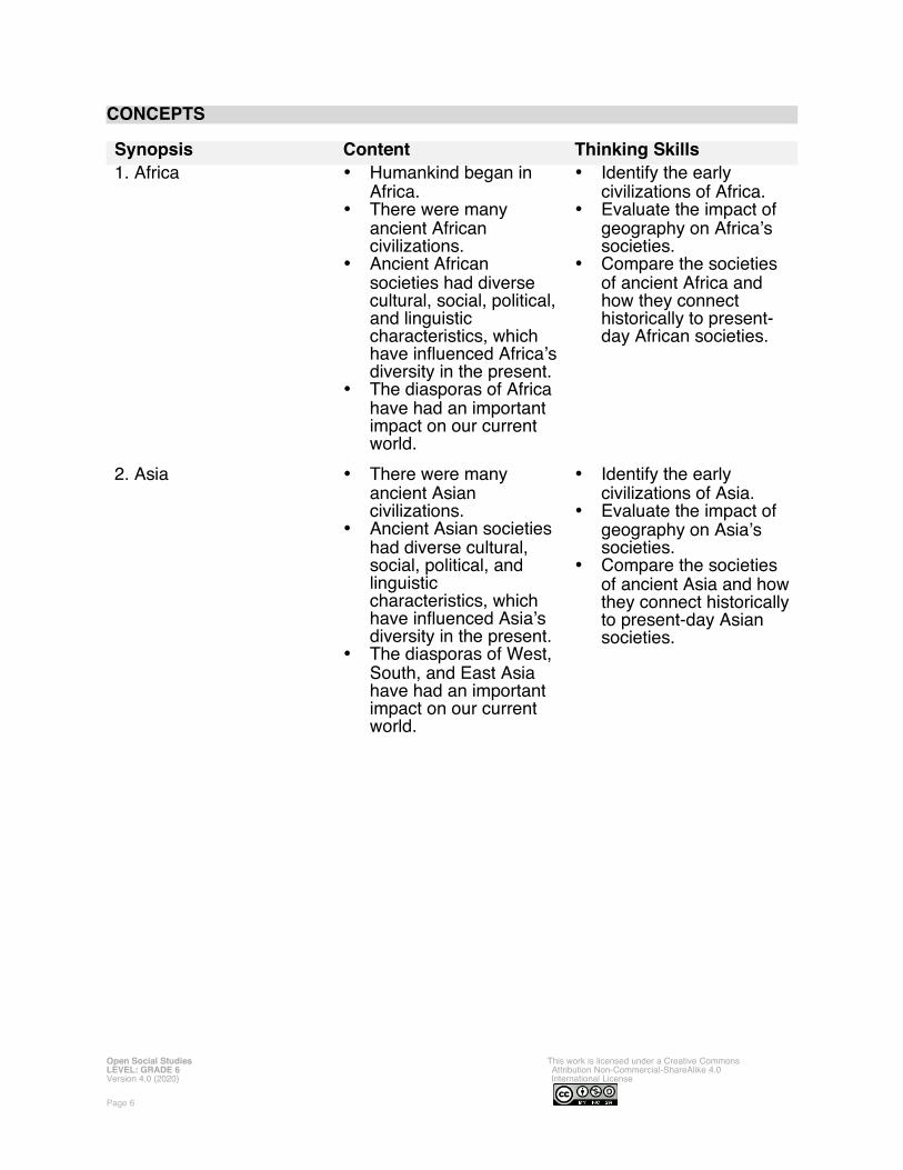
CONCEPTS
Synopsis Content Thinking Skills
1. Africa Humankind began in Africa.
There were many ancient African civilizations.
Ancient African societies had diverse cultural, social, political,and linguistic characteristics, which have inCuenced Africa’sdiversity in the present.
The diasporas of Africa have had an important impact on our current world.
Identify the early civilizations of Africa.
Evaluate the impact of geography on Africa’s societies.
Compare the societies of ancient Africa and how they connect historically to present-day African societies.
2. Asia There were many ancient Asian civilizations.
Ancient Asian societies had diverse cultural, social, political, and linguistic characteristics, which have inCuenced Asia’s diversity in the present.
The diasporas of West, South, and East Asia have had an important impact on our current world.
Identify the early civilizations of Asia.
Evaluate the impact of geography on Asia’s societies.
Compare the societies of ancient Asia and howthey connect historicallyto present-day Asian societies.
Open Social Studies This work is licensed under a Creative Commons LEVEL: GRADE 6 Attribution Non-Commercial-ShareAlike 4.0Version 4.0 (2020) International License
Page 6

3. The Americas There were many ancient American civilizations.
Ancient American societies had diverse cultural, social, political,and linguistic characteristics, which have inCuenced the Americas’ diversity in the present.
The diasporas of the Americas has had an important impact on ourcurrent world.
Identify the early civilizations of the Americas.
Evaluate the impact of geography on the Americas’ societies.
Compare the societies of the ancient Americasand how they connect historically to present-day American societies.
Open Social Studies This work is licensed under a Creative Commons LEVEL: GRADE 6 Attribution Non-Commercial-ShareAlike 4.0Version 4.0 (2020) International License
Page 7

GRADE 6 FIELD EXPERIENCES
It is strongly recommended that students engage regularly in social studies >eld experiences to connect their learning inside school to the world outside school. The Grade 6 curriculum covers the ancient world history, modern civics, geography, and economics. There are several >eld trip locations in the Boston area that would provide an excellent real world connection to this curriculum. We recommend the following:
Mappariumwww.marybakereddylibrary.org/project/mapparium/
Museum of Fine Arts (Asia, Africa, the Americas, and Europe Collections)www.mfa.org
Peabody Essex Museum (Africa and Asia Collections)www.pem.org
Harvard’s Peabody Museum of Archeology and Ethnologywww.peabody.harvard.edu
National Center of Afro-American Artistswww.ncaaa.org
Foreign Consular Of<cesThe Boston area includes numerous foreign consulates to assist the citizens living in theUnited States. They may have representatives that can meet with student groups.www.mass.gov/consular-corps-in-massachusetts
Open Social Studies This work is licensed under a Creative Commons LEVEL: GRADE 6 Attribution Non-Commercial-ShareAlike 4.0Version 4.0 (2020) International License
Page 8
GRADE 6 PROJECT-BASED LEARNING
These lessons are meant to supplement the school or district social studies curriculum. In addition, teachers are strongly encouraged to have students engage in project-based learning related to the content of these lessons. The Grade 6 curriculum covers the ancient world and its connections to the present. Below are several suggested long-term projects that we recommend teachers use in conjunction with these lessons. These projects may include producing a report and/or brief presentations in the form of poster boards, digital slideshows, performances that highlight the positive and negative aspect to each historical event or person.
Project 1: AfricaTo extend on lessons 6-1 to 6-9, students will research current events related to Africa.
Project 2: AsiaTo extend on lessons 6-10 to 6-24, students will research current events related to Asia.
Project 3: The AmericasTo extend on lessons 6-25 to 6-30, students will research current events related to North and South America (excluding the United States).
Project 4: Ancient WorldTo extend on lessons 6-1 to 6-30, students will research one of the ancient civilizations studied in this curriculum or a particular ancient civilization of personal importance not inthe curriculum.
Open Social Studies This work is licensed under a Creative Commons LEVEL: GRADE 6 Attribution Non-Commercial-ShareAlike 4.0Version 4.0 (2020) International License
Page 9

GRADE 6 CURRENT EVENTS
These lessons can be supported with accurate and rich news articles to help foster critical media and news literacy related to various contents and people being studied. Teachers are encouraged to use 2-3 adapted articles from trustworthy sources reportingon the same global current events to help students understand the world around them. For example, when studying ancient Mesopotamia, a teacher might create a lesson on the damage caused to cultural sites during the Syrian Civil War. We recommend pairingAmerican media sources with international sources to the diversity of global perspectives. Below is a partial list of trustworthy news outlets that we recommend for seeking current event articles related to the lessons of this curriculum. We advise teachers to adapt the text to a 6th grade reading level by altering vocabulary. The Lexile level of 6th grade students tends to be around 900-950; this website can measure the Lexile level of a reading: https://hub.lexile.com/analyzer
AFRICA
South African Broadcasting Corporation (SABC)www.sabcnews.com
The Guardian Nigeriawww.guardian.ng
Capital Ethiopiawww.capitalethiopia.com
Daily Nation Kenyawww.nation.co.ke
The New Times Rwandawww.newtimes.co.rw
Egypt Todaywww.egypttoday.com
ASIA
Nippon Hōsō Kyōkai (NHK) – Japanese Public Broadcastingwww.nhk.or.jp/nhkworld/
The Straits Times – Singapore www.straitstimes.com
The Korea Heraldwww.koreaherald.com
Asia Times Hong Kongwww.asiatimes.com
Times of Indianwww.timeso>ndia.indiatimes.com
Open Social Studies This work is licensed under a Creative Commons LEVEL: GRADE 6 Attribution Non-Commercial-ShareAlike 4.0Version 4.0 (2020) International License
Page 10

Al Jazeerawww.aljazeera.com
AMERICAS
Folha de S.Paulo - Brazilwww.folha.uol.com.br/internacional/en/
El Universal – Mexicowww.eluniversal.com.mx/english
Canadian Broadcasting Corporation (CBC)www.cbc.ca
National Public Radio (NPR)www.npr.org
Public Broadcasting Service (PBS)www.pbs.org
New York Timeswww.nytimes.com
Wall Street Journalwww.wsj.com
Boston Globewww.bostonglobe.com
Reuterswww.reuters.com
EUROPE
France 24 – French Public Broadcastingwww.france24.com/en/
Deutsche Welle – German Public Broadcasterwww.dw.com/en/
The Economistwww.economist.com
British Broadcasting Corporation (BBC)www.bbc.com
The Guardian United Kingdomwww.theguardian.com
Open Social Studies This work is licensed under a Creative Commons LEVEL: GRADE 6 Attribution Non-Commercial-ShareAlike 4.0Version 4.0 (2020) International License
Page 11

GRADE 6 ROAD MAP
PART I. AFRICA
LESSON 6-1
Lesson Title: Human Eras: Paleolithic, Neolithic, Ancient, Medieval, and Modern
Inquiry Question: Are we living in a new era of human development (or are we still in theModern Era or Post-Modern Era)? If we are living in a new era, what would you call it and why?
NOTE: The Massachusetts History and Social Science Framework for Grade 6 includes Topic 2 that includes the origins of humans and Topic 3 that includes Ancient Egypt, Timbuktu, and Ghana. In this curriculum, this was included in the Grade 4 curriculum (i.e. 4-12, 4-13. 4-14), which is the introduction to world history and geography. This level of the curriculum will begin with ancient East Africa and does not cover human origins or ancient Egypt, Timbuktu, and Ghana. Teachers are encouraged to use modi7ed versions of those lessons again here to refresh students’ understanding of the topics.
LESSON 6-2
Lesson Title: Anthropology of Ancient Africa (Cave Paintings, Domestication of Animals,and Iron Working)
Inquiry Question: What is the most important early African achievement?
LESSON 6-3
Lesson Title: The Nok People: An Art Study
Inquiry Question: What was life like for the Nok people? How are people today trying to preserve the record of their world?
LESSON 6-4
Lesson Title: Ancient Nubia (Kush): How Can You Live in a Desert?
Inquiry Question: What was the ancient Nubians’ most important adaption to their environment?
LESSON 6-5
Lesson Title: Ancient Swahili Coast: The Center of the World?
Inquiry Question: What was the most important factor in making the Swahili Coast wealthy trading ports?
LESSON 6-6
Lesson Title: Medieval Mali: A User’s Guide to Building an Empire
Inquiry Question: What was the most important factor that led to the Mali Empire?
Open Social Studies This work is licensed under a Creative Commons LEVEL: GRADE 6 Attribution Non-Commercial-ShareAlike 4.0Version 4.0 (2020) International License
Page 12

LESSON 6-7
Lesson Title: Landforms of Africa
Inquiry Question: What is Africa’s most important landmark?
LESSON 6-8
Lesson Title: Africa in Our Century
Inquiry Question: What event has had the largest impact on Africa in the 21st Century?
LESSON 6-9
Lesson Title: African Nations Today (Multi-Day Mini-Unit)
Inquiry Question: What are the most important cultural, governmental, economic, and natural aspects of your nation?
PART II. ASIA
LESSON 6-10
Lesson Title: Life in Ancient Mesopotamia
Inquiry Question: How should we remember ancient Mesopotamia?
LESSON 6-11
Lesson Title: Life in the Ancient Indus Valley
Inquiry Question: How should we remember ancient Indus Valley?
LESSON 6-12
Lesson Title: Native Peoples of Oceania: Indigenous Australians, Māori, and Samoans
Inquiry Question: How would you depict on of the Native peoples of Oceania in a graphic novel?
LESSON 6-13
Lesson Title: Phoenicia: The Ancient Mediterranean World
Inquiry Question: If you were an ancient historian, how would you write the history of thePhoenicians?
Open Social Studies This work is licensed under a Creative Commons LEVEL: GRADE 6 Attribution Non-Commercial-ShareAlike 4.0Version 4.0 (2020) International License
Page 13

LESSON 6-14
Lesson Title: Israel–Palestine ConCict: Making a Plan for Peace
Inquiry Question: What is the best solution for creating peace in Palestine and Israel?
LESSON 6-15
Lesson Title: Ancient Empires of the Central Asia: Persia/Sasanian, Gandhara, and Mauryan
Inquiry Question: If you could live in any Central Asian empire, which one would it be and why?
LESSON 6-16
Lesson Title: Ancient Chinese Inventions
Inquiry Question: What was the most important invention of ancient China?
LESSON 6-17
Lesson Title: Ancient Chinese Dynasties: Zhou, Qin, Han, Tang
Inquiry Question: Which dynasty of China was strongest?
LESSON 6-18
Lesson Title: Ancient Peoples of Eastern Asia: Japan, Korea, Mongolia, and Việt
Inquiry Question: What is each ancient people’s greatest contribution to the world?
LESSON 6-19
Lesson Title: History Detectives: How Did a Giraffe End Up in the Chinese Imperial Court?
Inquiry Question: How did a giraffe end up in the Chinese imperial court?
LESSON 6-20
Lesson Title: Comparing Global Trade Routes: Ancient and Modern Silk Roads
Inquiry Question: What has changed the world more, the Silk Road (100s BCE–1450s CE) or the Belt and Road Initiative (2013 CE-present)?
Open Social Studies This work is licensed under a Creative Commons LEVEL: GRADE 6 Attribution Non-Commercial-ShareAlike 4.0Version 4.0 (2020) International License
Page 14

LESSON 6-21
Lesson Title: The Crusades: Resistance to Invaders
Inquiry Question: What was the most important act of resistance to the European Crusades in the Middle East?
LESSON 6-22
Lesson Title: Climate and Terrain of Asia
Inquiry Question: Which of Asia’s regions would you like to visit most?
LESSON 6-23
Lesson Title: Asia in Our Century
Inquiry Question: What event has had the largest impact on Asia in the 21st Century?
LESSON 6-24
Lesson Title: Asian and Oceania Nations Today (Multi-Day Mini-Unit)
Inquiry Question: What are the most important cultural, governmental, economic, and natural aspects of your nation?
PART III. THE AMERICAS
LESSON 6-25
Lesson Title: The Salish People: Examining the cə̓snaʔəm (Marpole Midden) Site
Inquiry Question: What is the best way to protect ancient Indigenous cultural sites?
NOTE: The Massachusetts History and Social Science Framework for Grade 6 includes Topic 2 that includes the origins of humans and Topic 5 that includes Ancient Aztec and Maya. In this curriculum, this was included in the Grade 4 curriculum (i.e. 4-24), which is the introduction to world history and geography. This level of the curriculum will begin with other Indigenous peoples of the Americas and doesnot include Aztec, Incas, or Maya. Teachers are encouraged to use modi7ed versions of those lessons again here to refresh students’ understanding of the topics.
LESSON 6-26
Lesson Title: Native People of the Caribbean: The Taíno
Inquiry Question: What was life like in the Caribbean before the invasion of Europeans?
LESSON 6-27
Lesson Title: Indigenous People of the Amazon
Inquiry Question: How can we protect the Indigenous people of the Amazon?
Open Social Studies This work is licensed under a Creative Commons LEVEL: GRADE 6 Attribution Non-Commercial-ShareAlike 4.0Version 4.0 (2020) International License
Page 15

LESSON 6-28
Lesson Title: Places of Latin America
Inquiry Question: What Latin America place would you like to visit and why?
LESSON 6-29
Lesson Title: Latin America in Our Century
Inquiry Question: What event has had the largest impact on Latin America in the 21st Century?
LESSON 6-30
Lesson Title: Nations of the Americas Today (Multi-Day Mini-Unit)
Inquiry Question: What are the most important cultural, governmental, economic, and natural aspects of your nation?
Open Social Studies This work is licensed under a Creative Commons LEVEL: GRADE 6 Attribution Non-Commercial-ShareAlike 4.0Version 4.0 (2020) International License
Page 16

GRADE 6 PRE-TEST: ANSWERS
At the beginning of the Open Social Studies Curriculum Grade 6, it is recommended that teachers administer the Grade 6 Pre-Test, which is located after the Grade 6 Roadmap in the Student Workbook. The Grade 6 Pre-Test is a 10-question assessmentof the main concepts that should have been learned in previous years (questions 1-5) and new concepts that are included in this curriculum (questions 6-10). This assessment will give an indication of the students’ prior social studies knowledge, but also of supporting lessons that could be added before or during use of this curriculum.
Below are the answers to the pre-test. NOTE: Teachers should save a copy of the students’ pre-tests, so their answers can be compared to the post-test administered at the end of the year.
After each answer, there are recommendations for additional lessons that might be included before or during use of this curriculum to help support students. There are additional resources listed (with web links) at the end of this instructor manual that include lessons on the recommended topics that are not included in this curriculum.
Question 1. Name the oceans on Earth.
Answer 1. Most American schools teach that the following oceans in geography courses: Atlantic, Paci>c, Indian, Artic, and (sometimes also include) Southern. NOTE: There is no speci>c number or names of the oceans on Earth (different cultures, and even people with certain cultures, have different names and numbers for the oceans). Scientists generally view the Earth as having one connected world ocean.
Recommendation: This is a Grade 4 standard. If less than 50% of students answered this question correctly, consider adding a lesson on the world’s oceans (also see Lesson 4-10 in this curriculum).
Open Social Studies This work is licensed under a Creative Commons LEVEL: GRADE 6 Attribution Non-Commercial-ShareAlike 4.0Version 4.0 (2020) International License
Page 17

Question 2. Label each continent on the picture below: Antarctica, Africa, Asia, Australia, Europe, North America, South America.
Answer 2.
Recommendation: This is a Grade 1 standard. If less than 50% of students answered this question correctly, consider adding a lesson on identifying the continents.
Open Social Studies This work is licensed under a Creative Commons LEVEL: GRADE 6 Attribution Non-Commercial-ShareAlike 4.0Version 4.0 (2020) International License
Page 18

Question 3. Explain where humans <rst began.
Answer 3. The >rst humans came from Africa (about 160,000-70,000 years ago). Overtime, groups of humans migrated to the other continents of Earth (except Antarctica).
Recommendation: This is a Grade 4 standard. If less than 50% of students answered this question correctly, consider adding a lesson on the world’s oceans (also see Lesson 4-12 in this curriculum).
Question 4. Explain what ancient Egypt was like.
Answer 4. They ancient Egyptians built a complex society. It has a social system with the pharaoh at the top and the peasants at the bottom. They built pyramids along the Nile River in Africa. (If a student has just one of the above answers, it would be suf>cient.)
Recommendation: This is a Grade 4 standard. If less than 50% of students answered this question correctly, consider adding a lesson on ancient Egypt.
Question 5. Explain what ancient Maya (Mayans) were like.
Answer 5. The Maya built a complex society. Known for their hieroglyphics, astronomy, and calendar. They build along the Yucatán Peninsula and Caribbean Sea in México (If a student has just one of the above answers, it would be suf>cient.)
Recommendation: This is a Grade 4 standard. If less than 50% of students answered this question correctly, consider adding a lesson on the Maya.
Question 6. Explain what ancient Mesopotamia like.
Answer 6. Ancient Mesopotamia built a complex society in the Fertile Crescent of the Middle East/West Asia. They had different social classes that allowed some people to be rich and other poor. They wrote important literature, legal codes/laws, and inventions.
Recommendation: This is a new concept in the Grade 6 standards. If more than 50% of students answered this question correctly, consider adding additional lessons on ancient Mesopotamia.
Question 7. Explain what ancient Kush or Nubia like.
Answer 7. The ancient Kush built a complex society in the northeast of Africa. They Traded with neighbors, had famous skilled archers, and became wealthy through mininggold and silver.
Recommendation: This is a new concept in the Grade 6 standards. If more than 50% of students answered this question correctly, consider adding additional lessons on ancient Kush/Nubia.
Open Social Studies This work is licensed under a Creative Commons LEVEL: GRADE 6 Attribution Non-Commercial-ShareAlike 4.0Version 4.0 (2020) International License
Page 19

Question 8. Explain what ancient China like.
Answer 8. Ancient China built a complex society in the northeast of Asia. They had numerous families rule the empire over centuries (often referred to dynasties). Ancient China is responsible for many inventions that we use today (such as paper or gun powder).
Recommendation: This is a new concept in the Grade 6 standards. If more than 50% of students answered this question correctly, consider adding additional lessons on ancient China.
Question 9. Explain what ancient India like.
Answer 9. Ancient India built a complex society in the south of Asia (two speci>c ones include the Gandhara, and Mauryan). Several world religions have their origin in this region, including Hinduism and Buddhism. India was part of a trade network related to the Indian Ocean, which included East Asia and Africa.
Recommendation: This is a new concept in the Grade 6 standards. If more than 50% of students answered this question correctly, consider adding additional lessons on ancient India.
Question 10. Explain what ancient people of the Caribbean (Taíno, Arawak, Carib) were like.
Answer 10. The people of the ancient Caribbean built complex societies. The likely migrated from the Amazon River of South America and had similar languages (Arawakan languages). Many Caribbean people today are descendants from the Indigenous people.
Recommendation: This is a new concept in the Grade 6 standards. If more than 50% of students answered this question correctly, consider adding additional lessons on ancient Caribbean.
Open Social Studies This work is licensed under a Creative Commons LEVEL: GRADE 6 Attribution Non-Commercial-ShareAlike 4.0Version 4.0 (2020) International License
Page 20

LESSON PLAN 6-1: Human Eras: Paleolithic, Neolithic, Ancient, Medieval, andModern
MATERIALS
Human Origins Video (Lesson6-1Video1) [Located in the Open Social Studies Video Library: www.opensocialstudies.org/K-6.html]Human Eras: Sources (SOURCEBOOK 6-1.A)Notetaking Sheet: Human Eras Human (WORKSHEET 6-1.B)Human Eras: Exit Ticket (ASSESSMENT 6-1.C)
STANDARDS
Massachusetts History and Social Science Framework
MA-HSS.6.T2.3: Explain that the term Paleolithic Era refers to the period of earliest human history, beginning c. 2.6 million years ago to c, 11,700 years ago, characterized by the 7rst use of stone tools, 7re, hunting and gathering weapons, and, about 50,000 years ago, by cave painting, sculpture, tools, and artifacts using diverse materials such as bone, shell, stone, mineral pigments, and wood).
MA-HSS.6.T2.4: Explain that the term Neolithic Era refers to the period beginning about10,000 years ago to c. 4500 or c. 2000 BCE in different parts of the world, in which the technologies of agriculture.
MA-HSS.6.P3: Organize information and data from multiple primary and secondary sources.
MA-HSS.6.P6: Argue or explain conclusions, using valid reasoning and evidence.
Common Core: Literacy
CCSS.ELA-Literacy.RI.6.8: Trace and evaluate the argument and speci7c claims in a text, distinguishing claims that are supported by reasons and evidence from claims that are not.
CCSS.ELA-Literacy.W.6.8: Gather relevant information from multiple print and digital sources; assess the credibility of each source; and quote or paraphrase the data and conclusions of others while avoiding plagiarism and providing basic bibliographic information for sources.
CCSS.ELA-Literacy.W.6.9: Draw evidence from literary or informational texts to support analysis, reIection, and research.
PROCEDURES
Inquiry Question: Are we living in a new era of human development (or are we stillin the Modern Era or Post-Modern Era)? If we are living in a new era, what would you call it and why?
Open Social Studies This work is licensed under a Creative Commons LEVEL: GRADE 6 Attribution Non-Commercial-ShareAlike 4.0Version 4.0 (2020) International License
Page 21
PREPARATION
1. Post Human Origin and Migration QuestionsPost separately the following two questions about human origin and migration the boardor chart paper hidden from view. Question 1: Where on Earth did humans begin? Question 2: How did humans get to where we live today (Boston)?
A. OPENER (10 minutes)
2. Watch the Human Origins VideoReveal to the students Question 1 posted on the board or chart paper. Ask the question aloud: Where on Earth did humans begin? When students answer, follow up with this question: What makes you think that? Anticipated responses may include: Africa, Europe, Asia, outer space. Write students’ ideas on the board or charter paper.
Reveal to the students Question 2 posted on the board or chart paper. Ask the question aloud: How did humans get to where we live today (Boston)? When students answer, follow up with this question: What makes you think that? Anticipated responses may include: they walked, Native people came to the Americas by a land bridge or boats (covered in the Grade 2 curriculum), they took ships, they took airplanes. Write students’ ideas on the board or charter paper.
Tell students that they are going to watch a video that shows how most scientists think humans came to exist. It will also explain how humans moved from their origins in Africato the other parts of the world. Have students watch a brief >lm Human Origins Video (Lesson6-1Video1) showing human migration that begins with Africa and ends with the Americas. Ask students about their reaction to this video and questions like “What makes humans different from other hominins?” (Answer: Hominins have large brains, small teeth, bipedality [walking upright], and tool use; Homo sapiens: Larger brain capacity, sophisticated stone technology, control >re) “How long did it take humans to spread around the Earth? (Answer-not in video: Began around 200,000 years ago; 50,000 years ago, left Africa; 15,000 years ago, humans come to the Americas). Explainthat this migration happened relatively slowly, with humans moving their villages and homes over time and generations. Asks students, “Do you think it would have been dif>cult to travel over deserts, forests, and mountains by foot and oceans by small boat?”
Tell students that today we will be studying the different major periods of human history,which are called eras. The >rst era, Paleolithic, includes the >rst humans who we just learned about. Each era marks an important change in the course of humans. For example, the Paleolithic Era (meaning “old stone age”) involved humans making tools from stone. The Neolithic Era (meaning “new stone age”) involved humans developing farming. Today, you will read about >ve eras, including our last one, the Modern Era. You will debate if we are still in the Modern Era, of if another important change (the creation of the Internet and digital technology) means we are in a new era.
Notes on BCE/CE Dates and Periods:This would be a good place to explain century dating to the students. Write on the boardor chart paper the following: CE, BCE. Tell students that CE stands for “Common Era” and BCE stands for “Before Common Era.” You may hear some people use BC or “Before Christ” and AD “Anno Domini” meaning the Year of the Lord in Latin. Those are
Open Social Studies This work is licensed under a Creative Commons LEVEL: GRADE 6 Attribution Non-Commercial-ShareAlike 4.0Version 4.0 (2020) International License
Page 22

terms from the Christians, who mark Year 1 near the birth of Jesus. To respect people who are not Christian, historians use BCE and CE instead. It is also important to know that while most of the world uses this date system, but not everyone does. Different countries, cultures, and religions actually use different dating systems. For example, in the year 2020 in the Common Era calendar was the year 5780 in the Judaic calendar, 1441 in the Islamic calendar, 2563 in the Buddhist calendar, and Reiwa 2 in the Japanese calendar (which resets era and year with every new emperor). Another important thing to note is that there was no Year 0 or Century 0. So the Common Era calendar goes from 1 BCE to 1 CE. It also means that when counting centuries (100 years), 0-100 was the 1st Century (since there is no zero century). This is confusing for many people, as we are in the 2000s, but also in the 21st Century. Another confusing thing is that a new century (a decade; 10 years) does not begin until the year ending in 1 (so the year 2000 was still in the 20th century or 2020 was still in the 2010s).
B. DEVELOPMENT (20 minutes)
3. Read and Discuss the Human Eras SourcesPut students in small groups and have them read the >ve sources found in Human Eras:Sources (SOURCEBOOK 6-1.A). Source 1 describes the Paleolithic Era and the creation of stone tools by humans. Source 2 describes the Neolithic Era and the creation of farming. Source 3 describes the Ancient Era and the creation of written language. Source 4 describes the Medieval Era and creation of globalized trade routes. Source 5 describes the Modern Era and industrialization (manufacturing goods). Have one student from each group read their source. As the student reads, tell the other group members to underline or highlight any important information.
4. Engage in a Jig Saw About the Human ErasHave students participate in a jig saw activity. Make new groups where at least one student from each of the original groups is included. This will create several new groupsof three students, one is an expert on Source 1, 2, 3, 4, and 5. Have each student describe their document to the other members of their group. Students will take notes on the Notetaking Sheet: Human Eras (WORKSHEET 6-1.C).
Have students read the “A New Era?” (SOURCEBOOK 6-1.B), which describes the current debate between historians over what human era that we are currently in. Have students answer the following question in small groups: Do you think we are living in a new human era? If so, what would you name it and why?
Ask students to use the sources (WORKSHEET 6-1.A and WORKSHEET 6-1.C) to answer the following inquiry question: “Are we living in a new era of human development (or are we still in the Modern Era or Post-Modern Era)? If we are living in anew era, what would you call it and why? In answering this question, students should debate between the four different sources. After students have discussed the question, they should complete the exit ticket in the following step. Circulate the room, helping thestudents who may have dif>culty choosing one asset.
C. CLOSING (15 minutes)
5. Write Up Argument on the Current Human EraFor the evaluation task, have the students complete the exit ticket (ASSESSMENT 6-1.D), where they write their own personal response to the lesson’s Inquiry Question:
Open Social Studies This work is licensed under a Creative Commons LEVEL: GRADE 6 Attribution Non-Commercial-ShareAlike 4.0Version 4.0 (2020) International License
Page 23

“Are we living in a new era of human development (or are we still in the Modern Era or Post-Modern Era)? If we are living in a new era, what would you call it and why?” Tell students to cite at least three pieces of evidence from the sources for this lesson.
Before using the exit ticket, consider using a graphic organizer or two column notes to prepare students for the writing task. Consider using sentence starters and modeling to help the students with their answer to the inquiry question.
EVALUATION
ASSESSMENT 6-1.D
Before using the exit ticket, consider using a graphic organizer or two column notes to prepare students for the writing task (generic examples are available in the Organizers section at the end of this Instructor Manual-before “Writing Rubric”). Consider using sentence starters and modeling to help the students with their answer to the inquiry question.
A generic writing rubric for evaluating exit tickets is located at the end of this Instructor Manual-before “Additional Resources.”
What to look for?
The student should take a stance on if we are in a new era (and what it should be called) or if we are still in the Modern Era.
Some information that students may include in their answer to the question:
A New Era: The Internet has revolutionized humans; people can access information about
something in seconds. The Internet has changed how humans share stories or communicate. The Internet or digital technologies have changed humans lives equal or more
than the changes of other eras (agriculture, metal tools, printing press, etc.).
Still in the Modern Era: The Internet has made accessing information faster, but it is not much different
than a book, newspaper, or magazine. Humans communicate in the same ways as before; they now just do it over the
computer than by the telephone or letter. The Internet or digital technologies have changed humans lives less than the
changes of other eras (agriculture, metal tools, printing press, etc.)
Open Social Studies This work is licensed under a Creative Commons LEVEL: GRADE 6 Attribution Non-Commercial-ShareAlike 4.0Version 4.0 (2020) International License
Page 24

LESSON PLAN 6-2: Anthropology of Ancient Africa (Cave Paintings,Domestication of Animals, and Iron Working)
MATERIALS
Rock Art Video (Lesson6-2Video1) [Located in the Open Social Studies Video Library: www.opensocialstudies.org/K-6.html]Images (SOURCEBOOK 6-2.A)Anthropology of Ancient Africa: Sources (SOURCEBOOK 6-2.B)Anthropology of Ancient Africa: Exit Ticket (ASSESSMENT 6-2.C)
STANDARDS
Massachusetts History and Social Science Framework
MA-HSS.6.T1.3: Give examples of how archaeologists, historians, geographers, economists, and political scientists work as teams to analyze evidence, develop hypotheses, and construct interpretations of ancient and classical civilizations.
MA-HSS.6.T2.5: Explain how complex societies that practice agriculture may differ, some developing into permanently settled communities, some being nomadic and moving livestock from place to place, some cultivating land temporarily and moving to another location when a plot of land is no longer productive.
MA-HSS.6.P2: Develop focused questions or problem statements and conduct inquiries.
MA-HSS.6.P6: Argue or explain conclusions, using valid reasoning and evidence.
Common Core: Literacy
CCSS.ELA-Literacy.RI.6.8: Trace and evaluate the argument and speci7c claims in a text, distinguishing claims that are supported by reasons and evidence from claims that are not.
CCSS.ELA-Literacy.W.6.8: Gather relevant information from multiple print and digital sources; assess the credibility of each source; and quote or paraphrase the data and conclusions of others while avoiding plagiarism and providing basic bibliographic information for sources.
CCSS.ELA-Literacy.W.6.9: Draw evidence from literary or informational texts to support analysis, reIection, and research.
PROCEDURES
Inquiry Question: What is the most important early African achievement?
Open Social Studies This work is licensed under a Creative Commons LEVEL: GRADE 6 Attribution Non-Commercial-ShareAlike 4.0Version 4.0 (2020) International License
Page 25

PREPARATION
This lesson uses a method called Visual Thinking Strategy (VTS). The key to VTS is that you as a teacher only do two things: (1) Ask the following questions and (2) repeat as precisely as possible exactly what the students say.
Visual Thinking Strategy Questions: Open with: “What’s going on in this picture?”
Summarize student responses using conditional language (“Raoul thinks this could be…”). This keeps the conversation open to other interpretations by other students.
If appropriate: “What do you see that makes you say that?”This encourages students to back up their statements with things they see in the work of art.
Ask the group: “What more can we <nd?”This continues the conversation.
If this is your >rst time using VTS, I would recommend reading this description (with a video example from Grade 1) of it from the Milwaukee Art Museum: http://teachers.mam.org/collection/teaching-with-art/visual-thinking-strategies-vts/
1. Post De<nition of AchievementPost the de>nition of achievement on the board or chart paper hidden from view. Achievement: An important thing done successfully.
A. OPENER (10 minutes)
2. Engage in a Visual Thinking Strategy (VTS) on Cave Painting ImagesGive students Images (SOURCEBOOK 6-2.A). Do not reveal that these are images of early human cave paintings in Africa. Project the >rst image (Lettered “A”) and tell the students to look at the image closely and quietly. Give them about one minute. Next, begin the VTS question about the image. Use the above questions, following VTS instructions. Have students inquire about the question using the above questions for about 2-3 minutes.
Project the second image (Lettered “B”) and tell the students to look at the image closely and quietly. Give them about one minute. Next, begin the VTS question about the image. Use the above questions, following VTS instructions. Have students inquire about the question using the above questions for about 2-3 minutes.
Tell students that today we will be learning about the early human societies in Africa and their major achievements. Reveal the de>nition of Achievement: An important thing done successfully. These images that we were looking at were photographs of cave paintings done over 3,000 years ago in the Drakensberg plateau of South Africa by a group of people called the San. What messages do you think these early humans were trying to send? Do you think this was a major human achievement?
3. Watch the Cave Painting VideoShow the students a short video about the save paintings (Lesson6-2Video1). The video is an interview with anthropologist Genevieve von Petzinger, who researches ancient cave paintings in Europe and Africa. After watching the video, ask the students,
Open Social Studies This work is licensed under a Creative Commons LEVEL: GRADE 6 Attribution Non-Commercial-ShareAlike 4.0Version 4.0 (2020) International License
Page 26

“Do you think that these cave paintings were the >rst emojis? Why do you think ancient African people made them?” Anticipated responses may include: they were to send important messages, they wanted future people to know what they saw or learned, they wanted to remember important events for themselves.
B. DEVELOPMENT (20 minutes)
4. Read and Discuss the Sources on Ancient AfricaPut students in small groups and have them read the three sources found in Anthropology of Ancient Africa: Sources (SOURCEBOOK 6-2.A). Source 1 describes the cave paintings that were used to communicate in ancient Africa. Sources 2 describes the domestication of animals in ancient Africa. Source 3 described the use of iron smelting in ancient Africa. Have one student from each group read their source. As the student reads, tell the other group members to underline or highlight any important information.
5. Discuss and Reach Consensus on the Most Important African AchievementHave students in their group discuss which ancient African achievement was most important. Students should carefully examine each of the sources and weigh the evidence. They should try their best to come to some consensus.
6. Write Up Answer on Anthropology of Ancient Africa: Exit TicketFor the evaluation task, have the students complete the exit ticket (ASSESSMENT 6-2.C), where they write their group’s response to the lesson’s Inquiry Question: “What is the most important early African achievement?” Tell students to cite at least three pieces of evidence from the sources for this lesson. While they should work together to answer the inquiry question, each student should complete their own exit ticket sheet.
Before using the exit ticket, consider using a graphic organizer or two column notes to prepare students for the writing task. Consider using sentence starters and modeling to help the students with their answer to the inquiry question.
C. CLOSING (15 minutes)
7. Share Group’s Response on the Anthropology of Ancient Africa: Exit Ticket
Ask students to use the share their answers on the exit ticket (ASSESSMENT 6-2.C). After each group shares, lead the class in a discussion as to which arguments they >nd most compelling. Return to the opening video, which discusses the work of an anthropologist. Ask the class to share if they would want to have this job in the future? Why or why not?
EVALUATION
ASSESSMENT 6-2.C
Before using the exit ticket, consider using a graphic organizer or two column notes to prepare students for the writing task (generic examples are available in the Organizers section at the end of this Instructor Manual-before “Writing Rubric”). Consider using sentence starters and modeling to help the students with their answer to the inquiry question.
Open Social Studies This work is licensed under a Creative Commons LEVEL: GRADE 6 Attribution Non-Commercial-ShareAlike 4.0Version 4.0 (2020) International License
Page 27

A generic writing rubric for evaluating exit tickets is located at the end of this Instructor Manual-before “Additional Resources.”
What to look for?
The student should take a stance on one of the following being the most important ancient African achievement.
Some information that students may include in their answer to the question:
Cave Paintings This was one of the >rst forms of public communication They lasted thousands of years and we still have them in the present They helped share stories and news from the different ancient communities
Domestication of Animals This allowed for humans to use animals to farm better This created pets (perhaps connecting to their own love for pets) This allowed for people to settle in one place and not move around
Metal Work This allowed people to make tools and weapons This helped people travel further distances Today, much of our world is made from metal
Open Social Studies This work is licensed under a Creative Commons LEVEL: GRADE 6 Attribution Non-Commercial-ShareAlike 4.0Version 4.0 (2020) International License
Page 28

LESSON PLAN 6-3: The Nok People: An Art Study
MATERIALS
Nok Artwork Video (Lesson6-3Video1) [Located in the Open Social Studies Video Library: www.opensocialstudies.org/K-6.html]Nok Artwork Video (Lesson6-3SlideShow1) [Located in the Open Social Studies Video Library: www.opensocialstudies.org/K-6.html]Slideshow Notes (WORKSHEET 6-3.A)News Report on the Nok Artwork: Exit Ticket (ASSESSMENT 6-3.B)
STANDARDS
Massachusetts History and Social Science Framework
MA-HSS.6.T1.3: Give examples of how archaeologists, historians, geographers, economists, and political scientists work as teams to analyze evidence, develop hypotheses, and construct interpretations of ancient and classical civilizations.
MA-HSS.6.T2.2: Identify sites where archaeologists have found evidence of the origins of modern human beings.
MA-HSS.6.P3: Organize information and data from multiple primary and secondary sources.
MA-HSS.6.P6: Argue or explain conclusions, using valid reasoning and evidence.
Common Core: Literacy
CCSS.ELA-Literacy.RI.6.7: Integrate information presented in different media or formats(e.g., visually, quantitatively) as well as in words to develop a coherent understanding ofa topic or issue.
CCSS.ELA-Literacy.RI.6.8: Trace and evaluate the argument and speci7c claims in a text, distinguishing claims that are supported by reasons and evidence from claims that are not.
CCSS.ELA-Literacy.W.6.8: Gather relevant information from multiple print and digital sources; assess the credibility of each source; and quote or paraphrase the data and conclusions of others while avoiding plagiarism and providing basic bibliographic information for sources.
CCSS.ELA-Literacy.W.6.9: Draw evidence from literary or informational texts to support analysis, reIection, and research.
PROCEDURES
Inquiry Question: What was life like for the Nok people? How are people today trying to preserve the record of their world?
Open Social Studies This work is licensed under a Creative Commons LEVEL: GRADE 6 Attribution Non-Commercial-ShareAlike 4.0Version 4.0 (2020) International License
Page 29

Art ConnectionThis lesson involves an art study of terracotta sculptures from the Nok people in modernday Nigeria. This is a good opportunity to coordinate with an art teacher and have students practice making clay sculptures of people.
A. OPENER (10 minutes)
1. Watch the Nok Artwork VideoShow the students a short video about the terracotta sculptures of the Nok (pronounced“knock”) people (Lesson6-3Video1). The video involves two people discussing a Nok sculpture, which is housed at the Brooklyn Museum. Terracotta means that the sculpture is made of clay and baked after being formed. Ask students, “What do you notice about the Nok terracotta?” Anticipated responses may include: they have detailedfeatures, they look almost like a cartoon, they may have been painted or included something in the eyes.
B. DEVELOPMENT (20 minutes)
2. Show the Archeologist Slideshow Next, show students the brief slideshow displaying images of archeologists preserving the Nok terracotta sculptures (Lesson6-3SlideShow1) and give the note-taking sheet (WORKBOOK 6-3.A) for the students. Tell them to take notes as you play the slideshowand that those notes will be used later to create a news report on the excavation of Nok artwork.
Below are the notes for each slide in the slideshow (these are also embedded in the slideshow).
Slide 1: A Nok >gure. (Nok is pronounced “knock”)Slide 2: Another Nok >gure.Slide 3: Another Nok >gure. Notice the detail. Imagine how dif>cult it would have been to form this out of clay.Slide 4: Two more Nok >gures.Slide 5: This is overlooking the village of Nok in modern day Nigeria. This is where the >rst terracotta sculptures made by the Nok people were found.Slide 6: This is a map showing the location of Nok within Nigeria and Africa.Slide 7: This is the farmland where some of the Nok terracotta were discovered. Slide 8: These are images of the archeologists who excavated a site of Nok terracotta sculptures. The >rst step is to map out the area, so it can be recorded where artifacts are found. Notice the surveying tools they use to map out the area.Slide 9: Next archeologists use stakes and rope to outline a square. They then carefully dig down into the ground about an inch at a time around the items and avoid disturbing them. Slide 10: Then archeologists carefully clean dirt away from around the artifact.Slide 11: Then archeologists measure the artifacts while still in the ground.Slide 12: Then archeologists then take pictures of the artifacts and label them while theyare still in their original location.Slide 13: Here is an archeologist examining the Nok terracotta sculptures before they are removed and stored for protection.Slide 14: Many people have tried to steal the Nok terracotta. In 2012, U.S. Customs Agents prevented some from being smuggled into the United States.
Open Social Studies This work is licensed under a Creative Commons LEVEL: GRADE 6 Attribution Non-Commercial-ShareAlike 4.0Version 4.0 (2020) International License
Page 30
Slide 15: Here is a timeline of when the Nok terracotta were created.
Ask the students, “What do you notice about how archeologists excavated the Nok terracotta?” Anticipated responses may include: They were found in the ground. They were very delicate. They have been undisturbed for many years. Archaeologists neededto be very careful in uncovering them. It takes a long time to get them out of the ground.
3. Read and Discuss the Sources on Nok ArtworkIn small groups, students should use their note-taking sheets to create a news article onthe preservation of the Nok artwork. They should start by creating an outline of the mainideas that they want to include in the article. While they are drafting, you should continue to project the slideshow and tell students to let you know if there is a slide that they need to see again (and you can display it for them).
C. CLOSING (15 minutes)
4. News Report on the Nok Artwork: Exit TicketFor the evaluation task, have the students complete the exit ticket (ASSESSMENT 6-3.B), where they write their group’s news report on the Nok artwork preservation and answer to the lesson’s Inquiry Question: “What was life like for the Nok people? How are people today trying to preserve the record of their world?” Tell students to cite at least three pieces of evidence from the sources for this lesson. While they should work together to answer the inquiry question, each student should complete their own exit ticket sheet.Before using the exit ticket, consider using a graphic organizer or two column notes to prepare students for the writing task. Consider using sentence starters and modeling to help the students with their answer to the inquiry question.
EVALUATION
ASSESSMENT 6-3.B
Before using the exit ticket, consider using a graphic organizer or two column notes to prepare students for the writing task (generic examples are available in the Organizers section at the end of this Instructor Manual-before “Writing Rubric”). Consider using sentence starters and modeling to help the students with their answer to the inquiry question.
A generic writing rubric for evaluating exit tickets is located at the end of this Instructor Manual-before “Additional Resources.”
What to look for?
The student should take a stance on recent attempts to preserve the Nok people’s artwork and cultural record.
Some information that students may include in their answer to the question:
The Nok people had a long history of creating artwork, including terracotta sculptures
Open Social Studies This work is licensed under a Creative Commons LEVEL: GRADE 6 Attribution Non-Commercial-ShareAlike 4.0Version 4.0 (2020) International License
Page 31

We do not know who is in the sculptures, but it could be important people of their time
The terracotta were likely painted and included detailed features Today, archeologists are trying to locate these artifacts and preserve them; May
include descriptions on the process of an artifact dig, such as mapping and creating a box with stakes and rope, digging carefully inch by inch, measuring and photographing artifacts, before they are removed.
These artifacts are very important to the Nigerian people Some people have tried to steal and sell these valuable artifacts
Open Social Studies This work is licensed under a Creative Commons LEVEL: GRADE 6 Attribution Non-Commercial-ShareAlike 4.0Version 4.0 (2020) International License
Page 32

LESSON PLAN 6-4: Ancient Nubia (Kush): How Can You Live in a Desert?
MATERIALS
Zoom In Inquiry Activity (SOURCEBOOK 6-4.A)Map of Kush Kingdom (Nubia) (SOURCEBOOK 6-4.B)Ancient Nubia: Sources (SOURCEBOOK 6-4.C)Ancient Nubia: Exit Ticket (ASSESSMENT 6-4.D)
STANDARDS
Massachusetts History and Social Science Framework
MA-HSS.6.T2.5: Explain how complex societies that practice agriculture may differ, some developing into permanently settled communities, some being nomadic and moving livestock from place to place, some cultivating land temporarily and moving to another location when a plot of land is no longer productive.
MA-HSS.6.T3c.3: Analyze the kinds of evidence that have been used by archaeologists and historians to draw conclusions about the social and economic characteristics of ancient Nubia (the Kingdom of Kush).
MA-HSS.6.P2: Develop focused questions or problem statements and conduct inquiries.
MA-HSS.6.P6: Argue or explain conclusions, using valid reasoning and evidence.
Common Core: Literacy
CCSS.ELA-Literacy.RI.6.8: Trace and evaluate the argument and speci7c claims in a text, distinguishing claims that are supported by reasons and evidence from claims that are not.
CCSS.ELA-Literacy.W.6.8: Gather relevant information from multiple print and digital sources; assess the credibility of each source; and quote or paraphrase the data and conclusions of others while avoiding plagiarism and providing basic bibliographic information for sources.
CCSS.ELA-Literacy.W.6.9: Draw evidence from literary or informational texts to support analysis, reIection, and research.
PROCEDURES
Inquiry Question: What was the ancient Nubians’ most important adaption to theirenvironment?
Open Social Studies This work is licensed under a Creative Commons LEVEL: GRADE 6 Attribution Non-Commercial-ShareAlike 4.0Version 4.0 (2020) International License
Page 33
A. OPENER (10 minutes)
1. Zoom In Inquiry ActivityPut students in small groups. Give students the Zoom 1 image (SOURCEBOOK 6-4.A). Project the Zoom 1 image for the class. Tell the students to look at the image closely. Intheir groups, they should look at the details or clues and make educated guesses as to what the picture may be of. Ask the following questions: “What do you think this may be?”, “What can you tell from what you see?”, “What clues do you see?” Anticipated responses may include: a planet in outer space (Mars, the Moon), sand, footprints, a playground, a wall. Have students examine the source for about 2-3 minutes.
Give students the Zoom 2 image (SOURCEBOOK 6-4.A). Project the Zoom 2 image for the class. Tell the students to look at the image closely. In their groups, they should lookat the details or clues and make educated guesses as to what the picture may be of. Ask the following questions: “What do you think this may be?”, “What can you tell from what you see?”, “What clues do you see?” Anticipated responses may include: a wall, sand, pyramids. Have students examine the source for about 2-3 minutes.
Give students the Zoom 3 image (SOURCEBOOK 6-4.A). Project the Zoom 3 image for the class. Tell the students to look at the image closely. In their groups, they should lookat the details or clues and make educated guesses as to what the picture may be of. Ask the following questions: “What do you think this may be?”, “What can you tell from what you see?”, “What clues do you see?” Anticipated responses may include: pyramids, the sky, sand, a dessert, people. Have students examine the source for about2-3 minutes.
Tell students that this is an image of the great Nubian pyramids of the Kush Kingdom. Tell the students that Kush was an African empire that lasted from 1,000 BCE to about 500 CE. Today, we will learn about this kingdom and how they adapted to their environment, which was a desert. Have students look at the map of Kush within Africa (SOURCEBOOK 6-4.B). Highlight that it is in northeast Africa along the Nile River.
The Kush Kingdom was in a part of Africa called Nubia. Ask students if they have heard of that word before? As students in Boston, they may know the area of Roxbury known as Nubian Square. The area was once called Dudley Square, and was named after Thomas Dudley, who was a White politician and colonial leader when Massachusetts legalized slavery. Since the area was a historical African American neighborhood, a community group lobbied the city to change the name in 2019 to Nubian Square to describe one of the earliest African civilizations.
B. DEVELOPMENT (20 minutes)
2. Read and Discuss the Sources on Ancient NubiaPut students in small groups and have them read the four sources found in Ancient: Sources (SOURCEBOOK 6-4.C). Source 1 describes how the Nubians (Kush Kingdom)used the Nile River as an important water source for growing food and cotton. Source 2 describes their trade networks and how that brought resources into their kingdom. Source 3 describes how the desert provided natural protection from possible invaders, but that they also developed skilled archers as well. Source 4 describes how they minedthe gold and iron under their soil for buildings and trade. Have one student from each
Open Social Studies This work is licensed under a Creative Commons LEVEL: GRADE 6 Attribution Non-Commercial-ShareAlike 4.0Version 4.0 (2020) International License
Page 34

group read their source. As the student reads, tell the other group members to underlineor highlight any important information.
3. Discuss and Reach Consensus on the Most Important Adaption in NubiaHave students in their group discuss which adaption was most important to their kingdom. Students should carefully examine each of the sources and weigh the evidence. They should try their best to come to some consensus.
C. CLOSING (15 minutes)
4. Write Up Answer on Ancient Nubia: Exit TicketFor the evaluation task, have the students complete the exit ticket (ASSESSMENT 6-4.D), where they write their group’s response to the lesson’s Inquiry Question: “What was the ancient Nubians’ most important adaption to their environment?” Tell students to cite at least three pieces of evidence from the sources for this lesson. While they should work together to answer the inquiry question, each student should complete theirown exit ticket sheet.
Before using the exit ticket, consider using a graphic organizer or two column notes to prepare students for the writing task. Consider using sentence starters and modeling to help the students with their answer to the inquiry question.
5. Share Group’s Response on the Ancient Nubia: Exit Ticket
Ask students to use the share their answers on the exit ticket (ASSESSMENT 6-4.D). After each group shares, lead the class in a discussion as to which arguments they >nd most compelling.
EVALUATION
ASSESSMENT 6-4.D
Before using the exit ticket, consider using a graphic organizer or two column notes to prepare students for the writing task (generic examples are available in the Organizers section at the end of this Instructor Manual-before “Writing Rubric”). Consider using sentence starters and modeling to help the students with their answer to the inquiry question.
A generic writing rubric for evaluating exit tickets is located at the end of this Instructor Manual-before “Additional Resources.”
What to look for?
The student should take a stance on one of the following being the most important ancient African achievement.
Open Social Studies This work is licensed under a Creative Commons LEVEL: GRADE 6 Attribution Non-Commercial-ShareAlike 4.0Version 4.0 (2020) International License
Page 35

Some information that students may include in their answer to the question:
Living Near Water and Vegetation: Built villages around the Nile River, which allowed the Nubians to grow
vegetation Included wheat and barley, which would be made into bread Included beans and melons Allowed them to grow cotton to make clothes Allowed them to grow cattle, sheep, and water birds, which helped them produce
meat, milk, and butte
Trading with Neighbors: Kush Kingdom (Nubia) was known as a trading center Used the wealth from their trading to support their life in a dry and arid desert Traded gold, ivory, ebony, ostrich feathers, palm fruit, and even animals like
giraffes, antelopes, and monkeys Nubian traders would often return home many items in return, such as bronze
from Egypt, oil and cedar wood from Lebanon
Desert as Natural Protection/Skilled Archers The desert provided natural protection from invaders Nubians became skilled at archery to protect themselves
Gold and Iron Mined gold and iron Used gold and iron, along with stone, to build their homes, government buildings,
and religious building They traded it to neighbors; their wealth was used to provide for the people of the
Kush Kingdom (Nubia), which led to few wars.
Open Social Studies This work is licensed under a Creative Commons LEVEL: GRADE 6 Attribution Non-Commercial-ShareAlike 4.0Version 4.0 (2020) International License
Page 36
LESSON PLAN 6-5: Ancient Swahili Coast: The Center of the World?
MATERIALS
Dhow Video (Lesson6-5Video1) [Located in the Open Social Studies Video Library: www.opensocialstudies.org/K-6.html]Map: Swahili Coast (SOURCEBOOK 6-5.A).Ancient Swahili Coast: Sources (SOURCEBOOK 6-5.B)Notetaking Sheet: Ancient Swahili Coast (WORKSHEET 6-5.C)Ancient Swahili Coast: Exit Ticket (ASSESSMENT 6-5.D)
STANDARDS
Massachusetts History and Social Science Framework
MA-HSS.6.T4b.2: Explain the pivotal role Swahili coastal societies along the Indian Ocean played in linking trade networks between interior Africa and maritime routes along the coasts of Central and South Asia, and connecting to China; identify key goodsin this trade (e.g., gold, ivory, iron, people from Africa, and cloth, glass beads, and porcelain from Asia).
MA-HSS.6.P4: Analyze the purpose and point of view of each source; distinguish opinion from fact.
MA-HSS.6.P6: Argue or explain conclusions, using valid reasoning and evidence.
Common Core: Literacy
CCSS.ELA-Literacy.RI.6.8: Trace and evaluate the argument and speci7c claims in a text, distinguishing claims that are supported by reasons and evidence from claims that are not.
CCSS.ELA-Literacy.W.6.8: Gather relevant information from multiple print and digital sources; assess the credibility of each source; and quote or paraphrase the data and conclusions of others while avoiding plagiarism and providing basic bibliographic information for sources.
CCSS.ELA-Literacy.W.6.9: Draw evidence from literary or informational texts to support analysis, reIection, and research.
PROCEDURES
Inquiry Question: What was the most important factor in making the Swahili Coast wealthy trading ports?
PREPARATION
1. Note About This TopicIt is important that young adolescents learn about dif>cult histories from the caring and supportive adults in their lives. This lesson includes a discussion of the Indian Ocean slave trade and the people whose lives were disrupted or hurt by it. When teaching the
Open Social Studies This work is licensed under a Creative Commons LEVEL: GRADE 6 Attribution Non-Commercial-ShareAlike 4.0Version 4.0 (2020) International License
Page 37
Indian Ocean slave trade, be careful to not draw comparisons to the Transatlantic SlaveTrade and slavery in the Americas. While both systems involved forced labor and were dehumanizing, there were very different systems. Both systems were racialized (lighter skinned Arab people enslaved darker skinned Swahili people, as lighter skinned European people enslaved darker skinned West African people), but there are more examples of people in the Indian Ocean Slave Trade of gaining freedom. If you background on the Indian Slave Trade is limited, here is an article on the topic: https://www.dw.com/en/east-africas-forgotten-slave-trade/a-50126759
2. Set Up Carousel ActivityAround the room, post sources from the Ancient Swahili Coast: Sources (SOURCEBOOK 6-5.B).
3. Additional ResourcesThe African Studies Center at Boston University offers additional resources on the Swahili Coast, which can be used to expand this unit over multiple days. www.bu.edu/africa/outreach/teachingresources/culture-2/swahili/
A. OPENER (10 minutes)
4. Watch the Dhow VideoShow the students a short video about the dhow (pronounced “dow”) (Lesson6-5Video1), which is a traditional boat made on the Swahili Coast. In its construction, it uses no nails or power tools. Unlike traditional European boats, it also could change its sails to move the boat in any direction. Ask students, “What do you notice about the Zanzibar dhow?” Anticipated responses may include: it was used for trade, it did very well in monsoon storms, it is made with no nails or power tools, the sail can be moved to catch wind in any direction, they are used in races.
Next, show students a map of the ancient Swahili Coast (SOURCEBOOK 6-5.A). Highlight that East Africa is on the rim of the Indian Ocean and that the monsoonal winds change direction two times a year. Highlight that the Swahili Coast traded with both the Middle East (places like Jidda and Aden) and Indian (places like Kolkata [labeled as Calicut on the map]).
Tell that students that today, we will be studying the ancient people that >rst made the dhow. They used these boats to travel all around the Indian Ocean, creating major tradenetworks. We will also see the inCuence of their voyages on the Swahili people. We will learn about ways that the Swahili Coast became the center of the world.
B. DEVELOPMENT (20 minutes)
5. Engage in a Carousel Activity on the Ancient Swahili Coast Give each student a clipboard with lined paper on it. Ask students to go to each of the seven stations (SOURCEBOOK 6-5.C). At each station, the students should write the source name and take notes on each. Tell students that they should be thinking about who wrote each source. What perspective might they have? Is there a reason for them to be telling the truth or not?
Once students have gone to each of the six stations, they should return to their seats. Put students in small groups. Have them look at their notes and choose one of the
Open Social Studies This work is licensed under a Creative Commons LEVEL: GRADE 6 Attribution Non-Commercial-ShareAlike 4.0Version 4.0 (2020) International License
Page 38

sources that best explains why the Swahili Coast became such an important trade portsor come up with their own theory. Have each group share with the class the theory that they think is most likely.
C. CLOSING (15 minutes)
6. Write Up Argument on the Ancient Swahili Coast For the evaluation task, have the students complete the exit ticket (ASSESSMENT 6-5.D), where they write their own personal response to the lesson’s Inquiry Question: “What was the most important factor in making the Swahili Coast wealthy trading ports?” by choosing the source or sources (they may choose more than one). Tell students to cite at least three pieces of evidence from the sources or video.
Before using the exit ticket, consider using a graphic organizer or two column notes to prepare students for the writing task. Consider using sentence starters and modeling to help the students with their answer to the inquiry question.
EVALUATION
ASSESSMENT 6-5.D
Before using the exit ticket, consider using a graphic organizer or two column notes to prepare students for the writing task (generic examples are available in the Organizers section at the end of this Instructor Manual-before “Writing Rubric”). Consider using sentence starters and modeling to help the students with their answer to the inquiry question.
A generic writing rubric for evaluating exit tickets is located at the end of this Instructor Manual-before “Additional Resources.”
What to look for?
The student should take a stance on one of the following being the most important ancient African achievement.
Some information that students may include in their answer to the question:
Source 1: Indian Ocean Map; Showing Portuguese Trade Routes
This is a map from the perspective of Portuguese traders, who traded goods withthe peoples of the Swahili Coast.
This shows the extensive network of trade cities in East Africa/Swahili Coast, the Middle East, and India.
Source 2: Architecture of the Great Mosque of Kilwa These are photographs of the Great Mosque of Kilwa built by the Swahili people
(from the perspective of the Swahili people); The religion of Islam was brought to East Africa by Arab traders.
This shows the abilities of the Swahili people to create buildings and use detailedarchitecture.
Open Social Studies This work is licensed under a Creative Commons LEVEL: GRADE 6 Attribution Non-Commercial-ShareAlike 4.0Version 4.0 (2020) International License
Page 39

Source 3: Gold Coins Used in the Swahili Coast These are coins made by the Swahili people (from the perspective of the Swahili
people) that were found in India. This shows the amount of control that the Swahili Coast had on the trade of the
Indian Ocean.
Source 4: Painting of the Dhow Boat This is a painting of the dhow boat from the perspective of Arab traders, who
traded goods with the peoples of the Swahili Coast. The Swahili people are sailing the Arab people due to their excellent sailing skills.
Source 5: Painting of the Coastal City of Kilwa This is a painting of the city of Kilwa from the perspective of the Portuguese
traders, who traded goods with the peoples of the Swahili Coast. This shows how large and developed Kilwa became because if their trade. This shows how the Europeans wanted to trade with the powerful Swahili Coast
port cities.
Students should not use the additional source as evidence in answering the inquiry question. Instead, they should have discussed this dif>cult history in small groups.
Open Social Studies This work is licensed under a Creative Commons LEVEL: GRADE 6 Attribution Non-Commercial-ShareAlike 4.0Version 4.0 (2020) International License
Page 40
LESSON PLAN 6-6: Lesson Title: Medieval Mali: A User’s Guide to Building anEmpire
MATERIALS
Readers Theater: Sundiata (SOURCEBOOK 6-6.A)Mansa Musa Video (Lesson6-6Video1) [Located in the Open Social Studies Video Library: www.opensocialstudies.org/K-6.html]The Epic of Sundiata Video (Lesson6-6Video2) [Located in the Open Social Studies Video Library: www.opensocialstudies.org/K-6.html]Ibn Battuta’s Account of Mansa Musa (SOURCEBOOK 6-6.B)Medieval Mali: Exit Ticket (ASSESSMENT 6-6.C)
STANDARDS
Massachusetts History and Social Science Framework
MA-HSS.6.T4b.3: Identify the locations, sources of wealth and importance of West African cities and empires, including the city of Timbuktu (beginning c.5th century CE), and the empire of ancient Ghana (beginning c. 700 CE).
MA-HSS.6.P4: Analyze the purpose and point of view of each source; distinguish opinion from fact.
MA-HSS.6.P6: Argue or explain conclusions, using valid reasoning and evidence.
Common Core: Literacy
CCSS.ELA-Literacy.RI.6.8: Trace and evaluate the argument and speci7c claims in a text, distinguishing claims that are supported by reasons and evidence from claims that are not.
CCSS.ELA-Literacy.RL.6.3: Describe how a particular story's or drama's plot unfolds in a series of episodes as well as how the characters respond or change as the plot moves toward a resolution.
CCSS.ELA-Literacy.W.6.8: Gather relevant information from multiple print and digital sources; assess the credibility of each source; and quote or paraphrase the data and conclusions of others while avoiding plagiarism and providing basic bibliographic information for sources.
CCSS.ELA-Literacy.W.6.9: Draw evidence from literary or informational texts to support analysis, reIection, and research.
PROCEDURES
Inquiry Question: What was the most important factor that led to the Mali Empire?
Open Social Studies This work is licensed under a Creative Commons LEVEL: GRADE 6 Attribution Non-Commercial-ShareAlike 4.0Version 4.0 (2020) International License
Page 41

A. OPENER (10 minutes)
1. Perform the Sundiata Readers TheaterBefore you have students perform the readers theater, there is an optional video (Lesson6-6Video2) that can be shown, which tells the story of Sundiata (soon-dee-ah-ta) using Malian artwork. It is one way to allow students to hear a summary of the story before they perform it by reading a script. Note: Some of the historical Malian statues in the video include depictions of female breasts; you should preview the video and consider the maturity level of your students before showing the video.
Readers Theater is an activity where students take on a speci>c character and read a script adapted from literature, while the classroom audience pictures the actions that they are hearing read aloud. Assign volunteer students to each of the twelve roles in thescript. Have students highlight their parts with a magic marker or write their name next to where they should speak.
Read for the students the “Overview” section at the beginning of the readers theater, which explains the history of the story and its oral telling by griots or West African story tellers. Sundiata is the story of Sundiata Keita, who was the >rst emperor of Mali. It tells the story of his struggles with dis/ability as a child, his need to escape his country to survive, and how he eventually saved his people from a terrible leader to unite the kingdom.
Next, have students locate the kingdom of Mali on the map of Africa and highlight it.
Next, begin the readers theater. Have each student speak their roles, one after another.All other students should be listening and following along.
At the end of the readers theater, asks students for their reaction. Write the following questions on the board or chart paper: What were Sundiata’s most import decisions? How did he unite the people of Mali? What lessons does this story teach about leading a nation or government? What other lessons does it teach?
B. DEVELOPMENT (20 minutes)
2. Show Mansa Musa VideoTell students that they are going to watch a video (Lesson6-6Video1) that tells the story of Mansa Musa (man-sa moo-sa), who was the great nephew of Sundiata and who would rule of the Kingdom of Mali between 1312 and 1337 CE. Tell them that this helps us understand what happened after Sundiata’s rule and will help us answer the inquiry question of, “What was the most important factor that led to the Mali Empire?” Take notes on the video on the board or chart paper, so students can use those notes as evidence when they answer the inquiry question.
After showing the video, ask students the following questions: How did Mali become so wealthy? What was your reaction to Mansa Musa’s pilgrimage journey or Hajj to Mecca? How was Mansa Musa similar to his ancestor Sundiata? How was he different?What did Mansa Musa and the Mali people do to help themselves and other nations of people? How did these things make Mali stronger?
Open Social Studies This work is licensed under a Creative Commons LEVEL: GRADE 6 Attribution Non-Commercial-ShareAlike 4.0Version 4.0 (2020) International License
Page 42

3. Participate in a Small Group Discussion of the Mali KingdomHave students read the account of Ibn Battuta (ib-in ba-too-ta) of Mansa Sulayman (man-sa soo-lay-mon), who ruled after Mansa Musa. Using this account, the video about Mansa Musa, and the readers theater text about Sundiata, students should discuss in their small groups the inquiry question: “What was the most important factor that led to the Mali Empire?” Tell them to reference the sources in their discussion.
C. CLOSING (15 minutes)
5. Write Up Argument on Mali KingdomFor the evaluation task, have the students complete the exit ticket (ASSESSMENT 6-6.C), where they write their own personal response to the lesson’s Inquiry Question: “What was the most important factor that led to the Mali Empire?” In answering this question, students should >rst brainstorm what steps the leaders of Mali took to build them empire, but also what actions they took to ensure that their people were cared for, which ultimately made their kingdom stable and prosperous, some would even say wealthy. Students to cite at least three pieces of evidence from the sources.
Before using the exit ticket, consider using a graphic organizer or two column notes to prepare students for the writing task. Consider using sentence starters and modeling to help the students with their answer to the inquiry question.
EVALUATION
ASSESSMENT 6-6.C
Before using the exit ticket, consider using a graphic organizer or two column notes to prepare students for the writing task (generic examples are available in the Organizers section at the end of this Instructor Manual-before “Writing Rubric”). Consider using sentence starters and modeling to help the students with their answer to the inquiry question.
A generic writing rubric for evaluating exit tickets is located at the end of this Instructor Manual-before “Additional Resources.”
What to look for?
The student should take a stance on the most important factor that led to the Mali Empire. Students answers may vary but should include at least three pieces of evidence. Students might include ideas such as:
The leaders of Mali believed in justice and were fair to their people The took care of their people and used their wealth to help them, including
schools, mosques, and other community institutions They gain wealth from mining gold and salt They traveled to faraway places, to trade and for Mansa Musa’s Hajj (pilgrimage) They removed leaders from power who wanted control or to hurt people
Open Social Studies This work is licensed under a Creative Commons LEVEL: GRADE 6 Attribution Non-Commercial-ShareAlike 4.0Version 4.0 (2020) International License
Page 43

LESSON PLAN 6-7: Landforms of Africa
MATERIALS
Climbing Kilimanjaro (Lesson6-7Video1) [Located in the Open Social Studies Video Library: www.opensocialstudies.org/K-6.html]Notetaking Sheet: Landforms of Africa (WORKSHEET 6-7.A)Source 1: Mount Kilimanjaro (SOURCEBOOK 6-7.B)Source 2: Nile River (SOURCEBOOK 6-7.C)Source 3: Sahara Desert (SOURCEBOOK 6-7.D)Source 4: Mosi-oa-Tunya/Victoria Falls (SOURCEBOOK 6-7.E)Source 5: Congo Basin Rainforest (SOURCEBOOK 6-7.F)Landforms of Africa: Exit Ticket (ASSESSMENT 6-7.G)
STANDARDS
Massachusetts History and Social Science Framework
MA-HSS.6.T4a.1: On a map of the world, locate the continent of Africa, the Atlantic Ocean, the Indian Ocean, and the Mediterranean Sea. On a map of Africa, locate the northern, eastern, western, central, and southern regions of Africa, the Sahara Desert, Mount Kilimanjaro, the Cape of Good Hope, the Great Rift Valley, Lake Victoria). Use other kinds of maps (e.g., landform, population, climate) to determine important characteristics of this region.
MA-HSS.6.T4a.3: Explain how absolute and relative locations, major physical characteristics, climate (including drought and deserti7cation), and natural resources in this region have inIuenced settlement patterns, population size, and economies of the countries.
MA-HSS.6.P3: Organize information and data from multiple primary and secondary sources.
MA-HSS.6.P6: Argue or explain conclusions, using valid reasoning and evidence.
Common Core: Literacy
CCSS.ELA-Literacy.RI.6.8: Trace and evaluate the argument and speci7c claims in a text, distinguishing claims that are supported by reasons and evidence from claims that are not.
CCSS.ELA-Literacy.RI.6.10: By the end of the year, read and comprehend literary non7ction in the grades 6-8 text complexity band pro7ciently, with scaffolding as neededat the high end of the range.
CCSS.ELA-Literacy.W.6.9: Draw evidence from literary or informational texts to support analysis, reIection, and research.
PROCEDURES
Inquiry Question: What is Africa’s most important landmark?
Open Social Studies This work is licensed under a Creative Commons LEVEL: GRADE 6 Attribution Non-Commercial-ShareAlike 4.0Version 4.0 (2020) International License
Page 44

PREPARATION
1. Set Up StationsThis activity will involve stations where students will learn about different African landforms. Before this block, put desks into 5 groups. Each group of desks will be the station for one landform. At each station, put one (or multiple) copies of the handout for that station (i.e. SOURCEBOOK 6-7.B, 6-7.C, 6-7.D, 6-7.E, 6-7.F). Consider putting each in a sheet protector or dry erase pockets to protect them.
A. OPENER (15 minutes)
2. Watch the Climbing Kilimanjaro VideoShow the students a short video about a group of South African women climbing Mt. Kilimanjaro to celebrate Women’s Month and demand social justice for all women (Lesson6-7Video1). During the video, stop it and ask students about their wonderings orquestions that they might have (and write those on the board or chart paper). After watching the video, ask students to list the challenges that the climbers faced. Then go to the wonderings and questions and, using your background knowledge or access to a search engine, help student >nd answers to questions.
Tell students that today, we are going to take a road trip around Africa. You will get to know a little bit about >ve different important natural areas and you will have to decide, ifyou could only go to one natural landmark in Africa, where would it be.
B. DEVELOPMENT (20 minutes)
3. Engage in a Stations Activity on Natural Landmarks in AfricaGive each student pencil and clipboard with the Landforms of Africa Notes (WORKSHEET 6-7.A) on it. Ask students to go to each of the >ve stations (6-7.B, 6-7.C,6-7.D, 6-7.E, 6-7.F). At each station, the students should take notes on the different landforms and speci>cally why this landform may be the most important.
Once students have gone to each of the >ve stations, they should return to their seats. Put students in small groups. Have them look at their note sheets and discuss which landform in Africa would they most like to visit and why.
C. CLOSING (10 minutes)
4. Write Up Argument on African LandformsFor the evaluation task, have the students complete the exit ticket (ASSESSMENT 6-7.G), where they write their own personal response to the lesson’s Inquiry Question: “What is Africa’s most important landmark?” Tell students to cite at least three pieces of evidence from the sources. You may want to encourage students to get up and look at the information at a particular station, if it will help them answer the inquiry question.
Before using the exit ticket, consider using a graphic organizer or two column notes to prepare students for the writing task. Consider using sentence starters and modeling to help the students with their answer to the inquiry question.
Open Social Studies This work is licensed under a Creative Commons LEVEL: GRADE 6 Attribution Non-Commercial-ShareAlike 4.0Version 4.0 (2020) International License
Page 45

EVALUATION
ASSESSMENT 6-7.G
Before using the exit ticket, consider using a graphic organizer or two column notes to prepare students for the writing task (generic examples are available in the Organizers section at the end of this Instructor Manual-before “Writing Rubric”). Consider using sentence starters and modeling to help the students with their answer to the inquiry question.
A generic writing rubric for evaluating exit tickets is located at the end of this Instructor Manual-before “Additional Resources.”
What to look for?
The students should take a stance on the landmark in Africa that they think is most important. All arguments should cite at least 3 pieces of evidence from the sources.
Some information that students may include in their answer to the question:
Mount Kilimanjaro Highest free-standing mountain Often has snow on its peak (but may not exist in 2-50 years from now due to
climate change-we need to protect it) Almost every kind of ecological system is found on the mountain: cultivated land,
rain forest, heath, moorland, alpine desert, and an arctic summit A variety of animals live in the area surrounding the mountain, including the blue
monkey, bango (a type of antelope), galago (also known as a bush baby), four striped mouse, white neck raven, warthog, and giraffe
I have family members or ancestors who lived near it
Nile River Longest river in the world (disputed with the Amazon) Source is Nyanza/Lake Victoria The Pyramids of Ancient Egypt can be seen from the Nile River 95 percent of Egyptians live within a few kilometers of the Nile The Nile is a major transportation source for the region Dams are ruining the Nile and we need to >x it I have family members or ancestors who lived near it
Sahara Desert World’s largest hot desert Highest dunes in the world Highest recorded temperature in the Sahara was 47° Celsius (116.6° Fahrenheit) Climate change is making the desert larger and we need to stop it I have family members or ancestors who lived near it
Mosi-oa-Tunya/Victoria Falls One of the world’s largest waterfalls Tourist attraction (can wade in one of its pools)
Open Social Studies This work is licensed under a Creative Commons LEVEL: GRADE 6 Attribution Non-Commercial-ShareAlike 4.0Version 4.0 (2020) International License
Page 46

Many types of animals: hippopotamus, crocodile, white rhinos, elephant, antelope, and zebra
I have family members or ancestors who lived near it
Congo Basin Rainforest Second largest rainforest (after the Amazon rainforest) has over 10,000 species of tropical plants, 400 species of mammals, 1,000
species of birds, and 700 species of >sh (many are endangered and we need to help protect them)
Provides food, fresh water and shelter to more than 75 million people I have family members or ancestors who lived near it
Open Social Studies This work is licensed under a Creative Commons LEVEL: GRADE 6 Attribution Non-Commercial-ShareAlike 4.0Version 4.0 (2020) International License
Page 47

LESSON PLAN 6-8: Africa in Our Century
MATERIALS
Africa in Our Century: Image Sort (SOURCEBOOK 6-8.A)Source 1: Creation of the African Union (SOURCEBOOK 6-8.B)Source 2: War in Darfur (SOURCEBOOK 6-8.C)Source 3: South Africa Hosts World Cup (SOURCEBOOK 6-8.D)Source 4: Ebola Outbreak (SOURCEBOOK 6-8.E)Africa in Our Century: Exit Ticket (ASSESSMENT 6-8.F)
STANDARDS
Massachusetts History and Social Science Framework
MA-HSS.6.T4a.2: Sub-Saharan Africa: On a political map of the region, demonstrate map reading skills to distinguish countries, capitals, and other cities and to describe their absolute location (using latitude and longitude coordinates) and relative location (relationship to other countries, cities, or bodies of water); use knowledge of maps to complement information gained from text about a city, country or region.
MA-HSS.6.T4a.3: Sub-Saharan Africa: Explain how absolute and relative locations, major physical characteristics, climate (including drought and deserti7cation), and natural resources in this region have inIuenced settlement patterns, population size, and economies of the countries.
MA-HSS.6.P6: Argue or explain conclusions, using valid reasoning and evidence.
MA-HSS.6.P7: Determine next steps and take informed action, as appropriate.
Common Core: Literacy
CCSS.ELA-Literacy.RI.6.8: Trace and evaluate the argument and speci7c claims in a text, distinguishing claims that are supported by reasons and evidence from claims that are not.
CCSS.ELA-Literacy.W.6.1.B: Support claim(s) with clear reasons and relevant evidence, using credible sources and demonstrating an understanding of the topic or text.
CCSS.ELA-Literacy.W.6.9: Draw evidence from literary or informational texts to support analysis, reIection, and research.
PROCEDURES
Inquiry Question: What event has had the largest impact on Africa in the 21st Century?
Open Social Studies This work is licensed under a Creative Commons LEVEL: GRADE 6 Attribution Non-Commercial-ShareAlike 4.0Version 4.0 (2020) International License
Page 48

A. OPENER (15 minutes)
1. Participate in Image SortPut students in small groups (4-5 students). Tell students that today we will be learning about recent historical events in Africa. These are four images from the past two decades. Your challenge is to as a group try to put the images in chronological order, which means from oldest to newest. You should use clues within the picture to try and >gure out which images come >rst.
Hand students the four images found in African in Our Century: Image Sort (SOURCEBOOK 6-8.A). Circulate the room asking and answering questions to help students see the various clues in the images.
After all students have their documents ordered, reveal the correct order and dates of each and read the brief statements below about what each image is (make sure students are look at the image when you read each).
Image D: 2002: Creation of the African UnionIn 2002, the nations of Africa created the African Union and it met for the >rst time in South Africa. Since then, its Pan-African Parliament has met every year where the nations of Africa discuss political, economic, and social issues.
Image C: 2003: War in DarfurIn 2003, rebel groups in Sudan's western region of Darfur launched attacks on government bases there. The rebels claimed that the Sudanese government in Khartoum had ignored their people. The Janjaweed militia, which was supported by the Arab-dominated government, responded by attacking villages and forced people from their homes. Government forces responded and the >ghting escalated. Numerous international groups have labeled these acts by the Sudanese government as genocide,or the systematic killing of people due to their identity
Image B: 2010: South Africa Hosts World CupIn May 2004, the International Federation of Association Football (FIFA) chose South Africa to host the 2010 Football (Soccer) World Cup. This was the >rst time that an African country was chosen to host a major world supporting event. Over the next 6 years, South Africa built 10 stadiums across their country and invited the world to visit for the games.
Image A: 2014: Ebola OutbreakIn 2014-2016, West Africa faced the world’s largest Ebola outbreak. It effected the Sierra Leone, Liberia, and Guinea particularly badly. Medical professionals, like doctors and nurses, faced danger to care for the sick. Over 11,000 people died from the diseaseand another 17,000 people survived. African nations were able to contain Ebola preventing it from spreading around the world.
B. DEVELOPMENT (20 minutes)
2. Read Different Sources on Recent African HistoryPut students in small groups and assign them one of the sources: Source 1: Creation of the African Union (SOURCEBOOK 6-8.B), Source 2: War in Darfur (SOURCEBOOK 6-
Open Social Studies This work is licensed under a Creative Commons LEVEL: GRADE 6 Attribution Non-Commercial-ShareAlike 4.0Version 4.0 (2020) International License
Page 49

8.C), Source 3: South Africa Hosts World Cup (SOURCEBOOK 6-8.D), and Source 4: Ebola Outbreak (SOURCEBOOK 6-8.E).
3. Engage in a Jig Saw on Recent African HistoryHave students participate in a jig saw activity. Make new groups where at least one student from each of the original groups is included. This will create several new groupsof three students, one is an expert on Source 1, 2, 3, and 4. Have each student describe their document to the other members of their group.
Ask students to use the sources to answer the following inquiry question: “What event has had the largest impact on Africa in the 21st Century?” In answering this question, students should debate between the four different sources. After students have discussed the question, they should complete the exit ticket in the following step. Circulate the room, helping the students who may have dif>culty choosing one asset.
C. CLOSING (15 minutes)
4. Write Up Argument on Recent African HistoryFor the evaluation task, have the students complete the exit ticket (ASSESSMENT 6-8.F), where they write their own personal response to the lesson’s Inquiry Question: “What event has had the largest impact on Africa in the 21st Century?” Tell students to cite at least three pieces of evidence from the sources for this lesson.
Before using the exit ticket, consider using a graphic organizer or two column notes to prepare students for the writing task. Consider using sentence starters and modeling to help the students with their answer to the inquiry question.
EVALUATION
ASSESSMENT 6-8.F
Before using the exit ticket, consider using a graphic organizer or two column notes to prepare students for the writing task (generic examples are available in the Organizers section at the end of this Instructor Manual-before “Writing Rubric”). Consider using sentence starters and modeling to help the students with their answer to the inquiry question.
A generic writing rubric for evaluating exit tickets is located at the end of this Instructor Manual-before “Additional Resources.”
What to look for?
The students should take a stance on the recent historical event that has the largest impact on Africa. All arguments should cite at least 3 pieces of evidence from the sources.
Some information that students may include in their answer to the question:
Creation of the African Union It brought Africa’s nations together to solve problems It helps support political, economic, and social problems
Open Social Studies This work is licensed under a Creative Commons LEVEL: GRADE 6 Attribution Non-Commercial-ShareAlike 4.0Version 4.0 (2020) International License
Page 50

It involves peacekeeping forces
War in Darfur Many people died; a genocide occurred It showed how racism effects people and can lead to violence It effected neighboring countries due to refugee camps
South Africa Hosts World Cup It was a great success with many non-Africans visiting Africa It shared Africa culture and a love for football (soccer) with the rest of the world Ghana advanced to the knockout stage
Ebola Outbreak Many people died from the Ebola outbreak It effected opportunities for many people who survived it (stigma) African nations were able to contain Ebola preventing it from spreading around
the world
Open Social Studies This work is licensed under a Creative Commons LEVEL: GRADE 6 Attribution Non-Commercial-ShareAlike 4.0Version 4.0 (2020) International License
Page 51

LESSON PLAN 6-9: African Nations Today (Multi-Day Mini-Unit)
MATERIALS
African Nations Project: Assignment Instructions (WORKSHEET 6-9.A)African Nations Project: Template (WORKSHEET 6-9.B)African Nations Project: Rubric (ASSESSMENT 6-9.C)Laptops or computer lab (not included; preferred, but can be done without)
STANDARDS
Massachusetts History and Social Science Framework
MA-HSS.6.T3a.2: North Africa: On a political map of the region, demonstrate map reading skills to distinguish countries, capitals, and other cities and to describe their absolute location (using latitude and longitude coordinates) and relative location (relationship to other countries, cities, or bodies of water); use knowledge of maps to complement information gained from text about a city, country or region.
MA-HSS.6.T3a.3: North Africa: Explain how absolute and relative locations, major physical characteristics, climate (including drought and deserti7cation), and natural resources in this region have inIuenced settlement patterns, population size, and economies of the countries.
MA-HSS.6.T4a.2: Sub-Saharan Africa: On a political map of the region, demonstrate map reading skills to distinguish countries, capitals, and other cities and to describe their absolute location (using latitude and longitude coordinates) and relative location (relationship to other countries, cities, or bodies of water); use knowledge of maps to complement information gained from text about a city, country or region.
MA-HSS.6.T4a.3: Sub-Saharan Africa: Explain how absolute and relative locations, major physical characteristics, climate (including drought and deserti7cation), and natural resources in this region have inIuenced settlement patterns, population size, and economies of the countries.
MA-HSS.6.P4: Analyze the purpose and point of view of each source; distinguish opinion from fact.
MA-HSS.6.P6: Argue or explain conclusions, using valid reasoning and evidence.
Common Core: Literacy
CCSS.ELA-Literacy.RI.6.7: Integrate information presented in different media or formats(e.g., visually, quantitatively) as well as in words to develop a coherent understanding ofa topic or issue.
CCSS.ELA-Literacy.RI.6.9: Compare and contrast one author's presentation of events with that of another (e.g., a memoir written by and a biography on the same person).
CCSS.ELA-Literacy.W.6.1.a: Introduce claim(s) and organize the reasons and evidenceclearly.
Open Social Studies This work is licensed under a Creative Commons LEVEL: GRADE 6 Attribution Non-Commercial-ShareAlike 4.0Version 4.0 (2020) International License
Page 52

CCSS.ELA-Literacy.W.6.2: Write informative/explanatory texts to examine a topic and convey ideas, concepts, and information through the selection, organization, and analysis of relevant content.
CCSS.ELA-Literacy.W.6.4: Produce clear and coherent writing in which the development, organization, and style are appropriate to task, purpose, and audience.
CCSS.ELA-Literacy.W.6.6: Use technology, including the Internet, to produce and publish writing as well as to interact and collaborate with others; demonstrate suf7cient command of keyboarding skills to type a minimum of three pages in a single sitting.
CCSS.ELA-Literacy.W.6.7: Conduct short research projects to answer a question, drawing on several sources and refocusing the inquiry when appropriate.
CCSS.ELA-Literacy.W.6.9: Draw evidence from literary or informational texts to support analysis, reIection, and research.
PROCEDURES
Inquiry Question: What are the most important cultural, governmental, economic, and natural aspects of your nation?
PREPARATION
This mini-unit will involve groups of 3-4 students working on research projects. It is recommended that you choose the groups beforehand based on your knowledge of their work habits and need for support.
DAY 1
1. Introduce African Nations Project (15 minutes)Explain the project to students by previewing the steps to the process (WORKSHEET 6-8.A), which include STEP 1: CHOOSE A COUNTRY, STEP 2: RESEARCH, STEP 3: TAKE NOTES, STEP 4: CREATE AN OUTLINE, STEP 5: DRAFT SECTIONS, STEP 6:REVISE SECTIONS, and STEP 7: PUBLISH AND SHARE YOUR BOOK. Throughout this process, prompt students to ask questions and encourage them to highlight important parts of the project using highlighters or markers.
Select students to work in groups of 3-4. List the names of students in each group on board or chart paper for future reference.
If a laptop cart or computer lab is available, have groups of students gather with computers. Have students use Wikipedia (www.wikipedia.org) to look up various countries to help them decide what country they will write a book about. Consider allowing students to choose countries of personal importance (such as the countries of their relatives or ancestors, or countries they have visited). This would also be an opportune time to teach students about Wikipedia and being a “critical reader.” Wikipedia is a crowd sourced encyclopedia, which asks uses to edit and add to the encyclopedia based on their expertise. Anyone can edit it, but also there are people who check recent edits to make sure there are accurate. Wikipedia is a good place to
Open Social Studies This work is licensed under a Creative Commons LEVEL: GRADE 6 Attribution Non-Commercial-ShareAlike 4.0Version 4.0 (2020) International License
Page 53
start for basic information, but should not be the main source that you rely on. Any book that is written relies on multiple sources.
Once a group has a preferred country, list its name next to the students’ group on the board or chart paper. Once groups are >nished, have them begin to search for sources using the websites listed on the assignment (WORKSHEET 6-8.A).
DAY 2
2. Continue Research on African Nations ProjectHave students continue to search for sources using the websites listed on the assignment (WORKSHEET 6-8.A). Make sure that they are using some African sourcesfor their work (direct them to websites that relate to their countries from those countries themselves). Support students in their note taking.
DAY 3-4
3. Drafting and Copyediting African Nations ProjectShow students the template >le, which can help them with the formatting of their book (WORKSHEET 6-8.B). It is suggested that you download the >le from the Open Social Studies website (www.opensocialstudies.org) and make it into a separate word processing >le for the students to use as a starting place.
Have students begin drafting their book based on the sources and notes that they have collected. Prompt students to do their work in a word processing program (such as Microsoft Word, OpenOf>ce, or Google Documents) and remind them about every 5 minutes to save their work (6th graders are prone to crashed programs, especially when they are not regularly saving their work). Support students in the work creating the books. Day 3: Students should have a rough draft by the end of the class period (you should collect these and give feedback; this is also an important place to tell groups to pick up the pace if they are falling behind their peers). Day 4: Students should revise in class and produce a >nished book. NOTE: If your students need additional time, it is suggested you add an additional class period or two for them to complete their work.
DAY 5
4. Publishing PartyStudents should have their African Nations Project complete. In class, hold a publishing party. Consider bringing refreshments or inviting parents or community members. Students should each read their books to the class (being sure to show their images; it is recommended that you project their book images on an overhead project while they present).
EVALUATION
In this mini-unit, students will produce a book on an African nation, which will serve as the summative assessment for the unit. See the rubric to use to grade/give feedback on this assignment (ASSESSMENT 6-9.C).
Open Social Studies This work is licensed under a Creative Commons LEVEL: GRADE 6 Attribution Non-Commercial-ShareAlike 4.0Version 4.0 (2020) International License
Page 54

LESSON PLAN 6-10: Life in Ancient Mesopotamia
MATERIALS
Mesopotamia Video (Lesson6-10Video1) [Located in the Open Social Studies Video Library: www.opensocialstudies.org/K-6.html]Source 1: The Fertile Crescent (SOURCEBOOK 6-10.A)Source 2: Way of Life (SOURCEBOOK 6-10.B)Source 3: Gilgamesh (SOURCEBOOK 6-10.C)Source 4: Invention of the Wheel (SOURCEBOOK 6-10.D)Source 5: Code of Hammurabi (SOURCEBOOK 6-10.E)Life in Ancient Mesopotamia: Exit Ticket (ASSESSMENT 6-10.F)
STANDARDS
Massachusetts History and Social Science Framework
MA-HSS.6.T3b.1: Explain how the presence of the Tigris and Euphrates Rivers contributed to the development of agriculture and ancient complex societies; explain why historians have called the region that surrounds these rivers “the Fertile Crescent.”
MA-HSS.6.T3b.4: Describe how irrigation, mining and metalsmithing, agriculture, the domestication of animals, and inventions such as the wheel, the sail, and the plow contributed to settlement and the growth of Mesopotamian civilizations.
MA-HSS.6.P3: Organize information and data from multiple primary and secondary sources.
MA-HSS.6.P6: Argue or explain conclusions, using valid reasoning and evidence.
Common Core: Literacy
CCSS.ELA-Literacy.RI.6.8: Trace and evaluate the argument and speci7c claims in a text, distinguishing claims that are supported by reasons and evidence from claims that are not.
CCSS.ELA-Literacy.W.6.1.B: Support claim(s) with clear reasons and relevant evidence, using credible sources and demonstrating an understanding of the topic or text.
CCSS.ELA-Literacy.W.6.9: Draw evidence from literary or informational texts to support analysis, reIection, and research.
PROCEDURES
Inquiry Question: How should we remember ancient Mesopotamia?
1. Set Up Carousel ActivityAround the room, post the sources from this lesson (SOURCEBOOK 6-10.A, SOURCEBOOK 6-10.B, SOURCEBOOK 6-10.C, SOURCEBOOK 6-10.D, SOURCEBOOK 6-10.E).
Open Social Studies This work is licensed under a Creative Commons LEVEL: GRADE 6 Attribution Non-Commercial-ShareAlike 4.0Version 4.0 (2020) International License
Page 55

A. OPENER (15 minutes)
2. Watch the Mesopotamia VideoTell students that today we are shifting to a new continent. Asia is the world’s largest continent in both land and people. Some geographers break it up into 3-4 different regions, including West Asia or the Middle East (which includes countries like Iraq and Saudi Arabia), South Asia (which includes countries like India and Pakistan), East Asia (which includes countries China and Japan), and North Asia (which includes part of Russia or sometimes includes Mongolia). We will start in West Asia or the Middle East with the ancient civilization of Mesopotamia.
Show the students a short video on Mesopotamia (Lesson6-10Video1). The video describes the empires that formed in the Tigris River Valley around 3,000 BCE. After watching the video, ask the students, “What were some of the most important qualities of Mesopotamia?” Anticipated responses may include: they had a lot of farmland, they had a written language, they made large statues, they had kings, they had cities, they had our current timekeeping system.
B. DEVELOPMENT (20 minutes)
3. Engage in a Carousel Activity on Mesopotamia Give each student a clipboard with lined paper on it. Ask students to go to each of the >ve stations (SOURCEBOOK 6-10.A, SOURCEBOOK 6-10.B, SOURCEBOOK 6-10.C, SOURCEBOOK 6-10.D, SOURCEBOOK 6-10.E). At each station, the students should write the source name and take notes on each. Tell students that they should be thinking about who wrote each source. What perspective might they have? Is there a reason for them to be telling the truth or not?
Once students have gone to each of the >ve stations, they should return to their seats. Put students in small groups. Have them look at their notes and choose the events that they think are most important in the development of Mesopotamia. Have each group share with the class the theory that they think is most likely.
C. CLOSING (15 minutes)
4. Write Up Argument on Mesopotamia For the evaluation task, have the students complete the exit ticket (ASSESSMENT 6-10.F), where they write their own personal response to the lesson’s Inquiry Question: “How should we remember ancient Mesopotamia?” Tell students to imagine that they are historians and are writing an article on the history of Mesopotamia. Tell students that historians interpret the past; their job is to take a perspective on the events of the past. What is your perspective of Mesopotamia? As a historian, you will decide what events are most important and use evidence from our class activity to make your argument. Tell students to cite at least three pieces of evidence from the sources for this lesson.
Before using the exit ticket, consider using a graphic organizer or two column notes to prepare students for the writing task. Consider using sentence starters and modeling to help the students with their answer to the inquiry question.
Open Social Studies This work is licensed under a Creative Commons LEVEL: GRADE 6 Attribution Non-Commercial-ShareAlike 4.0Version 4.0 (2020) International License
Page 56

EVALUATION
ASSESSMENT 6-10.F
Before using the exit ticket, consider using a graphic organizer or two column notes to prepare students for the writing task (generic examples are available in the Organizers section at the end of this Instructor Manual-before “Writing Rubric”). Consider using sentence starters and modeling to help the students with their answer to the inquiry question.
A generic writing rubric for evaluating exit tickets is located at the end of this Instructor Manual-before “Additional Resources.”
What to look for?
The students should take a stance by interpreting the history of Mesopotamia. All arguments should cite at least 3 pieces of evidence from the sources.
Some information that students may include in their answer to the question:
The Fertile Crescent A good place for agriculture Due to the ability to grow crops, people worried less about getting food Allowed them to focus on other tasks, such as inventions and writings Bridge between Africa, Asia, and Europe; important place for trade and exchange
of ideas
Way of Life Different social classes that allowed some people to be rich and other poor Most people were most people were free commoners: farmers or labor trades
(construction workers, bakers/butchers, chariot drivers, soldiers Was a slave society, which is wrong
Gilgamesh One of the >rst pieces of literature Teaches the lesson that we do not live forever, but live the life that you want to
live
Invention of the Wheel Wheel was likely created around 3,500 BCE in Mesopotamia Was used to spin pottery; 300 years later, they were used on chariots and
wagons Important to move goods over long distances faster
Code of Hammurabi One of the earliest written legal codes (laws) Had some good laws that prevented people from hurting each other Had some bad laws that allowed people to have death sentence or enslave
others
Open Social Studies This work is licensed under a Creative Commons LEVEL: GRADE 6 Attribution Non-Commercial-ShareAlike 4.0Version 4.0 (2020) International License
Page 57

LESSON PLAN 6-11: Life in the Ancient Indus Valley
MATERIALS
Mohenjo Daro Video (Lesson6-11Video1) [Located in the Open Social Studies Video Library: www.opensocialstudies.org/K-6.html]Source 1: Street and Water Systems (SOURCEBOOK 6-11.A)Source 2: Way of Life (SOURCEBOOK 6-11.B)Source 3: The Great Bath (SOURCEBOOK 6-11.C)Source 4: Artwork (SOURCEBOOK 6-11.D)Ancient Indus Valley Children’s Book: Exit Ticket (ASSESSMENT 6-11.E)Drawing paper (not supplied)Pencils (not supplied)Markers/crayons (not supplied)
STANDARDS
Massachusetts History and Social Science Framework
MA-HSS.7.T1b.1: Explain the ways in which early Indian and Central Asian societies interacted with East African, Western Asian, and European societies (e.g., by conquest, trade, colonization, diffusion of religion, language, and culture).
MA-HSS.7.T1b.2: Describe important economic, political, and religious developments inIndian and Central Asian history and evaluate the ways in which they conform to or differ from developments in societies in other regions of the world.
MA-HSS.6.P3: Organize information and data from multiple primary and secondary sources.
MA-HSS.6.P6: Argue or explain conclusions, using valid reasoning and evidence.
Common Core: Literacy
CCSS.ELA-Literacy.RI.6.8: Trace and evaluate the argument and speci7c claims in a text, distinguishing claims that are supported by reasons and evidence from claims that are not.
CCSS.ELA-Literacy.W.6.1.B: Support claim(s) with clear reasons and relevant evidence, using credible sources and demonstrating an understanding of the topic or text.
CCSS.ELA-Literacy.W.6.3: Write narratives to develop real or imagined experiences or events using effective technique, relevant descriptive details, and well-structured event sequences.
CCSS.ELA-Literacy.W.6.9: Draw evidence from literary or informational texts to support analysis, reIection, and research.
Open Social Studies This work is licensed under a Creative Commons LEVEL: GRADE 6 Attribution Non-Commercial-ShareAlike 4.0Version 4.0 (2020) International License
Page 58
PROCEDURES
Inquiry Question: How should we remember ancient Indus Valley?
1. Two-Day LessonThis lesson spans over two days. Day 1 involves learning about the Indus Valley civilizations and drafting children’s books. Day 2 includes completing children’s books and sharing with class. Depending on your group of students, this lesson may span an additional 1-2 days working on the children’s books. To make this activity authentic, we suggest coordinating with primary grade classrooms in your school or district, where younger students can have access to and read the children’s books that your students create.
DAY 1
A. OPENER (15 minutes)
2. Watch the Mohenjo Daro VideoTell students that for the next few days, we will be researching and writing children’s books for students in the elementary grades.
Show the students a short video on Mohenjo Daro (Lesson6-11Video1). The video describes one of the largest ancient cities built in the Indus Valley around 2500 BCE, which is today in Pakistan. After watching the video, ask the students, “What were someof the most important qualities of Mohenjo Daro?” Anticipated responses may include: it was very large (500 acres/>ve times the size of Vatican City), had many monuments, it had a great bath, elaborate sewer and water system, had no government or religious buildings (people seemed to rule themselves), may not have had social classes, and grid system/city blocks.
B. DEVELOPMENT (20 minutes)
3. Read and Discuss Mohenjo Daro Put students in small groups and have them read the four sources (SOURCEBOOK 6-11.A, SOURCEBOOK 6-11.B, SOURCEBOOK 6-11.C, SOURCEBOOK 6-11.D). Source 1 describes Mohenjo Daro’s street and water systems. Source 2 describes the way of life of Mohenjo Daro’s people. Source 3 describes the Great Bath. Source 4 describes the artwork of Mohenjo Daro. Have one student from each group read their source. As the student reads, tell the other group members to underline or highlight any important information.
After the students read about each different aspect of ancient Indus Valley civilization, they should discuss the inquiry question: “How should we remember ancient Indus Valley?” Tell them that they should answer this question with their children’s book. Tell students that the children’s books can take many forms (listed below and on the exit ticket worksheet). Next to each item below are examples of each historical text genre. You should consider assembling a few examples of each category, share those with students, and allow students to access them as models while they create their children’sbooks.
Open Social Studies This work is licensed under a Creative Commons LEVEL: GRADE 6 Attribution Non-Commercial-ShareAlike 4.0Version 4.0 (2020) International License
Page 59
Historical >ction: Authors imagine the story of person living during a particular period. An example of this are the “I Survived” Series.
Illustrated history: Authors primarily use pictures to tell a story, but include bubbles explaining to each part of drawings. An example of this are books by David Macauley on the pyramids, mill towns, cathedrals, and cities.
Non->ction: Authors describe the facts and features of the historical event or place (like an encyclopedia). An example of this are the “Who Was?” Series that tell the story of an important historical person.
Historical comic book: Authors use images and dialogue in panels to tell a historical story. An example of this are the “Show Me History” Comic Series.
C. CLOSING (15 minutes)
4. Begin Drafting Children’s Book on Ancient Indus ValleyStudents should create an outline for their book including both the main ideas of each page and describe picture that they will create. Have them use the Ancient Indus Valley Children’s Book: Exit Ticket (ASSESSMENT 6-11.E) as a guide for their project. Remind students that their children’s books should include at least 10 pages and a drawing/ few sentences of text on each page.
If students complete their outlines, give them drawing paper, pencils, and markers/crayons to begin drafting their book.
DAY 2
A. OPENER (5 minutes)
5. Finish Drafting Children’s Book on Ancient Indus ValleyMost groups should continue work on their children’s books. If they have not >nished drafting their outline, give additional support to make sure they have enough time to complete the book.
B. DEVELOPMENT (40 minutes)
6. Complete Children’s Book on Ancient Indus ValleyStudents should >nish their children’s books continuing to be guided by the Ancient Indus Valley Children’s Book: Exit Ticket (ASSESSMENT 6-11.E) handout. It should include at least 10 pages and a drawing/few sentences of text on each page.
C. CLOSING (10 minutes)
7. Share Books/Collect and Bring to Primary ClassroomsIf possible, have students visit a primary classroom and read their books to the students. They can then leave their books in the classroom library, so students may read them in the future.
Open Social Studies This work is licensed under a Creative Commons LEVEL: GRADE 6 Attribution Non-Commercial-ShareAlike 4.0Version 4.0 (2020) International License
Page 60
If that is not possible, students should share their books with their own classmates and then donate their books to a primary classroom. If a primary classroom is not available, consider having students donate books to younger siblings.
EVALUATION
ASSESSMENT 6-11.E
In this lesson, students will produce a children’s book on the people of Ancient Indus Valley, which will serve as the assessment. See the rubric to use to grade/give feedback on this assignment (ASSESSMENT 6-11.E).
Open Social Studies This work is licensed under a Creative Commons LEVEL: GRADE 6 Attribution Non-Commercial-ShareAlike 4.0Version 4.0 (2020) International License
Page 61

LESSON PLAN 6-12: Native Peoples of Oceania: Indigenous Australians, Māori,and Samoans
MATERIALS
Paci>c Islanders Navigation Video (Lesson6-12Video1) [Located in the Open Social Studies Video Library: www.opensocialstudies.org/K-6.html]Māori Haka Video (Lesson6-12Video2) [Located in the Open Social Studies Video Library: www.opensocialstudies.org/K-6.html]Source 1: Indigenous Australians (SOURCEBOOK 6-12.A)Source 2: Māori (SOURCEBOOK 6-12.B)Source 3: Samoans (SOURCEBOOK 6-12.C)Native Peoples of Oceania Graphic Novel: Exit Ticket (ASSESSMENT 6-12.D)Laptops or computer lab (not included; preferred, but can be done without)Drawing paper (not supplied)Pencils (not supplied)Markers/crayons (not supplied)
STANDARDS
Massachusetts History and Social Science Framework
MA-HSS.7.T3b.1: Identify and describe the major social features of the indigenous peoples in Australia (the Aborigines) and New Zealand (the Maoris). Describe archaeological evidence, such as rock paintings, from the region and explain what it indicates about early Aboriginal and Maori cultures.
MA-HSS.6.P3: Organize information and data from multiple primary and secondary sources.
MA-HSS.6.P6: Argue or explain conclusions, using valid reasoning and evidence.
Common Core: Literacy
CCSS.ELA-Literacy.RI.6.8: Trace and evaluate the argument and speci7c claims in a text, distinguishing claims that are supported by reasons and evidence from claims that are not.
CCSS.ELA-Literacy.W.6.1.B: Support claim(s) with clear reasons and relevant evidence, using credible sources and demonstrating an understanding of the topic or text.
CCSS.ELA-Literacy.W.6.3: Write narratives to develop real or imagined experiences or events using effective technique, relevant descriptive details, and well-structured event sequences.
CCSS.ELA-Literacy.W.6.9: Draw evidence from literary or informational texts to support analysis, reIection, and research.
Open Social Studies This work is licensed under a Creative Commons LEVEL: GRADE 6 Attribution Non-Commercial-ShareAlike 4.0Version 4.0 (2020) International License
Page 62

PROCEDURES
Inquiry Question: How would you depict on of the Native peoples of Oceania in a graphic novel?
A Note on the Topic: This curriculum uses the term Indigenous people or Native people to describe the >rst people of the various continents. These terms are the most accurate, as they reCect thatthe native people were the original people to inhabit these areas. This lesson also uses the terms Paci>c Islanders, which describes the >rst people of the various islands of the Paci>c, and Native peoples of Oceania (as the Māori of New Zealand and Indigenous people of Australia are not usually considered Paci>c Islanders).
It is important to note, in relation to the Native peoples of the Americas, Native Americans is generally used by the United States government and First Nations/People and Aboriginal are generally used by the Canadian government. Indian or American Indian is the most commonly used term among Indigenous people in the United States. However, Indigenous or Native people is become more commonly used. Wherever possible, this curriculum (and teachers) should refer to the actual nations that Native people belong to, such as Wampanoag, Miwok, Aleuts, (Native) Hawaiian, or Samoan. Here is a good article on usage: www.learnnc.org/lp/editions/nc-american-indians/5526
1. Two-Day LessonThis lesson spans over two days. Day 1 involves learning about the civilizations of ancient Oceania and drafting graphic novels. Day 2 includes completing graphic novels and sharing with class. Depending on your group of students, this lesson may span an additional 1-2 days working on the graphic novels.
DAY 1
A. OPENER (15 minutes)
2. Watch the Paci<c Islanders Navigation and Māori Haka VideosTell students that for the next few days, we will be researching and writing graphic novels about the different Indigenous groups of Oceania. Oceania is a term for the collective islands of the Paci>c and continent of Australia. It includes the countries of Australia, New Zealand, Papua New Guinea, Palau, Fiji, Samoa, Marshall Islands, as well as the state of Hawaii and territory of Guam. At the end of this activity, we will create a class compilation of our graphic novels and you will be able to bring them home and share them with your families.
Show the students a short video on Paci>c Island Navigation (Lesson6-12Video1). The video describes how the ancient Paci>c Islanders traveled great distances using the ocean. After watching the video, ask the students, “What were some of the most important qualities of ancient Paci>c Islanders’ navigation?” Anticipated responses may include: they used large sailing double-hulled canoes called wa’a kaulua, many people helped build wa’a kaulua, they use the stars and sun to navigate, they were able to tell important information from the types of waves, they were able to use clouds to see land and water forms far away.
Open Social Studies This work is licensed under a Creative Commons LEVEL: GRADE 6 Attribution Non-Commercial-ShareAlike 4.0Version 4.0 (2020) International License
Page 63

Next, show the students a short video on the haka (ha-ka) of the Māori people. The video shows a Māori group performing the haka, which was used by Māori people to avoid >ghting, but has become a celebration of life and expression of pride. After watching the video, ask students if they have seen similar dances in other cultures or have dances in their cultures that show pride or celebrate life. Students may share pow wow dances common among different Indigenous American groups, obon/bon dances common among Japanese and Japanese American people, polka dancing common among Polish Americans, or ballet folklórico common among in Mexicans and Mexican Americans.
B. DEVELOPMENT (20 minutes)
3. Examine Sources As a Whole ClassAsk the students to read aloud (using choral, partner, or independent reading) the three documents on the different Native peoples of Oceania: Indigenous Australians (SOURCEBOOK 6-12.A), Māori (SOURCEBOOK 6-12.B), and Samoans (SOURCEBOOK 6-12.C).
Divide the class into three or six groups (depending on your class size); assign each group the Indigenous Australians, Māori (mau-ry), or Samoans (sah-mo-ans). These sources are introductions to each group. Their group task is to create a graphic novel telling the history of their group. Tell them that it is very important that they tell the story from the perspective of the people themselves and that they should work hard to imagine how each group would want to be remembered. Introduce them to the assignment and review the steps found on the exit ticket (ASSESSMENT 6-12.D).
You should also introduce the students to the concept of a graphic novel. A graphic novel is a book that uses comic-strip formatting to tell a narrative (story) and in the form of a book. It is recommended that you provide some examples of grade-level appropriate historical graphic novels. We suggest “Boxers” by Gene Luen Yang and Lark Pien or “A Game for Swallows” by Zeina Abirached (example pages included in student handout). Highlight how the authors use images and text to convey complicatedstories and different perspectives.
4. Begin Research on Indigenous Peoples of OceaniaIf a laptop cart or computer lab is available, have groups of students gather with computers. If a laptop cart or computer lab is not available, you should >nd several articles from the below resources, print, and distribute to students.
Have students use the following resources created by the people who were are studyingabout themselves.
Aboriginal Australianshttp://www.workingwithindigenousaustralians.info/content/History_2_60,000_years.htmlhttps://www.aboriginalart.com.au/aboriginal_australia.htmlhttps://www.aboriginalheritage.org/
Māorihttps://www.govt.nz/browse/history-culture-and-heritage/nz-history/maori-history/https://teara.govt.nz/en/maorihttps://www.otago.ac.nz/christchurch/departments/mihi/i-hikoi/index.html
Open Social Studies This work is licensed under a Creative Commons LEVEL: GRADE 6 Attribution Non-Commercial-ShareAlike 4.0Version 4.0 (2020) International License
Page 64

Samoanshttp://www.ashpo.org/index.php/history.htmlhttp://nzetc.victoria.ac.nz/tm/scholarly/tei-TuvAcco.htmlhttps://www.touramericansamoa.com/about-samoa
Students are also encouraged to do their own research, but to speci>cally seek sources from Indigenous perspectives. The exit tickets says, “If these sources do not provide enough information, you can search other websites. Be sure to seek the voices of the Native people themselves and check with your teacher to see if they are valid and accurate. In the past, Europeans wrote most of the histories of the Indigenous Australians, Māori, or Samoan people. In doing so, they presented the European narrative (their view of history), which often presented the Native people of Oceania in anegative way. You should avoid these types of sources when created your graphic novel, as your graphic novel should try to portray Indigenous perspectives of the past.”
C. CLOSING (15 minutes)
4. Begin Drafting Graphic Novels on Indigenous Peoples of OceaniaStudents should create an outline for their graphic novel by mapping out the 3-9 “comic”boxes for each of the six pages. Have them use the Native Peoples of Oceania Graphic Novel: Exit Ticket (ASSESSMENT 6-12.D) as a guide for their project. Remind students that their graphic novels should include at least 6 pages of “comic” boxes with images and text bubbles. If students complete their outlines, give them drawing paper, pencils, and markers/crayons to begin drafting their book.
DAY 2
A. OPENER (5 minutes)
5. Finish Drafting Graphic Novels on Indigenous Peoples of OceaniaMost groups should continue work on their graphic novels. If they have not >nished drafting their outline, give additional support to make sure they have enough time to complete the graphic novel.
B. DEVELOPMENT (40 minutes)
6. Complete Graphic Novels on Indigenous Peoples of Oceania Students should >nish their graphic novels continuing to be guided by the Native Peoples of Oceania Graphic Novel: Exit Ticket (ASSESSMENT 6-12.D) handout. It should include at least 6 pages of “comic” boxes with images and text bubbles.
C. CLOSING (10 minutes)
7. Share Graphic Novels/CollectHave students share their books with their own classmates. After the class, photocopy each group’s graphic novels into one classroom compilation. Make enough bound or stapled copies for all of the students in the class and give them the completion, so they can read their peer’s work and share with their families.
Open Social Studies This work is licensed under a Creative Commons LEVEL: GRADE 6 Attribution Non-Commercial-ShareAlike 4.0Version 4.0 (2020) International License
Page 65

EVALUATION
ASSESSMENT 6-12.D
In this lesson, students will produce a graphic novel on the ancient peoples of Oceania, which will serve as the assessment. See the rubric to use to grade/give feedback on thisassignment (ASSESSMENT 6-12.D).
LESSON PLAN 6-13: Phoenicia: The Ancient Mediterranean World
MATERIALS
Zoom In Inquiry Activity (SOURCEBOOK 6-13.A)Map: Phoenicia (SOURCEBOOK 6-13.B)Source 1: Papyrus Video (Lesson6-13Video1) [Located in the Open Social Studies Video Library: www.opensocialstudies.org/K-6.html]Source 2: Phoenician Writing System (SOURCEBOOK 6-13.C)Source 3: Phoenician Maritime Trade (SOURCEBOOK 6-13.D)Source 4: Phoenician Resistance and Alexander the “Not So” Great (SOURCEBOOK 6-13.E)Phoenicia: Exit Ticket (ASSESSMENT 6-13.F)Papyrus paper (not included; papyrus paper can be purchased through online retailers)Modeling clay (not included; modeling class can be purchased through online retailers)
STANDARDS
Massachusetts History and Social Science Framework
MA-HSS.6.T3d.3: Describe how the alphabetic Phoenician writing system differed from Mesopotamian cuneiform or Egyptian hieroglyphic writing; explain how Phoenician maritime traders contributed to the spread of the use of the alphabetic system, which eventually evolved into the Greek alphabet and then into letter symbols used in other languages.
MA-HSS.6.P3: Organize information and data from multiple primary and secondary sources.
MA-HSS.6.P6: Argue or explain conclusions, using valid reasoning and evidence.
Common Core: Literacy
CCSS.ELA-Literacy.RI.6.8: Trace and evaluate the argument and speci7c claims in a text, distinguishing claims that are supported by reasons and evidence from claims that are not.
CCSS.ELA-Literacy.W.6.1.B: Support claim(s) with clear reasons and relevant evidence, using credible sources and demonstrating an understanding of the topic or text.
Open Social Studies This work is licensed under a Creative Commons LEVEL: GRADE 6 Attribution Non-Commercial-ShareAlike 4.0Version 4.0 (2020) International License
Page 66

CCSS.ELA-Literacy.W.6.3: Write narratives to develop real or imagined experiences or events using effective technique, relevant descriptive details, and well-structured event sequences.
CCSS.ELA-Literacy.W.6.9: Draw evidence from literary or informational texts to support analysis, reIection, and research.
PROCEDURES
Inquiry Question: If you were an ancient historian, how would you write the history of the Phoenicians?
PREPARATION
1. Load Papyrus Video on ComputerThis activity involves having student watch a video on papyrus production as one of the sources. You should load this video on a computer or laptop before the beginning of class. You may also show this video to the entire class before proceeding to the development portion of the procedure.
NOTE: This is a one-day lesson. However, students may need an additional day to create their relief sculpture or papyrus scroll. We advise that you reserve a second day for students to >nish these activities and share.
A. OPENER (15 minutes)
2. Zoom In Inquiry ActivityPut students in small groups. Give students the Zoom 1 image (SOURCEBOOK 6-13.A). Project the Zoom 1 image for the class. Tell the students to look at the image closely. In their groups, they should look at the details or clues and make educated guesses as to what the picture may be of. Ask the following questions: “What do you think this may be?”, “What can you tell from what you see?”, “What clues do you see?” Anticipated responses may include: a >sh, a stick, a hockey stick/sports stick. Have students examine the source for about 2-3 minutes.
Give students the Zoom 2 image (SOURCEBOOK 6-13.A). Project the Zoom 2 image for the class. Tell the students to look at the image closely. In their groups, they should look at the details or clues and make educated guesses as to what the picture may be of. Ask the following questions: “What do you think this may be?”, “What can you tell from what you see?”, “What clues do you see?” Anticipated responses may include: a boat, >sh, >shermen, travelers. Have students examine the source for about 2-3 minutes.
Give students the Zoom 3 image (SOURCEBOOK 6-13.A). Project the Zoom 3 image for the class. Tell the students to look at the image closely. In their groups, they should look at the details or clues and make educated guesses as to what the picture may be of. Ask the following questions: “What do you think this may be?”, “What can you tell from what you see?”, “What clues do you see?” Anticipated responses may include: boats, >shermen, traders, invaders, docks, wood/logs, sea monsters. Have students examine the source for about 2-3 minutes.
Open Social Studies This work is licensed under a Creative Commons LEVEL: GRADE 6 Attribution Non-Commercial-ShareAlike 4.0Version 4.0 (2020) International License
Page 67
Tell students that this is a relief sculpture from King Sargon II's palace showing a Phoenician ship transporting cedar logs, which they are trading. It was made between 800-700 BCE and is today at the Louvre Museum in Paris. Tell the students that Phoenicians were a people who lived in the Levant region of the Middle East/West Asia,in the modern countries of Syria, Lebanon, Jordan, Israel, Palestine. was an African empire that lasted between 1500 and 300 BCE. Have students look at the map of Phoenicia (SOURCEBOOK 6-13.B). Highlight that it is in far west of Asia along the Mediterranean Sea. Explain to the students that this relief sculpture was one way that ancient historians recorded the past. They also used papyrus scrolls (thin paper made from the papyrus plant) and writing.
B. DEVELOPMENT (20 minutes)
3. Read and Discuss the Sources on Ancient PhoeniciaPut students in small groups and have them watch and read the four sources: Papyrus Video (Lesson6-13Video1), Phoenician Writing System (SOURCEBOOK 6-13.C), Phoenician Maritime Trade (SOURCEBOOK 6-13.D), Phoenician Resistance and Alexander the “Not So” Great (SOURCEBOOK 6-13.E). Source 1 is a video showing a educator at the Giza Papyrus Museum in Egypt demonstrating how papyrus scrolls were made. Source 2 describes the creation of the Phoenician writing system. Source 3describes the sea trade routes established by the Phoenicians. Source 4 describes howPhoenicians responded when Alexander the Great invaded their city-states. As the student reads, tell the other group members to underline or highlight any important information.
4. Discuss and Reach Consensus on the PhoeniciansHave students in their group discuss how they think the Phoenicians would want to be remembered by people in the future. Tell them that they will pretend to be ancient Phoenician historians writing their story to the future world through relief sculptures or on papyrus scrolls. Students should carefully examine each of the sources and weigh the evidence. They should try their best to come to some consensus as to how the Phoenicians might want to be remembered.
5. Write Up Answer on the Phoenicians Using Relief Sculptures or Papyrus For the evaluation task, have the students complete the exit ticket (ASSESSMENT 6-13.F), where they write their group’s response to the lesson’s Inquiry Question: “If you were an ancient historian, how would you write the history of the Phoenicians?” Tell students that they may choose to capture the Phoenician history in a relief sculpture (they will use modeling clay to sculpt it and then let dry) or by writing on papyrus (papyrus paper can be purchased through online store). As a substitute, students can use paper to map out their relief sculpture or use drawing paper as a substitute for papyrus.
Before using the exit ticket, consider using a graphic organizer or two column notes to prepare students for the writing task. Consider using sentence starters and modeling to help the students with their answer to the inquiry question.
Open Social Studies This work is licensed under a Creative Commons LEVEL: GRADE 6 Attribution Non-Commercial-ShareAlike 4.0Version 4.0 (2020) International License
Page 68

C. CLOSING (15 minutes)
6. Share Group’s Response on the Phoenicians: Exit Ticket
Ask students to use the share their answers on the exit ticket (ASSESSMENT 6-13.F). After each group shares, lead the class in a discussion as to which histories that they >nd most compelling and why. Have students highlight the ways that groups captured the Phoenician perspective of the past.
EVALUATION
ASSESSMENT 6-13.F
Before using the exit ticket, consider using a graphic organizer or two column notes to prepare students for the writing task (generic examples are available in the Organizers section at the end of this Instructor Manual-before “Writing Rubric”). Consider using sentence starters and modeling to help the students with their answer to the inquiry question.
A generic writing rubric for evaluating exit tickets is located at the end of this Instructor Manual-before “Additional Resources.”
What to look for?
Each group’s historical rendering will vary based on what aspects of the sources they decided to emphasize in their relief sculpture or papyrus scroll. All student exit tickets should include direct references to the information in the sources.
Open Social Studies This work is licensed under a Creative Commons LEVEL: GRADE 6 Attribution Non-Commercial-ShareAlike 4.0Version 4.0 (2020) International License
Page 69

LESSON PLAN 6-14: Israel–Palestine ConPict: Making a Plan for Peace
MATERIALS
Israel and Palestine ConCict Video (Lesson6-14Video1) [Located in the Open Social Studies Video Library: www.opensocialstudies.org/K-6.html]Map: Israel and Palestine/Polls: Israel and Palestine (SOURCEBOOK 6-14.A)Source 1: One-State Solution (SOURCEBOOK 6-14.B)Source 2: Two-State Solution (SOURCEBOOK 6-14.C)Source 3: Confederation Solution (SOURCEBOOK 6-14.D)Israeli–Palestinian ConCict: Note Taking Sheet (ASSESSMENT 6-14.E)Israeli–Palestinian ConCict: Exit Ticket (ASSESSMENT 6-14.F)
STANDARDS
Massachusetts History and Social Science Framework
MA-HSS.6.T3a.2: On a political map of the region, demonstrate map reading skills to distinguish countries, capitals, and other cities and to describe their absolute location (using latitude and longitude coordinates) and relative location (relationship to other countries, cities, or bodies of water); use knowledge of maps to complement informationgained from text about a city, country or region.
MA-HSS.6.T3a.3: Explain how absolute and relative locations, major physical characteristics, climate and natural resources in this region have inIuenced settlement patterns, population size, and economies of the countries.
MA-HSS.6.P2: Develop focused questions or problem statements and conduct inquiries.
MA-HSS.6.P7: Determine next steps and take informed action, as appropriate.
Common Core: Literacy
CCSS.ELA-Literacy.RI.6.8: Trace and evaluate the argument and speci7c claims in a text, distinguishing claims that are supported by reasons and evidence from claims that are not.
CCSS.ELA-Literacy.W.6.1.B: Support claim(s) with clear reasons and relevant evidence, using credible sources and demonstrating an understanding of the topic or text.
CCSS.ELA-Literacy.W.6.9: Draw evidence from literary or informational texts to support analysis, reIection, and research.
PROCEDURES
Inquiry Question: What is the best solution for creating peace in Palestine and Israel?
Open Social Studies This work is licensed under a Creative Commons LEVEL: GRADE 6 Attribution Non-Commercial-ShareAlike 4.0Version 4.0 (2020) International License
Page 70

PREPARATION
1. One-Day LessonThis lesson spans only one day. However, peace in Israel and Palestine is a complex topic. Depending on your group of students, this lesson may span an additional day preparing for the conversation.
2. Post De<nition of ConPictPost the de>nition of conCict on the board or chart paper hidden from view. ConCict: A serious disagreement lasting a long time and sometimes involving violence.
A. OPENER (15 minutes)
3. Watch the Israel and Palestine ConPict VideoTell students that we will be studying a conCict that has lasted for over 100 years. Reveal the de>nition of ConCict as “A serious disagreement lasting a long time and sometimes involving violence.” We will start by watching a video on the history of a conCict between people who are Jewish and people who are Muslim in the nations of Israel and Palestine. Many people believe that this conCict has occurred for centuries, but in reality, the two groups co-existed relatively peacefully for much of their histories. Changes in the 20th century (1900s) led to the two groups of people >ghting.
Show the students a short video on the Israel-Palestine ConCict (Lesson6-14Video1). While some of the events discussed in the video are complicated, it is intended to give the students a basic overview. You may decide to show the video a second time to ensure the students understand all of the complexities. After watching the video, ask thestudents, “What were some of the events that led to the people in Israel and Palestine >ghting?” Anticipated responses may include: the Europeans created divisions between the two groups, many Jewish people moved to Israel to Cee persecution in Europe, the creation of the separate country of Israel angered some Palestinians, the Holocaust made making a country for Jewish people more important, Israel declared independence in 1948, Arab nations attacked Israel in 1948-49 (Arab-Israel War), Israeldefended itself during the Arab-Israel War and took more land than it was originally given by the Europeans, Israel attacked Egypt leading to the Six-Day War where they expanded their territory, Israel and Egypt created a peace agreement, several leaders who supported peace were killed, the U.S. tries to create a peace agreement between Israel and Palestine, extremists on the Israeli and Palestinian sides gain power, Palestinian people >ght the Intifadas (Arab word for uprising) out of frustration.
Show students Israel-Palestine’s location on a map and show the changes in land control over the past 100 years (SOURCEBOOK 6-14.A). Tell students that we will be studying three of the peace plans proposed for the region and you will need to decide which plan you think is strongest.
Assign students to three groups and assign each one of the following sources as their stance for the three-way conversation: One State Solution (SOURCEBOOK 6-14.A), Two State Solution (SOURCEBOOK 6-14.B), Confederation Solution (SOURCEBOOK 6-14.C). Each group represents a different plan for making permanent peace between Israel and Palestine. Tell students that their task is to get to know their stance and then argue for it during a three-way conversation. After hearing about the different plans, including the pros and cons of each, you will get to decide which plan you think is best.
Open Social Studies This work is licensed under a Creative Commons LEVEL: GRADE 6 Attribution Non-Commercial-ShareAlike 4.0Version 4.0 (2020) International License
Page 71

B. DEVELOPMENT (20 minutes)
4. Prepare for the Three-Way Conversation on Peace in Israel and Palestine Tell the three groups to look at their document. Ask students to discuss in their groups, based on what they read, the reasons why their plan is stronger, but also some of the weaknesses to their plan. Have students use the Note Taking Sheet (WORKSHEET 6-14.D) to help make your argument (students should only complete the notes for their document at this point). Have students use a piece of paper to prepare an opening speech as to why their plan should be adopted. Tell students to choose one student to read their opening speech. Circulate the room helping students complete their opening speech.
5. Participate in the Three-Way Conversation on Peace in Israel and Palestine Have students put their chairs in a triangle position where the three sides of the conversation can see each other. Tell students that we will now have a conversation about which plan we think is more likely to lead to peace. Tell students that there will be three rules for our debate:
1. We must respect each other. There is no one right answer and everyone’s ideas are important.
2. We should only have one person speaking at a time (you may consider using a talking stick or item for this activity-where only the student holding that stick/item has the right to speak)
3. We should be listening when others speak.
Have one of the groups read their opening speech. Next, have another group read their opening speech. Finally, have the third group read their speech. [NOTE: It does not matter which group goes >rst].
After the opening speeches are read, tell the >rst group that they get to speak for 3 minutes and the other team cannot interrupt them. This is their chance to say why they think their idea is right.
Tell the second group that they get to speak for 3 minutes and the other team cannot interrupt them. This is their chance to say why they think their idea is right.Tell the third group that they get to speak for 3 minutes and the other team cannot interrupt them. This is their chance to say why they think their idea is right.
Have students make points or ask questions to the other side and allow the other side time to respond. This should last 5-7 minutes. Go back and forth having each side ask and the other side answer their question/respond to their statement. Tell the students that the debate is now over and that they will have a chance to make up their own mind, which may be different than the debate side that they were on. Before they make up their own mind, tell them that we will review the arguments from each side. Ask the class to remind us of the arguments for the “One-State Solution.” Listthese ideas on the board or chart paper. Have students add them to their worksheets, if they are not already recorded from the debate preparation. Ask the class to remind us of the arguments for “Two-State Solution.” List these ideas on the board or chart paper. Have students add them to their worksheets, if they are not already recorded from the debate preparation. Ask the class to remind us of the arguments for “Confederation Solution.” List these ideas on the board or chart paper. Have students add them to their worksheets, if they are not already recorded from the debate preparation.
Open Social Studies This work is licensed under a Creative Commons LEVEL: GRADE 6 Attribution Non-Commercial-ShareAlike 4.0Version 4.0 (2020) International License
Page 72

C. CLOSING (15 minutes)
6. Write Up Preferred Plan Related to Peace in Israel and Palestine Next, tell students that now that they have heard all three plans for peace, they are going to have to decide which plan they think would be strongest. For the evaluation task, have the students complete the exit ticket (ASSESSMENT 6-14.E), where they write their own personal response to the lesson’s Inquiry Question: “What is the best solution for creating peace in Palestine and Israel? Tell students to cite at least three pieces of evidence from the sources for this lesson.
Before using the exit ticket, consider using a graphic organizer or two column notes to prepare students for the writing task. Consider using sentence starters and modeling to help the students with their answer to the inquiry question.
EVALUATION
ASSESSMENT 6-14.E
Before using the exit ticket, consider using a graphic organizer or two column notes to prepare students for the writing task (generic examples are available in the Organizers section at the end of this Instructor Manual-before “Writing Rubric”). Consider using sentence starters and modeling to help the students with their answer to the inquiry question.
A generic writing rubric for evaluating exit tickets is located at the end of this Instructor Manual-before “Additional Resources.”
What to look for?
The students should take a stance by choosing and defending one of the peace plans. All arguments should cite at least 3 pieces of evidence from the sources.
Some information that students may include in their answer to the question:
One-State Solution Provides equal rights to all people in the country Removes the current barriers that prevent Palestinian and Israeli people from
living in certain areas It would not require anyone to move There are also roughly equal populations of Jews and Arabs in the region; they
would have relatively equal voting power, which may create a balance of power between the two groups
Two-State Solution Create two separate countries There would be borders and separate governments, which would allow the Israeli
and Palestinian people to control their own futures It would likely decrease >ghting between Israel and Palestine, as each country
would have its own territory and government
Open Social Studies This work is licensed under a Creative Commons LEVEL: GRADE 6 Attribution Non-Commercial-ShareAlike 4.0Version 4.0 (2020) International License
Page 73

Confederation Solution Provides equal rights to all people in the country Remove the current barriers that prevent Palestinian and Israeli people from
living in certain areas. It would not require anyone to move It would not require anyone to move Government structure would always ensure that Jews and Arabs have equal
political power
Open Social Studies This work is licensed under a Creative Commons LEVEL: GRADE 6 Attribution Non-Commercial-ShareAlike 4.0Version 4.0 (2020) International License
Page 74

LESSON PLAN 6-15: Ancient Empires of the Central Asia: Persia/Sasanian,Gandhara, and Mauryan
MATERIALS
Images (SOURCEBOOK 6-15.A)Source 1: Sasanian Empire (Persia) (SOURCEBOOK 6-15.B)Source 2: Gandhara Empire (SOURCEBOOK 6-15.C)Source 3: Maurya Empire (SOURCEBOOK 6-15.D)Ancient Empires of the Central Asia: Exit Ticket (ASSESSMENT 6-15.E)
STANDARDS
Massachusetts History and Social Science Framework
MA-HSS.7.T1b.1: Explain the ways in which early Indian and Central Asian societies interacted with East African, Western Asian, and European societies (e.g., by conquest, trade, colonization, diffusion of religion, language, and culture). MA-HSS.7.T1b.3: Explain how absolute and relative locations, major physical characteristics, climate and natural resources in this region have inIuenced settlement patterns, population size, and economies of the countries.
MA-HSS.6.P2: Develop focused questions or problem statements and conduct inquiries.
MA-HSS.6.P7: Determine next steps and take informed action, as appropriate.
Common Core: Literacy
CCSS.ELA-Literacy.RI.6.8: Trace and evaluate the argument and speci7c claims in a text, distinguishing claims that are supported by reasons and evidence from claims that are not.
CCSS.ELA-Literacy.W.6.1.B: Support claim(s) with clear reasons and relevant evidence, using credible sources and demonstrating an understanding of the topic or text.
CCSS.ELA-Literacy.W.6.9: Draw evidence from literary or informational texts to support analysis, reIection, and research.
PROCEDURES
Inquiry Question: If you could live in any Central Asian empire, which one would it be and why?
PREPARATION
This lesson uses a method called Visual Thinking Strategy (VTS). The key to VTS is that you as a teacher only do two things: (1) Ask the following questions and (2) repeat as precisely as possible exactly what the students say.
Open Social Studies This work is licensed under a Creative Commons LEVEL: GRADE 6 Attribution Non-Commercial-ShareAlike 4.0Version 4.0 (2020) International License
Page 75

Visual Thinking Strategy Questions: Open with: “What’s going on in this picture?”
Summarize student responses using conditional language (“Raoul thinks this could be…”). This keeps the conversation open to other interpretations by other students.
If appropriate: “What do you see that makes you say that?”This encourages students to back up their statements with things they see in the work of art.
Ask the group: “What more can we <nd?”This continues the conversation.
If this is your >rst time using VTS, I would recommend reading this description (with a video example from Grade 1) of it from the Milwaukee Art Museum: http://teachers.mam.org/collection/teaching-with-art/visual-thinking-strategies-vts/
A. OPENER (15 minutes)
1. Engage in a Visual Thinking Strategy (VTS) on Images from Ancient Central AsiaGive students Images (SOURCEBOOK 6-15.A). Do not reveal that these are images of the ruins of three great Central Asian Empires. Project the >rst image (Lettered “A”) and tell the students to look at the image closely and quietly. Give them about one minute. Next, begin the VTS question about the image. Use the above questions, following VTS instructions. Have students inquire about the question using the above questions for about 2-3 minutes.
Project the second image (Lettered “B”) and tell the students to look at the image closely and quietly. Give them about one minute. Next, begin the VTS question about the image. Use the above questions, following VTS instructions. Have students inquire about the question using the above questions for about 2-3 minutes.
Project the second image (Lettered “C”) and tell the students to look at the image closely and quietly. Give them about one minute. Next, begin the VTS question about the image. Use the above questions, following VTS instructions. Have students inquire about the question using the above questions for about 2-3 minutes.
Tell students that today we will be learning about the early human societies in Central Asia. These images that we were looking at were photographs of what remains of the ancient Sasanian, Gandhara, and Maurya Empires. Ask students: What can we tell about these ancient societies from what they have left behind?
B. DEVELOPMENT (25 minutes)
4. Read and Discuss the Sources on Ancient Central Asian EmpiresPut students in small groups and have them read the three sources: Source 1 describesthe Sasanian Empire (SOURCEBOOK 6-15.B). Source 2 describes the Gandhara Empire (SOURCEBOOK 6-15.C). Source 3 describes the Mauryan Empire (SOURCEBOOK 6-15.D). Have one student from each group read their source. As the student reads, tell the other group members to underline or highlight any important information.
Open Social Studies This work is licensed under a Creative Commons LEVEL: GRADE 6 Attribution Non-Commercial-ShareAlike 4.0Version 4.0 (2020) International License
Page 76

5. Discuss and Reach Consensus on the Ancient Central Asian Empire Where They Would Want to LiveHave students in their group discuss which ancient Central Asian Empire that they would like to live in. Students should carefully examine each of the sources and weigh the evidence. They should try their best to come to some consensus and explain why their choice is preferred.
6. Write Up Answer on Ancient Empires of the Central Asia: Exit TicketFor the evaluation task, have the students complete the exit ticket (ASSESSMENT 6-15.E), where they write their group’s response to the lesson’s Inquiry Question: “If you could live in any Central Asian empire, which one would it be and why?” Tell students tocite at least three pieces of evidence from the sources for this lesson. While they shouldwork together to answer the inquiry question, each student should complete their own exit ticket sheet.
Before using the exit ticket, consider using a graphic organizer or two column notes to prepare students for the writing task. Consider using sentence starters and modeling to help the students with their answer to the inquiry question.
C. CLOSING (10 minutes)
7. Share Group’s Response on the Ancient Empires of the Central Asia: Exit TicketAsk students to use the share their answers on the exit ticket (ASSESSMENT 6-15.E). After each group shares, lead the class in a discussion as to which arguments about thedifferent empires that they >nd most compelling.
EVALUATION
ASSESSMENT 6-15.E
Before using the exit ticket, consider using a graphic organizer or two column notes to prepare students for the writing task (generic examples are available in the Organizers section at the end of this Instructor Manual-before “Writing Rubric”). Consider using sentence starters and modeling to help the students with their answer to the inquiry question.
A generic writing rubric for evaluating exit tickets is located at the end of this Instructor Manual-before “Additional Resources.”
What to look for?
The students should take a stance by choosing and defending their choice to live in oneof the ancient Central Asian empires. All arguments should cite at least 3 pieces of evidence from the sources.
Open Social Studies This work is licensed under a Creative Commons LEVEL: GRADE 6 Attribution Non-Commercial-ShareAlike 4.0Version 4.0 (2020) International License
Page 77

Some information that students may include in their answer to the question:
Sasanian Empire (Persia) Was located in modern day Iran Known for its art, architecture, music, literature, and philosophy Many Sasanians practiced a religion called Zoroastrianism, they also allowed
many different religious groups within their empire They made grand monuments and cities, with extensive roads, water mills and
canals, and buildings They created schools to educate their people, including the Grand School (which
was their highest school) They had an extensive trade network, where they bought and sold goods with far
away peoples
Gandhara Empire Was located in modern day Pakistan and Afghanistan Known for art, music, and trade (especially perfumes and herbs) Buddhism was the main religion; made thousands of images and statues of
Buddha across the region Gandharans also allowed many different religious groups within their empire They also created complex cities, which served as trading places for people from
outside the region, and this made them a very wealthy empire
Maurya Empire Was located in modern day India Known for farming and trade (especially in salt, wood, and boat building) governors for each region with departments focused on speci>c parts of society:
art, trade, commerce (business), births and deaths, agriculture, forests, metal, mines, roads, and public buildings
Hinduism, Jainism, and Buddhism were their main religions Had 50–60 million (possibly the largest empire of its time) and it became very
wealthy from trade
Open Social Studies This work is licensed under a Creative Commons LEVEL: GRADE 6 Attribution Non-Commercial-ShareAlike 4.0Version 4.0 (2020) International License
Page 78

LESSON PLAN 6-16: Ancient Chinese Inventions
MATERIALS
Ancient Chinese Paper Making Video (Lesson6-16Video1) [Located in the Open Social Studies Video Library: www.opensocialstudies.org/K-6.html]Source 1: Character-Based Language (Logograph System) (SOURCEBOOK 6-16.A)Source 2: Paper/Moveable Print (SOURCEBOOK 6-16.B)Source 3: Gun Powder/Rockets (SOURCEBOOK 6-16.C)Source 4: Compass (SOURCEBOOK 6-16.D)Source 5: Mechanical Clock (SOURCEBOOK 6-16.E)Notetaking Sheet: Ancient Chinese Inventions (WORKSHEET 6-16.F)Ancient Chinese Inventions: Exit Ticket (ASSESSMENT 6-16.G)
STANDARDS
Massachusetts History and Social Science Framework
MA-HSS.7.T2b.2: Describe important economic, political, and religious developments inearly Chinese history and evaluate the ways in which they are similar to or different fromthe characteristics of societies in other regions of the world.
MA-HSS.7.T2b.2d: The Chinese ideographic writing system (characters, which are symbols for concepts/ideas) and how it differs from an alphabetic writing system
MA-HSS.7.T2b.2e: Important technologies of China such as bronze casting, silk and gunpowder manufacture. MA-HSS.6.P3: Organize information and data from multiple primary and secondary sources.
MA-HSS.6.P6: Argue or explain conclusions, using valid reasoning and evidence.
Common Core: Literacy
CCSS.ELA-Literacy.RI.6.8: Trace and evaluate the argument and speci7c claims in a text, distinguishing claims that are supported by reasons and evidence from claims that are not.
CCSS.ELA-Literacy.W.6.1.B: Support claim(s) with clear reasons and relevant evidence, using credible sources and demonstrating an understanding of the topic or text.
CCSS.ELA-Literacy.W.6.9: Draw evidence from literary or informational texts to support analysis, reIection, and research.
PROCEDURES
Inquiry Question: What was the most important invention of ancient China?
Open Social Studies This work is licensed under a Creative Commons LEVEL: GRADE 6 Attribution Non-Commercial-ShareAlike 4.0Version 4.0 (2020) International License
Page 79

A. OPENER (15 minutes)
1. Watch Ancient Chinese Paper Making VideoIMPORTANT: Do not tell students this is a video on paper making. Show the students a short video about the ancient process of papermaking in China (Lesson6-16Video1). Asthe video plays, after each segment of the process ask students to wonder about the following question: “What do you think she is making?” At the end of the video, reveal that this is a demonstration of the technique used in ancient China to make paper. Tell students that today we will study >ve different inventions that were >rst discovered or created by people in ancient China.
B. DEVELOPMENT (25 minutes)
2. Read and Discuss the Ancient Chinese Inventions SourcesPut students in small groups and have them read the >ve sources found in this lesson (SOURCEBOOK 6-16.A, SOURCEBOOK 6-16.B, SOURCEBOOK 6-16.C, SOURCEBOOK 6-16.D, SOURCEBOOK 6-16.E). Source 1 describes Chinese languages as character-based and using logograph systems. Source 2 describes the Chinese invention of paper and moveable print (something often incorrectly attributed toGutenberg in Europe). Source 3 describes the Chinese invention of gun powder and later rockets. Source 4 describes the Chinese invention of the compass. Source 5 describes the Chinese invention of the mechanical clock. Have one student from each group read their source. As the student reads, tell the other group members to underlineor highlight any important information.
3. Engage in a Jig Saw About Ancient Chinese InventionsHave students participate in a jig saw activity. Make new groups where at least one student from each of the original groups is included. This will create several new groupsof three students, one is an expert on Source 1, 2, 3, 4, and 5. Have each student describe their document to the other members of their group. Students will take notes on the Notetaking Sheet: Ancient Chinese Inventions (WORKSHEET 6-16.F).
Ask students to use the sources to answer the following inquiry question: “Are we living in a new era of human development (or are we still in the Modern Era or Post-Modern Era)? If we are living in a new era, what would you call it and why? In answering this question, students should debate between the four different sources. After students have discussed the question, they should complete the exit ticket in the following step. Circulate the room, helping the students who may have dif>culty choosing one asset.
C. CLOSING (15 minutes)
4. Write Up Argument on Ancient Chinese InventionsFor the evaluation task, have the students complete the exit ticket (ASSESSMENT 6-16.G), where they write their own personal response to the lesson’s Inquiry Question: “What was the most important invention of ancient China?” Tell students to cite at least three pieces of evidence from the sources for this lesson.
Before using the exit ticket, consider using a graphic organizer or two column notes to prepare students for the writing task. Consider using sentence starters and modeling to help the students with their answer to the inquiry question.
Open Social Studies This work is licensed under a Creative Commons LEVEL: GRADE 6 Attribution Non-Commercial-ShareAlike 4.0Version 4.0 (2020) International License
Page 80

EVALUATION
ASSESSMENT 6-16.G
Before using the exit ticket, consider using a graphic organizer or two column notes to prepare students for the writing task (generic examples are available in the Organizers section at the end of this Instructor Manual-before “Writing Rubric”). Consider using sentence starters and modeling to help the students with their answer to the inquiry question.
A generic writing rubric for evaluating exit tickets is located at the end of this Instructor Manual-before “Additional Resources.”
What to look for?
The students should take a stance by choosing and defending one of the ancient Chinese inventions as most important. All arguments should cite at least 3 pieces of evidence from the sources.
Some information that students may include in their answer to the question:
Character-Based Language (Logograph System) Created a written language used across a large region Based on original drawings of words A written character or two can represent an entire concept Allows ideas to be captured quickly Helps spread ideas
Paper/Moveable Print Created letters, pamphlets, books, maps Allows ideas to be captured over time Led to more people learning to read Helps spread ideas Paper is used in many important products, including paper screens and windows
in houses, hats and clothes, and eventually money.
Gun Powder/Rockets Can be used for >reworks and celebrations Can be used for deadly weapons and has killed many people (negative impact) Used for defense from invaders
Compass Can help arrange items in a house or decide where to put a building Can help people travel across land and sea in the correct direction
Mechanical Clock Used water to keep track of time Helps keep track of time and not rely on the sun Allows people to make and keep appointments and events
Open Social Studies This work is licensed under a Creative Commons LEVEL: GRADE 6 Attribution Non-Commercial-ShareAlike 4.0Version 4.0 (2020) International License
Page 81

LESSON PLAN 6-17: Ancient Chinese Dynasties: Zhou, Qin, Han, Tang
MATERIALS
Ancient Chinese Dynasties Scavenger Hunt (WORKBOOK 6-17.A)Source 1: Zhou Dynasty (SOURCEBOOK 6-17.B)Source 2: Qin Dynasty (SOURCEBOOK 6-17.C)Source 3: Han Dynasty (SOURCEBOOK 6-17.D)Source 4: Tang Dynasty (SOURCEBOOK 6-17.E)Ancient Chinese Dynasties: Exit Ticket (ASSESSMENT 6-17.F)
STANDARDS
Massachusetts History and Social Science Framework
MA-HSS.7.T2b.2: Describe important economic, political, and religious developments inearly Chinese history and evaluate the ways in which they are similar to or different fromthe characteristics of societies in other regions of the world.
MA-HSS.7.T2b.2a: The continuity of rule and encouragement of learning in the Shang and Zhou dynasties (c. 1600–256 BCE)
MA-HSS.7.T2b.2b: The teachings of Confucius (551–479 BCE), including writings on ethics and good government, codes of proper conduct, and relationships between parent and child, friend and friend, husband and wife, and subject and ruler and the philosophy/religion of Taoism, emphasizing harmony of humanity and nature
MA-HSS.7.T2b.2c: The First Emperor’s uni7cation of China in the short Qin Dynasty (221–206 BCE) by subduing warring factions, seizing land, centralizing government, imposing strict rules, and creating, with the use of slave labor, large state building projects for irrigation, transportation, and defense (e.g., the Great Wall) and his own tomb with life-size terracotta warriors MA-HSS.6.P3: Organize information and data from multiple primary and secondary sources.
MA-HSS.6.P6: Argue or explain conclusions, using valid reasoning and evidence.
Common Core: Literacy
CCSS.ELA-Literacy.RI.6.8: Trace and evaluate the argument and speci7c claims in a text, distinguishing claims that are supported by reasons and evidence from claims that are not.
CCSS.ELA-Literacy.W.6.1.B: Support claim(s) with clear reasons and relevant evidence, using credible sources and demonstrating an understanding of the topic or text.
CCSS.ELA-Literacy.W.6.9: Draw evidence from literary or informational texts to support analysis, reIection, and research.
Open Social Studies This work is licensed under a Creative Commons LEVEL: GRADE 6 Attribution Non-Commercial-ShareAlike 4.0Version 4.0 (2020) International License
Page 82

PROCEDURES
Inquiry Question: Which dynasty of China was strongest?
PREPARATION
1. Set Up Ancient Chinese Dynasties Scavenger HuntAround the room or playground (depending on the availability), hide clues from the Ancient Chinese Dynasties Scavenger Hunt (SOURCEBOOK 6-17.A). Each group will need to >nd 4 clues about their dynasty. The dynasties are color coded (if your printer isblack and white, you can color code them by using different paper colors or markers): Zhou (blue), Qin (orange), Han (yellow), Tang (green). You can hide clues in random places in the room (the location does not matter).
A. OPENER (15 minutes)
2. Participate in Ancient Chinese Dynasties Scavenger HuntTell students that today we will be going on team scavenger hunts to >nd clues about four different dynasties (which is another name for a family that rules a kingdom) of ancient China. Put students in four groups and assign them a dynasty and a color: Zhou(blue), Qin (orange), Han (yellow), Tang (green). Once you have retrieved all four of your group’s clues, you should return to your desks/tables and arrange them in chronological order (what happened >rst to what happened last). The >rst team to do sowill have won the scavenger hunt. When all teams have returned to their desks, we will read each of the facts in chronological order with Zhou >rst, Qin second, Han third, and Tang last to give the students a sense of the major events during these periods.
B. DEVELOPMENT (25 minutes)
3. Read and Discuss the Ancient Chinese Dynasty SourcesPut students in small groups and have them read the four sources found in this lesson: Zhou Dynasty (SOURCEBOOK 6-17.A), Qin Dynasty (SOURCEBOOK 6-17.B), Han Dynasty (SOURCEBOOK 6-17.C), Tang Dynasty (SOURCEBOOK 6-17.D).
4. Present Strengths and Weaknesses of Ancient Chinese DynastiesAsk students to use the sources to answer the following inquiry question: “Which dynasty of China was strongest? In answering this question, students should debate between the four different dynasties. Tell students that they do not need to choose the dynasty that they represented in the scavenger hunt. After students have discussed the question, they should complete the exit ticket in the following step. Circulate the room, helping the students who may have dif>culty choosing one asset.
C. CLOSING (15 minutes)
5. Write Up Argument on Ancient Chinese DynastiesFor the evaluation task, have the students complete the exit ticket (ASSESSMENT 6-17.F), where they write their own personal response to the lesson’s Inquiry Question: “Which dynasty of China was strongest?” Tell students to cite at least three pieces of evidence from the sources for this lesson.
Open Social Studies This work is licensed under a Creative Commons LEVEL: GRADE 6 Attribution Non-Commercial-ShareAlike 4.0Version 4.0 (2020) International License
Page 83
Before using the exit ticket, consider using a graphic organizer or two column notes to prepare students for the writing task. Consider using sentence starters and modeling to help the students with their answer to the inquiry question.
EVALUATION
ASSESSMENT 6-17.F
Before using the exit ticket, consider using a graphic organizer or two column notes to prepare students for the writing task (generic examples are available in the Organizers section at the end of this Instructor Manual-before “Writing Rubric”). Consider using sentence starters and modeling to help the students with their answer to the inquiry question.
A generic writing rubric for evaluating exit tickets is located at the end of this Instructor Manual-before “Additional Resources.”
What to look for?
The students should take a stance by choosing and defending the dynasty that they thought was strongest. All arguments should cite at least 3 pieces of evidence from the sources.
Some information that students may include in their answer to the question:
Zhou Dynasty Longest in Chinese history A feudal system that helped those at the top gain wealth and power (negative) Important philosophical and religious works: Confucianism, Taoism, Sun Tzu’s
“The Art of War”
Qin Dynasty Shortest in Chinese history Powerful emperor He removed power from nobles and enslaved people (negative) He ended free speech and had a massive book burning to stop ideas that might
oppose Confucianism and his rule (negative) Built the terracotta warrior statues Built the >rst part of the Great Wall
Han Dynasty A time of learning and cultural change Emperor Gaozu, a former commoner, understood the life of the peasants;
lowered taxes and opened up bureaucratic positions (government jobs) positions to all classes; allowed some people to earn more money and work their way up society
Empress Lu Zhi becomes the >rst women emperor of China; She was a powerful ruler who had some of her enemies killed (negative)
Open Social Studies This work is licensed under a Creative Commons LEVEL: GRADE 6 Attribution Non-Commercial-ShareAlike 4.0Version 4.0 (2020) International License
Page 84

Silk Road began, which was a trade route between China and peoples to their west (such as West Asia/Middle East, Europe, and Africa); increased the wealth of China
Tang Dynasty Era of inventions and advancements in Chinese history (gunpowder, air
conditioning, gas stoves, printing, advancements in medicine, science, technology, architecture, and literature)
Empress Wu Zetian improved education, agriculture, and reformed the government
From 712-756 CE, Emperor Xuanzong built public libraries to collect all the books and calendars in print
Yi Xing invention of the >rst mechanical clock powered by water in 725 CE Huang-Chao Rebellion was an uprising against the emperor led by soldiers and
peasants; They were unhappy with their lack of wealth and opportunity, and stood up for their rights
Open Social Studies This work is licensed under a Creative Commons LEVEL: GRADE 6 Attribution Non-Commercial-ShareAlike 4.0Version 4.0 (2020) International License
Page 85

LESSON PLAN 6-18: Ancient Peoples of Eastern Asia: Japan, Korea, Mongolia,and Việt
MATERIALS
Ancient Peoples of Eastern Asia Images (SOURCEBOOK 6-18.A)Source 1: Ancient Japan (SOURCEBOOK 6-18.B)Source 2: Ancient Korea (SOURCEBOOK 6-18.C)Source 3: Ancient Mongolia (SOURCEBOOK 6-18.D)Source 4: Ancient Việt (SOURCEBOOK 6-18.E)Ancient Peoples of Eastern Asia: Exit Ticket (ASSESSMENT 6-18.F)
STANDARDS
Massachusetts History and Social Science Framework
MA-HSS.7.T2c.2: Describe the impact of encounters, such as through trade, religion, and conquest, among the ancient civilizations of China, Japan, and Korea.
MA-HSS.7.T3: Southeast Asia and Oceania: Explain how absolute and relative locations, major physical characteristics, climate and natural resources in this region have inIuenced settlement patterns, population size, and economies of the countries. MA-HSS.6.P4: Analyze the purpose and point of view of each source; distinguish opinion from fact.
MA-HSS.6.P6: Argue or explain conclusions, using valid reasoning and evidence.
Common Core: Literacy
CCSS.ELA-Literacy.RI.6.8: Trace and evaluate the argument and speci7c claims in a text, distinguishing claims that are supported by reasons and evidence from claims that are not.
CCSS.ELA-Literacy.W.6.1.B: Support claim(s) with clear reasons and relevant evidence, using credible sources and demonstrating an understanding of the topic or text.
CCSS.ELA-Literacy.W.6.9: Draw evidence from literary or informational texts to support analysis, reIection, and research.
PROCEDURES
Inquiry Question: What is each ancient people’s greatest contribution to the world?
PREPARATION
1. Set Up Carousel ActivityAround the room, post sources from Ancient Peoples of Eastern Asia Images (SOURCEBOOK 6-18.A). Hang next to each image large pieces of chart paper with the
Open Social Studies This work is licensed under a Creative Commons LEVEL: GRADE 6 Attribution Non-Commercial-ShareAlike 4.0Version 4.0 (2020) International License
Page 86

following questions on it: Where do you think this picture is (can you name a place, like a country or city)? What do you think is happening in the picture?
A. OPENER (15 minutes)
2. Engage in a Carousel Activity on the Ancient Peoples of Eastern AsiaAsk students to go to each of the eight stations (SOURCEBOOK 6-18.A). At each station, the students should write the answer to the questions posted on the chart paper. They can write their own answers, but also react to previous answers. Let them know to star items from previous groups that they agree with. Once students have gone to each of the eight stations, they should return to their seats. Review what each group write on the chart paper at the eight stations. While doing this, reveal the group associated with each source (explanations are on the back of each source): Sources 1 and 4 are from Japanese history, Sources 2 and 5 are from Korean history, Sources 3 and 7 are from Mongolian history, Sources 4 and 8 are from Vietnamese history.
B. DEVELOPMENT (25 minutes)
3. Analyze Ancient Peoples of Eastern Asia SourcesPut students in small groups. Tell students that you will now each be given chronological sources (in order from oldest to newest events) in related to one of these groups. Your group will need to decide which event in their history was their greatest contribution to the world. You will answer the inquiry question: What is each ancient people’s greatest contribution to the world?
Ask students to use the sources to answer the following inquiry question: “Which dynasty of China was strongest? In answering this question, students should debate between the four different dynasties. Tell students that they do not need to choose the dynasty that they represented in the scavenger hunt. After students have discussed the question, they should complete the exit ticket in the following step. Circulate the room, helping the students who may have dif>culty choosing one asset.
C. CLOSING (15 minutes)
4. Write Up Argument on Ancient Peoples of Eastern AsiaFor the evaluation task, have the students complete the exit ticket (ASSESSMENT 6-18.F), where they write their own personal response to the lesson’s Inquiry Question: “What is each ancient people’s greatest contribution to the world?” Tell students to cite at least three pieces of evidence from the sources for this lesson.
Before using the exit ticket, consider using a graphic organizer or two column notes to prepare students for the writing task. Consider using sentence starters and modeling to help the students with their answer to the inquiry question.
EVALUATION
ASSESSMENT 6-18.F
Before using the exit ticket, consider using a graphic organizer or two column notes to prepare students for the writing task (generic examples are available in the Organizers section at the end of this Instructor Manual-before “Writing Rubric”). Consider using
Open Social Studies This work is licensed under a Creative Commons LEVEL: GRADE 6 Attribution Non-Commercial-ShareAlike 4.0Version 4.0 (2020) International License
Page 87
sentence starters and modeling to help the students with their answer to the inquiry question.
A generic writing rubric for evaluating exit tickets is located at the end of this Instructor Manual-before “Additional Resources.”
What to look for?
The students should take a stance by choosing and defending the most important contribution of each group of people. All arguments should cite at least 3 pieces of evidence from the sources.
Some information that students may include in their answer to the question:
Ancient Japan Some say that the Japanese islands were created by the gods Izanami and
Izanagi when they dipped a spear into the sea Ninigi, the >rst ruler of Japan, was the grandson of Amaterasu, the kami of the
sun; His great grandson was Emperor Jimmu, who ruled from 660-585 BCE Around 400 BCE, migrants began to arrive from continental Asia, especially
Korea and China; Japan began to adopt Buddhism as one of its main religions Capital to Heiankyo (Kyoto) led to art, music, and literature A Japanese woman named Murasaki Shikibu create the world’s >rst novel, the
Tale of Genji Clans created samurai
Ancient Korea Some say that Korea was founded by Dangun Wanggeom (or Tangun), who was
the offspring of the god Hwanung (supreme being) and a female bear transformed into a woman
The Gojoseon Kingdom became wealthy due to agriculture and natural resourceslike gold, silver, copper, tin, and zinc, which they traded with others
Koreans invented movable metal type printing (something not existing in Europe until centuries later)
The people of Korea became angry at the large palaces and water parks built by King Uijong. Rebellions broke out in 1126 and 1135 CE
Ancient Mongolia Genghis Khan became the >rst ruler of Mongolia, uniting the nomadic tribes of
the Asian steppe and creating a great calvary (horse warriors) They created dress, diet, and housing to survive harsh winters Genghis Khan would rule over much of Asia and the empire would expand as far
as Eastern Europe Kublai Khan, grandson of Genghis, would reign from 1260 to 1294 CE. He
declared himself the emperor of China and make a new capital in Daidu (Beijing)
Ancient Việt Some say that the Việt people originated from the marriage of a dragon father
and Âu Cơ, a fairy mother, who had 100 sons
Open Social Studies This work is licensed under a Creative Commons LEVEL: GRADE 6 Attribution Non-Commercial-ShareAlike 4.0Version 4.0 (2020) International License
Page 88

The Phù Nam (Funan) area in the south becomes a place of major sea trading ports
The Champa Kingdoms, including Lâm Ấp, formed in central Vietnam and created elaborate buildings
Wanting freedom for the Việt people, the Trưng sisters (Trưng Trắc and Trưng Nhị) led a revolt against China
Around 100 CE, Buddhism comes to Vietnam and China continues to rule In 939 CE, Ngo Quyen >nally defeats Chinese forces and ends Chinese control
of the region In 1280 CE, the Vietnamese stop a Mongol invasion
Open Social Studies This work is licensed under a Creative Commons LEVEL: GRADE 6 Attribution Non-Commercial-ShareAlike 4.0Version 4.0 (2020) International License
Page 89

LESSON PLAN 6-19: History Detectives: How Did a Giraffe End Up in the ChineseImperial Court?
MATERIALS
Image (SOURCEBOOK 6-19.A)The Giraffe and the Chinese Court: Sources (SOURCEBOOK 6-19.B)The Giraffe and the Chinese Court: Exit Ticket (ASSESSMENT 6-19.C)
STANDARDS
Massachusetts History and Social Science Framework
MA-HSS.7.T2b.2f.: China’s role in trade across Asia and to and from Africa and Europe
MA-HSS.7.T2c.2: Describe the impact of encounters, such as through trade, religion, and conquest, among the ancient civilizations of China, Japan, and Korea. MA-HSS.6.P4: Analyze the purpose and point of view of each source; distinguish opinion from fact.
MA-HSS.6.P6: Argue or explain conclusions, using valid reasoning and evidence.
Common Core: Literacy
CCSS.ELA-Literacy.RI.6.8: Trace and evaluate the argument and speci7c claims in a text, distinguishing claims that are supported by reasons and evidence from claims that are not.
CCSS.ELA-Literacy.W.6.1.B: Support claim(s) with clear reasons and relevant evidence, using credible sources and demonstrating an understanding of the topic or text.
CCSS.ELA-Literacy.W.6.9: Draw evidence from literary or informational texts to support analysis, reIection, and research.
PROCEDURES
Inquiry Question: How did a giraffe end up in the Chinese imperial court?
PREPARATION
This lesson uses a method called Visual Thinking Strategy (VTS). The key to VTS is that you as a teacher only do two things: (1) Ask the following questions and (2) repeat as precisely as possible exactly what the students say.
Visual Thinking Strategy Questions: Open with: “What’s going on in this picture?”
Summarize student responses using conditional language (“Raoul thinks this could be…”). This keeps the conversation open to other interpretations by other students.
Open Social Studies This work is licensed under a Creative Commons LEVEL: GRADE 6 Attribution Non-Commercial-ShareAlike 4.0Version 4.0 (2020) International License
Page 90

If appropriate: “What do you see that makes you say that?”This encourages students to back up their statements with things they see in the work of art.
Ask the group: “What more can we <nd?”This continues the conversation.
If this is your >rst time using VTS, I would recommend reading this description (with a video example from Grade 1) of it from the Milwaukee Art Museum: http://teachers.mam.org/collection/teaching-with-art/visual-thinking-strategies-vts/
A. OPENER (15 minutes)
2. Engage in a Visual Thinking Strategy (VTS) on the Giraffe and the Chinese Court ImagesGive students the Image (SOURCEBOOK 6-19.A). Do not reveal that this is an image ofa giraffe in the Chinese imperial court. Project the image and tell the students to look at the image closely and quietly. Give them about one minute. Next, begin the VTS question about the image. Use the above questions, following VTS instructions. Have students inquire about the question using the above questions for about 2-3 minutes.
Tell students that today we will be learning about Zheng He, who was a Chinese explorer, and an interesting event where a giraffe from Africa ended up in China. What are some of your educated guesses about how this giraffe ended up in Beijing.
B. DEVELOPMENT (25 minutes)
3. Analyze the Giraffe and the Chinese Court SourcesPut students in small groups. Tell students that you will now each be given a set of sources telling you information about how this Africans giraffe ended up in China. Your group will need to read the sources. Next, you should pretend to be historians who are interpreting (telling the meaning) of this event. You will answer the inquiry question: How did a giraffe end up in the Chinese imperial court? Circulate the room, helping the students who may have dif>culty choosing one asset.
C. CLOSING (15 minutes)
4. Write Up Argument on the Giraffe and the Chinese CourtFor the evaluation task, have the students complete the exit ticket (ASSESSMENT 6-19.C), where they write their own interpretations answering the lesson’s Inquiry Question: “How did a giraffe end up in the Chinese imperial court?” Tell students to cite at least three pieces of evidence from the sources for this lesson. Students should brainstorm as a group. You may have each group choose a scribe and write up one exitticket per group, or have each individual student record their interpretation.
Before using the exit ticket, consider using a graphic organizer or two column notes to prepare students for the writing task. Consider using sentence starters and modeling to help the students with their answer to the inquiry question.
Open Social Studies This work is licensed under a Creative Commons LEVEL: GRADE 6 Attribution Non-Commercial-ShareAlike 4.0Version 4.0 (2020) International License
Page 91

EVALUATION
ASSESSMENT 6-19.C
Before using the exit ticket, consider using a graphic organizer or two column notes to prepare students for the writing task (generic examples are available in the Organizers section at the end of this Instructor Manual-before “Writing Rubric”). Consider using sentence starters and modeling to help the students with their answer to the inquiry question.
A generic writing rubric for evaluating exit tickets is located at the end of this Instructor Manual-before “Additional Resources.”
What to look for?
The student should write a historical account answering the question: “How did a giraffe end up in the Chinese imperial court?” Students answers may vary but should include atleast three pieces of evidence from the sources.
Open Social Studies This work is licensed under a Creative Commons LEVEL: GRADE 6 Attribution Non-Commercial-ShareAlike 4.0Version 4.0 (2020) International License
Page 92
LESSON PLAN 6-20: Comparing Global Trade Routes: Ancient and Modern SilkRoads
MATERIALS
New Silk Road Video (Lesson6-20Video1) [Located in the Open Social Studies Video Library: www.opensocialstudies.org/K-6.html]Maps (SOURCEBOOK 6-20.A)Source 1: Silk Road Opened an Important Global Trade Network (SOURCEBOOK 6-20.B)Source 2: Silk Road Possibly Caused the Spread of the Plague (SOURCEBOOK 6-20.C)Source 3: Belt and Road Initiative Built Needed Infrastructure (SOURCEBOOK 6-20.D)Source 4: Belt and Road Initiative Put Nations in Debt (SOURCEBOOK 6-20.E)Silk Road and Belt and Road Initiative: Exit Ticket (ASSESSMENT 6-20.F)
STANDARDS
Massachusetts History and Social Science Framework MA-HSS.6.T3g.1: Describe the impact of encounters through trade, cultural exchange, and conquest among the societies and empires in the region, in particular, exchanges on land routes of the Silk Roads linking Europe, the steppes of West Asia, East Asia, and Africa, and the goods, languages, and cultural motifs exchanged (e.g., gold, ivory from Africa, grain from Western Asia, produce, horses, livestock, wood, furs from the steppes, ceramics, silk, and other luxury goods from China). MA-HSS.6.P4: Analyze the purpose and point of view of each source; distinguish opinion from fact.
MA-HSS.6.P6: Argue or explain conclusions, using valid reasoning and evidence.
Common Core: Literacy
CCSS.ELA-Literacy.RI.6.8: Trace and evaluate the argument and speci7c claims in a text, distinguishing claims that are supported by reasons and evidence from claims that are not.
CCSS.ELA-Literacy.W.6.1.B: Support claim(s) with clear reasons and relevant evidence, using credible sources and demonstrating an understanding of the topic or text.
CCSS.ELA-Literacy.W.6.9: Draw evidence from literary or informational texts to support analysis, reIection, and research.
PROCEDURES
Inquiry Question: What has changed the world more, the Silk Road (100s BCE–1450s CE) or the Belt and Road Initiative (2013 CE-present)?
Open Social Studies This work is licensed under a Creative Commons LEVEL: GRADE 6 Attribution Non-Commercial-ShareAlike 4.0Version 4.0 (2020) International License
Page 93

A. OPENER (15 minutes)
1. Watch the New Silk Road VideoShow the students a short video about the new Silk Road, also knowns as the Belt and Road Initiative in Chinese (Lesson6-20Video1). The video compares the original Silk Road with the new Belt and Road Initiative. After watching the video, ask the students, “Why do you think China is trying to create a new modern Silk Road?” Anticipated responses may include: they want to make money, they want to be friends with other nations, they want other nations to owe them money, they are competing economically with the U.S., they want to be connected (road, water routes, digital technologies, energy) with Europe, Africa, and other parts of Asia. Show the students the two maps comparing the Silk Road to the Belt and Road Initiative (SOURCEBOOK 6-20.A). Write “similarities” and “differences” on the board or chart paper. Have students list ways that the maps are similar and different, and list this on the board.
B. DEVELOPMENT (25 minutes)
2. Read and Discuss Silk Road and Belt and Road Initiative SourcesPut students in small groups and have them read the >ve sources found in this lesson (SOURCEBOOK 6-20.B, SOURCEBOOK 6-20.C, SOURCEBOOK 6-20.D, SOURCEBOOK 6-20.E). Source 1 describes how the Silk Road created a global network of trade bene>ting Asia, Europe, and Africa. Source 2 describes how the Silk Road may have been what caused the spread of the Bubonic Plague in Europe. Source3 describes how the Belt and Road Initiative is building roads, trains, digital technology networks in parts of Africa, Europe, and Asia. Source 4 describes the debt that nations have to China from the Belt and Road Initiative that is allowing China to inCuence their decisions. Have one student from each group read their source. As the student reads, tell the other group members to underline or highlight any important information.
Next, have students discuss in their groups the answer to the inquiry question: What has changed the world more, the Silk Road (100s BCE–1450s CE) or the Belt and RoadInitiative (2013 CE-present)? Students should attempt to convince their group members that their argument is strongest, but at the end of the lesson, each student will get to write their own argument.
C. CLOSING (15 minutes)
3. Write Up Argument on the Silk Road and Belt and Road InitiativeFor the evaluation task, have the students complete the exit ticket (ASSESSMENT 6-20.F), where they write their own personal response to the lesson’s Inquiry Question: “What has changed the world more, the Silk Road (100s BCE–1450s CE) or the Belt and Road Initiative (2013 CE-present)?” Tell students to cite at least three pieces of evidence from the sources for this lesson.
Before using the exit ticket, consider using a graphic organizer or two column notes to prepare students for the writing task. Consider using sentence starters and modeling to help the students with their answer to the inquiry question.
Open Social Studies This work is licensed under a Creative Commons LEVEL: GRADE 6 Attribution Non-Commercial-ShareAlike 4.0Version 4.0 (2020) International License
Page 94

EVALUATION
ASSESSMENT 6-20.F
Before using the exit ticket, consider using a graphic organizer or two column notes to prepare students for the writing task (generic examples are available in the Organizers section at the end of this Instructor Manual-before “Writing Rubric”). Consider using sentence starters and modeling to help the students with their answer to the inquiry question.
A generic writing rubric for evaluating exit tickets is located at the end of this Instructor Manual-before “Additional Resources.”
What to look for?
The student should write a historical account answering the question: “What has changed the world more, the Silk Road (100s BCE–1450s CE) or the Belt and Road Initiative (2013 CE-present)?” Students answers may vary but should include at least three pieces of evidence from the sources.
Silk Road (100s BCE–1450s CE) Made many nations wealthy through the global trade network Included the trade of silk, spices, oils, pearls, leopard skins, gold, papyrus, and
even housewares Trade bene>ted different groups of people in Asia, Europe, and Africa, making
nations in those different regions very wealthy from their trade Spread ideas, languages, and religions (Buddhism, Zoroastrianism, Judaism,
and later, Christianity and Islam) Helped prevent war and keep peace Likely spread one of the world’s >rst pandemics, the Bubonic Plague (negative)
Belt and Road Initiative (2013 CE-present) $1.3 trillion by 2027 spent by China to build infrastructure projects in Africa,
Eastern Europe, and other parts of Asia China lent money and building train lines, highways, school and health care
buildings, cell phone networks, and computer networks Helped poorer countries around the world improve the lives of their people
through transportation, internet technologies, and health care Many countries became indebted to China, some more than double the amount
of their wealth (negative) China often owns the infrastructure and makes money from it (negative)
Open Social Studies This work is licensed under a Creative Commons LEVEL: GRADE 6 Attribution Non-Commercial-ShareAlike 4.0Version 4.0 (2020) International License
Page 95

LESSON PLAN 6-21: The Crusades: Resistance to Invaders
MATERIALS
Zoom In Inquiry (SOURCEBOOK 6-21.A)The Crusades: Overview SOURCEBOOK 6-21.B)Source 1: Uprisings in Aleppo and Baghdad (SOURCEBOOK 6-21.C)Source 2: Saladin Wins Back Jerusalem (SOURCEBOOK 6-21.D)Source 3: The Siege of Acre (SOURCEBOOK 6-21.E)The Crusades: Resistance to Invaders: Exit Ticket (ASSESSMENT 6-21.F)
STANDARDS
Massachusetts History and Social Science Framework MA-HSS.6.T3g.1: Describe the impact of encounters through trade, cultural exchange, and conquest among the societies and empires in the region, in particular, exchanges on land routes of the Silk Roads linking Europe, the steppes of West Asia, East Asia, and Africa, and the goods, languages, and cultural motifs exchanged (e.g., gold, ivory from Africa, grain from Western Asia, produce, horses, livestock, wood, furs from the steppes, ceramics, silk, and other luxury goods from China).
MA-HSS.6.T3g.2: Use information from primary and secondary sources to research contributions of one of the ancient Mesopotamian, Egyptian, Phoenician, Israelite, Islamic, and Eurasian societies to the modern world. MA-HSS.6.P4: Analyze the purpose and point of view of each source; distinguish opinion from fact.
MA-HSS.6.P6: Argue or explain conclusions, using valid reasoning and evidence.
Common Core: Literacy
CCSS.ELA-Literacy.RI.6.8: Trace and evaluate the argument and speci7c claims in a text, distinguishing claims that are supported by reasons and evidence from claims that are not.
CCSS.ELA-Literacy.W.6.1.B: Support claim(s) with clear reasons and relevant evidence, using credible sources and demonstrating an understanding of the topic or text.
CCSS.ELA-Literacy.W.6.9: Draw evidence from literary or informational texts to support analysis, reIection, and research.
PROCEDURES
Inquiry Question: What was the most important act of resistance to the European Crusades in the Middle East?
Open Social Studies This work is licensed under a Creative Commons LEVEL: GRADE 6 Attribution Non-Commercial-ShareAlike 4.0Version 4.0 (2020) International License
Page 96
PREPARATION
1. Post De<nition of ResistancePost the de>nition of resistance on the board or chart paper hidden from view. Resistance: The refusal to accept something; to prevent a group from controlling others.
A. OPENER (15 minutes)
2. Zoom In ActivityPut students in small groups. Give students the >rst image labeled Zoom 1 image (SOURCEBOOK 6-21.A). Project the Zoom 1 image for the class. Tell the students to look at the image closely. In their groups, they should look at the details or clues and make educated guesses as to what the picture may be of. Ask the following questions: “What do you think this may be?”, “What can you tell from what you see?”, “What clues do you see?” Anticipated responses may include: a castle, a farm, a mountain. Have students examine the source for about 2-3 minutes.
Give students the Zoom 2 image (SOURCEBOOK 6-21.A). Project the Zoom 2 image for the class. Tell the students to look at the image closely. In their groups, they should look at the details or clues and make educated guesses as to what the picture may be of. Ask the following questions: “What do you think this may be?”, “What can you tell from what you see?”, “What clues do you see?” Anticipated responses may include: a castle, a town, a prison. Have students examine the source for about 2-3 minutes.
Give students the Zoom 3 image (SOURCEBOOK 6-21.A). Project the Zoom 3 image for the class. Tell the students to look at the image closely. In their groups, they should look at the details or clues and make educated guesses as to what the picture may be of. Ask the following questions: “What do you think this may be?”, “What can you tell from what you see?”, “What clues do you see?” Anticipated responses may include: a castle, an army, invaders. Have students examine the source for about 2-3 minutes.
Put students in small groups. Give students the second image labeled Zoom 1 image (SOURCEBOOK 6-21.A). Project the Zoom 1 image for the class. Tell the students to look at the image closely. In their groups, they should look at the details or clues and make educated guesses as to what the picture may be of. Ask the following questions: “What do you think this may be?”, “What can you tell from what you see?”, “What clues do you see?” Anticipated responses may include: a castle, a sporting event, church or mosque. Have students examine the source for about 2-3 minutes.
Give students the Zoom 2 image (SOURCEBOOK 6-21.A). Project the Zoom 2 image for the class. Tell the students to look at the image closely. In their groups, they should look at the details or clues and make educated guesses as to what the picture may be of. Ask the following questions: “What do you think this may be?”, “What can you tell from what you see?”, “What clues do you see?” Anticipated responses may include: a town, a parade, a sporting event, a ship. Have students examine the source for about 2-3 minutes.
Give students the Zoom 3 image (SOURCEBOOK 6-21.A). Project the Zoom 3 image for the class. Tell the students to look at the image closely. In their groups, they should look at the details or clues and make educated guesses as to what the picture may be of. Ask the following questions: “What do you think this may be?”, “What can you tell
Open Social Studies This work is licensed under a Creative Commons LEVEL: GRADE 6 Attribution Non-Commercial-ShareAlike 4.0Version 4.0 (2020) International License
Page 97

from what you see?”, “What clues do you see?” Anticipated responses may include: a castle, an army, invaders. Have students examine the source for about 2-3 minutes.
Tell students that today we will be learning about the Arab resistance to an invasion of Europeans during an event called the Crusades. Reveal the de>nition of Resistance: The refusal to accept something; to prevent a group from controlling others. Ask students to explain to you what resistance means and if they can think of any examples of resistance from the past or today. Can you think of any examples where people refused to accept something or stop a group from controlling them?
Tell the students that the >rst image that we looked at (show them the image) is French and German knights (soldiers) during the Siege of Damascus in 1148 (in modern day Syria). This is how many Europeans saw their Crusades. The second image that we looked at (show them the image) was of Saladin, an Arab military leader, entering the city of Jerusalem. This is how many Arabs saw their defense of their lands from the invading Europeans.
B. DEVELOPMENT (25 minutes)
2. Read and Discuss About the Crusades and Arab ResistancePut students in small groups and have them read the four sources found in this lesson (SOURCEBOOK 6-21.B, SOURCEBOOK 6-21.C, SOURCEBOOK 6-21.D, SOURCEBOOK 6-21.E). The >rst document describes an overview of the Crusades from beginning to end. Source 1 describes uprisings by people in Aleppo and Baghdad in reaction to the invasion of Europeans. Source 2 describes Arab military leader Saladin and the taking back of Jerusalem in 1187 CE and the massacre that was caused by King Richard I after the Europeans’ loss. Source 3 describes the Siege of Acre in 1191 CE, which was the beginning of the end of the Crusades. Have one student from each group read their source. As the student reads, tell the other group members to underline or highlight any important information.
Next, have students discuss in their groups the answer to the inquiry question: What was the most important act of resistance to the European Crusades in the Middle East? Students should attempt to convince their group members that their argument is strongest, but at the end of the lesson, each student will get to write their own argument.
C. CLOSING (15 minutes)
3. Write Up Argument About the Crusades and Arab ResistanceFor the evaluation task, have the students complete the exit ticket (ASSESSMENT 6-21.F), where they write their own personal response to the lesson’s Inquiry Question: “What was the most important act of resistance to the European Crusades in the MiddleEast?” Tell students to cite at least three pieces of evidence from the sources for this lesson.
Before using the exit ticket, consider using a graphic organizer or two column notes to prepare students for the writing task. Consider using sentence starters and modeling to help the students with their answer to the inquiry question.
Open Social Studies This work is licensed under a Creative Commons LEVEL: GRADE 6 Attribution Non-Commercial-ShareAlike 4.0Version 4.0 (2020) International License
Page 98
EVALUATION
ASSESSMENT 6-21.F
Before using the exit ticket, consider using a graphic organizer or two column notes to prepare students for the writing task (generic examples are available in the Organizers section at the end of this Instructor Manual-before “Writing Rubric”). Consider using sentence starters and modeling to help the students with their answer to the inquiry question.
A generic writing rubric for evaluating exit tickets is located at the end of this Instructor Manual-before “Additional Resources.”
What to look for?
The student should write an answer the question: “What was the most important act of resistance to the European Crusades in the Middle East?” Students answers may vary but should include at least three pieces of evidence from the sources.
Uprisings in Aleppo and Baghdad Arab people rebelled against their rulers who were supporting the European
invasion They were standing up for Muslim, Christians, and Jews who were forced out of
their homes They saw this as a struggle to do right (jihad) and protect their home land
Saladin Wins Back Jerusalem Muslim military leader Saladin took back Jerusalem from the Europeans He made several decisions that would result in fewer people being killed He freed the elderly people and wives and children of knights King of England, Richard I (The Lionheart) killed many Muslim people in revenge
(showing how brutal the European forces were)
The Siege of Acre Muslim Acre had long been an important port city for the European Crusaders in the
Levant; it had changed hands between Europeans and Arabs several times Sultan al-Ashraf Khalil lead an army in their attack of the city The European knights left and the Crusades were of>cially over
Open Social Studies This work is licensed under a Creative Commons LEVEL: GRADE 6 Attribution Non-Commercial-ShareAlike 4.0Version 4.0 (2020) International License
Page 99

LESSON PLAN 6-22: Climate and Terrain of Asia
MATERIALS
Asia’s Landforms (Lesson6-22Video1) [Located in the Open Social Studies Video Library: www.opensocialstudies.org/K-6.html]Global Climate Groups Map (SOURCEBOOK 6-22.A)Terrain Types (SOURCEBOOK 6-22.B)Notetaking Sheet: Climate and Terrain of Asia (WORKSHEET 6-22.C)Source 1: Asian Steppe (SOURCEBOOK 6-22.D)Source 2: The Himalayas (SOURCEBOOK 6-22.E)Source 3: Monsoon Region (SOURCEBOOK 6-22.F)Source 4: Arabian Desert (SOURCEBOOK 6-22.G)Source 5: Ring of Fire (SOURCEBOOK 6-22.H)Climate and Terrain of Asia: Exit Ticket (ASSESSMENT 6-22.I)
STANDARDS
Massachusetts History and Social Science Framework
MA-HSS.6.T3a.1: On a physical map, use cardinal directions, map scales, key/legend, and title to locate important physical features of the region (e.g. the Indian Ocean, the Black Sea, Aegean Sea, Mediterranean Sea, Red Sea, Arabian Peninsula, the Persian Gulf, the Nile, Tigris, and Euphrates Rivers, the Strait of Gibraltar, the Bosporus, and the Suez Canal). Use other kinds of maps (e.g., landform, population, climate) to determine important characteristics of this region.
MA-HSS.7.T1a.1: On a physical map of the world, use cardinal directions, map scales, key/legend, and title to locate Central and South Asia. On a topographic map of Central and South Asia locate important physical features of the region (e.g. the Indian Ocean, the Arabian Sea, the Bay of Bengal, the Ganges River, the Indo-Gangetic Plain, the Northern Mountains, the Khyber Pass, the Deccan Plateau, the Himalayan Mountains, and the Steppes). Use other kinds of maps (e.g., landform, population, climate) to determine important characteristics of this region.
MA-HSS.7.T2a.1: On a physical map of the world, use cardinal directions, map scales, key/legend, and title to locate East Asia. Locate important physical features (e.g. the Huang He [Yellow] River and Chang Jiang [Yangtze] Rivers, and the Himalayan Mountains) and other characteristics of the region. Use other kinds of maps (e.g., landform, population, climate) to determine important characteristics of this region.
MA-HSS.7.T3a.1: On a physical map of the world, use cardinal directions, map scales, key/legend, and title to locate the Indian Ocean, Australia, New Zealand, Antarctica, the major Paci7c Islands, the Paci7c Ocean, and the Coral Sea. Locate important physical features (e.g. the Bay of Bengal, the South China Sea, the Great Victoria Desert, and the Great Barrier Reef) and characteristics of the region. Use other kinds of maps (e.g., landform, population, climate) to determine important characteristics of this region.
MA-HSS.6.P3: Organize information and data from multiple primary and secondary sources.
Open Social Studies This work is licensed under a Creative Commons LEVEL: GRADE 6 Attribution Non-Commercial-ShareAlike 4.0Version 4.0 (2020) International License
Page 100

MA-HSS.6.P6: Argue or explain conclusions, using valid reasoning and evidence.
Common Core: Literacy
CCSS.ELA-Literacy.RI.6.8: Trace and evaluate the argument and speci7c claims in a text, distinguishing claims that are supported by reasons and evidence from claims that are not.
CCSS.ELA-Literacy.RI.6.10: By the end of the year, read and comprehend literary non7ction in the grades 6-8 text complexity band pro7ciently, with scaffolding as neededat the high end of the range.
CCSS.ELA-Literacy.W.6.9: Draw evidence from literary or informational texts to support analysis, reIection, and research.
PROCEDURES
Inquiry Question: Which of Asia’s regions would you like to visit most?
PREPARATION
1. Set Up StationsThis activity will involve stations where students will learn about different African landforms. Before this block, put desks into 5 groups. Each group of desks will be the station for one landform. At each station, put one (or multiple) copies of the handout for that station (i.e. SOURCEBOOK 6-22.B, 6-22.C, 6-22.D, 6-22.E, 6-22.F). Consider putting each in a sheet protector or dry erase pockets to protect them.
2. Post De<nitions of Climate and TerrainPost the de>nitions of climate and terrain on the board or chart paper hidden from view. Climate: The weather conditions in an area over a long period of time. Terrain: The features (parts) of the land.
National Geographic has two helpful websites on climate and terrain that you may want to reference:
Climate (climate groups):www.nationalgeographic.com/science/earth/earths-atmosphere/climate/
Terrain (landforms):https://www.nationalgeographic.org/encyclopedia/landform/
A. OPENER (15 minutes)
3. Watch the Asia’s Landforms VideoShow the students a short video about the different types of landform in Asia (Lesson6-22Video1). During the video, stop it and ask students about their wonderings or questions that they might have (and write those on the board or chart paper). After watching the video, reveal the de>nition of climate. Have students explain the geography term of climate by giving examples. Some examples might include: tropical (wet and hot), polar (cold), desert (dry), temperate (warm summers, cool winters),
Open Social Studies This work is licensed under a Creative Commons LEVEL: GRADE 6 Attribution Non-Commercial-ShareAlike 4.0Version 4.0 (2020) International License
Page 101

continental (cool summers and cold winters). Show students the Global Climate Groups Map (SOURCEBOOK 6-22.A) and highlight some of the key climate groups found on Earth, focusing on Asia. Next, show the landform video again. While watching ask students to raise their hand when they notice a climate. When multiple students raise their hands at the same time, pause the video and ask them to describe the type of climate that they see. Next, reveal the de>nition of terrain. Have students explain the geography term of terrain by giving examples. Some examples might include: mountain and hills, plains (Cat land), river valley, plateau (high Cat landform). Show students the Terrain Types (SOURCEBOOK 6-22.B) and highlight some of the key climate groups found on Earth, focusing on Asia. Next, show the landform video again. While watching ask students to raise their hand when they notice a terrain. When multiple students raise their hands at the same time, pause the video and ask them to describe the type of terrain that they see.
Tell students that today, we are going to learn about the different regions of Asia, with a focus on their climate and terrain. You will get to know a little bit about >ve different regions, and you will have to decide, which region would you like to visit and why?
B. DEVELOPMENT (20 minutes)
4. Engage in a Stations Activity on Climate and Terrain of AsiaGive each student pencil and clipboard with the Climate and Terrain of Asia Notes (WORKSHEET 6-22.C) on it. Ask students to go to each of the >ve stations (6-22.D, 6-22.E, 6-22.F, 6-22.G, 6-22.H). At each station, the students should take notes on the different climate/terrain explained and speci>cally why this region may be a good place to visit.
Once students have gone to each of the >ve stations, they should return to their seats. Put students in small groups. Have them look at their note sheets and discuss which regions of Asia would they most like to visit and why.
C. CLOSING (10 minutes)
5. Write Up Argument on Climate and Terrain of AsiaFor the evaluation task, have the students complete the exit ticket (ASSESSMENT 6-22.I), where they write their own personal response to the lesson’s Inquiry Question: “Which of Asia’s regions would you like to visit most?” Tell students to cite at least three pieces of evidence from the sources. You may want to encourage students to get up and look at the information at a particular station, if it will help them answer the inquiry question.
Before using the exit ticket, consider using a graphic organizer or two column notes to prepare students for the writing task. Consider using sentence starters and modeling to help the students with their answer to the inquiry question.
EVALUATION
ASSESSMENT 6-22.I
Before using the exit ticket, consider using a graphic organizer or two column notes to prepare students for the writing task (generic examples are available in the Organizers
Open Social Studies This work is licensed under a Creative Commons LEVEL: GRADE 6 Attribution Non-Commercial-ShareAlike 4.0Version 4.0 (2020) International License
Page 102

section at the end of this Instructor Manual-before “Writing Rubric”). Consider using sentence starters and modeling to help the students with their answer to the inquiry question.
A generic writing rubric for evaluating exit tickets is located at the end of this Instructor Manual-before “Additional Resources.”
What to look for?
The students should take a stance on the region in Asia that they would most like to visit. All arguments should cite at least 3 pieces of evidence from the sources.
Some information that students may include in their answer to the question:
Asian Steppe Want to see grasslands that extend for over 5,000 miles Want to experience extreme temperatures; Mongolia, yearly temperatures can
range from 94° Fahrenheit (33° Celsius) in the summer to -40° Fahrenheit (-40° Celsius) in the winter
Want to see wild Przewalski’s horses, saiga antelopes, saker falcons, and bustards
Have a personal connection, such as family members or friends living there
The Himalayas Want to climb or visit the highest mountains in the world Want to experience a tropical climate and then a permanent ice climate Want to see snow leopards, Himalayan tahr, red panda, Asian black bear, and
langurs Have a personal connection, such as family members or friends living there
Monsoon Region Want to experience constant heavy rains and dryness in two yearly seasons Want to experience tropical climate; In India, yearly temperatures can range from
104° Fahrenheit (40° Celsius) in the summer to 50° Fahrenheit (10° Celsius) in the winter
Want to see Asian giant softshell turtle, Bengal tiger, Asian elephant, lion-tailed macaque (monkey), king cobra, and the mugger crocodile
Have a personal connection, such as family members or friends living there
Arabian Desert Want to experience incredibly dry conditions; visit a city in the middle of a desert Want to experience hot temperatures; In Saudi Arabia, yearly temperatures can
range from 122° Fahrenheit (50° Celsius) Want to see oryx, Arabian wolf, Arabian leopard, hare, warbler, and dabb lizard. Have a personal connection, such as family members or friends living there
Ring of Fire Want to see active or inactive volcanoes Want to experience an earthquake
Open Social Studies This work is licensed under a Creative Commons LEVEL: GRADE 6 Attribution Non-Commercial-ShareAlike 4.0Version 4.0 (2020) International License
Page 103

Want to be in a tropical or temperate climate; In Japan, the temperature averages 95° Fahrenheit (35° Celsius) in the summer to 33.6° Fahrenheit (0.9° Celsius) in the winter.
Open Social Studies This work is licensed under a Creative Commons LEVEL: GRADE 6 Attribution Non-Commercial-ShareAlike 4.0Version 4.0 (2020) International License
Page 104

LESSON PLAN 6-23: Asia in Our Century
MATERIALS
Asia in Our Century: Image Sort (SOURCEBOOK 6-23.A)Source 1: ASEAN Charter (SOURCEBOOK 6-23.B)Source 2: North Korea Nuclear Tests (SOURCEBOOK 6-23.C)Source 3: China Hosts the 2008 Olympics (SOURCEBOOK 6-23.D)Source 4: Tōhoku Earthquake and Tsunami and Fukushima Daiichi Disaster (SOURCEBOOK 6-23.E)Source 5: Asian Media Goes Global: Bollywood, K-Pop, and Anime (ASSESSMENT 6-23.F)Asia in Our Century: Exit Ticket (ASSESSMENT 6-23.G)
STANDARDS
Massachusetts History and Social Science Framework
MA-HSS.6.T3a.2: Western Asia, the Middle East. On a political map of the region, demonstrate map reading skills to distinguish countries, capitals, and other cities and to describe their absolute location (using latitude and longitude coordinates) and relative location (relationship to other countries, cities, or bodies of water); use knowledge of maps to complement information gained from text about a city, country or region.
MA-HSS.7.T1a.2: Central and South Asia: On a political map of the region, demonstratemap reading skills to distinguish countries, capitals, and other cities and to describe their absolute location (using latitude and longitude coordinates) and relative location (relationship to other countries, cities, or bodies of water); use knowledge of maps to complement information gained from text about a city, country or region.
MA-HSS.7.T2a.2: East Asia: On a political map of the region, demonstrate map reading skills to distinguish countries, capitals, and other cities and to describe their absolute location (using latitude and longitude coordinates) and relative location (relationship to other countries, cities, or bodies of water); use knowledge of maps to complement information gained from text about a city, country or region.
MA-HSS.7.T3a.2: Southeast Asia and Oceania: On a political map of the region, demonstrate map reading skills to distinguish countries, capitals, and other cities and to describe their absolute location (using latitude and longitude coordinates) and relative location (relationship to other countries, cities, or bodies of water); use knowledge of maps to complement information gained from text about a city, country or region.
MA-HSS.6.P6: Argue or explain conclusions, using valid reasoning and evidence.
MA-HSS.6.P7: Determine next steps and take informed action, as appropriate.
Common Core: Literacy
CCSS.ELA-Literacy.RI.6.8: Trace and evaluate the argument and speci7c claims in a text, distinguishing claims that are supported by reasons and evidence from claims that are not.
Open Social Studies This work is licensed under a Creative Commons LEVEL: GRADE 6 Attribution Non-Commercial-ShareAlike 4.0Version 4.0 (2020) International License
Page 105

CCSS.ELA-Literacy.W.6.1.B: Support claim(s) with clear reasons and relevant evidence, using credible sources and demonstrating an understanding of the topic or text.
CCSS.ELA-Literacy.W.6.9: Draw evidence from literary or informational texts to support analysis, reIection, and research.
PROCEDURES
Inquiry Question: What event has had the largest impact on Asia in the 21st Century?
A. OPENER (15 minutes)
1. Participate in Image SortPut students in small groups (4-5 students). Tell students that today we will be learning about recent historical events in Asia. These are >ve images from the past two decades.Your challenge is to as a group try to put the images in chronological order, which means from oldest to newest. You should use clues within the picture to try and >gure out which images come >rst.
Hand students the four images found in Asia in Our Century: Image Sort (SOURCEBOOK 6-23.A). Circulate the room asking and answering questions to help students see the various clues in the images. After all students have their documents ordered, reveal the correct order and dates of each and read the brief statements belowabout what each image is (make sure students are look at the image when you read each).
Image D: 2006: North Korea Nuclear TestsIn 2006, North Korea, against international law, began testing nuclear weapons. It has done six nuclear tests since, which has South Korea and Japan, as well as other nations, concerned about the potential for a nuclear accident or war.
Image C: August 2008: China Hosts the 2008 OlympicsChina hosted its >rst Olympic Games in 2008. This was the third time that the Olympics were held in Asia, following the 1964 Summer Olympics in Tokyo, Japan, and the 1988 Summer Olympics in Seoul, South Korea. In 2022, Beijing will host the Winter Olympic Games and it will be the >rst city in history to have hosted a summer and winter Olympics.
Image B: December 2008: Formation of ASEANWhile the Association of Southeast Asian Nations or ASEAN began in 1967, in 2008, the 10 member nations created a charter similar to that of the European Union. The organization provides cooperation between the nations based on economic, political, security, military, educational, and cultural interests.
Image E: 2009-2019: Asian Media Goes Global: Asian Media Goes Global: Bollywood, K-Pop, and Anime From 2009 to 2019, East Asian and South Asian media gained global popularity. This included the 2009 Indian >lm Slumdog Millionaire (which won an Oscar Award in the
Open Social Studies This work is licensed under a Creative Commons LEVEL: GRADE 6 Attribution Non-Commercial-ShareAlike 4.0Version 4.0 (2020) International License
Page 106

U.S.), the 2012 Korean pop (K-Pop) hit song “Gangnam Style” from rapper Psy and the 2013 debut of the group BTS, the 2016 and 2017 Bollywood >lms Dangal and Secret Superstar, or the 2019 anime >lm Pokémon Detective Pikachu.
Image A: 2011: Tōhoku Earthquake and Tsunami and Fukushima Daiichi DisasterIn 2011, a magnitude 9.0 earthquake hit the northeast coast of Japan’s Honshu Island (the largest island that includes the capital of Tokyo). The earthquake caused a major tsunami (ocean wave), which caused the Fukushima Daiichi Nuclear Power Plant to have permanent damage to its reactors and it caused radiation leaks.
B. DEVELOPMENT (20 minutes)
2. Read Different Sources on Recent Asian HistoryPut students in small groups and assign them one of the sources: Source 1: Formation of ASEAN (SOURCEBOOK 6-23.B); Source 2: North Korea Nuclear Tests (SOURCEBOOK 6-23.C); Source 3: China Hosts the 2008 Olympics (SOURCEBOOK 6-23.D); Source 4: Tōhoku Earthquake and Tsunami and Fukushima Daiichi Disaster (SOURCEBOOK 6-23.E); Source 5: Asian Media Goes Global: Bollywood, K-Pop, and Anime (ASSESSMENT 6-23.F)
3. Engage in a Jig Saw on Recent Asian HistoryHave students participate in a jig saw activity. Make new groups where at least one student from each of the original groups is included. This will create several new groupsof three students, one is an expert on Source 1, 2, 3, and 4. Have each student describe their document to the other members of their group.
Ask students to use the sources to answer the following inquiry question: “What event has had the largest impact on Asia in the 21st Century?” In answering this question, students should debate between the four different sources. After students have discussed the question, they should complete the exit ticket in the following step. Circulate the room, helping the students who may have dif>culty choosing one asset.
C. CLOSING (15 minutes)
4. Write Up Argument on Recent Asian HistoryFor the evaluation task, have the students complete the exit ticket (ASSESSMENT 6-23.G), where they write their own personal response to the lesson’s Inquiry Question: “What event has had the largest impact on Asia in the 21st Century?” Tell students to cite at least three pieces of evidence from the sources for this lesson.
Before using the exit ticket, consider using a graphic organizer or two column notes to prepare students for the writing task. Consider using sentence starters and modeling to help the students with their answer to the inquiry question.
EVALUATION
ASSESSMENT 6-23.G
Before using the exit ticket, consider using a graphic organizer or two column notes to prepare students for the writing task (generic examples are available in the Organizers section at the end of this Instructor Manual-before “Writing Rubric”). Consider using
Open Social Studies This work is licensed under a Creative Commons LEVEL: GRADE 6 Attribution Non-Commercial-ShareAlike 4.0Version 4.0 (2020) International License
Page 107

sentence starters and modeling to help the students with their answer to the inquiry question.
A generic writing rubric for evaluating exit tickets is located at the end of this Instructor Manual-before “Additional Resources.”
What to look for?
The students should take a stance on the recent historical event that has the largest impact on Asia. All arguments should cite at least 3 pieces of evidence from the sources.
Some information that students may include in their answer to the question:
ASEAN Charter Association of Southeast Asian Nations (ASEAN) created their >rst charter in
2008 It created a union similar to the European Union Provides cooperation between the nations based on economic, political, security,
military, educational, and cultural interests They discuss regional issues related to economics, energy, and security with
other Asian nations It helped the Southeast Asian nations improve their economies and infrastructure
(buildings, roads, public transportation, etc.)
North Korea Nuclear Tests There is a heavy guarded border between the two countries called the
Demilitarized Zone (DMZ) There has long been tensions between the two nations and there is concern
about the potential for a nuclear accident or war North Korea withdrew from the United Nations’ Treaty on Nuclear Weapons and
started a nuclear program; conducted six nuclear tests and numerous missile launches
Missiles landed near neighboring South Korea, Japan (with several missiles going over Japan), and the Philippines
South Korea and North Korea have made recent agreements to work toward peace, but there are worries that this will not last long
China Hosts the 2008 Olympics China hosted its >rst Olympic Games in 2008. This was the third time that the
Olympics were held in Asia, following the 1964 Summer Olympics in Tokyo, Japan, and the 1988 Summer Olympics in Seoul, South Korea
In 2022, Beijing will host the Winter Olympic Games and it will be the >rst city in history to have hosted a summer and winter Olympics
To prepare for the Olympics, China build Beijing National Stadium, also known as the Bird’s Nest; Designed by Swiss and Chinese architects and Ai Weiwei (who now lives in England after he was forced out of China for protesting the government’s human rights violations)
Open Social Studies This work is licensed under a Creative Commons LEVEL: GRADE 6 Attribution Non-Commercial-ShareAlike 4.0Version 4.0 (2020) International License
Page 108

Tōhoku Earthquake and Tsunami and Fukushima Daiichi Disaster Was a magnitude 9.0 earthquake that hit the northeast coast of Japan’s Honshu
Island (the largest island that includes the capital of Tokyo) The earthquake caused a major tsunami (ocean wave) that reached 133 feet
(40.5 meters) high that destroyed many coastal cities (see image above); It was the most powerful earthquake ever recorded in Japan and the fourth most powerful earthquake in the world
Over 10,000 people died in the earthquake Caused the Daiichi Nuclear Power Plant in Fukushima Economic cost was $235 billion, making it the costliest natural disaster in history
Asian Media Goes Global: Bollywood, K-Pop, and Anime From 2009 to 2019, East Asian and South Asian media (>lms, television, music)
also gained global popularity All around the world people were seeing Bollywood movies (the Indian version of
Hollywood), listing to K-Pop (a nickname for Korean pop music), or watching anime cartoons from Japan
In 2009, the Indian-British >lm Slumdog Millionaire won an Oscar Award in the U.S. In 2012, the K-Pop song “Gangnam Style” from rapper Psy top the charts in multiple countries including the U.S.
The K-Pop group BTS won Billboard Music Awards in 2017, 2018, and 2019 The Bollywood >lms Dangal (2017) and Secret Superstar (2018) together made a
combined $400 million worldwide The 2019 anime >lm Pokémon Detective Pikachu made $433 million
Open Social Studies This work is licensed under a Creative Commons LEVEL: GRADE 6 Attribution Non-Commercial-ShareAlike 4.0Version 4.0 (2020) International License
Page 109

LESSON PLAN 6-24: Asian and Oceania Nations Today (Multi-Day Mini-Unit)
MATERIALS
Asian and Oceania Nations Project: Assignment Instructions (WORKSHEET 6-8.A)Asian and Oceania Nations Project: Template (WORKSHEET 6-8.B)Asian and Oceania Nations Project: Rubric (ASSESSMENT 6-9.C)Laptops or computer lab (not included; preferred, but can be done without)
STANDARDS
Massachusetts History and Social Science Framework
MA-HSS.6.T3a.2: Western Asia, the Middle East. On a political map of the region, demonstrate map reading skills to distinguish countries, capitals, and other cities and to describe their absolute location (using latitude and longitude coordinates) and relative location (relationship to other countries, cities, or bodies of water); use knowledge of maps to complement information gained from text about a city, country or region.
MA-HSS.7.T1a.2: Central and South Asia: On a political map of the region, demonstratemap reading skills to distinguish countries, capitals, and other cities and to describe their absolute location (using latitude and longitude coordinates) and relative location (relationship to other countries, cities, or bodies of water); use knowledge of maps to complement information gained from text about a city, country or region.
MA-HSS.7.T2a.2: East Asia: On a political map of the region, demonstrate map reading skills to distinguish countries, capitals, and other cities and to describe their absolute location (using latitude and longitude coordinates) and relative location (relationship to other countries, cities, or bodies of water); use knowledge of maps to complement information gained from text about a city, country or region.
MA-HSS.7.T3a.2: Southeast Asia and Oceania: On a political map of the region, demonstrate map reading skills to distinguish countries, capitals, and other cities and to describe their absolute location (using latitude and longitude coordinates) and relative location (relationship to other countries, cities, or bodies of water); use knowledge of maps to complement information gained from text about a city, country or region.
MA-HSS.6.P4: Analyze the purpose and point of view of each source; distinguish opinion from fact.
MA-HSS.6.P6: Argue or explain conclusions, using valid reasoning and evidence.
Common Core: Literacy
CCSS.ELA-Literacy.RI.6.7: Integrate information presented in different media or formats(e.g., visually, quantitatively) as well as in words to develop a coherent understanding ofa topic or issue.
CCSS.ELA-Literacy.RI.6.9: Compare and contrast one author's presentation of events with that of another (e.g., a memoir written by and a biography on the same person).
Open Social Studies This work is licensed under a Creative Commons LEVEL: GRADE 6 Attribution Non-Commercial-ShareAlike 4.0Version 4.0 (2020) International License
Page 110

CCSS.ELA-Literacy.W.6.1.a: Introduce claim(s) and organize the reasons and evidenceclearly.
CCSS.ELA-Literacy.W.6.2: Write informative/explanatory texts to examine a topic and convey ideas, concepts, and information through the selection, organization, and analysis of relevant content.
CCSS.ELA-Literacy.W.6.4: Produce clear and coherent writing in which the development, organization, and style are appropriate to task, purpose, and audience.
CCSS.ELA-Literacy.W.6.6: Use technology, including the Internet, to produce and publish writing as well as to interact and collaborate with others; demonstrate suf7cient command of keyboarding skills to type a minimum of three pages in a single sitting.
CCSS.ELA-Literacy.W.6.7: Conduct short research projects to answer a question, drawing on several sources and refocusing the inquiry when appropriate.
CCSS.ELA-Literacy.W.6.9: Draw evidence from literary or informational texts to support analysis, reIection, and research.
PROCEDURES
Inquiry Question: What are the most important cultural, governmental, economic, and natural aspects of your nation?
PREPARATION
This mini-unit will involve groups of 3-4 students working on research projects. It is recommended that you choose the groups beforehand based on your knowledge of their work habits and need for support.
DAY 1
1. Introduce Asian and Oceania Nations Project (15 minutes)Explain the project to students by previewing the steps to the process (WORKSHEET 6-8.A), which include STEP 1: CHOOSE A COUNTRY, STEP 2: RESEARCH, STEP 3: TAKE NOTES, STEP 4: CREATE AN OUTLINE, STEP 5: DRAFT SECTIONS, STEP 6:REVISE SECTIONS, and STEP 7: PUBLISH AND SHARE YOUR BOOK. Throughout this process, prompt students to ask questions and encourage them to highlight important parts of the project using highlighters or markers.
Select students to work in groups of 3-4. List the names of students in each group on board or chart paper for future reference.
If a laptop cart or computer lab is available, have groups of students gather with computers. Have students use Wikipedia (www.wikipedia.org) to look up various countries to help them decide what country they will write a book about. Consider allowing students to choose countries of personal importance (such as the countries of their relatives or ancestors, or countries they have visited). This would also be an opportune time to teach students about Wikipedia and being a “critical reader.” Wikipedia is a crowd sourced encyclopedia, which asks uses to edit and add to the
Open Social Studies This work is licensed under a Creative Commons LEVEL: GRADE 6 Attribution Non-Commercial-ShareAlike 4.0Version 4.0 (2020) International License
Page 111
encyclopedia based on their expertise. Anyone can edit it, but also there are people who check recent edits to make sure there are accurate. Wikipedia is a good place to start for basic information, but should not be the main source that you rely on. Any book that is written relies on multiple sources.
Once a group has a preferred country, list its name next to the students’ group on the board or chart paper. Once groups are >nished, have them begin to search for sources using the websites listed on the assignment (WORKSHEET 6-24.A).DAY 2
2. Continue Research on Asian and Oceania Nations ProjectHave students continue to search for sources using the websites listed on the assignment (WORKSHEET 6-24.A). Make sure that they are using some Asian sourcesfor their work (direct them to websites that relate to their countries from those countries themselves). Support students in their note taking.
DAY 3-4
3. Drafting and Copyediting Asian and Oceania Nations ProjectShow students the template >le, which can help them with the formatting of their book (WORKSHEET 6-24.B). It is suggested that you download the >le from the Open Social Studies website (www.opensocialstudies.org) and make it into a separate word processing >le for the students to use as a starting place.
Have students begin drafting their book based on the sources and notes that they have collected. Prompt students to do their work in a word processing program (such as Microsoft Word, OpenOf>ce, or Google Documents) and remind them about every 5 minutes to save their work (6th graders are prone to crashed programs, especially when they are not regularly saving their work). Support students in the work creating the books. Day 3: Students should have a rough draft by the end of the class period (you should collect these and give feedback; this is also an important place to tell groups to pick up the pace if they are falling behind their peers). Day 4: Students should revise in class and produce a >nished book. NOTE: If your students need additional time, it is suggested you add an additional class period or two for them to complete their work.
DAY 5
4. Publishing PartyStudents should have their Asian and Oceania Nations Project complete. In class, hold a publishing party. Consider bringing refreshments or inviting parents or community members. Students should each read their books to the class (being sure to show their images; it is recommended that you project their book images on an overhead project while they present).
EVALUATION
In this mini-unit, students will produce a book on an Asian and Oceania nation, which will serve as the summative assessment for the unit. See the rubric to use to grade/give feedback on this assignment (ASSESSMENT 6-24.C).
Open Social Studies This work is licensed under a Creative Commons LEVEL: GRADE 6 Attribution Non-Commercial-ShareAlike 4.0Version 4.0 (2020) International License
Page 112

LESSON PLAN 6-25: The Salish People: Examining the cə̓snaʔəm (MarpoleMidden) Site
MATERIALS
Musqeaum Introduction Video (Lesson6-25Video1) [Located in the Open Social StudiesVideo Library: www.opensocialstudies.org/K-6.html]Map of British Columbia and Musqeaum Lands (SOURCEBOOK 6-25.A)Coastal Salish Artifacts (SOURCEBOOK 6-25.B)Source 1: Europeans Arrive in cə̓snaʔəm/Excavations (SOURCEBOOK 6-25.C)Source 2: Fraser Arms Hotel (SOURCEBOOK 6-25.D)Source 3: Protests/Vancouver to Consider Transferring Land to Musqueam Nation (SOURCEBOOK 6-25.E)Suggested Conservation Methods (SOURCEBOOK 6-25.F)The Salish People: Exit Ticket (ASSESSMENT 6-25.G)
STANDARDS
Massachusetts History and Social Science Framework
MA-HSS.4.T4e.3: Describe the diverse cultural nature of the region, including contributions of Native Peoples (e.g., Paiute, Coast Salish).
MA-HSS.6.T1.1: Explain how different academic 7elds in the social sciences concentrate on different means of studying societies in the past and present.
MA-HSS.6.T1.2: Give examples of ways in which a current historical interpretation might build on, extend, or reject an interpretation of the past.
MA-HSS.6.T1.3: Give examples of how archaeologists, historians, geographers, economists, and political scientists work as teams to analyze evidence, develop hypotheses, and construct interpretations of ancient and classical civilizations.
MA-HSS.6.T2.2: Identify sites where archaeologists have found evidence of the origins of modern human beings and explain current theories of how human groups moved from Africa over time into the continents now known as Asia, Europe, the Americas, andOceania. Give examples of how ongoing archaeological research adds new data that changes interpretations of how migrations and habitation sites are dated.
MA-HSS.6.P3: Organize information and data from multiple primary and secondary sources.
MA-HSS.6.P6: Argue or explain conclusions, using valid reasoning and evidence.
Common Core: Literacy
CCSS.ELA-Literacy.RI.6.7: Integrate information presented in different media or formats(e.g., visually, quantitatively) as well as in words to develop a coherent understanding ofa topic or issue.
Open Social Studies This work is licensed under a Creative Commons LEVEL: GRADE 6 Attribution Non-Commercial-ShareAlike 4.0Version 4.0 (2020) International License
Page 113

CCSS.ELA-Literacy.RI.6.8: Trace and evaluate the argument and speci7c claims in a text, distinguishing claims that are supported by reasons and evidence from claims that are not.
CCSS.ELA-Literacy.W.6.8: Gather relevant information from multiple print and digital sources; assess the credibility of each source; and quote or paraphrase the data and conclusions of others while avoiding plagiarism and providing basic bibliographic information for sources.
CCSS.ELA-Literacy.W.6.9: Draw evidence from literary or informational texts to support analysis, reIection, and research.
PROCEDURES
Inquiry Question: What is the best way to protect ancient Indigenous cultural sites?
1. Post De<nition of SovereigntyPost the de>nition of sovereignty on the board or chart paper hidden from view. Sovereignty: The power of a group to govern or rule itself.
Art ConnectionThis lesson involves artifacts from the Musqeaum (musk-we-im) people (descendants ofthe Coastal Salish [say-lish]) in modern day British Columbia, Canada. This is a good opportunity to coordinate with an art teacher and have students study the art of the Salish peoples, which has a distinctive style. For more information, see here: https://www.amnh.org/exhibitions/permanent/northwest-coast/coast-salish
A. OPENER (10 minutes)
1. Watch the Musqeaum Introduction VideoShow the students a short video about the Musqeaum people (Lesson6-25Video1). Thevideo involves local Musqeaum nation members discussing their relationship with the non-Indigenous people of Vancouver, Canada. Ask students, “What were some of the issues that Musqeaum people are facing in Vancouver?” Anticipated responses may include: Non-Musqeaum people taking/living on their land, non-Musqeaum not understanding or listening to Musqeaum people, non-Musqeaum damaging the natural environment of the area (oil tankers, pipelines).
Reveal the de>nition of Sovereignty: The power of a group to govern or rule itself. Ask students to read the word and de>nition, and then explain in their own words what it means. Ask them to provide examples of sovereignty, if possible (such as Boston having the right to make its own laws or the United States having the right to stop other countries from invading it).
Tell students that the video that we just watched was about the Musqeaum (musk-we-im) people and issues they are having with their sovereignty. They were the >rst people of Vancouver, Canada, which they call cə̓snaʔəm (tsus-na-um). Write cə̓snaʔəm on the board or chart paper. The Musqeaum are the ancestors of the Salish (say-lish) people, who lived in the land of Vancouver for thousands of years before Europeans arrived. Show them the Map of British Columbia and Musqeaum Lands (SOURCEBOOK 6-
Open Social Studies This work is licensed under a Creative Commons LEVEL: GRADE 6 Attribution Non-Commercial-ShareAlike 4.0Version 4.0 (2020) International License
Page 114

25.A). Explain that the Musqeaum Indian Band (Musqeaum Nation) has over the years >led several lawsuits against the Canadian government related to their land and protecting it. They have led protests to stop the construction of buildings on their ancestors homes and burial grounds. Why do you think some non-Musqeaum people are not respecting the Musqeaum’s scared sites? Why do you think some people do notthink the Musqeaum should have sovereignty rights (rights to rule themselves and maketheir own decisions for their land and people)? Today, we will study some of the Musqeaum’s Salish ancestors’ sites and consider ways that they can be preserved.
B. DEVELOPMENT (25 minutes)
2. Read and Discuss About Protecting Musqeaum/Salish Ancestral SitesPut students in small groups and have them read the four sources found in this lesson (SOURCEBOOK 6-25.B, SOURCEBOOK 6-25.C, SOURCEBOOK 6-25.D, SOURCEBOOK 6-25.E). Source 1 shows artifacts from the Salish people. Source 2 describes the Indigenous people’s his, Europeans arrival in cə̓snaʔəm, and White people’s excavations of Native bodies. Source 3 explains how the Fraser Arms Hotel was built destroying Indigenous burial sites and ancestral artifacts. Source 4 explains how Musqeaum people protested and Vancouver debated giving ownership of Marpole Midden back to the Musqeaum Nation.
Next, have students discuss in their groups the answer to the inquiry question: What is the best way to protect ancient Indigenous cultural sites? Students should attempt to convince their group members that their suggestion would be best, but at the end of the lesson, each student will get to write their own argument. C. CLOSING (15 minutes)
3. Write Up Argument About Protecting Musqeaum/Salish Ancestral SitesFor the evaluation task, have the students complete the exit ticket (ASSESSMENT 6-25.G), where they write their own personal response to the lesson’s Inquiry Question: “What is the best way to protect ancient Indigenous cultural sites?” Tell students to cite at least three pieces of evidence from the sources for this lesson.
Before using the exit ticket, consider using a graphic organizer or two column notes to prepare students for the writing task. Consider using sentence starters and modeling to help the students with their answer to the inquiry question.
EVALUATION
ASSESSMENT 6-25.G
Before using the exit ticket, consider using a graphic organizer or two column notes to prepare students for the writing task (generic examples are available in the Organizers section at the end of this Instructor Manual-before “Writing Rubric”). Consider using sentence starters and modeling to help the students with their answer to the inquiry question.
A generic writing rubric for evaluating exit tickets is located at the end of this Instructor Manual-before “Additional Resources.”
Open Social Studies This work is licensed under a Creative Commons LEVEL: GRADE 6 Attribution Non-Commercial-ShareAlike 4.0Version 4.0 (2020) International License
Page 115

What to look for?
The student should take a stance on ways to defend the Musqeaum people’s Salish ancestors’ homes and burial grounds.
Some information that students may include in their answer to the question:
Giving the Musqeaum more protected land Not allowing construction in the area without Musqeaum approval Paying the Musqeaum Nation money when there is building on their land Not allowing anyone to destroy Musqeaum burial grounds or ancestral homes Making sure that Musqeaum’s ancestors artifacts are protected and given back
to the Musqeaum people
Open Social Studies This work is licensed under a Creative Commons LEVEL: GRADE 6 Attribution Non-Commercial-ShareAlike 4.0Version 4.0 (2020) International License
Page 116
LESSON PLAN 6-26: Native People of the Caribbean: The Taíno
MATERIALS
Taíno DNA Video (Lesson6-26Video1) [Located in the Open Social Studies Video Library: www.opensocialstudies.org/K-6.html]The Taíno: Sources (SOURCEBOOK 6-26.A)The Taíno: Exit Ticket (ASSESSMENT 6-26.B)
STANDARDS
Massachusetts History and Social Science Framework
MA-HSS.6.T1.1: Explain how different academic 7elds in the social sciences concentrate on different means of studying societies in the past and present.
MA-HSS.6.T1.2: Give examples of ways in which a current historical interpretation might build on, extend, or reject an interpretation of the past.
MA-HSS.6.T1.3: Give examples of how archaeologists, historians, geographers, economists, and political scientists work as teams to analyze evidence, develop hypotheses, and construct interpretations of ancient and classical civilizations.
MA-HSS.6.T5a.4: Describe the culture and way of life of the indigenous populations of the region (e.g., Carib [Antilles and South America], Taino [Cuba, Trinidad, Jamaica, Hispaniola, Puerto Rico], Lenca [Honduras], Miskito [Nicaragua], Huatares and Chorotegas [Costa Rica], Lokono, also known as Arawak [Trinidad and Tobago]). MA-HSS.6.P4: Analyze the purpose and point of view of each source; distinguish opinion from fact.
MA-HSS.6.P6: Argue or explain conclusions, using valid reasoning and evidence.
Common Core: Literacy
CCSS.ELA-Literacy.RI.6.8: Trace and evaluate the argument and speci7c claims in a text, distinguishing claims that are supported by reasons and evidence from claims that are not.
CCSS.ELA-Literacy.W.6.1.B: Support claim(s) with clear reasons and relevant evidence, using credible sources and demonstrating an understanding of the topic or text.
CCSS.ELA-Literacy.W.6.9: Draw evidence from literary or informational texts to support analysis, reIection, and research.
PROCEDURES
Inquiry Question: What was life like in the Caribbean before the invasion of Europeans?
Open Social Studies This work is licensed under a Creative Commons LEVEL: GRADE 6 Attribution Non-Commercial-ShareAlike 4.0Version 4.0 (2020) International License
Page 117

A. OPENER (15 minutes)
1. Watch the Taíno DNA VideoAsk the students, do you know if anyone in your family has taken a DNA test? Maybe to>nd out if they had certain health risks, to >nd out if they are related to someone, or to learn more about where their ancestors came from? Allow students time to share.
Show the students a short video about geneticist (genetic scientist) Maria Nieves-Colón,who has uncovered that the Indigenous people of Puerto Rico did not disappear, but that many Puerto Ricans have traces of their DNA (Lesson6-26Video1). During the video, stop it and ask questions about the video or explain any concepts that your students may not understand. After watching the video, ask the students, “Why do you think people believed the Taíno had disappeared? Why is it important to know that Puerto Ricans today are descendants of the Indigenous or >rst people of the island?” Anticipated responses may include: Europeans spread rumors that all the Native peoplewere dead, Puerto Ricans thought they were descendants of the Native people, but there was no evidence, it is very hard to research in the area due to the impact of heat and humidity on ancient skeletal remains.
B. DEVELOPMENT (25 minutes)
2. Analyze the Taíno SourcesPut students in small groups. Tell students that you will now each be given a set of sources (SOURCEBOOK 6-26.B) telling you information about the Taíno people, the >rst people of Puerto Rico and the people who lived there when Europeans arrived (including Columbus in 1493). Your group will need to read the sources. Next, you should pretend to be historians who are interpreting (telling the meaning) of this event. Your challenge is to tell the Taíno history from that of the Indigenous people of the island. You will answer the inquiry question: What was life like in the Caribbean before the invasion of Europeans? Circulate the room, helping the students who may have dif>culty synthesizing the sources into a narrative from the Taíno perspective.
C. CLOSING (15 minutes)
3. Write Up Interpretations on the Taíno PeopleFor the evaluation task, have the students complete the exit ticket (ASSESSMENT 6-26.B), where they write their own interpretations answering the lesson’s Inquiry Question: “What was life like in the Caribbean before the invasion of Europeans?” Tell students to cite at least three pieces of evidence from the sources for this lesson. Students should brainstorm as a group. You may have each group choose a scribe and write up one exit ticket per group, or have each individual student record their interpretation.
Before using the exit ticket, consider using a graphic organizer or two column notes to prepare students for the writing task. Consider using sentence starters and modeling to help the students with their answer to the inquiry question.
Open Social Studies This work is licensed under a Creative Commons LEVEL: GRADE 6 Attribution Non-Commercial-ShareAlike 4.0Version 4.0 (2020) International License
Page 118

EVALUATION
ASSESSMENT 6-26.B
Before using the exit ticket, consider using a graphic organizer or two column notes to prepare students for the writing task (generic examples are available in the Organizers section at the end of this Instructor Manual-before “Writing Rubric”). Consider using sentence starters and modeling to help the students with their answer to the inquiry question.
A generic writing rubric for evaluating exit tickets is located at the end of this Instructor Manual-before “Additional Resources.”
What to look for?
The student should write a historical account answering the question: “What was life likein the Caribbean before the invasion of Europeans? Students answers may vary but should include at least three pieces of evidence from the sources and be from the Taínos perspective (rather than the European perspective).
Open Social Studies This work is licensed under a Creative Commons LEVEL: GRADE 6 Attribution Non-Commercial-ShareAlike 4.0Version 4.0 (2020) International License
Page 119

LESSON PLAN 6-27: Indigenous People of the Amazon
MATERIALS
Isolated Indigenous Nations (Lesson6-27Video1) [Located in the Open Social Studies Video Library: www.opensocialstudies.org/K-6.html]Indigenous Lands Map (SOURCEBOOK 6-27.A)Notetaking Sheet: Indigenous People of the Amazon (WORKSHEET 6-27.B)Source 1: Protect Indigenous Land (SOURCEBOOK 6-27.C)Source 2: Support Indigenous Cultures and Languages (SOURCEBOOK 6-27.D)Source 3: Help Increase Indigenous People’s Access to Technology in Remote Areas (SOURCEBOOK 6-27.E)Source 4: Prevent Contact with Isolated Indigenous People (SOURCEBOOK 6-27.F)Indigenous People of the Amazon: Exit Ticket (ASSESSMENT 6-27.G)
STANDARDS
Massachusetts History and Social Science Framework
MA-HSS.6.T1.1: Explain how different academic 7elds in the social sciences concentrate on different means of studying societies in the past and present.
MA-HSS.6.T1.2: Give examples of ways in which a current historical interpretation might build on, extend, or reject an interpretation of the past.
MA-HSS.6.T1.3: Give examples of how archaeologists, historians, geographers, economists, and political scientists work as teams to analyze evidence, develop hypotheses, and construct interpretations of ancient and classical civilizations.
MA-HSS.6.T5a.4: Describe the culture and way of life of the indigenous populations of the region (e.g., Carib [Antilles and South America], Taino [Cuba, Trinidad, Jamaica, Hispaniola, Puerto Rico], Lenca [Honduras], Miskito [Nicaragua], Huatares and Chorotegas [Costa Rica], Lokono, also known as Arawak [Trinidad and Tobago]). MA-HSS.6.P6: Argue or explain conclusions, using valid reasoning and evidence.
MA-HSS.6.P7: Determine next steps and take informed action, as appropriate.
Common Core: Literacy
CCSS.ELA-Literacy.RI.6.8: Trace and evaluate the argument and speci7c claims in a text, distinguishing claims that are supported by reasons and evidence from claims that are not.
CCSS.ELA-Literacy.RI.6.10: By the end of the year, read and comprehend literary non7ction in the grades 6-8 text complexity band pro7ciently, with scaffolding as neededat the high end of the range.
CCSS.ELA-Literacy.W.6.9: Draw evidence from literary or informational texts to support analysis, reIection, and research.
Open Social Studies This work is licensed under a Creative Commons LEVEL: GRADE 6 Attribution Non-Commercial-ShareAlike 4.0Version 4.0 (2020) International License
Page 120

PROCEDURES
Inquiry Question: How can we protect the Indigenous people of the Amazon?
PREPARATION
1. Set Up StationsThis activity will involve stations where students will learn about different African landforms. Before this block, put desks into 5 groups. Each group of desks will be the station for one landform. At each station, put one (or multiple) copies of the handout for that station (i.e. SOURCEBOOK 6-27.C, 6-27.D, 6-27.E, 6-27.F). Consider putting each in a sheet protector or dry erase pockets to protect them.
A. OPENER (15 minutes)
2. Watch the Isolated Indigenous Nations VideoShow the students a short video about isolated Indigenous nations in the Amazon region of the Americas (Lesson6-27Video1). During the video, stop it and ask students about their wonderings or questions that they might have (and write those on the board or chart paper). Ask students to suggest reasons why these people have been isolated for so long. Anticipated responses may include: To protect themselves from war or disease, because they were faraway or dif>cult to reach, because they were afraid if invading people from Europe (who often had weapons or disease).
Show students the Indigenous Lands Map (SOURCEBOOK 6-27.A) and highlight that the Brazilian government in the 1960s created an agency to protect Indigenous lands and culture, and this map shows where protected Indigenous lands are.
Tell students that today, we are going to learn about Indigenous people living in the Amazon River region of Brazil. In the end of the lesson, you will need to suggest the best ways that we can protect Indigenous people’s land and culture.
B. DEVELOPMENT (20 minutes)
3. Engage in a Stations Activity on the Indigenous People of the AmazonGive each student pencil and clipboard with the Notetaking Sheet: Indigenous People ofthe Amazon (WORKSHEET 6-27.B) on it. Ask students to go to each of the four stations(6-27.C, 6-27.D, 6-27.E, 6-27.F). At each station, the students should take notes on the different ways to support the Indigenous people of the Amazon and speci>cally why this method may be helpful.
Once students have gone to each of the four stations, they should return to their seats. Put students in small groups. Have them look at their note sheets and discuss which methods would be most helpful for the Indigenous people of the Amazon.
C. CLOSING (10 minutes)
4. Write Up Argument on Indigenous People of the AmazonFor the evaluation task, have the students complete the exit ticket (ASSESSMENT 6-27.G), where they write their own personal response to the lesson’s Inquiry Question: How can we protect the Indigenous people of the Amazon? Tell students to cite at least
Open Social Studies This work is licensed under a Creative Commons LEVEL: GRADE 6 Attribution Non-Commercial-ShareAlike 4.0Version 4.0 (2020) International License
Page 121

three pieces of evidence from the sources. You may want to encourage students to get up and look at the information at a particular station, if it will help them answer the inquiry question.
Before using the exit ticket, consider using a graphic organizer or two column notes to prepare students for the writing task. Consider using sentence starters and modeling to help the students with their answer to the inquiry question.
EVALUATION
ASSESSMENT 6-27.G
Before using the exit ticket, consider using a graphic organizer or two column notes to prepare students for the writing task (generic examples are available in the Organizers section at the end of this Instructor Manual-before “Writing Rubric”). Consider using sentence starters and modeling to help the students with their answer to the inquiry question.
A generic writing rubric for evaluating exit tickets is located at the end of this Instructor Manual-before “Additional Resources.”
What to look for?
The students should take a stance on which methods would be most supportive to the Indigenous people of the Amazon. All arguments should cite at least 3 pieces of evidence from the sources.
Some information that students may include in their answer to the question:
Protect Indigenous Lands Indigenous reservations protect the Amazon rainforest for further damage Brazil had a history of supporting the rights of Indigenous people, including
Fundação Nacional do Índio (FUNAI) Brazil’s current president Jair Bolsonaro has attacked Indigenous people; does
not see them as equals and wants to allow people to mine, log, and cattle ranch on their land
Support Indigenous Cultures and Languages Over 330 different Indigenous languages spoken in the Amazon; many of these
languages have less than 500 speakers still using them Create more programs to help Indigenous people preserve their language and
culture (such as the video program) Will allow the Kayapó people not only teach their language and culture to their
children, but also share it with others
Help Increase Indigenous People’s Access to Technology in Remote Areas Do not want to have those technological advances (healthcare and electricity), if
it means their way of life is affected or the government takes away their protectedlands
Many Indigenous villagers in Brazil have generators for electricity and access to the Internet through cell phones
Open Social Studies This work is licensed under a Creative Commons LEVEL: GRADE 6 Attribution Non-Commercial-ShareAlike 4.0Version 4.0 (2020) International License
Page 122
Prevent Contact with Isolated Indigenous People There are some isolated nations that have never had contact with people outside
their communities; The isolated peoples have not built up immunity to common diseases
Many of these groups have purposely stayed away from other humans, because they saw over the past 400 years Europeans kill many tribes around them by waror diseases
Some have proposed that there should be laws to prevent contact with these isolated Indigenous groups
Open Social Studies This work is licensed under a Creative Commons LEVEL: GRADE 6 Attribution Non-Commercial-ShareAlike 4.0Version 4.0 (2020) International License
Page 123

LESSON PLAN 6-28: Places of Latin America
MATERIALS
Latin American Street Food (Lesson6-28Video1) [Located in the Open Social Studies Video Library: www.opensocialstudies.org/K-6.html]Latin America Map (SOURCEBOOK 6-28.A)Notetaking Sheet: Places of Latin America (WORKSHEET 6-28.B)Source 1: México City (SOURCEBOOK 6-28.C)Source 2: Rio de Janeiro (SOURCEBOOK 6-28.D)Source 3: Lima (SOURCEBOOK 6-28.E)Source 4: Havana (SOURCEBOOK 6-28.F)Places of Latin America: Exit Ticket (ASSESSMENT 6-28.G)
STANDARDS
Massachusetts History and Social Science Framework
MA-HSS.6.T5a.2: Demonstrate knowledge of political geography by locating the currentcountries and major cities of Central America and the Caribbean Islands on a political map; use knowledge of maps to complement information gained from text about a country or region.
MA-HSS.6.T5b.1: On a physical map of the world, use cardinal directions, map scales, key/legend, and title to locate South America and the Atlantic and Paci7c Oceans. On a map of South America, locate important physical features of the region (e.g. Isthmus of Panama, Andes Mountains, Cape Horn, Amazon River, and the southern, northern, eastern, and western regions of South America). Use other kinds of maps (e.g., landform, population, climate) to determine important characteristics of this region.
MA-HSS.6.T5b.2: On a political map of the region, demonstrate map reading skills to distinguish countries, capitals, and other cities and to describe their absolute location (using latitude and longitude coordinates) and relative location (relationship to other countries, cities, or bodies of water); use knowledge of maps to complement informationgained from text about a city, country or region, the Great Barrier Reef) and characteristics of the region. Use other kinds of maps (e.g., landform, population, climate) to determine important characteristics of this region.
MA-HSS.6.P3: Organize information and data from multiple primary and secondary sources.
MA-HSS.6.P6: Argue or explain conclusions, using valid reasoning and evidence.Common Core: Literacy
CCSS.ELA-Literacy.RI.6.8: Trace and evaluate the argument and speci7c claims in a text, distinguishing claims that are supported by reasons and evidence from claims that are not.
CCSS.ELA-Literacy.RI.6.10: By the end of the year, read and comprehend literary non7ction in the grades 6-8 text complexity band pro7ciently, with scaffolding as neededat the high end of the range.
Open Social Studies This work is licensed under a Creative Commons LEVEL: GRADE 6 Attribution Non-Commercial-ShareAlike 4.0Version 4.0 (2020) International License
Page 124

CCSS.ELA-Literacy.W.6.9: Draw evidence from literary or informational texts to support analysis, reIection, and research.
PROCEDURES
Inquiry Question: What Latin America place would you like to visit and why?
PREPARATION
1. Post De<nition of PlacePost the de>nitions of place on the board or chart paper hidden from view. Place: An area with unique physical and human characteristics.
National Geographic has a helpful website on place that you may want to reference: https://www.nationalgeographic.org/topics/resource-library-concept-place/
A. OPENER (15 minutes)
2. Watch the Latin American Street Food VideoHave students look at the Latin American Map (SOURCEBOOK 6-28.A) that identi>es its major cities. Explain that Latin America includes Spanish and Portuguese in South America, Central America, and North America. An American is anyone who lives in the Americas (but it is also a term we use for people in the United States, which can be confusing-in fact, Spanish speaking countries use a different to mean U.S. Americans called estadounidense or “United Stater”] In fact, many Americans, outside of the UnitedStates and Canada think of the Americas as one continent).
Tell students that today we will be studying the concept of place. Reveal the de>nition ofplace. Have students explain the geography term of place by giving examples. Ask them to this of areas that are unique in the humans/communities or natural areas there. Some examples might include: Boston, the Great Wall of China, the Amazon River, France, Musqeaum ancestral lands. Tell students that one thing that makes a place, or a unique area, is its cuisine or style of food. We are going to start today’s lesson by watching four short videos, each showcases a speci>c type of food from a Latin American city. Your challenge is to guess which city, using your Latin American map, is being shown in the video.
Show the students a short video about the different types of street food in Latin America(Lesson6-28Video1). During the video, stop it after each city (there will be a signal in thevideo to pause) and ask students to take guesses. After your restart the video, it will reveal the city’s name.
At the end of the entire video, ask students, “Which Latin American street foods have you tried? Which would you like to try? Why?”
Tell students that today, we are going to learn about >ve different cities in Latin Americaand what makes them unique areas or places. You will have to decide, Latin American place you would like to visit and why?
Open Social Studies This work is licensed under a Creative Commons LEVEL: GRADE 6 Attribution Non-Commercial-ShareAlike 4.0Version 4.0 (2020) International License
Page 125

B. DEVELOPMENT (20 minutes)
3. Read and Discuss the Latin American Places SourcesPut students in four groups and have them read one of the four sources on the unique cultres of each Latin American city. Source 1 is on México City (México) (SOURCEBOOK 6-28.C), Source 2 is on Rio de Janeiro (Brazil) (SOURCEBOOK 6-28.D), Source 3 is on Lima (Peru) (SOURCEBOOK 6-28.E), and Source 4 is on Havana(Cuba) (SOURCEBOOK 6-28.F). Have one student from each group read their source. As the student reads, tell the other group members to underline or highlight any important information.
4. Engage in a Jig Saw About Latin American PlacesHave students participate in a jig saw activity. Make new groups where at least one student from each of the original groups is included. This will create several new groupsof three students, one is an expert on Source 1, 2, 3, and 4. Have each student describe their document to the other members of their group. Students will take notes on the Places of Latin America: Exit Ticket (WORKSHEET 6-28.B).
Ask students to use the sources (WORKSHEET 6-28.C and WORKSHEET 6-28.F) to answer the following inquiry question: “What Latin America place would you like to visit and why?” In answering this question, students should debate between the four differentsources. After students have discussed the question, they should complete the exit ticket in the following step. Circulate the room, helping the students who may have dif>culty choosing one place.
C. CLOSING (10 minutes)
5. Write Up Argument on Latin American PlacesFor the evaluation task, have the students complete the exit ticket (ASSESSMENT 6-28.G), where they write their own personal response to the lesson’s Inquiry Question: “What Latin America place would you like to visit and why?” Tell students to cite at least three pieces of evidence from the sources. You may want to encourage students to get up and look at the information at a particular station, if it will help them answer the inquiry question.
Before using the exit ticket, consider using a graphic organizer or two column notes to prepare students for the writing task. Consider using sentence starters and modeling to help the students with their answer to the inquiry question.
EVALUATION
ASSESSMENT 6-28.G
Before using the exit ticket, consider using a graphic organizer or two column notes to prepare students for the writing task (generic examples are available in the Organizers section at the end of this Instructor Manual-before “Writing Rubric”). Consider using sentence starters and modeling to help the students with their answer to the inquiry question.
A generic writing rubric for evaluating exit tickets is located at the end of this Instructor Manual-before “Additional Resources.”
Open Social Studies This work is licensed under a Creative Commons LEVEL: GRADE 6 Attribution Non-Commercial-ShareAlike 4.0Version 4.0 (2020) International License
Page 126

What to look for?
The students should take a stance on the Latin American place that they would most like to visit. All arguments should cite at least 3 pieces of evidence from the sources.
Some information that students may include in their answer to the question:
México City See the mixing of Indigenous and Spanish traditions Eat the foods (tortas, tortillas, etc.) See/participate in Día de los Muertos (Day of the Dead) parade Visit family or friends who live there
Rio de Janeiro Go to the beach Watch a football (soccer) match See the mosaic sidewalks Experience the city and nature at the same time Eat the foods (churrasco) Experience a mix of many cultures (Portuguese, Indigenous, African, Italian,
Japanese, and German) See/participate in Carnival and the samba Visit family or friends who live there
Lima Experience a city with a long history (starting with the Inca) See mountains and the ocean Experience a mix of many cultures (Quechua people, descendants of enslaved
people from Africa and Spanish settlers, recent immigrants from Japan and China
Eat the foods (ceviche) Visit family or friends who live there
Havana Experience a city of contrasts: Old and new, brightly painted buildings and the
earth tones of nature, spicy foods that go well with cold drinks Eat the foods (ceviche) See old cars from the 1950s Dance the salsa or visit dance clubs Visit museums Eat the foods (ropa vieja, arroz con pollo, croqueta, pastelito, Cuban pizza) Visit family or friends who live there
Open Social Studies This work is licensed under a Creative Commons LEVEL: GRADE 6 Attribution Non-Commercial-ShareAlike 4.0Version 4.0 (2020) International License
Page 127

LESSON PLAN 6-29: Latin America in Our Century
MATERIALS
Latin America in Our Century: Image Sort (SOURCEBOOK 6-29.A)Source 1: Panama Takes Control of the Panama Canal (SOURCEBOOK 6-29.B)Source 2: Economic Crisis in Venezuela (SOURCEBOOK 6-29.C)Source 3: Pope Francis Elected (SOURCEBOOK 6-29.D)Source 4: Chilean Miners Rescued (SOURCEBOOK 6-29.E)Source 5: Brazil Hosts the World Cup and Olympics (SOURCEBOOK 6-29.F) Latin America in Our Century: Exit Ticket (ASSESSMENT 6-29.G)
STANDARDS
Massachusetts History and Social Science Framework
MA-HSS.6.T5a.2: Demonstrate knowledge of political geography by locating the currentcountries and major cities of Central America and the Caribbean Islands on a political map; use knowledge of maps to complement information gained from text about a country or region.
MA-HSS.6.T5b.1: On a physical map of the world, use cardinal directions, map scales, key/legend, and title to locate South America and the Atlantic and Paci7c Oceans. On a map of South America, locate important physical features of the region (e.g. Isthmus of Panama, Andes Mountains, Cape Horn, Amazon River, and the southern, northern, eastern, and western regions of South America). Use other kinds of maps (e.g., landform, population, climate) to determine important characteristics of this region.
MA-HSS.6.T5b.2: On a political map of the region, demonstrate map reading skills to distinguish countries, capitals, and other cities and to describe their absolute location (using latitude and longitude coordinates) and relative location (relationship to other countries, cities, or bodies of water); use knowledge of maps to complement informationgained from text about a city, country or region, the Great Barrier Reef) and characteristics of the region. Use other kinds of maps (e.g., landform, population, climate) to determine important characteristics of this region.
MA-HSS.6.P6: Argue or explain conclusions, using valid reasoning and evidence.
MA-HSS.6.P7: Determine next steps and take informed action, as appropriate.
Common Core: Literacy
CCSS.ELA-Literacy.RI.6.8: Trace and evaluate the argument and speci7c claims in a text, distinguishing claims that are supported by reasons and evidence from claims that are not.
CCSS.ELA-Literacy.W.6.1.B: Support claim(s) with clear reasons and relevant evidence, using credible sources and demonstrating an understanding of the topic or text.
Open Social Studies This work is licensed under a Creative Commons LEVEL: GRADE 6 Attribution Non-Commercial-ShareAlike 4.0Version 4.0 (2020) International License
Page 128

CCSS.ELA-Literacy.W.6.9: Draw evidence from literary or informational texts to support analysis, reIection, and research.
PROCEDURES
Inquiry Question: What event has had the largest impact on Latin America in the 21st Century?
A. OPENER (15 minutes)
1. Participate in Image SortPut students in small groups (4-5 students). Tell students that today we will be learning about recent historical events in Asia. These are >ve images from the past two decades.Your challenge is to as a group try to put the images in chronological order, which means from oldest to newest. You should use clues within the picture to try and >gure out which images come >rst.
Hand students the four images found in Asia in Our Century: Image Sort. Circulate the room asking and answering questions to help students see the various clues in the images. After all students have their documents ordered, reveal the correct order and dates of each and read the brief statements below about what each image is (make sure students are look at the image when you read each).
Image D: October 2010: Chilean Miners RescuedIn 2010, 33 trapped Chilean miners inside the San Jose Mine for 69 days were lifted to the surface of the earth through a newly drilled escape tunnel into which a capsule was slowly lowered and raised by a giant crane
Image C: 1999: Panama Takes Control of the Panama CanalIn 1977, U.S. President Jimmy Carter and military leader Omar Torrijos signed the Panama Canal Treaties, which allowed Panama to take control of the canal on December 31, 1999.
Image B: June 2010: Economic Crisis in VenezuelaIn 2010, Venezuela began to suffer from one of the worst economic collapses in history,one that was more severe than that of the United States during the Great Depression. Over the next decade, it led to massive food shortages and a refugee crisis.
Image E: 2013: Pope Francis ElectedIn 2013 Pope Francis was elected the >rst Roman Catholic pope from Latin America. His election was a sign of the growing power of Latin America within the Catholic Church and the world.
Image A: 2014: Brazil Hosts the World Cup and OlympicsIn 2014 and 2016, Brazil hosted the World Cup (soccer championship) and then the summer Olympics. This was the >rst time a nation hosted the two events back-to-back, since the United States hosted both in the mid-1990s.
Open Social Studies This work is licensed under a Creative Commons LEVEL: GRADE 6 Attribution Non-Commercial-ShareAlike 4.0Version 4.0 (2020) International License
Page 129

B. DEVELOPMENT (20 minutes)
2. Read Different Sources on Recent Latin American HistoryPut students in small groups and assign them one of the sources: Source 1: Panama Takes Control of the Panama Canal (SOURCEBOOK 6-29.B), Source 2: Economic Crisis in Venezuela (SOURCEBOOK 6-29.C), Source 3: Pope Francis Elected (SOURCEBOOK 6-29.D), Source 4: Chilean Miners Rescued (SOURCEBOOK 6-29.E),Source 5: Brazil Hosts the World Cup and Olympics (SOURCEBOOK 6-29.F).
3. Engage in a Jig Saw on Recent Latin American HistoryHave students participate in a jig saw activity. Make new groups where at least one student from each of the original groups is included. This will create several new groupsof three students, one is an expert on Source 1, 2, 3, 4, and 5. Have each student describe their document to the other members of their group.
Ask students to use the sources to answer the following inquiry question: “What event has had the largest impact on Latin America in the 21st Century?” In answering this question, students should debate between the four different sources. After students have discussed the question, they should complete the exit ticket in the following step. Circulate the room, helping the students who may have dif>culty choosing one asset.
C. CLOSING (15 minutes)
4. Write Up Argument on Recent Latin American HistoryFor the evaluation task, have the students complete the exit ticket (ASSESSMENT 6-29.G), where they write their own personal response to the lesson’s Inquiry Question: “What event has had the largest impact on Latin America in the 21st Century?” Tell students to cite at least three pieces of evidence from the sources for this lesson.
Before using the exit ticket, consider using a graphic organizer or two column notes to prepare students for the writing task. Consider using sentence starters and modeling to help the students with their answer to the inquiry question.
EVALUATION
ASSESSMENT 6-29.G
Before using the exit ticket, consider using a graphic organizer or two column notes to prepare students for the writing task (generic examples are available in the Organizers section at the end of this Instructor Manual-before “Writing Rubric”). Consider using sentence starters and modeling to help the students with their answer to the inquiry question.
A generic writing rubric for evaluating exit tickets is located at the end of this Instructor Manual-before “Additional Resources.”
Open Social Studies This work is licensed under a Creative Commons LEVEL: GRADE 6 Attribution Non-Commercial-ShareAlike 4.0Version 4.0 (2020) International License
Page 130

What to look for?
The students should take a stance on the recent historical event that has the largest impact on Latin America. All arguments should cite at least 3 pieces of evidence from the sources.
Some information that students may include in their answer to the question:
Panama Takes Control of the Panama Canal Latin American country takes control of this important canal Panama gained back the nearly 370,000 acres (1,500 square kilometers) of land,
including 7,000 military facilities, warehouses, schools, and private residences In October 2006, Panamanian voters approved a $5.25 billion plan to double the
canal’s size to accommodate larger ships
Economic Crisis in Venezuela As a result, over the past decade, there have been food shortages, an increase
in crime, and a lack of medical supplied in the country There were widespread protests of the Maduro government This has resulted in thousands of Venezuelans Ceeing the country as refugees to
places like Colombia, Peru, the United States, and Canada
Pope Francis Elected First Latin American Roman Catholic Pope His election was a sign of the growing power of Latin America within the Catholic
Church and the world Pope Francis’s election was also unusual, as it involved the resignation of pope
Chilean Miners Rescued 33 trapped Chilean miners, who were inside the San Jose Mine for 69 days, were
lifted to the surface of the earth through a newly drilled escape tunnel into which a capsule was slowly lowered and raised by a giant crane
Brazil Hosts World Cup and Olympics Many people viewed Brazil hosting two major world events (and the >rst
Olympics and second World Cup they have hosted) as a major achievement The World Cup had 3.5 million visitors and the Olympics had 6.6 million visitors While both events cost Brazil money to host, it also created revenue (wealth) for
local businesses
Open Social Studies This work is licensed under a Creative Commons LEVEL: GRADE 6 Attribution Non-Commercial-ShareAlike 4.0Version 4.0 (2020) International License
Page 131

LESSON PLAN 6-30: Nations of the Americas Today (Multi-Day Mini-Unit)
MATERIALS
The Americas Nations Project: Assignment Instructions (WORKSHEET 6-30.A)The Americas Nations Project: Template (WORKSHEET 6-30.B)The Americas Nations Project: Rubric (ASSESSMENT 6-30.C)Laptops or computer lab (not included; preferred, but can be done without)
STANDARDS
Massachusetts History and Social Science Framework
MA-HSS.6.T5a.2: Demonstrate knowledge of political geography by locating the currentcountries and major cities of Central America and the Caribbean Islands on a political map; use knowledge of maps to complement information gained from text about a country or region.
MA-HSS.6.T5b.1: On a physical map of the world, use cardinal directions, map scales, key/legend, and title to locate South America and the Atlantic and Paci7c Oceans. On a map of South America, locate important physical features of the region (e.g. Isthmus of Panama, Andes Mountains, Cape Horn, Amazon River, and the southern, northern, eastern, and western regions of South America). Use other kinds of maps (e.g., landform, population, climate) to determine important characteristics of this region.
MA-HSS.6.T5b.2: On a political map of the region, demonstrate map reading skills to distinguish countries, capitals, and other cities and to describe their absolute location (using latitude and longitude coordinates) and relative location (relationship to other countries, cities, or bodies of water); use knowledge of maps to complement informationgained from text about a city, country or region, the Great Barrier Reef) and characteristics of the region. Use other kinds of maps (e.g., landform, population, climate) to determine important characteristics of this region.
MA-HSS.6.P4: Analyze the purpose and point of view of each source; distinguish opinion from fact.
MA-HSS.6.P6: Argue or explain conclusions, using valid reasoning and evidence.
Common Core: Literacy
CCSS.ELA-Literacy.RI.6.7: Integrate information presented in different media or formats(e.g., visually, quantitatively) as well as in words to develop a coherent understanding ofa topic or issue.
CCSS.ELA-Literacy.RI.6.9: Compare and contrast one author's presentation of events with that of another (e.g., a memoir written by and a biography on the same person).
CCSS.ELA-Literacy.W.6.1.a: Introduce claim(s) and organize the reasons and evidenceclearly.
Open Social Studies This work is licensed under a Creative Commons LEVEL: GRADE 6 Attribution Non-Commercial-ShareAlike 4.0Version 4.0 (2020) International License
Page 132

CCSS.ELA-Literacy.W.6.2: Write informative/explanatory texts to examine a topic and convey ideas, concepts, and information through the selection, organization, and analysis of relevant content.
CCSS.ELA-Literacy.W.6.4: Produce clear and coherent writing in which the development, organization, and style are appropriate to task, purpose, and audience.
CCSS.ELA-Literacy.W.6.6: Use technology, including the Internet, to produce and publish writing as well as to interact and collaborate with others; demonstrate suf7cient command of keyboarding skills to type a minimum of three pages in a single sitting.
CCSS.ELA-Literacy.W.6.7: Conduct short research projects to answer a question, drawing on several sources and refocusing the inquiry when appropriate.
CCSS.ELA-Literacy.W.6.9: Draw evidence from literary or informational texts to support analysis, reIection, and research.
PROCEDURES
Inquiry Question: What are the most important cultural, governmental, economic, and natural aspects of your nation?
PREPARATION
This mini-unit will involve groups of 3-4 students working on research projects. It is recommended that you choose the groups beforehand based on your knowledge of their work habits and need for support.
DAY 1
1. Introduce the Americas Nations Project (15 minutes)Explain the project to students by previewing the steps to the process (WORKSHEET 6-8.A), which include STEP 1: CHOOSE A COUNTRY, STEP 2: RESEARCH, STEP 3: TAKE NOTES, STEP 4: CREATE AN OUTLINE, STEP 5: DRAFT SECTIONS, STEP 6:REVISE SECTIONS, and STEP 7: PUBLISH AND SHARE YOUR BOOK. Throughout this process, prompt students to ask questions and encourage them to highlight important parts of the project using highlighters or markers.
Select students to work in groups of 3-4. List the names of students in each group on board or chart paper for future reference.
If a laptop cart or computer lab is available, have groups of students gather with computers. Have students use Wikipedia (www.wikipedia.org) to look up various countries to help them decide what country they will write a book about. Consider allowing students to choose countries of personal importance (such as the countries of their relatives or ancestors, or countries they have visited). This would also be an opportune time to teach students about Wikipedia and being a “critical reader.” Wikipedia is a crowd sourced encyclopedia, which asks uses to edit and add to the encyclopedia based on their expertise. Anyone can edit it, but also there are people who check recent edits to make sure there are accurate. Wikipedia is a good place to
Open Social Studies This work is licensed under a Creative Commons LEVEL: GRADE 6 Attribution Non-Commercial-ShareAlike 4.0Version 4.0 (2020) International License
Page 133
start for basic information, but should not be the main source that you rely on. Any book that is written relies on multiple sources.
Once a group has a preferred country, list its name next to the students’ group on the board or chart paper. Once groups are >nished, have them begin to search for sources using the websites listed on the assignment (WORKSHEET 6-30.A).DAY 2
2. Continue Research on the Americas Nations ProjectHave students continue to search for sources using the websites listed on the assignment (WORKSHEET 6-30.A). Make sure that they are using some Asian sourcesfor their work (direct them to websites that relate to their countries from those countries themselves). Support students in their note taking.
DAY 3-4
3. Drafting and Copyediting the Americas Nations ProjectShow students the template >le, which can help them with the formatting of their book (WORKSHEET 6-30.B). It is suggested that you download the >le from the Open Social Studies website (www.opensocialstudies.org) and make it into a separate word processing >le for the students to use as a starting place.
Have students begin drafting their book based on the sources and notes that they have collected. Prompt students to do their work in a word processing program (such as Microsoft Word, OpenOf>ce, or Google Documents) and remind them about every 5 minutes to save their work (6th graders are prone to crashed programs, especially when they are not regularly saving their work). Support students in the work creating the books. Day 3: Students should have a rough draft by the end of the class period (you should collect these and give feedback; this is also an important place to tell groups to pick up the pace if they are falling behind their peers). Day 4: Students should revise in class and produce a >nished book. NOTE: If your students need additional time, it is suggested you add an additional class period or two for them to complete their work.
DAY 5
4. Publishing PartyStudents should have their Americas Nations Project complete. In class, hold a publishing party. Consider bringing refreshments or inviting parents or community members. Students should each read their books to the class (being sure to show their images; it is recommended that you project their book images on an overhead project while they present).
EVALUATION
In this mini-unit, students will produce a book on an Americas nation, which will serve asthe summative assessment for the unit. See the rubric to use to grade/give feedback on this assignment (ASSESSMENT 6-30.C).
Open Social Studies This work is licensed under a Creative Commons LEVEL: GRADE 6 Attribution Non-Commercial-ShareAlike 4.0Version 4.0 (2020) International License
Page 134

GRADE 6: POST-TEST: ANSWERS
At the end of the Open Social Studies Curriculum Grade 6, it is recommended that teachers administer the Grade 6 Post-Test, which is located after Lesson 6-30 in the Student Workbook. The Grade 6 Post-Test is a 12-question assessment of the main concepts that should have been learned in previous years (questions 1-5) and new concepts that are included in this curriculum (questions 6-12). This assessment will givean indication of the students’ current social studies knowledge and their results can be compared to the post-test that they took at the beginning of the year.
Below are the answers to the post-test.
Question 1. Name the oceans on Earth.
Answer 1. Most American schools teach that the following oceans in geography courses: Atlantic, Paci>c, Indian, Artic, and (sometimes also include) Southern. NOTE: There is no speci>c number or names of the oceans on Earth (different cultures, and even people with certain cultures, have different names and numbers for the oceans). Scientists generally view the Earth as having one connected world ocean.
Question 2. Label each continent on the picture below: Antarctica, Africa, Asia, Australia, Europe, North America, South America.
Open Social Studies This work is licensed under a Creative Commons LEVEL: GRADE 6 Attribution Non-Commercial-ShareAlike 4.0Version 4.0 (2020) International License
Page 135

Answer 2.
Question 3. Explain where humans <rst began.
Answer 3. The >rst humans came from Africa (about 160,000-70,000 years ago). Overtime, groups of humans migrated to the other continents of Earth (except Antarctica).
Question 4. Explain what ancient Egypt was like.
Answer 4. They ancient Egyptians built a complex society. It has a social system with the pharaoh at the top and the peasants at the bottom. They built pyramids along the Nile River in Africa. (If a student has just one of the above answers, it would be suf>cient.)
Question 5. Explain what ancient Maya (Mayans) were like.
Answer 5. The Maya built a complex society. Known for their hieroglyphics, astronomy, and calendar. They build along the Yucatán Peninsula and Caribbean Sea in México (If a student has just one of the above answers, it would be suf>cient.)
Question 6. Explain what ancient Mesopotamia like.
Answer 6. Ancient Mesopotamia built a complex society in the Fertile Crescent of the Middle East/West Asia. They had different social classes that allowed some people to be rich and other poor. They wrote important literature, legal codes/laws, and inventions.
Open Social Studies This work is licensed under a Creative Commons LEVEL: GRADE 6 Attribution Non-Commercial-ShareAlike 4.0Version 4.0 (2020) International License
Page 136

Question 7. Explain what ancient Kush or Nubia like.
Answer 7. The ancient Kush built a complex society in the northeast of Africa. They Traded with neighbors, had famous skilled archers, and became wealthy through mininggold and silver.
Question 8. Explain what ancient China like.
Answer 8. Ancient China built a complex society in the northeast of Asia. They had numerous families rule the empire over centuries (often referred to dynasties). Ancient China is responsible for many inventions that we use today (such as paper or gun powder).
Question 9. Explain what ancient India like.
Answer 9. Ancient India built a complex society in the south of Asia (two speci>c ones include the Gandhara, and Mauryan). Several world religions have their origin in this region, including Hinduism and Buddhism. India was part of a trade network related to the Indian Ocean, which included East Asia and Africa.
Question 10. Explain what ancient people of the Caribbean (Taíno, Arawak, Carib) were like.
Answer 10. The people of the ancient Caribbean built complex societies. The likely migrated from the Amazon River of South America and had similar languages (Arawakan languages). Many Caribbean people today are descendants from the Indigenous people.
Question 11. Choose one group of ancient people that you studied this year, and describe how they worked for fairness or justice.
Answer 11. Answers will vary. Students should use at least three pieces of evidence to support their answer.
Question 12. Choose one group of modern-day people that you studied this year, and describe how they worked for fairness or justice.
Answer 12. Answers will vary. Students should use at least three pieces of evidence to support their answer.
Open Social Studies This work is licensed under a Creative Commons LEVEL: GRADE 6 Attribution Non-Commercial-ShareAlike 4.0Version 4.0 (2020) International License
Page 137

ORGANIZERS
Venn Diagram
Open Social Studies This work is licensed under a Creative Commons LEVEL: GRADE 6 Attribution Non-Commercial-ShareAlike 4.0Version 4.0 (2020) International License
Page 138

Thought Web
Open Social Studies This work is licensed under a Creative Commons LEVEL: GRADE 6 Attribution Non-Commercial-ShareAlike 4.0Version 4.0 (2020) International License
Page 139

Paragraph Sandwich
Open Social Studies This work is licensed under a Creative Commons LEVEL: GRADE 6 Attribution Non-Commercial-ShareAlike 4.0Version 4.0 (2020) International License
Page 140
Ma
in
Arg
um
en
t
Evid
en
ce 1
Evid
en
ce 2
Evid
en
ce 3
Wra
p U
p

Two Column Notes
Main Idea Details
Open Social Studies This work is licensed under a Creative Commons LEVEL: GRADE 6 Attribution Non-Commercial-ShareAlike 4.0Version 4.0 (2020) International License
Page 141

WRITING RUBRIC
4 3 2 1Argument Made an
advanced argument
Made a beginning argument
Only explained; did not take a side
Did not answer question
Evidence Included more than 3 pieces ofevidence
Included 3 pieces of evidence
Included less than 3pieces of evidence
Included no evidence
Links Evidence to Argument
Connectedeach pieceof evidence to the argument
Connectedmost pieces of evidence to the argument
Connectedfew pieces of evidence to the argument
Did not connect evidence to argument/didnot have an argument or evidence
Open Social Studies This work is licensed under a Creative Commons LEVEL: GRADE 6 Attribution Non-Commercial-ShareAlike 4.0Version 4.0 (2020) International License
Page 142
ADDITIONAL RESOURCES
Below is a list of lesson plan and unit resources from other organizations, which in conjunction with Open Social Studies, may help teachers develop a content-rich elementary social studies curriculum.
Boston Public Schools: History and Social Studies DepartmentK-12 Curriculum Resourceshttps://sites.google.com/a/bostonpublicschools.org/history/curriculum-documents/
Massachusetts Department of Elementary and Secondary EducationModel Curriculum Units (Elementary-Level; Social Studies)http://www.doe.mass.edu/candi/model/download_form.aspx
C3 TeachersInquirieshttp://www.c3teachers.org/
New York State Education DepartmentNew York State K-12 Social Studies Resource Toolkithttps://www.engageny.org/resource/new-york-state-k-12-social-studies-resource-toolkit
Teaching ToleranceElementary Resourceshttp://www.tolerance.org/activities
Facing History and OurselvesEducator Resourceshttps://www.facinghistory.org/educator-resources
Primary SourceOnline Curriculumhttps://www.primarysource.org/for-teachers/online-curriculum
Share My Lesson (American Federation of Teachers)Educator Resourceshttps://sharemylesson.com
Better Lesson (National Education Association)Educator Resourceshttps://betterlesson.com
Open Social Studies This work is licensed under a Creative Commons LEVEL: GRADE 6 Attribution Non-Commercial-ShareAlike 4.0Version 4.0 (2020) International License
Page 143
ABOUT THE DEVELOPERS
Christopher C. Martell, Ed.D.Chris Martell is an Assistant Professor of Social Studies Education at the University of Massachusetts Boston. He teaches courses on elementary and secondary social studies methods. He was a social studies teacher for eleven years in urban and suburban contexts. For most of his teaching career, Chris taught in Framingham, Massachusetts, which is a racially and economically diverse urban school outside Boston with large immigrant populations from Brazil, Central America, and the Caribbean. His research and professional interests focus on social studies teachers in urban and multicultural contexts, critical race theory, culturally relevant pedagogy, and historical inquiry.
Jennifer R. Bryson, Ed.M.Jenn Bryson is a former elementary classroom teacher in the Chelsea Public Schools and specializes in the professional preparation of elementary education teachers at Boston University. Her responsibilities include coordination and supervision of student teachers in the elementary education program and the student-teaching abroad programs in London, England, Sydney, Australia, and Quito, Ecuador. She also facilitates the elementary pre-practicum placements for juniors and graduate students. In addition, Jenn teaches a course on urban education, leads >eld seminars on classroom management, and facilitates a book club entitled “Dads Read” at the William Monroe Trotter School in Dorchester, Massachusetts.
Open Social Studies This work is licensed under a Creative Commons LEVEL: GRADE 6 Attribution Non-Commercial-ShareAlike 4.0Version 4.0 (2020) International License
Page 144