GPS and Gravity Measurements Along the Western Part of the North Anatolian Fault and Their Relation...
7
GPS and Gravity Measurements Along the Western Part of the North Anatolian Fault and Their Relation to Crustal Deformations U. Doğan, H. Demirel, C. Aydin Department of Geodesy and Photogrammetry Engineering, Yildiz Technical University, 34349, Besiktas, Istanbul S. Ergintav, R. Çakmak, A. Belgen TUBITAK MRC Earth and Marine Sciences Institute, Gebze, Kocaeli, Turkey C. Gerstenecker Darmstadt University of Technology, Institute of Physical Geodesy, Petersenstr. 13, Darmstadt, Germany Abstract. The post seismic time dependent motions of 1999 Izmit and Düzce earthquake sequences in Marmara region ,Turkey, provide the opportunity to improve significantly our understanding of the mechanical behaviour of the western part of North Anatolian Fault. Therefore, an international cooperative project have been started to determine the long-term potential post seismic crustal deformations along the tectonic fault using GPS and gravity data sets in this region. We focus into the first results of joint gravity and GPS studies to understand 3-dimensions post seismic deformations of 1999 earthquakes along the North Anatolian Fault between the 2003 and 2005 years in the Marmara Region. The GPS data set following the 1999 earthquakes and the gravity observations were analyzed to detect of the accurate 3-dimension post seismic deformations and to determine gravity changes in time and space dependent on vertical crustal movements. The first results indicate that the gravity changes and some of the GPS time series show, strongly, seasonal unmodeled behaviours, and vertical motion from GPS field and gravity results shows good correlation. Furthermore, they show that height, gravity and potential changes between the western and eastern part of the network are very different. The western part shows significant strain loading, which is documented by horizontal displacements and potential increases. Keywords. GPS, Gravity, Marmara Region, Crustal Deformation 1 Inroduction A high magnitude potential earthquake in the Marmara region making up to great deal of population and economical sources of Turkey would be a significant threat to the region. Therefore, it has been very important to identify the seismic risk in the Marmara region by monitoring it with today’s techniques. GPS campaigns in the region have been started since 1988 (Reilinger et al. (1997), Barka and Reilinger (1997)). After the 17 August 1999 Izmit earthquake, numerous studies were carried out to identify the scientific details about the region with the help of these studies. (Özalaybey et al. (2002); Ergintav et al. (2002)). Despite of these studies, it is still not clear the relation between NAF and the secular faults around this region, especially in the vertical component, which shows important earthquake activity in the region. The aim of the observations is to determine the geometric and elastic parameters of the active faults by inversion of post seismic deformations. Due to the accuracy limitation of GPS up to now only horizontal deformations are analyzed. Vertical deformations are neglected as well as possible gravity changes. The common use of both parameters however can help to improve the error situation significantly (Gerstenecker et al. (2006)). In 2003, an international cooperative project was started by The Scientific and Technical Research Council of Turkey Marmara Research Center (TUBITAK-MAM), Earth & Marine Sciences
Transcript of GPS and Gravity Measurements Along the Western Part of the North Anatolian Fault and Their Relation...
GPS and Gravity Measurements Along the Western Part of the North Anatolian Fault and Their Relation to Crustal Deformations U. Doğan, H. Demirel, C. Aydin Department of Geodesy and Photogrammetry Engineering, Yildiz Technical University, 34349, Besiktas, Istanbul S. Ergintav, R. Çakmak, A. Belgen TUBITAK MRC Earth and Marine Sciences Institute, Gebze, Kocaeli, Turkey C. Gerstenecker Darmstadt University of Technology, Institute of Physical Geodesy, Petersenstr. 13, Darmstadt, Germany Abstract. The post seismic time dependent motions of 1999 Izmit and Düzce earthquake sequences in Marmara region ,Turkey, provide the opportunity to improve significantly our understanding of the mechanical behaviour of the western part of North Anatolian Fault. Therefore, an international cooperative project have been started to determine the long-term potential post seismic crustal deformations along the tectonic fault using GPS and gravity data sets in this region. We focus into the first results of joint gravity and GPS studies to understand 3-dimensions post seismic deformations of 1999 earthquakes along the North Anatolian Fault between the 2003 and 2005 years in the Marmara Region. The GPS data set following the 1999 earthquakes and the gravity observations were analyzed to detect of the accurate 3-dimension post seismic deformations and to determine gravity changes in time and space dependent on vertical crustal movements. The first results indicate that the gravity changes and some of the GPS time series show, strongly, seasonal unmodeled behaviours, and vertical motion from GPS field and gravity results shows good correlation. Furthermore, they show that height, gravity and potential changes between the western and eastern part of the network are very different. The western part shows significant strain loading, which is documented by horizontal displacements and potential increases. Keywords. GPS, Gravity, Marmara Region, Crustal Deformation
1 Inroduction A high magnitude potential earthquake in the Marmara region making up to great deal of population and economical sources of Turkey would be a significant threat to the region. Therefore, it has been very important to identify the seismic risk in the Marmara region by monitoring it with today’s techniques. GPS campaigns in the region have been started since 1988 (Reilinger et al. (1997), Barka and Reilinger (1997)). After the 17 August 1999 Izmit earthquake, numerous studies were carried out to identify the scientific details about the region with the help of these studies. (Özalaybey et al. (2002); Ergintav et al. (2002)). Despite of these studies, it is still not clear the relation between NAF and the secular faults around this region, especially in the vertical component, which shows important earthquake activity in the region. The aim of the observations is to determine the geometric and elastic parameters of the active faults by inversion of post seismic deformations. Due to the accuracy limitation of GPS up to now only horizontal deformations are analyzed. Vertical deformations are neglected as well as possible gravity changes. The common use of both parameters however can help to improve the error situation significantly (Gerstenecker et al. (2006)). In 2003, an international cooperative project was started by The Scientific and Technical Research Council of Turkey Marmara Research Center (TUBITAK-MAM), Earth & Marine Sciences
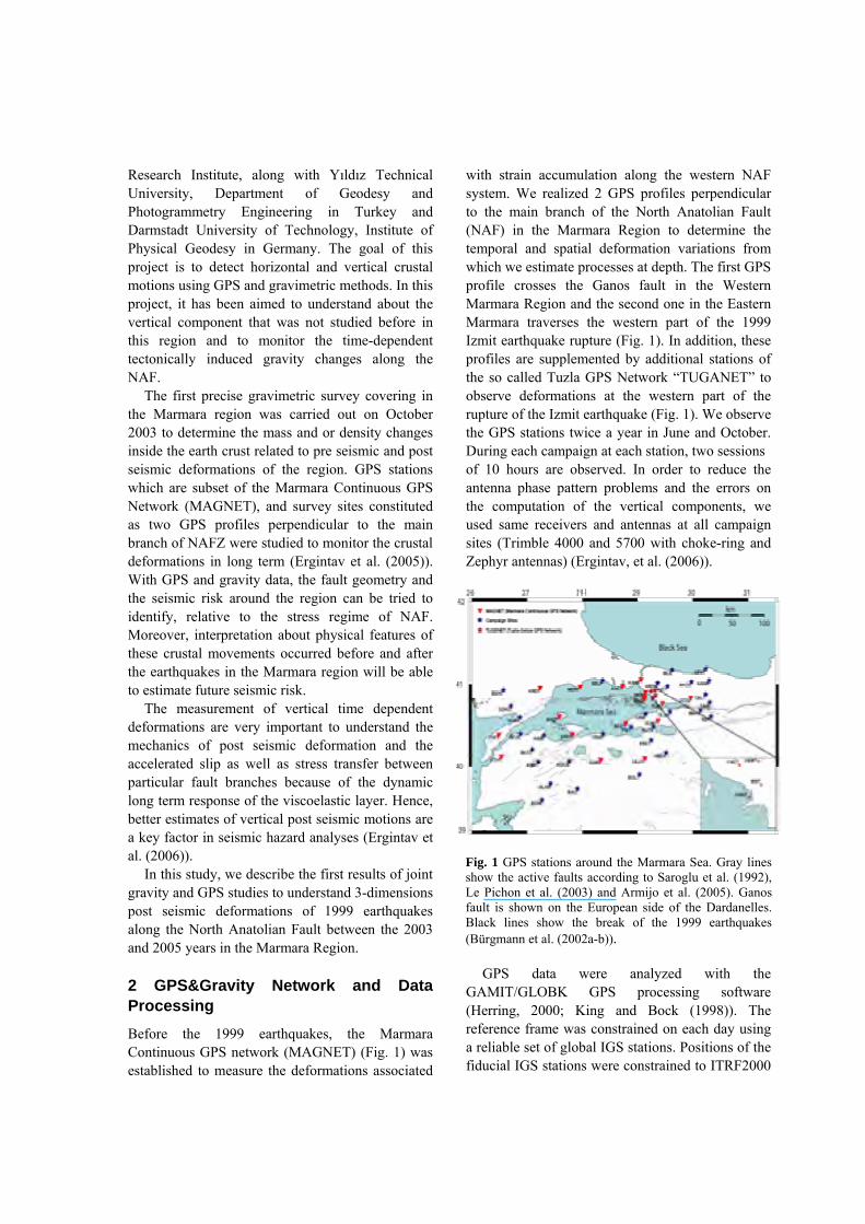
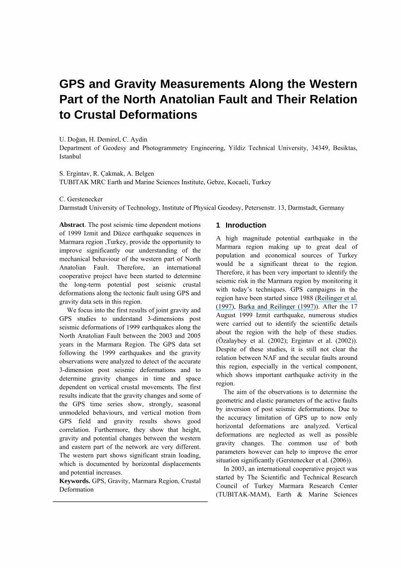
Fig. 1 GPS stations around the Marmara Sea. Gray lines show the active faults according to Saroglu et al. (1992), Le Pichon et al. (2003) and Armijo et al. (2005). Ganos fault is shown on the European side of the Dardanelles. Black lines show the break of the 1999 earthquakes (Bürgmann et al. (2002a-b)).
Research Institute, along with Yıldız Technical University, Department of Geodesy and Photogrammetry Engineering in Turkey and Darmstadt University of Technology, Institute of Physical Geodesy in Germany. The goal of this project is to detect horizontal and vertical crustal motions using GPS and gravimetric methods. In this project, it has been aimed to understand about the vertical component that was not studied before in this region and to monitor the time-dependent tectonically induced gravity changes along the NAF. The first precise gravimetric survey covering in the Marmara region was carried out on October 2003 to determine the mass and or density changes inside the earth crust related to pre seismic and post seismic deformations of the region. GPS stations which are subset of the Marmara Continuous GPS Network (MAGNET), and survey sites constituted as two GPS profiles perpendicular to the main branch of NAFZ were studied to monitor the crustal deformations in long term (Ergintav et al. (2005)). With GPS and gravity data, the fault geometry and the seismic risk around the region can be tried to identify, relative to the stress regime of NAF. Moreover, interpretation about physical features of these crustal movements occurred before and after the earthquakes in the Marmara region will be able to estimate future seismic risk. The measurement of vertical time dependent deformations are very important to understand the mechanics of post seismic deformation and the accelerated slip as well as stress transfer between particular fault branches because of the dynamic long term response of the viscoelastic layer. Hence, better estimates of vertical post seismic motions are a key factor in seismic hazard analyses (Ergintav et al. (2006)). In this study, we describe the first results of joint gravity and GPS studies to understand 3-dimensions post seismic deformations of 1999 earthquakes along the North Anatolian Fault between the 2003 and 2005 years in the Marmara Region. 2 GPS&Gravity Network and Data Processing Before the 1999 earthquakes, the Marmara Continuous GPS network (MAGNET) (Fig. 1) was established to measure the deformations associated
with strain accumulation along the western NAF system. We realized 2 GPS profiles perpendicular to the main branch of the North Anatolian Fault (NAF) in the Marmara Region to determine the temporal and spatial deformation variations from which we estimate processes at depth. The first GPS profile crosses the Ganos fault in the Western Marmara Region and the second one in the Eastern Marmara traverses the western part of the 1999 Izmit earthquake rupture (Fig. 1). In addition, these profiles are supplemented by additional stations of the so called Tuzla GPS Network “TUGANET” to observe deformations at the western part of the rupture of the Izmit earthquake (Fig. 1). We observe the GPS stations twice a year in June and October. During each campaign at each station, two sessions of 10 hours are observed. In order to reduce the antenna phase pattern problems and the errors on the computation of the vertical components, we used same receivers and antennas at all campaign sites (Trimble 4000 and 5700 with choke-ring and Zephyr antennas) (Ergintav, et al. (2006)).
GPS data were analyzed with the GAMIT/GLOBK GPS processing software (Herring, 2000; King and Bock (1998)). The reference frame was constrained on each day using a reliable set of global IGS stations. Positions of the fiducial IGS stations were constrained to ITRF2000
Fig. 2 Marmara Gravity Network (MAGRANET), and triangle points are permanent GPS stations belonging to MAGNET.
Epoch Number of Ins.
Number of Obs.
Mean point errors (µgal)
10-2003 2 434 5.9306-2004 2 543 4.26 10-2004 2 477 4.04 06-2005 2 450 4.19 10-2005 2 466 4.53
Table 1 Summary of the gravity observation campaigns
coordinates. Details about the processing method are described in McClusky et al. (2000). The Marmara Gravity Network (MAGRANET) is a precise gravimetric control network for monitoring gravity changes along the NAF due to geodynamic processes. The network whose points belong to MAGNET was established and consists of 25 stations (Fig. 2). The MAGRANET was re-observed five times in October and June of each year between 2003 and 2005, simultaneously with the GPS campaigns. The effect of seasonal variations on both observation sets should therefore be similar. We have used the relative spring gravimeters LaCoste Romberg LCR-G 85 and LCR-G 858 at all campaigns. The Scintrex CGS5 10076 and 10079 gravimeters have been also used since October 2004. The characteristics of the five surveys are given in Table 1.
We computed for each epoch stational point gravity values ( g ) from the following a least squares
adjustment model (Drewes et al. (1991); Torge (1989)):
p
kikidpkk ∆tdyngv −−−=+ ll , weight (1) kP
where, is the vector of the reduced gravimeter observation due to the earth tide, air pressure and instrument height effects, is the residual vector,
is the unknown gravimeter reading level vector at a day, is the scale correction vector for gravimeter (i), is the unknown drift polynomial coefficient vector for gravimeter (i), and ∆t is the time of observation referring to an initial time at a day.
kl
kv
dn
iy
id
The adjustment was carried out with the software package “GRAV” developed for adjustment of absolute gravity measurements and estimation of gravity values as well as gravimeter parameters using different adjustment models at the Institute of Physical Geodesy, Darmstadt University of Technology. A priori as unit weight standard deviation σ0= ±10 µgal for a particular observation is introduced. 3 Results and Evaluation Fig. 3 indicates an example of the GPS time series from MAGNET. It starts following the 1999 earthquake sequence and is fit well by a function of the form
x(ti)=x(to)+aln(∆t)+v∆t+Annual+Semi-annual (2)
where, x(ti) and x(to) are the observed site positions at epoch ti and to, respectively, a is the amplitude of the post-seismic response, v is the steady state velocity, and (t−to) is the time elapsed since the earthquake. The “Annual” and “Semi-annual” terms account for the unmodeled seasonal systematic effects. After the onset of the 1999 Izmit earthquake, the steady state site velocities can be predicted by this functional form, and they are equal within uncertainties to the observed site velocity prior to the earthquake (Ergintav et al. (2002); Ergintav et al. (2004)). The offsets of the 1999 Düzce earthquake were removed from the time series using the detailed coseismic deformations
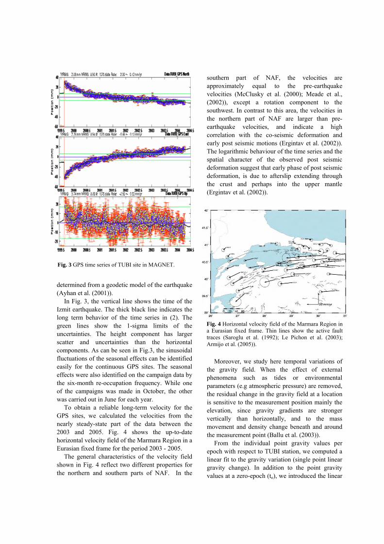
Fig. 3 GPS time series of TUBI site in MAGNET.
Fig. 4 Horizontal velocity field of the Marmara Region in a Eurasian fixed frame. Thin lines show the active fault traces (Saroglu et al. (1992); Le Pichon et al. (2003); Armijo et al. (2005)).
determined from a geodetic model of the earthquake (Ayhan et al. (2001)). In Fig. 3, the vertical line shows the time of the Izmit earthquake. The thick black line indicates the long term behavior of the time series in (2). The green lines show the 1-sigma limits of the uncertainties. The height component has larger scatter and uncertainties than the horizontal components. As can be seen in Fig.3, the sinusoidal fluctuations of the seasonal effects can be identified easily for the continuous GPS sites. The seasonal effects were also identified on the campaign data by the six-month re-occupation frequency. While one of the campaigns was made in October, the other was carried out in June for each year. To obtain a reliable long-term velocity for the GPS sites, we calculated the velocities from the nearly steady-state part of the data between the 2003 and 2005. Fig. 4 shows the up-to-date horizontal velocity field of the Marmara Region in a Eurasian fixed frame for the period 2003 - 2005. The general characteristics of the velocity field shown in Fig. 4 reflect two different properties for the northern and southern parts of NAF. In the
southern part of NAF, the velocities are approximately equal to the pre-earthquake velocities (McClusky et al. (2000); Meade et al., (2002)), except a rotation component to the southwest. In contrast to this area, the velocities in the northern part of NAF are larger than pre-earthquake velocities, and indicate a high correlation with the co-seismic deformation and early post seismic motions (Ergintav et al. (2002)). The logarithmic behaviour of the time series and the spatial character of the observed post seismic deformation suggest that early phase of post seismic deformation, is due to afterslip extending through the crust and perhaps into the upper mantle (Ergintav et al. (2002)).
Moreover, we study here temporal variations of the gravity field. When the effect of external phenomena such as tides or environmental parameters (e.g atmospheric pressure) are removed, the residual change in the gravity field at a location is sensitive to the measurement position mainly the elevation, since gravity gradients are stronger vertically than horizontally, and to the mass movement and density change beneath and around the measurement point (Ballu et al. (2003)). From the individual point gravity values per epoch with respect to TUBI station, we computed a linear fit to the gravity variation (single point linear gravity change). In addition to the point gravity values at a zero-epoch (to), we introduced the linear

Fig. 5 Linear changes as functions of distance from NAF with respect to TUBI station
Fig. 6 Time dependent potential regression coefficients
Fig. 7 Gravity changes and the vertical displacements for the stations in the south of the Marmara Region
temporal change (dg/dt) per station. The point gravity values per epoch are expressed as a function of linear variation as follows:
g(ti)=g(to)+(dg / dt )(ti−to) (4)
where g(ti) is the observed gravity value at epoch ti. The resulting data (dg/dt) are showed in Fig. 5. The linear temporal gravity changes indicate significant offsets depended anomalies. While the northern part of fault zone shows negative, the southern part shows positive changes in time. This is further evidence that the gravity changes reflect subsurface changes and not only vertical surface motions.
Gravity and height changes in time dg and dh are interpreted as potential changes dW according to (Gerstenecker, et al. (2006)):
dW=dg dh [Nm]. (5
We computed for the interpretation the changes of the potential dW/year. The results in Fig. 6 for the stations at NAFZ and Ganos fault. Applying the law of error propagation for the potential changes, we obtain statistically significant results. Obviously potential changes along NAFZ and Ganos fault are quite different. We observe generally a potential decrease at NAFZ, whereas at all stations near Ganos fault potential increase exists. The regimes
)
of both fault zones are quite different (Gerstenecker et al. (2006)). Fig. 7 indicates the plots of the linear temporal gravity changes and the vertical displacements for the stations at NAFZ for October 2004-October
from Fig. 7, while many sites show the expected
2003 with respect to TUBI site. As can be seen
negative correlation, and only DUMT site shows the positive correlation in the south of the Marmara Region. However, the linear temporal gravity changes indicate significant offsets depended anomalies. While the northern part of fault zone shows negative, the southern part shows positive changes in time. This is further evidence that the gravity changes reflect subsurface changes and not only vertical surface motions (Ergintav et al. (2006)).
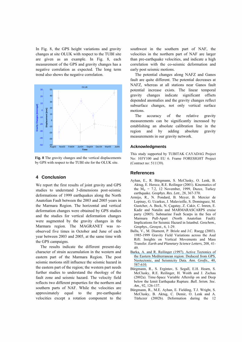
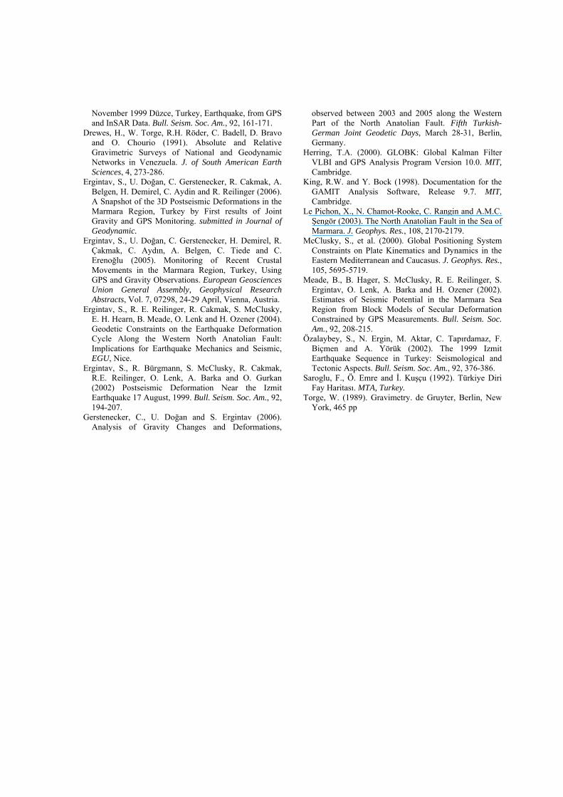
Fig. 8 The gravity changes and the vertical displacements by GPS with respect to the TUBI site for the OLUK site.
Aug03 Nov03 Feb04 Jun04 Sep04 Dec04 Mar05 Jul05-40
-30
-20
-10
0
10
20
30
40
50
Time
Dis
nt [m
m]
OLUK
plac
eme
-50
-40
-30
-20
-10
0
10
20
30
ites
[mic
roga
l]
In Fig. 8, the GPS height variations and gravity changes at site OLUK with respect to the TUBI site are given as an example. In Fig. 8, each measurement of the GPS and gravity changes has a negative correlation as expected. The long term trend also shows the negative correlation.
in October and June of each
l gravity changes indicate significant offsets depended anomalies and the gravity changes reflect subsurface changes, not only vertical surface motions. The accuracy of the relative gravity measurements can be significantly increased by establishing an absolute calibration line in the
ARPS cruise party (2005). Submarine Fault Scarps in the Sea of
(North Anatolian Fault):
ield Variations across the Asal Rift: Insights on Vertical Movements and Mass
and Planetary Science Letters, 208, 41-
B
ation during the 12
southwest in the southern part of NAF, the velocities in the northern part of NAF are larger than pre-earthquake velocities, and indicate a high correlation with the co-seismic deformation and early post seismic motions. The potential changes along NAFZ and Ganos fault are quite different. The potential decreases at
Gra
vy
Cha
ng
4 Conclusion We report the first results of joint gravity and GPS studies to understand 3-dimensions post-seismic deformations of 1999 earthquakes along the North Anatolian Fault between the 2003 and 2005 years in the Marmara Region. The horizontal and vertical deformation changes were obtained by GPS studies and the studies for vertical deformation changes were augmented by the gravity changes in the Marmara region. The MAGRANET was re-observed five times year between 2003 and 2005, at the same time with the GPS campaigns. The results indicate the different present-day character of strain accumulation in the western and eastern part of the Marmara Region. The post seismic motions still influence the seismic hazard in the eastern part of the region; the western part needs further studies to understand the rheology of the fault zone and seismic hazard. The velocity field reflects two different properties for the northern and southern parts of NAF. While the velocities are approximately equal to the pre-earthquake velocities except a rotation component to the
region and by adding absolute gravity measurements in our gravity network.
NAFZ, whereas at all stations near Ganos fault potential increase exists. The linear tempora
Acknowledgments
This study supported by TUBITAK CAYADAG Project No: 103Y100 and EU 6. Frame FORESIGHT Project (Contract no: 511139). References Ayhan, E., R. Bürgmann, S. McClusky, O. Lenk, B.
Aktug, E. Herece, R.E. Reilinger (2001). Kinematics of the Mw = 7.2, 12 November, 1999, Duzce, Turkey earthquake. Geophys. Res. Lett., 28, 367-370.
Armijo, R., N. Pondard, B. Meyer, B. Mercier de Lepinay, G. Ucarkus, J. Malavieille, S. Dominguez, M. Gustcher, A. Beck, N. Çagatay, Z. Cakir, C. Imren, E. Kadir and Natalin and MARMARASC
Marmara Pull-Apart Implications for Seismic Hazard in Istanbul. Geochem., Geophys., Geosyst., 6, 1-29.
Ballu, V., M. Diament, P. Briole and J.C. Ruegg (2003). 1985-1999 Gravity F
Transfer. Earth49.
Barka, A. and R. Reilinger (1997). Active Tectonics of the Eastern Mediterranean region: Deduced from GPS, Neotectonic, and Seismicity Data. Ann. Geofis., 40, 587-610.
Bürgmann, R., S. Ergintav, S. Segall, E.H. Hearn, S. McClusky, R.E. Reilinger, H. Woith and J. Zschau (2002a). Time-Space Variable Afterslip on and Deep below the Izmit Earthquake Rupture. Bull. Seism. Soc. Am., 92, 126-137.
ürgmann, R., M.E. Ayhan, E. Fielding, T.J. Wright, S. McClusky, B. Aktug, C. Demir, O. Lenk and A. Türkezer (2002b). Deform
November 1999 Düzce, Turkey, Earthquake, from GPS and InSAR Data. Bull. Seism. Soc. Am., 92, 161-171.
rewes, H., W. Torge, R.H. Röder, C. Badell, D. Bravo and O. Chourio (1991). Absolute and Relative Grav
D
imetric Surveys of National and Geodynamic
E. Demirel, C. Aydin and R. Reilinger (2006).
E Gerstenecker, H. Demirel, R.
h
E
estern North Anatolian Fault:
E
August, 1999. Bull. Seism. Soc. Am., 92,
G
North Anatolian Fault. Fifth Turkish-
H
e.
L
Geophys. Res., 108, 2170-2179.
terranean and Caucasus. J. Geophys. Res.,
M Lenk, A. Barka and H. Ozener (2002).
ism. Soc.
Ö
in Turkey: Seismological and
Sa
To
Networks in Venezuela. J. of South American Earth Sciences, 4, 273-286.
rgintav, S., U. Doğan, C. Gerstenecker, R. Cakmak, A. Belgen, HA Snapshot of the 3D Postseismic Deformations in the Marmara Region, Turkey by First results of Joint Gravity and GPS Monitoring. submitted in Journal of Geodynamic.
rgintav, S., U. Doğan, C.Çakmak, C. Aydın, A. Belgen, C. Tiede and C. Erenoğlu (2005). Monitoring of Recent Crustal Movements in the Marmara Region, Turkey, Using GPS and Gravity Observations. European Geosciences Union General Assembly, Geophysical ResearcAbstracts, Vol. 7, 07298, 24-29 April, Vienna, Austria.
rgintav, S., R. E. Reilinger, R. Cakmak, S. McClusky, E. H. Hearn, B. Meade, O. Lenk and H. Ozener (2004). Geodetic Constraints on the Earthquake Deformation Cycle Along the WImplications for Earthquake Mechanics and Seismic, EGU, Nice.
rgintav, S., R. Bürgmann, S. McClusky, R. Cakmak, R.E. Reilinger, O. Lenk, A. Barka and O. Gurkan (2002) Postseismic Deformation Near the Izmit Earthquake 17194-207.
erstenecker, C., U. Doğan and S. Ergintav (2006). Analysis of Gravity Changes and Deformations,
observed between 2003 and 2005 along the Western Part of the
German Joint Geodetic Days, March 28-31, Berlin, Germany.
erring, T.A. (2000). GLOBK: Global Kalman Filter VLBI and GPS Analysis Program Version 10.0. MIT, Cambridg
King, R.W. and Y. Bock (1998). Documentation for the GAMIT Analysis Software, Release 9.7. MIT, Cambridge.
e Pichon, X., N. Chamot-Rooke, C. Rangin and A.M.C. Şengör (2003). The North Anatolian Fault in the Sea of Marmara. J.
McClusky, S., et al. (2000). Global Positioning System Constraints on Plate Kinematics and Dynamics in the Eastern Medi105, 5695-5719. eade, B., B. Hager, S. McClusky, R. E. Reilinger, S. Ergintav, O.Estimates of Seismic Potential in the Marmara Sea Region from Block Models of Secular Deformation Constrained by GPS Measurements. Bull. SeAm., 92, 208-215.
zalaybey, S., N. Ergin, M. Aktar, C. Tapırdamaz, F. Biçmen and A. Yörük (2002). The 1999 Izmit Earthquake Sequence Tectonic Aspects. Bull. Seism. Soc. Am., 92, 376-386. roglu, F., Ö. Emre and İ. Kuşçu (1992). Türkiye Diri Fay Haritası. MTA, Turkey. rge, W. (1989). Gravimetry. de Gruyter, Berlin, New York, 465 pp