GLOBAL CITY - LOCAL IDENTITY? - Cabinet d'Architecture ...
61
GLOBAL CITY - LOCAL IDENTITY?
-
Upload
khangminh22 -
Category
Documents
-
view
0 -
download
0
Transcript of GLOBAL CITY - LOCAL IDENTITY? - Cabinet d'Architecture ...

1
GLOBAL CITY -LOCAL IDENTITY?

Mkuki na Nyota Publishers LtdP. O. Box 4246Dar es Salaam, Tanzaniawww.mkukinanyota.com© Goethe-Institut Tanzania, 2013 ISBN 978-9987-08-219-3
All rights reserved. No part of this publication may be reproduced, stored in a retrieval system or transmitted in any form or by any means, electronic, mechanical, photocopying, recording, or otherwise, without the prior written permission of Mkuki na Nyota Publishers Ltd.
Visit www.mkukinanyota.com to read more about and to purchase any of Mkuki na Nyota books. You will also find featured authors interviews and news about other publisher/author events. Sign up for our e-newsletters for updates on new releases and other announcements.
2 3
GLOBAL CITY -LOCAL IDENTITY?Edited by Annika Seifert
Partners
Goethe-Institut TanzaniaArchitects Association of Tanzania
Made possible by
Goethe-Institut TanzaniaGerman Embassy in Dar es SalaamBritish Council TanzaniaRoyal Netherlands Embassy in Dar es SalaamFrench Embassy in Dar es SalaamSwiss International Airlines TanzaniaSouthern Sun Hotel Dar es Salaam

Contents
Suites ArchitecturalesKinshasa–Douala– DakarDanièle Diwouta-Kotto
The Arch of MemoryUrban Signage Design for Douala Historical SitesSandrine Dole
Rethinking Tanzania’s CapitalThe New Town of Dodoma as a Product of Global Politicsand Conflicting Ideologies Sophie van Ginneken
Culture and Identity in Cairo Urban DevelopmentA Case Study of Cairo’s Informal SettlementsHassan El Mouelhi
The Case Against the Construction of a Cultural Identity Heinrich Wolff
70
76
84
100
114
4 5
AcknowledgementsEleonore Sylla
Introduction Annika Seifert
City Under ThreatHeritage Assets of Dar es Salaam Karen Moon
Tomorrow’s Built Heritage of Dar es SalaamGlobalist Architecture in the Local ContextAntoni Folkers
Mozambique IslandDevelopment and Conservation Strategies and Practises,With Focus on the Period 1943 to 2011Jens Hougaard
Approaching the Macuti HouseIdentity and Heritage Conservation in Ilha de MoçambiqueSilje Erøy Sollien
Making Cities For the PeopleIn View of Re-Inventing Dar Es SalaamCamilus Lekule
7
8
12
28
36
48
58
In October 2011 the Goethe-Institut Tanzania hosted and facilitated a multidisciplinary public platform under the name of Global City Local Identity?. The project series was dedicated to debating current issues of city development, public space, and cultural identity in African cities such as Dar es Salaam. Global City Local Identity? brought together a series of events and projects that involved local, regional, and international experts, local authorities, artists, and others. This documentation captures the presentations of the experts who participated in the international symposium. This collection ensures that those who had no opportunity to be part of the events should not miss out on these wonderful presentations, ideas, and reports.Parallel to the symposium, a temporary art space, Urban Dreamscape, was created in the heart of the city of Dar es Salaam. It was an amazing experience to see how, in connection with Global City, Local Identity?, the selected site, the colonial Ebrahim Building, built in 1932, came back to life through the movements and activity of people.I recommend reading this publication as a guideline and orientation towards the different thoughts, ideas, statements, and results that were produced by the end of the event.
I would like to thank all the participants, whose dedication made this documentation possible. My special thanks go to Annika Seifert, editor of this publication, who initiated Global City Local Identity?, together with our institute; as well as to Walter Bgoya from Mkuki na Nyota Publishers for his engagement and interest to publish the symposium proceedings.
Eleonore SyllaDirector Goethe-Institut Tanzania October 2012
6 7
Acknowledgements

A good 50 years after sub-Saharan Africa has achieved political independence, many of its cities like East African Nairobi, Dar es Salaam, Addis Ababa or Kampala continue to be confronted with the unresolved question of their cultural identity. Jimmy Okonga, Kenyan artist and curator, sees the reason for this lack of cultural rootedness in what he calls a “post-colonial loss of memory resulting in assimilation, conformism and insecurity of a cultural identity” hindering the development of a specific and self confident society.2
In the current „competition of cities“, in which globally connected regions urge to produce or maintain a recognizable profile historic cities in Europe and North America derive and maintain their characteristics through functional institutions and long standing urban traditions while others e.g. the rapidly developing autocratic states of the Middle and Far East have addressed this issue by engineering specific urban profiles from scratch. Compared to both of these groups however, African metropolises with their environment being defined by often weak institutions and ruthlessly enforced particular interests, are heavily disadvantaged: Instead of employing synchronised models for development, they are left with little more than pure quantitative growth. More than other global cities they seem to be at risk to loose what is left of their specific identity in a juxtaposed process of globalization and rural-urban migration.
The search of a specific cultural identity often leads us to look into the past; but in many cases answers for sustainable future urban planning are to be found in our immediate contemporary environment. Particularly in urban life we witness globalisation as an indicative factor seemingly shrinking spatial distances and cultural differences. Yet due to the ongoing trend of urbanisation more and more people experience the city as their very individual environment. Especially in the developing countries there is a strong discrepancy between the planners’ and decision makers’ global perspective and ambitions on the one hand and on the other hand the much larger part of the less privileged -often newly- urban populace, that is not taking part in the global experience, yet.
Urban grain plan of Dar es Salaam showing a typical heterogeneous morphology of formal and informal neighbourhoods, dense development and urban sprawl.(Map: Annika Seifert)
Introduction
Annika Seifert
In the 21st century, metropolises on the African continent are undergoing rapid and uncontrolled growth - an informal and unchecked development that contemporary industrial nations have not been subject to since the 19th century.1 Not only do these cities face immense technical challenges, the dramatic transformation also has an essentially cultural dimension: As development catalysts for African states, they are placed within the stress field of post-colonialism, political experiments and the upheaval of social heterogeneity, globalization and competing economic interests.
8 9

urban experiment of Dodoma, Tanzania. Jens Hougaard in Mozambique Island and Silje Erøy Sollien with Approaching the Macuti House, both touch the topic of Swahili culture found along the East African coast from Kenya to Mozambique, the first one highlighting the Portuguese colonial influence on Ilha de Mocambique, the later investigating an informal regional building type that has survived until today. Sandrine Dole shares her experience as a product designer developing The Arch of Memory, an unconventional concept for heritage signage in the urban context of Douala, while Danièle Diwouta-Kotto’s article Suites Architecturales suggests a supra-African perspective by drawing parallels between the different cities of Douala, Dakar and Kinshasa and their specific identities. Culture and Identity in Cairo Urban Development by Hassan El Mouelhi casts a concise view on concepts of cultural identity in informal settlements in the mega-city of Cairo. Lastly, Heinrich Wolff argues The Case Against the Construction of a Cultural Identity, as witnessed in drawing board neighbourhoods in South Africa, warning planners against an artificially constructed
“identity” forced upon the built environment.
Altogether the selection provides a broad perspective of the issues emerging metropolises in East Africa are confronted with, today. Looking into their ambiguous past, describing their dynamic present and discussing possible directions for their future the articles highlight these cities’ challenges as well as their untapped potential.
1. The 2010/11 UN Habitat State of African Cities Report: Governance, Inequality and Urban Land Markets suggests that African city populations will more than triple over the next 40 years)2. From the exhibition concept of Amnesia, an art exhibition at the Goethe-Institute Nairobi, 20093. C.f. exhibitions like Who knows tomorrow, Museum für Gegenwart, Berlin, Germany 2010; or Afropolis, Rautenstrauch-Joest-Museum, Cologne, Germany, 2010; as well as other formats like Rem Koolhaas: Lagos: How it works, documentary 2006; or Peter Herrle: Architecture and Identity, Lit Verlag 2008
While the phenomenon of cultural identity-crisis in African cities just begins to appear on the perceptive horizon of the European discourse 3, most African countries still lack public and neutral forums which could serve as a framework to debate these pressing issues:
• Can we possibly grasp a cultural identity of such heterogeneous cities?• What significance does the colonial past of African cities have for their present?• What are places of identification within the urban space and how do they arise?• Has not, unnoticeably, the city’s rapid development already fostered an independent,
in its nature specific and local movement beyond the conventional understanding of history and preservation?
• How can we conceive of a sustainable treatment of the historic city substance that would also accommodate economic interests?
This edition dates back to an international symposium held by the Goethe-Institut and the Architects Association of Tanzania in Dar es Salaam in 2011. Bringing together international experts and regional professionals and stakeholders over academic paper presentations and public discussions it sparked a local discourse on these questions of cultural identity in architectural and urban planning in East Africa.
The contributions selected for this publication shed light on the topic from different perspectives and from the smaller architectural to the larger urban scale.Given the fact that the symposium was held in Tanzania several papers deal with the City of Dar es Salaam:In City under Threat, Karen Moon focusses on the city’s historical centre as an important foundation of its cultural identity; with Tomorrow’s Built Heritage of Dar es Salaam Antoni Folkers critically highlights recent building tendencies against the background of Tanzania’s architectural past, while in Making Cities for the People Camilus Lekule reflects the challenges of Dar es Salaam’s master plan in view of its urban heterogeneity. A very different approach of urban planning is explored by Sophie van Ginneken in Rethinking Tanzania’s Capital, an article on the socialist
10 11

CITY uNDEr ThrEAT
12 13
A brief outline of Dar es Salaam’s history is necessary to understand the nature of its cultural identity and the character of its cultural resources. Dar es Salaam is of relatively recent foundation. Its site was chosen in 1862 by Sultan Majid, the Omani ruler of Zanzibar, as a mainland base and place of retreat. Majid made a shrewd assessment of the site’s strategic importance. With its fine harbour and proximity to mainland caravan routes, he could see its potential for economic development through agriculture and trade. After negotiating with the nearby village of Mzizima for rights to the land, the Sultan quickly began a building programme and invited Arab and Indian traders to settle. From the outset, Dar es Salaam was deliberately planned. A line of buildings was constructed, tracking the curve of the northern riverbank, which included the Sultan’s palace, a residence for guests, a mosque, and customs house, all built in local coral-stone. Public services comprised of a strip of road in front, with a series of wells.However, this activity was short-lived. Following the Majid’s death in 1870, Dar es Salaam’s construction ground to a halt, mainly due to a lack of interest by his successor. The project languished for seventeen years, not to be revived until the German East Africa Company (DOAG) adopted the site in 1887 for a company station. Hauptmann Leue led rehabilitation of the deteriorated structures and in the process he consolidated the palace and neighbouring buildings to create a fortified Boma.
The Colonial Era
The German government’s decision in 1891 to make Dar es Salaam the administrative base of its new colonial territory must be one of the most significant points in the city’s history. Major building works ensued. These followed a formal plan, setting in place the layout of streets in the city centre that remains in existence today. The German plan included a series of roads radiating from the riverfront’s arc, crossed by inner and outer ring roads reflecting this curve (now Indira Ghandi/Makunganya Streets and Jamhuri Street). Two parallel avenues tangential to the shoreline (now Samora Avenue and Sokoine Drive) were also created for the main European commercial centre. This plan combined a pattern of arcs and diagonals as well as ‘grand’ avenues. In the Asian
Right: Engraving of the water front c.1869 showing the Sultan’s palace (left)(Source: Tanzania Notes & Records, Number 71, 1970, Plate 1)
Left: German street plan of 1891.(Source: Gibb, Plan for Dar es Salaam)
HERITAGE ASSETS OF DAR ES SALAAM
Karen Moon
In terms of heritage and urban planning, many African cities are drifting. They may be growing at tremendous pace, but without clear direction. Historic buildings and neighbourhoods are being demolished or modified beyond recognition. What is the significance of this heritage and what is replacing it? What can be done to preserve these assets? Ultimately, what sorts of cities are wanted? This paper takes a look at one city, Dar es Salaam, in this context of rapid urban change.

14 15
programme, with its racially based zoning arrangement, was largely continued by the British. The first significant expansion outside the German town was predominantly overspill from existing districts northwards, with Sea View and Upanga, developing from the European and Asian areas respectively. These new areas were less strictly controlled and became more divergent in character. In the central core, many Asian businesses within the ring road area upgraded their premises during the 1930s, partly prompted by new legislation under British rule. A further surge of building activity immediately followed the Second World War. At this time, some large, multi-storey blocks (in general no more than five stories) were constructed in the Asian area, especially at its border with the former ‘European’ quarter, where the highest property and land values were located. Increasingly buildings of multiple storeys also sprang up in the centre, tightly squeezed into available plots – a pattern which continued during the 1950s and on into the 1960s following Independence. Since this time, taller and taller buildings have been constructed, mainly on existing plots, which intrude into the small-scale streetscapes and the well-landscaped residential area laid out by the Germans.
Even such a brief outline of Dar es Salaam’s early history serves instantly to illuminate the character of the city that developed. The racially based zoning divisions created pockets of architectural development by different cultural groups who, while predominantly all using coral-stone, employed a range of architectural traditions and methods of construction for their buildings. This created a variety of building styles and types, grouped in coherent ensembles, each set in distinct street arrangements: Hence, the German area, with large, official buildings and substantial residences in open plots, most with balconies or verandas, plus Sokoine and Samora, are in European (colonial) style, set on grand avenues or spacious, tree-lined streets. The European buildings were designed to set the tone, declare ownership, and reflect
area, the narrow streets were punctuated with open spaces (some later containing roundabouts) and at the points where several routes met, the irregular angles of the streets created tapering plots at the junctions and distinctive building shapes.At the same time a clear pattern of zoning was established by the colonial power, an approach which would also be highly influential. In essence, the highest status zone took the land to the east, near the Indian Ocean’s shoreline and its cool breezes, with the hierarchy diminishing westwards: from German official/residential, to European commercial, then to Arab and Asian. The existing village of Mjimwema, shown on the 1891 map, in a prime location in the eastern zone, was soon to be brusquely removed by the Germans, and the African inhabitants of Dar pushed furthest west to the African district of Kariakoo, laid out officially around 1906. At this time the industrial area and railway terminus were also developing to the south of the Asian bazaar, around the port and customs house where the Boma (now largely demolished) had been located.The First World War saw transition to British rule. While the character of some buildings constructed from this time altered accordingly, the German planning
Left: View of waterfront c.1906 showing German port buildings (foreground) and surviving Arab structures from Majid’s time (centre).(Source: Tanzania Notes & Records, Number 71, 1970, Plate 27)
View of new buildings in the Asian area c.1945.(Source: C. Gillman, “Dar es Salaam, 1860 to 1940” in Tanganyika Notes & Records, Number 20, 1945, Plate 11)
Sokoine Drive, c.1950(Courtesy Gloria Mawji)
Right: Street plan of 1941. The African area of Kariakoo can be seen to the far left, separated from the rest of the town by an open space (the ‘cordon sanitaire’). The densely-packed Asian area (the central business district) is in the centre.(Source: Gibb, Plan for Dar es Salaam, 1949)

16 17
the aspirations of the new colony. The Asian area had a more workaday flavour. Its ‘shop-front’ buildings (mixed use, commercial/residential), community, and religious buildings displaying an idiosyncratic mix of Indian, European, and Art Deco elements (Art Deco being the style popular during the major periods of this development). The buildings are closer together, the streets are narrow and more irregularly arranged, and its junctions embellished with distinctive corner buildings. Finally, Kariakoo, with its close mix of commercial and residential surrounding the central market, reflects a gradual development and upgrading of the originally basic structures, laid out in a regimented grid.These three main divisions form the underlying structure of Dar’s central urban heritage and the first layer of its historic and cultural identity. The key historical sites and buildings are found here, though in fact the majority identified to date belong to the former European and Asian zones where greater wealth led to the construction of more substantial and elaborated structures with better quality materials and finer detailing1
Post-Independence Development
Since Independence, various subtle changes have occurred in the former European and Asian zones which can be characterised as an Africanisation of these areas and can be considered to constitute a second layer of the city’s cultural identity. In the first three decades, this was primarily a result of changes in occupation, minor alterations, and a modest addition of modern structures reflecting the creation of the new state2, but the relaxation of the colonial grip on the city centre also allowed a livelier, more vibrant street life to develop, through an increase in street-based activity, vendors, unofficial street signs and the like, which have markedly modified its character. The changes in occupation were significant and due to the nationalisation of most commercial buildings in the city centre by the new government in 1971. 96% of these acquisitions had been the property of Asians and they passed into the ownership of the National Housing Corporation (NHC) which let them out to commercial and residential tenants. This has led to a greater cultural mix in the historically Asian and European quarters.
Left: Shashi House, 1932.A fine corner building.Many Asian buildings were identified with the owners’ names and dates of construction.(Photo: Karen Moon)
Right: View of Kariakoo, c.1970.(Source: Tanzania Notes & Records, Number 71, 1970, Plate 7)

18 19
heritage buildings. Sadly, among these were some of the earliest surviving buildings in the Asian area from the 1930s and the Salamander building (a prominent early German building on Samora Avenue). Several large landmark structures and distinctive corner buildings were also lost. Since 2009, yet more demolitions have occurred with the result that the integrity of the central historic area is fast disappearing.
What is Replacing the Old?
The pattern of development in this recent surge of construction has been opportunistic, depending on the availability of sites. The NHC, for instance, has begun a process of selling off its buildings for redevelopment. As these are scattered throughout the city centre, this means that new buildings can spring up anywhere. With land values rising sharply and little restraint from building regulations, investors aim to build as high as possible on each (however tiny) plot. There is no coordination of building designs and residents are not consulted. Many of the new constructions are of dubious quality and a standardised nature, jarring with the unique, personalised buildings of the 1930s and ‘40s. Glass and concrete predominate in the new modern aesthetic, again coordinating poorly with the older buildings of local coral stone. This is leading to a motley and mundane city centre of ill-considered buildings and overstretched services which cannot be satisfying from any perspective: functionality, aesthetics, liveability, tourism, or even yield the effect of glistening modernity which many of the chief actors want.
Throughout this process it is apparent that new construction is universally preferred to rehabilitation of existing stock. Despite the fact that the Antiquities Division – the government agency responsible for Tanzania’s cultural heritage – is handicapped by a lack of expertise in this area5, it has been actively promoting the rehabilitation of buildings and the protection of Dar es Salaam’s city centre heritage from the mid-1990s. In its Declaration of Conservation Areas (Dar es Salaam) 1995, 26 buildings and 5 individual sites (including Mnazi Moja and the National Stadium) were scheduled, and a single, large Conservation Area was created, comprising the length of Kivokoni Front plus the old German area and its Botanical Gardens. The majority of buildings
Only since the 1990s have the dynamics significantly shifted. Changes in government policy and growth in the economy have led to keen investor interest in the city centre and a mushrooming of high-rise projects. The speed of construction seems ever increasing. Since the turn of the 21st century, there has been almost constant building activity. The responsible authorities’ understanding of the need for planning and legislative action has not kept pace. Lack of planning and building controls, the absence of strategic planning for the future, and the woeful neglect of infrastructure upgrading to support this development, is only too clear. This has not been a carefully regulated, thoughtfully balanced growth. It has occurred without consideration of such issues as heritage, communities, liveability (including planning for cultural and leisure activities), or tourism potential. It has been a short-sighted, investment-driven explosion of construction, taking buildings higher and higher, disregarding the limited capacity of existing utilities (water, sewage, waste disposal, etc.), the needs of emergency services, parking availability, and even light. The devastation to the urban heritage has been enormous. In 2006, a study of this heritage was carried out in a section of the Central Business District (mostly the former Asian area and Samora Avenue), including 350 buildings3. This survey showed that over 60% of the buildings had some heritage value, with more than 20% considered to be of special interest. Three years later, in 2009, the same area was reviewed and it was found that 56 buildings had been demolished in this area in the intervening period4. 16 of the special interest buildings had gone and 19 of the other
Left: Habib Punja Star Building of 1938, demolished between 2006 and 2009.(Photo: Karen Moon)
Bagamoyo House on Morogoro Road. Just outside the survey area completed in 2006. Also demolished between 2006 and 2009.(Photo: Karen Moon)
Right: Asian area, photo taken in October 2011, showing the out-of scale new developments.(Photo: Karen Moon)

20 21
listed were in the old British and German areas with the addition of a few mosques and temples in the Asian sector. The legislation was passed in 1995 but Antiquities nevertheless has found it a struggle to enforce this protection. The process of heritage conservation is little understood. Support from other government departments (City Council, Surveys and Planning, NHC, etc.), and coordination between them and Antiquities, is wanting. The Division is rarely informed or consulted when building developments are planned. Antiquities legislation has also been flagrantly flouted, notoriously in the government’s construction of the Bank of Tanzania twin towers (2000-2006) in the protected Conservation Area.This highlights a fundamentally political problem. Present government policies on urbanisation have been dominated in recent years by a shift to a free market economy and a drive for modernisation. No room has been left for attention to heritage conservation planning. In 2006, in response to increasing demolitions in the city centre, Antiquities proposed gazetting a further 110 buildings in Dar es Salaam, this time including many Asian buildings in the Central Business District (CBD). However, this legislation was challenged by other government departments (including those agencies mentioned above) and it never took effect.
Dar’s historic centre cannot survive unless strong action is taken, and quickly. So, what can be done to rescue the situation? If it continues, the choices will rapidly reduce as irreplaceable assets are lost. Coordination between government agencies, whose actions impact the heritage buildings, with Antiquities, is needed so that a strategy is formed for Dar es Salaam’s future, a strategy that will lead to a balanced, viable place for its citizens to work and live. These partners should include those responsible for infrastructure as well as for planning and building controls. The NHC is of primary importance in this process. Being by far the largest city landlord, its impact can be significant in turning this situation around. At the core of this heritage planning should be rehabilitation of heritage buildings for an appropriate re-use, combined with sensitive modernisation of facilities and protection of the surrounding historic environment (i.e. retaining historic properties in their context, as much as possible in their cultural or period groupings, not just as individual buildings). Such
Right: Map from 2006 showing planned survey area (heavy line), area completed (light grey), special interest heritage buildings (dark grey), and buildings with some heritage value (medium gray).(Map: Karen Moon)
Map from 2009 review showing demolitions carried out over the previous 3 years (black).(Map: Karen Moon)

22 23
Areas which cover all major heritage assets of the historic city centres as well as individual gazetting. Regulations for the Conservation Areas to ensure that key buildings and streetscape ensembles have special protection and to control change, including protection of the skyline, etc.
• The development of tax incentives to encourage rehabilitation of historic properties in the protected zone.
• Permanent street signage connected with a city heritage walk and a tourism information centre: the information centre to include a display on the city’s history.
• An education campaign for both civil society, and for government departments not otherwise involved in the programme, to raise awareness of heritage value and revise negative public perceptions. To include re-evaluation and re-interpretation of the heritage in the light of identity and ownership issues to be discussed below.
• Training and capacity building for civil society groups to support the formation of a heritage Non-Governmental Organisation (NGO) for Dar es Salaam.
Public education and awareness raising is included in this programme because civil society participation is essential in heritage conservation to balance government actions. How is it that as yet there has been no public outcry at the loss of Dar es Salaam’s heritage and cultural identity? Why does the unique urban heritage of this city seem so little regarded by its citizens or other Tanzanians? However, it is true that individuals occasionally raise protest through articles in the press. One individual has spearheaded an exploration of grass-roots interest: Sarah Markes has highlighted many heritage buildings in her book Street Level and related exhibitions7. Feedback has shown that this is contributing to raising public awareness and interest. In addition, a group of concerned residents is at last beginning to associate and is involved in a project to establish a new Tanzanian heritage non-governmental organisation. However, public interest has, in general, been weak and ineffective. Previously, there had been no association of concerned individuals and therefore no lobbying power.
rehabilitation provides attractive, comfortable, well-functioning buildings in historic neighbourhoods, it can increase property values and attract cultural activities and tourism in the city centre with associated jobs (the most obvious examples elsewhere are historic European cities including Rome, London, or Amsterdam, but successful rehabilitation and heritage tourism is widespread in many smaller places and is occurring nearer at hand, for example in Morocco).
Possible Approaches
A recent proposal by Antiquities has suggested a workable plan for initial actions towards this end6. The proposal includes the following principal tasks:
• Completion of existing inventory work to identify heritage assets, including the historic area of Kariakoo. Individual buildings, related groups of buildings, and their setting to be taken into account. Inclusivity to be ensured through consultation with city users, resident communities and other stakeholders. Identified assets to be surveyed to assess the condition of the surviving fabric and their potential for rehabilitation or re-use.
• Capacity building in heritage planning and management for central and local government departments leading to:
• Development of a Heritage Conservation and Tourism Plan for the city, for inclusion in the existing government planning process. To include planning for green spaces, zoning locations for cultural activities, providing areas for relaxation, leisure and spaces for public events as well as a plan to protect Dar’s resident communities.
• The development and implementation of a system of coordination for central and local government agencies involved in building development and planning with Antiquities, to ensure full consultation with the heritage authority as the Plan is implemented and as decisions relating to the historic city centre are made.
• Strengthening of legislation. To include the establishment of Conservation
Right: Khoja Ithnaasheri Trust Building (1936), Sarah Markes.The level of street activity and sense of vibrancy in Dar today is well brought out in the drawings of Sarah Markes.(Illustration :Sarah Markes)

24 25
contribution of visual variety and character in the cityscape and a more human architectural scale. And finally, they have economic value through the tourism benefits they can bring.
Urban Cultural Identity?
The problem of ownership is part of a more general post-colonial problem in sub-Saharan Africa, of disassociation with, and insecurity about, the past that is a legacy of the colonial intrusion and its tendency to dismiss or undervalue pre-colonial African heritage and traditions. For cities and their cultural identity, a discontinuity in African architectural history has exacerbated this problem; traditional African architecture has less obvious continuity in development into modern times than has the architecture of the other dominant groups. This has created a ‘disconnect’ which can be an obstacle for Tanzanians in relating to their own past achievements and heritage. Why is so little interest shown in the heritage value of African buildings in Kariakoo? Why so little exploration by African architects of modern architecture as a development of African traditions? Instead the desire for place-less ‘modern’ buildings has grown, without any analysis of what sort of modernity is really needed or is appropriate to the local situation.A sense of place contributes to cultural identity. The historical fabric of urban places, their spaces and arrangement, their landmarks and districts, are familiar and important to residents and users, they create a structure in which daily activities are embedded. When people have been relocated from a village situation to high-rise modern buildings, or when places have been razed and rebuilt, this impact is clearly demonstrated in the disorientation and social problems caused.
Resolution of the question of African cultural identity as considered by the symposium GLOBAL CITY - LOCAL IDENTITY remains. Action is needed, in other arenas, by architects who wish to create contemporary African architecture that strengthens the city’s cultural identity and its citizens’ sense of pride. The protection of city heritage is essential, but African cities must also grow and develop for their own time. New
Responsibilty and Ownership
One reason for this is the prevailing public conception of older buildings. Dar es Salaam’s historic buildings have been poorly maintained over a long period. Since nationalisation, few historical buildings have had facilities repaired and the reality for occupants is deteriorating fabric and failing services. This is a common situation in Tanzania and results in older buildings having negative associations, whether they are of architectural interest or not. In addition, the majority of Dar es Salaam’s inhabitants have no knowledge of the successful rehabilitation of historical properties and districts in other places or of urban heritage tourism or the economic benefits this can bring (the same can presumably be said for its civic authorities). With the situation as it is, the assumption that modern buildings, of whatever quality, must be better, has become firmly entrenched.
The lack of a sense of ownership may also have some influence. Whose heritage is it anyway? The Germans (or other Europeans) and Asians? Or the Tanzanians? This problem of ‘ownership’ is recurrent in post-colonial situations and is likely to be a contributing factor in the eroding public support for significant parts of Africa’s architectural heritage8. In Dar es Salaam, as in some other places, this issue stems from the lack of involvement by Africans in the early development of the city, with the result that little of the historical fabric is inherently African in conception. Yet for any people or nation, place and history are important to an identity, and this heritage of occupation is Tanzania’s, part of its history and of today’s reality, it holds no threat now because it no longer belongs to these ‘others’. In fact it represents the achievement of what has been overcome or encompassed in making this African nation.Why does Britain keep the ruins left by its Roman conquerors, or Spain the remains from its conquest by North Africans? – because these places are assets. They have educational value, in that they tell the story of the past. They have and aesthetic value, they are worthy of study because of their workmanship and design. They have community value, especially in their religious and community buildings which have continued to be used through generations. They have ‘city liveability’ value in their

26 27
1. Kariakoo’s upgrading occurred relatively late and little has yet been done to identify its heritage assets. A survey of this area to establish an inventory of heritage buildings and sites is urgently needed.2. A few of the additions were of substantial size and on larger plots including the NIC Building of 1970.3. The survey was carried out independently by the author, supported by a number of other volunteers including members of the Tanzanian Architects Association and staff of the Antiquities Division.4. The review was conducted by Jeremy Cross. See Karen Moon and Jeremy Cross, Heritage of Dar es Salaam, ArchiAfrika Newsletter: Conservation Special Edition, May 20095. Its skills are focussed on Tanzania’s many archaeological and paleontological remains and not on 20th century, urban architecture.6. It was developed with Uganda Museums and Monuments, the heritage authority of Uganda, in 2010, as an application for the EC grant ‘Strengthening Capacities in the Cultural Sector’, to provide capacity building and support for heritage conservation in the two cities of Dar es Salaam and Kampala.7. Sarah Markes, ed., Street Level, Mkuki na Nyota Publishers, Dar es Salaam, Tanzania, 2011. The exhibition: Street Level: an exhibition of drawings and paintings inspired by Dar es Salaam, was held at Alliance Française, Dar es Salaam, from 3rd to 13th November, 2010.8. A study carried out by a German student, Jan Stirnweis, in 2005 revealed that some of this heritage can be rejected by outside ownership groups too. He visited Tanzania to make a survey of surviving German colonial heritage and to explore its tourism potential for German visitors. From his interviews and investigations he concluded that the idea was unlikely to have success, either with expatriate Germans in Africa or with those at home. Most Germans are aware that their occupation of Tanzania was largely unpopular and fiercely resisted. It seems that not only Tanzanians, but Germans also, are reluctant to accept cultural ownership of this heritage.
Right: An unusual old German building on the corner of Railway Street and Samora Avenue in very poor condition, demolished in early 2013.(Photo: Karen Moon)
architecture is needed both in vacant plots within the old centre and in other parts of the city. What should be the aim? What do African architects/planners/citizens really want? There is a lack of confidence in African artists and architects, influenced by the colonial undervaluing of their heritage, which must be overcome. Neither a blind/bland capitulation to Western modernity (yet more domination?) nor some reactionary ‘return to the past’ is likely to satisfy in the long term. Combining the best of the past with a culturally-driven modernity seems a better aim, one realised in the most successful and liveable modern cities elsewhere. To achieve this, the value of African traditions, heritage, and aesthetics must be reconsidered. What type of spaces, scale, plans, materials, social/physical/street networks, entrances, climate controls, and environment are part of the African aesthetic and continue to be relevant in making living/working today most (culturally) comfortable? Tanzanian architects might give more weight to African traditions when designing new architecture for Tanzania’s cities. The ‘disconnect’ in architectural history could still be repaired.

Left: St Joseph’s Cathedral,Architect Schurr 1897-1908.Restored L+P Architects(Belinda van Buiten & Antoni Folkers) 1987-1991(Image taken from Stars of Dar,an exhibition by African Architecture Matters and the Architects Association of Tanzania with Ardhi University students during the Global City Local Identity events in 2011)
TOMOrrOW’SBuILT hErITAGEOF DAr ES SALAAMGLOBALIST ARCHITECTURE IN THE LOCAL CONTEXT
Antoni Folkers
28 29
Dar es Salaam. A city I regard as my second home. A city that has undergone enormous change since I first came there for work in 1985. This change – in particular change within the urban and architectural context – has shifted into a higher gear during the past decade, undoubtedly due to economic growth. By and large, change for the better. There is more money, more jobs, more and better cars, and better houses. There are beautiful challenges for architects and planners, and luckily there is now a generation of well-educated Tanzanian professionals who are able to face these challenges. That was quite different in the eighties when I was registered as the 228th architect ever in the country.Yet change also hurts, and one of the painful sides to development is the disappearance of the ‘good old …..’ city. ‘Good old Dar es Salaam’, with the Kaiserhof, its Indian Art Deco, the Salamander, the trees in Samora Avenue, all but gone, and possibly soon the old British Club on Kivukoni Front. A club where those in power used to sit on the veranda, taking their G&T’s and enjoying the view over the sea, whilst the local population was not allowed to pass after five so as to not spoil this view, so they say. This history puts the issue of preserving built heritage straight into a charged context.
Should that be so? I personally think that it makes no sense to talk about a ‘shared built heritage’. The magnificent Ocean Road Hospital and St Joseph’s cathedral were conceived by German colonialists and built by Tanzanian fundis but my argument is that all Tanzanian’s heritage is exclusive Tanzanian property, as for example, Dutch heritage is Dutch property in the first place. One could argue that ‘we’ as the world’s citizens share a responsibility for world heritage and therefore a supra-national body is required to check national responsibility. To support the argument of how things can go terribly wrong without this, consider the recent mutilation of Timbuktu’s monuments or the wilful destruction of the Bamyan Buddhas in Afghanistan by the Taliban. However, these are terrorist acts by primitive fundamentalists and terrorism never represents a nation’s wishes. Hence it is the nation, the Tanzanian government and its citizens, who decide what their heritage is worth and whether it stands in the way of the country’s development. It is for them to decide whether to submit their heritage to international control, such as Zanzibar Stone Town to UNESCO World

30 31
In this situation, these buildings are under threat of disappearance. This may be a pity because of the high aesthetical quality and optimistic feel of a young nation these buildings transpire. However, it is not up to me to take a strong position on this situation, instead I would like to concentrate upon the contextual quality of this architecture, and in particular the climatic context, as well as its influence on contemporary architecture.
Modernist Architecture in the African Climate
Following this introduction, my main argument is that while these buildings were often designed by capable, modernist designers, in general, they did not take the local context into consideration. In this case, by context I mean both the cultural and geographical or natural context.The modernist architects were trained to follow generic rules that were applicable to a new global society that would soon spread over the world, including to Africa. It goes without saying that the Western model set the stage, with this model being proposed to serve the citizens of the new welfare state. African traditional architectural culture was seen as exotic and appealing to the anthropologist, but otherwise irrelevant for the making of modern Africa and thus discarded. However, the issue of the African climate, perceived by the Europeans as harsh and a thwarting factor to Africa’s development, should be considered. Climatic comfort was seen as an important factor for optimal labour production and well-being in general. Therefore, the modernist architects and urban designers adapted their designs to the tropical climate. These adaptations consisted mainly of two components that were added to the modernist idiom: the brise-soleil and the breathing wall. Brises-soleils are vertically
Heritage Listing. The rest of the world, including myself, is however free to share an opinion on the future of Tanzania’s built heritage. I would like to say a few words on this topic, in conjunction with, the responsible contextual design challenges of today.
Modernist Heritage in Africa
The overwhelming majority of building stock in sub-Sahara Africa is less than sixty years old. This certainly applies to Tanzania but does not mean there was no architecture of merit prior to modern times. Yet, in most traditional African architecture there was no intention of longevity or monumentality, buildings were intended to stand for a generation, seldom longer. Buildings were in themselves not needed for the construction of memory but rather it was the location and the history of the place that were memorialised. This, in itself, makes the traditional architecture found within Tanzania extremely sustainable. Coastal architecture, that is Swahili architecture, is made of locally found, organic materials such as mud, sticks and timber, coral stone, and makuti. After use, these materials return into the earth, without a trace, within less than one generation. However, this traditional architecture is disappearing fast and being replaced by a less sustainable but more durable modern vernacular of matofalis and mabatis. Ah! Sustainability, this magic word fit for all that is seen as good, durable, or enjoys a long life. This issue, together with the heritage question on perishable architecture is an interesting one, although it does not form further part of this discourse.Of the contemporary building stock of Tanzania, I would guess about 85-90% consists of ‘popular architecture’ and only 10-15% of ‘elitist architecture’.1 Of this educated guess, 10-15% consists of buildings that have been erected in the period between 1945-1975, during the pre-independent epoch. By far, most of these buildings have been planned and designed in the modernist tradition. These buildings made up the built backbone of the young nation of Tanzania: governmental and institutional offices; hospitals’ main schools and universities; police stations; court houses, libraries; and cultural buildings including museums and churches. As such, they are positioned in strategic locations and find themselves today in the heart of the areas to be developed.
Right: St Peter’s Church,Architect H.L.Shah, 1958-1962(Photo: Antoni Folkers)

32 33
modernist model, a model which does not perform well in the coastal climate. The Omani sultans, also lovers of the white cube, discovered the same problem about a hundred years before the advent of the modernists in Africa and they adapted their buildings in Zanzibar by raising makuti roofs on their palaces.
Bargash’ Proto-Modernism
Sultan Bargash’s ‘House of Wonders’ in Zanzibar is one of the finest and earliest examples of modern architecture in East Africa. Bargash understood that traditional Omani architecture was not well fitted for the coastal climate. In 1883 he constructed a new palace that was, in its functionalities and general layout, based on the traditional Omani palace, including an internal courtyard with galleries opening up to stretched rooms on the periphery. However, he jack-roofed the courtyard to prevent the sun from penetrating and allowing the hot air to escape. Inspired by Swahili architecture, he added broad barazas, verandas on the exterior, ensuring full shading of the outer façades as well. As Bargash was strongly inspired by Western modernity, he imported cast iron columns and steel beams, allowing him to provide the building with an open and light appearance which would not have been achieved with traditional building materials. As icing on the cake, he installed electricity and an elevator in the building, the first ever to appear in East Africa. No wonder the palace was named ‘Beit el Ajab’, the ‘House of Wonders’. This model of contextual modern architecture spread quickly in the following years and served the missionaries, colonials, and local chiefs pioneering into the mainland. It became a blueprint for residences, office buildings, hospitals, and so forth, until the advent of the modernist class of Le Corbusier and Niemeyer, who re-introduced the white cube after the Second World War.
Contemporary Modernism in Tanzania
Just as with Bargash, who understood both context and modern aspirations and in turn translated them into fitting architecture, I think there is currently a search going on in Tanzania to find the best-suited contemporary architecture which both addresses
Left: House of Wonders, 1880’s.Photograph taken before the bombardment of 1896 and the subsequent alterations(Courtesy National Archives Zanzibar)
Right: Mtoni Mosque,early 20th century (?)restored early 21st century(Sketch: Antoni Folkers 2005)
or horizontally positioned louvers, placed on the outside of the building to block the direct sunrays. A breathing wall is made up of open screen blocks, allowing the breeze to move freely through the building. These additions enhanced the plasticity of the modernist ‘white cube’ and created highly attractive façades, with beautiful light patterns inside the buildings. Soon after the widespread introduction of modernist architecture, mechanical air-conditioning was introduced in Africa and installed in many buildings that had been erected perhaps just a decade before. This addition resulted in blocking the breathing walls and preventing cool air from dissipating. Air-conditioning has been blamed for destroying climate-conscious and sustainable modernist architecture, but is that really true? Modernist brise-soleils and breathing walls do improve the microclimate in comparison to classic monolithic façades but on the whole, modernist buildings are not as cool as the traditional Swahili houses in the Dar es Salaam region. The reason for this is due to the fact that the most important climatic building component was often overlooked by the modernist architects, the roof. In the hot and humid East African coastal climate, the roof, acts as an the umbrella and the shade provider. A roof that is well ventilated, with long eaves to keep the façades in the shade, is actually sufficient to guarantee an optimal microclimate. The roof prevents the building from accumulating heat. Rather than drawing on traditional Swahili construction, modernist architects were instead inspired by Mediterranean and Maghreb architecture, where heat accumulation is welcome. The flat roofed white cube, without eaves, became the ideal

34 35
patronising sustainability lobby and the ‘Cradle to Cradle’ preachers of today. However, as long as this super technology has not yet been discovered and applied, it may be wise to be inspired by the true climate-conscious forefathers.Umoja House, in Dar es Salaam, in my opinion, makes a good step in this direction. The building incorporates contemporary technology into the ‘House of Wonders’ model with the best of modernist climate-conscious elements: a jack-roofed courtyard with galleries; façades protected with louvers; and breathing walls to ventilate the courtyard.
Conclusion: a Plea
To conclude I would also like to make a plea for the importance of public space. The threat to Dar es Salaam’s public space was one of the major issues brought to the fore by Ardhi University students in their research on Dar es Salaam’s built heritage. Public space in Dar es Salaam may become a rare commodity, a leftover afterthought once the buildings, car parks, and motorways are have been constructed. There is however, still the possibility to create meaningful public spaces within the city but this may become increasingly scarce, especially if the seafront is being sold off as private properties, Mnazi Mmoja fenced in and turned into a car park, and the golf course accessible only to the elite.
Kiswahili words:Baraza – covered entrance area of the Swahili houseFundi – craftsmanJua Kali – the hot sunMatofali – cement bricksMakuti – plaited coconut leavesMabati – corrugated metal roof sheets
1 This according to the definition introduced by Julio Carrilho and Paul Jenkins. ‘Elitist architecture’ stands for academically planned and professionally built architecture; ‘Popular architecture’ stands for architecture planned and built by the owner and local craftsmen.
aspirations and context, a context that is both cultural and natural. A popular direction of this search, one which can be seen in many other African countries, is towards what has been labelled hyper-modernism. Many of these hyper-modern buildings seem to ignore natural context by proudly showing shining glass façades to all orientations. They stand as to defy the lessons on climate-responsive design that were taught by the former generation of modernist-trained architectural teachers. Returning to my argument, these teachers were teaching lessons that they themselves often didn’t apply to their own built work. In extremis, why listen to a professor who does not follow his own lessons? It goes without saying that the glass towers are not what would be labelled as good examples of sustainable architecture. These buildings depend heavily on imported materials and components. They are uninhabitable without electricity, for example the elevators and air-conditioning will not work, and there will be no water from the taps. In that respect they do not differ from many buildings throughout the world but they are especially fragile in the context of Tanzania’s precarious power situation.Hence, putting myself in the position of the owner or tenant of a building, I would be in favour of a more autarchic architecture that reduces the dependency on electricity, this would save both money and headaches. Instead of only referring to modernist architecture, it might be wise to also be inspired by the approaches of traditional Swahili architecture, the early colonial planters houses, or Bargash’s ‘House of Wonders’. However, I am not pleading for historicism. I am all for the possibility of super technology solving all the above problems in one stroke, drawing millions of megawatts from the Tanzanian jua kali and defying the
Left: Exim Bank,Spasm Design Architects and IPA Architects, 2009.Beautifully detailed and expressive contemporary office tower(Image taken from Stars of Dar, ibid.)
Right: Umoja House,The Manser Practice Architects, 2002(Photo: The Manser Practice Architects)

36 37
Ilha de Moçambique, ‘Onhipiti’ in the local language Macua Nahara, is a tiny island situated on the coast of northern Mozambique at latitude 15 south and longitude 40 east. It is a banana shaped quaternary coral formation, approximately 3 km long and 500 meters wide (at its widest point), with a total area of 1 km2. The island is running NE–SW, shielding the Mossuril Bay from the Indian Ocean and thus forming a protected anchorage in the bay. It is protected to the north by the Mossuril Peninsula, to the south by the Sanculo Peninsula, and to the east by coral reefs, crowned by two small islands, Goa Island and Sena Island. These islands gained their names from the direction the ships would take, going either north-east towards Goa with the July monsoon or south-west towards Sena and the Cape with the January monsoon. The main entrance to the bay is through the tide channel that passes close to the northernmost point of the island. It was at this point that the construction of the impressive S. Sebastian fortress started early in the 16th century, shortly after the arrival of the Portuguese in 1498. Since 1969 the island has been connected to the mainland by a narrow bridge, four kilometres in length, joining the southernmost point of the island to the Sanculo peninsula.
History
Although Mozambique Island was known of by Arab and Persian writers since the 10th century, the urban and architectonical heritage of the island originates from the period following the arrival of the Portuguese. The first small colonial town developed along the northern coast of the island, located towards the bay and separated from the fortress by an exercise area (Campo de S. Gabriel). The present town plan still shows the urban layout, which was dominated by the two convents of S. Paulo and S. Domingos. After the consolidation of Portuguese rule under the Portuguese Viceroy in Goa, the town developed southwards along the bay side. From 1680 trade was dominated by Indian commercial companies. The town grew, in a spontaneous and unplanned way, with narrow streets and introverted houses showing both Indian and Muslim influence. By 1750, the Jesuits were expelled from Portugal and its colonies, and the Indian commercial monopoly came to an end. A new town developed towards
Left: Map of the bay and island(Source: Ilha de Moçambique Report 1985 - Jens Hougaard)
DEvELOPMENT AND CONSERvATION STRATEGIES AND PRACTISE WITH FOCUS ON THE PERIOD 1943 TO 2011
Jens Hougaard
MOzAMBIquEISLAND

38 39
centuries of global and regional history. The town is a distillate, where all the primary townscape elements can be found in their most archetypal form: axis; viewpoints; narrow lanes and open streets; closed squares; semi open squares; gardens; and open views. It is all there, like a townscape ‘ABC’. The island is also a catalogue over architectonical expressions: the gloomy fortress; majestic churches; pompous slave traders’ mansions; humble shopkeepers stalls; the inviting marked entrance; the uninviting high raised hospital; the austere city jail; inward-looking convents; Indian Muslim houses; and the outward-looking poor dwellings in the old native quarters, which are integrating public space as a common living room.
UNESCO’s Perception of the Island
The island was accepted to the UNESCO World Heritage List in 1990 according to the Criterion IV and VI in the UNESCO operational guidelines, 1988:
• Criterion IV: The town and the fortifications on the Island of Mozambique, and the smaller island of St. Laurent, are an outstanding example of an architecture in which local traditions, Portuguese influences and, to a somewhat lesser extent, Indian and Arab influences, are all interwoven.
• Criterion VI: the Island of Mozambique bears important witness to the establishment and development of the Portuguese maritime routes between Western Europe and the Indian sub-continent and thence all of Asia.
The nomination document also mentions more detailed justifications that are mainly based on architectonical values. The perception of the island was that of a historical architectonical ensemble. Since the island was accepted to the UNESCO World Heritage List, time has passed and there have been several phases of turbulent development characterised by degradation, population growth, individual donor interventions and private investments in the ‘Stone Town’; while densification of the ‘Macuti Town’ has lead to slumming. Until 2006 government interventions were limited to advocacy directed towards donors.
Left: S. Sebastian Fortress(Photo: Jens Hougaard)
Right: The Governor‘s Palace –former Jesuit convent - now Museum (Photo: Jens Hougaard)
the south, laid-out in a grid plan, with the construction of rich, two-storey commercial houses. This was also the time when the slave trade flourished. Not fitted for landings, the seaside coast became occupied by poor huts housing a native population. During the development of the colonial town, the southern part of the island (a Ponta da Ilha) was the backyard of the town. It was here that certain urban infrastructure, such as the armament deposit, the slaughterhouse, and the cemeteries, were placed for security and sanitary reasons. It was also the location of quarries, where coral stone was cut for the construction of the town. After 1880, the need to expand the colonial town resulted in the occupation of the seaside coast for new development. The native population was transferred to the old emptied quarries in the south. A new, impressive hospital, with an extensive park in the front, marked the borderline between the city and what now became the native quarters. Plantation economy had replaced the slave trade economy. The slaves had become indigenous labourers. The island was still an important port on the route between Europe and Asia, but the island had become divided into two urban structures.The introduction of steam vessels lead to the end of the island’s prosperity and the capital was transferred to Lourenço Marques (now Maputo) in 1898. With a new railroad connecting Lumbo (at the mainland in front of the island) to the interior, the island still maintained some importance as a regional port. However, by 1950 it had lost all importance to the new deep water Nacala harbour, sixty kilometres to the north. The island slowly fell asleep and later became a regional tourist resort for landlocked Malawi and Rhodesia, as well as for Portuguese soldiers during Mozambique’s liberation war. ‘A peaceful small town’, as people who grew up there in the 1950’s, remember it. It was divided into the ‘Stone Town’, holding a Portuguese speaking mixed population of mainly Catholic observance, and the ‘Macuti Town’, the native quarters, holding a poor Macua speaking population of pure Muslim orientation. A divided city, as it still is.
What is Unique About the Island?
The island still maintains, in a condensed form, all the elements of a 19th century tropical African colonial port, with an urban layout and architecture reflecting three
40 41
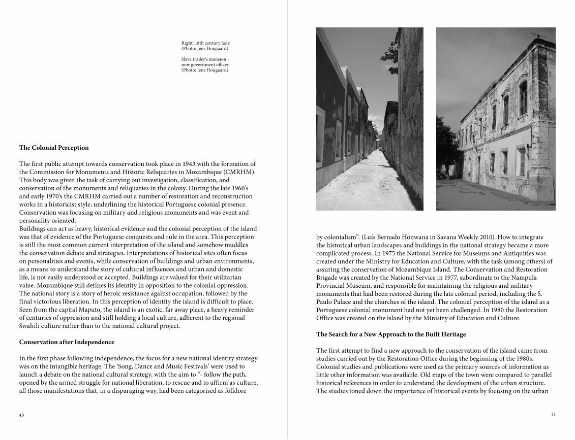
by colonialism”. (Luís Bernado Honwana in Savana Weekly 2010). How to integrate the historical urban landscapes and buildings in the national strategy became a more complicated process. In 1975 the National Service for Museums and Antiquities was created under the Ministry for Education and Culture, with the task (among others) of assuring the conservation of Mozambique Island. The Conservation and Restoration Brigade was created by the National Service in 1977, subordinate to the Nampula Provincial Museum, and responsible for maintaining the religious and military monuments that had been restored during the late colonial period, including the S. Paulo Palace and the churches of the island. The colonial perception of the island as a Portuguese colonial monument had not yet been challenged. In 1980 the Restoration Office was created on the island by the Ministry of Education and Culture.
The Search for a New Approach to the Built Heritage
The first attempt to find a new approach to the conservation of the island came from studies carried out by the Restoration Office during the beginning of the 1980s. Colonial studies and publications were used as the primary sources of information as little other information was available. Old maps of the town were compared to parallel historical references in order to understand the development of the urban structure. The studies toned down the importance of historical events by focusing on the urban
The Colonial Perception
The first public attempt towards conservation took place in 1943 with the formation of the Commission for Monuments and Historic Reliquaries in Mozambique (CMRHM). This body was given the task of carrying out investigation, classification, and conservation of the monuments and reliquaries in the colony. During the late 1960’s and early 1970’s the CMRHM carried out a number of restoration and reconstruction works in a historicist style, underlining the historical Portuguese colonial presence. Conservation was focusing on military and religious monuments and was event and personality oriented. Buildings can act as heavy, historical evidence and the colonial perception of the island was that of evidence of the Portuguese conquests and rule in the area. This perception is still the most common current interpretation of the island and somehow muddles the conservation debate and strategies. Interpretations of historical sites often focus on personalities and events, while conservation of buildings and urban environments, as a means to understand the story of cultural influences and urban and domestic life, is not easily understood or accepted. Buildings are valued for their utilitarian value. Mozambique still defines its identity in opposition to the colonial oppression. The national story is a story of heroic resistance against occupation, followed by the final victorious liberation. In this perception of identity the island is difficult to place. Seen from the capital Maputo, the island is an exotic, far away place, a heavy reminder of centuries of oppression and still holding a local culture, adherent to the regional Swahili culture rather than to the national cultural project.
Conservation after Independence
In the first phase following independence, the focus for a new national identity strategy was on the intangible heritage. The ‘Song, Dance and Music Festivals’ were used to launch a debate on the national cultural strategy, with the aim to “- follow the path, opened by the armed struggle for national liberation, to rescue and to affirm as culture, all those manifestations that, in a disparaging way, had been categorised as folklore
Right: 18th century lane (Photo: Jens Hougaard)
Slave trader‘s mansion -now government offices(Photo: Jens Hougaard)

42 43
increasing degradation of the Island. Two government decrees, approved in 2006, contributed specific statutes to Mozambique Island and created the Mozambique Island Conservation Office (GACIM). The Action Plan’s objectives stress concerns about the local economic and social development as well as the necessity of a general Master Plan. The plan suggests coordination of donor funding, development of cultural tourism, and capacity building of the Conservation Office staff. The following was achieved:• The Conservation Office (GACIM) was made operational by 2007;• The Master Plan was drawn up by May 2009 under the title: Integrated
Development Plan for Mozambique Island;• The Management Plan was draw up by the Ministry of Education and Culture, with
support from UNESCO by October 2010.
Left: National Hero’s Day celebration in front of the old Hospital(Photo: Jens Hougaard)
View over the native quarters in the old quarries(Photo: Jens Hougaard)
Right: Townscape Analysis(Source: Minnesota University, US, July 2011)
structure, building typology, and the conservation and sanitation problems. The research was compiled into a report which provided the foundation for the islands’ candidature for the World Heritage List in 1990. Following the completion of the report in 1985, works to conserve the island came to a stop due to warfare in the region. During the years to follow, the island suffered from continuous degradation and the influx of internal refugees from the mainland. While the ‘Stone Town’ was an almost petrified urban structure, left abandoned by independence, the ‘Macuti Town’ continued as a dynamic urban structure. The ‘Macuti Town’ had severe sanitation problems but also displayed historical evidence in its overall physical structure, living culture, and building tradition.The major challenge for the urban development of the island was, and still is, how to combine the two parts of the town in a harmonious and sustainable way, maintaining their valuable historical evidence within a new development context while not obstructing the improvement of the populations living conditions.After the signing of the Rome General Peace Accords in 1992, Mozambique was fully occupied by the economic and social reconstruction of the country, leaving little space for concerns about historical conservation. Nationalised real estate was alienated for a low prize to the occupants, which meant that major buildings and ruins on the island were sold out in fragments to occupants with no financial capacity to rehabilitate the property. Property speculation started.In 1997 a UNESCO consultancy presented A programme for Sustainable Human Development and Integral Conservation, a document which included a catalogue of projects and activities to be carried out as part of the historical conservation on the island. Several other UNESCO reports were drawing attention to the on-going degradation and in 2006 an Action Plan was finally agreed upon between UNESCO and the Mozambican Government.
The ‘Action Plan’
The Action Plan for the Management and Development of the Mozambique Island World Heritage Site was drawn up in order to take urgent measures against the
44 45
Both the Integrated Development Plan and the Management Plan are based on the assumptions that:
• Necessary legal framework is operational;• Common donor funding and coordination can be achieved;• Management of the World Heritage Site can be assured by the Ministry of Culture
together with local authorities, namely:• The District Government (GCIM);• The Municipal Council (CMCIM);• The Conservation Office (GACIM).
In reality these assumptions can be questioned and the Government has not yet approved the Integrated Development Plan.
The Ministry of Culture Strategic Plan
The Ministry of Culture is currently developing a new Strategic Plan for Culture (PEC). In this process an evaluation of the PEC 2006-2010/11 was carried out. In the evaluation it is put forward that the organic structure of the former Ministry of Education and Culture (MEC) was not compatible to the topics indicated in the PEC. It also states that the MEC never succeeded in making culture a crosscutting issue in the main strategic documents in the country.The problem is not new: “The doubt, that came to our minds thirty years ago, whether it was appropriate that such a vast compound of fundamental problems should be trusted to a single government sector can maybe be answered by saying that the cultural questions are effectual national structuring elements, and deserve, as such, the common and permanent attention of the State and the society” (Luís Bernado Honwana, ibid.). While the responsibility for the conservation of the island is in the hands of the Ministry of Culture, the tools for action are in the hands of other line ministries, including the ministries for State Administration, Planning, Finance, Justice, Public Works and Tourism, making it difficult for the Ministry of Culture to
The Integrated Development Plan
The integrated development Plan operates with six areas of intervention:
• Population and living conditions;• Employment and human resources;• Organisation of space and urban tissue;• Patrimony;• Economic and social infrastructure;• Economic development, divided into two clusters:
• Agro-industrial cluster;• Cluster of tourism.
The plan presents a catalogue of 25 programs including 112 budgeted projects to be financed by government budget, common donor funds, individual donor funding, and public-private investment programs.
The Management Plan
The Management Plan operates with nine key issues to be addressed within a five-year calendar:
• Legal framework;• Institutional framework;• Human resources for conservation;• Coordination between institutions;• Urban planning;• Property and use of built heritage;• Preservation and construction techniques;• Promotion/marketing, valorisation and education;• Tourism and cultural development.
Wedding celebration– Tufo dancers (Photo: Jens Hougaard)

46 47
How to move forward
The conservation of Mozambique Island as a national and international monument must be based on the desire to preserve its historical evidence. The understanding of the country’s long history is important for a balanced, modern development.
• The conservation of the historical urban landscape and architecture must be a crosscutting issue in any development plan for the island.
• The management of the heritage cannot be left to local authorities without capacity building in terms of skilled human resources and technical assistance.
• Inter-ministerial coordination and coordination between national plans and local management practise must be strengthened through the creation of steering committees as indicated in the Management Plan.
• Coordination between different UNESCO and donor initiatives needs to be improved.
impose cultural concerns as crosscutting issues in any development strategy. Crucial issues have shown to be major obstacles in the implementation of development projects and urban management, but they are beyond the capacity of the Ministry of Culture and the local authorities to deal with. These issues include:
• The continuous fragmentation of major historic buildings into smaller private owned properties through alienation of state property;
• The lack of urban detailed planning;• The lack of clear delimitation of public and private space in the municipal cadastral
register.
The development of the island is now characterised by many competing trends, represented by different public strategies and individual investor’s ideas, with the Ministry of Culture’s Conservation Office as one voice amongst many. Most development programmes for the island find their main justification in a strategy of so called ‘cultural tourism’, while conservation of the unique historical town as important documentation is in the defensive. Projects presented by private investors for adapting traditional houses and shops to new functions often change the typology and morphology of the building completely, depriving the building of its historical value and disturbing the urban homogeneity. Buildings in the ‘Stone Town’ are being transformed into holiday homes, leaving the houses empty for long periods. In the ‘Macuti Town’ both slumming and gentrification are taking place depending on the localisation. If not controlled the present ad hoc development may end up as a caricature of the colonial situation, with the historical ‘Stone Town’ transformed into a luxury holiday resort and the ‘Macuti Town’ given the role of an exotic local labour reserve.
Noah’s Ark – Old Muslim print (Photo: Jens Hougaard)

48 49
The plan of the macuti house shows how it is a type of Swahili architecture, relating it to a culture of house building along the East African coast, towards the north and including Arab influences, linking the house to a history of over a thousand years of long distance trade in the western Indian Ocean (Carrilho, 2004; Bruschi et al, 2005). This house type is currently disappearing from Ilha, due to modernisation, changing markets for building materials, and the gaining popularity of other house types. The macuti houses are also falling apart due to poverty and the inability of owners to maintain their houses, trying to salvage parts of the house while letting the rest collapse, or constructing huts of whatever material possible in the ruins of a once spacious and solidly built macuti house. Many are instead selling their plots, starting again and constructing a house on the mainland where land is cheaper.
The Macuti House
The macuti house is given its name by the generous coconut palm leaf roof cover. Macuti refers to the palm fronds tied to a stick, forming a ‘roofing tile’. This tile is then tied to a skeleton of mangrove wood and bamboo creating a cover which, if good quality and having matured properly, may stay watertight for up to six to eight years. Other plant materials may also be used but in the region of Ilha, none of the alternatives have the same durability as the macuti.3 The plan of the macuti house in Ilha generally has four bedrooms and a central living room, divided into front and back sections. The front room, facing the street, is the ‘men’s living room’, the back room, facing the little courtyard, used for cooking and washing, is the ‘women’s living room’. Previously, two of the bedrooms may have been joined to form the ‘suite’ of the head of the household, to which a private bathroom was also attached. Today however, pressure for space often results in one small family living in each room. The houses are generally aligned along more or less straight streets, with the façade facing the street and ornamented with carved and painted windows. The houses are plastered and may be painted with borders in contrasting colours along the corners and windows. Many of the houses on Ilha have additional plasterwork around the windows and corners as well, reflecting the estílo Português seen in the stone and lime town. Other houses
The macuti house(Photos: Silje Erøy Sollien)
ApprOAChINGThE MACuTI hOuSEIDENTITY AND HERITAGE CONSERvATION IN ILHA DE MOÇAMBIQUE1
Silje Erøy Sollien
The macuti house has been described in tourist brochures and conservation reports as the ‘traditional local architecture’ of the southern part of Ilha de Moçambique, in contrast to the colonial Portuguese town on the northern end2 (GACIM, 2010). However, a significant proportion of the remaining macuti houses have façades resembling houses from southern Portugal, have Indian decorative elements and are, in many instances, built with concrete walls or in a mixture of mangrove construction and stone and lime walls.

50 51
Left: Replacing part of a macuti roof on guesthouse run by an Italian architect in Ilha.(Photo: Silje Erøy Sollien)
Since at least the 1950s, there has been a move to both transform old houses to and build new houses with a one-slope fibre-cement or corrugated iron roof and a heightened façade6. This house type was dominant until well into the 1980s, at times these were also given a covered veranda, providing more privacy than the open bench. Since the 1990s, the ‘windmill house’ or ‘three slope house’, has become ubiquitous in both Ilha and cities all over Mozambique (Lage, 2004; Sollien et al, forthcoming). This house type has a different roof slope for each room and thus is appropriate for a culture where it is common to build a room at a time, covering it before continuing to the next room. In Ilha this approach is modified to fit the existing macuti house plan so that parts of the original house may be kept while transforming the roof. Today this is considered ‘the way we build now’, ‘modern’, or ‘development’, and is generally seen as the only solution when wanting to substitute the plant material roof for corrugated iron sheets7.
The Macuti Town
Since 1991, when the Ilha de Moçambique acquired the status of UNESCO World Heritage Site, there have been calls for the conservation of macuti houses in addition to the monumental and military architecture of the island8. The macuti town is seen as having heritage value as an urban conjunct, with a house type and material use continuously repeated (GACIM, 2010:34). During the later decades of the colonial period there was a policy of prescribing palhotas (straw huts) for the ‘indigenous’ population and prohibiting people from changing their roofs to more permanent materials such as corrugated iron or fibre-cement sheets. This is a memory people still have and thus ascribe the macuti house to a memory of colonial oppression and strict urban control9. However, the rule of keeping the macuti roofs in the 1960s and ‘70s was motivated by heritage conservation and the status of ‘indigenous’ was officially abolished in 1961. There were efforts from the 1960s onwards to make Ilha into a historical tourist city, partly bringing the architecture of the city back to the glory year of 1800, when slaves and ivory was in high demand, Ilha was at the heights of its powers and the most prosperous trading settlement on the East African coast (Loureiro, 2005; Newitt,
may have two small windows with wooden bars and no special plasterwork around the windows. Houses may be built on a raised platform or add a form of bench or small veranda in front of the house4. This bench forms more part of the streetscape than the house, inviting passers-by to sit down and is often a space used to play board games, women braiding hair, general socialising or just a place to watch the world go by. Many of the houses have electrical installations, some still from before independence, often with the remains of plastered ceilings and no longer functional installations for running water. The Aarhus report calls the house a ‘semi-urban’ typology (Aarhus, 1985) and this mix of architectural features is seen specifically in what were the areas for the urban working classes, or the ‘native quarters’ within the colonial city of Ilha de Moçambique. There are many different variations of construction practices within the macuti category, ranging from precarious stick huts, without plaster and windows, to solidly houses built of stones, lime, and sand mixture, but with mangrove poles (siki and laca laca) sewn together to form an internal wall, around which stones and lime mortar are placed. From the 1950s, when the cement factory opened in Beira, houses in the macuti area were increasingly rebuilt using cement blocks and cement plaster (Newitt, 1995). By the 1990s, the method of building durable houses with laca laca, stones and lime based mortar mixed with plant extracts called murrapa for waterproofing, seems to have disappeared completely. In 1983 more than 50% of the houses in the macuti areas already had walls constructed with cement (Aarhus, 1985:166). Today few houses do not have at least parts of the house in cement block construction or covered with cement mortar5. The façades of the grandest old macuti houses are often still in pau a pique (sticks with mortar) while the side and internal walls have been rebuilt.

52 53
and 1960s (Sollien, 2012). In a study on the state of conservation in the macuti town in Ilha, focusing on slum upgrading being the priority, rather than heritage conservation, Forjaz Arquitectos states conclusively that what first and foremost must be agreed upon,
“before any elaboration on an abstract concept of ‘patrimony’ [heritage] can be discussed; the so called ‘Macuti’ town is a slum” (Forjaz, 2010:56).
The question which arises here is then whether these two issues really are mutually exclusive and if not a form of heritage conservation with integrated infrastructure improvements was possible, presuming that there is a special local identity to preserve, which is expressed in the architecture.
Heritage, Tourism, and Identity in the Macuti Town
When listing Ilha de Moçambique, with its urban structures and fortifications, as a World Heritage Site in 1991, ICOMOS writes that is,
“an outstanding example of an architecture in which local traditions, Portuguese influences and, to a somewhat lesser extent, Indian and Arab influences are all interwoven”
It is also bears,“important witness to the establishment and development of the Portuguese maritime routes between Western Europe and the Indian sub-continent” (ICOMOS, 1991).
Attempts have been made to balance this quite Europe-centred view of Ilha de Moçambique through a
“retrospective Inventory of Outstanding Universal Value for Mozambique Island” as part of the management plan for the island11 (GACIM, 2010). This new statement has added to the first criterion: “The typology of the traditional architecture of the Macuti demonstrates the coexistence of two different architectural styles along time and space”,
while the second criterion has been rewritten to state that, “The community of Ilha de Moçambique is intimately associated with the history of
Left: Macuti house styles in Ilha. Similar houses can be identified on old postcards from 1906(Photos: Loureiro, 2005)
Right: Map showing the divided city Ilha de Moçambique(Source: Aarhus, 1985)
1995:179). If wanting to be historically correct, this would have meant demolishing the whole macuti town since this was only built in the second half of the 19th century10. Instead an unbroken macuti roofscape of ‘timeless’ traditional African architecture may have been seen as an appropriatly picturesque contrast to the historical Portuguese town and such a policy adopted. At the end of the 19th century there were however, many macuti houses within the Portuguese town as well, these were partly demolished in the mid-19th century and finally, in 1894, prohibited within the city limits. Since 1878, macuti roofs (palhotas) were only permitted in the area south of the hospital, what came to be knows first as ‘suburbs’, then bairro indigena, and later ‘the macuti town’ or Ponta da Ilha. These were areas where freed slaves and immigrants from the mainland could settle, partly in the old stone quarries, the materials from which were used to build the other parts of the city. Citizens of mixed, Portuguese, and Asian descent settled and built houses in the new areas where land was made available. When the Portuguese began their territorial occupation of Mozambique in the 19th century, Ilha was the capital city. The location of the capital moved, with the economy, southwards to cater for mining activity in South Africa. By 1950, the district capital had moved to Nampula and the regional harbour to Nacala, and with this shift many of the businesses operating out of Ilha de Moçambique also relocated. At independence in 1975 there was an exodus from the colonial town, leaving it to fall to ruin. Civil war raged from the mid-1980s, and a wave of war refugees and immigrants moved to Ilha, doubling the population from 7,760 in 1980 to 14,889 in 1997. They settled mainly in the macuti bairros, making these some of the densest settlements in Mozambique (CDS, 2009). The macuti town has extremely insufficient water and sanitation provisions and large parts of the bairros experience serious flooding problems during parts of the year. The view of the macuti town thus shifts away from a romantic image of ‘traditional’ or ‘vernacular’ architecture described as ‘labyrinthine’ but ‘picturesque’ (Lobato et al, 1966). From the early years of the settlement in Ponta da Ilha the authorities saw it both as a place dangerous to urban hygiene while at the same time they were fascinated by the local culture. The view of the romantic timeless vernacular architecture became more prominent with the development of the town into a heritage site in the 1950s

54 55
As has been referred to earlier, the population of Ilha is generally very poor and without the means to maintain the, by now expensive, large macuti houses. Macuti is not as readily available as before, partly due to demand from the tourism industry to built beach resorts with ‘exotic traditional architecture’ but also due to palm trees in the region being attacked by illnesses. The prices of macuti have gone up while low quality zinc sheets have become a cheap roofing option. The zinc sheets also have the additional benefit that they do not have to be replaced for many years. The desire to protect one’s house against the rain is a higher priority to people than what could be termed an academic discussion on identity, heritage, and roof shapes. This is the most important point to remember when suggesting any conservation policy, including macuti houses.
The fact that many people living in Ilha have not lived on the island for more than one or two generations means the value of the houses as heritage is less than if they were built by their family and thus representing a belonging to the land and to the place. Macuti houses are considered ‘backwards’ by people who have the means to build new houses and seen as not allowing for the same modern comforts as the conventional houses seen in Maputo and Nampula, has been stated in other reports (Nguirai, 2008; Forjaz, 2010). This perception is certainly prevalent and since a new macuti house has not been built for many years, there are no new shining examples of the type, except in tourist beach resorts already mentioned17. However, when some of the existing macuti houses were new they had water closets, piped water, and nicely plastered ceilings, plus a much cooler indoor climate than any zinc sheet cement blockhouse would provide. It appears as though there is a very strong sense that the three slope roof ‘is how you do things nowadays’, and that it is the cheapest and safest option. Thus macuti houses are constantly being torn down or left to collapse, making the particular Ilha style macuti houses increasingly rare. This situation will continue until the value of this type of house for heritage tourism, and thus local income, may be understood and acted upon.
Left: „One slope roof“ house and „three slope house“ transformed from macuti houses(Photos: Silje Erøy Sollien)
navigation on the Indian Ocean. (....) The wealth of intangible heritage, also related to the tangible aspects of Ilha, reflect the interactions between different people, since time immemorial.” (GACIM, 2010:45, my translation)
‘The community’, and the houses of ‘the community’, i.e. the architecture in the macuti area, have been added specifically, instead of looking more closely and finding that the houses of the macuti certainly fulfils the original statement (although more emphasis in this case could be put on the Arab influences through the Swahili culture of the Indian Ocean western coast)12. House construction in both the stone and lime town and macuti town has influenced each other (showing a cultural continuum) while at the same time there is a clear urban dichotomy between the two (GACIM, 2010:44). The history of colonial spatial oppression and slavery is difficult to reconcile with concurrent history of fruitful cultural exchange.Scholars of history currently explain Ilha de Moçambique as part of an Indian Ocean culture, as is stated in the new OUV statement. Thus history connects back to a time before the Portuguese arrived in Ilha. The fact that the majority of the population in Ilha today probably settled after 1980, in an urban working class settlement from the 19th century, largely built on cultural practices which came with Muslim missionaries from the Comores and Zanzibar around 1900, doesn’t necessarily have to contradict this assertion13. When the Portuguese arrived in Ilha, there was a Muslim settlement which remained on the island up until at least the end of the 16th century14 (Newitt, 1995:185). The local leaders had moved to Sancul, on the mainland, but the culture reaching back to ‘time immemorial’ - which in this case must be interpreted as ‘time before the Portuguese arrived’ - survived, changed and adapted, and it is the continuation of the culture seen today in Ilha de Moçambique. When the new Muslim orders came around 1900, some of the positions as religions leaders in the new orders, were taken up by xhehes1 from the old families in Sanculo (Bonate, 2007:140). When asked today about important historical houses or the urban heritage of the neighbourhoods, it is the houses of the great xhehes, the old dance groups and football clubs, plus artisans, shops, and urban infrastructure, such as the staircases, which are most frequently mentioned16.

56 57
1. This paper is based on preliminary findings from the initial phase of a PhD project carried out in collaboration between the Royal Academy School of Architecture in Copenhagen, Eduardo Mondlane University, Maputo, and Gabinete de Conservação da Ilha de Moçambique. The project runs 2011-13 and is funded by the Danish Ministry of Science, Council for Independent Research in the Humanities.2. Ilha de Moçambique is a urban UNESCO World Heritage Site in northern Mozambique, province of Nampula. The small historical island city measures roughly 3 by 0,6 km and had 13.350 inhabitants in 2007. Today urban expansion is taking place on the mainland opposite the island. See conference paper by Jens Hougaard for more on the background and history of Ilha de Moçambique.3. The macarasse leaf is widely used in Ilha, nahele is a good alternative but difficult to find, pelehi end other straw thatching generally used further inland is of much less durability.4. There is also an example of a veranda in the Indian style found in Diù in Gujarat, but this is a rare example of an element which was very important in Ibo island further north (Carrilho, 2004). A few of the benches have stylistic features like the baraaza of Zanzibar.5. Forjaz operates with slightly different categories, but generally estimates that mangrove pole construction counts about one quarter of the houses in the macuti bairros (Forjaz, 2010). Today cement is used to plaster these houses as well, also on the mainland.6. This house type is called típo uma àgua, or ‘one slope house’. The house types are generally characterised by the roof form. The macuti roof also being characterised as quatro àgua, or ‘four slopes’.7. Ca 30% of houses in the macuti town still has plant material roofs, ca 30% less than in 1983 (Aarhus, 1985: 166).8. Ilha de Moçambique is the site of some of the most important historical architecture of European origin in Africa, like the Fortaleza São Sebastião and the manueline church Nossa Senhora da Baluarte from 16th century.9. The Portuguese colonial administration of the Estado Novo under Salazar had an elaborate system of classifying its citizens with different rights and entitlements. The indigena, or African inhabitant of the colony could from the late 1930s, acquire a status of assimilado through adopting European culture and practices, speaking proper Portuguese and having an income. These African cold then be considered ‘civilised’ and ‘3rd class citizen’ with more right with relation to property ownership and getting through the labyrinthine bureaucratic process towards permission to build with permanent materials (See e.g. Cabaço, 2010). At the same time the strict urban control is missed when contrasted with current urban chaos and encroachment on public space without the municipal authorities doing anything about it10. This has also been suggested as a national policy after independence, since parts of the macuti bairros may be considered not suitable for habitation due to the constant flooding. A more moderate policy of ‘decongestion’ is the current official policy.11. The statement has not (yet) been accepted by UNESCO.12. Catherine Viderovitch describes seven characteristics of Swahili Cities in East Africa, one of them being macuti houses (Quoted by Pereira, 2011). The Swahili land owners and shaikhs have often differentiated themselves from the Arabs they were trading with through claiming a Shirazi, ie Persian descent. (See Bonate, 2003 for further references).13. The Muslim brotherhoods which form the basis of social organisation in Ilha came from the Comoro Islands and Zanzibar in 1896 and 1905 respectively.14. Description by Francisco Barreto‘s journey in the 1570s.15. Religious leader and man knowledgeable of history.16. I have currently initiated work on mapping the heritage of some of the neighbourhoods with groups organised through the women‘s organisations, the local secretary and other community members.17. In a tourism context, the quality of the construction with natural materials is of a price and quality generally far beyond the reach of the owners of houses in the macuti bairros.
Conclusion
As has been shown earlier in this paper, the macuti house is found along the East African coast and is a mixture of Swahili mangrove construction and house layout, stone construction learnt originally from Arabs, and decorative elements learnt from the Portuguese and Indian artisans. Thus the house could represent the mix of cultures in Ilha, rooted in the Swahili culture, in an exemplary way. I believe this discussion is not only an academic debate, as the report of Forjaz may suggest, but a way to engage the majority of the population of Ilha to be concerned about the island’s future as tourist destination and heritage site. The rich are investing in colonial houses in Ilha and rehabilitating them as a hobby. This development is done primarily by Mozambicans from the capital, retired Europeans, European architects, hotel owners and tourism operators. These are groups which are already well established and expanding on the island. Despite a conservation office being established in 2007, the government is not making the conservation of Ilha a priority, generally not playing a very active role in conserving the heritage of the island, but is hoping for increased tourism investments. Cultivating an identity that incorporates the macuti house and the culture it is rooted in may be a strategy for strengthening a community which is not a united entity, a community that is split by politics, memories of the war and disruption in the region. Identity is something that is claimed, created, and recreated continuously, and the setting on Ilha is one in which tourist demands and poverty may be decisive factors in determining which identity or identities are adopted and projected through the housing of the community.
Right: Macuti house in a transformation process which currently has come to a halt; an old macuti house owner trying to keep his house together with whatever means he can find.(Photos: Silje Erøy Sollien)

58 59
Left: An aerial view of Dar es Salaam central business area(Photo: Camilus Lekule)
Aerial view of an informal urban area(Photo: Camilus Lekule)
The current built environment of Dar es Salaam City can be attributed to four main administrative periods: the Arab Period (1860-1890), the German Period (1890-1914), the British Period (1914-1960), and the Post-Independent Period (1960-present). The first two periods may be combined and termed as the ‘first generation’ of the city’s growth. Only a few of the Arab buildings remain in comparison to their German counterparts, profoundly forming the majority of historical buildings in Dar es Salaam1. The later development, the ‘second generation’ of the city’s growth, involved the period of British administration (1920-1960). This urban development is exhibited in the urban functions and fabric of the city. The British embraced and developed the racially segregating patterns for residential and commercial zones previously set out by the Germans. The British colonial administrators chose to occupy the German buildings with minimum additions to the built up environment. The Asian merchants settled in the northwest part of the harbour, today known as the Western District of Dar es Salaam City Centre. They developed tenement buildings that contained commercial activities, with shop fronts, on the ground floor and residential activities on the upper floor. A majority of buildings exhibit Asian architectural motifs and ornamentation, with a few displaying coastal architecture. This set the present urban environment that dominates Dar es Salaam City Centre2. Samora Avenue was developed into a major urban space, which today continues to change, losing its dominance as the main commercial street. Lastly, the ‘third generation’ of the city’s growth, from 1960 onwards, is dominated by post-independence and free market economy periods. In the 1950s and 1960s there was a radical departure from the older styles towards adopting international contemporary styles employed in commercial, office, and institutional buildings. In the second half of the 1960s, through to the 1970s, the established urban fabric experienced a massive intrusion of high-rise buildings in response to satisfying the growing demand for office space.
The Many Cities of Dar es Salaam
The city of Dar es Salaam is undergoing rapid changes and many of which are not revealing of its past, although the citys history can still be seen in streets, windows, and doors. Observing contemporary Dar es Salaam, the recently constructed
MAkING CITIESFOr ThE pEOpLEIN vIEW OF RE-INvENTING DAR ES SALAAM
Dr. Camilus Lekule
This paper has been written in the light of the changing demands of the city of Dar es Salaam and in context of the new ‘Master Plan’ currently being developed. The central understanding behind the new ‘Master Plan’ is that the needs of the inhabitants should be at core of the city’s plan while also cherishing its history and continued development, a result of which has led to a variety of physical contexts. Many unique spaces have developed within the present Dar es Salaam city and therefore the Master Plan is devoted in vision towards the “sense of place” with the aim of addressing the future of the city as a place where its people can live, work, and enjoy life in all aspects – at global and at local level.

60 61
Left: High rise buildings within informal urban area.(Photo: Camilus Lekule)
Right: View of the city centre,Bibi-Titi-Mohammed Road(Photo: Camilus Lekule)
The ‘home’ spirit of the settlement becomes the driving force behind individual responsibility and community functions for example public meetings, funeral arrangements, the initiation of girls. It is in this way that residents identify themselves through the modes of place experiences, varying with individuals and groups but maintaining a common understanding. This image of the settlement is the product of experiences, attitudes, memories, and immediate sensations. These conceptions of the settlement transcend all levels of a city, the house becomes the city or the universe where man dwells. Heidegger reminds us that “poetically man dwells” and man has before his eyes the basic character of human existence4. Residents’ conceptions of an informal settlement is that we dwell in the city where we work and live our everyday lives. The ‘city’ connotation of the settlement can be interpreted on several layers, the urban space of the informal settlement is also a modern urban phenomenon5. It is through this concept of the city that it is possible to see a variety of other ‘cities’ within Dar es Salaam. The most prominent of these is the Central Business District, which can serve as an example of understanding the many cities of Dar es Salaam.
Understanding Dar’s City Centre – The Central Business District (CBD)
Dar es Salaam City Centre is located within Ilala District; one of three administrative districts that construct Dar es Salaam City Region. It is also the Central Business District (CBD) and covers a total area of 326 hectares, stretching from the Indian Ocean and the harbour in the East and South, Mnazi Mmoja Gardens to the West, onto the Gymkhana grounds, and Bibi Titi Mohammed Road in the North. With an average population growth rate of 4.6, it has a low night time population that explodes to a very high daytime population. This indicates unusual behaviour in the population of Dar es Salaam; on working days there is an inflow of people from other districts to the city centre during the morning and an outflow in the evening hours. Thus Ilala District is overwhelmed with business people and visitors during daytime working hours and is virtually empty at night and over the weekends.The city centre is being devoured by the need to satisfy a growing demand for commercial, office, and residential spaces, resulting in the demolition of old and
buildings appear to be of global nature and could be erected anywhere, this style greatly departs from the city’s past and localised construction. Thus it can be said that globalisation has settled in Dar es Salaam as in many other African cities such as Nairobi, Johannesburg, Harare, etc. Globalisation has changed the reality of urban life, increasingly leading to people depending on standardised processes and products. Can it be said that we are moving towards standardised high-rise buildings in Dar es Salaam?Through the activities of everyday life, there are multiple processes enacted which shape the city, in specific ways - be it economic, cultural, or political. There is a remarkable coexistence of globalised contemporary development and specific local traditionality. Informal development within Dar es Salaam gives the city unique characteristics. Informal settlements accommodate about eighty per cent of the urban population and provide challenges that need to be tackled. At the same time the process of gentrification appears to be taking place at great speed. How are these changes being regulated is a central question that needs to be addressed.The duality of the city in the stressfield of globalised development and a dynamic informal sector may be used to re-create Dar es Salaam as a place of special identity. This may be done through a critical understanding and analysis that needs to be taken together, juxtaposed with the symbolic value and individual spirit of specific places and the overall space of the city. This must include the identity of public spaces and its cultural assets. It should be noted that being a resident of Dar es Salaam does not mean one knows all of the city. Rather, the city can be comprehended in several ways. There is what can be termed the cognitive city, the structured city, and the detailed city. The cognitive city is composed of all the areas referred by the city residents – Mjini or city centre, Kariakoo, Kanzese, Kinondono, Kimara, Msasani, Mikocheni, Tandika, Ilala, Mbagala. The city starts at home and evolves to the settlement, this is why residents call home “Mji wangu”, ‘my city’. Previous research on informal settlements in Dar es Salaam has shown that residents conceptualise their settlement as a “home and city”3. In other words, the settlement is understood as a dwelling for the family, while at the same time also a borough or town. As a home, the settlement amalgamates individuals, families, and the community.

62 63
Right: View of the city centre, Mnazi Mmoja Gardens(Photo: Camilus Lekule)
Left: Tenement Buildings, India Street(Photo: Camilus Lekule)
plots facing Azikiwe Street are assigned not to be less than ten storeys. Interpretation of the guidelines can be as follows, if a plot measures 20x30, then the following interpretation can be put forward under two scenarios:First Scenario; working with plot ratio of 2 and plot coverage of 60%. Second scenario; working with height limit of 8 storeys.
Scenario Plot dimensions Total built up area Plot coverage 60% No. of storeys Remarks
1. 20x30 m /600 m2
1200 m2(plot ratio=2)
360 Sq. Meters 3.3 storeys 7 – 8 storeys cannot be achieved
2. 20x30 m / 600m2
2880 m2(plot ratio=4.8)
360 Sq. Meters 8 storeys The plot ration has changed to 4.8
This first scenario means the conditions cannot be achieved or can result in haphazard development directions. The second scenario means more un-postulated functional areas, increased population, an increase and overstretching of services, leading to unplanned parking and traffic congestion. A third scenario, using the statement that buildings should have no less than ten storeys, would mean construction may go up as high as the developer can afford. In this case, the plot ratio and plot coverage become ineffective, resulting in thin tall buildings. The three scenarios are seen as elements of not making a city for the people, opportunities should be met appropriately and adequately, and not be overdone or result in stressing resources.In conclusion, the ambiguity of development guidelines, failing to provide details at block and street levels, is responsible for the irregularities in the urban fabric; the control is based on the number of storeys, disregarding the storey-to-storey heights of individual developments. Developers are required to consider this but when the total built up area is calculated against the plot area the plot ratio is actually higher than intended and plot coverage over-shot; development controls do not take into consideration the size of the plot. This often results in rather tall and thin looking buildings with the proportions of building heights to the width of the street now out of scale. These tall structures have shrunk the previously adequately sized streets to narrow and dark alleys, diverting from their original image.
structurally inadequate buildings for new and contemporary ones, with the added advantage of being able to expand vertically. The high-rise buildings are in absolute contrast to the surrounding buildings, placing a strain on efforts to maintain the original character of Dar es Salaam CBD. The city centre is dynamic and efforts to blend the old and new should be made to retain its character for the purposes of enriching the cultural heritage and local identity.
Massing analysisWe take a look at one of the districts in CBD – the Western District. Its boundaries are Bibi Titi Mohammed Road, Nkurumah Street, India Street, and Upanga Rd. Typically Asian in architectural style, it experiences gradual modification with new constructions being erected. Previously comprised mainly of Indian tenement buildings that were between two- and four-storeys high, today it faces pressure to allow for the construction of high-rise buildings seen throughout the whole city. This creates conflict between the existing urban fabric and street character while also overloading the existing services and infrastructure. The development control guidelines for this area are; plot ratio -2.0, plot coverage- 60-70% and building heights-7-10 storeys6. The development guidelines for special areas such as Ali Hassan Mwinyi Road and Bibi Titi Mohammed Road for enabling the creation of entry gates are also quite vague. The

64 65
and structure population, resulting in densification and congestion. The existing infrastructure and services are labouring under this load and failing at some points.
SportsDar es Salaam City Centre is facilitated with three gardens of varying sizes: Samora Gardens; Memorial Gardens; and the Botanical Gardens. Samora Gardens and the Botanical Gardens are open to the public. There are also private clubs, including the Gymkhana Club, which allow their sports facilities to be used by schools and interested individuals. It would be in the city’s interest for the master plan to identify and open up more recreational spaces, particularly in congested areas.
Cultural heritage, tourism, and hospitalityThe architectural heritage of Dar es Salaam CBD is a fusion of five cultures: two Asian(Arabic and Indian), two European(German and British), and the indigenous Swahili, people along the coastline. The new contemporary culture, developed through globalisation, is threatening to destroy these architectural attributes. One such building is the Court of Appeals House, facing the waterfront; there are plans for it to be demolished and the space used by Hyatt International Hotels for presidential suites. Those who are the so-called guardians of the CBD are constantly flaunting any existing conservation policies. The waterfront, though neglected through mismanagement, is a potential tourist attraction. The landmarks are memorials of a colourful history and continue to guide people through the city centre. It is critical that these landmarks, which add to the identity and meaning of Dar es Salaam, be protected.Several of Tanzania’s tourist oriented hotels are located within the CBD. Serviced with all amenities expected by international tourists and business travellers, the CBD also boasts an assortment of travel agencies, both for local and international travellers, air travel companies and safari touring trips. Apart from being employed in these locations, most local people cannot afford to patronise any of these hotels due to prohibitive prices and therefore the local built flavour is minimum.
Right: Discarded tyres used as as street furniture(Photo: Camilus Lekule)
A garbage bin with a prohibitive barbed wire spikes dituring people from sitting on it(Photo: Camilus Lekule)
Social servicesFaced with a high population, the CBD has a high demand and supply (though insufficient) of social services including health, education, eating places, recreation, and sports centres, youth and community opportunities. The main question being, what is the relationship between the population of Dar es Salaam and the provision of social services? On health services, it is noted that there are very few hospitals, health centres/clinics, and dispensaries operating in the CBD. If someone gets sick along Samora Avenue, where does one go for early treatment? The CBD is also home to some schools of higher learning, especially business and finance related fields. The commuting for education adds to the day’s population and the vehicular congestion. Nonetheless, there are very few reading and learning places and libraries and bookshops are limited thus denying the day population opportunities to educate themselves.
Eating placesThere are several types of eating places located within the CBD ranging from themed restaurants to fast food restaurants. There are also casual eating places accessible to the middle-income earners. The lower-income earner is not catered for but rather left to roadside catering from food vendors who prepare food on the street and often bring it to particular locations (Mama Ntilia). Some of these food vendors are formally recognised by the authorities that govern the city. There is a clear shortage of ‘safe’ eating-places for the middle- to low-income groups.
Green and urban spacesThe original green spaces that were earmarked to be used as recreational areas and bring relief to the core, have often been built upon, changing the intended use of the land. An increased population has resulted in densification of structures; buildings are closer together and higher than they have ever been, with no space for relief.
CongestionCongestion is a critical issue that must be considered in city planning, including the new master plan. The human population has grown and along with it the vehicular

66 67
Left: Important cultural heritage: Lighthouse Corner(Photo: Camilus Lekule)
New and old blend well: Extel House and Numba ya Mayai – Samora Avenue(Photo: Camilus Lekule)
Right: Facades exposing services: water tanks, AC Units(Photo: Camilus Lekule)
guidelines, the need to respect cultural heritage and retain the architectural values not only of gazetted areas but also the entire CBD8. Unfortunately these guidelines and suggestions are not detailed to the street level and the process of implementation has not been sufficiently elaborated. This illustrates that there is a need for a coordinated city renewal.
Environmental issuesThe CBD is faced with environmental issues including: poor drainage; poor liquid and solid waste management; air pollution; and the congestion of both human and vehicular traffic. The city centre has poor drainage which in some areas is non-existent; during heavy rains the CBD floods in areas with particularly bad drainage systems. Buildings also have poor management of rainwater from the roofs. Added to the surface run-off, this waste meets and mixes with sewage from the inadequate or blocked sewerage system. Over the past two decades an increasing population has brought an increased numbers of high-rise buildings, resulting in an overstretching of the existing services and infrastructure of the CBD. The services and infrastructure are no longer able to serve the increased numbers of users in the city centre. Effective development guidelines are needed to control the quality of air that is affected by pollutants from the high numbers of cars, parking garages, and dust from streets that lack proper surfacing. The introduction of vegetation and paving elements may lessen this effect and bring needed relief.
Urban façades challengesOften considered as unimportant, the very structure and components of façades influence how the building is used and perceived. They endow the building with character, shaping the overall image of the city. In Dar es Salaam CBD, it is common to observe services such as water tanks and air-conditioners exposed on the outside of buildings. Unsightly wet clothes hang from clotheslines on balconies, perhaps a sign of the failure in the buildings design to address a need for a laundry space. Often façades fail to protect the pedestrian from weather elements such as sunshine, heat, and rain. Where possible, some façades could, and should, incorporate fixed seats
Identification of Key Challenges
The pedestrian environmentCertain streets in the city centre are furnished with pedestrian walkways, many of which may be traced back to the period of German occupation. In some cases, these have been improved as the population has grown. However, recently with an increased rural urban influx, pedestrians in the CBD face a number of issues such as: absence of walkways; narrow walkways; destroyed walkways; discontinuous and incoherent walkways; uncovered walkways exposed to weather elements; and walkways used for parking by cars. Desirable street furniture should encompass several features or services such as: waste disposal bins; public seats; street lighting; street name signs; vendors’ booths; advertising signs; public art or sculptures; and many more7. These elements of street furniture are necessary in the city centre and should be incorporated to enhance the vibrancy and appeal of the city. Their absence leaves a glaring question of who the city is designed for if not the urbanite.
People with special needs:For a long time our cities have not considered people with disabilities (PWD), the elderly, and children during planning and designing of the city; this should be amended.
Recreational spacesThese include the squares and green spaces for recreation, spaces which are almost non-existent in Dar es Salaam City centre. Green spaces are rapidly becoming a rare feature as an increased demand for office space has led to an increment in the construction of buildings on the city’s prime land. In Dar es Salaam CBD there is constant conflict between the historical and the contemporary, with the contemporary winning the battle. Population growth has brought with it a demand for more space within the city centre and many unscrupulous developers disregard the importance of retaining cultural heritage, especially if it is found on prime land. The Dar es Salaam Central Area Redevelopment Plan (2000) advocates, expressed through development

68 69
1 The buildings erected were of two architectural characteristics. Firstly, there were those that combined Swahili architectural elements and classical motifs and employing traditional building techniques such as Ocean Road Hospital (1890) and the State House (1914). Secondly, there were those that assumed European classical styles without any Swahili influence such as Azania Front Lutheran Church and St. Joseph’s Cathedral. Another characteristic are the trees planted to create avenues which still provide much needed shade for pedestrians and motorists, an important feature in regulating the external thermal environment.2 The British enforced the Germans’ grid-iron sheet layouts and small sized plots for the Africans (present day Kariakoo) and absence of vegetation or open spaces. Their houses were Swahili type and of tempora-building materials. The skyline was dominated by buildings of not more than two storeys.3 Place Dynamics, Camilus Thomas Lekule: meanings of Urban space to Residents in Keko Magurumbasi Informal Settlements, PhD Thesis Copenhagen Denmark, 20044 Rethinking Architecture, ed. Neil Leach (London and New York: Routledge, 1997), from the chapter entitled “Building, Dwelling and Thinking” by Martin Heidegger, page 1095 According to drawing 7.2 &10.1 (MLHSD 2000)5. Place Dynamics, Camilus Thomas Lekule, op.ct.6 Ministry of Lands Housing and Human Settlements Development – Dar es Salaam Central Area, Directorate of Human Settlements (MLHHSD 2000)7. Including traffic barriers, benches, bollards, post boxes, phone boxes, streetlamps, traffic lights, traffic signs, bus stops, grit bins, taxi stands, public lavatories, fountains, watering troughs and memorials, and waste receptacles.8. Ministry of Lands Housing and Human Settlements Development – Dar es Salaam Central Area, Directorate of Human Settlements (MLHHSD 2000)
CIVIL
STATE
OCEAN ROAD HOSPITAL
PRIMARY SCHOOL
MAIN QUAY
KISUTU
Left: Cobblers and other small businesses, fruit stalls and people sitting on make shift crates.(Photo: Camilus Lekule)
Right: Map of Dar es Salaam‘s Central Business District with Mnazi Mmoja Gardens to the West and a glimpse of Gymkhana grounds to the North.(Map: Annika Seifert, 2010)
for pedestrians. All this ‘ugliness’ is observed on the front elevation of the buildings, the street façades. It is important to set up guidelines to control the design of urban façades. From observation, existing corner façades had special treatment in that they were either curved (in or outward) or they were chamfered. Historical façades inform observers of the status of the building in the streetscape and city as a whole. The building’s status was expressed through its designated function and ornamentation of its façades. In addition, the owner’s economic status could often also be decoded, as is the case with contemporary buildings and their expensive glass façades.
Incorporating the informal sector The informal sector includes people engaged in business informally (e.g. unregulated, unregistered), a sector that is growing rapidly and can no longer be ignored. These businesses provide useful services and may include: cobblers; newspaper vendors; mobile phone credit vendors; fresh fruit vendors; crafts and art vendors; and more. Many others are involved in preparing and selling affordable food to low- and medium-income earners. In addition, they may also provide ‘eyes on the street’, implying that the more people on the streets at any one time the better the safety for all. To exclude the informal sector is to imply they do not have a share in the city centre, this would be an incorrect assumption as they are integral in the functioning of city and the city should be for everyone. Overseeing their activities with well-planned policies, informal businesses can be incorporated in the city’s daily activities.
Conclusion
The planning and development of Dar es Salaam needs to embrace an understanding of diversity. The city is rich in culture with many living and working together despite difference in occupation, culture, race, and income levels. To understand the varied places in the city is paramount. A deep human need exists for association with significant places. If planners choose to ignore that need and to allow the forces of placelessness to continue unchallenged, then the future can only hold an environment in which places simply do not matter.

70 71
Capitals
Cities in writing - Cities describedAfrican cities have long inspired the imagination of writers in ordinary and extraordinary ways.Dakar was one of those French speaking cities that evoked intense emotion. Its name itself imbued with poetic resonance. Numerous writings have used the Senegalese capital as their backdrop, in the manner of Abidjan, and are completely impregnated with its atmosphere. These writings, anchored in the real, offer identity codes through their descriptions. Douala, however, was mentioned with a certain disdain by Celine in Voyage au bout de la nuit (Voyage to the en of the night) “In order to walk through this town of sorts, where really, there’s only one thing that I really found likeable, the hospital.” And Kinshasa, whose art is in its music, has always been more sung than written about.
The idyllic or rejected African metropolis has given way to a city that is accepted in its plurality. Long considered a place of violence, social injustice, ruptured from its surrounding countryside, the colonial and then the post-colonial African city could not shed this negative image for a very long time. In 1954 work of Mongo Beti, Ville cruelle (Cruel city), the evocative title was representative of this realty. Some years later, the shady adventures of Cheikh Hamidou Kane, which was placed on African high-school curricula, would greatly influence the youth mind-set of the time.
Historical contextIn most of the continent, and especially in the port areas, urban centers were closely linked to their colonial past. Theses cities were fashioned by the will of the government and deliberate pointed towards the colonial metropolis. The only traditional architectures retained in these centers were those aspects that the Europeans considered interesting from an ethnological perspective. These were received with enthusiasm at the various large exhibitions of the time, including at the International Colonial Exhibition held in Paris in 1931. Paradoxically, however, colonial cities were
KINSHASA–DOUALA–DAKAR
Danièle Diwouta-Kotto
This article renders a brief summary of the book under the same title published by the author in 2010. The book takes a look at the semi-chaotic growth and the resulting mixture of historic lines, business interests, state stillness and passivity and the resulting architectural equations in African urban settings.
SuITESArChITECTurALES
Left: Major intersection in Douala,in the fifties and nowadays(The collages by Sandrine Dole illustrating this chapter are taken from Suites Architecturales.Photos: Georges 1950/Sandrine Dole, DESIGN in situ)

72 73
transformation. The works presented here, a blend of the past and the present, while only constituting one aspect of the architectural works, are important, because they represent a counter-current to the homogenization that threatens architecture.
Transverse views
Cities and lives lived in parallel Other walks through other African cities… Everywhere, the same feeling of incomplete town planning, limited to the main arteries and attempts at making various neighbourhoods viable. The absence of detailed town planning has left a vacuum filed by autonomous buildings that are inwardly focused with protected access roads that make no attempt to integrate into their surroundings. The ideal modern African single family home is just a dream. The reality is that modern life with its technological advances promotes a certain internationalization of architecture. The city which is meant to impose a certain order on and provide a certain reading of the society that lives within it has been overwhelmed by poverty. This order and disorder can be found in official activities and private sector, constantly pushing outwards, not moving inwards. Over the few years, building facades have been taken over by
built solely on the basis of the type of occupation and ignored any existing structures. This theoretical architecture with colonial overtones gave way to the modern tropical styles as early as the 1930s which continued to flourish until the 1970s. Even though a variety of town plans were instituted, the existing historical buildings continued to organize the living spaces. This was followed by the construction of public and government building, services and housing, all with a view to building a new nation. Between 1970 and 1985, vertical structures were quickly erected on the remaining free lots and these express a certain aspiration for novelty. Then came the recession years. Offices, business, and to a somewhat lesse r extent, lodging, began to coexist in a crowded urban space. African architecture changed radically because these changes happened at an astonishing speed. The same general thread can be found through most of the large cities of sub-Saharan Africa, even though each has some special aspect to it.
Heritage and reappropriation Immediately upon gaining independence, some countries changed their names. Zaire became the Congo, Haute Volta became Burnina Faso… Capital cities were rebaptized with typical local names in order to differentiate them from the colonizers. So Leopoldville became Kinshasa. Fort Lamy became N’Djamena etc. This was followed by a renaming of the main streets. The present replaced the past. All these actions together would forge the reappropriation of the country and cities were taken back from the old symbols of power. The architectural heritage of the past consisted of imposing public buildings, smaller private edifices and monuments. While the former have retained an urban public function, though these functions may be different now, the latter have integrated into the local environment through a series of transformations. The monuments, however, generally statues, are looked upon as insignificant vestiges of colonial rule.In the cities of today, this central core has been preserved as is, often by default and the building have integrated into the environment through a series of unremarked changes. The evolution of the heritage buildings of Africa requires a typological classification of the more common building, in addition to an inventory of its notable architecture. Appropriation, recycling - these buildings have shown a remarkable capacity for
Right: Building complex in Douala. Supermarket and hotel in thefifties; bank and office nowadays.Photos: Prunet 1955/Sandrine Dole, DESIGN in situ)

74 75
New identities History caused exchanges to occur among various continents. It is interesting, here, to draw a parallel with Addis Ababa, a city that was occupied but not colonized by the Italians for a short 5 years period (1936-1941). The city was built at the behest of Emperor Menelik in 1886, at practically the same time as the birth of other colonial African cities. From an architectural perspective, it symbolizes an opening towards the rest of the world and towards modernization. But the architectural evolution that took place thereafter is very similar to that which took place in other African cities. Colonial African cities and a city like Addis Ababa, now appear to have more similarities than differences, at least in the way look. This openness towards the rest of the world, this absorbing of foreign styles were thus the prerogative of cities and became permanent over time. The idea that architecture should reflect and nurture an urban African culture was never a winning argument. The African, whose culture has well defined outlines in other domains, never looked for this identity in contemporary architecture.With this attitude, it was been easy to transplant new architectural models based on what is perceived as being modern elsewhere. The transplants have only to correspond to a legitimized image, by that which was “seen” in Johannesburg, Shangai or Dubai. The emergence of new countries has broadened this palette of references and allows the continent to achieve its dreamed-of modernity without necessarily having to pass through an obligatory stop in Europe. This is done while adapting to the local economic situation and compensating for the lack of urban planning. Since the governments do not provide sufficient though to architecture. It gets its meaning from project developers who bring their own vision, choices and values to the table.The architect revisits his theories in this chaos and realizes that he has been given very little latitude to do his work. But he must win. His is the responsibility of providing an ethical approach that will maintain or recreate a cohesive entity. His is the task of designing contextual, useful and aesthetically pleasing building that make immediate sense to the public at large.
corporate communication. The downtown identity has become an economic identity. The color is used to embellish and mask some of the penury. Paradoxically, while one could fink that the city is still the dividing line between rural living and modern life, there are many different type of modern life that live side by side. There is no dividing line - rather juxtapositions, overlaps, spaces that live according to different rhythms in a multifaceted urban landscape.
Construction site cities Apart from the historical and architectural atmosphere that is special to each of these cities, there is another prevailing ambiance throughout. The ambiance of a permanent construction site. Construction sites in waiting, which have become dilapidated over time. Newer, living construction sites and abandoned sites with no future at all. Each construction site has an important reason why it was halted. And then there are the ordinary construction sites. These are the most numerous and usually live through abnormally long construction times. They are indicative of a rash of construction intended for prosaic needs. They are a sort of attic where the people place their acquired riches. They acquire this irregular rhythm because they are financed with private means in fits and starts. These buildings, which are often build without architects, without codes and without any real implementation plans, simply evolve as time goes by. It almost seems as if the site is the destination and not the building itself. The act of building seems to confer a sort of social recognition “I build, therefore I am” and the “on-going” construction site generates a sort of honourable visibility for its owner. Lack of process expertise gives way to a no holds barred type of attitude. People start construction when they want and the construction is completed when it is.
Left: Contrasts between time, stylesand scales in Douala(Photos: Sandrine Dole, DESIGN in situ)
“Suites architecturales - Kinshasa, Douala, Dakar” Danièle Diwouta-Kotto, photographies Sandrine Dole. Editions VAA, France, 2010.

76 77
In 2005, Doual’art initiated the project ‘City of Art and History’, with the aim of highlighting Douala’s past by marking historical sites. This initiative is targeted to both inhabitants of Douala as well as visitors to the city. Doual’art was dealing with complex information and emotions, both pain and silence, but also pride, in an environment that ignores itself. Theirs is a committed and ambitious stance.
As a French product designer, my professional background is from the Western industry. Yet, I have been applying design to sustainable development since 1999, since I have come to know and live in Africa, with an initiation that took place in Cameroon. Designing a urban signage for ‘City of Art and History’ project was a good opportunity for Doual’art and I to work together with common values.
Significant Support
Long before the ‘City of Art and History’ project, authorities were abandoning Douala and business sponsorship was neglecting social and cultural development. Collective life was left to civil society and the informal sector. Yet, such alternatives cannot carry a substantial action without support.
Legally, the settling of signage required authorisation from the Urban Community of Douala, (CUD). In practice, street sellers and residents were grabbing public space everywhere and anywhere, as long as the CUD permitted it. Without expecting a local authority to initiate or finance such a project, one was hoping the project would not get strangled. After a long negotiation, the administration’s approval came as a relief. Financially, ‘City of Art and History’ was supported by two German entities. Evangelischer Entwicklungsdienst (EED), a development organisation, was interested by the pedagogical approach. The German Embassy in Cameroon was seduced by the cultural asset. Germany was once an occupying power in Cameroon and supporting the project was an attempt at building bridges. Both entities praised the pleading for the preservation of Douala’s heritage.
Left: Signage playing with perspective on each side(Photo: Sandrine Dole, DESIGN in situ)
ThE ArChOF MEMOrY URBAN SIGNAGE DESIGN FOR DOUALA HISTORICAL SITES
Sandrine Dole
Original art initiatives are taking place in Douala, the Cameroonian economic capital. Doual’art, an urban development non-governmental organisation specialising in contemporary art, is taking the lead in these programmes.
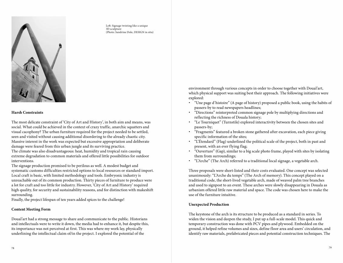
78 79
environment through various concepts in order to choose together with Doual’art, which physical support was suiting best their approach. The following initiatives were explored:• “Une page d’histoire” (A page of history) proposed a public book, using the habits of
passers-by to read newspapers headlines;• “Directions” reinterpreted common signage pole by multiplying directions and
reflecting the richness of Douala history;• “Le Tourniquet” (Turnstile) explored interactivity between the chosen sites and
passers-by;• “Fragments” featured a broken stone gathered after excavation, each piece giving
specific information of the sites;• “L’Étendard” (Flag) underlined the political scale of the project, both in past and
present, with an ever flying flag;• “Ouverture” (Gap), similar to a big scale photo frame, played with sites by isolating
them from surroundings;• “L’Arche” (The Arch) referred to a traditional local signage, a vegetable arch.
Three proposals were short-listed and their costs evaluated. One concept was selected unanimously: “L’Arche du temps” (The Arch of memory). This concept played on a traditional code, the short-lived vegetable arch, made of weaved palm tree branches and used to signpost to an event. These arches were slowly disappearing in Douala as urbanism offered little raw material and space. The code was chosen here to make the use of the furniture intuitive.
Unexpected Production
The keystone of the arch is its structure to be produced as a standard in series. To widen the vision and deepen the study, I put up a full-scale model. This quick and temporary construction was done with PCV pipes and plywood. Embedded on the ground, it helped refine volumes and sizes, define floor area and users’ circulation, and identify raw materials, prefabricated pieces and potential construction techniques. The
Harsh Constraints
The most delicate constraint of ‘City of Art and History’, in both aim and means, was social. What could be achieved in the context of crazy traffic, anarchic squatters and visual cacophony? The urban furniture required for the project needed to be settled, seen and visited without causing additional disordering to the already chaotic city. Massive interest in the work was expected but excessive appropriation and deliberate damage were feared from this urban jungle and its surviving practice.The climate was also disadvantageous: heat, humidity and tropical rain causing extreme degradation to common materials and offered little possibilities for outdoor interventions.The signage production promised to be perilous as well. A modest budget and systematic customs difficulties restricted options to local resources or standard import. Local craft is basic, with limited methodology and tools. Embryonic industry is unreachable out of its common production. Thirty pieces of furniture to produce were a lot for craft and too little for industry. However, ‘City of Art and History’ required high quality, for security and sustainability reasons, and for distinction with makeshift surrounding.Finally, the project lifespan of ten years added spices to the challenge!
Content Meeting Form
Doual’art had a strong message to share and communicate to the public. Historians and intellectuals were to write it down, the media had to enhance it, but despite this, its importance was not perceived at first. This was where my work lay, physically underlining the intellectual claim of/in the project. I explored the potential of the
Left: Signage twisting like a unique3D sculpture(Photo: Sandrine Dole, DESIGN in situ)
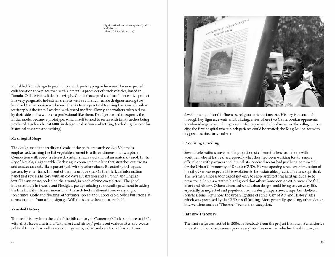
80 81
development, cultural influences, religious orientations, etc. History is recounted through key figures, events and building: a tree where two Cameroonian opponents to colonial regime were hung; a water factory which helped urbanise the village into a city; the first hospital where black patients could be treated; the King Bell palace with its great architecture, and so on.
Promising Unveiling
Several celebrations unveiled the project on site: from the less formal one with workmen who at last realised proudly what they had been working for, to a more official one with partners and journalists. A new director had just been nominated for the Urban Community of Douala (CUD). He was opening a real era of mutation of the city. One was expected this evolution to be sustainable, practical but also spiritual. The German ambassador called not only to show architectural heritage but also to preserve it. Some spectators highlighted that other Cameroonian cities were also full of art and history. Others discussed what urban design could bring to everyday life, especially in neglected and populous areas: water pumps; street lamps; bus shelters; benches; bins. Until now, the urban lighting of some ‘City of Art and History’ sites which was promised by the CUD is still lacking. More generally speaking, urban design interventions such as “The Arch” remain an exception.
Intuitive Discovery
The first series was settled in 2006, so feedback from the project is known. Beneficiaries understand Doual’art’s message in a very intuitive manner, whether the discovery is
model led from design to production, with prototyping in between. An unexpected collaboration took place then with Cométal, a producer of truck vehicles, based in Douala. Old divisions faded amazingly, Cométal accepted a cultural innovative project in a very pragmatic industrial arena as well as a French female designer among two hundred Cameroonian workmen. Thanks to my practical training I was on a familiar territory but the team I worked with tested me first. Slowly, the workers tolerated me by their side and saw me as a professional like them. Drudges turned to experts, the initial model became a prototype, which itself turned to series with thirty arches being produced. Each arch cost 600€ in design, realisation and settling (excluding the cost for historical research and writing).
Meaningful Shape
The design made the traditional code of the palm-tree arch evolve. Volume is emphasised, turning the flat vegetable element to a three-dimensional sculpture. Connection with space is stressed, visibility increased and urban materials used. In the sky of Douala, rings sparkle. Each ring is connected to a line that stretches out, twists and creates an arch, like a parenthesis within urban chaos. By entering this space, passers-by enter time. In front of them, a unique site. On their left, an information panel that reveals history with an old days illustration and a French and English text. The structure, sealed on the ground, is made of zinc-coated steel. The panel information is in translucent Plexiglas, partly isolating surroundings without breaking the line fluidity. Three-dimensional, the arch looks different from every angle, sometimes subtle and floating, other times spread and unbreakable. Sober but strong, it seems to come from urban signage. Will the signage become a symbol?
Revealed History
To reveal history from the end of the 16h century to Cameroon’s Independence in 1960, with all its facets and trials, ‘City of art and history’ points out various sites and events: political turmoil, as well as economic growth, urban and sanitary infrastructures
Right: Guided tours through a city of art and history (Photo: Cécile Démessine)

82 83
spontaneous or guided. If car drivers do not notice the initiative, passers-by become numerous and diverse sudden readers: moto-taxi drivers, street sellers, civil servants and so on. The Westerners in the city, either residents or tourists, easily join the crowd. To spread and share the information and results, a team of guides was trained on Doual’art’s initiative. Six hundred school children from the town followed these guided tours and adults also benefited from the initiatives. A tourist, artistic and historic city map, also produced by Doual’art, highlights ‘City of art and history’ initiative.
Serene Use
Several reactions and consequences are stand out from the work. Doual’art had involved and sensitised dwellers and street sellers, thus the project was easily introduced. When sites required redevelopment, even to a modest amount, the arrival of the arches helped embellish and improve the comfort of surroundings. Due to visitors’ affluence, local people felt concerned and valued, and neighbourhoods also became safer. Some people even took care of the street furniture. Surprisingly, neither stealing nor spoiling occurred over the period during or following the initiative. Light and friendly popular reuse, for example the drying of laundry, shows how the street furniture has entered everyday life. The most important assimilation is of Douala History. From time to time, strangers meet underneath “The Arch”. They share, for a minute, either their pride of each other or their tolerance for one another, and finally their willingness to face the present together.
The Next Steps
While such a cultural urban project may seem obvious in a Western context, in Douala, ‘City of Art and History’ aim and means were not far from revolutionary. Necessity was deeper and difficulty higher. This Cameroonian context, both harsh and smooth, violent and dull, outrageous and washed-out, precisely gave its meaning to this story. Design, supposedly born from industrialisation in developed countries, had a major role here too, maybe more than anywhere else?
Right: From traditional palm tree arch to urban signage(Photo: Sandrine Dole, DESIGN in situ)

84 85
Left: Entrance to the ten cell unit (communal parking space)in Area C, today.(Photo: Sophie van Ginneken)
Right: Dodoma in the geographical middle of the country. This scheme was used by the state to show the choice for Dodoma as the new capital of the country was a ‘natural’ one.(Source: Capital Development Authority, Portrait of Dodoma, 1974)
In 1973, a good decade after independence, the Tanzanian Government made an official start to relocate the nation’s capital from Dar es Salaam to Dodoma. As an alternative to the former colonial capital, the newly designed town was destined to embody President Julius Nyerere’s ideology of African Socialism, Ujamaa. In the midst of the arid, underdeveloped region of the country Nyerere’s “city of self reliance” was to rise. The reasons for and consequences of this highly ambitious and costly endeavour – creating a capital city from scratch – have been widely debated. Tanzania, like other newly independent nations faced both criticism and praise for the boldness of its venture. Less discussed, however, is the relationship between the urban design by a Canadian firm Project Planning Associates Ltd (PPAL), and Nyerere’s ideology behind it. In fact, there is an enormous discrepancy between the indigenous, socialist ideas for this symbolic act, a post-independence city; and the way these ideas have been translated into a rather generic ‘New Town’ design, reflecting Western planning ideals and differing little from the average American suburb. This article addresses the following questions: How precisely did Nyerere’s vision for an ideal rural socialist city relate to the actual design for it? And, secondly, what is the current impact of the Canadian master plan on the built city of today? In short, how does Dodoma’s planning history relate to the real city, lived by its inhabitants? These are relevant questions as still the 1976 master plan has considerable impact on Dodoma’s city planning, even though the political and economic context of today, in which the city faces several challenges (such as housing, infrastructural and sanitation problems), is completely different than forty years ago.
The Idea for a New City
Based on equality and collective rural life, Ujamaa referred to traditional African values and way of life. Ujamaa, meaning ‘brotherhood’ in Swahili, was the concept introduced by President Julius Nyerere (1922-1999) that formed the basis of his social and economic development policies for the country that gained independence from Britain under his leadership in 1961. In his prominent statement for African Socialism, the famous Arusha Declaration (1967), Nyerere imagined a modernisation
rEThINkINGTANzANIA’S CApITAL THE NEW TOWN OF DODOMA AS A PRODUCT OF GLOBAL POLITICS AND CONFLICTING IDEOLOGIES1
Sophie van Ginneken
“We have to take advantage of the opportunity to make Dodoma a good place in which to live and work, and to bring up children as good Tanzanians. The town must be integrated as a society as a whole, it must be neither an ivory tower, nor a new version of our existing towns. It must draw upon the lessons of other specially built cities throughout the world, but it must not be a copy of any of them. Dodoma must be a town which is built in simple style but with buildings which reflect the light, air and space of Africa.”President J.K. Nyerere in a foreword to the National Capital Master Plan Dodoma, May 1976.

86 87
Left: Nyerere with Mao, 1965(Source: www.juliusnyerere.info)
Nyerere on the cover of Time Magazine(Source: Mwalimu Julius Nyerere Foundation)
Right: President Nyerere, CDA director George Kahama, and minister ‘chief ’ Adam Sapi (left) attending a design team presentation. On the right: PPAL’s Charles Middleton (architect), Rebecca Boyd (sociologist) and Matthias Nuss (planner and project architect).(Source: Archives Matthias Nuss, Darmstadt, Germany)
beginning, was that Ujamaa villages were to be built and operated on a voluntary basis. Nyerere strongly believed that this was the only way to make the villages successful. The idea was that the success of the first Ujamaa villages would automatically lead to others. Later on, when this relaxed policy turned out to proceed too slowly; living in an Ujamaa village became an official order, and no longer a choice. During the 1970s tens of thousands of people were removed from their homes and forced into newly planned Ujamaa villages.Following the national policy of the past decade, Dodoma was to be the centrepiece of the Ujamaa Villagization Programme, the new capital city envisioned as a super-sized Ujamaa village. The decision was made in 1973, precisely the same year Nyerere imposed his gigantic artificial resettlement programme. Naturally, the creation of a new capital city was a chance to break away from the old capital established under colonial rule and give shape to a new national identity. Embodying Ujamaa on a national scale, Dodoma was to be the world’s first rural city: a man-centred city instead of a monumental one, a low density instead of a high-rise city, based on agriculture as its principal economy and collective life, and inhabited by farmers instead of townsmen. In fact an ‘anti-city’, this unique town was to become the symbol of Tanzania’s social and cultural values. Just as in the villages, the ten-cell housing unit was the organising principle for the design of the capital, reflecting the idea of the extended family as a self-reliant social, economical and political unit. Beginning with realising self-reliance on the level of the family (i.e. ten-cell unit), it was thought that this would, step by step, in a bottom up fashion, lead to the self-reliance of the entire community, then the entire city, followed by the entire region and, ultimately, to a self-reliant nation.
The Plan
One of the reasons for choosing Dodoma as the location for the new capital was that it was in the middle of the country, a neutral site at the crossroads of two national routes. The strategic location meant that the largest possible part of a rural population could be served, which of course had never been the case for Dar es Salaam. An already
of the country by strengthening indigenous values, thereby achieving economic self-sufficiency. An important physical part of the brand new policy was a rural resettlement programme: all Tanzanians were to be moved into newly established Ujamaa villages, evenly scattered throughout the country. Essentially, the already existing informal system within the lowest possible unit – a group of people farming and living together – was raised to national level as the cornerstone of Tanzanian society. In the years following the Arusha Declaration, this idea was officially formalized as a ‘ten-cell housing unit’, a group of ten houses around communal land. The ten-cell unit (or TANU unit, referring to, what was at the time, the nation’s one and only political party) thus became the basis for newly established Ujamaa villages.2
Nyerere’s socialist policy – he himself called it ‘a belief ’ – was of great originality and, together with his charismatic personality and modest lifestyle, gained enormous popularity throughout the world. As a former teacher, he was nicknamed Mwalimu (teacher in Swahili) and considered a man of great wisdom and intellect. Claiming that Tanzanian culture had both ingredients of socialism and democracy, he was admired and befriended by almost every leader in the world, both from the Eastern and Western blocks.3 During the Cold War, his clearly expressed non-alignment turned out to be a fruitful policy, keeping both East and West as close partners while building his nation. He was seen with Mao Zedong and Fidel Castro as well as John F. Kennedy and Queen Elizabeth; he appeared on the cover of Time Magazine, and wore his favourite Mao tunic at many of his public appearances. Although he was blamed by the West for having closer ties with communist leaders, he continued denying communist allegiances, rather claiming something new and in-between: a ‘communitary’ approach.4 In acting so, it must have looked like as if he were emitting a new form of world faith and energy, standing far above a global conflict. Nevertheless, a certain tendency towards communism is unmistakably present in his plans for the nation as well as for his new capital city. Most revealing in this respect was his dictatorial idea of mobilising the entire population into collective villages, holding striking parallels with Mao’s megalomaniac resettlement programmes for communist China in the late 1950s and 1960s. An important difference with Mao’s regime however (apart from having agricultural instead of industrial purposes), at least in the
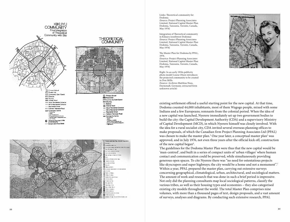
88 89
Links: Theoretical community for Dodoma.(Source: Project Planning Associates Limited, National Capital Master Plan Dodoma, Tanzania, Toronto, Canada, May 1976)
Integration of Theroetical community in Kikuyu (southwest Dodoma)(Source: Project Planning Associates Limited, National Capital Master Plan Dodoma, Tanzania, Toronto, Canada,May 1976)
The Master Plan for Dodoma by PPAL, 1976.(Sourtce: Project Planning Associates Limited, National Capital Master Plan Dodoma, Tanzania, Toronto, Canada,May 1976)
Right: In an early 1950s publicity photo model Louise Olson introduces the projected community to be created in Don Mills.(Source: Archives Matthias Nuss, Darmstadt, Germany, extracted form unknown article)
existing settlement offered a useful starting point for the new capital. At that time, Dodoma counted 44,000 inhabitants, most of them Wagogo people, mixed with some Indians and a few Europeans; remnants from the colonial period. When the idea of a new capital was launched, Nyerere immediately set up two government bodies to build the city: the Capital Development Authority (CDA) and a supervisory Ministry of Capital Development (MCD), in which Nyerere himself was closely involved. With the idea for a rural socialist city, CDA invited several overseas planning offices to make proposals, of which the Canadian firm Project Planning Associates Ltd (PPAL) was chosen to make the master plan.5 One year later, a conceptual master plan5 was approved, and in July 1976, not even three years after the official kick off, construction of the new capital began6.The guidelines for the Dodoma Master Plan were thus that the new capital would be ‘man-centred’, and built in a series of compact units of ‘urban villages’ where human contact and communication could be preserved, while simultaneously providing generous open spaces. To cite Nyerere there was “no need for ostentatious projects like skyscrapers and super highways; the city would be a home and not a monument”.7 Within a year, PPAL prepared the master plan, carrying out extensive surveys concerning geographical, climatological, urban, architectural, and sociological matters. The amount of work and research that was done in such a brief period is impressive. Not only did the planning consultants map local sociological patterns, classify the various tribes, as well as their housing types and economies – they also categorised existing city models throughout the world. The total Master Plan comprises nine volumes, with more than a thousand pages of text, design proposals, and a vast amount of surveys, analyses and diagrams. By conducting such extensive research, PPAL

90 91
ministries. On a vacant new site, on the other side of the railway, the new city centre was to be disconnected from the old city centre. However, the political heart of the new city, i.e. the parliament and the political (TANU) headquarters, were to be located possibly even further away, as an autonomous ‘centre’ on Chimwaga Hill, some eight kilometres east from the old city. This separation between people and government may seem to be a strange decision: not only is it opposite to the goal of a ‘man-centred city’, it also implied a strict division of the new city into different parts: living, working, recreation, and government were to be completely disconnected. The most peculiar aspect of the master plan however, is that it lacks the spirit of a rural city. As the design for Dodoma gained form, it became clear that there was not much room for communal rural grounds in the urban villages. Rural plots called shambas, often seen in traditional Wagogo homesteads (and later in Ujamaa Villages), would in the case of a capital city imply extensive open spaces, which would eventually lead to a city that was simply too large and hence, too expensive to build.8 As a result, the shambas, once destined to be the ‘DNA’ of the new city, were finally given a secondary position, grouped as leftover and unspecified spaces along the edges of the communities (and in reality would never be realised). All the more striking
attempted to grasp the identity of Tanzania, as well as local spirit, to incorporate these into what was to become a unique urban design. At least, that was the intention.However, despite the planners’ sincere intentions to make a unique and rural city, the master plan shows remarkable parallels with ‘New Towns’ – planned cities – everywhere in the world, especially Western ones. Characteristic for these ‘Garden Cities’ or ‘New Town’ models, as they are also referred to, are the hierarchical setup, the clustering of neighbourhoods, a zoning of functions, traffic and green space. These features go back to Ebenezer Howards Garden City model, developed at the end of the 19th century, combined with modernist planning principles by which they have been adapted throughout the 20th century. In the master plan for Dodoma, all these characteristics are clearly shown. Its physical layout is a series of connected communities, hierarchically structuring the city into different centres. The ‘A’ centre was to be the National Capital Centre, a gigantic new ‘mall’ to be placed on a new site, southeast of the city centre. On a lower level, the ‘B’ centres were programmed as the industrial cores, sited as separate hubs in each corner of the new city. On the residential level, the ‘C’ centres were to be the hearts of the communities, leaving on the most elementary level the ‘D’ centres as the ten-cell units. Each community was to be divided into four neighbourhood units, ‘urban villages’, consisting of numerous ‘D’ centres. A free bus lane was projected as to link all communities together by a public transport chain. Thus the heart of each community was the bus station, together with most facilities such as a market, shops, and small industries. In addition, each urban village would have its own collective amenities such as primary schools, clinics, shops, and places of worship. Next to a bus system, a vehicular road network was designed, should car ownership grow in the future. The idea of a model community, to be repeated broadly in the same physical pattern as a ‘stamp’ over and over again, provided the city the ability to expand in the future as much as needed. As a first stage expansion, ten communities directly around the old city centre were to be realised within ten years. Aiming at a total of 350,000 people by the year 2000, an expansion to the east was projected, repeated in the same formula of chained communities, and doubling the city in size. The new National Capital Centre (the ‘A’ centre) was projected as the commercial and civic hub as well as for the
Right: The National Capital Centre as planned by James Rossant (Concklin & Rossant).(Source: www.jamesrossant.com)
PPAL’s concept for two ten cell units, organized around communal open space with parking places.(Soutrce: Project Planning Associates Limited, National Capital Master Plan Dodoma, Tanzania, Toronto, Canada, May 1976)

92 93
Left: ‘Prototype housing’ as built in Area C by PPAL in 1978 was to set an example for the rest of Dodoma.(Source: Capital Development Authority: Building the National Capital 1978)
Right: PPAL’s prototype housingin 2011.(Photo: Sophie van Ginneken)
The answer lies perhaps in the universal rhetoric typical for modernist plans. The hierarchical setup, so characteristic to ‘New Towns’, seemed to match perfectly the political structure inherent to the ten-cell (TANU) system. Even so, the modernist idea of an open space system together with ‘green belts’ (here: the shambas) seemed to be a perfect model to shape a rural city. This is probably why, on a conceptual level, the ‘New Town’ model seemed to fit with Ujamaa. In fact, the generic aspects of modernism are exactly the reason why this model is used and reused so widely, in all contexts imaginable. Still, the very Western, capitalist features of the Dodoma plan cannot be ignored. To name a few, the carefully branched suburban road network with its curvilinear shapes (when private car ownership was not in line with socialism), the importance of parking places and the stress on pleasant family life and recreation, instead of communal farming, and the differentiation of housing typologies according to income. These ‘individualistic’ aspects are more common to the ‘American Dream’ than to an indigenous Tanzanian way of living.If we look closer at PPAL’s background, the technical, model-based approach in Dodoma’s design is better understood. The office was led by Canada’s modernist planner Macklin Hancock (1925-2010), who had gained fame after building Canada’s first ‘New Town’, Don Mills, in the 1950s. Trained at Harvard under Walter Gropius, he had been strongly influenced by town planning models and modernist principles. He knew by heart the Radburn design (1929) near New Jersey – America’s first planned community and generally regarded as the introduction of the Garden City model into the U.S. – as well as Clarence Perry’s invention of the neighbourhood unit (both highly influential experiments for the building of ‘New Towns’ worldwide). What Hancock actually did, was import the Garden City into Canada, and then re-export it to other countries of the world, among them Tanzania. Maybe even more than an urbanist, Hancock was an excellent salesman, selling his multipurpose urban template in a successful way all over the world.11 However sincerely interested in each local context, it appears as if the consultants looked for a framework in which their own model could fit.Besides the modern, capitalist roots of the town plan, global influences in the Dodoma planning process go even further. Directly after the capital city project was launched,
is that, instead, a lot of design energy was put into an extensive vehicular network accommodating individual car use, separated from a free bus lane by bridges and overpasses. At the same time, the communal spaces within the ten-cell units were designated as car parking. With these features, Dodoma was given form not as a socialist city, but rather as a middle of the road suburban landscape based on (Western) individualistic values, such as comfort, efficiency, and a pleasant family life.
The Clash of Two Opposing Ideologies
The commission to PPAL to design the world’s first rural socialist capital was a remarkable one. Not only is it questionable why foreign planners were asked to design something as highly symbolic as a capital city for a newly independent state; it is also notable that PPAL had already designed the master plan for Dar es Salaam, six years earlier (in 1967). According to authors Peter Siebolds and Florian Steinberg, this master plan was subject to a critical assessment in Tanzania as it didn’t reflect socialist ideals (keeping alive the segregation of the city according to income) and had to be cancelled because of its expensive investment projects.9 But that aside (this plan was never fully implemented), the crucial point here is that in fact very Western, in a way capitalist, planning ideals were seen as adequate tools to give shape to exactly the opposite: a socialist city. How then is it possible that Nyerere invited the same office to design his socialist capital city and, more relevantly, stated that the master plan for Dodoma was “consistent with the ideology of Tanzania”?10

94 95
between two conflicting worlds with opposite ideologies, which is reflected in its design: a technical, ‘capitalist’ translation of what was planned to become exactly the opposite: a socialist city. The ideology of Ujamaa, which shows parallels with Chinese land reform plans, stands in sharp contrast to the suburban character of the Canadian master plan. In this way the Dodoma planning process can be understood as reflecting a global conflict and, as a result, showing a clash between global city references and local culture.
The Plan and the City
What is the effect of all this global concern for the city of today? To date, the overall structure of the master plan (mostly its infrastructural system) is vaguely visible as a faint imprint onto the existing city fabric. Mostly from an infrastructural point of view, the master plan has actually added something positive to the city, especially in terms of infrastructure. However looking more closely, most of the master plan has never been realised. Before construction of the city was well underway, the entire nation faced bad economic times, and saw large sums of money spent on the war with Uganda. At the beginning of the 1980s the Dodoma project was abandoned, as was the entire Ujamaa Villagization Programme. The party headquarters on Parliament Hill were barely finished when the paving of the free bus lane stopped abruptly, as was the construction of Kikuyu, Dodoma’s model community. The National Capital Centre never saw the light of day. Still, the ‘Canadian’ street pattern is clearly visible today in the residential areas Area ‘A’, ‘B’, ‘C’, and ‘D’ – as these neighbourhood units are still prosaically named – just north of the city centre. Apart from the community centres and green spaces, they have been realised according to plan. Today, the Western ‘prototype houses’ are in a run-down state, cul-de-sacs are mostly empty, with some parked cars every now and then. Given the harsh character of the soil, Dodoma doesn’t seem to be the most suitable place for intensive rural production.Shortly after the capital city project stopped, Nyerere resigned in 1985 as president of the nation. From that moment, his successor Ali Hassan Mwinyi undertook the first steps towards a free market economy. In the meantime, Dodoma grew steadily,
Nyerere and his CDA officials undertook many inspirational field trips to newly built capital cities, including Canberra (Australia), Islamabad (Pakistan), and Chandigarh (India), as well as to ‘New Towns’ like Runcorn (UK) and Columbia (USA) – all of which have been designed by Western modernist planners. During their excursions, CDA did not look only at the physical setup of cities, but also into management, financial, and administrative aspects of town planning.12 Partly because of this, and thanks to PPAL’s worldwide network, the capital project started to attract all kinds of architects, urbanists, and theoreticians, who flew to Dodoma like bees to honey. James Rouse, the planner of Columbia (USA), was asked to share his ideas on the master plan for Dodoma; architect James Rossant, the planner of Reston (USA), was commissioned to produce the detailed plan for the National Capital Centre. On top of all this ‘overseas assistance’, an international panel of the United Nations Environment Programme (UNEP) settled in Dodoma to assist the planning process, this time unsolicited. In their turn, UNEP hired additional planners and consultants to review on urban design and architectural matters. It is not quite clear to me if this was on the government’s initiative, or on UNEP’s. But it is clear that the globalised sphere, in which the making of this ‘New Town’ gained form, is far-reaching. Not to speak of the exorbitant amounts of money from other countries, including considerable donations from Western countries as well as from the East. Especially in the case of what was to become a self-reliant, rural, and above all a unique and authentic city, the working method for the building of Dodoma was at complete odds with the goals Nyerere wanted to reach.The geopolitical gravitation field, in which Dodoma attracted interest, experts, and money from all over the world, can be better understood within the context of Cold War politics. In this period, urban planning was used by both East and West as an export product, in their competition for third world countries to enlarge their influential spheres. Newly independent African states formed, often as neutral grounds, and they became an interesting target for both superpowers. As architectural historian Michelle Provoost argues, urban planning in this context turned out to be a powerful instrument in Cold War politics, and the export of planning functioned as a means of cultural instead of political colonisation.13 In considering this specific era, we can see the Tanzanian capital project as a striking representative of the ambiguity
Right: Bar in Area C, today.(Photo: Sophie van Ginneken)
Unplanned dukas (shops) in Area C today.(Photo: Sophie van Ginneken)

96 97
been paved, and neither are the connections between these neighbourhoods. This is the city we found in the past few years (2009-2011), during visits within the framework of a larger research into ‘New Towns’, initiated by Crimson Architectural Historians.16 During these visits, the current state of the town was explored, as were its future prospects. This is when we learned to our surprise that still today, the Capital Development Authority is developing the city according to PPAL’s master plan. Although slightly amended, the main concept of the master plan – a series of connected communities complemented with detached cores for different functions – seems neatly intact. Even the construction of the gigantic and peripherally located National Capital Centre still figures as a realistic building project, one of the highlights projected for the near future. At the moment, the National Bank of Tanzania and the Ministry of Finance are being built here.17 Characteristic to the actualised plan is the planning of new, peripherally located cores. In a way just like the Canadians proposed almost forty years ago, these separate cores are to be autonomous centres for learning (the university town), governance (parliament town), working (industrial centres), business (the National Capital Centre) and living (the communities). Lastly, an overseas planning consultancy has been involved for revising the master plan. The South Korean engineering company SAMAN Corporation is expected to present their proposals before the end of this year (2012). Even more than the actual Canadian master plan, it seems that its mentality of hard-core top-down planning is still alive, perhaps even livelier than ever. From this point of view, the master plan seems to have left its mark deeply in the minds of Dodoma’s city authorities.It feels a bit out of place to criticise these current plans, while at the same time being a foreigner myself, thus always operating from a distance. Still, the question arises: how should one interpret these plans? Does today’s strict and model-based approach justify the real identity of this city, which in the meantime has become far more diversified – and more complicated – than the original model? Or is it an attempt to rectify the failure of the previous ‘New Town’ plans by a new, even more ambitious one? By planning separate, autonomous centres for government, education, living and working, it appears that the real city with its pleasant atmosphere and often bad living conditions is neglected in favour of entirely new and inevitably desolate areas, far away
Left: One of the schoolyards inArea C today.(Photo: Sophie van Ginneken)
Right: Dodoma’s old town centre today(Photo: Sophie van Ginneken)
following an intrinsic logic. While the designated site for the National Capital Centre remained empty for a long time, a second ‘city centre’ containing the Bunge (Parliament Building), and a Business School gained form, on a more ‘natural’ site next to the old centre (originally designated for industry). Along the streets, close to the markets, numerous dukas (small shops) have settled, selling fruits, beans, or nuts, cultivated mostly outside the city. In the residential areas hairdressers, bars and pharmacies are scattered, adding another layer to its planned basis. New houses are built on free plots; entirely new neighbourhoods are taking shape next to the existing ones, replacing former squatter settlements. This altogether leads to a layered city, showing an indistinct mix of long existing Swahili houses, some colonial buildings, occasionally mixed with remnants of the Canadian plan and newly (sometimes exotically) designed institutions. Next to the older St John’s University in Kikuyu, an entirely new university complex is taking shape on the former Parliament Hill, incorporating the old TANU Headquarters as principal lecture hall. In 2007, the current president, Jakaya Kikwete, decided to realise a university of international importance in Dodoma, as being the most prominent environment for higher education in Tanzania. When fully operational, the University of Dodoma (UDOM) aims to have 40,000 students in a variety of academic disciplines. This is more than double the present size of the University of Dar es Salaam.14 To date, most governmental functions are still based in Dar es Salaam, and few believe the city will ever get the status of a real capital. However, with a current total population of more than 400,000 people, the city – at least in size – is close to living up to Nyerere’s expectations.15 New universities and schools triggered the city’s natural growth and brought new economies, people and facilities. These current developments are leading to a city that has outgrown its original blueprint, performing as a pleasant and lively environment for a diversity of people and cultures. At the same time however, most of these people live in unplanned settlements, many of them without good access to water and sanitation. This informal pattern is taking shape along a north-south axis, i.e. in exactly the opposite direction as was projected by the master plan, mostly because this is where relatively good roads and water supply are located. Nevertheless, the internal road systems in these residential neighbourhoods have never
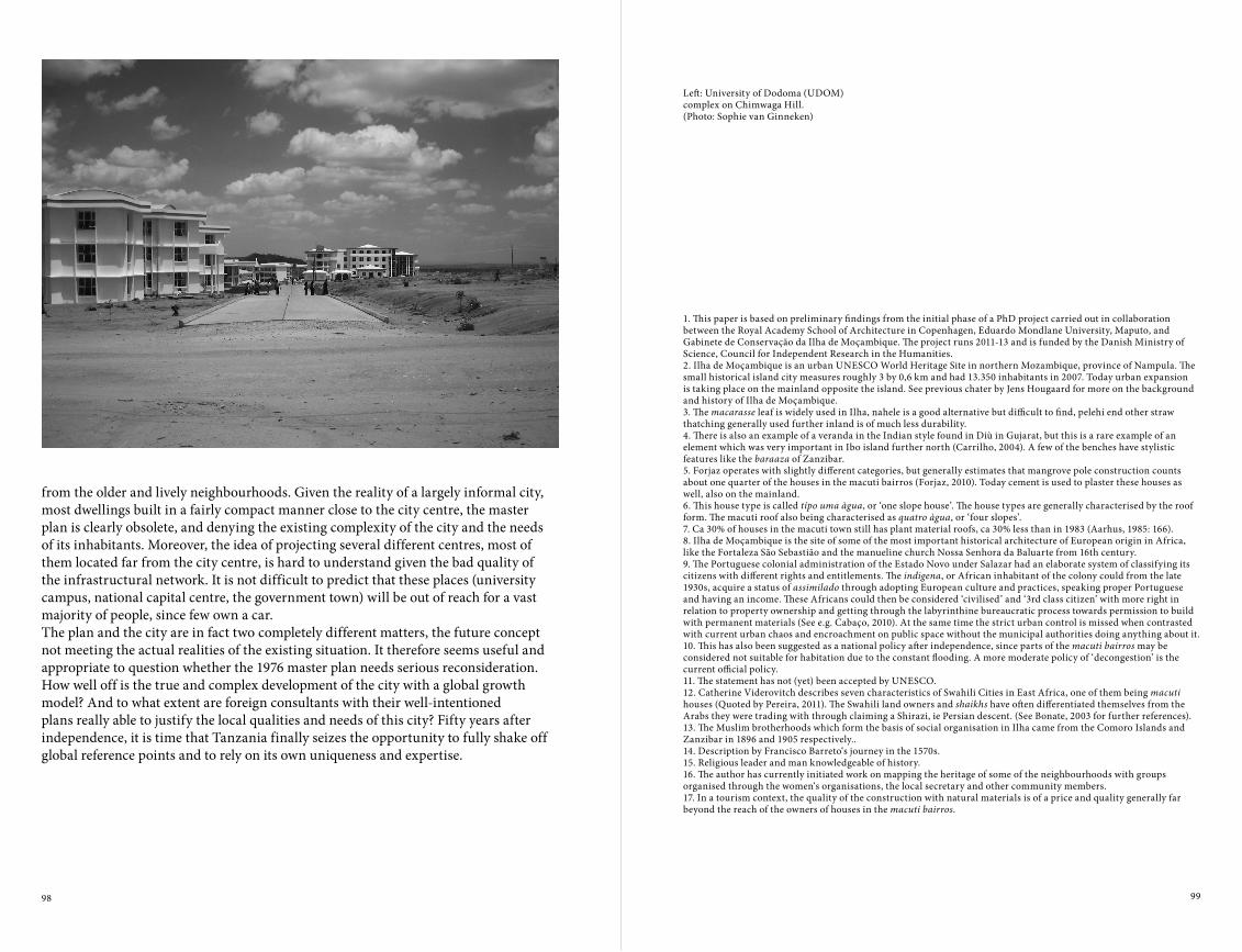
98 99
1. This paper is based on preliminary findings from the initial phase of a PhD project carried out in collaboration between the Royal Academy School of Architecture in Copenhagen, Eduardo Mondlane University, Maputo, and Gabinete de Conservação da Ilha de Moçambique. The project runs 2011-13 and is funded by the Danish Ministry of Science, Council for Independent Research in the Humanities.2. Ilha de Moçambique is an urban UNESCO World Heritage Site in northern Mozambique, province of Nampula. The small historical island city measures roughly 3 by 0,6 km and had 13.350 inhabitants in 2007. Today urban expansion is taking place on the mainland opposite the island. See previous chater by Jens Hougaard for more on the background and history of Ilha de Moçambique.3. The macarasse leaf is widely used in Ilha, nahele is a good alternative but difficult to find, pelehi end other straw thatching generally used further inland is of much less durability.4. There is also an example of a veranda in the Indian style found in Diù in Gujarat, but this is a rare example of an element which was very important in Ibo island further north (Carrilho, 2004). A few of the benches have stylistic features like the baraaza of Zanzibar.5. Forjaz operates with slightly different categories, but generally estimates that mangrove pole construction counts about one quarter of the houses in the macuti bairros (Forjaz, 2010). Today cement is used to plaster these houses as well, also on the mainland.6. This house type is called típo uma àgua, or ‘one slope house’. The house types are generally characterised by the roof form. The macuti roof also being characterised as quatro àgua, or ‘four slopes’.7. Ca 30% of houses in the macuti town still has plant material roofs, ca 30% less than in 1983 (Aarhus, 1985: 166).8. Ilha de Moçambique is the site of some of the most important historical architecture of European origin in Africa, like the Fortaleza São Sebastião and the manueline church Nossa Senhora da Baluarte from 16th century.9. The Portuguese colonial administration of the Estado Novo under Salazar had an elaborate system of classifying its citizens with different rights and entitlements. The indigena, or African inhabitant of the colony could from the late 1930s, acquire a status of assimilado through adopting European culture and practices, speaking proper Portuguese and having an income. These Africans could then be considered ‘civilised’ and ‘3rd class citizen’ with more right in relation to property ownership and getting through the labyrinthine bureaucratic process towards permission to build with permanent materials (See e.g. Cabaço, 2010). At the same time the strict urban control is missed when contrasted with current urban chaos and encroachment on public space without the municipal authorities doing anything about it.10. This has also been suggested as a national policy after independence, since parts of the macuti bairros may be considered not suitable for habitation due to the constant flooding. A more moderate policy of ‘decongestion’ is the current official policy.11. The statement has not (yet) been accepted by UNESCO.12. Catherine Viderovitch describes seven characteristics of Swahili Cities in East Africa, one of them being macuti houses (Quoted by Pereira, 2011). The Swahili land owners and shaikhs have often differentiated themselves from the Arabs they were trading with through claiming a Shirazi, ie Persian descent. (See Bonate, 2003 for further references).13. The Muslim brotherhoods which form the basis of social organisation in Ilha came from the Comoro Islands and Zanzibar in 1896 and 1905 respectively..14. Description by Francisco Barreto‘s journey in the 1570s.15. Religious leader and man knowledgeable of history.16. The author has currently initiated work on mapping the heritage of some of the neighbourhoods with groups organised through the women‘s organisations, the local secretary and other community members.17. In a tourism context, the quality of the construction with natural materials is of a price and quality generally far beyond the reach of the owners of houses in the macuti bairros.
Left: University of Dodoma (UDOM) complex on Chimwaga Hill.(Photo: Sophie van Ginneken)
from the older and lively neighbourhoods. Given the reality of a largely informal city, most dwellings built in a fairly compact manner close to the city centre, the master plan is clearly obsolete, and denying the existing complexity of the city and the needs of its inhabitants. Moreover, the idea of projecting several different centres, most of them located far from the city centre, is hard to understand given the bad quality of the infrastructural network. It is not difficult to predict that these places (university campus, national capital centre, the government town) will be out of reach for a vast majority of people, since few own a car. The plan and the city are in fact two completely different matters, the future concept not meeting the actual realities of the existing situation. It therefore seems useful and appropriate to question whether the 1976 master plan needs serious reconsideration. How well off is the true and complex development of the city with a global growth model? And to what extent are foreign consultants with their well-intentioned plans really able to justify the local qualities and needs of this city? Fifty years after independence, it is time that Tanzania finally seizes the opportunity to fully shake off global reference points and to rely on its own uniqueness and expertise.

100 101
In light of the new status quo of the Egyptian revolution, the main research questions have required slight modification. Generally, they intend to determine how the sub-cultures of sub-groups living in a certain informal area influence behaviour in urban spaces. Thus, the objective is to ascertain the influences of the ‘cultural factors/characteristics’ and ‘cultural change’ on behavioural patterns in urban spaces. The new issue to be investigated, due to the revolution, is the impact of the ‘January Revolution’ on cultural change, albeit perhaps minor. The slight modified research questions are as follows:
• What are the relations between the behavioural patterns (life style) and the culture (beliefs, values) of the residents (Upper Egyptian migrants) in urban spaces of Cairo informal Settlements?
• Have the ‘locations’ within the city, ‘time of migration’ and any other factors (e.g. January Revolution) had an impact on the cultural change?
Literature Review
Culture, behaviour and spaceExploring such diverse interdisciplinary topics requires a comprehensive understanding for the research topic. The research began with culture and its definitions. Different definitions (by authors such as Tylor (1871); Geertz, (1973) and UNESCO (2002)) are relatively close in defining culture and linking it to behaviour. Nevertheless, the definition by Rapoport (1978 p.14) was found most appropriate, thus has been adopted for this research:
CuLTurEAND IDENTITY IN CAIrO urBAN DEvELOpMENTA CASE STUDY OF CAIRO’S INFORMAL SETTLEMENTS1
Hassan El Mouelhi
Since the early eighties, urban developmental and upgrading projects in Egypt has focused almost entirely on physical interventions, based on the current physical conditions of the subject area. However, it has become clear in subsequent years that the sustainability of upgrading projects depends profoundly on the participation of the inhabitants. Beyond this, the incorporation of cultural aspects into policy making is often lacking. Nevertheless, aspects of local culture could be introduced into categorisation and be useful for intervention. Through understanding people’s values and beliefs, their behaviours could be predicted. Moreover, once the interrelated reasons for people’s behaviour in a certain setting are understood, subsequent intervention strategies might be enriched accordingly.

102 103
a ‘new way of life’, a mode of urban existence. Recognising that informality can be a survival option in the cities, they argue that in many cases it is a personal decision to adopt behaviours associated with informality. The production of informal space is also an expression of power; the informal economy is deregulated rather than unregulated. Thus, informality can be seen as a different and sometimes organised way of living. The following photos show different faces of informality from different cities from the global south.Globalisation may cause frustration and disappointment for poor urban dwellers through the media (Ghannam, 2002). Abou El-Ela (2003) argues that people, especially those who belong to traditional cultures are struggling between the culture they are being exposed to in the urban city and their own original traditional culture, they have to go through self adjustments to survive in the new circumstances. ‘Modernity’ in the eyes of traditional community members is an issue that deserves further research (Abu-Lughod, 1997).In some cities, which may be located anywhere in the world, informal settlements are located in one specific part of the city, while the better-off neighbourhoods in another (UN Habitat 2010). Urban informality is somehow related to wealth distribution and unequal property ownership in cities. The study of informality is related to social justice (Roy 2005). Perlman (2005) concludes that the urban poor living in informal settlements are ‘not marginalised’ on the economic level; on the contrary, they are important for the city to function but still deprived from services and many of their
“one can say that it is about a group of people who share a set of values, beliefs, a worldview and symbol system, which are learned and transmitted. These create a system of rules and habits, which reflect ideals and create a lifestyle, guiding behaviour, roles, manners, the food eaten- as well as built form.”
A further stream of reviewed literature that discusses the ‘culture of slums’ (Kamur Das, 2000) (Lewis, 1959), with the concept named ‘culture of poverty’ (Lewis, 1959) (Winter, Glazer, 1971). Attributes of slums could be divided into physical, social, and cultural attributes (Kumar Das, 2000).
Urbanisation, informality, globalisation, and slumsThe research explored several texts addressing issues of urbanisation, informality, and slums, within the international discourse; it was found that the three topics are strongly related. Rapid urbanisation and city growth is a global phenomenon (Davis, 2006) (UN Habitat 2009), resulting in the emergence of metropolitan or mega-cities in the Global South (Davis, 2006) (Kumar Das, 2000). Due to the lack of control of governments, it results in an informal growth of cities, known as informal settlements and/or slums. This global phenomenon has different names in different languages and countries (Gottdiener, Budd, 2009, p.137). ‘Cities without slums’ is currently one of the most important goals of urban planning in developing countries (UN Habitat 2009).
Informality is directly related to economics and politics (Altvater, 2004). It is a matter of power; regulations control the relation between state’s intentions and political, economic, and social decisions. (Kanbur, 2009) (Soliman, 2004) (UM, 2011). There are different styles of formal and informal social interaction in urban areas, which can be positioned on a scale between high and low (Etzold, B., et al., 2009). Addressing the relationship between informality and modernity, Alsayyad (2004) argues that informality is closer to the liberalisation concept, rather than formality. Roy and Alsayyad (2004) further define the connection between urbanisation, globalisation (liberalisation), and informality. By decoupling the definition of informality from the economic sector, they take the argument one step further, arguing that informality is
Left: Pushing a bus in Dar es Salaam(Photo: Hassan El Mouelhi)
Right: Kids flying kite in front of washed clothes in one of Mumbai’s slums(Photo :Hassan El Mouelhi)

104 105
processes in the Western world and Global South countries brought the attention of ‘specialists in other cultures’2. Abu-Lughod argues that generalisations through comparative urban studies could not be justified. She suggests that researchers should worry more about the differences rather than the generalisation (Abu-Lughod, 1975). Commenting on the Chicago School, Al Sayyad argues that the coming of urban growth future would be in the Global South, urban theories coming from Chicago or Los Angeles are not necessary valid in those cities. This needs more research stemming from those cities directly and schools of thought named after them (Alsayyad, 2004, p.9). For theories discussed, it is argued that the cases of informal settlements might differ from city to city (in terms of the physical conditions) in addition to the social and cultural conditions of its residents. Those theories have started and were tested empirically in the Western cities, or even in other cities of the global South, but not in Cairo. They should be re-tested in Cairo, through the exploratory ethnographic work, which takes place in the case studies. Then, those theories could be evaluated to find out which of them suits or does not suit the case of Cairo Ashwa’eyat.
Lifestyle, social life/everyday life and spaceCulture and space in urban form correlate (Rapoport, 1977). Lifestyle influences the organisation of the city through whatever variables – race, ethnic, religion, class, income – so that the city is a collection of different groups, with different lifestyles reflecting different cultures and subcultures. Places in the city, belonging to different groups, indicate status and social identity. Analysing activities in space is one way to understand lifestyle, which in turn leads to understanding culture. Socio-cultural variables need to be understood before understanding differences in spatial organisation comprehensively (Rapoport, 1977, P.20). Lifestyles result from different compositional social factors such as: class, gender, race, age, ethnicity and religion, in addition to location in the city and network, interaction between all these factors forms different ‘lifestyles’(Gottdiener 1985, p.182-83).Concepts of ‘social capital’ and ‘social networks’ were presented by Bourdieu (1983). Sodeur (1986) argues that social networks are partly determined by local opportunities.
civil rights. ‘Blaming the victim’ is the way for the government dealing with those people, as being responsible for their bad quality of life. Gottdiener addressed the relationship between governments of the ‘Global South’ and its people; they are unsuccessful in supporting their people (Gottdiener, 1994). The status of informal settlements varies from city to city, and country-to-country, regarding location and the way they are dealt with by the governments (Gottdiener 1994, p.256).
Urban sociology/anthropologyUrban sociology and urban anthropology/ethnography researchers attempt to understand life in the city and define the culture of the city. Studying urban life as a concern was begun by the Chicago School and its pioneers of researchers. Ethnic enclaves and low-income ‘slum’ areas were often the focus of study (Wirth 1928, p.285) and resulted in an ‘art of observing’ (Linder 2004, p.117). In Wirth’s work, comparing city life and village life, social relations are different, as in cities; relationships are secondary, while in contrast, in rural areas it is primary relationships. He argues that urbanism is a form of social organisation, and a way of life (Wirth, 1938). The response, over sixty years, to Wirth’s arguments generated many debates (Young, Willmot, 1962) (Gans, 1968) (Savage, Warde, 1993). Before Wirth, Simmel (1903) saw the life in the Großstadt (large city) governed by transitory, mysterious, and individual social relations, and where public space was given primacy over private space. He saw the modern city as a space of individualisation, and as a space of liberation, and as a laboratory in which it was possible to observe modern society’s constitutionIn the ‘Human Ecology’ theory, Park (1936) assumes that the human community consists of a population and a culture (customs, beliefs and artefacts). Subcultures theory and that of urbanism by Fischer (1975) claimed that while most of the differences between individuals in the metropolis were caused by background factors such as class and race, there were attributes of behaviour that differed among people according to their location. Fischer assumes that increasing the scale of the rural-to-urban continuum creates subcultures, modifies existing ones, and brings them in contact with each other (Fischer 1975). Hannerz (1980) claimed that the Global South started to be the habitual focus of attention of anthropologist, and that various social
Right: Vegetable market in Kariakoo, Dar es Salaam(Photo: Hassan El Mouelhi)
Left: Street vendor selling sugar cane within planned Cairo residential streets(Photo: Hassan El Mouelhi)

106 107
Cairo, in order to distinguish common topics of research, and whether the relation of culture to the urban space in informal settlements has already been investigated. Such investigations were found to be rare. Urban anthropologists/ethnographers who have studied Cairo are more concerned by the subcultures of the people of informal poor areas of Cairo, and their lifestyle in relevance to their poverty (Nelson, 1971) (Sherif, 1999) (Hoodfar, 1997). Often researchers concentrated on social phenomena – in various cases they describe the physical characteristics of an area studied and its urban space, but without any analysis of the relation between the culture and these characteristics, e.g. El Sharabeya shantytown (ElKordy 2008). In the list of research reviewed, the issue of urban space was only addressed in a descriptive sense, indicating legal circumstances and the deteriorated physical conditions of these spaces. ‘Activities’ are also occasionally mentioned, yet without links to the types of activities that take place by the inhabitants in those urban spaces, or to their imbedded subculture.
To understand the development of the Ashwa’eyat phenomenon in Cairo, different consequential research addressing this topic has been explored, along with discussion on the chronological development of Cairo’s urban growth and its reasons (Abu-Lughod, 1971) (El Kady 2009) (Solimen, 2004) (Sims, 2010). Another group of researchers discussed Cairo’s Ashwa’eyat as the most complicated city in the Egyptian case, trying to rationalise the reasons and relevance to cultural, social, political, and economic contexts of this phenomenon. Bayat and Denis (2000) illustrate that some of the population and demographic changes are due to rural urban migration and urbanisation, addressing the relation between the informal areas and other formal areas of Cairo. Ashwa’eyat are still viewed as lower status communities and are regarded as illegal. The gap between different classes cannot be beneficial due to social segregation, stigmatisation, and marginalisation. Shehayeb (2008) analysed living and lifestyle in Cairo informal areas. She highlighted the stigmatisation of informal areas’ residents through comparing their quality of life in their areas, to that existing in other formal areas of Cairo, and even through the media. This agrees with the concept of ‘the other’ between informal areas residents, and others living in the so-called ‘formal areas’ (Safey El Din, H., El Mouelhi, H., 2009).
Formal and informal areasin greater Cairo region (Source: Amar Ya Masr foundation)
Lefebvre (1991) initiated the concept of ‘social production of space’, with some attempts to modify and develop it by Gottdiener (1994, p.125-28, and Gottdiener, Budd, 2009). Lefebvre had two different definitions of space: firstly ’absolute space’ defined by governments and businessmen; and secondly ’social space’ space for everyday life. The socio-spatial perspective prefers focusing on groups (such as classes and networks) for studying such understanding meanings in cities and suburbs (Gottdiener 1985, 256).Various qualitative research methods were investigated to determine different possibilities to be used during the field study, mainly ‘grounded theory’ (Glaser & Strauss, 1967) and ‘case study research’ (Yin, 2004).
Cairo Discourse: Ashwa’eyat
The term Ashwa’eyat (literally translated as ‘randomly built areas’) will be used in the research to denote Cairo ‘informal settlements’ or slums. In many specialised reports by international organisations, Cairo is recognised as one of the largest megacities worldwide (UN-HABITAT, 2003). UN-HABITAT data reveals that a slum resident in Cairo can be better off than a non-slum dweller in other cities (UN-HABITAT, 2008). Life in Cairo’s informal settlements is close to life in any Egyptian city (Kipper, 2008). Its percentage of total area of Cairo shows the influence of informal settlements on the general shape of the metropolitan Cairo.The researcher explored numerous reports concerning informal settlements of

108 109
could be an indicator for potential community self-organisation and cooperation. Thus, sharing problems, facing the same legal and physical problems together with other factors (e.g. origin/family) may lead to a better sense of cooperation between the residents of informal areas.
• The level of homogeneity in the community targeted by development is a crucial factor that might help as a resource for the development process. In many cases, communities that are formed on formerly agricultural land were communities originating from the same village (e.g. Upper Egypt) or belonging to the same family. Whether the level of homogeneity affects the potential for community participation needs to be further researched.
• Mistrust between the community and the government is a defining factor in many communities. Many local residents commented that the money, which is going to be given to the governorate, is not necessarily going to be spent on their needs. This rather common issue is very important to consider as it highly influences the relations between the different community and government stakeholders involved in intervention processes.
• Corruption is discussed by many scholars addressing the contemporary Egyptian society (G.Amin 2009) and it is also reflected in Cairo daily life. Most of the interviewees mentioned the necessity to pay bribes to different officials in order to gain public services such as electricity provision in the house. It could be argued that the informal status of settlements is often being abused by government officials for additional benefit and at the same time hindering solutions to the local problems.
• Marginalisation is debated as one of the most challenging issues regarding Informal Areas in Cairo (Shehayeb 2009). Such communities, as in the case of Ezzbet Al Nasr, can be considered to be ‘marginalised’ in the sense of lacking basic needs (e.g. water supply and sewage system, garbage collection, safety, income, health). At the same time, they share in the workforce of the society, playing a role in the market economy (Perlman 1979-2005). Their way of perceiving themselves as ‘informal’ might be one of the motivators of some of their behavioural patterns, the so-called A’shw’aya, meaning random behaviour.
Ghannam (2002) in her ethnography conducted in one of Cairo’s poor urban areas, El Zawya El Hamra (public housing project), presents an in-depth analysis of the lifestyle of the urban poor in Cairo. The residents perceive the government, its officials, and police as if they are one entity, Elh’ekouma- they have negative feelings towards it (Ghannam, 2002). As the January Revolution could influence this relationship, the research will attempt to analyse the perspective of residents in informal settlements and observe the impact on their culture, thus consequently behaviour in urban space.Selecting the ‘Upper Egyptians’ as the targeted group of residents for my case studies also provided the grounds to study their traditional culture in rural or urban life in Cairo. Upper Egyptians, known as Sa’idi, have their own traditional ‘subculture’ and are known by their dignity and pride in their cultural identity (Miller 2006)3. This rural urban migration mainly refers to the neglect of the Upper Egypt Region by the state (Salheen 2005). Zohry (2002) attempts to address the motives for rural urban migration by the Upper Egyptians.
Findings of Case Study
The field research in different Ashwa’eyat in Cairo and Giza provided various insights into community life. Through the qualitative interviews, group discussions and observations, several cultural aspects raised special attention and were assessed as relevant to be incorporated into analysis/categorisation, decision-making and intervention.
• High level of cooperation, between community members of different communities, either between different residents, or between residents and workshops owners/workers who sometimes live outside the area, as neighbours collaborate and collect money together to overcome or solve a certain problem, either through sharing the expenses of a solution, or even through paying bribes. Sometimes shop owners cooperate, for instance to install a shading tent over a street, remove garbage from a certain part of a street, plant some trees in front of one of the mosques, put water jars for the pedestrians to drink, or illegally install light to a part of a street. This
Right: Formal vs. informal housing(Photo: Hassan El Mouelhi)
Ashwa’eyat on agricultural land(Photo:: Vicente Sandoval-Henriquez)

110 111
addresses the economic status of the area and its relation to other areas and districts of the city. Many informal areas act as business incubators, each specialising in a specific type of goods or service. As the informal settlement’s reputation for a specific range of products grows, these business networks extend regionally. Having different workshops sharing the same profession, or maintaining related specialties, helps strengthen the bonds between its owners, as in the case of chain process for car maintenance in Dayer El Nahia.
• Religion: Households that share specific religions – especially minority religions, and particularly Christianity in the case of Egypt – tend to concentrate in specific precincts comprising of one or several streets. These spatial arrangements help shape the dynamics of community governance, and not infrequently result in tension and territorialism between various groups.
• Self-perception: location within the city, its relation to neighbouring ‘formal’ districts affects the level of urbanity of the informal area. In addition, the level of accessibility of the area affects the attraction of investment in the area. Within the city context, self-perception plays a crucial role in shaping the community’s capacity to share in the development process. These perceptions are frequently shaped by different factors including the intensity of contact between the informal community and nearby formal settlements. The question arises: how far does the way inhabitants of Informal Areas are perceived and often stigmatised (Shehayeb 2009) by formal inhabitants affect their behaviours?
These factors could be reflected in residents’ behavioural patterns, which are the ways residents act, react and behave according to their culture, and shapes the built environment. The usage of open space is one way, through which cultural specificities manifest in physical space. It is assumed that activities in these areas are an extension of indoor activities. Outdoor activities also depend on and help to shape the usage of the physical environment. In Ezzbet El Nasr, males and females have different types of outdoor activities. This context raises some questions: is this behaviour due to certain concepts and traditions rooted in their culture of origin? Or it is only due to the lack of space?
Cultural Identity Factors
Based on the analysis of qualitative data gathered from the field, a preliminary list of factors comprising cultural characteristics that form the ‘cultural identity’ of a certain area is suggested. It still needs to be further investigated, tested and elaborated. These factors are argued to be interrelated and responsible for several forms of interaction between the residents and their physical setting in the form of certain behavioural patterns.• Origin, kinship, and time of migration: The informal settlements of Cairo residents’
origins are different from one area to another. They migrate from one of the following places: Upper Egypt rural/urban areas (different cities or villages), delta rural/urban areas (different cities or villages), or other districts in Cairo. In many areas, the residents originate from a specific area in Upper Egypt, and some families are located in certain neighbouring streets in the area (Ezbet El Haggana, Ezbet El Nasr). Upper Egyptians known as Sa’idi are known for their dignity and pride in their cultural identity, which makes them maintain their beliefs or cultural characteristics (Miller 2006). The kinship traditions of Upper Egyptians place great importance on respect for elders, and each group of people belonging to the same origin has a leader. Sometimes these leaders intervene in conflicts between households. These inter-family and intergeneration links also strongly influence economic and social networks in the settlement. At the time of migration, they even had to be more close to each other, to face the new society they are dealing with. The second and third generation of migrants are slightly of less close in their solidarity, although they are trying to keep their traditional culture identity.
• Security of tenure: In former agricultural land areas, the residents feel more secure as they own the land legally, although they do not have building permissions. In the case of desert land, which is usually owned either by the government or by private entity. They have encroached the land, that’s why they feel more insecure. Therefore it could be concluded that the he level of investing in construction and real estate is usually less than in the former agricultural land areas.
• Economic factor: This factor, including the profession and income generation,
Covered shops in Ezbet EL Haggana area, Cairo (2012)(Photo: Hassan El Mouelhi)
Workshop extending work into the street, with Coca-Cola signin Istabl Antar area, Cairo (2011)(Photo: Hassan El Mouelhi)

112 113
1. This paper is part of an ongoing PhD research, Habitat unit, Technical university of Berlin, started in 2010.2. He used the term ‘Third world’, as this was the common term in the 1980s.3. Based on several observations and interviews in different Cairo informal settlements in the years (2009-2011).4. This part was partially published at archiafrika newsletter, issue July 2012.
The ‘January Revolution’ Impact on Life in Cairo Informal Areas4
The Egyptian revolution, labelled the ‘January Revolution’ (25.01.2011), undoubtedly presents a dramatic change in the modern history of Egyptian society, at least on political and social levels. The political and social situation is changing. Although scientific studies are yet to be published, the researcher, through personal observations and interviews, could roughly argue the following indicators for cultural change:
• The revolution had a positive impact on much of the youth in different informal areas; it increased their sense of belonging and raised their spirit of cooperation between community members to improve their respective local areas. They are glad that the police will not arrest them anymore only because they live in Ashwa’eyat.
• The official perspective and the government’s treatment of informal areas, regarding definition and intervention strategies, could change as a response to the January revolution. This was indicated through crowd chants in the demonstrations for “change, freedom, and social justice”. The perception of the government for residents of informal settlements is changing, which could be an indicator for a minor cultural change that affects their behaviour in urban spaces;
• Various tensions between Muslims and Christians. These resulted in the demolition of a church in the area Atfih (March 2011) and the burning of a church in the area Imbaba (May 2011), both areas are ‘Informal Areas’. This may be an indicator that informal settlements offer good soil for such sectarian problems due to illiteracy, religious misconceptions, and poverty;
• Since the revolution began, a vast amount of publicly owned land (accurate data is currently unavailable) has been invaded, due to the lack of control by the local authorities. This was observed in Ezbet ElHaggana, Ezbet El Nasr and Istabl Antar, despite the army’s attempts to prevent it. This is related to the concept of public and private.
Animals under a truck in Ezbet EL-Haggana, Cairo(Photo: Hassan El Mouelhi)
Hence, it could be concluded that the understanding of residents’ cultural identity in the research field of informal area development is argued to be crucial for any development project. However, it must be remarked that the study of cultural aspects in urban development of informal areas needs further research linking between theories and empirical practice. The preliminary findings of this section guide the way to further investigation that will be conducted in the PhD project of the author.

114 115
This argument is supported by the position that no nation, city, group, or person has a single culture or identity but rather a composite culture or identity with multiple overlaps to other nations/cities/groups/persons. An attempt to construct a cultural identity is principally a political and nationalistic project, rather than a creative one. The urgent need for political unity in many countries does not require any projection of an imagined unity of intention or expression in the world of art and architecture. Political unity should not antagonise or negate diversity.This argument does not campaign against research into the past, the construction of ideas about what the culture of a place or a people is or has been or the conservation and adaptation of historical urban fabric. The case against the construction of a cultural identity is investigated from three perspectives; the logic of cultural nationalism, the difference between conception and perception, and the implications of constitutional culture. This paper is a proposition about how local characteristics should find a place in the creation of a piece of architecture that makes the work rooted intellectually and experientially in the world in which it is physically located. Such connections between the work and its context is fundamental in ending the legacy of colonial culture which saw work that all too often is a collection of motives disconnected from its context. The ability of architects to re-imagine the existing and to invent the new is as important in the construction of a cultural legacy as ornithology is to ornithologists.The uncertainties of our time should not represent a crisis of the imagination; on the contrary, it represents a rare opportunity for invention.
Introduction
In South Africa, where I am from, questions around the issue of cultural identity are often asked. In the face of political freedom, particularly freedom from political systems that did so much to destroy indigenous culture, one can understand the need to question who we are now (or who have we become). I have often thought that urgent questions about cultural identity follow recent political independence, which in the
ThE CASE AGAINST ThE CONSTruCTION OF A CuLTurAL IDENTITYHeinrich Wolff
This article will aim to clarify two opposing positions vis-à-vis the question of cultural identity. The first may be characterised as the position of the historian or cultural theorist; as outsiders to the making of buildings and urban space, a given built environment with its concomitant social life is taken as the point of departure for histories and theories which are constructed based on the existing. An analysis of cultural identity emerges after the artistic act. The second position can be characterised as that of the architect (urbanist, artist); the construction of a cultural identity should not have any relevance in the world of the imagination and the work that flows form it. In Barnett Newman’s terms, an idea of what a cultural identity should be should have as much relevance to the architect as ornithology has to the birds.

116 117
something different. Legibility in this case would mean that the interrelated practises (referred to above) are still reasonably intact and that the group of people claiming ownership will also claim the new project as part of their identity. Let‘s assume for the moment that this is possible, it would then mean that opinions about cultural identity would precede the creative acts that bring the built environment into being.If we consider the situation of a place where people are keen to construct a cultural identity, it would mean that the creative act is preceded by something that does not exist. The surrogate for an existing cultural identity will then be an imagined one, without any existing basis or claimants. Such an imagined cultural identity would be brought about by creative work in itself. Therefore, the construction of a cultural identity through architectural work would be an act of pure creativity. It then follows that the construction of a cultural identity in a body of architectural work is either a denial of the creativity necessary to construct it or a pretence that the invention that actually took place, never happened. The denial or the negation of the creative work that underpins the wilful construction of a cultural identity requires the architect to design in bad faith2.
I would therefore argue that the construction of a cultural identity should not have any relevance in the world of the imagination and the work that flows from it. In Barnett Newman’s terms, an idea of what a cultural identity should be should have as much relevance to the architect as ornithology has to the birds.
Cultural Nationalism
In the context of the built environment, it is most common that the idea of constructing a cultural identity is tied to the idea of the nation. Using Benedict Anderson (2006) definition of nation3, in this context it could refer to a nation state, for example a ‘Tanzanian cultural identity’ or to a religion, for example a ‘Muslim cultural identity’. In the context of the built environment, notions of the nation related to language would be less common.
case of South Africa came only seventeen years ago. So my curiosity was triggered when a call for papers arrived from Tanzania which seemed equally occupied with the question of cultural identity despite having gained independence forty-seven years ago.I would like to argue the case against the wilful construction of a (national) cultural identity. I will speak as an architect about these issues, but many of the points raised will equally apply to urban designers and even artists. I have been wondering what the concept ‘cultural identity’ would mean to an ordinary person, as opposed to specialists such as academics or philosophers. I would think that in the context of a discussion about the built environment, that cultural identity would mean a series of interrelated practises (as opposed to a single practise/action), be they characteristics of the built environment or the social life that it accommodates. These interrelated practises could be contemporary, historical or both. Such practises become an identity if a group of people claims ownership as either the agents or the inheritors of these practises. These practises in turn confer an identity onto the people who claim them as their own. The concept of cultural identity has of course been the subject of serious scholarship1, but the critique contained in this paper is born precisely out of the discrepancy between a popular conception of the term and some of the most sophisticated thinking in the field related to this concept.The paper will aim to clarify two opposing positions vis-à-vis the question of cultural identity. The first may be characterised as the position of the historian or cultural theorist; as outsiders to the making of buildings and urban space, a given built environment with its concomitant social life is taken as the point of departure for analysis and subsequent construction of histories or theories about such an environment. The order of events is important here; an environment exits before it is studied and commented on. Opinions about a cultural identity therefore follow the creative acts that have brought that environment into being.The second position can be characterised as that of the architect (urbanist, artist). If an idea of cultural identity were to precede the creative act with the expectation that this cultural identity would be legible in the final product, the concept begins to mean

118 119
Conception and Perception
I made the case earlier that our understanding of the concept of cultural identity is contingent upon whether it is contemplated by an observer/analyst or by a creator/originator. The discrepancy of subjectivity has correlations to the philosophical debate on the relationship between a phenomenon and the world of ideas. The debate centres on the way we perceive things and the way such perception becomes an independent ‚object in our minds‘ as distinct from the thing-in-itself.A cultural identity in the context of the built environment comes into being though perception of interrelated practices or phenomena. Such perception(s) triggers the mind to project understandings onto the thing-in-itself (an inert, potentially meaningless thing). In order for such perception to have the societal significance associated with ‚culture‘ or ‚identity‘, this perception must be shared by many. The continued correspondence in perception would validate the existence of such a cultural identity.The case I am making against the wilful construction of a cultural identity does not deny the existence of cultural identities. I am drawing attention to what is really happing when we are involved in creative work with the intention of constructing a cultural identity. In such a case, ‚cultural identity‘ would be a matter of preconception rather than perception. To attempt to give expression to a cultural identity in a design, when such an identity is seen as a complex but coherent whole, would be an impossible design task. The difficulty would lie in representing the whole identity in a single building. The particularities of a single building project are irreconcilable with the generalities contained in the notion of a cultural identity. The fact that the process of drawing and design inflects unpredictable distortions on the intentions we have at the onset of the process, adds to the difficulty in transcribing cultural identity directly into an architectural design. A preconceived notion of how a design should embody a cultural identity would foreclose creative opportunity inherent in the design process. The ability of architects to re-imagine the existing and to invent the new is as important in the construction of a cultural legacy as ornithology is to ornithologists.
The idea of defining cultural identity at the scale of the nation state is a problematic one in my view. Firstly, in a post-colonial context, national borders are commonly very recent delineations that often contain great ethnic diversity and diverse cultural practises. This means that the national borders often have very little correspondence with actual geographies of cultural identities. If the ethnic diversity is not unified by a common religion or language, shared cultural values at a national scale are less likely. National cultural identities often rely on what Max Weber (1968:389) called the myth of common descent or a denial of its objective modernity in favour of an imagined antiquity (Anderson, B. 2006:5). Secondly, the cosmopolitan populations of major cities would bring with them different cultural identities which would not easily be accommodated under a single national identity.I would argue that attempts to construct a cultural identity fail to recognise that nations, regions, cities, groups or individuals never have a single coherent cultural identity. This point has also been made by Bhabha (1994) and Gans (2003), who both argue that the construction of a cultural nationalism serves political ends rather than cultural ends4. Nations, regions, cities, groups or individuals are made up of composite cultural identifiers, such as geography, climate, history, language, religion, gender, race, ethnicity, sexual orientation, sport, etc. The denial of diversity or hybridity can manifest in exclusionary practises such as discrimination and xenophobia.The urgent need for political unity in many countries that suffer from ethnic, religious or racial conflict does not require the projection of an imagined cultural unity. Political unity within a constitutional democracy should accommodate and encourage the cultural diversity of its citizens. Within the context of national conflict, the state may very well be circumspect about the way the state represents itself in public architecture. Such was the case when Nehru opted for Modern architecture as the preferred expression for the new capital buildings in Chandigarh. Modernism was seen as representing a neutral middle ground between conflicting Hindus and Muslims5.To conclude this section on cultural nationalism, I would argue that the failure of architects to recognise the nature of the society that we are in service of cannot be justifiable grounds for the development of creative work.

120 121
the impulse to assign aesthetic guidelines to vast areas of new development not an attempt to antagonise the consequences of free architectural expression? To tie future generations and to the whims and insecurities of self-appointed style mongers is elitist, self-centred and short sighted.Why would our generation be so afraid of the architectural consequences of freedom of expression? I would suggest that if we are concerned about the quality of the built environment that our generation is producing, then we should not conceal real problems with a sugar coat of aesthetic pastiche. Visual appearance is not the most serious problem of the African city today.
1. Such as Homi Bhabha‘s The Location of Culture or Gans, C. (2003) The Limits of Nationalism. Cambridge University Press, Cambridge2. Bad faith in this context is used as Jean-Paul Sartre uses the term in Being and Nothingness (1943) to refer to inauthentic action or action that is in denial of its reality.3. As an imagined community not necessarily defined by a geographic area (nation state) only, but could be form around a sense of common language, gender or religion.4. “...[statist nationalism] focuses on the contribution that national cultures can make towards the realisation of political values that are neither derived from nor directed at the protection of particular national cultures.” Gans, C. (2003) The limits of Nationalism. Cambridge University Press, Cambridge, p25. See Prakash, V. (2002) Chandigarh‘s Le Corbusier - The struggle for Modernity in Postcolonial India. University of Washington Press. Seattle. p1796. http://www.tanzania.go.tz/constitutionf.html (accessed 24 September 2011)
Constitutional Culture
The final critique considers how attempts to construct a cultural identity come into conflict with a constitution. I would like to raise only one issue for the purposes of this paper and that is the proclamation of aesthetic guidelines. I am not sure how much of an issue it may be in Tanzania, but in South Africa aesthetic guidelines are used ever more frequently. In relation to the topic under discussion here, I would argue that aesthetic guidelines are used for two contradictory purposes; firstly, to guide the exterior architectural treatment of a new buildings to be in harmony with existing historical fabric. In this case the aesthetic guidelines are to some extent derived from the pre-existing and exert influence over future development. In other words, first many decades (or centuries) of development, then guidelines.The second application is of particular concern in the case against the construction of cultural identity. In the case of new suburban or urban developments, aesthetic guidelines are laid down before a single building is built. In other words, a compulsory appearance (masquerading as a cultural identity) is chosen, usually quite arbitrarily, and guides all buildings that would ever be built in the affected zone. In South Africa, the imposed aesthetic guidelines are mostly European or colonial in character.What is at stake, admittedly in varying degrees, is the violation of freedom of expression. For instance, Clause 18.1 of the constitution of The United Republic of Tanzania says:
...every person has the right to freedom of opinion and expression, and to seek, receive and impart or disseminate information and ideas through any media regardless of national frontiers, and also has the right of freedom from interference with his communications.6
I am not arguing against considering the impact that new buildings have on historic fabric or special buildings. It is reasonable to make guidelines to mitigate impacts on heritage, but we should recognise that aesthetic guidelines could contradict the freedoms contemplated in the constitution. In the second case outlined above, is