controlled substances act - Kentucky Cabinet for Health and ...
Upload
khangminh22Category
view
3download
0
This document has been classified as: Not Protectively Marked
Contact Officer: Louise Sloan, Senior Development Services Manager, x7455
Cabinet Cabinet Cabinet Cabinet Cabinet Cabinet Cabinet
Cabinet Date: 15th June 2022
South Tyneside Local Plan: Regulation 18
Report of the Director of Regeneration and Environment
Cabinet Portfolio/Lead Member: Councillor Margaret Meling, Lead Member for Economic Growth, Skills and Climate Change
Purpose of Report
1. This Report seeks
• Cabinet approval for those policies contained within the SouthTyneside Local Plan: Regulation 18 Draft so that it can be consultedupon thereafter.
• Cabinet approval to consult on the Scoping Report for theBiodiversity Supplementary Planning Document

This document has been classified as: Not Protectively Marked
South Tyneside Local Plan: Regulation 18
Cabinet Report: Local Plan Reg18
Final version Page 2
2. Authorities must prepare and maintain an up to date development plan (known as a local plan) which sets out a 15 year framework as to where new development will be located. Once adopted, it becomes the legal starting point to determine all planning applications.
3. Plans must by law, pass through several formal stages prior to adoption, including consulting on a formal ‘Publication draft’ and a Public Examination before an independent Planning Inspector. The Inspector will test whether the plan is “sound” (and can be adopted) or “unsound” (effectively taking it back to the start of the statutory process). It must also be compliant with the National Planning Policy Framework 2021 (NPPF). At paragraph 35, the NPPF confirms that a ‘sound’ plan must be: positively prepared; justified; effective; and consistent with national policy.
4. It is a legal requirement to continuously engage with neighbouring authorities and ‘prescribed bodies’ to address strategic cross boundary issues arising from a plan’s proposals. This includes the potential to accommodate the unmet development needs of neighbours. This is commonly known as the “Duty to Cooperate” and compliance with this legal duty must be demonstrated at the Examination.
5. Plans must be deliverable and cannot impose an extensive range of requirements that renders development unviable. There must be a realistic prospect that allocated sites will be delivered over the plan’s life and the necessary infrastructure can be viably delivered.
The Development Plan for South Tyneside
6. The Borough’s current adopted ‘Development Plan’ comprises the:
▪ Core Strategy (2007)
▪ Development Management Policies (2011)
▪ South Shields Town Centre and Waterfront Area Action Plan (2008)
▪ Hebburn Town Centre Area Action Plan (2008)
▪ Central Jarrow Area Action Plan (2010)
▪ Site Specific Allocations (2012)
▪ International Advanced Manufacturing Park Area Action Plan (2017).
7. In recent years, the NPPF and the planning system have undergone significant reform. It is important that our revised Local Plan takes full account of these. To speed up plan preparation, the ‘standard methodology’ calculates the minimum number of new homes required with the expectation that this will be followed.

This document has been classified as: Not Protectively Marked
South Tyneside Local Plan: Regulation 18
Cabinet Report: Local Plan Reg18
Final version Page 3
8. The Secretary of State can and has formally intervened where plans arenot being prepared quickly enough to deliver the Government’s housingagenda.
9. The Borough’s Development Plan also needs to take account ofchanging local circumstances. Many of the adopted site allocationshave been delivered and new sites are required to meet longer termdevelopment needs. In addition, two Neighbourhood Forums havebeen designated. The East Boldon Neighbourhood Plan is now anadopted Local Plan document and Whitburn Neighbourhood Plan hasbeen through examination by the Planning Inspectorate.
10. The International Advanced Manufacturing Park Area Action Plan(2017) will be retained (as it remains up to date) and will sit alongsidethe new Local Plan.
Preparing the South Tyneside Local Plan – Regulation 18 Draft
11. This Plan has been informed by consultations undertaken for the‘Issues and Options’ draft (February 2013); Growth Options (June2015), the Strategic Land Review (June 2015) and the previousregulation 18 pre-publication draft (August 2019). These sought publicviews on a range of matters including the scale and distribution of newhomes and jobs, regeneration, town centres, and the potential suitabilityof a range of known sites for development purposes.
12. On 17th March 2021 Cabinet agreed to review the spatial options andprogress to a new draft Regulation 18 Local Plan to be informed by thatreview.
13. The Plan now before Cabinet has been developed on the back of thisreview and is now being brought forward under the provisions of therevised NPPF is available at Appendix 1.
14. Whilst technically not forming part of the Plan, a Policies Map illustratesthose policies which have an area or place specific application. Thisincludes sites that are allocated for development and, whereappropriate, committed sites that have planning permission. This isattached at Appendix 2.
15. To ensure the Plan promotes sustainable development, it has beensubject to a formal Sustainability Appraisal which incorporates theformal Strategic Environmental Assessment.
16. Due to their size, hard copies of Appendices 1 to 2 will also be madeavailable in the Members’ Room.
17. A wider range of themed studies have been prepared (or are in the finalstages of completion) which have helped to inform the Plan on a seriesof matters including: a Habitats Regulation Assessment, Green Belt;

This document has been classified as: Not Protectively Marked
South Tyneside Local Plan: Regulation 18
Cabinet Report: Local Plan Reg18
Final version Page 4
flood risk; heritage; and development viability. Full details of the Local Plan’s existing evidence base can be found at:
https://www.southtyneside.gov.uk/article/36020/Supporting-Documentation-and-Evidence-Base-Studies. This page will be updated to inform this Local Plan’s consultation and will continue to be updated as new evidence is prepared.
Outline of the Main Policies and Proposals
18. The Local Plan Regulation 18 Draft proposes a preferred strategy forgrowth and development up to 2039 (i.e. 15+ years from its anticipatedadoption in 2023).
19. The following summarises the main elements of the Plan under thefollowing themes:
▪ Spatial Strategy for Sustainable Development
▪ Promote healthy Communities
▪ Meet the challenges of climate Change
▪ Deliver a mix of homes
▪ Build a strong, competitive economy
▪ Ensure the vitality of Centres
▪ Conserve and enhance the historic environment
▪ Create well-designed places
▪ Conserve and enhance the natural environment
▪ Deliver infrastructure and promote sustainable transport
▪ Manage resources - waste and minerals
The Overall Strategy for Sustainable Development
20. To understand the Plan’s proposed overarching growth strategy andhow development is proposed to be distributed, it is necessary tounderstand how the development needs for new homes and jobs havebeen derived and how this relates to the supply of suitable land.
21. To determine the minimum number of homes needed a local housingneed assessment has been conducted using the standard method innational planning guidance. The standard method uses a formula toidentify the minimum number of homes expected to be planned for, in away which addresses projected household growth and any historicunder-supply. Using this approach, the local housing needs assessmenthas concluded that for the plan period (1st April 2021 to 31st March

This document has been classified as: Not Protectively Marked
South Tyneside Local Plan: Regulation 18
Cabinet Report: Local Plan Reg18
Final version Page 5
2039) 321 dwellings per annum is required. This produces an overall minimum housing requirement of 5,778 new homes. The household projections that inform the housing baseline are the 2014-based household projections. This figure could change upwards or downwards over the next couple of years while we prepare our plan because it is updated every year when new datasets on household projections and the local affordability of homes are published. Our housing requirement will not be 'locked in' until we submit the Plan.
22. There is no comparable approach to determine the future jobs needs
and the Plan at Policy SP2 has followed the recommendations of the Employment Land Review (ELR) (2019) which developed a range of potential growth scenarios. The Council’s preferred scenario is “Baseline Scenario”, given the restricted land supply in the Borough. The Council has set a minimum general employment land target of 19.66ha.
The Overall Spatial Strategy for Sustainable Development
23. Previous development plans have largely been able to protect the Green Belt by accommodating development needs within the built up areas and reusing brownfield sites.
24. At the Issues and Options (April 2013) and Growth Options (July 2015) consultations, both acknowledged that a strategy to retain an unchanged Green Belt may be no longer feasible and included options as to how future growth could be best accommodated which included developing within the Green Belt.
25. The South Tyneside Stage One Green Belt Review has been prepared in accordance with the revised NPPF and relevant case law. It draws from the most up to date land supply information from the SHLAA, Sustainability Appraisal and Employment Land Review. It confirms that the NPPF’s ‘exceptional circumstances’ test has been met which justifies the Plan’s proposed review of the Green Belt boundaries to accommodate the Borough’s development needs.
26. A there is an acute shortfall in the supply of suitable land from non-Green Belt sources (including brownfield sites), the distribution of housing reflects the availability of suitable land in the Borough. Currently there is only 2.2 years’ worth of land available in the Borough for Housing. There are several considerations which the SHLAA has taken into account including environments, designations, physical constrains such as flooding, viability, and impact on economic growth. These constraints have all limited the amount of land available to be allocated. As a result, the spatial strategy for the distribution of housing allocations reflects the land available in the Main Urban Area. This includes the allocation of 47 sites which accommodate 2120 new homes. Therefore, there is a need to identify land to accommodate approximately 3000. In regard to Employment, due to the lack of

This document has been classified as: Not Protectively Marked
South Tyneside Local Plan: Regulation 18
Cabinet Report: Local Plan Reg18
Final version Page 6
available and suitable land to meet market demands, there is a need to identify a site.
27. Whilst there are negative consequences, a strategy which meets its growth needs and involves development within the Green Belt represents, on balance, the more sustainable option. Whilst ‘harm’ to the Green Belt would arise, this significantly varies from site to site. The integrity of the remaining Green Belt would still be retained should Green Belt boundaries be amended. The impacts on the purposes of the Green Belt can be reduced to the lowest reasonably practicable extent through a range of mitigation measures such as the scale, layout, materials and landscaping.
28. As evidenced by the above, the Plan’s resulting development strategy for the future growth and distribution is one that still seeks to promote a sustainable pattern of growth. It seeks to direct the majority of new development (i.e. for both homes and new jobs) within the main urban area.
29. However, to meet the development needs, the Plan proposes to redraw the Green Belt to allocate 12 Urban and Village Sustainable Growth Areas at Whitburn, Cleadon, East Boldon and West Boldon and Wardley. These are referred to in the Plan as Urban and Village Sustainable Growth Areas. These sites will be able to deliver approximately 1862 new homes during the plan period. These sites are the most appropriate and suitable locations for the future expansion of our Main Urban Area. Policies in the Plan will ensure they are developed to a high standard to make them attractive and sustainable places to live. Development will be expected to mitigate for the loss of Green Belt land by maintaining any physical boundaries that provide visual and functional separation to the Green Belt.
30. In addition, the Plan has identified land south of Fellgate as a Sustainable Urban Extension. Fellgate will be allocated for up to 1200 new dwellings. Further work is required to determine if land to the South should be safeguarded. The Council in this draft will consult on the option of safeguarding land for development beyond the plan period.
31. In total, some 167ha hectares is proposed to be removed from the Green Belt, which represents a 7% reduction from its total extent. This would therefore still leave a substantive area of Green Belt within the Borough i.e. approximately 2177 hectares. A further 160ha of land is proposed to be safeguarded.
Proposals for Health
32. As detailed below, the Plan proposes a range of policies to regulate pollution (and specifically air pollution), the provision of formal and informal recreational opportunities and address the proliferation of hot food takeaways. Furthermore, there continues to be an ongoing

This document has been classified as: Not Protectively Marked
South Tyneside Local Plan: Regulation 18
Cabinet Report: Local Plan Reg18
Final version Page 7
dialogue with the Clinical Commissioning Group to ensure sufficient health care provision to support the Borough’s population by 2039. This is reflected in the Infrastructure Delivery Plan (IDP).
Proposals for Housing
33. As detailed above, Plan establishes a housing requirement of 5778 new homes during the Plan period. There are a number of sources of housing supply that can contribute to meeting the housing need:
• Completions and Commitments - The Plan base date is April 2021 for housing completions and commitments (planning permissions). A proportion of the new houses we need are already committed either on sites under construction or sites not started with planning permission
• Lapse Rate - It is possible that some of these commitments will not come forward during the Plan period for a variety of reasons such as abnormal costs, including contamination or a lack of house builder interest etc. Non-delivery of some of these developments could affect the Plan’s ability to meet the identified housing need
• Projected Demolitions/Loss - South Tyneside has previously experienced relatively high levels of demolitions as a result of housing stock clearance and regeneration
• Small scale windfalls – Site currently not allocated in a development plan
• Brownfield Register – small sites registered.
34. Taking the sources of supply set out above, the Plan identifies a residual housing requirement which needs to be meet by allocating sites. This equates to a residual housing requirement target of 4,471.
35. In addition, the NPPF requires that plans are flexible and can respond
to changing circumstances. In particular, both the household projections and affordability ratios are updated every two years – meaning the housing requirement could change over the Plan’s life. Government now attaches great weight to authorities maintaining a 5 year supply of ready to develop housing land. Furthermore, the new ‘Housing Delivery Test’ measures the homes completed against each authority’s requirements. Failing either test can ultimately render the relevant adopted local policies out of date leaving authorities vulnerable to speculative housing proposals.
36. In response, a flexibility buffer has been provided that would deliver some 15% more than the minimum local housing need. Buffers are accepted as good practice and would help to shield the Plan against

This document has been classified as: Not Protectively Marked
South Tyneside Local Plan: Regulation 18
Cabinet Report: Local Plan Reg18
Final version Page 8
any future uplifts in the housing need or in the event that allocated sites do not come forward as currently anticipated. Therefore the Plan is required identify sites to accommodate 5588 new homes, as shown in Table 1. The draft Plan currently allocates land to accommodate 5706 new homes.
Table 1: Housing Requirement and Housing Sites Allocation Requirement
A Local Plan minimum housing requirement 2021 to 2039
5778
B Commitments 31.3.2021 943
C Completions (net) 207
D 1.5% lapse rate for commitments of 5 dwellings or more
14
E 10% lapse rate for commitments of 4 dwellings or less
2
F Projected demolitions / losses 170
G Small scale windfalls 300
H Brownfield Register (small sites) 43
Residual housing requirement = A – B - C + D + E + F – G - H
4,471
Residual housing requirement 4,471
Residual Requirement + 15% buffer 5,142
Local Plan allocations Supply 5,182
Housing Allocation sites (in the Main Urban Area) 1782
Urban and Village Sustainable Growth Areas 1862
Sustainable Urban Growth Area 1200
Housing Sites in Regeneration Areas 338
37. The Plan allocates a suite of sites that would support the Council and itspartners in delivering the future social, economic, and physicalregeneration within the Borough. Specific opportunities are identifiedlinked to the regeneration of South Shields town centre and theCouncil’s Integrated Housing Strategy.
38. The Plan will ensure the affordable housing needs in the borough aremet. Affordable Housing targets are subject to viability. The ViabilityAssessment has identified that there should be a 10% requirement inSouth Shields and Jarrow, 20% requirement in Hebburn, West Boldonand Boldon Colliery, and 30% requirement in Cleadon, East Boldon andWhitburn.
39. The Plan supports the development and expansion of self-build homes,larger executive homes, a range of specialist homes which are of atype, size and tenure that can best meet the needs of the existing andfuture residents. Furthermore, the Plan provides a framework to deliverimprovements to the existing housing stock though a range of optionsincluding estate regeneration.

This document has been classified as: Not Protectively Marked
South Tyneside Local Plan: Regulation 18
Cabinet Report: Local Plan Reg18
Final version Page 9
40. The Plan details criteria based policies to address planning applicationsfor new homes, houses of multiple occupation and Gypsy and Travelleraccommodation.
41. To ensure that land is used efficiently and effectively (therebyminimising the need to further Green Belt deletions), the Planencourages a range of minimum housing densities based upon theproximity to defined centres and metro stations. It also acknowledgesthose specific locational circumstances where lower densities would bedeemed more acceptable.
42. The Plan also requires a proportion of homes to be built that can eitherreadily be adapted or that immediately incorporate those features. Thiswill support the needs of Borough’s aging population and those withphysical disabilities.
Ensure the vitality of Centres
43. Town centres are facing increasing challenges from changes inconsumer behaviour; however they still perform an important economicand social role. Many of the Plan’s provisions have been informed bythe recommendations of the Town and District Centre Use Needs Study(2018).
44. Accordingly, the Plan confirms a more rationalised retail hierarchy ofdefined Town Centres, District Centres and Local Centres and a seriesof policies seek to protect the vitality and viability of the primaryshopping areas, with allowing a degree of flexibility as to thosealternative uses that would be considered acceptable.
45. The Town and District Centre Use Needs Study confirmed there are nosignificant comparison or convenience needs that justifies making anyadditional allocations. Should applications subsequently come forward,these would be required to comply with the Plan’s proposed sequentialand retail impact tests.
46. The Plan includes the interim policy first set out in SPD22 “Hot FoodTakeaways and Health” (November 2017). This sets out a range ofcriterion that includes the design and clustering of hot food takeaways,but also seeks to restrict new uses in wards with high obesity rates inYear 6 pupils and within 400m of all secondary school entry points.
Build a strong, competitive economy
47. The Plan seeks to enable growth and investment in advancedmanufacturing and technology, offshore oil and gas and renewableenergy sectors, research and development, storage and distribution andcontinued expansion of businesses in the Borough’s business parks.
48. As detailed above, the Plan categorises employment land by specialist“Port and Marine” (i.e. requiring a riverside location) and “General”

This document has been classified as: Not Protectively Marked
South Tyneside Local Plan: Regulation 18
Cabinet Report: Local Plan Reg18
Final version Page 10
employment. The Plan identifies a need to plan for between 8.73ha and 25.92ha of additional land for general employment. The Plan identifies that there is no need to plan for additional port and river related employment land. The Plan simply protects the allocations.
Table 2: Employment Land Requirements
General Employment Port Related
Option Baseline Policy-on Baseline Policy-on
Land required
19.66 (ha) 36.91 (ha) 4.16 (ha) 6.01 (ha)
Land supply (excluding Green Belt)
10.93 (ha) 10.93 (ha) 18.3 (ha) 18.3 (ha)
Balance -8.73 (ha) deficit
-25.98 (ha) deficit
14.4 (ha) 12.29 (ha)
49. In meeting this requirement, the Plan has also considered the wider recommendations of the ELR (2019) which pointed to a shortage of larger sites, suitable for the needs of the growing logistics sector to the south of the Borough which is in close proximity to the strategic road network. Therefore, 14.16 hectares (7.2 hectares net) of the land is proposed to be released from the Green Belt at Wardley Quarry to meet the requirement.
50. The Plan proposes a series of wider measures to promote employment including (in summary):
▪ Protecting existing sites and premises from proposals for other uses except where (for example) they are no longer suitable for employment uses
▪ Supporting the re-use and reconfiguration of employment areas and the recycling of land within them for employment use
▪ Supporting (subject to specified criteria) new and expansion of tourism resources and facilities.
Built and Natural Environment, Climate Change, Design
51. A range of policies are included within the Plan that respond positively towards opportunities to enhance and the built and natural environment.
52. A suite of policies is proposed that seeks to protect and enhance green infrastructure (such as greenspaces and playing pitches) as well as the Borough’s biodiversity and geodiversity assets. Particular attention is drawn to the potential recreational impacts that new homes may have

This document has been classified as: Not Protectively Marked
South Tyneside Local Plan: Regulation 18
Cabinet Report: Local Plan Reg18
Final version Page 11
upon the protected coastline and the necessary evidence and the appropriate mitigation to be provided. The Plan further seeks to protect trees and woodland and extend and promote tree planting as part of landscape schemes in new development.
53. Alongside the Local Plan, the Council will publish a Supplementary Planning Document (SPD) Scoping Report on Biodiversity (Appendix 3). The SPD will be in place in the interim, until the Local Plan is adopted. It will provide further guidance on biodiversity net gains, the importance of existing nature conservation features, wildlife corridors, Environment Act requirements, and monitoring, management, and maintenance of ecological mitigation. This document is being prepared in partnership with Gateshead Council and Sunderland Council. Consultation on this SPD will take place in June in accordance with both authorities Statement of Community Involvement. Following this consultation, responses will be reviewed by officers and will be used to inform the development of a joint Biodiversity SPD by Gateshead, South Tyneside, and Sunderland Councils. A second statutory consultation process will then be undertaken on the full SPD.
54. The Plan sets out a series of measures to minimise the impacts of climate change by setting out criteria policies that would support renewable energy, prevents development from increasing flood risk and regulates development that may cause or be affected by pollution and on unstable or contaminated land including requirements to improve air quality.
55. With regards to build development, the Plan contains a number of policies that seek to protect and enhance the Borough’s heritage assets including listed buildings, conservation areas the World Heritage Site and recognises the role of heritage in regeneration. Strong emphasis is given to ensuring high quality design within new buildings.
Infrastructure, Minerals and Waste
56. For a new community to be successful and sustainable, it needs to contain more than just homes to live in and places to work. Other uses are often needed to make new developments function efficiently and effectively. This needs to be provided in the right place, at the right time and be of the right size or type.
57. An Infrastructure Delivery Plan (IDP) has therefore been prepared to support the Plan which sets out the infrastructure required to support planned growth and development, in terms of the overall costs, where the funding will come from and when the infrastructure is required. The IDP is a live document and will continue to be updates as and when new information is available.
58. Policies detail how the demands for cars, public transport, walking and cycling would be managed through new development. Emphasis is

This document has been classified as: Not Protectively Marked
South Tyneside Local Plan: Regulation 18
Cabinet Report: Local Plan Reg18
Final version Page 12
given to the prioritisation of non-car borne modes of travel within the design of new developments (including provision for electric vehicles). A number of transport schemes are also proposed that would enhance the provision for provision for cars, public transport, walking and cycling and includes the safeguarding of the Leamside Line for its potential reopening.
59. The Plan makes provision for telecommunications and gives particularemphasis to the provision of high speed broadband infrastructure withinnew development.
60. The Plan also supports the South Tyne and Wear Waste ManagementPartnership with policies designed to safeguard existing wastemanagement facilities whilst guiding the development of new facilities toexisting areas of employment land.
Next steps
61. Subject to endorsement by Cabinet, engagement on the SouthTyneside Local Plan: Regulation 18 Draft would be undertaken inaccordance with the Statement of Community Involvement. This willinclude:
▪ Direct notification to those individuals on the Local Plan consulteedatabase
▪ Use of an online consultation portal and form to allow electronicresponses
▪ Information on the Council’s homepage, intranet homepage,social media, and planning homepage
▪ Making copies of the plan available in the Town Hall and otherlocations
▪ Social Media and press notifications
▪ Consultation events.
62. Following the close of the consultation period, all responses will beanalysed, and the Local Plan will be amended as necessary as a resultof the consultation and other more up to date evidence.
63. The next statutory stages of the Local Plan will be delivered in accordwith the Local Development Scheme which is available from theCouncil’s website: www.southtyneside.gov.uk
Financial and Value for Money Implications
64. The staff, printing, and other costs to produce the Local Plan will be metfrom existing revenue budgets.

This document has been classified as: Not Protectively Marked
South Tyneside Local Plan: Regulation 18
Cabinet Report: Local Plan Reg18
Final version Page 13
Legal Implications
65. The Planning and Compulsory Purchase Act 2004 (as amended by theLocalism Act 2011) and associated regulations require the Authority tokeep under review matters affecting planning and development, and tomake any necessary changes to Local Development Documents.
66. The planning system is plan-led, and planning applications must bedetermined in accordance with the adopted development plan unlessmaterial considerations indicate otherwise.
67. Until adoption, the emerging Local Plan will remain as a materialconsideration to determine planning applications. The weight that can begiven to the Local Plan will be limited in the short term but will increase asit advances through the statutory stages given that it is being prepared inaccordance with the NPPF. The degree of weight will also be influencedby the extent to which there are unresolved objections to the relevantpolices (the less significant these objections are, the greater the weightthat may be given).
Risk and Opportunities Implications
68. The risks associated with Local Plan preparation and engagement havepreviously been assessed. They will be managed using the Authority’srisk management process. These risks include:
▪ Capacity of external agencies and bodies to contribute todocument preparation, especially with supporting evidence
▪ The nature of representations received
▪ The views of the Planning Inspectorate following the Examination
▪ Changes in the law or National Planning Policy.
69. If there is a delay to the agreed work programme, culminating inadoption of the Local Plan, this may result in: any desired developmentbeing delayed or abandoned due to further uncertainty, an increasedvulnerability to not being able to resist more inappropriate development;and the inability to effectively coordinate development with the andinfrastructure required. Failure to make progress may also increase therisk of formal Government Intervention.
Equality and Diversity Implications
70. In undertaking the Sustainability Appraisal (referred to above), the Planwas also assessed against the principles of equalities and diversity andfound there were no adverse effects arising from Plan’s policies andproposals.

This document has been classified as: Not Protectively Marked
South Tyneside Local Plan: Regulation 18
Cabinet Report: Local Plan Reg18
Final version Page 14
Environmental and Sustainability Implications
71. Promoting sustainable development is an explicit requirement of anydevelopment planning document. The policies and proposals of the LocalPlan have been the subject of formal Sustainability Appraisal andAppropriate Assessment, in accordance with The EnvironmentalAssessment of Plans and Programmes Regulations 2004.
Recommendations
72. Cabinet is recommended to:
a) Approve the content of the South Tyneside Local Plan: Regulation18 Draft for consultation
b) Authorise the Director of Regeneration and Environment, inconsultation with the Cabinet members for Housing and Transport,and Regeneration and the Economy to make any final minoramendments prior to its publication and consultation with thepublic
c) Approve the content of the Biodiversity Supplementary PlanningDocument for consultation.
Reasons for Recommendations
73. The reasons for the recommendation are based on the following:
▪ The Local Plan as set out is based on relevant and up to dateevidence and has been prepared in accordance with the NationalPlanning Policy Framework
▪ The level of growth proposed is consistent with the methodologiesadvocated by the NPPF and national planning guidance
▪ Establishing an agreed plan for adequate housing delivery tomeet identified needs will provide the Council with greater controlover those sites released for development
▪ Failure to proceed could lead to significant delays in theintroduction of a local plan for South Tyneside. This wouldseverely impact the ability to effectively manage future speculativeplanning applications. This would make it harder to protect thesites that are valued and make adequate delivery of appropriateinfrastructure including for transport, education, health, openspace and affordable homes harder.

background papers background papers background papers
Contact Officer: Louise Sloan, Senior Development Services Manager, x7455
background papers background papers background papers
South Tyneside Local Plan: Regulation 18
The following is a list of the background papers (excluding exempt papers) relied upon in the preparation of the above report:
Background Paper File Ref: File Location
Appendix 1 Local Plan Regulation 18 Draft
Appendix 2 Local Plan Policies Map
Appendix 3 Biodiversity SPD Scoping Report

www.southtyneside.gov.uk 1
South Tyneside Draft Local Plan 2021-2039
Spread the word!ThiS iSSouThTyneSide
APPENDIX 1

www.southtyneside.gov.uk 32 www.southtyneside.gov.uk
Foreword
Foreword
South Tyneside Council is an ambitious local authority, determined to continue delivering for local residents and businesses, realising our long-term strategic vision of making South Tyneside an outstanding place to live, invest and bring up families.
South Tyneside is a unique and special place, a coastal community proud of its history, cultural and natural assets, and strong communities, but with ambitions that include raising prosperity and providing opportunities for residents now and in the future.
This Local Plan proposes a strategy for the future development of the Borough until 2039. It will deliver new development and positive growth that meets the needs and aspirations of South Tyneside. It will deliver new housing and employment throughout the Borough and will strengthen communities with new infrastructure.
It seeks to deliver this growth in a sustainable and inclusive way, protecting those assets which give South Tyneside its identity and special character, whilst enhancing our natural environment and recognising the current and future pressures of a changing climate.
The South Tyneside Local Plan will ensure the Borough has robust, effective, and up to date planning policies which will help to deliver the long term aims and objectives for the Borough as a whole, whilst offering protection to South Tyneside’s most sensitive assets and designations. The Local Plan provides a framework that will ensure that South Tyneside continues to deliver safe and healthy places to live, learn and work.

www.southtyneside.gov.uk 54 www.southtyneside.gov.uk
Contents
Contents Contents
1. Introduction 92. South Tyneside 143. Spatial Vision and Strategic Objectives 23 Spatial Vision 24 Strategic Objectives 254. Strategy for Sustainable Development 29 Sustainable Development 29 Strategy for Sustainable development to meet identified needs 29 Spatial Strategy 325. Strategic Allocations 36 Regeneration Areas and Sites 44 Economic Allocations 526. Promoting Healthy Communities 587. Meeting the challenge of climate change, flooding, and coastal change 648. Delivering a mix of homes 78 Housing Density 82 Existing Homes 839. Building a strong, competitive economy 9310. Ensuring the vitality of Centres 9811. Conserving and enhancing the Natural Environment 11012. Conserving and enhancing the Historic environment 126 Development Affecting Designated Heritage Assets 13213. Well-designed places 13514. Infrastructure 14415. Waste and Minerals 15316. Implementation and Monitoring 158
Appendix 1 List of Superseded Policies 160Appendix 2 List of SPDs 161Appendix 3 Housing Allocations Requirements 162 Housing Allocations 162 Urban and Village Growth Areas 168Appendix 4: Implementation and Monitoring 174Appendix 5: Glossary 198
Policy ContentsPolicy SP1: Presumption in favour of Sustainable Development 29Policy SP2: Strategy for Sustainable Development to meet identified needs 29Policy SP3: Spatial Strategy for sustainable development 33Policy SP4: Housing Allocations in the Main Urban Area 38Policy SP5: Urban and Village Sustainable Growth Areas 41Policy SP6: Fellgate Sustainable Growth Area 42Policy SP7: South Shields Riverside Regeneration Area 45Policy SP8: Tyne Dock Estate Regeneration Site 47Policy SP9: South Shields Town Centre College Regeneration Site 48Policy SP10: Salem Street Housing-led Regeneration Site 48Policy SP11: Queen Street Housing-led Regeneration Site 49Policy SP12: Hebburn New Town Housing-led Regeneration site 49Policy SP13: Regeneration Improvement Areas 50Policy SP14: Employment Land for General Economic Development 52Policy SP15: Wardley Colliery 53Policy SP16: Provision of Land for Port and River-Related Development 56Policy 1: Promoting Healthy Communities 58Policy 2: Air Quality 60Policy 3: Pollution 61Policy 4: Contaminated Land and Ground Stability 62Policy SP17: Climate Change 64Policy 5: Reducing energy consumption and carbon emissions 65Policy 6: Renewables and Low Carbon Energy Generation 67Policy 7: Flood Risk and Water Management 71Policy 8: Flood Risk Assessment (FRA) and Drainage Strategy 72Policy 9: Sustainable Drainage Systems 73Policy 10: Disposal of Foul Water 74Policy 11: Protecting Water Quality 75Policy 12: Coastal Change 76SP18: Housing Supply and Delivery 78Policy 13: Windfall and Backland sites 81Policy 14: Housing Density 82Policy 15: Existing Homes 83
6 www.southtyneside.gov.uk
Contents
Contents
Policy 16: Houses in Multiple Occupation 84Policy 17: Specialist Housing – Extra Care & Supported Housing 85Policy 18: Affordable Housing 86Policy 19: Housing Mix 89Policy 20: Technical Design Standards for New Homes 90Policy 21: Gypsies, Travellers and Travelling Showpeople 91Policy SP19: Strategic Economic Development 93Policy 22: Protecting Employment Uses 94Policy 23: Employment Development beyond Employment Allocations 95Policy 24: Safeguarding land at CEMEX Jarrow Aggregates Wharf 96Policy 25: Leisure and Tourism 96Policy SP20: The Hierarchy of centres 98Policy 26: Ensuring Vitality and Viability in our Town, District and Local Centres 103Policy 27: Prioritising Centres Sequentially 104Policy 28: Impact Assessment 104Policy 29: Local Neighbourhood Hubs 105Policy 30: South Shields Market 106Policy 31: Evening and Night-time Economy in South Shields Town Centre 106Policy 32: Hot Food Takeaways 107Policy SP21: Natural Environment 110Policy 33: Biodiversity, Geodiversity and Ecological Networks 111Policy 34: Internationally, Nationally and Locally Important Sites 112Policy 35: Delivering Biodiversity Net Gain 116Policy 36: Protecting Trees, Woodland and Hedgerows 117Policy SP22: Green Infrastructure 118Policy 37: Protecting and enhancing Open Spaces 120Policy SP23: Sports provision and Playing Pitches 122Policy 38: Providing for Cemeteries 124Policy 39: Areas of High Landscape Value 124Policy 40: Agricultural Land 125Policy 41: Green Belt 125Policy SP24: Heritage Assets 127Policy 42: World Heritage Sites 127
www.southtyneside.gov.uk 7
Contents
Policy 43: Development Affecting Designated Heritage Assets 128Policy 44: Archaeology 132Policy 45: Development Affecting Non-Designated Heritage Assets 132Policy 46: Heritage At Risk 133Policy 47: Design Principles 135Policy 48: Promoting Good Design with New Residential Developments 140Policy 49: Shopfronts 141Policy 50: Advertisements 142Policy SP25: Infrastructure 144Policy 51: Social and community infrastructure 144Policy 52: Telecommunications 145Policy 53: Accessible and Sustainable Travel 146Policy 54: Improving capacity on the road network 147Policy SP26: New Development 148Policy 55: Airport and Aircraft Safety 151Policy 56: Waste Facilities 153Policy 57: Existing Waste Facilities 155Policy 58: Minerals Safeguarding 156Policy 59: Development Management Considerations for Minerals Extraction 157Policy 60: Implementation and Monitoring 158Policy 61: Delivering Infrastructure 158Policy 62: Developer Contributions, Infrastructure Funding and Viability 159

8 www.southtyneside.gov.uk
Contents
Contents
Map 1 Key Diagram 12Map 12 Queen Street Regeneration Site 49Map 19 Wind Energy Development 69Map 23 The Coastal Management Area within South Tyneside 77Map 24 Inner South Shields and Jarrow 83Map 25 Affordable Housing Areas 87Map 26 Land at CEMEX Jarrow Aggregates Wharf 96Map 27 South Shields Town Centre 99Map 28 Jarrow Town Centre 99Map 29 Hebburn Town Centre 100Map 30 Westoe Bridge District Centre 100Map 31 Boldon Lane District Centre 100Map 32 Harton Nook District Centre 100Map 33 Frederick Street District Centre 101Map 34 Dean Road District Centre 101Map 35 Boldon Colliery District Centre 101Map 36 Cleadon Village Local Centre 101Map 37 East Boldon Local Centre 101Map 38 Harton Local Centre 102Map 39 Westoe Road Local Centre 102Map 40 Whitburn Local Centre 102Map 41 Secondary Schools with 400m Buffer Zones from Entry Points 109Map 49 Newcastle International Airport Safety Areas 152
www.southtyneside.gov.uk 9
Introduction
Introduction
1.1 All Local Planning Authorities have a statutory duty to prepare a Local Plan. The South Tyneside Local Plan (hereafter referred to as the Plan) is a planning framework to guide decisions and to shape development in the Borough until 2039.
1.2 Planning affects everyone. The homes we live in, the places we work, the greenspaces where we relax and the roads we travel on, are all a result of planning decisions. This Plan is the starting point for the determination of all planning applications. It sets a clear strategy for bringing land forward to address the Borough’s objectively assessed needs in line with the presumption in favour of sustainable development. It provides certainty and transparency to residents and businesses as to how South Tyneside will develop by 2039. Once adopted, the Plan will provide:
•AframeworktomeettheneedsofSouth Tyneside’s communities in a positive, managed, and sustainable way
•Prioritiesforinvestmentinjobs,homes, and the timely delivery of the infrastructure necessary to support this growth
•Amechanismforseekingthereduction of carbon emissions and creating a resilient and enhanced natural environment.
South Tyneside Development Plan1.3 The plans and policies that make up
the Development Plan are:
•TheLocalPlan
•TheInternationalAdvancedManufacturing Park Area Action Plan (IAMP AAP)
•Anycompleted Neighbourhood Plans.
1.4 All policies in the Development Plan will be monitored regularly and reviewed (in accordance with the Monitoring Frameworks) and updated, if necessary, to ensure that the Development Plan is up-to date. The Council’s Local Development Scheme provides details of timescales for preparing and reviewing the Development Plan.
1.5 Once this Plan is adopted, this will replace the Councils current Local Development Framework. Appendix 1 lists the Development Plan Documents (DPDs) which will be superseded.
Neighbourhood Plans1.6 Two Neighbourhood Forums have
progressed Neighbourhood Plans in South Tyneside:
•EastBoldonNeighbourhoodPlan…. https://www.southtyneside.gov.uk/article/60588/East-Boldon-neighbourhood-planning
•WhitburnNeighbourhoodPlan…https://www.southtyneside.gov.uk/article/57607/Whitburn-Neighbourhood-Planning
1.7 Neighbourhood Plans can be prepared at any time, but they must be in general conformity with the adopted Development Plan’s strategic policies.
Supplementary Planning Documents (SPDs)1.8 The Council has several SPDs in
place which provide more detail in relation to specific policies. These are listed in Appendix 2. In due course, the Council will review all SPDs and where necessary will revoke them or update them to reflect the Development Plan. The Local Development Scheme (LDS) will be updated to reflect any changes to proposed SPDs.
Preparing this Plan 1.9 The Council will prepare a
Compliance Statement which will set out how the Council has positively prepared the Plan in accordance with legislation, regulations, and national policy. It will also include a justification for how this Plan has met the legal and regulatory requirements and how it meets the test of soundness.

www.southtyneside.gov.uk 11
Introduction
Section 2: Spatial Vision and Spatial Strategy1.18 This section sets out the Council’s
vision and strategic priorities for the Borough. It outlines the spatial strategy for how and where the future growth of South Tyneside will be delivered and contains strategic allocations which are fundamental to the delivery of the Plan.
Section 3: Thematic Policies1.19 This section includes the Local
Plan policies. The Plan includes the following chapters and themes:
•Chapter 4: Strategy for Sustainable Development - Key strategic policies setting scale and location of growth
•Chapter 5: Strategic Allocations –Sites allocated for development
•Chapter 6: Promoting Healthy Communities – Policies seeking to improve health and wellbeing for residents
•Chapter 7: Meeting the challenge of Climate Change, Flooding and Coastal Change – Policies seeking to support renewables energy and carbon reduction, mitigate and adapt to the effects of climate change and reduce flooding impacts
• Chapter 8: Delivering a mix of homes – Policies seeking to deliver high quality housing
• Chapter 9: Building a strong, competitive economy – Policies supporting economic development
•Chapter 10: Ensuring the vitality of Centres – Policies supporting retail uses in town and district centres
• Chapter 11: Conserving and enhancing the natural environment – Policies to protect and enhance the natural environment, green infrastructure, and open space provision
• Chapter 12: Conserving and enhancing the historic environment – Policies which protect and enhance heritage assets
• Chapter 13: Well-designed places –Policies to ensure high quality design for new developments
• Chapter 14: Infrastructure – Policies supporting sustainable transport and infrastructure improvements
•Chapter 15: Waste and Minerals – Policies to manage waste and minerals.
Section 4: Implementation and Monitoring 1.20 This section sets out how the
policies in the Plan will be implemented and includes Infrastructure and Delivery. The Monitoring Framework details how the policies will be monitored.
Strategic and Local Policies1.21 The National Planning Policy
Framework (NPPF) requires that plans explicitly set out which policies are strategic, i.e. those that address the strategic priorities of the area (including any relevant cross boundary issues). This Plan identifies these policies using the suffice SP. Strategic policies set out the overall strategy for the pattern, scale, and quality of development. The Plan contains detailed local policies that address a range of themes.
Policies Map1.22 A separate ‘Policies Map’ supports
the Plan and illustrates those policies which relate to a specific place or area.
1.23 Allocations identified on the Policies Map should be read in conjunction with the relevant policy in the Plan that sets out the criteria that planning applications will need to comply with. Inclusion as an allocated site within the Plan indicates that the principle of development on that site is acceptable.
10 www.southtyneside.gov.uk
Introduction
Evidence and Assessing impacts 1.10 The Plan has been informed
through a variety of statutory and non-statutory appraisals and assessments. These include:
Evidence 1.11 The Plan’s policies and proposals
have been informed by an extensive range of evidence and studies.
Habitats Regulation Assessment (HRA) 1.12 This is the statutory process to
assess the potential impacts of the Plan on European sites as set out in the Conservation of Habitats and Species Regulations 2017 (as amended). European sites are of exceptional international importance in respect of rare, endangered, or vulnerable natural habitats and species and include Special Protection Areas, Special Areas of Conservation, European Marine Sites and Ramsar sites. As the Regulations apply the precautionary principle, plans can only be adopted if there is likely to be no adverse impact on the integrity of the site(s) in question.
Sustainability Appraisal (SA) 1.13 This is a statutory process integrated
into the preparation of all aspects of the Plan. The process measures the potential impacts of the Plan on a range of economic, social, and environmental considerations and includes the requirements of Strategic Environmental Assessment legislation. The SA has been designed to incorporate the principles of an Equality Impact Assessment and a Health Impact Assessment. This is to ensure that these aspects are fully embedded into the process of developing the Plan and to negate the need to produce separate documents as the Plan progresses. The separately published SA Report makes clear how environmental considerations have been integrated into the Plan, the reasons for choosing the selected approach over the alternatives considered, and the arrangements for monitoring the significant environmental effects of the Plan.
Duty to Co-operate Statement 1.14 This is a statement summarising
the work that the Council has undertaken with neighbouring local authorities and statutory bodies in the preparation of the Plan.
Plan Period1.15 The Plan period is from April 1st
2021 to 31 March 2039.
Structure of the Plan 1.16 The Plan sets out the proposed
policies, and the justification which supports them. The Plan must therefore be read as a ‘whole’ i.e. with reference to all relevant policies that will collectively determine what constitutes “sustainable development”. This Plan has four sections:
Section 1: Introduction1.17 This section introduces the Plan, its
structure and how it was prepared. It also includes a chapter on South Tyneside today and an executive summary of the evidence that has been prepared to support this Plan. It summarises the key features and characteristics of the Borough today and highlights some of the challenges and opportunities the Borough may face up to 2039.

www.southtyneside.gov.uk 1312 www.southtyneside.gov.uk
Introduction Introduction
Key Diagram 1.24 The NPPF states that the broad locations for development identified in a local plan should be identified on a Key Diagram.
Map 1 Key Diagram

www.southtyneside.gov.uk 1514 www.southtyneside.gov.uk
South Tyneside
South Tyneside South Tyneside
2.1 South Tyneside has a rich cultural heritage, spectacular scenery, and a strong community spirit. Sitting within the Tyne and Wear conurbation, natural boundaries include the River Tyne to the North and the North Sea to the East. Most of the Borough’s coastline is protected by international and European environmental designations. The northern part of South Tyneside is densely developed, and the built-up area extends to the coast. This contrasts with the southern part of the Borough where the Boldons, Cleadon and Whitburn are separated from the conurbation, and each other, by farmland.
2.2 South Tyneside covers 64 sq. km and includes the towns of South Shields, Hebburn and Jarrow, and the villages of the Boldons, Cleadon and Whitburn. The resident population of the Borough was estimated to be 151,936 in 2021 based on the 2021 population estimate from the 2018-based Office for National Statistics (ONS) population projections.
Map 2 The Borough of South Tyneside
2.3 The Borough is relatively compact and predominantly urban in character with the built-up area covering about 60% of the land area. The Tyne and Wear Green Belt wraps around the Borough to the south around the villages of the Boldons, Cleadon and Whitburn.
Promoting Healthy Communities 2.4 South Tyneside was ranked 27th
most deprived out of 317 local authorities nationally in the 2019 English Index of Multiple Deprivation. The Borough is more deprived that its Tyne and Wear neighbours and is the 3rd most deprived Borough in the North East region.
2.5 During 2018-20 in South Tyneside, life expectancy at birth was three years below the national average for men and two years for women (76.4 years for men and 81.2 for women, compared to 79.4 and 83.1 nationally). At ward level, there is difference of over nine years between the poorest and wealthiest areas of the Borough in terms of life expectancy (data from 2015-19). From 2017-19 in South Tyneside, healthy life expectancy was three years below the national average for men and five years lower for women (60.4 for men and 58.5 for women, compared to 63.2 and 63.5 nationally).
2.6 The Borough has higher than average rates of premature deaths, including those from cardio-vascular disease and cancer. South Tyneside residents are more likely than the national average to engage in behaviours which are risk factors for poor health. 16.3% of South Tyneside adults are smokers, compared to 13.9% of adults nationally. Just 57% of adults engage in regular physical activity, compared to 66.4% of adults nationally. 71.6% of adults are classified as overweight or obese, compared to a 62.8% English average.
Climate Change and Renewables2.7 Climate Change is expected to be
a defining issue of our time and is one that South Tyneside Council is committed to tackling. In July 2019 the Council declared a Climate Change emergency and committed to taking all necessary steps to make South Tyneside Council carbon neutral by 2030. Climate Change risks to the Borough include surface water and tidal flooding, overheating, sea level rise and coastal erosion.
2.8 In recent years, in line with the UK, South Tyneside has seen a steady reduction in carbon dioxide emissions. From 2005 to 2017, carbon emissions have fallen by 37%, across three sectors: domestic, transport and commercial/industrial. This represents a fall from 5.6 tonnes in 2005 to 3.5 tonnes
in 2017 per person. One of the main drivers for reduced levels of emissions has been a decline in the use of coal for electricity generation. However, reductions in emissions from domestic use and transport have not seen as great a decrease as industry and commercial emissions.
2.9 Risks from increased rainfall and storms are issues which could impact the Borough. The South Tyneside Surface Water Management Plan (2014) identifies a sizeable increase in surface water flood risk to properties (residential and commercial) in the Borough because of climate change if no mitigating action is undertaken. The Borough’s Flood and Coastal Risk Management Strategy (2017-2022) highlights that sea level rise, changes in wave directions, potential increase in intensity, severity and frequency of coastal storms, and rainfall events are likely to have impacts in terms of coastal and river erosion.
2.10 A Level 1 Strategic Flood Risk Assessment (SFRA) has been undertaken to help identify the number and spatial distribution of flood risk sources present throughout the South Tyneside Council’s Local Plan area. This has then informed the application of the Sequential Test, a tool used for steering new development to areas with the lowest risk of flooding from any source.
Delivering a mix of homes2.11 Housing plays a fundamental
role in supporting the health and wellbeing of its residents and it is vital to ensure more housing choice is available to support the needs of residents.
2.12 The South Tyneside Integrated Housing Strategy (2019) stated that property types vary throughout the Borough, although the choice of accommodation in certain areas is limited. There is a high percentage of older properties in Inner South Shields, compared to the highest level of new build accommodation which can be found in Hebburn.
2.13 Key conclusions of the Strategic Housing Market Assessment (SHMA) (2021) are that there needs to be a broader housing offer for older people across South Tyneside and there is a significant need for more affordable housing. The evidence from engagement through the SHMA suggests that the inner urban areas have a more challenging housing market and that many of the more desirable market areas within South Tyneside (e.g. the Boldons, Cleadon, and Whitburn) have a limited amount of family market housing due to planning constraints such as Green Belt.

www.southtyneside.gov.uk 1716 www.southtyneside.gov.uk
South Tyneside South Tyneside
2.14 There continues to be a demand for affordable housing units across the Borough. The SHMA found that there was a need for an additional 209 affordable units per year, which would include social / affordable units or intermediate tenure. Within South Tyneside, affordable housing is delivered by the Council, Registered Providers, or private developers. The social housing sector has received significant investment through South Tyneside Homes and other registered providers which have supported improvements to the overall condition of the existing stock to meet the Decent Homes Standard.
2.15 The Borough also has an ageing population and therefore an increasing demand for specialist housing to support elderly people in the community. The South Tyneside Adult Social Care Accommodation Strategy identifies a need for additional Extra Care accommodation to cater for the needs of the elderly population.
2.16 The NPPF places a requirement on Local Authorities to not only identify enough sites to meet our housing needs, but to also make sure that they are delivered. The Government has recently introduced penalties through the annual ‘Housing Delivery Test’ for authorities which are failing to do this. The Housing Delivery Test results for 2021 show that South Tyneside is currently failing to deliver enough housing to meet our needs. This means that the
development plan policies that are currently used to help it determine planning applications have less weight.
2.17 The Strategic Housing Land Availability Assessment (SHLAA) assesses the potential future supply of deliverable and developable housing land that is suitable, available, and achievable over a 15 year period. The SHLAA has helped to inform the Plan to identify the most suitable sites to allocate.
2.18 In total, the SHLAA (2021) assessed over 530 sites across the 2.1 Borough which currently do not benefit from planning consent for residential development including land in the Green Belt. The SHLAA concluded that the capacity of potential housing sites from non-Green Belt sources including urban brownfield sites is not sufficient to deliver the residual housing requirement for the Borough (by residual the Council means once the supply from existing planning permissions has been considered).
2.19 There remains an acute shortfall in the supply of housing land from non-Green Belt sources. This scale of under provision is such that it would not be realistic for the Plan to rely on the possibility that enough ‘windfall’ sites may, at some point over the Plan period, come forward to meet the shortfall. England operates in a ‘plan-led’ system and the Council’s Plan must provide a high degree of certainty
to effectively coordinate and deliver the necessary supporting infrastructure. It is therefore necessary for the Plan to amend Green Belt boundaries to deliver the housing requirement.
2.20 South Tyneside has an established community of Gypsies and Travellers. There is one permanent site for the Gypsy and Travelling community at West Pastures, West Boldon. This site is fully authorised and was granted planning permission in December 2013 for 11 Gypsy and Traveller pitches. The Borough does encounter unauthorised encampments. However, these are small and temporary in nature with Gypsies and Travellers generally passing through the Borough. There are no Travelling Showperson’s yards in the Borough but there is an Amusement Park Caravan Site on South Promenade, South Shields.
Building a strong, competitive economy 2.21 South Tyneside is an area with
many economic strengths, from our advanced manufacturing expertise (home to the Port of Tyne and much of Nissan’s automotive supply chain), a strong visitor economy and health and social care sectors, and a growing reputation in the green economy (housing the base for the world’s largest offshore wind farm, as well as innovative mine energy projects). South Tyneside has seen
strong growth in its business base and in higher-skilled roles, whilst economic investment has created regionally significant employment sites with excellent transport links (particularly the A19) and seen improvement in skills (Tyne Coast College) and digital infrastructure.
2.22 That said, the Borough’s challenges are many and have been exacerbated by the pandemic, leaving the Borough lagging behind the North East and UK on most economic indicators, particularly unemployment and youth claimant counts (both double the national average), high rates of low paid employment (especially in sectors such as retail and hospitality, heavily impacted by the pandemic), low rates of higher-level skills and in-work progression (meaning the Borough has low productivity with gross value added rates at 75% of the national average) and pockets of real deprivation (58% of South Tyneside Council wards are amongst the 30% most deprived in England ).
2.23 Employment premises have traditionally been concentrated along the riverside. The northern industrial estates typically accommodate a range of premises including factories, workshops, warehouses, and offices.
2.24 Offices are distributed across the Borough, but with a noticeable cluster around South Shields town centre which is the main administrative, retail and service centre for South Tyneside.
2.25 The western side of the Borough is well served by the strategic highway network; the A19 heads south from the Tyne Tunnel at Jarrow, the A194 Leam Lane heads south-west to link the A1(M), and the A184 Newcastle Road forms the base of this triangle of dual carriageways, linking the other two. The Employment Land Review (2019) found that in this area, recent demand for employment land has been strong.
2.26 The Local Economic Assessment (LEA) (2022) notes that commercial agents have reported that access to the A19 is a key requirement for manufacturing and distribution businesses, but northern and eastern parts of the Borough are seen as inaccessible. Business Parks in the south and west of the Borough are experiencing the highest demand given their transport links, particularly Monkton Business Park and Boldon Business Park. The LEA states that there is an undersupply of both office and industrial premises which is acting as a barrier to growth for many businesses (particularly manufacturing firms).
2.27 The LEA found evidence of clear strengths in both the advanced manufacturing and energy/offshore wind sectors. However, the creative and digital sectors are underrepresented, skills levels are comparatively low, and the Borough is overly dependent upon the public sector. The Council, through its Economic Recovery Plan, is seeking to nurture a culture of entrepreneurship and support sectors that have real strengths, in addition to assisting the foundational sectors that support the Borough’s economy, such as health and social care.
2.28 South Tyneside’s main strengths in advanced manufacturing are in automotive manufacturing and the related supply chain, with the cross-boundary International Advanced Manufacturing Park (IAMP) being a key asset shared with Sunderland. IAMP is identified in the LEA as having a major opportunity to increase the number of high quality jobs in South Tyneside and this is already happening: investment was announced in 2021 by Envision AESC for a Gigafactory to provide batteries for Electric Vehicles.

www.southtyneside.gov.uk 1918 www.southtyneside.gov.uk
South Tyneside South Tyneside
2.29 The Port of Tyne is a key offshore wind supply chain sector asset for South Tyneside. In fact the Port was named as the operations base for the Dogger Bank wind farm, the largest in the world. The LEA found that the Tyne ‘has capacity to become a major hub for the installation and maintenance of offshore wind farms and service the supply chain that will grow from it’. With offshore wind, electrification and heat networks all described in the LEA as having huge growth opportunities. South Tyneside has key expertise in heat networks, with mine water and related schemes underway in Hebburn, Jarrow and at Holborn in South Shields.
2.30 Domestic Tourism represents another area of opportunity identified in the LEA. South Tyneside’s visitor assets include its coastline and sandy beaches, the Ocean Beach Pleasure Park, Jarrow Hall, the Customs House, Arbeia Roman Fort and most recently the Word (the National Centre for the Written Word). These have helped South Tyneside to become established as a quality visitor destination. Data from 2019 shows that visitors to the Borough provided a £331m boost to the local economy.
Ensuring the vitality of Centres2.31 The South Tyneside Town and
District Centre Use Needs Study (2018) highlighted a need for flexibility – town centre accommodation needs to be adaptable to different uses to address future needs. This presents both opportunities and challenges for South Tyneside’s town centres. Retail uses within Primary Shopping Centres have historically been protected but this can restrict the ability of town centres to diversify and develop distinctive identities and offer consumers what they want.
2.32 The Borough has three town centres – South Shields, Jarrow and Hebburn. There are six district centres – Westoe Bridge, Boldon Lane, Harton Nook, Frederick Street, Dean Road, and Boldon Colliery. Vital and viable centres need a varied mix of uses – town centres are becoming increasingly diverse with the emergence of a greater proportion of leisure, food and drink uses. There is also an identified need to concentrate multifunctional public services in town centre locations where a number of services are provided in one location. This approach has been taken forward with the recent delivery of ‘The Word’.
2.33 The Use Needs Study found the overall performance of South Shields to be adequate, with a strong comparison retail offer. Whilst convenience provision is below the national average, Asda and Morrisons act as strong anchors for the centre to support linked trips. However, vacancy levels have significantly grown since the previous survey and the Study highlighted that there have been high profile losses such as the Marks and Spencer store. Additional high profile losses have included WH Smiths and Burton Menswear in Kings Street. Fowler Street suffers from very high vacancies as well as an unattractive public realm.
2.34 The Plan includes the re-location of South Tyneside College to the Town Centre. Currently located in Westoe Village, its relocation will allow the creation of state of the art education facilities to meet the needs of the college and bring significant numbers of students into the town centre. This will have a significant positive impact on the vitality and viability of the town centre.
2.35 The Plan also allocates housing sites near King Street and identifies the Fowler Street Improvement Area, which will bring additional footfall into the Town Centre.
2.36 Jarrow remains a vital and viable town centre. It has reasonable representation from national retailers and several good quality independents. Whilst tending towards the discount sector, this serves its residents well and ensures the centre remains popular. The centre also continues to provide a very good convenience retail offer with the large Morrisons supermarket acting as a genuine anchor. Whilst the town centre vacancy rate has increased since 2011, it remains at about the UK average and is limited to smaller retail units. There is a need to encourage further independent shops or cafes to fill these vacant units, particularly along Grange Road to provide a more active frontage in this location.
2.37 Hebburn Town Centre has benefitted from public realm improvements and investment in public facilities, such as the development of Hebburn Central which opened in 2015. The Hub includes a gym, exercise and fitness classes, two pools and a state of the art library. Public realm works included the repaving of the Mountbatten Shopping Centre, new car parks and play areas.
2.38 Strategic demolitions have been brought forward in 2016-2019 to facilitate regeneration of key sites in Hebburn town centre, including Westmoreland Court, Mountbatten Medical Centre, the former Library and The Roadhouse public house. The former Hebnac building at Victoria Road West was demolished in 2021. A new Aldi food store opened in 2018 and the Hebburn Minewater district heating system commenced onsite construction in 2021.
2.39 Investment by the private sector has taken place in the shopping centre but vacancies remain. A key priority is to improve footfall in Hebburn. Future regeneration plans include a housing-led regeneration site in Hebburn New Town which could accommodate general needs, over 55s housing and a high-quality extra care scheme, the delivery of which will generate additional footfall in the town centre.
Conserving and enhancing the historic environment 2.40 South Tyneside has a wide range
of historic, archaeological, and cultural assets. The Frontiers of the Roman Empire World Heritage Site was inscribed in 2005 and consists of Hadrian’s Wall, the German Limes, and the Antonine Wall. The Arbeia Roman Fort forms part of the Hadrian’s Wall element of the Frontiers of the Roman Empire World Heritage Site. The Borough also has five Scheduled Monuments including Marsden Lime Kilns and St Paul’s Monastery.
2.41 There are 11 Conservation Areas in South Tyneside and 191 Listed Building entries, including 4 Grade I and 7 Grade II* Listed Buildings.
2.42 Two historic structures currently appear on Historic England’s Heritage at Risk register. One of these is the Grade II* Listed Cleadon Water Tower, a prominent landmark based on Cleadon Hills. The chimney served a steam-powered pumping station for the Sunderland and South Shields Water Company, pumping fresh, hygienic water reserved from the underlying Magnesian limestone. 11 grade II Listed Buildings are recorded as being of ‘at risk’ on South Tyneside’s Grade II Buildings At Risk Register. Three Conservation Areas are At Risk.

www.southtyneside.gov.uk 2120 www.southtyneside.gov.uk
South Tyneside South Tyneside
2.43 The historic environment is not just about Listed Buildings or conservation areas, although these are undeniably of vital importance and contribute significantly to the unique character of the area. It is the larger number of non-designated heritage assets that reinforce local distinctiveness and sense of place. There are almost 200 locally listed heritage assets in South Tyneside, and many more appear on the Tyne and Wear Historic Environment Record. There are more than 2,100 records available of archaeological sites and finds in South Tyneside, ranging from prehistoric flint axes to World War II pillboxes, and this number grows every time a new find is discovered and recorded.
Well-designed places2.44 Recent investment in the Borough
includes the remodelling of the historic South Shields Market Place with the introduction of the contemporary flagship building The Word. Successful placemaking has also been achieved through the redevelopment of Cleadon Park, incorporating high quality homes based on Home Zone principles and including a new primary care centre, pharmacy, library, café and welfare rights office. The result is a visually rich and well-integrated environment, enhancing value and fostering a real sense of community ownership.
Conserving and enhancing the natural environment2.45 The character of the landscape
across the Borough is varied and has been shaped by human and physical influences over time. South Tyneside lies within two national character areas defined by Natural England. The Tyne and Wear Lowlands covers the riverside and the urban areas in the Borough, whilst the Durham Magnesian Limestone Plateau includes the coastal areas, the Green Belt and the villages of Cleadon, Whitburn and the Boldons.
2.46 South Tyneside’s main watercourses are the River Tyne and its tributary, the River Don, which flows through to Jarrow where it meets the Tyne. Flood risk zones in the Borough are situated around the coastal and riverside areas and along the course of the River Don.
2.47 The Tyne and Wear Green Belt extends from Gateshead and Sunderland to the south of the Borough. The Green Belt plays an important role in preserving the individual characters of settlements such as Cleadon and Whitburn, whilst also separating South Tyneside from Gateshead, Sunderland and Washington. The Green Belt also contains areas of High Landscape Value, including Cleadon Hills and Boldon Downhill, and various sensitive ecological designations.
2.48 South Tyneside has a wide range of habitats which support important areas of biodiversity and geological value. The coastline is of international importance and has two European designations; the Durham Coast Special Area of Conservation (SAC) and the Northumbrian Coast Special Protection Area (SPA) and Ramsar site. These important areas support unique vegetation, being the only area of vegetated sea cliffs on magnesian limestone rock in the UK and provide habitat for non-breeding seabirds such as Turnstone and Purple Sandpiper. The Borough is home to five Sites of Special Scientific Interest (SSSI’s) covering 158.8 ha, 52 Local Wildlife Sites and seven Local Nature Reserves.
2.49 The Open Space Study identifies that most areas within South Tyneside are within accessible distance to areas of greenspace with many of our larger sites playing a multi-functional role in providing open space provision. 58% of all open space sites in the Borough are of high quality and 79% of high value.
2.50 The Borough has a range of sporting facilities and assets which provide opportunities for recreation. The Playing Pitch Strategy (2019) identifies some shortfalls in pitch capacity for football, cricket and rugby and the quality of playing pitch provision varies from good to below average. In terms of non-pitch sports, supply meets current demand for tennis, bowls and athletics.
Infrastructure2.51 As part of the Tyne and Wear
Conurbation, the Borough is relatively well connected to the North East. Whilst the River Tyne forms a major physical barrier, the Tyne Road and Pedestrian Tunnels both traverse the river between North and South on the A19 corridor and a pedestrian ferry also serves the towns of North and South Shields.
2.52 The Borough has effective public transport infrastructure, with a network of bus routes providing frequent services connecting residents to destinations throughout Tyne & Wear. This is complemented by a light rail Metro system which has 60 stations across the network and links South Tyneside with Newcastle, Sunderland, Gateshead and North Tyneside. There are 10 stations situated throughout South Tyneside, providing connections to the national rail services and Newcastle Airport.
2.53 Key road connections within the Borough include:
• The A19 – a key strategic route connecting the Tyne and Wear City Region to Northumberland to the north and Durham, Hartlepool, Tees Valley and North Yorkshire to the south
•The A194(M) – connecting the A1(M) at Washington (Junction 65) and South Tyneside
•The A184 – running east to west connecting South Tyneside and Gateshead
• The A185 – running east to west connecting South Tyneside and Gateshead
• The A183 – connecting South Shields and Sunderland
•The A1018 – connecting South Shields and Sunderland.
2.54 A high proportion of households in South Tyneside do not own a private motor vehicle (38.5%). This is higher than the regional (31.5%) and national averages (25.8%). That said, commuting by car is the most popular mode of transport for residents within South Tyneside, with the number of residents opting for this method having increased by 6,321 between 2001 – 2011.
2.55 There has been a significant increase in the amount of Ultra Low Emission Vehicles (ULEVs) registered for use on public roads across England and South Tyneside is no exception. Ownership of ULEVs in the Borough has seen a tenfold increase over the last several years. There are currently 53 Electric Vehicle charging posts across South Tyneside.
These form part of our ongoing aspiration to decarbonise transport in the Borough, as part of the climate change and net-zero targets identified in the Sustainable South Tyneside Strategy.
2.56 There is also an extensive network of Public Rights of Way in the Borough, including 121km of footpath, 104km of cycle networks and 20km of bridleway.
2.57 There are a range of health assets in South Tyneside. South Tyneside and Sunderland NHS Foundation Trust manages both hospital and community health services across South Tyneside. The aim of the community service is to help patients stay out of hospital wherever possible and to receive their care within the community or in the comfort of their own home. The range of specialist services includes community nurses, health visitors and Recovery at Home. There are over 50 community services across Sunderland and South Tyneside that include children and young people, health visitors, cardiology, dental, harm

www.southtyneside.gov.uk 2322 www.southtyneside.gov.uk
South Tyneside Objectives
Spatial Vision and Strategic Objectives
reduction, learning disability and mental health. Pathway to Excellence is a transformational programme of healthcare across South Tyneside and Sunderland. Early work has started on phase two of the programme for three areas of hospital care: acute medicine and emergency care, emergency surgery and planned care, including surgery and outpatient care.
2.58 Cumbria, Northumberland and Tyne and Wear Foundation Trust is one of the largest mental health and disability trusts in England. They provide mental health, learning disability and neurological care for people across the north of England.
2.59 In 2021 Primary Care Services in South Tyneside included:
•21GPpracticesinthreePrimaryCare Networks (PCNs): Seven practices in PCN East, six in PCN South and eight in PCN West
•15contracteddentalpracticesacross 20 sites
•13optometricpractices
•33pharmacies.
2.60 The local authority is responsible for several services that impact on health and wellbeing, including the provision of social care. Whilst not a direct health asset, the importance and interdependency of social care must be acknowledged. Social care services provide support to people with learning disabilities, physical disabilities and illnesses, and mental
illnesses. This support can cover practical activities, personal care, and social work with the aim of helping the people receiving social care to live comfortably. Social care is provided in many different forms, ranging from some extra help around the house and assistance with washing and dressing, through to help with building positive relationships, access to specialist equipment, and full-time residential care.
2.61 Inspire South Tyneside is the infrastructure organisation for the voluntary and community sector in South Tyneside providing information, advice, and support towards improving the capacity and sustainability of the sector. The contribution the voluntary sector plays in meeting the needs of residents is vital.
2.62 South Tyneside has a two-tier school system with children progressing from Primary and Junior Schools to Secondary Schools. The organisational structure includes community and voluntary controlled, voluntary aided, trust, academy (single and multi-academy trusts) and special schools. Early education is provided in nursery schools, infant and primary schools with a nursery unit attached, children’s centre day-care settings, in several private, voluntary, and independent day-care settings (PVIs) and with independent childminders. In respect of further education, the Borough has South
Tyneside College which includes the world-renowned South Tyneside Marine School, a specialism that continues the tradition of maritime heritage in the Borough.
Waste and Minerals2.63 Managing waste is a key element
of sustainable development. Local authority waste is managed under the South Tyne and Wear Waste Management Partnership (STWWMP) which is a collaboration between South Tyneside, Gateshead, and Sunderland Councils.
2.64 South Tyneside possesses a variety of valuable mineral resources which play a part in meeting local, regional, and national requirements. There are currently two active quarries in South Tyneside at Marsden in South Shields and at Red Barns in West Boldon. The need for aggregates for built development is addressed through the Local Aggregate Assessment which is prepared jointly with the 8 North East Mineral Planning Authorities (MPAs).
3.1 This Plan’s vision sets out the wider ambitions and objectives of the Council and its Partners. The Council is in the process of refreshing this Vision (and its 3 year Corporate Strategy) which will be in place by October 2022. Work on this new vision is happening hand-in-hand with development of the draft Local Plan.
3.2 Key strategies have influenced this vision.
South Tyneside Vision 2011 -31: Change is Happening
The South Tyneside Vision sets out the shared long-term ambitions agreed with the Council’s Partners for the economic, social, and environmental wellbeing of South Tyneside. The document identifies 10 strategic outcomes, under the themes ‘People’ and ‘Place’. These are:
People
•Bettereducationandskills
•Fewerpeopleinpoverty
•Protectchildrenandvulnerableadults
•StableandIndependentfamilies
•Healthierpeople
Place
•AregeneratedSouthTynesidewithincreased business and jobs
•Bettertransport
•Betterhousingandneighbourhoods
•Acleanandgreenenvironment
•Lesscrimeandsafercommunities
South Tyneside Economic Recovery Plan 2020
The South Tyneside Economic Recovery Plan responds to the economic challenges presented by the Covid-19 pandemic, which has sent huge economic shockwaves across the northeast. The Economic Recovery Plan recognises that the Borough’s economy is changing quickly, presenting both challenges and opportunities. It sets out the key economic drivers of the Borough’s recovery and a series of interventions to help us build the right conditions for future growth, with a major focus on skills, green growth, and social inclusivity. Three key drivers of growth have been identified to respond to the new economy and deliver the Council’s ambitious vision:
•Turbochargeproductivitybyrefashioning our skills system, boosting our support for businesses, and investing in our transport and digital infrastructure
•Catalysegreenandsustainablegrowth by maximising the potential of our low-carbon and digital assets and expertise
•Fosteraninclusiverecoverybyboosting our vibrant communities, cultural assets and amazing places and tackling barriers to health and wellbeing
Sustainable South Tyneside 2020 – 2025: Climate change strategy and action plan
South Tyneside declared a climate change emergency in 2019. In response to this the Council has produced a document setting out the Council’s climate change strategy and five-year action plan, which covers 11 key themes to bring about carbon neutrality for the Council.
Our Better Health and Wellbeing Strategy 2017 -2021
The Council’s Health and Wellbeing Strategy is the go-to plan for tackling the big health and wellbeing issues in South Tyneside. The Strategy is currently being refreshed. However, the following outcomes have been agreed by the Health and Wellbeing Board:
•Beststartforlife
•Financialsecuritytoleadhealthy,fulfilling lives
•Goodmentalhealthandsocialnetworks throughout life
•Safeandhealthyplacestolive, learn and work
Other cross-cutting themes include:
•Fairdeliveryofservices
•PublicInvolvementandcommunityengagement

www.southtyneside.gov.uk 2524 www.southtyneside.gov.uk
Spatial Vision and Strategic Objectives
Objectives Objectives
Connected South Tyneside: South Tyneside’s Digital Infrastructure Strategy (2021)
Digital infrastructure is vital to economic growth in South Tyneside and is a key driver for a sustainable and inclusive economic recovery from the pandemic that will improve the lives of our residents. This document identifies 3 key priorities for digital connectivity in South Tyneside:
•Priority 1: Future-proofed, gigabit-capable digital connectivity throughout South Tyneside
•Priority 2: Resilient mobile connectivity, particularly in our town centres and tourist areas
• Priority 3: A connected Borough where smart solutions can be piloted and embedded.
Spatial Vision 3.3 The Local Plan will expand on these
ambitions and established a new spatial vision for South Tyneside.
By 2039, South Tyneside will be a place:
… where the Borough’s stunning coastline, natural green spaces, watercourses, countryside and important biodiversity and geodiversity designations will continue to be protected and enhanced to provide good quality environments. Opportunities to enhance our valued green infrastructure network will allow wildlife to thrive and provide spaces where people can live, work, and enjoy spending their time
…where people and property are more resilient to the effects of climate change, including mitigating and adapting to the effects of climate change and supporting the move towards zero carbon by 2050. Waste will be managed as a resource which minimises the amount produced and sent to landfill. Renewable energy and opportunities to reduce carbon emissions will be maximised, sustainable design principles and nature-based mitigation solutions will be embraced within new developments, and the impacts of flooding on properties will be reduced.
…. where the unique identity of the Borough landscape and our heritage and cultural assets are protected and enhanced ensuring both designated and non-designated assets and their settings are safeguarded for future generations.
…. where sustainable and inclusive communities have been created and strengthened across the Borough providing residents of all ages and abilities with a choice of new homes and the infrastructure required to support their daily needs.
…where new development is of an exceptional design quality, is well-integrated within the townscape and landscape of our existing communities and is supported by the provision of the right physical and digital infrastructure.
…where residents will have access to a range of educational and training facilities, including a choice of schools and nurseries, community and healthcare facilities, shops, and services as well as employment and recreational activities. Residents will have benefited from local training and employment opportunities, and they will continue to enjoy the strong sense of community and inclusiveness as well as social interaction and cohesion.
…where residents can easily make healthy lifestyle choices and have access to good quality, safe and well-designed open spaces and networks which encourage physical activity. We will have lowered childhood obesity levels and reduced health inequalities across the Borough. Residents of all ages will have a better quality of physical health and experience better mental wellbeing.
…. that has a flourishing and growing economy that makes a vital contribution to the regional and national economy. Employment and unemployment rates will be closer to the national average and deprivation and poverty rates significantly reduced. Investment opportunities along the River Tyne and our wider portfolio of employment sites will, in combination with the International Advanced Manufacturing Park, provide active and productive locations for continued investment. We will have an environment that is responsive to changing economic demands and working practices, where new and existing businesses can grow and flourish. The Borough’s mineral resources will be managed, ensuring the maintenance of appropriate reserves to meet needs. There will continue to be a high proportion and variety of small local businesses, offering local jobs, and further opportunities for residents to set up their own enterprise.
…. where the Borough’s town centres are attractive and vibrant places and our district and local centres support sustainable communities. The relocation of South Tyneside College to a flag-ship new town centre campus and new investment offers a range of services and activities including shops, businesses, homes, heritage, cultural and tourism facilities and enhanced public spaces which support the vitality of the area.
…. that has an integrated transport network and the physical and digital infrastructure that supports a prosperous economy. New investment in this infrastructure provides genuine transport choices to help communities, employees and tourists make more journeys by modes such as public transport, walking and cycling.
Strategic Objectives3.4 Linked to the objectives of both
the Council’s Vision and the Sustainability Appraisal Scoping Report, the Plan has developed the following specific objectives to achieve our Spatial Vision. These will give direction to the Plan’s policies and proposals to help deliver the objectives of the Plan and address the challenges identified:

www.southtyneside.gov.uk 2726 www.southtyneside.gov.uk
Spatial Vision and Strategic Objectives
Objectives Objectives
Spatial Strategy
Strategic Objective 1
To meet the development needs of the Borough through a sustainable approach to development by optimising the effective re-use of brownfield land and regeneration opportunities in urban areas, justified and considered Green Belt release in our villages and the creation of a new sustainable community at Fellgate.
SP1, SP2, SP3, SP4, SP5, SP6, SP7, SP8, SP9, SP10, SP11, SP12, SP13, SP14, SP15, SP16, SP17, SP19, SP20, SP24, P41, P46, P47, SP26, P50, P52, SP27, P59
Promoting Healthy Communities
Strategic Objective 2
To improve the physical and mental health and wellbeing of our communities by supporting healthy and active lifestyle choices. Encouraging positive health choices by providing access to healthcare facilities, managing the proliferation of hot food takeaways, and recognising the benefits of employment, education, and good quality housing provision in achieving wider health and wellbeing benefits.
SP1, SP2, SP3, SP4, SP5, SP6, P1, P2, P3, P4, P10, P15, P16, P17, P19, P20, P32, SP22, SP23, P37, SP24, P46, P50, SP27
Climate Change and Renewables
Strategic Objective 3
To ensure that development in South Tyneside contributes to meeting the Council’s zero carbon ambitions by maximising renewable energy generation and achieving the highest possible standards of sustainable construction.
SP1, SP2, SP16, SP18, P5, P6, P12, P15, P46, P47
Strategic Objective 4
To ensure that development, infrastructure, and communities are resilient to the effects of climate change and are designed to adapt to and reduce the effects of climate change.
SP1, SP2, P1, SP18, P5, P6, P12, P36, SP23, P47, P50, P52, SP27
Strategic Objective 5
To reduce and mitigate the local causes of climate change, mitigate flood risk and other impacts that support the move to a zero-carbon future by 2030
SP1, SP2, P2, P3, SP18, P5, P6, P7, P8, P9, P10, P12, SP22, SP23, P36
Delivering a mix of homes
Strategic Objective 6
To increase the supply and choice of the type and tenure of new homes that are of a high quality and are energy efficient, new homes will meet the needs of existing residents and those wishing to move to the area, including those with a need for affordable housing. Higher densities will be supported in areas better served by public transport.
SP1, SP2, SP3, SP4, SP5, SP6, SP7, SP8, SP10, SP11, SP12, SP13, SP14, P1, P5, P6, SP19, SP13, SP14, P16, P17, P18, P19, P20, P21, P46, P47
Strategic Objective 7
Through the provision of a wide portfolio of sites, create opportunities that support inward investment and deliver the physical and digital infrastructure needed to foster economic growth and strengthen South Tyneside’s position in the regional, national, and international economies. Economic growth will secure benefits for local people to reduce inequalities in the Borough by stimulating competition, supporting business creation, and increasing access to jobs, skills, training, and education opportunities.
SP1, SP2, SP3, SP7, SP9, SP15, SP16, SP17, SP20, P22, P23, P24
Strategic Objective 8
To support the sustainable growth of the visitor economy for the benefit of the local economy and communities and promote the Borough as an attractive and vibrant place for residents, workers, and visitors.
SP1, SP2, SP3, SP7, SP20, P25
Ensuring the vitality of Centres
Strategic Objective 9
To support the continued revitalisation of South Shields, Hebburn and Jarrow town centres and the viability and vitality of the Borough’s district and local centres
SP1, SP2, SP3, SP4, SP9, SP10, SP11, SP13, SP14, P25, SP21, P26, P27, P28, P29, P30, P31, P32, P48, P49
Conserving and enhancing the historic environment
Strategic Objective 10
To seek opportunities to conserve and, where appropriate, enhance the significance of heritage assets, ultimately sustaining the Borough’s local distinctiveness and character by safeguarding, conserving and enhancing designated and non-designated heritage assets and their settings.
SP1, SP2, P25, SP25, P42, P43, P44, P45, P46
Well-designed place
Strategic Objective 11
To enhance and promote the quality of design in our built environment to deliver beautiful buildings and attractive sustainable environments which consider local character and uniqueness.
SP1, SP2, SP4, SP5, SP6, SP14, P1, P5, P6, P20, P37, SP25, P46, P47, P48, P49, P50, SP27

www.southtyneside.gov.uk 2928 www.southtyneside.gov.uk
Spatial Vision and Strategic Objectives
Objectives Sustainable
Strategy for Sustainable Development
Conserving and enhancing the natural environment
Strategic Objective 12
To protect the Borough’s rich geodiversity and ecological assets ranging from its internationally recognised coastline to its regionally and locally significant natural assets. Ecological networks will be supported and enhanced through the delivery of biodiversity net gain.
SP1, SP2, SP3, SP5, SP6, P25, SP22, SP23, P37, SP24, P38, P40, P41, P46
Strategic Objective 13
To protect, enhance and increase the provision of green infrastructure across the Borough through multi-functional, interconnected, and attractive recreational networks which provide a physical environment that encourages physical activity and social interaction though high-quality open spaces, green infrastructure networks, sports facilities, and safe communities.
SP1, SP2, P10, P12, SP22, P33, P34, P35, P36, SP23, P39
Strategic Objective 14
To support sustainable development whilst protecting the Borough’s most valuable landscapes and maintaining the openness and permanence of the Green Belt.
SP1, SP2, SP3, P10, SP22, P33, P34, P35, SP23, P39, P47
InfrastructureStrategic Objective 15
To ensure the development of a safe, sustainable transport network across the Borough and beyond that prioritises public transport, cycling and walking, bridleways and the infrastructure for ultra-low emission vehicle charging, thereby improving local air quality, reducing local traffic congestion and the need to travel by private vehicle.
SP1, SP2, SP6, P1, P2, P3, SP18, P47, P50, P52, P53, SP27, P54, P59, P60, P61
Waste and Minerals
Strategic Objective 16
To manage the Borough’s waste sustainably by reducing waste and increasing recycling; including working with both Sunderland and Gateshead Councils as our partner local authorities.
SP1, SP2, P3, P4, P24, P55, P56, P57, P58
4.1 This chapter sets out policies for the overall strategy for sustainable development in South Tyneside by 2039. It identifies how and where the development needs of the Borough will be met.
Sustainable Development4.2 The NPPF makes it clear that the
purpose of the planning system and local plans is to contribute to the achievement of sustainable development. In accordance with this, the Plan (when read as a whole) seeks to deliver sustainable development. The clear policies set out in the Plan and the Sustainable Development Statement (SP1) guide how the presumption in favour of sustainable development will be applied in South Tyneside.
Policy SP1: Presumption in favour of Sustainable Development
1. A positive approach that reflects the presumption in favour of sustainable development contained in the National Planning Policy Framework (NPPF) will be applied when considering development proposals.
2. The Council will work proactively with applicants to try to find solutions which mean that development can be approved, where possible, and will seek to secure development that improves the economic, social, and environmental conditions in the Borough.
3. Planning applications that accord with the policies in the Plan (and, where relevant, with polices in made Neighbourhood Plans) will be approved without delay, unless material considerations indicate otherwise.
4. Where there are no policies relevant to the application, or relevant policies are out of date at the time of making the decision, then the Council will grant permission unless material considerations indicate otherwise, considering whether:
i. The application of policies in the NPPF that protect areas or assets of particular importance provides a clear reason for refusing the development proposed
ii. Any adverse impacts of doing so would significantly and demonstrably outweigh the benefits, when assessed against the policies in the NPPF taken as a whole.
4.3 When considering development proposals, the Council will take a positive approach that reflects the presumption in favour of sustainable development as set out in the NPPF. The Council will work proactively with applicants to find solutions which mean that proposals can be approved wherever possible, and to secure development that improves the economic, social, and environmental conditions in the Borough.
Strategy for Sustainable development to meet identified needsPolicy SP2: Strategy for Sustainable Development to meet identified needs
To deliver sustainable development and to meet the needs of South Tyneside by 2039, the Plan will:
1. Promote healthy lifestyles and ensure the development of safe and inclusive communities for all
2. Reduce carbon emissions by reducing energy consumption, encourage renewable energy generation, and direct new development to the most sustainable locations
3. Encourage the re-use of suitable and viable brownfield land and, where appropriate, encourage higher development densities
4. Deliver 5778 new homes and create sustainable mixed communities
5. Enhance existing economic strengths and promote green and sustainable economic growth, including the renewable and offshore energy sectors, support the creation of high-quality jobs and facilitate opportunities for enterprises to flourish
6. Deliver a minimum of 18.3 hectares of land for general economic development and protect 18.3 hectares of land for specialist port and river-related economic development
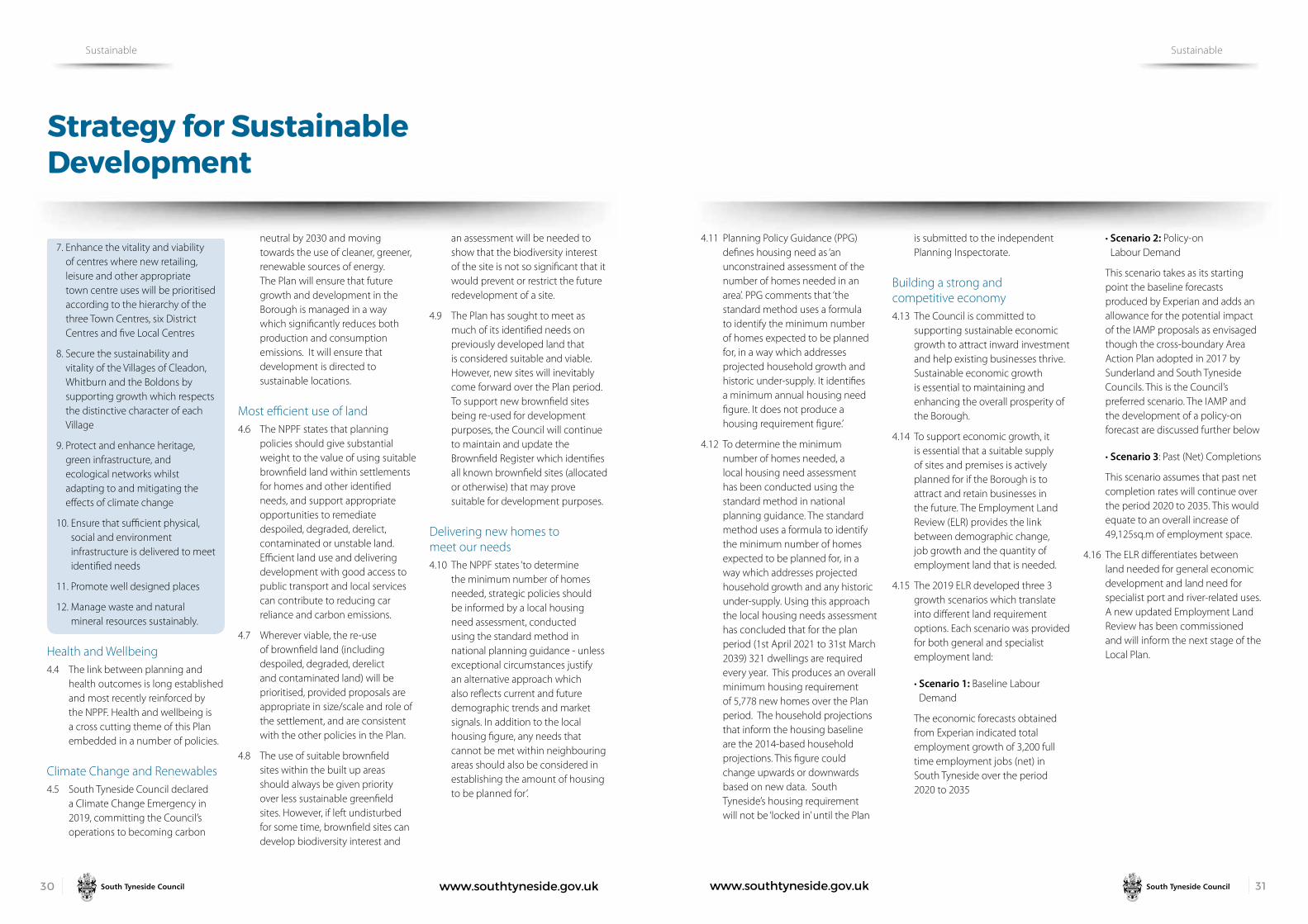
www.southtyneside.gov.uk 3130 www.southtyneside.gov.uk
Strategy for Sustainable Development
Sustainable Sustainable
7. Enhance the vitality and viability of centres where new retailing, leisure and other appropriate town centre uses will be prioritised according to the hierarchy of the three Town Centres, six District Centres and five Local Centres
8. Secure the sustainability and vitality of the Villages of Cleadon, Whitburn and the Boldons by supporting growth which respects the distinctive character of each Village
9. Protect and enhance heritage, green infrastructure, and ecological networks whilst adapting to and mitigating the effects of climate change
10. Ensure that sufficient physical, social and environment infrastructure is delivered to meet identified needs
11. Promote well designed places
12. Manage waste and natural mineral resources sustainably.
Health and Wellbeing 4.4 The link between planning and
health outcomes is long established and most recently reinforced by the NPPF. Health and wellbeing is a cross cutting theme of this Plan embedded in a number of policies.
Climate Change and Renewables4.5 South Tyneside Council declared
a Climate Change Emergency in 2019, committing the Council’s operations to becoming carbon
neutral by 2030 and moving towards the use of cleaner, greener, renewable sources of energy. The Plan will ensure that future growth and development in the Borough is managed in a way which significantly reduces both production and consumption emissions. It will ensure that development is directed to sustainable locations.
Most efficient use of land4.6 The NPPF states that planning
policies should give substantial weight to the value of using suitable brownfield land within settlements for homes and other identified needs, and support appropriate opportunities to remediate despoiled, degraded, derelict, contaminated or unstable land. Efficient land use and delivering development with good access to public transport and local services can contribute to reducing car reliance and carbon emissions.
4.7 Wherever viable, the re-use of brownfield land (including despoiled, degraded, derelict and contaminated land) will be prioritised, provided proposals are appropriate in size/scale and role of the settlement, and are consistent with the other policies in the Plan.
4.8 The use of suitable brownfield sites within the built up areas should always be given priority over less sustainable greenfield sites. However, if left undisturbed for some time, brownfield sites can develop biodiversity interest and
an assessment will be needed to show that the biodiversity interest of the site is not so significant that it would prevent or restrict the future redevelopment of a site.
4.9 The Plan has sought to meet as much of its identified needs on previously developed land that is considered suitable and viable. However, new sites will inevitably come forward over the Plan period. To support new brownfield sites being re-used for development purposes, the Council will continue to maintain and update the Brownfield Register which identifies all known brownfield sites (allocated or otherwise) that may prove suitable for development purposes.
Delivering new homes to meet our needs4.10 The NPPF states ‘to determine
the minimum number of homes needed, strategic policies should be informed by a local housing need assessment, conducted using the standard method in national planning guidance - unless exceptional circumstances justify an alternative approach which also reflects current and future demographic trends and market signals. In addition to the local housing figure, any needs that cannot be met within neighbouring areas should also be considered in establishing the amount of housing to be planned for’.
4.11 Planning Policy Guidance (PPG) defines housing need as ‘an unconstrained assessment of the number of homes needed in an area’. PPG comments that ‘the standard method uses a formula to identify the minimum number of homes expected to be planned for, in a way which addresses projected household growth and historic under-supply. It identifies a minimum annual housing need figure. It does not produce a housing requirement figure.’
4.12 To determine the minimum number of homes needed, a local housing need assessment has been conducted using the standard method in national planning guidance. The standard method uses a formula to identify the minimum number of homes expected to be planned for, in a way which addresses projected household growth and any historic under-supply. Using this approach the local housing needs assessment has concluded that for the plan period (1st April 2021 to 31st March 2039) 321 dwellings are required every year. This produces an overall minimum housing requirement of 5,778 new homes over the Plan period. The household projections that inform the housing baseline are the 2014-based household projections. This figure could change upwards or downwards based on new data. South Tyneside’s housing requirement will not be ‘locked in’ until the Plan
is submitted to the independent Planning Inspectorate.
Building a strong and competitive economy4.13 The Council is committed to
supporting sustainable economic growth to attract inward investment and help existing businesses thrive. Sustainable economic growth is essential to maintaining and enhancing the overall prosperity of the Borough.
4.14 To support economic growth, it is essential that a suitable supply of sites and premises is actively planned for if the Borough is to attract and retain businesses in the future. The Employment Land Review (ELR) provides the link between demographic change, job growth and the quantity of employment land that is needed.
4.15 The 2019 ELR developed three 3 growth scenarios which translate into different land requirement options. Each scenario was provided for both general and specialist employment land:
•Scenario 1: Baseline Labour Demand
The economic forecasts obtained from Experian indicated total employment growth of 3,200 full time employment jobs (net) in South Tyneside over the period 2020 to 2035
• Scenario 2: Policy-on Labour Demand
This scenario takes as its starting point the baseline forecasts produced by Experian and adds an allowance for the potential impact of the IAMP proposals as envisaged though the cross-boundary Area Action Plan adopted in 2017 by Sunderland and South Tyneside Councils. This is the Council’s preferred scenario. The IAMP and the development of a policy-on forecast are discussed further below
•Scenario 3: Past (Net) Completions
This scenario assumes that past net completion rates will continue over the period 2020 to 2035. This would equate to an overall increase of 49,125sq.m of employment space.
4.16 The ELR differentiates between land needed for general economic development and land need for specialist port and river-related uses. A new updated Employment Land Review has been commissioned and will inform the next stage of the Local Plan.

www.southtyneside.gov.uk 3332 www.southtyneside.gov.uk
Strategy for Sustainable Development
Sustainable Sustainable
General Employment Requirements4.17 The Council’s preferred scenario is
the baseline labour demand figure to the policy-on labour demand figure. Table 1 shows the need for general employment land. The ELR assessed employment land requirement over the period 2020-2035. The Council’s Business Investment Team have adjusted the land requirement figures for the baseline labour demand scenario to reflect the Local Plan period (2021-2039) and these figures are shown for Tables 1 and 2.
Table 1 The need-supply balance for general employment land
Scenario OptionBaseline Labour Demand (ha)
Land required 19.66
Port and river-related uses. 4.18 Table 2 shows the need in respect
of the baseline labour demand scenario for port and river-related employment land.
Table 2 The need for port and river-related employment land
Scenario OptionBaseline labour demand (ha)
Land required 4.16
Build and Natural Environments4.19 The way growth is delivered
through the Plan will need to be appropriate and sensitive to the landscape in which it is situated. Wider consideration of the landscape, natural environment, and townscape through the design principles of development proposals is an important consideration in the planning process. Development can offer opportunities to enhance landscape character, green infrastructure and biodiversity networks and can positively contribute to the character of an area. It is essential to consider landscape issues early in the planning application process.
Infrastructure4.20 It is important that development
is supported by the necessary infrastructure provision. The Infrastructure Delivery Plan provides a high-level overview of infrastructure requirements.
Minerals and Waste4.21 Minerals are important resources.
They are the raw materials which are necessary to provide the infrastructure, buildings, goods, and energy that both society and the economy needs, therefore supporting sustainable economic growth. The policies within the Local Plan aim to deliver the strategic objective to manage the prudent use of the Borough’s
natural resources, which includes minerals, while minimising the adverse impacts of their extraction and transportation on both communities and the environment.
4.22 Managing waste is a key element of sustainable development. The Council will seek to contribute to climate change mitigation and the reduction of carbon emissions by applying the waste hierarchy of prevention, preparing for reuse, recycling, other recovery, and safe disposal. Waste should be reduced and reused or recycled where possible and disposed of as a last resort.
Spatial Strategy 4.23 Local Plans not only identify the
amount of new development needed but also where it should be located. South Tyneside is a small Borough with numerous environmental, physical and infrastructure constraints that affect how and where development can be delivered. Balancing these constraints and delivering sustainable growth for the future needs of the Borough is the key challenge. The Spatial Strategy for Sustainable Development (Policy SP3) sets out the spatial distribution of development during the Plan period to ensure that the identified needs can be met .
Policy SP3: Spatial Strategy for sustainable development
To meet the identified needs in Policy SP1 and to facilitate sustainable growth, the Plan will:
1. Focus housing development in the Main Urban Area of South Shields, Hebburn, Jarrow and the Villages on allocated sites
2. Amend the Green belt boundary at Hebburn, Fellgate, Whitburn, Cleadon, East Boldon and West Boldon to:
i. allocate additional land for housing
ii. create a sustainable, new community for new homes on land south of Fellgate
iii. safeguard land for future development beyond the plan period
3. Prioritise the regeneration of South Shields Riverside, Tyne Dock, South Shields Town Centre, Salem Street, Queen Street, Hebburn New Town, Fowler Street Improvement Area, and the Foreshore Improvement Area
4. Prioritise economic development in designated Employment Areas that are accessible by a range of transport modes and allocate additional land at Wardley Colliery
5. Enhance and strengthen Green Infrastructure and ecological networks throughout South Tyneside and between neighbouring authorities.
Main Urban Area 4.24 Housing provision is an essential
element of the Plan. Giving existing and future residents a decent home that adequately meets their needs is critical to supporting healthy, safe, and sustainable communities. Housing allocations in the Plan should ensure that a range of housing types are developed and maintained to provide residents with a choice of affordable accommodation that meets their needs and aspirations in attractive, safe, and sustainable neighbourhoods. The type and condition of homes, together with the quality of the immediate surroundings, is one of the most important factors affecting quality of life.
4.25 In line with sustainable development principles (as defined in the NPPF) and the need to make the most efficient use of resources, the Spatial Strategy gives a clear priority for development to be located within the Main Urban Area shown on Map 3.
Map 3 Main Urban Area
4.26 The distribution of housing reflects the availability of suitable land for new housing in the Borough. There are several considerations which the SHLAA has considered including environments, designations, physical constrains such as flooding, viability, and impact on economic growth. Together, these constraints have limited the amount of land available for allocation. As a result, the Spatial Strategy for the distribution of housing allocations reflects the land available in the Main Urban Area. This includes the allocation of 47 sites which accommodate 2120 new homes. The SHLAA and the Sustainability Appraisal (SA) have considered all other reasonable alternatives to this approach.
4.27 However, to meet the housing requirement, land to accommodate an additional 3000 homes must be identified. The Spatial Strategy has therefore had to balance meeting the housing requirements with identifying additional land in sustainable locations.
Amending the Green Belt boundary 4.28 The Plan is committed to making
the most efficient use of land but there are significant issues which prevent the housing needs being met in the Main Urban Area. Firstly, there is an acute shortage of available, suitable, and deliverable brownfield land within the Borough.

www.southtyneside.gov.uk 3534 www.southtyneside.gov.uk
Strategy for Sustainable Development
Sustainable Sustainable
4.29 Through the SHLAA, an extensive survey of all sites has been undertaken which assessed most of the land in the Borough. Unfortunately, a lot of this land is not available or viable. The SHLAA has also considered other sources of land for housing development such as employment land and open space. However, the assessment was unable to identify sufficient land to meet the identified needs.
4.30 In accordance with the NPPF, where there is an existing or anticipated shortage of land to meet housing needs, planning policies should deter homes being built at low densities, ensuring that development makes the most use of each site. Therefore, in advance of concluding that exceptional circumstances exist, minimum density standards should seek a significant uplift in the average density of residential developments for town centres and other locations that are well served by public transport, unless there are strong reasons why this would be inappropriate. The Council, in accordance with the Housing Density Report, has reviewed all allocated sites to maximise housing densities, where it is appropriate to do so.
4.31 The scale of under provision is such that it would not be appropriate for the Plan to rely on the possibility that enough ‘windfall’ sites may, at some point over the Plan period, come forward to meet the shortfall. The Borough operates in a ‘plan-led’ system and the Plan must provide a high degree of certainty to effectively coordinate and deliver the necessary supporting infrastructure.
4.32 Prior to identifying land in the Green Belt the Council has, as part of Duty to Cooperate, discussed whether neighbouring authorities could accommodate additional housing. As set out in the Duty to Cooperate Statement, neighbouring authorities have confirmed that they would be unable to provide land to meet South Tyneside’s needs.
4.33 South Tyneside’s Green Belt is tightly drawn around the built up areas of South Shields, Jarrow, Hebburn and the villages of Cleadon, Whitburn and the Boldons, and extends to the Borough’s administrative boundaries. Green Belt is a major constraint on future development unless Green Belt boundaries are reviewed. The NPPF requires authorities to demonstrate that all reasonable options for meeting development needs have been fully met prior to amending Green Belt boundaries.
The case for change exists in any case where the development requirement exceeds what which can be satisfactorily and confidently delivered within the urban areas. This need constitutes exceptional circumstances as set out in the Stage One Green Belt Review: Exceptional Circumstances.
4.34 The Council considers that exceptional circumstances exist to amend the Green Belt boundary in specific areas to facilitate the sustainable patterns of development. The proposed revised Green Belt is shown on Map 4 and the Policy Map.
Sustainable Urban and Village Extensions4.35 The Council has undertaken an
extensive Green Belt review to identify land which would cause the least harm to the purposes of the Green Belt, that is considered suitable for development, and that could create a new defensible Green Belt boundary. Through this work, the Council has also established the exceptional circumstances to justify amending the Green Belt boundary at each location. Following consultation on the Plan, the Council will undertake a Green Belt boundary review which will review the entire Green Belt boundary to ensure that it has a strong and defensible boundary as required by the NPPF.
4.36 The Spatial Strategy allocates 12 Urban and Village Sustainable Growth Areas at Whitburn, Cleadon, East Boldon and West Boldon. These Urban and Village Sustainable Growth Areas will be able to deliver approximately 1862 new homes during the plan period. These sites are the most appropriate and suitable locations for the future expansion of the Borough’s Main Urban Area.
4.37 In addition, the Plan has identified land south of Fellgate as a Sustainable Urban Extension. The site will be allocated for up to 1200 dwellings. The Green Belt assessments have determined the most appropriate boundary to accommodate a new sustainable community.
Further work is required to determine if land to the south of this allocation should be safeguarded. The Council is therefore consulting on the option of safeguarding land for development beyond the plan period.
4.38 Land South of Fellgate offers a unique opportunity to deliver a new sustainable community. It will be well designed and provide an attractive and desirable place to live. Development of the area will respond to the site’s spatial context and incorporate all the necessary components to achieve a healthy, liveable, and vibrant new community. The new sustainable neighbourhood will provide for a mix of housing sizes, types, and tenures, including affordable housing, and will provide homes which are energy efficient and embed low carbon technologies.
4.39 The site will be expected to provide onsite playing pitches to meet the needs generated from the residential development. Work by the Council’s School Places Planning Managers has identified a need for additional school places to be provided.
Map 4 Revised Green Belt Boundary

www.southtyneside.gov.uk 3736 www.southtyneside.gov.uk
Strategy for Sustainable Development
Sustainable Strategic Allocations
Strategic Allocations
Regeneration 4.40 The Spatial Strategy seeks to
deliver a comprehensive approach to social, physical, and economic regeneration and will continue to prioritise key sites identified in South Shields Town Centre, The Foreshore Improvement Area and Hebburn Town Centre.
Employment Land4.41 To support economic growth across
the Borough, and to attract and retain businesses in the future, it is essential that a suitable supply of sites and premises is actively planned for. A robust supply of employment land offering a range of locations, types and sizes is essential to ensure that there is the flexibility to meet the requirements of the market for employment space. It is essential that these are in areas of the Borough that offer good opportunities to attract investment. It is also important that a variety of sites are designated for employment purposes to achieve a balanced and sustainable local economy.
4.42 The Borough has a very constrained supply of land for development opportunities, including for employment purposes. When comparing the existing supply of employment land to the forecasted need, there is a significant undersupply in general employment sites and an oversupply in port and river related
employment as illustrated in Table 3. Therefore, the Plan seeks to identify additional land for general employment purposes.
Table 3
Policy-on labour
demand (ha)
Baseline labour
demand (ha)
General employment land
Land required 36.91 19.66
Existing available supply
11.03
Land provision required
25.88 8.63
Port and river-related employment land
Land required 6.01 4.16
Existing available supply
18.3
Allocation above requirement
12.29 14.14
4.43 A new employment allocation is proposed at Wardley Colliery (Policy SP15). The overall Green Belt assessment is that it ‘performs moderately against the NPPF purposes and the contribution it makes to the overall integrity of the wider strategic Green Belt’. The site is near the A184 / A194 junction, a key strategic junction, and lies adjacent to the Leamside Line which the Council is looking to re-open in conjunction with its Partners. The site offers an excellent
opportunity for businesses that would require first class transport links and that are able to operate effectively within this distinctive site. It is considered there are exceptional circumstances which justify its removal from the existing Green Belt. The impact on the openness of the remaining Green Belt is reduced because of existing development and the fact it is well screened. It is considered that the test of exceptional circumstances has been met for the release of land from the Green Belt for economic development purposes.
4.44 The Wardley Colliery site will contribute towards reducing the overall quantitative shortfall in land for general economic development. Amending the Green Belt boundary in this location would recognise the reality that there are existing commercial operations on this site and provide the flexibility for Thomas Armstrong Ltd (the site owner) to develop the site.
5.1 By allocating a site, the Plan establishes the principle that the development of the site for its allocated purpose is acceptable. Site allocations are important because they help local people understand what will happen in their community in the future and they give certainty to developers and landowners. They also allow the Council and infrastructure providers to assess the cumulative impact of development and enable future needs such as transport schemes, school places and water infrastructure to be planned for. Allocations are positive policies which promote the development of a site and help ensure the right type of development happens.
Housing Allocations 5.2 To deliver the housing requirement
and to maintain a rolling five year supply of deliverable housing sites, the Plan allocates 40 sites for housing development (Policy SP4), 12 Village and Urban Growth Areas (Policy SP5) a Sustainable Urban Growth Area (Policy SP6) and 7 Housing-Led Regeneration Sites (Policies SP7-11). These allocations are summarised in Table 4 below.
Table 4 Housing Allocations in the Plan
AllocationTotal number
of sitesIndicative capacity
Housing Allocation sites (in the Main Urban Area) 40 1782
Urban and Village Sustainable Growth Areas 12 1862
Sustainable Urban Growth Area 1 1200
Housing Sites in Regeneration Areas 7 338
Total 60 5182
5.3 When allocating sites to meet the housing requirement, the Plan has looked to ensure the right homes are delivered in the right places, taking into account need, demand, deliverability, sustainability and improving choice.
5.4 It will be a requirement for development on land allocated for housing to:
•Bedesignedtoahighstandard.Particular attention to be paid to layout, scale, height, design, and massing to ensure that the development is of a high quality design that responds to local character
•Protect,maintainandwherepossible enhance open spaces (a few which are located within the Green Belt) in order to encourage improved quality and accessibility
•Contributetowardsthedeliveryof a high quality multi-functional green infrastructure network
•Makeprovisionorcontributionstowards education and healthcare.
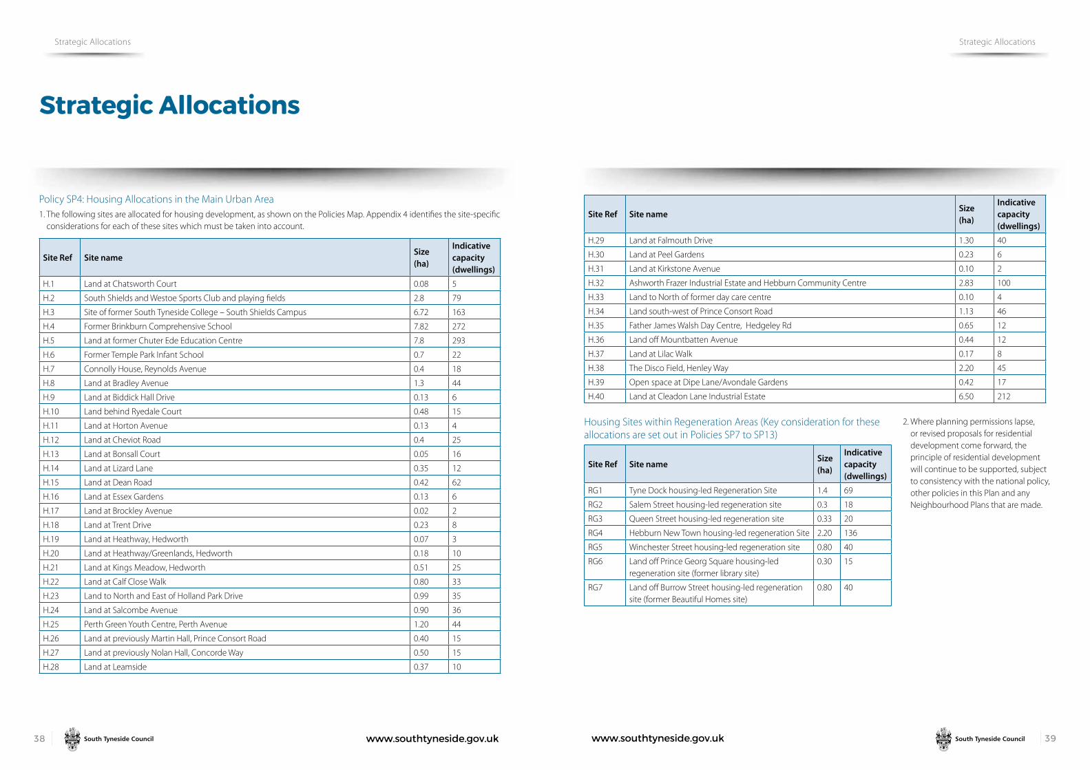
www.southtyneside.gov.uk 3938 www.southtyneside.gov.uk
Strategic Allocations
Strategic Allocations Strategic Allocations
Policy SP4: Housing Allocations in the Main Urban Area1. The following sites are allocated for housing development, as shown on the Policies Map. Appendix 4 identifies the site-specific
considerations for each of these sites which must be taken into account.
Site Ref Site nameSize (ha)
Indicative capacity (dwellings)
H.1 Land at Chatsworth Court 0.08 5
H.2 South Shields and Westoe Sports Club and playing fields 2.8 79
H.3 Site of former South Tyneside College – South Shields Campus 6.72 163
H.4 Former Brinkburn Comprehensive School 7.82 272
H.5 Land at former Chuter Ede Education Centre 7.8 293
H.6 Former Temple Park Infant School 0.7 22
H.7 Connolly House, Reynolds Avenue 0.4 18
H.8 Land at Bradley Avenue 1.3 44
H.9 Land at Biddick Hall Drive 0.13 6
H.10 Land behind Ryedale Court 0.48 15
H.11 Land at Horton Avenue 0.13 4
H.12 Land at Cheviot Road 0.4 25
H.13 Land at Bonsall Court 0.05 16
H.14 Land at Lizard Lane 0.35 12
H.15 Land at Dean Road 0.42 62
H.16 Land at Essex Gardens 0.13 6
H.17 Land at Brockley Avenue 0.02 2
H.18 Land at Trent Drive 0.23 8
H.19 Land at Heathway, Hedworth 0.07 3
H.20 Land at Heathway/Greenlands, Hedworth 0.18 10
H.21 Land at Kings Meadow, Hedworth 0.51 25
H.22 Land at Calf Close Walk 0.80 33
H.23 Land to North and East of Holland Park Drive 0.99 35
H.24 Land at Salcombe Avenue 0.90 36
H.25 Perth Green Youth Centre, Perth Avenue 1.20 44
H.26 Land at previously Martin Hall, Prince Consort Road 0.40 15
H.27 Land at previously Nolan Hall, Concorde Way 0.50 15
H.28 Land at Leamside 0.37 10
Site Ref Site nameSize (ha)
Indicative capacity (dwellings)
H.29 Land at Falmouth Drive 1.30 40
H.30 Land at Peel Gardens 0.23 6
H.31 Land at Kirkstone Avenue 0.10 2
H.32 Ashworth Frazer Industrial Estate and Hebburn Community Centre 2.83 100
H.33 Land to North of former day care centre 0.10 4
H.34 Land south-west of Prince Consort Road 1.13 46
H.35 Father James Walsh Day Centre, Hedgeley Rd 0.65 12
H.36 Land off Mountbatten Avenue 0.44 12
H.37 Land at Lilac Walk 0.17 8
H.38 The Disco Field, Henley Way 2.20 45
H.39 Open space at Dipe Lane/Avondale Gardens 0.42 17
H.40 Land at Cleadon Lane Industrial Estate 6.50 212
Housing Sites within Regeneration Areas (Key consideration for these allocations are set out in Policies SP7 to SP13)
Site Ref Site nameSize (ha)
Indicative capacity (dwellings)
RG1 Tyne Dock housing-led Regeneration Site 1.4 69
RG2 Salem Street housing-led regeneration site 0.3 18
RG3 Queen Street housing-led regeneration site 0.33 20
RG4 Hebburn New Town housing-led regeneration Site 2.20 136
RG5 Winchester Street housing-led regeneration site 0.80 40
RG6 Land off Prince Georg Square housing-led regeneration site (former library site)
0.30 15
RG7 Land off Burrow Street housing-led regeneration site (former Beautiful Homes site)
0.80 40
2. Where planning permissions lapse, or revised proposals for residential development come forward, the principle of residential development will continue to be supported, subject to consistency with the national policy, other policies in this Plan and any Neighbourhood Plans that are made.

www.southtyneside.gov.uk 4140 www.southtyneside.gov.uk
Strategic Allocations
Strategic Allocations Strategic Allocations
Map 5 Housing Allocations in the Main Urban Area
5.5 The NPPF reaffirms that the planning system should be genuinely plan-led and that housing sites should be deliverable and/or developable; that is to say have a genuine prospect of delivery over the plan period. The Plan allocates deliverable and/or developable housing sites that are needed to address the Borough’s housing requirement.
The allocation of housing sites has been informed by a wide range of South Tyneside technical documents including the Strategic Flood Risk Assessment (SFRA), the IDP, and the SHLAA. Each allocated housing site has been subject to a Sustainability Appraisal (SA) which aims to promote sustainable development by assessing all policies and alternatives against a set of Sustainability Objectives. To ensure that the site allocation process is transparent the Council has prepared a Site Allocation Topic Paper which provides a full overview of this process.
5.6 It is considered that the sites allocated in this policy are the most appropriate to deliver the new homes needed, making the effective use of land, and utilising previously developed land where it is available and viable. These allocations, together with other elements of housing supply such as Urban and Village Sustainable Growth Areas, Regeneration Areas, sites with planning permission and sites under construction, will provide the range and choice of sites to meet our needs and deliver the preferred spatial strategy for the distribution of housing.
5.7 The Council has identified an indicative capacity for each site identified . It should be noted that the stated number is based on the information available at the time. As further technical studies are undertaken in support of a planning application, this may demonstrate that a higher or lower number of houses is justified. Proposal should therefore be treated on their merits, taking into consideration the relevant policies contained within this Plan alongside all other material planning considerations. The Council is continuing to assess these sites as part of the preparation of the Plan.
5.8 Three sites identified as housing allocations within the main urban area include playing field land. These are:
•SouthShieldsandWestoeSportsClub and playing fields
•FormerBrinkburnComprehensiveSchool
•LandatformerChuterEdeEducation Campus
5.9 Policy SP5 also identifies lapsed playing field site Land at South Tyneside College, Hebburn Campus as a housing allocation.
5.10 These sites have been identified for housing development as they could provide high-quality housing in suitable and sustainable locations. However, these sites will require the provision of new playing field land to mitigate their loss. Policy SP23 identifies some mitigation proposals to address the loss of provision, however the Council is working with Sport England to determine if these sites can be delivered.
Urban and Village Sustainable Growth AreasPolicy SP5: Urban and Village Sustainable Growth Areas
1. The following sites will be removed from the Green Belt and are allocated for housing development, as shown on the Policies Map. Appendix 4 identifies the site-specific considerations for each of these sites which must be taken into account. Development of Urban and Village Growth Areas will be required to create a new defensible Green Belt boundary.
Site Ref
Site nameSize (ha)
Indicative capacity (dwellings)
GA1 Land south of Cleadon Park 3.42 90
GA2 Land west of Sunniside Farm 5.97 156
GA3 Land at South Tyneside College, Hebburn Campus
5.70 115
GA4 Land at North Farm 9.5.6 263
GA5 Former MoD bunkers, medical stores and associated land
5.2 120
GA6 Land south of St John’s Terrace and Natley Avenue
1.56 63
GA7 Land to North of Town End Farm 22.40 400
GA9 Land at West Hall Farm 10.27 259
GA10 Land at Wellands Farm 9.10 250
GA11 Land west of Cleadon Lane, Whitburn 3.90 75
GA12 Land at Whitburn Lodge 1.0 30
GA13 Land to North of Shearwater 1.65 41

www.southtyneside.gov.uk 4342 www.southtyneside.gov.uk
Strategic Allocations
Strategic Allocations Strategic Allocations
Map 6 Urban and Village Sustainable Growth Areas
5.11 Urban and Village Growth Areas, are sites which are proposed to be removed from the Green Belt and allocated for housing. Policy SP6 seeks to ensure that the scale and distribution of housing growth represents sustainable development. The Council has considered all alternative spatial growth, as set out in the Green Belt Assessments and SA and have concluded that these sites cause the least harm to the Green Belt.
5.12 The sites will be developed to a high standard to make them attractive and sustainable places to live. Development will be expected to mitigate for the loss of Green Belt land by maintaining any physical boundaries that provide visual and functional separation to the Green Belt.
Fellgate Sustainable Growth Area Policy SP6: Fellgate Sustainable Growth Area
1. Land at Fellgate, as shown on the Policies Map, is allocated as a sustainable urban extension and will be removed from the Green Belt. Development is required to be comprehensively masterplanned though an SPD to be prepared by the Council. The SPD will demonstrate how the phasing of development will have regard to the provision and timing of infrastructure and services. Development of this new sustainable community shall:
i. Provide a mix of house types and tenures
ii. Be designed to a high standard. Particular attention to be paid to layout, height, design, scale, landscaping, materials, and massing to ensure that the development is of a high quality design that responds to local character. Any planning application shall include a Design Code
iii. Make provision or contributions towards social and community infrastructure
iv. Enhance access to local facilities and services, where appropriate
v. Deliver up to 1200 homes on land allocated for residential development, as shown on the Policies Map and Inset Map 7.
vi. Provide 20% affordable homes
vii. Provide accessible or adaptable homes
viii. Create a new defensible Green Belt boundary to the south of the site
ix. Deliver compensatory improvements to the remaining Green Belt to maintain and enhance ecological value
x. Enhanced the boundary along to A184 and A19 to ensure appropriate screening and noise attenuation
xi. Maintain existing wildlife and green infrastructure corridors
xii. Limit any impact on the area’s landscape character and provide suitable ecological mitigation where appropriate
xiii. Deliver biodiversity net gains
xiv. Secure onsite recreational open space and playing pitch provision
xv. Ensure that there are no unacceptable impacts on highway safety or severe residual cumulative impacts on the wider road network in terms of capacity and congestion. Details of all necessary on and off site highway works and improvements, together with a timetable for their implementation, shall be agreed with the Council as part of the comprehensive masterplan and any future planning applications
xvi. Reduce the dominance of car traffic and improve permeability by incorporating convenient, safe, and high-quality bus, pedestrian, and cycle routes within the site that connect to existing networks. A Transport Assessment and Travel Plan for each site will also be required
2. Land south of Fellgate, as shown on the Policies Map, is proposed to be removed from the Green Belt and designated as Safeguarded Land. Planning permission for the development of Safeguarded Land will not be granted except where development is temporary or would otherwise not prejudice the ability of the site to be developed in the longer term.
Map 7 Fellgate Sustainable Growth Area

www.southtyneside.gov.uk 4544 www.southtyneside.gov.uk
Strategic Allocations
Strategic Allocations Strategic Allocations
5.13 In accordance with the Plan’s chosen spatial strategy and housing distribution, and after demonstrating exceptional circumstances alongside a comprehensive assessment of the Green Belt, land at Fellgate has been identified suitable, sustainable urban extension. This strategic allocation represents a unique opportunity within South Tyneside to deliver an exemplary new community.
5.14 Due to highway constraints the Plan does not propose to allocate the entire site. At this stage in plan preparation, it is proposed that land necessary to accommodate 1,000 homes will be allocated. The Council, with the aid of its Green Belt Review, has identified land which causes the least harm to the Green Belt. Following consultation on the Plan, the Council will prepare a masterplan which will guide the development of the site and determine the necessary infrastructure that will be required. It is anticipated that this masterplan will be adopted as an SPD. In addition, the Council are consulting on the potential of safeguarding land to the south of Fellgate.
5.15 Social and community infrastructure includes health and education. The Council’s School Places Planning Managers have identified a need for a primary school. Further details will be provided in the SPD.
5.16 Policy SP7 identifies criteria which any development within the site needs to take into consideration. These criteria will be reviewed following consultation on this Plan and the masterplanning exercise.
Safeguarded Land 5.17 Safeguarded Land to the south
of Fellgate (Map 7) is considered necessary for a few reasons. Firstly, it provides a degree of permanence to the Green Belt boundaries put in place by the Plan and ensures that future further reviews of the Green Belt will not be needed at the end of the plan period. Secondly, it provides flexibility and allows for a Plan review if the Council cannot demonstrate a five year land supply. During a Plan review, the reassessment of Safeguarded Land will involve determining whether in the prevailing circumstances there is a case for releasing some or all the land for development, or whether it should be maintained as Safeguarded Land until the next review of the Plan.
5.18 Although development will not generally be appropriate on Safeguarded Land, it is recognised that not all development will prejudice the function and the value of the land. It may, therefore, be appropriate to permit development required in connection with established uses or change of use to an alternative open land use or to temporary uses which would not prejudice the possibility of development after the Plan is reviewed, nor is it detrimental to the character of the site and its surroundings.
Regeneration Areas and Sites5.19 The Borough has a rich industrial
heritage, but the Council recognises the reality that traditional industries such as shipbuilding and coal mining no longer underpin the local economy. The objectives for this Plan include ‘Regenerating the Borough’ to address the legacies from the Borough’s industrial past. As set out in the Spatial Vision, the Council, working with Partners, wants to transform key regeneration sites into vibrant locations for new homes, shops, and jobs.
Policy SP7: South Shields Riverside Regeneration Area
To achieve an active and vibrant South Shields Riverside that contributes to the prosperity of the Borough, the following sites are allocated:
1. Holborn Middle Dock and Windmill Hill will deliver a mixed-use residential (approximately 348 homes) and office (approximately 200,000 sq. ft.) development. Development proposals shall include the creation of a new promenade that allows public access to the riverside area
2. Harton Quay will deliver a mixed-use residential, commercial and hotel development with ancillary food and drink offer which builds on the distinctive characteristics of Mill Dam Conservation Area
3. Customs House Car Park will deliver cultural-related uses which complement the use and setting of the Customs House.
Map 8 South Shields Riverside Regeneration Area
5.20 The South Shields Riverside is a major asset to the Borough which presents both opportunities and challenges. The allocation of the sites that together make up the Riverside Regeneration Area will contribute to the regeneration of the river corridor and support the on-going regeneration of South Shields Town Centre. It is important that the development of these sites is of a design quality that reflects the Council’s aspirations for the high-quality regeneration of the riverside corridor and that they achieve a high level of permeability for pedestrians and cyclists throughout the South Shields Riverside area and to South Shields Town Centre.
5.21 Most of the sites allocated in the policy are in public ownership through an acquisition strategy that the Council has been pursuing over a period of 15-20 years. There has been investment through acquisition and demolition. The Council has also undertaken or facilitated a range of site investigations for most of the sites.

www.southtyneside.gov.uk 4746 www.southtyneside.gov.uk
Strategic Allocations
Strategic Allocations Strategic Allocations
5.22 The Council has secured the necessary statutory consents to deliver the civil engineering enabling works at Holborn. This workstream includes the replacement of the failing quay edge, restoration of three former docks, flood alleviation, improvements to site topography, and addresses the legacy of land contamination from former heavy industrial uses. Located close to the town centre, the site represents a major opportunity for substantial new office development as well as residential and other supporting uses within a highly sustainable location.
5.23 As a regionally significant site, Holborn Middle Dock and Windmill Hill has the potential for a flagship mixed-use development. Proposals for the site are intended to capitalise on the Enterprise Zone status of the upper tier of the site and will deliver high quality office space and significant jobs. It is envisaged the new commercial development will include 200,000 sq. ft. of office space, as well as new high quality residential units which will provide a range of house types and tenures. Together, these will provide a balanced and mixed community. The Council sees these sites as a significant asset to the Borough particularly in terms of providing appropriate accommodation for new and growing business service and digital and tech companies.
5.24 The proposals will bring forward new mixed use development on the riverside which will not only enhance the waterfront but also mirror investment on the north banks of the Tyne around Tyne Commission Quay / Royal Quays and Smiths Dock. The Council’s proposed investment will complete the regeneration of this stretch of the riverside and will have a major impact in changing perceptions of South Tyneside. This is particularly important given the increasing number of visitors and cruise ships making the river our international window to the world.
5.25 The Riverside sites have strong historical associations with the heavy industries that were once prevalent along the River Tyne. They include the remnants of Cookson’s Glassworks and the Staithes Masters House that both contribute to the understanding of the importance the Harton Quay site has played throughout history, just as all the other heritage assets within and around Mill Dam Conservation Area have shared a variety of historical associations. Development proposals should therefore seek to knit what is currently a somewhat disjointed area back together whilst ensuring the many and varied heritage assets remain centre stage, having regard to distinctive views and settings.
5.26 The Mill Dam Conservation Area was designated in 1981 and represents an area of riverside heritage which includes the Customs House (1863). Supplementary Planning Document No 19: Mill Dam Conservation Area Management Plan (2010) encourages the Local Authority, developers, development professionals and the local community to engage in the preservation and enhancement of the historic environment. Potential mitigation measures have been highlighted in the Heritage Impact Assessments.
5.27 The Harton Quay area is developing a strong cultural identity supported by the proximity of the Customs House, which is a cultural hub (cinema, theatre, music, restaurant, events venue) and The Word. Both are high quality buildings, and their respective cultural offerings are encouraging the development of a cultural ethos in the Harton Quay area.
Tyne Dock Estate Housing-led Regeneration Site Policy SP8: Tyne Dock Estate Regeneration Site
The Tyne Dock Estate is allocated for approximately 69 homes. Development shall be in accordance with the Tyne Dock Masterplan and shall:
1. Locate new homes in the Lord Nelson Street Area
2. Provide qualitative environmental improvements to the wider estate area including:
i. Enhancing and better integrating public realm and public open space
ii. Retaining and, where possible, enhancing walking and cycling links, particularly to the metro station.
Map 9 Tyne Dock Estate Housing-led Regeneration Site
5.28 There have been various housing types on the Tyne Dock estate, but with a heavy weighting towards apartments. This has created poor demand and some estate management issues, which has limited appeal to families. There are local amenities but some of these are either run-down or under-utilised. Although there are pockets of quality housing, in general the area suffers from low demand, with several vacant or derelict buildings. That said, it is well located with access local amenities, including the Tyne Dock Metro and road network to Jarrow and South Shields. It is also bounded by areas of better quality housing, and the newly completed Staithes development by Karbon Homes has set a good benchmark for the area.
5.29 The Council is now embarking on a programme to regenerate the wider area, making the most of existing assets and creating a long-term, positive future for residents. The Council has been successful in bidding within the Estate Regeneration Programme from Homes England to determine an option for the future of the estate. A masterplan has been drawn up to guide development. This identifies the Lord Nelson Street Area as the core development area with the demolition of the 126 properties and their replacement by 69 new homes. The masterplan also identifies a range of improvements to the wider estate.

www.southtyneside.gov.uk 4948 www.southtyneside.gov.uk
Strategic Allocations
Strategic Allocations Strategic Allocations
South Shields Town Centre College-Led Regeneration SitePolicy SP9: South Shields Town Centre College Regeneration Site
The site is allocated for the relocation of the South Tyneside Campus of Tyne Coast College and the Marine School.
Map 10 South Shields Town Centre College-led Regeneration Site
5.30 South Tyneside College is a specialist in the provision of marine and offshore skills. The South Tyneside Economic Recovery Plan (2020) states that the Council will work closely with South Tyneside College to develop a fit for purpose College of the Future. The relocation will provide an opportunity for the creation of new state-of-the-art educational facilities that further the Council’s ambitions for making South Tyneside a UK-leader in low-carbon, advanced
manufacturing, and digital training that upskills residents and attracts new businesses to the Borough. The relocation will also bring students into the heart of the town centre, increasing footfall and thereby supporting its viability and vitality.
5.31 Careful consideration of layout, height, massing, landscaping, and materials should ensure development contributes positively to this town centre location. Central to the proposed campus is the Grade II Listed 16 Barrington Street, which will be integral to the design process. The immediate setting of the Trustee Savings Bank will also be carefully considered.
Salem Street Regeneration SitePolicy SP10: Salem Street Housing-led Regeneration Site
The area bounded by River Drive, Salem Street and North Street is allocated for approximately 18 homes.
Map 11 Salem Street Housing-led Regeneration Site
Queen Street Regeneration Site Policy SP11: Queen Street Housing-led Regeneration Site
The area bounded by Queen Street, North Street and Salem Street is allocated for approximately 20 homes.
Map 12 2 Queen Street Regeneration Site
5.32 The Salem Street and Queen Street Regeneration sites offer an opportunity to provide new homes in a location which will support the vitality and viability of the town centre. The proximity of the sites to the High Street means that it is particularly important that the quality of the development acknowledges the Council’s positive aspirations for the regeneration of South Shields Town Centre.
Hebburn New Town Regeneration site Policy SP12: Hebburn New Town Housing-led Regeneration site
The area adjacent to the Mountbatten Shopping Centre, and Hebburn Central is allocated for approximately 136 homes.
Map 13 Hebburn New Town Regeneration site
5.33 This site is located adjacent to the Mountbatten Shopping Centre and Hebburn Central, within Hebburn town centre. It has excellent transport links, doctors’ surgeries, and good schools. This location provides opportunities for a range of residential accommodation to meet the needs of the town as well as the wider needs of the Borough. Previous accommodation that was located on this site was Council-owned, high density and of poor quality, yet it remained popular until it was demolished.
Therefore, any new housing that is developed on this site must provide a high quality mix of housing type.
5.34 This site has been identified as an ideal location for an extra care scheme, with the provision of approximately 90 extra care units. There is also a need for family accommodation and it is estimated that 40 – 50 general needs homes could be provided here. This would be a mix of two and three bedroom homes to meet the needs of residents.

www.southtyneside.gov.uk 5150 www.southtyneside.gov.uk
Strategic Allocations
Strategic Allocations Strategic Allocations
Regeneration Improvement AreasPolicy SP13: Regeneration Improvement Areas
The following Regeneration Improvement Areas are designated:
1. Fowler Street Improvement Area. The following sites are allocated to support its enhancement:
i. Winchester Street Regeneration Site is allocated for approximately 40 homes
ii. Land off Prince Georg Square Regeneration Site (former library site) is allocated for approximately 15 homes
iii. Land off Burrow Street housing-led Regeneration Site (former Beautiful Homes site) is allocated for approximately 40 homes
2. Foreshore Improvement Area – within this Area the Council will support:
i. Public realm improvements and the development of sporting leisure facilities at Gypsies Green and the surrounding area
ii. Public realm improvements at the promenade between Colman’s Seafood Temple and Trow Quarry.
Proposals shall have regard to the Shoreline Management Plan, particularly in respect of the potential for the shoreline to be rolled-back in future years due to coastal erosion and also to the requirements for a HRA where impacts on European sites may occur.
Fowler Street Improvement Area
Map 14 Fowler Street Improvement Area
5.35 The area to the west of Fowler Street in South Shields Town Centre currently consists of a mix of public car parks, vacant land, and a timber business. The area does not present a positive image visually. It is important that it is identified as an improvement area to highlight that the Council will support proposals that complement existing notable townscape features and improve the quality of the built environment in this key gateway location.
5.36 There are currently a variety of uses within the Winchester Street site with the predominant one being a car park. Our Regeneration team have recognised an opportunity to provide new homes in a
location which will support the vitality and viability of the town centre. Although the site does not directly front onto Fowler Street, its proximity to this High Street means that it is particularly important that the quality of the development acknowledges the Council’s positive aspirations for the regeneration of the town centre. The former Library and Beautiful Homes sites are also near King Street and similarly provide opportunities to provide new homes in locations that will support the vitality and viability of the town centre.
Foreshore Improvement Area
Map 15 Foreshore Improvement Area
5.37 The South Shields Foreshore area is an important tourism resource. The parks and beaches represent one of the North East’s premier coastal attractions and it is the key driver for the Borough’s visitor economy. The Council has an ongoing commitment to further strengthen these vital assets through investment in the area’s public realm and facilities. This commitment has already paid dividends. For example, the Littlehaven Promenade regeneration has redefined the northern stretch of the Foreshore.
5.38 Regarding the further investment identified in the policy, Gypsies Green Stadium accommodates South Shields Harriers & Athletics Club, South Shields Velo Cycling
Club and South Tyneside Football Club. The Council is in discussions with Partners and existing users about the redevelopment of Gypsies Green as a sporting hub. The Council is also seeking funding for the south promenade / Gypsies Green area. The public realm along most of the promenade has been improved but the promenade to the south between Colman’s Seafood Temple and Trow Quarry still needs improvement.
5.39 Development close to the coast should consider the unique character, quality, and distinctiveness of the area, particularly in relation to Seascape. Seascape considers more than just views of the sea surface and/or
coast: it reflects the community’s personal connectivity with coastal and marine areas. Development proposals should consider the Marine Management Organisation (MMO) ‘Seascape Character Assessment for the North East Inshore and Offshore marine plan areas’ (2018), and the North East Inshore and North East Offshore Marine Plan (2021) Seascape Policy NE-SCP-1.
5.40 The Shoreline Management Plan is a non-statutory plan, which provides a large-scale assessment of the risks associated with coastal processes and presents a policy framework to reduce these risks to people and the developed, historic, and natural environment in a sustainable manner. The document was developed by the Northeast Coastal Authorities group and sets out policy for coastal defence management planning.
5.41 The Shoreline Management Plan identifies the need to retreat the coastline at this location due to climate change and rising sea levels. As there is a hard barrier currently behind the beach in this location, the dunes cannot naturally retreat inland. Over time the natural defence of the dunes will be reduced along with available beach, which is an important amenity for the residents of South Tyneside. Removing the hard structure and promoting the roll back of the dunes and beach will maintain the amenity value of the beach.
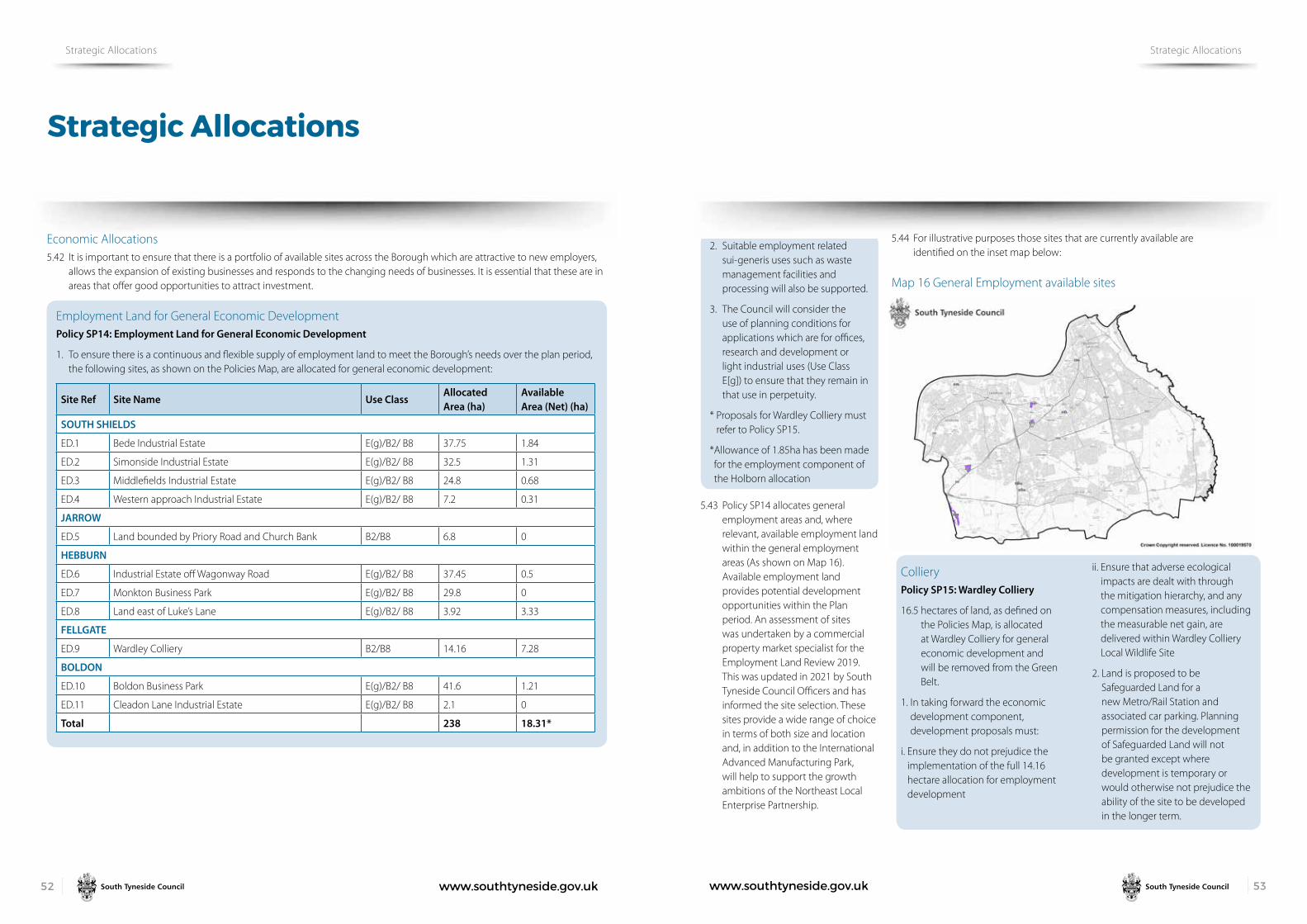
www.southtyneside.gov.uk 5352 www.southtyneside.gov.uk
Strategic Allocations
Strategic Allocations Strategic Allocations
Economic Allocations 5.42 It is important to ensure that there is a portfolio of available sites across the Borough which are attractive to new employers,
allows the expansion of existing businesses and responds to the changing needs of businesses. It is essential that these are in areas that offer good opportunities to attract investment.
Employment Land for General Economic DevelopmentPolicy SP14: Employment Land for General Economic Development
1. To ensure there is a continuous and flexible supply of employment land to meet the Borough’s needs over the plan period, the following sites, as shown on the Policies Map, are allocated for general economic development:
Site Ref Site Name Use ClassAllocated Area (ha)
Available Area (Net) (ha)
SOUTH SHIELDS
ED.1 Bede Industrial Estate E(g)/B2/ B8 37.75 1.84
ED.2 Simonside Industrial Estate E(g)/B2/ B8 32.5 1.31
ED.3 Middlefields Industrial Estate E(g)/B2/ B8 24.8 0.68
ED.4 Western approach Industrial Estate E(g)/B2/ B8 7.2 0.31
JARROW
ED.5 Land bounded by Priory Road and Church Bank B2/B8 6.8 0
HEBBURN
ED.6 Industrial Estate off Wagonway Road E(g)/B2/ B8 37.45 0.5
ED.7 Monkton Business Park E(g)/B2/ B8 29.8 0
ED.8 Land east of Luke’s Lane E(g)/B2/ B8 3.92 3.33
FELLGATE
ED.9 Wardley Colliery B2/B8 14.16 7.28
BOLDON
ED.10 Boldon Business Park E(g)/B2/ B8 41.6 1.21
ED.11 Cleadon Lane Industrial Estate E(g)/B2/ B8 2.1 0
Total 238 18.31*
2. Suitable employment related sui-generis uses such as waste management facilities and processing will also be supported.
3. The Council will consider the use of planning conditions for applications which are for offices, research and development or light industrial uses (Use Class E[g]) to ensure that they remain in that use in perpetuity.
* Proposals for Wardley Colliery must refer to Policy SP15.
* Allowance of 1.85ha has been made for the employment component of the Holborn allocation
5.43 Policy SP14 allocates general employment areas and, where relevant, available employment land within the general employment areas (As shown on Map 16). Available employment land provides potential development opportunities within the Plan period. An assessment of sites was undertaken by a commercial property market specialist for the Employment Land Review 2019. This was updated in 2021 by South Tyneside Council Officers and has informed the site selection. These sites provide a wide range of choice in terms of both size and location and, in addition to the International Advanced Manufacturing Park, will help to support the growth ambitions of the Northeast Local Enterprise Partnership.
5.44 For illustrative purposes those sites that are currently available are identified on the inset map below:
Map 16 General Employment available sites
Colliery Policy SP15: Wardley Colliery
16.5 hectares of land, as defined on the Policies Map, is allocated at Wardley Colliery for general economic development and will be removed from the Green Belt.
1. In taking forward the economic development component, development proposals must:
i. Ensure they do not prejudice the implementation of the full 14.16 hectare allocation for employment development
ii. Ensure that adverse ecological impacts are dealt with through the mitigation hierarchy, and any compensation measures, including the measurable net gain, are delivered within Wardley Colliery Local Wildlife Site
2. Land is proposed to be Safeguarded Land for a new Metro/Rail Station and associated car parking. Planning permission for the development of Safeguarded Land will not be granted except where development is temporary or would otherwise not prejudice the ability of the site to be developed in the longer term.

www.southtyneside.gov.uk 5554 www.southtyneside.gov.uk
Strategic Allocations
Strategic Allocations Strategic Allocations
5.45 Wardley is a former coal processing and disposal site that was operational in the early 1990’s. Since that time is has been occupied by several uses. Currently part of the site is used for container storage, part is hardstanding, and the site also includes an anaerobic digestion plant which generates renewable energy through the treatment of by-products from the food industry. The site comprises previously developed land and has recently been acquired by Thomas Armstrong Ltd, a leading block paving and concrete blocks manufacturer.
5.46 There is a shortfall in the supply of employment land for general economic development when restricted to sites that are out with the Green Belt. The site is not suited to meeting the specific qualitative need that has been identified for a new business/industrial park. However it is considered that it offers a few advantages which mean that it is well suited to making a contribution towards rectifying the quantitative shortfall in land for general economic development.
5.47 The site is near the A184 / A194 junction, a key strategic junction, and lies adjacent to the Leamside Line which the Council and its Partners are looking to re-open. It therefore offers an excellent opportunity for businesses that would require first class transport links and that are able to operate effectively within this distinctive site.
5.48 There is a willing landowner to take the site forward for employment growth. Thomas Armstrong Ltd have distinctive locational requirements for their operations to which this site is well suited.
5.49 Although removing the site from the Green Belt will impact on its openness, it is very well screened. Therefore the visual impact will largely be limited to the area immediately surrounding the site.
5.50 It is considered that the test of exceptional circumstances has been met for the release of land for economic development purposes from the Green Belt. +
Map 17 Wardley Colliery
5.51 The site is within an area requiring further investigation in relation to contamination, with former uses including a colliery and strategic coal stocking site. Surface water flooding has been identified on some small areas of the site.
5.52 The site is located within a wildlife corridor and within 500m survey zone of a recorded Great Crested Newt Pond. The Wardley Colliery Local Wildlife Site is the largest open mosaic habitat on previously developed land in South Tyneside and is the most valuable example of its type in the Borough. The NPPF is clear on the desirability of conserving and enhancing nature conservation.
5.53 A small area of the Local Wildlife Site falls within the employment component of the site but has been identified as within the employment component because it also falls within an area consented for employment use. This does not alter its Local Wildlife Site status, but this specific area of the Local Wildlife Site falls out with the Green Belt.
5.54 The total area of land that is allocated for employment is 14.16ha. The available area (i.e. the area net of existing development) is 9.1ha (this makes allowance for the area used for container storage, the Anaerobic Digester that has been built and for safeguarding land for a metro station and associated car parking). This equates to a net developable area 7.28ha.
5.55 The Transport Plan for the North East 2021-2035 states ‘We want to deliver new stations on existing lines and reopen routes, such as the Northumberland Line and the Leamside Line, alongside Metro network extensions to widen access to jobs and training, grow the economy and reduce deprivation.’

www.southtyneside.gov.uk 5756 www.southtyneside.gov.uk
Strategic Allocations
Strategic Allocations Strategic Allocations
Provision of Land for Port and River-Related DevelopmentPolicy SP16: Provision of Land for Port and River-Related Development
1. To support its continued operation as a key strategic gateway to trade, the Port of Tyne, as shown on the Policies Map, is allocated for port-related economic development opportunities. Where planning permission is required, specialist uses such as heavy processing industries, port services, offshore technology and the subsea sector will be supported within the uses specified in the table below. Other suitable employment-related sui-generis uses that require port or direct riverside access will also be supported.
2. To ensure that the Borough can take advantage of the opportunities and growth potential associated with the growth of offshore windfarms and the decommissioning of offshore oil and gas infrastructure, 12.7 ha of land is allocated for river-related development.
Site Ref
Site Name Use ClassAllocated Area (ha)
Available Area (Net) (ha)
PORT OF TYNE
PR.1 Port of Tyne E(g) / B2 / B8 141.3 5.6
JARROW
PR.2
Land bounded by Chaytor Street, Ellison Place, the Metro Line and Berkley Way
B2 / B8 45.9 12.7*
Total 187.2 18.3*
*The site for which the available area has been estimated is the former Dow Chemicals site.
5.56 The River Tyne and associated development sites are a significant driver of economic activity and there is the potential to further this through a strategy which prioritises riverside sites for port and river-related uses. It is useful to distinguish between land reserved for specific uses and general employment land. It is not unusual for land with access to rivers or the sea to be identified specifically for operators in the offshore and the maritime sectors, or for those requiring access to a river for import or export. The same principle can be applied with ports. Indeed most businesses using the Port of Tyne do so for import or export. The Port of Tyne benefits from permitted development rights to approve port-related development on land in its ownership.
5.57 The land bounded by Chaytor Street, Ellison Place, the Metro Line and Berkley Way, Jarrow includes the former Dow Chemicals site. This large site has a large river frontage that is well suited to such uses and the Employment Land Review recommends that ‘consideration should be given to reserving the site (in whole or in part) for port-related or riverside uses’.
5.58 Riverside developments are in a unique position to support environmental benefits to riverside habitats and wildlife. Where possible, riverside developments should implement opportunities to deliver environmental enhancements in line with the aims of the Tyne Estuary Partnership.
Map 18 Port and River Related use employment allocations

www.southtyneside.gov.uk 5958 www.southtyneside.gov.uk
Promoting Healthy Communities
Healthy Communities Healthy Communities
6.1 The NPPF states that the planning system can play an important role in facilitating interaction and creating healthy, safe, and inclusive communities. This Plan seeks to embed health and wellbeing considerations throughout to achieve healthy places with safe, accessible, and inclusive environments for people to come together. It is also important to deliver the social, recreational, and cultural facilities and services that communities need to facilitate active and healthy lifestyles such as through the provision of appropriate green infrastructure.
Policy 1: Promoting Healthy Communities
To improve and promote strong, vibrant, and healthy communities which encourage positive health related behaviours, reduce health inequalities, and support good physical and mental health and wellbeing, the Council and its Partners, including the NHS, will:
1. Ensure that development:
i. Increases physical activity and active travel through the provision of good quality, safe and accessible open spaces, playing fields and sports facilities, and enhances environments to encourage walking and cycling and the use of public transport
ii. Promotes safe and sustainable public realm and residential environments that encourage social interaction and strong communities
iii. Is designed to meet our changing population and mitigates the impacts of climate change
iv. Creates a quality natural environment and provides green infrastructure
2. Ensure that pollutants, including noise and air pollution, and hazards detrimental to public health and residential amenity are addressed prior to development
3. Deliver well- designed, high-quality, and affordable housing to meet the needs of the Borough’s changing population
4. Manage the provision of hot food takeaway outlets and promote and encourage healthy food choices to reduce levels of excess weight
5. Support health care provision and improvements
6. Ensure new developments contribute to improving health and reducing health inequalities by requiring a Health Impact Assessment (HIA) to be submitted for:
i. Residential schemes for 100 or more dwellings or bedspaces
ii. Other developments where the proposal is likely to have a significant impact on health and wellbeing.
6.2 The health of South Tyneside’s residents is generally worse than the national average, with unhealthy lifestyle choices and physical inactivity major contributors to the Borough’s health issues. The ‘South Tyneside Our Better Health and Wellbeing Strategy 2017-2021’ identifies the strategic priorities for improving health and wellbeing in the Borough, including the delivery of a Local Plan with ‘health at its centre’. The ‘Planning for Health and Wellbeing: Hot Food Takeaways and obesity in South Tyneside: Evidence Report’ (2014) and the ‘Progress Report’ (2017) provide an overview of the environmental factors which are influencing health in South Tyneside.
6.3 The built and natural environment can have a significant impact on physical and mental health. Improving the health and wellbeing of our communities and reducing health inequalities in the Borough are key priorities. Planning can play a significant role in providing healthier environments by engaging with communities and providing access to health care facilities and well-designed public, commercial and residential spaces. Planning can also provide opportunities for active and positive health-related behaviours and tackle social isolation.
6.4 The built environment can contribute to the wider factors which are influential in promoting or discouraging physical activity. Poor quality, unsafe environments which limit access to recreational spaces or facilities or prioritise the private car over other modes of sustainable transport can discourage the amount of physical activity untaken. Lack of physical activity and other unhealthy behaviours can lead to increased levels of obesity and other health issues which can reduce life expectancy and increase health inequality. The South Tyneside Physical Inactivity Strategy 2018-2021 identifies that 26.4 % of the adult population in South Tyneside is classed as inactive. The strategy aimed to increase activity levels throughout our resident population by 2021.
6.5 The provision of good quality open space, recreation facilities and a well-designed built environment is important in facilitating physical activity and healthy related behaviours. Green spaces and the natural environment provide important areas for social interaction which can reduce loneliness amongst all ages and promote good citizenship. Allotments provide opportunities for outdoor recreation and to produce healthy locally grown food, which can help to improve the diet of residents.
The Covid-19 Pandemic has highlighted the vital role that areas of natural environment and greenspace provide to our communities in terms of physical health, providing opportunities to exercise and be active and providing mental wellbeing benefits. These areas are spaces which are valued by residents and provide an important community function and can make a significant contribution to quality of life.
6.6 Long term unemployment, poor housing and reduced life chances can have negative impacts on the health and well-being of individuals (Barton, 2009); and in turn, poor health can lead to lower economic productivity and inactivity (Bambra, Munford, Brown et al, 2018). Planning can contribute to closing the gap in health inequality and improving quality of life by ensuring access to local healthcare facilities and providing well-designed developments that are accessible to all. Encouraging opportunities for employment, education, and training, as well as provision for culture and recreation can also contribute to improving mental health amongst residents
6.7 The Borough’s health facilities are likely to come under pressure due to an ageing population and health facility capacities. The Council’s Planning and Public Health teams are working in Partnership with South Tyneside Clinical Commissioning Group to support health care provision and improvements to ensure that healthcare provision is accessible to all.
6.8 Housing has an essential role to play in good health and wellbeing across all life stages. Housing that is poor quality or in a poor state of repair, or that lacks basic facilities can have a detrimental impact on residents’ physical health and mental wellbeing. Despite continued improvements in construction standards, the home remains a major cause of ill health for many. Poor quality housing can increase the risk of injury, cause or exacerbate respiratory and cardiovascular diseases and can cause illness or even death from temperature extremes. It is important that these risks are minimised and prevented, ensuring residents have suitable housing that meets their needs. Making sure that households have access to good quality housing options, particularly residents who may be more vulnerable to ill health, for example older households and those with young families, is essential to creating healthier communities.

www.southtyneside.gov.uk 6160 www.southtyneside.gov.uk
Promoting Healthy Communities
Healthy Communities Healthy Communities
6.9 New developments can generate potential risks to human health through increasing exposure to air pollution, noise pollution or contaminated land. These issues should be adequately addressed and assessed in accordance with the relevant policies in this Plan.
6.10 To ensure that health impacts are considered at the very outset, a Health Impact Assessment (HIA) shall be submitted in support of certain major planning applications, or any other form of development considered to have an impact on health. The HIA should be proportionate to the scale of development proposed and can be incorporated into other appropriate submission documents, such as a Design and Access Statement. Where a submitted HIA indicates that a development would have a significant adverse impact on health and wellbeing, development will be resisted unless evidence is submitted to demonstrate to the Council’s satisfaction that the impacts can be adequately mitigated. Further guidance on what detail should be contained within an HIA will be set out within a developer guidance note.
Air QualityPolicy 2: Air Quality
1. Development should contribute to the improvement of air quality
2. Where significant air quality impacts are likely to be generated by the development, an appropriate air quality assessment will be required. Development that would result in exposure to air pollution that exceeds national air quality objectives will only be approved where satisfactory mitigation measures can be implemented.
6.11 Air pollution is associated with several adverse health impacts and particularly affects vulnerable groups such as children, older people and those with heart and lung conditions. The importance of good air quality is recognised by the World Health Organisation which produced a series of standards that have been adopted by the European Commission and subsequently the UK.
6.12 The planning system can play an important role in the improvement of air quality. Whether or not air quality issues are relevant to a planning decision will depend on a proposed development and its location. In determining a planning application, a development’s likely effect, either directly or indirectly, on air quality will be considered.
This will be particularly important in areas which have been designated as an Air Quality Management Area (AQMA).
6.13 The Air Quality Annual Status Report (ASR) (2020) provides an overview of air quality in South Tyneside. The Council reviews Nitrogen Dioxide (NO2) annually so that any changes can be identified, and action taken where air quality exceeds national targets. The principal source of NO2 is road transport, combustion processes such as power generation and industrial processes. As highlighted in the ASR, the main contribution in South Tyneside is from road traffic.
6.14 Where national targets have been exceeded, an Air Quality Management Area (AQMA) is designated. The Borough currently has two Air Quality Management Areas where monitoring has shown that Nitrogen Dioxide levels exceed the national objective value. The Council is currently in consultation to remove both AQMAs.
Where relevant, development that may result in a detrimental effect on air quality in the Borough will need to be supported by an air quality assessment that demonstrates appropriate mitigation or promotes sustainable options such as electric charging points. Development proposals must consider the cumulative impacts from other permitted developments on air quality. The Validation Checklist outlines what an Air Quality Assessment must include.
Pollution Policy 3: Pollution
1. Development that may cause pollution of water, soil, or air through noise, vibration, odour, light, fumes, dust, or other pollutants, either individually or cumulatively, shall incorporate measures to prevent or reduce pollution to an acceptable standard to avoid negative impacts on people, the environment or biodiversity
2. Potentially polluting development will only be permitted where satisfactory mitigation measures can be demonstrated
3. Development which could lead to significant pollution, either individually or cumulatively, shall be accompanied by a detailed assessment of the likely impacts. Development proposals where pollution levels are assessed as being unacceptable will only be permitted where mitigation measures can be introduced to provide an acceptable living or working environment in relation to all existing or potential future occupants of the land.
6.15 Planning has an important role to play in making sure that new and existing development does not have, and is not at risk from, pollution which could have an unacceptable impact on health, living conditions or the natural environment including water quality.
The NPPF sets out that new development needs to be appropriate for its location and must consider the likely effects of pollution on health and living conditions including the sensitivity of the site itself and the wider area to those impacts. This is to ensure that new development can be integrated effectively with existing businesses and other community facilities (such as places of worship, pubs, music venues and sports clubs).
6.16 Pollution is the release of substances into the environment that can cause harm to human health, property and any other living organism supported by the wider environment. New and existing development should be protected from unacceptable levels of pollution and should not contribute to any increase in pollution.
6.17 Pollution considerations are especially important when planning for housing, day centres, schools and in areas of high population density. The separation of sensitive developments such as residential, or those relation to health and educational, from polluting sources can reduce the detrimental effects of pollution on those uses.
Development that may be sensitive to existing or potentially polluting sources will only be permitted at an acceptable distance from such sources or where satisfactory mitigation measures can be demonstrated.
6.18 Where development could lead to significant pollution, either individually or cumulatively, proposals must be supported by detailed assessment of the likely impacts. Development will be supported where such assessments demonstrate that pollution can be mitigated and brought within acceptable levels. Acceptable levels refer to statutory limits and the wider considerations of impacts under the Environmental Protection Act (1990).

www.southtyneside.gov.uk 6362 www.southtyneside.gov.uk
Promoting Healthy Communities
Healthy Communities Healthy Communities
6.19 Noise assessments will be required for any development proposals that will either introduce a noise source or create a sensitive use in proximity to an existing noise source. Mitigation measures to minimise adverse impacts from noise pollution should be considered and submitted with development proposals. Consideration should be given to the World Health Organisation levels for community noise.
Contaminated Land and Ground Stability Policy 4: Contaminated Land and Ground Stability
Development proposals that would be affected by contamination or ground stability issues shall:
1. Carry out investigations to assess the nature and extent of contamination or ground stability issues and the effect this may have on the development and its future users, biodiversity, the natural and built environment
2. Set out detailed measures, as appropriate, to allow the development to go ahead without adverse effect. These may include:
i. Removing the contamination
ii. Treating the contamination
iii. Protecting the development from the effects of the contamination
iv. Validation of mitigation measures
v. Addressing land stability issues.
6.20 South Tyneside has a significant industrial heritage that includes ship building and coal mining. Modern industries in the Borough include an active port, small chemical plants, quarrying and petrol storage. However, these have potentially introduced contamination and instability to the land. Depending on the level of contamination or land instability from previous uses, these sites are often incapable of being brought back into beneficial use without treatment.
6.21 The presence of contamination can restrict the viable reuse of a site and failure to adequately deal with land contamination could cause harm to health, property, and the wider environment. However, development can address the problem and bring land back into beneficial use. The presence of land instability can be a concern when new development is proposed, and it is necessary to ensure that new development and its surroundings are safe for future users.
6.22 All new development with a sensitive end use (including dwellings, allotments, schools, nurseries, playgrounds, hospitals and care homes) requires a minimum of a Phase 1 Land Contamination Assessment (often referred to as a Preliminary Risk Assessment) to be submitted. Also new development on land that has been identified on the public register as being contaminated, or land that is adjacent, requires a Phase 1 Assessment as a minimum.
6.23 Any potential risks associated with contaminated land and land instability should be identified and assessed at the earliest opportunity. Where necessary, applicants will be required to carry out remediation works so that their development can take place without any negative impact or risks to human health or the environment.
6.24 South Tyneside’s Contaminated Land Strategy (June 2019) provides the process whereby detailed inspection of land will be carried out and a risk assessment completed to determine whether land meets the definition of ‘contaminated land’ according to the legislation. The Strategy emphasises the importance of the planning regime in addressing potentially contaminated sites and ensuring that they are remediated to a condition that is suitable for their intended end use.
6.25 In assessing whether land contamination or land instability is an issue to be considered when a planning application is submitted, the Council will have regard to a range of information sources including that which is provided by developers and third parties as well as the advice of the Coal Authority, Environment Agency, and the Council’s Environmental Protection Team.
6.26 Where a site is affected by contamination or land instability, the applicant must submit a report detailing remediation and management measures to deal with risks from site works and health risks for end users. The report should be submitted to the Local Planning Authority as part of the planning application, and the Council will consult the Environment Agency and its Environmental Protections Officers.
6.27 The Council has adopted The Yorkshire and Lincolnshire Pollution Advisory Group’s “Development on Land Affected by Contamination; Technical Guidance for Developers, Landowners and Consultants”. This can assist applicants who intend to develop or redevelop potentially contaminated land.
6.28 The guidance is made up of three documents: Planning Guidance, Verification requirements for cover systems, and Verification requirements for gas protection systems. There is also a screening assessment form which is used for developments where it may only be a single house build or low risk development.

www.southtyneside.gov.uk 6564 www.southtyneside.gov.uk
Meeting the challenge of climate change, flooding, and coastal change
Climate Change Climate Change
7.1 One of the biggest challenges the Borough is facing during the lifetime of this plan is the climate emergency and the need to meet the significant rise in electricity demand that will arise from the move away from using fossil fuels to supply power for homes and vehicles.
7.2 The world is warming because of increased greenhouse gas emissions largely compounded by economic and population growth driving demand for the earth’s natural resources. The impacts of climate change on the built and natural environment are occurring globally, nationally, and locally. Such effects include higher temperatures especially during the summer months, increased rainfall and flooding during the winter months and an increase in extreme coastal water levels driven mainly by increases in mean sea level rise.
7.3 The government has introduced legislation which commits the UK to becoming net carbon zero by 2050 through amendments to the Climate Change Act 2008. At a local level, South Tyneside Council declared a Climate Change Emergency in 2019, which commits the Council’s operations to becoming carbon neutral by 2030 and a move towards the use of cleaner, greener, renewable sources of energy.
7.4 The NPPF sets out a positive approach to securing radical reductions in greenhouse gas emissions. It is made clear that decisions should be taken in line with the 2008 Climate Change Act, which has the provision to reduce carbon dioxide emissions by 80% by 2050 and by 34% by 2020. The NPPF also states that development should avoid increasing vulnerability to a range of impacts arising from climate change including flood risk, coastal change, water supply and changes to biodiversity and landscape.
7.5 The Plan can make a major contribution to mitigating and adapting to climate change by shaping new and existing developments in ways that reduce carbon emissions and positively build community resilience to problems such as extreme heat or flood risk. It can do this by ensuring that new development reduces the need to travel and supports the fullest possible use of sustainable transport. It should be designed in a way that limits carbon dioxide emissions, uses decentralised and renewable or low carbon energy, and minimises vulnerability to future climate impacts.
Climate ChangePolicy SP17: Climate Change
To meet the challenge of mitigating and adapting to the effects of climate change, a comprehensive approach to delivering sustainable development and reducing carbon emissions is required. This will be achieved by:
1. Mitigating against and improving the climate resilience of communities and environments to the effects of climate change
2. Requiring development to minimise the effects of climate change and reduce carbon emissions by embedding sustainable principles into the design, construction, and operation of developments
3. Reducing energy consumption through the delivery of low carbon heating networks and renewable energy generation, where appropriate
4. Maximising the potential of the natural environment to mitigate climate change by supporting nature-based approaches to mitigation and ensuring net gain for biodiversity
5. Facilitating a modal shift in transport by maximising the ability to make trips by public transport, sustainable and active modes of transport.
7.6 Climate change mitigation is about reducing the impact of human activity on the climate, primarily through reducing greenhouse gas emissions, such as carbon dioxide (CO2), which are produced in the construction industry, when we travel by cars and when we power and heat buildings. Climate change adaptation is about adjusting to the impacts of climate change to lessen harm, e.g. increased flooding protection and adapting to hotter weather.
7.7 Policy SP17 sets the principles for meeting the climate change challenge and ensures that large-scale development and associated infrastructure is future proofed and resilient to future impacts
7.8 As part of the Council’s commitment to achieving sustainable development and promoting the economic and social wellbeing of the Borough, it is important to ensure that there is effective protection of the environment and prudent use of natural resources. To do this the Council needs to assess the environmental impacts of development and take action to ensure that sustainable development objectives are met.
7.9 The Council will be supportive of innovative approaches to meeting and exceeding the standards set out in the policy.
7.10 The design of development should maximise the potential to use innovative construction technologies, pre-fabrication elements and sustainable materials alongside the use of recycled materials. Innovation is an important design element as it raises the standard of a development scheme by enhancing its performance, quality, and aesthetics, resulting in its desirability, longevity, and status. Innovation need not be limited to one-off developments.
7.11 Achieving sustainable development means that plans should secure net gains in terms of economic, social, and environmental objectives.
Reducing energy consumption and carbon emissions Policy 5: Reducing energy consumption and carbon emissions
Development which achieves zero carbon will be supported. All development shall embody sustainable design and carbon reduction, with an emphasis on a whole life carbon approach.
1. Development, including refurbishment, conversion and extensions to existing buildings shall, where applicable, incorporate sustainable design and construction practices including:
i. The efficient use of mineral
resources and the incorporation of a proportion of recycled and/or secondary aggregates
ii. Waste minimisation and reuse of material derived from excavation and demolition
iii. The use of landform, layout, building orientation, massing, and landscaping to reduce energy consumption
iv. Water efficiency that meets the highest national standard
v. Measures that enable sustainable lifestyles for the occupants of the buildings, including electric car charging points
2. Development shall follow the energy hierarchy except where it can be demonstrated that greater sustainability can be achieved by utilising measures further down the hierarchy
3. Major development shall include a sustainability statement setting out how the matters in this policy have been addressed and show how they have incorporated adaptations for a changing climate and changing weather patterns to avoid increased vulnerability and offer high levels of resilience to the full range of expected impacts.

www.southtyneside.gov.uk 6766 www.southtyneside.gov.uk
Meeting the challenge of climate change, flooding, and coastal change
Climate Change Climate Change
7.12 Minimising energy demand and meeting the Borough’s demands for heat and power without increasing carbon emissions to allow South Tyneside to meet its climate emergency commitments is a priority. Policy 5 sets out how development can reduce energy consumption.
7.13 Energy use in the construction and operation of development is currently a major contributor to greenhouse gas emissions. If South Tyneside is to fully support the achievement of the above targets, then it will be necessary both to minimise energy demands from development and to increase the generation of energy from renewable sources.
7.14 In additional to the above, the Council will consider mixed-use development to be major developments where either of the thresholds for major development are met. Non-major or smaller scale development means any development of a smaller scale than major development, including minor and householder development.
The Energy Hierarchy7.15 The Energy Hierarchy offers an effective framework to guide sustainable energy
policy and decision-making. It is a classification of energy options, prioritised to assist progress towards a more sustainable energy system.
7.16 The starting point for minimising energy use is to maximise energy efficiency, both in new developments and through the retrofitting of existing buildings. This can have a direct economic benefit in terms of significantly lowering the running costs of new and existing buildings, helping to address fuel poverty, as well as tackling climate change. Exceeding the minimum energy efficiency requirements of Building Regulations will be necessary if emission reduction targets are to be met.
7.17 Where energy use is necessary, priority should be given to utilising the most sustainable sources. Within South Tyneside, the scale and location of development means that there are opportunities to create and connect to district heating networks in parts of the Borough, through both new development and the retrofitting of existing buildings.
7.18 Zero carbon development means development where emissions from all regulated energy use are eliminated or offset. Offsets must be verifiable, long term and certified by an approved authorised body. The scenario used to produce the offset requirement must be based on realistic occupancy comfort conditions without significantly widening the deadband, e.g. between heating and cooling setpoints.
7.19 Considering operational as well as embodied carbon emissions together over a project’s expected life cycle constitutes the whole life approach. A whole life carbon approach identifies the overall best combined opportunities for reducing lifetime emissions and helps to avoid any unintended consequences of focusing on operational emissions alone.
7.20 For whole life principles to be integrated into the design, procurement, construction processes and beyond, and for project teams to be engaged in a timely fashion, carbon assessments should be carried out at key project stages from concept design to practical completion. Appropriate timing and sequencing of carbon assessments will help identify carbon reduction opportunities and monitor a project’s progress in achieving them.
Carbon assessment scenarios must use realistic internal conditions for building services e.g. lighting levels, heating, and cooling setpoints, relative humidity, etc.
Renewables and Low Carbon Energy Policy 6: Renewables and Low Carbon Energy Generation
1. Renewable and low carbon energy development in appropriate locations will be supported. Development shall demonstrate that there would be no unacceptable adverse impacts which cannot be satisfactorily mitigated. Such impacts may include:
i. The built environment including heritage assets
ii. The natural environment including green infrastructure and biodiversity assets, such as designated sites, protected species and priority habitats and species
iii. Cumulative, indirect, and direct impacts on the landscape and Green Belt
iv. Neighbouring land uses and developments including adverse impacts on amenity by virtue of noise and visual intrusion
2. The incorporation of renewable
energy into developments, particularly as part of major schemes, will be supported. The retrofit of renewable energy and use of micro-generation will also be supported in appropriate buildings and locations.
Wind Energy Development 3. New wind energy developments
will be supported in areas identified as suitable on map 19, or where they involve the repowering of existing turbines provided that:
i. The location, scale and design of the proposal conform with criteria (3 i-iv) of this policy
ii. Any unacceptable significant adverse impacts, such as noise nuisance, shadow flicker, overshadowing or overbearing, and interference with telecommunications, air traffic operations and MOD safeguarding areas are satisfactorily mitigated
iii. Any proposed wind turbine development is subject to Habitats Regulations Assessment and where likely significant effects are identified, permission would be dependent on the assessment ruling out adverse effects on integrity, alone or in-combination.
Energy Reduction
Energy Efficient Systems
Renewable Energy
Low Carbon Energy
Conventional Energy

www.southtyneside.gov.uk 6968 www.southtyneside.gov.uk
Meeting the challenge of climate change, flooding, and coastal change
Climate Change Climate Change
District Heating Schemes 4. The development of low and
zero carbon and decentralised energy, including Combined Cooling Heating and Power and Combined Heating and Power (CHP) distribution networks, will be strongly supported and encouraged by:
i Identifying potential district heating networks within South Tyneside
ii. Ensuring Combined Cooling and Heating and Power and Combined Heat and Power networks are scaled and operated to maximise the potential for carbon reduction
iii. Requiring major developments to assess the feasibility of connecting to an existing decentralised energy network or, where this is not possible, assess the feasibility of establishing a new network
5. The following existing or emerging heat networks are identified on Maps 20, 21 and 22:
•HolbornRenewableEnergyNetwork, South Shields
•HebburnMinewaterProject
•VikingEnergyNetwork,Jarrow
Developments within 400m of an existing district heat network or an emerging identified heat network shall be designed ready to connect to the district network, unless:
i. It can be clearly demonstrated that there is insufficient capacity
ii. Utilising a different energy supply would be more sustainable
iii. Connection is not physically feasible.
7.21 The NPPF supports the transition to a low carbon future and contributions towards a radical reduction in greenhouse gas emissions. The use and supply of renewable and low carbon energy is an important aspect of sustainable development. Energy from renewable sources makes an important contribution to reducing greenhouse gas emissions which are the main cause of global warming and climate change. The NPPF requires Local Plans to increase the use and supply of renewable and low carbon energy and heat by providing a positive strategy that maximises suitable development and identifies suitable areas for these energy sources.
7.22 Policy 6 seeks to identify areas potentially suitable for new wind energy development. The areas identified in map 19 are proposals at this stage. Footnote 54 of the NPPF requires plan makers to identify potential locations for consultation purposes. Following public consultation, if it can be demonstrated that the planning impacts identified by the affected local community have been fully addressed and the proposal has their backing, the Council will then determine which areas should be designated in the next iteration of the Plan.
7.23 This policy is supported by the South Tyneside Wind Development Study (2021) which identifies potential areas suitable for different turbine heights. Policy 6 will be the primary consideration in the determination of any planning application. This Study should be consulted prior to the submission of any planning application for a new wind turbine.
Map 19 Wind Energy Development
7.24 South Tyneside Council is supportive of the use of district heating schemes as a low carbon means of providing energy to new and existing development within the Borough. Major developments are required to assess the feasibility of connecting to an existing network or establishing a new network within the development.
Applicants are expected to demonstrate feasibility of this via a sustainability statement submitted alongside a planning application. Where it is feasible that a development could connect to a network identified by the Council, early discussions between the applicant and the Council are encouraged.

www.southtyneside.gov.uk 7170 www.southtyneside.gov.uk
Meeting the challenge of climate change, flooding, and coastal change
Climate Change Climate Change
7.25 The Council has undertaken a heat mapping exercise which identified three locations for district energy scheme in Jarrow, Hebburn and South Shields (Maps 20, 21 and 22). South Tyneside Council is delivering a renewable energy scheme in Jarrow which combines a river source heat pump, a combined heat and power (CHP) back-up system and a 1 MW solar farm. Following the success of first phase district energy scheme at Jarrow, the second phase of the project is being delivered at Hebburn to further expand the heat network infrastructure in the Borough. The Council intend to further investigate the feasibility of other district heating networks. Existing and potential district heating schemes should be taken into consideration by development proposals.
Map 20 Holborn Renewable Energy Network
Map 21 Viking Energy Network
Map 22 Hebburn Minewater Project
Flood Risk and Water ManagementPolicy 7: Flood Risk and Water Management
To reduce flood risk and ensure appropriate water management, development proposals shall:
1. Follow the sequential approach, directing new development to areas at lowest risk of flooding
2. Ensure opportunities to contribute to the mitigation of flooding elsewhere are taken
3. Prioritise the use of sustainable drainage systems (SuDs), where appropriate
4. Comply with the Water Framework Directive by contributing to the Northumbria River Basin Management Plan
5. Maximise the use of permeable
surfaces and green infrastructure
6. Not culvert or build over watercourses
7. Remove existing culverts and other hard engineering structures where possible and incorporate natural flood management measures
8. Where appropriate, take a coordinated approach to flood risk management between multiple sites and/or waste management schemes
9. Discharge at greenfield run off rates. Surface water runoff shall be managed at source wherever possible.
7.26 The European Floods Directive (2007) sets out the EU’s approach to managing flood risk and aims to improve the management of the risk that floods pose to human health, the environment, cultural heritage, and economic activity. The Directive was translated into English law by the Flood Risk Regulations which require the Council and the Environment Agency to produce Flood Risk Management Plans (FRMPs).
7.27 The NPPF and its supporting Planning Practice Guidance sets out the approach that Local Planning Authorities and developers should follow in considering flood risk, including a hierarchy of flood risk assessment documents. Any risk must be assessed by using the Environment Agency flood maps and the Council’s Strategic Flood Risk Assessment (SRFA) (2001).

www.southtyneside.gov.uk 7372 www.southtyneside.gov.uk
Meeting the challenge of climate change, flooding, and coastal change
Climate Change Climate Change
7.28 The SFRA assessed flood risk from all potential sources and identified a small number of areas along the coast which are prone to flooding from the North Sea. Most of the fluvial flood risk in South Tyneside comes from the River Tyne and River Don. Several areas are prone to flooding from surface water during periods of high rainfall and considered surface water flood risk of equivalent importance to fluvial and tidal flood risk.
The SFRA data has been used to ensure new development is located on sites which are at low risk of flooding and has informed the policies in the Plan to ensure the Borough, its residents and its businesses are not at risk from rising sea levels and increased rainfall resulting from climate change.
Flood Risk Assessment (FRA) and Drainage StrategyPolicy 8: Flood Risk Assessment (FRA) and Drainage Strategy
1. Where relevant, development proposals shall demonstrate that they are not at risk from flooding and would not increase flood risk elsewhere. A site-specific Flood Risk Assessment and Drainage Strategy shall be submitted for developments that:
i. Are within Flood Zone 3a or Flood Zone 2
ii. Are within Flood Zone 1
iii. Relate to a site area of 1 hectare or more in size
iv. May be subject to other sources of flooding including surface water, ground water and from the sewer network as detailed in the SFRA
v. Would introduce a more vulnerable use
vi. Will be situated in an area currently benefitting from defences
vii. Will be situated over a culverted watercourse, or where it would change or influence the flow of any watercourse, or could potentially change structures known to influence flood flow
viii. Are identified in the SFRA.
2. A Site-specific Flood Risk Assessment and Drainage Strategy shall demonstrate that:
i. The effects of climate change have been considered using the latest Environment Agency Guidance
ii. There is no net loss in any floodplain storage resulting from the development
iii. The development will not increase flood risk elsewhere and that exceedance flows will be managed
iv. There is no adverse effect on the operational functions of any existing flood defence infrastructure
v. Proposed resilience measures designed to deal with current and future risks are appropriate. Safe access and egress routes must be in place during a flood event and finished floor levels must be considered
vi. Appropriate SuDS techniques have been considered and are incorporated into the design of the site
vii. Surface water and runoff from the development will be disposed of in the most sustainable manner that is appropriate for the development and its location in accordance with the discharge hierarchy in Building Regulations Approved Document H: drainage and waste disposal
viii. Where applicable, the development has passed the Sequential Test Exception Test
3. Development proposals must demonstrate that they pass the Sequential Test and if necessary the Exceptions Test in Flood Zones 2 and 3;
4. Development shall not impede the flow of water within Flood Zone 3b nor shall it reduce the volume available for storage of flood water.
7.29 Working with Natural Processes (WwNP), also known as Natural Flood Management, is a type of flood risk management used to protect, restore, and re-naturalise the function of catchments and rivers to reduce flood and coastal erosion risk. WwNP has the potential to provide environmentally sensitive approaches to minimising flood risk, to reduce flood risk in areas where hard flood defences are not feasible, and to increase the lifespan of existing flood defences.
7.30 Both the European Commission and UK Government are actively encouraging the implementation of WwNP measures. The Environment Agency has produced the WwNP evidence base to help flood risk management practitioners and other responsible bodies access information which explains what is known and what is not known about the effectiveness of certain measures from a flood risk perspective. National maps for England have also been produced which highlight potential areas for tree-planting, runoff attenuation storage, gully blocking, and floodplain reconnection.
Sustainable Drainage SystemsPolicy 9: Sustainable Drainage Systems
1. Appropriately sourced Sustainable Drainage Systems (SuDS) shall be required for all major developments of 10 or more residential units, for non-residential development with a floorspace of 1,000m² or more, or for a site of 1 hectare or more
2. The SuDs drainage shall ensure:
i. The peak runoff rate from any new development to any surface water body, highway drain or sewer for the 1-in-1 year rainfall event and the 1-in-100 year rainfall event, must not exceed the peak greenfield runoff rate from the site same event.
Where the drainage system discharges to a surface water body that can accommodate uncontrolled surface water discharges without any impact on flood risk from that surface water body (e.g. the sea or River Tyne) the peak flow control standards and volume control standards need not apply
ii. Surface water runoff not collected for use by the sustainable urban drainage system, such as in the case of a rainwater harvesting system, is discharged to one or more of the following (listed in order of priority):
a) Discharge into the ground (infiltration)
b) Discharge to a surface water body
c) Discharge to a surface water sewer, highway drain, or another drainage system
d) Discharge to a combined sewer.
7.31 The Department for Environment and Rural Affairs (Defra) has produced non-statutory SuDS technical standards (2015). There’s an expectation that SuDS will be designed and constructed in accordance with these standards (or its successor) and are also consistent with the SuDS Manual (CIRIA, 2015) (or its successor). This manual incorporates the latest technical advice and adaptable processes to assist in the planning, design, construction, management, and maintenance of good SuDS.

www.southtyneside.gov.uk 7574 www.southtyneside.gov.uk
Meeting the challenge of climate change, flooding, and coastal change
Climate Change Climate Change
Roles and Responsibilities7.32 Local Planning Authority (LPA) - As
part of the planning application process the LPA consults with the Lead Local Flood Authority and Northumbrian Water (the water and sewerage undertaker for South Tyneside Council) on a range of development proposals that require a connection to the sewerage network.
7.33 Lead Local Flood Authority (LLFA) - Under the Flood and Water Management Act 2010, LLFAs are required to undertake a statutory consultee role providing technical advice on surface water and ground water flooding to LPAs on major developments (10 dwellings or more).
7.34 Northumbrian Water Ltd (NWL) - Northumbrian Water’s role as water and sewerage undertaker, in the planning and development process is to:
•Provideasystemofpublicsewersto ensure effective drainage
•Managetheadoptionofsewersserving new development sites, including sustainable storm water storage systems
•EngagewiththeLPAwhenintroducing new or revised long term special planning policies that ensure there will be sufficient capacity within their systems to meet anticipated flows from future developments
•ManagetheWhitburnLongSea Outfall, ensuring discharges during wet weather maintains water quality in accordance with the Bathing Water Directive and remains in compliance with the discharge permit at this location.
7.35 Environment Agency (EA) - The EA are a statutory consultee providing advice to the LPA for planning applications within 20m of a main river. They regulate Northumbrian Water Limited’s discharge at the Whitburn Long Sea Outfall against a permit to discharge, which contains conditions that must be complied with to ensure there is no breach of environmental laws. The EA also has responsibility for assessing the quality of designated bathing waters under the Bathing Water Directive and monitors the performance of the Whitburn scheme, following the requirement of The European Court of Justice. This data is reported back to the European Commission via Defra.
Disposal of Foul WaterPolicy 10: Disposal of Foul Water
1. Development shall utilise the following drainage hierarchy:
i. Connection to a public sewer
ii. Package sewage treatment plant, which can be offered to the Sewerage Undertaker for adoption
iii. Septic tank
2. Development involving the use of non-main methods of drainage (including septic tanks/cesspits) will not be permitted in areas where public sewerage exists
3. Development of new or extensions/ improvements to existing wastewater, sludge or sewage treatment works, will be supported unless the adverse impact of the development significantly outweighs the need for greater capacity
4. Where the development involves the disposal of trade effluent, a foul Water Management Plan/drainage assessment will be required to demonstrate how the disposal of foul water is undertaken following the disposal hierarchy. This shall include a trade effluent consent if connected to the sewerage system. Trade effluent is any liquid produced by the operations of any trade or industry including car washes.
7.36 The LPA must be satisfied that there is sufficient capacity within the existing sewer network before granting planning permission to a development that will impact on that capacity. However, it is the responsibility of NWL to ensure that there is sufficient capacity. NWL is a statutory consultee for planning applications. In assessing whether there is sufficient capacity, the LPA relies on the professional advice provided by NWL.
7.37 The Environment Agency is the regulator for licensing abstractions, pollution control and the quality of the water environment, whilst NWL is responsible for water services and sewerage. The Council has been working closely with the Environment Agency and NWL and will continue to collaborate with these agencies and other infrastructure providers to inform future decision making.
7.38 For further information regarding the drainage hierarchy and use of non-main methods of drainage, advice should be sought from Northumbrian Water.
Protecting Water Quality Policy 11: Protecting Water Quality
The quantity and quality of surface and groundwater bodies shall be protected and where possible enhanced.
1. Development which discharges into a watercourse or a watercourse that discharges to ground shall incorporate appropriate water pollution control measures and consider opportunities to reduce detrimental impacts including:
i. Naturalising watercourse channels
ii. Improving the biodiversity and ecological connectivity of watercourses
iii. Safeguarding and enlarging river buffers with appropriate habitat
iv. Mitigating diffuse agricultural and urban pollution
v. Progressively reducing the pollution of groundwater and preventing or limiting the entry of pollutants, particularly in high vulnerability areas
vi. Seeking opportunities to incorporate the creation of wetland habitat in designs, where appropriate
vii. Ensuring that development does not fragment a wildlife corridor
viii. Preventing the introduction of non-native species via construction or other works and managing present invasive non-native species, where practical
ix. Contributing towards achieving good status for all water bodies or, for heavily modified water bodies and artificial water bodies, good ecological potential, and good surface water chemical status
2. Watercourses shall be left with an appropriately sized, development-free buffer on both sides of the channel. The width required will be dependent on the specifics of the site and the nature of the development
3. Development that incorporates SuDS shall incorporate appropriate water pollution control measure
4. Where the drainage will be connected to a watercourse or to groundwater, development shall incorporate appropriate water pollution control measures
5. Development will not be permitted where it would have an adverse impact on water dependent Sites of Special Scientific Interest (SSSIs) and European sites.

www.southtyneside.gov.uk 7776 www.southtyneside.gov.uk
Meeting the challenge of climate change, flooding, and coastal change
Climate Change Climate Change
7.39 The Water Framework Directive (WFD) was transposed into English Law by the Water Environment Regulations (2003), to deliver improvements across Europe in the management of water quality and water resources through River Basin Management Plans (RBMP). South Tyneside is covered by the Northumbria Basin Management Plan (2015).
7.40 The Council will support the aims of the Water Framework Directive to protect and enhance the quality of the Borough’s surface freshwater areas, rivers, wetlands, and groundwater and to achieve ‘good ecological status’ in all water-bodies (including surface, ground and coastal waters) and prevent any deterioration from their current status, as echoed in the Northumbrian River Basin Management Plan.
7.41 Surface water run-off from urban areas and transport infrastructure can contain a range of contaminants. Surface water run-off from new development must incorporate pollution control measures to safeguard the water environment. Sustainable Urban Drainage Systems (SuDS) and green infrastructure can help to prevent pollution by filtering surface water run-off and improving the water quality of watercourses. Any transport infrastructure work must incorporate pollution control measures to reduce the impact of these pollutants on the water environment.
7.42 The Environment Agency’s groundwater vulnerability maps show the vulnerability of groundwater to a pollutant discharged at ground level. The main aim of the maps is as a high level screening tool to give an indication of whether a proposed development or activity is likely to be acceptable or of potential concern. A large proportion of the Borough, particularly in the east, has high groundwater vulnerability which means it can easily transmit pollution to groundwater. Operations or activities in these areas are likely to require additional measures over and above good practice pollution prevention requirements.
Coastal ChangePolicy 12: Coastal Change
1. Within the Coastal Change Management Area (CCMA), as defined on the Policies Map, development will only be permitted where it can be demonstrated that:
i. Development would not result in adverse changes to the coast, taking account of any impacts on landform, land stability, and ecology
ii. Development would need to be located within the zone, as opposed to further inland, by virtue of being concerned with a coastal activity that has a direct environmental, community or economic benefit and, in
exceptional circumstances, any structures are small scale, granted for a temporary period, of a temporary form of construction, and designed to minimise any risk of future erosion effects
iii. Development will not increase coastal erosion as a result of changes in surface water run-off.
2. If, applying the above criteria, a risk of adverse effects is identified, including inland of the Coastal Change Management Area, then an Erosion Vulnerability Assessment that demonstrates the development is safe over its planned lifetime and will not have an unacceptable impact on coastal change processes elsewhere will be required as part of the application. The assessment must be appropriate to the degree of risk and the location, scale, and nature of the development.
3. Proposals for new or replacement coastal defence schemes will be permitted where it can be demonstrated that:
i. There will be no significant adverse impacts on the coastal environment, including ecological, landscape and heritage assets and designations
ii. A programme of mitigation can be agreed, where required.
7.43 The risk to land from coastal erosion is and will continue to be an important issue that relates to erosion due to the action of the sea, but also coastal landslides exacerbated by localised changes in water movement and content in the cliff deposits.
7.44 The North East Shoreline Management Plan identifies areas of risk from coastal erosion and divides the South Tyneside Coast into five Coastal Management Areas with predicted shorelines after 20, 50 and 100 years of coastal erosion.
7.45 The Council will support the North East Shoreline Management Plan which states:
•Coastalflooddefenceswillbemaintained, termed ‘holding the line’, at River Tyne to South Pier, Herd Sands, Trow Quarry and Harbour Quarry
•‘Managedretreat’,whichmonitorsthe coastline’s natural processes but with no active intervention, will be undertaken along Trow Point as well as the area North of Lizard Point.
Map 23 The Coastal Management Area within South Tyneside
7.46 Development which involves land identified in the Coastal Change Management Area they must be in accordance with the updated Shoreline Management Plan and demonstrate that the development will be safe over its planned lifetime, provide wider sustainability benefits, and will not have a negative impact on coastal change, compromise the character of the coast or hinder the creation and maintenance of a continuous signed and managed route around the coast.
7.47 Council responsibilities relating to coastal risk management will comply with the National Flood and Coastal Erosion Risk Management Strategy for England (May 2020).
A Flood and Coastal Risk Strategy for the Borough highlights the Council’s approach to coastal risk management between 2017 and 2022 and sets out the management strategy for each of the Coastal Change Management Areas.
7.48 Development proposals must also consider the Marine Management Organisation (MMO) ‘Seascape Character Assessment for the North East Inshore and Offshore marine plan areas’ (2018), the North East Inshore and North East Offshore Marine Plan (2021) Seascape Policy NE-SCP-1.

www.southtyneside.gov.uk 7978 www.southtyneside.gov.uk
Delivering a mix of homes
Mix of homes Mix of homes
8.1 Delivering a mix of homes is an essential element of the Plan. Giving the Borough’s existing and future residents a decent, affordable home that adequately meets their needs is critical to support healthy, safe, and sustainable communities.
8.2 New housing in South Tyneside must ensure that a range of housing types are developed and maintained to provide residents with a choice of affordable accommodation that meets their needs and aspirations in attractive, safe, and sustainable neighbourhoods.
Housing Supply and Delivery SP18: Housing Supply and Delivery
The Council will work with Partners and landowners to deliver South Tyneside’s overall housing requirement of 5778 net additional dwellings (321 per year) and maintain a rolling five-year land supply. This will be achieved by:
1. Allocating sites to deliver at least 5182 new homes
2. Making provision for the delivery of at least 658 new homes within the designated East Boldon Neighbourhood Forum Area
3. Making provision for the delivery of at least 396 new homes within the designated Whitburn Neighbourhood Forum Area
4. The development of windfall sites
5. The development of small sites
6. Encouraging conversion and change of use of properties
7. Maintaining a five year land supply
8. Assessing the rate of housing delivery and supply through the annual monitoring process, with performance being assessed against the housing trajectory
9. Introducing a range of contingency measures where the supply or delivery is projected to fall below the housing requirements.
8.3 As identified in Policy SP2, and in line with the NPPF, the Strategic Housing Market Assessment (SHMA) has identified an overall housing requirement for the Plan period (1st April 2021 to 31st March 2039) of 321 dwellings per annum. This produces an overall minimum housing requirement of 5,778 new homes. Policy SP18 seeks to ensure that the housing need for the Borough is met.
Housing Supply 8.4 There are several sources of housing
supply that can contribute to meeting the housing need:
Completions and CommitmentsThe Plan base date is April 2021 for housing completions and commitments (planning permissions). A proportion of the new houses the Borough needs
are already committed and are either under construction or have planning permission but have not yet started on site.
Lapse RateIt is possible that some of these commitments will not come forward during the Plan period for a variety of reasons such as abnormal costs (e.g. contamination) or a lack of house builder interest. Non-delivery of some of these commitments could affect the Plan’s ability to meet the identified housing need. An assessment of the lapse rate of planning permissions has been undertaken which identifies a lapse rate of 1.5% for sites of more than 5 dwelling and 10% on sites less than 4 dwellings.
Projected Demolitions/LossSouth Tyneside has previously experienced relatively high levels of demolitions because of housing stock clearance and regeneration. Planned demolitions amount to a loss of 170 dwellings. There are no known large scale demolitions planned.
Small scale windfallsThe most recent data for small windfalls for the last 5 years indicates that on average 20 dwellings are delivered from this source each year. It is reasonable to assume that this rate will continue over the Plan period. An estimate for small windfalls, at a rate of 20 dwellings per annum, is forecast from years 4 onwards.
Brownfield Register The Brownfield register identifies sites which are less than 5 dwellings. These are expected to be delivered during the Plan period.
Residual Housing Requirement8.5 Taking the sources of supply set
out in paragraph 2.68 into account, Table 5 sets out the calculation used to determine how many houses the Council must plan for and allocate specific housing sites across the Borough. This equates to a residual housing requirement target of 4,471 (Table 5).
Table 5 Residual Housing Requirement
A Local Plan minimum housing requirement 2021 to 2039
5778
B Commitments 31.3.2022 943
C Completions (net) 207
D 1.5% lapse rate for commitments of 5 dwellings or more
14
E 10% lapse rate for commitments of 4 dwellings or less
2
F Projected demolitions / losses
170
G Small scale windfalls 300
H Brownfield Register (small sites)
43
I Residual housing requirement = A – B - C + D + E + F – G - H
4,471
Buffer8.6 The NPPF places a requirement on Local Authorities to not only identify sufficient sites to meet the housing need, but to also ensure that they are delivered. The Government has recently introduced penalties through the annual Housing Delivery Test.
At its most extreme, failure to deliver sufficient homes can lead to a Local Authority not being able to use the Local Plan for making decisions on applications, leaving it to the market and national policy to determine where new development will be located. To help ‘buffer’ against this, Local Authorities are asked to plan for between 5% and 20% additional homes. At this early stage of plan preparation, the Council is proposing to factor in a 15% buffer so that it can ensure there is sufficient flexibility for site options to be explored, and to ensure that enough sites have been allocated.
Housing Allocations Supply8.7 The Plan needs to allocate sites
to accommodate at least 5142 new homes during the plan period. Chapter 5 identifies Housing Allocations that would accommodate 5182 new dwelling during the period (Table 6).
Table 6 Residual Requirement against Housing Allocations Supply
Residual housing requirement 4,471
Residual Requirement + 15% buffer
5,142
Local Plan allocations Supply 5182
Housing Delivery8.8 The Council must maintain a
sufficient supply of housing land over the Plan period to ensure the delivery of the overall housing requirement as outlined in Policy SP19 and maintain a rolling five year supply of deliverable housing sites, including appropriate buffers.
8.9 It is anticipated that housing sites will be delivered in accordance with the housing trajectory shown in Figure 2. Housing trajectories are a planning tool designed to illustrate the expected rate of housing delivery across the Plan period. To prepare the housing trajectory, the Council has estimated the projected build out rates for all existing housing commitments and allocated sites. It is important to emphasise that the housing trajectories are not intended to produce perfect forecasts of the future but do provide as good an understanding as possible of the prospects for delivery.

www.southtyneside.gov.uk 8180 www.southtyneside.gov.uk
Delivering a mix of homes
Mix of homes Mix of homes
8.10 If it becomes apparent that a five year deliverable supply cannot be evidenced or that housing delivery is falling below the thresholds prescribed by the Housing Delivery Test over a rolling three year period, the Council will implement remedial action(s) to address any shortfalls. Depending upon the scale and nature of either under supply or under delivery, actions may include:
•Formallyimplementingthosemeasures as required by the Housing Delivery Test
•Drawinguponmoreuptodatesupply information from the SHLAA, Brownfield Register and Employment Land Review to identify additional housing sites that are consistent with the Plan’s policies
•Apartialandearlyreviewofthe Plan to release additional land for new homes. This may include further consideration of releasing additional land from the Green Belt, should exceptional circumstances be met.
Figure 2 Housing Trajectory
Neighbourhood Plans Housing Requirement 8.11 The NPPF states that within the
overall requirement, strategic policies should also set out a housing requirement for designated neighbourhood areas which reflects the overall strategy for the pattern and scale of development and any relevant allocations. The NPPF notes that, where it is not possible to provide a requirement figure for a neighbourhood area, an indicative figure can be provided if requested by the neighbourhood planning body.
8.12 The Plan has identified an indicative figure for the neighbourhood areas based on the latest evidence of local housing need and the Plan’s spatial strategy and allocations. This neighbourhood housing requirement is a minimum and therefore Neighbourhood Plans can include additional allocations.
Windfall Sites and Backland sitesPolicy 13: Windfall and Backland sites
1. Residential development on sites that have not been allocated in the Plan will be considered positively where:
i. The site is previously developed or is a small infill site within the main urban area or would make a positive contribution to the identified housing needs of the Borough
ii. The site has access to sustainable modes of transport
iii. Development would make the best and most efficient use of available land
iv. It can be demonstrated that there will be sufficient infrastructure capacity, either existing or proposed, to support the level of development
v. Development would make a positive contribution towards creating sustainable, healthy, safe and diverse communities that contribute positively to the character of the area
2. The development of residential new build within the curtilage of an existing dwelling, known as Backland development, shall:
i. Have its own separate and independent vehicular access which does not infringe on the amenity of adjacent dwellings
ii. Ensure it is acceptable in terms of the amenity of adjoining dwellings
iii. Be of a form and scale that respects the local character of the area having regard to density, size and massing of existing buildings
iv. For both the existing and proposed dwellings, provide adequate privacy, outlook, and garden space for recreational needs
v. Ensure the setting and character of the existing dwelling is not eroded.
8.13 Whilst it is the role of the Local Plan to provide for, and specifically allocate, sites to meet the overall housing needs, proposals for new sites which have not previously been identified in the Plan will continue to come forward for consideration throughout the Plan period. Residential proposals which come forward on sites outside of those allocated in the Local Plan are known as housing ‘windfalls’.
8.14 During the Plan period land may come available to contribute towards the Borough’s housing need. Policy 13 ensures that windfall and backland sites are designed and planned appropriately.
8.15 The spacious nature and low density of some of South Tyneside’s suburbs has led to development pressure for the intensification of existing housing areas through development of backland plots. This can have a significant impact on local distinctiveness and heritage significance by eroding the unique character that makes these places special, particularly if the principles of good design are not considered. It is essential therefore, if development takes place on backland sites, that it is appropriate in all respects and that it makes a positive contribution to the environment and community to ensure the local distinctiveness and character of these areas is maintained.
8.16 In particular, the traditionally designed bespoke houses set centrally within large private garden plots in Cleadon Plantation combine to provide a wooded garden suburb character to the area that is unique to the Borough. In the interests of preserving the distinctive character of the Cleadon Plantation, the Council will resist development proposals for infill housing unless a development proposal complies with all three of the following:

www.southtyneside.gov.uk 8382 www.southtyneside.gov.uk
Delivering a mix of homes
Mix of homes Mix of homes
•Thesitefrontsdirectlyontoapublic highway
•Thenewandremainingploteachcomprise an area of not less than 0.1 hectare, with a frontage to the highway of not less than 15 metres
•Inotherrespects,theproposeddevelopment will not adversely affect adjacent properties in terms of privacy, daylight, sunlight, or other residential amenity considerations.
Housing Density Policy 14: Housing Density
Optimum densities shall be determined through a design-led approach with consideration given to the site’s context, connectivity, and accessibility. Lower densities will be permitted where the development is part of a regeneration scheme and/or where proposals will improve the local housing offer.
8.17 Developments should make effective use of land and resources by achieving higher densities in locations with good access to public transport and facilities. Lower densities may be more appropriate in response to the existing character of a site, in smaller settlements or to provide a range and choice of housing.
8.18 The South Tyneside Density Study (2018) sets out recommendations for achievable housing densities across the Borough. In accordance with the following distances around the Borough’s defined town, district and local centres or Metro stations, the following densities should be applied:
1. Average 60 Dwellings per Hectare on sites within 400m in the Jarrow and Inner South Shields Character Areas identified on Map 24
2. Within the rest of the Borough:
•Average55dwellingsonsites within 400m
•Average45dwellingsperhectareonsites between 400-800m
•Average35dwellingsperhectareonsites beyond 800m.
8.19 Where a site is well connected and has good access to services, sites should be designed to a higher density. Significantly higher densities should be achieved in the Inner South Shields and Jarrow areas, given their character and high levels of accessibility. Proposed improvements to the accessibility of a site will be considered in implementing this policy where there is a high certainty of their delivery.
Map 24 Inner South Shields and Jarrow5
Existing HomesPolicy 15: Existing Homes
The Council, working with Registered Providers, private landlords and other key Partners shall:
1. Improve the condition of existing homes by enhancing energy efficiency and reducing carbon emissions in existing buildings
2. Deliver public realm improvements and enhance the attractiveness of existing residential areas
3. Address problems with anti-social behaviour and promote crime reduction
4. Facilitate improvements to properties that have traditionally suffered from poor management and under-investment
5. Promote, develop, and implement effective initiatives which improve the condition and living standards of the existing housing stock across all tenures throughout the Borough, including selective demolition where appropriate
6. Bring long term empty and other appropriate buildings back into use as homes
7. Encourage development through renewal / regeneration. Where this would lead to a net loss of residential housing stock, applicants must demonstrate that:
i. The dwelling(s) no longer provides
accommodation of a suitable sustainable standard
ii. It is financially unviable to improve or adapt the existing dwelling(s)
iii. The locality and character of the surroundings are no longer appropriate for residential use
iv. The proposed replacement uses make a positive contribution to the locality
8.20 It is necessary to make sure the existing housing stock is decent, sustainable, and meets the needs of our existing and future residents.
8.21 The social housing sector has received significant investment through South Tyneside Homes and other registered providers which has supported improvements to the overall condition of the existing stock to meet the Decent Homes Standard. Private housing stock, which includes owned and privately rented, provides 67% of all the homes in South Tyneside. This means that maintaining the condition of that stock becomes increasingly important, so the Borough’s residents continue to have access to high quality homes in attractive areas. This will help sustain neighbourhoods and encourage sustainable growth.

www.southtyneside.gov.uk 8584 www.southtyneside.gov.uk
Delivering a mix of homes
Mix of homes Mix of homes
8.22 In South Tyneside there are pockets of concentrations of private landlords. Typically, the higher densities of private landlords are found in the areas of highest deprivation. These are often poorly managed and maintained and they attract a transient population. This can have major implications on the attractiveness of residential areas and therefore lead to increased perceptions of crime and anti-social behaviour. The Council intends to introduce a Selective Licensing scheme in parts of the Borough that have problems with the private rented sector.
8.23 In October 2020, approximately 2.9% of the Borough’s total housing stock was classed as vacant. This vacancy rate is slightly higher than the average across England. Vacancy rates of Local Authority properties have also decreased over recent years from 1.6% in 2013 to 1.2% in 2020, and South Tyneside remains the lowest rate in the region. Vacant properties are often empty due to decanting prior to Decent Homes or similar works being undertaken, or they are being held ahead of regeneration schemes.
8.24 As part of the dwellings that are classed as vacant there are also homes that are long term vacant (empty for more than six months). In South Tyneside the percentage of dwellings that are classed as long term vacant equates to some 1.2% of our total housing stock. Any vacant property can have a negative effect on communities by becoming a potential focal point for illegal activities and anti-social behaviour. As such the Council introduced an Enforced Sale Policy in 2019 which uses powers given to the local authorities under Part III Law of Property Act 1925 and Local Land Charges Act 1975. This policy allows for the purchase of privately owned premises or land where the current owner is unwilling or unable to deal with the property / site. The main aim of the scheme is to provide a mechanism for bringing long term empty and problematic properties back into use.
8.25 The Council and its Partners continue to work to improve the quality of existing residential neighbourhoods through targeted regeneration and renewal schemes. The quality of residential neighbourhoods and the housing stock within them are important factors affecting quality of life and have implications for education, health, and other priority services.
Houses in Multiple OccupationPolicy 16: Houses in Multiple Occupation
1. Where planning permission is required, proposals for Houses in Multiple Occupation (HMOs) will be permitted where:
i. The building is suitable for the number of proposed units and the accommodation provides a good standard of living space and amenity for the occupiers
ii. The intensity of use will not adversely impact on the functionality and characteristics of a local area
iii. The proposal would not result in an over-concentration of HMOs within any one area of the Borough, or lead to HMOs becoming the dominant dwelling type
iv. The proposal would not have a detrimental impact on the amenities of surrounding properties by causing noise and disturbance
v. The development would provide adequate provision for parking, servicing, refuse and recycling
2. Where appropriate, the Council will consider the removal of permitted development rights through Article 4 Directions, to ensure that concentrations of HMOs of between 3 and 6 household units do not harm the character and amenity of neighbourhoods and communities in South Tyneside.
8.26 HMOs are defined as having a shared toilet, bathroom or kitchen that is the main residence of three or more occupiers who form a household. It is possible for single dwelling units to be converted into an HMO of between 3 and 6 household units without planning permission.
8.27 HMOs can and do help to meet the housing need within the Borough by providing diverse and affordable properties. However, they can tend to be grouped together as certain property types are more suitable for conversion than others. This can lead to clustering and HMOs becoming the dominant type of accommodation within an area. In South Tyneside, HMOs are typically clustered around areas of old, larger housing that can often be easily converted into multiple units. Government has recognised that high clusters of HMOs in an area can lead to:
•Increasedanti-socialbehaviour,noise, nuisance, and crime
•Imbalancedandunsustainablecommunities
•Negativeimpactsonthephysicalenvironment
•Parkingpressures
•Pressureoncommunityfacilities.
8.28 Therefore, when assessing applications for HMOs, consideration will be given to the impact on the amenity of the area, the impact of additional traffic generation and the existence of other HMOs.
8.29 When considering whether there is an over concentration of HMO properties within the locality, the Council will consider each proposal on its individual merits, taking into account the numbers and concentration of existing HMOs and the character of the area.
8.30 Article 4 Directions can be implemented where the numbers of HMOs in an area are having a detrimental effect on the character and function of that area. Article 4 Directions remove permitted development rights and prevent the change of use to HMOs without planning permission.
Specialist Housing – Extra Care & Supported HousingPolicy 17: Specialist Housing – Extra Care & Supported Housing
1. Specialist housing, including supported housing and extra care, will be supported where applicants can demonstrate the development:
i. Will integrate into the local residential community
ii. Is in a location accessible by public transport or within a reasonable walking distance of community facilities such as shops, medical services, and public open space. Where this is not the case, such facilities shall be provided on site
2. Accommodation should seek to deliver and promote independent living in new build properties as well as adaptations to existing homes.
8.31 As across the UK, South Tyneside has an aging population and in 2016 it was estimated that by 2041 there will be an additional 12,700 residents in the 70 and over age bracket. As a result, there are increasing demands for specialist housing that helps to support elderly people in the community who often have specific housing needs. Providing the right type of housing will help people to maintain independent living or support assisted living where appropriate. Alongside the increasing aging population comes an increase in the amount of people with physical or learning disabilities and other vulnerabilities that require additional support.

www.southtyneside.gov.uk 8786 www.southtyneside.gov.uk
Delivering a mix of homes
Mix of homes Mix of homes
8.32 The South Tyneside Adult Social Care Accommodation Strategy (2018) identifies a need for additional extra care accommodation to help reduce numbers of people living in residential care facilities. The Borough currently has a high number of people in residential care whose needs could be met in more cost effective accommodation such as extra care or supported living accommodation.
8.33 To deliver the community support services in an appropriate environment there will need to be an increase in the provision of extra care and supported living accommodation at the same time as a reduction and redesign of the residential and nursing care offer. At the time of publication, South Tyneside’s residential and nursing home market had approximately 20% vacancies whilst most models are built on a 5% vacancy rate.
8.34 Given the high level of need for specialist accommodation, the Local Plan seeks to ensure that new development contributes to a range of attractive housing options for older people and those with specific needs, including self-contained specialist housing and residential institutions. Proposals must demonstrate that the specialist housing will be an attractive option designed to contribute and improve the intended residents’ quality of life.
8.35 Where specialist accommodation is provided, it must enable residents to live independently, as far as possible, by ensuring it is located close to facilities and services or that they are accessible by public transport. Proposals for specialist housing should also demonstrate how the development contributes to an inclusive community and avoids creating neighbourhoods with exclusively specialist housing provision.
Affordable HousingPolicy 18: Affordable Housing
1. To meet the Borough-wide need for affordable housing, developments of new housing of 10 or more dwellings, or development with a gross internal area of more than 1,000m2 will be required to deliver affordable housing², where appropriate and viable
2. Affordable housing provision shall be delivered on site or, where robustly justified, an equivalent financial contribution in lieu of onsite provision
3. Development of new housing of 10 or more dwellings or gross internal area of more than 1,000m2 shall deliver:
i. 10% affordable homes in South
Shields and Jarrow: all 10% to be provided as an affordable home ownership product (e.g. Discounted Market Sale, First Homes etc), albeit with a minimum of 2.5% to be provided as First Homes.
ii. 20% affordable homes in Hebburn, West Boldon and Boldon Colliery: 10% to be provided as an affordable home ownership product (e.g. Discounted Market Sale, First Homes etc), with a minimum of 5% to be provided as First Homes. The remaining 10% to be provided as an affordable rented product (i.e. Social Rent or Affordable Rent, to be agreed with the Council).
iii. 30% affordable homes in Cleadon, East Boldon and Whitburn: 10% to be provided as an affordable home ownership product (e.g. Discounted Market Sale, First Homes etc), with a minimum of 7.5% to be provided as First Homes. The remaining 20% to be provided as an affordable rented product (i.e. Social Rent or Affordable Rent, to be agreed with the Council).
4. The First Homes discount will
be 30% on market value, except in Cleadon, East Boldon and Whitburn where the discount is increased to 40% of market value.
5. Where an applicant considers that the provision of affordable housing in accordance with the requirements of this policy would make the scheme unviable, they must submit a full detailed viability assessment to demonstrate that this is the case. The submission must show the maximum level of affordable housing that could be delivered on the site. The applicant shall be expected to deliver the maximum level of affordable housing achievable
6. Affordable housing provision and/or contribution will be secured by a Section 106 planning obligation agreement. For affordable housing for rent, discount market sales housing, or where public grant funding is provided towards other affordable routes to home ownership, the Section 106 agreement will ensure that the onsite provision remains affordable in perpetuity.
Map 25 Affordable Housing Areas
8.36 The NPPF defines affordable housing as ‘housing for sale or rent, for those whose needs are not met by the market’. This also includes housing provision via a subsidised route to home ownership and/or would be essential for local workers. Securing an appropriate level of affordable housing will support the Council in meeting the identified needs and allow access to high quality affordable housing for those people who would otherwise be unable to afford other housing. The role of affordable housing is therefore to bridge this gap of inequality and enable people to be able to afford a lower rental level or purchase price.
This then helps reduce housing need in the Borough that might present itself as homelessness or overcrowding.
8.37 The NPPF also goes on to outline that where major development involving the provision of housing is proposed, planning policies and decisions should expect at least 10% of the homes to be available for affordable home ownership, unless this would exceed the level of affordable housing required in the area or significantly prejudice the ability to meet the identified affordable housing needs of specific groups.

www.southtyneside.gov.uk 8988 www.southtyneside.gov.uk
Delivering a mix of homes
Mix of homes Mix of homes
In accordance with the NPPF, exemptions to this requirement would be made if a development provides solely for Build to Rent homes, specialist accommodation for a group of people with specific needs, self or custom build, or exclusively for affordable housing.
8.38 Affordable housing is informed by need and is identified in the SHMA (2021) which found that there was a need for an additional 209 affordable units per year, including social/affordable units or intermediate tenure. The need for affordable homes is assessed using Planning Practice Guidance (PPG). Occasionally the number is higher than the overall housing need which means there is a considerable need for affordable housing. However, PPG goes on to say that the total affordable housing need can then be considered in the context of its likely delivery as a proportion of mixed market and affordable housing developments, taking into account the probable percentage of affordable housing to be delivered by eligible market housing led developments. An increase in the total housing requirement included in the Plan may need to be considered where it could help deliver the required number of affordable homes.
8.39 In South Tyneside, affordable housing is delivered by the Council, Registered Providers, or private developers. Often affordable housing development is subsidised from the Department of Levelling Up, Housing and Communities through Homes England, whose funding is often key to enabling development via grant funding. Given that the identified affordable housing need in the Borough will be difficult to achieve, the Council will continue to work with these key Partners to maximise opportunities for increased numbers of affordable housing units in addition to homes negotiated through planning obligations.
8.40 The SHMA suggests a split of 75% affordable housing for rent and 25% affordable home ownership tenures. However, subject to site specific circumstances, this may not always be viable.
8.41 The typology testing results for the ‘Local Plan Viability Testing’ report (December 2021) shows that different locations in the Borough can sustain different levels of affordable housing. The report concludes that the following levels of affordable housing provision are reasonable:
•Cleadon,EastBoldon,Whitburn–30%
•WestBoldon,BoldonColliery,Hebburn – 20%
•SouthShields,Jarrow–10%
8.42 The National Planning Practice Guidance (NPPG) states that to qualify as a First Home, a property must be sold at least 30% below the open market value. A higher minimum house price discount of either 40% or 50% for First Homes buyers can be applied if a need is evidenced. The ‘Local Plan Viability Testing - Addendum First Homes’ (May 2022) shows that East Boldon, Cleadon and Whitburn are the highest value (i.e. property prices are highest) in the Borough. An addendum to the viability assessment shows that there is sufficient headroom in viability terms in these areas to increase the minimum house price discount to 40%.
8.43 In line with NPPF, pursuing sustainable development requires careful attention to viability. The Council has undertaken an assessment of viability through the Local Plan Viability Assessment. This has informed realistic targets for the delivery of affordable housing which do not threaten viability and the delivery of housing, and which include an assessment of the impacts of other policy requirements included within the Plan.
8.44 To ensure sufficient quality accommodation is available to meet current and future needs, a supply of good quality, affordable housing is required. Affordable housing should be provided onsite where practicable. Developments should be ‘tenure neutral’ so that affordable housing is not distinguishable from market housing by layout, design, or materials.
8.45 In addition to the requirement of affordable housing and the split in tenure, the SHMA highlights the need for different household types, dependant on location. There is a need for additional affordable housing for one and two bedroom homes throughout most areas of the Borough but particularly Hebburn and Jarrow.
Housing Mix Policy 19: Housing Mix
Housing development shall deliver an appropriate mix of housing types, sizes, and tenures to meet identified needs and to create and maintain mixed and balanced sustainable neighbourhoods by:
1. Contributing to meeting affordable housing need, market housing demand and specialist housing
2. Providing an appropriate mix of house types and sizes which enhance local housing options and are acceptable for the site and its location
3. Where appropriate, increasing the
supply of detached homes in the Borough
4. Where appropriate, increasing the choice of suitable accommodation for the elderly population and those with special housing needs including bungalows and extra care housing
5. Encouraging the inclusion of self-build and custom housebuilding plots as part of larger housing developments, where it is viable and where there is an identified need
6. Ensuring new homes meet the needs of our aging population and are accessible to all.
8.46 To ensure that a choice of homes is available that will address the need for homes of different types, developments should include an appropriate mix of dwelling types and sizes to address needs measured over the long term, considering the nature of the development and character of the location. The Council also recognises the need for the market to provide a choice in terms of type and mix of housing.
8.47 It is important that new homes provide a mix of good quality homes, designs and tenures which will contribute towards catering for people choosing to stay or move into South Tyneside whilst delivering sustainable neighbourhoods.
8.48 While most of the development within the Plan period will be carried out by private developers, it is still important that an appropriate mix of housing is developed to meet the housing need. The SHMA provides information on the housing need in the Borough as well as information on the type and size.
Custom and Self Build8.49 The Housing and Planning Act 2016
supports existing legislation for self-build and custom housebuilding by requiring Local Authorities to ensure sufficient serviced plots, with permission, are available to meet demand in their area.
8.50 The Council has a Self and Custom Build Register, enabling people who are interested in finding suitable building plots in South Tyneside to register an interest and will support individuals who wish to build houses for their own occupation. The Council will use the information contained within the register to inform decisions regarding the type and mix of housing on individual sites.

www.southtyneside.gov.uk 9190 www.southtyneside.gov.uk
Delivering a mix of homes
Mix of homes Mix of homes
Technical Design Standards for New Homes Policy 20: Technical Design Standards for New Homes
1. Up to 12% of new build housing in developments of 50 homes or more shall be designed to be wheelchair accessible, or easily adaptable for residents who are wheelchair users (compliant with Building Regulations M4(3) Category 3: Wheelchair user dwellings).
2. All residential dwellings shall be designed to be accessible and adaptable (compliant with Building Regulations M4(2) Category 2: Accessible and adaptable dwellings).
8.51 In March 2015, Government introduced a new technical housing standard in England and set out how these would be applied thorough planning policy. The aim of the national set of standards is to enhance residential quality and reduce the administrative burden on new housing developments by simplifying and rationalising the wide variety of standards that local authorities across England apply to new homes.
8.52 Given the ageing population in the Borough and the identified levels of disability amongst the population, the SHMA recommends that a policy requiring new homes built to accessibility standards is warranted. Based on available evidence, it is suggested that up to a maximum of 12.6% of new homes should be compliant with Building Regulations M4(3).
8.53 To allow for an appropriate transitional period, the standards relating to accessible and adaptable dwellings will only be applied to outline or full applications submitted 6 months after the date of the Plan’s adoption. It will not be applied retrospectively to those applications for reserved matters where the outline permission was determined or is subject to a resolution to grant permission (including subject to planning obligations).
8.54 South Tyneside’s older population is increasing and as people age so does the prevalence of illness and disability. Approximately 1,650 people with physical disabilities currently receive a service from South Tyneside Council. There are 65 applicants across the Borough who require wheelchair accessible housing, and there are many more who require adaptations to their existing homes. The South Tyneside Council Adult Social Care Accommodation Strategy seeks to increase the supply of wheelchair accessible housing through collaboration with South Tyneside Homes and other Partners.
8.55 Meeting the needs of an ageing population and those living with a disability presents challenges for housing provision. Providing more accessible homes will ensure that the Borough’s housing stock is more easily adaptable and will help people to maintain their independence for longer.
Gypsies, Travellers and Travelling ShowpeoplePolicy 21: Gypsies, Travellers and Travelling Showpeople
1. As defined on the Policies Map, the existing authorised Gyspy and Traveller site at West Pastures shall be maintained unless it is no longer required to meet an identified need
2. Where proposals for Gypsy and Traveller sites or Travelling Showperson yards are brought forward on non-allocated land, proposals will be supported where they can demonstrate:
i. The need for the number, size, type, and tenure of the proposed pitches/site
ii. The occupants meet the definition set out in national policy
iii. The proposal would not be located within any known flood risk areas
iv. The necessary infrastructure services could be made available
v. The proposed site is accessible to education, health, and other community facilities
vi. The proposed site is not located within Green Belt except where is can be demonstrated that very special circumstances outweigh harm to the Green Belt
vii. The proposal can be sympathetically assimilated into the surroundings.
8.56 Planning for the accommodation needs of Gypsies, Travellers and Travelling Showpeople is a necessary element in meeting the housing needs of all residents of South Tyneside. However, the nature of this accommodation differs from a standard bricks and mortar housing development.
8.57 For the purposes of this planning policy, ‘travelling community’ means ‘Gypsies and Travellers’ and ‘Travelling Showpeople’ as defined in Planning Policy for Traveller Sites (PPTS) (2015). This sets out the government’s policies and requirements in provision of sites for the travelling community and must be taken into consideration in preparing local plans and taking planning decisions.
8.58 There is one permanent site in South Tyneside for the travelling community at West Pastures, West Boldon. This site is fully authorised and was granted planning permission in December 2013 for 11 Gypsy and Traveller pitches, providing a settled base for residents that allows them to access local health care and education provision. All 11 pitches were occupied when last surveyed in 2018.
8.59 There is a site for Travelling Showpeople at South Promenade, Sea Road, South Shields. Through research undertaken in April 2014 it was suggested that this community should not necessarily be classed as travelling as the fairground is a permanent feature.
8.60 All local authorities are required to formulate their own evidence base for the accommodation needs of the travelling community and, if necessary, to provide their own targets relating to pitches required. The South Tyneside Gypsy, Traveller and Travelling Showpeople Accommodation Assessment (2021) concluded that there is a need for a permanent site within the Borough for 11 pitches required to 2039. There is, however, no required need for transit/stopover sites due to the lack of evidence of unauthorised encampments.

Building a strong, competitive economy
9.1 The NPPF states that planning policies should set out a clear vision and strategy which positively and proactively encourages sustainable economic growth, having regard to local policies for economic development and regeneration.
Strategic Economic DevelopmentPolicy SP19: Strategic Economic Development
A comprehensive approach to building a stronger and more resilient local economy will be achieved by:
1. Maintaining a portfolio of 261.5 ha of land for general economic development and a further 187.2 ha of land for specialist port and river-related development
2. Supporting the Port of Tyne as a key economic asset for the Borough and the region
3. Strengthening the Advanced Manufacturing and Engineering sector and maximising opportunities that arise from IAMP
4. Supporting growth in the Digital and Technology sector
5. Investing in skills, education, and training opportunities which enhance the skills of the workforce and are aligned to key growth areas, including Advanced Manufacturing and Engineering, Health and Social Care, Digital and Technology
6. Attracting new businesses and
encouraging existing businesses to grow through:
i. Supporting the provision of appropriate accommodation for new and growing business service companies and digital and tech companies
ii. Seeking to ensure businesses and entrepreneurs are given the best possible chance to access funding opportunities for businesses to start-up and to scale-up
7. Continuing to support the visitor economy.
9.2 The Borough has a proud industrial heritage and a continuing strength in the advanced manufacturing and engineering sector on which the Council is determined to build on. This is exemplified by the International Advanced Manufacturing Park, home to much of Nissan’s automotive supply chain and soon to house the UK’s largest, at scale, battery plant.
9.3 The Borough’s logistics offer benefits from an excellent strategic highway network with the A194 providing the main route into South Shields from the A19 and the A185 providing access to the Port of Tyne and the Tyne Tunnels.
9.4 Traditionally, employment has been concentrated in the north of the Borough along the River Tyne. Part of Holborn Riverside in South Shields benefits from Enterprise Zone status which was awarded to support the growth of the marine, offshore energy and services sector in the region.
9.5 In the south-west of the Borough, Monkton and Boldon Business Parks offer modern, purpose built flexible workspace in an area with excellent road links and high market demand.
9.6 The Council recognises the challenges and opportunities presented by the digital, health and social care and green economies and is determined to improve the Borough’s offer, particularly given the innovative mine energy and district heating schemes underway and the skills shortages in health and social care. Achieving these aspirations means that a robust supply of employment land is needed, and this Local Plan ensures that that will be the case.
9.7 The Council will also further strengthen the visitor economy offer which benefits from the attractiveness of the coast, the quality of South Shields as a resort, and as a popular visitor attraction for venues that include the National Centre for the Written Word, the Customs House, Arbeia Roman Fort, and Jarrow Monastery.
www.southtyneside.gov.uk 9392 www.southtyneside.gov.uk
Delivering a mix of homes
title competitive economy
8.61 To help meet the accommodation needs of the Borough’s gypsy and traveller community, the Council is asking landowners to put forward any available land they think is suitable for this use.
8.62 Any new settlement would need to be appropriately located to meet the needs of potential residents of the site, respect the interests of the settled community and sustain the local environment. A new community may require associated infrastructure including schools, utilities, and improvements to the highway network to enable suitable access. Proposals will not be permitted unless the existing infrastructure can accommodate the needs, or the proposed site intends to deliver the necessary improvements as part of its development.
8.63 The nomadic nature of the travelling community means that this is a cross-boundary issue, particularly with Sunderland to the South. The Council has been engaging with other LPAs in the North East to gather evidence to understand the needs for Gypsies and Travellers in the wider area and will continue to do so as part of the duty-to-cooperate. South Tyneside will continue to monitor the wider housing needs of the travelling community to make sure they are being met at a local and sub-regional level.

www.southtyneside.gov.uk 9594 www.southtyneside.gov.uk
Building a strong, competitive economy
competitive economy competitive economy
Port of Tyne9.8 The Port of Tyne is a key economic
asset for the Borough and a key business partner in the logistic sector for regional, national, and international connections offering a range of services including bulk and project cargoes, automotive industry cargoes and an estates role. The business and property market stakeholders for the ELR recognised it as a key economic asset for the Borough. As well as making a significant contribution to the Transportation and Storage sector, the importance of the Port for the future developments around the International Advanced Manufacturing Park is also critical. The Port of Tyne’s car terminal benefits from secure storage facilities and a rail distribution terminal. It is recognised as a major European vehicle handler and will continue to be an important asset to many operators who locate to IAMP. The Council will continue to work in Partnership with the Port of Tyne to grow its international role and to increase the volume of imported and exported goods and associated logistics.
Advanced Manufacturing and Engineering9.9 The ELR recognises that the
advanced manufacturing and automotive sectors play an important role in the Borough. In this context, it should be seen as part of a wider regional offer with future drivers likely to be cross-boundary such as IAMP. There are 30,000 jobs regionally in the advanced automotive sector and there is the potential to increase this significantly.
Digital and Technology Sector9.10 In South Tyneside there are fewer
businesses in the Information and Communications sector than is seen nationally. The ELR acknowledges that whilst the digital offer is highly-fragmented with a lack of a well-defined hub, there is potential for supporting digital and technology businesses and ensuring residents have the skills needed for this growing sector to take advantage of the growth opportunities over the coming years.
Visitor Economy 9.11 Visitor expenditure (both direct and
indirect) in South Tyneside in 2017 was £306 million, up by 6% on 2016. The South Tyneside Destination Management Plan (2017 to 2022) recognises that, although South Tyneside has a well-established and good quality visitor offer, there is the potential to attract more people to the area. The visitor economy plays a significant role in the local economy, with a much higher number of businesses providing accommodation and food service activities than across England as a whole. This sector, as well as arts, entertainment, and recreation, provides employment levels above the national average.
Protecting Employment UsesPolicy 22: Protecting Employment Uses
Development within allocated Employment Areas (Policies SP15, SP16 and SP17) for alternative uses will only be supported where the applicant has clearly demonstrated through the submission of robust evidence that:
1. The site is no longer viable for employment purposes as demonstrated by an active and robust process of marketing extending to at least 12 months
2. The applicant has demonstrated
that redevelopment or refurbishment of the site is not viable for continued employment uses, or continued employment use would result in unacceptable traffic or environmental problems which would be significantly alleviated by the proposed use
3. The standard of amenity that would be experienced by the future occupants of the proposal would be acceptable
4. The proposed use would not prejudice the operation of neighbouring properties and businesses
5. The proposed use would not result in an unacceptable reduction in the supply of land and buildings required for employment uses, taking into account the range and choice of available employment land for the remainder of the Plan period and the supply of employment land in the future.
9.12 The safeguarding of the Borough’s employment land and buildings for employment uses is vital to support a growing and diverse economy. It is also important to strike the right balance between this and having the flexibility to allow alternative uses where this is appropriate. Policy 22 sets out the criteria for when a site is considered to no longer have a reasonable prospect of coming into use for employment purposes.
The Council will continue to monitor employment land supply in terms of take up and review the existing portfolio of employment land to ensure it remains fit for purpose.
Employment Development beyond Employment Allocations Policy 23: Employment Development beyond Employment Allocations
Employment development outside of allocated employment sites within the Main Urban Areas will be supported where development:
1. Satisfies the sequential test set out in the NPPF if the development comprises offices
2. Cannot be accommodated on allocated employment sites as defined by Policies SP14, SP15 and SP16
3. Would not create undue harm to the character, appearance, or amenity of the area
4. Would be accessible to sustainable travel opportunities and there is appropriate vehicular access.
9.13 Whilst the established employment areas will be the most appropriate location for businesses, it is acknowledged that to maximise opportunities to grow the local economy and be responsive to changing market conditions, there may be occasions where a certain use requires a location outside of these areas.
Policy 23 provides the flexibility to respond positively to applications for employment land development that constitute sustainable development and make a positive contribution to the local economy.
9.14 The Council will require applicants to provide a detailed statement justifying why development cannot be accommodated within designated employment areas. This should include evidence that the proposal would not adversely impact upon the functionality of existing employment areas.

www.southtyneside.gov.uk 9796 www.southtyneside.gov.uk
Building a strong, competitive economy
competitive economy competitive economy
Safeguarding land at CEMEX Jarrow Aggregates Wharf Policy 24: Safeguarding land at CEMEX Jarrow Aggregates Wharf
1. The existing minerals transport and processing infrastructure at the CEMEX Wharf in Jarrow, as shown on the Policies Map, is safeguarded to allow for the importation, processing, and distribution of marine aggregates
2. Development within the safeguarded site or in its vicinity that would conflict with the use for which this site is safeguarded, or would result in unreasonable restrictions being placed upon its operation, will not supported
3. Development proposals will need to demonstrate how any the impacts on the strategic road network will be mitigated.
9.15 The land bounded by Priory Road and Church Bank in Jarrow includes the CEMEX Jarrow Aggregates Wharf. Marine dredged sand and gravel is landed at this wharf, making the site strategically important for the supply of sand and gravel for use as construction aggregates to South Tyneside and the wider region. It is also a major national facility for its current operator CEMEX. The safeguarding of this site seeks to prevent sensitive or inappropriate new development either within or in the vicinity of the safeguarded site that would cause a conflict with the use of site for the importation, processing, and distribution of marine aggregates.
Map 26 Land at CEMEX Jarrow Aggregates Wharf
Leisure And TourismPolicy 25: Leisure and Tourism
1. South Tyneside’s diverse range of leisure and tourism attractions will be enhanced by supporting:
i. The role of the town centres as the principal location for built entertainment and leisure facilities
ii. The expansion of existing or the provision of new tourist attraction and leisure facilities provided that they are of a suitable scale and type for the location, and they follow the sequential approach to location set out in Policy 27
iii. Proposals which make greater use
of the River Tyne and the Foreshore Area as leisure and recreational resources, provided that they do not compromising the safety and operation of commercial river-related uses or other recreational pursuits or have an adverse impact on natural and built assets
iv. Proposals for the conservation and enhancement of Jarrow Hall and St Paul’s Monastic Site
v. Proposals for the conservation and enhancement of the historic North and South Marine Parks and Bents Parks
vi. Proposals which enhance the
range and quality of attractions along the Foreshore, making it a destination of choice for visitors and tourists.
2. Proposals for leisure and tourism development that have the potential to result in a likely significant effect on European coastal designations shall be subject to Habitat Regulations Assessment.
9.16 South Shields is the focus of the visitor economy for the Borough. It is a traditional seaside resort, and the Council has an on-going set of initiatives to improve its attractiveness as a tourist destination. Helping to gain the area lots more coverage is The Word: The National Centre for the Written Word. This has proved a major visitor attractor since opening in 2016. The nearby Customs House is a popular cultural venue.
9.17 The Anglo Saxon Farm, Bede Museum and Jarrow Monastery provide a popular visitor destination in Jarrow. Hebburn Central and Jarrow Focus, both of which are leisure hubs, strengthen the roles of Hebburn and Jarrow town centres as leisure destinations that serve their local catchment areas.
9.18 The South Shields Foreshore is the developed part of the coastal area and is the primary location for leisure and tourism activities. The wider coastal area attracts a variety of water-based recreational pursuits. Whilst the Council wants to encourage leisure activities, it is important to ensure that proposals do not result in negative effects on the sensitive coastal environment. Most of the coastal area is designated as a Site of Special Scientific Interest (SSSI) and European Sites (Northumbria Coast SPA and Ramsar site and Durham Coast SAC) as shown on the Policies Map. Proposals for leisure and tourism activities which may result in likely significant effects on these designations will be subject to Habitat Regulations Assessment and will be expected to undertake an Appropriate Assessment as set out in Policy 34. Where likely significant effects are identified, proposals will only be considered acceptable where impacts can be fully mitigated. Early consultation with the Local Planning Authority is advised.
9.19 The beaches, coastal parks and open spaces along the foreshore are popular for both residents and tourists, providing a wide range of sport, recreation, leisure, and entertainment facilities. Leisure and Tourism development within the Foreshore area should also consider potential effects upon Seascape. Seascape considers landscape impacts and
unique coastal considerations. Development proposals should consider the Marine Management Organisation (MMO) Seascape Character Assessment for the North East Inshore and Offshore marine plan areas (2018) and the North East Inshore and North East Offshore Marine Plan (2021) Seascape Policy NE-SCP-1.
9.20 The Council has been successful with a bid to the Heritage Lottery Fund for £3.2million for the enhancement of the historic North Marine Park, adding to previous successes at South Marine Park that led to the park attaining Green Flag status which is the benchmark national standard for publicly accessible parks and green spaces.
9.21 South Tyneside is predominantly a leisure destination. Although the Borough receives visitors who are here on business, this is mainly those who are working in the area and staying in local accommodation rather than attending a major conference or meeting in South Tyneside. The day visitor market accounts for around 90% of visitors, most of whom are from within a 90 minute drive time of South Tyneside especially the northern parts of County Durham. The Council will continue to target day visitors but also attract more overnight visitors. The South Tyneside Visitor Destination Management Plan (2017) identifies that creating a real step change in overnight visitor numbers will require an increase in overnight accommodation stock.

www.southtyneside.gov.uk 9998 www.southtyneside.gov.uk
Ensuring the vitality of Centres
vitality of Centres vitality of Centres
10.1 National planning policy recognises centres as the heart of their communities and encourages Local Plans to pursue policies which support their viability and vitality.
10.2 The policies in this chapter recognise that national retailing trends present both challenges and opportunities to the Borough’s town centres. The policies therefore balance the traditional retail focus of town centres with the need to be flexible and responsive. This chapter seeks to encourage the development of centres in accordance with the Spatial Strategy for the Borough, the hierarchy of centres and the need to secure higher quality environments and encourage a greater sense of vibrancy. Successful town centres are also important to the Borough’s overall economic well-being.
The Hierarchy of the Borough’s centres Policy SP20: The Hierarchy of centres
As defined on the Policies Map, the following hierarchy of centres will provide the key locations for town centre investment and will be used as part of the sequential test for proposed town centre uses.
1. Town Centres: South Shields, Jarrow and Hebburn are the principal locations for retail, leisure, entertainment, cultural facilities and services
2. District Centres: Westoe Bridges, Boldon Lane, Harton Nook, Frederick Street, Dean Road, Boldon Colliery service localised needs through the provision of shops as well as other non-retail services such as cafes, financial services and post offices
3. Local Centres: Cleadon Village, East Boldon Village, Harton, Westoe Road, Whitburn serve the everyday needs of local communities and are the focus for small scale shops and services accordingly.
10.3 Centres also act as a focus for local community life and ensure that services are available in accessible locations. The NPPF states that planning policies should define a network and hierarchy of town centres and promote their long term vitality and viability. The Town and District Centre Use Needs Study (2018) has reviewed the hierarchy and boundaries of the Borough’s centres and these are shown on the Policies Map and inset maps throughout this chapter.
Town Centres10.4 The Town and District Centre Use
Needs Study has identified three Town Centres:
•SouthShieldsistheBorough’sprincipal market town and administrative centre and will be the focus for a range of town centre uses. The Council aims to develop a broader cultural offer underpinned by the National Centre for the Written Word and the Customs House. The relocation of South Tyneside College will increase footfall in the town centre. It is important to encourage a vibrant evening economy in South Shields Town Centre to support the overall energy and vigour of the Town Centre whilst balancing this objective with minimising ‘dead frontages’ during daytime hours and other amenity considerations.
The Council wishes to ensure that the evening economy in South Shields Town Centre includes an early evening offer with broad appeal to families. This will support the vitality and viability of the town centre and assist with ensuring a positive image is projected for the town centre. Proposals for restaurants, cafés, pubs, bars, and clubs that bolster and broaden the evening economy will be encouraged along with proposals that develop a family-orientated food and beverage offer which supports the daytime and early-evening economy.
•Jarrowisgenerallyahealthytown centre with a good retail offer, including several good quality independents. The offer tends towards the discount sector, but this is well suited to its catchment. Jarrow Town Centre is the principal shopping centre within Jarrow and contains a primary shopping area anchored by a supermarket. Jarrow is the primary focus for development and investment in shops and services.
•Hebburnistheprincipalshopping centre within Hebburn and contains a primary shopping area that has benefitted from recent investment in Hebburn Central the Mountbatten Shopping Centre.
Map 27 South Shields Town Centre
Map 28 Jarrow Town Centre

www.southtyneside.gov.uk 101100 www.southtyneside.gov.uk
Ensuring the vitality of Centres
vitality of Centres vitality of Centres
Map 29 Hebburn Town Centre
District Centres10.5 There are six District Centres.
Map 30 Westoe Bridge District Centre
Map 31 Boldon Lane District Centre
Map 32 Harton Nook District Centre
Map 33 Frederick Street District Centre
Map 34 Dean Road District Centre
Map 35 Boldon Colliery District Centre
Local Centres10.6 There are five Local Centres;
Map 36 Cleadon Village Local Centre
Map 37 East Boldon Local Centre

www.southtyneside.gov.uk 103102 www.southtyneside.gov.uk
Ensuring the vitality of Centres
vitality of Centres vitality of Centres
Map 38 Harton Local Centre
Map 39 Westoe Road Local Centre
Map 40 Whitburn Local Centre
Convenience retail floorspace10.7 The Town and District Centre Use
Needs Study found that there will be no capacity for additional convenience retail floorspace development in the Borough in the period up to 2033. Whilst the Study also found a very small positive retail floorspace requirement will occur (16 sq. m net sales area) by 2033, this is too small a requirement to justify warrant allocating a site to meet the need.
Ensuring Vitality and Viability in the Borough’s Town, District and Local CentresPolicy 26: Ensuring Vitality and Viability in Town, District and Local Centres
Within Town, District and Local Centres, as shown on the Policies Map, vitality and viability will be maintained by:
1. Promoting main town centres uses, as defined in the NPPF
2. Supporting proposals for non-main town centre uses where it is robustly demonstrated that they will maintain or enhance the vitality and viability of the centre. In considering if development will maintain vitality and viability, the following will be considered:
i. Whether the development would result in an active and high-quality ground floor frontage
ii. Whether the development would increase footfall in the centre
iii. Whether the development would
result in the unjustified loss of a key retail unit due to its size, location, or other characteristics
iv. Whether the development would result in a cluster of uses that cumulatively would be harmful to the centre’s function and character
v. Whether the development is appropriate in size and scale to the centre concerned
3. Supporting proposals for upper floor residential development (Use Class C) and other main town centre uses which would positively contribute towards vitality and viability
4. Encouraging proposals by local independent businesses for retail and other main town centre uses
5. Ensuring that where there is a risk to the continued operation of existing businesses or community facilities, appropriate mitigation is secured.
10.8 Town and Local Centres are the heart of their communities. Government policy continues to support town centres by promoting vitality and viability within them. The NPPF defines what a town centre use is and states that planning policies should define the extent of town centres and make clear the range of uses permitted in such locations as part of a positive strategy for the future of each centre.
10.9 There has been continued growth in on-line shopping and many consumers demand a more varied experience to attract them to town centres than the traditional retail offer. Policy 26 recognises the need for flexibility and is consistent with the NPPF and the Town and District Centre Use Needs Study (2018). South Tyneside has some very good independent retailers, many of whom provide a unique offer. The independent sector is particularly strong in the Villages and the Council wants to encourage the sector to contribute to the vitality and viability of town centres as well. The Town and District Centre Use Needs Study (2018) states that South Shields Town Centre should seek to diversify its overall offer including niche independent stores.

www.southtyneside.gov.uk 105104 www.southtyneside.gov.uk
Ensuring the vitality of Centres
vitality of Centres vitality of Centres
10.10 Section 106 agreements and/or conditions will be used to mitigate impacts such as noise, fumes, and other nuisances.
10.11 The policy recognises the contribution that residential development can make towards vitality and viability by bringing footfall into centres whilst at the same time acknowledging the need to balance this benefit by ensuring it is compatibility with existing businesses and community facilities.
Prioritising Centres SequentiallyPolicy 27: Prioritising Centres Sequentially
1. Development Proposals for town centre uses that are not located within a defined centre shall require a sequential assessment
2. Development in sequentially less preferable locations shall demonstrate that there are no available (or expected to become available within a reasonable period) suitable sites or premises in sequentially preferable locations, and that a flexible approach to scale and format has been applied
3. Proposals for edge of centre sites shall be of a scale that is appropriate to the existing centre.
10.12 The NPPF re-affirms the importance of safeguarding and enhancing the vitality and viability of existing retail centres and the sequential test is recognised as being an important policy tool to support this objective. A sequential test must be submitted with planning applications for main town centre uses which are neither in an existing centre nor in accordance with an up-to-date plan.
10.13 Wherever possible, the Council will support the applicant undertaking the sequential test by sharing relevant information. However, it is the responsibility of the applicant to demonstrate compliance with the test. The sequential assessment approach does not apply to Local Neighbourhood Hubs (Policy 29).
Retail Impact Assessment Policy 28: Impact Assessment
Retail development (Use Class E[a]) located in edge or out of centre locations will need to be supported by an impact assessment as set out in the NPPF where the development exceeds the following thresholds:
CentresConvenience retail threshold (gross)
Comparison retail threshold (gross)
Mixed comparison and convenience threshold (gross)
South Shields, Jarrow and Hebburn
1,000 sq. m 500 sq. m 1,000 sq. m
District & Local Centres
500 sq. m 500 sq. m 750 sq. m
10.14 When assessing applications for retail development outside town centres that are over a proportionate locally set floorspace threshold, are where that proposal is not in accordance with an up-to-date plan, the NPPF requires that local planning authorities should require an impact assessment.
10.15 The Town and District Centre Use Needs Study recommended a tiered local impact floorspace threshold to ensure a robust consideration of development which falls outside of the Borough’s defined Town and District Centres. The threshold used is based on the closest centre to the development site unless a combination of the development and local circumstances demonstrably require a lower or higher threshold.
10.16 A local threshold regarding impact assessments for leisure and office developments has not been set. The default threshold set out within the NPPF will apply.
Local Neighbourhood Hubs Policy 29: Local Neighbourhood Hubs
Within Local Neighbourhood Hubs, as shown on the Policies Map, development for shops, services and community facilities will be supported where it can be demonstrated that the development is of a small-scale that is appropriate to fulfilling a purely local role, subject to the following criteria:
1. The development creates an active frontage at ground floor level
2. The development does not result in the retail-led focus of the Hub being significantly diluted
3. There will no material adverse impact upon the amenities of nearby residential uses . Where no similar facilities exist within a reasonable walking distance, the provision of small scale shops, services and facilities within Employment Areas will be supported to provide a local service to those working in the employment area.
10.17 Local Neighbourhood Hubs are small parades of purely local significance. They are important both for meeting day-to-day needs and providing a focal point for communities which can assist in facilitating a sense of community identity, as well as reducing the need to travel by car. The Local Neighbourhood Hubs are:
•HedworthLane
•HendersonRoad
•HighfieldRoad
•HorseyHill
•HudsonStreet
•NorhamTerrace
•QuarryLane
•SeaWynningsWay
•StanhopeParade
•StanhopeRoad(WestHarton)
•StanhopeRoad
•VictoriaRoadEast
•WenlockRoad
•WhitleasWay

www.southtyneside.gov.uk 107106 www.southtyneside.gov.uk
Ensuring the vitality of Centres
vitality of Centres vitality of Centres
10.18 The locations identified as Local Neighbourhood Facilities Hubs on the Policies Map are consistent with these recommendations of the Town and District Centre Use Needs Study
10.19 Active frontages are important for maintaining the vitality and viability of Local Neighbourhood Hubs. Non-retail uses can provide an important function. However, the small size of Hubs means they need to be retail-led if they are to meet the day-to-day shopping needs of local communities.
Can impact on residential amenity. 10.20 Policy 29 provides the flexibility
to respond positively when new local neighbourhood facilities are required in a location that is not within an existing defined centre.
Policy 30: South Shields Market
South Shields market will continue to be supported and, where possible, the Council will support proposals for specialist fairs and a diversification of the market that enhance the wider vitality and viability of the Town Centre.
10.21 The NPPF states that planning policies should retain and enhance existing markets. South Shields is a market town, and this has historically been and continues to be an important part of the town’s identity and an important part of the town centre retail offer. The market is a charter market and operates on Fridays and Saturdays in the Market Place, providing a range of goods and serving as a notable attractor to the centre.
Evening and Night-time Economy in South Shields Town Centre Policy 31: Evening and Night-time Economy in South Shields Town Centre
To promote and manage the diversification of evening and night-time economy attractions that enhance the vitality of South Shields Town Centre, the Council will:
1. Encourage evening and night-time uses within the Town Centre where this would make a positive contribution to the evening economy and to the overall vitality and viability of the centre, particularly where such proposals do not result in dead frontages during daytime hours
2. Have regard to the potential
cumulative impact of evening and night-time uses, particularly within the Special Policy Area
3. Direct development for uses that operate principally outside daytime hours away from the Primary Shopping Areas unless proposals can demonstrate that the development would contribute to vitality and viability
4. Support the extension of the opening hours of retail (use class E[a]) units within the town centre later into the evenings
5. Encourage a street café culture in the town centre’s pedestrianised areas and public realm spaces, together with the provision of new restaurants (Use Class E[b]), bars (sui generis) and other licensed premises, where appropriate.
10.22 The evening and night time economy is generally considered to operate between 6pm and 6am and consists of food and drink uses (Use Class E[b]) and drinking establishments (suis generis).
10.23 Policy 31 will consider any potential adverse impacts upon the character, function, and viability of the surrounding environment and on the amenity of existing uses and on residential amenity.
10.24 The Council has adopted a policy statement on licensing, which establishes a Special Policy Area around the western end of Ocean Road and southern part of Mile End Road. It seeks to address the cumulative impact of the significant number of licensed premises concentrated in this part of the town centre. The Council wants to manage and control the growth of new licensed premises in this entertainment quarter of the town to avoid adverse impacts on the amenity of existing users and residential amenity (e.g. nuisance from noise, air quality and odour pollution, and delivery problems).
10.25 Extending the opening times of shops and other public facilities would help to bridge the period between traditional shop closing times and when the town’s thriving pub and club scene gets going. The creation of street cafés and other similar activities can also have a positive effect on the vitality of the street scene, both during the daytime and evening. However, careful consideration will need to be given to the effect of noise and general disturbance on nearby residential properties and this will particularly apply to proposals for night-economy uses. The Council will seek the views of interested third parties such as the police to make a balanced judgement. The Council will also need to take a balanced view where proposals would result in ‘dead’ frontages during daytime hours.
10.26 The Council aims to encourage the development of new cafés and restaurants in the Market Place, together with high quality pubs and bars within the South Shields Riverside Area (Policy SP7), where they would complement existing and proposed redevelopment and public realm schemes on the riverside.
Hot Food TakeawaysPolicy 32: Hot Food Takeaways
1. To encourage positive health related behaviours and minimise adverse amenity impacts associated with Hot Food Takeaways, the Council will permit hot food takeaways unless:
i. The premise is in a ward area where levels of obesity in Year 6 pupils is over 10%*
ii. The application site is outside of the town, district and local shopping centres and falls within a 400m radius of entry points to all secondary schools
2. Applications for sui generis Hot Food Takeaway uses will be assessed on their impact upon the overall vitality and viability of the shopping centre and the Borough’s shopping hierarchy
3. To prevent an over concentration and clustering of hot food uses within our defined town, district, and local shopping centres, sui generis Hot Food Takeaways will not be permitted if it would:
i. Result in the loss of a prominent retail unit(s)
ii. Result in more than two sui generis hot food outlets adjacent to each other
iii. Lead to more than two sui generis hot food outlets in any continuous frontage of 10 retail units or less.

www.southtyneside.gov.uk 109108 www.southtyneside.gov.uk
Ensuring the vitality of Centres
vitality of Centres vitality of Centres
4. Hot Food Takeaways shall
have regard to the amenity of existing and future occupants, neighbouring residents, highway safety, noise, odour, crime and anti-social behaviour.
*Planning applications for sui generis Hot Food Takeaway uses will be assessed against the most up to date annual National Child Measurement Programme data.
10.27 The Planning for Health and Wellbeing: Hot Food Takeaways and obesity in South Tyneside: Evidence Report (2014) and the 2017 Progress Report, provide an overview of obesity and hot food takeaway levels in South Tyneside. The data indicates South Tyneside has higher than the national average levels of childhood and adult obesity and has seen an 18% increase of A5 units in the Borough since 2014.
10.28 Whilst hot food takeaways do not directly cause obesity, most premises offer food which is energy dense and nutritionally poor. Frequent consumption of this food type can lead to excess weight and obesity, which in turn can lead to other serious lifelong health conditions. Reducing unhealthy behaviours and health inequalities throughout the Borough is a key priority.
The Council will encourage applicants of Hot Food Takeaways to promote healthy food options and to provide calorie information. Applicants are encouraged to contact the Council’s Public Health and Environmental Health teams for further guidance.
10.29 The National Childhood Measurement Programme (NCMP) records the weight of school children in Year 6 (10 -11-year olds). The NCMP provides annual data which will be used in the determination of planning applications. In 2019/2020, the NCMP data showed that 27% of Year 6 children in South Tyneside were obese and levels exceeded 10% in all but one ward in the Borough.
10.30 An increase of hot food takeaways outside of town, district and local shopping centres could contribute to the overall obesogenic environment. The concern is that an increased proliferation of hot food takeaways around secondary schools will make this type of food more accessible and easier for school children to access unhealthy food options at lunchtime or after school. It is widely considered that takeaways within a short walking distance of secondary schools could contribute to obesity issues. However, a distance of over 400m is still acceptable and equates to a 5 -10-minute walking time as illustrated by Map 41.
Map 41 Secondary Schools with 400m Buffer Zones from Entry Points
10.31 Hot food takeaways can have an adverse impact on the vitality and viability of shopping centres. Vitality refers to how busy a shopping centre is at different times of the day, whilst viability refers to its ability to attract investment. Hot food takeaways are often closed in the daytime leading to dead frontages. An over concentration of Hot food takeaways can therefore lead to a reduction in the attractiveness and character of shopping centres, contributing to a negative impact on the overall vitality and viability.
10.32 Hot food takeaways can also generate effects which may have a negative impact on the amenity of neighbouring premises. In assessing proposals for sui generis Hot Food Takeaways, consideration will be given to the potential levels of noise, vibrations, odours, traffic disturbance and litter which can be associated with hot food uses.
10.33 The impact on highway safety and levels of anti-social behaviour will be taken into consideration in determining planning applications. Consideration will be given to the existing traffic conditions in the area and the availability of sufficient off-street public parking provision close to the premises. Where there is evidence of existing crime and/or anti-social behaviour in the local area, this information, together with the nature of the proposed use, will be considered when assessing the potential impact of a proposal on any existing crime and anti-social behaviour.

www.southtyneside.gov.uk 111110 www.southtyneside.gov.uk
Conserving and enhancing the Natural Environment
Natural Environment Natural Environment
11.1 The natural environment is one of South Tyneside’s greatest assets and is highly valued by residents and visitors alike. Rich in internationally, nationally, and locally designated sites, as well as those without formal designation, protecting and enhancing the environment that makes South Tyneside special is a key objective of the Local Plan.
11.2 The policies in this chapter reflect the multi-functional and diverse roles of the natural environment and aim to deliver Strategic Objectives 10, 11 and 12 which include:
•Protectingtherichgeodiversityand ecological assets and enhancing ecological networks within the Borough
•Protect,enhance,andincreasetheprovision of green infrastructure across the Borough
•Supportingsustainabledevelopment whilst maintaining the openness and permanence of the Green Belt
•Enhancingparks,sportingprovision and green spaces.
Policy SP21: Natural Environment
The protection and enhancement of the natural environment will be delivered by:
1. Ensuring the conservation and enhancement of the natural environment, biodiversity and geological resources and preserving local, national and international priority species and habitats, whilst promoting their restoration, re-creation and recovery and ensuring appropriate protection is given to designated and non-designated assets, including their wider settings
2. Supporting the role of the natural environment in absorbing carbon emissions and mitigating the likely effects of climate change, taking full account of flood risk, water supply and demand and, where appropriate, coastal change
3. Securing measurable net gains for biodiversity including establishing coherent ecological networks that are more resilient to current and future pressures
4. Protecting against the loss, damage or deterioration of the Borough’s trees, woodland and hedgerows and irreplaceable habitats whilst securing new tree planting and habitat creation, particularly that which would contribute towards flood risk management
5. Providing new and maintaining
existing high quality and accessible open space and green infrastructure to create networks of green space for people, flora and fauna and allow species adaptation and migration.
11.3 The NPPF states that the purpose of the planning system is to contribute to the achievement of sustainable development. The protection and enhancement of the environment is one of the three overarching objectives which must be delivered and implemented through Local Plans to deliver sustainable development.
11.4 Local Plans have a statutory obligation to conserve and enhance biodiversity and geodiversity through legislation such as the Conservation of Habitats and Species (Amendment) (EU Exit) Regulations 2019 and the 2006 Natural Environment and Rural Communities Act. The Environment Act (2021) introduces new targets for biodiversity and environmental improvements, Local Nature Recovery Networks, and the introduction of mandatory biodiversity net gain for new developments. The policies within this chapter seek to deliver the statutory duties of the Plan.
11.5 The natural environment has a key role to play in the mitigation of climate change and reduction of carbon emissions. The natural environment can provide nature-based solutions to address these concerns and provide opportunities for nature enhancement. Trees, woodland, and hedgerows are an essential part of the Borough’s environment. Individually and in clusters, they provide a habitat for wildlife, enhance natural landscape, help to reduce flood risk, and offer space for recreation and the enjoyment of the natural world. They can also help to lower temperatures, especially in urban areas, and importantly offset CO2 emissions.
11.6 The connectivity, quality, and accessibility of green spaces within South Tyneside are essential to ensuring that residents also benefit from these environments. Maintaining a well-planned and strategic network of green infrastructure assets can help to deliver a range of sustainability targets.
11.7 Well planned and supported green infrastructure can help to improve the quality of environments by providing attractive and desirable spaces where communities want to live and can assist regeneration within South Tyneside. Furthermore, an attractive and well-connected network of green space can provide opportunities for sport and recreation which can
support active lifestyle choices and improve the health and mental wellbeing of residents.
Biodiversity, Geodiversity and Ecological NetworksPolicy 33: Biodiversity, Geodiversity and Ecological Networks
1. To ensure the protection and enhancement of biodiversity, geodiversity, and ecological networks, development shall, where appropriate:
i. Avoid/minimise adverse impacts upon biodiversity and geodiversity in accordance with the mitigation hierarchy
ii. Provide measurable net gains for biodiversity in accordance with Policy 35
2. For development which is likely to adversely affect biodiversity and/or geodiversity, planning conditions and/or obligations will be sought to secure the provision, maintenance and monitoring of appropriate mitigation, compensation and/or enhancement measures.
11.8 To protect biodiversity, geodiversity and ecological networks from inappropriate development and harm, the following principles of the mitigation hierarchy will be applied when determining planning applications:
•Avoidance
Avoiding adverse effects through good design should be the primary objective of any proposal. This may be achieved through the selection of alternative designs, alterations to site layout, or by selecting an alternative site where no harm to biodiversity would occur.
•Mitigation
Adverse effects that cannot be avoided should be adequately mitigated. Mitigation measures minimise the negative impacts of a development, examples include using pollution interceptors to minimise pollution of water courses or timing vegetation clearance to limit impacts on species. Mitigation measures should be secured through planning conditions or obligations and agreed with the Council and any other relevant bodies.
•Compensation
Compensatory measures are required for residual losses that cannot be adequately avoided or mitigated and should be used as a last resort in agreement with external decision-makers. If compensating for losses is not possible within the development footprint, or will not generate the most benefits for nature, off site compensatory measures will be required.

www.southtyneside.gov.uk 113112 www.southtyneside.gov.uk
Conserving and enhancing the Natural Environment
Natural Environment Natural Environment
11.9 Where harm from a proposed development cannot be addressed through the mitigation hierarchy, permission will be refused. The mitigation hierarchy reflects paragraph 180 (a) of the NPPF (2021). The requirement to provide biodiversity net gain is in addition to any mitigation measures required to address potential harm created as a result of the development.
Internationally, Nationally and Locally Important Sites Policy 34: Internationally, Nationally and Locally Important Sites
Internationally Important Sites
1. Priority will be given to protecting the Borough’s internationally important sites as defined on the Policies Map:
i. Special Protection Areas (SPAs)
ii. Special Areas of Conservation (SACs)
iii. Ramsar sites
iv. Any potential Special Protection Areas (SPAs), candidate Special Areas of Conservation (SACs) or proposed Ramsar sites
Development considered to result in a likely significant effect on these sites, irrespective of its location, and when considered both alone or in combination with other plans and projects, will be subject to an Appropriate Assessment
2. Development requiring Appropriate
Assessment will only be allowed where it can be determined that the development and its necessary mitigation would not result in adverse effects on the site’s integrity, either alone or in combination with other plans or projects. Where this requirement cannot be robustly demonstrated, development will only be considered acceptable where it meets the following criteria:
i. there are no suitable alternatives
ii. the development is of overriding public interest and appropriate compensatory measures are provided
3. Mitigation proposals will need to be agreed with the Council, in consultation with relevant statutory consultees
4. Development for residential (Use Class Order C3 or C4), including Change of Use and Prior Notifications within 7.2km of the Durham Coast Special Area of Conservation and Northumbria Coast Special Protection Area, as defined on the Policies Map, shall consider the most up to date Mitigation Strategy or any successor document
5. Proposals for leisure and tourism developments that have the potential to result in a likely significant effect on SPA/ SAC coastal designations will be required to undertake an Appropriate Assessment
Nationally Important Sites 6. Development that is likely to have
an adverse impact on Sites of Special Scientific Interest (SSSI) as defined on the Policies Map, including broader impacts on the national network and the combined effects with other development, will not normally be allowed. Where an adverse effect on the Site’s notified features of interest is likely; the Council will only support an exception where the applicant can demonstrate that:
i. The benefits of the development clearly outweigh both likely impact on the features of the site that makes it of special scientific interest, and any broader impacts on the network of SSSIs
ii. No reasonable alternatives are available
iii. The appropriate level of mitigation, and/or, where necessary, the appropriate level of compensation, is provided to redress the impact
Locally Important Sites 7. Development that is likely to have an
adverse impact on Local Sites (Local Wildlife Sites and Local Geodiversity Sites) or Local Nature Reserves as defined on the Policies Map, will only be considered acceptable where it can be demonstrated that:
i. The benefits clearly outweigh any adverse impact on the site
ii. No reasonable alternatives are
available
iii. Mitigation, and/or where necessary compensation, is provided for the impact
8. Development proposals that would have a significant adverse impact on the value and integrity of a Wildlife Corridor, as defined on the Policies Map, will only be permitted where suitable mitigation and/or compensation, is provided to retain and where possible enhance the value and integrity of the corridor.
11.10 South Tyneside has several internationally, nationally and locally important sites. The Council has shown the international and national designations on the Policies Map for reference. The designation and mapped boundaries of these sites are set by other organisations.
International Designations11.11 Within South Tyneside there are three internationally important designations:
•DurhamCoastSpecialAreaofConservation (SAC)
•NorthumbriaCoastSpecialProtectionArea (SPA)
•NorthumbriaCoastRamsarSite
Map 42 International Designations
11.12 The Conservation of Habitats and Species (Amendment) (EU Exit) Regulations 2019 requires a Habitats Regulations Assessment (HRA) to be undertaken to establish whether likely significant effects are likely to occur. The process involves an initial Screening stage followed by an Appropriate Assessment (AA). Development will not be permitted unless it can show it will not have an adverse effect on the integrity of the designated site, whether direct or indirect, having regard to avoidance or mitigation measures.
11.13 All residential developments within 7.2 km of the Durham Coast Special Area of Conservation and Northumbria Coast Special Protection Area and Ramsar site are considered to have a likely significant effect on the integrity of the site through increased recreational use of the coastline.
All new residential developments (Use Class C3 and C4, Change of Use to C3/C4) and Prior Notifications will be expected to contribute towards strategic mitigation measures as set out in the most up to date Mitigation Strategy or successor document, unless suitable alternative mitigation measures can be agreed with the Council in consultation with relevant statutory consultees.

www.southtyneside.gov.uk 115114 www.southtyneside.gov.uk
Conserving and enhancing the Natural Environment
Natural Environment Natural Environment
11.14 If an applicant chooses to present a proposal with individual measures that seek to avoid and mitigate for recreational pressure, they must provide robust evidence that allows the Council to determine whether the adverse effects on the European Site’s integrity has been prevented. It should be recognised that the package of measures funded by implementation of the interim SPD are designed to work together to give certainty that adverse effects will be prevented into the long term.
11.15 Leisure and tourism developments, which have the potential to increase recreational use of the European Sites, will also be required to undertake a Habitats Regulations Assessment and, where appropriate, provide suitable mitigation. Early consultation with the Local Planning Authority is advised.
11.16 Land beyond the boundaries of the European coastal designations may be defined as functional land, where there is an identified functional link between the site and the qualifying species for which the SPA/SAC has been designated. Functional land is considered to contribute to maintaining the designated site or supporting the protected populations’ favourable conservation status. Proposals affecting functional land may also be subject to an HRA/AA.
11.17 Where proposals for residential development are within the 7.2km threshold, or for any other proposal which is likely to have a significant effect on any internationally designated site, applicants are advised to contact the LPA for advice prior to submission of a planning application.
11.18 Proposals for any development within 400m of the European designated sites are likely to cause additional effects which may be detrimental to the integrity of the site. Effects generated from the proposed use of the site or from the construction process may also need to be considered through AA. It is strongly advised that applicants for any development proposals within 400m of a European designation should contact the Local Planning Authority for further guidance.
11.19 Where the requirements of the Habitats Regulations are met, any sites secured as compensation for adverse effects on a European site will be given the same protection as European sites. Residential development would be unlikely to pass an imperative reasons of public interest (IROPI) test, as it can be located elsewhere.
National and Local Designations11.20 Sites of Special Scientific Interest
(SSSIs) form a network of nationally designated sites which also underpin sites designated to meet international obligations. There are five SSSIs in South Tyneside. At the time of writing there are 52 Local Wildlife Sites, 6 Local Geodiversity Sites and 7 Local Nature Reserves covering over 500 hectares, all of which contribute to environmental quality and sense of place.
Map 43 National and Local Designations
11.21 Local Wildlife Sites are not allocated through the planning process and site boundaries and designations may change within the Plan period. For the purposes of the Policies Map, current existing Local Wildlife Sites are illustrated. To ensure that Local Wildlife Sites are fully considered as part of any planning application, developers are advised to contact the local records centre, ERIC NE (Environmental Records Information Centre North East) for up-to-date information: https://www.ericnortheast.org.uk/
11.22 Regard should also be had to any future Nature Recovery Strategies which are introduced over the Plan period.
11.23 Ecological networks comprising designated sites, other habitats, and wildlife corridors and steppingstones are necessary to maintain and enhance biodiversity and prevent fragmentation and loss of connectivity. This is essential if species are to adapt to climate change and if a net gain in biodiversity is to be achieved.
11.24 The NPPF requires Local Plans to identify and map wider ecological networks, wildlife corridors and steppingstones. The Wildlife Corridors Network Review (2020) identifies the ecological network throughout South Tyneside, Gateshead and Sunderland. The review identifies wildlife corridors made up of core sites, secondary features, steppingstones and buffers which are components of the wildlife corridor and contribute to the ecological network. The wildlife corridors are identified in Inset Map 44.

www.southtyneside.gov.uk 117116 www.southtyneside.gov.uk
Conserving and enhancing the Natural Environment
Natural Environment Natural Environment
Map 44 Wildlife corridors
11.25 Developments should minimise impacts on wildlife corridors, and provide net gains for biodiversity, including by developing these ecological networks whilst ensuring they are more resilient to current and future pressures. Where significant harm cannot be avoided, suitable alternative locations must be considered.
Biodiversity net gain Policy 35: Delivering Biodiversity Net Gain
Non-exempt development will only be permitted where a Biodiversity Net Gain of at least 10% can be demonstrated and secured in perpetuity. Development shall:
1. Seek to deliver biodiversity net gain onsite
2. Where onsite biodiversity net gain is demonstrated not to be deliverable, agree off site net gains with the Local Planning Authority
3. Secure biodiversity net gains through planning conditions or obligations for at least 30 years
4. Be located to maximise
opportunities for the enhancement and protection of ecological networks within South Tyneside and support nature-based solutions to climate change when provision is secured off site
5. Use the latest DEFRA metric to quantify the baseline and post-development biodiversity value
6. Submit a 30-year management, maintenance, and monitoring plan to support how post-development mitigation will be achieved.
11.26 Biodiversity net gain (BNG) is the achievement of measurable gains for biodiversity through new development and occurs when a development leaves biodiversity in a better state than before development.
The principle of BNG is set out in the NPPF 2019 which states that planning policies and decisions should contribute to and enhance the natural and local environment by minimising impacts on and providing net gains for biodiversity. Delivering BNG is also one of the key policies included in the Governments Environment Act (2021). The Act sets a requirement for development to achieve a mandatory 10% net increase in biodiversity, secured for at least 30 years.
11.27 South Tyneside, Sunderland and Gateshead Councils are working together on a common Biodiversity Supplementary Planning Document (SPD). This will give clarity to applicants about what must be submitted as part of a planning application and will set out the Councils’ approach to securing BNG through development. The Biodiversity SPD will provide an up-to-date framework for implementing the recent changes to national policy and legislation on biodiversity, that ensures interpretation of biodiversity net gain is consistent with best practice and demonstrated in accordance with legal requirements.
11.28 Local Nature Recovery Strategies (LNRS) are a new England-wide system of spatial strategies that will establish priorities and map proposals for specific actions to drive nature’s recovery and provide wider environmental benefits. The area covered by each LNRS will be set by Defra. It is expected that South Tyneside will be part of a larger LNRS area with other local authority areas within Tyne and Wear. The Council will work closely with all other local authorities within the common LNRS area to plan effectively for the recovery of biodiversity across the area and direct action and resources to where they will achieve the greatest benefit for nature.
Trees and HedgerowsPolicy 36: Protecting Trees, Woodland and Hedgerows
1. Trees, woodland and hedges of significant amenity or biodiversity value shall be suitably retained as an integral part of the design of the development, except where their long-term survival is compromised by their condition or where there are clear or exceptional benefits in accepting their loss
2. Development affecting trees on or adjacent to the development site will be required as part of the planning application to undertake a tree survey and arboricultural impact assessment, potentially leading to a tree protection plan and method statement
3. Where the loss of trees is accepted, applicants will be required to provide suitable replacements with adequate provision for maintenance and long-term establishment, including underground rooting infrastructure where appropriate. Replacements shall be planted within the site unless the developer can show exceptional circumstances to support providing the replacement provision elsewhere. In such circumstances off site provision will be secured via planning contributions
11.29 Trees and hedges play an important role in supporting the natural environment and wildlife habitats. They make a significant contribution to mitigating climate change, provide key ecosystem services that protect and enhance the local environment and provide essential green corridors which allow wildlife to travel between key sites. Trees and hedges also add to the character, appearance and distinctiveness of the local area, and their presence can have a significant and positive effect on the local landscape. The significance of trees and hedges may relate to their size, form, and maturity, or because they are rare or unusual.
11.30 Trees and hedges, including younger specimens that have the potential to add significant value to the landscape character in the future, should be retained as part of any proposed development and reflected in the proposed development layout.

www.southtyneside.gov.uk 119118 www.southtyneside.gov.uk
Conserving and enhancing the Natural Environment
Natural Environment Natural Environment
11.31 Where trees and hedges are present on proposed development sites, surveys and arboricultural impact assessments must be prepared in accordance with British Standard 5837: Trees in Relation to Design, Demolition and Construction, Recommendations (2012), or its successor. This information should guide final design and specify appropriate tree and hedge retention and protection measures, that will allow existing trees and hedges to be sustained in the long term.
11.32 As a member of the North East Community Forest (NECF), South Tyneside Council is committed to enhancing woodland and increasing its canopy cover, guided by a local forest plan. Where appropriate, development should enhance tree and hedge coverage on sites by planting trees and hedges in line with guidance provided by the NECF and forest plan. The type and quantity of trees should be carefully considered in line with good arboricultural practice and with regard to a changing climate and the need to provide mitigation for that change. Furthermore, planting should be designed in a way to allow sufficient space for new trees to grow to maturity, both above and below ground.
11.33 Where the loss of a tree or trees is accepted, the applicant should endeavour to replace the lost vegetation on the development site to contribute to retaining the character and biodiversity value of the area. Only in exceptional circumstance, where the applicant has clearly demonstrated that this cannot be achieved onsite, would it be considered acceptable to plant elsewhere. In these circumstances a financial contribution towards the planting of trees off site will be required to meet the requirements of this policy.
Green InfrastructurePolicy SP22: Green Infrastructure
To maintain and improve the network of green spaces (Green Infrastructure Network) which provide a range of social, economic, health and environmental benefits for all, development shall:
1. Protect and enhance the identified green infrastructure corridors and strengthen connections between development and green infrastructure networks in neighbouring authorities. As shown on the Policies Map and Map 45, these corridors are:
i. River corridor – River Tyne and River Don and associated tributaries
ii. Coastal Corridor
iii. Green Belt Corridor
iv. Railway minerals lines
2. Protect existing green
infrastructure assets identified in Supplementary Planning Document 3: Green Infrastructure Strategy (or any successor document)
3. Strengthen existing wildlife corridors and supporting opportunities for biodiversity improvement and net gains
4. Ensure new and existing Green Infrastructure provision is resilient to the effects of climate change and supports opportunities for nature-based climate change adaptation and mitigation
5. Incorporate existing and/or new green infrastructure within the design to ensure proposals are integrated into the surrounding area and that they enhance the wider green infrastructure network
6. Where there is an identified need, developer contributions will be sought to improve the quality, use and value of the green infrastructure network.
11.34 Green Infrastructure is a network of multifunctional green space and environmental assets which can deliver a wide range of environmental and quality of life benefits for local communities. Protecting and enhancing the Boroughs green infrastructure network is essential to delivering a high quality and sustainable
environment within South Tyneside. Green Infrastructure can include:
•Parksandgardens
•Amenityopenspaces
•Playingfieldsandsportsfacilities
•Children’splayarea
•Naturalopenspaceand wildlife corridors
•Cemeteriesandchurchyards
•Allotments
•Beachesandsanddunes
•Bluespaces–rivers,streams, and ponds
•Greencorridors–publicrightsofway, cycle routes, bridleways.
11.35 Green infrastructure can contribute to the long-term sustainability of the Borough by providing resources to help mitigate the impacts of climate change and flooding. It can also maintain and enhance the natural environment by strengthening wildlife corridors and protecting biodiversity assets. New green infrastructure provision should be resilient to the effects of climate change and provide opportunities to mitigate impacts; this can include using green space to reduce flood risk, enhancing green spaces to reduce overheating through tree planting or ensuring that the species of trees and vegetation planted are suitable and resilient to the changing climate.
Map 45 Strategic Green Infrastructure Network
11.36 Developments should prioritise green infrastructure at the design stage and consider the connections between the development and the wider green infrastructure network. Development can provide opportunities to create new green infrastructure assets and corridors; as well as strengthening the existing network. Well thought out, onsite green infrastructure provision can improve the quality and attractiveness of a site and help to mitigate the overall impact of the development.
11.37 Supplementary Planning Document 3: Green Infrastructure Strategy (2013) provides the foundation for the Green Infrastructure policy. A revised Green Infrastructure Strategy
will review our existing Green Infrastructure assets and inform the next stage of the Plan.
11.38 To ensure the Borough’s Green Infrastructure network continues to provide good quality and accessible green spaces, developer contributions will be sought to help improve the existing Green Infrastructure network and support the delivery of new projects. Areas identified as having shortages of green infrastructure provision, gaps in the connectivity of the network or shortages in the quality of existing provision will be a particular focus for enhancement.

www.southtyneside.gov.uk 121120 www.southtyneside.gov.uk
Conserving and enhancing the Natural Environment
Natural Environment Natural Environment
New and existing open space provisionPolicy 37: Protecting and enhancing Open Spaces
1. Development proposals that would result in the loss of open space in full or in part, will only be considered acceptable where such loss would not have a significant detrimental impact upon:
i. the amenity or character of the area
ii. the level and accessibility of open space provision within the local area
iii. where relevant, the requirements of part 2 of this policy are satisfied
2. Designated areas of open space (as shown on the Policies Map) will be protected and enhanced. Development proposals that would result in the loss in full or in part of designated open space, sports and recreational land and buildings will only be considered acceptable where one of the following criteria is met:
i. An up-to-date assessment has been undertaken which clearly shows the open space, sport and recreational land or building is surplus to requirements
ii. Replacement provision is provided by the proposed development and is equivalent or better in terms of quantity and quality in a suitable location agreed with the Council
iii. The development is for alternative
sports and recreational provision and the benefits clearly outweigh the loss of the current or former use and would positively contribute towards delivering high quality recreational facilities within the Borough
3. Major housing development (10 or more dwellings) shall contribute towards improving open space and green infrastructure within the Borough by meeting one of the following criteria:
i. providing onsite open space provision that, where possible, is linked into and contributes towards the enhancement of the Green Infrastructure Network
ii. where the applicant can robustly demonstrate that new onsite provision is not practicable, off site provision shall be provided or enhanced with such provision maintained and managed in perpetuity; or a developer contribution shall be provided to the Council for the enhancement and management/maintenance of existing open space provision within the local area.
11.39 A key priority for the Council is to promote healthy lifestyles through access to green infrastructure networks, open space, outdoor sport, and leisure facilities. Improved access can be achieved not only by improving the provision and quality of existing assets, but by promoting opportunities to enjoy outdoor recreational activities and open spaces.
11.40 Open Space provision for the purpose of Policy 37 is defined as:
•FormalParksandgardens
•Amenitygreenspaces
•Playingfieldsandsportsfacilities
•Children’splayareas
•Naturalandsemi-natural open space
•Cemeteriesandchurchyards
•Allotments.
11.41 Undesignated areas of green space in existing developed areas, including pockets of amenity green space and soft landscaping, also make a positive contribution to the character of an area. These features and elements help contribute to the perception of open space provision whilst also ensuring an aesthetically pleasing landscape that together provide social and health benefits. Undesignated areas of green space should be protected from development, where possible.
11.42 Development on designated areas of open space will only be supported where it can be demonstrated with an up-to-date assessment that the site is surplus to requirement. Regard should be had to any relevant assessments and strategies including the most recent Open Space Study and Playing Pitch Strategy. The Council is currently in the process of updating the Open Space Study and Playing Pitch Strategy.
11.43 Development which affects areas of open space which are not considered to be surplus to requirements must contribute towards appropriate mitigation to offset the impacts of the development. In areas where open space provision is identified as being sufficient in terms of quantity, it may be suitable to seek contributions for quality improvements. The most recent Open Space Study and/or Green Infrastructure Strategy should be used to help identify mitigation.
11.44 The Open Space Study identifies locally specific accessibility standards for South Tyneside, informed by the Greater London Authority (GLA) (2008): Open Space Strategies: Best Practice Guidance and the public consultation undertaken to inform the survey. The standards set out in Table 7 should be considered in the identification of any local open space deficits as part of a development proposal.
Table 7: Accessibility Standards
Open Space Typology Accessibility standard
Formal parks and gardens 10 mins walk time (800m)
Natural and semi-natural open space 15 mins walk time (1200m)
Amenity greenspace 5 mins walk time (400m)
Provision for children and young people 10 mins walk time (800m)
Allotments 15 mins walk time (1200m)
11.45 Major residential development must contribute towards green infrastructure and open space provision. Any new provision onsite should, where possible and appropriate, link into the wider green infrastructure network as set out in Policy SP23. The calculation of onsite provision should be informed by the most up to date Open Space Study.
11.46 Where onsite provision is to be provided, development proposals must also demonstrate that it will be managed and maintained accordingly. The Council will seek to provide further guidance on the calculation of developer contributions in due course.
11.47 There may be circumstances where onsite provision is not appropriate. In such cases the developer must clearly demonstrate why provision cannot be provided onsite, for example:
•Thesizeofthedevelopmentcould not provide good quality and useful size provision
•Thesizeofthesiteisunabletoprovide the type of infrastructure required
•Contributionswouldbebetterserved supporting existing provision or delivering identified green infrastructure projects in the local area.
11.48 Where onsite open space provision is not suitable, off site provision should be sought as a means of contributing to the green infrastructure network. In these circumstances the applicant should consult the most up-to-date Open Space Study to identify the type of provision to be provided and work alongside the Council to identify an appropriate location.
11.49 The Councils also acknowledges that the size and existing levels of open space provision within the Borough could mean that it may be more appropriate to seek to enhancements to existing sites and improve the quality of provision and/or improve access to alternative sites. In such circumstances, agreement should be sought with the Council on reasoning’s and potential mitigation solutions.

www.southtyneside.gov.uk 123122 www.southtyneside.gov.uk
Conserving and enhancing the Natural Environment
Natural Environment Natural Environment
11.50 The most up-to-date evidence base documents must be consulted when specifying new or enhanced on or off site open space provision or developer contributions and all such provision or contributions will be secured by planning conditions and/or obligations.
Sports provision and Playing Pitches Policy SP23: Sports provision and Playing Pitches
High quality and accessible sporting facilities that meet the current and future sporting needs of the Borough will be delivered by:
1. Protecting outdoor sports pitches and playing fields as set out in Policy 37
2. Supporting improvements to pitch quality and infrastructure at playing pitch sites where it would contribute to improving the quality of playing pitch provision and accessibility of the site for all users in the Borough
3. Enhancing indoor sport and leisure provision to meet the needs of the community
4. Delivering new sporting facilities, playing pitches and infrastructure improvements at the following sites to create key sporting hubs, as shown on the Policies Map:
i. Temple Park
ii. Monkton Stadium
iii. Gypsies Green
iv. Land south of South Shields Community School
5. Providing new playing field provision and supporting quality improvements to playing pitches and onsite infrastructure at the following outdoor pitch sites, as shown on the Policies Map:
i. The Dragon Playing Fields, South Shields
ii. Former South Shields Community School
iii. Former Temple Park Junior School
iv. Oakleigh Gardens, Cleadon
v. Cleadon Lane Playing Fields, Whitburn
vi. The Clock, Hebburn
vii. School Street, Hebburn
viii. Lukes Lane Playing Fields, Hebburn
ix. King George V, Jarrow
6. Requiring new residential development, where appropriate, to provide developer contributions to enhance existing provision of playing pitches based on additional demand generated by the new residential development and the sufficiency of existing provision to meet current and projected need
7. Where appropriate, requiring large-scale residential development sites, to deliver onsite pitch provision and make provision for management and maintenance in perpetuity.
11.51 Outdoor sports and leisure facilities are valuable assets for the Borough in terms of their function and role in supporting sport and healthy lifestyles, but also to amenity value and contribution to the green infrastructure network. The Playing Pitch Strategy (2019) is the most up to date evidence base relating to sports provision within South Tyneside. The document identifies current and future shortfalls of playing pitch facilities. It identifies a need to protect all playing pitch provision. Where development would result in the loss of playing field land, mitigation measures must be identified. Further advice is available in Sport England’s Playing Field Policy.
11.52 The identification of key sporting hubs is an important means of delivering high quality sports provision within South Tyneside. These key sites will seek to deliver attractive and accessible sports facilities which will encourage increased participation in sport for all. Additional sites identified for improvements will increase the capacity of playing provision in the Borough. Improving the overall infrastructure and accessibility of playing pitches by ensuring connections to sustainable transport infrastructure could make pitches more attractive to sports teams.
11.53 The Council will support measures to deliver improvements at these sites, notwithstanding the need to consider amenity, design, environmental and highway impacts alongside other relevant policies within the Plan.
11.54 The Council acknowledges the requirements for playing pitch mitigation resulting from the prosed housing allocations identified within Policies SP4 and SP5 of this Local Plan. Measures set out in Policy SP23 will contribute to addressing mitigation requirements. However, opportunities for the provision of new playing pitch within South Tyneside are limited due to the constrained geography of the Borough and limited land supply.
11.55 The Council has identified Land south of South Shields Community School (Site Option SP23 (4 iv) which could contribute to meeting the mitigation requirements of the Local Plan. The Playing Pitch Site Search Paper provides details of the site search undertaken by the Council to identify suitable sites for playing pitch mitigation.
Map 46 Land south of South Shield Community School
11.56 The Council is committed to continue to work with Sport England and relevant sports’ governing bodies to address playing pitch mitigation arising from the allocation of existing playing pitches for development within the Plan. The outcome of this consultation and continued discussions with Sport England and Partners will be reflected in the next stage of the Plan.
11.57 Proposals for new large-scale residential development over 300 dwellings are likely to generate additional demand for sports pitches and will must provide onsite provision or a contribution
to increase capacity of an existing site(s). In such circumstances the Council will have regard to Sport England’s strategic planning tools and the findings of the Playing Pitch Strategy to determine an appropriate amount and type of contribution or provision.
11.58 Where onsite provision is required, the applicant is required to provide the new pitch(es) and make provision for its management and maintenance in consultation with the Council.

www.southtyneside.gov.uk 125124 www.southtyneside.gov.uk
Conserving and enhancing the Natural Environment
Natural Environment Natural Environment
Providing for Cemeteries Policy 38: Providing for Cemeteries
Proposals for the extension of new cemeteries will be supported provided that:
1. Facilities are within proximity to communities to reduce travel
2. There would be no adverse impacts on the water table or flood risk in the area
3. There would be no adverse amenity or highways impacts.
11.59 Cemeteries can provide a valuable contribution to the Borough’s green infrastructure provision and play an important role for communities. Ensuring there is sufficient burial space within South Tyneside to meet the future needs of its communities is an essential role for the Council. Jarrow, Whitburn and Boldon Cemeteries have limited burial space, with expected capacity of 23 years and 29 years for Boldon and Whitburn Cemetery, and 11 years for Jarrow. The proposed cemetery extensions are expected to provide additional burial space to secure burial provision in these communities.
11.60 Where appropriate the proposed cemetery extensions should provide opportunities to enhance the Borough’s green infrastructure network through tree planting and landscaping and they should also support enhancements to wider ecological networks.
Areas of High Landscape Value Policy 39: Areas of High Landscape Value
Areas of High Landscape Value as shown on the Policy Map) will be protected. Development within these designated areas shall:
1. Retain and enhance the open and undeveloped character of the area
2. Ensure the views from and of key landmarks are retained and, where possible, enhanced
3. Encourage accessibility and enhancement of the green infrastructure network and opportunities for habitat enhancement
Development that is considered to have a significant negative impact on the integrity and character of the landscape will be resisted.
11.61 National policy provides strong support towards protecting and enhancing valued landscapes. The South Tyneside Landscape Study considered the landscape, townscape, and seascape of the Borough. The study identified three areas where the quality of the landscape and seascape merited additional protection as Areas of High Landscape Value:
•CleadonHills
•ThesummitandscarpofBoldonDownhill
•TheCoast–Trowpointtotheadministrative boundary with the City of Sunderland.
11.62 Cleadon Hills and Boldon Downhill have been subject to landscape designations in the LDF; however the Study recommends amendments to the boundaries of these designations as some areas of the LDF designation do not display the qualities needed to merit the designation.
11.63 The South Tyneside Landscape Study of 2012 argued the case for the original area of High Landscape Value along the coastline. The area of coast previously recommended for inclusion in the landscape designation ran from Trow Point to Whitburn Coastal Park. The Council considers that it is justified to include the area south of Whitburn Coastal Park to the City of Sunderland boundary within The
Coast Area High Landscape Value. It is considered that the extended area shares the same essential character, recreational uses, expansive views and limestone cliffs and outcrops.
11.64 Developments affecting the identified Areas of High Landscape Value must have regard to the Landscape Character Study and the specific character area guidelines for each area, or any successor document.
11.65 Development proposals within the Coast Area of High Landscape Value must consider the unique character, quality, and distinctiveness of the area, particularly in relation to Seascape. Development proposals should consider the Marine Management Organisation (MMO) Seascape Character Assessment for the North East Inshore and Offshore marine plan areas (2018) and should consider the North East Inshore and North East Offshore Marine Plan (2021) Seascape Policy NE-SCP-1.
Agricultural LandPolicy 40: Agricultural Land
Development proposals will be expected to demonstrate that they avoid the best and most versatile agricultural land (grade 1, 2, 3a).
Development of best and most versatile agricultural land will only be supported where:
1. There are no suitable alternative sites on previously developed or lower quality land
2. The need for the development clearly outweighs the need to protect such land in the long term.
11.66 The quality of agricultural land is classified by Defra and Natural England using the Agricultural Land Classification (ALC). The ALC system classifies land into five grades, with grade 3 subdivided into sub-grades 3a and 3b. The best and most versatile land is defined as Grades 1, 2 and 3a in the NPPF. Most of the agricultural land in South Tyneside is grade 3 or below.
11.67 Where development of best and most versatile agricultural land is proposed, applicants will be expected to demonstrate how the proposal complies with Policy 40.
Green Belt Policy 41: Green Belt
Development proposals within the Green Belt, as shown on the Policies Map, will be determined in accordance with national planning policy.
11.68 There is a presumption against inappropriate development in the Green Belt unless very special circumstances can be demonstrated. The NPPF sets out several exceptions:
•Buildingsforagricultureandforestry
•Appropriatefacilitiesforoutdoorsport, outdoor recreation and for cemeteries
•Proportionateextensionsoralterations of a building
•Replacementbuildingswhicharenot materially larger
•Limitedinfilling
•Limitedaffordablehousingforcommunity needs
•Partialorcompleteredevelopment of previously developed land which does not have a greater impact on openness.
11.69 The NPPF also sets out other forms of development which may not be inappropriate in the Green Belt including mineral extraction, engineering operations and transport infrastructure.

www.southtyneside.gov.uk 127126 www.southtyneside.gov.uk
Conserving and enhancing the Historic environment
Historic environment Historic environment
12.1 The historic environment includes all aspects of the environment resulting from the interaction between people and places through time, including all surviving physical remains of past human activity, whether visible, buried or submerged, landscaped, and planted or managed flora. It includes archaeological sites, historic landscapes, ruins, standing buildings, parks and gardens, semi-natural environments such as wood, heath and moor, or historic land uses such as industry, farming, defence, communications, and tourism.
12.2 The historic environment is not just about the past, it is also about the present and the future. It can contribute to quality of life by giving people a sense of place and identity. The historic environment gives the Borough a unique competitive advantage, attracts people to live and stay, businesses to invest, and tourists to visit. It essentially plays a significant role in driving growth. The Council recognises the contribution the historic natural and built environment can make to meeting local economic growth ambitions and therefore recognises the importance of its successful management.
12.3 South Tyneside has some of the finest heritage assets which include:
•ArbeiaRomanFort,partoftheFrontiers of the Roman Empire World Heritage Site
•Awealthofmininghistory
•TheForeshorewithitsevidenceofmaritime heritage
•SouterLighthouseandTheLeas
•TheAnglo-SaxonJarrowMonastery and adjacent Jarrow Hall and Anglo-Saxon Farm and Bede Museum.
12.4 These (and others) are of value locally, nationally, and internationally, and have significant benefits to the Borough’s economy through tourism and the heritage they portray. Their maintenance, enhancement and management are critically important. This cannot be done single-handedly and should be approached strategically, holistically and delivered jointly. Therefore, the Council must take a collaborative approach working with heritage owners and Partners, including national agencies.
12.5 The Borough’s heritage assets and the protected buildings, structures and areas currently comprise:
•1WorldHeritageSite
•11ConservationAreas
•191ListedBuildings(accountingfor 272 individual buildings)
•1HistoricParksandGardens(consisting of three individual parks)
•5ScheduledMonuments
•192LocallySignificantHeritageAssets (Local List).
12.6 The NPPF states that Plans should set out a positive strategy for the conservation and enjoyment of the historic environment, including heritage assets most at risk through neglect, decay, or other threats. All information requirements and assessment work in support of plan-making and heritage protection must be proportionate to the significance of the heritage assets affected and the impact on their heritage significance. At the same time, those making decisions need sufficient information to understand the issues and formulate balanced policies.
12.7 The Policies Map illustrates the locations of the Borough’s World Heritage Site, Conservation Areas, Historic Parks and Gardens, and Scheduled Monuments. Historic England’s National List for England provides details of all nationally designated heritage assets, whilst the Local List can be viewed on the Council website. These lists are regularly reviewed and updated.
12.8 Development proposals which affect the historic environment must sustain the Borough’s local distinctiveness and character by safeguarding, conserving, and enhancing designated and undesignated heritage assets and their settings.
Heritage AssetsPolicy SP24: Heritage Assets
1. Development proposals that protect, preserve and, where possible, enhance the Borough’s varied historic, and architectural character and heritage, visual appearance and contextual importance of the Borough’s heritage assets and their settings will be supported
2. Development shall make a positive contribution to strengthening link between culture and the historic environment
3. Every effort will be made to put heritage assets to viable uses consistent with their heritage significance.
12.9 An early understanding of the character and the value of the historic environment prevents conflict and maximises the contribution historic assets make to future economic growth and community well-being. In short, a well-cared for and managed historic environment improves everybody’s quality of life.
Heritage-Led Regeneration12.10 Heritage-led regeneration
encourages public and private sector investment by retaining businesses in an area and by providing an incentive to relocate to it. Understanding how places change, what makes them distinctive, and the significance of their history is the key to regeneration. The historic environment is part of successful regeneration because it contributes to:
• Investment
Historic places attract companies to locate, people to live, businesses to invest and tourists to visit. Market values in historic areas are generally higher than elsewhere
• Sense of place
People enjoy living in historic places, creating greater community cohesion
• Sustainability
Re-use of historic buildings minimises the exploitation of resources
• Quality of life
The historic environment contributes to quality of life and enriches people’s understanding of the diversity and changing nature of their community.
12.11 The Council continues to seek opportunities to enhance the historic environment, heritage assets and their settings using planning conditions and, where appropriate, Section 106 agreements.
World Heritage Sites Policy 42: World Heritage Sites
1. Development affecting the Hadrian’s Wall World Heritage Site, as shown on the Policy Map, will be encouraged to conserve, promote, and enhance its Outstanding Universal Value, including the authenticity, integrity, and significance of its attributes, and support its management and protection.
2. Development within the buffer zone, as shown on the Policy Map and Map 47, and setting shall have regard to the impacts on those values, including views into and from the Site

www.southtyneside.gov.uk 129128 www.southtyneside.gov.uk
Conserving and enhancing the Historic environment
Historic environment Historic environment
3. Development likely to have an
impact on the Hadrian’s Wall World Heritage Site or its setting will be permitted only where it can be demonstrated that the scheme will conserve those elements which contribute towards its outstanding universal value
4. Development which would cause substantial harm to the significance of the World Heritage Site will be allowed only in wholly exceptional circumstances
5. Regard must be had to The Hadrian’s Wall World Heritage Site Management Plan, which provides additional guidance for development and conservation within the Site and the Buffer Zone
12.12 World heritage sites are classed as Article 2.3 land in the General Permitted Development Order, which limits permitted development rights and are classified as sensitive areas for the purposes of the Environmental Impact Assessment Regulations.
.
Map 47 Arbeia WHS
Development Affecting Designated Heritage Assets Policy 43: Development Affecting Designated Heritage Assets
1. Development involving heritage assets, whether designated or non-designated, shall include an adequate description of the heritage significance of those heritage assets affected. The level of detail required shall be appropriate to the asset’s importance and sufficient to understand the potential impact of the proposal on its heritage significance and/or setting
2. Proposals that help to ensure a sustainable future for heritage assets, especially those identified as being at greatest risk of loss or decay, will be supported. The removal of harmful additions and reinstatement of features that have been lost will be actively encouraged
Alteration, Extension Or Change Of Use3. Development involving the
alteration, extension or change of use of a designated heritage asset or construction of any structure within its curtilage will only be permitted if the proposal:
i. Preserves or enhances its significance
as a heritage asset
ii. Protects existing historically significant hard and soft landscaping, including trees, hedges, walls, fences, and surfaces
iii. Retains historic plot boundaries and layouts
iv. Ensures the sensitive and viable use of the building.
Setting4. Any development affecting the
setting of a designated heritage asset will only be permitted if the development:
i. Preserves or enhances, or better reveals, its significance as a designated heritage asset
ii. Protects its immediate setting including the space(s) around the building and the historically significant hard and soft landscaping, including trees, hedges, walls, fences, and surfacing
iii. Retains historic plot boundaries and layouts.
Harm5. Where a development will lead
to substantial harm or total loss of a designated heritage asset, permission will only be granted where it can be demonstrated that all of the following apply:
i. The nature of the designated heritage
asset prevents all reasonable uses of the site
ii. No viable use of the designated heritage asset can be found in the medium term that will enable its conversion
iii. Conservation by grant funding, or some form of charitable or public funding, is demonstrably not possible
iv. The harm or loss is outweighed by the public benefit of bringing the site back into use.
6. Where a development will lead to less than substantial harm to the significance of a designated heritage asset, it will only be permitted where that harm is outweighed by the public benefits of the development, including securing its optimum viable use
7. Where it is appropriate to grant consent for demolition, there shall be a condition, or legal agreement, to ensure that demolition shall not take place until a contract for the carrying out of works for redevelopment has been signed and planning permission for those development works has been granted.
There may be exceptional cases where this would not be appropriate, for example because the demolition would give rise to a positive effect on the character or appearance of the area.
12.13 The advice of suitably qualified persons should be sought by applicants in relation to proposals which are likely to affect heritage assets or their settings. A written heritage statement prepared by a suitably qualified person must accompany all applications that affect designated and non-designated heritage assets or their settings and should detail how its significance has been considered. Through the heritage statement, applicants should show that they understand the significance of the heritage asset and how the changes proposed might impact on it. Sources of information which can be consulted to help find out about the value of a heritage site include the Tyne and Wear Historic Environment Record, local libraries and archives and property deeds.
For complex or challenging buildings, the Council would strongly advise the use of a Conservation Accredited Architect or Surveyor.

www.southtyneside.gov.uk 131130 www.southtyneside.gov.uk
Conserving and enhancing the Historic environment
Historic environment Historic environment
Conserving and Enhancing Heritage Assets12.14 A heritage asset is defined by the
NPPF as a building, monument, site, place, area, or landscape identified as having a degree of significance meriting consideration in planning decisions, because of its heritage interest. Heritage assets include designated heritage assets and assets identified by the local planning authority (including local listing). A Designated Heritage Asset is defined by the NPPF as a World Heritage Site, Scheduled Monument, Listed Building, Protected Wreck Site, Registered Park and Garden, Registered Battlefield or Conservation Area designated under the relevant legislation. There are also a number of non-designated heritage assets within the Borough which, although not formally designated, positively contribute to the historic environment. Any proposals which would affect non-designated heritage assets should be assessed by carefully weighing the loss or harm caused to the heritage asset against its significance.
12.15 Heritage assets, designated and non-designated, are irreplaceable, so any harm or loss will require clear and convincing justification. Heritage policies seek to ensure that the Borough’s buildings, monuments, archaeological sites, landscapes, and areas of historic and built heritage significance are preserved and enhanced so that they can continue to make an important contribution to the environment, economy, quality of life and lifelong learning for this and future generations.
Scheduled Monuments12.16 South Tyneside currently has five
Scheduled Monuments, protected through the Ancient Monuments and Archaeological Areas Act 1979:
•MarsdenLimeKilns
•RomanFort,SouthShields
•StPaul’sMonastery,Jarrow
•VillageofJarrow
•LizardLaneHeavyAnti-AircraftBattery.
12.17 To avoid the possibility of damaging a Monument, and therefore carrying out unlawful works, applicants are strongly advised to consult with Historic England in the early planning stages of any intended works.
Registered Parks and Gardens12.18 Registered Historic Parks and
Gardens are designated by Historic England in recognition of their special historic interest. Such places are an important, distinctive, and much cherished part of our inheritance and the Council has a duty to care for them. Three separately named parks make up South Tyneside’s only entry on this Register: North and South Marine Parks and Bents Park. Local Planning Authorities have a duty to consider the impact of any proposed development on the Parks’ special character in line with the NPPF.
Listed Buildings12.19 Listed Buildings are protected
through the Planning (Listed Buildings and Conservation Areas) Act 1990. The Act creates special controls for the demolition, alteration or extension of buildings, objects, or structures of particular architectural or historic interest. Buildings are Listed in their entirety, which means that there will be extra control over what changes can be made to a building’s interior and exterior and includes any object or structure included within the curtilage of the building which, although not fixed to the building, forms part of the land and has done so since before 1st July 1948.
This means that fixtures and fittings (e.g. plasterwork, chimney pots, panelling and fireplaces), outbuildings, boundary walls, and even stone setts can fall within the listing. Historic England’s Listed Buildings and Curtilage Advice Note provides additional guidance.
12.20 Some parts of a Listed Building may be more important, or significant, when considering applying for Listed Building Consent. Demolition, alteration, or extension of a Listed Building in such a way that is likely to affect its special architectural or historic interest is only allowed with the consent of the LPA. All likely adverse consequences of development, including physical development such as street furniture and advertising within the street or on frontages immediately adjoining the Listed Building, will also be critically examined. The intention is not to ensure that Listed Buildings are frozen in time, but to ensure that changes are well informed and intelligently managed so that they can sustain their heritage value.
Conservation Areas12.21 Conservation Areas represent some
of the Borough’s most significant areas of architectural and historic interest. Development in Conservation Areas will be carefully controlled, and the appropriate layout, design, materials and detailing will be sought. It will be important to assess the impact of the design and layout of new development on the character and appearance of Conservation Areas and planning application must include full design details. In many Areas, Article 4 Directions have been introduced to give extra protection. This means that even minor alterations, for example constructing a porch, replacing windows or re-roofing, could require planning permission.
12.22 The character of Conservation Areas derives not only from heritage assets but also from open spaces, attractive vistas, or settings to buildings or features and these will also be protected.
12.23 Conservation Area Management Plans are in place for all eleven of the Borough’s Conservation Areas, supported by Character Appraisals, which provide detailed guidance on the positive management of Conservation Areas. These documents will be kept under review. Proposals for development affecting a Conservation Area should preserve or, where appropriate, enhance those elements that have been identified as making a positive contribution to its character and special architectural or historic interest. These elements may include buildings, boundary features, other structures, landscape features, open spaces, and setting. Where proposals would lead to harm of Conservation Areas, harm will be assessed as either substantial or less than substantial based on the relative significance of the element affected and its contribution to the significance of the Conservation Area as a whole.

www.southtyneside.gov.uk 133132 www.southtyneside.gov.uk
Conserving and enhancing the Historic environment
Historic environment Historic environment
12.24 Conservation Areas site boundaries and designations may change within the Plan period. For the purposes of the Policies Map, current existing Conservation Area boundaries are illustrated. To ensure that Conservation Areas are fully considered as part of any planning application, applicants are advised to consider the latest versions of the Council’s Conservation Area Management Plans.
Policy 44 Archaeology
1. Development that would affect a known or potential archaeological site, whether designated or non-designated, will require the results of a desk-based assessment to be submitted as part of the planning application. An archaeological evaluation may also be required to identify the most appropriate course of action. Proposals on sites where archaeological interest has been established by a previous find recorded in the Historic Environment Record will not be determined until the potential impact of the proposed development on archaeological deposits and remains has been adequately assessed and evaluated, and any adverse impacts can be avoided, minimised, or mitigated. In the absence of adequate information, applications will be refused
2. Opportunities for information gain and investigations as part of proposed development will be maximised and added to the Historic Environment Record.
12.25 The Council is committed to ensuring important archaeological sites, regardless of designation, are protected from inappropriate development. The Tyne and Wear Historic Environment Record maintains details of all known sites of archaeological interest in the area, including finds, landscapes, buildings, and other aspects of the historic environment. In addition, it contains information on past research and investigations. Applicants are advised to check to see whether their site may contain archaeological remains. There are currently over 2,000 entries within South Tyneside, but these records are constantly being updated.
12.26 Archaeological remains are a finite and non-renewable resource which can be readily damaged or destroyed by development. Where development is likely to affect sites of known or potential archaeological interest, an archaeological evaluation may be required, the scope of which the Council will agree in consultation with the Tyne and Wear Archaeologist. This will help to establish the significance of any archaeological remains prior to the determination of any planning application.
Where appropriate, planning conditions and planning obligations will be used to secure measures to ensure that the development is acceptable in planning terms.
12.27 Where a development affecting archaeological is permitted, the Council will seek to preserve the remains either ‘in situ’ or by record. The former may be achieved through the design of the development while the latter may be achieved by the developer making appropriate and satisfactory provision for the excavation, recording, and reporting of the remains. An archaeological evaluation may be required to identify the most appropriate course of action.
Development Affecting Non-Designated Heritage AssetsPolicy 45: Development Affecting Non-Designated Heritage Assets
1. Development must conserve and, where possible, enhance the character, appearance and setting of non-designated heritage assets. Proposals that manage development in such a way that sustains or enhances the significant of heritage assets and their settings will be supported
2. Development that could affect previously unrecognised heritage assets will be expected to provide sufficient information for any impact to be assessed
3. In determining applications that would result in substantial harm to, or total loss of, a non-designated heritage asset or its setting, proposals must demonstrate that the public benefits of the development would outweigh any harm or loss of the heritage asset, based on heritage significance. A balanced judgement will be required having regard to the scale of any harm or loss and the significance of the heritage asset
4. Where development has the potential to include heritage assets with archaeological interest, an appropriate desk-based assessment and, where necessary, field evaluation, will be required to allow any impact to be assessed.
12.28 The South Tyneside List of Locally Significant Heritage Assets (November 2011) recognises non designated heritage assets so that they can be properly considered when development proposals are submitted to the Local Planning Authority. This Supplementary Planning Document provides detailed guidance for those wishing to carry out development. The list is not exhaustive and there will be other buildings, structures or spaces that are not currently on the list but may nevertheless contribute to heritage significance and local distinctiveness.
As a starting point, applicants are advised to consult the Tyne and Wear Historic Environment Record. The Local List is currently being reviewed as part of a pilot project which will encourage communities to nominate historic buildings and other heritage assets which they value most for inclusion on the local list, helping to protect them through the planning system.
Heritage At RiskPolicy 46: Heritage At Risk
1. The Council will work proactively with owners of heritage assets to remove buildings, monuments, and Conservation Areas from the Heritage at Risk register by supporting sustainable reuse of buildings and sympathetic repair. The Council will work proactively with owners to minimise heritage assets becoming at risk. To bring about repairs to heritage at risk the following discretionary measures may be utilised:
i. Serving a Repairs Notice
ii. Serving an Urgent Works Notice
iii. Article 4 Directions.
12.29 Historic England’s Heritage At Risk initiative was launched in 2008 as a way of understanding the overall state of England’s historic sites. It identifies those sites that are most at risk of being lost because of neglect, decay, or inappropriate development.
12.30 Since 1998 Historic England have kept a national register of Grade I and II* Listed Buildings, and recently expanded the register to include other heritage assets such as Conservation Areas, Registered Parks and Gardens, Registered Battlefields and Scheduled Monuments.
12.31 The Council has maintained its own Grade II Listed Buildings at Risk Register since 2000 and more recently partnered with Historic England and the North of England Civic Trust to deliver an ambitious programme to re-survey the Borough’s Grade II Listed Buildings. The aim of the project was to gain a sound understanding of condition and vacancy. The data will be used to identify possible solutions and strategies to bring at risk and vulnerable properties back into good condition. More detail can be found in the South Tyneside Grade II Listed Buildings at Risk report.

www.southtyneside.gov.uk 135134 www.southtyneside.gov.uk
Conserving and enhancing the Historic environment
Historic environment Well-designed places
Well-designed places
12.32 There is no distinct pattern to the type of building or the nature of the threat, but several of the entries relate to boundary walls and the majority are structures which are not capable of beneficial use. 13 assets were identified as being At Risk. However, the Council has since undertaken repairs to the following:
•Boundarywallimmediatelyto south of Church of St Peter, Harton
•JubileeMemorial,OceanRoad(also known as Wouldhave Memorial)
12.33 Vegetation has also been removed from the Tomb in the grounds of St Nicholas Church in West Boldon, which was damaging the stone joints.
12.34 The Council will support local communities seeking grant funding from external sources with a view to targeting improvements towards those heritage assets identified as being at risk or vulnerable to risk.
12.35 Where buildings are left in an underused and poor condition, there are some discretionary powers available to the Local Planning Authority. These include:
•UrgentWorksNotice
•RepairsNotice
12.34 The first step is always to negotiate with owners and offer practical advice before taking any formal action. Historic England’s Guide to Enforcement provides detailed advice on the use of these measures, which are included in the 1990 Planning (Listed Buildings and Conservation Areas) Act.
12.35 Three Conservation Areas have been identified as At Risk, largely due to small, cumulative alterations which have had an impact on overall character and appearance. Whilst there is detailed guidance on the preservation and enhancement of these areas contained within the Conservation Area Management Plans, many alterations do not require planning consent and owners often choose not to seek advice. Common alterations include the installations of PVCu windows and doors, the demolition of original boundary walls to create parking areas in gardens, and the addition of poorly designed porches. Where it is felt that the exercise of permitted development rights would harm local amenity, the historic environment, or the proper planning of a Conservation Area, the Council will consider introducing additional Article 4 Directions to remove certain permitted development rights. Whilst the use of these Directions does not give the Local Planning
Authority powers to require lost features to be reinstated, owners can be given practical advice that will allow them to make the most appropriate changes to their properties. By way of support and assistance, the Council has produced the following guidance:
•SouthTynesideListedBuildings:Aguide for owners and occupiers
•SouthTynesideLivinginaConservation Area: A guide for residents
•SouthTynesideRepairandMaintenance of Traditional Buildings
12.36 Article 4 Directions affect hundreds of properties throughout the Borough and have been, and will continue to be, successful in preventing alterations which would have a detrimental impact on the character and distinctiveness of South Tyneside’s most valued townscapes.
13.1 The character, distinctiveness and viability of successful places often lies in the quality of the built environment and public realm. Well-designed buildings, places and spaces help to create attractive environments, successful places, and sustainable, healthy communities. The NPPF attaches great importance to the design of the built environment. It states that good design is indivisible from good planning and should contribute positively to making places better for people.
13.2 Design is not just about how development looks, but also how it functions and meets the needs of users. The Council is committed to achieving high quality innovative and well-designed buildings and places that respond to the distinctive character of the Borough, are inclusive, and enrich the quality of life for all those who live, work, and visit.
13.3 Good design facilitates and contributes to local distinctiveness, a sense of place, and civic pride. It improves and enhances the existing environment and helps to attract people, businesses, and investment. The quality of architecture and design inform the impact development will have on the character of the area. High quality development is designed to understand local context and the Council will support development that enhances the distinctive character of the towns and villages and ensure new development positively responds to the environment.
Design Principles Policy 47 Design Principles
1. To achieving high quality, beautiful, safe, and inclusive design, development shall:
i. Maintain and enhance the Borough’s local distinctiveness whilst supporting innovation through design
ii. Contribute positively to the townscape by considering physical aspects of the area, views, and sense of place
iii. Have regard to local distinctiveness, taking into consideration building types, scale, massing, and materials to preserve and reinforce distinctive features
iv. Contribute to the conservation or enhancement of the Borough’s heritage assets
v. Consider the relationship between the proposed scheme and the existing settlement and surrounding landscape, in terms of visual and historic settings
vi. Enhance the character of the area through the retention of good quality open space, trees, and hedgerows, additional planting, street trees and soft landscaping
vii. Be sustainable in design and construction, incorporating best practice in resource management and climate change mitigation and adaptation
viii. Respect building lines, frontages, plot sizes and patterns, building heights, storey heights and massing
ix. Make provision for soft and hard landscaping, prioritising soft landscaping and permeable surfaces, including the planting of trees and shrubs, earthworks, boundary treatments and surfacing, with full consideration being given to future management and maintenance and the need for landscape measures that are appropriate and resilient
x. Incorporate high quality landscape design (including public art, where appropriate) with full consideration given to future maintenance

www.southtyneside.gov.uk 137136 www.southtyneside.gov.uk
Well-designed places
Well-designed places Well-designed places
xi. Integrate well with the surrounding streets and open spaces, improve movement through the site and wider area with direct, accessible, and easily recognisable routes, contribute positively to the street frontage, and minimise the amount of blank and inactive frontages
xii. Be secure and designed to minimise crime, fear of crime and antisocial behaviour
2. Proposals involving alterations and extensions to existing buildings shall demonstrate that they are compatible with the character of the original building in terms of design, architectural details, layout, size, bulk, proportions, mass, height, choice of materials and position.
13.4 Securing good design is central to good planning and it is essential that new schemes are built to appropriate design and layout standards to protect and enhance the quality and value of the Borough.
Character and Local Distinctiveness 13.5 The character and local
distinctiveness of South Tyneside is part of what makes the Borough special. South Tyneside has distinctive urban areas, villages, landscapes, parks, historic buildings, character areas, Conservation Areas, open spaces, and Listed Buildings which all play an important role in defining the local sense of place, character, and distinctiveness.
13.6 The South Tyneside Landscape Character Study identifies three important landscape areas:
•UrbanArea–InnerandOuterSouth Shields, Jarrow, Hebburn and the Villages (The Boldons, Whitburn and Cleadon)
•TheGreenBelt–undevelopedrural area in the south of the Borough.
•ForeshoreandCoastalArea–Developed coastal area in South Shields (Foreshore) to Sunderland boundary, including the Leas.
Landscape13.7 New development can offer
opportunities to enhance landscape character, green infrastructure, and biodiversity networks and it is important to consider landscape issues early in the planning application process.
13.8 Open spaces, street trees and hedgerows not only contribute to the attractiveness and character of an area, but they also provide important opportunities for recreation and leisure and support wildlife habitats and corridors. These green corridors also contribute to the wider green infrastructure network within the Borough and can provide opportunities to link built environments with the natural environment. Green spaces within the urban area can also assist in mitigating the impacts of climate change by offering opportunities for cooling and nature-based mitigation solutions.
13.9 New developments in Boldon, Cleadon and other sites adjoining the Green Belt will be encouraged to retain visual links to the wider landscape and enhance connectivity to the rural area. New developments in Whitburn must also consider the relationship between a development site and its coastal setting. Where appropriate, development proposals should consider landscape belts or screening measures to reduce the impact of new development on the wider setting. Any development at the edge of settlements should create strong and attractive urban edges which soften the impact of the built area and the countryside. The Council will support proposals for new hedgerows and woodland planting in appropriate locations.
Buildings13.10 The design, position and rhythm of
windows and doors can contribute to the overall appearance of a building and the overall character of an area.
13.11 Roof-form plays an important role in creating and contributing to the visual character of an area and in some instances their visual prominence creates local landmarks or frames views. When considering the pitch, shape and materials of roofs, care should be taken to ensure that design is of high quality and appropriate to neighbouring buildings.
13.12 The position and aspect of habitable rooms, windows, gardens, and balconies should be carefully considered.
13.13 Private outdoor amenity space including gardens, balconies and roof terraces can add significantly to resident’s quality of life but must also have regard to the residential amenity of neighbours.
13.14 The Council recognises the importance of the appearance of boundary treatments and their impact on a streetscape. They will vary according to the function of the building and the context in which it is located.
13.15 The quality of materials can play an important role in determining whether the integrity of the design concept is realised. The choice of materials and the quality of craftsmanship is vital to the overall success of the development in terms of function and appearance.
13.16 Building facades should be designed to provide active frontages and respond positively to the street. Active frontages add interest and vitality to public spaces.
13.17 Servicing equipment such as plant, utility boxes, ventilation systems (including heating and cooling), lift, mechanical equipment, fire escapes and soil vent pipes form an integral part of the operational components of a building. Their early consideration in the design process can enable them to be incorporated within the building envelope without compromising the integrity of the design concept.
13.18 Cycle storage, waste storage and recycling facilities should be carefully integrated into new developments. Consideration must be given to vehicle access to empty wheelie bins.

www.southtyneside.gov.uk 139138 www.southtyneside.gov.uk
Well-designed places
Well-designed places Well-designed places
13.19 The flexibility of a building or elements of its design can allow it to continue to be used efficiently despite changes in operational requirements, whereas an inflexible building might become unusable. Flexibility might include active flexibility, such as moveable partitions, but can also include the provision of features that are inherently flexible, such as multi-use spaces, open plan as opposed to cellular offices, large floor-to-ceiling heights, and high-capacity service voids. It might also include broader characteristics such as a room’s ability to expand or to use a range of different energy sources. Building heating systems should be designed to achieve design conditions with a flow temperature no greater than 55⁰C. Adequate stored domestic hot water should be provided to enable reduction of peak demand and integration of renewables e.g. solar thermal or heat pump technologies. Regard should be had to Supplementary Planning Document 9: Householder Developments, or any successor documents which provide guidance for anyone wishing to extend or alter their house or proposing to develop land within the boundaries of their property.
13.20 Regard should be had to Supplementary Planning Document 6: Parking Standards or any successor documents which provide guidance for development proposals.
Accessible Environments13.21 Good access and well-designed
legible places benefit everyone and new buildings and spaces should be inclusive and accessible to all. Development proposals must be able to demonstrate how the principles of inclusive design have been integrated into the proposed development and how inclusion will be maintained and managed.
13.22 The neighbourhoods we live in and our connectivity to others are as important as our homes when it comes to quality of life. There is good evidence about the positive association between neighbourhoods, health, and wellbeing. An age-friendly neighbourhood can provide opportunities to exercise, socialise and have contact with nature.
13.23 As outlined in Policy SP18, the Council will proactively engage with housing developers to support the delivery of well targeted and considered housing proposals. Sensitive and well-designed homes aimed at people with complex care needs and/or people living with dementia can be a highly effective housing alternative to registered care and this in turn can manage more effectively the delivery of, or reduce demand for, social care. It is important to make best use of the existing housing stock to support people in their own homes and allow them to remain in their communities. The adaptation of existing buildings should respond to access needs whist ensuring that alterations are sympathetic to the building’s character and appearance.
Public Realm13.24 A well-designed, cared for and
high-quality public realm plays an important role in presenting South Tyneside as a welcoming, safe, and accessible place. Most development includes an element of public realm which can range from large scale public realm improvements, such as the design of hard and soft landscaped areas (including footways) throughout a site, to smaller scale public realm improvements.
13.25 Where public realm improvements are necessary as part of a proposal, these should result in a high-quality public realm that is usable, permeable, uncluttered, legible and accessible. Routes should be direct, safe, and attractive for walking and cycling.
13.26 For larger developments a balance will be sought between private, semi-private and public open space, which may include allotments, sports facilities, children’s play area provision and natural open space provision. The Council will encourage the provision of larger areas of multifunctional green space as a preference to multiple smaller areas, where possible. New areas of open space should be designed to contribute towards part of a wider network of green infrastructure throughout the Borough.
Landscape13.27 The character of a place can be
significantly affected by the quality of the landscape and the way it is maintained. Sensitively designed landscapes can enrich and reinforce existing wildlife habitats and improve the ecological value of sites and their surroundings. The Council considers landscape to be an integral part development and proposals should be accompanied by plans detailing all existing and proposed hard and soft landscaping affected by or to be incorporated into the scheme.
Development proposals must respond to any existing natural assets and surroundings, such as topography and vegetation and there should be an emphasis on green infrastructure, onsite biodiversity net gain and nature-based climate change mitigations. Detailed landscaping schemes for outline planning applications will be agreed through a condition or a reserved matters application, where appropriate. New developments and alterations to existing buildings should demonstrate that existing natural habitats have been incorporated into proposals.
13.28 Proposals must include details of new soft landscaping, including where existing soft landscaping is to be retained. The quality and suitability of new planting is crucial to ensuring the ongoing sustainability of the landscape. The planting of native species will be encouraged and the use of semi-mature or advanced nursery stock will be particularly important for screening and boundary treatments. The resistance of species to drought should also be considered.
13.29 Buildings and paved surfaces encourage the absorption of solar energy into building structures, roads, and other hard surfaces. Well-designed landscaping around buildings in strategic locations could potentially reduce heat build-up by shading, evapotranspiration, and wind channelling as trees, shrubs, vines, and man-made structures can modify the climate around a building to reduce heat gains in summer and heat losses in winter.
Lighting13.30 Lighting plays an important role
in creating the perception of safe and welcoming place for people to use and interact with. A well-designed lighting scheme can give dimension to a building and the landscape surrounding it. Architectural lighting is most effective when used to highlight a few structural elements rather than flooding every surface with light.
13.31 The use of energy efficient lighting options can contribute to reducing carbon emissions and increase the sustainability of the development. The Council has already delivered a significant improvement programme of LED upgrades to street lighting to reduce the Borough’s carbon footprint. The use of LED lighting in development proposals will be supported.

www.southtyneside.gov.uk 141140 www.southtyneside.gov.uk
Well-designed places
Well-designed places Well-designed places
13.32 New lighting schemes that are proposed for adoption by STC should conform with the “Specification for Street Lighting Works” issued by STC and Balfour Beatty, the Council’s provider. LED lighting with intelligent photocell control & built in dimming regimes are preferred.
Promoting Good Design with New Residential Developments Policy 48: Promoting Good Design with New Residential Developments
Major residential development (10 units or more) shall:
1. Be in line with the principles of the National Model Design Code, the National Design Guide and any local design codes that are adopted by the Council
2. Respond to the natural design features or the site and, where appropriate, provide street trees and other open space to enhance green infrastructure networks and opportunities for nature-based climate change mitigation
3. Where appropriate, incorporate private amenity space such as gardens and balconies
4. Be designed to ensure the provision of sufficient privacy, minimisation of overlooking between surrounding dwellings, and avoid overdominance
5. Orientate buildings to maximise sunlight and daylight
6. Incorporate electric vehicle (EV) charging points within the design of the scheme by:
i. Providing at least one EV charging point in every new dwelling with parking provision within its curtilage
ii. Requiring communal car parks in commercial and residential developments to provide one EV charging point per 10 car parking spaces
7. Support sustainable travel methods by providing opportunities for active travel by connecting to existing footpaths, cycleways, and public transport networks
8. Ensure street lighting adopts the most energy efficient options, such as LEDs, that support carbon emission reductions.
13.33 Whilst it is important to respect local identity, innovation through design can generate new approaches to home design, construction and financing which can speed up the delivery of new homes and provide better options for the wider context of people’s needs. It may not always be desirable to reflect locally distinct patterns of developments, but development must be designed to ensure cohesive and vibrant neighbourhoods.
13.34 Design and Access Statements for major developments should, proportionate to the scale and complexity of the proposal, provide an explanation of the design process, and include a thorough and robust site and contextual analysis. A robust analysis will involve identifying opportunities and constraints. The Council will expect applicants to actively engage other stakeholders, as required.
13.35 Design and Access Statement should describe:
•Howtheproposalrespondsto relevant policies in the Plan including heritage, climate change and the natural environment
•Anyconsultationthathasbeenundertaken regarding how this has shaped the submitted design.
13.36 The number of electric vehicles on the road will continue to increase infrastructure will need to be in place to support this. The Council expects that most of the vehicle charging will occur overnight in a residential setting. However, it is appreciated that this will likely need to be supported by top-up charges during the day. Consequently to support this EV charging concept, it is desirable that planning applications should include an EV charging scheme for housing and business/commercial developments to demonstrate how it supports the provision of infrastructure necessary to fulfil
not only the Council’s vision, but the governments drive to shift to lower polluting technologies. The provision of solar Photovoltaic of capacity (KWp) at least equivalent to the EC charger design power output rating is encouraged.
ShopfrontsPolicy 49: Shopfronts
Proposals for new shopfronts or alterations to existing shopfronts shall:
1. Respect the character of the building on which they are located and their surroundings, as well as the wider street scene in terms of design, colours, materials, lighting, and location. Features that positively contribute to the character of the building and the street shall be retained and, where possible, restored
2. Where a shop occupies multiple units, ensure that shopfronts do not run in a continuous horizontal line across the different unit façades. The fascia and the shop windows should be broken up to ensure the features of each unit are not lost
3. Ensure that fascia boards are lower than any first floor windows and reflect the predominant height of existing fascia boards on surrounding buildings, where appropriate
4. Ensure canopies and blinds over windows and entrances are only for the shading of the shop and shall be retractable
5. Always present an active frontage to the street. The following principles will be applied when assessing planning applications for security shutters:
i. External or internal Security shutters will not normally be supported on Listed Buildings
ii. External security shutters will not normally be supported on buildings that are in a Conservation Area
iii. In other locations external security shutters may be acceptable subject to these being of an open lattice type construction and where shutter boxes are recessed within the shopfront. Shutters should be colour coated to reflect the colour of materials used on the host shopfront or property. External shutters of a solid or pin hole construction will not be supported unless there is an exceptional need for these on security grounds.
13.37 Shopfronts are usually the main advertisement for retailers and when designed well can attract shoppers and encourage them to stay and spend money. Individual shops form part of the wider street scene and a high quality environment can attract other businesses and encourage people to visit.
13.38 Responding to and reinforcing local context is important in all shopfront development proposals. The overall composition of multiple shopfronts is often of greatest importance and features such as stallrisers, pilasters and fascia boards can contribute to the character of the building as well as the wider streetscape and existing features should be retained. Fixed canopies can obscure features and are usually inappropriate. The merging of traditional shopfronts can negatively affect the pattern of the street so it is important to maintain a gap in the fascia boards and a strong separation between the exterior of the two units by a pilaster or a column, where possible.

www.southtyneside.gov.uk 143142 www.southtyneside.gov.uk
Well-designed places
Well-designed places Well-designed places
13.39 Security is an important consideration, and the Council does not seek to hinder the ability of businesses to protect their property. However, in recent years many shopfronts have been secured by external, solid roller doors. These are often a cheap and easy solution for security but have a detrimental visual impact on the shopfront and streetscape, presenting a blank wall to pedestrians, and reduce natural surveillance. The housings can also look unsightly when shutters are open. Other methods of security such as lattice grilles, internal shutters and expandable gates in recessed doorways are considered more appropriate as they still provide the necessary security but create a more open frontage and allow light spillage after dark.
13.40 Obscuring shop windows with opaque material can have a negative effect on the vitality of the whole street, sometimes because of how the interior of a shop is laid out. Shopfronts should remain active during both the day and night.
Policy 50: Advertisements
1. Advertisements shall respect the building or structure on which they are located and/or their surroundings and setting in terms of size, location, design, materials, colour, lettering, amount and type of text, illumination, and luminance, and shall not have a detrimental effect on public safety
2. The cumulative impact of adverts will be considered, and a proliferation of advertisements that detrimentally affects visual or aural amenity or public safety will not be acceptable. Advert proposals shall have regard to the following criteria:
i. Advertisements shall not obstruct windows, any other sign already located on the building, or significant architectural features such as cornices or scrolls
ii. In sensitive locations, where a shop or business occupies more than one adjacent unit and each unit has its own distinct identity, the advertisement shall not run between the shopfronts
iii. Advertisements on Listed Buildings
or in Conservation Areas shall respect the heritage significance of the building or area
iv. Advertisements shall not reduce visibility for users of the highway or accesses onto the highway
v. Illumination shall not detract from the amenity of the area or pose a safety hazard to users of the highway
vi. Advertisements shall not obscure the sight lines of cameras installed for public safety
3. Proposals for digital advertisements will be considered against whether the proposal would adversely affect public safety and amenity and shall have regard to:
i. The character and appearance of designated and non-designated heritage assets and their settings
ii. The cumulative impact of adverts on townscape.
Advertisements13.41 Advertising is closely associated
with urban life and can be one of the most dominant elements of the environment. In the right context advertisement hoardings can enhance the appearance and vitality of an area. However, where they are poorly designed or located and where too many signs have been installed, they can cause considerable damage to visual amenity by cluttering the built environment and detracting from the quality of an area.
13.42 The Town and Country Planning (Control of Advertisements) (England) Regulations 2007 (as amended) explains how advertisements are regulated and what the planning considerations are when assessing applications for advertisement consent.
13.43 Digital adverts are by design visually prominent and attention-grabbing with their illuminated images, but they are not suitable for some locations. Luminance, advert display times and how they transition will be controlled using planning conditions. In all instances, digital advertisements should have the levels of candelas reduced between dusk and dawn in the interests of residential amenity, reducing light pollution and road safety.
13.44 Energy consumption, operating noise and dimming regimes will also be evaluated to ensure minimal environmental impact in terms of carbon emissions and the impact on dark skies and wildlife. Appropriate onsite renewable generation is encouraged to offset consumption.
13.45 When assessing proposals for advertising hoardinga, the Council will expect signs and their supporting structures to be of a high quality architectural design that positively enhances its setting. Proposals must therefore be able to demonstrate that they:
•Aredesignednottoharmthepublic realm
•Candemonstratethattherearofthe sign is well designed, where applicable
•Donotharmthespecialcharacterof heritage assets and other visually attractive parts of the Borough
•Ensurethelocationandsizeofhoardings does not harm amenity or conflict with public safety.

www.southtyneside.gov.uk 145144 www.southtyneside.gov.uk
Infrastructure
Infrastructure Infrastructure
14.1 South Tyneside’s future growth and environmental sustainability cannot be achieved without infrastructure.
14.2 The term infrastructure refers to physical facilities, social and environmental services such as roads and other transport facilities, flood defences, schools and other educational facilities, health facilities, sporting and recreational facilities and open spaces. This is not an exhaustive list and there may be a range of other services and facilities that could constitute infrastructure, which will be required to deliver the Plan.
14.3 To ensure the infrastructure required is delivered, the Plan is supported by an Infrastructure Delivery Plan (IDP) which provides detail of the infrastructure that is necessary to enable growth to occur. The Council will keep the IDP under review to measure progress. The IDP principally identifies high level strategic infrastructure and does not include site specific infrastructure requirements, which will be dealt with through individual planning applications.
14.4 The Plan has been developed in consultation with Partners responsible for infrastructure delivery to ensure that essential infrastructure will be delivered in a timely manner. There remain some areas which will require on-going consultation with the responsible bodies and agencies to identify future, unforeseen needs.
Policy SP25: Infrastructure
The delivery of the social, environmental, and physical infrastructure that the Borough requires will be met by:
1. Working collaboratively with relevant bodies such as infrastructure providers and grant funders to deliver the infrastructure identified in the IDP
2. Ensuring that the infrastructure required to support new development is delivered as an integral part of the development at the appropriate stage and, where appropriate, improves any deficiencies in existing provision
3. Ensuring new development mitigates impacts and contributes fully towards the delivery of the IDP
4. Ensuring that development incorporates world-class digital infrastructure.
14.5 Whilst the Council has a key role to play in delivering policies and proposals, their implementation will require the combined efforts and investment of a range of Partners. The Council will have a vital role in coordinating the actions and activities of these Partners.
14.6 The Council will work with key Partners to ensure the delivery of an accessible and sustainable travel network that provides genuine accessible choices for travel by sustainable travel modes such as public transport, walking and cycling, and which supports economic prosperity.
Social and community infrastructurePolicy 51: Social and community infrastructure
1. The Council will support the provision of social and community infrastructure where it can be demonstrated that:
i. There is an identified need
ii. The scale of the provision is appropriate to that need
iii. The proposal would not have an unacceptable adverse impact on the amenity of existing uses and residential amenity, including car parking provision
iv. It is located within a town, district or local centre or it is in a location that would demonstrably be accessible to the community it is intended to serve by a range of sustainable travel modes
2. Development which would lead to the loss of community facilities and community services, including public houses, will not be supported unless proposals demonstrate that:
i. Through a robust viability
statement, that retention of the existing use would not be economically viable
ii. The proposal would provide an alternative use which is demonstrably of equivalent value to the local community
3. To ensure that social and community infrastructure, including education, meets the Borough’s evidenced needs, development proposals will be required to:
i. Set land aside for the provision of social and community infrastructure, where there is an identified need or, where appropriate, provide an equivalent financial contribution
ii. Support multi-purpose use for a range of community services and enhancement of existing community facilities
iii. Where new community facilities are proposed, encourage and support design measures which allow the flexibility for multi-purpose use for a range of community services
iv. Support proposals which widen the Borough’s cultural, sport, recreation, and leisure offer
4. Listing or nomination of Assets of Community Value will be considered as a material planning consideration.
14.7 Along with a variety of Partners, the Council is committed to ensuring that the social and community infrastructure needs of the Borough are met.
14.8 Community facilities and local services (as defined in the glossary of terms in Appendix 5) provide opportunities for residents to meet and share their interests and access essential services such as education, health care (SP7) and family support. It is therefore important that these facilities are protected where possible.
14.9 Where a need for additional school places is identified because of pressure on places from development, either individually or because of multiple developments within an area, requests for S106 contributions will be made.
14.10 If the scale of a development means that demand for school places cannot be met through the expansion of existing schools or academies a S106 contribution may be sought to include land needed to develop a new school in addition to the associated capital costs of establishing the school. Alternatively, the Council may request the developer to provide the land and construct and equip a new school.
Policy 52: Telecommunications
Proposals for all major development involving the will be required to provide details as to how gigabit-capable digital infrastructure, providing access to services from a range of providers, is expected to be delivered.
14.11 The NPPF states that policies should set out how high quality digital infrastructure, providing access to services from a range of providers, is expected to be delivered.
14.12 The Council is working proactively to support the provision of world class digital infrastructure throughout the Borough for residents and businesses. High quality digital infrastructure is integral to achieving economic prosperity, ensuring that communities are fully able to benefit from the opportunities offered by digital connectivity and reducing the need to travel.
14.13 Policy 52 does not to require developers to deliver gigabit-capable solutions themselves. Instead it focuses on the need to conduct early dialogue with telecom providers to best understand what their infrastructure specifications are and how these can be accommodated as part of a development.

www.southtyneside.gov.uk 147146 www.southtyneside.gov.uk
Infrastructure
Infrastructure Infrastructure
Policy 53: Accessible and Sustainable Travel
The Council will work with key Partners to ensure the delivery of an accessible and sustainable travel network by:
1. Supporting fleet investment and renewal for the Metro including the delivery of the following targeted improvements:
i. South Tyneside track dualling between Bede and Pelaw through the Metro Flow project.
ii. Implementation of the Healthier Metros project for Chichester and Tyne Dock
iii. Delivery of the new metro fleet
iv. Additional Metro stations on the network, including assessment of a potential new station at Mill Lane, Hebburn
v. Metro Station Upgrades across the whole network
vi. Enhancements at existing Metro stations including Park and Ride expansions at East Boldon, Fellgate and Tyne Dock
vii. Improved connectivity between South Tyneside and the Leamside Line, with consideration to the Pelaw Fly-over and Pelaw Chord improvements
viii. Improved Metro connectivity between South Shields and Sunderland through enhancements to the Boldon East curve and wider Wearside Loop connections
2. Improving the Strategic Rail network by:
i. Delivering the rail schemes being promoted by the Integrated Rail Plan
ii. Developing of High Speed Rail in the North East
iii. \re-opening of the full length of the Leamside Line
iv. Upgrading the Metro fleet and continuing to invest in the Metro Annual Renewals programme.
3. Safeguarding the following:
i. Land for a new Metro station at Mill Lane, Hebburn
ii. The existing (and part former) Tyne Dock mineral line between Tyne Dock and Brockley Whins Metro Stations (including Boldon East curve), for a possible new Metro link between South shields and Sunderland
iii. Land for rail connections (Boldon East Curve, Pelaw Fly-over and Pelaw Chord) for access from South Tyneside to the Leamside Line
iv. Land for rail connections sp6for the reinstatement of the Leamside Line within the administrative boundary of South Tyneside
4. Ensuring that bus priority measures, infrastructure, and service improvements are delivered where they are needed as defined in the North East Enhanced Bus Partnership and Bus Service Improvement Plan
5. Improving the engine specification of the Bus and Taxi Fleets to reduce emissions and improve local air quality
6. Expanding Electric Vehicle charging infrastructure throughout Borough, subject to the appropriate external funding and working with private Partners
7. Improving walking and cycling networks as defined in the Local Cycling and Walking Infrastructure Plan (LCWIP) by:
i. Improving the National Cycling Network
ii. Upgrading footways to bridleways
iii. Increasing the provision of bridleways where appropriate
iv. Ensuring that all development has suitable active travel links to the wider network
v. Protecting and enhancing the integrity of strategic cross-boundary cycling and walking routes
vi. Enhancing active travel connections in Town Centres and Village settings.
14.14 Despite operating at very high frequency throughout the day, the Metro system currently includes lengthy sections of single track between Bede and Pelaw. This limits the timetable and acts as a constraint on service recovery when disruption occurs. New stations being considered between Hebburn and Jarrow stations will be dependent on dual tracking.
14.15 Funding has been sourced by Nexus through the North East bid to the Transforming Cities Fund with the removal of the single track to be completed by 2023. The project will ensure that this part of South Tyneside receives improved Metro connectivity with the rest of the region.
14.16 The proposed new stations are well situated to serve existing residential developments and future sites identified in the Plan. With appropriate off-road connections for non-motorised users this will provide another means for new and future residents of the Borough to travel sustainably.
14.17 At Boldon East Curve Junction, the Network Rail line towards Sunderland could be used to provide direct connectivity to South Shields, whilst the Boldon West Junction provides an opportunity to secure direct journeys between South Tyneside and through to Follingsby Park, Washington, and Durham Belmont via the Leamside Line.
This would require the construction of a new spur heading west of Fellgate Metro.
14.18 The Council is supportive of pan-regional network rail upgrades that would improve service and divert local rail onto regional lines and will work with Partners to deliver the Council’s aspirations.
14.19 More emphasis is being placed on Local Authorities to promote walking and cycling through Active Travel. The Council has recently adopted the Local Cycling and Walking Infrastructure Plan which, subject to appropriate external funding, will enable the Local Authority to ensure growth in terms of Active Travel usage throughout the Borough. This will reduce local trips made by car, reduce congestion, and improve air quality and individual health and wellbeing.
Improving capacity on the road networkPolicy 54: Improving capacity on the road network
The Council will work with key Partners to deliver targeted improvements to the road network. This will include the following
1. Strategic Highway Network projects:
i. Junction Improvements (A19/
A185/Tyne Tunnel)
ii. A19 Lane Gain / Lane Drop Scheme (A185 to A194) – South bound
iii. Whitemare Pool Junction (A194M / A194 / A184).
2. South Tyneside Local Highway Network projects:
i. A185 Improvements between the A194 and A19.
ii. A194 corridor between Lindisfarne and White Mare Pool
iii. A183 Coast Road realignment
iv. Delivery of associated infrastructure to enable the IAMP development within South Tyneside
v. Traffic Signal Upgrades throughout the network using intelligent transport solutions at key junctions
vi. Localised junction improvements expected to be impacted by development growth
vii. Improved access to Town Centres associated with the relevant regeneration proposals that are brought forward
viii. Working with Network Rail to assess the implications of full barrier operation at Tileshed and Boldon level crossings.

www.southtyneside.gov.uk 149148 www.southtyneside.gov.uk
Infrastructure
Infrastructure Infrastructure
14.20 The Council is working with National Highways and other Partners to ensure a coordinated approach to the delivery of these projects.
14.21 The Infrastructure Delivery Plan is a live document which will be updated annually to monitor the delivery of projects and identify new projects.
14.22 The Council will continue to investigate the implications of full barrier operation at Tileshed and Boldon level crossings in respect of road safety and traffic flows.
New Development Policy SP26: New Development
1. To improve accessibility and widen the choice of transport available, development proposals shall:
i. Consider a range of transport modes, including public transport, footpaths and cycle routes that are fully integrated into existing networks
ii. Where appropriate, be supported by a Transport Statement or Transport Assessment and a Travel Plan
iii. Mitigate impacts on the strategic and/or local highway network arising from the development itself, or the cumulative impacts of development, through the provision of, or contribution towards, necessary and relevant transport improvements, including those secured by legal agreement
iv. Provide or contribute towards the
provision of new and/or improved sustainable travel infrastructure where the predicted number of additional trips will lead to a cumulative increase in car-based trips
v. Give priority to pedestrian, cycle and equestrian movements, within the proposal and adjoining areas and ensure that the layout addresses the need for public transport connectivity
vi. Incorporate safe and secure layouts which minimise conflict between traffic, cyclists, pedestrians and equestrians, including taking the needs of cyclists into account in traffic calming schemes
vii. Where appropriate, improve locations that are less attractive to pedestrians, cyclists, and equestrians, including crossing points at roads
viii. Ensure sufficient conveniently sited and secure cycle spaces are provided
ix. Ensure that the layout does not compromise the potential for the future development of adjoining sites
x. Protect and where possible enhance access to public rights of way
xi. Implement appropriate road safety solutions where applicable
xii. Ensure that sufficient car parking spaces will be provided in accordance with parking standards
2. Development shall be designed
to meet the needs of ultra-low emission vehicle users. In particular:
i. All major development shall incorporate charging infrastructure for ultra-low emission vehicles
ii. Minor development shall incorporate charging infrastructure for ultra-low emission vehicles where it is practicable to do so
3. Development shall be designed to meet the needs of public transport users by ensuring:
i. Road layouts include direct, convenient, and safe bus routes that do not obstructed by on-street parking
ii. Bus priority measures are implemented, where appropriate
iii. Where appropriate and necessary, all new homes and commercial development is located no more than 400m from a bus stop
iv. Bus stops shall have appropriately designed shelters, good pedestrian access and be open to public supervision
v. Demonstrate how they have sought to maximise opportunities to improve accessibility to Metro stations.
14.23 The NPPF states that all development that generates significant amounts of movement should be required to produce a travel plan, and the application should be supported by transport statement or transport assessment so that the likely impacts of the proposal can be addressed.
14.24 To deliver the Council’s economic aspirations and ensure the travel needs of our residents and businesses are met, it is essential to ensure that the strategic and local highway network continues to operate efficiently. This includes ensuring that the individual and cumulative impacts of development is mitigated.
14.25 The NPPF states that transport issues should be considered from the earliest stages so that opportunities to promote walking, cycling and public transport use are identified and pursued. The Spatial Vision supports accessible and sustainable travel, and the Council wants to ensure that new development facilitates the provision of real travel choices (access to bus stops/metro stations/walking and cycling networks), need to be integral to the planning of developments from the outset. It is also important that development is designed to promote road safety.
14.26 When determining whether a Transport Statement, Transport Assessment or Travel Plan is adequate, applicants are advised to have regard to the criteria provided within the Transport Assessments/Statements, and Travel Plans section of the Validation of Planning Applications in Tyneside (2019).
14.27 The Council’s Physical Activity Strategy (2019) recognises that physically active travel modes such as walking and cycling support health and wellbeing. Encouraging these travel modes also offers the potential to reduce trips by private car and thereby impact positively on the pressure on the highway network and on carbon emissions. Strategic cross-boundary cycling and walking routes have been identified in the Local Cycling and Walking investment Strategy (2021) and are shown on Map 48.

www.southtyneside.gov.uk 151150 www.southtyneside.gov.uk
Infrastructure
Infrastructure Infrastructure
Map 48 Strategic Cross Boundary Cycling Routes
14.28 Policy SP26 requires development proposals to consider the potential for future development at adjoining sites. This can be achieved by ensuring that there are positive options for walking and cycling interconnectivity as well as for highway links.
14.29 The policy refers to the Parking Standards SPD. The Council is currently preparing its successor document.
14.30 The Council is also preparing a Highways and Design Standards document which will contain guidance for the highway management and adoption process, to be read in conjunction with the Manual for Streets.
14.31 The decarbonisation of vehicles is a key aspect of promoting sustainable travel and the policy ensures that the incorporation of charging infrastructure for ultra-low emission vehicles will become an integral requirement for development, as well as aligning with the broader Air Quality Strategy that the Council is progressing.
Policy 55: Airport and Aircraft Safety
Development will be permitted within the Newcastle International Aerodrome Safeguarding Area, as defined on the Policies Map, where it can be demonstrated that it would not prejudice the safety of air traffic and air traffic services.
Development proposals shall consider potential individual and cumulative impacts. Where necessary, mitigation will be required by the developer to either remove or reduce the potential impact upon the safeguarded area to acceptable levels.
14.32 The aerodromes safeguarding process is set out the Town and Country Planning (Safeguarding Aerodromes) Direction 2002. Its purpose is to ensure the safe operation of the airport and aircraft within its safeguarding zone is not inhibited by buildings, structures, erections or works that would infringe protected navigation surfaces, or could impair the performance of navigation aids, radio aids or telecommunication systems
14.33 The Civil Aviation Authority has identified Newcastle International Airport as a ‘safeguarded aerodrome’. Aerodrome Safeguarding Areas contain two distinct areas - inner and outer (Map 49). Relevant planning applications within the defined safeguarded area will trigger consultation between the Council, the Civil Aviation Authority, National Air Traffic Service, the Ministry of Defence and Newcastle International Airport. A range of development types trigger the consultation requirement within the inner safeguarding area.

Waste FacilitiesPolicy 56: Waste Facilities
1. Development of new waste management facilities in South Tyneside will be supported where the proposal can demonstrate:
i. The need for the facility and that appropriate capacity available elsewhere in the North East region has already been utilised
ii. That a site for the disposal of waste meets a need that cannot be met by treatment higher up in the waste hierarchy
iii. That a proposal contributes to achieving the objectives and targets for the recycling and recovery of waste as set out in the Joint Municipal Waste Strategy (or its successor)
iv. That proposals support opportunities to locate complimentary facilities, such as waste disposal points and treatment facilities near each other
v. Adverse impacts can be addressed, such as:
a) Generation of pollutants such as odours, dust, and light
b) Noise, traffic generation and vibration
c) Harm to water quality and flood risk management
d) Land instability
e) Land use conflict.
2. Proposals for waste facilities will
be supported in sustainable locations appropriate to the waste management use and where potential adverse impacts on people, biodiversity and the environment can be mitigated and shall have regard to the following sequential priorities:
i. Existing permitted waste management sites, or co-located with other waste management development
ii. Employment sites suitable for Use Classes B2 (general industry) and B8 (storage and distribution), as defined in Policy SP14, SP15 and SP16, with the exception of the IAMP
iii. Sustainable locations on previously developed land.
15.1 Managing waste is a key element of sustainable development. Waste arises from three principal sources:
•Municipal
•Commercial
•Industrial
15.2 In seeking to achieve sustainable development, emphasis is placed on making the best and most efficient use of land. This includes an efficient and sustainable strategy for waste disposal.
Sustainable initiatives such as re-use and recycling should be encouraged over landfill. Greater emphasis should also be placed on avoiding waste production and making use of waste as a resource.
Figure 3: The Waste Hierarchy
Prevention
Preparing for re-use
Recycling
Other recovery
Disposal
15.3 The Council will continue to contribute to climate change mitigation and the reduction of carbon emissions by applying the waste hierarchy of prevention, preparing for reuse, recycling, other recovery, and safe disposal. Waste should be reduced and reused or recycled where possible and disposed of as a last resort.
15.4 The waste hierarchy has been devised through the Waste Framework Directive and ranks the methods of dealing with waste in order of preference. The National Waste Strategy sets national targets for reducing the amount of waste which ends up in landfill. Waste planning policies should support the waste hierarchy and contribute to achieving national targets.
www.southtyneside.gov.uk 153152 www.southtyneside.gov.uk
Infrastructure
Infrastructure Waste and Minerals
Waste and Minerals
Map 49 Newcastle International Airport Safety Areas
14.34 The Newcastle Airport Inner Safeguarding Area extends into the Hebburn/Fellgate/ arrow area of the Borough. Development proposals which would prejudice the air safety of Newcastle International Airport will not be permitted within this safeguarding zone.
14.35 In the outer zone of the Aerodrome Safeguarding Area development proposals involving the erection of one or more wind turbines
will trigger the requirement for consultation with Newcastle International. Wind turbines have the potential to affect radar and other Airport navigation systems, as well as being collision hazards in certain circumstances, for which certain mitigating procedures may be required. Therefore a 30km safeguarding zone (which covers the whole of South Tyneside) is operated by the Airport to ensure that such developments do not
adversely impact on the safe operation of aircraft. Primary radar is the airport’s system for tracking the course of aircraft. There is a significant cost to Newcastle International Airport to update the mitigation radar to chart new turbine developments, and the cost of this falls within the scope of the mitigation required by the developer.

www.southtyneside.gov.uk 155154 www.southtyneside.gov.uk
Waste and Minerals
Waste and Minerals Waste and Minerals
15.5 The Council is part of the South Tyne and Wear Waste Management Partnership. This is a joint approach with Gateshead and Sunderland Councils for the procurement of waste services. Guided by the Joint Municipal Waste Management Strategy (January 2013), the Partnership has developed a strategic solution for the treatment and disposal of residual municipal waste.
15.6 The Joint Municipal Waste Management Strategy sets out the Partnership’s objectives, which include reducing the amount of waste generated, reusing waste, recycling and/or composting waste as far as practicable, recovering energy from the remaining waste, and finally disposing of residual waste safely.
15.7 In 2014/15, 40% of the Borough’s waste was recycled or treated. This has increased from 30% when the Core Strategy (2007) was adopted but is still below the Partnership’s target. Therefore, an adequate range of waste management facilities should be provided to ensure that waste is treated and disposed of sustainably.
15.8 The Borough’s residual municipal waste is treated at a purpose-built Energy from Waste facility in Teesside. The facility can deal with up to 256,000 tonnes of residual waste each year and capable of exporting 18.84MW of electricity to the national grid. The contract commenced in 2014 and will run for 23 years. The Council also manages three waste transfer stations, including Middlefields in South Shields. This has resulted in a significant reduction in waste from the Borough going to landfill (3% in 2014/15).
15.9 The North East authorities jointly commissioned the Model of Waste Arisings and Waste Management Capacity Study and the Production and Disposal of Low-Level Radioactive Waste in the North East of England. The study includes a forecast of waste arisings until 2030, taking into account economic conditions, growth strategies and targets for the recycling, recovery and diversion of waste. It also includes an assessment of the capacity of existing and planned waste facilities.
15.10 South Tyneside is forecast to have an increase in total waste arisings to 163000 tonnes by 2030. With no local landfill or treatment capacity, the Borough has a shortfall in capacity. However, the Tyne and Wear figures show that there is sufficient landfill and treatment capacity in the region to deal with sub-regional commercial and industrial residual waste arising forecast. The Borough’s overall recycling capacity currently exceeds the Borough’s arisings. Although Marsden Quarry has a regionally important role in accommodating construction and demolition waste, South Tyneside has a shortfall in local landfill and treatment capacity.
15.11 Policy 56 sets out the principles of appropriate waste facility proposals. These principles are key to ensuring waste management infrastructure is delivered in the most sustainable and effective way for the treatment of waste and the avoidance of potential negative impacts. Planning applications must include a supporting statement that demonstrates that the proposal would not have unacceptable impacts on residents, the landscape, wildlife, heritage assets, and existing nearby land uses as well as other committed development proposals.
Protection of Existing Waste FacilitiesPolicy 57: Existing Waste Facilities
1. As shown on the Policies Map, the Council will protect existing waste management sites in the Borough from inappropriate development to maintain existing and future levels of waste management capacity and to aid delivery of the Joint Municipal Waste Strategy, unless it can be demonstrated that there is no longer a need for the facility or where the capacity can be better met elsewhere in the Borough
2. Development proposals in the vicinity of a waste management site will only be permitted where is can be demonstrated that the proposal would not harm the operations of the waste management site
3. Extension or intensification of existing facilities will only be permitted where it can be demonstrated that the proposal result in no additional adverse effect to the surrounding area.
15.12 This policy safeguards those sites required for the delivery of the Joint Municipal Waste Management Strategy and other strategically important sites to protect them against potential future conflict with incompatible uses, as well as protecting existing waste management infrastructure in South Tyneside. This will ensure that sufficient capacity is maintained to manage expected levels of waste over the Plan period. This is important because the predicted future need for additional waste management capacity assumes existing capacity is available (except where known closure has been identified within the Plan period). Should the continuation or potential expansion of sites be affected by non-waste development this would impact on the ability of South Tyneside to manage its waste.
15.13 When determining applications for non-waste development within a distance that could affect the potential for waste use on a site, regard will be had to any potential adverse impact the proposed development might have on the future of the site as a location for waste management. If a development is likely to have an unacceptable impact on the future of the site as a location for waste management it will be refused, unless it is demonstrated by the applicant that there is no longer a need for the allocated site as a location for waste management or there is an overriding need for the non-waste development in that location.
15.14 To ensure that there is sufficient capacity within the Borough to deal with waste arisings, other than those which are to be sent to the Energy from Waste plant at Haverton Hill, Policy 57 seeks to protect these facilities unless there is no longer a need for the facility. In such circumstances, the loss of waste management sites will only be supported where the capacity can be met elsewhere, appropriate compensatory provision is made, or the site is required to facilitate the strategic objectives of the Council.

www.southtyneside.gov.uk 157156 www.southtyneside.gov.uk
Waste and Minerals
Waste and Minerals Waste and Minerals
Policy 58: Minerals Safeguarding
The Council will continue to work with the wider North East authorities to ensure that there are appropriate land-banks for the supply of minerals in the region. To achieve this, Minerals Safeguarding Areas have been identified. These are facilities that need to be safeguarded for the importation of minerals and set out the criteria by which proposals for minerals extraction will be assessed.
1. Minerals Safeguarding Areas
Mineral resources within the Mineral Safeguarding Area will be protected from unnecessary sterilisation by other development. Proposals for non-mineral development within a Mineral Safeguarding Area on sites over 1 hectare will need to demonstrate one of the following:
a) The mineral concerned is no longer of any value or potential value or is of insufficient extent to be of any economic value
b) The mineral can be extracted
satisfactorily prior to the non-mineral development
c) The non-mineral development is temporary and will be completed and the site restored to a condition that does not inhibit extraction within the timescale that the mineral is likely to needed
d) The overall social, economic, or environmental benefits of the proposed development outweigh the loss of the mineral resource
e) It constitutes non-mineral development that is exempt from the safeguarding provisions
2. Safeguarding Facilities
As shown on the Policies Map, facilities at the Mercantile Wharf in Jarrow and the Port of Tyne will be safeguarded to allow the transport of minerals by sea.
15.15 Defining Mineral Safeguarding Areas and ensuring that known locations of specific mineral resources of local and national importance are not sterilised by non-mineral development is a requirement of the NPPF. Data provided by the Coal Authority shows that majority, but not all, of the Borough sits on areas covered by shallow coal. Mineral Safeguarding Areas have also been identified for sand, gravel and Magnesian limestone using the British Geological Survey’s Mineral Resource Map which has identified outcrops of basel sands, glacial sand and gravel and an extensive area of Magnesian limestone.
15.16 The NPPF states that planning policies should safeguard existing sites for the bulk transport, handling, and processing of minerals. Facilities at the Mercantile Wharf in Jarrow are used by CEMEX for the landing and processing of marine dredged aggregate and at the Port of Tyne by Aggregate Industries for the importation of aggregate minerals in Tyne and Wear.
Policy 59: Development Management Considerations for Minerals Extraction
In the context of proposals for minerals extraction, development proposals will be required to demonstrate the extent, quality, and significance of the reserves to be extracted and ensure that:
a) The workings of other important mineral deposits are maximised and not prevented
b) The proposal can be effectively and sensitively integrated with its surroundings and the character of the landscape, particularly due of changes to landform and topography both during and after extraction
c) The operation and restoration of the site does not create land instability and that the quarry slopes and mounds are designed so as not to create instability
d) The soil resource is managed in
a sustainable way and, where proposals affect the best and most versatile agricultural land, applicants shall demonstrate there is no suitable alternative that provides the same benefits in terms of other environmental considerations, the land could be restored to its previous agricultural land quality or there is an overriding need for the development
e) The transport of minerals using rail and water is encouraged and, where road transport is proposed, applicants shall demonstrate that transport by rail and water is not practicable or feasible
f ) Provision has been made for the restoration and aftercare of the proposed site at the earliest opportunity, to high environmental standards.
15.17 To accord with the NPPF, the policy sets out requirements to ensure that operations do not have unacceptable adverse impacts on the natural and historic environments or human health.
15.18 The NPPF states that planning policies should ensure that worked land is reclaimed at the earliest opportunity and that high quality restoration and aftercare of mineral sites takes place. There are currently two active quarries in South Tyneside:
•MarsdeninSouthShields
•RedBarnsinWestBoldon
15.19 Planning permission to extend Red Barns Quarry was granted in 2018 to underpin recent investment at Throckley Brickworks, to the west of Newcastle. The earliest phase of the quarry has already been restored and, under the terms of the planning consent and accompanying legal agreement, there is a detailed plan for the phased restoration of the site to ensure the objectives of landscape amenity and nature conservation of the site continue to be met. Upper Magnesian Limestone is worked at Marsden Quarry. Extraction is currently permitted until 2027, and a scheme to progressively restore the quarry is expected to be completed by 2031.

www.southtyneside.gov.uk 159158 www.southtyneside.gov.uk
Implementation and Monitoring
Implementation Implementation
Policy 62: Developer Contributions, Infrastructure Funding and Viability
New development will be required to contribute to infrastructure provision necessary to mitigate its impact. Planning Obligations will be sought where it is not possible to address unacceptable impacts using a condition.
1. In determining the level of contributions required from a development, regard will be given to the impact on the economic viability of the scheme.
2. When the applicant contends that the economic viability of a new development is such that it is not reasonably possible to make payments to fund all or part of the infrastructure required to support it, this will need to be supported by robust evidence. In this circumstance, the Council may:
i. Enter negotiations with the applicant over a suitable contribution towards the infrastructure costs of the proposed development, whilst continuing to enable viable and sustainable development
ii. Consider alternative phasing,
through the development period, of any contributions where to do so would sufficiently improve the viability of the scheme to enable payment.
3. Development proposals will have regard to Supplementary Planning Document: Planning Obligations and Agreements (or its successor document).
16.2 New development often creates a need for additional infrastructure or improved community services and facilities, without which development has the potential to cause harmful impacts. The mechanisms for securing the developer contributions needed to address unacceptable impacts include planning conditions and planning obligations.
16.3 A planning condition is a condition imposed on a grant of planning permission. They should only be imposed where they are ‘necessary, relevant to planning and to the development to be permitted, enforceable, precise and reasonable in all other respects’ (NPPF paragraph 55).
16.4 Planning obligations are legal agreements entered into under section 106 of the Town and Country Planning Act between a Council and a developer or landowner. Planning obligations can only be used where it is not possible to address unacceptable impacts through a planning condition.
16.5 The policies and proposals within the Local Plan have been subject to a Whole Plan Viability Assessment. Planning applications that comply with the policies in the Plan will be assumed to be viable. It is up to the applicant to demonstrate whether circumstances justify the need for a viability assessment at the planning application stage. Should a robust viability assessment demonstrate that contribution(s) sought to a proposal would render it economically unviable, then the Council will need to consider, taking into account all of the material considerations, whether it is appropriate to refuse or approve the proposal and whether the viability could be reassessed during the construction phase of the development. In the latter case the Council will need to consider its priorities in selecting the infrastructure for which contributions should be sought.
16.6 Supplementary Planning Document 5: Planning Obligations and Agreements will be updated at the earliest opportunity.
16.1 The successful implementation of the Local Plan relies on a coherent, robust, and flexible monitoring process which will enable the Council to respond to changing circumstances. The principal mechanism for monitoring the performance of the Local Plan will be through the Authority’s Monitoring Report (AMR). The Localism Act 2011 requires Local Authorities to prepare AMRs to assess the implementation of the Local Development Scheme (LDS), and the extent to which policies and proposals set out in local development documents are being successfully implemented.
Policy 60: Implementation and Monitoring
This Plan will be monitored against the performance indicators set out within the Local Plan Monitoring Framework (Appendix x). Should the annual Authority Monitoring Report or other updated evidence suggest policies are not on track to being implemented, the Council will initiate the corresponding contingency measures as set out within the Implementation and Monitoring Framework which may include:
1. A review of the delivery of site specific allocations and investigate any barriers to the development taking place.
2. A review of the financial
contributions mechanisms, such as negotiating Section 106 Agreements, which may impact on development viability and therefore delivery.
3. A review of development management processes, including pre-application discussions and how the Council engages with statutory and other consultees.
4. The preparation of supplementary planning documents, development briefs and masterplans to provide clearer guidance on the implementation of certain policies or using the Council’s Compulsory Purchase powers to assemble the land required to support delivery.
5. Maintaining the Infrastructure Delivery Plan and continued working with neighbouring local authorities and other Prescribed Bodies to address existing or new cross-boundary development issues.
6. Directing additional resources as well as seeking financial and other forms of support from the public, private and voluntary sectors to assist in the delivery of specific policies and proposals.
7. Working and engaging with various Partners across the public, private and voluntary sectors.
Policy 61: Delivering Infrastructure
Development will be expected to provide or contribute towards the provision of measures to directly mitigate the impacts of the development and make it acceptable in planning terms and contribute towards the delivery of essential infrastructure identified in the IDP.
The timing and prioritisation in the delivery of essential infrastructure will accord with the priority needs established through the IDP.

www.southtyneside.gov.uk 161160 www.southtyneside.gov.uk
Implementation Appendices
Appendices and Glossary
Appendix 1 List of Superseded PoliciesOnce adopted, this Plan will fully replace the following adopted development plan documents:
•CoreStrategyDevelopmentPlanDocument(June2007);
•SouthShieldsTownCentre&WaterfrontAreaActionPlan(November 2008);
•HebburnTownCentreAreaActionPlan(October2008);
•CentralJarrowAreaActionPlan(September2010);
•DevelopmentManagementPolicies(December2011);
•Site-SpecificAllocations(April2012).
Appendix 2 List of SPDsSPD1: Sustainable Construction and Development
SPD3: Green Infrastructure Strategy
SPD4: Affordable Housing
SPD5: Planning Obligations and Agreements
SPD6 Parking Standards
SPD7 Travel Plans
SPD8: South Shields Riverside Regeneration
SPD9: Householder Developments
SDP10: Westoe Conservation Area Management Plan
SPD11: West Boldon Conservation Area Management Plan
SPD12: Whitburn Conservation Area Management Plan
SPD13: St Paul’s Conservation Area Management Plan
SPD14: Cleadon Conservation Area Management Plan
SPD15: East Boldon Conservation Area Management Plan
SPD16: Hebburn Hall Conservation Area Management Plan
SPD17: Monkton Conservation Area Management Plan
SPD18: Cleadon Hills Conservation Area Management Plan
SPD19: Mill Dam Conservation Area Management Plan
SPD20: Mariners’ Cottages Conservation Area Management Plan
SPD21: Locally Listed Heritage Assets
SPD22: Hot Food Takeaways and Health
Interim SPD23: Mitigation Strategy for European Site

www.southtyneside.gov.uk 163162 www.southtyneside.gov.uk
Appendix 3 Housing Allocations Requirements
Appendix 3 Appendix 3
Site reference
Site Key Considerations
H2 South Shields and Westoe Sports Club and playing fields
Mature trees should be retained.
The brick wall that follows Wood Terrace and wraps around the corner onto Hartington Place must be retained.
The 1930s pavilion should be retained and unsympathetic alterations reversed, including reinstatement of metal windows.
Layout, scale, massing, materials and landscaping must have regard to the settings of heritage assets and conserve the character and appearance of Westoe Conservation Area.
Any playing pitches lost must be compensated.
Proposals must be supported by a site specific transport assessment, with particular focus on the A1018, Westoe Road, Imeary Street and Dean Road along with the importance of active travel links and public transport connections.
Proposals must be supported by a site-specific flood risk assessment.
H3 Site of former South Tyneside College – South Shields Campus
Mature trees should be retained.
Proposals must be supported by a site specific transport assessment, with particular focus on the A1018, Sunderland Road, Highfield Road, Grosvenor Road, and Dean Road along with the importance of active travel links and public transport connections
Proposals must be supported by a site-specific flood risk assessment.
H4 Former Brinkburn Comprehensive School
Loss of the playing pitches must be compensated.
Proposals must be supported by a site specific transport assessment, with particular focus on the Harton Lane, Temple Park Road, Boldon Lane and McAnany Avenue along with the importance of active travel links and public transport connections.
Proposals must be supported by a site-specific flood risk assessment.
Site reference
Site Key Considerations
H5 Land at former Chuter Ede Education Centre
The design and layout must actively seek to create and preserve, clear and defensible boundaries between the edge of the site and the Green Belt to which it is adjacent, in particular a landscaping and ecological buffer should be provided to the south of the site.
The development will include approximately 120 extra care units.
Loss of playing pitches must be compensated.
The developer will provide contributions towards the off site provision of children’s play facilities.
Trees around the north-east corner of the site should be retained.
Proposals must be supported by a site specific transport assessment, with particular focus on Benton Road, Galsworthy Road, Boldon Lane, New Road and the Boldon Level Crossing along with the importance of active travel links and public transport connections.
Proposals must be supported by a site-specific flood risk assessment.
H6 Former Temple Park Infant School
Surface water flood risk must be considered through a full drainage strategy.
H8 Land at Bradley Avenue Proposals must be supported by a site specific transport assessment, with particular focus on A1300 / Marsden Road corridor along with the importance of active travel links and public transport connections.
Proposals must be supported by a site-specific flood risk assessment.
H10 Land behind Ryedale Court
Surface water flood risk must be considered through a full drainage strategy
H11 Land at Horton Avenue Appropriate surface water drainage will be required as there is a record of the ground having been saturated.
H12 Land at Lizard Lane Proposals must be supported by a site specific transport assessment, with particular focus on Prince Edward Road, Lizard Lane, Marsden Road, A183 and A1300 along with the importance of active travel links and public transport connections.
Surface water flood risk must be considered through a full drainage strategy.

www.southtyneside.gov.uk 165164 www.southtyneside.gov.uk
Appendix 3 Housing Allocations Requirements
Appendix 3 Appendix 3
Site reference
Site Key Considerations
H13 Land at Dean Road The development should comprise approximately 62 extra care units.
Careful consideration must be given to the local vernacular, including scale, massing and roof form of surrounding buildings, having particular regard to the settings of heritage assets.
Introducing an active frontage to Dean Road
Proposals must be supported by a site specific transport assessment, with particular focus on Dean Road, Chichester Road and the A194 along with the importance of active travel links and public transport connections.
H15 Land at Brockley Avenue Surface water flood risk must be considered through a full drainage strategy.
H18 Land at Heathway/Greenlands, Hedworth
H19 Land at Kings Meadow, Hedworth
Proposals must be supported by a site specific transport assessment, with particular focus on Hedworth Lane and Calf Close Lane along with the importance of active travel links and public transport connections.
Surface water flood risk must be considered through a full drainage strategy.
H20 Land at Calf Close Walk Developer contributions should be made towards the enhancement of off site open space provision.
Further archaeological investigation and the adoption of any necessary scheme of archaeological investigation must be agreed and undertaken prior to the development.
Proposals must be supported by a site specific transport assessment, with particular focus on Fellgate Avenue, and Calf Close Lane along with the importance of active travel links and public transport connections.
Appropriate water quality treatment will need to be in place prior to discharge to nearby watercourse.
Proposals must be supported by a site-specific flood risk assessment.
H21 Land to North and East of Holland Park Drive
Developer contributions should be made towards the enhancement of off site open space provision.
Proposals must be supported by a site specific transport assessment, with particular focus on the A194 along with the importance of active travel links and public transport connections.
Proposals must be supported by a site-specific flood risk assessment.
Site reference
Site Key Considerations
H22 Land at Salcombe Avenue
Footpath through the site must be retained and improved.
Proposals must be supported by a site specific transport assessment, with particular focus on Hedworth Lane, Fellgate Avenue, Calf Close Lane and the A194 along with the importance of active travel links and public transport connections.
Proposals must be supported by a site-specific flood risk assessment.
H23 Perth Green Youth Centre, Perth Avenue
Developer contributions should be made towards the enhancement of off site open space provision including children’s play facilities.
The landscaping buffer must be retained.
Proposals must be supported by a site specific transport assessment, with particular focus on the A1300, Perth Avenue and Edinburgh Road along with the importance of active travel links and public transport connections.
Proposals must be supported by a site-specific flood risk assessment.
H24 Land at previously Martin Hall, Prince Consort Road
Proposals must be supported by a site-specific flood risk assessment.
Surface water flood risk must be considered through a full drainage strategy.
H25 Land at previously Nolan Hall, Concorde Way
The development should comprise approximately 15 supported living units.
Surface water flood risk must be considered through a full drainage strategy.
H26 Land at Leamside Appropriate water quality treatment will need to be in place prior to discharge to nearby watercourse.
Surface water flood risk must be considered through a full drainage strategy.
H27 Site of former Epinay Business and Enterprise School
Surface water flood risk must be considered through a full drainage strategy.
H28 Land at Falmouth Drive Landscaping must be provided onsite.
Developer contributions will be required towards off site open space provision.
Proposals must be supported by a site specific transport assessment, with particular focus on the A194, A1300 and the A19 along with the importance of active travel links and public transport connections.
Proposals must be supported by a site-specific flood risk assessment.
H30 Land rear of Shaftesbury Avenue
Proposals must be supported by a site specific transport assessment, with particular focus on the A194, A1300 and the A19 along with the importance of active travel links and public transport connections.
Proposals must be supported by a site-specific flood risk assessment.

www.southtyneside.gov.uk 167166 www.southtyneside.gov.uk
Appendix 3 Housing Allocations Requirements
Appendix 3 Appendix 3
Site reference
Site Key Considerations
H32 Ashworth Frazer Industrial Estate and Hebburn Community Centre
Development Impacts on A185 / A194 corridor to be assessed, with potential mitigation required.
Development must preserve the special architectural or historic significance of the Grade II Listed Building (St Aloysius Church).
Proposals must be supported by a site specific transport assessment, with particular focus on the A185, Glen Street, Hedgeley Road and Station Road along with the importance of active travel links and public transport connections.
Proposals must be supported by a site-specific flood risk assessment.
H34 Land south-west of Prince Consort Road
Developer contributions towards enhancement of off site open space provision.
Proposals must be supported by a site specific transport assessment, with particular focus on the A185, Station Road, Hedgeley Road and Glen Street along with the importance of active travel links and public transport connections.
Proposals must be supported by a site-specific flood risk assessment.
H35 Father James Walsh Day Centre, Hedgeley Rd
Development should comprise approximately 12 supported living units.
Surface water flood risk must be considered through a full drainage strategy.
H36 Land off Mountbatten Avenue
Bede Burn Culvert is within the vicinity.
Surface water flood risk must be considered through a full drainage strategy.
H37 Land at Lilac Walk Bede Burn Culvert is within the vicinity.
Surface water flood risk must be considered through a full drainage strategy.
H38 The Disco Field, Henley Way
Playground and open space to the south of the site should be retained and enhanced.
Mature trees throughout the site should be retained.
There must be a landscaping buffer to the north and east of the site.
Proposals must be supported by a site specific transport assessment, with particular focus on New Road, Henley Way, North Road, Hedworth Lane and Cotswold Lane along with the importance of active travel links and public transport connections.
Proposals must be supported by a site-specific flood risk assessment.
Site reference
Site Key Considerations
H39 Open space at Dipe Lane/Avondale Gardens
The children’s play area on the site must be retained and enhanced.
Proposals must be supported by a site specific transport assessment, with particular focus on the A184 along with the importance of active travel links and public transport connections.
Proposals must reflect the local vernacular in terms of scale, massing, layout and design.
Surface water flood risk must be considered through a full drainage strategy.
H40 Land at Cleadon Lane Industrial Estate
The design and layout must actively seek to create and preserve, clear and defensible boundaries between the edge of the site and the Green Belt to which it is adjacent.
Formal connections to East Boldon metro station should be established.
Proposals must be supported by a site specific transport assessment, with particular focus on Station Road, Station Approach, A184, Cleadon Lane, New Road and the level crossings at East Boldon village and Tileshed Lane level crossings along with the importance of active travel links and public transport connections.
Consideration should be given to the removal of the culverted section of the watercourse.
Proposals must be supported by a site-specific flood risk assessment.
Urban and Village Growth Areas

www.southtyneside.gov.uk 169168 www.southtyneside.gov.uk
Appendix 3 Urban and Village Growth Areas
Appendix 3 Appendix 3
Site reference
Site Key Considerations
GA1 Land south of Cleadon Park
The site must provide scope for environmental net gains, including onsite open space provision.
The design and layout must actively seek to create and preserve, clear and defensible boundaries between the edge of the site and the Green Belt to which it is adjacent, in particular a landscape buffer must be created to the south of the site.
Tree buffer to the north of the site must be retained.
Footpath running along the north the site must be retained and improved.
Access into site important for traffic movements with preferred access onto Shields Road / Sunderland Road.
Proposals must be supported by a site specific transport assessment, with particular focus, with particular focus on the A1018, Sunderland Road, Prince Edward Road and the A1300.
Proposals must be supported by a site-specific flood risk assessment
GA2 Land West of Sunniside Farm
The site must provide scope for environmental net gains, including onsite open space provision.
The design and layout must actively seek to create and preserve, clear and defensible boundaries between the edge of the site and the Green Belt to which it is adjacent, in particular a landscape buffer must be created to the south of the site.
Tree and shrub buffer to the north of the site must be retained.
Footpath running along the north the site must be retained and improved.
Lower densities should be considered towards the eastern part of the site to mitigate the impact on the settings of Cleadon Hills Conservation Area and the locally listed heritage asset (Sunniside Farm).
Access into site important for traffic movements with preferred access onto Shields Road / Sunderland Road.
Proposals must be supported by a site specific transport assessment, with particular focus on the A1018, A1300, Shields Road, Sunderland Road and Prince Edward Road along with the importance of active travel links and public transport connections.
Proposals must be supported by a site-specific flood risk assessment.
Site reference
Site Key Considerations
GA3 Land at South Tyneside College, Hebburn Campus
The design and layout must actively seek to create and preserve, clear and defensible boundaries between the edge of the site and the Green Belt to which it is adjacent, in particular a landscape buffer is required on the western and southern boundaries.
Developer contributions towards enhancement of off site playing pitch provision.
Proposals must be supported by a site specific transport assessment, with particular focus on the A185, Mill Lane, Monkton Lane and the A194 along with the importance of active travel links and public transport connections.
Proposals must be supported by a site-specific flood risk assessment.
GA4 Land at North Farm West Key considerations are:
The site must provide scope for environmental net gains, including onsite open space provision.
The design and layout must actively seek to create and preserve, clear and defensible boundaries between the edge of the site and the Green Belt to which it is adjacent.
Opportunities to re-naturalise the water course must be explored
Appropriate water quality treatment will be required prior to discharge to the watercourse.
The bridleway to the east of the site and the trees running along it to be retained.
Tree buffers to the north and south of the site must be retained. Buffer between the water course and residential development must be at least 8 metres.
Existing hedgerows must be retained.
Proposals must be supported by a site specific transport assessment, with particular focus on New Road, Boker Lane, the A184 and the Boldon and Tileshed Level Crossings along with the importance of active travel links and public transport connections.
Proposals must be supported by a site-specific flood risk assessment.

www.southtyneside.gov.uk 171170 www.southtyneside.gov.uk
Appendix 3 Urban and Village Growth Areas
Appendix 3 Appendix 3
Site reference
Site Key Considerations
GA5 mod bunkers, medical stores and associated land
The development of the site should be led by a thorough understanding of heritage significance and consider whether the bunkers could be incorporated into the development.
Mature trees throughout the site should be retained
Proposals should be supported by a site specific transport assessment, with particular focus on the A184 along with the importance of active travel links and public transport connections.
Proposals must be supported by a site-specific flood risk assessment.
GA6 Land south of St John’s Terrace and Natley Avenue
The site must provide scope for environmental net gains, including onsite open space provision.
The design and layout must actively seek to create and preserve, clear and defensible boundaries between the edge of the site and the Green Belt to which it is adjacent.
Formal connections to East Boldon metro station should be established.
Tree buffers must be preserved and enhanced.
Appropriate water quality treatment will be required prior to discharge to the watercourse. Proposals must be supported by a site specific transport assessment, with particular focus on the A184 along with the importance of active travel links and public transport connections.
Proposals must be supported by a site-specific flood risk assessment.
Site reference
Site Key Considerations
GA7 Land to North of Town End Farm
The site must provide scope for environmental net gains, including onsite open space provision.
The design and layout must actively seek to create and preserve, clear and defensible boundaries between the edge of the site and the Green Belt to which it is adjacent and consider including a landscape buffer to the north.
The design and layout must have regard to the settings of the Listed Buildings to the north.
Proposals must include an appropriate landscaping scheme throughout the site. Open space should be provided throughout the site.
Potential buffering required in terms of the Town End Farm estate.
Development should be designed to discourage and prevent unauthorised access into Downhill Old Quarry Local Wildlife Site. Proposals must be supported by a site specific transport assessment, with particular focus on the A19 (Highways England), A1290, Downhill Lane and the A184 along with the importance of active travel links and public transport connections.
Proposals must be supported by a site-specific flood risk assessment.
GA9 Land at West Hall Farm The site must provide scope for environmental net gains, including onsite open space provision.
The design and layout must actively seek to create and preserve, clear and defensible boundaries between the edge of the site and the Green Belt to which it is adjacent.
Mature trees to the east of the site should be retained and a hedge along Sunderland Road must be created.
Houses must be set back from the eastern boundary of the site to retain the feeling of openness along the A1018.
Improvements should seek to alleviate both the flooding on site and on West Meadows Road Opportunities for improving the current staggered junction between the site and Sunderland Road must be explored to support access to the site.
Proposals must be supported by a site specific transport assessment, with particular focus on the A1018, Moor Lane and Whitburn Road along with the importance of active travel links and public transport connections.
Proposals must be supported by a site-specific flood risk assessment.
Proposals must be supported by at least one season’s additional non-breeding monitoring data for wading birds for fields within 750m, including nocturnal survey with appropriate equipment.

www.southtyneside.gov.uk 173172 www.southtyneside.gov.uk
Appendix 3 Urban and Village Growth Areas
Appendix 3 Appendix 3
Site reference
Site Key Considerations
GA10 Land at Wellands Farm The site must provide scope for environmental net gains, including onsite open space provision.
The design and layout must actively seek to create and preserve, clear and defensible boundaries between the edge of the site and the Green Belt to which it is adjacent.
Landscape buffer to all boundaries of the site.
Proposals must reflect the local vernacular in terms of scale, massing, layout and design.
Surface water management plan would be required.
Proposals must be supported by a site specific transport assessment, with particular focus on the A183, Lizard Lane, North Guards and Front Street along with the importance of active travel links and public transport connections.
Proposals must be supported by a site-specific flood risk assessment.
Proposals must be supported by at least one season’s additional non-breeding monitoring data for wading birds for fields within 750m, including nocturnal survey with appropriate equipment.
GA11 Land west of Cleadon Lane, Whitburn
The design and layout must actively seek to create and preserve, clear and defensible boundaries between the edge of the site and the Green Belt to which it is adjacent.
Development must be of a high quality that preserves or enhances the character or appearance of Whitburn Conservation Area and must reflect the local vernacular in terms of scale, massing, layout and design.
Developer contributions towards enhanced playing pitch off site provision.
Enhanced the existing landscape buffer around the site, including the retention of mature trees.
Surface water management plan would be required.
Overland surface water flow routes will need to be considered and detailed modelling will be required to inform the surface water drainage strategy.
If the surface water discharge connection is via the ditch and culvert system adjacent to the site, further survey work will be required of this system.
Proposals must be supported by a site specific transport assessment, with particular focus on the A183, Cleadon Lane, Lizard Lane, North Guards and Front Street along with the importance of active travel links and public transport connections.
Proposals must be supported by a site-specific flood risk assessment.
Site reference
Site Key Considerations
GA12 Land at Whitburn Lodge The site must provide scope for environmental net gains, including onsite open space provision.
The design and layout must actively seek to create and preserve, clear and defensible boundaries between the edge of the site and the Green Belt to which it is adjacent.
Mature trees should be retained and tree planting throughout the site should be used to minimise visual impacts of developing the site.
Surface water management plan would be required.
Access to site important for traffic implications
Proposals must be supported by a site specific transport assessment, with particular focus on the A183, Lizard Lane, North Guards and Front Street along with the importance of active travel links and public transport connections.
Surface water flood risk must be considered through a full drainage strategy.
GA13 Land to North of Shearwater
The site must provide scope for environmental net gains, including onsite open space provision.
The design and layout must actively seek to create and preserve, clear and defensible boundaries between the edge of the site and the Green Belt to which it is adjacent.
Mature trees should be retained and tree planting throughout the site should be used to minimise visual impacts of developing the site.
Surface water management plan would be required.
Proposals must be supported by a site specific transport assessment, with particular focus on the A183, Lizard Lane, North Guards and Front Street along with the importance of active travel links and public transport connections.
Proposals must be supported by a site-specific flood risk assessment.
Proposals must be supported by at least one season’s additional non-breeding monitoring data for wading birds for fields within 750m, including nocturnal survey with appropriate equipment.

www.southtyneside.gov.uk 175174 www.southtyneside.gov.uk
Appendix 4: Implementation and Monitoring
Appendix 4 Appendix 4
Policy Ref LP Policy Policy Objective Monitoring IndicatorTrigger for action
Potential action or contingency
Data source
Strategy for Sustainable Development
PolicySP1 Strategy for Sustainable development to meet identified needs
To deliver sustainable development to secure a better quality of life for everyone now and for future generations
•Housingcompletionsagainst the overall plan period target
•Housingdeliveryagainstplan period requirements
•Landdevelopedforeconomic development (ha)
•Failuretodeliverthe quantum and distribution of development set out in the policy
•Potentialreviewofstrategic approach to identification of land for development
•Reviewoflandallocated for development
•Potentialreviewoftheplan
•STCMonitoring
•PlanningApplications
PolicySP2 Spatial Strategy for sustainable development to meet identified needs
Sets the spatial strategy and needs for the Borough
•Housingapplicationsgranted on Greenfield land and Brownfield land by area (ha)
•Housingcompletionson Greenfield land and Brownfield land (ha)
•Economicdevelopmentapplications granted on Greenfield land and Brownfield land (floorspace m²) by area (ha)
•Economicdevelopmentcompleted on Greenfield land and Brownfield land (floorspace m²) by area (ha)
•Failuretodeliverthe quantum and distribution of development set out in the policy
•Identifyreasonsforlackof implementation
•Potentialreviewofthestrategic approach to identification of land for development
•Reviewoflandallocated for development
•PotentialreviewofthePlan/Policy
•STCMonitoring
•PlanningApplications
•SHLAA
PolicySP3 Spatial Strategy for sustainable development
Identifies locations for sustainable growth
•Deliveryofregenerationschemes
•Housingcompletionsagainst the overall plan period target
•Housingdeliveryagainstplan period requirements
•Landdevelopedforeconomic development (ha)
•Failuretodeliverthe quantum and distribution of development set out in the policy
•Identifyreasonsforlackof implementation
•Potentialreviewofthestrategic approach to identification of land for development
•Reviewoflandallocated for development
•PotentialreviewofthePlan/Policy
•STCMonitoring
•PlanningApplications
•SHLAA
Policy Ref LP Policy Policy Objective Monitoring IndicatorTrigger for action
Potential action or contingency
Data source
PolicySP4 Housing Allocations in the Main Urban Area
To ensure that there are sufficient new dwellings to meet the needs of the Borough’s population
•HousingcompletionsinMain Urban Area
•Housingdelivery(gross/netadditions) in Main Urban Area
•Failuretodelivernew homes in Main Urban Area
•Identifyreasonsforlackof implementation
•PotentialreviewofthePlan/Policy
•Potentialreviewofthestrategic approach to identification of land for development
•STCmonitoring
•Planningapplications
•SHLAA
PolicySP5 Urban and Village Sustainable Growth Areas
To ensure that there are sufficient new dwellings to meet the needs of the Borough’s population
•Housingcompletionsin Urban and Village Sustainable Growth Areas
•Housingdelivery(gross/net additions) in Urban and Village Sustainable Growth Areas
•Failuretodeliver new homes in Urban and Village Sustainable Growth Areas
•Identifyreasonsforlackof implementation
•PotentialreviewofthePlan/Policy
•Potentialreviewofthestrategic approach to identification of land for development
•STCmonitoring
•Planningapplications
•SHLAA
PolicySP6 Fellgate Sustainable Growth Area
To ensure that there are sufficient new dwellings to meet the needs of the Borough’s population
•Qualitative/descriptiveanalysis of development progress of the site
•HousingcompletionsinFellgate Sustainable Growth Area
•Housingdelivery(gross/net additions) in Fellgate Sustainable Growth Areas
•Failuretodelivernew homes as set out in Policy SP6
•Identifyreasonsforlackof implementation
•PotentialreviewofthePlan/Policy
•Potentialreviewofthestrategic approach to identification of land for development
•STCmonitoring
•Planningapplications
•SHLAA
PolicySP7 South Shields Riverside Regeneration Area
Sets out the mix of development expected along South Shields Riverside
•Qualitative/descriptiveanalysis of development progress of the site
•HousingcompletionsinRiverside Regeneration Area
•Floorspace(sqm)developed (by Use Class)
•Developmentis not brought forward as expected
•Identifyreasonsforlackof implementation
•Reviewpolicy
•STCmonitoring
•Planningapplications
•SHLAA
PolicySP8 Tyne Dock Estate Housing-led Regeneration
Deliver housing-led regeneration scheme
•Qualitative/descriptiveanalysis of development progress of the site
•Numberofhousingcompletions
•Developmentis not brought forward as expected
•Identifyreasonsforlackof implementation
•Potentialreviewoftheplan
•STCmonitoring
•Planningapplications

www.southtyneside.gov.uk 177176 www.southtyneside.gov.uk
Appendix 4: Implementation and Monitoring
Appendix 4 Appendix 4
Policy Ref LP Policy Policy Objective Monitoring IndicatorTrigger for action
Potential action or contingency
Data source
PolicySP9 South Shields Town Centre College Regeneration Site
Facilitate new South Tyneside College development
•Qualitative/descriptiveanalysis of development progress of the site
•Developmentis not brought forward as expected
•Identifyreasonsforlackof implementation
•Potentialreviewoftheplan
•STCmonitoring
•Planningapplications
PolicySP10 Salem Street Housing-led Regeneration Sites
Deliver housing-led regeneration scheme
•Qualitative/descriptiveanalysis of development progress of the site
•Numberofhousingcompletions
•Developmentis not brought forward as expected
•Identifyreasonsforlackof implementation
•Potentialreviewoftheplan
•STCmonitoring
•Planningapplications
PolicySP11 Queen Street Housing-led Regeneration
Deliver housing-led regeneration scheme
•Qualitative/descriptiveanalysis of development progress of the site
•Numberofhousingcompletions
•Developmentis not brought forward as expected
•Identifyreasonsforlackof implementation
•Potentialreviewoftheplan
•STCmonitoring
•Planningapplications
PolicySP12 Hebburn New Town Housing -Led Regeneration Site
Deliver housing-led regeneration scheme
•Qualitative/descriptiveanalysis of development progress of the site
•Numberofhousingcompletions
•Developmentis not brought forward as expected
•Identifyreasonsforlackof implementation
•Potentialreviewoftheplan
•STCmonitoring
•Planningapplications
PolicySP13 Regeneration Improvement Areas
Facilitate Improvements to Fowler Street Area and South Shields Foreshore
•Qualitative/descriptiveanalysis of development progress of the sites
•Floorspace(sqm)developed (by Use Class)
•Numberofresidentialunitscompleted
•Developmentis not brought forward as expected
•Identifyreasonsforlackof implementation
•Potentialreviewoftheplan
•STCmonitoring
•Planningapplications
Policy Ref LP Policy Policy Objective Monitoring IndicatorTrigger for action
Potential action or contingency
Data source
PolicySP14 Employment land for General Economic Development
To identify and protect land to meet the economic needs of the Borough
•Economicdevelopmentapplications granted on Greenfield land and Brownfield land (floorspace m²) by area
•Economicdevelopmentcompleted on Greenfield land and Brownfield land (floorspace m²)
•Premisesavailableforeconomic development (m²)
•Numberofemploymentsites permitted
•Employmentland/floorspace developed (ha/m²)
•Significantlossof land allocated for economic development
•Significantincrease in applications granted for economic uses outside of identified general employment areas.
•Identifyreasonsforlackof implementation
•Reviewlandallocationsidentified in Policy SP15
•Reviewemploymentland evidence base
•Potentialreviewoftheplan
•STCmonitoring
•Planningapplications
•EmploymentLand Review
PolicySP15 Wardley Colliery To protect economic development use at Wardley Colliery
•Numberofplanningapplications approved contrary to policy
•Lossoflandordeteriorationof designated LWS
•Lossoflandforemployment uses
•Identifyreasonsfor failure of policy
•Reviewemploymentland evidence base
•Potentialreviewofplan
•STCmonitoring
•Planningapplications
•EmploymentLand Review
PolicySP16 Provision of Land for Port and River-Related Development
To identify and protect land for port and river-related development
•Premisesavailableforeconomic development for port and river-related uses (m²)
•Numberofemploymentsites permitted for port and river-related uses
•Employmentland/floorspace developed for port and river-related used (ha/m²)
•Significantlossof land allocated for port and river-related economic development
•Identifyreasonsforlackof implementation
•Reviewemploymentland evidence base
•Potentialreviewofthe plan
•STCmonitoring
•Planningapplications
•EmploymentLand Review

www.southtyneside.gov.uk 179178 www.southtyneside.gov.uk
Appendix 4: Implementation and Monitoring
Appendix 4 Appendix 4
Policy Ref LP Policy Policy Objective Monitoring IndicatorTrigger for action
Potential action or contingency
Data source
Promoting Healthy Communities
Policy 1 Promoting Healthy Communities
Ensure an equal distribution of services and amenities and encourage healthy lifestyle choices
•Lifeexpectancy–Boroughand ward level
•Adultstaking30minutesphysical activity 5+ times per week
•Excessweightinadults
•Excessweightinchildrenaged 4-5 years
•Excessweightinchildrenaged 10 -11 years
•Self-reportedwellbeing- people with a low happiness score
•Numberofallotmentplotsin South Tyneside
•%ofpopulationaffectedby noise
•StatutoryHomelessnessinSouth Tyneside
•Significantdecrease in the life expectancy of residents
•Increaseinobesity levels
•Significantdecrease in health facilities
•Identifyreasonforpolicy failure
•Identifyprojects/interventions to address issues.
•LAHealthProfiles
•STCMonitoringData
Policy 2 Air Quality To ensure development does not worsen air quality
•Localairqualitycomparedagainst national targets
•Significantincrease in exceedances in air quality pollution levels
•Identifyreasonsforthe failure to meet policy aims
•Identifyprojects/interventions to address issues
•PotentialreviewofthePlan/Policy
•STCMonitoring
Policy 3 Pollution To ensure new development does not result in increased pollution
•%ofpopulationaffectedby noise
•Localairqualitycomparedagainst national targets
•RiverDonwaterquality
•Significantincrease in exceedances in air quality pollution levels
•Decreaseinwater quality
•Increaseinnoisepollution
•Identifyreasonsforthefailure to meet policy aims
•Identifyprojects/interventions to address issues
•PotentialreviewofthePlan/Policy
•PublicHealthEngland - PHOF
•EnvironmentAgency
Policy Ref LP Policy Policy Objective Monitoring IndicatorTrigger for action
Potential action or contingency
Data source
Policy 4 Contaminated Land and Ground Stability
Sets out the requirements relating to development on contaminated land
•Amountofcontaminatedland remediated (ha)
•Significantincrease in inappropriately mitigated development on contaminated land
•dentifyreasonsforthefailure to meet policy aims
•Identifyprojects/interventions to address issues
•PotentialreviewofthePlan/Policy
•STCMonitoring
•Planningapplications
•EnvironmentAgency
Meeting the challenge of Climate Change, Flood Risk and Coastal Change
Policy SP17 Climate Change To provide a strategic approach to mitigating and adapting to climate change
•CarbonDioxideemissions(kilotons)
•Demandforfossilfuels – Gas & Electricity consumption
•Failuretoreduce carbon emissions in line with Climate Change Act 2008
•Identifyreasonforpolicy failure
•Reviewstrategicapproach to climate change
•Nationalmonitoring
•STCmonitoring
•Planningapplications
Policy 6 Renewables and Low Carbon Energy Generation
To support and maximise renewable energy generation and use
•Numberofrenewableenergy schemes permitted
•Generationcapacityof permitted/installed schemes.
•Numberofpropertiesconnecting to District Heating Networks
•Noincreasein delivery of renewable energy schemes to support development
•Failuretoconnect properties to district heating networks
•Identifyreasonsforlackof implementation
•Exploreopportunitiesto address issues, including funding opportunities
•PotentialreviewofthePlan/Policy
•STCmonitoring
•Planningapplications
Policy 7 Flood Risk and Water Management
Aims to reduce flood risk and support water management
•Numberofpermissionsgranted contrary to Environment Agency advice on flood risk grounds
•Numberofpermissionsgranted contrary to LLFA advice
•Numberofpermissiongranted contrary to NWL advice
•Numberofreportedflooding incidents
•Anyplanningpermissions granted contrary to LLFA, and EA advice
•Significantincrease in instances of surface water flooding
•Significantnumber of new developments at risk from flooding indicated by the SFRA
•Identifyreasonforpolicy failure
•Reviewobjectivesofpolicy with relevant Partners
•ReviewPlan/Policy
•STCmonitoring
•Planningapplications
•SFRA

www.southtyneside.gov.uk 181180 www.southtyneside.gov.uk
Appendix 4: Implementation and Monitoring
Appendix 4 Appendix 4
Policy Ref LP Policy Policy Objective Monitoring IndicatorTrigger for action
Potential action or contingency
Data source
Policy 8 Flood Risk Assessment (FRA) and Drainage Strategy
Sets requirement for FRA where necessary
•Numberofpermissionsgranted contrary to Environment Agency advice on flood risk grounds
•Numberofpermissionsgranted contrary to LLFA advice
•Numberofpermissiongranted contrary to NWL advice
•Anyplanningpermissions granted contrary to LLFA, and EA advice
•Significantincrease in instances of surface water flooding
•Significantnumber of new developments at risk from flooding indicated by the SFRA
•Identifyreasonforpolicy failure
•Reviewobjectivesofpolicy with relevant Partners
•ReviewPlan/Policy
•STCmonitoring
•Planningapplications
•SFRA
Policy 9 Sustainable Drainage Systems (SuDS)
To reduce the risk of flooding from surface water run-off
•Numberofnewdevelopments incorporating Sustainable drainage systems
•Significantnumber of developments not including SuDs
•Increaseinsurface water flooding
•Identifyreasonforpolicy failure
•Reviewobjectivesofpolicy with relevant Partners
•ReviewPlan/Policy
•STCmonitoring
•Planningapplications
•SFRA
Policy 10 Disposal of Foul Water
Sets out how foul water must be disposed of
•Developmentofwastewater, sludge or sewage treatment works
•Numberofpermissionsgranted contrary to Environment Agency and /or NWL advice
•Increaseindevelopments which do not incorporate measures to deal with foul water
•Increaseinapplications granted contrary to EA advice
•Identifyreasonforpolicy failure
•Reviewobjectivesofpolicy with relevant Partners
•ReviewPlan/Policy
•STCmonitoring
•Planningapplications
Policy Ref LP Policy Policy Objective Monitoring IndicatorTrigger for action
Potential action or contingency
Data source
Policy 11 Protecting Water Quality
To protect the quality and quantity of surface and groundwater
•RiverDonwaterquality
•Bathingwaterquality
•Numberofpermissionsgranted contrary to Environment Agency advice on water quality grounds
•Numberofpermissionsgranted contrary to LLFA advice on water quality grounds
•Numberofpermissionsgranted contrary to NWL advice on water quality grounds
•Anyplanningpermissions granted contrary to NWL, LLFA, and EA advice
•Significantnumbers of new development not incorporating SUDS
•Significantnumbers of new developments not incorporating necessary measures for discharge of surface water
•Identifyreasonforpolicy failure
•Reviewobjectivesofpolicy with relevant Partners
•ReviewPlan/Policy
•STCmonitoring
•Planningapplications
•EnvironmentAgency
Policy 12 Coastal Change To protect the coast from inappropriate development and manage coastal erosion
•Numberofdevelopmentsin the Coastal Change Management Area
•Increaseinplanning permissions approved contrary to policy
•Significantincrease in developments within the Coastal Change Management area
•Identifyreasonforpolicy failure
•Reviewobjectivesofpolicy with relevant Partners
•ReviewPlan/Policy
•STCmonitoring
•Planningapplications

www.southtyneside.gov.uk 183182 www.southtyneside.gov.uk
Appendix 4: Implementation and Monitoring
Appendix 4 Appendix 4
Policy Ref LP Policy Policy Objective Monitoring IndicatorTrigger for action
Potential action or contingency
Data source
Delivering a mix of homes
Policy SP18 Housing Supply and Delivery
To ensure that there are sufficient new dwellings to meet the needs of the Borough’s population
•Housingcompletions(Netand Gross)
•Housingapplicationsgranted on Greenfield land and Brownfield land by area
•Housingcompletionson Greenfield land and Brownfield land
•5%underdelivery on the target in the policy
•Persistentunderdelivery on the five-year housing supply
•Identifyreasonforpolicy failure
•Reviewhousingallocations and plan policies
•5%underdeliveryon the target in the policy, the Council will prepare and publish an action plan. 15% under the authority will apply a 20% buffer to its 5-year housing land supply.
•STCmonitoring
•Planningapplications
•SHLAA
•SHMAA
Policy 13 Windfall and Backland Sites
To deliver backland and windfall housing developments where appropriate
•Numberofhousingcompletions (net and gross) on backland/ windfall sites
•Numberofplanningapplications approved against this policy
•Increaseinthe number of appeals allowed against this policy
•Identifyreasonfor policy failure
•Reviewhousingallocations and plan policies
•STCmonitoring
•Planningapplications
•SHLAA
Policy 14 Housing Density To ensure appropriate housing density on housing sites
•Percentageofnewdwellings completed at <35, 45, 55, and 60> dwellings per hectare
•Increasein housing developments not complying with policy
•Identifyreasonforpolicy failure
•Negotiationwithdevelopers to comply with standards
•STCmonitoring
•Planningapplications
•SHLAA
Policy 15 Existing Homes To support improvements to existing residential stock
•Housingvacancyrate/number of empty homes
•StatutoryHomelessnessinSouth Tyneside
•%ofNon-DecentHomesLocal Authority dwellings
•FuelPoverty
•Significantincrease in vacancy rate of existing stock
•Significantincrease in the number of dwellings lost through demolition or change of use
•Identifyreasonforpolicy failure
•WorkwithPartnerstoactively bring vacant dwellings back into use and demolitions and clearance or regeneration
•STCmonitoring
•Planningapplications
•SHMAA
Policy Ref LP Policy Policy Objective Monitoring IndicatorTrigger for action
Potential action or contingency
Data source
Policy 16 Houses in Multiple Occupation
To manage proliferation of HMO’s in South Tyneside
•NumberoflicensableHMOsin South Tyneside
•Numberofplanningapplications approved
•Significantincrease in the number of HMOs
•Identifyreasonsforthefailure to deliver Policy aims
•PotentialreviewofthePlan/Policy
•Identifyinterventionsto address issues
•Reviewexistingand consider the use of new Article 4 Directions
•STCMonitoring
•Planningapplications
•SHMAA
Policy 17 Specialist Housing – Extra Care & Supported Housing
To ensure the delivery of specialist housing to meet needs
•Numberofspecialisthousing units completions
•Failuretodeliver specialist housing units
•Significantunmet demand for specialist housing
•Identifyreasonforpolicy failure
•WorkwithPartnersto review specialist housing needs
•STCmonitoringdata
•Planningapplications
•SHMA
Policy 18 Affordable Housing To ensure a supply of affordable housing of mixed type and tenure
•Typeofhousingapproved(size/tenure)
•Numberofaffordablehomes completed
•Significantshortfall in the delivery of affordable housing.
•Significantshortfall in then tenure requirements set out in the SHMA.
•Potentialreviewoftheplan. Identify projects/interventions to address issues.
•Reviewofevidencebase in regard to affordable housing needs
•STCmonitoringdata
•Planningapplications
•SHMA
Policy 19 Housing Mix To ensure mixed and balanced communities
•Typeofhousingapproved(size/tenure)
•Numberofaffordablehomes completed
•Numberofcustomandself-build plots approved
•Notdeliveringthe housing mix set out in the current SHMA
•Notdeliveringany self-build or custom build housing plots
•Reviewevidencebasein relation to housing mix.
•Negotiationwithdevelopers to ensure delivery of appropriate housing mix.
•Identifyprojects/interventions to address issues.
•STCmonitoringdata
•Planningapplications
•SHMA

www.southtyneside.gov.uk 185184 www.southtyneside.gov.uk
Appendix 4: Implementation and Monitoring
Appendix 4 Appendix 4
Policy Ref LP Policy Policy Objective Monitoring IndicatorTrigger for action
Potential action or contingency
Data source
Policy 20 Technical Design Standards for New Homes
To ensure minimum design standards for new homes
•Numberofdevelopmentscomplying with Building Regulations M4(2) Category 2: Accessible and adaptable dwellings)
•Numberofdevelopmentscomplying with Building Regulations M4(3) Category 3: Wheelchair user dwellings).
•Significantincrease in developments not complying with Building Regulation categories M4 (2) and M 4 (3)
•Identifyreasonforpolicy failure
•Reviewpolicy
•STCmonitoringdata
•Planningapplications
•SHMA
Policy 21 Gypsies, Travellers and Travelling Showpeople
To enable the provision of sites and meet the needs of the travelling community
•NumberofGypsyandTraveller pitches/ Travelling showpeople plots permitted
•Significantunmet demand for plots
•Identifyreasonsforthefailure to deliver Policy aims
•Reviewpolicyaimswith Partners
•ReviewPlanpolicy
•STCmonitoringdata
•Planningapplications
•SHMA
Building a strong, competitive economy
SP19 Strategic Economic Development
Sets the strategic priorities for economic development in South Tyneside
•Premisesavailableforeconomic development (m²)
•Numberofbusinessstartsups
•Numberofself-employedresidents
•Numberofeconomicallyactive/ inactive residents
•Averageweeklywage
•UnemploymentClaimantRates
•%of16-18yroldsnotineducation, employment or training (NEET)
•Significantreduction in businesses in South Tyneside
•Significantincrease in unemployment
•Identifyreasonsforthefailure to deliver Policy aims
•Reviewpolicyaimswith Partners
•ReviewPlanpolicy
•STCMonitoring
•NomisLabourMarket Profile
Policy 22 Protecting Employment Uses
Protect sites for employment use
•Numberofapplicationsapproved contrary to policy
•Premisesavailableforeconomic development (m²)
•Significantincrease in applications for non-employment uses in employment areas
•Identifyreasonsforthefailure to deliver Policy aims
•Reviewemploymentareas identified within the Local Plan
•ReviewLocalPlanpolicy
•STCmonitoringdata
•Planningapplications
Policy Ref LP Policy Policy Objective Monitoring IndicatorTrigger for action
Potential action or contingency
Data source
Policy 23 Employment Development Employment Allocations
Support for new employment uses outside of allocated areas where appropriate
•Employmentland/floorspace developed outside of employment areas (ha/m²)
•Significantdevelopment of new employment uses outside of designated employment areas
•Identifyreasonsforthefailure to deliver Policy aims
•Reviewemploymentareas identified within the Local Plan
•ReviewLocalPlanpolicy
•STCmonitoringdata
•Planningapplications
Policy 24 Safeguarding land at CEMEX Jarrow Aggregates Wharf
Safeguarding employment uses at CEMEX Jarrow Aggregates Wharf
•Numberofplanningapplications approved contrary to policy
•Increaseinplanning applications on or within the vicinity of the site which would conflict with use
•Reviewemploymentallocation with Partners
•Identifyreasonforpolicy failure
•Planningapplications
Policy 25 Leisure and Tourism Supports the development of cultural, leisure and tourism facilities and sets out where they would be considered acceptable
•NumberofLeisureDayandOvernight visits
•Numberofplanningapplications for leisure schemes
•Failuretoincrease leisure provision
•Identifyreasonforpolicy failure
•ReviewpolicywithPartners
•Visitbritian.org
•STCMonitoring
•Planningapplications
Ensuring the vitality of Centres
Policy SP20 The Hierarchy of centres
Establishes the retail hierarchy of the Borough
•Totalnumberofretailunitsand net retail floorspace (m²)
•Numberofvacantretailunits and floorspace (m²)
•Numberofapplicationsapproved for Changes of Use to or from E(a) in Town and District Centres
•Significantincrease in retail development proposals approved contrary to the retail hierarchy
•Significantdevelopment of retail uses contrary to the sequential approach
•Identifyreasonsforthefailure to deliver Policy aims
•Updatetheretailevidence base
•ReviewLocalPlanpolicy and retail site allocations
•STCmonitoringdata
•Planningapplications
•RetailHealth&Capacity Studies

www.southtyneside.gov.uk 187186 www.southtyneside.gov.uk
Appendix 4: Implementation and Monitoring
Appendix 4 Appendix 4
Policy Ref LP Policy Policy Objective Monitoring IndicatorTrigger for action
Potential action or contingency
Data source
Policy 26 Ensuring the Vitality and Viability in our Retail Centres
Ensure retail uses are retained in town centres and district centres
•Totalnumberofretailunitsand net retail floorspace (m²)
•Numberofvacantretailunits and floorspace (m²)
•Numberofapplicationsapproved for Changes of Use to or from E(a) in Town and District Centres
•Significantincrease proposals approved contrary to this policy
•Significantincrease in vacancies in primary shopping areas
•Identifyreasonsforthefailure to deliver Policy aims
•Updatetheretailevidence base
•ReviewLocalPlanpolicy and retail site allocations
•STCmonitoringdata
•Planningapplications
•RetailHealth&Capacity Studies
Policy 27 Prioritising Centres Sequentially
Establish need for sequential assessment
•Numberofapplicationsrequiring sequential assessment
•Significantincrease in applications requiring a sequential assessment
•Identifyreasonsforthefailure to deliver Policy aims
•ReviewLocalPlanpolicy and retail site allocations
•STCmonitoringdata
•Planningapplications
Policy 28 Impact Assessment Establish needs for retail impact assessment
•Numberofapplicationsrequiring retail impact assessment
•Significantincrease in applications requiring a retail impact assessment
•Identifyreasonsforthefailure to deliver Policy aims
•ReviewLocalPlanpolicy and retail site allocations
•STCmonitoringdata
•Planningapplications
Policy 29 Local Neighbourhood Hubs
Ensure the vitality and viability of neighbourhood hubs
•Numberofapplicationsapproved contrary to policy
•Significantincrease proposals approved contrary to this policy
•Increaseinvacant units in neighbourhood hubs
•Identifyreasonsforthefailure to deliver Policy aims
•ReviewLocalPlanpolicy and retail site allocations
•STCmonitoringdata
•Planningapplications
Policy 30 South Shields Market
Support vitality and viability of South Shields Market
•Numberofmarketstalls •SouthShieldsMarket ceases to trade
•Identifyreasonsforthefailure to deliver Policy aims
•STCmonitoring
Policy 31 Evening and Night-time Economy in South Shields Town Centre
Support evening and night time economy in South Shields
•Numberofapplicationsforevening and night-time uses in South Shields town centre
•Numberofapplicationsapproved contrary to policy
•Significantincrease in applications for licensed premises outside of South Shields town centre
•Identifyreasonsforthefailure of Policy
•STCmonitoringdata
•Planningapplications
Policy Ref LP Policy Policy Objective Monitoring IndicatorTrigger for action
Potential action or contingency
Data source
Policy 32 Hot Food Takeaways To manage proliferation of Hot Food Takeaways
•Numberofapplicationsapproved for HFTA uses
•Excessweightinadults
•Excessweightinchildrenaged 4-5 years
•Excessweightinchildrenaged 10 -11 years
•Significantincrease in the number of applications for HFTA uses within 400m of the entry points of all schools
•Significantincrease in the number of applications for A5 uses within a ward where obesity is prevalent
•Significantincrease in HFTA uses approved at appeal
•Appraiseeffectivenessof development management process
•ReviewLocalPlanpolicy
•STCmonitoringdata
•Planningapplications
•NCMPdata
•LAHealthProfiles
•PublicHealthEngland Outcome Frameworks
Natural Environment
SP21 Natural Environment
To protect and enhance the natural environment and green infrastructure
•NumberofPlanningapplications objected to by Natural England
•Changeinareaofdesignated sites as a result of planning approval
•Significantloss of green infrastructure
•Significantloss of areas of designated sites
•Identifyreasonsforpolicy failure
•ReviewLocalPlanpolicy
•ReviewobjectiveswithPartners
•STCmonitoring
•Planningapplications
•ERICNE
Policy 33 Biodiversity, Geodiversity and Ecological Networks
To protect biodiversity, geodiversity and ecological networks, and deliver net gain
•Numberofplanningapplications objected to by Natural England
•Changeinareaofdesignated sites as a result of planning approval
•NumberofBNGunitssecured
•Significantloss of areas of designated sites
•NoBNGunitssecured
•Identifyreasonsforpolicy failure
•ReviewLocalPlanpolicy
•STCmonitoring
•Planningapplications
•ERICNE

www.southtyneside.gov.uk 189188 www.southtyneside.gov.uk
Appendix 4: Implementation and Monitoring
Appendix 4 Appendix 4
Policy Ref LP Policy Policy Objective Monitoring IndicatorTrigger for action
Potential action or contingency
Data source
Policy 34 Internationally, Nationally and Locally Important Sites
Protect designated sites within South Tyneside
•Numberofapplicationscontributing to Strategic HRA Mitigation
•NumberofSSSI’sandarea(ha)
•ConditionofSSSI’s
•NumberofLocalWildlifeSites and area (ha)
•NumberoflocalGeodiversity sites and area (ha)
•AreaofLNR’sper1,000population (ha/1,000)
•Numberofplanningapplications approved in wildlife corridors
•Significantlossof designated sites
•Changeinstatus of species and habitats of importance
•Changeincondition of designated sites
•Identifyreasonsforpolicy failure
•WorkwithPartnersto review policy objectives
•Reviewmitigationandmonitoring
•STCmonitoring
•Planningapplications
•ERICNE
•NaturalEngland
Policy 35 Delivering Biodiversity Net Gain
To secure minimum 10% Biodiversity Net Gain
•NumberofBNGunitssecured
•NumberofBNGunitssecured onsite/ off site/ outside authority
•NoBNGunitssecured
•Significantnumber of BNG units delivered outside of authority
•Identifyreasonsforpolicy failure
•ReviewCouncilstrategy for facilitating net gain delivery within the authority
•STCmonitoring
•Planningapplications
•Planningobligations monitoring
Policy 36 Protecting Trees, Woodland and Hedgerows
To protect trees and hedgerows from development
•NumberofTreePreservation Orders and hedges negatively affected as a result of planning approvals
•Reductioninthenumber of Tree Preservation Orders and hedgerows covered by the Hedgerow Regulations
•Identifyreasonsforpolicy failure
•Identifypotentialmeasures to address issues
•STCmonitoring
•Planningapplications
Policy Ref LP Policy Policy Objective Monitoring IndicatorTrigger for action
Potential action or contingency
Data source
SP22 Green Infrastructure Aims to protect, enhance and manage the Borough’s Green Infrastructure network
•Numberofapplicationsapproved contrary to policy
•Numberofapplicationssecuring green infrastructure developer contributions
•Significantnumber of applications approved contrary to policy
•Significantloss of green infrastructure
•Identificationofreasonfor policy failure
•Reviewobjectivesof the policy with internal and external stakeholders
•Identifypotentialactivities/interventions to address issues
•STCMonitoring
•Planningapplications
Policy 37 Protecting and enhancing Open Spaces & Green Infrastructure
To protect areas of designated open space and secure appropriate mitigation
•Planningapplicationsapproved contrary to this policy
•Netgain/lossofgreenspace
•Developercontributionpayments received through planning obligations towards open space
•Area(ha)ofnewamenitygreenspace created within major development schemes
•Numberofpeopleonallotment waiting list
•Numberofallotmentplotsin South Tyneside
•Significantnumber of applications approved contrary to policy
•Significantloss of existing designated open space to development
•Significantreduction in quality of open spaces
•Identificationofreasonfor policy failure
•Identifypotentialactivities/interventions to address issues
•STCMonitoring
•Planningapplications
SP23 Sports provision and Playing Pitches
Protect playing pitches and facilitate improvements and new facilities
•Numberofapplicationsapproved that were objected to by Sport England
•Amountofplayingfieldland lost/gained (ha)
•Significantlossof playing field land
•Significantshortfalls in sports provision
•Identifyreasonforpolicy failure
•Reviewpolicyandsports strategy with Partners
•ReviewLocalPlanpolicy
•STCMonitoring
•Planningapplications
•PlayingPitchstrategy
Policy 38 Providing for Cemeteries
Provide new cemetery provision
•Newcemeteryprovisionprovided (ha)
•Failuretodelivernew cemetery provision
•Identifyreasonsforlackof implementation
•ReviewLocalPlanpolicy
•STCMonitoring
•Planningapplications

www.southtyneside.gov.uk 191190 www.southtyneside.gov.uk
Appendix 4: Implementation and Monitoring
Appendix 4 Appendix 4
Policy Ref LP Policy Policy Objective Monitoring IndicatorTrigger for action
Potential action or contingency
Data source
Policy 39 Areas of High Landscape Value
Protect AHLV from inappropriate development
•Numberandscaleofmajordevelopments in Areas of High Landscape Value
•Significantincrease in applications in AHLV
•Identifyreasonsforlackof implementation
•ReviewLocalPlanpolicy
•STCMonitoring
•Planningapplications
Policy 40 Agricultural land Protect the ‘best and most versatile’ areas of agricultural land from development
•Numberofapplicationsapproved contrary to policy
•Significantincrease in applications in areas of Grade 3a > soils quality
•Identifyreasonsforlackof implementation
•ReviewLocalPlanpolicy
•STCMonitoring
•Planningapplications
Policy 41 Green Belt To protect the Borough’s Green Belt from inappropriate development
•AreaofGreenBeltinSouthTyneside (ha)
•Numberandscaleofmajordevelopments in the Green Belt
•Significantnumber of applications approved on Green Belt land
•IdentifyreasonsforGreen Belt deletion and/or development
•Reviewstrategicapproach to identification of land for development.
•ReviewLocalPlanandGreen Belt designation
•STCmonitoring
•Planningapplications
Historic environment
SP24 Strategic Approach for Heritage Assets
To protect, enhance and manage all the Borough’s historic environment
•Numberofapplicationsapproved contrary to policy
•Numberofdesignatedheritage assets
•Numberofdesignatedheritage assets at risk or lost
•Numberofdesignatedheritage assets removed from Historic England and South Tyneside Council’s At Risk Registers
•Numberofheritage-relatedArticle 4 Directions made
•Significantloss or harmful impacts or deterioration of heritage and archaeologically important assets
•Significantnumber of applications approved contrary policy
•Lackofprogressin updating CAMPS
•Lackofsuccessin securing funding for addressing heritage at risk
•Identifyreasonsforlackof implementation / decisions contrary to policy
•Reviewobjectivesof policy with key Partners and stakeholders, including Historic England and Tyne & Wear Archaeology Service
•PotentialreviewofLocal Plan policies
•Identifypotentialactivities / interventions to address issues, including reviewing funding opportunities
•HistoricEnglanddata
•STCmonitoringdata
•ConservationArea Character Appraisals and Management Plans
•Tyne&WearHistoric Environment Record
Policy Ref LP Policy Policy Objective Monitoring IndicatorTrigger for action
Potential action or contingency
Data source
Policy 42 World Heritage Sites To protect World Heritage Sites in South Tyneside from inappropriate development
•Numberofapplicationsapproved contrary to policy
•Significantlossof, harmful impacts or deterioration of heritage
•Identifyreasonsforlackof implementation / decisions contrary to policy
•Reviewobjectivesof policy with key Partners and stakeholders, including ICOMOS, Historic England and Tyne & Wear Archaeology Service
•PotentialreviewofLocal Plan policies
•ICOMOSdata
Policy 43 Development affecting designated Heritage assets
To conserve, protect and positively enhance designated heritage assets in the Borough
•Numberofapplicationsapproved contrary to policy
•Numberofdesignatedheritage assets
•Numberofdesignatedheritage assets at risk or lost
•Numberofdesignatedheritage assets removed from Historic England and South Tyneside Council’s At Risk Registers
•Significantlossof, harmful impacts or deterioration of heritage and archaeologically important assets
•Significantnumber of applications approved contrary to heritage policy and guidance
•Increasednumber of heritage assets on Heritage at Risk Register, or otherwise identified as being at risk
•Lackofprogressin revising CAMPs
•Lackofsuccessin securing funding for addressing heritage at risk
•Identifyreasonsforlackof implementation / decisions contrary to policy
•Reviewobjectivesof policy with key Partners and stakeholders, including Historic England and Tyne & Wear Archaeology Service
•PotentialreviewofLocal Plan policies
•HistoricEnglanddata
•STCmonitoringdata
•ConservationArea Character Appraisals and Management Plans
•Tyne&WearHistoric Environment Record

www.southtyneside.gov.uk 193192 www.southtyneside.gov.uk
Appendix 4: Implementation and Monitoring
Appendix 4 Appendix 4
Policy Ref LP Policy Policy Objective Monitoring IndicatorTrigger for action
Potential action or contingency
Data source
Policy 44 Archaeology To ensure development takes full consideration of archaeological remains
•Appealsallowedforapplications refused as a result of archaeological advice
•Planningapplicationswith conditions requiring archaeologically recording of heritage assets
•Significantlossof, harmful impacts or deterioration of heritage and archaeologically important assets
•Identifyreasonsforlackof implementation / decisions contrary to policy
•Reviewobjectivesof policy with key Partners and stakeholders, including Historic England and Tyne & Wear Archaeology Service
•STCmonitoringdata
•Planningapplications
•Tyne&WearHistoric Environment Records
•TyneandWearArchaeological Service
Policy 45 Development affecting Non-designated Heritage Assets
To conserve, protect and positively enhance non-designated heritage assets in the Borough
•Numberofapplicationsapproved contrary to policy
•Numberoflocallysignificant heritage assets
•Numberoflocallysignificant heritage assets lost
•Significantlossof, harmful impacts or deterioration of heritage and archaeologically important assets
•Significantnumber of applications approved contrary to heritage policy and guidance
•Identifyreasonsforlackof implementation / decisions contrary to policy
•Reviewobjectivesof policy with key Partners and stakeholders, including Historic England and Tyne & Wear Archaeology Service
•PotentialreviewofLocal Plan policies
•STCmonitoringdata
•ConservationArea Character Appraisals and Management Plans
•Tyne&WearHistoric Environment Record
Policy 46 Heritage at Risk To conserve, protect and enhance heritage assets classified as ‘at risk’
•Numberofdesignatedheritage assets at risk or lost
•Numberofdesignatedheritage assets removed from Historic England and South Tyneside Council’s At Risk Registers
•Significantlossof, harmful impacts or deterioration of heritage and archaeologically important assets
•Increasednumber of heritage assets on Heritage at Risk Register, or otherwise identified as being at risk
•Identifyreasonsforlackof implementation / decisions contrary to policy
•Reviewobjectivesof policy with key Partners and stakeholders, including Historic England and Tyne & Wear Specialist Conservation Team
•PotentialreviewofLocal Plan policies
•HistoricEnglanddata
•STCmonitoringdata
Built Environment
Policy Ref LP Policy Policy Objective Monitoring IndicatorTrigger for action
Potential action or contingency
Data source
Policy 47 Design Principles To ensure all developments are designed to a high quality and positively enhance their location and setting
•Numberofapplicationsapproved contrary to policy
•BREEAMenergyefficiencyratings of developments in South Tyneside
•Numberofschemesawarded Building for Life accreditation
•NumberofBREEAMexcellent (or equivalent standard) commercial schemes completed
•Declineinquality of development constructed
•Numberofapplications approved contrary to policy
•Potentialreviewof design-related SPDs
•Identifyreasonsforlack of implementation
•Reviewpolicyandenforcement
•STCmonitoring
•Planningapplications
Policy 48 Promoting good design with new residential developments
To ensure residential developments are designed to a high quality and positively enhance their location and setting
•SchemesawardedBuildingfor Life accreditation
•Numberofapplicationsapproved contrary to policy
•BREEAMenergyefficiencyratings of developments in South Tyneside
•Numberbuildingssourcingrenewable energy
•Declineinquality of development constructed
•Numberofapplications approved contrary to policy
•Potentialreviewof design-related SPDs
•Identifyreasonsforlackof implementation
•Reviewpolicyandenforcement
•STCmonitoring
•Planningapplications
Policy 49 Shopfronts To ensure that shop fronts are of a high standard and protect local amenity
•Numberofapplicationsapproved contrary to policy
•Significantincrease in appeals dismissed against this policy
•Potentialreviewof design related SPDs
•Identifyreasonsforlackof implementation
•Reviewpolicyandenforcement
•STCmonitoring
•Planningapplications
Policy 50 Advertisements To ensure that advertisements are appropriately located within the Borough and are of an appropriate scale and size
•Numberofapplicationsapproved contrary to policy
•Significantincrease in appeals dismissed against this policy
•Potentialreviewof design related SPDs
•Identifyreasonsforlackof implementation
•Reviewpolicyandenforcement
•STCmonitoring
•Planningapplications

www.southtyneside.gov.uk 195194 www.southtyneside.gov.uk
Appendix 4: Implementation and Monitoring
Appendix 4 Appendix 4
Policy Ref LP Policy Policy Objective Monitoring IndicatorTrigger for action
Potential action or contingency
Data source
Infrastructure
SP25 Infrastructure Sets out how Infrastructure should be delivered through the Plan
•Numberofapplicationsapproved contrary to policy
•Failuretodeliverinfrastructure to support quantum of development in the Local Plan
•Identifyreasonforpolicy failure
•Reviewmechanismsfor securing developer contributions
•Reviewfundingopportunities
•ReviewoftheInfrastructure Delivery Plan and the schemes within it
•STCmonitoring
•Planningapplications
•InfrastructureDelivery Plan
Policy 51 Social and Community Infrastructure
To deliver new and to protect existing community infrastructure
•Numberofapplicationsapproved contrary to policy
•Numberof‘AssetsofCommunity Value’ in South Tyneside
•Significantlossof social and community infrastructure
•Failuretodelivernew social and community infrastructure
•Identifyreasonforpolicy failure
•Reviewmechanismsfor securing developer contributions
•ReviewoftheInfrastructure Delivery Plan and the schemes within it
•Reviewfundingopportunities
•Reviewpolicy
•STCmonitoring
•Planningapplications
•InfrastructureDelivery Plan
Policy 52 Tele communications
To support a high-quality telecommunications and digital network in South Tyneside
•Numberofplanningapplications for telecommunication infrastructure
•Failuretodeliver tele communication infrastructure
•Identifyreasonforpolicy failure
•Reviewpolicy
•STCmonitoring
•Planningapplications
Policy Ref LP Policy Policy Objective Monitoring IndicatorTrigger for action
Potential action or contingency
Data source
Policy 53 Accessible and Sustainable Travel
To support sustainable transport in South Tyneside
•Publictransportboardingsin Tyne & Wear
•CyclingTrips
•LengthofPublicRightsofWay
•Numberofelectriccharging points
•Significantreduction in public transport boardings
•Lackofprogressof the schemes identified through the policy
•Significantincrease in traffic flows
•Significantdecrease in the number of cycle trips
•Identifyreasonsforlackon implementation
•ReviewofLocalTransport
Plan projects and priorities
•ReviewoftheInfrastructure Delivery Plan and the schemes within it
•STCmonitoring
•Planningapplications
•InfrastructureDelivery Plan
•Nexus/LTAmonitoring
Policy 54 Improving capacity on the road network
Identifies schemes to improve capacity on the road network
•Deliveryofidentifiedschemes
•Trafficflowsmonitoring(vehicular and cycling)
•Killedorseriouslyinjuredcasualties on Roads
•Failuretodeliveridentified improvements
•Significantincrease in traffic flows
•Identifyreasonsforlackon implementation
•ReviewofLocalTransport Plan projects and priorities
•ReviewoftheInfrastructure Delivery Plan and the schemes within it
•STCMonitoring
•Planningapplications
•TyneandWear Accident Database Unit (TADU)
SP26 New Development Sets out transport considerations for new development
•NumberofElectricvehiclesregistered in South Tyneside
•Electricchargepointconsumption (kWh)
•Numberofapplicationsapproved contrary to policy
•Significantnumber of new developments not delivering charging infrastructure
•Increaseinnumber of applications approved which do not meet parking standards
•Identifyreasonsforlackon Implementation
•Reviewpolicy
•STCMonitoring
•Planningapplications
Policy 55 Airport and Aircraft Safety
Sets out considerations for Newcastle International Aerodrome Safeguarding Area
•Numberofapplicationsapproved contrary to policy
•Significantnumber of applications approved contrary to policy
•Identifyreasonforpolicy failure
•Reviewpolicywithexternal Partners particularly Newcastle Airport
•STCMonitoring
•Planningapplications

www.southtyneside.gov.uk 197
Appendix 4
Policy Ref LP Policy Policy Objective Monitoring IndicatorTrigger for action
Potential action or contingency
Data source
Implementation and Monitoring
Policy 60 Implementation and Monitoring
To set out how the policies within the Plan will be monitored and delivered
•Annualcompletionofmonitoring framework
•Failuretocomplete annual monitoring
•Identifyreasonforfailure to monitor the Local Plan
•STCMonitoring
Policy 61 Delivering Infrastructure
Sets out how the Council expects infrastructure to be delivered
•Numberofessentialinfrastructure projects delivered in line with the IDP
•Failuretodeliverinfrastructure identified in IDP
•Identifyreasonforlackof implementation
•Developmentapproved without necessary infrastructure
•ReviewofplanandIDPprojects
•STCMonitoring
•Planningapplications
•InfrastructureDelivery Plan (IDP)
Policy 62 Developer Contributions, Infrastructure and Funding Viability
Sets out how developer contributions will be used
•Numberofapplicationsapproved with a S106 agreement of agreement for developer contributions
•Failuretosecuredeveloper contributions as set in Local Plan policies
•Identifyreasonforlackof implementation
•ReviewofplanandIDPprojects
•STCMonitoring
•Planningapplications
Infrastructure Delivery Plan (IDP)
196 www.southtyneside.gov.uk
Appendix 4: Implementation and Monitoring
Appendix 4
Policy Ref LP Policy Policy Objective Monitoring IndicatorTrigger for action
Potential action or contingency
Data source
Waste and Minerals
Policy 56 Waste Facilities Sets out the criteria and supporting information require to assess a planning application
•Totalamountofmunicipalwaste produced
•TotalamountofwasteRe-used/Recycled or treated
•Totalamountofwastelandfilled (ha)
•Significantincrease in the amount of waste sent to landfill and/or reduction in amount managed by sustainable methods
•Identificationofreasonfor policy failure
•Reviewobjectivesof the policy in Partnership with key external stakeholders, particularly waste operators
•Reviewevidencebasewith regard to waste management
•PotentialreviewofthePolicy/ Plan
•STCandregional/ subregional monitoring data
•SouthTyneandWear Waste Management Partnership (STWWMP)
•Planningapplications
Policy 57 Existing Waste Facilities
To protect existing waste facilities and sets out the circumstances where they would be considered for alternative uses
•Totalamountofmunicipalwaste produced
•TotalamountofwasteRe-used/Recycled or treated
•Totalamountofwastelandfilled (ha)
•Significantincrease in the amount of waste sent to landfill and/or reduction in amount managed by sustainable methods
•Identificationofreasonfor policy failure
•Reviewobjectivesof the policy in Partnership with key external stakeholders, particularly waste operators
•PotentialreviewofthePolicy/Plan
•STCandregional/ subregional monitoring data
•SouthTyneandWear Waste Management Partnership (STWWMP)
•Planningapplications
Policy 58 Minerals Safeguarding and extraction
Sets out the criteria that will be used to assess applications submitted within mineral safeguarding areas
•Numberofplanningapplications granted in MSA for non-mineral development
•Numberofplanningapplications granted in close proximity to existing waste management sites
•Significantincrease in the number of applications approved contrary to policy
•Identificationofreasonfor policy failure
•Reviewobjectivesof the policy in Partnership with key external stakeholders.
•PotentialreviewofthePolicy/Plan
•STCMonitoring
•Planningapplications
Policy 59 Development Management Considerations for minerals extraction
Sets out the criteria that will be used to assess applications for mineral extraction
•Numberofplanningapplications granted contrary to policy
Significant increase in the number of applications approved contrary to policy
•Identificationofreasonfor policy failure
•Reviewobjectivesof the policy in Partnership with key external stakeholders.
•PotentialreviewofthePolicy/Plan
•STCMonitoring
Planning applications

www.southtyneside.gov.uk 199198 www.southtyneside.gov.uk
Appendix 5: Glossary
Appendix 5 Appendix 5
Term Description
Accessibility Accessibility can be viewed as the ‘ability to access’ and benefit from some system or entity.
Adoption The final confirmation of a Development Plan or Local Development. Document as having statutory status by a Local Planning Authority (LPA).
Affordable Housing Housing provided with a subsidy to enable the sale price or rent to be lower than the prevailing market prices or rents in the locality, and where mechanisms exist to ensure that the housing remains affordable for those who cannot afford to access the market housing. The subsidy will be provided from the public and/or private sector. The definition of ‘affordable housing’ includes key worker housing and shared ownership homes.
Aggregates Sand, gravel, crushed rock and other bulk materials used by the construction industry.
Amenity A positive element or elements that contribute to the overall character or enjoyment of an area. For example, open land, trees, historic buildings and the inter-relationship between them, or less tangible factors such as tranquillity.
Ancillary use A subsidiary or secondary use or operation closely associated with the main use of a building or piece of land.
Appropriate Assessment
See Habitat Regulations Assessment
Arboriculture Arboriculture is the management of trees where amenity is the prime objective.
Archaeological Assessment
A study of the extent and quality of any archaeological remains that may exist within a site. The study and resulting report(s) must be performed by a suitably qualified professional and will be examined by the Tyne and Wear Archaeologist, from whom advice on the form and nature of the assessment may be sought.
Archaeological interest There will be archaeological interest in a heritage asset if it holds, or potentially may hold, evidence of past human activity worthy of expert investigation at some point. Heritage assets with archaeological interest are the primary source of evidence about the substance and evolution of places, and of the people and cultures that made them.
Area Action Plan A type of Development Plan Document focused upon a specific location or an area subject to conservation or significant change (for example major regeneration).
Article 4 Direction Direction removing some or all permitted development rights, for example within a conservation area or curtilage of a Listed Building. Article 4 directions are issued by local planning authorities.
Arisings A calculation of the amount of waste produced in the Borough.
Backland Sites ‘Landlocked’ sites behind existing buildings, such as rear gardens and private open space, usually within predominantly residential areas. Such sites often have no street frontages.
Biodiversity The whole variety of life on earth. It includes all species of plants and animals, their genetic variation and the ecosystems of which they are a part.
Brief A planning brief can include site-specific development briefs, design briefs, development frameworks and master plans that seek to positively shape future development.
Brownfield/ Previously Developed Land
In the sequential approach this is preferable to Greenfield land. It is land which is or was occupied by a permanent structure (excluding agricultural or forestry buildings), and associated fixed surface infrastructure. The definition covers the curtilage of the development. Previously- developed land may occur in both built-up and rural settings.
Buffer zone An area of land separating certain types of development from adjoining sensitive land uses. Often used in relation to World Heritage Sites
Capacity The maximum amount that something can contain.
Carbon neutral Offsetting or compensating for carbon emissions (for example from burning fossil fuels) by schemes such as planting trees to absorb carbon or through careful use of design to promote energy efficiency and to avoid carbon emissions.
Change of Use A change in the way that land or buildings are used (see Use Classes Order). Planning permission is usually necessary to change a “use class”.
Character A term relating to Conservation Areas or Listed Buildings, but also to the appearance of any rural or urban location in terms of its landscape or the layout of streets and open spaces, often giving places their own distinct identity.
Climate Change Long-term changes in temperature, precipitation, wind and all other aspects of the Earth’s climate.
Climate Change Adaptation
Adjustments to natural or human systems in response to actual or expected climatic factors or their effects, including from changes in rainfall and rising temperatures, which moderate harm or exploit beneficial opportunities.
Climate Change Mitigation
Action to reduce the impact of human activity on the climate system, primarily through reducing greenhouse gas emissions.
Combined Heat and Power
The combined production of heat, usually in the form of steam, and power, usually in the form of electricity. Often regarded as a result of human activity and fossil fuel consumption.
Commitments (or committed development)
All land with current planning permission or allocated in adopted development plans for development (particularly residential development).
Community Facilities Facilities available for use by the community. Examples include village halls, doctors’ surgeries, pubs, churches and children play areas; may also include areas of informal open space and sports facilities.
Compulsory Purchase Order
An order issued by the Government or a local authority to acquire land or buildings for public interest purposes.
Conditions (or Planning Condition)
Requirements attached to a planning permission to limit or direct the manner in which a development is carried out.
Conservation (heritage) The process of maintaining and managing change to a heritage asset in a way that sustains and, where appropriate, enhances its significance.
Conservation Area Areas of special architectural or historic interest, the character, appearance or setting of which it is desirable to preserve or enhance.
Contaminated Land Land that has been polluted or harmed in some way making it unfit for safe development and usage unless cleaned.

www.southtyneside.gov.uk 201200 www.southtyneside.gov.uk
Appendix 5: Glossary
Appendix 5 Appendix 5
Context The context may include the physical surroundings of topography, movement patterns and infrastructure, built form and uses, the governance structures, and the cultural, social and economic environment.
Convenience goods Everyday essential items, such as food.
Culture Culture includes arts, media, sports, libraries, museums, parks, and the countryside, built heritage, tourism, and the creative industries.
Cumulative impact A number of developments in a locality or a continuous activity over time that together may have an increased impact on the environment, local community or economy.
Curtilage The area normally within the boundaries of a property surrounding the main building and used in connection with it.
Decent Homes A home must be warm, weatherproof and have reasonably modern facilities in order to be classed as ‘decent’.
Density In the case of residential development, a measurement of either the number of habitable rooms per hectare or the number of dwellings per hectare.
Design Code A set of illustrated design rules and requirements which instruct and may advise on the physical development of a site or area. The graphic and written components of the code are detailed and precise and build upon a design vision such as a masterplan or other design and development framework for a site or area.
Design Statement A design statement can be made at a pre-planning application stage by a developer, indicating the design principles upon which a proposal is to be based. It may also be submitted in support of a planning application.
Design Guide A document providing guidance on how development can be carried out in accordance with good design practice often produced by a local authority with a view to retaining local distinctiveness.
Designated Heritage Asset
A World Heritage Site, Scheduled Monument, Listed Building, Protected Wreck Site, Registered Park and Garden, Registered Battlefield or Conservation Area designated under the relevant legislation.
Development Development is defined under the 1990 Town and Country Planning Act as “the carrying out of building, engineering, mining or other operation in, on, over or under land, or the making of any material change in the use of any building or other land.” Most forms of development require planning permission (see also “permitted development”).
Development Management
The process whereby a local planning authority receives and considers the merits of a planning application and whether it should be given permission having regard to the development plan and all other material considerations.
District Centres A group of shops and some service outlets serving part of an urban area and providing a geographic focus for it, separate from the town centre but with more variety than local centres
Dwelling and Dwelling house
A self-contained building or part of a building used as a residential accommodation, and usually housing a single household.
Ecological Network These link sites of biodiversity importance. A dwelling may be a house, bungalow, flat, maisonette or converted farm building.
Economic Development Development, including those within the B Use Classes, public and community uses and main town centre uses (but excluding housing development).
Edge of Centre For retail purposes, a location that is well connected and up to 300 metres of the primary shopping area. For all other main town centre uses, a location within 300 metres of a town centre boundary. For office development, this includes locations outside the town centre but within 500 metres of a public transport interchange. In determining whether a site falls within the definition of edge of centre, account should be taken of local circumstances.
Employment Land Reviews (ELR)
An assessment of the demand for and supply of land for employment.
Energy from waste The conversion of waste into a useable form of energy, often heat or electricity.
Historic England The public body that helps people care for, enjoy and celebrate England’s historic environment.
Evapotranspiration A term used to refer to the combined processes by which water moves from the earth’s surface into the atmosphere. It covers both water evaporation (movement of water to the air directly from soil, canopies, and water bodies) and transpiration (movement of water from the soil, through roots and bodies of vegetation, on leaves and then into the air). Evapotranspiration is an important part of the local water cycle and climate, as well as measurement of it plays a key role in agricultural irrigation and water resource management.
Environment Agency A government body that aims to prevent or minimise the effects of pollution on the environment and issues permits to monitor and control activities that handle or produce waste. It also provides up-to-date information on waste management matters and deals with other matters such as water issues including flood protection advice.
Environment Impact Assessment (EIA)
A procedure to be followed for certain types of project to ensure that decisions are made in full knowledge of any likely significant effects on the environment.
European Site This includes candidate Special Areas of Conservation, Sites of Community Importance, Special Areas of Conservation and Special Protection Areas, and is defined in regulation 8 of the Conservation of Habitats and Species Regulations 2010.
Evidence base The information and data gathered by local authorities to justify the “soundness” of the policy approach set out in Local Development Documents, including physical, economic, and social characteristics of an area.
Flood risk assessment An assessment of the likelihood of flooding in a particular area so that development needs and mitigation measures can be carefully considered.
Footfall The numbers and movements of people to provide an indicator of the commercial health of a shopping centre, whilst also informing potential businesses of the likely level of passing trade.
Full application A planning application seeking full permission for a development proposal, with no matters reserved for later approval.

www.southtyneside.gov.uk 203202 www.southtyneside.gov.uk
Appendix 5: Glossary
Appendix 5 Appendix 5
General Permitted Development Order (GDPO)
A set of regulations made by the Government which grants planning permission for specified limited or minor forms of development.
Geodiversity The range of rocks, minerals, fossils, soils and landforms.
Green Belt (not to be confused with the term ‘greenfield’)
A designation for land around certain cities and large built-up areas, which aims to keep this land permanently open or largely undeveloped.
Green corridor/wildlife corridor
Green corridors can link housing areas to the national cycle network, town and city centres, places of employment and community facilities. They help to promote environmentally sustainable forms of transport such as walking and cycling within urban areas and can also act as vital linkages for wildlife dispersal between wetlands and the countryside.
Green Infrastructure A network of multi-functional green space, urban and rural, which is capable of delivering a wide range of environmental and quality of life benefits for local communities.
Global warming The gradual heating of the Earth due to greenhouse gases, leading to climate change and rising sea levels. Renewable energy, energy efficient buildings and sustainable travel are examples of ways to help avert the greenhouse effect.
Groundwater An important part of the natural water cycle present underground, within strata known as aquifers.
Habitable rooms There is no single legal definition of “habitable room”, as its use and meaning is subject to context. For example, the Building Regulations Approved documents provide 3 separate definitions in different parts.
Habitat An area of nature conservation interest.
Heritage asset A building, monument, site, place, area or landscape identified as having a degree of significance meriting consideration in planning decisions, because of its heritage interest. Heritage asset includes designated heritage assets and assets identified by the local planning authority (including local listing).
Highway A publicly maintained road, together with footways and verges.
Highways England An executive agency of the Department for Transport. Highways England is responsible for operating, maintaining and improving the strategic road network of England
Historic Environment All aspects of the environment resulting from the interaction between people and places through time, including all surviving physical remains of past human activity, whether visible, buried or submerged, and landscaped and planted or managed flora.
Historic Parks and Gardens
A park or garden of special historic interest. Graded I (highest quality), II* or II. Designated by Historic England.
Household Waste Refuse from household collection rounds, waste from street sweepings, public litter bins, bulky items collected from households and wastes which householders themselves take to household waste recovery centres and “bring sites”.
Housing Land Availability
The total amount of land reserved for residential use awaiting development.
Inclusive Design Designing the built environment, including buildings and their surrounding spaces, to ensure that they can be accessed and used by everyone.
Independent Examination
The process by which a planning inspector may publicly examine a Development Plan Document (DPD) or a Statement of Community Involvement (SCI), in respect, before issuing a binding report. The findings set out in the report of binding upon the local authority that produced the DPD or SCI.
Independent Retailer A non-multiple retailer operating separately and outside of a larger company chain.
Infrastructure Basic services necessary for development to take place, for example, roads, electricity, sewerage, water, education and health facilities.
Inset map A development plan map showing a particular area of interest on the wider proposals map at a larger, more readable scale.
Inward Investment New business investment or expansion of an existing investment into an area from outside.
Key Diagram The diagrammatic interpretation of the spatial strategy as set out in a local authority’s Local Plan.
Landfill The permanent disposal of waste into the ground, by the filling of man-made voids or similar features.
Landscape Appraisal A method of assessing appearance and essential characteristics of a landscape.
Landscape Character The distinct and recognisable pattern of elements that occur consistently in a particular type of landscape. It reflects particular combinations of geology, landform, soils, vegetation, land use and human settlement.
Layout The distinct and recognisable pattern of elements that occur consistently in a particular type of landscape. It reflects particular combinations of geology, landform, soils, vegetation, land use and human settlement.
Listed Building A building of special architectural or historic interest. Listed Buildings are graded I, II* or II with grade I being the highest. Listing includes the interior as well as the exterior of the building, and any buildings or permanent structures (e.g. wells within its curtilage).
Listed Building Consent Consent required for the demolition, in whole or in part of a Listed Building, or for any works of alteration or extension that would affect the character of the building.
Local Development Scheme
The local planning authority’s scheduled plan for the preparation of Local Development Documents.
Local Listing Locally important building valued for contribution to local scene or for local historical situations but not meriting Listed Building status.
Local Nature Reserve Non-statutory habitats of local significance designated by local authorities where protection and public understanding of nature conservation is encouraged. (See also Site of Nature Conservation Importance or Site of Biological Interest).
Local Plan Local Plans, prepared by a local planning authority in consultation with its community, set out a vision and a framework for the future development of an area. Once in place, Local Plans become part of the statutory development plan. The statutory development plan for the area is the starting point for determining local planning applications.

www.southtyneside.gov.uk 205204 www.southtyneside.gov.uk
Appendix 5: Glossary
Appendix 5 Appendix 5
Local Planning Authority
The public authority whose duty it is to carry out specific planning functions for a particular area.
Localism Act The Localism Act has devolve greater powers to Councils and neighbourhoods and given local communities more control over housing and planning decisions.
Main Town Centre Uses Retail development (including warehouse clubs and factory outlet centres); leisure, entertainment facilities the more intensive sport and recreation uses (including cinemas, restaurants, drive-through restaurants, bars and pubs, night-clubs, casinos, health and fitness centres, indoor bowling centres, and bingo halls); offices; and arts, culture and tourism development (including theatres, museums, galleries and concert halls, hotels and conference facilities).
Masterplan A type of planning brief outlining the preferred usage of land and the overall approach to the layout of a developer. To provide detailed guidance for subsequent planning applications.
Material consideration A matter that should be taken into account in deciding a planning application or on an appeal against a planning decision.
Mineral Rock or other material that has a commercial value when extracted.
Mineral Safeguarding Area
An area designated by Minerals Planning Authorities which covers known deposits of minerals which are desired to be kept safeguarded from unnecessary sterilisation by non-mineral development.
Mixed use (or mixed use development)
Provision of a mix of complementary uses, such as residential, community and leisure uses, on a site or within a particular area.
Natural England Natural England is the Government’s statutory adviser on landscape in England, with responsibility for landscape designations such as National Parks, Areas of Outstanding Natural Beauty and Heritage Coasts. Natural England is also concerned with England’s future landscapes, with involvement in planning policy and a range of environmental land management projects.
Nature conservation The protection and enhancement of habitats and species.
Neighbourhood Plan A plan prepared by a Parish Council or Neighbourhood Forum for a particular neighbourhood area (made under the Planning and Compulsory Purchase Act 2004).
Objectives and Indicators
Objectives are what are trying to be achieved, and indicators are measures that show whether or not objectives are being achieved. They can be used to help show whether planning policy is effective, or be used in helping to conduct a Sustainability Appraisal.
Obesogenic The term ‘obesogenic environment’ has been coined to refer to the influences that the surroundings, opportunities or conditions of life have on promoting obesity in individuals and populations.
Offshore Renewable Energy Projects
Projects that involve electricity generation methods such as offshore wind or wave generators. Central government may deal with these rather than local planning authorities.
Older people People over retirement age, including the active, newly-retired through to the very frail elderly, whose housing needs can encompass accessible, adaptable general needs housing for those looking to downsize from family housing and the full range of retirement and specialised housing for those with support or care needs.
Open Space All open space of public value, including not just land, but also areas of water (such as rivers, canals, lakes and reservoirs) which offer important opportunities for sport and recreation and can act as a visual amenity.
Out of centre A location which is not in or on the edge of a centre but not necessarily outside the urban area.
Outline application A general application for planning permission to establish that a development is acceptable in principle, subject to subsequent approval of detailed matters. Does not apply to changes of use.
Overbearing A term used to describe the impact of a development or building on its surroundings, particularly a neighbouring property, in terms of its scale, massing and general dominating effect.
Overlooking A term used to describe the effect when a development or building affords an outlook over adjoining land or property, often causing loss of privacy.
Overshadowing The effect of a development or building on the amount of natural light presently enjoyed by a neighbouring property, resulting in a shadow being cast over that neighbouring property.
People with disabilities (or specific needs)
People have a disability if they have a physical or mental impairment, and that impairment has a substantial and long-term adverse effect on their ability to carry out normal day-to-day activities. These persons include, but are not limited to, people with ambulatory difficulties, blindness, learning difficulties, autism and mental health needs.
Permitted Development (or Permitted Development Rights)
Permission to carry out certain limited forms of development without the need to make an application to a local planning authority, as granted under the terms of the Town and Country Planning (General Permitted Development) Order.
Phasing or Phased Development
The phasing of development into manageable parts. For example, an annual rate of housing release for a large development that may need to be controlled so as to avoid destabilising housing markets and causing low demand.
Photovoltaic cells Conversion of solar radiation (the sun’s rays) to electricity by the effect of photons (tiny packets of light) on the electrons in a solar cell. For example, a solar-powered car or a calculator.
Plan-led system The principle that the decisions upon planning applications should be made in accordance with the adopted development plan, unless there are other material considerations that may indicate otherwise.
Planning condition A condition imposed on a grant of planning permission (in accordance with the Town and Country Planning Act 1990) or a condition included in a Local Development Order or Neighbourhood Development Order.
Playing field The whole of a site which encompasses at least one playing pitch as defined in The Town and Country Planning (Development Management Procedure) (England) Order 2015.
Pollution Anything that affects the quality of land, air, water or soils, which might lead to an adverse impact on human health, the natural environment or general amenity. Pollution can arise from a range of emissions, including smoke, fumes, gases, dust, steam, odour, noise and light.
Port A harbour or sheltered piece of water into which boats can enter for repair, to trade or to allow passengers to board and depart.

www.southtyneside.gov.uk 207206 www.southtyneside.gov.uk
Appendix 5: Glossary
Appendix 5 Appendix 5
Precautionary principle Taking action now to avoid possible environmental damage when the scientific evidence for acting is inconclusive but the potential damage could be great.
Previously Developed Land or ‘Brownfield’ land
Land which is or was occupied by a permanent structure, including the curtilage of the developed land (although it should not be assumed that the whole of the curtilage should be developed) and any associated fixed surface infrastructure. This excludes: land that is or has been occupied by agricultural or forestry buildings; land that has been developed for minerals extraction or waste disposal by landfill purposes where provision for restoration has been made through development control procedures; land in built-up areas such as private residential gardens, parks, recreation grounds and allotments; and land that was previously-developed but where the remains of the permanent structure or fixed surface structure have blended into the landscape in the process of time.
Primary Shopping Area Defined area where retail development is concentrated (generally comprising the primary and those secondary frontages which are adjoining and closely related to the primary shopping frontage).
Priority habitats and species
Priority habitats and species: Species and Habitats of Principle Importance included in the England Biodiversity List published by the Secretary of State under section 41 of the Natural Environment and Rural Communities Act 2006.
Protected Species Plants and animal species afforded protection under certain Acts and Regulations.
Public Art Permanent or temporary physical works of art visible to the general public, whether part of a building or free-standing. For example, sculpture, lighting effects, street furniture, paving, railings and signs.
Public open space Urban space, designated by a Council, where public access may or may not be formally established, but which fulfils or can fulfil a recreational or non-recreational role (for example, amenity, ecological, educational, social or cultural usages).
Public realm Those parts of a village, town or city (whether publicly or privately owned) available, for everyone to use. This includes streets, squares and parks.
Public Right of Way A public right of way is a highway over which the public have a right of access along the route.
Ramsar Sites Wetlands of international importance, designated under the 1971 Ramsar Convention.
Recycled Materials or aggregates
Aggregates produced from recycled construction waste such as crushed concrete and planings from tarmac roads.
Recycling The reprocessing of waste either into the same product or a different one.
Regeneration The economic, social and environmental renewal and improvement of rural and urban areas.
Renewable and Low Carbon Energy
Includes energy for heating and cooling as well as generating electricity. Renewable energy covers those energy flows that occur naturally and repeatedly in the environment – from the wind, the fall of water, the movement of the oceans, from the sun and also from biomass and deep geothermal heat. Low carbon technologies are those that can help reduce emissions (compared to conventional use of fossil fuels).
Residual Waste Waste remaining after materials for re-use, recycling and composting have been removed.
Retail Floorspace Total floor area of the property that is associated with all retail uses. Usually measured in square metres. May be expressed as a net figure (the sales area) or in gross (including storage, preparation and staff areas).
Retail Impact Assessment
An assessment undertaken for an application for retail use on the impact of the proposal on the vitality and viability of existing centres within the catchment area of the proposed development. The assessment includes the likely cumulative effect of recent permissions, developments under construction and completed developments.
Safeguarded aerodrome
An area defined in Circular 01/03: Safeguarding aerodromes, technical sites and military explosives storage areas, to safeguard such sites.
Scheduled Ancient Monument
Nationally important monuments usually archaeological remains, that enjoy greater protection against inappropriate development through the Ancient Monuments and Archaeological Areas Act 1979.
Safeguarded Land Safeguarding is a planning mechanism that is employed to ensure land which has been identified for development in the future is protected from conflicting development. It may be applied in local development plans, in particular in relation to protecting the Green Belt, or safeguarding directions may be made in relation to significant infrastructure projects.
Secondary Aggregates Includes by-product waste, synthetic materials and soft rock used with or without processing as a secondary aggregate.
Section 106 Agreement A legal agreement under section 106 of the 1990 Town & Country Planning Act. Section 106 agreements are legal agreements between a planning authority and a developer, or undertakings offered unilaterally by a developer, that ensure that certain extra works related to a development are undertaken.
Sequential approach/sequential test
A planning principle that seeks to identify, allocate or develop certain types or locations of land before others. For example, brownfield housing sites before greenfield sites, or town centre retail sites before out-of-centre sites.
Setting The place or way in which something is set, for example the position or surroundings of a Listed Building.
Setting of a heritage asset
The surroundings in which a heritage asset is experienced. Its extent is not fixed and may change as the asset and its surroundings evolve. Elements of a setting may make a positive or negative contribution to the significance of an asset, may affect the ability to appreciate that significance or may be neutral.
Settlement pattern A settlement pattern describes the way in which hamlets, villages, towns and cities are distributed in space and the relationships between them.
Shoreline Management Plan
A plan providing a large-scale assessment of the risk to people and to the developed, historic and natural environment associated with coastal processes.
Significance (for heritage policy)
The value of a heritage asset to this and future generations because of its heritage interest. That interest may be archaeological, architectural, artistic or historic. Significance derives not only from a heritage asset’s physical presence, but also from its setting.

www.southtyneside.gov.uk 209208 www.southtyneside.gov.uk
Appendix 5: Glossary
Appendix 5 Appendix 5
Site investigation Includes a risk assessment of land potentially affected by contamination, or ground stability and slope stability reports, as appropriate. All investigations of land potentially affected by contamination should be carried out in accordance with established procedures (such as BS10175 (2001) Code of Practice for the Investigation of Potentially Contaminated Sites). The minimum information that should be provided by an applicant is the report of a desk study and site reconnaissance.
Site of Nature Conservation Importance
Locally important sites of nature conservation adopted by local authorities for planning purposes. (See also Local Nature Reserve).
Site of Special Scientific Interest
A site designated by Natural England under the Wildlife and Countryside Act 1981 as an area of special interest by reason of any of its flora, fauna, geological or physiographical features (plants, animals and natural features relating to the Earth’s structure).
Social inclusion Positive action taken to include all sectors of society in planning and other decision-making.
Soundness To be considered sound, a Development Plan Document must be justified (founded on robust and credible evidence and be the most appropriate strategy) and effective (deliverable, flexible and able to be monitored).
Spatial Vision A brief description of how the area will be changed at the end of a plan period.
Statutory Required by law (statute), usually through an Act of Parliament.
Statutory Body A government-appointed body set up to give advice and be consulted for comment upon development plans and planning applications affecting matters of public interest. Examples of statutory bodies include: Countryside Agency, English Heritage, English Nature, Environment Agency, Health & Safety Executive, Regional Development Agency, and Sport England.
Statutory Undertakers/Statutory Utilities
Bodies carrying out functions of a public character under a statutory power. They may either be in public or private ownership such as Post Office, Civil Aviation Authority, the Environment Agency or any water undertaker, any public gas transporters, supply of electricity etc.
Strategic Environmental Assessment
A procedure (set out in the Environmental Assessment of Plans and Programmes Regulations 2004) which requires the formal environmental assessment of certain plans and programmes which are likely to have significant effects on the environment.
Sui generis A term given to the uses of land or buildings, not falling into any of the use classes identified by the Use Classes Order, for example theatres, launderettes, car showrooms and filling stations.
Supplementary Planning Documents
Documents which add further detail to the policies in the Local Plan. They can be used to provide further guidance for development on specific sites, or on particular issues, such as design. Supplementary planning documents are capable of being a material consideration in planning decisions but are not part of the development plan.
Sustainability Appraisal An appraisal of the economic, environmental and social effects of a plan from the outset of the preparation process to allow decisions to be made that accord with sustainable development.
Sustainable Communities
Places where people want to live and work, now and in the future.
Sustainable Transport Any efficient, safe and accessible means of transport with overall low impact on the environment, including walking and cycling, low and ultra low emission vehicles, car sharing and public transport.
Topography A description (or visual representation on a map) of the shape of the land, for example, contours or changes in the height of land above sea level.
Town Centre Area defined on the local authority’s proposal map, including the primary shopping area and areas predominantly occupied by main town centre uses within or adjacent to the primary shopping area. References to town centres or centres apply to city centres, town centres, district centres and local centres but exclude small parades of shops of purely neighbourhood significance. Unless they are identified as centres in Local Plans, existing out-of-centre developments, comprising or including main town centre uses, do not constitute town centres.
Townscape The general appearance of a built-up area, for example a street a town or city.
Transport Assessment A simplified version of a transport assessment where it is agreed the transport issues arising out of development proposals are limited and a full transport assessment is not required.
Travel Plan A long-term management strategy for an organisation or site that seeks to deliver sustainable transport objectives through action and is articulated in a document that is regularly reviewed.
Tree Preservation Order A mechanism for securing the preservation of single or groups of trees of acknowledged amenity value. A tree subject to a tree preservation order may not normally be topped, lopped or felled without the consent of the local planning authority.
Use Classes Order The Town and Country Planning (Use Classes) Order 1987 puts uses of land and buildings into various categories. Planning permission is not needed for changes of use within the same use class.
Vernacular The way in which ordinary buildings were built in a particular place, making use of local styles, techniques and materials.
Viability In terms of retailing, a centre that is capable of commercial success.
Waste Waste is any material or object that is no longer wanted and requires disposal. If a material or object is re-usable, it is still classed as waste if it has first been discarded.
Waste Hierarchy A framework for securing a sustainable approach to waste management. Waste should be minimised wherever possible. If waste cannot be avoided, then it should be re-used; after this value recovered by recycling or composting; or waste to energy; and finally landfill disposal.
Wildlife Corridor Areas of habitat connecting wildlife populations.
Wind Farm A group of wind turbines located in areas exposed to wind. A wind farm may vary in terms of the number and size of turbines.
Windfall Site Sites which have not been specifically identified as available in the Local Plan process. They normally comprise previously-developed sites that have unexpectedly become available.
World Heritage Site A cultural or natural site of outstanding universal value designated by the International Council on Monuments and Sites (ICOMOS)
Zero Carbon Zero carbon means that no carbon emissions are being produced from a product or service (for example, a wind farm generating electricity, or a battery deploying electricity).

210 www.southtyneside.gov.uk

(0191) 424 7666
contact
www.southtyneside.gov.uk
If you know someone who needs this information in a different format, for example large print, Braille or a different language, please call Marketing and Communications on 0191 424 7385.

W lls ni
Stu1-1t- n .1n
South Tyneside Council
l
DRAFT Local Plan Policies
Map
H dr n Ro d
n
H
-lowdu1
n
I II ( t
f
Percv " '" Vil ge
PF!r y 'V11.m
WALLSEND
\ \ \ \ \ \ \ \ \ \ \ \
M<>adowW I
N, ' Shi d
Li
, rt
S,. bun
I h I k
� South Tyneside Borough Boundary
c::J IAMP AAP Area
Strategic Allocations
- Housing Allocations in the Main UrbanArea SP4
- Urban and Village Sustainable Growth Areas SP5
Fellgate Sustainable Growth Area SP6
Fellgate Sustainable Growth AreaSafeguarded Land SP6
- Regeneration Sites SP3, SP4, SP7-13
r• Regeneration Areas SP?. SP 13
Employment Land for General Economic Development SP3, SP14, SP15
• _ Provision of Land for Port and River Related Development SP3, SP16
Meeting the Challenge of Climate Change, Flooding and Coastal Change Areas Potentially Suitable for Wind Energy Development Policy 6
District Heating Networks Policy 6
Floodzone 3 Policy 8 Floodzone 2 Policy 8 Coastal Change Management Area Policy 12
Delivering a Mix of Homes
L-1 East Boldon Neighbourhood Area SP18 ,-----7 , , Whitburn Neighbourhood Planning Area SP18
Policy 14 - See Local Plan Inset Map 24 Policy 18 - See Local Plan Inset Map 25
- Gypsy, Travellers and TravellingShowpeople Sites Policy 21
Building a Strong and Competitive Economy
c:::::J CEMEX Jarrow Aggregates Wharf Policy 24, Policy 58
Ensuring the Vitality of Centres
c::J Town and District Centres SP20, Policy 26, Policy 31
Local Centres SP20, Policy 26, Policy 31
0 Local Neighbourhood Hubs Policy 29
�=� South Shields Market Policy 30
c::::J Special Policy Area Policy 31
c:::::J 400m Secondary School Buffer Policy 32
Conserving and Enhancing the Natural Environment
11111111 Special Protection Area (SPA), SSSI, Ramsar sites Policy 33, Policy 34
� Special Area of Conservation (SAC) Policy 33, Policy 34
c::J Local Wildlife Sites Policy 33, Policy 34
- Local Nature Reserves Policy 33, Policy 34
- Local Geodiversity Sites Policy 33, Policy 34
Ml1l1 Wildlife Corridor SP3, Policy 33, Policy 34,--,"--" 7.2km Buffer around SAC/SPA Policy 34
*
Green Infrastructure Network SP3, SP22
Designated Open Space Policy 37
New Sporting Facilities, Playing Pitch and Infrastructure Improvements SP23
� New Playing Field Provision and Pitch Improvements SP23
11D Areas of High Landscape Value Policy 39
Green Belt Boundary SP3, Policy 41
Conserving and Enhancing the Historic Environment
[;;;ii Arbeia World Heritage Site Policy 42
�., � � , Arbeia WHS Setting Policy 42
m Scheduled Ancient Monuments Policy 43
Important Archaeological Sites Policy 43
c:::::J Conservation Areas Policy 43
- Historic Parks and Gardens Policy 43
Infrastructure Safeguarded for Potential Metro Extension and Track Dualling Policy 53
11111111 Land Safeguarded for New Metro Stations SP16, Policy 53
Waste and Minerals ■ Waste Facilities Policy 56
Quarries Policy 58
The Airport Exclusion Outer Zone covers the entire Borough Policy 54 The Minerals Safeguarding Area covers the entire Borough Policy 57
The following policies are relevant to the whole Borough: SP1, SP2, SP17, SP19, SP21, SP24, SP25, SP26 Policies 1, 2, 3, 4, 5, 7, 9, 10, 11, 13, 15, 16, 17, 19, 20, 22, 23, 25, 27, 28,35,36, 38, 44,45,46,47,48,49,50, 51, 52,54, 56, 57, 60, 61,62
Crown Copyright reserved. Licence No. 100019570
APPENDIX 2

Biodiversity Supplementary Planning Document Scoping Report 2022
APPENDIX 3

Contents
1. Introduction .............................................................................................................................. 3
2. Legislation and Policy Context .................................................................................................... 5
3. Scope of Biodiversity Supplementary Planning Document .......................................................... 7
4. Timescales and Next Steps ......................................................................................................... 9

3
1. Introduction
1.1. Biodiversity can be defined as the variety of life on earth or within a particular area. It includes
all living things and the places in which they live. It is vital for our health, well-being and
economy but biodiversity is declining, both in the UK and internationally. Species are becoming
extinct, and the habitats needed for wildlife to live and thrive are under increasing pressure
from development and land management practices. However, we know that development and
land management are not incompatible with nature; both can and do provide spaces for wildlife
to thrive. The challenge is to understand how to design developments and manage land in such
a way that supports biodiversity.
1.2. Gateshead Council and South Tyneside Council have produced this Scoping Report to discuss
the key themes and issues around planning for biodiversity. The Councils, together with
Sunderland City Council who undertook a similar scoping consultation in 2020, will prepare a
joint Supplementary Planning Document (SPD) setting out the three Councils’ approach to
biodiversity. This scoping report will inform the structure and content of the SPD, which will be
subject to another consultation with amendments made where appropriate before the SPD is
adopted by all three authorities. Once adopted, the SPD will inform planning decisions in
Gateshead, South Tyneside, and Sunderland.
1.3. The SPD will not set policy, but it provides more detailed guidance on the interpretation and
implementation of Local Plan policies. The Local Plans for Gateshead and South Tyneside
currently comprise:
Gateshead:
• Planning for the Future: Core Strategy and Urban Core Plan for Gateshead and Newcastle
upon Tyne (CSUCP) (Adopted March 2015)
• Making Spaces for Growing Places (MSGP) – Site Allocations and Development
Management Policies (Adopted February 2021)
South Tyneside:
• Core Strategy (Adopted June 2007)
• Development Management Policies (Adopted December 2011)
• South Shields Town Centre & Waterfront Area Action Plan (Adopted November 2008)
• Central Jarrow Area Action Plan (Adopted September 2010)
• Hebburn Town Centre Area Action Plan (Adopted October 2008)
• Site-Specific Allocations (Adopted April 2012)
1.4. It should be noted that South Tyneside are in the early stages of developing a new Local Plan.
Once the Local Plan is adopted, the SPD will be reviewed to take account of the new policies.

4
Consultation
1.5. The consultation on this Scoping Report is being hosted by Gateshead Council on behalf of both
local authorities. If you wish to make comments please respond by;
• Emailing [email protected],
• Writing to Spatial Planning, Civic Centre, Regent Street, Gateshead, NE8 1HH, or
• Online, at www.gateshead.gov.uk/haveyoursayonplanning

5
2. Legislation and Policy Context
National Policy Natural Environment and Rural Communities Act 2006
2.1. The conservation and enhancement of biodiversity is a statutory requirement for local authorities:
Section 40 of the Natural Environment and Rural Communities Act 2006 places a duty on all public authorities in England and Wales to have regard, in the exercise of their functions, to the purpose of conserving biodiversity. Planning Practice Guidance, Paragraph: 009 Reference ID: 8-009-20190721
Environment Act 2021
2.2. The Environment Act 2021 seeks to provide a new framework for environmental protection in
response to growing public awareness of climate and environmental issues. The Act strengthens
requirements to protect and improve the environment.
2.3. The Act will mandate that all development and significant infrastructure demonstrates biodiversity net gain. This represents a significant change in the planning system’s approach to biodiversity.
2.4. Further guidance on how the Act should be interpreted is being developed. Natural England
guidance on the Environment Act is due to be published in Spring 2022, and Defra have
launched a consultation on the regulations and implementation for biodiversity net gain,
including more detail on key aspects of the legislation. This guidance and the results of the
consultation will inform the SPD.
National Planning Policy Framework
2.5. In 2021 the government published an updated National Planning Policy Framework (NPPF),
which replaced the original 2012 Framework, and subsequent updates in 2018 and 2019. The
recent updates to the NPPF have strengthened its wording around biodiversity and how it
should be taken into account by planning policies and decisions. The NPPF states that planning
should contribute to and enhance the natural and local environment, such as by ‘minimising
impacts on and providing net gains for biodiversity, including by establishing coherent
ecological networks that are more resilient to current and future pressures’.1
2.6. The NPPF goes on to outline how plans should protect and enhance biodiversity, including by
promoting the ‘conservation, restoration and enhancement of priority habitats, ecological
networks and the protection and recovery of priority species; and identify and pursue
opportunities for securing measurable net gains for biodiversity.’2
1 Paragraph 174(d) 2 Paragraph 179(b)

6
ODPM Circular 06/2005: Biodiversity and Geological Conservation
2.7. The circular provides administrative guidance on the application of the law relating to planning
and nature conservation as it applies in England. It complements national planning policy as set
out in the NPPF and relevant Planning Practice Guidance.
Local Policy
2.8. The Biodiversity SPD will provide detailed guidance to support the three Councils’ Local Plans in
having regard to biodiversity and net gain. The key Local Plan policies are as follows;
Gateshead:
• Core Strategy and Urban Core Plan policies:
o CS18 Green infrastructure and the Natural Environment
• Making Spaces for Growing Places:
o MSGP37 Biodiversity and Geodiversity
o MSGP30 Water Quality and River Environments
o MSGP31Green Infrastructure and Flood Management Schemes
o MSGP32 Maintaining, Protecting and Enhancing Green Infrastructure
o MSGP36 Woodland, Trees and Hedgerows
o MSGP38 The River Tyne
South Tyneside:
• Core Strategy (Adopted June 2007)
o Policy EA3 Biodiversity and Geodiversity
o Policy EA2 The Coastal Zone
• Development Management Policies (Adopted December 2011)
o Policy DM7 Biodiversity and Geodiversity Sites
• South Shields Town Centre & Waterfront Area Action Plan (Adopted November 2008)
o Policy SS13 Protecting the Natural Environment Assets of South Shields
• Central Jarrow Area Action Plan (Adopted September 2010)
o Policy J11 Protecting the Natural Environment Assets of Jarrow
• Hebburn Town Centre Area Action Plan (Adopted October 2008)
o Policy H9 Enhancing the Environmental Quality of Hebburn
• Site-Specific Allocations (Adopted April 2012)
o Policy SA7 Green Infrastructure and Recreational Opportunities
Sunderland:
• Core Strategy and Development Plan (Adopted January 2020)
o Policy NE2 Biodiversity and Geodiversity
o Policy ID2 Planning Obligations

7
3. Scope of Biodiversity Supplementary Planning Document
3.1. Supplementary Planning Documents do not introduce policy but provide more detailed
guidance on how it should be interpreted. Once adopted, the SPD will be considered a material
consideration in making development management decisions, supporting the delivery of Local
Plan policies in Gateshead, South Tyneside, and Sunderland.
3.2. The following table sets out those matters that will be considered in the SPD. In addition to any
comments on these specific issues, the Councils also welcome suggestions of other issues that
should be addressed through the SPD.
Table 1 Scope of Biodiversity SPD
Topic Details
Ecological information and impact assessments required to support planning proposals
The SPD will set out what information is required to support planning applications and provide guidance on the level of survey work to be undertaken, implementation of the mitigation hierarchy, and the design, delivery, maintenance and monitoring of ecological avoidance, mitigation, compensation and enhancement measures. It will help deliver high quality sustainable development, and demonstrate that national and local planning policies are making a meaningful contribution to securing positive outcomes for biodiversity and people.
Biodiversity net gain The SPD will clarify the types of development subject to biodiversity net gain and those which are exempt, the percentage increase in biodiversity required for development, and how this is to be calculated. The SPD will ensure that biodiversity net gain policies are applied consistently, and provide options for developers to address biodiversity net gain where, following adherence to the mitigation hierarchy, it is not possible to deliver the required percentage increase within the red line boundary of the site.
Existing nature conservation features including designated sites, protected species, irreplaceable habitats, and priority habitats and species
The SPD will identify existing nature conservation features and the need for developers to avoid direct and secondary adverse impacts on such assets. Where adverse impacts are unavoidable but the case for development clearly outweighs the need to safeguard an existing nature conservation feature(s), the SPD will set out the requirements for developing a robust and effective ecological mitigation and/or compensation strategy.
Wildlife Corridors The SPD will set out guidance on the potential impacts of development on ecological connectivity, including Wildlife Corridors, and how such impacts can be avoided and/or mitigated so as to retain the value and integrity of the corridor or feature.

8
Environment Act requirements including Local Nature Recovery Strategies
The SPD will provide guidance on interpretation of the Environment Act through existing planning policies, and set out where further work will be undertaken where the Act’s requirements are outside the scope of existing local planning policies.
Ecological and Biodiversity Net Gain Mitigation and Compensation Measures, and Developer contributions
The SPD will clarify the Councils’ requirements in relation to the delivery, management, maintenance and monitoring of ecological and biodiversity net gain mitigation and compensation measures; and any related charges where such measures are to be delivered offsite on Council land.

9
4. Timescales and Next Steps
4.1. This consultation will run for six weeks. Following the consultation, officers for Gateshead and
South Tyneside Councils will review your comments and prepare responses in a Scoping Report
Consultation Statement.
4.2. Your responses, along with Sunderland City Council’s responses to the 2020 Scoping Report
consultation, will inform the drafting of a full Biodiversity SPD. The Biodiversity SPD will be
taken to the respective Councils’ Cabinets for approval before being consulted on for a further
six weeks. The Scoping Report Consultation Statement will be published alongside the
Biodiversity SPD so that you can read our responses to your comments.
4.3. Following the second consultation, comments will again be reviewed with appropriate
amendments made to the SPD before it goes to Gateshead, South Tyneside, and Sunderland
Cabinets for adoption.
4.4. The adopted Biodiversity SPD will then inform development management decisions in the three
authorities.
Table 2 Biodiversity SPD Timescales
Stage Date
Scoping Report Consultation Summer 2022
Preparation of the SPD and evidence Autumn 2022
Consultation – six weeks Winter 2022
Cabinet and adoption Early 2023
Copyright © 2022 FDOKUMEN