GIS Multi-Criteria Evolution for Determination of Rangelands Suitability for Goat Grazing in the...
12
International Journal of Agronomy and Plant Production. Vol., 4 (7), 1499-1510, 2013 Available online at http:// www.ijappjournal.com ISSN 2051-1914 ©2013 VictorQuest Publications GIS Multi-Criteria Evolution for Determination of Rangelands Suitability for Goat Grazing in the Middle Taleghan Rangelands Anvar Sour 1 , Hossein Arzani 1 , Bakhtiar Feizizadeh 2 , Ali Tavili 1 , Esmaeil Alizadeh 1 1-Faculty of Natural Resources, University of Tehran, Tehran, Iran. 2-Department of Geoinformatic, University of Salzburg. *Corresponding Author: Anvar Sour Abstract The present research was conducted to specify instruction potential to classification of goat grazing suitability using GIS multicriteria evaluation in middle Taleghan rangelands. Within this research we use three criteria including vegetation, water sources and soil erosion as input of decision making model. Vegetation sampling was carried out in systematic-randomized manner by establishing four 200 m transects and the number of frothy 1 m 2 plots along with within which, present species list, species cover percent and composition percent of livestock palatable species and their production were taken and calculated. Results indicated that low available forage proportion, less allowable use, soil erosion and susceptible formation (marl), poor condition and regressive trend in some types, mountainous and steepness are the main limiting factors of the studied rangeland suitability in terms of goat grazing. Finally result from goat grazing model indicated that no vegetation type was classified in S1 and N class and most of studied types were fall into class S2 which is measured totally about 25555.41ha of studied area. Our research approved the capability of GIS multicriteria evaluation for rangelands suitability assessment. Results of this research are great of important for rangelands management in the Taleghan rangelands. Keyword: GIS- multicriteria evaluation, rangeland suitability, goat grazing, Taleghan rangelands. Introduction Rangelands are considered as one of the most extended and complex ecosystems. They are some precise and definite inter-correlation between ecosystems components, thus rangeland’s potentiality need to be evaluated for different land uses and be exploited in proportionate to their potential which substantially leads to create a balance of these potentialities and constant development of rangelands. In many cases, especially in semi-arid regions, the limited availability of agricultural land is a critical factor. This increased pressure on the available land resources may result in land degradation (Elaalem et al., 2011; Feizizadeh and Blaschke, 2013 a). As results of this pressure the vast areas and landscapes of Iran have been deteriorated and came under desertification which is mostly due to population explosion, anthropogenic adverse activities, inappropriate land uses, water, soil and vegetation unsystematic overexploitation. Obviously withstand of this condition requires a comprehensive lands use planning programs (Jahani et al., 2011). To correct and systematic management and having accurate knowledge of rangeland potentials vouch for sustainable development so that ignoring this great natural resources leads to economical impacts and significant shortcomings. In this regard, potentials assessment and systematic planning leads to appropriate exploitation of rangelands which is subsequently important for the sake of prevent of range degradation, conservation and restoration of rangelands. Determining range suitability aims to achieve systematic exploitation based on their potential and capabilities. In other words natural resource sustainable use which it is receiving considerable attention in world scale (Amiri, 2008). Range unsystematic overexploitation is one of the most important problems for range management resulted in ultra-degradation of rangelands (Makhdom, 1993). In this regard San Carlos (2010) defined suitability as appropriateness and coordinate exploitation of a given land use from given area so that its environmental and economic outcomes
Transcript of GIS Multi-Criteria Evolution for Determination of Rangelands Suitability for Goat Grazing in the...
International Journal of Agronomy and Plant Production. Vol., 4 (7), 1499-1510, 2013Available online at http:// www.ijappjournal.comISSN 2051-1914 ©2013 VictorQuest Publications
GIS Multi-Criteria Evolution for Determination of Rangelands Suitabilityfor Goat Grazing in the Middle Taleghan Rangelands
Anvar Sour1, Hossein Arzani1, Bakhtiar Feizizadeh 2, Ali Tavili1, Esmaeil Alizadeh1
1-Faculty of Natural Resources, University of Tehran, Tehran, Iran.2-Department of Geoinformatic, University of Salzburg.
*Corresponding Author: Anvar Sour
Abstract
The present research was conducted to specify instruction potential to classification ofgoat grazing suitability using GIS multicriteria evaluation in middle Taleghan rangelands.Within this research we use three criteria including vegetation, water sources and soilerosion as input of decision making model. Vegetation sampling was carried out insystematic-randomized manner by establishing four 200 m transects and the number offrothy 1 m2 plots along with within which, present species list, species cover percentand composition percent of livestock palatable species and their production were takenand calculated. Results indicated that low available forage proportion, less allowableuse, soil erosion and susceptible formation (marl), poor condition and regressive trendin some types, mountainous and steepness are the main limiting factors of the studiedrangeland suitability in terms of goat grazing. Finally result from goat grazing modelindicated that no vegetation type was classified in S1 and N class and most of studiedtypes were fall into class S2 which is measured totally about 25555.41ha of studied area.Our research approved the capability of GIS multicriteria evaluation for rangelandssuitability assessment. Results of this research are great of important for rangelandsmanagement in the Taleghan rangelands.
Keyword: GIS- multicriteria evaluation, rangeland suitability, goat grazing, Taleghanrangelands.
Introduction
Rangelands are considered as one of the most extended and complex ecosystems. They are someprecise and definite inter-correlation between ecosystems components, thus rangeland’s potentiality need tobe evaluated for different land uses and be exploited in proportionate to their potential which substantiallyleads to create a balance of these potentialities and constant development of rangelands. In many cases,especially in semi-arid regions, the limited availability of agricultural land is a critical factor. This increasedpressure on the available land resources may result in land degradation (Elaalem et al., 2011; Feizizadehand Blaschke, 2013 a). As results of this pressure the vast areas and landscapes of Iran have beendeteriorated and came under desertification which is mostly due to population explosion, anthropogenicadverse activities, inappropriate land uses, water, soil and vegetation unsystematic overexploitation.Obviously withstand of this condition requires a comprehensive lands use planning programs (Jahani et al.,2011). To correct and systematic management and having accurate knowledge of rangeland potentialsvouch for sustainable development so that ignoring this great natural resources leads to economical impactsand significant shortcomings. In this regard, potentials assessment and systematic planning leads toappropriate exploitation of rangelands which is subsequently important for the sake of prevent of rangedegradation, conservation and restoration of rangelands. Determining range suitability aims to achievesystematic exploitation based on their potential and capabilities. In other words natural resource sustainableuse which it is receiving considerable attention in world scale (Amiri, 2008). Range unsystematicoverexploitation is one of the most important problems for range management resulted in ultra-degradationof rangelands (Makhdom, 1993). In this regard San Carlos (2010) defined suitability as appropriateness andcoordinate exploitation of a given land use from given area so that its environmental and economic outcomes
Intl. J. Agron. Plant. Prod. Vol., 4 (7), 1499-1510, 2013
1500
1500
are determined by analysis. However in terms of the range land suitability analysis review of literature shows,the effective techniques like GIS based methodologies are rarely studied for rangelands suitability analysis.GIS and its spatial analysis are considered as provide a powerful methodology for rangeland suitabilityassessment. In context of GIS based suitability analysis the GIS Multicriteria Decision Analysis (GIS-MCDA)support the variety of spatial decision making methods for the sake of range land suitability assessment.GIS-MCDA can be thought of ‘‘as a process that transforms and combines geographical data and valuejudgments (the decision-maker’s preferences) to obtain information for decision-making. It is in the context ofthe synergetic capabilities of GIS and MCDA that one can see the benefit for advancing theoretical andapplied research on GIS-MCDA’’ (Malczewski 2006a, p. 703). The chief rationale behind integrating GIS andMCDA is that these two distinct areas of research can complement each other. While GIS is commonlyrecognized as a powerful and integrated tool with unique capabilities for storing, manipulating, analysing andvisualizing spatial data for decision-making, MCDA provides a rich collection of procedures and algorithmsfor structuring decision problems, designing, evaluating and prioritizing alternative decisions (Feizizizadehand Blaschke, 2013b). The integration of environmental characteristics and GIS-MCDA allows preciseecological resources evaluation in the finest resolution and very high and complicated manners, providinghigher potential in planning and assessment by combination a different data and making maps representingcommon attributes of different condition (Huigen, 2003). Based on this idea within this research we aim toassess the suitability of rangelands through GIS-MCDA for Taleghan rangelands which are identified as oneo most important rangelands in Iran.
Materials and Methods
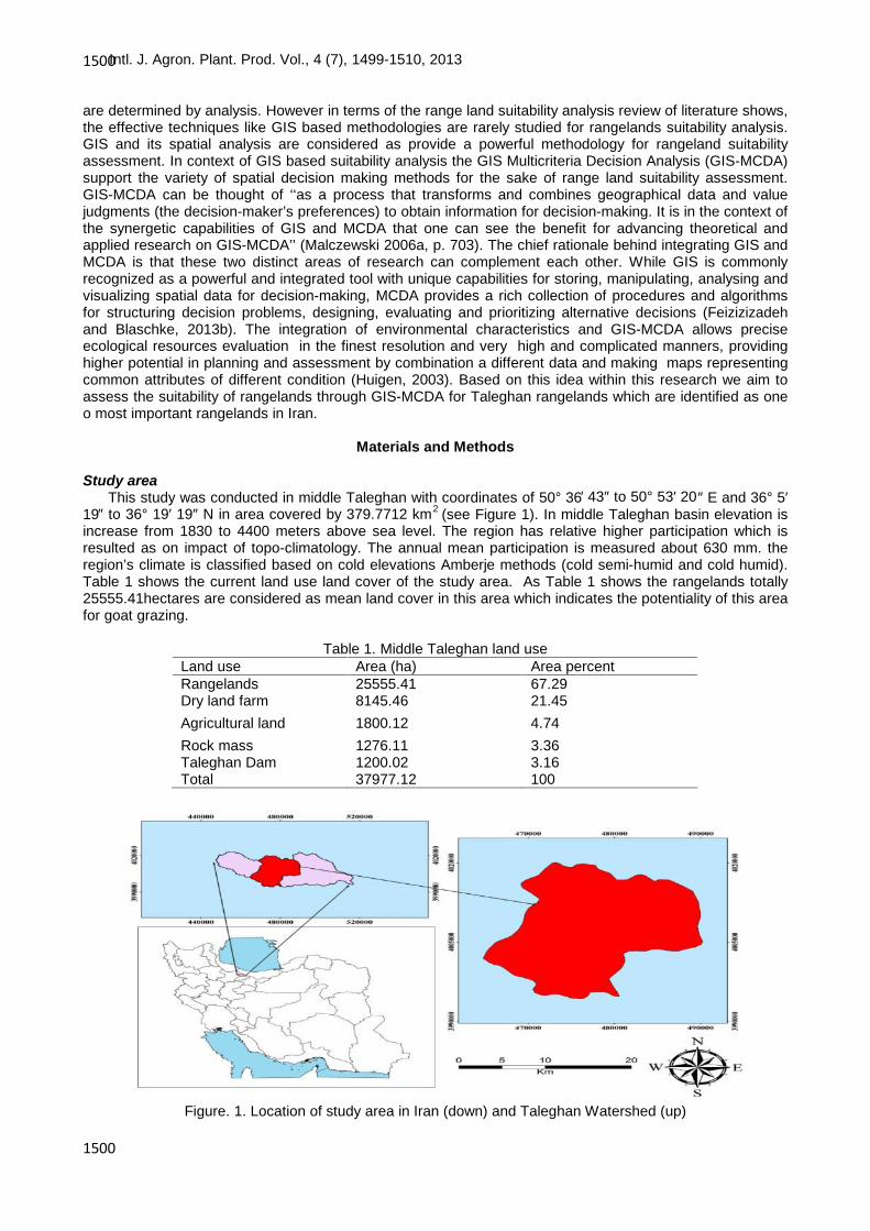
Study areaThis study was conducted in middle Taleghan with coordinates of 50° 36′ 43″ to 50° 53′ 20″ E and 36° 5′
19″ to 36° 19′ 19″ N in area covered by 379.7712 km2 (see Figure 1). In middle Taleghan basin elevation isincrease from 1830 to 4400 meters above sea level. The region has relative higher participation which isresulted as on impact of topo-climatology. The annual mean participation is measured about 630 mm. theregion’s climate is classified based on cold elevations Amberje methods (cold semi-humid and cold humid).Table 1 shows the current land use land cover of the study area. As Table 1 shows the rangelands totally25555.41hectares are considered as mean land cover in this area which indicates the potentiality of this areafor goat grazing.
Table 1. Middle Taleghan land useLand use Area (ha) Area percentRangelands 25555.41 67.29Dry land farm 8145.46 21.45Agricultural land 1800.12 4.74Rock mass 1276.11 3.36Taleghan Dam 1200.02 3.16Total 37977.12 100
Figure. 1. Location of study area in Iran (down) and Taleghan Watershed (up)

Intl. J. Agron. Plant. Prod. Vol., 4 (7), 1499-1510, 2013
1501
1501
Selection of criteria and data processingThe first land assessment method was published by FAO in 1976. In our research we use the concept of
range land suitability assessment based on Arzani et al., (2008) as instructions according FAO approach(1991). Within this approach all factors are identified and scored in this case and finally that land usesuitability is classified into classes S1, S2, S3 and N in terms of sum of obtained scores and classmathematical integration. Investigations indicated that three mean criteria including vegetation, soil erosionand resource have great deal of contribution to determine rangelands suitability which these three indiceswere considered in the present research. Table 2 shows these three criteria scores in goat grazing model.
Within the vegetation criterion, total rangeland production, available production, plant composition,condition and trend are considered as sub-criteria. While in water resource criterion, water point distance andquality were taken into account of decision making model. In terms of the soil erosion criterion, soil erosionwere measured and evaluated as part of decision making model. Respectively the spatial datasets of criteriawere prepared. All necessary geometric and thematic editing of the original datasets, a topology wascreated. All vector layers were then converted into raster format with 10 m resolution and the spatial datasetswere processed in Arc GIS.
Table 2. Scores for important criteria in range suitability for goat grazing in semiarid regions rangelandsscoreCriterionrow20Vegetation115Water resource215Soil erosion350-total
Suitability modeling through criterionVegetation
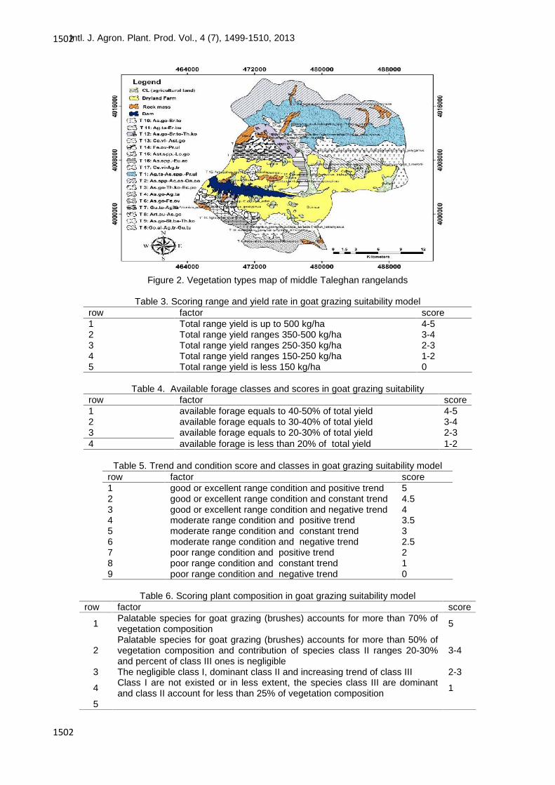
Vitiation cover is certainly can be identified as mean criteria in goat grazing. In our research themeasurement and evaluation of parameters of interest in goat grazing model were conducted separately ineach vegetation type limit. Vegetation’s types sampling and measurement get undertaken by surveying andreconnaissance of basin. We used vegetation typing map developed by Arzani et al., (2005) as a base forstudy and then types boundaries were corrected and updated by field survey according to area topographymap and geographical positioning system based on floristic and physiognomic method. Totally 17 vegetationtypes in middle Taleghan were identified (see Figure 2) and samples were taken within based onrandomized-systematic method. Respectively four line intercepts in 400 m length were established withineach type (depended on topography relief type) to measure production and cover percent and number of ten1 m2 plots (in respect to vegetation type). This process was preformed along each transect within the goatusable species (classes I, II and III). These areas were identified by considering their annual yield. For this tohappen their dry matter was calculated for having extracted from oven and finally after calculation totalspecies dry weight and identification species palatability percent, total type yield was calculated (Arzani,2011). To obtain available production, species palatability should be taken into account of goat grazing,allowable usage and range condition. Accordingly each type available production was separately calculatedin respect to three aforementioned factors. To deal with range condition and trend of four factors and surveybalance methods were used (Moghadam, 2005) to give score soil and vegetation attributes within each type.Vegetation cover percent for each species was estimated to evaluate regions plant composition and finallyplant composition in each type was addressed by cover percent method (see Table 3 to 6).
Intl. J. Agron. Plant. Prod. Vol., 4 (7), 1499-1510, 2013
1502
1502
Figure 2. Vegetation types map of middle Taleghan rangelands
Table 3. Scoring range and yield rate in goat grazing suitability modelscorefactorrow4-5Total range yield is up to 500 kg/ha13-4Total range yield ranges 350-500 kg/ha22-3Total range yield ranges 250-350 kg/ha31-2Total range yield ranges 150-250 kg/ha40Total range yield is less 150 kg/ha5
Table 4. Available forage classes and scores in goat grazing suitabilityscorefactorrow4-5available forage equals to 40-50% of total yield13-4available forage equals to 30-40% of total yield22-3available forage equals to 20-30% of total yield31-2available forage is less than 20% of total yield4
Table 5. Trend and condition score and classes in goat grazing suitability modelscorefactorrow5good or excellent range condition and positive trend14.5good or excellent range condition and constant trend24good or excellent range condition and negative trend33.5moderate range condition and positive trend43moderate range condition and constant trend52.5moderate range condition and negative trend62poor range condition and positive trend71poor range condition and constant trend80poor range condition and negative trend9
Table 6. Scoring plant composition in goat grazing suitability modelscorefactorrow
5Palatable species for goat grazing (brushes) accounts for more than 70% ofvegetation composition1
3-4Palatable species for goat grazing (brushes) accounts for more than 50% ofvegetation composition and contribution of species class II ranges 20-30%and percent of class III ones is negligible
2
2-3The negligible class I, dominant class II and increasing trend of class III3
1Class I are not existed or in less extent, the species class III are dominantand class II account for less than 25% of vegetation composition4
5

Intl. J. Agron. Plant. Prod. Vol., 4 (7), 1499-1510, 2013
1503
1503
Water sourcesIn this section three factors of water quality, quantity and distance were studied. The statistics and data
for Arzani et al., (2005) were used to measure water quantity and its score was calculated based on waterdischarge in each vegetation type and measuring the same type stocking rate and comparison of dischargewith stocking rate. Since just water drinkability and relative salinity and quality data are existed in thisinstruction, this factor was scored. Water resource map was prepared and scored by classifying slope mapinto three classes (0-15, 15-30 and ≥30) to study water resource distance (Tables 7-9). According to Table10, each type suitability class was calculated by summation of all obtained scores of three criteria of cover,erosion and water resource within each type.
Table 7. Water quantity scores in goat grazing suitability modelscorefactorrow
5The present water meets more than 90% of goats waterdemand
1
4The present water meets 75-90% of goats water demand23The present water meets 51-75% of goats water demand32The present water meets 25-50% of goats water demand40The present water meets less 90% of goats water demand5
Table 8. Water distance scores in goat grazing suitability modelSlope class%
score 0-15 15-30 >30
5 4<)km( 3<)km( 2<)km(3-4 4-5.5)km( 3-4.5)km( 2-3)km(1-2 5.5-7)km( 4.5-6)km( 3-4)km(
0 7>)km( 6>) km( 4>) km(
Table 9. Water quality scores in goat grazing suitability modelscorefactorrow5Water is easily drinkable by all livestock14Water is saline and drinkable22Water is relatively saline and is usable in emergency cases30Water is saline and undrinkable4
Table 10. Range suitability classes for goat grazingSuitability degreescorerowS1Total score more than 401S2Total score ranges 30-392S3Total score ranges 15-293NTotal score less than 154
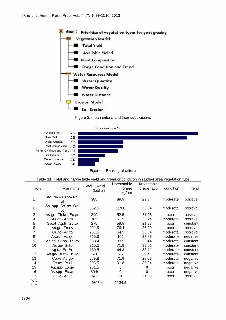
Goat grazing suitability mapI order to obtain rangelands suitability of goat grazing we use Analytical Hierarchy Process (AHP) to rank
the criteria. The procedures involve the utilization of geographical data, the decision-maker’s preferences,and the manipulation of the data and preferences according to specified decision rules (Malczewski, 1999).Fig 3 and 4 show the considered criteria and their importance in decision making model. Respectively weuse the weighted overlay method for applying a common scale of values to diverse and dissimilar input datato create an integrated analysis (Kuria et al., 2011). In this study, different map layers characterising goatgrazing suitability have been weighted using the weights derived from the AHP process described inprevious section. The weights were then combined with the attribute map layers in a manner similar to thatused in the linear additive combination methods (Malczewski , 2004; Feizizadeh et al., 2012 a and b). Theresults are displayed in Figures 5 and 6. The maps resulting from this weighted overlay, for both rangelandcondition and trend map.
Vegetation sub-criteria involves total forage yield, harvestable forage, plants composition, condition andtrend. as Table 10 shows, vegetation type numbers of 8, 1 and 2 and vegetation type of 16 had the highestand least forage yield and harvestable forage in vegetation types of 2 and 8 were highest and since in typesnumber of 15 and 6, vegetation types of 15 and 16 had negative trend and poor condition, as a resultharvestable forage yield equals to zero (Figures 5 and 6). Given to instruction, each criterion was scoredwithin every vegetation type. Table 12 shows criterion scores in studied vegetation type.
Intl. J. Agron. Plant. Prod. Vol., 4 (7), 1499-1510, 2013
1504
1504
Figure 3. mean criteria and their subdivisions
Figure 4. Ranking of criteria
Table 11. Total and harvestable yield and trend or condition in studied area vegetation type
row Type name Total yield)kg/ha(
Harvestableforage
(kg/ha)
Harvestableforage ratio condition trend
1 Ag. ta- As spp- Pr.ul 385 89.5 23.24 moderate positive
2 As. spp- Ac. as- On.co 362.5 119.8 33.04 moderate positive
3 As.go- Th.ko- Ec.po 249 52.5 21.08 poor positive4 As.go- Ag.ta 185 61.5 33.24 moderate positive5 Go.al- Ag.tr- Gu.to 275 59.5 21.63 poor constant6 As.go- Fe.ov 291.5 76.4 26.20 poor positive7 Gu.to- Ag.ta 251.5 64.5 25.64 moderate positive8 Ar.au- As.go 365.6 102 27.89 moderate negative9 As.go- St.ba- Th.ko 338.4 89.5 26.44 moderate constant
10 As.go- Br.to 215.5 71.8 33.31 moderate constant11 Ag.ta- Er. Bu 139.5 44.8 32.11 moderate constant12 As.go- Br.to- Th.ko 241 95 39.41 moderate constant13 Ce.vi- As.go 275.8 71.9 26.06 moderate negative14 Fe.ov- Pr.ul 305.5 91.8 30.04 moderate negative15 As.spp- Lo.go 231.5 0 0 poor negative16 As.spp- Eu.ae 80.9 0 0 poor negative17 Ce.vi- Ag.tr 142 31 21.83 poor positive
Totalsum - 4695.4 1134.5

Intl. J. Agron. Plant. Prod. Vol., 4 (7), 1499-1510, 2013
1505
1505
Figure 5. Rangeland condition map of middle Taleghan
Figure 6. Rangeland trend map of middle Taleghan
Intl. J. Agron. Plant. Prod. Vol., 4 (7), 1499-1510, 2013
1506
1506
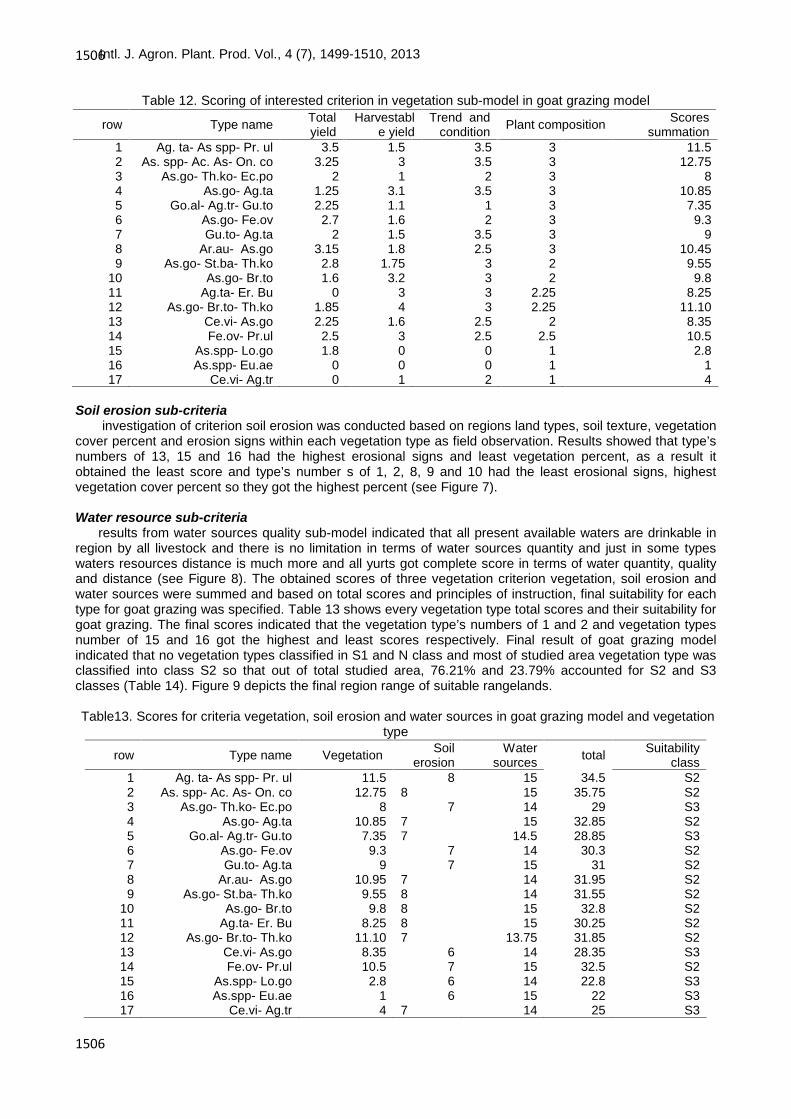
Table 12. Scoring of interested criterion in vegetation sub-model in goat grazing model
Soil erosion sub-criteriainvestigation of criterion soil erosion was conducted based on regions land types, soil texture, vegetation
cover percent and erosion signs within each vegetation type as field observation. Results showed that type’snumbers of 13, 15 and 16 had the highest erosional signs and least vegetation percent, as a result itobtained the least score and type’s number s of 1, 2, 8, 9 and 10 had the least erosional signs, highestvegetation cover percent so they got the highest percent (see Figure 7).
Water resource sub-criteria results from water sources quality sub-model indicated that all present available waters are drinkable in
region by all livestock and there is no limitation in terms of water sources quantity and just in some typeswaters resources distance is much more and all yurts got complete score in terms of water quantity, qualityand distance (see Figure 8). The obtained scores of three vegetation criterion vegetation, soil erosion andwater sources were summed and based on total scores and principles of instruction, final suitability for eachtype for goat grazing was specified. Table 13 shows every vegetation type total scores and their suitability forgoat grazing. The final scores indicated that the vegetation type’s numbers of 1 and 2 and vegetation typesnumber of 15 and 16 got the highest and least scores respectively. Final result of goat grazing modelindicated that no vegetation types classified in S1 and N class and most of studied area vegetation type wasclassified into class S2 so that out of total studied area, 76.21% and 23.79% accounted for S2 and S3classes (Table 14). Figure 9 depicts the final region range of suitable rangelands.
Table13. Scores for criteria vegetation, soil erosion and water sources in goat grazing model and vegetationtype
row Type name Totalyield
Harvestable yield
Trend andcondition Plant composition Scores
summation1 Ag. ta- As spp- Pr. ul 3.5 1.5 3.5 3 11.52 As. spp- Ac. As- On. co 3.25 3 3.5 3 12.753 As.go- Th.ko- Ec.po 2 1 2 3 84 As.go- Ag.ta 1.25 3.1 3.5 3 10.855 Go.al- Ag.tr- Gu.to 2.25 1.1 1 3 7.356 As.go- Fe.ov 2.7 1.6 2 3 9.37 Gu.to- Ag.ta 2 1.5 3.5 3 98 Ar.au- As.go 3.15 1.8 2.5 3 10.459 As.go- St.ba- Th.ko 2.8 1.75 3 2 9.55
10 As.go- Br.to 1.6 3.2 3 2 9.811 Ag.ta- Er. Bu 0 3 3 2.25 8.2512 As.go- Br.to- Th.ko 1.85 4 3 2.25 11.1013 Ce.vi- As.go 2.25 1.6 2.5 2 8.3514 Fe.ov- Pr.ul 2.5 3 2.5 2.5 10.515 As.spp- Lo.go 1.8 0 0 1 2.816 As.spp- Eu.ae 0 0 0 1 117 Ce.vi- Ag.tr 0 1 2 1 4
row Type name Vegetation Soilerosion
Watersources total Suitability
class1 Ag. ta- As spp- Pr. ul 11.5 8 15 34.5 S22 As. spp- Ac. As- On. co 12.75 8 15 35.75 S23 As.go- Th.ko- Ec.po 8 7 14 29 S34 As.go- Ag.ta 10.85 7 15 32.85 S25 Go.al- Ag.tr- Gu.to 7.35 7 14.5 28.85 S36 As.go- Fe.ov 9.3 7 14 30.3 S27 Gu.to- Ag.ta 9 7 15 31 S28 Ar.au- As.go 10.95 7 14 31.95 S29 As.go- St.ba- Th.ko 9.55 8 14 31.55 S2
10 As.go- Br.to 9.8 8 15 32.8 S211 Ag.ta- Er. Bu 8.25 8 15 30.25 S212 As.go- Br.to- Th.ko 11.10 7 13.75 31.85 S213 Ce.vi- As.go 8.35 6 14 28.35 S314 Fe.ov- Pr.ul 10.5 7 15 32.5 S215 As.spp- Lo.go 2.8 6 14 22.8 S316 As.spp- Eu.ae 1 6 15 22 S317 Ce.vi- Ag.tr 4 7 14 25 S3

Intl. J. Agron. Plant. Prod. Vol., 4 (7), 1499-1510, 2013
1507
1507
Figure 7. Rangeland erosion map of middle Taleghan
Figure 8. Rangeland water resources distance map of middle Taleghan
Table 14. Middle Taleghan rangeland suitability class percent and area for goat grazingArea percentArea (ha)Suitability classes--High suitability (S1)76.25519487.31Moderate suitability (S2)23.7456068.1Marginally suitability (S3)--Non suitable (N)10025555.41Total

Intl. J. Agron. Plant. Prod. Vol., 4 (7), 1499-1510, 2013
1508
1508
Figure 9. Final suitability model of middle Taleghan rangelands for goat grazing
Discussion
This research started off with considering three mean criteria and accordingly their subdivisions for goatgrazing using GIS MCDA. Results of soil erosion criteria indicated that low vegetation cover, sensitive soilformation and texture to marl erosion and erosional signs in some types (13, 15 and 16 types) led to lessscores served as limiting factor in criterion soil erosion. These results have been achieved by earlyresearcher as well (see Arzani et al., 2005; Amiri et al., 2011; Alizadeh et al., 2012).
Total forage yield analysis of studied vegetation type indicated that vegetation types numbers of 1, 8, 2and 15, 16, 17 had the highest and least forage yield. Since the least forage yield considered in semi-humidarea about 150 kg (Arzani, 2011) and since Taleghan region has semi-humid climate, if total forage yield in avegetation type is less than 150 kg/ha, no score is dedicated to this vegetation type so the minimum forageyield considered in study area was one of the suitability reducing factors and if vegetation type number of 16was 95 kg/ha, then the acquired score for this type would be zero. Although study area is located in semihumid climate and have high mean annual rainfall. Over and early exploitation in the study area in the pastmight be the main reason for low forage yield caused less forage yield in spite of desirable rainfall. Anotherdeterminant and limiting factor in forage production is available forage rate. Since allowable use forvegetation types in middle Taleghan rangelands is estimated about 20-50% according to studies of Azhdariet al., (2008), in case total forage yield to available forage ratio is less than 20% in this instruction, its scorewill be zero. Vegetation types 16 and 15 in study area got zero score. Species palatability class andallowable use are determinant factors in available forage calculation. Since there are less palatable speciesin vegetation types numbers 15 and 16 (mainly annual, class III and invader), they did acquired no score onavailable forage score. The main reason for less available forage is overgrazing and overexploitation duringpast years caused plant composition change and substitution, unpalatable species invasion in area.Overgrazing changes aboveground biomass, vegetation cover and plants species composition (McGinty etal., 2009). Since all vegetation types in study area have moderate and poor condition so the acquired scoresrange 0 to 3.5. If a vegetation type assessed as poor and very poor it will not acquire any score in terms ofsuitability and regarded as unsuitable. Range condition indicates range exploitation ways in past years,vegetation type condition analysis showed that regions rangelands have been deteriorated drastically so thatthey are not recovered yet in spite of low stocking arte and favorable climatic condition. Trend condition ofvegetation type in mountainous ranges without any degradation indicated that they are in better conditionthan plains and rural area suburbs, as a result in spite of abandoned dry farmlands, the available rangelandplough and destruction especially in countryside’s in the past caused more regressive regions condition. In,most types, vegetation cover is relatively high but because most no all of species are annual, class III andinvaders, so this was considered as limiting factor in some types in vegetation types (15,16 and 17) mostlydue to over exploitation, plough and rangelands conversion to dry farmlands. Javadi et al., (2008) and
Intl. J. Agron. Plant. Prod. Vol., 4 (7), 1499-1510, 2013
1509
1509
Gavili et al., (2011) while their investigation stated that harvestable forage, less palatability class and lowallowable use are main suitability limiting factors in forage yield. Gurmessa Desso (2009) pointed out that themost important limiting factors for less regions suitability are substitution of palatable species by unpalatableones.
Investigation of water resource in study area suggested that Taleghan has too many natural springs dueto good rainfall so there was no water quality and quantity limitation in study area. Holechek et al., (2001)stated that slope more than 60% is unsuitable. Hence slope is a limiting factor in suitability and because it isso important in mountainous area and livestock intend less grazing as slope increases (Gillen et al., 1984) sothey use up more energy to graze in these areas (Valentine, 1947; Lathrop et al., 1988). The negativesteepness effect is less livestock distribution and water availability (Vallentine, 1990) and less range stockingrate (Holechek et al., 2001). Arzani et al., (2005), Amiri (2009) and Sour et al., (2012) showed that in theirstudy area there was no water quality and quantity limitations and pointed out the slope or steepness asmain suitability limiting factor in mountainous areas. Tabas County was limiting suitability factor for camelgrazing as a result of its climatic condition. Mfitumukiza (2004) believed that water resource farness is themain suitability limiting factor.
Conclusion
Within this research we used GIS-MCDA approach fro range land suitability analysis. The results pointedout from goat grazing suitability model it could be stated that less available forage, less allowable use, soilsensitive formation to erosion in some vegetation types, poor condition and negative trend and steepnessare the most substantial limiting factors in area suitability for goat grazing. Final results from goat grazingsuitability in middle Taleghan rangelands as per instruction indicated that this instruction is able to identifyand distinguish suitable and unsuitable areas for goat grazing and is more efficient than model run based onFAO (1991) in respect to time-saving and simplicity. Results approved the GIS-MCDA capabilities throughcriteria analysis and layers overlaying for the sake of range management. We conclude the higher potentialof GIS-MCDA in data storage and classification and subsequently time and cost-effectiveness in range landsuitability assessment. In terms of the research results application we require concepts to predict and tomanage future suitability of rangelands for the sake of goat grazing. This study is a first step that lays thefoundation for a transparent regional land use policy, drawing on a comprehensive GIS database that willrequire regular updating. Results of this research are great of important to transparent and reliable planningprojects, based on comprehensible and replicable physical conditions, and the relative importance assignedto them by local stakeholders.
References
Alizadeh E, Arzani H, Azarnivand H, Mohajeri AR, Kaboli SH, 2011. Range suitability classification for goatsusing GIS Case Study: Ghareaghach watershed-Semirom. Iranian J Range and Desert Rese. 18(3):353-371.
Amiri F, 2008. Modeling multiple use of rangeland by using GIS. Ph.D thesis, Islamic Azad UniversityResearch and Science Branch ,Tehran, Iran. 560 p.
Amiri F, 2009. A GIS model for determination of water resources suitability for goats grazing, African J AgricRese. 4(1): 14-20.
Amiri F, Rashid A, Sheriff M, Saadatfar A, 2011. Modeling land suitability analysis to livestock grazingplanning based on GIS application. J World applied sciences. 6:1549-1564.
Arzani H, 2012. Handbook of assessment and analyzing course of natural recourses Faculty University ofTehran.
Arzani H, Ahmadi H, Azarnivand H, Salajeghe A, Jafari M, Tavili A, 2011. Instruction of determinationmultiple use from rangelands, Faculty Natural Resources of University of Tehran and ResearchInistute of Forest and Rangelands.
Arzani H, Yousefi Sh, Jafari M, Farahpour M, 2005. Rangeland suitability assessment by using GIS. JEnviron Stud. 37: 59-68
Azhdari G, Arzani H, Tavili A, Feghhi J, 2009. Determining criteria of utilization level in different types ofTaleghan rangelands. J Natu Resou. 62(3): 329-340.
Elaalem M, Comberm A, Fisher P, 2011. A comparison of fuzzy AHP and ideal point methods for evaluatingland suitability. J Transa GIS. 15(3): 329–346
FAO, 1991. Guidelines land evaluation for extensive grazing, Soil Resource Management and ConservationService. Soil Bull, No.58, Rome. 158 p.
FAO, 1994. Land degradation in south Asia: Its severity causes and effects upon the people, World SoilResearches Report, 78, Rome Italy, 100 p.

Intl. J. Agron. Plant. Prod. Vol., 4 (7), 1499-1510, 2013
1510
1510
Feizizadeh B, Blaschke T, 2013a. Land suitability analysis for Tabriz County, Iran: a multi-criteria evaluationapproach using GIS. J Envir Plan Manage. 56: 1-23.
Feizizadeh B, Blaschke T, 2013b. GIS-multicriteria decision analysis for landslide susceptibility mapping:comparing three methods for the Urmia lake basin, Iran. J Natu Haza. 65: 2105–2128.
Feizizadeh B, Blaschke T, Nazmfar H, 2012a. GIS-based ordered weighted averaging and dempster shafermethods for landslide susceptibility mapping in Urmia lake basin, Iran, International Journal of DigitalEarth, DOI:10.1080/17538947.2012.749950.
Feizizadeh B, Blaschke T, Nazmfar H, Akbari A, Kohbanani HK, 2012b. Monitoring land surface temperaturerelationship to land use/land cover from satellite imagery in Maraqeh County, Iran. Journal ofEnvironmental Planning and Management,DOI:10.1080/09640568.2012.717888.
Gavili E, Vahabi MR, Arzani H, Ghasriani F, 2011. Production suitability assessment in rangeland byGeographic Information System (Case study: Fereidoonshahr, Isfahan province). J Appl RS & GISTech Natu Resou Sci. 2(1): 63-77.
Gillen R.L, Krueger WC, Miller RF, 1984. Cattle distribution on mountain rangeland in north eastern Oregon,J Range Manage. 37: 549-553.
Gurmessa Desso D, 2009. Remote Sensing and GIS Based Suitability Analysis for Livestock Production inYabello District, Southern Ethiopia, MSc. thesis, Department of Earth Sciences, Addis AbabaUniversity, 73 p.
Holechek JL, Pieper RD, Herbel CH, 2001. Range Management Principles and Practices, 4th ed. PrenticeHall, Upper Saddle River, NJ. Biodiversity Technical Paper.
Huige M, 2003. Agent Based Modeling in Land use & Land Cover Change Studies, Laxenburg. Austria.(Web site:www.iiasa.ac.at).
Jahani A, Makhdom M, Feghhi J, Etemad V, 2010. Land use planning for forest management for multiple use(timber harvesting, ecotourism and conservation). J Town Country Plan. 3(5): 33-50.
Javadi SA, Arzani H, Salajegheh A, Farahpour M, Zahedi Amiri Gh, 2008. A GIS model for determination ofwater resource suitability for Camel grazing. Iranian J Range. Dese Rese. 14(4): 513-523.
Kuria D, Ngari D, Withaka E, 2011. Using geographic information systems (GIS) to determine land suitabilityfor rice crop growing in the Tana delta. J geogr regio plan. 4(9): 525–532.
Lathrop WJ, Kress DD, Havstad KM, Doornbos DE, Ayers EL, 1988. Grazing Behavior of Rangeland BeefCows Differing in Milk Production. J App Anim Behav Sci. 21: 315-327.
Makhdom M, 1993. Develop methods to analyze and summarize data on land use planning process. J NatuReso. 46: 109-112.
Malczewski J, 1999. GIS and multicriteria decision analysis. Toronto: Wiley.Malczewski J, 2004. GIS-based land-use suitability analysis: a critical overview. J Prog plan. 62(1): 3–65.Malczewski J, 2006. GIS-based multicriteria decision analysis: a survey of the literature. International J
Geogr Infor Sci. 20(7): 703–726McGinty EL, Baldwin B, Banner R, 2009. A review of livestock grazing and range management in Utah,
Setting the Stage for a Livestock Grazing Policy in Utah, 45 P.Mfitumukiza D, 2004. Evaluating rangeland potentials for cattle grazing in a mixed farming system, Master of
Science thesis, Department of Natural Resources, the Netherlands. 65 p.Moghadam M, 2001. Range and Range Management. 2th Edition's. Tehran University publication, Iran.San Carlos, 2010. Rangeland Suitability for Livestock Grazing At the Forest Plan Level and Standards for
NEPA Display, Appendix 4, Rangeland Suitability: 1-10.Sour A, Tavili A, Alizadeh E, Barbari M, Simonini S, Asadi O, 2012. A GIS model for the assessment of water
resources suitability for livestock grazing. J Food Agric. Envir. 10(2): 997-1004.Valentine KA, 1947. Distance from water as a factor in grazing capacity of rangeland. J Forestry. 45:749-
754.Vallentine JF, 1990. Grazing Management, (San Diego: academic Press).