GIS for All - ScholarWorks@UMass Amherst
11
Free and Open Source Soſtware for Geospatial (FOSS4G) Conference Proceedings Volume 13 Noingham, UK Article 4 2013 GIS for All: Exploring the Barriers and Opportunities for Underexploited GIS Applications Hao Ye Noingham Geospatial Institute, University of Noingham Michael Brown Horizon Digital Economy Institute, University of Noingham Jenny Harding Ordnance Survey Southampton Follow this and additional works at: hps://scholarworks.umass.edu/foss4g Part of the Geography Commons is Paper is brought to you for free and open access by ScholarWorks@UMass Amherst. It has been accepted for inclusion in Free and Open Source Soſtware for Geospatial (FOSS4G) Conference Proceedings by an authorized editor of ScholarWorks@UMass Amherst. For more information, please contact [email protected]. Recommended Citation Ye, Hao; Brown, Michael; and Harding, Jenny (2013) "GIS for All: Exploring the Barriers and Opportunities for Underexploited GIS Applications," Free and Open Source Soſtware for Geospatial (FOSS4G) Conference Proceedings: Vol. 13 , Article 4. DOI: hps://doi.org/10.7275/R5W66J0K Available at: hps://scholarworks.umass.edu/foss4g/vol13/iss1/4
-
Upload
khangminh22 -
Category
Documents
-
view
2 -
download
0
Transcript of GIS for All - ScholarWorks@UMass Amherst

Free and Open Source Software for Geospatial (FOSS4G)Conference Proceedings
Volume 13 Nottingham, UK Article 4
2013
GIS for All: Exploring the Barriers andOpportunities for Underexploited GISApplicationsHao YeNottingham Geospatial Institute, University of Nottingham
Michael BrownHorizon Digital Economy Institute, University of Nottingham
Jenny HardingOrdnance Survey Southampton
Follow this and additional works at: https://scholarworks.umass.edu/foss4g
Part of the Geography Commons
This Paper is brought to you for free and open access by ScholarWorks@UMass Amherst. It has been accepted for inclusion in Free and Open SourceSoftware for Geospatial (FOSS4G) Conference Proceedings by an authorized editor of ScholarWorks@UMass Amherst. For more information, pleasecontact [email protected].
Recommended CitationYe, Hao; Brown, Michael; and Harding, Jenny (2013) "GIS for All: Exploring the Barriers and Opportunities for Underexploited GISApplications," Free and Open Source Software for Geospatial (FOSS4G) Conference Proceedings: Vol. 13 , Article 4.DOI: https://doi.org/10.7275/R5W66J0KAvailable at: https://scholarworks.umass.edu/foss4g/vol13/iss1/4

GIS for All: Exploring the Barriers and Opportunities for Underexploited GIS Applications
GIS for All: Exploring the Barriers andOpportunities for Underexploited GISApplicationsby Hao Ye1, Michael Brown2, and Jenny Harding3
1: Nottingham Geospatial Institute, University of Not-tingham; 2: Horizon Digital Economy Institute, Univer-sity of Nottingham; 3: Ordnance Survey [email protected]
Abstract
Geographical Information Systems have been existedsince the early 1960s, but evidence suggests thatadoption of GIS technologies still remains relativelylow in many sectors. We will explore both the bar-riers that affect the utilisation of GIS and opportuni-ties to overcome these barriers. As part of this explo-ration we performed a literature review, collected re-sponses from quantitative questionnaire survey andinterviewed a range of technical and domain experts.Having analysed and collated the results of thesestudies we have identified ways forward for futureresearch and development to facilitate wider spreadadoption and exploitation of GIS applications. Ourdiscussion focuses on the importance of open-sourceGIS software, open data and cloud computing as keymediators for breaking the barriers and promotingthe wider appropriation of GIS based solutions.
Keywords: GIS barriers, GIS opportuni-ties, Open-Source GIS, Open Data, OpenStreetMap,Cloud Computing.
1. Introduction
The development of Geographical Information Sys-tems (GIS) began in the early 1960s and rapidly ad-vanced since the late 1980s. Over the past 50 years,GIS technology has been increasingly introduced to awide range of sectors. In addition to planning agen-cies and local governments, many other sectors havebeen involved, such as social science, transporta-tion, earth science, military, agriculture, environmen-tal protection, etc. The integration of GIS technologyin traditional geospatial tasks provides a number ofoptimal solutions for individuals/groups, e.g. policydevelopers, decision-makers, managers, researchers,and allows the performance of existing tasks cheaper,faster and more completely (Elangovan 2006).
The multidisciplinary nature of GIS technologymeans that the diffusion, appropriation and use ofGIS technologies are distributed in a variety of sub-ject domains, was and is often regarded as a newtechnology or approach on traditional task with spe-cific disciplines. This characteristic means that theadoption of GIS technologies have not yet fully de-livered its potential or adequately addressed theneed of GIS users in many domains (Ventura 1995,Nedovic-Budic 1999). Early studies have mentionedthat most users adopt GIS technology in relativelysimple applications but rarely use it for sophisticatedtasks (Nedovic-Budic 1998). More specifically, thesestudies indicated that the expectation of GIS technol-ogy in the areas of geospatial analysis and decision-making was particularly high but the penetration isrelatively low. The task demands were either notachieved at all or not achieved as expected due tobarriers and factors that hinder the utilisation of GIS.
Some researchers have investigated the direct orindirect barriers which affect the adoption rate ofGIS from early stages (Ventura 1995, Nedovic-Budic1999, Esnard 2007, Akingbade et al. 2009). This pre-vious work has identified the existing barriers foundfor effective use of GIS and classified them into twoboard groups(Brown 1996, Brown & Brudney 1998,Esnard 2007, Yap et al. 2008, Asligui Gocmen & Ven-turac 2012) ;
• Organisational barriers: generally referred todepartment factors, such as lack of staff (e.g.constraints by size of the team or funding), lackof purpose or mission to promote GIS applica-tion and lack of collaborators and networking.
• Technical barriers: including lack of context,insufficient software and tools, lack of reliabledata and lack of technical knowledge.
In addition, another difficulty is the fast paced up-dating and development of GIS technology. Empiri-cal knowledge is still scarce on the changing barriersaccompanied with rapid advances of GIS technology,as well as potential solutions to justify the possibilityfor problem-solving.
The aim of this paper is to gather informationfrom the literature, as well as questionnaire re-
OSGEO Journal Volume 13 Page 19 of 114
GIS for All: Exploring the Barriers and Opportunities for Underexploited GIS Applications
sponses and expert opinions to identify and updatethe GIS barriers. In addition we aim to explorethe potential opportunities, in terms of Open-SourceGIS, Open-Data and Cloud Computing in overcom-ing these barriers. The current application domainsof GIS and existing barriers were re-examined as it isimportant as focal points for the identification of fu-ture opportunity and proposal of potential solutions.This study intends to explore the following researchquestions:
1. Who are the current users of GIS and what isthe current state of GIS applications?
2. What current opportunities exist for exploita-tion of GIS beyond commonly accepted appli-cations?
3. What are the existing barriers that result in theunderutilisation of GIS?
4. What possible solutions exist for overcomingthe barriers and realising the opportunities thathave been identified?
This study provides a brief overview of the in-roads made by GIS, highlight a way forward forGIS researchers, professionals and developers to ful-fil potential users’ unmet needs and promote ever-changing practical development. The rest of this pa-per is divided into 4 sections. Section 2 gives anoverview and analysis of literatures exploring thecurrent application and barriers of GIS in several se-lected domains. Next, Section 3 describes the resultsof a questionnaire survey and interviews with GISusers and experts exploring this area. Section 4 dis-cusses the potentials of recent technologies towardbreaking the barriers. Finally section 5 provides gen-eral conclusions.
2. Literature Survey: Applicationsand Identified Barriers
In order to have an impression of the current state ofGIS applications, as well as an update of the impedi-ments for GIS adoption, literature was searched andrevisited, and analysis was conducted for applicationand barriers identified in past studies. In this paperthe literature review focused on 4 well-known fieldsof GIS application, including Government, Transporta-tion, Commercial Sectors, Public and Educations. Theselection might not contain comprehensive applica-tion domains, but it draws an impression about the
trends of the mainstream GIS applications. The liter-ature search for relevant publications was performedby using web-based search engine. The search wascarried out based on a Boolean search containing thekeywords such as “GIS barriers”, or “GIS” and rele-vant ‘application field’ selected above. The searchedarticles and referenced articles containing the termswere selected and reviewed. The GIS applicationdomains and identified barriers were analysed andsummarised.
Government
The government sector was an early adopter of GIS,and has been a major user over the last 20 years.GIS has been utilised in major governmental sectorssuch as land management, coastal condition mon-itoring, census statistics, disaster management, en-vironment protection, military, administrative pur-poses, surveying, etc (Brown & Brudney 1998, Lon-gley et al. 1999, Montoya 2003, Fleming et al. 2009,Sunarto 2011, Gregory 2012, Mendas & Delali 2012).
The review revealed that when GIS emerged asa valuable technology in the 1990s, a number ofresearchers started to examine the barriers of GISimplementation in local governments (Brown 1996,Nedovic-Budic & Godschalk 1996, Brown & Brudney1998,). These studies primarily identified three typesof main barriers for government staffs, including: (1)lack of programs/software for desired application;(2) lack of awareness of available tools; (3) lack ofnational initiatives. In recent years, some extensivestudies have been conducted to reveal that, exceptfor former barriers, some updated barriers for GISusers. For example, current GIS users cannot catchup with the technology advancements. One typicalexample is the adoption of emerging internet-basedGIS in urban planning and decision-making (Peng2001, Drummond & French, 2008). Some other stud-ies suggest that the barriers of GIS adoption in plan-ning sectors are similar to the impediment of adop-tion of GIS in other governmental sectors (Greetman& Stillwell, 2004).
Transportation
Transportation has always been one of the most im-portant domains of GIS application. To date, GIS hasbeen applied to different transport problems, suchas short path analysis, vehicle routing, trip investi-gation, road navigation, dynamic routing, accidentanalysis, Intelligent Transport System (ITS) (Ault-man 1998, Xu 2005, Pons & Perez 2003, Kim et al
OSGEO Journal Volume 13 Page 20 of 114

GIS for All: Exploring the Barriers and Opportunities for Underexploited GIS Applications
2011, Deshpande et al 2011).
Past studies have revealed that transport mod-ellers are used to coding up abstract road networksand managing transportation data non-spatially.Many transportation planners are unfamiliar withGIS data management and tools. Therefore, at thattime the barriers to GIS utilization are likely to betechnical, referred to as lack of awareness. Otherbarriers identified included insufficient tools anddata required by many transportation applications(Sutton 1996). Researcher in highway sectors sum-marised the barriers for implementing GIS applica-tion include: (1) unaware the benefits of GIS; (2)lack of good communication between highway engi-neers and GIS engineers; (3) standards for data con-sistency; (4) insufficient data; (5) lack of knowledgein understanding GIS methods (Smith 2012).
Commercial Sectors
Since GIS contains of many powerful softwaretoolsets for the integration of commercial data andgeographical information, it enables a wide range ofopportunities for different business domains, such asbanking, insurance, logistics, media, real estate andretail (Jafrullah 2003). A detailed summary has beenprovided by about the application of GIS in commer-cial sectors, as well as the techniques that could beadopted for the applications by Dangermond (2001).The primary use of GIS in commercial sectors is toanalyse the distribution of customers in order to ex-pand customer base, improving service quality andconsistent business profitability. In fact, the “Geo-marketing” is a term dedicated to describe the com-mercial GIS, which include the studies of consumer’sspatial behaviours, marketing and consumer’s val-ues, lifestyle and geographical information as well asthe location of retail for market demand and serviceactivities (ESRI 2003, Gerard 2006).
The past studies shown that the main barriers ofGIS in social sectors (including commercial sectorsand non-profit sectors) are the cost of GIS and lackof internal expertise. Finance resources were insuffi-cient to support in-house GIS at market value andoutsourcing costs exceeding $100 per hour are noteasily justified for small and medium organisations.It also mentioned that the increase of GIS applicationpractices is important for the consideration of po-tential selection of GIS in various sectors (Edwards,2011).
Public & Education
GIS have attracted wide interests for public and ed-ucation sectors in the past 30 years, e.g. measur-ing libraries accessibility, aquariums, building attacksimulation, high schools and university education(Wheeler et al. 2010, Park 2012, Kevany 2003, Singhet al., 2012).
The research of integrating GIS as tools intoschool curriculums have been conducted for adeeper-learning experience and participation. How-ever, three main challenges were identified as: (1)hardware issue (i.e. powerful computing to storeand interpret data); (2) software and data (i.e. freeis important for school); (3) teaching skills and com-petence (Wheeler, et al. 2010). A study conducted byRead et al. (2005) has highlighted the benefits andpotentials of adopting GIS for educational market-ing, but a few significant barriers referred to gen-eral implementation were also addressed, such as:(1) lack of data and skill exchange and cooperationbetween department; (2) lack of user-friendly soft-ware interface for novice users; (3) acceptance of newtools and methods for traditional tasks; (4) expensivegeo-demographic data; (5) licence permission for GISsoftware. This study particularly draw attention toinsufficient GIS data sources, especially these high-quality and well-documented data.
Table 1: The review summary of GIS application do-main and the identified barriers.
The survey in this section has conducted a con-densed review of literatures about the GIS applica-tion domains, as well as the barriers for improvingGIS adoption rate. It is clear, from the summary inTable 1, that the applications domains of GIS vary,
OSGEO Journal Volume 13 Page 21 of 114
GIS for All: Exploring the Barriers and Opportunities for Underexploited GIS Applications
but barriers in different sectors are not incompatible.If dividing the barriers into organisational and tech-nical factors described above, the government suf-fer more from organisational factors such as under-standing technology, lack of awareness, and lack oforganisational support. The Transportation sectorsare restricted by some technical factors such as lackof tools and expertise. The commercial sectors ex-pect cheaper and better software, and more reliableand convenient data. Public and Education sectorsexpects more cooperative and experts. These barri-ers show different underutilisation and potential ex-pectation from GIS technology.
3. Questionnaire Survey for Barri-ers of GIS Use
A questionnaire survey was designed to identifythe entry barriers from current GIS users and un-derutilised opportunities from their respective back-grounds. Questionnaires were sent to 30 candidatesto inform the survey and the authors collected 22valid questionnaires from them. These questionnaireparticipants were mainly selected from two organi-sations: the school of Civil Engineering at the Uni-versity of Nottingham (10 candidates, all of themare PhD students, various engineering backgrounds)and Ordnance Survey in Southampton (12 candi-dates, 8 staffs in research team and 4 intern students,all of them have geo-science backgrounds), see Ta-ble 2 for the statistical summary. Before the sur-vey, the authors investigated the candidates’ back-grounds and their relevance to GIS. The criterion forscreening was that participants needed to have ba-sic knowledge of GIS knowledge, and at least someexperience using GIS software.
Table 2: The summary of participants’ backgrounds.
The survey questionnaires were designed intotwo sections: the first section asked relevant per-sonal details, e.g. major in university, current de-partments; the other section includes some multiple-choice questions and open questions, both referred tothe investigations to GIS barriers and potentials. Allparticipants were asked to complete questionnaireand taken part in an in-depth interview exploringtheir responses to open questions.
Quantitative Results
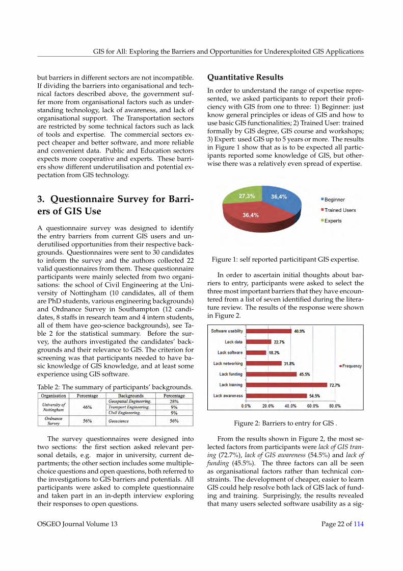
In order to understand the range of expertise repre-sented, we asked participants to report their profi-ciency with GIS from one to three: 1) Beginner: justknow general principles or ideas of GIS and how touse basic GIS functionalities; 2) Trained User: trainedformally by GIS degree, GIS course and workshops;3) Expert: used GIS up to 5 years or more. The resultsin Figure 1 show that as is to be expected all partic-ipants reported some knowledge of GIS, but other-wise there was a relatively even spread of expertise.
Figure 1: self reported particitipant GIS expertise.
In order to ascertain initial thoughts about bar-riers to entry, participants were asked to select thethree most important barriers that they have encoun-tered from a list of seven identified during the litera-ture review. The results of the response were shownin Figure 2.
Figure 2: Barriers to entry for GIS .
From the results shown in Figure 2, the most se-lected factors from participants were lack of GIS tran-ing (72.7%), lack of GIS awareness (54.5%) and lack offunding (45.5%). The three factors can all be seenas organisational factors rather than technical con-straints. The development of cheaper, easier to learnGIS could help resolve both lack of GIS lack of fund-ing and training. Surprisingly, the results revealedthat many users selected software usability as a sig-
OSGEO Journal Volume 13 Page 22 of 114

GIS for All: Exploring the Barriers and Opportunities for Underexploited GIS Applications
nificant barrier, rather than lack of data and lack ofsoftware. This is an interesting finding as many par-ticipants are novice users. This effect may be due tothe fact that the first impression of GIS for new usersis related to interface or operation menus, which af-fects their impressions of GIS as a tool.
Figure 3: The benefits of GIS technology for users.
The final quantitative aspect of the questionnaireasked particiants to identify the key benefits of us-ing GIS in their work. Four main uses of GIS identi-fid during the literature reviewwere listed and userswere allowed to tick multiple options. The resultsshow that the map presentation, is rated highest(77.3%). In addition, an interesting finding is thatthe use of GIS for decision-support and planning wasonly 22.7%. Decision-support and planning usingGIS are regarded as promising applications by somebut these are apparently still seen as a secondary orfuture functions by many users. This might be thereason because the participatants are more engineersand researchers rather than decision makers.
Barriers of GIS Use Identified
In-depth semi-structured interviews were performedwith domain experts. These experts were selectedas they are in close contact with a multiplicity ofGIS users from all fields having therefore an exten-sive knowledge about the problems and needs of GISusers. In this research a total of 6 groups were se-lected for this interview, including 3 team leadersin Ordnance Survey (i.e. Customer Service, Post-Sales Support, and User Need Research Team) and atechnical researcher in Chinese State Bureau of Sur-veying and Mapping and a renowned academic re-searcher at University of Nottingham.
Ordnance Survey Customer Service This groupnoted a range of barriers to GIS use from customerreports as customer service is the main department
contacting users, including: (1) methods for data ac-quisition; (2) data formats and attributes; (3) datamanipulation (e.g. download, open, transforma-tion); (4) suitable software for processing data; (5)data specifications modification; (6) data update andmaintenance; (7) data quality and reliability. In bal-ance, Customers always hope everything is alreadythere without processing or transformation of any-thing by them. The participants noted that the ma-jority of customers contacting them use only basicGIS applications. These applications mainly includecommercial mapping, web-fit mapping and personalmap tracking. They also noted that in many casespeople contacting customer service were not usingor needing to use the more detailed geographic dataor sophisticated software, highlighting demand foreasy-to-use and low-cost GIS toolsets free of obstruc-tive technical jargon. Novice users prefer a box oftoolkits and data included and easy-to-use, but ex-pert users have higher level demands for map databecause they want to modify and update by them-selves.
Ordnance Survey Post-Sales Support The Post-Sales team supports Customer Service staffs in re-solving specific technical issues, i.e. those relating tosoftware, data or coding. One participant mentionedthat the majority of their customers are new usersof GIS and that they come from two main sectors:Commercial and Government. Currently, the maintasks from commercial sector are focused on track-ing their commercial assets e.g. water pipelines, in-surance properties and transport objects. They esti-mate that around 50% of the customers are commer-cial users. The participant revealed that large compa-nies often have their own GIS teams, but most com-mercial companies lack even a small team. Enquiresfrom the government sector are often associated withthe interpretation of new data products. The major-ity of needs for support concern solving GIS manip-ulation problems, such as data format transforma-tion. The application of GIS in government sectorsvaries, but participants found the majority are inter-ested in analysis and routing purposes. For example,using ITN (Integrated Transport Network, a type ofOrdnance Survey mapping product) in mapping andanalysing footpath networks, efficient fuel consump-tion and addressing encoding. Some governmentdepartments have dedicated GIS teams. These mayuse GIS for relatively advanced applications such asair pollution assessment. Other government depart-ments might use IT professional or technician to per-form GIS analysis.
OSGEO Journal Volume 13 Page 23 of 114

GIS for All: Exploring the Barriers and Opportunities for Underexploited GIS Applications
Ordnance Survey User Needs Researchers Un-derstanding customer’s unmet needs is importantfor developing geographic information products.Through research barriers have been found to varywith the level of expertise of the users. For exam-ple, it is maybe relatively difficult for novice usersto transform data sets to required formats or under-stand the attributes within the data. However, forusers needing to carry out advanced data analysis,in depth understanding of data specifications, datarestructuring and attribute reclassification may be re-quired. Professional knowledge and training can bean issue even at this high level of expertise. Anotherbarrier to use can be insufficient computation powerfor large GIS data sets. Users who require massivedata volumes for national coverage may suffer fromlow-speed computation in their systems. Modern de-velopments in advanced data acquisition techniques(e.g. sensor data) increases the spatial and temporaldensity of data collected and is likely to further ac-centuate this problem.
Technical Researcher This participant shared theopinion that existing GIS software is too complicatedfor non-expert GIS users. While many GIS compa-nies have made much effort in this direction, theyfeel that the results to date are not satisfactory. Manysimple data viewers and data enquiry tools providesimple functions, such as ArcView, Arc Explorer, butthey feel that there is a need for novice friendly GISsoftware that incorporates more sophisticated GISfunctionality. This group suggested two possible so-lutions to overcome this issue: (1) Develop domainspecific GIS solutions for professional users that al-low users to complete a limited number of advancedGIS operations; (2) Use data middleware, i.e. an ab-straction layer that hides detail about hardware de-vices or other software from an application in orderto provide users with a seamless and simplified in-teraction.
Geospatial Academic Researcher This researchgroup highlighted the need for GIS experts to makesystems that are more closely aligned with user’sways of thinking. According to their comments, “thelargest challenge for GIS users is GIS terminologywhich is regarded as too sophisticated, too technicalfor user”. They have found that with applicationssuch as Google Maps and Google Earth, Google ad-dressed this problem more completely than most ex-pert GIS systems aiming at non-expert users, lead-ing to a move towards web services over dedicatedlocal software, for novice users. In addition to ter-
minology as a barrier, they note that data acquisi-tion should not be ignored given the current costinvolved in accruing some data sets. Open StreetMap is expected to play an important role for GISusers and developers in future”. The participantsemphases that training is critical to solve many bar-riers of GIS, such as lack of awareness and softwareusability”. In response to potential opportunities ofGIS, this group identified a wide range of possibil-ities including In-car applications, real-estate, andsimulation. They highlight the integration of GIS andsocial media (e.g. Facebook, Twitter) to analyse hu-man’ behaviours in daily life as an area with hugepotential, although it does raise issues such as pri-vacy, security and data ownership. They also men-tioned the importance of earth observation includ-ing measurements and monitoring of the earth, un-der water, land surface, air and water quality, atmo-spheric condition and measures of the health of hu-man, plants and animals.
Identified GIS Barriers Summary
Table 3: The identified barriers from GIS usersand expectation for future GIS development.
Based on the results of the questionnaire surveyand interviews with field experts, the authors haveidentified some barriers from these users and theirexpectations for GIS developments.
• Lack of awareness
• Lack of communication
• Entry cost
OSGEO Journal Volume 13 Page 24 of 114

GIS for All: Exploring the Barriers and Opportunities for Underexploited GIS Applications
• Lack of required software
• Insufficient data sources
• Lacks of computing power
• Usability
4. Potential of Recent Technologi-cal Development towards Breakingthe Barriers Identified
Having explored the current uses of GIS, identifiedbarriers that prevent its wider appropriation and ex-posed the potential opportunities; we now discussthe ways to overcome these barriers with relativelyrecent technical developments.
Open-Source GIS
With the development of Open-Source community,a large number of software tools have been estab-lished. Up to present, GIS software and toolkits havepublished online and allow users to freely download,and has been summarised, see Table 4 (Chen et al.2010). Open-Source GIS have been developed into abroad range of classification. The main spectrum isshown in Figure 4. Open-Source GIS can be approx-imately categorised as Desktop GIS, Spatial DBMS,Server GIS and Web GIS, GIS Library, Database, SpatialTools, etc. A detailed classification and informationfor different types of Open-Source Software has beenelaborated by Steiniger & Hunter (2012).
Table 4: The main web sources for Open SourceGIS software (from Chen et al. 2010).
There are a number of advantages of using open-source GIS software to break the barriers identifiedin previous literature and questionnaire sections.
The first being of Open-Source GIS is that it is freeto potential users. The free Open-Source GIS allowsnovice users to understand the basics of GIS withvery low entry cost, and in some degree, it promotesthe perception of GIS adoption rate. In fact, this isparticularly valuable for individuals, small researchgroup, small commercial companies, education sec-tors, with insufficient funding. Training sessions orworkshops are easier by using Open-Source GIS iffocusing on different level of users, but there is a
barrier as most of current Open-Source GIS manualsare centred on the technical aspect of GIS rather thancase study demonstration. In addition, the trainingcourses are often as expensive as GIS training pro-vided by commercial software providers.
The second advantage of Open-Source GIS isoriginal codes are accessible so it is convenient forsoftware modification. This is highly desirable bythe high-level users who want to develop their ap-plications. However, the quality of the open-sourcecodes sometimes cannot guaranteed, and it also addadditional cost (e.g. learning knowledge, correct thecode errors, time for coding) . Detailed and under-standable document is a good approach to solve thisproblem, but as stated before, it is too technical ofcurrent documents.
The third advantage is Open-Source GIS is allfreely available online, which enhanced the acces-sibility for users from different regions, e.g. devel-oping countries. The installation volume of Open-Source software is less than commercial GIS Desk-top software systems if only selected plug-ins areutilised. The advantages of these technical and eco-nomic aspects offer potential for using Open-SourceGIS in various organisations.
Figure 4: Open-source GIS classification (obtainedfrom Steiniger & Hunter 2012).
Open Data and OpenStreetMap
Geospatial data is at the core of almost all GIS ap-plications. The acquisition of available geospatialdata is usually time-consuming, expensive and maybe complex. This is mainly due to the disciplinarynature of GIS, as wide range of data is documented
OSGEO Journal Volume 13 Page 25 of 114
GIS for All: Exploring the Barriers and Opportunities for Underexploited GIS Applications
by different organisations with different size, format,specification, etc. In recent years many organisationshave started to release rich open data for public ordeveloper use in order to promote GIS applicationand collaboration. For example Open Street Map andOrdnance Survey’s OS OpenDataTM datasets (Open-StreetMap 2013, OpenData 2013).
OpenStreetMap is a specific open access data set,basically an online web map, created by volunteersto be freely created, shared and delivered to differ-ent communities. The map formats satisfy OGC stan-dards so that they could be used in almost all open-source and professional GIS software. The OSM nowincludes a wide range of data. For some location-based services application, it is more suitable to useOSM data. OSM has advantages over many profes-sionally created data sources, in terms of access tosome data that is difficult for professional survey-ors to obtain, such as cycling places, city toilets, etc.OSM can be downloaded as different format on forweb-mapping or desktop software (e.g. QGIS andArcGIS). Even some local government departmentshave started to use OSM for some GIS projects, suchas the Birmingham cycling parking project (Birming-ham City Council 2012).
However, it was reported that in 2010 the cov-erage of OSM was up to 69.8% worldwide and thismeans that the completeness is still lower than ex-isting commercial products (Feldman & Morley 2012). The data quality of OSM is the main concern withrespect to different applications because all mappersare volunteers. In addition, the tags seem sometimesnot to be quality checked leading to confusion. Ahigh learning curve is necessary to acquire the dataand prepare it so it can be reasonably used in ownanalysis. A recent study reports that the geometricalaccuracy of OSM was assessed between 5 and 10 me-tres, with higher accuracy in urban areas but low ac-curacy in rural/deprived areas) (Feldman & Morley2012 ). These disadvantage limited the wide spreadof OSM which might bring potential opportunities ifthese issues can be solved.
Cloud Computing
Cloud computing is rapidly emerging as a technol-ogy for industries who provide software, hardwareand infrastructure. In the field of GIS, the introduc-tion of cloud computing for GIS software and ser-vices has become a popular topic. There are sev-eral types of deployment scenarios, for example, theESRI have attempted to develop a Cloud-based plat-form for Amazon (ESRI 2012). One critical difference
between GIS in cloud and traditional GIS is that itcould deliver GIS services via the internet, insteadof installing and running the software on personalcomputers. Service users connect to private or pub-lic clouds (a set of connected computing comput-ers) and request service from cloud providers (Kouy-oumjian 2010). Due to completely different servicemode, the future cloud GIS might offer many bene-fits and some of them might break the barriers of cur-rent barriers. The summary in Table 5 organises a setof potential advantages of GIS, as well as the analysisof their potential to break the barriers of GIS.
Table 5: Summary of potential benefits and issues ofCloud GIS.
Cloud GIS indeed can potentially provide newbenefits based on traditional GIS, such as promot-ing productivity and reduce cost. Particularly, as theidentified barrier of high-computing requirement forprofessional users, the advantage of cloud comput-ing can help meet this demand are hitting the ceilingof hardware cost, storage space and computation re-sources (Willoughby 2011). However, some potentialissues will be promoted; for example, it is difficult tojudge whether it is safe to send data (e.g. sensitivedata) onto a cloud server.
5. Conclusions
The research in this paper explored both the barriersthat affect the utilisation of GIS and opportunities toovercome these barriers. The research provides a lit-erature review related to the application domains ofGIS, as well as the identified barriers. Next, a sur-vey analysis from a pool of selected participants wascarried out. The results from survey respondentsshowed that the applications of GIS still confrontmany barriers, including: (1) lack of awareness; (2)lack of communication; (3) entry cost; (4) lack of re-quired software; (5) insufficient data sources;(6) lacksof computing power; (7) usability. In addition, manyapplications are still focused on traditional map pre-sentation and geometry and topology based query-ing, decision-support and database management as
OSGEO Journal Volume 13 Page 26 of 114

GIS for All: Exploring the Barriers and Opportunities for Underexploited GIS Applications
a high-level functions are still under-utilised.The research discussed a set of potential solutions
to break the barriers and create potential opportu-nities for GIS development. For example, the de-velopment of Open-Source GIS offers a set of richsoftware toolsets in many different fields that couldcontribute efficiency and cost-effectiveness for thesechallenges; such as reducing entry cost, improve ac-cessibility, provide more tools. Open data poten-tially offers users with free and easy-to-use data.This research addressed OpenStreetMap as a richdata source, but the information completeness is lowcompared to some commercial products and qualityof data is a concern that must be considered. TheCloud Computing potentially provides on-demandand high performance computation. However, it issensitive to send data to the servers as it causes pri-vacy issue of data owners. In balance, this researchprovides some ideas to put forward these valuableresources for developing potential GIS solutions inthese identified domains.
Acknowledgement This work was carried out incollaboration with Horizon Digital Economy Re-search, the University of Nottingham, through thesupport of RCUK grant EP/G065802/1. We wouldappreciate the contributions research team of all sur-vey participants during entire research. We wouldalso appreciate the comments and feedback providedby the reviewers which were extremely helpful inimproving the quality of this paper.
ReferencesAkingbade, A., Navarra, D. D., Georgiadou, Y. (2009). ‘A 10 year
review and classification of the geographical informationsystem impact literature 1998-2008’, Nordic Journal of Sur-veying and Real-estate Research, 4, 84-116.
Asligui Gocmen, Z. & Ventura, J. S. (2012), ‘Barriers to GIS usein planning’, Journal of the American Planning Association 76(2), 172-183.
Aultman, H. L., Hall F. L., Baetz, B. B. (1998). ‘Analysis of bicyclecommuter routes using geographic information systems’,Transportation research record 1578, 102-110.
Birmingham City Council (last checked 2012) ‘Bike NorthBirmingham - Transforming walking and cycling inNorth Birmingham’. http://www.birmingham.gov.uk/
bikenorthbirmingham
Brown, M. M. (1996), ‘An emprical assessment of the hurdles togeographical information system success in local govern-ment’, State and Local Government Review 28 (3), 193-204.
Brown, M. M. & C. J. Brudney (1998), ‘A smarter, better, fasterand cheaper government: constracting and geographicalinformation systems’, Public Administration Review, 58 (4),335-345.
Clapp, J. (1998). ‘Using a GIS for real estate market analysis theproblem of spatially aggregated data’, Journal of Real EstateResearch, 16(1), 35-56.
Dangermond, J. (2001), ‘Geographic information systems andscience – The commercial setting of GIS’, Wiley Press, 55-65.
Deshpande, N., Chanda, I., Arkatkar, S.S. (2011), ‘Accidentmapping and analysis using geographical information sys-tems’, International Journal of Earth Sciences and Engineering,4, 342-345.
Drummond, W.J.& French, S. P. (2008), ‘The future of GIS inplanning: converging technologies and diverging inter-ests’, Journal of the American Planning Association, 74(2), 161-173.
Edwards, S. J. (2011), ‘Geographical information system in thesocial sector: trend, opportunities and barriers and bestpractices’, Master Thesis, Greensboro, University of NorthCarolina.
Elangovan, K. (2006), GIS: Fundamentall, application and implemen-tation, New India Publishing Agency, Jai Bharat PrintingPress.
Esnard, A. M. (2007), ‘Institutional and organisational barriersto effective use of GIS by community-based organisations’,URISA Journals, 19 (2), 14-21
ESRI (last checked 2012), ‘Evaluate ArcGIS for Server on AmazonWeb Services’ URL. http://www.esri.com/software/
arcgis/arcgisserver/evaluation
ESRI (2007), ‘Enterprise GIS for Utilities – Transforming Insightsinto Results’, ESRI White Paper, J9658, 1-7.
Feldman, S. & Morley, J. (2012), ‘Open Street Map -GBOverview’, 2012 Open-Source GIS Conference, University ofNottingham, UK.
Fleming, S., Jordan, T., Madden, M., Usery, E.L., Welch, R. (2009),‘GIS applications for military operations in coastal zones’,ISPRS Journal of Photogrammetry and Remote Sensing 64, 213-222.
Gerard, G. (2006), ‘Geo-marketing: method and strategies in spa-tial marketing’, ISTE Ltd, ISTE USA Press.
Greetman, S. & Stillwell, J. (2004), ‘Planning support system: aninventory of current practice’, Computers, Environment andUrban Systems, 28 (4), 291-310
Gregory, I. N. (2002). ‘The accuracy of areal interpolation tech-niques: standardising 19th and 20th century census datato allow long-term comparison’, Computer, Environment andUrban System 26(4), 293-314.
Jafrullah, M., Uppuluri, S., Rajopadhaye, N., Reddy, V.S (2003).‘An integrated approach for banking GIS’, Map India Con-ference – Business GIS.
Kevany, M. J. (2003), ‘GIS in the World Trade Centre attack – trialby fire’, Computers, Environment and Urban Systems 27, 571-583.
Kim, M., Miller, E. H., Nair, R. (2011), ‘A geographic informa-tion system-based real-time decision support frameworkfor routing vehicles carrying hazardous materials’, Journalof Intelligent Transportation System: Technology, Planning andOperations 15(1) 28-41.
Kouyoumjian, V. (2010), ‘GIS in the Cloud, the new age of cloudcomputing and geographical information system’, ArcWathe-Magazine. ESRI.
OSGEO Journal Volume 13 Page 27 of 114
Lam, C. C., Lai, E., Wong, J. (2009) ‘Implementation of geo-graphic information system (GIS) in secondary geographycurriculum in Hong Kong: current situation and futuredirection’, International Research in Geographic and Environ-ment Education 18 (1), 57-74.
Longley, P.A., Goodchild, M. E., Maguire, D. J., Rhind, D. W.(1999), Geographical Information Systems: Principles and Ap-plications, 2nd Edition edition, John Wiley & Sons.
Mendas, A. & Delali, A. (2012), ‘Integration of Multi-criteria De-cision Analysis in GIS to develop land suitability for agri-culture: Application to durum wheat cultivation in the re-gion of Mleta in Algeria’, Computer and Electronics in Agri-culture 83 117-126.
Montoya, L. (2012), ‘Geo-data acquisition through mobile GISand digital video: an urban disaster management perspec-tive’, Environmental Modelling & Software 18, 869-876.
Nedovic-Budic, Z. & Godschalk, D. (1996), Human factors inadopting of geographical information systems: a local gov-ernment case study: Public Administration Review, 55(6),554-567.
Nedovic-Budic, Z. (1998). ‘The impact of GIS technology’, Envi-ronment and Planning B: Planning and Design 25(5), 681-692.
Nedovic-Budic, Z. (1999), ‘Evaluating the effects of GIS technol-ogy: review of methods’, Journal of Planning Literature 13,284-295.
OpenStreetMap Team (last checked 2013), ‘OpenStreetMap: thefree wiki world map’, URL. http://www.openstreetmap.org/.
Ordnance Survey Open Data Team (last checked 2013),‘Business - OS OpenData’, www.ordnancesurvey.co.uk/oswebsite/products/os-opendata.html
Park, S. J. (2012), ‘Measuring public library accessibility: a casestudy using GIS’, Library & Information Science Research 34,13-21.
Peng, Z. R. (2001), ‘Internet GIS for public participation’, Envi-ronment and Planning B, 28(6),889-905.
Pons, J. M. S & Perez, M. R. (2003), ‘Geographical informa-tion systems and intelligent transport systems technologiesused to form new communication networks’, Network andCommunication Studies 17, 53-70.
Read, P., Higgs, G., Taylor, G. (2005), ‘The potential and barriersto the use of geographical information systems for market-ing applications in higher educational institutes’, ModellingIntelligence & Planning, 23(1), 30-42.
Singh, S. S. B., Kleeman, G., Bergen, P. V. (2012), ‘Opportunitiesto implement GIS in teaching and learning geography: asurvey among smart schools in Sabah, Malaysia’, Procedia– Social and Behavioural Sciences 69, 884-889.
Smith, R. C. (last checked 2012), ‘Implementing GIS-based High-way Safety Analysis: Bridging the Gap’. URL. http:
//proceedings.esri.com/library/userconf/proc00/
professional/papers/pap888/p888.htm
Sutton, J. C. (1996), ‘Role of geographical information systems inregional transportation planning’, Transportation ResearchRecord, 1518, 25-31.
Sunarto, K. (2011), ‘GIS application for land suitability of gingercultivation’. 10th Annual Conference & Exhibition on Geospa-tial Information Technology & Applications, Asia GeospatialForum.
Solanki, J. & Seetha, U. (2012), ‘Geographical information sys-tem for power utilities’, Global Journal of Computer Sci-ence and Technology 12, 53-56.
Steiniger, S. & Hunter, A. J. S. (2012), ‘The 2012 free and opensource GIS software map – a guide to facilitate research,development, and adoption’, Computers, Environment andAdoption (in press), 1-15.
Ventura, S. (1995), ‘The use of geographic systems in local gov-ernment’, Public Administration Review 55(5), 461-467.
Wheeler, P., Gordon-Brown, L., Peterson, J., Ward, M. (2010),‘Geographical Information Systems in Victorian secondaryschools: current constraints and opportunities’, Research inGeographical and Environmental Education, 19.2, pp.155-170
Xu, L. (2005), ‘A decision support model based on GIS for ve-hicle routing’, Proceedings of International Conference onServices Systems and Services Management Shanghai, 2,1126-1129.
Yap, L. Y. , Tan, G. C. I., Zhu, X., Marissa, C. (2008), ‘An assess-ment of the use of geographical information system (GIS)in teaching geography in Singapore school’, Journal of Ge-ography 107 (2), 52-60.
OSGEO Journal Volume 13 Page 28 of 114