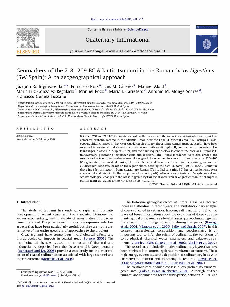
Geomarkers of the 218–209 BC Atlantic tsunami in the Roman Lacus Ligustinus (SW Spain): A...
12
Geomarkers of the 218e209 BC Atlantic tsunami in the Roman Lacus Ligustinus (SW Spain): A palaeogeographical approach Joaquín Rodríguez-Vidal a, * , Francisco Ruiz a , Luis M. Cáceres a , Manuel Abad a , María Luz González-Regalado a , Manuel Pozo b , María I. Carretero c , Antonio M. Monge Soares d , Francisco Gómez Toscano e a Departamento de Geodinámica y Paleontología, Universidad de Huelva, Avda. Tres de Marzo, s/n, 21071 Huelva, Spain b Departamento de Geología y Geoquímica, Universidad Autónoma de Madrid, 28049 Madrid, Spain c Departamento de Cristalografía, Mineralogía y Química Agrícola, Universidad de Sevilla, Apdo. 553, 41071 Sevilla, Spain d Radiocarbon Dating Laboratory, InstitutoTecnológico e Nuclear, Estrada Nacional 10, 2686-953 Sacavém, Portugal e Departamento de Historia I, Universidad de Huelva, Avda. Tres de Marzo, s/n, 21071 Huelva, Spain article info Article history: Available online 3 February 2011 abstract Between 218 and 209 BC, the western coasts of Iberia suffered the impact of a historical tsunami, with an epicentre probably located in the Atlantic Ocean near the Cape St. Vincent area (SW Portugal). Palae- ogeographical changes in the River Guadalquivir estuary, the ancient Roman Lacus Ligustinus, have been recorded in erosional and depositional landforms, both stratigraphically and as landscape relicts. The tsunamigenic waves (run-up of w5 m) and their subsequent backwash eroded the previous littoral spits transversally, generating rectilinear cliffs and incisions. The littoral foredunes were also eroded and reactivated as transgressive dunes over the edge of the marshes. Former coastal sediments (w520e100 BC) generated overwash deposits, ebb tide deltas and sand sheets within the estuary, as well as a subsequent bioclastic beach on the lagoon shore, defining the post-tsunami (130 BCe80 AD) estuarine shoreline (Roman lagoon). Some coastal pre-Roman (7th to 3rd centuries BC) human settlements were abandoned, and later, in the Roman period (1st century AD), saltworks were installed. Morphological and sedimentological changes in the coast triggered by this event were similar or greater than the changes in coastal features related to the AD 1755 Lisbon tsunami. Ó 2011 Elsevier Ltd and INQUA. All rights reserved. 1. Introduction The study of tsunami has undergone rapid and dramatic development in recent years, and the associated literature has grown exponentially, with a variety of investigative approaches being presented. The papers used in this study represent selective aspects that have been particularly useful, but they are not repre- sentative of the entire spectrum of approaches to the problem. Great tsunami have tremendous morphological effects and drastic ecological impacts in coastal areas (Borrero, 2005). The morphological changes caused to the coasts of Thailand and Indonesia by deposits from the December 26, 2004 tsunami (Fagherazzi and Du, 2008) provide a case-study for the interpre- tation of coastal sedimentation associated with large tsunami and their recurrence (Monecke et al., 2008). The Holocene geological record of littoral areas has received increasing attention in recent years. The multidisciplinary analysis of cores collected in estuaries, lagoons, salt marshes or deltas has revealed broad information about the evolution of these environ- ments, global or regional sea-level changes, palaeoclimatology, and the effects of anthropogenic actions during this period (Borrego et al., 2004; Vilanova et al., 2006; Selby and Smith, 2007). In this context, mineralogical composition and geochemistry is an important tool to infer the origin of sediments, the variations of some physicalechemical water parameters, and palaeoenviron- ments (Chamley, 1989; Carretero et al., 2002; Mackie et al., 2007). This record may include distinctive sedimentary layers that have been attributed to storms, cyclones, hurricanes or tsunami. These high-energy events cause the deposition of sedimentary beds with characteristic textural and mineralogical features (Clague et al., 2000; Singarasubramanian et al., 2006; Babu et al., 2007). The southwestern Spanish coast is a low-probability tsunami- genic area (Galbis, 1932; Reicherter, 2001). Although sixteen tsunami are documented for the time-period between 218 BC and * Corresponding author. Fax: þ34959219440. E-mail address: [email protected] (J. Rodríguez-Vidal). Contents lists available at ScienceDirect Quaternary International journal homepage: www.elsevier.com/locate/quaint 1040-6182/$ e see front matter Ó 2011 Elsevier Ltd and INQUA. All rights reserved. doi:10.1016/j.quaint.2011.01.032 Quaternary International 242 (2011) 201e212
-
Upload
uilvicenza -
Category
Documents
-
view
3 -
download
0
Transcript of Geomarkers of the 218–209 BC Atlantic tsunami in the Roman Lacus Ligustinus (SW Spain): A...
lable at ScienceDirect
Quaternary International 242 (2011) 201e212
Contents lists avai
Quaternary International
journal homepage: www.elsevier .com/locate/quaint
Geomarkers of the 218e209 BC Atlantic tsunami in the Roman Lacus Ligustinus(SW Spain): A palaeogeographical approach
Joaquín Rodríguez-Vidal a,*, Francisco Ruiz a, Luis M. Cáceres a, Manuel Abad a,María Luz González-Regalado a, Manuel Pozo b, María I. Carretero c, Antonio M. Monge Soares d,Francisco Gómez Toscano e
aDepartamento de Geodinámica y Paleontología, Universidad de Huelva, Avda. Tres de Marzo, s/n, 21071 Huelva, SpainbDepartamento de Geología y Geoquímica, Universidad Autónoma de Madrid, 28049 Madrid, SpaincDepartamento de Cristalografía, Mineralogía y Química Agrícola, Universidad de Sevilla, Apdo. 553, 41071 Sevilla, SpaindRadiocarbon Dating Laboratory, Instituto Tecnológico e Nuclear, Estrada Nacional 10, 2686-953 Sacavém, PortugaleDepartamento de Historia I, Universidad de Huelva, Avda. Tres de Marzo, s/n, 21071 Huelva, Spain
a r t i c l e i n f o
Article history:Available online 3 February 2011
* Corresponding author. Fax: þ34959219440.E-mail address: [email protected] (J. Rodríguez-Vidal
1040-6182/$ e see front matter � 2011 Elsevier Ltd adoi:10.1016/j.quaint.2011.01.032
a b s t r a c t
Between 218 and 209 BC, the western coasts of Iberia suffered the impact of a historical tsunami, with anepicentre probably located in the Atlantic Ocean near the Cape St. Vincent area (SW Portugal). Palae-ogeographical changes in the River Guadalquivir estuary, the ancient Roman Lacus Ligustinus, have beenrecorded in erosional and depositional landforms, both stratigraphically and as landscape relicts. Thetsunamigenic waves (run-up of w5 m) and their subsequent backwash eroded the previous littoral spitstransversally, generating rectilinear cliffs and incisions. The littoral foredunes were also eroded andreactivated as transgressive dunes over the edge of the marshes. Former coastal sediments (w520e100BC) generated overwash deposits, ebb tide deltas and sand sheets within the estuary, as well asa subsequent bioclastic beach on the lagoon shore, defining the post-tsunami (130 BCe80 AD) estuarineshoreline (Roman lagoon). Some coastal pre-Roman (7th to 3rd centuries BC) human settlements wereabandoned, and later, in the Roman period (1st century AD), saltworks were installed. Morphological andsedimentological changes in the coast triggered by this event were similar or greater than the changes incoastal features related to the AD 1755 Lisbon tsunami.
� 2011 Elsevier Ltd and INQUA. All rights reserved.
1. Introduction
The study of tsunami has undergone rapid and dramaticdevelopment in recent years, and the associated literature hasgrown exponentially, with a variety of investigative approachesbeing presented. The papers used in this study represent selectiveaspects that have been particularly useful, but they are not repre-sentative of the entire spectrum of approaches to the problem.
Great tsunami have tremendous morphological effects anddrastic ecological impacts in coastal areas (Borrero, 2005). Themorphological changes caused to the coasts of Thailand andIndonesia by deposits from the December 26, 2004 tsunami(Fagherazzi and Du, 2008) provide a case-study for the interpre-tation of coastal sedimentation associated with large tsunami andtheir recurrence (Monecke et al., 2008).
).
nd INQUA. All rights reserved.
The Holocene geological record of littoral areas has receivedincreasing attention in recent years. The multidisciplinary analysisof cores collected in estuaries, lagoons, salt marshes or deltas hasrevealed broad information about the evolution of these environ-ments, global or regional sea-level changes, palaeoclimatology, andthe effects of anthropogenic actions during this period (Borregoet al., 2004; Vilanova et al., 2006; Selby and Smith, 2007). In thiscontext, mineralogical composition and geochemistry is animportant tool to infer the origin of sediments, the variations ofsome physicalechemical water parameters, and palaeoenviron-ments (Chamley, 1989; Carretero et al., 2002; Mackie et al., 2007).
This recordmay include distinctive sedimentary layers that havebeen attributed to storms, cyclones, hurricanes or tsunami. Thesehigh-energy events cause the deposition of sedimentary beds withcharacteristic textural and mineralogical features (Clague et al.,2000; Singarasubramanian et al., 2006; Babu et al., 2007).
The southwestern Spanish coast is a low-probability tsunami-genic area (Galbis, 1932; Reicherter, 2001). Although sixteentsunami are documented for the time-period between 218 BC and
J. Rodríguez-Vidal et al. / Quaternary International 242 (2011) 201e212202
AD 1900 (Campos, 1991), there are still few papers focused on theirgeological record (e.g., Luque et al., 2001, 2002; Ruiz et al., 2004,2005; Scheffers and Kelletat, 2005; Pozo et al., 2010).
The great Lisbon earthquake and tsunami of AD 1755 is themorerecent one recorded on the coasts of southern Iberia, NW Moroccoand the Atlantic islands. The earthquake MSK intensity can beestimated at VIIIeIX in the Huelva-Cádiz sector, and its momentmagnitude Mw 8.7 (Baptista et al., 1998), recently re-evaluated asMw 8.5 � 0.3 (Solares and Arroyo, 2004). The highest tsunami run-up recorded in the Azores Islands and along the SW Portuguesemainland shore was 10e15 m, corresponding to an event intensityof IVeV (largeevery large) according to Alexander (1993) andVIIeVIII (damagingeheavily damaging) on the Papadopou-loseImamura scale. Recent investigations in the towns of Cádiz(Blanc, 2008) and Huelva (Lima et al., 2010) show a very probablerun-up of 4e5 m above present m.s.l.
The main objective of this paper is to document the geologicalmarkers left by the historically documented tsunami of 218e209 BCwithin the ancient Roman Lacus Ligustinus (Guadalquivir estuary,Fig. 1), as well as to analyze the recorded data in order to determineany geomorphological changes triggered by this high-energy event.The morphosedimentary record of the AD 1755 tsunami in theSpanish and Portuguese coasts has been used as a comparative toolfor the ancient tsunami (218e209 BC) documented in this study.
2. Study area
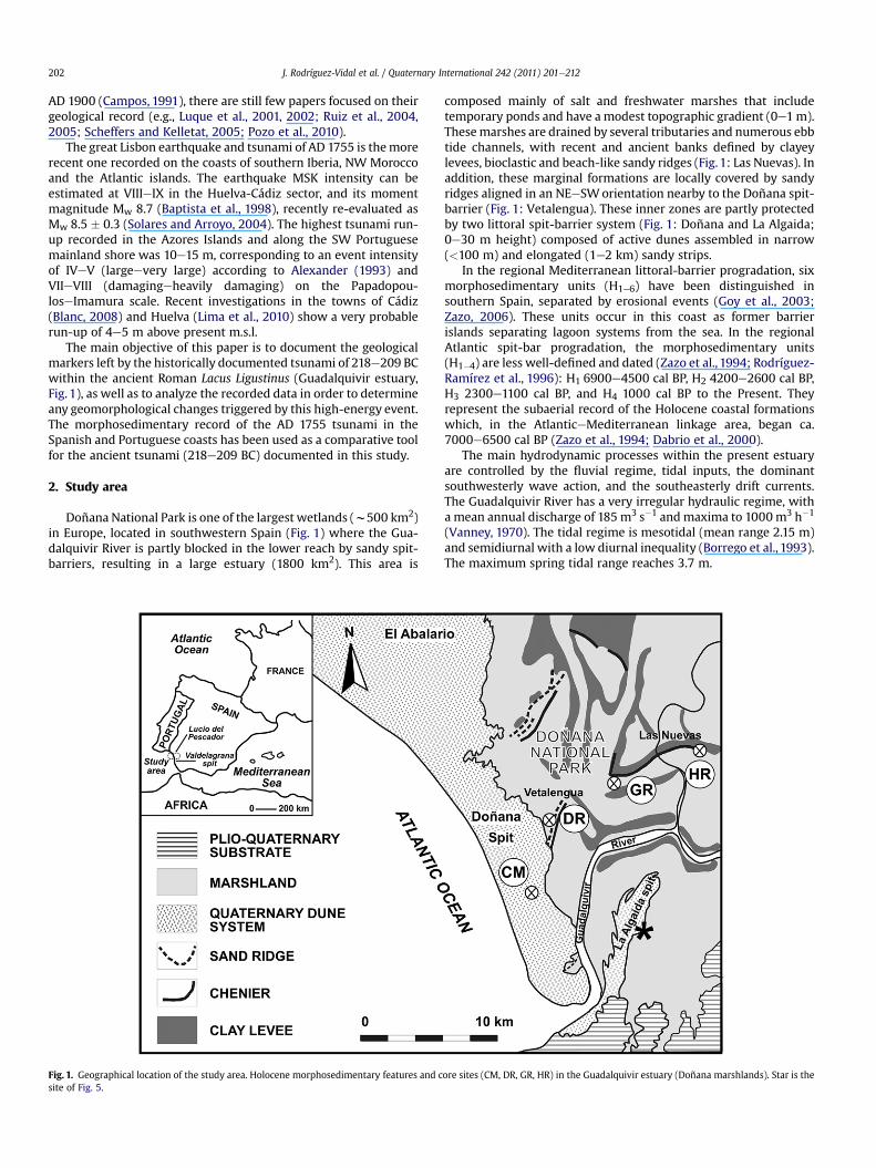
Doñana National Park is one of the largest wetlands (w500 km2)in Europe, located in southwestern Spain (Fig. 1) where the Gua-dalquivir River is partly blocked in the lower reach by sandy spit-barriers, resulting in a large estuary (1800 km2). This area is
Fig. 1. Geographical location of the study area. Holocene morphosedimentary features and csite of Fig. 5.
composed mainly of salt and freshwater marshes that includetemporary ponds and have amodest topographic gradient (0e1m).Thesemarshes are drained by several tributaries and numerous ebbtide channels, with recent and ancient banks defined by clayeylevees, bioclastic and beach-like sandy ridges (Fig. 1: Las Nuevas). Inaddition, these marginal formations are locally covered by sandyridges aligned in an NEeSWorientation nearby to the Doñana spit-barrier (Fig. 1: Vetalengua). These inner zones are partly protectedby two littoral spit-barrier system (Fig. 1: Doñana and La Algaida;0e30 m height) composed of active dunes assembled in narrow(<100 m) and elongated (1e2 km) sandy strips.
In the regional Mediterranean littoral-barrier progradation, sixmorphosedimentary units (H1e6) have been distinguished insouthern Spain, separated by erosional events (Goy et al., 2003;Zazo, 2006). These units occur in this coast as former barrierislands separating lagoon systems from the sea. In the regionalAtlantic spit-bar progradation, the morphosedimentary units(H1�4) are less well-defined and dated (Zazo et al., 1994; Rodríguez-Ramírez et al., 1996): H1 6900e4500 cal BP, H2 4200e2600 cal BP,H3 2300e1100 cal BP, and H4 1000 cal BP to the Present. Theyrepresent the subaerial record of the Holocene coastal formationswhich, in the AtlanticeMediterranean linkage area, began ca.7000e6500 cal BP (Zazo et al., 1994; Dabrio et al., 2000).
The main hydrodynamic processes within the present estuaryare controlled by the fluvial regime, tidal inputs, the dominantsouthwesterly wave action, and the southeasterly drift currents.The Guadalquivir River has a very irregular hydraulic regime, witha mean annual discharge of 185 m3 s�1 andmaxima to 1000m3 h�1
(Vanney, 1970). The tidal regime is mesotidal (mean range 2.15 m)and semidiurnal with a low diurnal inequality (Borrego et al., 1993).The maximum spring tidal range reaches 3.7 m.
ore sites (CM, DR, GR, HR) in the Guadalquivir estuary (Doñana marshlands). Star is the
J. Rodríguez-Vidal et al. / Quaternary International 242 (2011) 201e212 203
3. Materials and methods
3.1. Textural, mineralogical and palaeontological analyses
One long core (Fig. 1: CM (Corral de la Marta), w7 m a.s.l., 31 mlength) was collected by the Geological Survey of Spain (IGME) inthe southern part of the Doñana marshlands. Additional samples tothose obtained by Ruiz et al. (2004) were extracted from theuppermost part of three short cores collected in the same area (DR,GR and HR in Fig. 1).
Grain-size distribution was determined by wet sieving for thecoarser fractions (>100 mm). Fractions lesser than 100 mm wereanalysed by photosedimentation (MicromeriticsR Sedigraph 5100ET). Na-hexametaphosphate was used as a dispersing agent.
The mineralogical analysis of samples was carried out by meansof X-ray diffraction (XRD) using a Siemens D-5000 equipment witha scanning speed of 1�2q/min and Cu-ka radiation. XRD studieswere performed both on randomly oriented samples (total fraction)and clay fraction samples (<2 mm), the last prepared from cation-saturated, ultrasonic treated suspensions oriented on glass slides.The identification of the clay fraction minerals was carried out onoriented Mg2þ-saturated samples with ethylene glycol solution,after heating at 550 �C following Kþ saturation. When required,carbonates were eliminated using 0.6 N acetic acid. Quantitativeestimation of the mineral content was carried out using theintensity factors calculated by Schultz (1964) and Barahona (1974).
In addition, the >63 mm fraction was studied under a stereo-scopic microscope, in order to effectuate a general revision of thepalaeontological record. This included the taxonomical determi-nation and the estimation of both densities and diversities ofbivalves, gastropods, ostracods and foraminifera. In addition, thepresence and relative abundance of other groups (scaphopods,barnacles, bryozoans, crabs) were also noted.
3.2. Geomorphological mapping
The first geomorphological mapping of the Doñana marshlandswere made and synthetically published in Rodríguez-Ramírez et al.(1996). Other maps of the Doñana area have been prepared later,focused on particular aspects, as is the case of the one developed inthis study for the specific historical period (w220 BCe100 AD)(Fig. 6).
The survey made in this work is based on photointerpretations,along with field research, performed on bird-eye pictures taken in1956 (1:33,000) and 1980 (1:10,000), satellite images of GoogleEarth and digital orthophotos of Andalucia (1:50,000). The Topo-graphic Map of Andalucia (1:10,000) has been used as a basedocument for geomorphological mapping.
3.3. Radiocarbon chronology
Reliable radiocarbon dating of marine samples is hard to carryout since the initial specific 14C activity differs from that of thecontemporaneous atmosphere. The remaining 14C activity ofsamples formed in the ocean reservoir not only reflects 14C decay(related to sample age) but also the 14C activity of the oceanic regionwhere the sample lived (Stuiver and Braziunas, 1993). A correctionfor the age anomaly is possible when the reservoireatmosphereoffset in specific 14C activity is known. The offset R(t) is expressed asa reservoir 14C age, which is not constant with time.
Secular 14C variations in the marine environment can be rep-resented by a modelled world ocean curve, but a world averagecurve does not account for regional oceanic differences in specific14C activity. Regional differences in 14C content between the seasurface water for a specific region and the average surface water
ones are due to several causes and anomalies, namely theupwelling of deep water. Thus, a parameter, denoted as DR, can bedefined as the difference between the reservoir age of the mixedlayer of the regional ocean and the reservoir age of the mixed layerof the average world ocean (Stuiver and Braziunas, 1993).
A recent study concerning the reservoir effect in the coastalwaters off the Gulf of Cádiz suggests a significant fluctuation withtime in DR values during the Holocene (Soares and Dias, 2006). Thecomputed weighted mean for DR is of �135 � 20 14C y in theAndalusian coast. Nevertheless, for the time interval 4400e4000 BP,DR values are strongly positive and in a first approach, between4000 BP and 2500 BP, a DR value of 100� 100 14C y can be accepted(Soares and Martins, 2010). In the present work, the dates fromvarious laboratories by radiocarbon analysis of mollusc shells(beach ridge, sand sheet) and peaty sand (marsh, dune), wereobtained fromselected previous papers andnewsampling (Table 1).
The total dataset has fifteen radiocarbon dates that were con-verted into calendar dates using IntCal09 and Marine09 calibrationcurves (Reimer et al., 2009) for terrestrial and marine samples,respectively, and the program OxCal (Bronk Ramsey, 2001), version4.1.3 (http://c14.arch.ox.ac.uk/oxcal.html). The final results arepresented as calibrated ages for 2s intervals using a bayesianmodel(Fig. 2). The marine reservoir correction was carried out usinga value of�135� 20 14C y forDR, with an exception for the date UtC-4031 (2930 � 60 BP), which was calibrated usingDR ¼ 100 � 100 14C y (Soares and Martins, 2010; Rodríguez-Vidalet al., 2010). Ages discussed below represent the highest probableage of the 2s calibrated range.
4. Results
4.1. Facies and palaeoenvironmental interpretation
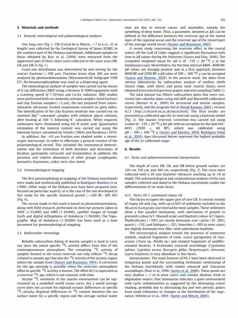
The depth of cores DR, GR, and HR below ground surface are120 cm, 150 cm, and 160 cm, respectively (Fig. 3). The cores werecollected with a 20 mm diameter vibracore reaching up to 1.6 mdepth. The sedimentological and compositional analyses of the coresamples collected and dated in the Doñana marshlands enable thedifferentiation of six main facies.
4.1.1. Facies FA-1. Laminated clayey siltThis facies occupies the upper part of core GR. It consists mainly
of clayey silt and clay, with up to 65% of sediments included in the40 mmto 4 mmgrain-size interval formost samples. These sedimentsshow a fine parallel lamination, with alternation of greyish togreenish (colour 6/1;Munsell scale) and blackish (colour 4/1) layers.Phyllosilicates (>70%) are clearly dominant over calcite (10e20%),quartz (<13%) and feldspars (<5%). Smectites (>50% in most cases)are slightly dominant over illite, with subordinate kaolinite.
The microscopical analysis reveals the presence of numerousreddish, oxidized fragments of roots, scarce gyrogonites of char-aceans (Chara sp., Nitella sp.) and isolated fragments of undiffer-entiated bivalves. A freshwater ostracod assemblage (Cyprinotussalinus, Cyprideis torosa, Ilyocypris gibba, Herpetocypris chevreuxi,Cypris bispinosa) is very abundant in this facies.
Interpretation: The main features of FA-1 have been observed intemporary ponds and the surrounding freshwater reedswamp ofthe Doñana marshlands, with similar ostracod and characeanassemblages (Ruiz et al., 1996; Santos et al., 2006). These ponds arevery shallow (<1 m in most cases) and contain alkaline, fresh tooligohaline waters. Fine lamination indicates a quiet environmentwith cyclic sedimentation as suggested by the alternating colourshading, probably due to alternating dry and wet periods, pulsesfrom small tributaries or changes in the distribution of the vege-tation (Whittecar et al., 2001; Harter and Mitsch, 2003).
Table 1Radiocarbon dataset from Doñana marshlands (Guadalquivir estuary) and Valdelagrana spit (Bay of Cádiz) sedimentary records.
Location (reference) Lab. code 14C age (BP) Calibrated date (2s)(cal BC/cal AD)Unmodelled
Calibrated date (2s)(cal BC/cal AD)Modelled
Phase pre-tsunamiDoñana field dune (Zazo et al., 1999) UtC-3929a 2760 � 60 1050e800 cal BC 990e790 cal BCDoñana field dune (Zazo et al., 1999) LGQ-758a 2590 � 120 980e400 cal BC 920e420 cal BCLucio El Pescador (Lario, 1996; Dabrio et al., 2000) UtC�4028c 2490 � 60 790e410 cal BC 800e480 cal BCLucio El Pescador (Lario, 1996; Dabrio et al., 2000) UtC-4031b 2930 � 60 890e340 cal BC 850e390 cal BCCM core (this paper) Beta-228876b 2830 � 40 770e230 cal BC 780e370 cal BC
Phase tsunamiLa Algaida spit (Zazo et al., 1994) Beta-88022b 2487 � 70 590e150 cal BC 480e140 cal BCLas Nuevas N2 core (Rodríguez-Ramírez and
Yáñez-Camacho, 2008)Beta-145202b 2570 � 70 470 cal BC to 140 cal AD 390e40 cal BC
Valdelagrana spit (Luque et al., 2002) GX-27986b 2340 � 40 340e50 cal BC 340e70 cal BCSum 540 cal BC to 60 cal AD 420e50 cal BC
Phase post-tsunamiLas Nuevas HR core (Rodríguez-Ramírez et al., 1996) R-2278b 2284 � 39 250 cal BC to 40 cal AD 160 cal BC to 40 cal ADLas Nuevas GR core (Ruiz et al., 2004) Beta-145203b 2140 � 70 130 cal BC to 250 cal AD 100 cal BC to 100 cal ADLa Algaida spit (Rodríguez-Ramírez et al., 1996) R-2284b 2233 � 29 160 cal BC to 60 cal AD 110 cal BC to 60 cal ADVetalengua DR core (Ruiz et al., 2004) Beta-88016b 2230 � 60 210 cal BC to 130 cal AD 120 cal BC to 70 cal ADVetalengua DR core (Ruiz et al., 2004) R-2283b 2171 � 36 90 cal BC to 140 cal AD 80 cal BC to 90 cal ADDoñana spit (Zazo et al., 1994) R-2205b 2185 � 50 150 cal BC to 140 cal AD 100 cal BC to 80 cal ADCM core (this paper) Beta-228874b 2170 � 40 100 cal BC to 150 cal AD 90 cal BC to 90 cal AD
Sum 200 cal BC to 160 cal AD 110 cal BC to 80 cal AD
Radiocarbon Laboratory: (UtC) Van der Graaf, Utrecht, Netherlands, (LGQ) Laboratoire de Géologie du Quaternaire, Luminy, France, (R) CNR Roma, Italy, (Beta) Beta AnalyticInc., Miami, USA, (GX) Geochron Laboratory, USA.
a Sample material: peaty sand.b Sample material: shell.c Sample material: twigs.
J. Rodríguez-Vidal et al. / Quaternary International 242 (2011) 201e212204
4.1.2. Facies FA-2. Greyish siltThis facies is widely represented in all cores and is made-up of
silt and clay (silt: 55e70%; clay: 26e43%) with greyish to greenishcolours (5Y 4/2). Up to 70% of sediment is comprised between 15and 2 mm, with high percentages of fine and very fine silt. They arestructureless or show a very weak lamination.
Phyllosilicates are the main mineral components (40e67%;mean 57%), although both quartz (mean 14%) and calcite (mean22%) increase in relation to FA-1. Smectites (46e60%) are dominantover illite (33e42%), kaolinite (7e12%) and chlorite (<5%).
The palaeontological record includes low densities of a brackishostracod assemblage (mainly C. torosa, Loxoconcha elliptica, Lep-tocythere castanea), salt marsh foraminifera (Ammonia tepida,Jadammina macrescens, Haynesina germanica, Trochammina inflata),scarce freshwater gastropods (Melanopsis) and undifferentiatedfragments of stems and roots. Reworked specimens of planktonicforaminifera, spines of echinoderms, bryozoans and marine orbrackish bivalves (Cardium edule, Venerupis decussatus) arefrequent.
Interpretation: This facies has intermediate characteristicsbetween FA-1 and FA-3. The microfossil assemblages are charac-teristic of brackish marshes or of the adjacent margins of a brackishlagoon. Tidal flows introduced marine faunas towards the innerlagoonal areas. Both mineralogical and palaeontological records arevery similar to those observed in the inner lagoons of the nearbyMediterranean rim (Ruiz et al., 2006b).
4.1.3. Facies FA-3. Green silt and clayThese deposits consist of greenish clayey silt or silty clay (10 YR
5/3), with up to 70% of sediment (dry weight) comprised between30 mm and 1 mm and very low sand contents (<4%). This facies-typedisplays a fine parallel lamination, with well-defined coarselaminae (5e10 cm thick) and scarce evidence of bioturbation.
The bulk mineralogy is dominated by phyllosilicates (mean 51%),reaching usually up to 47%. Calcite (19e32%; mean 25%) and quartz(13e16%) have more homogeneous distributions than FA-2,
although similar mean values. Smectites (mean 54%) are dominantover illite (mean 39%), kaolinite (mean 7%) and chlorite (mean< 5%).
The macrofauna is composed of brackish (mainly C. edule) andmarine (V. decussatus, Chamelea gallina) bivalves, together with lessfrequent specimens of marine gastropods (Rissoa, Hinia). Ostracods(2e200 individuals/gram; C. torosa, L. elliptica, L. castanea) andforaminifera (10e1000 individuals/gram;A. tepida,H. germanica) arefrequent to very abundant in these sediments. The reworkedmarinefaunas of ostracods, planktonic foraminifera, spines of echinoderms,fragments of bryozoans or centric diatomsmay be locally abundant,constituting the 20e40% of the palaeontological record.
Interpretation: The most representative species of both ostra-cods and foraminifera are well represented in brackish lagoons(salinity up to 15e20&). In this area, the tidal renewal is condi-tioned by the dimensions of outlets that cross the external, elon-gated sandy spits (Marocco et al., 1996; Ruiz et al., 2006a). Thismarine influence is proved by the presence of reworked faunasderived from the adjacent infralittoral zone (Pérez Quintero, 1989;Ruiz et al., 1997).
4.1.4. Facies FA-4. Yellow siltThis is off-white to pale yellow, sandy-clayey silt (colour 8/2 to
8/3), poorly sorted, with very low to moderate percentages of sand(4e20%). They display parallel lamination or absence of patentsedimentary structures in some intervals. These fine-grainedsediments are characterized by moderate to high percentages ofquartz (20e44%) and low to moderate phyllosilicate contents(15e35%), In addition, calcite exceeds 20% and feldspars can besignificant (w20%) in the upper part of core CM. Smectite and illiteshow similar proportions (40e50%).
Macrofauna is abundant,with numerous valves and fragments ofmarine molluscs, including bivalves (C. gallina, V. decussatus, Acan-thocardia tuberculata), gastropods (Rissoa spp., Hinia reticulata,Lemintina arenaria) and scaphopods (Dentalium vulgare, Dentaliumsexangulum). Benthic marine foraminifera (50e300 individuals/gram; Ammonia beccarii, Quiqueloculina spp., Elphidium crispum)

Fig. 2. Graphical representation of radiocarbon calibrated dataset generated by program OxCal. The broken line corresponds to the date of the 218e209 BC tsunami. A goodagreement can be verified between the data and the OxCal model. Laboratory code in Table 1.
J. Rodríguez-Vidal et al. / Quaternary International 242 (2011) 201e212 205
and ostracods (Palmoconcha turbida, Pontocythere elongata, Urocy-thereis oblonga) are dominant over brackish species. Fragments ofbryozoans, plates of barnacles, claws of crabs, and planktonic fora-minifera (Orbulina, Globigerina, Globigerinoides) are also abundant.
Interpretation: The most abundant assemblages of molluscs,ostracods and foraminifera of this facies characterize the shallowareas (<30 m depth) of the southwestern Spanish shelf (PérezQuintero, 1989; Ruiz et al., 1997). These assemblages and some
brackish specimens (C. torosa, L. castanea) are usually found in themarine zones of perimediterranean lagoons, very close to thenatural or artificial inlets and subjected to moderate to highhydrodynamic gradients (Ruiz et al., 2006a, 2006b).
4.1.5. Facies FA-5. Bioclastic silt and sandThis facies-type is the main component of several bioclastic
beaches located at the margins of recent and ancient tidal channels
Fig. 3. Core profiles showing lithofacies and calibrated ages.
J. Rodríguez-Vidal et al. / Quaternary International 242 (2011) 201e212206
(Fig. 1: Las Nuevas). These sedimentary beds are characterized bya large lateral extension (3e6 km) and a narrow width (20e30 m).Thickness (5e70 cm in most cases) decreases landward, usuallycovering the FA-2 or FA-3 facies. They display an erosive base, withvegetation remains and intraclasts of the underlying sediments inthe basal lag. In the upper part, bioclasts are in most cases frag-mented and arranged in thick laminae (3e5 cm) or displayinga disorganized disposition. Textural analysis allows delimiting twosubfacies, with a bimodal grain-size distribution and poor sortingin both cases.
4.1.5.1. Subfacies FA-5-a. Bioclasts are included in a greenish,clayey-silty matrix (5Y 8/3), with moderate sand contents(10e25%). Phyllosilicates (53e65%) are clearly dominant overcalcite (mean 20%) and quartz (mean 12%). Illite is the main claymineral (43e68%), with percentages slightly higher than smectites(28e47%), subordinated kaolinite (<5e15%) and chlorite (<5%) arealso detected.
4.1.5.2. Subfacies FA-5-b. This subfacies is transitional to FA-6, withbioclasts included in a greenish to greyish silty-sandy matrix (5Y 8/6). In general, this facies exhibit fining-upward sequences, passingfrom basal fine sands to very fine sands with important contribu-tion of silt near the top. Quartz is the main component (up to 70% inmost cases), accompanied by secondary percentages of phyllosili-cates (mean 11%) and feldspars (mean 10%). Illite ranges between50% and 60% in all samples, with subordinated smectite (20e40%)and kaolinite (5e15%).
Molluscs represent an important proportion (10e40% dryweight) of the sediment. Shell debris and disarticulated bivalveshells of euryhaline (mainly C. edule) and marine (mainly A.tuberculata, Donax vittatus and Spisula solida) are abundant.Gastropods are represented by freshwater (Gyraulus laevis, Mela-nopsis) and marine (Rissoa, Lemintina, Hinia) specimens. Fragmentsof barnacles, scaphopods and bryozoans are also frequent.
Microfauna is better represented in subfacies FA-5-a, with50e500 individuals/g of brackish ostracods (C. torosa, L. elliptica)and foraminifera (A. tepida, H. germanica), together with marinespecimens of both groups (Basslerites berchoni, Carinocythereiswhitei, Urocythereis britannica, A. beccarii, E. crispum). Some marinemiliolids are also abundant (Triloculina, Quinqueloculina) lackingthe last chambers in numerous individuals. Brackish ostracodspresent a high-energy population structure, with numerous indi-viduals (>70% in most samples) corresponding to adults or A-1 toA-3 moults. On the contrary, only scarce specimens of brackishspecies were observed in the sandier samples of subfacies FA-5-b.
Interpretation: These ridges show numerous features describedin tsunamigenic deposits (Bryant et al., 1992; Bryant, 2001; Dawsonand Stewart, 2007): a) an erosional base; b) occurrence of intraclastand plant remains near the base; c) finer sediments towards thetop; d) presence of higher sand percentages (near the Doñana spit-barrier) in relation to the underlying sediments; e) changes in theclay mineral composition; f) strong changes of fauna in relation tothe underlying layers; g) presence of numerous marine species ofboth macrofauna and microfauna with evidence of reworking.Consequently, a tsunamigenic origin is attributed to these beds.
4.1.6. Facies FA-6. Yellow sandThis facies is represented in the uppermost part of Vetalengua
and the dune system of Doñana spit-barrier (core CM). These layersconsists of well sorted, fine to very fine sand with intense yellowshades (10Y 8/6). Up to 60% of sediment presents mean grain sizecomprised between 500 and 80 mm. In the upper levels of core CM,these sediments exhibit cross stratification, whereas they aremassive in core DR. Both macrofauna and microfauna are virtuallyabsent, with exception of some isolated and fragmented remains ofthe bivalve Corbula gibba.
Quartz (62e88%) is dominant over phyllosilicates (3e30%) andfeldspars (5e21%). Smectites (54e56%) are the main clay minerals,with minor proportions of illite (34e40%) and kaolinite (6e10%).
Interpretation: These sediments constitute the dune system ofthe Doñana spit-barrier. The mineralogical records obtained coin-cide with those indicated by Flor (1990) in these aeolian materials.
4.2. La Algaida high-energy facies
The first eastern ridge of La Algaida spit-barrier (star in Fig. 1,and arrow in Fig. 4A) is a relict beach ridge of high-energy attachedto a palaeocliff formed during the tsunami. The tsunami wavesbroke the previous tombolo and deposited a sedimentary forma-tion composed of fine sands with numerous bioclasts, rock frag-ments and pebbles. These rock fragments (3e5 cm diameter) arequartz-rich sandstones and bioclastic calcarenites, rounded insome cases. They show shock marks, grooves and fractures filled byorange quartz-bearing sands, well sorted and slightly cementedwith bioclast fragments. In addition, some incrusting organisms(bryozoans, annelids) are frequent in the surface of these pebblesand fragments.
4.2.1. MacrofaunaThe matrix is almost azoic, with some occasional debris of
bivalves (Ostrea edulis). Macrofauna is represented mainly by

Fig. 4. La Algaida spit-barrier. A. Eastern shore with the tsunami beach ridge (yellow arrows; right hand side) and the post-tsunami ones (white arrows; left hand side), B. high-energy ridge attached to the former pre-tsunami palaeocliff and its sandy formation, with both rounded shells and bored clasts.
J. Rodríguez-Vidal et al. / Quaternary International 242 (2011) 201e212 207
reworked molluscs. Rounded fragments of bivalves (O. edulis, C.gallina, Glycymeris insubrica, Venus lamellosa) are frequent, some ofthem highly bioeroded by clionid sponges (Entobia). Gastropods areabundant, with abundant evidence of transport (loss of the apex orthe first whorls, abrasion of axial ornamentation, rupture of theouter lip or the aperture, shell fragmentation) inHexaplex trunculus,Conus mediterraneus, Cerithium vulgatum or Columbella rustica.
4.2.2. MicrofaunaThe inner sediments of these mollusc shells show remarkable
differences with the matrix. Foraminifera (mainly A. beccarii, E.crispum, Quinqueloculina seminulum, A. tepida) are abundant, withfrequent losses of the last chambers in miliolids. In addition, frag-ments of planktic forms (e.g., Orbulina universa) have been alsofound. The ostracod population includes adults (P. elongata, P. tur-bida) and juvenile instars (Loxoconcha rhomboidea, L. castanea).Some isolated fragments of bryozoans, characeans and echinodermspines complete the microfossil remains.
4.2.3. IchnologyA high percentage of molluscs shows bioerosion evidence
(Caulostrepsis, Entobia), most frequently in ostreids. In addition,some rare traces of Oichnus paraboloides Bromley have been foundin naticids. Biotic boring activity has been also observed innumerous pebbles, with an ichnofabric dominated by eroded tracesof Entobia sp. and small, poorly developed traces of Cauloptrepsis sp.
4.2.4. InterpretationThe sedimentological and palaeontological features of this ridge
indicate a polygenetic geomorphological structure. The matrix isvery similar to aeolian sediments of Doñana and La Algaida spit-barriers and the geomorphological beds derived from the erosion ofthem by tsunami or storm events (Ruiz et al., 2005). Contrast, thefossil record shows clear evidence of reworking, with the presenceof transported specimens of marine species of ostracods (P. elon-gata, P. turbida), foraminifera (A. beccarii, E. crispum), bivalves(G. insubrica, C. gallina) or gastropods (C. mediterraneus, C. rustica).

J. Rodríguez-Vidal et al. / Quaternary International 242 (2011) 201e212208
At present, these species inhabit shallow to very shallow infralit-toral environments in the adjacent Gulf of Cádiz (Pérez Quintero,1989; Junta de Andalucía, 1993; Ruiz et al., 1997; Lindner, 2000).This marine origin is also contrasted by the occurrence of bryo-zoans, echinoderm remains or planktonic foraminifera.
Clasts show evidence of transport and shocks, indicating a high-energy original environment (shorefaceeforeshore) with a contin-uous sedimentary reworking (Fig. 4B). They could come fromformer polygenic beaches of sands, bioclasts and pebbles locatedsouthward of the La Algaida spit-barrier. The provenance of theclasts can be only related with the erosion of PlioePleistocene cliffs(see the location of these materials in Fig. 1) with similar rocks(Domínguez et al., 2004; Del Río and Gracia, 2007).
5. Discussion
5.1. Geomorphological implication
Large tsunami produces significant geomorphological changes(Dawson, 1994; Fagherazzi and Du, 2008; Paris et al., 2009) whenthey reach the coast, including extensive erosion and deposition ofdifferent sedimentary layers. The direction of run-up flow on thecoastal plain of Indonesia and Thailand (earthquake of December26, 2004) was almost at 90� to the coastline, whereas backwashflow directions depended on topography (Umitsu et al., 2007).Coastal erosion of the plain was caused by the direct attack oftsunami waves, and the lower reaches of small rivers were erodedby a strong backwash flow. Intertidal areas are at present, exposedat low tide to the same extent as they were before the tsunami.
Thus, the main morphological changes undergone in the IndianOcean and Andaman Sea coasts are shown by an erosive retreat ofthe shoreline, with generation of oblique channels, erosion of thesandy shoals and tip of littoral spits at the estuary mouth(Fagherazzi and Du, 2008; Pari et al., 2008), and deposition of sandsheets that penetrated several kilometres inland (Paris et al., 2007;Choowong et al., 2008), filling pre-existing furrows and making theterrain uniform (Hori et al., 2007). The great sedimentary load thatpenetrates up the estuaries will facilitate sedimentation as a basalresidual lag or at the inner banks, either as a beach, ridge orwashover fan (Narayana et al., 2007). Ebb tide delta and theregrowth of littoral spit-bar and barrier are frequent at an estuarymouth (Liew et al., 2010). Similarly, as observed in the New Zealandcoastal dune systems (Goff et al., 2008), the tsunami inundation can
Fig. 5. Morphosedimentary formations of Vetalengua area and DR core. 1e
modify existing dunes, producing features such as relict dunepedestals, landward sand sheets, hummocky topography, andparabolic dunes.
A similarmodel is proposed to have occurred in the Guadalquivirestuary during the tsunami of 218e209 BC. The great sand barrier ofDoñana protected the coastal and tidal lowlands from erosion,although the first line of foredune and former dune ridges wereeroded (Table 1: pree420 cal BC). Accordingly, transgressive duneswere reactivated and migrated inland (Fig. 5). The sandy tip andshoals of the Doñana coastal-barrier were eroded suddenly, mainlyby thebackwashcurrents (Table 1: CMcore780e370cal BC), aswerethe western and eastern flanks of the La Algaida spit-barrier. Thiscreated a channelledmorphology, with small cliffs at right angles tothe coastline, which are partially preserved today (Figs. 4 and 6B).
The sediments transported by the tsunami waves were spreadover the estuary bed (Table 1: 420e50 cal BC) and subsequentlyaccumulated at the edges of the marshes by tides and waves(Fig. 6B), forming the beach ridges of Vetalengua (Fig. 5), Las Nuevas,and La Algaida (Fig. 4), shaping the coastline of the ancient estuarinelagoon (Lacus Ligustinus) (Fig. 6C). These post-tsunami estuarinelandscape has been dated (Table 1) between 110 cal BCe80 cal AD.
The growth of theDoñana and La Algaida spit-barriers continuedwith the episode of H3 regional progradation (2300e1100 cal BP,Rodríguez-Ramírez et al., 1996), which sealed and fossilized thestudied high-energy event (Table 2). Within the estuary, the sedi-mentation of marsh-type fine deposits continued.
5.2. Human settlement
This palaeogeographical and geomorphological reconstructionof the post-tsunami littoral landscape coincides with the earliesthistorical description of the estuary, made by the Roman chroniclerStrabo in his work Geographica, written between 29 and 7 BC(Jones, 1917e1932). He referred to the southern part of the estuaryas an inland lagoon (Lacus Ligustinus), a palaeogeographyconfirmed 40 years later by Mela, a Spanish chronicler, in his workDe Chorographica (García Bellido, 1987).
The spit-barrier of La Algaida, on the eastern bank of the estuary,records the unique pre-Roman settlement (sanctuary, in Fig. 6A)documented in this coastal area (7the3rd centuries BC: Blanco andCorzo,1983). This ancient settlementwas abandonedapproximatelyat the date of the tsunami, when this sandy barrier was convertedinto an island (Rodríguez-Ramírez et al., 1996). Later, in the 1st
2, interpretative cross-section of Vetalengua ridge during Roman time.

Fig. 6. Morphosedimentary evolution of the Guadalquivir estuary. A. pre-tsunami landscape (w220 BC), B. tsunami signatures and the landscape a few years later (w200 BC), C.post-tsunami Lacus Ligustinus (200 BC to 100 AD), D. present-day picture (Google Earth). Legend: 1. pre-Holocene substrate, 2. marshland, 3. beach ridge, 4. sandy formations andspit-ridge, 5. ebb tide delta, 6. transgressive dune, 7. cliff, 8. incoming tsunami, 9. human settlement.
J. Rodríguez-Vidal et al. / Quaternary International 242 (2011) 201e212 209
century AD (Esteve Guerrero, 1952), and when the connection withthe continent was re-established, the Romans installed a saltworkson the eastern coast, protected fromwave action (Fig. 6C).
The chronological data coming from the shells of the tsunami-genic sediments and from the subsequent post-tsunami littoralsediments (phase post-tsunami, in Fig. 2), match the dates at whichthe historical descriptions were made by Strabo and Mela. Thedevelopment of the post-tsunami landscape that was defined bya coastline of sandy beaches at the inner part of the estuary,
happened between w200 BC and 100 AD (Fig. 6C), ending up witha wide estuarine lagoon at its entrance. This was the Lacus Ligu-stinus that the Romans knew for 200 years approximately, betweenthe 1st century BC and 1st century AD.
5.3. Morphosedimentary evolution
The morphosedimentary study of the current Guadalquivirestuary allows definition of an important tsunamigenic event,
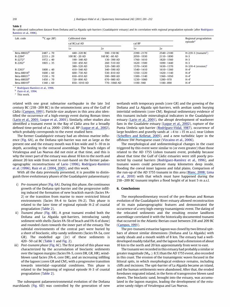
Table 2Re-calibrated radiocarbon dataset from Doñana and La Algaida spit-barriers (Guadalquivir estuary) and its correlation with regional progradation episode (after Rodríguez-Ramírez et al., 1996).
Lab. code 14C age (BP) Calibrated date Regional progradationepisodea
cal BC/cal AD cal BP
1s 2s 1s 2s
Beta-88022b 2487 � 70 440e220 BC 590e150 BC 2390e2170 2540e2100 H-2/H-3 (tsunamic)R-2284a 2233 � 29 100 BCe20 AD 160 BCe60 AD 2050e1930 2110e1890 H-3R-2272a 1972 � 40 190e340 AD 130e390 AD 1760e1610 1820e1560 H-3R-2262a 1865 � 35 330e450 AD 260e510 AD 1620e1500 1690e1440 H-3
380e520 AD 320e580 AD 1570e1430 1630e1370 H-3/H-4 (erosion)c
R-2263a 1800 � 40 410e540 AD 340e590 AD 1540e1410 1610e1360 H-4c
Beta-88018b 1600 � 60 600e730 AD 530e810 AD 1350e1220 1420e1140 H-4c
Beta-88021b 1530 � 70 650e810 AD 590e900 AD 1300e1140 1360e1050 H-4c
Beta-88020b 1450 � 70 720e890 AD 670e980 AD 1230e1060 1280e970 H-4c
Beta-88019b 1340 � 60 850e1010 AD 770e1060 AD 1100e940 1180e890 H-4c
a Rodríguez-Ramírez et al., 1996.b Zazo et al., 1994.c This work.
J. Rodríguez-Vidal et al. / Quaternary International 242 (2011) 201e212210
related with one great submarine earthquake in the late 3rdcentury BC (218e209 BC) in the seismotectonic area of the Gulf ofCádiz (Campos, 1991). Particle-size analyses in this area also iden-tified the occurrence of a high-energy event during Roman times(Lario et al., 2001; Luque et al., 2001). Similarly, other studies alsoidentified a tsunami event in the Bay of Cádiz area for a broadlydefined time-period of ca. 2000e2300 cal. BP (Luque et al., 2002),which probably corresponds to the event studied here.
The former Guadalquivir estuary had an obvious marine influ-ence (Fig. 6A), as the Doñana spit-barrier was not as large as thepresent one and the estuary mouth was 8 km wide and 5e10 m indepth, according to the ostracod assemblage. The beach ridges ofVetalengua and Las Nuevas did not exist at that time, and this iswhy the inner part of the estuary was about 10 km to the north andalmost 20 km wide from west to east-based on the former palae-ogeographic reconstructions of Lario (1996), Rodríguez-Ramírezet al. (1996), Ruiz et al. (2004, 2005), and this work.
With all the data previously presented, it is possible to distin-guish three evolutionary phases of the Guadalquivir palaeoestuary:
i) Pre-tsunami phase (Fig. 6A). During this phase, the continuousgrowth of the Doñana spit-barrier and the progressive infill-ing induced the formation of new brackish marsh (facies FA-2) or the transition from marine to more restricted littoralenvironments (facies FA-4 to facies FA-2). This phase isrelated to the later time of regional episode H-2 of coastalprogradation (Table 2).
ii) Tsunami phase (Fig. 6B). A great tsunami eroded both theDoñana and La Algaida spit-barriers, introducing sandysediment with shells (facies FA-5b of beach and FA-6 of dune)and rounded clasts towards the inner part of the estuary. Thesubtidal environments of the central part were buried bya sheet of bioclastic, silty-sandy sediments (facies FA-5a, coreGR). The modelled age (2s) of these sediments is420e50 cal BC (Table 1 and Fig. 2).
iii) Post-tsunami phase (Fig. 6C). The first period of this phase wascharacterized by the accumulation of bioclastic sedimentsover the lagoonmargins (facies FA-5, cores DR, GR, HR), wind-blown sand facies (FA-6, core DR), and an increasing infillingof the lagoon (cores GR and CM), with a progressive transitiontowards intertidalesupratidal conditions. This phase isrelated to the beginning of regional episode H-3 of coastalprogradation (Table 2).
The subsequent palaeoenvironmental evolution of the Doñanamarshlands (Fig. 6D) was controlled by the generation of new
wetlands with temporary ponds (core GR) and the growing of theDoñana and La Algaida spit-barriers, with aeolian sands buryingintertidal sediments (core CM). Regional sedimentary evidence ofthis tsunami include mineralogical indicators in the Guadalquivirestuary (Lario et al., 2001), the abrupt development of washoverfans in the Guadalete estuary (Luque et al., 2002), rupture of thePunta Umbría spit-barrier (Rodríguez-Vidal, 1987), occurrence oflarge boulders and gravelly sands at þ4 to þ15 m a.s.l. near Lisbon(Scheffers and Kelletat, 2005), and a new turbiditic layer in theoffshore SW Portuguese coast (Vizcaino et al., 2006).
The morphological and sedimentological changes in the coasttriggered by this event were similar to (or even greater) than thoserelated to the AD 1755 Lisbon tsunami event, probably becauseabout that time the Gulf of Cádiz estuaries were still poorly pro-tected by coastal barriers (Rodríguez-Ramírez et al., 1996), andtsunami waves could penetrate many kilometres deep inside,flooding the coeval inner lagoons and tidal plains. Comparison ofthe run-up of the AD 1755 tsunami in this area (Blanc, 2008; Limaet al., 2010) with that which must have happened during the218e209 BC tsunami implies a flood height of at least 5 m a.s.l.
6. Conclusions
The morphosedimentary record of the pre-Roman and Romanevolution of the Guadalquivir River estuary allowed reconstructionof its main palaeogeographic features and demonstrated theoccurrence of a very high-energy tsunamigenic event. The dating ofthe relocated sediments and the resulting erosive landformassemblage correlated it with the historically documented tsunamithat occurred in the Atlantic Iberian coast between 218 and 209 BC(Campos, 1991).
The pre-tsunami estuarine lagoonwas closed by two littoral spit-bars of almost similar dimensions (Doñana and La Algaida) withsandy shoals and a mouth width of 8 km. The estuary had a well-developedmuddy tidalflat, and the lagoonhadadimensionof about10 km to the north and 20 km approximately fromwest to east.
The tsunamiwe recorded in this estuaryhadprobablya similar orgreatermagnitude (Mw� 8.5) than the AD1755 event, also recordedin this coast. The erosion of the tsunamigenic waves focused in thelittoral spits, in which morphological evidence remains, includingcliffs and incisions. The spit-barrier of La Algaida became an island,and the human settlements were abandoned. After that, the erodedforedunes migrated inland, in the form of transgressive blown sandsheets. The bioclastic sand, brought into the estuary, was accumu-lated in the lagoon margins, leading the development of the estu-arine sandy ridges of Vetalengua and Las Nuevas.
J. Rodríguez-Vidal et al. / Quaternary International 242 (2011) 201e212 211
The reorganization of the relocated sediments by the tsunamiand their accumulation at the sides of the Guadalquivir estuaryformed the sand ridges of Doñana, Vetalengua, Las Nuevas and LaAlgaida, placed over sand shoal or previous bioclastic sand and silt.The tsunami action, the consequent relocation of sediments andmorphological changes triggered within the ancient estuary,controlled the palaeogeography of the Lacus Ligustinus during theearly Roman times in southern Spain.
Acknowledgements
This research was funded by the SpanisheFEDER ProjectsCTM2006e06722/MAR, CGL2006e01412/BTE andCGL2010e15810/BTE, and three Research Groups of the Andalusia Board (RNMe238,RNMe293, and RNMe349). We thank reviewers and guest-editorsfor helpful comments. Darren Fa improved the English of themanuscript. This work is a contribution to the IGCPs 526 (Risks,resources, and record of the past on the continental shelf), 567(Earthquake Archaeology and Palaeoseismology), and 588(Preparing for coastal change).
References
Alexander, D., 1993. Natural Disasters. ULC Press, London, 632 pp.Babu, N., Suresh Babu, D.S., Mohan Das, P.N., 2007. Impact of tsunami on texture and
mineralogy of a major placer deposit in southwest coast of India. EnvironmentalGeology 52, 71e80.
Baptista, M.A., Heitor, S., Miranda, J.M., Miranda, P., Mendes Victor, L., 1998. The1755 Lisbon tsunami; evaluation of the tsunami parameters. Journal of Geo-dynamics 25, 143e157.
Barahona, E., 1974. Arcillas de ladrillería de la provincia de Granada: evaluación dealgunos ensayos de materias primas. Ph.D. Thesis. University of Granada, Spain.
Blanc, P.-L., 2008. The tsunami in Cadiz on 1 November 1755: a critical analysis ofreports by Antonio de Ulloa and by Louis Godin. Comptes Rendus Geoscience340, 251e261.
Blanco, A., Corzo, R., 1983. Monte Algaida. un santuario púnico en la desembocaduradel Guadalquivir. Historia-16 87, 122e128.
Borrego, J., Morales, J.A., Pendón, J.G., 1993. Holocene filling of an estuarine lagoonalong the mesotidal coast of Huelva: the Piedras River mouth, southwesternSpain. Journal of Coastal Research 8, 321e343.
Borrego, J., López González, N., Carro, B., 2004. Geochemical signature as palae-oenvironmental markers in Holocene sediments of the Tinto River estuary(Southwestern Spain). Estuarine, Coastal and Shelf Science 61, 631e641.
Borrero, J.C., 2005. Field data and satellite imagery of tsunami effects in Banda Aceh.Science 308, 1596.
Bronk Ramsey, C., 2001. Development of the radiocarbon calibration programOxCal. Radiocarbon 43 (2A), 355e363.
Bryant, E.A., 2001. Natural Hazards. Cambridge University Press, Hong Kong.Bryant, E.A., Young, R.W., Price, D.M., 1992. Evidence of tsunami sedimentation on
the southeastern coast of Australia. Journal of Geology 100, 753e765.Campos, M.L., 1991. Tsunami hazard on the Spanish coasts of the Iberian Peninsula.
Science of Tsunami Hazards 9, 83e90.Carretero, M.I., Ruiz, F., Rodríguez Ramírez, A., Cáceres, L.M., Rodríguez-Vidal, J.,
González-Regalado, M.L., 2002. The use of clay minerals and microfossils inpalaeoenvironmental reconstructions: the Holocene littoral strand of LasNuevas (Doñana National Park, SW Spain). Clay Minerals 37, 93e103.
Chamley, H., 1989. Clay Sedimentology. Springer Verlag, Berlin.Choowong, M., Murakoshi, N., Hisada, K., Charoentitirat, T., Charusiri, P.,
Phantuwongraj, S.,Wongkok, P., Choowong,A., Subsayjun,R., Chutakositkanon,V.,Jankaew, K., Kanjanapayont, P., 2008. Flow conditions of the 2004 IndianOcean tsunami in Thailand inferred from capping bedforms and sedimentarystructures. Terra Nova 20, 141e149.
Clague, J.J., Bobrowsky, P.T., Hutchinson, I., 2000. A review of geological records oflarge tsunami at Vancouver Island, British Columbia. Quaternary ScienceReviews 19, 849e863.
Dabrio, C.J., Zazo, C., Lario, J., Goy, J.L., Sierro, F.J., Borja, F., et al., 2000. Depositionalhistory of estuarine infill during the last postglacial transgression (Gulf of Cadiz,southern Spain). Marine Geology 162, 381e404.
Dawson, A.G., 1994. Geomorphological effects of tsunami run-up and backwash.Geomorphology 10, 83e94.
Dawson, A.G., Stewart, I., 2007. Tsunami deposits in the geological record. Sedi-mentary Geology 200, 166e183.
Del Río, L., Gracia, F.J., 2007. Análisis de la vulnerabilidad de los acantilados atlán-ticos de la provincia de Cádiz ante la erosión costera. Cuaternario y Geo-morfología 21, 87e101.
Domínguez, L., Gracia, F.J., Anfuso, G., 2004. Tasas de avance/retroceso de la línea decosta mediante morfometría fotogravimétrica en el sector Sanlúcar de
Barrameda-Rota (provincia de Cádiz). Revista de la Sociedad Geológica deEspaña 17, 71e86.
Esteve Guerrero, M., 1952. Sanlúcar de Barrameda (Cádiz): fábrica de salazónromana en la Algaida. Noticiario Arqueológico Hispánico 1e3, 126e133.
Fagherazzi, S., Du, X., 2008. Tsunamigenic incisions produced by the December2004 earthquake along the coasts of Thailand, Indonesia and Sri Lanka.Geomorphology 99, 120e129.
Flor, G., 1990. Tipología de dunas eólicas. procesos de erosión, sedimentación cos-tera y evolución litoral de la provincia de Huelva (Golfo de Cádiz occidental, Surde España). Estudios Geológicos 46, 99e109.
Galbis, R.J., 1932. Catálogo sísmico de la zona comprendida entre los meridianos 58�
E y 20� W de Greenwich y los paralelos 45� y 25� N. Dirección General delInstituto Geográfico, Catastral y de Estadística, Madrid.
García Bellido, A., 1987. La España del siglo primero de nuestra era (según P. Mela yC. Plinio). Colección Austral, Espasa Calpe.
Goff, J., McFadgen, B., Wells, A., Hicks, M., 2008. Seismic signals in coastal dunesystems. Earth-Science Reviews 89, 73e77.
Goy, J.L., Zazo, C., Dabrio, C.J., 2003. A beach-ridge progradation complex reflectingperiodical sea-level and climate variability during the Holocene (Gulf ofAlmería, Western Mediterranean). Geomorphology 50, 251e268.
Harter, S.K., Mitsch, W.J., 2003. Patterns of short-term sedimentation in a fresh-water created marsh. Journal of Environmental Quality 32, 325e334.
Hori, K., Kuzumoto, R., Hirouchi, D., Umitsu, M., Janjirawuttikul, N., Patanakanog, B.,2007. Horizontal and vertical variation of 2004 Indian tsunami deposits: anexample of two transects along the western coast of Thailand. Marine Geology239, 163e172.
Jones, H.L. (Ed.), 1917e1932. The Geography of Strabo. Harvard University Pressand Heinemann.
Junta de Andalucía, 1993. Atlas de los recursos marinos del Golfo de Cádiz. In: deHuelva, Litoral (Ed.). Junta de Andalucía, España, p. 145.
Lario, J., 1996. Último y Presente Interglacial en el área de conexión Atlántico eMediterráneo: Variaciones del nivel del mar, paleoclima y paleoambientes.Unpublished Ph.D. Thesis. Universidad Complutense de Madrid, 269p.
Lario, J., Zazo, C., Plater, A.J., Goy, J.L., Dabrio, C., Borja, F., et al., 2001. Particle size andmagnetic properties of Holocene estuarine deposits from the Doñana NationalPark (SW Iberia): evidence of gradual and abrupt coastal sedimentation.Zeitschrift für Geomorphologie 45, 33e45.
Liew, S.C., Gupta, A., Wong, P.P., Kwoh, L.K., Lindner, G., 2010. Recovery from a largetsunamimappedover time: theAcehcoast, Sumatra.Geomorphology114, 520e529.
Lima, V.V., Miranda, J.M., Baptista, M.A., Catalão, J., Gonzalez, M., Otero, L., et al.,2010. Impact of a 1755-like tsunami in Huelva, Spain. Natural Hazards and EarthSystem Sciences 10, 139e148.
Lindner, G., 2000. Moluscos y caracoles de los mares del mundo. Ediciones Omega,Barcelona, 319 pp.
Luque, L., Lario, J., Zazo, C., Goy, J.L., Dabrio, C.J., Silva, P.G., 2001. Tsunami deposits aspalaeoseismic indicators: examples from the Spanish coast. Acta GeológicaHispánica 3e4, 197e211.
Luque, L., Lario, J., Civis, J., Silva, P.G., Zazo, C., Goy, J.L., Dabrio, C.J., 2002. Sedi-mentary record of a tsunami during Roman times, Bay of Cadiz, Spain. Journal ofQuaternary Science 17, 613e631.
Mackie, E.A.V., Lloyd, J.M., Leng, M.J., Bentley, M.J., Arrowsmith, C., 2007. Assessmentof d13C and C/N ratios in bulk organic matter as palaeosalinity indicators inHolocene and Lateglacial isolation basin sediments, northwest Scotland. Journalof Quaternary Science 22, 579e591.
Marocco, R., Melis, R., Montenegro, M.E., Pugliese, N., Vio, E., Lenardon, G., 1996.Holocene evolution of the Caorle barrier lagoon (northern Adriatic Sea, Italy).Rivista Italiana di Paleontologia e Stratigrafia 102, 385e396.
Monecke, K., Finger, W., Klarer, D., Kongko, W., McAdoo, B.G., Moore, A.L.,Sudrajat, S.U., 2008. A 1000-year sediment record of tsunami recurrence innorthern Sumatra. Nature 455, 1232e1234.
Narayana, A.C., Tatavarti, R., Shinu, N., Subeer, A., 2007. Tsunami of December 26,2004 on the southwest coast of India: post-tsunami geomorphic and sedimentcharacteristics. Marine Geology 242, 155e168.
Pari, Y., Ramana Murthy, M.V., Jaya kumar, S., Subramanian, B.R., Ramachandran, S.,2008. Morphological changes at Vellar estuary, India e impact of the December2004 tsunami. Journal of Environmental Management 89, 45e57.
Paris, R., Lavigne, F., Wassmer, P., Sartohadi, J., 2007. Coastal sedimentation asso-ciated with the December 26, 2004 tsunami in Lhok Nga, west Banda Aceh(Sumatra, Indonesia). Marine Geology 238, 93e106.
Paris, R., Wassmer, P., Sartohadi, J., Lavigne, F., Barthomeuf, B., Desgages, E.,Grancher, D., Baumert, P., Vautier, F., Brunstein, D., Gomez, C., 2009. Tsunami asgeomorphic crises: lessons from the December 26, 2004 tsunami in Lhok Nga,west Banda Aceh (Sumatra, Indonesia). Geomorphology 104, 59e72.
Pérez Quintero, J.C., 1989. Introducción a los Moluscos onubenses, I: Faunística.Junta de Andalucía, Spain.
Pozo, M., Ruiz, F., Carretero, M.I., Rodríguez-Vidal, J., Cáceres, L.M., Abad, M., Gon-zález-Regalado, M.L., 2010. Mineralogical assemblages, geochemistry and fossilassociations of PleistoceneeHolocene complex siliciclastic deposits from theSouthwestern Doñana National Park (SW Spain): a palaeoenvironmentalapproach. Sedimentary Geology 225, 1e18.
Reicherter, K., 2001. Paleoseismological advances in the Granada Basin (BeticCordilleras, southern Spain). Acta Geológica Hispánica 36, 267e281.
Reimer, P.J., Baillie, M.G.L., Bard, E., Bayliss, A., Beck, J.W., Blackwell, P.G., BronkRamsey, C., Buck, C.E., Burr, G.S., Edwards, R.L., Friedrich, M., Grootes, P.M.,Guilderson, T.P., Hajdas, I., Heaton, T.J., Hogg, A.G., Hughen, K.A., Kaiser, K.F.,
J. Rodríguez-Vidal et al. / Quaternary International 242 (2011) 201e212212
Kromer, B., McCormac, F.G., Manning, S.W., Reimer, R.W., Richards, D.A.,Southon, J.R., Talamo, S., Turney, C.S.M., van der Plicht, J., Weyhenmeyer, C.E.,2009. IntCal09 and Marine09 radiocarbon age calibration curves, 0e50,000years cal BP. Radiocarbon 51 (4), 1111e1150.
Rodríguez-Ramírez, A., Rodríguez-Vidal, J., Cáceres, L.M., Clemente, L.,Belluomini, G., Manfra, L., Improta, S., de Andrés, J.R., 1996. Recent coastalevolution of the Doñana National Park (SW Spain). Quaternary Science Reviews15, 803e809.
Rodríguez-Ramírez, A., Yáñez-Camacho, C.M., 2008. Formation of chenier plain ofthe Doñana marshland (SW Spain): observations and geomorphic model.Marine Geology 254, 187e196.
Rodríguez-Vidal, J., 1987. Modelo de evolución geomorfológica de la flecha litoral dePunta Umbría, Huelva, España. Cuaternario y Geomorfología 1, 247e256.
Rodríguez-Vidal, J., Soares, A.M.M., Ruiz, F., Cáceres, L.M., 2010. Comment on“Formation of chenier plain of the Doñana marshland (SW Spain): observationsand geomorphic model” by A. Rodríguez-Ramírez and C.M. Yáñez-Camacho[Marine Geology 254 (2008) 187e196]. Marine Geology 275, 292e295.
Ruiz, F., González-Regalado, M.L., Serrano, L., Toja, J., 1996. Los ostrácodos de laslagunas temporales del Parque Nacional de Doñana. Aestuaria 4, 125e140.
Ruiz, F., González-Regalado, M.L., Muñoz, J.M., 1997. Multivariate analysis applied tototal and living fauna: seasonal ecology of recent benthic ostracoda off theNorth Cadiz Gulf Coast (SW Spain). Marine Micropaleontology 31, 183e203.
Ruiz, F., Rodríguez Ramírez, A., Cáceres, L.M., Rodríguez-Vidal, J., Carretero, M.I.,Clemente, L., Muñoz, J.M., Yáñez, C., Abad, M., 2004. Late Holocene evolution ofthe southwestern Doñana National Park (Guadalquivir Estuary, SW Spain):a multivariate approach. Palaeogeography, Palaeoclimatology, Palaeoecology204, 47e64.
Ruiz, F., Rodríguez Ramírez, A., Cáceres, L.M., Rodríguez-Vidal, J., Carretero, M.I.,Abad, M., Olías, M., Pozo, M., 2005. Evidence of high-energy events in thegeological record: mid-Holocene evolution of the southwestern DoñanaNational Park (SW Spain). Palaeogeography, Palaeoclimatology, Palaeoecology229, 212e229.
Ruiz, F., Abad, M., Galán, E., González, I., Aguilá, I., Olías, M., Gómez Ariza, J.L.,Cantano, M., 2006a. The present environmental scenario of El Melah Lagoon(NE Tunisia) and its evolution to a future sabkha. Journal of African EarthScience 44, 289e302.
Ruiz, F., Abad, M., Olías, M., Galán, E., González, I., Aguilá, E., Hamoumi, N., Pulido, I.,Cantano, M., 2006b. The present environmental scenario of the Nador Lagoon(Morocco). Environmental Research 102, 215e229.
Santos, A., Sousa, A., Fernández, R., García, P., 2006. Aquatic macrophytes in Doñanaprotected area (SW Spain): an overview. Limnetica 25, 71e80.
Scheffers, A., Kelletat, D., 2005. Tsunami relics on the coastal landscape west ofLisbon, Portugal. Science of Tsunami Hazards 23, 3e16.
Schultz L.G., 1964. Quantitative interpretation of mineral composition from X-rayand chemical data for the Pierre Shale. United States Geological SurveyProfessional Paper 391C.
Selby, K.A., Smith, D.E., 2007. Late Devensian and Holocene sea-level changes on theIsle of Skye, Scotland, UK. Journal of Quaternary Science 22, 119e139.
Singarasubramanian, S.R., Mukesh, M.V., Manoharan, K., Murugan, S., Bakkiaraj, D.,Meter, A.J., Seralathan, P., 2006. Sediment characteristics of the M-9 tsunamievent between Rameswaram and Thoothukudi, Gulf of Mannar, southeast coastof India. Science of Tsunami Hazards 25, 160e172.
Soares, A.M.M., Dias, J.M.A., 2006. Once upon a time into the Azores Front pene-trated into the Gulf of Cadiz. In: Abstracts 5th Symposium on the IberianAtlantic Margin, 3pp.
Soares, A.M.M., Martins, J.M.M., 2010. Radiocarbon dating of marine samples fromGulf of Cadiz: the reservoir effect. Quaternary International 221, 9e12.
Solares, J.M.M., Arroyo, A.L., 2004. The great historical 1755 earthquake. Effects anddamage in Spain. Journal of Seismology 8, 275e294.
Stuiver, M., Braziunas, T.F., 1993. Modeling atmospheric 14C influences and 14C agesof marine samples to 10,000 BC. Radiocarbon 35, 137e189.
Umitsu, M., Tanavud, C., Patanakanog, B., 2007. Effects of landforms on tsunami flowin the plains of Banda Aceh, Indonesia, and Nam Khem, Thailand. MarineGeology 242, 141e153.
Vanney, J.R., 1970. L’hydrologie du Bas Guadalquivir. CSIC-Consejo Superior deInvestigaciones Científicas, Madrid.
Vilanova, I., Prieto, A.R., Espinosa, M., 2006. Palaeoenvironmental evolution andsea-level fluctuations along the southeastern Pampa grasslands coast ofArgentina during the Holocene. Journal of Quaternary Science 21, 227e242.
Vizcaino, A., Gràcia, E., Escutia, C., Asioli, A., García-Orellana, J., Lebreiro, S., Cacho, I.,Thouveny, N., Larrasoaña, J.C., Diez, S., Dañobeitia, J.J., 2006. CharacterizingHolocene paleoseismic record in the SW Portuguese Margin. GeophysicalResearch Abstracts 8, 08469.
Whittecar, G.R., Megonigal, J.P., Darke, A.K., 2001. Sedimentation patterns withintidal fresh-water marshes, Mattaponi River, Virginia. In: GSA Annual meeting,Boston, session 180, booth 69.
Zazo, C., 2006. Cambio climático y nivel del mar: la península ibérica en el contextoglobal. Cuaternario y Geomorfología 20, 115e130.
Zazo, C., Goy, J.L., Somoza, L., Dabrio, C.J., Belluomini, G., Improta, S., Lario, J.,Bardaji, T., Silva, P.G., 1994. Holocene sequence of sea-level fluctuations inrelation to climatic trends in the Atlantic-Mediterranean linkage coast. Journalof Coastal Research 10, 933e945.
Zazo, C., Dabrio, C.J., Borja, F., Goy, J.L., Lezine, A.M., Lario, J., Polo, M.D., Hoyos, M.,Boersma, J.R., 1999. Pleistocene and Holocene aeolian facies along the Huelvacoast (southern Spain): climatic and neotectonic implications. Geologie enMijnbouw 77, 209e224.