Geology of the Omaha-Council Bluffs Area Nebraska-Iowa
74
Geology of the Omaha-Council Bluffs Area Nebraska-Iowa By ROBERT D. MILLER GEOLOGICAL SURVEY PROFESSIONAL PAPER 472 Prepared as a part of a program of the Department of the Interior for the development of the Missouri River basin UNITED STATES GOVERNMENT PRINTING OFFICE, WASHINGTON : 1964
-
Upload
khangminh22 -
Category
Documents
-
view
2 -
download
0
Transcript of Geology of the Omaha-Council Bluffs Area Nebraska-Iowa

Geology of the
Omaha-Council Bluffs Area
Nebraska-Iowa By ROBERT D. MILLER
GEOLOGICAL SURVEY PROFESSIONAL PAPER 472
Prepared as a part of a program of the
Department of the Interior for the development
of the Missouri River basin
UNITED STATES GOVERNMENT PRINTING OFFICE, WASHINGTON : 1964

STEWART L. UDALL, Secretary
GEOLOGICAL SURVEY
Thomas B. Nolan, Director
Miller, Robert David, 1922-Geology . of the Omaha-Council Bluffs area,
Iowa. 'iV ashington, U.S. Govt. Print. Off., 1964.
iv, 70 p. illus., maps (3 col.) diagrs., tables. 30 em. (U.S. Geological Survey. Professional Paper 472)
Part of illustrative matter fold. in pocket. Prepared as a part of a program of the Dept. of the Interior for
the development of the Missouri River basin. Bibliography: p. 67-70.
Miller, Robert David, 1922-0maha-Council Bluffs area, (Card 2)
(Continued on next card)
Geology of the Nebraska-Iowa. 1964.
1. Geology-Nebraska-Omaha region. 2. Geology-Iowa-Council Bluffs region. I. Title: Omaha-Council Bluffs area, Nebraska-Iowa. (Series)
For sale by the Superintendent of Documents, U.S. Government Printing Office Washington, D.C. 20402

CONTENTS
Abstract __________________________________________ _ Introduction ______________________________________ _
Location ______________________________________ _
Present investigation ___________________________ _ Acknowledgments ______________________________ _ Earlier investigations ___________________________ _ Geography _____________________________________ _
Landforms ________________________________ _ Climate ___________________________________ _
Stratigraphy ______________________________________ _ General features _______________________________ _ Pennsylvanian System __________________________ _
Kansas City Group ________________________ _ Dennis Limestone ______________________ _
Winterset Limestone Member _______ _ Cherryvale Formation __________________ _
Fontana Shale Member_ ____________ _ Block Limestone Member ___________ _ W ea Shale Member ________________ _ Westerville Limestone Member ______ _ Quivira Shale Member _____________ _
Drum Limestone ______________________ _ Chanute Shale _________________________ _ Iola Limestone ________________________ _ Lane Shale ____________________________ _ Wyandotte Limestone __________________ _
Frisbie Limestone Member __________ _ Quindaro Shale Member ____________ _ Argentine Limestone Member _______ _ Island Creek Shale Member _________ _ Farley Limestone Member __________ _
Bonner Springs Shale ___________________ _ Lansing Group ____________________________ _
Plattsburg Limestone __________________ _ Merriam Limestone Member ________ _
Vilas Shale ____________________________ _ Stan ton Limestone _____________________ _
Captain Creek Limestone and Eudora Shale Members __________________ _
Stoner Limestone Member __________ _ Rock Lake Shale and South Bend
Limestone Members ______________ _ Cretaceous System _____________________________ _ Quaternary System ____________________________ _
Pleistocene Series __________________________ _ David City(?) Formation _______________ _ Nebraskan tilL ________________________ _ Fullerton Formation ___________________ _ Red Cloud Sand and GraveL ____________ _ Kansan till ____________________________ _
Page
1 2 2 2 3 4 4 4 5 5 5 5 8 8 9 9 9 9 9
10 10 10 11 11 11 12 12 12 12 12 12 13 13 13 13 13 13
13 13
14 14 14 14 15 16 16 19 20
Stratigraphy--Continued Quaternary System-Continued
Pleistocene Serie!Y-Contin ued Grand Island Formation ________________ _ Sappa Formation __________ - ___________ _
Pearlette Ash Member ______________ _ Crete Formation _______________________ _ Loveland Loess ______________________ - __ Peorian and Bignell Loesses _____________ _ Terrace alluvium ______________________ _
Recent Series _________________ --- ________ - __ Terrace alluvium ______________________ _ Flood-plain alluvium ___________________ _ Alluvial-fan deposits ________________ -- __ Slope wash ____________________________ _ Slump blocks __________________________ _ Artificial fill ________________________ -- __
Physiography _____________________________________ _
Entrenchment of the Missouri River _____________ _ Buried Loveland surfaces _______________________ _ Modern channel changes ________________________ _
Structure _________________________________________ _
Geologic history ___________________________________ _ Pre-Pleistocene history _______________________ - __ Pleistocene geologic history _____________________ _
Economic geology __________________________________ _ Engineering considerations ______________________ _
Foundation conditions ______________________ _ Loess _________________________________ _ Till __________________________________ _ Alluvium _____________________________ _ Bedrock ______________________________ _
Excavation _______________________________ _ Erosional characteristics ____________________ _
Loess _________________________________ _ Till __________________________________ _
Sand and graveL ______________________ _ Construction materials _________________________ _
Concrete aggregate _______________________ ---Mineral aggregate _________________________ _ Gravel and crushed rock for surfacing ________ _ Mineral filler ______________________________ _ Soil binder ________________________________ _ Clay surfacing materiaL ____________________ _ Lightweight aggregate ______________________ _ Building stone _____________________________ _ Clay _____________________________________ _
Stratigraphic sections ______________________________ _ References cited _________________________________ --_
III
Page
23 27 27 32 33 36 40
42 42 44 45 45 45 45 46 46 46 47 47 47 47 47 49 49 49 49 50 50 50 50 50 50 52 52 52 53 53 53 53 53 53 53 54 54 54 67
IV CONTENTS
ILLUSTRATIONS [Plates are in pocket]
PLATE 1. Geologic map of the Loveland quadrangle. 2. Geologic map of the Omaha North and Council Bluffs North quadrangles. 3. Geologic map of the Omaha South and Council Bluffs South quadrangles. 4. Columnar sections of rocks exposed in three quarries.
Page
FIGURE 1. Map of Nebraska and Iowa showing the area discussed in this report_______________________________________ 3 2. Excavation at the Olivo quarry showing the terrace alluvium of Wisconsin age______________________________ 8 3. Sketch of Fullerton Formation exposed in streambank____________________________________________________ 17
4. Surficial section exposed along U.S. 275----------------------------------------------------------------- 18 5. Changes in percent of clay, with depth, in the Fullerton Formation________________________________________ 19 6. Horizontally truncated unoxidized Kansan till overlain by the Grand Island Formation _________________ ----- 22 7. Sand and gravel "boulder" in Kansan tilL______________________________________________________________ 23
8. Grand Island Formation and Sappa Formation exposed in walls of North Omaha Rock and Lime quarry_______ 25 9. Sandstone at base of Grand Island Formation___________________________________________________________ 26
10. Clayey silt of the Sappa Formation _______________________________________________________________ ----- 27 11. Pearlette Ash Member of the Sappa Formation ___________________________________________________ - ___ --- 28
12. Sketch of formations exposed in sand and gravel pit south of Ponca Creek, north of Omaha, Nebraska ________ - 2H 13. Relocated type locality of the Loveland Loess___________________________________________________________ 34 14. Loveland Loess exposed near corner of 30th and Lake Streets. Omaha, Nebr________________________________ 34 15. Size-distribution curves of Loveland Loess west and east of the Missouri River, compared to curves of Loveland
Loess from south-central Nebraska __________________________ ---______________________________________ 35
16. Size-distribution curves of Peorian and Bignell Loesses west and east of the Missouri River _________________ -- 3 7 17. Size-distribution curves of the Peorian and Bignell Loesses from selected depths _______ - _____________ - ___ -_- 39 18. Sketch of loess blocks in roadcut near Crescent, Iowa_____________________________________________________ 40 19. Sketches showing relation between loess hills and terrace alluvium_________________________________________ 43
20. Map showing location of bedrock bench_--------------------------------------------------------------- 51 21. Terraced slope in loess, east end of Mormon Bridge road__________________________________________________ 52
TABLES
TARLE 1. Comparison of stratigraphic nomenclature of the Missouri Series exposed in the Omaha and Council Bluffs area_ 6 2. Stratigraphic succession of Pleistocene and Recent deposits exposed in the Omaha and Council Bluffs area______ 15 ;>. Quantitative spectrographic analyses of glass shards from samples of the Pearlette Ash Member of the Sappa For-
mation___________________________________________________________________________________________ 31

GEOLOGY OF THE OMAHA- COUNCIL BLUFFS AREA, NEBRASKA- IOWA
By RoBERT D. MILLER
ABSTRACT
The Omaha-Council Bluffs area coYers five 7%-minnte quadrangles that include parts of Washington, Douglas, and Sarpy Countie.s, Nebr., and Pottawattamie and Mills Counties, Iowa.
The Omaha-Council Bluffs area is a broad loess-mantled upland till plain into which the valley of the Missouri River is eroded. Terraces locally separate the Yalley floors from the upland. The highest terrace surface is best 11reserved in and north of Omaha.
Limestone and shale of the Kansas City and Lansing Groups of the :\Iissonri Series of Late Pennsylyanian age make up the principal bedrock exposures in the mapped area. The oldest bed exposed is the Winterset Limestone Member of the Dennis Limestone; the youngest is the South Bend Limestone Member of the Stanton Limestone. All interYening formations. and their members oecur in normal stratigraphic sequenees.
Most of the bedrock exposures are in the Olivo, North Omaha Rock ancl Lime, and Hnakirt quarries. The Winterset Limestone Member of the Dennis Limestone, the Cherryvale Formation, the Drum Limestone, the Chanute Shale, the lola Limestone, the Lane Shale, the Wyandotte Limestone, and the Bonner Springs Shale, all parts of the Kansas City Group, and the Merriam Limestone ::\Iember of the Plattsburg Limestone of the Lansing Group were exposed as of 19;)7 in these quarries.
Isolated outcrops, however, expose other beds in the stratigrapically higher Lansing Group. The uppermost unit of this group, the South Bend Limestone l\lember of the Stanton Limestone, crops out along the railroad cuts at the base of the Missouri RiYer north of Bellevue, Xebr., '-Yhere thE> Rock Lake Shale :\!ember underlies the South Bend. The Stoner Limestone 1Iember is exposed in a qnarry northea:..;t of Council Bluffs along :\Iosqnito Creek.
These Upper Pennsylvania limestone, dayst.ones, and siltstones were depositE>d in shallmv open seas in near-shore waters, or in lagoons and :..;wamps, as indieated by fos . ..,;ils in beds of the 1Iissouri ~Prie~. Cydothem sequences of limestones reveatedly OYerlain by shaly daystone and siltstone are related to cycles of changing se-a leYels.
Rocks of Cretaceous age are not exposed, but may possibly mulerlie the Pleisto<·ene rocks west of the mapped area.
The Pleist<H'ene deposits in this area incllHle ice-deposited materials as '.Yell as those of fluvial. lacustrinE>, colluvial, and eolian origins.
Sand and gravel overlying bedrock in the southeastern part of this area may be equivalent to the David City Formation of E>arly Nebraskan age. Nebraskan till, although not exposed, was penetrated in auger holes along the bluff of the Missouri Riv!:'r. Silt of the Fullerton Formation of late Nebraskan age is the oldest exposed Pleistocene deposit. Unc-onformably overlying the Fullerton is the Red Cloud Sand and Gravel of early
Kansan age. It is a medium to coarse sand that contains lenses of pebble gravel and irregular inclusions of compact till. The overlying Kansan till is predominantly a heterogeneous mixture of boulders, cobbles, pebbles, and sand in a silt matrix. The lower part of the till is unoxidized and medium to olive gray, whereas the upper part is oxidized and moderate yellowish brown. Medium to coarse sand of the Grand Island Formation of late Kansan age in places unconformably overlies a horizontal surface on the till. Overlying this sand is silt and clayey silt of the Sappa Formation, which was deposited during the last part of the alluvial cycle in late Kansan time. Within the Sappa is the Pearlette Ash Member, a diagnostic stratigraphic marker.
The Crete Formation of early Illinoian age overlies the Sappa. The Crete consists of medium to coarse sand and lag concen· trates of cobbles on the eroded surface of the Kansas till. It grades upward into the principal deposit of Illinoian age, the Loveland Loess.
Loveland Loess, which was deposited by wind, covered most of the surface exposed during the Illinoian Glaciation. The Loveland '.Vas subsequently weathered during the Sangamon Interglaciation, at which time it acquired its characteristic moderate-yellowish-brown color and a dark-brown to purplishgray humic zone. Both the color of the loess and the humic part of the soil make the Loveland a distinctive stratigraphic marker.
Overlying the Loveland is a deposit of yellowish-gray silt composed of two loesses of 'Visconsin age, the Peorian and the Bignell. The Peorian Loess was deposited during the early part of Wisconsin time ; the Bignell Loess was deposited during the later part of the Wisconsin. A well-developed very dark grayish-brown soil separates the loesses at a few places. Terrace alluvium of 'Visconsin age that is composed of stratified silt, and locally some loess, forms prominent flat surfaces along the west side of the Missouri River.
11aterials of Recent age include two terrace deposits, floodplain alluvium, alluvial fan deposits, and slope wash. The terraces are flat-topped valley fills bordering streams throughout the area. The older is underlain primarily by clayey to sandy tan :..;ilt, the ynunger by humic gray silt. The flood-plain alluvium is sand and gravel beneath the Missouri River flood plain and silt along the tributary streams in the upland, although locally the tributary alluvium contains sand, gravel, and lenses of rounded limestone fragments. Alluvial-fan deposits consist of fine sand and silt. Slope wash consists of stratified fine sand, silt, and humus-all reworked principally by gravity and sheet wash from nearby older deposits.
'l'he Missouri River entrenched its modern channel during late Kansan time. The Grand Island Formation was deposited during late middle Kansan to late Kansan time on nearly flat sur-
1

2 GEOLOGY OF THE OMAHA-COUNCIL BLUFFS AREA, NEBRASKA-IOWA
faces where the Missouri River eroded Kansan till or flowed across southeast-trending ridges on Pennsylvanian rocks.
The ancient Missouri River valley prO'ba'bly was wider than the present valley. The Kansan till is absent under the bluffs from Couueil Bluffs eastward to Mosquito Creek, whereas the Grand Island Formation extends the entire distance. The Loveland Loess oecurs beneath the upland over a series of surfaces whieh probably formed during entrenchment of the Missouri River or us periglaeial features related to the several advances and retreats of the Illinoian glacier.
The geologic history in this area is varied ·but relatively simple. The formations of Pennsylvanian age were deposited during a series or cycles of advancing and retreating seas. If any sediments ·of later Paleozok, Mesozoic, or Tertiary age were ever deposited here, they were removed by erosion before the beginning of the Pleistocene Epoch.
Two Pleistocene glaciers extended through this area and deposited till and outwash sand and gravel. As the Nebraskan glacier flowed through the area moving southwest, it deposited sand and gravel of the David City Formation in front of its advance. It was overridden and subsequently buried under the l\'"ebraskan till. Later, as the glacier retreated, streams entrenched themselves into the till plain and deposited finegrained deposits of the Fullerton Formation.
After the end of the warm climate of the Aftonian Interglaciation, the Red Cloud Sand and Gravel was deposited in front of, and was overridden by, the Kansan glacier as it adYanced southwestward through the Omaha-Council Bluffs area. Till covered all older deposits, forming a broad plain when the glacier subsequently retreated. Streams again entrenched the till plain and deposited sand and gravel of the Grand Island Formation. Clay, silt, and sand were deposited as the Sappa Formation during the waning stages of this alluvial cycle. The Pearlette Ash Member accumulated in small ephemeral pools from clouds of volcanic dust.
A warm interYal, the Yarmouth Interglaciation, followed the last major glaciation that covered the Omaha-Council Bluffs area. During the third glaciation, the Illinoian, ice advanced to points north and northeast of this area. The increased moisture helped erode the exposed deposits, so that locally a cobbleand-bouhler pavement. or "lag concentrate," covered the surface of the till. This pavement and local deposits of alluvial sand nnd gravel of the Crete Formation are all that record the early part of the Illinoian Glaeiation. Dust blown from outwash of the Illinoian glacier, however, accumulated over all the region as the Loveland Loess. As the Illinoian Glaciation drew to an end and the climate became warmer, the soil of the Sangamon Iuterglaciation developed on the Loveland Loess and all exposed older deposits.
Climatic change w·ithin the following 'Viseonsin Glaciation is represented by a soil, possibly the Brady Soil of Schultz and Rtout. This soil is in the undifferentiated Peorian and Bignell Loesses. which represent the largest deposit of 'Visconsin age in the area. Alluvium aecumulated along the Missouri River during this timP and waH snbHPqnently entrpnehed about 11,000 years ago. Remnants are preserved as the Fort Calhoun terrace.
Loess deposition continued during the gradual transition from the Pleistocene Epoch to the Recent Epoch. Subsequent erosion formed steep-sided ravines in the loess. Alluvium eventually filled these ravines which were eroded at least twice during the Recent Epoch. The flood-plain alluvium, alluvial-fan deposits, and slope wash all began to form during the Recent Epoch.
Foundation conditions of the materials in the Omaha-Council Bluffs area generally are good. The Peorian and Bignell Loesses cover the surface in most of the area ; with careful preparation these loesses may be used as support for structures.
Excavation of Pleistocene materials iu this area requires only power equipment; excavation of the rocks of Pennsylvanian age requires blasting.
Erosion is confined principally to the widespread Peorian and Bignell Loesses. Although loess has the property of standing well in nearly vertical cuts, it erodes rapidly in sloping cuts.
Deposits in the area are potential sources for concrete aggregate, mineral aggregate, gravel and crushed rock suitable for ~mrfacing, mineral filler, soil binder, clay surfacing materials, lightweight aggregate, building stone, and clay.
INTRODUCTION
LOCATION
The five 71;2 minute quadrangles that comprise the area of this report include parts of Washington, Douglas, and Sarpy Counties, Nebr., and parts of Pottawattamie and Mills Counties, Iowa. The Omaha South, Council Bluffs South, Omaha North, and Council Bluffs North form a block of four quadrangles; the Loveland quadrangle lies north of the Omaha North quadrangle (fig. 1).
Omaha and Council Bluffs are the largest cities in the area. Smaller communities within the five quadrangles are East Omaha, A very, Bellevue, Gilmore, and part of Fort Crook and Offutt Air Force Base in Nebraska and Crescent, Manawa Park, and Carter Lake in Iowa. Owing to a change in the river channel during a flood in 1877, the community of Carter Lake, Iowa, is now on the west side of the Missouri River.
PRESENT INVESTIGATION
Geologic mapping was started in August 1951 a.s part of the program of geologic mapping and investigation of mineral resources being made in conjunction with studies of the Department of the Interior for the Development of the Missouri River basin and was concluded in 1953. In order to supplement the subsurface data available from vvell logs, test holes were bored, using a truck-mounted power auger.
Mapping was done on aerial photographs, and the information "\vas compiled on published quadrangle maps (pls. 1-3). Geology of small additional areas was mapped in 1956, and also in 1957 when I was assisted by Edwin J{. Maughan. This additional mapping extended the know ledge of the geology to the boundaries of newly published quadrangle maps.
Walter R. Power, Jr., assisted me in 1951, Wilbur A. Smythe in part of 1952, and David D. Kroenlein during parts of 1952 and 1953.

INTRODUCTION 3
NEBRASKA
~------
, ___ _
0 10 20 MILES
I
'\
J
I
J I ,?, I
\~---------------~i~/ l .L
\""' _ ___ "1> '--v,
( MISSOURI
' \ '-
0 100 200 MILES
' ' "'\
j
FIGURE 1.-Map of Nebraska and Iowa showing the area discussed in this report and the location of the quadrangles mapped.
ACKNOWLEDGMENTS
Personnel of many Federal, State, and municipal agencies were extremely helpful in providino- data for use in this report. o
,J. A. Trantina and W. L. Stuckey, U.S. Corps of ~ngineers, Omaha district, provided data on test-bortng along the Missouri River flood plain. Dr. G. E. Condra, Director (1D51) Nebraska Geological Survey, Mr. B. C. Heed, Director, Nebraska Geological Survey, and Dr. H. G. Hershey, Director, Iowa State Geological ~urvey, made av~tilable subsurface geologic informatiOn from their files. In addition, I am grateful to Mr. Heed, to Mr. V. H. Dreeszen, Assistant Director, Nebraska Geological Survey, and to Mr. Ray Burchett, of the Nebraska Geological Survey, all of whom vollmteered information, accompanied me in the field, critically reviewed this report, and helped in many other ways.
Mr·. 0. E. LunJ and Mr. H. G. Schlitt, Nebraska State Highway Department, provided results of tests of silt,
sand, and gravel samples and data from test holes. Well records were furnished by the Omaha Public Power District, the Union Pacific Railroad, the LayneWestern Co., the Omaha Drilling Corp., Kirkham and Michalls and Associates, the Raymond Concrete Co., Sargent & Lundy, the Omaha Testing Laboratory, the Kelly Well Co., Grand Island, Harrington and Cortelyou, Kansas City, Mo., and the following Nebraska and Iow:t >vell drillers: Dan Melcher & Sons, Mr. James Wood, and the Christensen vVell Co. of Omaha; G. A., E. vV., and .T. A. Lefgren and Roger Rasmussen of Council Bluffs; Mr. Marvin Brenton, .Tr., of Glenwood, Iowa; A. A. Horn & Son of Papillion, Nebr.; and Mr. .Ten sen of Blair, Nebr.
The scope of this report is principally concerned with the surficial deposits; therefore, I especially wish to acknowledge the coopernJ ion of Mr. E. C. Reed, Director, Nebraska State Geological Survey, in identifying and correlating the bedrock units exposed in the area. In .Tnne 1D57, exposures in three quarries were measured

4 GEOLOGY OF THE OMAHA-COUNCIL BLUFFS AREA, NEBRASKA-IOWA
by E. K. Maughan, U.S. Geological Survey, and me; however, the correlations of these rocks with established formations are based on the opinions expressed by Mr. Reed. His willingness to express these opinions and to make tentative corrections of limestone and shale 1n isolated outcrops is gratefully acla1owledged.
EARLIER INVESTIGATIONS
The Omaha-Council Bluffs area was on the route used by several national surveys as well as individual scientists. Owen (1852) reported on his geologic observations in this area. Marcou ( 1864) published a report on a reconnaissance of the geology and paleontology of eastern Nebraska in which he placed the rocks in the sub-Carboniferous group (Mississippian). Meek · ( 1867) subsequently placed these rocks in the upper Coal Measures ( Pennsy 1 van ian), where they remain today. Other geologists ·who made observations regarding the area are 'Vhite (1867, 1870), Hayden (1872), Meek (1872), Todd (1892, 1897, 1899, and 1914), Udden (1901, 1903), Shimek (1908, 1909, 1910a, b), Calvin (1909), and Lee (in Le~ and others, 1916). Compilation of the logs of deep wells in Nebraska by Condra, Schramm, and Lugn (1931) and studies of water-bearing formations by Condra and Reed (1936) included the Pennsylvanian rocks of the Omaha area. Descriptions of groups, formations, and members by Condra and Reed (1943), Condra (1949), Hershey and others (1960), Moore (1949), and deep-well correlations by Reed and Svoboda (1957) are the bases for the bedrock terminology used here.
Most recent reports have emphasized the surficial deposits. Studies by Kay (1924, 1928), Kay and Apfel (1929), Kay and Miller (1941), and Kay and Graham (1943) resulted in detailed descriptions of the deposits in western Iowa. Studies in Nebraska by Lugn (1935) resulted in one of the most comprehensive early reports on the Pleistocene of Nebraska. Lueninghoener's terrace studies (1947) covered part of the mapped area of this report. The correlation of the Pleistocene deposits of Nebraska by Condra, Reed, and Gordon (1947, 1950) is the basis for much of the Pleistocene stratigraphy in this report.
GEOGRAPHY
LANDFORMS
The Omaha-Council Bluffs area consists of a broad loess-1nantled upland till surface bisected by the valley of the Missouri River. The land surface locally is eroded, thereby accentuating topographically l~igh areas. [ Loess-covered till hills that have moderately gentle slopes extend eastward from the western bound-
a.ry of the mapped area in N ebra.ska to the bluffs of the Missouri River. Loess hills along a belt 1-2 miles wide adjacent to the flood plain have steeper slopes. )Loesscovered dissected upland till surfaces in Iowa similarly extend westward from the eastern boundary of the mapped area to within 4 miles of the Missouri River flood plain. Supplemental loess, locally derived from the flood plain of the Missouri River, accumulated in a belt 2 to 4 miles wide along the eastern edge of the Missouri River flood plain. Erosion of the loess caused peaks and ridges that extend along the bluffs. /
Terraces that range in height from 25 to 80 feet above the fl.ood plain of the Missouri River and its tributaries locally separate the valley floors from the uplands. The highest terrace surface is best preserved in the Loveland quadrangle (pl. 1), Omaha North quadrangle, beneath Florence and downtown Omaha (pl. 2), and in the Omaha South quadrangle, beneath Bellevue and Offutt Air Force Base (pl. 3). A terrace 50 feet above the flood plain is preserved along Mosquito Creek in Iowa. Remnants of a terrace 25 feet above the flood plain flank the hillside on the north side of the mouth of Mosquito Creek in the Council Bluffs South quadrangle. /
The flood-plain of the Missouri River bisects the mapped area into almost equal parts. It lies about 250 feet below the upland surface and ranges in width from 3 to 8 miles. In most places it extends from bluff to bluff as a plain that slopes gradually toward the river channel. Except for minor relief caused by meanders and oxbow lakes, such as Lake Manawa and Carter Lake, and by scarps of old channels, the plain rises in altitude about 5-10 feet from the channel to the bluff. The flood- plain surface coincides with the floor of the major tributary valleys .. ./
Tributary streams flow into the Missouri River from both Nebra~ska and IO\va.J Bjg Papillion, Mill, Ponca, and Deer Creeks drain theN e~aska part of the map peel area. Indian Creek flows in a concrete flume and tunnel through Council Bluffs, Iowa, until the channel extends beyond the business district. Mosquito, Pony, Pigeon, and Honey Creeks are the other major tributaries on the Io·wa side of the J\iissouri River.
/
The major tributaries on both sides of the J\1:issouri River flm-v throughout the year. Parts of their channels have been straightened to prevent overflo"Y during floods. The third- and fourth-order tributaries of these streams finger outward from the main channels into the loess-covered hills 'vhere they dissect topography along the bluffs of the Missouri River. Although dry most of the year, these minor channels carry considerable water during seasonal rainfall.

STRATIGRAPHY 5
CLIMATE
The mapped area lies between the humid Central Interior and the semiarid Great Plains; consequently, the climate of the area fluctuates between the two zones. Frequent extreme changes in climate are typical, especially during the winter months.
A narrative climatological summary provided by the U.S. vV ea,ther Bureau ( 1957, p. 1) states in part that-
The 78-year record of weather data shows the average July and August maximum temperature ranged from 85 to 87 degrees, and 90-degree or higher readings can be expected about 28 days a year. The highest temperature ever recorded was 114 degrees during the dry, hot July of 1936. However, during most of the hot (lay~ the relative humidity iB comparatively low, which makes the high temperature more tolerable, if not comfortable. During the winter months the average daily maximum temperature ranges from 31 to 35 degrees and the minimum readings from 14 to 19 degrees. The lowest temperature on record for Omaha is 32 degrees below zero in January 1884. An average year generally has 123 days when the temperature is freezing (32 degrees) or lower and 14 days with zero or below.
Rainfall in the mapped area occasionally occurs as violent thunderstorms accompanied by cloudbursts as well as the more typically gentle rains and showers. Records of rapid precipitation at Omaha range from 1 to more than 3 inches during 2 hour periods; the maximum was more than 3lj2 inches during a 5-minute period on September 28, 1923 (U.S. Weather Bur., 1930, p. 39-7). Runoffs from such rainfalls can cause flash floods that will erode streambanks and damage structures.
The average annual precipitation from 1858 through 1959 was 28.40 inches, with extreme amounts of precipitation ranging from about 48 to about 15 inches.1 About 75 percent of the precipitation falls from April through September.
The annual snowfall averages about 29 inches (records through 1947), but one single snowfall depth of 19.0 inches was recorded on March 14, 1912 (U.S. vVeather Bur., 1930, p. 39-4). The greatest amount of snow falls during February and March. Melting snows in the spring, combined with ice jams, can cause flooding of streams.
The average wind velocity in Omaha is less than 10 miles per hour (records through 194 7). However, a maximum velocity of 73 miles per hour was recorded in Omaha on July 16, 1936 (U.S. Weather Bur., 1937, p. 77). The prevailing wind direction is from the nortlnvest in late fall, winter, and early spring, but from the south or southeast during the rest of the year (U.S. Weather Bur., 1930, p. 39-31).
1 CompilPd from the U.S. Department of Agriculture, Weather Bureau, Climatic Summary of the United States from the eSJtablishment of the stations to 1930, inclusive, and the U.S. Department of Commerce, Weather Bureau Annual Summaries from 1931-59, inclusive.
STRATIGRAPHY
GENERAL FEATURES
Pre-Pleistocene rocks exposed in the mapped area are pa~ q_! __ the Pennsylvania System. About 2,000 f.eet of unexposed sedimentary rocks cover the Precambrian igneous -and metamorphic rocks beneath the Omaha area (Reed and Svoboda, 1957). They consist of formations of the Cambrian, Ordovician, Silurian, Devonian, Mississippian, and Pennsylvanian Systems (Condra, Schramm, and Lugn, 1931, p. 55-68). The Dresbach Sandstone of Oambrian age is the oldest; it unconformably overlies the Precambrian basement complex. Condra and Reed ( 1943) described the Paleozoic forInations, but only the formations exposed at the surface are discussed in detail in this report. These exposed rocks, confined to the Missouri Series of Late Pennsylvanian age, consist of interbedded limestone, siltstone, and cia ystone.
The Dakota Sandstone of Cretaceous age may locally overlie the Pennsylvanian formations, but it is not exposed. Instead, unconsolidated deposits of glacial till, sand, silt, and clay, all of Quaternary age, overlie, and in most places obscure, the pre-Pleistocene formations.
Pleistocene formations range in age from Nebraskan to Wisconsin. Sand that may be part of the David City Formation and clayey till of Nebraskan age are the oldest Pleistocene deposits in the a,rea, but they are not exposed. The oldest exposed Pleistocene deposits are composed of silt and sand of the Fullerton Formation, principally of late Nebraskan age. Overlying all older deposits of pre-"\Vise on sin age and forming a blanketlike cover of silt are the Peorian and Bignell Loesses of Wiscon.sin age.
Recent deposits mapped are alluvium in terraces and on flood plains, alluvial fans, and slope wash. Thin deposits of loess are not shown on the geologic maps.
PENNSYLVANIAN SYSTEM
Discussion of the rocks of Pennsylvanian age concerns the Missouri Series, and is specifically restricted to formations within the Kansas City and Lansing Groups. Table 1 compares the nomenclature used in this report with the nomenclature used by the Nebraska and Iowa Geological Surveys, where there are differences in usage. The Cherryvale Formation is used in this report to include rocks within the Fontana Shale Formation, the Sarpy Formation, and the Quivira Shale Formation as used by the Nebraska Geological Survey. The terms used to describe stratification and splitting characteristics of the rocks follow the usage of McKee and Weir ( 1953).

6 GEOLOGY OF THE OMAHA-COUNCIL BLUFFS AREA, NEBRASKA-IOWA
Limestone, shaly siltstone, and sha.ly claystone constitute the rocks of the Upper Pennsylvanian Series. The oldest bed exposed in the mapped area as of June 1957 is the vVinterset Limestone l\fember of the Dennis Limestone. The youngest 1nay be the South Bend Limestone Member of the Stanton Limestone; its correlation is tentative and is based on records from drill holes (E. C.
Reed, written commun., June 1957). Formations of Late Pennsylvanian age accmnulated in shallow open seas, lagoons, and swamps, as shown by the fossils in the :Missouri Series beds. Limestones are overlain by shaly siltstones and claystones. Such an alternating sequence of deposits is related to cycles of changing sea levels.
TABLE I.-Comparison of stratigraphic nomenclature used by the Nebraska Geological Survey, the Iowa Geological Survey, and this report for the sequence of rocks of the Missouri Series exposed in the Omaha and Council Bluffs area
Series Group Nebraska Geological Survey (E. C. Reed, written This report Iowa Geological Survey (Hershey and others, communication, Oct. 27, 1961) 1960, pp. 24-28; fig. 25)
---
South Bend Lime- South Bend Lime-stone Member stone Member
Rock Lake Shale Rock Lake Shal-e Member Member
Stoner Limestone Stanton Lime- Stoner Limestone Stanton Lime- Stanton limestone formation Member stone Forma- Member stone
tion Eudora Shale Eudora Shale
Member Member blJ :::::
Captain Creek Captain Creek '51 .:: Limestone Limestone ~ ~ Member Member
Vilas Shale Formation Vilas Shale Vilas shale formation
Spring Hill Lime- Spring Hill Lime-stone Member stone Member
Hickory Creek Plattsburg Plattsburg
Limestone Hickory Creek Limestone Plattsburg limestone formation Shale Member Formation Shale Member
Merriam Lime- Merriam Lime-·c stone Member stone Member g 00 00
~ Bonner Springs Shale Formation Bonner Springs Shale Bonner Springs shale formation
I Farley Limestone Farley Limestone Farley lime-
Member Member stone
Island Creek Shale Island Creek Island Creek Member Shale Member shale
Wyandotte Wyandotte Wyandotte Argentine Lime- Limestone Argentine Lime- Limestone Argentine lime- limestone
stone Member Formation stone Member stone formation
Quindaro Shale Quindaro Shale Quindaro shale Member Member
Frisbie Limestone Frisbie Limestone Frisbie lime-Member Member stone
Lane Shale Formation Lane Shale Lane shale formation
Raytown Lime- Raytown lime-stone Member stone
Muncie Creek lola Limestone lola Limestone Muncie Creek lola limestone Shale Member Formation shale formation
Paola Limestone Paola limestone Member

STRATIGRAPHY 7
TABLE 1.-Gom.parison of .'1tratigraphic natnenclat1we used by the Nebraska Geological SU?·vey, the Iowa Geological Survey, and this report tor tlle sequence at rocks of the Missouri Series e.xposed 'in the Omaha and Council Bluffs area-Continued
Serie~ Group Kebraska Geological Survey (E. C. Reed, written This report Iowa Geological Survey (Hershey and others, communicdion, Oct. 27, 1961) 1960, p, 24· 28: fi~. 25)
---------
Chanute Shale Formation Chanute Shale Chanute shale formation
Corbin City Lime-stone Member
;;:..., Cement City +"
0 Limestone (/1 Member Drum Lime-ell stone Forma- Drum Limestone Drum limestone formation (/1
>::: Richfield Quarry tion ell
~ Shale Member
P.W.A. Quarry Limestone Member
Quivira Shale Qui vir a shale Quivira Shale Formation Member
Westerville Lime- Westerville Lime- Westerville stone Member stone Member limestone
W ea Shale Mem- Sarpy Forma:- Wea Shale Mem- Cherryvale Wea shale Cherryvale shale ber tion ber Formation formation
Block Limestone Block Limestone Block limestone Member Member
Fontana Shale Fontana shale Fontana Shale Formation Member
Winterset Lime- Winterset Lime- Winterset lime-stone Member stone Member stone
Dennis Lime-Stark Shale Mem- stone Forma- Stark Shale Mem- Dennis Lime- Stark shale Dennis limestone
ber tion ber stone formation
Canville Lime- Canville Lime- Canville lime-stone Member stone Member stone
Galesburg Formation Galesburg Shale Galesburg shale formation
Bethany Falls Swope Forma- Bethany Falls Swope Lime- Bethany Falls Swope limestone Limestone tion Limestone stone limestone formation Member Member
The upper surface of the Pennsylvanian rocks has moderate relief. It is eroded into low ridges and shallow valleys that do not necessarily conform to the modern topography. Total relief above the surface of beds exposed in quarries is about 60 feet. Except for areas around Bellevue, Nebr., and part of Mosquito Creek, Iowa, this relief probably is insufficient to include the youngest Pennsylvanian rocks, the Virgil Series. If rocks of Virgil age are preserved, they remain as isolated hills sporadically distributed beneath the mapped area.
quarry, is north of the mapped area in the NW1;4SE:i4 sec. 34, T. 13 N., R. 12 E., near Fort Calhoun, Nebr. The second, the North Omaha Rock and Lime quarry, is in the SE1;4SE:i4 sec. 28, T. 17 N., R. 13 E., in the Loveland quadrangle, Nebraska. The third, the Snakirt quarry, is in the NE1;4NE% sec. 34, T. 76 N., R. 44 W., near Crescent, Iowa, in the Omaha North quadrangle. In addition, a ledge is being quarried along Mosquito Creek northeast of Council Bluffs.
Three quarries contain the principal exposures of rocks of Pennsylvanian age. The first, the Olivo
Most of the stratigraphic section is exposed in these three quarries (pl. 4; fig. 2). The Snakirt quarry exposes beds from the Dennis to the Drum Limestones,

8 GEOLOGY OF THE OMAHA-COUNCIL BLUFFS AREA , NEBRASKA-IOWA
' FIGURE 2.-Excavation at the Olivo quarry, in the NW1,4 SE% sec. 34, T. 13 N., R. 12 E., showing the terrace alluvium of Wisconsin age (A) ,
from which rarl iocnrbon "ample wa ~ collected (at Xc,.) , and some of th e formations of the MiRHOUri Series as shown: the Argentine Limestone Member (B ) an d the Quindaro Shale and Frisbie Limestone Members (C) of the Wyandotte Limestone; Lane Shale (D) ; lola Limestone (E); Chanute Shale (F); Drum Limestone (G); and the Quivira Shale (H) and the Westerville Limestone Members (!) of the ChetTyvale Formation. The dash line represents the position of the modern flood plain . Photograph taken June 1!)6(}.
the Olivo quarry exposes beds from below the Drum to the ·wyandotte Limestones (fig. 2), and the North Omaha rock and lime quarry exposes beds from the " Tyandotte to the Plattsburg Limestones.
Isolated outcrops, however, expose other beds in tl1e stratigraphically higher Lansing Group. The Stoner Limestone Member of the Stanton Limestone is the ledge being quarried along Mosquito Creek northeast of Council Bluffs. The uppermost unit of the Lansing Group, the fusnline-bearinp: South Bend Limestone Member of the Stanton Limestone, crops out along railroad cuts at the base of the Missouri River bluff north of Bellevue (E. C. Reed, written commun., .Tune 22, 1957 ). The Rock Lake Shale Member of the Stanton Limestone underlies the South Bend Limestone Member in the bluff.
KANSAS CITY GROUP
Most of the exposed formations of Pennsylvanian age belong to the Kansas City Group. They are about 145 feet. thick, and include beds of Jimestone, some of which are argillaceous or cherty, that alternate with beds of calcareous and noncalcareous siltstone and claystone. The oldest rock exposed during field investigations was the upper member of the Dennis Limestone. Excavation of the Snakirt quarry has exposed the lower
part of the Dennis Limestone and the underlying Galesburg Shale; in 1959 the quarry was floored in the Bethany Falls Limestone Member of the Swope Limestone. 2
The composite stratigraphic sequence extends upward into the Bonner Springs Shale. Some units are missing, and some units are in part duplicated among the sections exposed by the three quarries. (See pl. 4.)
DENNIS LIMESTONE
The Dennis Limestone in eastern Nebraska consists of the here-adopted C'n.nville Limestone Member, the Stark Shale Member, and the Winterset Limestone Member, in ascending order, and has a tota.l thickness of about 30 feet. The type locality of the Canville, na.med by Jewett (HJ:32), for Canville Creek, Neosho County, Kans., is about 3 miles west of Stark, in roadcuts in the NE cor. sec. 2fi, T. 27 S., R. 20 E., and theSE% sec. 20, T. 27 S ., R. 19 E. ,Jewett (1932) named the Stark for Stark, Kans., and designated the type locality as SE1j,1
sec. 18, T. 27 S., R. 21 E., and NW1,4 sec. 28, T. 27 S., R. 20 E., Neosho County, K ans. Only pa.rt of the Winterset Limestone Member was exposed in the Snakirt quarry in 1957.
2 Docekal , Jerry, 1959, Geology and topography of the Pennsylvanian bed rock surface in parts of Douglas, Sarpy, Cass, Washington Counties, Nebraska: Lincoln, Nebraska Univ., M.S. the sis, 157 p.

STRATIGRAPHY 9
Winterset Limestone Member
A series of finely crystalline thin-bedded grayish limestone beds separated by shaly siltstone and claystone partings constitutes the vVinterset Limestone Member of the Dennis Limestone. The upper seven limestone beds range in thickness from about 1 to 2 feet, vvhereas the lower beds are less than 1 foot thick. The total exposed thickness is about 21 feet.
Several of the limestone beds that do not conform to this general description have recognizable features characteristic of the Winterset. Chert nodules that contain calcareous fossil fragments form a horizontal band near the top of a limestone bed about 10 feet belo·w the top of the member. Chert nodules also are exposed prominently in the middle of a limestone bed about 5 feet below the top of the Winterset, as well as along the upper and lower partings. The upper bed is almost white, is aphantic, and contains layers of alternating lighter and darker laminae that are bent and broken. The Winterset Limestone Member is described extensively in stratigraphic section 3.
The \Vinterset Limestone Member is exposed west of Bellevue in the center of sec. 32, T. 14 N., R. 13 E. (E. C. Reed and Ray Burchett, written commun .. .Tune 12, 1962) . The limestone is eroded and overlain by alluvium~ it is best seen vvhere it forms the lower 5 or 6 feet of a steep-sided ravine. Here, three recognizable beds compose the member. A thin-bedded limestone that breaks in irregularly shaped flaggy and slabby pieces forms a ledge along the waterline, and a second thin-bedded limestone that breaks in smaller flaggy pieces forms a slope along the bank. These beds are overlain by a dense thick-bedded limestone, 31j2 feet thick, that forms a persistent ledge about 5 feet above the stream.
The Winterset is eroded at the west end of this exposure, but crops out be~1eath terrace alluvium along the floor of another ravine a few hundred feet west of the larger outcrop. Here, the ledge forms small rapids along the stream.
CHERRYVALE FORMATION
The Cherryvale Formation, which has a total thickness of about 30 feet, consists of the following members, in ascending· order: The Fontana Shale, the Block Limestone, the vVea Shale, the vVesterville Limestone, and the Quivira Shale. These beds are listed by Moore (1D4D, p. 94-97) as members of the Cherryvale Shale which was defined by Haworth (1898, p. 47) as including beds from the top of the Winterset Limestone Member of the Dennis Limestone to the base of the Drum Limestone. This usage is followed by the Iowa Geological Survey (Hershey and others, 1960, fig. 25).
The Nebraska Geological Survey regards the Fontana Shale .Member as a formation; the Block Limestone, \V ea Shale, and vV esterville Limestone Th-Iembers as part .of the Sarpy Formation of Condra (19-19); and the Quivira Shale IVlember as a formation. Because of the heteroaeneous limestone and siltstone lithology in this b ~
area, the formation is called the Cherryvale Formation rather than the Cherryvale Shale as it is called in most of Iowa. Fontana Shale Member
Type exposures of the Fontana, nmned by Newell ( 10:35), are. near Fontana, Miami County, l(ans., in roadeuts at the NE cor. sec. 11, T. 18 S., R. 23 E., and at the middle of the west side of the N\¥~ sec. 36, T. 18 S., R. 23 E. The here-adopted Fontana Shale Member is composed predominantly of slightly calcareous greenish-gray blocky siltstone, about 10 feet thick. Calcium carbonate nodules form a slight ledge near the middle of the member, and a siltstone 0.6 foot thick forms the uppermost part of the member. It weathers more olive-gray, is pyritic, is more calcareous, is laminated, and breaks into shaly fragments.
Yellowish shaly siltstone or claystone exposed in the stream bottom in the NEI4 sec. 5, T. 13 N., R. 13 E., may be the Fontana Shale ~!ember. It crops out at a slightly higher altitude south of the exposure of the Winterset Limestone Member of the Dennis Limestone. The possible correlation of the shaly deposit with the Fontana is based on a 7 -foot increase of altitude at thP. outcrop. Block Limestone Member
Newell ( 1935) named the Block for a hamlet in Miami County, Kans. The Block Limestone Member, here adopted for the Omaha-Council Bluffs area, is a greenish-gray argillaceous finely crystalline limestone. It is only about 0.5 foot thick and forms a slightly projecting ledge that separates the underlying Fontana Shale Member from the .overlying Wea Shale Member. wea Shale Member
The W ea was named by Newell ( 1935) for W ea Creek, jn the northeastern part of Miami County, J(ans. Type exposures are at the SE cor. sec. 31, T. 16 S., R. 24 E., and at the center of the east side of sec. 12, T. 18 S., R. 22 E. Blackish calcareous thinly laminated siltstone and limestone constitute the here-adopted vVea Shale Member in the Omaha-Council Bluffs area. It has a blocky appearance in fresh exposures, but breaks into ftaggy and shaly fragments when struck with a hammer. Although theW ea is only about :3 feet thick, it has three distinct parts.
The lower part of this member is an olive-black dense argillaceous limestone that has prominent laminae near

10 GEOLOGY OF THE OMAHA-COUNCIL BLUFFS AREA, NEBRASKA-IOV.7A
the middle. 'Vhere these laminae are well developed~ this limestone bed breaks into shaly pieces; elsewhere, it breaks into angular ftaggy pieces. This lower part forms a slightly protruding ledge at the base of the 'Vea Shale member.
The middle part of the 'iV ea is distinguishable primarily because of its color and erosional characteristics and by being almost noncalcareous. It is a black siltstone that contains layers and lenses of light -gray silt stone. These colors alternate and result in bands of light-colored surfaces in the shaly and papery flakes. It is stained orange on joint faces. This siltstone bed is homogeneous in texture and forms a smooth blocky vertical face where freshly quarried.
Siltstone in the upper 0.8 foot differs from the lower two parts of the 'Vea Shale Member. It is light gray, has thick laminae (as much as 1 em) rather than thin ( 2 mm), and breaks into shaly pieces. Because this siltstone is less homogeneous than the lower parts of the member, it is easily eroded and becomes a notch in the quarry face. The c.ontact of the W ea 'vith the overlying vVesterville Limestone Member is sharp and distinct. Westerville Limestone Member
The 'V esterville was named for exposures at Westerville, Decatur County, Iowa. Bain (1898) described it as fossiliferous ashy-gray fine-grained thin-bedded limestone, 10 feet thick. In the Omaha-Council Bluffs area, a series of eight limestone beds, which range in thickness from 1 to 4 feet and 'vhich are orange colored near the top of the series and gray below, compose the here-adopted V\T esterville Limestone Member of the Cherryvale Formation. Some of the beds are coarsely crystalline, some are finely crystalline, some are aphanitic, one is oolitic, and several are fine grained and argillaceous almost to the point of being siltstones. The total thickness is about 11% feet.
The aphanitic and crystalline beds bre.ak ·in angular flaggy pieces, whereas the extremely argillaceous beds break in shaly as well as flaggy pieces. A 1-foot-thick limestone bed underlying the upper 4 feet of massive I imestone is brecciated in the upper and lower parts. The upper part of this bed ·weathers into pinnacles and points; the lower part weathers into round knobs in a siltstone matrix.
A massive ledge in the Snakirt quarry is composed of the three uppermost limestone beds of the Westerville Limestone l\:fember. The top two beds are orange, coarsely crystalline or oolitic, and thin bedded. The bottom bed is white, aphanitic, very dense, and very thin hedded.
Most beds in the 'Vestervil1e Limestone Member are fossiliferous. Some of the fossils are replaced by wavy
streaks of crystalline calcite; others are weathered in relief on the faces of the beds. Fusulinids and crinoid columnals are most prominent.
Correlation of isolated exposures is not always easy. A crinoidallimestone crops out along the railroad ditch between the Snakirt quarry and Cres·cent, Iowa. Erosion locally has removed the overlying Pennsylvanian rocks, and Pleistocene deposits rest directly on the limestones. Stratigraphic relations are partly obscured by landslides and slump; nevertheless, similar altitudes suggest that this exposure is probably the Westerville Limestone Member. Quivira Shale Member
The Quivira Shale Member was named by Newell (1935) for exposures below the dam which forms Quivira Lake on the Kansas River east of Holliday, l(ans. The here-adopted Quivira Shale Member is a calcareous light-gray shale 2.5 feet thick at the PW A quarry south of Richfield, Nebr. (Condra and Reed, 1943, p. 52), and 7 feet thick in the Snakirt quarry. It is laminated even though it appears massive and forms a smooth vertical face in the quarry. The Quivira is calcareous at the Snakirt quarry, where it contains 69 percent calcium carbonate; it is considered an argillaceous limestone in the section shown on plate 4.
A calcareous shaly siltstone overlying the 'V esterville Limestone Member along the railroad between the Snakirt quarry and Crescent is the Quivira Member. The Quivira is eroded, locally, along the ditch. Shale exposed in a hillside test pit south of Crescent was described to me as the Quivira by E. C. Reed (written commun., May 16, 1953). Limestone overlying the Quivira in the base of the bluffs along the railroad is the Drum Limestone.
DRUM LIMESTONE
Limestone is the main constituent of the Drum Limestone. The formation also contains a few siltstone and claystone beds. The Drum consists of four members: the PW A Quarry Limestone Member of Condra ( 1949), the Richfield Quarry Shale Member of Condra ( 1949), the Cement City Limestone ~:fember of Hinds and Greene ( 1915), and the Corbin City Limestone Member of Moore ( 1932), in ascending order. The Corbin City does not occur inN ebraska (Condra, 1949, p. 37). No attempt was made to differentiate the me.mbers~ and the Drum Limestone is diseusesd as a single nnit in thi~ report.
Two quarries exposed parts of the Drum Limestone in 1957 (stratigraphic sections 1, 3). The lower 13 feet was exposed in the Snakirt quarry, and the upper 5 feet was exposed in the Olivo quarry. Because the thicln1ess of the Drum is generally 9-12 feet thick,

STRATIGRAPHY 11
some beds are apparently exposed at both of the quarries.
In general, the Drum Limestone consists of a series of thin-bedded limestones and shaly argillaceous limestones. The limestones are greenish gray, yellowish gray, or olive gray and are generally coarsely to finely crystalline; some are aphanitic and some are oolitic. A few of the beds are argillaceous, but most of them are dense crystalline limestones. Shaly partings less than 0.5 foot thick separate these beds. The fusulinid Triticites is very common.
The lower part of the Drum is exposed in the Snakirt quarry as alternating beds of limestone and shaly argillaceous limestones. The argillaceous beds are yellowish gray, thin bedded or laminated, and break in shaly fragments. They are overlain by beds of purer crystalline limestone. The argillaceous beds erode easily and form indentations in the quarry face, whereas the purer more resistant limestones form small ledges.
The limestone beds ~t the_ top of the section exposed in the quarry are thin bedded, but they form a vertical face about 8 feet high. These limestones are separated by shaly siltstone partings less than 0.5 foot thick; as a result, a sequence of closely spaced ledges are formed by the limestone beds.
Limestone beds in the upper part of the Drum are exposed in the Olivo quarry. All are thin bedded, dense, and tabular in shape. Some beds vacy in texture and crystallinity; some contain oolites and some do not. The upper bed is aphanitic; it is also dense and somewhat argillaceous. Shaly partings between ea~h limestone bed accentuate the uneven or wavy surfaces of the limestone beds.
Many of the beds contain fossils; fusulinids, gastropods, brachiopods, and productids occur the most frequently.
CHANUTE SHALE
The Chanute Shale is composed predominantly of ~reenish-gray calcareous to slightly calcareous clayey siltstone. It is thinly bedded or laminated so that it breaks into flaggy or shaly pieces, some of which have subconchoidal fractures. The total thickness is about 8 feet.
Greenish-gray siltstone overlies the Drum Limestone. This basal siltstone of the Chanute Shale is clayey, thin bedded, and laminated. It is in turn overlain by a greenish-gray very clayey shaly siltstone that contains calcareous nodules and contorted and bent laminae. This slightly to moderately calcareous thin-bedded car?onaceous siltstone forms the lower part of a ledge that IS only about 11,6 feet above the base of the Chanute Shale. The ledge-forming siltstone bed pinches and swells, and in places it is absent. Overlying shaly silt-
stone beds form a smooth massive face to the top of the formation.
A siltstone 2 feet thick lies at the top of the Chanute. It is greenish gray, but weathers to a mottled dusky yellow. It is less clayey than the underlying siltstones, but is calcareous, and thinly laminated. It breaks into shaly and flaggy pieces rather than the papery fragments typical of fissile shales even though it looks fissile on the quarry face. Its weathered surface is roughened by small fossils standing in relief, the most common of which are horn corals and productids.
A black zone within the Chanute that is believed to correlate with the Chanute coal in l{ansas was not seen during this study.
IOLA LIMESTONE
Three members constitute the lola Limestone in eastern Nebraska; in ascending order they are the Paola Limestone, the Muncie Creek Shale, and the Raytown Limestone. These members are not differentiated, and the formation is discussed only as a unit. Its total thickness is about 8.5 feet.
The lola Limestone forms a massive ledge composed of four major limestone beds in the Olivo quarry, the only place where it is exposed (pl. 4). Stratigraphic section 1 describes the lola in detail. A zone of claystone and siltstone partings 0.75 foot thick, that ranges from 0.7 to 1.5 feet above the base of the lola, is in the correct stratigraphic position for the thin Muncie Creek Shale Member. All four major limestone beds are dense fossiliferous crystalline limestones. The beds in the upper 4 feet, however, pinch and swell; consequently, the upper contact of the lola Limestone with the Lane Shale is uneven.
LANE SHALE.
Beds of limestone, siltstone, and claystone compose the Lane Shale, 'vhich forms a massive wall in the Olivo quarry face. The Lane is for the most parl grayish colored, but a 1-foot thick layer of maroon and green claystone 2 feet above the base of the formation provides a recognizable color band in the Olivo quarry (stratigraphic section 1) . The Lane is about 9 feet thick.
The basal siltstone in the Lane Shale is brecciated, a diagnostic feature in itself. The easily recognizable maroon claystone (grayish red by color chart) contains strjngers of grayish-green claystone. The reddish color is gone on the east wall of the quarry where the claystone is entirely grayish green.
A 6-foot thick-bedded and massive greenish-gray bed at the top of the Lane Shale contains so much calcium carbonate that it is an argillaceous limestone. Its upper surface is wavy, and marks the uneven, though con-

12 GEOLOGY OF THE OMAHA-COUNCTL BLUFFS AREA, NEBRASKA-IOWA
formable, contact with the Frisbie Limestone J\1ember of the V\T yandotte Limestone.
WYANDOTTE LIMESTONE
The Wyandotte Limestone in eastern Nebraska consists of the following members, in ascending order: The Frisbie Limestone, the Quindaro Shale, the Argentine Limestone, the Island Creek Shale, and the Farley Limestone. The total exposed thickness of the Wyandotte is about 40 feet, of which the beds in the lower 10 feet form the top layers in the Olivo quarry, and the beds in the upper 30 feet extend to the floor of the North Omaha Rock and Lime quarry. The amount of the Argentine Limestone Member at the two quarries which is duplicated, or which is not represented, is not known. Frisbie Limestone Member
The Frisbie Limestone Member, named by Newell ( 1935) for Frisbie, Johnson County, Kans., is here adopted. Exposures are at the middle of the north side of sec. 17, T. 12 S., R. 23 E. In the Omaha-Council Bluffs area the greenish-gray limestone, 1 foot thick, overlying the uneven surface of the Lane Shale is the Frisbie Limestone Member. It is finely crystalline, dense, and thin bedded, and contains brachiopods and gastropods. The most distinctive features of the Frisbie are its smooth weathered surface and its protruding ledge that marks the base of the Wyandotte. Quindaro Shale Member
Newell (1935) named the Quindaro Shale Member for a political township in Wyandotte County, Kans. Typical exposures are at the floor of Boyn's quarry, nea'r the NW cor. sec. 30, T. 10 S., R. 25 E. In the area of this report, two beds of slightly calcareous siltstone overlie the limestone ledge formed by the Frisbie. The lower bed of the here-adopted Quindaro Shale Member is a medium-gray lmninated clayey siltstone, 2 feet thick, that contains inclusions of lighter colored and more calcareous siltstone. This bed forms a blocky vertical face in the quarry, but breaks into shaly fragments when exposed to weathering. It is this lower bed that is typically described as the black fissile part of the Quindaro.
The upper 1-foot-thick siltstone bed is greenish gray, slightly calcareous, and laminated. Its characteristic tendenc.y to \Yeather in angular fragments is due to a crisseross pattern of fractures on the exposed surfaee. Weathering along these fractures results in a rough knobby surface on which brachiopods and crinoid columnals stand out. The total thiekness of the Quindaro is 3 feet.
Argentine Limestone Member
The Argentine Limestone Member, named by Newell ( 1935) for Argentine railway station, Kansas City, J(ans., is here adopted. Type exposures are in a quarry south of 26th and Metropolitan A venue. The thickest member of the Wyandotte Limestone in Nebraska is the Argentine Limestone Member. About 21 feet of the Argentine is exposed in the Omaha-Council Bluffs area (stratigraphic section 2). The Argentine is composed principally of thin-bedded light-olive-gray limestone, but shaly argillaceous limestone beds are near the top of the member. Thin wavy shaly siltstone seams and several shaly siltstone beds separate the limestones in the two quarries. Fossils are represented in most beds by crinoid columnals, brachiopods, productids, and ostracodes. Calcite crystals have replaced some of the columnals and productids. Bryozoa are in and adjacent to a shaly bed between two limestone beds about 9 feet below the top of the member.
The top of the Argentine Limestone Member is marked in the North Omaha Rock and Lime quarry by a very thin bedded irregular yellowish-gray limestone, "\vhose bedding is extremely contorted, or even brecciated. Its upper surface is covered with pinnacles and knobs, probably as a result of pre-Island Creek 'veathering. Island Creek Shale Member
Island Creek Shale Member, named by Ne,vell (1935) for Island Creek, in the northern part of Wyandotte County, J(ans., is here adopted. Type exposures are west and south of ""\Volcott. In the Omaha-Council Bluffs area, greenish -gray shaly siltstone beds compose the Island Creek Shale Member. The lowest siltstone overlies the pinnacles of the "\veathered ..... L\..rgentine Member; consequently, the laminations conform to this surface and are wavy near the base of the Island Creek. The horizontally bedded shaly siltstone at the top of tlw member contains fragments of Fenestrella-rich yellowish-gray limestone near its base. The Island Creek Shale Member is about 2.5 feet thick. Farley Limestone Member
Beds of grayish fossiliferous limestone compose the Farley Limestone Member. It is about 7 feet thick in the mapped area.
A 0.5-foot-thick greenish-gray argillaceous limestone ledge marks the base of the Farley in the North Omaha Roek and Lime quarry. A thin overlying shaly clayey siltstone, only 0.3 foot thiek, erodes easily and forms an indentation in the quarry face. T"\YO thick-bedded limestones constitate a massive ledge m.ore than 6 feet thick at the top of the member.

STRATIGRAPHY 13
BONNER SPRINGS SHALE
Grayish shaly siltstone eomposes the uppermost. formation in the Kansas City Group, the Bonner Springs Shale. It is laminated or thinly bedded and for the most part breaks into shaly fragments. The total thickness is about 8.5 feet.
Four separate calcareous tabular beds constitute the Bonner Spring-s Shale. A 0.5-foot-thick greenish-gray siltstone that is thinly laminated, that breaks into shaly frag·ments, and that contains calcite nodules overlies the Farley Limestone ~{ember of the \.Vyandotte Limestone in the North Omaha Rock and Lime quarry. T\YO beds of light-gray siltstone that are thinly laminated or thin bedded break into flaggy or shaly fragments, or into nodules, some of which are larger than 1 inch in diameter. At the top of the Bonner Springs is a light-gray siltstone that is mottled and streaked a dusky yellow. It is thinly laminated, calcareous, and breaks into slabby fragments. Its weathered surface is rough and uneven. These four beds present a blocky face in the gnarry.
LANSING GROUP
Formations that constitute the Lansing Group of the Niissouri Series in Nebraska are, in ascending order, the Plattsburg Limestone, the Vilas Shale, and the Stanton Limestone. Only the Merriam Limestone ~1ember of the Plattsburg Limestone, and, possibly the Stoner Limestone Member, the Rock Lake Shale Member, and the South Bend Limestone Member of the Stanton Limestone are exposed in the mapped area.
PLATTSBURG LIMESTONE
In eastern Nebraska the Plattsburg Limestone consists of three members: the Merriam Limestone, the Hickory Creek Shale, and the Spring Hill Limestone, in ascending order, and has a total thickness of about 13 feet. Of these, only part of the Merriam Limestone Member was exposed in 1957 in the North Omaha Rock and Lime quarry. Merriam Limestone Member
The Merriam Limestone Member in eastern Nebraska eomprises 1 or 2 limestone beds and ranges in thickness from about 21;2 to 4 feet (Condra, 1949, p. 34). The light-olive-gray limestone bed at the top of the North Omaha Rock and Lime quarry is about 11/4 feet thick, and represents only part of the eroded member. It is a coarsely crystalline~ almost pure, dense thin-bedded limestone that weathers into a rough knobby quarry face. Its upper surface is eroded and rough; its lower surface is wavy and nodular. It forms a ledge that projects slightly outward over the rocks of the J(ansas City Group.
735-718 0-64-2
Isolated outcrops of limestone along the stream in the NElit, sec. 5, T. 13 N., R. 13 E., west of Bellevue, may be the Merriam Limestone Member. The outcrops are about 1,010 feet in altitude (estimated from the topographic map). This altitude fits the stratigraphic position of the Merriam above the Farley Limestone Member of the Wyandotte Limestone. The Farley is exposed at about 1,000-foot altitude approximately onethird of a mile north of this outcrop.
The overlying Hickory Creek Shale and Spring Hill Limestone Members of the Plattsburg Limestone are not known to crop out in the 1napped area.. Nevertheless, these members do o'ccur beneath the Missouri River bluffs in the SW1;4SE1it, sec. 24, T. 14 N., R. 13 E. (E. C. Reed, written communication, June 22, 1957).
VILAS SHALE
The Vilas Shale does not crop out in the mapped area. It does occur beneath the Missouri River bluffs in the S\.Vlit,SElit, sec. 24, T.14 N., R.13 E., where drill records (E. C. Reed, written commun., June 22, 1957) show about 5 feet of Vilas Shale between the· Spring Hill Limestone Member of the Plattsburg Limestone and the Captain Creek Limestone Member of the overlying Stanton Limestone.
STANTON LIMESTONE
In addition to underlying the Missouri River bluffs, the Captain Creek Limestone Member, the Eudora Shale Member, the Stoner Limestone Member, the Rock Lake Shale Member, and the South Bend Limestone Member of the Stanton Limestone locally crop out near Bellevue (E. C. Reed, written commun., June 22, 1957). Captain Creek Limestone and Eudora Shale Members
As already mentioned, the Captain Creek underlies the bluff in the SW1,4SE1;4 sec. 24, T. 14 N., R. 13 E. Meek ( 1872, p. 89) described an 18-foot-thick limestone near Bellevue that probably includes rocks of the Captain Creek, Eudora, and Stoner interval (E. C. Reed, written commun., June 22, 1D57). This exposure has not been seen by contemporary workers, and now it apparently has been covered by slump and vegetation.
The Captain Creek Limestone Member is about 1lj2
to 3 feet thick and is bluish gray (Condra and Reed, 19-t~, p. 50-51). The Eudora Shale Member is described as being about ;3 feet thick, gray in the upper part, dark and coallike in the lower 0.5 foot.
8toner Limestone Member
Limestone exposed northeast of Council Bluffs along Mosquito Creek in the NW14SW1;4 sec. 21, T. 75 N., R 43 \.V., is tentati-vely correlated as the Stoner Limestone Member of the Stanton Limestone (E. C. Reed, written commun., June 22, 1957). It consists of several

14 GEOLOGY OF THE OMAHA-COUNCIL BLUFFS AREA, NEBRASKA-IOVi~A
units. A hard dense yellowish-gray limestone is exposed near stream level and in the floor of a quarry being excavated. About 2 feet of yellowish-brown shaly siltstone or claystone overlies this basal limestone and un'derlies a ledge-forming limestone bed that contains brachiopods and fusnline Foraminifera, which_ weather in relief. Yellowish and gray fossiliferous limestone about 12 feet thick constitutes most of the east wall of the quarry. A limestone layer rich in black chert is exposed at the top of the quarry.
Drill records seem to confirm the presence of the Stoner Limestone Member beneath the Missouri River bluffs north of Bellevue, Nebr. (E. C. Reed, written commun., June 22, 1957). To my knowledge, however, the Stoner does not crop out along the base of the bluff. Rock Lake Shale and South Bend Limestone Members
Black shaly claystone or siltstone and a limestone that crop out along the base of the bluffs north of Bellevue in sees. 13 and 24, T. 14 N., R. 13 E., are believed to be the Rock Lake Shale and the South Bend Limestone Me1nbers of the Stanton Limestone. Slump from the unconsolidated deposits of Pleistocene age cover these beds along most of the 1 ~ miles of outcrop area. Springs flowing from the bluff mark the trace of the boundary between the limestone and shale and the unconsolidated materials.
The Rock Lake and South Bend are best exposed at the mouth of a ravine in the SE~SEl4NE1U sec. 24, T. 14 N., R. 13 E. The Rock Lake is fissile and looks like a coal streak near the contact with the limestone. Only 1 or 2 feet of shale is exposed.
The projecting ledge formed by the South Bend Limestone Member extends as a yellowish-gray limestone band along the base of the bluff. It is thick bedded, but breaks in flaggy pieces. Because it is the eroded top of the bedrock here, it is thinner than the 8 to 12 feet reported along the Platte River south of the mapped area (Condra, 1949, p. 32). Only about 11;2 feet is exposed along the bluff, and only about 4 to 6 feet underlies the bluffs southwest of this exposure (E. C. Reed, written commun., June 22, 1957).
Fossils are numerous in the South Bend Limestone Member, especially so a.re the foraminifers. Lloyd G. IIenbest (U.S. Geol. Survey, written commun., May 5, 1960) reports that
the algal-foraminiferal colonies called Osagia incrustata Twen
hofel, 1919, and the fusilinid Triticites sp. aff. newelli Hurma, 1942, characterize the fauna. ·The fossils are sorted, and the larger and most of the .smaller or immature individuals· are missing from the sediment sampled. The sorting, presence of ooliths and Osagia, and attrition of the fusilinid shells indicate wave or current agitation.
Henbest concludes that the fossils lived in or near the photic zone of the sea.
CRETACEOUS SYSTEM
The Dakota Sandstone of Cretaceous age underlies areas east and west of Omaha and Council Bluffs (Condra and Reed, 1943, fig. 1; Udden, 1901, p. 238; 1903, p. 162), and is exposed (1961) in cuts along highway alinements and interchanges west of the mapped area. No ~rocks of Cretaceous age are exposed in the mapped area of Omaha-Council Bluffs, and available drill records show only rocks of Pennsylvanian age at the contact with the deposits of Pleistocene age.
Sandstone that is reputed to be part of the Dakota has been reported under parts of or nearby the mapped area. "Sand rock," a term for any sandy material that will stand unsupported and that will not cave into well holes, underlies the hills north of Bellevue. Drill cuttings in such sand consist of sharp angular grains rather than the rounded grains more characteristic of the Pleistocene alluvial sands (John Horn, oral commun., November 1952). Records of drill holes in the same area do not show Cretaceous deposits between the Pennsylvanian and Pleistocene deposits. Any "sand rock" that might be present is included in the Pleistocene deposits.
Sandstone, which also may be part of the Dakota, is ·reported by older residents to have cropped out in earlier days along Happy Hollow and the stream in Elmwood Park, outside the mapped area, about 1 mile east of 72d Street, in the Elh sec. 24, T. 15 N., R. 12 E. Springs flowed from the contact of the sandstone with overlying sand and silt. Tllis sandstone was not found; only oxidized till of Kansan ·age crops out in isolated exposures in Elmwood Park.
Records of test holes drilled before the constrruction of a storm sewer along 72d Street, about 1 mile west of the mapped area in the SE%SE1;4 sec. 23, T. 15 N., R. 12 E., indicate the presence of sandstone that probably is part of the Dakota ( 0. E. Lund and H. G. Schlitt, written commun., 1951). This area is east of the new highway alinement along which are the cuts containing Dakota Sandstone.
QUATERNARY SYSTEM
PLEISTOCENE SERIES
Pleistocene materials in the Omaha-Council Bluffs area are both glacial and nonglacial in origin. The pre-Wisconsin formations contain ice-laid materials as well as those of fluvial, lacustrine, colluvial, and eolian origin. The Wisconsin deposits, on the other hand, are mostly eoli:m but include some alluvium and colluvium.

STRATIGRAPHY 15
The correlation of these materials with the classical Pleistocene section is based primarily on lithologic similarity and stratigraphic position relative to key beds, such as the Pearlette Ash Member of the Sappa Forma.tion and the Loveland Loess, as well as on soil development, topographic position of deposits, and the relation to two tills in the area (table 2).
TABLE 2.-Stratigraphic succession of Pleistocene and Recent deposits exposed in the Omaha and Council Bluffs area
Epoch Geologic-climate units Deposits
1:1 Slope wash Alluvial-fan deposits
8 Flood-plain alluvium <l> Terrace alluvium ~
-Bignell Loess s
::::! ·;;: Wisconsin Glaciation Soil development E
"a
Peorian Loess 8 o:l
~ E-<
Sangamon Interglaciation Sangamon soil -------------------------------------
~ § Loveland Loess
Illinoian Glaciation
~ Crete Formation .S:l Yarmouth soil il<
Yarmouth Interglaciation --------------------------------------Sappa Formation, includes the Pear-
Jette .A,sh Member
Grand Island Formation
Kansan Glaciation Kansan till
Red Cloud Sand and Gravel
Aftonian Interglaciation Aftonian soil -------------------------------------
Nebraskan Glaciation Fullerton Formation
Precise age limits for the pre-Wisconsin are not known at present, but recent estimates suggest that the Pleistocene Epoch may have started more than 800,000 years ago (Hough, 1953, p. 256), and that the vVisconsin Glaciation may extend as far back as 70,000 years (Frye and vVillman, 1960, p. 2, fig. 1). More conventional interpretations, at this time, place the beginning of the Wisconsin Glaciation at about 25,000 or 28,000 years ago ( Ruhe and Scholtes, 1956, p. 265; Frye and Willman, 1960, p. 3). In this report the Wisconsin includes all Pleistocene deposits that are post-Sangamon 1n age.
The end of the Wisconsin Glaciation and Pleistocene Epoch is generally considered to be the time when North America was free of the continental icecap. Suess ( 1956, p. 356) places an age of 10,000 years as the end of the vVisconsin Glaciation. Frye and Willman ( 1960, p. 2, 9), however, extend the Wisconsin to about 5,000 years ago. They refer to Fisk ( 1956, 1959), who states that at that time the sea level was stabilized at nearly the modern level.
Stratigraphy of Wisconsin deposits is in the process of reexamination and possible revision at present.
Numerous and frequent amplifications and changes by various authors in the st1ratigraphic position, terminology, and ages-for the most part based on interpretations of radiocarbon determinations-of the Wisconsin deposits in the centra1 United States make impossible the easy correlation of deposition cycles within the Peorian and Bignell Loesses with cycles of deposition elsewhere. For these reasons the ages of vVisconsin deposits in the Omaha-Council Bluffs area are not subdivided.
Similarity in geologic-climate and rock terminology can cause misinterpretation of facts. For example, the Kansan till was deposited directly by the I{ansan glacier during the I{ansan Glaciation. The till deposits, nevertheless, do not necessarily represent all the Kansan Glaciation even though the use of a geologicclimate name for a rock unit may suggest a time correlation. During any glaciation, fluvial deposits from glacial streams commonly precede the advance of a glacier into an area. Similarly, fluvial accumulations corrunonly accompany the retreat of the ice from an area and cover the deposits from the glacier. Lake deposits may fill local depressions on the surface of the retreatal outwash deposits. Thus, lake, stream, and direct ice deposits can all represent deposition during a glaciation and can record a long interval of time.
In this report, glaciations are considered to be represented for the most part by deposition and the interglaciations by weathering and erosion. Accumulation of stratified sand, clayey till, stratified alluvial silt, and loess are representative of deposition during glaciations. The times at which deposition stopped and weathering and erosion started are not known, but fossil soils (paleosols) represent intervals of weathering and soil development on glacial deposits. Because soil development generally requires a relatively warm climate, it is accepted that soil profiles represent interglaciations within the Pleistocene Epoch, or interstades within glaciations.
DAVID CITY(J) FORMATION
Sand and gravel of the David City Formation is at the base of the Pleistocene deposits in eastern Nebraska. The formation was penetrated in deep test wells at the type locality a few miles east of David City, Nebr. (west of Omaha) . The formation is not continuous beneath the surface in eastern Nebraska and has not been traced directly into the Omaha-Council Bluffs area.
A southwest-trending preglacial valley in the Pennsylvanian rocks in the northwestern part of the area contains sand and gravel beneath till. This valley is one of the few bedrock valleys in this area having sand or gravel in the prope1r topographic position for David City. Seven feet of sand occurs 373 feet below

16 GEOLOGY OF THE OMAHA-COUNCIL BLUFFS AREA, NEBRASKA-IO"""A
the surface in the NE1,4SvVli1 sec. 6, T. 16 N., R. 13 E. (Christensen Well Co., oral commun., 1953) ; 43 foot of sand is 261 feet below in the NE~4NEl4 sec. 14, T. 16 N., R. 12 E. (Layne-Western, Inc., written commun., 1952) west of the mapped area. The till that for the most part fills this bedroek valley is probably a eomposite deposit of both the l{ansan and Nebraskan drifts. Consequently, the sand is ten~<ttively referred to as the David City (?) Formation. If the till represents only one glaciation, the sand is probably the Red Cloud Sand and Gravel of early Kansan age.
Proglacial fluvial deposits originate from streams flowing from an advancing glacier and are commonly overridden by the glacier. In addition, streams flowing toward the advancing glaeier supplement the proglacial deposits. Such conditions of deposition are represented by the David City Formation west of the mapped area (Lugn, 1935, p. 38). The David City (?) Formation in the Omaha-Council Bluffs area, however, probably was deposited as advanee outwash from the nearby glacier, not as inwash from other areas.
NEBRASKAN TILL
Nebraskan till is not exposed in the mapped area, but as seen in auger samples it is a dark-gray to black clayey till containing pebbles of limestone and quartzite.
The Nebraskan till is reportedly exposed beneath the Kansan till at many plaees elsewhere in southwestern Iowa. Aecording to l{ay and Apfel ( 1929, p. 141, pl. 2), Nebraskan till underlies the loess in the western parts of Pottawattamie and Mills Counties, Iowa.
Nebraskan till was penetrated in auger holes at the places below and must underlie part of the OmahaCouncil Bluffs area. Reliability of correlation is based on the stratigraphic position of the till.
Location Reliability SE:J4NW1.4 sec. 17, T. 73 N., R. 43 W., Io~ra ____________________________ _
Definite. NE1,4SW1,4 sec. 33, T. 74 N., R. 43 W.,
Io,va ____________________________ _ Do.
SW14,NE1,4 sec. 8, T. 14 N., R. 13 E .. Nebraska ________________________ _ Probable.
SE1,4NE1,4 sec. 4. T. 14 N .. R. 13 E .. Nebraska ________________________ _ Do.
Till underlies silt and sand of the Fullerton Formation at the Imva locations; therefore the till must be older than Aftonian in age. At these two places auger holes started in the Fullerton Formation, exposed below !{ansan till, and penetrated through 21 feet of Nebraskan till (stratigraphic section 4). The Nebraska localities each contain two tills separated by sand more than 40 feet thick. The lower till is almost eertainly the Nebraskan.
Nebraskan till recovered from wells and seen in exposures west of this area is predominantly a dark-gray till containing pink Sioux Qururtzite, granite, and meta~ morphie and sedimentary pebbles and boulders (Lugn, 1935, p. 40--45). The upper few feet is loeally altered to a gumbotil or soil zone. Nebraskan till exposed in northeastern Kansas is described by Frye and Leonard (1952, p. 57) as "boulders and cobbles of pink quartzite, conglomeratic qururtzite, igneous rocks, metamorphie rocks, and * * * limestone, in a matrix of clay, silt, and sand." In comparison, the Nebraskan till beneath this area, reeovered as auger samples, consists of a tough dark-gray to black clayey till that contains a heterogeneous mixture of pebbles of limestone and pink quartzite.
The Nebraskan till was deposited from theN ebraskan glacier on the David City ( ? ) Formation and on the preglaeial bedrock surface. Depressions and valleys provided favorable sites for its accumulation and preservation. Presence of this till in low areas on the preglacial surface and its absence in high areas indicate either that erosion removed most of the Nebraskan till from the mapped area or that it was not deposited on the ridges. Because the N ~braskan glacier probably covered the entire land surface, erosion probably removed the till from the high ridges. Age and Correlation
The dark-gray to black till exposed along the Missouri River bluffs near Omaha and Council Bluffs was believed by Shimek (1909) to be equivalent to the lowermost till in Union County, Iowa (Chamberlin, 1894, p. 773-774; 1896, p. 873), and was used by him as the type loeality for the N ebra.skan till. This till subsequently has been recognized as younger than Nebraskan (Condra, Reed, and Gordon, 1950, p. 18). Because only two glaeiers covered this area with ice, the lower till in the auger holes is correlated with the Nebraskan Glaciation.
FULLERTON FORMATION
The Fullerton Formation exposed in the OnlahaCouncil Bluffs area typically eonsists of four units. The lowermost unit is ·a fine to very fine salt-and-pepper gray quartz sand. It is overlain by light-gray elayey silt that grades upward into a pinkish-looking moderate-yellowish-brown clayey silt. It in turn grades upward into the uppermost unit of the Fullerton, a dark-yellowish-brown clayey silt that looks chocolate colored on the outcrop. All units are leached or only slightly ealcareous. The maximum exposed thickness is about 22 feet.
Lugn and Condra (in Lugn, 1932) named the silt and elay above the sand and gravel of Nebraskan age
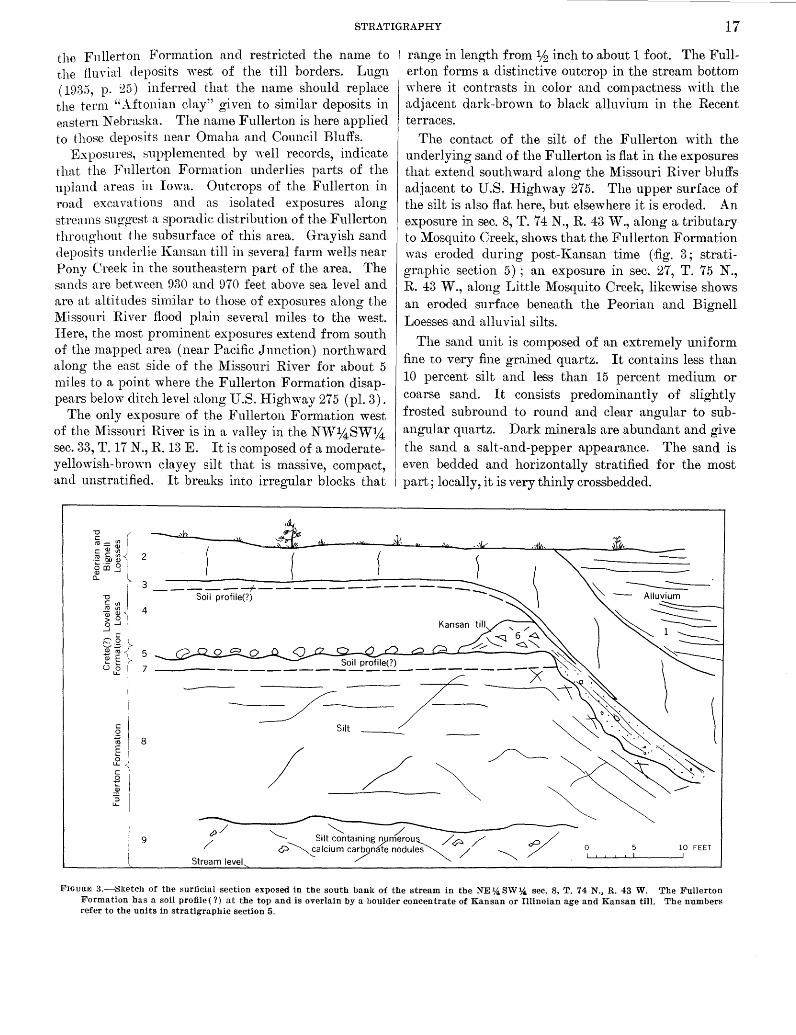
STRATIGRAPHY 17
the Fullerton Formation and restricted the name to the fiuvia1 deposits west of the till borders. Lugn ( 1935, p. 25) inferred that the name should replace the term "Aftonian clay" given to similar deposits in eastern Nebraska. The name Fullerton is here applied to those deposits near Omaha and Council Bluffs.
Exposures, supplem,ented by 1vell records, indicate that the Fullerton Formation underlies parts of the upland areas in Iowa. Outcrops of the Fullerton in road excavations and as isolated exposures along streams sug-gest a sporadic distribution of the Fullerton throughout the subsurface of this area. Grayish sand deposits underlie Kansan till in several farm wells near Pony Creek in the southeastern part of the area. The sands are between 930 and 970 feet above sea level and are at altitudes similar to those of exposures along the ~fissouri River flood plain several miles to the west. Here, the most prominent exposures extend from south of the mapped area (near Pacific Junction) northward along the east side of the :Missouri River for about 5 miles to a point where the Fullerton Formation disappears below ditch level along U.S. Higlnvay 275 (pl. 3).
The only exposure of the Fullerton Formation west of the Missouri River is in a valley in the NW~SW1;4 sec. 33, T. 17 N., R. 13 E. It is composed of a moderateyellowish-bro\vn clayey silt that is massive, compact, and unstratified. It breaks into irregular blocks that
~=~r ~tn.3
CL
range in length from lh inch to about 1 foot. The Fullerton forms a distinctive outcrop in the stream bottom where it contrasts in color and compactness with the adjacent dark-brown to black alluvium in the Recent terraces.
The contact of the silt of the Fullerton 1vith the underlying sand of the Fullerton is flat in the exposures that extend southward along the Missouri River bluffs adjacent to U.S. Highway 275. The upper surface of the silt is also flat here, but elsewhere it is eroded. An exposure in sec. 8, T. 7 4 N., R. 43 W., along a tributary to Mosquito Creek, shows that the Fullerton Formation was eroded during post-I{ansan time ('fig. 3; stratigraphic section 5) ; an exposure in sec. 27, T. 75 N., R. 43 W., along Little Mosquito Creek, likewise shows an eroded surface beneath the Peorian and Bignell Loesses .and alluvial silts.
The sand unit is composed of an extremely uniform fine to very fine grained quartz. It contains less than 10 percent silt and less than 15 percent medium or coarse sand. It consists predominantly of slightly frosted subround to round and clear angular to subangular quartz. Dark minerals are abundant and give the sand a salt-and-pepper appearance. The sand is even bedded and horizontally stratified for the most part; locally, it is very thinly crossbedded.
.§ ~ ~l 2 (
I' 3-----~-------------
-a Soil profile(?) ............ c Ul ro Ul 4 ~ ~""\ .3~1 s.g r ~ E \ 5 u ~ ( 7
c 0 ·.;:; ro E 0
I
LL. <.
c B ~ '3 LL.
8
9 0 10 FEET
FIGURE 3.~Sketch of the surficial section exposed in the south bani{ of the stream in the NE~ SW~ see. 8, T. 74 N., R. 43 W. The Fullerton Formation has a soil profile (?) at the top and is overlain by a boulder concentrate of Kansan or Illinoian age and Kansan till. The numbers refer to the units in stratigraphic section 5.
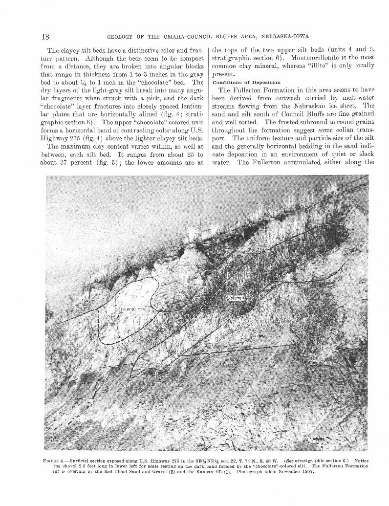
18 GEOLOGY OF THE OMAHA-COUNCIL BLUFFS AREA, NEBRASKA-IOWA
The clayey silt beds have a distinctive color and fracture pattern. Although the beds seem to be compact from a distance, they are broken into angularr blocks that range in thickness from 1 to 3 inches in the gray bed to about % to 1 inch in the "chocolate" bed. The dry layers of the light-gray silt break into many angular fragments when struck with a pick, and the dark "chocolate" layer fractures into closely spaced lenticular plates that are horizontally a lined (fig. 4; stratigraphic section 6). The upper "chocolate" colored unit forms a horizontal band of contrasting color along U.S. Highway 275 ('fig. 4) above the lighter clayey silt beds.
The maximum clay content varies within, as well as between, each silt bed. It ranges from about 25 to about 37 percent (fig. 5) ; the lower amounts are at
the tops of the two upper silt beds (units 4 and 5, stratigraphic section 6). Montmorillonite is the most common clay mineral, whereas "illite" is only locally present. Conditions of Deposition
The Fullerton Formation in this area seems to have been derived from outwash carried by melt-water streams flowing from the Nebraskan ice sheet. The sand and silt south of Council Bluffs are fine grained and well sorted. The frosted subround to round grains throughout the formation suggest some eolian transport. The uniform texture and particle size of the silt and the generally horizontal bedding in the sand indicate deposition in an environment of quiet or slack water. The Fullerton accumulated either along the
FIGURE 4.-Sul'ficial section exposed along U.S. Highway 275 in the SE',4NE'A sec. 22, T. 74 N., R. 43 W. (See stratigraphic section 6.) Notice the shovel 2.3 feet long in lower left for scale resting on the dark band formed by the "cbocolate"-colored silt. The Fullerton Formation (Al is overlain by the Red Cloud Sand and Gravel (Bl and the Kansan till (Cl. Photograph taken November 1957.

8TRATIGRAPHY 19
ancestral :Missouri River flood plain or in smaller streams that were entrenched into the Nebraskan till plain (U elden, 1901, p. 250; Lugn, 1935, p. 66; Condra, Reed, and Gordon, 1950, p. 18). The extent of the Fullerton along the Missouri River bluffs south of Council Bluffs and southeastward beneath the uplands in Iowa su o-o-ests that the Fullerton was deposited along a broad
bb
southeast-trending valley in the till plain. The Fullerton 'vas subjected to weathering during at
least pa1t of the Aftonian Intergla,ciation and thereby was leaehed. In only one exposure., in the SE%,NW% sec. 17, T. 73 N., R. 43 W. (stratigraphic section 4), does the Fullerton react with dilute hydrochloric acid. At this particular place the upper silt unit probably contains seeondary calcium carbonate from the overlying calcareous sand of Kansan age.
The Fullerton Formation originally may have been a noncalcareous deposit; consequently, secondary clay enrichment \Vas sought as supplemental evidence of weathering and soil development in the deposit in the SE%,NE¥4 sec. 22, T. 74 N., R. 43 W. Clay enrichment in a podzolic soil has a characteristic pattern.. There is generally a very small amount of clay in the upper part of the soil. The clay is transported down\vard into the B horizon 3 where it is redeposited. The clay percentage curves shown in figure 5 do not clearly establish that the Fullerton at this locality has a podzolic 8oil. The increase of elay in the A 1 horizon (fig. 5) may be due to secondary enrichment from the overlying Red Cloud Sand and Gravel. The clay content, however, is low at the top of unit 5 of stratigraphic section 6 ( A2? horizon). This decrease is interpreted as being .a result of weathering and clay transport to a lower level. About 18 inches below the top of unit 5 ( B2? horizon), the clay content increases to about 37 percent (fig. 5) . Age and Correlation
Silt and sand underlying the l{ansan till were considered to be Aftonian in age for many years (Condra, Reed, and Gordon, 1950, p. 18-19). Subsequently, however, the Fullerton Formation was assigned to the late Nebraskan (Thorp, and others, 1951, p. 4) . In this report, following Lugn's suggestion ( 1935, p. 25), the "Aftonian clay" in the Omaha and Council Bluffs area is called the Fullerton Formation; and, to be consistent with Thorp, Johnson, and Reed (1951, p. 4), the Fullerton Formation in this area is considered to be princi-
3 A1 horizon consists of organic matter mixed with mineral matter, usually dark colored.
A2 horizon is usually lighter colored than the underlying horizon and ha:-; had clay minerals, iron, aluminum, or all three, removed by leaching and carrying the minerals in solution and suspension.
B horizon consists of altered materials characterized by accumulations of clay, iron, aluminum, by blocky or prismatic structure, and by more intense color. (U.S. Dept. Agriculture, 1951, p. 178-180).
Depth (feet)
0.0
0.5
1.0
1.5
2.0
2.5
3.0
3.5
4.0
4.5
5.0
Depth-location of laboratory samples numbered 867 (top) through 877 (bottom)
10
Percent of clayand silt-s1zed particles in ranges shown
15 20. -25 30 35 \ \ \ \ \ \ \ .,
\ ' \ \ \ \ I I I I
<I.U i i / I
/ I /. /
Possible horzons in podzolic soil profile
At
/ ...... -;:i<3.9ft_../ >3.9.U \ \.. A2(?)
...... ........
................ ........ .......
.......................................... ',, i /
I / I /
/ / / I
82(?)
// ! \ \ c \. \ Parent material
'· '· 5 5 1 2 ft covered to ditch level . l
Units in stratigraphic section 6
4
FIGURE 5.-Graph showing changes in percentage of particle sizes <1p., >1t~-<3.9p. and >3.9p. related to depth from top of Fullerton For
mation, in the SE:J4NE1,4 sec. 22, T. 74 N., R. 44 W. The changes are shown related to the units of the Fullerton at stratigraphic section 6.
pally late Nebraskan in age. Whether deposition continued a very great time into the interglaciation is not known, but any weathering interval recorded on the Fullerton is considered to be part of the Aftonian Interglaciation (table 2) .
Correlation of deposits within the mapped area with the Fullerton Formation of the type locality is based on the presence of overlying and undedying tills. Deposits of compact blocky clayey silt or fine to very fine gray sand underlying l{ansan till or sand are assumed to be older than Kansan in age and are mapped as the Fullerton Formation. Controls for such correlations within this area are the stratigraphic position of the silt and sand south of Council Bluffs between the Kansan and Nebraskan tills, the consistent lithologies of the Fullerton, and a weathering profile on the Fullerton. The lone exposure in Nebraska mapped as the Fullerton is so correlated because of its similar lithology.
RED CLOUD SAND AND GRAVEL
The Red Cloud Sand and Gravel is a medium to coarse fluvial sand. Its type locality is near Red Cloud, Nebr., about 160 miles southwest of Omaha. As defined by Schultz, Reed, and Lugn (1951, p. 548), the Red Cloud underlies l{a,nsan till in the ghteiated part of eastern Nebraska and is of early Kansan age. In the Omaha-Couneil Bluffs area it underlies the Kansan till and locally overlies the Fullerton Formation.

20 GEOLOGY OF THE OMAHA-COUNCIL BLUFFS AREA, NEBRASKA-IOWA
The Red Cloud Sand and Gravel is exposed south of Council Bluffs near road level along U.S. l-Iighway 275 and sporadically along the bluff line road south of the junction of U.S. I-Iighway 275 and Iowa State Road ~70. Because of the thinness of the deposits and the interfingering of the Red Cloud with the I{ansan till, as well as the scale of the map, the Red Cloud is not sho·wn separately; it is grouped either with the more widespread late Kansan Grand Island Formation or with the Kansan till.
The Red Cloud in this area is predominantly a horizontally bedded medium to coarse calcareous yellowishbrmvn sand that is locally erossbedded. It contains lenses of pebble gravel, lenses and irregular-shaped inclusions of distorted compaet silt, and rounded clay balls and blocks of silt. Round to subround grains and pebbles of limestone and quartz are most common, but subround or angular pebbles, cobbles, and boulders of pink quartzite are scattered throughout the formation. It is a uniform sand within individual lenses, but it is well graded as a deposit. Calcium carbonate cements some of the sand grains into discontinuous sandstone lenses and also into many small clusters that crumble when pressed between the fingers. Less numerous are friable granitic pebbles and cobbles that are easily crushed by a light blow from a hamme.r. The Red Cloud is locally unconformable with both the overlying I{ansan till and the underlying Fullerton Formation (stratigraphic sections 4, 6). Elsewhere along the bluffs the Reel Cloud interfingers with the Kansan till.
The Red Cloud Sand and Gravel is about 5 feet thick "\Vhere it is exposed, but it may be thicker in the subsurface.
Streams flowing from the soutlnvestward-advancing glacier deposited the Red Cloud Sand and Gravel as outwash that probably filled irregularities on the prel{ansan surface. The outvmsh was derived in part from debris transported from the north by the glacier and in part from reworked local materials. The advaneing ice sheet moved over the sand and gravel, some of which was incorporated as contorted beds into the till now exposed in the area. Age and Correlation
The early Kansan age of the Red Cloud Sand and Gravel at its type locality is established by vertebrate fossils (Sehultz and others, 1951, p. 548). In the mapped £lWea the age is established by stratigraphy. The sand and gravel here unconformably overlies the Fullerton Formation and underlies or interfino-ers with
b
the base of the Kansan till. Using these criteria, the Red Cloud in this area can only be early Kansan in age.
The Red Cloud Sand and Gravel is equivalent to the deposits of pro-l{ansan sand of Frye and W alte'I's (1950, p. 149), which were na1ned the Atchison Formation by Moore and others (1951, p. 15). According to Schultz, Reed, and Lugn (1951, p. 548), vertebrate fossils of similar types were collected from the Atehison Formation, from the lower sand and gravel of early J{ansan age that underlies l{ansan till, and from the type locality of the Red Cloud Sand and Gravel.
KANSAN TILL
A heterogeneous mixture of boulders, cobbles, pebbles, and sand in a matrix of silt constitutes the Kansan till. In most exposures brownish oxidation is prevalent in the upper pa.rt, but is absent in the lower part of the gray till. Till is the most widespread deposit of !{ansan .age in this area.
The J{ansan till (Chamberlin, 1896, p. 873) is exposed mainly along the bluffs of the Missouri River and along the channels and adjacent hillsides of tributary streams. One exposure (about 1,125-ft alt) is in an excavation behind a service station on the corner of 30th and Lake Streets in Omaha, in the NE14,SW'l4, sec. 9, T. 15 N., R. 13 E., near the top of a loess-eovered hill flanking the Missouri River. This exposure is import.ant because it shows that the ICansan till locally can be within 5 feet of the surface in the upland (stratigraphic section 9).
Exposures wre less common on the Iowa side of the Missouri River than on the Nebraska side. South of Couneil Bluffs the sporadie occurrenees of boulders in many of the hillside fields indicate that till is close to the surface under a thin eover of the Peorian and Bignell Loesses.
Exposures and well reeords (E. C. Reed, written commun., 1952-53) throughout the uplands reveal the Kansan till as a widely distributed subsurface deposit in the Omaha-Council Bluffs area. Most of this infonnation concerns the area vi·est of the Missouri River, but till is penetrated in almost every well deeper than 70 feet in the upl,ands on the east side of the river (G. A. Lefgren, E. W. Lefgren, J. A. Lefgren, and M. Brenton, oral commun., 1953).
The loess eover and its subsequent erosion affeet the distribution, shape, and frequency of till exposures. Exposures of l{ansan till are generally confined to stream banks and to elongate narrow bands parallel to the lower hill slopes along the south sides of tributary ereeks. The slopes on the north sides of these creeks are more gentle, uneroded, and covered by the Peorian and Bignell Loesses. Exceptions to tllis occur where cultivation exposes till in ridge tops or high on the valley sides.

STRATIGRAPHY 21
Erosion dissected the original Kansan till surface of moderately lmv hills and shallow depressions. In some places the Kansan till and all older deposits overlying the bedrock surface 'vere removed. Elsewhere along the ~1issouri River bluffs, especially in some exposures north of Omaha and south of Council Bluffs, the slopes of the modern topography locally approximate the surface of the eroded ICansan till. This is most noticeable in cuts through hills where the cores of the hills are remnants of till. Other exposures in the Missouri River bluffs reveal a nearly horizontal surface cut on the till by streams that flowed in late ICansan time (fig. 6). Cemented sand of the Grand Island Formation locally overlies this surface (fig. 9) .
Kansan till can be separated into three zones according to the amount of soil development resulting from weathering during the Yarmouth Interglaciation: an upper oxidized and leached zone from which most of the limestone fragments and other forms of calcium carbonate a.re removed to depths of as much as 12 feet, an oxidized but unleached zone in which calcium carbonate remains, and an unoxidized and unleached zone. Limestone fragments 1;32 to Vs inch in diameter remain in the upper zone, but the surrounding till is leached. Oxidized and leached till fingers downward-as stringers into the oxidized but unleached zone. Bands of secondary calcium carbonate nodules as much as 9 inches long and 3 inches thick are characteristic of this zone. Redeposited calcium carbonate also coats the sides of fractures and joints in the till and fills some joints as large as 1 inch wide.
Joints or fractures in the lower unoxidized and unleached zone provide access ways to the agents necessary for oxidation and leaching. Oxidized rinds as thick as 2 inches wide parallel the fractures in many exposures. Till between these rinds is unoxidized and unleached. Such rinds and zones of oxidation and leaching are well exposed in the bluffs north of the Mormon Memorial Bridge.
In general, the oxidized Kansan till is grayish or yellowish orange, hard, compact, and unsorted, and has an unstratified clayey silt matrix. It contains granules and pebbles of quartzite, granite, and limestone. Local stringers or lenses of sand are common. The oxidized till generally is about 3-4 feet thick, but it can be as much as 10 feet thick.
Oxidation that is not part of soil development covers the exposed surface of till in some nearly vertical bluffs. Much of the till in the lower part of the bluffs of the area mapped in Nebraska north of the Mormon Memorial Bridge has 2 inches of an oxidized layer covering the dark-gray unoxidized till. The supposition that this surface covering is very recent is supported
by an incident that happened during studies in the area. In 1952, blocks of till fell from the face of the bluff exposing grayish unoxidized till. By late 1953 most of the surface on this gray till was thinly oxidized and superficially resembled the till oxidized by weathering higher in the bluff. It can be assumed from this that most of the yellowish color obscuring the gray till in the lower part of the bluff developed since the road was built.
The underlying unoxidized till generally is olive gray to medium gray, hard, and compact, and has an unstratified clayey silt matrix containing coarse particles. Subangular to subround sand grains, granules, and pebbles of granite, quartzite, and limestone are scattered throughout the unoxidized till. Some exposures contain layers, bloc.ks, or alternating bands of oxidized and unoxidized till that may represent differential oxidation owing to differences in permeability of the till (fig. 6). Unoxidized till as much as 40 feet thick is exposed in the mapped area.
.Certain features are common to both the oxidized and unoxidized parts of the Kansan till. Sioux quartzite and granite boulders are scattered throughout the till. The quartzite is unaffected by weathering, but the granite generally disintegrates into ~-,- to :14 -inch fragments when struck with a pick. Also included are beds or layers of stratified sand and pebble gravel. Most of these layers are only 1 to 4 feet thick; some, however, are as much as 15 feet thick.
Exposures at two locations provide good examples of intratill sand and gravel. Loose sand and a compact calcium carbonate cemented sand underlie oxidized Kansan till along the· south side of the road in the NE1;4NW1;4 sec. 14, T. 74 N., R. 44 W., at an altitude of about 1,120 feet. Till is exposed under the sand a short distance to the south at a slightly lower altitude (about 1,090-1,100 ft). The sand is oxidized drurk yellowish orange and is brighter than the oxidized till. The loose sand is silty and forms a nearly vertical exposure. It is crossbedded and dips S. 25° W. to S. 35° W. (stra.tigra phic section 8) .
Crossbedded sand and gravel lie between oxidized till and unoxidized till in a pit in the NE. cor. SEJ4SW:l4 sec. 3, T. 77 N., R. 44 W., just south of the town of Loveland, Iowa. The sand is pale yellowish brown to moderate reddish brown. Laye,rs and beds are displaced as much as 1 foot by a series of steeply dipping normal faults; this displacement probably was caused by differential compaction of underlying materials. Sand and till are exposed elsewhere south of Loveland; in some of these exposures the sand overlies till, whereas in others it underlies till.

22 GEOLOGY OF THE OMAHA-COUNCIL BLUFFS AREA, NEBRASKA-IOWA
FIGURE 6.-Unoxidized Kansan till (A), in the SElj, sec. 5, T. 7 3 N., R . 43 E ., in which localized oxidation (B) bas advanced along contorted layers of till. The till was eroded by late Kansan streams that deposited the overlying Grand Island Formation (C). Peorinn and Bignell Loessess (D) at top of cut. Shovel is 2.3 feet long. Photograph taken November 1956.
In addition, inclusions or "boulders" of well to poorly stratified and well-sorted sand and pebble gravel are locally enclosed by the till matrix. Most of these "boulders" are less than 5 feet wide, but some are as large as 10 feet in diameter. ·when these inclusions weather, the molds rure left as ca velike openings.
In the bluff along the Iowa side of the Missouri River opposite Old Honey Creek Lake in the NW%NWJU sec. 11, T. 76 N., R. 44 IV., are subround to irregular-shaped "boulders" of "·ell-sorted sand a.nd gravel as much as 8 feet long. Most of them show stratification parallel with the smooth wall of the till matrix, but this feature becomes obscure near the center of the inclusion (fig. 7). Similar inclusions or pockets of sand are described by Udden (1901, p. 250-251) and by Barbour (1914, p. 808), who called them frigites. These inclusions prob-
ably were introduced into the till as frozen pieces of the underlying Red Cloud Sand and Gravel.
The matrices of both the oxidized and unoxidized tills contain similar clay minerals. Two S<'tmples of oxidized but unleached till and two samples of unoxidized and unleached till were analyzed.4 All samples contained the clay minerals montmorillonite and "illite." The different amounts of clay minerals are 'vithin the range of analytical error, so that conclu sions were not made regarding percentage differences between the oxidized and unoxidized till.
The vwriations in thickness of the Kansan till depend on bedrock topography, thickness of pre-Kansa.n deposits, and on post-Kansan erosion. Drill records re-
• A. J. Gu de 3d, written commun. , U.S. Geol. Survey report GDX- 108, Apr. 27, 1954.

STRATIGRAPHY 23
j I
I )
\ I
Frau1n1 7.- Inclu"ion of "boulder" of sand and gravel within unoxidizell K.msan till in an excavation along the ra!lroud in the NW'4NW'4 sec . 11, T. 76 N., R. 44 W. Stratification is approximately parallel to the walls of the enclosing till, !}ut is poorly developed or absent near the center <>f the inclusion. Notice the till (A) faulted into sand above handle of the 2 .3-foot shovel.
veal that the till can extend from bedrock almost to the surface in one locality, but that it can be absent at another. Although 120 to 150 feet of till is common beneath ridges, the average thickness soon in most exposures is about 20 feet.
Most of the material in the Kansan till apparently had a northern source as indicated by the abundance of pink Sioux Quartzite of Precambrian age. The Sioux Quartzite is exposed in southeastern South Dakota and southwestern Minnesota and underlies parts of northwestern I owa and northeastern Nebraska. Striations trending S. 30° W. scribed into limestone 1 mile south of Omaha (White, 1867, p. 302) also indicate a northern source.
As the Kansan ice sheet mo\·ecl into the OmahaCouncil Bluffs area, it overrode older deposits, pr11rts of which probably "·ere incorporated into the glacial (lebris. Till was deposited as ground moraine as the glacier melted. Lenses of stratified sand and gravel within the till were deposited by st.reams flowing in, on, or under the ice. Age and Correlation
Till exposed along the bluti"s of the .Missouri River and in adjacent areas is accepted today as the Kansan till, even thoug-h the bluff's around Omaha and Counci l Bluffs Me the type ar·ea of the Nebraskan till (Shimek, 1!)0!), p. 407-408). Various workers (TTdden, 1901; Shimek, 1008, HlOD, 1DlOa, b; Kay, 1!)~~; 1024, p. 71; Kay and Apfel, 192!), p. 100, 121, 192; Lug-n, 19:1!\, p. 41, 67; Condra, Reed, and Gordon, 1950, p. 17-20; Frye and Leonard, 1952, p. 57) suspected tha,t the till in this
area was, at least in part, Kansan in age, but most agreed that it was not possible to differentiate Kansan from Nebraskan till in isolated exposures on the basis of color, lithology, texture, or degree of weathering.
Correlation of the till as Kansan is based on its stratigraphic position as the uppermost of two tills and by its apparent relation to adjacent exposures. Outcrops and test holes bored with an auger south of Council Bluffs provide the stratigraphic sequence by which two tills are known to be in the area, and thereby allowing the upper till in the area to be called Kansan (stnl-tigraphic sections 4, 7).
The position of the till in each exposure is not always apprurent. All exposed till, however, is overlain by at least one of the post-Kans..'tn deposits tmcl is never overlain by a pre-Kansan deposit. This repeated stratigraphic sequence causes me to call all the exposed till in th is area the Kansan till.
GRAND ISLAND FORMATION
The Grand Island Formation is a fluvial sand and gravel deposit that overlies the eroded surface of the Kansan till.
The original Grand Island Formation was redefined in 1951 into the Reel Cloud Sand n,ncl Gmvel, which underlies the Kansan till, and the Grand Island Formation, which overlies the Kansan till (Schultz a,ncl others, 1951, p. 548). In this report sand and gTaveJ that fills valleys eroded into the Kansan till is called the Grand Island.
Exposures of the Grand Island Formation are confined almost entirely to the bluffs along the Missouri River where the Grand Island overlies the Kansan till or the bedrock surface, as shown on the geologic maps. It is exposed almost continuously between Bellevue and the South Omaha bridge, in Nebraska, and for about 2 miles n,long the Chicago and Northwestern l{ailroacl north of Council Bluffs, in Iowa. It is sporadically exposed elsewhere along the Missouri River, but exposures of Grand Island are virtually nonexistent in the upland area. Drill-hole records in Iowa show that the Grand Island overlies till under the hills between the Missouri River valley and Mosquito Creek. It is scarce under the hills in Nebraska where it is probably restricted to local valleys in the Kansan till.
Preloess topography developed on the Grand Island Formation is generally flat in the Omaha-Council Bluffs area. Although almost every exposure of the Grand Island under younger deposits shows a flat nearly level surface (fig. 8), this buried surface is not necessarily reflected in the overlying materials. The Peorian and Bignell Loesses form hills and ridges over this flat surface.

24 GEOLOGY OF THE OMAHA-COUNCIL BLUFFS AREA, NEBRASKA-IOWA
Nearly vertical or slightly sloping faces are characteristic of the Grand Island which has been exposed in quarries and subjected to erosion. If the sand and gravel is silty, ridges and pinnacles form as the Grand Island is eroded. Where the Grand Island forms the ground surface, a smooth gentle slope extends along the hillside.
The Grand Island Formation is a uniformly sorted gray to light-brown fluvial sand and gravel. Sandy gravel occurs in lenses within the medium to coarse sand. Quartz, Sioux Quartzite, and granitic rocks are the main constituents. Pebble and larger size pieces of the quartzite and granite are subangular to subround. The granite is weathered and crumbles easily. Minor amounts of manganese-coated limestone fragments are scattered throughout the Grand Island. These are ovoid, subround, or tabular. Angular, subround, and round qururtz grains in the fine-sand size are clear as well as frosted.
The Grand Island Formation is exposed above the Merriam Limestone Member of the Plattsburg Limestone and below the Sappa Formation in the North Omaha Rock and Lime quarry in the SEl4 sec. 28, T. 17 N., R. 13 E. The Grand Island is obscured in the west quarry wall, but it is well exposed at the southwest corner as light-brown coarse sand and granules. The upper surface of the Grand Island in the quarry is horizontal (fig. 8). The upper part of the formation is crossbedded (fig. 8), but the lower part is horizontally bedded as it extends across the exposure (stratigraphic section 10).
The Grand Island Formation is overlain by clay, silt, and the Pearlette Ash Member of the Sappa Formation in an old sand and gravel pit just south of Ponca Creek in the NWl4SEl4 sec. 9, T. 16 N., R. 13 E. The contact between the Grand Island and the Sappa is nearly level (fig. 12). The Grand I sland is a medium to coarse crossbedded sand containing lenses of fine gravel in the upper part. Weathered granite cobbles and boulders eroded from the lower 12 feet of sand cover the floor of the pit. These mechanically disintegrated boulders crumble easily when struck with a pick.
Examination of samples from a test hole in alluvium near the outer edge of the pit showed tan and gray silt, similrur to the modern flood-plain deposits, oYer till which overlies sand covering bedrock (stratigraphic section 11). The lower sand is probably Recent al luvium covered by a slump block of till. The slump block is in turn covered by more alluvium. The Grand Island Formation is a:bsent; consequently, the face of the bluff must extend steeply downward 38 feet below the top of the flood plain.
Sand and gravel of the Grand Island Formation overlies the bedrock surface in the north wall of the Snakirt quarry south of Crescent, Iowa, in the NEl4NE% sec. 34, T. 76 N., R. 44 W. During excavation of the quarry in 1952, the Grand Island was exposed as .a gray to dark yellowish-orange crossbedded sand 3 to 15 feet thick. Erosional irregularities in the upper part are filled by silt and ash of the Sappa Formation. Boulders-as large as 2% feet in diameter-and cobbles of Sioux Quartzite form a nearly continuous layer at the base of the Grand Island. (See stratigraphic section 12.)
These two places- the abandoned sand and gravel pit near Ponca Crook and the Snakirt quarry-contain perhaps the most important exposures of the Grand Island Formation in the Omaha-Council Bluffs area. These exposures establish the age and stratigraphic position of the sand and gravel and permit other exposures of similar sand and gravel to be interpreted as the Grand Island Formation of late Kansan age. In both places the Sappa Formation contains the Pe.:'trlette Ash Member and is gradational with the sand and gravel, or at least, in part, of the late Kansan depositional cycle.
One .area of exposed Grand Island Formation that lacks the identifying Pearlette Ash Member extends from about 21Jt, miles south of the Snakirt qururry to Iowa Lake (pl. 2). Pale-yellowish-brown medium to coarse sand as much as 32 feet thick overlies the horizontally eroded surface of the Kansan till. In places the lower 5 feet of the sand is cemented by calcium carbonate into a sandstone and conglomerate. This is best exposed along the railroad tracks in the SE1,4 sec. 11 and the NEl4 sec. 14, T. 75 N., R. 44 W. (:fig. 9). Neither the Grand Island Forn1ation nor the Kansan till is exposed continuously in the bluff, but the trace of the contact between the two deposits is marked by numerous sprmgs.
The sand and conglomerate along this bluff was exploited commercially about the turn of the century. As a result, pits provided good exposures for Todd (1899, p. 88-89) and Udden (1901, p . 254), both of whom described the sand a,nd gra,vel. Stra.tig'raphic section 13 describes the exposure in one of these pits in the SEl4SEl4 sec. 11, T. 75 N., R. 44 W.
The Grand Island Formation overlies horizontally truncated Ka,nsan till in many exposures along the Missouri River bluffs, but this fe11ture is exceptionally well displayed in three localities. A smooth horizontal nearly level surface on the Kansan till (fig. 6) is covered by crossbedded sand a,nd fine gravel in the SE14 sec. 5, T. 73 N., R. 43 E. The second exposure is a,long an access road to a borrow pit in the Missouri River bluff

STRATIGRAPHY 25
l"IGUR~J 8.-The Grund Island Formation a nd t.he Sappa F ormation in the North Omaha Rock and Lime quarry, SE'!. sec. 28, T . 17 N., R. 13 E. Xotice that the crossbedding is more prominent in the upper few feet of the Urund Is land Fc;rmation in the lower half of the photograph. Dark lines and layers a re caused by manganese-coated grains and granules.
in the NW%NE1;4 sec. 35, T. 15 N., R. 13 E. The third exposure is in a deep gully eroded into the Missouri River bluffs at Mandan Park, in the SW1;4S'W% sec. 11, T. 14 N., R. 10 E. Here the horizontal surfa.ce on the Kansan till stands out conspicuously where the stream flowing from the gully makes a small waterfall.
One of the isolated occurrences of the Grand Island Formation away from the river bluff or major streams
is in an excavation for a house (being built in 1953) near the top of a deep ravine in the SWl)J,SE% sec. 3, T. 14 N., R. 13 E. Horizontally bedded medium sand about 7 feet thick covers unoxidized Kansan till and is overlain by Loveland Loess. The Grand Island is within 20 feet of the top of the ravine on the north slope and about 15 feet from the top of the ravine on the south slope. The altitude of the top of the

26 GEOLOGY OF THE OMAHA-COUNCIL BLUFFS AREA, NEBRASKA-IOWA
FIGURE 9.- Calcinm carbonate cemented sandstone and conglomerate at the base of the Grand Island Formation overlying the horizontally truncated surface of the Kansas till in the NE'4 sec. H , '1'. 75 N ., R 44 W. Note ftuvial crossbedding at center of photograph. Till surface is at the top of the grass and weed line in lower third.
sand is about 1,050 feet, or about the same as that at the Mandan Park and access road exposures (p. 24-25). Such similarity in altitude is interpreted to mean that the Grand Island extends westward at least one-fourth mile from the bluff as a sheet beneath this part of the upland hills.
The thickness of the Grand Island Formation varies in the Omaha-Council Bluffs area, ranging from about 2 feet to at least 30 feet. Most of the exposures along the Missouri Ri,·er display about 10 to 15 feet of Grand Island.
The Grand Island Formation is a fim·ial deposit, for the most part restricted to stream channels eroded into the Kansan till (Condra, Reed, and Gordon, 1950, p. 20; Frye and Leonard, 1952, p. 89-90). Sand and gravel of the Grand Island, found in wells drilled in the up-
lands, are confined to a few depressions or channels. Almost all exposures of the Grand Island Formation in the Omaha-Council Bluffs area are along ancient stream courses, and they are most prevalent along tlw Missouri River. This distribution supports the idea that deposition of the Grand Island resulted from streams HmYing from the ·waning continental glacier down the till sheet along a series of elongate depressions or s:tgs that, according to Condra, Reed, and Gordon (1950, p. 20), are probably more or less coincident with depressions of the pre-Kansan topography.
The rock material in the Grand Ishtnd Formation is the same as that in the Kansan till. A common source of exposed rock does not seem feasible inasmuch as the gla.cier, or its deposits, covered all exposed rocks at the time the greater part of the Grand Island Forma-

STRATIGRAPHY 27
tion was deposited in the Omaha-Council Bluffs are.:'t. Consequently, the Grand Island Formation probably was derived from glacial debris reworked by the meltwater streams flowing from the retrea,ting glacier. Age and Correlation
~\_ late Kansan age for the Grand Island in central N el>ra,skn. is based on hunal evidence referred to by Schultz, Heed, and Lugn (1951, p. 548); unfortunately, I did not find any fossils in the Omaha-Council Bluffs are<t. As a. result, the Grand Island is designated as being of late Kansan age in this report because of its position above an eroded Kansan till surface and below the Pearlette Ash Member of the Sappa Formation, which, in my opinion, restricts the age to post-middleKansan and prelatest-Kansan.
Elsewhere in the area, sand and gravel underlying the Sappa Formation or the Loveland Loess is mapped as the Grand Island Formation. Likewise, sand and gravel that overlies Kansan till is mapped as the Grand Island. It is recognized that these sands and gravels <tbove Kansan till and below Loveland Loess may be either late Kansan or et1!rly to middle Illinoian in age. The mere occurrence of a sand and gravel between these two deposits is not adequate proof of a late Kansan age, and some exposures of sand and gravel may be deposits of Illinoian age. The decision to consider this sand and gravel as the Grand Island is based on a few critical sections ( p. 24) that show the thick fluvial deposits along the Missouri River apparently to be related to only one cycle, the late Kansan alluviation.
SAPPA FORMATION
The Sappa Formation consists of gray to greenishgray clay and clayey silt and includes a white to gray volcanic ash, the Pearlette Ash Member.
At the type locality of the Sappa in Sappa Township, Harlan County, Nebr. (Reed, in Reed and Schultz, 1951, pt. 2, p. SWN-4), the formation consists of an upper silt and clay member that grades downward into sand and grave.J, then the P earlette Ash Member, and final ly a lower silt member. In the Omaha-Council Bluffs area the Pertrlette Ash Member is mapped separately, but. the upper and lower silt members are not differentiated.
Although the Sapptt Formation is a. widespread deposit, it is discontinuous. Exposures are rare and almost invariablv occur as the result. of excavations along the Missou;i River bluff.
In most exposures the Sappa Formation is a greenishgray or light-gray clay or clayey silt that contains shards of volcanic glass. The silt and clay of the Sappa are generally compact and hard, and stand in vertical 'bluffs. Stratification may or may not be con-
spicuous; where it is seen, stratification is commonly horizontal or slightly wavy (fig. 10), but it may be fluvially crossbedded (fig. 8; stratigraphic section 10). Clay having conchoidal fractures and waxy coatings locally is at the top of the silt of the Sappa Formation ( stratigmphic section 11), and represents a gley soil. 5
Other exposures that contain silt of the Sappa Formation are ( 1) in the ea.st wall of an old pit in the SE%SE% sec. 11, T. 75 N., R. 44 W. (stratigraphic section 13); (2) in the deep gully eroded into the river bluff at Mandan Park in the SW1Ji sec. 11, T. 14 N., R. 13 E. (not mapped because of settle of map); and (3) in the ditch along the north side of the road in the SW cor. NElJl sec. 16, T. 74 N., R. 43 W. No other outorops of the silt of the Sappa Formation are known, but subsequent excavations undoubtedly will provide additional exposures.
FIGURE 10.-Clayey silt of th~ Sappa Formation. exposed In sand ancl gravel pit in the NW""SE'-4 sec. 9, T. 16 N., R. 13 E. (See strati · graphic section 11.) Wavy bands and! layers are in lower part of deposit. Shovel is 2.3 feet long.
Pearlette Ash Member
The Pearlette Ash Member of the Sappa Formation is a widely distributed stratigraphic marker bed that originated from probably not more than four volcanic eruptions (Young and Powers, 1960, p. 876, 880; Miller and others, 1964). It is made up of white to lightgray shards of volcanic glass having a rhyolitic composition. Reed (in Reed and Schultz, 1951, pt. 2, p. SWN-4), in his description of the type locality of the
5 Gley soils a.re formed under the influence of a permanently high-water table (Thorp and others, 1951, p. 5).

28 GEOLOGY OF THE OMAHA-COUNCTL BLUFFS AREA, NEBRASKA- IOWA
Sappa Formation, included the Pearlette Ash Member in the Sappa. The four volcanic ash layers are similar in composition and in phenocryst composition, so that together or singly these layers can be recognized from place to place as the Pearlette Ash Member (Miller and others, 1964).
At least one additional ash fall is included within the Sappa Formation in south-central Nebraska, but is not found in this area. This ash apparently does not constitute part of the Pearlette Ash Member, for although this ash is recognized from spect.rographic a.nalyses (Miller and others, 1964) as being different from the typical Pearlette Ash Member in Nuckolls County, it, nevertheless, falls stratigraphically within the Sappa Formation.
Although volcanic ash is distributed throughout much of eastern Nebraska and south-central Iowa, ash is exposed at only two places in the mapped area: in the abandoned sand and gravel pit near Ponca Creek, in the NW~SE~ sec. 9, T. 16 N., R. 13 E., and in the Snakirt quarry, in the NE~NEl4 sec. 34, T. 76 N., R. 44 W. A third deposit is west of 72d Street near Pacific Street in the NW~ sec. 25, T. 15 N., R. 12 E. ( v .. ·est of the mapped area), " ·here ash was exposed in b!~Sement excavations of new homes in 1952.
The best exposure of the Pearlette Ash Member is in the west face of the sand and gravel pit south of Ponca Creek. Blocky pieces of ash at the north end of the exposure are overlain by leached clay (fig. 11). The glass shards are flat or slightly curved clear to
FIGURE 11.-Penrlette Asb Member (P) ot tbe Sappa Formation in sand and gravel pit in tbe NW'4,SE'4, see. 9, T. 16 N., R. 13 E. Pearlette Ash Member is overlain by clay of the Sappa Formation (Scl and underlain by silt of the 'Sappn Formatio n (Ss). All overlain by Crete Formation (C). Loveland Loess (L), and slopewash (siJ. Photograph taken August 1901.
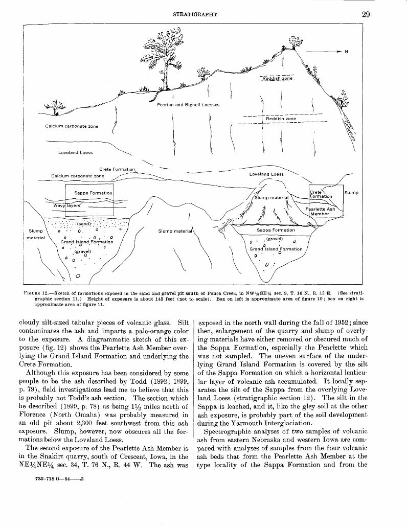
STRATIGRAPHY 29
-------N
) Peorian and Bignell Loesses
Calcium carbonate zone
Loveland Loess
Crete Formation ------~ Loveland Loess ~ ~ / Calcium carbonate zone
r-----=~·
Sappa Formation Slump
I · : : : :.· ·: ":: _: -'c;·~~co:-:: .>: · -~ · .. ·. · .. :: :~:::
0 • . 0. 0 . Slump material
\ 0
• , (grav~l)
0 • Grand Island Formation
0 0
0 :
material o . 0 • · · 0 Grana Island Formation 0 •• 0 • : 0
\
· (graveh
0 0 . 0
\ \
FIGURE 12.-Sketch of formations exposed in the sand and gravel pit south of Ponca Creek, in NW14SE14 sec. 9, T. 16 N., R. 13 E. (See stratigraphic section 11.) Height of expoErnre is about 145 feet (not to scale). Box on left is apoproximate area of figure 10 ; box on right is approximate area of figure 11.
cloudy silt-sized tabular pieces of volcanic glass. Silt contaminates the ash and imparts a pale-orange color to the exposure. A diagrammatic sketch of this exposure (fig. 12) shows the Pearlette Ash Member overlying the Grand Island Formation and underlying the Crete Formation.
Although this exposure has been considered by some people to be the ash described by Todd ( 1892; 1899, p. 79), field investigations lead me to believe that this is probably not Todd's ash section. The section which he described ( 1899, p. 78) as being 11/2 miles north of Florence (North Omaha) was probably measured in an old pit about 2,300 feet southwest from this ash exposure. Slump, however, now obscures all the formations below the Loveland Loess.
The second exposure of the Pearlette Ash Member is in the Snakirt quarry, south of Crescent, Iowa, in the NE~NE~ sec. 34, T. 76 N., R. 44 W. The ash was
735-718 0-64--.3
exposed in the north wall during the fall of 1952; since then, enlargement of the quarry and slump of overlying materials have either removed or obscured much of the Sappa Formation, especially the Pea.rlette which was not sampled. The uneven surface of the underlying Grand Island Formation is covered by the silt of the Sappa Formation on which a horizontal lenticular layer of volcanic ash accumulated. It locally separates the silt of the Sappa from the overlying Loveland Loess (stratigraphic section 12). The silt in the Sappa is leached, and it, like the gley soil at the other ash exposure, is probably part of the soil development during the Yarmouth Interglaciation.
Spectrographic analyses of two samples of volcanic ash from eastern Nebraska and western Iowa a~re compared with analyses of samples from the four volcanic ash beds that form the Pearlette Ash Member at the type locality of the Sappa Formation and from the

30 GEOLOGY OF THE OMAHA-COUNCIL BLUFFS AREA, NEBRASKA-IOWA
Pearlette Ash Member in Russell and Lincoln Counties, Kans. (table 3) .
Sample preparation followed procedures and methods outlined by H. A. Powers (oral commun., May 1956), vdw also helped with the interpretation of the analytic data. The samples were disaggregated with an ultrasonic transducer. Minerals with a speci1fic gravity greater than 2.4 were separated from the ash by a mixture of bromoform and carbon tetrachloride. Magnetic minerals were removed from the shards by an electromagnetic separator, and the clean glass shards were analyzed by quantitc'ttive spectrographic methods. All samples contain nearly the same amounts of boron, gallium, niobium, yttrium, and ytterbium (table 3).
Analyses of numerous samples of volcanic ash from south-central and central Nebraska conform to the composition of the Pearlette Ash Member of the Sappa Formation (Miller and others, 1964). Consequently, in my opinion the consistent results with clean samples confirm that quantitative spectrographic analyses are a valid aid in identifying the Pearlette Ash Member.
One volcanic ash sample (E 2079) was collected from the sand and gravel pit south of Ponca Creek, in the NW%SE1_4 sec. 9, T. 16 N., R. 13 E. The ash is exposed at the north end of the exposure. The other sample ( G 2852) was collected from an ash exposure near the Harrison and Monona County line, in the NW%NE~4 sec. 5, T. 81 N., R. 44 W., near the "county line exposure" or Little Sioux locality of western Iowa (Condra, Reed, and Gordon, 1950, p. 23-24) . Although this volcanic ash exposure is more than 40 miles north of the mapped area, it was sampled to determine if the ash considered by many geologists in Iowa to be pa.rt of the Loveland depositional cycle. of early Illinoian age is the same ash as that considered to be the Pearlette Ash Member in Nebraska and l{ansas. As shown in table 3, both volcanic ash samples are spectrographically almost identieal with the Pearlette Ash Member at the type locality of the Sappa Formation in Harlan County, Nebr., and with the Pearlette Ash Member from J{ansas.
Phenocrysts in these two ash deposits include minerals that are typical of the Pearlette Ash Member elsewhere in Nebraska and J{ansas. Chevkinite (a titanosilicate of the cerium earths), three types of hornblende, colorless and pink zircon, feNoaugite ( ,B = 1. 736), and augite (,8=1.695±) are common associated phenocryst heavy minerals that are inherent in the ash in most places (Young and Powers, 1960, p. 880) . Of these minerals, chevkinite, brown hornblende, brown to redbrown hornblende, green to blue-green hornblende, and pale-green augite (,8<1.73) are present in the sample (E 2079) collected south of Ponca Creek in the
NW1ASE1;4 sec. 9, T. 16 N., R. 13 E., Nebraska (E. J. Young, U.S. Geol. Survey, oral commun., Nov. 25, 1960). Chevkinite, the three hornblendes, and colorlesF zircon are part of the sample ( G 2852 6
) from the ash deposit in the NW1;4NE1A sec. 5, T. 81 N., R. 45 W., Iowa. Source and Origin
The Sappa Formation was probably derived either from fine materials carried into the 01naha-Council Bluffs area by streams flowing from the north or northeast or by local reworking of the Grand Island Formation by these streams. The Sappa in this area accumulated as alluvium and as lacustrine deposits in pools, ponds, and lakes.
The source of the Pearlette Ash Member was probably a group of volcanoes southwest of the mapped area. Pearlette deposits are widespread elsewhere in the central Great Plains and possibly extend into Utah anc1
Idaho (Powers and others, 1958). Landes (1928, p. 939) suggested the Capulin group of volcanoes in New Mexico as a possible source of the ash. Swineforc1
(1949, p. 308), however, considered the Valle Grand(' volcanic area of north -central New Mexico a more f.a vorable source locality.
The Pearlette Ash Member accumulated as windblown sorted deposits and became concentrated in quiet ponds, lakes, or small ephemeral pools. Age and Correlation
An age assignment more precise than late Kansar to early Yarmouth is not possible for the Sappa Formation. Paleontologists have different opinions as to the age of local faunas found in the Sappa elsewhere ir Nebraska and Kansas. Apart from opinions based or individual species, many opinions are influenced by paleoecologic interpretations. This is true of both vertebrate and invertebrate faunal studies. Some paleontologists believe that certain fossil vertebrate faunas considered to be from the Sappa indicate a cold glacial climate; others believe other assemblages, also from the Sappa, indicate a warm interglacial climate (Leonard, 1947; 1950, p. 44; Frye, Swineford, and Leonard, 1947; 1948, p. 506; Schultz and Stout, 1948, p. 566; Schultz,- Lueninghoener, and Frankforter, 1951, p. 6; Schultz and Tanner, 1955; 1957, p. 78; Hibbard, 1944, p. 702-742; 1949, p. 1421-1426; Taylor, 1954, p. 1; Frye and Leonard, 1952, p. 155-163). Exposures in the Omaha-Council Bluffs area were examined for verte·brate and invertebrate fossils, but none were found.
The age of the Sappa Formation, based on fossil evidence could range from late Kansan to Yarmouth ;
6 Geochemistry and petrology re.port TDM-A443 and A578, Edward J. Young, U.S. Geol. Survey, written commun., June 16, 1960.
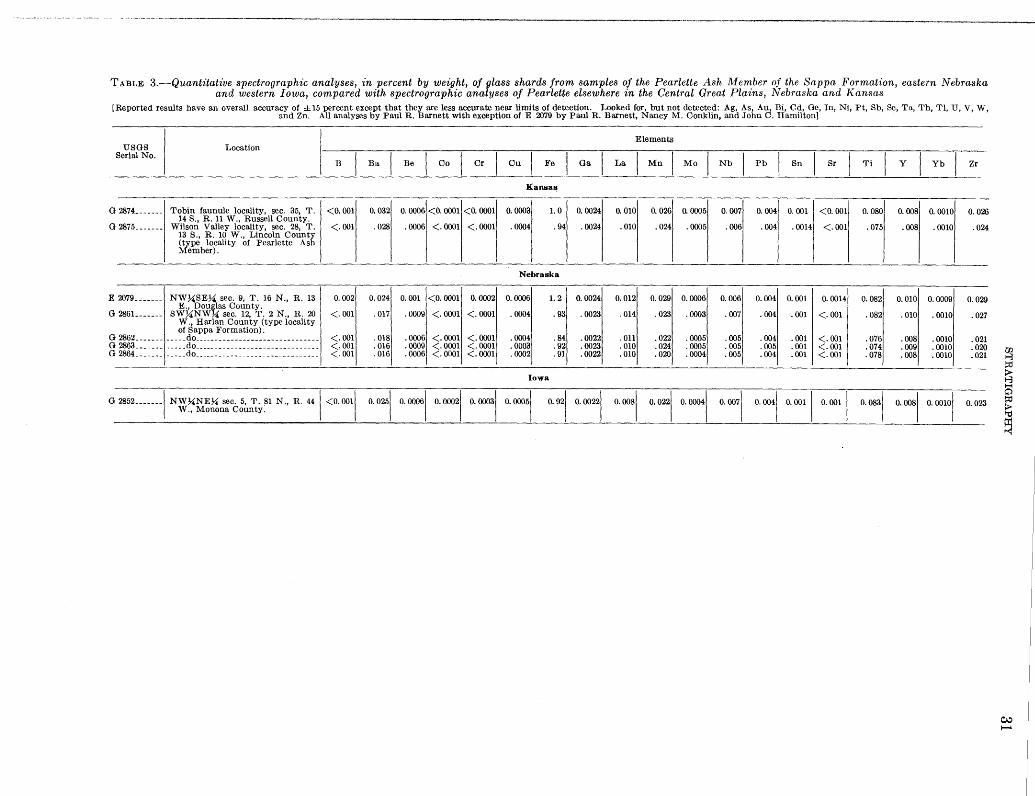
- ................ , .. _ .... ,.---~-----·
TABLE 3.-Quantitative spectrographic analyses, in percent by weight, of glass shards from samples of the Pearlette Ash klember of the Sappa Formation, eastern Nebraska and western Iowa, compared with spectrographic analyses of Pearlette elsewhere in the Central Great Plains, Nebraska and Kansas
[Reported results have an overall accuracy of ±15 percent except that they are less accurate near limits of detection. Looked for, but not detected: Ag, As, Au, Bi, Cd, Ge, In, Ni, Pt, Sb, Se, Ta, 'l'h, Tl, U, V, W, and Zn. All analyses by Paul R. Barnett with exception of E 2079 by Paul R. Barnett, Nancy M. Conklin, and John C. Hamilton]
Elements Location USGS
Serial No. B I Ba I Be I Co I Cr Cu I Fe I Ga I La I Mn I Mo I Nb I Pb Sn Sr
G
G
E
G
G G G
2874 _______ Tobin faunule locality, sec. 35, T. 14 8., R. 11 W., Russell County.
2875 _______ Wilson Valley locality, sec. 28, T. 13 S., R. 10 W., Lincoln County (type locality of Pearlette Ash Member).
- --- -- - - - -
2079 _______ NW~SE~ sec. 9, T. 16 N., R. 13 E., Doufts County. 2861_ ______ SW~NW ~ sec. 12, T. 2 N., R. 20 W., Harlan County (type locality of Sappa Formation). 2862 _______ _____ do _______________________________
2863 _______ _____ do _______________________________ 2864 _______ ____ .. do _______________________________
<O. 001 0. 032
<.001 . 028
- -
0.002 0.024
<.001 . 017
<.001 . 018 <.001 . 016 <.001 .016
Kansal!
0. 0006 <O. 0001 <O. 0001 0. 0003 1. 0 0. 0024
. 0006 <. 0001 <.0001 .0004 . 94 . 0024
-- - -- ----- ----- -
Nebraska
0. 001 <O. 0001 0. 0002 0. 0006 1.2 0. 0024
. 0009 <. 0001 <. 0001 . 0004 . 93 . 0023
.0006 <.0001 <. 0001 .0004 . 84 .0022
.0009 <.0001 <. 0001 .0003 . 92 .0023
.0006 <. 0001 <.0001 . 0002 . 91 .0022 -------- ----- ~--~ ~--~-- ------- ------- -----
G 2852-------1 NW~NE~ sec. 5, T. ~1 N., R. 441 <O. 0011 \V., Monona County.
Iowa
0. 0251
0. -I 0 =I o. ~I 0. ~·I o. "I o 00221
0. 010 0. 026 0. 0005 0. 007 0. 004 0. 001 <O. 001
.010 .024 . 0005 .006 .004 . 0014 <.001
---- -
0.012 0.029 0. 0006 0. 006 0.004 0.001 o. 0014
. 014 . 023 .0003 . 007 . 004 .001 <.001
. 011 .022 .0005 .005 . 004 . 001 <.001
.010 .024 .0005 . 005 .005 .001 <.001
.010 .020 .0004 .005 .004 .001 <.001
0 0081 0. 0221 0 -1 ~ 0071 0 ~I o. 001 I 0 001 I
Ti Y I Yb l Zr
0. 080 0. 008 0. 0010 o. 026
.075 .008 . 0010 .024
0. 082 0.010 0. 0009 0. 029
. 082 . 010 . 0010 . 027
.076 .008 . 0010 .021
.074 .009 .0010 .020
.078 .008 .0010 .021
0 0831 0. 0081 0 00101 0.023
~ !:0
f:3 ~
0 !:0
~
~ ..........
32 GEOLOGY OF THE OMAHA-COUNCIL BLUFFS .AREA, NEBRASKA-IOWA
it could also have the same range based on stratigraphic evidence. The presence of a soil of Yarmouth age on the Sappa-unimpressively developed in this area but more conspicuous in central and southern Nebraslmlimits the Sappa to an age no younger than Yarmouth. As .the development of the soil must have taken some time, it seems probable that the Sappa is related to the last part of the alluviation accompanying the waning of the Kansan glacier and the bulk of the Sappa was deposited before late Yarmouth time.
The Iowa Geological Survey does not entirely concur with the nomenclature and age assignment used in this report. Instead, the current usage of the Iowa Geological Survey is to place the silt and ash in the lower part of the Loveland deposition cycle and to assign an age of Illinoian to the deposits (C. N. Brown, Iowa Gool. Survey, written commun., Oct. 25, 1957).
Correlation of the Sappa ·in the Omaha-Council Bluffs area is based on the comparison of spectroscopic analyses of the volcanic glass shards in the Pearlette Ash Member in the mapped area with shards in the ash horizons at the type locality of the Sappa. Grayish clayey silt deposits that overlie the Grand Island Formation and underlie the Crete Formation or Loveland Loess are also mapped as the Sappa Formation.
CRETE FORMATION
Light-brown, fine, medium, and coarse sand and lag concentrates of cobbles constitute the Crete Formation.
The Crete Formation as defined by Condra, Reed, and Gordon ( 194 7, p. 24), is sand reworked from local deposits of the Grand Island Formation. It is composed of quartz, quartzite, feldspar fragments, and pieces of granite, as well as concentrates of Sioux Quartzite. The sand cannot be separated from the Grand Island unless the Sappa Formation is present; consequently, some deposits of the Crete Formation may be mapped with the Grand Island.
Although the Crete may be widely distributed, it is rarely exposed in the Omaha-Council Bluffs area. It is deposited on, and is parallel to, eroded surfaces of the Sappa or Kansan till; in some places the Crete is horizontal, in other places it slopes to conform with the underlying deposit.
The best and most easily accessible outcrop of the Crete Formation is in the previously referred-to exposure in the abandoned sand and gravel pit, in the Missouri River bluff near Ponca Creek in the NWJUSEl~ sec. 9, T. 16 N., R. 13 E. (pl. 2; stratigraphic section 11). The Crete is a 1-foot-thick discontinuous limonitestained light-brown medium to coarse sand resting unconformably on and filling channels eroded into the Sappa Formation. The constituents of the Crete are
very similar to those of the older Grand Island Formation. Figure 12 diagrammatically shows the Crete in relation to the other deposi,ts in this exposure.
Sand containing a fine gravel overlies the Sappa Formation and underlies the Loveland Loess in the gully near Mandan Park, in the SW1~SW1,4 sec. 11, T. 14 N., R. 13 E. The Crete is only 11;2 to 2 feet thick and is not mapped, but it fills irregularities and channels in the upper part of the Sappa Formation and it is gradational with the overlying Loveland Loess.
Lag concentrates of cobbles and a few boulders are believed to be the Crete Formation in many exposures elsewhere in eastern Nebraska. The excavation at the corner of 30th and Lake Streets, in the NE1~SW1,4 sec. 9, T. 15 N., R. 13 E., reveals cobbles of pink Sioux Quartzite extending laterally over the Kansan till. It is under the Loveland Loess in the west side of the exposure and beneath the Peorian and Bignell Loesses in the north side of the exposure (stratigraphic section 9). The concentrate may be composed of a layer only one cobble thick.
Another exposure of lag concentrate (not mapped), is in Iowa, in the NE1~SW1,4 sec. 8, T. 74 N., R. 43 W., where the Crete is exposed in the streambank over the Kansan till and the Fullerton Formation (fig. 3). The cobbles extend as a layer, 0.5 foot thick, for the entire length of the exposure beneath 6 feet of Loveland Loess. (See stratigraphic section 5.)
The Crete was derived from local materials. The thin fine-grained Sappa probably contributed a very small amount of materials to the sandy Crete. Most of the material in the Crete, therefore, came from the Kansan till and Grand Island Formation. The lithology of the sandy Crete resembles that of the underlying Grand Island (stratigraphic section 11), and the lag concentrates have cobbles of the same type as those found in the underlying Kansan till (stratigraphic section 9) ; it is because of this evidence that local deposits of Kansan age are considered to be the sources of the Crete.
Increased precipitation that accompanied the beginning of the Illinoian Glaciation resulted in greater streamflow along the late Kansan drainageways and in erosion in the upland hills. Streams with increased capacity locally reworked and retransported sand and gravel from the Grand Island Formation. In addition, poorly sorted slope wash was deposited as a result of hillside erosion which also locally removed the fine materials, leaving only the coarse cobbles and boulders~ the lag concentrate. This interpretation agrees with the earlier descriptions of Crete deposition outside the 1napped area by Lugn (1935, p. 128-129), Condra,

STRATIGRAPHY 33
Reed, and Gordon (1947, p. 24), and Frye and Leonard (1952,p. 110-115).
.A.ge and Correlation
The age of the Crete Formation in the Omaha-Council Bluffs area is based on stratigraphy. The gradational contact of the Crete with the overlying Loveland Loess indicates that the Crete formed during the Illinoian Glaciation. The unconformable relationship of the Crete to the underlying Sappa necessitates that erosion occurred after deposition of the Sappa and after soil development but before deposition of the Crete. The early Illinoian age designation for the Crete agrees with that of Condra, Reed, and Gordon (1947, p. 24) in their definition of the Crete Formation. The Nebraska and Kansas State Geological Surveys currently place the Crete in the early part of the Illinoian Glaciation. The Iowa Geological Survey includes the sand and gravel of the Crete( n as the b.asal part of their Loveland.
LOVELAND LOESS
The Loveland Loess is a massive eolian silt that blankets older deposits and may contain stratified colluvial silt and clay in the lower part (Condra, Reed, and Gordon, 1947, p. 25-26).
Most of the outcrops of the Loveland Loess are in the Missouri River bluffs, along valley walls of major tributary streams, in the walls of deep ravines, or along roads that cut into upland hills. The Loveland is exposed under areas of relatively thin silt (<15ft) of the Peorian and Bignell Loesses in shallow excavations. These exposures show that the Loveland Loess is near the surface along the sides of the hills, that it is more than 12 feet below the surface of the slopes near the valley bottoms, and that it is widespread ooneath the upland "·est and east of the Missouri River bluff. The Peorian and Bignell Loesses are more than 15 feet thick under Council Bluffs where the Loveland Loess is rarely exposed in excavations.
The upper surface of the Loveland Loess generally reflects the underlying pre-Illinoian surface. The Loveland, locally, has a sloping upper surface where it overlies the sloping surface of the Kansan till. It has a horizontal surface where it overlies the horizontal Sappa Formation or the Grand Island Formation and also where it is exposed in roadcuts through ridges. These exposures of horizontally surfaced Loveland Loess seem to be restricted to four ranges of altitudes: from 1,020 to 1,040 feet, at about 1,060 feet, from 1,070 to 1,090 feet, and from 1,125 to 1,130 feet. The loess may be covering buried surfaces or benches cut into older materials. The lowest surfaces are near the Missouri River valley; the highest are in the uplands away from the valley.
The Loveland Loess in the mapped area consists of moderate grayish-brown clayey silt (fig. 15) that has a moderate-yellowish-brown layer in the upper 3 to 6 feet. Montmorillonite, "illite," kaolinite, and some vermiculite are reported from the Loveland Loess at its type section (Daniels and Handy, 1959, p. 118) less than 100 feet north of the boundary of the mapped area near Loveland, Iowa. The silt is compact and hard, and stands in vertical cuts and bluffs. The moderate-yellowish-brown layer breaks into subangular to angular fragments about one-fourth inch in diameter. These have a waxlike coating characteristic of clayenriched horizons in soil profiles. The clay decreases downward toward the unoxidized loess below the B horizon. The lower part of the Loveland is also firm and compact, and stands in vertical cuts. Only 5 miles west of Omaha the Loveland Loess is a characteristic and recognizable moderate yellowish brown throughout its thickness, and it has a characteristic dark-purplishblack humic A horizon layer. This humic zone is so rarely present in the mapped area, probably because of erosion, that the known locations are listed.
Thickness of humic. Location zone (feet)
NEl4 SW1.4 sec. 30, T. 14 N., R. 13 E _______ 3 SW1,4NW14 sec. 35, T. 14 N., R. 13 E ______ 5 SW14SE1.4 sec. 8, T. 16 N., R. 13 E ________ 2±0. 5 SEl4NEl4 sec. 29, T. 16 N., R. 13 E _______ 3 NW1;4NW1,4, sec. 28, T. 14 N., R. 13 E _____ 3 SW1,4SE1;4 sec. 5, T. 14 N., R. 13 E ________ 3 NE1;4NW1.4 sec. 27, T. 14 N., R. 13 E _______ 4 NW1;4NE1;4 sec. 35, T. 15 N., R. 13 E ______ 1
NE1,4SW1,4 sec. 8, T. 74 N., R. 43 W ------ 1
Several possible A horizons within the Loveland have been reported elsewhere in Nebraska and Iowa (Thorp and others, 1951, p. 13-14; Schultz, Lueninghoener, and Frankforter, 1951, p. 6; Miller and others, 1964). Where reported, these A horizons are underlain by complete B, and C horizons; none were seen in the OmahaCouncil Bluffs area.
The type locality of the Loveland Loess is at Loveland, Iowa. Shimek's type section, obscured during excavation in 1957, was in a vertical bluff at the east end of the half section line road just north of the town near the center of sec. 3, T. 77 N ., R. 44 W. Kan&'tn till was exposed at the base of the bluff; it was overlain by sand and gravel as much as 7 feet thick. The exposed Loveland Loess was about 30 feet thick, but only the upper 3 foot was moderate yellowish brown.
ExcaV'ation of the ridge at the type section exposed the same sequence of deposits in the north end of the borrow pit, barely outside the area of the geologic map (pl. 1) in the SE%,NW14 sec. 3, T. 77 N., R. 44 W. (fig. 13) . This exposure has boon suggested as the "new

34 GEOLOGY OF THE OMAHA-COUNCIL BLUFFS AREA, NEBRASKA-IOWA
FIGURE 13.- Reference locality of the Loveland Loess, In the SE1,4NW1J.. sec. 3, T. 77 N., R. 44 W., near Loveland, Iowa. Sectl()n exposed Is as follows: 1. Loess; 2. Humic h()rizon ; 3. Loess; 4. Humic horizon on Loveland Loess; 5. Loveland Loess; 6. Kansnn t111. Units 1 through 3 include Peorian and Bignell Loesses.
type section" of the Loveland in western Iowa (Daniels and Handy, 1959). About 8 feet of Kansan till were exposed in 1958 in the center of the hill at the base of the cut. Loveland Loess overlies the till and is composed of yellowish-brown c}ayey sil,t in the lower 8 feet and the more typically colored moderate-yellowishbrown clayey silt in the upper 4% feet. The upper 4% feet contains about 26 percent clay as compared to 18 percent in the lower 8 feet. The Loveland is apparently thicker at the west end of the exposure. At the east end there is a distinct cleavage or layering in the Loveland parallel to the eroded surface of the till, perhaps from slope wash during deposition. A dark zone can be seen ~t the top of the Loveland from a distance of 50 or 60 yards; this impression is lost when viewed from a distance of only a few feet. The Peorian and Bignell Loesses are 110 feet thick over the Loveland.
One of the most easily accessible and most typical exposures of the Loveland Loess in the Omaha-Council Bluffs area is in the excavation in the NEl4SWl4 sec. 9, T. 15 N., R. 13 E., near the corner of 30th and Lake Streets in Omaha. The Loveland Loess here consists of a horizontal moderate-yellowish-brown layer about 3% feet thick above 11 feet of grayish-brown unoxidized loess (fig. 14). The Loveland Loess is also exposed in the west face of an ex ca. vation about 30 feet to the right of the view in figure 14,-where it overlies the Kansan till (stratigraphic section 9) .
The moderate-yellowish-brown color is commonly used to recognize the Loveland Loess and to separate it from the overlying Peorian and Bignell Loesses.
Causes of this diagnostic coloration have been expressed in varying opinions by regional geologists and soil scie11tists. Condra, Reed, and Gordon (1947, p. 39-40) voiced the view of Nebraskan geologists and pedologist.s that the color is not the original color of the material, but is, instead, the result of weathering and is part
FIGURE 14.-Loveland Loess (A ) and Peorian and Bignell Loesses (8) exposed In excavation in the NE1,4 SW% sec. 9, T. 15 N., R. 13 E., near the corner of 30th and Lake Streets, Omaha. The horizontal moderate yellawish-brown zone, an oxidized clay enriched B horizon in the Sangamon soil (C), overlips unoxidlzed loess as much as 11 f~et thick. Photograph taken May 1952.
of a well-developed soil profile on well-drained materials. This is the opinion generally held today.
Wide distribution of the Loveland Loess in Nebraska, Kansas, and Iowa requires multiple sources of the loess material. Condra, Reed and Gordon (1950, p. 26) regard the Loveland Loess as having originated from reworked alluvial deposits, dune sand, older Pleistocene deposits, and from silts of the Ogallala and older Tertiary formations. The Loveland Loess is thickest and coarsest in western Nebraska, becoming thinner and finer eastward. Lugn (1935, p. 130; 1962, p. 36-38) indicates that there was a principal source west or northwest of the mapped area. Comparison of the curve~:: showing size distribution of the Loveland Loess in the Omaha-Council Bluffs area and of the Loveland LoeSE

I
I
I I
STRATIGRAPHY
west along the Republican River in south-central N ebraska indicates that loess is slightly finer grained in the Omaha-Council Bluffs area (fig. 15).
100,-------------------------------------~
80
70 a:: u.J z u::: (f) 60 u.J _.J ()
i= a:: <( 50 0..
0 1- 40 z u.J () a:: u.J 0..
30
20
10
Clay Silt Sand
2 3 4 5 6 8 10 20 40 60 80 100 DIAMETER, IN MICRONS
FIGURE 15.-Size-distribution curves determined by hydrometer a.nalyses of the Loveland Loess from the Nebraska and Iowa sides of the Missouri River in the Omaha-Council Blu1fs area, compared with the size distribution of Loveland Loess from Webster County, in southcentral Nebraska (.Miller and others, 1964). 1. Sample from moderate-yellowish-brown zone in Loveland Loess; 2. Sample from grayish-brown zone below moderate-yellowish-brown zone; 3. Sample from oxidized Loveland Loess, Webster County, Nebr.
Included in the loess is montmorillonite that was reworked from older deposits. Electrostatic adsorption of the fine clay particles to silt grains is proposed by Beavers (1957) to explain the distribution of montmorillonite throughout deposits of loess. Although concerned with loess of Wisconsin age in his studies, jt seems to me that the theory is equally applicable to the montmorillonite content in the Loveland Loess. Such electrostatic adsorption of clay to silt grains may also explain the unstratified nature of loess (Beavers, 1957).
Loveland Loess was transported into this area principally by wind. Many geologists who have worked in the Great Plains consider that winds from the west and northwest provided most of the silt that covered the
, pre-Loveland surface as the Loveland Loess. Some geologists believe, however, that more local sources provided the silt. That the Illinoian ice sheet advanced
into northeastern Nebraska has been supposed for many years; its presence has been confirmed by drilling, and it is now believed that the fine material in the outwash from this ice sheet probably was a principal source of the Loveland Loess in eastern Nebraska (E. C. Reed, oral commun., 1958). Another even more local source may be the bottom lands of the Missouri River (J. C. Mickelson; 7 written commun., 1949). Any silt from the flood plain probably would accumulate on the Iowan side of the Missouri River valley because of the prevailing westerly winds. If this is true, the Loveland Loess should be somewhat coarser and thicker than the loess on the Nebraska side. The coarseness is not evident, nor is the Loveland thicker in exposures in Iowa than in Nebraska. Drill-hole information regarding the Loveland Loess is scarce in Iowa, but generally the thickness of the Loveland is about the same as in Nebraska.
It is possible that local sources did not contribute at all to the deposition of the Loveland Loess. The Loveland, Peorian and Bignell Loesses are widespread deposits, and a similar pattern of accumulation can be expected in each formation. Consequently, the absence of local soul'ce areas is inconsistent with the depositional history of the Wisconsin loess in south-central Nebraska (Miller and others, 1964) and central Nebraska and Kansas (Condra, Reed, and Gordon, 1950, p. 32; Swineford and Frye, 1951, p. 318; Frye and Leonard, 1952, p. 132), as well as in the Omaha-Council Bluffs area, "IV here local sources are recognized a·s contributing to the Wisconsin silt (Hutton, 1947, p. 424-426; Ulrich and Riecken, 1950, p. 305 ; Simonson and Hutton, 1954, p. 100) . Inasmuch as parts of the Peorian and Bignell are known to have been derived locally from the Missouri River flood plain as well as from regional sources, it is expected that logically the Loveland Loess would also have some local source of supply.
Assuming, therefore, that the bottom land of the Missouri River was a local source of the Loveland, a further comparison between the depositional pattern of the Peorian and Bignell Loesses, which were in part derived from the Missouri River flood plain, and the Loveland Loess is in order. The Peorian and Bignell component that was derived from the flood plain is confined for the most part to the east side of the Missouri River. Some silt accumulated as a thinner deposit on the west side of the flood plain. Such a depositional pattern can also be inferred for the Loveland Loess, inasmuch as there is no reason to suspect change in predominate wind direction during accumulation of
7 Mickelson, J. C., 1949, Reclassification of the Pleistocene Loveland Formation: Iowa City, Iowa Univ., Pb.. D. dissertation, 97 p.
36 GEOLOGY OF THE OMAHA-COUNCIL BLUFFS AREA, NEBRASKA-IOWA
either the Loveland Loess or the Peorian and Bignell Loesses.
The Loveland Loess exposed near the Missouri River valley has a nearly consistent and comparable thickness in both Nebraska and Iowa. It thins radically in both Nebraska and Iowa away from the Missouri River beyond the mapped area (E. C. Reed, written commun., June 12, 1962). Thus, the Missouri River, at least, probably was a primary local source of the Loveland Loess.
No vertebrate or invertebrate fossils were collected from the mapped area, hut faunas associated with the Sangamon soil in Nebraska are considered to be indicative of interglacial conditions by Schultz, Lueninghoener, Frankforter (1951, p. 6). Age and Correlation
For many years the Loveland Loess was assigned a Sangamon or late Sangamon age by geologists who studied the Pleistocene deposits of the Great Plains (Lugn, 1935, p. 148-149: Condra, Reed, and Gordon, 1947, p. 20). More recently, the Loveland has been considered to be late Illinoian to Sangamon in age (Condra, Reed, and Gordon, 1950, p. 27; Frye and Leonard, 1952, p. 118). The age of the Loveland within the mapped area can be established as postearly Illinoian by the underlying Crete Formation and as preSangamon soil development by the weathered zone developed on the upper part of the loess.
Correlation of the Loveland Loess is made by the color and by tracing the outcrops from the type locality. Exposures along the Missouri River bluffs show this loess to be in the same stratigraphic position as, and traceable to, the type locality of the Loveland. Elsewhere in the area, the Loveland is correlated on stratigraphic position, lithology, and color.
Stratified silt and, sand of the Crete Formation and volcanic ash of the Sappa Formation, as used in this report, are included by geologists of the Iowa Geological Survey in what is called the Loveland Formation.
PEORIAN AND BIGNELL LOESSES
The Peorian and Bignell Loesses are nearly identical in appearance; each is a compact yellowish-brown clayey silt that stands nearly vertically. They can be distinguished at a few places by. the presence of a reddish-brown band trending horizontally across the face of the bluffs. But because the Peorian and Bignell Loesses cannot be easily differentiated in this area, they are not separated on the geologic maps, and the two loesses are mapped as one. Although the name Peorian and Bignell Loesses is used in this report, the members of the Iowa State Geological Survey do not use the
names Peorian or Bignell; instead, they consider them only as loess of Wisconsin age (C. N. Brown, written commun., Oct. 25, 1957).
A dark humic soil within the loess is exposed in parts of Nebraska, Kansas, and Iowa (Ruhe, 1950). Over the years, the name Brady has been applied to this soil. This interloess soil may be the Brady Soil of Schultz and Stout ( 1948, p. 570), but it has not been traced to the type section of the Brady Soil and Bignell Loess west of Omaha (Schultz and Stout, 1945, p. 241) .
The loess locally forms undulating and steeply sloping surfaces. The undulating surface is especially prominent in the western part of the mapped area where thin loess reflects the pre-Wisconsin surface. The loesscovered areas along the Missouri River bluffs, however, have moderately steep slopes along the larger tributary valleys and extremely steep slopes along the shorter tributaries that have moderately steep gradients. These extend more than 3 miles into the uplands.
Steps on the slopes of the Peorian and Bignell are one of the most recent physiographic features in the area. The steps have bare loess scarps or risers, capped by treads of sod. These slopes have the appearance of contouring because of the nearly horizontal arrangen1ent of the steps. Closer examination reveals, however, that treads of most steps are not horizontal. The height of an individual scarp varies from a few inches to a few feet, and the length is similarly variable. The origin of such stepped slopes in loess along the Missouri River ("cat steps" and "terracettes" are names applied by different people) is attributed to slumping in the loess (Sharpe, 1938, p. 73) or scarp retreat (Brice, 1958, p. 81).
The topography on the east side of the Missouri River and southeast of Council Bluffs is characterized by round to elongate knoblike hills and ridges that rise above the general loess plain level. Carman (1917, p. 326, 339) recognized this loess-formed topography extending along the Missouri River from northwestern Iowa south beyond Council Bluffs. Additional accumulation of late Wisconsin loess (Bignell n over middle and early Wisconsin loess ( Peorian?) may have added to the sharp crestlines and prominent peaks on hills in the area.
The topography developed on loess north of Council Bluffs shows both deposition and erosion. The thick loess along the bluff line covers an almost horizontal surface developed on the Grand Island Formation or Loveland Loess. The steep hillsides and dissected terrain result from erosion by short streams graded to the Missouri River flood plain. Level areas of loess 1 or 11h miles east of the river bluffs are depositional over a level pre-Wisconsin surface.

STRATIGRAPHY 37
The Peorian and Bignell Loesses show slight change in physical property and little change in appearance throughout the mapped area. In most exposures the loess is light gray, pale yellowish brown, or moderate yellowish brown. It is predominantly a clayey silt (fig. 16) that contains some sand and a few pebbles. Quartz is the principal constituent, and feldspar is the second most abundant mineral The small grains commonly are bound together by calcium carbonate to form clusters or ·aggregates. Montmorillonite, "illite," and vermiculite are in the Peorian and BigneH Loesses at the type locality of the Loveland Loess (Daniels and Handy, 1959, p. 118). Montmorillonite, however, is the predominant clay mineral in the Peorian and Bignell Loesses in Kansas, Nebraska, South Dakota, and southwestern Iowa (Mielenz and others, 1949; Swineford and Frye, 1951, p. 315-316; 1955, p. 19; Davidson and Handy, 1953, p. 4; Gibbs and Holland, 1960, p. 4).
Stratification within the Peorian and Bignell Loesses is rarely evident. Eolian crossbedding in a roadcut through loess, east of the Mormon Memorial Bridge, near Crescent is accentuated by wind erosion that etched the surface on the northern side of the cut to show dipping silt layers. Secondary stratification from lacustrine accumulation or pluvial reworking of loess is less common. Silt deposited in ephemeral pools or ponds has poorly developed but almost horizontal stratification. In addition, rains reworked loess on slopes and mixed it with underlying materials to develop dipping layers.
One feature characteristic of the Peorian and Bignell Loesses is the tendency to stand in nearly vertical bluffs or cuts. Roadcuts through loess hills along U.S. Highways 75 and 30A north of Council Bluffs strikingly display this characteristic. Similar vertical bluffs remain at the excavations of the North Omaha Rock and Lime quarry and the Snakirt quarry.
Opinions differ as to why loess stands in vertical faces. True cohesion between grains is expounded by Bagnold ( 1937, p. 435) who found that deposits of particles 0.005 em in diameter or smaller will stand in vertical bluffs, and that addition of such grains to coarser deposits will permit these eoarser deposits to stand in vertical bluffs as well. The Peorian and Bignell Loesses in the Omaha-Council Bluffs area contain between 84 and 91 percent particles smaller than 0.005 em (fig. 16).
Clay coatings on the silt particles, however, are currently believed to be the cause of the loess standing vertically. Thin films of clay materials form a matrix between grains (Swineford and Frye, 1951, p. 315; Holtz and Gibbs, 1952, p. 15). In addition, distinct
100
90
80
70 0:: w z u::: (j) 60 w _J
u i= 0:: <( 50 a.. u.. 0 I- 40 z w u 0:: w a..
30
20
10
0 2
h i/ I
7 /
/ . / ./ //
," _...,
3 4 5 6 8 10 20
DIAMETER, IN MICRONS
// . I
// . / I
I I
I I
I i I I I I I I I I I
I I I
40 60 80100
FIGURE 16.-Size-distribution curves determined by hydrometer analyses of the Peorian and Bignell Loesses. Fourteen samples from the Nebraskan side (1) of the Missouri River are compared with eight samples from the Iowan side (2) in the Omaha-Council Bluffs area.
silt-sized grains of calcite may join the clay as the bond holding the silt particles together.
Another important characteristic of loess is the tendency to form columnar joints. Jointing of the Peorian and Bignell, well developed in some exposures but absent in others, is believed to be related to vertical plant stems and root tubes and not to physical properties of loess (Condra, Reed, and Gordon, 1947, p. 33; Holland and King, 1949, p. 2; Holtz and Gibbs, 1952, p. 15); columnar jointing is most common where plants have deep roots.
Some of the better exposures of the loess are along roadcuts, in the bluffs along the Missouri River, and in the bluffs flanking quarries. Two of the exposures accessible for examination are at stratigraphic section 11, in the NW1;4SE14 sec. 9, T. 16 N., R. 13 E., Nebraska, and at stratigraphic section 12, in the NE1;4NE14 sec. 34, T. 76 N., R. 44 W., Iowa. Descriptions o:f the Peorian and Bignell at specific localities are included in some of the measured sections.
Leached and oxidized zones in the Peorian and Bignell, which locally are clay enriched, may represent buried soil horizons. · The humic A horibon of a soil is

38 GEOLOGY OF THE OMAHA-COUNCIL BLUFFS AREA, NEBRASKA-10'\\"A
the least desirable part of a profile to be used for recognizing a soil, because such horizons can accumulate or be overthickened by means other than soil formation. Consistently more reliable is the clay-enriched, leached and oxidized B horizon below the humic zone, which can only be produced by a prolonged period of weathering.
Peorian and Bignell exposed in the bluffs of the Missouri River south of Ponca Creek, in the NW%,SE14 sec. 9, T. 16 N., R. 13 E., contains two bands of leached and oxidized reddish loess (fig. 12; stratigraphic section 11). Both bands, separated by 20 feet of unleached loess, are the same color as the Loveland Loess in the Omaha-Council Bluffs area-a moderate yellowish brown. The lower oxidized zone is separated from leached Loveland Loess by 25 feet of unleached loess.
Two samples of loess were collected at this exposure: one from about 16 feet above the lower leached zone and the other from about 19 feet below this zone. The lower loess is slightly coarser than the upper loess, even though it does contain more clay-sized material (fig. 17B). These curves indicate finer grained loess near the top of this exposure; whether this condition is widespread, is not known.
Laboratory analyses of samples detected four leached zones in the Peorian and Bignell at depths of about 5 feet, 25 feet, 45 to 50 feet, and 75 to 80 feet (Handy and Davidson, 1956, p. 472-473) in the north wall of the Snakirt quarry, in the NE1;4NE'%, sec. 34, T. 76 N., R. 44 W. (stratigraphic section 12). Only two leached but unoxidized horizons were found by testing with dilute hydrochloric acid during my field examination of this quarry. The entire 130 feet of thickness is a pale brown that does not change where the loess is leached. The upper leached zone extends from 50 to 61 feet below the top of the loess, and the lower leached zone extends from 67 to 70.5 feet below the top. In each phase the leached zone grades imperceptibly into the overlying and underlying unleached loess.
Similiarly, zones that are leached and oxidized are in the Peorian and Bignell Loesses at the type locality of the Loveland Loess (Daniels and Handy, 1959, p. 115-118).
Other examples of multiple loess accumulations are readily seen in the mapped area. Roadcuts along U.S. Highway 75 north of Council Bluffs, Iowa, show loesses separated by a dark humic accumulation that is probably the A horizon of an intraloess soil. Two phases of loess deposition that are not sepa.rated by a leached zone are exposed southwest of Crescent, Iowa, in a highway cut through a small ridge about one-eighth of a mile west of U.S. Highway 75 ·and 30A. Here an upper dunelike loess deposit overlies a horizontally truncated surface on a lower loess. Hydrometer analyses show
that the upper loess at this exposure is slightly finer than the under lying loess (fig 17 D). Other samples collected from multiple loess deposits show that neither the upper nor the lower silt is consistently finer or coarser (fig. 17). Local conditions apparently controlled the size distribution of the particles.
A zone having less calcium carbonate is at the base of many of the exposures of the Peorian and Bignell Loesses. The carbonate content is qualitatively determined by the intensity of the reaction of the loess to dilute hydrochloric acid. One such zone is well exposed in the SWl!.tSEll.t sec. 5, T. 14 N., R. 13 E., where a railroad cut extends downward into the Loveland Loess. The Peorian and Bignell react less in the 3 feet above the Loveland than does the loess higher in the exposure. This zone may have boon leached by weathering, or, although less likely, the loess originally may have contained less calcium carbonate. This less calcareous zone may be equivalent to the Farmdale Loess of Illinois, or because it is a weakly developed soil, it may represent slower loess accumulation than that which followed during the period of greater deposition (E. C. Reed, written commun., June 12, 1962).
Old slump blocks and slide planes are exposed in ths cut on the north side of the highway near Crescent, Iowa. The lower part of the cut shows a center block of undisturbed loess (unit 1, fig. 18) bounded on the west and east by remnants of landslide or slump blocks (unit 2, fig. 18) separated by slide planes. The western plane has a true strike and dip of N. 25° E. and 51 oW.; the eastern plane strikes about N. 20° E. and dips about 56° E. These blocks are truncated by a horizontal surface on which is deposited a younger loess (unit 3, fig. 18).
This deposit apparently formed when a loess ridge was undercut on the west by Pigeon and Crescent Creeks and on the east by a northward-flowing unnan1ed tributary of Crescent Creek. Stream level was lower than at present, and the slopes of the ridge slid down as the ridge sides were oversteepened. The unna.med tributary of Crescent Creek subsequently aggraded its channel to an alluvial fan forming at the mouth of Crescent Creek. Later, rthe tributary eroded the ridge leaving a generally level surface cut on the core of the ridge and the slump blocks.
Subsequent entrenchment by this unnamed stre;am and lateral erosion by Pigeon Creek and the Missouri River left this truncated surface as a terrace about 5 feet above the modern flood plain. Silt blowing eastward from the flood plain blanketed this terrace, perhaps in Recent time, and eventually accumulated as a dunelike ridge. Stratification in this uppermost loess (unit

STRATIGRAPHY
100~--------------------------------------,
90
80
a:: u.J ~ 70 u... (f) u.J
s2 60 1-0:::
~ 50 u... 0
~ 40 u.J () a:: ~ 30
20
l/ I.
// I. I I I I I I
2/ I
I /.
/! L." __ .?
10~:--·
--- I I I sand Clay 1
1 0~
Silt'
--r--
100.--------------------------------------,
--_ _.. --
I . I I
I /
I I
I I I I I I
/ "/ -· ~-
/
/
I I
2! I
I
Silt I I sand
39
1 2 3 4 5 6 8 10 20 40 60 80100 2 3 4 5 6 8 10 B
20 40 60 80100 A
100
90
80
a:: u.J
70 z u... (f) l.J..J _J 60 ()
1-a:: < 50 a.. u... 0
1- 40 z u.J () a:: u.J 30 a..
20
10
c DIAMETER, IN MICRONS
100~--------------------------------------·
/ I
I I I I I I { I I i I I I I
1 I I
I . 2;
-~/ __/,./ . .......-· ./"/ J.-·-
~-----,...---· I Silt -~~~-------'
2 3 4 5 6 8 10 20
D DIAMETER, IN MICRONS
40 60 80100
FIGURE 17.-Size-distribution curves determined from hydrometer analyses of samples of Peorian and Bignell Loesses collected at selected intervals from four nearly vertical exposures. A, Type locality, Loveland Loess, SE14,NWI,4 sec. 3, T. 77 N., R. 44 W.: 1, sample from 33 feet below top of hill and 72 feet above lower leached zone; 2, sample from 8 feet above top of Loveland Loess, and 15.5 feet below top of leached zone. B, Stratigraphic section 11, NW14,SE1;4 sec. 9, T. 16 N., R. 13 E.: 1, sample from 16 feet above lower oxidized zone; 2, sample from 19 feet below lower oxidized zone. C, NW% sec. 3, T. 76 N., R. 44 W.: 1, sample from 62 feet above base of cut, 22 feet helow top of cut; 2, sample from -!0 feet above base of cut, 22 feet bt>low 1; 3, sample from 15 feet above base of cut, 25 feet below 2. IJ, SE 14, SE% sec. 23, T. 73 N., R. 44 W.: 1, sample from upper silt in ronllcut near Crescent Iowa; 2, sample from lower silt in roadcut near Crescent, Iowa.

40 GEOLOGY OF THE OMAHA-COUNCIL BLUFFS AREA, NEBRASKA-IOWA
w E
Ditch level
FIGURE 18.-Sketch showing generalized relation of blocks of loess of Wisconsin ( ?) and Re.cent ( ?) ages in roadcut through hill near Crescent, Iowa, SE~ SE~ sec. 2!3, T. 76 N., R. 44 W. Unit 1 is loess core of older hill on which slump blocks, unit 2~ formed; unit 3 is later loess depoSoited in dunelike form, having eolian stratification. Approximate height of hill is 25 feet. Fractures are conspicuous on outcrop owing to oxidation along fractures.
3, fig. 18) is eolian, and it is conspicuous where etched by the wind.
The Peorian and Bignell Loesses are thickest along the Missouri River bluffs where they probably average more than 100 feet. A nearly vertical cut through a loess ridge at the Snakirt quarry south of Crescent, Iowa, exposes about 130 feet of loess of Wisconsin age. Loess near Council Bluffs is reported to be 115 feet thick (Simonson and Hutton, 1954, p. 102), which is probably near the average thickness on the Iowa side of the river. Udden (1903, p. 167-168) estimated the loess thickness at about 150 feet. Although no such thickness is exposed, a drill hole in sec. 24, T. 14 N., R. 13 E., penetrated 148 feet of Peorian and Bignell overlying Loveland Loess (E. C. Reed, written commun., June 22, 1957). Away from the river the loesses range in thickness from 0 in eroded areas to about 35 feet in the western and extreme eastern edges of the mapped area.
The Missouri River is considered to be a primary source for the Peorian and Bignell Loesses in the Omaha-Council Bluffs area, although western sources probably contributed some loess to the mapped area. The Platte and Elkhorn Rivers seem to be logical nearby sources for the thinner loess in the western part of Omaha. Thicker loess along both sides of the Missouri River can be explained only by the flood plain of the Missouri River being a dominant source of supply. Turbulence over the river valley, coupled to intermittent changes in wind direction, probably caused the loess accumulation on the Nebraska side. Wind blowing in a southeasterly direction deposited the loess along the Iowa side of the valley. Because the loess decreases in thickness toward the southeast (Hutton, 1947, p. 424-426; lTlrich and Riecken, 1950, p. 305; Simonson and Hutton, 1954, p. 100), it is concluded that the Missouri River is the source of the silt in the loess.
Age and correlation
The loess in the mapped area extends westward, southward and eastward into areas where fossils have ' . established it to be of Wisconsin age. CorrelatiOn of the loess in this area with the type Peorian Loess and Bignell Loess is based on its stratigraphic position over the Loveland Loess and older deposits, on its mode of deposition, and on lithologic similarity.
The Brady Soil of Schultz and Stout (1948), if present in the Omaha-Council Bluffs area, may be the lightbrownish band exposed in some outcrops of Peorian and Bignell Loesses along the Missouri River bluffs. This band is not identical with the humic soil in the loess hills a few miles west of Omaha, but neither is the Loveland along the Missouri River comparable to the Lbveland west of Omaha. A leached zone accompanies the brownish band and suggests that the band is indeed part of a soil profile.
TERRACE ALLUVIUM
The terrace alluvium of Pleistocene age is stratified to· massive dusky-yellow clayey silt. It forms two terraces along the Missouri River and Mosquito Creek that are about 60 t.o 70 feet and 70 to 90 feet above the flood plain. The altitudes of the surfaces range from about 1,050 to about 1,100 feet. Remnants of these t~rrace~ are preserved along the Nebraska side of the M1ssoun River north of Omaha where they include the Fort Calhoun terrace surface of Lueninghoener ( 194 7, p. 35). Other remnants extend from North Omaha to the Union Station, are in and north of Riverview Park, and are at Bellevue and Offutt Air Force Base. In addition, a terrace remnant is preserved along Big Papillion Creek north of Rumsey. Terraces are less well preserved on the Iowa side of the river; the only remnants are along Mosquito Creek, east and southeast of Council Bluffs.
Locally streams flowing from the loess uplands or encroachi~g headward from the flood plain are dissecting the terrace. The nearly level terrace ~urfac~ sl~pes gradually toward the flood plai.n of the M1ssoun ~1:er, but the original surface rema1ns only on the d1v1des between the dissecting streams. Benches cut into the. terrace alluvium by these streams are covered by Recent alluvium.
The terrace alluvium is predominantly a dusky-yellow cla.yey silt in which lenses and laminae of fine sand are locally common. Horizontal stratification is common in the silt, although in some places the upper part is a massive colunmar jointed silt which may be loess. Locally, a dark humic band extends horizontally across the exposure within the alluvium. Where this humic zone is absent the dusky-yellow silt is uninterrupted from the bottom of the exposure to the top. At

STRATIGRAPHY 41
several places in the Nebraska part of the area-under the terrace at the Olivo quarry, north of Nashville and beneath Miller Park, North Omaha,--gray to white crossbedded sand is at the base of the terrace alluvium. The sand probably is widespread, but it was not seen else,vhere in the mapped area.
The most complete exposure of the terrace alluvium is at the Olivo quarry. Located in the SE1_4SW1;4 sec. 34, T. 18 N., R. 12 E., the quarry is 13_4 miles north and 114 miles west of the town of Fort Calhoun (west of the mapped area). The quarry excavation starts at the edae of the Missouri River flood plain and extends west mo~e than 100 feet into the terrace alluvium. The result is a nearly vertical slice through the terrace alluvium downward to the top of the Pennsylvanian bedrock, 18 feet below the surface of the flood plain. Two color phases of silty alluvium are evident within the alluvium, but no humic or soil zone is visible (fig. 2).
Stratified alluvial silt and white crossbedded sand constitute the terrace alluvium at this exposure. The uppermost 30 feet of the alluvium is composed of the dusky-yellow stratified silt, throughout which mollusks are scattered. Olive-gray horizontally stratified silt underlies the upper silt below a distinct color br~<tk 25 feet above the modern flood-plain level. The contact between the two silt phases seems to be gradational except for the color break, but the vertical bluff makes close examination difficult. Layers of wood fragments and carbonized chips form a conspicuous horizontal band about 10 feet below the contact of the two silts and about 15 feet above the level of the modern flood pl~in (fig. 2). This lower silt is saturated ( 1956) , and spnngs flow at the boundary with the bedrock. About 4 feet of white crossbedded sand locally separates the silt and bedrock.
A humic zone is exposed in a ravine 60 to 70 feet deep eroded into the terrace alluvium beneath the Fort Calhoun terrace surface north of Nashville, Nebr. The ravine crosses the section line near the half section between sees. 29 and 30, T. 17 N., R. 13 E. This locality is believed to be one in which Lueninghoener (1947, p. 35-37) describes the alluvial silt underlying more recent alluvium in his Fort Calhoun terrace. Massive uniform silt 12 feet thick having columnar joints overlies stratified silt that erodes in pinnacles and knobs. The light-olive-gray humic zone, 1 foot thick, is easily visible against the dusky yellow of the stratified silt as it extends laterally, about 15 feet above stream level along the south side of the exposure, for about 30 feet before it disappears beneath slump from the overlying silt. Gastropod shells are common at the top of the humic zone.
Terrace remnants along Mosquito Creek southeast of Council Bluffs are also at an altitude of 1,050 feet. The alluvium is well exposed in the SE1_4NEJU sec. 29, T. 75 N., R. 43 W., where Mosquito Creek has eroded the terrace and exposed a vertical section about 50 feet thick (stratigraphic section 17). Here, the dusky-yellow alluvial silt overlies a reddish-gray humic silt that might be pa.rt of an older terrace deposit. This lower silt erodes into horizontal ledges and is visible from the bridge across Mosquito Creek.
Two localities of pre-Wisconsin Pleistocene deposits exposed beneath the terrace alluvium are known. At both places the terrace surface is at the altitude of 1,050 feet. In the NE. cor. SW1_4 sec. 30, T'. 14 N., R. 13 E., Loveland Loess topped a 3-foot-thick dark Sangamon soil underlies about 15 feet of the dusky-yellow silt. The other exposure, in the SW1_4 sec. 26, T. 15 N., R. 13 E., shows Kansan till under the ter~ace alluvium.
The principal source of the silt in the terrace probably was the outwash plain from the Wisconsin ice sheet north and northeast of the area. Overloaded streams deposited the silty alluvium along the major drainageways and their tributaries. Part of the silt may have been deposited from dust storms coming from the west and northwest, as well as from local sourees.
In addition, the Peorian and Bignell Loesses covered the entire ·area. Some of it was washed off the slopes where subsequent floods reworked it into the terrace alluvium. Loess that had accumulated on the flood plain was also reworked into the alluvium, as was loess that had fallen, or had been washed, into the tributary streams. Age and Correlation
The Wisconsin age of the silty terrace alluvium is based on paleoecology and radiocarbon age determinations of buried wood.
Fragments of wood collected from the terrace alluvium were identified as spruce, Picea sp., by Richard A. Scott (U.S. Geol. Survey, written commun., Jan. 29, 1957), who stated that "Paleoecological inferences cannot be extensive on the basis of this one genus. However, cooler and moister conditions than present are indicated." Such a climate could indic.ate that the tree grew in a glacial or periglacial environment.
Radiocarbon age determination suggests that the lower part of the terrace is Wisconsin in age. An age of 22,200+1,000 years (W-618) was reported for the wood which was collected 15 feet above the modern flood plain and 10 feet below the color break in the alluvium. The 22,200-year age of the wood, according to Meyer Rubin (written commun., Sept. 30, 1957), was about the time of maximum loess deposition, and before the climax of the Wisconsin Glaciation.
42 GEOLOGY OF THE OMAHA-COUNCIL BLUFFS AREA, NEBRASKA-10\VA
Naturally, the sand beneath the terrace must be older than 22,000 years; how much older is not known.
The wood probably came from a point north of the Omaha area; consequently, the paleoecology and the age determination can be applied to the mapped area only with caution. Numerous fragments, pie_ces, and chips of wood in several horizons in the silt suggest that the wood collected in a swale or backwater on the flood plain of that time. The Wisconsin glacier covered different parts of northwestern Iowa (Ruhe and others, 1957, p. 672), northeastern Nebraska, and southwestern South Dakota (Flint, 1955, p. 82-83) during different times of its advance. Thus, at the time the spruce trees grew, the ice was advancing toward its maximum terminus; and the spruce forest was north of the Omaha area for an unknown distance.
Silt near the top of the terrace may in part be loess; stratification is not plainly visible, and the silt is standing vertically with columnar joints. Loess is reported covering an alluvial silt terrace along the Republican River (Miller and others, 1964) and along the west Nishnabotna River in Iowa (Corliss and Ruhe, 1955, p. 347-349).
Alluvium was deposited as the Wisconsin glacier advanced and probably was accumulated continually until the glacier retreated from its terminus. The Two Creeks Forest Bed of Goldthwait (1907), dated at about 11,000 years, is recognized as indicating a widespread interstade (Frye and Willman, 1960, p. 8). It was during this time that deposition of the alluvium probably stopped and that local stream entrenchment started.
Correlation of this terrace alluvium with terrace alluvium outside the mapped area was not attempted in this study, although other writers have correlated the surfa.ce on this terrace with surfaces elsewhere in N ebraska. A surface 60 feet above the flood plain of the lower Elkhorn River and a surface 65 feet high along the Platte River near its junction with the Elkhorn (west of the mapped area) are correlated with the surface on the terrace alluvium along the Missouri River at Fort Calhoun (Lueninghoener, 1947, p. 15); a surface on a GO-foot terrace along the middle Elkhorn valley is correlated with Lueninghoener's Fort Calhoun surface (Frankforter, 1950, p. 12; map).
In addition, a similar-appearing terrace alluvium extends along the West Nishnabotna River valley that trends southward through eastern Pottawattamie County, Iowa, east of the Omaha-Council Bluffs area. This terrace can be traced to the margin of the Wisconsin drift (believed in 1955 to be Iowan in age), at }fanHing, Carrol Cotmty, Iowa, and is believed to be Iowan in age (Corliss and Ruhe, 1955, p. 347). Whether this terrace alluvium is correlative with the terrace al-
luviurn in the Omaha-Council Bluffs area, is not known tome.
RECENT SERIES
Deposits of Recent age consist of loess, terrace alluvium, floodplain alluvium, alluvial-fan deposits, and colluvium. Recent loess is not mapped separately; instead, it is included with the terrace alluvium along streams incised into the upland hills or the terrace alluvium beneath the Fort Calhoun terrace surface, and with the Peorian and Bignell Loesses in the uplands.
TERRACE ALL UVIU:M
Silty alluvium composes two flat-topped terrace deposits of Recent age. The older surface is the higher, and both the deposit and the surface are gradational into the upland Peorian and Bignell Loesses (fig. 19). The younger alluvium partly fills channels cut into the older alluvium.
The older Recent terrace alluvium extends along every ravine and valley in the rna pped area, and it is nearly continuous along most valleys. Along the lower part of Ponca Creek, however, and at a few other places, the older alluvium is preserved as discontinuous benches on the sides of the loess slopes. More typical of the older terrace alluvium is a gently sloping surface that extends uninterruptedly from the sides of the loess slopes to the entrenched channel of the modern stream (fig. 19A). Overlying the older terrace alluvium is a dark-gray to black humic layer that is as much as 6 feet thick.
Stratified pale-yellowish-brown silt generally composes the older Recent terrace alluvium. Layers of silt, stained brown or orange, are distributed throughout some exposures, but they are absent in others. In addition, indistinct layers of humic silt and clayey silt are typical of this alluvium. Sand composes part of the alluvium or underlies the silt where available from local sources. Within a short distance the lithology of the older alluvium can change with spectacular abruptness. Stratified silt is replaced by stratified pebble gravel of rounded limestone fragments within a distance of less than 50 feet in the SW1J.t,SE1J.t, sec. 10, T. 74 N., R. 43 W.
Where the terrace alluvium is thick, the lower part is stratified; at two places humic zones were observed within this alluvium. The first is exposed near the base of the older alluvium at the mouth of an unnamed creek in the NW. cor. NW1;4SW'J4 sec. 16. T. 16 N., R. 13 E. The other is along the bluff south of Riverview Park, near the SE1;4 sec. 34, T. 15 N., R. 13 E., where a dark humic zone-5 feet above modern flood-plain level-is exposed above a pool of sewage.
In the NElJ.t,SW-1.;4 sec. 33, T. 17 N., R. 13 E., stratified iron carbonate-cemented sand interlenses with an olive-

STRATIGRAPHY 43
A B
FIGURE 19.-Sketches showing tl2e generalized relation between the Peorian and Bignell Loesses and the older and younger terrace alluvium of Recent age along- (A.) small upland valleys, and (B) larger tributary streams, such as Mosquito Creek.
black to greenish-gray silt containing fragments of wood that are dated as 2,800±200 years (Meyer Rubin, U.S. Geol. Survey, written commun., Sept. 27, 1957, W-614). Compact, hard light-olive-gray silt of the older alluvium overlies the cemented sand (stratigraphic section 20) and stands in vertical columns.
The younger Recent terrace alluvium also extends along every valley in the mapped area. This alluvium, and the surface developed on it, is less continuous than the older terrace alluvium. The lower terrace is extensively preserved along the middle reaches of many valley and ravines, hut it has been eroded locally elsewhere along most of the drainageways. It is traceable, nevertheless, along almost the entire length of each stream.
Dark-yellowish-brown humic silt composes the younger Recent alluvium. Layers of dark-gray clayey silt alternate with layers of light-gray or gray sandy silt. The alluvium is horizontally stratified except near its boundary with the older Recent alluvium. There, the stratification bends upward and nearly parallels the wall of the channel. Quartz grains are the most abundant constituent.
A scarp generally separates the two terrace alluviums. Near the head of each valley, where the younger alluvium is first exposed, the scarp is only 3 to 4 feet high. The scarp between the two terraces becomes higher down valley until it is about 15 feet high where the valley joins the Missouri River flood plain. Although the younger alluvium is commonly incised below the older alluvium, it locally oovers the surface of the older terrace. Such a stratigraphic relation is typical along the larger streams, such as Pony and Mosquito Creeks (fig. 19B).
Similarly, a scarp separates the younger terrace alluvium from the modern channel and flood-plain alluvium along each stream. Each scarp is low (about 3 ft high) near the head of most valleys, but valley floors become deeply eroded a short distance from the head of each
valley and the scarp is as much as 15 feet high. Scarps generally become only about 6 foot high, however, near the Missouri River. Such a reduction in height downvalley is explained by modern stream gradients that are steep near the head and low near the mouths of each valley.
Scattered exposures along an unnamed creek in sees. 32 and 33, T.17 N., R. 13 E., north of Omaha, show the relationships of the terraces to the upland loess. Stream erosion exposes the older terrace alluvium in contact with the upland loess and with the younger terrace alluvium. The contact of the older alluvium with the upland loess is gradational (fig. 19A). Stratification and minor crossbedding are less distinct near the contact and fade into nonstratified loess without an obvious erosional surface separating the two deposits. The younger terrace alluvium fills a distinct channel cut into the older terrace alluvium; the boundary is well exposed at most places.
Exposures along Pony Creek and its branches, south of Council Bluffs, show the relationships of the terrace alluviums to the broad surface typically developed along the larger tributaries. Tan silt of the older ter· race alluvium fills the valley. Channels eroded into this older terrace alluvium are filled with the younger terraee alluvium to the same level as the older alluvium. The dark-yellowish-brown silt of the younger terrace alluvium, which thins towa,rd the valley sides, locally covers the older terrace alluvium (stratigraphic section 19). Overlying both terrace alluviums is the modern flood-plain alluvium that forms the flat valley floor which is gradational with the flood plain of the Missouri River. Exposures along the walls of the modern channel of Pony Creek show that one wall of the channel may be composed entirely of the pale-yellowishbrown silt of the older terrace alluvium, whereas the other wall may be composed of the dark-yellowishbrown sandy silt of the younger terrace alluvium (fig. 19B). Downstream the eroded younger terrace is pre-

44 GEOLOGY OF THE OMAHA-COUNCIL BLUFFS AREA, NEBRASKA-IOWA
served as a bench below the level of the older terrace alluvium.
Streams entrenched into the terrace alluviu1n of "\Viscousin age contain the same sequence of Recent terraces. The Recent terrace alluviUins form benchlike surfaces about 15 to 20 feet below the general surface of the Wisconsin terrace.
The fill of the younger Recent alluvium is eroded out of most deep ravines cut by modern streams. Where Deer Creek is deeply eroded into the Wisconsin terrace alluvium, the younger Recent terrace alluvium is absent. Both the older and younger terrace alluviums are preserved along Deer Creek south of the Wisconsin terrace. A scrap about 10 feet high separates the two Recent terraces; a scarp about 6 feet high separates the younger Recent terrace from the strea.m floor.
Silt and sand that constitute the terrace alluviums were derived from local sources. The gradational contact between the older Recent alluvium and the upland loess of Recent age suggests that early Recent loess deposition provided part of the alluvial material and that the other part was reworked from the Pleistocene loess already deposited. The younger terrace alluvium seems to be reworked humic material from soil developed on older deposits.
Erosion and subsequent deposition resulted in alluvial sand and gravel accumulation, on which horizontally stratified pale-yellowish-brown silt of the older alluvium accumulated contemporaneously with loess deposited during Recent time. Later, the older alluvium was eroded and dark-yellowish-brown stratified humic younger alluvium filled channels. Stream erosion subsequently formed the deep channels characteristic of many of the streams. Slope wash combined with flood deposits to accumulate humic alluvium locally over both terrace alluviums. Age and Correlation
Both terrace alluvium deposits are Recent in age. The lower part of the older Recent terrace alluvium is dated at 2,800+200 years before the present nv-614); the younger Recent terrace alluvium is not dated. The deposits are correlated from place to place in the n1apped area on the basis o:f their stratigraphic position and lithology. Two terrace surfaces and two terrace deposits are typical along every stream in this area. The higher surface is correlated as the older Recent terrace and the lower surface as the younger Recent terrace.
FLOOD-PLAIN ALLUVIUM
Materials transported by water and deposited along modern streams in channels or along alluvial plains are classified as flood-plain alluvium. The most common alluvial material in the uplands is silt. It extends
along all small streams and along most o:f the larger tributary streams, but it is mapped only along the larger valleys. Sand, pebbles, and boulders are scattered throughout the alluvium where the Grand Island Formation or Kansan till is near.
Flood-plain alluvium along the larger tributaries is principally pale-yellowish-brown humic clayey silt. Such alluvium is exposed in the ditches along Mosquito, Pigeon, and Papillion Creeks. Their modern stream channels are about 15-20 :feet below the surface of the alluvium, and only dark humic clayey silt is exposed. It is probable, nevertheless, that locally the pale-yellowish-brown silt of the older Recent terrace alluvium underlies the more humic flood-plain alluvium. This interpretation is based on vertical exposures along Papillion Creek, near Rumsey, in the SW%SW'% sec. 29, T. 14 N., R. 13 E., where pale-yellowish-brown stratified silt fills an old channel of Papillion Creekshown by an overprint to delineate this older channel on the geologic map-and by records o:f holes bored through the abandoned channel deposit that show that it underlies the flood-plain alluvium. Elsewhere along Papillion and Big Papillion Creeks, only the dark clayey silt of the flood-plain alluvium is exposed or penetrated by auger holes.
Alluvium beneath the surface o:f the flood plain of the Missouri River is principally sand and fine pebble gravel. A· layer of humic silt 1-6 feet thick generally overlies the coarser alluvium. In some areas clayey silt forms deposits (shown by an overprint on the geologic map) in old swales, meanders, and oxbow lakes. In other areas fine sand covers the coarser alluvium (shown by an overprint). Most o:f the alluvium, however, where more than 100 :feet thick, consists of fine to medium sand and fine pebble gravel in the upper 60 feet.
The sources of the flood-plain alluvium are twofold; :from local materials along tributary streams and :from materials north of this area along the Missouri River valley. Modern floods, such as the one of 1952, have resulted in water extending :from bluff to bluff. After the 1952 flood, deposits of fine sand grading upward to clay covered much of the flood plain along the bluffs north of Omaha to a thickness o:f 4-6 inches. Elsewhere, the flood-deposit of silt was thinner or absent. Similarly, flood waters along the larger tributaries ha.ve covered much o:f the valley bottoms. Big Papillion Creek flooded in 1959 and covered the surface o:f the flood plain. Bridge approaches were damaged, and water flowed over the decks o:f several bridges crossing the creek. Such modern floods and their overbank deposits contribute the fine silt that forms the surface of the flood plain. Sand and gravel deposited
STRATIGRAPHY 45
in the channels of larger streams constitute most of the alluvitim underlying the flood plains.
ALLUVIAL-FAN DEPOSITS
Alluvial-fan deposits at mouths of small tributary streams flowing onto the larger valley floors are composed of humic fine sand and silt, generally lighter colored than the humic silt of the flood plain. None of the deposits are spectacular in appearance in this area; most of them, in fact, form deposits that are only slightly higher topographically than the surrounding flood-plain alluvium.
Only the most prominent fan-shaped alluvial deposits are mapped as alluvial-fan deposits. The surfaces of the fans are smooth and slope very gently to join the flood plain. The silt accumulates at the mouth of the tributary streams as a result of loss of carrying power of the stream, probably owing to a change in gradient and loss of water by seepage.
SLOPE WASH
The slope ·wash consists of stratified fine sand, silt, clay, and humus, and contains some pebbles. It is reworked from older deposits and is transported by gravity assisted by surface runoff, such as sheet wash. Stringers of pebbles and sand are locally in the slope wash near deposits of the Grand Island Formation or Kansan till.
Slope wash, which has a smooth gently sloping surface, covers the lower slopes of loess hills, the edges of terrace surfaces, and the boundary between the floodplain deposits and the upland. Slope wash, as shown on the. geologic maps, is most extensive along the upland valleys and their numerous tributaries. Many smaller valleys also contain slope wash on the hillsides and the floor of the valleys, but the deposits are not shown because of the scale of the ma.p.
Slope wash along valleys and terraces is generally recognized by lithology different than that of outcropping formations. Pebbly sandy humic silt 5 feet thick overlies Kansan till along the Missouri River bluff near Loveland, Iowa. Slope wash is a humic silt as much as 10 feet thick south of Council Bluffs. In some areas, however, the slope wash changes from reworked humic silt to undisturbed silt so imperceptibly that the boundary between the deposits must be placed arbitrarily.
Slope wash is predominantly derived from the Peorian and Bignell Loesses. It is very late Recent in age and is accumulating at present.
SLUMP BLOCKS
Terracelike surfaces along the Missouri River bluff, some arranged as stairsteps and others as isolated surfaces, are formed by sections of the bluff breaking free
735-718 0-64---4
and moving downslope. Although not mapped, these large slump blocks are prominent features along the Nebraska side of the river north of the Mormon Memorial Bridge. The upper part of the vertical bluff from Mill Creek to Ponca Creek is a series of scalloped vertical faces. Below these faces are slump blocks whose loess surfaces are generally hummocky and uneven.
Smaller secondary slumps, which cause some of the topographic unevenness, are blocks 10-40 feet long. They locally form conspicuous steplike surfaces along the lower part of the larger main slump blocks. Scarps about 1-8 feet high help trace their extent. Kansan till is exposed in the lower parts and along the flanks of the main slump blocks. The surface of the I{ansan till in the lower face of the block is lower than the surface of till in adjacent undisturbed material; this fact suggests that at least the upper part of the till slumped along with the loess.
The cause of slumping is not definitely known, but two reasons, singly or in combination, seem most plausible. One may be that ground water saturated a zone, apparently within the till because the till moved as part of the slump, and thereby provided the lubrjcation necessary for the block to slide downslope. The other may be that the bluffs were eroded by the Missouri River, the slope oversteepened, and support removed for part of the bluff, thereby causing sliding.
Steep slopes along the east side of the Missouri River, north of Council Bluffs, are also caused by hillside slumping. In this area, however, the slump blocks are less distinct, and the scars on the loess hills, though grassed over, are the striking features. These slumped areas almost certainly were caused by high-water levels or lateral cutting by the Missouri River into the hillside. Kansan till and the Grand Island Formation extend along the slump face below the Loveland Loess and the Peorian and Bignell Loesses. The Missouri River either removed or covered the slump material, leaving only the steep slopes as scars on the hillsides.
AR.TIFICIAL FILL
Artificial fill is scattered throughout this area in highway fills, railroad embankments, and other manmade deposits that are namely silt, but they also contain many other kinds of material. The larger fill deposits are mapped, but the smaller ones are not. The larger fills are generally near the cities or large quarries; the smaller ones are along rural roads. Almost every road on the flood plain of the Missouri River is composed of reworked alluvium, 1-2 feet thick, that was used to raise the road grade above the flood plain. These thin fills generally are not mapped; only the filled road

46 GEOLOGY OF THE OMAHA-COUNCIL BLUFFS AREA, NEBRASKA-IOWA
grades that rise appreciably above the level of the flood plain are shown on the geologic maps.
Artificial fill is composed predominantly of silt ob~ tained from the Peorian and Bignell Loesses, but it also consists of sand, till, broken rock, manmade debris, and organic waste. Fill obtained from excavations in hillsides is almost always composed of silt. A few deposits consist of till. Some filled areas, however, consist of trash and garbage, such as the artificial fill in the old river channel near Carter Lake.
Recognition of artificial fill is based on two things, topographic inconsistency with surrounding terrain and the contained foreign matter. Ridges that extend across gullies, such as road fills and sm.all earthfill dams, and isolated conical mounds in the middle of large smooth-floored valleys are not natural landfoTins. They are considered to be artifi-cial fill.
In areas where depressions are filled to the level of the surrounding land, artificial fills of silt are difficult to recognize by topographic expression. In such areas, contained :foreign matter relates the deposit to its artificial origin. Excessive amounts o:f unnaturally oriented humic and woody matter suggest an artificial accumulation. More obvious are inclusions of bricks, cans, bottles, and other manmade debris.
Sources of artificial fill commonly are restricted to the Peorian and Bignell Loesses or Kansan till. Small borrow pits are scattered along the bluffs of the Missouri River. Nearby fills show that, locally at least, Kansan till and sand and gravel and Recent flood-plain alluvium were used as fill.
PHYSIOGRAPHY
ENTRENCHMENT OF THE MISSOURI RIVER
The :Missouri River did not flow along its modern course throughout Pleistocene time. The ancestral Missouri River was probably flowing either along the margin o:f the ice shoot or on the ice sheet itself when the Nebraskan and ICansan glaciers covered this area. It seems probable from available exposures that the Missouri River entrenched its modern course through the Omaha-Council Bluffs area in Kansan time.
The variable width, 31;2 to 12 miles, of the Missouri River valley in the vicinity of the mapped area may indicate that the Missouri River has cut across valleys that formerly drained eastward. Nearly flat-lying bedrock is exposed or lies close to the surface in the narrow parts of the Missouri Valley and may represent ridges between southeast-trending pre-Pleistocene valleys. Such an inference is in agreement with the interpretation of the history of the Missouri River valley elsewhere in Nebraska based on subsurface data by E. C.
Reed, Nebraska Geological Survey (oral commun., 1953).
Beveled bedrock and Kansan till, both overlain by the Grand Island Forination of late Kansan age, record erosion by the Missouri River during Kansan time. Exposures along the Missouri River valley show the eroded surface of the Pennsylvanian bedrock to be at about the same height as the Kansan till surface. The bedrock and till surfaces represent the floor of the channel eroded by the ancestral Missouri River following withdrawal of the Kansan glacier. The Grand Island Formation filled this channel as outwash. The erosion of till and subsequent outwash deposition establish the entrenchment of the Missouri River through this area as Kansan in age.
The original profile of the middle and late Kansan valley must have been topographically higher than the now-exposed-bedrock and till surfaces. The river lowered its channel as it eroded into the Kansan till. This resulted in the truncated bedrock and till surfaces. Whether channel erosion and downcutting was even and continuous, or whether there were pauses and lateral channel movement that formed a series of surfaces along the river now buried beneath the upland loess, is not definitely known.
BURIED LOVELAND SURFACES
Exposures o:f Loveland Loess in the uplands seem to be restricted to :four levels where it may cover surfaces of Kansan deposits. The Loveland Loess crops out in roadcuts and other excavations as a horizontal and nearly level deposit, similar to the "reddish" hand of Loveland Loess along the Missouri River bluffs. At each roadcut in the mapped area where the top of the Loveland Loess was exposed, the elevation was determined with a hand level. Although such measurements are only close approximations, the upper surfaces of the Loveland Loess seem to fall within :four ranges of altitudes: 1,130+10 feet, 1,080+10 :feet, 1,060±5 :feet, 1,020± 10 feet. Exposures of Loveland Loess in ravines also coincide with these :four altitudes.
High level surfaces reflected in the covering Peorian and Bignell Loesses have been dated as late Kansan or younger elsewhere in eastern Nebraska and western Iowa. Two such levels in eastern N ebra.ska are referred to as the Loess Plain level, or "level no. 6," and the Loveland level or "level no. 5," by Condra, Reed, and Gordon (1950, p. 48-49), who now consider that the Loveland levels may be periglacial reflections of several glacial invasions and retreats during the Illinoian Glaciation as now recognized in Illinois (E. C. Reed, written commun., June 12, 1962) . A similar sequence of levels in eastern Nebraska is related to the surfaces of
I

GEOLOGIC EUSTORY 47
the Kansas till and Grand Island Formation (Schultz, Lueninghoener, and Frankforter, 1951, p. 3-6 and figs. 2-3) ; levels in Iowa are related to Kansan and Sangamon surfaces (Rube, 1954, 1956; Ruhe and Scholtes, 1956, p. 266-268). These or similar surfaces may account for the levels reflected by the Love] and Loess exposed in the Omaha-Council Bluffs area.
MODERN CHANNEL CHANGES
The Missouri River flows in a channel about 10 feet below the flood plain, which extends as a nearly level surface from bluff to bluff. The Missouri River constantly changes its channel position under normal unencumbered levee-free movement, thereby eroding the bluff and terrace alluvium. The river has changed channels during the time of man's settlement of the area. It has shifted its channel locally more than a mile from the time of the first land survey in about 1850. The channel moved one-fourth mile westward opposite Council Bluffs, it moved nearly a mile eastward near the south line of Pottawattamie County, Iowa (Udden, 1901, p. 203), and it moved southward during the flood of 1881 when Lake Manawa was formed. It was because of this constantly changing channel that the river in the past eroded the river bluffs, leaving the terrace deposits and small valleys hanging above the level of the modern flood plain.
STRUCTURE
The dominant structural feature of the bedrock in this area is the Nehawka arch (Reed and others, 1958). The axis of the arch trends southeast through the southern part of Sarpy County, before it turns and trends southward into Cass County. Consequently, Omaha and Council Bluffs are on the northeast flank of the arch, which apparently is not a smooth even-sloping structure. A small northeast-plunging anticlinal nose trending southwest (Hershey and others, 1960, p. 99) is reported in the vicinity of Council Bluffs, and has a syncline to the north.
Approximate altitudes of the base of the Drum Limestone at different places also suggest that the beds may not dip uniformly. The base of the Drum at the Olivo quarry is at an altitude of about 930 feet (pl. 4). About 7 miles to the southeast, in the North Omaha Rock and Lime quarry, the base of the Drum is estimated at about 920 feet. About 5 miles farther southeast, in the Snakirt quarry, the base of the Drum has risen to 997 feet, 77 feet higher than at the North Omaha quarry. If the limestone exposed in the Mosquito Creek quarry is the Stoner Limestone Member of the Stanton Limestone, then the base of the Drum Limestone has dropped to an altitude of about 885 feet (estimating 110 ft of
section between the base of the Stoner and the base of the Drum Limestone). Likewise, if the limestone exposed north of Bellevue is the South Bend Limestone Member of the Stanton Limestone, the base of the Drum would be lower still, at about 836 feet. The attitudes of the beds support the interpretation of an anticlinal nose near Council Bluffs.
Limestone exposed in sec. 32, T. 14 N., R. 13 E., about 41;2 miles southwest from the exposure north of Bellevue, is the Winterset Limestone Member of the Dennis Limestone. The base of the Drum here would be about 1,023 feet, about 187 feet higher than in the area north of Bellevue. This difference in altitude of the Drum Limestone in these last two localities may be related to a disturbed zone reported in an old quarry just south of the mapped area. The abandoned quarry, in the NW1;4 sec. 10, T. 13 N., R. 13 E., is on a nose of a hill projecting into the Papillion Valley. Limestone beds are nearly vertical according to Mr. Horn, Papillion, Nebr. (oral commun., 1952). Some years ago his grandfather, also a well driller, worked in the quarry and commented about the limestone beds standing on end. ·The location of this quarry is about in line with the La Platte fault south of the mapped area-on the east flank of the southern trend of the Richfield arch (Condra and Scherer, 1939, p. 13). The old quarry is filled, and I did not see any exposures of limestone. If this deformation is an extension of the La Platte fault, the probable different altitudes of the Drum Limestone seem to reflect the upthrown and downthrown sides of the Drum adjacent to the fault.
GEOLOGIC HISTORY
PRE-PLEISTOCENE HISTORY
A shallow marine sea covered the Omaha-Council Bluffs area at the beginning of the geologic events recorded in the exposed rocks. This sea of the Late Pennsylvanian Epoch advanced and retreated numerous times, thereby becoming deeper or shallower, respectively. It was in this sea that the rocks of the Missouri Series were deposited. This cyclic fluctuation continued during the time the beds of shaly siltstone, claystone, and limestone were deposited.
Such deposition probably continued at leastthroughout the Late Pennsylvanian Epoch and perhaps throughout the remainder of Paleozoic time. Any sediments of late Paleozoic, Mesozoic, or Tertiary age, if deposited in this area, were completely removed by erosion before the beginning of the Pleistocene Epoch.
PLEISTOCENE GEOLOGIC HISTORY
Glacial advances and retreats with corresponding changes in climate characterize the early Pleistocene

48 GEOLOGY OF THE OMAHA-COUNCIL BLUFFS AREA, NEBRASKA-IOWA
Epoch in the Omaha and Council Bluffs area. Later glacial advances were represented primarily by loess accumulations in this area, followed by cycles of stream alluviation and erosion.
The climate became cooler and more humid before the earliest Pleistocene glaciation-the Nebraskan Glaciation. Little is known from exposures in the Omaha and Council Bluffs area concerning the advance of the Nebraskan glacier. Information from adjacent areas (Lugn, 1932) suggests that sand and gravel of the David City Formation was deposited in front of the advancing glacier in this area. Heterogeneous debris then accumulated as till from the Nebraskan glacier. As the glacier melted from the area, streams entrenched themselves into the till plain and deposited the fine-grained sediments of the Fullerton Formation. The climate warmed, ·and soils developed on the exposed deposits during the Aftonian Interglaciation.
After the Aftonian interval, the climate again became cooler and more humid as the Kansan ice sheet advanced through the Omaha-Council Bluffs area southward toward northern Kansas. Outwash streams carrying sand and gravel flowed from the front of the ice sheet. This material is called the Red Cloud Sand and Gravel. It was overridden by the advancing glacier and incorporated into the basal glacial till. Eventually, the glacier retreated northward and streams began to flow on the newly exposed Kansan till plain.
It was at this time that the Missouri River began to entrench its channel. The ancient Missouri River flowed on a surface much higher than that of the present topography. It slowly cut downward and deposited sand of the Grand Island Formation in its channel during late Kansan time. The modern course of the Missouri River was the end result of this entrenchment. Alluvium became finer as the streamflow diminished, and silt and clay of the Sappa Formation was deposited in swales, oxbow lakes, and sloughs on the flood plain. These made excellent traps for the volcanic ash that fell during late Kansan time. Ash that fell or was washed into standing water was preserved in many places as the Pearlette Ash Member of the Sappa Formation.
The lower silt of the Sappa Formation and the volcanic ash were eroded by water and wind even while they \vere being deposited. As a result, the Sappa is partly or completely eroded at some places. This erosion locally was followed by alluvial deposition of the upper silt of the Sappa Formation. The climate became warmer during the Yarmouth Interglaciation and a soil developed.
The climate became cooler after the Yarmouth Interglaciation, and the Illinoian glacier advanced toward
the Omaha-Coun.cil Bluffs area; outwash streams, apparently flowing at a level lower than the present flood plain of the Missouri River, deposited channel alluvium which is called the Crete Formation. The Grand Island and older formations locally were reworked at the same time. Following this cycle of alluviation, wind from the north and northwest deposited the clay and siltsized particles from flood plain and outwash plains as the Loveland Loess. The Illinoian glacier north of this area apparently retreated and advanced at least once and possibly twice (E. C. Reed, written commun., May 19, 1959) as the Loveland was being deposited. The Loveland covered several surfaces that developed in the environment controlled by the fluctuating Illinoian ice sheet. Humic soils developed within the Loveland Loess during warm climates accompanying these fluctuations of the Illinoian glacier.
The Sangamon Interglaciation was under way as the Illinoian glacier retreated and the climate became warmer. Weathering during this interval produced the deep oxidation that characterizes the Loveland Loess. After a period of time, the climate became cooler. Wind, from the west and northwest as before, blew over the Platte River and Elkhorn River flood plains. It picked up silt and clay and redeposited it' as the Peorian and Bignell Loesses. Dust blowing from the Missouri River flood plain supplemented the loess deposited adjacent to the Missouri River. It was then, sometime before 22,000 years ago, that the Missouri River began to aggrade its channel with silt and deposit the alluvium that filled the valley to the level of the terraces along the flood plain.
Soils of different intensities within the Wisconsin deposits indicate alternating cool and warm periods. These periods probably correspond to the advances and retreats of the Wisconsin ice sheet north of the OmahaCouncil Bluffs area.
Near the end of the Wisconsin Glaciation, about 11,000 years ago, the Missouri River and other streams probably began to erode the valley fill, remnants of which are preserved as the terrace alluvium of Wisconsin age. How long this downcutting continued is not known definitely-but it may have continued until about 3,000 years ago. when Recent alluvium began to fill the valleys.
The depositional transition from the Pleistocene Epoch to the R-ecent Epoch in this area was so gradational that there 'is still not full agreement as to the position in time of the boundary between the two epochs. The loess deposition was for the most part uninterrupted and did not stop suddently with the end of the Pleistocene. Recent loess covered the Pleistocene loess and the surfaces of the older alluvial deposits.

ECONOMIC GEOLOGY
The Recent alluvium was derived from the older materials in the drainage basin of each stream. Soil continued to develop on the upland loess while the Recent terrace alluviums were being deposited along stream channels. The valleys were partly filled with alluvium, which was subsequently eroded to form a terrace composed of the older Recent alluvium.
The younger Recent alluvium accumulated when the downcutting stopped, perhaps about 1,500 years ago (G. R. Scott, U.S. Geol. Survey, oral commun., May 27, 1960). It wa,s derived for the most part from the older Recent alluvium and from the surface soil developed on the Peorian and Bignell Loesses. It, too, formed a flat-topped deposit. Erosion, which some geologists believe occurred as late as 1880, excavated the younger Recent alluvium to the modern level of the gully floor.
The youngest deposits of Recent age are currently being formed. Erosion is presently stripping some of the upland soil and depositing it as a belt of slope wash along the break in slope between the upland hills, terraces, and flood plains. Alluvium carried from the tributary valleys also is being deposited as alluvial-fan deposits.
ECONOMIC GEOLOGY
The deposits of most economic interest are the widespread unconsolidated surficial materials. The outcrop areas shown on the geologic map are the locations where the different formations can be found either at the surface or beneath a few feet of younger material. Most of the deposits extend indefinitely under the younger materials, but some, such as the Sappa Formation and Crete Formation, are lenticular. Their variations in size and shape should be kept in mind when prospecting or developing any of these deposits.
The deposits are discussed under two categories, engineering considerations and construction materials. The discussion under engineering considerations points out the way geologic formations may affect construction of engineering projects. The section on construction materials, on the other hand, discusses the suitability of geologic formations for certain construction uses.
ENGINEERIN·G CONSIDERATIONS
FOUNDATION CONDITIONS
Foundations of most structures in the Omaha-Council Bluffs area are placed in loess, till, alluvium, or bedrock. Of these, the widely distributed Peorian and Bignell Loesses a.re the most common foundation material.
LOESS
It can be stated as a broad generality that loess should be regarded with suspicion when used as a foundation
material. It is potentialy hazardous to heavy structures because loess has the property of settling under heavy loads when saturated with water (Gibbs and Holland, 1960). Frequently the settling is not uniform and, therefore, may cause unsual stress in the structure.
Loess has a variable compressive strength that is related to its moisture content, has abnormal shear and consolidation characteristics, and is highly permeable (Judd and King, 1952, p. 1269). Dry loess generally has high strength and can support loads of several tons per square foot without undue settlement. Loess, nevertheless, contains numerous voids between silt grains and clusters of silt grains bound together by clay. When the bonding strength is reduced by increased moisture or exceeded by load weight, the grains collapse, the voids disappear, and settlement is the result. Dry loess ( <10 percent moisture content) settles under heavy loads that exceed the binding strength of the clay holding the silt particles together ( > 100 psi), or under light loads ( <100 psi) if the loess is wetted ( >20 percent moisture content) (Holtz and Gibbs, 1952, p. 11, 15-16; Gibbs and Holland, 1960, p. 14-17).
Laboratory_ and field tests have been made of loess by different groups during the past 25 years, and certain physical properties have been recognized. Studies of the loess in the Missouri River Basin by the U.S. Bureau of Reclamation, in connection with the construction of dams, canals, and related structures, show that natural density-measured in pounds per cubic foot (pcf) -is perhaps the most important index property of loess (Clevenger, 1956, p. 5).
The maximum settlement and shearing resistance, after wetting of the loess, depend on the natural density. Loess that has a density of 80 pcf or less (considered loose) can be expected to have a large settlement potential and a low shear resistance; loess that has a density above 90 pcf (considered so mew hat dense) can be expected to settle a relatively small amount, and will have a fairly high shearing strength. The properties of loess between 80 and 90 pcf are transitional (Clevenger, 1956, p. 5).
Natural density of loess in the Omaha-Council Bluffs area is about 80 to 95 pcf (W. H. Campen, written commun., Nov. 25, 1953) . Because density increases with depth (Davidson and others 1953, p. 339-340; Handy and Davidson, 1956, p. 476), loess below the surface generally has a greater bearing strength than the loess at the surface.
Physical properties vary from location to location; consequently, bearing-strength tests should be made at the construction site. One such test is the plate load test, in which steel plates, commonly as large as 5 by 5 feet, are loaded over a period of time, and the amount of

50 GEOLOGY OF THE OMAHA-COUNCIL BLUFFS AREA, NEBRASKA-IOWA
settlement, or compaction, is measured. U.S. Bureau of Reclamation tests show that dry loess at natural moisture (about 10 percent) can support 5 tons per square foot without settlement. Loads as low as 500 pounds per square foot will cause damaging settlement, however, when this same loess is prewetted and the moisture content increased (Clevenger, 1956, p. 10; Gibbs and Holland, 1960, p. 20).
In addition to footings that rest on loess, wooden piles and concrete-filled metal piles are used to support some large buildings. Some are friction piles, others penetrate the loess and rest on bedrock.
TILL
Little is known to me about the foundation characteristics of Kansan till. Observations of small structures, such as homes, barns, and silos built on the till, showed no failures; consequently, it can be assumed that the till is satisfactory for small buildings. Excessive wetting, however, might cause some settlement, because of the silty and clayey nature of the till matrix.
ALLUVIUM
~Similarly, little is known to me about the qualities of alluvium as foundation material. It seems to be satisfactory for most buildings, however, because portions of Council Bluffs and Omaha are built on the alluvium of the Missouri River, and yet few buildings show any failure that could be attributed to the alluvium foundation. Some buildings show distress, such as the old post office in Council Bluffs, but they are few.
The sandy flood-plain alluvium is generally covered by silt and, locally, clay in a layer that ranges in thickness from 3 feet to more than 20 feet. Clay is the most common material in the deeper old channels and is as much as 40 feet thick. The outline of the old channels and the overprint shown on the geologic maps will assist in the location of the silt and clay, which are generally poor foundations. The general distribution of channel fills, point bars, river bars, and flood-basin deposits in part of the Omaha and Council Bluffs area is shown on a sm·all scale map by Glenn and others (1960, pl. 8).
BEDROCK
Bedrock consists of limestone, shaly siltstone, and shaly claystone. Few buildings are built directly on the bedrock in the Omaha-Council Bluffs area. The Missouri River bridges, however, do have their piers in bedrock. Other large structures in the area, like the Civic Center in Omaha, are built on footings that rest on concrete-filled metal piles that extend as far as 80 feet to the bedrock surface. The bedrock surface provides a good foundation, if it is not weathered shale.
A flat benchlike erosional surface on the bedrock extends for several miles below the flood plain in the area southeast of Council Bluffs (fig. 20). Bedrock generally is more than 100 feet below the flood plain. Southeast of Lake Manawa, however, this bedrock bench is about 80 feet below the surface, and would provide a stable foundation for piles. Limestone and shale make up the top bedrock layers; because the depth is not excessive, this bench provides an area capab]e of supporting large and heavy industrial buildings (Miller, 1961).
EXCAVATION
Loess and till deposits are the most commonly excavated materials in the Omaha-Council Bluffs area. Power shovels, bulldozers, and earthmovers can be utilized effectively in loess excavation or removal.
The loess stands almost vertically in most roadcuts, stream embankments, and excavations. Moisture moving downward along rootlets, joints, and other openings tends to reduce stability, and the loess will slump or slough badly.
Till is tough and more resistant to power equipment, but it can be excavated by scraping with a bulldozer, and with more· difficulty, with a power shovel. The till is compact, brittle, and fractures into chunks and blocks when dry; it is soft and sticky when wet, adheres to the equipment, and is difficult to remove. Power equipment can bog down when the till is saturated.
Excavations in till areas may also pentrate deposits of associated sand and gravel. These can be excavated and removed easier than the till and loess as they are less consolidated.
Bedrock formations consist of limestone alternating with shaly siltstone and claystone (fig. 2). Blasting is generally required to excavate bedrock.
EROSIONAL CHARACTERISTICS
LOESS
Loess erodes easily, but normal precautions reduce hazard and expensive maintenance problems. Loess has the property of standing well in nearly vertical cuts, whereas it erodes rapidly in sloping cuts (fig. 2). Slopes of lj2 (horizontal) on 1 (vertical) have been used successfully to slope heights of 80 feet (Turnbull, 1948, p. 102). However, even vertical slopes permit rills to erode narrow channels down the face of the cut (fig.13).
To reduce maintenance of ditches near Crescent along the access highway to the Mormon Memorial Bridge, a loess hill was excavated in 1951 with stairstep terraces cut into the side slope (fig. 21). This method of terracing slopes in loess, described by Gwynne ( 1950), is also used in a deep cut behind the Jennie Nursing Home
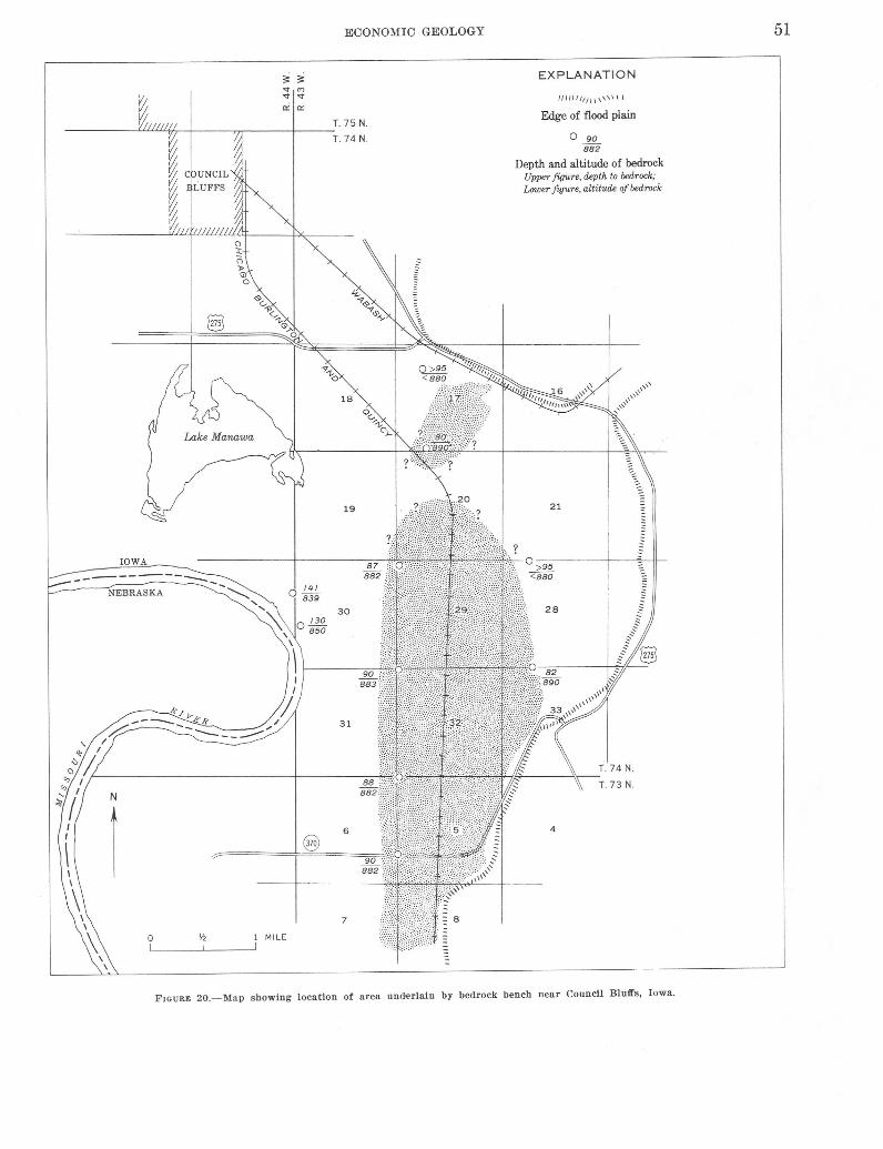
0
ECONOMIC GEOLOGY
1 MILE
EXPLANATION
IIIII lftt l 1 \ '"\I
Edge of flood plain
0 90 882
Depth and altitude of bedrock Upper figure, depth to bedrock; Lower figure, altitude of bedrock
4
FIGURE 20.-Map showing location of area underlain by bedrock bench near Council Blutfs, Iowa.
51

52 GEOLOGY OF THE OMAHA-COUNCIL BLUFFS AREA, NEBRASKA-IOWA
FIGURE 21.- Terraced slope in the Peorian and Bignell Loesses in road cut through hill near Crescent, Iowa, SE'j,SE% sec. 23, T . 76 N., R. 414 W. Terracing reduces erosion and ditch maintenance becau se treads on terraces ca tch wash and slump from above risers. Photograph taken November 1951.
near the center of sec. 30, T. 75 N., R. 43 \V., in Council Bluffs.
Infiltration tests in loess soils show that bare loess, and to some extent even cultivated humic topsoil, loses its capacity to absorb water quickly. Furthermore, the wet loess at the surface acts as a seal and prevents water from penetrating the loess after the first few minutes of rainfall (Duley, 1945, p. 281-282). Some protection, such as mulch, reduced the runoff considerably.
Bare loess, whether exposed in a cultivated field or in areas of construction, tends to erode quickly during heavy storms. Gullying, once started, is rapid. The runoff flows rapidly downslope along depressions or channels. \Vherever the humic-rich A horizon or the clay-rich B horizon of the soil profile is preserved, however, downcutting is reduced. \Vherever the downcutting entrenches a channel into the parent loess, or C zone, erosion is rapid. As the loess is eroded and removed, a vertical face forms at the head of the gully. An overhang and plunge basin are quickly developed at the point where the runoff penetrates through the clayey B horizon and erodes the parent loess.
The headwall progresses upstream by caving of the overhanging portion, caused in part by the erosion at the plunge basin and in part by back trickling of '-vater along the overhanging roof and cave sides. Some of the back trickling drops from the overhang, but most flows down the wall of the loess. This, then, softens
the loess and permits washing that accelerates erosion at this point.
Gully erosion in the deeply weathered granite piedmont ~LI"Nl. of South CaroHna follows an almost identical procedure, and is clearly described by Ireland, Sharp, and Eargle ( 1939, p. 52).
The characteristics of loess are such that even though care is taken to control erosion and the deep gullies, greater care must be taken to maintain these preventative measures. A severe storm providing extreme and rapid runofi' can rejuvenate downcutting in loess and undo in a short time the results obtained by erosion control. Reactivation of erosion at the lower end of a gully or ditch associated with a locally lower base level cannot be ignored. Headward progression of this renewed downcutting may be exceedingly rapid.
Loess in certain locations will flow during spring thaws. Snow collects and remains on north-facing slopes in roadcuts long after the snow on south-facing slopes has melted. As a result, the outer 6 inches of loess can become saturated during thawing and subsequently flow down the cut slope. Flowing seems to be more common in the unaltered loess below the B horizon of the soil profile (Watkins, 1945, p. 300).
TILL
Erosion in the Kansan till occurs somewhat differently than in loess. Loose and weathered rock particles are common in oxidized till. For this reason oxidized till erodes and gullies more rapidly than does the unoxidized till, and at many places it cievelops sloping gully sides. After the channels erode into the unoxidized till, the walls of gullies are more nearly vertical. Rapids, waterfalls, and potholes develop near the headwall of a gully in unoxidized till.
The same corrective measures applied to loess can be used to control erosion of Kansan till.
SAND AND GRAVEL
Erosion of the Red Cloud Sand and Gravel and sand and gravel in the Grand Island is confined, for the most part, to slumping, sloughing, and channeling of local deposits. In most exposures the sand and gravel is permeable, but it contains enough silt to stand in moderately steep faces. Sheet erosion and undercutting result in sloughing of the face and block falls of overlying deposits, generally loess.
Vegetation generally covers the shunped area and helps retain the slope after the sand and gravel has slumped and become stabilized.
CONSTRUCTION MATERIALS
The classification of construction materials used in this report is based on the State of Nebraska "Standard

ECONOMIC GEOLOGY
Specifications for Highway Construction" (Nebraska Bur. Highways, 1955, 1957), except for lightweight aggregate and clay. These exceptions are based on other systems of classification, as listed under those sections, or on my opinions.
CONCRETE AGGREGATE
Aggregate for concrete is composed of fragments of hard, durable minerals or rocks of sand and gravel size, which are relatively free from adherent coatings, soft. or shaly lumps, and organic or other deleterious material. Potential sources of concrete aggregate are crushed rock from some of the limestone beds in the Missouri Series and coarse sand from the Quaternary deposits.
Coarse aggregate is probably available from crushed rock derived from the Bethany Falls Limestone Member of the Swope Limestone, Winterset Limestone Member of the Dennis Limestone, Westerville Limestone Member of the Cherryvale Shale, Drum Limestone, lola Limestone, and the Argentine Limestone and Farley Limestone Members o:.E the Wyandotte Limestone. The Winterset Limest.0ne Member of the Dennis Limestone, however, contains- chert that may have a deleterious reaction with cement. Other potential aggregate sources are the Red Cloud Sand and Gravel, the Grand Island Formation, and the flood-plain alluvium. Sources of coarse aggregate could be developed by locating very coarse beds or by selectively screening gravel from these beds.
The same three units-the Red Cloud, Grand Island, and alluvium along. the Missouri River-are also potential sources of fine aggregate and sand and gravel for concrete. E-ach deposit should be checked for excessive amounts of material that may have detrimental reactions with portland cement.
MINERAL AGGREGATE
Mineral aggregate consists o:f clean, hard, durable, and uncoated particles of rock or sand -and gravel used for base course, surface course, or armor course. Potential sources for this material include the limestone members o:f the :formations o:f Pennsylvanian age that underlie this area and the sand -and gravel of the Red Cloud, Grand Island, and alluvium.
None of these materials were submitted to the Los Angeles abrasion test or sodium sulfate soundness tests.
Ceramic slag has been made :from Pleistocene loesses :for road metal and railroad ballast in Kansas (Plummer and Hladik, 1948, p. 95-97). The Peorian, Bignell, and the Loveland are practically inexhaustible sources of loess.
GRAVEL AND CRUSHED ROCK FOR SURFACING
Gravel and crushed rock for surfacing roads and runways are durable particles of stone, sand, or crushed rock with a limited amount of clay and silt. None of the limestones in this area were tested by me, but much of the rock from the quarries is used for surfacing at present.
Pit-run coarse sands from the Red Cloud and Grand Island are slightly ~finer than usually specified, but this can be rectified by controlled screening o:f the material. Alluvium near the surface o:f the flood plain of the Missouri River is considerably finer than specified, but coarser sand occurs at depth.
MINERAL FILLER
Mineral filler is any finely divided inert mineral material that mixes easily with mineral aggregate. Potential sources include silt and clay of the Sappa Formation, its Pearlette Ash Member, the Loveland Loess, the Peorian and Bignell Loesses, and the silt of the terrace alluvium of Wisconsin age.
Except for the Pearlette, the other potential sources of mineral filler generally have a plastic index that is too high ( >4). The Pewrlette Ash Member has the proper size grading and plastic index; unfortunately, the known deposits in the mapped area are small and lenticular. The thickness generally changes radically at most outcrops and grades laterally into .a featheredge. Future excavations may expose larger deposits.
SOXL BINDER
Soil binder consists of ·fine particles of sand, silt, and clay. Potential sources include the Fullerton Formation, silt and clay of the Sappa Formation, Loveland Loess, Peorian and Bignell Loesses, and the silty layer overlying the alluvium beneath the Missouri River flood plain.
CLAY SURFACING MATERIAL
Clay sufacing material consists of clay, silt, and sand, arenaceous lime rock, or calcareous sandstone. Potential sources in the Omaha-Council Bluffs area include many of the calcrureous siltstone and claystone beds separating the limestone beds in the Pennsylvanian formations. In addition, silt beds of the Fullerton and Sappa Formations may also be suitable for this purpose.
LIGHTWEIGHT AGGREGATE
Lightweight aggregate, foilowing the usage of Bush (1951, p. 306), is any material suita'ble for use as aggregate in producing concrete that weighs less than 120

54 GEOLOGY OF THE OMAHA-COUNCIL BLUFFS AREA, NEBRASKA-IOWA
pounds per cubic foot. The aggregate should contain a high percentage of enclosed voids and be porous but impermeable. No materials from the Omaha-Council Bluffs area are known to have been used or tested for lightweight aggregate. Potential shale sources, after suitable treatment, include the Fontana Shale Member, the Wea Shale Member, and the Quivira Shale Member of the Cherryvale Shale, the Lane Shale and the Bonner Springs Shale all of which were tested in Kansas for lightweight aggregate, and proved to bloat satisfactorily upon firing (Plummer and Hladik, 1951, p. 53-55).
Loesses, the Loveland, Peorian, and Bignell, are unlimited potential sources. Tests of loess samples from different places in Kansas showed that loesses containing a great deal of plastic clay bloated best on firing. The unleached part of loess having some calcium carbonate available for use as flux can be fired at a reduced temperature well within the range of economical commercial production of lightweight aggregate (Plummer and Hladik, 1951, p. 73-74).
BUILDING STONE
Building stone, as used in this report, includes all natural stone used for ordinrury masonry construction. No tests were made to determine strength or other characteristics of the rock in this area, and the opinions contained in this section of the report are based on my observations.
Most of the limestone beds exposed in this a~rea are thin to medium bedded and are closely fractured or jointed. For this reason it seems doubtful if any large amount of building stone is available. Beds that break in flaggy fragments have been used for retaining walls, mortared or free, and for grurden construction.
CLAY
Clay suitable for the manufacture of ceramic slag, tile, and brick exists in large quantities in the area. The Loveland Loess and the Peorian and Bignell Loesses are suitable sources. Tests made by the State Geological Survey of Kansas indicate that the silt of the Sanborn Group (equivalent to the Loveland and Peorian and Bignell Loesses of this report) is suitable for making such products as ceramic slag (Plummer and Hladik, 1948, p. 95-97), brick, and hollow tile (Frye and others, 1949, p. 80).
STRATIGRAPHIC SECTIONS
Rock-color nomenclature in all sections is from the National Research Council "Rock-Color Chart" (Goddard and others, 1948). Percent solubles were deter-
mined by heating crushed samples in HCl (1: 1) until effervescing ceased; insoluble residue is the material remaining after effervescing ceased.
SECTION 1.-Rocks of the Kansas Oity Group, Upper Pennsylvanian, exposed in the OUvo quarry NW"%,SE1A, sec. 84, T. 18 N., R. 12 E., Washington County, Nebr.
[Measured by R. D. Miller and E. K. Maughan, June 1957]
Wyandotte Limestone. Argentine Limestone Member (upper part
covered by slump) : 1. Limestone, medium- to medium-light-gray
( N 5-N 6) ; mottled light olive gray (5Y 6/1); weathers yellowish gray ( 5Y 7/2) ; contains 95 percent solubles (crushed samples heated in HCl (1: 1) until effervescing cease d) ; finely crystalline, dense, thin bedded, tabular ; weathered surface moderately rough; breaks into slabby pieces with subconchoidal fracture; contains calcitereplaced crinoid columnals, small brachiopods, and ostracodes; units 1 and 2 separated by shale parting ; forms
Thickness (feet)
ledge ------------------------------- 0.8-1.0 2. Limestone, light-olive-gray ( 5Y 6/1) ;
weathers yellowish gray (5Y 7/2); argillaceous; contains 41 percent insoluble residue, fine grained ; laminated, tabular; weathered surface rough, platy; contains a few calcite-replaced crinoid columnals, some brachiopods ; contains pyrite crystals ---------------------- . 8
3. Limestone, light-olive-gray ( 5Y 7/1) ; weathers yellowish gray (5Y 7/2) ; contains 80 percent solubles; finely crystalline, thin bedded, tabular ; contains calcite-replaced crinoid columnals, small brachiopods, productids; shale parting separates units 3 and 4; forms ledge---------~--------------------- .7-.8
4. Siltstone, light-olive-gray (5Y 7/1), calcareous; contains 40 percent solubles ; laminated, tabular; weathered surface rough to knobby, shaly; contains mica; slightly fossiliferous----------------- . 8
5. Limestone, light-olive-gray ( 5Y 6/1) ; weathers yellowish gray ( 5 Y 7/2) , argillaceous; contains 3 percent insoluble residue; finely crystalline, thin bedded, tabular ; contains small brachiopods ; lower surface undulating; forms ledge_ . 6
6. Limestone, light-olive-gray ( 5Y 7/1), argillaceous; contains 37 percent insoluble residue, finely crystalline, thin bedded, tabular; fossils scarce; in places greenish gray (5GY 6/1) siltstone 0.0-0.5 ft thick separates units 5 and 6; forms ledge__________________ . 4

STRATIGRAPIDC SECTIONS 55
SECTION 1.-Roclc.s of the Kansas City Group, Upper Pennsylt:anian, exposed i.n the Olivo qua·rry NWl4SE14 sec. 34, T. 18 N., R. 12 E., TVashington County, Nebr.-Continued
Wyandotte Limestone--Continued Argentine Limestone Member (upper part
covered by slump) -Continued 7. Limestone, light-olive-gray ( 5Y 7/1),
argillaceous; ·contains 49 percent insoluble residue; finely crystalline, laminated, tabular; splits in platy pieces; contains calcite-replaced crinoid col-
Thickness (feet)
umals, other small fossils____________ 0. 7-. 9 8. Limestone, light-olive-gray (5Y 7/1) ;
m"Ottled light olive gray (5Y 5/2) with fragments of fossils; weathers yellowish gray (5Y 8/1) ; slightly argillaceous; contains 27 percent insoluble residue ; finely crystalline, dense, thin bedded, tabular; weathered surface moderately rough, breaks into slabby pieces, subconchoidal fracture; contains numerous fossil fragments ; lower surface undulating; forms ledge__ . 3-. 5
Quindaro Shale Member : 9. Siltstone, greenish-gray ( 5G Y 7/1) ,
slightly calcareous; contains 19 percent solubles; laminated, tabular; weathers in angular fragments, knobby to rough surface; breaks into shaly fragments ; displays crisscross fractures on surface; contains mica; contains brachiopod fragments, crinoid columnals;
5.1-5.8
fossils raised on weathered surface____ 1. 0 10. Siltstone, medium-dark-gray (N 5),
clayey, slightly calcareous; contains 16 percent solubles, carbonaceous, contains 20 percent organic matter ; coDrtains inclusions of light-olive-gray (5Y
17/1) calcareous (29 percent solubles) siltstone; weathers light olive gray (5Y 7/1) ; laminated, tabular; forms vertical face at fresh exposures; breaks into shaly pieces_____________________ 2.0
Frisbie Limestone Member : 11. Limestone, greenish-gray (5GY 6/1) ;
weathers light olive gray (5Y 6/1) ; ·contains 89 percent solubles; finely crystalline, dense, thin bedded, tabular ; weathered surface smooth; contains !brachiopods, gastropods ; lower bound-
3.0
ary wavy; forms ledge________________ 0. 7-1. 0
0.7-1.0
SECTION 1.-Rocks of the Kansas City Group, Upper Pennsylvanian, exposed in the Olivo quarry NW14,SEl4 sec. 34, T. 18 N., R. 12 E., Washington County, Nebr.-Continued
Thickness
Lane Shale: (feet)
tl2. Limestone, greenish-gray ( 5 GY 7/1) ; weathers yellowish gray ( 5Y 8/1) ; argillaceous ; contains 26 percent insoluble residue; dense, thick bedded, tabular; weathered surface rough, some nodular shaped masses ; lower 1.1 ft contains stringers of dusky-yellow-green ·(5GY 5/2) claystone; breaks into shaly fragments _____________________ _
13. Olaystone, grayish-red (lOR 5/2) ; contains stringers of grayish-green ( 5G 5/2) claystone in upper 5-6 in., grayishgreen (5G 5/2) claystone mottled dusky yellow in lower 5-6 in.; calcareous; contains 70 percent solubles; very thin bedded, tabular ; shaly in uprper part, flaggy in lower part ; weathers rough, knobby in lower part ; appears to be clay balls in matrix ; entirely .green on east wall of quarry----------
14. Siltstone, light-olive-gray (5Y 7/1); clayey, slightly calcareous; contains 24 percent solubles; laminated, tabular; breaks into angular fragments, almost subconchoidal on some faces ; weathers knobby, brecciated; lower contact un-
dulating ----------------------------
lola Limestone: 15. Limestone. light-olive-gray (5Y 7/1).
slightly argillaceous; contains 24 percent insolube residue; finely crystalline, dense, hard, very thin bedded, tabular; breaks with subconchoidal fracture; ab-
6.0
. 8---1. 0
2.0
8.8-9.0
sent in some places __________________ 0.0--0.5
16. Limestone, yelowish-gray (5Y 8/1) ; weathers yellowish gray ( 5 Y 7/2) ; contains 97 percent solubles; crystalline, dense, hard, oolitic, pinches and swells, irregular; contains a few fossils; upper and lower 3-4 in. marked by grayish-green ( 5GY 6/1 claystone partings____ 1. 5
17. Limestone, yellowish-gray (5Y 8/1); weathers yellowish gray ( 5Y 7/2) ; coarsely crystalline, dense, oolitic, tabular; lower 10 in. more argillaceous ; contains 25 percent insoluble residue; contains crinoid columnals, numerous fossil fragments ; contains lenticular bodies of grayish-green ( 5GY 6/1) claystone, upper and lower 3-4 in. marked by wavy claystone partings ____________________ 1.5--2.5

56 GEOLOGY OF THE OMAHA-COUNCIL BLUFFS AREA, NEBRASKA-IOWA
SECTION 1.-Rocks of the Kansas City Group, Upper Pennsylvanian, exposed in the Olivo quarry NW1,4SEI4 sec. 34, T. 18 N., R. 12 E., Washington County, Nebr.-Continued
Lane Shale-Continued lola Lime~tone-Continued
18. Limestone, light-olive-gray (5Y 6/1); contains 85 percent solubles; finely crystalline, dense, tabular; breaks into blocky fragments with subconchoidal fracture; contains crinoid columnals, a few other fossil fragments; upper 1¥2-2 in. contains wavy grayish-green (5GY 6/1) claystone partings, lower 3-4 in. similarly marked; grayish-green siltstone 1 in. thick separates units 18
and 19------------------------------19. Limestone, greenish-gray (5GY 7/1);
mottled light olive gray (5Y 6/1) owing to clusters of fossil fragments ; weathers light olive gray (5Y 6/1) ; argillaceous ; contains 36 percent insoluble residue; finely crystalline, dense, thin hedded, oolitic, tabular ; upper 3-4 in. contains claystone partings ; contains crinoid columnals, numerous fossil fragments and clusters ; lower surface wavy; units 15, 16, 17, 18, and 19 appear as a single massive limestone on fresh quarry face _____ _
Chanute Shale : 20. Siltstone, greenish-gray (5GY 6/1) ;
weathers mottled dusky yellow ( 5Y 6/3) ; slightly calcareous; contains 23 percent solubles ; thinly laminated, appears fissile on outcrop, tabular; breaks into rough angular fiaggy and shaly pieces; weathered surface rough, fossils raised in relief ; contains numerous horn corals, productids ; lower surface gradational with unit
Thickness (feet)
3.0
1.0
7.0-8.5
21 --------------------------------- 2.0 21. Siltstone, dark-gray (N 3), clayey; con-
tains light-olive-gray ( 5Y 6/1 and ( 5Y 5/1) alternating horizontal laminae; slightly carbonaceous; contains 6 percent organic matter; noncalcareous, thinly laminated, tabular; breaks into shaly to fiaggy pieces, conchoidal on some faces; weathered surface smooth, appears massive in quarry face; contains productids near base ; lower sur-face even and distinct_______________ 2. 0
22. Siltstone, light-olive-gray ( 5Y 6/1) ; mottled dusky yellow ('5Y 6/3) ; slightly calcareous; contains 12 percent solubles, dense, thin bedded, tabular; breaks into fiaggy pieces, subconchoidal fracture; has silky appearance on surface; persistent wavy parting between units 22 and 23_____________ 1. 5-2. 0
SECTION 1.-Rocks of the Kansas City Group, Upper Pennsyl'liani.an, exposed in the Olivo quarry NW1,4SEI4 sec .. li14, T. 18 N., R. 12 E., Washington County, Nebr.-Continued
Chanute Shale-Continued 23. Siltstone, greenish-gray (5GY 5/1), clay
ey, slightly calcareous; contains 11 per~eent solubles; dense, very thin bedded, tabular; breaks into fiat fiaggy pieces with subconchoidal fracture; contains dark carbonaceous fragments; forms prominent ledge with domelike surface; unit 23' swells and pinches with unit 22; lower surface sharp to gradational with
unit 24------------------------------24. Siltstone, greenish-gray (5GY 5/1), very
clayey; mottled light olive gray (5Y 7/1) in areas of very calcareous nodules an'd contorted laminae; matrix moderately calcareous, very thin bedded, tabular ; breaks into irregular fiaggy pie<:_es ; forms lower part of ledge formed by unit 23 ; lower surface distinct
25. Siltstone, greenish-gray ·(5GY 6/1) ; !Slightly mottled greenish gray (5G 6/1) and dusky yellow (5Y 6/4) ; clayey, very slightly calcareous ; contains 5 percent solubles, dense, very thin bedded, tabular ; breaks with rough irregular
Thickness (feet)
0.0-0.8
. 8-1.0
surface into shaly and flaggy pieces___ .1-0. 3
Drum Limestone: 26. Limestone, dark-greenish-gray (5GY
4/1) ; weathers greeni-sh gray (5GY
6/1) ; argillaceous, dense, aphanitic, moderately hard, tabular; contains brachiopods and gastropods in upper
6.4-8.1
6 in_________________________________ 1.0-1.3
27. Siltstone, dark-greenish-gray (5GY 411) ; streaked and mottled greenish gray ( 5GY 611) ; slightly calcareous ; contains 27 percent solubles; thinly laminated, tabular ; breaks into angular shaly fragments ; contains numerous fossils ; continuous layer of varying
thickness --------------------------- .1- .2 28. Limestone, light-olive-gray ( 5Y 6/1) ;
contains 93 percent solubles·; finely crystalline in upper 2 in., granular crystalline in lower 8-10 in.; thin bedded, dense in upper part, oolitic in lower part ; breaks into rough angular pieces ; contains numerous fossil fragments ; dark-greenish-gray (5GY 4/1) claystone parting, containing dark gastropods, separates units 28 and 29------------- 1. 0

STRATIGRAPHIC SECTIONS 57
SECTION 1.-Rocks of the Kansas City Group, Upper Pennsylvanian, exposed in the Olivo quarry NW1,4SE1,4 sec. 34, T. 18 N., R. 12 E., Washington Co·unty, Nebr.-Continued
Chanute Shale-Continued Drum Limestone-Continued
29. Limestone; olive gray (5Y 5/1) and granular crystalline in upper 1 in., yellowish gray (5Y 7/2) and coarsely crystalline in remainder; contains 95 percent solubles; oolitic thin-bedded, tabular; breaks into flaggy and slabby pieces; extremely fossiliferous in upper 1 in., gastropod fragments; lower surface wavy, bas greenish-gray (5GY 7/1) claystone parting betwen unit 29 and
Thickness (feet)
unit 30------------------------------ 1.0-1.2 30. Limestone, light-olive-gray ( 5Y 7/1) ;
contains 92 percent solubles, coarsely crystalline, dense, thin bedded, oolitic, tabular ; breaks in to angular sharp-edged fiaggy pieces___________________ 1.0
Water covers remainder of formation.
4.1-4.7
Total exposed------------------------------ 35.1-40.1
SECTION 2.-Rooks of the Lansing and Kansas City Groups, Upper Pennsylvanian, exposed in the North Omaha Rock and Lime quarry, SE1j4 SE1,4 sec. 28. T. 17 N., R. 13 E., Washington County, Nebr.
[Measured by R. D. Miller and E. K. Maughan, June 1957]
Lansing Group. Plattsburg Limestone:
Merriam Limestone Member : 11. Limestone, light-olive-gray (5Y 7/2);
mottled and streaked dark yellowish orange (10YR 7/6) ; weathers grayish orange (10YR 6/4) ; contains 93 percent solubles, coarsely crystalline, dense, thin bedded, tabular; weathered surface moderately rough, knobby; breaks into jagged, sharp edged, fiaggy fragments, some with subconcboidal fracture ; lmiddle part vesicular ; upper surface weathered and rough ; lower surface wavy and nodular; con-tains Osagia; forms ledge _______ _
Bonner Springs Shale : 2. Siltstone, ligbt-oli ve-gray ( 5Y 5/1) ; mot
tled and streaked dusky yellow ( 5¥ 6/3); weathers dusky yellow (5Y 6/4) ; .slightly calcareous; contains 23 percent solubles; thinly laminated, tabular; weathered surface rough; breaks into slabby fragments; gradational with unit 3-------------------------------
Thickness (feet)
1.3
1.3
2.0
SECTION 2.-Rocks of the Lansing and Kansas City Groups, Upper Pennsylvan·ian, exposed in the North Omaha Rock and Lime quarry, SE1f4.SE1,4 sec. 28, T. 17 N., R. 13 E., Washington County, Nebr.-Continued
Lansing Group-Continued Bonner Springs Shale-Continued
3. Siltstone, light-olive-gray (5Y 6/1), very !Slightly calcareous; contains 6 percent .solubles, thinly laminated, tabular; breaks into flaggy or sbaly fragments and into nodules larger than 1 in. in diameter ; forms blocky unit in quarry
Thickness (teet)
face_________________________________ 4.0
4. Siltstone, light-brownish-gray (5YR 5/1); mottled light-olive-gray (5Y 7/1) ; ~slightly calcareous; contains 23 percent solubles ; thin bedded, tabular ; breaks into shaly fragments, and into nodules about 0.5 in. in diameter-------------- 2. 0
5. Siltstone, greenish-gray (5GY 7/1), clayey, slightly calcareous; contains 14 percent solubles; thinly laminated, tabular; breaks into shaly fragments; contains calcite nodules; lower contact
abrupt ------------------------------
Wyandotte Limestone : Farley Limestone Member:
6. Limestone, yellowish-gray ( 5Y 8/1) ; contains 94 percent solubles ; finely crystallinf, d e n s e, thick bedded, tabular; contains calcite plates; breaks into slabby fragments; forms massive ledge; upper 6 in. contains lh- to %-in. beds of lime-
stone ---------------------------7. Limestone, light-olive-gray ( 5Y 7/1) ;
weathers greenish gray (5GY 7/1) ; slightly argillaceous ; contains 17 percent insoluble residue; coarsely crystalline, thin bedded, tabular; weathered surface rough; contains calcite plates, fossils ___ _
8. Siltstone, greenish-gray (5GY 7/1) ; stained moderate yellowish brown (10YR 5/4) ; clayey, calcareous; contains 41 percent solubles, laminated, tabular; breaks into shaly
fragments -----------------------9. Limestone, greenish-gray ( 5G Y 7/1),
finely crystalline, argillaceous ; contains 30 percent insoluble residue ; thin bedded, tabular; contains very few fossils ; lower surface wavy ; fornas ledge _____________________ _
.5 8.5
5.0
1.7
.3
.6
7.6

58 GEOLOGY OF THE OMAHA-COUNCIL BLUFFS AREA, NEBRASKA-IOWA
SECTION 2.-Rocks of the Lansing and Kansas City Groups, Upper Pennsylvanian, ea:posed in the North Omaha Rock and Lime quarry, SE1f4f:fEI.f4 sec. 28, T. 11 N., R. J3 E., Washington County, Ncb1·.-Continued
Lansing Group--Continued Wyandotte Limestone--Continued
Island Creek Shale Member: 1(). Siltstone, greenish-gray ( 5GY 7 /1),
!Clayey, slightly calcareous; coll!tains 21 percent solubles; very thin bedded, tabular; breaks into ishaly fragments; contains fossiliferous yellowish-gray ( 5Y 8/1) flaggy limestone fragments near base, in which Fenestella are
common ------------------------11. Siltstone, greenish-gray ( 5G Y 6/1) ,
dayey, very slightly calcareous; contains 4 percent solubles ; laminated, irregular, breaks into angular shaly fragments; lower surface
Thickness (feet)
1.0
undulating---------------------- .7-1.5
Argentine Limestone Member: 12. Limestone, yellowish-gray (5Y 8/1) ;
mottled and streaked greenish gray (5GY 6/1)·; weathers dusky yellow ( 5Y 7/3) ; slightly argillaceous;
:contains 11 percent insoluble resi-due ; finely crystalline, very thin bedded, irregular ; brecciated, contorted; upper surface forms pinnacles and knobs, lower surface
1.7-2.5
gently undulating________________ 0. 5-1. 5
13. Limestone, yellowish-gray (5Y 8/1); mottled grayish green (5GY 6/1) along partings; weathers grayish yellow (5Y 8/3) ; slightly argillaceous; contains 19 percent insoluble residue ; finely crystalline, dense. thin bedded, tabular; breaks into flaggy fragments ; contains calcite ; consists of two 4- to 6-in. beds sep
arated by wavy parting; lower contad on west side of quarry is
\Vavy ---------------------------14. Limestone, medium-light-gray (N
6) ; mottled yellowish gray ( 5Y 7/2) ; argillaceous; contains 46 percent insoluble residue of clayey silt, laminated, tabular; breaks into shaly and papery fragments; lower contact distinct; contains
fossils -------------------------15. Limestone, light-o l i v e-g r a y ( 5Y
7/1) ; mottled pale red purple ( 5-RP 5/2) giving a purplish cast to bed; slightly argillaceous ; contains 16 percent insoluble residue; finely crystalline, thin bedded, tabular ; breaks into slabby frag-
. 5-.7
.5
SECTION 2.-Rocks of the Lansi,ng and J(ansas City Groups, Upper Pennsyl,van,ian, ea:posed in the North Ornaha Rock and L1:rne quarry, SE1f4SE1j4 sec. 28, T. 11 N., R. 13 E., Washington County, Nebr.-Continued
Lansing Group---Continued Wyandotte Limestone-Continued
Argentine Limestone Member-Continued ments; lower contact distinct; forms thin ledge _______________ _
16. Limestone, medium-light-gray (N 6) ; mottled yellowish-gray ( 5Y 7/2), has purplish cast from distance ; argillaceous ; contains 42 percent insoluble residue of very clayey silt; laminated, tabular; breaks into shaly and papery fragments; contains calcareous nodules; gradational with unit 17; contains fossils (productids) -------------
17. Limestone, greenish-gray (5GY 7/1) ; mottled grayish purple ( 5P 4/2), pale red purple ( 5RP 6/2) containing reduction bands of grayish yellow green (5GY 7/2); slightly argillaceous ; contains 26 percent insoluble residue; finely crystalline, thin bedded, tabular ; breaks into angular flaggy fragments; lower contact faintly vis-ible; contains fossils ___________ _
18. Limestone, greenish-gray ( 5GY 7/1) ; slightly argillaceous; contains 27 percent insoluble residue; finely crystalline, thin bedded, tabular; breaks into flaggy to slabby fragments ; thin partings in upper 1.0 ft, remainder has layers indistinctly separated by partings; stands as massive bed, has vertical joints at places ; lower boundary marked by slightly wavy parting; productids and bryozoans numer-ous at base ____________________ _
19. Siltstone, greenish-gray (5GY 7/1) ; upper part mottled grayish purple ( 5P 4/2) ; very calcareous ; contains 45 percent solubles ; finely crystalline, thin bedded, tabular ; breaks into flaggy and· slabby fragments, some with conchoidal fracture; productids, bryozoans, numerous at top of unit ; indistinct part-ing between units 19 and 20 _____ _
20. Limestone, medium-light-gray (N6) ; weathers dark yellowish orange (10YR 7/6); contains 85 percent solubles; finely crystalline, thin bedded, tabular; contains numerous fossil fragments and calcite; contains partings marked by black lines on weathered surface, distinct parting 3-4 in. above base, thin wavy parting between units 20 and
21 ------------------------------
Thickness (feet)
0.5
.5
1.0
4.0
. 6-.8
4.0

STRATIGRAPHIC SECTIONS 59
SECTION 2.-Rocks of the Lansing and Kansas Oity Groups, Upper Pennsyl1,anian, exposed in the North Omaha Rock and Lirne quarry, SE1j.1 SE14, sec. 28, T. 17 N., R. 13 E., Washingtoo Oounty, Nebr.-Continued
Lansing Group-Continued Thickness
Wyandotte Limestone--Continued (feet)
Argentine Limestone Member-Continued 21. Limestone, medium-light-gray (N 6);
mottled yellowish gray (5Y 8/) ; contains 89 percent solubles ; finely crystalline, thin bedded, ta'bular ; breaks into angular flaggy fragments ; contains numerous fossil fragments; some crystalline caldte; base has distinct wavy surface ; shale layer '-4 to % in. thick between units 21 and 22---------- 0. 8-1.1
22. Limestone, medium-light-gray (N 6); 1sparsely mottled medium gray (N 5)., and yellowish gray ( 5Y 8/1) ; weathers grayish orange (lOYR '71/4) along fractures and joints; contains 94 percent solu'bles·; finely crystalline, thin bedded, tabular ; breaks into angular slabby and :tlaggy fragments ; contains fossil fragments as dark line; contains chert nodules; distinct wavy shaly parting 4 in. below top and less well-developed shale parting 10 in. below tOP------------------------ 2. 7
23. Limestone, light-olive-gray (5Y 6/1) ; ·stained yellowish gray ( 5Y 8/1) along joints; weathers medium gray ( N 5) ; contains 92 percent solubles; finely crystalline, thick bedded, tabular ; breaks into angular slabby fragments; contains numerous productids (some with calcite crystals inside), crinoid columnals that are raised prominently on weathered surfaces, and pyrite crystals; more argillaceous at base, where it contains 28 percent in.soluble residue; units 21, 22, .and 23 have purplish. cast from distance ; water covers base________________ 2.7
18.3-20.0
Total 37.4-39.9
SECTION 3.-Rocks of the Kansas Oity Group, Upper Penn,. sylvanian, exposed in the Snakirt quarry, SWlf4NE'-4NElf4 sec. 34, T. 76 N., R. 44 W., Pottawattamie County, Imva
[Measured by R. D. Miller and E. K. Maughan, June 1957)
Drum Limestone : 1. Limestone; weathers grayish-orange ( 10
Y R 7/4) ; thin bedded; forms vertical
face --------------------------------
Thickness (feet)
6.5
SEcTION 3.-Rocks of the Kansas Oity Group, Upper Pennsylvanian, ea:posed in the Snakirt quarry, SW'-4NE*NE'-4 sec. 34, T. 76 N., R. 44 W., Pottawattamie Oounty, Iowa-Con.
Thickness
Drum Limestone--Continued (teet)
2. Limestone, yellowish-gray ( 5Y 7 /2) ; ,weathers grayish orange (lOYR 7/4) ; finely crystalline, dense, thin bedded, :tabular ; breaks into angular slabby fragments; contains siltstone partings__ 2. 0
3. Claystone, dark-gray (N 3) ; breaks into shaly fragm nts; contains numerous small fusulini 81---------------------- . 5
4. Limestone, yel owish-gray ( 5Y 7 /2) ; weathers gra ish orange (lOY R 7 /4)1; finely crystal ine, dense, thin bedded, 'tabular; con ins partings that separate limestone int two ledges ; gradational lower bound ---------------------- 1. 5
5. Limestone, gr yish-yellow ( 5Y 7 /4) ; slightly argil aceous ; contains 22 percent insolubl residue of clay and silt ; laminated, ular; breaks into shaly fragments; ntains lenticular layers of purer lime tone____________________ 1. 5
6. Limestone, ye owish-gray ( 5Y 8/1) ; weathers gr yish yellow ( 5Y 7/3) ; slightly argil aceous; contains 28 percent insolubl residue of clay and some silt ; thin b ded, irregular ; contains prod.uctids; 1 wer surface undulating__ 1. 5
Cherryvale Formation : Quivira Shale Member:
7. Limestone, lig t-olive-gray (5Y 6/1) ; weathers gr yish yellow (5Y 7/3); argillaceous; contains 31 percent insoluble residue · f clay and silt; laminated hut appears massive, tabular; breaks into shaly f gments-----------------
Westerville Limestone Member : 8. Limestone, gra ish-orange (lOYR 7/4);
weathers pal yellowish orange (lOYR 8/6) ; contai s 96 percent solubles; coarsely crys alline, dense, thin bedded, tabular ; we thered surface granular and pitted; reaks into angular slabby fragments; contains calcite plates ; lower bound ry sharp but irregular __
9. Limestone, ver pale orange (lOYR 8/3); weathers pal yellowish brown (lOYR 7/2) ; contai s bands stained dark yellowish orang (lOYR 6/6) ; contains 92 percent solu les; oolitic, dense, thin bedded, tab lar; weathered surface rough and a gular; breaks into angular flaggy f agments; lower surface
irregular ___ ------------------------
13.5
2.5
2.5
1.2
1. 5
60 GEOLOGY OF THE OMAHA-COUNCIL BLUFFS ARE1, NEBRASKA-IOWA
SECTION 3.-Rocks of the Kansas City Group, Upper Penn- SECTION 3.-RoJks of the Kansas City Group, Upper Penn-sylvanian, e{Cposed in the Snakirt quarry, SW1,4NE:14NE1,4 sylvan-ian, C{C~osed in the Snalrirt quarry, SWt,4NEI4NEJ.4 sec. 34, T. 76 N., R. 44 W., Pottawattamie County, Iowa-Con. sec. 34, T. 76 N., R. 44 W., Pottawattamie County, Iowa-Con.
Cherryvale Formation-Continued Westerville Limestone Member-Continued
10. Limestone, white (N 9) ; weathers yellowish gray ( 5Y 8/1) ; contains 96 percent solubles ; aphanitic, very dense, very thin bedded, tabular; breaks into angular flaggy fragments; units 8, 9, and 10 form massive ledge __________ _
11. Limestone, light-olive-gray (5Y 6/1); weathers yellowish gray ( 5Y 7/3) , stained grayish yellow ( 5Y 8/4) ; contains 96 percent solubles ; aphanitic, dense, thin bedded, irregular ; breaks into angular :tlaggy fragments; contains wavy calcite streaks (fossils) ; upper 0.3 ft yellowish-gray ( 5Y 8/1) brecciated limestone, that weathers in knobs, pinnacles, and points ; lower 0.3 ft yellowish-gray ( 5Y 7/2), brecciated aphanitic limestone that weathers in round knobs, in siltstone matrix that is grayish yellow (5Y 8/4) ; lower bound-ary wavy, fossiliferous ______________ _
12. Limestone, light-olive-gray ( 5Y 6/1) to yellowish-gray ( 5Y 7/1) ; contains 93 percent solubles, aphanitic, dense, thin bedded, tabular; weathers into :tlaggy fragments having conchoidal fracture; lower surface gently wavy, sharp boundary; consists of four beds that form ledges _________________________ _
13. Limestone, grayish-yellow (5Y 8/4) ; weathers pale orange (10YR 7/6); slightly argillaceous; contains 14 percent insoluble residue; very finely crystalline, dense, tabular; weathered surface rough, foraminifers and fragments of other fossils weather in relief; lower boundary gradationaL _________ _
14. Limestone, greenish-gray (5GY 7/1) ; slightly argillaceous ; contains 27 percent insoluble residue, very thin bedded, tabular; breaks into shaly to :tlaggy fragments; foraminifers, crinoid columnals, and other fossil fragments weather in relief; lower contact
sharp -------------------------------15. Limestone, greenish-gray ( 5GY 7/1) :
argillaceous; contains 35 percent insoluble residue; finely crystalline, dense, tabular; breaks into angular flaggy fragments ; foraminifers, crinoid columnals, weather in relief; forms over-hanging ledge _______________________ _
Thickness (feet)
1.3
1.0
3.5
1.0
1.0
. 95
11.45
Thickness
Cherryvale Formation-Continued (feet)
Wea Shale Member: 16. Siltstone, olive-gray (5Y 5/1) ; weathers
ligjt olive gray (5Y 6/1) ; slightly cal~areous ; contains 15 percent solublet; laminated, tabular; contains 4 percen/t organic matter; breaks into angular shaly fragments ; forms notch in quarry face_______________________ 0.85
17. Siltstdne, grayish-black (N 2) ; weathers ver!Y light gray (N 8), stained dark yel~owish orange (10YR 6/6) ; clayey, vecy slightly calcareous ; contains 7 per~ent solubles; thinly laminated; some lay~rs 0.01 ft thick ; carbonaceous ; contains 26 percent organic matter; layers and lenses of very light gray calcareous siltstone, results in light-colored parting planes ; breaks into shaly and pal!lery flakes; breaks and forms angular' blocky face where fresh ; lower co~tact gradational and horizontaL___ 1. 0-1.2
18. Limest'One, olive-black (5Y 2/1); weathers yellowish-gray ( 5Y 8/1) ; argillaceous; co~tain 35 percent insolubles; carbonaceoius; contains 8 percent organic matter ; thinly laminated, dense, irregular upper surface scalloped ; breaks into angular :tlaggy fragments; three beds form unit ; middle 0.3-0.5 ft has wellde"\l'eloQped laminae, breaks into flat shaly fra~ments; unit stained brown in
pla~es ------------------------------ .5-.8
Block Limestone Member : 19. Limestone, greenish-gray ( 5GY 6/1) ;
slightly argillaceous; contains 20 percenjt insoluble resdiue, finely crystalline, derj.se, tabular; breaks into angular jagjged flaggy fragments ; lower bound-
2. 35-2.85
ary gradational______________________ 0.3-0.5
Fontana Shale Member : 20. Siltstdne, medium-gray (N 5) ; weathers
oliye-gray (5Y 4/1) ; calcareous; contains 34 percent solubles; laminated, tab~lar ; breaks into shaly fragments; co~tains fossils, pyrite; lower bound-
0.3-0.5
ary gradational ______________________ 0.25-0.<XI 21. Siltst001e, light-olive-gray (5Y 6/1) to yel
loWish-gray (5Y 8/1), clayey, slightly calrareous; contains 16 percent soluble$; platy, laminated, tabular; breaks into angular and jagged flaggy frag-ments; forms ledge__________________ .5

STRATIGRAPHIC SECTIONS til
SECTION 3.-Rocks of the Kansas City Group, Upper Pennsylvanian, exposed in the Snakirt quarry, SW%,NEJ4NE?4, sec. 34, T. 76 N., R. 44 W., Pottatcattam-ie County, Iowa--Con.
Cherryvale Formation-Continued !fontana Shale Member-Continued
22. Siltstone, greenish-gray ( 5GY 6/1), clayey, very slightly calcareous; contains 4 percent solubles, blocky, tabular; breaks into angular flaggy fragments ; middle 0.6-1.0 ft 00ntains calcium carbonate nodules ; forms slight ledge ; lower 3.0 ft has greenish cast _________________ _
Dennis Limestone : 'Vinterset Limestone Member :
23. Limestone, white (N 9) ; weathers medium light gray ( N 6) , stains grayish yellow (5Y 8/4) ; contains 94 percent solubles; aphanitic, dense, thin bedded, tabular ; contains calcite crystals and plates; broken and bent laminated layers of alternating light and dark bands characteristic _________________ _
24. Limestone, yellowish-gray ( 5Y 8/1), to light greeniS'h-gray (5GY 8/1) ; contains 86 percent solubles; ·banding prominent on fresh surfaces ; finely ~rystalline,
thin bedded, dense, tabular ; contains pyrite; lower 1 ft coarsely crystalline; contains calcite crystals and streaks; massive where fresh, parting in middle visible where weathered; lower bound-ary marked by siltstone parting ______ _
25. Limestone, yellowish-gray ( 5Y 8/1) ; weathers very light gray ( N 8) ; contains 96 percent solubles; finely crystalline, very dense, thin bedded, tabular ; contains calcite streaks (fossils) and crystals; breaks into angular slabby or flaggy fragments; chert nodules along lower wavy surface _________________ _
26. Limestone, yellowish-gray (5Y 7/1) ; contains 97 percent solubles; finely crystalline, dense, thin bedded, tabular ; contains medium-dark-gray (N 4) chert nodules in middle and along parting at base; contains oolites; lower surface marked by slightly wavy shaly claystone parting
27. Limestone, yellowish-gray (5Y 7/2) ; weathers greenish gray ( 5G Y 6/1) ; contains 98 percent solubles; finely crystalline, dense, thin bedded, tabular ; contains calcite, fossils ; lower surface wavy, marked by shaly claystone
parting -----------------------------
735-718 0-64---5
Thickness (feet)
8.7
9.45-9.85
1.0-1. 5
2.n
.9
1.5
1.5
SECTION 3.-Rocks of the Kansas GUy Group, Upper Pennsulvanian, eil:posed in the Snakirt quarry, SWI4NEI4NE:J4 sec. 84., T. 76 N., R. 44 W., Pottatcattam-ie County, Iowa--Con.
Dennis Limestone--Continued Winterset Limestone Member-Continued
28. Limestone, light-olive-gray (5Y 5/1) and yellowish-gray ( 5Y 8/1), variegated; weathered light olive gray (5Y 6/1) ; contains 98 percent solubles; finely crystalline, dense, thin bedded, tabular ; contains dark calcite streaks (fossils) and light crinoid columnals; breaks into angular slabby fragments with subconchoidal fracture ; lower surface horizontal, marked by shaly claystone parting __
Limestone, yellowish-gray (5Y 7/1) ; weathers yellowish gray (5Y 8/2) ; contains 94 percent solubles ; finely crystalline, thin bedded, tabular; contains medium-gray ( N 5) chert in horizontal band 0.5 ft from top; chert contains calcareous fossil fragments ; limestone contains dark fragments, calcite streaks ( fos:sils) ; lower surface horizontaL ____________ _
30. Limestone, yellowish-gray (5Y 8/1) ; weathers medium gray (N 5); contains 96 percent solubles ; finely crystalline, dense, thin bedded, tabular ; 0.2- oo 0.8-ft layers; fossils weather in relief in some beds; contains calcite plates, productids ; exposed on north side of quarry where road obscures remainder of
section ------------------------------
Thickness (feet)
2.0
1.1-1.5
9.6
20.1-21.0
Total exposed------------------ 59.65-61.65
SECTION 4.-SE:J4NW14 sec. 17, T. 13 N., R. 43 W., Mills County, lfYWa
Red Cloud Sand and Gravel : 1. Sand, moderate yellowish-brown (lOYR 5/4),
fine to coarse ; about 20 percent granules, pebbles and cobbles; less than 20 percent silt; some individual particles dark yellowish orange (lOYR 6/6) ; calcareous; crudely stratified, roughly parallel to surface of unit 2; limestone pebbles, chert, quartzite igneous rock fragments; calcium carbonate cemented sandstone in upper part, forms a discontinuous ledge; lower contact distinct, abrupt, unconformable ___________________ _
Fullerton Formation: 2. Silt, olive-gray ( 5Y 5/1), fine, massive, com
pact; breaks into subangular blocks, very slightly calcareous, probably secondary enrichment from unit 1; lower contact distinct, conformable -----------------------------
3. Sand, pale-yellowish-brown (lOY R 7/2), wellgraded; predominantly quartz, some dark minerals; lower contact conformable ______ _
Thickness (feet)
4.0-5.0
2.0-3.0
.5

62 GEOLOGY OF THE OMAHA-COUNCIL BLUFFS AREA, NEBRASKA-IOWA
SECTION 4.-SE:J4NW14 sec.11, T. 13 N., R. 43 W., Mills County, I owa-Oontinued
Thickness
Fullerton Formation-Continued (feet)
4. Silt, dark-yellowish-brown (lOYR 4/2), wellsorted, massive, compact; breaks with subangular fracture ; leached ; lower contact ob-scured by wash in ditch__________________ 5. 7
Total exposed ______________________ 12.2-14.2
Auger hole continued from ditch level. 5. Silt: yellowish-gray (5Y 7/2) dry, light-olive-
gray (5Y 6/2) wet---------------------- 12.0 6. Sand, dusky-yellow (5Y 6/4), compact, me-
dium-fine ------------------------------Nebraskan till:
7. Till: greenish-gray (5GY 6/1) dry, dark-greenish-gray ( 5GY 4/1) wet; contains coarse sand, pebbles; auger chattered, return very poor, recovered samples on bit-and-auger
sections ---------------------------------Upper Pennsylvanian Series:
8. Limestone(?), hard drilling, chatter and
grind -----------------------------------9. Bound at 42ft, pulled, green and red shale on
bit-and-auger sections ____________________ _
3.0
21.0
1.0
5.0
Total thickness in test hole__________ 42. 0
Total combined thickness _____________ 54. 2-56. 2
SECTION 5.-NE14SW14 sec. 8, T. 14 N., R. 43 W., PottQIWat-tamie Oounty, Iowa
Thickness Alluvium: (feet)
1. Silt, pale-yellowish-brown (lOYR 6/2) ; con-tains humus; fills channel eroded into Peo-rian and Bignell Loesses at west end of exposure-------------------------------- 10.0
Peorian and Bignell Loesses : 2. Silt, grayish-orange (lOYR 7/4), massive____ 3. 0
Loveland Loess : 3. Silt, dark-yellowish-brown (lOYR 4/2) ; con-
tains humus, massive; soil ( ?) ------------ 1. 0 4. Silt, moderate-yellowish-brown (lOYR 5/4},
massive--------------------------------- 6.0 Crete ( ?) Formation:
5. Cobble-and-boulder concentrate forming layer on eroded surface of underlying Fullerton F'ormation; butts against Kansan till at west end of exposure ____________________ _
Kansan till : 6. Till, grayish-orange (lOYR 7/4) ; pebbles, cob
bles, in silt and sand matrix; eroded ; till grades into stratified sand and silt at west end of exposure, covers truncated surface
0-().5
of Fullerton Formation__________________ 2. 0-3. 0 Fullerton Formation:
7. Silt, pale-yellowish-brown (10YR 5./2), clayey·;
soil(?) --------------------------------- 1.5
SECTION 5.-NElA,SW14 sec. 8, T. 14 N., R. 43 W., Pottawattam.ie CO'I.l<nty, Iowa--Continued
Thickness F'ullerton Formation-Continued <teet)
8. Silt, moderate-brown ( 5Y R 4/4), clayey ; irregular joint pattern ; contains numerous calcium carbonate nodules; joints seems to follow eroded surface at west end--------- 17. 0
9. Silt, light-olive-gray ( 5Y 5/2), clayey ; diag-onal joints prominent; calcium carbonate nodules conspicuous______________________ 4.5
Stream level : Total exposed ___________________________ 45.0-46.5
SECTION 6.-SE14NE14 sec. ~2, T. 14 N., R. 43 W., Potta'loattamie County, Iowa
Thickness Slope wash : (feet)
1. Silt, moderate-yellowish-brown (lOYR 5/4), thin-layered, horizontally stratified; rootlets and humic layers interstratified ; grades upward into thin humic horizon 8 in. thick ; lower contact horizontal but uncomform-
able ------------------------------------ 0.5-0. 7 Kansan till :
2. Till, grayish-orange (lOY 7/4) ; clayey silt matrix contains sand grains, pebbles scat-tered throughout, cobbles less common; contorted, pinches and swells laterally, discontinuous lower contact horizontal but unconformable with unit 3------------------- 4. 0-10.0
Red Cloud Sand and Gravel: 3. Sand, moderate-yellowish-brown (10YR 5/4)
overall ; contains less than 10 percent darkyellowish-orange (lOYR 6/6) granules; contains lenses of granules and pebbles; some scattered pebbles are more than 2 in. long ; pebbles less than %, in. subround to round, larger than %, in. subangular to subround, broken pebbles rounded on edges ; bedding distorted ; limestone dominant, some granite, quartz, and red quartzite; sandsized particles cemented by calcium carbonate into clusters ; underlies till laterally ; upper surface truncated, top of cut grass covered, lower contact irregular----------- 1. 0-4.0
Fullerton Formation: 4. Silt, dark-yellowish-brown (10YR 4/1) ;
weathers moderate brown (5YR 4/4) on joint and fracture surfaces; clayey, very fine grained, massive, compact; breaks into JA,- ·to 1-in. subangular blocks, leached; contains montmorillonite and "illite"; lower contact gradational; under microscope quartz grains subrounded to well rounded, silt and clay aggregates, dark minerals scattered throughout, some magnetite and hema-
tite ------------------------------------- 1. 5-2.1

STRATIGRAPHIC SECTIONS 63
SECTION 6.-SE 1,4.NE% sec. 22, T. 74 N., R. 43 W., Pottawattamie County, Iowa--Continued
Fullerton Formation-Continued 5. Silt, pale-yellowish..Jbrown (lOY R 5/2) ; grades
into darker color upper 18 in., grades downward into light olive gray ( 5Y 6/2) ; clayey, very fine grained, massive, compact, almost a siltstone; breaks into 1- to 3-in. subangular blocks, subconchoidal surfaces ; irregular diagonal fractures on outcrop; leached; lower contact covered by slope wash ; under microscope, subrounded to well-rounded clear quartz grains, silt and clay aggregates, and dark minerals less common than unit
Thickness (feet)
4 -------------------------------------- 4.1 6. Covered to ditch level by silty colluvium and
slope wash_______________________________ 2.n
Totalexposed _______________________________ 13.6-23.4
SECTION 7.-NE cor. SW14 sec. 33, T. 74 N., R. 43 W., Pottawattamie County, Iowa
[Bed'ding contact terms are as follows: Abrupt, less than 1 in.; clear, 1 to 2% in.; gradual, 2% to 5 in.; difl'use, + 5 in.]
Bignell and Peorian Loesses : 1. Silt, moderate-yellowish-brown (10YR 5/4),
sandy; effervesces with dilute hydrochloric acid; contains calcium carbonate concre-tions ; lower contact obscured, irregular ero-
.Thickness (feet)
sional surface____________________________ 6. 0 Grand Island Formation:
2. Sand, dark-yellowish -orange ( 10 Y R 6/6) , medium-fine; contains less than 10 percent silt and 1 percent peb'bles ; stringers of grayish-orange (10YR 7/4) oxidized till horizontally stratified and cross laminated; effervesces with dilute hydrochloric acid____ 5. 5
3. Sand, pale-yellowish-orange (lOY R 8/8) ; horizontally stratified; effervesces with dilute hydrochloric acid__________________ 1. 5
Kansan till : 4. Till, grayish-orange (10YR 7/4), oxidized; con-
tains yellowish-gray ( 5Y 7 /2) unoxidized till stringers; clayey silt matrix contains sand grains, pebbles, and cobbles of Sioux Quartz-ite; moderate effervescense in acid in upper 5 ft. considerable effervescence in lower 2 ft where till is predominantly unoxidized; breaks into angular tabular blocks ; lower contact uncontact unconformable with unit 5____________ 7. 5
.l!,ullerton Formation: 5. Silt, dark-yellowish-brown (10YR 4/2), appears
reddish on outcrop, clayey ; well sorted, massive, tightly compacted ; well-developed angular blocky structure, appears massive in exposure; slightly hard dry, brittle; slightly sticky wet, plastic; leached; lower contact smooth, abrupt ; under microscope predominantly quartz grains, subangular to subround, clear; slakes in water; contains clusters of -2()()-mesb size particles, numerous dark heavy minerals, magnetite, hematite------------------------------------ 3.0
SECTION 7.-NE cor. SW1,4. sec. 33, T. 74 N., R. 43 W., Pottawattamie County, Iowa--Continued
Thickness
)fullerton Formation-Continued (feet)
6. Silt, yellowish-brown (lOY R 5/3), clayey; slightly hard, brittle, breaks into subangular blocks some of which are platy; massive, well sorted, compacted; slightly sticky when wet, plastic; leached; lower contact gradational with unit 7; under microscope predominantly quartz grains, subangular to subround, clear ; mica, some dark minerals
7. Silt, ligbt-oli ve-gray ( 5Y 5/2), clayey ; contains limestone blocks as large as 2.6 ft in diameter ; slightly hard, brittle, breaks into subangular blocks, some platy fragments; slightly sticky when wet, plastic; leached; lower contact clear, abrupt, with unit 8; under microscope predominantly quartz grains, subangular to subround,
6.0
clear; mica, some dark minerals-------------- 5. 0
8. Sand, grayish-orange (10YR 7/3), fine to very fine; salt-and-pepper appearance; horizontally stratified, even bedde, some cross- lamination ; predominantly quartz ; under microscope quartz angular to round, predominantly subangular to sub round, slightly frosted to clear ; mica, com-mon; dark minerals abundant---------------- 4. 0
9. Covered to ditch line__________________________ 4. 0
Total exposed---------------------------- 42.5
Auger hole continued from ditch level. 10. Sand, fill and slope wash________________________ 6. 0
11. Sand, grayish-orange (WYR 7/3), medium-tine, salt-and-pepper appearance: predominantly quartz; saine as unit 8----------------------- 25.0
12. Very tough drilling (till?) ; some grinding and chatter, boulders(?); bard drilling, bound, no
sample return-------------------------------- 13.0
Thickness in test hole____________________ 44. 0
Total thickness--------------------------- 86.5
SEcTION 8.-NE"14NW"14 sec. 14, T. 74 N., R. 43 W., Pottawat-tamie County, Iowa
(feet) Loveland Loess : Thickness
1. Silt, Inoderate-yellowisb-brown (10YR 5/4) ; top of Loveland at alti 1,130±5 ft________ 8. 0
2. Covered ---------------------------------- 2. 0-3. 0 Kansan till:
3. Till, grayish-orange (10YR 7/4) oxidized; clayey silt matrix containing sand and pebbles of quartzite; lime accumulation at contact with unit 4----------------------- 1. 7-2. 1
4. Sand, dark-yellowish-orange (10YR 6/6), oxidized; medium sand and fine gravel, some silt sized; stands almost vertically-------- 2. 5-5. 0
5. Sand, dark-yellowish-orange (lOYR 6/6) ; me-dium sand ; indurated; cemented by cal-cium carbonate; lenticular_______________ . 3-1. 5
64 GEOLOGY OF THE OMAHA-COUNCIL BLUFFS AREA, NEBRASKA-IOWA
SECTION 8.-NE%NW1,4, T. "14 N., R. 43 W., Pottawattamie County, I owlV-Continued
Thickness Kansan till-Continued (feet)
6. Sand, dark-yellowish-orange (lOY R 6/6), oxidized ; medium sand and fine gravel, contains some silt; crossbedded, dips S. 25° W. to S. 35° W.; lenses of dark (manganese coated) covered sand grains; stand verti-tically ---------------------------------- 6. 3
Total exposed ______________________ 20.8-25.9
SECTION 9.-North face of excavation in NE1,4SW% sec. 9, T. 15 N., R.l3 E., Douglas County, Nebr.
Bignell and Peorian Loesses and colluvial silt: Thickness
(feet)
1. Silt, moderate-grayish-brown (lOYR 6/4), massive; some stratification; breaks into angular to subangular blocks; stands in vertical cut; lower contact distinct, horizontal, marked by calcium carbonate accumulation; some calcium carbonate nodules extend from unit 3 into unit L __________________ _
Crete Formation: 2. Cobbles . of Sioux Quartzite; discontinuous
laterally, especially in west face of excavation where it extends beneath Loveland
3.0
Loess; lag concentrate from erosion of till__ . 5 Kansan till :
3. Till, yellowish -gray ( 5 Y 7/2) dry, light-olivegray ( 5Y 5/2) moist; clayey silt matrix, sand common ; pebbles and cobbles throughout; very compact; joints and fractures coated by black powder, manganese oxide ( ?) ; a few calcium carbonate nodules in lower 1.9 ft, abundant calcium carbonate in the upper 1.1 ft, almost obscures till; upper contact marked by heavy calcium carbonate accumulation; calcium carbonate nodules extend into overlying silt of unit 1; unit 2 locally separates units 1 and 3------- 4. 1
4. Till, moderate-grayish-brown (lOYR 6/4) ; silty clay matrix; pebbles scattered throughout; less compact than unit 3; breaks into angular blocky fragments; black coating on joints, manganese oxide(?); calcium carbonate coats joints and fractures as well; upper contact distinct__________________________ 3. 1
Floor of excavation. Total exposed _________________________________ 10. 2-10.7
Auger hole continued downward from floor of excavation. 5. Till, mod£>rat£>-grayish-brown (lOYR 6/4) :
clayey matrix, contains granules and
pebbles --------------------------------- 17.0 6. Sand, silty with pebbles ; moist______________ 6. 0
:F'ullerton ( ? ) Formation : 7. Silt, compact; contains few pebbles or
granules-------------------------------- 10.0 8. Silt, tan to brown, compact, hard; very few
pebbles or granules_______________________ 9.0
SECTION 9.-North face of excavation in NE1,4SW% sec. 9, T. 15 N., R 13 E., Douglas County, Nebr.-Continued
Thir:knes11
]"'ullerton ( ?) Formation-Continued (feet)
9. Silt, tan, compact; some hard drilling, pos-sibly cemented(?)________________________ 13.0
Kansan (?) or Nebraskan (?) till:
10. Till, dark-blue-b~ack, unoxidized; clayey ma-trix contains pebbles____________________ 5. 0
David City(?) Formation:
11. Sand, and tan silt; easy drilling, poor return __ 30.0
Thickness in test hole_______________________ 90. 0
Total thickness ___________________________ 100. 2-100. 7
SECTION 10.-Exposed in the northwest face of the North O'fYULha Rock and Lime quarry, in SE% seo. 28, T. 17 N., R. 13 W., Washington County, Nebr.
Bignell and Peorian Loesses : 1. Silt, grayish-orange (lOYR 7/4); massive,
stands in nearly vertical bluff; humic zone projects diagonally from top of bluff to base; gully eroded near top cut into loess filled with reworked silL--------,----------------
2. Sand, grayish-orange (lOY R 7/4), fine; contains silt; grades imperceptibly into silt of unit 1-----------------------------------
Sappa Formation : 3. Silt, grayish-orange (lOYR 7/4) ; contains
clay and lesser amounts of fine sand; compact, breaks into columnar blocks; fluvially cross laminated ; upper surface marked by calcium carbonate concretion band; lower 0.5 ft forms whitish band containlng calcium
carbonate -------------------------------Grand Island Formation:
4. Sand, pale-yellowish-brown (10YR 6/2), fine; fiuvially cross laminated; limonite stains one-sixteenth inch thick along some bedding plains; upper surface irregular, scalloped; lower 4 ft covered _____________ _
5. Sand, moderate-yellowish-brown (lOYR 5/6), coarse; contains fine gravel in lenses, cobbles 2-3 in. in diameter scattered throughout; contains medium sand and fine gravel in upper 2 ft ; lower 1.5 ft locally stained light brown ( 5Y R 5/6) by limonite; displays streaks of moderate-reddish-brown (lOR 4/6) limonite staining parallel to black-appearing dusk---y-yellowish-brown (10 r n 2/2) bands ; stands in steep slope ; crossbedded upper 2 ft, dips to southwest, generally h01izontal below; upper surface level and horizontaL _____________________ _
6. Gravel, light-brown (5YR 5/6) ; poorly sorted cobble size in fine sandy silt and pebble matrix, 2- to 6-in. size dominant; lenses laterally; upper surface marked by layer of 2-in. cobbles and 8- to 10-in. boulders; semi-consolidated, forms vertical ledge ________ _
:I'hickness (feet)
20.0-60.0
1 .. 5-2. 0
1.5
7.5
7.0--9.0
.9

STRATIDRAPHIC SECTIONS 65
SECTION 10.-Emposed in the northwest face of the North Omaha Rock and Lime quarry, in SE14, sec. 28, T. 17 N., R. 13 W., Washington County, Nebr.-Continued
Grand Island Formation-Continued 7. G r a v e l, moderate-yellowish-brown (lOY R
5/6), fine; contains coarse sand; 6- to 10-in. boulders scattered throughout; blackappearing 2-in.-thick dusky-yellowish-brown (lOYR 2/2) gravel layer 1 ft from top of
unit; generally horizontally bedded; pink quartzite, granite, and .feldspar pebbles dom-
Thickness (feet)
inant----------------------------------- 3.0 8. Covered from base unit 7 to top limestone
ledge; lower 9-ft slope covered with limestone blocks, upper 7.5-ft slope covered by sand and gra~eL________________________ 16. 5
Total exposed ______________________ 57.9-100.4
SECTION 11.-NW14SE14 sec . • 9, T. 16 N., R. 13 B., DougZa.r; County, Nebr.
Bignell and Peorian Loesses : 1. Silt, grayish-orange (lOYR 7/4) ; mot
tled light olive gray (5Y 5/2) in lower 10 ft; unleached to surface, effervesces with dilute hydrochloric acid ________ _
2. Silt, grayish to moderate-yellowish-brown (10YR 5/4) ; leached in upper 4.0 ft; does not effervesce with dilute hydrochloric acid (soil?)------------------
3. Silt, grayish-orange (lOYR 7/4); invertebrate fossil zone 9 ft below top of unit; unleached, effervesces with dilute hy-
Thickness (feet)
40.0
6.0
drochloric acid----------------------- 20.0 4. Silt, moderate-yellowish-brown (lOYR
5/4) ; upper 4 .ft leached, does not effervesce with dilute hydrochloric acid (soil?)------------------------------ 5.0
5. Silt, grayish-orange (lOYR 7/4) ; acces-sibility difficult ; unleached near lower contact, effervesces with dilute hydro-chloric acid-------------------------
Loveland Loess : 6. Silt, moderate-yellowish-brown (10YR
5/4) ; upper 2-6 leached; lower 10--18 in. effervesces with dilute hydrochloric acid, upper surface irregular ; covered by thin wash from overlying loess, obscures color------------------
Crete Formation: 7. Sand, light-brown (5YR 5/6), limonite
stained; medium to coarse; contains fine gravel:; lower contact with unit 8 unconformable; leached; discontinuous laterally ----------------------------
Sappa Formation : Upper silt of the Sappa Formation:
8. Clay, moderate-yellowish-brown (lOYR 5/4), silty; conchoidal fractures, waxy appearance; horizontal bedding intermittent; leached; soil(?)-------------
25.0
3.0--8.0
Q-1.0
. 5--2. 0
SECTION 11.-NWlASE% sec. 9, T. 16 N., R. 13 E., Douglas County, Nebr.-Continued
Thickness Sappa formaJtion-Continued (feet)
9. Silt, pale-orange (lOY R 8/3) , clayey, fine; contains some sand; calcium car-bonate in layers, streaks, or nodules___ 4. 0--5. 0
Pearlette Ash Member:
10. Volcanic ash, very pale orange (10YR 8/2), silty ; blocky, irregular-shaped fragtnents; upper surface irregular, faulted, unconformable with silt of unit 11 near slump area; ·ash is discontinuous laterally, grades into pale-orange clayey silt of unit 9------------ 1. 5--4. 0
Lower silt of the Sappa Formation :
11. Silt, yellowish-orange (lOY R 1/6 clayey ; leached, does n o t effervesce with dilute hydrochloric acid ; horizontally bedded, wavy horizontal layers of fine sand and clay alternate in lower 18 in. ; compact, hard, stands in vertical face ; clay nodules scattered throughout; lower contact is sharp, distinct, horizon-tal, and unconformable with unit 12____ 3. 0
Grand Island Formation :
12. Sand, moderate-yellowish-brown (lOYR 5/4), medium to coarse; contains lenses of gravel; crossbedded; quartz, quart-zite, granite dominant________________ 2. 5
13. Sand, grayish-orange (lOYR 7/4); contains granules and pebbles ; ironcemented nodules ; sand locally limonite stained dark yellowish orange (lOYR 6/6) ; quartz, quartzite, granite, igneous rocks dominant, limestone fragments almost absent; upper surface horizonltal,
unconformable ----------------------- 12. 0 14. Covered to flood-plain level; one 18-in.
boulder in slope wash----------------- 20. 0
Total thickness (units 1-14) ____ 142.5-153.5
Auger hole in ditch along road on flood plain 30 ft east of
measured section 15. Fill, ·tan silt sand, and pebbles___________ 7. 0
Flood-plain alluvium : 16. Silt, tan with fine gravel; water table 7 fL
17. Silt, olive-gray, water------------------
Kansan till : 18. Clay, tight, with peiJbles; long strips
adhere to auger sections--------------
19. Sand and water; flood-plain sand with till slump block over it; easy drilling _____ _
20. Shale ---------------------------------21. Limestone(?) hard grinding, refusal at
base ------------------------------------
Total (units 15-21)-------------------------
5.0 7.0
11.0
8.0
4.0
42.0

66 GEOLOGY OF THE OMAHA-COUNCIL BLUFFS AREA, NEBRASKA-IOWA
SECTION 12.-NElA, sec. 34, T. 16 N., R. 44 W., Pottawattamie County, Iowa
Bignell and Peorian Loesses : 1. Silt, pale-brown (lOY R 6/3) ; for most
part massive,_ platy structure prominent 9 ft above base unit 1; concentration of fossil gastropods 22ft above bottom unit 1 ; calcareous throug·hout to humic zone at surface __________________________ _
2. Silt, pale-brown (lOYR 6/3), massive; leached, does not effervesce with dilute hydrochloric acid; grades imperceptibly into overlying calcareous loess ;
(soil?) ------------------------------3. Silt, pale-brown (lOY R 6/3), massive ;
calcareous, effervesces with dilute hydrochloric acid ____________________ _
4. SHt, pale-brown (lOY R 6/3), massive, compact ; leached, does not effervesce with dilute hydrochloric acid; bluff excavation in terrace steps; grades imperceptibly into calcareous loess ; (soil?) __
5. Silt, jale-brown (lOY R 6/3), massive, compact; calcareous, effervesces moderately with dilute hydrochloric acid; lower 7 ft contains pebble gravel and clay balls; lower 32ft contai.ns calcium carbonate nodules throughout_ _______ _
Loveland Loess : 6. Silt, moderate-yellowish-brown (lOYR
5/4) ; effervesces moderately to violently with dilute hydrochloric acid; lower part fills irregularities in Sappa Formation, upper surface horizontal ; continuous exposure in excavated face_
Sappa Formation: Pearlette Ash Member :
7. Volcanic ash, white to very pale orange (lOYR 8/2) ; contains secondary calcium carbonate, effervesces with dilute hydrochloric acid ; original upper surface horizontal, eroded to irregular and discontinuous unit_ __________________ _
Lower silt of the Sappa Formation: 8. Silt, yellowish-gray ( 5Y 7/2) in lower 3
ft; limonite stained dark yellowish orange (lOY R 6/6) in horizontal layers ; grades upward into dusky-yellow (5Y 6/4) silt; dark-yellowish-orange (lOYR 6/6) balls of silt in upper 2 ft ; duskyyellow silt at eastern end overlies Grand Island Formation ; contains sand lenses and sand balls in lower part ; leached, does not effervesce with dilute hydrochloric acid; lower surface irregular; pinches out to east against Grand
Island ------------------------------
Thickness (feet)
+50.0
11.0
6.0
3.5
59.5
6.o-8.0
1.0--1.5
8.6
SECTION 12.-NEJ4 sec. 34, T. 76 N., R. 44 W., Pottawattamie County, J01va.--Continued
Grand Island Formation : 9. Sand, very light gray ( N 8), medium to coarse ;
gravel in lenses and channels ; stained dark yellowish orange (lOY R 6/6) ; cross bedded at east end of exposure ; quartzite, marl, limestone, and granitic rocks predominate ; Sioux Quartzite 'boulders 2% ft in diameter ; upper surface irregular, western end eroded to provide basin for Sappa silt and Pearlette Ash Member ____________________________ _
Thickness (feet)
3.0--15.0
Total exposed ________________ +148.5-163+
SECTION 13.-SEJ4SE1A, sec. 11, T. 75 N., R. 44 W., Pottawatta:mie County, Io·wa
Bignell and Peorian Loesses : 1. Silt, dusky-yellow ( 5Y 6/5), massive; grassed
over for most part _______________________ _ Loveland Loess :
Silt, moderate-yellowish-brown (lOYR 5/4) ; lower 3 ft contains calcium carbonate zone __
Sappa Formation : 3. Silt, pale-olive (lOY 6/2) ; contains clay; scat-
tered pebbles throughout_ ________________ _
4. Sand, pale-yellowish-brown (lOY R 6/2), medium to coarse ; pebble gravel in lenses; stained moderate yellowish brown ( lOYR 5/4) by limonite; quartz, quartzite, chert, granite, limestone constitUite major types ___ _
Grand Island Formation : 5. Sand, very pale orange (lOYR 8/1) ; calcium
carbonate cemented medium to coarse sandstone; contains granules and pebbles ; grains range from subangular to round, frosted to clear ; hard, compact ; exposed surface in face, rough, irregular; weathered to pale yellowish brown (lOYR 6/2), mottled dark
Thickness (feet)
+50.0
8.()-12.0
3.0
27.~
yellowish brown (10YR 4/1) -------------- 4. 0-- 5. (' 6. Covered to diteh level; probably Kansan tilL_ 10. 0
Total exposed ____________________________ 102.5-107.5
SECTION 11.-SE1J±NEJ4 sec. ~9, T. 75 N., R. 43 W., Pottawattamie Cotmty, Iowa
Recent loess: 1. Silt, moderate-yellowish-brown (lOYR 5/4)·;
modern grass roots throughout; grass at
Thickness (feet)
surface --------------------------------- 1.0 Bignell and Peorian Loesses :
2. Silt, light-olive-gray ( 5Y 5/2) ; color derived ;from humic material scattered throughout; columnar joints, 2-3 in. on side, well developed; extends northwest about 250 ft paral-lel to surface; soiL______________________ 0. 5-0. 8

REFERENCES CITED 67
SECTION 17.-SElf4NElf4 sec. 29, T. 75 N., R. 43 W., Pottawattamie County, Iowa--Continued
Bignell and Peorian Loesses-Continued 3. Silt, moderate-yellowish-brown (lOYR 5/4) ;
massive, breaks into flat vertical plates, has more clay than underlying material; grades upward into unit 2, but has distinct color break; B horizon of soil profile ___________ _
4. Silt, grayish-orange (lOYR 7/4) ; massive, no columnar structure; calcium carbonate con-tent not determined _____________________ _
5. Silt, moderate-yellowish-brown (10YR 5/4) ; may be surface stain, or oxidation zone rep-resenting soil profile ; in vertical face ____ _
6. Silt, grayish-orange (10 YR 7/4); massive; upper 6 ft is vertical bluff; gastropods about 5-6 ft below top of this unit; un-leached, effervesces with dilute hydrochlo-ric acid _________________________________ _
7. Silt, yellowish-brown (lOYR 5/1) ; horizontally stratified; sharp contact with unit 6; erodes as horizontal ledges, alluvium or
Thickness (feet)
3.0
3.0
3.0
24.0
soil------------------------------------- 11.5 8. Slump material to stream level.
Total exposed------------------------ 46.0-46.3
SECTION 19.-SE1t4,NE14 sec. 10, T. 14 N., R. 43 W., Pottawattarnie County, Iowa
Slope wash: 1. Silt, pale-yellowish-brown (10YR 6/2), sandy;
soft, semirompact; horizontally stratified, underlies flat surface of alluvial plain extending toward hills ; hard clayey layers form benches, fills channel eroded into the
Thickness (feet)
youngest terrace alluvium_________________ 4. 0-10. 0
Younger terrace alluvium: 2. Silt, dark-yellowish~brown ( lOYR 4/1),
leached; contains humus; hard, compact, has nutlike structure (soil?)--------------- .8
3. Silt, dark-yellowish-brown (lOYR 5/1); contains iron oxide nodules and streaks, and flakes of carbonized wood 1/32 to 1/64 in. ; breaks with subangular faces; lower 3 ft is massive and more sandy------------------ 12. 0
Older terrace alluvium : 4. Silt, pale-yellowish-brown (10YR 6/3), clayey;
hard, compact, has nutlike structure; no re-action to dilute hydrochloric acid__________ 1. 5
5. Silt, yellowish-brown (lOY R 5/3) ; less clayey than unit 4; upper surface eroded irregularly ; lower 4 ft hard, compact ; has vertical cleavage; iron oxide specks scattered
throughout------------------------------ 8.0
Stream level : Totalexposed _______________________________ 26.3-32.3
SECTION 20.-NE1,4SW14 sec. 33, T. 17 N., R. 13 E., Washington County, Nebraska
Younger terrace alluvium: 1. Silt, dark-yellowish-brown (lOYR 4/1) ; con-
tains humus; sandy; horizontally strati-
fied -------------------------------------Older terrace alluvium :
2. Silt, light-olive-gray (-5Y 5/2) ; contains pebbles, horizontal lenses of sand; appears massive from distance ; columnar joints prominent; contains more grayish silt that is fossiliferous about 3 ft from top; layer trends diagonally through unit at southwest side of exposure; numerous silt and clay layers 0.5-1.0 in. thick __________________ _
3. Sand, moderate-yellowish-brown (lOYR 5/4) ; contains pebble gravel; crossbedded ______ _
4. Silt, light-olive-gray (5Y 5/2) ; horizontally stratified, but appears massive from dis-
tance -----------------------------------5. Sand, olive-gray ( 5Y 4/2), coarse; inter lenses
with clayey silt of unit 6------------------6. Silt, olive-back ( 5Y 2/1) to greenish-gray
(5GY 5/l), clayey; fragments o.f wood, and buried log ( W -614, 2,800±200 yr before present) enclosed in this layer ; interlenses
Thickness (feet)
8.0
12.0
1.0-1.5
3.0
.1-0. 9
with unit 7 _________________ .:.____________ 2. 0
7. Sand, light-olive-gray (5Y 5/2) to moderate yellowish-brown (10YR 5/4) ; contains pebble gravel; locally cemented by calcium carbonate; color derived from staining iron ; cemented layers form ledges______________ . 5-1. 5
Stream level: Totalexposed------------------------------- 24.6-28.9
REFERENCES CITED
Bagnold, R. A., 1937, The transport of 3and by wind: Royal Geog. Soc., Geog. Jour., v. 89, p. 409--438.
Bain, H. F., 1898, The Bethany limestone at Bethany, Missouri: Am. Jour. Sci., 4th ser., v. 5, p. 433-439.
Barbour, E. H., 1914, A phenomenon of the Kansan drift in Nebraska: Jour. Geology, v. 22, no. 8, p. 807-810.
Beavers, A. H., 1957, Source and deposition of clay minerals in Peorian loess [Mississippi Valley]: Science, v. 126, no. 3286 p. 1285.
Brice, J. C., 1958, Origin of steps on loess-mantled slopes: U.S. Geol. Survey Bull. 1071-C, p. 69-85.
Bush, A. L., 1951, Sources of lightweight aggregates in Colorado: Colorado Sci. Soc. Proc., v. 15, no. 8, p. 305-368.
Calvin, Samuel, 1909, Aftonian mammalian fauna: Geol. Soc. America Bull., v. 20, p. 341-356.
Carman, J. E., 1917, The Pleistocene geology of northwestern Iowa : Iowa Geol. Survey Bull. 26, p. 233-445.
Chamberlin, T. C., 1894, Glacial phenomena of North America, in Geikie, James, The Great Ice age: 3d ed., p. 724-774.
--- 1896 [Nomenclature of glacial formations]: Jour. Geology, v. 4, no. 7, p. 872-876.

68 GEOLOGY OF THE OMAHA-COUNCIL BLUFFS AREA, NEBRASKA-IOWA
Clevenger, ,V. A., 1956, Experience with loess as foundation material : Am. Soc. Civil Eng. Proc., Paper 1025, Soil Mechanics and Found. Div. Jour. SM3, v. 82, 26 p.
Condra, G. E., 1949, The nomenclature, type localities and correlation of the Pennsylvanian subdivisions in eastern Nebl'aska und adjacent States: Nebraska Geol. Survey Bull. 16, 67 p.
Condra, G. E., and Reed, E. C., 1936, Water-bearing formations of Nebraska: Nebraska Geol. Survey Paper 10, 24 p.
--- 1943, The geological section of Nebraska: Nebraska Geol. Survey Bull. 14, 82 p.
Condra, G. E., Reed, E. C., and Gordon, E. D., 1947, Correlation of the Pleistocene deposits of Nebraska: Nebraska Geol. Survey Bull. 15, 73 p.
--- 1950, Correlation of the Pleistocene deposits of Nebraska : (revised ed.) Nebraska Geol. Survey Bull. 15A, 74 p.
Condra, G. E., and Scherer, 0. J, 1939, Upper Carboniferous formations in the lower Platte Valley, with an annotated bi·bliography by William Russell Johnson: Nebraska Geol. Survey Paper 16, 18 p.
Condra, G. E., Schramm, E. F., and Lugn, A. L., 1931, Deep wells of Nebraska: Nebraska Geol. Survey Bull. 4, 2d ser., 288 p.
Corliss, J. F., and Ruhe, R. V., 1955, The Iowan terrace and terrace soils of the NishnabOitna Valley in western Iowa: Iowa Acad. Sci. Proc. 1955, v. 62, p. 345-360.
Daniels, R. B., and Handy, R. L., 1959, Suggested new type section for the Loveland Loess in western Iowa: Jour. Geology, v. 67, no.1, p. 114-119.
Davidson, D. T., and Handy, R. L., 1953, Studies of the clay fraction of southwestern Iowa loess [abs.], Natl. Conf. on Clays and Clay Minerals, 2d, Columbia, Mo., 1953: 4 p.
Davidson, D. T., Handy, R. L., ·and Chu, T. Y., 1953, Depth studies of the Wisconsin loess in southwestern Iowa ; I. Particle-size and in-place density : Iowa Acad. Sci. Proc., 1953, v. 60, p. 333-353.
Duley, F. L., 1945, Infiltration into loess soil, in Symposium on loess, 1944: Am. Jour. Sci., v. 243, no. 5, p. 278-282.
Fisk, H. N., 1956, Nearsurface sediments of the continental shelf off Louisiana: Texas Univ., Bur. Eng. Research Proc., Texas Conf., 8th, 1956, Soil mechanics and foundation engineering, art. 1, 36 p.
--- 1959, Padre Island and Laguna Merche Flats, coastal South Texas, in Russell, R. M., chm., Second Coastal Geog. Conf.: Washington, Natl. Acad. Sci., p. 103-151.
Flint, R. F., 1955, Pleistocene geology of eastern South Dakota: U.S. Geol. Survey Prof. Paper 262, 173 p.
Frankforter, W. D., 1950, The Pleistocene geology of the middle portion of the Elkhorn River Valley: Nebraska Univ. Studies, new ser. no. 5, 46 p.
Frye, J. C., and Leonard, A. B., 1951, Stratigraphy of the lat£' Pleistocene loesses of Kansas: Jour. Geology, v. 59, no. 4, p. 287-305.
--- 1952, Pleistocene geology of Kansas : Kansas Geol. Survey Bull. 99, 230 p.
Frye. J. C., Plummer, N. V., Runnels, R. T., and Hladik, W. B., 1949, Ceramic utilization of northern Kansas Pleistocene loesses and fossil soils : Kansas Geol. Survey Bull. 82, pt. 3, p. 49-124.
Frye, J. C., Swineford, Ada, and Leonard, A. B., 1947, Correlation of the Pearlette volcanic ash from the glaciated region into the southern High Plains [abs.] : Geol. Soc. America Bull., v. 58, no. 12, pt. 2, p. 1182.
--- 1948, Correlation of Pleistocene deposits of the central Great Plains with the glacial section: Jour. Geology, 'T· 56, no.6,p. 501-525.
Frye, J. C., and Walters, K. L., 1950, Sub'3urface reconnaissance of glacial deposits in northeastern Kansas : Kansas Geo 1.
Survey Bull. 86, pt. 6, p. 141-158. Frye, J. C. and Willman, H. B., 1960, Classification of the Wis
consinan stage in the Lake Michigan glacial lobe : Illinois Geol. Survey Circ. 285, 16 p.
Gibbs, H. J., and Holland, W. Y., 1960, Petrographic and engineering properties of loess: U.S. Bur. Reclamation Eng. Mon. 28, 37 p.
Glenn, J. L., Dahl, A. R., Roy, C. J., and Davidson, D. T., 1960, Missouri River studies-alluvial morphology ·and engineering soil classification: Iowa StaJte Univ. Sci. and Technology, Eng. Expt. Sta. Prog. Rept., 86 p.
Goddard, E. N., chm., and others, 1948, Rock-color chart: Natl. Research Council ( repub. by Geol. Soc. America, 1951), 6 p.
Goldthwait, J. W., 1907, The abandoned shore lines of eastern Wisconsin: Wisconsin Geol. Nat. History Survey Bull. 17, 134 p.
Gwynne, C. S., 1950, Terraced highway side slopes in loess, southwestern Iowa: Geol. Soc. America Bull., Y. 61, no. 12,pt 1,p. 1347-1354.
Handy, R. L., and Davidson, D. T., 1956, Evidence of multiple loess deposition in western Iowa : Iowa Acad. Sci. Proc., v. 63, p. 470--476.
Haworth, Erasmus, 1898, Special report on coal: Kansas Univ. Geol. Survey, v. 3, p.1-347.
Hayden, F. V., 1872, Final report of the United States Geological Survey of Nebraska and portions of the adjacent territories: U.S. 42d Cong., 1st sess., H. Ex. Doc. 19, 264 p.
Hershey, H. G., Brown, C. N., Van Eck, Orville, and Northup. R. C., 1960, Highway construction materials from the consolidated rocks of southwestern Iowa: Iowa Highway Research Board Bull. 15, 151 p.
Hibbard, C. W., 1944, Stratigraphy and vertebrate paleontology of Pleistocene deposits of southwestern Kansas: Geol. Soc. America Bull., v. 55, no. 6, p. 707-754.
--- 1949, Pleistocene vertebrate paleontology in North America, chap. 4 of Flint, R. F., chm., Pleistocene research: Geol. Soc. America Bull., v. 60, no. 9, p. 1417-1428.
Hinds, Henry, and Greene, F. C., 1915, The stratigraphy of thP Pennsylvanian series in Missouri: Misssouri Bur. Geol. and Mines, 2d ser., v. 13, 407 p.
Holland, W. Y., and King, M. E., 1949, Petrographic characteristics of loess, Trenton dam, Frenchman-Cambridge Division [Nebr.], Missouri River Basin project: U.S. Bur. Reclamation Petrog. La•b. Rept. 93, 7 p.
Holtz, W. G., and Gibbs, H. J., 1952, Consolidation and related properties of loessial soils, in Symposium on consolidation testing of soils, 1951 : Am. Soc. Testing Materials Spec. Tech. Pub. 126, p. 9-26.
Hough, J. L., 1953, Pleistocene climatic record in a Pacific Ocean core sample: Jour. Geology, v. 61, no. 3, p. 252-262.
Hutton, C. E., 1947, Studies of loess-derived soils in southwestern Iowa : Soil Sci. Soc. America Proc., v. 12, p. 424-431.
Ireland, H. A., Sharpe, C. F. S., and Eargle, D. H., 1939, Principles of gully erosion in the Piedmont of South Carolina: U.S. Dept. Agriculture Tech. Bull. 633, 142 p.
Jewett, J. M., 1932, Brief discussion of the Bronson group in Kansas: Kansas Geol. Soc. Guidebook, 6th Ann. Field Conf., p. 99--104.

REFERENCES CITED 69
Judd, W. R., and King, l\I. E., 1952, Lo~ss-its petrography, physical behavior, and relationship to engineering structures [abs.] : Geol. Soc. America Bull., v. 63, no. 12, pt. 2, p. 1268-1269.
Kay, G. F., 1922, Comparative study of the Nebraskan ann Kansan tills in Iowa [abs.] : Geol. Soc. America Bull., v. 33, no. 1, p. 115.
--- 1924, Recent studies of the Pleistocene in western Iowa [abs., with discussion by ,V. C. Alden]: Geol. Soc. America Bull., v. 35, no. 1, p. 71-74.
--- 1928, Loveland loess; post-Illinoian, pre-Iowan in age: Science, new ser., v. 68, no.1768, p. 482-483.
Kay, G. F., and Apfel, E. T., 1929, The pre-Illinoian Ple•istocene geology of Iowa: Iowa Geol. Survey, v. 34, p. 1-304.
Kay, G. F., and Graham, J. B., 1943, The Illinoian nnd postIllinoian Pleistocene geology of Iowa : Iowa Geol. Survey Ann. Rept., v. 38, p. 11-262.
Kay, G. F., and Miller, P. T., 1941, The Pleistocene gravels of Iowa : Iowa Geol. Survey Ann. Rept., v. 37, p. 1-231.
Landes, K. K., 1928, Volcanic ash in Kansas: Geol. Soc. America Bull., v. 39, no. 4, p. 931-940.
Lee, W. T., Stone, R. W., Gale, H. S., and others, 1916, The Overland Route with a side trip to Yellowstone Park, part B of Guidebook of the western United States: U.S. Geol. Survey Bull. 612, 244 p.
Leonard, A. B., 1947, Yarmouthian molluscan fauna of the Great Plains and Missouri Valley Pleistocene [abs.] : Geol. Soc. America Bull., v. 58, no. 12, pt. 2, p. 1202.
--- 1950, a Yarmouthian molluscan fauna in the midcontinent region of the United States, M ollu.sca, art. 3: Kansas Univ. Paleont. Contr. 8, 48 p.
Lueninghoener, G. C., 1947, The post-Kansan geologic history of the lower Platte Valley area [Nebr.] : Nebraska Univ. Studies, new ser., no. 2, 82 p.
Lugn, A. L., 1932, Pleistocene formations of southern Nebraska [abs.] : Geol. Soc. America Bull., v. 43, no. 1, p. 190.
--- 1935, The Pleistocene geology of Nebraska: Nebr,aska Geol. Survey Bull. 10, 2d ser., 223 p.
--- 1962, The origin and sources of loess: Ne'braska Univ. Studies, new ser., no. 26, 105 p.
Marcou, M. Jules, 1864, Une reconnaissance geologique au Nebraska: France Geol. Soc. Bull. 2d ser., v. 21, p. 132-146.
:.\icKee, E. D., and 'Veir, G. ,V., 1953, Tenninology for stratification and cross-stratification in sedimentary rocks: Geol. Soc. America Bull., v. 64, no. 4, p. 381-389.
:\leek, F. B., 1867, Remarks on Prof. Geinitz's views respecting the upper Paleozoic rocks and fossils of southeastern Nebraska: Am .. Jour. Sci., 2d ser., v. 44, p. 170-187, 282-283, 327-339.
--- 1872, Report on 'the paleontology of eastern l\Tebraska with some remarks on the Carboniferous rocks of that dis trict, in Hayden, F. V., Final report of the United States Geological Survey of Nebraska: U.S. 42d Cong., 1st sess., H. Ex. Doc. 19, p. 83-239.
}!ielenz, R. C., Holland, W. Y., and King, M. E., 1949, Engineering petrography of loess [abs.]: Geol. Soc. America Bull., v. 60,no. 12,pt.2,p.1909.
Miller, R. D., 1961, Economic si!,;nificance of a buried bedrock bench beneath the Missouri River flood plain near Council Bluffs, Iowa, in Short papers in the geologic and hydrologic sciences: U.S. Geol. Survey Prof. Paper 424-B, p. B301-B303.
Miller, R. D., Van Horn, Richard, Dobrovolny, Ernest, and Buck, L. P., 1964, Geology of Franklin, Webster, and Nuckolls Counties, Nebr. : U.S. Geol. Survey Bull. 1165, (in press).
Moore, R. C., 1932, A reclassification of the Pennsylvanian system in the northern Midcontinent region : Kansas Geol. Soc. Guidebook 6th Ann. Field Conf., p. 79-98.
--- 1949, Divisions of the Pennsylvanian system in Kansas: Kansas Geol. Survey Bull. 83, 203 p.
Moore, R. C., Frye, J. C., Jewett, J. M., Lee, Wallace, and O'Connor, H. G;, 1951, The Kansas Rock column: Kansas Geol. Survey Bull. 89, 132 p.
Nebraska Bureau of Highways, Department of Roods and Irrigation, 1955, Standard specifications for highway construction: 110 p.; Supplement, 1957, 23 p.
Newell, N. D., 1935, The geology of Johnson and Miami Counties, Kansas: Kansas Geol. Survey Bull. 21, p. 7-150.
Owen, D. D., 1852, Report of a geological survey of Wisconsin, Iowa, and Minnesota and incidentally of a portion of Nebraska Territory : Philadelphia, Pa., Lippincott, Grambo & Co., 638 p.
Plummer, N. V., and Hladik, W. B., 1948, The manufacture of ceramic railroad ballast and constructional aggregates from Kansas clays and silts: Kansas Geol. Survey Bull. 76, pt. 4, p. 53-112.
--- 1951, The manufacture of lightweight concrete aggregate from Kansas clays and shales: Kansas Geol. Survey Bull. 91, 100 p.
Powers, H. A., Young, E. J., and Barnett, P. R., 1958, Possible extension into Idaho, Nevada, and Utah of the Pearlette ash of Meade County, Kansas [abs.]: Geol. Soc. America Bull., v. 69, no. 12, pt. 2, p. 1631.
Reed, E. C., 1951, iln Reed, E. C., and Schultz, C. B., Part 2, of Pleistocene Field Conf., Road Log, Southwestern Nebraska, June 1951: p. SWN-4.
Reed, E. C., and Svoboda, R. F., 1957, Contour map of Precambrian surface in Nebraska: Nebraska Geol. Survey, map.
Reed, E. C., Svoboda, R. F., Prichard, G. E., and Fox, Jeannette, 1958, Map of Nebraska showing areal distribution of prePennsylvanian rocks, anticlines, and basins, oil and gas fields, pipelines, and unsuccessful test wells: U.S. Geol. Survey Oil and Gas Inv. Map OM-198.
Ruhe, R. V., 1950, Reclassification and correlation of the glacial drifts of northwestern Iowa and adjacent areas [abs.] : Geol. Soc. America Bull., v. 61, no. 12, pt. 2, p. 1500-1501.
--- 1954, Relations of the properties of Wisconsin loess to topography in western Iowa: Am. Jour. Sci., v. 252, no. 11, p. 663-672.
--- 1956, Geomorphic surfaces and the nature of soils [Iowa] : Soil Sci., v. 82, no. 6, p. 441-455.
Ruhe, R. V., Rubin, Meyer, and Scholtes, W. H., 1957, Late Pleistocene radiocarbon chronology in Iowa: Am. Jour. Sci., v.255,no. 10,p.671-689.
Ruhe, R. V., and Scholtes, W. H., 1956, Ages and development of soil landscapes in relation to climatic and vegetational changes in Iowa : Soil Science Soc. America Proc., v. 20, p. 264-273.
Schultz, C. B., Lueninghoener, G. C., and Frankforter, W. D., 1951, A graphic resume of the Pleistocene of Nebraska (with notes on the fossil mammalian remains) : Nebraska State Mus. Bull., v. 3, no. 6, 41 p.

70 GEOLOGY OF THE OMAHA-COUNCIL BLUFFS AREA, NEBRASKA-IOWA
Schultz, C. B., Reed, E. C., and Lugn, A. L., 1951, The Red Cloud Sand and Gravel, a new Pleistocene formation in Nebraska: Science, v.l14, no. 2969, p. 547-549.
Schultz, C. B., and Stout, T. M., 1945, Pleistocene loess deposits of Nebraska: Am. Jour. Sci., v. 243, no. 5, p. 231-244.
--- 1948, Pleistocene mammals and terraces in the Great Plains, in Colbert, E. H., ed., Pleistocene of the Great Plains-a symposium: Geol. Soc. America Bull., v. 59, p. 553-588.
Schultz, C. B., and Tanner, L. G., 1955, New mid-Pleistocene fossil quarry in southern Nebraska [abs.]: Geol. Soc. America Bull., v. 66, no.12, pt. 2, p.1612.
--- 1957, Medial Pleistocene fossil vertebrate localities in Nebraska: Nebraska State Mus. Bull., v. 4, no. 4, p. 59-81.
Sharpe, C. F. S., 1938, Landslides and related phenomena; a study of mass-movements of soil and rock: New York, Columbia Univ. Press, 136 p.
Shimek, Bohumil, 1908, Aftonian sands and gravel in western Iowa: Science, new ser., v. 28, no. 730, p. 923.
--- 1909, Aftonian sands and gravels in western Iowa : Geol. Soc. America Bull., v. 20, p. 399-408.
--- 1910a, Evidence that the fossiliferous gravel and sand beds of Iowa and Nebraska are Aftonian: Geol. Soc. America Bull., v. 21, p.119-140.
--- 1910b, The Pleistocene of the Missouri Valley : Science, new ser., v. 31, no. 785, p. 75-76.
Simonson, R. W., and Hutton, C. E., 1954, Distribution curves for loess [Iowa-Missouri]: Am. Jour. Sci., v. 252, no. 2, p. 99-105.
Suess, H. E., 1956, Absolute chronology of the last glaciation: Science, v.123, no. 3192, p. 355-357.
Swineford, Ada, 1949, Source area of Great Plains Pleistocene volcanic ash: Jour. Geology, v. 57, no. 3, p. 307-311.
Swineford, Ada, and Frye, J. C., 1951, Petrography of the Peoria loess in Kansas: Jour. Geology, v. 59, no. 4, p. 306-322.
--- 1955, Petrographic comparison of some loess samples from western Europe with Kansas loess: Jour. Sed. Petrology,v.25,no.1,p.3-23.
Taylor, D. W., 1954, A new Pleistocene fauna and new species of fossil snails from the high plains: Michigan Univ. Mus. Zool-ogy Occasional Paper 557, 16 p.
Thorp, James, Johnson, W. M., and Reed, E. C., 1951, Some postPliocene buried soils of central United States: Jour. Soil Sci., v. 2, no.1, p. 1-19.
Todd, J. E., 1892, Volcanic dust from Omaha, Nebraska: Am. Geol'Ogist, v.10. p. 295-296.
--- 1897, Volcanic dust in southwestern Nebraska and in South Dakota: Science, new ser., v., 5, no. 106, p. 61-62.
--- 1899, The moraines of southeastern South Dakota and their attendant deposits: U.S. Geol. Survey Bull. 158, 171 p.
--- 1914, The Pleistocene history of the Missouri River: Science, new ser., v. 39, p. 263-274.
Turnbull, W. J., 1948, Utility of loess as a construction material: Jnternat. Conf. Soil Mechanics and Found. Eng., 2d, Rotterdam, Proc., v. 5, p. 97-103.
Udden, J. A., 1901, Geology of Pottawattamie County, Iowa: Iowa Geol. Survey, v.ll, p. 199-277.
--- 1903, Geology of Mills and Fremont Counties [Iowa] : Iowa Geol. Survey Ann. Rept., 1902, v. 13, p. 123-183.
Ulrich, Rudolph, and Riecken, F. F., 1950, Some physical characteristics of Wiesenb-oden and planosol soils developed from Peorian Loess in southwestern Iowa : Iowa Acad. Sci. Proc., v. 57, p. 299-305.
U.S. Department of Agriculture, 1951, Soil Survey Manual: Handbook no. 18, 503 p.
U.S. Weather Bureau, 1930, Section 39-Eastern Nebraska, in Climatic summary of the United States from the establishment of the stations to 1930, inclusive : p. 39-1 to 39-35.
--- 1937, Nebraska section, in Climatological data for the United States by section, 1936: v. 23, pt. 5, Ann. Summ., p. 73-78.
-- 1957, Local climatological data, Omaha, Nebr., 1956: 3 p. w.atkins, W. I., 1945, Observations on the properties of loess in
engineering structures, in Symposium on loess: Am. Jour. Sci., v. 243, no. 5, p. 294-303.
White, C. A., 1867, Drift phenomena of southwestern Iowa: Am. Jour. Sci., new ser., v. 43, p. 301-305.
-- 1870, Report on the geological survey of the State of Iowa 1866-1869: Des Moines, Iowa, Mills & Co., v. 1, 391 p.
Y-oung, E. J., and Powers, H. A., 1960, Chevkinite in volcanic ash : Am. Mineralogist, v. 45, nos. 7 and 8, p. 875-881.
U. S. GOVERNMENT PRINTING OFFICE : 1964 0 - 735-718