Bethsaida and Other Fortified Cities in Northern Israel during Iron Age II (Batchelder Biblical...
33
Batchelder Biblical Archaeology Conference November 2006 p. 1 BETHSAIDA AND OTHER FORTIFIED CITIES IN NORTHERN ISRAEL DURING IRON AGE II By Boyd Seevers, Ph.D. Northwestern College, St. Paul, Minnesota INTRODUCTION In 1996, the excavations directed by Rami Arav at the site of Bethsaida (et-Tell) in northern Israel began to reveal a massive city gate from the 10 th century B.C.E. The Iron Age IIB (925-732 B.C.E.) city gate turned out to be part of a double-gate complex that has proven to be the largest and best preserved city gate yet uncovered in the region. It made up part of the city’s fortifications, along with the massive city walls and impressive, paved approach road. This article will seek to describe these fortifications at IA II Bethsaida in their cultural context. It will begin with a brief discussion of the function of such gates and fortifications, then describe the relevant finds uncovered so far at Bethsaida, and finally compare them with the known contemporary fortifications of nearby sites in northern Israel. FUNCTION OF CITY GATES City gates and fortifications such as those unearthed at Bethsaida served to protect and foster the life of ancient cities, which acted as hubs for wider regions. The large and impressive elements of the IA city found so far at Bethsaida reflect a height of city-building in the IA II period, one of several such periods in antiquity. Stambaugh points out that urbanization in the ancient Levant ran in millennial cycles, reaching peaks in each of the Early Bronze (ca. 3000 B.C.E.), Middle Bronze (ca. 2000 B.C.E.), and Iron Ages (ca. 1000 B.C.E.), each following periods more characterized by villages and weak cities (1992, 1031-32). The establishment of
Transcript of Bethsaida and Other Fortified Cities in Northern Israel during Iron Age II (Batchelder Biblical...

Batchelder Biblical Archaeology Conference November 2006
p. 1
BETHSAIDA AND OTHER FORTIFIED CITIES IN NORTHERN ISRAEL
DURING IRON AGE II
By Boyd Seevers, Ph.D.
Northwestern College, St. Paul, Minnesota
INTRODUCTION
In 1996, the excavations directed by Rami Arav at the site of Bethsaida (et-Tell) in
northern Israel began to reveal a massive city gate from the 10th
century B.C.E. The Iron Age
IIB (925-732 B.C.E.) city gate turned out to be part of a double-gate complex that has proven to
be the largest and best preserved city gate yet uncovered in the region. It made up part of the
city’s fortifications, along with the massive city walls and impressive, paved approach road.
This article will seek to describe these fortifications at IA II Bethsaida in their cultural context.
It will begin with a brief discussion of the function of such gates and fortifications, then describe
the relevant finds uncovered so far at Bethsaida, and finally compare them with the known
contemporary fortifications of nearby sites in northern Israel.
FUNCTION OF CITY GATES
City gates and fortifications such as those unearthed at Bethsaida served to protect and
foster the life of ancient cities, which acted as hubs for wider regions. The large and impressive
elements of the IA city found so far at Bethsaida reflect a height of city-building in the IA II
period, one of several such periods in antiquity. Stambaugh points out that urbanization in the
ancient Levant ran in millennial cycles, reaching peaks in each of the Early Bronze (ca. 3000
B.C.E.), Middle Bronze (ca. 2000 B.C.E.), and Iron Ages (ca. 1000 B.C.E.), each following
periods more characterized by villages and weak cities (1992, 1031-32). The establishment of
Batchelder Biblical Archaeology Conference November 2006
p. 2
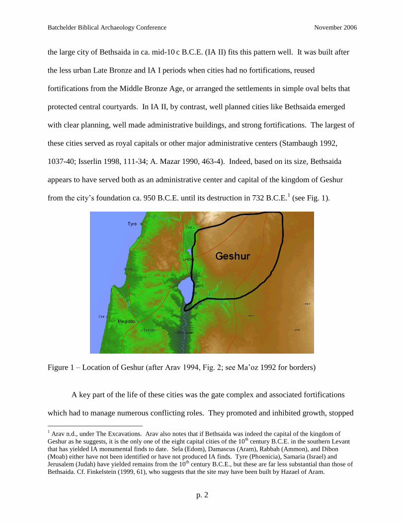
the large city of Bethsaida in ca. mid-10 c B.C.E. (IA II) fits this pattern well. It was built after
the less urban Late Bronze and IA I periods when cities had no fortifications, reused
fortifications from the Middle Bronze Age, or arranged the settlements in simple oval belts that
protected central courtyards. In IA II, by contrast, well planned cities like Bethsaida emerged
with clear planning, well made administrative buildings, and strong fortifications. The largest of
these cities served as royal capitals or other major administrative centers (Stambaugh 1992,
1037-40; Isserlin 1998, 111-34; A. Mazar 1990, 463-4). Indeed, based on its size, Bethsaida
appears to have served both as an administrative center and capital of the kingdom of Geshur
from the city’s foundation ca. 950 B.C.E. until its destruction in 732 B.C.E.1 (see Fig. 1).
Figure 1 – Location of Geshur (after Arav 1994, Fig. 2; see Ma’oz 1992 for borders)
A key part of the life of these cities was the gate complex and associated fortifications
which had to manage numerous conflicting roles. They promoted and inhibited growth, stopped
1 Arav n.d., under The Excavations. Arav also notes that if Bethsaida was indeed the capital of the kingdom of
Geshur as he suggests, it is the only one of the eight capital cities of the 10th
century B.C.E. in the southern Levant
that has yielded IA monumental finds to date. Sela (Edom), Damascus (Aram), Rabbah (Ammon), and Dibon
(Moab) either have not been identified or have not produced IA finds. Tyre (Phoenicia), Samaria (Israel) and
Jerusalem (Judah) have yielded remains from the 10th
century B.C.E., but these are far less substantial than those of
Bethsaida. Cf. Finkelstein (1999, 61), who suggests that the site may have been built by Hazael of Aram.

Batchelder Biblical Archaeology Conference November 2006
p. 3
and enhanced the flow of traffic, and served both military and civic functions. The fortifications
acted to protect the city and thus promote its growth, but their very presence limited its
maximum size. They were designed to stop armies, bandits and other hostile elements from
entering the cities, yet had to allow traffic to flow in and out of the city with a minimum of
hindrance. In addition, the natural funneling of traffic through the city’s gate or gates made them
natural meeting places and thus common sites for commercial, judicial, religious, and other
functions (Herzog 1976, V; 1992, 844-452). The majority of these functions can be seen built
into the IA II gate complex at Bethsaida as described in the following section.
FORTIFICATIONS AT BETHSAIDA
In addition to illustrating the typical functions of city gates, the fortifications at Bethsaida
also reflect the best defenses available at the time of IA II. Thick, solid walls like at Bethsaida
provided more protection than hollow casemate walls, still in use at some sites at this time. City
walls were typically 2-7 meters thick (A. Mazar 1990, 465-66), and the 6-8 meter thick walls at
Bethsaida were among the largest. Walls were often built of mud-brick on top of a modest stone
foundation, but some, like at Bethsaida, were made largely or entirely of stone. Certain cities
also had a second, outer wall as well as a glacis, a hard sloping surface extending out from the
base of a wall. Both the glacis and second wall were designed to prevent attackers from
approaching the main walls with equipment such as battering rams. Bethsaida had these features
too. Finally, gate complexes varied in size and strength, and as was mentioned earlier, Bethsaida
boasted a double-gate complex of unparalleled size.3
2 For references to biblical passages that illustrate these functions, see B. Mazar 1990, 469.
3 For more complete discussions of types of fortifications, see Isserlin (1998, 134-37), Herzog (1992, 848-52), B.
Mazar (1990, 465-70), and the somewhat dated but helpful Yadin (1963, vol. 2).

Batchelder Biblical Archaeology Conference November 2006
p. 4
The massive fortifications at Bethsaida apparently date to the city’s beginnings.4 The city
wall and the Bit Hilani palace (Arav 1999, 45-84) that would have served as the city’s
administrative center, apparently both date to IA IIA (950-850 B.C.E.; Stratum 6). In IA IIB
(850-732 B.C.E.; Stratum 5) the builders reused the city wall but rebuilt and expanded the gate
complex, to be discussed below.
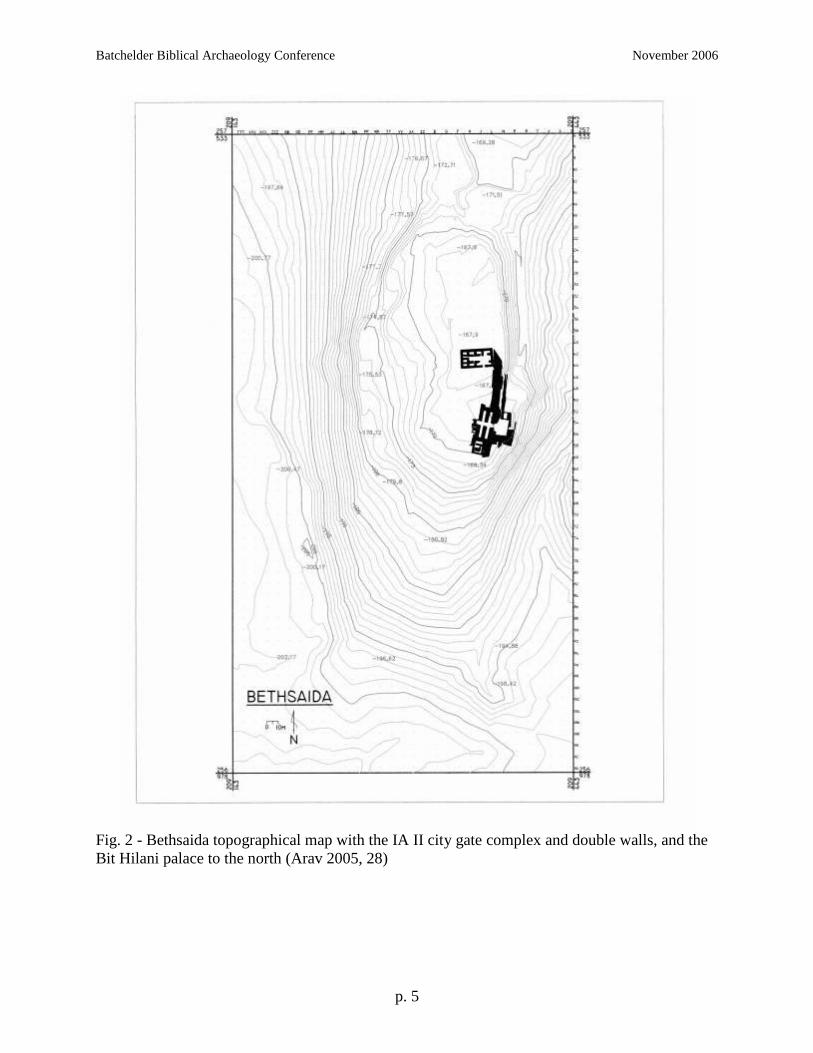
The city was built just east of the Jordan River on a hill of basalt that extends south from
the Golan Heights toward the Sea of Galilee. The site cover approximately 8 hectares (ca. 20
acres; Arav 1995, 3), making Bethsaida one of the largest Iron Age cities in the southern Levant
(Arav n.d., Introduction5). The hill is surrounded by ravines on the east, south and west (see Fig.
2), making the northern side the most accessible. Both the modern and ancient roads approach
the site from that direction. The ancient road has been traced for several hundred meters, leading
toward the city from a north-northeasterly direction with the plateau of the Golan in the distance.
The Approach to the City Gate
The ancient road approaches the city on the eastern side of the mound, skirting the deep
ravine on that side. To help protect the city, the builders of Bethsaida brought the road up to the
northeastern corner of the city, then ran it alongside the city walls. The ravine ensured that
attackers had to approach the gate on this road, keeping them within easy range of defenders
posted on top of the walls. The builders of Bethsaida also constructed three terraces on the
eastern side of the mound, apparently in order to widen the hill and make room for their wide but
well protected approach. The approach road averages four meters in width, apparently wide
4 Some potsherds and a very small number of architectural remains at Bethsaida date to the Early Bronze Age, the
earliest of the site’s seven known strata. However, given the paucity of the EB finds, the IA strata appear to present
the first meaningful phases of occupation. The final four of the site’s seven strata date from IA IIC (732 B.C.E.)
through the 20th
century C.E. (Arav 1999, 14-15). 5 Unless otherwise noted, the material in the rest of this section is drawn from Arav n.d., Architecture.
Batchelder Biblical Archaeology Conference November 2006
p. 5
Fig. 2 - Bethsaida topographical map with the IA II city gate complex and double walls, and the
Bit Hilani palace to the north (Arav 2005, 28)

Batchelder Biblical Archaeology Conference November 2006
p. 6
enough for two ox-drawn carts to pass.6 The gentle incline of ca. 6.5 degrees approaching the
gate makes for an easy ascent. The final 50 meters was paved in Stratum 6 with basalt
cobblestones ca. 30-40 cm in diameter, carefully fitted to one another. These made for a highly
durable pavement that apparently continued to be used until the city wall collapsed and covered
it, probably during an earthquake. Roman tombs dug into the road with accompanying Roman
potsherds dating to the 1st-4
th centuries C.E. suggest that the road was in use until this time,
making a lifespan for the road of approximately 1000 years.
The City Walls
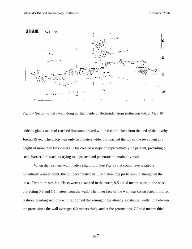
The city walls that ran parallel to this road for part of their distance have been exposed
north of the gate complex as well as a 56-meter long section on the northern side of the city (see
Fig. 3). Sections in both of these areas show that Bethsaida had a large, inner wall and a
smaller, outer wall. The walls were apparently built in the mid-10 c B.C.E. (Str. 6) and
continued in use from the late 10 – late 8 c B.C.E. (Str. 5).
The city’s builders went to great efforts when constructing the large, inner wall. Arav7
notes that the builders cleared the area for the wall down to bedrock before beginning
construction. The wall’s outer face had a revetment wall, a facing built to sustain an
embankment such as a glacis. The revetment followed the city wall at a distance of 3.5 meters,
creating a free rampart that would have kept battering rams away from the main city wall. The
builders used large boulders (some 0.9 x 0.7 x 0.5 m) to make the revetment wall, and then
6 For further discussion see Arav n.d., Architecture: The Approach to the City Gate.
7 Description of city walls taken from Arav 1999, 84-85, 102-4 as well as Arav n.d., The City Walls.
Batchelder Biblical Archaeology Conference November 2006
p. 7
Fig. 3 – Section of city wall along northern side of Bethsaida (from Bethsaida vol. 2, Map 10)
added a glacis made of crushed limestone mixed with red earth taken from the bed of the nearby
Jordan River. The glacis was only two meters wide, but reached the top of the revetment at a
height of more than two meters. This created a slope of approximately 32 percent, providing a
steep barrier for attackers trying to approach and penetrate the main city wall.
When the northern wall made a slight turn (see Fig. 3) that could have created a
potentially weaker point, the builders created an 11.4 meter-long protrusion to strengthen the
area. Two more similar offsets were excavated in the north, 9.5 and 8 meters apart to the west,
projecting 0.6 and 1.5 meters from the wall. The inner face of the wall was constructed in mirror
fashion, creating sections with reinforced thickening of the already substantial walls. In between
the protrusions the wall averages 6.2 meters thick, and at the protrusions, 7.2 to 8 meters thick.
Batchelder Biblical Archaeology Conference November 2006
p. 8
The inner and outer faces of this wall were made of massive boulders weighing several
hundred kilograms each, with smaller stones filling the space between. At the more vulnerable
corners of the offsets or towers, the builders used even larger stones (see notations on Fig. 3),
some weighing more than one metric ton. Remnants of plaster on some of the stones indicate
that the outer face of the wall was covered with thick white plaster, presenting a large,
impressive white wall that would have contrasted with the dark soil and black basalt rock of the
region. The wall has survived up to a height of three meters in places.
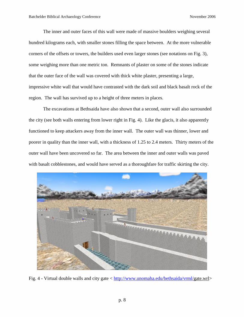
The excavations at Bethsaida have also shown that a second, outer wall also surrounded
the city (see both walls entering from lower right in Fig. 4). Like the glacis, it also apparently
functioned to keep attackers away from the inner wall. The outer wall was thinner, lower and
poorer in quality than the inner wall, with a thickness of 1.25 to 2.4 meters. Thirty meters of the
outer wall have been uncovered so far. The area between the inner and outer walls was paved
with basalt cobblestones, and would have served as a thoroughfare for traffic skirting the city.
Fig. 4 - Virtual double walls and city gate < http://www.unomaha.edu/bethsaida/vrml/gate.wrl>

Batchelder Biblical Archaeology Conference November 2006
p. 9
The Gate Complex
An army that wished to attack Bethsaida would have had to approach next to the double
walls, as discussed earlier, then attempted to penetrate the large (ca. 17 x 35 m - Arav 1999, 26)
gate complex, located on the eastern side of the city (see Fig. 5). Placing the gate on the east
Fig. 5 – The IA II city gate, double walls, and Bit Hilani palace (from Arav 2005, n.p.)
rather than on the more accessible north forced attackers to skirt the walls with defenders
undoubtedly raining down fire from above. The attackers would have to penetrate the double
doors of an outer gate, visible in Figure 4. They would then find themselves in a single room ca.
12 x 7 m, of which only the western wing has survived. The Assyrian army which penetrated
the city through the gate in 732 B.C.E. apparently tore down the entire eastern side of the gate
complex (see Fig. 6) and rolled its stones into the ravine.

Batchelder Biblical Archaeology Conference November 2006
p. 10
Fig. 6 – Virtual City Gate of IA II Bethsaida < http://www.unomaha.edu/bethsaida/vrml/
gate.wrl>
After passing through the outer gate, attackers would find themselves in a spacious,
paved courtyard in the middle of the gate complex. Defenders ringing the top of the gate
compound could fire at attackers from all angles (see Figure 6). The courtyard measures
approximately 191 m2, larger than similar IA II courtyards found at Megiddo (172 m
2) and Dan
(79 m2). During peacetime, an estimated 200 people could use the courtyard at any one time,
making the place eminently suitable in peacetime for the various commercial, religious and other
activities mentioned earlier. A total of 25 m of stone benches lined the walls of the courtyard at
Bethsaida. They were 20 cm high and covered with plaster and white wash. The courtyard also
served as the site for religious functions, as shown by the five stelae uncovered there, one on
each side of both pairs of gates and a single stele with a carving of an Aramean god on of top of
the stepped high place to the right of the inner gate (see Figure 7 and Arav n.d. for a more
complete discussion).

Batchelder Biblical Archaeology Conference November 2006
p. 11
Fig. 7 – Virtual view of courtyard of gate complex. Note inner gates, benches, three steles near
inner doors. < http://www.unomaha.edu/bethsaida/vrml/gate.wrl>
Walls and towers surrounded the courtyard on all sides. Large towers (12.5 x 5.6 m; see
Fig. 6) flanked the inner gate on the west side of the courtyard. A bastion or lookout tower stood
on the southeast, connected to the outer gate by a thick wall (see Fig. 6).
From within the gate courtyard, attackers had to make a right-hand turn to attack the
heavier, 4-m wide main gate from within the gate compound. Bethsaida’s inner gate complex is
the largest yet uncovered in the entire region, as noted earlier.8 It was built from large, coarsely-
dressed fieldstones covered in plaster and white wash. The stone construction survived to a
height of three meters in one part of the gate. Sun-dried mud-bricks that had collapsed from the
upper levels show that the second and third stories were made of brick, and the entire
construction was covered with plaster and white wash.
8 See Arav n.d. (esp. table under The Inner City Gate) for measurements and further discussion. Also note Arav’s
conjecture that the city gates of other capitals in the region, not yet uncovered, may have been as large.

Batchelder Biblical Archaeology Conference November 2006
p. 12
The inner gate has piers that form four chambers, as was common in IA II, leaving a 4 m-
wide road between the chambers (see Fig. 5). The four chambers measure ca. 10 x 3 m each
(Arav 1999, 27-30). Their main function appears to have been for storage of grain, perhaps as
much as one ton in each chamber. Excavations uncovered a layer of charred barley
approximately one meter thick in one chamber, obviously burned when the Assyrians penetrated
the gate and conquered the city. Chamber 4 on the northeast side of the gate is closest to the
stepped high place on the other side of the doors, and that chamber yielded thousands of
potshards during excavation, evidently from offering vessels used for rituals conducted at the
high places.
Despite Bethsaida’s impressive and well made gate complex, walls and approach road,
the Assyrian army did penetrate the fortifications and conquer the city in 732 B.C.E. The
Assyrians apparently attacked the gate complex rather than the much more accessible northern
wall of the city. On the north, the 6-8 m thick inner wall, the 2 m thick rampart set out 3.5 m
from the wall, plus the steep 2 m wide glacis and then a 2 m thick outer wall, combined to form a
set of fortifications over 15 m deep. These defenses apparently discouraged any attack on the
north, as no sling stones, arrowheads or ashes appeared in the excavations in that area.
Instead the Assyrians attacked the gate complex on the east, despite the obvious
challenges. The Assyrians would have used battering rams to flatten the doors of the outer gate,
where excavators found bits of carbonized wood. Large numbers of bent arrowheads, sling
stones of various sizes, and spear- and lance-heads recovered in the gate area attest to the
ferocity of the battle. The attackers would have brought their battering ram into the courtyard of
the gate complex and turned it toward the inner gate, despite what was probably withering fire

Batchelder Biblical Archaeology Conference November 2006
p. 13
from the defenders ringing the courtyard. The ram then penetrated the inner doors and the
Assyrians entered and finished capturing the city.
Afterward the Assyrians probably drove out the inhabitants with their possessions, and
then further destroyed parts of the city and its fortifications. The gods of Bethsaida received
particularly brutal treatment. The ritual objects stored at the gate were thoroughly smashed, as
noted earlier. The attackers broke off the tops of the stelae, thus “beheading” the gods. The stele
carved with the picture of the chief god was broken into multiple pieces. Such treatment was
obviously intended to show the superiority of the Assyrian gods over the gods of the vanquished.
The Assyrians then set fire to the city gate and burned the wood, grain, oil and other
flammable materials in the complex, perhaps augmented by bitumen brought from Assyria. The
blaze was so intense that it baked the mud-bricks and the plaster that coated the walls, and fused
much of the brick, plaster, rubble and ceramic material into more than a ton of hardened black
“clinkers,” apparently at a temperature higher than 1200º C (ca. 2200º F.). Not surprisingly, the
fire caused the collapse of the gate complex, creating an enormous pile of rubble. After the fire
the Assyrians thoroughly destroyed the entire eastern side of the gate complex, as discussed
earlier, apparently to discourage or prevent the rebuilding and reuse of the gate. Thousands of
tons of stone, earth and clay bricks would have been pushed into the ravine in an operation that
may have taken weeks to complete.9
COMPARISON WITH FORTIFICATIONS OF OTHER CITIES IN NORTHERN ISRAEL
How did the IA II fortifications at Bethsaida compare with those of contemporary cities
in the region? This final section will survey the cities in Bethsaida’s kingdom of Geshur and
then other major cities in northern IA Israel as far south as Megiddo in the Jezreel Valley.
9 Arav, n.d., The Picture of the Destruction. Arav also posits that the Assyrians may have had a part of their army
dedicated to carrying out such destructions.

Batchelder Biblical Archaeology Conference November 2006
p. 14
Fortifications in IA II Geshur
IA II Bethsaida apparently served as the capital of the kingdom of Geshur, a region of ca.
350 km2 (135 mi
2) situated east of the Sea of Galilee (see Fig. 1). The name Geshur may appear
in historical texts as early as the Amarna letters (mid-14 c B.C.E.).10
During the 11 c B.C.E.,
Geshur became strong enough to support a kingdom, and by the end of the 11 c, the kingdom
apparently built a new, strong capital at Bethsaida (Ma‘oz 1992, 996; Arav 2004, 6). At about
the same time, Geshur became an ally to King David (2 Sam 3:2-3), and David married Ma‘acah,
the daughter of Talmai, king of Geshur. David and Ma‘acah’s son Absalom sought asylum in his
mother’s homeland for three years after killing his half-brother Amnon (2 Sam 13:37-38, 14:23-
32, 15:7-8; see also Kochavi 1989, 2-3).11
An archaeological survey found 27 sites in Geshur settled during MB II, eight in the LB,
and 18 in the IA (Kochavi 1989, 996). Most of the Geshurite sites with significant IA remains
are situated just east of the Sea of Galilee (see Fig. 8). We now turn to survey those with IA
fortifications.
Figure 8 – Sites in Geshur with significant IA II remains
10
The “Land of Ga<su>ru” in EA 256. See Ma‘oz 1992, 996. 11
If Bethsaida had been established by Absalom’s time, he probably found refuge at the site.

Batchelder Biblical Archaeology Conference November 2006
p. 15
Tel Hadar
The remains at Tel Hadar seem to illustrate Geshur’s development. The excavator
suggests that the city was established as a royal citadel that acted as the defensive, economic and
commercial center, perhaps for the entire kingdom. The first IA level (Str. II) dates to the 11 c,
and the second (Str. I) to the 9-8 c. The remains from Str. II include two concentric stone walls
25 m apart—a 4 m thick outer wall and a 2.5 m thick inner wall, a configuration unique in
ancient Israel (Kochavi 1989, 15). The inner wall formed a gate on the east where one section of
the wall made a 45º angle with the next section (see Fig. 9).
Figure 9 – Tel Hadar, Stratum II. Note concentric walls, gate on east (from Kochavi 1993b,
551).
The city of Stratum II was destroyed in a great fire during the late 11 c. After a gap of
approximately two centuries, the site was resettled as a small farming village whose builders
reused the outer wall for defense and built over the inner wall. The site’s former importance had

Batchelder Biblical Archaeology Conference November 2006
p. 16
been supplanted by the newly built city administrative center at nearby ‘En Gev, discussed next
(Kochavi 1989, 9-11, 15; 1993b, 551-52).
‘En Gev
Following the destruction of Tel Hadar Str. II, a new administrative center was built
farther south along the shores of the Sea of Galilee at ‘En Gev (Kochavi 1989, 15; see Fig. 8).
This site was continuously occupied from its founding in the early 10 c until the Assyrian
campaign of 732 B.C.E. With an area of 3 ha., (ca. 7.5 a.), the site is one of the largest IA sites
in the Golan (Kochavi 1991, 183).
The site has five strata with IA II remains. Stratum V (early-mid 10 c) had a city wall
with a level stone foundation 1.85 m wide, apparently to support a mud-brick wall above (B.
Mazar 1993, 410; 1964, 7). In Stratum IV (mid 10-early 9 c), the mud-brick wall was replaced
by a large casemate wall built of large, undressed stones filled with smaller stones. The outer
line of the casemate was 1.75 m thick, separated by a 1.4 m space from the 1.15 m thick inner
wall, for a total width of 4.3 m. The casemate wall was similar to, but stronger than, the
casemate walls from Hazor (Str. IX-X) and Megiddo (Str. IVB-VA), perhaps because the flatter,
more vulnerable site at ‘En Gev called for stronger walls. B. Mazar interprets the remains of ‘En
Gev V and IV as Israelite. When the city was rebuilt in Stratum III, the builders changed the
layout and built a solid defensive wall instead of a casemate. They used the heavier external wall
from the casemate, and further strengthened sections to form a solid inset-offset wall ranging
from 1.75-3.15 m thick, similar to the walls at Megiddo IVA and Hazor VIII. ‘En Gev III also
had a glacis. Stratum III was destroyed by fire, then rebuilt apparently using the same city wall
and citadel. B. Mazar interprets the similarity of ‘En Gev III and II as the continuation of the
same ethnic group—in this case the Arameans who had captured the region from Israel. The

Batchelder Biblical Archaeology Conference November 2006
p. 17
final city of Str. I was unfortified and laid out on a different plan, apparently reflecting a re-
conquest by Israelites who lived there until the city’s final destruction by Assyria in 732 B.C.E.
(B. Mazar 1964, 9-15; 1993, 410-11; Kochavi 1993a, 411-12, who re-dates Str. III to the 9th
c).
IA ‘En Gev was clearly a major city in the region, apparently fought over by the
Arameans and Israelites. Kochavi (1993a, 412) suggests that the site should be identified with
biblical Aphek, where numerous battles between the two peoples took place according to the
biblical text (1 Kgs 20, 2 Kgs 13).
Tel Soreg
The third and final site with IA to be discussed here is Tel Soreg, a small site of less than
one acre situated east of ‘En Gev. It served as the home for farmers who tilled the nearby fields,
and would have been a satellite of ‘En Gev. Remains at the site reflect habitation for two
millennia from as far back as MB I, but the only time Tel Soreg was fortified was in the 9-8 c
Figure 10 – Tel Soreg. Note outer wall, cross-walls of casemate (from Kochavi 1993c, 1410).

Batchelder Biblical Archaeology Conference November 2006
p. 18
B.C.E., when ‘En Gev apparently served as a major forward position for the Arameans and Tel
Soreg would have been a fortified outpost as well as an agricultural settlement. The only
remains of note at Tel Soreg consist of a small casemate fort on the northeastern corner of the
site (Kochavi 1993c, 1410; see Fig. 10).
Geshur—Conclusion
This brief survey of Geshurite remains outside of Bethsaida demonstrates that settlement
in Geshur peaked in IA II, and that the fortifications at Bethsaida dwarf those at the other sites,
even compared to the administrative center at ‘En Gev. The Geshurites apparently built Tel
Hadar as an administrative center, perhaps their capital, in the 11th
century. After its destruction,
‘En Gev replaced Tel Hadar as the new primary city east of the Sea of Galilee. The destruction
of Tel Hadar may also have been the impetus for the building of Bethsaida, the kingdom’s
apparent new capital. The following chart summarizes the known information about the
fortifications at these sites in Geshur, with the information for Bethsaida included for
comparison.
Site Date Wall Type Wall Thickness Gate
Tel Hadar Str. II 11 c B.C.E. 2 concentric solid 4 m, 2.5 m Wall at 45º
angle
I 9-8 c Single solid 4 m None
‘En Gev Str. V Early-mid 10 c Stone/mud-brick 1.85 m None
IV Mid 10-early 9 c Casemate 4.3 m None
III Mid 9 c Inset-offset,
glacis, citadel
1.75-3.15 m None
II Mid 9-early 8 c Same as III Same as III None
I Early-mid 8 c None None None

Batchelder Biblical Archaeology Conference November 2006
p. 19
Tel Soreg 9-8 c Casemate fort None None
Bethsaida 10-8 c Solid 6-8 m 4-chamber
Figure 11 – Comparison of fortifications in IA II Geshur
Fortifications in IA II Northern Israel
We now turn to look at the significant IA II fortifications in the broader area of northern
Israel. The sites to be surveyed are Dan, Hazor and Kinneret in the north, Jokneam, Megiddo
and Taanach in the Jezreel Valley, and Beth Shean and Rehov in the Beth Shean Valley (see Fig.
12; cf. list in A. Mazar 2005, Table 2.2).
Figure 12 – Major IA II sites in northern Israel
Dan
The large site of Dan (20 ha./50 a.) in far northern Israel has several strata from IA II,
with two major phases of fortifications. The first major phase comes from Str. III (mid-9 c)
Batchelder Biblical Archaeology Conference November 2006
p. 20
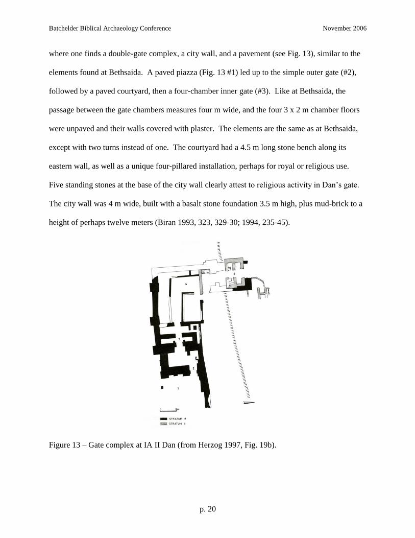
where one finds a double-gate complex, a city wall, and a pavement (see Fig. 13), similar to the
elements found at Bethsaida. A paved piazza (Fig. 13 #1) led up to the simple outer gate (#2),
followed by a paved courtyard, then a four-chamber inner gate (#3). Like at Bethsaida, the
passage between the gate chambers measures four m wide, and the four 3 x 2 m chamber floors
were unpaved and their walls covered with plaster. The elements are the same as at Bethsaida,
except with two turns instead of one. The courtyard had a 4.5 m long stone bench along its
eastern wall, as well as a unique four-pillared installation, perhaps for royal or religious use.
Five standing stones at the base of the city wall clearly attest to religious activity in Dan’s gate.
The city wall was 4 m wide, built with a basalt stone foundation 3.5 m high, plus mud-brick to a
height of perhaps twelve meters (Biran 1993, 323, 329-30; 1994, 235-45).
Figure 13 – Gate complex at IA II Dan (from Herzog 1997, Fig. 19b).

Batchelder Biblical Archaeology Conference November 2006
p. 21
The second major phase dates to the 8 c, when a second gate complex with another four-
chamber gate (#5) was added at the top of the paved road (#4) for additional security, perhaps for
a citadel. The upper gate has four chambers (#5) ca. 4.5 x 3.1 m which flank a passageway of
3.7 m. Both of these gate complexes were destroyed in the second half of the 8 c, apparently
during the same Assyrian invasion that destroyed Bethsaida (Biran 1993, 330; 1994, 250-54).
Hazor
The next site to the south with major IA fortifications is at Hazor, whose appearance in
the Mari documents, Amarna letters, and the Bible (Josh 11:10-13; 2 Kgs 15:29) reflect the
importance of the large site (80 ha./200 a.) for more than a millennium. By the time of IA II,
only the 12 ha. (30 a.) upper mound was fortified. Eleven strata date to the IA (XIII-III), but the
Figure 14a, b, c – Hazor Str. X, VIII, V (from Herzog 1997, Figs. 5.16, 5.20)
Batchelder Biblical Archaeology Conference November 2006
p. 22
major fortifications in IA II are as follows: Stratum X (mid-10 c; see Fig. 14a) includes a six-
chamber gate (ca. 18 x 20 m) and a casemate wall (ca. 5 m thick) that enclosed only the western
half of the upper city. These fortifications were ascribed to Solomon by Yadin, but their dating
is now contested (see Finkelstein 1999). In Str. VIII (9 c; see Fig 14b) the builders erected a
large citadel on the western end of the mound and filled in the earlier casemate wall to form a
solid wall ca. 4-6 m thick, which was expanded to encompass the entire upper mound. In Str. V
(8 c; see Fig. 14c), the builders added a solid inset-offset wall ca. 4-6 m thick on three sides of
the citadel in an effort to withstand the impending Assyrian attack. Obviously hey didn’t
succeed, as the Assyrians under Tiglath-pileser III destroyed the city. A layer of ash and rubble
1 m thick attests to the attack (Yadin 1993, 594-603).
Kinneret
The last of the northernmost three IA cities is Kinneret (Tell el-‘Orēme) on the northwest
corner of the Sea of Galilee. Remains at the site reflect habitation from the EB, MB II and IA II
periods, when the city would have dominated the nearby Ginnosar Plain and the international
highway that passed by. The name of the Sea of Galilee in Hebrew comes from this city, a
reflection of the site’s importance.
Excavations at the site show that the first major IA inhabitation was during the late IA I
(late 11c, Str. V, IV12
), when a massive wall of 5 – 12.3 m13
thick encircled an area of about four
ha. (10 a.). The wall had a glacis, an inner revetment (Zangenberg 2005:188), and a mud-brick
12
Dates for strata from Kinneret Regional Project: Stratigraphy, cited 6 Oct 2006. 13
Fritz 1993 (p. 300) and 1999 (p. 98) give the maximum width as 11 m, but Münger 1999 (p. 18) gives 12 m and
Münger personal communication (2006) with the author of this article gives 12.3 m.

Batchelder Biblical Archaeology Conference November 2006
p. 23
superstructure. The city was destroyed late 10-early 9 c14
, and rebuilt at the end of the 9-early 8
c (Str. II) on a smaller scale. The wall, now 2.5 - 4 m thick encircled just 0.8 ha. (2 a.) on the
upper part of the site (see Fig. 15). Four large towers, each ca. 400 m2, guarded the northwestern
and northwestern sides, and a two-chamber gate (ca. 14 x 8 m; see Fig. 15) was located on the
east.
Figure 15 – Kinnereth Str. II (9-8 c) with towers, 2-chamber gate (from Herzog 1993, Fig. 5.25)
Excavators found gate’s chambers and passageway filled with two meters of burned mud-brick
and ash, reflecting the city’s destruction in the second half of the 8 c, apparently by Tiglath-
pileser III in 732 B.C.E. (Fritz 1993, 299-300; 1999, 98; Fritz & Münger 2002, 8).
Jokneam
This survey now moves further south to the Jezreel Valley, beginning with Jokneam,
which guarded the westernmost of the three passes through the Carmel Range. The site has 27
14
Fritz (1999, 94) suggests that inhabitants of the city of Str. V-IV were Canaanite, but does not offer a suggestion
as to who may have destroyed it. Given the date of the destruction (late 10-early 9 c), David may have conquered
the city during his expansion.

Batchelder Biblical Archaeology Conference November 2006
p. 24
occupational levels, spanning nearly 4,000 years. Jokneam was settled but unfortified in IAI, but
had a well developed fortification system in IA II. Str. XIV (10 c) was protected by a large
casemate wall, replaced in Str. XII (end 10/early 9 c) by a double city wall. The outer was ca. 2
m thick, and the inner ca. 1.5 m thick. A space of ca. 1.5 m in between the walls served as a
passageway (Ben-Tor 1993, 805-8).
Taanach
Toward the southeastern end of the Jezreel Valley along the Carmel Range, one finds the
site of Taanach which did not guard a pass through the Carmel, but did serve as an Israelite
administrative and religious center by the 10 c B.C.E. The fortifications of Str. II (13-9 c)
include an east fortress, plus some fortifications on the west dating to the 12 c, but a clear picture
of the site’s defenses is lacking (Glock 1993, 1428-32).
Megiddo
The third site from the Jezreel Valley, Megiddo, covers an area of about six ha. (15 a.).
The city dominated the central pass through the Carmel Range and thus the major international
highway (Via Maris) that passes the site as it enters the Jezreel Valley. Megiddo was a major
fortified city as far back as the EB period (Aharoni 1993, 1003-9), and during the IA served as
one of Solomon’s administrative centers (1 Kgs 4:12) which he fortified (1 Kgs 9:15) along with
Hazor and Gezer.
Megiddo contains the most IA remains of the cities in the Jezreel Valley, but their dating
is contested. Yadin originally laid out the stratigraphy of Megiddo (see summary in Stern 1990,

Batchelder Biblical Archaeology Conference November 2006
p. 25
13-14), but his work has been modified by a number of others.15
Herzog summarizes the IA
remains as follows: Str. VA (see Fig. 16) had no city wall, but a ring of residences protected the
mound, along with a simple gate on the north and a fortress on the south (Herzog 1997, 212).
Figure 16 – Megiddo Str. VA (10 c) with gate, ring of houses, fortress (from Herzog 1993, Fig.
5.15)
15
For example, Ussishkin and Finkelstein propose redating Str. VA-IVB and IVA to a century later than Yadin,
pushing the six-chamber gate and offset-inset wall to the 9th
c (Finkelstein 2000, 140-53; personal communication
2006).

Batchelder Biblical Archaeology Conference November 2006
p. 26
Str. IVB (? – 8 c; see Fig. 17) had a gate complex and solid inset-offset walls. The gate
complex started with a two-chamber outer gate, then made a turn to the left, passing through a
six-chamber gate (ca. 20 x 18 m) with solid towers at the front. The attached city wall was 3.6 m
thick, made of a stone foundation and mud-brick superstructure. The 6 m long sections were
offset by .5 - .6 m (Herzog 1997, 226-29). Str. IVA (8 c) continued with the same fortifications
as IVB, except that the gate was rebuilt as a four-chamber gate (25 x 16 m) also connected to the
offset-inset wall (Herzog 1997, 229).

Batchelder Biblical Archaeology Conference November 2006
p. 27
Figure 17 – Megiddo Str. IVB (?-8 c) with double gate including 6-chamber gate, offset-inset
wall (from Herzog 1993, Fig. 5.21, labeled as IVA)
Beth Shean
The last two sites surveyed in this paper are located at the eastern end of the Beth Shean
Valley where E-W and N-S routes intersect (see Fig. 12). Only the second site has meaningful
IA II fortifications. The major site of Beth Shean is mentioned in the Bible as a city not
conquered by the Israelites (Josh 17:11; Judg 1:27), as the place where the Philistines hung the
body of Saul (1 Sam 31:10), and as an administrative center under Solomon (1 Kgs 4:12). The
city had three main IA strata, the last of which was apparently destroyed by Tiglath-pileser III
and the Assyrians in the 8 c B.C.E. (A. Mazar 1993, 214-22). The most recent excavations
suggest that the town was not fortified during the IA (A. Mazar 2006, 36).
Rehov
The more important IA II site in the Beth Shean Valley is Rehov, the largest mound in
the valley and the dominant city during the IA. Rehov is located ca. 7 km (4 mi) south of Beth
Shean. Rehov does not appear in the Bible, but the mound was occupied from the EB through
the IA II periods (Vitto 1993, 1272). Rehov Str. VI-V date to the 10 c and Str. IV to the 9 c,
when the city covered the entire 10.2 ha. (26 a.) mound. During Str. III (9-8 c) the city shrank to
half its former size and occupied just the upper mound (A. Mazar n.d., Intro, History, Iron IIA,
Iron IIB).
Surprisingly, the IA fortifications and other buildings exhibit only mud-brick
construction without stone foundations. Wood sometimes appears in the foundations of both
walls and floors, perhaps to provide stability in the event of an earthquake. The cities of Str. VI-

Batchelder Biblical Archaeology Conference November 2006
p. 28
V were apparently unfortified (A. Mazar 2000, 43). In Str. IV a tower and a double wall,
possibly a casemate (walls 1.35 & 1.2 m thick), appear, parallel to the slope of the mound. So
far such defensive elements have been found only on the upper mound. In Str. III, a massive but
poorly built 9.5 m thick mud-brick wall appears, apparently constructed hurriedly to withstand
the Assyrian invasion that came in 732 B.C.E. (A. Mazar n.d., Iron Age IIA, IIB; 1999, III. The
Upper Mound, Stratum B-3). As with the other sites surveyed, the fortifications at Rehov failed
to stop the Assyrian attackers. Graphic evidence of this destruction came to light at Rehov in the
form of two human skeletons. One was decapitated; the other, a woman, was thrown into the
corner of a room where she died (A. Mazar 1999, n.p.; 2000, 47).
The IA II fortifications in northern Israel surveyed may be summarized as follows:
Site Date Wall Type Wall Thickness Gate
Dan III Mid 9 c Solid stone/brick 4 m Outer + 4-
chamber
III 8 c Same Same 4-chamber
Hazor X Mid 10 c Casemate 5 m 6-chamber
VIII 9 c Solid, filled
casemate
5 m ?
V 8 c Solid, offset-inset 3 - 5 m ?
Kinnereth V, IV Late 11 c Solid 5 - 12.3 m ?
II 8 c Solid 2.5 - 4 m 2-chamber
Jokneam XIV 10 c Casemate 7 m ?
XII End 10 – early 9 c Double 2 m, 1.5 m ?
Taanach II 13-9 c ? ? ?
Megiddo VA 10 c Residences --- Simple
IVB ? – 8 c Offset-inset 3.6 m 6-chamber

Batchelder Biblical Archaeology Conference November 2006
p. 29
IVA 8c Same Same 4-chamber
Beth Shean IA None None None
Rehov IV 9 c Double 1.35 m, 1.2 m ?
III 9 – 8 c Offset-inset 9.5 m ?
Figure 18 – Comparison of fortifications in IA II northern Israel
CONCLUSION
Simply put, the IA II fortifications at Bethsaida have no contemporary peer in the region.
The IA defenses of known Geshurite sites pale in comparison. The defenses at other IA II sites
in northern Israel are often impressive, and some elements may exceed parts of the system at
Bethsaida (walls 9.5, 12.3 m thick at Rehov III and Kinnereth V, IV), but the overall defensive
systems known from these other sites do not match the IA II system at Bethsaida in size,
materials and complexity. Perhaps more remains will come to light at some of these sites (i.e.
Rehov), or other sites in the region may yet yield equally impressive remains. To date however,
the known defensive systems in IA II Geshur and northern Israel do not match those at
Bethsaida. Sadly, none of the defenses, event at Bethsaida, were able to withstand the Assyrian
attack in 732 B.C.E., and the fortifications were all destroyed.
Batchelder Biblical Archaeology Conference November 2006
p. 30
LITERATURE CITED
Aharoni, Yohanan. 1993. “Megiddo.” In The New Encyclopedia of Archaeological Excavations
in the Holy Land. Ephraim Stern et al., eds. New York: Simon & Schuster.
Arav, Rami. 1995. Bethsaida Excavations: Preliminary Report, 1987-1993. In Bethsaida: A City
by the North Shore of the Sea of Galilee, vol. 1. Rami Arav & Richard A. Freund, eds.
Kirksville, Mo.: Truman State Univ. Press.
________. 1999. Bethsaida Excavations: Preliminary Report, 1994-1996. In Bethsaida: A City
by the North Shore of the Sea of Galilee, vol. 2. Rami Arav & Richard A. Freund, eds.
Kirksville, Mo.: Truman State Univ. Press.
________. 2004. Toward a Comprehensive History of Geshur. In Bethsaida: A City by the North
Shore of the Sea of Galilee, vol. 3. Rami Arav & Richard A. Freund, eds. Kirksville, Mo.:
Truman State Univ. Press.
________. 2005. Bethsaida Excavations Project: The Season of 2005, Field Report. Cited 24
October 2006. Online: http://www.unomaha.edu/bethsaida/reports/
bethsaida_report_2005_rev.doc
________. n.d. Stratum 5: The City Gate. For Bethsaida: A City by the North Shore of the Sea of
Galilee, vol. 4. Forthcoming.
Ben-Tor, Amnon. 1993. “Jokneam.” In The New Encyclopedia of Archaeological Excavations in
the Holy Land. Ephraim Stern et al., eds. New York: Simon & Schuster.
Biran, Avraham. 1993. “Dan.” In The New Encyclopedia of Archaeological Excavations in the
Holy Land. Ephraim Stern et al., eds. New York: Simon & Schuster.
________. 1994. Biblical Dan. Jerusalem: Hebrew Union College.
Finkelstein, Israel. 1999. “Hazor and the North in the Iron Age: A Low Chronology
Perspective.” Bulletin of the American Schools of Oriental Research 314: 55-70.
________, David Ussishkin & Baruch Halpern, eds. 2000. Megiddo III: The 1992-1996 Seasons.
2 vol. Monograph Series 18. Tel Aviv: Institute of Archaeology.
Fritz, Volkmar. 1990. Kinneret: Ergebnisse der Ausgrabungen auf dem Tell el-‘Orēme am See
Gennesaret 1982-1985. Wiesbaden: Otto Harrassowitz.
________.1993. “Chinnereth, Tel.” In The New Encyclopedia of Archaeological Excavations in
the Holy Land. Ephraim Stern et al., eds. New York: Simon & Schuster.

Batchelder Biblical Archaeology Conference November 2006
p. 31
________. 1999. “Excavations at Tell el-Oreimeh (Tel Kinrot): Preliminary Report on the 1994-
1997 Seasons.” Tel Aviv 26 (1): 92-115.
________ & Stefan Münger. 2002. “Vorbericht über die zweite Phase der Ausgrabungen in
Kinneret (Tell el-‘Orēme) am See Gennesaret, 1994-1999.” Zeitschrift des Deutschen
Palästina-Vereins 118: 2-32.
Glock, Albert. 1993. “Taanach.” In The New Encyclopedia of Archaeological Excavations in the
Holy Land. Ephraim Stern et al., eds. New York: Simon & Schuster.
Herzog, Ze’ev. 1976. The City-Gate in Eretz-Israel and its Neighboring Countries. Tel Aviv:
Institute of Archaeology
________. 1992. Fortifications (Levant). In The Anchor Bible Dictionary, edited by David Noel
Freedman, et al. New York: Doubleday.
________. 1997. Archaeology of the City: Urban Planning in Ancient Israel and Its Social
Implications. Monograph Series 13. Tel Aviv: Institute of Archaeology.
Isserlin, B. S. J. 1998. The Israelites. London: Thames and Hudson.
Kinneret Regional Project. “Kinneret Regional Project: Stratigraphy.” No pages. Cited 6 Oct
2006. Online: http://www.kinneret-excavations.org/site1.html.
Kochavi, Moshe. 1989. “The Land of Geshur Project: Regional Archaeology of the Southern
Golan (1987-1988 Seasons).” Israel Exploration Journal 39, no. 1-2: 1-17.
________. 1991. “The Land of Geshur Project, 1989-1990.” Israel Exploration Journal 41, no.
1-3: 180-84.
________. 1993a. “‘En Gev: Recent Excavations.” In The New Encyclopedia of Archaeological
Excavations in the Holy Land. Ephraim Stern et al., eds. New York: Simon & Schuster.
________. 1993b. “Hadar, Tel.” In The New Encyclopedia of Archaeological Excavations in the
Holy Land. Ephraim Stern et al., eds. New York: Simon & Schuster.
________. 1993c. “Soreg, Tel.” In The New Encyclopedia of Archaeological Excavations in the
Holy Land. Ephraim Stern et al., eds. New York: Simon & Schuster.
Loud, Gordon. 1948. Megiddo II: Seasons of 1935-39. Chicago: Univ. of Chicago.
Ma‘oz, Zvi. 1992. Geshur. In The Anchor Bible Dictionary, edited by David Noel Freedman, et
al. New York: Doubleday.

Batchelder Biblical Archaeology Conference November 2006
p. 32
Mazar, Amihai. 1990. Archaeology of the Land of the Bible 10,000-586 B.C.E. Anchor Bible
Reference Library. New York: Doubleday.
________. 1993. “Beth-Shean.” In The New Encyclopedia of Archaeological Excavations in the
Holy Land. Ephraim Stern et al., eds. New York: Simon & Schuster.
________. 1999. “The 1997-1998 Excavations at Tel Rehov: Preliminary Report.” Israel
Exploration Journal 49:1-42. Cited 20 Oct 2006. Online: http://www.rehov.org/Rehov/
publications/index1.htm.
________. 2000. “Will Tel Rehov Save the United Monarchy?” Biblical Archaeology Review
Mar/Apr: 38-51, 75
________. 2005. “The Debate over the Chronology of the Iron Age in the Southern Levant.”
Pp. 15-30 in The Bible and Radiocarbon Dating. Archaeology, Text and Science. T.E.
Levy and T. Higham, eds. London: Equinox.
________. 2006. Excavations at Tel Beth-Shean 1989-1996. Vol. 1. Jerusalem: Institute of
Archaeology, Hebrew University.
________. n.d. “Tel Rehov.” After article submitted to the Encyclopedia of Archaeological
Excavations in the Holy Land, Supplementary Volume, E. Stern, ed. No pages. Cited 20
Oct 2006. Online: http://www.rehov.org/Rehov/Results.htm.
Mazar, Benjamin, et al. 1964. “‘Ein Gev: Excavations in 1961.” Israel Exploration Journal 14,
no. 1-2: 1-49.
________. 1993. “‘En Gev: Excavations on the Mound.” In The New Encyclopedia of
Archaeological Excavations in the Holy Land. Ephraim Stern et al., eds. New York:
Simon & Schuster.
Münger, Stefan. “Kinneret (Tell el-‘Orēme/Tel Kinrot) 1999.” Rundbrief der Schweizerischen
Gesellschaft für orientalische Altertumswissenschaft 45:17-19.
Shiloh, Yigal. 1993. “Megiddo: The Iron Age.” In The New Encyclopedia of Archaeological
Excavations in the Holy Land. Ephraim Stern et al., eds. New York: Simon & Schuster.
Stambaugh, John E. 1992. Cities. In The Anchor Bible Dictionary, edited by David Noel
Freedman, et al. New York: Doubleday.
Stern, Ephraim. 1990. “Hazor, Dor and Megiddo in the time of Ahab and under Assyrian Rule.”
Israel Exploration Journal 40: 12-30.
Vitto, Fanny. 1993. “Rehob.” In The New Encyclopedia of Archaeological Excavations in the
Holy Land. Ephraim Stern et al., eds. New York: Simon & Schuster.
Batchelder Biblical Archaeology Conference November 2006
p. 33
Yadin, Y. 1963. The Art of Warfare in Biblical Lands in the Light of Archaeological Studies. 2
vols. Trans. M. Pearlman, from Hebrew. New York: McGraw-Hill.
________. 1993. “Hazor.” In The New Encyclopedia of Archaeological Excavations in the Holy
Land. Ephraim Stern et al., eds. New York: Simon & Schuster.
Zangenberg, Jürgen, Stefan Münger, and Juha Pakkala. 2005. “Excavations on the Sea of Galilee
– The 2004 Season of the German-Finnish-Swiss Expedition to Tel Kinrot.” Jahrbuch des
DEIAHL/Annual of the GPIA 9/10: 187-191.


![Penland, Patrick R., LEd.] Pittsburgh Univ., Pa. Graduate ...](https://static.fdokumen.com/doc/165x107/63201b7294d995f22f073c7c/penland-patrick-r-led-pittsburgh-univ-pa-graduate-.jpg)


![Download this - Jurnal - Univ. Bandar Lampung [UBL]](https://static.fdokumen.com/doc/165x107/6314115c15106505030b3038/download-this-jurnal-univ-bandar-lampung-ubl.jpg)
![Untitled - Jurnal - Univ. Bandar Lampung [UBL]](https://static.fdokumen.com/doc/165x107/63150beec72bc2f2dd04947c/untitled-jurnal-univ-bandar-lampung-ubl.jpg)