Periglacial landforms at the Phoenix landing site and the northern plains of Mars
Icarus 202 (2009) 60–77
Contents lists available at ScienceDirect
Icarus
www.elsevier.com/locate/icarus
Geological evolution of Ares Vallis on Mars: Formation by multiple eventsof catastrophic flooding, glacial and periglacial processes
Andrea Pacifici ∗, Goro Komatsu, Monica Pondrelli
International Research School of Planetary Sciences, Università d’Annunzio, Viale Pindaro, 42, 65127 Pescara, Italy
a r t i c l e i n f o a b s t r a c t
Article history:Received 26 March 2008Revised 16 January 2009Accepted 27 February 2009Available online 14 March 2009
Keywords:Mars, climateMars, surfaceGeological processesIces
Ares Vallis is one of the greatest outflow channels of Mars. Using high-resolution images of recentmissions to Mars (MGS, 2001 Odyssey, and Mars Express), we investigated Ares Vallis and its valleyarms, taking advantage of 3-dimensional analysis performed using the high-resolution stereo capabilityof the Mars Express High Resolution Stereo Camera (HRSC). In our view, Ares Vallis is characterizedby catastrophic flood landscapes partially superimposed by ice-related morphologies. Catastrophic floodlandforms include erosional terraces, grooved terrains, streamlined uplands, giant bars, pendant bars,and cataract-like features. Ice-related morphologies include probable kame features, thermokarsticdepressions, and patterned grounds. Our investigations outline that throughout the Hesperian age, AresVallis and its valley arms had been sculpted by several, time-scattered, catastrophic floods, originatingfrom Iani, Hydaspis and Aram Chaos. Geomorphological evidence suggests that catastrophic floods wereice-covered, and that climatic conditions of Mars at this time were similar to those of the present day.At the end of each catastrophic flood, ice masses grounded, forming a thick stagnant dead-ice body.Each catastrophic flood was followed by a relatively brief period of warmer-wetter climatic conditions,originated as a consequence of catastrophic flooding. During such periods thermokarstic depressionsoriginated, liquid water formed meandering channels, and ice-contact deposits were emplaced by ice-walled streams. Finally, the climate turned into cold-dry conditions similar to the present-day ones, andice masses sublimated.
© 2009 Elsevier Inc. All rights reserved.
1. Introduction
Outflow channels on Mars are large complexes of fluid-erodedtroughs up to 100 km wide and 2000 km long. The flows thatformed martian outflow channels appear to have emanated fromdiscrete collapse zones or chaotic terrains (Baker, 1982). Ares Vallis(Fig. 1) is one of the greatest among these: it is a trough 1500 kmlong originating from Iani Chaos, etching Noachian and Early Hes-perian cratered plateaus, and debouching in Chryse Planitia.
Ares Vallis has been deeply investigated in the past decades,partially to support landing site analyses of the NASA Pathfinder,which landed near the present termination of Ares Vallis onJuly 4, 1997. Several geologic interpretations of Ares Vallis havebeen proposed. Baker and Milton (1974), Baker (1982), Baker etal. (1992), Komatsu and Baker (1997) hypothesize that Ares Val-lis was carved by catastrophic floods. Glicken and Schultz (1980)propose that Ares Vallis originated by giant clay-rich volcanic mudflows. Lucchitta et al. (1981) and Lucchitta (1982, 2001) suggestice-sculpturing processes. Costard (1989) proposes a fluvio-thermal
* Corresponding author.E-mail addresses: [email protected] (A. Pacifici), [email protected]
(G. Komatsu), [email protected] (M. Pondrelli).
0019-1035/$ – see front matter © 2009 Elsevier Inc. All rights reserved.doi:10.1016/j.icarus.2009.02.029
erosion. Robinson et al. (1996) consider that it was formed byglacial processes with some fluvial activity. Marchenko et al. (1998)investigated the mouth of Ares Vallis and interpreted it as shapedby multiple catastrophic flood events. Nelson and Greeley (1999)suggest an initial sheetwash followed by deepening of channelscaused by subsequent floodings. Tanaka (1999) propose catas-trophic outbreak of water from pressurized aquifers, evolving intodebris flows. Furthermore, thermokarstic landforms and processesalong Ares Vallis have been reported by some works (Costard andDollfus, 1986; Costard and Kargel, 1995; Costard and Baker, 2001).Leverington (2004) proposes a volcanic origin. The hypotheses re-garding the origin of martian outflow channels are summarized inBaker et al. (1992) and Carr (1996). Each model of origin and evo-lution implies different processes of the Ares Vallis formation anddifferent climatic evolutions of Mars. Almost all the proposed mod-els derive from observations carried out using mainly Mariner andViking data with low-medium spatial resolutions (some tens tofew hundreds of meters for each pixel). Aims of this work, there-fore, are: (i) to investigate Ares Vallis with high-resolution images(HRSC, THEMIS VIS and MOC narrow angle), (ii) to describe newobserved morphologies, and according to these, (iii) to hypothe-size new possible scenarios illustrating the geologic history of Ares
Geological evolution of Ares Vallis, Mars 61
Fig. 1. Location map of Ares Vallis Complex area based on the MOLA grid data.Frames refer to other figures.
Vallis. Our observations are based mainly on a detailed geomor-phological map of Ares Vallis recently published by Pacifici (2008).
2. Datasets
The High Resolution Stereo Camera (HRSC), on board the ESAmission Mars Express, provides orthorectified images and stereo-derived Digital Terrain Models (DTMs). The orthorectified imagesare provided both in gray scale (obtained by nadir channel) andin color (with pan-sharpening of nadir channel). HRSC imagesfill the gap in cell size between high-resolution small-footprintimages (e.g., MGS MOC narrow angle) and low-resolution large-footprint images (e.g., Viking, Mars Global Surveyor MOC wideangle and Mars Odyssey THEMIS infra-red), over very large areas.Such characteristics of the HRSC images are very helpful in or-der to observe stratigraphic correlations and wide-ranging, small-scale morphologies. Furthermore, HRSC data allow draping of high-resolution images on stereo-derived DTMs, and their observation in3-dimensional view.
Twenty-one HRSC orbit datasets covering entire Ares Valliswere processed in order to provide images with resolutions be-
tween 12.5 and 50 m/pixel, and derived DTMs with a spatial reso-lution of about 200 m/pixel. We complemented the HRSC datasetswith other mission datasets such as Viking, Mars Global SurveyorMOC wide angle (MOC WA), and Mars Odyssey THEMIS (both Vis-ible and IR). MOC narrow angle (MOC NA) images were used tofurther characterize the observed morphologies with much moredetails. The Mars Odyssey THEMIS infra-red (THEMIS IR) data wereused in order to characterize also thermal properties of surfaces.Regarding thermal properties, we performed only qualitative andnot quantitative observations in this work. Finally, Mars GlobalSurveyor MOLA-megdr grid data were used to conduct regional to-pographic analysis.
3. Physiographic and geological setting of Ares Vallis
Two main reaches characterize Ares Vallis. The upper reach(Narrow Ares Vallis) is about 25 km wide and 1500 m deep. A fewerosional terraces characterize its steep walls and broad, shallow,and anastomosing channels occur on the surrounding plateaus. Thelower reach (Wide Ares Vallis) is about 100 km wide, and it is shal-lower and wider and its walls are less steep approaching the valleytermination. Widths of both the reaches are generally constant andthe transition between them is evident.
Three valley arms tens of kilometers wide merge with Ares Val-lis. We appoint these valleys with the informal names of EasternValley, Western Valley, and Aram Chaos Channel (Fig. 1). EasternValley is a trough about 20 km wide and 1 km deep, hangingabove Ares Vallis. Similar to Ares Vallis, Eastern Valley originatesfrom Iani Chaos but at a more marginal (eastern) position andhigher altitudes. The valley merges into the upper reach of AresVallis with a hanging morphology and a difference in altitude ofabout 600 m. Western Valley is a broad and shallow trough em-anating from Hydaspis Chaos and hanging above Ares Vallis. Itextends for about 370 km, varies in width from 40 to 160 km, andterminates with a hanging morphology with a difference in alti-tude of about 900 m. Western Valley shows gently-sloping wallsand lies about 1000 m below the neighboring plateaus. AramChaos Channel is a narrow and deep trough emanating from AramChaos and merging with Ares Vallis. Using the term ‘the Ares VallisComplex’ we will refer to Ares Vallis and its incoming troughs.
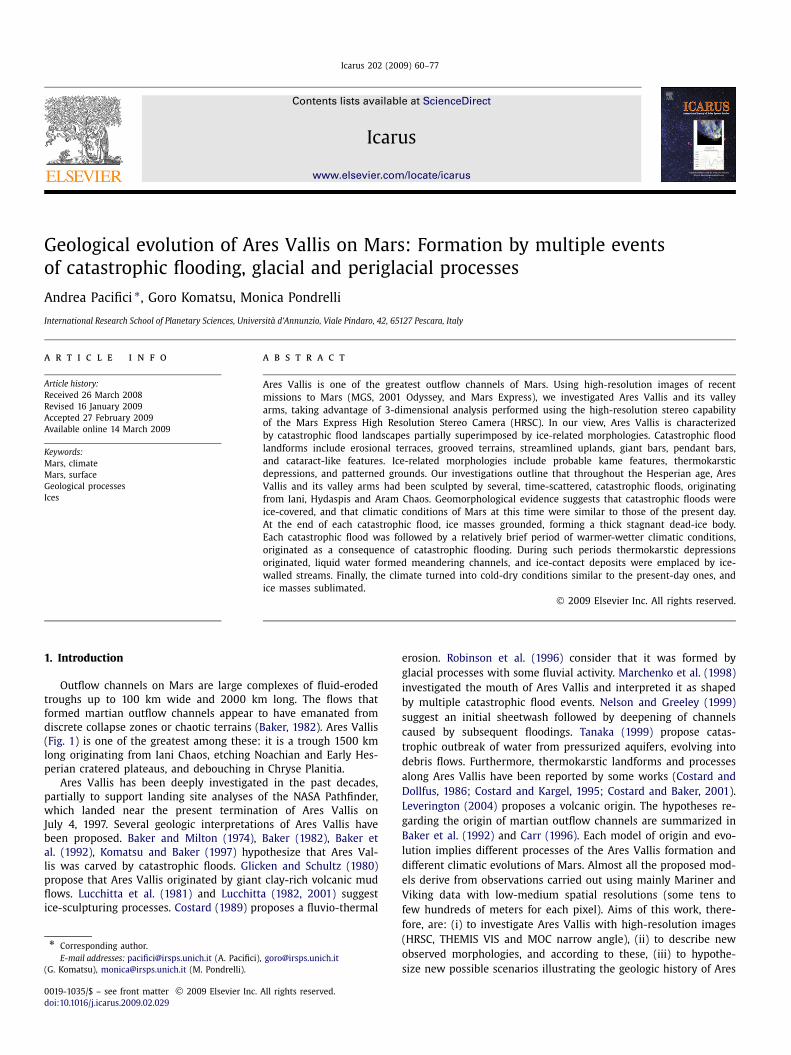
A longitudinal topographic profile of the Ares Vallis floor (Fig. 2)shows that the narrower upper reach of Narrow Ares Vallis hasa steeper topographic gradient on average. The deepest point ofIani Chaos, which is believed to be one of the main source ar-eas for fluids eroding Ares Vallis (Komatsu and Baker, 1997), liesabout 800 m below the beginning of Narrow Ares Vallis. Floorsof Wide Ares Vallis lie about 200 m above the lowest floors ofNarrow Ares Vallis, and its topographic profile appears to be irreg-ular at the upstream portion and flat on the downstream portion.The present-day termination of Ares Vallis consists of a scarp 50–200 m high, which was formed by Tiu-Simud Valles flows postdat-ing Ares Vallis (Marchenko et al., 1998; Nelson and Greeley, 1999;Costard and Baker, 2001).
Fig. 2. Longitudinal profile of Ares Vallis obtained from MOLA grid data. Notice the lowest portion of the valley resides in the narrow reach. Arrows indicate merging pointsof main valley arms debouching on Ares Vallis.

62 A. Pacifici et al. / Icarus 202 (2009) 60–77
Regarding ages of Ares Vallis surfaces, Tanaka et al. (2005) mapfive units in the area. They vary in ages from Middle Noachian toLate Hesperian. Hartmann (2005) also indicates a Late Hesperianage for the Ares Vallis floor and its surroundings. Pacifici (2008)suggests ages varying from Early to Late Hesperian. Werner (2005)observes that ages of the northern reach of Iani Chaos vary from3.5 Ga to 50 Ma, while the upper reach of Ares Vallis shows agesvarying from 650 to 40 Ma.
4. Geomorphological analysis
We observe in the Ares Vallis Complex two different typologiesof geomorphological features. The first one includes grooved ter-rains, streamlined uplands, giant bars, pendant bars, cataract-likefeatures and hanging valleys, resembling terrestrial morphologiesthat are believed to have been shaped by catastrophic floods. Thesecond typology includes ice-contact features, thermokarstic de-pressions, and patterned grounds. These ice-related features over-lap and postdate catastrophic flood morphologies. All these fea-tures are described below in detail.
4.1. Catastrophic flood features
4.1.1. Erosional terraces and hanging valleysAlong the upper reach of Ares Vallis, there are terraces (Fig. 3)
occurring (at least) at five different altitude levels. Each terraceseems to have been sculpted by one (or more) catastrophic flood-ing, originated by an enormous release of water emanating fromchaotic terrains. A terrace occurring at the highest altitude con-sists of a very large area extending mainly northeast of NarrowAres Vallis. This terrace is delineated by the −2000 m contour line,and it is characterized by a smooth-texture on medium-resolutionimages (15–50 m/pixel). Locally, shallow anastomosing channelsoccur. This terrace corresponds to the areas produced by the firstfloods emanating from Iani Chaos. Terraces occurring at lower alti-tudes mark subsequent floods and illustrate progressive deepeningand channelization of Ares Vallis. They develop laterally to theentire widths of Ares Vallis and often show a grooved surface.The grooved surface of the terraces suggests that it was sculptedmainly by erosive processes.
Eastern and Western Valley arms are truncated by the AresVallis main channel and hang over its floors. Crosscutting rela-tionships among Eastern Valley and the erosional terraces of AresVallis show that Eastern Valley originated during the first fourcatastrophic flood events (Fig. 3), and then became abandoned dur-ing the subsequent events.
Western Valley (Fig. 4) is a broad and shallow trough character-ized by the absence of erosional terraces. This suggests that West-ern Valley was formed during one single catastrophic flood em-anating from Hydaspis Chaos. If multiple floods indeed occurred,they did not leave any observational evidence. Crosscutting rela-tionships between Western Valley and Ares Vallis suggest that suchcatastrophic flood event occurred between the second and fourthcatastrophic flood events of Ares Vallis.
Aram Chaos Channel is a deep and narrow gorge in which ero-sional terraces are consequently poorly extended. On the base ofhigh-resolution images we hypothesize that Aram Chaos Channelwas carved by at least two catastrophic floods (possibly more),which occurred at the same time of last floods emanating fromIani Chaos.
4.1.2. Grooved terrainsGrooved terrains characterize a large part of Ares Vallis Com-
plex. They occur mainly on top of erosional terraces, and on thevalley floors as patches. Grooved terrains occur both at the prox-imal and at the distal portions of Ares Vallis troughs. Grooves
Fig. 3. Upstream reach of Ares Vallis. Arrangement of erosional terraces and stream-lined uplands shows that at least six main catastrophic flood events sculpted AresVallis. The terrace formed during the first catastrophic flood event shows relativeshallow anastomosing channels. Erosional terraces marking subsequent floods illus-trate the progressive deepening and channelization of Ares Vallis. Frames refer toother figures. Mosaic of HRSC h0934_0000, h0923_0000, and h0912_0000 images;topographic profile obtained from HRSC DTM mosaic.
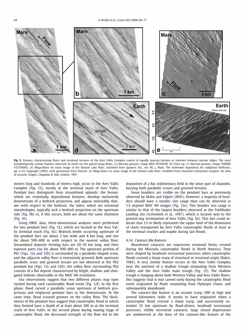
appear to consist of equally-spacing furrows or trenches betweennarrow ridges (Figs. 5 and 5c) that extend along the direction ofthe flow. They are hundreds of meters wide, hundreds of me-ters spaced, and about a few to tens of kilometers long. Groovedepths are not estimated due to their small scales. The overall
Geological evolution of Ares Vallis, Mars 63
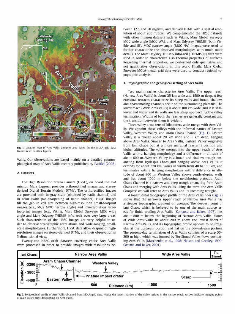
Fig. 4. Western Valley topography from MOLA grid data. Arrows indicate flow direc-tions as suggested from morphological features. Transversal topographic profile (AB)illustrates that Western Valley appears to be characterized by an elevated width-to-depth ratio (vertical exaggeration of profile is four times). Double-arrowed barindicates lateral extension of grooved terrain. Frames refer to other figures.
morphology of such features resembles those of some terrestrialmega-flutes (Figs. 5d and 5e). On the base of relationships amonggrooves and neighboring morphologies it is possible to assess cer-tain morphological and geological properties of the grooved ter-rains. The grooved terrains appear to be locally etched and post-dated by narrow, meandering channels (Fig. 6), which typicallyemanate from flat-floored impact craters or from shallow, flat-floored irregularly-shaped depressions. Comparison between chan-nels and grooves, and their geometrical relationships, allows hy-pothesizing that grooves are no more than meters or a few tensof meters deep. In areas where water flowed deeper and longer(i.e. on the main stream of Ares Vallis) grooves appear widerand deeper than in areas where water flowed shallower and forshorter time (i.e. Western Valley). Moreover, relationships amongmeandering channels and grooves seem to indicate that groovedterrains consist of relatively “soft” highly erodible materials. Thisinference is consistent with the presence of remnants of ancientimpact craters that often characterize grooved terrains (Fig. 7).Such remnants, commonly with positive relieves, suggest that theyconsist of rocks more resistant than the surrounding surfaces tothe erosive processes shaping grooves. On the topmost part ofremnants, grooves generally are absent or less prominent. Rela-tionships among grooves and impact crater remnants, then, seemto confirm that grooves formed mainly on relatively “soft” highlyerodible materials.
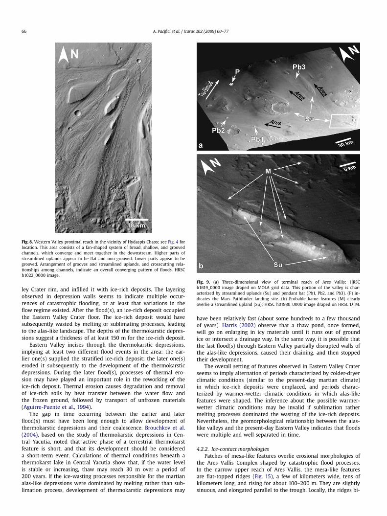
4.1.3. Streamlined uplandsStreamlined uplands occur both at the origin of Ares Vallis
Complex troughs (i.e. in the vicinity of chaotic terrains), and atthe terminal reach of Ares Vallis. They seem to have been formedby erosion of former Noachian and Early Hesperian plateau mate-rials. Streamlined uplands are teardrop-shaped, and characterizedby a whaleback profile. Their topmost part reaches the same al-titude of the neighboring plateaus and consists of Noachian andEarly Hesperian terrains (Pacifici, 2008). Usually, terrains surround-ing streamlined uplands appear to be grooved.
Streamlined uplands located in the vicinity of chaotic terrains(Fig. 8) are the most prominent features occurring near (and some-time in connection with) the flood source areas. Arrangementof such streamlined uplands indicates that they were shaped bybroad converging floods coming out from the chaos. Cross-cuttingrelationships among troughs separating streamlined uplands seemto indicate that floods abandoned lateral troughs early with re-spect to the innermost ones. This setting could be consistent witha progressive decreasing of the fluid level in the reservoirs duringdischarges, which resulted in a progressive canalization of floods.
Streamlined uplands occurring at the terminal reach of AresVallis (Fig. 9) show a distribution and orientations suggesting aspreading of floods. The upstream portion of streamlined uplandsis commonly characterized by an impact crater or a rocky hill,which is believed to have caused the diversion of flow, protect-ing downstream Noachian and Early Hesperian plateaus from flooderosion (Fig. 10).
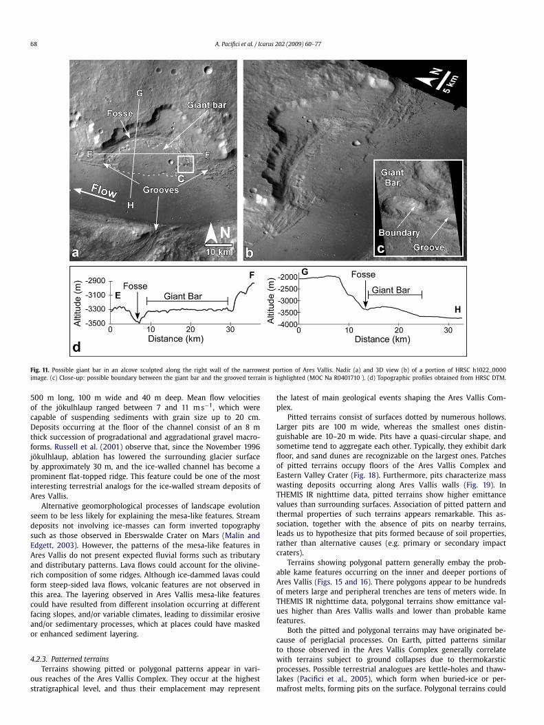
4.1.4. Giant barsWe observe a few features occurring in alcoves flanking valley
floors on the downstream portion of Narrow Ares Vallis (Fig. 11).They appear some kilometers long, a few km wide, and rising forabout 500 m from the valley floor. We propose two hypotheses forthe origin of such features. In the first hypothesis we observe thatthese features appear strikingly similar to giant eddy bars formedduring some known terrestrial catastrophic floods in alcoves flank-ing flooded valleys (Carling et al., 2002). Thus we suggest thatsuch martian features could have been formed as giant bars dur-ing Ares Vallis catastrophic floods. Their thicknesses suggest thatcatastrophic flood(s) probably responsible for their emplacementwas (were) at least 500 m deep in the narrow reach of Ares Vallis.The origin of the alcove features could be related to exhumationand erosion of buried impact craters by catastrophic floods. Thesefeatures overlie grooved terrains and are separated from the valleywall by a swath of about 1.5 km. Such separation can be inter-preted as a non-deposition zone, which occurs between bedformsand valley walls, and which is interpreted to form by flow sepa-ration immediately downstream from a flow expansion or channelbend (Burr et al., 2004). The topmost part of the possible bars is al-most flat and lacks grooves. It is possible to identify boulders about5–10 m in diameter on the largest pristine impact crater (1.5 kmin diameter) occurring on top of one the possible bar.
In the second hypothesis, we suggest that these features couldbe interpreted as mass wasting deposits originated by collapsing ofAres Vallis walls, and possibly reworked by following catastrophicfloods. However, lacking of erosional features, such as grooves, andoccurrence of the flat trough, which characteristically separatesthis feature from the valley wall, lead us to discard this secondidea.
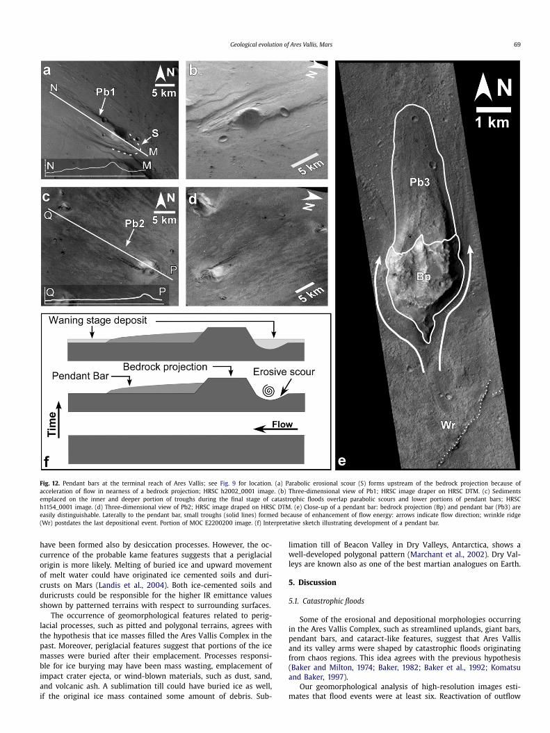
4.1.5. Pendant barsThe term pendant bar was introduced to indicate streamlined
mounds emplaced by Missoula floods downstream of bedrock pro-jections in the Channeled Scabland of North America (Baker, 1982).Pendant bars form by sediment deposition in flow separations de-veloping downstream from a flow obstacle. Similar features, kilo-
64 A. Pacifici et al. / Icarus 202 (2009) 60–77
Fig. 5. Grooves characterizing floors and erosional terraces of the Ares Vallis Complex consist of equally spacing furrows or trenches between narrow ridges. The mostmorphologically similar features observed on Earth are the glacial mega-flutes. (a) Martian grooves; image MOC R1101630. (b) Close up. (c) Martian grooves; image THEMISV12795005. (d) Mega-flutes on sonar image of the Ontario Lake floor; reprinted from Quatern. Int., vol. 90, J. Shaw, The meltwater hypothesis for subglacial bedforms,pp. 5–22, Copyright (2002), with permission from Elsevier. (e) Mega-flutes on sonar image of the Ontario Lake floor; modified from Glaciated continental margins: An atlasof acoustic images, Chapman & Hall, London, 1997.
meters long and hundreds of meters high, occur in the Ares VallisComplex (Fig. 12), mostly at the terminal reach of Ares Vallis.Pendant bars distinguish from streamlined uplands: the former,which are essentially depositional features, develop exclusivelydownstream of a bedrock projection, and appear noticeably thin-ner with respect to the bedrock; the latter, which are erosionalmorphologies, typically lack a bedrock projection on the upstreamside (Fig. 9b) or, if this occurs, both are about the same thickness(Fig. 10).
Using HRSC data, three-dimensional analyses were performedfor two pendant bars (Fig. 12), which are located in the Ares Val-lis terminal reach (Fig. 9a). Bedrock knobs occurring upstream ofthe pendant bars are about 3 km wide and 4 km long, and risefor about 500–600 m with respect to the nearest valley floor.Streamlined deposits forming bars are 20–35 km long, and theirtopmost parts rise for about 300–400 m. The upstream portion ofPb1 (Figs. 12a and 12b) is surrounded by a parabolic-shaped scour,and the adjacent valley floor is extensively grooved. Both upstreamparabolic scour and grooved terrain are not observed at the Pb2pendant bar (Figs. 12c and 12d); the valley floor surrounding Pb2consists of a flat deposit characterized by bright, shallow, and elon-gated hollows observable at the MOC NA resolution.
Our observations suggest that two different phases may haveexisted during each catastrophic flood event (Fig. 12f). In the firstphase, flood carved a parabolic scour upstream of bedrock pro-jections and emplaced pendant bars to the downstream. At thesame time, flood scoured grooves on the valley floor. The thick-nesses of the pendant bars suggest that catastrophic flood in whichthey formed have a depth of at least about 300 m at the terminalreach of Ares Vallis. In the second phase during waning stage ofcatastrophic flood, the decreased strength of the flow led to the
deposition of a flat sedimentary field in the inner part of channels,burying both parabolic scours and grooved terrains.
Some boulders are visible on the pendant bars as previouslyobserved by Malin and Edgett (2001). However, a majority of boul-ders should have a smaller size range than can be observed in1.5 m/pixel MOC NA images (Fig. 12e). This boulder size range issimilar to that of the largest boulders observed at the PathfinderLanding site (Golombek et al., 1997), which is located next to thepresent-day termination of Ares Vallis (Fig. 9a). This fact could in-dicate that 1.5 m likely represents the upper limit of the dimensionof clasts transported by Ares Vallis catastrophic floods at least atthe terminal reaches and maybe during last floods.
4.1.6. Cataract-like featuresAbandoned cataracts are impressive erosional forms created
during the Missoula catastrophic floods in North America. Theywere shaped by headwall recessional processes when catastrophicfloods crossed a sharp scarp of structural or erosional origin (Baker,1982). A very similar feature occurs at the Ares Vallis Complexnear the junction of a shallow trough emanating from WesternValley and the Ares Vallis main trough (Fig. 13). The shallowtrough is hanging above both Western Valley and Ares Vallis floors:this suggests that it was carved early during the catastrophic floodevent originated by fluids emanating from Hydaspis Chaos, andsubsequently abandoned.
The cataract-like feature is an arcuate scarp, 500 m high andseveral kilometers wide. It seems to have originated when acatastrophic flood crossed a sharp scarp, and successively ex-tended 35 km upstream by flood-driven, headwall recessionalprocesses. Unlike terrestrial cataracts, large closed depressionsare unobserved at the base of the cataract-like feature of the
Geological evolution of Ares Vallis, Mars 65
Fig. 6. Three-dimensional view of a portion of Western Valley and Aram Chaos rim;HRSC h1000_0000 image draped on HRSC DTM. See Fig. 4 for location. (a) The nar-row outlet channel emanating from a 50 km wide impact crater located on the ex-tended rim of Aram Chaos meets the central portion of Western Valley. Comparisonbetween the channel 100–250 m deep and the grooves allows hypothesizing thatthe grooves are no more than some meters or a few tens of meters deep. (b) At itsdownstream portion, the meandering channel etches the grooved floor of WesternValley and appears truncated by a shallow, small, chaotic region. (c) The meanderingchannel does not show variations in proximity of the transition from the groovedto the non-grooved terrain, suggesting that geological properties of grooved andnot-grooved terrains are similar. (d) HRSC h1000_0000 and MOC E0900989 imagesmosaic showing a close-up of channel and its abandoned meanders.
Ares Vallis Complex. The shallow trough occurring upstream ofthe cataract-like feature shows an association of grooved terrain,streamlined uplands and pendant bars. In the downstream of thecataract, instead, trough enlarges with a fan-shaped morphology:here grooved terrain and pendant bars are unobserved and onlytwo small streamlined remnants occur.
4.2. Ice-related morphologies
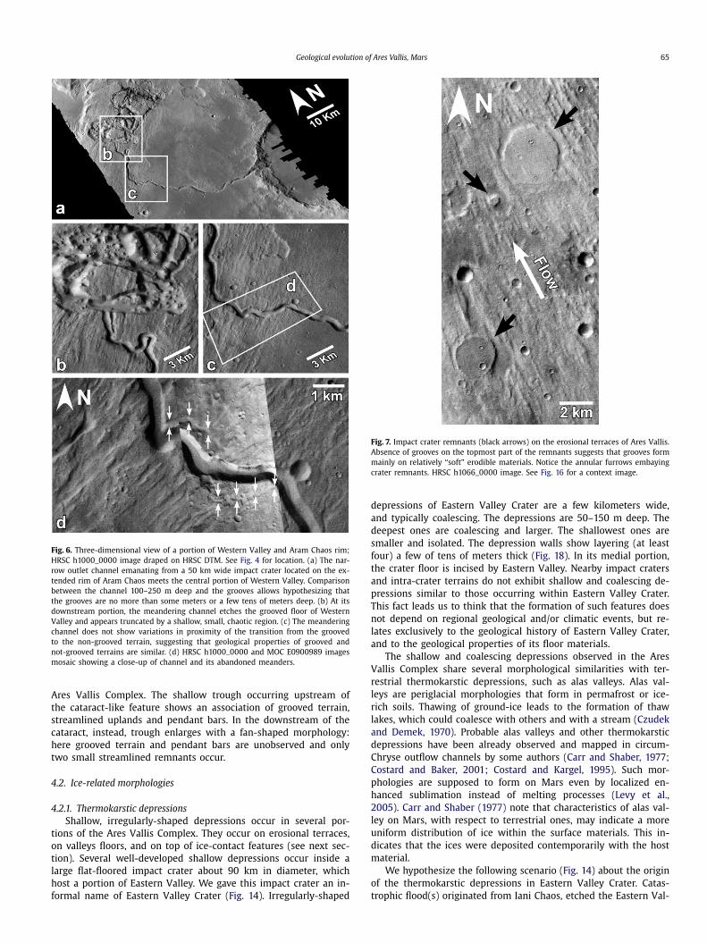
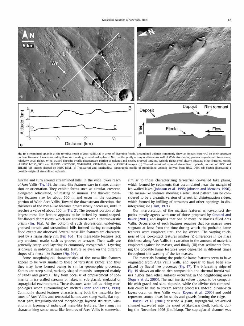
4.2.1. Thermokarstic depressionsShallow, irregularly-shaped depressions occur in several por-
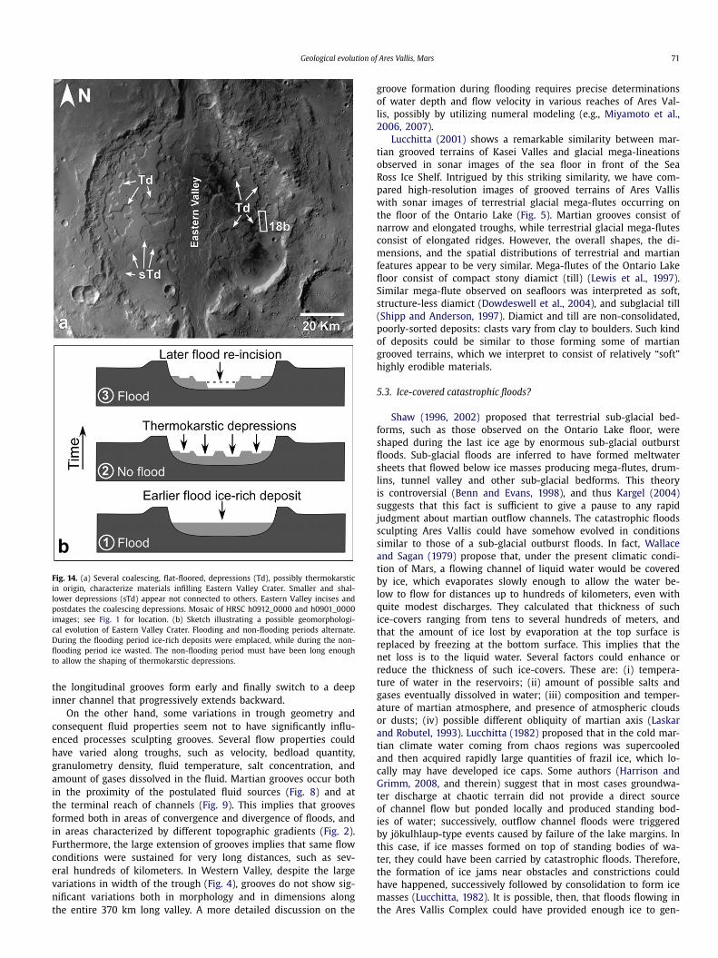
tions of the Ares Vallis Complex. They occur on erosional terraces,on valleys floors, and on top of ice-contact features (see next sec-tion). Several well-developed shallow depressions occur inside alarge flat-floored impact crater about 90 km in diameter, whichhost a portion of Eastern Valley. We gave this impact crater an in-formal name of Eastern Valley Crater (Fig. 14). Irregularly-shaped
Fig. 7. Impact crater remnants (black arrows) on the erosional terraces of Ares Vallis.Absence of grooves on the topmost part of the remnants suggests that grooves formmainly on relatively “soft” erodible materials. Notice the annular furrows embayingcrater remnants. HRSC h1066_0000 image. See Fig. 16 for a context image.
depressions of Eastern Valley Crater are a few kilometers wide,and typically coalescing. The depressions are 50–150 m deep. Thedeepest ones are coalescing and larger. The shallowest ones aresmaller and isolated. The depression walls show layering (at leastfour) a few of tens of meters thick (Fig. 18). In its medial portion,the crater floor is incised by Eastern Valley. Nearby impact cratersand intra-crater terrains do not exhibit shallow and coalescing de-pressions similar to those occurring within Eastern Valley Crater.This fact leads us to think that the formation of such features doesnot depend on regional geological and/or climatic events, but re-lates exclusively to the geological history of Eastern Valley Crater,and to the geological properties of its floor materials.
The shallow and coalescing depressions observed in the AresVallis Complex share several morphological similarities with ter-restrial thermokarstic depressions, such as alas valleys. Alas val-leys are periglacial morphologies that form in permafrost or ice-rich soils. Thawing of ground-ice leads to the formation of thawlakes, which could coalesce with others and with a stream (Czudekand Demek, 1970). Probable alas valleys and other thermokarsticdepressions have been already observed and mapped in circum-Chryse outflow channels by some authors (Carr and Shaber, 1977;Costard and Baker, 2001; Costard and Kargel, 1995). Such mor-phologies are supposed to form on Mars even by localized en-hanced sublimation instead of melting processes (Levy et al.,2005). Carr and Shaber (1977) note that characteristics of alas val-ley on Mars, with respect to terrestrial ones, may indicate a moreuniform distribution of ice within the surface materials. This in-dicates that the ices were deposited contemporarily with the hostmaterial.
We hypothesize the following scenario (Fig. 14) about the originof the thermokarstic depressions in Eastern Valley Crater. Catas-trophic flood(s) originated from Iani Chaos, etched the Eastern Val-
66 A. Pacifici et al. / Icarus 202 (2009) 60–77
Fig. 8. Western Valley proximal reach in the vicinity of Hydaspis Chaos; see Fig. 4 forlocation. This area consists of a fan-shaped system of broad, shallow, and groovedchannels, which converge and meet together in the downstream. Higher parts ofstreamlined uplands appear to be flat and non-grooved. Lower parts appear to begrooved. Arrangement of grooves and streamlined uplands, and crosscutting rela-tionships among channels, indicate an overall converging pattern of floods. HRSCh1022_0000 image.
ley Crater rim, and infilled it with ice-rich deposits. The layeringobserved in depression walls seems to indicate multiple occur-rences of catastrophic flooding, or at least that variations in theflow regime existed. After the flood(s), an ice-rich deposit occupiedthe Eastern Valley Crater floor. The ice-rich deposit would havesubsequently wasted by melting or sublimating processes, leadingto the alas-like landscape. The depths of the thermokarstic depres-sions suggest a thickness of at least 150 m for the ice-rich deposit.
Eastern Valley incises through the thermokarstic depressions,implying at least two different flood events in the area: the ear-lier one(s) supplied the stratified ice-rich deposit; the later one(s)eroded it subsequently to the development of the thermokarsticdepressions. During the later flood(s), processes of thermal ero-sion may have played an important role in the reworking of theice-rich deposit. Thermal erosion causes degradation and removalof ice-rich soils by heat transfer between the water flow andthe frozen ground, followed by transport of unfrozen materials(Aguirre-Puente et al., 1994).
The gap in time occurring between the earlier and laterflood(s) must have been long enough to allow development ofthermokarstic depressions and their coalescence. Brouchkov et al.(2004), based on the study of thermokarstic depressions in Cen-tral Yacutia, noted that active phase of a terrestrial thermokarstfeature is short, and that its development should be considereda short-term event. Calculations of thermal conditions beneath athermokarst lake in Central Yacutia show that, if the water levelis stable or increasing, thaw may reach 30 m over a period of200 years. If the ice-wasting processes responsible for the martianalas-like depressions were dominated by melting rather than sub-limation process, development of thermokarstic depressions may
Fig. 9. (a) Three-dimensional view of terminal reach of Ares Vallis; HRSCh1619_0000 image draped on MOLA grid data. This portion of the valley is char-acterized by streamlined uplands (Su) and pendant bar (Pb1, Pb2, and Pb3). (P) in-dicates the Mars Pathfinder landing site. (b) Probable kame features (M) clearlyoverlie a streamlined upland (Su); HRSC h01980_0000 image draped on HRSC DTM.
have been relatively fast (about some hundreds to a few thousandof years). Harris (2002) observe that a thaw pond, once formed,will go on enlarging in icy materials until it runs out of groundice or intersect a drainage way. In the same way, it is possible thatthe last flood(s) through Eastern Valley partially disrupted walls ofthe alas-like depressions, caused their draining, and then stoppedtheir development.
The overall setting of features observed in Eastern Valley Craterseems to imply alternation of periods characterized by colder-dryerclimatic conditions (similar to the present-day martian climate)in which ice-rich deposits were emplaced, and periods charac-terized by warmer-wetter climatic conditions in which alas-likefeatures were shaped. The inference about the possible warmer-wetter climatic conditions may be invalid if sublimation rathermelting processes dominated the wasting of the ice-rich deposits.Nevertheless, the geomorphological relationship between the alas-like valleys and the present-day Eastern Valley indicates that floodswere multiple and well separated in time.
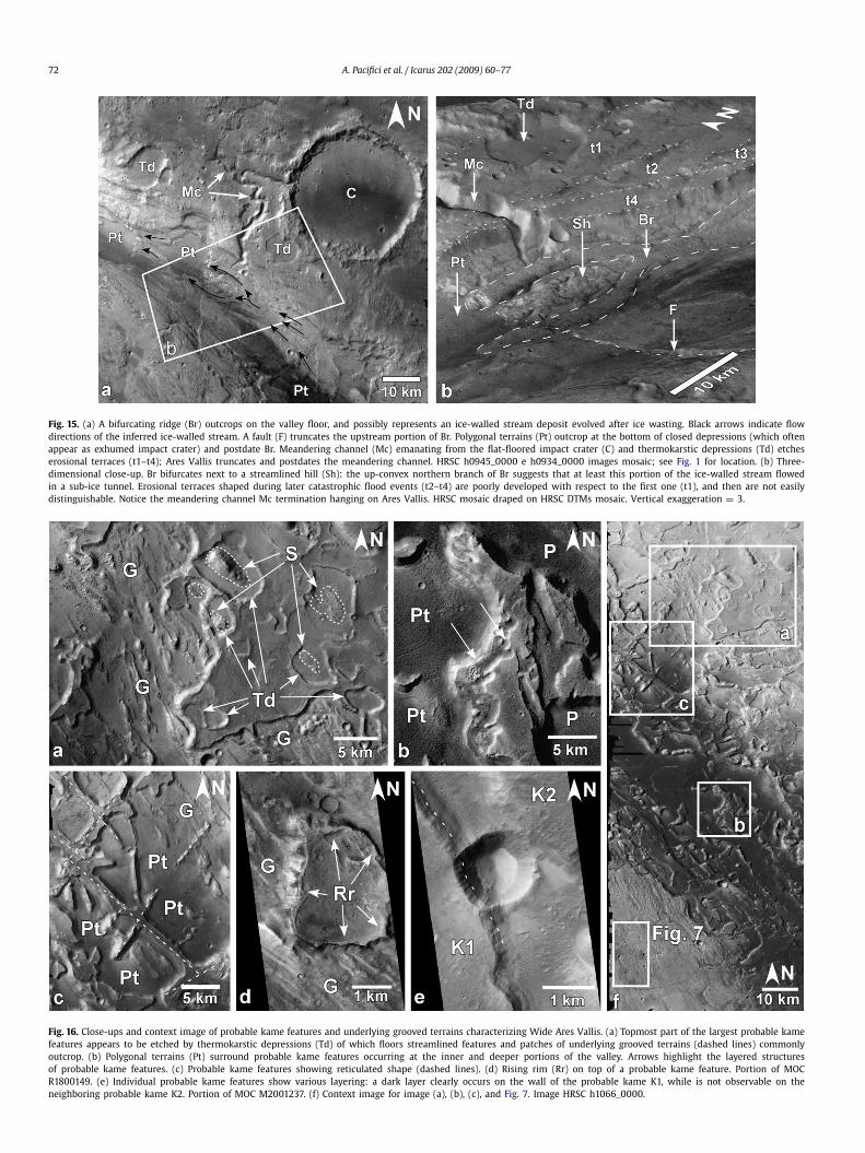
4.2.2. Ice-contact morphologiesPatches of mesa-like features overlie erosional morphologies of
the Ares Vallis Complex shaped by catastrophic flood processes.In the narrow upper reach of Ares Vallis, the mesa-like featuresare flat-topped ridges (Fig. 15), a few of kilometers wide, tens ofkilometers long, and rising for about 100–200 m. They are slightlysinuous, and elongated parallel to the trough. Locally, the ridges bi-
Geological evolution of Ares Vallis, Mars 67
Fig. 10. Streamlined uplands at the terminal reach of Ares Vallis. (a) In areas of diverging floods, streamlined uplands commonly show an impact crater (C) on their upstreamportion. Grooves characterize valley floor surrounding streamlined uplands. Next to the gently raising northeastern wall of Wide Ares Vallis, grooves degrade into transversal,relatively small ridges. Wing-shaped deposits overlie downstream portion of uplands and nearby grooved terrains. Wrinkle ridges (Wr) clearly postdate other features. Mosaicof HRSC h0155_0001 and THEMIS V12795005, V04782003, V10349017, and V14330014 images. (b) Three-dimensional view of streamlined uplands; mosaic of HRSC andTHEMIS VIS images draped on HRSC DTM. (c) Transversal and longitudinal topographic profile of streamlined uplands derived from HRSC DTM. (d) Sketch illustrating apossible origin of streamlined uplands.
furcate and turn around streamlined hills. In the wide lower reachof Ares Vallis (Fig. 16), the mesa-like features vary in shape, dimen-sion or orientation. They exhibit forms such as circular, crescent,elongated, reticulated, bifurcating or sinuous. The thickest mesa-like features rise for about 500 m and occur in the upstreamportion of Wide Ares Vallis. Toward the downstream direction, thethickness of the mesa-like features progressively decreases, until itreaches a value of about 100 m (Fig. 2). The topmost portion of thelargest mesa-like feature appears to be etched by round-shaped,flat-floored depressions, which are consistent with a thermokarsticorigin (Fig. 16a). At the bottom of such depressions, underlyinggrooved terrain and streamlined hills formed during catastrophicflood events are observed. Several mesa-like features are character-ized by a rising sharp rim (Fig. 16d). The mesas-like features lackany erosional marks such as grooves or terraces. Their walls aregenerally steep and layering is commonly recognizable. Layeringis diverse in individual mesa-like feature or even on the differentslopes of a mesa-like feature (Fig. 16e).
Some morphological characteristics of the mesa-like featuresappear to be very similar to those of terrestrial kames, and thusthey may have formed owing to similar geomorphic processes.Kames are steep-sided, variably shaped mounds, composed mainlyof sands and gravels. They form because of emplacement of sed-iments in ice-walled streams or lakes, in sub-glacial, englacial orsupraglacial environments. These features were left as rising mor-phologies when surrounding ice melted (Benn and Evans, 1998).Commonly shared features characterizing both the mesa-like fea-tures of Ares Vallis and terrestrial kames are; steep walls, flat top-most part, irregularly-shaped morphology, layered structure, vari-ations in layering of individual mesa-like features. The rising rimcharacterizing some mesa-like features of Ares Vallis is somewhat
similar to those characterizing terrestrial ice-walled lake plains,which formed by sediments that accumulated near the margin ofice-walled lakes (Johnson et al., 1995; Johnson and Menzies, 1996).The mesas-like features showing a reticulated pattern can be con-sidered to be a gigantic version of terrestrial disintegration ridges,which formed by infilling of crevasses and other openings in dis-integrating ice (Flint, 1971).
Our interpretation of the martian features as ice-contact de-posits mostly agrees with one of those proposed by Costard andBaker (2001), and implies that one or more ice masses filled AresVallis. Occurrence of such features requires that ice masses werestagnant at least from the time during which the probable kamefeatures were emplaced until the ice wasted. The varying thick-ness of the ice-contact features implies (i) differences in ice massthickness along Ares Vallis, (ii) variation in the amount of materialsemplaced against ice masses, and finally (iii) that sediments form-ing the probable kame features were deposited in different timesthroughout the wasting of the ice masses.
The materials forming the probable kame features seem to haveoriginated from Ares Vallis walls, and appear to have been em-placed by fluvial-like processes (Fig. 17). The bifurcating ridge ofFig. 15 shows an olivine-rich composition and thermal inertia val-ues higher than other surfaces occurring in the neighboring areas(Rogers et al., 2005). Thermal inertia values appear to be compati-ble with gravel and sand deposits, while the olivine-rich composi-tion could be due to stream sorting processes. Indeed, olivine-richlayers occur on Ares Vallis walls (Rogers et al., 2005) and couldrepresent source areas for sands and gravels forming the ridge.
Russell et al. (2001) describe a giant, supraglacial, ice-walledchannel excavated into the snout of Skeiðarárjökull, Iceland, dur-ing the November 1996 jökulhlaup. The supraglacial channel was
68 A. Pacifici et al. / Icarus 202 (2009) 60–77
Fig. 11. Possible giant bar in an alcove sculpted along the right wall of the narrowest portion of Ares Vallis. Nadir (a) and 3D view (b) of a portion of HRSC h1022_0000image. (c) Close-up: possible boundary between the giant bar and the grooved terrain is highlighted (MOC Na R0401710 ). (d) Topographic profiles obtained from HRSC DTM.
500 m long, 100 m wide and 40 m deep. Mean flow velocitiesof the jökulhlaup ranged between 7 and 11 m s−1, which werecapable of suspending sediments with grain size up to 20 cm.Deposits occurring at the floor of the channel consist of an 8 mthick succession of progradational and aggradational gravel macro-forms. Russell et al. (2001) observe that, since the November 1996jökulhlaup, ablation has lowered the surrounding glacier surfaceby approximately 30 m, and the ice-walled channel has become aprominent flat-topped ridge. This feature could be one of the mostinteresting terrestrial analogs for the ice-walled stream deposits ofAres Vallis.
Alternative geomorphological processes of landscape evolutionseem to be less likely for explaining the mesa-like features. Streamdeposits not involving ice-masses can form inverted topographysuch as those observed in Eberswalde Crater on Mars (Malin andEdgett, 2003). However, the patterns of the mesa-like features inAres Vallis do not present expected fluvial forms such as tributaryand distributary patterns. Lava flows could account for the olivine-rich composition of some ridges. Although ice-dammed lavas couldform steep-sided lava flows, volcanic features are not observed inthis area. The layering observed in Ares Vallis mesa-like featurescould have resulted from different insolation occurring at differentfacing slopes, and/or variable climates, leading to dissimilar erosiveand/or sedimentary processes, which at places could have maskedor enhanced sediment layering.
4.2.3. Patterned terrainsTerrains showing pitted or polygonal patterns appear in vari-
ous reaches of the Ares Vallis Complex. They occur at the higheststratigraphical level, and thus their emplacement may represent
the latest of main geological events shaping the Ares Vallis Com-plex.
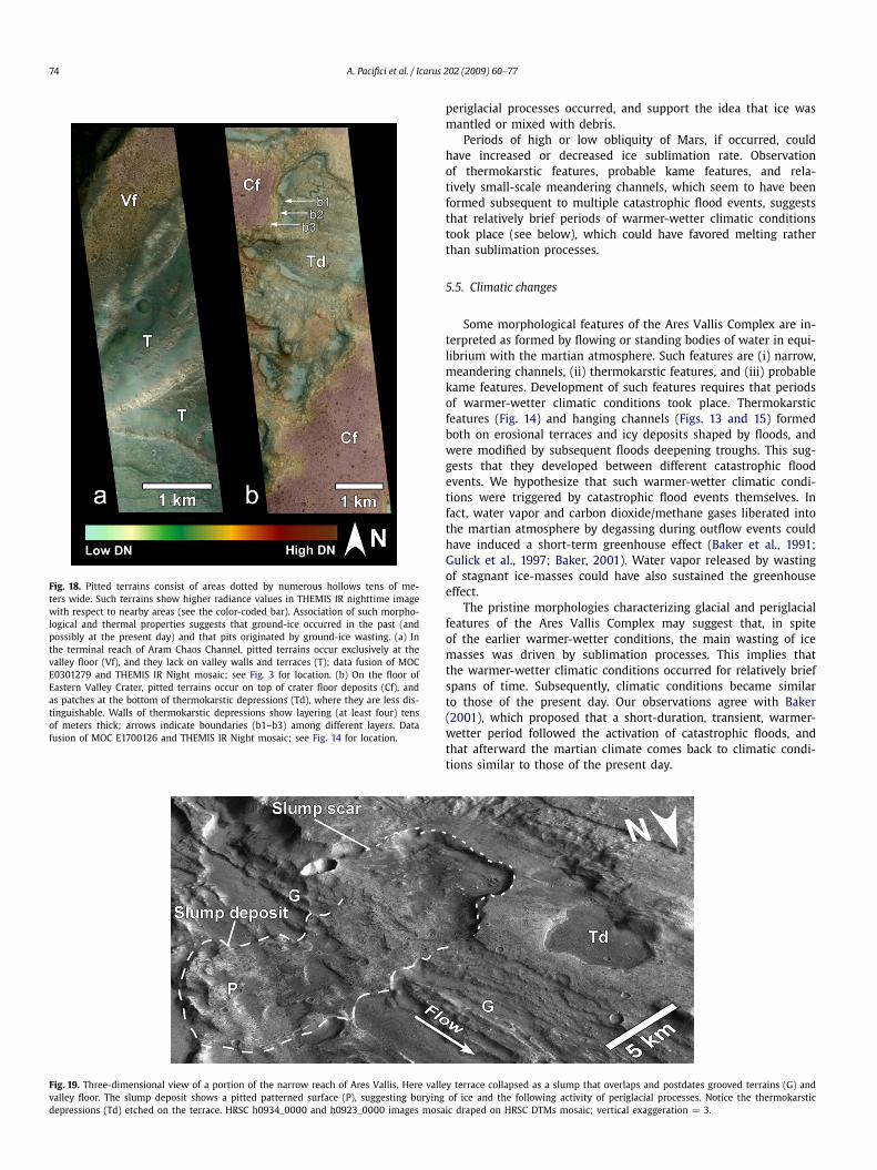
Pitted terrains consist of surfaces dotted by numerous hollows.Larger pits are 100 m wide, whereas the smallest ones distin-guishable are 10–20 m wide. Pits have a quasi-circular shape, andsometime tend to aggregate each other. Typically, they exhibit darkfloor, and sand dunes are recognizable on the largest ones. Patchesof pitted terrains occupy floors of the Ares Vallis Complex andEastern Valley Crater (Fig. 18). Furthermore, pits characterize masswasting deposits occurring along Ares Vallis walls (Fig. 19). InTHEMIS IR nighttime data, pitted terrains show higher emittancevalues than surrounding surfaces. Association of pitted pattern andthermal properties of such terrains appears remarkable. This as-sociation, together with the absence of pits on nearby terrains,leads us to hypothesize that pits formed because of soil properties,rather than alternative causes (e.g. primary or secondary impactcraters).
Terrains showing polygonal pattern generally embay the prob-able kame features occurring on the inner and deeper portions ofAres Vallis (Figs. 15 and 16). There polygons appear to be hundredsof meters large and peripheral trenches are tens of meters wide. InTHEMIS IR nighttime data, polygonal terrains show emittance val-ues higher than Ares Vallis walls and lower than probable kamefeatures.
Both the pitted and polygonal terrains may have originated be-cause of periglacial processes. On Earth, pitted patterns similarto those observed in the Ares Vallis Complex generally correlatewith terrains subject to ground collapses due to thermokarsticprocesses. Possible terrestrial analogues are kettle-holes and thaw-lakes (Pacifici et al., 2005), which form when buried-ice or per-mafrost melts, forming pits on the surface. Polygonal terrains could
Geological evolution of Ares Vallis, Mars 69
Fig. 12. Pendant bars at the terminal reach of Ares Vallis; see Fig. 9 for location. (a) Parabolic erosional scour (S) forms upstream of the bedrock projection because ofacceleration of flow in nearness of a bedrock projection; HRSC h2002_0001 image. (b) Three-dimensional view of Pb1; HRSC image draper on HRSC DTM. (c) Sedimentsemplaced on the inner and deeper portion of troughs during the final stage of catastrophic floods overlap parabolic scours and lower portions of pendant bars; HRSCh1154_0001 image. (d) Three-dimensional view of Pb2; HRSC image draped on HRSC DTM. (e) Close-up of a pendant bar: bedrock projection (Bp) and pendant bar (Pb3) areeasily distinguishable. Laterally to the pendant bar, small troughs (solid lines) formed because of enhancement of flow energy: arrows indicate flow direction; wrinkle ridge(Wr) postdates the last depositional event. Portion of MOC E2200200 image. (f) Interpretative sketch illustrating development of a pendant bar.
have been formed also by desiccation processes. However, the oc-currence of the probable kame features suggests that a periglacialorigin is more likely. Melting of buried ice and upward movementof melt water could have originated ice cemented soils and duri-crusts on Mars (Landis et al., 2004). Both ice-cemented soils andduricrusts could be responsible for the higher IR emittance valuesshown by patterned terrains with respect to surrounding surfaces.
The occurrence of geomorphological features related to perig-lacial processes, such as pitted and polygonal terrains, agrees withthe hypothesis that ice masses filled the Ares Vallis Complex in thepast. Moreover, periglacial features suggest that portions of the icemasses were buried after their emplacement. Processes responsi-ble for ice burying may have been mass wasting, emplacement ofimpact crater ejecta, or wind-blown materials, such as dust, sand,and volcanic ash. A sublimation till could have buried ice as well,if the original ice mass contained some amount of debris. Sub-
limation till of Beacon Valley in Dry Valleys, Antarctica, shows awell-developed polygonal pattern (Marchant et al., 2002). Dry Val-leys are known also as one of the best martian analogues on Earth.
5. Discussion
5.1. Catastrophic floods
Some of the erosional and depositional morphologies occurringin the Ares Vallis Complex, such as streamlined uplands, giant bars,pendant bars, and cataract-like features, suggest that Ares Vallisand its valley arms were shaped by catastrophic floods originatingfrom chaos regions. This idea agrees with the previous hypothesis(Baker and Milton, 1974; Baker, 1982; Baker et al., 1992; Komatsuand Baker, 1997).
Our geomorphological analysis of high-resolution images esti-mates that flood events were at least six. Reactivation of outflow

70 A. Pacifici et al. / Icarus 202 (2009) 60–77
Fig. 13. (a) HRSC mosaic of a cataract-like feature; see Fig. 4 for location. Cataract-like feature (C) forms next to a scarp (F) and successively extends upstream for about 35 kmby backward erosion of the headwall. Grooved terrain (G), pendant bar (Pb) and streamlined upland (Su) occur upstream of the cataract-like feature. Downstream of thecataract-like feature, all these erosional morphologies disappear; only a few small streamlined remnants (R) occur. Notice sapping channels (S) emanating from a geologicalcontact between two different layers forming Noachian plateau, and hanging on Ares Vallis. HRSC h1022_0000 and h1011_0000 image mosaic. (b) Three-dimensional view ofthe area; HRSC mosaic draped on HRSC DTMs mosaic; vertical exaggeration = 5.
channel flooding is indicated also at Tiu Vallis west of Ares Val-lis (Rodriguez et al., 2005), thus it can be concluded that largecircum-Chryse outflow channels were commonly formed by mul-tiple floods. Occurrence of multiple floods is in agreement withnumerical model of groundwater flow and surface discharge at theoutflow channel sources (Harrison and Grimm, 2008). Topographicanalyses of giant and pendant bars indicate that floods were atleast 500 m deep in Narrow Ares Vallis, and at least 300 m deepat the Ares Vallis terminal reach. Geomorphological relationshipsindicate a progressive decreasing of fluid volume in the reservoirsduring the discharges, which resulted in a progressive canalizationof floods. This is partially in agreement with Nelson and Greeley(1999). Our hypothesis about the geomorphological evolution ofEastern Valley Crater (Fig. 14) suggests that the amount of timeelapsed between the two different floods in Eastern Valley musthave been long enough to have permitted the emplacement ofthermokarstic features 150 m deep and a few kilometers large. Wedo not know how much time was required for their formation. Tomake a roughly comparison, similar features 20 m deep could re-quire few hundreds of years to form on Earth (Brouchkov et al.,2004). Occurrence of layering could suggest two hypotheses. Onthe first one, each layer, a few tens of meters thick, formed duringdifferent floods; in the second hypothesis we suggest that layeringformed because of variations in the flow regime during a singleflood. Both the hypotheses appear to be consistent.
5.2. Grooved terrains
Grooved terrains characterize a large portion of the Ares VallisComplex floors and erosional terraces, and occur also at other mar-tian outflow channels, such as in Kasei Valles. In earlier works onmartian outflow channels, main interpretations of grooved terrainswere: (i) features sculpted by high-velocity (catastrophic) flows ofwater (Baker and Milton, 1974) and (ii) features similar to glacialscours and mega-flutes (Lucchitta, 1982; Lucchitta, 2001). In theformer hypothesis grooves are considered to have been formed bypowerful roller vortices, which developed parallel to the flow di-rection. In the latter hypothesis grooves are shaped by ice that
in place moved through martian channels. Ices flow similarly inAntarctic ice streams over deformable debris saturated with waterunder high pore pressure. Other hypotheses about groove originsincluding formation by roller vortices in fluids such as wind, de-bris flows and mudflows, were discussed in Baker et al. (1992) andCarr (1996). Origin of grooves could be inferred from geological re-lationships among grooves and nearby geomorphological features.In the Ares Vallis Complex, occurrence of cataract-like features,streamlined uplands, and pendant bars in association with groovedterrains (Fig. 13) seems to support the cataclysmic flood origin.
Geomorphological characteristics of the observed grooves, andtheir relationship with respect to nearby features, such as me-andering channels (Fig. 6) and impact craters remnants (Fig. 7),suggest that the grooves formed mainly on relatively “soft” highlyerodible materials.
In areas where water flowed deeper and for longer durations(i.e., on the Ares Vallis floor) grooves appear wider and deeperthan in the areas where water flowed shallower and for shortertimes (i.e., in Western Valley). This appears in agreement withlaboratory experiments and field observations. Laboratory experi-ments on water streams indicate that regular spacing of vorticesin flow varies with velocity and depth of the flow (Allen, 1970).Field observations at the base of the Sigsbee Escarpment, in thenorthwestern Gulf of Mexico (Bean, 2003), show that strong cur-rents formed mega-furrows on fine-grained sediments of seafloor.Higher current velocities and durations lead to form mega-furrow,which are wider, deeper and closer. Furthermore, the strongersediments determine the maximum depth of erosion and requirehigher current velocity and duration to be eroded (Bean, 2003).Such seafloor mega-furrows exhibit some similarities with respectto martian grooves. Therefore, it is possible that similar currentsoccurred at the bottom of martian catastrophic floods. At thesouthern termination of Western Valley (Fig. 4), grooves seem toconverge and meet to form a deep and narrow canyon-like feature.This appears in agreement with some experimental flow simula-tions (Shepherd, 1972; Shepherd and Schumm, 1974) showing as
Geological evolution of Ares Vallis, Mars 71
Fig. 14. (a) Several coalescing, flat-floored, depressions (Td), possibly thermokarsticin origin, characterize materials infilling Eastern Valley Crater. Smaller and shal-lower depressions (sTd) appear not connected to others. Eastern Valley incises andpostdates the coalescing depressions. Mosaic of HRSC h0912_0000 and h0901_0000images; see Fig. 1 for location. (b) Sketch illustrating a possible geomorphologi-cal evolution of Eastern Valley Crater. Flooding and non-flooding periods alternate.During the flooding period ice-rich deposits were emplaced, while during the non-flooding period ice wasted. The non-flooding period must have been long enoughto allow the shaping of thermokarstic depressions.
the longitudinal grooves form early and finally switch to a deepinner channel that progressively extends backward.
On the other hand, some variations in trough geometry andconsequent fluid properties seem not to have significantly influ-enced processes sculpting grooves. Several flow properties couldhave varied along troughs, such as velocity, bedload quantity,granulometry density, fluid temperature, salt concentration, andamount of gases dissolved in the fluid. Martian grooves occur bothin the proximity of the postulated fluid sources (Fig. 8) and atthe terminal reach of channels (Fig. 9). This implies that groovesformed both in areas of convergence and divergence of floods, andin areas characterized by different topographic gradients (Fig. 2).Furthermore, the large extension of grooves implies that same flowconditions were sustained for very long distances, such as sev-eral hundreds of kilometers. In Western Valley, despite the largevariations in width of the trough (Fig. 4), grooves do not show sig-nificant variations both in morphology and in dimensions alongthe entire 370 km long valley. A more detailed discussion on the
groove formation during flooding requires precise determinationsof water depth and flow velocity in various reaches of Ares Val-lis, possibly by utilizing numeral modeling (e.g., Miyamoto et al.,2006, 2007).
Lucchitta (2001) shows a remarkable similarity between mar-tian grooved terrains of Kasei Valles and glacial mega-lineationsobserved in sonar images of the sea floor in front of the SeaRoss Ice Shelf. Intrigued by this striking similarity, we have com-pared high-resolution images of grooved terrains of Ares Valliswith sonar images of terrestrial glacial mega-flutes occurring onthe floor of the Ontario Lake (Fig. 5). Martian grooves consist ofnarrow and elongated troughs, while terrestrial glacial mega-flutesconsist of elongated ridges. However, the overall shapes, the di-mensions, and the spatial distributions of terrestrial and martianfeatures appear to be very similar. Mega-flutes of the Ontario Lakefloor consist of compact stony diamict (till) (Lewis et al., 1997).Similar mega-flute observed on seafloors was interpreted as soft,structure-less diamict (Dowdeswell et al., 2004), and subglacial till(Shipp and Anderson, 1997). Diamict and till are non-consolidated,poorly-sorted deposits: clasts vary from clay to boulders. Such kindof deposits could be similar to those forming some of martiangrooved terrains, which we interpret to consist of relatively “soft”highly erodible materials.
5.3. Ice-covered catastrophic floods?
Shaw (1996, 2002) proposed that terrestrial sub-glacial bed-forms, such as those observed on the Ontario Lake floor, wereshaped during the last ice age by enormous sub-glacial outburstfloods. Sub-glacial floods are inferred to have formed meltwatersheets that flowed below ice masses producing mega-flutes, drum-lins, tunnel valley and other sub-glacial bedforms. This theoryis controversial (Benn and Evans, 1998), and thus Kargel (2004)suggests that this fact is sufficient to give a pause to any rapidjudgment about martian outflow channels. The catastrophic floodssculpting Ares Vallis could have somehow evolved in conditionssimilar to those of a sub-glacial outburst floods. In fact, Wallaceand Sagan (1979) propose that, under the present climatic condi-tion of Mars, a flowing channel of liquid water would be coveredby ice, which evaporates slowly enough to allow the water be-low to flow for distances up to hundreds of kilometers, even withquite modest discharges. They calculated that thickness of suchice-covers ranging from tens to several hundreds of meters, andthat the amount of ice lost by evaporation at the top surface isreplaced by freezing at the bottom surface. This implies that thenet loss is to the liquid water. Several factors could enhance orreduce the thickness of such ice-covers. These are: (i) tempera-ture of water in the reservoirs; (ii) amount of possible salts andgases eventually dissolved in water; (iii) composition and temper-ature of martian atmosphere, and presence of atmospheric cloudsor dusts; (iv) possible different obliquity of martian axis (Laskarand Robutel, 1993). Lucchitta (1982) proposed that in the cold mar-tian climate water coming from chaos regions was supercooledand then acquired rapidly large quantities of frazil ice, which lo-cally may have developed ice caps. Some authors (Harrison andGrimm, 2008, and therein) suggest that in most cases groundwa-ter discharge at chaotic terrain did not provide a direct sourceof channel flow but ponded locally and produced standing bod-ies of water; successively, outflow channel floods were triggeredby jökulhlaup-type events caused by failure of the lake margins. Inthis case, if ice masses formed on top of standing bodies of wa-ter, they could have been carried by catastrophic floods. Therefore,the formation of ice jams near obstacles and constrictions couldhave happened, successively followed by consolidation to form icemasses (Lucchitta, 1982). It is possible, then, that floods flowing inthe Ares Vallis Complex could have provided enough ice to gen-
72 A. Pacifici et al. / Icarus 202 (2009) 60–77
Fig. 15. (a) A bifurcating ridge (Br) outcrops on the valley floor, and possibly represents an ice-walled stream deposit evolved after ice wasting. Black arrows indicate flowdirections of the inferred ice-walled stream. A fault (F) truncates the upstream portion of Br. Polygonal terrains (Pt) outcrop at the bottom of closed depressions (which oftenappear as exhumed impact crater) and postdate Br. Meandering channel (Mc) emanating from the flat-floored impact crater (C) and thermokarstic depressions (Td) etcheserosional terraces (t1–t4); Ares Vallis truncates and postdates the meandering channel. HRSC h0945_0000 e h0934_0000 images mosaic; see Fig. 1 for location. (b) Three-dimensional close-up. Br bifurcates next to a streamlined hill (Sh): the up-convex northern branch of Br suggests that at least this portion of the ice-walled stream flowedin a sub-ice tunnel. Erosional terraces shaped during later catastrophic flood events (t2–t4) are poorly developed with respect to the first one (t1), and then are not easilydistinguishable. Notice the meandering channel Mc termination hanging on Ares Vallis. HRSC mosaic draped on HRSC DTMs mosaic. Vertical exaggeration = 3.
Fig. 16. Close-ups and context image of probable kame features and underlying grooved terrains characterizing Wide Ares Vallis. (a) Topmost part of the largest probable kamefeatures appears to be etched by thermokarstic depressions (Td) of which floors streamlined features and patches of underlying grooved terrains (dashed lines) commonlyoutcrop. (b) Polygonal terrains (Pt) surround probable kame features occurring at the inner and deeper portions of the valley. Arrows highlight the layered structuresof probable kame features. (c) Probable kame features showing reticulated shape (dashed lines). (d) Rising rim (Rr) on top of a probable kame feature. Portion of MOCR1800149. (e) Individual probable kame features show various layering: a dark layer clearly occurs on the wall of the probable kame K1, while is not observable on theneighboring probable kame K2. Portion of MOC M2001237. (f) Context image for image (a), (b), (c), and Fig. 7. Image HRSC h1066_0000.
Geological evolution of Ares Vallis, Mars 73
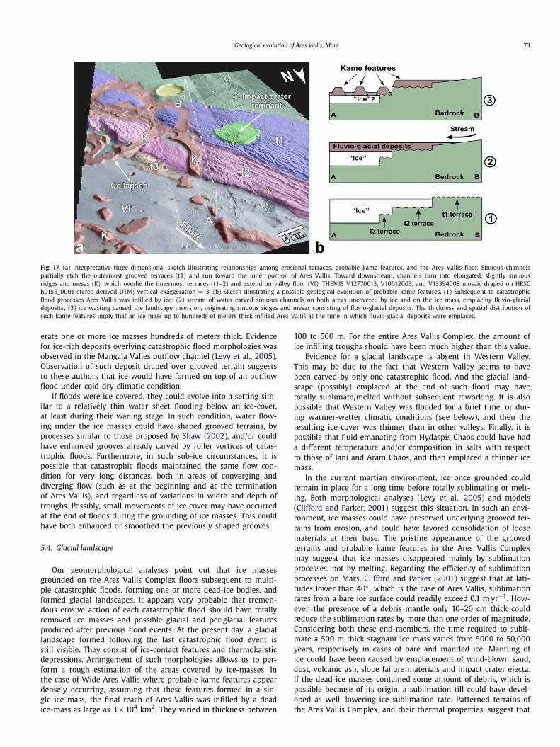
Fig. 17. (a) Interpretative three-dimensional sketch illustrating relationships among erosional terraces, probable kame features, and the Ares Vallis floor. Sinuous channelspartially etch the outermost grooved terraces (t1) and run toward the inner portion of Ares Vallis. Toward downstream, channels turn into elongated, slightly sinuousridges and mesas (K), which overlie the innermost terraces (t1–2) and extend on valley floor (Vf). THEMIS V12770013, V10012003, and V13394008 mosaic draped on HRSCh0155_0001 stereo-derived DTM; vertical exaggeration = 3. (b) Sketch illustrating a possible geological evolution of probable kame features. (1) Subsequent to catastrophicflood processes Ares Vallis was infilled by ice; (2) stream of water carved sinuous channels on both areas uncovered by ice and on the ice mass, emplacing fluvio-glacialdeposits; (3) ice wasting caused the landscape inversion, originating sinuous ridges and mesas consisting of fluvio-glacial deposits. The thickness and spatial distribution ofsuch kame features imply that an ice mass up to hundreds of meters thick infilled Ares Vallis at the time in which fluvio-glacial deposits were emplaced.
erate one or more ice masses hundreds of meters thick. Evidencefor ice-rich deposits overlying catastrophic flood morphologies wasobserved in the Mangala Valles outflow channel (Levy et al., 2005).Observation of such deposit draped over grooved terrain suggeststo these authors that ice would have formed on top of an outflowflood under cold-dry climatic condition.
If floods were ice-covered, they could evolve into a setting sim-ilar to a relatively thin water sheet flooding below an ice-cover,at least during their waning stage. In such condition, water flow-ing under the ice masses could have shaped grooved terrains, byprocesses similar to those proposed by Shaw (2002), and/or couldhave enhanced grooves already carved by roller vortices of catas-trophic floods. Furthermore, in such sub-ice circumstances, it ispossible that catastrophic floods maintained the same flow con-dition for very long distances, both in areas of converging anddiverging flow (such as at the beginning and at the terminationof Ares Vallis), and regardless of variations in width and depth oftroughs. Possibly, small movements of ice cover may have occurredat the end of floods during the grounding of ice masses. This couldhave both enhanced or smoothed the previously shaped grooves.
5.4. Glacial landscape
Our geomorphological analyses point out that ice massesgrounded on the Ares Vallis Complex floors subsequent to multi-ple catastrophic floods, forming one or more dead-ice bodies, andformed glacial landscapes. It appears very probable that tremen-dous erosive action of each catastrophic flood should have totallyremoved ice masses and possible glacial and periglacial featuresproduced after previous flood events. At the present day, a glaciallandscape formed following the last catastrophic flood event isstill visible. They consist of ice-contact features and thermokarsticdepressions. Arrangement of such morphologies allows us to per-form a rough estimation of the areas covered by ice-masses. Inthe case of Wide Ares Vallis where probable kame features appeardensely occurring, assuming that these features formed in a sin-gle ice mass, the final reach of Ares Vallis was infilled by a deadice-mass as large as 3×10⁴ km2. They varied in thickness between
100 to 500 m. For the entire Ares Vallis Complex, the amount ofice infilling troughs should have been much higher than this value.
Evidence for a glacial landscape is absent in Western Valley.This may be due to the fact that Western Valley seems to havebeen carved by only one catastrophic flood. And the glacial land-scape (possibly) emplaced at the end of such flood may havetotally sublimate/melted without subsequent reworking. It is alsopossible that Western Valley was flooded for a brief time, or dur-ing warmer-wetter climatic conditions (see below), and then theresulting ice-cover was thinner than in other valleys. Finally, it ispossible that fluid emanating from Hydaspis Chaos could have hada different temperature and/or composition in salts with respectto those of Iani and Aram Chaos, and then emplaced a thinner icemass.
In the current martian environment, ice once grounded couldremain in place for a long time before totally sublimating or melt-ing. Both morphological analyses (Levy et al., 2005) and models(Clifford and Parker, 2001) suggest this situation. In such an envi-ronment, ice masses could have preserved underlying grooved ter-rains from erosion, and could have favored consolidation of loosematerials at their base. The pristine appearance of the groovedterrains and probable kame features in the Ares Vallis Complexmay suggest that ice masses disappeared mainly by sublimationprocesses, not by melting. Regarding the efficiency of sublimationprocesses on Mars, Clifford and Parker (2001) suggest that at lati-tudes lower than 40◦ , which is the case of Ares Vallis, sublimationrates from a bare ice surface could readily exceed 0.1 m yr−1. How-ever, the presence of a debris mantle only 10–20 cm thick couldreduce the sublimation rates by more than one order of magnitude.Considering both these end-members, the time required to subli-mate a 500 m thick stagnant ice mass varies from 5000 to 50,000years, respectively in cases of bare and mantled ice. Mantling ofice could have been caused by emplacement of wind-blown sand,dust, volcanic ash, slope failure materials and impact crater ejecta.If the dead-ice masses contained some amount of debris, which ispossible because of its origin, a sublimation till could have devel-oped as well, lowering ice sublimation rate. Patterned terrains ofthe Ares Vallis Complex, and their thermal properties, suggest that
74 A. Pacifici et al. / Icarus 202 (2009) 60–77
Fig. 18. Pitted terrains consist of areas dotted by numerous hollows tens of me-ters wide. Such terrains show higher radiance values in THEMIS IR nighttime imagewith respect to nearby areas (see the color-coded bar). Association of such morpho-logical and thermal properties suggests that ground-ice occurred in the past (andpossibly at the present day) and that pits originated by ground-ice wasting. (a) Inthe terminal reach of Aram Chaos Channel, pitted terrains occur exclusively at thevalley floor (Vf), and they lack on valley walls and terraces (T); data fusion of MOCE0301279 and THEMIS IR Night mosaic; see Fig. 3 for location. (b) On the floor ofEastern Valley Crater, pitted terrains occur on top of crater floor deposits (Cf), andas patches at the bottom of thermokarstic depressions (Td), where they are less dis-tinguishable. Walls of thermokarstic depressions show layering (at least four) tensof meters thick; arrows indicate boundaries (b1–b3) among different layers. Datafusion of MOC E1700126 and THEMIS IR Night mosaic; see Fig. 14 for location.
periglacial processes occurred, and support the idea that ice wasmantled or mixed with debris.
Periods of high or low obliquity of Mars, if occurred, couldhave increased or decreased ice sublimation rate. Observationof thermokarstic features, probable kame features, and rela-tively small-scale meandering channels, which seem to have beenformed subsequent to multiple catastrophic flood events, suggeststhat relatively brief periods of warmer-wetter climatic conditionstook place (see below), which could have favored melting ratherthan sublimation processes.
5.5. Climatic changes
Some morphological features of the Ares Vallis Complex are in-terpreted as formed by flowing or standing bodies of water in equi-librium with the martian atmosphere. Such features are (i) narrow,meandering channels, (ii) thermokarstic features, and (iii) probablekame features. Development of such features requires that periodsof warmer-wetter climatic conditions took place. Thermokarsticfeatures (Fig. 14) and hanging channels (Figs. 13 and 15) formedboth on erosional terraces and icy deposits shaped by floods, andwere modified by subsequent floods deepening troughs. This sug-gests that they developed between different catastrophic floodevents. We hypothesize that such warmer-wetter climatic condi-tions were triggered by catastrophic flood events themselves. Infact, water vapor and carbon dioxide/methane gases liberated intothe martian atmosphere by degassing during outflow events couldhave induced a short-term greenhouse effect (Baker et al., 1991;Gulick et al., 1997; Baker, 2001). Water vapor released by wastingof stagnant ice-masses could have also sustained the greenhouseeffect.
The pristine morphologies characterizing glacial and periglacialfeatures of the Ares Vallis Complex may suggest that, in spiteof the earlier warmer-wetter conditions, the main wasting of icemasses was driven by sublimation processes. This implies thatthe warmer-wetter climatic conditions occurred for relatively briefspans of time. Subsequently, climatic conditions became similarto those of the present day. Our observations agree with Baker(2001), which proposed that a short-duration, transient, warmer-wetter period followed the activation of catastrophic floods, andthat afterward the martian climate comes back to climatic condi-tions similar to those of the present day.
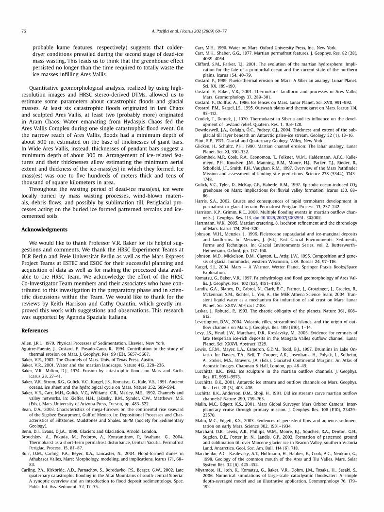
Fig. 19. Three-dimensional view of a portion of the narrow reach of Ares Vallis. Here valley terrace collapsed as a slump that overlaps and postdates grooved terrains (G) andvalley floor. The slump deposit shows a pitted patterned surface (P), suggesting burying of ice and the following activity of periglacial processes. Notice the thermokarsticdepressions (Td) etched on the terrace. HRSC h0934_0000 and h0923_0000 images mosaic draped on HRSC DTMs mosaic; vertical exaggeration = 3.
Geological evolution of Ares Vallis, Mars 75
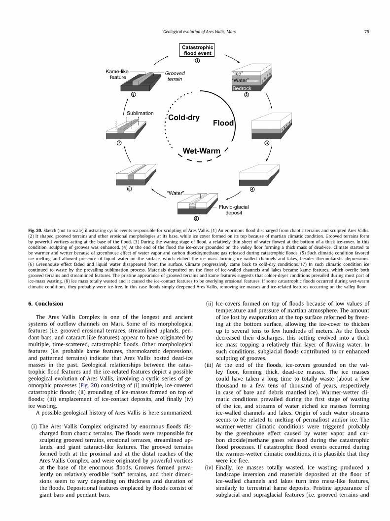
Fig. 20. Sketch (not to scale) illustrating cyclic events responsible for sculpting of Ares Vallis. (1) An enormous flood discharged from chaotic terrains and sculpted Ares Vallis.(2) It shaped grooved terrains and other erosional morphologies at its base, while ice cover formed on its top because of martian climatic condition. Grooved terrains formby powerful vortices acting at the base of the flood. (3) During the waning stage of flood, a relatively thin sheet of water flowed at the bottom of a thick ice-cover. In thiscondition, sculpting of grooves was enhanced. (4) At the end of the flood the ice-cover grounded on the valley floor forming a thick mass of dead-ice. Climate started tobe warmer and wetter because of greenhouse effect of water vapor and carbon dioxide/methane gas released during catastrophic floods. (5) Such climatic condition favoredice melting and allowed presence of liquid water on the surface, which etched the ice mass forming ice-walled channels and lakes, besides thermokarstic depressions.(6) Greenhouse effect faded and liquid water disappeared from the surface. Climate progressively came back to cold-dry conditions. (7) In such climatic condition icecontinued to waste by the prevailing sublimation process. Materials deposited on the floor of ice-walled channels and lakes became kame features, which overlie bothgrooved terrains and streamlined features. The pristine appearance of grooved terrains and kame features suggests that colder-dryer conditions prevailed during most part ofice-mass wasting. (8) Ice mass totally wasted and it caused the ice-contact features to be overlying erosional features. If some catastrophic floods occurred during wet-warmclimatic conditions, they probably were ice-free. In this case floods simply deepened Ares Vallis, removing ice masses and ice-related features occurring on the valley floor.
6. Conclusion
The Ares Vallis Complex is one of the longest and ancientsystems of outflow channels on Mars. Some of its morphologicalfeatures (i.e. grooved erosional terraces, streamlined uplands, pen-dant bars, and cataract-like features) appear to have originated bymultiple, time-scattered, catastrophic floods. Other morphologicalfeatures (i.e. probable kame features, thermokarstic depressions,and patterned terrains) indicate that Ares Vallis hosted dead-icemasses in the past. Geological relationships between the catas-trophic flood features and the ice-related features depict a possiblegeological evolution of Ares Vallis, involving a cyclic series of ge-omorphic processes (Fig. 20) consisting of (i) multiple, ice-coveredcatastrophic floods; (ii) grounding of ice-masses formed on top offloods; (iii) emplacement of ice-contact deposits, and finally (iv)ice wasting.
A possible geological history of Ares Vallis is here summarized.
(i) The Ares Vallis Complex originated by enormous floods dis-charged from chaotic terrains. The floods were responsible forsculpting grooved terrains, erosional terraces, streamlined up-lands, and giant cataract-like features. The grooved terrainsformed both at the proximal and at the distal reaches of theAres Vallis Complex, and were originated by powerful vorticesat the base of the enormous floods. Grooves formed preva-lently on relatively erodible “soft” terrains, and their dimen-sions seem to vary depending on thickness and duration ofthe floods. Depositional features emplaced by floods consist ofgiant bars and pendant bars.
(ii) Ice-covers formed on top of floods because of low values oftemperature and pressure of martian atmosphere. The amountof ice lost by evaporation at the top surface reformed by freez-ing at the bottom surface, allowing the ice-cover to thickenup to several tens to few hundreds of meters. As the floodsdecreased their discharges, this setting evolved into a thickice mass topping a relatively thin layer of flowing water. Insuch conditions, subglacial floods contributed to or enhancedsculpting of grooves.
(iii) At the end of the floods, ice-covers grounded on the val-ley floor, forming thick, dead-ice masses. The ice massescould have taken a long time to totally waste (about a fewthousand to a few tens of thousand of years, respectivelyin case of bare and debris mantled ice). Warmer-wetter cli-matic conditions prevailed during the first stage of wastingof the ice, and streams of water etched ice masses formingice-walled channels and lakes. Origin of such water streamsseems to be related to melting of permafrost and/or ice. Thewarmer-wetter climatic conditions were triggered probablyby the greenhouse effect caused by water vapor and car-bon dioxide/methane gases released during the catastrophicflood processes. If catastrophic flood events occurred duringthe warmer-wetter climatic conditions, it is plausible that theywere ice free.
(iv) Finally, ice masses totally wasted. Ice wasting produced alandscape inversion and materials deposited at the floor ofice-walled channels and lakes turn into mesa-like features,similarly to terrestrial kame deposits. Pristine appearance ofsubglacial and supraglacial features (i.e. grooved terrains and
76 A. Pacifici et al. / Icarus 202 (2009) 60–77
probable kame features, respectively) suggests that colder-dryer conditions prevailed during the second stage of dead-icemass wasting. This leads us to think that the greenhouse effectpersisted no longer than the time required to totally waste theice masses infilling Ares Vallis.
Quantitative geomorphological analysis, realized by using high-resolution images and HRSC stereo-derived DTMs, allowed us toestimate some parameters about catastrophic floods and glacialmasses. At least six catastrophic floods originated in Iani Chaosand sculpted Ares Vallis, at least two (probably more) originatedin Aram Chaos. Water emanating from Hydaspis Chaos fed theAres Vallis Complex during one single catastrophic flood event. Onthe narrow reach of Ares Vallis, floods had a minimum depth ofabout 500 m, estimated on the base of thicknesses of giant bars.In Wide Ares Vallis, instead, thicknesses of pendant bars suggest aminimum depth of about 300 m. Arrangement of ice-related fea-tures and their thicknesses allow estimating the minimum aerialextent and thickness of the ice-mass(es) in which they formed. Icemass(es) was one to five hundreds of meters thick and tens ofthousand of square kilometers in area.
Throughout the wasting period of dead-ice mass(es), ice werelocally buried by mass wasting processes, wind-blown materi-als, debris flows, and possibly by sublimation till. Periglacial pro-cesses acting on the buried ice formed patterned terrains and ice-cemented soils.
Acknowledgments
We would like to thank Professor V.R. Baker for its helpful sug-gestions and comments. We thank the HRSC Experiment Teams atDLR Berlin and Freie Universität Berlin as well as the Mars ExpressProject Teams at ESTEC and ESOC for their successful planning andacquisition of data as well as for making the processed data avail-able to the HRSC Team. We acknowledge the effort of the HRSCCo-Investigator Team members and their associates who have con-tributed to this investigation in the preparatory phase and in scien-tific discussions within the Team. We would like to thank for thereviews by Keith Harrison and Cathy Quantin, which greatly im-proved this work with suggestions and observations. This researchwas supported by Agenzia Spaziale Italiana.
References
Allen, J.R.L., 1970. Physical Processes of Sedimentation. Elsevier, New York.Aguirre-Puente, J., Costard, F., Posado-Cano, R., 1994. Contribution to the study of
thermal erosion on Mars. J. Geophys. Res. 99 (E3), 5657–5667.Baker, V.R., 1982. The Channels of Mars. Univ. of Texas Press, Austin.Baker, V.R., 2001. Water and the martian landscape. Nature 412, 228–236.Baker, V.R., Milton, D.J., 1974. Erosion by catastrophic floods on Mars and Earth.
Icarus 23, 27–41.Baker, V.R., Strom, R.G., Gulick, V.C., Kargel, J.S., Komatsu, G., Kale, V.S., 1991. Ancient
oceans, ice sheet and the hydrological cycle on Mars. Nature 352, 589–594.Baker, V.R., Carr, M.H., Gulick, V.C., Williams, C.R., Marley, M.S., 1992. Channels and
valley networks. In: Kieffer, H.H., Jakosky, B.M., Synder, C.W., Matthews, M.S.(Eds.), Mars. University of Arizona Press, Tucson, pp. 483–522.
Bean, D.A., 2003. Characteristics of mega-furrows on the continental rise seawardof the Sigsbee Escarpment, Gulf of Mexico. In: Depositional Processes and Char-acteristics of Siltstones, Mudstones and Shales. SEPM (Society for SedimentaryGeology).
Benn, D.I., Evans, D.J.A., 1998. Glaciers and Glaciation. Arnold, London.Brouchkov, A., Fukuda, M., Fedorov, A., Konstantinov, P., Iwahana, G., 2004.
Thermokarst as a short-term permafrost disturbance, Central Yacutia. PermafrostPeriglac. Process. 15, 81–87.
Burr, D.M., Carling, P.A., Beyer, R.A., Lancaster, N., 2004. Flood-formed dunes inAthabasca Valles, Mars: Morphology, modeling, and implications. Icarus 171, 68–83.
Carling, P.A., Kirkbride, A.D., Parnachov, S., Borodavko, P.S., Berger, G.W., 2002. Latequaternary catastrophic flooding in the Altai Mountains of south-central Siberia:A synoptic overview and an introduction to flood deposit sedimentology. Spec.Publs. Int. Ass. Sediment. 32, 17–35.
Carr, M.H., 1996. Water on Mars. Oxford University Press, Inc., New York.Carr, M.H., Shaber, G.G., 1977. Martian permafrost features. J. Geophys. Res. 82 (28),
4039–4054.Clifford, S.M., Parker, T.J., 2001. The evolution of the martian hydrosphere: Impli-
cation for the fate of a primordial ocean and the current state of the northernplains. Icarus 154, 40–79.
Costard, F., 1989. Fluvio-thermal erosion on Mars: A Siberian analogy. Lunar Planet.Sci. XX, 189–190.
Costard, F., Baker, V.R., 2001. Thermokarst landform and processes in Ares Vallis,Mars. Geomorphology 37, 289–301.
Costard, F., Dollfus, A., 1986. Ice lenses on Mars. Lunar Planet. Sci. XVII, 991–992.Costard, F.M., Kargel, J.S., 1995. Outwash plains and thermokarst on Mars. Icarus 114,
93–112.Czudek, T., Demek, J., 1970. Thermokarst in Siberia and its influence on the devel-
opment of lowland relief. Quatern. Res. 1, 103–120.Dowdeswell, J.A., Cofaigh, Ó.C., Pudsey, C.J., 2004. Thickness and extent of the sub-
glacial till layer beneath an Antarctic paleo-ice stream. Geology 32 (1), 13–16.Flint, R.F., 1971. Glacial and Quaternary Geology. Wiley, New York.Glicken, H., Schultz, P.H., 1980. Martian channel erosion: The lahar analogy. Lunar
Planet. Sci. XI, 330–332.Golombek, M.P., Cook, R.A., Economou, T., Folkner, W.M., Haldemann, A.F.C., Kalle-
meyn, P.H., Knudsen, J.M., Manning, R.M., Moore, H.J., Parker, T.J., Rieder, R.,Schofield, J.T., Smith, P.H., Vaughan, R.M., 1997. Overview of the Mars PathfinderMission and assessment of landing site predictions. Science 278 (5344), 1743–1748.
Gulick, V.C., Tyler, D., McKay, C.P., Haberle, R.M., 1997. Episodic ocean-induced CO2
greehouse on Mars: Implications for fluvial valley formation. Icarus 130, 68–86.
Harris, S.A., 2002. Causes and consequences of rapid termokarst development inpermafrost or glacial terrain. Permafrost Periglac. Process. 13, 237–242.
Harrison, K.P., Grimm, R.E., 2008. Multiple flooding events in martian outflow chan-nels. J. Geophys. Res. 113, doi:10.1029/2007JE002951. E02002.
Hartmann, W.K., 2005. Martian cratering. 8. Isochron refinement and the chronologyof Mars. Icarus 174, 294–320.
Johnson, W.H., Menzies, J., 1996. Pleistocene supraglacial and ice-marginal depositsand landforms. In: Menzies, J. (Ed.), Past Glacial Environments: Sediments,Forms and Techniques. In: Glacial Environments Series, vol. 2. Butterworth–Heinemann, Oxford, pp. 137–160.
Johnson, M.D., Mickelson, D.M., Clayton, L., Attig, J.W., 1995. Composition and gene-sis of glacial hummocks, western Wisconsin, USA. Boreas 24, 97–116.
Kargel, S.J., 2004. Mars — A Warmer, Wetter Planet. Springer Praxis Books/SpaceExploration.
Komatsu, G., Baker, V.R., 1997. Paleohydrology and flood geomorphology of Ares Val-lis. J. Geophys. Res. 102 (E2), 4151–4160.
Landis, G.A., Blaney, D., Cabrol, N., Clark, B.C., Farmer, J., Grotzinger, J., Greeley, R.,McLennan, S.M., Richter, L., Yen, A., the MER Athena Science Team, 2004. Tran-sient liquid water as a mechanism for induration of soil crust on Mars. LunarPlanet. Sci. XXXV. Abstract 2188.
Laskar, J., Robutel, P., 1993. The chaotic obliquity of the planets. Nature 361, 608–612.
Leverington, D.W., 2004. Volcanic rilles, streamlined islands, and the origin of out-flow channels on Mars. J. Geophys. Res. 109 (E10), 1–14.
Levy, J.S., Head, J.W., Marchant, D.R., Kreslavsky, M., 2005. Evidence for remnats oflate Hesperian ice-rich deposits in the Mangala Valles outflow channel. LunarPlanet. Sci. XXXVI. Abstract 1329.
Lewis, C.F.M., Mayer, L.A., Cameron, G.D.M., Todd, B.J., 1997. Drumlins in Lake On-tario. In: Davies, T.A., Bell, T., Cooper, A.K., Josenhans, H., Polyak, L., Solheim,A., Stoker, M.S., Stravers, J.A. (Eds.), Glaciated Continental Margins: An Atlas ofAcoustic Images. Chapman & Hall, London, pp. 48–49.
Lucchitta, B.K., 1982. Ice sculpture in the martian outflow channels. J. Geophys.Res. 87, 9951–9973.
Lucchitta, B.K., 2001. Antarctic ice stream and outflow channels on Mars. Geophys.Res. Lett. 28 (3), 403–406.
Luchitta, B.K., Anderson, D.M., Shoji, H., 1981. Did ice streams carve martian outflowchannels? Nature 290, 759–763.
Malin, M.C., Edgett, K.S., 2001. Mars Global Surveyor Mars Orbiter Camera: Inter-planetary cruise through primary mission. J. Geophys. Res. 106 (E10), 23429–23570.
Malin, M.C., Edgett, K.S., 2003. Evidences of persistent flow and aqueous sedimen-tation on early Mars. Science 302, 1931–1934.
Marchant, D.R., Lewis, A.R., Phillips, W.M., Moore, E.J., Souchez, R.A., Denton, G.H.,Sugden, D.E., Potter Jr., N., Landis, G.P., 2002. Formation of patterned groundand sublimation till over Miocene glacier ice in Beacon Valley, southern VictoriaLand, Antarctica. Geol. Soc. Am. Bull. 114 (6), 718.
Marchenko, A.G., Basilevsky, A.T., Hoffmann, H., Hauber, E., Cook, A.C., Neukum, G.,1998. Geology of the common mouth of the Ares and Tiu Valles, Mars. SolarSystem Res. 32 (6), 425–452.
Miyamoto, H., Itoh, K., Komatsu, G., Baker, V.R., Dohm, J.M., Tosaka, H., Sasaki, S.,2006. Numerical simulations of large-scale cataclysmic floodwater: A simpledepth-averaged model and an illustrative application. Geomorphology 76, 179–192.
Geological evolution of Ares Vallis, Mars 77
Miyamoto, H., Komatsu, G., Baker, V.R., Dohm, J.M., Itoh, K., Tosaka, H., 2007. Cat-aclysmic Scabland flooding: Insights from a simple depth-averaged numericalmodel. Environ. Modell. Softw. 22, 1400–1408.
Nelson, D.M., Greeley, R., 1999. Geology of Xanthe Terra outflow channels and theMars Pathfinder landing site. J. Geophys. Res. 104 (E4), 8653–8669.
Pacifici, A., 2008. Geomorphological map of Ares Vallis, Mars — ASI PlanetaryMap Series — Map No. 1. Boll. Soc. Geol. It. (Ital. J. Geosci.) 127 (1), 75–92.
Pacifici, A., Ori, G.G., Neukum, G., the HRSC Co-Investigator Team, 2005. High-resolution morphological analysis of the central part of Ares Vallis us-ing HRSC, MOC and THEMIS data. In: First Mars Express Science Confer-ence.
Robinson, C.A., Neukum, G., Hoffmann, H., Marchenko, A., Basilevsky, A.T., Ori, G.G.,1996. A suggested geological development for Ares Vallis, Mars. Lunar Planet.Sci. XXVII, 1083–1084.
Rodriguez, J.A.P., Sasaki, S., Kuzmin, R.O., Dohm, J.M., Tanaka, K.L., Miyamoto,H., Kurita, K., Komatsu, G., Fairén, A.G., Ferris, J.C., 2005. Outflow channelsources, reactivation, and chaos formation, Xanthe Terra, Mars. Icarus 175, 36–57.
Rogers, A.D., Christensen, P.R., Bandfield, J.L., 2005. Compositional heterogeneity ofthe ancient martian crust: Analysis of Ares Vallis bedrock with THEMIS and TESdata. J. Geophys. Res. 110, doi:10.1029/2005JE002399. E05010.
Russel, A.J., Knudsen, Ó., Fay, H., Marren, P.M., Heinz, J., Tronicke, J., 2001. Morphol-ogy and sedimentology of a giant supraglacial, i ce-walled, jökulhlaup chan-
nel, Skeiðarárjökull, Iceland: Implications for esker genesis. Global PlanetaryChange 28, 193–216.
Shaw, J., 1996. A meltwater model for Laurentide subglacial landscape. In: McCann,S.B., Ford, D.C. (Eds.), Geomorphology sans Frontière. Wiley, Chichester, pp. 182–226.
Shaw, J., 2002. The meltwater hypothesis for subglacial bedforms. Quatern. Int. 90,5–22.
Shepherd, R.G., 1972. Incised river meanders: Evolution in simulated bedrock. Sci-ence 178 (4059), 409–411.
Shepherd, R.G., Schumm, S.A., 1974. Experimental study of river incision. Geol. Soc.Am. Bull. 85 (2), 257–268.
Shipp, S., Anderson, J.B., 1997. Drumlin field on the Ross Sea continental shelf,Antarctica. In: Davies, T.A., Bell, T., Cooper, A.K., Josenhans, H., Polyak, L., Sol-heim, A., Stoker, M.S., Stravers, J.A. (Eds.), Glaciated Continental Margins: AnAtlas of Acoustic Images. Chapman & Hall, London, pp. 52–53.
Tanaka, K.L., 1999. Debris-flow origin for the Simud/Tiu deposit on Mars. J. Geophys.Res. 104 (E4), 8637–8651.
Tanaka, K.L., Skinner, J.A., Hare, T.M., 2005. Geologic Map of the Northern Plainsof Mars. US Geological Survey Scientific Investigations Map 2888 [available onWorld Wide Web at: http://pubs.usgs.gov/sim/2005/2888/].
Werner, S., 2005. Major Aspects of the chronostratigraphy and geologic evolutionaryhistory of Mars. Ph.D. thesis, Freie Universität, Berlin.
Wallace, D., Sagan, C., 1979. Evaporation of ice in planetary atmospheres: Ice-covered rivers on Mars. Icarus 39, 385–400.
Copyright © 2022 FDOKUMEN