Geographical information system (GIS) based approach to monitor epidemiological disaster: 2011...
18
Geographical information system (GIS) based approach to monitor epidemiological disaster: 2011 dengue fever outbreak in Punjab, Pakistan Shahbaz Ahmad 1 , Muhammad Bilal Sadiq 2 , Tanzeem Akbar Cheema 2 , and Muhammad Shahzad Sarfraz 3 1 Department of Computer Science, National Textile University, Faisalabad, Pakistan ([email protected]) 2 Food Engineering & Bioprocess Technology, Asian Institute of Technology, Bangkok, Thailand 3 Remote Sensing & Geographical Information System, Asian Institute of Technology, Bangkok, Thailand Abstract Epidemiological disaster management, using geo- informatics (GIS), is an innovative field of rapid information gathering. Dengue fever, a vector-borne disease, also known as break bone fever, is a lethal re- emerging arboviral disease. Its endemic flow is adding serious effects to the economy and health concern issues at global-level. Still, many under-developing and developing countries like Pakistan are lacking the necessary GIS technologies to monitor such health issues. The aim of this study is to enhance the effectiveness of developing countries through disaster management capabilities by using state-of-the-art technologies, which provides the measures to relief the disaster burden on public sector agencies. In this paper, temporal changes and regional burden for distribution of this disease are mapped using GIS tools. For the prevention of disaster burden, these types of studies are widely used to provide an effective help and relief. This study concludes that a public sector institute can use such
Transcript of Geographical information system (GIS) based approach to monitor epidemiological disaster: 2011...

Geographical information system (GIS) based approach tomonitor epidemiological disaster: 2011 dengue fever
outbreak in Punjab, Pakistan
Shahbaz Ahmad1, Muhammad Bilal Sadiq2, Tanzeem Akbar Cheema2,and Muhammad Shahzad Sarfraz3
1Department of Computer Science, National Textile University, Faisalabad,
Pakistan ([email protected])2Food Engineering & Bioprocess Technology, Asian Institute of Technology, Bangkok, Thailand 3Remote Sensing & Geographical Information System, Asian Institute of
Technology, Bangkok, Thailand
Abstract
Epidemiological disaster management, using geo-informatics (GIS), is an innovative field of rapidinformation gathering. Dengue fever, a vector-bornedisease, also known as break bone fever, is a lethal re-emerging arboviral disease. Its endemic flow is addingserious effects to the economy and health concern issuesat global-level. Still, many under-developing anddeveloping countries like Pakistan are lacking thenecessary GIS technologies to monitor such health issues.The aim of this study is to enhance the effectiveness ofdeveloping countries through disaster managementcapabilities by using state-of-the-art technologies,which provides the measures to relief the disaster burdenon public sector agencies. In this paper, temporalchanges and regional burden for distribution of thisdisease are mapped using GIS tools. For the prevention ofdisaster burden, these types of studies are widely usedto provide an effective help and relief. This studyconcludes that a public sector institute can use such

tools for surveillance purpose and to identify the riskareas for possible precautionary measures.
Keywords1-GIS 2-Dengue 3-Hemorrhagic fever 4- Aedesaegypti Introduction Dengue virus was first time arrived at the start of WorldWar II [1]. Dengue fever is also known as break bonefever. It is lethal re-emerging arboviral disease whoseendemic flow [2] is adding effecting to the economy andhealth concern issues at global level. It is mosquito-borne fellow of Flaviviridae clan, which is thecontributory fever [3]. Dengue is found in tropical and asub tropical area around the globe, mainly in urban andsemi urban region. The vital force behind the growth anddevelopment of dengue virus is temperature and climate.Climate and temperature are two known natural resources,which are not under human control.Therefore, precautionary measures can take against thedamaging dengue, and try to avoid the breeding of dengueand transmission. It is observed that time period of growthfrom egg eclosion to adult is inversely related to temperature.It ranges from 7.2 ± 0.2 days at 35°C to 39.7 ± 2.3 days at15°C[4]. Dengue virus is now almost blowout over the globe.In recent years due to fast communication andtransportation, It is expected that there are 50 to 100million cases of dengue fever while about 500000 cases ofdengue haemorrhagic fever per year, which requirehospitalization [5].Dengue fever normally blowout by thebite of an infected Aedes aegypti mosquito, while symptomof disease exposed automatically in the range of 5-7days.
Dengue hemorrhagic fever was described in Southeast Asia,Manila in 1953[6] and even in the start of 1950 about 9countries were its victim. Dengue fever becomes more

public in 1980 while at the end of 1990s, it becomes themost substantial mosquito-borne disease [7]. It isdistressing humans after malaria in the time span of 40years. Afterwards in the year of 2009, an epidemic brokeout in Bolivia, where 31000 cases were registered [8].Particularly in Punjab area of Pakistan.
In this research study, dengue patient data andgeographical information system (GIS) tool are integratedto show the real picture of natural disaster in form ofdengue virus in Punjab, Pakistan. The GIS system is usedin this paper to show the indication of disastrous areaand its intensity level.
To show possible the real picture of dengue disaster wemove from hospital to hospital for data collection ofdengue patients and then make its conversion in soft formand made usage of satellite images to show the denguedisaster in Punjab the main province of Pakistan. Soanyone can observe the dengue disastrous areas and feelthe loss of lives and income along with dengue fear amongpeoples.
Study Area

Figure 01 Figure 02
The world of PUNJAB was first time used in the booktarikh-e-sher shah suri (1580) [9].It is derived fromPersian language and concatenation of two substrings Punjand aab mean the land of five rivers. Pakistan comprisesfour provinces while Punjab is major province of thePakistan with respect to population, industry, and richagricultural resource. Punjab is the most established,populated and flourishing province of Pakistan. As it ishub of cultural, historical economic and administrativeactivities. Almost 62% population of the Pakistanresiding in the province of Punjab [10].we can say that inthe development and progress of Pakistan this region of
Punjab play vital role while if any dead lock occur inthis region then whole country is affected as it havingmassive impact upon country. In last year 2011 denguevirus boomed throughout the country especially it disturbthe Punjab region. Dengue fever become epidemic in coupleof year especially in 2011.
Pakistan is developing country here is lack of resourcesand management so due to high cost of treatment thisdisease spread out more rapidly in 2011with respect tothe previous year [11].In couple of months up to November2011 about 300 peoples were died while over 14000 wereinfected by dengue. Majority of the population effectedfrom dengue was from Lahore which is also provincialmetropolis of Punjab. In Pakistan normally patient datain hospitals is not in electronic form it is mounted overthe registers in manual fashion so it was very hard taskto move from district to district and hospital tohospital to collect data of dengue patients. We makecollection of all 36 districts of the Punjab province andsettled data according to districts.
Results

Figure 03 Figure 04
In March 2011, dengue emerge from Lahore accidently andabout five patients were admitted to differenthospitals.so it was dengue debut in Lahore in theprovince of Punjab as Lahore is located on the boarder ofIndia and most populated city of the province.in PakistanMarch is the ending of winter season which is notsuitable for the growth of dengue virus as this virus wastransferred by some foreign country throughtransportation of persons and products.so Lahore proved alaunching pad for dengue and in very next month of Aprilvirus was moved to the near by city Sheikhupura which isjust 37km away from Lahore as it was natural to flow ofvirus to the nearest area as local bodies fromSheikhupura daily travel to Lahore as Lahore iscommercial hub for the Punjab area. Mean while in thesame month viral attack moved directly to the Jhang,Leyya and Bhakkar.
This movement of dengue was due to daily transport ofpassenger as from Lahore most buses move on this trackwhere these three main district are laying so in this waythe dengue get start from Lahore and moved to the otherfour districts. But it was very minute in these four

districts as just single case was observed per districtso it was start of the endemic flow of dengue. Actuallythis climate was not suitable for the growth of denguevirus so soon treatment was made as it was observed anddengue skip away from these four districts but yet inLahore it was present but in minute value.
In the month of April climate start getting slightly hotbut no chance of rain and it is the season of wheatgetting ripe up but not fortunate for dengue. So in Maydengue was promoted to the district of Sargodha, Sahiwaland Saialkot and this spread out was due totransportation of passengers from Lahore to these areasbut in all above maps one point is common that is Lahoreas it prove dengue hub in Pakistan and in May weather isgetting hot and dengue growth rate decreases down.

Figure 05 Figure 06
So from March to May dengue virus moves through differentdistrict of Punjab but for a short while like a warningto the peoples but strengthened its root in Lahorepermanent. Later on in June the booming hot season inPakistan which is most offensive season for dengue virusas in June the population of mosquitos is finished due to
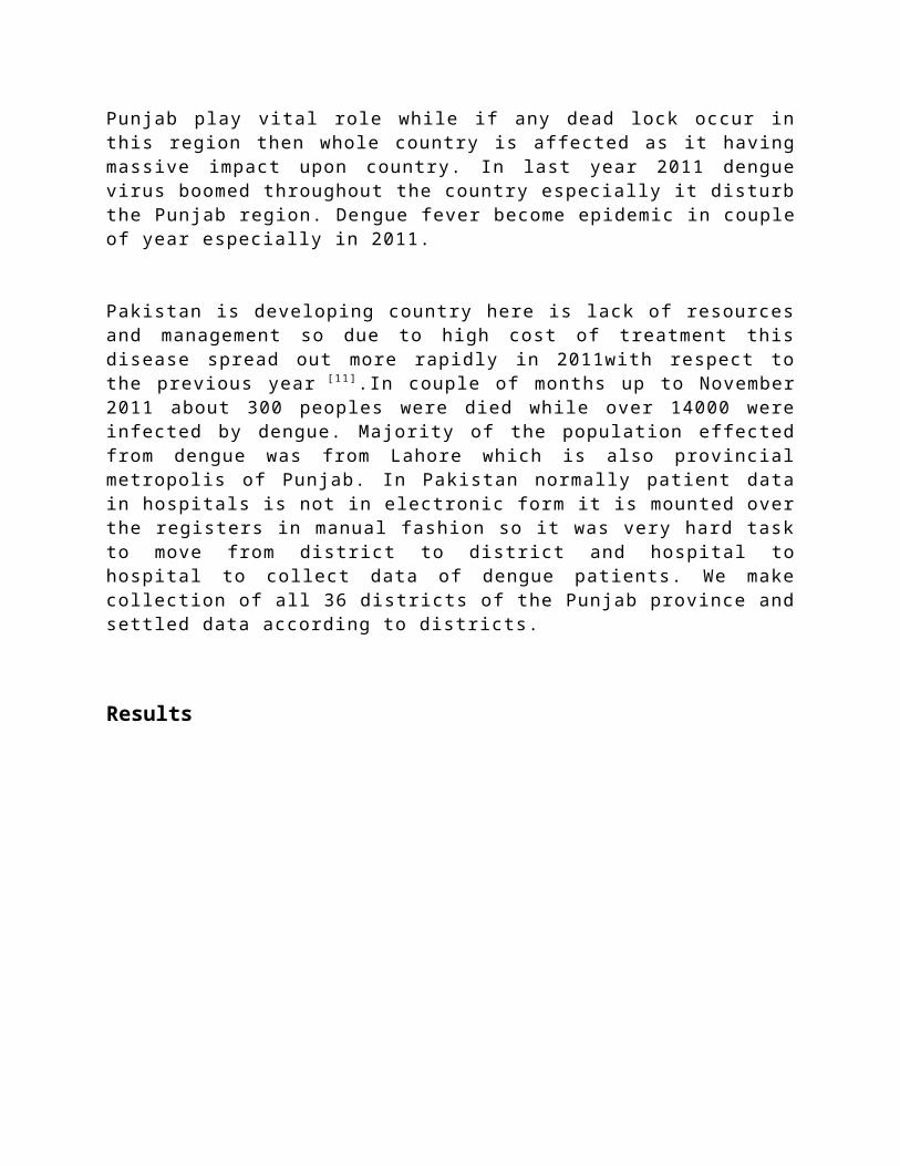
hot season. So in June just Kasur district was infectwith just single patient along with Lahore as this areais just 25km away from Lahore. July is also hot seasonbut with little but humidity and the growth of dengue yetremain limited to Lahore with eight patients and justsingle patient was found in Attock. So in July Denguecreated no problem for Government and public while nextmonth open the flow of dengue toward whole Punjabprovince.
Figure 07 Figure 08
Pakistan is located on the Geographical map where moonsoon rain gear up at the end of July or start of Augustand humidity is also on boom so this climate andtemperature is favorable for the growth of dengue virusand it widely spread out in just the month of August bycovering 27 districts out of 36 district in this way itcovered the 75% area of Punjab. The suffering area can beobserved by the given below map where Lahore, Faisalabad,Multan and Sheikhupura were most badly effected.

In the month of August and we can observe that this monthalmost whole Punjab was effected due to Dengue viruswhich caused lost of lives, restless life, fear amongpublic and Government start the Dengue advertisement inorganized way so that people should use precautionarymeasures from this viral attack even in some schools andcolleges announces holiday so that in result dengueintensity can be control.no doubt that in August denguecovered almost 75% of area of Punjab but concentrationwas limited to four districts.
In the month of September dengue geared up its strengthof attack and covered 100% area of Punjab province as nodistrict was without dengue viral infection and itsintensity level was also increased and spread over 14districts as almost 39% area of Punjab was so much badlyinfected. While 17% area of Punjab was facing averageintensity of dengue while about 44% area having belowaverage dengue intensity.in single month of Septemberabout 11000 patients were registered in differenthospital of the Punjab. In the month of October denguedevastation boomed much as compared to September seasonand people were so much scared, everyone think dengue isthe second name of death as daily television channelsannounce the death due to dengue while Governmentagencies start to spray on dengue expected areas so thatits growth can be controlled.

Figure 09 Figure 10
In Lahore, Faisalabad, Sahiwal, Rawalpindi and Rahim Yarkhan the intensity level of dengue remain same in themonth of September and October. While in the month ofNovember Slight change occur as intensity was lowereddown up to 19% as compared to previous months so slightrelief was felt in this month and dengue climax wasbroken that contribute efforts of government to conductspray on doubtful areas, educating public through mediaand peoples self awareness. Dengue hub Lahore,Faisalabad along with Rawalpindi having the sameintensity of dengue viral cases while the area ofBahawalpur,Rajan pur and Layya were purely cleaned fromdengue.Kasur, Okara, Pakpatan and Sahiwal have denguecases more then average.
In the month of December surprisingly the dengue effectwas very down up to 20% with respect to the number ofcases arriving from different district. So 80% public gotrelief from dengue in December as in this monthtemperature fall up to 0-8 centigrade and dengue deathoccur due to high chill climate and in this way inDecember the dengue story come to and which left

permanent mark upon the families of Punjab who lost theirown, restless sleep, government spent million of rupeesfor advertisement and equipment, heavy economic loss ,public face heavy strain, education sector was alsoeffected, many doctors teams from Sri Lanka,Thailand andother countries also came for rescue of public fromdengue.
Figure 11 Figure 12
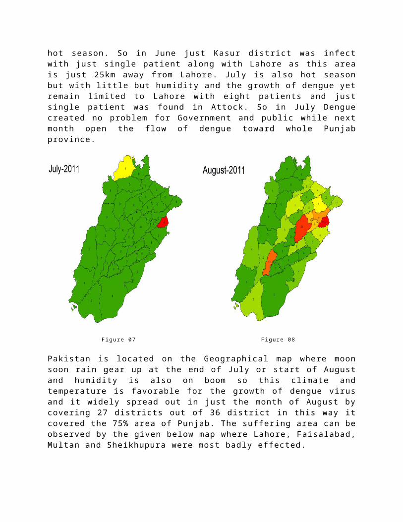
When we observe the final map for the overall denguewreckage, we come to know that about 21000 patients wereinfluenced through this viral disease. Lahore proved ahub for dengue flow and top district while containingabout 17234 patients while Rajanpur was least effecteddistrict with just 6 patients. The dengue rampage wasobserved at Lahore, Faisalabad, Okara, Pakpatan,Khanewal, Rahim Yar Khan, Sheikhupura, Rawalpindi
Sargodha, and these districts as normally adjacent toeach other except, Rahim Yar Khan and Rawalpindi.
Figure 13 Figure 14
Figure 15
Discussion
We know that dengue disaster gear up from Lahoreaccidently in the month of March,2011 while the weatherof Lahore on that time is announcing the end of winterseason mean that it is not suitable climate formosquitoes.so the question arries where from Denge arrivein Lahore.When investigation was made it came to know

that Dengue arrived from Bangkok,Thailand while its realsource was 1000 second hand tractor tyres.These tyerscontain some water inside them where dengue eggs werepresent and in this way dengue spread over lahore.we knowthat Lahore is capital city of province and commericalhub so due to transportation this virus was moved toLayya , Jhang , and Bhakkar because frequently trasportmoves through these districts from lahore.So the mainreason of flow from lahore to the other cities was publictransportation.But soon virus vanish from these districtand emerg to the other districs .Except lahore dengueplay like hide and seek because temperature and climatewas not in the favourable for dengue growth.
Objectid
Distcode District
Patient
Objectid
Distcode District
Patient
1 601 Attock 28 19 619 Lodhran 15
2 602Bahawalna
gar 99 20 620M.Bahaud
din 11
3 603Bahawalpu
r 52 21 621 Mianwali 144 604 Bhakkar 40 22 622 Multan 113
5 605 Chakwal 46 23 623Muzaffargarh 30
6 606 Chiniot 29 24 624 Nankana 487 607 D.G Khan 30 25 625 Narowal 64
8 608Faisalaba
d 875 26 626 Okara 185
9 609Gujranwal
a 133 27 627Pakpatta
n 222
10 610 Gujrat 29 28 628RahimYar 148
11 611 Hafizabad 31 29 629 Rajanpur 6
12 612 Jhang 77 30 630Rawalpin
di 45013 613 Jhelum 80 31 631 Sahiwal 11414 614 Kasur 109 32 632 Sargodha 138

15 615 Khanewal 147 33 633Sheikhup
ura 27416 616 Khushab 9 34 634 Sialkot 94
17 617 Lahore17235 35 635
T.TSingh 59
18 618 Layyah 62 36 636 Vehari 90
The real outbreak occur in the August when rainy seasonstart and now temperature and climate moves in the favourof dengue and in this month it covered the 75% area ofPunjab and in later months it cover 100% area and now theexpension of dengue was due to public movement because adengue can cover maximum 300 meters area.so real sourcefrom district to district is fast transportation whichcause to deploy viral infection from one place to otherplace.In tropical parts dengue diffusion occursthroughout the year,while the temperature and humidityfavour the existence of adult mosquitoes beyond theirextrinsic incubation period.We know chill winter seasonand sweltering hot season are not suitable for dengegrowth so from march to august dengue did no florishedbut as rainy season get start in meanwhile dengue growthrate increased.normaly the spry don’t harm to the denguebut it causes to destroy its eggs so that future growthcan be avoided.While one female produces about 300 eggsin the life spane of 14days.So real task is to wipe awayand distroy its eggs so that further disaster can beavoided and we can save lives, econmoy,and health.

BahawalnagarFaisalabadGujranwalaKasurKhanewalLahoreMultanOkaraPakpattanRahim Yar KhanRawalpindiSahiwalSargodhaSheikhupura
Figure 16
Conclusion
We come to know that GIS approach is very effective andsuitable to observe and indicate the disaster caused bythe viral diseases.It is not possible to monitor thewhole area without using GIS approach as if we accumulatedata from the different areas and then process it then acouple of information we can receive while data that weprocess throught GIS can generate information indifferent respects.in this research we accumulate denguepatients data from different districts and embed it onsattellite images.So in result we can observe andindicate the disaster nature and its intensity indifferent region so that precautionary measures can betaken in that areas where intensity of dengue is onrampage.In future if we develop integrated network of allthe system of the government and private hospitals wheredata should be process in realtime then it can help thegovernmnet to observe the current situation of disastertime to time and positive decision can be made to see thereal time map and necessary action can be take to observe

this real time GIS approach . In this way we can savelives , indicate and observe disaster, manage theresources according to the situation.So in future in thisdynamic environment real time GIS approach should beimplemented on the integrated network of all hospitals,in response we can save lives,economy, and resources ofcountry,we can remove fear among faimlies ,stressed andstrain from public.
References
1-Kurane I, Ennis FA. Cytokines in dengue virus infections: role of cytokines in the pathogenesis of dengue hemorrhagic fever. Sem Virol 1991;5:443–448.
2- P. E. R. Dale, J. M. Knight, 2008.Wetlands and mosquitoes: areview, Wetlands Ecol Manage 16:255–276
3-S.I.Hay, J.A.Omumbo, M.H.Craig (2000).Earthobservation, geographic information system and plasmodiumfalciparum malaria in sub-Saharan Africa. Volume 47, 2000,Pages 173–174.
4-W. Tun-Lin,T. R. Burkot,B. H. Kay effect oftemperature and larval diet on development rates andsurvival of the dengue vector Aedes aegypti in northQueenland, Australia. Volume 14 issue 1, pages 31-37,march2000
5-Nisar Ahmad, Hina Afzal. Dengue fever treatment with Carica papaya leaves extracts. Asian Pacific Journal of Tropical Biomedicine (2011)330-333
6- Richard C Russell 1999.Mosquito-borne arboviruses inAustralia:the current scene and implication of climate

change for human health. Volume 28, Issue 6, 1 June 1998,Pages 955–969
7-Duane J. Gubler, 2002.Epidemic dengue/denguehemorrhagic fever as a public health, social and economicproblem in the 21st century. TRENDS in MicrobiologyVol.10 No.2
8. Oyewale Tomori (1999).Impact of Yellow Fever on The Developing World, Advance in virus research. Volume 53, Pages 5–34
9-http://en.wikipedia.org/wiki/Punjab,_Pakistan
10-http://en.wikipedia.org/wiki/History_of_the_Punjab
11- C.G. Hayes, S. Baqar(2004). West Nile virus inPakistan. 1. Sero-epidemiological studies in PunjabProvince. Volume 76, Issue 4, 1982, Pages 431–436