GEOGRAPHIC INFORMATION SYSTEM FOR THE REGIONAL PLANNING, URBAN DESIGN AND LANDSCAPE ARCHITECTURE...
12
GEOGRAPHIC INFORMATION SYSTEM FOR THE REGIONAL PLANNING, URBAN DESIGN AND LANDSCAPE ARCHITECTURE (ONLINE) Postgraduate studies Partners: Colegio de Arquitectos de Canarias
-
Upload
independent -
Category
Documents
-
view
3 -
download
0
Transcript of GEOGRAPHIC INFORMATION SYSTEM FOR THE REGIONAL PLANNING, URBAN DESIGN AND LANDSCAPE ARCHITECTURE...

GEOGRAPHIC INFORMATION SYSTEM FOR THE REGIONAL PLANNING, URBAN DESIGN AND LANDSCAPE ARCHITECTURE (ONLINE)
Postgraduate studies
Partners:
Colegio de Arquitectos
de Canarias

“
https://www.facebook.com/pages/Urbatic/569825699754837
1ª Materia: 1ª Materia: NOCIONES BÁSICAS PARA EL USO DESISTEMAS DE INFORMACIÓN GEOGRÁFICA EN LA
ORDENACIÓN DEL TERRITORIO, EL URBANISMO Y ELPAISAJE
(7,5 ECTS)(7,5 ECTS)
EXPERTO UNIVERSITARIO EXPERTO UNIVERSITARIO en análisis urbano y territorial a través de
Sistemas de Información Geográfica por la Universitat Politècnica de
València(17 ECTS)(17 ECTS)
2ª Materia: 2ª Materia: ANÁLISIS A TRAVÉS DE SISTEMAS DEINFORMACIÓN GEOGRÁFICA APLICADOS AL TERRITORIO
Y LA CIUDAD
(7,5 ECTS)(7,5 ECTS)
4ª 4ª Materia: Materia: GESTIÓN DE DATOS Y CARTOGRAFÍASMEDIANTE SIG PARA LA ADMINISTRACIÓN URBANA Y
TERRITORIAL
(7,5 ECTS)(7,5 ECTS)
5ª 5ª Materia: Materia: APLICACIONES DE LOS SIG PARA LA
3ª 3ª Materia de Materia de 2 ECTS2 ECTS
paraparaPROYECTO FINAL PROYECTO FINAL
EXPERTO EXPERTO UNIVERSITARIOUNIVERSITARIO
6ª Materia de 6ª Materia de 2 ECTS2 ECTS
paraparaPROYECTO FINAL PROYECTO FINAL
EXPERTO UNIVERSITARIO EXPERTO UNIVERSITARIO en gestión de datos para la administración de territorios y ciudades a través de
Sistemas de Información Geográfica por la Universitat Politècnica de
DIPLOMA DE ESPECIALIZACIÓN DIPLOMA DE ESPECIALIZACIÓN en Sistemas de Información Geográfica aplicados a la Ordenación del Territorio, el Urbanismo y el Paisaje por la Universitat Politècnica de
València(36 ECTS)(36 ECTS)
5ª 5ª Materia: Materia: APLICACIONES DE LOS SIG PARA LAAUTOMATIZACIÓN DE GEOPROCESOS Y CÁLCULO DE
INDICADORES URBANOS
(7,5 ECTS)(7,5 ECTS)
PROYECTO FINAL PROYECTO FINAL EXPERTO EXPERTO
UNIVERSITARIOUNIVERSITARIO
por la Universitat Politècnica de València(17 ECTS)(17 ECTS)
7ª Materia de 7ª Materia de 2 ECTS 2 ECTS para PROYECTO para PROYECTO FINAL DIPLOMA ESPECIALIZACIONFINAL DIPLOMA ESPECIALIZACION
Mate
rias
o C
urs
os
de
Form
aci
ón
Título
s de Po
stgra
do

Introduccition
A few years ago under the patronage of of the Department of Urban Studies and UPV with the support of the Institute of Architecture College of Architecture Madrid (IA-COAM), Colegio de Arquitectos de Canarias, Instituto Valenciano and Mapping ESRI International, we run a set of courses on the use of GIS for regional, urban planning and landscape design. With an experience of 10 years, this year we improved our offer on 2 points:
On one hand, we have integrated this course in the structure of Postgraduate Studies of the Universitat Politècnica de Valencia (UPV), with the advantage that it involves from the point of view curricular. The structure of postgraduate studies in GIS consists of 2 University Expert and 1 Specializations Diploma. The structure of Postgraduate studies you can see in the left picture.
On other hand, nowadays with the support and technology of the UPV we can run the courses in ONLINE mode.The main advantages of this course are:
“

Our expertize in potsgraduate studies
The Research Unit “Urban Observatory” UPV has extensive experience in carrying out customized courses related to GIS. In the last 5 years we have taught at: College of Architects of Alicante, College of Architects of Valencia, Madrid College of Architects, Architects Association of Canarias. Demarcation of Tenerife, La Gomera and El Hierro, Canary Islands Institute of Architects. Demarcation of La Palma - Cabildo Insular de La Palma, Valencia School of Architecture, School of Architecture of the Universidad Europea de Madrid in Madrid, José Antonio Echevarría Institute (Havana).
The titles we teach, are essentially practicals and its main objective is to provide new technical tools to facilitate the work. Therefore we have requested the support of some public and private companies as well as professional associations for the development of the Titles we teach, adapting its content to the real needs of society. In this way at the end of 2014 we have the support of the Institut Cartogràfic Valencià, the internacional company Esri Spain Geosistemas SA, developer of GIS software used in the course, the Colegio de Arquitectos de Madrid, the Colegio de Arquitectos de Canarias, Colegio de Arquitectos de Castellón, Coordinadora Zona 4 de Educación de Ecuador, The Colegio de Aparejadores, Arquitectos Técnicos e Ingenieros de la Edificación de Valencia.

What can I do with these Graduate Degrees?
We have prepared four videos in which we summarize what is a GIS, the software features we will use in the course, and some results developed with the material that we are going to teach in these courses.
Subject and content:
You can learn what is a GIS and how can be used in 3 ‘
What can I do with ArcGIS?
Know some interesting applications that you can learn in these courses
Know how we teach you in these courses
https://www.youtube.com/watch?v=oYuuXoQXyCE
http://video.esri.com/watch/2436/arcgis-overview
https://www.youtube.com/watch?v=90vc8AsdT9k
http://politube.upv.es/uploads/b4450fcdf9b773a0b358d06fc8075abc.mp4

Methodology and organization of Titles
The Titles in On-Line mode are developed on the Training “PoliformaT” Platform, which belongs to the Universitat Politècnica de València. This Platform is widely experienced in a community of more than 40,000 students of Degree, Master and Doctorate, and has the latest technology and their own maintenance service and management, allowing to the students the maximum utilization of your course.
Following there are two links to two documents. Pdf, in which the procedure required to access the educational platform of the Polytechnic University of Valencia is explained in detail.
Access Guide PoliformaT. This document is a manual that teaches you how to access the platform and describes the steps you must follow in case of forgetting the key as well as the resolution of technical issues in the platform.
Basic Guide PoliformaT. In this document the student will find a basic guide to the operation of the platform, and a tool called HELP AREA where you can see a list of videos explaining the differents tools PoliformaT.

Working Plan
The structure of each title is explained below. Each title has a series of subjects. For carrying out each subject there are:
• An educational video about the matter, in which isexplained in detail each of the steps you have to do in the development of practices.
• A pdf document that explain you in a tutorial way thepractice or activity you have to carry on.
• Afolderwiththenecessaryresourcesforthedevelopmentof the practice. Normally this folder will have alphanumeric and cartographic material, in vector format and raster format.
FAQ Tutorials / Inquiries
The students will have access to queries and doubts with the teacher every week using the “Forum and Chat” tool in PoliformaT. Every week, at a date which shall be indicated, a specific forum for each Subject will open, in this forum the questions and answers raised by the students and teachers will be shown. Others complementary forums to discuss other matters of more general can be open too.
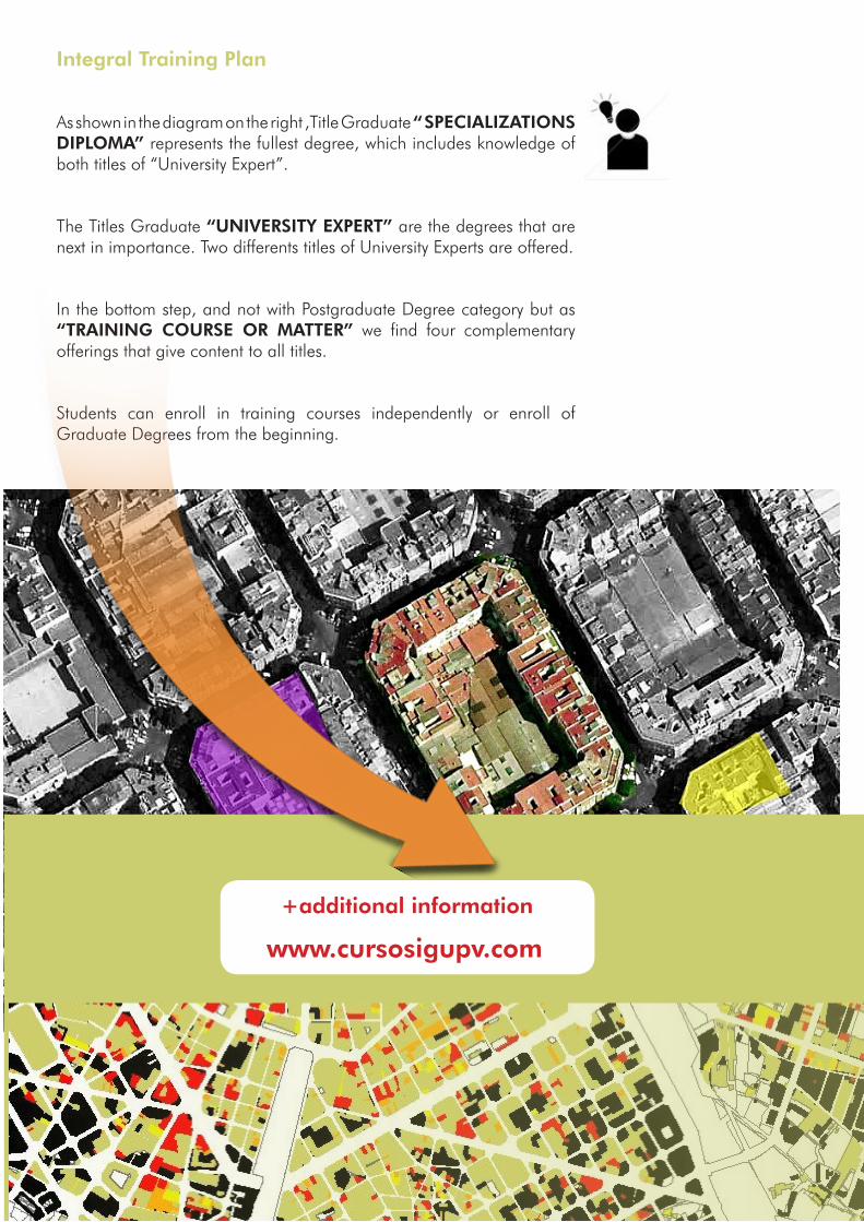
Integral Training Plan
As shown in the diagram on the right ,Title Graduate “ SPECIALIZATIONS DIPLOMA” represents the fullest degree, which includes knowledge of both titles of “University Expert”.
The Titles Graduate “UNIVERSITY EXPERT” are the degrees that are next in importance. Two differents titles of University Experts are offered.
In the bottom step, and not with Postgraduate Degree category but as “TRAINING COURSE OR MATTER” we find four complementary offerings that give content to all titles.
Students can enroll in training courses independently or enroll of Graduate Degrees from the beginning.
+additional information
www.cursosigupv.com
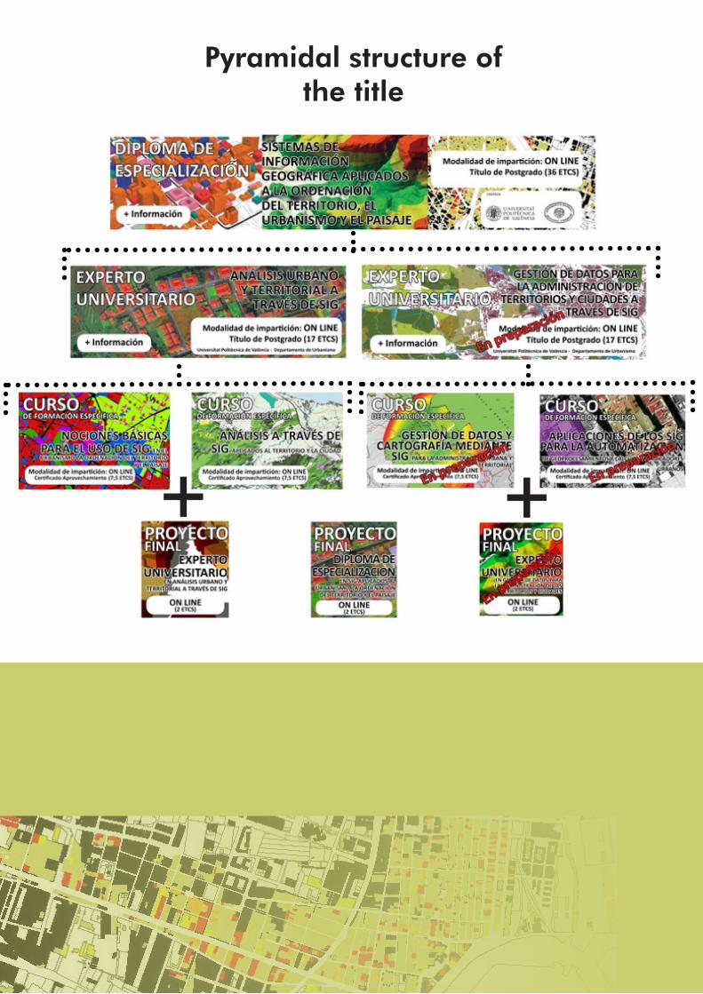
Pyramidal structure of the title
+ +

Below are be exposed in more detail the contents of each training course or matter that lead to achieve all the Postgraduate exposed.
M01: BASIC USE OF GIS IN THE REGIONAL PLANNING, URBAN DESIGN AND LANDSCAPE. (ONLINE)
P01.Introduction to ArcGis: Layout of tematic cartography
P02.Surface analyst 3D and photographyc modelation with ArcScene
P03.Georeferencing and vectorization with ArcGis
P04.Other software of GIS. Introduction to gvSIG
Annex: Joining with a attribute table with ArcGis
Annex: The geographic projections
M02: ANALYSIS THROUGH GEOGRAPHIC INFORMATION SYSTEMS (GIS) APPLIED TO THE TERRITORY AND THE CITY. ONLINE
P01.Territorial aptitude through Analysis multi-criterion
P02. Levantamiento volumétrico automatizado de una trama urbana con ArcScene
P03.Network Analysis: Closer facilities and areas of service
P04. Calculation of the exposure to the sun and visibility as from the Toolbox Solar Radiation
Annex: File .las’s use of LIDAR for a MDT’s formation
Annex: Conversions tools from CAD(.dwg; .dwf;.dgn) to Shape
M03: MANAGEMENT OF DATA AND CARTOGRAPHIES WITH GIS FOR THE URBAN AND TERRITORIAL ADMINISTRATION. ON LINE
P01. The INE’s management of statistical data and implementation in ArGis
P02. Cadastral management through ArcGis’s Application Cadaster
P03. Management of the survey of infrastructures and local facilities through Application Arcgis’s
EIEL
P04. Automated management based in Book Maps
Annexed information: Connections to services OGC (wms, wfs, wcs,…)

M04: GIS APPLICATIONS FOR AUTOMATION AND CALCULATION OF URBAN GEOPROCESSES INDICATORS. ON LINE
P01.Geoprocessing with Model Builder”
P01.Arranging the planning with a GIS
P01.GIS for a urban indicators supporting with the attributes and positions
P01.Urban indicators in a Network Analyst
Annex: Conversions tools (.kml to .shp)
Academic Certification of Titles
As academic support courses, they will be certified by the Universitat Politècnica de València and Postgraduate and Training Courses. To obtain this certificate the student must properly check overcome Exercises and Final Project developed during the course.
Language of the Titles
We are working to provide the content of the titles in English. We hope to have it available in 2015. Currently all content is in Spanish

Dr. Rafael R. Temes Cordovez [email protected]
Prf. de Urbanismo
UDI. Observatorio de Urbanismo (Our)Camino de Vera sn., Universitat Politècnica de ValènciaETS de Arquitectura. Departamento de Urbanismo46021 – VALENCIA –
Web: http://www.cursosigupv.comCanal https://twitter.com/URBATIC