GEO amazOnia - UNEP
167
GEO AMAZONIA ENVIRONMENT OUTLOOK IN AMAZONIA
-
Upload
khangminh22 -
Category
Documents
-
view
1 -
download
0
Transcript of GEO amazOnia - UNEP

GEOamazOniaENVIRONMENT OUTLOOK INAMAZONIA

>3
Published by the United Nations Environment Programme (UNEP) and the Amazon Cooperation Treaty Organization (ACTO) in collaboration with the Research Center of the Universidad del Pacífico (CIUP).
This publication may be reproduced in whole or in part and in any form for educational or non-profit purposes without special permission from the copyright holder, provided acknowledgement of the source is made. UNEP, ACTO, and Universidad del Pacifico would appreciate receiving a copy of any publication that uses this publication as a source.
No use of this publication may be made for resale or any other commercial purpose whatsoever.
DISCLAIMERSThe contents and views expressed in this publication do not necessarily reflect the views or policies of UNEP, ACTO or the contributory organizations concerning the legal status of any country, territory, city or its authorities, or concerning the delimitation of its frontiers and boundaries.
Copyright ©2009, UNEP and ACTOISBN: 978-92-807-2945-0Job Number: DRC/1073/PA
For more information:United Nations Environment Programme (UNEP) Regional Office for Latin America and the Caribbean/ Division of Early Warning and AssessmentClayton, City of Knowledge, Building 103, Morse Avenue, Ancon Panama City, Panama Post code: 03590-0843Tel.: (507)305-3100Fax.: (507) 305-3105www.pnuma.org/ing/
Amazon Cooperation Treaty Organization (ACTO) SHIS – QI 05, Conjunto 16 , casa 21 - Lago Sul Brasília, DF, Brazil Post code: 71615-160 Tel.: (55-61) 3248 4119/ 4132 Fax.: (55-61) 3248 4238www.otca.org.br/en/
Research Center of Universidad del Pacífico (CIUP)Av. Salaverry 2020, Jesús María Lima, PeruPost code: Lima 11Tel.: (51-1) 2190100Fax.: (51-1) 2190135www.up.edu.pe/ciup

❱❱❱ WITH ASSISTANCE OF:
BOLIVIAMinistry of Rural Development, Agriculture and Environment (MDRAyMA)
BRAZILMinistry of the Environment (MMA)
COLOMBIAMinistry of Environment, Housing, and Land Development (MAVDT)
ECUADORMinistry of the Environment
GUYANAEnvironmental Protection Agency (EPA)
PERUMinistry of the Environment (MINAM)
SURINAMEMinistry of Labor, Technological Development and Environment (ATM)
VENEZUELAMinistry of People’s Power for the Environment (Miamb)
❱❱❱ Team of the United Nations Environment Programme (UNEP)
Ricardo Sánchez Sosa – Regional Director, Regional – Office for Latin • America and the Caribbean
Kakuko Nagatani – Programme Officer, Division of Early Warning and • Assessment – GEO Amazonia Project Coordinator
Cristina Montenegro – Coordinator, UNEP Brazil•
❱❱❱ Team of Amazon Cooperation Treaty Organization (ACTO)Francisco Ruiz – Acting Secretary General•Luis Alberto Oliveros – Environment Coordinator•
❱❱❱ Team of the Research Center of the Universidad del Pacífico (CIUP)
Rosario Gómez – Researcher, Project Technical Focal Point •Elsa Galarza – Researcher, Project Technical Focal Point•
❱❱❱ Overall CoordinationUNEP: Kakuko Nagatani•ACTO: Luis Alberto Oliveros•CIUP: Rosario Gómez and Elsa Galarza•
❱❱❱ Technical CommitteeBolivia: Vice-Ministry of Biodiversity, Forest Resources and Environment, Department of Forest Resources: Jorge Antonio Arnez Martínez; Institute of Ecology – Mayor de San Andres University: Mario Baudoin; International Center for Tropical Agriculture (CIAT):Hugo Serrate, Raúl Aguirre
Brazil:MMA: Muriel Saragoussi, Kelerson Costa; Amazon Institute for People and the Environment (IMAZON): Carlos Souza, Katia Pereira; Instituto Socioambiental (ISA): Alicia Rolla
Colombia:MAVDT, Ecosystem Department: Leonardo Muñoz; Amazonian Institute for Scientific Research (SINCHI): Uriel Murcia, Juan Carlos Alonso; Alexander von Humboldt Biological Resource Research Institute: Dolors Armenteras, Mónica Morales
Ecuador: Ministry of the Environment: Camilo González
Guyana:EPA, Division of Natural Resources Management: Navin Chandarpal, Indarjit Ramdass
Peru:MINAM (formerly Consejo Nacional del Ambiente [CONAM]): César Villacorta; Peruvian Amazonia Research Institute (IIAP): Fernando Rodríguez MINAM (formerly Consejo Nacional del Ambiente [CONAM]): César Villacorta; Peruvian Amazonia Research Institute (IIAP): Fernando Rodríguez
Suriname:ATM: Mariska Milieu
Venezuela:Ministry of People for the Environment: Maritza Reechinti; Venezuelan Institute for Scientific Research (IVIC): Ángel Fernández
❱❱❱ AssistantsUNEP Assistants
Teresa Hurtado•Ricardo Mellado•Esther Mendoza•Adriano Porto•
CIUP AssistantsDaniel Anavitarte•Aura Benavides•Ursula Fernández-Baca•Isabel Guerrero•Mariella Zapata•
❱❱❱ Team of Map DevelopmentAdolfo Kindgard, Faculty of Agronomy, University of Buenos Aires, - Argentina; Hua Shi, UNEP/GRID – Sioux Falls, USA; with help of Andrea de Bono, UNEP/GRID Europe; Hugh Eva, JRC of the European Union, Italia; Jaap van Woerden, UNEP/GRID Europe; Mark Bryer, The Nature Conservancy
❱❱❱ PhotographyDairy News, • El Comercio, PeruConservation International, Bolivia and Peru•Programa de Desarrollo Alternativo en las Áreas de Pozuzo y •
Palcazú, PeruArchivo de la Biblioteca Amazónica, • PeruGerman technical cooperation (GTZ)•Ernesto Ráez, Peru•Zaniel Novoa, • Pontificia Universidad Católica, PeruIIAP, Peru•Guyana Amazon Tropical Birds Society (gratitude to the Worldwide •
Fund for Nature, WWF)IMAZON, Brazil•ACTO•Greenpeace•MMA, Brazil, through UNEP Brazil•
❱❱❱ Graphic editing, design, type-set, and infographics: Fábrica de Ideas Arte coordination and photographic editing: Xabier Díaz de CerioDesign: Roger HiyaneCover design: Xabier Díaz de CerioType set: Ingrid LandaveriInfographics: Mario ChumpitaziMultimedia: Frederik Corazaowww.fabricadeideas.pe
❱❱❱ IN COLLABORATION WITH:
❱❱❱ IN TECHNICAL COORDINATION WITH:
>5

e
❱❱❱ English translation and editingThe team of translators from Traducciones Bogan, S.A., Costa Rica: •
Charles P. Swett, M.B.A.; Pablo Fernández A., M.A. and chief editor, Dr. Mark W. Bogan, M.A., Ph.D.
Phil Linehan, Mexico•Kakuko Nagatani and Simon Michaud, UNEP•
❱❱❱ English translation of Working documents• PhilLinehan,Mexico
❱❱❱ Preparation of virtual communication platform• KarlosLaSerna,CIUP• GermánChión,CIUP
❱❱❱ AcknowledgementWe thank individuals and institutions that contributed to the production of the GEO Amazonia with information and inputs.
❱❱❱ Institutional contributionsBrazil:National Agency of Water (ANA); Consejo Nacional de Seringueiros (CNS); Brazilian Agricultural Research Corporation (EMBRAPA); Grupo de Trabalho Amazonico (GTA); Brazilian Environment and Renewable Natural Resources Institute (IBAMA); Brazilian Institute of Geography and Statistics (IBGE); National Colonization and Agrarian Reform Institute (INCRA); National Institute for Space Research (INPE); Amazon Institute for Environmental Research (IPAM); Instituto de Pesquisa Economica Aplicada (IPEA); Ministry of Education; Museum Paraense Emilio Goeldi (MPEG); Ministry of Foreign Affairs; Ministry of Health; Federal University of Acre; Federal University of Amazonas; Worldwide Fund for Nature (WWF)
Colombia:Instituto Geográfico Agustín Codazzi (IGAC); Institute of Hydrology, Meteorology, and Environmental Studies (IDEAM)
Ecuador:Facultad Latinoamericana de Ciencias Sociales (FLACSO Ecuador); Fundación Ecuatoriana de Estudios Ecológicos (Ecociencia); International Union for Conservation of Nature, Regional Office for South America (IUCN South)
Guyana:EPA; Central Housing and Planning Authority; Guyana Forestry Commission; Guyana Lands and Surveys Commission; Conservation International-Guyana; Guyana Sugar Corporation; Iwokrama International Centre; National Agricultural Research Institute; Ministry of Agriculture; Ministry of Amerindian Affairs; Ministry of Housing and Water; Guyana Water Incorporated; Ministry of Local Government and Regional Development; Guyana Rice Development Board; Ministry of Foreign Affairs; University of Guyana; Forestry Training Centre; United Nations Development Programme (UNDP); Inter-American Institute for Cooperation on Agriculture; National Parks Commission; Office of the President
Peru:Asociación Peruana para la Conservación de la Naturaleza (Apeco); Regional Government of Loreto; National Institute of Natural Resources (INRENA)
Suriname:Centre for Agricultural Research in Suriname (CELOS); Suriname Conservation Fund; Milieu Sektie; Ministry of Physical Planning, Forest and Land Management (RGB); National Coordination Center for Disaster Relief (NCCR); National Institute for Environment and Development (NIMOS); University of Suriname; Foundation for Nature Conservation in Suriname (STINASU); Suriname Water Company (SWM); Worldwide Fund for Nature (WWF)
❱❱❱ Special collaborationTim Killeen, Conservation International, Bolivia
❱❱❱ Collaborators•AdrianaRivera–Advisor,AmazoniaRegionalProgramme,ACTO/ DGIS/BMZ-GTZ•AdrianoVenturieri-EMBRAPA,Brazil•AntonioBrack-MinistryoftheEnvironment,Peru•AnniePitamber-EPA,Guyana•CarlosAmatyLeón-CIUP,Peru•CarlosAragón-Coordinator,ForestcomponentoftheAmazonia Regional Programme, ACTO/DGIS/BMZ-GTZ•CarlosArielSalazar-SINCHI,Colombia•CarolFranco-AlexandervonHumboldtBiologicalResourceResearch Institute, Colombia•ClaudiaVilla-AlexandervonHumboldtBiologicalResourceResearch Institute Colombia•EdithAlcorta-Plan Binacional Peru, Ecuador/ Peru•EduardoGudynas- Centro Latino Americano de Ecología Social (CLAES), Uruguay•FernandoLeón-INRENA,Peru•GunterSimon,Director,AmazoniaRegionalProgramme,ACTO/DGIS/ BMZ-GTZ•HansThiel-ForestConsultant,ACTO•JoannaKámiche-CIUP,Peru•JoaoPauloViana-MMA,ProjectAquabio,Brazil•JorgeMeza-BiodiversityProject,ACTO•JoséAntonioGómez-AlexandervonHumboldtBiologicalResource Research Institute, Colombia•JuanCarlosBethancourt-AlexandervonHumboldtBiologicalResource Research Institute, Colombia•MarluciaBonifacio-MPEG,Brazil•MaríaLuisadelRío-MINAM,Peru•PauloRobertoMartini-INPE,Brazil•RitaPiscoya-INCRA,Brazil•SilviaSánchez-Apeco, Peru
❱❱❱ Workshop ParticipantsMethodology Workshop, Lima, Peru, 27- 28 February 2006•RaúlR.AguirreVásquez-CIAT,Bolivia•MarioBaudoin-InstituteofEcology,Mayor de San Andres University, Bolivia•KelersonCosta-MMA, Brazil•UrielGonzaloMurcia-SINCHI,Colombia•DolorsArmenteras-AlexandervonHumboldtBiologicalResource
Research Institute, Colombia•CamiloGonzález-MinistryoftheEnvironment,Ecuador•MalkiSáenz-Fundación Ecuatoriana de Estudios Ecológicos (Ecociencia), Ecuador•CarlosLoretdeMola,CésarVillacorta,DavidSolano,VerónicaMendoza- CONAM (current MINAM), Peru•CarlosSalinas-INRENA,Peru•AlbertoGarcíaMauricio-IIAP,Peru•ElsaGalarza,RosarioGómez,JoannaKámiche-CIUP,Peru•ÁngelFernández-IVIC,Venezuela•CarlosPonce-ConservationInternational,Peru•RosalíaArteaga,LuisAlbertoOliveros-ACTO•RicardoSánchezSosa,KakukoNagatani- UNEP
Workshop on the Project Presentation and Identification of Environmental Problems, Villa de Leyva, Colombia, 16-19 May 2006
Jorge Antonio Arnez Martínez - Vice-Ministry of Biodiversity, • Forest Resources and Environment, Department of Forest Resources, Bolivia
RaúlR.AguirreVásquez-CIAT,• BoliviaMario Baudoin - Institute of Ecology, • Mayor de San Andres University,
BoliviaKelerson Costa - MMA,• BrazilKatia Pereira - IMAZON, • BrazilAlicia Rolla - ISA, • BrazilRosenilde Gregório dos Santos Costa - GTA,• BrazilSandra Suárez - MAVDT,• ColombiaLuz Marina Mantilla Cárdenas, Uriel Gonzalo Murcia - SINCHI, •
ColombiaFernando Gast, Dolors Armenteras, Mónica Morales - Alexander •
von Humboldt Biological Resource Research Institute, ColombiaCamilo González - Ministry of the Environment,• Ecuador Malki Sáenz - Ecociencia, • EcuadorCésar Villacorta Arévalo, CONAM (current MINAM),• PeruAlberto García Mauricio - IIAP,• PeruNélida Barbagelata - Regional Government of Loreto,• PeruMariska Riedewald - ATM,• SurinameMaritza Reechinti, Office of Management and Internacional •
Cooperation, Ministry of the Environmnet and Natural Resources, the Bolivian Republic of Venezuela, Venezuela
Ángel Fernández - IVIC,• VenezuelaTim Killeen - Conservation International, • BoliviaConsuelo Espinoza - International Union for Conservation of Nature, •
Regional Office for South America (IUCN South), EcuadorElsa Galarza, Rosario Gómez - CIUP, • PeruLuis Alberto Oliveros - • ACTOKakuko Nagatani -• UNEP
National Workshop on the Project Presentation and Consultation, Brasilia, Brazil, 6-7 December 2006
Paulo Augusto Tatsch, Viviani Pineli Alves - • ANAAtanagildo de Deus Matos -• CNSAdriano Venturieri, Braz Calderano Filho –• EMBRAPARosenilde Gregório dos Santos Costa -• GTAAdriana Carvalhal, Cláudia Enck de Aguiar, Guilherme Holtz, Humberto •
>7

>9
R. Nasibdar -• NCCRD. Burospan, S. Ramcharan - • NIMOSH. Telgt -• SWMK. Tjon -• CELOSK. Mohadin -• STINASUH. Malone -• WWF-GuyanaCh. Sieuw - • RGBH. Uiterloo, M. Riedewald, S.Soetosenojo, H. Aroma, Khoenkhoen, •
T. Elder, S. de Meza, P. Karjodromo, N. Tjin Kong Foek - Milieu SektieElsa Galarza -• CIUP, Peru
National Workshop on the Project Presentation and Consultation, Georgetown, Guyana, 18-19 June 2007
Indarjit Ramdass, Khalid Alladin -• EPAFayola Azore -• Central Housing and Planning AuthorityJames Singh, Sonya Reece -• Guyana Forestry CommissionAndrew Bishop, Bramhanand Singh -• Guyana Lands and Surveys
CommissionCurtis Bernard -• Conservation InternationalAnton Dey -• Guyana Sugar Corporation RaquelThomas-• Iwokrama International CentreCleveland Paul -• Inter-American Institute for Cooperation on
AgricultureDenzil Roberts -• Ministry of AgricultureRonald Cumberbatch -• Ministry of Amerindian AffairsDeborath Montouth-• Hollingsworth - Ministry of Housing and WaterGladwin Tait - • Guyana Water IncorporatedRamnarine Singh -• Ministry of Local Government and Regional
DevelopmentKuldip Ragnauth -• Guyana Rice Development BoardPeggy McClennan -• Ministry of Foreign AffairsPaulette Bynoe, Suzy Lewis -• University of GuyanaRohini Kerrett -• Forestry Training CentreNadine Livan -• UNDPIgnatius Jean -• Inter-American Institute for Cooperation on
AgricultureYolanda Vasconcellos - • National Parks CommissionNavin Chandarpal, Leroy Cort -• Office of the PresidentRosario Gómez - CIUP,• PeruKakuko Nagatani -• UNEP
Final Review Workshop, Belén, Brazil, 6-8 August 2007Hugo Serrate Rea - CIAT, • BoliviaMario Baudoin - Institute of Ecology, • Mayor de San Andres
University, BoliviaMuriel Saragoussi - MMA,• BrazilCarlos Souza, Katia Pereira – IMAZON,• BrazilAlicia Rolla – ISA,• BrazilMarcos Ximenes – IPAM,• BrazilRita Piscoya, Thiago Silva Gomes – INCRA,• BrazilAdriano Venturieri, Adilson Serrao – EMBRAPA,• BrazilGuilherme Pimentel Holtz – IBAMA,• BrazilJosé Rocha Collares, Denise Kronemberger – IBGE,• BrazilArnaldo Carneiro Filho – INPA,• BrazilMarlúcia Bonifácio Martins – MPEG,• Brazil
Edna Castro -• Núcleo de Altos Estudios Amazónicos, Federal University of Pará, Brazil
Sandra Suárez – MAVDT,• ColombiaUriel Gonzalo Murcia, Juan Carlos Alonso – SINCHI,• ColombiaMónica Morales - Alexander von Humboldt Biological Resource •
Research Institute, ColombiaCamilo González – Ministry of the Environment,• Ecuador Indarjit Ramdass – EPA,• GuyanaFernando Rodríguez Achung - IIAP,• PeruMariska Riedewald - ATM,• SurinameÁngel Fernández – IVIC,• VenezuelaElsa Galarza, Rosario Gómez - CIUP,• PeruLuis Alberto Oliveros -• ACTOKakuko Nagatani -• UNEP
Colta Jr., Juan Marcelo de Oliveira, Kátia Cury Roseli, Rodrigo Paranhos Faleiro, Rodrigo Rodrigues - IBAMA
Adma Hamam de Figueiredo, Guido Gelli, José Enílcio Rocha • Collares - IBGE
Rita de Cássia Condé de Piscoya, Thiago Silva Gomes -• INCRAMarcos Ximenes -• IPAMLuiz Cezar Loureiro de Azeredo -• IPEAFernando Mathias -• ISAFábio Deboni –• Ministry of EducationAlexandre R. Duarte, Cláudia Ramos, Flávia Pires Lima, Kelerson Costa, •
Klinton Senra, Leonel Teixeira, Marcelo Mazzola, Márcia Paes, Marco Antônio Salgado, Marly Santos, Muriel Saragoussi, Silvana Macedo, Volney Zanardi Jr. – MMA
Marlúcia Bonifácio Martins –• MPEGSérgio Paulo Benavides –• Ministry of Foreign AffairsKátia Regina Ern –• Ministry of HealthIrving Foster Brown -• Federal University of AcreJackson Fernando Rêgo -• Federal University of AmazonasEkena Rangel – WWF, • BrazilJuan Carlos Alonso – SINCHI,• ColombiaDolors Armenteras - Alexander von Humboldt Biological Resource •
Research Institute, ColombiaElsa Galarza, Rosario Gómez – CIUP,• PeruCristina Montenegro, Bernadete Lange - UNEP,• BrazilLuis Alberto Oliveros -• ACTO
Review Workshop, Santa Cruz, Bolivia, 11 – 13 December 2006RaúlR.AguirreVásquez,HugoSerrate-CIAT,• BoliviaMario Baudoin - Institute of Ecology, • Mayor de San Andres University,
BoliviaKelerson Costa - MMA,• BrazilCamilo González - Ministry of the Environment, • Ecuador Juan Carlos Alonso, Uriel Gonzalo Murcia - SINCHI,• ColombiaDolors Armenteras, Mónica Morales - Alexander von Humboldt •
Biological Resource Research Institute, ColombiaCésar Villacorta Arévalo - CONAM (current MINAM),• PeruFernando Rodríguez Achung - IIAP, • PeruJulio Salek Mery -• Association of Amazonian Universities (UNAMAZ)Tim Killeen - Conservation International, • BoliviaHua Shi - UNEP/GRID, USGS/EROS Data Centre,• USAJorge Antonio Arnez Martinez - • Sistemas de Información Geográ-
ficos y Monitoreo, Dirección General de Recursos Forestales, Vice- ministerio de Biodiversidad, Recursos Forestales y Medio Ambiente
Erwin Aguilera A. -• Direccion de Recursos Naturales, Gobierno Departamental Prefectura de Santa Cruz
Francisco Cirbian F. -• Desarrollo Productivo, Gobierno Departa- mental Prefectura de Santa Cruz
Luis Alberto Oliveros, Jeanette Aguirre -• ACTOKakuko Nagatani -• UNEPElsa Galarza, Rosario Gómez -• CIUP, Peru
National Workshop on the Project Presentation and Consultation, Paramaribo, Suriname, 17-18 May 2007
L.C: Johanns -• Suriname Conservation FundR. Nurmohamed -• University of Suriname

>11
After a two-year process involving around 150 scientists and experts from all Amazonian countries, it is a great pleasure for the United Nations Environment Programme (UNEP) and the Amazon Cooperation Treaty Organization (ACTO) to present the Environment Outlook in Amazonia – GEO Amazonia.
Using the Global Environment Outlook (GEO) methodology, this unique report provides a complete and integrated assessment of the globally significant ecosystem of the Amazon Basin, shared by Bolivia, Brazil, Colombia, Ecuador, Guyana, Peru, Suriname and Venezuela.
Amazonia is home to an enormous variety of species of flora and fauna and is an important area of endemism, constituting a genetic reservoir of worldwide importance. The water generated in the Amazon Basin represents around one-fifth of the world’s runoff. Its forests are a crucial carbon sink, absorbing hundreds of millions of tonnes of greenhouse gases every year.
The region has a long and rich history of human settlement and culture – it currently has 38 million inhabitants: over 60 per cent in cities. Monoculture and livestock farming have been rapidly expanding along with transportation and energy mega-infrastructures linked with regional economic growth but also with globalization and international markets.
Countries sharing this rich yet fragile ecosystem have recently developed strategies for conservation and sustainable development, but they have yet to develop a unified Amazonian environmental vision.
The limitation of scientific information and consistent statistical data across areas makes it difficult to compare or aggregate environmental issues, and the local data has not been analyzed and organized in a way that can contribute to a solid and integrated environmental vision.
ACHIM STEINER United Nations Under-Secretary General
and UNEP Executive Director
FRANCISCO J. RUIZ M.Acting Secretary General,
Amazon Cooperation Treaty Organization
FOREWORD:The GEO Amazonia aims to provide a sound basis for policy makers at the national, sub-national and local levels of the Amazonian countries in their efforts to ensure the long-term sustainability of development initiatives.
We wish to thank the Ministries and National Environmental Authorities, line ministries and associated experts, as well as the scientists, researchers and institutes in the Amazonian countries for the valuable collaboration that made the production of this report possible. We particularly wish to emphasize the contribution of the Universidad del Pacífico, in Peru, towards the coordination of the complex assessment process.
While Amazonia has suffered many environmental hazards, we remain convinced that the region’s leaders will take the right decisions to halt environmental degradation and promote sustainable development for the good of the region’s inhabitants and for all of humanity. Our hope is that this report will contribute to this process.

The knowledge of how this complex Amazonian ecosystem that transcends national borders of the countries it comprises, works, is as yet very limited. In spite of the many studies that have been conducted on the region, “Amazonia Without Myths” (Commission on Development and Environment for Amazonia, 1992) is the document that has most faithfully demonstrated the preconceptions or demythologisation of Amazonia. This work was an important contribution toward promoting a regional vision of Amazonia. Among the myths singled out in that publication were: (i) the homogeneity of Amazonia; (ii) the emptiness or virginity of Amazonia; (iii) the wealth, and alongside, the poverty of Amazonia; (iv) Amazonia as the “lung of the Earth”; (v) the indigenous “brake on development”; (vi) Amazonia as a solution or panacea for national problems; and, finally (vii) the internationalisation of Amazonia.
GEO Amazonia is intended to present a vision of Amazonia from the perspective of the Amazonian countries and with the participation of Amazonian stakeholders; as well as to explain, based on scientific evidence, that Amazonia is a heterogeneous region, of striking contrasts, both in physico-geographic aspects and those of natural wealth as well as in the socio-cultural, economic and politico-institutional characteristics. The differences become evident, even in such basic aspects of its study, as the very denomination of Amazonia (while some of the region’s countries use the accent “Amazonía” others call it Amazonia) or in the area it comprises.
There have been many years of memorable events and international summit meetings, where commitments were assumed in favour of sustainable development. It has been 22 years since the launch of Our Common Future, where the concept of sustainable
Amazonia is an extremely valuable ecosystem because of its natural and cultural wealth. Populations from a wide variety of origins have occupied this territory since time immemorial. Furthermore, Amazonia is globally recognised for the variety of ecosystem services it provides, not only for its local population, but also to the entire world.
Amazonia is going through a process of environmental degradation that is expressed in growing deforestation, loss of biodiversity, water pollution, deterioration of the indigenous populations and cultural values and degradation of environmental quality in urban areas. This environmental situation is the result of a set of processes and driving forces that adversely affect this complex ecosystem and its ecosystem services, which is translated into the loss of quality in the lives of the local, national and entire regional population.
development was defined; seven years have passed since the World Summit on Sustainable Development, where the Johannesburg Implementation Plan for Agenda 21 was adopted. Among the related initiatives there is the “Millennium Development Goals”, which represents a summation of efforts to achieve sustainable and fair development.
In spite of all this, evidence shows that Amazonia, one of the most valuable ecosystems on the planet, is deteriorating in an accelerated manner, mainly due to the unsustainable way activities are operating and the predominance of the criterion of seeking short-term benefits, without considering the externalities of the economic decisions. The differences, far from daunting or distancing us, constitute an important challenge for managing Amazonia’s environmental problems, on both the national and regional levels, and offer the opportunity of continuing to strengthen the efforts of collaboration among the Amazonian countries. In respect of those countries, their concern for environmental problems in Amazonia is evident, and has translated into plans, programmes and projects for attending to them. However, the responses and actions are as yet limited in relation to the magnitude of the environmental problems that must be faced.
In this context, the objective of GEO Amazonia is to develop an integral environmental evaluation of the Amazonian ecosystem in order to contribute to the formulation of policies and decision-making processes for sustainable development in Amazonia. This integrated environmental assessment was conducted using the methodological proposal, suggested by the United Nations Environment Programme (UNEP) GEO (Global Environment Outlook) project, which has been adapted to realise
inTRODUCTiOn:>13

an ecosystem analysis. It should be pointed out that GEO Amazonia, like other GEO processes, is characterised by a participatory, multi-disciplinary, multi-sectorial and multi-product approach.
The methodological proposal for integral environmental evaluation consists of analysing pressures and driving forces that explain the environmental situation, explaining the situation of the principal environmental components, analysing the impacts generated by environmental degradation in the ecosystems and in human wellbeing, and explaining the principal actions and responses attempted by the divers stakeholders to reverse the process of environmental degradation. Finally, after concluding the diagnosis, the future environmental perspectives for Amazonia are presented, based on the analysis of scenarios and emerging issues.
In synthesis, an integral environmental evaluation answers the following questions:
1. What is happening to the Amazonian environment and why?
2. What are the impacts of the environmental situation on the Amazonian ecosystem and on human wellbeing?
3. What is being done to respond to this environmental situation?
4. What are the future environmental perspectives for Amazonia?
5. What are the proposals for action that would allow for future sustainable development?
To carry out this evaluation, several important and knowledgeable sources have been consulted. It is vital to stress that this study has worked primordially with the available and accessible information from official
The results of GEO Amazonia bear witness to the fact that the clarion call in "Amazonia Without Myths" is still pertinent. It is possible to think of an Amazonia where progress is ensured toward sustainable development and human wellbeing for the current and future generations in the region; but this requires a committed willingness to achieve those objectives and coordinated actions leading to those ends.
It is also important to recognise that a project of this nature would not have been possible without the unconditional support of the persons and institutions from the eight member countries of ACTO. They contributed to the production and revision of the document and facilitated statistical information. Special mention is made of each of the participants in the different workshops, thanks to whose suggestions, contributions and commentaries, it was possible to achieve better regional understanding of the environmental problems of Amazonia. Finally we wish to express our sincere recognition of the German–Dutch cooperation, which has covered the costs of this publication, through the Regional Amazonian Programme ACTO/DGIS/BMZ-GTZ, as well as the persons and institutions that have generously collaborated with photographic materials to better communicate the results of the study.
institutions in the respective Amazonian countries. In this sense, GEO Amazonia promotes monitoring environmental indicators in the respective Amazonian areas of the countries, to evaluate changes in the near future.
This study is organized into seven chapters. The first chapter explains the nature of the research, the outstanding characteristics of Amazonia and the historical background, in order to establish an adequate context and framework for the study. The second chapter explains the different processes affecting the environmental situation, such as socio-demographic and economic trends, processes of change in land usage and climate change, among others. Chapter three explains the status and trends in biodiversity, the forest, water resources and aquatic ecosystems, agro-productive systems and human settlements. In the fourth chapter, the impact of environmental degradation in Amazonia on its natural ecosystems and human wellbeing is analysed. Chapter five explains the principal responses that have been given to halt the process of environmental degradation and its respective impacts. The sixth chapter suggests four probable scenarios that explain the environmental situation that could describe life in a future Amazonia, considering the assumptions of each scenario. Emerging issues requiring attention are also identified. Finally, chapter seven presents the principal conclusions from the study and suggests a set of guidelines for action for the purpose of contributing to the reduction of degradation in Amazonia.
GEO Amazonia includes a set of valuable data and sources of information that is intended to serve as a baseline for the continuous process of evaluation and monitoring. It was also attempted to support and broaden the spaces for dialogue and exchange of information in order to establish a platform for the systematisation and coordination of the information that is available.
>15

❱❱❱ AMAZONIA, A REGION OF GREAT WEALTH AND ABUNDANT CONTRASTS.
Since the times of pre-Columbian occupations and more recently those of European settlers, Amazonia has been an area of cultural, social and biological diversity.Amazonia is home to a wide variety of species of flora and fauna and is an important area for endemisms, making it a genetic reserve of global importance for the development of humanity. For example, 107 species of amphibians were found in a single area of no more than 10 hectares in the Ecuadorian Yasuní forest, which makes it the most bio-diverse place on the planet for this group and one of the world’s biodiversity hotspots. While Amazonia is known for its abundance of natural resour-ces like minerals, petroleum and natural gas, its inhabitants frequently are found at a level of poverty far worse than the national averages.
❱❱❱ AMAZONIA IS CHANGING AT AN ACCELERATED PACE AND THERE ARE PROFOUND MODIFICATIONS IN THE ECOSYSTEM.
The change in Amazonian land use, due to the growth of economic activities, the construction of infrastructure and the establishment of human settlements, has genera ted and acce le ra ted t ransformat ion of the Amazonian ecosystem. By 2005, accumulated deforestation in Amazonia had reached 857,666 km², which means that the vegetation cover of the region had been reduced by approximately 17%. This is equivalent to two thirds of the land area of Peru or 94% of the land area of Venezuela.
Biodiversity loss is refleted in the increasing number of threatened species.Although there is no precise information, several studies draw at tention to a disturbing process of genetic erosion. In spite of environmental changes, Amazonia st i l l contains areas that are untouched or show few signs of intervention, which constitutes a stimulus for joint action by all of the countries in order to promote sustainable development in the region.
❱❱❱ ENVIRONMENTAL DEGRADATION IN AMAZONIA IS THE RESULT OF INTERNAL AND EXTERNAL FACTORS.
Throughout history, Amazonia has been the centre of attraction for populations expelled from areas with limited productive activity and few sources of jobs, or as a colonization zone promoted by public policy.In the first decade of this millennium, the Amazonian areas of most countries had a growth rate above national average. In four of the eight Amazonian countries, more than 50% of the Amazonian population is urban and are affected by environmental problems such as the growing generation of solid waste, the loss of air quality and increasing contamination in their bodies of water.
Meanwhile, natural Amazonian resources have generated significant attraction for mining, petroleum and hydroelectric mega-projec t investments, which, when added to others in agricultural and livestock production, in response to global market demands for foodstuffs and energy, are causing an exaggerated development of highway infrastructure and a change in production methods, which af fects the ecosystems and
the quality of the inhabitants’ lives. Furthermore, national public policy also generates incentives for developing productive activities, which are not always guided by criteria of sustainability.
❱❱❱ CLIMATE CHANGE IS A THREAT TO AMAZONIA.
The Amazonian region is being affected by the rise in average temperature and by the change in the accustomed pattern of precipitation. These changes affect ecosystem equilibrium and increase vulnerability of both the environment and the human populations, especially the poorest.Amazonia also contr ibutes to the generation of greenhouse gases, as a consequence of deforestation and forest burning. Climate change may convert 60% of Amazonia into savannah lands during this century.
KEYmESSaGES
>17

❱❱❱ DEGRADATION OF AMAZONIAN ECOSYSTEM SERVICES AFFECTS HUMAN WELLBEING, ALTHOUGH LITTLE IS KNOWN ABOUT THEIR ECONOMIC VALUE.
The wealth of Amazonia is not only based on the supply of tangible goods, but is also sustained by the operation of its varied natural ecosystems and socio-cultural systems, which provide a set of ecosystem services. Regrettably, environmental degradation is reducing human wellbeing in the region, which is expressed as an increased incidence of diseases among the population, increased costs in the operation of economic activities, the heightening of social conflicts and a generalised increase of vulnerability in the face of climate change.
There are evidences of increases in diseases such as yellow fever, malaria and Chagas disease, associated with changes in land use and certain anthropogenic interventions including migration, deforestation, and mining activities. The World Health Organization has reported between 400,000 and 600,000 persons per year with malaria in Amazonia. Any increase in the level of these diseases will have a major impact on these local populations.
It is also well known that if the loss of the Amazonian forest surpasses 30%, the release of water vapour will be reduced, with the consequent reduction in precipitation. Since the water draining out of these Amazonian forests into the Atlantic Ocean constitutes 15 to 20% of the total global discharge of fresh river water, a modification in the amount of fresh water in the Amazonian hydrological cycles could be sufficient to influence some of the great ocean currents, which are important regulators of global climate. Economic valorisation allows for strategic behaviour in respect of exploitation of the Amazonian ecosystem, given that it
identifies values associated with the use or non-use of the resources. For this reason, promoting studies and actions for economic valorisation of Amazonian environmental services is a regional priority.
❱❱❱ THE INTEGRATION OF AMAZONIA INTO THE NATIONAL SYSTEM AND THE NATIONAL ECONOMY HAS BEGUN.
The vision of the region as a peripheral space, with a very limited integration into the national economy, has persisted among the Amazonian countries, as a result of its remoteness from the principal political and administrative centres and of the fragmented and sectorial policies that propitiate an environmental management with limited efficiency and effectiveness. In most of the region’s countries, Amazonia is still not considered a part of their national “active space”; however, they are slowly beginning to integrate Amazonia into the political/ administrative system, into society and into the national economy. Brazil is the country that shows the most progress in this area. On the other hand, the ongoing process of decentralisation, with different degrees of progress, seeks to strengthen environmental governance by regional and local governments.
❱❱❱ THE STAKEHOLDERS OF THE AMAZONIAN REGION, BOTH GOVERNMENTS AND CIVIL SOCIETY, HAVE DE-
MONSTRATED GREAT DYNA-MISM IN RECENT YEARS, UNDERTAKING INITIATIVES FOR HANDLING AMAZONIAN ENVIRONMENTAL PROBLEMS.
Within the framework of integration, and decentralisation, a series of national instruments has been implemented for the planned management of Amazonia and, the countries have drafted plans for sustainable development, regional development strategies, instruments for ecological economic zoning, and regional programmes and projects, among others. There are emergent national actions to design and implement environmental management tools, such as environmental financial instruments, including funds, created to execute environmental programmes in Amazonia. One of these examples is Brazil’s Amazonia Fund, which was activated by Decree 6527 in August 2008, to invest in actions of prevention, monitoring and combating deforestation. The Ministry of the Environment expects that this fund will attract US$1,000 million in its first year of operation.
However, Amazonia is a natural unit and functions as such and therefore cannot be conserved and managed in isolation, within a framework of efforts by each of the countries. Therefore, it is imperative that joint actions by the eight regional countries be fortified to capitalise on opportunities for Amazonian cooperation and integration, formulating public policies for the region in a coordinated manner, and conferring or
recognising new roles for regional and local stakeholders in every regional initiative for sustainable development, for which these countries already have the venue of the Amazon Cooperation Treaty Organization (ACTO) as an inter-governmental organism that they must empower.
❱❱❱ PUBLIC POLICIES REGARDING UTILISATION OF NATURAL RESOURCES, MARKET BEHA-VIOUR AND THE APPLICATION OF SCIENCE, TECHNOLOGY AND INNOVATION FOR SUSTAINABLE DEVELOPMENT OF AMAZONIA, WILL BE THE THREE DETERMINING FACTORS OF AMAZONIA’S ENVIRONMENTAL PERSPECTIVES FOR THE FUTURE.
Amazonia is especially sensitive to changes in market behaviour, which weighs heavily on the vision and strategy for regionaldevelopment.It is important to concentrate efforts on three working guidelines: conservation of the Amazonian rainforest and climate change, integrated management of water resources, and sustainable management of biodiversity and environmental services.
The homologation of environmental policies on issues of regional relevance, the generation and dissemination of environmental information throughout the region and the promotion of economic valorisation for Amazonian environmental services, are a few examples of the actions recommended to improve the environmental perspective of the region. The Amazonian countries should extend their efforts for regional integration and cooperation toward the construction of a vision and joint model for sustainable development, going beyond energy and infrastructural integration.
>19

>21
EXECUTiVESUmmaRYFOR DECISION MAKERS
among other criteria. GEO Amazonia has used geospatial information – according to the three criteria indicated above – to define Amazonia, which has resulted in a composite map for the region, “Greater Amazonia” (8,187,965 km²) and “Lesser Amazonia” (5,147,970 km²).
Amazonia has been occupied and in use from time immemorial. It should be stressed that the original land occupation of this region is subject to serious controversies, especially concerning the extent of the occupation and how it took place. The pre-Columbian occupations into Amazonia consisted of Arawak populations who spread as far as the Antilles, the Tupí-Guaraní, from the El Chaco region, and the ethno-linguistic family of Carib origin that entered the Amazonian basin through a low rainfall corridor. In the Peruvian – Ecuadorian zone, between the years 3,500 and 300 BC, there was a cultural and commercial link between the Pacific coast, the Andean altiplano and the eastern slope of the Andes (Upper Amazonia). The configuration of the territory that we know today as Amazonia is the result, by and large, of the process of occupation by European colonists between the 16th and 19th centuries.
The level of economic development varies widely in Amazonia. There are areas, such as Orellana, Ecuador, with a Gross Domestic Product (GDP) per capita of US$25,628.22, contrasted with Putumayo, Colombia, with a GDP of US$705.33 per capita. The GDP level seen in some Amazonian localities, superior to the national average, is produced by a relatively reduced number of inhabitants and large amount of natural resources exploited, such as
CHAPTER 1AMAZONIA: TERRITORY, SOCIETY AND ECONOMY OVER TIME
Amazonia is a region of South America, which is characterised by its wealth, and its natural and cultural contrasts. Divided into the lowland forest or Amazonian flood plains, the highland forest and the cloud forest (also known as “ceja de selva” or “yungas”), it is drained by the Amazon river, the longest in the world with the most extensive hydrological watershed on the planet, with over 1,000 tributaries. Amazonia is home to an immense variety of flora and fauna, and is an important area of endemism. At the same time, Amazonia is also synonymous with cultural diversity with its 420 distinct indigenous peoples, 86 languages and 650 dialects.
There is no universal definition of the Amazonian area. Amazonia is heterogeneous and its boundaries are a complex subject. For this reason, each of the member countries of the Amazon Cooperation Treaty Organization (ACTO), an instrument of regional cooperation on Amazonian issues, which is comprised of Bolivia, Brazil, Colombia, Ecuador, Guyana, Peru, Suriname and Venezuela, handles its own criteria for establishing a national definition of Amazonia. The most common criteria are physical (e.g., basin), ecological (e.g., forest coverage) and/or of other types (e.g., political–administrative).
Furthermore, the region’s heterogeneity not only corresponds to physical aspects, but also to the multiplicity of ethnic groups and human settlements
minerals, petroleum and gas. However, given that in most cases the profits are not reinvested in the region, the poverty indices of Amazonia are very high.
CHAPTER 2AMAZONIAN DYNAMICS
The socio-demographic dynamic is rapidly transforming Amazonia from a region of low population density to one that is more populated and with accelerated growth.While in the 1970s, Amazonian inhabitants numbered little more than 5 million, by 2007, 33.5 million persons lived there, representing 11% of the total population of the Amazonian countries. This is a population growing at an average annual rate that is superior to the average of those countries, in a process that is associated with spontaneous migrations and state policies of colonization and settlement. As a result, the population density has grown from 3.4 inhabitants/km² in the 1990s, to 4.2 inhabitants/km² in the period from 2000 to 2007.
The economic–productive dynamic in response to international market demands exerts pressure for intensive use of the region’s natural resources. The production of lumber and non-lumber products (especially Brazil nuts), hydrocarbons and mining, as well as agricultural and livestock expansion attend to globalised commodities markets, have recently led to a production model that has no consideration for sustainable exploitation and which results in being much more harmful for the environment, because
it is accompanied by sophisticated technological resources. In addition to that, the highway infrastructure and energy development that go along with this growth in productive activities fails to consider the loss of ecosystem goods and services. At the same time there has been a growing demand for wild flora and fauna, increasing the illegal trade in species, which is an important factor in biodiversity erosion.
These socioeconomic processes have brought about an accelerated change in the use of Amazonian land. Population growth, the expansion of economic activities and infrastructure development, have led to significant modifications in land usage in the region, which has led to ecosystem fragmentation, deforestation and biodiversity loss. For example migratory agriculture and livestock production have generated accumulated Amazonian deforestation of 857,666 km² as of 2005; and in Brazilian Amazonia, over a period of thirty years (1975 to 2005) the highway network has multiplied ten times, stimulating the development of human settlements. More recently, the growing production of biofuels could accelerate the region’s change in land use.
The economic and social dynamics in Amazonia have led to the cultural erosion of native populations. The size of the population of the region’s native communities has been affected as a consequence of environmental degradation, the increase of diseases, food scarcity, and transculturation. It is undeniable that the economic and social dynamics, brought on by “modernisation”, have weakened traditional institutions and practices,

>23
urbanisation into account for the construction of a sustainable development strategy for the region.
There are large cities, with more than a million inhabitants, and intermediate cities that have registered significant rates of growth in recent years. On the other hand there is dynamic articulation among neighbouring human settlements in border zones (for example, Cobija, Epitaciolandia, and Brasilea, on the border between Bolivia and Brazil; and Caballococha, Leticia and Tabatinga, on the border of Peru, Colombia and Brazil). In each of these cases environmental problems arise, such as the growing generation of solid waste, the loss of air quality and pollution of bodies of water due to the
lack of sewage treatment.
CHAPTER 4FOOTPRINTS OF ENVIRONMENTAL
DEGRADATION
Growing environmental degradation is altering Amazonian ecosystem services. The forest’s capacity for carbon absorption is affected as a result of deforestation and, it contributes to emitting carbon through the process of burning, which also affects air quality. Fragmentation and forest disruption alone have a significant impact on ecosystems. In Bolivia, for example, the forest that has not been disturbed has 43% more biomass and 70% more diversity of small mammalian species than the forests that have been affected by the indicated activities. The problem is that the evidence of the footprint of Amazonian environmental degradation on ecosystem services is yet very limited, and requires more inter-disciplinary scientific research that would improve the comprehension of the magnitude of environmental
costs in Amazonia and of the urgency of joint action to confront them.
Environmental degradation is affecting health. The disappearance of the
natural predators of disease vectors, colonization/migration, mining exploitation, the construction
of dams and other activities that drastically change the characteristics of the Amazonian ecosystem, are affecting the epidemiology, ecology, life cycles and
distribution of viruses. For example, the island of Marajó had an elevated incidence of yellow fever
as a result of migration, carried by persons who were not immune, into areas where the vector is located (Vasconcelos and others 2001).
Malaria is another of the transmissible diseases with high incidence in Amazonia, and studies indicate that when an area is 20% deforested, vector activity increases significantly, which worsens the incidence of malaria (Walsh and others 1993; Foley, and others 2007). There has also been an increase in respiratory diseases as a consequence of ever more frequentforest fires, and Chagas disease has been bolstered by the replacement of primary vegetation and the expansion of populated centres, especially slums.
Environmental degradation is impacting the local economy. Some examples of economic loss through degradation of economic services are the following: the increase of pests in the crops due to the disappearance of their natural controls, which leads to the increased costs of production, due to more use of agrochemicals; the disappearance of tourist activities due to the loss of scenic resources and beauty, and the reduction in the quality and availability of fresh water that increases the cost of investment in water and sanitation, that must be covered by the government and the local population. Fisheries– a productive sector that generates commercial flows of US$100 to US$200 million annually – can be affected by species reduction (Bayley and Petrere 1989; Petrere 1989; Almeida and others 2006; Barthem and Goulding 2007).
Environmental degradation has affected social relations and has generated a growing number of situations of conflict. The limited scope of the regulatory frameworks, the unclear definition of property rights and limited resources for implementing the existing regulations have provoked land invasions, processes of unplanned colonization and the development of informal productive activities. These have created arbitrary forms of access to natural resources and resource use without taking the environmental and social impacts into consideration, which has affected the rights of different local social groups. By the same token, the indigenous peoples have been affected in their traditional ways of life, their customs and beliefs, as a result of the appearance of models for land occupation that fail to consider local economic, social and environmental dynamics. There is a tendency for increased vulnerability to floods, droughts and climate change. The Amazonian communities are made more vulnerable by the disorderly land occupation on danger-prone zones resulting from the establishment of population settlements with unsuitable construction methods and the inadequate land use for productive
12,000 and 16,000 km3 of water per year. However, the availability of superficial waters in the Amazonian watershed countries depends to a great extent on the use and adequate management that each country performs. On the other hand, the surface waters of the Amazonian region are being affected by a plethora of anthropogenic activities that lead to quality loss: mining washouts, hydrocarbon spills, use of agrochemicals for agriculture, solid waste from cities and waste from the transformation of crops for illegal use, such as coca.
Marked expansion of non-sustainable agro-productive systems. The region displays highly differentiated production systems in terms of scale, productive processes, and market articulation. On the one hand, there has been a significant spread of monoculture agriculture soya and intensive livestock production, especially in Brazil and Bolivia, which advances into the deforested rainforest, contributing to global warming and the loss of biodiversity. Nevertheless, one can also appreciate that for the last few years there is an upsurge of sustainable agro-productive systems, which are viable at small, medium and large scale. These systems are based on integral management of economic, social and environmental components. In these systems (agrosilvopastoral, agricultural forest and forest grazing), the productive processes incorporate conservation of Amazonian ecosystem services and the improvement of the quality of life of the population within the framework of a profitable economicactivity. However, due to market incentives and the limited and inconstant scope of public policies, the advance of sustainable agro-productive systems is limited in contrast to the expansion of non-sustainable agro-productive systems.
Amazonia has undergone a process of accelerated unplanned urbanisation, which has led to approximately 62.8% of its population living in cities. Of a total of 33.5 million inhabitants, who are considered as Amazonian population, some 21 million live in urban zones. Four of the eight countries that share the region have over 50% of their Amazonian population settled in urban areas, which reflects the importance of taking the process of
such as, the system of reciprocity, which affects the methods of production and the social and cultural cohesion of the indigenous peoples.
Scientific and technological development in the region has been limited in generating alternatives for sustainable exploitation of natural resources. Important contributions for improving the knowledge and use of divers species of flora and fauna have been developed in Amazonia. However, the challenge is in articulating and disseminating the results. Innovations in technology and productive methods have also been applied in the region, without adequately evaluating their impacts, for example, the growing use of agrochemicals in monocultures, as well as the introduction of floral and forest species, to name a few.
The scientific and technological institutional structure of Amazonia is ample, but, in spite of the efforts for inter-institutional coordination, independent initiatives predominate, with limited articulation and diffusion. One important restriction for scientific and technological development in the region is the limited availability of financial and human resources, destined to this end. The general budget for science and technology in the different countries of the region amounts to less than 1% of the GDP, to which is added the minimal priority assigned to science, technology and innovation in the public agenda.
CHAPTER 3AMAZONIA TODAY
Deforestation and the reduction of biodiversity produce habitat loss and ecosystem fragmentation. The reduction of forest cover in Amazonia is an incomparable reality. In the period 2000 – 2005 annual deforestation covered 27,218 km², which also signified the loss of species of flora and fauna. However, it is impossible to estimate that loss, due to the restrictions on information. Although there is local information on the biodiversity situation in each of the countries, there are neither statistics nor general cartography that illustrates the level of this ecosystem reality.
Amazonia has a high value in global and continental hydrological equili-brium, but the actions favouring integrated management of the watershed are still very limited. The Amazonian basin’s volume of water represents around 20% of the total fresh water supply for the entire world; it captures between

>25
environmental issues of mutual interest (for example, integrated management of biodiversity or water resources).
CHAPTER 6THE FUTURE OF AMAZONIA
For the period between 2006 and 2026, the Amazonian stakeholders consider that the role of public policy on exploitation of the region’s natural resources, market behaviour and science, technology and innovation for sustainable development in the region, are the three most prominent driving forces for environmental change in Amazonia, known as “critical uncertainties”. It should be pointed out that Amazonia, especially, is very sensitive to changes in market behaviour.
Four scenarios have been considered: the “Emerging Amazonia” Scenario, the “Inching along the Precipice” Scenario, the “Light and Shadow” Scenario and “The Once-Green Hell” Scenario.
❱❱❱ In the future of “Emerging Amazonia" Scenario, the environmental management improves, both due to greater commitment from governments and from heightened awareness of the citizenry as to the importance of the ecosystems and natural resources. There is control and more stringent requirements on productive activities (mining, hydrocarbons, agriculture), based on the the “polluter pays principle”. The most notable scarcity in Amazonia under this scenario is the limited availability of and access to alternative eco-efficient technologies and the utilisation of bio-diversity that benefits the communities.
❱❱❱ In the world of the “Inching along the Precipice” Scenario, Amazonia has become “the world’s last grain reserve”, responding to the international market, which demands greater quantities of products at lower prices. The development of economic activities in the region has favoured the development of infrastructural mega-projects, like IIRSA and IIRSA II, to expand its highway and energy connections, improving regional integration, the exchange of pro-ducts and the mobilisation of the assets for production, such as labour, to respond to global demand. In respect of the regulatory framework, the important thing is that public policy exists and functions to promote more investment in the region and to not hinder its progress. It is of concern that armed internal conflicts near the border zones have increased. Environmental degradation, the loss of forest cover and reduced availability of
clean water are serious problems and the region is now facing the impacts of climate change.
❱❱❱ The development of science, technology and innovation (STI) to achieve sustainable development is the focus upon which the Amazonian countries have placed much of their efforts, under the “Light and Shadow” Scenario. ACTO is the facilitator of various initiatives and scientific integration and exchange with the network of academic entities. Furthermore, alliances have been fortified between public and private sectors, which has given rise to dialogue among science, corporate developments and local needs. By 2026, Amazonia is still at the beginning of its journey toward sustainable development, trying to halt the inevitable adverse impacts of its traditional productive activities, still holding their importance in the regional economy.
❱❱❱ The myth of “Empty Amazonia” remains deeply rooted in the mental schemes of the public officials and citizens of the Amazonian countries in general, under the “Once-Green Hell” Scenario. Occupation and development of this vast area continues thanks to initiatives of each Amazonian country, with little regional coordination. ACTO has seen limited progress in terms of generating a consensus for solving the problem of environmental insecurity and economic inequality between and within the countries. Poverty in the Amazonian population has worsened and the inequality gap is the widest in history. Although the world market has given Amazonia opportunities to take advantage of its environmental services in a sustainable manner, the limited institutional capacities in the public sectors and limited scientific, technological and innovative development in the Amazonian countries have not allowed an opportune and strategic incorporation of Amazonian issues into the international agenda; now, the ecosystems are degraded and fragmented by the irreversible loss of natural and cultural wealth.
Sadly, the exercise of scenarios allows one to see that the development style chosen by the Amazonian countries and their citizens is reducing both the options for future Amazonian sustainable development, and the hope of believing in an alternative future for Amazonia. There can be no doubt about the impossibility of maintaining the integrity of the Amazonian ecosystems in their totality, but the many decisions made today are fundamental in determining the degree of trade-off between environmental degradation and socio-economic development that will be acceptable for the Amazonian citizens of tomorrow.
activities, tied to the lack of knowledge of the way the Amazonian ecosystem works, especially on the part of the immigrant population.
Growing deforestation in the sectors of the Andean piedmont provokes erosion of the river and stream banks and carries a significant amount of sediment toward the lowlands, forcing the erosion of the river banks, to broaden the channel and even changing the river’s course. If the loss of forest exceeds 30% of vegetation cover, rainfall inhibition will get stronger, which will generate a vicious circle leading to forest fires, reducing the release of water vapour and increasing the emission of smoke into the atmosphere, with the consequent suppression of precipitation (Nepstad and others 2007).
The fragmentation and degradation of forests makes them more vulnerable to forest fires in that the rays of the sun penetrate and heat the interior of the forest. In this context, the results of the Nepstad study (2007) are very disturbing, projecting that by 2030 the Amazonian rainforest may be 55% deforested. The mortality rate (infectious diseases, vectors, sanitation problems and damages in sanitary infrastructure) has increased as a consequence of heat waves, droughts, fires and floods, due to climate change.
CHAPTER 5STAKEHOLDERS’ RESPONSE TOTHE AMAZONIAN ENVIRONMENTAL SITUATION
Active Amazonian stakeholders. The stakeholders of the Amazonian region have shown great dynamism during recent years. On the one hand, the governments have made certain efforts in the management of Amazonian environmental problems, but progress in planning and long-range management strategies is still very limited. On the other hand, civil society has undertaken several programmes and projects with good success, allowing some of the most urgent problems to be solved, which provides ever-greater incentives for increasing participation in decision-making. International cooperation and international organisms have played an important role in facilitating financial and technological resources for carrying out these activities.
There is progress in providing tools for Amazonian environmental management. During the last decade, national tools have been designed for the planned management of Amazonia, within a framework of integration, articulation
and decentralisation of the different countries. Generally speaking, the countries have sustainable development plans, regional development strategies, instruments for ecological economical zoning, as well as regional programmes and projects, among others. However, in many cases the lack of financial resources and the overlapping or imprecision of the competencies of national, sub-national and local governments, hinder a more rapid advance in the application of these instruments.
Actions for integrated management of the Amazonian basin are still limited. Amazonia is very valuable within global and continental hydrological equilibrium, but the continued availability of surface waters in each of the Amazonian countries depends, to a great extent, on the use and adequate management implemented in each of those countries, in a context in which integrated management of Amazonian water resources is a goal that has been proposed, but has yet to be attained. For example, ACTO has initiated a process of dialogue and design of a regional management programme for water resources, together with UNEP, GEF and OAS. This is a huge challenge for Amazonia.
The information on Amazonia is still fragmented. There is environmental information on the resources and the environment of Amazonia, but it is highly fragmented, has varying degrees of development and has not been homologated among the countries. In recent years efforts have been made to understand the ecosystem and human processes in the region; however, much remains to be discovered and understood. Basic information, as well as permanent monitoring, form the basis for acceptable decision-making, and that is a challenge for the group of Amazonian countries.
There are opportunities for cooperation and capacity for action. Facing the challenges of Amazonia requires strengthening the capabilities and institutional networks between the countries that facilitate the generation and exchange of knowledge, promote research/innovation, transfer and dissemination of technological development, and assign value to Amazonia for the countries of the region and for the world. The Amazonian countries have been in a process of regional integration and cooperation, through physical (for example, infrastructure for facilitating trade and the development of services) and energy integration, but it will be necessary to commit more efforts of other types by regional cooperation, like the initiatives provided by ACTO that allow for dealing with

>27
CHAPTER 7THE POSSIBLE AMAZONIA
Amazonia´s environment poses great challenges for the region, which suggests the importance of joint action. The lines of action herein proposed are the result of integrated environmental assessment and of the process of consultation among the representatives of the eight Amazonian countries, constituting an effort to promote sustainable development in the region.
The lines of action suggested are as follows: ❱❱❱ Create an integrated Amazonian environmental perspective and define the role of the region in national development.The construction of this perspective will be based on dialogue among the different Amazonian stakeholders, articulated with different levels of government. This process will enrich the efforts of the Amazonian countries to establish an integrated environmental perspective. To achieve this, an initial step would be to constitute the Forum of Environmental Ministers of the Amazonian Region, which will facilitate the drafting and implementation of an environmental agenda for joint action and will constitute the first step toward the creation of multi-sectorial discussion forums involving the stakeholders relevant to the development of the countries that share the region.
❱❱❱ Harmonise environmental policies on matters of regional relevance.Considering the particularities of the Amazonian ecosystem, whose functional patterns transcend political boundaries, it is important for public policy among the countries to maintain a certain harmony. It will be necessary to create mechanisms that will enable the facilitation of this process, in order to share national experiences, lessons learned, technology developed; and to construct and implement a joint work programme for the management of natural resources (forests, biodiversity, water, among others); capitalising the good practices developed and generating synergies in priority environmental management issues. ❱❱❱ Design and implement instruments for integrated environmental management.Recognising that the countries have progressed in the development and implementation of tools for Amazonian environmental management, it is necessary to unite their efforts to use the tools of land use management and criteria for developing environmental impact assessments and strategic
environmental assessments. In this sense, the exchange of experiences on progress made in the respective countries is a starting point for regional discussion on these issues. It should also be stressed that implementing these tools in a harmonious manner is a highly strategic element in planning the development of Amazonia from a regional perspective. ❱❱❱ Design and implement regional strategies that lead to sustainable exploitation of the Amazonian ecosystemConsidering that the Amazonian countries share a variety of ecosystems, it is important to have joint, or closely coordinated, strategies for the integral management of ecosystem goods and services. To do this it is necessary to concentrate efforts along three lines of action: forest conservation and climate change; integrated water resource management; sustainable management of biodiversity and environmental services, taking prior progress into consi-deration. It is also important to share the strategies defined among the stakeholders, in order to obtain their commitment to participate in the achievement of the proposed goals.
To facilitate the implementation of these strategies, it will be necessary to draft a joint strategy for financing. This will allow national technical abilities to be improved, investments to be made in each Amazonian country within compatible time frames, and international cooperation links to be expanded. ❱❱❱ Incorporate risk management into the public agenda.The heterogeneity and complexity of Amazonia, in a context of growing vulnerability to climate events, demand the design of policies and measures that promote adaptation to climate change. This makes it vital to incorporate risk management, as a part of strategic environmental evaluation, into the definition of Amazonian development strategies. This will allow for avoiding or reducing the costs associated with the occurrence of disasters.
A fundamental element that accompanies risk management is environmental monitoring, based on previously defined indicators. Monitoring also allows for the identification of sources of risks to be identified, thus facilitating how early warning systems operate.
❱❱❱ Strengthen Amazonian environmental institutional structure.It is important to adequately exploit the existing
venues and opportunities for discussion and action on the region’s priority environmental topics. To this effect, it is fundamental to bolster ACTO and other regional forums that promote dialogue among national, regional, departmental and/or local authorities, as well as with experts on priority Amazonian environmental issues. It is also necessary to promote the participation of different stakeholders from civil society in the decision making process. Furthermore, mechanisms and measures must be designed to make the actions agreed upon viable.
-Establish an Amazonian forum of regional and local environment authorities and evaluate the suitability and viability of reactivating and perfecting the ACTO Special Committee on the Environment.-Design and implement mechanisms tools and measures to facilitate and make viable the coordination, execution, monitoring and evaluation of the adopted regional accords.
❱❱❱ Strengthen efforts to produce and disseminate environmental information in the region.Considering the importance of scientific production and the generation of statistics in the countries of the region for adequate environmental management of Amazonian issues, it is important to systematise and articulate the several on-going efforts, in order to design an integrated information system, and, specifically, one for environmental statistics. It is also imperative to expand the links of scientific and technological cooperation among the countries, in order to draft and carry out an agenda of scientific research for the region, with emphasis on applied research.
A strategy for diffusion and communication should also be prepared for priority environmental issues, considering the different target audiences (policy makers, business sector, academia, NGOs and the general public).
There follow the principal actions suggested for these purposes:
-Generate an Amazonian environmental information
system, taking the currently existing platforms into account (geo-referencing systems, statistics, and others).-Generate scientific and technological research that responds to the region’s priority environmental problems, and promote the exchange of experiences and experts.-Develop applied research in social sciences to contribute to an improved design of regional policy.-Strengthen the existing information systems and promote their articulation with the public and private sectors.-Design and implement a dissemination strategy that will allow for adequate communication of Amazonian ecosystem issues to the different target audiences.
❱❱❱ Promote studies and actions of economic assessment of Amazonian environmental services.The assessment of environmental services is a matter that will allow for regional unification of efforts, for the purpose of recognising the value of the diverse ecosystem services that Amazonia produces. Based on this, it will be possible to design policies and instruments for retribution that provide incentives for sustainable exploitation of the ecosystem services.
To do so, it is possible to utilise existing regional university networks that can identify issues of common interest, as well as modes of collaboration for the development of studies on economic assessment of issues like water and biodiversity.
❱❱❱ Design a system for monitoring and evaluating the impact of policies, programs and projects.For the purpose of following up on the implementation of the Amazonian environmental agenda, it becomes necessary to have a monitoring system in place that has clearly defined performance indicators for the different issues contemplated therein. It is also necessary to periodically evaluate goal fulfilment, based on the pre-established indicators. Thus, it is vital that an Amazonian environmental observatory be established, to act as a strategic tool for the formulation of policies and management instruments.

>29
Foreword
Introduction
Key messages
Executive Summary
Chapter 1 Amazonia: Territory, Societyand Economy Over Time
1.1 Geographic Characteristics
1.2 Sphere of Study
1.3 History and Culture
1.4 New Land Occupation Models
Chapter 2 Amazonian Dynamics
2.1 Socio-demographic Dynamics
2.2 Economic Dynamics
2.3 Land-use Change
2.4 Science, Technology and Innovation
2.5 Climate Change and Natural Events
Chapter 3 Amazonia Today
3.1 Biodiversity
3.2 Forests
3.3 Water Resourses and Aquatic Ecosystems
3.4 Agroproductive Systems
3.5 Human Settlements
10
12
16
20
30
32
38
42
56
64
66
80
94
96
100
106
109
130
147
162
176
Chapter 4 Footprints of EnvironmentalDegradation
4.1 Impacts on Ecosystem Services
4.2 Impacts on Human Wellbeing
4.3 Vulnerability
Chapter 5 Stakeholders´ Response to the Amazonian Environmental Situation
5.1 Environmental Governance
5.2 Regional Players
5.3 Main Environmental Actions
Chapter 6 The Future of Amazonia
6.1 Introduction
6.2 Fundamental Assumptions
6.3 A Glance at the Future Amazonia
6.4 Emerging Themes
6.5 Conclusions
Chapter 7 The Possible Amazonia
7.1 Conclusions
7.2 Lines of Action
References
Indexes of Tables, Figures, Maps and Boxes
Acronyms
194
196
202
212
220
222
236
240
252
254
256
258
274
276
282
286
288
292
317
320
inDEX
PHO
TOG
RAPH
S: J
UAN
PRA
TGIN
ESTÓ
S /
acer
vo P
PG7-
GTZ
GEO
GRA
PHIC
C
HA
RA
CTER
ISTI
CS
1.11.2
SPH
ERE
OF
STU
DY
amazOnia:
1.3
HIS
TORY
AN
D C
ULT
UR
E
1.4
NEW
LAN
DO
CCU
PATI
ON
M
OD
ELS
OVER TimETERRITORY, SOCIETY AND ECONOMY
AUTHORS:KELERSON COSTA Ministry of the Environment – BrazilELSA GALARZA Research Center of the Universidad del Pacífico (CIUP)– PeruROSARIO GOMEZ Research Center of the Universidad del Pacífico (CIUP)– Peru
CO-AUTHORS: MARIO BAUDOIN Institute of Ecology – Mayor de San Andres University – BoliviaZANIEL NOVOA Applied Geography Research Centre/PUCP – PeruRITA PISCOYA National Colonization and Agrarian Reform Institute (INCRA) – BrazilLUIS ALBERTO OLIVEROS Amazon Cooperation Treaty organization (ACTO)FERNANDO RODRIGUEZ Peruvian Amazonia Research Institute (IIAP) – PeruCARLOS ARIEL SALAZAR Amazonian Institute for Scientific Research (SINCHI) – ColombiaMURIEL SARAGOUSSI Ministry of the Environment – BrazilKAKUKO NAGATANI United Nations Environment Programme (UNEP)

32AMAZONIA: TERRITORy, SOCIETy ANd ECONOMy OvER TIMECHAPTER1
>33
Amazonia is the centre of attention not only for the Amazonian countries (Bolivia, Brazil, Colombia, Ecuador, Guyana, Suriname, Peru, and Venezuela)1 but, also for the rest of the world, because of its natural, social, and cultural wealth. Besides providing a great variety of ecosystem services, this great complex of heterogeneous ecosystems covers the planet’s most extensive tropical forest and largest water system. The Amazon, recognized as the world´s longest, mightiest, widest and deepest river, transmits sensations of vastness and majesty as it travels through this extensive and valuable area of natural and cultural life.
Amazonia’s characteristics are conditioned by the different geological, geomorphological, climatological, hydrographic and biological processes that have occurred in South America. The Amazonian ecosystem is the result of these processes and its interaction with the human population has determined the region’s environmental patterns.
More than 100 million years ago, the territories of South America (in that geological period only the present Guyana Shield existed) and Africa gradually separated. These two continents shared a number of groups of plants and animals in the taxonomic levels of genus, family and order. South America was then a large island, for a long period of time, until some four million years ago, it became physically attached to North America. As a consequence, an invasion of plants and animals took place from one continental block to the other and, due to the influence of different groups of animals coming from the north, Amazonian fauna underwent great changes (Peru: Instituto de Investigaciones de la Amazonía Peruana [IIAP] 2004b).
The subduction or displacement of the Nazca Plate below the South American Continental Plate activated the formation of the Andes mountain range. About 15 to 20 million years ago a sedimentary structural
AMAZONIA, EXTENSIVE AND HETEROGENEOUS, HAS BEEN OCCUPIED BY humans since time immemorial; it has different but closely linked ecosystems. With the intent to provide a general framework for the analysis developed in the following chapters, this chapter will: specify the region’s most notable geographic characteristics; define the scope of the study; describe the region’s historical background; and present new models of territorial occupation.
FOREsTs ANd RIVERs, AN AbUNdANcE OF wATER ANd NATURE, ThEsE ARE ThE EssENcE OF ThE AMAZONIAN LANdscApE.
1.1|GEOGRAPHICCHARACTERISTICS
The Amazon basin´s water behaviour is conditioned by the alternating dry and rainy seasons in each hemisphere.
CON
SERV
ATIO
N IN
TERN
ATIO
NAL
HAR
OLD
O C
ASTR
O /
CO
NSE
RVAT
ION
INTE
RNAT
ION
AL
1France has an Amazonian territory with the status of an overseas department: French Guyana.

34AMAZONIA: TERRITORy, SOCIETy ANd ECONOMy OvER TIMECHAPTER1
>35
basin was formed between this mountain range and the Guyana Shield (IIAP 2001). It should be pointed out that, because the Amazon basin is byhemispheric, its water behaviour is conditioned by the alternating dry and rainy seasons in each hemisphere. The Amazon river discharges into the Atlantic Ocean an average of 220,000 m3/sec; in the rainy season in most of the basin, the discharge reaches 300.000 m3/sec. Most water coming into the Amazon basin is from the Madeira river a tributary on the right bank of the Amazon river.
The low water and high water cycles
of the Amazon basin condition dif ferent biological processes. In the high water cycle the water level and the river’s flow increase significantly and allow aquatic elements to disperse and improve feeding conditions for hydrobiological resources. During the low water cycle the volume of water is progressively reduced, thus facilitating the concentration of ic thic fauna in the main water courses. Because catch is easier, fishing is more productive during this period.
The Amazon rises in the Apacheta creek in the icy waters that come from a small spring located at the foot of Mount Quehuisha, in the Chila mountain range in Arequipa (Peru), at an altitude of 5,170 metres. The Amazon crosses approximately 7,000 km until it flows into the Atlantic Ocean. It should be noted that it is complex to determine the exact length of the Amazon river because of its course's displacements, especially when it meanders in the Ucayali river zone. (Novoa 1997; Martini, Duarte, Shimabukuro, Arai and Barros 2007).
The width of the river varies depending on the swell. The relative maximum is 5 km, although in some sectors in the seasonal floods, it covers land between 20 and 50 km beyond both banks. It has numerous islands that at times form a labyrinth of canals. The delta of the Amazon estuary is 320 km wide. The delta’s two main river arms, the Macapa and the Para, form the island of Marajo, the largest river island, not only in South America but in the world (48,000 km2).
BOX 1.1AMAZON RIVER´S ANDEAN ORIGIN
The origin of the Amazon river has aroused permanent interest among scientists, resulting in various expeditions undertaken over the course of time. Currently, all agree that the origin of the Amazon is in the Andean province of Caylloma in Arequipa (Peru).
The scientific report on the 1966 Amazon Source expedition explains that the Amazon has its origin in the Apacheta creek which has its source at the foot of the snow-capped Quehuisha mountain (5,170 m.a.s.l.) at position 15°31’05’’ south latitude and 71°45’55’’ west longitude. After covering a short distance, the Apacheta first receives water from the Ccacansa and then from the Sillanque rivers. At the confluence of the Carhuasanta and Apacheta rivers, the Apacheta becomes the Loqueta and runs from south to north. The Carhuasanta river comes down from the snow-capped Choqueco-rao. The snow-capped Quehuisa and Choquecorao are in the Chila mountain range, a western section of the Andes that represent the continental divide.
The report states that the Apacheta creek is considered to be the main spring, according to the criteria of volume of water discharged (the Apacheta stream discharges six times more water than the Carhuasanta river) and the morphology, showing how the river has defined its course with the passage of time.
The following are some of the authors who have studied the location of the source of the Amazon.
>35
AUTHOR YEAR SOURCE
S.J. SANTOS GARCIA 1935 VILAFRO LAGOON
MICHEL PERRIN 1953 HUAGRA MOUNTAIN
GERARDO DIANDERAS 1953 HUAGRA MOUNTAIN – MONIGOTE RIVER
HELEN Y FRANK SCHREIDER 1968 VILAFRO LAGOON
NICOLAS ASHESHOV 1969 NEVADO MINASPATA
CARLOS PEÑAHERRERA DEL AGUILA 1969 NEVADO MISMI – CARHUASANTA RIVER
LOREN MCINTYRE 1971 NEVADO CHOQUECORAO
WALTER BONATTI 1978 HUARAJO RIVER
JEAN-MICHEL COUSTEAU 1982 NEVADO CHOQUECORAO
JACEK PALKIEWICZ, ZANIEL NOVOA GOICOCHEA
1996 NEVADO QUEHUISHA – APACHETA RIVER
BOHUMIR JANSKÝ 1999 NEVADO MISMI – CARHUASANTA RIVER
BOHUMIR JANSKÝ 2000NEVADO MISMI – REGION WITH THE CARHUASANTA, CCACANSA, APACHETA AND SILLANQUE RIVERS’ SOURCES
ThE AMAZON RIVER dIschARgEs INTO ThE ATLANTIc OcEAN AN AVERAgE OF 220,000 M3/sEc, ALThOUgh IN ThE RAINy sEAsON ThE dIschARgE REAchEs 300,000 M3/sEc IN MOsT OF ThE bAsIN.
❱❱❱ In the upper river course, the Amazon’s headwaters are fast-flowing rivers running through a precipitous Andean relief.
❱❱❱ The Amazon begins its course in a stream called Apacheta.
HAR
OLD
O C
ASTR
O /
CO
NSE
RVAT
ION
INTE
RNAT
ION
AL
ZAN
IEL
NO
VOA
Source: Novoa (1997); Janský and others (2008)

36AMAZONIA: TERRITORy, SOCIETy ANd ECONOMy OvER TIMECHAPTER1
>37
BOX 1.2AMAZONIA AND THE AMAZON RIVER:MOST OUTSTANDING DIMENSIONS
1. The Amazon river is the world’s longest at 6,992.06 km (National Institute for Space Research [INPE] 2008).
2. The Amazon river has the planet’s most extensive hydrographic basin. Various studies specify the surface of the Amazon basin with some indicating it covers 7,165,281 km2 (Novoa 1997, INPE 2008), while others, like Brazil’s National Water Agency, specify 6,100,000 km2 (Brazil: Ministry of the Environment – National Water Agency, 2006).
3. The Amazon river discharges the largest volume of water (averaging 220.000 m3 per second). It carries more water than the Missouri-Mississippi, Nile and Yangtse rivers combined.
4. The Amazon river has more than 1,000 tributaries, three of them longer than 3,000 km (Madeira, Purús and Yurua rivers).
5. The most important Amazon river tributary basins originate in the Andes mountain range; other tributaries come from the Guyana plateau, the Brazilian plateau and sectors adjacent to the Orinoco basin in Colombia.
6. Amazonia contributes approximately 20% of the fresh water that flows from the continents into the oceans.
7. The Amazonian forest represents more than half the planet’s humid tropical forests.
8. It is a megadiverse region: Brazil and Colombia, Amazo-nian countries, have a third of the world’s known vascular plants. The world record for the greatest number of butterflies is held by Peru.
9. Examples of cultural diversity: 420 indigenous peoples, 86 languages and 650 dialects. Approximately 60 popula-tions living in isolation.
Sources: Novoa (1997); Organización del Tratado de Cooperación Amazónica (OTCA), Programa de Naciones Unidas para el Medio Ambiente (PNUMA) yGlobal Environment Facility (GEF) (2006); OTCA (2007), Gudynas (2005), Brackelaire (2006).
“The Earth receives an insult and offers its flowers in response”.
RAbINDRANATH TAgORE (1861-1941) INDIAN PHILOSOPHER AND WRITER.
❱❱❱ In the Guyana Shield, the relief is less abrupt, but water and vegetation are equally abundant to other parts of Amazonian plains.
GUYANA AMAZON TROPICAL BIRDS´ SOCIETY / WWF
According to official information provided by the members of ACTO, the Amazon region covers between 5,147,970 km2 and 8,187,965 km2, depending on the criteria used to define it, and includes Andean highlands, foothills and tropical plains. Thus, this region represents between 4% and 6% of the planet’s total land surface and between 25% and 40% of the surface of Latin America and the Caribbean.
An enormous volume of suspended sediment is swept along the course of the Amazon giving it a muddy aspect. Estimates indicate that 106 million cubic feet of sediment are discharged into the
Atlantic Ocean every day. The mass of water that reaches the ocean makes its effect felt at more than 100 km out to sea. The depth in the lower part varies between 10 and 30 m on average, depending on the season and location, although in the Obidos (Brazil) strait its depth is close to 300 m. These charac ter ist ics are explained in more detail in the section on water resources and aquatic ecosystems in Chapter 3.
It should be mentioned that other hydrographic basins and microbasins, not part of the Amazon river, are closely related to it (for example: the Tocantins in Brazil).
In the sector of the Amazon basin in which tropical humid forest formations predominate, three subsections are identified with their own climate and relief characteristics, and whose delimitation may be established by their altitude levels. The lowland forest or Amazonian flood plain, from the estuary up to 500 m.a.s.l., has a warm and humid climate with rainfall fluctuating between 1,500 mm/year and 3,000 mm/year or more, and an almost flat relief, with sporadic alternating hill systems. The highland forest, from 500 up to 1,000 m.a.s.l., also has a warm and humid climate, with a temperature that varies between day and night and narrow and very long valleys in which the rivers have shaped terraces on various levels. Annual rainfall may in some places exceed 5,000 mm/year, depending on the terrain’s orientation. Finally there are the ceja de selva (cloud forest),also called yungas or other local denominations, that may be higher than 3,000 m.a.s.l. with a predominantly very abrupt terrain, deep canyons, valleys in gorges and fast-flowing rivers; the humid climate with great temperature variations makes it very cloudy (sectors of the "misty forest").
Average precipitation in Amazonia is, in general, very variable, fluctuating between 1,000 and 3,000 mm/year. It is estimated that 60% of precipitation is recycled by evaportranspiration; however, there are also localized zones with very low precipitation, at times less than 300 mm/year. The average temperature is high in the region. It fluctuates between 24° and 26 °C, although there is great spatial and time variability (falling at higher altitude).
The marked variation in temperature and atmospheric humidity depending on altitude, both during the day and night throughout the year, explains the configuration of “ecological strata” that favour biodiversity effervescence in the eastern Andean foothill sectors (highland forest and mountain edge),does not impede an important connection being made between the high and low areas of Amazonia. For greater details see the sections on Biodiversity and Forests in Chapter 3.
A variety of ecosystems, recognized as the world’s richest, function in these ecological strata where indigenous people have always lived. The indigenous people have tradit ional knowledge about the characteristics of the rich biological diversity and its use: “The indigenous people knew thousands of vegetable species and they used them for many different purposes. They collected fruits and seeds, used the bejucos (climbing plants) and the lianas (long-stemmed, usually woody vines) to build their dwellings and basic utensils; large tree trunks to make canoes and rafts, palm leaves to protect themselves from inclement weather; as well as magic-medicinal species (Wust 2005).

38AMAZONIA: TERRITORy, SOCIETy ANd ECONOMy OvER TIMECHAPTER1
Amazonia is heterogeneous and difficult to delimit. To do so, all the member countries of the Amazon Cooperation Treaty Organization (ACTO), the regional cooperation instrument for Amazonian themes whose members are Bolivia, Brazil, Colombia, Ecuador, Guyana, Peru, Suriname and Venezuela, use their own criteria to establish a national definition of Amazonia. The criteria are physical (e.g., basin), ecological (e.g., forest cover) and/or other types (e.g., political/ administrative). Countries that use the same criteria may also manage different thresholds (e.g., altitude to differentiate between the Andean and Amazonian regions) or their own definitions of what they consider in each criterion. Furthermore, the region’s heterogeneity includes not only physical aspects but also the multiplicity of ethnic groups, human settlements, and other criteria.
According to the political-administrative criteria, Amazonia covers an area of 7,413,827 km², representing 54% of the total area of the eight Amazonian countries members of the Amazon Cooperation Treaty Organization (ACTO). Brazil accounts for 68% of the Amazonia, followed by Bolivia and Peru. In five of the eight countries (Bolivia , Brazil , Guyana , Peru and Suriname), the Amazon area is over 50% of their total territory (Table 1.1). Considering this criterion, Amazonia represents 3.5 times the sum of the total land area of Spain, France , Germany , Italy and the UK, 3.6 times the territory of Mexico , or 75% of the land area of China (Map 1.3).
Notes:
a) The ecological or biogeographic criterion map was constructed on the basis of the archives and information provided by Conservation International / WWF, the Amazon Scientific Research Institute SINCHI of Colombia, the Environmen-tal Management Programme of the Peruvian Amazon Research Institute (IIAP), the Tropical Agriculture Research Centre – Bolivia (CIAT-Bolivia), and the Brazilian Institute of Geography and Statistics (IBGE).
b) The basin or hydrographic criterion map was constructed on the basis of the archives and information obtained from HydroShed (USGS/WWF), the Amazon Scientific Research Institute SINCHI of Colombia, the Environmental Management Programme of the Peruvian Amazon Research Institute (IIAP), the Tropical Agriculture Research Centre – Bolivia (CIAT-Bolivia), the Brazilian Institute of Geography and Statistics (IBGE), and the Simon Bolivar Geographic Institute of Venezuela.
c) The political-administrative criterion map was constructed on the basis of the archives and information obtained from the Ministry of the Environment, Housing and Territorial Development and the Amazon Scientific Research Institute SINCHI of Colombia; the National Environment Council of Peru; the Environmental Management Programme of the Peruvian Amazon Research Institute (IIAP), the Vice-Ministry of Biodiversity, Forest Resources and the Environment of Bolivia; the Tropical Agriculture Research Centre – Bolivia (CIAT-Bolivia); the Ministry of the Environment of Brazil; the Brazilian Institute of Geography and Statistics (IBGE); the Ministry of the Environment and Natural Resources of Venezuela; the Venezuelan Institute of Scientific Research (IVIC); the Simon Bolivar Geographic Institute of Venezuela; the Ministry of the Environment of Ecuador; the Centre for Integrated Surveys of Natural Resources by Remote Sensors (CLIRSEN) of Ecuador; the Environmen-tal Protection Agency of Guyana; and the Ministry of Labour, Technological Development and Environment of Suriname.
Source: Original production of GEO Amazonia, with the technical collaboration of UNEP/GRID – Sioux Falls and the University of Buenos Aires.
Due to the region’s complexity and heterogeneity, this document includes the most used three criteria: Ecological; Hydrographic, and Political-administrative.
BOX 1.3
ACTO COUNTRIES’ AMAZONIAN AREA, ACCORDINGTO THREE ALTERNATIVE CRITERIA
Due to the region’s complexity and heterogeneity, restric-tions are encountered when attempting to give a strict definition of Amazonia; this document includes the three criteria most used in studies:
a. Ecological (or biogeographic): uses as an indicator the extension corresponding to the South American tropical and subtropical humid forest biome, located to the east of the Andes mountain range.
b. Hydrographic: considers the total extension of the Amazonian basin. However, it should be noted that, when needed for the analysis, reference is made to other basins or microbasins closely linked to the Amazon basin.
c. Political-administrative: refers to the area covered by the different hierarchical political and/or administrative limits established by the countries and defined as part of their Amazonia.
1.2| SPHEREOFSTUDY
MAP 1.1aEcological criterion outline of Amazonia
MAP 1.1bHydrographic criterion outline of Amazonia
MAP 1.1cPolitical/ administrative criterion outline of Amazonia
❱❱❱ Sunset on a river of the Amazonian plains.
SERGIO AMARAL / OTCA
>39>39

40AMAZONIA: TERRITORy, SOCIETy ANd ECONOMy OvER TIMECHAPTER1
>41
BOX 1.4
ACTO COUNTRIES’ AMAZONIAN AREAACCORDING TO COMBINED CRITERIA
Superimposing geospatial information to define Amazonia according to the three criteria indicated above, gave a composite map of the region that identified two areas: “Greater Amazonia” and “Lesser Amazonia”. “Greater Amazonia” covers an area of 8,187,965 km2, equal to 6% of the world’s land surface, 40% of the Latin America and the Caribbean surface, 85% of the territory of the United States, more than four times the territory of Mexico, and 33 times the territory of the United Kingdom. In this respect, the Amazon region represents 60% of the total surface of the eight Amazon Cooperation Treaty Organization (ACTO) member countries. “Lesser Amazonia” covers an area of 5,147,970 km2, equal to 4% of the Earth’s surface and 25% of the surface of Latin America and the Caribbean.
NOTES:
Greater Amazonia: the maximum extension of Amazonian based on at least one of the criteria (hydrographic, ecological or political/administrative).
Lesser Amazonia: the minimum extension of Amazonian where the three criteria overlap.
TOTAL AREA(km²)
CONSERVATION AREA(1)
(km²)ÁREA %
GREATER AMAZONIA
8,187,965 1,713,494 20.93
LESSER AMAZONIA
5,147,970 1,159,387 22.52
WORLD 134,914,000(2) 13,626,314 10.10
>41
Source: Prepared by the Faculty of Agronomy of the University of Buenos Aires and GRID-Geneva/UNEP for GEO Amazonia, with data from GlobCover land cover data v2 2005-2006. European Space Agency, 2008, http://ionia1.esrin.esa.int.
MAP 1.2aOutline of Greater Amazonia
MAP 1.2bOutline of Lesser Amazonia
(1) According to the definition of the International Union for Conserva-tion of Nature (IUCN), a “Conservation Area” is an “area of land and/or sea especially dedicated to the protection and maintenance of biological diversity, and of natural and associated cultural resources, and managed through legal or other effective means.” Source: World Commission on Protected Areas (WCPA n.d.)
(2) The area of the world that covers the entire Earth including continental bodies of water. Source: The United Nations Statistics Division (n.d.).
MAP 1.3Vegetation cover in Amazonia (2006)
"Greater Amazonia" represents 60% of the total surface of the eight Amazon Cooperation Treat Organization (ACTO) member countries.
TABLE 1.1Area of Amazon, according to criteria
Notes:
(1) It should be noted that calculating the surface of the Amazon basin is open to research. The information on the map has been prepared on the basis of the GIS information the countries provided to UNEP. It should also be noted that some studies (Novoa 1997, INPE 2008) indicate that the Amazon basin surface covers 7,165,281 km2, while others register it as 6,100,000 km2, as indicated by the National Water Agency of Brazil (ANA). The difference is explained by excluding from the Amazon basin the Tocantins and Araguaia rivers and their tributaries. The Tocantins basin has an approximate extension of 900,000 km2. For more information consult <http://www.ana.gov.br/hibam>.
(2) Venezuela and Bolivia only use the hydrographic criterion to define Amazonia and, as explained by the responsible authorities in the respective countries, it is recognized as being political-administrative.
(3) The information is recorded according to the criteria used by the countries.
* Official sources: Bolivia: Military Geographic Institute; Brazil: Ministry of the Environment (2006a). Brazilian Institute of Geography and Statistics [IBGE] (2004); Colombia: Ministry of the Environment, Housing and Territorial Development of Colombia – SINCHI (2007); Ecuador: Institute for Amazon Regional Ecodevelopment (ECORAE) (2006); Guyana: Environmental Protection Agency (2007); Peru: Peruvian Amazonia Research Institute [IIAP] (2007). Peruvian Amazonia spatial demarcation; Suriname: General Statistics Bureau; Venezuela: Simón Bolívar Geographical Institute (IGVSB). (2008).** Unofficial national sources which, based on scientific studies, have produced information on Amazonia: (a) Freitas (2006). (b) Martini et al. (2007). Panamazonia Project II. INPE.
COUNTRYTOTAL EXTENSIONOF COUNTRY (km²)
(A)
EXTENSION OF AMAZONIAHYDROGRAPHICCRITERION (km²)
(B)
EXTENSION OF AMAZONIA ECOLOGICAL CRITERION
(km²) (C)
EXTENSION OF AMAZONIAPOLITICAL/ ADMINISTRATIVE
CRITERION (km²) (D)
REGIONAL IMPORTANCE OF NATIONAL AMAZONIA (%)
(D COUNTRY/D TOTAL)
NATIONAL IMPORTANCE OF AMAZONIA (%)
(D/A)
BOLIVIA 1,098,581* 724,000* 567,303** (b) 724,000* 9.8 65.9BRAZIL 8,514,876* 3,869,953* 4,196,943* 5,034,740* 67.9 59.1COLOMBIA 1,141,748* 345,293* 452,572* 477,274* 6.4 41.8ECUADOR 283,561* 146,688**(a) 76,761** (b) 115,613* 1.6 40.8GUYANA 214,960* 12,224** (a) 214,960* 214,960* 2.9 100.0PERU 1,285,216* 967,176* 782,786* 651,440* 8.8 50.7SURINAME 142,800* - 142,800* 142,800* 1.9 100.0VENEZUELA 916,445* 53,000* 391,296** (b) 53,000* 0.7 5.8TOTAL 13,598,187 7,413,827 100
Cultivated and Manage areas
Post-floodingorirrigatedcroplands(oraquatic)
Rainfed croplands
Mosaic cropland (50 -70%) /vegetation (grassland/shrubland/forest)(20 - 50%)
Mosaic vegetation (50 -70%) (grassland/shrubland/forest) cropland (20 - 50%)
Closed to open (>15%) broadleaved evergreen or semi-deciduous forest (>5m)
Closed (>40%) broadleaved deciduous forest (>5m)
Open (15-40%) broadleaved deciduous forest / woodland (>5m)
Closed ( >40%) needle-leaved evergreen forest (>5m)
Closed ( >40%) needle-leaved deciduous forest (>5m)
Open (15-40%) needle-leaved deciduous for evergreen forest (>5m)
Close to open (>15%)mixed broadleaved and needleaved forest
Mosaic forest or shrubland (50-70%) and grassland (20-50%)
Mosaic grassland (50-70%) and forest or shrubland (20-50%)
Closed to open (>15%)(broadleaved or needle-leaved, evergreen or deciduous) shrubland (<5m)
Closed to open (>15%) herbaceous vgt (grassland, savannas or Lichens/Mosses)
Sparse (<15%) vegetation
Closed to open (>15%) broadleaved forest reguraly flooded (semi-permanently), fresh
or brakish water
Closed (>40%) broadleaved forest or shrubland permanently flooded, saline or brackish water
Closed to open (>15%) grassland or woody vgt on regularly flooded or waterlogged soil, fresh,
brakish or saline water
Artificial surface and associated areas (Urban areas >50%)
Bare areas
Greater Amazonia
Lesser Amazonia
Made by: UNEP/GRID SIOUX Fall and the University of Buenos Aires.
kilómetros

42AMAZONIA: TERRITORy, SOCIETy ANd ECONOMy OvER TIMECHAPTER1
>43
Considered in continental terms, at least three factors must be taken into account in relation with the history of Amazonia: geographic and ecological diversity that influences human occupation processes and methods; the continued human presence in the region for more than 12,000 years, as well as interruptions and a lack of continuity as to how the territory was occupied; and the diversity of colonization processes begun by European countries in the sixteenth century and continued by the new independent national states established in the first half of the nineteenth century.
PRE-COLONIAL OCCUPANTSOF AMAZONIA
Amazonia has been occupied and its territory used since time immemorial. It should be stressed that the original land occupation of this region is subject to serious controversies, especially concerning the extent of the occupation and how it took place. Although research on pre-Columbian Amazonian society is still limited (Heckenberger 2005, Calandra and Salceda 2004, Meggers 1996), two currents may be identified that explain human occupation. One is the Amazonian archaeology, developed since the 1950’s, which considers that pre-colonial indigenous groups would have been organized in the same way as present-day indigenous Amazonian groups (small population and low demographic density, societies with few hierarchies, etc.). The impoverished soils would have been one of the determining factors that limited local human societies and impeded the development of complex cultures in the humid tropics. A corollary of this affirmation is that cultural innovations such as pottery and agriculture could not have taken place locally, and that they arrived in Amazonia with different groups of pre-colonial immigrants native to areas of diffusion located in the Andes and in the northeast of South America.
Another more recent theory sustains that the tropical forest would not only be a receiver of cultural traditions, but also an innovation-producing centre. An example of this is that Amazonia is considered to be a centre where plants, such as the yuca (Manihot esculenta) and the pejibaye (Bactris gasipaes), were domesticated.
In spite of this divergence, there is no doubt that the Andean and Amazonian people sustained close relations for thousands of years in a mountainous area of between 500 and 2,000 m.a.s.l., generally travelling on rivers that connected the mountains to the lowland forest areas. Various archaeological records refer to their presence since the pre-Inca era, but it was only during the Inca Empire that they established closer relations. It should be pointed out that the Incas were unable to exercise control over the Amazonian people (Andesuyo) as they did over other people in the Andean region (Santos Granero 1992).
In the Peruvian-Ecuadorian zone, between 3500 and 300 BC a cultural and trade link existed between the Pacific coast, the Andean altiplano and the eastern slope of the Andes (Upper Amazonia). The ceramics of that era testify that there were exchanges between these regions. Ethnic groups, often of distant origin, led that exchange process. These populations were characterized by a complex and hierarchical social system. There were large exchange centres around the Napo, Marañon, Ucayali and Huallaga rivers. Products traded included salt, gold, cotton and turtle oil (De Saulieu 2007).
1.3| HISTORYANDCULTURE
❱❱❱ “Forest” Indians in a canoe. Watercolour by Baltazar Jaime Martínez Compañón (18th century). Taken from Macera, P.; A. Jiménez Borja and I. Francke, Trujillo del Perú, edited by the Banco Continental Fund, 1997, p. 190.
FUN
DAC
IÓN
DEL
BAN
CO C
ON
TIN
ENTA
L

44AMAZONIA: TERRITORy, SOCIETy ANd ECONOMy OvER TIMECHAPTER1
>45
Calling into question the idea that the environment would have been a limiting factor, various archaeologists say that, especially in the várzea (floodable areas of the Amazon and some of its tributaries), conditions would have allowed numerous human groups to develop relatively complex societies some 2,000 years before the arrival of the Europeans. The banks of the Amazon would have been continuously and densely populated between 1000 BC and the sixteenth century. Historic demographic studies conducted by William Denevan in the 1970’s state that the population of Amazonia once reached more than five million (Ribeiro 1992: 79).
There were significant contrasts in pre-Columbian human settlements with, for example, large and sedentary communities and relatively intensive subsistence economies (Heckenberger 2005). The heterogeneity of Amazonian nature led to development of diverse strategies to improve the exploitation of natural resources for survival, with respect to food, technology, medicine and trade; reality that conditioned the degree to which economic activities developed: hunting, mining, fishing, agriculture, among others, in the different Amazonian areas (Meira 2006).
Pre-Columbian Amazonian occupation came from different locations. One of the migratory currents – the Arawac family – reached from the eastern Andes; this current expanded to the northeast towards the Antilles. The Tupi-Guarani left the El Chaco region, split into two groups with one heading to central Brazil and the other to the Atlantic coast towards the northeast. Finally, another migratory current – from the ethno-linguistic family of Carib origin – entered the Amazon basin through a low rainfall corridor. They introduced crops such as peanuts (Arachis hypogaea), maize (Zea mays) and beans (Phaseolus vulgaris) (Morey and Sotil 2000).
The migratory currents brought a diversity of language and forms of social organization. The indigenous people of the Maku, Tukano and Arawac families lived for more than 2,000 years in the Negro river region and adjacent area. The people of the Arawac family now live in Brazilian, Colombian and Venezuelan Amazonian territory. As a result, Amazonian languages include Andean, Guarani and Caribbean voices.
In the case of Guyana, the Warrau Indians were established in 900 BC followed later by the Caribe and Ararac tribes. The native settlers’ main activities were subsistence agriculture, hunting and fishing. The word guiana meaning “land of many waters” is one of the legacies of the native settlers (Guyana: Environmental Protection Agency 2007).
The pre-Inca Chachapoyas culture deve-loped in Peruvian Amazonia and, according to research by the Amazon Archaeological Institute, it has Andean origins. Archaeological remains provide evidence of the splendour of this culture including: the ruins of Kuélap, the sarcophagus of Carajia, the mausoleums of Revash, among others. As to population and demographic density, Joaquin Garcia (1993) refers to various investigations indicating that the Amazonian population settled in groups of high demographic density.
Some pre - co lon ia l Amazon ian
populations altered the landscape by constructing drained cultivable plots and land elevations for agriculture, housing, defence and burials, for example in areas that are
part of Bolivia, Brazil, Guyana and Venezuela (Beckerman 1991: 145, Roosevelt 1991: 120), or by involuntarily creating the so-called “Indian black lands”, the highly fertile lands resulting from the decomposition of organic material in old human settlements. However, the discontinuance of human occupation following the arrival of the Europeans allowed the forest to grow again in the formerly inhabited areas which hid the evidences of human activity (Costa 2002).
CONFIGURATION OF THE TERRITORY
The present configuration of the territory we know as Amazonia is, broadly speaking, the result of the European colonizers’ occupation of the region between the sixteenth and nineteenth centuries, with conflicts not only between them and the different native populations, but also disputes between Spain, Portugal, England, the Netherlands and France during the different colonial wars of the period. According to the Treaty of Tordesillas (1494), South America was supposed to be divided between Spain and Portugal; however, after occupying a large part of the continent’s northern coast at the end of the sixteenth century, now belonging to Guyana, French Guyana and Suriname, the English, French and Dutch ended the so-called Iberian dominion of the whole continent.
Dutch and French seventeenth century
cartographic records projected the virtual dominion of their countries over the whole of what was then known as the “Region of Guyana” or the “Kingdom of the Amazon”, much more extensive than what we know today as the region, was delimited to the south by the Amazon river, to the west by the Orinoco river, to the north by the Caribbean sea, and to the east by the Atlantic Ocean (Costa 2002).
In the first four decades of the seventeenth century, English and Dutch expeditions to the Amazon penetrated the great river from north of the island of Marajo until they arrived at the confluence of the Xingú river, leading to long struggles by the Portuguese to control the inland course of the river and its estuary. At the end, these enterprises were not very successful and they only consolidated their control over Guyana.
The French, established in Cayenne since the end of the sixteenth century, tried several times to occupy the present northern coast of Brazil, where in 1612 they founded the city of San Luis, and then went north until they reached the Tocantins river as part of a broad colonial project named “Equinoctial France”. Their attempts at territorial expansion being a failure, they established themselves in Guyana (Costa 2002).
The Dutch and English were especially concentrated in the regions of the Esequibo, Demerara, Berbice and Suriname rivers, and alternated in controlling these areas from the middle of the seventeenth to the beginning of the nineteenth century. The colonies of Esequibo, Demerara and Berbice were founded by the Dutch and controlled by them until the last decades of the eighteenth century. The different private initiatives of the early years were replaced, in 1621, by the monopoly of the West Indies Company that lasted until the second half of the seventeenth century when control and administration of the colonies passed to the chambers of the Dutch cities of Veere, Middelburg and Vlissengen (Farage 1991: 88-9). At the end of the following century the English, in 1796, occupied
❱❱❱ The thirteenth Captain, Capac Apo Ninarua. Andesuyo (Huamán Poma de Ayala). ❱❱❱ “Second woman, Capac Mallquima. Andesuyo” (Huamán Poma de Ayala).

46AMAZONIA: TERRITORy, SOCIETy ANd ECONOMy OvER TIMECHAPTER1
>47
that territory by force of arms and, after successive conflicts and changes in control, they bought it from the Dutch in 1814 and, in 1831, unified the three colonies under the name of British Guyana.
In 1656 the English were the first Europeans to become permanently installed in the Suriname river where they dedicated themselves to cultivating sugar cane. On the other hand, it was the Dutch that assumed control of the region when, in 1667, the Treaty of Breda put an end to the Anglo-Dutch war and, among other agreements, exchanged Suriname for New Amsterdam in North America. The region welcomed the sugar cane growers who had previously been installed on the northeast coast of Brazil, from where the Dutch had been expelled in 1654.
In the first half of the sixteenth century the Spaniards under took a series of excursions to the east of the Andes, the most famous of which was the Gonzalo Pizarro/Francisco de Orellana (1541-1542), expedition that went down the Napo river; they were the first Europeans to navigate to the mouth of the Amazon river. However, a series of other incursions between 1536 and 1560, “allowed the more systematic penetration and the recognition of a strip about 100 kilometres wide consisting of the external slope of the eastern mountain range and the sub-Andean system (deep and small mountain ranges parallel to the general axis of the Andes and groups of hills in the lower reaches) and its provisional incorporation in the colonial economy” (Deler 1987: 55). Consequently, activities such as gold mining and cotton cultivation developed and different population centres were established following a rigorous plan to build a relatively complex administrative structure (Deler 1987).
By the end of the sixteenth century, due to the decline of gold mining, the shifting of interest to the silver mines discovered in Potosí, and the serious indigenous insurrections of the period, such as the general uprising of the Audience of Quito and of the Jibaros in Amazonia, the eastern slope entered into a state of total decadence with Spanish establishments being abandoned or destroyed (Deler 1987).
Following the failure of these first initiatives, missionaries took almost exclusive charge of the Spanish colonization of Amazonia. Between the end of the sixteenth century and the middle of the seventeenth century since, as a way to contain the excesses of the conquistadores, the Spanish Crown, by Royal Warrant of 1573, prohibited new armed expeditions to the east and ruled that only religious orders could co-lonize in that region (Tibesar 1989: 16).
The Portuguese movement on Amazonia, whose first landmarks were the conquest of San Luis from the French in 1615 and the foundation of Belén in 1616, centred on discovering the course of the Amazon river which was the foundation for Portuguese domination in the area of Amazonia. This large river plain presented the Portuguese colonizers with a region to explore and occupy, especially after Pedro Teixeira, taking the opposite direction to Orellana, arrived in Quito after going up the Amazon and pushing the limits much further than the meridian of Tordesillas later claimed by Portugal, at the confluence of the Napo and Aguarico rivers, which today is Ecuadorian territory.
While it cannot be considered as a determining element, the geographic factor played a relevant role in favour of the Portuguese by facilitating the displacement of the movement upriver in an environment that was relatively homogeneous over its entire extension, if we compare it to the difficulties encountered by the Spaniards; not only the great disparity between the Andes and the Amazonian areas of the lowland forest that was an obstacle to movement (abrupt terrain, river not navigable), but also rigorous climate differences that cost the lives of thousands of indigenous people who had been obliged to move from the mountain range to the tropical forest to work in servitude.
Throughout the nineteenth and twentieth centuries, the region’s frontier disputes were gradually solved. Some of the disputes resulted from old inaccurate definitions of limits; others from territorial expansion due to the exploitation of forest products. The main divergences between the Spaniards and Portuguese in Amazonia about borders were solved by the Treaties of Madrid (1750)
and San Ildefonso (1777) that traced the political outlines of the Amazonia territory.
The colonization of Amazonia did not take place in empty spaces. It was by no means an unpopulated territory that the European colonial powers were disputing and sharing. On the contrary, during the colonization process relations were established between the colonizers and the indigenous populations who were the territory’s original occupiers.
INDIGENOUS, AFRICANAND ASIAN WORKERS
Sixteenth century chronicles, outstanding among which are those of Gaspar de Carvajal, who wrote about Orellana’s expedition, and of the different chroniclers of the Pedro de Ursúa
“We do notinherit the land from our forefathers; we borrow it fromour children”.
A SIOUx PROvERb
The present configuration
of the territory we know as
Amazonia is the result of
the European colonizers’
occupation of the region
between the 16th and 19th
centuries, with conflicts
not only between them
and the different native
populations, but also
disputes between Spain,
Portugal, England, the
Netherlands and France.
and Lope de Aguirre expedition, recount the very numerous populations that lived on the banks of the Amazon. However, less than a century later the situation had changed: referring to how the Jesuits of the Maynas missions, established in 1638 behaved, Jean Pierre Chaumeil (1988) warned that the societies with which the missionaries had contact were already considerably reduced and altered by the presence, both direct and indirect, of the Europeans.
Chaumeil pointed out that, even without a permanent and continued presence in some regions, in a few decades the colonizers caused the destabilization and reduction of various populations, whether by spreading diseases or by wars to capture slaves. This phenomenon was accentuated
❱❱❱ European colonisers explored and occupied the region between the 16th and 19th centuriesARC
HIV
O B
IBLI
OTE
CA
AMAZ
ÓN
ICA:
PRA
DO
MAY
OR
Y G
ABEL
SO
TIL,
RED
AM
BIE
NTA
L

48AMAZONIA: TERRITORy, SOCIETy ANd ECONOMy OvER TIMECHAPTER1
>49
in the following decades so that, by the middle of the eighteenth century almost all the people who had inhabited the floodable forests (várzeas) of the Amazon had been extinguished or their numbers reduced, and many others had fled to the high courses of the tributaries (Porro 1996: 37). The natives were in part replaced by those dislodged towards the missionaries’ villages that spread from east to west and causing a great change in the ethnic and cultural composition of the Amazonian várzeas. Two hundred years after the first incursions, the European colonizers had provoked the depopulation of very remote areas where they had not yet been able to establish themselves but where they had arrived, directly or indirectly, with expeditions to collect forest products or
because of the different ramifications of the indigenous slave trade.
Economic activities in most of Amazonia (fishing, cultivation and collection of products such as cocoa, cloves, quinine, sarsaparrilla, among others) were sustained by the indigenous work force that was exploited by different forced labour methods. This lasted throughout the colonial period, in most of the nineteenth century and, in some areas, even in the first decades of the twentieth century.
While indigenous work predominated throughout Amazonia, Afr ican slaves were very important in some regions. In Portuguese colonized Amazonia, they were more numerous in the eastern part (San
Luis and the surroundings of Belén, Lower Tocantins, Lower Amazon), working mostly on sugar cane, rice and cotton crops; and in the second half of the eighteenth century also in the Guaporé valley, close to the present frontier with Bolivia. These black populations were the origin the hundreds of the quilombos (fenced enclosures) still existing in Brazilian Amazonia.
But it was in Guyana, in Suriname and in French Guyana where, from the seventeenth century, Africans made up the main work force, however, it is important to note that the indigenous slave work in the Dutch dominions persisted almost up to the nineteenth century. In these colonies, the main activity was not mining but agriculture in small units, as in French Guyana, or in large-scale productive units in the Dutch colonies where the plantation system predominated with large sugar cane fields and, in the eighteenth century, with cocoa, cotton and indigo.
Most African slaves arriving in the region were brought to Suriname. There, between the seventeenth and nineteenth centuries, the resident white population was never more than 7% of the slave population. There were massive escapes by slaves who settled in the country’s inland forest. Unlike what occurred in other regions of America, where the fugitive slaves’ small communities were destroyed by white suppression or remained isolated, in Suriname the slaves were able to keep fighting the colonizers for decades. Those who escaped formed dif ferent ethnic groups such as the Saramacá, Djuka, Paramaka, Matawai, Aluku and Kwinti whose right to parts of the Surinamese territory is today recognized. After the abolition of slavery (in Guyana in 1837 and in Suriname in 1863), workers of different nationalities, mainly from India, were recruited to replace African labour and toil in semi-servitude; they produced immigration waves that altered the population’s ethnic makeup.
INTERNAL BORDERS
In the first decades of the nineteenth century, the young independent States (Guyana and Suriname who only became independent in
1966 and 1975 respectively, and French Guyana, still a French territory) had large territories still unoccupied by the incipient national societies and, in many cases, totally unknown to them. Treaties signed in the eighteenth century and the areas under jurisdiction of the old Spanish dominated administrative units, and they defined, although often somewhat precariously, the limits between the new countries. However, there was a great distance between the delimited territories and the territories that were actually occupied. In fact, the “conquest” and occupation of the territory was a hit-or-miss process. In this respect, in the following paragraphs the term “frontier” alludes not to the limits between national States but to where a society expanded towards the interior of its own territory across the lands occupied by indigenous populations (Leonardi 1996, Martins 1997).
In the case of the old Spanish colonies, the occupation of the forest region, until then based mostly on missionary activity, took a serious backward step with the colonial system crisis and the weakening of the missions in the former Audiences of Lima, Quito, Charcas and Bogota, as well as in the Viceroyship of New Granada. This retreat was also due to the great indigenous rebellion led by Juan Santos Atahualpa between 1742 and 1752, in which the dif ferent indigenous groups (Conibo, Piro and Amuesha, among others) retook control of the central forest in what is now Peru and that had been in the hands of the Spaniards. For example, in the first decade following that country’s independence there was practically no advance of the internal frontier towards the east (Garcia Jordan 1995). Important population centres continued to exist in Moyobamba and neighbouring regions along the Marañon river, but as late as the 1840’s the region appeared on maps as “unknown lands”.
In Bolivia quinine production continued to make a modest advance; in Upper Beni cattle raising increased, starting in Santa Cruz de la Sierra. However, most of what was then known as the “east”, a concept that included all the Bolivian Amazonian territory as well as El Chaco, remained practically unknown and isolated from the rest of the country. During the first 50 or 60 years of the Republic, the
In the European imagination, the indigenous peoples of Amazonia lived in primitive conditions.
In the case of the older
Spanish colonies the
occupation of the
forested region suffered
a serious reverse with
the crisis in the colonial
system and the declineof
the missions in the former
Audiences of Lima, Quito,
Charcas and Bogota, as
well as the Viceroyalty of
New Granada.
ARC
HIV
O B
IBLI
OTE
CA
AMAZ
ÓN
ICA:
PRA
DO
MAY
OR
Y G
ABEL
SO
TIL,
RED
AM
BIE
NTA
L

AMAZONIA: TERRITORy, SOCIETy ANd ECONOMy OvER TIMECHAPTER1
>51
BOX 1.5BOLIVIA: LINKS BETWEEN AMAZONIA AND THE ANDES
At the end of the nineteenth and the beginning of the twentieth centuries, there was a boom in rubber production in the Bolivian Amazonia. Its extraction produced local wealth, mainly centred around Cachuela Esperanza, Riberalta and Guayaramerin. Due mainly to communication problems, there was very limited development of the departments of Beni, Pando and the north of La Paz.
The establishment of the Bolivian Mining Corporation (1952) led to a huge rise in the consumption of meat from Beni and its transport by air, a boom that brought increased economic power to Bolivian Amazonia. The Mamoré river had always been one of the channels of communication, although an extremely costly one, for the rest of the country.
However, in spite of the communication difficulties, the Andes and the Tropics have been connected ever since the time when paths were used to extract quinine in pre-colonial times, then to mine gold in the north until 1985 when the collapse of Andean mining increased the flows of migrants to the east. The communication corridors between Cochabam-ba and Santa Cruz and between La Paz and Beni are areas where immigrant Andean populations caused the increased expansion of the agricultural frontier, a process that has been going on for more than 50 years.
Prepared by: Baudoin, Mario (2007). Ecology Institute, San Andrés University, Bolivia.
efforts of those governing were concentrated on projects of public land concessions for colonization, on reconnaissance explorations and on the search for an outlet to the Atlantic from the Amazonian rivers (Jordan 2001).
In Colombia, the occupation of the Caqueta Territory, covering the whole of the country’s Amazonian forest, suffered a setback after the expulsion of the Jesuits (1767) and the failure of the Franciscan missions at the end of the eighteenth century. This meant that the expedition of General Agustin Codazzi to the region in the 1850’s, organized by the National Chorographic Commission, “signified a fundamental change in knowledge of the east of New Granada and of both governments and the inhabitants in general learning about it” (Dominguez, Barona, Figueroa and Gomez 1996: 45).
There was a similar situation in the territory of what is now Ecuador. According to Jean Paul Deler (1987), in the eighteenth and nineteenth centuries Quito’s historical sovereignty on the Maynas missions, by then in decline, was only formal. Even after the new Republic of Ecuador was established (1830) it was 1860 before the Ecuadorian
State began to pay more attention to the Amazonian region (Esvertit Cobes 1995). For Alexander von Humboldt (in 1800) the great Orinoco waterfalls in Venezuela, much more than the decadent religious missions, were the natural limit of the “wild and unknown interior regions” (Humboldt 1985).
In the case of Brazil, we can identify a different situation in which reference is made to the occupation of Amazonia in the two or three decades following independence. In one extreme is Belén, the former capital of Amazonia colonized by the Portuguese, the State of Gran-Para and Marañon, independent of the federal government of Brazil, with its own colonial authorities and directly subordinate to Lisbon which, in 1822, strongly resisted breaking colonial ties and becoming part of the Brazilian Empire. Belén was the main urban centre from which Portuguese and Brazilians ventured into Amazonia, and it was the port through which the region communicated with Portugal.
Colonial methods of occupying the territory continued, as did the exploitation of the work force. In many regions violence against indigenous people was even worse than in the
>51
colonial period. For example, in 1880 in the Caqueta river region in Colombia, the illegal traffic of Indian slaves to Brazil grew from the middle of the nineteenth century (Dominguez Ossa et al. 1996). Throughout the twentieth century, the indigenous populations of that region were still being exploited as semi-slaves (Hildebrand, Bermúdez and Peñuela 1997).
FRONTIER EXPANSION IN THE NINETEENTH CENTURY
Throughout the nineteenth century the various national societies devised plans for their Amazonian territories, motivated, above all, by the different extraction activities of, for example, quinine and rubber. Nevertheless, that movement was not uniform in all countries.
In the Andean-Amazonian countries quinine, which had been exploited in the Andes since the eighteenth century and had gained great acceptance in European markets because of its medicinal properties, was the first product that encouraged them, in the nineteenth century, to move towards their Amazonian areas. Quinine is produced over a very vast area and is not limited to Amazonian lands. However, as it was becoming exhausted in regions close to inhabited centres – extraction meant cutting the trees – quinine exploitation advanced towards the east. For 34 years trade in quinine was of very significant for national economies and from 1881 to 1883 was the main export of Colombia where, in the Upper Caqueta and Upper Putumayo regions, exploitation had begun in the 1870’s. In Bolivia quinine was exploited in Caupolican and, later, in Larecaja and Upper Beni. It was very important for Bolivia’s economy and the central government took action to control its trade (Dominguez and Gomez 1990, Zarate 2001).
Areas that extracted and traded only in quinine suffered a general weakening of the economy and society with companies going bankrupt, and the population leaving and abandoning entire communities. However, there remained a minimum infrastructure of services and road systems especially in Colombian Upper Amazonia and Bolivian Amazonia; advantage was taken of this when these areas were included in the production and sale of rubber bands. Furthermore, some of the principal quinine traders were able to convert their businesses to producing and selling rubber (Zarate 2001).
In the first half of the eighteenth century the Omagua Indians of the Upper Amazon, as well as other indigenous groups, told the Portuguese about the properties and uses of the rubber tree latex.
Throughout the nineteenth century the various national societies devised plans for their Amazonian territories, motivated, above all, by the different extraction activities of products such as quinine and rubber.
Indigenous groups: cultural values are transmitted from one generation to the next.
❱❱❱ The canoe is the basic vehicle for family transportation or over short distances on the rivers in Amazonia.
ENRI
QU
E C
ASTR
O M
END
ÍVIL
/ P
ROD
APP
CON
SERV
ATIO
N IN
TERN
ATIO
NAL
50

52AMAZONIA: TERRITORy, SOCIETy ANd ECONOMy OvER TIMECHAPTER1
>53
There was intensive exploitation of latex rubber during the 19th century; it formed the basis of a significant economic and social dynamic. However, this activity was closely associated with labour exploitation.
ThE cOMMERcIAL bOOM FOR LATEx ExTRAcTEd IN AMAZONIA LAsTEd FOR ALMOsT 70 yEARs, dUE LARgELy TO ThE AdVENT OF VULcANIsATION IN 1841.
PHO
TO R
EPO
RT: E
NRI
QU
E C
ASTR
O M
END
ÍVIL
/ P
ROD
APP
For decades, the latex extracted in Brazilian Amazonia was only used locally, and was restricted to producing syringes, waterproofing clothes and footwear. In 1820, footwear produced with latex began to be exported through the port of Belén (Santos 1980). But, in fact, it was not until the advent of vulcanization in 1841 that possibilities were increased of using latex industrially, and the world demand for the product grew to the extent that it caused a commercial boom that lasted for almost 70 years and, in different degrees of intensity, reached all the independent Amazonian countries.
It was also in the 1880’s that latex production greatly increased in Bolivia, Colombia, Peru and Ecuador, although records show it had been produced since the 1860’s. This expansion had to do with various disputes over territories previously considered remote or “empty” spaces.
In Colombia, latex production in the 1860’s and 1870’s took place in the forests of the area within the influence of Cartagena and Panama, in what was then Colombian territory. Only in the 1880’s did it reach Upper Amazonia, where it replaced quinine production, and in the regions of the Guaviare, Vaupés and Negro rivers. In the following decade it reached Middle Caqueta and Middle Putumayo, and various indigenous groups, among them the Witotos and the Boras, were expelled from their lands (Dominguez and Gomez 1990). In the Venezuelan Amazon this activity had a local impact on the territory’s exploitation, on consolidating local powers and on disseminating semi-servile work relations, although it did not have the same economic importance as in the other countries (Iribertegui 1987: 138). In Guyana balata (latex) was collected at the headwaters of the Esequibo river and in some areas along the banks of the Rupununi river (Silva 2005).
In Bolivia, in the northern regions towards Acre, rubber was first produced in the 1870’s and large enterprises were established in the 1880’s. The first populations in the region, such as Riberalta, arrived when large companies like Casa Braillard, founded in 1892, began their operations (Beltran 2001).
The relatively rapid expansion of rubber production areas in most of the Amazon basin, with men and merchandise travelling over thousands of kilometres, would not have been possible without the introduction, in 1853, of steam navigation. This important progress in regional transport, apart from the significant increase in cargo capacity, allowed the length of journeys along the Amazonian rivers to be drastically reduced. Until then, regional transport depended exclusively on the small sail and row boats used by traders and the journey from Belén to Manaus could take between 40 and 90 days, depending on the rivers’ flows, the intensity of the winds and the seasons.

54AMAZONIA: TERRITORy, SOCIETy ANd ECONOMy OvER TIMECHAPTER1
>55
The changes also affected the world of labour: large-scale employment of indigenous workers continued, but Amazonia also brought in large contingents of workers from other regions.
❱❱❱ Depopulation and regimes of servitude: consequences of the European colonization of Amazonia.
“We don’t have another world to move to".
gAbRIEL gARCíA MáRqUEz.
ENRI
QU
E C
ÚN
EO /
EL
COM
ERC
IO
SERG
IO A
MAR
AL /
AC
TO
With steam boats the same journey could be made in eight days. Introducing this technical innovation on Amazonian rivers not only stimulated the advance of national societies to unoccupied areas; it also facilitated access from the Amazonian foothills to the Atlantic. Furthermore, it permitted remote points in the region to be connected to the main trading centres, reaching beyond national frontiers, and linking them all in a single process of distributing the merchandise, and sustained by the extraction and sale of latex.
The expansion of rubber exports, with investments of companies in Europe and the United States, brought great changes to the region. Urban development was accelerated not only with new populations appearing where expansion took place, but also with the growth of old urban centres. Iquitos, Peru, had only a few hundred inhabitants in 1870 but by 1896 it had grown to a city with a population of 10,000. Manaus also showed dizzying growth, from a small town with very precarious buildings in the 1850’s it became a large city in the nineteenth
century and, together with Belén, was one of the first Brazilian cities to have electric light and tap water.
The changes also affected the world of labour: large-scale employment of indigenous workers continued, still in the same conditions as during the colonial period, but Amazonia also brought in large contingents of workers from other regions such as the Andean mountains and the semi-arid Brazilian northeast, and they ended by outnumbering the indigenous workers, once again changing the regional population’s composition.
The region also received immigrants from many countries. For example, when the Madeira-Mamoré railway in Brazil was being built, people of about 50 nationalities worked on it: in the region they came from Bolivia, Brazil, Colombia, Ecuador, Peru and Venezuela; from outside they came from Cuba, Granada, Ireland, Sweden, Belgium, China, Japan, India, Turkey and Russia, etc (Hardman 1988). However, activities in the rubber forests and on large works cost human
lives; while each tonne of rubber exported cost one human life, about 6,000 lost their lives between 1907 and 1912 during the construction of the Madeira-Mamoré railway, a railway that was never finished.
In the second decade of the twentieth century, because of competition with rubber plantations in Southeast Asia, latex suffered an irreversible drop in price that led to the collapse of the rubber-based economy (Santos 1980: 237). Many areas incorporated to extract latex were abandoned and old rubber trading connections were weakened and even fell apart. There also began a process of commercial diversification of extractive activities (timber extraction, collecting resins, hunting to sell the skins) and new extraction fronts were opened, such as for Brazil nuts in Upper Tocantins. It is worth remembering that rubber bands were still traded, although on a small scale, and briefly recovered when, during the Second World War, consumers in Europe and the United States could not depend on Southeast Asian production. Rubber production had caused great negative
impacts on the indigenous populations in terms of autonomy and traditional values.
The fauna was used above all for food consumption but also to export skins and feathers, it is worth remembering that great pressure were placed on aquatic species such as the paiche or the pirarucú (Arapaima gigas) and the manatee (Trichechus manatus). However, special mention should be made of the production of different species of fresh water chelonions, in particular Podocnemis expanda, known as the charapa, the arrau or Amazon turtle. This turtle had been eaten since pre-colonial times but its consumption spread widely in the following centuries, principally in areas colonized by the Portuguese where producing turtles was a very important commercial activity (IIAP 2001).
Environmental damage, while not a great threat to the integrity of the Amazonian biome, often endangered the colonial occupation’s sustainability because the localized exhaustion of some natural resources unleashed local crises and made it impossible for human settlements to remain in the affected areas.

56AMAZONIA: TERRITORy, SOCIETy ANd ECONOMy OvER TIMECHAPTER1
>57
The new Amazonian land occupation models have been significantly modified compared to those predominating in earlier centuries: the speed of how the frontiers are displaced and the level of transformation they are able to produce in occupied spaces seem to make it impossible to reverse the process of occupying these “last frontiers of the planet”.
In the Andes, the direction toward which the frontiers of expansion were displaced is the same as in earlier days, while in Brazil the situation is different: the penetration routes changed so that, without replacing the old land occupation model, a new model was introduced. Until the middle of the twentieth century, the point of entry to Brazilian Amazonia was the mouth of the Amazon river, and riverside land occupation was predominant. The main Amazonian cities were, and still are, on the banks of large rivers. It was hard to have access to higher land, in the region of the Brazilian altiplano to the south and the Guyanas to the north, because the large waterfalls that are the transition between the altiplano and the river plain are obstacles to river navigation. Since the middle of the 1950’s, when regional planning defined what is known as the “Legal Amazon”, the situation changed and occupation began from the centre of the country with highways crossing the altiplano and connecting the rest of the country to the principal Amazonian cities. These highways opened the way for the new frontiers.
The historic process of Amazonian territory occupation has led to different political, economic, social and environmental structures being established in the region. Amazonian environmental institutions are managed independently in each country; while efforts are being made to carry out joint programmes and projects, there is still no
common vision of Amazonia. Each country’s partial and particular views have resulted in a variety of organizational structures concerning the theme of the environment, and the theme of Amazonia in particular, as well as a diversity of policies, instruments and implementation levels (for more details see Chapter 5).
At present, the countries making up the Amazonian region have very different levels of economic development. A relevant indicator is the heterogeneity of the countries when it comes to their Gross Domestic Product (GDP), that is to say, the level of added value that each one generates. Thus, Amazonian countries like Brazil and Venezuela have a national GDP of over US$3,000, and others, such as Bolivia, have a GDP of less than US$1,000. An analysis of regional Amazonian economies gives a better view of the levels of economic development, as shown by the indicators in Table 1.2.2
The analysis of Amazonian regions’ GDP per capita shows that some regions have a higher level than the national. This is because these regions have a relatively small number of inhabitants and a large amount of
>57
REGIONS GDP PER CAPITA2005
GDP PER CAPITA REGIONS /NATIONAL 2005 (%)
GDP GROWTH RATE1992-2005
BOLIVIA (a) 1,178.07 3.23%
BENI 817.81 69.42 0.84%PANDO 1,489.10 126.40 4.75%SANTA CRUZ 1,586.22 134.64 3.95%
BRAZIL (b) 3,609.52 2.34%
ACRE 1,908.13 52.86 4.42%AMAP 2,521.51 69.86 3.60%AMAZON 4,242.13 117.53 4.69%MARANHÃO 1,019.55 28.25 4.45%
MATO GROSSO 3,769.99 104.45 7.70%
PARA 1,852.04 51.31 2.81%RONDONIA 2,314.37 64.12 4.66%RORAIMA 1,810.99 50.17 7.79%
TOCANTIS 1,400.98 38.81 6.26%
COLOMBIA (c) 2,018.35 12.95%
AMAZON 940.95 46.62 13.90%CAQUETÁ 1,111.15 55.05 11.63%GUAINIA 769.73 38.14 12.72%GUAVIARE 1,210.03 59.95 5.75%PUTUMAYO 705.33 34.95 11.70%VAUPÉS 1,424.66 70.59 13.28%
ECUADOR (d) 1,605.58 3.22%
MORONA SANTIAGO 705.94 43.97 -2.52%NAPO 871.43 54.28 -4.13%ORELLANA 25,628.22 1,596.20 97.61%PASTAZA 6,620.34 412.33 33.58%SUCUMBIOS 10,083.96 628.06 63.86%ZAMORA - CHINCHIPE 990.77 61.71 0.21%
GUYANA (e) 960.61 1.73%
PERU (f) 2,352.47 3.32%
AMAZON 1,247.53 53.03 1.19%LORETO 2,136.18 90.81 0.31%MADRE DE DIOS 3,223.56 137.03 6.47%SAN MARTIN 1,323.30 56.25 5.04%UCAYALI 1,601.35 68.07 3.17%
SURINAME (g) 2,551.00 3.35%
VENEZUELA (h) 5,117.04 1.97%
TABLE 1.2GDP per capita and growth rate of the Amazonian regions (in constant 2000 US$)
(a) Source: National Statistics Institute of Bolivia; (b) Data from 2004 instead of 2005. Source: Brazilian Institute of Geography and Statistics; (c) Data from 2003 instead of 2005. Source: National Administrative Statistics Department of Colombia; (d) Data from 2004 instead of 2005. Figures from the provinces correspond to the gross added value. Source: Central Bank of Ecuador; (e) Source: Bureau of Statistics of Guyana; (f) National Institute of Statistics and Informatics of Peru; (g) General Bureau of Statistics in Suriname; (h) Central Bank of Venezuela.
1.4|NEWLAND OCCUPATION MODELS
The speed with which the different frontiers advance seems to make it impossible to reverse the processes that occupy “the planet’s last frontiers”.
❱❱❱ The natural environment sustains different life styles in Amazonia.
ENRI
QU
E C
ASTR
O M
END
ÍVIL
/ P
ROD
APP
2Major political division criteria of the countries were used to prepare the table since the GDP figures are only available in these terms.

58AMAZONIA: TERRITORy, SOCIETy ANd ECONOMy OvER TIMECHAPTER1
“Instead of seek-ing what you don’t have, find what you have never lost”.
NISANgARATTA (HIMALAYA, 2000 bC)
COUNTRY PRODUCTIVE ACTIVITIES
BOLIVIA
Agriculture (maize, manioc, legumes)Hydrocarbons (petroleum, natural gas)Mining (gold, lithium, bauxite)Forestry (timber-yielding and non timber-yielding [chestnut])
BRAZIL
Agriculture (millet, livestock)ForestryIndustry (agroindustry, petrochemical, manufactures)Mining (gold, copper, bauxite, iron)
COLOMBIA
Agriculture (coffee), livestockForestryHydrocarbons (petroleum)Fishing (for consumption and ornamental)Industry(agroindustry,aquiculture)Services (tourism, banking, restaurants)
ECUADORAgriculture (bananas, flowers, cocoa, coffee)ForestryHydrocarbons (petroleum)
GUYANAAgriculture (sugar, rice)ForestryMining (bauxite, gold)
PERU
Agriculture (oil palm, coffee, yellow maize)Mining (gold)ForestalHydrocarbons (petroleum, natural gas)
SURINAMEAgriculture (rice, bananas)ForestryHydrocarbons (petroleum)
VENEZUELA Mining (bauxite)
Tourism
TABLE 1.3Principal productive activities in the Amazonian regions
Source: Prepared by The GEO Amazonia Technical Committee.
AbOUT 500 INdUsTRIEs OpERATE IN ThE INdUsTRIAL/MANUFAcTURINg cLUsTER IN MANAUs ANd gENERATE 400,000 jObs dIREcTLy OR INdIREcTLy.
❱❱❱ Mineral exploitation and infrastructure mega-projects alter the forest’s integrity.
SERG
IO A
MAR
AL /
AC
TO
3Data from the Social Information Integrated System of Ecuador (SIISE) (2001).
exploited natural resources, such as minerals, petroleum or gas (Amazon in Brazil; Orellana in Ecuador), that are major added value sources. However, it is not possible to say that these regions are highly developed because the profits are usually not re-invested in them. On the contrary, in most of these zones poverty indicators are high. Ecuador is an example of this: the GDP per capita levels in Orellana and Sucumbios are particularly high because the principal petroleum deposits are in these regions and concessions have been given on close to 5 million hectares. However,
poverty indexes are higher than the national index: 84.2% in Sucumbios and 80.2% in Orellana, compared to 55% nationally. As to public sanitation, Sucumbios has a drainage coverage rate of 27% and Orellana 19%, compared to 48% nationally, while only 14% of the population in Sucumbios and 13% in Orellana have tap water compared to 48% of the national population3.
It is also important to observe that there are population migration processes
in regions where significant productive activities are concentrated because more jobs are available, causing a greater demand for basic services which, in many cases, cannot be met. This, together with scant re-investment of economic surpluses in the region, means very low development levels. An exception is in Amazonas (Brazil), where industrial, non-extractive growth has produced significant development.
Some regions with GDP per capita levels 50% below the national level (Marañon and Tocantins in Brazil; Amazonas, Guainia and Putumayo in Colombia; and Morona Santiago in Ecuador) also have natural resources that have not yet been exploited.
In spite of the economic development heterogeneity outlined in the above analysis, a common aspect can be seen in the eight countries: Amazonia’s principal productive activities depend on its natural resources. In the Amazonian nations, agriculture, mining and hydrocarbons and forestry production are very important wealth producers. In agriculture, cereals like millet, rice and
coffee are especially important. Mineral and energy resources are widely distributed throughout Amazonia. A variety of minerals are exploited, and ready to be exploited, such as bauxite, zinc, coal, manganese, iron and a large number of minor minerals. There are also deposits of petroleum and natural gas. Forest activity is also a developing economic activity although its industrialization is not homogeneous. Most of these activities are extractive with reduced added value and this shows there is a potential for economic growth (for more details see Chapter 2).
It should be pointed out that, unlike the other countries in the region, Brazil has developed an industrial/manufacturing cluster in Manaus. The main stimulus for growth was the establishment of the free zone in the mid-1960’s which, with almost 500 industries, directly employs some 50,000 people and indirectly 350,000. Predominant industries are electrical appliances, informatics, professional equipment and electronic components. Motorcycles, time keeping equipment, chemicals, optical equipment, toys, among others, are also produced.

60AMAZONIA: TERRITORy, SOCIETy ANd ECONOMy OvER TIMECHAPTER1
>61
The historic process of Amazonian territory occupation has led to different political, economic, social and environmental structures being established in the region. Amazonian environmental institutions are managed independently in each country; while efforts are being made to carry out joint programmes and projects, there is still no common vision of Amazonia.
ENRI
QU
E C
ASTR
O M
END
ÍVIL
/ P
ROD
APP
ENRI
QU
E C
ASTR
O M
END
ÍVIL
/ P
ROD
APP
ENRI
QU
E C
ASTR
O M
END
ÍVIL
/ P
ROD
APP
ENRI
QU
E C
ÚN
EO /
EL
COM
ERC
IO
DAN
TE P
IAG
GIO
/ E
L CO
MER
CIO
JUAN
PRA
TGIN
ESTÓ
S /
acer
vo P
PG7-
GTZ

62AMAZONIA: TERRITORy, SOCIETy ANd ECONOMy OvER TIMECHAPTER1
>63
ThE RIVERs OF AMAZONIA: dRAINAgE AxEs, sOURcEs OF LIFE ANd A MEANs OF cOMMUNIcATION
ANDRE BARTSCHI / CONSERVATION INTERNATIONAL


>65
SOCIO-DEMOGRAPHICDYNAMICS2.1
ECONOMICDYNAMICS2.2
LAND-USECHANgE 2.3
SCIENCE, TECHNOLOgY ANDINNOvATION2.4
2.5 CLIMATE CHANGE AND NATURAL EvENTSamazOnian
DYnamiCS
AUTHORS:ROSARIO GÓMEZ The Research Institute of the Universidad del Pacífico (CIUP) – PeruELSA GALARZA The Research Institute of the Universidad del Pacífico (CIUP) – PeruJUAN CARLOS ALONSO Amazonian Institute for Scientific Research (SINCHI) – ColombiaDOLORS ARMENTERAS Alexander von Humboldt Biological Resource Research Institute (Instituto de Investi- gación de Recursos Biológicos Alexander von Humboldt) – ColombiaMÓNICA MORALES Alexander von Humboldt Biological Resource Research Institute (Instituto de Investi- gación de Recursos Biológicos Alexander von Humboldt) – ColombiaCARLOS SOUZA Amazon Institute for People and the Environment (IMAZON) – Brazil
CO-AUTHORS:LUIS ALBERTO OLIVEROS Amazon Cooperation Treaty Organization (ACTO)MURIEL SARAGOUSSI Ministry of the Environment – BrazilFERNANDO RODRÍGUEZ Peruvian Amazon Research Institute (IIAP) – PeruURIEL MURCIA Amazonian Institute for Scientific Research (SINCHI) – ColombiaMARLUCIA BONIFACIO Museum Paraense Emilio Goeldi (MPEG) – BrazilMARCOS XIMENES PONTE Amazon Institute for Environmental Research (IPAM) – BrazilLEONARDO DE SÁ National Institute for Space Research (INPE) / Museum Paraense Emilio Goeldi (MPEG) / Ministry of Science and Technology (MCT) – BrazilARNALDO CARNEIRO FILHO National Institute of Amazonian Research (INPA) – Brazil

66AMAZONIAN dyNAMICSCHAPTER2
>67
As explained in Chapter 1, the heterogeneous Amazonian population has diverse socio-cultural characteristics with different ways of taking advantage of the Amazonian ecosystem services. Population growth in Amazonia is closely linked with an increasing demand by its inhabitants for goods and services to meet their basic needs such as food, electricity, drinking water, drainage, and health services, among others.
POPULATION AND MIGRATIONS
The determination of the Amazonian population will depend on the criteria used to define Amazonian territory, as well as on how each country selects the methodology and criteria to define its respective Amazonian population. The following section presents the population in the areas of Greater Amazonia and Lesser Amazonia, as defined in Chapter 1, which is calculated on the basis of georeferenced demographic information and international sources. An analysis is then made of the Amazonian population based on official information provided by the countries that constitute the Amazonia.
Taking into consideration the areas of Greater Amazonia and Lesser Amazonia, in 2005 the Amazonian population was 38,777,600 inhabitants in the first case and 11,037,260 inhabitants in the second case (UNEP 2008) (Table 2.1). The contrast in maps 2.1a and 2.1b reveals evidence of population growth but also of its concentration in the south of Brazilian Amazonia, in the western part of Amazonia (principally in Peru) and along the course of the Amazon River (the zone of Iquitos in Peru, the Brazil-Colombia-Peru border zone and the urban conglomerates of Manaus and Belen in Brazil). It also shows the almost total lack of population in the Colombian, Ecuadorean and Venezuelan Amazonian plain, although in the first two countries there are population centres in the Andean foothills.
THE ENVIRONMENTAL SITUATION IN THE AMAZONIAN REGION IS THE RESULT OF the interaction of a set of socio-demographic and economic politico-institutional and scientific-technological driving forces, and the closely combined pressures that drive land-use change. Such a set of driving forces establishes processes that condition changes in patterns of how natural resources are used and the resulting environmental impacts. As these pressures are factors that directly affect the ecosystem services, it is important to analyze the characteristics of such forces and how they are linked to the way the Amazonian ecosystem functions.
AREATOTAL POPULATION
(2005)
POPULATION DENSITY
(INHABITANTS/km²)
POPULATION PRESSURE(% OF AMAZONIA)
HIGH>100
MEDIUM25 -100
LOW< 25
GREATER AMAZONIA 38,777,600 4.74 0.61 2.81 96.58
LESSER AMAZONIA 11,037,260 2.14 0.32 1.23 98.45
WORLD 6,453,628,000 47.83 8.28 12.61 79.11
TABLE 2.1Approximate population of Greater Amazonia and Lesser Amazonia (2005)
Notes: Population pressure: high = more than 100 people/km2, medium = between 25 and 100 people/km², and low = fewer than 25 people/km².Source: Prepared by UNEP/GRID Sioux Falls using the Gridded Population of the World, version 3 (GPWv3), Center for International Earth Science Information Network (CIESIN) of the Earth Institute, the University of Columbia.
2.1|SOCIO-DEMOGRAPHIC DYNAMICS
❱❱❱ Family of settlers, frequent inhabitants of Amazonian river banks.
ENRI
QU
E C
ASTR
O M
END
ÍVIL
/ P
ROD
APP
MAP 2.1a
Population density in Greater Amazonia and Lesser Amazonia (1990)
MAP 2.1b
Population density in Greater Amazonia and Lesser Amazonia (2005)
IT Is EsTIMATEdThAT AbOUT
OF ThE TOTALAMAZONIANpOpULATION LIVEsIN bRAZIL.
75%
01 - 45 - 910 - 1415 - 2425 - 4950 - 99> 100Greater AmazoniaLesser AmazoniaInternational borders
01 - 45 - 910 - 1415 - 2425 - 4950 - 99> 100Greater AmazoniaLesser AmazoniaInternational borders
Based on information reported by the Amazonian countries and the respective average annual growth rates in the two last census periods, it was estimated that in 2007 there were 33,485,981 inhabitants in Amazonia (prepared by GEO Amazonia), representing 11% of the total population of the ACTO countries. Close to 75% of the Amazonian population lives in Brazil, followed by 13% in Peru (Table 2.2). Evidence shows that, among the Andean-Amazonian countries, Peru has the largest Amazonian population and the highest proportion of the national population settled in that region (16%).

68AMAZONIAN dyNAMICSCHAPTER2
>69
Notes:
* Information taken from Melvy Aidde Vargas (2005) (“Demography of the Amazonian region: the case of Bolivia”), whose work is based on the National Population Census of Bolivia. In: Aragón (2005).
In Peru ecological criteria is considered.
Sources: Aragón (2005). Bolivia: National Statis-tics Institute (INE - Bolivia). Brazil: IBGE (2007). Colombia: SINCHI (2002); Ecuador: Ecorae (2006). Guyana: Environmental Protection Agen-cy (2007). Peru: National Institute of Statistics and Information (INEI) – Peruvian Amazonia Research Institute (IIAP) (2006). Suriname: General Bureau for the Statistics. Venezuela: National Statistics Institute (INE - Venezuela). General Population and Housing Census, 1981, 1990 and 2001.
Sources: Aragón, Luis (2005). Bolivia: INE. Brazil: IBGE (2007). Colombia: SINCHI. Ecuador: ECORAE (2006). Guyana: Environmental Protection Agency (2007). Peru: INEI-IIAP (2006). Suriname: General Bureau for the Statistics (2007). Venezuela: INE. General Population and Housing Census, 1981, 1990 y 2001..
TABLE 2.2Population in Amazonia
FIGURE 2.1Average annual Amazonian population growth rate per country
Family and indigenous housing in the high Amazonian forest
The growth of the Amazonian population is associated with migrations resulting from State colonization and populating policies, expanding productive activities, displacements to more peaceful zones due to violence, and the development of transport infrastructure.
ENRI
QU
E C
ÚN
EO /
EL
COM
ERC
IO
Decade 1990-Decade 1980 Decade 2000-Decade 1990
Population Growth Decade 1990 – Decade 2000
3.21.4
3.52.8
1.4Brazil
1.71.5
Peru9.0
-15 -10 -5 0 % 5 10 15
3.61.8
4.4Ecuador
0.03.2
2.9Bolivia
2.22.2
2.1Venezuela
1.4
1.4 Surinam
-0.40.30.3Guyana
-10.5Colombia
The Amazonian population grew at an average annual rate of 2.3% from 1990 to 2007 and Ecuador was the country with the highest rate of average annual growth (3.6%). It is worth pointing out that since 2000, the speed of population growth in Amazonia was higher than the respective national population growth rate in most Amazonian countries, particularly in Ecuador, Colombia and Brazil (Figure 2.1).
The growth of the Amazonian population is associated with the continuous migrations that have been taking place in the region. These migrations are the result of several determining factors. On the one hand, there are State colonization and populating policies (in Brazil and Peru for example) and the expansion of productive activities (for example monoculture agriculture, raising cattle, mining and hydrocarbons, timber, and others), and on the other hand, there is the contingent of people displaced because of violence who migrate in search of more peaceful zones. In addition, the development of transport infrastructure encouraged the establishment of population centres. The combination of these factors converted Amazonia into an escape valve for social tensions, led to the occupation of land and the establishment of human settlements as well as to developing agriculture and ranching.
In Brazil, “A land without men for men without land” was the slogan with which go-vernments in the 1970’s sought to stimulate
occupation of Amazonia by creating agricultural colonies along the Trans-Amazonian highway. Furthermore, the expansion of tourism and industry in development centres such as Manaus, the development of hydro-energy and road projects, as well as agricultural, livestock and forestry activities, brought a large flow of migrants (mainly in the north of Mato Grosso, Rondonia and Roraima).
In Colombia, Amazonia turned into an escape valve during the time of “the violence”. From the 1950’s to the 1970’s expansion in this area was stimulated by large flows of migrants entering the indigenous regions
that make up Northwestern Amazonia. Amazonian geography was transformed to accomodate the development of an extensive livestock model and intensive oil activity that stimulated colonization and had great impacts on the indigenous peoples’ territories (Cofán and Inga, and others).
In Peru’s Amazonian region there was also a large increase in population, multiplying fourfold between 1940 and 1981 (from 414,452 to 1,796,283 inhabitants) due mainly to intensified migratory movements in the 1960’s. For example, the departments of San Martín and Ucayali are important population
PAÍSES NÚMERO DE HABITANTESTASA DE CRECIMIENTO
PROMEDIO ANUAL
BOLIVIA --
1992606,530
2001*805,101
--
1992-20013.2
BRASIL 198011,015,363
199116,146,059
200724,970,600
1980-19913.5
1991-20072.8
COLOMBIA 19851,607,093
1993658,723
2005960,239
1985-1993-10.5
1993-20053.2
ECUADOR 1982263,797
1990372,533
2005629,373
1982-19904.4
1982-20053.6
GUYANA 1980759,568
1991723,673
2002751,223
1980-1991-0.4
1991-20020.3
PERU 19811,253,355
19933,542,391
20054,361,858
1981-19939.0
1993-20051.38
SURINAME 1980354,860
1993s.i
2004492,823
1980-1990s.i
1980-20041.38
VENEZUELA*1981
45,667199055,717
200170,464
1981-19902.2
1990-20012.16

70AMAZONIAN dyNAMICSCHAPTER2
>71
Source: Aragón (2005). Bolivia: National Statistics Institute. Brazil: IBGE (2007). Colombia: SINCHI. Ecuador: ECORAE (2006). Guyana: Environmental Protection Agency (2007). Peru: INEI-IIAP (2006). Suriname: General Bureau for the Statistics. Venezuela: INE. General Population and Housing Census, 1981, 1990 and 2001.
FIGURE 2.2Population density in Amazonia per country
FIGURE 2.3Amazonia: Urban population (%)
Note: No information available for Suriname.
Sources: Aragón (2005). Bolivia: INE. Brazil: IBGE (2007). Colombia: SINCHI. Ecuador: ECORAE (2006). Guyana: Environmental Protection Agency (2007). Peru: National Institute for Statistics (2002). Venezuela: INE. General Population and Housing Census, 1981, 1990 and 2001.
“Based on sustainable forest management, forestry businesses can provide a large number of jobs and export products, and make degraded lands productive".
ANTONIO bRACK(TAKEN FROM ANTONIO bRACK-LA bUENA TIERRA)
❱❱❱ Indigenous peoples sustain their way of life with goods and services provided by nature.
CON
SERV
ATIO
N IN
TERN
ATIO
NAL
Decade 1990 Decade 2000
people/km2
4.53
3.214.96
5.57Peru
Brazil
Ecuador
Colombia
Bolivia
Venezuela
Guyana
Suriname
3.225.44
3.773.92
2.493.45
1.382.01
0.841.11
0.300.38
0 1 2 3 4 5 6
64.8
55.7968.22
75.22
Peru
Brazil
Ecuador
Colombia
Bolivia
Venezuela
Guyana
5661.67
47.551.6
35.949.6
28.4
22.024.9
Decade 1990 Decade 2000
0 10 20 30 40 50 60 70 80
centres because they are areas where the agricultural and livestock designated areas have expanded and, more recently, because they serve as strategic coca production and processing centres. The department of Madre de Dios is a centre of attraction for artisan exploitation of gold, timber extraction, non-timber producing forest activities (chestnut for example) and, recently, the expansion of ecotourism. Due to population growth and changes in land use, Peruvian Amazonia now holds a very important position in the national economy (Barclay and others 1991).
In Bolivia the migratory process began in the 1970’s when large extensions of land were freely distributed to private owners on the condition that they make productive investments; in most cases, however, this condition was not met. The policy of allocating land on request and with practically cost-free title led to agricultural land being re-concentrated in the western part of the country (Urioste 2004). Colonization encouraged the expansion of the agricultural frontier in Bolivian Amazonia where crops developed included sugar cane, yellow hard maize, cotton, rice and soya (in the department of Santa Cruz) and coca (in El Chapare) (Bolivia: Unidad de Analisis de Politicas Sociales y Económicas [Udape] 2004).
Similarly, in Ecuador oil exploitation principally, followed by agricultural and livestock activities, encouraged migration to Amazonia. In Guyana, mining expansion acted as a stimulus to attract workers both from within the country and from neighbouring countries.
In the Amazonian region, population density increased from 3.4 people/km2 in the decade of the 1990’s to 4.2 people/km2 between 2000 and 2007. This increase in population density has been concentrated in urban areas. In the region, the largest increases in population density (45%) were registered in Brazil, Colombia and Ecuador (Figure 2.2).
According to the population distribution in the Amazonian territory by urban-rural area, the main population increases were in Brazil, Bolivia and Venezuela and demonstrated the dynamic growth of cities. In Brazil the urban population grew from 55.8% of the total population in 1991 to 68.2% in 2007 (Figure 2.3). The rural population represents more than 60% of the total Amazonian population only in Ecuador and Guyana.
Population dynamics in the Amazonian
territory has led to the expansion of cities of different sizes as a response to the expansion of productive and social centres. In Brazil there are very large cities like Manaus (1,646,602 inhabitants [Brazil: Brazilian Geographic and Statistics Institute - IBGE 2007]) and Belén (1,408,847 inhabitants [ IBGE 2007]); Santa Cruz in Bolivia
(1,545,648 inhabitants [National Statistics Institute of Bolivia [INE] 2008]); Iquitos in Peru (396,615 inhabitants [Peru: National Institute of Statistics and Informatics – INEI 2005]), as well as intermediate cities with fewer than 100,000 inhabitants but that allow productive zones and facilitate regional economic activity (Yurimaguas in Peru and Lago Agrio in Ecuador for example). Urban growth in Amazonia is explained in the section on human settlements in Chapter 3.
The Amazonian population is diverse and ancient and has formed a complex social and economic mosaic (see Chapter 1). This population is made up of different human groups including indigenous peoples, colonists, riverside settlers, urban settlers, among others, who account for Amazonia’s cultural diversity.
In the first years of the 21st century there are still remote, and almost intact, areas similar to those which, some 500 years ago, were known to the men who came with Alonso Mercadillo, Díaz de Pineda or Francisco de Orellana. There still are people who live in the forests of Bolivia, Brazil, Colombia, Ecuador and Peru who do not

72AMAZONIAN dyNAMICSCHAPTER2
>73
TABLE 2.3Indigenous populations
n.i.: no Information.Notes: (1) The data for Brazil do not include indigenous peoples in voluntary isolation and their linguistic families.(2) It should be pointed out that in Ecuador indigenous population encompass both the native Amazonian population and the non-native mountain people from other indigenous groups. Another source, Servicios de Iniciativa Local para La Amazonía Ecuatoriana (SILAE) taken from http://www.silae.org, registers 160,000 Amazonian indigenous inhabitants in the strict sense. That is to say, they have their own regional ancestral way of life and limited contact with the outside world.Sources: Aragón (2005). Brazil: Instituto Socioambiental (ISA) (2007). Bolivia: INE (2003), Ecuador: Ecorae (2006). Guyana: Environmental Protection Agency (2007). Peru: INEI-IIAP (2006). Suriname: General Bureau for the Statistics.
BOX 2.1
SURINAME: INDIGENOUS PEOPLESAND PROPERTY RIGHTS
Suriname is one of the South American countries that do not recognize indigenous peoples’ rights to land tenure. Forty-five indigenous groups live in seven distinct areas of the country with a total population of 12,000 inhabitants. In an attempt to remedy this situation, the Association of Indige-nous Leaders (VIDS) organizes dialogues with the government and has prepared a proposal for a law on the rights of indigenous peoples; it also presents petitions to United Nations human rights bodies.
All this is done to improve understanding of the theme both in Suriname and elsewhere. In addi-tion, in the country different indigenous peoples are trained in mapping and on the sustainable use of natural resources.
Source: Prepared by Mariska Millieu, Ministry of Health, Suriname.
COUNTRY NUMEBER OF INHABITANTS NUMBER OF ETHNIC GROUPS NUMBER OF LINGUISTIC FAMILIES
BOLIVIA 48,123 (2001) 25 18
BRAZIL 300,000 (2007) 175 34
COLOMBIA 107,231 (2005) 62 n.i.
ECUADOR 369,810 (2006)* 10 n.i.
GUYANA n.i. n.i. n.i.
PERU 300,000 (2005) 59 15
SURINAME 12.000 n.i. n.i.
VENEZUELA 37,362 (2001) 17 n.i.
❱❱❱ An Amazonian woman peeling cassava or manioc, a staple food of the Amazonian population.
Isolated or unconnected indigenous peoples live in places in the tropical forest to which access is difficult and they subsist by taking advantage of the forest’s resources. Brazil and Peru have the largest number of indigenous people living in this situation.
DAN
TE P
IAG
GIO
/ E
L CO
MER
CIO
maintain constant contact with the national societies (“unconnected” groups). Isolated or unconnected indigenous peoples live in places in the tropical forest to which access is difficult and they subsist by taking advantage of the forest’s resources. Brazil (4) and Peru (20) have the largest number of indigenous people living in isolation (Brackelaire 2006).
Indigenous peoples have their own cultures and values and settle in different areas. They have a tradition of harmonious coexistence with nature and much knowledge about the various uses of flora and fauna. There are 420 different indigenous peoples in Amazonia who speak 86 languages and 650 dialects (ACTO 2007) that are an expression of Amazonian cultural diversity. These groups have their own levels of demographic dynamics and profiles of birth and death as well as distinct patterns of human settlements; for example, they cross borders freely and move on the basis of social rather than geographic patterns. The socio-economic and environmental changes that have taken place in the region have
had a very severe effect on the indigenous Amazonian population, forcing them to change their lifestyles and reducing their numbers. For example, in 1997 in Peru there were 11 extinct ethnic groups and 18 in danger of extinction recorded. This gradual process of disappearance goes back to the occupation of the territory by Europeans (see Chapter 1). Other factors to consider are the demographic growth, social and cultural disintegration of some indigenous groups, assimilation of other groups and their inability to self-reproduce (Brack 1997b).
Limited information is available about the size of the land occupied by indigenous Amazonian peoples. Brazil records 175 indigenous groups, with a population of 300,000 (representing 1.2% of the Brazilian Amazonian population) living on 107,721,017 hectares which covers 21.4% of Legal Amazonia. In Brazil, the importance of indigenous land is recognized as a way of projecting the collective rights and cultural identity of indigenous peoples. These lands are of great value in conserving the forest even if they have been invaded by miners,
agricultural producers, timber merchants, fishermen and hunters who take advantage of their natural resources, causing conflicts between the invaders and the indigenous populations. While the indigenous population suffered a drastic reduction over the past 25 years, a significant raise in their population has now been recorded (ISA 2007) (table 2.2).
On the other hand, from the 1980’s national and international pressure to preserve Amazonia has increased. In that context, political action was intensified by ecological groups and groups defending forest people.
In numerous cases the exploitation of Amazonian natural resources in indigenous territories, such as activities by timber and oil companies, without consulting with or having the consent of the local communities, caused a deterioration of the environment and endangered their survival. Agreement 169 of the International Labour Organization (ILO) supports the participation and prior consultation of indigenous peoples in cases where natural resources are used, their right to reap the
benefits from such activities as well as to be compensated for any damage that might result from such activities. In Brazil, also a signatory to the agreement, indigenous peoples have the exclusive right to use the water, energy or mining natural resources within their territories. In spite of the existence of norms that recognize these principles of participation, conflicts are still common between indigenous communities and private companies.
In many Amazonian countries, and in certain circumstances, attention has been paid to the problems of the social exclusion of indigenous peoples. The central state has facilitated and opened a number of more accessible spaces that have helped the indige-nous peoples to negotiate better conditions or guarantees to allow them to meet their needs (ILO 1996).
POVERTYThe concept of poverty has evolved from an exclusive idea of reduced income to one that is more integrated and complex and that considers cultural, geographic and environmental factors.

74AMAZONIAN dyNAMICSCHAPTER2
>75
pEOpLE IN cOUNTRIEs INANdEAN AMAZONIA sUFFER FROM dEFIcIENT dRINKINg wATER sUppLy ANddRAINAgE sERVIcEs.
4,000,000OF ThE pOpULATION INbRAZILIAN AMAZONIALIVE wITh MEdIUM OR sERIOUs FOOdINsEcURITy (2004).
35%
ENRI
QU
E C
ASTR
O M
END
ÍVIL
/ P
ROD
APP
To survive, indigenous peoples, as well as other traditional populations, extract forest or river products (collecting fruits, fishing or hunting). The wellbeing of such populations depends not only on income but also on the availability of and access to natural resources, as well as on having the conditions and capacities to manage them (Celentano and Verissimo 2007). Poor people are exposed to events beyond their control (among them diseases, violence, and natural events). In these situations they are the ones who are most vulnerable, lacking the means they need to protect themselves, to take advantage of opportunities, to develop capacities and to assert their rights, leading to the exclusion and ill-being of such populations (Roca Rey and Rosas 2002). Also, the probability of being poor increases for indigenous populations, as the poverty gap gets wider and is very slow to improve.
The Amazonian region illustrates well the rich-poor duality because, although it is an area with a great amount and variety of natural and cultural resources, a large part of the population lives in poverty or extreme poverty; nevertheless, because each country uses different methodologies to measure poverty, in comparative terms its analysis is limited. What is evident is that in a large part of each country’s Amazonian region, a larger proportion of the population lives in poverty than rest of the respective population. For example, in Peru in 2007 the proportion of the Amazonian region population living in poverty was higher (48.4%) than nationally (39.3%); this being a reduction from the 2005 figure of 60.3%. In addition, the greatest reduction in poverty was in urban areas where it passed from 53.9% in 2005 to 40.3% in 2007. Extreme poverty also showed a significant reduction, falling from 25.5% in 2005 to 17.8% in 2007 (Peru: INEI 2008).
In Brazilian Amazonia an assessment of the Millennium Goals led to the conclusion that the population in extreme poverty was reduced by 6 percentage points, from 23% in 1990 to 17% in 2005. However, there has been no change in the percentage of people living in poverty which still remains at 45%. Another indicator of poverty is the proportion of households with food insecurity. FAO defines “food insecurity” as a situation in which individuals have a reduced amount of food available and limited access to food because of their low income; they do not
have enough food because of a lack of, among other services, water and sanitation; and they live in a state of instability when faced with contingencies of climate.
In 2004 in Brazilian Amazonia, 35% of the population lived in a household with medium or serious food insecurity, 21% being the national average. However, there are important differences between states; those facing the most critical situation are Roraima (52%) and Marañón (50%) (Celentano y Veríssimo 2007).
In Guyana poverty decreased both in urban and coastal areas, the greatest reduction being seen in Georgetown. In Guyana most poor people live in rural areas and are self-employed in agriculture, or do manual labour.
Soc ia l inequal i t y goes beyond differences in income; it is also related to the level of access to basic services (for example drinking water, drainage system, energy, domestic waste collection, well-built houses and access to housing). There are differences between countries in basic services coverage. In Brazilian Amazonia there has been an improvement in water supply from 48% in 1990 to 68% in 2005, as well as in sanitation coverage from 33% to 48% during the same period (IPEA 2006, taken from Celentano y Veríssimo 2007).
In the Andean-Amazonian region, the deficiency in drinking water supply and drainage services is a common denominator in the countries and affects more than 4 million people. Sixty-one percent of the population does not have drinking water and 70% have no drainage (Nippon Koei, Secretary General of the Andean Community [SGCA] and Water and Sanitation Programme [WAP] 2005.
Besides limiting their quality of life, the lack of basic services available for marginalized citizens, affects local environmental quality by increasing water and soil contamination and damaging flora and fauna. Marginalized groups are generally the first to be affected by environmental degradation; for example, the proliferation of mosquitoes that transmit malaria, yellow fever and dengue fever, causes a strong impact on human health and the population’s quality of life.
While the level of poverty in the Amazonian region is an important theme, the predominant perception among the indigenous peoples themselves, and acknowledged by most of their leaders, is that they are not poor but that they have a different lifestyle, more in harmony with nature, even though in western eyes this may be seen as a synonym for poverty. These populations are usually found among the most vulnerable groups of society. As in other cases, poverty implies unemployment, malnutrition, illiteracy (especially amongst women), environmental risks and limited access to social and sanitation services, including health services in general (OEA 2000).

76AMAZONIAN dyNAMICSCHAPTER2
>77
TABLE 2.4Brazilian Amazonia: health and the environment
❱❱❱ A growing population and a greater need for health.
❱❱❱ Vaccinating children helps to prevent diseases and to reduce infant mortality.
DISEASE NUMBER OF CASES PER 100,000 INHABITANTS
AIDS From 1.2 in 1990 to 12.4 in 2004
MALARIA From 3.3 in 1990 to 2.0 in 2004
TUBERCULOSIS From 73 in 1990 to 48 in 2004
ENRI
QU
E C
ÚN
EO /
EL
COM
ERC
IO
DAN
TE P
IAG
GIO
/ E
L CO
MER
CIO
LIN
O C
HIP
ANA
/ EL
CO
MER
CIO
Source: Aragón (2005).
IN EcUAdORThE INFANT MORTALITyRATE wAs
39.5FOR EAch 1,000 LIVE bIRThs.
❱❱❱ The state and international agencies help to improve the living conditions of the Amazonian population.
HEALTHThe condition of the population’s health depends on sanitar y and hospital infrastructure facilities, but most importantly on the availability of medical personnel to attend to the population’s needs. In general, health services in the Amazonian region are limited in comparison to health services in other areas. The vulnerable population is, therefore, more likely to get gastrointestinal and respiratory diseases because of water and air pollution, respectively, as well as those that are extended by different environmental conditions such as malaria.
Historically, the productive booms in
Amazonia and the attraction of migrants have unleashed epidemics that have affected the local, especially the native, population unprotected by any type of
vaccination. The health of migrant settlers is also exposed to tropical diseases associated with the forest’s ecosystem. Recent studies in Iquitos (Peru) have shown that, because the malaria vector abounds on land where there is stagnant water which is a characteristic of recently deforested areas, malaria transmission is greater in deforested areas (Vittor and others 2006).
In a recent publication on the situation of Brazilian indigenous peoples, the Instituto Socioambiental (ISA) of Brazil pointed out the increase in the number of deaths caused by infant malnutrition in Mato Grosso as well as the resurgence of malaria in Roraima. In addition, a greater incidence of cases of tuberculosis has also been detected, an epidemic present in various indigenous tribes (ISA 2006b).
The rate of infant mortality is an indicator related to families’ socio-economic, nutritional and sanitary conditions such as access to health services, in a context in which there could be preventive management of a large number of the factors that increase infant mortality. There has been a remarkable improvement in this indicator in Brazilian Amazonia. The infant mortality rate in one-year-old children fell from 51 to 36 deaths for each 1,000 live bir ths between 1991 and 2000. There was even more of an improvement in the case of the infant mortality rate in children under 5 years of age, which dropped from 67 to 46 deaths for each 1,000 live births (Celentano y Veríssimo 2007).
In Ecuador in 2001 the rate of infant mortality was 39.5 for each 1,000 live births (Instituto para el Ecodesarrollo Regional Amazónico, 2006). It is pointed out that in the state of Amazonas (Venezuela) there is limited public investment in this area and that diarrhoea is the principal cause of medical consultations (Aragón 2005).
Diseases recorded in the Amazonian zone, in general with a different degree of incidence in each country are: AIDS, malaria, dengue fever and tuberculosis. The increase of the number of cases of malaria in urban areas is significant.

78AMAZONIAN dyNAMICSCHAPTER2
>79
❱❱❱ Poor quality of education and conditions that make school attendance difficult, particularly by the indigenous population, are problems that urgently need to be overcome.
❱❱❱ Children make every effort to get to school.
Precarious infrastructure limits children’s ability to learn.
ENRIQUE CÚNEO / EL COMERCIO
JUAN
PO
NC
E /
EL C
OM
ERC
IO
JUAN
PO
NC
E /
EL C
OM
ERC
IO
EDUCATIONThe illiteracy rates, although they vary in each country, are considered high in the Amazonian region. For example, in Bolivia and Ecuador 12% are illiterate while in Venezuela, it is 93% of the population of 10 years of age or more who cannot read or write. In Brazilian Amazonia there has been a reduction of 7 percentage points between 1990 and 2005 in the illiteracy rate which corresponds to a drop from 20% to 13% in the population older than 15 years. There was also an increase in the number of years spent in school, from 4.1 years in 1990 to 5.9 years in 2005. In addition, the participation of children from 7 to 14 years in basic education improved from 85% in 1990 to 96% in 2005 (Celentano and Veríssimo 2007).
It is worth noting that in Guyana the level of education in poor homes is lower than the educational level of the total population. Less than 15% of heads of poor households have finished secondary school or higher levels of education. In rural areas school attendance is low. The situation is worse in interior regions where less than 13% of heads of poor households have f inished secondar y school . In addition, 41% of households below the poverty line are engaged in agricultural ac t i v i t ies (Guyana ; Env i ronmenta l Protection Agency 2007).
It should be stressed that educational conditions are substantially worse for the indigenous population, making clear the
restrictions faced by this population group on having access to the service and its poor quality. As previously explained, this limits a highly vulnerable population from developing capacities (Hall and Patrinos 2004).
Another impor tant educat ional challenge in Amazonia is the development of programmes consistent with the local reality that allow this complex and rich region to be understood from a holistic point of view. On the other hand, it is important to monitor the quality of the service in terms of school dropouts and skills learned. To do so it is necessary to have information systems that will permit adequate follow-up on how the education service performs.

80AMAZONIAN dyNAMICSCHAPTER2
>81
Throughout the past 50 years Amazonia has been occupied by different human groups that have used its natural resources like rubber (until about 1945). More recently, Amazonia has been explored in search of mineral resources such as petroleum, gas and metals. The population making a living from mining is increasingly important in the region; the garimpeiros or informal gold miners are a reality that cannot be overlooked. Forest and hydrocarbon exploitation is also an important source of jobs and foreign currency; as a consequence of these activities, in recent years the communications infrastructure has grown significantly.
In general, all economic activities carried out in the Amazonian region have put pressures of different magnitudes on its natural resources. An analysis follows of the trends, in recent years, of the main productive activities in Amazonia: agricultural and livestock activities, forestry, mining and energy activities, and the development of the road infrastructure.
AGRICULTURAL AND LIVESTOCK EXPANSION INCREASES
Starting in the 1970’s, governments in different countries began building large road and development projects towards and in Amazonia, promoting migration of small-scale farmers by giving them various types of subsidies. At the same time, large properties were installed in Amazonia, mainly in Brazil, and also encouraged by state policies. With the passage of time, both of these situations had impacts on Amazonia that are now visible such as the “fish bone” type of deforestation in Rondonia, Acre and Roraima in Brazil; the pattern of deforestation with its epicentre close to Santa Cruz in Bolivia; and the less organized but highway-linked type of deforestation close to Pucallpa and Iquitos in Peru.
There are different types of agricultural activities (more details on agroproductive systems are given in Chapter 3). Some agricultural areas are dedicated to a large extent to self-sufficient crops, mainly cassava, maize, rice, beans, bananas and different native or introduced fruits, while agro-industrial crop areas grow African oil palms, cocoa, annatto, fibres, tea, coffee, and others. More recently, the consolidation of the complex of grains (soya, rice, sunflower, sorghum and maize), led by Brazil, and that is gradually taking place in Bolivia, is rapidly expanding the agricultural frontier towards the interior of Amazonia (Soya in Bolivia 2005, Working Unions and the Environment in Latin America and the Caribbean 2005, Pasquis 2006). As far as livestock is concerned, Brazil is one of the countries where the growth of cattle raising
has been most rapid; in 1990 there were 26 million head of cattle in Brazilian Amazonia and in 2006 the figure was 73.7 million.
The low efficiency of the land used for agriculture and livestock in Amazonia is worrying. There is a very high rate of land abandonment in sectors of Bolivia and Peru. According to Antonio Brack Egg (1997), between 0.8 and one million square kilometres of Amazonian forest land have been colonized or occupied; of this 40% is farmland and forest and 60% land that has been abandoned and covered with secondary or degraded forests. This is because farming systems that have been introduced on forest soils have transformed the forest into crop and grassland zones. In the south-eastern part in Brazilian Amazonia there are some
2.2|ECONOMIC DYNAMICS
Livestock expansion stimulates land use change and affects ecosystem services.
The low efficiency of the land used for agriculture and livestock in Amazonia is worrying.EN
RIQ
UE
CÚ
NEO
/ E
L CO
MER
CIO
ENRI
QU
E C
ASTR
O M
END
ÍVIL
/ P
ROD
APP

82AMAZONIAN dyNAMICSCHAPTER2
>83
500,000 km2 of degraded lands of which 15% are abandoned (Brazil: Secretaría de Políticas para el Desarrollo Sustentable 2004). In Amazonia pasture production is unsuited to the region’s ecological conditions. Foothill and lowland forests are deforested to make way for livestock farming, extensive agricultural and timber extraction expansion.
Soya is one of the agrobusinesses which, in recent years, has grown more and received more investments, and the trend is that demand will increase because of the need to provide balanced feed for birds, pigs, fish, among others, as well as for a growing world population. For example, in the Mato Grosso region soya covers more than 5 million of Brazil’s total soya production which is of 21 million hectares. Cotton production in that state has also shown strong growth with a significant increase from 1,390 kg/ha to 3,302 kg/ha. This expansion in soya production on savannah and forest land encourages farmers and cattle ranchers to penetrate deeper into the forest in search of new land. It should be noted
that, according to Nepstad and Campos (2006), commercial markets have recently begun to demand more legality and better administration for the entire Amazonian production meat chain and grains so as to provide incentives to conserve the tropical forest. The development of extensive agricultural activities in the eight countries of the region has resulted in more deforestation which in Brazilian Amazonia has meant an accumulated increase in the surface deforested from 41.5 million hectares in 1990 to 58.7 million hectares in 2000, most of which ended up as grassland. However, it must be stressed that while livestock farming causes 75% of deforestation, soya is only responsible for 5% although its increased production is a potential threat.
Similarly, the boom caused by some monocultures such as rice and sugar cane in the Beni and Santa Cruz area in Bolivia has been an important factor in the loss of forest land and this, together with the use of agrochemicals (fertilizers, pesticides and herbicides) has accelerated deforestation
of large forest zones in the Amazonian provinces of Napo, Sucumbíos, Morona Santiago and Pastaza in Ecuador.
Another recent trend that is now affecting the countries of Amazonia, and could affect them even more, is the production of biofuels (biodiesel and ethanol for example) mainly derived from organic products such as maize and sugar cane. The raw material for biofuel production requires intensive agriculture which implies the extensive use of fertilizers, pesticides and machinery, with less intensive agricultural methods, more land would be required and costs would be very high. While Brazil is the main world sugar and sugar cane ethanol producer and exporter, Legal Amazonia is responsible for less than 3% of the national sugar cane production with an annual production of 30 million tonnes and 17,500 million litres respectively. The main argument in favour of introducing biofuels is that they would help reducing the emission of greenhouse gases. On ther other hand, recent studies (Russi 2007) show that the savings in energy and
CO2 are not so high. It is still not clear what the costs and benefits of biofuel production might be (Ballenilla 2007).
Coca is an ancestral crop which grows in the high forest and forest edge zones (see Chapter 1) where the poppy has also been cultivated; both are now mainly used to produce narcotics. Coca production is concentrated in Bolivia, Colombia and Peru and has increased in recent years compared to 2003 which saw the lowest area of coca cultivation in the period between 2000 and 2006. In Colombia, the 15,500 hectares of coca cultivation in 1985 rose to 85,750 in 2005. This means that the country’s coca crop surface multiplied by 4.5 times incrementally over a period of 19 years (Colombia: Instituto Amazónico de Investigaciones Científicas [SINCHI]2007).
The ecological impacts of coca cultivation and the production of the drug are: heavy soil erosion due to poor management and establishing crops in steep slopes (that should function to protect the forest);
❱❱❱ Many sectors of the Amazonian forest are cleared for market farming without the respective permits or care for the environment.
Soya is one of the agro-businesses which, in recent years, has grown more and received more investments.
CON
SERV
ATIO
N IN
TERN
ATIO
NAL
DAN
TE P
IAG
GIO
/ E
L CO
MER
CIO
❱❱❱ Cultivating coca has deep roots in the high forest and forest edge (yungas) in Bolivia and Peru.
IN cOLOMbIA ThE cOcA gROwINg AREA MULTIpLIEd by
TIMEs IN A19-yEAR pERIOd.
4.5

84AMAZONIAN dyNAMICSCHAPTER2
>85
Bolivia Peru Colombia
1996
0
50,000 h.
100,000 h.
150,000 h.
2000,000 h.
250,000 h.
97 98 99 2000 01 02 03 04 05 06
invasion of protected areas and destruction of unique ecosystems and their biodiversity; and serious pollution of water courses due to the use of large volumes of various toxic substances to prepare the drug, especially the basic cocaine paste. It is estimated that the deforested areas in Bolivian, Colombian and Peruvian Amazonia varies between 200 and 500 km2 because of the effect of illicit crops, depending on the year assessed and the source consulted (Sistema Integrado de Monitoreo de Cultivos Ilícitos [Simci] II 2005). To the above must be added pollution caused by ongoing fighting drug trafficking or by prevention programmes that use herbicides. For example, in Colombia fumigation, for which gliphosato is mainly used, caused coca cultivation to be expanded to zones where it had not previously existed, thus increasing deforestation and pollution (United Nations 2007) (Figure 2.4).
UNSUSTAINABLE FOREST ACTIVITY
When well managed, forest activity is not a threat to the state of the resources in Amazonia. Many Amazonian countries have norms that regulate access to forest resources and determine the requirements for sustainable forest management. However, for various reasons the norms are not complied with. These actions resulted is the loss of forest cover which has led to some economic operators defining forest exploitation in Amazonia as a type of selective, opportunistic and anarchist activity that
has resisted all kinds of efforts to be regulated and to apply forest management practices (Dourojeanni 1998). In this context, only a very small proportion of the deforestation of the Amazonian forest is due to forest activities.
The pressure of timber exploitation on the forest may lead to the extinction of species that have a high economic value (Tabarelli and others 2004). Cases have been documented where deforestation has been caused by a cycle of economic growth being followed by a collapse of the activity. In Brazil, during a phase of economic growth, timber exploitation produces significant incomes for the municipalities and creates direct and indirect jobs. Such incomes disappear when species of commercial value become scarce making the timber merchants migrate to other municipalities and affecting other local economies (Schneider and others 2000). In these cases ecosystem services (biodiversity, water cycle, among others) are also lost.
Forestry production trends vary according to each country. The indicator of volume produced (round wood) in Brazil, as reported by the Amazon Institute for People and the Environment (IMAZON), shows 24.5 million m3 in 2004, with a downward trend since 1998. In Bolivia, annual production is approximately 500,000 m3 and in Peru it is 1.8 million m3. Unmanaged forest exploitation will rarely cause species to become extinct, on the other hand, it can cause many species to become rare and lose their commercial value.
FIGURE 2.4Coca cultivation in Andean-Amazonian countries (hectares)
A recent phenomenon of forest exploitation in Amazonia is the arrival of large-scale foreign investors, mainly Asiatic, to carry out massive forestry exploitation. This process began in Suriname and Guyana but quickly expanded to Brazil (Traumann 1997) and the other countries in the region; which represents a cause of great concern because not all the enterprises offer management guarantees (Sizer and Rice 1995). Another problem associated to large lumber companies is that extensive areas of Amazonia are opened up and will probably be invaded by landless campesinos leading to the consequent acce-leration of the region’s deforestation.
It must be pointed out that most Amazonian countries give forestry or private property concessions governed by sustainable forest management norms. In Bolivia, for example, there are 2 million hectares of certified forests; and in Brazil there are 1.8 million hectares. However, it
can also be seen that the lack of supervision and control results in cases of unsustainable forestry practices, land on which small-scale illegal loggers, whose activity is very difficult to control, cause the most pernicious negative impacts on the Amazonian forest.
Illegal logging, just like any other ecological offence, is a problem that has economic, social and environmental repercussions that threaten government efforts to achieve good natural resource management. Illegal logging, in practice, is also a disincentive for those countries, owners or forestr y companies that have decided to invest in sustainable management of their forestry resources and do not receive a better market price because of the oversupply of cheap but illegally extracted timber. This is an alarming situation in Amazonian countries where sometimes the authorities do not have the capacity to control and supervise. According to figures provided by INRENA
“We are in favour (of the highways)if there is a policy to preserve the forest that will encourage agriculture and pre-vent land ownership being concentrated in the hands of very large owners”.
CHICO MENDES, PRESIDENT OF THERURAL WORKERS’ UNION OF xAPURI, ACRE, ASSASSINATED IN 1988.
❱❱❱ Logs seized in operations against logging and illegal trade in forest products.
ROLLY REYNA/ EL COMERCIOSource: UNODC (2007).

86AMAZONIAN dyNAMICSCHAPTER2
>87
Sources: Ministry of Mines and Energy of Colombia <http://www.minminas.gov.co>, Ministry of Mines and Energy of Brazil <http://www.mme.gov.br>, Ministry of Mines and Energy of Ecuador <http://www.menergía.gov.ec>, Ministry of Energy and Mines of Peru <http://www.minem.gob.pe>, Ministry of Hydrocarbons and Energy of Bolivia <http://www.hidrocarburos.gov.bo>.
and the Multisectorial Commission Against Illegal Logging (CMLTI), in 2005 in Peru it is estimated that each year more than 221,000 m3, or 15% of national production of illegal timber is extracted with a value of US$44.5 million (World Bank 2006).
The demand of the Forest Stewardship Council (FSC) for certification of international trade in forest products is the main incentive to get rid of illegal logging. However, approximately 70% of the wood logged in Amazonia is for the domestic market (Rodríguez 1995); although in Peru, due to the change of regime on the use of production forests, recent years have seen growing trends in the volume and value exported, from US$45.3 million in 1997 to US$169 million in 2005 (World Bank 2006).
MINERING AND ENERGY:NEW SOURCES, MORE PRODUCTION
Mineral and energy resources are widely distributed throughout the Amazon basin where gold, bauxite, zinc, coal, manganese and iron, as well as a large amount of minor minerals are found. Amazonia also has large oil and natural gas reserves, many recently discovered. In addition, the enormous water resources of Amazonia make it possible to generate the hydroelectric energy needed for the growth of economic activity.
MiningMining has been, and continues to be, a significant threat to aquatic and land ecosystems in the Amazon basin, especially in the Guyana Shield, in the Andean mountains of Bolivia and Peru, and in the Colombian foothills. Small-scale gold mining is the most extended and destructive given that large scale industrial operations may be subject to more regulation. Mercury pollution from gold mining now appears to be minimum and local in the Amazonian tributaries; however, in some rivers with high acidity and a small amount of sediments, this may cause more serious problems by increasing sedimentation and altering the streams’ natural courses. (Franco and Valdés 2005, USAID 2005).
In the Amazon basin, gold is found in the Brazilian and Guyana Shields where it is mined from alluvial deposits in the large rivers and streams. In Brazil the principal gold producing regions, with large enterprises and garimpeiros, between 1960 and 1990 were in the northern part of Mato Grosso, along the banks of the Tapajós, the garimpo in Sierra Pelada in Pará and the state of Amapá. In Ecuador gold and copper production are taking place in the provinces of Morona Santiago and Zamora Chinchipe. It is estimated that mining companies have concessions in 40% of the territory in Morona Santiago where there
are serious conflicts between them and indigenous communities over using and polluting water sources. It is calculated that there may be between 100,000 and 200,000 garimpeiros in Colombia, a similar number in Peru and double that number in Brazil (Instituto Socioambiental [ISA] 2006).
Gold production in Brazilian Amazonia has declined since the beginning of the 1990’s; however, it has become more extensive in the Madre de Dios (Peru) high basin and in the highlands of the Beni region in Bolivia. Today there are thousands of small-scale gold miners in the Madre de Dios high basin; this has become an environmental problem because of mercury pollution of the water, the diversion of the current by using artisan methods and by washing heavy metals. However, it is also possible that, for natural reasons, the concentration of mercury is higher in the basin of the Madre de Dios river than in other regions to the east of the Amazon basin due to intense erosion in the Andes. In the case of fishing, as mentioned in Chapter 3, mining activity particularly affects the large catfish that are found between the
TABLE 2.5Oil mining activity in Amazonia (2006)
Amazon estuary and the Andes foothills (TCA 1995; Barthem and Goulding 1997; Goulding and others 2003a).
Clandestine mining is also carried out along the border between Brazil and Venezuela (while there is no hydrocarbon exploitation in Venezuelan Amazonia there is artisan mining as well as large-scale bauxite mining). Levels of mercury contamination in much of the fish eaten by the population in these places are above the Brazilian legally recommended consumption limit (Goulding, and others 2003b; Barthem 2004). There are gold mining problems along the border between Colombia and Brazil and arsenic pollution in Ecuador.
In Guyana, large mining enterprises with foreign capital are the only ones that produce diamonds while gold and bauxite are mined by small and medium size companies. There is very dynamic foreign investment in mining. Canadian enterprises have entered this market although there are also Australian and Brazilian companies. On a small scale, the garimpeiros who come from Brazil also exert heavy pressure on Guyana’s Amazonian region.
❱❱❱ Artisan techniques used for informal mining contribute significantly to water and soil pollution.
COUNTRY PETROLEUM PRODUCTION (BLS/YEAR) PRINCIPAL PRODUCTION AREAS
COLOMBIA 4,611,786 PUTUMAYO
BOLIVIA 2,744,161 SANTA CRUZ
BRAZIL 16,753,500 URUCU (AMAZONAS)
ECUADOR 182,693,891 SUCUMBÍOS, NAPO, ORELLANA, PASTAZA
GUYANA - -
PERU 16,500,615 UCAYALI, LORETO
SURINAME 4,800,000 -
VENEZUELA - -
TOTAL 243,822,237 -
Mining is a significant threat to the aquatic and land ecosystems of the Amazon basin.
ENRIQUE CÚNEO / EL COMERCIO

88AMAZONIAN dyNAMICSCHAPTER2
>89
The case of Sur iname is not much dif ferent where small-scale gold mining has a long history. The large-scale silver mining has not succeeded in this country because the lack of highways makes production expensive. In addition to the garimpeiros, there is also “porknocking” mining that is carried out by the Maroons and, just like in Guyana, it results in serious contamination problems from the use of mercury. In Suriname, Canadian capital predo-minates in mining with important concessions in the Brokopondo district.
Petroleum extractionAlthough petroleum is found throughout the basin, most of the exploitable deposits are in western Amazonia and the largest oil and gas fields are close to the Andes in Colombia, Ecuador, Peru and Bolivia. Commercial petroleum extraction in Brazilian Amazonia is basically restricted to the region of the Urucú river, a tributary of the Coari river from where it is pumped to the banks of the Tefé river (natural gas is also extracted from the Urucú). The largest oil refine-ries in Amazonia are found close to where the Amazon and Negro rivers converge in Manaus. Very little is known about the impact of oil pollution in the Amazon.
Peru, Colombia and Ecuador have oil pipelines from the
oil fields to the refineries in the Andes and the Pacific coast. For example, the Yanacu Terminal on the Marañón river to the north of the Pacaya-Sasmiria reserve, is the beginning of the oil pipeline in the north of Peru that transports crude oil from Amazonas across the Andes. There is only one oil well in Pacaya-Samiria, and the government has rights to exploit two areas in the reserve. In Guyana the only information available reveals that oil exploration programmes are being carried out in the Takatu river basin (TCA 1995; Goulding and others 2003a). As it can be seen in table 2.5, Ecuador is the country with most oil production in the Amazonian region (74.9% of total production). The greatest petroleum activity is in the provinces of Sucumbios, Napo, Orellana and Pastaza, places that also have great human and natural diversity. Unfortunately, the environmental impacts of petroleum activity have not been properly controlled and oil spills and other types of pollution are a threat to the forest and its inhabitants.
Oil and gas reserves are found in some of the most sensitive ecological areas. A clear example of this is the superimposition of oil exploration lots on protected areas. In Peru hydrocarbon operations are taking place in some protected areas such as the Pacaya-Samiria National Reserve, the Machiguenga Communal Reserve and the Pucacuro Reserved Zone. Eleven lots are also being offered for petroleum exploration in protected or buffer areas (Peru: Defensoría del Pueblo 2007). This situation reflects the great pressure of the oil industry on the Amazonian ecosystem.
MAP 2.2Main highways in Amazonia
>89
While some of these petroleum exploration areas were discarded in the past because they were inaccessible, at present the high prices of oil and gas justify reactivating the exploration work. The proper balance between hydrocarbon exploration and exploitation and the conservation of critical ecosystems is only feasible by establishing strict and specific environmental conditions, including strengthening national regulatory frameworks and guaranteeing benefits and compensation for affected areas and local populations.
Natural gas reserves in Amazonia are a rather recent discovery. The Camisea gas deposit in Peru is one of the largest energy projec ts in South Amer ica. This mega-investment of US$1,400 mil l ion pumps the natural gas from deposits situated at
BOX 2.2
ENERGY IN BRAZILIAN AMAZONIA
Brazil gives priority to hydro-electricity as an electric ener-gy source. At present it has 90,732 MW of electric capacity installed and in 2004 hydraulic generation represented close to 94% of total electric energy consumption. Brazil has accumulated plenty of technological capacity to build large reservoirs. Since the 1980’s it has gained experience in managing energy complexes and has created an institu-tional base that guarantees participation by those affected by and interested in desicion-making. Brazilian Amazonia has a water source energy potential of 112,039 MW, 43% of the national hydroelectric potential of which only 10% is being used. With respect to socio-environmental aspects related to its reservoir construction programme, Brazil has advanced legislation, an organized civil society and a Public Ministry careful to minimize the negative consequence of its im-plementation. In addition, complex management methods have been established in the affected areas. It is, therefo-re, very probable that hydroelectricity will continue to be the principal source of electric energy for Brazil and that Amazonia will be the supplying region. A notable Brazilian initiative in the energy field is the use of biofuels produced from sugar cane. Brazil produces 32 billions litres of alcohol a year, half the world’s alcohol production.
Source: Prepared by Marcos Ximenes Ponte, Amazon Institute for Environmen-tal Research (IPAM)
Imperatriz
Araguaína
Marab
TucuruíAltamira
Santarém
Itaituba
ParintinsItacoatira
Manaus
ManacapuruTefé
Paragominas
CaxiasTimon
Palmas
GurupiSinop
Barra do Garças
Primavera do Leste
Rondónopolis
Puerto Suarez
Tangar da Serra
Pimenteiras do Oest
Vilhena
Cacoal
Costa Marques
Guayaramerin
Riberalta
Nova Mamoré
Rio BrancoSanta Rosa do Purus
PucallpaTocache
Tarapoto
Yurimaguas
El Estrecho
Puerto Asis
San José del Guavia
Puerto Ayacucho
Boa Vista BonfimNormandia
Uiramuta
Paramaribo
Olapoque
Corriverton Spring
Anna PeginaGeorgetown
Bartica Rose Hall
New AmsterdamNieuw-Nikerina
Pacaraima
San Vicente del CagFlorencia
Nueva Loja
Francisco de OrellanaPuyo
Macas
Zamora
IquitosCaballococha
Leticia
Tingo María
CapixabaAssis Brasil
Ibería
Puerto Maldonado
Cobija
Ariquemes
Porto Velho
Ji-Paran
CuiabáVrzea GrandeC. ceres
San MatiasSan Ignacio
Ascension de Guaray
Trinidad
MonteroSanta Cruz
Yapacani
San Borja
Sao LuisBelémAabaetetuba
Ananindeua
Macap
BragantaCastanhal
Parauapebas
0 - 50000
50001 - 100000
100001 - 200000
200001 - 500000
500001 - 1636837
Greater Amazonia
Lesser Amazonia
Asphalted
Unpaved
Population 2006
Source: Original GEO Amazonia production with the collaboration of UNEP/GRID – Sioux Falls and the University of Buenos Aires, with data from Bolivia: Conser-vation International and INE; Brazil: IBGE; Colombia: CIAT and DANE; Ecuador: INEC; Guyana: EPA; Peru: INEI; Suriname: General Bureau for the Statistics; and Venezuela: National Statistics Institute.
ENRI
QU
E C
ÚN
EO /
EL
COM
ERC
IO

90AMAZONIAN dyNAMICSCHAPTER2
>91
a depth of 4,000 metres in the lower Urubamba forest. In Bolivia there are also gas reserves that may supply energy to countries in the region which in the future could imply that Amazonia will have to undertake infrastructure projects for the trade of this product.
Hydroelectric ComplexesBuilding dams to generate hydroelectric energy and reservoirs for different reasons (agriculture, mining) has not changed the region’s water flow, but it has the potential to modify the water discharge cycle. At present there is no proof of annual reductions in Amazonian rivers’ discharges. Brazil is the only Amazonian country that has built large reservoirs of which the largest are the Tucuruí and the Balbina (Goulding and others 2003a), although in Ecuador proceedings are under way to build nineteen new water projects including the Negro river, Anisa, Zamora and Hidrobanico (the latest is now being implemented). Many of these projects are associated with mining development.
Research has been carried out on the Tucurui, the largest existing dam in Amazonia, about this activity’s environmental impact. The results show the variable and complex effects on local fishing; it has been found that there are more risks of fish populations disappearing close to the river’s waterfalls (USAID 2005).
It should be mentioned that the largest hydro energy project in Amazonia is the Hydroelectric Complex on the Madeira river which, if it becomes a reality, will dam the basin’s second largest river. Because of its characteristics and Andean origin, the Madeira river carries half of the basin’s sediments and drains one of the world’s regions with the greatest physical and biological diversity. The Madeira river is shared by three countries: Bolivia, Brazil and Peru. The government of Brazil has now issued a licence to build the Santo Antonio and Jirau dams. Studies on the environmental impact of the two downriver dam complexes in Brazilian territory identified the very serious impacts they would have on fish, fauna and flora, the population, sediments and the spread of tropical diseases.
TABLE 2.6Principal hydroelectric complexes in the Amazon basin
*Total capacity
**Total with reference to hydroelectric complexes in this table
Sources: Adapted from the Water Resources Strategic Plan of the Water Basin of the Tocantins and Araguaia rivers. In: Brazil: Ministerio del Medio Ambiente - Agencia National del Agua (ANA) (2006); Goulding and others (2003a) Namuncura (2002); Lopes and Cardoiso (2006).
Pa lud ismo and sch is tosomias is , that already exist in the region, are impacts caused by the reservoirs that directly affect the population. The experience of other large reservoirs in the Amazonian region, such as the Tucuruí, gives the impression that they might increase the habitats of these diseases’ vectors (mosquitoes and molluscs) (Fobomade 2005). Building reservoirs implies flooding large areas; for example, in Suriname the construction in 1963 of the Afobaka dam meant flooding half the Saramacca territory (about 1,560 km2 of tropical forest) and displaced 6,000 people.
Local efforts are being made in isolated communities in Brazil to use alternative energies such as solar panels. The combination of energy needs and the protection and conservation of important biodiversity areas has presented the energy industry and the conservationist community with new challenges. In the Amazonian countries there is a demand to modernize and expand their economies and, due to the potential of petroleum and gas resources to meet international demand, new foreign companies are showing increased interest in investing.
EXTENDING THE ROAD INFRASTRUCTURE
The existence of immense natural resources in Amazonia creates the need to develop projects to take advantage of them. In this respect, large energy, transport and communications projects are a growing trend.
Concerning road infrastructure, in 1975, Brazilian Amazonia had 29,400 kilometres of roads; in 2004, almost 30 years later, there were 268,900 kilometres. In the past two years Brazil has registered two road infrastructure projects with Bolivia, four with Peru and one with each of the other countries. In each Amazonian country there are also numerous new highway projects, or projects to improve already existing highways, at a total cost of many thousands of millions of dollars which, it is expected, will be provided by public and private capital.
The most notable case of road infrastructure development in Amazonia is in Brazil and, to a certain extent, it reflects what is happening in the other countries. In Brazil, the 1970 National
Integration Plan resulted in a great change in the region’s infrastructure, not only on roads but also on building ports, airports and the beginning of a complex communications network.
Besides building the highway between Belén and Brasilia, road density was high in Marañón and Tocantins, in east Pará, Mato Grosso and Rondonia. The first roads were poorly built by farmers and lumberjacks and, later, the municipalities and states converted some roads into paved highways, although many still remain unpaved.
Most of the paved highways are in the states of Marañón, Pará and Tocantins, precisely where the large highway junctions that advance on Amazonia are located. In 1975, there were 29,400 km of highways in Brazilian Amazonia of which 5,200 km were paved and 24,200 km were unpaved. In 2004 highways covered 268,900 km of which 246,600 km were unpaved; that is to say, in almost thirty years the road network multiplied tenfold (Ximenes 2006). Given present trends, it can be foreseen that more highways will be constructed in zones where there are now few, such as the states of Amazonas and Acre, creating more pressure in years to come on Amazonian ecosystems and natural resources.
COUNTRY HYDROELECTRIC COMPLEXES RESERVOIR AREA (km²) INSTALLED POWER (MW)
BRAZIL
SERRA DA MESA 1,784 1,275CANA BRAVA 139 465
SÃO SALVADOR 104 243PEIXE ANGICAL 294 452
IPUEIRAS 934 480LAJEADO 626 902
TUPIRANTIS 370 620ESTREITO 590 1,087
SERRA QUEBRADA 386 1,328MARABÁ 1,115 2,160
TUCURUI 2,430TUCURUÍ I TUCURUÍ II
4,200*8,370
COARACY NUNES 23 68SAMUEL 579 216BALBINA 2,360 250
TOTAL BRAZIL** 11,734 13,746SURINAME AFOBAKA 1,560 100
The hydroelectric complex of the Madeira river will have a very greatimpact on fish, fauna and flora, the population, sediments and the spread of tropical diseases.
IN 1975,bRAZILIAN AMAZONIA hAd 29,400 KM OF ROAds; IN 2004, ALMOsT 30 yEARs LATER, IT hAd INcREAsEd TO 268,900 KM.
❱❱❱ New roads, more development?
SERG
IO A
MAR
AL /
AC
TO

92AMAZONIAN dyNAMICSCHAPTER2
>93>93
BOX 2.3
BRAZIL: SUSTAINABLE BR-163 HIGHWAY PLAN
The Regional Sustainable Development Plan for the BR-163 highway, area of influence on the stretch between Santarém and Cuibá, was prepared to guarantee sustainable development and avoid the negative impacts of processes that historically have accompanied asphalting highways in Amazonia. The plan is based on the experience of the Pilot Programme to Protect Tropical Forests in Brazil – PPG7 and is in accordance with the principles of the Sustainable Amazonia Plan. This highway will benefit one of the areas of greatest economic potential and social and biological diversity in Amazonia. Traditional communities, urban and rural populations and more than thirty indigenous groups live in this region, a total of approximately two million people in an area that covers 24% of Brazilian Amazonia.
A group of twenty-one ministries and federal bodies, in agreement with state and municipal governments and with civil society, will define the action to be taken on the basis of established priorities. Fifteen public consultations have been held, given that the Regional Develop-ment Sustainable Plan and the government seek to strengthen participatory management policies to create protected areas, to highlight sustainable economic opportunities and to consolidate monitoring and environmental control policies with which it is hoped to reduce natural resources degradation.
As soon as the actions are implemented, many of the enterprises involved, as well as state governments and other government bodies, will intensify their control over agriculture and the transport of illegal timber products. The Ministry of the Environment, in association with the National Indigenous Foundation (FUNAI), is working to fight deforestation in the Xingú Park and on indigenous lands Kaiabi, Baú and Menkrangnoti. The region will benefit with the creation of 10.6 million hectares of conservation units. Other conservation units will be created by the governments of Amazonas and Pará with federal government support.
Investments will be made in road infrastructure and in electric energy networks. The government has also invested in ecological economic zoning of the whole area of influence of BR-163. Instruments will be developed to activate land use planning and environmental management in the area. The National Colonization and Agrarian Reform Institute (INCRA), the Federal Highways Police and the Brazilian Environment and Renewable Natural Resources Institute (IBAMA) will be strengthened in the region. Also included in the joint operations plan are the Federal Police, the Army and others whose mission it is to disband groups that invade public lands and combat illegality and crimes in the region. Actions will also be taken to promote civil responsibility by means of social protection programmes for the poorest families, eradicating child labour and combating slave labour. The National Education and Agrarian Reform Programme (PRONERA) will also broaden its care networks in the region
Source: Prepared by Muriel Saragoussi, Ministry of Environment, Brazil
Because of their importance in the occupation of Amazonia, informal roads deserve a special analysis. Some informal agents build highways that cover thousands of kilometres on public land, especially in forest areas, without any planning or the authorizations required by law. In an study by IMAZON in the state of Pará, in the zone with the greatest concentration of illegal highways that give access to natural resources, it was shown that the extension of roads increased four times in a period of ten years, from 5,042 km in 1990 to 20,769 km in 2001. Most of them were built on public land, on reserves and in indigenous areas.
In order to reduce their impact, new projects must include social and environmental considerations. The Initiative for the Integration of Regional Infrastructure in South America (IIRSA), to promote infrastructure development with a regional outlook by physically connecting the countries of South America, is an ambitious multi-national programme financed by the Inter-American Development Bank (IDB), CAF (Corporación Andina de Fomento) and in par t by Brazil and, for the first time, involving the twelve South American countries. It is the project aims to construct 300 highways, bridges, hydroelectric complexes, gas pipelines and other infrastructure works. According to Killeen, if the total impact of IIRSA investments is not anticipated, a combination of forces will be unleashed that will result in a perfect torrent of environmental and social destruction in Amazonia, in addition to putting at risk the survival of indigenous communities that try to adapt to a globalized world. IIRSA might intensify the factors that endanger the survival of Amazonia such as climate change, timber exploitation and clearing forests for land to grow crops (Killeen 2007).
It is indisputable that highways are an instrument for development. The problem lies in the way the territory is planned. Amazonian history is full of ecological and social disasters and, in many cases, economic disasters, associated with the highways: the Marginal Forest Highway in Peru or the BR-364 in Brazil and many dozens more (Dourojeanni 1998).
IN AMAZONIA hIghwAy cONsTRUcTION IsRELENTLEss.
ENRI
QU
E C
ÚN
EO /
EL
COM
ERC
IO
In order to reduce their impact, new projects must include social and environmental considerations.

94AMAZONIAN dyNAMICSCHAPTER2
>95
Throughout history, the process of land occupation of the great Amazonian region is linked to socio-economic dynamics. The perception of Amazonia as a huge empty space with great risks and opportunities to develop various economic activities was an incentive to occupy the territory that did not take into account the interaction with native cultures or with fragile ecosystems. As a consequence of this, the accelerated changes in land-use, mainly the significant forest loss, now attracts attention and causes concern.
More than fifteen years have passed since the publication of Amazonia Without Myths (Commission on Development and Environment for Amazonia 1992) that pointed out that one of the existing myths is that Amazonia is empty. It is important to repeat and emphasize this theme in order to organize and control how land is used in the region. In this respect, it is pertinent to remember that the report says:
“It is common to refer to Amazonia as one of humanity’s last frontiers and as an immense empty space that must be occupied. Some even think that it is a virgin region. These ideas are common in countries both outside the region, especially in the northern hemisphere, and those in the region itself. Those outside the region are often interested in conserving Amazonia intact as a natural reserve for all humanity, forgetting that there are people living in the region who need to prosper. On the other hand, the nations living in the Amazonian region have considered it, and still consider it, to be one of the great possibilities to exploit natural wealth, to extend the agricultural frontier and clear peripheral zones, populating it with people who are unaware that it is already occupied by inhabitants who also have rights.
❱❱❱ Deforestation is the first step in intense land use changes in Amazonia.
2.3|LAND-USE CHANGE
Amazonia is neither a virgin nor an empty space where nature is in a pristine or in an intact state. It does not constitute an immense laboratory where the forces of nature act without human intervention. The region, in fact, has a long history of human occupation [...]” (Commission on Development and Environment for Amazonia 1992: 16-7).
Changes in land use in Amazonia are the result of an accelerated and disorganized occupation of the territory over time that has altered the Amazonian vegetation cover. The underlying factors causing land-use changes include: regional productive dynamics such as expanding the agricultural frontier (principally driven by monoculture) and livestock activity; informal mining; illegal logging; the development of mega-projects (for example, reservoirs and highways) (see Section 2.2); incomplete normative frameworks (for
example, poorly defined property rights); limited capacity to comply with norms and apply penalties; market incentives, and changes in the population’s attitudes and values. The factors differ as to strength and relative importance in each country (see Chapter 1 and Chapter 2, Section 2.1).
Given that soils have their own physical, chemical and ecological characteristics, the changes they undergo affect how their ecosystems function and, therefore, the goods and services they provide. Land-use change has consequences on the availability and/or quality of natural resources and ecosystem services including: soil erosion and increased sediments in bodies of water; landscape fragmentation; the introduction of species and removal of native species; alterations in hydrological and biogeochemical cycles; air pollution; and deforestation, among others (see Chapter 3) (Coe 2008).
It has been reported that in most countries, only limited advances were made in implementing land-use regulations as an instrument to organize local, national and regional sustainable development processes that help to make sustainable use of the territory as well as to reduce conflicts. Public policies promoting occupation of Amazonia were centred on developing a connecting highway infrastructure to give access to markets. It should be stressed that Brazil, through its Amazonia Sustainable Development Plan, is committed to implementing public policies that promote sustainable development in the region. Brazil began to promote the plan in 2000 and has undertaken to include transversal environmental management in public policies. On their side, Guyana and Suriname have areas where there is little or no exploitation; therefore, they both have the opportunity to plan and organize sustainable use of their resources on the basis of an integral, multisectorial and participatory approach which would allow a re-assessment to be made of the culture-nature and wellbeing relationship. In Colombia, as part of the process on the Amazonia 21 agenda, they now have the bases for the sustainable development of Colombian Amazonia.
The accelerated occupation of the terr i tor y, in an area charac ter ized by the fragility of its ecosystems, has not only disturbed their balance but has also entailed socio-economic dynamics and led to demands being made that put pressure on environmental quality. For example, cities that are expanding without proper solid waste ma-nagement systems improperly dispose of their waste in bodies of water or in the soil, thus affecting the provision of ecosystem goods and services.
On the other hand, the intensive operation of activities such as agriculture, mining and hydrocarbons, and the disposal of chemical waste, also affects the quality of bodies of water and the soil.
For example, in Peru between 1986 and 2006 in Huaypetue (Madre de Dios), a gold mining zone, the Amazonian forest landscape was converted into a desert landscape due to gold extraction (IIAP 2007).
The changein land-useis the result of an accelerated and disorganized land occupationin Amazoniaover time.
ENRI
QU
E C
ASTR
O M
END
ÍVIL
/ P
ROD
APP

96AMAZONIAN dyNAMICSCHAPTER2
>97
850
800750
700
650
600550
500450
400
350
300250200150100
50
01956 57 58 59 60 61 62 63 64 65 66 67 68 69 70 71 72 73 74 75 76 77 78 79 80 81 82 83 84 85 86 87 88 89 90 91 92 93 94 95 96 97 98 99 00 01 02 03 04 05
Amazonia’s natural wealth and culture makes the region very attractive as a space to promote scientific and technological development. In effect, scientists from outside the region often look on Amazonia as an open and easily accessible laboratory. In this respect, scientific and technological development is a driving force that can alter the availability and quality of the region’s natural resources and environmental quality in addition to helping it to progress economically.
An indicator of scientific interest in Amazonia is the number of articles published in specialized journals or scientific magazines. Since 1956 there has been a gradual increase in the number of articles and since the 1990’s the increase has been significant (Figure 2.5).
More than 95% of the articles on Amazonia published in peer reviewed scientific journals listed in the Web of Science database were written in English, demonstrating the international academic community’s interest in Amazonia. It is interesting to note that the number of articles published in Portuguese is more than double the number published in Spanish (GEO Tracking analysis).
Because Amazonia is an important megabiodiverse region, a vast number of studies have been carried out on diverse aspects of its biodiversity. For example, in the GEO Tracking database more than
50% of the scientific articles recorded refer to Amazonia and deal with themes such as ecology, environmental science, geoscience, and meteorology, among others. However, there is a growing demand to delve deeper into the characterization and nutritional assessment of prioritized species, vegetative growth and development, characterization of reproductive development, integrated application technology, designing commercial and marketing strategies, among other themes (Mantilla 2006).
Amazonia is not unconnected to the international scientific and technological developments that have grown significantly due to increasing demands by the agroproductive, food, cosmetics and pharmaceutical industries. Among other aspects, such developments have been directed at increasing crops productivity and reducing management costs. This has led to the production of be-tter seeds and planting stocks, transgenic seeds, and agrochemical products. Some of these developments have taken place in Amazonia without a proper assessment being made of their impacts; for example, the use of agrochemicals in monocultures or the introduction of
new forest or flora species. In addition, this scientific and technological development is associated with the registration of patents that protect intellectual property and, therefore, protect returns on private investment.
Amazonia has made important contributions to improving knowledge and using different species of flora and fauna; new varieties of flora and fauna varieties have been discovered; and alternative methods have been developed that allow the soil to be more productive while conserving ecosystem services, among others. However, the challenge is to articulate and disseminate the results.
There are many scientific-technological institutions in Amazonia and the countries have specialized research institutes that develop collaboration and information exchange networks (Box 2.4).
In spite of inter-institutional efforts on coordination, independent initiatives predominate. Although important research work is carried out, there is limited dissemination, articulation and application. In order to socialize and capitalize research and to promote coordination and inter-institutional exchanges on regional scientific
FIGURE 2.5Published articles per year
“Scientific and technological information is the key to innovative development in Amazonia".
ANTONIO bRACK(TAKEN FROM: ANTONIO bRACK. LA BUENA TIERRA)
2.4|SCIENCE,TECHNOLOGY ANDINNOVATION
❱❱❱ Increasingly, investigations are done on Amazonia and more publications are disseminated.and technological development, the Amazon Cooperation Treaty Organization (ACTO) organizes regional and international symposiums, seminars and workshops. In 2006, for example, ACTO and the National Science and Technology Council (Concytec) organized the First Amazonian Scientific Symposium in Iquitos, Peru. The following were identified as being among the priority themes for the region: water management; breeding fresh water fish for human consumption (aquaculture); biotechnologies applied to the cultivation of plants of commercial interest and forest management; and biodiversity conservation (Concytec 2006). The organization is also in the process of formulating a Science and Technology Strategy for the Conservation and Sustainable Use of Amazonian Biodiversity.
The lack of f inancial and human resources is a serious restr ic t ion to scientific and technological development. In many countries in the region, the general science and technology budget is less than 1% of GDP and little priority is given in the public agenda to science, technology and innovation. To date, no information has been found on budgets to develop science and technology in the Amazonia.
Source: CLAES (2008), prepared for UNEP
FÁB
RIC
A D
E ID
EAS

98AMAZONIAN dyNAMICSCHAPTER2
>99
In contrast, it is worth noting that the scientific, technological and innovation advances led by Brazil in the region on which the Ministry of Science and Technology (MCT), in coordination with other interested ministries, has organized an Amazonian Scientific and Technological Research Programme.
Furthermore, Brazil has the Brazilian Agricultural Research Corporation (Embrapa) which is linked to the Ministry of Agriculture, Livestock and Food Supply. The objective of this institution is to generate technology for the agroindustrial sector, and especially, to develop alternative technologies to improve the efficiency of agroproductive systems.
In addition, the development of robotics applied to different fields is advantageous in promptly identifying environmental problems and in reducing their social costs. In Brazil, Manaus is an important robotics development centre.
Scientific and technological development is making increasing use of the goods that nature provides, as well as of traditional knowledge, to develop new food and pharmaceutical and
cosmetic products. However, local communities do not always participate equally in the benefits derived from using biodiversity and traditional knowledge. According to M. J. Balik’s calculations, ethnobotanical identification made by members of indigenous communities may be four to five times more effective in detecting active compounds to develop drugs. It was also found that of a random sample of 10,000 species, only one specimen has potential commercial application; consulting with indigenous people, however, raises the probability of success to one in 5,000. Evidence shows that traditional knowledge reduces the time needed to develop products, as well as increasing the probability of their being developed (Chadwick 1990, taken from Belmont and Zevallos 2004).
Universities are also important actors in developing science and technology in Amazonia. One of the most studied subjects is the medicinal properties of diverse vegetable species. Researchers carried out the studies with valuable help from indigenous groups who passed on their knowledge about curative properties of the different flora species.
Over the past fifteen years there has been a renewal of interest in natural products and their possible applications in agriculture for pest control, as well as in the food, pharmaceutical and cosmetics industries. The constant search for new and more efficient medicines for cancer, diabetes, microbial diseases, heart diseases, pain and inflammation, has resulted in more research on natural plant products.
Scientific development in Amazonia may take two forms: on the one hand, scientific and technological development that permits ecosystem services to be preserved, traditional knowledge to be valued and the production of medium and long-term economic benefits; and, on the other hand, development that is unconnected to conserving ecosystem services and is meant to produce short-term economic benefits.
Developing scientific knowledge about Amazonia and its contribution to improving the population’s living conditions, within a sustainable development framework, is a pending challenge. More cooperation is required to promote basic and applied research and to exchange existing knowledge. The lines of research on which work is needed include, among others: bioprospection, productive chains (fishing and agroindustry), forest management, water resources, health and food technology, and environmental modelling.
BOX 2.4
SCIENTIFIC AND TECHNOLOGICAL RESEARCH INSTITUTIONS WITH HEADQUARTERS IN AMAZONIA
Amazonian countries understand that putting a value on their natural resources, conserving biodiversity and properly managing the territory’s ecosystems requires the participa-tion of specialized science and technology institutions in Amazonia. At present there are three relevant science and technology institutions in the region whose main characte-ristic is the greater or lesser degree of autonomy they enjoy and having their headquarters in an Amazonian city.
In order of the date they were established:
The National Institute of Amazonian Research (INPA) in Manaus, Brazil was created in 1952 and started operating in 1954 with the objective of undertaking scientific studies of the physical medium, and the living conditions and human wellbeing in Brazil’s Legal Amazonia. It is a relatively autono-mous research unit that depends on the Ministry of Science and Technology.
The Peruvian Amazon Research Institute (IIAP) was created by article 120 of the Constitution of Peru in 1979 as a technical and independent institution to make an inventory of, carry out research on, evaluate and control the natural resources in Peruvian Amazonia. It has legal public right capacity as well as economic and administrative auto-nomy. It is connected to the Executive through the Ministry of Production. The IIAP has its headquarters in the city of Iquitos.
The Amazonian Institute of Scientific Research (SINCHI) was created by Law 99 in 1993 as a scientific entity linked to the Ministry of the Environment, with administrative independence, a legal status, its own patrimony and with headquarters in the city of Leticia. Its objective is to carry out and disseminate the results of high-level studies and scientific research on the social and ecological biological reality of Colombian Amazonia.
Source: Prepared by Fernando Rodríguez Achung, IIAP
RELEVANT SCIENCE AND TECHNOLOGY INSTITUTIONS IN AMAZONIA HAVE
THEIR HEADQUARTERS IN AN AMAZONIAN CITY
3❱❱❱ Technological innovation on industrial production processes allows improvements to be made on the use of Amazonian products.
>99
OF ARTIcLEs ON AMAZONIApUbLIshEd IN pEER REVIEwEdMAgAZINEs wERE wRITTENIN ENgLIsh.
95%
ENRI
QU
E C
ASTR
O M
END
ÍVIL
/ P
ROD
APP
Amazonia has made important contributions to improving knowledge and using different species of flora and fauna. However, the challenge is to articulate and disseminate the results.

100AMAZONIAN dyNAMICSCHAPTER2
>101
The pressure of world climate change must also be included to the different driving forces that affect Amazonia, that are presented in this chapter. Amazonia is closely linked to how the climate is configured and modified. First of all, the forest acts as a gigantic heat consumer that absorbs half the solar energy reaching it through the evaporation of water in its foliage. This energy captured by the Amazonian forest has effects that extend all over the world through links called “climatic teleconnections”, many of which we are still trying to understand. Second, it is a broad and relatively sensitive reserve of carbon that is freed into the atmosphere through deforestation, drought and fires and contributes to the accumulation of greenhouse gases. Third, the water drained from Amazonian forests towards the Atlantic Ocean is 15-20% of the total world discharge of fresh river water and could be enough to influence some of the large ocean currents that are important climate system regulators (Nepstad 2007).
Climate change is a threat to Amazonia which has global implications. In its last report the Intergovernmental Panel on Climate Change (IPCC) points out that climate change is already taking place and is irreversible over the short term. The IPCC reaffirms that the main changes in the climatic pattern are the increase in world temperature, rising ocean levels
FIGURE 2.6Drought levels in the Amazonian region
FIGURE 2.7Precipitation in the Amazonian region
and more frequent extreme climate events. Following this trend, it is possible to show that climate change has taken place in the last century throughout the whole north-eastern part of South America, including the Amazonian region. The average monthly temperature records show a warming of 0.5 to 0.8 ºC in the 20th century (Pabón 1995; Pabón and others 1999; Quintana-Gómez 1999) and, specifically in the Amazonian region, the warming trend was +0.63 °C over a period of 100 years (Victoria and others 1998). Different studies confirm temperature rises although in different magnitudes.
While Amazonia does not make a significant contribution to greenhouse gases that cause global warming, it is a different situation if we take into account the emissions of gases caused by land use changes (in Chapter 4 details
>101
are given on how deforestation could have an impact on the climate in the Amazonian region and the world in general).
This trend of increasing drought and heat in Amazonia could be strengthened by the death of the eastern Amazonian humid forest and by being replaced with savannah-type and semi-arid vegetation. According to Nobre and Oyama (2003) this situation could convert 60% of Amazonia’s territory into a savannah in this century. Figure 2.6 shows the trends in the volume of the water level in the Negro and Amazonas rivers in dry years compared to the averages, as evidence of the impact in terms of the reduction in the volume of water and, therefore, the drought level.
Precipitation trends in Amazonia are not clear. Variations in rainfall in different decades have shown opposite trends in the northern and southern parts of the Amazon basin (Marengo and others 2000), as can be seen in Figure 2.7. While in the north of Amazonia it was a rainy period from 1950 to 1976, since 1977 the region has been rather dry (IPCC 2001) suggesting climate variability but not a defined rainfall pattern.
Drought and heat could be reinforced by the death of the humid forest in eastern Amazonia, replacing it with savannah-type and semi-arid vegetation, a process that could affect 60% of its territory.
❱❱❱ Floods are having an increasing effect in Amazonia in a context where the loss of forest cover leaves the soil unprotected and the erosion-sedimentation advances.
LEss ThAN
OF ThE AMAZON RIVER’s ANNUAL MAss cOMEs FROM MELTINg ANdEAN gLAcIERs.
1%
Source: Marengo and others (2007).
30
25
20
15
10
5
S O N D J J JF M MA A
2004-05HLT
1925-261963-641982-831997-98
HLT118
116
114
112
110
108
106
104
102S O N D J J JF M MA A
Negro river in Manaus - “dry years”
Amazonas-Iquitos river (water level)
2004-05
water level (m)
199019801970196019501930 1940
Source: Marengo (2004) TAC.
Precipitation in North Amazonia
3
2
1
0
-1
-2
-3
3
2
1
0
-1
-2
-3
1930 199019801970196019501940
Precipitation in South Amazonia
DANIEL BELTRA / GREENPEACE
2.5|CLIMATECHANGE ANDNATURAL EVENTS

102AMAZONIAN dyNAMICSCHAPTER2
>103>103
BOX 2.5
AMAZONIA: CLIMATE REGULATOR
Amazonia has great influence in bringing heat and water vapour to regions at higher latitudes. It also has a very important role in atmospheric carbon sequestration and, therefore, contributes to reducing global warming.
As a consequence of deforestation, the forest will no longer function as a climate regulator. The increase in temperature and the reduction in precipitation in the dry months could mean the transformation of Amazonia into a savannah. According to Marengo and others (2007), the maps of future climate scenarios provided by different IPCC models show that there will be systematic warming in different regions of South America, including Amazonia, although different models with equal concentrations of greenhouse gases give different regional climate projec-tions, especially in relation to rainfall.
Marengo and others (2007) also mention the more sensi-tive forest areas that will cover Tocantins and Guyana cros-sing the Santarém region that show precipitation patterns more similar to those of the Cerrado. This dry Amazonia would have savannah-type vegetation and show greater in-dexes of evapotranspiration, so that its soils would tend to be drier during the months of the dry season. This region would be much more vulnerable to forest fires, the main cause of the conversion of the the forest into savannah.
These threats present great challenges that will be closely associated to the creativity and initiative of the scientific body and the decision making of the political body, and will demand great multi-institutional and interdisciplinary articulations to find technically innovative solutions that guarantee sustainability.
Source: Marengo and others (2007)
Prepared by Leonardo de Sá, INPE/MPEG/MCT.
❱❱❱ A reduction in the rainfall cycle in Amazonia is already causing serious droughts that have a severe impact on icthic species and on soil characteristics.
Amazonian rivers play an important role in the region’s water cycle and balance. Changes in this regime affects the habitat and the behaviour of many plant and animal species.
THESE THREATS PRESENT GREAT CHALLENGES THAT WILL BE CLOSELY ASSOCIATED TO THE CREATIVITY AND INITIATIVE OF THE SCIENTIFIC BODY AND TO DECISION MAKING OF THE POLITICAL BODY.
DANIEL BELTRA / GREENPEACE
ERNESTO RAEZ
On the other hand, climate change has a direct effect on the melting of the glaciers in the Andes. According to Carlos Nobre, even if global warming causes the glaciers to totally disappear, the effect on the volume of flow of the Amazon will be very small and perhaps may not even be felt in the estuary. Some findings of the Páramo Andino Project 2007 reaffirm this idea: Andean experts calculated that the water contributed because of the melting ice is approximately 7,000 million m3/year, representing less than 1% of the annual mass of the Amazon river, even if no part of this water goes towards the rivers of the Pacific slope. On the other hand, the small rivers of the Andes will be strongly affected and the ecological impacts will be felt in those regions; the water supply and hydroelectric complexes will also be affected.
One of the climatic events that will be more frequent and intense is the El Niño Southern Oscillation (ENSO) which, on the one hand, is a driving force that explains Latin America’s climate variability (IPCC 2007) and, on the other hand, is associated with dry conditions in north-eastern Brazil, in the Peruvian and the Bolivian altiplano and on the Pacific coast of Central America; in these periods there were anomalous rainy conditions in the southern part of Brazil and the north-east of Peru (Horel and Cornejo-Garrido 1986). This happened in 1997-1998 when drought caused devastating fires in the state of Roraima, and in 2005 when a moderate El Niño reduced rainfall along the Negro river, a large Amazon tributary. It should be noted that a recent study by Marengo and others (2008) shows that the drought in Brazil in 2005 was caused by the warming of the waters of the Atlantic Ocean and not by the El Niño effect. However, it is scientifically agreed that the El Niño will be more frequent and intense because of global warming.
All these changes threaten Amazonia’s terrestrial and aquatic ecosystem. The latter, in particular, is affected by the increase in temperature that results in more surface water evaporation and more transpiration of plants, thus producing a more intense water cycle. If the reduction in precipitation during the dry season occurs, the impacts on the Amazonian water pattern will become exacerbated (Nijssen and others 2001).
Climate change threatens aquatic Amazonian ecosystems in different ways, some of which are: (i) increased temperature in waters with an impact on some fish and animal species; (ii) reduced precipitation during dry months that affects many Amazonian water systems: (iii) changes in river nutrients due to changes in forest productivity and affecting aquatic organisms; and (iv) higher levels of sedimentation and colmatation in courses of rivers that rise in the Andean foothills.
Rivers in Amazonia play an important role in the region’s water cycle and balance. Changes in this regime (quantity, quality and temporality) affect the habitat and behaviour of many plant and animal species. It can already be seen that some plant and animal species are adapting to change.
Another effect of droughts in Amazonia due to climate change has been the increase in frequency, and possibly also the intensity, of forest fires (for more details see Chapter 3.2 on Forests). Every year both deforestation and forest fires send hundreds of millions of tonnes of carbonic gas into the atmosphere contributing to global warming. Fires are particularly harmful because they fragment habitats and have very extreme impacts (Nepstad 2007, Laurance and Williamson 2001, Cochrane and Laurance 2002).
A study by an international team of scientists at Oxford University, the Potsdam Institute and others concluded in February 2008, that the Amazonian forest is the planet’s second most vulnerable area after the Arctic; the accelerated deforestation of the Amazonia is leading it towards gradual desertification, which could in turn bring about a vicious circle in planetary climate behaviour, besides being seriously affected by global climate change. Amazonian societies recognize that proper precautions must be taken on the problems caused by disasters that come with climate change, worsening health problems, as well as a rise in existing poverty levels.

104AMAZONIAN dyNAMICSCHAPTER2
>105
ThE pAIchE OR pIRARUcÚ (ARAPAIMA GIGAS),Is ThE LARgEsT FIsh IN AMAZONIAN RIVERs.
DAN
IEL
SILV
A /
EL C
OM
ERC
IO


>107
En esta sección se identifican los factores
que afectan la situación ambiental en la región.
bIO
DIv
ERSI
TY
3.1
FOR
ESTS
3.2W
ATER
RES
OU
RSES
AN
DA
qU
ATIC
ECO
SYST
EMS
3.33.4 H
UM
AN
SETT
LEM
ENTS
3.5AG
ROPR
OD
UC
TIVE
SY
STEM
S
amazOnia TODaY
AUTHORS:DOLORS ARMENTERAS Alexander von Humboldt Biological Resource Research Institute (Instituto de Investigación de Recursos Biológicos Alexander von Humboldt) – ColombiaMÓNICA MORALES Alexander von Humboldt Biological Resource Research Institute (Instituto de Investigación de Recursos Biológicos Alexander von Humboldt) – Colombia
CO-AUTHORS:MARLUCIA BONIFACIO Museum Paraense Emilio Goeldi (MPEG) – BrazilMARÍA LUISA DEL RÍO Ministry of the Environment – BrazilCAMILO CADENA Alexander von Humboldt Biological Resource Research Institute (Instituto de Investigación de Recursos Biológicos Alexander von Humboldt) – ColombiaELSA GALARZA The Research Institute of the Universidad del Pacífico (CIUP) – PeruROSARIO GÓMEZ The Research Institute of the Universidad del Pacífico (CIUP) – Peru

108AMAZONIA TOdAyCHAPTER3
>109
3.1|BIODIVERSITYAmazonia is an area with an extraordinary concentration of biodiversity of worldwide importance as to both species and ecosystems, as well as in genetic variation. As a whole, it is a region of great economic potential for mankind. Preventing the reduction of this biological diversity through loss and transformation of habitats and ecosystems, species extinction, reduction of genetic diversity and introduction of exotic species, among other causes, is one of the greatest environmental challenges facing the countries with territory in this region.
Throughout Amazonia, in spite of the zone’s vast heterogeneity, there are similarities in many of its patterns of biodiversity, in the wealth of species and in endemism. In a similar manner, the causes of environmental changes, as well as their impact and opportunities to protect and use the environment, are identified as having similar origins.
AMAZONIAN BIODIVERSITY
Amazonian biodiversity is synonymous with ecosystem abundance and complexity and has developed over a vast territory, without its functional patterns having been affected by political boundaries. Amazonia has contributed diverse products of great importance to the world (e.g., rubber and cacao). However, signs of deteriorating biodiversity -understood not only as a set of ecosystems and species, but also as genetic and cultural diversity - are beginning to appear.
Indigenous peoples are knowledgeable users and conservers of genetic diversity and of their traditional knowledge with its ancestral value. Several studies indicate that the indigenous peoples of Amazonia use approximately 1,600 species of medicinal plants to cure different diseases, although the figure may be greater, owing to
Amazonian biodiversity is synonymous with ecosystem abundance and complexity, andhas developed over a vast territory.
RAIsINg A TARIcAyA TURTLE ALLOws sUsTAINAbLE dEVELOpMENT OF A pROdUcTIVE AcTIVITy ThAT bENEFITs ThE pOpULATION.
SEBA
STIÁ
N C
ASTA
ÑED
A/ E
L CO
MER
CIO
AND
RE B
ARTS
CH
I / C
ON
SERV
ATIO
N IN
TERN
ATIO
NAL
❱❱❱ Exotic and uniquely beautiful biodiversity surprises the world.

110AMAZONIA TOdAyCHAPTER3
>111
the high degree of endemism of Amazonian plants. Sadly, a large part of this ethno-botanical knowledge is disappearing with the acculturation or disappearance of some of the indigenous peoples (Álvarez 2005).
BIODIVERSITY PATTERNS
Generally speaking, ecosystems follow a global latitudinal pat tern: tropical ecosystems are richer in species than the colder ecosystems at higher latitudes (Walter 1985, Gaston and Williams 1996). A similar pattern can be observed for higher taxonomic groups (genera, families) (Blackburn and Gastón 1996), which is attributed to physical factors (e.g., climate, geology, soil science, geographical barriers, etc.) as well as the capacity of species to occupy and adapt to abiotic and biotic environmental conditions.
Amazonia has been considered as one of the planet’s most biologically diverse areas, and it is estimated that around 10% of all species of plants are found in this region. (Prance and others 2000). The Amazonian region is fundamental for maintaining global climatic equilibrium, conservation and use of biological and cultural diversity, and traditional knowledge. Although for many years the region was considered to be a relatively homogenous area, recent studies
have documented spatial heterogeneity and floral differences between sites that were previously thought to be similar (Tuomisto and Ruokolainen 1997).
Different explanations, such as climatic and historical factors, have been put forward for the great diversity of Amazonia’s species and bio-geographical patterns (Simpson and Haffer 1978; Josse and others 2007). The spatial heterogeneity found in Amazonia has been explained by differences in geology and geomorphology, producing environments with a wide diversity of drainage systems and soil qualities that lead to important differences in ecosystem composition and structure. Josse and others (2007) emphasize the importance of specifically defining criteria by zones, especially when these present significant comparative differences, such as in Amazonia. For example, they indicate that, in the case of the mountainous zone, altitudinal floors and the bio-climate are key criteria, while in the alluvial plain, the topography, hydrography and dynamics of flooding are factors that explain the spatial distribution of vegetal communities.
The great diversity of flora and fauna species in Amazonia has facilitated its traditional use as a source of food (agriculture or gathering of natural products), in handicrafts
TYPE OF FLOODING TYPE OF CYCLE TYPE OF WATER TYPE OF FLOODED FOREST
SEASONALLY FLOODED
Regular annual river floodsWhite Seasonal várzea
Black and clear Seasonal igapó
Tidal movementsSalt water Mangrove swamps
Recirculation of fresh water Tidal várzea
Torrential events (rainfall) Flooded forests
PERMANENTLY FLOODEDWhite water Permanent swampland forests
Black and clear water Permanent igapó
or traditional medicine. There are more than 2,000 species identified as plants that are useful for nutritional and medicinal purposes, and for producing oils, greases, waxes, etc. (Secretaría Pro Tempore del Tratado de Cooperación Amazónica 1995). Fishing, far more than hunting, is the main source of proteins for local populations in Amazonia.
Amazonian wildlife is mainly used by the local populations for hunting and fishing for food; it is used less frequently for medicinal or traditional artisan purposes. Furthermore, the large mammals, such as peccaries, tapirs, rodents, deer, large primates, and river and land turtles, provide the main volume of bush meat (Secretaría Pro Tempore del Tratado de Cooperación Amazónica 1995). Another use for Amazonian fauna is the capture of wild animals as pets, a limited commercial activity regulated by the norms of the Convention on International Trade in Endangered Species of Wild Fauna and Flora (CITES) in all Amazonian countries.
The ample biodiversity of the region has also favoured development of economic activities based on that biodiversity, such as:
Source: Prance (1979). n.a.: no data available for Amazonia in those countries having territory beyond this region.
TABLE 3.2Number of species by group reported in the Amazonian countries
COUNTRYPLANTS
TOTAL / AMAZONIAMAMMALS
TOTAL / AMAZONIABIRDS
TOTAL / AMAZONIAREPTILES
TOTAL / AMAZONIAAMPHIBIANS
TOTAL / AMAZONIA
BOLIVIA 20,000 / n.a. 398 / n.a. 1,400 / n.a. 266 / n.a. 204 / n.a.
BRAZIL 55,000 / 30,000 428 / 311 1,622 / 1,300 684 / 273 814 / 232
COLOMBIA 45,000 / 5,950 456 / 85 1,875 / 868 520 / 147 733 / n.a.
ECUADOR 15,855 / 6,249 368 / 197 1,644 / 773 390 / 165 420 / 167
GUYANA 8,000 198 728 137 105
PERU 35,000 / n.a. 513 / 293 1,800 / 806 375 / 180 332 / 262
SURINAME 4,500 200 670 131 99
VENEZUELA 21,000 / n.a. 305 / n.a. 1,296 / n.a. 246 / n.a. 183 / n.a.
aquaculture, ecotourism, animal breeding, agroindustry, hunting or forest extraction (of timber-yielding or non-timber-yielding species) (see Sections 3.2 and 3.4).
The forest is the significant characteristic of this region (see Section 3.2 of this chapter). Five major categories of vegetation can be found in Amazonia (Kalliola, and others 1993; Domínguez 1987; Prance 1979, 1985; Huber 1981; Sierra 1999):
❱❱❱ Floodplain forests: sub-classified into seven sub-categories in function of the flooding regime and the type of water (Prance 1979)
❱❱❱ Dry land forests: these include the hillside forests (campinarana) and the highland forest complexes (piedemonte, sierra)
❱❱❱ Tepuies and Pantepuies ❱❱❱ Montane savannahs
❱❱❱ Wet and dry savannahs: found together with several types of aquatic and swamp vegetation along the river system.
Sources: Castaño (1993); Rueda-Almonacid and others (2004); Mojica and others (2002); Ecuador: Ecociencia, Ministerio del Ambiente (2005); Ibisch and Mérida (2004); Fundación Amigos de la Naturaleza (FAN, undated); Brazil: Sociedad Brasileña de Herpetología <http://www.SBherpetología.org.br> (for all of Brazil); Ávila-Pires and others (2007); Peru: Information System on Biological and Environmental Diversity of Peruvian Amazonia (Sistema de Información de la Diversidad Biológica y Ambi-ental de la Amazonía Peruana (Siamazonía), <http://www.siamazonia.org.pe>.The Amazonian
region is fundamental for maintaining global climatic equilibrium, conservation and use of biological and cultural diversity, and traditional knowledge.
TABLE 3.1Types of floodplain forests in Amazonia
The rich aquatic ecosystems provide the Amazonian people with many species of fishes for food.
MU
SUK
NO
LTE/
EL
COM
ERC
IO

112AMAZONIA TOdAyCHAPTER3
>113
Plants show a clear gradient of diversity from east to west, so that the abundance of species is greater in the foothills of the Andes (Gentry 1988), which also occurs with many animal species (Brown 1999). Gentry (1988) attributes this phenomenon to the presence of more fertile soils, greater rainfall and a lesser degree of seasonality in the climates of the upper Amazon river.
In the case of plant species, many might
also be soil considered as belonging to specific types of soils, and their geographic distribution is correlated to the distribution of certain particular types of vegetation, as is the case in Amazonia (De Oliveira and Daly 1999). Nevertheless, it often occurs that an area with the same type or little variety of vegetation has different patterns of geographical distribution, generally attributed to historic events and evolutionary divergence of populations (Prance 1982; De Oliveira and Daly 1999).
SPECIES DIVERSITY
In the Amazonian region six of the eight ACTO members belong to a group of mega-diverse countries. To mention a single biological group, a third of the world’s known vascular plants are found in Brazil, Colombia and Peru (Mittermeier and others 1999; Peru: The Biological Diversity and Environment Information System of Peruvian Amazonia [Siamazonía] at <http://www.siamazonia.org.pe>).
Brazil not only has the greatest territorial extension of the continent; of the eight countries analyzed, it is the one with the greatest total number of plant, mammal, bird, reptile and amphibian species numbering a little more than 58,000 species. Colombia
follows Brazil in its wealth of biological diversity, with almost 49,000 species; Peru, with 38,020 species; and Bolivia, with 22,268 species, of the five biological groups mentioned (Table 3.2).
Brazilian Amazonia boasts a concentration of 54% of the plant species, 73% of the mammal species and 80% of the country’s bird species. Peru is renowned for the concentration in its national territory of reptile species (48%), and amphibians (79%) of the total number of species in the respective groups. Ecuadorean Amazonia sustains a concentration of 53.3% of the nation’s total mammal species, while Colombian Amazonia is the habitat for 46% of the avian species registered.
Dinerstein (1995) recognizes the western arch of Amazonia, and especially the areas close to the Andean foothills, as a zone of well-known and extraordinary diversity in species and endemism. At any rate, it is widely accepted that both Amazonian flora and fauna are not only lacking complete documentation, but that there is no total biological count for Amazonia and new collections constantly incorporate new species into the inventories of Amazonian flora and fauna (Da Silva and others 2005; Prance and others 2000).
Lewinsohn (2005) affirms that in Brazilian Amazonia there are 30,000 species of higher plants, 300 ferns (only in the lowlands), 311 mammals, 1,300 bird species and more than 163 species of amphibians as well as 1,800 continental fish.
Specifically in Colombian Amazonia, the Amazonian Institute for Scientific Research (SINCHI), through its Colombian Amazonian
bIODIvERSITY: a great variety of animaland plant species / endemism /gradients of diversity
Herbarium (COAH), reports a total of 214 botanical families with 5,950 species, of which 226 are non-vascular plants and 5,274 are vascular (Instituto de Hidrología, Meteorología y Estudios Ambientales [Ideam] 2004). While the country’s Information System on Biodiversity indicates a total of 868 avian species, 140 amphibians, 85 mammals and 147 reptiles for this river basin.
In Ecuador, Ecociencia, Ministerio del Ambiente (2005) differentiates between two major Amazonian ecosystems: that of the Amazonian rainforest and the Amazonian flooded forest. In the rainforest they recognize a total of 8,042 species, represented by plants (6,249), birds (773), fish (491), mammals (197), amphibians (167) and reptiles (165).
The flooded forest has a slightly lesser wealth of species, with a total of 1,060; of these 425 correspond are fish, 366 birds, 139 reptiles, 83 amphibians and 47 mammals. It should be made clear that many of these species probably share both ecosystems.
Peru has the world record for the largest number of but ter f ly species (4,200) and 20% of the world’s avian species (Information System on Biological and Environmental Diversity of Peruvian Amazonia (Siamazonía), at <http://www.siamazonia.org.pe>; Brack 2004). Evidence of this wealth of biodiversity came to the fore in the Bi-national Project, “Peace and Conservation of Peruvian–Ecuadorean Biodiversity” (“Paz y Conservation de la
There are more than 30,000 plants, many of them arboreal species, inBrazilian Amazonia.
AMAZONIAN pEOpLE UsE AppROxIMATELy
spEcIEs OF MEdIcINALpLANTs TO cURE dIFFERENTdIsEAsEs.
1,600
HAR
OLD
O C
ASTR
O /
CO
NSE
RVAT
ION
INTE
RNAT
ION
AL

114AMAZONIA TOdAyCHAPTER3
>115
COUNTRY CATEGORY N° PROTECTED AREA (ha)
BOLIVIA
National ParksNational ReservesBiological StationsWildlife Refuges Sanctuaries TOTAL
9 6 1 3 1
20
2,865,656 3,990,900
135,000 270,000
1,500 7,263,056
BRAZIL
National Parks Biological Reserves Ecological StationsEcological Stations of the federal statesParks administered by the federal states Biological Reserves under the responsibility of theAmazonian states TOTAL
21 9 15 842
5 100
19,101,420 3,638,184 6,765,915
4,590,2256,623,239
1,284,513 42,003,496
COLOMBIA
National Natural Parks National Natural Reserves Sanctuaries for Fauna and Flora TOTAL
11 2 1 14
4,904,768 1.947.500
8 6,852,276
ECUADOR
National Parks Ecological Reserves Reserve for Fauna production Biological Reserve TOTAL
3 1 1 1 6
1,098,435 403,103 655,781
4,613 2,161,932
GUYANANational ParksTOTAL
2 2
7,870,000 7,870,000
PERU
National Parks National ReservesNational Sanctuaries Historic Sanctuary TOTAL
9 3 2 1 15
7,467243 2,412,759
131,609 32,592
10,044,203
SURINAMENational Parks Natural Reserves TOTAL
1 5 6
8,400 544,170 552,570
VENEZUELANational Parks Natural Monuments TOTAL
1 4 5
1,360,000 300,015
1,660,015
TOTAL BASIN 168 78,407,518
Biodiversidad, Perú-Ecuador”), backed by Conservation International (Perú: Instituto Nacional de Recursos Naturales [ Inrena] – Conservación Internacional 1997), which showed the world that in the Condor Mountain Range in the Amazonas Department, in a period of only three weeks 800 plant species were collected, belonging to 94 families of which one of the most outstanding families was that of orchids, with 26 species. Many of the species found were new to science. However, it was also shown that in this highly diversified floral area, there are many endangered animal species, such as the spider monkey (Ateles bezelbuth), the spectacled bear (Tremarctos omatus), the neo-tropical otter (Lontra longicaudis), to name a few. On the Ecuadorean side, 2,030 plant species were found, 613 avian species, 56 toad and frog species among others.
On the other hand, Amazonian aquatic biodiversity is also very rich and like the chemistry of its waters, is diverse and complex. Different studies reveal around
3,000 registered species of algae (Ehrenberg 1843; Forsberg and others 1993; Putz and Junk 1997; Sant’Anna and Martins 1982; Scott and others 1965; Thomasson 1971; Uherkovich 1976, 1984; Uherkovich and Rai 1979; Uherkovich and Franken 1980). In contrast to this wealth, micro-algae densities are very low, owing to the reduced mineralization of Amazonian waters.
Aquatic plants (macrophytes) are those with the highest annual primary production and represent 65% of the total aquatic food network, followed by the flooded forests with 28%. However, due to the large trees, forests have the highest biomass content followed by the periphytons and the phytoplankton with 5% and 2%, respectively (Barthem and Goulding 2007).
Approximately 2,500 species of fish have been identified in Amazonia; a number greater than that registered in the Atlantic Ocean. It is also well known that most of the ichthyic biomass, and especially that of
Source: adapted and updated from the Iniciativa Amazónica, with original sources in: The Amazonian Cooperation Treaty (TCA) - Special Commission on the Environment for Amazonia. Brasil: Ministerio de Medio Ambiente (2008). Colombia: Unidad de Parques Nacionales Naturales (UAESPNN). Perú: Instituto Nacional de Recursos Naturales (Inrena) (2007a).
TABLE 3.3Strictly Protected Areas in the Amazonian Basin
❱❱❱ The lepidopters (butterflies), with multiple colour combinations, are among Amazonia’s most beautiful and varied insects.
spEcIEs OF bUTTERFLIEshAN bEEN REgIsTEREd INpERU, cONsIdEREd TO bE A wORLd REcORd.
4,200
HAROLDO CASTRO / CONSERVATION INTERNATIONAL

116AMAZONIA TOdAyCHAPTER3
detritophagous fish (that feed on decomposed organic material) is related to the primary productivity of lakes and floodplains (Araujo-Lima, Forsberg, Victoria and Martinelli 1986; Forsberg and others 1993).
Outstanding among the fish species are pirarucu or paiche or (Arapaima gigas), measuring over 2.5 m and weighing up to 200 kilos. Elsewhere, several types of boa constrictor, anaconda (Eunectes murinus) and caiman (Alligatoridae) are found in swampy areas or tranquil backwaters. And aquatic turtles, known as charapas (Podocnemis expanda), the largest fresh water turtles in the world, weighing up to 45 kilos, are found in backwaters and lagoons, where the taricayas turtles (Podocnernis unifilis), as well as frogs and amphibians are also prevalent (Alvárez 2005).
ENDEMISM CENTRES
Endemic areas, with concentrations of species that occupy a delimited and very specific region in unique and irreplaceable assemblies, are par ticularly important in Amazonia; they contribute elements for reconstructing the processes of biota formation in the region (Da Silva and others 2005). These authors have identified eight major areas of land mammal endemism for Amazonia: Napo, Imeri, Guyana, Inambari, Rondonia, Tapajos, Xingú and Belem. Of these eight, four are completely in Brazil and the rest of the endemic areas also occupy areas of the other Amazonian countries.
These areas vary considerably in size within the eight countries studied and show threats of habitat loss, degradation and fragmentation whose origins lie mainly in deforestation, cat tle ranching, illicit crops and lumber extraction (Gascon and others 2001; Sierra 1999; Armenteras and others 2006). These processes are far from homogeneously distributed among the eight major areas; for example, the areas of Rondonia and Xingú have lost 10 to 50% of their original forest cover. An extreme case is that of Belem, in Brazil, a zone having less than a third of its original coverage, while Napo, Inambari, Guyana and Tapajós have lost less than 10% of their forests (Da Silva and others 2005).
Some bi-national studies provide specificities for endemism in Amazonia. For example, in the Condor Range, the bi-national Ecuadorean–Peruvian project mentioned earlier shows that there is a high level of endemism in that region, owing to its proximity to the region known as the “Huancabamba depression” or the Porculla Pass, which is the distribution limit for many species of northern and central Andean flora (PERÚ: Instituto Nacional de Recursos Naturales [Inrena] and Conservación Internacional [CI] 1997). Furthermore, in the bi-national study NatureServe (2007) on the ecological systems in the Amazon basin of Peru and Bolivia, 84 ecological systems were identified in 1,249,281 km2. It indicates that 15 ecological systems are shared between the two countries; while 7 systems are unique to Bolivia and 10 occur only in Peru (Josse 2007).
CONSERVATION AREAS
All Amazonian countries have national systems of protected areas and some categories of conservation and sustainable natural resource usage. Conservation areas have increased in number and extension, especially since the 1990’s. The protected areas cover more than 780,000 square kilometres which is 12% of the Amazon basin’s area. The countries with the most protected area are Brazil and Peru, or 54% and 13% of the total Amazonian protected area respectively (Table 3.3). On the other hand, this protected area is 4% of the total area of the eight ACTO member countries.
This map includes “Conservation Areas” as well as other managed areas that contrib-ute to the conservation of biodiversity, at least partially. The “Conservation Areas” are those having as their primordial function the protection and mainte-nance of biodiversity, as well as natural and associated resources. These areas are also managed on the basis of legal instruments and are compatible with the IUCN categories I – VI.
The areas included by country are as follows:
❱❱❱ Bolivia: Conservation Area: National Park, Wildlife Reserves and Integrally Managed Natural Area (includes Cotapata, Aguaragüe e Iñao Protected Areas that do not yet have Management Plans and whose operation is based on Annual Operational Plans); other areas: Indigenous Lands (includes areas under litigation).
❱❱❱ Brazil: Conservation Area: National Parks, Biological Reserves, Ecological Stations, State Parks, State Ecological Stations and State Biological Reserves. Other areas: Indigenous Lands.
❱❱❱ Colombia: Conservation Area: National Natural Parks, National Natural Reserves, Unique Natural Areas, Flora Sanctuaries, Fauna Sanctuaries, Vías parques (similar to Natural Monuments). Other areas: Indigenous Reserves (constituted by INCORA and the more recent ones by INCODER. Established in Decree 1320 of 1998)
❱❱❱ Ecuador: Conservation Area: National Parks, Ecological Reserves, Reserves for Fauna Production, Biological Reserves.
❱❱❱ Guyana: Conservation Area: National Parks (e.g. Kaieteur National Park and the Iwokrama Tropical Rainforest, each of which has its own legislation – Acts of Parliament) and the Moraballi Reserve, protected under the framework of the Forestry Law, Other areas: Indigenous Lands.
❱❱❱ Peru: Conservation Area: National Parks, National Reserves, National Sanctuaries, Historical Sanctuaries.
❱❱❱ Suriname: Conservation Areas: National Parks, National Reserves. Other areas: Forest Reserves, Multiple usage areas.
❱❱❱ Venezuela: Conservation Area: National Parks, Natural Monuments
BOX 3.1AMAZONIAN MANAGED AREAS
Source: Original production of GEO Amazonia, with the technical collabora-tion of UNEP/GRID - Sioux Falls with data received from: Conservation Inter-national (for Bolivia); IBGE and MMA (for Brazil); the Unidad Administrativa Especial del Sistema de Parques Nacionales Naturales (Special Admin-istrative Unit for the National Natural Parks System) and CIAT Colombia (for Colombia); Environmental Protection Agency (for Guyana); IIAP (for Peru); Suriname Forest Service, Ministry of Labour, and ACTO (for Ecuador, Suriname, and Venezuela).
Acquatic and land turtles abound in Amazonian rivers and lagoons, but their habitat faces growing threats.
bOTANIc FAMILIEs wITh5,950 spEcIEs hAVE bEENREpORTEd IN cOLOMbIANAMAZONIA.
214
spEcIEs OF FIsh hAVE bEEN IdENTIFIEd IN AMAZONIA, MORE ThAN IN ThE ATLANTIc OcEAN.
2,500
HAR
OLD
O C
ASTR
O /
CO
NSE
RVAT
ION
INTE
RNAT
ION
AL
Greater AmazoniaLesser AmazoniaBorders between states
Conservation AreaOther managed areas
>117
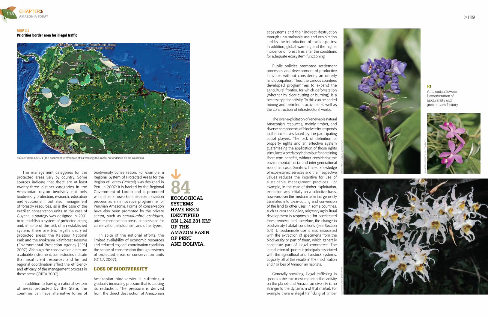
118AMAZONIA TOdAyCHAPTER3
>119
The management categories for the protected areas vary by country. Some sources indicate that there are at least twenty-three distinct categories in the Amazonian region involving not only biodiversity protection, research, education and ecotourism, but also management of forestry resources, as is the case of the Brazilian conservation units. In the case of Guyana, a strategy was designed in 2001 to to establish a system of protected areas; and, in spite of the lack of an established system, there are two legally declared protected areas: the Kaieteur National Park and the Iwokrama Rainforest Reserve (Environmental Protection Agency [EPA] 2007). Although the conservation areas are a valuable instrument, some studies indicate that insufficient resources and limited regional coordination affect the efficiency and efficacy of the management process in these areas (OTCA 2007).
In addition to having a national system of areas protected by the State, the countries can have alternative forms of
biodiversity conservation. For example, a Regional System of Protected Areas for the Region of Loreto (Procrel) was designed in Peru in 2007; it is backed by the Regional Government of Loreto and is promoted within the framework of the decentralization process as an innovative programme for Peruvian Amazonia. Forms of conservation have also been promoted by the private sector, such as servidumbre ecológica, private conservation areas, concessions for conservation, ecotourism, and other types.
In spite of the national ef for ts, the limited availability of economic resources and reduced regional coordination condition the scope of conservation through systems of protected areas or conservation units (OTCA 2007).
LOSS OF BIODIVERSITY
Amazonian biodiversity is suf fering a gradually increasing pressure that is causing its reduction. The pressure is derived from the direct destruction of Amazonian
ecosystems and their indirect destruction through unsustainable use and exploitation and by the introduction of exotic species. In addition, global warming and the higher incidence of forest fires alter the conditions for adequate ecosystem functioning.
Public policies promoted settlement processes and development of productive activities without considering an orderly land occupation. Thus, the various countries developed programmes to expand the agricultural frontier, for which deforestation (whether by clear-cutting or burning) is a necessary prior activity. To this can be added mining and petroleum activities as well as the construction of infrastructural works.
The over-exploitation of renewable natural Amazonian resources, mainly timber, and diverse components of biodiversity, responds to the incentives faced by the participating social players. The lack of definition of property rights and an effective system guaranteeing the application of those rights stimulates a predatory behaviour for obtaining short term benefits, without considering the environmental, social and inter-generational economic costs. Similarly, limited knowledge of ecosystemic services and their respective values reduces the incentive for use of sustainable management practices. For example, in the case of timber exploitation, extraction was initially on a selective basis, however, over the medium term this generally translates into clear-cutting and conversion of the land to other uses. In some countries, such as Peru and Bolivia, migratory agricultural development is responsible for accelerated forest removal and, therefore, the change in biodiversity habitat conditions (see Section 3.4). Unsustainable use is also associated with the extraction of specimens from the biodiversity or part of them, which generally constitute part of illegal commerce. The introduction of species is principally associated with the agricultural and livestock systems. Logically, all of this results in the modification and / or loss of Amazonian habitats.
Generally speaking, illegal trafficking in species is the third most important illicit activity on the planet, and Amazonian diversity is no stranger to the dynamism of that market. For example there is illegal trafficking of timber
Source: Rivera (2007) (The document referred to is still a working document, not endorsed by the countries)
MAP 3.1Priorities border area for illegal traffic
Amazonian flowers: Demonstration of biodiversity andgreat natural beauty
EcOLOgIcAL sysTEMs hAVE bEEN IdENTIFIEdON 1,249,281 KM2 OF ThEAMAZON bAsIN OF pERUANd bOLIVIA.
84
CON
SERV
ATIO
N IN
TERN
ATIO
NAL
SEBA
STIÁ
N C
ASTA
ÑED
A/ E
L CO
MER
CIO
SEBA
STIÁ
N C
ASTA
ÑED
A /
EL C
OM
ERC
IO

120AMAZONIA TOdAyCHAPTER3
>121
and non-timber species (like orchids) and wild fauna (especially avifauna) (Map 3.1). In spite of the efforts of CITES, this type of commerce is facilitated, in some cases, by the development of infrastructure projects and human settlements in the project’s areas of influence (Rivera 2007). Of the twenty-one countries that permit the legal sale of species, five are part of the Amazon basin, (Brazil, Bolivia, Colombia, Peru, and Venezuela,) and they sell to eleven countries, among them the United States, the greatest consumer of wild animals in the world. According to the estimations of
Brazil’s herbarium, 38 million wild animals are smuggled across Brazil’s borders.
HABITAT REDUCTION, FRAGMENTATION AND TRANSFORMATION OF ECOSYSTEMS
Doubtless, natural ecosystems provide essential goods and services for mankind (Millennium Ecosystem Assessment [MEA] 2006). However, its unsustainable exploitation has brought the reduction of great natural extensions, which
has generated deforestation and habitat fragmentation. The destruction of tropical forests has received worldwide attention since these ecosystems are fundamental elements for the stability of global processes, such as the carbon cycle, water regulation, biodiversity conservation and maintenance and the potential effects on global climate (Fearnside 1995; Fearnside an others 2001).
Land occupation of Amazonia generally takes place in three stages: the first comprises typical activities of timber, firewood and fibre
extraction, with the consequent reduction in the number of adult trees (Nepstad and others 1999). The second stage includes burning processes that tend, on the one hand, to reduce the seed bank in the soil, and on the other, to raise the indices of seed and seedling mortality, due to competition from pioneer species and vines (Cochrane and Schulze 1999; Gascon and others 2000, Perez-Salicrup 2001). The third stage consists of hunting and habitat loss, activities that eliminate the seed dispersers (Laurance 2001; Silva and Tabarelli 2000, 2001). This process leads to a loss of, in many cases irreplaceable, species in the Amazonian ecosystems.
The fragmentation of natural ecosystems (“fragmentation” understood as the division of continuous fragments into smaller patches that are partially or totally disconnected) originated by the development of infrastructure, human settlements or agricultural practices of greater or lesser scale (monoculture) (see Chapter 2, Section 2.2). To a great extent, this process affects the quality of habitats and causes a significant loss in species wealth (Laurance 1998; Laurance, Delamônica, Laurance, Vasconcelos and Lovejoy 2000). These impacts are related to the “border” effects that cause physical and biotic changes in the remaining fragments that translate into an abundance of pioneer species and alterations in germ plasm banks. This greatly affects the demography and the community’s attributes, and puts the "natural" regeneration and forest function at risk (Laurance and others1997; Gascon and others 2000, Benítez and Martínez 2003).
Infrastructure development (either by the government or illegal incentive) unleashes a series of events that affect biodiversity and ecosystems and causes more destruction, than even forestry plantations (Fearnside 2005; Soares-Filho and others 2004). The trails that facilitate timber extraction usually precede highways and expand the frontiers for agricultural and livestock exploitation (see Chapter 2, Section 2.2). Timber extraction itself has stimulated ecosystem degradation and has also made some areas more susceptible to fires because of: (i) an increase in flammability of the forest and (ii) the reduction in the number of days without rain, an event that facilitates the sotobosques
The destruction of tropical forests has received worldwide attention because these ecosystemsare fundamental for the stability of global processessuch as the carbon cycle, water regulation,bhiodiversity conservation and maintenance, and the potential effects on the global climate.
AMAZONIAN NATURE Is sO AbUNdANT, dIVERsE ANd sURpRIsINg ThAT IT Is NOT RARE TO FINd MIMETIsM IN sOME spEcIEs, sUch As ThIs ORchId.
SEBA
STIÁ
N C
ASTA
ÑED
A /
EL C
OM
ERC
IO

122AMAZONIA TOdAyCHAPTER3
>123
(the group of bushes found beneath or close to a forest) becoming inflammable (Fearnside 2005; Nepstad and others 2004).
Conversion and loss of habitat have been severe and the rate of deforestation is growing in Amazonia. This is associated with international prices of agricultural and livestock products that allow for growing profits in these sectors, as well as public policies developed to confront deforestation (Soares-Filho, Nepstad, Curran, Cerqueira, García, Azevedo Ramos, Voll, McDonald,Lefebvre and Schlesinkger 2006) (see Section 3.4). The rate of deforestation in Brazilian Amazonia increased during the period 1988-2004 (Fearnside 2005), primordially due to the expansion of livestock exploitation. Medium and large-sized ranches are principally responsible for more than half of that growth (Laurance, Albernaz, Schroth, Fearnside, Bergen, Venticinque and Da Costa 2002). In contrast, during the period 2005-2006 the deforestation rates fell significantly: in 2006 there was a reduction of 25%, which can be explained by the effectiveness of public programmes and projects for reducing deforestation, based on the participation of local populations (Brazil: Ministry of Foreign Relations, Ministry of Science and Technology, Ministry of the Environment, Ministry of Mines and Energy and Ministry of Development, Industry and Foreign Trade 2007). However, 2007 registered a new increase in the rate of deforestation with a growth of 15% over the previous year, due to the accelerated increase in international food prices, which stimulated the expansion of agriculture and livestock production (Brazil: Instituto Nacional de Pesquisas Espaciales [INPE] 2008).
In spite of the fact that Amazonia contains more than half of the world’s remaining tropical forests, it continues to show rapid deforestation with the consequent changes in patterns of ecosystem loss (Malhi and others 1999; Laurance 1998; Whitmore 1997; Brazil: INPE 2008; Lima and Gascon 1999). This process inevitably leads to loss of species habitat, greater fragmentation and increased isolation of the fragments of the remaining ecosystems, which can affect their ecological processes, their structure, dynamics and operation, both at the ecosystems levels and those of species and genes (Carvalho and Vasconcelos 1999;
Gascon and others 1999; Davies and Margules 1998; Laurence and others 1998; Laurance, Delamônica, Laurance, Vasconcelos and Lovejoy 2000; Nepstad and others1999).
Variations in forest cover cause local
and regional climate change altering water cycles and even accelerating desertification. In Amazonia, during the period 2000-2005, annual deforestation was 27,218 km2 (see Section 3.2).
Laurance and others (2002) identify another factor, in addition to transportation infrastruc ture and human population density, causing deforestation and habitat loss in Brazilian Amazonia: the severity of the dry season. There is evidence showing that tropical deforestation in Brazilian and Bolivian Amazonia are most frequently found in the driest ecosystems that are the most vulnerable to fire (Laurence and others 2002; Steininger and others 2001). Moreover, CO2 emissions, nitrogen fixation, air pollution and climate change are not yet completely understood, although preliminary evidence suggests that they can cause enormous changes in the composition of species and the structure of the Amazonian forest (Clark and others 2003; Lewis and others 2004).
On the other hand, extreme events, (e.g., floods, storms and seismic activity), which are generally increasing in frequency and intensity all over the world and notably in the Amazonia region, alter the characteristics of the habitat and therefore affect its biodiversity. This implies that the vulnerability of biodiversity increases, not only due to anthropic action, but also as a result of extreme natural events.
THREATENED SPECIESAND SPECIES LOSS
The largest number of extinct species is reported in Brazil, one of the countries having the greatest biological wealth of the eight being analyzed (Table 3.4), as pointed out earlier. Regarding the other endangered categories, according to the “red lists” of the International Union for the Conservation of Nature (IUCN), Colombia and Ecuador report the largest numbers, followed closely by Peru. However it is important to clarify that
the way threat levels are determined varies greatly from country to country, and between different groups of living organisms. It should be mentioned that some species at risk are not included in the Red List.
Upon analyzing the threatened categories: “in critical danger”, “in danger”, and “vulnerable”, by biological group (Table 3.5), Ecuador is identified as the country with most reported species, followed by Brazil. The latter turns out to be the territory with the highest levels of threat for mammals, birds, reptiles, fish and invertebrates other than molluscs, in categories of intermediate and high risk. Colombia holds first place among the eight nations in the number of endangered amphibians. Finally, regarding the groups of molluscs and plants, Ecuador has the highest number of species considered to be vulnerable, endangered and in critical danger.
To date, there is not enough information available to prepare a list of endangered Amazonian species, except for Guyana and Suriname both of which consider their entire
territory to be part of Amazonia. Brazil, through its Ministry of the Environment (Biodiversitas Foundation) reports that this part of the country registers 60 endangered species between mammals (19), birds (16), other invertebrates (5) and plants (20).
The Amazonian ecosystem’s services and, in particular, its biodiversity reveal a process of discernable deterioration: the number of extinct, threatened and critically endangered species is growing. Furthermore, there is also evidence of a lack of knowledge about these complex ecosystems and their respective value, which in turn offers no incentive for their care or conservation. One must add to this a reduced valorization placed on the traditional wisdom of the indigenous peoples, who are the most affected by this accelerated change in habitat and reduction of biodiversity.
Even though programmes and projects
have been launched to stimulate the conservation of biodiversity, these still have limited scope in relation to the magnitude of the deterioration.
To date, there is not enough information available to prepare a list of endangered Amazonian species.
❱❱❱ Opening roads affects the condition of the forest, including the fauna it shelters.
ERN
ESTO
ARI
AS/
EL C
OM
ERC
IO
IN 2007 dEFOREsTATION INcREAsEd by
15%cOMpAREd TO ThE pREVIOUs yEAR.
FROM 2000-2005
27,218KM2 OF FOREsTs wERE LOsT IN AMAZONIAANNUALLy.

124AMAZONIA TOdAyCHAPTER3
>125
COUNTRY EXTINCTEXTINCT IN
NATURE
IN CRITICAL DANGER
IN DANGER VULNERABLEAT RISK /
DEPENDS ON CONSERVATION
CLOSE TO BEING
THREATENED
DEFICIENT DATA
OF LESSERCONCERN
BOLIVIA 1 0 14 32 108 5 65 47 1,611
BRAZIL 10 2 125 163 342 ** ** ** **
COLOMBIA 6 0 106 210 298 7 133 204 2,049
ECUADOR 6 0 311 778 1,091 6 347 367 1,859
GUYANA 0 0 6 10 55 4 21 53 922
PERU 2 0 45 90 389 11 105 197 1,912
SURINAME 0 0 7 9 49 1 17 39 823
VENEZUELA 1 0 30 52 151 6 52 135 1,497
TABLE 3.4Number of extinct, threatened and other species in each category of the “Red List”, by country (2006)
*Brazil does not officially adopt the IUCN classification. The NGOs committed to conservation of biodiversity use the IUCN classification and because of that, the totals presented here do not coincide with the totals of the following table. ** no information.Source: International Union for Conservation of Nature (IUCN) (2006) for all countries except Brazil. Brazil: Informe técnico - Revisión de la lista de especies de la fauna brasileña amenazada de extinción. Conservation International. Diciembre/2002.
TABLE 3.5Number of threatened species, by group of organisms, by country
COUNTRY MAMMALS BIRDS REPTILESAMPHIB-
IANSFISH MOLLUSCS
OTHERINVERTEBRATES
PLANTS TOTAL
BOLIVIA 24 32 3 23 0 0 1 71 154
BRAZIL 69 160 20 16 154 40 163 108** 622
COLOMBIA 38 88 16 217 28 0 2 225 614
ECUADOR 34 76 11 165 14 48 0 1,832 2,180
GUYANA 11 3 6 9 18 0 1 23 71
PERU 46 98 8 86 8 0 2 276 524
SURINAME 11 0 6 2 19 0 0 27 65
VENEZUELA 26 25 13 71 26 0 3 69 233
Source: IN MMA N° 3 of 05/27/2003; IN MMA N° 5 of 05/21/2004 and IN N° 52 of 11/08/05; IN MMA N° 5 of 05/21/2004, IN N° 52 of 11/08/05 and IN No 3 of 05/27/2003 – includes aquatic and land based invertebrates; Ordinance N° 37-N of 3 April 1992, however, the MMA is updating the list of flora in extinction with a current forecast that the number of flora threatened by extinction could be as many as 1,500 species. Brazil: The list of fauna species threatened by extinction is found in the Normative Instructions of the Ministry of the Environment (MMA). IN N° 5 of 21/05/04, presents two annexes: the first, with a list of fish and aquatic invertebrate species, and the second with a list of over-exploited or threatened by over-exploitation fish and aquatic invertebrate species. Some of these species, presented in the Conservation International report, have since left the list of threatened species and been incorporated in the list of species over-exploited or threatened by over-exploitation. ❱❱❱ There are multiple species of different forms and sizes of frogs and toads including some with striking skin colourations.
AND
RE B
ARTS
CH
I / C
ON
SERV
ATIO
N IN
TERN
ATIO
NAL

126AMAZONIA TOdAyCHAPTER3
>127
MILLIONs OF wILd ANIMALs ARE sMUggLEd EAch yEAR. dEFIcIENcIEs IN dEFININg pROpERTy RIghTs ENcOURAgE pILLAgINg bIOdIVERsITy FOR shORT-TERM pROFIT.
BOX 3.2BOLIVIA: USE AND EXPLOITATION OF NON-TIMBERFORESTRY RESOURCES: BRAZIL NUTS(BERTHOLLETIA EXCELSA H.B.K.)
The Bertholletia excelsa HBK (Lecythidaceae family) is one of the dominant species in the dry land forest canopy of Amazonia, especially in Brazil, Peru and Bolivia, dis-tributed over an area estimated at 325 million hectares. At times it can reach 50 m in height, and its fruits of a considerable size hold between 15 and 25 seeds cov-ered with a hard, woody shell. These seeds are known as castañas or Brazil nuts, and although it is one of the most widely commercialized dry fruits in the world (1 or 2% of the total volume of international trade), it is considered to be one of the most viable alternatives for the sustainable use of the Amazonian forest, due to the self-sustaining ecological characteristics of the species and the fact that the vast majority of fruit collection is done in natural forests with minimum levels of alteration.
In the North of Bolivia this species is specifically con-centrated in the departments Pando, Beni and La Paz, areas where castaña collection, processing and com-mercialization activities are also prevalent. And although some debate the impact of this product in improving the living standards of the Amazonian rural populations, some 170,000 persons currently obtain their suste-nance from some activity connected to the produc-tion of castaña. It even forms a visible part of Bolivian exports, as a non-traditional product, especially since the significant reduction in natural rubber production.
Castaña is considered by many to be one of the flag-ship species for conservation of the Amazonian for-est, although, when it comes to calculating the area that would be effectively preserved through extrac-tion of this seed, it only amounts to 6% of the to-tal area of potential distribution of the species.
If we add to this the growing interest in initiatives like organic certification, bio-commerce and fair trade, it would appear that all of the conditions are met for the castaña to become the standard bearer for sustainable use of the Amazonian forest.
Source: Stoian (2004).
❱❱❱ A large variety of monkey species are sheltered in Amazonia.
❱❱❱ The cock of the rocks.
>127
AND
RE B
ARTS
CH
I / C
ON
SERV
ATIO
N IN
TERN
ATIO
NAL
AND
RE B
ARTS
CH
I / C
ON
SERV
ATIO
N IN
TERN
ATIO
NAL
ANDRE BARTSCHI / CONSERVATION INTERNATIONAL
AND
RE B
ARTS
CH
I / C
ON
SERV
ATIO
N IN
TERN
ATIO
NAL
SERG
IO A
MAR
AL /
OTC
A
Ecosystem services and biodiversity show a processof deterioration: more species extinct, endangered and in critical danger.

128AMAZONIA TOdAyCHAPTER3
>129
ThE jAgUAR, ONZA OR OTORONgO (PAntheRA oncA) Is ThE bIggEsT FELINE IN AMAZONIA ANd ThE ThIRd bIggEsT IN ThE wORLd.
AND
RE B
ARTS
CH
I / C
ON
SERV
ATIO
N IN
TERN
ATIO
NAL

130AMAZONIA TOdAyCHAPTER3
>131
3.2|FORESTSThe Amazonian forest comprises several natural ecosystems and is considered to be one of the planet’s most important (Foley and others 2007). Its importance lies in its vast remaining tropical forest area, which offers several valuable environmental products and services (pharmaceuticals, enzymes, gene bank, among others). Prominent among its environmental services is that it is the depository of a very broad biological diversity (Fearnside 1999; Dirzo and Raven 2003), its capacity to absorb and store carbon (DeFries and others 2004), and its continental and global scale of its energy balance and water regulation (Foley and others 2007).
The Amazonian forest is subject to strong pressure, both from natural phenomena (drought and fire), as well as from man-made phenomena (mainly productive activities). Diverse economic activities, such as migratory agriculture, extensive ranching, agro-industry, un-regulated timber exploitation and accelerated urbanization, among others, generate the degradation and/or loss of forest cover, which in many cases causes irreversible impacts on the ecosystems.
THE AMAZONIAN FOREST
There are multiple proposals for classification of the Amazonian forests (Moran 1993; Whitmore 2001; Stone and others 1994; Saatchi and others 2008). According to one of the most recent (Saatchi and others 2008), sixteen classes of vegetal coverage can be distinguished, which in aggregate terms, fall into four categories: dense forests, open forests, flooded forests and non-forest vegetation. Ayres (1993) refers to the fact that several different types of vegetation complexes can be found in the tropical Amazonian forest such as, highland forests, dense forest,
AUThORs:CARLOS SOUZA - Amazon Institute for People and the Environment (IMAZON) – BrazilELSA GALARZA - Research Institute of the Universidad del Pacífico (CIUP) – Peru
cO-AUThORs:LUIS ALBERTO OLIVEROS - Amazon Cooperation Treaty Organization (ACTO)KATIA PEREIRA - Amazon Institute for People and the Environment (IMAZON) – Brazil
The importance of the Amazonianforest is in extensive area of remaining tropical forest and the valuable environmental services and products it offers.
BOX 3.3
COVERAGE IN COLOMBIAN AMAZONIA
It is noteworthy that in 2001 95% of the Colom-bian Amazonia was considered natural or minimally transformed. The coverage was distributed as fol-lows: Natural forests, 43,311,755 ha. (90.75%); cultivated pasturelands, 2,186,524 ha (4.58%); natural grasslands, 833,232 ha (1.75%); bodies of water, 535,614 ha (1.12%); and the remaining area,
ThE AgUAjE, bURITI OR MORIchE (MAURItIA FLeXUoSA) Is A TypIcAL pALM ThAT pROLIFERATE IN AMAZONIAN FLOOdEd FOREsTs.
with less than 1% was divided into: scrublands (44,050 ha), secondary vegetation (328,755 ha), annual or transitional crops (12,698 ha), heterogeneous agricultural areas (72,475 ha) and urban zones (5,178 ha).
Source: Colombia: Instituto Amazónico de Investigaciones Científicas - SINCHI (2007)
JHO
N M
ARTI
N V
ILC
ABAR
/ C
ON
SERV
ATIO
N IN
TERN
ATIO
NAL

132AMAZONIA TOdAyCHAPTER3
>133
floodplains and flooded forest. Beyond the limits of the Amazonian forest, the Amazon basin is covered by a broad savannah and enclosed in the basin's headlands by the Brazilian and Guyanese shields. The cloud forest is a special type of vegetation that grows between 1,500 and 3,000 meters in the eastern foothills of the Andes, exposed to constant moisture-bearing winds. The vegetation can change abruptly at altitudes greater than 3,000 meters (Goulding and others 2003a).
The estimated amount of Amazonian forest cover varies according to the source, but it fluctuates around 6 million km2 (Saatchi and others 2008). The dense forest comprises tropical humid ombrophilous, dry land forests and transitional forests. Here the trees are predominantly very large with high commercial value for lumber production (Lentini and others 2005), which makes these forests susceptible to pressure from timber activities (Uhl and Vieira 1989; Asner and others 2005) and in some regions to fires (Cochrane and Laurance 2002). Dense
BOX 3.4DIVERSITY OF VEGETATION IN PERUVIAN AMAZONIA
The classification of the diverse vegetation in Peruvian Amazonia was prepared by the Peruvian Amazonian Research Institute through the BIODAMAZ Project (Biological Diversity Project for Peruvian Amazonia; Peru-Finland Agreement) in 2004; it is based on the composition of a mosaic of Landsat TM images and the identification of twenty-four vegetal units.
I. NATURAL VEGETATION1. AMAZONIAN PLAINSa. Vegetation of the floodplain. Exposed to seasonal flooding by the flow of the rising rivers; in lowland terraces of recent andsub-recent origin
- Successional scrub-arboreal forest (riverbank complex vegetation) - Herbaceous marshes with predominance of grasses - Herbaceous- scrub marshes, associated with spiny palms - Dense swamps or pure Mauritia flexuosa communities - Mixed swamps or mixed associations with the renacos (Ficus sp. and Coussapoa sp.) - Mixed swamps or disperse Mauritia flexuosa communities - Scrub-arboreal marshlands and swamps in the Pastaza river delta sector - Savannah-type vegetation with grassland dominance and disperse palms (pampas del Heath) - Terraced forests, floodable by black water from the Nanay river - Dense Pacal or pure guadua spp. communities (see group B) - Mixed Pacal or guadua spp. communities and other tree species (see group B) - White sand (Varillales) forests (along the banks of the Nanay, Pintoyacu and Chambira rivers) (see group B)
b. Vegetation of highlands or “dry land”. Non-floodable by rising rivers, except for those lands with poor drainage, due to the accumula-tion of rainwater, in undulating lands, high terraces and hills.
- Dense Pacal or pure guadua spp. communities (see group A) - Mixed Pacal or communities of guadua and other tree species (see group A) - Highland swamps or Mauritia flexuosa palm groves in the highland plains with poor drainage (see group C) - White sand (Varillales) forests (Allpahuayo – Mishana sector) (see group A) - High humid colluvial terrace forests or forests on Andean foothill delta lands - High colluvial terrace forests on glacis-type terrains in the Andean foothills - Hilly forests on the Amazonian plains - Hilly forests dissected in a dendritic drainage pattern, in the Pucacuro – Nanay – Chambira sector (Hoja Seca del Nanay)
2. MOUNTAINSc. Low mountain forests
- Highland swamps or Mauritia flexuosa palm groves in high inter-montane terraces with poor drainage (see group B) - High-hill plains forests or forests of low mountains cut-off from the Divisory Sierra - Tropical dry forests - Andean mountain cloud forests (see group D)
d. High mountain forests
- Andean mountain cloud forests (see group C)
II. ANTHROPIC VEGETATION
e. Complexes of successional vegetation more than three centuries old
- Grasslands
f. Complexes of successional vegetation less than three centuries old
- Deforested areas (populated centres and complexes of farms and secondary forests on dry land) - Deforested areas with plantations of palms (e.g. El Espino Palm) - Deforested areas of dry tropical forest.
forest predominates in Amazonia and is distributed over an area of 3,938 million km2. Most of the dense forests are found in Brazil, with 2,513 million km2, followed by Peru with 446,600 km2 and Colombia with 324,600 km2. The rest of the countries together contain from 1 to 3% of the total Amazonian dense forest.
Open forests are predominantly made
up of palm trees, vines and bamboo, with a canopy that is more open than that of the dense forest. This type of forest is concentrated in eastern Amazonia in Brazil; in the southwest, along the borders of Brazil, Bolivia and Peru; and in the northwest, in Colombia. There are also small areas of open forest in the north, on the Guyanese Shield. It is estimated that open forests occupy approximately 610,000 km2.
The flooded forests or várzeas represent an important environment, because of their diversity and aquatic productivity (Goulding 1980; Goulding 1988; Forsberg and others
Dense forest predominates in Amazonia,and is distributed over an area of 3,936 million km2. Most dense forests are found in Brazil, followed by Peru and Colombia.
❱❱❱ Aspect of the arbustive-arboreal forest, a product of seasonal flooding. SERG
IO A
MAR
AL /
AC
TO
Source: Instituto de Investigaciones de la Amazonía Peruana (IIAP) - BIODAMAZ (2004a)

134AMAZONIA TOdAyCHAPTER3
>135
1993; Araújo-Lima and others 1986; Junk 1983 and 1997). These areas extend all along the rivers and are almost completely flooded during the rainy season, although it is difficult to determine exactly which areas, due to the complexity of the flooding system that can be influenced by local rains, flood periodically due to overflowing rivers and incoming tides (Goulding and others 2003a). The várzeas of white-water rivers are relatively well conserved in zones upriver from the confluence of the Purús and Amazon rivers in Brazil, where the impact of ranching or agriculture is still very slight. On the other hand, the várzeas of the Amazon river are significantly altered in the lower reaches of the Purús river, especially in Santarem, in the state of Pará. There is a special type of várzea, influenced by floods and river overflow in the area where the Tapajós and Xingú rivers flow into the lower Amazon (Barthem 2001). In Brazil, tidal várzeas can be seen along the entire length of the area between the confluence of the Xingú, the Amazon and the mangrove swamps. This vegetation is intensely exploited by lumber companies and small-scale farmers (Anderson 1999; Barros and Uhl 1995). According to Saatchi and others (2008), the area occupied by this type of forest covers 527,000 km2 and Brazil has 64% of the total of floodplains, followed by Bolivia with 11%, and Peru and Colombia with 7% each.
Non-forest vegetation can be found in several types of savannahs with small trees, frequently with twisted trunks, dispersed across the land. This class of vegetation also includes deforested areas or secondary forests. It is estimated that this type of vegetation covers 1,131 million km2 of Amazonia (Saatchi and others 2008).
DEFORESTATION INAMAZONIA
Several investigations have been carried out in each of the constituent countries, regarding the tempo of deforestation in Amazonia; however, their results dif fer from one study to another, because of the absence of precise monitoring systems, the use of different methodologies or simply because the figures are not accessible or are outdated. In spite of this, one can affirm that the tropical Amazonian rainforest has been seriously affected in recent years and has suffered a reduction in vegetal coverage.
Table 3.6 shows that by 2005 accumulated
deforestation in Amazonia reached 857,666 km2 (85.8 million hectares), which means that the total vegetation coverage of the region was reduced by approximately 17%. This is almost equivalent to 67% of Peru’s total land area or 94% of that of Venezuela.
The causes of deforestation are varied and affect each country with differing intensity. The Amazonian forest, in general, is being affected by the pressures of agriculture and ranching (Hecht 2005) and timber extraction (both legal and illegal) (Asner and others 2005); by the exploitation of its natural resources in general (mining, non-timber-yielding forest resources) (Peres and others 2006); by government policies, such as highway building (Nepstad and others 2001; Soares-Filho and others 2004) and other infrastructure works; by demographic growth (Fearnside 1993; Kaimowitz 1997), to name the principal culprits. By the same token, natural events have also affected the forests; for example, extended droughts have caused an intensification of forest fires.
Deforestat ion in t ropical forests leads to the global loss of biodiversity, especially in areas with fewer remaining natural ecosystems, and a high degree of endemism (Capobianco 2001, quoted by Fearnside 2005). In addition to erosion, deforestation generates soil compaction and loss of nutrients (Fearnside 2005), as mentioned in Section 3.1.
Braz i l has the larges t area of accumulated deforestation, 682,124 km2, meaning that, of the total deforested up to 2005, 79.5% corresponds to that country, followed by Peru with 8.2% of the total deforestation for the period, and Bolivia and Colombia, with 5.3 and 3.4%, respectively. The other the countr ies
account for percentages below 2% of the total. It should be clarified that these interpretations should be understood as being preliminary, since the data are not homogenous for all of the countries during the period under analysis.
Estimates for the annually deforested area between the decades of 1980 and 1990 reveal a reduction of 13%, from 23,619 km2 to 20,550 km2, basically in function of Brazil’s reduction of deforested area by 16,503 km2 per annum, and that of Peru to 783 km2 annually. However, during that same period, the rates of annual deforestation for Bolivia and Ecuador increased by 8.7% and 78%, respectively (see Table 3.6).
KM2 Is ThE AccUMULATEd AREA dEFOREsTEdIN bRAZIL Up TO 2005, sUppOsEdLy 79.5% OF ThE TOTAL dEFOREsTATION IN ThAT pERIOd.
682,124
Deforestion of tropicalforests causes the loss of global biodiversity, especially in areas with a high degree of endemism.
ENRI
QU
E C
ÚN
EO /
EL
COM
ERC
IO
Deforestation of slopes encourageserosion with soil loss and sedimentationof Amazonian rivers.

136AMAZONIA TOdAyCHAPTER3
>137
COUNTRY
ACCUMULATED DEFORESTED AREA (km²)ANNUAL DEFORESTATION
(km²/YEAR)
1980-1989 1990-1999 2000-2005 % OF TOTAL DEFOR-ESTED BY 2005 1980-1989 1990-1999 2000-2005
BOLIVIA1 15,500 24,700 45,7352 5.3% 1.386² 1.506² 2.247²
BRAZIL3 377,500 551.782 682,124 79.5% 19.410 16.503 22.513
COLOMBIA4 19,973 27,942 29,3025 3.4% n.a. 664 942
ECUADOR5 n.a. 3,784 8,540 1.0% 2125 378 3884
GUYANA5 n.a. n.a. 7,390 0.9% n.a. n.a. 2105
PERU5 56,424 64,252 69,713 8.2% 2.611 783 1235
SURINAME5 n.a. n.a. 2,086 0.2% n.a. n.a. 2425
VENEZUELA5 n.a. 7,158 12,776 1.5% n.a. 716 5535
TOTAL 451,924 666,076 857,666 100% 23.619 20.550 27.218
Laurance and others (2002) suggest that Brazilian Amazonia has the highest absolute indices of deforestation and forest fragmentation in the world. That perception was confirmed in 2004, when annual deforestation reached the second highest figure in its history, with 27,379 km2, according to the National Institute for Space Research (INPE)/ the Programme of Monitoring the Brazilian Amazon Deforestation (PRODES) data. The highest annual deforestation in Brazil’s history was recorded in 1995, with 29,059 km2 (Lentini and others 2005). The Brazilian states most affected by deforestation are Mato Grosso and Rondonia. They registered a strong expansion of agricultural and ranching activity, primordially for the establishment of soya cultivation and for extensive cattle raising. In Brazilian Amazonia, for example, there was an increase from 5 million hectares of cultivated areas in 1990 to 8 million hectares in 2002, according to the Brazilian Institute of Geography and Statistics (IBGE). The Amazonian Institute of People and Environment (Instituto do Homem e Meio Ambiente da Amazônia) (IMAZON) indicates that the attack on the forests is mainly associated with illegal occupation of public lands and the construction of clandestine highways, which have been opened through Amazonia by miners, in search of gold and diamonds, as well as by timber companies.
For 2000-2005 deforestation of the Amazonian forest grew to 27,218 km2 per year, mainly as a result of the surprising increase of deforestation in Brazil, which averages 22,513 km2 per year. This growth of annual deforestation in Brazil represents an increase of 16% of the overall rate for the decade of 1980, and 36.4% of that for the 1990’s. In spite of that, it should be noted that between the years 2005 and 2007 there was a significant deceleration in the rhythm of deforestation; in 2007 annual deforestation was 11,224 km2, that is, 59% less than at the 2004 peak. Annual deforestation for 2000-2005 also grew in Bolivia, Colombia, and Ecuador, but decreased significantly in Peru and Venezuela (see Table 3.6).
In Peruvian Amazonia, migratory agriculture and the cultivation of coca leaves are the two main causes for deforestation. The first utilizes the technique of slash-and-
BOX 3.5DEFORESTATION IN AMAZONIA
It is a well-known fact that deforestation is concentrated in transitional areas between forests and the “cerrado” (tropical savannah), along the highways and on the boundary between Acre and Rondonia (Houghton and others 2000; Cardille and Foley 2003; Soares-Filho and others 2004). However, there are still gaps in the understanding of Amazonian deforestation. Until recently, the characterizing defores-tation from a satellite’s view was concentrated on estimating changes in “forest” and “non-forest” areas over time. Today the Amazonian landscape is much more dynamic and complex: it has undergone cycles of clear-cutting, cultivation, pasture land and growth of second-ary forests, which has resulted in a complex mosaic of interaction between the tropical forest, lands under varied management regimens and recuperation of secondary forest, (Fearnside 1993; Nepstad and others 1999; Cardille and Foley 2003). It is particularly important to distinguish between the regions where secondary forest is regenerat-ing, given the fact that it provides important areas for carbon capture, (Houghton and others 2000), temporary reservoirs of genetic diversity and some degree of recuperation and/or soil conservation.
Source: Foley and others (2007).
TABLE 3.6 Deforestation of the Amazonian Forest during the decades of 1980, 1990 and 2000-2005.
burn on a small scale, for the inhabitants to carry out rudimentary agriculture, generally on soils of limited agricultural quality. For that reason they only occupy the land during a short period of time, which causes the cycle to be constantly repeated. The second involves the use of improved techniques for coca cultivation; however, this also leads to land being abandoned due to Government pressures to combat the expansion of this crop for illicit ends.
Clearing for illegal purposes, together with the expansion of the agricultural frontier, new
Attacks on forestsare associatedwith illegal appropriation of public land and clandestine highwaycontruction
Source:1 Steininger, Tucker, Townshend, Killeen, Desch, Bell and Ersts (2001).2 Killeen, Calderón, Soria, Quezada, Steininger and Harper (2007).3 Brazil: Instituto Nacional de Pesquisas Espaciales (INPE) (2006).4 Colombia: Instituto Amazonico de Investigaciones Científicas (SINCHI) (2007).5 Soares-Filho, Nepstad, Curran, Cerqueira, Garcia, Azevedo Ramos, Voll, Mcdonald, Lefebvre and Schlesinger (2006).
settlements and extensive cattle ranching are the main causes of deforestation in Colombian Amazonia. Deforestation rates vary from 0.97% to 3.73% in highly populated areas and up to 0.23% in sparsely populated areas (Armenteras and others 2006).
In Bolivia, the advance of the agricultural and ranching frontier over the last decade has been the cause of the increased rate of illegal deforestation of lands with forest usage potential (there are permits for changing land usage, granted according to technical criteria established by the authorities);
PAD
RO M
AYO
R /
GAB
EL S
OTI
L /
RED
AM
BIE
NTA
L

138AMAZONIA TOdAyCHAPTER3
>139
COUNTRY PRINCIPAL CAUSES OF DEFORESTATION AND FOREST DEGRADATION
BOLIVIA
Subsistence agriculture due to migration of landless individuals (Killeen, Calderón, Soria, Quezada, Steininger and Harper 2007)Soya cultivation, ranching activity (Steininger, Tucker, Townshend, Killeen, Desch, Bell and Ersts 2001)Pasture lands for ranching activity (Pacheco 1998)Timber extraction
BRAZIL
Pasture lands for ranching activity (Arima, Barreto and Brito 2005)Mechanized agriculture (Nepstad, Moutinho and Soares-Filho 2006)Infrastructure: highways and hydroelectric dams (Fearnside and Laurance 2002)Agrarian reform settlements (Brandão and Souza 2006)Timber activity (Lentini, Sabogal, Pokorny, Silva, Zweede, Veríssimo and Boscolo 2005)Appropriation of public lands
COLOMBIASpontaneous settlement (Armenteras, Rudas, Rodríguez, Sua and Romero 2006)Pasture lands for ranching activity (Armenteras, Rudas, Rodríguez, Sua and Romero 2006)Cultivation of illegal plantations (Armenteras, Rudas, Rodríguez, Sua and Romero 2006)
ECUADORPolicies of settlement and shifting borders, subsistence agriculture (Wunder 2003)Infrastructure associated with petroleum production
GUYANAAgriculture (EPA 2007)Bauxite mining (EPA 2007)Artisan mining (garimpo) (EPA 2007)
PERUHighways (Maki, Kalliola and Vuorinen 2001)Agrarian reform (Álvarez 2003)Timber activity
SURINAME Artisan mining, (garimpo) (Peterson and Heemskerk 2001)
VENEZUELAAgriculture and ranching activity Gold mining
however, the underlying causes for the increase are insecurity in property ownership, the comparative economic advantage of agricultural and ranching activities, as against forestry activities, insufficient mechanisms of control and supervision of deforestation, and the lacunae in the legislation, to mention a few. Also, the number of forest fires has increased, in many cases, as a consequence of deforestation itself. The department of Santa Cruz is where 75% of the deforestation is concentrated, and Pando and Beni constitute 20% (Unidad de Control de Desmontes e Incendios Forestales [Ucdif] 2007).
Deforestation in Ecuador started with the opening of roads to build pipelines for the petroleum industry, making it easier to colonize Amazonian land. For decades the policies for state land settlement, strongly influenced by the need to maintain its presence in border areas, were an incentive to change soil usage from forest to rudimentary agriculture and ranching. This generated a flow of migrants, and with them came very significant pressures on the Amazonian region (Wunder 2003). The lumber industry, responsible for approximately a third of the deforestation, builds most of the roads and promotes the advance of the forest’s colonizers. Land traffickers and road builders encourage colonization and the fragmentation of ecosystems.
TABLE 3.7Principal causes of deforestation and forest degradation
❱❱❱ Illegal crops are an important deforestation vector in some Andean-Amazonian countries.
ANTO
NIO
ESC
ALAN
TE/
EL C
OM
ERC
IO
ThE NUMbER OF FOREsT FIREs hAs INcREAsEd, IN MANy AsEs, As A cONsEqUENcE OF dEFOREsTATION ITsELF.

140AMAZONIA TOdAyCHAPTER3
>141
Although Guyana does not register high levels of deforestation, the growth of lumber exports and the growing interest in bio-fuels are cause for concern that deforestation will increase in that country. The same applies to Suriname, which has a low level of deforestation, caused almost exclusively by lumber extraction. This situation, however, changed recently with the entry of Asian timber companies, which have obtained important forest concessions for 25 to 40% of the territory (from 7 to 12 million hectares) for lumber extraction (World Rainforest Movement [WRM] 2000).
Venezuela has part of the world’s largest
extension of virgin, or not significantly af fected, tropical forests. The highest rates of deforestation were reached during the 1980s, when public and multilateral development banking investments were made in iron ore and bauxite exploration, steel and aluminium factories, dams and a multitude of light industries, all linked by a network of roads and high tension lines that crossed the new cities founded to supply labour for the industries. Another cause of deforestation in Venezuela is the increase in the agricultural frontier between 1980 and 1990, which grew from 24 to 32 million hectares) (WRM 2000). The conversion of forests to agricultural lands has not helped much to solving the food deficit in this country, but it has facilitated the transfer of large quantities of public lands, that were originally forest, to private ownership, even within forest reserves.
Industrial mining also has a direct and indirect impact on the forest. Deforestation and contamination of the forest with chemical residues and mine tailings are direct impact examples (Uhl and others 1993). Indirect impact occurs when mining attracts large flows of migrants who help to increase deforestation in areas adjacent to the mining projects. The impact of industrial mining occurs mainly in Brazil, but artisan mining attracts thousands of people mainly in search of gold. These activities have been documented in Suriname, Guyana and Brazil. Artisan miners or garimpeiros generate impacts on the rivers through contamination with mercury and sodium cyanide (Muezzinoglu 2003).
FOREST DEGRADATION
Deforestation and its associated impacts are not the only threats to the integrity of the Amazonian forests. Extensive forested areas are also being impoverished by the degradation caused by different activities including lumber extraction (Nepstad and others 1999), forest fires (Cochrane and Schulze 1999) and forest fragmentation (Laurance, Vasconcelos y Lovejoy 2000). Hydroelectric dams also generate direct impacts, such as flooding extensive areas of forest, and indirect impacts, such as population migrations (Junk and Mello 1999; Fearnside and Laurance 2002). Forest degradation generates partial, temporary or permanent alterations in the composition and structure of the forests (Lambim and others 2000). Other elements that can lead to forest degradation include hunting, the extraction of non-timber resources and the invasion of exotic species (Peres and others 2006); however, these disturbances are not detected by remote sensors and therefore there is no information as to their localization and extension.
Selective forest exploitation or skimming (“descreme”) is also considered a forest degrading activity. It consists of extracting various commercially valuable tree species per hectare, without applying techniques for low impact forest exploitation. This practice has proven to be extremely destructive, since it is not regulated. On average, for each tree removed, up to thirty more trees are seriously damaged by the operation itself, since when trees are felled, the vines binding them together pull down neighbouring trees, causing severe damage to the surroundings. This practice can also cause the forest floor and undergrowth to dry out, making it much more vulnerable to forest fires (Asner and others 2006). Unregulated skimming can generate severe impacts on the soil, caused by heavy machinery. The forest penetration roads, constructed by these illegal timber merchants, frequently are used by colonizers to go even further into the forest and convert it to migratory agriculture.
Illegal timber extraction in Peru, especially mahogany, is produced by the action of small-scale loggers, who invade forest concessions or native communities and selectively extract the trees. The National Institute of Natural
Resources (INRENA) calculates that in 2006, the value of timber illegally extracted was about US$44.5 million, equivalent to 221,000 m3 of timber (World Bank 2006). In the now emblematic case of the Yasuní National Park in Ecuador, a protected area where tribes live in voluntary isolation but which, nevertheless, is having its cedar trees illegally extracted.
In contrast to deforestation, which completely eliminates the forests, non-sustainable timber extraction partially affects their structure and composition. Logging activity is one of the principal causes of forest
degradation and leads to a reduction of forestry stock as well as of commercially valuable forest species (Cochrane and Schulze 1999; Gerwing and Farias 2000; Fredericksen and Fredericksen 2002) and creates a fire-prone environment (Holdsworth and Uhl 1997), in addition to increasing the risk of extinction of native species (Martini and others 1994).
Although it is more visible than skimming, the expansion of infrastructure, mainly highways, is also a cause of Amazonian forest fragmentation, which particularly affects Brazil (Fearnside and Laurance 2002; Nepstad and
Much of the timber commercialized inAmazonia is illegal and taken from landthat belongs to native communities orfrom forestry concessions.
In Suriname, Asian timber companies have arrived and were given important forestryconcessions on 25-40% of the territory.
In Venezuela, converting forests for agriculture has helped to transfer a large amount of public forest land to private owners, even within forest reserves.
MIGUEL BELLIDO / EL COMERCIO

142AMAZONIA TOdAyCHAPTER3
>143
Note: A hot spot indicates the existence of fire in the element of resolution (pixel) that varies from 1 km x 1 km to 5 km x 4 km. There may be one or various fires in one pixel. Source: <http://www.dpi.inpe.br/proarco/bdqueimadas/>.
others 2001), Peru (Maki and others 2001) and Ecuador, in this case, associated with petroleum activities. In Peru, for example, between 1981 and 1996, deforestation saw an explosive increase along the Inter-Oceanic Highway (Naughton-Treves 2004). In Brazil, 80% of deforestation is concentrated in a radius of 50 km from the official highways (Asner and others 2006). To this we add the opening of illegal roads for access to natural resources (timber and gold) and to public lands, by squatters (Brandão and Souza 2006). Through satellite mapping imagery in 2003, it was possible to identify nearly 173,000 km of illegal roads through the Amazonian forest. Similarly, the growth of urban centres also leads to increased pressure on the remaining forests within a 20 km radius of those centres (Barreto and others 2006), due to the rise in forest fragmentation and degradation through timber exploitation and forest fires, as well as the impoverishment of fauna and flora from hunting and collecting non-forest timber products (Peres and others 2006).
FOREST FIRES IN AMAZONIA
Forest f ires are a huge threat to the integrity of tropical forests (Rudel 2005). Fire has been used as a tool for clearing pasturelands and agricultural plots in the Amazonian forest (Kato and others 1999) and for burning the forest af ter clear-
cutting (Fearnside 2005). Uncontrolled fires in pasturelands and farming areas generally extend into (and burn) the edges of adjacent forests (Nepstad and others 1999; Cochrane and Schulze 1999). When the adjacent forests have already been exploited by timber cutting activit ies, the f ires penetrate into the forest with greater ease and cause a more significant impact. This occurs because of the higher incidence of solar radiation and the accumulation of residue generated by exploitation (Holdsworth and Uhl 1997). Once an area is burnt, its vulnerability to new fires increases and the damages caused are far more extensive (Cochrane and Schulze 1999).
Maps show the local izat ion and extension of forests degraded by fires. Local studies, based on remote sensing and field data collection, show that the area affected by forest fires far exceeds that af fected by logging activities. One way to understand the dimensions of this problem and the risks of forest fires is through data on localized burning (hot spots, active fires).
From 2003-2006 there were, on average, 24,000 fire hot spots per year. The year with the most fires was 2004, reaching 31,308 recorded hot spots, while
COUNTRIES
# HOT SPOTS
2003 2004 2005 2006
N° % N° % N° % N° %
BOLIVIA 1,764 9 4,291 14 4,532 16 2,855 16
BRAZIL 17,941 88 26,742 85 23,723 83 14,316 83
OTHER COUNTRIES 611 3 275 1 260 1 144 1
TOTAL 20,316 31,308 28,515 17,315
TABLE 3.8Number of fire hot spots in Amazonia
2006 repor ted the smallest number: 17,315. Brazil is the Amazonian country repor ting most f ires during the period 2003-2006, averaging 85% of the total. Bolivia holds second place with an annual average of 14% of total fires for the same period. The other countries, on average, had 1% of the total number of fires.
Most of the hot spots are concentrated in the southern limits of the Amazonian forest, along the so-called “deforestation arch” in Brazil and the central zone of Bolivia (Figure 3.1). A concentration of fires can also be seen along the highways that cut the central zone of the Brazilian forest, along the length of the Trans-Amazonian Highway (BR-230), Santarem-Cuiabá (BR-163) and highway BR-317, that connects western Brazilian Amazonia to the Pacific Ocean. These areas are all have recently deforested frontiers.
During the last half of the 20th century one of the principal ecological transformations in the Amazonian region was a short lapse of time between forest fires. Instead of centuries between events, some fires are now burning with lapses of five to fifteen years (Cochrane and Schulze 1999; Alencar and others 2006), which makes the forest even more susceptible to subsequent burning. The critical ecological point of the Amazonian forest is reached when the forest becomes so inflammable that frequent periodic burning is virtually inevitable.
According to Nepstad (2007), over great extensions of Amazonia, unregulated skimming, drought and fire are thinning the forest canopy, allowing more and more sunlight to penetrate the thin combustible forest substrate. Trees that die or are extracted by loggers (Nepstad and others 1999), trees that die from drought and trees
Deforestation and selective extraction make Amazonian forests much more prone to fires.
CON
SERV
ATIO
N IN
TERN
ATIO
NAL
ON AVERAgEThERE wERE
24,000FOREsT FIRE hOT spOTs IN ThE REgION IN ThE 2003-2006pERIOd.

144AMAZONIA TOdAyCHAPTER3
>145
that die from fire, open the forest canopy to the powerful rays of the equatorial sun, which dries the fine layer of kindling on the ground. As more sunlight that penetrates inside the forest, more light demanding plants, and that increase the inflammable nature of the forest, are able to establish themselves. Although they are still rare in Amazonia, grasses, ferns and highly inflammable bamboos can establish themselves in the undergrowth, which considerably increases its susceptibility to fire. When these damaged forests catch fire, more trees die and the invasion of grasses, ferns and bamboos continues in a vicious circle.
Finally, as mentioned in Chapter 2,
Section 2.5, global warming is another type of environmental pressure that can lead to turning extensive areas of Amazonian forest into savannahs (Nobre and others 2007). Deforestation, followed by burning forests,
FIGURE 3.1Distribution of the fire spots in the Amazonian forest (2003-2006)
❱❱❱ Before fields are ready for crops, the forest is cleared and burnt.
MILLIONs OF TONNEs OF cARbONARE RELEAsEd EAch yEAR INTOThE ATMOsphERE As A REsULT OF FOREsT cLEARINg ANd TRAdITIONAL sELEcTIVE bURNINg IN AMAZONIA.
500EN
RIQ
UE
CÚ
NEO
/ E
L CO
MER
CIO
2003 2004
2005 2006
During the last half of the 20th Century, one of the principal ecological transformations in the Amazonian region was a shorter lapse of time between forest fires.
Source: MODIS sensor data base
Hot spots Amazon Bione Countries
contributes to carbon emissions. In Brazilian Amazonia alone, emissions can reach 0.2 gigatonnes of carbon per year (Nobre and Nobre 2002). Projections made by climate models for South America for the year 2100 show, in the worst case scenario, that the mean temperature of Amazonia may increase by up to 8 degrees Celsius and produce heavy rainfall (Marengo and others 2007).
In addit ion to this environmental concern, the fact that, while an estimated 400 million tonnes of carbon are released into the atmosphere every year, as a result of traditional clear-and-burn agriculture in the forest in Amazonia, Asner and others (2005) estimate that another 100 million tonnes are produced by selective logging, in other words, 25% more greenhouse gases than were previously assumed; which could drastically alter the predictions for global climate change.

146AMAZONIA TOdAyCHAPTER3
>147
AUThORs:JUAN CARLOS ALONSO GONZÁLEZKATTY ALEXANDRA CAMACHO GARCÍAMARCELA NÚÑEZ AVELLANEDAEDWIN AGUDELO CÓRDOVAResearchers from the Amazonian Aquatic Ecosystems Group, Amazonian Institute for Scientific Research (SINCHI) – Colombia
cO-AUThORs:ELSA GALARZA - Research Center of the Universidad del Pacífico (CIUP) – PeruLUIS ALBERTO OLIVEROS - Amazon Cooperation Treaty Organization (ACTO)KAKUKO NAGATANI - United Nations Environment Programme (UNEP)
As set out in Chapter 1, the Amazon watershed is the largest in the world and occupies more than a third of the surface of the South American subcontinent. The most important tributary basins of the Amazon river originate in the Cordillera of the Andes, and other tributaries find their source in the Guyanese and Brazilian shields and other areas neighbouring the Orinoco basin (Colombia).
Amazonia has a vast supply of water resources that by far exceed the demand for their use; however, deforestation constitutes a growing threat to the availability of water, given that it affects the water cycle. By the same token, economic activities carried out in the region (agriculture and mining, among others), as well as the accelerated rate of urbanisation, are forces having a negative impact on the water quality.
The water resources of Amazonia have a variety of characteristics and, as a result, contain a great wealth of fish species. Although fishery resources are generally not being over-exploited, there is evidence that the reduction in volume of certain species in determined zones is as much due to the change in water quality as to fishery pressure to satisfy nutritional requirements.
WATER RESOURCES IN THE AMAZON BASIN
The Amazon Basin water supply is due to a combination of several elements. The headwaters of six of the 12 principal rivers that flow directly into the Amazon are in some way linked with the Andes mountain range, since they gather waters from its snow-covered peaks (e.g., the Mismi, in Peru) and from the rains which, in some sectors of the high Andes, can reach 8,000 mm of rainfall per year; rainfall in the strip of piedmont varies between 2,500 and 5,000 mm/year. These rainfall patterns, added to those of the
Six of the 12 principal rivers that flow directly into the Amazon are in some way linked with the Andes mountain range.
3.3|WATERRESOURCES ANDAQUATICECOSYSTEMS
ThE AMAZONIAN LANdscApE INcLUdEs gREAT RIVERs As ONE OF ITs EssENTIAL cOMpONENTs.
ANTONIO ESCALANTE / EL COMERCIO

148AMAZONIA TOdAyCHAPTER3
>149
drainage areas of the other six affluents and of the rest of the lesser tributaries that originate on the Amazonian lowlands (where rainfall varies between 1,500 and 3,000 mm/year), result in a total liquid water accumulation in the Amazon Basin of between 12,000 and 16,000 km3/year (Salati 1983, Goulding and others 2003b, Barthem and others 2004).
However, it has been estimated that the outflow of water through the different river channels oscillates between 5,500 and 6,700 km3/year, which means that the remaining 60% of the water returns to the atmosphere through evapotranspiration by the Amazonian forest (Salati 1983; Sioli 1984; Goulding and others 2003b; Calasans and others 2005, Cadavid undated), a process that has become a fundamental suppor t for ensuring the water balance between the terrestrial and
aquatic ecosystems. Furthermore, climate change may also alter the water availability in Amazonia, although there is no current scientific evidence that this is happening (see more detail in Chapter 4).
Surface waterDepending on dif ferent studies, the drainage area that gathers the waters from the Amazonian water network for each of the countries of the basin corresponds to approximately 30.2% of Colombia’s national territory; 51.7% for Ecuador; 45.4% for Brazil (or 57.2%, if you consider the sub-basin of the Tocantins river); 75.3% for Peru; and 66% for Bolivia. In the cases of Venezuela, Guyana and Suriname, they generally do not drain water into the Amazonian basin; however, during periods of heavy rainfall and floods, small sectors are able to mix the waters of separate basins, such as those of the Orinoco with
those of the Negro river in what is known in Venezuela as the “Casiquiare Branch”; or, in Guyana, the Río Negro mixes with the Takutu river (Barthem and others 1995; Brazil: Ministerio del Medio Ambiente - Agencia Nacional de Aguas [ANA] 2002a; Colombia: Instituto Amazónico de Investigaciones Científicas [SINCHI] 2002; Goulding and others 2003b; Bar them and others 2004; Cummings 2006; Peru: Instituto de Investigaciones de la Amazonía Peruana [IIAP] 2006).
If the contributions of water from each country into the Amazon Basin are considered, Colombia, Ecuador and Peru are the source of 30% of the flows that reach the main channel of the Amazon. The Madeira river (Peru, Bolivia and Brazil) and the Negro river (Brazil) contribute another 30%, and the rest is all captured in Brazilian territory (Figure 3.2) (Brazil: Ministerio del Medio
Climate change could alter availabilityof water in Amazonia, although there is no scientific evidence that this is happenning.
The total liquid water captured by the Amazonianbasin is between 12,000 and 16,000 km3 / year.
Ambiente - Agencia Nacional de Aguas [ANA] 2002a, Goulding and others 2003a).
As a consequence, the availability of surface water for each Amazonian country depends, to a great extent, on adequate water management by its “upstream” neighbouring country, not only in respect of its particular aquatic situation, but that of the entire Amazonian ecosystem.
The disappearance of natural vegetation cover, which now encompasses approximately 17% of the size of the original forest cover (see Section 3.2), is the principal factor affecting water availability. The high levels of deforestation attributed to expanding agricultural, ranching and logging activities, together with the deforested areas of Bolivian, Colombian and Peruvian Amazonia, due to the effects of illegal crops, have led to changes in soil usage affecting the water supply and ecosystem services.
❱❱❱ The “meeting of the waters” is the name given to the confluence of the Negro river with the Amazon, each one bringing waters of different quality, origin and coloration.
FIGURE 3.2Percentage contribution of the principal Amazonian hydrographicsub-basins to total basin discharge
Source: Goulding and others (2003a).
SERG
IO A
MAR
AL /
OTC
A

150AMAZONIA TOdAyCHAPTER3
>151
The environmental effect of reduced vegetal coverage is cumulative for the basin as a whole, since it has been proven that the volume of water a given region ceases to receive after being deforested wil l be propor t ional to the intensit y and frequency of rainfall, as well as to the amount of fresh biomass removed (United States Agency for International Development [USAID] 2005; Marengo and others 2006; Troncoso and others 2007). To wit, having less forest coverage reduces evapotranspiration while promoting soil erosion and increased surface drainage, because of the rain falling directly on the unprotected ground. This increase in surface drainage, in turn, generates an increase in the volume of the basin’s flow, accelerating the egress of water from the system. Therefore, the environmental ser v ice provided by the Amazonian basin, as regulator of the water cycle, not only for the basin itself, but also for the water balance of the countries of South America, is being lost in ever-increasing proportions (Nepstad and Campos 2006; Troncoso and others 2007).
Subterranean watersIf the potential of subterranean waters, for which there are no known statistics for any of the Amazonian countries, is added to the panorama described above, the hydrological potential may possibly be multiplied several times over. Bolivia and Colombia have identified hydrogeological provinces, among them Amazonia, to which they attribute a huge potential (García and others 2001; Van Damme 2002; Colombia: Instituto Colombiano de Minería Y Geología [Ingeominas] 2004). Brazil also confirms this potential and indicates that the system for recharging aquifers is facilitated by the high pluviometric index and the abundance of surface water (Pedrosa and Caetano 2002).
Although there is no certain knowledge on subterranean water supply, its usage has been identified for a variety of activities. For example, Pedrosa and Caetano (2002) estimate a series of uses for Brazilian Amazonia that could be the general trend for other countries:
❱❱❱ Most subterranean water is destined for human consumption and the percentage of
COUNTRYPERCENTAGE COVERAGE (%)
AQUEDUCT SANITATION
BOLIVIA 45.2 24.4
BRAZIL 63.0 9.0
COLOMBIA 33.5 26.0
ECUADOR 29.0 21.1
GUYANA n.a. n.a.
SURINAME 92.0 n.a.
PERU 40.3 33.7
VENEZUELA 20.0 15.0
TABLE 3.9 Coverage of aqueduct and sanitation services for the Amazonian region
water used in other activities (irrigation, livestock production, industry, etc.) is less than 10%.
❱❱❱ The contribution of subterranean water to public services is relatively small as against its tremendous possibilities; for example the State of Amazonas in Brazil uses 25% of available subterranean water sources to supply public service.
❱❱❱ There is a large number of shallow wells in household patios in the region, which, due to deficient construction and a lack of conservation measures, are focal points for aquifer contamination; for example in Belén, Brazil, there are a total of 20,000 wells, used by residences, hotels, hospitals and small industries, among others.
In Peru, INRENA indicates that the city of Pucallpa, in the Ucayali basin, has 2,802 domestic wells, 7 for agricultural, 20 for
“Amazonia needs tobe preserved to study it, to explore the forest without extracting from it but in atotally new way. Brazil should lead the development of thenew forest economy”.
CARLOS NObRE, SCIENTIST - NATIONALSPACE RESEARCH INSTITUTE (INPE), bRAzIL
Note: n.a. = no data available.Sources: Gutiérrez and others (2004); Nippon Koei Lac Co. and the General Secretariat of the Andean Community (2005); Brazil: Instituto Brasileño de Geografía y Estadística (IBGE) (2006); Peru: Instituto Nacional de Estadística e Informática (INEI) (2006); Supelano (2006); Brazil: Ministerio do Medio Ambiente and others (2007); Suriname: Análisis Sectorial de la Oferta de Agua Potable y Saneamiento en Suriname (2002); World Bank(2005).
livestock and 10 for industrial use (Peru: Instituto Nacional de Recursos Naturales [INRENA] 2006). In the city of Leticia’s area of influence (the tripartite border: Brazil-Colombia-Peru), it is well known that among the indigenous communities, along the banks of the Amazon and in urban family groups, the practice of constructing shallow wells, to insure a clean, continuous and abundant water supply, has become customary. (Nippon Koei Lac Co. and the General Spell Check of the Andean Community 2005).
In coastal Amazonian countries (Guyana and Suriname) the coastal aquifer system is the most important source for generating subterranean water; in the case of Guyana it supplies 90% of the population, residing in low-lying areas (US Army Corps of Engineers Mobile District and Topographic Engineering Centre 2001, Guyana Environmental Protection Agency [EPA] 2007).
sUbTERRANEAN wATER pROdUcTION IN sOME AREAs wOULd ALLOw cITIEs wITh pOpULATIONs OF 20,000 TO 70,000 INhAbITANTs TO bE sUppLIEd FROM A sINgLE wELL.
❱❱❱ All Amazonian inhabitants have a right to clean and health water.
CON
SERV
ATIO
N IN
TERN
ATIO
NAL

152AMAZONIA TOdAyCHAPTER3
>153
ALMOsT
OF ThE pOpULATION ALONg ThE cENTRAL AxIs OF ThE AMAZON RIVER hAVE ThEIR wATER sUppLIEd ThROUgh LOcAL AqUEdUcTs.
Diverse studies in Latin America indicate that subterranean water production in some areas is between 200 and 700 m3/hour; sufficient for supplying cities with populations of 20,000 to 70,000 inhabitants from a single well (UNESCO 1996, cited in Global Water Partnership – South American Technical Advisory Committee 2000). The preceding information suggests the expedience of regionally evaluating the supply of subterranean aquifers and defining the minimum parameters for their appropriate use, in conjunction with all the countries of the basin, depending on the origin, depth and destination of the volumes of water that are extracted from these reservoirs.
MULTIPLE USES AND QUALITY OF WATER RESOURCES
The principal use of water resources in Amazonia is for agricultural and livestock activities, followed by other industrial uses. They all generate impacts on the quality of the resource to a greater or lesser extent. On the other hand, coverage of water for consumption by the Amazonian population is still very limited, in spite of the fact that the supply is very ample, from which we can gather that there is a problem of service management.
Water for domestic purposes The average consumption of water for the population, depending on socio-economic strata and the needs of urban or rural zones, varies between 100 and 200 litres/person/day (Lopes and others 1998; Colombia: Instituto de Hidrología, Meteorología y Estudios Ambientales [Ideam] 2002; Brazil: Ministerio del Medio Ambiente - Agencia Nacional de Aguas [ANA] 2002a; Ecuador: Consejo Nacional de Recursos Hídricos 2002). Considering the upper value of 200 litres/person/day and an Amazonian population, estimated for the eight countries, of 33.485,981 inhabitants, it turns out that the per capita consumption of the Amazonian basin is 77.51 m3/s of water to generously satisfy their domestic needs, which is 0.036% of the surface water that the system discharges into the sea.
In spite of the existence of a surfeit of water supply, when one analyzes the coverage of public services that have to do with the use of water (drinking water, waste water –
sewerage) for each of the ACTO countries, in none of these cases, does it exceed 60% (Table 3.10). Most of the communities, distant from major urban centres, have few or none of these services, although they are subsumed under the average indicators (Nippon Koei Lac Co. and the General Secretariat of the Andean Community 2005, Supelano 2006) (for greater detail on certain cities see Section 3.5). In this sense, Brazil presents the best global indicators, followed by Bolivia and Peru.
The conditions of water use and services in rural areas of Amazonia can vary widely. It was reported that almost 80% of the population along the central axis of the Amazon river have their water supplied through local aqueducts (with serious limitations in service hours); the main problem is the quality of basic sanitation services (toilets and latrines), which gets worse as one approaches the border between Colombia and Peru. This means that sewage and residual waters from most population centres are drained directly into the aquatic ecosystems close to dwellings, with no treatment whatsoever, converting them into the principal vectors for diseases such as dengue and malaria.
One of the threats to water utilised near populated centres is related to basic sanitation, since nearly 70% of solid waste disposal takes place in open air. It is calculated that 1,700,000 tonnes of waste reach the Amazon river system and 600 l/s of leachate enters the environment (Table 3.11) (Nadalutti 2002; Brazil: Instituto Brasileño de Geografía y Estadística [IBGE] 2006; GEO Brazil – Water Resources 2007).
Water for productive processes The greatest demand for water comes from agricultural and ranching activities, and Brazil leads the field by far over the other countries of the Amazonian basin: its demand is somewhere between 60 and 250 m3/s, depending on the source consulted (Brazil: ANA 2002a and 2002b; Brazil: Ministerio do Meio Ambiente and others 2007), and is mainly a function of the extensive plantings in the south and southeast of its Amazonian territory, with a tendency to continue increasing the area that must be irrigated, with projections that
TABLE 3.10Estimate of solid waste and leachate produced in the Amazon basin
COUNTRY SOLID WASTE (T)* CALCULATION OF LIXIVIATE (L/S)** SOLID WASTE ENTERING THE RIVERS (T)
BOLIVIA 94,275 5 18,855
BRAZIL 5,438,584 388 1,087,716
COLOMBIA 254,802 24 50,960
ECUADOR 47,654 6 9,530
GUYANA - - -
PERU 2,445,906 155 489,181
SURINAME 90,000 7 18,000
VENEZUELA 37,000 3 7,400
TOTALAMAZONIA 8,408,224 589 1,681,644
go from the current 92,000 to 300,000 hectares for the year 2020 (Brazil : Ministerio del Medio Ambiente - Agencia Nacional de Aguas [ANA] 2007). Regarding the other countries for which there is information on water used for agricultural activities, Colombia uses 76 m3/s; Peru, 61.70 m3/s; and Suriname, 61.13 m3/s (Goulding and others 2003a; Peru: Instituto Nacional de Recursos Naturales [INRENA] 2006; Supelano 2006; US Army Corps of Engineers Mobile District and Topographic Engineering Centre 2001).
Although the dimensions of the areas deforested due to agriculture and livestock activities begin to be significant, the main threat lies in the sectors of each sub-basin where these productive processes have been established. In Brazil, for example, the headlands of the Xingú and Tapajós Rivers are worked intensively. (Puty and others 2007; Troncoso and others 2007), while in Bolivia, Colombia and Peru there is intense agriculture and livestock activity in the Andean
foothill sectors, in the precise vicinity of the headwaters of the larger tributaries of the Amazon River (Goulding and others 2003; Barthem and others 2004; Peru: Instituto Nacional de Recursos Naturales [INRENA] 2006; Supelano 2006).
Thus, the impact generated is doubly negative: that coming from deforestation itself and that caused by the use of fertilizers, pesticides, weed killers and products of mechanisation. The first of these increase the concentrations of nitrates, which propitiate algal growth and eutrophication of lakes and flood areas, while the second have bio-accumulable compounds (e.g. organochlorines), which affect the rest of the organisms in the aquatic ecosystems, especially fish which, in most of Amazonia, are the base of the diet for local populations (Global Water Partnership – South American Technical Advisory Commit tee 2000; Centro Latinoamericano de Ecología Social [CLAES] 2008; Pasquis 2006; Barthem and Goulding 2007).
Most of the communities farfrom the principal urban centrehave few or none of the publicservices related to water use,although they are hidden in average figures of indicators.
80%
Sewage and residual water ofmost populated centres godirectly into aquatic ecosystemsnear dwellings, without anytype of treatment.
* The solid waste estimate was made by multiplying the per capita rate of production in the basin (0.2 – 0.4 t/year) by the population data per country in the region. ** The formula for estimating the flow of lixiviates is Q = K x NT x RY x 1 litre. Where Q = flow in l/sec. K = is a constant of permeability. If the site is protected with a covering material, we use el K = 0.1. If the site is completely uncovered, with the waste in the open air, K = 0.6 is used. NT = is the total quantity, in tons, of solid waste placed in the site. RY = average yearly rainfall in mm/year. To develop the formula, the constant of 0.6 is taken tighter with an existence for the waste deposit as 10 years. Adapted from: “Guide for developing an integral solid waste management plan" from the UNICEF Integral Solid Waste Management Plan (ISWMP), Municipality of Mirafores, Department of Guaviare, Colombia.
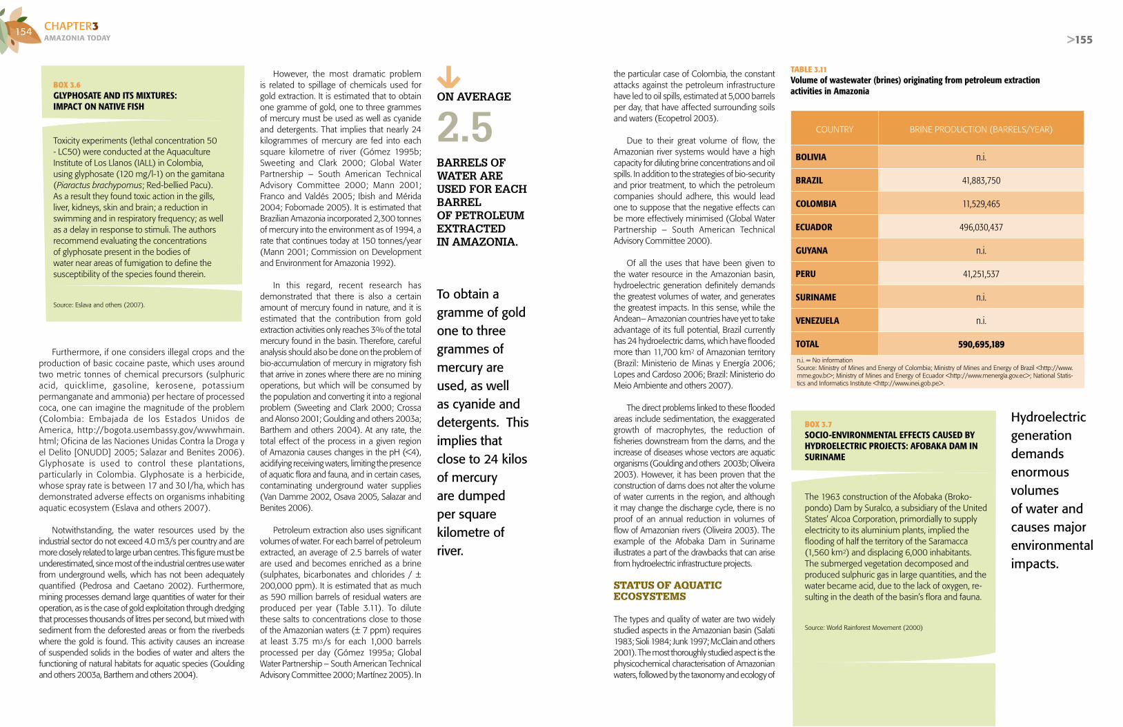
154AMAZONIA TOdAyCHAPTER3
>155
Furthermore, if one considers illegal crops and the production of basic cocaine paste, which uses around two metric tonnes of chemical precursors (sulphuric acid, quicklime, gasoline, kerosene, potassium permanganate and ammonia) per hectare of processed coca, one can imagine the magnitude of the problem (Colombia: Embajada de los Estados Unidos de America, http://bogota.usembassy.gov/wwwhmain.html; Oficina de las Naciones Unidas Contra la Droga y el Delito [ONUDD] 2005; Salazar and Benites 2006). Glyphosate is used to control these plantations, particularly in Colombia. Glyphosate is a herbicide, whose spray rate is between 17 and 30 l/ha, which has demonstrated adverse effects on organisms inhabiting aquatic ecosystem (Eslava and others 2007).
Notwithstanding, the water resources used by the industrial sector do not exceed 4.0 m3/s per country and are more closely related to large urban centres. This figure must be underestimated, since most of the industrial centres use water from underground wells, which has not been adequately quantified (Pedrosa and Caetano 2002). Furthermore, mining processes demand large quantities of water for their operation, as is the case of gold exploitation through dredging that processes thousands of litres per second, but mixed with sediment from the deforested areas or from the riverbeds where the gold is found. This activity causes an increase of suspended solids in the bodies of water and alters the functioning of natural habitats for aquatic species (Goulding and others 2003a, Barthem and others 2004).
BOX 3.6GLYPHOSATE AND ITS MIXTURES:IMPACT ON NATIVE FISH
Toxicity experiments (lethal concentration 50 - LC50) were conducted at the Aquaculture Institute of Los Llanos (IALL) in Colombia, using glyphosate (120 mg/l-1) on the gamitana (Piaractus brachypomus; Red-bellied Pacu). As a result they found toxic action in the gills, liver, kidneys, skin and brain; a reduction in swimming and in respiratory frequency; as well as a delay in response to stimuli. The authors recommend evaluating the concentrations of glyphosate present in the bodies of water near areas of fumigation to define the susceptibility of the species found therein.
Source: Eslava and others (2007).
However, the most dramatic problem is related to spillage of chemicals used for gold extraction. It is estimated that to obtain one gramme of gold, one to three grammes of mercury must be used as well as cyanide and detergents. That implies that nearly 24 kilogrammes of mercury are fed into each square kilometre of river (Gómez 1995b; Sweeting and Clark 2000; Global Water Partnership – South American Technical Advisory Committee 2000; Mann 2001; Franco and Valdés 2005; Ibish and Mérida 2004; Fobomade 2005). It is estimated that Brazilian Amazonia incorporated 2,300 tonnes of mercury into the environment as of 1994, a rate that continues today at 150 tonnes/year (Mann 2001; Commission on Development and Environment for Amazonia 1992).
In this regard, recent research has demonstrated that there is also a certain amount of mercury found in nature, and it is estimated that the contribution from gold extraction activities only reaches 3% of the total mercury found in the basin. Therefore, careful analysis should also be done on the problem of bio-accumulation of mercury in migratory fish that arrive in zones where there are no mining operations, but which will be consumed by the population and converting it into a regional problem (Sweeting and Clark 2000; Crossa and Alonso 2001; Goulding and others 2003a; Barthem and others 2004). At any rate, the total effect of the process in a given region of Amazonia causes changes in the pH (<4), acidifying receiving waters, limiting the presence of aquatic flora and fauna, and in certain cases, contaminating underground water supplies (Van Damme 2002, Osava 2005, Salazar and Benites 2006).
Petroleum extraction also uses significant volumes of water. For each barrel of petroleum extracted, an average of 2.5 barrels of water are used and becomes enriched as a brine (sulphates, bicarbonates and chlorides / ± 200,000 ppm). It is estimated that as much as 590 million barrels of residual waters are produced per year (Table 3.11). To dilute these salts to concentrations close to those of the Amazonian waters (± 7 ppm) requires at least 3.75 m3/s for each 1,000 barrels processed per day (Gómez 1995a; Global Water Partnership – South American Technical Advisory Committee 2000; Martínez 2005). In
COUNTRY BRINE PRODUCTION (BARRELS/YEAR)
BOLIVIA n.i.
BRAZIL 41,883,750
COLOMBIA 11,529,465
ECUADOR 496,030,437
GUYANA n.i.
PERU 41,251,537
SURINAME n.i.
VENEZUELA n.i.
TOTAL 590,695,189n.i. = No information Source: Ministry of Mines and Energy of Colombia; Ministry of Mines and Energy of Brazil <http://www.mme.gov.br>; Ministry of Mines and Energy of Ecuador <http://www.menergía.gov.ec>; National Statis-tics and Informatics Institute <http://www.inei.gob.pe>.
BOX 3.7SOCIO-ENVIRONMENTAL EFFECTS CAUSED BY HYDROELECTRIC PROJECTS: AFOBAKA DAM IN SURINAME
The 1963 construction of the Afobaka (Broko-pondo) Dam by Suralco, a subsidiary of the United States’ Alcoa Corporation, primordially to supply electricity to its aluminium plants, implied the flooding of half the territory of the Saramacca (1,560 km2) and displacing 6,000 inhabitants. The submerged vegetation decomposed and produced sulphuric gas in large quantities, and the water became acid, due to the lack of oxygen, re-sulting in the death of the basin’s flora and fauna.
Source: World Rainforest Movement (2000)
the particular case of Colombia, the constant attacks against the petroleum infrastructure have led to oil spills, estimated at 5,000 barrels per day, that have affected surrounding soils and waters (Ecopetrol 2003).
Due to their great volume of flow, the Amazonian river systems would have a high capacity for diluting brine concentrations and oil spills. In addition to the strategies of bio-security and prior treatment, to which the petroleum companies should adhere, this would lead one to suppose that the negative effects can be more effectively minimised (Global Water Partnership – South American Technical Advisory Committee 2000).
Of all the uses that have been given to the water resource in the Amazonian basin, hydroelectric generation definitely demands the greatest volumes of water, and generates the greatest impacts. In this sense, while the Andean– Amazonian countries have yet to take advantage of its full potential, Brazil currently has 24 hydroelectric dams, which have flooded more than 11,700 km2 of Amazonian territory (Brazil: Ministerio de Minas y Energía 2006; Lopes and Cardoso 2006; Brazil: Ministerio do Meio Ambiente and others 2007).
The direct problems linked to these flooded areas include sedimentation, the exaggerated growth of macrophytes, the reduction of fisheries downstream from the dams, and the increase of diseases whose vectors are aquatic organisms (Goulding and others 2003b; Oliveira 2003). However, it has been proven that the construction of dams does not alter the volume of water currents in the region, and although it may change the discharge cycle, there is no proof of an annual reduction in volumes of flow of Amazonian rivers (Oliveira 2003). The example of the Afobaka Dam in Suriname illustrates a part of the drawbacks that can arise from hydroelectric infrastructure projects.
STATUS OF AQUATICECOSYSTEMS
The types and quality of water are two widely studied aspects in the Amazonian basin (Salati 1983; Sioli 1984; Junk 1997; McClain and others 2001). The most thoroughly studied aspect is the physicochemical characterisation of Amazonian waters, followed by the taxonomy and ecology of
Hydroelectric generationdemands enormous volumesof water and causes majorenvironmental impacts.
TABLE 3.11Volume of wastewater (brines) originating from petroleum extraction activities in Amazonia
To obtain a gramme of goldone to three grammes of mercury are used, as well as cyanide and detergents. This implies thatclose to 24 kilos of mercuryare dumped per square kilometre of river.
ON AVERAgE
bARRELs OF wATER AREUsEd FOR EAch bARRELOF pETROLEUM ExTRAcTEdIN AMAZONIA.
2.5

156AMAZONIA TOdAyCHAPTER3
>157>157
phytoplankton, zooplankton, macro-invertebrates and productivity. This set of references illustrates the mosaic of Amazonian aquatic environments that give origin to the significant diversity of aquatic organisms and sustain extraction activities as important as fishing.
Types of waterWater characteristics in the Amazonian region can be classified into three groups, according to their origins and locations.
❱❱❱ Andean, pre-Andean and alluvial formation regions: the waters coming from this sector are muddy, yellowish (white waters) and are fed by material from recent geological formations within the Andean mountain range. They transport huge quantities of sediments, which are deposited in banks and floodplains or form islands (Furch 1984). The mineralization (60 - 200 µS.cm-1)and pH levels (6.0 – 8.0) of these environments are higher than those of the other two regions. The rivers that originate in these formations present a decreasing gradient in their mineralization (McClain and others 2001), as they get fur ther from their origins; examples in
BOX 3.8SEDIMENTS IN AMAZONIAN RIVERS
Due to the heavy rainfall it receives and to the strong topographic gradient varying from north to south, the Andean mountain range undergoes intense erosive phenomena to enrich the Andean rivers of the Amazo-nian basin with huge quantities of materials in particu-late (sediments) and dissolved form.
Laraque, Guyot and Filizola (in press) coincide that it is difficult to evaluate the comparative yearly variability of the sediment flows in Amazonia due to the lack of long sampling series. When these exist, they generally refer to small basins, as in the case of the Piray River near Santa Cruz de la Sierra, in Bolivia. Analysing these sedimentary series in small basins reveals an extreme inter-annual variability of erosion in the mountainous region, where, for example, an exceptional flood caused by El Niño in 1982-1983, lasting for several days, modified the average inter-annual value.
As it leaves the Andes, owing to diverse factors (a violent change in the topographical slope, different geodynamic processes, lithological variations), the transportation capac-ity of the water currents varies rapidly and the phenomena observed vary from one point of the mountain range to the next. In Ecuador, for example, the first data obtained suggest that half of the sedimentary flow of the Napo river, flowing into Peru, comes from Andean basins and the other half, from the erosion of Ecuadorian sediments. In Bolivia, to the contrary of what is seen in Ecuador, one sees an abundant sedimentation in the Andean piedmonts and much weaker slopes. In the Madeira river basin, only 40% of the material eroded in the Andes arrives in the Amazon. The total flow of sedimentary material exported by the Amazon to the Atlantic Ocean is estimated to be between 600 and 800 x 106 tonnes/year-1 (Filizola 2003). It is worth noting that the complex processes of erosion and sedimentary transfer, seen in different parts of the basin, are currently being studied and quantified.
Source: Laraque, Guyot and Filizola (in press).
Bolivia are Mamoré and Ichilo; in Brazil: Amazon-Solimoes; in Colombia: Caquetá/Japurá and Putumayo/Izá; in Ecuador: Napo and Pastaza; in Peru: Tambopata, Marañón, Yuruá, Ucayali and Madre de Dios. These rivers produce a yearly flood pulse of rising and falling water levels (Junk and others 1989) that propitiates changes in river and lake dynamics, affecting their hydrology as well as the physical, chemical and biological condition of their waters.
❱❱❱ Region of the Guyanese Shield and the Central Brazilian Massif: these are very ancient geological areas, where black and clear waters originate. The former environments are characterised by having a low mineralization, expressed in terms of low conductivity (8 - 60 µS.cm-1)and acidic environments (4.0 - 6.0). In this zone we find, among others, the headwaters of the Negro and Urubú rivers (Brazil), Madeira (Bolivia), Yavarí (Peru) and Igaraparaná (Colombia). On the other hand, the clear waters traverse zones with sandy soils and, therefore, lose most of the material in suspension; the chemical conditions are similar to those of the black waters, but
IN THE MADEIRA RIVER BASIN, ONLY 40% OF THE MATERIAL ERODED IN THE ANDES REACHES THE AMAZON.❱❱❱ The rivers are “highways” that make communication possible among Amazonian populations.
A good part of the Amazonianeconomy and its inhabitants´ nutrition are based on the use of the diversity of aquatic organisms, especially fish.
SERG
IO A
MAR
AL /
AC
TO
their transparency is greater. Examples of the rivers that are classified among this group are Trombetas, Xingú and Tapajós. Each of the clear and black water tributaries contributes minerals or dilutes the waters of the greater Amazon river, generating an East – West gradient.
❱❱❱ Region of central Amazonia: found in this province are rivers of a smaller order known as igarapés (streams) that run through the forests, and some lakes that are fed by both the Amazon and small tributaries. This is an area of extreme geochemical poverty, reflected in low levels of conductivity. This is even seen in the lakes of the Amazon valley that present a paucity of nutrients in certain seasons and thus influence the development of life strategies by aquatic biota.
Diversity of fish as a sourceof food and incomeA good part of the Amazonian economy, and its inhabitants' nutrition are based on the diversity of aquatic organisms, especially fish, that are important factors for the region’s economic, social and cultural movement. Since the 1990s, ichthyic resources have generated commercial flows, oscillating between US$100 million and US$200 million per year (Bayley and Petrere 1989; Petrere 1989; Almeida, Lorenzen, McGrath and Amaral 2006; Barthem and Goulding 2007). These yields are due, precisely, to the high ichthyic diversity of Amazonia, estimated as

158AMAZONIA TOdAyCHAPTER3
>159
between 1,200 and 2,500 species, of which commercial and subsistence fisheries utilise an average of 200 species, and of these, 30 represent the basin’s most important landings (Géry 1984; Barthem and others 1995; Barthem and Goulding 2007).
In 1988, 166,000 tonnes were recorded as coming from the basin’s principal fishing ports: Bolivia (3,000), Brazil (150,000), Colombia (3,000) and Peru (10,000) (Tratado de Cooperación Amazónica [TCA] y Organización de las Naciones Unidas para la Agricultura y la Alimentación [FAO] 1991). Ten years later, merging available statistics for the same countries, the calculation yielded 170,000 tonnes/year, which demonstrates a certain stability, at least regarding the volumes extracted (Barthem and others 1995; Tello 1998; Peru: Ministerio de la Produccion – Dirección Regional de Pesquería de Loreto 2001; Barthem 2004; Batista 2004; Batista and others 2004; Isaac and others 2004; Viana 2004; Junior and Almeida 2006; Colombia: Instituto Colombiano de Desarrollo Rural [INCODER] 2006).
The other side of the story concerns the
fish consumed by the local populations, which implies no commercial exchange, and as a
consequence does not appear in any official statistics. In this regard, it has been calculated that fish consumption per capita, for rural and riverside families in different regions of the basin, varies from 250 to 800 grammes/person/day (Cerdeira and others 1997; Batista and others 1998; Fabré and Alonso 1998; Agudelo and others 2006). Therefore, it is estimated that the aquatic ecosystems offer the inhabitants of Amazonia 200,000 tonnes of fish per year (Figure 3.3).
Adding these commercial production estimates to those destined to self-consumption gives values of nearly 400,000 tonnes/year that Bayley and Petrere (1989) calculated for Amazonia, and they are a long way from the potential of 900,000 tonnes/year, suggested by Merona (1993) for the entire basin. Therefore, one can conclude that fisheries activities are not in grave danger; however, there is excessive use of certain resources that are causing a decline in their natural supply.
This behaviour is evident when we analyze the data available from Brazil, Colombia and Peru for the years 1994, 1995, 1996 and 2000 (Figure 3.4) (Isaac and others 1996; Tello 1998, Peru: Ministerio de la Produccion – Dirección Regional de Pesquería de Loreto
2001; Barthem 2004; Batista 2004; Isaac and others 2004; Viana 2004; Colombia: Instituto Colombiano de Desarrollo Rural [INCODER] 2006; Almeida and others 2006; Barthem and Goulding 2007): (i) pirabutón, bocachico or curimatá, yaraquí, palometa, garopa or pacu and dorado, have always been the most commercialised species in the different years; (ii) B. vaillantii decreased to 13,000 tonnes/year in 2000; (iii) P. nigricans tended to increase greatly towards the year 2000, reaching 32,600 tonnes/year; (iv) pintadillo, doncella or Tiger shovelnose catfish (surubim) and B. rousseauxii surpassed 10,000 tonnes/year in 2000, and the first of these began to take on importance in the statistics of the three countries.
Similar cases were recorded in central Amazonia when, during the 1980s, the Manaus fishing fleet found it necessary to extend its fishing efforts to distances of over 500 km to maintain its production of the gamitana (Red bellied pacu). However, the species never regained its original yields (Bayley and Petrere 1989; Tratado de Cooperación Amazónica [TCA] y Organización de las Naciones Unidas para la Agricultura y la Alimentación [FAO] 1991; Barthem and others 1995; Isaac and others 1996). Recently, towards Upper Amazonia, the species popularly known as lechero is no longer commercially important and is being replaced by another, known as mota (Petrere 2001; Petrere and others 2004). In the case of other countries of the basin, Guyana and Suriname, Amazonian fishing is strictly a subsistence activity, and therefore has
FIGURE 3.3Average annual fisheries landings per country during the period 1988-1998 (a) andestimate of fish consumed by rural and riverside populations in Amazonia (b)
BOX 3.9ALERT ON THE OVER-EXPLOITATION OF DORADO (BRACHYPLATYSTOMA ROUSSEAUXII) AND PIRABUTÓN (BRACHYPLATYSTOMA VAILLANTII)
Adults and pre-adults of Dorado are captured all along the Amazon river’s main channel and major tributaries, while juveniles are heavily fished in the estuaries. Similarly, a significant number of pirabutón juveniles are also captured in trawl nets. In the first case, the first signs of over-fishing are being seen, while in the second, the situation has already been confirmed. Posting an early alert on the threat of a collapse of these fisheries should create an incentive for the governments of the Amazonian countries to consider plans for macro-regional management, in which definite measures can be applied and monitored in conjunction on either side of the borders.
Source: Adapted from Bayley and Petrere (1989); Ruffino and Barthem (1996); Barthem and Goulding (1997); Japan International Cooperation Agency (1998); Fabré and Alonso (1998); Agudelo and others (2000); Petrere (2001); Petrere and others (2004); Alonso and Pirker (2005); Fabré and others (2005); Almeida (2006); Food and Agriculture Organization (FAO) (2006); Barthem and Goulding (2007).
❱❱❱ Most food eaten by Amazonian inhabitants is river fish.
Source: adapted from Barthem and others (1995); Tello (1998); Peru: Ministerio de la Produccion – Dirección Regional de Pesquería de Loreto (2001); Barthem (2004); Batista (2004); Batista and others (2004); Isaac and others (2004); Viana (2004); Junior and Almeida (2006); Colombia: Instituto Colombiano de Desarrollo Rural [INCODER] (2006).
Source: adapted from Cerdeira and others (1997); Batista and others (1998); Fabré and Alonso (1998); Agudelo and others (2006).
Fish consumption per capita, for rural and riverside families in different regions of the basin, varies from 250 to 800 grammes/person/day.
ENRI
QU
E C
ASTR
O M
END
ÍVIL
/ P
ROD
APP
160000
140000
120000
100000
80000
60000
40000
20000
Bolivia Brazil Colombia Peru
0
T/year
Country Country
160000
140000
120000
100000
80000
60000
40000
20000
Bolivia Brazil EcuadorColombia Peru
0
T/year
(a) (b)

160AMAZONIA TOdAyCHAPTER3
>161
no recorded data, and in the case of Suriname, its only fisheries are in the coastal zone (Tratado de Cooperación Amazónica [TCA] y Organización de las Naciones Unidas para la Agricultura y la Alimentación [FAO] 1991).
Due to the migratory and cross-border nature shown by the principal species that sustain Amazonian fisheries, it would be appropriate to integrate each country’s basic knowledge of these species, as well as the initiatives among the countries for fishery management and administration. This will allow international agreements to be made to control fishing, define which equipment has the least impact and include strategic areas for the preservation of different stages of the species’ development (i.e. spawning, breeding, and growth) (Ruffino and Barthem 1996; Barthem and Goulding 1997; Agudelo and others 2000; Ruffino 2000; Petrere 2001; Alonso and Pirker 2005; Fabré and others 2005; Alonso, Agudelo and others 2006; Barthem and Goulding 2007). Therefore the migration routes used by the fish during their life cycles must be safeguarded to ensure the dispersion and repopulation of these aquatic environments. In this sense, infrastructural mega-projects become the principal threats to the connectivity and environmental continuum of the Amazonian basin (Barthem and Goulding 1997; Petrere 2001; Alonso and Pirker 2005; Barthem and Goulding 2007).
Since the 1980s, aquaculture has been mentioned as a viable alternative in Amazonia; it could contribute to minimising the impact caused by overfishing of certain species, while allowing for the maintenance or improvement of the supply during the off-season within the natural milieu. In this sense, the supposition that aquaculture is an absurd activity or that it is anti-economic, in the face of the basin’s vocation to fisheries, should be reoriented towards its outstanding strengths, due the excellent availability of water of different types and qualities (Junk 1983; Barthem and others 1995; Val, Ramos and Rabelo 2000).
Definitely, this productive alternative cannot be conceived as a substitute for traditional fisheries, but as an opportunity for development, which some governments are already supporting, with emphasis on areas near to the larger urban centres (Belén, Manaus and Iquitos) (Barthem and Goulding
BAv: Brachyplatystoma vaillantii (pirabutón, piramutaba, manitoa), PRN: Prochilodus nigricans (bocachico, curimatá), SEM: Semaprochilodus spp. (yaraquí, jaraqui), PSE: Pseudoplatystoma spp. (pintadillo, surubim, doncella), MyL: Mylossoma spp. (palometa, garopa), BRA: Brachyplatystoma rousseauxii (dorado, dourada), BRy: Brycon cepha-lus (sábalo, matrinxa), POT: Potamorrhina spp. (branquinha), TRI: Triportheus spp. (sardina, sardinha), HyP: Hypophthalmus edentatus (mapará, maparate), HOP: Hoplias malabaricus (traira), PLA: Plagioscion spp. (curvinata, pescada), COL: Colossoma macropomum (gamitana, tambaqui).
* Brazil during the period 1994-1996 includes fisheries from Belén, Santarém and Manaus (with the exception of 1996, when there was no information on the refrigeration facili-ties in Belén). Brazil in 2000 includes the continental fisheries for the states of Pará and Amazonas. For Colombia data refer to landings in Leticia and Peru in the Loreto region.
FIGURE 3.4 Principal species landed in Brazil, Colombia and Peru* in the period 1994-1996 and 2000
FIGURE 3.5 Annual fisheries exports from the Amazonian basinin the period 1995-2003 (Brazil, Colombia, Peru)
FIGURE 3.6 Live fish (units) exported by Brazil, Colombiaand Peru from the Amazonian basin
2007). It is possible that the perspective of Amazonian aquaculture will be to supply local markets at low cost, while wild catch fishing could be directed toward export at higher market prices. (Almeida and others 2006).
Ornamental fish are also an example of Amazonian biodiversity in the fisheries. In the worldwide context, ornamental fish represent annual exports in excess of US$ 200 million, of which Amazonia contributes, depending on the year, between US$6 million and US$11.5 million per year, representing between 20 and 25 million live units per year of the 30 to 50 most utilised species (Figure 3.5). Brazil is the leading marketer, with an average volume of 16 million units, followed by Peru with 9 million and Colombia with 1.9 million (Figure 3.6) (Food and Agriculture Organization [FAO] 2002; Perdomo 2004; Pereira 2005; Junior and Almeida 2006; Prang 2006).
In Brazilian Amazonia some 180 ornamental species are commercialised, of which the most frequently captured are the cardinal and the neon tetra (Pereira 2005; Brasil: Ministerio de Minas y Energia – Petrobras 2005; Freitas and Rivas 2007). In the case of Colombia and Peru, there are 150 species registered for export, of which the most representative are the otocinclus catfish and the arowanas (Perdomo 2004; Campos-Baca 2005; Sanabria 2005; Rodríguez-Sierra 2007). The last named species presents a certain degree of threat, since it is a medium-sized fish and also suitable for consumption; however, given its exotic characteristics, its larvae and fry are commercialised (Junior and Almeida 2006; Rodríguez-Sierra, 2007). The combined exports of Guyana, Venezuela and Ecuador amount to less than 2% of the total sold by the Amazonian countries (Cabrera 2005; Prang 2006).
Arowana trade, as with other ornamental species, presents conflicts in usage and legislation at the borders between Brazil, Colombia and Peru. Therefore, a strategic initiative is needed to administer the activity through management plans coordinated between the countries involved so that, by sharing responsibilities, a commitment between users and institutions would have greater effect (Food and Agriculture Organization [FAO] 2002; Colombia: Instituto Colombiano de Desarrollo Rural [INCODER].
ORNAMENTAL spEcIEsARE REgIsTEREd FOR ExpORT IN cOLOMbIA
ANd pERU INcLUdINg ThE OTOcINcLUs cATFIsh ANd ThE AROwANAs.
AqUAcULTURE cANNOT bE sEEN As A sUbsTITUTE FOR TRAdITIONAL FIshERIEs, bUT RAThER As A VIAbLE ALTERNATIVE IN AMAZONIA.
150 Tons 35,000
30,000
20,000
25,000
15,000
10,000
5,000
0
A. YEAR 1994
SpeciesBAV SEM PSE BRA BRY POT TRI HYP HOP PLA COLMYLPRN
Tons 35,000
30,000
20,000
25,000
15,000
10,000
5,000
0
B. YEAR 1995
SpeciesBAV SEM PSE BRA BRY POT TRI HYP HOP PLA COLMYLPRN
Tons 35,000
30,000
20,000
25,000
15,000
10,000
5,000
0
C. YEAR 1996
SpeciesBAV SEM PSE BRA BRY POT TRI HYP HOP PLA COLMYLPRN
Tons 35,000
30,000
20,000
25,000
15,000
10,000
5,000
0
D. YEAR 2000
SpeciesBAV SEM PSE BRA BRY POT TRI HYP HOP PLA COLMYLPRN
Value Volume Units (millions)
12,0004035302520151050
10,000
8,000
6,000
4,000
2,000
01995 96 97 98 99 2000 01 02 03
Value US$1.000Brazil Peru Colombia
353025201510
50
1995 96 97 98 99 2000 01 02 03
Units (millions of fish)
Source: Adapted from: Isaac and others (1996); Tello (1998); Peru: Ministerio de la Produccion – Dirección Regional de Pesquería de Loreto (2001); Barthem (2004); Batista (2004); Isaac and others (2004); Viana (2004); Colombia: Instituto Colombiano de Desarrollo Rural (INCODER) (2006), Almeida and others (2006); Barthem and Goulding (2007).

162AMAZONIA TOdAyCHAPTER3
>163
The term “Agroproductive systems” refers to the set of biological and natural resources, managed by the population, to produce food and other non-food goods, as well as to conserve ecosystem services that society values. A variety of agricultural productive systems have been developed in Amazonia, taking advantage of the wealth of its ecosystem services. However, the development and operation of those systems varies between and within each of the Amazonian countries AMAZONIAN AGROPRODUCTIVE SYSTEMS
Soil quality is fundamental to sustaining the production of agricultural productive systems. Amazonian soils are generally poor, due to their thin layer of organic material. Because of its wealth of micro-organisms, the organic material is the source of nutrients for plants. This microbial diversity is fundamental to ecosystem function, owing to the varied processes those micro-organisms control, such as decomposition, nutrient recycling and soil aggregation, among others (Peña and Cardona 2007). Furthermore, organic material acts as a protective layer for the soil against erosive agents or processes.
Amazonian soil has different characteristics, according to its development in alluvial or non-alluvial zones. In alluvial flood zones, the soil has greater natural fertility, since it is fertilized annually by mud and clay sedimentation left by floods; however, it has poor drainage. Generally speaking it is covered by water during most of the year. River bank lands have their own particularities, according to the cycle of flooding and its wealth of nutrients, and there is an identifiable
3.4|AGROPRODUCTIVE SYSTEMS
classification into: mires, islands, beaches, swamps, shoals and floodplains. These soils are sensitive to hydrological erosion, and therefore, to loss of fertility; thus, when the forest is cleared for agricultural development, the fragile natural equilibrium of the ecosystem is broken, and the rains cause its rapid impoverishment. Soils in non-alluvial zones are those found in the shoals, high terraces, hills, and mountains, which have been enriched by the biomass they support (Rodríguez 1995). It should be pointed out that there is limited knowledge about the characteristics of these soils and their use potential, as well as relating to the species or varieties that are suitable for development thereon.
Amazonian agroproductive systems are heterogeneous, both in their production modes and scale, as well as their access to natural resources and the destination of their production, among other factors. In this sense, traditional production systems exist alongside their modern, high technology counterparts. The development of agroproductive systems is conditioned by the process of land usage in Amazonia (see Chapter 1, Section 1.2.), as well as by the socio-economic dynamics of the areas neighbouring the Amazonian region of each country.
Agroproductive systems in Amazonia include: agrosilvopastoral, agroforestal, forest grazing, agricultural systems for forest enrichment, simple agriculture (i.e. monocultures) and extensive livestock production. The agrosilvopastoral system consists of integrated crop management, pasturelands for livestock production and forestry activities involving timber-yielding and non-timber yielding products. The agroforestal system concentrates on managing associated crops and developing synergies with appropriate forest species; this system helps
AUThOR:ROSARIO GÓMEZ - Research Center of the Universidad del Pacífico (CIUP) – Peru
cO-AUThORs:MARLUCIA BONIFACIO - Museum Paraense Emilio Goeldi (MPEG) – BrazilELSA GALARZA - Research Center of the Universidad del Pacífico (CIUP) – PeruCAMILO GONZÁLEZ - Ministry of the Environment – EcuadorURIEL MURCIA - Amazonian Institute for Scientific Research (SINCHI) – ColombiaLUIS ALBERTO OLIVEROS - Amazon Cooperation Treaty Organization (ACTO)RITA PISCOYA - National Colonization and Agrarian Reform Institute (INCRA) – BrazilFERNANDO RODRÍGUEZ - Peruvian Amazonia Research Institute (IIAP) – PeruMURIEL SARAGOUSSI - Ministry of the Environment – Brazil
❱❱❱ Unsustainable productive systems advance in Amazonia.
The fragile fertility of Amazoniansoil means low crop yields comparedto other productive zones.
INST
ITU
TO IM
AZO
N

164AMAZONIA TOdAyCHAPTER3
>165
to improve crop yields and soil conservation, and to reduce agrochemical usage. Forest grazing systems associate livestock production with managing pasturelands and forest resources. Agricultural systems for forest enrichment involve managing timber-yielding and non-timber-yielding forest species. All of these systems assume integrated management of the productive unit, not only to guarantee the conservation of ecosystem services, but also to consider economic profitability and improving the quality of life of the population.
In contrast, there are also monoculture
and livestock production systems that concentrate on using natural resources to attend to the growing demands of the food market and on maximising earnings, without considering ecosystem functions.
Agroproductive systems are managed by growers with a wide variety of profiles and differing interests:
❱❱❱ In production by indigenous populations, the property regimen is communal. They manage integrated production systems that include agriculture and extraction (hunting, fishing, forest crops). Productive management is traditional, to wit, in agriculture, no agrochemicals are used and forest management is a community activity. The environmental impact from these productive activities is minimal. ❱❱❱ In the genre of production by settled small-scale farmers, the growers generally own the land they work. They carry out a variety of productive activities: diversified agriculture, livestock production, forest exploitation and artisan mining. Frequently the settler comes from a different ecological environment, and is therefore not familiar with the Amazonian forest. For this reason and because he has no training, he employs agricultural techniques that are inappropriate or inadequate for the Amazonian physical milieu.
❱❱❱ In the entrepreneurial production mode, access to natural resources (e.g. land) can be attained through concessions, forced occupation of the land or by obtaining illegal property titles, among others. Productive activit ies are specialised and highly
BOX 3.10BABAZÚ: OPPORTUNITIES AND LIMITATIONS
Characteristics- Native palm from the northern and north-eastern regions of Brazil.- Extends over 13 to 18 million hectares.- States of Marañón, Piauí, Tocantins, Goiás, Mato Grosso, Amazonas and Pará.- Marañón accounts for 55% of the babazú growth area.- Babazú provides around 64 sub-products (oil, ethanol, methanol, cellulose, handicraft products, flours, glycerine, among others).- Possibility of obtaining carbon credit for substitution of coal for ba-bazú charcoal, a non-lumber yielding forest product, which allows for the palm trees to remain standing.
Source: Secretaría de Extractivismo y Desenvolvimiento Rural Sustentable. Ministry of the Environment.Information supplied by Muriel Saragoussi (Ministry of the Environment, Brazil).
technical. The main productive activities are: monoculture agriculture articulated under an agro-business chain (e.g. soya), livestock production (e.g. dairy and zebu cattle), selective extraction of timber-yielding species, management of oil palms (e.g. dendé and babazú), production of sugarcane to produce biofuels, among others.
Reduced labour costs, low land prices, tax exemptions or evasion and the opening of communication routes sustain the competitive advantages of entrepreneurial agriculture in the region. Furthermore, international market forces, interested in expanding crops (e.g. sugar cane and soya) provide incentives for expanding the agricultural frontier into tropical forest ecosystems (Killeen and Da Fonseca 2006).
During the historical process of land occupation, Amazonia was considered an empty space with tremendous productive potential (see Chapter 1). Therefore, public
policies applied since 1960 considered investments in infrastructure and promoted colonization processes and the expansion of the agricultural frontier over this region. It should be clarified that in Amazonian agricultural development, there is a difference between riverside growers that cultivate the floodplains (várzeas) or riverbanks, and those growers who carry out their agriculture in the forest itself.
In the case of the riverside or alluvial zone growers, they take advantage of the mud deposited during the flood stages of the river, allowing them to obtain better yields. Furthermore, there is a culture and method of production, typical of riverside dwellers, characterised by managing a variety of activities, such as extraction, which includes collecting fruits, vines, honey, latex, bark, flowers, gums and resins and ornamental fish, among others, in addition to farming. However economic feasibility studies evaluating these types of productive units are limited.
To cultivate the dry land or in the forest, the swidden technique is used (cut, fell and burn the forest) in order to clear the land and form a layer of ash, which contributes to soil fertility. On that prepared ground they produce diverse agricultural products (e.g. sugar cane, coffee, maize, grains and fruits, among others) (Rodríguez 1995).
The fragile fertility of Amazonian soil generates low crop yields in comparison to those of other productive zones. For example, in Peru, rice cultivation yields differ according to the area of production, depending on whether it is on the northern coast (8.5 MT/ha), the southern coast (11 MT/ha), the high forest (6,5 MT/ha) or the low forest (3 MT/ha) (Peru: Ministerio de Agricultura 2002; Centro Peruano de Estudios Sociales 2006). The limited fertility of Amazonian soil forces growers to move to a new zone every three to five years and generating migratory agriculture.
Soya is a monoculture that has begun expansion in Amazonia, although the production of this crop has traditionally been concentrated in other biomes, such as the Cerrado (in Brazil) and the Chaco and Chiquitano forest (in Bolivia). Expansion of soya cultivation responds to the growing demand of international markets and takes advantage of the availability of relatively low-cost land. The accelerated growth of soya cultivation has generated socio-productive changes, both in the productive zones and in their zone of influence.
Soya production is a monoculture that has begun expansion in Amazonia, although the production of this crop has traditionally been concentrated in other biomes, such as the Cerrado (in Brazil) and the El Chaco and the Chiquitano forest (in Bolivia). Expansion
Production by indigenous populations is on communalproperty. Their integratedproduction systems include agriculture and extractive activities.
MARKET CHARACTERISTICS
RELATIVESIZE
RELATIVE IMPORTANCE TONS/YEAR
PRICE RANGE US$/TON
PHARMACEUTICAL VERY SMALL < 105 > 2,000
CHEMICAL MODERATE < 106 700 - 2,000
NUTRITIONAL LARGE < 107 450 - 700
ENERGETIC UNLIMITED > 107 < 450
BOX 3.11AMAZONIAN RIVERSIDE AGRICULTUREON THE UCAYALI RIVER (PERU)
“The banks of the Ucayali river were the sites of the first indigenous and colonist settlements in Peruvian Amazonia, Those riverside populations developed diverse productive activities, such as fisheries, agriculture and others. The complexity and diversity of the Ucayali agro-ecological system determines the agricultural activities employed during the different seasons of the year (Bergman 1990, De Jong 1995). One important element of the Ucayali agro-ecological system is the diverse variety of soil types, suitable for agriculture, that appear and disappear along the riverbanks, according to changes in the river.
Riverside crops include: plantain, cassava, rice, maize, beans, peanuts, soya, and many others. Rice is concen-trated mainly in the mud flats (barrizales), while maize gets better yields in the shoals (restingas). Once the crops are chosen, the production system becomes very simple; monocultures are predominant. There are few riverside growers involved in associated crop cultivation. The few that do exist are located on the shoals, and their produc-tion limited to self-consumption (Padoch and De Jong 1991).
Agricultural activity on the banks of the Ucayali can have high yields. However, this does not guarantee profitability for the crops nor for the farm managing them. To wit, both the yields and the earnings are susceptible to variations in the conditions for producing and marketing the products. The risks of early flooding, the high cost of river transporta-tion and price instability all affect the profitability of their agriculture.”
Source: Labarta and others (2007).
The expansion of soya cultivationis a response to the growing international market demand and the availability of relatively low-cost land.

166AMAZONIA TOdAyCHAPTER3
>167
of soya cultivation responds to the growing demand on international markets and takes advantage of the availability of relatively low-cost land. The accelerated growth of soya cultivation has generated socio-productive changes, both in the productive zones and in their zone of influence.
The mechanised nature of soya cultivation makes the flatlands suitable for this crop. Large-scale soya production has smaller manpower requirements (one worker for each 170–200 ha) compared to other crops. The extensive areas of cultivation require the use of crop dusting aircraft for applying herbicides, which favours the dispersion of these chemicals into the environment.
Beginning in 1984, soya cultivation in Bolivia was the main cause of deforestation. Between 1997 and 2006, the area of soya cultivation expanded by 411%, which meant 1,420,000 hectares of deforestation. Soya production is concentrated in the department of Santa Cruz. Eighteen percent of the deforested area is tropical rainforest, while 37% is in the wooded savannahs of the Gran Chaco and 30% in the Chiquitano forest. Some studies indicate that, in the case of San Julián - Santa Cruz, one of the main soya production centres, at the current rate, the forests will disappear within nine years. Soya management implies the use of an intensive technological package of agro-chemicals, to which is added the initiation of trans-genetic soya production. Thus, depending on the type of seed used, production costs will vary; with conventional seed they are approximately US$229/ha, while in the case of trans-genetic seed these costs rise to US$351/ha (Asociación Internacional por la Salud 2006).
Soya cultivation in Brazil is also advancing into rainforest areas (e.g. Rondonia, Pará and Amazonas) (Pasquis 2006). This expansion of production affects habitats with high conservation value and the way of life of the local population, because it leads to erosion and soil exhaustion and obliges the locals to either substitute their productive activities or abandon their lands. Furthermore, it fosters exhaustion and eutrophication of the rivers and the loss of ecosystem supportive services; in particular, it reduces soil fertility.
Coca is a crop concentrated in the Andean-Amazonian zone and the region contains 98% of the world coca production. Production moves from one producing country to another, according to the risks faced. Thus, after 1998 when eradication programmes became aggressive and effective in Bolivia and Peru, production moved to Colombia. The coca harvesting area reached its maximum level in the year 2000, with 221,300 ha and its minimum level in the year 2003, with 153,800 ha. In 2006 there was a slight reduction of 2% compared to the previous year, when 156,554 ha were recorded (Oficina de las Naciones Unidas Contra la Droga y el Delito [ONUDD] 2007).
Coca growing areas are located in remote zones with difficult access and generally on steep slopes, so that land preparation for planting frequently provokes intensive erosion of the slopes. The incentive for planting coca is the significant short-term income that can be earned and that is higher than any other crop. For example, the average price for coca leaf in 2005 showed an increase of 3.6% over the previous year, reaching US$2.90/kg. The expectation of higher income attracts migrants from other regions. In Peru and Bolivia, as against Colombia, coca leaf cultivation for traditional consumption (chaccheo) is legal (Durand 2005).
In remote sectors of the Bolivian and Peruvian Andean foothills poor campesinos produce coca leaf both for traditional consumption andfor the illegal market.
BOLIVIA BRAZIL COLOMBIA ECUADOR GUYANA PERU SURINAME VENEZUELA
AGRICULTURE
RICE — — —
COFFEE — — —
CACAO — —
SUGARCANE — — — —
COCA — — — — —
CASSAVA — —
MAIZE — — — — —
PEPPERS — — — — — — —
SOYA — — — — — —
TROPICAL FRUITS(BANANAS, CITRUS, COCONUT)
—
FORESTRY
DENDÉ NATIVE OILPALM
— — — — — —
— — — —
EXOTIC FORESTRY — — — — —
EXTRACTIVE FORESTRY
NON-TIMBER YIELDING FOREST EXTRACTION (E.G., BRAZIL NUTS)
—
LIVESTOCK
LIVESTOCK-PASTURES —
Source: Original production; Programa de las Naciones Unidas para el Medio Ambiente (PNUMA) and others (2006 and 2007).
TABLE 3.12Amazonia: Crops and livestock production
foto coca o soya
ENRI
QU
E C
ÚN
EO /
EL
COM
ERC
IO

168AMAZONIA TOdAyCHAPTER3
>169
The use of agro-chemicals (fertilisers and pesticides) in the Amazonian region has increased, due to the need to improve soil fertility and control pests. This increase is due principally to the expansion of monocultures, such as soya or coca. In Brazilian Amazonia, for example, the states leading in consumption of agrotoxic substances are Mato Grosso (208 kg/ha), Tocantins (112 kg/ha) and Amapá (105 kg/ha) (Brazil: Ministerio del Medio Ambiente 2005).
In Guyana, agricultural development
is concentrated along the coast, and the principal crops are sugarcane and rice. The Guyanese coast is between 0.5 and 1 m below sea level and has natural defences like mangrove swamps and concrete infrastructure, which protect it from incoming salt water, making it inhabitable and suitable for growing crops. In contrast, the soils of the country’s interior are fragile and clayey, which allows certain crops to grow (cereals, peanuts, coconuts, tomatoes; fruits like coconut, mango, star fruit, pear, bananas, and others) as well as livestock. In general, the National Development Strategy indicates that
agricultural expansion in the country assumes the use of good agricultural practices that include the elimination of aerial fumigation, an increased use of bio-insecticides, and the revision of agro-chemical use, among other measures (Guyana: National Development Strategy Secretariat 2006).
In Venezuela, expansion of the agricultural frontier was carried out by assigning forest-covered public lands to landless campesinos and they began by commercialising the most valuable forest species and then burning the degraded forest to use it for agriculture. During the period 1980-1990, the annual rate of agricultural frontier growth was 2.9%, reaching 32 million hectares by 1990 (Censat-Agua Viva 2002).
The original forest must also be converted into cleared land for livestock production. Later grasses are introduced, which in some cases are associated with legumes (Rodríguez 1995). Livestock production is an activity that requires the field worker to live in one place and limits shifting agriculture. In Amazonia there are two identifiable methods of
livestock production: on the one hand are the small-scale traditional ranchers, and on the other, commercialized/ intensive cattle raising.
Small ranchers, generally in a situation of poverty, with limited pasture management due to the lack of technical assistance and information on adequate technology, have reduced levels of productivity in terms of litres of milk/cow or kilos of meat/steer.
In the second case, intensive livestock production is carried out, which is mainly managed by livestock companies with greater extensions of land and economic resources. This type of cattle rancher carries out pasture management, introduces improved stock and uses other industrial products to complement feeding the livestock. Intensive livestock production has expanded in Amazonia and is linked to international markets through meat exports.
Intensive grazing in a single field throughout the year leads to extreme trampling of the forage, limiting its normal development and causing soil compaction. This leads to the disappearance of cultivated grasses and in some cases the abandonment of the pastures, as they are converted into young fallows, difficult to recuperate. Cattle raising activity in Amazonia has intensified in recent years, i.e., the land supports a greater number of head of cattle per unit of surface, a situation that is highlighted in Brazil and Bolivia. In Brazil, for example, the States of Rondonia and Pará show a significant increase in livestock production pressure, with an annual increase of 11.7% and 9.68% in the number of head of cattle per km2, respectively, during the period 2001-2006. Rondonia went from 27.69 head of cattle/km2 in 2001 to 48.15 head of cattle/km2 in 2006.
In Brazil, the increase in bovine livestock has been huge and fast, from 34,721,999 head of cattle in 1994 to 73,737,986 in 2006, occupying 74% of the deforested area. The average annual growth rate for the cattle herd increased significantly, if we compare the numbers by five-year increments; during the period 1994-1999 the annual increase in head of cattle was 4.7%, and the period 2001-2006, was 7.4%. The speed of cattle herd growth is differentiated among the states, of which Rondonia is the undisputed leader, with an annual rate of 11.7% between 2001 and 2006. Smeraldi and May (2008) stresses the fact that for each four additional head of cattle added to the State’s herd over the last five years, three were added in Amazonia. It is worth noting that 75% of the cattle herd is concentrated in the states of Mato Grosso, Pará and Rondonia. In addition, there are two aspects of large-scale cattle ranching that contribute to the production of greenhouse gases: (i) the emission of nitrous oxide from excrement; and (ii) the 21-300 times increase of methane due to the intestinal fermentation of the ruminants (Smeraldi and May 2008).
BOX 3.12BOLIVIA: LAND MANAGEMENT AND A WEAK LEGAL-INSTITUTIONAL FRAMEWORK
“Regarding land ownership in the lowlands, there is no recent, reliable information and there are large areas where several corporations, persons and communities have overlapping territorial claims. Official statistics show that between 1955 and 1994 some 30 million hectares of public lands were given away (40% of the region’s total area) to different groups. Nearly 23 million hectares were given to mid-sized and large farming enterprises, three million to small scale agricultural settlers and three million to indigenous groups. Nevertheless, a much greater proportion of the region’s land is under ‘de facto’ private control, as a product of a great many illegal and semi-legal manoeuvres, above all, by entrepreneurial growers. In many cases, these groups have falsified docu-ments, bribed government officials, obtained proper-ties without complying with the legal requirements or bought land knowing that it had been acquired illegally”.
Source: Pacheco (1998).
In Bolivia, the principal departments for bovine livestock are Beni and Santa Cruz, predominated by medium and large-scale ranchers. The Department of Beni contains 48% of the country’s cattle, in an area greater than 200,000 km2. Bolivia’s total cattle herd increased by 31% between 1994 and 2004, from 5.4 million head in 1994 to 7.1 million head in 2004. Meat production also grew by 36%, from 125,000 MT in 1994 to 169,000 MT in 2004 (Bolivia: Unidad de Análisis de Políticas Sociales y Económicas 2004).
In Colombia, intensive livestock production also grew in its Amazonian sector. The cattle consume a variety of forest undergrowth species and fruit from its trees, and generally develop on acid soils, with little consideration for ecological criteria, and productive yield is relatively small (Instituto Amazónico de Investigaciones Científicas [SINCHI] 2007).
Regarding access to the principal factors of production, land and labour, these markets are generally distorted, due to the problems associated with assigning property rights and to incomplete information, which negatively affects their efficient operation. This promotes repeated non-compliance of norms, overlapping proper ty rights and to squatters’ rights being claimed based on possession rather than title.
>169
Rondonia Mato Grosso Pará
Cattle numbers km²
1994
60
50
40
30
20
10
0
95 96 98 99 2001 02 03 04 05 0697
FIGURE 3.7Livestock density in the States of Rondonia, Mato Grosso and Pará (Brazil) 1996 – 2006
Source: Brazil: Instituto Brasileño de Geografía y Estadística (IBGE) (2007)

170AMAZONIA TOdAyCHAPTER3
>171
Agroproductive systems have developed in parallel with structural changes in landholding. In this sense, the nations of Amazonia have carried out processes of agrarian reform, in order to reduce the concentration of landholdings, but with differing results. In Brazil, most of the land in Legal Amazonia is in the public domain, or that of the federal governments. Legally, the lands may be sold to large private landholders. Thirty-one percent of the area is in the hands of 0.8% of farming or ranching units, with landholdings greater than 200 hectares. An indicator of the imbalance in land access is the Gini coefficient, which showed certain improvement in the northern region, by decreasing from 0.882 in 1968 to 0.714 in 2000. Regarding legitimacy of ownership, IMAZON indicates that 31% of lands in Legal Amazonia are owned by persons who lack property titles and registration. These properties occupy 1.58 million km2, which is equivalent to the combined territories of Spain, France, Germany, the Czech Republic and Hungary. Only 4% of Legal Amazonia has complete documentation, regulated by the National Colonization and Agrarian Reform Institute (INCRA) (Fearnside 2003).
Furthermore, the widespread availability of unorganized labour and the limited number of contractors affect the efficiency and equity of the agrarian labour market. This worsens working conditions for farmers, since contracting mechanisms that fail to respect workers’ rights are employed: in some extreme cases, situations of slavery have even been identified.
UNSUSTAINABLE AGROPRODUCTIVE SYSTEMS IN EXPANSION
The accelerated and disorderly growth of agriculture and livestock production has reduced the vegetal cover and contributed to soil deterioration. There are unsustainable agroproduction systems on fragile ecosystems that ignore the close relationship between them and their ecosystem services. These systems interact with the natural milieu without considering the consequences (soil erosion, biodiversity loss, deterioration of soil support services, and loss of quality in bodies of water). The ecosystem soil support service is affected by the changes in its structure and the dynamics of the macro- and micro-organisms that affect soil fertility. This means higher future costs of using the resources and affects the quality of life of the local inhabitants.
The incentives and underlying factors for the operation of unsustainable agricultural productive systems in Amazonia are of different types. On the one hand are structural causes, such as poverty and migrations. In areas near the Amazonian region, the
BOX 3.13BRAZIL: SLAVE LABOUR IN AGRICULTURALPRODUCTION IN AMAZONIA
Between 1960 and 1970, modern slave labour was initiated in Brazil, in response to the expansion of modern agriculture in Amazonia. The labour force came from places with few job opportunities and limited access to land and financial services. Furthermore, large-scale agribusiness has generated heavy pressure on the region’s natural resources, promoting accelerated deforestation processes and an increase in slave labour.
The Sharma study estimates that there are between 25,000 and 40,000 workers in conditions of slavery. Marañón, Piauí and Tocantins are the three Brazilian states that provide the highest numbers of slave labourers. Pará is the state with the greatest requirement for slave labour, followed by Mato Grosso. The principal activities utilising slave labour are: livestock production (43%), deforestation (28%), agriculture (24%), forestry activities (4%) and charcoal extraction (1%).
In 2005, the Special Group for Mobile Inspection freed 4,113 persons, mainly in the agricultural states of Mato Grosso and Pará.
Source: Sharma (2006).
conditions of poverty push the populations toward Amazonia, where manpower is needed for the many different agricultural activities (e.g. soya and coca) and expanding cattle ranches. In this way, in Bolivia miners and Andean campesinos are driven towards the lowlands. The growers’ poverty and strong market incentives have encouraged soil over-utilization which has led to an acceleration of migratory agriculture and this, in turn, results in increased deforestation. In Peru, for example, migratory agriculture is responsible for 81% of the deforestation in that country’s Amazonian region (Peru: Instituto Nacional de Recursos Naturales [INRENA] 2001).
In an area as fragile as Amazonia, this behaviour translates into the degradation of environmental quality and over-exploitation of natural resources. The lack of definition regarding property rights is also an incentive for the illegal or irregular acquisition of land. All of this contributes to an unmanageable occupation of the territory and changes in land use to engage in illicit or illegal productive activities.
In addition, promoting investments in infrastructure projects, and especially for highways, has also generated great dynamism in the Amazonian region and has encouraged the expansion of unsustainable agricultural practices. This investment in highway infrastructure has allowed the continuous growth of increasingly efficient and more economical multi-modal transportation that fur ther supports agricultural and livestock production. Exports from areas of limited access are now possible at more competitive prices. To this one must add Brazil’s construction of waterways that have allowed a river network to be developed, thereby reducing the cost of transportation by 40 to 60% (for example, in the Northern Corridor, the river route that connects the Madeira river to the Amazon). This makes it possible to incorporate new productive areas (e.g. Tocantins and Marañón) (Banco Interamericano de Desarrollo [BID] 2000).
On the other hand, market conditions, expressed in terms of the growing demand for food products and inputs for the agrofood
❱❱❱ Extensive livestock farming is one of the most important causes of land-use change in Amazonia.
industry, together with government policies, are another incentive for monoculture production. Dynamic and large-scale markets, such as the United States, China, Europe and Japan, encourage crop production in large areas of Amazonia. Because of fuel subsidies, reduced labour costs, relatively low land values and tax exemptions, the region has a competitive advantage in those markets, (Killeen and Da Fonseca 2006).
The growing demand for biofuels (ethanol, biodiesel and others) also increases pressure on the tropical rainforest, especially if production plans are based on species adapted to the tropical climate and soils, such as oil palm, sugarcane and elephant grass (Killeen and Da Fonseca 2006).
The adoption of technological innovations can be seen in very large productive units. In this case the grower-entrepreneur has the technological information and resources needed to access appropriate technologies. Evidence shows that the productive development and the use of technology do
Dynamic andlarge-scale markets,such as the United States, China,Europe and Japan, encourage cropproduction in large areas of Amazonia.
ENRI
QU
E C
ASTR
O M
END
ÍVIL
/ P
ROD
APP
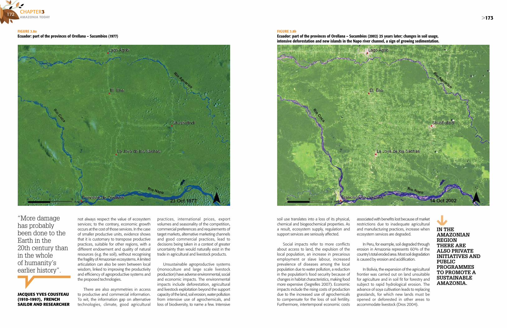
172AMAZONIA TOdAyCHAPTER3
>173
not always respect the value of ecosystem services; to the contrary, economic growth occurs at the cost of those services. In the case of smaller productive units, evidence shows that it is customary to transpose productive practices, suitable for other regions, with a different endowment and quality of natural resources (e.g. the soil), without recognising the fragility of Amazonian ecosystems. A limited articulation can also be seen between local wisdom, linked to improving the productivity and efficiency of agroproductive systems and the proposed technologies.
There are also asymmetries in access to productive and commercial information. To wit, the information gap on alternative technologies, climate, good agricultural
practices, international prices, expor t volumes and seasonality of the competition, commercial preferences and requirements of target markets, alternative marketing channels and good commercial practices, lead to decisions being taken in a context of greater uncertainty than would naturally exist in the trade in agricultural and livestock products.
Unsustainable agroproductive systems (monoculture and large scale livestock production) have adverse environmental, social and economic impacts. The environmental impacts include deforestation, agricultural and livestock exploitation beyond the support capacity of the land, soil erosion, water pollution from intensive use of agrochemicals, and loss of biodiversity, to name a few. Intensive
soil use translates into a loss of its physical, chemical and biogeochemical properties. As a result, ecosystem supply, regulation and support services are seriously affected.
Social impacts refer to more conflicts about access to land, the expulsion of the local population, an increase in precarious employment or slave labour, increased prevalence of diseases among the local population due to water pollution, a reduction in the population’s food security because of changes in habitat characteristics, making food more expensive (Segrelles 2007). Economic impacts include the rising costs of production due to the increased use of agrochemicals to compensate for the loss of soil fertility. Furthermore, intertemporal economic costs
FIGURE 3.8aEcuador: part of the provinces of Orellana – Sucumbíos (1977)
FIGURE 3.8bEcuador: part of the provinces of Orellana – Sucumbíos (2002) 25 years later; changes in soil usage,intensive deforestation and new islands in the Napo river channel, a sign of growing sedimentation.
associated with benefits lost because of market restrictions due to inadequate agricultural and manufacturing practices, increase when ecosystem services are degraded.
In Peru, for example, soil degraded through erosion in Amazonia represents 60% of the country’s total eroded area. Most soil degradation is caused by erosion and acidification.
In Bolivia, the expansion of the agricultural frontier was carried out on land unsuitable for agriculture and in soil fit for forestry and subject to rapid hydrological erosion. The advance of soya cultivation leads to replacing grasslands, for which new lands must be opened or deforested in other areas to accommodate livestock (Dros 2004).
“More damage has probablybeen done to the Earth in the 20th century than in the whole of humanity’s earlier history”.
JACqUES YvES COUSTEAU(1910-1997), FRENCH SAILOR AND RESEARCHER
IN ThE AMAZONIAN REgION ThERE ARE ALsO pRIVATE INITIATIVEs ANd pUbLIcpROgRAMMEs TO pROMOTE A sUsTAINAbLEAMAZONIA.

174AMAZONIA TOdAyCHAPTER3
>175
In Colombia, the expansion of livestock production and increased pressure to free up new areas increase damage to other ecosystems, since it affects fauna that may be vulnerable or in danger of extinction (Colombia: Instituto Amazónico de Investigaciones Científicas [SINCHI] 2007).
In contrast to the operation of unsustainable agroproductive systems, there are also private initiatives and public programmes in the Amazonian region to promote a sustainable Amazonia. The State promotes development of sustainable agricultural productive systems, offering financing and technical assistance, as well as facilities for better access to alternative markets (fair trade and ecological markets).
The development of technological innovations by public institutions has also been important in managing sustainable productive units for small and mid-sized growers; for example, the International Center for Tropical Agriculture (CIAT) in Bolivia, the Brazilian Agricultural Research Corporation (Embrapa) in Brazil, the Amazonian Scientific Research Institute (SINCHI) in Colombia, the Peruvian Amazonia Research Institute (IIAP) in Peru, among others.
The private sector has also invested in the productive development of Amazonia, with criteria of sustainability and paying attention to the demands of specialised markets. An example of that is the growing production of organic coffee. Coffee traditionally has been an important export product for countries like Colombia, Ecuador and Peru.
However, the international crisis in the prices of this product was an incentive for implementing differentiation strategies (premium and special, including organic) coffee. Today, organic coffee production is an alternative for small growers in the Amazonian foothills (e.g. Caquetá in Colombia, San Martín and Amazonas in Peru, and Orellana in Ecuador), since prices paid for organic coffee can be twice those of traditional coffee. Setting up and consolidating productive chains is an important step in promoting the organization of production and marketing, thereby reducing transaction costs and improving market access.
In Brazil, since 2003 new agro-productive models have been promoted, based on economic and environmental feasibility and on land use management. For this purpose the INCRA has created alternative programmes for Legal Amazonia, such as agro-extraction set tlements, projects for sustainable development and forestry projects (Brazil: Ministerio de Desarrollo Agrario 2006).
Furthermore the Embrapa is designing and disseminating integrated agricultural, livestock and forestry production systems to improve the economic and ecological sustainability of productive units. The idea is to use these systems to improve soil fer tility through crop and grass rotation, and to optimise the use of inputs and crop diversification and, as a result, improve
IN pERU
OF ALL sOILs dEgRAdEdby EROsION ARE INAMAZONIA.
60%In Brazilian Amazonia and the Andean countries’ highforest, coffee is a commercial crop that is gaining ground.
PHO
TO R
EPO
RT: M
IGU
EL B
ELLI
DO
/ E
L CO
MER
CIO
the profitability of the productive unit while minimising deforestation. It is also developing alternative methods of livestock production management, showing it is possible to have sustainable livestock production based on more productive technologies, and on restricting the areas of cultivation, according to their capacities for agricultural or livestock production.
In Colombia, SINCHI is implementing the Programme for Research on Sustainable Productive Systems. Within this framework, it identifies, evaluates, systematises and improves species. It also develops and transfers technologies, based on recovering and strengthening local and traditional communities’ knowledge. As a result of this, ten sustainable production systems have been established that
have been evaluated in ecological, economic and social terms (Colombia: Instituto Amazónico de Investigaciones Científicas [SINCHI] 2007).
The IIAP is developing and disseminating productive alternatives that promote the development of sustainable productive systems. The projects include: diversification of productive systems to produce native Amazonian fruits in communities within the zone of influence of the Iquitos-Nauta highway; genetic improvement of camu camu (Myrciaria dubia) to produce it in floodplains soils; improvement of vegetal species to conserve species and ecosystems; technological development and sustainable use of bio-exportable products, among others (Peru: Instituto de Investigaciones de la Amazonía Peruana [IIAP] 2001).

176AMAZONIA TOdAyCHAPTER3
>177
AUThOR:ELSA GALARZA - Research Center of the Universidad del Pacífico (CIUP) – Peru
cOAUTOREs:ROSARIO GÓMEZ - Research Center of the Universidad del Pacífico (CIUP) – PeruLUIS ALBERTO OLIVEROS - Amazon Cooperation Treaty Organization (ACTO)KAKUKO NAGATANI - United Nations Environment Programme (UNEP)
3.5|HUMAN SETTLEMENTSAmazonia currently has a population of 33,485,981 inhabitants, with an estimated population density of 4.2 people/km2 during the period of 2000-2007 (see Chapter 2). This is a result of a long process of human occupation, which does away with the belief that Amazonia is a “demographic vacuum”, still held by many people from outside the region (Commission on Development and Environment for Amazonia 1992). The present day territorial configuration of Amazonia is a spatial expression of the natural, economic, social and political processes of the countries it comprises, the effects of which, in terms of growing urbanization and the densification of certain economic activities, has implied population relocation and the transformation of natural resource use and consumption patterns. Over the last twenty years, most of the Amazonian population has relocated into its cities, following the Latin American trend and Caribbean, which shows 75.3% of its population established in urban zones (UNEP 2003).
As is customary in any growing city, the Amazonian variety has problems of access to water supplies and environmental problems, such as water and air pollution and solid waste disposal and treatment, which take on greater relevance insofar as these problems directly affect the ecosystem and the services it provides.
THE RURAL AND URBANPANORAMA OF AMAZONIA
Since the mid-1950s, the process of Amazonian occupation has adopted varying patterns that enable us to identify human settlements with differing characteristics. As mentioned in chapter 2, the demographic
flows in Amazonia have been anything but simple; to the contrary, the Amazonian family unit is highly mobile (Padoch 2006). Many Amazonian households are rural and urban at the same time: families maintain dwellings and productive activities in rural areas as well as in peripheral urban settlements (Aramburú and Bedoya 2003). However, one can observe a predominance of urban areas or consolidated traditional cities with more access to basic services and infrastructure. Peripheral human settlements have formed as a consequence of migration and are generally precarious (Padoch 2006). With time, these settlements tend to consolidate and become annexed to the cities. However, there are also rural settlements with small populations and
few resources that are, to a large degree, going through a growing process, while still others remain on the margin of this process, such as those that are mainly home to indigenous communities.
Classification and information on rural and urban settlements are, therefore, not entirely accurate in the Amazonian context (Padoch 2006). An example of this can be found in Brazilian Amazonia, where new immigrants continue their practices of planting foodstuffs in their yards for their own consumption
(Winkler Prins 2005). In fact, over the past few decades there has been a process of extensive urbanization. Urban rhythm and life styles have subjected rural areas to the culture and conditions of consumption and production typical of that life style, with a tendency to eliminate the gap between what is rural and what is urban, unifying the concept of regional and urban problem areas.
As mentioned in Chapter 2, a predominance of urban population in the Amazonian countries was seen in 2001,
AT TIMEs IT Is dIFFIcULT TO bE pREcIsE AbOUT whAT Is RURAL ANd whAT Is URbAN IN AMAZONIAN sETTLEMENTs.
Traditional consolidated citieshave more basic servicesand infrastructure.
MIG
UEL
BEL
LID
O /
EL
COM
ERC
IO

178AMAZONIA TOdAyCHAPTER3
>179
BOX 3.14AMAZONIAN CITIES AND AREAS OF INFLUENCE
Porto VelhoPorto Velho’s area of influence covers four of its neighbouring municipalities and another five centres along highway BR-364, which is the main means of travel between the existing rural settlements.
Río BrancoThis city is favoured by highway BR-364, which allows year-round access from the Atlantic coastal regions of Brazil. The area of influence of the Acre state capital is made up of local, small, sparsely populated centres, like Brasileia, Epitaciolandia, Feijó, Sena Madureira and Boca de Acre.
Iquitos and PucallpaThe urban populations of the Loreto and Ucayali regions are concentrated in the three most important cities in the border areas of that eco-region: Iquitos, located on the banks of the Amazon, and Pucallpa, on the banks of the Ucayali. These cities, which have become poles of population concentration, exercise intense influence on the exploitation of natural resources and on environmental deterioration. In addition to the city dwellers, an important portion of the urban population is made up of the inhabitants of intermediate towns, provincial and district capitals. Twenty percent of the urban population of this eco-region lives in these settlements.
Source: Brazil: Ministerio del Medio Ambiente (2006b); Peru: Instituto de Investigaciones de la Amazonía Peruana (2007).
with the exception of Amazonian Ecuador and Guyana that continued to have more than 70% rural population. Generally speaking, 62.8% of the total Amazonian population is urban meaning that approximately 21 million Amazonian inhabitants live in urban areas. In Guyana, four of the country’s ten administrative regions have urban centres, which, together with population of the capital city, Georgetown, had 339,873 inhabitants or 45.2% of the total population in 2002. The rest of the population is settled in villages along the coast, and a few are scattered across the interior of the country.
The Amazonian portions of Brazil, Peru and Venezuela contain more than 60% urban population (see Figure 2.3, Chapter 2). In the case of Brazil, the occupation of Legal Amazonia shows great heterogeneity where one can distinguish: an extensive territory with low demographic density, typified by a disperse rural population with minimal pressure on the environment (Brazil: Brazil: Ministerio del Medio Ambiente 2006c). This area is the most remote frontier of Legal Amazonia, in terms of human occupation and is represented by lands north of the Amazon River, the north of Pará, the north-east of Amapá (Amazonas) and the south-east of the State of Acre, the last mentioned in south-western Amazonia (Brazil: Ministerio de Integración Nacional, Ministerio del Medio Ambiente, Ministerio de Planeamiento, Ordenamiento y Gestión y Casa Civil de la Presidencia 2006). Its principal characteristic is that it is marked by many indigenous lands and conservation units.
There are also two other types of rural settlements: those that are dispersed but exert pressure on the environment, and others that are connected to local centres with significant rural modernization. The first of these is found in central Amazonia and in western Rondonia, where there is great pressure for expansion of the agricultural and mining frontiers. The second type of rural settlement includes a large portion of central and northern Mato Grosso, where the expansion of the agricultural and ranching frontier, mainly through soya and cotton production, implies contracting labour in large agricultural and ranching establishments. The local urban centres are expressions of the relationship between modern agriculture and the need for products and services, essential to the development of contemporary agro-industrial complexes.
It should be mentioned that the várzeas (floodplains) are associated with these areas of medium density populations, linked to local centres. These are areas of periodic flooding, located all along the Amazon and its principal tributaries and are the most densely populated areas of Amazonia. The várzeas, with their conglomerate of high islands surrounded by lowlands exposed to seasonal flooding by the rising rivers, and cochas or lagoons of stagnant water, constitute an important ecosystem used for seasonal
agriculture and agroforestry systems. The várzeas are of high economic importance in zones like the Amazon River delta and Manaus, in Brazil, as well as in Iquitos and Pucallpa, where the greatest population of Peruvian Amazonia is concentrated. The várzeas are made up of soils, enriched by sediments that provide the productive base for many of the products consumed in the region (Tratado de Cooperación Amazónica [TCA] 1994).
During the second half of the 20th century, Amazonian occupation responded to colonisation criteria and geopolitical visions (see Chapter 1). At that time large State colonization programmes were developed along the highways. Brazil and Peru were the countries that most used these strategies, such as those implanted along the Trans-Amazonian and BR-364 highways (Mato Grosso and Rondonia) in Brazil, and all along the Marginal de la Selva highway (Amazon Jungle Road), in Peru. However,
the rivers continued to be the main means of transport for communication between Amazonian villages, thus constituting the axes for placement of human settlements. This situation is slowly changing. New highways that cross Amazonia began to respond to the need for facilitating the outlet for production of both soya and wood or mineral products. Doubtless, these inspired the placement of new human settlements, to provide services for these activities, and that are being established along the highways and are becoming a new form of settlement expansion in Amazonia.
Regarding the similarities of Amazonian human settlements in the eight countries, one can see high rates of population growth, an ever-greater par t icipation of urban areas and a predominance of “traditional axis cities” with a significant area of influence. However, some of the countries still have significant rural areas.
62.8% of the Amazonianpopulation, approximately 21 million people, live in cities.
❱❱❱ The Ver-O-Peso market in Belén, Pará: Intense commercial activity in one of Amazonia’s largest cities.SERGIO AMARAL / ACTO

180AMAZONIA TOdAyCHAPTER3
>181
Bolivia registers 51.6% of its Amazonian population as urban. The population growth rate for the period 1992-2006 was 3.2%; this is far above the average growth rate for Latin America for the 2000-2005 period, which was 1.5%, with a population density of 1.1 inhabitants per km2. The department of Santa Cruz is in a transition area between Amazonia and the Chaco, where the Amazonian region is concentrated in its northern zone. Of the more than 2 million inhabitants, only 269,000 are considered to be Amazonians, according to the 2001 census. The department of Pando is also a leader in population growth and percentage of urban population (4.4% and 46.3%, respectively) (Bolivia: Instituto Nacional de Estadística de Bolivia 2001). If Santa Cruz is included as an Amazonian city, then this city, Cobija (Pando) and Trinidad (Beni) are the most important urban settlements in Bolivian Amazonia.
Brazil has nine states within its Legal Amazonia, among which the states of Amapá and Roraima had the highest rates of population growth, 5.3% and 4.3%, respectively, during the period 1991-2005. By 2007, the percentage of urban population in Brazilian Amazonia was 68.22%, with a population density of 4.7 inhabitants per km2. The Brazilian Amazonian cities of Manaus and Belén are the largest in the region, with 1.6 and 1.4 million inhabitants, respectively. The total estimated population of four cities: Belén, Manaus, Sao Luis and Cuiabá was 4.5 million inhabitants in 2007, and represented approximately 18% of the total Brazilian Amazonian population (Brazil: Ministerio de Integración Nacional, Ministerio del Medio Ambiente, Ministerio de Planeamiento, Ordenamiento y Gestión y Casa Civil de la Presidencia 2006).
Most of the population of Colombian Amazonia lives in the departments of Caquetá, Putumayo, Guaviare and Amazonas, with a total of 960,239 inhabitants in 2005, and an average urban percentage of 49.6%. The cities with the largest populations are: Florencia, San José del Guaviare, Puerto Asís and Leticia (Colombia: Departamento Administrativo Nacional de Estadística [DANE] 2007)
Ecuador had an estimated Amazonian population of 629,000 inhabitants in 2006, and urbanization was limited to 24.9% of its population. However, the Province of Pastaza registered an urban population of 40%, the city of Puyo being the most important (Ecuador: Instituto Nacional de Estadística y Censos [INEC] 2006).
Peru had an Amazonian population of approximately 4.3 million inhabitants, with an average annual growth rate of 1.7% in the period 1993-2005. Although the Amazonian region covers the largest part of Peruvian territory, it is the least populated area. Nevertheless, 61.7% of the population of the Amazonian departments is considered urban. Iquitos, Pucallpa and Tarapoto are the most important cities of Peruvian Amazonia (Peru: Instituto Nacional de Estadística e Informática [INEI] 2007).
Venezuelan Amazonia had one of the lowest populations, only 70,000 in 2001, and a scant population density of 0.38 inhabitants/km2. Of the whole population, 75.2% was considered urban, living in the city of Puerto Ayacucho, the Amazonas state capital.
Suriname and Guyana consider their entire population to be Amazonian. Paramaribo and Demerara-Mahaica, are,
BOX 3.15GEORGETOWN: URBAN DEVELOPMENT
The evolution of this capital city began in December 1781, with the proclamation of British Governor, Lieute-nant Colonel, Robert Kingston, after defeating the Dutch. However, in January 1782, a French squadron, allied with the Dutch, recovered Fort St. George and the English were forced to surrender. The French commander, in that same year, proclaimed, “it was considered necessary to establish the capital, which would become a business centre”. The colonies of Demerara and Essequibo were returned to the Dutch in 1784. By 1789, Stabroek was a village of 88 houses and 780 inhabitants.
In 1796 The English returned. In May 1812, when Demerara, Essequibo and Berbice finally passed into British hands, it was decided that the town would be formally called “George Town”. In March 1837, an ordinance was issued, abolishing the Georgetown police force and creating the position of mayor and his corresponding mayoral council.
Georgetown was elevated to the category of city when the colony was declared a Bishop’s See by Queen Victoria, in August 1843. At the beginning of the 19th Century, George-town consisted of three sections: Stabroek, Werk-en-Rust and Robbstown-Newtown. In 1852, Lacytown was incorpo-rated into the city. The residential areas extended into the ex-plantation areas of Vlissengen and Bourda. By 1970, the city had grown by approximately 2.5 square miles as a result of urban development.
Source: An extract from Guyana: Central Housing and Planning Authority (2000).
respectively, their most populated departments. The capital cities of both countries: Paramaribo (242,946 inhabitants in 2004) and Georgetown (235,017 inhabitants in 2005) the highest population concentrations.
GROWTH DYNAMICS OFAMAZONIAN CITIES
Amazonia has undergone an accelerated, unplanned urbanization process that has resulted in approximately 62.8% of its population, to wit, 21 million people living in cities. There are large cities with more than a million inhabitants, such as Belén and Manaus in Brazil, and Santa Cruz in Bolivia. There is another group of mid-sized cities, with over 200,000 inhabitants, such as Iquitos and Pucallpa in Peru; Rio Branco, Macapá, Imperatriz, Sao Luis, Cuiabá, Várzea Grande, Ananindeua, Santarém, Porto Velho and Boa Vista, in Brazil; Paramaribo, in Suriname; and Georgetown, in Guyana (see Table 3.13).
As mentioned in Chapter 2, the development of Amazonian cities, in the countries sharing the region, has been varied and conditioned by different factors, For example, in Peruvian cities there are two general formats for organization and development. In the lower
forest or floodable Amazonia, such as Iquitos, human settlements are isolated; in the upper forest there is a variety of equally important small and medium-sized cities. These latter are based on an agrarian economy; in Iquitos the economic base is extraction and more recently, services. In Colombia, there are departmental capitals with fewer than 50,000 inhabitants, except for Florencia that has 151,000; these cities are not connected to each other. In Bolivia, most of the cities are connected, by land, to the main urban and economic centres of the country, with exception of Cobija.
The urban network of Brazil’s Legal Amazonia is structured around four general systems: Manaus, Belén, Sao Luis and Cuiabá, and on the urban agglomerations of Goiania, Brasilia, Teresina and Timón which, in spite of not belonging to the area of Legal Amazonia in Brazil, exercise influence over an extensive border area (Brazil: Ministerio del Medio Ambiente 2006c). One can also see that the principal urban nuclei generate growth dynamics over the smaller urban nuclei. Thus, the metropolitan region of Belén has an estimated population of 2.15 million
❱❱❱ Twenty-four Amazonian cities already have more than 100,000 inhabitants, and are expanding and diversifying their services, including recreational ones.
Many intermediate Amazonian cities have very high rates of population growth.
>181
SEBA
STIÁ
N C
ASTA
ÑED
A /
EL C
OM
ERC
IO

182AMAZONIA TOdAyCHAPTER3
>183
COUNTRIES / AMAZONIAN REGION CITIES POPULATION BY YEAR
BOLIVIA 1992 2001 2008
SANTA CRUZ* 697,278 1.113.582 1.545.648
BRAZIL 1991 2000 2007
ACRE RÍO BRANCO 168,679 226,298 269,505
AMAPÁ MACAPÁ 154,063 270,628 328,865
AMAZONAS MANAUS 1,006,585 1,396,768 1,646,602
MARAÑÓNCAXIAS 84,331 103,485 108,542 EMPERATRIZ 210,051 218,673 217,192 SAO LUIS 246,244 837,584 917,155
MATO GROSSO RONDONÓPOLIS 113,032 141,838 164,969 VÁRZEA GRANDE 155,307 211,303 244,185
PARÁ
ANANINDEUA 74,051 392,627 484,278 BELEM 849,187 1,272,354 1,408,847 CASTAÑAL 92,852 121,249 137,226 MARABÁ 102,435 134,373 196,468 SANTARÉM 180,018 186,297 274,285
RONDONIA PORTO VELHO 229,788 273,709 304,228
RORAIMA BOA VISTA 120,157 197,098 246,156
TOCANTINS ARAGUAÍNA 84,614 105,874 109,571 PALMAS 19,246 134,179 175,168
COLOMBIA 1993 2000p 2005
CAQUETÁ FLORENCIA 96,247 130,500 143,871
GUYANA 1970 2002 2005
DEMERARA-MAHAICA GEORGETOWN 63,184 135,382 235,017
PERU 1981 1993 2005
LORETO IQUITOS 178,738 274,759 396,615
SAN MARTÍN TARAPOTO 34,979 77,783 105,500
UCAYALI PUCALLPA 89,604 172,286 232,000
SURINAME 1980 2000 2004
PARAMARIBO PARAMARIBO 169,798 200,970 242,946
TABLE 3.13Amazonian cities with populations greater than 100,000 inhabitants
* For the purposes of this analysis, the city of Santa Cruz is considered Amazonian.
Source: Colombia: National Statistics Administrative Department (DANE); Peru: National Institute of Statistics and Informatics (INEI); Bolivia: National Statistics Institute; Brazil: Brazilian Institute of Geography and Statistics (IBGE); Guyana: Environmental Protection Agency (EPA); Suriname: General Bureau of Statistics.
inhabitants (in 2005), of whom 1.4 million live in the municipality of Belén and 740,000 in its outskirts. Manaus, which has no metropolitan area, has only one municipality with 1.64 million inhabitants. Manaus and Belén form strong centres of attraction, while Sao Luis and Cuiabá also have a strong degree of attraction, so that subordinate urban centres grow in their vicinities (Brazil: Ministerio de Integración Nacional, Ministerio del Medio Ambiente, Ministerio de Planeamiento, Ordenamiento y Gestión y Casa Civil de la Presidencia 2006).
Many intermediate Amazonian cities have very high rates of population growth. For example, in Peru, Puerto Maldonado (Madre de Dios) is growing at rates of over 5% per year; and between 1961 and 1993 the population of Iquitos (Loreto) multiplied more than four-fold, while that
Cities located along international borders play an important role in the regional integration process. They are points of commercial articulation that provide basic services on both sides of the border.
of Pucallpa (Ucayali), did so six-fold. In Colombia, the urban centres showing greatest relative population growth during the period 1985-1993 were Miraflores (Guaviare), with 1.66%; Albania, Morelia and San Vicente del Caguán (Caquetá) and Villagarzón and Mocoa (Putumayo). None of these are consolidated or large cities; on the contrary, they are small cities, yet characterised by accelerated expansion. In Brazil, in the past six years the cities of Caracaraí, Coari and Cruzeiro do Sul have grown by 28.57%, 30.36% and 28.59%, respectively. Likewise, in Bolivia the cities of Riberalta, Trinidad and Guayaramerín-Boliviano in the Department of Beni, have grown very rapidly over recent years.
Another group of cities that should be mentioned are those along the borders (see Map 3.1). These cities play an important
MAP 3.1The most important Amazonian cities
Imperatriz
Araguaína
Marabá
TucuruíAltamira
Santarém
Itaituba
ParintinsItacoatira
Manaus
ManacapuruTefé
Paragominas
CaxiasTimon
Palmas
GurupiSinop
Barra do GarçasPrimavera do Leste
Rondónopolis
Puerto Suarez
Tangar da Serra
Pimenteiras do Oeste
Vilhena
Cacoal
Costa Marques
Guayaramerín
Riberalta
Nova Mamoré
Rio BrancoSanta Rosa do Purús
PucallpaTocache
Tarapoto
Yurimaguas
El Estrecho
Puerto Asís
San José del Guaviare
Puerto Ayacucho
Boa Vista BonfimNormandia
Uiramuta
Paramaribo
Olapoque
CorrivertonSpring
Anna Pegina GeorgetownBartica Rose Hall
New AmsterdamNieuw-Nikerina
Pacaraima
San Vicente del Caguán
Florencia
Nueva Loja
Francisco de OrellanaPuyo
Macas
Zamora
IquitosCaballococha
Leticia
Tingo María
CapixabaAssís Brasil
Ibería
Puerto Maldonado
Cobija
Ariquemes
Porto Velho
Ji-Paran
CuiabáVárzea GrandeCáceres
San MatíasSan Ignacio
Ascensión de Guaray
Trinidad
MonteroSanta Cruz
Yapacaní
San Borja
Sao LuisBelénAabaetetuba
Ananindeua
Macapá
BragantaCastanhal
Parauapebas
0 - 50000
50001 - 100000
100001 - 200000
200001 - 500000
500001 - 1636837
Greater Amazonia
Lesser Amazonia
Population 2006
Source: Original production of GEO Amazonia, with the technical collaboration of UNEP/GRID - Sioux Falls and the University of Buenos Aires, using data from Bolivia: Conservation International and INE-Bolivia; Brazil: IBGE; Colombia: CIAT-Bolivia and DANE; Ecuador: INEC; Guyana: EPA; Peru: INEI; Suriname: General Bureau of Statistics; and Venezuela: INE-Venezuela.

184AMAZONIA TOdAyCHAPTER3
>185
role in regional integration processes. They are points of commercial articulation that provide basic services for the populations on both sides of the international political boundaries. It should be stressed that these small to medium-size cities are dissimilar in size and urban development. On the tripartite border between Peru, Colombia and Brazil are the cities of Caballococha (Peru), a minor populated centre, with 3,700 inhabitants; Leticia (Colombia), a city of 35,000 inhabitants; and Tabatinga (Brazil), a city with 42,500 inhabitants. Another nucleus of border cities is that between Peru, Brazil and Bolivia, which joins the states or departments of Madre de Dios, Acre and Pando, respectively. Cities located along this axis are, for example, Epitaciolandia, in Brazil, that has grown 28.7% over the last six years; and Cobija, in Bolivia which, during the census period of 1992-2001, registered a population growth rate in excess of the national average of 7.92%.
This accelerated and disorderly phenomenon of urban growth in Amazonia is causing problems, not only in the form of Amazonian natural resource exploitation, but also for the quality of life of the urban population. The growing demand for supplying basic urban services has, by far, exceeded the planning capacity of the local development agencies. Thus, the cities with over 500,000 inhabitants are facing problems of basic sanitation, traffic jams, inadequate solid waste disposal, loss of air quality to mention but a few. If the fact that many of the Amazonian cities contain the most extreme levels of poverty is added to the mix, then their inhabitants are even more vulnerable.
URBAN ENVIRONMENTAL PROBLEMS
a) Access to water, and contaminationAs seen in Section 3.3, in Bolivian, Colombian, Ecuadorian and Peruvian Amazonia, 61% of the Amazonian population lacks access to potable water and 70% has no sewerage services, according to a study carried out by Nippon Koei Lac Co. and the General Secretariat of the Andean Community (2005). Furthermore, Peruvian Amazonia has the least access to potable water and sewerage, followed by Colombia, Bolivia and Ecuador, according to the same study.
In the Andean regions of Amazonia, statistics show the average coverage of water and sanitary services as being below the respective national averages, and in rural areas it falls below 15%. Among the principal causes for the delay in providing water and sanitation services in Andean Amazonia one finds a wide dispersion and diversity of ethno-linguistic families, limited development of appropriate technologies and methodologies for dealing with the Amazonian reality, insufficient legal framework and a scant allocation of financial resources (Nippon Koei LAC Co. and the General Secretariat of the Andean Community 2005).
BOX 3.16POTABLE WATER IN SURINAME
In spite of the fact that along the coast, water services in Suriname should be supplied by a single institution, in or-der to improve service quality, these services have not yet been integrated to the Suriname Water Company. And, although local communities and organizations should manage water services for the interior of the country, the pilot water committees do not seem to be functional. Community participation and a focus on community-based management should be adopted in these cases.
Institutional problems also affect sanitation services in Paramaribo. The drainage system is neither efficiently nor effectively managed. The current responsibility for these services is shared by several institutions. Experience has shown that there should be a single authority in charge of maintaining and administering this system in urban-ized areas, such as Greater Paramaribo. Not only does not such authority exist, but there is no Sanitation Master Plan for Paramaribo.
Finally, a culture of environmental conservation must be developed. Planning becomes an instrument for guid-ing water management in Suriname both as a natural resource and a consumer good.
According to the Bolivian Vice-Ministry of Basic Services, Santa Cruz is the department with greatest coverage for potable water, with 87.39% of its population served (both urban and rural). At the other extreme, the department in the country with the least potable water coverage Beni, where only 44.88% of its inhabitants in urban and rural areas have access to these services. In the urban environment, in 2005, the Cooperativa de Servicios Públicos Santa Cruz Ltda., which provides service to the city of Santa Cruz, recorded coverage of water services at 99%, and sewerage at 49%.
In the city of Iquitos, EPS Sedaloreto S.A., the agency in charge of the service for the urban population, registered potable water coverage at 70%, and sewerage service at 60%. Coverage for both services has remained stable over recent years, meaning that the connections keep pace with population growth, and indicating a shortfall of investment to increase coverage levels. It should also be
mentioned that there are serious problems with clandestine connections. The average continuity for potable water service in the second quarter of 2005 was seventeen hours per day, although in some sectors of the city, such as San Juan, water was only available for six hours a day (Superintendencia Nacional de Administración de Servicios de Saneamiento 2005).
In Guyana, the Guyana Water Incorporated (GWI) is a public corporation that currently supplies 85% of the water supply for urban zones. As part of its plans the GWI seeks to increase its potable water supply during the next five years to 90% of the country’s coastal population.
One of the problems of Amazonian cities, in respect of water pollution, in addition to domestic sewage coming from the cities themselves, is the use of toxic substances in agricultural activities. In Amazonia, herbicides
❱❱❱ The area of the city of Poucallpa, in Peruvian Amazonia, has multiplied several times as the course of the Ucayali river has shown significant variation.
Cities with more than 500,000 inhabitantshave problems of basic sanitation, traffic jams, inadequate solid waste disposal andloss of air quality.
are the most frequently used, followed by insecticides, fungicides and acaricides. In Brazil, the widespread use of herbicides is associated with direct planting schemes, an agricultural technique that reduces soil quality and promotes the growth of harmful weeds. Among the principal active ingredients consumed are glyphosate and 2.4 D acid, representing 48.8% and 10.33% of the herbicides used, respectively (Brazil: Instituto Brasileño de Geografía y Estadística [IBGE] 2004a).
Another factor of concern regards mercury and other heavy metal pollution (iron, manganese, cadmium and lead) of Amazonian waters, a result of mining and forestry activities that affect city water supply sources. An example of this problem is the contamination of the Nanay River basin, which supplies water to the city of Iquitos (Peru). There is growing, partly illegal, gold-mining activity in the basin that uses a dredging system, and there is also
FIGURE 3.9aCITY OF PUCALLPA-PERU, 1975
FIGURE 3.9bCITY OF PUCALLPA-PERU, 2007
Source: Suriname: Sectorial Analysis of Drinking Water Supply and Sanitation in Suriname (2007).

186AMAZONIA TOdAyCHAPTER3
>187
intensely mechanised forestry activity that removes the topsoil of the forests on both banks of the Nanay and Pintuyacu rivers and accelerating the increase in heavy metals in basin waters. This contamination has caused health problems among some of the basin’s populations, generated by ingesting fish and water with a growing content of mercury, cyanide and other heavy metals.
b) Air and noise contaminationThe most important sources of air pollution affecting Amazonian cities include: industry, vehicles and burning forests. To this is also added burning vegetal debris after cutting weeds in the yards and gardens of homes and public parks, and burning solid waste in local dumps.
During the dry season (June to September) in the northern zone of Mato Grosso and Rondonia, intense air pollution is produced from forest and grassland fires, affecting the cities of Cobija (Bolivia), Epitaciolandia and Brasilea (Brazil), Iñapari (Peru), and other settlements in the area. The traditional burning of solid waste in these cities is another source of air
pollution. According to Brown (2007), the area affected by fire in the region of Pando (Bolivia) covered 241,513 hectares. Furthermore, 23 of the 45 days monitored during 2006 showed concentrations of particulate material (smoke) in excess of 150 µg/m3 and, on 18 days, it was more than 400 µg/m3.
Similarly, the lack of pavement on many roads creates severe problems of air pollution from settling dust during the dry season (Dourojeanni 1998). However, there is no detailed information on the levels of contamination or on the impacts this has on the health of the population.
In the city of Iquitos (Peru), the results of the atmospheric basin inventories indicate two situations regarding air quality: (i) the mobile sources generate the highest concentrations of carbon monoxide (CO) (88.21%); nitrous oxides (77.21%); and volatile organic compounds (VOC) (76,59%); and (ii) fixed sources are the greatest generators of total suspended particles (TSP), with 89.52%, and SO2 with 86.82%.
BOX 3.17“QUEMADAS” (SET FIRES) ARE THE LEADING CAUSEOF AIR POLLUTION IN BRAZILIAN CITIES
The conclusion of a 2002 IBGE survey (Munic) of the country’s 5,560 municipalities was that air pollution is not a problem restricted to the large Brazilian urban centres, and that its most frequent causes are not industries or motor vehicles, but “quemadas” and unpaved streets and highways.
The results of the survey indicate that 1,224 municipalities (22% of the total), including the Federal District (Brasilia), reported the frequent occurrence of air pollution. Almost half of the Brazilian population (85 million) resides in the municipalities reporting this problem and 54% of them are in the south-east. Among the municipalities that reported the occurrence of air pollution, the causes mentioned were: “quemadas” (64%), unpaved roads (41%), industrial activity (38%), agricultural and livestock production activities – dust, pulverisation of agrotoxic substances, etc. (31%) and vehicles (26%).
Fires set in cut forests (“quemadas”) are the most frequently mentioned cause of air pollution in almost all of the regions. The exception is in the south, where the first place in this ranking is held by agricultural and livestock production activities (53% of the municipalities) with “quemadas” appearing in second place, tied with unpaved roads at 43%, which also come in second in the north, north-east and central-west of the country. This position is occupied by industrial activity in the south-east (45%).
The "quemadas" are the most significant cause of air pollution, in both cities that are less urbanized (with an urban population of up to 30%) and those of high urbanization (an urban population equal to or greater than 70%). Unpaved roads are in second place as the most frequent cause among less urbanized cities, and as the third cause among highly urbanized cities. Similarly, among smaller cities, 61% of the municipalities with up to 20,000 inhabitants reported facing degraded air quality, and 69% reported this situation for cities having between 20,000 and 100,000 inhabitants.
Source: Brazil: Instituto Brasileño de Geografía y Estadística (IBGE) (2002).
In the city of Iquitos there is a serious chronic health risk dueto noise from vehicles such asmotorcycles and mototaxis, mostof which have no noise controldevices.
The highest amount of CO and VOC coming from mobile sources is emitted by motorcycles and scooters adapted for carrying three passengers (92% of the CO and 95% of the VOC between the two types of vehicles). Amazonian cities, other than the Brazilian ones, because of their climatic characteristics and for other reasons such as their population’s income level and culture, use scooters or mototaxis, as their principal means of transportation and these are the most common means of personal transportation from one place to another. The use of this type of transportation also generates high noise levels in the city. In the case of fixed sources, it should be mentioned that in the city of Iquitos, Peru, 84% of the SO2 is emitted by a single company: Electro Oriente, the electric generation company (Municipalidad Provincial de Maynas 2006).
Although it is an evident problem, especially for outsiders, there is very little information on noise levels in Amazonian cities. A study on Iquitos (Peru) revealed that there is a serious and chronic health risk from noise emissions produced by vehicles like motorcycles and mototaxis, most of which circulate without mufflers, giving the city a constant noise level 58% and 44% above the World Health Organzation designation for moderate noise levels (50 dB) and severe noise levels (55 dB), respectively. On the average, noise registered in the districts of Iquitos and Punchana, from 7:00 hours until 22:00 hours fluctuates around 79 dB. The highest noise indexes are between 18:00 hours and 22:00 hours (Peru: Comisión Nacional del Medio Ambiente [CONAM] 2005).
c) Solid wasteOne of the principal problems with disorderly urban growth is the inadequate disposal of solid waste. Amazonia is not exempt from this problem, although it is added to by the traditional practice in some countries of burning waste at home, the most common practice being the use of open air dumps with no strategy for lixiviates management. This causes pollution of the soil, subterranean and sur face waters and, in turn, generates foci of disease for the inhabitants, especially in low-income sectors, who consume and use contaminated water that gives them parasites and diarrhoea. Their children are especially vulnerable. In this context, it is essential to invest in building sanitary landfills in Amazonian cities and creating incentives for the development of integrated plants to produce bio-fertilizers. Although the countries have drafted plans for solid and liquid waste management in the principal Amazonian urban centres, it is necessary to move from the diagnostic and formulation stages to articulate and apply these processes (Nippon Koei Lac Co and the General Secretariat of the Andean Community 2005; Corpoamazonía 2006 [personal communication]).
❱❱❱ Noise contamination due to the proliferation of small motor vehicles is a problem in various Amazonian cities.
>187EN
RIQ
UE
CÚ
NEO
/ E
L CO
MER
CIO

188AMAZONIA TOdAyCHAPTER3
>189
According to IBGE (Table 3.14), the Amazonian states show levels of waste collection above 70%; however, the practices of burning are still relevant in Marañón, Pará and Rondonia.
The absence of adequate planning for urban growth creates a situation where there is neither adequate provision for the installation of sanitary landfills, nor the establishment of mechanisms for reusing and recycling waste materials. This leads to people disposing of those materials in informal dumps, because they have no other means of disposing of them.
In the city of Manaus, most solid waste is collected directly or indirectly, but a significant volume is burnt or deposited in vacant lots or in bodies of water, causing environmental problems. The public sanitation system operated by the Municipal Prefecture is being expanded and modernised to increase the efficiency of collection and final disposal of
urban and hospital waste. Controlled disposal of waste in Manaus is considered to be good and it receives adequate treatment; however, it is necessary to extend the coverage of garbage collection (Programa de las Naciones Unidas para el Medio Ambiente 2002b).
The city of Georgetown generates 51,100 tons of solid waste annually, with a per capita waste production rate of 0.6 – 0.8 kilos/inhabitant/day (Guyana: Environmental Protection Agency [EPA] 2007). Two contrac tors, who collec t approximately 90% of the solid waste produced, carry out the city collections. The contractors also collect most commercial waste in their operating zones, while there are also small informal collectors who charge a fee to pick up waste from the population in the zones they attend to. Solid waste collection in Georgetown has proven to be efficient in the zones where it operates.
TABLE 3.14Final disposal of waste in Amazonian regions of Brazil (2000)(in percentages)
REGIONS
FINAL WASTE DISPOSAL
DIRECT COLLECTION INDIRECT COLLECTION BURNED OR BURIED OTHER
ACRE 77.1 8.8 6.7 7.4
AMAPÁ 89.4 5.2 2.9 2.5
AMAZONAS 75.6 13.9 7.7 2.8
MARAÑÓN 71.6 8.0 14.3 6.1
MATO GROSSO 85.0 8.1 5.2 1.7
PARÁ 72.3 14.0 10.6 3.2
RONDONIA 84.9 3.2 10.0 1.8
RORAIMA 94.8 0.2 3.8 1.1
TOCANTINS 94.4 0.7 4.1 0.8
The open air disposal of untreated urban waste is an important source ofpollution in Amazonian cities.
ENRIQUE CÚNEO / EL COMERCIO
The lack of urban growth planning means there are no proper sanitary landfill areas, or mechanisms to re-use or recycle waste.
The absence of adequate planning for urban growth creates a situation where there is neither adequate provision for the installation of sanitary landfills, nor the establishment of mechanisms for reusing and recycling waste materials.
Source: Brazil: Instituto Brasileño de Geografía y Estadística (IBGE) (2002)

190AMAZONIA TOdAyCHAPTER3
>191
❱❱❱ Large, intermediate and smallAmazonian cities are the signof an Amazonia whose populationis growing at an accelerated rate.
SERG
IO A
MAR
AL /
AC
TO
Santa Cruz, Bolivia
Iquitos, Peru
Georgetown, GuyanaParamaribo, Suriname
Manaus - AM, Brazil
Belén, Brazil
CRI
STIA
N G
UER
RERO
/ G
TZ

192AMAZONIA TOdAyCHAPTER3
>193
ThE AMAZONIA OF TOdAy hAs MAssIVE ANd AccELERATEd dEFOREsTATION As A syMbOL OF A pREOccUpyINg dyNAMIcs ThAT Is A RIsK TO ThE INTEgRITy OF ITs EcOsysTEM.
PATRICK JOHNSTON


>195
IMPA
CTS
ON
ECO
SYST
EM S
ERv
ICES
4.1 4.2
IMPA
CTS
ON
HU
MA
N W
ELLb
EIN
g
4.3
vU
LNER
Ab
ILIT
Y
AUTHORS:JUAN CARLOS ALONSO Amazonian Institute for Scientific Research (SINCHI) – ColombiaDOLORS ARMENTERAS Alexander von Humboldt Biological Resource Research Institute (Instituto de Investigación de Recursos Biológicos Alexander von Humboldt) – ColombiaELSA GALARZA Research Center of the Universidad del Pacífico (CIUP) – PeruROSARIO GÓMEZ Research Center of the Universidad del Pacífico (CIUP) – PeruMÓNICA MORALES Alexander von Humboldt Biological Resource Research Institute (Instituto de Investigación de Recursos Biológicos Alexander von Humboldt) – ColombiaCARLOS SOUZA Amazon Institute for People and the Environment (IMAZON) – Brazil
CO-AUTHORS:MARLUCIA BONIFACIO Museum Paraense Emílio Goeldi (MPEG) – BrazilMARIO BAUDOIN Institute of Ecology– Mayor de San Andrés University – BoliviaURIEL MURCIA Amazonian Institute for Scientific Research (SINCHI) – ColombiaLUIS ALBERTO OLIVEROS Amazon Cooperation Treaty Organization (ACTO)ALICIA ROLLA Instituto Socioambiental (ISA) – BrazilMURIEL SARAGOUSSI Ministry of the Environment – Brazil
FOOTPRinTSOFEnViROnmEnTaLDEGRaDaTiOn
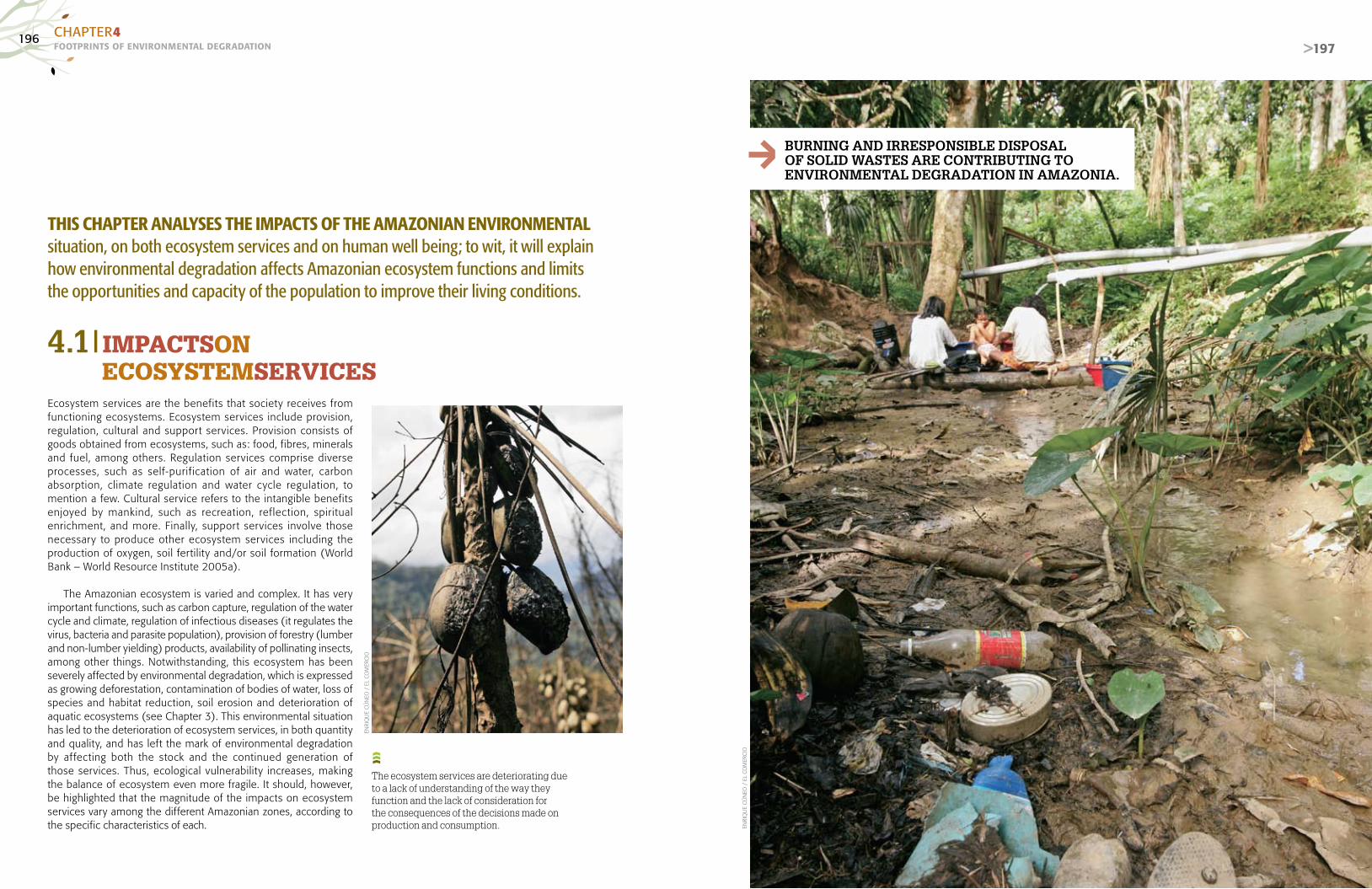
196FOOTPRINTS OF ENvIRONMENTAL dEGRAdATIONCHAPTER4
>197
Ecosystem services are the benefits that society receives from functioning ecosystems. Ecosystem services include provision, regulation, cultural and support services. Provision consists of goods obtained from ecosystems, such as: food, fibres, minerals and fuel, among others. Regulation services comprise diverse processes, such as self-purification of air and water, carbon absorption, climate regulation and water cycle regulation, to mention a few. Cultural service refers to the intangible benefits enjoyed by mankind, such as recreation, reflection, spiritual enrichment, and more. Finally, support services involve those necessary to produce other ecosystem services including the production of oxygen, soil fertility and/or soil formation (World Bank – World Resource Institute 2005a).
The Amazonian ecosystem is varied and complex. It has very important functions, such as carbon capture, regulation of the water cycle and climate, regulation of infectious diseases (it regulates the virus, bacteria and parasite population), provision of forestry (lumber and non-lumber yielding) products, availability of pollinating insects, among other things. Notwithstanding, this ecosystem has been severely affected by environmental degradation, which is expressed as growing deforestation, contamination of bodies of water, loss of species and habitat reduction, soil erosion and deterioration of aquatic ecosystems (see Chapter 3). This environmental situation has led to the deterioration of ecosystem services, in both quantity and quality, and has left the mark of environmental degradation by affecting both the stock and the continued generation of those services. Thus, ecological vulnerability increases, making the balance of ecosystem even more fragile. It should, however, be highlighted that the magnitude of the impacts on ecosystem services vary among the different Amazonian zones, according to the specific characteristics of each.
bURNINg ANd IRREspONsIbLE dIspOsAL OF sOLId wAsTEs ARE cONTRIbUTINg TO ENVIRONMENTAL dEgRAdATION IN AMAZONIA.
4.1|IMPACTSON ECOSYSTEMSERVICES
THIS CHAPTER ANALYSES THE IMPACTS OF THE AMAZONIAN ENVIRONMENTAL situation, on both ecosystem services and on human well being; to wit, it will explain how environmental degradation affects Amazonian ecosystem functions and limits the opportunities and capacity of the population to improve their living conditions.
The ecosystem services are deteriorating due to a lack of understanding of the way they function and the lack of consideration for the consequences of the decisions made on production and consumption. EN
RIQ
UE
CÚ
NEO
/ E
L CO
MER
CIO
ENRI
QU
E C
ÚN
EO /
EL
COM
ERC
IO
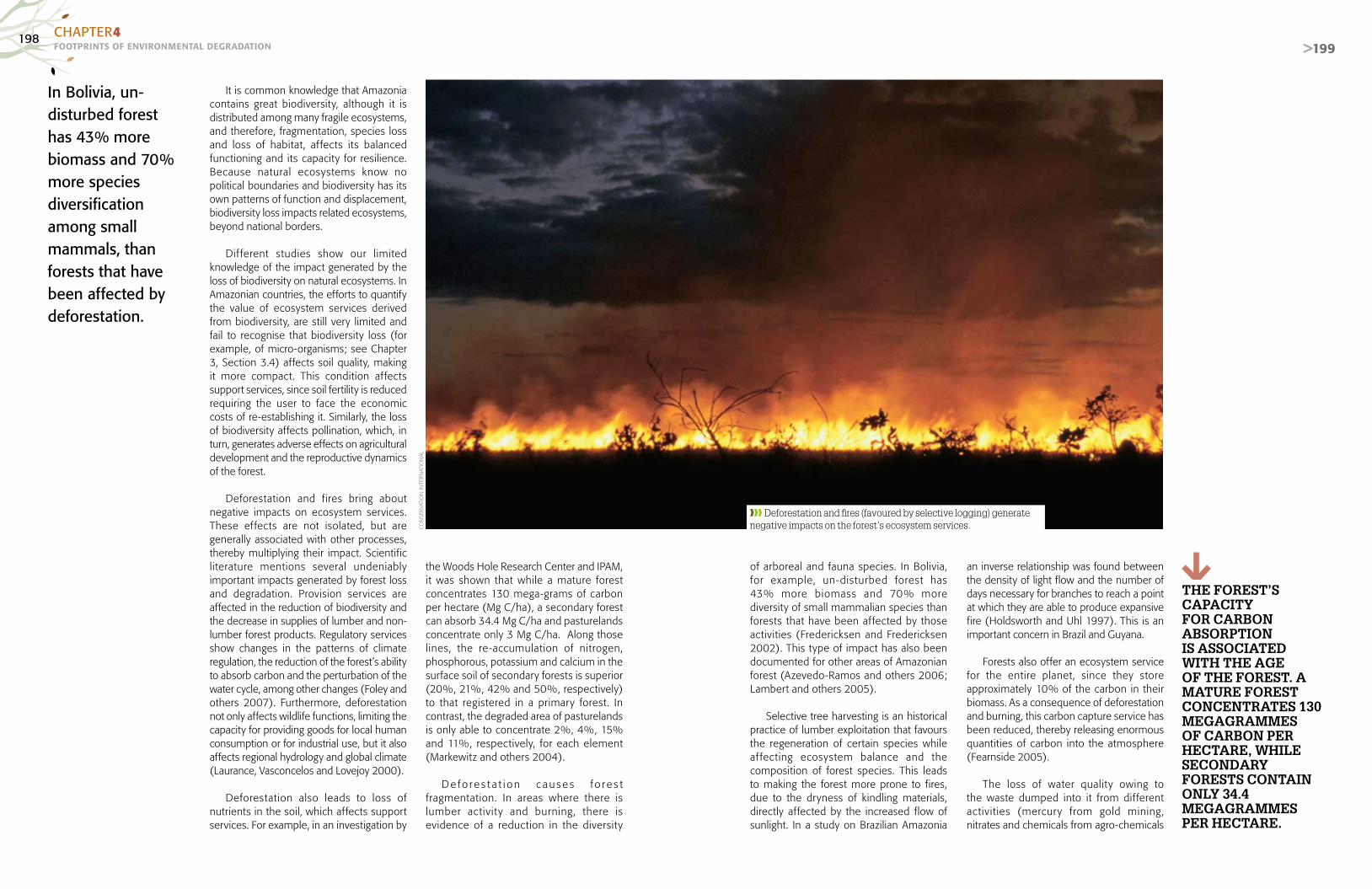
198FOOTPRINTS OF ENvIRONMENTAL dEGRAdATIONCHAPTER4
>199
It is common knowledge that Amazonia
contains great biodiversity, although it is distributed among many fragile ecosystems, and therefore, fragmentation, species loss and loss of habitat, affects its balanced functioning and its capacity for resilience. Because natural ecosystems know no political boundaries and biodiversity has its own patterns of function and displacement, biodiversity loss impacts related ecosystems, beyond national borders.
Dif ferent studies show our limited knowledge of the impact generated by the loss of biodiversity on natural ecosystems. In Amazonian countries, the efforts to quantify the value of ecosystem services derived from biodiversity, are still very limited and fail to recognise that biodiversity loss (for example, of micro-organisms; see Chapter 3, Section 3.4) affects soil quality, making it more compact. This condition affects support services, since soil fertility is reduced requiring the user to face the economic costs of re-establishing it. Similarly, the loss of biodiversity affects pollination, which, in turn, generates adverse effects on agricultural development and the reproductive dynamics of the forest.
Deforestation and fires bring about negative impacts on ecosystem services. These effects are not isolated, but are generally associated with other processes, thereby multiplying their impact. Scientific literature mentions several undeniably important impacts generated by forest loss and degradation. Provision services are affected in the reduction of biodiversity and the decrease in supplies of lumber and non-lumber forest products. Regulatory services show changes in the patterns of climate regulation, the reduction of the forest’s ability to absorb carbon and the perturbation of the water cycle, among other changes (Foley and others 2007). Furthermore, deforestation not only affects wildlife functions, limiting the capacity for providing goods for local human consumption or for industrial use, but it also affects regional hydrology and global climate (Laurance, Vasconcelos and Lovejoy 2000).
Deforestation also leads to loss of nutrients in the soil, which affects support services. For example, in an investigation by
the Woods Hole Research Center and IPAM, it was shown that while a mature forest concentrates 130 mega-grams of carbon per hectare (Mg C/ha), a secondary forest can absorb 34.4 Mg C/ha and pasturelands concentrate only 3 Mg C/ha. Along those lines, the re-accumulation of nitrogen, phosphorous, potassium and calcium in the surface soil of secondary forests is superior (20%, 21%, 42% and 50%, respectively) to that registered in a primary forest. In contrast, the degraded area of pasturelands is only able to concentrate 2%, 4%, 15% and 11%, respectively, for each element (Markewitz and others 2004).
D e fo r e s t a t i o n c au s e s f o r e s t fragmentation. In areas where there is lumber activity and burning, there is evidence of a reduction in the diversity
of arboreal and fauna species. In Bolivia, for example, un-disturbed forest has 43% more biomass and 70% more diversity of small mammalian species than forests that have been affected by those activities (Fredericksen and Fredericksen 2002). This type of impact has also been documented for other areas of Amazonian forest (Azevedo-Ramos and others 2006; Lambert and others 2005).
Selective tree harvesting is an historical practice of lumber exploitation that favours the regeneration of certain species while af fecting ecosystem balance and the composition of forest species. This leads to making the forest more prone to fires, due to the dryness of kindling materials, directly affected by the increased flow of sunlight. In a study on Brazilian Amazonia
an inverse relationship was found between the density of light flow and the number of days necessary for branches to reach a point at which they are able to produce expansive fire (Holdsworth and Uhl 1997). This is an important concern in Brazil and Guyana.
Forests also offer an ecosystem service for the entire planet, since they store approximately 10% of the carbon in their biomass. As a consequence of deforestation and burning, this carbon capture service has been reduced, thereby releasing enormous quantities of carbon into the atmosphere (Fearnside 2005).
The loss of water quality owing to the waste dumped into it from different activities (mercury from gold mining, nitrates and chemicals from agro-chemicals
ThE FOREsT’s cApAcITy FOR cARbON AbsORpTION Is AssOcIATEd wITh ThE AgE OF ThE FOREsT. A MATURE FOREsT cONcENTRATEs 130 MEgAgRAMMEs OF cARbON pER hEcTARE, whILE sEcONdARy FOREsTs cONTAIN ONLy 34.4 MEgAgRAMMEs pER hEcTARE.
In Bolivia, un-disturbed forest has 43% more biomass and 70% more species diversification among small mammals, than forests that have been affected by deforestation.
❱❱❱ Deforestation and fires (favoured by selective logging) generate negative impacts on the forest’s ecosystem services.CO
NSE
RVAT
ION
INTE
RNAT
ION
AL

200FOOTPRINTS OF ENvIRONMENTAL dEGRAdATIONCHAPTER4
>201
and hydrocarbon spills, among others) affects the aquatic food cycle and causes aquatic species loss as well as bringing about irreversible damage to the ecosystem services that the water resource provides (loss of the ability to auto-purify itself, reduction of water available for use in other activities).
There is serious concern in Amazonia over the effects of water pollution by mercury, because of the changes it causes in ecological niches of local fauna from
agr icul ture and ranching and the construction of poorly designed roadway infrastructure, have affected the natural conditions of water bodies and with it the habitat of aquatic flora and fauna species.
The development of unsustainable agro-productive systems has generated changes in the cultural and productive patterns of Amazonia and its local communities. Cultivation practices designed to achieve greater productivity, without considering their environmental impacts, have led to
Selective tree harvesting favours the regeneration of certain species while affecting ecosystem balance and the composition of forest species.
bioaccumulation of that element in the food chain. In fact the concentrations of mercury in many carnivorous fish species are above the limits established by the WHO (Hacon and Azevedo 2006). Informal gold mining is an important source of mercury being dumped into nature; it contributes 3% of the mercury found in the zone, or 150 MT/year (see Chapter 3, Section 3.3).
Fur thermore, the growing sediment load that has increased from deforestation in the headwaters of the basin, expanding
❱❱❱ Infrastructures, such as oil or gas pipelines, are not exempt from causing environmental deterioration, especially when emergency situations occur (spills, explosions). EN
RIQ
UE
CÚ
NEO
/ E
L CO
MER
CIO
cONTAMINATION OF wATERcOURsEs wITh MERcURy gENERATEs chANgEs IN ThE EcOLOgIcAL NIchEs OF LOcAL FAUNA, dUE TO bIO-AccUMULATION IN ThE FOOd chAIN.
increasing use of agro-chemicals, which has affected ecosystem equilibrium. In this regard, the environmental concerns are concentrated on the toxicity affecting the soil’s microorganisms, insects, plants, and birds, which are beneficial not only to agriculture, but also to other economic activities (Wood and others 2000). Unsustainable agro-productive systems negatively affect the support service corresponding to soil fertility and, therefore, limit its productive capacity for growing crops.
Increased soil compaction and the reduction of nutrients and organic material, among other problems, reduce the availability of land for agricultural development and accelerate soil degradation, which affects ecosystem resilience.
Although pesticides have not notably contaminated surface and subterranean waters, there are many local situations that arouse concern. In spite of the fact that the studies are insufficient, an increased sensitivity to organochlorinated pesticides, which are easily bio-accumulated, has been reported in aquatic organisms, and, on the same note, it is well known that the use of fungicides can have negative impacts on tropical fish populations (Pardo and Gudynas 2005, Pasquis 2006, Global Water Partnership 2001).
The foo tp r in t o f Amazon ian environmental degradation on ecosystem services gives evidence to how limited the knowledge of the Amazonian ecosystem function is, as well as the intertemporal costs associated with that deterioration. This

202FOOTPRINTS OF ENvIRONMENTAL dEGRAdATIONCHAPTER4
>203
4.2|IMPACTSON HUMANWELLBEING
FIGURE 4.1Impact on human wellbeing
LIN
O C
HIP
ANA
/ EL
CO
MER
CIO
COMPONENTS OF HUMAN WELLBEING
CAPABILITIES
ECONOMIC ACTIVITIES AND THE ECONOMY
SOCIAL RELATIONS
IMPACT
HEALTH
THE NATURAL ENVIRONMENT
CHANGES IN ENVIRONMENTAL STATUS
BIODIVERSITY
FORESTS
WATER RESOURCES AND AQUATIC ECOSYSTEMS
AGRO-PRODUCTIVE SYSTEMS
URBAN SETTLEMENTS
Source: UNEP (2007b).
❱❱❱ Biodiversity reduction is one of the factors that have caused the reappearance of infectious diseases and the appearance of new diseases.
Human wellbeing refers to the possibility of people having the kind of lives they consider to be of value, and the opportunity they have to achieve their aspirations. Among the essential elements of human wellbeing are health, access to material goods, security and adequate social relationships (UNEP 2007b).
An analysis of the effects of environmental degradation on human wellbeing implies considering the consequences of the environmental situation on the population’s health, economic activities and social relations. The effects on health include an increase in the incidence of diseases from environmental causes. The impacts on the economy and economic activities refer to the restrictions or ease for accessing goods and services, as well as the income and assets necessary for maintaining an acceptable quality of life. Finally, social relations allude to the conflicts generated by access to and use of natural resources, the loss of social cohesion and local cultural values, among other things (Figure 4.1).
IMPACTS ON HUMAN HEALTH
The principal impacts of environmental degradation on health are: increased disease prevalence associated with the increased predator–prey imbalance, causing diseases, changes in eating patterns; and decreasing food security.
A reduction of biodiversity is, in fact, one of the factors that have caused the reappearance of infectious diseases or the appearance of new diseases affecting human health, due to the disappearance of natural predators that prey on the vectors of these diseases (Millennium Ecosystem Assessment 2006).
For example Brazilian Amazonia contains human pathogenic viruses and arboviruses such as dengue, yellow fever, Mayaro and Oropouche, among others that occur naturally in the region. For example, an elevated incidence of yellow fever was found on the island of Marajó as a result of the migration of non-immune persons to areas
where the vector is found (Vasconcelos and others 2001) (Table 4.1). There is evidence that colonization, mining, dam building and other activities that change the Amazonian environment, affect the epidemiology, ecology, life cycles and distribution of viruses (Vasconcelos and others 1992).
Malaria is one of the high incidence transmissible diseases of Amazonia. Deforestation has been blamed as one of the main causes of malaria, in this sense; some studies indicate that when an area is 20% deforested, vector activity increases significantly and, therefore the risk of malaria expansion increases. The World Health Organization reports that between 400,000 and 600,000 people are infected with malaria yearly in Amazonia (Walsh and others 1993; Foley and others 2007).
In Suriname there is a relationship
between areas of small-scale gold mining and centres of malarial and other tropical disease transmission (Heemskerk 2001). Water wells, opened by miners, become breeding grounds for mosquitoes and other disease vector organisms.
Peruvian Amazonia is one of that country’s zones with particularly high incidence of malaria, where habitat deterioration
The principal impacts of environmental degradation on health are: increased disease prevalence associated with the increased predator–prey imbalance, causing diseases, changes in eating patterns; and decreasing food security.

204FOOTPRINTS OF ENvIRONMENTAL dEGRAdATIONCHAPTER4
>205
BOX 4.1ECUADOR: THE EFFECT OF PETROLEUM EXTRACTIONON THE HEALTH OF AMAZONIAN POPULATIONS
In May 2003 a trial began against the Chevron Texaco Corporation for environmental and social impacts, especially for water pollution in the Amazonian forests of eastern Ecuador. It is the first case of a collective suit against a foreign company for environmental and social impacts in its two decades of operations. This trial was originally presented in the United States in 1993 and was the first case in which a US court required acceptance of Ecuadorian jurisdiction. In respect to its implications for human health, the population of San Carlos (canton of Sachas, province of Orellana) is known as the “cancer zone”, due to the numerous cases reported, and, seemingly, this increase in mortality is related to the Texaco petroleum operations. The leukaemia rate in children is four times higher than other areas. Claims were also brought against the Corpora-tion due to the contamination affecting two indigenous nationalities (Cofán and Secoya), which are on the brink of extinction, as well as its having provoked the extinction of a third indigenous nation (Tetete).
Sources: <http://www.texacotoxico.com>, <http://www.sustainlabour.org/documents/latam/Informe%20-20 Medio%20Ambiente%20ALC.doc>.
TABLE 4.1Arboviruses in Brazilian Amazonia and probable factors for their appearance
VIRUS PROBABLE FACTORS FOR THEIR APPEARANCE DISEASES IN HUMANS
DENGUE Poormosquitocontrol,Amazonianurbanisation Yes, epidemic
GAMBOA Hydroelectric dams, migratory birds No, to date
GUAROA Hydroelectric dams Yes, sporadic cases
MAYARO Deforestation Yes, seasonal
OROPOUCHE Deforestation; urbanisation and colonization Yes, epidemic
TRINITI Hydroelectric No, to date
YELLOW FEVER Amazonian deforestation; urbanisation, lack of immunisation Yes, epidemic
Source: Vasconcelos and others (2001).
>205
Local populations still have limited access to health service programmes and when these programmes exist, they are frequently culturally inappropriate.
and deforestation are causing a loss of ethnobotanical knowledge in the region and of the species with anti-malarial potential as well as the biocides traditionally used by indigenous communities (Pérez 2002).
The loss of species used in traditional medicine affects health makes the local populations ever more dependent on modern western medicine. For example, in 1997 Inrena reported that in Peruvian Amazonia 340 species, 229 genera and 88 botanical families were used for medicinal purposes. In general, many indigenous communities have organized themselves to establish health programmes, but, in spite of that, Montenegro and Stephens (2006) cite several examples of studies suggesting that many of the local populations still have limited access to health service programmes and when these programmes exist, they are frequently culturally inappropriate.
Foley and others (2007) point out that deforestation and forest degradation affect the availability of plants and medicinal substances for use in health care (Shanley and Luz 2003). Therefore, deforestation affects the habitat of viruses or puts pressures on them to migrate to other places, which generates disease areas that had not previously been reported (Schoeler and others 2003).
There has also been a notable increase in respiratory diseases in Amazonia, due to the growing number of fires used to convert natural forests. In addition, a large number of Amazonian inhabitants also continue using solid fuels to cook and warm themselves. The atmospheric contamination produced by burning, as well as the precariousness of the stoves within the houses, has caused significant levels of mortality and morbidity due to respiratory diseases, especially among children. In areas were the demand for firewood has exceeded the local supply and the people cannot afford other forms of energy, there is a growing vulnerability to diseases and malnutrition from consuming water (unboiled) contaminated by microorganisms and incorrectly cooked food.
Also recognised as a public health problem in Amazonia is Chagas disease, caused by the parasite Tripanosoma cruzi, which is transmitted by the bite of the vinchuca insect, Triatoma infestans. Chagas disease weakens organs like the heart, the oesophagus or the colon over a long period of ten to twenty years. The spread of this disease has been enhanced by habitat modification from cutting and burning trees and bushes; replacing primary vegetation with agricultural crops; and the expansion of population centres, which
has integrated the population into the disease’s wild transmission cycle. The insects live in the cracks and holes of the walls of dwellings and bite the inhabitants (Organización Panamericana de la Salud 2005; Cáceres and others 2002). The Amazonian countries have all subscribed to the Initiative of the "Amazon countries for surveillance and control of Chagas´ disease" (Yamagata and Nakagawa 2006).
The populations of voluntarily isolated indigenous communities are also vulnerable to different diseases that spread across the region, including the flu. This population has seen its habitat affected by timber harvesting, forest f ires and petroleum and gas exploitation, which have obliged them to move away from their traditional zones of settlement.
Finally, the degradation of the Amazonian ecosystem also has implications for food security, because it does not only affect the health of the population but also the availability of native foods and water of a quality adequate for foodstuff production. The poorer segments of the population are most vulnerable, which produces an even graver situation of malnutrition for them (Foley and others 2007).
IMPACTS ON THE ECONOMY
The deterioration of ecosystem services caused by environmental degradation in Amazonia has yet to be economically quantified; however, there can be no doubt that it does have a value. There is no certain knowledge as to the cost of treating the waters of polluted river basins, or of the costs of mitigating the environmental impacts associated with deforestation. In many cases, these valorisations of intangibles are ignored, or are difficult to quantify; especially because aspects such as climate regulation have no market value, allowing them to be expressed in monetary terms. For that reason this section presents some quantifications of the economic impacts of biodiversity loss and deforestation for which there is information; as can be expected, the real impacts in Amazonia are far greater.
The loss of potentially useful species (those used in pharmaceutical or manufacturing products) or the scarcity of species in the market, due to over-exploitation or loss, constitutes a huge economic impact, which is difficult to evaluate. Scarcity is expressed in higher prices, but the disappearance of species constitutes a total loss of value. Another example is the increase of pests in crops, due to the disappearance of natural control agents; or the disappearance of tourist activities in the region, due to the loss of scenic resources, scenic beauty being one of them.
Deforestation and forest degradation have economic impacts to the extent that they eliminate three potentially commercial products: wood, non-timber yielding products (for example brazil nuts) and ecosystem services. Thus, deforestation leads to the extinction of economically valuable species (Tabarelli and others 2004) and to the search for new areas for extraction. Scarcity of commercially valuable woods affects companies, given that the potential generation of earnings is reduced since there is less of the product available. This also causes the lumberjacks and harvesters to migrate to other municipalities or places, given the lack of jobs or opportunities for generating income.
An interesting example of this impact is the case of mahogany. In Peru, as of 2003, mahogany was included in appendix II of the Convention on International Trade in Threatened Species of Wild Fauna and Flora (CITES). Most of the country’s mahogany production is exported, although the tendency is toward decreasing the

206FOOTPRINTS OF ENvIRONMENTAL dEGRAdATIONCHAPTER4
>207
In urban zones, supplying potable water for a growing population gives rise to the need for investment in infrastructure, which currently falls short of universal service coverage.
Source: Peru: Ministerio de Agricultura (2007).
TABLE 4.2Total annual mitigation of carbon and the income associated through sustainable agriculture, reduction of deforestation and reforestation (2003-2012)
ThE LARgEsT EcONOMIc AssET OF AMAZONIA Is ITs cARbON REsERVEs, whIch ARE EsTIMATEd AT A VALUE OF Us$2,800 MILLION.
COUNTRIESTOTAL CARBON FROM ALL ACTIVITIES
2003 - 2012 MtCTOTAL NET PRESENT VALUE (MILLIONUS$)
2003-2012, ALL ACTIVITIES
BOLIVIA 137.0 US$1,041.7
BRAZIL 750.2 US$ 5,614.3
COLOMBIA 68.6 US$ 511.4
COSTA RICA 12.9 US$ 97.0
ECUADOR 77.0 US$ 580.8
GUATEMALA 27.0 US$ 202.5
GUYANA 21 US$ 15.1
HONDURAS 18.3 US$ 134.5
MEXICO 63.7 US$ 467.7
NICARAGUA 14.1 US$ 103.7
PANAMA 22.2 US$ 168.4
PARAGUAY 68.8 US$ 521.6
PERU 28.4 US$ 204.0
VENEZUELA 58.9 US$ 442.6
TOTAL 1,349.1 US$10,105.3Source: Niles and others (2001).
FIGURE 4.2Peru: Mahogany exports
0
10,000,00010,000
0
20,000
30,000
40,000
50,000
60,000
20,000,000
30,000,000
40,000,000
50,000,000
60,000,000FOB valueExport volumes m³
2000Year51,266.52m3
Value FOBUS$ 46,769,213.38
32,842.87
31,304,097.4
52,137.65
55,194,519.41
42,406.49
46,857,252.77
30,785.19
29,468,233.80
23,584.54
35,328,497.37
21,802.13
36,082,961.68
2001 2002 2003 2004 2005 2006
volume of exports. Export value reached its minimum in 2005 – 2006, when a National Export Quota was established. The volume of exports was 23,584.54 m3 in 2005 and 21,802.13 m3 in 2006. The value of these exports was US$40,143,539 (yearly average for the period 2000 through 2006), which represents approximately 23% of the total value for wood exports. In recent years this average has dropped to US$35.7 million (Peru: Instituto Nacional de Recursos Naturales [INRENA] 2007b). One can infer that for 2007, the reduction has been greater, because of the quota reduction. In the case of Brazil, the prices of mahogany move differently. Prices usually increase when controls are applied to limit illegal mahogany harvesting. Ecuador recently applied a ban on mahogany and cedar, which caused a rise in price on the black market.
Deforestation in Amazonian countries has led to measures for mitigation, which has meant additional contributions from the public budget to improve forest management control and supervision measures. It is also relevant to look at the potential income lost to ecosystem
services, such as the sale of carbon services, which is associated with forest conservation, although this market is not yet in full operation. The study by Niles and others (2001) estimated the net present value that would be received from establishing measures for carbon mitigation for Latin American countries, as can be seen in Table 4.2.
Killeen also mentions that the largest economic asset of Amazonia is its carbon reserves, which are estimated at a value of US$2,800 million, if it were monetised at current market values. For example, if the Amazonian countries would accept to reduce their rates of deforestation by 5% per year for thir ty years, this could qualif y as a reduction in greenhouse gases and generate around US$6,500 million annually during the life of the agreement. Distributed on an equitable basis among approx imate ly 1,000 Amazonian municipalities, that amount would be equivalent to nearly US$6.5 million per year per community that could be duly invested in health and education, which are priority requirements for most
of these communities (Killeen and Da Fonseca 2006). Although this option of selling carbon services is not yet totally developed and some of the countries have reserves about entering into this system, it is a good opportunity for posting a referent for the region’s potential value.
On the other hand, the current status of Amazonian water resources is generating important impacts on the local population’s economy, in urban as well as rural zones. In urban zones, the supply of potable water for a growing population gives rise to the need for investment in infrastructure, which currently falls short of providing universal coverage. If the factor of water source contamination is added, the resulting cost for service provision is even greater. Table 4.3 shows that the level of investments in water and sanitation for the period from 2002-2015 in Amazonia for the Andean countries will require US$11,900 million.
Those directly af fected by this are the users, g iven that rate increases will be direc tly applied, since private concessionaires provide these services in the large cities. In the case of the rural Amazonian sectors of Andean countries, most of the existing potable water and sewerage systems have basically been f inanced by the users themselves (resident associations) and by national and/or local governments, based on resources transferred by the national government (Nippon Koei LAC Co. y Secretar ía General de la Comunidad Andina 2005).
The status of Amazonian water resources generates a series of economic impacts. Although there is no firm evidence regarding the variability and possible reduction of the volume of flow in Amazonian rivers, if it were to occur, there would be problems in potable water supply for the cities, as well as for agricultural activities.

208FOOTPRINTS OF ENvIRONMENTAL dEGRAdATIONCHAPTER4
>209
ThE AbsENcE OF AdEqUATE pLANNINg FOR URbAN gROwTh MEANs ThAT IN MANy cAsEswAsTE dIspOsAL TAKEs pLAcE IN INFORMAL dUMps.
❱❱❱ Inadequate final disposal of solid waste places the population’s health at risk.
n/d = No data.*The participation of Colombia and Venezuela is proportionally less than that of other countriesSource: Nippon Koei LAC Co. and the General Secretariat of the Andean Community (2005).
TABLE 4.3Andean countries: Investment in water and sanitation forthe Amazonian region (2002-2015) (in millions of US$)
COUNTRY PERIOD TOTAL AMOUNT YEARLY AVERAGEFOREIGN INDEBTEDNESS
(%)
BOLIVIA 2002 / 2010 1,069 118.8 46.6
COLOMBIA* 2003 / 2006 1,358 339.5 n/d
ECUADOR 2003 / 2015 2,017 144.1 16.1
PERÚ 2002 / 2011 2,404 240.4 10.3
VENEZUELA* 2004 / 2015 5,053 421.1 n/d
TOTAL 2002 / 2015 11,901 1,263.8
IN bRAZILIAN AMAZONIA, ThE AgRIcULTURE ANd RANchINg AcTIVITIEs OccUpy
OF ThE EcONOMIcALLy AcTIVE pOpULATION.
30%
ERN
ESTO
ARI
AS/
EL C
OM
ERC
IO
With respect of Amazonian fisheries, it is well known that a good part of the regional economy and of the nutritional sustenance of its inhabitants are based on exploiting the diversity of aquatic organisms, especially that of its fish, which constitute an important part of the region’s economic, social and cultural dynamics. Since the 1990s, this resource has generated commercial flows of between US$100 million and US$200 million per year (Bayley and Petrere 1989; Petrere 1989; Almeida and others 2006; Barthem and Goulding 2007), which are likely to be affected by a species reduction.
Regarding the economic impact generated by the operation of agro-productive systems, we see a varied situation. Large-scale agriculture favours a higher rate of employment in the region, which generates positive economic impacts in the welfare of the population. Furthermore, recent changes in the market have led to concentration of landholdings, which, in turn, has brought with it larger investments in technologically more advanced productive systems and increases in productivity. However, this type of monoculture system generates high costs for several economic activities, because of the deterioration of ecosystem services. On the other hand, small-scale
migratory agriculture in countries such as Peru, Ecuador and Bolivia generates short-term income at the cost of causing greater deforestation, which imposes greater costs on the development of productive activities in the long run.
It should be pointed out that the environmental costs of agricultural activity in the region have never been quantified. Water pollution causes the reduction and disappearance of fish and affects the lives of other species with important economic impacts. However, agriculture and livestock activities also generate benefits. In Brazil, the agriculture and ranching activities of Brazilian Amazonia represent nearly 20% of the regional Gross Domestic Product (GDP) and occupy 30% of the economically active population. As mentioned previously, in recent years there has been a significant increase in planted area.
The disordered growth of Amazonian human settlements affects the population in that it produces neither the sought after access to nor the efficient performance of basic services. In most cases, infrastructure development does not keep pace with the accelerated dynamic growth of the human settlements, which affects family economics.
The population living in more developed Amazonian cit ies is af fec ted by the environmental problems of air pollution, noise from the vehicular fleet and water contamination, as mentioned in Chapter 3, Section 3.5. These factors, as they become extreme, can affect the productivity of the population in its daily routine and increase the cost due to illness. Sadly, there is no specific information on the matter.
The development of human settlements in Amazonia has led to promoting investments in road infrastructure within the cities as well as in their surroundings, providing acceptable ar ticulation of urban agglomerations. Doubtless, these initiatives have a positive economic impact on the productive activities developed by the inhabitants, but they are also associated with environmental costs.
To summarize, the economic impacts caused by the status of the Amazonian environment are, in some cases, positive; however, in many other cases they are negative and vary in magnitude. Impacts
that are associated with the marketplace are quantifiable, although most frequently, it is the benefits rather than the costs that are calculated. On the other hand, those impacts that are not associated with the market have been minimally quantified, and therefore we have little certain knowledge of their magnitude. This demonstrates the need for detailed studies to establish a cost–benef it rat io for Amazonian environmental degradation.
SOCIAL CONSEQUENCES:CONFLICTS
Conflic ts over the use of Amazonian ecosystems (for the conversion or exploitation of mineral, petroleum or water resources) af fect the biodiversity and sustainable management of those ecosystems, but they also af fect the local par ticipants, both the indigenous populations and the colonisers. The lack of regulation, the insecurity in terms of planning, speculation and land invasions are the consequences of colonization

210FOOTPRINTS OF ENvIRONMENTAL dEGRAdATIONCHAPTER4
>211
TABLE 4.4Principal economic impacts by status of water resources and aquatic ecosystems
❱❱❱ The inhabitants of Amazonia are aware of the environmental degradation that their region is undergoing and are raising their voices in protest.
Indigenous populations are affected also by productive activities like petroleum and gas extraction.
INEqUITy, sOcIAL MARgINALIsATION OF pOpULATION gROUps ANd ThE cREATION OF URbAN bELTs OF ExTREME pOVERTy, gENERATE sOcIAL cONFLIcTs ANd pRObLEMs OF cULTURAL IdENTITy.
PAD
RO M
AYO
R /
GAB
EL S
OTI
L /
RED
AM
BIE
NTA
L
VARIABILITY IN THE AMOUNT OF WATER RESOURCES
- Increases cost of resource access (principally in cities).- Drastically reduces waterway communications.- Disrupts economic activity (reduction of agriculture and livestock production, increase in cost of basic foodstuffs due to lower availability) .
WATER POLLUTION
- Reduces demand for agricultural and hydro-biological products (greater risk of consuming contaminated foods). - Higher public spending for disease care. - Reduces agriculture and livestock production for self-consumption.- Disincentive for development of economic activities.
INCREASED SEDIMENTATION
- Increases agricultural production in mud flats (as they drain).- Reduces life expectancy of dams and hydroelectric complexes. - Reduces navigability.
REDUCTION OF HYDRO-BIOLOGICAL RESOURCES
- Scarcity of foodstuffs.- Reduced economic income (due to greater fishing efforts).- Changes in activities: abandon fishing. Fishermen become farmers and generate greater pressure on the forest.
Source: Original production.
processes in tropical ecosystems. The clandestine invasion of colonisers, illegal timber extraction, the presence of squatters on isolated lands, etc., are processes that result in changes in existing social relations and, in many cases, conflicts between social groups.
The social consequences unleashed by the loss of biodiversity, frequently have long-term repercussions. Many indigenous communities see their traditional ways of life, their customs and their religious beliefs affected and their social institutions disrupted by the arrival of new forms or models of territorial occupation. For example, indigenous villages in the Brazilian states of Amazonas and Rondonia have been invaded by farmers, ranchers and gold miners, resulting in violent confrontations and expulsion of traditional populations
from their lands. This has happened all over Brazilian Amazonia at different times. Not only does it lead to a cultural loss for the region (uses and customs) but also the loss of traditional wisdom on the use of local biodiversity (medicinal, agricultural or sustainable extraction activities).
Another aspect of this change in social relations comes as a consequence of migration from rural to urban areas. This disordered urbanisation process and its respective consequences of inequity, social marginalisation of population groups and the creation of urban belts of extreme pover ty, generate social conflic ts and problems of cultural identity.
Ethnic groups or indigenous populations in voluntary isolation are also affected by productive activities like petroleum and
gas extraction. These populations are very fragile and, therefore more vulnerable than others. The case of Camisea, Peru, illustrates how the advance of these activities affects this vulnerable population by displacing it and altering its way of life. But this case is repeated among remote populations all over Brazil, Colombia (the Bloque Sirirí) and Ecuador. In the Yasuní region of Ecuador, an Amazonian zone where indigenous peoples of the Tagaeiri and Taromenane groups live in voluntary isolation and where there is also an impressive biological diversity, these peoples have been threatened by petroleum initiatives, such as Block 31 and the Ishpingo-Tiputini-Tambococha megaproject. The Ecuadorian government has expressed its firm intention of leaving millions of barrels of proven oil reserves underground, as long as the international
community supports the creation of a fund for sustainable development in this region.
Faced with the oil spills in the headwaters of the Amazonian sub-basins of Peru, Ecuador and Colombia, the affected inhabitants have sued the petroleum companies in international cour ts, for the huge amounts of petroleum waste products generated by their activities and the eventual abandonment of the oilfields without applying measures for bio-remediation.
In the Colombian case, in particular,
and as a consequence of the problems of public order, continuous at tacks against petroleum infrastructure led to recent oil spills that involved both the surrounding soil and bodies of water.

212FOOTPRINTS OF ENvIRONMENTAL dEGRAdATIONCHAPTER4
>213
4.3|VULNERABILITY
FLOOds hAVE bEcOME MORE FREqUENT IN REcENT yEARs, dUE TO ThE EFFEcTs OF cLIMATE chANgE.
❱❱❱ Floating dwellings are one way that riverbank settlers protect themselves from the impact of the floods that occur regularly close to Amazonian rivers.
SERGIO AMARAL / OTCA
❱❱❱ The precarious conditions for potable water supply are a health hazard for the Amazonian population.
JAVI
ER M
EDIN
A /
EL C
OM
ERC
IO
Vulnerability is defined as a set of characteristics and conditions, of a social nature, that make society, or a component of it, prone or susceptible to suffering damages and losses when it is the object of threatening events or external physical phenomena (Lavell 2007). Amazonia is a region that presents a high degree of social and economic vulnerability, owing to the fact that the majority of its population lives in conditions of extreme poverty (see Chapter 2).
A broader conception of vulnerability, which is associated with more than physical events alone, is one that contemplates three principal dimensions (World Bank-World Resource Institute 2005a): (i) exposure to pressures, perturbations and unforeseen events; (ii) sensitivity of persons, places, ecosystems and species to the pressures or perturbations, and their capacity for anticipating and dealing with those pressures; and (iii) the capacity for resistance of the peoples, places, ecosystems and species to deal with the unforeseen events and perturbations, without ceasing to perform their normal functions.
The dangers or threats potentially faced by the Amazonian region are vast and tend to increase considerably over time. There are natural dangers associated with geological, geo-morphological, atmospheric, hydro-meteorological and biotic dynamics, such as droughts, floods, overflows, seismic activity, erosion and landslides. There are other dangers called socio-natural, which are produced as a result of the inter-linkages of social practices with the environment, such as deforestation, migration, forest fires and global warming. And finally, there are technological dangers directly and unilaterally associated with human activity, such as accidents from petroleum and mining exploitation, explosions and fires in gas and hydrocarbon installations.
EXPOSURE TO FLOODS
Amazonian floods are generally frequent and happen on a yearly basis throughout the watershed, during the rainy season. These are concentrated in zones where the rivers have little gradient and their flow forms meanders. Overflows are also caused by intense and growing deforestation in the piedmont sectors of the Andes, which cause the rivers to erode the banks, carrying a significant amount of soil downstream into the lowlands. This generates the effect of rivers eroding the banks to expand their channels and, at times, even changing their course.
Urban occupation on flood terraces reduces
the area available for absorption of rain and the ability of the channel to transport the extra water; the river then rises and creates the risk of flooding. Furthermore, dwellings and urban infrastructure, frequently located along the rivers are exposed to flooding problems. Thus, the location of settlements and infrastructure are fundamental, since, on the one hand, they can increase the danger of flooding, and on the other, their presence in these areas constitutes a condition of vulnerability. Another element is the fact that many Amazonian villages have no drainage systems.

214FOOTPRINTS OF ENvIRONMENTAL dEGRAdATIONCHAPTER4
>215
BOX 4.2MIGRATION AND VULNERABILITY
Migration into Amazonia that occurred during the last century and intensified after the 60s has caused important environmental impacts that have raised the levels of danger and vulnerability. The migrant population comes, mainly, from the sierra with a tendency to reproduce its culture in a different medium, which is why it deforests areas to plant crops and to construct adobe dwellings, with disastrous consequences. This is in contrast to the practices of the native population, which, having knowled-ge of the local environment, locates its dwellings better, builds them adequately so that they better resist floods, makes temporary use of the plains for planting crops and, generally, is less exposed to suffer from natural disasters. Recently, the development of economic activities such as petroleum exploitation, mining and agroindustry, added to the development of roadway infrastructure, has attracted populations seeking sources of work and income. The municipalities receive income from the economic activities through taxes and have the resonsability to administer the basic services for these large population flows. The limited capacity of local management leads to populations facing greater risks associated with the lack of planning.
Source: Peru: Instituto Nacional de Defensa Civil (Indeci) (2006).
❱❱❱ Water pollution affects the poorest segment of the population.
Predatory exploitation of biological resources beyond capacity for generations makes ecosystems more fragile and susceptible to damage.
ISAB
EL G
UER
RERO
YEAR DISASTERESTIMATED COST
(DOLLARS)
1988 FLOODING 90 MILLION
1997 FLOODING 33 MILLION
2005 FLOODING 84 MILLION
2006 FLOODING 16 MILLION
TOTAL 220 MILLION
TABLE 4.5 Evaluation of damages in Acre
Source: Brown (2007)
In Peru, floods occur in five departments located in the Amazonian region (Madre de Dios, Amazonas, San Martín, Ucayali and Loreto), where four great watersheds are located: those of the Marañón, Huallaga, Ucayali and Madre de Dios. Floods in this region endanger populated as well as unpopulated areas, where without human activity, these floods cause no damage. The first case refers to the populated centres, where agriculture and ranching activities and infrastructure (roads, power lines, etc.), are located near the riverbanks.
The disorderly occupation of the land, causing it to be used for different activities in danger-prone areas, and the ignorance of the way the Amazonian ecosystem works on the part of immigrant populations, brings about inappropriate use of the land for agricultural activities or to establish unsuitable types of construction, and makes the Amazonian population more vulnerable to natural events than the inhabitants of other regions, with the consequent physical and moral damage.
Floods have become more frequent in recent years, due to the effects of climate change, which, as a consequence, has generated increased economic costs for the region’s countries. For example, in the area including the department of Madre de Dios (Peru), the state of Acre (Brazil) and the department of Pando (Bolivia), which make up the MAP Initiative (Madre de Dios, Acre and Pando), there is evidence of an increase in flooding (Brown 2007). The costs resulting from floods in the zone of Acre have climbed as high as US$220 million in the last 20 years, with a tendency of increasing in recent years since 2000 (see Table 4.5).
EXPOSURE TO ENVIRONMENTDEGRADING ACTIVITIES
The paucity of knowledge on Amazonian biodiversity, the high costs of scientific and technological research on biodiversity, and the threat of illegal trafficking in biodiversity, have all resulted in certain species becoming highly vulnerable. Predatory exploitation of biological resources, beyond their capacity for regeneration (using dynamite or poison for fishing, etc.) makes ecosystems more fragile and susceptible to damage. The lack of planning in forest management is also a factor that increases vulnerability.
The highly diverse forested area of Amazonia and the “hotspots” of diversity in el Cerrado and the Andes, supply the world with ecosystem services through their biodiversity, carbon reserves, water resources and climate regulation. On the local level, the biological resources of the region provide sustenance and
income for the inhabitants, through fish, land fauna, fruit and f ibers, but they also contribute great value to the world economy. Unfortunately, the production systems tend to be based on extraction, centered on short-term economic returns, which make them economically and ecologically unsustainable. At present, there is no current mechanism or market to convert the ecological services of Amazonia into the financial resources needed to pay for its conservation or to subsidise the sustainable management of its renewable natural resources (Killeen and Da Fonseca 2006).
Defores tat ion in Amazonia also unleashes a series of effects that make the natural and human ecosystems more vulnerable. In previous chapters we have examined the relationships that the forest has with climate regulation (water cycle) and with the conservation of biodiversity, which leads us to conclude that the greater the rate of deforestation, the more fragile the ecosystems become, and some may even disappear.
An example of a fragile area, given its exposure to the pressures of forestry and petroleum activities, is Yasuní, in Ecuadorian Amazonia. According to Romo (2008), a single hectare in this zone has double the arboreal species that can be found in the United States or almost all of Europe. In a study covering an area of no more than ten hectares of forest, they found 107 amphibian species, which makes this place the most bio-diverse on the planet for this group. This is why Yasuní is one of the few places in the world that can be highlighted as a biodiversity hotspot.
Similarly, water pollution caused by the inhabitants dumping solid waste into the rivers and from accidents in hydrocarbon activities; mercury contamination from certain mining activities, deforestation and contamination with residues from illegal drug-trafficking operations, are all factors that reduce Amazonia’s capacity to respond to the threats and dangers it faces.
An additional element that must be taken into account is the food security
of the Amazonian population. Forest degradation, water resource contamination and the growth of populated centres are generating changes in the population’s patterns of consumption and problems in the availability of foodstuffs. Doubtless, the indigenous population, which makes its living by gathering or subsistence farming, is the most vulnerable; although there is a large riverside population which lives on extraction that will also feel the effects. At another level, the production of bio-fuels, based on sugarcane and corn, could also bring problems of food security to the countries of the region.
CLIMATE CHANGE
The Amazonian forest is intimately related to world climate. According to Nepstad, Amazonia influences climate, acting like a gigantic consumer of heat close to the earth, and absorbs half of the solar energy that arrives, through evaporation of water from its foliage. Furthermore, Amazonia is an ample and relatively sensitive storehouse for carbon, which is being released into

216FOOTPRINTS OF ENvIRONMENTAL dEGRAdATIONCHAPTER4
>217
Deaths and mortality rates have increased as a consequence of heat waves, droughts, fires and floods caused by climate change.
IT Is KNOwN ThAT IF ThE LOss OF ThE FOREsT ExcEEds
30%
MIG
UEL
BEL
LID
O /
EL
COM
ERC
IO
❱❱❱ Forest fires contribute to the generation of greenhouse gases.
the atmosphere through deforestation, drought and fire, which in turn contributes to global warming. Finally, the water that drains out of these Amazonian forests into the Atlantic Ocean makes up between 15 and 20% of the total world discharge of fresh river waters, and could be sufficient to influence some of the great ocean currents in their important task as regulators of the global climate system (Nepstad 2007). For this reason, conserving the Amazonian forest is a necessity of global importance and amplitude; the stability of the planet’s climate will depend on this conservation.
As mentioned in Chapter 2, Section 2.5, Amazonia is in a period of transformation, due to climate change. Global warming will probably cause a reduction in precipitation by more than 20% and will increase the average temperature by more than 2 °C (or even as much as 8 °C) by the end of this century, if mankind is unable to reduce greenhouse gas emissions. This tendency to drought (most severe in
eastern Amazonia) and warming could be enhanced by the large-scale disappearance of the forest in eastern Amazonia and its replacement with savannah and semi-arid type vegetation (Nepstad 2007).
There is evidence that, during the Amazonian dry season, there were distinct patterns of rainfall and higher temperatures in deforested areas (National Aeronautics and Space Adminis t rat ion [NASA] 2006). Other research has established that cumulative rainfall has decreased significantly at the end of the rainy season and increased at the end of the dry season (Chagnon and Bras 2005). The loss of vegetation cover means that there is less heat absorption, resulting in less humidity in the atmosphere. Over the long run, this could lead to a reduction of rainfall, which would be devastating for the population of the region, since it could convert up to 60% of Amazonia into savannah lands during this century, according to a study conducted by INPE (Nobre and Oyama 2003).
Several studies using satellite data suggest that deforestation in Amazonia may affect regional climate. Agriculture and cattle ranching expansion, fire, drought and tree harvesting could deforest 55% of the Amazonian rainforest by 2030 (Nepstad 2007). Extensive forest degradation would gather speed, due to the relationship between the ecosystems and the climate of the Amazonian region. It is known that if the loss of the forest exceeds 30% (Nepstad and others 2007), the inhibition of rainfall will become more severe, and will generate a vicious circle, fostering forest fires, reducing the release of water vapour and increasing the emission of smoke into the atmosphere, with the consequent suppression of precipitation.
Forest fires contribute to the generation of greenhouse gases. During the last half of the last century there was been evidence of a reduction in the period of time between forest fires. Instead of centuries going by between events, some forests burn every five to fifteen years (Cochrane and Schulze 1999; Alencar and others 2006). With every new fire, the forest becomes more susceptible to subsequent fires. The higher frequency of forest fires is also related to deforestation. The tops of the evergreen trees in the Amazonian canopy protect the forest from the intense equatorial sun, like a gigantic umbrella that intercepts most of the solar energy, keeping it from falling on the forest’s dark, damp substrate, many meters below. Each tree that dies, or is extracted, leaves a hole, through which sunlight penetrates the forest and heats its interior. The heating and drying of the forest substrate is the principal factor determining the inflammable character of the forest and more so when the forest cover is thin or very close to the forest floor (Ray and others 2005). It must be noted that fires caused by solar rays are still rare in Amazonia, although they do constitute a growing threat.
Man-made fires are abundant in the central forests of Amazonia. These are set to clear the forest for agriculture or pastures or to improve forage. However, fires frequently extend beyond their planned limits and spread through nearby forests. During the severe drought of 1998, approximately 39,000 km2 of standing forest burned in
Brazilian Amazonia (Alencar and others 2006), which makes up twice the area cut during that year. Also, during the severe drought of 2005 (Aragón 2007), at least 3,000 km2 of living forest were burnt in the regions of Madre de Dios, Pando and Acre, in south-eastern Amazonia (Brown 2007).
Climate change also impacts the health of the population, making it more vulnerable. However these effects vary in magnitude, according to the size, density, localisation and wellbeing of the affected populations (Githeko and others 2000). Deaths and mortality rates (infectious diseases, sanitation problems and damage to the sanitation infrastructure) have increased, as a consequence of heat waves, droughts, fires and floods caused by climate change. Many models have analysed urban populations, whose conditions of poor housing (overcrowding and poor ventilation) are particularly vulnerable at extreme temperatures (Kilbourne 1989, Martens 1998). However, the effects on rural populations are different and there are few studies available.
Climate change has also increased the infestation of insects and the propagation of diseases. In South America, malaria, leishmaniasis, dengue, Chagas disease and schistosomiasis are the main diseases transmitted by climate sensitive vectors. Others are yellow fever, the plague, Venezuelan equine encephalit is and several arboviral diseases detected in Amazonia (for example, Oropouche fever). As a consequence of the drought caused by El Niño, Brazilian populations migrate from rural to urban areas in search of work, which enhances the transmission of malaria and leishmaniasis in the cities. However, malaria has also been seen to increase with the floods, associated with El Niño.
As mentioned earlier, the Amazonian basin plays an important role in the water cycle and balance of the region. Changes in the quantity, quality and frequency of water availability can af fect the habitat and behaviour of many plant and animal species. These changes, added to extreme events, can push ecosystems beyond their average conditions.
ThE INhIbITION OF RAINFALL wILL bEcOME MORE sEVERE.

218FOOTPRINTS OF ENvIRONMENTAL dEGRAdATIONCHAPTER4
>219
pOTAbLE wATER Is ONE OF ThE bAsEs FOR ThE dEVELOpMENT OF A hEALThy AMAZONIAN pOpULATION.
ENRIQUE CASTRO MENDÍVIL / PRODAPP

>221
EnViROnmEnTaL STAKEHOLdERS’ RESPONSES TO THE AMAZONIAN
AUTHORS:ELSA GALARZA Research Center of the Universidad del Pacífico (CIUP) – PeruROSARIO GÓMEZ Research Center of the Universidad del Pacífico (CIUP) – Peru
CO-AUTHORS:JUAN CARLOS ALONSO Amazonian Institute for Scientific Research (SINCHI) - ColombiaLUIS ALBERTO OLIVEROS Amazon Cooperation Treaty Organization (ACTO)JOANNA KÁMICHE Research Center of the Universidad del Pacífico (CIUP) – PeruCARLOS SOUZA Amazon Institute for People and the Environment (IMAZON) – BrazilMURIEL SARAGOUSSI Ministry of the Environment – BrazilFERNANDO RODRÍGUEZ Peruvian Amazonia Research Institute (IIAP) – Peru
SiTUaTiOn
ENVIRONMENTALgOvERNANCE5.1
REGIONALPLAYERS5.2
MAIN ENvIRONMENTAL ACTIONS5.3

222STAKEHOLdERS’ RESPONSES TO THEAMAZONIAN ENvIRONMENTAL SITUATION
CHAPTER5>223
AMAZONIA ́ S ENVIRONMENT HAS GENERATED A SERIES OF responses from the stakeholders in Amazonian matters. Based on its national environmental institutional structure, each country has developed actions with the common objective of providing responses for dealing with the region’s environmental degradation. This chapter will review the ways these countries have organized their environmental institutions and principal policies related to Amazonian environmental management. It will also identify the principal Amazonian players and the most relevant mutual processes for regional actions.
It should be pointed out that it is not the purpose of this chapter to carry out a comparative analysis between systems of environmental management, or to comment on its efficiency and effectiveness; however, it helps to know that the way environmental management is organized in the countries is highly varied. This will influence the way each is able to handle resource management in the Amazonian region.
There is a series of interacting stakeholders in Amazonia, whose actions are generally governed by a system of rules and procedures that make up the institutional framework of environmental management. The efficient, effective and legitimate exercise of the power held by each of these players is, precisely, the origin of its governance (Fontaine, Van Vliet and Pasquis 2007).
ENVIRONMENTAL INSTITUTIONALISM
Each of the eight Amazonian countries has its own environmental institutional structure, as will be seen further on. At the ecosystemic level there is no single environmental institution, neither is there a single common authority. However, these countries are subscribers to the Amazon Cooperation Treaty (ACT), whose objective is to carry out joint efforts, mainly for environmental preservation and the rational utilisation of Amazonia’s natural resources, reserving the right of each country to exercise its sovereignty in the most appropriate manner.1 ACT is a permanent venue for consultation among the countries, for articulation of policies and promotion of sustainable development projects for Amazonia, through its institutional structure in the Amazon Cooperation Treaty Organization (ACTO) (Box 5.1).
The environmental institutional framework of the Amazonian countries is varied, as can be seen in Table 5.1. Most of the countries have a ministry in charge of environmental policies, except for Guyana, which has a specific institution, without ministerial rank: the Environmental Protection Agency (EPA). In the case of Peru, the Ministry of the
BOX 5.1AMAZON COOPERATION TREATY ORGANIZATION (ACTO)
The Amazon Cooperation Treaty (ACT) was signed onJuly 3rd,1978 by Bolivia, Brazil, Colombia, Ecuador, Guyana, Peru, Suriname and Venezuela, to promote joint actions for the harmonious development of the Amazon basin.
As part of the Treaty, the member countries as-sumed a common commitment to preserve the environment and foment a rational utili-sation of Amazonia’s natural resources.
In 1995, the eight countries decided to create the Amazon Cooperation Treaty Organization (ACTO), to strengthen and implement the Treaty objectives. The ACT amendment was approved in 1998 and the Per-manent Secretariat was established in Brasilia in De-cember 2002, and finally installed in March 2003.
ACTO is mandated to institutionally strengthen the coordination and joint action required by the demands of Amazonia, and represents a show of interest, on the part of the governments, to attend to those demands in a prioritised manner. It also deals with strengthe-ning ties between the countries, through regional cooperation and the need to forge a common vision for the sustainable development of Amazonia. In its Strategic Plan 2004-2012, ACTO establishes four stra-tegic lines of action: (i) Conservation and sustainable use of renewable natural resources; (ii) Knowledge manage-ment and technological exchange; (iii) Regional integration and competitiveness, and (iv) Institutional strengthening. These lines of action are applied to six topical areas: water; forests/soils and protected natural areas; biological diver-sity, biotechnology and bio-commerce; land use manage-ment, human settlements and indigenous affairs; social infrastructure: health and education; and transportation, energy and communications infrastructure (OTCA 2004).
Source: ACTO < http://www.otca.info/ >.
1 The treaty is binding, but does not have a mechanism for the adoption of binding decisions.
❱❱❱ Amazonia’s inhabitants are aware of their duties and rights as citizens.
5.1|ENVIRONMENTAL GOVERNANCE
>223
ANTO
NIO
ESC
ALAN
TE /
EL
COM
ERC
IO

224STAKEHOLdERS’ RESPONSES TO THEAMAZONIAN ENvIRONMENTAL SITUATION
CHAPTER5>225
Environment was recently created to replace the National Environmental Council (CONAM). It will begin full operation in early 2009. It should also be mentioned that, although ministries of the environment are, per se, is predominant, as is the case of Brazil, Ecuador and Venezuela, there are other institutions, as in Bolivia, for example, where more than one ministry covers environmental matters and natural resources; and in Colombia and Suriname, where the ministry is shared with other areas (the Ministry of Environment, Housing and Territorial Development [Ministerio de Ambiente, Vivienda y Desarrollo Territorial] in Colombia and the Ministry of Labour, Technological Development and Environment in Suriname). There is a committee or national council in the structure of most of these ministries, which serves as consultative or multi-sector organ, whose structure may be very complex, as in the case of Brazil. These differences demonstrate the heterogeneous treatment of environmental matters in the different countries.
The political constitution of all Amazonian countries includes some article, dealing with the right to a healthy environment, which establishes a clear mandate on the
The participation of different local stakeholders in managing natural resources and environmental quality has become an important element in preventing the spread of conflict, as well as contributing to the integration of Amazonia into the national setting.
ThE NATIONAL ENVIRONMENTAL NORMs cONsIdER pARTIcIpATION by cIVIL sOcIETy TO bE AbsOLUTELy NEcEssARy ANd hAVE cREATEd MEchANIsMs TO pROMOTE IT.
❱❱❱ The voice of Amazonian inhabitants is heard with ever-increasing force.
❱❱❱ Participatory mechanisms are gaining importance in the debate on common problems and decision making.
use and management of the environment. In Brazil, for example, Article 225 of the Federal Constitution of 1988 stipulates that all citizens have the right to an ecologically balanced environment, to the common use of that environment, essential for the quality of life, and that the citizenry and political powers are responsible for defending and preserving it for present and future generations. The Peruvian Constitution consecrates natural resources as national patrimony in its articles 66 through 69; it is therefore commited to watch over the sustainable usage of those resources. It also promotes the conservation of biological diversity and of protected natural areas. The Suriname Constitution is less explicit than the foregoing two, but it does establish that the social objective of the State is oriented to create and foster the conditions necessary for protecting nature and maintaining an ecological balance.
The countr ies also have national environmental systems that organize the competencies and functions among the dif ferent levels of environmental management (see also Table 5.1). For example, Colombia has its National Environmental System (SINA), which is defined as “the set of orientations, norms, activities, resources, programmes and institutions that allow the functioning of the general environmental principles contained in this law” (Law 99 of 1993). “SINA is made up of: (i) general principles and orientations, (ii) current specific norms, (iii) State entities responsible for environmental policy and ac t ions, ( iv) communit y and non-governmental organisat ions concerned with environmental problems, (v) economic sources and resources to manage and recover the environment, (vi) public, private or mixed entities that carry out activities for producing information, scientif ic research and technological development in the environmental field”2. Fur thermore, the national government regulates the organization and operation of the National Environmental System.
In respect of the management of Amazonian resources, it can be seen that each country has its own organs or specialised institutes
(see Table 5.1). However, the functions are not the same in all cases; to wit, some only carry out monitoring and control, while others decide on and implement specific policies for their national Amazonian areas. Generally speaking, the functions of the Amazonian areas are shared by several institutions, which carry out certain coordinated activities with their neighbouring countries.
This varied structure of environmental
institutions has ar ticulating elements, embodied in a series of norms that allow environmental management to function. However, it is necessary to establish policy priorities to ensure efficient management, considering the breadth of the topic and the restrictions it faces. A common element in the countries of the region in respect of environmental management of Amazonia is the difficulty of integrating environmental priorities into national development plans. Brazil is an exception, given that it has the Sustainable Amazonia Plan, integrated into the National Development Plan, the latest version of which was approved in May 2008. Colombia has also made integration efforts in these matters; in Peru, although the topic of environmental sustainability is recognised in national accords, its inclusion in national plans and specific actions is still very limited. In both cases, the zones of most demographic and economic importance are not found in Amazonia; thus, although they are Amazonian countries, the environmental management of this region is, as yet, incipient.
Data on public budgets destined for environmental management in general, and that of Amazonia in particular, are not available for all of the countries, because national accounts do not allow for that differentiation (the allocation is generally by economic sector) or because there has been no requirement for them. There are also difficulties in budget monitoring, so it is also difficult to ascertain its effectiveness. Some figures reveal the different budgetary magnitudes between the countries. For example, Brazil had a federal budget for environmental management in Amazonia, of US$1,000 million in 2005, while Peru had a public environmental expenditure in 2004 of US$163 million, and Guyana, of US$198,200 in 2006.
2 Article 4 of Title II of Law 99 of 1993.
ERN
ESTO
ARI
AS /
EL
COM
ERC
IO
ERN
ESTO
ARI
AS /
EL
COM
ERC
IO

226STAKEHOLdERS’ RESPONSES TO THEAMAZONIAN ENvIRONMENTAL SITUATION
CHAPTER5>227
TABLE 5.1Environmental institutions of the Amazonian countries
BOLIVIA BRASIL COLOMBIA ECUADOR GUYANA PERU SURINAME VENEZUELA
ENTITY RESPONSIBLEFOR THE ENVIRONMENT
Ministry of Rural, Envi-ronmental and Agricultural Development (biodiversity, forest resources and the environment)
Ministry of Water
Ministry of theEnvironment
Government Council
National Council on the Environment (CONAMA)
Ministry of the Environment, Housing and Territorial Development
National Council on the Environment
Ministry of theEnvironment
National Secretariat on Development Planning
President of Guyana
Sub-Cabinet–Committee on Natural Resources and the Environment
Natural Resources and Environment Advisory Com-mittee (NREAC)
Environmental Protection Agency (EPA)
Ministry of theEnvironment
Ministry of Labour, Tech-nological Development and the Environment
National Institute ofthe Environment andDevelopment
Ministry of Popular Power and the Environment
REFERENCE TO THE ENVIRONMENT IN THE CONSTITUTION
Political Constitution of the Republic of Bolivia (1967, with reforms in 2002)
Federal Constitution (1988)
Political Constitution of Colombia (1991)
Political Constitution of the Republic of Ecuador (1998)
Constitution of theRepublic of Guyana (1980)
Political Constitution of Peru (1993)
Constitution of theRepublic of Suriname (1987)
Constitution of theBolivarian Republic ofVenezuela (1999)
ADMINISTRATION, CONTROLAND MONITORING THE NATURAL RESOURCES OF AMAZONIA
National Institute ofAgrarian Reform
Superintendencyof Forestry
Departmental Prefectures
Municipal Governments
Brazilian Institute on the Environment and Renewable Natural Resources (IBAMA)
Brazilian Forestry Institute
Amazonian Institute for Scientific Research (SINCHI)
CorpoAmazonía C.D.A.
Cormacarena CRC
Corponariño
Corporinoquia
Institute for Amazon Regional codevelopment (ECORAE)
Subcommittee on Natural Resources and the Environ-ment – Advisory Committee on Natural Resources and the Environment (NREAC)
National Institute of Natural Recourses (INRENA)
Peruvian Amazonia Research Institute (IIAP)
Ministry of Physical Planning, Land and Forest Management
Ministry of Natural Resources
Venezuelan Institute of Amazonian Research(Instituto de Investigaciónde la Amazonía Venezolana) (IVIA)
Source: UNEP, ACTO and CIUP (2007).

228STAKEHOLdERS’ RESPONSES TO THEAMAZONIAN ENvIRONMENTAL SITUATION
CHAPTER5>229
There is a very minimal presence of the State in the Amazonian region because it has always been considered an inhospitable and low priority region.
TABLE 5.2International conventions and principal national policies
BOLIVIA BRAZIL COLOMBIA ECUADOR GUYANA PERU SURINAME VENEZUELA
INTERNATIONAL CONVENTIONS
UN Framework Conven-tion for Climate Change – Kyoto Protocol
Convention onBiological Diversity
International Tropical Timber Agreement n.i. n.i.
CITES Convention
Ramsar Conventionon Wetlands n.i. n.i.
Cartagena Protocolon Biosafety n.i. n.i.
OTHER CONVENTIONS
CAN Decision 391:Common Regime for Access to Genetic Resources
n.a. n.a. n.a. n.a.
Cross-borderaccords
(with
BRA,PER)
(with BOL, PER, COL, GUY, VEN)
n.i.
(with PER, COL)
(with BRA)
(with BOL, BRA, ECU)
n.i. (with BRA)
NATIONAL POLICIES
Policies on sustainable development n.i.
National Strategy orPlan on biodiversity
Forestry or ForestPolicies
Policies for wildlife protection n.i. n.i. n.i.
Policy or law onwater resources n.i.
❱❱❱ The indigenous communities and local populations are consolidating their venues for dialogue and participation.
INTERNATIONAL ENVIRONMENTAL MATTERS RELATED TO AMAZONIA It is important to point out that the Amazonian countries have been involved in discussions and decisions on international environmental matters. Most of the countries are signatories of the multilateral environmental agreements (MEAs), and their environmental legislations are based on those principles. The relevant MEA for Amazonia are shown in Table 5.2: the UN Framework Convention on Climate Change and the Kyoto Protocol; the Convention on Biological Diversity; the International Tropical Timber Agreement; the Convention on International Trade in Endangered Species of Wild Fauna and Flora (CITES); the Ramsar Convention on Wetlands; the Cartagena Protocol on Biosafety; and the Non-Binding Agreement on Forests.
The fact that most of the countries
recognise the aforementioned MEA implies that national norms are arrived at in accord with the principles established in these multilateral agreements. Thus, it is possible to find national policies referring to national plans or strategies on biodiversity, forestry policies, policies on the protection of fauna, and policies or laws on water resources.
The existence of policies on natural resources does not, however, guarantee that these resources are managed in a sustainable manner in Amazonia. The socio-political and economic dynamics of each country make for a varied application of the policies in each case. Furthermore, some countries have a stronger institutional structure than others, given the political stability of some of them that allows the institutions to develop long range plans and strategies. On the
ANTO
NIO
ESC
ALAN
TE /
EL
COM
ERC
IO
n.a.: not applicable. n.i.: no information.Source: Original production.

230STAKEHOLdERS’ RESPONSES TO THEAMAZONIAN ENvIRONMENTAL SITUATION
CHAPTER5
BOX 5.2
THE BRAZILIAN STATE OF AMAZONAS RECEIVED THESUPPORT OF THE IDB TO IMPROVE LIVING CONDITIONSIN THE IGARAPÉS
In Brazil, the State of Amazonas will receive US$154 million from the Inter-American Development Bank (IDB) within the framework of the Social and Environmental Programme for the Igarapés of Manaus – Prosamim II, through which more than 15,500 families from Manaus will receive direct benefit. The programme includes actions and projects in the basins of the Igarapés Educandos / Quarenta and Sao Raimundo, to improve the environmental, urbanistic, health and housing conditions of the population, based on community participation. The programme includes the following components: (i) sanitation and environmental infrastructure to improve potable water service coverage, sanitation (e.g., microdrainage and sewage treatment) and refuse collection; (ii) environmental recuperation through the resettlement of families in areas of risk, preservation and conservation of water sources and recuperation of floodable areas; and (iii) social and institutional sustainabi-lity to improve the programme’s operational capacity and administration.
That financing will make it possible to construct drainage and solid waste elimination systems, treatment plants for sewage and solid waste, which will reduce the vulnerabi-lity of the population to floods and disease, produced by contaminated water, and will allow for the development of marginal roads to the Igarapés as well as the improvement of urban transportation and electric power systems.
The IDB loan expires in twenty-five years, has a five-year grace period and finances 70% of the total project cost.
Source: Bretas (2008).
IN sEVERAL cOUNTRIEs OF ThE REgION ThERE ARE cONFLIcTs OF cOMpETENcIEs OR A LAcK OF ThEIR dEFINITION, ANd LITTLE cOORdINATION AMONg ThE dIFFERENT pUbLIc sEcTOR ENTITIEs.
There is a very profuse body of environmental norms, which generates, more than legal vacuums, overlapping and at times contradicting norms
contrary, other countries constantly change their policies, strategies and officials, which impedes continuity of their activities, above all considering that the environmental matters require long term interventions.
On the other hand, there are also environmental matters of sub-regional importance that have made it possible to develop environmental policies with an Amazonian regional impact. Such is the case of the Andean Community of Nations (CAN), a process of integration subscribed to by four of the eight Amazonian countries. Having gone beyond economic and commercial matters, to which it was dedicated in its first decades of application, it is now a venue for dialogue and responses to environmental matters of importance for Amazonia. The Andean - Amazonian countries (Bolivia, Colombia, Ecuador and Peru), as members of CAN, have
adopted divers accords, called “Decisions”, in particular Decision 391, on a Common Regime for Access to Genetic Resources. CAN also supports the implementation of accords of the Convention on Biological Diversity in the member countries, and has been able to establish a Regional Strategy for Biodiversity for the Countries of the Andean Tropics and promotes the implementation of national strategies in each country.
PRINCIPAL ENVIRONMENTAL POLICIES
In general, in the formulation of public policies, Amazonia has been considered peripheral. Although Amazonian matters have begun to be discussed, public policy in the different countries does not yet have an integrated management perspective. In this sense, the ACTO has made it clear that
inter-sectorial state policies are a necessity in Amazonia, because regional environmental challenges recognise no borders and require regional strategies (OTCA 2007).
There are national environmental policies as well as general and specific norms. Table 5.3 shows the principal environmental norms by country, a majority of which cover all natural resources. There is a very large body of environmental norms but with many voids; the resulting norms overlap and at times are contradictory (Fontaine, Van Vliet and Pasquis 2007). In several countries of the region there are conflicts of competencies or a lack of their definition, and little coordination among the different public sector entities, which makes applying the norms even more difficult.
In Amazonia, in particular, there is a notably scant
presence of Government; although this situation is changing in many countries, due to the implementation of public decentralisation, current at tention to Amazonia is still very tentative. Many countries have had centralised administrations that have placed their highest priorities on investments in coastal or capital cities and have left Amazonia behind, considering it an inhospitable place of low priority (The ACT Amazonian Commission for Development and the Environment 1992). An exception to this situation is Brazil, which is characterised by its organization into federal states, each with political and economic autonomy, which has facilitated the implementation of development policies in its Amazonian region (Weiss, Van Vliet and Pasquis 2007). In this sense, Brazil perceives Amazonian development within the framework of the country’s development. In order to adequately coordinate the policies in their respective areas, the Extraordinary Ministry of Strategic Affairs has charge of the supervision of implementing the Sustainable Amazonia Plan (PAS).
❱❱❱ State agencies have a weak presence in the application of environmental policies. ARC
HIV
O P
ROD
APP
>231

232STAKEHOLdERS’ RESPONSES TO THEAMAZONIAN ENvIRONMENTAL SITUATION
CHAPTER5>233
TABLE 5.3Principal national norms by subject
BOLIVIA BRAZIL COLOMBIA ECUADOR GUYANA PERU SURINAME VENEZUELA
GENERAL EN-VIRONMENTAL NORMS
Environmental Law N°1333 (1992)
Social Environmental Decree (Law 6938/81)
Code for Protection of Natural Resources and the Environment (D.L 1811 of 1974)
SINA (Law 99 of 1993)
Law on Environmental Management
Law on Environmental Protection (1996)
General Law on the environment Law on the National System of Evironmental Management
Policy of the Environment Ministry (2006-2010)
Statutory Law on the Environment (1976)
SPECIFIC NORMS
Forestry Law N° 1700 (1996)
Law of National Service for Agrarian Reform N° 1715 (INRA 1996)
Development Plan for Biodiversity, Mining and Hydrocarbons
Law on Water Resources
Law on Environmental Crimes
Forestry Code
Public Forest Management
System of Conservation Units
Promotion of Rational andEfficient Energy Usage
Guidelines for Integral Water Management
Land Use Management Law(Law 388 of 1997)
National Wetlands Policy (2001)
Forestry Law (Law 1021 of 2006)
National Biodiversity Policy (1995)
Law on Forestry and Natural Areas and Wildlife Conservation
Forestry Law (2006)
National Parks Decree
Code for Wetlands Usage
Decree on Water and Drainage (2002)
Water Law
Law on Biodiversity Use and Conservation
Forestry and Wildlife Law
Natural ProtectedAreas Law
Law on Solid Waste
Law on Physical Planning
Law on NaturalConservation
Law on Fisheries, Soil, Water, Forests, Air and Biodiversity
Community environmental Management
Water and Drainage
Guacaipuro Mission
Productive Reforestation
Land Use Management
Recuperation ofDegraded Areas
Solid Waste and Hazardous Materials Management
The current trend in the countries is toward decentralising Public administration, which means giving greater power of decision to the regional and local governments, thus contributing to integrating the Amazonian region into national development plans. An example of this process is the Inter-regional Council on Amazonia (CIAM) in Peru; a mechanism for coordination between regional government organisms of Peruvian Amazonia. On matters of environmental management, the regional governments are not only able to monitor and supervise environmental management, but also to generate policies and norms that help to improve the exploitation of resources in a sustainable manner.
On the other hand, the participation of different local players in managing natural resources and environmental quality has
become an important element in preventing the spread of conflict, as well as contributing to the integration of Amazonia into the national milieu. In recent years, Amazonia has seen an awakening of its Amazonian population, claiming its right to participate in its own development. Proof of this is the growing number of social organizations created in several areas and their participation in the oversight and control of environmental management (Buclet 2007). The national environmental norms also consider participation by civil society to be absolutely necessary, and have created mechanisms to promote it. The participative budgets and public hearings for reviewing studies on environmental impact, among others, are tools currently used by civil society. Those mechanisms are not the same, nor are they applied in the same manner in all of the
countries and their effectiveness has not received much study; however, it is to be expected that civil society will play more of a stakeholder role in managing the natural environment of Amazonia.
Some of the policy instruments used in Amazonia are preventive in nature, such as land use management, in some countries called, “Ecological-economic zoning (Economic and Ecological Zoning)” (EEZ) or “land use planning”. It should be explained that these forms of planning and organization for land use have different implications from one country to the other, although they use the same name. Another preventive instrument is the environmental impact study (EIA), required before authorising the development of any productive activity. The EIA are used mainly for mining, petroleum and activities that have an
impact on the natural environment. In some countries, like Brazil, the EIA are a mandatory requirement for all types of activities.
The policy instruments most frequently used by the Amazonian authorities are those hallmarked “control”. These are generally instruments that imply audits, oversight and sanctions, when the case deserves it, and therefore require the use of monitoring and supervision systems. For example, in the case of forestry monitoring, satellite images are a great ally for combating deforestation and illegal lumber exploitation. In Brazil, the National Institute for Space Research’s (INPE) Programme of Monitoring the Brazilian Amazon Deforestation (PRODES) is one of the world’s most advanced systems for monitoring deforestation in real time (Kintisch 2007). The other countries of
MANy cOUNTRIEs hAVE cREATEd FINANcINg FUNds FOR IMpLEMENTINg ENVIRONMENTAL pROgRAMMEs; MOsT ARE OF A gENERAL NATURE OR ARE cENTREd ON A pARTIcULAR ThEME.
Source: In house production.

234STAKEHOLdERS’ RESPONSES TO THEAMAZONIAN ENvIRONMENTAL SITUATION
CHAPTER5
BOX 5.3THE PROCESS OF ECOLOGICAL AND ECONOMICZONING IN THE ACTO COUNTRIES
The countries of ACTO at technical meetings in Manaus (1994), in Brazil, and Santa Fe de Bogotá (1996), in Colombia, agreed to promote economic and ecological zoning (EEZ), as one of the fundamental instruments for providing a technical basis for land use management in the Amazonian countries, and as a tool for the adequate use of Amazonia.
From that time on, many countries developed processes with differing spatial coverage, scales and methodologies, within their respective Amazonian surroundings. In general terms, the countries have been applying the methodology agreed to in the TCA meeting in Bogotá. In Peru, EEZ processes are reported in the departments of San Martín, Amazonas, and Madre de Dios, as well as some zones of Loreto and Ucayali, directed by their respective regional governments with the technical support of the IIAP. In that country there is a legal and institutional framework that establishes norms for the EEZ process. In Ecuador there are also reports of EEZ processes in that country’s entire Amazonian environment, promoted by ECORAE. In the case of Colombia, EEZ is reported for the Putumayo river basin (1998), Eje Apaporis Tabatinga (2000), and in local areas, in the departments of Guaviare (2001) and Caquetá (2004), conducted by the SINCHI Institute with the support of other institutions.
In Brazil, on the other hand, according to the specific legal framework of that country, the EEZ is considered as a proposal for land use management, related to the allocation of land use. In this framework EEZ processes have been carried out in a variety of scenarios. Such is the case with the EEZ of the states of Acre and Rondonia, as well as in the area of influence of the BR 163 (Cuiaba – Santarém) highway. In Bolivia, several PLUS (Plan for Land Use) have been developed in almost all Amazonian departments, however, the use allocation for these lands has been based on agro-ecological zoning.
BOX 5.4
BRAZIL: AMAZONIA FUND
Decree 6527 was published on August 4th, 2008, establis-hing the Amazonia Fund, managed by the Brazilian Development Bank (BNDES). That norm authorises the BNDES to attract private resources from voluntary dona-tions, be they national or foreign, to invest in actions for the prevention and monitoring of and combat against defores-tation. The hope of the Environmental Ministry is that this fund will, in its first year, attract US$1,000 million.
The fund will attend to areas of forest management and protected natural areas, control and environmental oversight, sustainable forest management, development of economic activities from the sustainable use of the forests, land use management and regularisation of agrarian property and conservation and sustainable use of biodiversity.
An activity steering committee will manage the Fund’s actions. The committee will consist of representatives of the Ministry of the Environment, the Ministry of Develop-ment, Industry and Foreign Trade, the Ministry of Foreign Relations, of Agriculture and Agrarian Development, of the Interior, of the State Governments and from civil society.
Source: Brazil: Ministerio de Casa Civil (Presidencia) (2008).
the region have no systems for monitoring of this type, although, through the Pan-Amazonian project, promoted by ACTO, INPE and the Brazilian Agency for Cooperation (Agência Brasileira de Cooperação; ABC), efforts are being made to implement these systems: meanwhile monitoring and control depend on forestry or ecological police, or on some other monitoring system.
There are also instruments for restoration that attempt to repair a damage already done or to eliminate environmental liabilities. Examples of these instruments are the programmes of environmental adaptation (Peru), the plans for decontamination (Colombia), environmental insurance (for example, in Brazil), and others. These instruments are used mainly in mining and petroleum activities, hydroelectric and highway projects, when the environmental degradation impacts are apparent.
The conservation units for forest, flora and fauna protection, are recognised as one of the most effective strategies for combating the advance of deforestation and illegal lumber exploitation (Soares-Filho and others 2006), and have been widely utilised in the Amazonian countries. Some countries have conservation units for sustainable lumber production and for the integral protection of the biodiversity.
Another recently developed type of mechanism for environmental management is the environmental financial instrument. Many countries have created financing funds for implementing environmental programmes, most are of a general nature or are centred on a particular theme, such as those associated with funds for protected natural areas. In some cases, there are sectorial funds that are channelled toward the conservation of the environment. Another example related to forests, is the carbon market, through which, although in a limited manner, CO2 capture or the environmental service provided by the forest, is commercialised (Box 5.4).
There are economic instruments that are not generally used, although they have many possibilities for development, in that they motivate a change in consumer behaviour
IN THE PERUVIAN CASE, THERE ARE EEZ PROCESSES IN THE DEPARTMENTS OF SAN MARTÍN, AMAZONAS AND MADRE DE DIOS, AS WELL AS IN SOME ZONES OF LORETO AND UCAYALI, WHICH ARE DIRECTED BY THE RESPECTIVE REGIONAL GOVERNMENTS WITH TECHNICAL SUPPORT FROM IIAP.
❱❱❱ The indigenous people of Amazonia are raising their voice, demanding a responsible entrepreneurial presence that would guarantee a healthy environment.
DAN
TE P
IAG
GIO
/ E
L CO
MER
CIO
DAN
TE P
IAG
GIO
/ E
L CO
MER
CIO
Source: Prepared by Fernando Rodríguez Achung, Peruvian Amazonia Research Institute (IIAP).
through incentives. This is the case with the concessions, which imply the allocation of a right to use for a determined time and according to specific conditions. The concessions have been relatively successful in forest and biodiversity management. There are also economic instruments for decision-making, such as methods of natural resource and environmental evaluation, cost avoidance and efficiency, among others, which are increasingly being used by public decision-makers. Finally, the use of non-traditional methods, based on the potential for generating income through environmental services to subsidise economic growth that avoids deforestation and rewards conservation, have recently been adopted by some of the countries (Killeen 2007).
The conservation units for forest, flora and fauna protection, are recognised as one of the most effective strategies for combating the advance of deforestation and illegal lumber exploitation.

236STAKEHOLdERS’ RESPONSES TO THEAMAZONIAN ENvIRONMENTAL SITUATION
CHAPTER5>237
The key stakeholders participating in Amazonian environmental management are widely varied in characteristics and cover a wide variety of activities. One way to classify these players includes grouping them as follows: (i) public players, responsible for the formulation and management of public environmental policies in national, regional / state-wide and local situations; (ii) private players, responsible for productive activities of divers goods and services and support organizations, such as NGOs; (iii) international cooperation; (iv) international organisms; (v) academic players, created by universities and other centres of higher education; and (vi) elements from civil society, including a variety of social organizations with specific objectives, such as organized indigenous communities.
Government authorities in different levels of government play an important role in articulating national and international policies and are involved in many bilateral and multi-lateral pro-Amazonian actions; however, it is important to point out that there are still great differences between the countries regarding the political priority given to Amazonia.
A very active group of players in Amazonia are the NGOs. In
this case, one should distinguish between those of international and national origin. Most of the Amazonian countries have at least one International NGO working on Amazonian matters, whose best known representatives are: The Worldwide Fund for Nature (WWF), Conservation International (CI), The Nature Conservancy (TNC), to name a few. The national NGOs also play differentiated roles in the countries of the region. Some are dedicated to specific environmental issues, such as the conservation of particular species, while others
are identified with more general matters like forestry resources and policies, among others. NGOs have also served to channel financial resources for international cooperation into specific areas, complementing, in some cases, national financial resources. It should be mentioned that many NGOs also play an important role in promoting initiatives among countries for managing neighbouring Amazonian areas.
Another player in the Amazonian region is international cooperation. Initially, cooperation only worked directly through governments, but in recent years, it has also worked through NGOs. In Amazonia, German technical cooperation (GTZ), Dutch cooperation and the US Agency for International Development (USAID) have several task areas. International cooperation not only provides financial resources, but also contributes to the discussion of ideas and support for the consolidation of national policy in cases where the countries of the region so desire. For this reason it is important to strengthen the process of integration and cooperation in the Amazonian region, to take better advantage of international cooperation, so that it can adjust to the principles and priorities established within the framework of these processes.
International organisms, such as the United Nations, inter-governmental agencies, such as ACTO, and multi-lateral organizations, like the World Bank and the Inter-American Development Bank (IDB), also participate
actively. In this case, their participation is in cross-sectional issues, like bolstering capabilities for environmental management or development of science and technology for utilising certain natural resources. These organizations have a variety of fund sources that allow them to develop programmes and projects.
Academia and the scientific institutions of Amazonia form another important participant in Amazonian affairs; however, the financial, human resource, infrastructure and equipment restrictions limit the development of scientific research and technology in most of the countries, so they have to resort to private funding, causing their results to be non-public in nature. In order to articulate the universities of Amazonia and the research that they generate, the Association of Amazonian Universities (UNAMAZ) was created two decades ago. The results of that integration are still a work in process, due to the lack of incentives for dissemination as well as the limitation for developing joint research on issues, such as biodiversity, which require broad comprehension. In this sense, the consolidation of research networks in science and technology and other decisive topics for
Amazonian sustainable development within the UNAMAZ framework, is a goal yet to be attained.
There is a wide range of social organizations in Amazonia. In Brazil, for example, there are organizations of social networks such as the Amazonian Work Group (GTA), the Coordination of Indigenous Organizations of the Brazilian Amazon (Coordenação das Organizações Indígenas da Amazônia Brasileira; COIAB) and the Forum for Coordination of Local Amazonian Institutions of Acre, among others. These organized community groups allow for a better-coordinated relationship with the government. In general, there are organized institutions from civil society in all of the countries, which allow improved coordination between the civil population and other national participants.
Another group of stakeholders, who participate actively in the environmental management of Amazonia, are community and religious groups. However, their areas of interest are more specific and varied for each country. For example, in Bolivia, religious groups concentrate on water resources; in Colombia and Guyana, their
The national NGOs play differentiated roles in the countries of the region. Some are dedicated to specific environmental issues, such as the conservation of particular species, while others are identified with more general matters like forestry resources and policies.
The productive forests require responsible management by the logging companies.
5.2|REGIONAL PLAYERS JE
FFER
SON
RU
DY
/ ac
ervo
PPG
7-G
TZ

238STAKEHOLdERS’ RESPONSES TO THEAMAZONIAN ENvIRONMENTAL SITUATION
CHAPTER5>239
TABLE 5.4Principal community groups in the Amazonian Region
INTERNATIONAL cOOpERATION NOT ONLy pROVIdEs FINANcIAL REsOURcEs, bUT ALsO cONTRIbUTEs TO ThE dIscUssION OF IdEAs ANd sUppORT FOR ThE cONsOLIdATION OF NATIONAL pOLIcy.
INSTITUTION COUNTRY
- Campesino (Riberalta)- Coinacapa (Pando)- Confederation of Indigenous Peoples of Bolivia
BOLIVIA
- Coord. of Indigenous NGOs of Brazilian Amazonia- Community Radio Stations of Legal Amazonia
BRAZIL
- Association of Woodsmen of Curillo (Amacur)- Association of Woodsmen of Orteguaza- Environmental Campesino Association of Losada – Guayabero (Ascal – G)- Campesino Association of Ariari – Guayabero Acarigua- Committee of Cacao growers of Remolino del Caguán and Suncillas (Chocaguán)- Association of Wood Traders of Caguán (Comadelca)- Network of Civil Society Reserves- Organization of Indigenous Peoples of Colombian Amazonia (Opiac)
COLOMBIA
- Confederation of Amazonian Indigenous Nationalities (Confeniae) ECUADOR
- Association American Indian Peoples of Guyana GUYANA
- Inter-ethnic Development Association of the Peruvian Forest (Aidesep)- Confederation of Amazonian Nationalities of Peru (Conap)
PERU
- Association of Indigenous Village Leaders Suriname (VIDS))- Indigenous Organization of Suriname (OIS)
SURINAME
- Indigenous organisation of the Caura basin: Multi-ethnic civil association founded by the ye'kawana and sanema (Kuyujani)- Regional Organization of Amazonian Indigenous Peoples (Orpia)
VENEZUELA
Source: Coordinadora de las Organizaciones Indígenas de la Cuenca Amazónica (COICA) <http://www.coica.org.ec>.
❱❱❱ The stakeholders of sustainable development for Amazonia are very active and committed.
❱❱❱ Humanitarian action groups have brought encouragement and support for the marginal Amazonian populations.
interest lies in environmental education; while in Brazil, these groups cover a wide variety of subjects, from biodiversity and forests to matters of integration.
This brief review of the principal players in Amazonia indicates that each stakeholder has specific objectives and competencies. In spite of everything that has been done to date in the Amazonian countries for sustainable development and the number
of projects implemented in many places around the region, Amazonia continues to be fragmented as a region and lacks an ample space for coordination among these players (Brackelaire 2003). However, the Amazonian stakeholders do have their strengths, such as their influence in formulating public policies, generating information, their interest in the environmental issues of Amazonia, and channels of communication and dissemination.
RICHARD HIRANO / EL COMERCIO
ENRI
QU
E C
ASTR
O M
END
ÍVIL
/ P
ROD
APP

240STAKEHOLdERS’ RESPONSES TO THEAMAZONIAN ENvIRONMENTAL SITUATION
CHAPTER5>241
In addition to establishing public policies for Amazonia, its countries actively intervene in promoting and implementing programmes and projects to encourage the sustainable development of the region. It is not the intention of this section to offer an exhaustive review of the programmes and projects promoted by the Governments of the Amazonian countries, but to present the principal lines of action and some examples, with emphasis on regional, rather than national, activities. In this sense, the projects and programmes promoted by the Amazonian countries, dealing with environmental and natural resource management have fallen mainly into three areas: plans for integration, information systems and technology, and environmental education.
The objective of the plans for border integration is to develop a
consolidated zone for interchange and cooperation on economic, social and environmental matters among countries, in an area that they define for these effects as their political borders. The Amazonian countries share habitats and micro-watersheds, through which common problem areas, such as human settlements, health, indigenous populations, to mention a few, are encountered, which allows them to develop synergies based on their joint efforts.
ACTO, as entity for inter-government coordination and facilitation,
includes environmental management as one of its key working areas. In this sense, it supports cooperative processes among the governments of its member countries related to the conservation of natural resources for sustainable development of the region.
>241
BOX 5.5ENVIRONMENTAL SUBJECT AREAS FOR THEAMAZON COOPERATION TREATY ORGANIZATION
ACTO, in dealing with environmental matters, is committed to strengthening and consolidating a vision of Amazonia, which is understood and assumed as a physical and natural unit. It includes relationships of dependence or competition that, in essence, are expressed in terms of its wealth of natural resources and in biodiversity, abundance and balance, which is vital to maintain in order to create conditions for sustainable development. Therefore, among the set of initiatives that ACTO has led on environmental matters, the most notable has been the concept of “integrated management” of Amazonian resources and biodiversity.
ACTO works on the basis of four core topics: forests, biodiversity, climate change, and water resources. During the period 2006–2007, ACTO managed, together with other organizations, nineteen projects that mobilised US$33 million. The amount of financial resources increased by 168% compared to the year 2005. Among the principal projects and activities performed in each of the topical areas are the following:
Forests1. Selection of criteria and indicators for sustainable forest management: a tool for the continuous monitoring of the sustainable development process. In 2001, fifteen indicators were identified, corresponding to eight criteria. The validation of indicators included training activities, search for information, identification of key players, and others.
2. Monitoring vegetation cover: dissemination of the DETER/PRODES Digital system and survey of the potential for its application in the region. The system developed by the National Institute for Space Research (INPE) which is used by Brazil’s Ministry of the Environment to monitor coverage in real time.
3. Puembo Initiative: platform for dialogue and coordination between national forestry authorities, to interchange experiences on forestry topics in the region, within the framework of implementation of national forestry programmes.
Biodiversity1. Project for strengthening regional joint management for sustainable use of Amazonian biodiversity. The objective is to coordinate and stimulate knowledge on regional biodiversity
in Amazonia, its uses, conservation and utilisation, which requires collaboration among the countries it comprises. One of the results of this project has been the elaboration of proposals, such as:
❱❱❱ The regional Programme for Sustainable Management of Natural, Protected Amazonian Areas❱❱❱ Mechanism for Coordinating and Monitoring Trafficking in Wildlife Fauna and Flora in the Amazonian Region❱❱❱ A Science and Technology Strategy for the Conservation and Sustainable Use of Amazonian Biodiversity
Another result is the implementation of Infotca: a system for geo-processing digital cartographic information from ACTO. One of the applications includes interactive management of information on protected natural areas.
Also currently being prepared is the Support Mechanism for Preservation of Traditional Knowledge, Access to the Genetic Resources and Rights to Intellectual Property, as well as the Methodology for Global Analysis of Risks and the Regional Action Plan on Amazonian Biodiversity. 2. Regional Programme for Amazonian Bio-Trade: Its objective is to promote the sustainable use and conservation of biological diversity, based on regional actions that stimulate trade and investments in products and services from the Amazonian region’s biodiversity, taking into account a fair and equitable distribution of benefits.
Water Resources1. Project “Integrated and Sustainable Development of the Transboundary Water Resources in the Amazon River Basin” (GEF-Amazonas): the preparatory phase was carried out during the period 2006-2007. The objective is to strengthen the institutional framework in ACTO countries, to plan and execute actions for protection and sustainable management of hydrological resources in a coordinated manner, in the face of impacts from human activities and climate change. To date the execution phase of this project has yet to begin.
Climate ChangeACTO considers the “Bali Roadmap”, adopted in the 13th Conference of the Parties to the UN Framework Convention on Climate Change, in Bali (December 2007), an interesting opportunity for Amazonian countries, especially regarding the mechanism for reducing emissions from deforestation and forest degradation (REDD). This context is suitable for designing and applying policies to rectify the tendencies of environmental degradation, now occurring in Amazonia
ACTO’s actions on this topical area are meant to strengthen the capacities of the Amazonian countries to jointly evaluate the effects of climate change, to commit to measures of adaptation or to mitigation that they prioritise and to present a unified position before international forums where these matters are negotiated.
Source: OTCA (2008).
5.3|MAIN ENVIRONMENTAL ACTIONS
❱❱❱ The population plays an active role which is decisive in conserving and managing Amazonian resources.
ENRI
QU
E C
ASTR
O M
END
ÍVIL
/ P
ROD
APP

242STAKEHOLdERS’ RESPONSES TO THEAMAZONIAN ENvIRONMENTAL SITUATION
CHAPTER5>243
BOX 5.6TRI-NATIONAL PROGRAMME: CONSERVATION AND SUSTAINABLE DEVELOPMENT OF THE LA PAYA-GÜEPPI-CUYABENO CORRIDOR OF PROTECTED AREAS
This project is a tri-national collaborative initiative among Colombia (La Paya), Ecuador (Cuyabeno) y Peru (Güep-pi), whose objective is to establish a model for coordina-ted management of protected areas lying along common borders; a project that is susceptible to being repeated in other parts of Amazonia.
Its specific objectives include:
❱❱❱ Developing a joint planning process that sets up a common vision and complements and provides feedback to the planning processes of each of the protected areas, including specific plans for resource management and pu-blic use, as well as land use management for buffer zones.
❱❱❱ Facilitating joint learning and training processes and the exchange of experiences.
❱❱❱ Strengthen the joint operating capacity among the protec-ted areas, including the development of legal and operational instruments that will allow for coordinated and collaborative action between area teams and their strategic allies.
Source: OTCA (2008).
BOX 5.7BI-NATIONAL DEVELOPMENT PLAN FORTHE PERU-ECUADOR BORDER REGION
Within the framework of the Peru-Ecuador Bi-national Plan, by 2006, the total investment was US$439.43 million of which US$32.97 million was destined to agricultural and environmental projects; approximately 37% (US$12.2 million) was concentrated in Amazonian projects, such as forest development of the Bagua (Amazonas) tropical rainforests and management of natural resources in the Pastaza and Morona (Loreto) river basins.
Similarly, by 2006, the Amazonian departments of Peru (Amazonas and Loreto) had concentrated 19% and 13% of the total input from the Bi-national Fund, respectively. These funds are distributed to small educational, healthca-re and basic rural sanitation projects. On the Ecuadorian side, the integration zone covers seven provinces: El Oro, Loja, Zamora Chinchipe, Morona Santia-go, Pastaza, Francisco Orellana and Sucumbíos, represen-ting about 50% of Ecuador’s territory, along 1,500 km of border. The cantons in El Oro and Loja are the most active. The projects have been oriented to developing water, sani-tation and roadway infrastructure, although the portfolio of projects has become more diversified.
Source: Plan Binacional de Desarrollo de la Región Fronteriza Perú-Ecuador (2006a and 2006b).
>243
Joint action by the governments in the border zones is reflected in improved living conditions for the population.
In the eight Amazonian basin countries there is a project for Integrated and Sustainable Management of Transboundary Water Resources in the Amazon River Basin.
JUAN
PO
NC
E /
EL C
OM
ERC
IO
Regarding the participation of international cooperation in the region, GTZ is one of the important players carrying out a variety of projects. An important aspect of its participation is that of risk management; it is also committed to promoting and putting into operation the payment for environmental services (PES) approach; as well as giving its support to conservation and sustainable management of the Amazonian forest, through the Regional Amazonia Programme, in conjunction with ACTO.
As an example of the use of these instruments, some experiences have been carried out in the Amazonian region, among them, the River Guatiquía Project, in Villavicencio, Colombia, that seeks to achieve coordinated and sustainable exploitation of natural resources in the hydrological basin of that river, thereby reducing the risk of catastrophes. The effort has resulted in land use planning under a participatory approach, which has made it possible to link the strategies of poverty reduction with those of disaster risk management (Kohler and others 2004).
Another project is called “Design of a Payment Scheme for Environmental Services in the Sub-watershed of the Alto Mayo, in the San Martín Region of Peru”. The purpose of this project is to provide an integral solution for deforestation of the highlands of the Rumiyacu, Mishquiyacu and Almendra micro-watersheds, which are the headwaters supplying water to the population of Moyobamba, one of the principal cities of Department San Martín; this process is currently in the negotiation stages. The PES approach in Peru has also had experience in providing water supply services and deforestation avoidance, among others (Veen 2007). In Brazil, agreements are already being made between states like Acre, Pará and Amazonas, to initiate actions for reducing vulnerability, especially from the impacts of climate change, all within the framework of the Thematic Network on Risk Management in Amazonia (GTZ Brazil 2007).
Elsewhere, bilateral agreements have been subscribed to, with reference to the objectives of the ACT, which serve as a basis for carrying out integrated studies between two countries. To date, the bilateral agreements include: Colombia – Ecuador and Colombia – Peru, both signed in March 1979; Brazil – Colombia, of March 1981; Brazil – Peru, of October 1979; and Bolivia – Brazil, of August 1988. Thus, for example, Colombia and Ecuador developed the Plan for Land Use Planning and Management of the San Miguel and Putumayo river basins; and Colombia and Peru organized themselves to carry out the Plan for the Integral Development of the Putumayo River basin. Also being implemented is the Peru – Ecuador Bi-national Plan that covers an extensive border strip between the two countries, including sectors of their Amazonian borderlands (Box 5.7).
By the same token, the role of the chancelleries must be stressed. Within the framework of border development, they are in charge of the mechanisms for collaborative work, such as community commissions and integration, whose objective is to identify, promote and encourage the combined development of programmes, projects and initiatives for generating a community of significant economic, social and environmental interests. As an example, we can cite the Peru-Colombia Neighbourhood and Integration Commission. Its activities are oriented toward attending to the health, education, environmental and basic nutritional needs of the border zone, respecting the sovereignty of each of the parties.
There are also several committees and work groups with assignations of specific activities within the framework of cross-border cooperation. An example is the Tripartite Technical Operational Group in Colombia, Brazil and Peru. This group was founded in 1992 in response to the cholera epidemic of the Amazonian Trapezium, and later considered it pertinent to develop actions for prevention and control of other transmissible pathologies prevalent in the area.
Brazil and Peru have several bi-national cooperation agreements. For example: the Work Group on Amazonian Cooperation and Border Development; the Support Committee at the Bi-national Development Core Iñapari – Assís Brazil; the Working Group on Amazonian Security and Development; the Working Group on the Environment; to name a few. There is also a project called Malaria Control in Frontier Zones of the Andean Region: a Community Focus (Control de la Malaria en las zonas fronterizas de la región andina: un enfoque comunitario; Pamafro), which integrates efforts among Ecuador, Colombia, Peru and Venezuela to reduce malaria in its zones of greatest incidence.
Regarding projects of a regional scope, in the eight Amazonian basin countries there is a project for Integrated and Sustainable Management of Transboundary Water Resources in the Amazon River Basin, considering Climate Variability and Climate Change, Project GEF-Amazonas – ACTO/UNEP/OAS. The Programme for Strengthening Joint Regional Management for the Sustainable Utilisation of Amazonian Biodiversity carried out by ACTO and co-financed by the IDB.

244STAKEHOLdERS’ RESPONSES TO THEAMAZONIAN ENvIRONMENTAL SITUATION
CHAPTER5>245
BOX 5.8ENVIRONMENTAL INFORMATION SYSTEMSIN AMAZONIA: COLOMBIA AND PERU
Siamazonía (Information System on the Biological and Environmental Diversity of Peruvian Amazonia) is the reference centre for managing information on biological and environmental diversity in Peruvian Amazonia. Its purpose is to improve the level of knowledge and communication, and thereby contribute with good practices and decisions to the conservation and sustainable use of this region. It was created in 2001, under the initiative of the Biological Diversity Project of Peruvian Amazonia (Biodamaz, Peru-Finland Agreement) and executed in Peru by the Peruvian Amazonia Research Institute (IIAP). It was designed with the participation of regional players versed in the subject matter and with the initial commitment of seven partner institutions.
The available information includes scientific data, organized in databases, documentary information, images, maps and multiple tools for contact and communication. It also allows for entities and specialists to collaborate with information. It functions as a decentralised network, organized by entities and specialists who generate and handle relevant information. It integrates with similar initiatives, like the Mechanism for Facilitation of Information on the Biological Diversity Convention (Clearing House Mechanism, CHM), the Global Biodiversity Information Facility (GBIF) and the Inter-American Biodiversity Information Network (IABIN).
In another area, SIAT-AC (System on Territorial Environmental Information of the Colombian Amazonia) is a process in which a group of stakeholders establish accords, with common objectives, for managing environmental information on Colombian Amazonia; these players are organized as a network of individuals and entities, to
>245
support the decision-makers with data and information products, in the regional processes that seek to achieve sustainable development. It is equally valid to define SIAT-AC as a regional expression of the Colombian System of Environmental Information (Sistema de Información Ambiental de Colombia; SIAC) in Colombian Amazonia.
This is an inter-institutional process with first-phase participation by the Amazonian Institute for Scientific Research (SINCHI), as its coordinator; the Ministry of the Environment, Housing and Territorial Development; the Alexander von Humboldt Institute Biological Resources Research Institute; The Special Administrative Unit for Natural National Parks; CorpoMacarena; CorpoAmazonía; the Colombian Institute of Hydrology, Meterology and Environmental Studies (Ideam); and the Colombian Biodiversity Information System (SIB). In the following phases other corporations, academia, professional groups and NGOs were integrated into the process.
At the SIAT-AC portal there is information on the state of the environment: biodiversity, ecosystems, forests; socio-demographic characteristics, resource use, environmental dynamics, cartographic information, on-line consultations, metadata. The SIAT-AC web portal has become consolidated as a reference point for environmental information on Colombian Amazonia.
Sources: Peru: SINAMAZONIA; Colombia: Amazonian Institute for Scientific Research (SINCHI), Alexander von Humboldt Biological Resources Research Institute, and the Ministry of Environment, Housing and Territorial Development (MAVDT) (2007).
ThE AssOcIATION OF AMAZONIAN UNIVERsITIEs (UNAMAZ) pROMOTEs ThE sEARch FOR cOMMON sOLUTIONs TO REgIONAL pRObLEMs ThROUgh scIENTIFIc cOOpERATION, pROMOTION OF KNOwLEdgE ANd pROMOTION OF IMpROVEd cONdITIONs FOR ThE hUMAN cApITAL OF ThE REgION.
dEFOREsTEd AREA IN bRAZILIAN LEgAL AMAZON INcREAsEd
IN 2008 cOMpAREd TO ThE pREVIOUs pERIOd.
9%
Innovative initiatives have also been established to prevent environmental impacts and social conflicts, for which the commitment and effort of divers players has been required. To this effect, the Yasuní-ITT (Ishpingo-Tambocicha-Tiputini) Model Initiative in Ecuador should be mentioned. Its objective is to fight climate change, conserve biodiversity and protect the indigenous populations. To do all that, it requires the creation of an international financial trust that allows Ecuador to be compensated for keeping nearly 1,000 million barrels of crude oil underground in Ecuadorian Amazonia, which would alternatively be exploited by the ITT project. Desisting from exploiting this petroleum in the subsoil is equivalent to keeping nearly 432 million tons of carbon dioxide underground. This initiative has the backing and commitment of the President of Ecuador and has been broadcast among many different venues for dialogue and international cooperation in an attempt to receive financial backing. It should be explained that Yasuní is the largest protected area of continental Ecuador and the second most important after Galápagos, and that it is recognised as the zone of greatest biodiversity on the planet. It is also the home of several indigenous peoples in voluntary
isolation, including: Tagaeri-Taromenani and the Huaorani indigenous population (Ecuador: Ministerio de Relaciones Exteriores, Comercio e Integración 2008). Different experts point out that this initiative is an alternative way of approaching the matter of ecological debt from a global perspective and with instruments for compensation. A proposal has also been made for establishing an “eco-tax”, whose objective would be to create a negative incentive for the use of fossil fuels, through a tax that affects the sale of hydrocarbons (including gas and coal), instead of taxing emissions (Martínez Alier and others 2008).
Regarding the research projects covering several countries, including those outside the region, we can mention the HiBam, which involves Brazil, Ecuador, Bolivia and France, whose purpose is to study the hydrology and geo-chemistry of the Amazonian basin.
The existing environmental information systems in the Amazonian region countries are varied. In spite of the fact that the region generates an appreciable amount of information, it is not disseminated nor is it adequately accessible among Amazonian players. Two examples of
national information systems for Amazonia are those of Peru (Biological Diversity and Environmental Information System of Peru [SIAMAZONIA]) and Colombia (System on Territorial Environmental Information of the Colombian Amazonia [SIAT-AC]).
It is also important to mention the effort of Brazil to implement an early warning system to monitor forest coverage and to report on the deforestation situation in real time, denominated DETER. This system was developed by the National Institute
of Space Research (INPE). INPE registered a deforested area in Legal Amazon between August 2007 and June 2008 that increased 9% compared to the previous period. Furthermore, it publishes these figures on deforested areas on a monthly basis; for example, it indicated that in Legal Amazon in June 2008 this was 870 km2, which represents a reduction of 20% compared to the area in May 2008 (1,096 km2). It also indicated that the states most affected by deforestation are Mato Grosso and Pará (Brazil: INPE 2008).

246STAKEHOLdERS’ RESPONSES TO THEAMAZONIAN ENvIRONMENTAL SITUATION
CHAPTER5>247
BOX 5.9COMMUNITY-BASED NATURAL RESOURCEMANAGEMENT – THE WAI WAI EXPERIENCE, GUYANA
The Konashen district, or “Wai Wai country”, as it is commonly known, is located in the southern part of Guyana and is home to one of the Guyana´s Amerindian tribes, the Wai Wai. This tribe has occupied an area of around 625,000 hectares from time immemorial, and in 2004 the Guyanese government granted them absolute property title over that land.
Upon receiving the Title, the community requested the Government of Guyana to have Konashen District recognised as part of the proposed National Protected Areas System (NPAS), and as a Community Owned Conservation Area (COCA). To this effect, the community has prepared a draft Management Plan with assistance from Conservation International – Guyana. The Plan includes the goals and objectives of COCA, guidelines for natural resource management, governance structure, and a capacity building programme. There is also a monitoring and evaluation programme in the Plan which will be ongoing in order to meet new challenges and opportunities, and to adapt to new circumstances. The Plan will be evaluated after the first two years of implementation.
The main goals of COCA are: to conserve biodiversity, to maintain traditions and ways of life, to develop the community and to provide opportunities for community members and their families. The implementation of the Plan will be governed by a Management Team comprising the Toshao or Village Captain and Councillors, and complemented by the community ranger programme, record keeper, interpreters, and other elements of management. The Team will be supported internally by the Conservation Club, Women’s Group, Church elders, Teachers, etc. and externally by the Ministry of Amerindian Affairs, Environmental Protection Agency, Regional Administration, and other partners.
The next steps leading up the declaration of the Konashen district as a COCA are: approval of the management plan and the declaration of the district as a conservation area by relevant institutions.
Source: Yong (2007).
>247
BOX 5.10MADRE DE DIOS, ACRE AND PANDO (MAP)CITIZEN’S INITIATIVE: A NEW MANIFESTATIONOF SOCIAL COORDINATION
MAP is defined as a “cross-border social movement that understands that only through collaboration and integration of various segments of local, regional, national and world society will it be possible to achieve sustainable development in south-western Amazonia, capable of sustaining itself through the coming decades and beyond 2100”.
Since 1999, in the zone of Madre de Dios (Peru), Acre (Brazil) and Pando (Bolivia) (MAP) an initiative has been developing between institutions and persons from academic-university circles, social organizations, NGOs and municipal and governmental entities, whose objective has been to encourage processes of bringing together good will, democratic participation in decision-making and coordination of plans, programmes and integrationist projects oriented toward sustainable development of the triple border area, the heart of south-western Amazonia. MAP’s objectives are:❱❱❱ To strengthen the tri-national relations that allow for the projection of regional perspectives from local capacities❱❱❱ To foster regional endogenous integration in economic, social, environmental and political matters ❱❱❱ To generate models of development with solidarity that prevent environmental degradation
The basis of the organization rests on two important events: thematic meetings, grouped in the Mini MAP, and holding of annual encounters, denominated MAP Forums. These encounters have been carried out since 2000, in Río Branco (MAP I), Puerto Maldonado (MAP II), Cobija (MAP III) and in the cities of Brasileia and Epitaciolandia (MAP IV).
MAP has achieved a sense of awareness in the participation of the local participants and that of the institutions interested in executing actions for sustainable development of the region. Among its accomplishments are also: the elimination of passports for the circulation of persons among the three countries, the development of a Local Agenda 21 for participating municipalities, and the construction of scenarios for the mitigation of the Inter-Oceanic Highway.
What makes MAP special, as a civic movement, is that the initiative seeks to generate plural and transparent political spaces in which to deal with matters of common importance, instead of being a reactive manifestation, such as a reaction against the highways.
Source: <http://www.map-amazonia.net>; Gudynas (2007).
❱❱❱The study of Amazonian biodiversity attracts scientists from research centres around the world.
❱❱❱ Teams of scientists and researchers on Amazonian topics visit the region frequently.
ERN
ESTO
ARI
AS/
EL C
OM
ERC
IO
ANTONIO ESCALANTE / EL COMERCIO
Referring to education in the Andean-Amazonian area, there is the Andean-Amazonian Plan for Communication and Environmental Education (Panacea), whose objective is to integrate actions by the countries in environmental education and to create a space for interchange and more organic actions. Panacea’s lines of work are: (i) public policies and national and regional strategies on environmental education; (ii) communication for environmental education and management; and (iii) formation, training and research in environmental communication and education. However, this plan still has not been put into execution due to the lack of financial commitment by the institutions involved.

248STAKEHOLdERS’ RESPONSES TO THEAMAZONIAN ENvIRONMENTAL SITUATION
CHAPTER5>249
BOX 5.11THE YANACHAGA CHEMILLÉN NATIONAL PARK PRO-VIDES QUALITY WATER: THE CASE OF “CALIFORNIA’S GARDEN” FISH FARM
California’s Garden began its operations in 1996, with a feasibility study for the installation of a fish farm in Oxapampa, where there are favourable conditions for growing trout, such as water of excellent quality coming from springs in the Yanachaga Chemillén National Park (PNYCH).
The water that Yanachaga Chemillén National Park provides for the fish farm is highly oxygenated, causing the trout to develop faster and better exploit their feed compared to their major competitor, found in the city of Huancayo, where each 1.2 kg of feed yields one kg of growth in the trout, while at California’s Garden that growth is obtained for each kg of feed. The characteristics of the water are due to the “good health” of the ecosys-tems preserved by the Yanachaga Chemillén National Park.
Furthermore, due to the greater abundance of oxygen in California’s Garden waters, they can work with a density of 28 to 34 kg/m2 of trout in the ponds, while the opti-mum density of trout in ponds is normally 15 kg/m2. This allows them to produce double the trout that other fish farms do, without having to invest in new infrastructure.
By using high quality water, due to the conservation of the Yanachaga Chemillén National Park watershed, California’s Garden has managed to double its productivi-ty in the face of its competitors, and currently reports an-nual exports of more than 250,000 kilogrammes of trout to the European market. Therefore, California’s Garden recognises that conservation of the Yanachaga Chemillén National Park is a source of competitive advantage.
❱❱❱ Recreational activities also form a part of sustainable utilisation of natural resources.
❱❱❱ Ecological tourism, as the expression of an environmentally responsible economic activity, is increasing its presence in Amazonia.
LIN
O C
HIP
ANA
/ EL
CO
MER
CIO
RIC
HAR
D H
IRAN
O /
EL
COM
ERC
IO
Source: Prepared by Fernando León Morales, INRENA, 2006, with information provided by California’s Garden S.A., 2005.
Generally speaking the Amazonian countries have developed a series of initiatives to “environmentalise” education in high schools and universities, as well as for teachers, but these have mostly been independent actions in each country.
Referring to the universities, there is an Association of Amazonian Universities (UNAMAZ) that includes more than 60 universities and nearly 40 public research institutions. UNAMAZ was created in 1987 in Belén de
Pará, Brazil, at the initiative of researchers and scientists from the eight member countries of ACTO. UNAMAZ promotes the search for common solutions to regional problems through scientific cooperation, promotion of knowledge and promotion of improved conditions for the human capital of the region, however its progress is still quite modest.
There are also multiple initiatives by social organizations that carry out actions in environmental management in Amazonia (for example, the Wai Wai experience in Guyana and the MAP).
Communities organize and carry out actions to improve the environmental, at times on as individuals and at other times, in a coordinated manner with local or regional governments. Many institutions and NGOs have contributed to this change through training and empowerment activities with the local populations.
The private sector is, by nature, a stakeholder that produces environmental impacts, so its behaviour is generally cr i t ic ised. In recent years , cer tain companies have adopted strategies of social responsibility, including environmental responsibility. Within this framework, there are initiatives being developed in the private sector that favour processes of sustainable management. The case of ecological tourism is an example of the development of an environmentally clean industry.
In summary, the par ticipants and institutions in Amazonia have developed a series of initiatives in an attempt to respond to the environmental problems they face. The region receives important support from the international community, which translates into technical and financial contributions and research; but it has also developed social processes that have contributed to making the different players join together and offer progressively better articulated responses to benefit a more ef f icient environmental management. Doubtless, the local institutions have had a fundamental role in responding to the problems. The organizations of civil society have fostered important efforts to solve their problems, basically in healthcare (related to water pollution), but have developed business enterprises as well, which contribute to using the region’s natural wealth in a sustainable manner. However there is still much work to be done on cohesion, articulated research, as well as technical and financial resources to be obtained, so that these efforts by the stakeholders of Amazonian development can be reflected in concrete achievements to benefit the region’s environment.

250STAKEHOLdERS’ RESPONSES TO THEAMAZONIAN ENvIRONMENTAL SITUATION
CHAPTER5>251
sUNsET ON ThE AMAZON RIVER: A bUcOLIc LANdscApE, FOR ThE REcONcILIATION OF MAN wITh NATURE.
ANTONIO ESCALANTE / EL COMERCIO

>253
AUTHORS:ROSARIO GÓMEZ Research Center of the Universidad del Pacífico (CIUP) – PeruKAKUKO NAGATANI United Nations Environment Programme (UNEP)
CO-AUTHORS:ELSA GALARZA Research Center of the Universidad del Pacífico (CIUP) – PeruMARCOS XIMENES Amazon Institute for Environmental Research (IPAM) - BrazilADRIANO VENTURIERI Brazilian Agricultural Research Corporation (Embrapa) - BrazilTIMOTHY KILLEEN Conservation International - Bolivia LUIS ALBERTO OLIVEROS Amazon Cooperation Treaty Organization (ACTO)MURIEL SARAGOUSSI Ministry of the Environment – BrazilDOLORS ARMENTERAS Alexander von Humboldt Biological Resource Research Institute (Instituto de Investigación de Recursos Biológicos Alexander von Humboldt) - Colombia
INTRODUCTION6.1
FUNDAMENTAL ASSUMPTIONS6.2
A GLANCE AT THE FUTURE AMAzONIA6.3
EMERGING THEMES6.4
CONCLUSIONS6.5
THE FUTURE OFamazOnia

254 CHAPTER6THE FUTURE OF AMAZONIA >255
Considering the biophysical, economic, socio-cultural and political heterogeneities to be found in Amazonia, the different sections of the environmental assessment contained in this report required an extensive process of revision and negotiation. However, one irrefutable observation which received immediate consensus from the principal stakeholders of the eight Amazonian countries, who met to discuss the future perspectives for the regional environment, was: “Our Amazonia is changing at an accelerated pace and the modifications in the ecosystem run deep”.
Where are we headed? What are the factors behind these changes? This chapter presents the results of the analysis of the elements that have become a powerful driving force of today’s changes in the region, as well as a panorama of future paths that we see as
“possible”, considering the decisions that the countries and their citizens are making for Amazonia today.
Four hypothetical images --called “scenarios”-- have been combined with priority and/or cross-cutting themes, identified in previous chapters. Each of the scenarios presents a different path, with a twenty-year time frame, 2006-2026, and a cut-off at the ten-year mark, in 20161.
In each scenario, we study who makes the key decisions (key stakeholders), how these decisions are made (predominant management approaches) and why these decisions are made (principal priorities). The nature and names of the scenarios are determined by the predominant theme in the particular associated image. All scenarios presented have equal possibilities over the same time frame, but they are not exact projections of the future. However, the hope is that they will serve as a useful guide for reviewing and evaluating the decisions and actions under the responsibility of the different stakeholders and the most important implications they will have over time.
The combination of critical uncertainties determines a scenario. After the evaluation of the possible scenarios, four of the more plausible and relevant for the Amazonian region were selected. It is worth noting that the sustainability scenario, which achieves economic growth for the region, based on sustainable exploitation of its resources and improvement of the population’s quality of life, in other words, one in which sustainable development is working, is not being analyzed, because this is the ideal and desirable situation for the region.
1 This period was agreed upon in a participatory manner by the project Techni-cal Committee during the GEO Amazonia Workshop held in Villa de Leyva, Colombia, in May 2006.
BOX 6.1BUILDING SCENARIOSUSING THE GEO METHODOLOGY
There are three stages in a GEO integrated environmental assessment: the definition of the objective for scenario preparation, the design of the process contemplated for its preparation, and the construction of the scenarios. The analysis of scenarios is a useful process for achiev-ing awareness among the players and decision-makers, on topics that drive environmental change (for example, the socio-economic dynamic); for stimulating creative planning processes; and for generating new knowledge on the interrelations between the different sectors of society. The objective is to directly and indirectly influence decision-making, in order to promote sustainable develop-ment.
During the scenario construction design stage, aspects such as the scope and depth of the analysis, the amount of qualitative and quantitative data to be examined and the weight to be given to expert opinions and to the literature are determined. Generally, scenarios are explained in a qualitative and quantitative manner in order to provide a coherent and multidimensional vision of how events should be handled in the future.
In general, GEO scenarios give more weight to construc-tion of narratives, based on opinions of experts and quali-tative information. In other GEO processes, such as GEO 4 a single, generic model, such as Polestar, developed by the Stockholm Environment Institute, was used to generate quantitative data.
Scenarios are built on assumptions, but a scenario is never a prediction of the future. A scenario is, however, a hypoth-esis of a simplified, yet possible, future image.
Source: United Nations Environment Programme (UNEP)(2007a;
2007b).
>255
Our Amazonia is changing at an accelerated pace and the modifications in the ecosystem run deep. Where are we headed? What are the factors behind these changes?
❱❱❱ Only the effort and commitment of all of its inhabitants will allow them to build a promising future for Amazonia.
hypOThETIcAL IMAgEs --cALLEd “scENARIOs”-- hAVE bEEN cOMbINEd
wITh pRIORITy ANd/OR cROss-cUTTINg ThEMEs, IdENTIFIEd IN pREVIOUs chApTERs.
4
THE OBJECTIVE IS TO DIRECTLY AND INDIRECTLY INFLUENCE DECISION-MAKING, IN ORDER TO PROMOTE SUSTAINABLE DEVELOPMENT.
ENRIQUE CASTRO MENDÍVIL / PRODAPP
6.1|INTRODUCTION

256 CHAPTER6THE FUTURE OF AMAZONIA >257
The preparation of scenarios is based on the identification and analysis of driving forces (Box 6.1). “Driving forces” are understood to be the set of factors and processes underlying the economic, social, environmental, political-institutional and cultural fields, as well as others that affect the environment, now and in the future.
The identification and revision of driving forces in Amazonia was a process rich in discussion and contribution by the members of the Geo amazonia Technical Committee and other representatives of key players. These consultations and revisions were carried out in the workshops in Villa de Leyva, Colombia (May 2006) and received feedback in the scenario meeting in Havana, Cuba (August 2006). There follows a list of the driving forces: Demographic aspects - Migrations- Population growth
Social aspects - Poverty and income inequality - Basic service coverages - Internal conflicts (subversive violence or violence promoted by groups acting outside the law)- General level of education
- General level of employment - Environmental education
Economic aspects- Productive activities without sustainable management- Investment in infrastructure projects (communications and industry)- Mega-projects and their relation to land-use planning - Development of monoculture - Development of illegal crops - Development of the market for environmental services
Political and institutional aspects - Regulatory development - Development of management tools - Inter-institutional coordination
Science, technology and innovation- Technology transfer - Articulation and recognition of traditional knowledge
Culture- Conservation of multi-ethnicity and culture
Environmental aspects - Changes in soil utilization - Water pollution
Upon evaluating this set of driving forces in terms of their implications on the future environmental of Amazonia, and of the importance and degree of uncertainty, three driving forces were identified as “critical uncertainties”:
❱❱❱ The role of public policies aimed at utilisation of natural resources in the region, including the following elements: citizen participation, information, environmental governance and environmental management. Public policy may be oriented toward promoting sustainable development or may be far from it.
❱❱❱ Market behaviour: referring to market trends, which may lean toward a market that values environmental services of Amazonia and demands products that are made, based on criteria of sustainability, or, to the contrary, markets that do not insist upon environmental care in the production of goods and services in the region.
❱❱❱ Science, technology and innovation for sustainable development of the region that includes scientific and technological responses allowing the development of productive activities and the construction of infrastructure in a sustainable manner, or, which can be absent and far from sustainable exploitation of environmental goods and services.
It should be specified that, given that it is not possible to predict the behaviour of these critical uncertainties, suppositions are used to characterise them. On the other hand, it is assumed that each of these critical uncer tainties has a dif ferent degree of influence; for example, science and technology do not have the same influence as the market in determining future trajectories. Changes in market behaviour generate incentives that affect the decisions of dif ferent social players, while in the case of science and technology, the transmission of changes and incentives in some opportunities is not as fast as the adjustments caused by changes in the market. Amazonia, in particular, is very sensitive to changes in market behaviour.
By identifying and analyzing different combinations of critical uncertainties, four scenarios were selected as being considered highly possible and relevant to the Amazonian region. Each of them have the following fundamental supposit ions, in which “+” means improvement or increase, while “-” means reduction or deterioration:
“EMERGING AMAZONIA” SCENARIO”(Role of public policies +, Market behaviour +, STI -): public policies promote sustainable development of the Amazonian region based on ef fective environmental governance, which promotes citizen participation. Market forces provide incentives for developing sustainable productive activit ies, in such a way that the stability
❱❱❱ Education for youth: a guarantee for a sustainable future in Amazonia.
of the ecosystems is guaranteed and ecosystemic goods and services are valued. Science, technology and innovation have limited development; there is neither public investment to generate new knowledge about the natural wealth that the region offers, nor the technological development needed to optimise the sustainable utilisation of its resources.
“INCHING ALONG THE PRECIPICE” SCENARIO (Role of public policies +, Market behaviour -, STI -): public policies promote sustainable development of the Amazonian region based on ef fective environmental governance, which promotes cit izen par t icipat ion. However, market forces provide incentives for developing non-sustainable productive activities that affect ecosystem stability and place no value on environmental goods and services. “Science, technology and innovation” have limited development; there is neither public investment to generate new knowledge about the natural wealth that the region offers, nor the technological development needed to optimise the sustainable utilisation of its resources.
“LIGHT AND SHADOW” SCENARIO(Role of public policies +, Market behaviour -, STI +): public policies promote sustainable development of the Amazonian region based on effective environmental governance, which promotes cit izen par t icipat ion. However, market forces provide incentives for developing non-sustainable productive activit ies that af fect the ecosystem stability and place no value on environmental goods and services. On the other hand there is investment in science, technology and innovation which promotes the generation of new knowledge about the natural wealth that the region offers, and the technological development needed to optimise the sustainable utilisation of its resources.
“THE ONCE-GREEN HELL” SCENARIO(Role of public policies -, Market behaviour -, STI -): public policies fail to promote sustainable development; the environmental component is missing from the public decision making process. Environmental governance is ineffective and fails to promote citizen participation. Fur thermore, market forces provide incentives for developing unsustainable productive activities, affecting ecosystem stability and place no value on environmental goods and services. Science, technology and innovation have limited development; there is neither public investment to generate new knowledge about the natural wealth that the region of fers, nor the technological development needed to optimise sustainable utilisation of its resources.
6.2|FUNDAMENTAL ASSUMPTIONS
JUAN
PO
NC
E /
EL C
OM
ERC
IO

258 CHAPTER6THE FUTURE OF AMAZONIA >259
As indicated in Chapter 2, socio-economic processes have promoted an accelerated change in land use and in the process of cultural integration of the Amazonian indigenous populations. It is also clear that public policy and institutionism in the respective Amazonian countries are the basic components for constructing the future of Amazonia.
The work “Amazonia Without Myths” reveals the erroneous beliefs and strategies imposed on the region by industrialized or developed countries, and it alludes to the commitment by the Amazonian countries to assume their responsibility and ensure the development and environmental welfare of the region (Commission on Development and Environment for Amazonia 1992). In sixteen years the dominant forces in Amazonia have changed, and national decisions have directly conditioned the selection of options for development in the region. What forces will predominate during coming decades? How will the current driving forces behave in each of the scenarios? Considering the heterogeneity that exists among Amazonian countries, the answers to these questions are considerably disparate in different parts of the region.
Furthermore, it is worth mentioning that there are driving forces that have begun to emerge and that have acquired importance in recent years, such as global climate change. The Fourth Assessment Report: Climate Change from the Intergovernmental Panel on Climate Change (IPCC) (2007) and divers studies (Case 2002) bear witness to the increased vulnerability of Amazonia in the face of this global phenomenon, and constitute a key driving force in regional environmental per formance. The IPCC scenarios present a range of temperature changes that fluctuates between 1.1 and 6.4°C. Dif ferent studies indicate that an increase above 2°C generates significant and irreversible changes in the ecosystems (IPCC 2007) (see Chapter 2).
Even with the national differences and a high degree of uncertainty due to limited scientific knowledge in respect of complex interactions between the systems, Amazonian experts have made evaluations on the behavioural tendencies of the driving forces (Table 6.1).
❱❱❱ Here is the future of Amazonia.
LEGEND
SIGNIFICANTINCREASE
INCREASE REDUCTIONSIGNIFICANTREDUCTION
NO EFFECT
6.3|AGLANCEATTHE FUTUREAMAZONIA
SERGIO AMARAL / OTCA
TABLE 6.1Behaviour of the Driving Forces
CATEGORYDRIVING FORCES /
SCENARIOS
EMERGINGAMAZONIA SCENARIO
INCHINGALONG THE PRECIPICESCENARIO
LIGHTAND SHADOWS
SCENARIO
ONCE-GREENHELL
SCENARIO
DEMOGRAPHIC ASPECTS
Migrations
Population growth
SOCIAL ASPECTS
Povertyandincomeinequality
Basic service coverage
Armed Conflict
General level of education
General level of employment
Environmental education
ECONOMICS ASPECTS
Productive activities without sustainable management
Investment in infrastructure projects(communications and industry)
Mega-projects and their relation toterritorial planning
Development of monoculture
Development of illegal crops
Development of the environmental services market
POLITICALINSTITUTIONAL
ASPECTS
Regulatory development
Development of management tools
Inter-institutional coordination
SCIENCE, TECHNOLOGY
AND INNOVTION
Technology transfer
Articulation and recognition of traditional knowledge
CULTURE Conservation of multi-ethnicity and culture
ENVIRONMENTALASPECTS
Introduction of invasive species
Changes in soil utilization Water pollution

260 CHAPTER6THE FUTURE OF AMAZONIA >261
and mobilisation of assets for production (such as labour, inputs and energy sources, among others) among countries. Improved planning and heightened control of negative impacts from these projects contributed to the reduction of the disparity in income and quality of life between the Amazonian population and the rest of the national population in each country. The most remarkable evidence of this positive trend is the reduction of conflict among the different social groups and those related to internal security in some countries.
Public policies recognize the Amazonian region’s diversity and promote an integrated management of Amazonian wealth, to wit
they favour the development of man and his culture expressed in different ways of life and forms of production, in harmony with nature. Therefore, the recognition of and respect for traditional culture and knowledge stimulate the preservation of traditional uses and customs, as well as an appreciation of Amazonia’s multi-ethnic and multi-cultural identity.
Perhaps one of the limitations for the governments has been their scant contribution to scientific, technological and innovative development. Although this situation differs among the Amazonian countries, it implies not only a limited investment in basic and applied research, but also restrictions to technological transfer. This limits the expansion of existing
productive activities and the start-up of promising or emerging productive activities in competitive terms. The countries have not been able to direct public academic or institutional capabilities to make the most of the region’s natural resources. Therefore, the expansion of some sustainable productive activities is still costly and ineffective. Local populations have not been able to take part in the distribution of profits derived from the use of biodiversity, except for some private sector ad hoc initiatives. In addition, the scant scientific, technologic and innovative development in the region leads to brain drain to different regions of the country or to other countries altogether, where this subject has more resources and a higher priority in the public agenda.
“EMERGING AMAZONIA” SCENARIO
Human settlements in Amazonia underwent demographic expansion during the past two decades. However, thanks to public policies aimed at improving social services, this increase has been accompanied by significant investment to improve basic service coverage and job creation. Amazonian countries have strengthened regulations and legislation in the region. Furthermore, the State has managed to reduce inequality of income distribution through integration and coordination of public policies and, as a result, poverty levels have fallen.
Nevertheless, the level of achievement differs between countries. Central and local governments have been very active in preparing and applying management instruments suited to the Amazonian context, supported as well by inter-institutional coordination, aimed at working according to the priority of the region’s environmental issues.
The increasing growth of economic activities in the region, within a framework of regional integration, has favoured the development of infrastructure mega-projects (for example, roads and energy transmission) that facilitate both exchange of products
In 2026, the Amazonian region has a greater awareness of the importance of environmental sustainability, and contributes positively to key environmental indicators.
THE FOLLOWING ARE SNAPSHOTS OF FOUR SCENARIOS AMAZONIA COULD FACE IN 2026. THIS PROVIDES A GLANCE OF THE FUTURE BASED ON KNOWLEDGE OF THE DYNAMICS OF THE DIFFERENT ELEMENTS OF TODAY’S SOCIETY.
❱❱❱ “Emerging Amazonia”: poverty in retreat.ENRI
QU
E C
ÚN
EO /
EL
COM
ERC
IO

262 CHAPTER6THE FUTURE OF AMAZONIA >263
Environmental Situation In 2026, the Amazonian region has a greater awareness of the impor tance of environmental sustainabil i t y. The region has a positive contribution to key environmental indicators, such as the rate of land-use change and water pollution, thanks to environmental governance, which improved along with strengthening policies and institutionalism, and regional coordination in general.
Deforestation, erosion and loss of genetic diversity also show signs of reduction; hence, it should be recognized the State’s success in the application of regulatory instruments and the fight against corruption to combat selective forest extraction, illegal trafficking in species, and introduction of invasive species. Furthermore, public policies have allowed an effective operation of the protected areas to become sustainable, thanks to productive development opportunities offered by the international market, which values environmental goods and services.
Adequate land management instruments (such as, ecologic economic zoning and cadastre), allow modern economic activities and new cities to develop in appropriate zones, avoiding ecosystem degradation and deterioration. Now, land-use planning guides infrastructure projects thanks to regulatory development, the development of management tools, and inter-institutional coordination. A clearer legal framework, more consistent with proper ty rights, creates incentives to invest in sustainable productive activities. Meanwhile, non-sustainable productive activities, particularly monoculture farming and illegal crops, have seen an important decline.
As time goes by and the driving forces behind changes in vegetation cover diminish, this contributes in reducing the variation in water availability, as well as water pollution due to effective operation of the mechanisms that regulate productive activities (mining, hydrocarbons, and agriculture). The “polluter pays” concept is widely accepted.
On the other hand, market demands for sustainable production practices encourage producers to internalize environmental costs,
implementing environmental management in the different phases of the productive process, reducing the externalities they used to generate. Thus, the quantity of solid, liquid and gaseous waste decreases, just as contamination levels do in the receiving bodies such as soil and water.
The most notable lack is the scant development of science and technology. This restriction limits availability and access to eco-efficient alternative technologies. Fur thermore, biodiversity utilisation is insufficient to better care for the needs of the population, such as in food and health, among others.
Technological research and solutions to face climate change have not achieved a significant advance either. Concern and interest on the subject have not generated actions or results that demonstrate its priority for the Amazonian countries.
“INCHING ALONG THE PRECIPICE” SCENARIO
Amazonian population growth increases, particularly due to the migrations stimulated by an economic boom in productive activities, which have grown for more than a decade. Per capita GDP of the Amazonian regions of each country has risen during this century thanks to different public incentives, which have promoted further investments to exploit mineral, forest, hydrobiological and biodiversity resources, among others. Amazonia is known for its ability to adapt large-scale production schemes –“the world’s last grain reserve”-, such as ranching, and soybean and transgenic product farming, making it very attractive for multi-national investors and contributing to alleviate the food crisis caused by drought due to climate change in traditional cereal and grain producing areas. It is a response to international market demands for lower priced products.
The development of economic activities in the region, within a framework of regional integration, has significantly favoured the development of infrastructure mega-projects. Most of the IIRSA works are completed, and there is an IIRSA II plan now to expand its road and energy network to improve regional integration, which in turn will favour the interchange of products and mobilisation of assets for production such as labour. This plan will contribute significantly to the operation of the Union of South American Nations (Unión de Naciones Suramericanas; UNASUR).
Public policies are aimed at improving social services. The State improves income distribution indicators and contributes to the reduction in poverty levels on the basis of economic growth and stable public policies. The decisions made by social stakeholders have, at times, been criticized for their short-sightedness in obtaining benefits over the short-term, and the lack of consideration of the long-term environmental consequences of such decisions. However, the opportunities offered by the market facilitate a platform to rescue the Amazonian population from poverty.
As for the regulatory framework, there has been some improvement in normative development, even if there are still limitations in the implementation of inter-institutional management and coordination tools. But the most important thing is that public policies exist and work to promote the arrival of more investments for the region, and not hinder its progress. There is scant compliance with regulations and the system of sanctions has limited effectiveness and efficiency. Nevertheless, the countries do promote self-regulatory actions by companies and individuals.
The greatest and most common concern in some Amazonian countries is internal armed conflict near their border zones. The region has not been capable of eliminating these conflicts despite its economic advances.
Science, technology and innovation have shown limited development due to the restriction of financial and human resources in the public sector. However, private sector is expected to contribute to spreading of advances in productive efficiency, as well as in the use and care of eco-systemic services.
IN
TEN yEARs AFTER bEINg EsTAbLIshEd, ThE gOALs FOR AccEss TO wATER hAVE bEEN MET.
2015,
The development of economic activities in the region, within a framework of regional integration, has significantly favoured the development of mega-projects infrastructure.
Science, technology and innovation have shown limited development due to the restriction of financial and human resources in the public sector.
❱❱❱ “Emergent Amazonia”: the key environmental indicators are improving.
SERG
IO A
MAR
AL /
AC
TO

264 CHAPTER6THE FUTURE OF AMAZONIA >265
Unsustainable productive systems have grown significantly, favouring an increase in productivity without consideration for the environmental consequences of their agricultural practices.
Environmental Situation In 2026, the Amazonian region is beginning to pay the cost of decades of public policies devoid of the environmental dimension, based solely on the provision of economic services and infrastructure. The forces of an unregulated market limit the effectiveness of the few environmental policies being executed. Furthermore, the establishment of an integrated information system to evaluate environmental per formance is one of the areas that have received limited public attention and contributions. Env i ronmental author i t ies , w i thout adequate institutional strengthening, find their capabilities overwhelmed and they only process requests of environmental impact assessments that correspond to new projects and economic initiatives, without the capacity to monitor and sanction non-compliance.
Erosion and biodiversity loss, including ecosystem fragmentation and deforestation, are still critical environmental problems. Soil degradation and vegetation cover loss are more acute due to the expansion of monoculture farming (for example, conventional soybeans and transgenic crops), and the increasing production of illicit crops, even though the later is more localized in certain countries and has less relative importance as a causal factor of the environmental problems in Amazonia. Thus, unsustainable productive systems have grown significantly, favouring an increase in productivity without consideration for the environmental consequences of their agricultural practices. The use of transgenic seeds is generally accepted as necessary for regional development and used without restriction. The expansion of ranching and agricultural activities is perfectly correlated to increasing imports and use of agrochemicals in all Amazonian countries. Furthermore, hydrocarbon spills and the disposal of toxic wastes in the watercourses are more frequent. Additionally, control mechanisms are ineffective in the face of informal markets and corruption. This will affect soil support service, as well as water quality, recording an increase in the region’s Disability-Adjusted Life Years (DALY) rates for environmental factors (World Health Organization and Pan-American Health Organization 2007).
Productive systems will be surrounded by social conflict due to land occupation, since the property rights system is not fully organized in the region. Therefore, selective extraction and trafficking in species, illegal logging, de facto land occupation, all worsen the region’s social and environmental problems. Moreover, limited attention to conservation and appreciation of Amazonian culture worsens the social exclusion process.
Economic growth at the expense of environmental degradation af fects eco-systemic services and reduces the possibilities of sustaining traditional ways of life; thus, it favours rural to urban migrations. Environmental problems worsen due to the dominance of market forces and a lack of disposition to pay for ecosystem services. These environmental problems have global, regional, national and local impacts. While some transnational companies take advantage of the region’s open investment policies, international pressures regarding Amazonian countries’ difficulties in maintaining the globally important region’s ecosystemic integrity also increase, particularly from international NGO’s and some European countries. For example, deforestation magnifies the effects of climate change, since the carbon retained by the Amazonian forest is not absorbed at expected levels. Furthermore, deforestation has a severe effect on convection systems, which recycle 50% of Amazonia’s rainfall, making the dry season markedly longer (Killeen 2007). The impact from this phenomenon inside and outside Amazonia increasingly attracts the attention of researchers.
In 2015, ten years after establishing the goals for access to water, these have been met. However, subterranean water is found to be contaminated due to limited control over hydrocarbon extraction and artisanal mining activities, as well as growing and untreated effluents, which affect the bodies of surface water in and around cities. Hydroelectric dams are not considered viable options, because of rapid sedimentation in the watercourses, due to deforestation and earth movements by several of the mega-projects. The disruption of aquatic ecosystems affects the reproduction of hydrobiological resources, resulting in the decline of this important source of protein for the local population. M
IGU
EL B
ELLI
DO
/ E
L CO
MER
CIO
“INchINg ALONg ThE pREcIpIcE”: ThERE hAs bEEN MITIgATION IN ThE pOVERTy INdIcATORs, bUT ThE sEARch cONTINUEs FOR shORT-TERM bENEFITs.

266 CHAPTER6THE FUTURE OF AMAZONIA >267
This limits the capacity to respond to climate change and makes the region more vulnerable to the impacts of this global phenomenon. Scientific, technological and innovative development is limited, creating voids and asymmetry in the availability and access to new alternative technologies that promote sustainable production processes, and responses to mitigate and adapt to climate change. Finally, in 2026, economic and human activities have greater operating costs due to the reduction in availability and quality of environmental services.
The guidance of the sustainable development process for Amazonia was never incorporated in a cross-sectional manner into national or regional development planning, and it is acknowledged as a twentieth century utopian concept.
“LIGHT AND SHADOW” SCENARIO
Demographic growth in the Amazonian countries has shown a moderate and stable trend for almost three decades, as a response to growth in different economic activities, stimulated by market incentives in the globalization process and regionally
integrated public policies regarding migration and land-use planning. The global growth in green business and brands, including certification and green labelling, translated into a growth in innovative entrepreneurial initiatives in the region that take advantage of these investment opportunities to promote social-environmental sustainability.
Nevertheless, traditional productive activities, such as mining and large-scale ranching and agriculture, have maintained their relative importance with the main objective of achieving short-term benefits by taking advantage of the dynamism of the national and international markets. The operation of the productive activities responds to market incentives, which favours the purchase of products at lower prices.
Public policies are aimed at improving social services, increasing coverage of basic services and improving levels of environmental training and education. However, national and regional infrastructure investments, such as communications and energy projects, have had mixed results in their scope, and countries are less interested and more wary of executing mega-scaled integration projects. As a result, poverty and inequality indicators have not shown any significant improvement in recent years. As for the regulatory framework, although there are still limitations in the implementation of the instruments for managerial and institutional coordination, there has been cer tain improvement in regulatory development. Regulatory compliance is limited, particularly in social and environmental issues, and the penalty system has a limited scope.
Nonetheless, Amazonian countries have paid a great deal of attention to developing science, technology and innovation (STI) to promote a sustainable development process, after a long period of stagnation that lasted into the early 21st century. To that end they have assigned important public resources and promoted programs and projects of a regional scope in order to stimulate integration and scientific and technological exchange in the greater Amazonian region. International cooperation
funds can be applied for on the basis of a joint effort among countries, allowing for co-financing of large-scale STI projects. ACTO is a facilitator of diverse initiatives, together with UN agencies, international cooperation and multilateral organizations.
Efforts are also articulated to strengthen alliances between the public and private sectors, so as to have an adequate dialogue among science, business undertakings and local needs. Moreover, regional and local governments coordinate closely so that joint strategies are designed and implemented to promote sustainable and innovative development on the basis of productive chains and strengthened social capital. In addition, this scientific and technological development process is carried out in a harmonious and synergic manner with traditional knowledge. To that end, there is a transparent and efficient system for local communities to participate in the benefits derived from the use of traditional knowledge and biodiversity. Science, technology and innovation have contributed to closing gaps and they have become a bridge between sectors and disciplines that have traditionally worked in isolation from each other.
Environmental SituationIn the year 2026, the Amazonian region is still starting down the road to sustainable development. The region’s main traditional environmental problems, such as erosion, biodiversity loss (especially due to introduced species) and deforestation still subsist, but they are under control and will start to decline in coming years. This has happened because of the role played by public policies, which are dedicated to improving the social conditions of the population (basic services, health and education coverage), and promoting the development of science, technology and information systems, such as the detection of illegal logging in real time. This system is at work in all Amazonian countries, using the technology first developed by Brazil and later adopted and improved by other countries.
The scientif ic and technological development in the region now offers greater knowledge and alternatives for the introduction of more efficient productive processes, leading to a reduction in
production costs and adverse environmental impacts. Recently, the development of new products has been directed to the international markets, but more and more products are developed to satisfy the demand from emerging and socio-environmentally responsible markets within these regions. STI development contributes to the creation of a greater and enhanced knowledge of the natural wealth of the greater Amazonian region, while it generates technological alternatives that promote its sustainable use. Furthermore, this scientific and technological development process is carried out in a harmonious and synergic manner with traditional knowledge. This is achieved by means of a transparent and efficient system for local communities to participate in the benefits derived from the use of traditional knowledge and biodiversity. Finally, scientific and technological development allows a response to the impact of climate change, reducing the region’s vulnerability to this global environmental problem.
A majority of public policies are well defined and stable, and committed to improving management and implementation of projects and other initiatives, as well as processes that evaluate and monitor their environmental performance.
❱❱❱ “Light and shadow”: local communities are benefiting from the use of traditional knowledge and achievements in science and technology.
❱❱❱ “Light and shadow”: there are more consistent public social policies, but poverty indicators show no significant improvement.
ERN
ESTO
RAE
Z
ANTO
NIO
ESC
ALAN
TE /
EL
COM
ERC
IO

268 CHAPTER6THE FUTURE OF AMAZONIA >269
Poverty is more acute among the Amazonian population and the gap in inequality is at its greatest historical point. A large proportion of the population is excluded from basic public services such as electricity, water, sewerage systems, health and education.
Opinion makers state that these problems are a result of public policies implemented since the late 20th century, which favoured rapid economic growth.
❱❱❱ The Once-Green Hell: irreversible deterioration of natural wealth.
These management improvements favour pollution control, with a positive impact in the administration of water resources.
Initiatives for the valorisation of ecosystem services and internalization of environmental costs in production have not been very successful. However, public policies are aimed at promoting each dimension of the sustainability of productive activities, hence, they promote STI. This provides a clear signal to private investment about the convenience and advantages of investing in environmental protection in order to become more competitive in participating markets, as well as to diversify to other markets.
The main Amazonian stakeholders contribute to strengthening the public-private alliance that encourages profitable economic activities capable of promoting both improvement in the population’s living conditions and ecosystem balance.
“THE ONCE-GREEN HELL” SCENARIO
According to the latest national household censuses, the Amazonian part of each country is the area that has registered the largest demographic growth. Public policies are fragmented and inconsistent, and institutional weakness is still the common characteristic in different public institutions that are relevant for the administration of Amazonia. They are also foreign to the development of adequate frameworks for mitigation of environmental degradation, as well as to the promotion of city planning.
Existing regulations are from the end of last century, and they have a limited scope to regulate or control new environmental issues and “development” activities already underway in the region. The establishment and application of management instruments is very limited, due to lack of institutional capabilities, rampant corruption and insecurity in mega cities and human settlements, some of which are transboundary. The myth of “empty Amazonia” is still deeply ingrained in the thinking of officials and citizens in general in the Amazonian countries.
In 2026, lit tle was achieved in the most recent meeting of the Chancellors of the ACTO member countries, in terms
of reaching a consensus to solve the issue of environmental insecurity and economic disparity among and within the Amazonian regions of the member States. The region’s socioeconomic situation is at a critical point. Poverty is more acute among the Amazonian population and the gap in inequality is at its greatest historical point. A large proportion of the population is excluded from basic public services such as electricity, water, sewerage systems, health and education.
More and more frequently, the media tell of the rising number of socio-environmental conflicts and their intensity. There are even frequent violent armed conflicts for access to resources. Opinion makers state that these problems are a result of public policies implemented since the late 20th century, which favoured rapid economic growth without taking into consideration the social and environmental dimensions.
There are road networks and communications and electricity generating infrastructure that have been built at a brisk pace in order to better connect the different markets within the framework of Amazonian regionalization and integration. These undertakings produced certain short and medium-term benefits, in terms of local employment created, but for the most part did not take into consideration their influence on local socio-economic processes, or their environmental consequences within each project’s area of influence, including, development of precarious human settlements that lack services and, thus, create even more pressure on ecosystem goods and services. As a result, some projects have been stopped due to frequent confrontations with the communities and international pressure regarding the viability of the works to generate the expected socioeconomic benefits. There has not been a single new road or power project in recent years, because international banks and other agencies consider these initiatives in the region to be “high risk”.
With regard to social fragmentation, on the one hand, part of the population appropriates the resources needed to subsist precariously, and on the other, business undertakings that appropriate resources, even violently, expelling the possessors. The lack of an effective
presence of the State leaves the population exposed to processes of dispossession and marginality. Similarly, the appropriation of traditional knowledge without payment and biopiracy increase and affect the cultural legacy of the native populations.
Although there are opportunities in the world market where the Amazonian environmental services are appreciated, limited institutional capabilities in the public sector and a limited scientific, technological and innovative development in the Amazonian countries have not facilitated a timely and strategic incorporation of key regional issues in the international agenda. Ecosystems are now degraded and fragmented. The jobs created are mostly precarious, and there are even slave-like forms of exploitation in the local populations. Other still lucrative activities include monoculture agriculture and the use of transgenics due to the increasing world food demand.SE
BAST
IÁN
CAS
TAÑ
EDA
/ EL
CO
MER
CIO
GERMÁN FALCÓN / EL COMERCIO
foto oso

270 CHAPTER6THE FUTURE OF AMAZONIA >271
A sTUdy by ThE UNIVERsITy OF scIENcE ANd TEchNOLOgy (ETh ZURIch) pOINTs OUT ThAT AMAZONIA wILL sUFFER 13 yEARs OF ExTREME dROUghT bETwEEN ThE yEARs 2071 ANd 2100.
These conditions have driven ethnic communities away from their original territories, and numerous indigenous groups have disappeared in the past ten years. Academic and research institutions have at tempted to, at least, organize documentation on traditional languages and knowledge of these endangered or recently disappeared communities, but in this case as well, lack of public support and regional coordination hinders their advance.
Environmental Situation The environmental situation in Amazonia reveals an accelerated degradation process leading to an irreversible loss of natural and cultural wealth and of ecosystemic services. National actions and international attention to the threats to the integrity of the Amazonian ecosystem have been insufficient and the existing ones have been ineffective in stopping the forces of deregulated markets. An enormous and important carbon sink is being wasted and it
is, rather, contributing to accentuate climate change impacts, leading to a rise in the vulnerability of local populations to extreme weather events, such as drought and floods due to the loss of vegetation cover.
In this respect, the prediction from a study by the Amazon Institute for Environmental Research (IPAM) in Brazil in 2007, published twenty years ago was confirmed. It estimated that between 30% and 60% of Amazonia would become grasslands as a consequence of a rise in temperature between 2 and 3°C and a reduction in rainfall. This has caused drought over wide areas, particularly in southern Amazonia, where extreme droughts are gradually appearing. Prognostics from a study of the University of Science and Technology (ETH Zurich), by scientists Michele Bättig, Martin Wild and Dieter Imboden, point out that Amazonia will suffer thirteen years of extreme drought between the years 2071 and 2100.
Countries such as Brazil have made important advances in STI to tackle priority environmental issues in the region, including, monitoring deforestation and climate change. Regrettably, there was no consensus at the regional level for the harmonious use of technological instruments. Because of the restrictions in relation to availability and access to information, as well as uncertainty regarding recognition of intellectual property and appropriate use of information, the number of applied investigations in Amazonia has dropped drastically in recent years. The few reports available correspond to studies paid for by private companies in order to explore possible mineral and hydrocarbon reserves.
The evaluation made by the Amazon Institute for People and the Environment (IMAZON) Institute in 2007 on the advance in achieving the Millennium Development Goals (MDG) in Brazilian Amazonia, concluded that even if most of the indicators evaluated recorded improvements in relation to 1990, it confirmed that the deforestation indicator has worsened (Celentano and Veríssimo 2007). If public policies do not promote sustainable management of natural resources, combined with a limited investment in science, technology and innovation, the acceleration
of deforestation will become a sad reality. None of the Amazonian countries could satisfy Goal 7 of the MDG when 2015, the deadline for compliance of most of the goals, came around. A quarter century later (2040), an estimated one million square kilometres of Amazonian forest will be lost and 33,000 million tons of carbon dioxide will be released in that region, the equivalent of almost five years of global emissions (Moutinho 2007). The rise in deforestation severely affects the regional hydrological cycle, reducing rainfall and increasing the duration of the dry season. There is ample evidence of modifications in ecosystem services, many of which are irreversible in Amazonia. A consequence of these changes with a continental scope is the reduction in the availability of water in the adjacent basins south of Amazonia, where ranching and agricultural activities are an important part of national income. The Amazonian forest is fragmented (spots of different sizes and composition), accompanied as well by fragmentation in biodiversity. Community forests and some protected areas are the places that have best preserved the original compositions of the Amazonian ecosystem, which was still intact in the early 21st century.
❱❱❱ The Once-Green Hell: accelerated biodiversity loss.
In 2026, the prediction from a study by IPAM in Brazil in 2007, published twenty years ago was confirmed. It estimated that between 30% and 60% of Amazonia would become grasslands as a consequence of a rise in temperature between 2 and 3°C and a reduction in rainfall.
❱❱❱ “Once-Green Hell”: the conversion of Amazonia into savannahs is a reality.
ENRI
QU
E C
ÚN
EO /
EL
COM
ERC
IO
ENRI
QU
E C
ASTR
O M
END
ÍVIL
/ P
ROD
APP

272 CHAPTER6THE FUTURE OF AMAZONIA >273
The main causes of environmental degradation include: building of trans-border highways, without planning and mitigation of socio-environmental impacts; the development of extractive activities; monoculture agriculture, and large-scale cattle ranching.
These activities put pressure on bodies of water as well; to wit, sedimentation increases and water quali t y loss is accelerated, af fecting its physical and chemical characteristics. Pollution of water sources is severe, which has an effect on the health of human settlements, where the inhabitants depend on wells as their main source of water during the dry season.
To ease access to markets and insure maximum benefits in the shor t term, governments facilitate access to land at the headwaters of the Amazonian basin, where mega-structures such as dams have been built to secure access to water for ranching and agricultural development, improve water management and use it for electricity generation. This affects connectivity and superficial watercourses, altering aquatic biodiversit y habitats and productive activities like artisanal fishing.
Therefore, the quality of life of the world’s population and in Amazonia in particular, is diminished, due to the reduction in the quality and quantity of the resources for the development of economic activities, limiting income and food sources. The health of the population deteriorates, expressed in a rise in diseases like malaria, tuberculosis and Chagas disease.
INcREAsEs IN dEFOREsTATION sEVERELy AFFEcT ThE REgION’s hydROLOgIcAL cycLE, REdUcINg RAINFALL ANd INcREAsINg ThE LENgTh OF ThE dRy sEAsON.
ENRI
QU
E M
. QU
INTE
RO
The rise in deforestation severely affects the regional hydrological cycle, reducing rainfall and increasing the duration of the dry season.

274 CHAPTER6THE FUTURE OF AMAZONIA >275
Emerging themes are those having importance in the future, due to their medium and long-term consequences that include environmental changes caused by short-term human activities. Their effects extend over time and frequently establish a vicious circle between environmental degradation and its adverse socio-economic impact.
The advantages of identifying emerging themes are the following: to generate awareness among the citizenry of the interrelationships between the local and global environment; to act ahead of time to guarantee adaptation and to avoid crises; to better orient research and to compile data systematically; to promote the comprehension of the relationship between human activities and the environment; and finally, to integrate scientific knowledge with public administration.
A few of the emerging issues, which critical to Amazonias identified in this report, are the following:
❱❱❱ Competitiveness through technological innovation: within a framework of dynamic, varied and demanding markets, it is necessary to have a strategic vision on the exploitation of Amazonia, which recognizes and values the heterogeneity of its natural, human and cultural resources. The concept of competitiveness, as suggested by Porter (2007), demands consideration and an efficient management of the environmental dimension. Therefore, public policy requires an integral approach to provide adequate incentives to the different stakeholders. In this context, it is appropriate to increase the knowledge base on the ecosystem services the region provides, the diverse markets in which participation is possible and the instruments that provide incentives for its use and conservation.
Technological innovation also enables the development of new products with higher value added, capable of satisfying the demands of the different markets, and contributes to improving the efficiency of the productive processes, based on the conservation of ecosystem services.
❱❱❱ Introduction of species and expansion of transgenic crops: these are growing pressures on Amazonia, which lead to altering Amazonian ecosystems that are fragile by nature. Market expansion demands more products for foodstuffs and industrial development, with lower prices, and it offers incentives for expanding cultivation, plantations, and growing species that are not native to the region.
The process of species introduction has begun in Amazonia; however its impact on the functioning of Amazonian ecosystem services is, as yet, unknown. Therefore, it is important to regulate the process in order to minimize the environmental impact. It is also important to acknowledge that the decisions we make on the subject, will have consequences over the regional ecosystems, which recognize no political boundaries. ❱❱❱ Biofuels: the growing demand for biofuels, sought by the global energy crisis, is an important pressure that encourages a change of forest land usage to land for agricultural production.
In developed countries, land for such purposes is very limited. For that reason the developing countries, and this includes Amazonia, are seen as suitable areas for the production of crops from which to produce biofuels. For this reason the potential competition for land to cultivate food and crops from which to produce biofuels is an emerging theme that the Amazonian countries must continue to monitor, with the objective of evaluating the consequences in their economic, social and environmental contexts.
❱❱❱ Infrastructure for sustainable development: infrastructure expansion is a reality in the region. It makes it possible to undertake new economic activities and facilitates market access. However, it is important to have a strategic perspective regarding this aspect of development, within a framework of integrated land-use planning in
the different projects and activities. This implies that the different government entities promote sustainable investments in infrastructure, to wit, that both the benefits and social environmental costs be recognized and considered.
❱❱❱ National policy and regional Amazonian cooperation and integration: Amazonia is undergoing accelerated economic, political and institutional changes, promoted primarily by each country’s national and individual interests. In this context, there is little security regarding the scope of inter-governmental organizations to consolidate an intelligent and balanced development of Amazonia for long-range benefit and from an integrated regional perspective.
❱❱❱ Regional Amazonian prospectus: the accelerated changes in Amazonia require conducting constant monitoring and analysis of the future situations that could befall the region, in order to improve the capacity for intervention and to adjust the processes that pressure the environment and natural resources of the region. Several Brazilian institutions have accumulated experience on the matter and are using models that allow for analyzing environmental outlook in Legal Amazonia. However, it is also important to activate this type of effort in other Amazonian countries, and eventually to stimulate their interaction, both to channel existing capacities for use in their respective Amazonian region and to exchange information, adding and articulating efforts to resolve current environmental problems and emergent regional issues.
6.4|EMERGING THEMES
The accelerated changes in Amazonia require conducting constant monitoring and analysis of the future situations that could befall the region, in order to improve the capacity for intervention.
MIG
UEL
BEL
LID
O /
EL
COM
ERC
IO

276 CHAPTER6THE FUTURE OF AMAZONIA
This chapter has presented four possible future scenarios for Amazonia through 2026. The scenarios are defined fundamentally by three regionally important forces that are considered as most powerful and, at the same time, most difficult to predict in terms of regional influence.
In reality, the future of Amazonia, a little less than 20 years from now, will surely include elements of each of the hypotheses indicated in this chapter, in addition to many others. It is also possible that some of the countries will have a future similar to some of the hypotheses and that others might await a totally different future.
Generally speaking, preparing hypotheses for scenarios like these is done by using a long-range time horizon that varies between 50 and 100 years. It is important to stress the importance of the timeframe elected by the regional stakeholders for Amazonia: only two decades. What does the selection of that horizon signify for Amazonia? It reflects the fact that Amazonia is changing at a rate that makes it irrelevant to think in a time horizon greater than that suggested.
None of the hypotheses presents a utopian situation. To wit, it has not been possible for the Amazonian stakeholders to imagine a future in which public policies, the market, and science and technology, all develop simultaneously in such a positive manner that would allow for promotion of the sustainable development of Amazonia. Sadly, the chosen development styles for the Amazonian countries and their citizens are undermining both the options for future sustainable development and the hope for belief in an alternative future for Amazonia. There can be no doubt that it has become impossible to conserve the integrity of the
entire Amazonian ecosystem (or “standing Amazon”, as it was called in “Amazonia Without Myths”). However, different decisions made today are critical in determining how much the trade-off between environmental degradation and socio-economic development will be acceptable for the Amazonian citizens.
The visions of the future in this chapter should influence today’s decisions and the vital urgency for action. Finally, it is important to point out that the discussion on possible options and the adoption of decisions on the future of Amazonia are in the hands of the decision-makers and of the citizens themselves of the Amazonian countries.
None of the hypotheses presents a utopian situation. There can be no doubt that it has become impossible to conserve the integrity of the entire Amazonian ecosystem. How much of the trade-off between environmental degradation and socio-economic development will Amazonian citizens accept?
6.5|CONCLUSIONS
SERG
IO A
MAR
AL /
AC
TO

278 CHAPTER6THE FUTURE OF AMAZONIA >279
IN 2026, ThEy wILL bE ThE dEcIsIVE sTAKEhOLdERsIN bUILdINg AMAZONIA.
ENRI
QU
E C
ÚN
EO /
EL
COM
ERC
IO

280 CHAPTER6THE FUTURE OF AMAZONIA >281
IN 2026, THESE CHILDREN WILL bE AROUND 30 YEARS OF AgE. They will
live in a democracy, will have the right to vote, and certainly will have exercised
this right in some electoral process. Probably, when electing their president,
they will have kept in mind, among other things, electoral agenda on ecology
and sustainable development. Some of them are sure to
walk down the opposite path their parents followed and,
contracted by private enterprise, will return to Amazonia to
work. Perhaps one of them, after completing his or her studies
in mechanical engineering, will be in charge of designing
new machinery that will minimize the harmful effects on the
environment, when it is sued alongside of old machineries.
AFTER A WEEK, gEO AMAzONIA received a set of resounding drawings that
were both clear and precise in picturing Amazonia in 2026, a future that will be
lived by the children of today when they will be grown-ups.
needed to create images for the four
scenarios described by the experts, so a
group of school children who are members
of the Ecological Child Reporters’ Brigade
from the San Eulogio School in Comas-
Lima-Peru were invited to take part in a
drawing exercise. The children brought
together were between 11 and 13 years of
age, most of them children of migrants who had left Amazonia
in search of better job opportunities in the capital city. They were shown the
scenario matrix proposed by GEO Amazonia, and in a daylong exercise, they
digested each scenario line of the report thinking about images that would
support it: “There will come a time when there are more cattle than native animals”, “if there are more cows, that means that there will be fewer trees”,“in the first scenario lets put monkeys, jaguars and toucans”, “concrete will dominate the last scenario”, “there won’t be any dialogue…”
gEO AMAzONIA


>283
THEPOSSiBLE
amazOnia
CONCLUSIONS7.1LINESOF ACTION7.2

>285
Amazonia is a vast region in South America’s humid tropics, which is blessed with abundant wealth and natural and cultural contrasts interacting in a space that has been occupied since the distant past. ON THE ONE HAND, AMAZONIA IS HOME TO A TREMENDOUS VARIETY OF FLORA AND FAUNA SPECIES, WHICH HAVE SET WORLD RECORDS FOR BIOLOGICAL DIVERSITY. IT IS ALSO AN IMPORTANT AREA OF ENDEMISM, WHICH MAKES IT A GENETIC RESERVE OF GLOBAL SIGNIFICANCE FOR THE DEVELOPMENT OF HUMANITY. Likewise, it houses mineral and energy (petroleum and gas) resources. On the other hand, Amazonia is also synonymous with cultural diversity, which has resulted in a historical process of land occupation and interaction among groups of varied ethnic and geographic origins. The interaction between mankind and the Amazonian ecosystems presents a series of contrasts. ON THE ONE HAND THERE ARE SUSTAINABLE MODELS OF PRODUCTION AND CONSUMPTION FAVOURING THE UTILISATION
AND CONSERVATION OF BIODIVERSITY AND, ON THE OTHER, MODELS OF PRODUCTION THAT GENERATE PROCESSES OF ENVIRONMENTAL DEGRADATION AND DETERIORATION OF NATURAL RESOURCES. For example, one can find sustainable activities such as aquaculture, animal farming and timber and non-timber forestry, while at the same time there are extensive monoculture, ranching and shifting agriculture, to name a few. AMAZONIA SHOWS A COMPLEX DYNAMIC OF INTERRELATIONS AMONG THE NATURAL AND HUMAN SYSTEMS, WHICH SERVE AS FEEDBACK TO EACH OTHER, AFFECTING THE ECOLOGICAL BALANCE. IN THIS SENSE, IT IS DIFFICULT TO RECOGNISE ONE-WAY CAUSE-AND-EFFECT RELATIONSHIPS, WHICH COMPLICATES THE DIAGNOSTIC AND/OR THE SOLUTIONS FOR THE DIFFERENT SITUATIONS.The decisions made today regarding Amazonia will have a long-term impact and will condition the environment and human wellbeing in the region into the future.
>285

>287
cause of water pollution. In addition, there is an obvious multiplication of mega-projects related to petroleum exploitation, the construction of highways and hydroelectric dams. Similarly, migration also drives the development of human settlements and services and communications infrastructure, which requires preparing areas for these purposes and generates change in land use. This change limits the provision of ecosystemic services, such as soil support, provision of goods, recreation and culture and the regulation of the water cycle. This land occupation of Amazonia reveals the limited application of land-use management as a tool to administrate sustainable development.
Climate change and external events also put pressure on the Amazonian ecosystem, increasing its vulnerability. All of the elements mentioned are closely related and produce different forces that adversely affect Amazonia.
degradation of the Amazonian ecosystem has a variety of impacts on human well being: it affects the ability to develop future productive activities; it increases the risk of diseases, and generates social conflicts for access to natural resources and due to contamination, to name but a few.
The problems in Amazonian have provoked several types of responses from governments, NGOs, private enterprise, social organizations, those of indigenous communities and the population in general. Governments have promoted programms and projects aimed at improving sustainable forest utilisation, the development of sustainable agro-productive systems, strategies for biodiversity conservation, and economic tools for sustainable resource use, among others. Large infrastructure projects (e.g. highways, electricity) , whose environmental and social impact is yet to be duly quantified, have also been developed. At the same time, initiatives for regional integration to solve environmental problems jointly have been
created. All of these policies and measures unfortunately are still limited in their ability to reverse the processes of natural resource loss and the environmental degradation, and to improve the quality of life of its local populations.
Some corporations have implemented processes of forest certification and ecological production and/or have diversified the supply of Amazonian goods and services (e.g. ecotourism and bio-trade).In general, NGOs have contributed to providing better understanding on the functions of Amazonian ecosystem, the distinct social groups living there, and the interrelationship between the two. Social organizations have also created a space for dialogue to deal with Amazonian environmental problems. By the same token, indigenous communities have organized themselves, making them more visible in the discussion forums and allowing for better communication of their vision for Amazonian development. Finally, the Amazonian populations, through their participation in several regional development initiatives, have attained greater presence in the debate on the problems of Amazonia.
The region is going through a process of accelerated transformation that not only depends on internal forces, but also on changes in the international economy, as well as the heterogeneity and complexity of the natural and human interrelationships in Amazonia. Considering the dynamic associated with these factors, we are faced with overwhelming uncertainty with the future of Amazonian development. The qualitative analysis of the scenarios illustrates that the development style of the countries of Amazonia is limiting the options for sustainable development in the region. Four possible situations that may well occur in the next twenty years have been suggested. The direction taken by the forces of public policy, the market, and the scientific and technological development, will condition sustainable development in the region.
7.1|CONCLUSIONSAmazonia demonstrates a growing process of environmental degradation expressed in the advance of deforestation, the loss of biodiversity and localised impacts from climate change. Regarding deforestation of the natural forest, as of 2005, the accumulated deforested area covered 857,666 km², with a yearly increase of 20,550 km²/year for the period 1990 – 1999, rising to 27,218 km²/year in the period 2000 – 2005.
The current situation of the Amazonian ecosystem can be explained by the set of driving forces that direct its land occupation and the use of its resources, such as socio-demographic, economic and political–institutional aspects; and pressures, like that of climate change and natural events. The way these factors have affected the Amazonian ecosystem are associated with the incentives provided by public policies or the processes of globalisation that translate into the variations in demand for products originating in the region. Furthermore, the limited knowledge about how the Amazonian ecosystem functions, as well as regarding its value - the almost non-existent value attributed to environmental services generated by the forest - feed the impulse for predatory practices.
Settlement processes promoted by public policy, as well as migration, explained by a lack of job opportunities in the periphery of Amazonia, promote the development of productive activities, some of which are hardly sustainable. Added to all this is the consequences of the globalisation process that encourages the expansion of monoculture farming covering huge extensions. Examples of this are cattle ranching, soya and coca production, which in some countries are the principal vectors of deforestation, biodiversity loss as well as a

>289
7.2|LINESOF ACTION
AMAZONIA´S ENVIRONMENT POSES HUGE CHALLENGES
for the region, which suggests the importance of joint action.
The lines of action proposed are the result of both integrated
environmental assessment and consultation among the
representatives of the eight Amazonian countries, and constitute
an effort to promote sustainable development in the region.
Given the magnitude and pace of environmental degradation,
immediate action is required, independent of the fact that some of
the actions have a long-range horizon of implementation. These
responses also require the participation of all social stakeholders
in both design and organizational phases as well as those of
implementation and monitoring. To account for the progress and
continuous improvement of the Amazonian ecosystem, it will be
important to consider a system of economic, social and environmental
indicators, and their permanent feedback, as part of a process of
strategic environmental assessment that should orient policy decisions.
The following are the lines of action suggested:
Create an integrated Amazonian environmental perspective and define the role of the region in national development.
This will allow for better comprehension of the interlinkages among the economic, social and political-institutional processes, in order to promote sustainable development and the improvement of the quality of life for the regional population.
The construction of this perspective will be achieved through a process of dialogue among the different Amazonian stakeholders articulated with different levels of government. This process will enrich the efforts of Amazonian countries to establish an integrated environmental perspective. To achieve this, an initial step would be to constitute the Forum of Environmental Ministers of the Amazonian Region, which will facilitate the drafting and implementation of an environmental agenda for joint action and will be the first step towards creating of multi-sectorial discussion forums involving the stakeholders relevant to the development of the countries that share the region.
Harmonise environmental policies on matters of regional relevancy.
Considering the particularities of the Amazonian ecosystem, whose functional patterns transcend political boundaries, it is important for public policy among the countries to maintain a certain harmony. For this it will be necessary to create mechanisms that will enable a facilitation of this process, in order to share national experiences, lessons learned, technology developed; and to construct and implement a joint working agenda or a regional strategy for the management of natural resources (forests, biodiversity, water, among others); capitalising the good practices developed and generating synergies in priority environmental management issues.
Design and implement instruments for integrated environmental management.
Recognising that the countries have made progress in the development and implementation of tools for Amazonian environmental management, it becomes necessary to join efforts to work with instruments for land-use management and criteria for carrying out environmental impact and strategic environmental assessments. In this regard, the exchange of experiences on progress realised in the respective countries is a starting point for regional discussion on these topics. It is also worth pointing out that the harmonious implementation of these instruments becomes a strategic element for planning Amazonian development with a regional perspective.
Design and implement regional strategies that allow for sustainable exploitation of the Amazonian ecosystem.
Considering that the Amazonian countries share a variety of ecosystems, it is important to have joint, or closely coordinated, strategies for the integral management of ecosystem goods and services. To do this it is necessary to concentrate efforts along three lines of action: forest conservation and climate change; integrated water resource management, and sustainable management of biodiversity and environmental services, taking prior progress into consideration. It is also important to share the strategies defined among the stakeholders, in order to obtain their commitment to participate in achieving of the proposed goals.
To facilitate the implementation of these strategies, it will be necessary to draft a joint strategy for financing. This will allow national technical abilities to be improved, investments to be made in each Amazonian country within compatible time frames, and international cooperation links to be expanded.

>291
Incorporate risk management into the public agenda.
The heterogeneity and complexity of Amazonia, in a context of growing vulnerability to climate events, demand the design of policies and measures that promote adaptation to climate change. This makes it essential to incorporate risk management, as a part of strategic environmental evaluation, into the definition of Amazonian development strategies. This will allow for avoiding or reducing the costs associated with the occurrence of disasters.
A fundamental element that accompanies risk management is environmental monitoring, based on previously defined indicators. Monitoring also allows for the identification of sources of risks to be identified, thus facilitating how early warning systems operate.
Strengthen Amazonian environmental institutional structure.
It is important to adequately exploit the existing venues and opportunities for discussion and action on the region’s priority environmental topics. To this effect, it is fundamental to bolster the Amazon Cooperation Treaty Organization (ACTO) and other regional forums that promote dialogue among national, regional, departmental and/or local authorities, as well as with experts on priority Amazonian environmental issues. It is also necessary to promote the participation of dif ferent stakeholders from civil society in the decision making process. Furthermore, mechanisms and measures must be designed to make the actions agreed upon viable. ❱❱❱ Evaluate the appropriateness and viability of reactivating and perfecting the Amazon Cooperation Treaty Organization Special Commission on Environment.
❱❱❱ design and implement mechanisms, tools, and measures to facilitate and make viable the coordination, execution, monitoring and evaluation of the adopted regional accords.
Strengthen the efforts for generation and diffusion of environmental information in the region.
Considering the importance of scientific production and the generation of statistics in the countries of the region for adequate environmental management of Amazonian issues, it is important to systematise and articulate the several on-going efforts, in order to design an integrated information system, and, specifically, one for environmental statistics. It is also imperative to expand the links of scientific and technological cooperation among the countries, in order to draft and carry out an agenda of scientific research for the region, with emphasis on applied research.
A strategy for information dissemination and communication should also be prepared for priority environmental issues, considering the different target audiences (policy makers, business sector, academia, NGOs and the general public).
The following are the lines of action suggested: ❱❱❱ Generate an Amazonian environmental information system, taking the currently existing platforms into account (geo-referencing systems, statistics, and others).
❱❱❱ Generate scientific and technological research that responds to the region’s priority environmental problems, and promote the exchange of experiences and experts.
❱❱❱ develop applied research in social sciences to contribute to an improved design of regional policy.
❱❱❱ Strengthen the existing information systems and promote their articulation with the public and private sectors.
❱❱❱ design and implement a dissemination strategy that will allow for adequate communication of Amazonian environmental issues to the different target audiences.
Promote studies and actions of economic assessment of Amazonian environmental services.
The assessment of environmental services is a matter that will allow for regional unification of efforts, for the purpose of recognising the value of the diverse ecosystem services that Amazonia produces. Based on this, it will be possible to design policies and instruments for retribution that provide incentives for sustainable exploitation of the ecosystem services.
To do so, it is possible to utilise existing regional university networks that can identify issues of common interest, as well as how to collaborate in developing studies on economic assessment of issues like water and biodiversity.
Design a system for monitoring and evaluating the impact of policies, programmes and projects.
For the purpose of following up on the implementation of the Amazonian environmental agenda, it becomes necessary to have a monitoring system in place that has clearly defined performance indicators for the different issues contemplated therein. It is also necessary to periodically evaluate goal fulfilment, based on the pre-established indicators. Thus, it is vital that an Amazonian environmental observatory be established, to act as a strategic tool for the formulation of policies and management instruments.

292>293
❱❱❱ AD HOC OPEN-ENDED WORKING
GROUP ON ACCESS AND BENEFIT-
SHARING
2006 Report of the Regional Bio-
piracy Prevention Workshop. 4a reunión.
Granada.
❱❱❱ AGUDELO, E.; J. C. ALONSO and L. A.
MOYA (Eds.)
2006 “La pesca y la acuicultura
en la frontera colombo-peruana del río
Putumayo”. In: AGUDELO, E.; J. C. ALONSO,
and L. A. MOYA (Eds.). Perspectivas para el
ordenamiento de la pesca y la acuicul-
tura en el área de integración fronteriza
colombo-peruana del río Putumayo, p. 59-
77. Instituto Amazónico de Investigaciones
Científicas (SINCHI) e Instituto Nacional de
Desarrollo (Inade). Bogotá: Editorial Scripto.
❱❱❱ AGUDELO, E.; Y. SALINAS, C. L. SÁN-
CHEZ, D. L. MUÑOZ-SOSA, J. C. ALONSO
and M. E. ARTEAGA
2000 “Bagres de la Amazonía
colombiana: un recurso sin fronteras”.
In: FABRÉ, N. N.; J. C. DONATO and J.
C. ALONSO (Eds.). Bogotá: Instituto
Amazónico de Investigaciones Científi-
cas (SINCHI). Programa de Ecosistemas
Acuáticos.
❱❱❱ ALENCAR, A.; D. C. NEPSTAD and M.
del C. VERA DÍAZ
2006 “Forest Understory Fire in the
Brazilian Amazon in ENSO and non-ENSO
Years: Area Burned and Committed Car-
bon Emissions”. In: Earth Interactions, 10,
paper N° 6, p. 1-17.
❱❱❱ ALMEIDA, O.
2006 “A indústria pesqueira na
Amazônia”. Capítulo I. In: ALMEIDA, O.
(Ed.). A indústria pesqueira na Amazônia.
Provárzea, IBAMA , p. 9-15.
❱❱❱ ALMEIDA, O. and B. ALMEIDA
2006 “Caracterização e análise
financiera da indústria pesqueira”. In:
ALMEIDA, O. (Ed.). A Indústria pesqueira
na Amazônia. Provárzea, IBAMA . 110 pp.
❱❱❱ ALMEIDA, O.; K. LORENZEN, D.
McGRATH and L. AMARAL
2006 “O setor pesqueiro na economia
regional”. Capítulo 2. In: Manejo de pesca
na Amazônia brasileira. IPAM, WWF, DFID,
Darwin Initiative, Moore Fondation, p. 26-32.
❱❱❱ ALONSO J. C.; E. AGUDELO, C. A.
SALAZAR, L. E. ACOSTA, L. A. MOYA and
M. NÚÑEZ-AVELLANEDA
2006 “Ordenación y desarrollo de
la pesca y la acuicultura en la frontera
colombo-peruana”. In: AGUDELO, E.; J. C.
ALONSO and L. A. MOYA (Eds.). Perspecti-
vas para el ordenamiento de la pesca y la
acuicultura en el área de integración fron-
teriza colombo-peruana del río Putumayo.
Instituto Amazónico de Investigaciones
Científicas (SINCHI) e Instituto Nacional
de Desarrollo (Inade). Bogotá: Editorial
Scripto, p. 79-95.
❱❱❱ ALONSO, J. C. and L. E. M. PIRKER
2005 “Dinâmica populacional e
estado actual da exploração de piramutaba
e de dourada”. Capítulo 2. In: FABRÉ, N. N.
and R. B. BARTHEM (Coord.). O manejo
da pesca dos grandes bagres migradores:
piramutaba e dourada no eixo Solimões-
Amazonas. Coleção Estudos Estratégicos.
IBAMA, Provárzea, p. 21-8.
❱❱❱ ÁLVAREZ, José
2005 “Océano verde: un río de
récords mundiales”. In: WUST, Walter. El río
Amazonas: 7000 km de imágenes. Lima:
Integra-ING.
❱❱❱ ÁLVAREZ, María D.
2003 “Environmental Damage from
Illicit Drug Crops in Colombia”. In: Extreme
Conflict and Tropical Forests. Volume 5.
Serie World Forest. Netherlands: Springer.
❱❱❱ ANDERSON, Robin L.
1999 Colonization as Exploitation
in the Amazon Rain Forest, 1758-1911.
Gainesville: University Press of Florida.
❱❱❱ ANGULO, Lenkiza
2004 “Apectos físico-espaciales”
In: Comisión Multisectorial de Reducción
de Riesgos en el Desarrollo. Estrategia
Nacional de Reducción de Riesgos frente
a Peligros Naturales para el Desarrollo.
❱❱❱ ARAGÓN, Luis E. (Org.)
2005 Población de la Amazonía.
Belén: Universidad Federal de Pará-UFPA; Nú-
cleo de Altos Estudios Amazónicos (NAEA).
❱❱❱ ARAMBURÚ, Carlos and Eduardo
BEDOYA (Eds.)
2003 Amazonía: procesos demográ-
ficos y ambientales. Lima: Consorcio de
Investigación Económica and Social (CIES).
❱❱❱ ARAUJO-LIMA, C. A. R. M.; B. R.
FORSBERG, R. L. VICTORIA and L.
MARTINELLI
1986 “Energy Sources for Detritivo-
rous Fishes in the Amazon”. In: Science,
234, p. 1256-8.
❱❱❱ ARIMA, Eugenio; Paulo BARRETO
and Marky BRITO
2005 Pecuaria en la Amazonía:
Tendencias e implicaciones para la con-
servación. Belén, Brasil: IMAZON. <http://
www.IMAZON.org.br/publicaciones/
publicacao.asp?id=376>.
❱❱❱ ARIMA, Eugenio and Christopher
UHL
1996 Pecuaria en la Amazonía
oriental: desempeño actual y perspectivas
futuras. Belén: IMAZON.
❱❱❱ ARMENTERAS, Dolors
2005 Ecological Function
Assessment in the Colombian Andean
Coffee-Growing Region. Villa de Leyva, Co-
lombia: Millennium Ecosystem Assessment.
❱❱❱ ARMENTERAS, D.; G. RUDAS, N.
RODRÍGUEZ, S. SUA and M. ROMERO
2006 “Patterns and Causes of
Deforestation in the Colombian Amazon”.
In: Ecological Indicators, 6, p. 353-68.
❱❱❱ ASNER, G. P.; D. E. KNAPP, E. N.
BROADBENT, P. J. C. OLIVEIRA, M.
KELLER and J. N. SILVA
2006 “Condition and Fate of Logged
Forests in the Brazilian Amazon”. In:
Proceedings of the National Academy of
Sciences of the United States of America,
103(34), p. 12947-50.
2005 “Selective Logging in the Brazilian
Amazon”. In: Science, 310(5747), p. 480-2.
❱❱❱ ASOCIACIÓN INTERNACIONAL POR
LA SALUD
2006 “¿A quién beneficia la soya?”.
In: El Juguete Rabioso, N° 154. Junio.
<http://www.ecoportal.net/coment/new/
full 58531>.
❱❱❱ ASOCIACIÓN RED COLOMBIANA
DE RESERVAS NATURALES DE LA
SOCIEDAD CIVIL
2006 Listado de reservas naturales.
<http://www.resnatur.org.co/reservas/
listado/index.php>.
❱❱❱ ÁVILA-PIRES, T. C. S.; M. S.
HOOGMOED and L. J. VITT
2007 “Herpetofauna da Amazônia”.
In: NASCEMENTO, L. B. and M. E. OLIVEIRA
(Eds.). Herpetologia do Brazil II. Sociedade
Brasileira de Herpetologia, pp. 13-43.
❱❱❱ AYRES, J. M.
1993 As matas de várzea do Mami-
rauá. MCT – CNPq – Programa do Trópico
Úmido, Sociedade Civil Mamirauá.
❱❱❱ AZEVEDO, João Lúcio de
1999 [1901] Os jesuítas no
Grão-Pará: suas missões e a colonização.
Belén: Secult. [Edición facsimilar de
Lisboa, T. Cardoso].
❱❱❱ AZEVEDO-RAMOS, C.; O. DE CAR-
VALHO and B. D. DO AMARAL
2006 “Short-Term Effects of
Reduced-Impact Logging on Eastern
Amazon Fauna”. In: Forest Ecology and
Management, 232(1), p. 26-35.
❱❱❱ BAAR, R; M. DOS REIS CORDEIRO, M.
DENICH and H. FOLSTER
2004 “Floristic Inventory of Secon-
dary Vegetation in Agricultural Systems
of East-Amazonia”. In: Biodiversidad and
Conservación, vol. 13, March.
❱❱❱ BÁKULA, Juan Miguel
2006 La visión de la Amazonía y
la obra de Carlos Larrabure and Correa.
Iquitos: CETA – Gobierno Regional de
Loreto.
❱❱❱ BALLENILLA, Mariana
2007 Biocombustibles: ¿mito o
realidad? Licenciatura en Ciencias
Ambientales. Universidad Miguel
Hernández de Elche. Spain.
❱❱❱ BALUARTE, Juan
1995 Diagnostico del sector forestal
en la región amazónica. Documento
Técnico N° 13. Iquitos, Peru.
❱❱❱ BANCO INTERAMERICANO DE
DESARROLLO (BID)
2000 Un nuevo impulso a la integra-
ción de la infraestructura regional en Améri-
ca del Sur. Washington: BID – Departamento
de Integración y Programas Regionales.
❱❱❱ BANCO MUNDIAL
2006 Análisis preliminar sobre
gobernabilidad y cumplimiento de la
legislación del sector forestal en el Peru.
❱❱❱ BANCO MUNDIAL – WORLD RE-
SOURCE INSTITUTE
2005a Millenium Assessment: Ecosys-
tem and Human Well-Being: Current State
and Trends. Washington: Island Press.
2005b Millenium Assessment: Health
Report. Washington: Island Press.
❱❱❱ BARCLAY, Frederica
1995 “Transformaciones en el
espacio rural loretano tras el período
cauchero”. In: JORDÁN, Pilar G. (Coord.).
La construcción de la Amazonía andina
(siglos XIX-XX). Quito: Eds. Abya-Yala, p.
229-85.
a
B1993 “La evolución del espacio rural
en la Amazonía nororiental del Peru”. In:
RUIZ, Lucy (Coord). Amazonía: escenario
y conflictos. Quito: Cedime.
❱❱❱ BARCLAY, Federica; Martha
RODRÍGUEZ, F. SANTOS and Marcel
VALCÁRCEL
1991 Amazonía 1940-1990: el ex-
travío de una ilusión. Lima, Peru: Pontificia
Universidad Católica del Peru – Cisepa.
❱❱❱ BARRETO, Paulo; Carlos SOUZA
Jr., Anthony ANDERSON, Rodney
SALOMÃO, Janice WILES and Ruth
NOGUERÓN
2006 Human Pressure on the
Brazilian Amazon Forests. Belén: World
Resources Institute-IMAZON.
❱❱❱ BARROS, A. C. and C. UHL
1995 “Logging Along the Amazon
River and Estuary-Pa-tterns, Problems and
Potential”. In: Forest Ecology and Manage-
ment, 77, p. 87-105.
❱❱❱ BARTHEM, R.
2004 “Desembarque na região de
Belem e a pesca na foz amazônica”. In: A
pesca e os recursos pesqueiros na Amazô-
nia Brasileira. 1a ed. Instituto Brasileiro do
Meio Ambiente e dos Recursos Naturais
Renováveis (IBAMA ), p. 153-83.
2001 “Componente biota aquática”.
In: RIBEIRO CAPOBIANCO, João Paulo;
Adalberto VERÍSSIMO, Adriana MOREIRA,
Donald SAWYER, Iza DOS SANTOS and
Luiz Paulo PINTO (Coord.). Biodiversida-
de na Amazônia brasileira: avaliação e
ações prioritárias para a conservação, uso
sustentável e repartição de benefícios. São
Paulo: Editora Estação Liberdade, Instituto
Socioambiental (ISA), p. 60-78.
❱❱❱ BARTHEM, R. and M. GOULDING
2007 Un ecosistema inesperado.
La Amazonía revelada por la pesca. Belén:
Museu Paraense Emilio Goeldi, ACCA. 243 pp.
1997 The Catfish Connection.
Ecology, Migration and Conservation of
Amazon Predators. Columbia University
Press. 144 pp.
❱❱❱ BARTHEM, R. B.; H. GUERRA and M.
VALDERRAMA
REFEREnCES
XAB
IER
DÍA
Z D
E C
ERIO

294BIBLIOGRAPHy >295
1995 Diagnóstico de los recursos
hidrobiológicos de la Amazônia. Lima,
Peru: Tratado de Cooperación Amazónica,
Secretaría Pro-Témpore. 162 pp.
❱❱❱ BARTHEM, R. B.; P. CHARVET-ALMEI-
DA, L. F. A. MONTAG and A. E. LANNA
2004 Global International Waters
Assessment, Amazon Basin. GIWA
Regional Assessment 40b. Kalmar, Suecia:
University of Kalmar, 60 pp.
❱❱❱ BATES, Henry W.
1989 Um naturalista no rio Amazo-
nas. São Paulo: EDUSP / Belo Horizonte:
Itatiaia.
❱❱❱ BATISTA, V.
2004 “Pesca na Amazônia central”.
In: RUFFINO, M. A pesca e os recursos pes-
queiros na Amazônia brasileira. Provárzea,
p. 213-44.
1998 Disminução dinâmica da frota
e dos recursos pesqueiros da Amazonia
central. Tesis de doctorado. Manaus: INPA/
FUA. 291 pp.
❱❱❱ BATISTA, V. S.; A. J. INHAMUS, C. E.
C. FREITAS and D. FREIRE
1998 “Characterization of the
Fishery in River Communities in the Low
– Solimoes / High – Amazon Region”. In:
Fisheries Management and Ecology, 5, p.
419-35.
❱❱❱ BATISTA, V.; V. J. ISAAC and J. P.
VIANA
2004 “Exploração e manejo dos
recursos pesqueiros da Amazônia”. In:
RUFFINO, M. L. (Ed). A pesca e os recursos
pesqueiros na Amazônia brasileira. Provar-
zea – IBAMA . 268 pp.
❱❱❱ BAYLEY, P. B. and M. PETRERE
1989 “Amazon Fisheries: As-
sessment Methods, Current Status and
Management Options”. In: DODGE, D. P.
(Ed). Proceedings of the Internacional
Large River Symposium. Can. Spec. Publ.
Fish. Aquat. Sci. V. 106, p. 385-98.
❱❱❱ BECKER, Bertha
2006 “Fronteras a inicios del siglo
XXII”. In: Amazonía a los 500 años. Belén:
Museo Goeldi.
❱❱❱ BECKER, Bertha
2006 Comunidades e ecosistemas
críticos: novos mapas de uso do solo e
zoneamento ambiental. Proyecto Manejo
Integrado e Sustentable dos Recursos
Hídricos Transfronteriços na Bacia do Rio
Amazonas Considerando a Variabilidade
e a Mudança Climática. Relatório final.
Brasilia: OTCA / GEF / PNUMA / OEA.
❱❱❱ BECKERMAN, Stephen
1991 “A Amazônia estava repleta
de gente em 1492?”. In: NEVES, Walter A.
(Org.). Origens, adaptações e diversidade
biológica do homem nativo da Amazônia.
Belén: MPEG / CNPQ / SCT / PR, p. 143-59.
❱❱❱ BELMONT, Diana and Cecilia
ZEVALLOS
2004 Los conocimientos tradicio-
nales indígenas en el uso de la diversidad
biológica. Documento de investigación
elaborado para el Seminario de Investi-
gación Económica. Lima: Universidad del
Pacífico.
❱❱❱ BENAVIDES, Margarita (Ed.)
2006 Atlas de comunidades nativas
de la selva central. Lima: Instituto del Bien
Común.
❱❱❱ BENÍTEZ, J. and M. MARTÍNEZ
2003 “Impact of Forest Fragmenta-
tion on Understory Plant Species Richness
in Amazonía”. In: Conservation Biology, vol.
17, Nº 2, p. 389-400.
❱❱❱ BERGMAN, R.
1990 Economía amazónica: estrate-
gias de subsistencia en las riberas del Uca-
yali en el Peru. Lima: Centro Amazónico de
Antropología and Aplicación Práctica.
❱❱❱ BERNAL ZAMUDIO, Hernando
2005 Amazonía, entre la integración
regional y la globalización. Universidad
del País Vasco. Manizales, Spain. <http://
www.ehu.es/Amazonia>.
❱❱❱ BESSA FREIRE, José R.
2004 Rio Babel: a história das
línguas na Amazônia. Río de Janeiro:
EDUERJ / Atlántica Editora.
❱❱❱ BICKEL, Ulrike and Jan MAARTEN DROS
2003 The Impacts of Soybean Culti-
vation on Brazilian Ecosystems. Bonn: WWF.
❱❱❱ BLACKBURN, T. M. and K. J. GASTON
1996 “A Sideways Look at Patterns
in Species Richness, or Why There Are
so Few Species Outside the Tropics”. In:
Biodiversity Letters, Nº 3, p. 44-53.
❱❱❱ BOLIVIA: INSTITUTO NACIONAL DE
ESTADÍSTICA
2001 Censo Nacional de Población.
<http://www.ine.gov.bo>.
❱❱❱ BOLIVIA: UNIDAD DE ANÁLISIS
DE POLÍTICAS SOCIALES Y
ECONÓMICAS
2004 Sector agropecuario en Bolivia,
(1990-2004). La Paz: Udape.
❱❱❱ BOLIVIA: UNIDAD DE CONTROL
DE DESMONTES E INCENDIOS
FORESTALES
2007 <http://sig.sforestal.gov.bo>.
❱❱❱ BONIFACIO, Marlucia
2006 “Biodiversidad da Amazonía”.
In: Primer Simposio Científico Amazónico.
Iquitos: OTCA.
❱❱❱ BRACK EGG, Antonio
2004 TLC and Biodiversidad del
Peru. Lima. <http://www.educared.
edu.pe/directivos/index.asp?id_
articulo=406>.
1997 “Zonificación ecológica-
económica, biodiversidad and desarrollo
sostenible en la Amazonía”. In: Propues-
ta metodológica para la zonificación
ecológica-económica para la Amazonía:
memorias del seminario taller. Lima, Peru:
TCA/BID. p. 139-44.
1994 “Medio ambiente, economía and
vialidad en la Amazonía peruana”. In: Memoria
del seminario taller “Biodiversidad y desarrollo
sostenible de la Amazonía en una economía
de mercado”. Brazil: Centro Internacional de
Investigaciones para el Desarrollo.
❱❱❱ BRACK EGG, Antonio and Carlos
ÁÑEZ BOLUARTE
1997 Amazonía peruana: comu-
nidades indígenas, conocimientos and
tierras tituladas. Lima: GEF, PNUD, UNOPS.
❱❱❱ BRACKELAIRE, Vincent
2006 Situación de los últimos
pueblos indígenas aislados en América
Latina. Diagnóstico regional para facilitar
estrategias de protección. Brasilia.
2003 “Una visión regional para la
Amazonía: ¿quién construye la región?”. In:
Iniciativa Amazónica, N° 7. Quito: ALDHU.
❱❱❱ BRANDÃO Jr., A. and C. SOUZA Jr.
2006 Desmatamento nos assenta-
mentos de Reforma Agrária na Amazônia.
O Estado da Amazônia. Belén: IMAZON.
❱❱❱ BRAZIL: INSTITUTO BRASILEÑO DE
GEOGRAFÍA Y ESTADÍSTICA (IBGE)
2007 Censo de población 2007.
<http://www.ibge.gov.br>.
2006 Estadísticas sobre los Estados
Brasileños. <http://www.ibge.gov.br/
estadosat>.
2004a Datos de la Dirección de Inves-
tigaciones, Coordinación de Agropecuaria,
Producción Agrícola Municipal.
2004b Mapa de biomas y de vegeta-
ción. Río de Janeiro: IBGE.
2004c Indicadores de desarrollo
sustentable. Dimensión ambiental.
2002 Base de datos municipal.
<http://www.ibge.gov.br>.
❱❱❱ BRAZIL: INSTITUTO DEL MEDIO
AMBIENTE Y DE LOS RECURSOS NATU-
RALES RENOVABLES
2006 Plan Nacional de Recursos
Hídricos. Brasilia: Ministerio del Medio
Ambiente.
❱❱❱ BRAZIL: INSTITUTO NACIONAL DE
PESQUISAS ESPACIALES (INPE)
2008 Sistema de Detección de
Deforestación en Tiempo Real (DETER).
División de Sensoramiento Remoto.
2006 Monitoramiento de floresta
amazónica por satélite. San José de Cam-
pos, Brazil.
❱❱❱ BRAZIL: MINISTERIO DE DESARRO-
LLO AGRARIO
2006 Desenvolvimento agrário
como estratégia. Porto Alegre: MDA.
❱❱❱ BRAZIL: MINISTERIO DE INTEGRA-
CIÓN NACIONAL, MINISTERIO DEL
MEDIO AMBIENTE, MINISTERIO DE
PLANEAMIENTO, ORDENAMIENTO
Y GESTIÓN Y CASA CIVIL DE LA
PRESIDENCIA
2006 Plan para la Amazonía Sus-
tentable. Escenarios propuestos para un
nuevo desarrollo regional.
❱❱❱ BRAZIL: MINISTERIO DEL MEDIO
AMBIENTE
2008 Áreas protegidas estrictas.
Brasilia.
2006a Plan Nacional de los Recursos
Hídricos – Panorama de recursos hídricos
de Brasil. Brasilia: Secretaría Nacional de
Recursos Hídricos.
2006b Mapas temáticos seleccio-
nados (texto explicativo). Proyecto de
Macrozoneamiento de la Amazonía Legal.
Brasil.
2006c Plan Nacional de los Recursos
Hídricos – Aguas para el futuro, escenarios
para 2020. Brasilia: Secretaría Nacional de
Recursos Hídricos.
2005 Proyecto de Zonificación
Ecológico-Económica de Brasil. Producto
1: Sistematización de Información.
❱❱❱ BRAZIL: MINISTERIO DEL MEDIO
AMBIENTE - AGENCIA NACIONAL DE
AGUAS (ANA)
2007 Componente da série de
relatórios sobre o estado e perspectivas do
meio ambiente no Brasil. Brasilia. 264 pp.
2006 Plano Estratégico de Recursos
Hídricos da Bacia Hidrográfica dos Ríos
Tocantins e Araguaia.
<http://www.ana.gov.br>.
2002a A evolução da gestão de re-
cursos hídricos no Brasil. Brasilia: Agência
Nacional de Águas, Brasilia. <http://www.
ana.gov.br/AcoesAdministrativas/CDOC/
Catalogo_imgs/A_Evolucao_da_Gestao_
dos_Recursos_Hidricos_no_Brasil.pdf>.
2002b Regiões hidrográficas do
Brazil – Recursos hídricos e aspectos
prioritários. <http://www.ana.gov.br/
AcoesAdministrativas/CDOC/Catalogo_
imgs/RegioesHidrograficasBrasil.pdf>.
❱❱❱ BRAZIL: MINISTERIO DEL MEDIO
AMBIENTE Y MINISTERIO DE
INTEGRACIÓN NACIONAL
2006a “Plan para una Amazonía
Sustentable – PAS. Escenarios propuestos
para un nuevo desenvolvimiento regional”.
In: Políticas públicas para la Amazonía
brasileña.
2006b Dirección de Gestión Ambien-
tal y Territorial. Programa de Zonificación
Ecológico-Económica. Brasilia.
2006c Mapas temáticos seleccionados
(texto explicativo). Proyecto de macrozonea-
miento de la Amazonía Legal. Brasil.
❱❱❱ BRAZIL: MINISTERIO DE MINAS Y
ENERGÍA
2006 Plan Nacional de Energía 2030
(PNE 2030).
❱❱❱ BRAZIL: MINISTERIO DE MINAS Y
ENERGIA – PETROBRAS
2005 “Peces ornamentales”. In:
Terra da Gente. N° 11, p. 19-27.
❱❱❱ BRAZIL: MINISTERIO DE CASA CIVIL
(PRESIDENCIA)
2008 Fondo Amazonía. Brasilia.
❱❱❱ BRAZIL: MINISTERIO DEL MEDIO
AMBIENTE – INSTITUTO SOCIO-
AMBIENTAL (ISA)
2007 Amazonía brasileña, 2007.
São Paulo: Programa de Áreas Protegidas
da Amazonia. ISA, Ministerio del Medio
Ambiente – WWF – Norad – ICCO.
2006a Pueblos indígenas en Brasil,
2001-2005. São Paulo.
2006b Minería en unidades de con-
servación de la Amazonía brasileña. São
Paulo: ISA.
❱❱❱ BRAZIL: MINISTERIO DE RELACIO-
NES EXTERIORES, MINISTERIO DE
CIENCIA Y TECNOLOGÍA, MINISTERIO
DEL MEDIO AMBIENTE, MINISTERIO
DE MINAS Y ENERGÍA Y MINISTERIO DE
DESARROLLO, INDUSTRIA Y COMERCIO
EXTERIOR
2007 Contribución de Brazil para
evitar el cambio climático. Brasilia.
❱❱❱ BRAZIL: SECRETARÍA DE POLÍTICAS
PARA EL DESARROLLO SUSTENTABLE
2004 Brazil – Avaliação e planeja-
mento integrados no contexto do Plano
Amazônia Sustentável: o setor soja na área
de influência da rodovia BR-163. Escritório
Brazil do PNUMA, Secretaria de Políticas de
Desenvolvimento Sustentável (SDS/MMA),
Secretaria de Coordenação da Amazônia ENRI
QU
E C
ASTR
O M
END
ÍVIL
/ P
ROD
APP

296BIBLIOGRAPHy >297
(SCA/MMA) do Ministério do Meio Ambiente,
Secretaria de Desenvolvimento Regional
(SDR/MI) do Ministério da Integração
Nacional and Centro de Desenvolvimento
Sustentável da Universidade de Brasília.
❱❱❱ BRETAS, Fernando
2008 Programa Social and Ambien-
tal para los Igarapés de Manaos – Prosa-
mim II. Washington: Banco Interamericano
de Desarrollo. <http://www.iadb.org>.
❱❱❱ BROWN, Foster
2007 Perspectivas del cambio
climático en la Región Madre de Dios-Peru,
Acre-Brazil y Pando-Bolivia (Región MAP).
WHRC/UFAC. In: Taller “La Amazonía en
un mundo en transformación climática”.
Quito, Ecuador: Climalatino.
❱❱❱ BROWN, J. H.
1999 “Macroecology: Progress and
Prospect”. In: Oikos, Nº 87, p. 3-13.
❱❱❱ BUCLET, Benjamin
2007 “Redes verdes and gobernanza
en la Amazonía”. In: FONTAINE, Guillaume;
Geert VAN VLIET and Richard PASQUIS (Eds.).
Políticas ambientales y gobernabilidad en
América Latina. Quito: FLACSO Ecuador.
❱❱❱ CABRERA, A.
2005 “Situación del recurso
peces ornamentales continentales en
Venezuela”. In: Aspectos socioeconómicos
and de manejo sostenible del comercio
internacional de agua dulce en el norte de
Sudamérica. Peces ornamentales: retos y
perspectivas. Memorias Taller Internacio-
nal. 24, 25 and 26 de agosto del 2005.
Dirección General de Circuitos Agrícolas
Pesqueros and Acuícola Ministerio de Agri-
cultura and Tierras de Venezuela (MAT).
❱❱❱ CABRERA BECERRA, Gabriel
2002 La Iglesia en la frontera: misio-
nes católicas en el Vaupés (1850-1950).
Leticia: Imani.
❱❱❱ CÁCERES, Abraham; Lucinda
TROYES, Ántero GONZALES-PÉREZ,
Enrique LLONTOP, Carmen BONILLA
and Eduardo MURÍAS
2002 “Enfermedad de Chagas en la
Región Nororiental del Peru. I. Triatominos
presentes en Cajamarca and Amazonas”. In:
Revista Peruana de Medicina Experimental
and Salud Pública, vol. 19, N° 1, p. 17-23.
❱❱❱ CADAVID, E.
s.f. Brasilian Amazonian Water
Resources Management. Brasilia:
Embrapa, Departamento de Pesquisa e
Desenvolvimento (DPD), 22 pp.
❱❱❱ CALANDRA, Horacio Adolfo and
Susana Alicia SALCEDA
2004 “Amazonía boliviana:
arqueología de los Llanos Mojos”. In: Acta
Amazónica, vol. 34, N° 2, p. 155-63.
❱❱❱ CALASANS, N; M. LEVY and M.
MOREAU
2005 “Interrelações entre clima e va-
zão”. In: SHIAVETTI, A. and A. CAMARGO.
Conceitos de bácias hidrográficas. Teorías
e aplicações, p. 67-123.
❱❱❱ CALVO, Carlos E. F. and Carlos G.
ZÁRATE (Eds.)
2001 Imani Mundo: estudios en la
Amazonía colombiana. Bogotá: Editorial
Unibiblos.
❱❱❱ CÂMARA, Gilberto; Dalton DE MO-
RISSON VALERIANO and João VIANEI
SOARES
2007 São José dos Campos: MCT /
INPE. <http://www.obt.Inpe.br/prodes/
metodologia.pdf>.
❱❱❱ CAMPOS-BACA, L.
2005 “Peces ornamentales en la
Amazonía peruana”. In: Aspectos socioeco-
nómicos y de manejo sostenible del comer-
cio internacional de agua dulce en el norte
de Sudamérica. Peces ornamentales: retos y
perspectivas. Memorias Taller Internacional.
24, 25 and 26 de agosto del 2005. Instituto
de Investigaciones de la Amazonía Peruana.
❱❱❱ CAPOBIANCO, João Paulo Ribeiro (Ed.)
2001 Biodiversidade na Amazônia
brasileira: avaliação e ações prioritárias para a
conservação, uso sustentável e repartição de
benefícios. São Paulo: ISA, Estação Liberdade.
❱❱❱ CARDILLE, J. A. and J. A. Foley
2003 “Agricultural Land Use Change
in Brazilian Amazonia Between 1980 and
1995: Evidence from Integrated Satellite
and Census Data”. In: Remote Sensing of
Environment, 87, p. 551-62.
❱❱❱ CARPENTER, S. R.; S. G. FISHER, N. B.
GRIMM and J. F. KITCHELL
1992 “Global Change and Fres-
hwater Ecosystems”. In: Annual Reviews
Ecology and Systematics, 23, p. 119-39.
❱❱❱ CARVALHO, K. S. and H. L.
VASCONCELOS
1999 “Forest Fragmentation in
Central Amazonia and its Effects on
Litter-Dwelling Ants – Analysis by Ant
Communities”. In: Biological Conservation,
vol. 91, Nº 2, p. 151-7.
❱❱❱ CASE, Michael
2002 Climate Change Impacts in
the Amazon: Review of Scientific Litera-
ture. Research Scientist. WWF Climate
Change Programme.
❱❱❱ CASTAÑO, Carlos
1993 Situación general de la
conservación de la biodiversidad en la
región amazónica. Evaluación de las áreas
protegidas: propuestas and estrategias.
Quito: Tratado de Cooperación Amazónica.
<http://www.otca.org.br/publicacao/
SPT-TCA-PER-31.pdf>.
❱❱❱ CASTRO, Edna
2005 “Populaçôes quilombolas
na Amazônia: um olhar sobre o Brasil”.
In: ARAGÓN, L. E. Populações da Pan
Amazônia. Belén.
❱❱❱ CELENTANO, Daniele and Adalberto
VERÍSSIMO
2007 La Amazonía and los Objeti-
vos del Milenio. Belén: IMAZON.
❱❱❱ CENSAT-AGUA VIVA
2007 La Amazonía and los Objeti-
vos del Milenio. Belén: IMAZON.
2002 Amazonía: Selva y Bosques
diez años después de Río. Colombia, July
2002. In the website, http://www.wrm.
org.uy/paises/Amazonia/Censat.html.
❱❱❱ CENTRO DE INVESTIGACIÓN AGRÍCOLA
2005 Plan de la Política Forestal
Nacional. Universidad de Suriname
❱❱❱ CENTRO LATINOAMERICANO DE
ECOLOGÍA SOCIAL (CLAES)
2008 GEO Tracking, prepaed for
UNEP, Montevideo.
❱❱❱ CENTRO PERUANO DE ESTUDIOS
SOCIALES
2006 El Boletín de Arroz, N° 21. Lima:
Comité Nacional de Productores de Arroz.
❱❱❱ CERDEIRA, R.; M. RUFFINO and V.
ISAAC
1997 “Consumo de pescado e
outros alimentos nas comunidades ribeirin-
has do lago Grande de Monte Alegre”. In:
Acta Amazónica, vol. 27, N° 3, p. 213-27.
❱❱❱ CHADWICK, D. J.
1990 “Ethnobotany and Identif i-
cation of Therapeutic Agents from the
Rainforest”. Reino Unido: Wiley and
Sons. Tomado de: BELMONT, Diana
and Cecilia CEVALLOS (2004). Los
conocimientos tradicionales indígenas
en el uso de la diversidad biológica.
Lima: Universidad del Pacífico.
Documento inédito.
❱❱❱ CHAGNON, F. J. F. and R. L. BRAS
2005 “Contemporary Climate
Change in the Amazon”. In: Geophysical
Research Letters, N° 32.
❱❱❱ CHAUMEIL, Jean Pierre
1988 “Introducción”. In: MARONI,
Pablo. Noticias auténticas del famoso río
Marañón (1738). Iquitos: IIAP/CETA. p. 11-43.
❱❱❱ CLARK, D. A.; S. C. PIPER, C. D.
KEELING and D. B. CLARK
2003 “Tropical Rain Forest Tree
Growth and Atmospheric Carbon Dyna-
mics Linked to Interannual Temperature”.
In: Proceedings of the National Academy
of Sciences.
❱❱❱ COCHRANE, M. A. and W. F.
LAURANCE
2002 “Fire as a Large-Scale Edge
Effect in Amazonian Forests”. In: Journal of
Tropical Ecology, N° 18, 311-25.
❱❱❱ COCHRANE, M. A. and M. D.
SCHULZE
1999 “Fire as a Recurrent Event in Tro-
pical Forests of the Eastern Amazon: Effects
on Forest Structure, Biomass, and Species
Composition”. In: Biotropica, 31, p. 2-16.
❱❱❱ CODAZZI, Agustín
1996 Geografía física y política de
la Confederación Granadina: Estado del
Cauca/ Território del Caquetá (1857).
Bogotá: Coama / Unión Europea, Instituto
Geográfico Agustín Codazzi.
❱❱❱ COE, Michael
2008 Assessing the Amazon River’s
Sensitivity to Deforestation. Woods Hole
Research Center.
❱❱❱ COLOMBIA: DEPARTAMENTO
ADMINISTRATIVO NACIONAL DE
ESTADÍSTICA
2007 Datos del Censo Nacional
2005 conciliados. Departamento Adminis-
trativo Nacional de Estadística. Colombia.
<http://www.dane.gob.co>.
❱❱❱ COLOMBIA: INSTITUTO AMAZÓNICO
DE INVESTIGACIONES CIENTÍFICAS
(SINCHI)
2007 Balance anual sobre el estado
de los ecosistemas y el ambiente de la
Amazonía colombiana, 2006. Bogotá:
Ministerio de Ambiente Vivienda and
Desarrollo Territorial –SINCHI.
2002 “Indicadores del sistema de
información ambiental”. In: Sistema de In-
formación Ambiental de Colombia (SIAC),
Perfil del estado de los recursos naturales
y del medio ambiente en Colombia 2002.
Tomo I. Colombia: Ideam, SINCHI, IAvH,
Invemar, Ministerio del Medio Ambiente, p.
186-97.
2000 Caquetá: construcción de
un espacio amazónico en el siglo XX.
Bogotá: SINCHI.
❱❱❱ COLOMBIA: INSTITUTO AMAZÓ-
NICO DE INVESTIGACIONES CIENTÍ-
FICAS (SINCHI) and MINISTERIO DE
AMBIENTE, VIVIENDA Y DESARROLLO
TERRITORIAL
2004 Perfiles urbanos en la Ama-
zonía colombiana: un enfoque para el
desarrollo sostenible. Bogotá, Colombia.
C
❱❱❱ COLOMBIA: INSTITUTO COLOMBIANO
DE DESARROLLO RURAL (INCODER)
2006 Registros estadísticos. Leticia.
2005 Aspectos socioeconómicos
and de manejo sostenible del comercio
internacional de peces ornamentales de
agua dulce en el norte de Sudamérica.
Retos and perspectivas. Memorias Taller
Internacional. 72 pp.
❱❱❱ COLOMBIA: INSTITUTO COLOM-
BIANO DE MINERÍA Y GEOLOGÍA
(INGEOMINAS)
2004 Programa de exploración de
aguas subterráneas. Instituto Colombiano de
Ingeniería y Minería (Ingeominas). 42 pp.
❱❱❱ COLOMBIA: INSTITUTO DE HIDRO-
LOGÍA, METEOROLOGÍA Y ESTUDIOS
AMBIENTALES (IDEAM)
2004 Informe anual sobre el estado
del medio ambiente y los recursos natura-
les renovables en Colombia. Bogotá.
2002 Estudio nacional del agua.
Colombia: Ministerio del Medio Ambiente.
227 pp. <http://www.ideam.gov.co/
publica/ena/enatexto.pdf>.
❱❱❱ COLOMBIA: INSTITUTO GEOGRÁFI-
CO AGUSTÍN CODAZZI (IGAC)
2005 Mapa de resguardos indíge-
nas de Colombia. Información cartográfica
digital tipo shapefile, coordenadas planas
origen Bogotá. Escala 1:100.000. Bogotá,
Colombia.
❱❱❱ COMISIÓN AMBIENTAL REGIONAL
LORETO
2005 Estrategia Regional de la Diver-
sidad Biologica de Loreto. Gobierno Regional
Loreto, IIAP, Biodamaz, Conam – Secretaria
Ejecutiva Regional Loreto – San Martín.
❱❱❱ COMMISION ON DEVELOPMENT
AND ENVIROMENT FOR AMAZONIA
1992 Amazonia Without Myths. Inte-
American Development Bank (IDB), United
Nations Development programme (UNDP),
and Amazon Cooperation Treaty (ACT):
Washington: IDB/UNDP/ACT.
❱❱❱ COOPERATIVA DE SERVICIOS PÚBLI-
COS SANTA CRUZ LTDA.
2006 Resumen e indicadores.
<http://www.saguapac.com.bo>.MU
SUK
NO
LTE
/ EL
CO
MER
CIO

298BIBLIOGRAPHy >299
zonas: sua importância para as populações
ribeirinhas”. In: Serie Zoología, vol. 14, N° 1, p.
19-21. Belén: Museo Paraense Emílio Goeldi.
❱❱❱ FOOD AN AGRICULTURE ORGANIZA-
TION (FAO)
2006 El estado de la inseguridad
alimentaria en el mundo.
2005 FishStat Plus. Programa infor-
mático universal para series cronológicas
de estadísticas pesqueras. FAO, Depar-
tamento de Pesca y Acuicultura. <http://
www.fao.org/fishery/statistics/software/
fishstat/es>.
2002 El estado mundial de la pesca
y la acuicultura. 200 pp.
2000 Causas and tendencias de
la deforestación en América Latina y el
Caribe. <http://www.fao.org>.
❱❱❱ FARAGE, Nádia
1991 As muralhas dos sertões: os
povos indígenas no rio Branco e a coloni-
zação. Río de Janeiro: Paz e Terra, Anpocs.
❱❱❱ FEARNSIDE, P. M.
2006 “Desmatamento na Amazônia:
dinámica, impactos e control”. In: Acta
Amazônica, vol. 36, N° 3, p. 395-400.
2005 “Deforestation in Brazilian
Amazonia: History, Rates and Consequen-
ces”. In: Conservation Biology, vol. 19, N°
3, p. 680-8.
1999 “Biodiversity as an Environ-
mental Service in Brazil’s Amazonian
Forests: Risks, Value and Conservation”. In:
Environmental Conservation, vol. 26, N° 4,
p. 305-21.
1995 “Potential Impacts of Climatic
Change on Natural Forests and Forestry in
Brazilian Amazonia”. In: Forest Ecology and
Management, 78, p. 51-70.
1993 “Deforestation in Brazilian
Amazonia: The Effect of Population and Land
Tenure”. In: Ambio, vol. 22, N° 8, p. 537-45.
❱❱❱ FEARNSIDE, P. M. and W. F.
LAURANCE
2002 “O futuro da Amazônia: os
impactos do Programa Avança Brasil”. In:
Ciência Hoje, vol. 31, N° 182, p. 60-5.
❱❱❱ FEARNSIDE, P. M.; P. M. LIMA DE
ALENCASTRO GRACA and F. J. ALVES
RODRÍGUEZ
❱❱❱ COORDINADORA DE ORGANIZA-
CIONES INDÍGENAS DE LA CUENCA
AMAZÓNICA
2005 Volviendo a la Maloca, Agen-
da Indígena Amazónica. Quito, Ecuador.
❱❱❱ COPPENS, Walter
1998 Historia Yawarana (siglo XVI
a 1957). Caracas: Vicariato Apostólico de
Puerto Ayacucho.
❱❱❱ COSTA, Kelerson S.
2004 “A formação da Amazonía e
seu lugar no Brasil”. In: TOLEDO, Marleine.
Cultura brasileira: o jeito de ser e de viver
de um povo. São Paulo: Nankin Editorial.
2002 Homens e natureza na Ama-
zônia brasileira: dimensões (1616-1920).
Tesis de doctorado. UnB. Brasilia.
❱❱❱ COX, Peter; Richard A. BETTS, Chris
D. JONES, Steven A. SPALL and Ian J.
TOTTERDELL
2000 “Acceleration of Global War-
ming Due to Carbon-Cycle Feedbacks in a
Coupled Model”. In: Nature, 408, p. 184-7.
❱❱❱ CROSSA, M. M. and J. C. ALONSO
2001 “Variabilidade na concentracão
de mercúrio total no músculo da dourada
(Brachyplatystoma flavicans) e seus efeitos
na saude humana e na distribuicão espacial
da espécie no sistema estuário-Amazonas-
Solimões”. In: Memorias XIV Encontro
Brasileiro de Ictiologia. São Leopoldo, RS.
❱❱❱ CUMMINGS, A.
2006 Integrated and Sustainable
Management of Transboundary Water
Resources in the Amazon River Basin. Re-
porte final de la visión nacional. Document
ACTO / GEF / UNEP / OAS. 107 pp.
❱❱❱ DA SILVA, J. M. C.; A. B. RYLANDS
and G. A. B. DA FONSECA
2005 “The Fate of the Amazonean
Areas of Endemism”. In: Conservation
Biology, vol. 19, Nº 3, p. 689-94.
❱❱❱ DALY D. C. and G. T. PRANCE
1989 “Brazilian Amazon”. In: CAM-
PBELL, D. G. and H. T. HAMMOND (Eds).
Floristic Inventory of Tropical Countries, p.
401-26. Bronx: New York Botanical Garden.
❱❱❱ DAVIES, K. F. and C. MARGULES
1998 “Effect of Habitat Fragmen-
tation on Carabid Beetles: Experimental
Evidence”. In: Journal of Animal Ecology,
Nº 67, p. 460-71.
❱❱❱ DE FACCIO, Paulo César
2004 Perfiles por país del recurso
pasturas, Brasil. Brasil: FAO.
❱❱❱ DE JONG, W.
1995 Diversity, Variation and Change
in Ribereno Agriculture and Agroforestry. CIP-
DATA Koninklinjke Bibliotheek, Den Hagee.
❱❱❱ DE OLIVEIRA, Alexandre A. and
Douglas C. DALY
1999 “Geographic Distr ibution of
Tree Species Occurring in the Region
of Manaus, Brazil : Implications for
Regional Diversity and Conservation”.
In: Biodiversity and Conservation,
Nº 8, p. 1245-59.
❱❱❱ DE SAULIEU, Geoffroy
2007 “Apuntes sobre el pasado
precolombino de la Amazonía ecuatoria-
na”. In: Arqueología Ecuatoriana. <http://
www.arqueo-ecuatoriana.ec>.
❱❱❱ DE SOUZA, J.
2000 “75% dos latifúndios são
irregulares”. In: Folha de São Paulo. 8 April.
❱❱❱ DeFRIES, R.; G. ASNER, and R.
HOUGHTON (Eds.)
2004 “Ecosystems and Land Use
Change”. In: American Geophysical Union.
Geophysical Monograph Series, vol. 153.
Washington D. C.: 309 pp.
❱❱❱ DELER, Jean Paul
1987 Ecuador: del espacio al Estado
Nacional. Quito: Ediciones del Banco
Central del Ecuador.
❱❱❱ DINERSTEIN, E.
1995 A Conservation Assessment of
the Terrestrial Ecoregions of Latin America
and the Caribbean. Washington, D. C.:
World Wildlife Fund and World Bank.
❱❱❱ DIRZO, R. and P. H. RAVEN
2003 “Global Biodiversity and
Loss”. In: Annual Review of Environmental
Resources, 28, p. 137-67.
❱❱❱ DOMÍNGUEZ, C.
1987 “Colombia and la Panamazo-
nía”. In: Colombia Amazónica. Universidad
Nacional de Colombia y Fondo FEN de
Colombia. Bogotá, Colombia.
❱❱❱ DOMÍNGUEZ, Camilo; Guido
BARONA, Apolinar FIGUEROA and
Augusto GÓMEZ
1996 “Presentación and comentarios”.
In: CODAZZI, Agustín. Geografía física and
política de la Confederación Granadina: Esta-
do del Cauca / Territorio del Caquetá (1857).
Bogotá: COAMA and Tha Eoropean Union,
Instituto Geográfico Agustín Codazzi, p. 45.
❱❱❱ DOMÍNGUEZ, Camilo and Augusto
GÓMEZ
1990 La economía extractiva en
la Amazonía colombiana (1850-1930).
Bogotá: Editorial Presencia.
❱❱❱ DOUROJEANNI, Marc J.
2003 “Tierras and bosques amazóni-
cos: ¿para qué and para quién?”. In: World
Forestry Congress.
1998 “Medio siglo de desarrollo en
la Amazonía: ¿existen esperanzas para
su desarrollo sustentable?”. In: Estudios
Avanzados, vol. 12, N° 34, p. 187-218.
❱❱❱ DROS, Jan Maarten
2004 El manejo del boom de la
soya: dos escenarios sobre la expansión
de la producción de la soya en América
del Sur. Ámsterdam: AIDEnvironment.
❱❱❱ DUQUE, S. R.
1997 Tipificación limnológica de
algunos lagos de la Amazonía colombia-
na a través de la composición, biomasa
y productividad del fitoplancton. Tesis
MSc. Universidad Nacional de Colombia.
Santafé de Bogotá.
❱❱❱ DURAND, Francisco
2005 “El problema cocalero and el
comercio informal para uso tradicional”. In:
Debate Agrario, N° 39. Lima: Cepes, pp.
109-25.
❱❱❱ ECUADOR: CONSEJO NACIONAL DE
RECURSOS HÍDRICOS
2002 Gestión de los recursos hídricos
del Ecuador – Políticas y estrategias. Quito.
❱❱❱ ECUADOR: ECOCIENCIA, MINISTE-
RIO DEL AMBIENTE
2005 Indicadores de Biodiversidad
para Uso Nacional (BINU). Ecosistemas
terrestres continentales. Datos, análisis y
experiencia. Quito.
❱❱❱ ECUADOR: MINISTERIO DE RELA-
CIONES EXTERIORES, COMERCIO E
INTEGRACIÓN
2008 Yasuní – ITT: cambio de
modelo por el cambio climático. Quito.
<http://www.yasuni-itt.gov.ec>.
❱❱❱ ECUADOR: MINISTERIO DEL
AMBIENTE E INSTITUTO DE ECOLOGÍA
APLICADA
2007 Guía de patrimonio de áreas
naturales protegidas del Ecuador. Quito:
Ecofund, FAN, Darwin Net, IGN.
❱❱❱ ECUADOR: INSTITUTO NACIONAL
DE ESTADÍSTICAS Y CENSO (INEC)
2003 Características socioeconómi-
cas de la población indígena. Ecuador: Ser-
vicios de Iniciativa Local para la Amazonía
Ecuatoriana. <http://www.silae.org.ec>.
2006 Censo 2006. <http://www.
inec.gov.ec>.
❱❱❱ ECUADOR: SISTEMA INTEGRADO DE
INFORMACIÓN SOCIAL
2001 Unidad de Información and
Análisis de la Secretaría Técnica. Ministerio
de Coordinación del Desarrollo Social del
Ecuador. <http://www.siise.gov.ec>.
❱❱❱ EGER, Helmut and Alberto AQUINO
2006 Actuar ante el riesgo porque
los desastres no son naturales: impor-
tancia de la gestión del riesgo para el
desarrollo sostenible de la Región Ama-
zónica. Lima: Organización del Tratado de
Cooperación Amazónica (OTCA); Instituto
de Investigaciones de la Amazonía Perua-
na (IIAP); Internationale Weiterbildung und
Entwicklung (InWEnt), Alemania; y
Cooperación Técnica Alemana (GTZ),
Programa Desarrollo Rural Sostenible OTCA.
❱❱❱ EHRENBERG, C. G.
1843 Verbreitung und Einfluss des
mikroskopischen Lebens. Süd-und Nord-
Amerika. 157 pp.
❱❱❱ ESTADOS UNIDOS: DEPARTAMENTO
DE ESTADO
2006 International Narcotics Control
Strategy Report, 2006. Washington.
❱❱❱ ESLAVA, P.; W. RAMÍREZ and I.
RONDÓN
2007 Sobre los efectos del glifosato
y sus mezclas: impacto en peces nativos.
Universidad de los Llanos. 150 pp.
❱❱❱ ESPINOSA, María Fernanda
1999 “Reforma del Estado, descen-
tralización y manejo de recursos naturales
en la Amazonía ecuatoriana”. In: Terra das
Águas (Revista de Estudos Amazónicos),
vol. 1, N° 2, p. 70-83.
❱❱❱ ESVERTIT COBES, Natalia
1995 “Caminos al oriente. Estado e
intereses regionales en los proyectos de vías
de comunicación en la Amazonía ecuatoria-
na 1890-1930”. In: GARCÍA JORDÁN, Pilar
(Coord.). La construcción de la Amazonía
andina (siglos XIX and XX). Procesos de
ocupación y transformación de la Amazonía
peruana y ecuatoriana entre 1820 y 1960.
Quito: Ediciones Abya-Yala.
❱❱❱ FABRÉ, N. N.; R. BARTHEM, A. CAR-
VALHO and R. ANGELIM
2005 “Sistema integrado para o ma-
nejo dos grandes bagres migradores”. In:
FABRÉ, N. N. and R. B. BARTHEM (Org.).
O manejo da pesca dos grandes bagres
migradores: piramutaba e dourada no
eixo Solimões-Amazonas. Coleção Docu-
mentos Técnicos: Estudos Estratégicos.
Manaus: IBAMA , ProVárzea, p. 75-106.
❱❱❱ FABRÉ, N. N. and J. C. ALONSO
1998 “Recursos ícticos no Alto Ama-
D
E
F
XAB
IER
DÍA
Z D
E C
ERIO

300BIBLIOGRAPHy >301
2001 “Burning of Amazonian
Rainforests: Burning Ef ficiency and
Charcoal Formation in Forest Cleared
for Cattle Pasture near Manaus, Brazil”.
In: Forest Ecology and Management,
146, p. 115-28.
❱❱❱ FEARNSIDE, Philip
2003 Cuestiones de propiedad de
tierra como factores de la destrucción
ambiental en la Amazonía brasileña: el
caso del sur de Pará. Manaus: Instituto de
Pesquisas da Amazonía (INPA).
❱❱❱ FILIZOLA, N.
2003 Transfert sédimentaire actuel
par les fleuves amazoniens. Tesis doctoral.
Université P. Sabatier, Toulouse. 292 pp.
❱❱❱ FORO BOLIVIANO MEDIO AMBIENTE
Y DESARROLLO (FOBOMADE)
2005 Geopolítica de los recursos
naturales y acuerdos comerciales en
Sudamérica. 151 pp.
❱❱❱ FOLEY, Jonathan A.; Gregory P.
ASNER, Marcos Heil COSTA, Michael T.
COE, Ruth DeFRIES and Holly K. GIBBS
2007 “Amazonia Revealed: Forest De-
gradation and Loss of Ecosystem Goods and
Services in the Amazon Basin”. In: Ecological
Environment 2007, vol. 5, N° 1, p. 25-32.
<http://www.frontiersinecology.org>.
❱❱❱ FONTAINE Guillaume; Geert VAN
VLIET and Richard PASQUIS (Eds.)
2007 Políticas ambientales y
gobernabilidad en América Latina. Quito:
FLACSO.
❱❱❱ FONTAINE, Guillaume
2005 “Microconflictos ambientales
and crisis de gobernabilidad en la Ama-
zonía ecuatoriana”. In: Iconos, Revista de
Ciencias Sociales, N° 21. Quito: FLACSO –
Ecuador, p. 35-46.
2000 “Conflictos por petróleo and
gas natural en la Amazonía”. In: World
Energy Assessment. Energy and the Cha-
llenge of Sustainability. New York: UNDP.
❱❱❱ FOOD AND AGRICULTURE
ORGANIZATION (FAO)
2006 El estado de la inseguridad
alimentaria en el mundo.
2006 El estado mundial de la pesca
y la acuicultura. 200 pp.
❱❱❱ FORSBERG, B.; C. A. ARAUJO-LIMA,
L. MARTINELLI, R. L. VICTORIA and J. A.
BONASSI
1993 “Autotrophic Carbon Sources
for Fish of the Central Amazon”. In: Ecolo-
gy, vol. 74, N° 3, p. 643-52.
❱❱❱ FORSBERG, B.; R. DEVOL, A. J. RICHEY,
L. MARTINELLI and H. DOS SANTOS
1988 “Factors Controlling Nutrient
Concentration in Amazon Floodplain
Lakes”. In: Limnology and Oceanography,
vol. 33, N° 1, p. 41-56.
❱❱❱ FRANCO, F. and H. VALDÉS
2005 “Minería ar tesanal del oro
de aluvión Mocoa – Putumayo”. In:
Amazonía Colombiana. Universidad
Nacional de Colombia – Sede Leticia,
CorpoAmazonía.
❱❱❱ FREDERICKSEN, N. J. and T. S. FRE-
DERICKSEN
2002 “Terrestrial Wildlife Responses
to Logging and Fire in a Bolivian Tropical
Humid Forest”. In: Biodiversity and Conser-
vation, vol. 11, N° 1, p. 27-38.
❱❱❱ FREDERICKSEN, T. S. and W. PARIONA
2002 “Effect of Skidder Disturban-
ce on Commercial Tree Regeneration in
Logging Gaps in a Bolivian Tropical Forest”.
In: Forest Ecology and Management, vol.
171, N° 3, p. 223-30.
❱❱❱ FREITAS, Marcos
2006 Vulnerabilidades climáticas e
antrópicas da Bacia Amazonica, desafios
para a gestão integrada da agua. Brasilia:
OTCA / INPE / PNUMA / GEF.
❱❱❱ FREITAS, C. and A. RIVAS
2007 “A pesca e os recursos
pesqueiros na Amazônia Ocidental”. In:
Ciencia e Cultura. July/Septiembre, vol.
58, N° 3, p. 30-2.
<http://cienciaecultura.bvs.br>
❱❱❱ FUNDACIÓN BIODIVERSITAS
1992 “Banco de dados da lista das
espécies da fauna brasileira ameaçada de
extinção”. In: Portaria, Nº 37-N. 3 de abril.
❱❱❱ FUNDACIÓN HEMERA
2006 Comunicación, vida and
desarrollo. Etnias de Colombia.
<http://www.etniasdecolombia.org>.
❱❱❱ FUNDACIÓN NACIONAL DEL INDIO
DE BRASIL
2008 Indígenas en aislamiento
voluntario huyen de territorio peruano a
Brasil. Material fotográfico.
❱❱❱ FURCH, K.
1984 “Seasonal Variation of the Ma-
jor Cation Content of the Várzea-Lake Lago
Camaleão, Middle Amazon, Brazil, in 1981
and 1982”. In: Limnology and Oceanogra-
phy, 22, p. 1288-93.
❱❱❱ GARCÍA, Javier
2002 Amazonía competitiva: el reto
de la bioindustria. Lima: GTZ, Agro Acción
Alemana, SNV, Centrum – PUCP.
❱❱❱ GARCÍA, Joaquín
1993 “Proceso de construcción de
identidad de las poblaciones en la Amazonía
peruana”. In: RUIZ, Lucy (Coord). Amazonía:
escenario and conflictos. Quito: Cedime.
❱❱❱ GARCÍA, M.; F. D. SÁNCHEZ, R.
MARÍN, H. GUZMÁN, N. VERDUGO and
E. DOMÍNGUEZ
2001 “El agua”. In: LEYVA, P. (Ed.).
El medio ambiente en Colombia. Bogotá:
Instituto de Hidrología, Meteorología and
Estudios Ambientales (Ideam), p. 115-89.
❱❱❱ GARCÍA JORDÁN, Pilar
1995 La construcción de la Amazo-
nía andina (siglos XIX and XX). Procesos de
ocupación y transformación de la Amazo-
nía peruana and ecuatoriana entre 1820 y
1960. Quito: Ediciones: Abya-Yala.
❱❱❱ GASCON, C.; R. O. BIERREGAARD
Jr., W. F. LAURANCE and J. RANKIN-DE-
MERONA
2001 Deforestation and Forest
Fragmentation in the Amazon. In:
BIERREGAARD Jr., R. O; C. GASCON, T.
E. LOVEJOY and R. MESQUITA (Eds.).
Lessons from Amazonia: The Ecology and
Conservation of a Fragmented Forest.
New Haven, Connecticut: Yale University
Press, p. 22-30.
❱❱❱ GASCON, C.; T. E. LOVEJOY, R. O.
BIERREGAARD Jr., J. R. MALCOLM, P. C.
STOUFFER and H. L. VASCONCELOS
1999 “Matrix Habitat and Species
Richness in Tropical Forest Remnants”.
In: Biological Conservation, vol. 91,
N° 2, p. 223-9.
❱❱❱ GASCON, C.; G. B. WILLIAMS and G.
A. B. DA FONSECA
2000 “Receding Forest Edges and
Vanishing Reserves”. In: Science, Nº 288, p.
1356-8.
❱❱❱ GASTON, K. J. and P. H. WILLIAMS
1996 “Spatial Patterns in Taxono-
mic Diversity”. In: GASTON, K. J. (Ed.).
Biodiversity: A Biology of Numbers and
Difference. Oxford, Reino Unido: Blackwell
Science Ltd., p. 202-29.
❱❱❱ GENTRY, A.
1988 “Changes in Plant Community
Diversity and Floristic Composition on En-
vironmental and Geographical Gradients”.
In: Annals of the Missouri Botanical
Garden, vol. 75, Nº 11, p. 1-34.
1982 “Patterns of Neotropical Plant
Species Diversity”. In: Evolutionary Biology,
Nº 15, p. 1-84.
❱❱❱ GERWING, J. J. and D. L. FARIAS
2000 “Integrating Liana Abundance
and Forest Stature into an Estimate of Total
Above-Ground Biomass for an Eastern
Amazonian Forest”. In: Journal of Tropical
Ecology, 16, p. 327-36.
❱❱❱ GÉRY, J.
1984 “The Fishes of Amazonia”.
In: SIOLI, H. The Amazon. Limnology and
Landscape Ecology of a Mighty Tropical
River and its Basin. Dr. W. Junk Publishers,
p. 353-412.
❱❱❱ GITHEKOI, Andrew K.; Steve W.
LINDSAY II, Ulisses E. CONFALONIERI III
and Jonathan A. PATZL
2000 “El cambio climático y las
enfermedades transmitidas por vec-
tores: un análisis regional”. In: Bulletin
World Health Organization, vol. 78, N°
9. Ginebra, Suiza.
❱❱❱ GLIGO, Nicolo
2006 Estilos de desarrollo y
medio ambiente en América Latina, un
cuarto de siglo después. Santiago, Chile:
CEPAL.
❱❱❱ GLOBAL WATER PARTNERSHIP –
SOUTH AMERICAN TECHNICAL ADVI-
SORY CO-MMITTEE
2001 Agua para el siglo XXI: de la
visión a la acción: el caso de Venezuela.
Caracas: GWP – Samtac – Cidiat.
2000 Agua para el siglo XXI: de la
visión a la acción – América del Sur. GWP
– Samtac. 81 pp.
❱❱❱ GOLDEMBERG, José (Ed.)
2001 World Energy Assessment.
Energy and the Challenge of Sustainability.
New York: UNDP.
❱❱❱ GÓMEZ, R.
1995a Contaminación ambiental
en la amazonía peruana. Iquitos: IIAP.
Documento técnico N° 20. 63 pp.
1995b Programa de Acción
Integrado Peruano Boliviano (PAI-
PB) – Diagnóstico regional integrado.
Secretaría General de la Organización
de los Estados Americanos. Oficina
de Desarrollo Sostenible and Medio
Ambiente; Ministerio de Energía and
Minas del Peru – Dirección General de
Minas-Asuntos Ambientales.
❱❱❱ GOULDING, H.
1988 “Tropical Rainforest: Ecology
and Management of Migratory Food Fishes
of the Amazon Basin”. In: ALMEDA F. and
C. PRINGLE (Eds.). California Academy of
Science, p. 70-85.
1980 The Fishes and the Forest:
Explorations in Amazonian Natural History.
Berkeley-California: University of California
Press. 280 pp.
❱❱❱ GOULDING, M.; R. BARTHEM and E.
FERREIRA
2003a The Smithsonian Atlas of the
Amazon. Washington and Londres: Smith-
sonian Books. 253 pp.
❱❱❱ GOULDING, M.; C. CAÑAS, R. BAR-
THEM, B. FOSBERG and H. ORTEGA
2003b Amazon Headwaters. Rivers,
Wildlife and Conservation in Southeastern
Peru. Lima: ACA & ACCA. Gráfica Biblos.
❱❱❱ GRUPO DE TRABAJO DE BOSQUES
2004 Relationship Between Expan-
sion of Soy Plantations and Deforestation.
Brasil: Foro de ONG de Brazil and Movi-
mientos Sociales para el Ambiente and el
Desarrollo (FBOMS).
❱❱❱ GUDYNAS, Eduardo
2007 El MAP entre la integración re-
gional y las zonas de frontera en la nueva
globalización. Centro Latinoamericano de
Ecología Social.
<http://www.ambiental.net>.
2005 “Contexto internacional y
desarrollo sostenible amazónico: las
posibilidades y límites de un nuevo
regionalismo”. In: Amazonía Política.
Bolivia: Ildis.
❱❱❱ GUTIÉRREZ, F; L. ACOSTA and C.
SALAZAR
2004 Perfiles urbanos en la
Amazonía colombiana: un enfoque para
el desarrollo sostenible. Bogotá: Instituto
Amazónico de Investigaciones Científicas
(SINCHI). 258 pp.
❱❱❱ GUYANA: CENTRAL HOUSING AND
PLANNING AUTHORITY
2000 Greater Georgetown Develop-
ment Plan (Planning Scheme) 2001-2010.
Guyana.
❱❱❱ GUYANA: ENVIRONMENTAL PRO-
TECTION AGENCY
2007 Guyana Information – GEO
Amazonia Project. Reporte interno. July.
104 pp.
❱❱❱ GUYANA: NATIONAL DEVELOPMENT
STRATEGY – SECRETARIAT
2006 National Development Strate-
gy. Georgetown: NDS.
G
ENRI
QU
E C
ÚN
EO /
EL
COM
ERC
IO

302BIBLIOGRAPHy >303
❱❱❱ ISAAC, V.; A. MILSTEIN and M.
RUFFINO
2004 “A pesca no baixo Amazonas”.
In: RUFFINO, M. A pesca e os recursos pes-
queiros na Amazônia brasileira. Provárzea,
p. 185-209. 268 pp.
1996 “A pesca artesana no Baixo
Amazonas: análise multivariada da captura
por espécie”. In: Acta Amazônia, vol. 26,
N° 3. Manaus, Amazonas. 185 pp.
❱❱❱ JANSKÝ, Bohumir; David DURAND,
Julius CESÁK; Zbynek ENGEL; Peter
JAKES, Jirí KASTNER; Vladimir KORÍNEK;
Ivan KUPCÍK; Carlos PEÑAHERRERA and
Ludek SELMA
2008 Los orígenes del Amazonas.
Praga: Casa editorial Otto.
❱❱❱ JAPAN INTERNATIONAL COOPERATION
AGENCY
1998 The Fishery Resources Study
of the Amazon and Tocantins River
Mouth Areas in the Federative Republic
of Brazil. Final Report. Tokio: Japan
International Cooperation Agency (JICA),
Museo Paraense Emilio Goeldi (MPEG)
e Instituto Brasileiro do Meio Ambiente
e dos Recursos Naturais Renováveis
(IBAMA).332 pp.
❱❱❱ JORDÁN, Pilar G.
2001 Cruz and arado, fusiles and
discursos: la construcción de los orientes
en el Peru and Bolivia (1820-1940).
Lima: IFEA / IEP.
❱❱❱ JORDÁN, Pilar G. (Coord.)
1995 La construcción de la Amazonía
andina (siglos XIX-XX). Quito: Eds. Abya-Yala.
❱❱❱ JOSSE, C.; G. NAVARRO, F. ENCAR-
NACIÓN, A. TOVAR, P. COMER and W.
FERREIRA
2007 Sistemas ecológicos de la
cuenca amazónica de Peru y Bolivia.
Clasificación y mapeo. Arlington-Virginia:
NatureServe, Instituto de Investigaciones
de la Amazonía Peruana y Centro de Datos
para la Conservación de la Universidad
Nacional Agraria La Molina.
❱❱❱ HACON, Sandra and Fausto AZEVEDO
2006 Plan de Acción Regional para
la Prevención y el Control de la Contami-
nación de Mercurio en los Ecosistemas
Amazónicos. Brasilia: Organización del
Tratado de Cooperación Amazónica.
Ministerio del Medio Ambiente.
❱❱❱ HALL, G. and A. PATRINOS
2004 Pueblos indígenas, pobreza
y desarrollo humano en América Latina:
1994-2004. Washington: Banco Mundial.
❱❱❱ HARDMAN, F. Foot
1988 Trem fantasma: a modernida-
de na selva. São Paulo: Cia das Letras.
❱❱❱ HECKENBERGER, Michael
2005 “Ecología y poder: a base sim-
bólica da economía política na Amazônia”.
In: FORLINE, Louis Carlos; Rui Sérgio SE-
RENI MURRIETA e Ima Célia GUIMARÃES
VIEIRA (Org). Amazônia: além dos 500
anos. Belén: MPEG.
❱❱❱ HECHT, Susanna
2005 “Soybean Production, Deve-
lopment and Conservation on an Amazon
Frontier”. In: Development and Change,
vol. 36, N° 2, p. 375-404.
❱❱❱ HEEMSKERK, M.
2001 “Maroon Gold Miners and
Mining Risks in the Suriname Amazon”.
In: SALEEM, H. Ali and Larissa BEHRENDT
(Eds). Cultural Survival Quarterly, vol. 25,
Nº 1. Special Issue: “Mining Indigenous
Lands: Can Impacts and Benefits be
Reconciled?”, p. 25-9.
❱❱❱ HILDEBRAND, Patricio von; Nicolás
BERMÚDEZ and María Cristina PEÑUELA
1997 La tortuga chapara en el río
Caquetá. Bogotá: Disloque Editores.
❱❱❱ HOLDSWORTH, Andrew and
Christopher UHL
1997 “Fire in Amazonian Selectively
Logged Rainforest. The Potential for Fire
Reduction”. In: Ecological Applications, vol
7, N° 2. p. 713-25.
❱❱❱ HOREL, J. D. and A. G. CORNEJO-
GARRIDO
1986 Convection Along the Coast
of Northern Peru, During 1983: Spatial
and Temporal Variations of Clouds and
Rainfall. Monitor. Weather Rev. 114, p.
2091-105.
❱❱❱ HOUGHTON, R. A.; J. L. HACKLER
and K. T. LAWRENCE
2000 “The U.S. Carbon Budget:
Contributions from Land-Use Change”. In:
Science, vol. 285, N° 5427, p. 574-8.
❱❱❱ HUMBOLDT, Alejandro de
1985 Viaje a las regiones equinoc-
ciales del Nuevo Continente. Caracas:
Monte Ávila Editores.
❱❱❱ HUBER, O.
1981 “Significance of Savanna
Vegetation in the Amazon Territory of Ve-
nezuela” In: PRANCE, G. T. (Ed.). Biological
Diversification in the Tropics. New York:
Columbia University Press.
❱❱❱ IBISCH, P. L. and G. MÉRIDA (Eds.)
2004 Biodiversit y: The Richness
of Bolivia. State of Knowledge and
Conservation. Ministr y of Sustaina-
ble Development. Vice-Ministr y of
Natural Resources and Environment.
General Biodiversit y Direc torate. San-
ta Cruz de la Sierra, Boliv ia: Editor ial
FAN. CD-ROM.
❱❱❱ INSTITUTO DE ECOLOGÍA DE LA
UNIVERSIDAD MAYOR SAN ANDRÉS,
BOLIVIA
2003 Seminario Internacional sobre
Desarrollo Sostenible, Ecología and Multi-
culturalidad. La Paz, Bolivia.
❱❱❱ INSTITUTO DE INVESTIGACIONES
AMBIENTALES DE LA AMAZONÍA
(IPAM)
2006 Amazon Conservation
Scenarios. Belén
2006 Supplementary Information to
“Amazon Conservation Scenarios”. Belén.
Unedited document.
❱❱❱ INSTITUTO DE INVESTIGACIONES
DE LA AMAZONÍA (IIAP) - BIODAMAZ
(2004a). Diversidad de la vegetación de
la amazonía peruana expresada en un mo-
saico de imagenes de satélite. Documento
técnico Nº12.
Iquitos -Peru: Proyecto diversidad niológica
de la Amazonía Peruana (Peru-Fiulandia).
(2004b). Estrategia regional de la diver-
sidad biológica amazónica. Documento
técnico Nº1.
Iquitos -Peru: Proyecto diversidad niológica
de la Amazonía Peruana (Peru-Fiulandia).
❱❱❱ INSTITUTO DEL BIEN COMÚN
2006 Atlas de comunidades nativas
de la selva central. Peru, Lima: IBC.
❱❱❱ INSTITUTO PARA EL ECODESARRO-
LLO REGIONAL AMAZÓNICO (ECORAE)
2006 Zonificación ecológico-
económica de la Amazonía ecuatoriana.
Quito: ECORAE.
❱❱❱ INTERGOVERNMENTAL PANEL ON
CLIMATE CHANGE (IPCC)
2007 Climate Change 2007: Mitiga-
tion. Contribution of Working Group III to
the Fourth Assessment Report of the Inter-
governmental Panel on Climate Change.
[METZ, B.; O. R. DAVIDSON, P. R. BOSCH,
R. DAVE and L. A. MEYER (eds.)]. New York
– Cambridge: Cambridge University Press.
2001 Climate Change 2001:
Impacts, Adaptation, and Vulnerability.
Contribution of Working Group II to the
Third Assessment Report of the Intergo-
vernmental Panel on Climate Change.
Cambridge, UK: Cambridge University
Press. 1032 pp.
2000 Special Report on Emissions
Scenarios. UNEP-WMO.
❱❱❱ INTERNATIONAL UNION FOR CON-
SERVATION OF NATURE
2006 2006 IUCN Red List of
Threatened Species. Fecha de consulta :
14/02/2007.
<http://www.iucnredlist.org>.
❱❱❱ IRIBERTEGUI, Ramón
1987 Amazonas: el hombre and
el caucho. Puerto Ayacucho: Vicariato
Apostólico de Puerto Ayacucho.
❱❱❱ JUNIOR, W. and O. ALMEIDA
2006 “Avaliação do mercado da
indústria pesqueira na Amazônia”. Capítulo II.
In: ALMEIDA, O. (Ed.). A indústria pesqueira
na Amazônia. Provárzea, IBAMA , p. 17-39.
110 pp.
❱❱❱ JUNK, W.
2006 Ecology and Sustainable
Management of large Amazonian River
Floodplain Systems: A Multinational
Challenge. Germany: Max Planck Institute
of Limnology.
1997 “The Central Amazon Flood-
plain. Ecology of a Pulsing System”. In:
Ecological studies, vol. 126. Springer.
348 pp.
1983 “As aguas da região Amazóni-
ca”. Capítulo 2. In: SALATI . Amazônia: des-
envolvimento, integração e ecologia. São
Paulo: Consejo de Desarrollo Científico, p.
45-100.
1980 “Áreas inundáveis, um desafio
para limnologia”. In: Acta Amazônica, Nº
10, p. 775-95.
❱❱❱ JUNK, W. J.; P. B. BAYLEY and R. E.
SPARKS
1989 “The Flood Pulse Concept in
River-Floodplain Systems”. In: DODGE,
D. P. Proceedings of International Large
River Symposium. Can. Spec. Public. Fish.
Aquatic. Sci. 106, p. 110-27.
❱❱❱ JUNK, W. and J.A.S.M. MELLO
1999 The Central Amazon
Floodplain: Actual Use and Options for
a Sustainable Management. Backhuys
Publishers. 584 pp.
❱❱❱ KAIMOWITZ, D.
1997 “Factors Determining Low
Deforestation: The Bolivian Amazon”. In:
Ambio, vol. 26, N° 8, p. 537-40.
❱❱❱ KALLIOLA, R.; M. PUHAKKA and W.
DANJOY (Eds.)
1993 Amazonía peruana.
Vegetación húmeda tropical en el llano
subandino. Finlandia: Proyecto Amazonía,
Universidad de Turku.
❱❱❱ KATO, M.d.S. A.; KATO, O. R., DE-
NICH, M, and VLEK, P.L.G. (1999)
Fire-free alternatives to slash-and-burn for
shifting cultivation in the eastern Amazon
region: The role of fertilizers.
❱❱❱ KILBOURNE, E. M.
1989 “Heatwaves”. In: GREGG, M. B.
(Ed.). The Public Health Consequences of
Disasters. Atlanta, GA: U.S. Department of
Health and Human Services, Public Health
Service, Centers for Disease Control and
Prevention.
❱❱❱ KILLEEN, Timothy
2007 “Una tormenta perfecta en la
Amazonía: desarrollo y conservación en el
contexto de la iniciativa para la Integración
de la Infraestructura Regional Sudamericana
(IIRSA)”. In: Advances in Applied Biodiversity
Science, N° 7. Conservación Internacional.
❱❱❱ KILLEEN, T. J.; V. CALDERÓN, L.
SORIA, B. QUEZADA, M. K. STEININGER
and G. HARPER
2007 “Thirty Years of Land-Cover
Change in Bolivia”. In: Ambio: A Journal
of the Human Environment, vol. 36, N° 7.
November.
❱❱❱ KILLEEN, Timothy and Gustavo A. B.
DA FONSECA
2006 A Perfect Storm in the Amazon
Wilderness Area. Washington: Center for
Applied Biodiversity Science at Conserva-
tion International, Center for Biodiversity
Conservation – Andes (CBC – Andes),
Center for Biodiverstiy Conservation –
Brazil (CBC – Brasil). Unedited document.
❱❱❱ KINTISCH, Eli
2007 “Giving Climate Change a
Kick”. In: ScienceNOW, 9, p. 1.
❱❱❱ KOHLER, Alois; Sebastian JÜLICH
and Lena BLOEMERTZ
2004 Manual el análisis de riesgo
– Una base para la gestión de riesgo de
desastres naturales. GTZ.
❱❱❱ KREMLING, Desider
1999 “Amazônia violentada: o con-
flito armado e suas conseqüências sobre
a população civil na região amazônica
colombiana”. In: Terra das Águas (Revista
H
i
J
K
SERG
IO A
MAR
AL /
OTC
A

304BIBLIOGRAPHy >305
de Estudos Amazônicos), vol. 1, N° 2, p.
13-36.
1993 “La ocupación de la Amazo-
nía brasileña: apuntes para una visión
histórica”. In: RUIZ, Lucy. Amazonía:
escenarios and conflictos. Ecuador:
Cedime.
❱❱❱ LABARTA, Ricardo A.; Douglas WHI-
TE, Efraín LEGUÍA, Wagner GUZMÁN
and Javier SOTO
2007 “La agricultura en la Amazonía
ribereña del río Ucayali-Peru”. In: Acta
Amazónica, vol. 37, N° 2.
❱❱❱ LAMBERT, T. D.; J. R. MALCOLM and
B. L. ZIMMERMAN
2005 “Effects of Mahogany (Swiete-
nia macrophylla) Logging on Small Mam-
mal Communities, Habitat Structure, and
Seed Predation”. In: Forest Ecology and
Management, vol. 206, N° 1, p. 381-98.
❱❱❱ LAMBIM, F. E.; B. L. TURNER and H.
J. GEIST
2000 “The Causes of Land-Use and
Land-Cover Change: Moving Beyond the
Myths”. In: Global Environmental Change,
11, p. 261-9.
❱❱❱ LANDERS, John
2004 Desarrollo de la siembra
directa en Brazil tropical. Roma: FAO.
❱❱❱ LAPITZ, Rocío and Eduardo GUDYNAS
2004 Claroscuros del cultivo de soya
en Mato Grosso. Montevideo: CLAES –
Observatorio del Desarrollo.
❱❱❱ LARAQUE, A.; J. L. GUYOT and N.
FILIZOLA
e.p. The Amazon River Mixing Processes
at the Negro and Solimões Rivers
Confluence, Encontro das Águas, Manaus,
Brazil. Hydrological Processes.
❱❱❱ LAURANCE, William
2004 The Future of the Amazon.
Smithsonian Tropical Research Institute /
Department of Forest Science – Oregon
University / INPA.
❱❱❱ LAURANCE, W. F.
2001 “Fragmentation and Plant
Communities: Synthesis and Implications
for Landscape Management”. In: BIE-
RREGAARD, R. O. Jr. (Ed.). Lessons from
Amazonía: The Ecology and Conservation
of a Fragmented Forest. New Haven, Con-
necticut: Yale University Press, p. 158-68.
❱❱❱ LAURANCE, W. F.; A. K. M. ALBER-
NAZ, G. SCHROTH, P. M. FEARNSIDE,
S. BERGEN, E. M. VENTICINQUE and C.
DA COSTA
2002 “Predictors of Deforestation
in the Brazilian Amazon”. In: Journal of
Biogeography, vol. 29, N° 5-6, p. 737-48.
❱❱❱ LAURANCE, W. F.; P. DELAMÔNICA,
S. G. LAURANCE, H. L. VASCONCELOS
and T. E. LOVEJOY
2000 “Rainforest Fragmentation Kills
Big Trees”. In: Nature, Nº 404, p. 836.
❱❱❱ LAURANCE, W. F.; S. G. LAURANCE,
L. V. FERREIRA and J. M. RANKIN-DE-
MERONA
1998 “A Crisis in the Making: Res-
ponses of Amazonian Forests to Land Use
and Climate Change”. In: TREE, vol. 13, Nº
10, p. 412-51.
❱❱❱ LAURANCE, W. F.; S. G. LAURANCE,
L. V. FERREIRA, J. M. RANKIN-DE-MERO-
NA, C. GASCON and T. E. LOVEJOY
1997 “Biomass Collapse in Ama-
zonian Forest Fragments”. In: Science, Nº
278, p. 1117-8.
❱❱❱ LAURANCE, W. F.; H. L. VASCONCE-
LOS and T. E. LOVEJOY
2000 “Forest Loss and Fragmen-
tation in the Amazon: Implications for
Wildlife Conservation”. In: Oryx, vol. 34, N°
1, p. 39-45.
❱❱❱ LAURANCE, W. F. and G. B. WILLIAM-
SON
2001 “Positive Feedbacks Among
Forest Fragmentation, Drought, and Clima-
te Change in the Amazon”. In: Conserva-
tion Biology, vol. 15, N° 6, p. 1529-35.
❱❱❱ LAURANCE, W. F.; G. B. WILLIAM-
SON, P. DELAMÔNICA, A. OLIVEIRA, T.
E. LOVEJOY, C. GASCON and L. POHL
2001 “Effects of a Strong Drought
on Amazonian Forest Fragments and
Edges”. In: Journal of Tropical Ecology,
17, p. 771-85.
❱❱❱ LAVELL, Allan
2007 Apuntes para una reflexión
institucional en países de la Subregión
Andina sobre el enfoque de la gestión
del riesgo. Lima: Secretaría General de la
Comunidad Andina. Proyecto Predecan.
Unedited document.
❱❱❱ LENTINI, M; César SABOGAL, Benno
POKORNY, J. N. M. SILVA, Johan ZWEE-
DE, Adalberto VERÍSSIMO and Marco
BOSCOLO
2005 Fatos florestais da Amazônia
2005. Instituto do Homem e Meio Am-
biente da Amazônia. IMAZON.
❱❱❱ LEÓN, Efraín
2005 Comentarios en torno a la
geopolítica de la riqueza biológica ama-
zónica. La Paz: Foro Boliviano sobre Medio
Ambiente and Desarrollo (Fobomade).
❱❱❱ LEONARDI, Víctor
1999 Os historiadores e os rios:
natureza e ruína na Amazônia brasileira.
Brasilia: EDUnB / Paralelo 15.
1996 Entre árvores e esquecimen-
tos: história social nos sertões do Brasil.
Brasilia: EDUnB / Paralelo 15.
❱❱❱ LEWINSOHN, T. M. (Org.)
2005 Avaliação do estado do conhe-
cimento da diversidade biológica brasileira.
Brasilia: Ministerio del Medio Ambiente.
❱❱❱ LEWIS, S. L.; O. L. PHILLIPS, T. R.
BAKER, J. LLOYD, Y. MALHI and S.
ALMEIDA
2004 “Concerted Changes in
Tropical Forest Structure and Dynamics:
Evidence from 50 South American Long-
Term Plots, Philosophical Transactions of
the Royal Society”. In: Biological Sciences,
vol. 359, N° 1443, p. 421-36. <http://
dx.doi.org/10.1098/rstb.2003.1431>.
❱❱❱ LIMA, M. G. and C. GASCON
1999 “The Conservation Value of Li-
near Forest Remnants in Central Amazonía”.
In: Biological Conservation, Nº 91, p. 241-7.
❱❱❱ LOPES, P. and H. CARDOSO
2006 Visão estratégica para o
planejamento e gerenciamiento dos
recursos hídricos e do solo, desenvolvi-
miento sustentável da bacia hidrográfica
do rio Amazonas. Relatório Final. Projeto
gerenciamento integrado e sustentable
dos recursos hídricos transfronteiriços
na bacia do rio Amazonas. Proyecto GEF
Amazonas – OTCA / PNUMA / OEA.
❱❱❱ LOPES, E.; R. NETO and J.
VILLAS-BOAS
1998 “Hidroclimatología”. In:
SUDAM / OEA. Projeto de zoneamento
ecológico-económico da região fronteiriça
Brazil – Colômbia – Eixo Tabatinga –
Apaporis – PAT. Tomo II. Belén: Sudam, p.
103-22.
❱❱❱ LÓPEZ BELTRÁN, Clara
2001 “La exploración y ocupación
del Acre (1850-1900)”. In: Revista de
Indias, vol. LXI, N° 223, p. 573-90.
❱❱❱ MAKI, S.; R. KALLIOLA and K.
VUORINEN
2001 “Road Construction in the
Peruvian Amazon: Process, Causes and
Consequences”. In: Environmental Conser-
vation, vol. 28, N° 3, p. 199-214.
❱❱❱ MALHI, D. D.; D. D. BALDOCCHI and
P. G. JARVIS
1999 “The Carbon Balance of
Tropical, Temperate and Boreal Forests”.
In: Plant Cell and Environment, Nº 22, p.
715-40.
❱❱❱ MALPICA, Carlos
2005 Propuesta de Programa de
Innovación Tecnológica para la Valoriza-
ción Industrial de la Biodiversidad. Lima:
CONCYTEC.
❱❱❱ MANN, O.
2001 “Evaluación de los estu-
dios de la contaminación ambiental y
humana con mercurio en la Amazonía y
perspectivas”. In: Jornada Internacional
sobre el impacto ambiental del mercurio
utilizado por la minería aurífera artesanal
en Iberoamérica. Lima, Peru 26-28 de
septiembre de 2001. Cyted.
❱❱❱ MANTILLA, Luz Marina
2006 Biodiversidad and uso de
recursos naturales: el caso de la flora
amazónica colombiana. Primer Simposio
Científico Amazónico. Iquitos: OTCA,
SINCHI.
❱❱❱ MARENGO, José A.
2006 “Interdecadal Variability and Trends
of Rainfall across the Amazon Basin”. In:
Theoretical and Applied Climatology. Vol.
78, Nº 1-3 pp 79-96.
❱❱❱ MARENGO, J.; U. BHATT and C.
CUNNINGHAM
2000 “Decadal and Multidecadal
Variability of Climate in the Amazon Basin”.
In: International Journal of Climatology.
❱❱❱ MARENGO, J. A.; C. A. NOBRE, E.
SALATI and T. AMBRIZZI
2007 “Mudanças climáticas globais e
seus efeitos sobre a biodiversidade – carac-
terização do clima atual e definição das alte-
rações climáticas para o território brasileiro ao
longo do século XXI”. In: Biodiversidade, 26.
2a ed. Brasilia: Ministério do Meio Ambiente,
Secretaria de Biodiversidade e Florestas.
❱❱❱ MARENGO, J. A.; C. A. NOBRE, J.
TOMASELLA, F. M. CARDOSO and M. D.
OYAMA
2008 Hydro-Climatic and Ecological
Behaviour of the Drought of Amazonia in
2005. Phil. Trans. R. Soc. B, DOI.
❱❱❱ MARENGO, José A.; Carlos A.
NOBRE, Javier TOMASELLA, Marcos D.
OYAMA, Gilvan SAMPAIO DE OLIVEIRA,
Rafael DE OLIVEIRA
2006 The Drought of Amazonia in
2005. CPTE/INPE, Divisão de Ciencias At-
mosféricas, Woods Hole Research Center.
55 pp.
❱❱❱ MARKEWITZ, Daniel; Erick DAVID-
SON, Paulo MOUTINHO and Daniel
NEPSTAD
2004 “Nutrient Loss and Redis-
tribution After Forest Clearing on Highly
Watered Soil in Amazonia”. In: Ecological
Society of America, vol. 14, p. 177-99.
<http://www.esajournal.org/perlserv>.
❱❱❱ MARONI, Pablo
1988 Noticias auténticas del famoso
rio Marañón (1738). Iquitos: IIAP / CETA.
❱❱❱ MARTENS, W. J. M.
1998 “Climate Change, Thermal
Stress and Mortality Changes”. In: Social
Science and Medicine, vol. 46, N° 3, p.
331-44.
❱❱❱ MARTÍNEZ, Esperanza
2005 “Ecuador: contra la globaliza-
ción de las transnacionales”. In: OSAL, año
V, N° 17. May-August.
❱❱❱ MARTINEZ ALIER, Joan; Lucía
GALLARDO, Kevin KOENING and Max
CHRISTIAN
2008 El impuesto Daly-Correa al
carbono. <http://www.yasuni-itt.gov.ec>.
❱❱❱ MARTINI, A.; N. D. ROSA and C. UHL
1994 “An Attempt to Predict Which
Amazonian Tree Species may be Threate-
ned by Logging Activities”. In: Environmen-
tal Conservation, 21, p. 152-62.
❱❱❱ MARTINI, Roberto; Valdete DUARTE,
Yosio E. SHIMABUKURO, Egídio ARAI
and Otón BARROS
2007 Projeto Pananamazonia II.
INPE.
❱❱❱ MARTINO, Diego
2007 “Deforestación en la Ama-
zonía: principales factores de presión y
perspectivas”. In: Revista del Sur, N° 169,
p. 3-22. January-February.
❱❱❱ MARTINS, José de S.
1997 Fronteira: a degradação do outro
nos confins do humano. São Paulo: Hucitec.
❱❱❱ McCLAIN, M.; R. VICTORIA and J.
RICHEY
2001 The Biogeochemistry of the
Amazon Basin. Oxford University Press.
❱❱❱ MEGGERS, B. J.
1996 Amazonia: Man and Culture
in a Courterfeit Paradise. 2a ed. Washing-
ton: Smithsonian Institute Press.
L
m
HEN
RY M
. QU
INTE
ROS

306BIBLIOGRAPHy >307
❱❱❱ MEGGERS, Betty
1987 Amazônia: a ilusão de um paraí-
so. Belo Horizonte: Itatiaia / São Paulo: EDUSP.
❱❱❱ MEIRA, Márcio
2006 “Índios e brancos nas águas
pretas: histórias do rio Negro”. In: FORLINE,
Louis Carlos; Rui Sérgio SERENI MURRIETA e
Ima Célia GUIMARÃES VIEIRA (Org.). Ama-
zônia: além dos 500 anos. Belén: MPEG.
❱❱❱ MEJÍA, Kember
1995 Diagnóstico de recursos vege-
tales de la Amazonía peruana. Lima: IIAP.
❱❱❱ MERONA, B.
1993 “Pesca e ecologia dos recursos
acuáticos na Amazônia”. In: Povos das
águas: Realidade e perspectivas na Ama-
zonia. 292 pp.
❱❱❱ MILES, L.; A. GRAINGER and
O. PHILLIPS
2004 “The Impact of Global Climate
Change on Tropical Biodiversity in Amazo-
nia”. In: Global Ecology and Biogeography,
vol. 13, pp. 553-65.
❱❱❱ MITTERMEIER, Russell. A.; Norman
MYERS, Patricio ROBLES-GIL and
Cristina GOETTSCH MITTERMEIER
1999 Hotspots. Earths’s Biologically
Richest and Most Endangered Terrestrial
Ecoregions. Mexico D.F.: Cemex / Agrupa-
ción Sierra Madre.
❱❱❱ MOJICA, J. I.; C. CASTELLANOS, S.
USMA and R. ÁLVAREZ (Eds.)
2002 Libro rojo de peces dulce-
acuícolas de Colombia. Serie Libros
Rojos de Especies Amenazadas de
Colombia. Bogotá: Instituto de Ciencias
Naturales – Universidad Nacional de
Colombia, Ministerio del Medio
Ambiente. p. 288.
❱❱❱ MONTENEGRO, R. A and C.
STEPHENS
2006 “Indigenous Health in Latin
America and the Caribbean”. In: The
Lancet, vol. 367, p. 1859-69. 3 June.
❱❱❱ MORALES, César and Marianne
SCHAPER
2004 “Las nuevas fronteras tecno-
lógicas: los transgénicos y sus impactos en
América Latina and el Caribe”. In: IBÁRCENA,
Alicia. Los transgénicos en América Latina:
un debate abierto. Santiago, Chile: CEPAL
❱❱❱ MORÁN, E. F.
1990 La ecología humana de los pue-
blos de la Amazonia (Trad.). Madrid: Fondo
de Cultura Económica de Spain. 325 pp.
❱❱❱ MOREIRA NETO, Carlos A.
1988 Índios da Amazônia: de maioria
a minoria (1750-1850). Petrópolis: Vozes.
❱❱❱ MOREY, Humberto and Gabel SOTIL
2000 Panorama histórico de la
Amazonía peruana. Iquitos: Municipalidad
Provincial de Maynas.
❱❱❱ MOUTINHO, Paulo
2007 Amazonía and aquecimento.
Belén: Instituto de Pesquisa Ambiental de
la Amazonía.
❱❱❱ MUEZZINOGLU, A.
2003 “A Review of Environmental
Considerations on Gold Mining and Pro-
duction”. In: Critical Reviews in Environ-
mental Science and Technology, vol. 33,
N° 1, p. 45-71.
❱❱❱ MUNICIPALIDAD PROVINCIAL DE
MAYNAS
2006 Plan para descontaminar el aire
de la cuenca atmosférica de Iquitos. Loreto,
Peru: Oficina de Cooperación Técnica.
❱❱❱ MURRAY, T. P. and J. SÁNCHEZ-CHOY
2001 “Health, Biodiversity, and
Natural Resource Use on the Amazon
Frontier: An Ecosystem Approach”. In: Cad.
Saúde Pública, vol. 17, p. S181-91.
❱❱❱ NACIONES UNIDAS – OFICINA
CONTRA LA DROGA Y EL DELITO
(ONUDD)
2007 Cultivos de coca en la re-
gión andina. Un monitoreo de Bolivia,
Colombia, Ecuador y Peru. Resumen
operativo. Oficina contra la droga and
el delito.
2005 Colombia: Censo de cultivos
de coca. Bogotá.
❱❱❱ NACIONES UNIDAS –
DEPARTAMENTO DE ASUNTOS ECONÓ-
MICOS Y SOCIALES
2007 Convención de Diversidad
Biológica: régimen de acceso, distribu-
ción de beneficios y derechos humanos
de los pueblos indígenas. Reunión
Internacional del Grupo de Expertos.
New York.
❱❱❱ NADALUTTI, A. L.
2002 Projeto Geo Cidades: relatório
ambiental urbano integrado: Informe
GEO: Manaus. Río de Janeiro: Consórcio
Parceria 21. 188 pp.
❱❱❱ NAMUNCURA, Domingo
2002 Ralco: ¿represa o pobreza?
Editorial LOM.
❱❱❱ NATIONAL AERONAUTICS AND
SPACE ADMINISTRATION
2006 “Deforestation Affects Climate
in the Amazon”. <http://www.mongabay.
com/external/Deforestation_Affects_Cli-
mate.htm>.
❱❱❱ NATURESERVE
2007 Especies endémicas and
sistemas ecológicos de los Andes y la
Cuenca Amazónica de Peru and Bolivia.
Proyecto financiado por Fundación
Gordon and Betty Moore. <http://www.
natureserve.org/aboutUs/latinamerica/
andes:amazon_es.jsp>.
❱❱❱ NAUGHTON-TREVES, L.
2004 “Deforestation and Carbon
Emissions at Tropical Frontiers: A Case Stu-
dy from the Peruvian Amazon”. In: World
Development, 32, p. 173-90.
❱❱❱ NEPSTAD, Daniel
2007 Los círculos viciosos de la
Amazonía. Sequía y fuego en el inverna-
dero. Gland, Suiza: WWF Internacional.
❱❱❱ NEPSTAD, Daniel and Marina
CAMPOS
2006 “Smallholders, the Amazon’s
New Conservationists”. In: Conservation
Biology, vol. 20, N° 5.
❱❱❱ NEPSTAD, D.; G. CARVALHO, A. C.
BARROS, A. ALENCAR, J. P. CAPOBIAN-
CO and J. BISHOP
2001 “Road Paving, Fire Regime
Feedbacks, and the Future of Amazon
Forests”. In: Forest Ecology and Manage-
ment, vol. 154, N° 3, p. 395-407.
❱❱❱ NEPSTAD, Daniel; Paul LEFEBVRE,
Urbano LOPES DA SILVA, Javier TOMA-
SELLA, Peter SCHLESINGER and Luiz
SOLÓRZANO
2004 “Amazon Drought and its Im-
plications for Forest Flammability and Tree
Growth: A Basin-Wide Analysis”. In: Global
Change Biology, vol. 10, Nº 5, p. 704-17.
❱❱❱ NEPSTAD, D.; P. MOUTI-NHO and B.
SOARES-FILHO
2006 A Amazonia em clima de mu-
dança: Reduzindo as emissões de Carbono
resultantes de desmatamento e degradação
florestal em grande escala. IPAM, The
Woods Hole Research Center, UFMG.
❱❱❱ NEPSTAD, D. C.; I. TOH-VER, D. RAY,
P. MOUTINHO and G. CARDINOT
2007 “Long-Term Experimental
Drought Effects on Stem Mortality, Forest
Structure, and Dead Biomass Pools in an
Eastern-Central Amazonian Forest”. In:
Ecology, vol. 88, N° 9, p. 2259-69.
❱❱❱ NEPSTAD, D.; A. VERÍSSIMO, A.
ALENCAR, C. NOBRE, P. LEFEBVRE and
P. SCHLESINGER
1999 “Large-Scale Impoverishment
of Amazonian Forests by Logging and Fire”.
In: Nature. 398, p. 505-8.
❱❱❱ NEVES, Eduardo G.
2006 Arqueologia da Amazônia. Río
de Janeiro: Jorge Zahar Editor.
❱❱❱ NIJSSEN, B.; G. M. O’DONNELL, A. F.
HAMLET and D. P. LETTENMAIER
2001 “Hydrologic Sensitivity of
Global Rivers to Climate Change”, vol. 50,
N° 1-2, pp. 143-75.
❱❱❱ NILES, John O.; Sandra BROWN, Ju-
les PRETTY, Andrew BALL and John FAY
2001 Potential Carbon Mitigation
and Income in Developing Countries from
Changes in Use and Management of
Agricultural and Forest Lands Centre for
Environment and Society Occasional Paper
2001-04. University of Essex.
❱❱❱ NIPPON KOEI LAC CO. and SECRETARÍA
GENERAL DE LA COMUNIDAD ANDINA
2005 Recopilación and análisis de
información de los servicios de agua y
saneamiento de los países andinos en la
cuenca amazónica. Programa de Agua y
Saneamiento. Informe final. Lima, Peru.
❱❱❱ NOBRE, Carlos; Myanna LAHSEN
and Jean P. H. B. OMETTO
2007 “Global Environmental Change
Research: Empowering Developing Countries”.
In: Anais da Academia Brasileira de Ciências.
❱❱❱ NOBRE, C. and A. NOBRE
2002 “O balanço de carbono da
Amazônia brasileira”. In: Estudos Avança-
dos, vol. 16, N° 45, p. 81-90.
❱❱❱ NOBRE, C. A.; P. J. SELLERS and J.
SHUKLA
1991 “Amazonian Deforestation and
Regional Climate Change”. In: Journal of
Climate, vol. 4, N° 10, p. 957-88.
❱❱❱ NOGUEIRA, Ricardo José B.
1999 “Caminhos que marcham: o
transporte fluvial na Amazônia”. In: Terra
das Águas (Revista de Estudos Amazóni-
cos), vol. 1, N° 2, p. 70-83.
❱❱❱ NOVOA, Zaniel
1997 El origen del río Amazonas.
Lima: Pontificia Universidad Católica del
Peru – Centro de Investigación en Geogra-
fía Aplicada.
❱❱❱ OFICINA DE LAS NACIONES UNIDAS
CONTRA LA DROGA Y EL DELITO
(ONUDD)
2007 Sistema Integrado de Monito-
reo de Cultivos Ilícitos (Simci II). ONUDD.
2005 Sistema Integrado de Monito-
reo de Cultivos Ilícitos (Simci II). ONUDD.
❱❱❱ ORGANIZACIÓN INTERNACIONAL
DEL TRABAJO
1996 Pueblos indígenas de la
Amazonía peruana ydesarrollo sostenible.
Lima. <http://www.oitandina.org.pe>.
❱❱❱ OLIVEIRA, A.
2003 Estudo hidrodinâmico-
sedimentológico do baixo São Francisco,
estuário e zona costeira adjacente – AL /
SE. Projeto de gerenciamento integrado
das atividades desenvolvidas em terra
na bacia de São Francisco. ANA / GEF /
PNUMA / OEA. 79 pp.
❱❱❱ OLIVEROS, Luis Alberto
2002 La integración de las fronte-
ras andinas, elementos de una propuesta
para el estudio, clasificación y el diseño de
cursos de acción en materia de integra-
ción y desarrollo fronterizo en los países
de la comunidad andina. SG – CAN, SG/di
439. Lima, Peru.
❱❱❱ OLSON, D. M. and E. DINERSTEIN
1998 “The Global 200: A Represen-
tation Approach to Conserving the Earth’s
Most Biologically Valuable Ecorgions”. In:
Conservation Biology, vol. 12, Nº 3, p. 502-15.
❱❱❱ ORGANIZACIÓN DE ESTADOS
AMERICANOS
2000 Segundo informe sobre la
situación de los derechos humanos en el
Peru. Comisión Interamericana de Dere-
chos Humanos, Document 59.
❱❱❱ ORGANIZACIÓN DEL TRATADO
DE COOPERACIÓN AMAZÓNICA
(OTCA), PROGRAMA DE NACIONES
UNIDAS PARA EL MEDIO AMBIENTE
(PNUMA) Y GLOBAL ENVIRONMENT
FACILITY (GEF)
2006 Gestión integrada de recursos
hídricos en cuencas transfronterizas. Taller
Nacional. Iquitos – Peru.
❱❱❱ ORGANIZACIÓN DEL TRATADO DE
COOPERACIÓN AMAZÓNICA (OTCA)
2008 La agenda ambiental de la
OTCA. Informe presentado a los señores
ministros de Medio Ambiente de los países
amazónicos, participantes en la Novena
Conferencia de la Convención sobre Di-
versidad Biológica – COP9 – CBD. Brasilia:
OTCA.
2007 Estado de la gestión de las
nO
MU
SUK
NO
LTE
/ EL
CO
MER
CIO

308BIBLIOGRAPHy >309>309
unidades de conservación en los países
miembros de OTCA. Foz de Iguazú.
2006 Fortalecimiento de la gestión
regional conjunta para el aprovecha-
miento sostenible de la biodiversidad
amazónica. Brasilia 2004. Plan Estratégico
2004-2012. <http://www.otca.org.br>.
1999 Conservación and uso de la
fauna silvestre en áreas protegidas de la
Amazonía. <http://www.otca.org.br/SPT-
TCA-VEN-69.pdf >.
1995 Uso and conservación de la
fauna silvestre en la Amazonía. <http://
www.otca.org.br/SPT-TCA-PER-35.pdf >.
❱❱❱ ORGANIZACIÓN INTERNACIONAL
DEL TRABAJO
1996 Pueblos indígenas de la
Amazonía peruana y desarrollo sostenible.
Lima, Peru.
❱❱❱ ORGANIZACIÓN PANAMERICANA
DE LA SALUD
2005 Mal de Chagas, problema
de salud pública. Cayena, French
Guyana.
❱❱❱ OSAVA, M.
2005 Mercurio: otra amenaza
amazónica. <http://www.tierramerica.
net/2005/0806/acentos.shtml>.
❱❱❱ PABÓN, J. D.
1995 “Búsqueda de series de
referencia para el seguimiento de la señal
regional del calentamiento global”. In:
Cuadernos de Geografía, 2, p. 164-73.
❱❱❱ PABÓN, J. D.; G. E. LEÓN, E. S. RAN-
GEL, J. E. MONTEALEGRE, G. HURTADO
and J. A. ZEA
1999 El cambio climático en Colombia:
tendencias actuales y proyecciones. Nota
Técnica del Ideam, Ideam / Meteo / 002-99.
Santa Fe de Bogotá, Colombia. 20 pp.
❱❱❱ PACHECO, Pablo
1998 Magnitud and causas de la
deforestación. La Paz: FAO.
❱❱❱ PADOCH, Christine
2006 Sustainable Resource Mana-
gement for an Urbanizing Amazonia.
❱❱❱ PADOCH, C. and W. DE JONG
1991 “The House Gardens of Santa
Rosa: Diversity and Variability in Amazo-
nian Agricultural Systems”. In: Economic
Botany, vol. 45, pp. 166-75.
❱❱❱ PÁEZ, Alexei
1993 “La internacionalización de la
Amazonía, una perspectiva desde el nar-
cotráfico and la violencia”. In: RUIZ, Lucy
(Coord). Amazonía: escenario y conflictos.
Quito: Cedime.
❱❱❱ PAPÁVERO, Nelson
2002 O novo ÉdIn: A fauna da
Amazônia brasileira nos relatos de
viajantes e cronistas desde a descoberta
do Rio Amazonas por Pinzón (1500) até o
Tratado de Santo Ildefonso (1777). 2ª ed.
Belén: Museu Paraense Emílio Goeldi.
❱❱❱ PÁRAMO ANDINO PROJECT
2007 Hydrology Workshops. Mérida,
Venezuela. February 28 – March 2.
❱❱❱ PARDO, M. and E. GUDYNAS
2005 Soja en Bolivia: la encrucijada
entre mercados, tecnología e impactos.
Montevideo: Claes – Observatorio del
Desarrollo.
❱❱❱ PAREDES, F.
2006 Visión nacional para la gestión
integrada de los recursos hídricos en la
cuenca del río Amazonas Ecuador.
Proyecto Manejo Integrado y Sostenible
de los Recursos Hídricos Transfronterizos
en la Cuenca del Río Amazonas Consi-
derando la Variablidad Climática and el
Cambio Climático. Informe final. OTCA /
GEF / PNUMA / OEA. 144 pp.
❱❱❱ PASQUIS, Richard
2006 “Mercado and medio am-
biente: el caso de la soya en la Amazonía
brasileña”. In: Íconos, Revista de Ciencias
Sociales, N° 25. Quito: Flacso – Ecuador.
❱❱❱ PASSOS, C. J.; D. S. DA SILVA, M.
LEMIRE, M. FILLION, J. R. GUIMARÃES,
M. LUCOTTE and D. MERGLER
2008 “Daily Mercury Intake in
Fish-Eating Populations in the Brazilian
Amazon”. In: Journal of Expo Science
Environmental Epidemiology. 18 January.
❱❱❱ PATZ, Jonathan and Amy VITTOR
2006 “Link Between Malaria Epi-
demics and Rainforest Destruction in the
Peruvian Amazon”. In: American Journal of
Tropical Medicine and Hygiene.
❱❱❱ PEDROSA, C. A. and A. C. CAETANO
2002 Águas subterrâneas. Agência
Nacional de Águas-ANA, Superintendência
de Informações Hidrológicas – SIH. 85 pp.
❱❱❱ PEÑA, Clara Patricia and Gladys Inés
CARDONA
2007 “Diversidad microbiana en los
suelos de la región amazónica colombiana”.
In: SINCHI. Balance anual sobre el estado
de los ecosistemas and el ambiente de la
Amazonía colombiana, 2006. Bogotá:
Ministerio de Ambiente, Vivienda y
Desarrollo Territorial – SINCHI.
❱❱❱ PEÑAHERRERA, Carlos
2004 Enciclopedia Temática del Peru.
Tomo V: “Geografía”. Lima: El Comercio.
❱❱❱ PERDOMO, J.
2004 “El negocio del comercio de
los peces ornamentales”. In: Propesca, N°
26, p. 19-21. May.
❱❱❱ PEREIRA, H.
2005 “Ordenamento e controle do co-
mércio do exportador de peixes ornamentais
no Estado do Amazonas”. In: INSTITUTO DE
MEIO AMBIENTE E RECURSOS NATURAIS
RENOVÁVEIS (IBAMA ), BRASIL. Aspectos
socioeconómicos y de manejo sostenible del
comercio internacional de agua dulce en el
norte de Sudamérica – Peces ornamentales.
Retos and perspectivas. International Works-
hop Minutes. 24, 25 and 26 August.
❱❱❱ PEREIRA, Marcos
2006 “A génese das sociedades
amazonicas e a preservação do patrimônio
arqueológico”. In: FORLINE, Louis Carlos
(Org.). Amazonía: além dos 500 anos.
Belén: MCT / Museo Goeldi.
❱❱❱ PERES, C. A.; J. BARLOW and W. F.
LAURANCE
2006 “Detecting Anthropogenic
Disturbance in Tropical Forests”. In: Trends in
Ecology and Evolution, vol. 21, N° 5, p. 227-9.
❱❱❱ PÉREZ, D.
2002 “Etnobotánica medicinal
and biocidas para malaria en la región
Ucayali”. In: Folia Amazónica, vol. 13, Nº
1-2, p. 87-108.
❱❱❱ PÉREZ-SALICRUP, D. R.
2001 “Effect of Liana Cutting on
Tree Regeneration in a Liana Forest in
Amazonian Bolivia”. In: Ecology, N° 82, p.
389-96.
❱❱❱ Peru: CONSEJO NACIONAL DE CIEN-
CIA Y TECNOLOGÍA E INNOVACIÓN
TECNOLÓGICA- CONCYTEC
2006 Primer Simposio Científico
Amazónico. Iquitos: OTCA-Concytec.
Consejo Nacional del Ambiente de Peru.
<http://www.conam.gob.pe.>
❱❱❱ Peru: CONSEJO NACIONAL DEL
AMBIENTE (CONAM) (actual Ministerio
del Ambiente)
2005 Indicadores ambientales de
Loreto. Serie de Indicadores Ambientales
N° 7. Lima, Peru.
2001 Estrategia Nacional de Diver-
sidad Biológica. Lima: CONAM – PCM.
❱❱❱ Peru: DEFENSORÍA DEL PUEBLO
2007 Superposición de lotes de
hidrocarburos con áreas naturales protegi-
das y reservas territoriales en la Amazonía
peruana. Informe N° 009-2007-DP/ASP-
MA.CN.
❱❱❱ Peru: FONDO DE COOPERACIÓN
PARA EL DESARROLLO SOCIAL (FON-
CODES)
2006 Mapa de pobreza, 2006.
Lima: Foncodes.
❱❱❱ Peru: INSTITUTO DE INVESTIGACIO-
NES DE LA AMAZONÍA PERUANA (IIAP)
2007a Demarcación espacial de la
Amazonía peruana. Iquitos: IIAP.
2007b “Características biofísicas, aná-
lisis del paisaje y efectos de proyectos de
infraestructura en las áreas inundables de la
amazonia peruana”. In: Seminario sobre el
uso sostenible de las áreas de inundación
en la Amazonía peruana. Iquitos.
2006 Características de la Amazo-
nía peruana. <http://www.iiap.org.pe/
caracteristicas.htm>.
2004a Estrategia Regional de la
Diversidad Biológica Amazónica. Iquitos,
Peru: IIAP – Conam – Biodamaz.
2004b Diversidad de vegetación
de la Amazonía peruana expresada en
un mosaico de imágenes de satélite.
Documento Técnico Nº 12. Iquitos, Peru:
IIAP – Biodamaz.
2001 Estrategia Regional de
Conservación de la Diversidad Biológica
Amazónica. Iquitos: IIAP – Biodamaz.
❱❱❱ Peru: INSTITUTO NACIONAL DE
DEFENSA CIVIL (INDECI)
2006 Plan Nacional de Prevención y
Atención de Desastres. Decreto Supremo
001-A-2004-DE/SG.
❱❱❱ Peru: INSTITUTO NACIONAL DE
ESTADÍSTICA E INFORMÁTICA (INEI)
2008 La pobreza en el Peru, 2007.
Informe técnico. Lima: INEI.
2007 Censo de Población and Vi-
vienda 2007. <http://www.inei.gob.pe/>.
2006 Cobertura de los principales
servicios básicos de los hogares para el
Peru, según departamentos, 2002-2003 /
2004. <http://www.inei.gob.pe/>.
2005a Compendio Estadístico. Lima:
INEI.
2005b Censo Nacional de Población
and Vivienda. Lima.
❱❱❱ Peru: INSTITUTO NACIONAL DE
ESTADÍSTICA E INFORMÁTICA (INEI) e
INSTITUTO DE INVESTIGACIONES DE LA
AMAZONÍA PERUANA (IIAP)
2006 Población en la Amazonía
peruana. Iquitos: IIAP.
❱❱❱ Peru: INSTITUTO NACIONAL DE
RECURSOS NATURALES (INRENA)
2007a Sistema Nacional de Áreas
Naturales Protegidas por el Estado. Lima.
2007b Reducción drástica del cupo
nacional de exportación de caoba. Lima.
2006 Las aguas subterráneas en
el Peru, Ucayali-Pucallpa. <http://www.
inrena.gob.pe/irh/pdf_varios/estudios/as/
pucallpa.pdf>.
2001 Plan estratégico institucional
2002-2006. Lima.
1997 “Estudio nacional de la diversi-
dad biológica”. In: Diagnósticos Regionales
de Diversidad Biológica, vol. II. Lima:
Ministerio de Agricultura. PNUMA.
1996 Mapa ecológico del Peru.
Lima, Peru.
❱❱❱ Peru: INSTITUTO NACIONAL DE
RECURSOS NATURALES (INRENA) y
CONSEJO NACIONAL DEL
AMBIENTE (CONAM) (actual
Ministerio del Ambiente)
2005 Mapa de deforestación de la
Amazonía peruana 2000. Memoria Descrip-
tiva. Proclim / Ogateirn. Lima, Peru. 74 pp.
❱❱❱ Peru: INSTITUTO NACIONAL DE
RECURSOS NATURALES (INRENA) and
CONSERVACIÓN INTERNACIONAL (CI)
1997 Paz and conservación
binacional en la Cordillera del Cóndor,
Peru-Ecuador. Lima: CI.
❱❱❱ Peru: MINISTERIO DE AGRICULTURA
2007 Plan de Acción Estratégico
para la Implementación del Apéndice II de
la Cites para la Caoba en el Peru (PAEC –
Peru). Lima, Peru.
2002 Estadísticas de producción,
2002. Portal Agrario.
<http://www.minag.gob.pe>.
❱❱❱ Peru: MINISTERIO DE LA PRODUC-
CION – DIRECCIÓN REGIONAL DE
PESQUERÍA DE LORETO
2001 Estadística de recursos
hidrobiológicos en Loreto, año 2001. Di-
rección Regional de pesquería (Direpe).
Iquitos. 80 pp.
❱❱❱ Peru: MINISTERIO DE TRABAJO Y
PROMOCIÓN SOCIAL
2005 Encuesta Nacional de Hoga-
res, 1999 and 2004. Lima.
❱❱❱ Peru: MINISTERIO DE TRANSPORTES
Y COMUNICACIONES
2005 Plan Intermodal de Transportes
del Peru. OGPP. Informe final - parte 1, capí-
tulo 10. Consorcio BCEOM – GMI – WSA.
❱❱❱ PETERSON, Garry and Marieke
HEEMSKERK
2001 “Deforestation and Forest
P
ANTO
NIO
ESC
ALAN
TE /
EL
COM
ERC
IO

310BIBLIOGRAPHy >311
Regeneration Following Small-Scale Gold
Mining in the Amazon: The Case of Surina-
me”. In: Environmental Conservation, vol.
28, N° 2, p. 117-26.
❱❱❱ PETRERE, M.
2001 Desarrollo sostenible del área
amazónica fronteriza, Bolivia, Brazil y
Colombia. Convenio OEA – SINCHI -
Sudam. Leticia. 103 pp.
❱❱❱ PETRERE Jr., M.
1989 “Amazon Fisheries: As-
sessment Methods. Current Status and
Management Options”. Special publication
of de Canadian Journal of Fisheries and
Aquatic Sciences 106, p. 385-98.
❱❱❱ PETRERE Jr., M; R. B. BARTHEM; E.
AGUDELO and B. CORRALES
2004 “Review of the Large Catfish
Fisheries in the Upper Amazon and the
Stock Depletion of Piraíba (Brachypla-
tystoma filamentosum Lichtenstein)”. In:
Reviews in Fish Biology and Fisheries, vol.
14, N° 4, p. 403-14.
❱❱❱ PLAN BINACIONAL DE DESARROLLO
DE LA REGIÓN FRONTERIZA PERU-
ECUADOR
2006a Capítulo Peru, 2000-2006. Lima.
2006b Capítulo Ecuador, 2000-2006.
Quito.
❱❱❱ PORRO, Antônio
1996 O povo das águas: ensaios de
etno-história. Río de Janeiro: Vozes / São
Paulo: EDUSP.
❱❱❱ PORTER, Michael
2007 Competitive Strategy:
Techniques for Analyzing Industry and
Competitors. Simon & Schuster.
❱❱❱ POSEY, Darrell A.
1987 “Manejo da floresta secundária,
capoeiras, campos e cerrados (Kayapó)”. In:
RIBEIRO, Berta (Coord.). Suma etnológica
brasileira. 2a ed. Edição atualizada do
Handbook of South American Indians.
Petrópolis: Vozes / Finep, p. 251-71.
❱❱❱ PRANCE, G. T.
1985 “A Review of the Phytogeographic
Evidences for Pleistocene Climate Changes
in the Neotropics”. In: Annals of the Missouri
Botanical Garden, vol. 69, p. 594-624.
1982 Biological Diversification in the
Tropics. Columbia University Press.
1979 “Notes on the Vegetation of
Amazonía III. The Terminology of Amazo-
nian Forest Types Subject to Inundation”.
In: Brittonia, vol. 31, Nº 1, p. 26-38.
❱❱❱ PRANCE, G. T.; H. BEENTJE, J.
DRANSFIELD and R. JOHNS
2000 “The Tropical Flora Remains
Undercollected”. In: Annals of the Missouri
Botanical Garden, vol. 87, N° 1.
❱❱❱ PRANG, G.
2006 “Mitos and realidades del
comercio de peces ornamentales amazó-
nicos”. Presentación magistral a la Reunión
Satélite de Ictiología Dulceacuícola Neotro-
pical. II Congreso Colombiano de Zoología.
26 de noviembre al 2 de diciembre del
2006. Santa Marta – Magdalena.
❱❱❱ PROGRAMA DE LAS NACIONES UNI-
DAS PARA EL DESARROLLO (PNUD)
2005 Informe de desarrollo
humano. Washington.
❱❱❱ PROGRAMA DE LAS NACIONES
UNIDAS PARA EL MEDIO AMBIENTE
(PNUMA)
2002a GEO Brasil. Brasilia: Instituto
Brasileño del Medio Ambiente y Recursos
Naturales Renovables (IBAMA ).
2002b GEO Manaos. Relatorio Urba-
no Ambiental Integrado, Informe. Brasil.
2001 Estado actual de la cubierta
vegetal en América Latina y el Caribe:
situación and perspectivas. Río de Janeiro
– Brasil: XIII Reunión del Foro de Ministros
de Medio Ambiente de América Latina y el
Caribe, 21 - 23 October.
❱❱❱ PROGRAMA DE LAS NACIONES UNI-
DAS PARA EL MEDIO AMBIENTE (PNU-
MA), ORGANIZACIÓN DEL TRATADO DE
COOPERACIÓN AMAZÓNICA (OTCA)
and CENTRO DE INVESTIGACIÓN DE LA
UNIVERSIDAD DEL PACÍFICO (CIUP)
2007 Taller Final de Revisión
Informe GEO Amazonía. Belén: OTCA.
2006 Taller de Revisión Informe
GEO Amazonía. Brasilia: Ministerio de
Medio Ambiente – OTCA.
❱❱❱ PROGRAMA IBEROAMERICANO
DE CIENCIA Y TECNOLOGÍA PARA EL
DESARROLLO
2001 “Evaluación de los estudios
de la contaminación ambiental y
humana con mercurio en la Amazonía”.
Jornada Internacional Sobre el Impacto
Ambiental del Mercurio Utilizado por la
Minería Aurífera Artesanal en Iberoamé-
rica. Lima, Peru.
❱❱❱ PUTY, C., ALMEIDA, O. and RIVERO, S.
2007 Impactos da produção de
grãos no desmatamento amazônico.
Ciência Hoje, vol. 40, no. 239, p. 44-48.
❱❱❱ PUTZ, R. and W. J. JUNK
1997 “Phytoplankton and Peri-
phyton”. In: JUNK, W. J. (Ed.). The Central
Amazon Floodplain. Berlin. p. 207-19.
❱❱❱ QUIJANO-ABRIL, Mario Alberto
2006 “Areas of Endemism and
Distribution Patterns for Neotropical Piper
Species (Piperaceae)”. In: Journal of
Biogeography, vol. 33, Nº 7, p. 1266-78.
❱❱❱ QUINTANA-GÓMEZ, R. A.
1999 “Trends of Maximum and
Minimum Temperatures in Northern South
America”. In: Journal of Climate, vol. 12, N°
7, p. 2104-12.
❱❱❱ RAMÍREZ, Bertha
2002 “Caracterización and alterna-
tivas productivas para fincas ganaderas
establecidas en la Amazonía colombiana”.
In: Revista Agroforestería en las Américas,
vol. 9, N° 33-34.
❱❱❱ RAY, D.; D. NEPSTAD and P.
MOUTINHO
2005 “Micrometeorological and Ca-
nopy Controls of Fire Susceptibility in Fo-
rested Amazon Landscape”. In: Ecological
Applications, 15, p. 1664-78. Competitive
Enterprise Institute.
❱❱❱ REDWOOD, John III
2002 World Bank Approaches to
the Brazilian Amazon: The Bumpy Road
Toward Sustainable Development. Was-
hington: World Bank – Latin America and
Caribbean Region. Sustainable Develop-
ment Working Paper N° 13.
❱❱❱ RIBEIRO, Berta G.
1992 Amazônia urgente: cinco
séculos de história e ecologia. 2ª ed. Belo
Horizonte: Itatiaia.
❱❱❱ RIVERA, Adriana
2007 Monitoreo and control del tráfi-
co de fauna y flora en la Amazonía. Informe
de Avance. Brasilia: OTCA – Proyecto ATN/
OC-9251-RG. Fortalecimiento de la Gestión
Regional Conjunta para el Aprovechamiento
Sostenible de la Biodiversidad Amazónica.
❱❱❱ ROCA REY, Iris and Belissa ROSAS
2002 “Pobreza and exclusión social:
una aproximación al caso peruano”. In:
Boletín del Instituto Francés de Estudios
Andinos, vol. 31, N° 3.
❱❱❱ RODRIGUES, M. S.
1994 Biomassa e produção fito-
planctónica do lago Camaleão (Ilha de
Marchantaria, Amazonas). INPA / FUA.
❱❱❱ RODRÍGUEZ, A. Fernando; Francisco
REÁTEGUI and Lizando FACHÍN
2006 “Delimitación espacial de
la Amazonía peruana“. In: Programa de
Ordenamiento Ambiental (Documento de
Trabajo). Iquitos-Peru: Instituto de Inves-
tigaciones de la Amazonía Peruana (IIAP)
– Programa de Ordenamiento Ambiental.
❱❱❱ RODRÍGUEZ, Fernando
1995 El recurso suelo en la
Amazonía peruana: diagnóstico para su
investigación. Iquitos: IIAP.
❱❱❱ RODRÍGUEZ, Martha
1991 “Proceso de ocupación and
construcción social del espacio amazónico”.
In: BARCLAY, F. Amazonía 1940-1990, el
extravío de una ilusión. Lima: Terra Nuova
– Cisepa-PUCP.
❱❱❱ RODRÍGUEZ-SIERRA, C.
2007 La pesca de arawana Osteo-
glossum bicirrhosum en el área de fronte-
ra Brasil-Colombia-Peru y evaluación de
un sistema de manejo en cautiverio bajo
condiciones de la Amazonia colombiana.
Tesis de maestría en Estudios Amazónicos.
Universidad Nacional de Colombia – Sede
Leticia. 191 pp.
❱❱❱ ROMO, David
2008 Explosión de biodiversidad:
el caso de la Reserva de Biósfera Yasuní.
Conferencia en el Museo Elder de la
Ciencia and la Tecnología de Las Palmas
de Gran Canaria.
❱❱❱ ROOSEVELT, Ana
1991 “Determinismo ecológico
na interpretação do desenvolvimento
social indígena da Amazônia”. In: NEVES,
Walter A. (Org.). Origens, adaptações e
diversidade biológica do homem nativo
da Amazônia. Belén: MPEG / CNPQ / SCT
/ PR, p. 103-42.
❱❱❱ ROUX, Jean Claude
1995 “El reino del oro negro del
Oriente peruano: una primera destrucción
del medio amazónico, 1880-1910”. In:
JORDÁN, Pilar G. (Coord.). La construcción
de la Amazonía andina (siglos XIX-XX).
Quito: Eds. Abya-Yala, p. 107-51.
❱❱❱ RUDEL, Thomas K.
2005 Tropical Forests: Regional
Paths of Destruction and Regeneration
in the Late Twentieth Century. New York:
Columbia University Press, 237 pp.
❱❱❱ RUEDA-ALMONACID, J. V.; J. D.
LYNCH and A. AMEZQUITA (Eds.)
2004 Libro rojo de anfibios de
Colombia. Serie Libros Rojos de Especies
Amenazadas de Colombia. Bogotá, Colom-
bia: Conservación Internacional Colombia,
Instituto de Ciencias Naturales – Universi-
dad Nacional de Colombia, Ministerio del
Medio Ambiente. 384 pp.
❱❱❱ RUFFINO, M.
2004 A pesca e os recursos
pesqueiros na Amazônia brasileira.
Provárzea. 268 pp.
2000 “Manejo dos recursos pes-
queiros no meio Amazonas”. In: IBAMA .
Recursos pesqueiros do médio Amazonas,
biologia e estatística pesqueira. Brasilia:
Ediciones IBAMA , p. 115-40.
❱❱❱ RUFFINO M. L. and R. B. BARTHEM
1996 “Perspectivas para el manejo
de los bagres migradores de la Amazô-
nia”. Boletín Científico, N° 4. Santa Fé de
Bogotá: Instituto Nacional de Pesca and
Acuicultura (INPA), p. 19-28.
❱❱❱ RUSSI, Daniela
2007 Social Multicriteria Evaluation
and Renewable Energy Policies. Spain:
Universidad Autónoma de Barcelona.
❱❱❱ SAATCHI, S.; M. STEINENGER, C. J.
TUCKER, B. NELSON and M. SIMARD
2008 Vegetation Types of Amazon
Basin from Fusion of Optical and Mi-
crowave Remote Sensing Data, Remote
Sensing of Environment. Land Cover Map,
Wetland Types. NASA.
❱❱❱ SALATI, E.
1983 “O clima atual depende da
floresta”. In: Amazônia: desenvolvimen-
to, integração e ecologia. São Paulo:
Brasiliense; Conselho de Desenvolvimento
Científico e Tecnológico – CNPq, p. 15-44.
❱❱❱ SALAZAR, E. and J. BENITES
2006 Bases para una visión
nacional común de desarrollo de la
Amazonía peruana. Informe final.
Proyecto Gerenciamiento Integrado and
Sustentable de los Recursos Hídricos
Transfronterizos de la Cuenca del Río
Amazonas Considerando la Variabilidad
Climática and el Cambio Climático. Pro-
yecto GEF Amazonas – OTCA / PNUMA
/ OEA. 160 pp.
❱❱❱ SALLES, Vicente
2006 “A Amazônia após a chegada
dos europeus”. In: FORLINE, Louis Carlos
(Org.). Amazônia: além dos 500 anos.
Belén: MCT / Museo Goeldi.
❱❱❱ SAN ROMÁN, Joaquín O.S.A.
1994 Perfiles históricos de la Amazo-
nía peruana. Iquitos: CETA – CAAAP – IIAP.
Q
R
S
ANTO
NIO
ESC
ALAN
TE /
EL
COM
ERC
IO

312BIBLIOGRAPHy >313
❱❱❱ SANABRIA, A.
2005 “Aprovechamiento del re-
curso íctico ornamental en Colombia”.
In: INCODER. Aspectos socioeconó-
micos y de manejo sostenible del
comercio internacional de agua dulce
en el norte de Sudamérica – Peces
ornamentales. Retos and perspectivas.
Memorias Taller Internacional. 24, 25
and 26 August 2005.
❱❱❱ SANT´ANNA, C. L. and D. V. MARTINS
1982 Chlorococcales dos lagos
Cristalino e São Sebastião, Estado do Ama-
zonas. Hoehnea (São Paulo). p. 67-82.
❱❱❱ SANTA-ANNA NERY, Barão de
1979 O país das Amazonas. Belo
Horizonte: Itatiaia. São Paulo: Edusp.
❱❱❱ SANTOS, Fernando
1993 “Burguesías locales and
espacios regionales en la Amazonía nor-
peruana: los casos de Loreto and Ucayali”.
In: RUIZ, Lucy. Amazonía: escenarios y
conflictos. Cedime, Ecuador.
1992 Etnohistoria de la Alta Amazo-
nía (Siglos XV-XVIII). Quito: Abya Yala.
❱❱❱ SANTOS, Roberto
1980 História econômica da Ama-
zônia. São Paulo: T. A. Queiroz Editora.
❱❱❱ SCHNEIDER, Arima; A. VERÍSSIMO, P.
BARRETO and C. J. SOUZA
2000 Amazonía sustentable: limi-
tantes y oportunidades para el desarrollo
rural. Belén: IMAZON, World Bank.
❱❱❱ SCHOELER, G. B.; C. FLORES-
MENDOZA, R. FERNÁNDEZ, J. R.
DÁVILA and M. ZYZAK
2003 “Geographical Distribution of
Anopheles darlingi in the Amazon Basin
Region of Peru”. In: Journal of the Ameri-
can Mosquito Control Association, vol. 19,
N° 4, pp. 286-96.
❱❱❱ SCOLES, Ricard
2003 Historia, economía y política
del caucho en la Amazonía. Bolivia.
❱❱❱ SCOTT, A.; R. GRONBLAD and H.
CROASDALE
1965 “Desmids from the Amazon Basin,
Brazil”. In: Acta Botánica Fennica, 69, p. 94.
❱❱❱ SECRETARÍA GENERAL DE LA COMU-
NIDAD ANDINA
2001 Estrategia Regional de Bio-
diversidad: distribución de beneficios. La
Paz, Bolivia.
❱❱❱ SECRETARÍA PRO TÉMPORE DEL TRA-
TADO DE COOPERACIÓN AMAZÓNICA
1995 Políticas and estrategias
regionales para el aprovechamiento
sustentable de los recursos forestales de
la Amazonía. <http://www.otca.org.br/
publicacao/SPT-TCA-ECUI.17.pdf>.
❱❱❱ SEGRELLES, José Antonio
2007 “Una reflexión sobre la re-
ciente expansión del cultivo de la soya en
América Latina”. In: Revista Bibliográfica
de Geografía and Ciencias Sociales, vol.
XII, N° 731, Junio. Barcelona: Universidad
de Barcelona.
❱❱❱ SHANLEY, P. and L. LUZ
2003 “The Impacts of Forest
Degradation on Medicinal Plant Use and
Implications for Health Care in Eastern
Amazonia”. In: Bioscience, vol. 53, N° 6, p.
573-84.
❱❱❱ SHARMA, Bhavna
2006 Contemporary Forms of
Slavery in Brazil. Anti-Slavery International.
❱❱❱ SIERRA, R.
1999 “Deforestation and Forest
Fragmentation in the Amazon”. In: Environ-
mental Conservation, 26, p. 136-45.
❱❱❱ SIERRA, R. (Ed.)
1999 Propuesta preliminar de un
sistema de clasificación de vegetación
para el Ecuador continental. Ecuador: Pro-
ject Inefan / GEF – BIRF and EcoCiencia.
❱❱❱ SILVA, Carlos Roberto B.
2005 A revolta do Rupununi: uma
etnografia possível. Tesis de doctorado.
Unicamp, Campinas, Brasil.
❱❱❱ SILVA, J. M. C. and M. TABARELLI
2001 “The Future of the Atlantic
Forest in Northeastern Brazil”. In: Conser-
vation Biology, Nº 15, p. 819-20.
2000 “Tree Species Impoverish-
ment and the Future Flora of the Atlantic
Forest of Northeast Brazil”. In: Nature, Nº
404, p. 72-3.
❱❱❱ SIMPSON, B. B. and J. HAFFER
1978 “Speciation Patterns in the
Amazonian Forest Biota”. In: Annual
Review of Ecology and Systematics, vol. 9,
p. 497-518.
❱❱❱ SINDICATOS Y MEDIO AMBIENTE EN
AMÉRICA LATINA Y EL CARIBE
2005 Trabajo y medio ambiente.
Conferencia Sindical. São Paulo, Brasil, 17-
19 April.
❱❱❱ SIOLI, H.
1984 “The Amazon and its Main
Affluents: Hydrography, Morphology of the
River Courses and River Types”. In: SIOLI,
H. (Ed.). The Amazon: Limnology and
Landscape Ecology of a Mighty Tropical Ri-
ver and its Basin. Dordrecht, Netherlands:
W. Junk Publishers, p. 127-65. 763 pp.
❱❱❱ SIZER, Nigel and Richard E. RICE
1995 Backs to the Wall in Suriname:
Forest Policy in a Country in Crisis.
❱❱❱ SMERALDI, Roberto and Peter MAY
2008 The Cattle Realm, a New Pha-
se in the Livestock Colonization of Brazilian
Amazonia. São Paulo: Friends of the Earth-
Brazilian Amazon.
❱❱❱ SOARES-FILHO, B.; Anne ALENCAR,
Daniel NEPSTAD, Gustavo CERQUEI-
RA, María del Carmen VERA DÍAZ and
Sérgio RIVERO
2004 “Simulating the Response
of Land-Cover Changes to Road Paving
and Governance along a Major Amazon
Highway: The Santarém-Cuiabá Corridor”.
In: Global Change Biology, vol. 10, Nº 5, p.
745.
❱❱❱ SOARES-FILHO, B. S.; Daniel
NEPSTAD, Lisa M. CURRAN, Gustavo
CERQUEIRA, Ricardo GARCIA, Claudia
AZEVEDO RAMOS, Eliane VOLL, Alice
MCDONALD, Paul LEFEBVRE and Peter
SCHLESINGER
2006 “Modelling Conservation in the
Amazon Basin”. In: Nature, vol. 440, p. 520.
❱❱❱ SORIA, Carlos
2005 “Camisea: ¿por qué nos
cuesta tanto el gas barato?”. In: Iconos,
Revista de Ciencias Sociales, N° 21. Quito:
Flacso – Ecuador, p. 47-55.
❱❱❱ SOUZA, Carlos
2005 Human Pressure on the Bra-
zilian Amazon Forests. Belén, Pará, Brasil:
IMAZON – WRI.
❱❱❱ STEEGE, Hanster
2001 “National Vegetation Map.
Species May be Threatened by Logging
Activities”. In: Environmental Conservation,
21, p. 152-62.
❱❱❱ STEININGER M.K.
2002 “Tropical Deforestation in
the Bolivian Amazon”. In: Environmental
Conservation, 28, p. 127-34.
❱❱❱ STEININGER, M. K.; C. J. TUCKER,
J. R. G. TOWNSHEND, T. J. KILLEEN, A.
DESCH, V. BELL and P. ERSTS
2001 “Tropical Deforestation in
the Bolivian Amazon”. In: Environmental
Conservation, vol. 28, N° 2, p. 127-34.
❱❱❱ STOCKHOLM ENVIRONMENT
INSTITUTE
2008 PoleStar Project. Stockholm
Environment Institute. Consulta hecha el
26/12/2008. <http://www.polestarpro-
ject.org/index.html>.
❱❱❱ STOIAN, D.
2004 “Cosechando lo que cae: la
economía de la castaña (Bertholletia ex-
celsa H.B.K.) en la Amazonía boliviana”. In:
ALEXIADES, M. N. and P. SHANLEY (Eds.).
Productos forestales, medios de subsis-
tencia y conservación. Estudios de caso
sobre sistemas de manejo de productos
forestales no maderables, p. 89-116.
❱❱❱ STONE, T. A.; P. SCHLESINGER, R. A.
HOUGHTON and G. M. WOODWELL
1994 “A Map of the Vegetation of
South America Based on Satellite Imagery”.
In: Photogrammetric Engineering and
Remote Sensing, vol. 60, N° 5, p. 541-51.
❱❱❱ SUÁREZ, Aurelio
2005 Impactos del TLC andino en
el sector agropecuario, caso Colombia.
Pereira – Colombia.
❱❱❱ SUPELANO, C.
2006 “Línea de base del estado del
agua en la unidad regional de la Amazonía.
Construcción e implementación partici-
pativa de políticas públicas, acciones y
formas organizativas para la defensa del
agua como bien público en Colombia”. In:
ECOFONDO. El agua: un bien público –
Campaña de puertas abiertas – Colombia.
Informe final. 116 pp.
❱❱❱ SUPERINTENDENCIA NACIONAL DE
ADMINISTRACIÓN DE SERVICIOS DE
SANEAMIENTO
2005 Informe de supervisión y
fiscalización desde la sede. Informe N° 167-
2005/Sunass-120-f. EPS Sedaloreto S.A.
❱❱❱ SURINAME: ANÁLISIS SECTORIAL
DE LA OFERTA DE AGUA POTABLE Y
SANEAMIENTO EN SURINAME
2007 Plan Regional de Inversiones
en Ambiente y Salud. Serie Análisis N° 1.
Parte 9. Paramaribo.
❱❱❱ SURINAME: GENERAL BUREAU FOR
THE STATISTICS
2007 Suriname Statistics. Paramaribo.
2002 Country Profiles Series.
Paramaribo
❱❱❱ SWEETING, A. and A. CLARK
2000 Disminuyendo el impacto:
una guía para la explotación minera
responsable a gran escala. Conservation
International. 132 pp.
❱❱❱ TABARELLI, Marcelo; José María Car-
doso DA SILVA and Claude GASCÓN
2004 “Forest Fragmentation,
Synergisms and the Impoverishment of
Neotropical Forests”. In: Biodiversity and
Conservation, vol. 13, N° 7, p. 1419-25.
❱❱❱ TAVARES BASTOS, A. C.
2000 O vale do Amazonas. Belo
Horizonte: Itatiaia.
❱❱❱ TELLO, S.
1998 Analysis of a Multispecies
Fishery: The Comercial Fishery Fleet of
Iquitos, Amazon Basin, Peru. Tesis MSc.
Oregon State University. 83 pp.
❱❱❱ TERÁN, Yolanda
2007 Factores que permiten u
obstruyen la participación de los pueblos
indígenas en los procesos del Convenio de
Diversidad Biológica.
❱❱❱ THOMASSON, K.
1971 “Amazonian algae”. In: Memo-
rias. Real Instituto de Ciencias Naturales
de Bélgica, serie 2, fascículo 86, p. 57.
❱❱❱ TIBESAR, Antonio (OFM)
1989 “La conquista del Peru y su
frontera oriental”. In: BIEDMA, Manuel .
La conquista franciscana del Alto Ucayali.
Iquitos: IIAP / CETA, p. 15-79.
❱❱❱ TRATADO DE COOPERACIÓN
AMAZÓNICA (TCA)
1995 Propuesta de Tarapoto sobre
criterios e indicadores de sostenibilidad
del bosque amazónico. Secretaría Pro
Témpore.
1994 Experiencias agroforestales
exitosas en la cuenca amazónica. TCA,
Secretaría Pro Témpore. Lima, Peru.
❱❱❱ TRATADO DE COOPERACIÓN
AMAZÓNICA (TCA) and ORGANIZA-
CIÓN DE LAS NACIONES UNIDAS
PARA LA AGRICULTURA Y LA
ALIMENTACIÓN (FAO)
1991 Consulta de expertos sobre
“Planificación de los recursos vivos acuáti-
cos de la cuenca amazónica”. Roma: Trata-
do de Cooperación Amazónica. 30 pp.
❱❱❱ TRAUMANN, T.
1997 “Começa o ataque dos
asiáticos (Madereiras da Ásia chegam ao
Amazonas depois de deixar um rastro de
destruição em outros países)”. In: Veja,
June.
❱❱❱ TRONCOSO, R.; A. CARNEIRO and J.
TOMASELLA
2007 “Amazônia, desflorestamento
e água”. In: Ciência Hoje, vol. 40, N° 239,
p. 30-7.
TM
IGU
EL B
ELLI
DO
/ E
L CO
MER
CIO

314BIBLIOGRAPHy >315
❱❱❱ TUOMISTO, Hana; Kalle RUOKOLAI-
NEN, Risto KALLIOLA, Ari LINNA, Walter
DANJOY and Zoila RODRÍGUEZ
1995 “Dissecting Amazonian Biodi-
versity”. In: Science, 269, pp. 63-6.
❱❱❱ TUOMISTO, H. and K. RUOKOLAINEN
1997 “The Role of Ecological
Knowledge in Explaining Biogeography and
Biodiversity in Amazonia”. In: Biodiversity
and Conservation, Nº 6, p. 347-57.
❱❱❱ UHERKOVICH, G.
1984 “Phytoplankton”. In: SIOLI, H.
The Amazon: Limnology and Landscape
Ecology of a Mighty Tropical River and its
Basin. Boston: Dr. Junk Publishers.
1976 “Algae from the Rivers Rio
Negro and Rio Tapajós”. In: Amazoniana,
vol. 5, N° 4, p. 465-515.
❱❱❱ UHERKOVICH, G. and M. FRANKEN
1980 “Periphytic Algae from Central
Amazonian Rain Forest Streams”. In: Ama-
zoniana, vol. 7, N° 1, p. 49-79.
❱❱❱ UHERKOVICH, G. and H. RAI
1979 “Algae from the Rio Negro and
its Affluents”. In: Amazoniana, vol. 6, N° 4,
p. 611-38.
❱❱❱ UHL, C. e I. C. G. VIEIRA
1989 “Ecological Impacts of Selec-
tive Logging in the Brazilian Amazon - A
Case Study from the Paragominas Region
of the State of Para”. In: Biotrópica, vol.
21, N° 2, p. 98-106.
❱❱❱ UHL, C.; O. BEZERRA O. and A. MARTINI
1993 “An Ecosystem Perspective
on Threats to Biodiversity in Eastern
Amazonia, Para State”. In: POTTER, C.
S.; J. I. COHEN and D. JANCZEWSKI.
Perspectives on Biodiversity: Case Studies
of Genetic Resource Conservation and
Development. Washington, D. C.: Ameri-
can Association for the Advancement of
Science (AAAS), p. 213-31.
❱❱❱ UNITED NATIONS CONVENTION ON
BIOLOGICAL DIVERSITY
1992 Rio de Janeiro Summit. CBD.
❱❱❱ UNITED NATIONS ENVIRONMENT
PROGRAMME (UNEP)
2007a GEO Resource Book:
A Training Manual on Integrated Environmental
Assessment and Reporting. UNEP and
the International Institute for Sustainable
Development (IISD). <http://www.unep.
org/DEWA/cbps/georesource/>.
2007b Global Environment Outlook:
Environment for Development (GEO-4).
Nairobi: UNEP.
2006 Environment for Development:
Value of the Environment for Human Well-
Being. Nairobi: UNEP.
2003 GEO Latin America and the
Caribbean: Environment Outlook. Mexico
City: UNEP Regional Office for Latin Ameri-
ca and the Caribbean (UNEP/ROLAC).
❱❱❱ URIOSTE, Miguel
2004 “Bolivia: el abandono de la
reforma agraria en la zona de los valles y el
altiplano”. In: GROPPO, P. (Ed.). Reforma
agraria: colonización and cooperativas.
Santiago, Chile: FAO.
❱❱❱ U.S. ARMY CORPS OF ENGINEERS
MOBILE DISTRICT Y TOPOGRAPHIC
ENGINEERING CENTER
2001 Water Resources Assessment
of Suriname. December. 59 pp.
❱❱❱ UNITED STATES AGENCY FOR INTER-
NATIONAL DEVELOPMENT (USAID)
2005 Conserving Biodiversity in the
Amazon Basin, Context and Oportunities
for USAID. 111 pp.
❱❱❱ VAL, A.; P. RAMOS and H. RABELO
2000 “Situação atual da acuicultura
na região norte”. Capítulo 7. In: VALENTI, W.
(Ed.). Aqüicultura no Brasil. Bases para um
desenvolvimento sutentável. p. 247-66.
❱❱❱ VAN LIER, R. A. J.
2005 Sociedade de fronteira: Uma
análise social da história do Suriname.
Brasilia: Fundação Alexandre de Gusmão.
❱❱❱ VAN-DAMME, P.
2002 Disponibilidad, uso y calidad
de los recursos hídricos en Bolivia. Comi-
sión para la Gestión Integral del Agua en
Bolivia (CGIAB). Coniag. 90 pp.
❱❱❱ VASCONCELOS, P.E.; A. P. ROSA, S.
G. RODRIGUES, E. S. ROSA, H. A.
MONTEIRO and A. C. CRUZ
2001 “Yellow Fever in Pará
State, Amazon Region of Brazil, 1998-
1999: Entomology and Epidemiology
Findings”. In: Emerging Infections
Diseases, vol. 7, N° 3.
❱❱❱ VASCONCELOS, Pedro; Amélia P. A.
TRAVASSOS DA ROSA, Nicolas DÉGA-
LLIER, Jorge F. S. TRAVASSOS DA ROSA
and Francisco P. PINHEIRO
1992 “Clinical and Ecoepidemio-
logical Situation of Human Arboviruses
in Brazilian Amazonia”. In: Journal of the
Brazilian Association for the Advancement
of Science, Nº 44, p. 117-24.
❱❱❱ VASCONCELOS, Pedro; Amélia TRA-
VASSOS DA ROSA, Sueli G. RODRIGUES,
Elizabeth TRAVASSOS DA ROSA, Nicolas
DÉGALLIER and Jorge F. S. TRAVASSOS
DA ROSA
2005 Inadequate Management of
Natural Ecosystem in the Brazilian Ama-
zon Region Results in the Emergence and
Reemergence of Arboviruses.
2001 “Inadequate Management of
Natural Ecosystem in the Brazilian Amazon
Region Results in the Emergence and
Reemergence of Arboviruses”. In: Cad.
Saúde Pública, vol. 17 suppl., p. S155-
64. <http://www.scielosp.org/scielo.
php?script=sci_arttext&pid=S010207000
25&lng=en&nrm=iso>.
❱❱❱ VEEN, MARTIJN
2007 Oportunidades para pago por
servicios ambientales en la Amazonía pe-
ruana. Servicio Holandés de Cooperación
al Desarrollo.Working document.
❱❱❱ VENEZUELA: INSTITUTO GEOGRÁFI-
CO DE VENEZUELA SIMÓN BOLÍVAR
2008 Galería de mapas, regiones
hidrográficas. <http://www.igvsb.gov.ve>.
❱❱❱ VIANA, J.
2004 “Pesca no médio Solimões”.
In: RUFFINO, M. A pesca e os recursos pes-
queiros na Amazônia brasileira. Provárzea,
p. 245-68. 268 pp.
❱❱❱ VICTORIA, R.; L. MATINELLI, J.
MORÃES, M. BALLESTER, A. KRUSCHE, G.
PELLEGRINO, R. ALMEIDA and J. RICHEY
1998 “Surface Air Temperature
Variations in the Amazon Region and its
Border During this Century”. In: Journal of
Climate, 11, p. 1105-10.
❱❱❱ VILLEGAS, León
2006 La investigación universitaria
y el desarrollo integral de la biodiversidad
en el Peru. Primer Simposio Científico
Amazónico. Universidad Peruana Cayetano
Heredia. Iquitos: OTCA.
❱❱❱ VITTOR, A. Y.; R. H. GILMAN, J.
TIELSCH, G. GLASS and T. SHIELDS
2006 “The Effect of Deforestation
in the Human Biting Rate of Anopheles
darlingi, the Primary Vector of Falciparum
Malaria in the Peruvian Amazon”. In: Ame-
rican Journal of Tropical Medicine, vol. 74,
N° 1, p. 3-11.
❱❱❱ WALSH, J. F.; D. H. MOLYNEUX and
M. H. BIRLEY
1993 “Deforestation – Effects on
Vector-Borne Disease”. In: Parasitology,
106, p. S55-75.
❱❱❱ WALTER, H.
1985 Vegetation of the Earth and
Ecological Systems of the Geo-Biosphere.
3a ed. Revisada and ampliada [traducida de
la 5a edición revisada del alemán, por Owen
Muise]. New York, New York: Springer Verlag.
❱❱❱ WEISS, J.; G. VAN VLIET and R.
PASQUIS
2007 “Factores que estructuran
el diálogo sobre políticas ambientales
en la Amazonía brasileña”. In: FONTAINE
Guillaume; Geert VAN VLIET and Richard
PASQUIS (Eds.). Politicas ambientales y
gobernabilidad en América Latina. Quito:
FLACSO Ecuador, p. 29-55.
❱❱❱ WHITMORE, T. C.
2001 An Introduction to Tropical Rain
Forests. New York: Oxford University Press.
1997 “Tropical Forest Disturbance,
Disappearancce, and Species Losing” In:
LAURANCE, W. F. and R. O. BIERREGAARD,
Jr. (Eds). Tropical Forest Remnants: Eco-
logy, Management and Conservation of
Fragmented Communitites, p. 3-12.
❱❱❱ WINKLER PRINS, Antoinette
2005 “Surviving the City: Urban
Home Gardens and the Economy of Affec-
tion in the Brazilian Amazon”. In: Journal
of Latin American Geography, vol. 4, N° 1.
University of Texas Press.
❱❱❱ WOOD, Stanley; Kate SEBASTIAN
and Sara J. SCHERR
2000 Agroecosystems. Washington:
World Resources Institute.
❱❱❱ WORLD HEALTH ORGANIZATION
and PAN-AMERICAN HEALTH ORGANI-
ZATION (WHO/PAHO)
2007 Health in the Americas.
Washington: WHO/PAHO.
❱❱❱ WORLD RAINFOREST MOVEMENT
2000 Bosque amazónico: 10
años después de la Cumbre de la Tierra.
<http://www.wrm.org.uy/paises/
Amazonia/libro.html#intro>.
❱❱❱ WUNDER, S.
2003 Oil Wealth and the Fate of the
Forest. London and New York: Routledge.
❱❱❱ WUST, Walter
2005 Río Amazonas: 7,000 km de
imágenes. Lima: Gráfica Biblos.
❱❱❱ XIMENES PONTE, Marcos
2006 “Infraestructura física:
energía, comunicación y transporte”. In:
Plano de desarrollo sustentable de la
Amazonía Legal. Estudios diagnósticos
sectoriales, PDSA 2005-2008. Belén,
Brazil.
❱❱❱ YAMAGATA, Yoichi and Jun
NAKAGAWA
2006 “Control of Chagas Disease”.
In: Advances in Parasitology, vol. 61, p.
129-65.
❱❱❱ YOUNG, Kenneth
2006 “Bosques húmedos”. In:
MORÃES, Mónica . Botánica económica
de los Andes Centrales. La Paz, Bolivia:
Universidad de San Andrés.
❱❱❱ YUNG, Linda
2007 La experiencia wai wai. Con-
servación Internacional
❱❱❱ ZÁRATE, Carlos
2001 Extracción de quina: la confi-
guración del espacio andino-amazónico
de fines del siglo XIX. Bogotá: Universidad
Nacional de Colombia / Imani.
1995 “Las misiones católicas en
la Amazonía peruana: ocupación del
territorio y control indígena (1821-1930)”.
In: La construcción de la Amazonía andina
(siglos XIX-XX). Quito: Eds. Abya-Yala.
1993 “Cambio ambiental y apropia-
ción del espacio en la historia de la alta
Amazonía ecuatoriana”. In: RUIZ, Lucy (Co-
ord.). Amazonía: escenarios y conflictos.
Ecuador: Cedime.
U
V
W
Y
z
X
SEBA
STIÁ
N C
ASTA
ÑED
A /
EL C
OM
ERC
IO

316>317
❱❱❱ ASOCIACIÓN LATINOAMERICANA PARA LOS
DERECHOS HUMANOS
http://www.aldhu.com/paginas/fs_info/
info_a,a-htm
❱❱❱ BOLIVIA: MINISTERIO DE DESARROLLO
RURAL, AMBIENTE Y AGRICULTURA
http://www.agrobolivia.gov.bo
❱❱❱ BRAZIL: EMPRESA BRASILEIRA DE PESQUISA
AGROPECUARIA (EMBRAPA)
http://www.embrapa.gov.br
❱❱❱ BRAZIL: INSTITUTO DE PESQUISA AMBIENTAL
DE LA AMAZONÍA (IPAM)
http://www.ipam.org.br
❱❱❱ BRAZIL: INSTITUTO NACIONAL DE
INVESTIGACIONES ESPACIALES
http://www.inpe.br
http://www.dpi.inpe.br/proarco/bdqueimadas/
❱❱❱ BRAZIL: MINISTERIO DEL MEDIO AMBIENTE
http://www.mma.gov.br
http://www.mma.gov.br/
index.php?ido=conteudo.monta&idEstrutura=14&id
Conteudo=818
http://www.mma.gov.br/CONAMA
❱❱❱ BRAZIL: SOCIEDAD BRASILEÑA DE
HERPETOLOGÍA
http://www.sbherpetología.org.br
❱❱❱ BRAZIL: MINISTERIO DEL MEDIO AMBIENTE
– INSTITUTO NACIONAL DE COLONIZACIÓN Y
REFORMA AGRARIA (INCRA)
http://www.incra.gov.br
❱❱❱ COLOMBIA: EMBAJADA DE LOS ESTADOS
UNIDOS DE AMÉRICA
http://bogota.usembassy.gov/wwwhmain.html
❱❱❱ COLOMBIA: INSTITUTO SINCHI, MEDIANTE EL
HERBARIO AMAZÓNICO COLOMBIANO (COAH)
http://www.sinchi.org.co/herbariov
❱❱❱ COLOMBIA: SISTEMA DE INFORMACIÓN
SOBRE BIODIVERSIDAD
http://www.siac.net.co
http://www.humboldt.org.co/sib
❱❱❱ COORDINADORA DE LAS ORGANIZACIONES
INDÍGENAS DE LA CUENCA AMAZÓNICA
http://www.coica.org.ec
❱❱❱ CORPORACIÓN PARA EL DESARROLLO
SOSTENIBLE DEL SUR DE LA AMAZONÍA
(CORPOAMAZONÍA)
http://www.corpoamazonia.gov.co
❱❱❱ ECOPETROL
http://www.ecopetrol.com.co
❱❱❱ ECUADOR: MINISTERIO DE MINAS Y
PETRÓLEO
http://www.menergia.gov.ec
❱❱❱ FRENTE DE DEFENSA DE LA AMAZONÍA
http://www.texacotoxico.com
❱❱❱ FUNDACIÓN AMIGOS DE LA NATURALEZA
http://www.fan-bo.org:9090/fan/es/biodiversidad/
index_html
❱❱❱ HERBARIO DEL BRASIL
http://www.herbario.com.br
http://www.herbario.com.br/biopirat.htm
❱❱❱ INTERNATIONAL LABOUR FOUNDATION FOR
SUSTAINABLE DEVELOPMENT
http://www.sustainlabour.org
❱❱❱ ORGANIZACIÓN DEL TRATADO DE
COOPERACIÓN AMAZÓNICA (OTCA)
http://www.otca.org.br/publicacao/
SPT-TCA-PER-31.pdf
❱❱❱ PARQUES NACIONALES NATURALES DE
COLOMBIA
http://www.parquesnacionales.gov.co/areas.htm
❱❱❱ PERÚ: INSTITUTO NACIONAL DE ESTADÍSTICA
E INFORMÁTICA
http://www.inei.gob.pe
❱❱❱ PERÚ: MINISTERIO DE AGRICULTURA
http://minag.gob.pe
❱❱❱ PERÚ: SISTEMA DE INFORMACIÓN DE LA
AMAZONÍA
http://www.siamazonia.org.pe
❱❱❱ PROYECTO MAP
http://www.map-amazonia.net
❱❱❱ REVISTA PANAMERICANA DE SALUD PÚBLICA
http://www.scielosp.org
❱❱❱ SECRETARÍA GENERAL DE LA COMUNIDAD
ANDINA
http://www.comunidadandina.org/prensa/notas/
np9-8-05.htm
❱❱❱ SIAMAZONIA – MARCO CIENTÍFICO PARA LA
CONSERVACIÓN DE CUENCA
http://www.csr.ufmg.br/simAmazonia
❱❱❱ SOCIOECONOMIC DATA AND APPLICATIONS
CENTER
http://sedac.ciesin.columbia.edu/gpw/
❱❱❱ UNIÓN INTERNACIONAL PARA LA
CONSERVACIÓN DE LA NATURALEZA (UICN)
http://www.iucn.org
❱❱❱ UNITED NATIONS STATISTICS DIVISION
(UNSD)
http://unstats.un.org.unsd/ENVIRONMENT/
totalarea.htm
❱❱❱ VENEZUELA: MINISTERIO DEL PODER
POPULAR PARA EL AMBIENTE DE VENEZUELA
http://www.minamb.gov.ve
❱❱❱ WORLD COMMISSION ON PROTECTED AREAS
– WORLD DATABASE ON PROTECTED AREAS
http://sea.unep-wcmc.org/wbdpa/
❱❱❱ WORLD WILDLIFE FUND
http://www.worldwildlife.org/wildfinder/search
TABLE CONTENT PAGE
TABLE 1.1 Area of Amazonia, according to criteria 41
TABLE 1.2 GDP per capita and growth rate of the Amazonian regions 57
TABLE 1.3 Principal productive activities in the Amazonian regions 58
TABLE 2.1 Approximate population of Greater Amazonia and Lesser Amazonia (2005) 67
TABLE 2.2 Population in Amazonia 68
TABLE 2.3 Indigenous populations 72
TABLE 2.4 Brazilian Amazonia: health and the environment 77
TABLE 2.5 Oil mining activity in Amazonia (2006) 87
TABLE 2.6 Principal hydroelectric complexes in the Amazon basin 90
TABLE 3.1 Types of floodplain forests in Amazonia 110
TABLE 3.2 Number of species by group reported in the Amazonian countries 111
TABLE 3.3 Strictly Protected Areas in the Amazonian Basin 115
TABLE 3.4 Number of extinct, threatened and other species in each category of the “Red List”, by country (2006) 124
TABLE 3.5 Number of threatened species, by group of organisms, by country 124
TABLE 3.6 Deforestation of the Amazonian Forest during the decades of 1980, 1990 and 2000-2005 137
TABLE 3.7 Principal causes of deforestation and forest degradation 138
TABLE 3.8 Number of fire hot spots in Amazonia 142
TABLE 3.9 Coverage of aqueduct and sanitation services for the Amazonian region 150
TABLE 3.10 Estimate of solid waste and lixivia produced in the Amazon basin 153
TABLE 3.11 Volume of wastewater (brines) originating from petroleum extraction activities in Amazonia 155
TABLE 3.12 Amazonia: Crops and livestock production 166
TABLE 3.13 Amazonian cities with populations greater than 100,000 inhabitants 182
TABLE 3.14 Final disposal of waste in Amazonian regions of Brazil (2000) (in percentages)
188
TABLE 4.1 Arbovirus in Brazilian Amazonia and probable factors for their appearance 204
TABLE 4.2 Total annual mitigation of carbon and the income associated through sustainable agriculture,reduction of deforestation and reforestation (2003-2012)
207
TABLE 4.3 Andean countries: Investment in water and sanitation for the Amazonian region (2002-2015) (in millions of US$)
208
TABLE 4.4 Principal economic impacts by status of water resources and aquatic ecosystems 210
TABLE 4.5 Evaluation of damages in Acre 214
TABLE 5.1 Environmental institutions of the Amazonian countries 226
TABLE 5.2 International conventions and principal national policies 229
TABLE 5.3 Principal national norms by subject 232
TABLE 5.4 Principal community groups in the Amazonian Region 239
TABLE 6.1 Behaviour of the Driving Forces 259
WEBSiTES inDEX OF TaBLES

318>319
FIGURE CONTENT PAGE
FIGURE 2.1 Average annual Amazonian population growth rate per country 68
FIGURE 2.2 Population density in Amazonia per country 70
FIGURE 2.3 Amazonia: Urban population (%) 71
FIGURE 2.4 Coca cultivation in Andean-Amazonian countries (hectares) 84
FIGURE 2.5 Published articles per Year 97
FIGURE 2.6 Drought levels in the Amazonian region 101
FIGURE 2.7 Precipitation in the Amazonian region 101
FIGURE 3.1 Distribution of the fire spots in the Amazonian forest (2003-2006) 145
FIGURE 3.2 Percentage contribution of the principal Amazonian hydrographic sub-basins
to total basin discharge 148
FIGURE 3.3 Average annual fisheries landings per country during the period 1988-1998 (a)
and estimate of fish consumed by rural and riverside populations in Amazonia (b) 158
FIGURE 3.4 Principal species landed in Brazil, Colombia and Peru in the period 1994-1996 and 2000 160
FIGURE 3.5 Annual fisheries exports from the Amazonian basin in the period
1995-2003 (Brazil, Colombia, Peru)160
FIGURE 3.6 Live fish (units) exported by Brazil, Colombia and Peru from the Amazonian basin 160
FIGURE 3.7 Livestock density in the States of Rondonia, Mato Grosso and Pará (Brazil) 1996 – 2006 168
FIGURE 3.8a Ecuador: part of the provinces of Orellana – Sucumbíos (1977) 172
FIGURE 3.8b Ecuador: part of the provinces of Orellana – Sucumbíos (2002) 25 years later; changes in soil usage,
intensive deforestation and new islands in the Napo river channel, a sign of growing sedimentation. 173
FIGURE 3.9a City of Pucallpa-Peru, 1975 185
FIGURE 3.9b City of Pucallpa-Peru, 2007 185
FIGURE 4.1 Impact on human well being 202
FIGURE 4.2 Peru: Mahogany exports 206
BOX CONTENT PAGE
BOX 1.1 Amazon river´s Andean origin 35
BOX 1.2 Amazonia and the Amazon river: most outstanding dimensions 37
BOX 1.3 ACTO countries’ Amazonian area, according to three alternative criteria 39
BOX 1.4 ACTO countries’ Amazonian area according to combined criteria 40
BOX 1.5 Bolivia: links between Amazonia and the Andes 51
BOX 2.1 Suriname: indigenous peoples and property rights 73
BOX 2.2 Energy in Brazilian amazonia 89
BOX 2.3 Brazil: Sustainable BR-163 highway plan 93
BOX 2.4 Scientific and technological research institutions with headquarters in Amazonia 99
BOX 2.5 Amazonia: climate regulator 102
BOX 3.1 Amazonian managed areas 117
BOX 3.2 Bolivia: Use and exploitation of non-timber forestry resources: Brazil nuts (Bertholletia excelsa H.B.K.) 127
BOX 3.3 Coverage in colombian amazonia 131
BOX 3.4 Diversity of vegetation in peruvian amazonia 133
BOX 3.5 Deforestation in Amazonia 136
BOX 3.6 Glyphosate and its mixtures: impact on native fish 154
BOX 3.7 Socio-environmental effects caused by hydroelectric projects: Afobaka Dam in Suriname 155
BOX 3.8 Sediments in Amazonian river 157
BOX 3.9 Alert on the over-exploitation of dorado (Brachyplatystoma rousseauxii) and pirabutón (Brachyplatystoma vaillantii) 159
BOX 3.10 Babazú: opportunities and limitations 164
BOX 3.11 Amazonian riverside agriculture on the Ucayali river (Peru) 165
BOX 3.12 Bolivia: land management and a weak legal-institutional framework 169
BOX 3.13 Brazil: slave labour in agricultural production in Amazonia 170
BOX 3.14 Amazonian cities and areas of influence 178
BOX 3.15 Georgetown: urban development 181
BOX 3.16 Potable water in Suriname 184
BOX 3.17 “Quemadas” (set fires) are the leading cause of air pollution in in Brazilian cities 187
BOX 4.1 Ecuador: The effect of petroleum extraction on the health of Amazonian populations 205
BOX 4.2 Migration and vulnerability 214
BOX 5.1 Amazon Cooperation Treaty Organization (ACTO) 223
BOX 5.2 The Brazilian State of Amazonas achieved the support of the IDB to improve living conditions in the Igarapés 231
BOX 5.3 The process of ecological and economic zoning in the ACTO countries 234
BOX 5.4 Brazil: Amazonia Fund 235
BOX 5.5 Environmental subject areas for the Amazon Cooperation Treaty Organization 240
BOX 5.6 Tri-national Programme: Conservation and Sustainable Development of the La Paya-Güeppi-Cuyabeno
Corridor of Protected Areas242
BOX 5.7 Bi-national Development Plan for the Peru-Ecuador Border Region 243
BOX 5.8 Environmental Information Systems in Amazonia: Colombia and Peru 245
BOX 5.9 Community-Based Natural Resource Management – The Wai Wai, Experience, Guyana 247
BOX 5.10 Madre de Dios, Acre and Pando (MAP) Citizen’s initiative: a new manifestation of social coordination 247
BOX 5.11 The Yanachaga Chemillén National Park provides quality water: the case of “California’s Garden” 248
BOX 6.1 Building scenarios using the GEO methodology 255
MAP CONTENT PAGE
MAP 1.1a Ecological criterion outline of Amazonia 39
MAP 1.1b Hydrographic criterion outline of Amazonia 39
MAP 1.1c Political/ administrative criterion outline of Amazonia 39
MAP 1.2a Outline of Greater Amazonia 40
MAP 1.2b Outline of Lesser Amazonia 40
MAP 1.3 Vegetation cover in Amazonia (2006) 41
MAP 2.1a Population Density in Greater Amazonia and Lesser Amazonia (1990) 67
MAP 2.1b Population Density in Greater Amazonia and Lesser Amazonia (2005) 67
MAP 2.2 Main highways in Amazonia 88
MAP 3.1 The most important Amazonian cities 183
inDEX OF BOXESinDEX OF FiGURES
inDEX OF maPS

aCROnYmS❱❱❱ ACTO: Amazon Cooperation Treaty Organization
❱❱❱ BIODAMAZ: Biological Diversity Project for Peruvian Amazonia (Proyecto Diversidad Biológica de la Amazonía Peruana)
❱❱❱ CAAAP: Centro Amazónico de Antropología y Aplicación Práctica – Peru
❱❱❱ CAF: Corporación Andina de Fomento
❱❱❱ CAN: Andean Community of Nations
❱❱❱ CBC: Centre for Conservation of the Andean Biodiversity (Centro para la Conservación de la Biodiversidad Andina)
❱❱❱ CBD: Convention of Biological Diversity
❱❱❱ CEDIME: Centro para la Investigación y el Desarrollo de los Movimientos Sociales del Ecuador
❱❱❱ CENPES: Centro de Pesquisas e Desenvolvimento Leopoldo Américo Miguez de Mello – Brazil
❱❱❱ CETA: Centro de Estudios Teológicos de la Amazonía - Peru
❱❱❱ CI: Conservation International
❱❱❱ CIAT: International Center for Tropical Agriculture (Centro Internacional de Agricultura Tropical)
❱❱❱ CITES: Convention on International Trade in Endangered Species of Wild Fauna and Flora
❱❱❱ CLIRSEN: Centro de Levantamientos Integrados de Recursos Naturales por Sensores Remotos – Ecuador
❱❱❱ CMLTI: Multisectorial Commission Against Illegal Logging (Comisión Multisectorial de Lucha Contra la Tala Ilegal) – Peru
❱❱❱ CO: Carbon monoxide
❱❱❱ COAH: Colombian Amazonian Herbarium (Herbario Amazónico Colombiano)
❱❱❱ COCA: Community Owned Conservation Area (Áreas de Conservación de Propiedad Comunitaria)
❱❱❱ COICA: Coordinator of the Indigenous Organizations of the Amazonian River Basin (Coordinadora de las Organizaciones Indígenas de la Cuenca Amazónica)
❱❱❱ CONAM: National Environmental Council (Consejo Nacional del Ambiente; current Ministry of the Environment) - Peru
❱❱❱ CONAMA: National Council on the Environment (Conselho Nacional do Meio Ambiente) - Brazil
❱❱❱ CONCYTEC: National Council for
Science, Technology and Technological Innovation (Consejo Nacional de Ciencia, Tecnología e Innovación Tecnológica) - Peru
❱❱❱ CORPOAMAZONIA: Corporación para el Desarrollo Sostenible del Sur de laAmazonía
❱❱❱ DANE: National Statistics Administrative Department (Departamento Administrativo Nacional de Estadística) - Colombia
❱❱❱ DIAN: Dirección de Impuestos y Aduanas Nacionales - Colombia
❱❱❱ EAP: Economically Active Population
❱❱❱ ECOAN: Asociación de Ecosistemas Andinos - Peru
❱❱❱ ECORAE: Institute for Amazon Regional Ecodevelopment (Instituto para el Ecodesarrollo Regional Amazónico de Ecuador)
❱❱❱ EEZ: Ecological-economic zoning, or Economic and Ecological Zoning
❱❱❱ EIA: Environmental Impact Assessment
❱❱❱ EMBRAPA: Brazilian Agricultural Research Corporation (Empresa Brasileira de Pesquisa Agropecuária)
❱❱❱ ENAHO: Encuesta Nacional de Hogares – Peru
❱❱❱ ENSO: El Niño-Southern Oscillation
❱❱❱ EPA: Environmental Protection Agency - Guyana
❱❱❱ EPS: Empresas prestadoras de saneamiento de agua potable y alcantarillado - Peru
❱❱❱ FAO: Food and Agriculture Organization of the United Nations
❱❱❱ FDA: U.S. Food and Drug Administration
❱❱❱ FOBOMADE: Foro Boliviano de Medioambiente y Desarrollo
❱❱❱ FONCODES: Fondo de Cooperación para el Desarrollo Social - Peru
❱❱❱ FONPLATA: Fondo Financiero para el Desarrollo de la Cuenca de la Plata
❱❱❱ FRA: Forest Resources Assessment
❱❱❱ FSC: Forest Stewardship Council
❱❱❱ FTA: Free Trade Agreement
❱❱❱ FUNAI: National Indigenous Foundation (Fundação Nacional do Índio) - Brazil
❱❱❱ GDP: Gross Domestic Product
❱❱❱ GEF: Global Environment Facility
❱❱❱ GETAT: Grupo Ejecutivo de Tierra de Araguaia y Tocantins
❱❱❱ GHG: Greenhouse gas
❱❱❱ GOES: Geostationary Satellite Server
❱❱❱ GST: General Sales Tax
❱❱❱ GTZ: German technical cooperation
❱❱❱ GuySuCo: Guyana Sugar Corporation Inc
❱❱❱ GWI: Guyana Water Incorporated
❱❱❱ IABIN: Inter American Biodiversity Information Network
❱❱❱ IALL: Aquaculture Institute of Los Llanos (Instituto de Acuicultura de los Llanos) – Colombia
❱❱❱ IBAMA: Brazilian Environment and Renewable Natural Resources Institute (Instituto Brasileiro do Meio Ambiente e dos Recursos Naturais Renováveis)
❱❱❱ IBGE: Brazilian Institute of Geography and Statistics
❱❱❱ ICM: Institute of Marine Sciences - Spain
❱❱❱ ICMP: Illicit Crop Monitoring Programme
❱❱❱ IDB: Inter-American Development Bank
❱❱❱ IDEAM: Institute of Hydrology, Metorology, and Environmental Studies (Instituto de Hidrología, Meteorología y Estudios Ambientales) - Colombia
❱❱❱ IDRC: The International Development Research Centre (Centro Internacional de Investigaciones para el Desarrollo de Canadá)
❱❱❱ IEPA: Instituto Ecológico y de Protección de los Animales
❱❱❱ IGAC: Instituto Geográfico Agustín Codazzi - Colombia
❱❱❱ IGVSB: Venezuela Simón Bolívar Geographical Institute (Instituto Geográfico de Venezuela Simón Bolívar)
❱❱❱ IIAP: Peruvian Amazonia Research Institute (Instituto de Investigaciones de la Amazonía Peruana)
❱❱❱ IIRSA: Initiative for the Integration of Regional Infrastructure in South America
❱❱❱ ILDIS: Instituto Latinoamericano de Investigaciones Sociales
❱❱❱ ILO: International Labour Organization
❱❱❱ IMAZON: Amazon Institute for People and the Environment (Instituto do Homem e Meio Ambiente da Amazônia) - Brazil
❱❱❱ INADE: Instituto Nacional de Desarrollo
❱❱❱ INCODER: Colombian Institute for Rural Development (Instituto Colombiano de Desarrollo Rural) - Colombia
❱❱❱ INCRA: National Colonization and Agrarian Reform Institute (Instituto Nacional de Colonização e Reforma Agrária) - Brazil
❱❱❱ INDECI: Instituto Nacional de Defensa Civil - Peru
❱❱❱ INE - Bolivia: National Statistics Institute (Instituto Nacional de Estadísticas) – Bolivia
❱❱❱ INE - Venezuela: National Statistics Institute (Instituto Nacional de Estadísticas) – Venezuela.
❱❱❱ INEC: National Statistics and Census Institute (Instituto Nacional de Estadísticas y Censos) - Ecuador
❱❱❱ INEI: National Institute of Statistics and Informatics (Instituto Nacional de Estadística e Informática) - Peru
❱❱❱ INGEOMINAS: Colombian Institute of Geography and Mining (Instituto Colombiano de Minería y Geología)
❱❱❱ INPA: National Institute of Amazonian Research (Instituto Nacional de Pesquisas da Amazônia) - Brazil
❱❱❱ INPE: National Institute for Space Research ❱❱❱ INRENA: National Institute of Natural Resources (Instituto Nacional de Recursos Naturales) - Peru
❱❱❱ IPAM: Amazon Institute for Environmental Research (Instituto de Pesquisa Ambiental da Amazônia) - Brazil
❱❱❱ IPCC: Intergovernmental Panel on Climate Change
❱❱❱ ISA: Instituto Socioambiental - Brazil
❱❱❱ ITTO: International Tropical Timber Organization
❱❱❱ IUCN: International Union for Conservation of Nature
❱❱❱ IVIC: Venezuelan Institute for Scientific Research (Instituto Venezolano de Investigaciones Científicas)
❱❱❱ LAC: Latin America and the Caribbean
❱❱❱ LBA: Experimento de Larga Escala en la Biosfera- Atmósfera en la Amazonía
❱❱❱ LPG: Liquid Petroleum Gas
❱❱❱ MAP: Initiative Madre de Dios, Acre and Pando
❱❱❱ MCT: Ministry of Science and Technology - Brazil
❱❱❱ MEA: Multilateral Environmental Agreement
❱❱❱ MEF: Ministry of Economy and Finance - Peru
❱❱❱ MERCOSUR: South Common Market (Mercado Común del Sur)
❱❱❱ MMA: Ministry of the Environment - Brazil
❱❱❱ MODIS: Moderate Resolution Imaging Spectroradiometer
❱❱❱ MPEG: Museum Paraense Emilio Goeldi (Museu Paraense Emilio Goeldi) - Brazil
❱❱❱ MUNIC: Survey of Municipal Basic Information - Brazil
❱❱❱ NGO: Non-governmental Organization
❱❱❱ NOAA: National Oceanic and Atmospheric Administration
❱❱❱ OAS: Organization of American States
❱❱❱ OCIPES: Organizaciones de la Sociedad Civil de Interés Público
❱❱❱ PAEC: Plan de Acción Estratégico para la implementación del apéndice II de laCITES para la Caoba en el Perú
❱❱❱ PAMAFRO: Malaria Control in Frontier Zones of the Andean Region: a Community Focus (Proyecto Control de la Malaria en las Zonas Fronterizas de la Región Andina)
❱❱❱ PANACEA: Andean-Amazonian Plan for Communication and Environmental Education (Plan Andino de Comunicación y Educación Ambiental)
❱❱❱ PES: Payment for Environmental (Ecosystem) Services
❱❱❱ PNYCH: Yanachaga Chemillén National Park - Peru
❱❱❱ PPCP: Plan Colombiano-Peruano para la cuenca del río Putumayo
❱❱❱ PREDECAN: Proyecto Apoyo a la Prevención de Desastres en la Comunidad Andina
❱❱❱ PRODES: Programme of Monitoring the Brazilian Amazon Deforestation
❱❱❱ PRONERA: National Education and Agrarian Reform Programme (Programa Nacional de Educação na Reforma Agrária) - Brazil
❱❱❱ RNPS: Pacaya Samiria National Reserve - Peru
❱❱❱ SCA/MMA: Secretary of the Amazonian Coordination, Ministry of the Environment - Brazil
❱❱❱ SDR/MI: Secretary of Regional Development, Ministry of National Integration - Brazil
❱❱❱ SDS/MMA: Secretary of Sustainable Development Policies, Ministry of the Environment - Brazil
❱❱❱ SGCA: General Secretariat of the Andean Community
❱❱❱ SIAC: Colombian System of Environmental Information (Sistema de Información Ambiental de Colombia)
❱❱❱ SIAMAZONIA: Biological Diversity and Environmental Information System of Peru (Sistema de Información de la Diversidad Biológica y Ambiental de la Amazonía Peruana)
❱❱❱ SIAT-AC: System on Territorial Environmental Information of the Colombian Amazonia (Sistema de Información Ambiental Territorial de la Amazonía Colombiana)
❱❱❱ SIMCI: Integrated System for Monitoring of Illicit Crops (Sistema Integrado de Monitoreo de Cultivos Ilícitos) - Colombia
❱❱❱ SINA: National Environmental System (Sistema Nacional Ambiental) - Colombia
❱❱❱ SINAMA: Sistema Nacional de Información sobre Medio Ambiente
❱❱❱ SINCHI: Amazonian Institute for Scientific Research (Instituto Amazónico de Investigaciones Científicas de Colombia)
❱❱❱ SOTE: Sistema de Oleoducto Transecuatoriano - Ecuador
❱❱❱ SPDA: Sociedad Peruana de Derecho Ambiental
❱❱❱ STI: Science, technology and innovation
❱❱❱ TCA: Amazon Cooperation Treaty
❱❱❱ TCFG: Trillion Cubic Feet of Gas
❱❱❱ TGP: Transportadora de Gas del Perú S.A.
❱❱❱ TNC: The Nature Conservancy
❱❱❱ TSP: Total suspended particles
❱❱❱ UDAPE: Unidad de Análisis de Políticas Sociales y Económicas de Bolivia
❱❱❱ UFPA: Federal University of Pará (Universidade Federal do Pará) - Brazil
❱❱❱ UN: United Nations
❱❱❱ UNAMAZ: Association of Amazonian Universities (Asociación de Universidades Amazónicas)
❱❱❱ UNDP: United Nations Development Programme
❱❱❱ UNEP: United Nations Environment Programme
❱❱❱ UNESCO: United Nations Educational, Scientific and Cultural Organization
❱❱❱ USAID: United States Agency for International Development
❱❱❱ UTU: Universidad del Trabajo de Uruguay
❱❱❱ VIDS: Association of Indigenous Village Leaders - Suriname
❱❱❱ VOCs: Volatile Organic Compounds
❱❱❱ WHO: World Health Organization
❱❱❱ WRM: World Rainforest Movement
❱❱❱ WWF: Worldwide Fund for Nature
>321

>323
Upon completing the preparation of this report, a group of students from a basic school in the zone of Iquitos-Nauta, in Peruvian Amazonia, helped us plant seedlings of the pacae or the guaba (Inga feuillei DC), a non-lumber yielding forest species that only exists naturally in Amazonia. If no one or nothing else hinders its development, in six years, it will flower, reach a height of 8 to 15 meters, and produce pods, containing black seeds covered with a soft, white, sugary, pleasant tasting pulp, up to three times a year. This tree planting is part of a reforestation programme of regional fruit species that is promoted by the Peruvian Amazonia Research Institute (IIAP). IN
STIT
UTO
DE
INVE
STIG
ACIO
NES
DE
LA A
MAZ
ON
ÍA P
ERU
ANA
(IIA
P)