GCSE GEOGRAPHY Y9 2017-2020 PAPER 1
58
1 GCSE GEOGRAPHY Y9 2017-2020 PAPER 1 – LIVING WITH THE PHYSICAL ENVIRONMENT SECTION C PHYSICAL LANDSCAPES IN THE UK Student Name: _____________________________________________________ Class: ___________ Specification Key Ideas: Key Idea Oxford text book UK Physical landscapes P90-91 The UK has a range of diverse landscapes Coastal landscapes in the UK P92-113 The coast is shape by a number of physical processes P92-99 Distinctive coastal landforms are the result of rock type, structure and physical processes P100-105 Different management strategies can be used to protect coastlines from the effects of physical processes P106-113 River landscapes in the UK P114-131 The shape of river valleys changes as rivers flow downstream P114-115 Distinctive fluvial (river) landforms result from different physical processes P116-123 Different management strategies can be used to protect river landscapes from the effects of flooding P124-131 Scheme of Work: Lesson Learning intention: Student booklet 1 UK landscapes & weathering P10-12 2 Weathering P12-13 3 Coastal landscapes – waves & coastal erosion P14-16 4 Coastal transport & deposition P16-17 5 Landforms of coastal erosion P17-21 6 Landforms of coastal deposition P22-24 7 INTERVENTION P24 8 Case Study: Swanage (Dorset) P24-25 9 Managing coasts – hard engineering P26-28 10 Managing coasts – soft engineering P28-30 11 Managed retreat P30-32 12 Case Study: Lyme Regis (Dorset) P32-33 13 INTERVENTION P33 14 River landscapes P34-35 15 River processes P35-36 16 River landforms P36-41 17 Case Study: River Tees (County Durham) P42-44 18 INTERVENTION P44 19 Factors increasing flood risk P44-45 20 Flood hydrographs P46-47 21 Managing floods – hard engineering P48-50 22 Case study – hard engineering P50-51 23 Managing floods – soft engineering P51-53 24 Case study – soft engineering P54-55 25 Case Study: Managing floods at Banbury (Oxfordshire) P55-57
-
Upload
khangminh22 -
Category
Documents
-
view
0 -
download
0
Transcript of GCSE GEOGRAPHY Y9 2017-2020 PAPER 1

1
GCSE GEOGRAPHY Y9 2017-2020
PAPER 1 – LIVING WITH THE PHYSICAL ENVIRONMENT
SECTION C PHYSICAL LANDSCAPES IN THE UK
Student Name: _____________________________________________________ Class: ___________
Specification Key Ideas:
Key Idea Oxford text book
UK Physical landscapes P90-91
The UK has a range of diverse landscapes
Coastal landscapes in the UK P92-113
The coast is shape by a number of physical processes P92-99
Distinctive coastal landforms are the result of rock type, structure and physical processes
P100-105
Different management strategies can be used to protect coastlines from the effects of physical processes
P106-113
River landscapes in the UK P114-131
The shape of river valleys changes as rivers flow downstream P114-115
Distinctive fluvial (river) landforms result from different physical processes P116-123
Different management strategies can be used to protect river landscapes from the effects of flooding
P124-131
Scheme of Work:
Lesson Learning intention: Student booklet
1 UK landscapes & weathering P10-12
2 Weathering P12-13
3 Coastal landscapes – waves & coastal erosion P14-16
4 Coastal transport & deposition P16-17
5 Landforms of coastal erosion P17-21
6 Landforms of coastal deposition P22-24
7 INTERVENTION P24
8 Case Study: Swanage (Dorset) P24-25
9 Managing coasts – hard engineering P26-28
10 Managing coasts – soft engineering P28-30
11 Managed retreat P30-32
12 Case Study: Lyme Regis (Dorset) P32-33
13 INTERVENTION P33
14 River landscapes P34-35
15 River processes P35-36
16 River landforms P36-41
17 Case Study: River Tees (County Durham) P42-44
18 INTERVENTION P44
19 Factors increasing flood risk P44-45
20 Flood hydrographs P46-47
21 Managing floods – hard engineering P48-50
22 Case study – hard engineering P50-51
23 Managing floods – soft engineering P51-53
24 Case study – soft engineering P54-55
25 Case Study: Managing floods at Banbury (Oxfordshire) P55-57

2
26 Fieldwork preparation 1 P58
27 Fieldwork preparation 2 P58
28 Exam technique & revision P58
29 Assessment P58
30 Assessment review P58
AQA GCSE GEOGRAPHY(8035) 3.1.3 Section C: Physical landscapes in the UK In this section, students are required to study UK physical landscapes and two from Coastal landscapes in the UK, River landscapes in the UK and Glacial landscapes in the UK. 3.1.3.1 UK physical landscapes The UK has a range of diverse landscapes. An overview of the location of major upland/lowland areas and river systems. 3.1.3.2 Coastal landscapes in the UK The coast is shaped by a number of physical processes. Wave types and characteristics. Coastal processes: • weathering processes – mechanical, chemical
• mass movement – sliding, slumping and rock falls • erosion – hydraulic power, abrasion and attrition • transportation – longshore drift • deposition – why sediment is deposited in coastal areas.
Distinctive coastal landforms are the result of rock type, structure and physical processes. How geological structure and rock type influence coastal forms. Characteristics and formation of landforms resulting from erosion – headlands and bays, cliffs and wave cut platforms, caves, arches and stacks. Characteristics and formation of landforms resulting from deposition – beaches, sand dunes, spits and bars. An example of a section of coastline in the UK to identify its major landforms of erosion and deposition. Different management strategies can be used to protect coastlines from the effects of physical processes. The costs and benefits of the following management strategies:
• hard engineering – sea walls, rock armour, gabions and groynes • soft engineering – beach nourishment and re-profiling, dune regeneration • managed retreat – coastal realignment.
An example of a coastal management scheme in the UK to show: • the reasons for management • the management strategy • the resulting effects and conflicts.
3.1.3.3 River landscapes in the UK The shape of river valleys changes as rivers flow downstream. The long profile and changing cross profile of a river and its valley. Fluvial processes: • erosion – hydraulic action, abrasion, attrition, solution, vertical and lateral erosion
• transportation – traction, saltation, suspension and solution • deposition – why rivers deposit sediment.
Distinctive fluvial landforms result from different physical processes. Characteristics and formation of landforms resulting from erosion – interlocking spurs, waterfalls and gorges. Characteristics and formation of landforms resulting from erosion and deposition – meanders and ox-bow lakes. Characteristics and formation of landforms resulting from deposition – levées, flood plains and estuaries. An example of a river valley in the UK to identify its major landforms of erosion and deposition. Different management strategies can be used to protect river landscapes from the effects of flooding. How physical and human factors affect the flood risk – precipitation, geology, relief and land use.

3
The use of hydrographs to show the relationship between precipitation and discharge. The costs and benefits of the following management strategies:
• hard engineering – dams and reservoirs, straightening, embankments, flood relief channels • soft engineering – flood warnings and preparation, flood plain zoning, planting trees and river restoration.
An example of a flood management scheme in the UK to show: • why the scheme was required • the management strategy • the social, economic and environmental issues.
GLOSSARY
9. UK Physical Landscapes
Key Term Definition
Cross-section an imaginary ‘slice’ through a landscape which helps to visualise what we cannot see
Geology the rock type that forms the landscape
Landscape an extensive area of land regarded as being visually and physically distinct
Relief the height of the land and the different landscape features created by changes in
height
Resistant rock tough rock such as granite and slate
River system the complete river network from its source to mouth
Spot height indication of land height, usually represented on OS maps as black dots with height
above sea level written alongside
10. Coastal landscapes in the UK
Key Term Definition
Abrasion (1) rocks carried along a river wear down the river bed and banks
(2) the sandpaper effect of glacial ice scouring a valley floor and sides
Adaptation actions taken to adjust to natural events such as climate change, to reduce damage,
limit the impacts, take advantage of opportunities, or cope with the consequences
Aerial photo an image taken from above ground-level looking down on a landscape, they can either
be (1) Vertical – looking directly down to the ground or, (2) Oblique – looking sideways
Arch a wave-eroded passage through a small headland. This begins as a cave which is
gradually widened and deepened until it cuts through
Attrition rocks being carried by the river smash together and break into smaller, smoother and
rounder particles
Backwash water that flows back towards the sea after the swash has moved up-shore
Bar where a spit grows across a bay, a bar can eventually enclose the bay to create a
lagoon
Barrier beach coastal landform that runs parallel to the coastline, often created when offshore bars
are driven onshore by rising sea levels

4
Bay a wide coastal inlet, often with a beach, where areas of less resistant rock have been
eroded by the sea
Beach a zone of deposited material that extends from the low water line to the limit of storm
waves
Beach nourishment adding new material to a beach artificially, through the dumping of large amounts of
sand or shingle
Berm a low ridge on a sandy beach created by swash, usually marks the high tide line
Biological weathering a type of weathering caused by flora and fauna, such as plant roots growing in cracks
in the rock or animals burrowing into weak rocks
Carbonation weathering of limestone and chalk by acidic rainwater
Cave a large hole in a cliff caused by waves forcing their way into cracks in the cliff face
Cavitation the explosive force of air trapped in the cracks of rock
Chemical weathering the decomposition (or rotting) of rock caused by a chemical change within that rock
Cliff a steep high rock face formed by weathering and erosion
Coastal management strategies used to defend coastal environments, divided into three different
approaches: hard engineering, soft engineering and managed retreat
Coastal realignment the establishment of a new coastline as part of managed retreat, often allowing
flooding to occur over low-lying land to protect farmland, roads and settlements
Concordant coastline a straight coastline with a single rock running parallel to the coast
Constructive waves a powerful wave with a strong swash that surges up a beach
Corrosion chemical erosion caused by the dissolving of rocks and minerals by sea water
Deposition occurs when material being transported by the sea is dropped due to the sea losing
energy
Destructive waves a wave formed by a local storm that crashes down onto a beach and has a powerful
backwash
Discordant coastline an indented coastline made up of headlands and bays formed when different rocks
reach the coast
Dune deposit of sand which has been blown inland by onshore winds
Dune fencing fences constructed on sandy beaches to encourage the formation of new sand dunes
to protect existing dunes
Dune regeneration building up dunes and increasing vegetation to prevent excessive coastal retreat
Erosion wearing away and removal of material by a moving force, such as a breaking wave
Fault a crack or line of weakness in rock
Fetch the distance of open water over which the wind can blow
5
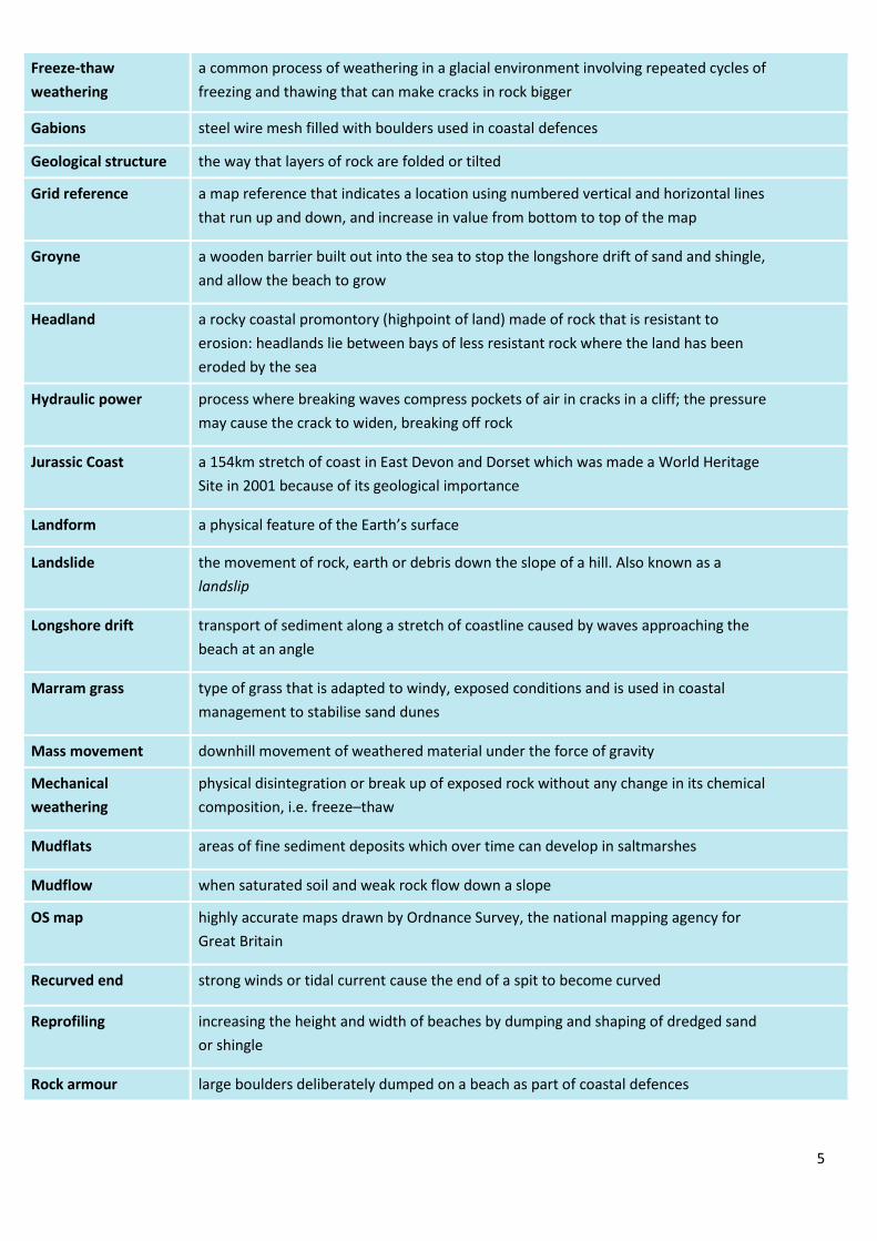
Freeze-thaw
weathering
a common process of weathering in a glacial environment involving repeated cycles of
freezing and thawing that can make cracks in rock bigger
Gabions steel wire mesh filled with boulders used in coastal defences
Geological structure the way that layers of rock are folded or tilted
Grid reference a map reference that indicates a location using numbered vertical and horizontal lines
that run up and down, and increase in value from bottom to top of the map
Groyne a wooden barrier built out into the sea to stop the longshore drift of sand and shingle,
and allow the beach to grow
Headland a rocky coastal promontory (highpoint of land) made of rock that is resistant to
erosion: headlands lie between bays of less resistant rock where the land has been
eroded by the sea
Hydraulic power process where breaking waves compress pockets of air in cracks in a cliff; the pressure
may cause the crack to widen, breaking off rock
Jurassic Coast a 154km stretch of coast in East Devon and Dorset which was made a World Heritage
Site in 2001 because of its geological importance
Landform a physical feature of the Earth’s surface
Landslide the movement of rock, earth or debris down the slope of a hill. Also known as a
landslip
Longshore drift transport of sediment along a stretch of coastline caused by waves approaching the
beach at an angle
Marram grass type of grass that is adapted to windy, exposed conditions and is used in coastal
management to stabilise sand dunes
Mass movement downhill movement of weathered material under the force of gravity
Mechanical
weathering
physical disintegration or break up of exposed rock without any change in its chemical
composition, i.e. freeze–thaw
Mudflats areas of fine sediment deposits which over time can develop in saltmarshes
Mudflow when saturated soil and weak rock flow down a slope
OS map highly accurate maps drawn by Ordnance Survey, the national mapping agency for
Great Britain
Recurved end strong winds or tidal current cause the end of a spit to become curved
Reprofiling increasing the height and width of beaches by dumping and shaping of dredged sand
or shingle
Rock armour large boulders deliberately dumped on a beach as part of coastal defences

6
Rockfall a fragment of rock breaks away from the cliff face, often due to freeze-thaw
weathering
Rotational slip slump of saturated soil and weak rock along a curved surface
Salt weathering a weathering process where salt crystals grow and expand in the cracks and holes of
rock, creating pressure which eventually causes fragments of rock to break away
Saltation hopping movement of pebbles along a river or sea bed
Saltmarshes important natural habitats often found in sheltered river estuaries behind spits where
there is very little flow of water
Scree accumulation of fragments of weathered rock
Sea wall concrete wall aiming to prevent erosion of the coast by reflecting wave energy
Sliding loose surface material becomes saturated and the extra weight causes the material to
become unstable and move rapidly downhill
Solution the dissolving of rocks such as limestone and chalk by sea water
Spit depositional landform formed when a finger of sediment extends from the shore out
to sea, often at a river mouth
Stack isolated pillar of rock left when the top of an arch has collapsed
Suspension small particles carried in river flow or sea water, i.e. sands, silts and clays
Swash the forward movement of a wave up a beach
Traction heavy particles rolled along the sea bed
Transportation the movement of eroded material
Tsunami huge waves caused by earthquakes
Wave refraction wave energy is reduced in bays as the water gets shallower
Waves ripples in the sea caused by the transfer of energy from the wind blowing over the
surface of the sea
Wave-cut platform rocky, level shelf at or around sea level representing the base of old, retreated cliffs
11. River landscapes in the UK
Key Term Definition
Abrasion rocks carried along a river wear down the river bed and banks
Aerial photo an image taken from above ground-level looking down on a landscape, they can
either be (1) Vertical – looking directly down to the ground or, (2) Oblique – looking
sideways
Alluvium a sediment deposited by a river when it floods

7
Attrition rocks being carried by the river smash together and break into smaller, smoother and
rounder particles
Benefits financial savings made by preventing flooding, along with any environmental
improvements
Channel the main water course
Channel straightening removing meanders from a river to make it straighter
Confluence where a tributary joins a larger river
Costs the financial cost of a scheme, and any negative impacts on the environment and on
people’s lives
Course the path of the river from its source to mouth
Cross profile a cross section of a river channel or its valley
Dam a barrier built across a valley to interrupt river flow
Deposition occurs when material being transported by the sea is dropped due to the sea losing
energy
Discharge quantity of water that passes a given point on a stream or riverbank within a given
period of time
Drainage basin an area of land drained by a river and its tributaries
Embankment artificially raised river banks often using concrete walls
Estuary tidal mouth of a river where it meets the sea – wide banks of deposited mud are
exposed at low tide
Flash flood a very sudden flood event resulting from a torrential rainstorm
Flood where river discharge exceeds river channel capacity and water spills onto the
floodplain
Flood relief channel artificial channels that are used when a river is close to maximum discharge; they
take the pressure off the main channels when floods are likely
Flood risk the likelihood of a flood event occurring in a certain area
Flood storage areas water is deliberately allowed to flood wetlands to reduce the risk of flooding further
downstream
Flood warnings providing reliable advance information about possible flooding
Floodplain relatively flat area forming the valley floor either side of a river channel that is
sometimes flooded
Floodplain zoning identifying how a floodplain can be developed for human uses
Flow control specially designed aperture (opening) in a river channel which controls the rate of
flow downstream. Excess water is stored behind the structure in a reservoir
Gorge a narrow steep-sided valley – often formed as a waterfall retreats upstream

8
Gradient the height and angle of a slope
Hydraulic action power of the water eroding the bed and banks of a river
Hydrograph a graph which shows the discharge of a river, related to rainfall, over a period of time
Interlocking spurs outcrops of land along the river course in a valley
Knick point a step or drop in a river’s bed which often cause waterfalls
Lateral erosion erosion of river banks rather than the bed – helps to form the floodplain
Levee raised bank found on either side of a river, formed naturally by regular flooding or
built up by people to protect the area against flooding
Load material transported by a river
Long profile the gradient of a river, from its source to its mouth
Meander a wide bend in a river
Mouth the end of a river, usually where a river joins the sea
Mudflats areas of fine sediment deposits which over time can develop in saltmarshes
Ox-bow lake an arc-shaped lake on a floodplain formed by a cut-off meander
Plunge pool a deep and turbulent area of water where the river ‘plunges’ over a waterfall
Pools and riffles alternating sequence in the course of a river or stream that carry coarse sediment,
where shallow fast-flowing sections are called riffles and deeper slower-moving
sections are called pools
Precipitation moisture falling from the atmosphere – rain, sleet or snow
Prediction using historical evidence and monitoring, scientists can make predictions about when
and where a hazard may happen
Reservoir A large natural or artificial lake used as a source of water supply
River restoration modifying the course of a river to return it to its natural state
Saltation hopping movement of pebbles along a river or sea bed
Saltmarshes important natural habitats often found in sheltered river estuaries behind spits
where there is very little flow of water
Solution dissolved rocks and minerals often derived from limestone or chalk
Source the start of a river
Suspension small particles carried in river flow or sea water, i.e. sands, silts and clays
Thalweg the course of the fastest flow (velocity) within a river
Time lag the time in hours between the highest rainfall and the highest (peak) discharge
Traction where material is rolled along a river bed or by waves
9
Transportation the movement of eroded material
Tributary a small stream that joins a larger river
Velocity rate of the river flow
Vertical erosion downward erosion of the river bed
V-shaped valley steep-sided valley
Waterfall a step in the long profile of a river usually formed when a river crosses over a hard
(resistant) band of rock
Watershed the edge of the river basin
Wetlands saturated areas of land, often found on river floodplains
Notes:
10
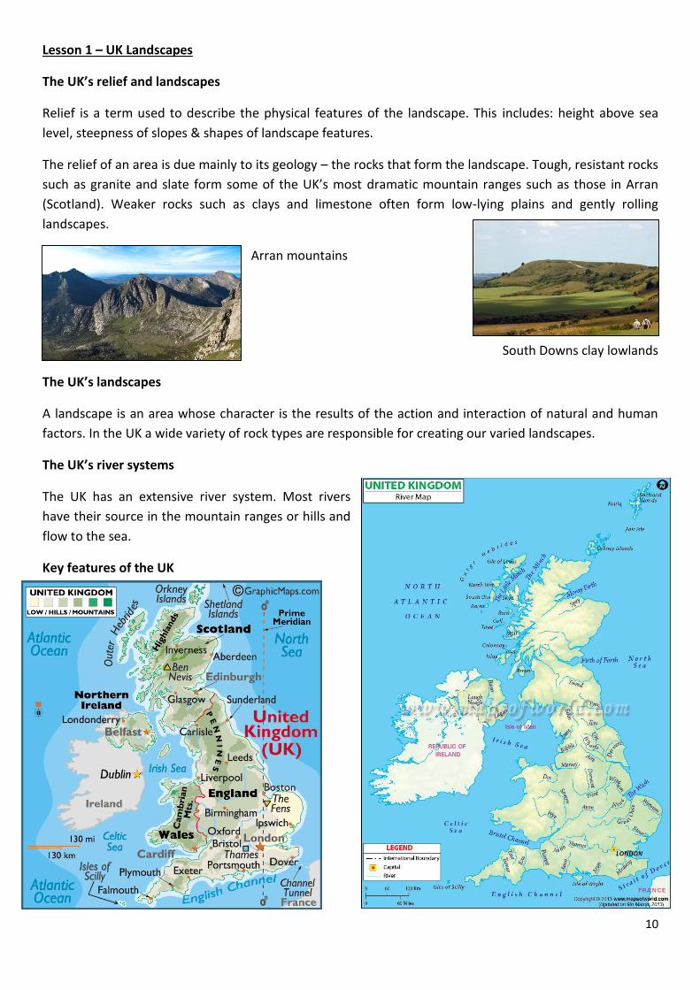
Lesson 1 – UK Landscapes
The UK’s relief and landscapes
Relief is a term used to describe the physical features of the landscape. This includes: height above sea
level, steepness of slopes & shapes of landscape features.
The relief of an area is due mainly to its geology – the rocks that form the landscape. Tough, resistant rocks
such as granite and slate form some of the UK’s most dramatic mountain ranges such as those in Arran
(Scotland). Weaker rocks such as clays and limestone often form low-lying plains and gently rolling
landscapes.
Arran mountains
South Downs clay lowlands
The UK’s landscapes
A landscape is an area whose character is the results of the action and interaction of natural and human
factors. In the UK a wide variety of rock types are responsible for creating our varied landscapes.
The UK’s river systems
The UK has an extensive river system. Most rivers
have their source in the mountain ranges or hills and
flow to the sea.
Key features of the UK
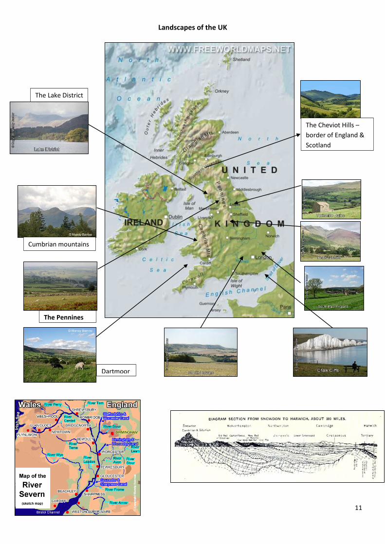
11
The Pennines
Dartmoor
Landscapes of the UK
The Cheviot Hills –
border of England &
Scotland
Cumbrian mountains
The Lake District

12
Maps of Middlewich
The department has OS maps of Middlewich that you
can refer to.
Lesson 2 - Weathering & Mass Movement
Cliffs collapse because of different types of weathering.
This is the weakening or
decay of rocks in their
original place on, or close
to, the ground surface. It is
mostly caused by weather
factors such as rainfall and
changes in temperature.
Mass movement is the downward movement or sliding of material under the
influence of gravity. Diagram D describes some of the common types of mass movement found at the
coast. Both mass movement and weathering provide an input of material to the coastal system. Much of
this material is carried away by waves and deposited further along the coast.
13
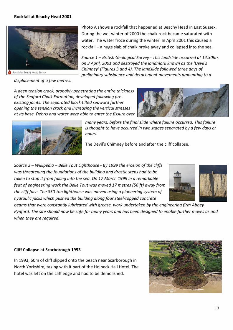
Rockfall at Beachy Head 2001
Photo A shows a rockfall that happened at Beachy Head in East Sussex.
During the wet winter of 2000 the chalk rock became saturated with
water. The water froze during the winter. In April 2001 this caused a
rockfall – a huge slab of chalk broke away and collapsed into the sea.
Source 1 – British Geological Survey - This landslide occurred at 14.30hrs on 3 April, 2001 and destroyed the landmark known as the 'Devil's Chimney' (Figures 3 and 4). The landslide followed three days of preliminary subsidence and detachment movements amounting to a
displacement of a few metres.
A deep tension crack, probably penetrating the entire thickness of the Seaford Chalk Formation, developed following pre-existing joints. The separated block tilted seaward further opening the tension crack and increasing the vertical stresses at its base. Debris and water were able to enter the fissure over
many years, before the final slide where failure occurred. This failure is thought to have occurred in two stages separated by a few days or hours.
The Devil’s Chimney before and after the cliff collapse.
Source 2 – Wikipedia – Belle Tout Lighthouse - By 1999 the erosion of the cliffs
was threatening the foundations of the building and drastic steps had to be
taken to stop it from falling into the sea. On 17 March 1999 in a remarkable
feat of engineering work the Belle Tout was moved 17 metres (56 ft) away from
the cliff face. The 850-ton lighthouse was moved using a pioneering system of
hydraulic jacks which pushed the building along four steel-topped concrete
beams that were constantly lubricated with grease, work undertaken by the engineering firm Abbey
Pynford. The site should now be safe for many years and has been designed to enable further moves as and
when they are required.
Cliff Collapse at Scarborough 1993
In 1993, 60m of cliff slipped onto the beach near Scarborough in
North Yorkshire, taking with it part of the Holbeck Hall Hotel. The
hotel was left on the cliff edge and had to be demolished.

14
Lesson 3 Coastal Landscapes – Waves & Coastal Erosion
Wave Types & Their Characteristics
Waves are formed by the wind blowing over the sea. Friction with the surface of the water causes ripples
to form and these develop into waves. The distance the wind blows over the water is called the fetch. The
longer the fetch the more powerful the wave.
Waves can also be caused by undersea earthquakes or volcanic eruptions. These are called tsunamis.
When waves reach the shore there is a forward movement of water as the waves break and surge up the
beach. Friction with the seabed causes the wave to change shape and eventually the wave crest rises up
and then collapses on the beach. Water rushing up the beach is called swash and water flowing back to the
sea is called backwash.
There are two types of waves – constructive and destructive.
Constructive waves
* low waves that surge up beach
* powerful swash
* carry & deposit large amounts of sediment
* ‘construct’ the beach making it bigger
* preferred by surfers due to longer rides
* formed by storms out to sea
Destructive waves
* formed by local storms close to shore
* can ‘destroy’ the beach
* closely spaced
* can ‘interfere’ with each other creating chaotic
swirling water
* high and steep before plunging down on beach
* little forward motion (swash)
* powerful backwash
* gradually removes sediment from beach

15
Japanese Tsunami 2011 – Source – The Telegraph
DEATH TOLL: A total of 12,431 people were confirmed dead by Japan's National Police Agency, while
15,153 were missing.
NUMBER OF PEOPLE EVACUATED: More than 163,000 people were in shelters around the country
following evacuation, the National Police Agency said. The government has set up an evacuation area
around Tokyo Electric Power Co's quake-stricken nuclear plant in Fukushima 150 miles north of Tokyo, with
a 12-mile radius. More than 70,000 people lived in the largely rural area within the zone. It is unclear how
many of them have been evacuated, but most are believed to have left. Another 136,000 people were
within a zone extending a further six miles in which residents are recommended to leave or stay indoors.
A total of 164,059 households in the north were without electricity, Tohoku Electric Power Co said.
At least 170,000 households in eight prefectures were without running water, the Health Ministry said.
At least 46,027 buildings have been destroyed, washed away or burnt down, the National Police Agency of
Japan said.
The government has estimated damage from the earthquake and tsunami at 16-25 trillion yen. The top
estimate would make it the world's costliest natural disaster.
The estimate covers damage to roads, homes, factories and other infrastructure, but excludes lost
economic activity from power outages and costs arising from damage to the Fukushima nuclear power
plant, as well as the impact of swings in financial markets and business sentiment. The yen initially spiked
to a record high against the dollar after the quake, prompting the first joint intervention by the Group of
Seven rich nations in 11 years to help shield Japan’s export-reliant economy.
Japan's reconstruction spending will almost certainly exceed that of the 1995 quake in Kobe, when the
government needed extra budgets of more than 3 trillion yen. The government may need to spend more
than 10 trillion yen in emergency budgets for post-quake disaster relief and reconstruction, with part of
them possibly covered by new taxes, Deputy Finance Minister Mitsuru Sakurai signalled on Thursday.
According to the Foreign Ministry, 134 countries and 39 international organisations have offered
assistance.
16
Coastal (Marine) Processes – Coastal Erosion
Erosion causes the removal of material and the shaping of landforms. There are 5 key processes of coastal
erosion.
Solution- dissolving of soluble chemicals in the rocks e.g. limestone.
Hydraulic power/action – the power of the waves as they smash onto a cliff, tapped air is forced into cracks
& holes in the rock eventually causing the rock to break apart. The explosive force of trapped air operating
in a crack is called cavitation.
Attrition – rock fragments carried by the sea knock against each other causing them to become smaller and
more rounded.
Abrasion – This is the ‘sand-papering’ effect of pebbles grinding over a rocky surface or platform often
causing it to become smooth.
Corrasion – fragments of rock are picked up and hurled by the sea at a cliff. The rocks act like tools scraping
and gouging to erode the rock.
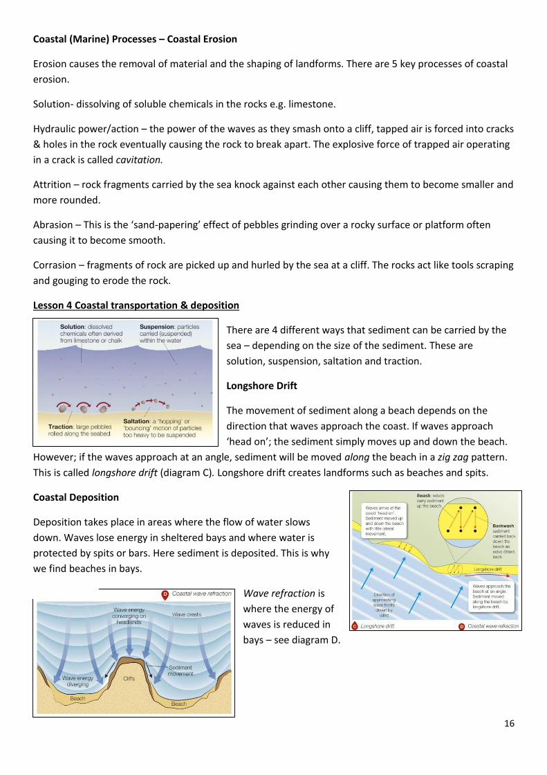
Lesson 4 Coastal transportation & deposition
There are 4 different ways that sediment can be carried by the
sea – depending on the size of the sediment. These are
solution, suspension, saltation and traction.
Longshore Drift
The movement of sediment along a beach depends on the
direction that waves approach the coast. If waves approach
‘head on’; the sediment simply moves up and down the beach.
However; if the waves approach at an angle, sediment will be moved along the beach in a zig zag pattern.
This is called longshore drift (diagram C). Longshore drift creates landforms such as beaches and spits.
Coastal Deposition
Deposition takes place in areas where the flow of water slows
down. Waves lose energy in sheltered bays and where water is
protected by spits or bars. Here sediment is deposited. This is why
we find beaches in bays.
Wave refraction is
where the energy of
waves is reduced in
bays – see diagram D.

17
Mudflats and salt marshes are often formed in sheltered estuaries behind spits where there is little flow of
water.
Local coastal locations where deposition occurs
Formby Beach, Lancashire Cleveleys Beach, Lancashire River Dee mudflats
Lesson 5 – Landforms of Coastal Erosion
A landform is a feature of the landscape that has been formed or sculpted by processes of: erosion,
transportation or deposition.
Some rocks are tougher and more resistant than others. Rocks such as granite, limestone and chalk from
impressive cliffs and headlands because they are more resistant to erosion.
Softer rocks such as clays and sands are more easily eroded to form bays or low-lying stretches of
coastline.
Geological structure includes the way that layers of rock are folded or tilted.
This can be an important factor in the shape of cliffs. Faults are cracks in rocks.
Enormous tectonic pressures can cause rocks to ‘snap’ rather than fold (bend)
and movement happens on either side of the fault. Faults form lines of
weakness in rocks, easily carved out by the sea.

18
Headlands and Bays
Different types of rocks are eroded at different rates. Weaker
rocks erode more easily to create bays. As bays are sheltered,
deposition takes place and a sandy beach forms.
The more resistant rocks are eroded more slowly. They stick out
into the sea as headlands. Erosion dominates here so there are
no beaches. Most erosional
landforms are found at
headlands. Headlands and bays
are formed due to differential
erosion. This indented coast is
called a discordant coastline.
Cliffs and Wave-Cut Platforms
Waves break against the base of a cliff and erode at
the high tide mark. This erosion forms a wave-cut
notch. Over a long period of time – usually hundreds
of years – the notch will get deeper and deeper,
undercutting the cliff. Eventually the over-hanging
cliff can no longer support its own weight and it
collapses.
This process repeats itself over time and
gradually the cliff retreats backwards. In its place
a gently sloping rocky platform called a wave-cut
platform forms. This is typically smooth due to abrasion, however in places
there may be rock pools.
Caves, arches and stacks
Faults are vulnerable to erosion. Waves erode the cliffs along lines of
weakness such as faults to form caves. Over time erosion may lead to two
back-to-back caves breaking through a headland to form an arch.
Gradually the arch is enlarged by erosion at the base and weathering
processes on the roof. Eventually the roof will be worn away and collapse
to form an isolated pillar of rock called a stack.

19
Activity - Coastal Erosion landforms
This accompanies the animation Skills-pod 04: Interpreting photos – Landforms.
Look carefully at the photo below of Lulworth Cove in Dorset, southern England.
1. Identify two geomorphic processes which have helped to create the landscape
in the photo. [2
marks]
2. Using evidence from the photo, add annotations to the photo to explain how
Lulworth Cove was formed. [7
marks]
3. Identify one further piece of information which would help to provide a better
understanding of how this landscape was formed.
[1 mark]
[10 marks]
20
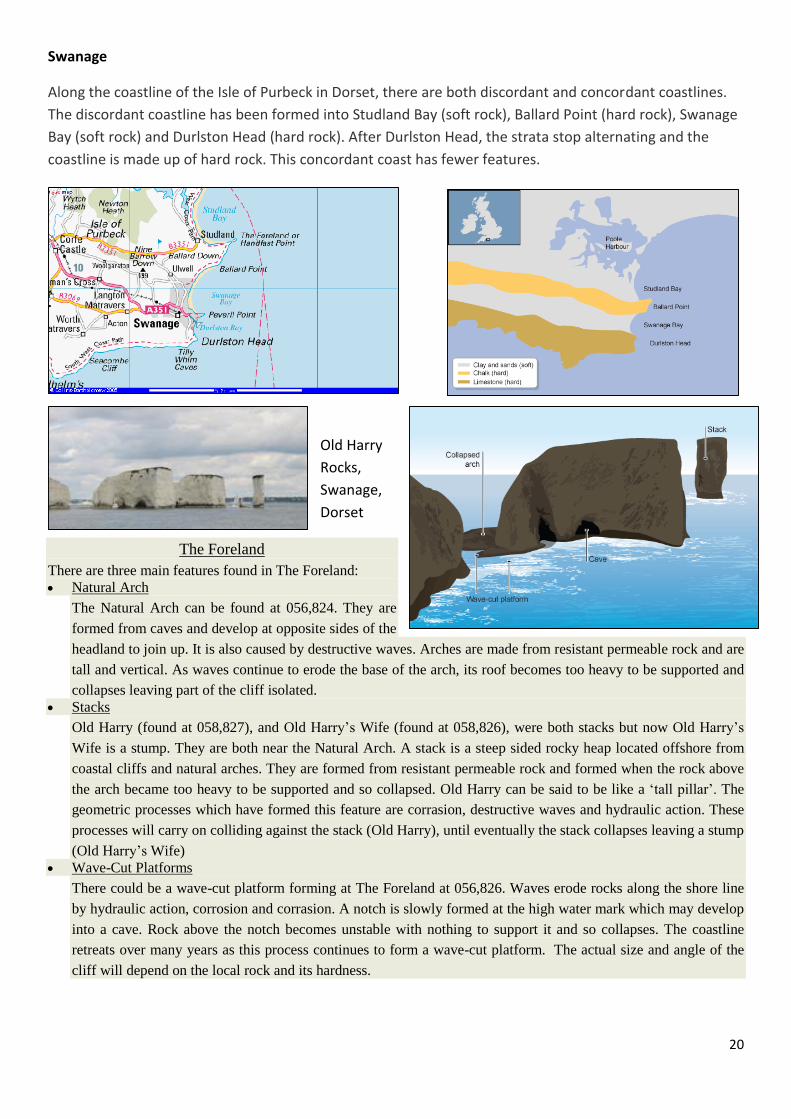
Swanage
Along the coastline of the Isle of Purbeck in Dorset, there are both discordant and concordant coastlines.
The discordant coastline has been formed into Studland Bay (soft rock), Ballard Point (hard rock), Swanage
Bay (soft rock) and Durlston Head (hard rock). After Durlston Head, the strata stop alternating and the
coastline is made up of hard rock. This concordant coast has fewer features.
Old Harry
Rocks,
Swanage,
Dorset
The Foreland
There are three main features found in The Foreland: Natural Arch
The Natural Arch can be found at 056,824. They are
formed from caves and develop at opposite sides of the
headland to join up. It is also caused by destructive waves. Arches are made from resistant permeable rock and are
tall and vertical. As waves continue to erode the base of the arch, its roof becomes too heavy to be supported and
collapses leaving part of the cliff isolated. Stacks
Old Harry (found at 058,827), and Old Harry’s Wife (found at 058,826), were both stacks but now Old Harry’s
Wife is a stump. They are both near the Natural Arch. A stack is a steep sided rocky heap located offshore from
coastal cliffs and natural arches. They are formed from resistant permeable rock and formed when the rock above
the arch became too heavy to be supported and so collapsed. Old Harry can be said to be like a ‘tall pillar’. The
geometric processes which have formed this feature are corrasion, destructive waves and hydraulic action. These
processes will carry on colliding against the stack (Old Harry), until eventually the stack collapses leaving a stump
(Old Harry’s Wife) Wave-Cut Platforms
There could be a wave-cut platform forming at The Foreland at 056,826. Waves erode rocks along the shore line
by hydraulic action, corrosion and corrasion. A notch is slowly formed at the high water mark which may develop
into a cave. Rock above the notch becomes unstable with nothing to support it and so collapses. The coastline
retreats over many years as this process continues to form a wave-cut platform. The actual size and angle of the
cliff will depend on the local rock and its hardness.

21
Ballard
Cliff
Wealden Cliffs

22
Lesson 6 - Landforms of Coastal Deposition
There are 4 main depositional landforms found at the coast – beaches, sand dunes, spits and bars. You may
also see a tombolo – this is a bar which connects an island to a mainland.
Beaches
* deposits of sand or shingle (pebbles)
* sandy beaches are mainly found in sheltered bays –
constructive waves have strong swash and build the beach
* Many beaches have pebbles not sand – in southern
England the strong waves wash sand away leaving pebbles
which come from nearby eroded cliffs or are washed ashore
from out to sea
A beach profile shows a cross-section through a beach – look at the berms, which are ridges on the beach.
Seaweed and rubbish are often deposited at the high tide mark.
Sand dunes
These are formed by sand, that is deposited on the beach, being
blown inland by onshore winds to from dunes. Sand dunes
change over time. Vegetation colonises the dunes and helps to
stabilise them.
Spits
A spit is a long narrow finger of sand or shingle jutting out into
the sea from the land. They form on coasts where there is
longshore drift and a change in shape of the coastline.
A sharp bend in the coast, such as an estuary, allows sediment
to be deposited out into the sea, building up an extension from
the land.
Strong winds or tidal currents can cause the end of the spit to
curve – this is called a hook or recurved end. A spit may have a
number of hooks
showing the previous
positions of the spit.
Salt marshes often form
in the sheltered water
behind the spit, where
deposits of mud
develop. These are
gradually colonised by
plants and wildlife.

23
Bars
Sometimes longshore drift causes a spit to grow right across a bay
forming a bar. Freshwater is trapped behind it forming a lagoon.
Occasionally an offshore bar forms further out to sea. Here waves
deposit sediment due to friction on the gently sloping sea bed. The
offshore bar causes waves to break some distance from the coast.
In some parts of the UK offshore bars have been driven onshore by
rising sea levels following the end of the last ice age 8000 years ago.
This forms a barrier beach such as Chesil Beach in Dorset.
Extension - Tombolos
Can you explain their formation using a labelled diagram?
24
Lesson 7 - INTERVENTION
Lesson 8 – Case study: Swanage
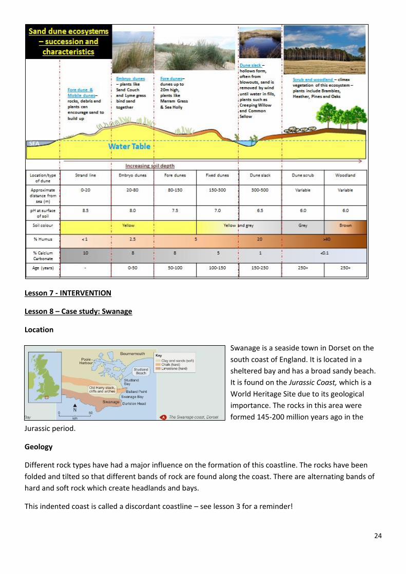
Location
Swanage is a seaside town in Dorset on the
south coast of England. It is located in a
sheltered bay and has a broad sandy beach.
It is found on the Jurassic Coast, which is a
World Heritage Site due to its geological
importance. The rocks in this area were
formed 145-200 million years ago in the
Jurassic period.
Geology
Different rock types have had a major influence on the formation of this coastline. The rocks have been
folded and tilted so that different bands of rock are found along the coast. There are alternating bands of
hard and soft rock which create headlands and bays.
This indented coast is called a discordant coastline – see lesson 3 for a reminder!

25
To the north of Swanage lies Poole Harbour, one of the UK’s largest natural harbours. A lot of deposition
has taken place here. Two spits have formed – on each side of the bay.
Studland has a number of depositional features including lagoons, saltmarshes and sand dunes.
Using the OS map extract you can locate many well-known local landforms such as Ballard Point, Swanage
Bay, Old Harry, Peveril Point and Durlston Head.

26
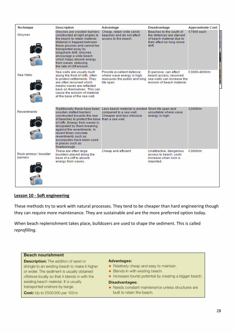
Lesson 9 – Managing Coasts – Hard Engineering
Why do coasts need to be managed?
Coastal management tries to find a balance between the forces of nature and the needs of people. People
who live and work at the coast can be affected by coastal erosion and flooding. As sea levels are predicted
to rise, coastal defences will become more expensive. In some places, the coasts may outweigh the
benefits and the coastline may be left undefended.
Coastal Management Options
Hard engineering – building artificial structures to control natural processes
Soft engineering – less intrusive, more environmentally friendly methods working with natural processes
Managed retreat – controlled retreat of the coastline, often allowing flooding of some low-lying land
Comparing Coastal Management Methods & Costs
Hard engineering
This includes sea walls, wooden and rock groynes, rock armour and gabions.
Today hard engineering methods are less common due to the high cost of
building and maintaining them. They interfere with natural coastal
processes which can cause destructive knock-on effects elsewhere. They
also look unnatural.

27
Artificial headlands are rock structures built along the toe of
eroding dunes to protect strategic points, allowing natural
processes to continue along the remaining frontage. This is
significantly cheaper than protecting a whole frontage and can
provide temporary or long term protection to specific assets
at risk. Temporary headlands can be formed of gabions or
sand bags, but life expectancy will normally be between 1 and
5 years.
Timber Revetments Source: Scottish Natural Heritage
Appropriate
locations High value sites suffering modest and periodic erosion.
Costs Moderate (£2000 to £50,000/100m frontage length).
Effectiveness Provide good protection if only occasionally exposed to waves. 5-30 year life.
Benefits Normally acceptable to the public. Less expensive than seawalls or rock revetments
Problems Limited life, particularly where exposed to wave action. Visually intrusive. Alters
beach-dune processes as sand interchange is disrupted.
Artificial Headlands Source: Scottish Natural Heritage
Appropriate
locations
Rapidly eroding dunes with important backshore assets at discrete intervals along the
shore.
Costs Moderate, but low maintenance (£20,000-£60,000/100m of structure, plus minor
works for unprotected frontages).
Effectiveness
Good temporary or long term protection for protected length. Allows natural processes
to continue elsewhere. Can be used with other low cost methods. Unlimited structure
life for rock headlands.
Benefits Provides local protection with minimum disturbance to dune system as a whole. Can
be modified or removed at later date.
Problems
Visually intrusive. Do not control erosion along the whole frontage. Structures may
interfere with longshore transport, particularly on sand-gravel beaches, and may
require periodic extension or relocation landward to avoid outflanking.
28
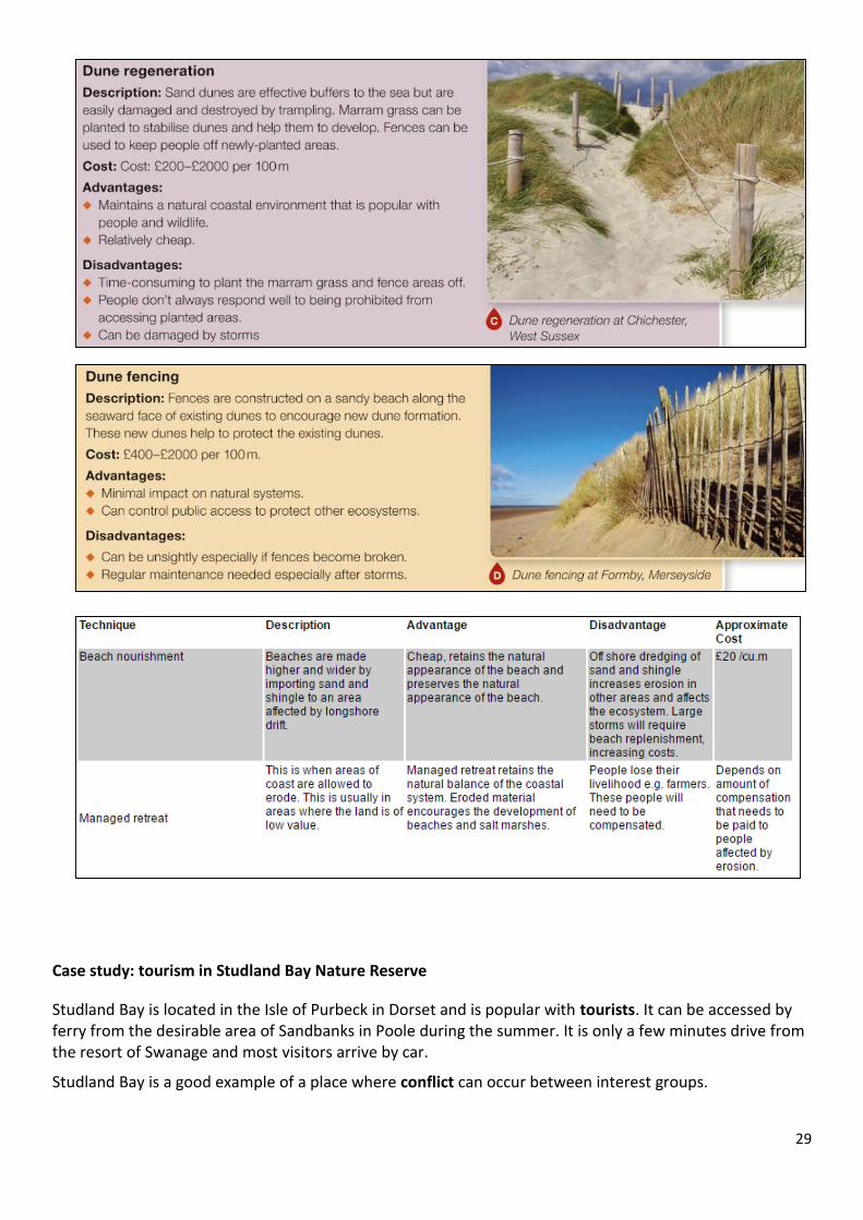
Lesson 10 - Soft engineering
These methods try to work with natural processes. They tend to be cheaper than hard engineering though
they can require more maintenance. They are sustainable and are the more preferred option today.
When beach replenishment takes place, bulldozers are used to shape the sediment. This is called
reprofilling.
29
Case study: tourism in Studland Bay Nature Reserve
Studland Bay is located in the Isle of Purbeck in Dorset and is popular with tourists. It can be accessed by ferry from the desirable area of Sandbanks in Poole during the summer. It is only a few minutes drive from the resort of Swanage and most visitors arrive by car.
Studland Bay is a good example of a place where conflict can occur between interest groups.

30
The issues
The nature reserve is an area of sand dunes. These are dynamic, but often unstable and vulnerable environments.
Areas such as this are home to rare species of plants and birds.
The area is attractive to tourists because of the dunes and the wide, sandy beach. The beach can get very crowded in summer months.
Visitors need somewhere to park and also demand other facilities, such as paths and public toilets.
Tourists bring their problems such as litter and fire hazards (caused by barbecues and cigarette ends).
How is the area managed?
Vulnerable areas and areas recently planted with marram grass (which is used to stabilise the dunes) are fenced off to limit access and damage.
Boardwalks have been laid through the dunes to focus tourists onto specific paths. Car parks have been provided and people are not permitted to drive onto the beach. Fire beaters are positioned within the dune area in case of a fire. Facilities including a shop, café, toilets and litter bins are provided near the car parks to focus tourists into
one area. Information boards educate visitors about the environment and how they can help to protect it.
Lesson 11 – Managed Retreat
Managed retreat is a deliberate policy of allowing the sea to flood or erode an area of relatively low-value
land.
It is a form of soft engineering as it allows natural processes to take place.
In the long term, managed retreat is a more sustainable method than spending large sums of money trying
to protect the coast with hard engineering methods.
As sea levels continue to rise, managed retreat is likely to become an increasingly popular choice for
managing the coastline.

31
Coastal monitoring & adaptation
Most of the UK’s coastline does not need expensive coastal defences. The coastal land may be low-value
farmland, forest or moorland. Here the coastal zone is left alone – the ‘Do Nothing’ approach.
People who live or work here have to adapt by moving inland. This might involve moving mobile homes on
a holiday park, a path or a fence.
These stretches of coastline are monitored by scientists. This helps to reduce possible conflict between
managing the coast and meeting the needs & views of local people.
This monitoring involves studying coastal processes, mass movement and human activity to ensure safety.
If conditions change then a new approach might be needed, for example if the risk of flooding increases
and threatens homes.
Some people think that managed retreat does not account for the longer-term impact on coastal trade,
tourism, infrastructure and businesses, as well as rehousing costs.
32
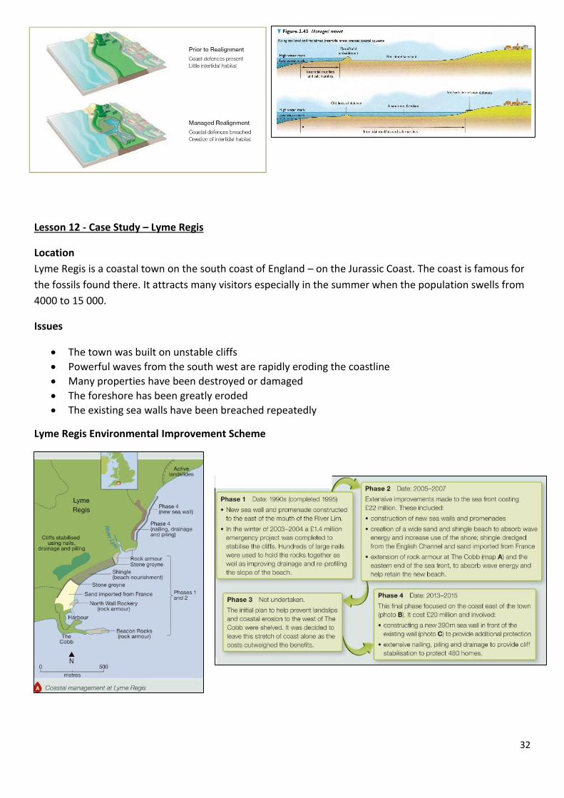
Lesson 12 - Case Study – Lyme Regis
Location
Lyme Regis is a coastal town on the south coast of England – on the Jurassic Coast. The coast is famous for
the fossils found there. It attracts many visitors especially in the summer when the population swells from
4000 to 15 000.
Issues
The town was built on unstable cliffs
Powerful waves from the south west are rapidly eroding the coastline
Many properties have been destroyed or damaged
The foreshore has been greatly eroded
The existing sea walls have been breached repeatedly
Lyme Regis Environmental Improvement Scheme
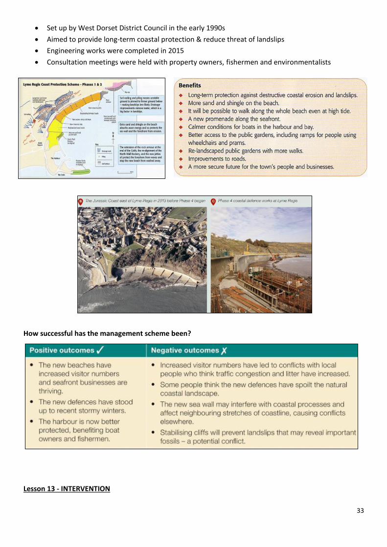
33
Set up by West Dorset District Council in the early 1990s
Aimed to provide long-term coastal protection & reduce threat of landslips
Engineering works were completed in 2015
Consultation meetings were held with property owners, fishermen and environmentalists
How successful has the management scheme been?
Lesson 13 - INTERVENTION

34
Lesson 14 – River Landscapes
Changes in Rivers and Their Valleys
What is a drainage basin?
This is an area of land drained by a river and its tributaries. The long profile of a river changes as you travel
downstream.
How does the cross profile of a river and it valley change downstream?
A cross profile is an imaginary slice across a river channel and its valley at a particular point.
As the river flows downstream it changes:
Wider channel
Deeper channel
Wider valley
Flatter valley
Less steep valley sides
There will be variations due to geology, human activity and river management by people.

35
The changes are due to the amount of water flowing in the river. More water means a bigger river which
can erode a wider and deeper channel. This in turn broadens and flattens the river valley. Weathering and
mass movement make the valley sides less steep.
Lesson 15 - River (Fluvial) Processes
Rivers have the same three types of processes as coastal areas – erosion, transportation and deposition
(see lesson 2).
Rivers have two types of erosion – vertical (downwards) and lateral (sideways).
Erosion – hydraulic action, abrasion, attrition & solution.
Transportation – traction, saltation, suspension & solution.
The size and amount of load that a river can carry depends on its velocity (rate of flow).
36
Deposition – occurs when velocity decreases and sediment is deposited.
Larger rocks are deposited in the upper course of the river – only transported short distances
(traction) during periods of high flow.
Finer sediment is carried further downstream (suspension) – deposited on river bed and banks
when velocity is reduced due to friction.
Large amount of deposition takes place at river mouth – river velocity reduced due to interaction
with tides and very gentle gradient.
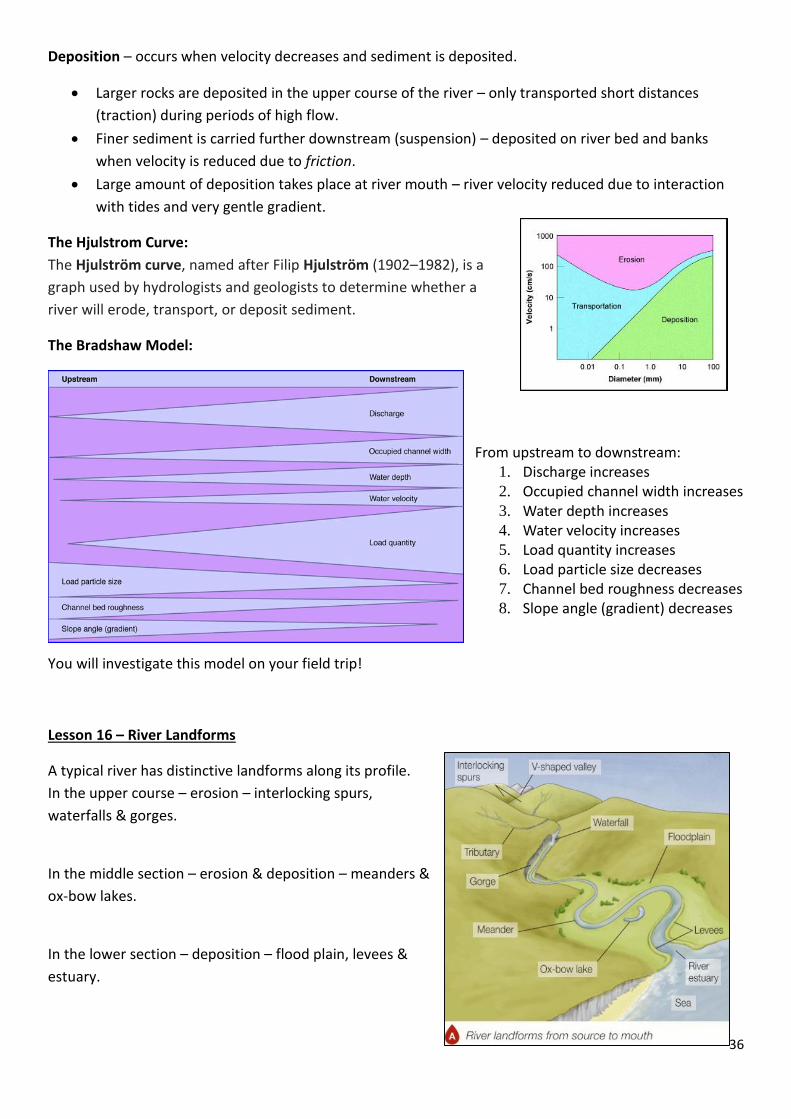
The Hjulstrom Curve:
The Hjulström curve, named after Filip Hjulström (1902–1982), is a
graph used by hydrologists and geologists to determine whether a
river will erode, transport, or deposit sediment.
The Bradshaw Model:
From upstream to downstream: 1. Discharge increases
2. Occupied channel width increases
3. Water depth increases
4. Water velocity increases
5. Load quantity increases
6. Load particle size decreases
7. Channel bed roughness decreases
8. Slope angle (gradient) decreases
You will investigate this model on your field trip!
Lesson 16 – River Landforms
A typical river has distinctive landforms along its profile.
In the upper course – erosion – interlocking spurs,
waterfalls & gorges.
In the middle section – erosion & deposition – meanders &
ox-bow lakes.
In the lower section – deposition – flood plain, levees &
estuary.

37
River erosion landforms
Interlocking spurs
These are fingers of land that jut out from the V-shaped
valley sides – the river weaves its way around them.
As the river is near its source it is not powerful enough to
cut through the spurs so has to flow around them.
Waterfalls
This is a ‘step’ in the long profile formed when a river flows
over more resistant rock.
Waterfalls are most commonly formed when a river flows
over a relatively resistant band of hard rock.
When a river plunges over a waterfall it forms a turbulent
and deep plunge pool. Here erosion (hydraulic action &
abrasion) combine to undercut the waterfall.
Eventually the overhanging rock collapses and the waterfall
retreats upstream.
Over many years the retreating waterfall creates a steep-sided gorge.
Waterfalls can also form when a drop in sea level causes a river to cut down into its bed creating a step in
the long profile. This step is called a knick point and is marked by a waterfall.
Waterfalls can also be found in glacial hanging valleys.
Gorges
A narrow steep-sided valley usually found downstream of a
waterfall. It is formed by the gradual retreat of a waterfall
over 100s or even 1000s of years. Sometimes gorges are
formed when huge quantities of melting glacial water
poured off upland areas at the end of the last glacial period
(8000 years ago) i.e. Cheddar Gorge (Somerset). Rarely
gorges are formed by the collapse of underground caverns.
38
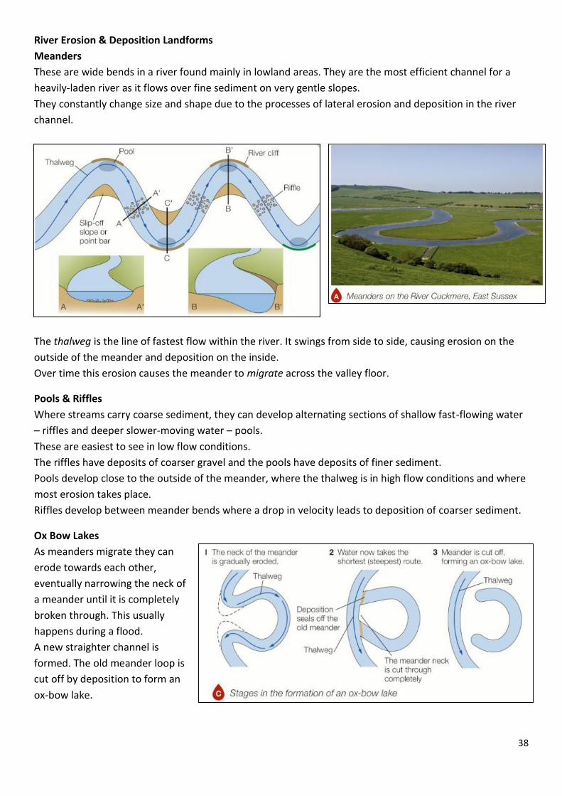
River Erosion & Deposition Landforms
Meanders
These are wide bends in a river found mainly in lowland areas. They are the most efficient channel for a
heavily-laden river as it flows over fine sediment on very gentle slopes.
They constantly change size and shape due to the processes of lateral erosion and deposition in the river
channel.
The thalweg is the line of fastest flow within the river. It swings from side to side, causing erosion on the
outside of the meander and deposition on the inside.
Over time this erosion causes the meander to migrate across the valley floor.
Pools & Riffles
Where streams carry coarse sediment, they can develop alternating sections of shallow fast-flowing water
– riffles and deeper slower-moving water – pools.
These are easiest to see in low flow conditions.
The riffles have deposits of coarser gravel and the pools have deposits of finer sediment.
Pools develop close to the outside of the meander, where the thalweg is in high flow conditions and where
most erosion takes place.
Riffles develop between meander bends where a drop in velocity leads to deposition of coarser sediment.
Ox Bow Lakes
As meanders migrate they can
erode towards each other,
eventually narrowing the neck of
a meander until it is completely
broken through. This usually
happens during a flood.
A new straighter channel is
formed. The old meander loop is
cut off by deposition to form an
ox-bow lake.

39
Floodplains & Levees
A floodplain is a wide flat area of marshy land on either side of a river, usually found in the middle and
lower sections of the river.
Floodplains are made of alluvium – a sediment (silt) deposited by a river when it floods. The soils here are
very fertile and excellent for farming.
There are two processes which create a floodplain:
Migrating meanders due to lateral erosion which erode the sides of the valley (bluff) widening the
valley
River floods which deposit silt creating a flat flood plain – many layers build up over time forming a
thick deposit of alluvium
A levee is a raised river bed found alongside a river in its lower course.
It is formed by flooding over many years. A ridge of sediment is deposited naturally to build up the levee.
During low flow conditions deposition takes place.
This raises the river bed and reduces the capacity of
the channel.
When flooding happens, water flows over the sides
of the channel.
Here the river velocity decreases rapidly leading to
deposition of sediment on the river banks.
First coarser sands are deposited then finer silt and
mud. Gradually, after many floods, the height of
the banks can be raised by up to two metres!

40
Estuaries
Estuaries are transitional zones where a river mouth opens into the sea. They are affected by both river
and coastal processes. The main process found here is deposition.
During a rising tide river water is unable to be discharged into the sea. The river’s velocity falls and
sediment is deposited. At low tide these fine deposits form extensive mudflats. Over time mudflats can
develop into saltmarshes.
UK Waterfalls
Hardraw Force (Hardraw Beck Yorkshire Dales)
Janet’s Foss (Gordale Beck Yorkshire Dales)
Cauldron Snout (River Tees Northumbria)

41
River Floodplains – Aerial photos
42
Lesson 17 – Case Study – The River Tees (County Durham)
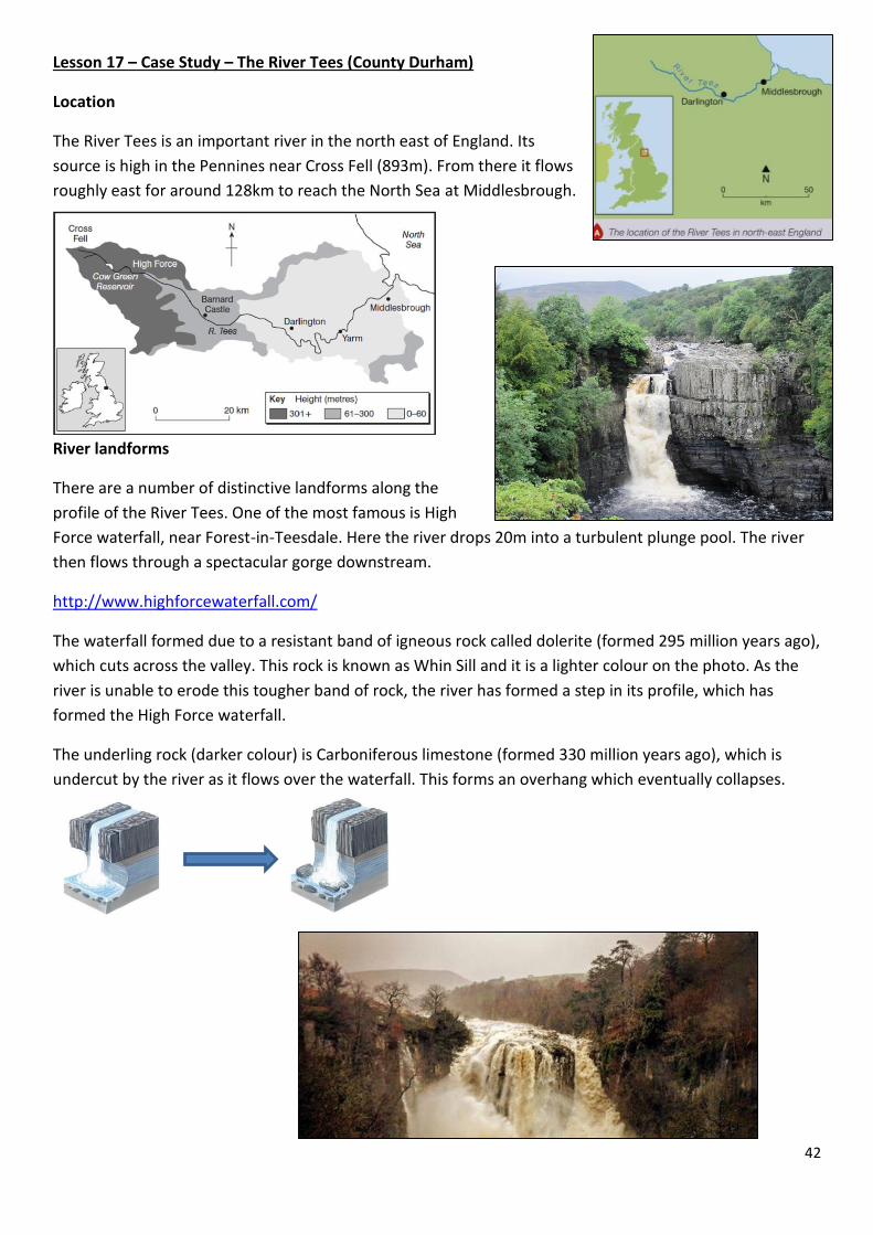
Location
The River Tees is an important river in the north east of England. Its
source is high in the Pennines near Cross Fell (893m). From there it flows
roughly east for around 128km to reach the North Sea at Middlesbrough.
River landforms
There are a number of distinctive landforms along the
profile of the River Tees. One of the most famous is High
Force waterfall, near Forest-in-Teesdale. Here the river drops 20m into a turbulent plunge pool. The river
then flows through a spectacular gorge downstream.
http://www.highforcewaterfall.com/
The waterfall formed due to a resistant band of igneous rock called dolerite (formed 295 million years ago),
which cuts across the valley. This rock is known as Whin Sill and it is a lighter colour on the photo. As the
river is unable to erode this tougher band of rock, the river has formed a step in its profile, which has
formed the High Force waterfall.
The underling rock (darker colour) is Carboniferous limestone (formed 330 million years ago), which is
undercut by the river as it flows over the waterfall. This forms an overhang which eventually collapses.

43
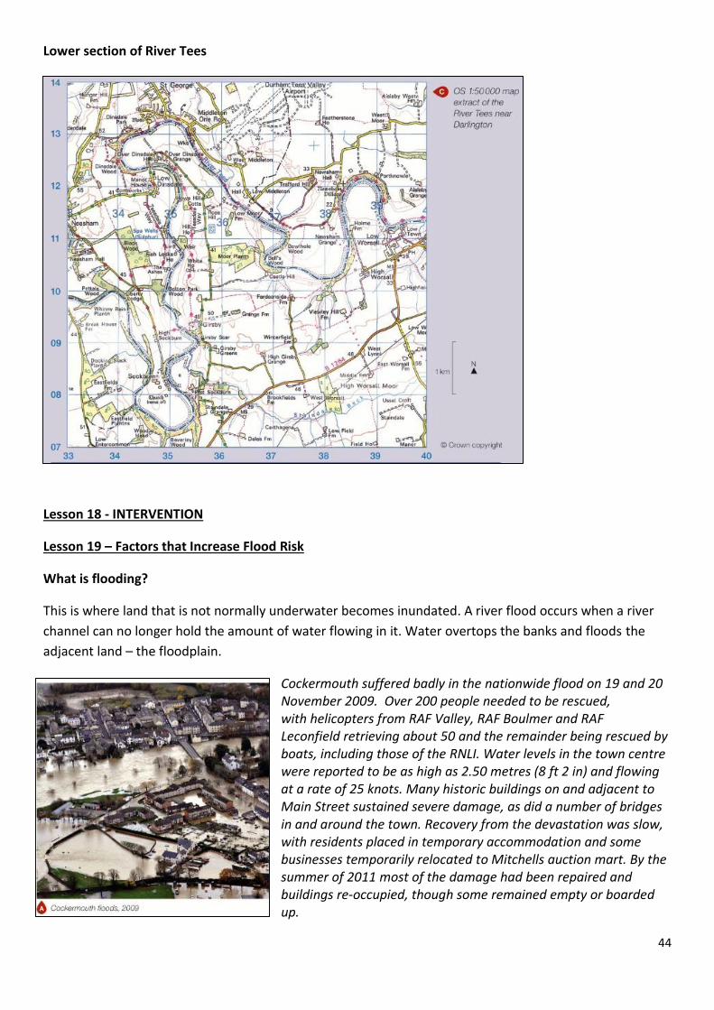
In the lower course of the River Tees, south of Darlington, the river flows over relatively flat low-lying land
where there are good examples of meanders, levees and floodplains.
Source of the River Tees
44
Lower section of River Tees
Lesson 18 - INTERVENTION
Lesson 19 – Factors that Increase Flood Risk
What is flooding?
This is where land that is not normally underwater becomes inundated. A river flood occurs when a river
channel can no longer hold the amount of water flowing in it. Water overtops the banks and floods the
adjacent land – the floodplain.
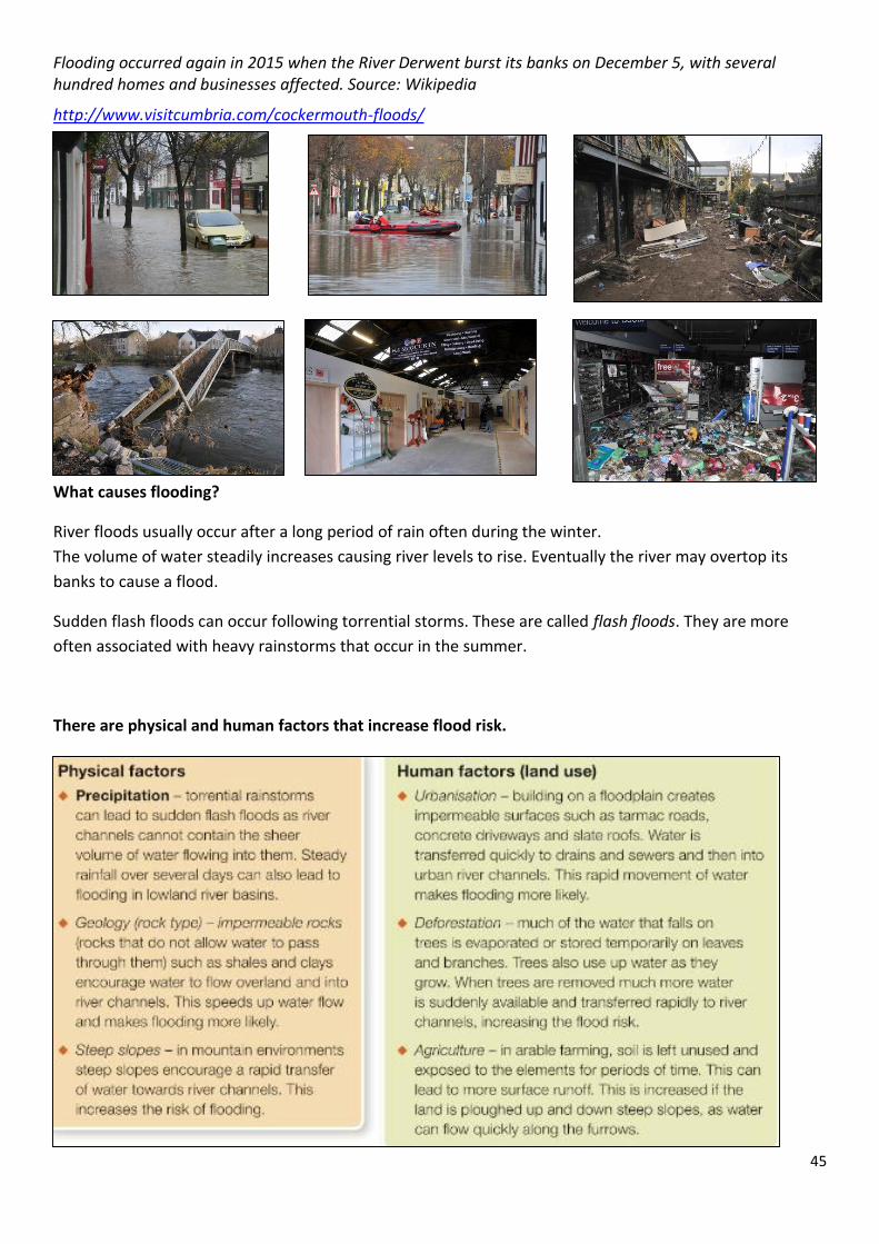
Cockermouth suffered badly in the nationwide flood on 19 and 20 November 2009. Over 200 people needed to be rescued, with helicopters from RAF Valley, RAF Boulmer and RAF Leconfield retrieving about 50 and the remainder being rescued by boats, including those of the RNLI. Water levels in the town centre were reported to be as high as 2.50 metres (8 ft 2 in) and flowing at a rate of 25 knots. Many historic buildings on and adjacent to Main Street sustained severe damage, as did a number of bridges in and around the town. Recovery from the devastation was slow, with residents placed in temporary accommodation and some businesses temporarily relocated to Mitchells auction mart. By the summer of 2011 most of the damage had been repaired and buildings re-occupied, though some remained empty or boarded up.
45
Flooding occurred again in 2015 when the River Derwent burst its banks on December 5, with several hundred homes and businesses affected. Source: Wikipedia
http://www.visitcumbria.com/cockermouth-floods/
What causes flooding?
River floods usually occur after a long period of rain often during the winter.
The volume of water steadily increases causing river levels to rise. Eventually the river may overtop its
banks to cause a flood.
Sudden flash floods can occur following torrential storms. These are called flash floods. They are more
often associated with heavy rainstorms that occur in the summer.
There are physical and human factors that increase flood risk.

46
Lesson 20 - Hydrographs
A hydrograph is a graph that plots river discharge after a storm. River discharge is the volume of water
flowing along a river – measured in cubic metres per second (cumecs).
A hydrograph shows how discharge rises after a storm, reaches its peak and then returns to a normal rate
of flow.
Flood hydrograph
One of the most important aspects of a hydrograph is the time lag. This is the time in hours between the
highest rainfall and highest (peak) discharge.
This shows how quickly water is transferred into a river channel and is a key factor in the flood risk.
The shorter the time lag the greater the risk of flooding.
Hydrographs
What affects the shape of a hydrograph?

47

48
Lesson 21 – Managing Floods – Hard Engineering
Hard engineering involves using man-made
structures to prevent or control natural processes
from taking place.
(See lesson 6 re. coastal defences)
This is an expensive form of flood management –
individual projects can cost several million pounds.
This is the preferred option for protecting expensive
property or land such as housing estates, railways or
water treatment works. The costs have to be
weighed against the benefits.
Costs – financial plus any negative impacts on the
environment or people’s lives.
Benefits – financial savings made by preventing
flooding plus any environmental improvements.

49
Dams and reservoirs
These are widely used around the world to
control river flow and reduce the risk of flooding.
Most dam projects are multi-purpose and have
several functions:
Flood prevention
Irrigation
Water supply
Hydro-electric power
Recreation
Dams can be very effective in regulating water flow. During periods of high rainfall, water can be stored in
the reservoir. It can then be released when rainfall is low.
However dam construction can be controversial as they are very expensive and the reservoir often floods
large areas of land. Many people may have to be moved from their homes.
Other hard engineering methods include channel straightening, embankments and flood relief channels.

50
Lesson 22 – Case study of hard engineering
Thames Flood Barrier

51
The Thames Barrier is one of the largest movable flood barriers in the world. The Environment Agency runs
and maintains the Thames Barrier as well as London’s other flood defences.
https://21stcenturychallenges.org/the-thames-barrier/
https://www.carbonbrief.org/risk-and-uncertainty-calculating-the-thames-barriers-future
http://www.telegraph.co.uk/news/weather/10646439/The-Thames-Barrier-has-saved-London-but-is-it-
time-for-TB2.html
Lesson 23 – Managing Floods – Soft Engineering
Soft engineering involves working with natural river processes to manage the flood risk.
It does not involve building artificial structures or trying to stop natural processes.
It aims to reduce and slow the movement of water into a river channel to help prevent flooding.
There are costs and benefits.
Afforestation
Planting trees to create a woodland helps to obstruct the
flow of water and slow down the transfer of water to river
channels. Water is soaked up by the trees or evaporated
from leaves and branches. Tree planting is relatively cheap
and has other environmental
benefits.
Wetlands and flood storage areas
Wetland environments on river floodplains are very efficient in storing water.
Wetlands are deliberately allowed to flood to form flood storage areas. Water
can be stored to reduce the risk of flooding further downstream.
Floodplain zoning
This restricts different land uses to certain zones on the
floodplain. Areas close to the river and at risk from
flooding can be kept clear of high-value land uses such as
housing and industry. Instead these areas can be used for
pasture, parkland or playing fields.
Floodplain zooming can reduce overall losses caused by
flood damage. It can be difficult to implement on
floodplains that have already been developed and can
cause land prices to fall.

52
River restoration
Where the course of a river has be changed
artificially, river restoration can return it to its
original course. This uses the natural processes and
features of the river, such as meanders and
wetlands, to slow down river flow and reduce the
risk of a major flood downstream.
Cheshire West plan 1 Warrington Flood
defences Warrington Flood Defences 2
Preparing for floods
Rivers and drainage basins are monitored remotely using satellites and computer technology. Instruments
are used to measure rainfall and check river levels.
Computer models are used to predict river discharge and identify areas at risk from flooding.
In England & Wales the Environment Agency issues flood warnings if flooding is likely. Warnings are sent to
the emergency services and the public using social media, text and email. There are 3 levels of warning:
Flood Watch – flooding of low-lying land and roads is expected. People should be
prepared and watch river levels.
Flood Warning – there is a threat to homes and businesses. People should move
items of value to upper floors and to turn off electricity and water.
Severe Flood Warning – extreme danger to life and property is expected. People
should stay in an upper level of their home or leave the property.
How the Environment Agency decides when to issue a warning and what type of
warning to issue.
53
Lesson 24 – Soft engineering case study - Morpeth
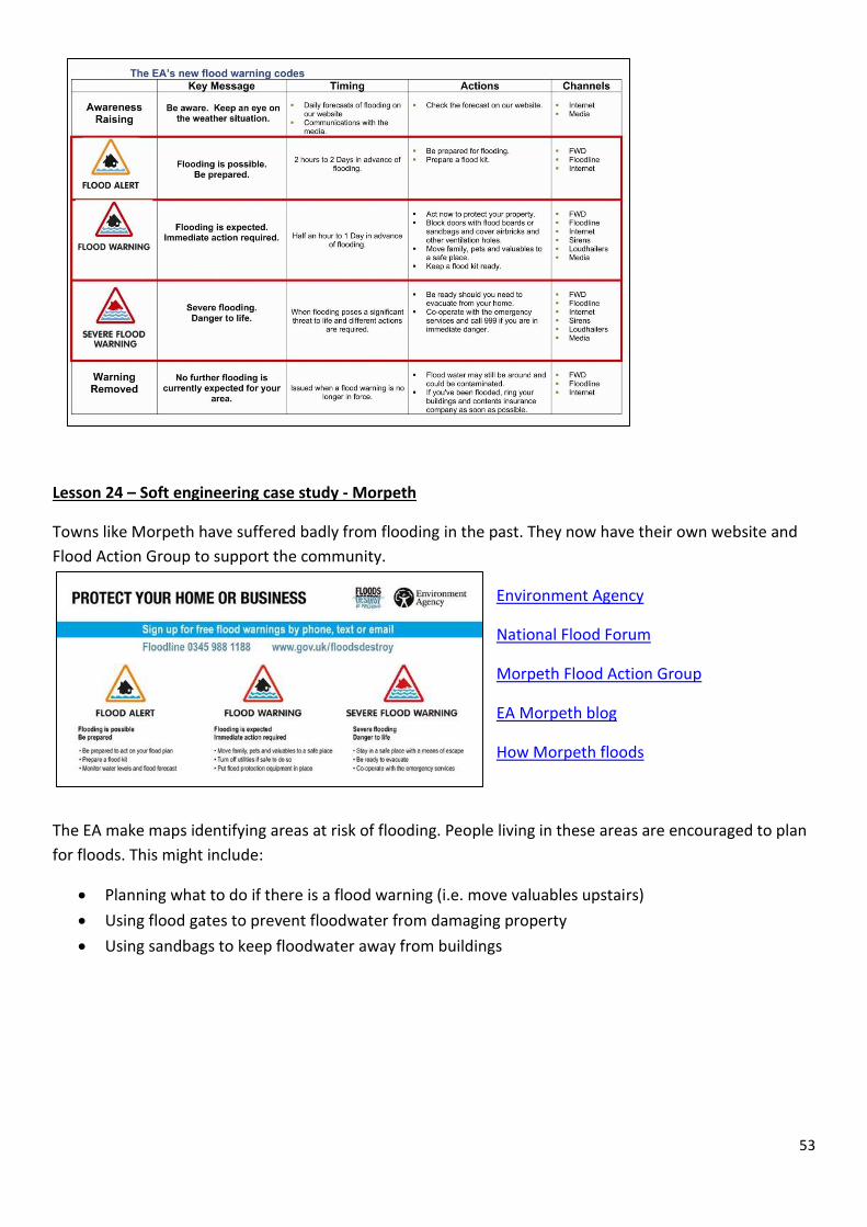
Towns like Morpeth have suffered badly from flooding in the past. They now have their own website and
Flood Action Group to support the community.
Environment Agency
National Flood Forum
Morpeth Flood Action Group
EA Morpeth blog
How Morpeth floods
The EA make maps identifying areas at risk of flooding. People living in these areas are encouraged to plan
for floods. This might include:
Planning what to do if there is a flood warning (i.e. move valuables upstairs)
Using flood gates to prevent floodwater from damaging property
Using sandbags to keep floodwater away from buildings

54
Middlewich High School is in an area with a
low risk of flooding.
What about where you live?
Local
authorities
and
emergency
services use
these maps to plan responses to floods. For
example, installing temporary flood barriers,
evacuating people, closing roads and securing
buildings and services.
Flood prediction is based on probability and one of the ‘costs’ is that places can become blighted by being
‘at risk’ from flooding. This can cause property values to drop and insurance premiums to increase.

55
Lesson 25 – Case Study – Managing Floods at Banbury
Location
Banbury is a town in the Cotswold Hills about 50km north of Oxford. The
population is about 45,000. Much of the town is built on the floodplain of the
River Cherwell, which is a tributary of the River Thames.
History of flooding
Banbury has experienced many devastating floods. In 1998 flooding led to the
closure of the town’s railway station, shut local roads and caused £12.5
million damage. More than 150 homes and businesses were affected
In 2007 the town was hit again by floods that covered much of central and
western England. Many more homes and businesses were affected as the river burst its banks after very
heavy rain.
Flood Management in Banbury
In 2012 Banbury’s new flood defence scheme was completed. A 2.9km earth embankment was built
parallel to the M40 motorway to create a flood storage area. The embankment has a maximum height of
4.5m. It is capable of holding around 3 million cubic metres of water – that’s 1200 Olympic sized swimming
pools!
The flood storage area is located mainly on the
natural floodplain for the River Cherwell. It
collects rainwater that otherwise would fill the
river and cause it to flood.
Photo D shows one of the two flow control
structures in the embankment. The specially
designed aperture (opening) controls the rate of
flow downstream towards Banbury. Any excess
water backs up behind the structure, filling the
reservoir rather than flooding Banbury. The design
avoids the need to open and close flood gates.

56
Map of Flood Storage Area at Banbury

57
Additional flood defences (part of the scheme):
Raising part of the A361road in the flood storage area plus improvements to drainage beneath the
road to prevent flooding
New earth embankments and floodwalls to protect property and businesses, such as the
motorsport business Prodrive
A new pumping station to transfer excess rainwater into the river below the town
The creation of a new Biodiversity Action Plan (BAP) habitat with ponds, trees and hedges to absorb
and store excess water
Scheme in operation Nov 2012
BBC news
Flood conference presentation
Costs and benefits?

58
Lesson 26 – Fieldwork preparation 1
Lesson 27 – Fieldwork preparation 2
Lesson 28 – Revision
Lesson 29 – Assessment
Lesson 30 – Assessment review