Gaining Ground on the Gateway Tradition
32
30 ABSTRACT An abandoned collection of archaeological materials, recov- ered from nine Late Prehistoric structural sites on the Weimer Ranch and adjacent public lands in western Colorado in the mid-1970s, was analyzed by Alpine Archaeological Consul- tants, Inc. Based on radiocarbon dates and ceramic cross- dating, the sites were occupied during the tenth and eleventh centuries A.D. The results of the analyses suggest that the site occupants possessed their own ceramic tradition and pursued a subsistence strategy based on maize horticulture and big game hunting. Imported ceramics and rock art suggest connections to the Pueblo II unit of southwestern Colorado. The materials represent the most comprehensively studied collection of Gate- way tradition artifacts and ecofacts to date. INTRODUCTION Between 1974 and 1977, Metropolitan State College (MSC) of Denver, Colorado, conducted archaeological field schools under the direction of Dr. Jiri Vondracek at several Late Prehistoric sites in western Montrose County (the term “Late Prehistoric” as used in this arti- cle is temporally equivalent to the term “Formative era” as defined by Reed and Metcalf [1999]). The sites were mostly clustered on or adjacent to the Weimer Ranch near Norwood, Colorado, but the Roc Creek site north of Paradox, Colorado, was also subjected to investigation. In 1973, MSC had also conducted “a small amount of testing” at the Wray Mounds site (5MN191) (Crane 1977:67). At least 10 sites—including Roc Creek, which is not discussed in this article—were excavated by the field school students between 1974 and 1977. Most of the sites consisted of masonry habitation structures. The majority of site assemblages included small quantities of Puebloan ceramics, and evidence of corn was also found in some contexts. Upon completion of the fieldwork, the artifacts and associated records were returned to MSC where they were subjected to limited analysis by students. The most important analysis was conducted by Cathy Crane in her Master’s thesis for Eastern New Mexico University. This research (Crane 1977; see also Crane 1978) provided a valuable overview of the sites investi- gated and presented a model of subsistence and social organization. Crane’s thesis, however, did not provide basic descriptions of cultural features and artifacts. Virtually no other descriptions of the four field seasons of excavation were written. The college eventually turned over the collections to the Rimrocker Historical Society in Naturita, Colorado. Dissemination of the Weimer Ranch collection data is important for several reasons. First, masonry habita- tion sites with ceramics and evidence of corn are relative- ly rare in west-central Colorado. Nonstructural sites are far more common throughout all periods, suggesting that most of the region’s inhabitants were relatively mobile hunters and gatherers. Sites such as those at Weimer Ranch can contribute greatly to our understand- ing of the range in variation of regional settlement and subsistence systems during the period between approxi- mately A.D. 900–1100. Second, excavation data from the region’s structural habitation sites are scarce. As will be described in the discussion of previous archaeological work, virtually all of the available excavation data are from projects conducted in the 1930s and 1940s, which usually employed less rigorous field and analytic methods than today’s and only cursorily described their findings in print. The Weimer Ranch excavations, conducted more than 30 years ago, represent the most recent large-scale excavations targeting the region’s masonry sites. Third, data from the Weimer Ranch collection can contribute to our understanding of distributions of peoples or traits associated with the Ancestral Puebloan and Fremont traditions. Early twentieth-century archaeologists com- monly regarded the region’s structural sites as represen- tative of the Anasazi tradition, while recognizing that their non-normative aspects may have resulted from their position on the periphery of the Ancestral Puebloan homeland and their proximity to non-Puebloan cultural groups. More recently—and without the benefit of new GAINING GROUND ON THE GATEWAY TRADITION: ANALYSIS OF MATERIALS FROM WEIMER RANCH, A PREHISTORIC FARMING SETTLEMENT IN WEST- CENTRAL COLORADO Rand A. Greubel, Alan D. Reed, and Bradford W. Andrews Rand A. Greubel ■ Alpine Archaeological Consultants, Inc., P. O. Box 2075, Montrose, Colorado 81402–2075; [email protected] Alan D. Reed ■ Alpine Archaeological Consultants, Inc., P. O. Box 2075, Montrose, Colorado 81402–2075; alan_reed@ alpinearchaeology.com Bradford W. Andrews ■ Department of Anthropology, Pacific Lutheran University, Tacoma, Washington 98447–0003; [email protected]
-
Upload
independent -
Category
Documents
-
view
2 -
download
0
Transcript of Gaining Ground on the Gateway Tradition

30
ABSTRACTAn abandoned collection of archaeological materials, recov-
ered from nine Late Prehistoric structural sites on the WeimerRanch and adjacent public lands in western Colorado in themid-1970s, was analyzed by Alpine Archaeological Consul-tants, Inc. Based on radiocarbon dates and ceramic cross-dating, the sites were occupied during the tenth and eleventhcenturies A.D. The results of the analyses suggest that the siteoccupants possessed their own ceramic tradition and pursued asubsistence strategy based on maize horticulture and big gamehunting. Imported ceramics and rock art suggest connections tothe Pueblo II unit of southwestern Colorado. The materialsrepresent the most comprehensively studied collection of Gate-way tradition artifacts and ecofacts to date.
INTRODUCTIONBetween 1974 and 1977, Metropolitan State College
(MSC) of Denver, Colorado, conducted archaeologicalfield schools under the direction of Dr. Jiri Vondracek atseveral Late Prehistoric sites in western MontroseCounty (the term “Late Prehistoric” as used in this arti-cle is temporally equivalent to the term “Formative era”as defined by Reed and Metcalf [1999]). The sites weremostly clustered on or adjacent to the Weimer Ranchnear Norwood, Colorado, but the Roc Creek site northof Paradox, Colorado, was also subjected to investigation.In 1973, MSC had also conducted “a small amount oftesting” at the Wray Mounds site (5MN191) (Crane1977:67). At least 10 sites—including Roc Creek, whichis not discussed in this article—were excavated by thefield school students between 1974 and 1977. Most of thesites consisted of masonry habitation structures. Themajority of site assemblages included small quantities ofPuebloan ceramics, and evidence of corn was also foundin some contexts. Upon completion of the fieldwork, theartifacts and associated records were returned to MSCwhere they were subjected to limited analysis by students.The most important analysis was conducted by CathyCrane in her Master’s thesis for Eastern New Mexico
University. This research (Crane 1977; see also Crane1978) provided a valuable overview of the sites investi-gated and presented a model of subsistence and socialorganization. Crane’s thesis, however, did not providebasic descriptions of cultural features and artifacts.Virtually no other descriptions of the four field seasons ofexcavation were written. The college eventually turnedover the collections to the Rimrocker Historical Societyin Naturita, Colorado.
Dissemination of the Weimer Ranch collection datais important for several reasons. First, masonry habita-tion sites with ceramics and evidence of corn are relative-ly rare in west-central Colorado. Nonstructural sites arefar more common throughout all periods, suggestingthat most of the region’s inhabitants were relativelymobile hunters and gatherers. Sites such as those atWeimer Ranch can contribute greatly to our understand-ing of the range in variation of regional settlement andsubsistence systems during the period between approxi-mately A.D. 900–1100. Second, excavation data from theregion’s structural habitation sites are scarce. As will bedescribed in the discussion of previous archaeologicalwork, virtually all of the available excavation data arefrom projects conducted in the 1930s and 1940s, whichusually employed less rigorous field and analytic methodsthan today’s and only cursorily described their findings inprint. The Weimer Ranch excavations, conducted morethan 30 years ago, represent the most recent large-scaleexcavations targeting the region’s masonry sites. Third,data from the Weimer Ranch collection can contributeto our understanding of distributions of peoples or traitsassociated with the Ancestral Puebloan and Fremonttraditions. Early twentieth-century archaeologists com-monly regarded the region’s structural sites as represen-tative of the Anasazi tradition, while recognizing thattheir non-normative aspects may have resulted fromtheir position on the periphery of the Ancestral Puebloanhomeland and their proximity to non-Puebloan culturalgroups. More recently—and without the benefit of new
GAINING GROUND ON THE GATEWAY TRADITION: ANALYSIS OF MATERIALSFROM WEIMER RANCH, A PREHISTORIC FARMING SETTLEMENT IN WEST-
CENTRAL COLORADO
Rand A. Greubel, Alan D. Reed, and Bradford W. Andrews
Rand A. Greubel � Alpine Archaeological Consultants, Inc., P. O. Box 2075, Montrose, Colorado 81402–2075;[email protected] D. Reed � Alpine Archaeological Consultants, Inc., P. O. Box 2075, Montrose, Colorado 81402–2075; [email protected] W. Andrews � Department of Anthropology, Pacific Lutheran University, Tacoma, Washington 98447–0003;[email protected]
Juliana
Typewritten Text
Reproduced with permission of the CCPA.
Juliana
Typewritten Text
Colorado Archaeology 75(1&2):30–61. 2009.

31
excavation data—archaeologists have asserted that theinhabitants of the structural sites represented theFremont or indigenous groups that borrowed certainaspects of Ancestral Puebloan and Fremont material cul-ture (e.g., McMahon 2004; Reed 1997).
A primary objective of this article is to present basicdescriptive data for the Weimer Ranch sites. Such basicdescriptions have been unavailable to the archaeologicalcommunity for over three decades and will augment avery limited dataset regarding the region’s structuralsites. Project data are also used to evaluate Crane’s (1977)settlement and subsistence model, to reexamine Crane’s(1977, 1978) conclusions regarding site chronology andsocial organization, to assess the suitability of variousarchaeological units (i.e., Gateway tradition, AncestralPuebloan, and Fremont) as references for the structuralsites of western Montrose County, and to evaluate previ-ous models (e.g., Reed 1997 and McMahon 2000) thataddress the cultural affiliations and lifeways representedby these sites. Finally, new interpretations of sitechronology and the origins of the occupants of theWeimer Ranch sites are offered.
PREVIOUS RESEARCHMost of what is known about ceramic-bearing sites
with evidence of corn and/or substantial habitation archi-tecture (i.e., pithouses or above-ground masonry struc-tures) in western Montrose and San Miguel counties isderived from early twentieth-century archaeologicalexpeditions. One of the first formal investigations in theregion was conducted in 1924 by Jean Jeançon and FrankRoberts, Jr., who established that the current study areawas at the periphery of “sedentary” prehistoric peoples ofsouthwestern Colorado (Woodbury and Woodbury1932:1). According to McMahon (1997), Jeançon andRoberts investigated several noncontiguous rectangularsurface roomblocks at the Paradox 1 site (Wray Mounds,5MN191) in the Paradox Valley in western MontroseCounty and concluded that they represented Anasazi“summer homes,” based on the architecture and pottery.In 1931, George and Edna Woodbury returned to theParadox Valley. They conducted some survey, but large-ly relied on local knowledge to locate artifact concentra-tions and ruins (Woodbury and Woodbury 1932:4).Sixteen ruins were recorded and one, Wray Mounds(5MN191), was excavated. Wray Mounds consisted of atleast two contiguous rectangular masonry rooms andcontained pottery attributed to the Pueblo I or II periodsof the Anasazi tradition (Woodbury and Woodbury1932:18). The sites were thought to represent the north-ernmost extension of the Anasazi tradition in Colorado(Woodbury and Woodbury 1932:18).
Betty and Harold Huscher of the Colorado Museumof Natural History conducted surveys and limited exca-vations over a broad portion of west-central Coloradobetween 1938 and 1941, focusing on sites with masonryarchitecture. Although the precise locations of many ofthe Huscher sites are sometimes in question, one of
the site clusters they investigated is probably WeimerRanch (Gleichman et al. 1982). The Huschers describedthe architecture observed at Weimer Ranch and reportfinding black-on-white pottery at one ruin—possiblyCottonwood Pueblo—that cross-dated to A.D. 1100.The Huschers appear to have regarded CottonwoodPueblo as a Puebloan ruin, or possibly as a “hybrid”between Puebloan and Athabaskan groups (Huscher andHuscher 1943:19). They do not seem to have excavatedany of the Weimer Ranch sites.
Formal archaeological investigation of westernMontrose County continued in 1939 with ClarenceHurst’s Tabeguache Expedition. Over the next six years,C. T. Hurst and Western State College of Gunnison,Colorado, excavated three sites in the vicinity of Nucla,Colorado. Two sites—Tabeguache Cave (5MN868) andTabeguache Cave II (5MN890)—are large rockshelters(Hurst 1940, 1941, 1942, 1943, 1944, 1945, 1946).Recent radiocarbon analyses of corn macrofossils fromTabeguache Cave and Tabeguache Cave II indicate occu-pations between cal 345 B.C. and A.D. 70 and betweencal A.D. 440 and 760, respectively (Stiger 2001:172). Theexpedition’s third site, Tabeguache Pueblo (5MN1609),is an open architectural site northwest of Nucla,Colorado. The site consists of three noncontiguous rec-tangular rooms and a small room block; artifacts recov-ered included small corner-notched projectile points andPueblo II period Anasazi pottery (Hurst 1946). Hurstinterpreted the three sites as peripheral Anasazi habita-tions.
Hurst continued his archaeological investigations in1946 at Dolores Cave (5MN915). Situated near theDolores River, this cave is a large sandstone alcove thatyielded corn in addition to other perishable materials(Hurst 1947). The presence of corn in the absence ofAnasazi ceramics suggested to Hurst that the site wasoccupied by Basketmaker II groups.
Hurst’s last field investigations in the area were in1947 and 1948, whenWestern State College excavated atCottonwood Pueblo (5MN654) and Cottonwood Cave(5MN519) (B. H. Hurst 1957). Cottonwood Pueblo isone of the Weimer Ranch sites, whereas CottonwoodCave is located a few kilometers to the northwest ofWeimer Ranch. Cottonwood Cave yielded corn that waslater radiocarbon dated to cal 405–55 B.C. (Stiger2001:172). At Cottonwood Pueblo, Hurst and his stu-dents excavated House 4 or Lone Tree House, a mason-ry room block with four contiguous rooms (Hurst1948a). Collected artifacts included ground stone, smallcorner-notched projectile points, knives, scrapers, ham-mers, choppers, beads, and pottery. Pottery sherds wereclassified as Mancos Black-on-white, Wingate Black-on-red, as well as plain gray and corrugated (Hurst 1948a).Crane (1977) also indicates that Hurst excavated a secondstructure, called Hill Pueblo, which was 21 m from LoneTree House (Crane 1977, citing Hurst 1948b).
Masonry architectural sites in west-central Coloradowere largely ignored by archaeologists between the end

32
of Hurst’s investigations in the late 1940s and thecommencement of field school investigations byCalifornia State University and MSC in the 1970s. Anexception was Blanche Hurst’s 1957 article inSouthwestern Lore in which she summarizes C. T. Hurst’s1940s work at Cottonwood and Tabeguache Pueblos (B.H. Hurst 1957). Schroeder’s (1964) consideration of thecultural affiliation of the two Tabeguache rocksheltersand Tabeguache Pueblo investigated by Hurst wasanother important exception. Schroeder (1964:77) rec-ognized three “northern peripheral blends” of pueblo-like culture in Nevada, Utah, and Colorado, north andwest of the core of the San Juan Anasazi homeland.These included the “Puebloid” of southern Nevada (nowreferred to as the Virgin Anasazi), the Fremont of Utahand parts of Colorado, and “the development in theUncompahgre-Gunnison Basin area” (Schroeder1964:77). Schroeder implied that the similarities of thepre-ceramic, corn-bearing rockshelter sites investigatedby Hurst represented a diffusion of early Anasazi traitsfrom the south. He notes that the Harinoso de Ocho vari-ety of maize was introduced into the core Anasazi regionfrom Mexico at approximately A.D. 700 and arrived inthe “area bordering the Uncompahgre Plateau” some-time after that date. The corn, in addition to other mate-rials associated with the Anasazi tradition (e.g., paintedpottery and masonry architecture), suggested toSchroeder the expansion of a Pueblo II period lifeway inwestern Montrose County, representing either an immi-gration of peoples from the south or of their ideas. In anycase, Schroeder (1964:78) writes that western MontroseCounty was marginal for horticulture, and that climaticchanges resulted in the withdrawal of the region’s horti-culturalists by A.D. 1150.
California State University conducted excavations atParadox 1 (i.e., Wray Mounds, 5MN191) in 1970 (Crane1977; McMahon 1997, 2000). No report of these inves-tigations was ever prepared and the artifacts and fieldnotes were destroyed in a fire (McMahon 1997, 2000).One article summarizing the analysis of the faunalremains (Kasper 1977) resulted from the investigations.
In 1974, Henry Toll of the University of Coloradoconducted an archaeological inventory along the DoloresRiver from Dolores County, Colorado, northwards intoGrand County, Utah (Toll 1977). Ancestral Puebloansites were identified in Dolores County, but the sites inwestern SanMiguel, Montrose, andMesa counties to thenorth were more difficult to ascribe to an archaeologicalunit. Toll observed rock art depicting anthropomorphswith trapezoidal bodies in the Big Gypsum Valley inwestern San Miguel County, and noted other rock sitesin western Montrose County that seemed to representelements of both Ancestral Puebloan and Fremont rockart styles (Toll 1977:100). Toll considered the sites in thesame area with small quantities of Puebloan ceramics andsingle-room architecture and tentatively concluded thatthese sites represented the San Rafael Fremont (Toll
1977:157). His reasons for ascribing Fremont affiliationincluded similarities in site locations between the west-central Colorado sites and sites in Utah, architecture thatis unlike that of Ancestral Puebloans, lower quantities ofceramics at sites than is typical of Ancestral Puebloansites, and indications that horticulture played a lesser rolein overall subsistence than typical of the AncestralPuebloans. Toll (1977) noted considerable intermixing ofAncestral Puebloan and Fremont traits at the subjectsites, however, and asserted that the degree of local vari-ation was relatively great; suggesting, in turn, the limita-tions of conventional archaeological units (Toll1977:177).
Since MSC’s 1974–1977 excavations at WeimerRanch, no formal excavations have occurred at structuralsites in west-central Colorado yielding Late Prehistoricpottery and/or corn. In 1994 and 1995, the University ofUtah conducted excavations at Coombs Cave(42GR2685), on the Manti-La Sal National Forest eastof Moab, Utah (Fawcett and Bright 1997). Coombs Cavemay be a Gateway tradition site; it yielded corn and grayware ceramics and was occupied between roughly A.D.500 and 1000. Archaeological excavations for theTransColorado pipeline project revealed two sites inMontrose County with evidence of corn and basin hous-es, but the basin houses were much less substantial thanthe masonry architecture characterizing the WeimerRanch and Roc Creek sites. Transfer Road Hamlet(5MN3876) consisted of three basin houses dating some-time between cal A.D. 1 and 500 (Kalasz et al. 2001). Asingle grain of corn pollen was recovered in archaeolog-ical contexts that might indicate use of corn on theUncompahgre Plateau’s eastern slope. The Schmidt site(5MN4253), also investigated by the TransColoradopipeline project, is northwest of Norwood, Colorado,several kilometers southwest of Weimer Ranch. Twobasin houses were excavated there; both yielded cornmacrofossils (Greubel and Cater 2001). The charredcorn kernels yielded AMS dates calibrated to 140B.C.–A.D. 80 and 345 B.C.–A.D. 0 (Greubel and Cater2001:Table 21–75).
In spite of the dearth of new excavation data from theregion pertaining to Late Prehistoric-era masonry sites,there has been some discussion of these sites in the liter-ature. In 1997, Reed (1997) suggested that sites like theWeimer Ranch cluster be referred to as the Gateway tra-dition, asserting that they were sufficiently unlike eitherthe Ancestral Puebloan sites of southwestern Coloradoor the Fremont sites of Utah and northwestern Coloradoto merit classification as variants of those archaeologicalunits. Reed perceived the Gateway tradition as represent-ing a local development, where both Ancestral Puebloanand Fremont traits were integrated into the culture of anautochthonous group. McMahon (2000, 2004) has chal-lenged the concept of the Gateway tradition, arguing,instead, that the sites so assigned are better regarded asFremont.
33
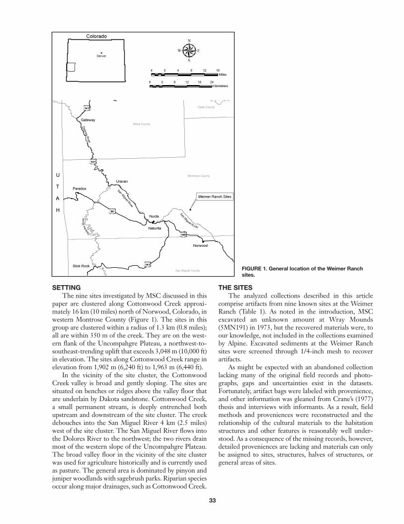
SETTINGThe nine sites investigated by MSC discussed in this
paper are clustered along Cottonwood Creek approxi-mately 16 km (10 miles) north of Norwood, Colorado, inwestern Montrose County (Figure 1). The sites in thisgroup are clustered within a radius of 1.3 km (0.8 miles);all are within 350 m of the creek. They are on the west-ern flank of the Uncompahgre Plateau, a northwest-to-southeast-trending uplift that exceeds 3,048 m (10,000 ft)in elevation. The sites along Cottonwood Creek range inelevation from 1,902 m (6,240 ft) to 1,963 m (6,440 ft).
In the vicinity of the site cluster, the CottonwoodCreek valley is broad and gently sloping. The sites aresituated on benches or ridges above the valley floor thatare underlain by Dakota sandstone. Cottonwood Creek,a small permanent stream, is deeply entrenched bothupstream and downstream of the site cluster. The creekdebouches into the San Miguel River 4 km (2.5 miles)west of the site cluster. The San Miguel River flows intothe Dolores River to the northwest; the two rivers drainmost of the western slope of the Uncompahgre Plateau.The broad valley floor in the vicinity of the site clusterwas used for agriculture historically and is currently usedas pasture. The general area is dominated by pinyon andjuniper woodlands with sagebrush parks. Riparian speciesoccur along major drainages, such as Cottonwood Creek.
THE SITESThe analyzed collections described in this article
comprise artifacts from nine known sites at the WeimerRanch (Table 1). As noted in the introduction, MSCexcavated an unknown amount at Wray Mounds(5MN191) in 1973, but the recovered materials were, toour knowledge, not included in the collections examinedby Alpine. Excavated sediments at the Weimer Ranchsites were screened through 1/4-inch mesh to recoverartifacts.
As might be expected with an abandoned collectionlacking many of the original field records and photo-graphs, gaps and uncertainties exist in the datasets.Fortunately, artifact bags were labeled with provenience,and other information was gleaned from Crane’s (1977)thesis and interviews with informants. As a result, fieldmethods and proveniences were reconstructed and therelationship of the cultural materials to the habitationstructures and other features is reasonably well under-stood. As a consequence of the missing records, however,detailed proveniences are lacking and materials can onlybe assigned to sites, structures, halves of structures, orgeneral areas of sites.
FIGURE 1. General location of the Weimer Ranchsites.

34
The Battleship Site (5MN368)The Battleship site was originally combined with
Weimer IV and Creek Knoll under one site number,5MN368. Weimer IV and Creek Knoll now bear theSmithsonian numbers 5MN7720 and 5MN7721, respec-tively, and the site number 5MN368 refers solely toBattleship. The site is located on a southeast-facing slopeabove the north fork of Cottonwood Creek. This site wassummarized by Crane (1977:22) in a single paragraph.Crane stated unequivocally that no structures were pres-
ent at the Battleship site (Crane 1977:22), but a visit tothe site by the first author in 2006 revealed low moundsof rock rubble on a small knoll that indicate the presenceof at least one, possibly more, structures. The site report-edly contained projectile points, flakes, and some groundstone, on the basis of which it was described as a workarea (Crane 1977:22). It also contained the burial of a sin-gle individual, excavated during the 1976 field season. Abone sample from this individual was radiocarbon datedto 870 ± 70 B.P. (UGa-1274) (Crane 1977:22; McMahon2000:Table 1). Calibrated, the date has a calendricalrange of A.D. 1030–1270 (two sigma).
Details about the burial appeared in a news story runby the Denver Post in 1977. In the story, Dr. Vondraceksuggested the burial contained an adult cranium associat-ed with the post-cranial skeleton of a child lacking ribs.Unfortunately, nothing else was written about the burialor the human remains. The current location of theremains is unknown.
The Hill I Site (5MN517)The Hill I site is on an open bench above Cotton-
wood Creek, roughly midway up the canyon side slope,at an elevation of 1,902 m (6,240 ft). Crane (1977:19)described the site as a square habitation structure meas-uring 4.3 m on a side (Figure 2a). This configuration isrelatively unique at Weimer Ranch because most of theother isolated structures are round to ovoid in plan view.
TABLE 1. Sites Represented in the Weimer RanchCollections.
Site Name Site Number
Battleship 5MN368Hill I 5MN517Last Hill 5MN518Middle Hill 5MN652Wagon Bend 5MN653Cottonwood Pueblo, which includes Rim and
Rim II (proveniences of House 3), and WestRim II (comprising House 1 and/or 2) 5MN654
No. 90 5MN665Weimer IV 5MN77201
Creek Knoll 5MN77211
1 Weimer IV and Creek Knoll were originally combined with Battleship under the sitenumber 5MN368.
FIGURE 2. Plan maps of the structures at Hill I (a), LastHill (b), Middle Hill (c), and Wagon Bend (d). The Hill I,Middle Hill, and Wagon Bend maps are reproduced fromMSC post-excavation field drawings. The Last Hill sitewas mapped by Alpine.

35
The floor of the structure was found at a depth of 40–50cm below the modern ground surface on the upslope(north) side, but apparently just beneath the modernground surface on the south side. Thus, the structurewould appear to have been excavated into the hill slopeby the prehistoric builders. Trenching was conductednorth of the structure, and a possible second structurewas detected (Crane 1977:19). The excavation of the HillI site by MSC resulted in a single radiocarbon date of1190 ± 355 B.P. (UGa-1132) (Crane 1977:19; McMahon2000:Table 1).
The Last Hill Site (5MN518)Last Hill (5MN518) is on the slope of a low ridge
overlooking Dry Park Draw, a tributary of CottonwoodCreek. The site is within a pinyon and juniper woodlandat an elevation of 1,926 m (6,325 ft). The site is not dis-cussed in Crane’s (1977) thesis but was examined byAlpine personnel in 2005. One definite, possibly semi-subterranean, structure (Structure 1) and two other pos-sible structures (Structures 2 and 3) were identified(Figure 2b). Structure 1 is a circular depression measur-ing about 5 m in diameter, partially demarcated byunshaped sandstone blocks and slabs. Structure 2 is southof Structure 1. It consists of a scatter of stones, rectangu-lar in outline, measuring roughly 3.5 m by 2 m. Structure3 is north of Structure 1 and comprises a flat rectangulararea demarcated by leveled ground and a few unshapedstones. Structures 2 and 3 may represent habitations,work areas, or storage facilities.
Partially surrounding the three structures are stonealignments suggesting that the Last Hill site may havebeen enclosed by a masonry wall. If so, the site may havebeen a residential compound. Within this area to thewest of Structure 1 is a relatively flat space that containsnumerous flaked stone tool artifacts and a few pieces ofground stone, possibly representing an extramural activ-ity area.
The Middle Hill Site (5MN652)The Middle Hill site (5MN652) is on the south-
facing slope of a terrace above Cottonwood Creek. Thesite is upslope from the Creek Knoll site (5MN7721).Site elevation is 1,896 m (6,220 ft). Crane (1977:17) notesthat Middle Hill exhibited the smallest structure—measuring slightly over 4 m in diameter—of all theWeimer Ranch sites (Figure 2c). Instead of unshapedsandstone blocks that are characteristic of most struc-tures at the Weimer Ranch, the walls of the Middle Hillstructure were outlined by rounded stream cobbles. Thefloor was found 40 cm below the modern ground surface,suggesting a shallow pithouse rather than a surface struc-ture.
Crane (1977:19) suggested the site—which consistedof the structure described above as well as associated arti-facts—was primarily a food processing unit rather than ahabitation. She provided no real evidence for this asser-tion, however. The size of the structure, the investment
of labor in its construction, and the presence of a centralhearth are all more consistent with a domicile rather thana specialized work area.
The Wagon Bend Site (5MN653)The Wagon Bend site (5MN653) is north of
Cottonwood Creek, on a toe slope below CottonwoodPueblo (5MN654). The elevation of the site is 1,926 m(6,320 ft). The steep slope north of the site is coveredwith talus, the likely source of most of the building stone.Wagon Bend is an isolated circular structure built ofunshaped, sandstone blocks, measuring about 5 m indiameter (Figure 2d, Figure 3). On a 1976 site form pre-pared after excavation, Vondracek states that the wallswere unmortared, that there was no discernableentrance, and that roof construction was uncertain. Alarge fire pit was present near the center of the structure.Based on its size and morphology, as well as the presenceof a central hearth, the structure appears to be a habita-tion. Alpine observed two areas roughly demarcated bystones adjacent to the southeast side of the structure.They may represent extramural work zones.
Cottonwood Pueblo (5MN654)Cottonwood Pueblo (5MN654) is a habitation com-
plex on the southern rim of Cottonwood Creek canyon(Figure 4). The elevation of the site is 1,975 m (6,480 ft).This site was first mapped by C. T. Hurst in 1947 as four“habitation” areas, designated Houses 1–4, arrangedaround a quadrangular compound (Hurst 1948a:Plate I).Hurst and his crew excavated House 4, a purported four-room structure that he named “Lone Tree House.” Hill“Pueblo,” located on the rim less than 25 m east-south-east of the room block that Hurst defined as CottonwoodPueblo, is regarded as part of the same habitation com-plex based on its close proximity. It comprises a singleroom that was also excavated by Hurst in 1947 (Hurst1948a). MSC’s 1976–1977 excavations concentrated onHouse 3, as well as House 1 or 2 or possibly both. Thesefeatures are discussed in greater detail below.
Alpine observed five discrete structures that corre-
FIGURE 3. Post-excavation view of the structure at the WagonBend site (5MN653) (photograph by Jiri Vondracek).

36
spond to Hurst’s (Hurst 1948a:Plate I) map of Cotton-wood Pueblo, in addition to a set of structures that nei-ther Hurst nor Crane mentioned, which were dubbedPinyon House. These features, along with Hurst’s HillPueblo, were collectively mapped as Cottonwood Puebloby Alpine because of their close proximity to one anoth-er (Figure 4). Low wall remnants enclosing a centralplaza bounded by Houses 1–4—Hurst’s (1948a) “quad-rangular compound”—were observed. All of the visiblemasonry alignments and walls at Cottonwood Pueblo aremade of unshaped blocks of sandstone. These featuresrange in height from 0.5 to 1 m, but portions of the wallmay have been reconstructed by the excavators. The arti-facts in the Weimer Ranch collections recovered fromCottonwood Pueblo came from the eastern and westernhalves of House 3 and from a provenience that is suspect-ed to be either House 1 or House 2.
Houses 1 and 2House 1 overlooks the rim of Cottonwood Creek
canyon. As defined by Hurst (1948a:Plate I), it is thesmallest of the four rooms or room blocks within thecentral cluster of Cottonwood Pueblo. Details of House2 are difficult to discern because rubble was apparentlypiled atop it during the 1977 excavations. MSC’s “WestRim II” provenience refers to either House 1, House 2,or both structures in combination.
House 3House 3 sits atop the canyon rim and has a bedrock
floor (Figure 5). The walls of House 3 are well defined
and still quite substantial—up to 1 m high in someplaces. Crane (1977:25) speculated that this structure,measuring 5 m wide by 10 m long, never had highwalls and was not roofed. She interpreted it as a food-processing area, based in part on the 6–8 bedrockmetates within the structure (Crane 1977:25). Alpineinvestigators do not share this interpretation. A largequantity of rubble is present on the slope below thestructure, likely representing the remains of a substan-tial wall that collapsed and fell from the canyon rim.The structure had a large central hearth area. House 3,therefore, is interpreted as a large, roofed room. Thecomposition and spatial distribution of the room assem-blage suggest that it may have functioned as a commu-nal house (Greubel 2006). A trash midden is apparentdownslope, below the rim (Crane 1977:25). The mid-den has never been investigated. MSC’s “Rim” and“Rim II” proveniences refer to the eastern and westernhalves of House 3, respectively.
House 4House 4, or Lone Tree House (Hurst 1948a), pres-
ently appears as a roughly rectangular area marked bylow wall remnants, oriented northeast-southwest. Thestructure measures 7 by 15 m. Hurst (1948a:7) describedit as having four rooms, walls as high as 1.22 m (4 ft), anda floor excavated at least 30 cm (1 ft) below the surround-ing ground surface. Charcoal and ash deposits inside thestructure suggest that it was roofed and that the super-structure burned. Hurst (1948a:7) reported hearths inthree of the rooms.
Alpine personnel observed a feature that was neitherevident on Hurst’s map (1948a:Plate 1) nor mentioned inCrane’s (1977) thesis. It consists of a circular stone fea-ture with an interior diameter measuring less than 2 m(Figure 6). It is located between Houses 3 and 4, placingit in the east-central portion of the quadrangular areaoriginally defined by Hurst (1948a:Plate 1). While it ispossible that it represents a pile of rubble cleared fromHouse 3 during MSC’s excavations, this is regarded asunlikely given the feature’s morphology and obvious
FIGURE 4. Plan map of Cottonwood Pueblo (5MN654),prepared by Alpine using GPS in July 2005.
FIGURE 5. House 3 at Cottonwood Pueblo (5MN654) in July2005. View is to the southeast.

37
interior depression. The feature may have been anabove-ground storage unit (see also McMahon andBedingfield 2001:18–19).
Pinyon HouseDuring a visit to the site in 2005, Alpine investigators
observed a low but discrete rubble mound and two small-er, circular stone features about 20 m northwest of House1. The rubble mound, called Pinyon House, appears torepresent collapsed masonry architecture. The featureseems to be undisturbed, but may have been impacted bychaining decades ago. It appears to be rectangular in out-line, measuring about 10 m northwest-southeast by 7 mnortheast-southwest (Figure 4). The two associated cir-cular stone features resemble the possible storage unitsdescribed above. Both features have interior diameters ofabout 2 m. They are adjacent to the southeast and north-east corners of the rubble mound.
Hill PuebloHill Pueblo, actually a single room, is located 21 m
east of Cottonwood Pueblo, perched atop the canyon
rim. The structure was named after Charles Hill, theowner of the ranch during Hurst’s fieldwork (Hurst1948a). It is a subrectangular structure (Figure 4) withrelatively substantial walls, consistently measuring about1 m in height (Figure 7). Hurst (1948a) suggested thatHill Pueblo may have had a stone pillar in the center,though no evidence of this was seen during McMahonand Bedingfield’s 2001 visit nor Alpine’s 2005 visit.According to Crane (1977:26), there was a hearth alongthe southeastern portion of the wall. This featurepresently appears as a stained depression adjacent to alarge scorched wall stone. Adjacent to the structure onthe northeast is another circular feature of heaped,unshaped stone blocks similar in appearance to the pos-sible storage feature described above, with an interiordiameter of about 1.5 m.
Petroglyph PanelAbout 23 m southeast of Hill Pueblo is a large sand-
stone block below the caprock. The upper surface of thisstone is covered with petroglyphs. The panel facesupward with a slight southeastern exposure. Severalanthropomorphic figures are present, some of which aresimple stick figures with round heads and others morestylized with full bodies and exaggerated curvingappendages (Figure 8). Many figures appear to be linkedby curvilinear lines. Based on a conversation with SallyCole, McMahon and Bedingfield (2001:20) suggest thatthe panel most closely resembles rock art from the MillCreek area that is thought to be associated with the
FIGURE 6. Possible stone storage feature designated“Storage Feature 1,” Cottonwood Pueblo. View is to the west.
FIGURE 7. The structure named Hill Pueblo by Hurst, easternend of 5MN654. View is to the south.
FIGURE 8. Petroglyph panel near Cottonwood Pueblo(5MN654). View is to the northwest.

38
Pueblo II period. Moreover, many motifs are very simi-lar to Pueblo II–III rock art from the upper DoloresRiver valley (Cole 1990:Figure 58).
Site No. 90 (5MN665)Site No. 90 (5MN665) was the only Weimer Ranch
site on the south side of Cottonwood Creek, apparentlyadjacent to Highway 90. Alpine personnel identified thelocation of the site and determined that it has been most-ly destroyed by the realignment and construction of thepresent Highway 90. Artifacts were observed next to theroad in areas that seem to have been disturbed by heavymachinery. Nevertheless, it is possible that not all burieddeposits were completely destroyed.
A small assemblage of lithic debitage and flaked stonetools (76 artifacts total) from No. 90 was included in theMSC collections received by Alpine. Nothing is knownabout the context of these materials other than their asso-ciation with the site. Because of its limited nature andlack of well understood context, the assemblage was notanalyzed.
Weimer IV (5MN7720)TheWeimer IV site (5MN7720) was originally com-
bined with Creek Knoll and Battleship under the sitenumber 5MN368. The site is on a bench above Cotton-wood Creek, southeast of Cottonwood and Hill Pueblos(Figure 9). The site is at an elevation of 1,914 m (6,280ft). Weimer IV was originally recorded and partiallyexcavated by MSC in 1975. The excavation effortsincluded the investigation of two structures, “Unit 1” and“Unit 3,” in the eastern half of the site and an extramuralwork area—“Unit 2”—located between the two struc-tures. Alpine defined five masonry structures during the2005 site visit. Unit 1 is a 5-m-diameter circular structurewith a possible entryway on its south side. Unit 3 meas-
ures about 7 m in diameter. While it may have been ahabitation, its large size and artifact assemblage suggeststhat it may have functioned as an enclosed and shelteredwork area, possibly a communal house (Greubel 2006).Vondracek’s 1975 site form prepared after the excava-tions were completed implies that the fill of the struc-tures was up to 50 cm deep. Such a depth suggests thatthese may not have been surface structures, but rathershallow pithouses. Several post-excavation photographsof Unit 1 show a large basined feature. As noted above,Unit 2 was interpreted as an extramural work area andmidden between Units 1 and 3, rather than a structure.Metate fragments were observed in this area.
West of Unit 3 are the remains of two side-by-sidemasonry structures, smaller than the circular featuresreferred to as habitations. These appear to be semi-intactstructures rather than spoil-piles from MSC’s excava-tions. These features resemble those at Cottonwood andHill Pueblos that were mapped as possible storage fea-tures. Interestingly, the placement of these featuresbetween the habitation structures is similar to the centralplacement of one of the possible storage features atCottonwood Pueblo.
Southwest of the possible storage feature is another,unexcavated, circular structure with an approximatediameter of 5 m (Figure 10). This feature is called EdgeHouse because it is situated on the terrace edge. Thesimilarity of this feature to Unit 1 suggests that EdgeHouse was probably a roofed habitation structure.Northwest of Edge House and the possible storage fea-tures is a level, relatively rock-free expanse that may havebeen used as an extramural work area.
Creek Knoll (5MN7721)The Creek Knoll site (5MN7721) was originally
combined with Weimer IV and Battleship under the
FIGURE 9. Plan map of the Weimer IV site (5MN7720),prepared by Alpine using GPS in July 2005.
FIGURE 10. Edge House at Weimer IV (5MN7720), July 2005.View is to the west-southwest.

39
site number 5MN368. The site is on a low remnant ter-race within a small oxbow bend of Cottonwood Creek(Figure 11). Site elevation is 1,902 m (6,240 ft). The creekis actively undercutting the eastern margin of the site.Crane (1977:19) characterized the site as a food-processing area with no structures. Alpine personnelobserved two areas with rock alignments that seem torepresent structures. The alignments appear to be onlyone course high, built of unshaped stones. The slopesbelow the alignments, however, are covered with rockrubble, suggesting collapsed walls. The southernmostarea, referred to as Structure 1 (Figure 11), is roughlyovoid and about 4.5 m in diameter. Structure 2 is slightlymore rectangular with a maximum length of 4 m. Arough double alignment of stones separates the two areaswith no apparent entryway from one to the other. Of thetwo, Structure 1 more closely resembles the other struc-tures atWeimer Ranch, because of the greater quantity ofstones.
Materials in the CollectionsA wide variety of materials was collected by MSC
during the 1974–1977 excavations at the nine WeimerRanch sites discussed in this article. The collections ana-lyzed by Alpine and outside specialists include 1,623flaked stone tools and miscellaneous stone implements,39 cores, 7,868 pieces of debitage, 142 ground stone arti-facts, 238 ceramic artifacts, 27 beads, one stone disk, 37miscellaneous artifacts, 1,943 faunal remains specimens,60 modified bone or antler artifacts, and nine macroflo-ral samples containing 43 individual plant specimens.
Flaked Stone ArtifactsDebitage
The Weimer Ranch sites yielded a total of 7,868pieces of lithic debitage. The lithic analysis identified thetechnological origin of 3,630 flakes, representing 46 per-cent of the total. These data are summarized in Table 2,which presents the frequencies and percentages of threebroad, diagnostic categories of debitage: decortication(cortex removal) flakes, interior/core (core reduction)flakes, and biface (edging, thinning, and finishing) flakes.The flake types are defined in detail in Greubel et al.(2006:10–12). Briefly, decortication flakes are those flakesresulting from the removal of cortex from a block, nod-ule, or tablet of raw material. Interior/core debitage arenon-cortical flakes resulting from mid-core-sequencereduction activities. Biface flakes are those flakes result-ing from initial edging of bifaces, primary and secondarypercussion thinning of bifaces, and pressure thinning andfinishing of bifaces.
Over 36 percent of the entire debitage assemblage—79 percent of the identifiable flakes—consists of biface-thinning flakes. The high percentage of biface-thinningflakes compared to the other flake types indicates thatbiface manufacture was the major focus of lithic reduc-tion activities on the Weimer Ranch sites.
Despite the strong emphasis on biface production,the decortication and reduction of cores was conductedto one degree or another on all the sites. The low relativefrequencies of these flakes within the debitage assem-blage is partially due to their use as both expedient flaketools and as blanks for the manufacture of small bifacessuch as projectile points and drills.
The debitage collections indicate that the WeimerRanch site occupants primarily used quartzites from theDakota, Burro Canyon, and Morrison formations andchert possibly derived from the Burro Canyon formation
FIGURE 11. Plan map of the Creek Knoll site. The Creek Knollsite was mapped by Alpine in July 2005.
Table 2. Frequency (Row Percent) of TechnologicalDebitage Types from the Weimer Ranch Sites.
Site Decortication Interior/Core Biface Total
Hill I(5MN517) 83 (18) 96 (20) 293 (62) 472 (100)
Middle Hill(5MN652) 49 (21) 42 (18) 143 (61) 234 (100)
Wagon Bend(5MN653) 25 (23) 16 (15) 68 (62) 109 (100)
Cottonwood Pueblo(5MN654) 155 (9) 115 (7) 1,394 (84) 1,664 (100)
Weimer IV(5MN7720) 110 (10) 48 (5) 902 (85) 1,060 (100)
Creek Knoll(5MN7721) 20 (24) 4 (5) 59 (71) 83 (100)
Last Hill(5MN518) 8 (100) 8 (100)
Total(Percent Total) 442 (12) 321 (9) 2,867 (79) 3,630 (100)
40
and Brushy Basin member of the Morrison formation.Most of these materials were probably procured locally.The debitage analysis suggests that much of the materi-al was decorticated off-site.
Flaked Stone ToolsThe flaked stone tool assemblage consists of 1,623
tools from the nineWeimer Ranch sites discussed in thispaper. Thirty-nine cores are also in the collection. Abreakdown of the various tool classes by site is present-ed in Table 3. The flaked stone tool collection reflectsthe same emphasis on bifacial technology that is seen inthe debitage assemblage.
Despite the strong orientation toward a bifacial lith-ic reduction strategy, the Weimer Ranch assemblagecontains numerous expedient tools made on flakes, cob-bles, and natural pieces of angular and tabular lithicmaterial. In fact, such tools represent over 37 percent ofthe total flaked stone tool assemblage. Retouched or uti-lized flakes dominate this class of implements; nearly600 were identified, 568 of which could be placed intoone of three functional categories: cutting (n = 127),scraping (n = 332), or multipurpose (n = 109). Expedienttools were probably used for a wide range of on-site foodprocessing, craft, and manufacturing tasks.
PROJECTILE POINTSThe Weimer Ranch sites discussed in this article
yielded 264 projectile points. The projectile points aresummarized in Table 4. As might be expected given theperiod of occupation, the collection is dominated bysmall points that likely tipped arrows (Figure 12). Smallcorner-notched specimens typed as Rose SpringCorner-notched or Rosegate (Holmer 1986; Holmerand Weder 1980; Justice 2002; Thomas 1981) are themost numerous diagnostic point type, followed closely
by a distinctive type of small corner-notched to low side-notched type called Anasazi Type B Corner-notched, fol-lowing Hayes and Lancaster (1975; see also Bradley1988, 2000). Untyped arrow points are the most numer-ous class; the majority of these points are likely RoseSpring Corner-notched or Anasazi Type B Corner-notched with broken bases. Small quantities of otherarrow points are also represented, including Uinta Side-notched (Holmer 1986; Holmer and Weder 1980),Anasazi Type A Stemmed (Hayes and Lancaster 1975),Anasazi Type C Side-notched (Hayes and Lancaster1975), Desert Side-notched (Holmer 1986; Holmer andWeder 1980; Thomas 1981), Bear River Side-notched(Holmer 1986; Holmer and Weder 1980), andCottonwood Triangular (Holmer 1986; Thomas 1981).
TABLE 3. Frequency (Row Percent) of Flaked Stone Tools, Hammerstones, and Cores Recovered from theWeimer Ranch Sites.
Bifaces-in- Bifacial Projectile Formal FlakeSite progress1 tools2 points scrapers tools3 Choppers Hammerstones4 Cores Misc.5 Totals
Cottonwood Pueblo (Rim)
(5MN654) 79 (28.4) 37 (13.3) 55 (19.8) 11 (4.0) 73 (26.3) 5 (1.8) 2 (0.7) 4 (1.4) 12 (4.3) 278 (100.0)
Cottonwood Pueblo (Rim II)
(5MN654) 128 (25.2) 39 (7.7) 62 (12.2) 21 (4.1) 190 (37.4) 11 (2.2) 11 (2.2) 16 (3.1) 30 (5.9) 508 (100.0)
Cottonwood Pueblo (West Rim)
(5MN654) 18 (24.0) 8 (10.7) 13 (17.3) 27 (36.0) 1 (1.3) 2 (2.7) 6 (8.0) 75 (100.0)
Middle Hill (5MN652) 11 (17.5) 5 (7.9) 14 (22.2) 3 (4.8) 21 (33.3) 3 (4.8) 2 (3.2) 2 (3.2) 2 (3.2) 63 (100.0)
Creek Knoll (5MN7721) 15 (21.7) 13 (18.8) 3 (4.3) 3 (4.3) 31 (44.9) 2 (2.9) 1 (1.4) 1 (1.4) 69 (100.0)
Wagon Bend (5MN653) 22 (33.3) 6 (9.1) 5 (7.6) 1 (1.5) 19 (28.8) 3 (4.5) 3 (4.5) 4 (6.1) 3 (4.5) 66 (100.0)
Hill I (5MN517) 39 (28.5) 15 (10.9) 11 (8.0) 4 (2.9) 58 (42.3) 3 (2.2) 2 (1.5) 1 (0.7) 4 (2.9) 137 (100.0)
Weimer IV (5MN7720) 106 (22.7) 41 (8.8) 101 (21.7) 12 (2.6) 166 (35.6) 7 (1.5) 6 (1.3) 9 (1.9) 18 (3.9) 466 (100.0)
Totals (Percent Total) 418 (25.2) 164 (9.9) 264 (15.9) 55 (3.3) 585 (35.2) 35 (2.1) 26 (1.6) 39 (2.3) 76 (4.6) 1,662 (100.0)
1 Unfinished bifaces, including projectile point preforms.2 Finished bifacial implements and biface fragments.3 Includes a variety of retouched and/or utilized flakes used for cutting, scraping, or multiple use actions.4 Includes hammerstones of various sizes as well as small “pecking stones” possibly used for ground stone rejuvenation.5 Includes core tools, eccentrics, tested cobbles, and tools or tool fragments of indeterminate form or function.
TABLE 4. Summary of Projectile Points Recoveredfrom the Weimer Ranch Sites.
Projectile Point Type Frequency Percent
Anasazi Type A Stemmed 3 1.1Anasazi Type B Corner-notched 54 20.5Anasazi Type C Side-notched 1 0.4Rose Spring Corner-notched 63 23.9Uinta Side-notched 13 4.9Bear River Side-notched 1 0.4Desert Side-notched 2 0.8Cottonwood Triangular 1 0.4Indeterminate Arrow Point1 116 43.9Pinto Shouldered 3 1.1Indeterminate Dart Point 2 0.8Indeterminate Stemmed Point 1 0.4Indeterminate 4 1.5Total 264 100.11 Projectile points whose size is consistent with bow-and-arrow use but whose bases aretypically broken, precluding assignment to one of the diagnostic types.

41
FIGURE 12. Representative projectile points from the Weimer Ranch sites: Rose Spring Corner-notched, a-l; Anasazi Type BCorner-notched points, m-x; Anasazi Type A Stemmed, y; Anasazi Type C Side-notched, z-aa; Uinta Side-notched points, bb-cc;and Cottonwood Triangular, dd.
42
Additionally, several Archaic-type dart points wererecovered that suggest either earlier occupations or cura-tion of points found by the Late Prehistoric occupants. Afew large notched bifaces of the Elko series (n = 15)(Holmer 1978, 1986) were also recovered.
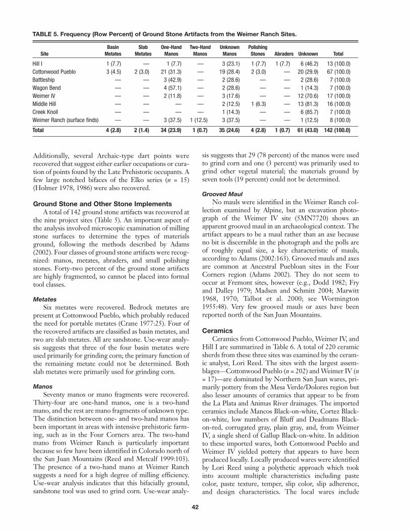
Ground Stone and Other Stone ImplementsA total of 142 ground stone artifacts was recovered at
the nine project sites (Table 5). An important aspect ofthe analysis involved microscopic examination of millingstone surfaces to determine the types of materialsground, following the methods described by Adams(2002). Four classes of ground stone artifacts were recog-nized: manos, metates, abraders, and small polishingstones. Forty-two percent of the ground stone artifactsare highly fragmented, so cannot be placed into formaltool classes.
MetatesSix metates were recovered. Bedrock metates are
present at Cottonwood Pueblo, which probably reducedthe need for portable metates (Crane 1977:25). Four ofthe recovered artifacts are classified as basin metates, andtwo are slab metates. All are sandstone. Use-wear analy-sis suggests that three of the four basin metates wereused primarily for grinding corn; the primary function ofthe remaining metate could not be determined. Bothslab metates were primarily used for grinding corn.
ManosSeventy manos or mano fragments were recovered.
Thirty-four are one-hand manos, one is a two-handmano, and the rest are mano fragments of unknown type.The distinction between one- and two-hand manos hasbeen important in areas with intensive prehistoric farm-ing, such as in the Four Corners area. The two-handmano from Weimer Ranch is particularly importantbecause so few have been identified in Colorado north ofthe San Juan Mountains (Reed and Metcalf 1999:103).The presence of a two-hand mano at Weimer Ranchsuggests a need for a high degree of milling efficiency.Use-wear analysis indicates that this bifacially ground,sandstone tool was used to grind corn. Use-wear analy-
sis suggests that 29 (78 percent) of the manos were usedto grind corn and one (3 percent) was primarily used togrind other vegetal material; the materials ground byseven tools (19 percent) could not be determined.
Grooved MaulNo mauls were identified in the Weimer Ranch col-
lection examined by Alpine, but an excavation photo-graph of the Weimer IV site (5MN7720) shows anapparent grooved maul in an archaeological context. Theartifact appears to be a maul rather than an axe becauseno bit is discernible in the photograph and the polls areof roughly equal size, a key characteristic of mauls,according to Adams (2002:163). Grooved mauls and axesare common at Ancestral Puebloan sites in the FourCorners region (Adams 2002). They do not seem tooccur at Fremont sites, however (e.g., Dodd 1982; Fryand Dalley 1979; Madsen and Schmitt 2004; Marwitt1968, 1970; Talbot et al. 2000; see Wormington1955:48). Very few grooved mauls or axes have beenreported north of the San Juan Mountains.
CeramicsCeramics from Cottonwood Pueblo, Weimer IV, and
Hill I are summarized in Table 6. A total of 220 ceramicsherds from these three sites was examined by the ceram-ic analyst, Lori Reed. The sites with the largest assem-blages—Cottonwood Pueblo (n = 202) andWeimer IV (n= 17)—are dominated by Northern San Juan wares, pri-marily pottery from the Mesa Verde/Dolores region butalso lesser amounts of ceramics that appear to be fromthe La Plata and Animas River drainages. The importedceramics include Mancos Black-on-white, Cortez Black-on-white, low numbers of Bluff and Deadmans Black-on-red, corrugated gray, plain gray, and, from WeimerIV, a single sherd of Gallup Black-on-white. In additionto these imported wares, both Cottonwood Pueblo andWeimer IV yielded pottery that appears to have beenproduced locally. Locally produced wares were identifiedby Lori Reed using a polythetic approach which tookinto account multiple characteristics including pastecolor, paste texture, temper, slip color, slip adherence,and design characteristics. The local wares include
TABLE 5. Frequency (Row Percent) of Ground Stone Artifacts from the Weimer Ranch Sites.
Basin Slab One-Hand Two-Hand Unknown PolishingSite Metates Metates Manos Manos Manos Stones Abraders Unknown Total
Hill I 1 (7.7) — 1 (7.7) — 3 (23.1) 1 (7.7) 1 (7.7) 6 (46.2) 13 (100.0)Cottonwood Pueblo 3 (4.5) 2 (3.0) 21 (31.3) — 19 (28.4) 2 (3.0) — 20 (29.9) 67 (100.0)Battleship — — 3 (42.9) — 2 (28.6) — — 2 (28.6) 7 (100.0)Wagon Bend — — 4 (57.1) — 2 (28.6) — — 1 (14.3) 7 (100.0)Weimer IV — — 2 (11.8) — 3 (17.6) — — 12 (70.6) 17 (100.0)Middle Hill — — — — 2 (12.5) 1 (6.3) — 13 (81.3) 16 (100.0)Creek Knoll — — — — 1 (14.3) — — 6 (85.7) 7 (100.0)Weimer Ranch (surface finds) — — 3 (37.5) 1 (12.5) 3 (37.5) — — 1 (12.5) 8 (100.0)
Total 4 (2.8) 2 (1.4) 34 (23.9) 1 (0.7) 35 (24.6) 4 (2.8) 1 (0.7) 61 (43.0) 142 (100.0)

43
(5MN654) is estimated at A.D. 988 to 1055 (L. Reed2006). The small quantities of ceramic types affiliatedwith the period A.D. 750–900 (e.g., Bluff Black-on-redrecovered from Cottonwood Pueblo) probably representcurated pots.
Six sherds of Uncompahgre Brown ware pottery wereidentified, four fromHouse 3 at Cottonwood Pueblo andtwo from Unit 1 at Weimer IV. The sherds fromCottonwood Pueblo are plain brown wares. TheWeimerIV sherds, in contrast, are micaceous and fingernail-impressed. In both cases, the brown ware sherds wereinterpreted as representing instances of Utes camping onthe abandoned ruins. Stiger (1998:14), however, has sug-gested that the Uncompahgre Brown wares from theWeimer Ranch sites were contemporary with the mainoccupation and may actually represent a Pueblo II pot-tery type. Lacking more detailed provenience informa-tion, it is impossible to assess whether the brown waresherds were recovered from contexts suggesting associa-tion with the main occupation during the tenth andeleventh centuries. No known Fremont wares were iden-tified in this collection.
A number of sherds are missing from the ceramicassemblage, based on Crane’s inventory of the sherdsfrom each site (Crane 1977, 1978). For example, Crane(1977, 1978) lists 43 sherds from Hill I, 6 from WagonBend, and 13 from Creek Knoll, but the MSC collectioncontains only one ceramic sherd from Hill I and nosherds from Wagon Bend or Creek Knoll. Additionally,Crane (1977:52) lists 74 sherds from Weimer IV, where-as only 17 were present in the collection analyzed by LoriReed.
The data resulting from the reanalysis of theWeimerRanch ceramic artifacts represent an important contribu-tion of the project. Lori Reed’s full ceramic report isincluded as Appendix A in the Weimer Ranch technicalreport (Greubel et al. 2006). Interested readers shouldconsult this report for a more detailed discussion of theissues associated with ceramics.
Beads, Ornaments, and Miscellaneous ArtifactsA variety of beads, ornaments, and miscellaneous
artifacts was recovered from the Weimer Ranch sites.The beads are described briefly below. For a full descrip-tion of the ornaments and miscellaneous artifacts seeGreubel et al. (2006).
BeadsForty-eight beads were recovered from Cottonwood
Pueblo and Weimer IV of the Weimer Ranch site com-plex. Forty-two are discoidal or disk-shaped with flat-sided faces; the remaining six are tubular. The tubularand discoidal beads are crafted from a variety of materi-als, including shale, jet, bone, and wood.With the excep-tion of a single wood bead, all of the tubular beads werecrafted frommammal or bird long bones, using a methodfrequently referred to as the groove-and-snap technique,in which the long bone shaft was scored or grooved and
TABLE 6. Ceramics Recovered from Three WeimerRanch Sites.
Tradition Ware Ceramic Type Count
Weimer local
Brown Plain brown 7Polished brown 2
Gray Narrow Neck-banded 2Indeterminate gray rim 2Corrugated gray 25Tooled gray 1Plain gray 25Polished gray 3Clay coil 2
White Cortez style black-on-white 8Mancos style black-on-white 1Pueblo II style black-on-white 5Painted black-on-white 4Slipped white 17
Northern San JuanGray Mancos Gray 1
Corrugated gray 15Indeterminate gray rim 1Plain gray 11Polished gray 4
White Cortez Black-on-white 9Mancos Black-on-white 20Pueblo I/II black-on-white 2Pueblo II style black-on-white 5Painted black-on-white 4Slipped white 13
Red Bluff Black-on-red 7Indeterminate San Juan Red Ware 2Deadmans Black-on-red 1
IndeterminateGray Plain gray 1
Polished gray 2Too small for analysis 1
White Painted black-on-white 1Slipped white 1
CibolaWhite Gallup Black-on-white 1
UncompahgreBrown Uncompahgre Brown 6
Not AnalyzedN/A Too small to analyze 8
Total 220
slipped white ware; “local Cortez-style,” “local Mancos-style,” and “Pueblo II-style” black-on-white; corrugatedgray; and plain gray. The single sherd from Hill I wasclassified as local polished gray ware. Based on theimported wares, the ceramics suggest a general period ofoccupation between A.D. 900 and 1150. More specifical-ly, the ceramics from Weimer IV (5MN7720) datebetween A.D. 1000 and 1075 and the mean date range ofthe ceramic assemblage from Cottonwood Pueblo

44
then snapped into segments of the desired bead length(Metcalf et al. 1993; Schmitt 1990:117–119; Talbot andRichens 1996:89–92). This manufacturing technique isevident at contemporaneous Ancestral Puebloan siteswithin Mesa Verde and Chaco Canyon, as well asFremont sites (Elston and Budy 1990; Jennings1980:97–103; Marwitt 1970:104–105; Talbot and
Richens 1996:89–92). Representative beads from thisassemblage are shown in Figure 13.
Miscellaneous ArtifactsFIRED CLAY ITEM
A burned or fired piece of gray clay with impressionsof seven corn kernels was recovered from Weimer IV.Two rows of kernels are imprinted within the clay speci-men, which has a length of 13.8 mm, a width of 13.3 mm,and a thickness of 6.1 mm.
SMALL SPHERICAL STONESNineteen natural concretions and one small sand-
stone pebble were recovered. All are small, averaging13.3 mm in diameter. The spherical concretions consistof sandstone that has been cemented with iron-rich min-erals, such as hematite and goethite. Petit (2005:74)asserts that the Hopi believe that similar items were“playthings for the spirits of their ancestors.” Kidder(1932:66) suggests that sandstone balls from the PecosRuin in New Mexico that are slightly larger than theWeimer Ranch specimens may have had esthetic or cer-emonial attraction.
Modified Bone ArtifactsThe project’s bone artifacts were identified by Patrick
M. Lubinski of Central Washington University. Sixtyworked bone artifacts were identified. The bone artifactsinclude 18 awls, seven modified artiodactyl phalanxes,eight punches or flakers, one gaming piece, two frag-ments of a notched scapula, one bone bead, one rodenttooth chisel, and 22 unclassified worked bone fragments.
Of particular interest are seven modified artiodactylphalanxes recovered at three sites at Weimer Ranch(Figure 14). All consist of the first phalanx of a deer,sheep, or pronghorn. The distal ends of the phalanxeshave been cut at right angles to the bones’ longitudinalaxes with a stone tool and ground to expose the hollowbone interior. Although grinding is usually restricted tothe cut ends, several artifacts have grinding or polishingon other surfaces. The proximal epiphyses are unmodi-fied.
According to Patrick Lubinski, these bone artifactsare unusual and are of unknown function. Recently, threesimilar artifacts have been reported from the Scorpio site(42WS2434), a Late Prehistoric site in southwesternUtah (Eckman 2005:1726). These artifacts consisted offirst phalanges of artiodactyls; one had a hole in bothends, and two had single holes. The function of the arti-facts was not ascertained. Similar artifacts, however, arerare at other sites in the region.
Eight bone artifacts consist of antler (n = 6) or artio-dactyl long bone (n = 2) sections that have been carefullyshaped. The oblong artifacts are relatively flat on oppos-ing sites and have shaped, rounded ends. Some of theends exhibit damage. Dimensions of complete specimensrange from 46 to 51 mm in length, 13 to 14 mm in width,and 7 to 9 mm in thickness. Geib (2002) has recently
FIGURE 13. Beads from the Weimer Ranch sites. Top row: jetbeads; middle rows: shale beads; bottom row, bone beads(left and center) and wooden bead (right).
FIGURE 14. Modified artiodactyl phalanxes from the WeimerRanch sites. Seven of the artifacts are from three sitesdiscussed in this article, while three are from an unidentifiedprovenience at one of the Weimer Ranch sites.
45
identified sheep horn rods from Basketmaker II contextsin southeastern Utah as indirect percussion punches. Healso identifies similar, though smaller, antler rods as theworking ends of composite pressure flakers (Geib 2002).Bradley (1988, 2000:Figure 7) has reported flakers andpunches made of bone and antler from the Pueblo IIperiod Wallace Ruin in southwestern Colorado. Basedon Geib’s and Bradley’s identification of similar items aseither indirect percussion punches or pressure flakers, itis likely that the antler and bone tools recovered from theWeimer Ranch sites served the same function.
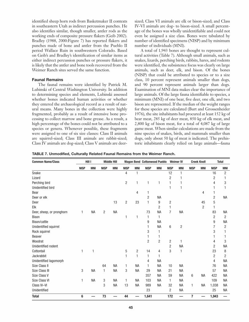
Faunal RemainsThe faunal remains were identified by Patrick M.
Lubinski of Central Washington University. In additionto determining species and elements, Lubinski assessedwhether bones indicated human activities or whetherthey entered the archaeological record as a result of nat-ural means. Many bones in the collection were highlyfragmented, probably as a result of intensive bone pro-cessing to collect marrow and bone grease. As a result, ahigh percentage of the bones could not be attributed to aspecies or genera. Whenever possible, these fragmentswere assigned to one of six size classes: Class II animalsare squirrel-sized; Class III animals are rabbit-sized;Class IV animals are dog-sized; Class V animals are deer-
sized; Class VI animals are elk or bison-sized; and ClassIV-VI animals are dog- to bison-sized. A small percent-age of the bones was wholly unidentifiable and could noteven be assigned a size class. Bones were tabulated bynumber of identified specimens (NISP) and by minimumnumber of individuals (MNI).
A total of 1,943 bones are thought to represent cul-tural activities (Table 7). Although small animals, such assnakes, lizards, perching birds, rabbits, hares, and rodentswere identified, the subsistence focus was clearly on largeanimals, such as deer, elk, and bison. Of the bones(NISP) that could be attributed to species or to a sizeclass, 10 percent represent animals smaller than dogs,and 90 percent represent animals larger than dogs.Examination of MNI data makes clear the importance oflarge animals. Of the large fauna identifiable to species, aminimum (MNI) of one bear, five deer, one elk, and twobison are represented. If the median of the weight rangesfor these species are calculated (Burt and Grossenheider1976), the site inhabitants had procured at least 152 kg ofbear meat, 285 kg of deer meat, 850 kg of elk meat, and2,800 kg of bison meat, for a total of 4,087 kg of largegame meat.When similar calculations are made from thenine species of snakes, birds, and mammals smaller thandogs, only about 50 kg of meat is indicated. The prehis-toric inhabitants clearly relied on large animals—fauna
TABLE 7. Unmodified, Culturally Related Faunal Remains from the Weimer Ranch.
Common Name/Class Hill I Middle Hill Wagon Bend Cottonwood Pueblo Weimer IV Creek Knoll Total
NISP MNI NISP MNI NISP MNI NISP MNI NISP MNI NISP MNI NISP MNI
Snake 4 1 12 1 16 2Lizard 2 1 2 1Perching bird 2 1 1 1 1 1 4 3Unidentified bird 1 1 1 1Bear 4 1 4 1Deer or elk 2 NA 2 NADeer 13 2 23 1 9 2 45 5Elk 2 1 2 1Deer, sheep, or pronghorn 1 NA 2 NA 73 NA 7 NA 83 NABison 1 1 1 1 2 2Bison/cattle 9 NA 9 NAUnidentified squirrel 1 NA 6 2 7 2Rock squirrel 3 1 3 1Beaver 1 1 1 1Woodrat 2 2 2 1 4 3Unidentified rodent 2 NA 2 NACottontail 1 1 5 2 14 4 3 1 23 8Jackrabbit 1 1 1 1 2 2Unidentified lagomorph 4 NA 4 NASize Class II 64 NA 1 NA 1 NA 10 NA 76 NASize Class III 3 NA 1 NA 3 NA 29 NA 21 NA 57 NASize Class V 357 NA 59 NA 6 NA 422 NASize Class VI 1 NA 3 NA 1 NA 103 NA 1 NA 109 NAClass IV–VI 3 NA 13 NA 989 NA 32 NA 1 NA 1,038 NAUnidentified 23 2 NA 25 NA
Total 6 — 73 — 44 — 1,641 172 — 7 — 1,943 —

46
that were highly ranked in terms of optimal foraging the-ory (Janetski 1997).
The prehistoric hunters of the Weimer Ranch sitesprocured large game animals muchmore prolifically thancontemporary Puebloan groups to the south. In a recentstudy of faunal remains excavated during the Trans-Colorado project, artiodactyls composed only 4 percentof the identified animal bones recovered from AncestralPuebloan sites (Reed et al. 2001). In contrast, artiodactylsmake up 66 percent of the identified faunal bones fromthe nine Weimer Ranch sites discussed in this paper.Even allowing for the apparent under-representation ofsmall animals in the assemblage because of possible col-lection bias or attrition of the collection, this is a veryhigh percentage.
The inhabitants of Weimer Ranch also appear tohave focused more intensively on big game hunting thandid the inhabitants of Fremont villages in eastern Utah.Janetski (1997) has compiled artiodactyl indices to meas-ure trends in big game use among the Fremont. Theindex is derived as the �artiodactyls/� (artiodactyls +lagomorphs) (Janetski 1997:1077). Larger values indicategreater dependence on artiodactyls (Janetski 1997:1077).Only three Fremont villages on the Colorado Plateauwere included in Janetski’s study. Snake Rock has anartiodactyl index of 0.592; Huntington Canyon has anindex of 0.206; and Round Spring has a value of 0.580.The Weimer Ranch faunal assemblage has an artiodactylindex of 0.774, highest of all.
Two of the Weimer Ranch sites discussed in this arti-cle, Cottonwood Pueblo and Weimer IV, had relativelylarge faunal assemblages, from which bones indicative ofthe season of animal mortality were identified. Twenty-four bones were recovered at Cottonwood Pueblo thatcan be used to estimate season of occupation; all werefrom sub-juvenile (fetal or neonatal) mammals. Of those,20 represent one or more unidentified deer-sized ani-mals; two may be from a near-term fetal bison; one is asub-juvenile rabbit; and one is a sub-juvenile rock squir-rel. Bison calve between mid-April and May; mule deergive birth between April and June; and rabbits and rocksquirrels have litters over the spring and summer. TheWeimer IV site also yielded a possible neonatal rabbitbone, again suggesting spring or summer mortality. Thepresence of fetal and neonatal animal bones at the threeWeimer Ranch sites clearly establishes human occupa-tion the Cottonwood Creek area in the spring and sum-mer. The faunal evidence for spring and summeroccupation does not, of course, preclude occupation dur-ing other times of the year.
Macrobotanical RemainsMacrobotanical samples in the Weimer Ranch
Collection provide insight into patterns of plant use. Thesamples, analyzed by Tony Hoag, were from Hill I,Middle Hill, Wagon Bend, the western half of House 3at Cottonwood Pueblo, and Weimer IV (Hoag 2006).Previously, Cathy Crane processed five macrobotanical
samples from Cottonwood Pueblo (n = 2), Middle Hill,Wagon Bend, and Weimer IV (Crane 1977). The resultsof Crane’s analysis are herein integrated.
Samples from Weimer IV and Middle Hill yieldedsmall quantities of charred juniper berries and pinecones, which probably represent fuel, rather than food-stuffs. Crane’s samples also yielded pinyon and juniperplant parts, also suggesting use of these trees for fuel.Crane also reports, however, charred pinyon nut frag-ments, which she interprets as evidence for consumptionof pinyon nuts (Crane 1977:32). Other possible wildfoods identified by Crane include acorn, Cheno-Amseeds, prickly pear, and mutton grass seeds.
Corn (Zea maize) was identified in the samples fromCottonwood Pueblo and Hill I. All are fragments ofcorncobs. Corncob fragments and cupules were alsorecovered in macrobotanical samples processed by Crane(1977) from Cottonwood Pueblo and Weimer IV.Additionally, Crane reports that maize cobs were recov-ered by MSC excavators at Hill I, Middle Hill, WagonBend, and Cottonwood Pueblo. Overall, corn has beenidentified from at least five of the nine Weimer Ranchsites and in six of the 15 macrobotanical samplesprocessed from the sites. It is inferred from these datathat corn was probably an important source of food dur-ing these occupations.
Radiocarbon DatingPrior to Alpine’s reanalysis of the Weimer Ranch
materials, only four radiocarbon dates had been obtainedfrom the Weimer Ranch sites. The dates are reported inCrane (1977, 1978:Table 1) and McMahon (2000:Table1), and are also shown in Table 8. They include two woodcharcoal dates, one date on human bone, and one maizedate (Crane 1977; McMahon 2000:Table 1). The twodates on wood charcoal are of limited value. The datefrom Hill I has an extremely large standard error, result-ing in a 2-sigma calibrated age range spanning over 1,000years. The date fromWagon Bend is very early and con-tradicts a newly obtained AMS date on maize from thesame site. Both probably represent the use of old woodfor hearth fuel (Reed and Metcalf 1999; Schiffer 1987;Smiley 1985). The skeletal date is problematic for at leasttwo reasons. First, it calibrates to A.D. 1030–1270 at twosigma, which seems rather late in view of many of theceramics and the newly obtained, more reliable AMSdates on maize. Second, the relationship of the burial tothe structural sites is far from clear given the availabledocumentation. Despite these shortcomings, however,the lower end of its calibrated calendrical range is consis-tent with the estimated date range reflected by theceramic assemblage. Finally, the radiocarbon date onmaize from Cottonwood Pueblo also seems somewhatlate compared to the other maize dates from the site, butit, too, overlaps with the date range based on the ceram-ics and may be accurate on its lower end.
As part of Alpine’s analysis, 10 carbon samples fromsix Weimer Ranch sites were submitted for radiometric

47
and AMS assay. Five samples were maize and five werewood charcoal. All of the maize samples were analyzed bythe AMS method. All but one of the wood charcoal sam-ples were analyzed by conventional radiometric method.The results of the radiocarbon assays are presented inTable 9.
The maize dates from theWeimer Ranch sites appearto encompass similar calendrical age ranges, with theexception of Hill I, which produced a slightly earlier date.The maize dates were tested for contemporaneity andfound to be statistically the same (� = 0.05) at the 95 per-cent level (t = 4.58). Their pooled mean radiocarbon age,calculated using the Calib Rev 5.0.1 software program, is1084 ± 18, which yields calibrated calendrical age rangesof A.D. 900–920 and 940–1010, with associated proba-bilities of 0.31 and 0.69, respectively. The pooled agerange of the maize AMS dates accords well with the ear-lier half of the general date range of A.D. 900–1150derived from the combined ceramic assemblage and sub-stantially overlaps the tighter estimated mean date rangeof the Cottonwood Pueblo ceramic assemblage, which isA.D. 988–1055. The maize dates suggest that five of theprincipal Weimer Ranch sites—Cottonwood Pueblo,
Wagon Bend, Hill I, Middle Hill, andWeimer IV—wereall occupied contemporaneously or within a relativelyshort period of time. This is a significant finding and adeparture fromCrane’s original interpretation, based pri-marily on radiocarbon dates obtained on charcoal fromhearth fuel and secondarily on ceramics, that some sites(Wagon Bend, Hill I) substantially predated others.
The wood charcoal dates are problematic. Three ofthe dates—from Creek Knoll, Weimer IV, and a prove-nience called West Rim II at Cottonwood Pueblo—appear to be one to three centuries older than the maizedates. Reed and Metcalf (1999:151) have suggested thatmuch of the available dead fuel wood on the landscapecan be expected to be up to 300 years old. Therefore, thethree wood charcoal dates from the sites noted abovelikely represent the use of dead wood for hearth fuel(Schiffer 1987; Smiley 1985). It is also possible that thedated material consisted of the carbonized remains ofstructural timbers, which may have been dead when usedfor construction and which also may have produced thedated samples from branch or trunk interiors, resultingin cross-section effect (Smiley 1985). In either case (i.e.,whether they are hearth fuel or structural wood), the
TABLE 8. Original Radiocarbon Dates Obtained from the Weimer Ranch Sites in the 1970s.1
Laboratory Material Radiocarbon Standard Calibrated Age Range AssociatedNumber Site Dated Age (B.P.) Error at 2 Sigma Probability
UGa-1132 Hill I Wood charcoal 1190 355 A.D. 90–110 0.004A.D. 120–1430 0.996
UGa-1375 Wagon Bend Wood charcoal 1370 65 A.D. 550–780 0.996A.D. 790–800 0.004
UGa-1274 Battleship Human Bone 870 70 A.D. 1030–1270 1.0UGa-1379 Cottonwood Pueblo Maize 905 65 A.D. 1020–1250 1.0
1 From Crane 1977, 1978:Table 1 and McMahon 2000:Table 1.
TABLE 9. Radiocarbon Dates Obtained During Alpine’s Analysis of the Weimer Ranch Materials.
Calibrated AgeLaboratory Sample Material Radiocarbon Standard 13C/12C Range at Associated
Number Number Site Context Dated Age (B.P.) Error Ratio 2 Sigma Probability
Beta-205227 Rim-1 Cottonwood Pueblo Hearth Wood charcoal 850 50 -21.2 A.D. 1040–1270 1.0(radiometric)
Beta-205835 R2-1 Cottonwood Pueblo Unknown Maize (AMS) 1050 40 -9.9 A.D. 900–1030 1.0
Beta-205224 WR2-1 Cottonwood Pueblo “Floor” Wood charcoal 1320 90 -22.2 A.D. 570–900 1.0(radiometric)
Beta-205836 H-1 Hill I “Unit 1” Maize (AMS) 1140 40 -11.3 A.D. 790–990 1.0
Beta-205834 WB-1 Wagon Bend “Unit 1, below Maize (AMS) 1120 40 -11.6 A.D. 810–850 0.07the rock” A.D. 860–1010 0.92
Beta-205837 MH-1 Middle Hill “Unit 1, soil Maize (AMS) 1050 40 -10.5 A.D. 900–1030 1.0beneath rocks”
Beta-205225 W4-1 Weimer IV “Unit 1, surface” Wood charcoal 1980 60 -23.5 110 B.C.–A.D. 130 1.0(radiometric)
Beta-205226 W4-2 Weimer IV “Unit 2, fire pit” Wood charcoal 1290 80 -21.5 A.D. 620–900 1.0(radiometric)
Beta-205833 W4-3 Weimer IV “Unit 3” Maize (AMS) 1060 40 -11.6 A.D. 900–1030 1.0
Beta-205229 CK-1 Creek Knoll Unknown Probable wood 1260 40 -20.9 A.D. 670–880 1.0charcoal (AMS)

48
dates overestimate the true period of occupation at theWeimer Ranch sites. Thus, where wood charcoal datesare not consistent with maize dates, they are rejected.One wood charcoal date (Beta-205227), from a prove-nience called Rim at Cottonwood Pueblo, seems slightlytoo late to be accurate when compared to the maizedates. However, it is not entirely inconsistent with theceramic data, so it may overlap the actual period of occu-pation at its lower end. Finally, one wood charcoal date(Beta-205225) is so early that it may represent a mucholder (early Late Prehistoric or Terminal Archaic) occu-pation at the site.
ARCHITECTUREMore than any other area of technology, the mason-
ry architecture of the Weimer Ranch sites and similarLate Prehistoric sites in the region (e.g., TabeguachePueblo) has been the subject of considerable discussionand the basis of comparisons with the Puebloan andFremont cultures (e.g., Crane 1977; Hurst 1948a;Huscher and Huscher 1943; McMahon 2000; McMahonand Bedingfield 2001; Reed 1997; Reed and Metcalf1999; Schroeder 1964). Whereas theWeimer Ranch col-lections have yielded new information relevant to datacategories such as lithics, ceramics, and faunal remains,they shed no additional light on architecture, at least notdirectly. Therefore, it seems appropriate to recapitulatesome of the discussions and thoughts of the researcherswho have considered this topic in the past, followed by abrief discussion of the Weimer architecture.
Hurst (1948a:6) described Cottonwood Pueblo asconsisting of “four houses with connecting walls enclos-ing a quadrangle.” Construction details are sparse. Theplan map shows excavated House 4 as a small, rectangu-lar room block (Hurst 1948a:Plate I). Hurst noted thatthe walls were composed of irregular stone masonry withpoor-quality mud mortar, 26 to 35 inches (66–89 cm)thick at the base and an estimated maximum of 4 feet (1.2m) high prior to their collapse (Hurst 1948a:7). Hebelieved that the floor of the room block had been exca-vated down 1 ft (30 cm) below the “original ground level”(Hurst 1948a:7). He speculated that the roof had beenconstructed of “light poles, brush, and ordinary soil”which had burned, based on the quantities of charcoaland ash found inside the structure (Hurst 1948a:7). Noneof the rooms had formal hearths, but concentrations ofburned material suggested informal hearths in threerooms. As for the cultural affiliation of the site, Hurstimplied that it was “peripheral Pueblo I–II” based on theceramics (Hurst 1948a:11).
Crane (1977) noted both similarities and obviousdifferences between the masonry structures at WeimerRanch and those found in adjoining Ancestral Puebloanand Fremont culture areas. She concludes that thesimilarities were the “result of diffusion and techno-environmental factors” (Crane 1977:101). The WeimerRanch structures were summarized as “small, singlerooms” built of unshaped sandstone blocks, with no dis-
cernable doorways and no definite postholes (Crane1977:2). Roofs were thought to have been made of“juniper timbers covered over by adobe or mud” (Crane1977:4). Interior hearths were large, unlined, and rim-less and associated middens were small (Crane 1977:4).
Reed (1997; Reed and Metcalf 1999) has comparedthe architecture of Weimer Ranch and other Gatewaytradition sites to Pueblo II period architecture. He notesthat pithouses and contiguous rectangular rooms, thoughpresent in small numbers, are uncommon, while kivas arealtogether absent from Gateway tradition sites (Reed1997:22). Arguing against Ancestral Puebloan culturalaffiliation for these sites, he noted that the layout ofstructures is atypical of Anasazi sites (Reed and Metcalf1999:107). He finds a greater similarity betweenFremont and Gateway structures, but points out thatthere is little or no supporting evidence—such as ceram-ics and other diagnostic artifacts—that the west-centralColorado structural sites are affiliated with the Fremont(Reed and Metcalf 1999:132).
McMahon, in his review of the structural sites of theParadox Valley, has sought to explain diachronic changesin architecture by reference to mobility and subsistencesystems. He proposed a model of architectural develop-ment in which the oldest occupations are characterizedby the few pithouses present in the region, followed bycircular surface masonry habitations, and finally by con-tiguous rectangular masonry rooms (McMahon2000:14–18). Though specifically formulated for theParadox Valley, McMahon includes the Weimer Ranchand Tabeguache Pueblo sites in the scheme (McMahon2000:14–17). The model intentionally resembles theBasketmaker-to-Pueblo architectural sequence, thoughno relationship to Puebloans is implied. As in thePuebloan model, McMahon’s proposed changes in domi-ciliary architecture are tied to decreasing mobility(increased sedentism), greater reliance on horticulture,and increases in social integration and populationthrough time (McMahon 2000:16–17).
While McMahon’s model has merit, it may be con-structed upon inaccurate data. In most cases, the sitesincorporated into the model are not tightly and securelydated, thereby calling into question the chronologicalassumptions underpinning the model. Kasper’s (1977)work with the faunal material from the Paradox 1 sitenotwithstanding, subsistence data from these sites aresketchy and artifact assemblages have not usually beenthoroughly analyzed and reported. In short, for all itspositive qualities, the model is not supported by the newchronometric, ceramic, and subsistence data from theWeimer Ranch sites.
Indeed, some of the newly acquired data from theWeimer Ranch sites seem to directly contradictMcMahon’s proposed diachronic changes in architec-ture. Based primarily upon radiocarbon dates, Crane(1977) regarded several of the isolated and circular orovate structures as representing earlier occupations thanCottonwood Pueblo with its rectangular rooms. Ceramic

49
data were also used to support these inferences. NewAMS dates on maize macrofossils, however, suggest thepossibility that all of theWeimer sites and structures rep-resent contemporaneous occupations. Moreover, analysisof the ceramics tends to support the radiocarbon data. Inlight of these data, the differences between the sites andstructures at Weimer Ranch may be related to socialorganization and possibly different functions rather thantime period. As a caveat to the above interpretations, itshould be noted that, in view of its slightly earlier AMSdate on maize, the possibility of an earlier occupation atHill I cannot be entirely ruled out. Unfortunately, mostof the ceramics originally recovered from the Hill I sitehave disappeared, precluding the possibility that the pot-tery might shed additional light on the chronology of thesite.
Figure 15 shows examples of typical Pueblo II andFremont masonry habitations in plan view. Like theWeimer Ranch structures, these particular examplesprobably represent single households or small extendedfamily habitations. As can be seen from this figure,masonry habitation structures in the region exhibit con-siderable variability. Rectangular masonry rooms are notas common as round or oval structures at Fremont sitesin eastern Utah; moreover, the San Rafael Fremont typ-
ically constructed with alternating courses of adobe andmasonry rather than dry-laid or mud-mortared masonry(Madsen 1975:24). Conversely, round and oval surfaceresidential rooms (not including towers) tend to be lesscommon than rectangular residential room in most areasinhabited by the Pueblo II period Ancestral Puebloans.Yet both types of structures (i.e., round/oval vs. rectangu-lar) are well represented at Weimer Ranch. The Weimerstructures, therefore, seem to share characteristics of thearchitecture of both neighboring cultural groups. Thismixture of architectural types is fairly unique comparedto the adjoining San Rafael Fremont and Four CornersAncestral Puebloan culture areas. It may reflect multiplecultural influences or it may be an indigenous develop-ment linked to a complex interplay of social organization,structure function, and localized limiting factors such astopography, geomorphology, and the availability or ubiq-uity of particular building materials.
The Weimer Ranch structures have been portrayedin the literature as stylistically and technologically infor-mal or even “crude” (Reed 1984:32), representing alower investment of labor compared to contemporane-ous Ancestral Puebloan habitations. The masonry is con-structed of highly variable, unshaped stones, dry-laid orbound with poor quality mortar. Structures are variablein plan, and the layouts of room blocks or house clustersare irregular and asymmetrical. On the other hand, thestructures typically incorporate impressive quantities ofstone, including some very large individual sandstoneblocks that would have been quite difficult to lift andmove into place. Cottonwood Pueblo exhibits a possiblecentral plaza enclosed by room blocks and a wall. In atleast three cases—House 4 of Cottonwood Pueblo, Unit1 at Weimer IV, and Middle Hill—the rooms wereapparently excavated to depths of 30–50 cm below theprehistoric ground surface (Crane 1977). Indeed, MiddleHill and Unit 1 at Weimer IV can probably be classifiedas shallow pithouses. Moreover, true pithouses may actu-ally be present at Weimer Ranch. The Last Hill site con-tains a depression associated with possible structuralstones that Alpine personnel speculated might representa pithouse, an assessment apparently shared by C. T.Hurst (1948a:6). Thus, while the investment of labor inthese structures was less than that evidenced on typicalPueblo II period Ancestral Puebloan habitation sites, itwas still very high.
CONTRIBUTIONS OF THE WEIMER RANCHCOLLECTION ANALYSIS PROJECT
As a result of this project, the Weimer Ranch materi-als constitute the most intensively studied collection ofGateway tradition artifacts and ecofacts to date. The datafrom these analyses have yielded timely new insights intothe chronology, lithic and ceramic technology, subsis-tence systems, and social organization of the occupants ofthis unique site complex. Crane’s (1977) preliminarymodel of settlement and subsistence seems to have been
Loper Ruin(Jennings 1978: Fig. 131)
5MT8943(Errickson 1993: Fig. 5.4)
5MT5498(Rohman et al. 2003: Fig. 12-41)
LA38528, Structure 1(Phippen and Silberberg 2001: Fig. 34-20)
Turner-Look(Wormington 1955: Fig 6)
42Cb770(Spangler et al. 1995:Fig. 3.23)
Gnat Haven(Jennings andSammons-Lohse 1981: Fig. 10)
Innocents Ridge(Schroedl and Hogan 1975: Fig. 4)
KIVAKIVA
KIVA
Pithouse
FIGURE 15. Simplified plan maps of representative Pueblo IIperiod Ancestral Puebloan (top) and San Rafael Fremont(bottom) masonry habitation structures.

50
confirmed in its major points and can now be understoodin greater depth. On the other hand, her interpretationof the time depth and duration of the Weimer Ranchoccupations no longer appears to be tenable.While thereare arguably no revelations, there are clearly a few sur-prising results.
ChronologyThe chronology of the occupations underpins all
else. Disregarding gross dating techniques such as pro-jectile point typologies, there are two classes of chrono-logical data that are useful for assessing the temporalpositions of the Weimer Ranch sites: typological classifi-cations of ceramic artifacts and radiocarbon dating. Bothmethods have their disadvantages when applied to thesesites. The main problem with ceramics is that a substan-tial portion of the Weimer Ranch assemblage as a wholehas simply disappeared. For example, Crane (1977, 1978)examined 43 sherds from Hill I, 6 from Wagon Bend,and 13 from Creek Knoll, but the MSC collection exam-ined by Lori Reed in 2005 contains only one sherd fromHill I and no sherds from Wagon Bend or Creek Knoll.Furthermore, Crane (1977:52) listed 74 sherds fromWeimer IV, but only 17 were present in the collectionanalyzed by Lori Reed. One possible solution to thisdilemma would be to rely on Crane’s original analysis—in which she was assisted by Bruce Burns—of the missingceramic materials. Crane and Burns were clearly compe-tent analysts who seem to have correctly classified mostof the ceramic artifacts into the appropriate typologicalcategories and identified the collection as, basically, aMesa Verde region assemblage largely dating to thePueblo II period (Crane 1977:46). It is unlikely, however,that either analyst possessed the same level of expertise asLori Reed, the ceramic specialist who examined theWeimer Ranch sherds in 2005. Moreover, typologicalstudies of Puebloan ceramics have advanced in the past30 years, an advantage for the more recent analyst. Forexample, the existence of a local ceramic tradition—amajor finding of Lori Reed’s 2005 analysis—may havebeen detected by Crane but was only casually mentionedwith reference to one particular ceramic type, MancosBlack-on-white (Crane 1977:50). Beyond the brief men-tion, the subject was not discussed in her thesis and itsimplications were not addressed.
One of the problematic aspects of the 1970s analysisis that Crane and Burns identified early ceramic types—for example, Chapin Gray, Chapin Black-on-white, andMoccasin Gray—that were not found in the 2005 analy-sis. These sherds are, apparently, among those that aremissing from the collection. If these identifications wereaccurate, they may constitute evidence for relatively early(i.e., pre-A.D. 900) occupations at Hill I, Wagon Bend,and Weimer IV, for which there is scant additional evi-dence currently available. Because these sherds are miss-ing, however, Crane and Burns’ original identificationscannot be independently verified. In view of Lori Reed’s
identification of locally manufactured variants of plaingray, neck-banded, corrugated, polished gray, and black-on-white ceramics that tend to be variable in terms ofpaste and temper and also more poorly made than theNorthern San Juan trade wares found at the sites, it isquite possible that the Chapin Gray, Moccasin Gray, andChapin Black-on-white sherds noted by Crane (1977:52)were actually misidentified local wares.
Based on the more reliable ceramic data resultingfrom Lori Reed’s 2005 analysis, therefore, the WeimerRanch ceramic assemblage indicates a general period ofoccupation between A.D. 900 and 1150. The time esti-mate can be further narrowed on a site-specific basis. Adate range of between A.D. 1000 and 1075 is estimatedfor Weimer IV (5MN7720), whereas the mean daterange of the ceramic assemblage from CottonwoodPueblo (5MN654) is estimated at A.D. 988 to 1055 (L.Reed 2006). The few sherds of Bluff Black-on-red areinterpreted as curated vessels and, in any case, this typemay have persisted until as late as A.D. 1000 and is notnecessarily an indication of an earlier occupation(Wilson and Blinman 1995:56).
As discussed earlier in this article, MSC processedfour radiocarbon dates (see Table 8), including two woodcharcoal dates, one date on human bone, and one date onmaize (Crane 1977; McMahon 2000:Table 1). To sum-marize the earlier discussion, one of the wood charcoaldates is essentially useless because its 2-sigma calibratedage range spans more than a millennium. The other isrejected because it conflicts with (i.e., is considerably ear-lier than) an AMS date on maize from the same site and,therefore, is interpreted as representing the use of oldwood as hearth fuel or, possibly, as structural timbers.The date on human skeletal material from the Battleshipsite may be accurate on the early end of its 2-sigma cali-brated age range, but because the context of the burialand its relationship with the other Weimer Ranch sites isnot understood, it is impossible to evaluate the signifi-cance of this date. Lastly, the radiocarbon date on maizefrom Cottonwood Pueblo seems late compared to therecently acquired maize dates from the site, but it over-laps with the estimated date range of the ceramic assem-blage and, like the human bone date, it may be accurateon its early end. The latter two dates are of limited use-fulness and, at any rate, have no bearing on any possibleearly occupation of the Weimer Ranch locale. It is possi-ble that the dates indicate relatively late occupationspost-dating A.D. 1150, but equally likely that they repre-sent terminal dates for the Weimer Ranch occupationsbetween A.D. 1020 and 1150.
The chronometric dates obtained during Alpine’sanalyses more than triple the number of radiocarbonassays from the Weimer Ranch sites. Five acceleratormass spectrometer (AMS) dates were obtained on maizemacrofossils from the Wagon Bend, Hill I, Middle Hill,Cottonwood Pueblo, and Weimer IV sites and five dates(four radiometric and one AMS) were obtained on wood

51
charcoal from Cottonwood Pueblo, Weimer IV, andCreek Knoll (see Table 9).
The newly obtained wood charcoal dates have beendiscussed. To summarize, three of the dates range fromone to three centuries older than the maize dates and,therefore, seem to reflect the use of local supplies of deadwood for hearth fuel (Reed and Metcalf 1999:151).Consequently, these radiocarbon dates are very likelyerroneous estimates of the true period of occupation atthe Weimer Ranch sites and are, accordingly, rejected.The calibrated calendrical range of one wood charcoaldate (Beta-205227) seems slightly too late to be accuratewhen compared to the maize dates. However, it is notentirely inconsistent with the ceramic data, so the earlypart of this range may encompass the actual period ofoccupation. Finally, one wood charcoal date (Beta-205225) is so early that it suggests a Terminal Archaic orearly Late Prehistoric occupation at the locale unrelatedto the post-A.D. 900 Puebloan occupation. In a discus-sion of the interpretation of radiocarbon data, Schiffer(1987:312) concludes that, because of the pervasivenessof the old wood problem, low numbers of dates on woodcharcoal originating from hearths cannot be dependedupon to yield accurate site chronologies. He advocatesinstead using dates on annual plants such as maize. Otherresearchers (e.g., Shott 1992) have echoed Schiffer’s rec-ommendation.
Collectively, the 2-sigma calibrated age ranges of theAMS dates on maize macrofossils suggest an occupationor series of occupations that took place between A.D. 790and 1030. The maize date from Hill I is somewhat earli-er than the other maize dates, though its calendricalrange—cal A.D. 790–990—overlaps the ranges of theother dates. These results indicate the possibility thatHill I was occupied earlier than the otherWeimer Ranchsites. Nevertheless, when tested for contemporaneity, allof the maize radiocarbon dates were found to be statisti-cally contemporaneous. When pooled, their mean radio-carbon age is 1084 ± 18 B.P. Pooling these statisticallycontemporaneous dates to derive a mean radiocarbon ageis appropriate because the dates are on similar materialsand were processed by the same laboratory (Shott1992:212). The pooled mean radiocarbon age yields acalibrated calendrical age range spanning the period A.D.900–1010. This age range spans the first half of the gen-eral time period inferred from the ceramics and overlapssubstantially with the estimated mean date range of theCottonwood Pueblo ceramic assemblage.
With regard to the AMS dates on maize from theWeimer Ranch sites, it is possible that each date repre-sents a distinct event (i.e., the harvest of a particularmaize plant at the end of a particular growing season)well separated in time from the others, with the dates asa group potentially distributed across a span of manyyears, consisting of decades to as long as two centuries.Alternatively, it is possible that all of the maize dates rep-resent events that took place at essentially the same timeor a series of events closely spaced in time. The method
typically employed to assess the probability that the datesrepresent coeval events is a statistical test of contempo-raneity. When this method is applied, as described above,to the five AMS dates on maize from the Weimer Ranchsites, they are found to be statistically contemporaneous.As Shott has observed:
Any series of dates—no matter how secure thecontext and how close the association of datedand target events . . . will be dispersed alongsome chronological range, which is apt to varypositively with the number of samples dated.The simple presentation of such results… failsto measure the central tendency of the seriesand to consider the possibility that all sampleshave the same or nearly the same true age.Therefore, the absolute range of results is notnecessarily an accurate or valid measure of thelength of time spanning the cultural eventsthat deposited the samples (Shott 1992:211).
With this in mind, we choose to view the statisticalcontemporaneity of the AMS dates on maize from fiveof the Weimer Ranch sites as evidence that the siteswere occupied either contemporaneously or over a rela-tively brief period of time best measured in decadesrather than centuries, during which we believe there is ahigh probability that multiple sites were occupied con-temporaneously.We favor this view because it is the mostparsimonious interpretation of both the ceramic andradiocarbon data. There is no compelling evidence forthe alternative interpretation that the sites were occupiedsequentially, with one being abandoned before the nextwas occupied, or that the simpler structures predate themore complex ones. Such an interpretation has been thebasis of previously offered models of diachronic changesin social organization and architecture at these and otherGateway tradition sites (Crane 1977, 1978; McMahon2000), models that must now be reevaluated in light ofthe newly obtained chronometric and ceramic data. Forexample, based largely on radiocarbon dates that we nowunderstand probably reflect an old wood bias, Craneasserted that the locale was occupied continuously forover 400 years, with the isolated circular and oval struc-tures predating the clustered houses of Weimer IV andthe rectangular room blocks at Cottonwood Pueblo(Crane 1977:43, 1978:8). These interpretations wereused to make inferences about possible changes in socialorganization through time, centered on posited popula-tion increase and greater integration as represented byhouse clustering (Crane 1978:7–9). As noted above, itnow appears that Crane’s hypothesis of a 400-year-longoccupation is not supported by either the ceramic orradiocarbon data. At the very least, the temporal scale ofthe diachronic model offered by Crane has been reducedby half.
With regard to the possibility of an occupation of theWeimer Ranch locale predating A.D. 900, the above dis-cussion of the ceramic and radiocarbon data demon-strates how the evidence for such an occupation largely

52
evaporates upon close inspection. To summarize, most ofthe evidence for an early occupation consists of:• a ceramic study conducted 30 years ago by analysts
who were largely unaware of the existence and impli-cations of a local ceramic tradition and whose resultscannot be verified because many of the ceramic arti-facts they studied are now missing,
• four radiocarbon dates on wood charcoal that proba-bly reflect the use of old wood for hearth fuel, and
• an AMS date on maize from the Hill I site that issomewhat earlier than the maize dates from four othersites that postdate A.D. 900, but—based on statisticaltesting—could just as easily be contemporaneous withthem.Thus, while the possibility that the Weimer Ranch
locale was settled prior to A.D. 900 cannot be complete-ly ruled out, the evidence for such an occupation is notconvincing and currently available data suggest that suchearly settlement did not occur. Nevertheless, in view ofthe imperfect dataset—e.g., the loss of a portion of theceramic assemblage, the lack of radiocarbon dates onmaize or other annual plants from four of the nineWeimer Ranch sites, and sparse information about thecontexts of the dated samples—we acknowledge that ourinterpretation of the chronology of the Weimer Ranchsites as presented above may not be accurate in everyrespect and, of course, is subject to refinement or revisionwith the discovery of new information.
Lithic TechnologyThe Weimer Ranch debitage analysis indicates that,
although core reduction was an important component ofthe stone tool economy, biface technology was dominant.Much has been made of the usefulness of flaked lithicdata as a relative means of measuring group mobility.Studies have suggested links between bifacial technologyand high residential mobility on the one hand, and flakecore technology and sedentism on the other (e.g., Kelly1988; Nelson 1994; Parry and Kelly 1987; Torres 2000).There is compelling archaeological evidence that highlymobile Archaic and Protohistoric hunter-gatherers in theregion relied largely on bifaces for their flaked stone toolneeds (e.g., Greubel et al. 2003; Reed et al. 2001). Thereis equally good evidence that relatively sedentary horti-culturists relied heavily on expedient tools derived fromflake cores (e.g., Firor et al. 1998:124–126, 223; Parryand Kelly 1987; Reed et al. 2001:42–44; Sullivan andRozen 1985; Torres 2000). The reasoning is simple:mobile people need tools that are compact and portable;bifaces fulfill this need because they are simultaneouslymaintainable tools and reducible cores (Kelly 1988).Sedentary groups, in contrast, do not have the sametransport constraints on lithic materials and do notrequire tools to be portable. Their tool needs are betterserved by keeping large cores on hand and striking flakesfrom them when needed (Parry and Kelly 1987; Torres2000). A relationship between lithic technology andmobility has been demonstrated time and again, though
exceptions are sometimes found. One such exceptioninvolves the presence of locally abundant lithic raw mate-rial, which may have induced prehistoric tool makers touse more expedient flake tools because the transportcosts of the material were low (Andrefsky 1994, 1998).
The use of bifaces may also be related to factors otherthan mobility. Bifaces, because they are reliable andmaintainable, are better suited for hunting and faunalprocessing tasks than expedient tools. Bifacial tools areinherently more reliable than expedient tools becausethey are designed to perform predictably, among otherreasons (Bleed 1986). Reliability is important becausehunting is a subsistence endeavor that carries a high riskof failure; reliable hunting gear decreases the chance ofhunting failure occurring as a result of equipment mal-function or substandard performance. Maintainability isimportant because an individual can carry only a limitedamount of gear on a hunting trip, the lithic componentsof which will likely need to be resharpened or reworkeddue to breakage at some point. It has also been recentlyargued that the use of specialized formal tools such ashafted bifaces and scrapers increased as a response tochanges in resource processing patterns; namely, anintensification of faunal procurement and processing(Tomka 2001). Thus, a lithic assemblage dominated bydebitage indicating biface production and containingnumerous projectile points and other bifacial implementsmay reflect a heavy emphasis on hunting and faunal pro-cessing.
The evidence for bifacial technology at the WeimerRanch sites, therefore, may reflect both a high degree oflogistical mobility and a focus on hunting. This interpre-tation would seem to run counter to the evidence for asedentary lifeway as demonstrated by the expedient flaketools, the investment in durable architecture, and maizehorticulture. These seemingly contradictory lines of evi-dence likely reflect a bipartite subsistence system where-in both farming and seasonal hunting and gathering werecritical to survival.
Ceramic TechnologyAnalysis of the ceramic collection from the Weimer
Ranch sites revealed evidence for local ceramic produc-tion as represented by 111 sherds. The locally producedassemblage consists of slipped white ware, “local Cortez-style” and “Pueblo II-style” black-on-white, corrugatedgray, plain gray, and polished gray ware (Table 6).According to ceramic analyst Lori Reed, the local waresare similar to Northern San Juan ceramics in terms ofpainted designs, construction technique, and slip applica-tion, but were distinguished from them on the basis ofpaste color, paste texture, tempering material, and slipcolor and adherence (L. Reed 2006). She summarized thedifferences as follows:
The ceramic paste of the local Weimer potterywas primarily a brownish color and had a soft,friable texture, contrasting with the grayer andharder paste of the Northern San Juan pottery.
53
The slips on the local white ware also had abrownish tint and were softer in most casesthan those on the nonlocal pottery. Thesecharacteristics suggest that the local potterymay have been fired at lower temperaturesthan the Northern San Juan ceramics.Material used to temper the local Weimer pot-tery was highly variable, including abundantquartz sand, some chalcedony, angular orcrushed granitic rock, and some crushedsherd. Biotite mica was also abundant in manyof the local sherds and may have been natural-ly occurring in the clay, as part of the sandsource, or as a residual from the crushedgranitic rock (L. Reed 2006:34).
Reed (2006:36) notes that the local Weimer Ranchpottery exhibits “great influence from the Northern SanJuan Anasazi region and culture.” The Cortez- andMancos-style designs were executed with mineral pig-ments, similar to Northern San Juan wares. In terms ofvessel forms, greater variability is seen in the local waresversus the nonlocal ceramics. This variability is mostlyseen in the local brown ware pottery, examples of whichincluded effigy fragments, pinch pots, and pipe frag-ments (L. Reed 2006:34).
To our knowledge, the Weimer Ranch collectionrepresents the first sizeable ceramic assemblage excavat-ed from a Gateway tradition site subjected to rigorousexamination and well reported by an expert analyst. Theresults of the study suggest several possible avenues forfuture research, including petrographic and INAA analy-ses of a large sample of locally produced ceramics fromregional Gateway sites (L. Reed 2006).
Social OrganizationThe possible contemporaneity of all house types and
sites at the Weimer Ranch implies greater complexity insocial organization than some past researchers have sus-pected. Rather than a loose collection of “small, inde-pendent households” (Crane 1977:44), of which only afew were occupied at any given time, we believe that thecluster of sites making up theWeimer Ranch locale func-tioned as a local residential community (sensu Varien andPotter 2008:5; see also Varien 1999:4), albeit a small one.It has been noted that no kivas are present at theWeimerRanch sites, nor are any known to exist at other Gatewaytradition sites (McMahon 1997, 2000:18; Reed 1984,1999). Yet, it is possible that other types of structures orarchitectural features, such as the plaza at CottonwoodPueblo, may have functioned to integrate households andindividuals (Greubel 2006; Kenzle 1997; Reed andMetcalf 1999:140). It is also possible that integrativestructures are present but have not yet been identified.
Food storage strategies may reveal aspects of inter-household integration and economic organization. Onlyone possible storage feature was found during MSC’sinvestigations, an undescribed feature on the northeastside of the habitation structure at the Wagon Bend site
that has since been destroyed (Crane 1977). One of therooms of House 4 at Cottonwood Pueblo may have func-tioned for storage, according to Hurst (1948a:7). DuringAlpine’s 2005 field visit, several circular masonry featureswere observed at Cottonwood Pueblo (n = 4) andWeimer IV (n = 2) that appear too small to be habitationstructures. These features were also observed andremarked upon by McMahon and Bedingfield in 2001.The features may have functioned as storage units. Theyare situated adjacent to habitation structures, in somecases almost centrally, with individual features spatiallylinked to particular structures or groups of structures.Their extramural locations and placement near houseclusters suggest that stored foods may have been sharedamong household clusters. This may reflect a societybased on extended families, aggregates of interrelatednuclear families, or some other kinship-based units.
Subsistence and Settlement PatternThe centerpiece of Crane’s thesis and Southwestern
Lore article on the Weimer Ranch sites was a “prelimi-nary model” of subsistence and settlement (Crane 1977,1978; see also Reed andMetcalf 1999:136–138 for a sum-mary). Briefly stated, the model assumes that the primaryhabitation sites at the Weimer Ranch locale were occu-pied year-round. Stored food—maize, grass and Cheno-Am seeds, pinyon nuts, dried meat—served as winterrations, supplemented with occasional fresh meatobtained through hunting mule deer and elk on theirlow-elevation winter ranges. Wild greens, cactus pads,hunting, and whatever remained of winter stores charac-terized springtime subsistence. Maize was planted late inthe spring, by which time early-ripening grass seeds mayhave been available. As summer progressed, more plantfoods became available and hunting of both large andsmall prey likely took place on a more-or-less continuousbasis. Late summer and fall brought ripening crops ofgoosefoot seeds, berries, pinyon nuts, and acorns. Themaize was harvested. Hunting parties pursued largegame in the higher elevations of the UncompahgrePlateau. Food was dried and stored away for winter, andthe cycle began again.
The newly acquired floral, faunal, and artifact datalargely support Crane’s model. The new subsistence data,combined with those originally reported in Crane’s(1977) thesis, reveal that the occupants of the WeimerRanch sites grew maize, collected edible wild and ruder-al plants and seeds, and hunted large and small game.The direct evidence for maize growing and consumptionconsists of maize cob fragments, cupules, and kernels,and use wear consistent with maize grinding on metatesand manos. There is no compelling reason to suspectthat the maize was not grown in Cottonwood Creekcanyon or dry-farmed on the mesa tops nearby. As recon-structed by Petersen (1988), the dry farming belt insouthwestern Colorado from A.D. 800–1000 lay approx-imately between 1,829–2,134 m (6,000–7,000 ft). The

54
Weimer Ranch sites are between 1,902–1,963 m(6,240–6,440 ft) in elevation, suggesting both adequaterainfall as well as a frost-free season of sufficient lengthfor corn to mature during this period.
In addition to maize, flotation samples taken frombedrock metates and floor surfaces near hearths (Crane1977:31) yielded evidence for the use of grass seeds, pin-yon nuts, juniper berries, acorns, cactus pads, and Cheno-Am seeds. The faunal assemblage produced abundantevidence of the procurement of small animals such asreptiles, small birds, rodents, rabbits, and hares, and espe-cially large game including deer, elk, bison, bighornsheep, and bear. Of the large game, deer are especiallywell represented. Comparison with faunal assemblagesfrom contemporaneous Puebloan sites suggests that theoccupants of Cottonwood Pueblo and the other WeimerRanch sites focused more intensively on artiodactyls thandid most Ancestral Pueblo peoples. Based on artiodactylindices (Janetski 1997), big game hunting among theWeimer Ranch horticulturists was apparently even moreimportant than it was to most Fremont groups.
While the new data mostly support Crane’s model,there are areas where the earlier model requires revision.For example, whereas Crane downplayed the importanceof maize to the occupants of the Weimer Ranch sites(Crane 1978:4), the presence of maize macrofossils at fiveof the Weimer Ranch sites in addition to indirect evi-dence such as use wear patterns on ground stone imple-ments suggests that maize may have been moreimportant than she asserted. There is also a greaterdiversity of large mammals represented in the sites’ fau-nal assemblages than Crane suspected—including bison,bighorn sheep, and bear in addition to deer and elk.Furthermore, Patrick Lubinski’s study of the faunalremains suggests that the bones of these larger animalswere heavily processed in order to extract within-bonenutrients (i.e., marrow and bone grease). These sub-stances may have provided important calories during thelean months of winter and early spring. In most otherrespects, however, Crane’s subsistence model is remark-ably consistent with the results of the detailed floral, fau-nal, and lithic analyses conducted during this study.
Both structural and nonstructural Gateway traditionsites have been documented in the region, some of whichlikely represent foraging or logistical use of the country-side by the occupants of the Weimer Ranch settlement.One such structural site—the Jeff Lick Stone Circles(5MN3462)—is located near the crest of theUncompahgre Plateau. It consists of four or five stonestructures at an elevation of 2,914 m (9,560 ft). Workconducted at the site by the Huschers (1943) suggests aLate Prehistoric affiliation, as small, corner-notchedarrow points were recovered (Huscher and Huscher1943:24). Recent testing at the site produced a woodcharcoal sample that yielded a radiocarbon date of 1465± 20 B.P., which is calibrated to A.D. 560–640 (twosigma) (Reed and Emslie 2008:35). While the date is
probably earlier than the period of occupation due to oldwood or cross-section effect, it confirms a post-Archaicaffiliation for the site. The structures are smaller thanmost of the habitations at Weimer Ranch, but they aresimilar in appearance and construction methods. The JeffLick site may represent a seasonal base for hunting andgathering of a group from the Weimer Ranch settlementor one of the other structural Gateway tradition sites inthe region. The Jeff Lick site is important for under-standing Gateway subsistence systems because it seemsto represent evidence for the intensive use of highlandenvironments by these groups. An example of a non-structural Gateway tradition site in the region is theFallen Deer site (5SM2578), on the southern end of theUncompahgre Plateau in San Miguel County. The siteyielded a small assemblage that included flake tools,bifaces, projectile points, ceramics, and animal bone(McDonald 1998). The ceramics included Mancos Gray,Mancos Corrugated, painted white ware, and plain andcorrugated gray wares (McDonald 1998:31). The faunalassemblage consisted of small quantities of identifiedbison and deer bones (n = 9), with the remainder (n = 86)classified mostly as large artiodactyl (McDonald1998:37–38). The Fallen Deer site likely reflects warmseason, logistical use of upland areas by the groups thatoccupied Weimer Ranch, Tabeguache Pueblo, the Para-dox Valley sites, and other structural, pottery-bearingsites in the region.
Overall, the data from the Weimer Ranch sites andother Gateway tradition sites in the region reflect a care-fully balanced subsistence system in which the risks ofgrowing maize were offset by a robust, seasonal, huntingand gathering regime. The strategy might be regarded asboth a compromise to the uncertainty of relying onmaize in an area marginal for horticulture as well as aconsummate adaptation to the unique opportunitiesoffered by the locale.
Cultural AffiliationThe origins and cultural or ethnic affiliation of the
groups who occupied the Weimer Ranch site complexare arguably the most perplexing aspects of these andother Gateway tradition sites. As discussed in thePrevious Research section, early investigators—Jeançonand Roberts, the Woodburys, the Huschers, C. T.Hurst—considered at least some of these sites to bePuebloan, the result of northward migration and colo-nization by Ancestral Puebloan groups during the latePueblo I and Pueblo II periods. Schroeder’s (1964) inter-pretation was more equivocal, suggesting eitherPuebloan migrations or the adoption of a Puebloanlifestyle by indigenous peoples. Crane (1977:83–88,1978:9) discussed cultural affiliation but regarded it asless important than other issues. She noted the resem-blance of certain aspects of the material culture to thoseof neighboring cultural traditions and summarized herposition as follows:

55
Rather than arguing for a Pueblo or Fremontoccupation, it may be best to view the SanMiguel-Dolores area as having had an indige-nous population which was influenced by theadjacent Pueblo and Fremont populations.Actual migrations into the area by thesegroups may have occurred, but it is just as like-ly that a mixture of Pueblo and Fremont traitsmay have diffused to the extant and increasingpopulations; and that these traits were selec-tively accepted or rejected by these people(Crane 1977:87–88).
Reed (1997, 1999) later developed this basic idea intothe Gateway tradition construct, which posited an in situdevelopment from an indigenous base, attended by tradewith the Ancestral Puebloans and at least some diffusionof ideas and technology from both the AncestralPuebloan and Fremont. McMahon (2000, 2004) hasbeen the most outspoken critic to date of the Gatewaytradition, suggesting instead that these sites are best con-sidered a variant of Fremont. Without overstating itsimportance, the issue continues to be worthy of discus-sion for the simple reason that it is linked to larger con-cerns such as regional demographics, the causes andcontexts of a possible migration, the mechanisms behindthe diffusion of technologies and ideas, and the process-es underlying decisions to adopt a sedentary, horticultur-al lifestyle.
Traditionally, material culture traits such as ceramics,projectile points, and architecture are used to make a casefor cultural or ethnic affiliation. We may also look tosuch ideological phenomena as rock art for clues to cul-tural connections. Prior to these analyses, the consensusamong researchers has been that the ceramics from theWeimer Ranch sites probably represent trade items (e.g.,Reed and Metcalf 1999:131). As such, they indicate somesort of interaction with Ancestral Puebloan groups to thesouth (McMahon 2000:12). Lori Reed’s ceramic analysisnow suggests that some of the corrugated and plain graywares, slipped white wares, and black-on-white paintedwares were manufactured locally, while the rest of thepottery was imported from the Mesa Verde/Doloresregion and La Plata and Animas River drainages. Theimplications are intriguing. Not only was there a rela-tionship with the Ancestral Puebloan heartland, but aPuebloan ceramic tradition was somehow transplanted tothe area and persisted for an unknown period of time. Inshort, the ceramic findings imply an actual migration ofAncestral Puebloan people.
Rock art, as an expression of ideology, might beexpected to reflect ethnicity better than other aspects ofmaterial culture. The petroglyph panel near Cotton-wood Pueblo (Figure 8) contains motifs that are similarto Pueblo II–III rock art from the upper Dolores Rivervalley (Cole 1990:Figure 58). As McMahon and Bed-ingfield note (2001:20), it does not resemble mostFremont rock art.
The possibility of a genetic connection between the
occupants of the Weimer Ranch sites and the AncestralPuebloan has been downplayed in recent decades, in partbecause archaeologists have preferred to explain caseslike Weimer Ranch through evolutionary models rootedin cultural ecology, avoiding cultural-historical explana-tions, including migration as a mechanism for explainingsimilarities between cultures. Yet, the Weimer Ranchceramic assemblage, and to a certain extent the projectilepoints, grooved maul, and rock art, suggest a strongerconnection to prehistoric Puebloan peoples than recentmodels have taken into account. In our view, the relation-ship reflects the probable migration and colonization ofthe Weimer Ranch locale by Ancestral Puebloan people.
To discern migration, it is necessary to document rel-atively sudden cultural changes in an area. The highest-quality chronometric data available for Gateway traditionsites include the corn macrofossils recovered at theWeimer Ranch sites and a bone collagen AMS daterecently recovered at The Maze site (5SM346), a partic-ularly large structural site located west of Norwood,Colorado. As noted above, the statistically contempora-neous corn macrofossils have calibrated age ranges ofA.D. 900 to 920 (p = 31 percent) and A.D. 940–1010 (p =69 percent). The assay fromTheMaze yielded a calibrat-ed age range of A.D. 990 to 1030 (Reed and Emslie2008). These data, coupled with ceramic cross-datingderived from Lori Reed’s ceramic study, may indicate atight cluster of site occupations, most likely betweenA.D. 950 and 1050. During that period, important tech-nological innovations appeared in west-central Coloradofor the first time, including masonry habitation architec-ture, ceramic artifacts, and corn horticulture. The sud-denness of the appearance of these innovations, and thelack of antecedents in the area of masonry structures andceramics, strongly suggest migration.
As Jeffrey Clark has pointed out, however, technolog-ical changes can appear in an area for other reasons thanmigration, including exchange and emulation (Clark2001). Exchange can be ruled out because the inhabitantsof the Weimer Ranch sites apparently manufactured asubstantial percentage of the ceramics that they used,probably with local raw materials. Emulation is a morelikely explanation for highly visible artifacts and architec-tural units, such as those used in ceremonies. Clark(2001:18) argues that using attributes with low physicaland contextual visibility, such as basic sequences of pot-tery production, domestic spatial organization, and basicfood preferences, are reliable indicators of enculturation,so are useful for identifying migration.
Consideration of low-visibility attributes support thehypothesis of immigration into west-central Coloradobetween approximately A.D. 950 and 1000. Althoughdecorations on ceramics might have been copied afterexposure to Ancestral Puebloan pottery through eithertrade or travel, it is highly unlikely that the indigenouspeoples of western Montrose and San Juan countieswould have employed ceramic construction methods that

56
were, essentially, indistinguishable by the naked eye fromthose produced by Four Corners-area potters. Such sim-ilarity in pottery attributes, such as wall thickness andquality of firing, probably reflects enculturation bywomen potters raised in the Four Corners area. Theappearance of sites with masonry architecture also repre-sented a radical departure in patterns of site layout. MostLate Prehistoric sites in the region are thought to havebeen inhabited by full-time hunter-gatherers, who con-structed ephemeral habitation structures that left littlearchaeological evidence. It is likely that such structureswere noncontiguous, based on the site layouts typical ofhighly mobile hunter-gatherers described in ethnograph-ic literature (e.g., Yellen 1977). Sites such as CottonwoodPueblo are characterized by rectilinear masonry struc-tures, some with contiguous rooms. This, alone, consti-tutes a major shift in spatial organization, and is morelikely to have resulted from migration into the areainstead of emulation of distant Four Corners or Fremontfarmers.
The Gateway Tradition—A Useful Construct?Alan D. Reed defined the Gateway tradition to
encompass cultural remains found in the San Miguel andlower Dolores River basins that exhibit masonry habita-tion structures, Ancestral Puebloan ceramics, and evi-dence of maize horticulture, but lack other distinctivecharacteristics that might allow their assignment toeither the Ancestral Puebloan or Fremont cultural tradi-tions (Reed 1997; Reed and Metcalf 1999). Such occupa-tions are also very different from contemporaneous sitesin the region that exhibit no evidence of masonry struc-tures, maize, or ceramics—although the nature of therelationship between Gateway peoples and neighboringforaging groups is far from clear and constitutes animportant research question. The Gateway tradition wastentatively dated between 500 B.C. and A.D. 1250 (Reed1997:24). More recently, Reed (2005:30) has suggestedrestricting the label to sites with “substantial masonryarchitecture, low quantities of Anasazi ceramics, andevidence of corn” dating between A.D. 900 and 1100, cit-ing the lack of evidence for maize horticulture in west-central Colorado between A.D. 400 and 900 and afterA.D. 1100 (but see Stiger 2001:172 for two radiocarbondates on maize from the region that fall into these twocritical periods). As for early occurrences of maize in theregion (i.e., from about 200 B.C. to A.D. 400), Reed nowsuspects that this horticultural period may represent theactivities of a different cultural group (Reed 2005:30).
The usefulness of any taxonomic unit must be regu-larly and continually assessed as new data become avail-able. The data from these analyses suggest that thecultural tradition represented by theWeimer Ranch sitesdoes not clearly fit into either the Fremont or normativeAncestral Puebloan cultural traditions, suggesting that itcannot be assigned to either tradition—it seems to be aseparate and seemingly unique cultural phenomenon.For this reason, continued use of the Gateway tradition
construct seems justified. The analyses, however, havealso demonstrated a closer connection to the Pueblo IIperiod Ancestral Puebloan culture than was previouslyknown to have existed.
An Ancestral Puebloan origin for some of the peoplewho occupied the Weimer Ranch and other Gatewaysites seems more plausible in view of these new data. Themechanisms through which this occurred may have beenmore complex than the simple models of migration ordiffusion offered to date. It might be hypothesized thatsedentary Puebloan farmers of the 800s and 900s, espe-cially those near the northern Ancestral Puebloan fron-tier, were familiar with the landscapes of the area thatlater became the “Gateway heartland” and interactedwith hunting-and-gathering peoples who resided in thisperipheral area. Certainly, the evidence for early corn inwest-central Colorado (see Reed 2005; Stiger and Larson1992) suggests that such contacts and even small-scalemigrations were occurring from an early period.Interaction between the two regions, therefore, may haveincluded trade, alliances, and movement of people (seealso McMahon 2000:18–19).
The Pueblo II period was a time of widespread pop-ulation upheaval in the northern Southwest, includingthe near depopulation of some areas in the A.D. 900s(Lipe et al. 1999:287). This may have been due, in part,to climatic changes that made it difficult to sustain a sub-sistence system based on maize horticulture (Petersen1988:124). One consequence of this may have been therelocation of groups or individuals to marginal or fron-tier areas where conditions for farming were better, orthought to be better, or where it was known that otherresources could be obtained (see Reed and Metcalf1999:136). The knowledge already possessed by thesegroups would have made relocation easier, as would anypreviously existing relationships with the indigenouspopulace. Interaction and cooperation with some ele-ments of the local population, as well as the exigencies ofsurvival within a new landscape, may in part account fordivergences in architecture and technologies from themother culture (Lightfoot and Martinez 1995). In short,a hybridized or “creolized” culture may have come intobeing that retained some of the basic elements of themother culture—masonry houses, maize growing, andpottery making—but deviated from it in other significantways. In this view, the Gateway tradition may have beena relatively short-lived phenomenon whose emergenceand unique expression were in part directly tied to eventsand conditions occurring in the Ancestral Puebloanhomeland of southwestern Colorado during the PuebloII period. Such a scenario does not negate models thataddress changing subsistence during the Late Prehistoricera (e.g., Reed 2005), but rather places ecologically basedmodels within a historical context linked to largerregional developments.
The idea that hybridized cultures arise in frontier set-tings is contrary to the traditional notion that migration

57
Adams, Jenny L.2002 Ground Stone Analysis: A Technological Approach.
University of Utah Press, Salt Lake City.Andrefsky, William, Jr.1994 Raw-Material Availability and the Organization of
Technology. American Antiquity 59(1):21–34.1998 Lithics: Macroscopic Approaches to Analysis. Cambridge
University Press, Cambridge.Barlow, K. Renee2002 Predicting Maize Agriculture among the Fremont:
An Economic Comparison of Farming and Foragingin the American Southwest. American Antiquity67(1):65–88.
Bleed, Peter1986 The Optimal Design of Hunting Weapons: Main-
tainability or Reliability. American Antiquity 51(4):737–747.
Bradley, Bruce1968 Wallace Ruin Interim Report. Southwestern Lore
54(2):8–33.2000 Points from Two Pueblo Sites in Southwestern Colo-
rado. Electronic document, www.primtech.net/chipsPoints.htm, accessed March 26, 2009.
Burt, William H., and Richard P. Grossenheider1976 A Field Guide to the Mammals. Houghton Mifflin Co.,
Boston.Clark, Jeffrey J.2001 Tracking Prehistoric Migrations: Pueblo Settlers among
the Tonto Basin Hohokam. Anthropological Papers ofthe University of Arizona No. 65. University ofArizona Press, Tucson.
Cole, Sally J.1990 Legacy on Stone: Rock Art of the Colorado Plateau and
Four Corners Region. Johnson Books, Boulder,Colorado.
Crane, Cathy J.1977 A Comparison of Archaeological Sites on the Un-
compahgre Plateau and Adjacent Areas. UnpublishedMaster’s thesis, Anthropology, Eastern New MexicoUniversity.
1978 Cultural Adaptation Along the Tributaries of the SanMiguel River, West Central Colorado. SouthwesternLore 44(4):1–10.
Dodd, Walter A., Jr.1982 Final Year Excavations at the Evans Mound Site.
University of Utah Anthropological Papers No. 106.University of Utah Press, Salt Lake City.
Eckman, Jason C.2005 Archaeological Investigations at the Scorpio Site
(42WS2434). In Kern River 2003 Expansion ProjectUtah—Volume III: Prehistoric Excavated Sites andDiscoveries Part 5, edited by Alan D. Reed, MatthewT. Seddon, and Heather K. Stettler, pp. 1691–1746.Alpine Archaeological Consultants, Inc., Montrose,Colorado and SWCA, Salt Lake City.
Elston, Robert G., and Elizabeth E. Budy (editors)1990 The Archaeology of James Creek Shelter. University of
Utah Anthropological Papers No. 115. University ofUtah Press, Salt Lake City.
and colonization be perceived as core-periphery develop-ments, whereby the dominant, incoming colonistsimpose their culture on relatively “passive” peripheralpopulations (Lightfoot and Martinez 1995:472). Theexpectations of the traditional perspective would purportfrontier zones with distinct boundaries demarcated bysharp differences in material culture. In contrast, it maybe more realistic to view boundary areas as zones whereunique cultural expressions are developed for both cul-tural and environmental reasons. Migrating groups canbe seen as relatively “plastic” in that they are open toinnovation and change in order to accommodate living inentirely new settings (Jackson 1989:364–365). The extentto which Gateway culture differed from what is consid-ered normative Ancestral Puebloan, and particularly thereasons behind such differences, is a topic well worthy offuture research efforts aimed at defining and understand-ing this unique prehistoric development in west-centralColorado and east-central Utah.
Whatever the genesis of the Gateway tradition, thisculture and way of life may have lasted no more than 200years and possibly less at the Weimer Ranch site com-plex, between A.D. 900–1100. The causes of the aban-donment of the lifeway in general and theWeimer Ranchsites in particular might be sought through subsistenceand settlement modeling based on climate change, opti-mal foraging principles, and diet breadth, as addressed inrecent studies by Barlow (2002) and Reed (2005).
ACKNOWLEDGMENTSWe would like to acknowledge and thank the follow-
ing organizations for making possible the successfulcompletion of the Weimer Ranch analysis project: theRimrocker Historical Society; Uncompahgre/Com, Inc.;the Colorado State Historic Fund; and the Bureau ofLand Management. We would also like to thank the fol-lowing individuals who contributed in various ways tothe success of this project: Marie Templeton, MaryHelen de Koevend, Julie Coleman, Tom Carr, Ron Bell,Cheryl Harrison, Carrol Weimer, May Weimer, ZeneWeimer, David Breternitz, Phillip Duke, CaroleGraham, Dave Kauffman, Marilyn Martorano, R. G.Matson, Chuck Richey, Todd McMahon, Mark Stiger,Jonathon Kent, Lori Reed for the ceramic analysis,Patrick Lubinski for the faunal analysis, Kim Gerhardtfor assistance with rock identifications, Trevor Lindlandfor the analysis of beads and ornaments, Haley Harms forthe analysis of ground stone artifacts, Sandra Coambs forthe artifact illustrations, Diane Perry for laboratory workand cataloging, Sage Wall and Barb Lockwood for draft-ing, Jack Pfertsh and Jim Firor for assistance withresearch and graphics, and Phil Nesius and AndyWakefield for photographing artifacts. We are grateful toKevin Black and Mike Metcalf for facilitating the reviewand publication of this article and greatly appreciate theinsightful comments on a previous draft provided byTodd McMahon and two anonymous reviewers.
REFERENCES CITED

58
Errickson, Mary1993 Archaeological Investigations on Prehistoric Sites, Reach
III of the Towaoc Canal, Ute Mountain Ute Reservation,Montezuma County, Colorado, Volumes 1 and 2. FourCorners Archaeological Project Report No. 21.Complete Archaeological Service Associates, Cortez,Colorado.
Fawcett, William B., and Jason R. Bright1997 Prehistoric Agriculture at High Altitude on the
Northern Colorado Plateau. In Proceedings of theThird Biennial Conference of Research on the ColoradoPlateau, edited by C. van Riper III and E. T. Deshler,pp. 240–256. Transactions and Proceedings SeriesNPS/NRNAU/NRTP-97/12. U. S. Department ofthe Interior, National Park Service, Washington,D.C.
Firor, James, Rand A. Greubel, and Alan D. Reed1998 Archaeological Data Recovery at Four Anasazi Sites
on White Mesa along US Highway 191, San JuanCounty, Utah. Prepared by Alpine ArchaeologicalConsultants, Inc., Montrose, Colorado. Submitted toUtah Department of Transportation, Salt Lake City.
Fry, Gary F., and Gardiner F. Dalley1979 The Levee Site and the Knoll Site. University of Utah
Anthropological Papers No. 100. University of UtahPress, Salt Lake City.
Geib, Phil R.2002 Basketmaker II Horn Flaking Tools and Dart Point
Production: Technological Change at the Agri-cultural Transition. In Traditions, Transitions, andTechnologies: Themes in Southwestern Archaeology, edit-ed by Sarah H. Schlanger, pp. 272–306. UniversityPress of Colorado, Boulder.
Gleichman, Peter J., Susan Eininger, and Douglas D. Scott1982 The Archaeology of the West End (San Miguel
Resource Area). In Archaeological Resources inSouthwestern Colorado, by Susan Eininger, Peter J.Gleichman, D. A. Hull, Paul R. Nickens, Alan D.Reed, and Douglas D. Scott, pp. 428–523.BLM–Colorado Cultural Resources Series No. 13.Bureau of Land Management, Denver.
Greubel, Rand A.2006 Society and Use of Space at the Weimer Ranch Site
Complex. Unpublished Master’s thesis, School ofArchaeology and Ancient History, University ofLeicester, Leicester, England.
Greubel, Rand A., and John D. Cater2001 Schmidt Site (5MN4253). Chapter 21 in The
TransColorado Natural Gas Pipeline Archaeological DataRecovery Project, Western Colorado and NorthwesternNew Mexico, edited by Alan D. Reed. Prepared byAlpine Archaeological Consultants, Inc., Montrose,Colorado. Submitted to TransColorado Gas Trans-mission, Lakewood, Colorado, and Bureau of LandManagement, Montrose, Colorado.
Greubel, Rand A., Bradford W. Andrews, and Alan D. Reed2006 The Weimer Ranch Sites Revisited: Analysis of
Materials From a Prehistoric Farming Community inWest Central Colorado. Prepared by Alpine Arch-aeological Consultants, Inc., Montrose, Colorado.Prepared for Uncompahgre/Com, Inc., Delta, Colo-rado. Submitted to Bureau of Land Management,Southwest Center, Montrose, Colorado.
Greubel, Rand A., Jonathon C. Horn, JohnD. Cater, and JamesFiror2003 Synthesis of Archaeological Data. In The Mid-
America Pipeline Company/Williams Rocky MountainExpansion Loop Pipeline Archaeological Data RecoveryProject, Northwestern New Mexico, Western Colorado andEastern Utah, Volume 6, edited by Jonathon C. Horn,Jerry Fetterman and Linda Honeycutt, pp. 31–113.Prepared by Alpine Archaeological Consultants, Inc.,Montrose, Colorado and Woods Canyon Archaeo-logical Consultants, Inc., Yellow Jacket, Colorado.Submitted to Williams Energy Services, Tulsa, Okla-homa, and Bureau of Land Management, Utah StateOffice, Salt Lake City.
Hayes, Alden C., and James A. Lancaster1975 Badger House Community, Mesa Verde National Park,
Colorado. National Park Service Publications inArcheology 7E. U.S. Department of the Interior,National Park Service, Washington, D.C.
Hoag, Tony2006 Analysis of Macrobotanical Samples from Sites
5MN517 (Hill I), 5MN654 (Rim II), 5MN653(Wagon Bend), 5MN652 (Middle Hill), and5MN7720 (Weimer IV), the Weimer RanchCollection, Montrose County, Colorado. Appendix Din The Weimer Ranch Sites Revisited: Analysis ofMaterials from a Prehistoric Farming Community inWest Central Colorado. Prepared by Alpine Archaeo-logical Consultants, Inc., Montrose, Colorado. Sub-mitted to Uncompahgre/Com. Inc., and the Bureauof Land Management, Montrose, Colorado.
Holmer, Richard N.1978 A Mathematical Typology for Archaic Projectile Points of
the Eastern Great Basin. Ph.D. dissertation, Universityof Utah, Salt Lake City. University Microfilms, AnnArbor.
1986 Common Projectile Points of the IntermountainWest. In Anthropology of the Desert West: Essays inHonor of Jesse D. Jennings, edited by Carol J. Condieand Don D. Fowler, pp. 89–115. University of UtahAnthropological Papers No. 110. Salt Lake City.
Holmer, Richard N., and Dennis G. Weder1980 Common Post-Archaic Projectile Points of the
Fremont Area. In Fremont Perspectives, edited byDavid B. Madsen, pp. 55–68. Antiquities SectionSelected Papers 16. Utah State Historical Society,Salt Lake City.
Hurst, Blanche H.1957 A Comparative Study of the Peripheral Excavations
of C. T. Hurst. Southwestern Lore 23(2):14–31.Hurst, Clarence T.1940 Preliminary Work in Tabeguache Cave—1939.
Southwestern Lore 6(1):4–18.1941 The Second Season in Tabeguache Cave.
Southwestern Lore 7(1):4–19.1942 Completion of Work in Tabeguache Cave.
Southwestern Lore 8(1):7–16.1943 Preliminary Work in Tabeguache Cave II.
Southwestern Lore 9(1):10–16.1944 1943 Excavation in Cave II, Tabeguache Canyon,
Montrose County, Colorado. Southwestern Lore10(1):2–14.
1945 Completion of Excavation of Tabeguache Cave II.Southwestern Lore 11(1):8–12.
1946 The 1945 Tabeguache Expedition. Southwestern Lore12(1):7–15.
1947 Excavation of Dolores Cave—1946. Southwestern Lore13(1):8–17.

59
1948a The Cottonwood Expedition, 1947—A Cave and aPueblo Site. Southwestern Lore 14(1):4–19.
1948b Cottonwood Cave and Hill Pueblo 1948. Draft ofOfficial Report to Department of Agriculture,Smithsonian Institution, and the AmericanPhilosophical Society. On file at Western StateCollege, Gunnison, Colorado.
Huscher, Betty H., and Harold A. Huscher1943 The Hogan Builders of Colorado. Southwestern Lore
9(2):1–92.Jackson, Thomas L.1989 Reconstructing Migrations in California Prehistory.
American Indian Quarterly 13(4):359–368.Janetski, Joel C.1997 Fremont Hunting and Resource Intensification in the
Eastern Great Basin. Journal of Archaeological Science24:1075–1088.
Jennings, Jesse D.1978 Prehistory of Utah and the Eastern Great Basin. Univer-
sity of Utah Anthropological Papers No. 98. Univer-sity of Utah Press, Salt Lake City.
1980 Cowboy Cave. University of Utah AnthropologicalPapers No. 104. University of Utah Press, Salt LakeCity.
Jennings, Jesse D., and Dorothy Sammons-Lohse1981 Bull Creek. University of Utah Anthropological
Papers No. 105. University of Utah Press, Salt LakeCity.
Justice, Noel D.2002 Stone Age Spear and Arrow Points of California and the
Great Basin. Indiana University Press, Bloomington,Indiana.
Kalasz, Stephen M., Scott Slessman, Kathryn L. Joyner, andJohn D. Kennedy2001 The Transfer Road Hamlet Site (5MN3876). In The
TransColorado Natural Gas Pipeline ArchaeologicalRecovery Project, Western Colorado and NorthwesternNew Mexico, compiled by Alan D. Reed, Volume 2,Chapter 19. Submitted by Alpine ArchaeologicalConsultants, Inc., Montrose, Colorado; and Centen-nial Archaeology, Inc., Fort Collins. Report on file atthe Bureau of Land Management, UncompahgreField Office, Montrose, Colorado.
Kasper, Jan C.1977 Animal Resource Utilization at the Colorado Paradox
Valley Site. Southwestern Lore 43(1):1–17.Keeley, Lawrence H.1980 Experimental Determination of Stone Tool Uses. Univer-
sity of Chicago Press, Chicago.Kelly, Robert L.1988 The Three Sides of a Biface. American Antiquity
53(4):717–734.Kenzle, Susan C.1997 Enclosing Walls in the Northern San Juan:
Sociophysical Boundaries and Defensive Fortifi-cations in the American Southwest. Journal of FieldArchaeology 24(2):195–210.
Kidder, Alfred Vincent1932 The Artifacts of Pecos. Yale University Press, New
Haven.Lightfoot, Kent G., and Antoinette Martinez1995 Frontiers and Boundaries in Archaeological Perspec-
tive. Annual Review of Anthropology 24:471–492.Lipe, William D., Mark D. Varien, and Richard H. Wilshusen(editors)1999 Colorado Prehistory: A Context for the Southern Colorado
River Basin. Colorado Council of ProfessionalArchaeologists, Denver.
Madsen, David B.1975 Three Fremont Sites in Emery County, Utah. Antiquities
Section Selected Papers Vol. 1, No. 1. Department ofDevelopment Services, Division of State History, SaltLake City.
Madsen, David B., and Dave N. Schmitt2004 Buzz-Cut Dune and Fremont Foraging at the Margin of
Horticulture. University of Utah AnthropologicalPapers No. 124. University of Utah Press, Salt LakeCity.
Marwitt, John P.1968 Pharo Village. University of Utah Anthropological
Papers No. 91. University of Utah Press, Salt LakeCity.
1970 Median Village and Fremont Culture Regional Variation.University of Utah Anthropological Papers No. 95.University of Utah Press, Salt Lake City.
McDonald, Kae1998 Archaeological Excavations at the Fallen Deer Site
(5SM2578). Prepared by Metcalf ArchaeologicalConsultants, Inc., Eagle, Colorado. Prepared forWestern Land Group, Inc., Denver, Colorado.Copies available from Grand Mesa, Uncompahgre,and Gunnison National Forests Supervisor’s Office,Delta, and the Office of Archaeology and HistoricPreservation, Denver.
McMahon, Todd C.1997 Official Recording of George and Edna Woodbury’s
1931 Paradox Valley Survey and Considerations forReinterpretation. Prepared by Colorado HistoricalSociety, Office of Archaeology and Historic Preser-vation, Denver.
2000 Paradox Valley, Colorado: Cultural Interactions andConsiderations for Reinterpretation. SouthwesternLore 66(3):1–29.
2004 By Any Other Name, the Fremont Culture ofColorado. Paper presented at the 77th Annual PecosConference, August 2004, Bluff, Utah.
McMahon, Todd C., and Ken Bedingfield2001 Reconnaissance Survey of Sites Near Paradox Valley,
Montrose County, Colorado. Prepared by ColoradoHistorical Society, Office of Historic Preservation.Prepared for Bureau of Land Management,Uncompahgre Field Office, Montrose, Colorado.
Metcalf, Michael D., Kelly J. Pool, Kae McDonald, and AnneMcKibbin (editors)1993 Hogan Pass: Final Report on Archaeological Investi-
gations along Forest Highway 10 (State Highway 72),Sevier County, Utah, Vol. III. Prepared by MetcalfArcheological Consultants, Inc., Eagle, Colorado.Prepared for Interagency Archaeological Services,U.S. Department of the Interior, National ParkService, Lakewood, Colorado.
Nelson, Reid J.1994 Basketmaker II Lithic Technology and Mobility
Patterns on Cedar Mesa, Southeast Utah. Kiva60(2):277–288.
Parry, William J., and Robert L. Kelly1987 Expedient Core Technology and Sedentism. In The
Organization of Core Technology, edited by Jay K. John-son and Carol A. Morrow, pp. 285–304. WestviewPress, Boulder, Colorado.
Petersen, Kenneth Lee1988 Climate and the Dolores River Anasazi. University of
Utah Anthropological Papers No. 113. University ofUtah Press, Salt Lake City.
Petit, Charles W.2005 The Little Rovers That Could. National Geographic
Magazine 208(1):58–77.

60
Phippen, G. Robert, and Amy B. Silberberg2001 The Blast View Site (LA 38528). In The TransColorado
Natural Gas Pipeline Archaeological Recovery Project,Western Colorado and Northwestern New Mexico,Volume 5, compiled by Alan D. Reed, Chapter 34.Submitted by Alpine Archaeological Consultants,Inc., Montrose, Colorado; and Centennial Archaeo-logy, Fort Collins. Report on file at the Bureau ofLand Management, Uncompahgre Field Office,Montrose, Colorado.
Reed, Alan D.1984 West Central Colorado Prehistoric Context. Colorado
Historical Society, Denver.1997 The Gateway Tradition: A Formative Stage Culture
Unit for East-Central Utah and West-CentralColorado. Southwestern Lore 63(2):19–26.
2005 Settlement and Subsistence During the FormativeEra in West-Central Colorado. Colorado Archaeology:Southwestern Lore peer-reviewed issue 71(4):17–34.
Reed, Alan D., and Michael D. Metcalf1999 Colorado Prehistory: A Context for the Northern Colorado
River Basin. Colorado Council of ProfessionalArchaeologists, Denver.
Reed, Alan D., Rand A. Greubel, Stephen M. Kalasz, JonathonC. Horn, John D. Cater, and Kimberly Redman2001 Synthesis of Project Data. In The TransColorado
Natural Gas Pipeline Archaeological Data RecoveryProject, Western Colorado and Northwestern New Mexico,edited by Alan D. Reed, pp. 41–1 to 41–170. Pre-pared by Alpine Archaeological Consultants, Inc.,Montrose, Colorado. Submitted to the Bureau ofLand Management, Montrose, Colorado.
Reed, Alan D., and Steven D. Emslie2008 Archaeological Assessment of Twelve Gateway-
Tradition Sites in Western Montrose and San MiguelCounties, Colorado. Prepared by Alpine Archaeo-logical Consultants, Inc., Montrose, Colorado.Prepared for the Colorado Archaeological Society,Chipeta Chapter, Montrose, Colorado. Submitted toBureau of Land Management, Southwest Center,Montrose, and the Grand Mesa, Uncompahgre, andGunnison National Forests Supervisors Office,Delta, Colorado.
Reed, Lori Stephens2006 Ceramic Artifacts. Appendix A in The Weimer Ranch
Sites Revisited: Analysis of Materials from a PrehistoricFarming Community in West Central Colorado.Prepared by Alpine Archaeological Consultants, Inc.,Montrose, Colorado. Submitted to Uncompahgre/Com. Inc., and the Bureau of Land Management,Montrose, Colorado.
Rohman, Peter, Jerry Fetterman, and Linda Honeycutt2003 Late Anasazi (Pueblo II–III): A.D. 900–1300. In The
Mid-America Pipeline Company/Williams RockyMountain Expansion Loop Pipeline Archaeological DataRecovery Project, Northwestern New Mexico, WesternColorado and Eastern Utah, Volume 4, edited byJonathon C. Horn, Jerry Fetterman, and LindaHoneycutt, Chapter 5. Prepared by Alpine Archaeo-logical Consultants, Inc., Montrose, Colorado andWoods Canyon Archaeological Consultants, Inc.,Yellow Jacket, Colorado. Submitted to WilliamsEnergy Services, Tulsa, Oklahoma, and Bureau ofLand Management, Utah State Office, Salt LakeCity.
Schiffer, Michael B.1987 Formation Processes of the Archaeological Record.
University of New Mexico Press, Albuquerque.
Schmitt, Dave N.1990 Bone Artifacts and Human Remains. In The
Archaeology of James Creek Shelter, edited by RobertG. Elston and Elizabeth E. Budy, pp. 117–127.University of Utah Anthropological Papers No. 115.University of Utah Press, Salt Lake City.
Schroeder, Albert H.1964 The Cultural Position of Hurst’s Tabeguache Caves
and Pueblo Sites. Southwestern Lore 29(4):77–79.Schroedl, Alan R., and Patrick F. Hogan1975 Innocents Ridge and the San Rafael Fremont. Antiquities
Section Selected Papers Vol. 1, No. 2. Department ofDevelopment Services, Division of State History, SaltLake City.
Shott, Michael J.1992 Radiocarbon Dating as a Probabilistic Technique:
The Childers Site and LateWoodland Occupation inthe Ohio Valley. American Antiquity 57(2):202–230.
Smiley, Francis Edward, IV1985 The Chronometrics of Early Agricultural Sites in
Northeastern Arizona: Approaches to the Interpre-tation of Radiocarbon Dates. Unpublished Ph.D. dis-sertation, Department of Anthropology, Universityof Michigan, Ann Arbor.
Spangler, Jerry D., Marylyn Rands, and Sue Ann Bilbey1995 Paradigms and Perspectives: A Class I Overview of
Cultural Resources in the Uinta Basin and TavaputsPlateau. Submitted to the Bureau of Land Manage-ment, Vernal, Utah.
Stiger, Mark1998 Distinguishing Ute and Navajo Archaeological
Remains. Southwestern Lore 64(2):1–20.2001 Hunter-Gatherer Archaeology of the Colorado High
County. University Press of Colorado, Boulder.Stiger, Mark, and Mark Larson1992 A Radiocarbon Date from the Cottonwood Cave
Corn Cache and Problems Interpreting the Originsof Farming in Western Colorado. Southwestern Lore58(2):26–36.
Sullivan, Alan P., III, and Kenneth C. Rozen1985 Debitage Analysis and Archaeological Interpretation.
American Antiquity 50(4):755–779.Talbot, Richard K., and Lane D. Richens1996 Steinaker Gap: An Early Fremont Farmstead. Museum
of Peoples and Cultures Occasional Papers No. 2.Brigham Young University, Provo, Utah.
Talbot, Richard K., Lane D. Richens, James D. Wilde, Joel C.Janetski, and Deborah E. Newman2000 Excavations at Five Finger Ridge, Clear Creek Canyon,
Central Utah. Museum of Peoples and CulturesOccasional Papers No. 5. Brigham Young University,Provo, Utah.
Thomas, David Hurst1981 How to Classify the Projectile Points from Monitor
Valley, Nevada. Journal of California and Great BasinAnthropology 3(1):7–43.
Toll, Henry Wolcott, III1977 Dolores River Archaeology; Canyon Adaptations as Seen
Through Survey. Cultural Resource Series No. 4.Bureau of Land Management, Denver.
Tomka, Steve A.2001 The Effect of Processing Requirements on
Reduction Strategies and Tool Form: A NewPerspective. In Lithic Debitage: Context, Form,Meaning, edited by William Andrefsky, Jr., pp.207–223. University of Utah Press, Salt Lake City.
61
Torres, John A.2000 Changing Lithic Technology During the
Basketmaker-Pueblo Transition. In Foundations ofAnasazi Culture: The Basketmaker-Pueblo Transition,edited by Paul F. Reed, pp. 221–229. University ofUtah Press, Salt Lake City.
Varien, Mark D.1999 Sedentism and Mobility in a Social Landscape: Mesa Verde
and Beyond. University of Arizona Press, Tucson.Varien, Mark D., and James M. Potter2008 The Social Production of Communities: Structure,
Agency, and Identity. In The Social Construction ofCommunities, edited by Mark D. Varien and James M.Potter, pp. 1–18. Altamira Press, Lanham, Maryland.
Wilson, C. Dean, and Eric Blinman1995 Ceramic Types of the Mesa Verde Region. In:
Archaeological Pottery of Colorado: Ceramic Clues to thePrehistoric and Protohistoric Lives of the State’s NativePeoples, edited by Robert H. Brunswig, Jr., BruceBradley, and Susan M. Chandler, pp. 33–88. CCPAOccasional Papers No. 2. Colorado Council ofProfessional Archaeologists, Denver.
Woodbury, George, and Edna Woodbury1932 The Archaeological Survey of Paradox Valley and
Adjacent Country in Western Montrose County,Colorado, 1931. The Colorado Magazine 9(1):1–21.
Wormington, H. Marie1955 A Reappraisal of the Fremont Culture: With a Summary
of The Archaeology of the Northern Periphery. TheDenverMuseum of Natural History Proceedings No.1. Denver.
Yellen, John1977 Archaeological Approaches to the Present: Models for
Reconstructing the Past. Academic Press, New York.