From Farmer to Factory Owner: Models, Methodology and Industrialisation. The Archaeology of the...
111
Transcript of From Farmer to Factory Owner: Models, Methodology and Industrialisation. The Archaeology of the...


From Farmer to Factory Owner Models, Methodology and Industrialisation
Archaeological Approaches to the Industrial Revolution
in North West England
Edited by Michael Nevell
Archaeology North West Volume 6 (Issue 16, for 2001-3)
Council for British Archaeology North West, CBA North West Industrial Archaeology Panel
The University of Manchester Archaeology Unit and
Chester Archaeology

3
From Farmer to Factory Owner
Archaeology North West Vol 6 (issue 16 for 2001-3
Copyright Individual Authors
First published 2003
All rights reserved. No part of this publication may be Reproduced, in any form or by any means, without
Permission from the authors
Typeset by UMAU and printed by Q3 Digital Loughborough, Leicestershire
Published by Council for British Archaeology North West, CBA North West Industrial Archaeology Panel
The University of Manchester Archaeology Unit and Chester Archaeology
With the financial assistance of Tameside Metropolitan Borough Council
ISSN 0962-4201

5
From Farmer to Factory Owner
Archaeology North West Vol 6 (issue 16 for 2001-3
Contents Preface 7 Malcolm Cooper Part 1: Modelling the Archaeology of the Industrial Revolution in North West England Chapter 1 Introduction: Models, Methodology and Industrial Archaeology John Walker, Michael Nevell, & Eleanor Casella 11 Chapter 2 The Origins of Industrialisation and the Manchester Methodology: The Roles of the Lord, Freeholder and Tenant in Tameside During Industrialisation, 1600-1900 John Walker & Michael Nevell 17 Chapter 3 From Linen Weaver to Cotton Manufacturer: Manchester During the 17th and 18th Centuries and the Social Archaeology of Industrialisation Michael Nevell 27 Chapter 4 Industrialisation at the Margins: Industrial Origins and Development Along the Lancashire-Westmorland Border Richard Newman 45 Chapter 5 An Archaeology of Work. The Example of 19th and 20th Century Chester Keith J Matthews 51 Part 2: Case Studies from North West England Chapter 6 Castleshaw and Piethorne Valleys: The Industrial Exploitation of a Pennine Landscape Norman Redhead 69 Chapter 7 Industrialisation and Rural Desertion. Some Examples from 19th and 20th Century Lancashire. John Darlington 79 Chapter 8 The Early Cotton Industry in North West Derbyshire. Torr Vale Mill and the Textile Industry in New Mills Derek Brumhead 86 Chapter 9 The Archaeology of the Textile Finishing Trades in North West England Michael Nevell, Peter Connelly, Ivan Hradil, & Steve Stockley 91 Chapter 10 The Early Iron Industry in Furness: The Role of the Freeholder and Tenant in the 18th century Revolution in Manufacturing David George 101 Conclusion: Future Research Directions Robina McNeil & Michael Nevell 106 Bibliography 109 Index 114

6 Archaeology North West Vol 6 (issue 16 for 2001-3)
From Farmer to Factory Owner
List of Authors
Derek Brumhead New Mills Visitor Centre
Dr Eleanor Casella
School of Art History and Archaeology, University of Manchester
Peter Connelly University of Manchester Archaeology Unit
Malcolm Cooper
Director, North West Region, English Heritage
John Darlington Lancashire County Archaeologist
David George
Manchester Region Industrial Archaeology Society
Ivan Hradil University of Manchester Archaeology Unit
Keith J Matthews
Chester Archaeology and Chester College
Robina McNeil Greater Manchester County Archaeologist
Dr Michael Nevell
Director, University of Manchester Archaeological Unit
Dr Richard Newman Cumbrian County Archaeologist
Norman Redhead
Assistant County Archaeologist for Greater Manchester
Steve Stockley Consultant Industrial Archaeologist
John Walker
Chief Executive, York Archaeological Trust

7
From Farmer to Factory Owner
Archaeology North West Vol 6 (issue 16 for 2001-3)
T he United Kingdom’s first tentative list of world heritage sites, prepared in 1985, included only one
industrial site, that of Ironbridge Gorge. Ironbridge was justified as representing ‘the birthplace’ of the Industrial Revolution, where crucial technological innovation first took place. There was, however, a very real shift in em-phasis in the UK Government’s second list of tentative sites submitted in 1999. Of the 15 English sites seven were industrial. These included Saltaire, Derwent Valley Mills and the Cornish Tin Mines. As Sir Neil Cossons (then Director of the Science Museum in London and one of the advisors to the UK Government) remarked, industrial innovation was the UK’s one major contribu-tion to world history. The inclusion of both Manchester/Salford and Liver-pool on the 1999 list reflects the importance of the North West of England. Manchester/Salford is seen by many as the world’s first industrial city, attracting social and political commentators from across Europe to witness the ‘filthy sewer from which pure gold flows’. Work has commenced on the nomination document and manage-ment plan. Liverpool’s nomination based on its role as the gateway to the world is already with UNESCO. It would be naïve though to look to these two rapidly developing urban complexes alone and expect to under-stand the rapid development in industrial technology, let alone the far-reaching social, economic and political changes which were developing. Nor would it be wise to expect to gain a full understanding by concentrating on the 18th and 19th centuries. It is clear that a complex range of factors were at play, both geographically and chronologically. This volume helps provide a context for the major changes which are seen in Liverpool and Manchester/Salford and vice versa. The papers allow changes and expansion in Manchester in the 17th and 18th centuries to be readily contrasted with the development of the manu-facturing base on the Lancashire-Westmoreland border or with declining settlements in east Lancashire. The social structures underlying industrialisation in Tame-side or Furness are described and it is possible to look at the nature of the physical remains in rural settings such as the Castleshaw and Piethorne valleys in the Pennines
or in urban settings such as Chester. Specific industrial processes such as textile finishing are also discussed. The studies presented here, while wide-ranging, can-not be comprehensive. They do, however, emphasise the importance of not considering the major industrial urban settlements in isolation. The contemporary changes in smaller urban areas and the countryside are important both in their own right and for our wider understanding. Across the volume, the focus of attention shifts from specific technological developments to social changes; from individual buildings to entire landscapes. Each shift raises problems of approach, of methodology and philosophy. The introductory chapters help the reader to chart this emerging archaeological territory but the sheer diversity of subject matter, of emphasis and approach only becomes clear as the reader progresses. This helps emphasise the excitement of moving in previously un-charted waters. This volume is thus important not only in revealing the detail of particular places and their changing nature, but in giving an opportunity to see the gradual development of a discipline. But the process cannot be too gradual. We must con-tinue to develop and refine the methodologies which identify the significance of our industrial past to allow us to respond effectively to the changes which threaten its survival. Major urban areas such as Liverpool and Manchester are undergoing very rapid change, driven by regeneration strategies, planning policies which encour-age brownfield development and a return to city-living. Recent studies by English Heritage and others in Bir-mingham, Sheffield and Liverpool have sought to devel-op methodologies to help characterise and avoid the unnecessary loss of important industrial urban land-scapes but more of such studies are becoming urgent. While there are good examples of the adaptive reuse of cotton mills and textile warehouses in the region, very significant numbers continue to be lost. Many other types of historic buildings - engineering works in Man-chester for example - are in danger of being lost entirely without study. Pre-1919 terraced housing in Greater Manchester, East Lancashire, and Merseyside has been the focus of Gov-ernment attention in its recent Sustainable Communities
Preface
‘If we knocked at the doors of the master manufacturers, we presently saw a house full of lusty fel-lows, some at the dye vats, some dressing cloths, some in the loom...all hard at work and full em-
ployed upon the manufacture and all seeming to have sufficient business’
Daniel Defoe, ‘A Tour Through the Whole Island of Great Britain’, 1726.
Malcolm Cooper

8 Archaeology North West Vol 6 (issue 16 for 2001-3)
From Farmer to Factory Owner
initiatives. It is argued that the terraced housing is ‘past its sell-by date’. Worryingly, the rhetoric supporting demolition is familiar from slum-clearance campaigns in Birmingham and Manchester in the late 19th century and in the inter-War period. We need to draw on arguments of sustainability and local distinctiveness to help justify preservation and adaptive reuse, but we need also to develop methodologies to identify which battles to fight. The biggest challenge relates to the problem of ‘image’ and our industrial past. Wherever one travels in the North West, there seems to be a deeply held feeling that our industrial past is something to be embarrassed about; something which was not good at the time; that we must now move on. The roots of this view are com-plex and we cannot discuss this here. The massive 20th century industrial decline in Western Europe has left us with significant numbers of highly visible, but derelict, buildings and structures in both urban and rural areas.
For many of those responsible for either proposing change in our great industrial landscapes or for manag-ing the process of change, the starting point is an as-sumption that these have no merit and their loss is to be welcomed. If the North West has one enduring charac-teristic, it is of technical ingenuity and innovation and this holds out hope for re-branding our industrial herit-age in a forward looking way. We certainly must gain a far wider understanding of the importance of the re-gion’s industrial past and its survivals. But we must also promote these remains in a manner which will help oth-ers recognise their potential for helping the region’s fu-ture and as a positive contributor to the region’s image. The papers in this volume are an important part of this process. Malcolm Cooper, North West Regional Director, English Heritage, March 2003.

9
From Farmer to Factory Owner
Archaeology North West Vol 6 (issue 16 for 2001-3)
Part 1
Modelling the Archaeology of the Industrial Revolution
in North West England
In the first part of this monograph five papers layout a variety of explicitly archaeological models and approaches to the is-sue of industrialisation in North West England. Walker, Nevell & Casella provide an over view of current theoretical and methodological approaches to Industrial Archaeology (Chapter 1). This provides the background for the following four papers which explore industrialisation through the issue of the ownership of the new monuments of the period and how that relates to the contemporary social structure of the region (Walker & Nevell, Chapter 2), the social archaeology of work (Matthews, Chapter 5) and the landscape impact of industri-alisation (Nevell, Newman, Chapters 3 & 4). Each paper at-tempts to provide an archaeological perspective for the de-bate on industrialisation in the region.

10 Archaeology North West Vol 6 (issue 16 for 2001-3)
From Farmer to Factory Owner
The Kirklees Valley in Bury, Greater Manchester. This section of landscape encompasses many of the classic industri-al and urban monuments which characterise the Industrial Period in North West England. These include textile mills, textile finishing sites, water reservoirs, weavers’ cottages, workers’ terraced housing, and transport elements such as turnpike roads and railways (see Chapters 2-5). Whilst much of the effort of archaeologists has concentrated in the past 30 years on the recording and mapping of these monument types, it was only in the 1990s that attention was given to archaeological models of industrialisation which might explain their growth and decline. This is the thrust of the first section of this monograph.
11
From Farmer to Factory Owner
Archaeology North West Vol 6 (issue 16 for 2001-3)
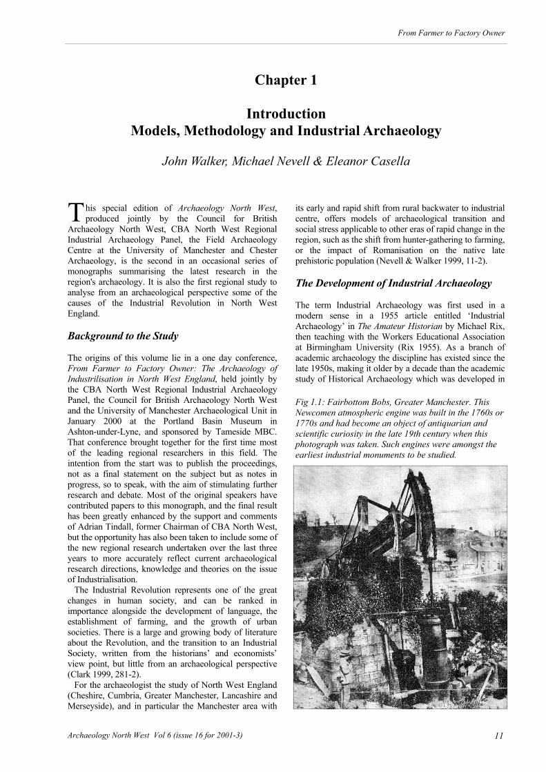
T his special edition of Archaeology North West, produced jointly by the Council for British
Archaeology North West, CBA North West Regional Industrial Archaeology Panel, the Field Archaeology Centre at the University of Manchester and Chester Archaeology, is the second in an occasional series of monographs summarising the latest research in the region's archaeology. It is also the first regional study to analyse from an archaeological perspective some of the causes of the Industrial Revolution in North West England. Background to the Study The origins of this volume lie in a one day conference, From Farmer to Factory Owner: The Archaeology of Industrilisation in North West England, held jointly by the CBA North West Regional Industrial Archaeology Panel, the Council for British Archaeology North West and the University of Manchester Archaeological Unit in January 2000 at the Portland Basin Museum in Ashton-under-Lyne, and sponsored by Tameside MBC. That conference brought together for the first time most of the leading regional researchers in this field. The intention from the start was to publish the proceedings, not as a final statement on the subject but as notes in progress, so to speak, with the aim of stimulating further research and debate. Most of the original speakers have contributed papers to this monograph, and the final result has been greatly enhanced by the support and comments of Adrian Tindall, former Chairman of CBA North West, but the opportunity has also been taken to include some of the new regional research undertaken over the last three years to more accurately reflect current archaeological research directions, knowledge and theories on the issue of Industrialisation. The Industrial Revolution represents one of the great changes in human society, and can be ranked in importance alongside the development of language, the establishment of farming, and the growth of urban societies. There is a large and growing body of literature about the Revolution, and the transition to an Industrial Society, written from the historians’ and economists’ view point, but little from an archaeological perspective (Clark 1999, 281-2). For the archaeologist the study of North West England (Cheshire, Cumbria, Greater Manchester, Lancashire and Merseyside), and in particular the Manchester area with
its early and rapid shift from rural backwater to industrial centre, offers models of archaeological transition and social stress applicable to other eras of rapid change in the region, such as the shift from hunter-gathering to farming, or the impact of Romanisation on the native late prehistoric population (Nevell & Walker 1999, 11-2). The Development of Industrial Archaeology The term Industrial Archaeology was first used in a modern sense in a 1955 article entitled ‘Industrial Archaeology’ in The Amateur Historian by Michael Rix, then teaching with the Workers Educational Association at Birmingham University (Rix 1955). As a branch of academic archaeology the discipline has existed since the late 1950s, making it older by a decade than the academic study of Historical Archaeology which was developed in
Chapter 1
Introduction
Models, Methodology and Industrial Archaeology
John Walker, Michael Nevell & Eleanor Casella
Fig 1.1: Fairbottom Bobs, Greater Manchester. This Newcomen atmospheric engine was built in the 1760s or 1770s and had become an object of antiquarian and scientific curiosity in the late 19th century when this photograph was taken. Such engines were amongst the earliest industrial monuments to be studied.

12 Archaeology North West Vol 6 (issue 16 for 2001-3)
From Farmer to Factory Owner
the USA in the 1960s (Palmer & Neaveson 1998, 1-3). From the very beginning the term industrial archaeology was applied to the physical remains of the Industrial Revolution, although there was, and continues to be, a recognition that the Industrial Archaeology of the manufacturing process applies as much to Neolithic hand axes as to steam engines. The early decades of the discipline were spent arguing as to which of these two intellectual strands would predominate. The decline of many of the classic 18th and 19th century industries in mid-20th century, and the growing recognition of the historic value of textile mills, iron works, transport networks and the wider industrial landscape of these centuries, led to a general acceptance that Industrial Archaeology meant the archaeology of the Industrial Revolution. In the North West its leading exponent during the 1960s and 1970s was Owen Ashmore who published the first surveys and guides to the region’s major manufacturing industries (Ashmore 1969, 1975 & 1982). During the 1980s the study of Industrial Archaeology in Britain diverged from the study in north America, where a strong tradition of social archaeology was applied to the study of society during the 18th and 19th centuries under the broad heading of Historical Archaeology. In contrast, British Industrial Archaeology remained focused on manufacturing processes, although there was a shift towards more thematic studies of monument types. This was led by the Royal Commission on the Historical Monuments of England and emerged with three textile mills surveys, including a study of the textile mills of Greater Manchester (Williams with Farnie 1992) and Cheshire (Calladine & Fricker 1993). Their thematic work continued into the 1990s with subjects ranging from planned farmsteads to hospitals and workhouses and has now been taken over by English Heritage (Barnwell & Giles 1997; Morrison 1999; Richardson 1998). It was not until the 1990s that serious thought was given in Britain to Industrial Archaeology's potential wider role
in providing a distinctive archaeological perspective on the Industrial Revolution (Palmer 1991). This culminated with the publication of Marilyn Palmer and Peter Neaverson's academic study Industrial Archaeology. Principles and Practice (Palmer & Neaverson 1998), which set out an intellectual and methodological framework for the discpline firmly focused on the industrial transition and the changes that this process wrought on society, the landscape and above all the archaeological record.
Archaeological Theory and the Industrial Transition The scale of the changes produced by industrialisation has resulted in a wide range of economic analyses and explanations ranging from grand theory and macro-economic studies of statistical measures, down to detailed investigations of regions and individual industries. In recent years social historians and historical geographers have begun to study the idea of an Industrial Revolution by asking not only was there such a revolution, but also whether local social, economic and historical studies might not be as useful as inter-regional and international economic indices in studying the phenomenon. The contributions to the debate made by archaeologists in Britain have tended to lean towards studies of the mechanics, or physical character, of individual industries or structures, with a consequent lack of synthesis. This trend amongst British archaeologists is understandable given the volume of the available archaeological database and historical record and the depth of the theories of economic historians. Yet, as English Heritage have observed, this trend may have meant that the contribution of archaeologists to the debate on the validity and origins of the Industrial Revolution as a concept has not been as
Fig 1.2: Shaw Mill, Delph, Saddleworth, Greater Manchester. This was a late 18th century water powered wool scribbling mill and one of dozens of woollen and cotton water-powered mill sites established in the Pennine foothills dur-ing the 18th century. Many such mills have been recorded archaeo-logically and they re-flect the first phase of industrialisation in North West England.

13
From Farmer to Factory Owner
Archaeology North West Vol 6 (issue 16 for 2001-3)
great as it could have been (English Heritage 1997, 45). It is not the place of this monograph to discuss in detail the various schools of thought about the Industrial Revolution, but a brief review of some of the more recent literature will serve to illustrate the vigorous nature of the national debate. Current economic theory about the event can be divided into various strands all of which address, to some extent, the key question of what do we mean by an Industrial Revolution, and how can we identify its time and place? The idea that there was one period which saw a take-off in industrialisation has been debated since the 1820s when French commentators coined the term the Industrial Revolution to described what they saw as the economic transformation of England (Mathias 1989, 1-2). In recent years economic historians have attempted to refine the empirical database (Crafts 1976 & 1989; Feinstein 1978; Harley 1982; Wrigley & Schofield 1981) in order to address the view that major sectoral, regional and institutional changes, represented by an overall discontinuity in the economic database, marked the take-off period for the Industrial Revolution as occurring in the years c 1780 to c 1800. The lead sector hypothesis was proposed by W W Rostow in the mid-20th century who argued that the main momentum for economic growth in 18th century England came from a few manufacturing sectors (cotton and iron) which were the motors of growth for industrial take-off (Rostow 1960). This theory has been superceded by later studies which showed that in Britain there was a widely diffused pattern of growth with many sources of momentum (Mathias 1989, 19-22). The ‘long view’, or proto-industrialization theory, was revived by Franklin Mendels in 1972, who argued that much of the industrial expansion in Britain before 1800 came from handicraft industries using enhanced artisan technology (domestic textiles, small metal wares and even coal mining; Mendel 1972); it is a concept which has been explored by economic historians ever since (Mathias 1989, 10-13). Finally, amongst the latest of the many theoretical strands studied by economic historians is the concept of marginality, the view that industrialisation and growth first takes off in the marginal zones of Europe. Professor Sidney Pollard has demonstrated the impact upon growth of two main types of marginality; political and economic during the industrial transition (Pollard 1997, 10-7). Firstly, with the idea of political marginality the debate appears to be about the pull between the centre which seeks to open up, subject, and colonise the fringe, and the fringe which might come to dominate the system of which it was a notional periphery. Secondly, economic marginality, which is more about the natural features of a region rather than its political makeup. In pre-industrial, non-urbanised societies, economic marginality was the result of having poor agricultural land. Many of the marginal lands of Europe with their mountains, forests, fen or marshland were to take the lead in developing an industrial base. Much of North West England, in terms of agricultural productivity, was just such a marginal zone prior to industrialisation. In last decade there has been the emergence amongst
British archaeologists of a more theoretical approach to the transition from an agrarian to an industrial society. Ironically, however, this has been led by historical archaeologists, rather than industrial archaeologists. The tone was set in 1997 by a major conference between the Post-Medieval Society of Britain and the Historical Archaeology Society of the USA. The conference reflected the approach of the north America historical archaeologists, with the emphasis on craft production and material culture, the social use of space and expressions of authority, and the role and survival of ethnicity. The resulting publication, Old and New Worlds (Egan and Michael 1999) contained only two papers on industry and its link to social and landscape change (Barker 1999; Cranstone 1999). In a similar way to the Old and New Worlds conference, the volume The Familiar Past? edited by S Tarlow and S West (1999) brings together recent contributions by some of the most active historical archaeologists involved in studying the period in Britain. Most of these individual studies deal with particular aspects of the material culture in great depth rather than focusing on more explicit industrial archaeology sites or landscapes, which is touched upon in only two papers. In their contributions to this work Brooks, Buckham, Mytum and Tarlow explore in different ways aspects of the relationship between the material culture of the period and its social structure. Giles, Gould, Leech, Lucas, Johnson and Williamson demonstrate the relationship between structures (their layout and planning) and contemporary social issues, whilst Pennell does the same for diet. In the same volume Keith Matthews, of Chester Archaeology, discusses how a classical archaeological approach to the study of the period is both in its infancy and still questioned. Finally, in her summary of present progress Tarlow draws attention to two areas where archaeologists are trying to make a contribution. Great attention is being paid to how individuals in the past established and demonstrated their identity in various material ways such as building plans or funerary monuments. This interest in issues of identity is moving archaeologists towards a more subtle notion of social structure beyond seeing the recent historic past as
Fig 1.3: The late 19th century Ancoats Hospital, Man-chester. Hospitals are one of the Industrial Period mon-ument types that have been thematically studied in the last two decades.

14 Archaeology North West Vol 6 (issue 16 for 2001-3)
From Farmer to Factory Owner
consisting merely of large contending classes. Tarlow also emphasises that an archaeological approach demands or requires by the nature of the discipline the use of long timescales and broad concepts of a type that are not usually found in historical studies. It is thus ironic that this volume only addresses the issue of social change, virtually ignoring the chief motor for change; the rise of mass production. Shane Gould (2001) has followed a similar historical archaeology methodology, with its focus on material culture and social structures. He has called for a fresh approach to the study of industrial and historic period buildings through the use of social archaeology and through attempts to de-construct the role of authority and power in these structures. An Archaeology of Capitalism by Matthew Johnson (1996) is the most explicitly theoretical of these recent historical archaeology volumes and appears to echo a wider trend in archaeology in explaining how the rise of the concept of the individual, seen by some as crucial to industrialisation, can be demonstrated by changes in a wide range of physical remains. Charles Orser (1999) in his recent article about the progress of historic archaeology in Britain and America also called for changes in approach, specifically a new form of archaeology centred upon four main concepts; a global view, an emphasis upon past social relations, the study of social relationships across space and through time, and a willingness to comment upon today by drawing from the recent past. The dominance in the 1990s of historical archaeologists’ social approach to the industrial transition rather than industrial archaeologists’ process-based methodologies is reflected in Kate Clark’s 1999 call for industrial archaeology to consider how best it can contribute to the study of this era (Clark 1999). Recently, however, there has started to develop amongst industrial archaeologists a more explicitly theoretical approach to the industrial transition, with an emphasis on long time scales, the development of social linkages, and authority and landscapes, but focused on industrial production and the growth of the new industrial, urban-based, tenantry. This shift began with the publication of Post-Medieval Archaeology in Britain by David Crossley (1990) which brought together the results of large numbers of individual archaeological studies conducted on remains dating from 1500 to 1800. The volume demonstrated that local variations were often significant and that various types of archaeological remains seldom figure in the historical record, meaning that the lives of the majority of the population living in 16th-, 17th-, and early 18th-century England are barely touched upon by the written word (Crossley 1990, 2). It was not until the end of the 1990s that the next major step forward occurred with the publication of Industrial Archaeology, Principles and Practice by Marilyn Palmer and Peter Neaverson (1998). This volume, a work that has had the greatest impact on industrial archaeologist so far, attempts to widen the horizons of the industrial archaeologist through analysing the social relations of production and consumption. This is done by relating industries to their associated housing, transport networks,
and wider landscape context, and by placing aspects of the material culture of industrial production in its social context. The authors introduce ideas about the social controls which are both explicit and implicit in the architecture and spatial organisation of industrial buildings, and the way in which social relations were both constructed and expressed in the housing built to accommodate those involved in industrial production. At a local level the final two volumes in the Archaeology and History of Tameside series, Lands and Lordships in Tameside (Nevell & Walker 1998) and Tameside in Transition (Nevell & Walker 1999) are the first to take an explicitly theoretical approach to industrialisation in North West England. The focus in these two related works is on landscape change and social archaeology in the period 1348 to 1870. The rate of archaeological change is studied through the temporal occurrence of sites as defined in English Heritage’s Thesaurus of Archaeological Monument types. This is taken a step further, however, by putting each of these monument types in their social context through assigning them to one of three contemporary social groupings; lords, freeholders or tenants (see below Chapter 2). The most recent attempt to marry industrial and historical archaeology to a theoretical view of the industrial transition can be found in Richard Newman, David Cranstone & Christine Howard-Davis’ volume The Historical Archaeology of Britain, c 1540-1900 (Newman with Cranstone & Howard-Davis 2001); although here there is a contradiction between Cranstone’s approach, which follows Professor Rolt’s dogmatic assertion that Industrial Archaeology can only ever be about the manufacturing process, and the rest of the volume which tries, largely successfully, to integrate landscape, historical and industrial archaeological approaches. This contrast encapsulates the tensions current in the study of the Industrial Transition era. Current Methodological Concerns The continuing efforts to record, conserve and analyse the material significance of Britain's industrial heritage have illuminated some significant methodological concerns as to how we study the archaeology of industrial sites. To explore these issues three debates can be tracked through the existing methodological approaches. Firstly, an issue of scale permeates the practice of industrial archaeology, both on British sites and abroad. More traditional approaches have placed the emphasis and attention on aspects and features of the site most related to regional, or sometimes even local, variations in the evolution of production technologies. Thus, the unique and distinctive characteristics of a particular industry (such regional variants in building type, resource use, or landscape organisation) formed the dominant subject of data collection and presentation (Bowden 2000; Calladine & Fricker 1993; Clark 1999, 284-94; Cranstone 2001; Giles & Goodall 1992; Rynne 1999; Symonds 2001; Williams with Farnie 1992). In contrast, recent theoretical directions have begun to emphasise the global nature of historic period archaeology (Orser 1996; Johnson 1996; Tarlow & West 1999; Leone 1999).

15
From Farmer to Factory Owner
Archaeology North West Vol 6 (issue 16 for 2001-3)
One outcome of this trend has been a growing focus on both the artefacts and features of industrial sites as material representations of wider international transformations in labour relations, population movements, domestic life, and consumer practices (Brooks 1999; Clark 1999, 295; Shackel 1996). The methodological implications of this expansion of scale include a concern over the scope of fieldwork on industrial sites. Within Britain, these debates have led to the development of a hierarchical four-tiered recording system for standing structures by the Royal Commission of the Historical Monuments of England (RCHME 1996), and since adopted by English Heritage. The four levels of recording attempt to standardise the degree and type of archaeological detail recorded according to the degree of national significance afforded to the industrial site. According to this method, a ‘Level 1’ site (one of local significance) would produce a visual record of exteriors only, while a ‘Level 4’ site (one of high national or international value) would require a full range of recording, incorporating detailed external and interior photography, site plans and elevations, three-dimensional projections, phased reconstructions of the built environment, a detailed analysis of the documentary history of the site, a significance statement, descriptions of past and present uses, and subsurface evaluations (see Palmer & Neaverson 1998: Fig 28). The important benefits of this systematic approach to standing structures include the comparative value of recorded data, and a more strategic investment of limited archaeological resources. However, the method can be criticised for a lack of flexibility - sites deemed to be of Level 1 or 2 overall significance may contain specific features, structural elements or landscapes worthy of higher levels of recording. Even so, by recognising differences in global, national, regional and local dimensions of industrial sites, archaeologists have begun to adopt a wider range of options within their methodological practices. A second debate has focused upon the basic objectives
of industrial archaeology. The most common approach has utilised archaeological techniques in order to identify and categorise the productive technologies and various stages of manufacture represented through the surviving material culture of an industrial site and to group similar sites together in lists (Ashmore 1969 & 1982; Cranstone 2001; Monuments Protection Programme reports; the Association for Industrial Archaeology regional guides ie McNeil & Nevell 2000). Because of these underlying research objectives, field methods have emphasised two forms of archaeological data; the recording of intra-site spatial geographies to map the transmission and processing of raw materials within a site; and the identification of diagnostic attributes required for functional classifications of constituent technology, machinery types and site. This traditional approach to the practice of industrial archaeology has tended to yield site reports rich in descriptive detail. More importantly, in the last two decades such research has advanced our general understandings of both the evolution and diffusion of technological innovations within the Industrial Era and has led to the development of a landscape approach to the subject. By situating sites within their contemporary natural and historic landscapes, archaeologists have been able to trace wider patterns in the regional emergence and evolution of industries, ultimately recording the material biographies of Britain's leading post-medieval productive industries (Cranstone 2001, 183-210; Clark 1999, 285-290; Palmer & Neaveson 1998). Finally, such objectives have resulted in comprehensive collections of photographic, documentary, and artefactual archives for the historically dominant British industries; coal mining, engineering, iron making, pottery production, textile manufacture and transportation. Thirdly, given both the high potential of this data collection for wider comparative studies, and a growing concern with international scales of research, a new methodological approach has emerged, drawing upon far more sociological perspectives. For this 'socio-economic' approach, the underlying objectives of research tend
Fig 1.4: Workers’ housing at Well Row, Broadbottom, Tameside. These were built by the Sidebottom family, local mill owners, around 1827. Terraced housing remains an important sub-ject for industrial archae-ology research.

16 Archaeology North West Vol 6 (issue 16 for 2001-3)
From Farmer to Factory Owner
towards questions of labour relations, unequal patterns of resource distribution, gender roles within productive industries, and the globalisation of production and distribution. To create such socio-economic interpretations, research methods typically incorporate a wide range of documentary sources, including census records, Parliamentary reports, newspaper accounts, municipal and parish records, public health and sanitation records, fire insurance plans, wills and inventories, and taxation records (Palmer & Neaverson 1998, 105-128). More importantly, by adopting explicitly comparative perspectives, this approach to industrial archaeology has emphasised the social, economic and technological interconnections that linked sites into wider regional networks of extraction, transportation, production, distribution, and consumption (Clark 1999; Nevell & Walker 1999; Clark 1999; Newman 2001). This has resulted in one of the most exciting new directions, namely, the survey, excavation and analysis of not only the industrial workplaces (the canals, factories, mills, mines, and railways) but the associated domestic and recreational places. Archaeological fieldwork has expanded to include studies of workers' housing (Caffyn 1986; Timmins 1998; Leech 1999), public sanitation (Newman 2001, 162-167; Clapp 1994), pubs and hotels, and even places of working-class leisure such as resort towns, public baths and urban parks (Baker & Jones 1996; Everson & Williamson 1998; Newman 2001, 157-161). The incorporation of wider multidisciplinary perspectives has led industrial archaeology towards greater socio-economic engagement. As traditional approaches have focused on detailed classifications of evolutions in industrial production technologies, these studies have tended to draw interdisciplinary sources from the material sciences, most typically chemistry and physics. For example, most archaeological studies of Britain's various non-ferrous metal industries have incorporated detailed summaries of the relevant chemical extraction methods, as the requirements of such secondary processing areas, and the management of resulting industrial wastes, often determining the geography of mining landscapes (Newman 1996; Sharpe 1992; Pye & Weddell 1992). However, with a growing interest in the socio-economic aspects of industrial sites, studies have begun to evaluate the archaeological implications of workers' living conditions, settlement patterns, and even gender relations. As a result, practitioners have begun to look towards the social sciences for interdisciplinary inspiration, drawing from both classic studies and current research in sociology and economic history. What has transformed is not only how research is theoretically framed, but also how the sites themselves are archaeologically recorded and analysed. By
incorporating, for example, ephemeral structural details of the temporary shelters erected by homeless workers' within their archaeological survey of the Basset Mines of Cornwall, Marilyn Palmer and Peter Neaverson (1998, 29-140) could interpret the rapid population growth caused by the advent of steam-powered mining, and resulting expansion of the local labour market. It was only through their appreciation of the historical and sociological perspectives on labour mobility within 19th-century Cornish mining communities that these ephemeral structural elements garnered enough significance to justify careful field recording.
The Aim of this Volume The various contributors to the present study have approached the Industrial Revolution primarily from a social archaeology view point, the aim of this study being to try to provide a distinctive archaeological view point on the transition to an industrial society in one of the heartlands of this process; North West England. Thus, this collection of papers is not primarily about industrial processes, technological innovation or listing groups of site types, but is rather a broader attempt to analyse the various changes in landscape, society and material culture which, when taken together, form the Industrial Period in North West England. The study is divided into two sections. The first part, which is entitled ‘Modelling the Archaeology of the Industrial Revolution in North West England’, comprises five papers (including this one) which attempt to apply archaeological theory to the wider industrialisation process in the region. These range from the issue of the ownership of the new monuments of the period and how that relates to the contemporary social structure of the region, to urbanisation and industrialisation issues in Chester and Manchester. The second part, entitled ‘Case Studies’, comprises a series of five papers from around the region. These include landscape studies of the Castleshaw valley, of the River Goyt around New Mills and of the village of Stock; technological innovation and its social impact in the textile finishing trades of Lancashire and in the iron industry of Cumbria. The theoretical themes which emerge from these papers include; the social relations of production and consumption; the changes in rural and urban life; and the changing use of the landscape. Other themes which could be added to this list, but which are not touched upon by the present study, include death and commemoration, and the archaeology of authority. These ideas are brought together in the concluding chapter which explores some of the areas for future research in the industrial archaeology of North West England.

17
From Farmer to Factory Owner
Archaeology North West Vol 6 (issue 16 for 2001-3)
T his paper summarises some of the results of a long-term landscape study into the history and
archaeology of modern Tameside which have been published in eight volumes (Burke & Nevell 1996; Nevell 1991, 1992, 1993, 1994; Nevell & Walker 1998, 1999; Fig 2.1). The final two volumes of that study dealt explicitly with the problem of industrialisation from an archaeological viewpoint. Those works were a response to a widespread call for archaeology to make a distinctive theoretical contribution to the study of the era of industrialisation (see above Chapter 1). The University of Manchester Archaeology Unit took up the challenge of trying to present an archaeological understanding of the Industrial Revolution between the years 1600 and 1900. We have approached the subject in the same way classically trained archaeologists might study the Roman Empire; that is a landscape approach that charted and grouped sites by type, whilst using geographical, historical and socio-economic sources only to illustrate archaeological perceptions. It is important to realise that this approach was distinctive in the way it combined three methodologies; firstly, in its emphasis on material remains; secondly in its landscape analysis through identifying the new monument types introduced during the period under study and then relating them to the monument type categories as listed in the RCHME’s Thesaurus of Archaeological Monument Types (RCHME 1996); and thirdly, in the use of geographical, historical and socio-economic evidence to relate these new monument types to the contemporary social structure. This stress upon material remains, monument types, and landscape study is essential if archaeology is to make a contribution in its own right to the origins of industrialisation in this era, since the discipline remains the study of material culture in all its forms. A holistic approach meant treating the period in the same way as we might treat the remains of the Neolithic period, by giving in the initial phases of the study equal weight and importance to all elements of the physical remains. The Tameside Archaeological Survey Whilst there are many modern studies of the industrial development of the cities and towns of England, there are comparatively few by archaeologists dealing with the rural fringes where the contrast between pre-
industrial and industrial society were often most dramatic. One aim behind the Tameside Archaeological Survey was to attempt to describe from an archaeological viewpoint the way in which two long lived landscape units, the lordships of Ashton and Longdendale, were changed by industrialisation. In comparison to the other modern boroughs that surround Manchester, Tameside and its Lordships contained no real urban centres prior to industrialisation. The industrial growth in this area was therefore both more dramatic and less constrained than in other parts of the Manchester region. The study area lies on the eastern side of the Mersey Basin, centred 18km east of Manchester on the south-
Chapter 2
The Origins of Industrialisation and the Manchester Methodology:
The Roles of the Lord, Freeholder and Tenant in Tameside During Industrialisation, 1600-1900
John Walker & Michael Nevell
Fig 2.1: The front cover of volume 8 of the award win-ning ‘A History and Archaeology of Tameside’ series, published in 1999, showing in the foreground the textile mills of Mossley and in the background the Portland Basin Canal Warehouse, now an industrial archaeology museum.

18 Archaeology North West Vol 6 (issue 16 for 2001-3)
From Farmer to Factory Owner
western flanks of the Pennines, and encompasses the middle reaches of the Tame and Etherow valleys (Fig 2.2). It is an area of physical contrasts, with wide lowland clay plains dominating the western half of the area whilst in the east there are many steep sided river valleys. The eastern two thirds lie between 76.2m and 496.2m above sea level upon the shales and sandstones of the Millstone Grit or Coal Measures. This eastern zone also contains the Longdendale valley which
provided an historic access route through the Pennines. Throughout the study area the soil quality is generally poor, rainfall high and the valleys subject to rapid flooding (Nevell & Walker 1998, 17-32). By the eighteenth century the area was part of the centre of an extensive international industrial complex primarily based upon cotton production (Aikin 1795). Aikin's contemporary description of the Tameside area in late 18th century is marked by contrasts; the township of Mottram, for instance, is described as having twelve large manufactories, but also a greater number of small mixed farms, the tenants of which eked out an existence
Fig 2.2: The location of the Tameside study area, the development test-bed for the Manchester Methodology.

19
From Farmer to Factory Owner
Archaeology North West Vol 6 (issue 16 for 2001-3)
defensive sites; domestic sites; education sites; monuments associated with gardens, parks and open spaces; those connected with health and welfare; industrial monuments; institutional monuments; recreational sites; religious, ritual and funerary sites; transport sites; and those monuments associated with water supply and drainage. These new sites range from ice houses, such as the fine 18th century example in the grounds of Broadbottom Hall; hatting plank shops, such as that on Joel Lane in Gee Cross built in the late 18th century; pumping engine houses, such as at Fairbottom Bobs near Park Bridge (Fig 2.3) probably from the 1760s; to transport networks such as the Manchester to Ashton Canal, built in the 1790s, or the Manchester to Sheffield railway, built in the 1840s. However, the three most common archaeological sites were; the terraced workers' house of which there were thousands, the earliest surviving buildings being a row of six cottages in Broadbottom known as Summerbottom built in 1790; the textile site, of which 274 sites are known, the earliest surviving purpose built mill being Albion Mill in Hollingworth and Dry Mill in Mottram both erected during the early 1790s; and the farmstead, of which 273 sites are known, one of the more notable being Old Post Office Farm, built in 1692 by one of the many wealthier tenant farmers in the area. Using the Thesaurus together with the findings made during the archaeological survey it is possible to draw a graph of when different types of site were first constructed within the study area. As the great majority of these new sites survived for long periods it was found most helpful to draw a cumulative graph showing how the total range of sites expanded through time. Figure 2.4 shows the pattern of introduction of new types of site in the area and how the range of sites expanded. The slope of the graph is S-shaped with a long period in which new types of sites were gradually developed followed by phases of more rapid change. Such S-shaped (sigmoidal or logistic) growth curves are found in many cases of population growth and typically can be divided into four main phases:
through cottage industry combined with farming (Aikin 1795, 458, 472). The Manchester Methodology Stage 1: Making Sense of the Archaeological Database Landscape fieldwork and documentary research confirmed that the archaeology of the study area, from the period 1348 to 1642, was distinct, being dominated by the remains of isolated farms and the homes of the owners of manors. As part of the landscape study the survey examined the earliest surviving pre-industrial map from the study area, the late 16th century Staley estate survey, noting how the sites recorded corresponded with the known archaeological evidence for this area in the 16th and early 17th centuries. The map showed a pre-industrial landscape consisting of a major hall and isolated farms, lying amongst enclosed fields, some of which contained ridge and furrow. Beyond the limits of the fields lay the open moors or commons containing the remains of Buckton Castle, a cairn, a turf pit and a slate quarry. Allowing access between the two zones was a series of lanes and moor gates. Staley Hall, the manorial centre, appeared as a large multi-gabled, multi-storeyed structure, apparently capable of housing many people, joined on one side by a field surrounded by a vertical plank fence typical of a park pale. Other structures were all simple tenant houses with different arrangements of windows and chimneys, each surrounded by fields. The archaeology of the period from 1642 to 1900 within the Ashton and Longdendale lordships was as distinct as that for the three centuries before 1642. It was dominated by two new archaeological site types; the textile site, of which 274 were established in Tameside between 1763 and 1907, and the terraced house of which thousands of examples still survive from the period 1790 to 1870. These patterns were tested and confirmed by a considerable number of individual building surveys allied to a number of archaeological excavations on sites such as Ashton Old Hall, the Black Bull Inn, Dukinfield Hall, Denton Hall, Haughton Green Farmhouse and colliery, Mottram village, the Park Bridge Ironworks and the field boundaries and tracks of Werneth Low. The first problem was to characterise or group this new information and new sites for the period 1600-1900. In order to categorise much of this archaeological material and to provide a common frame of reference we used the archaeological site descriptions and monument category classifications contained within English Heritage's and the Royal Commission's Thesaurus of Archaeological Monument Types (RCHME 1996). Using the Thesaurus UMAU identified over 100 new types of archaeological site established in the Ashton and Longdendale lordships between 1600 and 1900 were identified (Fig 2.4; Nevell & Walker 1999). These new sites fall, according to the schema within the Thesaurus, into 15 of the 18 monument categories; agricultural and subsistence monuments; civil monuments; commemorative monuments; commercial sites;
Fig 2.3: Fairbottom Bobs 18th century colliery pumping engine during excavation in 2000 by UMAU. Steam engines were one of the new monument types that help define the Industrial Period

20 Archaeology North West Vol 6 (issue 16 for 2001-3)
From Farmer to Factory Owner
The adaptive phase; in which change is slow. The expansionary phase; a period of rapid growth
with positive feedback. The consolidatory phase; in which growth is less
rapid and negative feedback becomes more common.
Maturity; when growth slows considerably or
stops. The study of growth curves is dominated by ecological theory (Allaby 1996; Colinvaux 1993; Smith & Smith 1998) and if we accepted some of these insights we might conclude that the graph of new archaeological type sites from the Tameside area is typical of a population where investment in developing new sites (population members) is high and that ultimately the total range is restricted by some form of complex constraint. Stage 2: The Ownership of the Archaeological Site Types Having categorised the broad changes in the local material culture within the study area the problem then was to offer some form of insight into the pattern that had emerged. The Thesaurus only divides sites into groups or individual entities on the basis of a combination of site function and recognised
archaeological typologies. Having established a broad pattern of development in sites and site types we explored different contemporary contexts which might fit this pattern (Nevell & Walker 1998). Analysis of environmental and population changes in the period 1600-1900 did not throw any light on this pattern. However, we discovered that each new type of site could be related to a distinct contemporary local social class, lord, freeholder and tenant, and that in each case these new forms related directly to the traditional sphere of influence of each social class. One difficulty that arose from taking this social context approach was the certainty of assigning ownership of sites to the right class. In a typical local manor such as Hattersley a tenant was responsible for building their own house and in the early part of the period could use certain materials obtained from the common land. It might seem, therefore, that the house was the tenants' property but in fact if they lost their tenancy they also lost the house and it became the property of the landowner. However, there is evidence that most tenants thought of themselves as quite secure in their tenancies. In practice the relationship between tenant and land owner was deeply anchored in custom, or embedded in the contemporary social structure, so that few tenants lost control of the houses they built. Thus, where we have allocated control over the development of different types of sites we have tried to balance the evidence of tradition and contemporary legal
Tameside New Monument Types 1600-1900
0
20
40
60
80
100
120
1600
1620
1640
1660
1680
1700
1720
1740
1760
1780
1800
1820
1840
1860
1880
Sites by decade
no o
f si
tes
sites per decade
total number of sites
Fig 2.4: Monument types introduction into Tameside during the period 1600-1900.
21
From Farmer to Factory Owner
Archaeology North West Vol 6 (issue 16 for 2001-3)
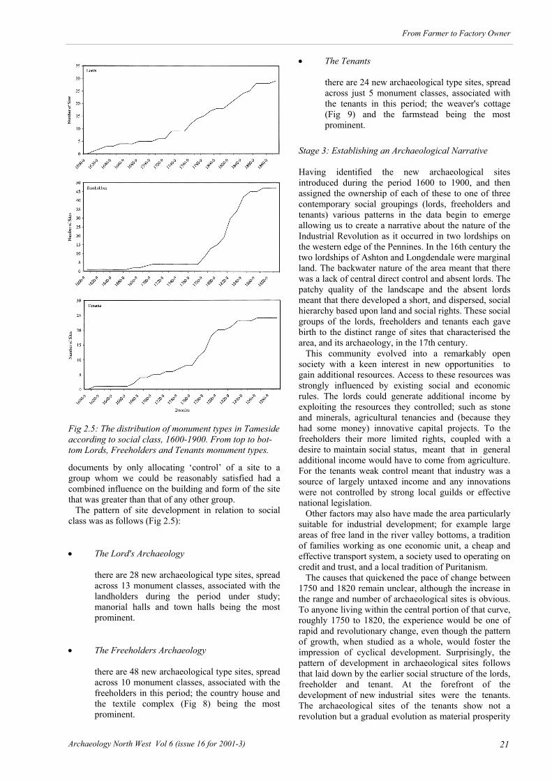
documents by only allocating ‘control’ of a site to a group whom we could be reasonably satisfied had a combined influence on the building and form of the site that was greater than that of any other group. The pattern of site development in relation to social class was as follows (Fig 2.5): The Lord's Archaeology
there are 28 new archaeological type sites, spread across 13 monument classes, associated with the landholders during the period under study; manorial halls and town halls being the most prominent.
The Freeholders Archaeology
there are 48 new archaeological type sites, spread across 10 monument classes, associated with the freeholders in this period; the country house and the textile complex (Fig 8) being the most prominent.
The Tenants
there are 24 new archaeological type sites, spread across just 5 monument classes, associated with the tenants in this period; the weaver's cottage (Fig 9) and the farmstead being the most prominent.
Stage 3: Establishing an Archaeological Narrative Having identified the new archaeological sites introduced during the period 1600 to 1900, and then assigned the ownership of each of these to one of three contemporary social groupings (lords, freeholders and tenants) various patterns in the data begin to emerge allowing us to create a narrative about the nature of the Industrial Revolution as it occurred in two lordships on the western edge of the Pennines. In the 16th century the two lordships of Ashton and Longdendale were marginal land. The backwater nature of the area meant that there was a lack of central direct control and absent lords. The patchy quality of the landscape and the absent lords meant that there developed a short, and dispersed, social hierarchy based upon land and social rights. These social groups of the lords, freeholders and tenants each gave birth to the distinct range of sites that characterised the area, and its archaeology, in the 17th century. This community evolved into a remarkably open society with a keen interest in new opportunities to gain additional resources. Access to these resources was strongly influenced by existing social and economic rules. The lords could generate additional income by exploiting the resources they controlled; such as stone and minerals, agricultural tenancies and (because they had some money) innovative capital projects. To the freeholders their more limited rights, coupled with a desire to maintain social status, meant that in general additional income would have to come from agriculture. For the tenants weak control meant that industry was a source of largely untaxed income and any innovations were not controlled by strong local guilds or effective national legislation. Other factors may also have made the area particularly suitable for industrial development; for example large areas of free land in the river valley bottoms, a tradition of families working as one economic unit, a cheap and effective transport system, a society used to operating on credit and trust, and a local tradition of Puritanism. The causes that quickened the pace of change between 1750 and 1820 remain unclear, although the increase in the range and number of archaeological sites is obvious. To anyone living within the central portion of that curve, roughly 1750 to 1820, the experience would be one of rapid and revolutionary change, even though the pattern of growth, when studied as a whole, would foster the impression of cyclical development. Surprisingly, the pattern of development in archaeological sites follows that laid down by the earlier social structure of the lords, freeholder and tenant. At the forefront of the development of new industrial sites were the tenants. The archaeological sites of the tenants show not a revolution but a gradual evolution as material prosperity
Fig 2.5: The distribution of monument types in Tameside according to social class, 1600-1900. From top to bot-tom Lords, Freeholders and Tenants monument types.

22 Archaeology North West Vol 6 (issue 16 for 2001-3)
From Farmer to Factory Owner
increased as a whole. Whilst agriculture increased in efficiency ultimately the old medieval freeholders, with their strong reliance on farming, declined. They were replaced by a new form of freeholder interested not only in agriculture but also in industry. The lords, on the other hand, were responsible or involved with all the major new capital and strikingly innovative projects which involved administrative, legal and social control or infrastructure. The roles of the lord were in time taken over by the new Victorian local government. An Archaeological Theoretical Basis for Studying Industrialisation? Having categorised the remains and provided an explanatory narrative three significant tasks remain to be addressed for the Manchester approach to industrialisation: Assessing the validity of the categorisation
technique that was used. Testing the methodology.
Relating the narrative to exiting models. The Validity of the Categorisation Technique In compiling the graph we have classified as ‘new’ the archaeological remains defined as sites in the Thesaurus because of their distinct nature and form. However, there is the possibility that many types of sites defined in the Thesaurus should not really been seen as distinct but merely as elaborations of older forms. Thus, whilst the local 17th century glassworks at Haughton Green was a totally new type of site introduced by immigrants how should one view the emergence of the terraced house? From one perspective the local evidence suggests that it is the end of a chain that began with the labourer's room in the farm which was superseded by individual worker's cottage which, in turn, led on to the development of the terrace. A similar process of elaboration is shown particularly well in the clothing industries, schools and the church. Thus, within the hatting industry during the late 19th century there are a number of sites which consisted of a number of distinct elements. In the case of the Woolfendens’ hatting works in Denton, this included the factory itself, workers’ housing and three villas for the owner and his two sons. Today we might classify these remains as separate interrelated sites each arising out of a particular tradition. In fact they all originate from the phased growth of what originally consisted of a single farmhouse. In that dual economy structure we would have found, around 1830, rooms for the owner, rooms for the labourers and a central room (often called in local wills the house) for industrial activity. The growth in prosperity of the family led to a gradual pattern of expansion in their working area; firstly, by adding a workshop in 1860; secondly, by building a factory in 1873; and finally, by the creation of separate cottages for the workers and new homes for the family (Holding 1986). Schools also show a process of increasing elaboration with increasing wealth; the first references are to masters without separate buildings, a phase which is followed by the construction of small buildings and eventually by large scale structures. Contrary to some widespread opinions the introduction of pews in churches marks not some new social order but the elaboration of the old. The order of seating on the benches of the pewless Ashton church was, in 1422, already strictly controlled before the introduction of the pews. The ‘new’ pews were, initially at least, merely a more elaborate and expensive expression of an earlier system. To try to resolve this problem of whether or not a site is really ‘new’, or indeed what constitutes a ‘site’ in this period, is extremely difficult and beyond the scope of the present study. Recourse to the historical documents does not necessarily help simply because they are selective about what they record, factories, for instance, receiving a great deal more attention than stone quarries. Therefore, at the moment we simply have to note the problem, whilst assuming the validity of the Thesaurus.
Fig 2.6: The distribution of weavers’ cottages in Tame-side, with above a plan of typical cottage, No 18 Carrhill, Mossley. These were type was built by the ten-ants of the area and was one of the defining industrial monument types of the area.

23
From Farmer to Factory Owner
Archaeology North West Vol 6 (issue 16 for 2001-3)
Testing the Manchester Methodology It remained possible that the methodology derived from the Tameside evidence might be unique to that landscape and social context. One way of testing whether this was the case was to compare the Tameside lordships with other areas in the region using this methodology. Two areas were chosen for their contrasting, but linked, landscapes. The first was the township, manor and parish of Warburton in the lower Bollin valley, roughly 20km west of Tameside (Fig 2.7). This is a landscape unit of four square kilometres, held by one family, the Warburtons, from the twelfth to the early 20th centuries. In contrast to the two lordships in the Tameside area it is a low lying manor with good agricultural soils which remains a rural community dominated by dispersed farmsteads. Furthermore, the local lords retained control over the landscape and few freeholds were allowed to develop. This was despite the fact that like the two lordships in Tameside, Warburton had absentee landlords from 1469 when the family moved to the nearby Arley Hall estate. The categorisation of Warburton’s new monument types in the period 1600-1900 revealed a more restricted pattern than that in Tameside, with only 12 categories and 44 new monuments types represented, split almost evenly between lords (23 new sites) and tenants (19 new sites), with only two new monument types established by freeholders. The cumulative growth curve for all these new monuments is also distinctive to that seen in Tameside, with an almost straight-line growth, suggesting constant investment by both the lords and tenants in Warburton during this period. However, the individual growth curves for the lords and tenants show, respectively; consistent investment by the tenants, throughout the period; whilst the investment by the lords
takes the form of specific steps or bursts of activity focussing upon the late 17th, mid-18th and late 19th centuries. These patterns are quite distinctive to those recovered in the same period from the Tameside evidence (Nevell & Walker 1999, 93). The second was the manor of Dunham Massey, another low lying township in the lower Bollin valley, east of, and immediately adjacent to, Warburton (Fig 2.7). This was chosen as it was the seat of the Earls of Stamford who also held the manor of Ashton-under-Lyne, and it was felt that a comparative analysis of these two related holdings might provide some interesting data. Dunham remains today a largely rural township, dominated by Dunham Hall and its associated parkland and estate. Although most of the estate remained in the hands of the earls until it was gifted to the National Trust in 1976, unlike Warburton there were a few small freeholds. Furthermore, the eastern edge of the manor was developed from the 1850s onwards as a suburb area for the middle classes of Manchester by the 7th Earl, whilst the north-eastern corner of the manor was developed from the 1880s onwards as the Broadheath Industrial Park, focussed upon engineering, by the 8th and 9th earls. Consequently the number of monument types within the manor is greater than that seen in the neighbouring Warburton, at 61, and is spread across one few categories, 11. Evenso, the new monument types in the period 1600-1900 revealed a more restricted pattern (Fig 2.8) than that seen in Tameside (Figs 2.2 & 2.3). The cumulative growth curve for all these new sites is
Fig 2.7: Warburton (outlined left) and Dunham Massey (outlined right) townships in the 1840s. These two town-ships were used to test the Manchester Methodology as developed in Tameside. Source: First Edition Ordnance Survey One map of the area, surveyed 1841-2 (the rail-ways were inserted later).

24 Archaeology North West Vol 6 (issue 16 for 2001-3)
From Farmer to Factory Owner
close to the reverse S-shaped profile seen in the Tameside evidence. However, when the graph is split into those monument types associated with the three social groupings it can be seen that those of the lords predominate, at 46 sites, with the tenants accounting for nine sites and freeholders for six sites. Nor are their individual growth patterns similar, that for the lords following closely the cumulative s-shaped graph, whilst the tenants’ graph only takes off in the last third of the
19th century. These results would appear to reflect the dominance of the local lords for whom Dunham Massey was their home estate for most of this period. As in Warburton various burst of investment in the estate by the lords is reflected in the cumulative graph for all sites.
Dunham Massey New Monument Types
0
10
20
30
40
50
60
70
1600
-9
1620
-9
1640
-9
1660
-9
1680
-9
1700
-9
1720
-9
1740
-9
1760
-9
1780
-9
1800
-9
1820
-9
1840
-9
1860
-9
1880
-9
all sites
lords sites
tenants sites
freeholders sites
Warburton New Monument Types
0
5
10
15
20
25
30
35
40
45
50
1600
-9
1620
-9
1640
-9
1660
-9
1680
-9
1700
-9
1720
-9
1740
-9
1760
-9
1780
-9
1800
-9
1820
-9
1840
-9
1860
-9
1880
-9
all sites
lords sites
tenents sites
Fig 2.8: Monument types from the period 1600-1900 for top Dunham Massey and bottom Warburton townships.

25
From Farmer to Factory Owner
Archaeology North West Vol 6 (issue 16 for 2001-3)
It is tempting to see the upsurge in sites associated with tenants and freeholders from the 1850s onwards as reflecting the absence of the Earls of Stamford from Dunham Massey during this period. Much work still remains to be done on both these comparative studies, but the initial results appear to suggest that the Manchester Methodology is applicable in other landscape contexts, at least as a descriptive tool for charting the impact of industrialisation in the period 1600-1900. Whether the Manchester Methodology is applicable outside North West England, with its shallow social structure, remains to be seen. The Relationship of the Manchester Methodology to other models A cornerstone of the present study is that the archaeological remains that have been be classified by the Tameside Archaeological Survey can be further explained by linking them to particular social groups. This concept of linking distinctive types of remains to distinct social classes implies that the sites were constructed or shaped by the economic, political or social needs of these groups. This implication means that an attempt should be made to relate these archaeological conclusions to some wider body of social theory such as Closure Theory. One school of thought which readily suggests itself was first proposed by Weber and has been developed by a number of recent scholars during the 20th century. For instance Rigby used and elaborated Closure Theory to explain developments during the later medieval period (Rigby 1995). Closure Theory concentrates upon how individuals within society attempt to bolster their position by acting as a group. To strengthen their position such groups make use of exclusion and usurpation. Exclusion involves the exercise of power downwards to control or restrict others whilst usurpation involves lower groups wresting new rights from more powerful groups. This theory attempts to focus not only on competition between different classes but also on competition within particular classes. It draws attention to three main modes of power, economic, coercive (such as political, legal and military force), and ideological, that are used within and between groups to enhance or maintain their position. Rigby's work (1995) demonstrates how that approach is useful in classifying and categorising the various developments in the medieval economy and society of England. In many ways Weber's approach was similar to that developed by Karl Marx but to Weber the causal factor in social change was not always the economy. To Weber identifying the causes of change depended upon an analysis of each case and in each case the cause could be different. To Weber social groupings would establish or justify their power by appealing to or using one of the following factors: Legal or traditional factors. Ideology, morals or charismatic factors. Rational or economic factors.
The Tameside Archaeology Survey has demonstrated that all such factors were used locally throughout the industrial period to foster the position of the various social groups. The groups that we defined (lords, freeholders, and tenants) could all be seen as quite distinctive ways of trying to achieve a sustainable relationship within a changing world. The adaptive strategies of each group were influenced by social factors that both strengthened there position but also constrained or influenced their options for adjusting to change. Manorial lords relied on various methods of exploiting the population, their access to capital and their traditional rights; freeholders concentrated on agricultural efficiency or growth; and tenants upon finding a mechanism, such as crafts, that was not easily exploited by others. Not all the strategies of adaptation were equally successful. The early agricultural freeholders declined and were replaced by new freeholders created by successful tenants who acquired their wealth through industry. It seems clear that these new freeholds, with only a partial reliance on agriculture, were designed to enhance the social position of their owner. Some lacunae in the pattern of archaeological remains also become more easily understood. The early coal pits of the study area, whilst following the best shallow seams, show gaps in their distribution which coincide with tenanted land. The reasons seem clear in that the local lord who controlled coal exploitation encouraged digging, but not where it could lead to complaints or claims from established tenants. In recent years some sociologists and historians have brought the study of complex social networks to a level beyond that presented here (Griffin & Van Der Linden 1998). Wetherell (Wetherell 1998) has, for instance, felt able to justify the view that in the past: all people were interdependent. that links or relations between people channelled
resources. that the structure of these relations both eased
and constrained actions. that the pattern of these relations defined
economic, political and social structures. It is a view that this study tends to confirm. Thus, we might suggest that the proto-industrial culture of North West England was different and made up of a small range of distinct groups with their own interests. These small groups cannot only be detected in the archaeological record but actually shaped that record to a considerable extent by the pursuit of their own distinctive strategies designed to seize the opportunities presented by growth. Conclusions The methodology developed by UMAU in recent years, and outlined in this paper, provides archaeology with a further means of contributing to the debate on the industrial transition by linking a landscape approach to social analysis at a local level.

26 Archaeology North West Vol 6 (issue 16 for 2001-3)
From Farmer to Factory Owner
The first part of this methodology is descriptive, and reflects the character of the industrial transition through the introduction of new archaeological site types. As the comparative study areas have demonstrated this pattern varied around the Manchester region in terms of timing and extent, but a common trait was the S-shaped pattern of growth formed by the new types of sites identified in this period. This particular growth pattern allows specific periods of investment in the landscape to be clearly identified and, furthermore, goes some way to explaining the economic historians’ arguments between a broad or short Industrial Revolution, suggesting that this debate depends upon the time frame elected to study. A fundamental part of the Manchester Methodologt has been to link this descriptive archaeological approach to the contemporary social structure. In doing this we were fortunate in choosing study areas where the social structure during the period 1600-1900 was restricted. Linking particular new site types to a contemporary social class allowed us to see how and when these groups were investing in the their own areas. The application of Closure Theory allowed us to show how the opportunities for growth in the Manchester area were exploited by different social groups on the basis of both their own self-interest and their traditional rights to give rise to an ever more elaborate material culture. Clearly, there are various criticisms that could be offered of the Manchester Methodology, an approach derived from landscape archaeology and sociology through the selective use of historical sources. We have already noted the debate surrounding what is meant by an archaeological site in this period, whilst it remains unclear whether the methodology is applicable in regions where the contemporary social structure is more developed. Furthermore, the use of Closure Theory
might be taken to imply that the contemporary social groups of the area closed their membership to those trying to enter them. Yet that does not explain how it was possible for Tameside tenants, such as the Ashton family of Hyde, to become freeholders and ultimately lords of the manor of Hyde in the 19th century, if the driving force behind each group was to close off access to those from below, to keep what they held. We might explain the rise of the Ashton family by saying that by this time the control of the lords had already passed to the industrialists but this ignores the still potent social power of lords today. We could emphasise that there must have been occasions when it was easier to include new members into a group rather than promote conflict. A more satisfying view is to recognise that whilst we have explained much of the pattern of the archaeological remains by reference to social groups in the Tameside area, and in the comparative study areas in Dunham and Warburton, there remain exceptions. In the end the Manchester Methodology is not an explanation of the causes of the industrial transition, but a way of describing the changes that took place during the period which can highlight such anomalies; it is perhaps in these exceptions that the causes might be found. UMAU’s task now is to test whether this methodology is applicable in other regions of Britain, or indeed, in other industrialised countries. Even if a broader analysis based upon Closure Theory proves to have severe limitations the concept of linking landscape archaeology to the contemporary social structure by charting the typological and chronological development of new sites will remain, we hope, a cheap and effective method of creating another base from which archaeology can make a distinctive contribution to the debate on the industrial transition.

27
From Farmer to Factory Owner
Archaeology North West Vol 6 (issue 16 for 2001-3)
E conomic commentators and social historians have written extensively upon Lancashire's transformation
during the late 18th and 19th centuries, from Wadsworth and Mann to Farnie, Kidd, Walton and Timmins. From these writings emerges a broad consensus that ‘cotton was an engine of economic growth in the industrial revolution and it was Manchester which provided the commercial infrastructure essential for the success of the venture’ (Kidd 1996, 36). The dominance of textile studies in the history of North West England can be seen in a recently published bibliography of the subject listing 2957 books, pamphlets, theses and articles printed between the late 18th century and 1997 (Wyke & Rudyard 1997). Of these 61 deal solely with the textile industry in Manchester. What caused the birth of the world's first industrial city, and the specific details and trajectory of Manchester's
history during this crucial period, are still subjects that provoke extreme opinions. However, the three themes that regularly surface in this body of work as crucial to the emergence of the industrial city are the mechanisation of cotton production, Manchester's role as a market or trade centre, and city’s role as a transport hub. The paucity of the archaeological contribution to the study of Manchester’s industrialisation is demonstrated by the scarcity of entries in Wyke and Rudyard’s bibliography. There is not even a separate section on the archaeology of the textile industry in the region as a whole. However, in the period 1991 to 2000 there were 560 books and articles published on North West archaeological topics of which 99, or 17.7%, dealt with Post-Medieval and Industrial Archaeology topics, yet
Chapter 3
From Linen Weaver to Cotton Manufacturer:
Manchester During the 17th and 18th Centuries and the Social Archaeology of Industrialisation
Michael Nevell
Fig 1: Manchester in 1650.

28 Archaeology North West Vol 6 (issue 16 for 2001-3)
From Farmer to Factory Owner
only three dealt directly with Manchester’s industrial archaeology (Nevell 2000, 33-41). What contribution can or should archaeology make to the issue of Manchester’s industrialisation, a subject studied for much of the 19th and 20th centuries and which has produced such a vast literature? For the economic and social historian archaeology might seem to be only about structures and objects, (such as cotton mills, warehouses and pottery) yet as both Barrie Trinder (Trinder 2002, 75) and Keith Matthews have reiterated (see Chapter 5 below) it is as much, if not more, about people than either of these two disciplines. It brings the student of the past into intimate contact with our ancestors through their physical remains and in the case of historical and industrial archaeology the cross-discipline study of documents and maps provides, at least in the case of Manchester, a way of testing through finely-grained studies the assumptions and hypotheses put forward during the 20th century as to the reasons behind the development of the world's first industrial city (Fig 3.1). The purpose of this short paper, therefore, is to draw researchers’ attention to the distinctive contribution that
archaeology is starting to make to the investigation of the origins and development of the city; the publication in December 2002 of Manchester – Archetype City of the Industrial Revolution being the latest example (McNeil & George 2002). The current study focuses upon the 17th and 18th centuries, a period in Manchester’s development far less studied and understood than the 19th century, but which, it will be argued, is crucial to an understanding of the development of the world’s first industrial city. Charting Manchester’s Growth 1600 to 1900
Both contemporary and modern commentators have to grapple with the issue of Manchester’s rapid economic, physical and population expansion during the period 1600 to 1900 (Figs 3.1 & 3.2). One way of archaeologically charting this growth is to look at the number and rate of introduction of new monument types, as defined by the English Heritage/RCHME thesaurus of archaeological monument types. This approach has been set out in full in Chapter 2 of the current study, but in brief it allows short bursts of economic and social expansion to be identified through the archaeological record, whilst long term trends can also be recovered using this analysis. It is the archaeological equivalent of charting population trends, with similar benefits, through the identification of empirical data, and similar problems, not least the fact
Fig 3.2: Green’s map of Manchester and Salford pub-lished in 1794 shows the extent of the late 18th century Georgian textile boom town. The area covered by the map of Manchester from 1650 (Fig 3.1) is outlined.

29
From Farmer to Factory Owner
Archaeology North West Vol 6 (issue 16 for 2001-3)
that this method is only descriptive and not explanative. In an attempt to compensate for some of these draw backs, in particular the lack of explanation, the Manchester Methodology outlined in Chapter 2 attempted to link new archaeological monument types to a particular social group through a detailed study of a particular landscape during a specific period. The application of this methodology to the township of Manchester is still in its infancy. Therefore what follows is an initial attempt to study the archaeology of the township in the period 1600-1900 using the first stage of this methodology, that is through charting the introduction of new archaeological monument types. Although the studies needed to place these new monument types in their social context have not as yet been undertaken the identification of these new archaeological sites should indicate areas worthy of discussion and future research.
This initial analysis of the archaeological database of the township shows that at least 142 new archaeological monument types were introduced during the period 1600-1900 across 17 of the 18 monument categories. The largest category so far identified is that for industry with 37 new sites, but a further four categories had 10 or more entries; civil monument types with 10, commercial with 15, domestic with 17 and transport with 16 new sites. Since it seems unlikely that future research will substantially alter the range and number of these figures a preliminary analysis of this evidence has been undertaken. This archaeological data supports the economic and social historians’ arguments that the classic period of
Fig 3.4: The population of the Manchester Town-ship as recorded on seven separate occasions dur-ing the period 1563-1801. Sources for the figures: Episcopal Returns 1563; Protestation Returns 1642; Hearth Tax Returns 1664; Bishop’s Returns 1717; 1758 enumeration; 1773 census; 1801 Census Reports (Arrowsmith 1985, 100-101; Hartwell 2001, 17).
Manchester's Population, 1563-1801
0
10000
20000
30000
40000
50000
60000
70000
80000
1560-
9
1580-
9
1600-
9
1620-
9
1640-
9
1660-
9
1680-
9
1700-
9
1720-
9
1740-
9
1760-
9
1780-
9
1800-
9
years in decades
popu
latio
n
Fig 3.3: A graph of the new monument types introduced into the Manchester township during the period 1600-1900 as identified by the present study.
Cumulative Graph of New Monument Types in Manchester 1600-1900
0
20
40
60
80
100
120
140
160
1600-
9
1620-
9
1640-
9
1660-
9
1680-
9
1700-
9
1720-
9
1740-
9
1760-
9
1780-
9
1800-
9
1820-
9
1840-
9
1860-
9
1880-
9
years in decades
num
ber
of s
ites

30 Archaeology North West Vol 6 (issue 16 for 2001-3)
From Farmer to Factory Owner
expansion in Manchester was the era 1780 to 1850 (Fig 3.2), with 78 new sites, or 55% of the total number of sites identified so far, falling within this 70 year period. However, it can be seen from the above graph (Fig 3.3) that the archaeological database suggests that this expansion was not constant, with two distinct phases of change during this period, the decades 1780-1800 with 31 new sites and the years 1820-50 with 40 new sites. Furthermore, the graph also suggests a lengthy period of expansion before 1780, with the rate of introduction of new monument types accelerating during the mid-18th century. In the search for explanations of these two features of the archaeological record it is necessary to look at the growth of Manchester’s population in this period and the role of the textile industry in the centuries before 1800. Manchester’s Population 1563-1801
In order to better understand Manchester’s transformation in the 17th and 18th centuries, we need to briefly review the growth pattern of the town’s population, from the earliest estimates in the mid-16th century to the first accurate census in 1801 (Fig 3.4). The success of the town during the period 1563 to 1801 can be seen in the size of its population, although estimating the city’s population increase during this period is problematic. The 1838 borough was much bigger than the historic township and accurate figures for the township were not taken until the census of 1801 (Hartwell 2001). Nevertheless, there are a number of points in the period 1563-1801 which give an indication of Manchester’s rise in size (Fig 3.4). The earliest record of population for the Manchester area in this period comes from 1520 which gives a figure of 7000 for the parish of Manchester, although this was clearly many times larger than the township. This figure is almost certainly too high, as are the estimates for the parish of 10,000 and 20,000 given in the Collegiate Church charters of 1578 and 1635 (Wadsworth & Mann 1931, 509). Far more credence can be given to the total of around 1800 for the township alone suggested by Willan for the year 1563, as this is based upon the number of households given in the episcopal returns to the Privy Council in that year (Willan 1980, 38-9). The next approximation of Manchester’s population can be made in February 1642, when all householders and men of 18 years or over within the township were called upon to sign the Protestation, a political document expressing their willingness to maintain the Anglican Church and to protect the king’s person, and the freedom, rights and liberties of the subject. This record lists around 1200 names suggesting a population for the township of just over 3000 (Willan 1980, 39; Willan 1983, 36). This figure is lent some support by the Hearth Tax Returns of 1664 which list 820 households, suggesting a population of around 3690, showing that the town had largely recovered from an outbreak of plague in 1645 (Arrowsmith 1985, 100; Philips & Smith 1994, 7). These figures suggest that Manchester’s population roughly doubled in the period 1563-1664, well above the national average increase of 68% in this period, the North Western average of 64%,
and the Lancashire average of 72% (Phillips & Smith 1994, 6-7). However, it is worth noting that this growth was not consistent nor uninterrupted, for on three occasions during the period 1563 to 1664 the population was considerably reduced as a result of outbreaks of plague during the years 1565, 1605 and 1645 (Arrowsmith 1985, 100-101; Willan 1983, 29-40). Was this growth entirely internal? Willan’s 16th and early 17th century studies suggest that this was probably not the case. Whilst the evidence for migration into the town is scanty, the very fact that Manchester’s population rapidly recovered from these three plague outbreaks strongly suggests that the population shortfall was made up by a significant number of migrants from the surrounding countryside. This migration is also probably reflected in the Court Leet records which distinguish in this period between natives and foreigners (Willan 1979, 175-83; Willan 1980, 38-9, 80; Willan 1983, 39). Whereas Manchester’s population doubled in the 101 years from 1563 to 1664, its growth during the 109 years from 1664 to 1773 was even more startling, the township growing nearly seven-fold. The first indication of Manchester’s accelerating growth is given in the Bishop of Chester’s returns for 1717 which lists the number of families in the township as 2003, suggesting a population of around 9013, more than double the figure for 1664. Both Daniel Defoe and William Stukeley visited the town around 1724 and passed comment on the number of its inhabitants. Defoe estimated the population of Manchester and Salford at around 50,000, which is far too high (Arrowsmith 1985, 101), whilst Stukeley’s estimate that the Manchester township had roughly 2400 families is close to that recorded by the Bishop’s returns of 1717. The next indicator of Manchester’s expanding population comes in 1758 when an enumeration of the population of the township was prompted by a dispute over the manorial corn mill, and suggested that the township, but not the town, contained 17,101 people, suggesting a near doubling in the previous 40 years, a slightly faster rate of growth than in the period 1664-1717 (Fig 3.4; Arrowsmith 1985, 101). The census of 1773 is usually taken as the most accurate prior to that of 1801. This was organised by a private group led by the antiquarian and local historian John Whittaker. This showed that the township of Manchester contained 24,937 people, of whom 23,032 lived within the town itself, indicating that in the preceding 15 years Manchester’s population had grown by 35% or just over a third (Arrowsmith 1985, 101). Again this was a further acceleration in the rate of population growth compared to the period 1717-58. This increased rate of growth was eclipsed, however, by the rapid expansion of the final quarter of the 18th century. The 1801 census records 70,409 people within the town, a trebling of the town’s size in the space of a generation, which was hitherto totally unparalleled in Manchester’s history (Fig 3.4). The tracing of the growth of Manchester’s population is important in this period because it allows us to put the town in its regional and national contexts. Thus, in 1500 Manchester was one of the smaller 34 market centres in the region (Morris 1983, 21), but by 1664 it had grown to become the largest town in Lancashire and probably the

31
From Farmer to Factory Owner
Archaeology North West Vol 6 (issue 16 for 2001-3)
fourth biggest in the region behind Chester, with a population of around 7800, and Macclesfield and Nantwich both of which had similar population sizes to Manchester’s (Phillips & Smith 1994, 7). Whilst population size remains difficult to established throughout the period it is clear that by 1720 the two largest urban centres in North West England were Liverpool and Manchester, both with populations around 10,000 according to Gastrell’s census of that year (Phillips & Smith 1994, 67). The next largest urban centre in the region was Chester, which in 1728 is thought to have had a population of around 8700. Nationally, by 1801 Birmingham, Liverpool and Manchester were the largest urban centres outside London, each with populations around 70,000, and there were only two other towns with populations in excess of 50,000 (Bristol and Leeds). Also in 1801 there were eight towns with populations between 20,000 and 50,000 and 30 with populations between 10,000 and 20,000 (Prince 1973, 458-9). Yet the next largest North West towns in 1801 were Chester and Stockport, both with populations of around 15,000. Textiles in Manchester Before 1783 The Woollen and Linen Cloth Town 1500-1700 During the period 1500 to 1700 Manchester was a cloth town whose economy rested primarily upon the manufacture and marketing of linen and woollen fabrics (Willan 1980). The history, economy and social composition of the Elizabethan town is well known thanks to a study published in 1980 by Professor T S Willan (Willan 1980). As early as 1551 Manchester cottons, a plain woven woollen cloth so-called because of the cottoning or raising of the nap, is mentioned in an Act defining the widths of Lancashire woollen cloth. In 1561-2 five Manchester clothiers are recorded as selling cloth in London (Willan 1980, 56). Whilst in 1565 Manchester was chosen as one of five towns in Lancashire for the location of the queen’s aulneger, or officer appointed to examine and seal or approve manufactured cloth (Tupling 1947; Willan 1979, 175). By the end of the 16th century the importance of the town as a centre for marketing textiles is highlighted by the naming of a separate department in London’s cloth market as the Manchester Hall (Hartwell 2001, 7). Willan argued that by this date weaving had largely moved out of the town into the countryside whilst cloth finishing remained an urban occupation (Willan 1980, 52-3). This was reflected in the term clothier, frequently found in Manchester wills, inventories and parish registers during the 16th and 17th centuries. Although elsewhere the term covers a variety of functions in Manchester during this period a clothier was someone who bought cloth from the weavers and often undertook to finish the cloth through bleaching and dying, before selling it on. By the end of the 16th century a number of wealthy clothiers had emerged within Manchester. These included William Baguley who estate was worth £584 on his death in 1573, Thomas Brownsword, whose estate was valued at £1109 in 1588, Francis Hough worth £241 in 1593 and
Edward Ellor worth £323 upon his death in 1596 (Willan 1980, 52-3, 154-5). By far the richest clothiers were the Mosley family. Nicholas Mosley appears to have moved to London in the 1570s from where he and his son Rowland exported Manchester cottons. He became so successful that whilst he was lord mayor of London in 1599-1600 he was knighted. More importantly from a Manchester perspective Mosley bought the lordship of the manor of Manchester from John Lacy in 1596 for £3500 (Willan 1980, 9). The previous year his brother Oswald had bought Garrett Hall close to the town and lands in Manchester from Sir Thomas Gerrard, whilst in 1597 Nicholas’ son Rowland paid £8000 for the manors of Withington and Hough. His brother Anthony appears to have managed the Manchester end of the business and on his death in 1607 his estate was worth £2000 of which £254 was in cloth in his warehouse at home with £224 worth of cloth at the fullers (Willan 1980, 56-7). Thus, the Mosleys came to dominate Manchester’s textile and civil life during the 1590s. There were also a number of wealthy traders in flax, yarn and finished cloth, the richest being Richard Nugent whose personal estate at his death in 1609 was valued at £2344, including £200 in canvas in London and £127 worth of yarn at home (Willan 1980, 60). Other wealthy cotton traders included Isabel and Richard Tipping, whose
Fig 3.5: 19th century view of the 16th and 17th century timber-framed merchant houses along the northern end of Smithy Door at its junction with Cateaton Street. Close to the Old Shambles Market Place this was the commercial heart of the town. The parish church, later Manchester Cathedral, can be seen in the background.

32 Archaeology North West Vol 6 (issue 16 for 2001-3)
From Farmer to Factory Owner
estate was worth around £1500 on their deaths in the 1590s, and James Bradshaw whose estate was worth £460 when he died in 1588 (Willan 1980, 60). The value of these estates are comparable with the value of the estates of the lesser manorial lords and wealthier freeholders in the townships around Manchester during this period. The 17th century textile industry in Manchester has been less studied than the 16th century, despite the continuance of similar sources such as wills and inventories, parish registers and the court leet records. Nevertheless, it can be seen that the broad outlines of the 16th century industry were altered in three key ways; by the rise of cotton weaving, the emergence of a dominant group of textile clothier families and the development of the putting out system. Woollen cloth remained a significant feature of the Manchester textile scene throughout the 17th century. For instance, between December 1614 and September 1616 around 28,000 woollen cloths were sealed by the deputy aulnager for Manchester (Willan 1979, 175-83). Whilst the traveller Fynes Moryson noted in a visit around 1617 that the town was rich in the trade of woollen cloth, especially those fabrics known as Manchester cottons (Bradshaw 1987, 9-10). However, early in the 17th century the linen industry was further developed by the introduction of a mixed cloth called fustian, which had a linen warp and cotton weft. The earliest identified reference to cotton in the Manchester area is usually cited as the will of George Arnould, a Bolton fustian weaver
brought before the quarter sessions in Manchester in 1601 (Wadsworth & Mann 1931; Winterbottom 1998, 32). The textile merchants and workers of Manchester rapidly took to this new form of cloth, so that by 1688 Celia Fiennis, who visited the town in that year, could write that ‘the market is kept for their linen cloth, cotton tickings, incles [smallwares], which is the manufacture of the town’ (Bradshaw 1987, 10). When did this shift from woollen production to linen and fustians take place? A description of the town from 1650 noted that its trade consisted mainly of woollen frizes, fustians and sack-cloths as well as smallwares such as mingled stuffs, caps, inkles, tapes and points (Aikin 1795, 154). This impression is borne out by a recent study of the marriage registers of the parish of Manchester during the 1650s by Geoffrey Timmins. This confirmed that, like many urban centres in the region, Manchester was dominated by the manufacturing sector (61.4% of entries coming from this sector as opposed to 22.8% for the service sector, 9.3% for agriculture and only 6.4% not giving an occupation), far more so than the surrounding rural parish (where the chief occupations given were manufacturing at 43.9% and agriculture at 35.6%). Furthermore, this manufacturing sector was dominated by a variety of textile occupations from woollen, linen, fustian and silk weavers to cloth finishers such as bleachers, dyers and cloth dressers (Timmins 1998, 73-4). This analysis suggests that the 1640s and 1650s were a crucial period of transition in the Manchester textile industry with the manufacturing leadership in the town passing from the woollen to the linen trade. A more detailed analysis of the wills and inventories of the town during the mid-17th century would clearly be very desirable in helping to clarify this issue.
Fig 3.6 (above): The northern elevation of the Old Shambles before it was moved in 1999. This is the only known extant timber-framed building left from Manches-ter’s first textile boom in the 16th and 17th centuries. It was owned by the Byrom family, wealthy textile mer-chants, during the 17th and 18th centuries. Fig 3.7 (left): The Old Wellington and Sinclairs in their new position next to Manchester Cathedral.

33
From Farmer to Factory Owner
Archaeology North West Vol 6 (issue 16 for 2001-3)
Whatever the precise timing of this shift in the emphasis of the textile trade in Manchester, the town came to be dominated during this century by a few extremely wealthy textile manufacturers and merchants (Willan 1979, 181-2). By the 1620s three families had emerged as the main fustian dealers and by the mid-17th century were the dominant force in the Manchester textile trade (Wadsworth & Mann 1931, 29-36; Willan 1983, 37). These were the Booths, the Cheethams and the Wrigleys, the Mosley family having retired from trade to take up their life as lords of the manor of Manchester at Ancoats Hall (Wadsworth & Mann 1931, 30-4). Perhaps the wealthiest of these families was the Chethams. In his will of 1653 Humphrey Chetham left several thousand pounds as a bequest to found Chetham’s Grammar School and free library in the ruinous buildings of the former college of priests next to the parish church, and this conversion took place in the years 1654-8. Other prominent mid-17th century textile families included the Byrom family, linen drapers, who rented a town house in the Shambles Market in Manchester in 1657, which they later bought in 1666; this is the recently re-erected and restored timber-framed building known as the Old Wellington (Figs 3.6 & 3.7). There is no evidence to suggest that by 1600 the linen and woollen industries of Manchester had developed a putting-out system, where a clothier bought wool and put it out to be spun and the yarn to be woven in the workers’ own homes, and then marketed the finished product. Rather, Willan has argued that there was a separate commercial system in operation with clothiers and traders dealing either in linen and woollen yarn and cloth or finishing and then marketing the cloth (Willan 1980, 63). It was, however, a relatively short step from this commercial dealing to a fully fledged putting out system where the clothier or trader put up the capital for all stages of the manufacturing process, and one of the features of 17th century Manchester was the emergence of just such a system by the 1680s (Walton 1987, 62; Wadsworth & Mann 1931, 78-90). However, Timmins has recently cautioned against the argument that this system produced a sharp division between a manufacturing countryside and the trading towns as suggested by Willan. At least in Manchester textile manufacturing such as weaving and finishing remained a key part of the 17th and early 18th century economy (Stobart 1998; Timmins 1998, 71-2). Of this late 16th and 17th century textile boom town, with its four market-places, sessions house, merchants houses, warehouses, and public fountain, very little now remains. The 1650 map of Manchester (Fig 3.1) shows a town spread along Deansgate, Longmillgate, Market
Street and up Shudehill, and until the mid-19th century, many timber-framed buildings pre-dating the mid-17th century, and thus the product of this early woollen and linen textile boom period, could still be found along this streets (Fig 3.5). The only one of these structures now left is the Old Wellington, which was re-erected and re-stored on its present site next to the Cathedral, in Hanging Bridge Street, in 1999 (Figs 3.6 & 3.7). Originally, this building stood on the southern side of the Shambles Market Place and was leased to Edward Byrom in 1657. He bought the property in 1666, the family retaining the Old Wellington until the 19th century. Byrom’s will from 1669 indicates that what survives is merely a fragment of a much larger mercantile property which included two warehouses, a brewhouse and a kitchen, probably arranged around a courtyard to the rear, or immediately south, of the building, accessed via an alleyway on the western side of the Old Wellington. The current three bay, three storey, domestic building covers roughly 225m2. The lower two storeys date from the mid-16th century, whilst the third storey was added in the 17th century, although stylistically no later than 1660, and probably some years before Edward Byrom leased the property in 1657. Such a courtyard arrangement, with its mixture of domestic and commercial textile buildings (Fig 3.8), appears to have been common in 17th century Manchester. The 18th Century Fustian Boom Town The 18th century marks the emergence of Manchester as a manufacturing and commercial town of national
Fig 3.8: A reconstruction of the 17th and 18th century commercial heart of Manchester, the Shambles and Market Place areas, showing the Byrom family’s prop-erties, numbers 1 and 3. Key: (1) Byrom town house; (2) Market Cross; (3) Old Wellington Inn with textile ware-houses to the rear around the courtyard; (4) John Shaw’s Punch House, now Sinclair’s (5) Court Leet house; (6) The Conduit House, containing Manchester’s first piped water supply; (7) the 1729 Exchange; (8) Bull’s Head; (9) Angel Inn. Based upon Stannicliffe 1938 and Thompson (nd).

34 Archaeology North West Vol 6 (issue 16 for 2001-3)
From Farmer to Factory Owner
importance, but within the cotton trade rather than the linen branch of the textile industry, which was in sharp decline after 1700 (Chaloner 1962, 157-8). The dominant position of Manchester in the newly developing cotton manufacturing trade of the early 18th century is reflected in two ways. Firstly, in the probate evidence for the period 1700-60. Superficially, this evidence reveals that most textile production was rural based, with around three-quarters of all linen and fustian manufacturing took place in the countryside and woollen production being evenly split between the town and country (Stobart 1998, 7). However, closer analysis revealed that silk and smallware manufacture and textile finishing were all largely urban based, and that Manchester dominated this urban textile trade as both a regional and local manufacturing centre. For instance, half of all the probate records for the finishing trades during this period were Manchester based. The growing importance of cotton in Manchester’s textile trade is reflected in the references to fustians in the probate evidence, which rose from nothing in 1700 to 30% of all textile occupations listed in the Manchester probate records by the mid-18th century (Stobart 1998, 7). Textiles dealers, often though not exclusively referred to a chapmen in these records, were three times more likely to be urban-based and once more Manchester was the regional centre for such dealers (Stobart 1998, 12-13). Although the putting-out system was by no means universal in this period Manchester and its chapmen were already central. Its textile merchants ‘not only controlled the supply of raw materials and the marketing of the finished cloth...but also played an increasingly important part in determining the work-patterns of the individual workers’ (Stobart 1998, 13). An example of this can be found in the will of Joseph Jolly, linen draper of Manchester, who died in 1753 leaving £431 17s 3d of goods in his warehouse and a further £548 9s 6d in the weighhouse. His will lists 137 individuals to whom debts were owed or credit extended including 13 yarn winders and 42 weavers (Stobart 1998, 14). Secondly, Manchester’s dominant position is also reflected in the passing of the Manchester Act in 1736. This prohibited the manufacture of all-cotton cloth in Britain and was designed to protect the woollen industry against competition from the new, cheap, all-cotton materials imported from India and also from cotton cloth being made in this country, whose production centre was the Manchester area. Fustians, a linen warp and cotton weft mix the manufacture of which was dominated by the Manchester textile merchants, were permitted to be made but were subject to a tax of 3d per yard. The Act was repealed in 1774, largely through the efforts of Richard Arkwright. The rising prosperity of the Manchester textile merchants and the success of the putting-out system is well illustrated by the life of Joseph Byrom, owner of the Old Wellington and Boroughreeve in 1703 (Thompson nd), who in the period 1675 to 1733 amassed an immense fortune. After an eight year apprenticeship in textiles he set himself up as a fustian and silk merchant in 1683 trading between Manchester and London. By 1702 his estate was worth £7,000 and this had risen to £12,900 by 1715. He bought the property next door to the Old
Wellington from his brother in 1713 for £1,320, this now forming part of Sinclair’s. In 1721 his estate was worth £14,400 and his town house situated in the Blue Boar Court, adjacent to the Market Place the heart of the textile commercial district in 18th century Manchester. His will of 1733 shows that besides land in Manchester including the Old Wellington, the house in Blue Boar Court and lands to the west of Aldport, he held property in Barton, Deane, Halliwell, Stockport and Urmston, as well as owning the Smithills Hall estate, which he had bought for £4,688 in 1722. Byrom’s son, Edward, remained involved in the textile and merchantile trade of Manchester until his death during the 1770s. In particular, Edward was an important shareholder from 1735 onwards in the Mersey and Irwell Navigation Company, created by an Act of Parliament in 1720 at the instigation of a group of Liverpool and Manchester landowners and merchants including his father. He became chairman of the company in 1757, leading a committee dominated by Manchester merchants, whom during the 1750s and 1760s included John Bower, Thomas Chadwick, Robert Gartside, John Hardman, and Marsden Kenyon (John Ryland Library M300/Trunk D). Some of his wealth he used to build a number of properties around the town and provided the money to build St John’s church off Deansgate in 1769. Joseph and Edward Byrom were by no means exceptional in making the leap from textile merchants to land owners within 18th century Manchester. Casson and Berry’s map of Manchester published in 1741 has a number of inserts around the map which depict 18th century town houses built by wealthy Manchester textile merchant’s such as Mr Marsden’s house in Market Street. Few of these merchant properties now survive, Cobden House built in the 1770s on Quay Street being the best preserved example. On King Street, described in 1777 by an American visitor as the best built of all Manchester streets, only two 18th century town houses survive; nos 35-37, a five bay brick house built in 1736 for Dr Peter Waring, and possibly used by the textile merchant and cotton manufacturer Samuel Gregg later in the 18th century, and opposite No 56, a more fragmentary early 18th century property. There are, however, other new urban areas that survive from the last third of the 18th century. The heirs of Edward Byrom, his two daughters Ann and Elenara, sold off large parts of their Manchester estate in the late 1770s and 1780s to build houses upon, including Deansgate, Quay Street, St John Street which has the best preserved Georgian terraces in the city, Water Street and Byrom Street, which still retains a few late 18th century houses (Hartwell 2001, 10-12, 253-4). The increasing wealth of Manchester is reflected elsewhere in the town earlier in the century; St Anne’s Square was the first major Georgian planned addition to the town and this was laid out in 1720. Manchester in 1772 The character of this thriving merchant textile town is captured in Manchester’s first directory published in 1772. It’s 1495 entries within the main directory represent a cross-section of Manchester society, although this was

35
From Farmer to Factory Owner
Archaeology North West Vol 6 (issue 16 for 2001-3)
(2.4%). However, individually these figures do not reflect the dominance of the fustian sector which accounted for 173 entries or 11.6% of the main directory. Whilst individual house numbers are not given the historical geography of this textile industry can be recovered by looking at the distribution of the various brances of the textile trade, manufacturers, weavers and finishers, street by street (Fig 3.12). The entries referring to textile manufacturers appear to relate to textile merchants involved in the putting out trade. Their commercial premises can be found all over the centre of the town, with notable concentrations along Cannon Street, the northern end of Deansgate, King Street and Market Street. The location of those involved in textile
only 6.5% of the 23,032 people recorded as living in the town in the following year. The occupations listed within the 1772 directory (Fig 3.9) can be broken down into textiles (29.3%), food retailers (15.3%), retailers (14.8%), other occupations such as hatting, forging and smithying (13.8%), home-based manufacturing workers (13.2%), those with no occupation listed (9.3%) and warehousemen (4.3%). Although textiles were not overwhelming in their dominance they did form the largest single grouping with 439 individuals describing themselves as involved in the trade, or just under a third of all the entries. Within this grouping the largest entries were for fustian manufacturers (3.9% of the directory), check manufacturers (2.7%) and smallware manufacturers
Manchester Occupations in 1772
textiles
food retailers
retailers
other occupations
home-based manufacturers
no occupation
warehousemen
Fig 3.10 (below): The distribution of textile warehouses as record-ed in Manchester’s first directory pub-lished in 1772. Seven of the 38 warehouses listed could not be located. Base map is Fothergill’s map of 1772.
Home-based manufac-turers
Retailers
Warehousemen No occupation
Food Other occupations
Manchester Occupations in 1772 Fig 3.9: Manchester Occupations in 1772. These figures are based upon the directory en-tries for that year and therefore should be taken as representative rather than definitive figures. Note the domi-nance of the textile sec-tor with 29.3% of all the 1495 entries and the significant number of warehousemen which reflects the town’s commercial role in the region by this date.
Textiles

36 Archaeology North West Vol 6 (issue 16 for 2001-3)
From Farmer to Factory Owner
(13) 6 Copperas Street. (14) 69-71 Thomas Street. (15) 39-43 Tib Street. (16) 76-78 Tib Street. (17) 84-88 Tib Street. (18) 47-53 Tib Street & 14 Scholes St. (19) 98 Tib Street. (20) 110-110a Tib Street.
Fig 3.11: The northern two thirds of the St Paul’s District as depicted on Green’s map of Manchester published in 1794. Surviving 18th century workshop dwellings are shaded. The Turner St/Milk (Kelvin) St building complex is ar-rowed.
Key: (1) 44 Shudehill. (2) Northern side of Back Turner Street. (3) 36-38 Back Turner Street. (4) 37 Turner Street. (5) 48-50 Thomas St. (6) 1-5 Kelvin Street. (7) 38-46 Thomas Street. (8) 31-33 Thomas Street. (9) 48-52 Back Turner Street & 7 John Street (10) 26 Edge Street. (11) 52-54 Thomas Street (12) 36-40 Edge Street & 16 Whittle St.

37
From Farmer to Factory Owner
Archaeology North West Vol 6 (issue 16 for 2001-3)
weaving and calendering, presumably in domestic workshops, shows that there were two major concentrations. The first in the Aldport area of Manchester, now the southern third of Deansgate, and the second in the streets around Turner Street in the what is now the northern quarter (Fig 3.12). Finally, textile finishers could be found around the fringes of the town in the 1770s, where there was access to plentiful supplies of clean water; principally along the Rivers Irk and Irwell, but there were also textile finishers along Shooters Brook along the eastern edge of the town (Fig 3.14 and see Chapter 9). Another intriguing aspect of the 1772 directory is the high number of warehousemen with 64 entries or 4.3% of the directory. This reflects the large number of warehouses within the late 18th century textile town; 38 are recorded in Manchester’s first directory from 1772, of which 31 can be located with some certainty (Fig 3.10). These were concentrated in four main areas; the western end of Market Street, the northern end of Deansgate, the back of St Anne’s Square and the Shambles market Place. In other words the traditional commercial heart of the town. 18th Century Workshop Dwellings Research undertaken since the 1980s, firstly by MRIAS and MEDREG and since 1997 by UMAU, has indicated that substantial parts of this mid to late 18th century textile manufacturing town still survive within the city centre. The most important survival, perhaps, is as many as 50 workshop dwellings in an area of the city centre focused upon Thomas Street and originally known as the St Paul’s District. The workshop dwelling was characterised by having three storeys and a cellar, and was usually one bay deep. The upper storey or attic contained a workshop lit by long multi-light windows and the cellar was usually used as a workshop as well. Such workshop dwellings were the counter-part to the rural weaver’s cottage, although in fact they allowed all sorts of home-based craftsmen to ply their trades. They were described as early as 1799 by Joshua Gilpin as being ‘ab[ou]t 20 or 30 feet wide composed of houses of three storeys above and one underground, not above 7ft 6ins or 8ft high, each storey with a family...’ (Roberts 1997, 2). The St Paul's District of Manchester was one of 14 special constable districts that had developed by 1800 as the town more than trebled in size during the 18th century. It lay to the north-east of the medieval core of Manchester in an area now known as the Northern Quarter and was defined by the following streets; on the east by Lever Street, on the north by Great Ancoats Street and Swan Street, on the west by Shude Hill, Nicholas Croft and High Street, and on the south by Market Street and Piccadilly. This area is now protected as the Smithfield Conservation Area. Map evidence indicates that the street pattern of this roughly rectangular zone has remained largely intact since the 18th century. The two main thoroughfares running north to south were Oldham Street and Lever Street, whilst the Church Street/Dale Street, and Thomas Street/Hilton Street alignments
provided east to west access through the area. Within this area at least 50 three storey brick built workshop dwellings from the period 1772-1800 still stand. Three 18th century maps of Manchester indicate how rapidly this part of the town developed in the second half of the 18th century. The earliest, Casson and Berry’s map of Manchester from 1741, shows that only the south-western quarter of the St Paul’s district had been developed by this date, with only two of the four roads that later delineated the district shown. High Street is shown as having housing on both sides as far north as its junction with Shude Hill and houses are also shown along the northern side of Market Street as far east as the River Tib. Within this area Garden Lane, Church Street and Turner Street are shown running eastwards from High Street, although there are large gaps in the housing in this area, which did not extend as far as the River Tib. St Paul’s Church itself is absent. Tinker’s map of Manchester, published in 1772 as part of the town’s first directory, shows that housing in this area had grown to cover over a third of the district. In particular Garden Lane, Church Street and Turner Street, at the end of which was St Paul’s built in 1765 (Hartwell 2001, 11), now ran as far east as the River Tib and smaller north-south roads had been built such as Birchin Lane and Union Street. Housing also extended northwards on both sides of Shude Hill as far north as its junction with Millers Lane. However, north of St Paul’s and east of the River Tib there was no housing, although the line of Oldham Street was marked as an intended street showing that it was part of the development of the area to the east of St Paul’s by the Lever family, who had begun to sell land for building in this area in the early 1770s (Hartwell 2001; Fig 3.10. According to Green's map of Manchester, published in 1794 (Fig 3.11), nearly all of the St Paul's District had been built upon. The eastern boundary of this area, the newly built Oldham Street, faced a rectilinear grid of streets focussed upon Stevenson’s Square that ran to the south-east. However, behind Oldham Street, the vast majority of the St Paul’s district was characterised by an irregular street pattern, with many narrow alleyways and courtyards, especially along the Tib Street and Back Turner Street corridors. The River Tib had been culverted in 1783. The exception was the corner of the district bordering the junction of Shude Hill and Swan Street, where there remained large areas of open space and only a few isolated houses. An analysis of the 1800 directory for Manchester indicates that the character of the St Paul’s district was that of a mixed working class residential, commercial and manufacturing district. Of the 114 people listed as resident in the St Paul’s district during 1800 the largest single grouping were textile workers and manufacturers with 23.9% of the entries, homebased manufacturing workers with 21%, followed by food retailers with 15.7%, retailers with 6.8%, those with no occupation with 6% and warehousemen with 5%. Other occupations accounted for 21.6% of the entries. Most of the St Paul’s district was covered by 1800 in small scale workshop dwellings and examples of these can still be found along Tib Street, Thomas Street and

38 Archaeology North West Vol 6 (issue 16 for 2001-3)
From Farmer to Factory Owner
Turner Street (Hartwell 2001; Fig 3.11). There were also, however, small-scale Georgian town houses on Oldham Street and warehouses in Red Lion Street and Birchin Street for instance. There were even a number of factories; along Oak Street two steam powered cotton spinning mills are recorded by 1795 (Little 1997, 42; below Table 3.1 and Fig 3.14). Six examples of these late 18th century workshop dwellings have been studied in a block formed by Turner Street, modern Kelvin Street (formerly Milk Street), Back Turner Street and Brick Street (Figs 3.11 & 3.13). This block of land appears to have been divided into plots which were sold off during the 1740s and 1750s by one Josiah Nicholls, a merchant, to 17 different individuals. Green’s map of 1794 indicates that virtually the whole of this block had been built upon by 1794, whilst the three directories published between 1772 and 1800 indicate that these three streets contained a variety of properties. Turner Street was dominated by the houses of manufacturers who had their business elsewhere, whilst the properties on Milk Street and Back Turner Street were occupied by crafts men or tradesmen who lived and worked in the same buildings. Occupations mentioned in the trade directories from this period included timber, flour and tea dealers and sellers, as well as joinery, shoemaking and textiles. The earliest of the six dwellings to survive is No 36 Back Turner Street, built in the period 1755-57. The title deeds studied by MEDREG show that it was part of four blocks of land bought by Peter Hall, a slater, and like many of the other 17 individuals to which land was sold in this block Hall was probably a speculative
builder. Its three floors and cellar cover an area of 81m2. No 37 Turner Street was probably built in the 1760s and is certainly no later than 1772/3, although by whom is unknown at present. The cellar retains the railed area along Turner Street, and the whole covers 198m2. Nos 1-5 Milk Street were erected in the years 1772-3 and cover areas of 110m2, 129m2 and 115m2. No 38 Back Turner Street was erected in the years 1794-1800 on part of the plot bought by Peter Hall in 1755 and covers an area of 110m2. The title deeds and early rate books are most revealing as regards the late 18th century history of Nos 1-5 Milk Street. These three properties were built by Richard and Mary Manchester in 1772/3 and rented out by that family until sold by them in 1790s. Directory evidence indicates that the family were textile traders. The only Manchester family member mentioned in the 1772 directory is a Richard Manchester, who was described as a cow-keeper resident on Great Turner Street, which is just a few streets away from Milk Street. However, the 1788 directory also records one Manchester family member, again a Richard, who was described as a dealer and chapman (that is a textile merchant) of Red Bank. The 1800 directory lists two Manchesters; another Richard resident at 68 Bank Top and a Benjamin who was a twist dealer with a house at 81 Hanover Street. It seems likely that some at least of these people were either the same individuals or part of the same family as those mentioned in the deeds to the Milk Street properties from 1772. Unfortunately no tenants are known before the 1790s, although thereafter residents include fustian weavers. Thus, the building of a row of three workshop dwellings such as those at Nos
Fig 3.12: The distribution of references to textile occupations (cotton, silk and woollen manufacturers, spinners and weavers) by street as recorded in Manchester’s first directory published in 1772. For the distribution of textile finish-ers in 1772 see Chapter 9. Base map is Fothergill’s map of 1772.

39
From Farmer to Factory Owner
Archaeology North West Vol 6 (issue 16 for 2001-3)
Fig 3.13: Details of the late 18th century workshop dwellings in the St Peter’s District. Top, the Milk (Kelvin) Street, Turner Street and Back Turner Street complex. Of the six surviving 18th century workshop dwellings at the Milk Street end of the block four have been surveyed by UMAU. Middle and bottom; left No 37 Turner Street, right Nos 1 to 5
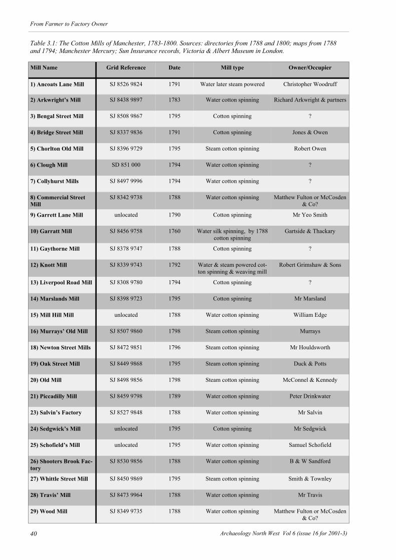
40 Archaeology North West Vol 6 (issue 16 for 2001-3)
From Farmer to Factory Owner
Mill Name Grid Reference Date Mill type Owner/Occupier
1) Ancoats Lane Mill SJ 8526 9824 1791 Water later steam powered Christopher Woodruff
2) Arkwright’s Mill SJ 8438 9897 1783 Water cotton spinning Richard Arkwright & partners
3) Bengal Street Mill SJ 8508 9867 1795 Cotton spinning ?
4) Bridge Street Mill SJ 8337 9836 1791 Cotton spinning Jones & Owen
5) Chorlton Old Mill SJ 8396 9729 1795 Steam cotton spinning Robert Owen
6) Clough Mill SD 851 000 1794 Water cotton spinning ?
7) Collyhurst Mills SJ 8497 9996 1794 Water cotton spinning ?
8) Commercial Street Mill
SJ 8342 9738 1788 Water cotton spinning Matthew Fulton or McCosden & Co?
9) Garrett Lane Mill unlocated 1790 Cotton spinning Mr Yeo Smith
10) Garratt Mill SJ 8456 9758 1760 Water silk spinning, by 1788 cotton spinning
Gartside & Thackary
11) Gaythorne Mill SJ 8378 9747 1788 Cotton spinning ?
12) Knott Mill SJ 8339 9743 1792 Water & steam powered cot-ton spinning & weaving mill
Robert Grimshaw & Sons
13) Liverpool Road Mill SJ 8308 9780 1794 Cotton spinning ?
14) Marslands Mill SJ 8398 9723 1795 Cotton spinning Mr Marsland
15) Mill Hill Mill unlocated 1788 Water cotton spinning William Edge
16) Murrays’ Old Mill SJ 8507 9860 1798 Steam cotton spinning Murrays
18) Newton Street Mills SJ 8472 9851 1796 Steam cotton spinning Mr Houldsworth
19) Oak Street Mill SJ 8449 9868 1795 Steam cotton spinning Duck & Potts
20) Old Mill SJ 8498 9856 1798 Steam cotton spinning McConnel & Kennedy
21) Piccadilly Mill SJ 8459 9798 1789 Water cotton spinning Peter Drinkwater
23) Salvin’s Factory SJ 8527 9848 1788 Water cotton spinning Mr Salvin
24) Sedgwick’s Mill unlocated 1795 Cotton spinning Mr Sedgwick
25) Schofield’s Mill unlocated 1795 Water cotton spinning Samuel Schofield
26) Shooters Brook Fac-tory
SJ 8530 9856 1788 Water cotton spinning B & W Sandford
27) Whittle Street Mill SJ 8450 9869 1795 Steam cotton spinning Smith & Townley
28) Travis’ Mill SJ 8473 9964 1788 Water cotton spinning Mr Travis
29) Wood Mill SJ 8349 9735 1788 Water cotton spinning Matthew Fulton or McCosden & Co?
Table 3.1: The Cotton Mills of Manchester, 1783-1800. Sources: directories from 1788 and 1800; maps from 1788 and 1794; Manchester Mercury; Sun Insurance records, Victoria & Albert Museum in London.

41
From Farmer to Factory Owner
Archaeology North West Vol 6 (issue 16 for 2001-3)
1-5 Milk Street by Richard Manchester could fit into a pattern of semi-domestic textile manufacture which typified the putting-out system controlled by the chapmen of 18th century Manchester. The Arrival of the Cotton Mill, 1783-1800 The first cotton mill in Manchester was opened in 1783 on Shude Hill and fittingly it was built by Richard Arkwright. However, this was 14 years after he first patented the water frame and the mill into which it could be installed. Until 1783 there was seemingly no indication that Manchester would become within 17 years the heart of the cotton spinning manufacturing trade; prior to 1783 the largest textile mill towns in North West England were Congleton, Macclesfield and Stockport. Archaeological, documentary and map evidence suggests that at least 207 water and steam powered textile mills were built in southern Lancashire and Cheshire prior to 1800. These can be split between
modern Greater Manchester with 154 mills, and modern Cheshire with 53 mills. There were also 58 finishing works (bleaching, dyeing and printworks; see below Chapter 10) from the 18th century recorded in Greater Manchester but none from modern Cheshire. These textile sites were not evenly distributed across the 18th century landscape, and although there were mills and finishing works in places as far apart as Nantwich and Wigan the greatest concentration lay in an arc around Manchester that ran from Horwich in the north west to Congleton in the south-east. Even in this area the mills and finishing sites were not evenly distributed. The finishing sites were concentrated along the River Irwell and its tributaries in Bolton, Bury, Manchester and Salford, and the River Mersey and its tributaries in Stockport and Tameside. There were notable concentrations of textile mills along the major river valleys and their minor tributaries within the modern boroughs of Bolton, Oldham, Rochdale and Tameside and significant concentrations in three towns; Manchester with 29 textile mills (Table 3.1 & Fig 3.14), Macclesfield with 26 mills and Stockport with 25. However, unlike the other two textile towns Manchester also had 18 textile finishing works within the township (see below Chapter 9), making it the leading area in the finishing as well as the spinning sectors of the cotton manufacturing trade by 1800.
Fig 3.14: The location of Manchester’s 18th century textile mills and finishing sites (see opposite Table 3.1). The base map is Green’s survey of Manchester and Sal-ford, published in 1794. The site numbers refer to Table 3.1. Key: ● = textile mills; ♦ = textile finishing sites

42 Archaeology North West Vol 6 (issue 16 for 2001-3)
From Farmer to Factory Owner
The first of these mills, Arkwright’s Mill (Fig 3.16), was insured for £5000, and its size, at 60.9m x 9.1m and six storeys high, was a measure of Manchester’s importance as a cotton manufacturing town. In order to provide water for the centrally placed water wheel a reservoir was built on the western side of the mill and it seems highly likely that it was fed by a leat drawn from nearby ponds known as the Shude Hill Pitts on Swan Street, which in their turn were fed by directly from the River Tib (Fig 3.15). The head for the water was achieved by siting the mill on the hillside formed by the Irk valley. This was a closed system, since the water was not lost but recycled by being pumped from the lower reservoir to the west of mill back up hill to a small square header reservoir north-east of the mill using an atmospheric steam engine of the Savory type. Technically, Arkwright’s Mill was the first in Manchester to use steam although the steam engine did not power any textile machinery (Chaloner 1955, 90-1). The first proper steam powered mill in Manchester, where the engine actually ran the cotton spinning machinery, was, however, at another Arwkright-type mill owned by Peter Drinkwater (c 1742-1801). Drinkwater was one of the Manchester fustian putting-out merchants
who made the transition to cotton mill owner. During the 1770s he was a fustian manufacturer with commercial premises including a warehouse in King Street, a town house in Spring Gardens and extensive overseas interests. During the late 1780s he began investing some of the capital he had accumulated in cotton spinning mills; first in a water-powered mill in Northwich and then in 1789 in Manchester with the construction of his four storey, brick-built, Piccadilly Mill on Auburn Street, which by the early 1790s was employing around 500
Fig 3.15 (above): The location of Arkwright’s Mill as shown on Green’s map of Manchester published in 1794. The line of the River Tib and the leat running to the mill are arrowed. Fig 3.16 (above inset): A 19th century view of the south-ern elevation of Arkwright’s Mill. This was the first wa-ter powered cotton spinning mill in Manchester, opened in 1783. It caused such disquiet amongst the hand cotton spinners that there were riots during its building.

43
From Farmer to Factory Owner
Archaeology North West Vol 6 (issue 16 for 2001-3)
people (Chaloner 1955, 85-93; 1962, 162-3). This was powered by an 8hp Boulton and Watt rotary beam engine (the original drawings for which can still be seen in the company’s archives at Birmingham), installed and working by 1st May 1790, and immediately increasing the output of his business thirtyfold (Chaloner 1955, 87-90). Throughout the 1790s a number of water powered mills were converted to steam and these included the Bengal Street Mill rented by McConnel and Kennedy in 1796 where they installed a 16hp Boulton and Watt steam engine the following year. The 1790s steam powered mills in Manchester are more difficult to locate but there are a number of candidates where the documentary evidence is unrevealing but the siting suggests they may have been steam powered from their inception; these include Oak Street Mill and Whittle Street Mill in the St Paul’s district and Chorlton Old Mill and Marslands Mill both just over the township boundary in Chortlon-upon-Medlock. All four were built around 1795. The only one of the 18th century steam powered cotton mills to survive, however, is Murrays’ Old Mill on the Rochdale Canal in Ancoats which was erected in 1798. Like Drinkwater’s Piccadilly Mill this too had a Boulton and Watt steam engine. Murrays’ Old Mill came to typify the Manchester cotton mill; it was a narrow, six storey, brick built structure, located on the side of a canal and with, for the time, a large beam engine powering spinning mules. The only contemporary late 18th century record of the distribution of cotton spinning mills is to be found in a 1788 survey of Arkwright patented water-frame mills in Great Britain. This was undertaken by Patrick Colquhoun, a Glasgow merchant working for the Manchester cotton lobby. This records 143 Arkwright mills in Great Britain, although a re-assessment of this figure in 1982 by Chapman increased the number to 208 (Chapman 1982, 5-10). Chapman demonstrated that the largest concentration of water-powered mills of the Arkwright-type was in Lancashire, where there were 44 such structures, followed by Yorkshire with 36 mills and Derbyshire with 27 mills (Chapman 1981, 8). Five of these mills were located in Manchester and this group included Arkwright’s mill, by then under the control of J & S Simpson, and Garratt Mill, built in 1760 as a water-powered silk mill but by 1788 converted to cotton spinning. The other three mills were probably Commercial Street Mill and New Islington Mill, whilst one, Mill Hill Mill, has as yet not been located. However, it is clear that not all mills in Manchester were listed by Colquhoun, since the map and documentary evidence shows two further water powered mills in Manchester by 1788. A preliminary analysis of the map, newspaper and rate book records for the period 1783-1800 by UMAU and the Manchester Region Industrial Archaeology Society has managed to locate 19 further cotton spinning mills in use during this period both within the township of Manchester and along its fringes in Chorlton-upon-Medlock (Fig 3.12). The distribution of these mills shows a split between riverside locations and urban fringe sites. The water powered mills were the oldest and these could be found along the River Medlock where there were three mills, along the River Irk with three water mills, on
Shooters Brook also with three mills and on the River Tib where there were two water powered cotton spinning mills. By 1800 these water powered cotton mills were out numbered by the steam powered mills, which were mostly grouped on the eastern edge of the town between Shude Hill and Ancoats (Fig 3.14). Conclusion At the beginning of this article an attempt was made to trace the impact of the industrial revolution on Manchester by analysing the introduction of new archaeological monument types over the period 1600-1900. It was noted that viewing the archaeological database in this fashion suggested that the expansion seen during this period was not constant, with two distinct phases of change, during the decades 1780-1800 with 31 new sites and the years 1820-50 with 37 new sites. Furthermore, the graph also suggested a lengthy period of expansion before 1780, with the rate of introduction of new monument types accelerating during the mid-18th century. In the search for explanations of these two features of the archaeological record, the long period of expansion, and the double acceleration in the rate of growth, the population of the town and the development of the textile industry have been examined. When the population data and the history of the textile industry before 1800 are combined with the trends visible in the graph of new archaeological monument types it can be seen that the last three decades of the 18th century were crucial in Manchester’s development; the trebling in the population of the town coincided with the introduction of 42 new monument types, especially through the proliferation of fustian weaving in workshop dwellings and the introduction of the cotton spinning mill. Using this evidence it is possible to put forward an archaeological model for the rise of regional manufacturing towns such as Manchester during the 18th and early 19th centuries. This builds upon the pioneering work of Barrie Trinder who has recently outlined a detailed model for local market towns in the same period and follows his tripartite division (Trinder 2002):
Fig 3.17: An early 19th century view of Murray’s Old Mill, built in 1798 along the northern side of the Roch-dale Canal and the oldest surviving textile mill in Man-chester

44 Archaeology North West Vol 6 (issue 16 for 2001-3)
From Farmer to Factory Owner
1600-1750 Proto-Industrial A complex central area with a long established
topography accommodating craft manufacturers, merchants and their warehouses, retailers, and the houses of professionals.
Specialist small-scale manufacturers with distinctive premises for national markets.
Production of building materials for local requirements.
The absence of a functioning market borough government
The absence of a guild system. The absence of resident county gentry. 1750 to 1850 Industrial Transition The rise of a single mechanised industry supported
by domestic workshops dominating the region. The development of secondary support industries
such as engineering. The incorporation of the town. The rise of a new governing class based upon the
new manufacturing families. The development of a regional commercial quarter,
with distinctive banking and warehousing buildings.
The development of a regional transport hub through the introduction of turnpike roads, canals and railways.
1850-1900 Maturity Establishment of new consumer goods industries
serving national markets. The growth of the township boundaries. Depopulation of the city centre as industrial and
commercial sectors expand into residential areas. The growth of specialist middle class suburbs. Proliferation of public utilities. One of the most important factors underlying this model is the lack of regulation in Manchester before
incorporation in 1838. In the town this was expressed by weak local lordship. We have already noted how the medieval chartered borough had ceased to function by the early 16th century, leaving the governing of Manchester to the local manorial court leet. Daniel Defoe had proclaimed in 1726 that for the great towns, including Manchester, ‘there are few or no Families of Gentry among them; yet they are full of Wealth, and full of People, and daily increasing in both; all off which is occasion'd by the meer Strength of Trade, and the growing Manufactures establish'd in them’. He was one of the first to use the term ‘manufacturing town’, which was in growing currency from the 1750s onwards and recognized that they owed their wealth and growth not to gentry or patronage, but to an expanding industrial and commercial life. The lack of resident landlords and the absence of a functioning market borough structure, combined with the availability of capital and the historical ability of the mercantile class to adapt to changing economic circumstance, meant that Manchester was well placed to exploit the industrial advantage given by the mechanisation of cotton production. The proliferation of workshop dwellings and the introduction of the cotton spinning mill reflect archaeologically this advantage. Thus, the workshop dwelling is at the heart of the town’s industrialisation and rise to national prominence prior to 1783, whilst the introduction of the cotton spinning mill coincided with Manchester’s emergence as the second city in Britain by 1801. Acknowledgements Thanks to Sue Mitchell, Lynne Walker and Ivan Hradil for their documentary and survey work at Nos 1-5 Kelvin Street and to Norman Redhead for drawing my attention to the Turner Street properties. Dr Peter Arrowsmith gave advice on the power systems and locations of some of Manchester’s 18th century textile mills, and on the population size of early Manchester. Mike Redfern of MRIAS provided a detailed analysis of the 1772, 1788 and 1800 directories. David Vale, also of MRIAS, provided information on the life of the 18th century Edward Byrom. Finally, thanks to Jill Champness & Dorothy Smith for helping to identify additional late 18th century cotton mills within the Manchester township.

45
From Farmer to Factory Owner
Archaeology North West Vol 6 (issue 16 for 2001-3)
T he work undertaken by UMAU on the more recent archaeology of Tameside summarises the potential
causes of industrialization in that part of Greater Manchester (Nevell and Walker 1999; and see above Chapter 2). Amongst these are a dual economy of industry and agriculture, probably linked to the marginal nature of the land, large areas of available land in the river valleys, a cheap and effective transport network, a tradition of Puritanism and a social system in which lordship was weak. These are factors that have been claimed by others to have stimulated industrial development in south Lancashire, the core area of 19th century industrial development in the North West. My intention in this paper is to examine a peripheral area in the history of industrialization in the region, the north Lancashire/Westmorland border area (Fig 4.1), and to highlight the archaeological remains of that process. Some attempt will be made to compare this area with south and east Lancashire in an effort to understand differences in the industrial experience of these regions. With the exception of Price’s examination of industrial sites in the Lune valley (1983), this is territory more
frequently covered from an historian's rather than an archaeologist’s viewpoint (see for example Winstanley 2000) and this is reflected in the content and references of this paper. This paper, however, represents little more than preliminary musings based on data incidentally gleaned from a variety of disparate projects. I hope to examine in greater depth some of the themes highlighted here, especially during the course of work currently (2002) being undertaken as part of the Lancashire Extensive Urban Survey. The concept of marginality as applied to medieval and post-medieval agricultural society, makes most of North West England a marginal area, and this has long been seen as one of the root causes of the development of industry in the region (Bailey 1989, 9). Such a concept can also be applied within the region with regard to industrialization and allows distinctions to be seen within the North West between core and peripheral areas of industrial development. Viewed from this perspective the Lancashire/Westmorland border can be seen by the later 19th century as marginal to the main centre of industrial and economic activity in south Lancashire. An 18th century snapshot of the region presents a different picture, however, with the area being as active in the early stages of the Industrial Revolution as many other parts of the North West which later became far more industrialised. This is especially true of the period 1780-1820 when a number of existing rural settlements grew considerably as a consequence of industrialization including Dolphinhome, Scorton, Galgate, Holme, and Milnthorpe (Winstanley 2000, 1). Settlement Patterns in the Lune Valley Today, the Lancashire/Westmorland border is regarded as a primarily rural area, and is generally not associated with industry outside its larger urban centres, Lancaster, Morecambe, and Kendal. It also has three smaller towns Grange-over-Sands, Kirby Lonsdale, and Carnforth, none of which are any longer associated with industrial employment (Fig 4.2). Three of these are settlements of late 19th/early 20th century origin; Carnforth was an industrial and railway-stimulated development whilst Morecambe and Grange were seaside resorts. The remainder of the settlement pattern is characterised by substantial nucleated ‘villages’ and scattered farms. Within this pattern, however, are a variety of now wholly rural and non-industrial communities, whose
Chapter 4
Industrialisation at the Margins:
Industrial Origins and Development along the Lancashire-Westmorland Border
Richard Newman
Fig 4.1: Northern Lancashire and southern Cumbria, the location for the current study.

46 Archaeology North West Vol 6 (issue 16 for 2001-3)
From Farmer to Factory Owner
physical fabric betrays evidence of former industrial activity. In many cases the very existence, development and form of these settlements is a legacy of an industrial past. In the 17th century the area was sparsely populated outside of Lancaster and Kendal. Much of the land at that time could be considered agriculturally poor with large areas of open common land both on fell tops and in the mosses. For example as late as 1813 the large and ancient parish of Heversham, which included the significant townships of Milnthorpe, Levens, Brigsteer and Crosthwaite, had 6,000 acres enclosed under Act of Parliament. Much of the area was wooded, particularly in what is now the Arnside/Silverdale Area of Outstanding Natural Beauty and on Cartmel Fell. Far from the centres of economic and political power, the area thus exhibits many of the features considered to define a marginal region; poor soils, harsh (at least wet) climate, remote location and like the Manchester area it was relatively unconstrained by strong, traditional, manorial systems (Bailey 1989, 4, 8-11). In the later 17th century the area became a centre of Quakerism and many of the merchants and industrial
investors in the area in the 18th century, as elsewhere in the north of England, were from families who were in the Society of Friends (Raistrick 1972). Study of inventories have suggested that the population was relatively static and that there was little material cultural differentiation amongst the main farming class, the yeomanry, though wealth was rising in the late 17th century (Marshall 1980, 508). Vernacular architecture, with many local houses possessing date stones, suggests that this was a period of housing investment for this class (Marshall 1980, 511; Newman 2001, 60-1). 17th and 18th Century Industries Textiles The area had a tradition of industry particularly in the production of woollen cloth, with Kendal Greens being famous from the late Middle Ages. Kendal itself was described by the antiquarian Thomas Machel in 1697 as ‘a most famous town for its industry’ (Ewbank 1963, 60). By the 17th century the continued importance of woollen cloth is reflected in the area’s vernacular architecture, with spinning balconies being a particular feature of local farmhouses, and spinning wheels appear as a frequent item in inventories (Marshall 1980, 514). The physical and documentary evidence thus indicate that some participation in industry was common within farming families. Even so, a study of late 17th/early 18th century inventories incorporating evidence from Kendal did not reveal a ‘a marked tendency to rapid industrialization’ (Marshall 1980, 508). Caution is needed in using items listed in inventories as indicators of industrial activity, since a more recent study of inventories in the Lune valley has convincingly argued for the under-representation of domestic weaving by drawing inferences from this material. Nevertheless, another recent study of 17th and early 18th century sources, including both wills and inventories, based on the failed medieval borough of Walton, near Carnforth, supports the conclusion that there is little evidence of industrialization c 1700 in the area. Whilst nearly 50% of the male inhabitants supported themselves wholly or partially through non-agricultural occupations, the majority were still engaged in full-time farming. The trades noted are all the general commercial and craft activities that would be associated with any settlement, without any evidence of industrial specialisation (MLHS 1998, 151-3). In contrast in the ex-Forest areas of east Lancashire by the early 17th century the vast majority of households were engaged in clothmaking, on a scale perhaps much greater than anywhere in the Lancashire/Westmorland border area. Yet even there, unlike in the Manchester region, little evidence of sustained industrial growth is noted until well into the 18th century. The manufacturing base in the Lancashire/Westmorland border area in the late 17th and early 18th centuries was narrow, though perhaps a little broader than that of east Lancashire. In addition to textile production, paper was an important industry, iron was worked and there had been some pottery production.
Fig 4.2: The location of the settlements discussed in this study.
Fig 4.3: An 18th century view of the City of Lancaster looking south. Lancaster remained the dominate settle-ment of the Lune valley throughout the 18th and 19th centuries.

47
From Farmer to Factory Owner
Archaeology North West Vol 6 (issue 16 for 2001-3)
All these industries exploited the locality’s natural resources either for power or raw materials. The area’s abundant watercourses and coppice woods were especially attractive in an era before steam power and the widespread use of coal as a fuel. In addition to manufacturing using local resources, extractive industries exploited the abundant limestone and the small Lune valley coalfield. Some very limited exploitation of copper and iron deposits may have been undertaken around Warton Crag north of Carnforth (Fig 4.2). Quarrying Quarrying has remained an important industry through to the present day. In the past the Kellet quarries supplied stone to Lyme Park, Cheshire, for building works at the mansion in the 18th century, and later Trowbarrow Quarry near Silverdale provided the original stone for surfacing Blackpool Promenade. Apart from the usual farm kilns the area had major concentrations of industrial lime burning, as at Kendal Fell, and featured technically advanced kilns such as the now largely destroyed Hoffinan kiln at Trowbarrow and a triple flue kiln at Leighton Beck, both in the Arnside/Silverdale district between Carnforth and Milnthorpe. Iron Industry Haematite ore was available within the area but despite numerous attempts at commercial exploitation, from at least the 17th century, never seems to have provided a viable source for local iron smelting (Newman 1999, 14). Instead the ease of water transport across Morecambe Bay enabled the cost-effective export of ore from the iron-mining areas of Furness to the Arnside/Silverdale district and the lower Lune valley. Milnthorpe is widely known as Westmorland’s only port, though since the 18th century that distinction properly belongs to Sandside a hamlet 1.5 km further down the estuary of the River Bela. Milnthorpe was a hamlet in the parish of Heversham and its medieval origins as the mill hamlet of that township are somewhat given away by its name. A water-powered bloomsmithy was established in Milnthorpe between 1650-5. The forge was out of use by 1692 and had been converted to a paper mill (Newman 2001). Milnthorpe’s involvement with the iron industry continued into the 18th century, however. Sandside was in the 18th century the entry point for ore smelted at Leighton Beck charcoal blast furnace, three miles south of Milnthorpe, and for Scottish pig iron for use at the finery and chafery forge two miles north of Milnthorpe at Force Forge on the River Kent. The latter was established by gentlemen from Kendal by 1763 and was described by the poet John Gray in 1769 (Newman 1999,14; see also Chapter 10); ‘Force Falls. The stream is much impaired in beauty since the forge was erected. I went on down to the forge (from which proceeded the din described) and saw the demons at work by the light of their own fires. The iron is brought in pigs to Millthrop by sea from Scotland etc., and is here beat into bars and plates’.
Little now survives of Force Forge. Better documented and archaeologically more visible is Leighton Beck furnace, although only a converted charcoal barn survives above ground (Bowden 2000, 61). Established by the Backbarrow Company in 1713, two years after their blowing in of the Backbarrow Furnace, Leighton Beck continued in blow until it literally blew up in 1806 (Bowden 2000, 7; Newman 1999). Although it was fuelled with charcoal gained from the local coppice woods, its greatest claim to fame was its extensive use of peat as a fuel. In 1715-16 peat was used with charcoal in a ratio of 2:1. Around this time more than 8,000 cart loads were used per annum and its use had a significant impact on the local mosslands (Hodgkinson et al 2000, 5 1). Iron smelted in this manner seems to have been an inferior product because of its high sulphur content. Even so, the relative cheapness of peats in comparison to charcoal made the iron a viable product, and Leighton Furnace was initially more profitable than Backbarrow (see below Chapter 10). In 1755 the Backbarrow Company sold their interest in Leighton Furnace to the Halton Iron Company, who seemed to have built a furnace at Halton near Lancaster in 1752 and also owned a forge at nearby Caton (Newman 1999). The charcoal blast furnace industry continued on at sites like Backbarrow into the later 20th century (Bowden 2000, 48), later than anywhere else in England, but the industry seems to have ended in the north Lancashire/Westmorland border area in the early 19th century. 19th Century Industry Wool and Cotton In many areas the iron industry was an important factor in regional industrialization but despite this, as well as the local importance of paper-making and, from 1762, gunpowder production, the principal engine of industrialization in the Lancashire/Westmorland border area, as throughout most of North West England, was the textile industry. The archaeologically most significant development of this was the growth of Caton in the lower Lune valley, which had five textile mills in the 19th century creating a settlement which outgrew its original township of Brookhouse (Price 1983, 14-22). The cotton industry in the area began to grow from the mid 18th century, unsurprisingly since the environmental and trading conditions which stimulated its development were similar to those in the south of Lancashire. Milnthorpe had two cotton mills in the 18th century, the last one closing in 1816. Burneside, near Kendal, had a cotton mill in 1787 and other 18th century cotton spinning mills were opened at Scorton south of Lancaster and Cark in Cartmel. Silk and Linen Industry In addition to woollen and cotton cloth the area also produced linen and silk in the 18th century. There is some tentative archaeological evidence for medieval flax retting and thus possible linen production along the River Keer, near Carnforth (Higham 1998, 14). Little

48 Archaeology North West Vol 6 (issue 16 for 2001-3)
From Farmer to Factory Owner
other evidence for local linen production is noted until the 18th century, when linen manufacture appears to have gradually moved northwards from a focus around Kirkham. Garstang and Lancaster both had domestic-based yarn spinning industries by the 1740s. Domestic spinning and weaving spread throughout north Lancashire in the late 18th century and into south Westmorland. Only one linen mill had opened in the area by the end of the 18th century, however, at Holme Mills near Milnthorpe. Holme Mills is a hamlet of the township and chapelry of Holme. A linen mill was built there about 1790 (Fig 4.4), possibly anticipating in its location the arrival of the Lancaster Canal, though the canal section to Kendal via Holme was not opened until 1819. Even so, the mill in part owed its success to the canal. Sometime before 1860 the mill was partially destroyed by fire and linen manufacture ended, but the mill was rebuilt and converted to cocoa-mat and matting production. The effect of the canal and the subsequent opening of the linen mill is to some extent reflected in the population development of Holme in the 19th century. In 1811 the township had 283 inhabitants within ten years this leapt to 420 and by 1851 had increased to 1,154. Silk manufacture was a more important factor in the industrialization of the locality. The processing of waste silk for garment production was being undertaken in both Lancaster and Kendal by the 1720s. A silk waste spinning mill was in operation at Kendal by 1769 (Bush 2000, 20) and the still surviving example at Galgate was established in 1792 (Beeden 1991). Further silk mills were established by 1800 at Caton, Wray and Halton, making the Lancaster hinterland second in importance only to the Cheshire/Derbyshire border for the early 19th century silk processing industry. 19th Century Industrial Settlements Galgate Galgate is a settlement on the present A6 within the township and chapelry of Ellel to the south of Lancaster. A hamlet known by the name Galgate appears as early as 1605. Archaeological evidence suggests occupation in
the area, perhaps associated with a tannery, as early as the 10th century (Drury 1998, 41). Galgate was chosen as the base of a silk spinning enterprise because it had a corn mill of medieval origin which could be converted. The site lay adjacent to the Turnpike road, though this moved slightly to the west in the 19th century, but more importantly it was planned in 1790 to build a canal from Lancaster to Preston that would pass through Galgate. Indeed, when the Lancaster Canal opened in 1797 the opening ceremony included a symbolic exchange of limestone from Lancaster for coal shipped from Preston, which took place at the Galgate wharves (Phillpotts 1993, 41). During the 19th century two more silk mills were added at Galgate and a cotton mill was also erected, though this enterprise had failed and the mill had been pulled down by 1895 (Newman forthcoming). In 1912, when Galgate was described as a considerable, important and populous village (Fig 4.5), silk spinning was said to employ 300 people within the township of Ellel or about 20% of the population (Newman, forthcoming). The significance of Galgate was recognised later in the 19th century by the establishment of an L&NW railway station. Lancaster did not erect its first textile mill until 1802 (Dalziel 1993, 135), and the remainder were built after 1815 following the wider adoption of steam power (Winstanley 2000, 2). Generally unsuitable for water-powered enterprises, Lancaster was able to obtain both the raw materials for steam power, water and coal, from the Lancaster Canal. This had reached the town in 1797 and allowed the delivery of coal from Wigan. During the 19th century Lancaster developed a steam-powered cotton spinning industry with seven mills in operation in the 1830s plus ancillary enterprises (Winstanley 1993, 151-2). The flourishing of steam-powered cotton mills in Lancaster at a time when the water-powered cotton industry of the rural hinterland was declining, reflects the general focus of mill development in urban areas following the widespread adoption of steam power. After 1840 the cotton textile industry declined in Lancaster. As Lancaster failed to grow appreciably, in comparison to towns elsewhere in Lancashire in the 19th century, so it failed to provide an economic stimulus for the surrounding countryside. Kendal, hampered by poor communications until 1819, remained a town dependant on wool for its manufacturing industry. The conservatism of manufacturing there, encouraged by the late adoption of steam power caused by the expense of importing coal before the extension of the Lancaster Canal, is shown by the use of water power at K shoes as late as the 1920s. Carnforth One settlement bucked the trend of industrial decline. Carnforth was a hamlet of Warton (Fig 4.2). It existed in the medieval period when it may have been a centre of pottery production. By the 18th century Carnforth appears to have been a sizeable settlement with about 40 resident families (Newman, forthcoming). Its main claim to any prominence was that it lay along the Lancaster-Kendal tumpike road. In 1792 Carnforth
Fig 4.4: The mill pond at Holme Mills for the linen mill built in 1790. Its location possibly anticipated the arri-val of the Lancaster Canal, though the canal section to Kendal via Holme was not opened until 1819.

49
From Farmer to Factory Owner
Archaeology North West Vol 6 (issue 16 for 2001-3)
became a settlement on the Lancaster Canal. This stimulated production from local gravel pits and may also have helped to encourage the mining of local haematite, a venture which met with only limited success, when the ore was crushed and used in a paint mill (Ashmead and Peter 2000). The real expansion of Carnforth did not start, however, until 1857 when it became a junction for the Furness railway with the Lancaster Carlisle railway, the latter becoming the L&NW in 1861. These transport links made Carnforth a prime site for the establishment of a new industrial enterprise. In 1865 an ironworks was erected there, financed by Manchester money (Harris 1960, 107-8), which by 1873 consisted of three blast furnaces and two Bessemer steel convertors. This enterprise owed nothing to local natural resources, the nearby presence of Lancaster, or any other factor beyond its location on a railway junction giving access to raw materials in south Lancashire and Furness and more generally to markets. The works continued until 1929, when they were forced to close because they were outcompeted for supplies of ore by ironworks closer to the Furness iron mines (Newman 1999, 15). Physically only fragments remain of this industrial history, including the boundary wall of the ironworks, the impressively large size of the railway station and the piles of furnace waste on the foreshore. The impact of the ironworks can be clearly seen in the census igures for Carnforth; between 1821 and 1851 the population remained remarkably stable at around 295, by 1861 following the arrival of the railway it had increased to 393, by 1871 it was 1,091 and by 1901, 3,040 (Newman, forthcoming). The large workforce requirement of the ironworks ensured that Carnforth grew to achieve urban status in 1894 (Harris 1960, 118). Like Caton, Galgate, Holme Mills and even Milnethorpe, Carnforth originated as a hamlet of another settlement. All five grew in the late 18th-19th centuries, Milnthorpe and Carnforth achieving administrative and political independence, Galgate and Holme Mills not. For their expansion they depended on one or two primary industries. They are all nucleated settlements with both Holme Mills and Galgate being restricted in size by the cost of the land the mill owners had to purchase to erect workers housing. In the early 19th century, houses were built by the mill owners at Galgate and it seems also at Holme Mills for their workforce. At Carnforth both the railway and the ironworks built workers housing in the late 19th century, though the majority of the housing was built as private developments of terraces. At Milnthorpe the more gradual development of the settlement, and indeed its commercial decline from the mid-19th century with the closure of the port and the decline of waterpowered mills, ensured that 19th century terraces are absent. Rows of 19th century cottages are present but they are accretions of often individually built dwellings infilling restricted spaces. The only evidence of the effect of past industry on the fabric of the settlement are the many former warehouses. These five sites all grew from hamlets lying close to other settlements to which they were subordinate in the local settlement
hierarchy. With the exception of Carnforth, however, none developed urban characteristics and the industrial enterprises were fairly small scale. Conclusion
The Lancashire/Westmorland border area shared many of the economic and social characteristics of much of the rest Lancashire in the later 17th and early 18th centuries. There was a tradition of small-scale, often domestic-based industry, frequently providing by-employment for smallholding farmers. In Kendal it had an urban centre noted for textile production in the 17th century and similar in this respect to Blackburn in east Lancashire. Despite sharing many of the circumstances favourable to industrialization enjoyed by south Lancashire, the Lancashire/Westmorland border did not become a major industrial area. Divergence between its economy and that of east Lancashire may have begun as early as the late 17th century, however, when the Blackburn Hundred, for example, began to exhibit a marked increase in the number of individuals at least part dependant on the production of textiles for their livelihoods. By the 18th century a large portion of the population appears to have been mainly dependant for their livelihoods on manufacturing, although this was not the case in the Lancashire/Westmorland border area (Marshall 1989, 139). By the end of the 17th century much of that part of Lancashire which came to be associated with cotton production, can be recognised as sharing ‘proto-industrial’ characteristics. This marks the area stretching from Manchester to Preston, Blackburn and Burnley as different from north Lancashire and south Westmorland as early as 1700. Consequently, by the late 18th century Kendal for example had a very different occupation profile to Blackburn with far fewer handloom weavers present. During the later 18th century there is some evidence based on inventories to suggest a decline in rural textile weaving, and the iron industry also went into decline (Marshall 1989, 134, 148). In some ways not yet clearly understood, the seeds of the failure to sustain industrial growth in the 19th century may have been present before the Industrial Revolution had gathered strength. More clearly influential in the area’s inability to keep pace with industrialization in south Lancashire was the
Fig 4.5: Industrial workers’ housing in Galgate.

50 Archaeology North West Vol 6 (issue 16 for 2001-3)
From Farmer to Factory Owner
decline of its Atlantic trade. During the 18th century Lancaster grew rich on this trade, importing mahogany, sugar and other exotic produce and re-exporting slaves. By the later 18th century Lancaster was the fourth largest slaving port in the country (Elder 1992, 209). The wealth accrued from the Atlantic trade was invested in the town’s fine Georgian architecture and also in industrial development. It directly stimulated associated industries such as shipbuilding, sail cloth making and furniture manufacture within the town (Elder 1992, 174). It also brought extra finance into the general economy of the town’s hinterland which could be used for other forms of industrial investment. Thomas Hinde, a wealthy Lancaster merchant, developed the worsted mill at Dolphinholme in the late 18th century, similarly silk and cotton mills at Caton were financed with monies gained in the slave trade (Elder 1992, 188; DaIziel 1993, 135). Throughout North West England the textile industry in particular can be seen as ‘part of an integrated maritime economy’ (Winstanley 2000, 6), thus when Lancaster began to falter as a centre of the Atlantic trade towards the end of the 18th century this inevitably had an impact on the wider economy of its locality. Potential investors focused southward on the booming economy of the Liverpool/Manchester axis. The decline in Lancaster’s ability to stimulate local industrial enterprises, negated the beneficial effects of the newly built Lancaster Canal. Moreover, local industries were very soon adversely affected by national changes in the nature of industrial activity. The charcoal-fuelled iron industry was declining in response to the improvement in the products of the coke-fuelled industry and steam power was replacing water power. Both these developments acted to focus industrial activity on coalfields and away from well-wooded rural environments. The Lancashire/Westmorland border area had only the Lune valley coalfield which was highly marginal in terms of its economic viability. Changing economic circumstances and industrial requirements in the early 19th century prevented the area developing from an industrial base which was as advanced in the late 18th century as it was in many other areas of Lancashire. Settlements which had evolved to support the growth of industrial enterprises in the 18th century, continued to have an industrial character in the 19th century but for the most part neither they nor the industries they supported flourished in a way that was comparable to similar places in south and east Lancashire. Hence, the industries remained small-scale and the settlements remained as industrial hamlets and did not grow into towns. The textile industry’s move away from rural to urban localities did have some effect on Lancaster, and the town increased in size as a result (Winstanley 1993, 152). A 40% increase in population between 1821 and 1851, however, was very small in comparison to the trebling and quadrupling often experienced by communities in east Lancashire during the same period. Lancaster’s relative failure as a 19th
century industrial town further dampened the potential for industrial growth in its hinterland, as it lacked the stimulus of an economically strong local urban centre. Consequently, other than at Carnforth, outside finance was little attracted into the area. The archaeological and architectural legacy of industrialization in the area reflects its 18th-century strong beginnings and 19th-century failure to maintain momentum. Many of the remains are early, with sites of major importance to the development of the iron and silk industries. The enterprises are generally small-scale and the associated settlements relatively small with good surviving examples of early industrial housing. It has been argued that in the Lune valley the reasons for the failure to maintain the momentum of the later 18th century in the development of the textiles industry are complex, and little explored or understood (Winstanley 2000, 9). This determination can be broadly applied to industrialization overall within the Lancashire/Westmorland border area. Nevertheless, it is difficult to escape the conclusion that marginality was a key factor in the failure of the growth of industrialization in the vicinity after such a promising start in the later 18th century. As the Liverpool/Manchester axis evolved and settlements grew more rapidly than further north, so even more money was attracted into the south to invest in industry. The growing local market created its own demands. Success bred success. Once Lancaster faltered in the Atlantic trade and steam-power reduced the attraction of mill locations on rural stream systems, the outcome was inevitable. Far away from the engine of economic growth in Manchester by 1800, the Lancashire/Westmorland area was doomed to be a peripheral area with the scale, nature and duration of is enterprises and industrial settlements reflecting its economically marginal situation. The boundaries of marginality can change through time and the margin can take various different forms. It can be locational, institutional or environmental (Bailey 1989, 14-5). Peripheral geographically and possessing only limited natural resources suitable for industrial exploitation, the Lancashire/Westmorland border area became increasingly marginal during the 19th century both economically and politically, as symbolised by Lancaster’s loss of its monopoly of the County assizes in 1835 (Winstanley 1993, 156). Aside from Kendal and Lancaster, industrial growth in the 18th and 19th centuries was largely confined to industrial hamlets, which themselves had developed as peripheral settlements within the settlement hierarchy. In the 19th century rural-based industries exploiting local resources, other than quarrying, declined because they could not compete with better resourced areas (see Hudson 1998 for example). Marginality was ingrained throughout the industrialization of the Lancashire/Westmorland border area, it defines its character and ensured the area’s development was distinct from that of south Lancashire.

51
From Farmer to Factory Owner
Archaeology North West Vol 6 (issue 16 for 2001-3)
T he archaeology of industrialisation, with its implied emphasis on the process of change from a non-
industrialised to an industrialised society, is an area of enquiry that has often had a very narrow field of view. This was perhaps best expressed a generation ago by Kenneth Hudson who maintained dogmatically that industrial archaeology was only about the archaeology of industry (Hudson 1983, 1; and above Chapter 1). Despite the growth of landscape and social archaeology studies of industrialisation since 1983, there remains a constant danger of concentrating primarily on heavy industry. Until recently, this has been the case with many studies of the period, both archaeological and historical, in North West England. Too often the lives of those who worked, travelled and defended their communities are
largely ignored by archaeologists who leave them to social historians; their homes can be catered for by architectural historians; their material culture is left to cultural historians. It has only been in the last decade that these separate subjects of investigation have been brought together by archaeologists in a synthesised interpretation (Newman 2001; Palmer & Neaverson 1997; see above Chapter 1). This study, focusing on one rather unusual place in North West England, Chester (Fig 5.1), will show that the model of industrialisation derived from the experience of places that acquired heavy industries in the 19th century is incomplete. What is needed is a more social approach that embraces both those communities that were dominated by heavy industry and those that were not (Trinder 2002, 87).
Chapter 5
An Archaeology of Work:
The Example of 19th and 20th Century Chester
Keith J Matthews
Fig 5.1: Early 21st century Chester. The numbers refer to sites described in the text.

52 Archaeology North West Vol 6 (issue 16 for 2001-3)
From Farmer to Factory Owner
Matthew Johnson’s (1996) The Archaeology of Capitalism was arguably the first large-scale attempt to use archaeology to look at the social conditions that led to the development of an industrialised culture in 18th-century Britain, although it stops short of actually analysing that culture. Increasingly, archaeologists who perhaps define themselves more as post-medieval specialists than as industrial specialists are looking at the past three centuries. We have moved a long way from the traditional Industrial Archaeology of the 1960s, 1970s and 1980s, in which machines dominated our accounts and people rarely figured except, perhaps, as their inventors or operators. However, we still have difficulties in studying those places that conspicuously lack the characteristic remains of industrialisation, or where such remains are few. There is a temptation to see these as places where industrialisation failed (Trinder 2002, 76). We should not confuse industry (in the sense of work that generates a tangible product) with industrialisation (a system of production that involves full-time specialists, working in factories designed to produce maximum profits for their owners, who do not actively produce; see above Chapter 1). Humans have experienced industry since at least 2.5 million years ago, when the earliest known stone tools were made, but the experience of industrial production is a recent and by no means universal phenomenon. If we use the term ‘industrialised’ to characterise society in Britain during the 19th and 20th centuries, are we thereby excluding all those who did not work in factories? If, on the other hand, we characterise the period from, say, 1800 to 1980 as
‘industrial’, what do we mean? Furthermore, by concentrating on the physical remains of industrial buildings and other sites, do we run the risk of marginalising so many aspects of the lives of those who worked in them? Ought we perhaps to take a step back and start to think about the economic and social archaeology of the 19th and 20th centuries? Historians have long been interested in work, which has been defined as ‘the daily labours, routine and otherwise, involved in the production, management, and dissemination of resources and skills for sustaining a living’ (Corfield 1990, 208). Studies of the history of ‘work’ have particularly focused on occupational analyses, relating them to such diverse phenomena as voting patterns and places of residence. Social archaeology ought to help us bridge the gap between these ‘historical’ interests and those of traditional, manufacturing-focused, industrial archaeology. In non-industrialised societies, where the place of residence and place of work are frequently the same, this is a relatively easy task; for the more recent past in Britain, where workplace and residence have been distinct, it is a greater challenge. As noted in the first chapter of this study, by focusing on the idea of ‘work’ and integrating fine-grained historical data with fine-grained archaeological studies, we can begin to meet this challenge. Through the archaeological study of remains of the recent past, we not only illuminate recent history, but also can develop new ways of looking at what one recent publication (Tarlow & West eds 1999) has questioningly called ‘The Familiar Past?’ Industry in Chester Like most ‘pre-Industrial’ towns, Chester was an important manufacturing centre serving a large region from the Medieval Period to the 18th century. Leather, especially, had long been a major element in the city’s
Fig 5.2: The Albion Cotton Mill, later a corn mill and now a hotel (Ashmore 1982, 34).
Fig 5.3: The better known (and later) part of the Steam Mill (Ashmore 1982, 34).

53
From Farmer to Factory Owner
Archaeology North West Vol 6 (issue 16 for 2001-3)
productive economy: in the late 16th and 17th centuries over a fifth of the artisans in the city were engaged in it. Gloving was the most important aspect of the industry (Koweleski 1990, 68), which continued locally into the 19th century, although its decline began early in the 18th. Felt hatting also became important to the city around the middle of the 16th century, when the hats became popular items of clothing, and 135 feltmakers were admitted to the freedom of the city over the following century. One of the great advantages of felt making was that it required no investment in machinery; artisans not only supplied the material to haberdashers, mercers and drapers but also sold finished goods directly to the public in their shops. By 1750, though, the industry had become the victim of the restrictive practices operated by the city guilds, encouraging artisans to leave the city in search of greater freedom and profit elsewhere at a time when the industry was expanding. The Dee Mills (Fig 5.1, No 1) were first recorded in AD 1119 as ‘a mill at the further end of Dee Bridge’ and during the thirteenth century, the mills were among the largest and most valuable in England, their annual rent being £270 (DCMS 1998, 1). They were sometimes called The Causeway Mills. By 1698, one of them had become a paper mill and by 1701, another was a snuff mill. By 1745, there were three paper mills in Paper Mill
Lane (now Mill Street) (Bracegirdle 1965, 14). The mills were owned by the crown until being sold to the Wrench family in the late 18th century. They were partly destroyed by fire in 1789, 1819, 1847 and 1895, the latter at Johnson’s Flour Mill, which closed three years later. During the 19th century, work at the mill was seasonal for some, who earned their living as salmon fishermen the rest of the time, becoming mill employees during the closed season. The City bought the mills in 1895 and there was a brief revival under Rigby’s of Frodsham in 1902, but it was short lived. The mills on the northern bank of the river were demolished in 1910, while those on the south bank survived until about 1970. The northern mill was restored as a hydroelectric power station in 1913 (DCMS 1998, 32); in 1939, it became a water pumping station. By the end of the 18th century, Chester was losing out to the developing industrial towns of the region such as Liverpool and Manchester. Nevertheless, new industries did grow up in the city, albeit with mixed results. During the middle of the 18th century, a small pottery factory was established in Handbridge, but it was unable to compete with the growing industry in Staffordshire, and it closed after barely twenty years. Two cotton mills were also founded early in the 19th century (Fig 5.1, No 2; Fig 5.2), but these also failed to compete and had closed by the 1820s. William Harrison, a Chester grocer, set up the Roodee Iron Foundry and Paper Mills (Fig 5.1, No 4) shortly after 1800, but the business was worth only £6,000 in 1812 (Bracegirdle 1965, 17). Only the Steam Mill (Fig 5.1, No 3; Fig 5.3; Bracegirdle 1965, 17; Nevell & Walker
Fig 5.5: The shot tower of the Leadworks (Ashmore 1982, 32).
Fig 5.4 Swindley’s Ironworks, Handbridge, before dem-olition in the 1980s. It was here that the ironwork for the Eastgate Clock was made (Photograph by T E Ward).

54 Archaeology North West Vol 6 (issue 16 for 2001-3)
From Farmer to Factory Owner
2001, 65), the Leadworks (Fig 5.1, No 5; Fig 5.5; Ashmore 1982, 32; Rowe 1983, 81; Wilding 1991) and the Hydraulic Engineering Company (Fig 5.1 No. 6), established in c 1785, 1799 and 1805 respectively, really flourished. Iron working took place in small foundries and forges throughout the city (Fig 5.4), but the industry remained
small scale and its markets were confined to the rural hinterland of Chester. A chemical industry seems to have operated along the canal banks, but little information about it has survived, allowing future archaeological research to shed some light on its nature. A building called Chemistry is shown in Upton on early 19th century maps, while the field-name Chemistry Pits over a kilometre from this site suggests that the industry, if small-scale scale, was widespread. As the city was linked to the developing rail network in the 1840s, it was hoped that it would revive the city’s economic fortunes, which had entered a slump in the 1830s, but it did so in unexpected ways. In the late 1830s, members of the city council had stated that the way ahead for the city was to attract major manufacturing industries, and it was hoped that the railways would encourage them to settle here, at an important nodal point in the new transport network. Indeed, a thriving engine works (which remains open at the start of the twenty-first century) was soon established near the General Station (Fig 5.1, No 7), leading to residential development in Hoole (which acquired Urban District status in 1894). Further opportunities to exploit the new technology of transport were afforded in Saltney, where wharves were built by the Shrewsbury and Chester Railway next to its junction with the Chester and Holyhead line. A number of industries were subsequently established in this area, including Henry Wood and Co.’s anchor, chain and general engineering works, Proctor and Ryland’s bone manure works and a chemical works. Instead of attracting the hoped-for heavy industry, Chester continued to develop as a tourist centre, now that people could travel quickly and cheaply (Fenwick 1896, 253). Many tourists came from abroad; a bilingual French and English guidebook was produced as early as 1851. The city became especially popular with Americans, many of whom landed at Liverpool and travelled by rail to London via Chester. A famous visitor was the novelist Henry James, who wrote (anonymously) in 1872, ‘The American traveller arriving in this venerable old town finds himself transported, without a sensible gradation, from the edge of the New World to the very heart of the Old ... Chester is still an antique town and medieval England sits bravely under her gables’ (quoted in Palliser 1980, 31). The 1890s were a period of contraction for many new industries and some, such as Hughes and Lancaster’s engineering works in City Road moved away from the city (in this case, to Ruabon). In 1895, steelworks were set up in Shotton by Henry Hall Summers of Stalybridge, while other industries were developing in Ellesmere Port, all evidence that Chester was not seen as an ideal location for manufacturing, although it served as a useful transport hub. On the other hand, some new industries were established in the city, notably Brookhirst Switchgear, set up in Victoria Road in 1898, whose rapid expansion soon made the construction of new premises in Newry Park necessary (Bracegirdle 1965, 74). Despite the optimism of the early 20th century, when Crosville Motor Services Ltd operated a general engineering works at Crane Wharf and the Hydraulic Engineering Company expanded its premises between
Fig 5.6: The early 20th century extensions to the Hydrau-lic Engineering Company’s works on Charles Street.
Fig 5.7: The ‘invisible’ side of retailing: a 19th century warehouse on Whitefriars.

55
From Farmer to Factory Owner
Archaeology North West Vol 6 (issue 16 for 2001-3)
Charles Street and Egerton Street (Fig 5.6), and after the First World War, when Pratt, Levick & Co were established in Victoria Road (subsequently moving to Walls Avenue), Chester never developed as a manufacturing town, and a significant proportion of its population worked in nearby industrial areas such as Ellesmere Port, Runcorn and Broughton. Nevertheless, the city suburbs continued to flourish as industrial areas throughout the middle of the 20th century, particularly around Boughton to the east, to the north of the historic core and westwards into Saltney and Sealand. This only began to alter with changing economic patterns and the national collapse of manufacturing industry from the 1970s. The slow decline of the port finally led to its demise for commerce around 1950, although pleasure boats continue to use the river and canals and the port entered the realm of the leisure industry. The silver assay office, one of only five provincial offices, survived until 1962 and was the last of these offices to close. Light engineering continues on the north-eastern side of the city, and the railway works are still important. The lead industry also continues, with the 1799 lead shot tower dominating the eastern skyline of the city, but it is retailing that still dominates the city’s economy (Fig 5.7). Characterising Industrial Period Chester One way of classifying Chester’s industrial period archaeology as described above, and thus avoiding the emphasis on extensive manufacturing industries and processes, is to take a broadly social and anthropological view. Thus, what may broadly be described as ‘civilisation’ (not necessarily western!) is associated with economic specialisation. This produces complex economies, which are generally divided into four sectors: the primary, which deals with the production of
raw materials, including foodstuffs; the secondary, which deals with the transformation
of raw materials into saleable materials; the tertiary, which deals with the provision of
services, including the retailing of the products of the secondary sector;
the quaternary, which deals with government, information and research.
All four sectors of the economy, therefore, involve work of some kind, although industrial archaeology has often concentrated on the primary and secondary aspects. If the evidence from Chester is characterised in this fashion, then archaeologists from Chester Archaeology and other organisations have investigated aspects of all four sectors within the city during the last 20 years. Within Chester’s Primary sector, the Leadworks and the Steam Mill have been the subject of archaeological excavation and building survey work (Pack 2000; Scruby 2001). The city’s Secondary, or manufacturing, sector is represented by the remains of clay tobacco pipe manufacturies by the New Gate (Fig 5.1, No 8; Connelly 1999), bakeries at 27 Watergate Row (Fig 5.1, No 9; Fig 5.8; Matthews 1991a) and Tudor House on Lower
Bridge Street (Fig 5.1, No 10; Luke 1998), the Will R Rose photographic laboratory on the site of a former Baptist Chapel in Hamilton Place (Fig 5.1, No 11; Fig 5.9) and the Northgate Brewery (Fig 5.1, No 12; Fig 5.10; Fig 5.11; Fig 5.12; Davey 1973). Chester’s Tertiary, or trade, sector was very extensive. As well as the Port of Chester, whose origins lie in the medieval period, there were the late 18th and early 19th century canal basins known as the Dee Basin (Fig 5.1, no 13; Emery 1996) and the North Basin (Fig 5.1, No 14; Fig 5.13; Cooke 1999). These basins were provided with the usual facilities, including warehouses (Fig 5.16), a dry dock (Fig 5.17), iron roving bridge, boat sheds (Fig 5.18), blacksmith’s forge and a tavern. The Union Hall, a large building on Foregate Street (Fig 5.1, No 15; Fig 5.14; Matthews 1991b), was built in 1809 as a Cloth Hall, part of a post-medieval northern English tradition. More familiar forms of retailing have been investigated at the former and the North Basin built on the northern side of the city. Retail premises included four cloth halls in the 18th and 19th centuries, of which only fragments of the Union Hall survives on Foregate
Fig 5.8: The firebox of a 19th century bread oven at 27 Watergate Row (Photograph S Warburton).
Fig 5.9: A drain for chemicals in the cellar of the Will R Rose photographic laboratories (Photograph A Lovatt).

56 Archaeology North West Vol 6 (issue 16 for 2001-3)
From Farmer to Factory Owner
Street. Other remains from this sector recently investigated include the early 20th century premises of the Cheers and Hopley Pharmacy at the corner No 6 Northgate Street and No 1 Eastgate Row North (Fig 5.1, No 16; Fig 5.15; Matthews et al. 1995, 30). The Quaternary sector is often overlooked, but the impact of service industries during the 19th and 20th centuries cannot be underestimated. Recent investigations have revealed the growth of water supply (Matthews et al. 1995, 69; Trueman 2000, 30; Wright 1997, 53), sewerage and sanitation (Fig 5.19; Fig 5.20), electricity supply (Fig 5.1, No 17; Fig 21; Fletcher 1999). Only the gas supply (Wilson 1991, 174) has remained unexplored by archaeologists. The Survival of Domestic Production in Chester Something that is missing from many accounts of industrialisation is the significant role that continued to be played by small-scale, domestic work. The contribution of outworkers to the developing cotton industry of Lancashire is well known, for instance, but although the presence of domestic production in historic town centres is a familiar archaeological phenomenon, it often seems to be overlooked. In addition to domestic production per se, there was a great deal of domestic work, even in relatively less well-off houses, where one or more servants might be employed to carry out general domestic tasks such as laundry (Fig 5.22). Hamilton Place and Herbert’s Court Three rectangular, brick-built structures with no foundations were found at Hamilton Place in 1994, during the excavation of a slum courtyard (Fig 5.1, no 11). The presence of quantities of coke, sand and tools associated with ironworking were evidence that these structures were forges, something that had not been anticipated, as the documentary sources did not mention them and only one appeared (unlabelled) on cartographic sources. Although the walls of the earliest of these structures had survived reasonably well, there was no trace of its hearths. It was a very poorly built structure with almost no right angles between its walls. The second lay almost directly over the demolished remains of the first, but slightly to the south; it had two hearths, and although little of its structure survived, it appeared to have been similar in plan to the first. The latest of them was constructed before 1908 a short distance to the west (Fig 5.23). This time, it was a well-built, lean-to structure, butting against the east wall of the end house on the south side of Herbert’s Court. The lowest three to five courses of this structure survived, allowing an accurate reconstruction of its superstructure to be made. It contained two hearths in a very confined space, too narrow for adults and even restricting for young teenagers. This raises interesting questions about the organisation of work in the forge and brings us into an area little considered by economic historians and archaeologists, the so-called ‘black economy’.
Greenhouses at Dee House During evaluations of the car park to the southeast of Dee House in 1994 (Fig 5.1, No 18), several red brick structures were identified. In one case, it survived to a height of two courses of brick over foundations three courses deep. The extant footings comprised a wall running in a north-south direction across the trench with four other walls set at right angles to it, which were equidistantly spaced (Fig 5.24). The cross-walls were perhaps intended to provide ventilation beneath a suspended timber floor. Upon excavation of the voids between the parallel walls, red bricks were discovered forming a solid base to the structure. The position of the structure corresponded to a greenhouse marked on the 1899 Ordnance Survey 1:2500 map. Stratified beneath this structure were two red brick walls surviving to a height of three courses above the foundations, which were also three courses deep. This structure can also be interpreted as footings for a greenhouse with a raised floor allowing ventilation, this time shown the 1875 Ordnance Survey 1:500 map, which records a series of large greenhouses perhaps for domestic horticulture attached to St. John’s House, a property that stood to the north-east of
Fig 5.10: The mosaic threshold of the Northgate Brew-ery (Photograph T E Ward).
Fig 5.11: The well house of Northgate Brewery (Photograph T E Ward).

57
From Farmer to Factory Owner
Archaeology North West Vol 6 (issue 16 for 2001-3)
Dee House until 1958. In another trench, a linear red brick wall with seven courses of masonry survived; parallel to it lay another linear red brick wall further to the east, also surviving to a height of seven courses. Like the other walls, this structure can be interpreted as footings for a greenhouse. Again, it is shown on the 1875 Ordnance Survey 1:500 map. These large-scale maps enable some assessment of function to be made for the structures found in this small-scale exercise. Garden paths on the map can be identified with features in the ground and the extensive greenhouses that occupied the southern part of the garden of St John’s House have left substantial remains. The building to their south is shown as part of a separate property, but 19th century Directories do not list it or its occupiers: it is possible that it was a cottage occupied by a member of staff from St John’s House, perhaps the gardener. It is clear from accounts written both in the 19th century and from the work of later social historians that the home remained an important focus of production. This is something that is often overlooked by British archaeologists, who have tended to focus on factory production in the 19th and 20th centuries. Sometimes evidence is found by archaeologists that does not exist in
documents, even where they are plentiful. In this way, while the existence of forges in the slum courtyard at Hamilton Place had not been anticipated, evidence for small-scale manufacturing could have been expected in courtyard dwellings of this date. Domestic manufacturing was a necessary means of earning a living for those with no regular sources of income. In one of the slum dwellings, slivers of animal bone had discs cut from them that would have provided the blanks for making bone buttons, several of which were also found. Cut marks on bones from the same property indicate that the cats were being skinned to make fur gloves; it is even possible that the meat was being consumed. We should assume that numerous other types of small scale-production also took place in the home but have left no archaeological traces. The separation of workplace and home The shift from city-centre work in the home to a separation of the two is a commonplace in social histories of the 19th century; however, we can see that this usually affected only the upper and middle classes. The homes of those who continued to live in the city centre remained centres of production: in some other parts of England, large-scale factory production did not bring about the end of domestic production, and the relationship between the two has been described as ‘close and often symbiotic’ (Stratton & Trinder 1997, 13). Domestic production seems to have been common in the 19th-century working-class home and many domestic properties can be seen to have remained busy centres of production well into the 20th century. Documents show that women were economically important, while the discovery of the small forges at Hamilton Place show that children were also important produces within their family groups (Fig 5.25). Indeed, in a society where unskilled labourers were employed only occasionally, the contribution of these politically unimportant members could have been vital to the wellbeing of the family. This contrasts strongly with conservative viewpoints, which suggest that women did not fulfil any social roles other than the raising of families before the mid 20th century; this is clearly derived from middle-class perceptions of gender roles that have no grounding in historical practice. Domestic production forms what would today be described as a ‘black (or informal) economy’, an entrepreneurial sense driven by deprivation in which the underclasses engage in transactions outside the usual sphere of employment. Giddens (2001, 587) notes that the informal economy is of considerable significance to poorer social groups and in areas of high unemployment, and stresses the importance of the household as its sphere of operation. The élites and middle classes had mostly left the city centre by the middle of the 19th century, but in moving out, they left their businesses behind, creating the commercial centre familiar today. There is a period from the mid 19th century to the mid 20th century when the city centre was very different from the shopping centre familiar today: combining commerce with production, it was still the classic medieval town, at least in the performance of its economy. In other ways, though, things were changing rapidly.
Fig 5.12: The barrel lift of Northgate Brewery (Photograph T E Ward).
Fig 5.13: Part of a Mersey Flat, sunk during the infilling of the North Basin in the 20th century (Photograph M Morris).

58 Archaeology North West Vol 6 (issue 16 for 2001-3)
From Farmer to Factory Owner
The expression of wealth through the possession and manipulation of landed estates that characterised 15th- to 18th-century élites is not possible in an urban setting. In towns where the new industrial élites were powerful, the new discourse of wealth often involved philanthropic building works: municipal baths, libraries and working men’s institutes were common expressions of this form of display. The chosen styles include Romanesque and Gothic, both associated originally with ecclesiastical architecture. At Ashton-under-Lyne, for instance, the public baths, built in 1870-71, includes a hammer-beam roof (Nevell 1993, 142). Purely functional, secular buildings were being provided with the trappings of the sacred, indicative of a profound shift of meaning. Public buildings became the new temples: monuments to wealth and power, designed to awe the urban poor through the explicit use of styles that had earlier been used to awe the medieval rural poor. There are interesting contrasts between the appearances of slum buildings, common across the northwest region, and the street frontages from which they were approached. It is especially ironic that some of the worst housing in late 19th-century Chester lay immediately behind the grandiose Town Hall. François Bédarida (1991, 20) has noted the unusual degree of social segregation in 19th-century English towns (he terms it ‘apartheid’), to which he attributes the vigour of highly localised loyalties and the strengthening of class
differentiation. An interesting observation can be made about the nature of work among the urban poor. It is usually assumed that those who worked in the ‘informal economy’ went from one occupation to another, taking any job that came along. Although the documentary evidence does indeed show that occupational mobility was common, this is a phenomenon found among the residentially stable (Phillips 1990, 197). This is something that the inhabitants of Chester’s slum courtyards were not: census returns and registers of electors show a pattern of short-term occupancy that puts these people into an entirely different group. They kept their trades through the vicissitudes of their economic ups and downs, but they had multiple trades that are often hidden behind the census enumerator’s ‘general labourer’. The example of Chester demonstrates very clearly that heavy industry is not the direct cause of poor housing (except perhaps indirectly through industrialist landlords), nor is the quality of the housing necessarily an indication of the quality of life within it. Chester lacks the heavy industry that is usually blamed for the terrible conditions in which so many of the urban poor spent what are too often portrayed as miserable, worthless lives. In contrast, the archaeology of these people, as seen for instance at Hamilton Place, demonstrates that even if their existence was one of grinding poverty, they nevertheless lived culturally rich lives. Their crockery contained the same contrasts between everyday and special as their better-off contemporaries; their homes were filled with ornaments; they wore cologne from New York; they smoked tobacco in pipes from Paris. In short, we ought not to look down on them (as did their contemporaries), nor ought we to pity them (as do too many modern liberals). Instead, we can appreciate their role in maintaining the Victorian and early 20th-century city. An Archaeological ‘Work’ Programme for Future Research? In his pioneering study of 19th- and 20th-century industry, Kenneth Hudson (1983, 7) suggested a programme for future study and methodologies for carrying it out, but it is an approach essentially limited to industry, as is made clear by its chapter divisions: food processing, retailing and packaging, building construction and housing, domestic equipment, the manufacture and care of clothing, the motor industry, aviation, the media industries, and computers and office equipment. Essentially, it retains the cataloguing that is characteristic of so much industrial archaeology. More recent texts have not really improved matters: Michael Stratton and Barrie Trinder saw their masterly work on 20th century archaeology, focusing on artefacts, images and structures, as a corrective to ‘the lack of attention to material culture in many standard works on the history of 20th-century Britain’ (Stratton & Trinder 2000, 200). Their final chapter, Reaching Conclusions does not begin to theorise the mass of data to which they draw attention. What can we do to make the archaeology of the recent past relevant and, above all, interpretive? As suggested at the start of this paper, there is a case for
Fig 5.14: The southeast corner of the Union Hall, with 1809 build to the left and an early twentieth-century rebuild to the right (Photograph S Warburton).
Fig 5.15: The attic level of Cheers and Hopley pharma-cy, abandoned c 1910 and photographed 1991 (Photograph S Warburton).
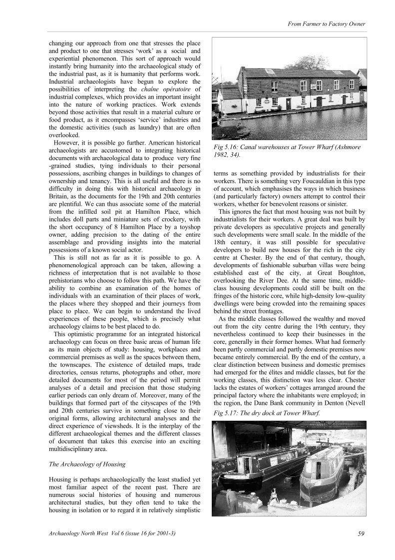
59
From Farmer to Factory Owner
Archaeology North West Vol 6 (issue 16 for 2001-3)
changing our approach from one that stresses the place and product to one that stresses ‘work’ as a social and experiential phenomenon. This sort of approach would instantly bring humanity into the archaeological study of the industrial past, as it is humanity that performs work. Industrial archaeologists have begun to explore the possibilities of interpreting the chaîne opératoire of industrial complexes, which provides an important insight into the nature of working practices. Work extends beyond those activities that result in a material culture or food product, as it encompasses ‘service’ industries and the domestic activities (such as laundry) that are often overlooked. However, it is possible go further. American historical archaeologists are accustomed to integrating historical documents with archaeological data to produce very fine-grained studies, tying individuals to their personal possessions, ascribing changes in buildings to changes of ownership and tenancy. This is all useful and there is no difficulty in doing this with historical archaeology in Britain, as the documents for the 19th and 20th centuries are plentiful. We can thus associate some of the material from the infilled soil pit at Hamilton Place, which includes doll parts and miniature sets of crockery, with the short occupancy of 8 Hamilton Place by a toyshop owner, adding precision to the dating of the entire assemblage and providing insights into the material possessions of a known social actor. This is still not as far as it is possible to go. A phenomenological approach can be taken, allowing a richness of interpretation that is not available to those prehistorians who choose to follow this path. We have the ability to combine an examination of the homes of individuals with an examination of their places of work, the places where they shopped and their journeys from place to place. We can begin to understand the lived experiences of these people, which is precisely what archaeology claims to be best placed to do. This optimistic programme for an integrated historical archaeology can focus on three basic areas of human life as its main objects of study: housing, workplaces and commercial premises as well as the spaces between them, the townscapes. The existence of detailed maps, trade directories, census returns, photographs and other, more detailed documents for most of the period will permit analyses of a detail and precision that those studying earlier periods can only dream of. Moreover, many of the buildings that formed part of the cityscapes of the 19th and 20th centuries survive in something close to their original forms, allowing architectural analyses and the direct experience of viewsheds. It is the interplay of the different archaeological themes and the different classes of document that takes this exercise into an exciting multidisciplinary area. The Archaeology of Housing Housing is perhaps archaeologically the least studied yet most familiar aspect of the recent past. There are numerous social histories of housing and numerous architectural studies, but they often tend to take the housing in isolation or to regard it in relatively simplistic
terms as something provided by industrialists for their workers. There is something very Foucauldian in this type of account, which emphasises the ways in which business (and particularly factory) owners attempt to control their workers, whether for benevolent reasons or sinister. This ignores the fact that most housing was not built by industrialists for their workers. A great deal was built by private developers as speculative projects and generally such developments were small scale. In the middle of the 18th century, it was still possible for speculative developers to build new houses for the rich in the city centre at Chester. By the end of that century, though, developments of fashionable suburban villas were being established east of the city, at Great Boughton, overlooking the River Dee. At the same time, middle-class housing developments could still be built on the fringes of the historic core, while high-density low-quality dwellings were being crowded into the remaining spaces behind the street frontages. As the middle classes followed the wealthy and moved out from the city centre during the 19th century, they nevertheless continued to keep their businesses in the core, generally in their former homes. What had formerly been partly commercial and partly domestic premises now became entirely commercial. By the end of the century, a clear distinction between business and domestic premises had emerged for the élites and middle classes, but for the working classes, this distinction was less clear. Chester lacks the estates of workers’ cottages arranged around the principal factory where the inhabitants were employed; in the region, the Dane Bank community in Denton (Nevell
Fig 5.16: Canal warehouses at Tower Wharf (Ashmore 1982, 34).
Fig 5.17: The dry dock at Tower Wharf.

60 Archaeology North West Vol 6 (issue 16 for 2001-3)
From Farmer to Factory Owner
1993, 153) is a good example of this type. Only in Hoole, to the northeast of the railway station, were these types of workers’ cottages built c 1900 (Fig 5.26). A similar style of development in Handbridge, to the south, cannot be linked to any single employer. There was little distinction between centres of production and domestic premises for the poorest inhabitants well into the 1930s. Fishermen’s cottages dominated Handbridge until after the Second World War, and at least one original example survives at Nowhere (Fig 5.27). During the 19th century, it also had a shippon for three or four cattle and the occupant ran a milk and poultry business, showing the typically diverse economic activities of poorer members of society. The correct postal address for this building is Nowhere, England! It is said that the Beatles’ song ‘Nowhere man’ was inspired by the band’s incredulity at learning of the name during a visit to Chester in the early 1960s, although it has not been possible to check the authority for this. Extreme poverty and appalling housing conditions were as common in Chester as in the major industrial towns of the region, much of it hidden from view. Large numbers of Chester’s working (and frequently unemployed) population were concentrated in common lodging-houses (Glazier 1996, 55) and the so-called ‘courts’ (Matthews 1999, 163). The latter consisted of terraces of poorly built and usually back-to-back housing (in other words, where the dwellings share a common rear wall) located behind the main street frontages. Generally, they were approached only along a covered passage. Most dwellings were without any running water, sewerage or any of the other improvements to civic infrastructure such as electricity. Water supply was generally by a shared standpipe in the courtyard (Perry 1996, 136). By 1905, there were 122 courts, containing 747 houses and a population that has been estimated at 2,500 (E. Willshaw in Carrington ed. 1994, 112). However, these figures imply a density of only 3.3 persons per house, which is so low as to be unrealistic. Census returns indicate a much higher density, as much as double this figure. Indeed, John Herson (1996b, 29) points out that in the 1860s, about 5,500 people lived in the courts, which he estimates as about 17% of the city’s population. Following the pioneering efforts of late 19th-century social reformers such as Ebenezer Howard and his Garden City movement, housing became a major political issue. New developments led to the creation of ‘model villages’ for workers in places such as Port Sunlight,
Wirral, built as a more pleasant environment for the workers at the Lever factory (Tigwell 1985, 57; Stratton & Trinder 1997, 107). At Letchworth, Hertfordshire, an entire Garden City was planned from 1903 as an ideal community (Miller 1989, 40); it was intended to be the first of many private ventures of this type, but the idea stalled during the 1930s as political pressure was put on local authorities to remove substandard housing and build high-quality homes with up-to-date amenities. In Chester, the Grosvenor Estate commissioned John Douglas to design Parker’s Buildings at the east end of Foregate Street, under the direction of Cecil Parker, the Duke of Westminster’s nephew and agent for the estate (DCMS 1998, 101). They were intended as a model tenement for workers in 1888-9 and are now considered one of the finest surviving examples of the type in Britain
Fig 5.18: Boat sheds at Tower Wharf.
Fig 5.20: Drains from a communal toilet block at Her-bert’s Court, installed c 1910.
Fig 5.19: A capped soil-pit at 8 Hamilton Place, filled in when mains sewerage was provided in the 1880s (Photograph A Lovatt).

61
From Farmer to Factory Owner
Archaeology North West Vol 6 (issue 16 for 2001-3)
(Morriss & Hoverd 1993, 110), despite the complaints of Cecil Parker that they were poorly built and had smoky chimneys (Hubbard 1991, 69). The standard they set, however, was not widely copied locally and early in the 20th century the City Council came under increasing pressure to provide ‘homes fit for heroes’. This followed with Lloyd George’s popular 1918 general election slogan, as soldiers were expected to return victorious from the Great War. To replace the slum courtyards from which many of them had come, new estates of council housing were built in suburbs, following the trend set in the previous century by the middle classes. The principal areas developed at this time were Buddicome Park, Heath
Lane, Handbridge and Lache, with most of the construction taking place in the late 1920s and 1930s. Many of the new tenants, especially in Lache (or ‘The Lache’ as it became more popularly known), came from courts in the Princess Street area behind the Town Hall. Some 224 inhabited slum dwellings in courts were cleared in this area in the late 1930s following the designation of the clearance area in 1934 (Tigwell 1985, 28). At the time, 214 of the dwellings (over 95%) lacked baths, while over half were structurally unsound and infested with vermin. Many others in different areas of the city were cleared at other times, often in a piecemeal fashion as redevelopment took place. The clearances led to the virtual depopulation of the historic core, a process that had taken about 150 years. After the Second World War, further working-class suburban development occurred. Blacon, hitherto a small rural community that had sheltered an RAF base, became a vast council estate. Work began in 1948, and by the 1970s there were over 3000 homes there; it was said at the time to be one of the largest council estates in Europe, an unsubstantiated claim with echoes in a number of other towns. Other, smaller developments took place in Newtown and in the area around the former Northgate Station. Nevertheless, some housing remains in the city centre, particularly on the fringes of the commercial core. Examples at Bunce Street, Cuppin Street, Commonhall Street and Love Street include well-built and well-designed Victorian terraces. Middle class housing was
Fig 5.21: The Chester Electric Lighting Station in its late 20th century form.
Fig 5.22: A 19th century washhouse at Abbey Green c 1975 (Photograph T E Ward).
Fig 5.23: An early twentieth-century forge at Herbert’s Court.

62 Archaeology North West Vol 6 (issue 16 for 2001-3)
From Farmer to Factory Owner
built in the 20th century at Greyfriars Court, on the site of the former Royal Infirmary and on Water Tower Road. It is ironic to reflect that much of the housing now available within the city walls is so expensive (whether to buy or rent) that occupation is virtually restricted to the well off. After two centuries, the process of city centre depopulation has been reversed, and, again, the élites are the pioneers. The Archaeology of Workplaces Industrial archaeologists are familiar enough with workplaces, particularly factories and other workshops. However, there is too often an emphasis on the processes and machinery of manufacture without an appreciation of the humans who carry out those processes. When people are mentioned, it is often as the inventors of new machinery or as the institutors of new working practices (e.g. Palmer & Neaverson 1998, 72). We need to move away from this descriptive way of dealing with workplaces and think equally about the experience of life within them, not in a wishy-washy empathetic way, but as an exploration of the quality of life and the social
psychology of work and the changes that industrialisation brought to them. The types of workplaces that are worth exploring are also often too limited. The small workshop may be considered a legitimate object of study if it provides evidence for traditional craft activities (as at Swindley’s Ironworks, shown in Fig 5.5, above), but what of the 20th-century garage? Some Art Deco filling stations are now listed and they are considered an important part of our architectural heritage, but they can also be the subject of excavation and traditional archaeological recording Fig 5.28). Familiarity has led us to undervalue them as part of the specifically archaeological resource, and the same can be said for many other classes of 19th- and 20th-century workplace. The Archaeology of Commerce Commercial buildings are every bit as worthy of study as
the buildings associated with production, for it was in these places that manufactured materials reached the public. The definition of ‘commercial’ needs to be broad and I will look briefly at hotels, which became a common feature of the Chester townscape during the middle of the 19th century. They are appreciated as an architectural form and socially as places where visitors would stay. What is rarely considered is their role within Chester and what they did for the population. They were principally places of work for large numbers of the city’s residents. The establishment of new hotels began in the 1850s, with the suburban development at Bishopsfield (later to become the core of Hoole Urban District), which were intended to accommodate the ever-growing numbers of visitors to the city. In City Road, laid down as a new approach to the General Station, two substantial and fashionable hotels were built in the early 1860s to cater for visitors arriving by train: the Queen Hotel, dating from 1861, and across the road, the same company opened the Queen Commercial Hotel (now the Town Crier), built in 1867. The former Royal Hotel in Eastgate Street was rebuilt between 1863 and 1866 and was renamed the Grosvenor Hotel after its owner, the second Marquess of Westminster. During the 19th century, the patterns of occupation for buildings underwent enormous changes with the conversion of formerly high-status houses in the city
Fig 5.24: The foundations of a late 19th century green-house at Dee House.
Fig 5.25: Reconstruction of the early 20th century forge at Herbert’s Yard (drawn by Stephen Player).
Fig 5.26: William Street, Hoole: a suburban street built in 1900.

63
From Farmer to Factory Owner
Archaeology North West Vol 6 (issue 16 for 2001-3)
centre as purely commercial premises. It was also a period of enormous change in the physical fabric of the city. Many of the historic properties of the city centre, including some that survived from the 17th century or earlier, were rebuilt or at least provided with new frontages in fashionable London styles. Also at this time, the city’s developing commercial centre acquired its familiar black-and-white appearance, inspired by the timber-framed tradition of the region’s vernacular buildings. Most notable of the architects involved in the so-called ‘Black-and-White Revival’ was John Douglas (1830-1911), although other local architects such as T M Penson and T M Lockwood were also influential. They also made extensive use of brick and stone, often combining it with black-and-white half-timbering, but it is the wholly half-timbered style that has become such a distinctive feature of Chester. According to Nikolaus Pevsner (Pevsner & Hubbard 1971, 131), ‘Chester is not a medieval, it is a Victorian city. What deceives is the black and white. 95 per cent is Victorian and after’. In fact, the ‘deception’ was not deliberate, as the architects generally produced innovative vernacular buildings, which have earned Chester a special place in the history of late Victorian architecture. The style continued to be popular for new buildings in Chester well into the 1920s, especially where the interests of the Grosvenors were directly involved. In 1910, the second Duke of Westminster redeveloped part of Bridge Street as a shopping arcade, St Michael’s Row. The design by W T Lockwood was a typically Edwardian Baroque, fashionably faced with white faience tiles. It was widely criticised locally because it did not fit in with the ‘picturesque’ character of the historic Rows and a year later it was refronted in timber. With its three massive half-timbered gables, St Michael’s Buildings contrasts sharply with Lockwood’s original arcade, which was allowed to survive behind and at street level. What is of interest is why a style that only a century earlier had been considered rustic and old-fashioned was now seen as appropriate to a modern commercial zone. In other instances, such as Northgate Bakery, built c 1905 (Fig 5.29; DCMS 1998 112), a neo-Classical style was adopted. The relationship between these buildings,
designed primarily to cater to the shopping needs of the better-off, and the housing that was hidden behind them is an interesting social phenomenon, as those who lived behind the shops were those who worked in them, while those who patronised them tended to live outside the commercial centre. There are real social divisions visible in the very fabric of the city, largely swept away in the middle of the 20th century in an effort to improve living conditions. The Archaeology of Warehouses Another common class of building that is often undervalued in the study of industrialisation is the small commercial warehouse (industrial and canal warehouses
are well served). These buildings are usually found tucked away in the back streets (Fig 5.30), if they survive at all, and have often been converted into wine bars or apartments. They are another untapped resource in our understanding of work in the recent past. Census returns list warehouseman as a common occupation; how many worked in these small buildings rather than the large repositories? The Archaeology of Pubs By 1800, the public house was an established feature of the social landscape, but it followed a period of legislation designed to reduce social drinking, especially among the
Fig 5.27: Fisherman’s Cottages, Nowhere, Handbridge.
Fig 5.28 A vehicle inspection pit belonging to an early 20th century garage, north of Foregate Street.

64 Archaeology North West Vol 6 (issue 16 for 2001-3)
From Farmer to Factory Owner
poor. The Second Gin Act of 1736 had attempted to reduce the drinking of gin and this marked the start of a decline in general spirit consumption; in 1757, gambling and gaming were made illegal on licensed premises, but many alehouses simply ignored the order. Documents show a general anxiety about drunkenness among the ‘lower orders’ from the 1770s, and in 1787, George III issued a Royal Proclamation against vice, which led to yet more stringent local regulations on alehouses. In the last two decades of the king’s reign, few new licenses were granted, despite the rapidly growing population. In many areas, closing times were enforced for the first time and in a few places, regulations were even introduced specifying the location of the bar, taproom, customer space and casks. The traditional tavern, catering for those of middling status, had largely gone by 1800, with most developing into alehouses catering for the working population because of the decline in public drinking among the more prosperous. In the early 19th century, the preferred drink was beer, often with additives such as grated ginger or more noxious chemicals; Guinness, cider and wine also become popular drinks around this time. Following the slump in consumption of spirits after 1780, they became popular again in the 1820s. After this,
Burton light ale became more popular in the 1830s. Many alehouse owners had secondary employment (such as boot-making, coopering, joinery, carpentry, smithing and wire-making); some were petty dealers, such as coal merchants; some were fences. Licensing tended to remove the more insalubrious backstreet alehouses, although clusters tended to remain around markets and main roads. During the 1810s, the first purpose-built alehouses appeared; previously they had been in houses. In the 1820s, Manchester magistrates were harassing alehouse owners over the provision of toilets, complaining about men urinating in the street, in full view of passers by. The developing social segregation in towns began to be an important determining factor in the location of public houses during the 1830s. By 1840, the number of pubs had risen by 15% and in 1876, over 69,000 are recorded. They begin to be found in suburbs from the 1840s, having previously been excluded from them. Premises expanded in the mid-19th century, with seatless bar parlours to encourage casual, passing trade. As working class living standards improved after 1850, consumption of beer per capita increases for the first time in centuries. From the 1870s, ‘Queen Anne’ style urban pubs are found; 4- or 5-bar houses began to be built in respectable working-class communities; unimproved slum pubs are also found. The number of pubs rose by half in the fifty years between 1831 and 1881, while the 1890s can be regarded as the zenith of the English public house. This is clearly reflected in pub
Fig 5.29 Northgate Bakery, George Street.
Fig 5.30: A small late 19th century urban warehouse behind Northgate Street.

65
From Farmer to Factory Owner
Archaeology North West Vol 6 (issue 16 for 2001-3)
architecture of the period, which can be described best as flamboyant eclectic. In 1823, the Intermediate Beer Act attempted to encourage new breweries to break the existing monopoly, but it was ineffectual and this was followed in 1828 by the Licensing Act, part of the growing regulation of drinking. The 1830 Beer Act then permitted any householder to sell beer and cider so long as they had an excise permit, which could be bought for two guineas; it ended the adulteration of beer with substances such as copperas or opium and encouraged local brewers. 24,000 beerhouses opened under the new regulations; they were often small or in the back rooms of houses. They rapidly became places for gaming, finding jobs, meeting prostitutes and fencing stolen goods. Legislation in 1869 and 1872 removed the privileges of the 1830 Beer Act that allowed householders to sell beer with an excise license, bringing all drink retailers under the authority of licensing magistrates. Beer shops were badly affected and their numbers declined rapidly. In 1899, Allsop’s of Burton-on-Trent began making lager under the direction of a Swedish brewer, E M Lundgren, using equipment manufactured in New York State. Arthur Guinness established its first mainland depot in Trafford Park in 1913 and in 1933, set up its first mainland brewery at Park Royal in northwest London, at a time when strained relations between the UK and Irish governments led to speculation that heavy import duties might be imposed on Irish Guinness. Beer consumption fell after 1900 following further restrictive legislation and changes in consumer spending; more money was being spent in improvements for the home and on holidaying. In 1881, there had been 71,814 licensed premises, dropping to 56, 538 by 1935 (the number of pubs per person declines from 1:334 to 1:719). By 1943, a government report concluded that the pub ‘plays a smaller role in the life of a town than ever before’. During the 1990s, there was an enormous increase in social drinking and the number of licensed premises, reversing a century of decline, but in premises very different from those of earlier centuries. The rise of the pub is conventionally linked with rise of urbanisation and industrialisation. Indeed, they have been described as ‘refuges for men escaping from the monotonous toll of factory work, from the misery of unemployment and big-city alienation; or, alternatively, as places to spend high industrial wages at a time when working men had few outlets for conspicuous expenditure’ (Clark 1983, 1, explaining why this view is wrong). In the 1970s, though, social historians began to take note of their traditional nature as places for playing games and other communal activities, moving away from the view that pubs and alehouses were simply places for the urban poor to get drunk towards one that sought to understand why they played such a central role in working-class life during the 19th and 20th centuries. The Archaeology of Shops In Chester, the medieval Rows that provided retailers with their outlets to the public mostly survived the great rebuilding of the later 19th century, in contrast to the
willingness to enclose them during the 17th and 18th centuries. The Victorian buildings that replaced them whilst retaining the same general form of undercroft with a gallery at first floor level but with shops on both levels, are wider, lighter and airier than the originals, but they maintain the character of the system. By the end of the century, the medieval Shoemakers’ Row on the west side of Northgate Street was in a parlous condition. It had to be demolished and was redeveloped by a number of architects. The new designs did away with the elevated walkway and replaced it with a black-and-white arcade just two steps above street level, leaving the medieval undercrofts as small half-cellars. The last building in the range was completed in 1903 and has a canopied statue of the new king, Edward VII, facing Town Hall Square. New building was rarely in fashionable styles; as already mentioned, when St Michael’s Arcade was first built in 1910 (Fig 5.31), there was a public outcry at its faience façade, which had to be replaced with a black-and-white frontage. By the early 20th century, Cestrians had developed a very clear idea of what their commercial centre should look like. Conclusion The remaining question is how to integrate these disparate elements into a coherent account of life during the past two centuries and how to make it specifically
Fig 5.31: St Michael’s Arcade, designed by W T Lock-wood in 1910.

66 Archaeology North West Vol 6 (issue 16 for 2001-3)
From Farmer to Factory Owner
archaeological. I believe that there is a programme here that will provide us with useful insights into what we might pretentiously call the ‘human condition’. The key to it is the concept of work. Since the early 19th century, the commodification of human life has tended to separate work from other aspects of existence. We talk about our ‘private lives’ and our ‘working lives’ as if there is no overlap. In doing so we ignore the historically specific
conditions that had led us to perceive our lives in this way. We can integrate the two by thinking specifically about work, working practices and the effects of those practices on the individual. As with so much in archaeology, we are drawn back to an interpretation that has to be human focused if it is to be meaningful and, above all, relevant.

67
From Farmer to Factory Owner
Archaeology North West Vol 6 (issue 16 for 2001-3)
Part 2
Case Studies from North West England The second section of this monograph presents a series of five case studies dealing with the issue of the archaeology of in-dustrialisation in North West England. These include three landscape studies; of the Castleshaw valley (Chapter 6), of the village of Stock (Chapter 7), and of the River Goyt around New Mills (Chapter 8). The archaeology of technological innova-tion and its social impact is studied in the textile finishing trades of Lancashire (Chapter 9) and in the iron industry of Cumbria (Chapter 10). Amongst the theoretical themes which emerge from these papers are the social relations of production and consumption, the changes in rural and urban life, and the changing use of the landscape.

68 Archaeology North West Vol 6 (issue 16 for 2001-3)
From Farmer to Factory Owner
The Castleshaw valley looking north-east. This valley has been the subject of an extensive landscape study looking at more than 2000 years of development (see Chapter 6). One of the recurring themes in the landscape is the pulse of industrial exploitation during the Medieval and Industrial periods. The valley contains two Roman forts, medieval iron bloomery sites, late medieval and early Post-Medieval livestock farms, and late 18th and 19th century domestic weaving sites and water-powered mill sites. Much of this Post-Medieval activity ended with the construction in the mid-19th century of the reservoirs.

69
From Farmer to Factory Owner
Archaeology North West Vol 6 (issue 16 for 2001-3)
I n 1996 the Greater Manchester Archaeological Unit undertook a landscape study of North West Water’s
Castleshaw and Piethorne reservoir catchment areas (UMAU & GMAU 1996). This work was commissioned by the water company to identify sites of archaeological interest in order to make proper provision for them in their land management plans. The survey area covered some 14 square kilometres of the western slopes of the central Pennines (Fig 6.1). Over six hundred sites of archaeological interest were identified and remains were found for all archaeological periods. However, this paper deals with the later use of these Pennine Valleys and examines the remarkably intense industrial exploitation of the landscape in the post-medieval period. Historically, the study area is divided between the township of Butterworth to the north, in Lancashire, and that of Saddleworth to the south, formerly in the West Riding of Yorkshire. On the Lancashire side of the study area is Piethorne Valley with its six reservoirs built for the Oldham Water Corporation; Piethorne, Kitcliffe, Norman Hill, Hanging Lees (built 1858-66), Ogden (1872-8) and Rooden (1894-1901). On the Yorkshire side are the reservoirs of the upper Tame Valley above Denshaw; New Year’s Bridge, Dowry, Crook Gate and Readycon Dean (1876-83) and Castleshaw Upper and Lower Reservoirs (1887-91) in the Castleshaw Valley. Land forming the water catchment areas for these reservoirs was compulsory purchased by Oldham Water Corporation
in the 19th century and inhabitants of farms and cottages were re-housed. Some abandoned buildings were deliberately demolished and used as sources of raw material for reservoir construction and associated walls, others gradually decayed over a number of decades. The result of this wholesale abandonment was to leave a landscape `frozen in time' which has preserved the 19th century field patterns, roads and settlements. Elsewhere in Greater Manchester, large scale 20th century industrial and suburban growth has often destroyed or masked earlier landscapes. In contrast the Pennine fringes, particularly the reservoir catchment areas, provide excellent research material for the study of landscape evolution and, in relation to this paper, for charting the change from a farming economy to industrialisation. Two valleys in the study area, those of Castleshaw and Piethorne, provide a good source of evidence relevant to the theme of this volume. Castleshaw Valley (Fig 6.2) In the late medieval period the Cistercian abbey of Roche owned Castleshaw as part of their Friarmere land holdings. Roche Abbey was dissolved in 1538 and five years later the Crown sold Friarmere to Arthur Assheton (SHSB 1986, 22-5). In 1618 the Assheton family sold out to the various resident tenant farmers in the valley (Hunt 1986, 67). Within Castleshaw we can be certain of three farms existing at this time: Francis and Edmund Schofield lived at Broadhead, Edmund Buckley and Walter Schofield both held properties at Castleshaw Fold, and the latter may also have acquired Waters Farms, formerly known as ‘Walters’. Further evidence for settlement in the upper Castleshaw Valley has been derived from the studious work of the Saddleworth Historical Society in analysing deeds, land transfers, wills and other primary documentary material. It is known that Wood Farm, Wood Barn, Marled Earth Nook, Oaken Hill and Oaken Hill Lee are all documented in the 18th century and are all potentially earlier. Although many of the farmstead sites have been demolished, several remain and the architectural style of these buildings can also place Low Bank and Castle Hill Cote as 18th century at the latest. All of the earlier settlement sites within the Castleshaw Valley occupy the lower slopes and it is likely that by the early 17th century each farm was surrounded by its own field system. The form of these field divisions may have been stone walls although earthen banks (some of which
Chapter 6
The Castleshaw and Piethorne Valleys
The Industrial Exploitation of a Pennine Landscape
Norman Redhead
Fig 6.1: The location of the Castleshaw and Piethorne study areas.

70 Archaeology North West Vol 6 (issue 16 for 2001-3)
From Farmer to Factory Owner
are partially hedged) located around Castle Shaw Farm also appear to relate to medieval or early post-medieval enclosure. Evidence for the type of agricultural activity taking place within the area is of variable quality. There is little documentary evidence of arable farming in the post-medieval period, other than references to barns being located on several of the farms; the existence of barns inferring the threshing and storage of grain, although not all barns are associated with arable activity and may have been used to store imported hay for farm animals. More conclusive evidence comes in the form of areas of ridge and furrow. These earthworks, some of whose ridges measure c 3 metres wide, have survived where ploughed strips have reverted to pasture, and several can be found around Broadhead and Wood Farm. It is in such areas, adjacent to the farms, on the lower slopes, that arable activity is more likely to be expected. That corn was being produced is clear from the 1618 grant which records that Edmund Linthwaite be given the right of access to a corn drying kiln in Castleshaw. It is possible that one of the later fulling mill sites was originally used as a corn mill. Transcribed deeds provide numerous lists of field names associated with properties in the study area, and many of these fields are described as meadow. This would appear to be the most predominant land use of the enclosed area of the Castleshaw valley, certainly during the 18th century. Meadowland was used to grow grass which was subsequently mown for hay. Once the hay had been mown the land was used for grazing and therefore the presence of meadowland is typically associated with pastoral farming. Unlike in arable farming, meadowland
is not frequently ploughed and therefore physical remains do not normally survive in the archaeological record. Further evidence for a pastoral based farming economy is provided by the use and partial enclosure of the moorlands, which occupy the upper slopes and plateau sections of the area. The placename ‘Cudworth Pasture’ is indicative of land use and was given by the Assheton family to a relative John Cudworth of Werneth, Oldham, prior to the allotment of the remaining lands to the tenant farmers in 1618 (Hunt 1986, 71). Hunt has indicated that large areas of moorland on the north and east of the valley were divided, if not physically enclosed, amongst these tenant farmers in or soon after 1618. Castleshaw Moor (Fig 6.3) was one of two areas of moorland that were divided, in this case into three areas, due to the variable quality of the land. Plots, representing fourteenths from each of the areas, were subsequently divided amongst the farmers. Fig 6.2: Sites in the Castleshaw Valley.
Fig 6.3: Castleshaw Moor.

71
From Farmer to Factory Owner
Archaeology North West Vol 6 (issue 16 for 2001-3)
An informative document with regard to land use in this moorland area is found amongst the deeds relating to Wood Farm. This document, of 1726, indicates that local farmers also had the right to dig peat and excavate stone from the moors, the latter undoubtedly accounting for some of the quarries in the area, the stone from which was used both in the construction of the farmhouses and in the field walls. The settlement pattern and land use within the study area, during the post-medieval period, consisted of a small group of farmsteads, mainly based on the lower slopes of the Castleshaw Valley, whose occupants carried out both arable and pastoral farming, with the emphasis seemingly on the latter, and this led to considerable enclosure of moorlands on the valley’s upper slopes. The topography and soil conditions contained within the Castleshaw valley did not provide ideal land for agricultural activity. The improved hill pastures supported sheep grazing, although even grazing was not feasible on the high moors. The valley floors and the level terraces provided grazing for cattle and the cultivation of fodder crops and vegetables. The additional factor of climate meant that cereal cultivation was not suitable in this area. It was therefore unlikely that many farmers who lived in this and neighbouring valleys could sustain a living from farming practices alone. This situation was compounded by a partible inheritance system which existed during the post-medieval period, whereby property was divided at
death between all the children of the family, resulting in a continual subdivision of estates into smaller land holdings, thus further reducing the ability to sustain a livelihood from agriculture alone. The documentary material which emerges from the 18th century onwards clearly demonstrates that many farmers supplemented their income with an involvement in the woollen textile industry. Indeed in a number of cases wool production represented the primary industry of the inhabitants in the valley. This involvement in the woollen industry can be traced from its predominance in the West Riding of Yorkshire, in which direction Saddleworth, in economic terms, certainly faced, as opposed to the emerging cotton industry on the western side of the Pennines (Fig 6.4). One of the earliest and most informative sources for the occupational status of the occupants of the study area are the Saddleworth Parish Registers for the period 1722 to the 1790s. Analysis of the registers clearly indicate the dominance of textile working, very largely in the form of domestic woollen working (Wild 1971, 220). For Saddleworth as a whole, as many as three-quarters of the local population declared their main occupational interest to be in this particular activity during the 1720s. This figure actually increased during the century, so that by the 1770s 89.2% were involved. The increase in textile activity was parallelled with an apparent decrease in agricultural practice, with the amount of people declaring themselves as having a farming occupation falling from 11.4% in the 1720s to 1.6% by the end of the century. These figures have to be considered in the light that declaration of occupation usually cited the main
Fig 6.4: Castleshaw Valley looking north-east.
Fig 6.5: Castleshaw hamlet around 1900 (Peter Fox Collection)
Fig 6.6: Millcroft.
Fig 6.7: Wood Barn.

72 Archaeology North West Vol 6 (issue 16 for 2001-3)
From Farmer to Factory Owner
occupation and there is every reason to believe that a number of people actually had dual occupations and were involved both in farming and in the textile industry. From the parish registers the majority of the people involved in domestic textile working were described as `clothier', with
the term ‘weaver’ only rarely occurring. Wild suggests that this is ‘a clear manifestation of the dominance of the
Fig 6.8: Johnny Mill. Above c 1880 and below in the late 1990s. Source: Peter Fox Collection.

73
From Farmer to Factory Owner
Archaeology North West Vol 6 (issue 16 for 2001-3)
small family clothier in the Pennine woollen industry at this time...The woollen cloth woven in Saddleworth was produced by small ‘clothiers’ who rarely employed any persons outside their own family units’ (Wild 1971, 223). Any ‘putting-out’ system, whereby manufacturers distributed the raw material to domestic weavers, was not taking place within Saddleworth to any great extent during the 18th century. In Castleshaw a church register record of 1721 describes Edmund Buckley of Wood as a ‘clothier’, a similar attribution is given to James Platt of Broadhead in 1726, Isaac Bradbury of Castleshaw in 1749, John Shaw of Oakenhill in 1747, Benjamin Gartside of Oakenhill Lee
Fig 6.9: The site of Long Royd Mill, above. Below: earthwork plan of the remains.
Fig 6.10: Low Gate Lane. A good example of a metalled packhorse trail in a sunken lane.

74 Archaeology North West Vol 6 (issue 16 for 2001-3)
From Farmer to Factory Owner
in 1782, and Thomas Platt of Waters in 1726. Old photographs of now demolished buildings such as those at Castleshaw (Fig 6.5) and surviving buildings such as Mill Croft (Fig 6.6) and Wood Barn (Fig 6.7), with their characteristic multi-light mullioned windows providing light for loom workers, provide further testimony to this domestic textile industry. Lower Moorcroft Wood, a farm situated in the upper Castleshaw valley but long since demolished, has left to posterity an interesting description provided by a former occupant which gives an insight into the arrangement that many of the farms may have had. As well as having a barn and shippon, indicating farming activity, the upper storey of the house was described as follows: ‘It had a long row of mullioned windows, and had been designed to accommodate hand looms and things appertaining to hand loom weaving, and only on second thoughts was it sleeping accommodation. There still remained there two hand looms, a bobbin wheel, a hand jenny, and some warping waws (walls). There were also skips, baskets, beams, empty bobbins, and various other articles used in the weaving of cloth around the place. These had belonged to my grandfather's elder brother, who had been a small manufacturer on his own, marketing his cloth in Huddersfield’ (SHSB 1972, 9). The general picture provided by this description is in keeping with the other evidence consulted, indicating farmers supplemented their living with domestic textile manufacturing, which was also carried out within their homes. Rather than being involved in a ‘putting-out’ system it would appear that these farmers were independent clothiers, who undertook trading activities as
well. Wood Barn, a Grade II listed building, is a farmhouse and adjoining (converted) barn of mid-18th century date (Fig 6.7). The house displays characteristic elements of local architecture of this period, such as watershot stone work, a stone slate roof and recessed flat-faced stone mullion windows. A William Wood, described as a ‘clothier’ lived here in 1757. Like many of his contemporaries he had a dual income and this was evident in the building: farming being represented by the barn and weaving as indicated by a row of mullion windows. Although the woollen industry within Saddleworth was predominantly a domestic one during the 18th century, some of the finishing processes were carried out beyond the confines of the house or farm. It was the topography of the Pennine area, with its fast flowing streams in steep valleys, which encouraged the siting of water-powered mills to undertake these finishing processes on a large scale, mechanical, factory basis. Two labour intensive processes benefited from this early mechanisation: fulling and scribbling. Bernard Barnes undertook a study of the foundation of water powered mills that formed part of the rapid expansion of the late 18th century woollen industry (Barnes 1983, 24-54). By examining Quarter Sessions records and the Registry of Deeds held at Wakefield, he established that by 1800 no less than 21 fulling mills and 41 scribbling mills were in operation in the Upper Tame Valley in Saddleworth. Of the fulling mills, 17 were built between 1720 and 1800, and all of the scribbling mills were erected between 1780 and 1800. Fulling was the process in which woollen cloth was scoured. This was a washing process undertaken in fulling stocks and traditionally using fuller's earth, the action of the stocks Fig 6.11: Sites in the Piethorne Valley.

75
From Farmer to Factory Owner
Archaeology North West Vol 6 (issue 16 for 2001-3)
and earth serving to remove the oil, size and other dirt. The cloth was then washed and fulled in the stocks, involving prolonged pounding in a soapy solution, to give a dense felted finish to the cloth. In the parish registers of 1722-6 only two cloth finishers were represented but by 1787-91 as many as twenty-one were recorded. Wild suggests that these figures represented a reaction to the increasing demands of the domestic industry as well as a shift in emphasis during the last four decades of the 18th century from the production of the traditional coarse narrow kersey cloths to the manufacture of heavier finer quality broadcloths which required a considerably greater amount of fulling (Wild 1971, 223). Scribbling was a preparatory process in the woollen industry, which involved the disentangling of woollen fibres and arranging them into slivers of similar thickness and weight. A variety of hand powered scribbling machines had been used on a domestic scale from the mid-18th century but by the late 1770s the first water powered purpose built scribbling mills were being erected. There followed a rush by entrepreneurs to obtain stream sites to erect scribbling mills, so that over the next two decades forty-one were established in the Upper Tame Valley. Only seven of these were on the River Tame itself, with the rest being located on tributary streams (Barnes 1983, 28-30). In the Castleshaw Valley study area, sited on the upper reaches of the Hull Brook or fed by streams, there were six mills in operation by 1800. Two were fulling mills; Wood Mill, owned and occupied in 1790 by Joseph Milns
(a clothier) of the farm at Wood, and Moorcroft (Johnny) Mill (Fig 6.8), built in 1786 by John Kenworthy of Castleshaw (clothier) in partnership with James Rhodes of Castlehill (clothier) and Abraham Gartside of Water Cote (clothier). There were four scribbling mills; Castleshaw (Higher Broadhead) Mill, in 1758 Benjamin Wrigley of Broadhead (yeoman) mortgaged his estates which included this site, Broadhead Mill, occupied in 1785 by Benjamin Wrigley and his son James, Waters Mill, occupied in 1794 by John Nield, and Moorcroft Wood Mill, in 1795 leased by Benjamin Taylor of Ogden (yeoman) and Henry Whitehead of Moorcroft Wood (clothier), to James and Thomas Millns of Wood, clothiers; Barnes 1983, 39-46). Unfortunately none of the mill buildings survive as standing structures, with Wood Mill, Broadhead Mill and Castleshaw Mill lying beneath Castleshaw Lower and Upper Reservoirs. Of the remaining sites mill ponds, leats, weirs and building platforms survive as a tangible reminder of this once significant industry. Just north of the Castleshaw Valley is Long Royd Mill (Fig 6.9), a fulling mill erected in the 1790s, which is an example of a well preserved mill site. Remarkably the
remains just avoided destruction from the construction of New Year's Bridge Reservoir sited immediately to the east. The water power evidence survives very well here; there is a stone weir across the stream which allowed water to flow into a leat which channelled water into a narrow mill pond. The site of the mill itself can be seen as a platform revetted by a 30 metre section of wall and a depression in this platform is probably the site of a wheel pit. Alongside the mill is a grassy terrace representing an earlier alignment of the Huddersfield and New Hey Trust turnpike road, built in 1807. The woollen industry was heavily dependent on good communications and a network of packhorse trails crossed the valleys. Some of these followed more ancient routes dating back to medieval times and have become ‘hollow-ways’, sunken lanes formed by erosion from the constant passage of traffic over many centuries (Fig 6.10). However, roads were poorly maintained and could not cope with the increasing traffic for the woollen trade. By the mid-18th century turnpike trusts were being set up to repair, maintain and improve existing roads of
Fig 6.12: Remains of the outbuildings at Ragholes exca-vated in the 1980s by the Littleborough Archaeological Society and recently consolidated by North West Water.
Fig 6.13: Remains of Binns Farm
Fig 6.14: 17th century window base surviving in the ruins of Binns Farm

76 Archaeology North West Vol 6 (issue 16 for 2001-3)
From Farmer to Factory Owner
importance. This led in some instances to completely new sections of roads with properly metalled surfaces being constructed. In conclusion, it can be seen that at Castleshaw the first water powered textile mills were built by small, independent domestic clothiers, many of them local farm owners of long standing. This pattern is repeated across the Upper Tame Valley with twenty-seven of the forty-one scribbling mills being established by landowners. Several landowners were responsible for the erection of more than one mill and it is interesting to note that a few Saddleworth clothiers were even able to supply mortgages to fund mill building, two of the same clothiers going on to found local banks. Many of the same names associated with the mortgaging and erection of water powered textile mills participated in financing turnpike roads. Piethorne Valley (Fig 6.11) This lies within the former township of Butterworth which was in the parish of Rochdale and county of Lancaster. After a complex history of ownership through the medieval period, it would appear that the Byron family had acquired most of the upper Piethorne Valley that falls within the study area (Farrer & Brownbill 1911, 213). At this time the land (and brook) was known as Ogden and a small hamlet survives today which is certainly medieval in origin (Fishwick 1889, 118-9). Another medieval site is Ragholes Farm (Fig 6.12) which was called ‘Gutford Acres’ at that time (Fishwick 1889, 115). Financial problems at the beginning of the 17th century forced the Byrons to sell off or release many of their Lancashire estates, including Butterworth. When Sir John Byron died, his leasehold of the title of lord of the manor of Rochdale expired, its ownership reverting to the Crown. The manor then passed to Sir Robert Heath, who in 1626 commissioned a survey of the manor, including the Piethorne study area (Fishwick 1913, 41-2). This
document gives a detailed account of the many farmsteads that existed in the valley at that time, names such as Ragholes, Binns, Hanging Lees, and Coldgreave which can be identified with ruined farm sites in today's landscape. Another useful document from about this time is a list of constables appointed by Sir John Byron in the early 17th century; these include in 1609 a Geoffrey Turner and Richard Haworth at Normanhill, Robert Gartside at Piethorne, and in 1617 Cuthbert Butterworth at Townehillholes (also known as Tanning Holes). A large number of deeds relating to various properties within the study area have also survived, largely because of the acquisition of much of the land by the Oldham Water Corporation during the 19th century for construction of the reservoirs. These provide additional information on many of the sites referred to in the 1626 survey and constables list, including details about who owned the various freeholds, the landholding (including field names) associated with various properties, the types of buildings on the sites (houses, cottages, barns and outbuildings), and the entitlements of freeholders with regard to common land and rights. From this variety of source material it is clear that many of the farm sites within the study area were in freehold occupation by the early 17th century. Of the farms themselves, none have survived with intact standing buildings, although all the sites are still distinguished by collapsed stone ruins, which in some cases have standing walls and plan arrangements that are still definable (Fig 6.13). The structural remains visible on these sites include stone masonry, stone roof tiles as well as slightly more diagnostic features such as chamfered stone mullion windows (Fig 6.14), window and door surrounds. In general the structural debris of these sites is consistent with buildings of the 17th century date or later. Documentary evidence suggests that several of these farmsteads were in occupation prior to this period and it is likely that archaeological investigation would reveal evidence for this earlier phase. The 17th century was a period when major changes in building construction were taking place and the houses of yeoman farmers in particular were subject to change, with the yeoman farmhouse often being rebuilt and utilising for the first time stone as a structural material. In the study area many farmers changed from tenants to freeholders in the first half of the 17th century and this rise in social
Fig 6.15: A stone head carved from a gritstone building block and found at the base of a 17th century field boundary wall, perhaps placed there as a lucky charm to pro-tect livestock.
Fig 6.16: Site of Tanning Holes (centre), with Binns at the bottom right.

77
From Farmer to Factory Owner
Archaeology North West Vol 6 (issue 16 for 2001-3)
status appears to have led to a period of relative prosperity and rebuilding; the incentive to rebuild may have been heightened by years of property neglect by a financially troubled landlord. With regard to the landscape within which these farms were set, it would appear from the documentary material that a certain amount of enclosure had already taken place by the 1626 survey, with a mixture of agricultural activities taking place. Potentially the earliest reference in the upper Piethorne valley is to ‘Gutfordacres’ in the Black Book of Clayton which is of late 13th or early 14th century date (Fishwick 1889, 115). The ‘acres’ element of this name usually implies plots of arable land (Field 1993, 4), which would have had a perimeter enclosure at least, to protect crops from wandering animals (Faull & Moorhouse 1981, 663). In the 1626 survey there are a number of references to closes of arable, meadow and pastureland. The dating of this enclosure is not certain although in some cases it cannot have pre-dated 1626 by a great length of time, for example one particular reads; ‘Two tenements mead. ar. & past. called Coldgreave lately enclosed from the waste adj North to Hanging Lees and Philly Shaws’ (Fishwick 1913, 53-4). This indicates that fields were recently created from the moorland waste. The structural form of the enclosure divisions may originally have been hedges and this is indicated by another reference from the survey; ‘3 acres in Henginlees (Hanging Lees) 7 yds. to the rod as now measured hedged & taken out of a close called the New Meadow’ (Fishwick 1913, 55). Within the study area there is generally scant evidence for this early enclosure although a handful of substantial earthen banks with ditches, particularly around the site of Ragholes and Town Hill may represent former hedge lines. Some of these earthworks are of considerable size, measuring 5-6 metres across and 1.5 metres high. However, the majority of enclosure within the study area is now defined by dry stone walls and while there are no precise dates for these, given the absence of documented enclosure awards, it is likely that enclosure by stone walls dates to the 17th and 18th centuries (Faull & Moorhouse 1981), parallelling the adoption of stone as a building material for farm buildings (Fig 6.15). As with the Castleshaw valley there are several areas of surviving ridge and furrow, with the ridges measuring 2 to 2.5 metres wide. Further evidence for arable farming occurs
in the form of a reference to a corn mill and kiln at Binns in 1677 (Oldham Archives, Coldgreave No. 15). A deed of 1680 refers to the mill as a water corn mill (Oldham Archives, Coldgreave No. 16) and a lease of 1683 mentions ‘Thomas Brearley of Binns, Millar’ (Oldham Archives, Coldgreave No. 119). Whilst the site of the kiln is suggested by the place names of Higher and Lower Kiln Green for fields adjacent to Binns Farm, the location of the corn mill is less certain. Given Binns later, close historical association with Kitcliffe fulling mill and the close proximity of these two sites, it is likely that the fulling mill occupies the site of the earlier corn mill. As well as enclosed agricultural land there is also documentary evidence for common pasture within the Piethorne valley. The 1626 survey provides detailed information on the common pastureland within Butterworth with a distinction being made between stinted and unstinted common. Stinted common is land which is apportioned for use by a number of specified people, whereas unstinted represents land with no restrictions on those who use it. Rough stinted pasture is identified at Coldgreave and Ogden Edge, and unstinted common around Bleakedgate Moor on the eastern side of the valley (Fishwick 1913, 64-6). The stinted moorland appears to have been physically defined by merestones which were large stone boulders used as boundary markers; in 1626 Gerarde Schofielde had ‘60 acres (of ‘More ground’) as it is meared & bounded’ (Fishwick 1913, 41). As with the farms at Castleshaw, those at Piethorne had turbary rights (the right to cut peat for fuel). Many references are made to this right in the property deeds and the 1626 survey, an example being a property agreement for Binns Farm of 1610 ‘the fourth part of Bindes Pasture together with common of turbary to be taken throughout the mores, mosses and wastes of Butterworth…’ (Oldham Archives B1). Thus in terms of land use, there is evidence for a mixed farming economy within the Piethorne study area, with arable activity occurring on the lower, flatter slopes of the valleys and the higher slopes providing common pastureland. Most of the enclosure is associated with the arable areas and the documentary and physical evidence suggests that the majority of the early enclosure, as well as the settlement sites and agricultural remains are of 16th and 17th century date. In summer 1999 a programme of archaeological evaluation was carried out by the Greater Manchester
Fig 6.17: Excavation at Tanning Holes, with Ogden Reservoir in the background
Fig 6.18: Booth Hollins Mill.

78 Archaeology North West Vol 6 (issue 16 for 2001-3)
From Farmer to Factory Owner
Archaeological Unit at the site of Tanning Holes Farm (SD 9560 1297). With financial support and permission from the landowner, North West Water, the work was undertaken over a one week period using archaeology students from Manchester University. Historical documentation dates the farmstead to the beginning of the 17th century but an area of earthwork terraces and possible hollow-ways adjacent to the stone remains of Tanning Holes farm were felt to have considerable archaeological potential as evidence for earlier, more extensive settlement at this site. The investigation consisted of topographic and resistivity surveys, followed by one week of trial trenching. A late 19th century cellar complex belonging to the farmstead was also surveyed. The results of the evaluation were encouraging, including as they did a stratified sherd of late medieval pottery from a gulley running parallel with a buried collapsed dry stone wall, and a cobbled floor surface located about eighty metres away from the main farm ruins. A further season of exploratory excavation is planned to identify the potential of this site to tell the story of the evolution of a Pennine farmstead. This work will be complimented by a student dissertation investigating the surrounding field system and the remains at the neighbouring Binns Farm site (Figs 6.16 & 6.17). Castleshaw's involvement with the domestic textile industry is well documented, but in the Piethorne study area there are no direct references to such domestic activity. This is surprising given its widespread occurrence in the central Pennines, and it seems highly unlikely that farmers would not have supplemented their income in this way. All the farms have been demolished so there is no architectural evidence for home weaving; however, one house survives in the study area in the Longden Valley (the next valley north from Piethorne). This now dilapidated building is called New Nook and comprises a row of three cottages which have a large expanse of mullion windows in their south-facing front elevation. The occupants could have been agricultural workers carrying out weaving, or may have been solely engaged in the latter perhaps employed by the owners of the nearby fulling mill, Longden End Mill. Only one mill site lies within the upper Piethorne valley and this is Kitcliffe already mentioned above. On the 1851 Ordnance Survey 6 inch map this is shown as a fulling mill with associated mill pond and tenter field (on 1895 Ordnance Survey map). The tenter field was where the woollen cloth, having been fulled, was stretched and dried by hanging it on racks under tension. Longden End mill still retains a series of terraces in the hillside above which indicate the position of tenter post alignments. Although all structures have gone there are good remains of the pond, leat and water wheel pit. Today the only building standing which belonged to Kitcliffe Mill is a single storey shed on the south side of Piethorne Brook, although the platforms of other buildings are evident. Just outside the study area is Ogden Mill, immediately below Ogden Reservoir which started as a fulling mill and became a much larger textile processing site, still in use. In Longden End Valley is the Grade II listed Booth Hollins Mill (Fig 6.18), again starting as a fulling mill, which retains a building of c 1730 date.
Conclusion
Historical records show that in the late middle ages, there were just one or two landowners with a scattering of tenant farmers. There was little cultivated land at this time, but there would have been pasture for grazing on the lower valley slopes with more woodland than today and a great expanse of unenclosed moorland. By the mid-17th century the major landowners had sold their lands to the tenants. This appears to mark a period of relative prosperity for the yeoman farmer, with many houses being rebuilt at this time and with marginal land being taken in for pasture. But the nature of the terrain, soils and climate was far from ideal for agricultural activity and farms had to adopt a dual economy as the population grew and land was subdivided through inheritance. On the farming side the improved hill pastures supported sheep grazing, whereas the valley floors and terraces allowed some cultivation of fodder crops and vegetables, and cattle grazing. This was supported by industrial activities such as coal mining, quarrying and especially home weaving. By the early 18th century nearly every farmer supplemented his income with an involvement in the woollen textile industry, many as independent clothiers whereby they carried out domestic textile weaving and traded as well. Weaving was usually carried out in a spacious room on the upper floor using hand looms. Such a room would be well lit by a long row of mullioned windows and many buildings in the central Pennines still retain this distinctive architectural feature. The late 18th century saw the construction of a number of water powered textile mills; occasionally these were on the same site as medieval corn mills. These mills undertook labour intensive mechanical processes, especially fulling, in which the woollen cloth was scoured, and scribbling, whereby woollen fibres were disentangled and sorted. Although all these mills have been demolished the remains of the water power systems, such as weirs, leats, ponds, water wheel pits and outraces, can still be traced at some sites. These early mills were mostly built by local entrepreneurs, the more successful farming/weaving families who were also clothiers. They showed remarkable initiative in exploiting the changing nature of the woollen industry and led the way in the early development of water powered factories which allowed a massive increase in manufacturing output. In a harsh landscape, these farmers had, over several centuries, transformed the nature of their living from marginal traditional farming into a prosperous industrial based economy. The abandonment of these valleys, through the construction of reservoirs by the Oldham Water Corporation in the 19th century, has left a legacy of ruined farms, cottages, mills, field boundaries and lanes that reflect a time of intense industrial activity. Acknowledgements
Tom Burke and Peter Arrowsmith for undertaking research and providing text for the Castleshaw/Piethorne Archaeological Survey from which much of this article is derived. Peter Fox for kindly lending old postcard photographs from his collection held at Oldham Museum.

79
From Farmer to Factory Owner
Archaeology North West Vol 6 (issue 16 for 2001-3)
T he study of deserted villages has long held a fascination for archaeologists and landscape
historians alike. Definitive projects, such as those carried out at Goltho, Barton Blount and Wharram Percy, or the work of Maurice Beresford and John Hurst, have done much to capture the imagination and aid understanding of the complex processes which lead to the movement, shrinkage or disappearance of settlements. However, the classic models for village desertion are often difficult to apply to Lancashire. Here, in a county where much of the traditional settlement pattern is not one of nucleated medieval villages, but of dispersed farmsteads and hamlets, the identification of examples of settlements which both originate and were deserted within the medieval period are few and far between. The Lancashire Sites and Monuments Record (SMR), maintained and managed by Lancashire County Council, contains just 51 recorded deserted medieval settlements (DMV), and eight possible shrunken medieval settlements (SMV) out of a total of just over 23,000 known archaeological sites and
historic structures. Of these deserted or shrunken medieval settlements 56 have been identified primarily from documentary sources and indeed the majority have yet to be associated with any surviving earthworks or structures (Fig 7.1). Instead the geographical location may be limited to an associated placename within the modern landscape. In contrast, evidence of rural settlement desertion in the post-medieval period is far more readily identified. Abandoned and ruined barns, farmhouses and sometimes hamlets from the period are in evidence in many of the upland areas of the county, often contributing towards the bleak and ‘wild’ appearance of moorland, and in certain valley landscapes. Over 240 examples of such desertions are recorded within the SMR, and these represent only a very small proportion of the real total being the result of highly selective area surveys. Surprisingly, such physical remains of mainly 19th and 20th century abandonment have received little attention. Instead much of the interest in the study of industrialisation has tended to focus upon the fabric, social structures and exponential growth of the northern towns - and with good reason. In 1781 Bacup was described as a ‘large village where they have a great manufacture of woollen cloths’. Bacup and Rawtenstall increased in population by 460% and 645% respectively between 1801 and 1901. Given such increases it is perhaps unsurprising that the eye has been drawn to the explosion of urbanism rather than rural change. Consequently, less time has been spent upon the study of the impact of industrialisation upon the agrarian landscape, in particular the villages, hamlets and farmsteads which were a ready source of urban poor and gentry alike. This paper will briefly explore the subject of settlement desertion in Lancashire, with particular reference to the abandonment of the settlement at Stock, near Bracewell, and at Grane near Haslingden (Fig 7.1). The principal themes will be the causes of 19th century desertion, the problem of site identification, and the management legacy which are presented by such sites today. Stock and Grane were two villages each originating as medieval hamlets and each ultimately disappearing as a consequence of urbanism and industrialisation. The route to their disappearance is, however, very different. The context for the study lies, in the case of Stock, in the assessment of the scheduled area of a ‘classic’ DMV, and for Grane, in the broad examination of a particular landscape type.
Chapter 7
Industrialisation and Rural Desertion:
Some Examples From 19th and 20th Century Lancashire
John Darlington
Fig 7.1: Location, showing Stock, Haslingden Grane, Hawthornthwaite, known deserted medieval settlements and know ruined buildings

80 Archaeology North West Vol 6 (issue 16 for 2001-3)
From Farmer to Factory Owner
Stock The settlement of Stock lies two kilometres north of the town of Barnoldswick and less than a kilometre to the north east of the village of Bracewell in East Lancashire (and was formerly within the West Riding of Yorkshire) (Fig 7.2). The latter, a settlement identified in the Domesday Survey, lends its name to both Civil Parish and township, and is clearly the primary manor and settlement. Bracewell possesses a church, manor house, fishponds and parks, as well as farms, barns and other village structures and survives as a mixed commuter village and agricultural community. Stock is also mentioned in the Domesday Book as Stoche. The placename probably derives from the Old English stoc or place, probably in the sense of a ‘dairy farm, outlying farmstead’, evidence again emphasising its position in the local settlement hierarchy. Today Stock appears as a small scatter of five inhabited dwellings, but otherwise has all the attributes of a ‘typical’ shrunken medieval village, including holloways, house platforms, ponds, crofts and tofts, gardens, industrial areas and the site of a water-powered mill, which it shared with Bracewell. A considerable proportion of these earthworks are scheduled as an ancient monument, as is a nearby rectilinear earthwork of undetermined function on Hawber Hill. All in all the landscape is one which contains a suite of features characteristic of a medieval community. The Cumbria and Lancashire Archaeological Unit surveyed some of these in 1979. It has been assumed that Stock was probably deserted during the later Middle Ages, and indeed that opinion is shared by the early scheduling information. However recent work has illustrated that the settlement was a thriving community at the end of the 18th century and had not shrunk to its present state until the middle of the 19th century. Two estate plans have been particularly useful. One dated 1717 (Fig 7.3) shows the village, ‘Stock Towne’, comprising at least five separate dwelling houses and numerous outbuildings and barns. The road
linking the settlement to Bracewell is well defined, as is the remains of a large open field, ‘Haber’, to the north east. Curiously the shape of the plot at the north west corner of the settlement (shown numbered 75 and 76 with Freehold behind) is not mirrored in later mapping, in aerial photographs, or in the earthwork survey of 1979, perhaps indicating that the ‘medieval’ features identified are actually part of a substantial 18th century reorganisation of the area. Alternatively this may be a result of inaccuracies in the 1717 mapping (unlikely given its accuracy elsewhere), or due to the schematic nature of the plan which appears primarily to be concerned with rights within the former open field. This area apart, the village in 1717 is remarkably similar in terms of both dwelling numbers and locations to that of the present day. A second estate plan of 1796 shows some change, particularly in number of dwellings, which increase from a minimum of five identified in 1717 to no fewer than fourteen (Figs 7.4 and 7.5). Otherwise, apart from the intensification of use and possible remodelling of the north west part of the village (see above), the plan is much the same as that of 1717, and contains many features which survive in the landscape today. By the publication of the Ordnance Survey First Edition 6 inch mapping in 1853 (Fig 7.6) at least six buildings had been abandoned, compared with just one building complex which appeared to have been significantly enlarged. Elsewhere the subdivisions previously marked in the large Haber field are no longer so defined and the internal boundaries of the subcircular field in the north west of the village have disappeared. There is little change between the settlement and individual building distribution shown on the 1853 mapping and that of today. To explore the possible reasons behind the 18th century increase and mid 19th century depopulation of Stock village requires an appreciation of the occupations of those who lived and worked within the township. The first impression gained from the documentation, in particular the 19th century trade directories, is of a village
Fig 7.2: Aerial photograph show-ing Stock

81
From Farmer to Factory Owner
Archaeology North West Vol 6 (issue 16 for 2001-3)
with a gradually shrinking population. The whole township had a listed population of 185 in 1811, which had dropped to 176 by 1821. By contrast the nearby town of Barnoldswick grew from 892 inhabitants in 1811 to 1334 in 1821, an increase of over 500 (by 1891 the town numbered some 4,000 people, rising to 12,000 in 1921). The Craven Muster Roll of 1803 illustrates the range of occupations occurring in the township. Out of the 37 active males listed there were 11 farmers, eight labourers, eight weavers, five servants, a cordwainer, cleryman, mason, carpenter and constable. Add to this the working
female and juvenile population and it is clear that both farming and weaving provided the dual motors which sustained the local economy of the area. Physical evidence of the textile industry within the current building fabric at Stock is scant, but it is reasonable to assume the probable presence of loomshops within the main buildings and outshuts of the cottages and farmsteads. None of these need necessarily be distinct from rooms serving other general domestic or agricultural purposes, indeed their presence elsewhere may only indicated through minor building modifications, documentary
Fig 7.3 The 1717 Stock Estate Plan
Fig 7.4 The 1796 Stock Estate Plan

82 Archaeology North West Vol 6 (issue 16 for 2001-3)
From Farmer to Factory Owner
sources, or because the loomshop has been purpose built (such as the fine example of a protofactory ‘weavers cottages’ at Fall Barn Fold, Rawtenstall). The period from the late 18th century to the mid 19th
was a boom time for handloom weavers. Mechanisation of the first (spinning) and last (finishing) processes of textile manufacture brought about by the invention and adoption of Hargreaves’ spinning jenny (1764), Arkwright’s water frame (1769) and carding machine (1775), and Crompton’s spinning mule (1779) was not paralleled by successful development in powerloom technology until the 1820s and 1830s. The significant increase in the production of yarn to be ‘put out’ led to a commensurate increase in handloom weaving. Throughout this period the settlement of Barnoldswick had turned from a local agricultural market, with some woollen, worsted and flax production, to a growing cotton town. That growth was prompted by, amongst other things, the construction of the Leeds and Liverpool canal, which reached the town in the 1790s and was completed along its entire length by 1816. By 1838 Barnoldswick possessed five small, water-powered cotton mills. These were initially spinning mills which put out work to the handloom weaving industry based in weavers own homes or in the ‘Dandy’ shops in town, such as that at Slater's on the Manchester Road where fourteen looms were maintained. A second spur to growth was the arrival of the railway in 1871 which, alongside other economic factors led to the construction of specialist weaving sheds after the 1880s. Here Barnoldswick, Earby and, to an extent, Skipton, combined with the emerging east Lancashire towns of Burnley, Neslon and Colne to specialise in the weaving process and were typified by the ‘room and power’ system, which allowed entrepreneurs with limited capital to thrive. In 1915 Barnoldswick had at least eleven mills in production, powering over 22,000 looms. It is against such a backdrop that the context for Stock's growth and decline can be explained. It is suggested that
Fig 7.5: The 1796 Stock Estate Plan, showing detail
Fig 7.6: Stock shown on the First Edition six inch mapping

83
From Farmer to Factory Owner
Archaeology North West Vol 6 (issue 16 for 2001-3)
the village originated as a subsidiary settlement of medieval origin. During the 18th century, and very probably the 17th, the settlement had expanded to accommodate a growing population. That population growth was sustained through improvements in agricultural technology, husbandry and management and through the growth of a cottage-based textile industry. The collapse of the domestic weaving industry, coupled with the rise in purpose-built factories in nearby Barnoldswick, must have been significant factors in the shrinkage of Stock. It is suggested that one half of the traditional dual economy was effectively removed and with it the economic sustainability of rural life, particularly for those at the lower end of the social scale. However, the abandonment of the settlement was not sudden climactic event but a creeping atrophy which took place over half a century. After all Barnoldswick was a relatively short walk away for Stock's villagers and smallholders to seek employment in the town's sheds and mills. Yet, over time, and with both changes and improvements in agricultural practise, it was perhaps inevitable that those living in rural communities but employed in the towns would relocate to the purpose-built terraces of Barnoldswick and Earby. Such a move would have had as much to do with the push of rural poverty as the pull of urban employment and accommodation. It is perhaps ironic that now such a trend is reversed as more urban workers seek the solitude and bucolic pleasures of the countryside. Haslingden Grane The Grane valley lies to the west of the town of Haslingden (Figs 7.1 and 7.7), again in East Lancashire. John Hallam and Alan Crosby have researched the settlement of the valley, in particular the village of Grane and the hamlets of Lower Ormerods, Hartley House, Grane Head and Alley Cross. In summary, Haslingden Grane was a series of scattered settlements and later a village (only emerging by 1800) in the valley of the Ogden Brook. Like Stock the area known as Grane was not the principal centre, this being the medieval market town Haslingden. Also like Stock the inhabitants of the valley were dependent upon weaving to supplement, and in some places supplant, income brought in from farming. In addition, quarrying added a further occupation to the extent that within one family it might be common to find the older generations employed in agriculture, sons working at the quarries and daughters employed weaving. By 1798, 51 farms are recorded within the valley, with half the farms covering less than 25 acres, and only eight owned by their occupants. Hartley House, excavated by John Hallam in the 1980s provides a mirror to the development of the area. Constructed in the 17th century, although possibly on the site of earlier medieval buildings, Hartley House was originally a single dwelling associated with the intensification of agriculture, enclosure and improvement of moorland, and the rising aspirations of the yeoman farmer. By 1798 it had been split into two dwellings while a further four other cottages were added to the complex. A description in 1827 lists two more cottages indicating a community comprising no
fewer than ten separate dwellings. Most of the buildings had either purpose-built or adapted loomshops and the documentation shows the rising importance and eventual dominance of the domestic handloom weaving industry. A similar pattern of building and occupational change is apparent higher up the valley sides where new farms were constructed from the 17th century onwards closer to recently enclosed moorland. Up until the 19th century the settlement pattern of the area remained one of dispersed farmsteads and hamlets. However, some time after 1800 one such hamlet expanded substantially developing into Grane Village, complete with its own church, chapel, shops and schools as well as a double row of residential cottages (Fig 7.8). By 1850 approximately 1,500 people lived in the valley, with over 600 residing in the vicinity of Grane village. So here, as at Stock, a growing community founded upon agriculture, quarrying and textile manufacturing had become established. However, unlike Stock, the pull of the industrial textile mills and weaving sheds of nearby Haslingden did not lead to the collapse of the handloom weaving industry and rural depopulation from the mid-19th century. The reason for this lies in the establishment during the 1830s of two cotton mills at Calf Hey and at Holden Wood in the valley itself. Yet by 1930 the Grane valley had become deserted. Ironically it was still industrialisation and urbanisation which led to the abandonment of the settlement. The demand for water for industrial use in the factories of the Helmshore and Ogden valleys led to the construction of the Holden Wood reservoir in 1841, the first of three substantial reservoirs to be located within the valley. 19 years later, in 1860, the Bury and Radcliffe Waterworks Company completed the Calf Hey Reservoir as a water supply for the burgeoning town of Bury. As part of the construction process the water companies purchased land in the valley, reorganised holdings and
Fig 7.7: Distribution of abandoned farmsteads in the Grane Valley

84 Archaeology North West Vol 6 (issue 16 for 2001-3)
From Farmer to Factory Owner
terminated leases, forcing tenants to relocate elsewhere. Later in the century such a policy of land acquisition for the practical construction of reservoirs was considerably extended on the grounds on public health. Concern over the spread of disease in the towns, particularly cholera and typhoid, and poor sanitation, was such that many water authorities pursued a policy of land acquisition and enforced depopulation within a whole catchment area. On visiting the Grane valley in 1898 a Local Government Board inspector, reported that: ‘no one who has visited the gathering grounds of the Bury Corporation can doubt that there exist conditions which must foul the water and are highly favourable to the spread of water-borne disease’. Between 1899 and 1905 most of the valley farmsteads were abandoned and in 1912 the Ogden reservoir was finally completed. This signalled not only the desertion of the last farmsteads within the valley catchment area, but also the destruction of the Calf Hey Cotton mill, and with it one of the main employers of Grane Village. Conclusion Stock and Grane represent just two examples of village desertion in the 19th and 20th centuries. Both are good illustrations of settlements which originated in the medieval period and were abandoned due to the effects of industrialisation, albeit in entirely different ways. There are many others; a quick comparison of the First Edition Six Inch Ordnance Survey mapping of c 1850 with that of the present day will reveal countless structures, farmsteads and even hamlets which do not survive as habitable dwellings today. One such example is the settlement of Hawthornthwaite near Abbeystead on the fringes of the Forest of Bowland (Fig 7.9). Here at least six buildings no longer exist and the hamlet has now shrunk to two occupied properties. Hawthornthwaite is
recorded as a medieval vaccary and it is possible that the hamlet corresponds with the site of the principal vaccary farm and, consequently, was in existence from the early 14th century, if not the 13th century. Neither is this an isolated example, for within less a few kilometres radius lies Catshaw Mill, an abandoned cotton spinning mill and a handful of associated cottages. In short, evidence for the post-medieval abandonment of rural settlement in Lancashire is often to be found wherever it is sought; a survey of North West Water's Forest of Bowland Estate in 1997 recorded over fifty abandoned farms and agricultural structures within an area of 88 square kilometers. This included the hamlet of Stocks (not to be confused with Stock above) which is now submerged by Stocks Reservoir. The work carried out at Haslingden Grane and adjacent Musbury Valley resulted in the identification of over sixty examples, ranging from redundant industrial structures to whole hamlets (Fig 7.8). Some abandonment, especially in the remote rural areas, may result from changes in agricultural practise, leading for example to the ruination of field barns, but much can be connected, either directly or indirectly, with industrialisation and the demands of the towns. In conclusion, the impact of post-medieval industrialisation on the Lancashire countryside has resulted in a considerable legacy of ruined farmsteads and earthwork remains (Fig 7.10). These are as distinct to the area as the textile mills and terraced housing are to the towns and, indeed, as the archetypal deserted medieval settlements are to the central midlands, Lincolnshire and the north east. Such examples of 18th to 20th century desertion are important in their own right as highly distinctive elements of a changing landscape and for the information that they contain about the transfer from an agrarian society to an industrial one. They are also important as potential indicators of underlying medieval settlement. The studies of Stock and Haslingden Grane
Fig 7.8: Grane Village shown on the First Edition six inch mapping
Fig 7.9: Hawthornthwaite shown on the First Edition six inch mapping

85
From Farmer to Factory Owner
Archaeology North West Vol 6 (issue 16 for 2001-3)
illustrated that a dispersed medieval settlement pattern was identifiable at the core of the post-medieval, the former providing a framework for the nucleation of the latter, prompted by population growth, technological innovation and industry. Such a relationship warrants further investigation especially given the apparently mutually exclusive distribution of known deserted medieval settlements compared with farmsteads abandoned in the post-medieval period (see Fig 7.1) recorded in the Lancashire SMR. Even where the pattern of post-medieval settlement desertion demonstrates no signs of a medieval precursor, its presence provides a valuable physical document on the process of land reclamation and exploitation (particularly of moorland and wetland environments) from the 16th century to the present day. At the same time it affords both comment and a link to the scale, extent and type of earlier activity. Few of Lancashire’s post-medieval deserted rural settlements have been the subject of detailed research, this paper attempting to do no more than bring them to wider attention, but it is clear that with similar examples elsewhere (particularly in Greater Manchester and Yorkshire) they represent a significant regional asset. They also present a management challenge: they exist in large numbers, would require substantial resources to stabilise (assuming this were desirable) and, on occasion, possess health and safety problems precluding public access. In Lancashire the challenge is greater still in that basic information is not available on the number and condition of later abandoned structures and monuments. To remedy this a mapping exercise will take place over
the next few years which will transcribe those structures identified by the Ordnance Survey in c 1850 and which no longer survive today. This, at last, will provide a county-wide starting point from which to initiate more detailed research and to target scarce resources. Acknowledgements Thanks to the staff of the Lancashire County Archaeology Service for SMR information and comment and to Mary and Eric Higham for their advice and drawing my attention to the Craven Muster Roll.
Fig 7.10: Hartley House abandoned farm

86 Archaeology North West Vol 6 (issue 16 for 2001-3)
From Farmer to Factory Owner
A lthough historically part of the High Peak, the pronounced north-west extension of Derbyshire
(Fig 8.1), with its gritstone moorlands, lower shelves of sandstone and shales with intervening valleys, and westward-flowing rivers (the Dark Peak), has physically more affinity with the western Pennine fringe than the rest of the county. The two regions are similar in geography, geology and climate which, before the industrial period, resulted in a similar dual economy based on cattle and sheep, the growing of corn (mainly oats and barley) and the domestic production of textiles, mainly wool and linen. Although domestic wool and
linen were common to the whole of the western Pennine fringe, cotton does not appear to have found its way into the farms of New Mills, unlike the fustian-producing farms of south-east Lancashire, where farmer-weavers brought in cotton from the first half of the 17th century (Wadsworth and Mann, 1965, 15). A distinctive dispersed settlement pattern of farms emerged, the only ancient nucleated settlements in the Dark Peak being the small market towns of Glossop and Chapel-en-le-Frith, and the village of Hayfield. The present towns of New Mills, Whaley Bridge, and Chinley are the products of the industrial revolution. The medieval and early-modern rural economy of this region was moulded by it being part of the royal forest of Peak which extended eastwards into the limestone 'white peak', and originally formed part of an inheritance dating back to William II. In 1372, by an exchange of lands with Richard II, the rest of the forest came into the possession of John of Gaunt, duke of Lancaster. When his son was crowned Henry IV in 1399 it became part of the huge crown estate known as the duchy of Lancaster. From thence onward, the manor and lordship of High Peak remained in the single ownership of the duchy, so that the upper social stratum of lords of the manor, present for instance in modern Tameside, Longdendale, Stockport and Glossop, was absent. With the aristocracy and professional classes missing, the local social order was headed by gentlemen, followed by yeomen, husbandmen, a group containing clothiers, weavers, craftsmen and tradesmen, and finally widows and spinsters. (Brumhead 1998, 194-207). The absence of local lords meant that they were not present to play a role in developing the growth of towns, industry, mining and transport (Nevell and Walker 1999, 19-20). Although the duchy of Lancaster retained the mineral rights, particularly coal, unlike local lords, it never attempted to conduct operations itself but instead licensed or leased out mining rights to local entrepreneurs, often on terms which showed that its officials had not properly considered the economic value of the coal (Brumhead 1987). Since the duchy was the single landowner, to some extent its size, remoteness and bureaucracy meant that control in the traffic of land was more lax than that of smaller private manors. Duchy officers did not keep as strict control on land management as they should have done. As a result, the centuries which followed the duchy's acquisition of the forest were characterised by low rents and a growth in freeholds at the expense of
Chapter 8
The Early Cotton Industry in North West Derbyshire Torr Vale Mill and the Textile Industry in New Mills
Derek Brumhead
Fig 8.1: North-western Derbyshire as shown on Bur-dett’s map of 1767, reprinted with amendments in 1791.

87
From Farmer to Factory Owner
Archaeology North West Vol 6 (issue 16 for 2001-3)
copyholds, a process which has been recognised in other areas where manorial control was also weak, such as west Yorkshire and Somerset (Hudson 1983, 138; Hoyle 1992, 204-5). Such protection from inflation, allied to the growth of freeholds and leaseholds, aided the growth of a moderately rich class of gentlemen and yeomen farmers in the Dark Peak and gave financial ability and confidence to rebuild property. The resulting prosperity can be seen in other royal forests of the western Pennines, such as Rossendale, where copyhold rents were also pegged throughout the long inflation of the 16th century and early 17th century. The period of prosperity after about 1660 is represented in the hearth tax assessments. In 1662 in the ten Dark Peak hamlets of Bowden Middlecale, 6.8% of the houses had three or more hearths. In 1670, the figure was 12.27%. (PRO, E 179/94/378). The strong gentlemen-yeomen presence is evident from the many halls and hall-farms which are still a strong element in the gritstone areas of Bowden Middlecale and Bowden Chapel (Pearson 1985, Walton 1987, 27). Such influential persons, strong minded and independent, were to play an important role in the traffic of land following the division and dispersal of the commons and wastes of the forest in the later part of the 17th century. The establishment in the 1660s around Ford Hall, near Chapel-en-le-Frith, of one of the earliest centres of nonconformity is therefore not surprising.
Development of the Early Cotton Industry in New Mills
Before the industrial period, the diffused rural population of family farms practised a pastoral economy with sheep, cattle and oats, supplemented by spinning
and weaving wool and flax at home. Throughout the probate inventories, recurring items indicate the important place of domestic textiles in supporting the pastoral farming, including varying amounts of yarn, wool, flax and linen; raw wool and linen cloth, kersey pieces and blankets; spinning wheels, woollen wheels, looms, gears and cards; tenter bars and boards, shears and shearboards, presses and papers. That said, however, a cloth industry of the strength found in other similar hill country of the north-west, such as south-east Lancashire, Rossendale or the West Riding, was not present (Brumhead 1997, 24-33). A key change in south-east Lancashire was the introduction of cotton in the first half of the 17th century for cotton-using fustians in domestic workshops, a cloth for the market rather than the home. This did not happen in the New Mills region. There is no evidence that cotton was spun or woven in the farms and consequently there appears not to have been a direct path from proto-industry to factory. In considering how far domestic actvities were a preparatory stage towards industrialisation, it is unfortunate that just as we enter the period of transition in the last quarter of the 18th century inventories cease to form part of probate documents. The first factory masters in New Mills were local men, switching to cotton with the introduction of the new carding and spinning machines, a development paralleled in parts of east Lancashire especially Rossendale (Ashmore 1958, 129-36). Thomas Beard, described as a woollen manufacturer with a warehouse in Manchester, started the first cotton mill in New Mills in 1785 (Fig 8.2; Brumhead 1997), the year that Arkwright lost his patents, leasing premises adjacent to the woollen mill to two cotton spinners Crowder and Goddard. There was an evolution here from the woollen trade to the cotton trade, for Beard was from a family with a long history as woollen clothiers and drapers in the area. In fact, wool was phased out entirely, for in 1799 redundant woollen machinery was up for sale (Manchester Mercury, 12 November 1799). In 1788, Daniel Stafford who at that time worked the corn mill, which was situated about half a mile up the river Sett at the entrance to the Torrs gorge, took out a 99 year lease on a plot of land in the Torrs containing 30 perches within a bend of the river Goyt for the purpose of building a cotton mill, the future Torr Vale Mill (Schedule of Deeds, CRO, 1793-1951, D5166/2). He must have been also associated with another cotton mill built adjacent to the corn mill for, in 1789, a three-storey stone building there was advertised for let, being described as 'lately employed for the purpose of carding and spinning cotton' (Manchester Mercury, 17 February 1789). The corn mill, a separate building, was also for let, so that the cotton mill was a new building or converted one, and represented not a switch of capital from corn, but new capital. In 1790-91, Edward and Ralph Bower, who were from a local family of clothiers and tanners, were described as proprietors and occupiers of both the cotton mill and corn mill (Derbyshire Record Office, Land Tax Assessments). These cases, therefore, mark an important transition that was occuring in New Mills with the arrival of cotton,
Fig 8.2: The Torrs gorge and its mills in 1896 (Ordnance Survey 25 inch map, reduced).

88 Archaeology North West Vol 6 (issue 16 for 2001-3)
From Farmer to Factory Owner
representing locally derived capital and necessary mechanical skills for the switch over to the cotton. Even if the workforce did not carry skills into the factories, the new cotton masters did. The timing of the start of the cotton factory industry in New Mills and elsewhere must be seen in the light of two key developments, the introduction of the mule about 1782 and the courts' decision against Arkwright's patents in 1781 and 1785. These ocurrences 'concurred to give the most extraordinary impetus to the cotton manufacture' and precipitated a rush of new mills for warp spinning (Butterworth 1856, 128). Torr Vale Mill The new mills were sited in the Torrs gorge (Fig 8.2) which, formed by glacial meltwater about 15,000-20,000 years ago, was particularly suitable for mill construction (Brumhead 1992, 21-32). Rocky waterfalls and cascades in the river beds allowed the construction of weirs and a steady supply of water; there were good mill sites on a rocky terrace several feet above the water; and the sides of the gorge provided sandstone for building. Indeed, the removal of quantities of sandstone made ample room for the mills. Today, disused quarries in the Torrs are most probably the source for stone for the mills construction. The mill, which became known as Torr Vale Mill (Fig 8.3), was built for water-powered cotton spinning in 1788-1790 when it was recorded that there was a weir, a
water course cutting through the promontory on which the mill was built, a bridge over the river, a mill and two other buildings used as dwelling houses and factories (CRO, D5166/2). No early plans have been found but physical evidence of early surviving structures suggests that a building identified as the Old Mill, partly survived the rebuilding of 1860s; and in the basement of the cotton mill are the remains of an earlier mill, probably contemporaneous with the old mill.
Fig 8.3: Sketch of Torr Vale Mill, January 2000. The annotations show the various buildings which make up the complex.
Fig 8.4: Plan of Torr Vale Mill at ground level. Re-drawn with permission from the RCHME report (Williams and Stoyel 1997).

89
From Farmer to Factory Owner
Archaeology North West Vol 6 (issue 16 for 2001-3)
Torr Vale Mill was extensively rebuilt in the 1860s (Fig 8.5) when steam power was introduced. The difficulties of access (there were only steep paths down into the gorge) and the cheapness of water power delayed the introduction of steam in such mills until the mid-19th century. Manufacturers in semi-rural sites were discouraged by the high cost of purchasing and installing steam engines, the large amounts of coal they used, the cost of an engine man, and the difficulties of access. However, periodic problems did arise from the irregular flow of rivers from the gritstone hills around - the river Sett rose on the flanks of Kinder Scout. Thomas Barnes, who opened a new water-powered mill in New Mills in 1805 reported that:
`the degrees of irregularaities, the liabilities are various; first, in the summer the water in a dry season is subject to great scarcity, and at other times, from the mountainous part of the country subject to heavy floods, which causes the water-wheels to be impounded, and a loss of time to the hands. The various stoppages of water as stated will average a loss of one twelfth part. Extent of the power fifty-five horse.' (Parliamentary Papers 1834, XX, 37).
Yet even after the steam engines were installed in the mid-19th century, the water wheels were not taken out of use, proving more economical when production level was low. When the water level was low, water wheel and steam engine were often coupled. It is interesting therefore that the RCHME survey of Torr Vale Mill confirms that in the basement is evidence that the steam engine, which was installed in 1856, was flanked by two wheel pits. Steam engine and water wheels were coupled by means of a clutch until about the 1940s. The engine was manufactured by Hick, Hargreaves Ltd of Bolton. Originally it had a low pressure single cylinder but was compounded to give 260 hp in 1862 following the rebuilding of the site. It ceased operation in 1952 and was removed soon afterwards. By the late 19th century the site (Fig 8.5) functioned as an integrated cotton mill with, unusually, both spinning and weaving in the multi-storeyed mills. This was probably determined by the constricted nature of the site which prevented the construction of single-storeyed buildings. Most of the buildings date from the second half of the 19th century, but significant structures survive from the original mill. There still remains an intact and relatively well-preserved complex of mills and ancillary buildings covering a wide date range, which include the Old Mill, a five-storey cotton mill, a four-storey weaving mill, boiler house, chimney, offices, workshop and smithy. The mid-19th century rebuilding included a terrace of workers housing named Torr Vale in 1863 alongside the access road, with a manager's house at one end. Descriptions of the three main buildings follow (Sather 1999; Williams and Stoyel 1997).
Old Mill (Fig 8.5) Called as such on the 1861 plan. The modified remains of this, the oldest extant building on the site, date back to the early 1790s. There were originally five floors and it was built to a wide plan of three bays. The walls have mullioned windows and doors with heavy stone lintels and jambs, which probably date from 1790s. There are late 19th century modifications, concerning the roof, floors and wall openings, which means that there is little evidence relating to the original use of the building. Today, it can be seen that this building is too high above the river to have been water-powered, being built on a rocky crag, hence the conclusion that it was an unpowered spinning shop. The New Mills area specialised in spinning in the late 18th century, with weft spinning and carding mainly located in workshops and warp spinning in the water-powered mills. Evidence for such complementary workshops in New Mills is found in the land tax assessments (Brumhead, 2002). In 1796, when water-powered spinning mills had been established locally for over ten years, the land tax assessments listed fifteen mills in the New Mills area. Most were small - too small for factory mills - ten of the fifteen being assessed at 1s or less. One was assessed at only 3d and another, specifically termed a spinning shop, was assessed at 5 ¾d. The water powered mills are assessed at 2s or more. Whether set with jennies or carding engines the workshops did not need a great deal
Fig 8.5: The main stages in the development of Torr Vale Mill. (A) 1841, showing the old mill and original cotton mill. (B) 1856-7, showing the extensions to the original cotton mill and the warehouse/cottages. (C) 1861, showing continued extensions to the original cot-ton mill and the new weaving mill. (D) 1896, showing the complex at its fullest development. Note the newly sited footbridge which was moved in the 1860s when the railway retaining was built.

90 Archaeology North West Vol 6 (issue 16 for 2001-3)
From Farmer to Factory Owner
of capital and would have had employees numbered in tens, as in Oldham. (Butterworth 1856, 118). In 1796, there appears to have been 10 workshops in New Mills and three workshops can be identified - one was a spinning shop on the same site as Thomas Beard's fulling mill; a second was on a farm; (Beardhough); and the third was in a converted leather fulling mill, an enterprise which had been running on the same site since at least 1689. It would appear that at this time both weft spinning (in the old mill) and warp spinning (in the cotton mill) were going on at Torr Vale Mill. Cotton Mill (Fig 8.5) The largest building on the site, of fireproof structure dating from c 1860. It has five storeys, eleven bays long and six bays wide, built to a plan shape typical of mid-19th century mills. It appears to incorporate parts of the lower walls of an earlier water mill in its basement, the smaller ground plan of the original mill, now forming the basement, taking up less than a quarter of the area of the upper floors. The building straddles two tunnelled races which probably survive from the earlier mill; these are fed from the river Goyt by an open channel with a sluice gate. One wheel pit is not accessible, being below a concrete floor in the basement, but the other wheel pit is accessible through its tailrace arch. The wheel here was probably about sixteen feet in diameter and five feet wide. After the construction of the cotton mill a steam engine was introduced flanked by the two wheel pits. There is physical evidence that the engine and wheels were coupled, allowing them to be run separately or in tandem - an unusual arrangement probably determined by the desire not only to retain the original wheel chambers and water courses, but to meet the problems of the irregular river regime. The steam engine followed the rebuilding of the site so as to provide adequate power for both the Cotton Mill and Weaving Mill. Documentary evidence indicates that the mill was used for both spinning and weaving in the 1880s. The fireproof structure comprises transverse brick ceiling vaults supported by cast-iron beams and two rows of cast-iron columns. Each floor had provision for five longitudinal line shafts, allowing power looms or preparation machinery to be used on any floor. This contrasts with the line shafting in a typical mule spinning mill which consisted of multiple shafts in the ground floor and a single central shaft to drive mules in the upper floors.
Weaving Mill (Fig 8.5) Unfortunately, this building was destroyed in a fire in August 2001, and at the time of writing only the shell remains and the future of its site is uncertain. This L-shaped building, was of non-fireproof construction, dating from c 1860. It was four storeyed and comprised a main block of eight bays long and three bays wide. The plan and shape were typical of early to mid-19th mills. It was contemporary with the Cotton Mill and must have been powered from it. A wing is linked to the Cotton Mill by a stair tower. Conclusion In addition to its architectural significance, Torr Vale Mill is an outstanding example of the influence of topography on early industrial development, retaining a weir with related tunnels and watercourses, so much so that it been listed by English Heritage as Grade II*. It ceased working in December 2000 (manufacturing cotton towelling from imported yarn), having been in continuous production since 1788-90. Until the recent survey was made, it had not been realised that this was probably the longest period of continuous use of a cotton mill site in England. The search for funding has been pursued by the New Mills Conservation Area Partnership for conserving the mill, funding its repair, and ensuring its future with new employment opportunities. An approach has been made to the committee of the Prince of Wales' personal initiative Regeneration Through Heritage, a part of his Business In The Community organisation, to engage the interest and support of its members in finding a solution to this important problem building. A recent fillip to this strategy has been the construction of the spectacular Millennium Walkway which is cantilevered out over the river from the huge gritstone wall supporting the railway on the opposite bank to Torr Vale Mill, providing access to what was described, somewhat dramatically by The Guardian, 8 January 2000 as 'the last inaccessible place in England' The walkway provides a direct route through this historic gorge for the thousands of walkers and visitors who come here every year. It also provides another route for visitors to reach the town's heritage centre, sited at the top of one of the paths leading down into the gorge.

91
From Farmer to Factory Owner
Archaeology North West Vol 6 (issue 16 for 2001-3)
T he impact of industrialisation in the North West is perhaps most typified by the growth of large urban
centres during the 19th century, with their reliance on one or two industries (coal, metal working and textiles in this region) for most of their employment. The development of such new manufacturing urban communities, divorced from the countryside, has tended to mask the rural origins of these classic industries in North West England. During the 16th and 17th centuries coal, metal and textile production were domestic, cottage-based, industries and one or other of these could be found in most rural communities, but especially on
the farmsteads of the wealthier tenants. In the 18th century, however, each of these industries began to adopt more mechanised forms of manufacture. It was the newly mechanised textile industry which was to have the greatest impact on the rural landscape of the North West, at least south of Cumbria, since many of the new textile mill sites led to the development of manufacturing urban centres in the following century.
Chapter 9
The Archaeology of the Textile Finishing Trades
in North West England
Michael Nevell, Peter Connelly, Ivan Hradil & Steve Stockley
Fig 9.1: The 18th century textile finishing sites in north-ern Cheshire and Greater Manchester, showing the three major textile towns in this area.

92 Archaeology North West Vol 6 (issue 16 for 2001-3)
From Farmer to Factory Owner
Amongst the many new site types of the Industrial Period one had a major impact on the rural landscape; the textile finishing works (Fig 9.1). These sites form an important but little studied part of the industrial landscape of the 18th, 19th and early 20th centuries in North West England. Less numerous than the better known, and better studied, textile mill, the impact of the hundreds of bleaching, dyeing and printing works established in the North West during the 18th and 19th centuries was no less dramatic . The growth in the textile finishing site, whose antecedents can be traced to the late Medieval period, was
the result of two technological changes. The first was the introduction of chemical bleaching and the second the application of steam power to the bleaching, dyeing and printing processes. The Development of the Bleaching and Dyeing Processes Chlorine bleaching was first perfected in 1785 by the French chemist Berthollet, who demonstrated that a solution made by passing chlorine through potash had a very strong bleaching action, reducing the time taken to bleach cloth from four or five months to days and allowed the process to be moved under cover. In 1788 a Manchester chemist, Thomas Henry, exhibited a yard of cloth bleached in the ‘new way’ to a meeting of textile finishers and merchants in Manchester, already the regional centre of the textile finishing trade, which helped to popularise the process in the area, and further encouragement for its use was given in 1799 when Tennant introduced chlorine-based bleaching powder. Traditionally the cloth was treated in bundles by hand but in 1828 David Bentley invented a washing machine that used lengths of cloth pieced or sewn together to form a near continuous process (Aspin 2000, 25). However, it was not until 1845 that John Brooks, of the Sunnyside Print Works in Crawshawbooth, first used steam power to carry the ropes of cloth through all the stages of the bleaching process. This continuous process used a pulley system, and the cloth ropes were pulled through the walls separating the various bleaching and dyeing rooms via glazed bricks with large holes in them known as pot eyes. By the early 19th century the typical industrialised bleaching process for cotton yarn involved; boiling in caustic soda or soda ash; bleaching in chloride of lime; souring in hydrochloric or sulphuric acid; and finally, for white yarn, washing and blueing (Fig 9.2). In principle this was the method adopted in nearly all bleaching processes, but the details (such as solution strengths and duration of treatment) not only varied in different works, but in the same works, according to the quality of the cotton and the yarn to be bleached. The new process for bleaching cotton pieces was even more complicated than that for yarn. This was because whereas in cotton yarn the impurities were mainly natural, very few impurities coming from the spinning process, in cotton fabric or pieces there were far more accidental impurities such as oil and grease, finger marks, lime soaps, copper and iron compounds and above all size, that is the substance used to strengthen the warp fibres before weaving. This was made from starch, soap, tallow and paraffin wax. To remove all these impurities involved an number of different chemical processes. After arrival the cotton pieces were stitched together into a continuous rope form to facilitate handling and movement between process units. Cloth that was going to be used for printing was singed, that is it was passed on heated plates which removed any loose hairs to produce a smoother surface. After this it was washed and impregnated with milk of lime. The next step in the process was to place the cloth in large kiers of free-standing iron, later steel, vats for
Fig 9.2: A cross-section through a typical early 19th century cistern for bleaching yarn.
Fig 9.3; A low pressure bleaching kier for yarn, with a mezzanine floor, from the mid-19th century.

93
From Farmer to Factory Owner
Archaeology North West Vol 6 (issue 16 for 2001-3)
bleaching, after which the cloth was washed again. This process might be repeated a number of times in different chemicals depending on the quality of the finished goods required. Finally, the bleached rope of cloth was scutched or opened and then damped down and put through calenders (heavy duty rollers) and mangles for a final wash and dry (Fig 9.4). The dying process, which until the mid-19th century was undertaken using natural dyes, was often done on a separate site, but like bleaching involved intensive preparation of both cloth and yarn which required large amounts of power and water. The similarities in the basic requirements of the two industrialised processes meant that by the early 19th century bleaching and dying were usually done on the same site. This newly industrialised process required large amounts of housing and storage. Consequently it led to a switch in the late 18th century from open-air bleaching grounds to an enclosed bleachworks with bleach and dying crofts housed in long thin one or two storey buildings. Ruinous examples of early industrial stone bleaching and dyeing tanks can still be seen at the Hodge Print works near Broadbottom in the Etherow Valley (Fig 9.9) and at the Lee Hill Bleachworks near Shuttleworth in
Ramsbottom (McNeil & Nevell 2000, 56; Ashmore 1982, 220). Later on kiers, or large free-standing vats (Fig 9.3), were used for the bleaching process, being housed in tall single storey buildings which still characterise many bleaching and dyeing sites today. The introduction of new power systems at the end of the 18th and beginning of the 19th centuries, first through the waterwheel and later through the steam engine, had a big impact on the processes. Water and steam power were used to drive the singers, kiers, washing machines and drying machines which were needed to cope with the increased through-put of yarn and cloth (Ashmore 1982, 5). These newly mechanised bleach and dye works were characterised by a central core of buildings, flanked by artificial reservoirs and a complex leat system which exploited a local river system. It was the latter two elements which had the greatest impact on their surrounds. Some of the largest bleach and dye works in the region covered tens of hectares with their reservoirs and leat systems and led to a fundamental re-working of their immediate landscape. As the 19th century progressed the separate processes of bleaching and dyeing were usually combined on a single site. There are still many extensive examples of bleaching and dyeing works in the region, and amongst the most notable being the Compstall Works in Stockport, the Halliwell Bleach Works in Bolton and Wallsuches Bleach Works, also in Bolton (McNeil & Nevell 2000). The Development of the Printing Process The use of fast colour dyes in hand block printing was first introduced into Europe in imitation of Indian fabrics around 1670 and the first English print works to use this method was founded on the River Lea at West Ham in East London in 1676. This early process initially used engraved wooden blocks up to 12 inches square, but from the mid-18th century copper plates from one foot to one yard square became very popular because of the ability to created more finely detailed designs. Both printing processes involved stretching the fabric across a table, the blocks being applied by hand using pins as guides (Aspin 2000, 22-27; Clark 1997, 9-16). A print works would normally have a number of tables in one or more rooms, and there was usually a print carriage, or small trolley on rails, that ran parallel to the blocking tables, which carried the dyes for refreshing the blocks or plates. This early printing industry remained centred on London until the 1780s, with a notable concentration in the Wandle Valley. Hand block printing was ideal for highly coloured, intricate, patterns used in short runs. However, it was also time-consuming and labour-intensive. As the earlier parts of the textile manufacturing process were mechanised during the 18th century from cotton and wool spinning to weaving, bleaching and dyeing, so the pressure grew to increase the production of printed cloth. The first successful cylinder printing machine, with the pattern engraved on copper rollers, was patented in 1783 by a Scotsman, Thomas Bell, and by
Fig 9.4: Cloth dyeing before the mid-19th century was a hand process. In this engraving the worker is passing the cloth through dye held in a trough known as a beck.
Fig 9.5: An 1830 engraving of steam powered, cylinder, calico printing.

94 Archaeology North West Vol 6 (issue 16 for 2001-3)
From Farmer to Factory Owner
Fig 9.6: 18th Century textile sites in Manchester. Source: Green’s map of Manchester and Salford published in 1794. Key: ♦ = textile finishing sites; ● = textile mills.
the 1830s this method had superseded hand-block printing (Fig 9.5). Cylinder printing was to remain the industry standard until the development of silk screen printing during the 1920s and 1930s. Initially cylinders were made of solid copper but hollow or copper-faced cylinders were later introduced. The early cylinders were between 32 and 80 inches long and between 5 and 30 inches in diameter. However, an important variant in the process, known as mill and die engraving, was introduced by the Manchester engravers Joseph Lockett & Co. This involved a small cylindrical steel die roughly three inches long and one inch in diameter which was hand engraved. The introduction of cylinder printing coincided with the shift of the printing industry from London to southern Lancashire and Manchester (Fig 9.6). The earliest experiments in the use of wooden hand block printing in the county took place during the 1760s at the Mosney Works in Walton le Dale, at Bamber Bridge, and at Brookside in Oswaldtwistle by Robert Peel. The take off of the industry did not come, however, until the later 1780s when many Lancashire printers, led by the Manchester merchants, started to adopt cylinder printing. Although initially water power was used to run the
cylinder rollers, steam engines rapidly took over this role early in the 19th century. Steam engines were also used to power the new steam fixing kiers, washing machines, heated drying rooms and callenders which were needed to finish the printing process and to cope with the increased through-put of printed cloth. During the 19th century the separate processes of bleaching, dyeing and printing were often combined on a single site as at the Hodge Bleaching, Dyeing and Print Works at Broadbottom in the Etherow Valley or at the Kirklees Print Works near Bury. One consequence of this development was the growth of large clusters of bleaching, dyeing and printing works in many of the river valleys of the region; in the upper Ribble Valley in north-east Lancashire, in the valleys of the Irwell, Irk, Kirklees and Medlock around Manchester, and along the tributaries of the Mersey (the Goyt, Tame and Etherow) in eastern Cheshire (Ashmore 1982; McNeil & Nevell 2000; Fig 9.1 & 9.6). These new, extensive, industrialised landscapes were dominated by reservoirs and leat systems. The Archaeological Remains There were four elements to any bleaching, dyeing or

95
From Farmer to Factory Owner
Archaeology North West Vol 6 (issue 16 for 2001-3)
printing works, and each have left their own archaeological record. Firstly, multi-storey warehouses for the huge amount of cloth each site dealt with on a weekly basis. Secondly, the remains of the bleaching, dyeing and printing processes themselves. For bleaching and dyeing this includes the dye vats and washing machines, both of which were usually recessed into the floor; the free standing iron kiers which could be up to two storeys high although usually only the position of the feet and the surrounding gantry survive; ceramic pairs of holes built into walls at head height known as pot eyes which were used as part of the continuous belt process of bleaching; and finally machine beds for dyeing and singeing machines to finish the cloth. For printing these remains include the position of the hand blocking tables although usually only the rails that ran parallel to the tables for the blocking trolley survives; and a variety of machine beds for the steam powered cylinder printing, for the keirs at the start of the finishing process which involved fixing the dyes by steam, machine beds or troughs for washing machines, machine beds for the drying and stretching process to straighten the fabric’s warp and weft; and finally machine beds for the calendering of the cloth. These processes were all usually done in separate structures, typically long thin buildings one or two storey high each with its own engine room and water supply. However, as the industry developed these individual structures often merged to form a complex single building. Thirdly, the supply and management of water for cleaning the cloth before, during and after the bleaching, dyeing and printing processes, and for use during fixing and washing. Water was also needed for the boilers of the steam engines. Fourthly, the power systems needed to run each mechanical process. On early sites this might be water power, on later sites steam and electricity. Typical features of these sites were the many boiler and engine houses, although in the early 20th century the boilers were often centralised. A fifth element to many print works and finishing sites was housing for the workforce, either in the form of two storey terraced housing or as three storey work shops for weaving as at the Hodge Print Works site in Broadbottom, Tameside. However, the best way to understand the complexity of these sites is to briefly review two finishing complex, one that is largely demolished and that remains substantially intact.
The Hodge Bleach and Print Works The Hodge Print Works is a complex site in operation from c. 1763 to 1913 (SJ 9897 9359) and demonstrates one of the characteristic features of textile finishing sites; their adaptability. This site began as a woollen mill, then became a cotton spinning mill, was converted into a bleach and dye works, to which was added a printing section. The site lies on the northern bank of the River Etherow, in the township of Mottram, in the parish of
Mottram-in-Longdendale (Fig 9.7). At this point the river forms the modern boundary between Greater Manchester and Derbyshire. Most of the complex was demolished in the early 20th century, although parts of the original mill and later warehousing and stables survive. The earliest part of the site dates to the mid-18th century, when a woollen mill occupied the site. This was later converted to a cotton spinning mill, and in 1804 the site was rented by Samuel Matley, a callico printer from Manchester. Initially the complex was just a bleachworks but in the early 1820's printing was begun on the site. By 1851 the print works were amongst the largest employers in the valley and amongst the most famous in the country (Fig 9.7). The site was in use for over 150 years, but after its closure in 1919 most of the buildings were demolished. The first reference to a mill on this site occurs in 1763 when the Mottram parish register records the baptism of a child of one James and Susan Scholefield of Hodge Mill, which was probably then being used as a woollen mill (Nevell 1993, 58). In 1789 John Swindells, a cotton manufacture from Hurst in Ashton-under-Lyne, along with Edward Moss and Strettie Seddon, leased the site. Swindells' lease was redrawn in 1799 for 32 years at an increased rent, but according to the Land Tax returns for 1804 Hodge Mill was occupied by a John Dale, and in 1805 was sub-let again to Samuel Matley. Samuel Matley was a calico printer from Red Bank, near Scotland Bridge in Manchester (Graham 1846, 423; Powell 1988, 2). Swindells continued to sub-let the mill to Samuel Matley until at least 1813, although by 1822 Matley was
Fig 9.7: The Hodge Print Woks, Broadbottom, Tame-side. Key: (1) Hodge Cottage; (2) bleaching croft; (3) woollen mill; (4) print works; (5) gas holder; (6) Hodge Hall; (7) Summerbottom weavers’ cottages. A and B mark the intake and outfall of the leat supplying the mill.

96 Archaeology North West Vol 6 (issue 16 for 2001-3)
From Farmer to Factory Owner
the sole tenant (Nevell 1993, 59). It seems likely that Samuel Matley set about adding new buildings to the old Hodge woollen mill as soon as he took over the site in 1805, for the value of the rent more than doubled between 1805 and 1809. In 1813 the site was described in the Mottram estate rentals as a `bleaching factory'. New leases on parts of the complex were drawn in 1818 and 1827, and the rentable value of the property once more doubled in this period, suggesting that the site was again extended in this period (Nevell 1993; Powell 1988, 2). By 1821-2 the company were described as calico-printers of ‘Hodge-mill’, and in 1826 the site itself was described as the ‘Hodge print works’. The much expanded bleaching and printing works included a set of three reservoirs on the northern side of the site, first mentioned in 1826 (Fig 9.7). These new buildings appear on a plan of the site in a sale catalogue of 1841 for the Mottram Estate of Lord Tollemache. This indicates that the site also had a gas works, with an early gas holder. The site appears to have achieved it maximum extent in this period. Comparison with the plan accompanying the sale catalogue of 1919 (Fig 9.7) indicates little change in the layout of the buildings in the latter half of the 19th century. Samuel appears to have given control of the company to his son Richard by 1821-2, for in this period the company is first called Samuel Matley & Son, although Samuel did not die until 1829. He had joined his father
in the business in Manchester, and under his guidance the firm grew to be one of the largest employers in the area, with 450 workers in 1851. By then workers were housed in cottages at Summerbottom, and at Crescent Row, built in 1837 by the Matley family. The family sold the business in 1870 and the site became part of the Calico Printers Association Ltd in 1902 (Powell 1988, 3). The Hodge Print works finally closed in 1913 (Nevell 1959). The surviving remains of the Hodge Print Works consist of the foundations and leat of the 1763 woollen mill, bleaching baths relating to the bleaching processes on the site, and Hodge Cottage, a probable late 18th century loomshop. Also associated with this site are a range of three storey weavers cottages known as Summerbottom, built by John Swindells in the 1790 and later extended by the Matley family. The complex is finished by the home of the Matley family, Hodge Hall, which lies immediately to the north of the site, on the valley side overlooking the printworks. The 18th century Woollen Mill survives as a partial ruin south of Hodge Cottage. These remains comprise a loading bay to the north, and a water wheel, with associated leat, to the south. At least three periods of construction are visible. The earliest building was a rectangular structure of at least three storeys 11.lm by 20.8m, with a wheel pit 4.7m by 2.8m in plan. Water was supplied to the wheel via a sluice taken off from a weir across the Etherow, east of the print works site. Somctime in the 19th century this building was extended southwards by the addition of an extra bay 11. lm by 8.1m. The precise use of this extension is unclear, due to the amount of rubble covering this end of the site. However, local tradition asserts that this was the site of the boiler house for the print works, and that the equipment in here included a pair of Lancashire boilers. Perhaps slightly later than this addition was the insertion of a double loading bay in the north-eastern comer of the building and the existing eastern facade of Hodge Cottage. Hodge Cottage itself is a two storey building, built of watershot stone, 9.3m by 10.9m, with a hipped stone slate roof, and was added to the northern gable of the original woollen mill (Fig 9.8). The original building of
Fig 9.9: Examples of excavated bleaching vats at the Hodge Print Works, Broadbottom, Tameside.
Fig 9.8; Isometric drawing of Hodge Cottage, the only part of the complex to survive as a standing building. The upper floor was used as a weaver’s cottage, whilst the lower floor appears to have been a storage area.

97
From Farmer to Factory Owner
Archaeology North West Vol 6 (issue 16 for 2001-3)
the late 18th had a single room on the second storey that was probably used as a loomshop. The northern elevation was cut into the side of the hill, so that the second storey opened on to ground level. This is where the taking in entrance was located. Entrance into the first storey was from the western elevation, although later alterations to this storey have removed all trace of the original internal plan. It seems likely that this building was erected by John Swindells in the period 1789-1805 as an extension to the old 18th commill, now a cotton spinning mill, which lay immediately south of this building (Nevell 1993, 59). In the mid-1980's three groups of stone bleaching baths were excavated by the Greater Manchester Archaeological Unit at the western end of the print works site (Fig 9.9). There were two sets of 20 baths; and one set of ten baths. Each was internally c.1.6m by 1.8m in plan, and 1.6m deep, whilst the stone slab walls were tensoned together and held by 25mm square wrought iron stays. The baths were terraced into the hillside, and each group was arranged in rows either side of a deep central drainage channel. This drainage channel emptied into a split level settling tank system, prior to returning the water/effluent to the river. It seems likely that these baths were constructed during the expansion of the site undertaken by Samuel Matley in the period 1805-9, although the settling tanks appear to be later. Shortly after John Swindells took out the lease for Hodge Mill he was forced to build lodgings for his cotton operatives because of the isolated nature of the Broadbottom district. In 1790 he obtained a lease from Lord Tollemache to build six cottages on a `part of a field...called Summerbottom'. Each cottage was stone-built and had three storeys of one bay and double-depth,
with a loomshop running the full length of the upper floor. These can still be seen today, although between 1841 and 1872 a further four cottages were added to the eastern end of the range (Nevell 1993, 163). The final surviving element of this industrial landscape is formed by Hodge Hall, the home of the Matley family during the 19th century. This was originally a 17th century building of some status. Wallsuches: A Bleach Works Type Site
Wallsuches near Bolton (centred SD 654 117; Fig 9.10) lies off Chorley Old Road in Horwich, to the north-west of Bolton. It remains an extensive complex with many early stone and brick buildings surviving. Wallsuches' regional importance lies not only in the completeness of its early buildings (many of which have been listed) but also in the fact that it was one of the first bleachworks in Britain to utilise the new chemical bleaching process in the late 1780s. Locally, it has one of the earliest records of the application of steam power steam to the bleaching and dyeing process; a Boulton and Watt 10hp engine was purchased and installed in 1798 to drive calenders and mangles, in a building known as the Gingham House. The site was started by John and Thomas Ridgway around 1777, bleachers who moved from Ridgway Gates near Bolton. In the mid-19th century the site was expanded to include printing, whilst the building of a local weaving community was also encourgaed by the
Fig 9.10: Wallsuches Bleach Works, near Bolton look-ing north (SD 654 117). A well preserved example of a complex and extensive textile finishing site from the 19th century.

98 Archaeology North West Vol 6 (issue 16 for 2001-3)
From Farmer to Factory Owner
family. In 1854 it employed a workforce of 461, only surpassed in the Bolton area by the Halliwell Bleachworks which in the same year employed 508 people. In 1900 the firm was one of 60 companies which amalgamated to form the Bleachers' Association, but in 1933, against a background of mounting difficulties in the textile industry, the Wallsuches Bleachworks closed. Amongst the most numerous and earliest buildings to survive on the site are a number of warehouses, storage areas, cart sheds and stables. As noted earlier a large storage area was needed to house the yarn and cloth on any bleach and dyeworks sites. At Wallsuches most of this storage space was separated from the bleaching buildings, which lay in the western half of the site (Fig 9.10). Of these the earliest was a two storey, four bay, yellow sandstone warehouse (Fig 9.11; building nos 36-7) first shown on a plan of 1801. There was a large keystone-arched cart entrance offset to the west, above which was a wooden clock tower, and internally there were wooden floors supported by transverse beams. On the 1901 plan (Fig 9.11) these were described as stores
and a mason's shed. Also shown on the 1801 map were buildings five and six. Five was a one storey office structure (as described in the 1901 inventory) and later raised to two storeys with sash windows and a Georgian-style door surround. Building six was a three bay, yellow sandstone, barn, with central opposing cart entrances flanked by stabling. By 1819 an L-shaped two storey stone range (buildings 41-3, Fig 9.11), containing stores, stabling and coach houses, had been added to the western end of the site, north of the office. Also built between 1801 and 1819 was building nos 36-7. This complex was described as a 'hanging stove' in the 1901 inventory, that is a drying area, but the design of this three stone yellow sandstone building, with taking-in doors in the western gable and southern elevation, suggests that it was originally a warehouse. Further storage areas were also located in the vicinity of the main bleaching crofts, but the main yarn and cloth warehousing appears to have taken place at the western end of the site. The remains of the bleaching process were housed in
Fig 9.11: 1901 Plan of Wallsuches Bleachworks; The building numbers refer to an inventory which describes each structure. This plan reveals how the site was arranged with warehousing and stabling on the western side (structures 29-47) and bleaching crofts in the large structures to the east (nos 1-28). Nos 22 and 27 are boiler houses, whilst 9 structures had individual steam engines. The multiplicity of warehouses and engine-houses were two of the defining characteristics of textile finishing works. Source: (Quarry Bank Mill Trust Archives, BAA 396).

99
From Farmer to Factory Owner
Archaeology North West Vol 6 (issue 16 for 2001-3)
the two large building complexes (Building nos 1-11 and 12-22 in Fig 9.11) in the eastern half of the site. Both these complexes were the result of more than 100 years of growth and development. Amongst the most distinctive buildings in this part of the site was the Gingham House (probably building nos 36-37), originally a four storey yellow stone structure, now reduced to two floors and part of building complex 2. This long (c70m), narrow (11.5m wide) building had wooden floors supported by transverse beams and was first referred to in 1798. The ground floor was almost certainly used as the original bleaching croft, whilst the upper storeys were probably used for drying and storage. Such a multi-storey building, housing a range of bleaching processes, is very rare in the region. More typical were the early 19th century single storey bleaching crofts or sheds, with ventilated roofs. These housed two main types of equipment; cisterns for bleaching yarn and iron kiers for bleaching cotton pieces. All that survived of the bleaching cisterns was a rectangular stone tank, sunk into the floor and covered by railway sleepers, which represented the lower half of a yarn bleaching machine. All that survived of the kiers were their footings and the brackets for iron mezzanine walkways that surrounded the free-standing vats. The only other substantial archaeological remains relating directly to the bleaching processes were rectangular, U-sectioned, troughs which were the bases of washing machines. Of the singing machines, calenders and mangles, no archaeological traces were found. However, substantial remains survived for the extensive power system needed to supply these machines. Analysis of the complex and the 1901 inventory revealed the location of 13 steam engines, only two of which were located in the western, storage
and distribution, half of the site. Eleven steam engines were situated in the two bleaching complexes. Clearly, one way of locating the processing heart of bleaching complex is to map the position of the steam engines. In the case of Wallsuches the steam engines in the bleaching crofts were positioned next to the calender houses and kier houses, the latter having later, more powerful, horizontal steam engines. Only one waterwheel has been recorded at wallsuches, in an inventory of 1837, and it seems likely that this was associated with the earliest bleaching croft, the Gingham House. The most important requirement of any bleach and dyeworks was a plentiful supply of clean water (Fig 9.12). The earliest buildings at Wallsuches were located on both banks of a small stream running southwards from Makinson Moor, and marks the division between the western, warehousing part of the site, and the eastern bleaching zone. This stream is now culverted throughout its length across the site, and according to the map evidence was covered at the latest by the mid-19th century. This same map evidence also records a series of small reservoirs along its length, which were subsequently filled in the later 19th century. By 1819 larger reservoirs had also been built immediately north of the bleachworks buildings. By the mid-1840s the water supply had been further improved by damming the east-west brook to create Park Reservoir, from a where a great leet brought water to the northern side of the works. There was a fifth element to the Wallsuches' complex that was by no means common to all such sites, but was a key feature of many of the largest bleachworks in region such as Compstall near Stockport or the Hodge Printworks at Broadbottom. This was the addition of handloom weavers' cottages. Wallsuches is probably exceptional in having both an extensive surviving documentary archive (these archives include the Bleacher's Association records now held at Quarry Bank Mill, engineering plans and elevations in the Boulton and Watt archive and the Hick Hargreaves engineering archive) and extensive standing structures with which to match this evidence. The quality of this information has allowed the extremely in depth analysis of the bleaching processes carried out at the Wallsuches complex to be linked with the surviving archaeological remains, making it a type-site for the industry in this region. Textile Sites and Social Control The rural textile community of the Industrial Period was characterised by three key features. At its core was the textile site, typically a cotton spinning mill although as we have seen textile finishing sites were also important elements in this newly industrialised landscape. Next to the industrial site was workers' housing built specifically to accommodate the factory operatives. Usually set slightly apart from this new type of industrial settlement was the third feature, the factory owner's mansion, a grand residence so positioned as to both overlook the factory and housing, and be seen by those living and
Fig 9.12: The 1892 OS 1:2500 plan of Wallsuches (Lancashire sheets LX&&), showing the landscape con-text of Wallsuches Bleachworks XXVI.6 (outlined).

100 Archaeology North West Vol 6 (issue 16 for 2001-3)
From Farmer to Factory Owner
working in the community (Newman 2001; Palmer & Neaverson 1998). This amounted to a planned and controlled landscape, an expression of the industrialist's power over people and place that was not confined to the textile industry (Gould 2001). Both the Hodge Print Works and Wallsuches Bleachworks were industrial landscapes controlled in this way. Thus at Wallsuches the Ridgeways encouraged the development of a sizeable colony of handloom weavers close to the bleachworks during the early 19th century by leasing land to the weavers for building, and through representation on the committee of a building society formed to finance its development. The fact the Ridgeway’s encouraged such a development strongly suggests that some finishers’ may have viewed the location of their sites near to major centres of cloth production as a means of securing the required amount and quality of their raw material; cloth (Timmins 1998, 97). These houses were built east of the bleach works and out of site of the Ridgway’s own residence, Wallsuches House which was itself built during the 1820s. Its size, at over 1000m2 in area, and location within the landscape, immediately adjacent to the bleach works, reflected the power and importance of its owners. However, the style of the building's construction, with its polite symmetrical facade and classical porch, may also have reflected ‘an aesthetic affinity to the ruling elite whilst at the same time attempting to humble the rebellious worker’ (Gould 2001, 20). Thus, the floor area of Wallsuches House contrasted sharply with that of the individual terraced house. The mansion covered more than 1000m2, whereas the handloom weavers’ cottages in the hamlet had floor areas of c60m2. The disparity in size between the
houses of the cotton workers and that of their employer, which was more than ten times greater, mirrored the gulf in house sizes and styles between the wealthier manorial lords and smaller tenant farmers of the 17th century in the Manchester area (Nevell & Walker 1998). Thus, the differing house sizes and levels of ornamentation reflected the social hierarchy of both periods. A textile community such as that at Wallsuches can be viewed as a controlled environment which helped to re-affirm the existing social order in a period of rapid economic change (Gould 2001, 20).
Conclusion The study of late 18th and 19th century finishing works with their rural, riverine, distribution pattern is a reminder that the industrialisation process was rooted in the countryside, and that at least during the 18th and early 19th centuries the growth of large industrialised urban centres in North West England, such as Macclesfield, Manchester and Stockport, was exceptional (Fig 9.1). The impact of such rural-based industries as bleaching, dyeing and print works was probably greater in the century from 1750 to 1850 than at any other period during the industrial transition. Whilst many textile mills and their associated communities ultimately became urban centres in their own right, or merged with other neighbouring communities to form large urban areas, textile finishing works usually remained outside this later urban development. Consequently, the impact and extent of the landscape changes wrought by finishing works have often been overlooked, even though many of the artificial water courses and reservoirs still survive long after the industrial buildings have gone.

101
From Farmer to Factory Owner
Archaeology North West Vol 6 (issue 16 for 2001-3)
T he former area of Lancashire north of the sands, now part of South Cumbria, has been an iron smelting and
forging region throughout the last millennium (Brumhead & George 1988; Marshall & Davies-Shiel 1977). The industry was charcoal based throughout most of its history and thus the early ironmaking sites were situated close to the coppice woodlands - the source of the fuel supply. It has been estimated that one acre of trees were needed to make one ton of iron and thus the sites were scattered, but as time went on, capital investment and improvements in technology resulted in something of a revolution in the mid to late 18th century (Fig 10.1; Marshall 1958). There were three phases of development over the period and these coincide with rises in activity and also with technological change and locational shifts. The initial process was aimed at producing a lump or piece of iron which could either be re-heated and forged under hammers or as later refined into bars for transfer to forges locally or further afield. The main products were tools and implements. In the third phase, large parts of the melt would be allowed to cool and cast into either pigs for re-working at forges or elsewhere, or using moulding boxes cast into shapes useful for domestic items such as firebacks or cooking pots.
Origins The earliest phase (1100-1500 approximately) was known as the Bloomery phase after the pasty mass or lump of iron - the bloom which was the product of the hearth. Bloomeries were thus a type of primitive smelting furnace and were situated near a stream (beck in Cumbrian parlance) or lake. Today, these sites are indicated by mounds of slag of which the pieces are pinkish and cindery underneath (Bowden 2000, 6-7). The furnace itself consisted of a beehive shaped hollow in the ground, stone or clay lined about 4½ft in diameter. A natural draught or small hand operated bellows helped to raise the temperature. After some hours a pasty mass or lump of iron was delivered at the bottom of the hearth. The clay or earth lid was broken down and the bloom removed. It had of course to be reheated and hammered to remove the scale and slag and then could be used to fashion farm tools and was estimated not more than 30 pounds at the heaviest. Bloomeries were first worked by the Monks of Furness, Conishead and Calder abbeys in the area studied. For example, about 1230 Furness Abbey acquired mining
rights with liberty to use the neighbouring watercourses for washing the ore in the districts of Oregrave and Elliscales, later extending to Dalton in the following century. It has been estimated that the Abbey had no fewer than forty hearths in operation and pieces of Furness iron have been recorded at such places as Liverpool Castle and Lytham Priory. It has also been claimed that the net annual income from the sale of iron might have been nearly twice the amount from their herds and flocks. After the dissolution, the iron came to be made by itinerant smiths, metal workers and charcoal burners. Fell estimated that 38 bloomery sites might be traced in the late 1890’s. Mary C Fair, a local historian, claimed to have listed some 60 sites but recent surveys in the territory between Windermere and Coniston by M Davies-Shiel and others have taken the numbers to between 150 and 200. In the last few years bark peelers huts and charcoal pitsteads have also been identified and demonstrations/reconstructions given of the methods of reducing coppiced timber to charcoal in slow burning heaps. The need to accumulate adequate stocks of charcoal has always meant that iron smelting was intermittent rather than continuous and the term ‘campaign’was used to describe the number of weeks during which the furnace was lit. A more substantial type of ironmaking establishment from 1610 to 1730 came to be situated on the properties of the larger landowners such as the Penningtons, Machells and Braithwaites (Phillips 1977). In 1549 for instance two were known to be operating at Cunsey on the west bank of Windermere and at Force in the Rusland Valley. These sites were leased from the Crown Commissioners, but were abolished in 1564 after the tenants complained they were being deprived of timber which was their right. Later, however, the local gentry acquired more of the Monastic lands and gradually re-built the industry. Fell mentions ten sites in the 17th century including Cunsey, Force, Coniston, Colwith, Backbarrow and Low Wood on the Leven, Winster, Spark Bridge, Stoney Hazel near Rusland, and Cark near Cartmel (Fell 1908). These installations were the Bloomsmithys or Bloomforges, and a description of 1674-5 shows the smelting hearths to have been 1/2 to 2ft deep and lined with iron plates. The cavity was filled with charcoal and the ore, broken into very small pieces, was then laid on top and around the flat part of the hearth. Passing through the containing wall was a tuyêre or blast
Chapter 10
The Early Iron Industry in Furness:
The Role of the Freeholder and Tenant in the 18th Century Revolution in Manufacturing
David George

102 Archaeology North West Vol 6 (issue 16 for 2001-3)
From Farmer to Factory Owner
pipe from the water-powered bellows. Slag settled at the bottom of the hollow and the mass of iron was lifted out with tongs and taken to the forge. The forge hammer might be driven by a separate water wheel. The furnace produced about 250 pounds from a melt in which the temperature rose to 1600 degrees centigrade. In 1995, Davies-Shiel mapped about 30 sites and re-classified them as either Smeltsmithy or Smeltsmithy and Forge. For the most part they are clearly located by the fast flowing streams and rivers of High Furness and extend from Irton on the West to Hornby in the east. He also notes that headraces, weirs, ponds and dams were needed and the stone or slate walls, earthworks and water courses can often still be traced. The process was carried out inside a permanent building and less than 10% of the iron was lost in the slag. Each operational Smithy was the equivalent of at least ten bloomeries. Few of these sites have ever been examined in detail with the exception of the so-called Muncaster Head Bloomery excavated by Dr Tylecote and Historical Metallurgy Group in the 1960’s. The third phase of the Industry took place between 1711
and the 1890's during which eight blast furnaces were producing in Lakeland, though not all were in operation at the same time (Bowden 2000; Riden 1993). This new type of furnace was a substantial stack of local stone or slate built up to 50ft high with a flue running the whole height above the hearth. They were erected on the lands of some of the better off tenants situated closer to the river estuaries or coast to tap the coastal deposits of iron ore but also because it was intended to export part of the product to other ironworking areas such as the Midlands and South Wales. The hearths were capable of casting two to three tons at each melt during a campaign of about twenty weeks. The ore was mixed with a quantity of limestone and cinders and tipped into the furnace which had been previously charged with charcoal and turf The molten metal trickled down to the hearth whilst the impurities in the ore combined with the limestone and cinders into solid lumps. After about twelve hours, the dross was raked out and the liquid metal was run off into a long channel (the sow) made in a bed of sand and into side channels (the pigs) to cool, solidify and be broken up.
Fig 10.1: The 18th and 19th Century Iron Industry in Cumbria. Key:

103
From Farmer to Factory Owner
Archaeology North West Vol 6 (issue 16 for 2001-3)
Large charcoal stores - barn-like buildings were needed to accumulate the fuel which was carted in. A small gang of workers also lived in cottages on the site to tend the furnace, cast the metal and operate the water-driven blowing cylinders which Wilkinson, the Ironmaster, had introduced to replace the leather bellows reputed to be lubricated by best farm butter! The first of these new enterprises was that of the Backbarrow Company (William Rawlinson and John Machell were the partners). Their furnace was reported in 1713 to be producing 4½ tons per week. In the same year they erected a second furnace on the banks of Leighton Beck near Silverdale and acquired iron mines at Lindal, Whitriggs and elsewhere. Then two Cheshire Ironmasters erected a blast furnace at Cunsey and re-built the forge as a finery/chafery. Three more partners set up a furnace at Duddon Bridge in 1736. The Newlands Company (Ford, Rigg and others) came into being at Nibthwaite (1735) expanding to Newlands near Ulverston in 1747. Another Rawlinson and Isaac Wilkinson were involved at a short-lived enterprise at Low Wood on the Leven. (The site later became a Gunpowder Works). In Lancaster, Kendal, Ulverston and Penrith, also Whitehaven - these companies maintained warehouses which supplied local smiths. Foundries were also set up to make pots, kettles, boilers, irons, firegrates, rollers and pipes. Pigs were exported by coast to other ironworking areas. There is no doubt that the blast furnace represented a revolution in ironmaking in the mid to late 18th century for the following reasons:
1. The industry had become capitalised by merchants and entrepreneurs who raised capital locally and from areas such as Liverpool. Their shareholding partnerships made them largely independent of the landowners.
2. Outputs had increased for any given unit by a factor of x 60 compared with the old bloomeries.
3. Techniques such as casting had greatly improved because of the diffusion of knowledge through the Quaker connection.
4. The industry now served much wider markets - domestic, agricultural, mining, shipbuilding, toolmakers and engineers.
Ironworking The metal obtained from the primitive smelting hearth known as the bloomery, in the earlier period was a lump of iron which had not reached molten state. It was akin to the wrought iron made in the later puddling furnaces of the 19th century being fibrous, containing some slag and gaining in strength when re-heated and forged. This avoidance of the brittle quality of cast iron was thus an advantage to the early smiths who hammered out nails, clamps, tools and implements on their stone anvils. When we come to the iron from the Bloom or Smeltsmithy of the middle phase, this was a product which had limited applications and so a network of finery and chafery forges were set up to re-heat and refine the iron with more charcoal and then to forge it in to bar form under water-driven trip or tilt hammers. Few of these sites have actually been tested - they were mostly out of use by 1780. The exception is the Stoney Hazel Finery Forge in
Fig 10.2: The main features of the Duddon Charcoal Furnace.

104 Archaeology North West Vol 6 (issue 16 for 2001-3)
From Farmer to Factory Owner
the Rusland Valley which was excavated over a number of seasons by Davies-Shiel and others (Davies-Shiel 1970). The remains exposed include a wheelpit and dam, the base for the forge hammer, the tree trunk base for the anvil and the working end of a helve hammer head. The hearth is also almost complete. Briefly, the finery hearth was for re-melting small cast iron pieces with more charcoal. A slag bowl was formed and the iron ball extracted, to be re-heated in chafery hearth with powerful bellows operated by an undershot water wheel about 15ft in diameter. Next the bloom was beaten under a tilt hammer of which the head might be 4 to 7 cwts in weight. It could strike a hot bloom about thirty times a minute. The Stoney Hazel hammer was shorter and weighed 5 cwts, and was a belly-helve hammer being lifted just behind the head. In the case of the blast furnace and sand casting, this meant that more of the product was used in the manufacture of domestic items and decorative iron. At Backbarrow, for instance, the Wilkinsons specialised in the production of smoothing irons. Despite the export trade in pigs, most of the furnaces had associated forges and an example can be seen at Backbarrow close to the weir on the River Leven. It survived because it was later converted to house water-driven turbines for the electricity industry. Another example is at Lowick Green where the iron was forged into spades. The Principal Industrial Monuments 1) Duddon Bridge Charcoal Furnace (Fig 10.2) Duddon Bridge Charcoal Furnace (SD 199 882) was built in 1736 by the Cunsey Company (later Harrison, Ainslie) ore was carted from Lindal Moor mine to Ireleth and thence up the Duddon to a wharf The furnace stack, large charcoal stores and small ore shed all survive (Morton 1962). The blowing equipment was described by J N Mart in Vol 18 of the Newcomen Society’s Transactions. All this is now gone including the 27ft diameter waterwheel. The furnace was made from stone quarried locally with a
conical stack inside and a round hearth (28ft 6ins high to the charge floor, plus another 12ft tapering to 2ft 6ins in diameter). It manufactured cold blast pig, some of which was sent to the Spark Bridge forge. A proportion of iron was taken to forges such as those at Cleator, at Backbarrow, Lowick, Wortley (Sheffield) for re-working into such products as spades, shovels, or forging into wheels, axles. The furnace was first brought to the attention of the public by the Lake District artist, W Heaton Cooper, who painted the scene in 1938. The picture shows the smelting complex still partly roofed with a small office and forge on the left. The casting house in front of the hearth and the next door messroom were demolished to the foundations but a waterwheel is visible through the right hand archway for the operation of the blowing apparatus. Unfortunately all this equipment went for scrap during the Second World War. Nevertheless, the furnace is probably the most complete surviving example of an 18th century charcoal fired stack in England. The furnace continued to be worked up to 1867, was part dismantled in the 1890’s and lay mouldering away for years. In the 1960’s it was in danger of collapse from tree roots and vegetation so in 1973, after much negotiation, the Cumberland County Council took a lease on the site, cleared the growth that was threatening to collapse the structure and began a programme of consolidation. A new lintel and girder was inserted into the blowing arch, and another brace put in the charging hole at the top. The ore bins were cleared out and the bridge to the charging platform was re-built. In recent years under the aegis of the Lake District Special Planning Board, the ore store has been re-roofed and conservation work carried out on the two charcoal barns. An archaeological programme was carried out from 1981 by the University of Leicester. The casting floor was cleared and two Duddon stamped pigs were discovered. In the blowing house and wheel pit, the remains of three wheels of different periods were discovered. The office, smithy stores and messroom also received attention (Fig 10.2 shows a detailed plan of the site). The cottages where the furnace keepers lived are 200 years old and were last lived in in 1953. The large charcoal store is of similar date but has been re-built at its southern end. The early charcoal store's masonry appears
Fig 10.3: Extract from the production record archives for Newlands Furnace recording the opening of the last charcoal iron furnace in 1889.

105
From Farmer to Factory Owner
Archaeology North West Vol 6 (issue 16 for 2001-3)
to be contemporary with the furnace. The ore store was re-roofed in 1982. The charging house originally had a gabled roof and a sloping floor. More recently the furnace has been capped and the charging hole covered in. The excavation of the blowing house confirmed that it originally housed a pair of leather bellows but about 1790 a pair of blowing cylinders were installed. The hearth interior was originally of sandstone, replaced later by a firebrick lining. The earliest illustrations show the furnace stack enclosed within a building with interlocking ridge slates and iron louvres. The last waterwheel was of pinewood with iron bands, 27ft in diameter by 4ft wide and was of the low breast or undershot type. The tailrace carried the water under an old bridge back to the River Duddon. 2) Backbarrow Ironworks (Fig 10.1) The works are situated on the River Leven north-west of the A590 by-pass (SD 355 844). The furnace was built as mentioned above by a local company in 1711. They also re-organised and re-built the adjacent forge, controlling other forges also at Cunsey Beck and Coniston. Ore and charcoal had to be carried to Backbarrow, a distance of over ten miles, and were often ferried down Windermere (Bowden 2000). The employment of charcoal from over 150 square miles of coppice woodlands continued down to the 1920’s. A detailed study of the furnace remains by Davies-Shiel (Davies-Shiel 1963; unpublished but shown to the author) indicates that the original hearth was about 7ft 6ins wide and lift 6ins high from the base to the original lintel. There was a further 38ft of tapering stack to the charge hole. The stack of the furnace however has been much modified over the years and probably only the 30ft wide base, the 15ft inside the arch, and a few courses above are original. It was re-built and raised to 105ft in brickwork with iron bands in 1870. A new circular charging platform was also fitted. Earlier the furnace had been blown by water power but about the time of the major re-building, a horizontal steam engine was installed. The whole site was finally abandoned in 1964. The furnace had a barrow lift and bridge across the road, a water jacket, cupola and casting machine. All these modern installations were later cleared leaving the ruined furnace stack, roofless water wheel pit and rusting steam engine. The remains are on private land, and conservation work was concentrated on consolidating the charcoal stores to the rear of the site. English Heritage are believed to have carried out a detailed recording exercise and the University of Lancaster have always maintained a watching brief on the site. A loading wharf on the lakeside branch railway still exists, as do the massively buttressed charcoal stores with their arched entrances. 3) Newlands Furnace (Fig 10.3) Newlands Furnace (SD 299 798) is situated about a mile north-east of the town of Ulverston (Bowden 2000; Helme 1994). The furnace complex is at the centre of a small community where the houses are still occupied. It
was the last of the eight charcoal blast furnaces to be opened in 1889 (Fig 10.3). A leat form Newlands beck powered a 39ft diameter waterwheel to operate the blowing cylinders. The furnace was blown out for the last time in 1891 because of an unsold stock of 1000 tons of pig iron. Erected in 1747 by two partners, their successors added a forge and rolling mill by 1799 (Marshall, Helme, Wignall & Braithwaite 1996). Exports of cast and wrought iron were made to Glasgow, Manchester and the West Midlands via a wharf on the Barrow Island channel. It is recorded that in its last year of operation the furnace produced 27½ tons of iron from 40 tons of ore. In 1903, the furnace and its machinery were partly dismantled. In the 1950's a large wooden beam supporting the blowing chamber arch collapsed and much masonry fell down. The Cumberland and Westmorland Antiquarian Society drew the County Archaeologist’s attention to the danger of further loss and letters to various organisations asking for help produced some funds and an offer of labour from the Cumbrian Industrial History Society. And so during 1989/90 debris was removed and sorted, vegetation stripped from the wall and the entrance to the hearth, whilst the blowing chamber was cleared. All usable stone and firebrick was stacked for future repairs. These efforts coincided with the designation of Newlands as a conservation area. The next task was the replacement of the 18ft long 15 inches square beam in the blowing chamber. An oak tree was felled and a new beam cut to the required dimensions by Cumbrian Broadleaves Ltd. The new beam was lifted into the original sockets. In 1991/2 the blowing chamber arch was re-built to lintel height and the right hand casting arch wall renewed. It was reported in 1999 that all restoration work on the furnace was complete. Conclusion From the 1840’s, much larger coke fired furnaces were being established on the coalfields of West Cumberland and the north-east, allied to much better communications in the form of railway branch lines, docks and harbours, for the import of raw materials and the export of the finished product. This was to lead to an eventual decline in the relatively small scale iron industry of the South Lakeland area. At one or two locations such as Backbarrow and Newlands attempts were made to convert the furnaces to coke fired working. There was however no convenient coal supply and no local coke ovens until the late 19th century. Transport costs were thus a disadvantage. The large ironworks on the coalfields were also adding puddling furnaces for wrought iron and steelmaking plant after 1860. One south Cumbrian furnace survived until the 1960's - a tribute to the persistence of its owners and the quality of the product in which they undertook small specialised orders for customers. It is to be hoped now that planning permission for new business development on the site has been refused, that a rescue operation can be mounted to save the furnace and the blowing engine.

109
From Farmer to Factory Owner
Archaeology North West Vol 6 (issue 16 for 2001-3)
Aikin J, 1795, A Description of the Country Thirty to Forty Miles round Manchester. London.
Allaby M, 1996, Basics of Environmental Science. Routledge.
Arrowsmith P, 1985, ‘The population of Manchester from c AD 79 to 1801’, Greater Manchester Archaeological Journal Vol 1, 99-101.
Arrowsmith P, 1992, ‘Broad Mills, Broadbottom. A 19th Century Cotton Mill Site in the Etherow Valley,’ Archaeology North-west No.4, AutumnlWinter 1992.
Ashmead R and Peter D, 2000, ‘Warton Crag mines’, Keer to Kent 43, 16.
Ashmore O, 1958, ‘The early textile industry in north-west Derbyshire’, Derbyshire Miscellany 1, 129-36.
Ashmore O, 1969, The Industrial Archaeology of Lancashire. Phillimore, Chichester.
Ashmore O, 1975, The Industrial Archaeology of Stockport. Ashmore O, 1982, The Industrial Archaeology of North-west
England. Chetham Society 3rd Series Vol 29. Manchester University Press.
Aspin C, 2000, The Cotton Industry. Shire Publications Ltd, Princes Risborough.
Bailey M, 1989,‘The concept of the margin in the medieval English economy’, Economic History Review 2 ser 42, 1-17.
Baker R & Jones R, 1996, ‘The Park and Gardens of Colomendy Hall’, The Journal of the Flintshire Historical Society 34, 33-51.
Barker D, 1999, ‘The ceramic revolution 1650-1850’, in Egan & Michael, 226-34.
Barnes B, 1983, Early Woollen Mills in a Pennine Parish: Saddleworth and the Upper Tame Valley Saddleworth Historical Society Bulletin vol 13 no 2, 24-54.
Barnwell C & Giles C, 1997, English Farmsteads 1750-1914. Royal Commission on the Historical Monuments of England. HMSO.
Bédarida F, 1991, A social history of England 1851-1990. Translated by A S Forster with G Hodgkinson. Second edition. London, Routledge.
Beeden JM, 1991, ‘Galgate Silk Mills: a study of the development of mill architecture’, The Over Wyre Historical Journal 6, 39 48.
Boulton J & Boulton M (Littleborough Historical Society), undated, Unpublished transcribed documents relating to farms in the Piethorne valley - derived from North West Water archives deposited with Oldham Local Studies Library.
Bowden M, (ed), 2000, Furness Iron. English Heritage, London.
Bradshaw L D, (ed), 1987, Visitors to Manchester. A Selection of British and Foreign Visitors’ Descriptions of Manchester from c1538 to 1865. Neil Richardson, Manchester?
Bracegirdle N, 1965, Engineering in Chester: 200 years of progress. Chester College of Further Education.
Brooks A, 1999, ‘Building Jerusalem. Transfer-printed finewares and the creation of British identity’, in Tarlow & West, 51-65.
Brown A N, (ed), 1999, The Rows of Chester: the Chester Rows Research project. London: English Heritage (Archaeol Rep 16).
Brumhead D D, 1987, The coal mines of New Mills. New
Mills. Brumhead D D , 1992, ‘Geology and Transport History in
north west Derbyshire’, North West Geologist No 2, 21-32. Brumhead D D, 1997, ‘The Early Cotton Industry in New
Mills, Derbyshire’, Manchester Region History Review XI, 24-33.
Brumhead D D, 1998, ‘Social Structure in some ‘dark peak’ hamlets of north-west Derbyshire in the seventeenth and eighteenth centuries’, The Local Historian 28 (1998), 194-207.
Brumhead D D, 2002, ‘New Mills in Bowden Middlecale: Domestic textiles in the rural economy before the industrial revolution and the change to factory cotton’, Textile History 33 (2), 195-218.
Brumhead D D & George A D, 1988, Cumbrian Industrial Archaeology.
Burke T & Nevell M D, 1996, A History and Archaeology of Tameside. Volume 5: Buildings of Tameside. Tameside Metropolitan Borough Council with the University of Manchester Archaeological Unit and the Greater Manchester Archaeological Unit.
Burke T & Redhead N, 1996, Castleshaw and Piethorne - North West Water Landholding: Archaeological Survey Unpublished Report. University of Manchester Archaeological Unit & Greater Manchester Archaeological Unit.
Bush S, 2000, The Silk Industry, Second Edition, Shire Publications.
Butterworth E, 1856, Historical Sketches of Oldham, Oldham.
Buxton K, 1993, Dee House, Chester, Cheshire: archaeological evaluation. Unpublished archive report. Lancaster: Lancaster University Archaeological Unit.
Bythell D, 1969, The Handloom Weavers. Cambridge University Press.
Caffyn L, 1986, Workers’ Housing in West Yorkshire: 1750-1920. Royal Commission on the Historical Monuments of England. HMSO.
Calladine A & Fricker J, 1993, East Cheshire Textile Mills. Royal Commission on the Historical Monuments of England. HMSO.
Chaloner W H, 1955, ‘Robert Owen, Peter Drinkwater and the Early Factory System in Manchester, 1788-1800’, Bulletin of the John Rylands Library, Manchester, Vol 37, 78-102.
Chaloner W H, 1962, ‘The Birth of Modern Manchester’, in Carter C F (ed), Manchester and its Region. British Association.
Chapman S D, 1981, ‘The Arkwright Mills – Colquhoun’s census of 1788 and archaeological evidence’, Industrial Archaeology Review 6 (1), 5-27.
Clapp B W, 1994, An Environmental History of Britain since the Industrial Revolution. Longman.
Clark H, 1997, Textile Printing. Shire Publications Ltd, Princes Risborough.
Clark K, 1999, ‘The workshop of the world: the industrial revolution’, in Hunter J and Ralston I (eds), 1999, The Archaeology of Britain. An Introduction from the Upper Palaeolithic to the Industrial Revolution. Routledge, London.
Clark P, 1983, The English alehouse: a social history 1200-1830. London & New York, Longman.
Sources

110 Archaeology North West Vol 6 (issue 16 for 2001-3)
From Farmer to Factory Owner
Colinvaux P, 1993, Ecology. John Wiley and sons, London. Connelly P, 1999, Land to the west of Souter’s Lane,
Chester: an archaeological evaluation. Unpublished archive report. Manchester: University of Manchester Archaeological Unit.
Cooke M, 1999, ‘Happy reunion: recent excavations by British Waterways at North Basin, Tower Wharf, Chester’, Rescue News (77) 1999, 1-2.
Corfield P J, 1990, ‘Defining urban work’, in Corfield, P J & Keene, D (eds) Work in towns 850-1850. Leicester: Leicester University Press, 207-30.
Courtney P, 1997, ‘The tyranny of constructs’, in Gaimster & Stamper, 9-24.
Crafts N F R, 1976, ‘English economic growth in the eighteenth century: a re-examination of Deane and Cole's estimates’, Economic History Review 29 (1976), 226-35.
Crafts N F R, 1985, ‘British Economic Growth During the Industrial Revolution’, in O’Brien P & Quinault R (eds), The Industrial Revolution and British Society. Cambridge University Press.
Cranstone D, 1999, ‘Cherishing the cradle of industry: protection of industrial monuments in England’, in Egan & Michael, 203-7.
Cranstone D, 2001, ‘Industrial Archaeology - Manufacturing a New Society’, in Newman with Cranstone and Howard-Davis, 183-210.
Crossley D, 1990, Post-Medieval Archaeology in Britain. Leicester University Press.
Dalziel N, 1993, ‘Trade and transition, 1690-1815’, in White A, (ed), A History of Lancaster 1193-1993, Keele University Press.
Davey, P J, 1973, Chester Northgate Brewery, Phase One: interim report. Chester, Grosvenor Museum.
Davies J A, 1989, ‘Industrialization in Britain and Europe before 1850: New Perspectives and Old Problems’, in Mathias P & Davis J A (ed), 1989, The First Industrial Revolutions. Blackwell Ltd, Cambridge, 44-68.
Davies-Shiel M, 1963, The Backbarrow Ironworks. Unpublished survey.
Davies-Shiel M, 1970, Excavation at Stony Hazel, Lake District – Interim report.
Dodgson J McN, 1970, The Place-Names of Cheshire. Part 1. English Place-Name Society, vol 44 (for 1966-7). Cambridge University Press.
DCMS, 1998, Department for Culture, Media and Sport revised list of buildings of special architectural or historic interest: City of Chester extra mural. London, DCMS.
Drury D, 1998, ‘Archaeological investigations at Tanhouse Holm Field, Galgate’, Contrebis 23, 41-43.
Egan G & Michael R L, (eds), 1999, Old and New Worlds, Oxbow Books.
Elder M, 1992, The Slave Trade and the Economic Development of Eighteenth-Century Lancaster. Ryburn Publishing.
Emery, M M, 1996, ‘Successful search for sunken boats’, The Past Uncovered (Winter 1996).
English Heritage, 1997, English Heritage Research Agenda. English Heritage.
Everson P & Williamson T, 1998, The Archaeology of Landscape. Manchester University Press.
Ewbank JM, (ed), 1963, Antiquary on Horseback. Cumberland and Westmorland Archaeological and Antiquarian Society Extra Series 19.
Farrer W & Brownbill J (eds) 1911 The Victoria History of the County of Lancaster vol 5.
Faull ML & Moorhouse SA (eds) 1981 West Yorkshire: an Archaeological Survey to AD 1500 vol 3.
Feinstein C H, 1978, ‘Capital formation in Great Britain’, in Mathias P and Postan M M (eds), Cambridge Economic History of Europe. Cambridge, Vol 7, part 1, 28-96.
Fell A, 1908, The Early Iron Industry of Furness. Fenwick G L, 1896, A history of the ancient city of Chester
from the earliest times. Chester, Phillipson & Golder. Field J, 1993, A History of English Field-Names. London. Fishwick H, 1889, The History of the Parish of Rochdale in
the County of Lancaster. Fishwick H, (ed), 1913, The Survey of the Manor of
Rochdale.... made in 1626. Chetham Society New Series vol 71.
Fletcher M, 1999, Chester Electricity Station, New Crane Street, Old Port, Chester: building recording. Unpublished archive report. Wakefield, West Yorkshire Archaeological Services.
Gaimster D and Stamper, P, (ed), 1997, The Age of Transition. The Archaeology of English Culture 1400-1600. The Society for Medieval Archaeology Monograph 15 and Oxbow Monograph 98.
Gausden T, 1988, ‘Manchester Early Dwellings Research Group’, Manchester Region History Review Vol 2(1), 37-41.
Giddens A, 1997, Sociology. Third edition. Cambridge: Polity Press.
Giles C & Goodall I H, 1992, Yorkshire Textile Mills. The Buildings of the Yorkshire Textile Industry 1770-1930. Royal Commission on the Historical Monuments of England, HMSO, London.
Glazier M, 1996, Common lodging houses in Chester, 1841-71. In: Swift, R (ed.) Victorian Chester: essays in social history 1830-1900. Liverpool: Liverpool University Press, 53-83.
Gould S, 2001, ‘The Identification, Recording and management of the More recent Archaeological and Architectural Heritage of Essex’, Industrial Archaeology Review 23 (1), 11-24.
Graham J, 1846, History of Printworks in the Manchester District From 1760-1846. Unpublished collection of MS notes in Manchester Central Library.
Griffin L J & Van Der Linden M, (eds), 1998, New Methods for Social History. International Review of Social History 43, 1998 Supplement.
Harley C K, 1982, ‘British industrialisation before 1841: evidence of slower growth during the industrial revolution’, Journal of Economic History 42 (1982), 267-89.
Harris A, 1960, ‘Carnforth, 1840-1900: the rise of a north Lancashire town’, Transactions of the Historical Society of Lancashire and Cheshire 112, 105-119.
Hartwell C, 2001, Manchester. Pevsner Architectural Guides. Penguin Books, London.
Herson J, 1996a, ‘Canals, railways and the demise of the Port of Chester’, in Carrington, P (ed.) Where Deva spreads her wizard stream: trade and the port of Chester. Papers from a seminar held at Chester, November 1995. Chester: Chester City Council (Chester Archaeology Occ Paper 3), 75-89.
Herson J, 1996b, ‘Victorian Chester: a city of change and ambiguity’, in Swift, R (ed.) Victorian Chester: essays in social history 1830-1900. Liverpool: Liverpool University Press.
Higharn MC, 1998, ‘The organisation and production of textiles in north west England in the medieval period, including woollen processing, but with particular reference to linen’, in Roberts E (ed) A History of Linen in the North West, Centre for North-West Regional Studies, 1-21.

111
From Farmer to Factory Owner
Archaeology North West Vol 6 (issue 16 for 2001-3)
Hodgkinson D, Huckerby E, Middleton R & Wells CE, 2000, The Lowland Wetlands of Cumbria. Lancaster Imprints.
Hodson, J H, 1978, Cheshire 1660-1780: Restoration to Industrial revolution. Chester, Cheshire Community Council (A History of Cheshire 9).
Holding T, 1986, An Archaeological Survey of the Hatting Industry in Denton. Unpublished ms. Copy in Tameside Local Studies Library.
Hubbard E H, 1991, The work of John Douglas. London: The Victorian Society.
Hoyle R, 1992, ‘Shearing the Hog: the reform of the estates c 1598-1640’, in R W Hoyle, The estates of the English crown 1558-1640. Cambridge.
Hudson P, 1983, ‘From manor and mill: the West Riding in transition’, in M Berg et al Manufacture in town and country before the factory. Cambridge.
Hudson K, 1983, The archaeology of the consumer society: the Second Industrial Revolution in Britain. London: Heinemann.
Hudson M, 1998, Coal Mining in Lunesdale. Hudson History.
Hudson P, 1992, The Industrial Revolution. London. Hunt J M, 1986, ‘Castleshaw Moor - An Early Attempt at
Enclosure in Friarmere’, Saddleworth Historical Society Bulletin vol 16 no 4, 66-73.
Johnson R H, 1989, ‘The Late Glacial and Post Glacial History of the River Goyt’, The Manchester Geographer 10, 26-41.
Johnson M, 1996, The Archaeology of Capitalism. Oxford, Blackwell.
Kidd A, 1996, Manchester. Second Edition. Keele University Press.
Kowaleski M, 1990, ‘Town and country in late medieval England: the hide and leather trade’, in Corfield, P J & Keene, D (eds) Work in towns 850-1850. Leicester: Leicester University Press, 57-73.
Leech R H, 1999, ‘Row and terrace – urban housing in the 17th and 18th century English city’, in Egan & Michael, 41-50.
Little S, 1996, ‘The Tib Street Corridor: a first glance’, in McNeil & Stevenson 42-3.
Luke G, 1998, ‘Bread and wine’, The Past Uncovered (Autumn 1998), 2-3.
Marshall J D, 1958, Furness in the Industrial Revolution. Marshall JD, 1980, ‘Agrarian wealth and social structure in
pre-industrial Cumbria’, Economic History Review 2 d ser 33, 503-21.
Marshall J D & Davies-Shiel, 1977, The Industrial Archaeology of the Lake Counties.
Marshall J D, 1989, ‘Stages of industrialization in Cumbria’, in Hudson P (ed) Regions and Industries. Cambridge University Press, 132-155.
Marshall J D, Helme J, Wignall J & Braithwaite J C, 1996, ‘The lineaments of Newlands blast furnace 1747-1903’, Transactions of the Cumberland Westmoreland Antiquarian and Archaeology Society New Series Vol 9.
Mathias P, 1989, ‘The Industrial Revolution: Concept and Reality’, in Mathias P and Davis 1989, 1-24.
Matthews K J, 1991a, An evaluation excavation at 27 Watergate Row, Chester, May 1991. Unpublished archive report. Chester: Chester City Council (Chester Archaeol Serv Eval Rep 6).
Matthews K J, 1991b, An evaluation excavation at 32-36 Foregate Street, Chester, September 1991. Unpublished archive report. Chester: Chester City Council (Chester Archaeol Serv Eval Rep 9).
Matthews K J, 1999, ‘Familiarity and contempt: the archaeology of the ‘modern’ in Tarlow, S & West, S eds
The familiar past? Archaeologies of later historic Britain. London & New York, Routledge, 155-79.
Matthews K J et al, 1995, Excavations at Chester: the evolution of the heart of the city. Investigations at 5-13 Eastgate Street 1990/1. Chester, Chester City Council (Archaeol Serv Excav Surv Rep 8).
McNeil R & George A D, 2002, Manchester – Archetype City of the Industrial Revolution. A proposed World heritage Site. University of Manchester Field Archaeology Centre.
McNeil R & Nevell M, 2000, A Guide to the Industrial Archaeology of Greater Manchester. Association for Industrial Archaeology.
Mendels F F, 1972, ‘Proto-industrialisation: the first phase of the industrialisation process’, Journal of Economic History 32, 241-61.
Miller M, 1989, Letchworth: the first Garden City. Chichester, Phillimore.
Morris M, 1983, The Archaeology of Greater Manchester Vol 1: Medieval Manchester. A Regional History. Greater Manchester Archaeological Unit.
Morrison K, 2000, The Workhouse. A Study of Poor-Law Buildings in England. English Heritage, London.
Morriss, R & Hoverd, K 1993 The Buildings of Chester. Stroud & Dover, Alan Sutton.
Morton G, 1962, ‘The Furnace at Diddon Bridge’, Journal of the Iron and Steel Institute No 200.
Mourholme Local History Society (MLHS), 1998, How it was. A North Lancashire Parish in the Seventeenth Century. Mourholme Local History Society.
Nevell M, 1991, A History and Archaeology of Tameside. Volume 2: Tameside 1066-1700. Tameside Metropolitan Borough Council with the Greater Manchester Archaeological Unit.
Nevell M, 1992, A History and Archaeology of Tameside. Volume 1: Tameside Before 1066. Tameside Metropolitan Borough Council with the Greater Manchester Archaeological Unit.
Nevell M, 1993a, A History and Archaeology of Tameside. Volume 3: Tameside 1700-1930. Tameside Metropolitan Borough Council with the Greater Manchester Archaeological Unit.
Nevell M, 1993b, ‘The Hodge Print Works, Broadbottom. A Site of the Industrial Revolution in the Etherow Valley’, Archaeology North West Vol 1 (No 6), 20-25.
Nevell M, 1994, A History and Archaeology of Tameside. Volume 4: The People Who Made Tameside. Tameside Metropolitan Borough Council with Greater Manchester Archaeological Contracts.
Nevell M, 2000, ‘A Bibliography of North West Archaeology, 1991-2000', Archaeology North West 5 (Issue 15), 33-41.
Nevell M, & Walker J, 1998, A History and Archaeology of Tameside. Volume 6. Lands and Lordships in Tameside: Tameside in Transition 1348-1642. Tameside Metropolitan Borough Council with the University of Manchester Archaeological Unit.
Nevell M, & Walker J, 1999, A History and Archaeology of Tameside. Volume 7. Tameside in Transition 1642-1870. Tameside Metropolitan Borough Council with the University of Manchester Archaeological Unit.
Nevell M & Walker, J 2001, The Archaeology of Tameside Volume 1: Portland Basin and the archaeology of the canal warehouse. Tameside Metropolitan Borough with the University of Manchester Archaeology Unit.
Newman R, 1996, The Archaeology of Lancashire. Lancaster University Archaeology Unit.
Newman R, 1999, ‘Current trends in the archaeological study

112 Archaeology North West Vol 6 (issue 16 for 2001-3)
From Farmer to Factory Owner
of post-medieval landscapes in England: context, character and chaos’, in Egan G & Michael R, 390-6.
Orser C E, 1996, A Historical Archaeology of the Modern World. Plenum Press.
Orser C E, 1999, ‘Negotiating Our `Familiar` Past’, in Tarlow S & West S, 1999, The Familiar Past? Routledge, London and New York, 273-285.
Pack K, 2000, Archaeological desk-based assessment of land at the Leadworks, Chester. Unpublished archive report. London: L-P Archaeology (ref. LP/0101C).
Palliser D M, 1980, Chester: contemporary descriptions by residents and visitors. Second edition. Chester: Chester City Council.
Palmer M, 1991, ‘Industrial Archaeology: Working for the Future’, Industrial Archaeology Review 16, 17-32.
Palmer M & Neaverson P, 1998, Industrial Archaeology, Principles and Practice. Routledge, London & New York.
Pearson S, 1985, Rural Houses of the Lancashire Pennines, 1500-1760. London.
Perry J, 1996, ‘Cholera and public health reform in early Victorian Chester’, in Swift, R (ed.) Victorian Chester: essays in social history 1830-1900. Liverpool: Liverpool University Press, 119-47.
Pevsner N & Hubbard E, 1971, The buildings of England: Cheshire. Harmondsworth, Penguin.
Phillips C B, 1977, ‘The Cumbrian iron industry in the Seventeenth century’, in Challoner W H & Ratcliffe B H (eds), Trade and Transport – essays in Economic History in Honour of T S Willan.
Phillips C B & Smith J H, 1994, A Regional History of England: Lancashire and Cheshire from AD 1540. Longman, London and New York.
Phillips J A, 1990, ‘Working and moving in early-nineteenth-century towns’, in Corfield, P J & Keene, D (eds) Work in towns 850-1850. Leicester: Leicester University Press, 182-206.
Pigot J & Dean R & W, 1821-2, New directory of Manchester and Salford. Manchester.
Pollard S, 1997, Marginal Europe. The Contribution of Marginal Lands Since the Middle Ages. Clarendon Press, Oxford.
Powell J, 1977, Longdendale in Retrospect. Longdendale Amenity Society.
Powell J, 1988, The Hodge Print Works, unpublished MS, Tameside Local Studies Library.
PP 1834, Vol XX, Factories Inquiry Commission. Supplementary report, Part II: Lancashire District.
Price J W A, 1983, The Industrial Archaeology of the Lune Valley. Centre for North West Regional Studies, Occasional Paper No 13, Lancaster University.
Prince H C, 1973, ‘England circa 1800’, in Darby H C, (ed), A New Historical Geography of England, 389-464.
Pye A & Weddell P, 1992, ‘A survey of the Gawton Mine arsenic works, Tavistock Hamlets, West Devon’, Industrial Archaeology Review 15 (1), 62-95.
Quartermaine J. Trinder, B & Turner R, 2003, Thomas Telford’s Holyhead Road. CBA Research Report 135.
Raistrick A, 1972, Industrial Archaeology. Eyre Methuen Ltd.
RCHME 1996, Thesaurus of Monument Types. Royal Commission on the Historical Monuments of England, London.
Renfrew C and Bahn P, 1996, Archaeology. Theories, Methods and Practice. Second Edition, Thames and Hudson, London.
Rennison R W, 1977, ‘The supply of water to Newcastle upon Tyne and Gateshead’, Archaeologia Aeliana (5th series) 5, 179-96.
Richardson H, 1998, English Hospitals 1660-1948. A Survey of their Architectural Design. English Heritage.
Riden P, 1993, A Gazetteer of Charcoal Fired Blast Furnaces in use in Great Britain Since 1660.
Rigby S H, 1995, English Society in the Later Middle Ages. Class, Status and Gender. Macmillan, London.
Rix M, 1955, ‘Industrial archaeology’, The Amateur Historian, 2 (8), 225-9.
Roberts J, 1997, ‘From Warehouse to Town House: some small warehouses of the 18th and 19th centuries’, in McNeil & George 1997, 15-16.
Rostow W W, 1960, The Stages if Economic Growth. A Non-communist Manifesto. Cambridge.
Rowe D J, 1983, Lead manufacturing in Britain: a history. London, Croom Helm.
Rynne C, 1996, ‘Early Irish watermills [brief notes on Cloontycarthy and other horizontal mills]’, British Archaeology 14, 13-15.
Sather K, 1999, Torr Vale Mill, New Mills, Derbyshire: A Conservation Plan. Unpublished draft.
Scruby A, 2001, Proposed residential development on land between Russell Street, Steam Mill Street and Canal Side, Chester: a programme of archaeological evaluation. Unpublished archive report. Ewloe, Earthworks Archaeological Services.
Shackel D, 1993, Personal Discipline and Material Culture: An Archaeology of Annapolis, Maryland 1695-1870. Knoxville, University of Tennessee Press.
Sharpe A, 1992, An Archaeological Survey of the Mining District. 2 Vols. Cornwall Archaeological Unit.
Smith R E and Smith R M, 1998, Elements of Ecology. Fourth Edition, Benjamin Cummings and Co.
Stobart J, 1998, ‘Textile Industries in North-west England in the Early Eighteenth Century: A Geographical Approach’, Textile History 29, 3-18.
Stratton M & Trinder B, 1997, The English Heritage book of industrial England. London, Batsford.
Stratton M & Trinder B, 2000, Twentieth century industrial archaeology. London.
Symonds J, (ed), 2001, The Historical Archaeology of the Sheffield Cutlery and Tableware Industry 1750-1900. Arcus Studies in Historical Archaeology 1, Sheffield University.
Tarlow S & West S, 1999, The Familiar Past? Archaeologies of Later Historical Britain Routledge, London and New York.
Thompson W H, nd, The Byroms of Manchester. 3 vols, privately published, Manchester Central Library.
Tigwell R E, 1985, Cheshire in the twentieth century. Chester: Cheshire Community Council (A History of Cheshire 12).
Timmins J G, 1993, ‘Healthy and decent dwellings: the evolution of the two-up and two-down house in nineteenth century Lancashire’, in Crosby A G, (ed), Lancashire Local Studies, 101-22.
Timmins G, 1998, Made in Lancashire. A history of regional industrialisation. Manchester University Press.
Trinder B, 2002, ‘18th- and 19th- Century Market Town Industry: An analytical model’, Industrial Archaeology Review 24 (2), 75-90.
Trueman M R G, 2000, Monuments Protection Programme: water and sewage industries Step 3 report. Nottingham, Trent & Peak Archaeological Unit. Unpublished report for English Heritage.
Tupling G H, 1947, ‘Lancashire Markets in the sixteenth and
seventeenth centuries’, Transactions of the Lancashire and Cheshire Antiquarian Society 58 (for 1945-6), 1-34.

113
From Farmer to Factory Owner
Archaeology North West Vol 6 (issue 16 for 2001-3)
Wadsworth A P & Mann J de Lacy, 1931, The Cotton Trade and Industrial Lancashire 1600-1780. Manchester University Press.
Walton J, 1987, Lancashire: A Social History, 1558-1939. Manchester University Press.
Ward J T & Wilson R G, (ed), 1971, Land and Industry: the Landed Estate and the Industrial Reolution. David & Charles, London.
Watson M, 2003, The International Context for Textile Sites http://www.mnactec.com/TICCIH/txtsec.htm.
Wetherell C, 1998, ‘Historical Social Network Analysis’, in Griffin L J & Van Der Linden M, (eds), New Methods for Social History. International Review of Social History 43, 1998 Supplement, 125-144.
Wild M T, 1971, The Saddleworth Parish Registers. Textile History 1 (for 1968-70), 214-32.
Wilding D R, 1991, Chester Lead Works 1800-1991. Unpublished dissertation submitted to the University of Birmingham (Ironbridge Institute) for the Diploma in Industrial Archaeology. Ironbridge Institute.
Willan T S, 1979, ‘Manchester Clothiers in the Early Seventeenth Century’, Textile History 10, 175-183.
Willan T S, 1980, Elizabethan Manchester. Manchester University Press.
Willan T S, 1983, ‘Plague in perspective: the case of Manchester in 1605’, in Kermode J I & Phillips C B (ed), Seventeenth-Century Lancashire. Essays Presented to J J Bagley. TLCAS Vol 132.
Williams M with Farnie D, 1992, Cotton Mills in Greater Manchester. Carnegie Press, Preston.
Williams M & Stoyel A, 1997, Torr Vale Mill, New Mills, Derbyshire. National Monuments Record Centre.
Wilson J E, 1991, Lighting the town: a study of management in the North West gas industry 1805-1880. London, Paul Chapman/British Gas.
Winstanley M, 1993, ‘The town transformed 1815-1914’, in White A, (ed), A History of Lancaster 1193-1993. Keele University Press, 145-98.
Winstanley M, (ed), 2000, Rural Industries in the Lune Valley. Centre for North West Regional Studies.
Winterbottom D, 1998, ‘`Sackclothes and fustyans and such like com’odyties`. Early linen manufacture in the Manchester region’, in Roberts E, (ed), A History of Linen in the North West. Centre for North-west Regional Studies, University of Manchester, 22-43.
Woodward D, 1996, ‘The Port of Chester in context 1500-1800’, in Carrington P, (ed), Where Deva spreads her wizard stream: trade and the port of Chester. Papers from a seminar held at Chester, November 1995. Chester: Chester City Council (Chester Archaeology Occ Paper 3), 61-5.
Wright C F, 1997, A history of the civil parish of Great Boughton to commemorate the centenary of the Local Government Act 1894. Great Boughton Parish Council.
Wrigley E A & Schofield R S, 1982, Some aspects of the history of Denton and Haughton, Lancashire, prior to the eighteenth century. Unpublished Local History Certificate dissertation, University of Manchester Dept of Extra Mural Studies.
Wyke T & Rudyard N, 1997, Cotton: A Select Bibliography on Cotton in North West England. Vol 17 in the Bibliography of North West England. Manchester.
114 Archaeology North West Vol 6 (issue 16 for 2001-3)
From Farmer to Factory Owner
Archaeological theory 12-26, 28-30, 55-6, 106-8 Ashton-under-Lyne 11, 17-22, 58 Birmingham 8, 11, 31, 107 Blackburn 49 Bolton 41, 93, 97-100 Brewing 56-7 Broadbottom 15, 19, 93-7, 99 Bury 10, 83-4, 94 canals 16, 48, 50, 55, 57, 59-60, 107 Castleshaw Valley 7, 16, 67-78 CBA 11 Cheshire 11-12, 41, 47, 94, 103 Chester 7, 16, 30-1, 51-66, 107 Chester Archaeology 11, 13 coal 48 Congleton 41 Cumbria 11, 16, 45, 67, 101-5 Defoe, Daniel 7, 30, 44 Denton 22, 59 Derbyshire 43, 86, 95 Derwent Valley 7 Dunham Massey 23-4, 26 English Heritage 7-8, 14, 19, 28, 90, 106 Etherow Valley 18, 93-4 Fairbottom Bobs pumping engine 11, 19 forges 47, 53, 61-2, 101-5 furnaces 47 Furness 7, 47, 49, 101-5 Glasgow 43 Glossop 86 Greater Manchester 7, 10-12, 41, 85 Greater Manchester Archaeological Unit 69, 97 Haslingden Grane 83-4 Hodge Lane Printworks 91, 93-7, 99 iron industry 47, 53-4, 68 Ironbridge 7 Kendal 45-7, 49-50, 103 Kirklees Valley 10, 94 Lancashire 7, 11, 16, 27, 30-1, 41, 45-50, 79-85, 87 Lancaster 45-6, 50, 86, 103 Liverpool 7, 31, 50, 53-4, 101 London 31, 34, 54, 106-7
Longdendale 17-21, 86 Lune Valley 45-7, 50 Macclesfield 31, 41, 91 Manchester 7-8, 13, 16-7, 19, 25-44, 46, 49-50, 53, 65, 69, 78,
91-2, 94, 96, 100, 107 Merseyside 7, 11 Monuments Protection Programme 15, 106 Morecambe 45 Mottram 18-9, 95 Nantwich 31 New Mills 16, 67, 86-90 Oldham 41, 69, 76, 78 Park Bridge Ironworks 19 Piethorn Valley 7, 69, 76-8 Portland Basin Museum 11, 17 Preston 48-9 quarrying 47 railways 48-9 roads 48-9, 106 RCHME 12, 15, 17, 19, 28 Rochdale 41 Saddleworth 12, 69, 71, 74 Salford 7, 28 Sheffield 7 Stock 16, 67, 79-83 Stockport 31, 41, 86, 91, 93, 99 Tameside 11, 14, 17-26, 41, 45, 86 Tame Valley 18, 76 textile mills 10, 12, 16, 19, 40-3, 52-3, 68, 72-3, 75, 77, 86-90 textile finishing 10, 32-3, 91-100 textiles 31-34, 42, 46, 74-5, 81, 107 transport 10, 16, 49 UNESCO 7 University of Manchester Archaeology Unit 11, 17, 25-6, 37,
43, 45 USA 14 Wallsuches 91, 93, 97-100 Warburton 23-4, 26 warehousing 35, 62-4 weavers’ cottages 10, 22, 36-39, 71 workers’ housing 15, 49, 59-60 Yorkshire 43, 80, 85
Index
Entries in bold indicate pages on which figures or plates and their captions occur.