Friday 04 March 2022 - Time of Issue: 0900 hours IST
30
Friday 04 March 2022 MORNING Time of Issue: 0900 hours IST ALL INDIA WEATHER SUMMARY AND FORECAST BULLETIN Significant Weather Features The Depression over southwest Bay of Bengal moved north-northwestwards with a speed of about 13 kmph during last 06 hours and lay centered at 0530 hrs IST of today, the 04th March 2022, over the same region near latitude 8.5°N and longitude 83.0°E, about 190 km east of Trincomalee (Sri Lanka), 430 km east- southeast of Nagappattinam (Tamil Nadu), 520 km southeast of Puducherry (Tamil Nadu) and about 580 km south-southeast of Chennai (Tamil Nadu). It is likely to intensify further into A Deep Depression during next 12 hours. It is likely to move north-northwestwards along & off east coast of Sri Lanka towards north Tamil Nadu Coast during next 48 hours. Under its influence: Rainfall forecast & Warnings: i) Light to moderate rainfall/thundershower at many places with isolated heavy rainfall likely over coastal Tamil Nadu, Puducherry & Karaikal; light to moderate rainfall/thundershower at a few places likely over south coastal Andhra Pradesh and Rayalaseema on 04th & 05th March, 2022. iii) Light to moderate rainfall/thundershower at most places with heavy to very heavy rainfall at isolated places very likely over north coastal Tamil Nadu, Puducherry & Karaikal; light to moderate rainfall/thundershower at many places with isolated heavy falls very likely over south coastal Andhra Pradesh and Rayalaseema on 06th & 07th March, 2022. iv) Light to moderate rainfall/thundershower at a few/many places with heavy rainfall at isolated places very likely over north Tamil Nadu, Puducherry & Karaikal, south coastal Andhra Pradesh and Rayalaseema on 08th March, 2022. Fishermen Warning: Fishermen are advised not to venture into Southwest & adjoining Westcentral Bay of Bengal, adjoining Equatorial Indian Ocean, Gulf of Mannar, Comorin area and along & off Tamil Nadu, Puducherry and south Andhra Pradesh coasts till 6th March, 2022. Main Weather Observations ♦ Rainfall/thundershower observed (from 0830 to 1730 hours IST of yesterday): at many places over Jammu-Kashmir-Ladakh-Gilgit-Baltistan- Muzaffarabad and Himachal Pradesh and at isolated places over Uttarakhand, East Madhya Pradesh and Sub-Himalayan West Bengal & Sikkim. ♦ Significant amount of rainfall/thundershower observed (from 0830 to 1730 hours IST of yesterday)(1 cm or more): Jammu & Kashmir: Batote-1. ♦ Thunderstorm observed (from 0830 hours IST of yesterday to 0530 hours IST of today): at isolated places over Jammu division, Himachal Pradesh and East Madhya Pradesh. ♦ Maximum Temperature Departures (as on 03-03-2022): Maximum temperatures were appreciably above normal (3.1°C to 5.0°C) at many places over Coastal Karnataka; at a few places over Saurashtra & Kutch, Arunachal Pradesh and Assam & Meghalaya; at isolated places over East Madhya Pradesh, Kerala & Mahe and Konkan & Goa; above normal (1.6°C to 3.0°C) at many places over Haryana-Chandigarh-Delhi, West Uttar Pradesh and Nagaland-Manipur- Mizoram-Tripura; at a few places over West Madhya Pradesh and Odisha; at isolated places over Vidarbha and Coastal Andhra Pradesh & Yanam. They were appreciably below normal (-3.1°C to -5.0°C) at many places over Jammu-Kashmir-Ladakh-Gilgit-Baltistan-Muzaffarabad and West Rajasthan; below normal (-1.6°C to -3.0°C) at a few places over East Uttar Pradesh, Rayalaseema, Tamilnadu-Puducherry-Karaikal and South Interior Karnataka; at isolated places over Andaman & Nicobar Islands and near normal over rest parts of the country. Yesterday, the highest maximum temperature of 38.5°C was reported at Nalgonda (Telangana) over the country. ♦ Minimum Temperature Departures (as on 03-03-2022): Minimum temperatures were appreciably above normal (3.1°C to 5.0°C) at most places over Punjab; at a few places over Haryana, Chandigarh & Delhi and Andaman & Nicobar Islands and at isolated places over Saurashtra & Kutch; above normal (1.6°C to 3.0°C) at many places over West Rajasthan; at a few places over Jammu & Kashmir, Himachal Pradesh, Vidarbha, Gujarat Region and Madhya Maharashtra and at isolated places over East Rajasthan, West Uttar Pradesh, Madhya Pradesh, Konkan & Goa and Tamil Nadu-Puducherry-Karaikal. They were appreciably below normal (-3.1°C to -5.0°C) at isolated places over Rayalaseema; below normal (-1.6°C to -3.0°C) at most places over Nagaland, Manipur, Mizoram & Tripura, Coastal Karnataka; at many places over Kerala & Mahe; at a few places over South Interior Karnataka and at isolated places over East Uttar Pradesh, Assam & Meghalaya, Gangetic West Bengal and Coastal Andhra Pradesh & Yanam and near normal over rest parts of the country. Yesterday, the lowest minimum temperature of 7.4°C was reported at Pantnagar (Uttarakhand) over the plains of the country. * Red color warning does not mean "Red Alert" Red color warning means "Take Action". Forecast and Warning for any day is valid from 0830 hours IST of day till 0830 hours IST of next day For more details kindly visit www.imd.gov.in or contact : +91 11 24631913, 24643965, 24629798 (Service to the Nation since 1875)
-
Upload
khangminh22 -
Category
Documents
-
view
3 -
download
0
Transcript of Friday 04 March 2022 - Time of Issue: 0900 hours IST

Friday 04 March 2022MORNING
Time of Issue: 0900 hours ISTALL INDIA WEATHER SUMMARY AND FORECAST BULLETIN
Significant Weather Features
The Depression over southwest Bay of Bengal moved north-northwestwards with a speed of about 13 kmph during last 06 hours and lay centered at 0530 hrs IST of today, the 04th March 2022, over the same region near latitude 8.5°N and longitude 83.0°E, about 190 km east of Trincomalee (Sri Lanka), 430 km east-southeast of Nagappattinam (Tamil Nadu), 520 km southeast of Puducherry (Tamil Nadu) and about 580 km south-southeast of Chennai (Tamil Nadu). It is likely to intensify further into A Deep Depression during next 12 hours. It is likely to move north-northwestwards along & off east coast of Sri Lanka towards north Tamil Nadu Coast during next 48 hours. Under its influence:
Rainfall forecast & Warnings:
i) Light to moderate rainfall/thundershower at many places with isolated heavy rainfall likely over coastal Tamil Nadu, Puducherry & Karaikal; light to moderate rainfall/thundershower at a few places likely over south coastal Andhra Pradesh and Rayalaseema on 04th & 05th March, 2022.
iii) Light to moderate rainfall/thundershower at most places with heavy to very heavy rainfall at isolated places very likely over north coastal Tamil Nadu, Puducherry & Karaikal; light to moderate rainfall/thundershower at many places with isolated heavy falls very likely over south coastal Andhra Pradesh and Rayalaseema on 06th & 07th March, 2022.
iv) Light to moderate rainfall/thundershower at a few/many places with heavy rainfall at isolated places very likely over north Tamil Nadu, Puducherry & Karaikal, south coastal Andhra Pradesh and Rayalaseema on 08th March, 2022.
Fishermen Warning: Fishermen are advised not to venture into Southwest & adjoining Westcentral Bay of Bengal, adjoining Equatorial Indian Ocean, Gulf of Mannar, Comorin area and along & off Tamil Nadu, Puducherry and south Andhra Pradesh coasts till 6th March, 2022.
Main Weather Observations
♦ Rainfall/thundershower observed (from 0830 to 1730 hours IST of yesterday): at many places over Jammu-Kashmir-Ladakh-Gilgit-Baltistan-Muzaffarabad and Himachal Pradesh and at isolated places over Uttarakhand, East Madhya Pradesh and Sub-Himalayan West Bengal & Sikkim.
♦ Significant amount of rainfall/thundershower observed (from 0830 to 1730 hours IST of yesterday)(1 cm or more): Jammu & Kashmir: Batote-1.
♦ Thunderstorm observed (from 0830 hours IST of yesterday to 0530 hours IST of today): at isolated places over Jammu division, Himachal Pradesh and East Madhya Pradesh.
♦ Maximum Temperature Departures (as on 03-03-2022): Maximum temperatures were appreciably above normal (3.1°C to 5.0°C) at many places over Coastal Karnataka; at a few places over Saurashtra & Kutch, Arunachal Pradesh and Assam & Meghalaya; at isolated places over East Madhya Pradesh, Kerala & Mahe and Konkan & Goa; above normal (1.6°C to 3.0°C) at many places over Haryana-Chandigarh-Delhi, West Uttar Pradesh and Nagaland-Manipur-Mizoram-Tripura; at a few places over West Madhya Pradesh and Odisha; at isolated places over Vidarbha and Coastal Andhra Pradesh & Yanam. They were appreciably below normal (-3.1°C to -5.0°C) at many places over Jammu-Kashmir-Ladakh-Gilgit-Baltistan-Muzaffarabad and West Rajasthan; below normal (-1.6°C to -3.0°C) at a few places over East Uttar Pradesh, Rayalaseema, Tamilnadu-Puducherry-Karaikal and South Interior Karnataka; at isolated places over Andaman & Nicobar Islands and near normal over rest parts of the country. Yesterday, the highest maximum temperature of 38.5°C was reported at Nalgonda (Telangana) over the country.
♦ Minimum Temperature Departures (as on 03-03-2022): Minimum temperatures were appreciably above normal (3.1°C to 5.0°C) at most places over Punjab; at a few places over Haryana, Chandigarh & Delhi and Andaman & Nicobar Islands and at isolated places over Saurashtra & Kutch; above normal (1.6°C to 3.0°C) at many places over West Rajasthan; at a few places over Jammu & Kashmir, Himachal Pradesh, Vidarbha, Gujarat Region and Madhya Maharashtra and at isolated places over East Rajasthan, West Uttar Pradesh, Madhya Pradesh, Konkan & Goa and Tamil Nadu-Puducherry-Karaikal. They were appreciably below normal (-3.1°C to -5.0°C) at isolated places over Rayalaseema; below normal (-1.6°C to -3.0°C) at most places over Nagaland, Manipur, Mizoram & Tripura, Coastal Karnataka; at many places over Kerala & Mahe; at a few places over South Interior Karnataka and at isolated places over East Uttar Pradesh, Assam & Meghalaya, Gangetic West Bengal and Coastal Andhra Pradesh & Yanam and near normal over rest parts of the country. Yesterday, the lowest minimum temperature of 7.4°C was reported at Pantnagar (Uttarakhand) over the plains of the country.
* Red color warning does not mean "Red Alert" Red color warning means "Take Action". Forecast and Warning for any day is valid from 0830 hours IST of day till 0830 hours IST of next day
For more details kindly visit www.imd.gov.in or contact : +91 11 24631913, 24643965, 24629798 (Service to the Nation since 1875)
Meteorological Analysis (Based on 0530 hours IST)
♦ The Depression over southwest Bay of Bengal moved north-northwestwards with a speed of about 13 kmph during last 06 hours and lay centered at 0530 hrs IST of today, the 04th March 2022, over the same region near latitude 8.5°N and longitude 83.0°E, about 190 km east of Trincomalee (Sri Lanka), 430 km east-southeast of Nagappattinam (Tamil Nadu), 520 km southeast of Puducherry (Tamil Nadu) and about 580 km south-southeast of Chennai (Tamil Nadu). It is likely to intensify further into A Deep Depression during next 12 hours. It is likely to move north-northwestwards along & off east coast of Sri Lanka towards north Tamil Nadu Coast during next 48 hours.
♦ The Western Disturbance as a cyclonic circulation over north Pakistan & neighborhood between 3.1 km & 4.5 km above mean sea level with trough aloft in middle & upper tropospheric westerlies with its axis at 5.8 km above mean sea level roughly along Long.73°E to the north of Lat.28°N persists.
♦ The induced cyclonic circulation over West Rajasthan & neighbourhood extending upto 2.1 km above mean sea level persists.
♦ A fresh Western Disturbance is likely to affect Northwest India from 05th March, 2022.
Weather Forecast for next 5 days * upto 0830 hours IST of 09th March, 2022
♦ Meteorological sub-division wise detailed 5 days precipitation forecast is given in Table-1.
♦ No significant change in temperatures very likely over most parts of the country during next 4-5 days.
♦ Strong surface winds (speed 25-35 kmph) very likely to prevail over Haryana-Chandigarh-Delhi & Rajasthan on 04th March and over most parts of plains of northwest India on 05th March, 2022.
Weather Outlook for subsequent 2 days during 09th-11th March, 2022
♦ Under the influence of Western Disturbance, Isolated to scattered light/moderate rainfall/snowfall likely over Western Himalayan Region.
♦ Isolated to scattered rainfall light rainfall activity likely over parts of Peninsular, Central India and Nicobar Islands.
♦ Dry weather likely over rest parts of the country.
* Red color warning does not mean "Red Alert" Red color warning means "Take Action". Forecast and Warning for any day is valid from 0830 hours IST of day till 0830 hours IST of next day
For more details kindly visit www.imd.gov.in or contact : +91 11 24631913, 24643965, 24629798 (Service to the Nation since 1875)
Weather Warning during next 5 days *
04 March (Day 1): ♦ Heavy rainfall at isolated places very likely over coastal Tamil Nadu-Puducherry-Karaikal.
♦ Thunderstorm accompanied with lightning at isolated places very likely over Chhattisgarh, Tamil Nadu-Puducherry-Karaikal and Kerala-Mahe.
♦ Squally winds speed would gradually increase becoming 50-60 kmph gusting to 70 kmph very likely over Southwest & adjoining Westcentral Bay of Bengal, Gulf of Mannar and along & off north Tamil Nadu, Puducherry & South Andhra Pradesh coasts. Fishermen are advised not to venture into these areas.
05 March (Day 2): ♦ Heavy rainfall at isolated places very likely over north coastal Tamil Nadu-Puducherry-Karaikal.
♦ Thunderstorm accompanied with lightning at isolated places very likely over south Coastal Andhra Pradesh-Yanam, Rayalaseema, Tamil Nadu-Puducherry-Karaikal and Kerala-Mahe.
♦ Squally winds speed would gradually increase becoming 50-60 kmph gusting to 70 kmph very likely over Southwest & adjoining Westcentral Bay of Bengal, Gulf of Mannar and along & off north Tamil Nadu, Puducherry & South Andhra Pradesh coasts. Fishermen are advised not to venture into these areas.
06 March (Day 3): ♦ Heavy to very heavy rainfall at isolated places likely over north coastal Tamil Nadu-Puducherry-Karaikal and heavy rainfall at isolated places over south Tamilnadu, south Coastal Andhra Pradesh and Rayalaseema.
♦ Heavy rainfall/snowfall at isolated places likely over Jammu-Kashmir-Ladakh-Gilgit-Baltistan-Muzaffarabad.
♦ Thunderstorm accompanied with lightning at isolated places likely over Jammu-Kashmir-Ladakh-Gilgit-Baltistan-Muzaffarabad, Himachal Pradesh, south Coastal Andhra Pradesh-Yanam, Rayalaseema, Tamil Nadu-Puducherry-Karaikal and Kerala-Mahe.
♦ Squally winds speed reaching 40-50 kmph gusting to 60 kmph likely to prevail over Westcentral & adjoining Southwest Bay of Bengal and along & off north Tamil Nadu, Puducherry and south Andhra Pradesh coasts. Fishermen are advised not to venture into these areas.
07 March (Day 4): ♦ Heavy to very heavy rainfall at isolated places likely over north Tamil Nadu-Puducherry-Karaikal and heavy rainfall at isolated places over south Tamilnadu, south Coastal Andhra Pradesh and Rayalaseema.
♦ Thunderstorm accompanied with lightning at isolated places likely over Jammu-Kashmir-Ladakh-Gilgit-Baltistan-Muzaffarabad, north Rajasthan, south Coastal Andhra Pradesh-Yanam, Rayalaseema, Tamil Nadu-Puducherry-Karaikal and Kerala-Mahe.
08 March (Day 5): ♦ Heavy rainfall at isolated places very likely over Tamil Nadu-Puducherry-Karaikal, south Coastal Andhra Pradesh and Rayalaseema.
♦ Thunderstorm accompanied with lightning at isolated places likely over south Coastal Andhra Pradesh-Yanam, Rayalaseema, Tamil Nadu-Puducherry-Karaikal and Kerala-Mahe.
Kindly download MAUSAM APP for location specific forecast & warning, MEGHDOOT APP for Agromet advisory and DAMINI APP for Lightning Warning & visit state MC/RMC websites for district wise warning.
* Red color warning does not mean "Red Alert" Red color warning means "Take Action". Forecast and Warning for any day is valid from 0830 hours IST of day till 0830 hours IST of next day
For more details kindly visit www.imd.gov.in or contact : +91 11 24631913, 24643965, 24629798 (Service to the Nation since 1875)

Table-1
* Red color warning does not mean "Red Alert" Red color warning means "Take Action". Forecast and Warning for any day is valid from 0830 hours IST of day till 0830 hours IST of next day
For more details kindly visit www.imd.gov.in or contact : +91 11 24631913, 24643965, 24629798 (Service to the Nation since 1875)

ALL INDIA WEEKLY WEATHER REPORT
24 FEBRUARY-02 MARCH, 2022
Go to: Table-1(A) Table-1(B) Table-1(C) Table-2 Table-3 Fig-1 Fig-2 Fig-3 Annexure-1
SIGNIFICANT WEATHER FEATURES
♦ A cyclonic circulation extending upto mid tropospheric levels lay over Strait of Malacca &
neighbourhood on 26th February 2022 which subsequently emerged into south Andaman Sea and
adjoining Equatorial Indian Ocean on 27th February 2022; under its influence, a Low Pressure Area
had formed over Southeast Bay of Bengal and adjoining areas of south Andaman Sea and
Equatorial Indian Ocean in the evening of 28th February 2022; moving westwards, it lay over central
parts of South Bay of Bengal and adjoining Equatorial Indian Ocean in the forenoon of 2nd March
2022 which further lay as a Well Marked Low Pressure Area over the same region from the
afternoon of the same day; under its influence, scattered to fairly widespread rainfall/thunderstorms
had occurred over Andaman & Nicobar Islands during the second half of the week along with
isolated heavy rainfall activity reported on two days during the same period.
♦Movement of Western Disturbances had caused fairly widespread to widespread
rainfall/snowfall/thunderstorm activity over Jammu Kashmir & Ladakh on four to five days and over
remaining parts of Western Himalayan Region on two to three days whereas isolated
rainfall/snowfall/thunderstorm activity had been reported over these region on one or two days
during the week; passage of these systems and their induced cyclonic circulations had caused
scattered to fairly widespread rainfall/thunderstorms over Punjab and Haryana, Chandigarh & Delhi
one or two days and isolated rainfall/thunderstorm activity over parts of Madhya Pradesh on two to
three days; isolated hailstorm activity also had been reported over Uttarakhand and over plains of
northwest India on one or two days along with.
♦Remnants of Western Disturbances had caused scattered to fairly widespread
rainfall/thunderstorm activity over parts of northeast India on two to three days and isolated
rainfall/thunderstorm activity over these region on three to four days; passage of these systems
along with presence of cyclonic circulations/troughs in the lower tropospheric levels had caused
isolated rainfall/thunderstorm activity over parts of east India and eastern parts of Central India also
on a few days; isolated hailstorm activity also had been reported over these region on one or two
days during the week.
Heavy rain
♦Heavy rainfall at isolated places had occurred over Andaman & Nicobar Islands on two days
during the week.
Government of India Ministry of Earth Sciences
India Meteorological Department National Weather Forecasting Centre
Hailstorm:
♦Thunderstorm accompanied with hailstorm at a few places had occurred over Haryana,
Chandigarh & Delhi on one day during the week.
♦Thunderstorm accompanied with hailstorm at isolated places had occurred over Chhattisgarh and
Jharkhand on two days each; over Uttarakhand, East Uttar Pradesh, East Madhya Pradesh, Bihar,
Sub Himalayan West Bengal & Sikkim, Gangetic West Bengal, Arunachal Pradesh, West Uttar
Pradesh, West Rajasthan and Punjab on one day each during the week.
Fog:
♦Dense to very dense fog at isolated places had occurred over Bihar on one day during the week.
Temperature Scenario:
♦The highest maximum temperature of 38.5oC had been recorded at Nalgonda (Telengana) on 1st
March 2022 and the lowest minimum temperature of 6.2oC had been recorded at Amritsar &
Ludhiana(Punjab) on 27th February 2022 over the plains of the country during the week.
LEGEND: Few days-(3 days), Many days-4 to 5 days and Most days-6 to 7 days during the week.
METEOROLOGICALANALYSIS
♦ Last week’s Western Disturbance as a cyclonic circulation over north Pakistan and
neighbourhood between 3.1 and 4.5 km above mean sea level lay over north Pakistan and
adjoining Jammu & Kashmir at 3.1 km above mean sea level with a trough aloft in mid and upper
tropospheric westerlies with its axis at 5.8 km above mean sea level roughly along Long. 72°E to
the north of Lat. 32°N on 24th February 2022; the cyclonic circulation associated with the Western
Disturbance has become less marked ; however, its remnant trough in mid & upper tropospheric
westerlies with its axis at 5.8 km above mean sea level ran roughly along Long. 81°E to the north of
Lat. 25°N on 25th; it has become less marked on 26th February 2022.
♦ Last week’s cyclonic circulation over southwest Rajasthan & neighbourhood lay over West
Madhya Pradesh & adjoining East Rajasthan and extended upto 1.5 km above mean sea level on
24th February 2022; it lay over West Madhya Pradesh & neighbourhood extending upto 1.5 km
above mean sea level in the evening of the same day; it lay over East Madhya Pradesh & adjoining
Chhattisgarh and extended upto 1.5 km above mean sea level on 25th; it has become less marked
on 26th February 2022.
♦ Last week’s cyclonic circulation over east Bangladesh & neighbourhood persisted over the same
region and was seen at 1.5 km above mean sea level on 24th February 2022; it has become less
marked on 25th February 2022.
♦ Last week’s cyclonic circulation over South Interior Karnataka & neighbourhood extending upto
0.9 km above mean sea level has become less marked on 24th February 2022.
♦ Last week’s cyclonic circulation over Comorin area & neighbourhood between 1.5 km & 3.6 km
above mean sea level has become less marked on 24th February 2022.
♦ Last week’s induced cyclonic circulation over Punjab & neighbourhood extending upto 1.5 km
above mean sea level has become less marked in the early morning hours of 24th February 2022.
♦Last week’s trough from the induced cyclonic circulation over Punjab & neighbourhood to
northwest Madhya Pradesh extending upto 1.5 km above mean sea level has become less marked
in the early morning hours of 24th February 2022.
♦ A Western Disturbance as a cyclonic circulation lay over northeast Afghanistan & neighbourhood
at 5.8 km above mean sea level on 24th February 2022; it lay as a cyclonic circulation over east
Afghanistan & neighbourhood between 3.1 km & 7.6 km above mean sea level on 25th; it was seen
as a trough in mid & upper tropospheric westerlies with its axis at 5.8 km above mean sea level
roughly along Long.72°E to the north of Lat.30°N on 26th; it continued as a trough in mid & upper
tropospheric westerlies and lay with its axis at 5.8 km above mean sea level roughly along
Long.76°E to the north of Lat.30°N on 27th; it has moved away east-northeastwards on 28th
February 2022.
♦ A trough at 0.9 km above mean sea level ran from the cyclonic circulation over West Madhya
Pradesh & adjoining East Rajasthan to Nagaland across East Madhya Pradesh, southeast Uttar
Pradesh, Jharkhand, Gangetic West Bengal and Assam on 24th February 2022; it ran from the
cyclonic circulation over East Madhya Pradesh & adjoining Chhattisgarh to Nagaland across
Jharkhand, Gangetic West Bengal & Assam and extended upto 1.5 km above mean sea level on
25th; it has become less marked on 26th February 2022.
♦ An induced cyclonic circulation lay over southwest Rajasthan & adjoining Pakistan and extended
upto 1.5 km above mean sea level on 25th February 2022; it lay over central parts of Rajasthan &
neighbourhood and extended upto 1.5 km above mean sea level on 26th; it has become less
marked in the early morning hours of 27th February 2022.
♦ A cyclonic circulation lay over east Bangladesh & neighbourhood at 0.9 km above mean sea level
on 26th February 2022; it has become less marked on 27th February 2022.
♦ A cyclonic circulation lay over Strait of Malacca & neighbourhood and extended upto 5.8 km
above mean sea level on 26th February 2022; it lay over Strait of Malacca & adjoining south
Andaman Sea in the forenoon and over south Andaman Sea & adjoining Equatorial Indian Ocean
in the afternoon and extended upto 5.8 km above mean sea level on 27th; it persisted over south
Andaman Sea & adjoining Equatorial Indian Ocean and extended upto 5.8 km above mean sea
level on 28th February 2022;under its influence, a Low Pressure Area has formed over Southeast
Bay of Bengal and adjoining areas of south Andaman Sea and Equatorial Indian Ocean in the
evening of the same day with the associated cyclonic circulation extending upto 5.8 km above
mean sea level; it persisted over the same areas with the associated cyclonic circulation extending
upto 5.8 km above mean sea level on 1st March 2022; it lay over Central parts of South Bay of
Bengal and adjoining Equatorial Indian Ocean with the associated cyclonic circulation extending

upto 5.8 km above mean sea level in the forenoon of 2nd March 2022; it lay as a Well Marked Low
Pressure Area over the same region with the associated cyclonic circulation extending upto 5.8
km above mean sea level in the afternoon of the same day.
♦ A fresh Western Disturbance was seen as a trough in mid & upper tropospheric westerlies with its
axis at 5.8 km above mean sea level roughly along Long. 52°E to the north of Lat. 30°N in the
evening of 27th February 2022; It ran roughly along Long. 60°E to the north of Lat. 30°N on 28th
February 2022; it ran roughly along Long. 70°E to the north of Lat. 30°N on 1st March 2022; it has
moved away northeastwards on 2nd March 2022.
♦ A trough in westerlies at 1.5 km above mean sea level ran roughly along Long. 89°E to the north
of Lat.22°N on 28th February 2022; it has become less marked on 1st March 2022.
♦ A cyclonic circulation lay over north Odisha & neighbourhood at 0.9 km above mean sea level on
1st March 2022; it has become less marked on 2nd March 2022.
♦ A cyclonic circulation lay over Marathwada & neighbourhood at 1.5 km above mean sea level on
1st March 2022; it has become less marked on 2nd March 2022.
♦ A Western Disturbance as a trough in mid tropospheric westerlies with its axis at 5.8 km above
mean sea level ran roughly along Long.64°E to the north of Lat.26°N on 2nd March 2022.
♦ An induced cyclonic circulation lay over Southwest Rajasthan & adjoining Pakistan and extended
upto 1.5 km above mean sea level on 2nd March 2022.
RAINFALL SUMMARY
Category of the rainfall
WEEK SEASON
24.02.2022 TO 02.03.2022 01.01.2022 TO 28.02.2022
Number of Sub-divisions Number of Sub-divisions
LARGE EXCESS (+60% or more) 4 18 EXCESS (+20% to +59%) 0 8 NORMAL (+19% to -19%) 10 2 DEFICIENT (-20% to -59%) 0 3 LARGE DEFICIENT (-60% to -99%) 8 5 NO RAIN (-100%) 14 0
Cumulative rainfall (mm) Actual Normal % Departure Actual Normal % Departure
EAST & NORTH-EAST INDIA 7.8 10.0 -22% 73.4 52.1 +41% NORTH-WEST INDIA 10.5 13.1 -20% 108.3 78.9 +37% CENTRAL INDIA 1.1 1.7 -36% 26.6 15.2 +75% SOUTH PENINSULA 0.7 1.8 -60% 24.2 16.2 +49%
Country as a whole 5.0 6.5 -23% 58.7 40.8 +44%
• Weekly cumulative rainfall distribution is presented in Fig-1
• Sub-division wise weekly and seasonal rainfall distribution is presented in Fig-2 and Fig-3.
• Sub-divisionwise daily distribution of realised Rainfall is shown in Table-1(A).
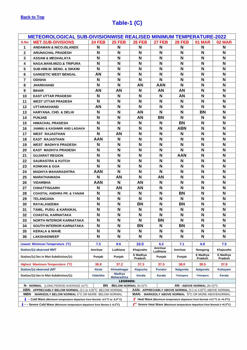
• Sub-divisionwise departure of realised Minimum temperature from Normal is shown in Table-1(C)
• Statewise distribution of number of districts with Large-Excesse, Excess, Normal, Deficient, Large-deficient and no
rainfall is shown in Table-2.
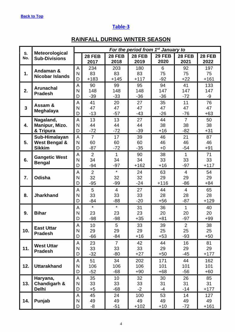
• Cumulative seasonal rainfall data during the corresponding weekly period for the last five years are given in Table-3.
• Sub-divisionwise realised weekly rainfall (in cm) is shown in Annexure-1.
FORECAST & WARNING FOR THE NEXT WEEK 03 March TO 09 March, 2022
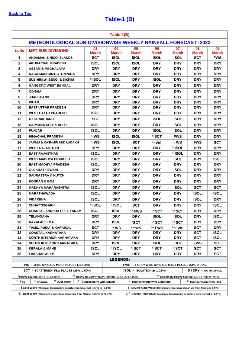
➢ Detailed seven days Sub-division wise rainfall-forecast is given in Table-1(B).

Back to Top
Fig-1
WEEKLY CUMULATIVE RAINFALL (24 FEB – 02 MAR. 2022)

Back to Top
Table-1 (A)
METEOROLOGICAL SUB-DIVISIONWISE DISTRIBUTION OF REALISED RAINFALL-2022
S.No. MET.SUB-DIVISIONS 24 FEB 25 FEB 26 FEB 27 FEB 28 FEB 01 MAR 02 MAR
1 ANDAMAN & NICO.ISLANDS SCT SCT SCT ISOL SCT SCT FWS
2 ARUNACHAL PRADESH DRY ISOL FWS ISOL FWS SCT DRY
3 ASSAM & MEGHALAYA DRY SCT WS ISOL ISOL ISOL DRY
4 NAGA.MANI.MIZO.& TRIPURA ISOL ISOL ISOL ISOL DRY ISOL DRY
5 SUB-HIM.W. BENG. & SIKKIM DRY ISOL FWS ISOL DRY ISOL ISOL
6 GANGETIC WEST BENGAL ISOL WS** SCT DRY DRY DRY ISOL
7 ODISHA DRY ISOL ISOL DRY DRY DRY ISOL
8 JHARKHAND DRY WS ISOL DRY SCT ISOL ISOL
9 BIHAR DRY SCT ISOL DRY ISOL DRY DRY
10 EAST UTTAR PRADESH DRY ISOL ISOL ISOL DRY DRY DRY
11 WEST UTTAR PRADESH DRY DRY ISOL ISOL DRY DRY DRY
12 UTTARAKHAND SCT DRY SCT WS DRY DRY ISOL
13 HARYANA CHD. & DELHI DRY DRY FWS SCT DRY DRY DRY
14 PUNJAB DRY DRY FWS SCT DRY DRY DRY
15 HIMACHAL PRADESH SCT DRY WS WS* DRY DRY ISOL
16 JAMMU & KASHMIR AND LADAKH WS* DRY WS FWS DRY ISOL FWS
17 WEST RAJASTHAN DRY DRY DRY DRY DRY DRY DRY
18 EAST RAJASTHAN DRY DRY DRY DRY DRY DRY DRY
19 WEST MADHYA PRADESH DRY DRY DRY ISOL DRY ISOL DRY
20 EAST MADHYA PRADESH DRY ISOL DRY ISOL ISOL ISOL ISOL
21 GUJARAT REGION DRY DRY DRY DRY DRY DRY DRY
22 SAURASTRA & KUTCH DRY DRY DRY DRY DRY DRY DRY
23 KONKAN & GOA DRY DRY DRY DRY DRY DRY DRY
24 MADHYA MAHARASHTRA DRY DRY DRY DRY DRY DRY DRY
25 MARATHAWADA DRY DRY DRY DRY DRY DRY DRY
26 VIDARBHA DRY DRY DRY DRY DRY DRY DRY
27 CHHATTISGARH DRY ISOL DRY ISOL DRY DRY DRY
28 COASTAL ANDHRA PR. & YANAM DRY DRY DRY DRY DRY DRY DRY
29 TELANGANA DRY DRY DRY DRY DRY DRY DRY
30 RAYALASEEMA DRY DRY DRY DRY DRY DRY DRY
31 TAMIL. PUDU. & KARAIKAL ISOL ISOL DRY ISOL ISOL ISOL ISOL
32 COASTAL KARNATAKA DRY DRY DRY DRY DRY DRY DRY
33 NORTH INT.KARNATAKA DRY DRY DRY DRY DRY DRY DRY
34 SOUTH INT.KARNATAKA DRY DRY DRY DRY DRY DRY DRY
35 KERALA & MAHE ISOL DRY DRY DRY ISOL DRY DRY
36 LAKSHADWEEP DRY DRY DRY DRY DRY DRY DRY
LEGENDS:
WS - WIDE SPREAD / MOST PLACES (76-100%) FWS - FAIRLY WIDE SPREAD / MANY PLACES (51% to 75%)
SCT - SCATTERED / FEW PLACES (26% to 50%) ISOL - ISOLATED (up to 25%) DRY No rain
* ACTIVE (R/F 11/2- 4 times the normal with WS/FWS, at least 2 stations should be 5 cm. along west coast & 3 cm. elsewhere )
** VIGOROUS (R/F More than 4 times the normal with WS/FWS, at least 2 stations should be 8 cm. along west coast & 5 cm. elsewhere)
Back to Top
Table-1 (B)
Table-1(B)
METEOROLOGICAL SUB-DIVISIONWISE WEEKLY RAINFALL FORECAST -2022
Sr. No MET.SUB-DIVISIONS 03
March 04
March 05
March 06
March 07
March 08
March 09
March
1 ANDAMAN & NICO.ISLANDS SCT ISOL ISOL ISOL ISOL SCT FWS
2 ARUNACHAL PRADESH ISOL ISOL ISOL DRY DRY DRY DRY
3 ASSAM & MEGHALAYA DRY DRY DRY DRY DRY DRY DRY
4 NAGA.MANI.MIZO.& TRIPURA DRY DRY DRY DRY DRY DRY DRY
5 SUB-HIM.W. BENG. & SIKKIM L ISOL ISOL DRY ISOL DRY DRY DRY
6 GANGETIC WEST BENGAL DRY DRY DRY DRY DRY DRY DRY
7 ODISHA DRY DRY DRY DRY DRY DRY DRY
8 JHARKHAND DRY DRY DRY DRY DRY DRY DRY
9 BIHAR DRY DRY DRY DRY DRY DRY DRY
10 EAST UTTAR PRADESH DRY DRY DRY DRY DRY DRY DRY
11 WEST UTTAR PRADESH ISOL DRY DRY DRY DRY DRY DRY
12 UTTARAKHAND SCT DRY DRY ISOL ISOL DRY DRY
13 HARYANA CHD. & DELHI ISOL DRY DRY DRY ISOL DRY DRY
14 PUNJAB ISOL DRY DRY ISOL ISOL DRY DRY
15 HIMACHAL PRADESH L WS ISOL ISOL L SCT FWS DRY DRY
16 JAMMU & KASHMIR AND LADAKH L WS ISOL SCT L ● WS L WS FWS SCT
17 WEST RAJASTHAN DRY DRY DRY DRY L ISOL DRY DRY
18 EAST RAJASTHAN ISOL DRY DRY DRY L ISOL DRY DRY
19 WEST MADHYA PRADESH ISOL DRY DRY DRY ISOL DRY ISOL
20 EAST MADHYA PRADESH ISOL DRY DRY DRY DRY DRY DRY
21 GUJARAT REGION DRY DRY DRY DRY ISOL DRY DRY
22 SAURASTRA & KUTCH DRY DRY DRY DRY DRY DRY DRY
23 KONKAN & GOA DRY DRY DRY DRY DRY DRY DRY
24 MADHYA MAHARASHTRA ISOL DRY DRY DRY ISOL SCT SCT
25 MARATHAWADA ISOL DRY DRY DRY DRY ISOL ISOL
26 VIDARBHA ISOL DRY DRY DRY DRY ISOL DRY
27 CHHATTISGARH L ISOL L ISOL SCT DRY DRY DRY ISOL
28 COASTAL ANDHRA PR. & YANAM ISOL ISOL L● FWS L● SCT L● SCT DRY DRY
29 TELANGANA DRY DRY DRY ISOL ISOL DRY ISOL
30 RAYALASEEMA DRY ISOL ●SCT L● SCT L● SCT DRY DRY
31 TAMIL. PUDU. & KARAIKAL SCT L● WS L●● WS L●● FWS L● FWS SCT DRY
32 COASTAL KARNATAKA DRY DRY DRY DRY DRY SCT ISOL
33 NORTH INTERIOR KARNATAKA DRY DRY DRY DRY DRY SCT ISOL
34 SOUTH INTERIOR KARNATAKA DRY ISOL DRY ISOL ISOL FWS SCT
35 KERALA & MAHE ISOL L ISOL L SCT L SCT L SCT SCT SCT
36 LAKSHADWEEP DRY DRY DRY DRY DRY DRY SCT
LEGENDS:
WS - WIDE SPREAD / MOST PLACES (76-100%) FWS - FAIRLY WIDE SPREAD / MANY PLACES (51% to 75%)
SCT - SCATTERED / FEW PLACES (26% to 50%) ISOL - ISOLATED (up to 25%) D / DRY - NO RAINFALL
● Heavy Rainfall (64.5-115.5 mm) ●● Heavy to Very Heavy Rainfall (115.6-204.4 mm) ●●● Extremely Heavy Rainfall (204.5 mm or more)
F Fog * Snowfall D Dust storm $ Thunderstorm with Squall L Thunderstorm with Lightning # Thunderstorm with Hail
- Cold Wave (Minimum temperature departure from Normal -4.5 OC to -6.4OC) - -
Severe Cold Wave (Minimum temperature departure from Norma ≤ -6.5OC)
+ Heat Wave (Maximum temperature departure from Normal +4.5 OC to +6.4OC) + + Severe Heat Wave (Maximum temperature departure from Normal ≥ +6.5OC)
Back to Top
Table-1 (C)
METEOROLOGICAL SUB-DIVISIONWISE REALISED MINIMUM TEMPERATURE-2022 S.No MET.SUB-DIVISIONS 24 FEB 25 FEB 26 FEB 27 FEB 28 FEB 01 MAR 02 MAR
1 ANDAMAN & NICO.ISLANDS N N N N N N N
2 ARUNACHAL PRADESH N N N N N N N
3 ASSAM & MEGHALAYA N N N N N N N
4 NAGA.MANI.MIZO.& TRIPURA N N N N N N N
5 SUB-HIM.W. BENG. & SIKKIM N N N N N N N
6 GANGETIC WEST BENGAL AN N N N N N N
7 ODISHA N N N N N N N
8 JHARKHAND N N AN AAN N N N
9 BIHAR AN AN N AN AN N N
10 EAST UTTAR PRADESH N N N N AN N N
11 WEST UTTAR PRADESH N N N N N N N
12 UTTARAKHAND AN N N N N N N
13 HARYANA, CHD. & DELHI N N AN N N BN N
14 PUNJAB N N AN BN N N N
15 HIMACHAL PRADESH N N N N BN N N
16 JAMMU & KASHMIR AND LADAKH N N N N ABN N N
17 WEST RAJASTHAN N AN N N N N N
18 EAST RAJASTHAN AAN N N N N N N
19 WEST MADHYA PRADESH N N N N N N N
20 EAST MADHYA PRADESH N N N N N N N
21 GUJARAT REGION N N N N AAN N N
22 SAURASTRA & KUTCH N N N N N N N
23 KONKAN & GOA N N N N N N N
24 MADHYA MAHARASHTRA AAN N N N N N N
25 MARATHAWADA N AN N AN N N N
26 VIDARBHA AAN N AN N N N N
27 CHHATTISGARH N AN AN N N N N
28 COASTAL ANDHRA PR. & YANAM N N N N BN N N
29 TELANGANA N N N N N N N
30 RAYALASEEMA N N BN N BN N N
31 TAMIL. PUDU. & KARAIKAL N N N N N N N
32 COASTAL KARNATAKA N N N N N N N
33 NORTH INTERIOR KARNATAKA N N N BN N N N
34 SOUTH INTERIOR KARNATAKA N N BN N BN N N
35 KERALA & MAHE N N N N N N N
36 LAKSHADWEEP N N N N N N N NNNAN
Lowest Minimum Temperature (°C) 7.3 8.6 10.0 6.2 7.1 6.8 7.5
Station/(s) observed HMT Amritsar Ludhiana Khajuraho Amritsar Ludhiana
Amritsar Nowgong Khajuraho
Station/(s) lies in Met-Subdivision/(s) Punjab Punjab E Madhya Pradesh
Punjab Punjab E Madhya Pradesh
E Madhya Pradesh
Highest Maximum Temperature (°C) 36.9 37.2 37.3 37.5 38.0 38.5 37.8
Station/(s) observed LMT Akola Ahmadnagar Alapuzha Punalur Nalgonda Nalgonda Kottayam
Station/(s) lies in Met-Subdivision/(s) Vidarbha Madhya
Maharashtra Kerala Kerala Telangana Telangana Kerala
LEGENDS:
N- NORMAL (LONG PERIOD AVERAGE ±1OC BN -BELOW NORMAL (N-2)OC AN -ABOVE NORMAL (N+2)OC
ABN- APPRECIABLY BELOW NORMAL (3.1 to 4.9)OC BELOW NORMAL AAN- APPRECIABLY ABOVE NORMAL (3.1 to 4.9)OC ABOVE NORMAL
MBN MARKEDLY BELOW NORMAL 5OC OR MORE BELOW NORMAL MAN- MARKEDLY ABOVE NORMAL 5OC OR MORE ABOVENORMAL
- Cold Wave (Minimum temperature departure from Normal -4.5 OC to -6.4O C) + Heat Wave (Maximum temperature departure from Normal +4.5 OC to +6.4OC)
- - Severe Cold Wave (Minimum temperature departure from Norma ≤ -6.5OC) ++ Severe Heat Wave (Maximum temperature departure from Normal ≥ +6.5OC)

3
Back to Top
Table-2
STATEWISE DISTRIBUTION OF NO. OF DISTRICTS
WITH EXCESS, NORMAL,DEFICIENT,SCANTY AND NO RAINFALL
S.
STATES PERIOD FROM : 01.01.2022 TO 28.02.2022
NO. LE E N D LD NR ND TOTAL
1 A & N ISLAND (UT) 3 0 0 0 0 0 0 3
2. ARUNACHAL PRADESH 0 2 7 3 3 0 1 16
3. ASSAM 12 11 4 0 0 0 0 27
4. MEGHALAYA 4 2 1 0 0 0 0 7
5. NAGALAND 8 1 1 1 0 0 0 11
6. MANIPUR 2 2 2 2 1 0 0 9
7. MIZORAM 1 0 2 3 2 0 0 8
8. TRIPURA 0 0 3 1 0 0 0 4
9. SIKKIM 1 0 1 2 0 0 0 4
10. WEST BENGAL 16 1 2 0 0 0 0 19
11. ODISHA 18 7 3 2 0 0 0 30
12. JHARKHAND 20 1 2 1 0 0 0 24
13. BIHAR 22 10 4 2 0 0 0 38
14. UTTAR PRADESH 42 11 10 7 5 0 0 75
15. UTTARAKHAND 6 6 1 0 0 0 0 13
16. HARYANA 21 1 0 0 0 0 0 22
17. CHANDIGARH (UT) 1 0 0 0 0 0 0 1
18. DELHI 9 0 0 0 0 0 0 9
19. PUNJAB 21 1 0 0 0 0 0 22
20. HIMACHAL PRADESH 8 2 1 1 0 0 0 12
21. JAMMU & KASHMIR(UT) 4 7 5 3 1 0 0 20
22. LADAKH(UT) 1 0 0 1 0 0 0 2
23. RAJASTHAN 22 2 5 4 0 0 0 33
24. MADHYA PRADESH 21 15 10 2 3 1 0 52
25. GUJARAT 11 2 3 4 3 10 0 33
26. DADRA & NAGAR HAVELI (UT) 0 0 0 0 0 1 0 1
27. DAMAN & DIU (UT) 1 1 0 0 0 0 0 2
28. GOA 1 0 0 0 0 1 0 2
29. MAHARASHTRA 7 3 3 1 9 13 0 36
30. CHHATISGARH 20 6 1 0 0 0 0 27
31. ANDHRA PRADESH 5 3 3 1 1 0 0 13
32. TELANGANA 21 2 5 0 5 0 0 33
33. TAMILNADU 15 4 12 7 0 0 0 38
34. PUDUCHERRY (UT) 1 1 1 0 0 1 0 4
35. KARNATAKA 0 0 0 2 19 9 0 30
36. KERALA 0 1 2 5 5 1 0 14
37. LAKSHADWEEP (UT) 0 0 0 1 0 0 0 1
TOTAL 345 105 94 56 57 37 1 695
CATEGORYWISE DISTRIBUTION
OF DISTRICTS OUT OF THE 50% 15% 14% 8% 8% 5%
694 WHOSE DATA RECEIVED
PERCENT DISTRIBUTION OF DISTRICTS IN EARLIER YEARS SINCE 1st JANUARY
DATE LE E N D LD NR
28.02.2021 19% 3% 5% 14% 43% 16%
29.02.2020 23% 14% 17% 16% 16% 14%
28.02.2019 22% 10% 16% 19% 19% 14%
28.02.2018 2% 3% 4% 18% 42% 31%
28.02.2017 7% 5% 11% 17% 27% 33%
4
Back to Top
Table-3
RAINFALL DURING WINTER SEASON
S. No.
Meteorological Sub-Divisions
For the period from 1st January to
28 FEB
2017
28 FEB 2018
28 FEB 2019
29 FEB 2020
28 FEB 2021
28 FEB 2022
1. Andaman & Nicobar Islands
A N D
234 83
+183
203 83
+145
180 83
+117
6 75 -92
92 75
+22
197 75
+161
2. Arunachal Pradesh
A N D
90 148 -39
99 148 -33
95 148 -36
94 147 -36
41 147 -72
133 147 -9
3 Assam & Meghalaya
A N D
41 47 -13
20 47 -57
27 47 -43
35 47 -26
11 47 -76
76 47
+63
4. Nagaland, Manipur, Mizo. & Tripura
A N D
13 44 -72
13 44 -72
27 44 -39
44 38
+16
7 38 -82
50 38
+31
5. Sub-Himalayan West Bengal & Sikkim
A N D
7 60 -87
17 60 -72
39 60 -35
46 46 +0
21 46 -54
87 46
+91
6. Gangetic West Bengal
A N D
2 34 -94
1 34 -97
90 34
+162
38 33
+16
1 33 -97
71 33
+117
7. Odisha A N D
2 32 -95
* 32 -99
24 32 -24
63 29
+116
4 29 -86
54 29
+84
8. Jharkhand A N D
5 33 -84
4 33 -88
27 33 -20
44 28
+56
4 28 -87
65 28
+129
9. Bihar A N D
* 23 -98
* 23 -98
31 23
+35
36 20
+81
1 20 -97
40 20
+99
10. East Uttar Pradesh
A N D
10 29 -66
5 29 -84
33 29
+16
39 25
+53
2 25 -93
38 25
+50
11. West Uttar Pradesh
A N D
23 33 -32
7 33 -80
42 33
+27
44 29
+50
16 29 -45
81 29
+177
12. Uttarakhand A N D
51 106 -52
34 106 -68
202 106 +90
171 101 +68
44 101 -56
162 101 +60
13. Haryana, Chandigarh & Delhi
A N D
35 33 +5
10 33 -68
32 33 -2
30 31 -4
26 31 -14
85 31
+177
14. Punjab A N D
45 49 -8
24 49 -51
100 49
+102
53 49
+10
14 49 -72
127 49
+161
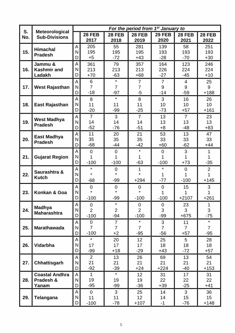
5
S. No.
Meteorological Sub-Divisions
For the period from 1st January to
28 FEB
2017 28 FEB
2018 28 FEB
2019
29 FEB 2020
28 FEB 2021
28 FEB 2022
15. Himachal Pradesh
A N D
205 195 +5
55 195 -72
281 195 +43
139 193 -28
58 193 -70
251 193 +30
16. Jammu & Kashmir and Ladakh
A N D
361 213 +70
79 213 -63
357 213 +68
164 226 -27
123 224 -45
246 224 +10
17. West Rajasthan A N D
6 7
-18
* 7
-97
7 7 -5
7 9
-14
4 9
-59
25 9
+188
18. East Rajasthan
A N D
8 11 -20
* 11 -99
8 11 -25
3 10 -73
16 10
+57
26 10
+161
19. West Madhya Pradesh
A N D
7 14 -52
3 14 -76
7 14 -51
13 13 +8
7 13 -48
23 13
+83
20. East Madhya Pradesh
A N D
11 35 -68
20 35 -44
21 35 -42
53 33
+60
13 33 -62
47 33
+44
21. Gujarat Region
A N D
0 1
-100
0 1
-100
* 1
-63
0 1
-100
3 1
+73
1 1
-35
22. Saurashtra & Kutch
A N D
* *
-68
0 *
-99
1 *
+294
* 1
-77
0 1
-100
2 1
+145
23. Konkan & Goa
A N D
0 *
-100
0 *
-99
0 *
-100
0 1
-100
15 1
+2107
3 1
+261
24. Madhya Maharashtra
A N D
0 2
-100
* 2
-94
0 2
-100
0 3
-99
23 3
+675
1 3
-75
25. Marathawada A N D
0 7
-100
7 7
+2
* 7
-95
3 7
-56
11 7
+57
* 7
-95
26. Vidarbha
A N D
* 17 -99
20 17
+18
12 17 -29
25 18
+43
5 18 -72
28 18
+57
27. Chhattisgarh A N D
2 21 -92
13 21 -39
26 21
+24
69 21
+224
13 21 -40
54 21
+153
28. Coastal Andhra Pradesh & Yanam
A N D
1 19 -95
* 19 -99
12 19 -36
31 22
+39
17 22 -25
31 22
+41
29. Telangana
A N D
0 11
-100
3 11 -78
25 12
+107
14 14 -1
3 15 -76
36 15
+148

6
S. No.
Meteorological Sub-Divisions
For the period from 1st January to
28 FEB
2017 28 FEB
2018 28 FEB
2019
29 FEB 2020
28 FEB 2021
28 FEB 2022
30. Rayalaseema
A N D
4 7
-41
5 7
-30
14 7
+112
4 8
-47
35 8
+330
10 8
+27
31. Tamil Nadu, Puducherry & Karaikal
A N D
38 31
+24
17 31 -46
5 31 -84
10 28 -66
151 28
+436
43 28
+51
32. Coastal Karnataka
A N D
1 1
+20
* 1
-81
* 1
-68
1 3
-77
77 3
+2973
1 3
-76
33. North Interior Karnataka
A N D
0 4
-100
2 4
-49
1 4
-78
1 5
-86
13 5
+142
* 5
-92
34. South Interior Karnataka
A N D
5 4
+26
3 4
-28
9 4
+97
1 6
-92
49 6
+747
1 6
-91
35. Kerala & Mahe
A N D
13 24 -46
17 24 -30
13 24 -46
10 22 -57
114 22
+409
15 22 -33
36. Lakshadweep A N D
22 35 -38
13 35 -64
28 35 -21
8 25 -68
217 25
+761
18 25 -29
Country as a whole
A N D
39.3 41.4 -5
15.5 41.1 -63
51.4 41.4 +24
40.2 40.8 -1
27.8 40.8 -32
58.7 40.8 +44
SUMMARY
No. of Sub-Divisions with rainfall
For the period from 1st January to
28 FEB 2017
28 FEB 2018
28 FEB 2019
29 FEB 2020
28 FEB 2021
28 FEB 2022
Large Excess Excess Normal Total
02 03 05 10
01 00 02 03
09 04 03 16
05 05 08 18
10 03 01 14
18 08 02 28
Deficient Large Deficient No rain Total
08 12 06 26
10 22 01 31
13 05 02 20
07 09 02 18
08 13 01 22
03 05 00 08
Data Inadequate 00 00 00 00 00 00
TOTAL 36 36 36 36 36 36
* Data is rounded off to nearest full figure according to Meteorological convention.
SEASONS : WINTER SEASON (January-February) PRE-MONSOON SEASON (March-May)
MONSOON SEASON (June-September) POST-MONSOON SEASON (October-December)
LEGENDS:
Large Excess: (+60% or more) Large Deficient: (-60% to -99%) A: Actual Rainfall (mm)
Excess: (+20% to +59%) Deficient: (-20% to -59%) N: Normal Rainfall (mm)
Normal: (+19% to -19%) No Rain (-100%) D: Departure from normal (%)
Data Inadequate: ** Rainfall upto 0.4 mm : *

Back to Top
Fig-2

3
Back to Top
Fig-3
4
Back to Top
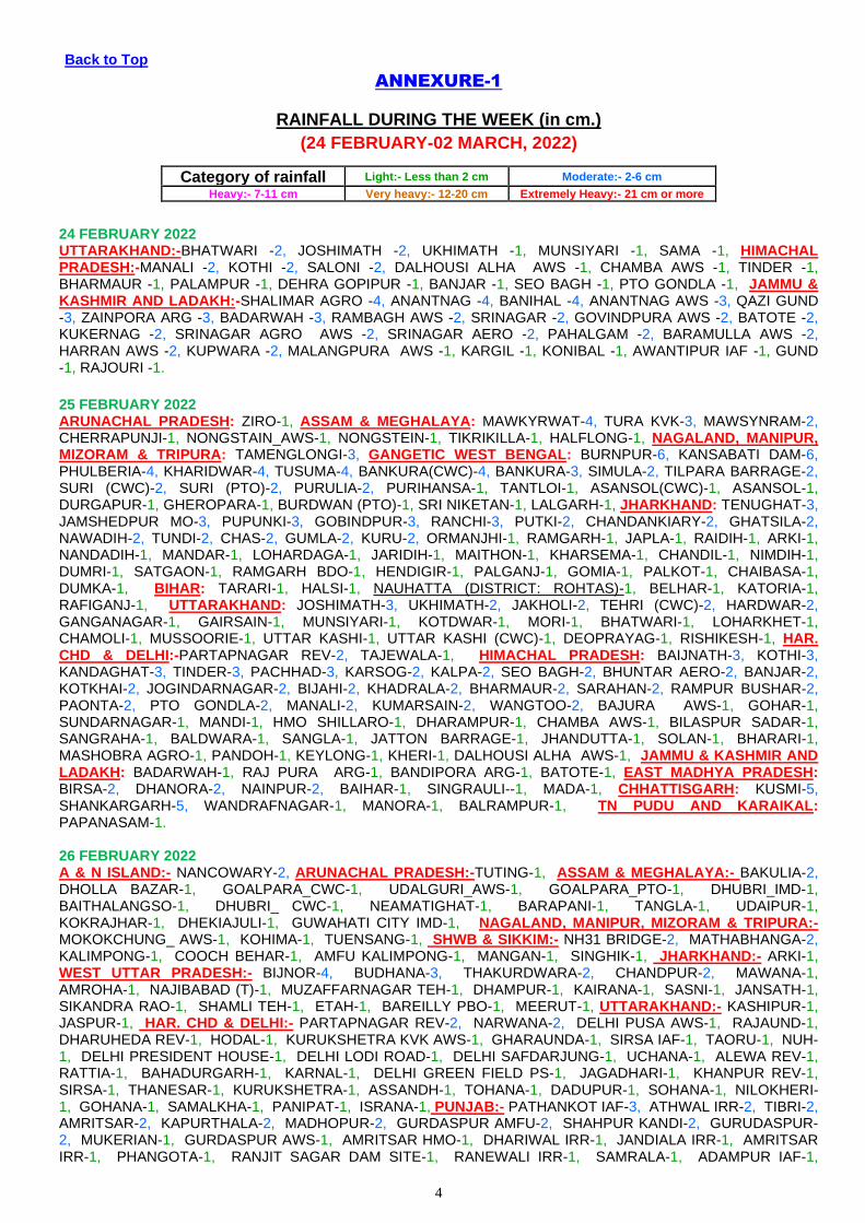
ANNEXURE-1
RAINFALL DURING THE WEEK (in cm.)
(24 FEBRUARY-02 MARCH, 2022)
Category of rainfall Light:- Less than 2 cm Moderate:- 2-6 cm
Heavy:- 7-11 cm Very heavy:- 12-20 cm Extremely Heavy:- 21 cm or more
24 FEBRUARY 2022 UTTARAKHAND:-BHATWARI -2, JOSHIMATH -2, UKHIMATH -1, MUNSIYARI -1, SAMA -1, HIMACHAL PRADESH:-MANALI -2, KOTHI -2, SALONI -2, DALHOUSI ALHA AWS -1, CHAMBA AWS -1, TINDER -1, BHARMAUR -1, PALAMPUR -1, DEHRA GOPIPUR -1, BANJAR -1, SEO BAGH -1, PTO GONDLA -1, JAMMU & KASHMIR AND LADAKH:-SHALIMAR AGRO -4, ANANTNAG -4, BANIHAL -4, ANANTNAG AWS -3, QAZI GUND -3, ZAINPORA ARG -3, BADARWAH -3, RAMBAGH AWS -2, SRINAGAR -2, GOVINDPURA AWS -2, BATOTE -2, KUKERNAG -2, SRINAGAR AGRO AWS -2, SRINAGAR AERO -2, PAHALGAM -2, BARAMULLA AWS -2, HARRAN AWS -2, KUPWARA -2, MALANGPURA AWS -1, KARGIL -1, KONIBAL -1, AWANTIPUR IAF -1, GUND -1, RAJOURI -1.
25 FEBRUARY 2022 ARUNACHAL PRADESH: ZIRO-1, ASSAM & MEGHALAYA: MAWKYRWAT-4, TURA KVK-3, MAWSYNRAM-2, CHERRAPUNJI-1, NONGSTAIN_AWS-1, NONGSTEIN-1, TIKRIKILLA-1, HALFLONG-1, NAGALAND, MANIPUR, MIZORAM & TRIPURA: TAMENGLONGI-3, GANGETIC WEST BENGAL: BURNPUR-6, KANSABATI DAM-6, PHULBERIA-4, KHARIDWAR-4, TUSUMA-4, BANKURA(CWC)-4, BANKURA-3, SIMULA-2, TILPARA BARRAGE-2, SURI (CWC)-2, SURI (PTO)-2, PURULIA-2, PURIHANSA-1, TANTLOI-1, ASANSOL(CWC)-1, ASANSOL-1, DURGAPUR-1, GHEROPARA-1, BURDWAN (PTO)-1, SRI NIKETAN-1, LALGARH-1, JHARKHAND: TENUGHAT-3, JAMSHEDPUR MO-3, PUPUNKI-3, GOBINDPUR-3, RANCHI-3, PUTKI-2, CHANDANKIARY-2, GHATSILA-2, NAWADIH-2, TUNDI-2, CHAS-2, GUMLA-2, KURU-2, ORMANJHI-1, RAMGARH-1, JAPLA-1, RAIDIH-1, ARKI-1, NANDADIH-1, MANDAR-1, LOHARDAGA-1, JARIDIH-1, MAITHON-1, KHARSEMA-1, CHANDIL-1, NIMDIH-1, DUMRI-1, SATGAON-1, RAMGARH BDO-1, HENDIGIR-1, PALGANJ-1, GOMIA-1, PALKOT-1, CHAIBASA-1, DUMKA-1, BIHAR: TARARI-1, HALSI-1, NAUHATTA (DISTRICT: ROHTAS)-1, BELHAR-1, KATORIA-1, RAFIGANJ-1, UTTARAKHAND: JOSHIMATH-3, UKHIMATH-2, JAKHOLI-2, TEHRI (CWC)-2, HARDWAR-2, GANGANAGAR-1, GAIRSAIN-1, MUNSIYARI-1, KOTDWAR-1, MORI-1, BHATWARI-1, LOHARKHET-1, CHAMOLI-1, MUSSOORIE-1, UTTAR KASHI-1, UTTAR KASHI (CWC)-1, DEOPRAYAG-1, RISHIKESH-1, HAR. CHD & DELHI:-PARTAPNAGAR REV-2, TAJEWALA-1, HIMACHAL PRADESH: BAIJNATH-3, KOTHI-3, KANDAGHAT-3, TINDER-3, PACHHAD-3, KARSOG-2, KALPA-2, SEO BAGH-2, BHUNTAR AERO-2, BANJAR-2, KOTKHAI-2, JOGINDARNAGAR-2, BIJAHI-2, KHADRALA-2, BHARMAUR-2, SARAHAN-2, RAMPUR BUSHAR-2, PAONTA-2, PTO GONDLA-2, MANALI-2, KUMARSAIN-2, WANGTOO-2, BAJURA AWS-1, GOHAR-1, SUNDARNAGAR-1, MANDI-1, HMO SHILLARO-1, DHARAMPUR-1, CHAMBA AWS-1, BILASPUR SADAR-1, SANGRAHA-1, BALDWARA-1, SANGLA-1, JATTON BARRAGE-1, JHANDUTTA-1, SOLAN-1, BHARARI-1, MASHOBRA AGRO-1, PANDOH-1, KEYLONG-1, KHERI-1, DALHOUSI ALHA AWS-1, JAMMU & KASHMIR AND LADAKH: BADARWAH-1, RAJ PURA ARG-1, BANDIPORA ARG-1, BATOTE-1, EAST MADHYA PRADESH: BIRSA-2, DHANORA-2, NAINPUR-2, BAIHAR-1, SINGRAULI--1, MADA-1, CHHATTISGARH: KUSMI-5, SHANKARGARH-5, WANDRAFNAGAR-1, MANORA-1, BALRAMPUR-1, TN PUDU AND KARAIKAL: PAPANASAM-1. 26 FEBRUARY 2022 A & N ISLAND:- NANCOWARY-2, ARUNACHAL PRADESH:-TUTING-1, ASSAM & MEGHALAYA:- BAKULIA-2, DHOLLA BAZAR-1, GOALPARA_CWC-1, UDALGURI_AWS-1, GOALPARA_PTO-1, DHUBRI_IMD-1, BAITHALANGSO-1, DHUBRI_ CWC-1, NEAMATIGHAT-1, BARAPANI-1, TANGLA-1, UDAIPUR-1, KOKRAJHAR-1, DHEKIAJULI-1, GUWAHATI CITY IMD-1, NAGALAND, MANIPUR, MIZORAM & TRIPURA:- MOKOKCHUNG_ AWS-1, KOHIMA-1, TUENSANG-1, SHWB & SIKKIM:- NH31 BRIDGE-2, MATHABHANGA-2, KALIMPONG-1, COOCH BEHAR-1, AMFU KALIMPONG-1, MANGAN-1, SINGHIK-1, JHARKHAND:- ARKI-1, WEST UTTAR PRADESH:- BIJNOR-4, BUDHANA-3, THAKURDWARA-2, CHANDPUR-2, MAWANA-1, AMROHA-1, NAJIBABAD (T)-1, MUZAFFARNAGAR TEH-1, DHAMPUR-1, KAIRANA-1, SASNI-1, JANSATH-1, SIKANDRA RAO-1, SHAMLI TEH-1, ETAH-1, BAREILLY PBO-1, MEERUT-1, UTTARAKHAND:- KASHIPUR-1, JASPUR-1, HAR. CHD & DELHI:- PARTAPNAGAR REV-2, NARWANA-2, DELHI PUSA AWS-1, RAJAUND-1, DHARUHEDA REV-1, HODAL-1, KURUKSHETRA KVK AWS-1, GHARAUNDA-1, SIRSA IAF-1, TAORU-1, NUH-1, DELHI PRESIDENT HOUSE-1, DELHI LODI ROAD-1, DELHI SAFDARJUNG-1, UCHANA-1, ALEWA REV-1, RATTIA-1, BAHADURGARH-1, KARNAL-1, DELHI GREEN FIELD PS-1, JAGADHARI-1, KHANPUR REV-1, SIRSA-1, THANESAR-1, KURUKSHETRA-1, ASSANDH-1, TOHANA-1, DADUPUR-1, SOHANA-1, NILOKHERI-1, GOHANA-1, SAMALKHA-1, PANIPAT-1, ISRANA-1, PUNJAB:- PATHANKOT IAF-3, ATHWAL IRR-2, TIBRI-2, AMRITSAR-2, KAPURTHALA-2, MADHOPUR-2, GURDASPUR AMFU-2, SHAHPUR KANDI-2, GURUDASPUR-2, MUKERIAN-1, GURDASPUR AWS-1, AMRITSAR HMO-1, DHARIWAL IRR-1, JANDIALA IRR-1, AMRITSAR IRR-1, PHANGOTA-1, RANJIT SAGAR DAM SITE-1, RANEWALI IRR-1, SAMRALA-1, ADAMPUR IAF-1,

5
HIMACHAL PRADESH:- CHAWARI-3, NAGROTA SURIAN-1, GHAMROOR-1, KHERI-1, MEHRE (BARSAR)-1, GHUMARWIN-1, GULER-1, DEHRA GOPIPUR-1, BHARMAUR-1, HAMIRPUR-1, CHAMBA AWS-1, BANGANA_R-1, BANGANA_F-1, BHORANJ-1, MANALI-1, AMB-1, BANJAR-1, SALONI-1, UNA-1, PANDOH-1, JANJEHLI-1, DHARMSALA-1, KHADRALA-1, SEO BAGH-1, JAMMU & KASHMIR AND LADAKH:- BANIHAL-4, ANANTNAG AWS-4, UDHAMPUR(IAF)-3, BADARWAH-3, QAZI GUND-3, PAHALGAM-3, BATOTE-3, ZAINPORA ARG-2, GOVINDPURA AWS-2, KATRA-2, JAMMU AWS-2, JAMMU-2, ANANTNAG-2, KAWA AWS-2, RAJHANI AWS-2, RS PURA ARG-2, JAMMU AERO-2, KULGAM AWS-2, SAMBA AWS-2, RAJ PURA ARG-2, KATHUA-2, SRINAGAR AGRO AWS-1, KUKERNAG-1, GUND-1, GULMARG R.S.-1, KUPWARA-1, BANDIPORA ARG-1, HARRAN AWS-1, KONIBAL-1, BANDIPORA-1, SHALIMAR AGRO-1, KERALA & MAHE:- KANJIRAPPALLY-1. 27 FEBRUARY 2022 A & N ISLAND:- NANCOWARY-2, ARUNACHAL PRADESH:- YINGKIONG-1, NAGALAND, MANIPUR, MIZORAM & TRIPURA:- LILONG_ ARG-1, ODISHA:- KEONJHARGARH-1, WEST UTTAR PRADESH:--, MORADABAD-2, SAMBHAL-1, UTTARAKHAND:- PAURI-2, JAKHOLI-2, GAIRSAIN-2, SAMA-1, GARUD-1, SOMESHWAR-1, PUROLA-1, DUNDA-1, UTTAR KASHI-1, BHATWARI-1, LOHARKHET-1, BERINAG-1, MORI-1, ALMORA-1, HARIPUR-1, TIUNI-1, BHAGWANPUR-1, KEERTINAGAR-1, CHAUKHUTIA-1, TEHRI-1, BETALGHAT-1, UKHIMATH-1, CHAMOLI-1, KAPKOT-1, MUSSOORIE-1, CHAKRATA-1, GANGOLIHAT-1, DHANAULTI-1, THARALI-1, HAR. CHD & DELHI:- NAHAR REV-2, PALHAWAS REV-2, TAJEWALA-1, PUNJAB:- BUL IRR-4, PHAGWARA-2, DORAHA IRR-2, BALACHAUR-2, LUDHIANA-2, SAMRALA-2, NANGAL-2, FEROZEPUR-2, KAPURTHALA-1, PHANGOTA-1, NAKODAR ARG-1, ANANDPUR SAHIB-1, ROPAR-1, HOSHIARPUR AWS-1, TALWANDI BHAI-1, LUDHIANA IRR-1, JAGRAON-1, HIMACHAL PRADESH:- KHADRALA-3, JHANDUTTA-3, RAMPUR BUSHAR-2, BHUNTAR AERO-2, BAJURA AWS-2, KARSOG-2, SHIMLA AERO-2, WANGTOO-2, KUMARSAIN-2, NAINA DAVI-2, SEO BAGH-2, KOTHI-1, ROHRU-1, PANDOH-1, KAHU-1, SARAHAN-1, MANALI-1, SUNDARNAGAR-1, BANJAR-1, NICHAR-1, BILASPUR SADAR-1, GOHAR-1, BARTHIN-1, R L BBMB-1, KOTKHAI-1, MANDI-1, PAONTA-1, KALPA-1, AGHAR-1, BHARARI-1, KANDAGHAT-1, SANGRAHA-1, RAJGARH-1, JAMMU & KASHMIR AND LADAKH:- JAMMU AERO-1, ANANTNAG AWS-1, EAST MADHYA PRADESH:- NARAYANGANJ-2, JAITHARI-1, PANAGAR-1, ANUPPUR--1, SHAHPURA (DISTRICT: JABALPUR)-1, KOTMA-1, JABALPUR-1, TN PUDU AND KARAIKAL:- R.S.MANGALAM-3, TONDI-1, THOOTHUKUDI PORT AWS-1, TIRUPOONDI-1, KADALADI-1, MUDUKULATUR-1. 28 FEBRUARY 2022 A & N ISLAND:-NANCOWARY-9, CAR NICOBAR-8, IAF CARNICOBAR-7, ARUNACHAL PRADESH:-KOLORIANG-2, TUTING-2, KIBITHU-1, KABU BASTI-1, ASSAM & MEGHALAYA:-BEKI MATHUNGARI-1, TANGLA-1, SHWB & SIKKIM:-CHUNGTHANG-3, SANKALAN-2, SINGHIK-2, MANGAN-2, SHIPGYAR-1, GANGETIC WEST BENGAL:-GHEROPARA-2, BURDWAN (PTO)-1, SRI NIKETAN-1, CANNING-1, KALYANI SMO-1, , JHARKHAND:-PARSABAD-1, JAPLA-1, JARMINDI-1, SATGAON-1, BIHAR:-NAWADA-1, SONO-1, BAUSI-1, JHAJHA-1, JAMUI-1, BELHAR-1, EAST MADHYA PRADESH:-BIJURI-4, ANUPPUR--3, KOTMA-2, GOHPARU-1, JAITPUR-1, VENKATNAGAR-1, JAITHARI-1, SHAHDOLE(SOHAGPUR)-1, TAMIA-1, CHHATTISGARH:-KHADGAVA-3, KANSABEL-3, MARWAHI-2, LAKHANPUR-2, JASHPURNAGAR-1, POUDI UPARORA-1, MAINPAT-1, DHARAMJAIGARH-1, UDAIPUR-1, SITAPUR-1, RAMANUJNAGAR-1, BHAIYATHAN-1, KATGHORA-1, AMBIKAPUR-1, KERALA & MAHE:-ALAPUZHA-5, KONNI ARG-2, KONNI-2, PERUMKADAVILA ARG-1, THIRUVANANTHAPURAM-1, TRIVANDRUM AERO-1. 1 MARCH 2022 A & N ISLAND:-IAF CARNICOBAR-8, CAR NICOBAR-4, NANCOWARY-2, ARUNACHAL PRADESH: - YINGKIONG-2, KOLORIANG-1, ASSAM & MEGHALAYA:- BEKI MATHUNGARI-2, NAGALAND, MANIPUR, MIZORAM & TRIPURA:- MOKOKCHANG-2, CHHATTISGARH:- MARWAHI-2, PENDRA ROAD-2, BAIKUNTHPUR-1, KOTA-1, 2 MARCH,2022 A,&,N,ISLAND:-CAR,NICOBAR-1, IAF,CARNICOBAR-1,HUT,BAY-1, SHWB,&,SIKKIM:-MANGAN-1,KABI-1,SANKALAN-1,SINGHIK-1, ODISHA:- BANGIRIPOSI-2,KARANJIA-2,TIRING-2,BETANATI-1, CHANDANPUR-1, BALIMUNDALI-1,NAWANA-1, JHARKHAND:-CHAKRADHARPUR-1, UTTARAKHAND:- BHATWARI-1,LOHAGHAT-1, JAMMU,&,KASHMIR,AND,LADAKH:-GULMARG,R.S.-1.
LEGENDS: CWC Central Water Commission PT/PTO Part Time Observatory
AP Airport FMO Flood Meteorological Office PBO Pilot Balloon Observatory
AWS Automated Weather Station IAF Indian Air Force REV Revenue
ARG Automated Rain Gauge IMD India Meteorological Department SR State Raingauge
CDR Cyclone Detection Radar PWD Public Works Department

1 | P a g e
Government of India
Earth System Science Organization
Ministry of Earth Sciences
India Meteorological Department
Press: Dated: 3rd Mar, 2022
Subject: Current Weather Status and Extended range Forecast for next two weeks
(3-16 March 2022)
1. Salient Features for week ending on 2 March 2022
Formation and westward movement of a Low Pressure Area across south Andaman Sea had
caused scattered to fairly widespread rainfall/thunderstorms over Andaman & Nicobar Islands
during the second half of the week along with isolated heavy rainfall activity reported for 2 days
during 27 Feb-1 March.
Movement of three WDs across extreme norther India had caused fairly widespread to
widespread rainfall/snowfall/thunderstorm activity over Jammu Kashmir & Ladakh during most
dates in the week and over remaining parts of Western Himalayan Region on two to three
days whereas isolated rainfall/snowfall/thunderstorm activity had been reported over these
region on one or two days during the week. Two WDs along with their induced cyclonic
circulations had caused scattered to fairly widespread rainfall/thunderstorms over Punjab and
Haryana, Chandigarh & Delhi one or two days and isolated rainfall/thunderstorm activity over
parts of Madhya Pradesh on two to three days; isolated hailstorm activity also had been
reported over Uttarakhand and over plains of northwest India on one or two days along with.
Weekly overall Rainfall distribution during the current week ending on 2 March 2022
Winter Season’s Rainfall Scenario (01 Jan to 28 Feb, 2022): During the week ending on 1
March, for the country as a whole, the weekly cumulative All India Rainfall departure from its
long period average (LPA) was -23% with weekly cumulative over Peninsular India as -60%,
while all India cumulative rainfall during this year’s Winter Season till 28 Feb, 2022 is above

2 | P a g e
LPA by +44% and over northwest India, it is above LPA by +37%. Details of the rainfall
distribution over the four broad geographical regions of India are given in Table 1 and
Meteorological sub-division-wise rainfall both for week and season are given in Annex I and II
respectively.
Table 1: Rainfall status (Week and season)
Region
WEEK SEASON
24.02.2022 TO 02.03.2022 01.01.2022 TO 28.02.2022
Actual Normal % Dep Actual Normal % Dep
EAST &
NORTH-EAST
INDIA 7.8 10.0 -22% 73.4 52.1 +41%
NORTH-
WEST INDIA 10.5 13.1 -20% 108.3 78.9 +37%
CENTRAL
INDIA 1.1 1.7 -36% 26.6 15.2 +75%
SOUTH
PENINSULA 0.7 1.8 -60% 24.2 16.2 +49%
country as a
whole 5.0 6.5 -23% 58.7 40.8 +44%
2. Large scale features
Currently, La Niña conditions are prevailing over the equatorial Pacific region. The La Niña is likely to weaken
during the northern hemisphere spring season and to reach cold ENSO neutral conditions during the second
quarter of 2022. At present, neutral IOD conditions are present over the Indian Ocean and the latest MMCFS
forecast indicates that the neutral IOD conditions are likely to continue during the northern hemisphere spring
and summer seasons. There is also a possibility of negative IOD conditions during the autumn season.
The Madden Julian Jndex (MJO) currently lies in phase 6 with amplitude less than 1. it is likely to continue in
the same phase for the for next 3-4 days, then move to phase 7 and remain there till 1st half of the week 2
and at phase 8 in the 2nd
half of the week 2 with amplitude remaining less than 1.
3 | P a g e
3. Forecast for next two week
Weather systems & associated Precipitation
week 1 (03 to 09 March, 2022):
o The depression over southwest Bay of Bengal and adjoining Equatorial Indian Ocean moved north-
northwestwards with a speed of about 18 kmph during last 06 hours and lay centered at 1130 hrs IST
of today, the 3rd March 2022, over southwest Bay of Bengal near latitude 6.1°N and longitude 83.4°E,
about 360 km south-southeast of Trincomalee (Sri Lanka), 700 km south-southeast of Nagappattinam
(Tamil Nadu), 760 km south-southeast of Puducherry (Tamil Nadu) and about 840 km south-southeast
of Chennai (Tamil Nadu). It is likely to intensify further into a Deep Depression during next 24 hours.
It is likely to move northwestwards along and off east coast of Sri Lanka towards north Tamil Nadu
Coast during next 48 hours. Under its influence:
Rainfall forecast & Warnings (associated with depression):
Light to moderate rainfall/thunder shower at a few places likely over coastal Tamil Nadu,
Puducherry & Karaikal on 03rd March, 2022.
Light to moderate rainfall/thunder shower at many places with isolated heavy rainfall likely
over coastal Tamil Nadu, Puducherry & Karaikal; light to moderate rainfall/thundershower at a
few places likely over south coastal Andhra Pradesh and Rayalaseema on 04th March, 2022.
Light to moderate rainfall/thundershower at most places with heavy to very heavy rainfall at
isolated places very likely over north coastal Tamil Nadu, Puducherry & Karaikal; light to
moderate rainfall/thunder shower at many places with isolated heavy falls very likely over
south coastal Andhra Pradesh and Rayalaseema on 05th & 06th March, 2022.
Light to moderate rainfall/thundershower at most places with heavy to very heavy rainfall at
isolated places very likely over north Tamil Nadu, Puducherry & Karaikal and isolated heavy
falls very likely over south coastal Andhra Pradesh and Rayalaseema on 07th March, 2022.
Wind warning (associated with depression):
Squally winds speed reaching 45-55 kmph gusting to 65 kmph are very likely to prevail over
Southwest & adjoining Westcentral Bay of Bengal, Gulf of Mannar and along & off Tamil

4 | P a g e
Nadu, Puducherry coasts. Squally winds speed reaching 40-50 kmph gusting to 60 kmph are
very likely over Equatorial Indian Ocean on 03rd March, 2022.
Squally winds speed would gradually increase becoming 50-60 kmph gusting to 70 kmph
over Southwest & adjoining Westcentral Bay of Bengal, Gulf of Mannar and along & off north
Tamil Nadu, Puducherry & South Andhra Pradesh coasts on 04th & 05th March, 2022.
Squally winds speed reaching 40-50 kmph gusting to 60 kmph are very likely to prevail over
Westcentral & adjoining Southwest Bay of Bengal and along & off north Tamil Nadu,
Puducherry and south Andhra Pradesh coasts on 06th March, 2022.
Sea condition:
Sea condition will be rough to very rough over Southwest & adjoining westcentral Bay of
Bengal, Gulf of Mannar and Comorin area and along & off Tamil Nadu, Puducherry & south
Andhra Pradesh coasts during 3rd – 6th March. Sea condition will be rough to very rough over
adjoining Equatorial Indian Ocean on 3rd March, 2022.
Fishermen Warning:
Fishermen are advised not to venture into Southwest & adjoining Westcentral Bay of Bengal,
adjoining Equatorial Indian Ocean, Gulf of Mannar, Comorin area and along & off Tamil
Nadu, Puducherry and south Andhra Pradesh coasts till 6th March, 2022.
o A The Western Disturbance as a cyclonic circulation lies over north Pakistan &
neighbourhood in lower & middle tropospheric levels and an induced cyclonic circulation lies
over West Rajasthan & neighbourhood in lower tropospheric levels. Under their influence:
Fairly widespread to widespread light/moderate rainfall/snowfall with isolated
thunderstorm/lightning very likely over Jammu-Kashmir-Ladakh-Gilgit-Baltistan-
Muzaffarabad & Himachal Pradesh and Uttarakhand during next 24 hours.
Isolated light rainfall very likely over Punjab, Haryana-Chandigarh and West Uttar Pradesh
during next 24 hours.
Strong surface Winds (speed 25-35 kmph) very likely to prevail over Haryana-Chandigarh-
Delhi & Rajasthan on 04th March and over most parts of plains of northwest India on 05th
March, 2022.
o A fresh Western Disturbance is very likely to cause isolated to scattered rainfall/snowfall on
05th and fairly widespread to widespread light/moderate rainfall/snowfall over Jammu-

5 | P a g e
Kashmir-Ladakh-Gilgit-Baltistan-Muzaffarabad & Himachal Pradesh; and isolated
rainfall/snowfall over Uttarakhand on 06th & 07th March, 2022. Isolated heavy rainfall is also
very likely over Jammu-Kashmir-Ladakh-Gilgit-Baltistan-Muzaffarabad on 06th March, 2022.
Under influence of induced cyclonic circulation; isolated light rainfall likely over adjoining
plains on 06th & 07th March, 2022.
o Dry weather very likely over remaining parts of the country during most days of the week.
o Overall precipitation activity is likely to be above normal most parts of Soth Peninsular India
and Western Himalayan Region and below normal over rest parts of the country during the
week.
week 2 (10 to 16 March, 2022):
o Under the influence of Western Disturbance & its associated induced cyclonic circulation;
precipitation activity is likely to be normal to above normal over northwest India during the
week.
o Rainfall activity is likely to be below normal rest parts of the country.
Maximum Temperatures Forecasts
Week 1(03 to 09 March, 2022):
o Maximum Temperature Departures (as on 02-03-2022) were above normal by 2- 4°C over
West Rajasthan, Gujarat, West Madhya Pradesh, Vidharbha, Kerala & Mahe, Punjab,
Konkan & Goa, Tamilnadu-Puducherry-Karaikal and Coastal Andhra Pradesh & Yanam.
These were near normal or slightly below over most parts of rest India.
o The maximum temperatures are likely to be above normal by 2-3°C over most parts of
northwest, east & northeast India and near normal of below normal by 2-3°C over rest parts
of India.
o No heat wave is likely over any part of the country during the week.
week 2 (10 to 16 March, 2022):
o There is likely gradual rise in maximum temperatures over most parts of the country as
compare to week 1.
o These are likely to be above normal by 2-4°C over most parts of northwest and many parts of
east & northeast India; and near normal of below normal by 2-3°C over rest parts of India.
o No heat wave is likely over any part of the country during the week.
6 | P a g e
o (Refer Annex IV)
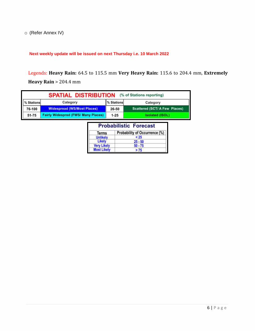
Next weekly update will be issued on next Thursday i.e. 10 March 2022
Legends: Heavy Rain: 64.5 to 115.5 mm Very Heavy Rain: 115.6 to 204.4 mm, Extremely
Heavy Rain > 204.4 mm
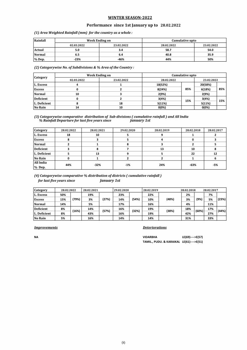
28.02.2022
(1) Area Weighted Rainfall (mm) for the country as a whole :
Rainfall
Actual
Normal
% Dep.
(2) Categorywise No. of Subdivisions & % Area of the Country :
L. Excess
Excess
Normal
Deficient
L. DeficientNo Rain
(3) Categorywise comparative distribution of Sub-divisions ( cumulative rainfall ) and All India % Rainfall Departure for last five years since January 1st
Category
L. Excess
Excess
Normal
Deficient
L. Deficient
No Rain
All India
% Dep.
(4) Categorywise comparative % distribution of districts ( cumulative rainfall )
for last five years since January 1st
Category 28.02.2021 29.02.2020 28.02.2019 28.02.2018 28.02.2017
L. Excess 50% 19% 23% 22% 2% 7%
Excess 15% 3% 14% 10% 3% 5%
Normal 14% 5% 17% 16% 4% 11%
Deficient 8% 14% 16% 19% 18% 17%
L. Deficient 8% 43% 16% 19% 42% 27%
No Rain 5% 16% 14% 14% 31% 33%
NA VIDARBHA LE(69)---->E(57)
TAMIL., PUDU. & KARAIKAL LE(61)---->E(51)
14 10 0(0%) 0(0%)
10 3 2(9%)
0 2 3(4%)
8 18 5(11%) 5(11%)
0 2 8(24%) 6(18%)
2(9%)
3(4%)
02.03.2022 23.02.2022 28.02.2022 23.02.2022
4 1 18(52%)
85%
15%
6.4 40.8 35.9
5.0 3.4
-23% -46% 44% 50%
23.02.2022
12
28.02.2017
5
0
1
3
8
22
15%
Cumulative upto
6
Improvements Deteriorations
(60%)(32%)
2
-5%
(79%)
20(58%)
8 3 5
WINTER SEASON-2022
Performance since 1st January up to
CategoryWeek Ending on Cumulative upto
29.02.2020
Week Ending on
28.02.2019
2
28.02.2022 28.02.2021
02.03.2022 23.02.2022
85%
58.7 54.0
28.02.2022
6.5
28
(44%)
18 5
(48%)
4
1 3
(23%)
(16%)
5
13
9
44% -32%
0
-1%
(57%)
2
28.02.2022
(27%)
8
1
3
2
13
7
-63%
1
28.02.2018
(9%)(54%)
(38%)
24%
5
10
10 9
(ii)
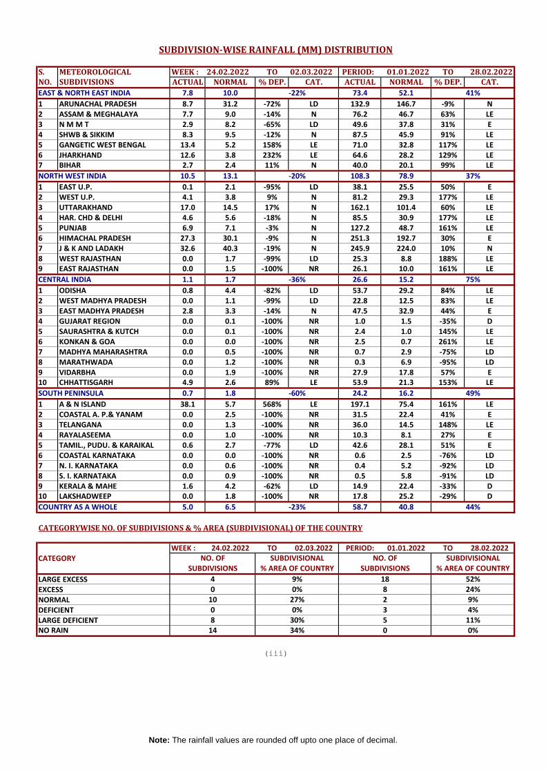
S. METEOROLOGICAL WEEK : 24.02.2022 TO 02.03.2022 PERIOD: 01.01.2022 TO 28.02.2022NO. SUBDIVISIONS ACTUAL NORMAL % DEP. CAT. ACTUAL NORMAL % DEP. CAT.
EAST & NORTH EAST INDIA 7.8 10.0 73.4 52.1
1 ARUNACHAL PRADESH 8.7 31.2 -72% LD 132.9 146.7 -9% N2 ASSAM & MEGHALAYA 7.7 9.0 -14% N 76.2 46.7 63% LE3 N M M T 2.9 8.2 -65% LD 49.6 37.8 31% E4 SHWB & SIKKIM 8.3 9.5 -12% N 87.5 45.9 91% LE5 GANGETIC WEST BENGAL 13.4 5.2 158% LE 71.0 32.8 117% LE6 JHARKHAND 12.6 3.8 232% LE 64.6 28.2 129% LE7 BIHAR 2.7 2.4 11% N 40.0 20.1 99% LE
NORTH WEST INDIA 10.5 13.1 108.3 78.9
1 EAST U.P. 0.1 2.1 -95% LD 38.1 25.5 50% E2 WEST U.P. 4.1 3.8 9% N 81.2 29.3 177% LE3 UTTARAKHAND 17.0 14.5 17% N 162.1 101.4 60% LE4 HAR. CHD & DELHI 4.6 5.6 -18% N 85.5 30.9 177% LE5 PUNJAB 6.9 7.1 -3% N 127.2 48.7 161% LE6 HIMACHAL PRADESH 27.3 30.1 -9% N 251.3 192.7 30% E7 J & K AND LADAKH 32.6 40.3 -19% N 245.9 224.0 10% N8 WEST RAJASTHAN 0.0 1.7 -99% LD 25.3 8.8 188% LE9 EAST RAJASTHAN 0.0 1.5 -100% NR 26.1 10.0 161% LE
CENTRAL INDIA 1.1 1.7 26.6 15.2
1 ODISHA 0.8 4.4 -82% LD 53.7 29.2 84% LE2 WEST MADHYA PRADESH 0.0 1.1 -99% LD 22.8 12.5 83% LE3 EAST MADHYA PRADESH 2.8 3.3 -14% N 47.5 32.9 44% E4 GUJARAT REGION 0.0 0.1 -100% NR 1.0 1.5 -35% D5 SAURASHTRA & KUTCH 0.0 0.1 -100% NR 2.4 1.0 145% LE6 KONKAN & GOA 0.0 0.0 -100% NR 2.5 0.7 261% LE7 MADHYA MAHARASHTRA 0.0 0.5 -100% NR 0.7 2.9 -75% LD8 MARATHWADA 0.0 1.2 -100% NR 0.3 6.9 -95% LD9 VIDARBHA 0.0 1.9 -100% NR 27.9 17.8 57% E10 CHHATTISGARH 4.9 2.6 89% LE 53.9 21.3 153% LE
SOUTH PENINSULA 0.7 1.8 24.2 16.2
1 A & N ISLAND 38.1 5.7 568% LE 197.1 75.4 161% LE2 COASTAL A. P.& YANAM 0.0 2.5 -100% NR 31.5 22.4 41% E3 TELANGANA 0.0 1.3 -100% NR 36.0 14.5 148% LE4 RAYALASEEMA 0.0 1.0 -100% NR 10.3 8.1 27% E5 TAMIL., PUDU. & KARAIKAL 0.6 2.7 -77% LD 42.6 28.1 51% E6 COASTAL KARNATAKA 0.0 0.0 -100% NR 0.6 2.5 -76% LD7 N. I. KARNATAKA 0.0 0.6 -100% NR 0.4 5.2 -92% LD8 S. I. KARNATAKA 0.0 0.9 -100% NR 0.5 5.8 -91% LD9 KERALA & MAHE 1.6 4.2 -62% LD 14.9 22.4 -33% D10 LAKSHADWEEP 0.0 1.8 -100% NR 17.8 25.2 -29% D
COUNTRY AS A WHOLE 5.0 6.5 58.7 40.8
CATEGORYWISE NO. OF SUBDIVISIONS & % AREA (SUBDIVISIONAL) OF THE COUNTRY
WEEK : 24.02.2022 TO 02.03.2022 PERIOD: 01.01.2022 TO 28.02.2022CATEGORY
LARGE EXCESSEXCESSNORMALDEFICIENTLARGE DEFICIENTNO RAIN
-60% 49%
-23% 44%
-22% 41%
-20% 37%
-36% 75%
SUBDIVISIONAL% AREA OF COUNTRY SUBDIVISIONS % AREA OF COUNTRY
3 4%27%0%9% 18
SUBDIVISION-WISE RAINFALL (MM) DISTRIBUTION
SUBDIVISIONSNO. OF SUBDIVISIONAL NO. OF
14 34% 0 0%
4 52%0
0 0%2 9%8 24%
(iii)
10
8 30% 5 11%
Note: The rainfall values are rounded off upto one place of decimal.
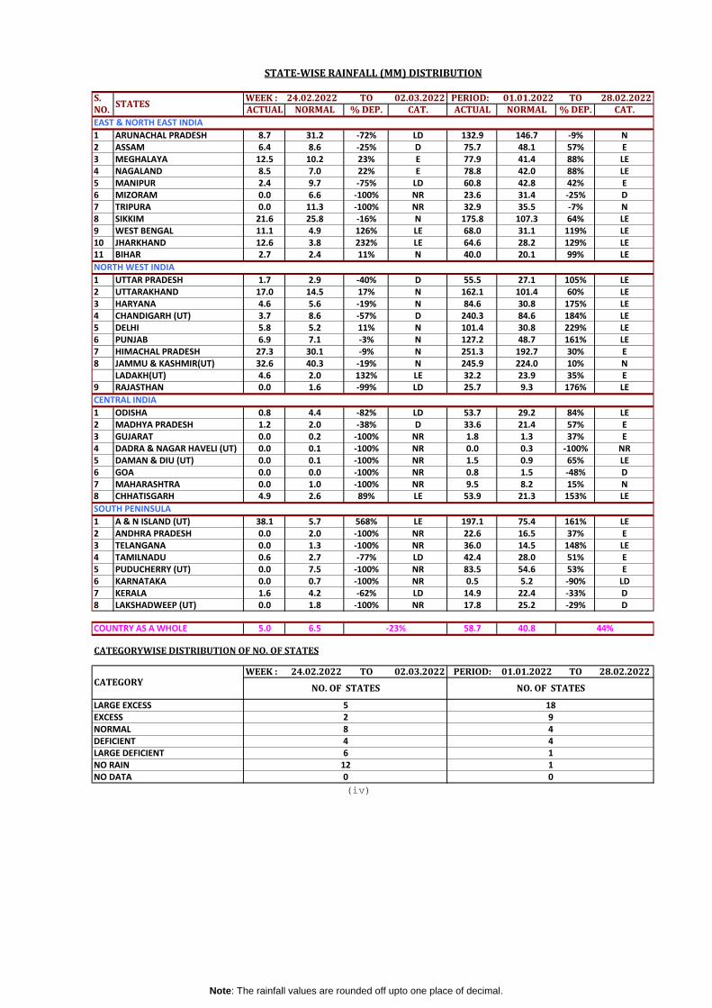
S. WEEK : 24.02.2022 TO 02.03.2022 PERIOD: 01.01.2022 TO 28.02.2022NO. ACTUAL NORMAL % DEP. CAT. ACTUAL NORMAL % DEP. CAT.
1 ARUNACHAL PRADESH 8.7 31.2 -72% LD 132.9 146.7 -9% N2 ASSAM 6.4 8.6 -25% D 75.7 48.1 57% E3 MEGHALAYA 12.5 10.2 23% E 77.9 41.4 88% LE4 NAGALAND 8.5 7.0 22% E 78.8 42.0 88% LE5 MANIPUR 2.4 9.7 -75% LD 60.8 42.8 42% E6 MIZORAM 0.0 6.6 -100% NR 23.6 31.4 -25% D7 TRIPURA 0.0 11.3 -100% NR 32.9 35.5 -7% N8 SIKKIM 21.6 25.8 -16% N 175.8 107.3 64% LE9 WEST BENGAL 11.1 4.9 126% LE 68.0 31.1 119% LE10 JHARKHAND 12.6 3.8 232% LE 64.6 28.2 129% LE11 BIHAR 2.7 2.4 11% N 40.0 20.1 99% LE
1 UTTAR PRADESH 1.7 2.9 -40% D 55.5 27.1 105% LE2 UTTARAKHAND 17.0 14.5 17% N 162.1 101.4 60% LE3 HARYANA 4.6 5.6 -19% N 84.6 30.8 175% LE4 CHANDIGARH (UT) 3.7 8.6 -57% D 240.3 84.6 184% LE5 DELHI 5.8 5.2 11% N 101.4 30.8 229% LE6 PUNJAB 6.9 7.1 -3% N 127.2 48.7 161% LE7 HIMACHAL PRADESH 27.3 30.1 -9% N 251.3 192.7 30% E8 JAMMU & KASHMIR(UT) 32.6 40.3 -19% N 245.9 224.0 10% N
LADAKH(UT) 4.6 2.0 132% LE 32.2 23.9 35% E9 RAJASTHAN 0.0 1.6 -99% LD 25.7 9.3 176% LE
CENTRAL INDIA
1 ODISHA 0.8 4.4 -82% LD 53.7 29.2 84% LE2 MADHYA PRADESH 1.2 2.0 -38% D 33.6 21.4 57% E3 GUJARAT 0.0 0.2 -100% NR 1.8 1.3 37% E4 DADRA & NAGAR HAVELI (UT) 0.0 0.1 -100% NR 0.0 0.3 -100% NR5 DAMAN & DIU (UT) 0.0 0.1 -100% NR 1.5 0.9 65% LE6 GOA 0.0 0.0 -100% NR 0.8 1.5 -48% D7 MAHARASHTRA 0.0 1.0 -100% NR 9.5 8.2 15% N8 CHHATISGARH 4.9 2.6 89% LE 53.9 21.3 153% LE
SOUTH PENINSULA
1 A & N ISLAND (UT) 38.1 5.7 568% LE 197.1 75.4 161% LE2 ANDHRA PRADESH 0.0 2.0 -100% NR 22.6 16.5 37% E3 TELANGANA 0.0 1.3 -100% NR 36.0 14.5 148% LE4 TAMILNADU 0.6 2.7 -77% LD 42.4 28.0 51% E5 PUDUCHERRY (UT) 0.0 7.5 -100% NR 83.5 54.6 53% E6 KARNATAKA 0.0 0.7 -100% NR 0.5 5.2 -90% LD7 KERALA 1.6 4.2 -62% LD 14.9 22.4 -33% D8 LAKSHADWEEP (UT) 0.0 1.8 -100% NR 17.8 25.2 -29% D
COUNTRY AS A WHOLE 5.0 6.5 58.7 40.8
CATEGORYWISE DISTRIBUTION OF NO. OF STATES
WEEK : 24.02.2022 TO 02.03.2022 PERIOD: 01.01.2022 TO 28.02.2022
(iv)
-23% 44%
STATE-WISE RAINFALL (MM) DISTRIBUTION
STATES
LARGE EXCESS
NORTH WEST INDIA
LARGE DEFICIENT4
6DEFICIENT
2
EAST & NORTH EAST INDIA
18
44
0
1
NO DATA 01
CATEGORYNO. OF STATES NO. OF STATES
5
NORMAL
NO RAIN 12
EXCESS 98
Note: The rainfall values are rounded off upto one place of decimal.

S. TONO. LE E N D LD NR ND TOTAL1 A & N ISLAND (UT) 3 0 0 0 0 0 0 32. ARUNACHAL PRADESH 0 2 7 3 3 0 1 163. ASSAM 12 11 4 0 0 0 0 274. MEGHALAYA 4 2 1 0 0 0 0 75. NAGALAND 8 1 1 1 0 0 0 116. MANIPUR 2 2 2 2 1 0 0 97. MIZORAM 1 0 2 3 2 0 0 88. TRIPURA 0 0 3 1 0 0 0 49. SIKKIM 1 0 1 2 0 0 0 410. WEST BENGAL 16 1 2 0 0 0 0 1911. ODISHA 18 7 3 2 0 0 0 3012. JHARKHAND 20 1 2 1 0 0 0 2413. BIHAR 22 10 4 2 0 0 0 3814. UTTAR PRADESH 42 11 10 7 5 0 0 7515. UTTARAKHAND 6 6 1 0 0 0 0 1316. HARYANA 21 1 0 0 0 0 0 2217. CHANDIGARH (UT) 1 0 0 0 0 0 0 118. DELHI 9 0 0 0 0 0 0 919. PUNJAB 21 1 0 0 0 0 0 2220. HIMACHAL PRADESH 8 2 1 1 0 0 0 1221. JAMMU & KASHMIR(UT) 4 7 5 3 1 0 0 2022. LADAKH(UT) 1 0 0 1 0 0 0 223. RAJASTHAN 22 2 5 4 0 0 0 3324. MADHYA PRADESH 21 15 10 2 3 1 0 5225. GUJARAT 11 2 3 4 3 10 0 3326. DADRA & NAGAR HAVELI (UT) 0 0 0 0 0 1 0 127. DAMAN & DIU (UT) 1 1 0 0 0 0 0 228. GOA 1 0 0 0 0 1 0 229. MAHARASHTRA 7 3 3 1 9 13 0 3630. CHHATISGARH 20 6 1 0 0 0 0 2731. ANDHRA PRADESH 5 3 3 1 1 0 0 1332. TELANGANA 21 2 5 0 5 0 0 3333. TAMILNADU 15 4 12 7 0 0 0 3834. PUDUCHERRY (UT) 1 1 1 0 0 1 0 435. KARNATAKA 0 0 0 2 19 9 0 3036. KERALA 0 1 2 5 5 1 0 1437. LAKSHADWEEP (UT) 0 0 0 1 0 0 0 1
TOTAL 345 105 94 56 57 37 1 695
50% 15% 14% 8% 8% 5%694 WHOSE DATA RECEIVED
LE E N D LD NR19% 3% 5% 14% 43% 16%
29.02.2020 23% 14% 17% 16% 16% 14%28.02.2019 22% 10% 16% 19% 19% 14%28.02.2018 2% 3% 4% 18% 42% 31%
7% 5% 11% 17% 27% 33%
(v)
PERCENT DISTRIBUTION OF DISTRICTS IN EARLIER YEARS SINCE 1st JANUARY
OF DISTRICTS OUT OF THE
CATEGORYWISE DISTRIBUTION
DATE28.02.2021
28.02.2017
STATES
STATEWISE DISTRIBUTION OF NO. OF DISTRICTS
WITH EXCESS, NORMAL,DEFICIENT,SCANTY AND NO RAINFALL
PERIOD FROM : 01.01.2022 28.02.2022