Fragmented Otherwheres: Socio-spatial Production in Johannesburg
39
Fragmented Otherwheres Socio-spatial production in Johannesburg by Bronwyn Kotzen London School of Economics and Political Science MSc City Design and Social Science 2014
-
Upload
independent -
Category
Documents
-
view
0 -
download
0
Transcript of Fragmented Otherwheres: Socio-spatial Production in Johannesburg
Fragmented OtherwheresSocio-spatial production in Johannesburg
by Bronwyn Kotzen
London School of Economics and Political ScienceMSc City Design and Social Science 2014

Acknowledgments
Johannesburg presents itself to us in several possible ways: as the ruins of a utopian European dream of the city as ordered and rational; as the remnant of a city that grew out of the geographical and human upheaval of industrial invention and the discovery of gold; as the fractured emerging post-apartheid metropolis that has been described, variously, as elusive, haunted, dystopian; as the African city emblematic of a new way of being in the world…of new relationships and porous boundaries, at once dangerous and exhilarating, chaotic and productive.
Bronwyn Law-Viljoen, Fire walker: William Kentridge, Gerhard Marx (2011:1)
quote
X
With thanks
This thesis is testament to the fact that no work is brought into the world in isolation. To everyone who has been influential along my urban trajectory, I am forever grateful.There are however a few who deserve special mention.
To my parents and family, this would not be possible without you. Thank you for teaching me the qualities of determination and hard work. To Suzi Hall, thank you for a year of incredible insight and guidance. To Sofia, for opening my eyes to new ways of seeing and being. To all my global friends who I have been fortunate enough to share this enriching academic and life experience with, you have made this year what it is. And finally to Kevin, my greatest ally and enduring supporter, without whom this would all be a litte less worthwhile.•

Contents
01
2022
25
37
3737
37
20
2022232223
22
IntroductionThe Fragmented City
Framing Difference Topography of Power Theorising the Production of Space Johannesburg Today City of Extremes Multiple Johannesburgs
Producing Difference Apartheid City Then
World Class African City Now
New Conceptual Frameworks
Reading the City Anew Frontiers Islands Shadows Elsewheres Inbetweens
ConclusionImagining Tomorrow
B
A Theoretic Context
Analytic Context

06 Introduction: The Fragmented City 07 Introduction: The Fragmented City
Johannesburg is a polyglot city; a conurbation of remarkably different contexts within one urban boundary. Unread as a comprehensive whole, this is ‘a metropolis increasingly forced to construct itself out of heterogeneous fragments and fortuitous juxtapositions’ (Mbembe 2008:59). Yet these stark pockets of misery and privilege are not simply the inheritance of a geological or political past but equally, the making of its present. This paper therefore aims to move beyond the complex casual matrix by attempting new ways at reading the conflicting, overlapping and intersecting logics that make Johannesburg today.
A city shaped by the rise, fall and reconstruction of legally sanctioned segregation, Johannesburg today demonstrates one of the worlds most socio-economically and spatially polarised and fragmented urban landscapes (UN-Habitat, 2009). By foregrounding the spatial distribution of hierarchical power relations, as Akhil Gupta and James Ferguson (19992) argue, Johannesburg is better understood, not as a juxtaposition of pre-existing socio-spatial hierarchies and differences but rather as one which has been produced by a whirlwind of social, political and economic forces. It is therefore critical to understand how these processes organise the city’s inhabitants across its ‘multiple Johannesburgs’ in order to more appropriately address those policies detrimenting an equitable city future.
Historical apartheid forces have given way to new forms of urban governance, dominated by ‘world city’ and developmentalist approaches. These contradictory policy agenda’s fail to relate simultaneously to the rationalities of achieving the desired position in the global market place, and making connections with the city’s ordinary people. Framed in a global economicism, the result is a system of governance that only brings parts of the city into view as spaces of reality or potentiality. The unintended and unexpected consequences of its planning practices - between the extremes of its self interest rich and survivalist poor - means that policy-makers and planners, struggle to actualise a sustained impact on the remaking of urban space, as the city expands along unknown development pathways.
Johannesburg is then considered, as authors like AbdouMaliq Simone (2004), Achille Mbembe (2004), Sarah Nuttall (2004), and Jennifer Robinson (2004) argue, lacking according criteria laid down by Western planning paradigms – ‘an object apart from the world…a failed and incomplete example of
something else’, a problem to be fixed (Mbembe & Nuttall 2004:351). ‘Thinking from Johannesburg’, as Philip Harrison (2006:273) contends, means then to look beyond the meta-narratives of historic segregation, urbanisation, modernisation or crisis in order to find new process of constructing citiness that emerge ‘at the intersection of multiple rationalities’. Ascribing equal value to all these vastly different fragments could allow the city to grow as a more democratic, diverse, connected and evenly distributed set of opportunities according to local differences and process; to begin to blur the boundary lines to allow for a new presencing.
In developing a structure for this paper, Part A begins to contextualise the profoundly unequal city that Johannesburg is today. Reflected and reinforced spatially, key development processes that shape the city of multiple urban formations are defined as a socio-spatial framework used in this paper. Theorizing the socio-political construction of the city sets up a position from which to understand the forces responsible for producing the city of difference and division. Historical forces that first shaped the city’s socio-spatial hierarchies are then analyzed, followed by an investigation into current policy perspectives which are arguably re-enforcing the city of extremes. Part B, begins with establishing new conceptual frameworks through which to analyse the city. A grouping of key city-making processes are established. In understanding the ‘citiness’ produced in each, as a result of particular policy approaches (or lack thereof), the basis of a focused investigation through which to read the city anew is formed. In conclusion, rethinking the role of design suggests its potential to inform current city-making and policy processes, to craft a new ‘politics of possibility’ (Pieterse & Meintjies in Nuttall 2006:268).•
A boundary is not that at which something stops but, as the Greeks recognized, the boundary is that from which something begins its presencing.
Martin Heidegger, 'Building, Dwelling, Thinking'
The Fragmented City
IntroductionPart AX
quote
Theoretic Context
08 09 Framing DifferenceFraming Difference
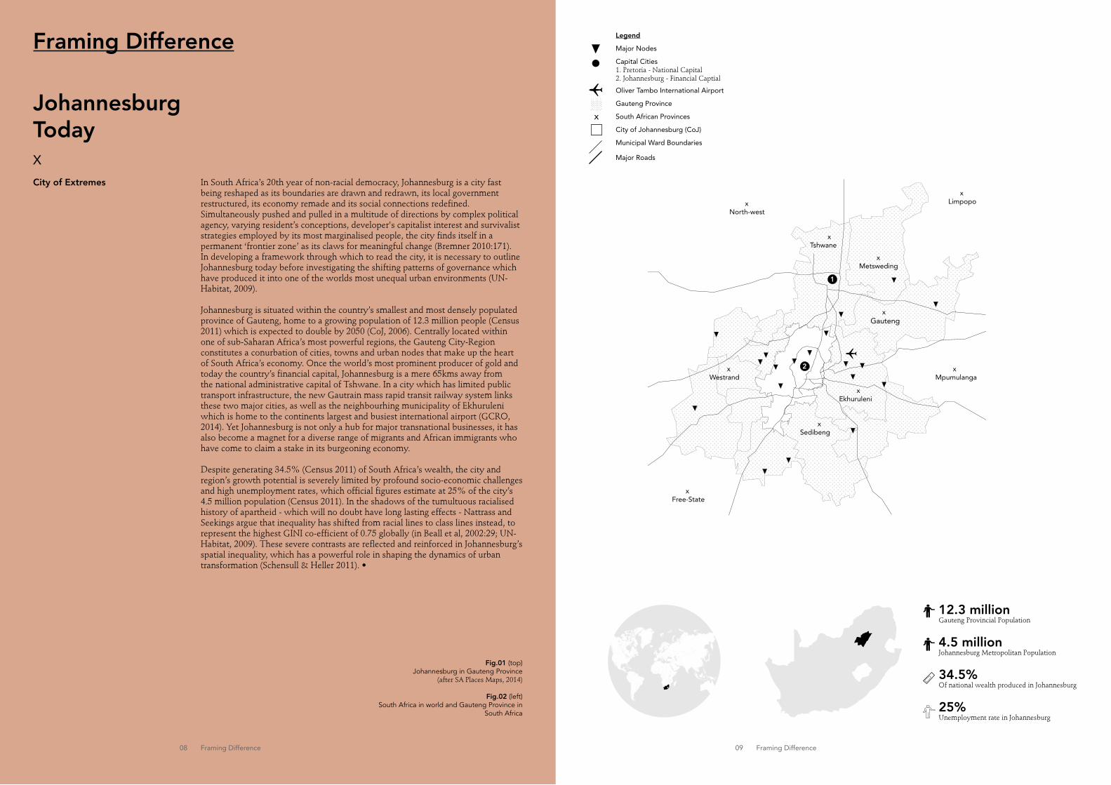
In South Africa’s 20th year of non-racial democracy, Johannesburg is a city fast being reshaped as its boundaries are drawn and redrawn, its local government restructured, its economy remade and its social connections redefined. Simultaneously pushed and pulled in a multitude of directions by complex political agency, varying resident’s conceptions, developer's capitalist interest and survivalist strategies employed by its most marginalised people, the city finds itself in a permanent ‘frontier zone’ as its claws for meaningful change (Bremner 2010:171). In developing a framework through which to read the city, it is necessary to outline Johannesburg today before investigating the shifting patterns of governance which have produced it into one of the worlds most unequal urban environments (UN-Habitat, 2009).
Johannesburg is situated within the country’s smallest and most densely populated province of Gauteng, home to a growing population of 12.3 million people (Census 2011) which is expected to double by 2050 (CoJ, 2006). Centrally located within one of sub-Saharan Africa’s most powerful regions, the Gauteng City-Region constitutes a conurbation of cities, towns and urban nodes that make up the heart of South Africa’s economy. Once the world’s most prominent producer of gold and today the country’s financial capital, Johannesburg is a mere 65kms away from the national administrative capital of Tshwane. In a city which has limited public transport infrastructure, the new Gautrain mass rapid transit railway system links these two major cities, as well as the neighbourhing municipality of Ekhuruleni which is home to the continents largest and busiest international airport (GCRO, 2014). Yet Johannesburg is not only a hub for major transnational businesses, it has also become a magnet for a diverse range of migrants and African immigrants who have come to claim a stake in its burgeoning economy.
Despite generating 34.5% (Census 2011) of South Africa’s wealth, the city and region’s growth potential is severely limited by profound socio-economic challenges and high unemployment rates, which official figures estimate at 25% of the city’s 4.5 million population (Census 2011). In the shadows of the tumultuous racialised history of apartheid - which will no doubt have long lasting effects - Nattrass and Seekings argue that inequality has shifted from racial lines to class lines instead, to represent the highest GINI co-efficient of 0.75 globally (in Beall et al, 2002:29; UN-Habitat, 2009). These severe contrasts are reflected and reinforced in Johannesburg’s spatial inequality, which has a powerful role in shaping the dynamics of urban transformation (Schensull & Heller 2011). •
Fig.01 (top) Johannesburg in Gauteng Province
(after SA Places Maps, 2014)
Fig.02 (left) South Africa in world and Gauteng Province in
South Africa
Johannesburg TodayX
12.3 millionGauteng Provincial Population
4.5 millionJohannesburg Metropolitan Population
34.5% Of national wealth produced in Johannesburg
25% Unemployment rate in Johannesburg
1
2
xGauteng
xMpumulanga
xNorth-west
xLimpopo
xFree-State
xEkhuruleni
xTshwane
xMetsweding
xSedibeng
xWestrand
Legend
Major Nodes
Capital Cities1. Pretoria - National Capital2. Johannesburg - Financial Captial
Oliver Tambo International Airport
Gauteng Province
South African Provinces
City of Johannesburg (CoJ)
Municipal Ward Boundaries
Major Roads
x
Framing Difference
City of Extremes

010 Framing Difference
MultipleJohannesburgsX
In order to move through the socio-spatial context of this research, key development processes and role players involved in rapid urbanization and the proliferation of Johannesburg’s multiplicity of unequal urban formations need to be identified. These are comprised of privatization, state redistribution, state speculation, and informality.
In Johannesburg, the decline of gold mining accelerated the shift from manufacturing towards a service-based economy. The resultant low density and predominantly affluent suburban sprawl has been paralleled by the decentralisation of commerce from the declining and ‘chaotic’ city centre in the 1980’s and 90’s, to the peri-urban fringes (Mubiwa & Annegarn, 2013). Fuelled by neo-liberal market driven interests and the rhetoric of crime, this spatial reconfiguration of privatisation has been characterised by a geography of enclosure, self-assertion and sovereignty - most evident in Johannesburg’s endless northern expansion (Frug, 1999).
Ceaseless state redistribution interventions aimed at overcoming the apartheid legacy are most acute in the city’s peripheral flatland areas. Post-apartheid democracy, as Schensull & Heller (20011) note, generated a high capacity African majority government who have rolled out large-scale public infrastructural projects – in former apartheid townships and in the bland new post-apartheid townscapes and sprawling housing settlements on its disconnected outskirts.
Large-scale development projects, in the image of western modernity, are driven by state speculation. Here, there is no room for public intervention without prospect of immediate socio-economic return, bringing only particular parts of the city into view. This, Ash Amin (2012:4) argues is a ‘city ordered for elites, consumers and creative classes, an agglomerative dynamic traced to a series of economies of proximity’, directly overlooking local specificities of those who disappear into the urban blindspot.
In a city which has struggled to deal with the challenges posed by growing urbanisation, rapidly proliferating spatial and economic informality is shaping the city’s future. Now home to an estimated 25% of Johannesburg’s residents (Huchzermeyer, 2006) - amidst high levels of unemployment - those left out by western management and planning receive limited benefit from government and are therefore forced into a makeshift urbanism of need. As Craig Calhoun, Richard Sennett and Harel Shapira attest, this is a city-making process that extends beyond a group of experts but instead is ‘made by everyday people contending with daily challenges and restrictions’ (2013:196).
In the aftermath of decolonisation, Achille Mbembe (2008:60) attest that ‘Johannesburg, much like the rest of Africa, is conurbation of multiple assemblages’, ‘a matrix of plural styles, a striated, striped city that concatenates the most formal and modern with the most informal’, producing new social-spatial and political morphologies. Importantly then, understanding the shifting relationship between space and power in the perpetuation and production of inequality is critical to develop an appropriate platform through which to approach a more locally relevant and meaningful urban transfiguration.•

012 013 Framing DifferenceFraming Difference
into a subjected sovereignty, limited by another sovereignty - like privatised communities which exercise power but are also subjected to the power of local governance (ibid. 1999:8).
Drawing on and departing from Iris Young’s call for regional governance, Frug therefore calls for a decentralisation of power to the local level, which unlike central government, has the capacity to ‘build communities’ through immediate contact with its citizens. This is a ‘power that is not based on sovereignty…[but] on the recognition of the impact that cities within a single metropolitan area have on each other’, through addressing regional considerations and de-emphasizing the boundary (ibid 1999:10). In post-apartheid Johannesburg, new understandings of local government have minimized national development to a local scale, an administration which also falls within the Gauteng City-Region (Beall et al, 2002).
Yet despite this shift, (and its purported regional consideration, which is less important to this argument), the problem is that decentralisation in cities of extreme disparity struggle firstly to build power on the relationship between the vastly different intra-city territories themselves, where the benefits are seemingly minimal (Amin, 2013). For Ananya Roy (2012:132), the resultant manifestation of extreme urban difference ‘makes possible an understanding of how’, for example, ‘the slum is produced through the governmental administration’, while ‘the bourgeois city and its edifices of prosperity are produced though the practices of the state’. By foregrounding the socio-spatial hierarchies inherent within it, Johannesburg is revealed as a product of intentional difference producing processes and policy directions that treat each ‘locality’ and its inhabitants as its own spatial world, once racially and now economically driven.
Lefebvre’s contestation that space is not a neutral object but rather one pervaded by politics forms the basis for exposing the ‘intellectual terrorism’ by political planning processes, that only give particular parts of the city value (1978:34). Critically analysing the swinging political pendulum that ‘[produces] distinct local milieuxs’ is the only way to steer the city through ‘the complex political, social and economic changes’ (Beall et al. 2002:5:8) required to unite the divided body.•
Topography of PowerX
Theorising the Production of Space In establishing a theoretical basis through which to read the Johannesburg, the manifestation of divergent territories and urban formations which appear to exist in different worlds need to be understood. Conceived of as collections of distinctive societies, on which cultural difference, historical memory and societal organization are plotted, the seemingly unproblematic division of space exhibits an inherently fragmented series of specific localities that map the fractured landscape of ‘independent’ and ‘autonomous’ cultures onto the city’s geography. Thought of ‘not as integrated wholes’, as Michael McQuarrie (2013:315) contends, ‘but as agglomerations of balkanized communities, economies and ways of life’, city space needs to be theorized as the product of a multitude of forces that actively shape it into zones of inclusion and exclusion - a point of departure for deeper urban analysis.
The Politics of Difference For anthropologists Akhil Gupta and James Ferguson (1992:8) ‘the presumption that spaces are autonomous, [have] enabled the power of topography to conceal successfully the topography of power’; which sees cultural difference as the correlate of a world of separate people. In understanding the challenges of social change and cultural formation in a rapidly urbanizing society, this presumption ‘fails to examine the processes that go into the construction of space’. (ibid.). By investigating the spatial formation instead, ‘the premise that spaces have always been hierarchically interconnected, instead of naturally disconnected’ exposes the city not as the juxtaposition of pre-existing differences, but of the construction of difference; a historical process which produces ‘communities’ or particular geographic ‘localities’ of inequality and contradiction. Lefebvre’s (1978) notion of the politics of space further demonstrates the ‘contestations over the political-economic hierarchies and power relations that are inscribed in and in turn transform socio-spatial arrangements’ (Brenner 2013:22).
To this end, as Gupta and Ferguson (1992) argue, the ability of the city’s inhabitants to confound the established spatial orders through acts of capitalist interest, political movement, or survivalist necessity, means that place is not a given but rather a socio-political construction; manifested out of particular representations of a territory which are dependant on the city-maker's location within the field of power. Framed in political economic core and socio-spatial approach, Gerald Frug’s (1999) work on the politics of urban development as a ‘legal concept’ takes salience here. For Frug, the hierarchies embedded in the pervasive urban landscape of inequality are a product of slew of government policies, determined and implemented by the state on its people.
Sovereignty and InequalityFrug’s core thesis is that American cities are rendered powerless, as they remain reliant on the state for decision-making authorisation, creating sovereign city entities within a larger regional area. Exacerbated by government’s privatised version of local autonomy, Frug contests that ‘like the boundary lines that separate one private property-owner from another, city borders have become a vehicle for dividing us from them, our problems from their, our money from theirs’ resulting in the withdrawal from public life and the multiplication of private spaces. Michel Focault describes the fear of sovereign power as so common that it is converted

014 Producing Difference 015 Producing Difference
A city which boomed almost overnight at the discovery of gold in 1886, Johannesburg bears the traces of a series of shifting socio-political forces which have produced and shaped it. Fuelled by the insatiable capitalist interest in mining at the turn of the century, its beginnings would form the spatial and political basis for the segregated and unequal city that it is today; ‘a vast experiment’, as Lindsay Bremner (2007:207) suggests, ‘in...[inhabiting] apartheid’s ruins’.
Driven by British colonial aspirations, large mining corporations fortuitously dominated the areas gold mines by the 1890’s. But rising tensions among Afrikaners, English new comers and mining lords led to the Anglo-Boer War in 1899, which resulted in British control of the rapidly growing region (Bremner, 2010). In 1903, in the first signs of a pattern of development yet to come, the colonial government razed dense multicultural slums under the guise of rampantly spreading disease; relocating racial groups to distant settlement far from the city’s centre (Findley & Ogbu, 2011). Simultaneously, the contrasting growth of affluence to the north saw Johannesburg develop in the image of western modernity, the ‘vision of a European city in Africa’ (Bremner 2010:17). By 1933, Johannesburg was declared a white city forcing most of its marginalised black population to its south-western periphery (ibid.).
Yet, marginalization was not only confined to the black population during the colonial era. The Afrikaners who had claimed South Africa’s interior as their homeland before British annexure, feared that Imperialist economic power in the mining region would force them to be subjugated to English rule (Moodie, 1975). The consequence was a powerful conservative Afrikaner nationalist movement which mobilized itself to power over the Union of South Africa in 1948. Racist attitudes engrained deepening social divides through a barrage of racially discriminatory policies designed as tools for ‘the biological protection of the…white race’ from the black body (Mbembe 2008:46). Pass laws and intensive police surveillance restricted access and divided South African society. Yet the key to this segregation lay in the architecture and planning of urban space as a way to distribute privilege and power; expanding on the existing 1913 Land Act which reserved land ownership for the country’s white minority (Findley & Ogbu, 2011).
The 1950’s Group Areas Act consolidated racial groups into homogenous residential areas, planned as a series of concentric circles around an economic core. As Bremner (2010) describes: ‘straddling the source of [Johannesburg’s] wealth, the 130km long gold reef, lay its prosperous business districts and industrial suburbs…while the north stretched leafy, whites only residential suburbs’. The outer rings housed the city’s ‘temporary’ black work force who were separated by vast tracts of uninhabited land, into anti-urban, peripheral dormitory townships far from any economic opportunity (Findley & Ogbu, 2011; Mubiwa & Annegarn, 2013). The combination of race exclusive areas and forced removals which peaked during the 1960-70’s, produced an almost completely segregated city, one where race correlated directly with the economic geography of inequality (Schensull & Heller, 2011).
The use of townships as a racial construct was reinforced by western theoretical movements within architecture and planning, overlaid with South African visions of control and surveillance. Le Corbusier temporary workforce housing, Ville Contemporaine and Ebenezer Howards Garden city model inspired an urban form
Fig.03 (left)Villa Contemporaine Workhouses, Le Corbusier Image: http://utopies.skynetblogs.be/archive/2008/12/12/le-corbusier-une-ville-contemporaine.html
Fig.04 (middle)Garden City, Ebenezer HowardImage: http://scodpub.wordpress.com/2011/03/01/garden-cities-by-ebenezer-howard/
Fig.05 (right)Apartheid Township in the Modernist Imagehttp://places.designobserver.com/feature/south-africa-after-apartheid-from-township-to-town/31148/
which would lay the ground work for ‘a series of matchbox houses whose sterile forms became ubiquitous across the sprawling township landscapes’ (Findley & Ogbu, 2011). Yet even in this strictly controlled environment, informal spaces and activities emerged as political acts or a matter of survival; a responsive urbanism which made visible extreme levels of socio-economic marginalisation.
At the end of apartheid in 1994, Johannesburg’s spatial landscape displayed almost a century’s worth of deliberate endevours on the part of white administrators to structure the city according to their own racial and economic prejudices. Yet despite democracy, the city’s wounds remain clear as its discontinuous territories of inequality endure. Understanding how the city is made and re-made, envisioned and re-imagined by it governance today is therefore critical to redress the ruins of the city that apartheid built.•
ApartheidThenX
Producing Difference

017 Producing Difference
Key Moments1886 - 1994
1886
Gold was discovered in Johannesburg's flat grasslands in 1886, swiftly transforming the city from a mining tent town to bricks and mortar within two short decades.
1889
The Second Anglo-Boer war (1899-1902) was fought between the British empire and the Afrikaner Boer republics of the Orange Free State and Transvaal during the time of British imperialism in the 20th century. The British won power over the Transvaal region.
1948
In 1948 the Nationalist Party came to power in South Africa under the directive of D.F.Malan, who began to introduce apartheid policy; a barrage of racially discriminatory laws aimed at controlloing and humiliating the black body for 'protection' of the white minority.
1950
Architecture and planning became the new weapon for segregation. The 1950's Group Areas Act was the title of three acts of Parliament enacted under the apartheid government.Racial groups were assigned to different urban areas in a concentric plan.
1994
At the fall of the apartheid regime in 1994, Nelson Rolihlala Mandela was elected as South Africa's first black chief executive. His inauguration commenced in Pretoria on 10 May 1994, to symbolise the beginnings of a non-racially organised, inclusive and integrated South Africa.
1913 The 1913 Land Act placed restrictions on land ownership rights for 'Natives', held for the white minority instead. This law further allowed white farmers to remove black sharecroppers on agricultural land, in one of the first racial policy directives.
1933
In 1933, the Johannesburg Town Council declared the city to be a white only urban area. All blacks without special permission would have to move out of town and into municipal hostels or ‘locations’ on the city's peripheries.
1886
1889
1913
1948
1933
1994
1950
Fig.06 1886 Early Johannesburghttp://www.skyscrapercity.com/showthread.php?p=102706230
Fig.07 1889 British Army in the Boer Warhttp://colonialwarfare18901975.devhub.com/blog/889906-naval-cannon-battle-of-colenso-boer-war/
Fig.08 1913 Fear of the Nativehttp://kaganof.com/kagablog/2013/08/29/cherryl-walker-land-quest-towards-a-cosmopolitan-sense-of-place/
Fig.09 1933 Official White Cityhttp://www.ilo.org/global/about-the-ilo/activities/statements-speeches/mandela/lang--en/index.htm
Fig.10 1948 First Apartheid Prime Minister D.F.Malanhttp://en.wikipedia.org/wiki/Daniel_François_Malan
Fig.11 1950 Group Areas Act Concentric Planhttp://www.theguardian.com/cities/2014/apr/30/cape-town-apartheid-ended-still-paradise-few-south-africa
Fig.12 1994 Mandela's Inaugural Speechhttp://bioreports.net/news/the-historic-inaugural-speech-delivered-by-nelson-mandela-as-south-africas-first-black-president-at-cape-town-9-may-1994/

018 Producing Difference 019 Producing Difference
European cities’, as CoJ strategy specialist Steven Narsoo attests (Gurney 2013:61). Such approaches are particularly questionable for governance in Johannesburg as the City struggles to address the urgent demands of its vastly different realities. Government aims to rebalance deepening inequality through:
…service deliverables and efficiencies that meet world best practice. Its economy and labour force will specialise in the service sector and will be strongly outward oriented such that the City economy operates on a global scale. The result of this competitive economic behaviour will be strong economic growth that will drive up City tax revenues, private sector profits and individual disposable income levels such that the standard of living and quality of life of all the City’s inhabitants will increase in a sustainable manner.
(City of Johannesburg 2005 in Zdiara 2013:115)
In line with national government policies, the City therefore slowly removes itself from the business of governing, toward a more corporate approach. As Harrison (2003) and Frug (1999:8) argue, despite the fact that globalisation - rooted in neo-liberal ideology - is inherently about connectivity at a global level, the result is institutional fragmentation which ‘builds local power on the protection of local autonomy’ associated with private values. Interventions by a growing elite therefore create pockets of sovereignty and citadelisation which reinforce existing lines of privilege. Harrison (2003) contends that an inverse and larger underclass simultaneously emerge to result in what Marcuse and van Kempen (2000) describe as the ubiquitous symbol of a ‘new geography’ of extreme socio-spatial fragmentation. The consequence, following Alan Mabin’s (2007) contention, in reference to Benit and Gervais Lambony, is a system of governance which is ‘promoting development in the shop window and managing poverty in the back shop’ (2007:59).
In parallel to nationalist policies which endorse globalisation, government therefore simultaneously engages in the competing developmentalist policy rhetoric. Here, far from the privatised and affluent worlds of the northern suburbs, the drastically underserviced former apartheid townships, peripheral post-apartheid townships and housing developments, informal settlements and the declining inner city are brought more closely in to view (Zdiara, 2013). Committed to desegregation, local government is tasked with large scale provision of basic infrastructure, housing, road systems and urban environment upgrades which the city’s poor urgently require (Schensull & Heller, 2013). These ‘non-western’ parts of the city are developed not in relation to their own trajectories but aligned instead within pre-given standards of western planning paradigms; vexed in an impossible game of catch-up. Robinson (2004:540) argues that while ‘world city approaches ascribe the characteristics of only parts of cities to the whole city…mega-city and developmentalist approaches extend to the entire city the imagination of those parts which are lacking in services’, neither of which are likely to support effective social cohesion.
The Ordinary City: Beyond Categorisation Despite efforts to overcome segregation by merging Johannesburg’s greater region into a common municipality, Harrison (2006:332) reasons that differentiating, peripheralising or marginalising those parts of the city without globalising potential or the ability to conform to western norms of city living means that ‘large sectors
World Class African CityX
In an effort to claim its place in the prestigious network of global cities, Johannesburg has positioned itself as ‘a world class African city of the future – a vibrant, equitable African city strengthened though its diversity; a city that provides real quality of life; a city that provides sustainability for all its citizens; a resilient and adaptive society’ (CoJ, 2006:11). A visionary statement which first appeared more than a decade ago, this aspirational tagline was officially adopted by the City of Johannesburg (CoJ) in its first long-term strategy, Joburg 2030, and translated into urban planning through the Spatial Development Framework. Yet, hidden within its vocabulary, this tagline outlines the challenges inherent in the city of ‘disjunctive juxtapositions and autonomous communities’ (Amin 2012:3). In returning to Frug’s notion of the city as a product of state legalities, it becomes important to analyse current official government discourses shaping Johannesburg’s future.
Theorising the Global CityInfluenced by the respective work of John Friedmann and more recently Saskia Sassen, the global and world cities theory is based on the empirical focus of transnational business and finance networks which arrange cities ‘within the hierarchy of the world economy’ (Robinson 2004:534). Sassen’s core thesis is that the spatially dispersed global economy requires locally based and integrated transnational organisations that occur in a few leading global cities. Those cities that do not make the grade are either ascribed ‘global city functions’ or are relegated to the residual category of ‘megacities’; cities which are most often linked to developmentalist practices (Robinson, 2003). Premised on the participation in a minor set of economic activities which occur in a small part of cities that have claim to global reach. Jennifer Robinson (2004) argues that the danger of this categoric organisation of city status drops many cities out of the purview of economic and global relevance to shape the way they are represented, if at all. Despite the fact that this is a status conferred according to western ideals which lie outside of specific local realities, for many relegated ‘megacities’ such as Johannesburg, the desire to take a position in the global economic circuit remains an aspiration.
Between the ‘African’ & the ‘World-Class’ CityEntangled between two powerful development discourses and sets of practices shaping cities, Johannesburg is drawn into the respective frameworks of the world-city hypothesis and developmentalist approach; struggling between a more economically driven global system of governance and one which moves toward more democratic practices (Harrison, 2006; Robinson, 2003; Mabin, 2007). Benit and Gervais-Lambony (2004) argue that a politics of double vitrine has emerged: ‘promoting investment in the newer globally connected spaces of finance and business as the public shop window, while increasing poverty and exclusion largely in townships and informal settlements (and the inner city) is hidden away…in the back room of the shop’ (in Mabin 2007:59). Consequently, different policy agendas and imagined futures circulate within the same city, exposing both Lefebvre (1978) and Gupta and Ferguson’s (1992) readings of the socio-spatial hierarchies that such processes produce.
In an attempt to achieve a position in the global market place, the ‘world-class’ concept places economic growth at its core; a development strategy which often means to ‘benchmark around cities considered to be world-class and its usually
020 Producing Difference 021 Producing Difference
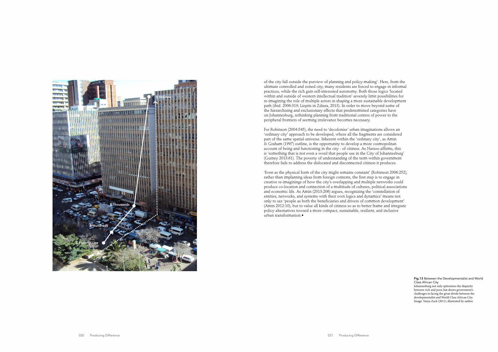
Fig.13 Between the Developmentalist and World Class African CityJohannesburg not only epitomises the disparity between rich and poor, but shows government's challenges in facing the great divide between the developmentalist and World Class African City. Image: Tanya Zack (2011), illustrated by author.
of the city fall outside the purview of planning and policy-making’. Here, from the ultimate controlled and zoned city, many residents are forced to engage in informal practices, while the rich gain self-interested autonomy. Both those logics ‘located within and outside of western intellectual tradition’ severely limit possibilities for re-imagining the role of multiple actors in shaping a more sustainable development path (ibid. 2006:319; Liepits in Zdiara, 2013). In order to move beyond some of the hierarchising and exclusionary effects that predetermined categories have on Johannesburg, rethinking planning from traditional centres of power to the peripheral frontiers of seeming irrelevance becomes necessary.
For Robinson (2004:545), the need to ‘decolonise’ urban imaginations allows an ‘ordinary city’ approach to be developed, where all the fragments are considered part of the same spatial universe. Inherent within the ‘ordinary city’, as Amin & Graham (1997) outline, is the opportunity to develop a more cosmopolitan account of being and functioning in the city - of citiness. As Narsoo affirms, this is ‘something that is not even a word that people use in the City of Johannesburg’ (Gurney 2013:61). The poverty of understanding of the term within government therefore fails to address the dislocated and disconnected citiness it produces.
‘Even as the physical form of the city might remains constant’ (Robinson 2006:252), rather than implanting ideas from foreign contexts, the first step is to engage in creative re-imaginings of how the city’s overlapping and multiple networks could produce co-location and connection of a multitude of cultures, political associations and economic life. As Amin (2013:206) argues, recognizing the ‘constellation of entities, networks, and systems with their own logics and dynamics’ means not only to see ‘people as both the beneficiaries and drivers of common development’ (Amin 2012:10), but to value all kinds of citiness so as to better frame and integrate policy alternatives toward a more compact, sustainable, resilient, and inclusive urban transformation.•
$ Millions
$ Thousands
$ Hundreds
$ Poverty Line
023 Photographic Essay
Photographic Essay
X
24 - 25 Maintenance of Public Township Infrastructure26 - 27 Economic and Physical Informality28 - 29 Residential Privatisation30 - 31 Office and Institutional Privatisation32 Large Scale-Infrastructure33 Unchanged Urban Form
Following Photographs
Fig.14 (page 24)Public infrastructure maintained by Orlando East resident
Fig.15 (page 25)Public infrastructure left unmaintained by the state
Fig.16 (page 26)Informally extending formal infrastructure for trade in Orlando East
Fig.17 (page 27)Informally extending formal infrastructure for residence in Pennyville
Fig.18 (page 28)Neighbourhood enclosure in Forest Town
Fig.19 (page 29)Gaurded neighbourhood enclosure in Westcliff
Fig.20 (page 30)Entry to Parktown mixed-use node
Fig.21 (page 31)Parktown's over manicured sidewalks
Fig.22 (page 32 left)Constitution Hill
Fig.23 (page 32 middle)Hillbrow neigbouring Constitution Hill
Fig.24 (page 32 right)Soccer City Complex
Fig.25 (page 33)Auckland Park streetscape

024 Photographic Essay 025 Photographic Essay
Fig.14Newly laid public infrastructure maintained by an Orlando East resident
Fig.15Newly laid public infrastructure left unmaintained by the state
026 Photographic Essay 027 Photographic Essay
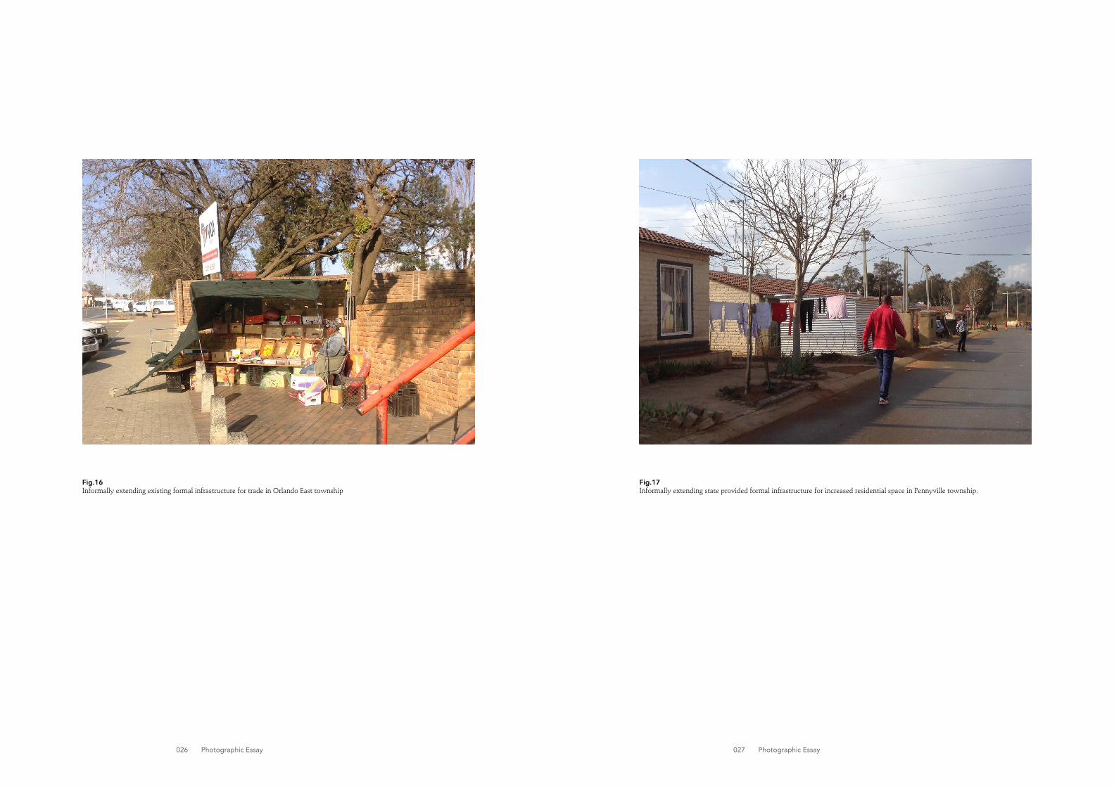
Fig.16Informally extending existing formal infrastructure for trade in Orlando East township
Fig.17Informally extending state provided formal infrastructure for increased residential space in Pennyville township.

028 Photographic Essay 029 Photographic Essay
Fig.18Neighbourhood enclosure in suburban Forest Town
Fig.19Gaurded and boomed neighbourhood enclosure in suburban Westcliff

030 Photographic Essay 031 Photographic Essay
Fig.21 (this page and opposite page)The mixed-use area of Parktown's over manicured sidewalks, keeping those unwanted at bay.

032 Photographic Essay 033 Photographic Essay
Fig.22 (left)Constitution Hill Precinct
Fig.23 (middle)Hillbrow neigbouring Constitution Hill Precinct
Fig.24 (right)Soccer City Complex
Fig.25 (next page)Auckland Park neighbourhood streetscape
034 035New Conceptual Framworks New Conceptual Frameworks
Analysed as little other than the physical manifestation of historic segregation and unequal economic relations driven by divisive government approaches, Johannesburg remains read as failed according to western modernity, limiting imaginaries for change (Simone 2004, Mbembe & Nuttall, 2004; Bremner, 2010). The challenge for urbanists then, as Caroline Kihato argues, is to ‘develop [new] conceptual frameworks that make sense of urban Africa on its own terms and not in the image of urban reality elsewhere’, ‘to find new languages, methodologies and…tools for understanding African cities as an analytic category in their own right’ (2007:215-17). The future of the city therefore needs to be situated in re-imagining its potential to emerge as a new landscape, ‘exploring [the] limits, pointing out deficiencies, finding fault [and] charting exclusions’ (Robinson in Nuttall 2006:268).
The theoretical investigation into the socio-political production of Johannesburgs origins, and current entangled policy directives that have shaped it into the profoundly divided city that it is today, lays the contextual ground work through which to investigate Johannesburg’s spatial inequality. Following Schensul and Heller’s (2011) ‘social cartographic’ methodology, the research below takes on a socio-spatial approach to find the ‘mobility mechanisms’ inscribed within its fragmented socio-spatial hierarchies. In understanding the links between local government policy directives and the various city-making processes they support or deny, the resultant character and condition of the heterogeneous citiness they produce is brought to the fore. Reading this socio-spatial character anew, reveals opportunities and challenges for urban change. It is important to note, that this attempt aims not to provide new policies, but is envisaged rather as the first step in better understanding the city so as to inform more appropriate development pathways for a truly democratic urban future.
In establishing a framework through which to read Johannesburg’s variegated reality, an 18km arterial route that stretches from the central Inner City to the peripheral townships fringes was selected. Although a sample study
could have been represented through a number of different strategies and locations, this route provides an extensive cross section of the city through which to make a strong argument. 15 urban formations were selected along the route for their difference in policy positions and practices, city-making processes and relevant actors, urban form and socio-economic character. 2011 Census data (Appendix 1) and GIS mapping by Adrienne Firth (Appendix 2 & 3) and appendix) further enabled these examples to be arranged within 5 major groupings (Fig.32), according to the stark socio-economic divides. Due to length constraints, each grouping will focus on one or two predominant examples. Importantly, these grouping are conceptualized not as categories, but rather as representative spaces through which to understand predominant patterns in the city-making process. Two groupings will be analysed in detail, while an overview of the remaining three will be discussed – providing an analytical methodology for further investigation.•
In an attempt to overturn predominant readings of Africa, we need to identify sites within the continent, entry and exit points, not usually dwelt upon in research …that defamiliarize commonsense readings.
New Conceptual Frameworks
Analytic ContextPart BX
quote
Achille Mbembe & Sarah Nuttall, Writing the World From an African Metropolis (2004:352)

037 Reading the city anew
Reading the City Anew
Socio-Spatial MappingThe following data outlines the key socio-spatial feautres along an 18km spine, stretching from the Inner City at Empire Road to Mooki Street in the township of Orlando East. This mapping enables a focused reading of each urban formation outlined below.
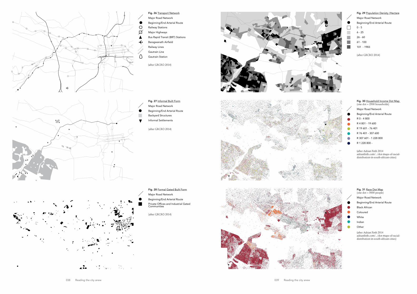
038 Reading the city anew 039 Reading the city anew
Fig. 29 Population Denisty /Hectare
Major Road Network
Beginning/End Arterial Route
0 - 5
6 - 25
26 - 60
61 - 100
101 - 1983
(after GRCRO 2014)
Fig. 27 Informal Built Form
Major Road Network
Beginning/End Arterial Route
Backyard Structures
Informal Settlements
(after GRCRO 2014)
Fig. 28 Formal Gated Built Form
Major Road Network
Beginning/End Arterial Route
Private Offices and Industrial Gated Communities
(after GRCRO 2014)
Fig. 26 Transport Network
Major Road Network
Beginning/End Arterial Route
Railway Stations
Major Highways
Bus Rapid Transit (BRT) Stations
Baragwanath Airfield
Railway Lines
Gautrain Line
Gautrain Station
(after GRCRO 2014)
Fig. 30 Household Income Dot Map (one dot = 2500 households)
Major Road Network
Beginning/End Arterial Route
R 0 - 4 800
R 4 801 - 19 600
R 19 601 - 76 401
R 76 401 - 307 600
R 307 601 - 1 228 800
R 1 228 800 -
(after Adrian Firth 2014adrianfrith.com/.../dot-maps-of-racial-distribution-in-south-african-cities)
Fig. 31 Race Dot Map(one dot = 5000 people)
Major Road Network
Beginning/End Arterial Route
Black African
Coloured
White
Indian
Other
(after Adrian Firth 2014adrianfrith.com/.../dot-maps-of-racial-distribution-in-south-african-cities)

040 Reading the city anew 041 Reading the city anew
o
o
Fig.32 Socio-spatial MappingExemplar socio-spatial fragments organised into representative groupings for further analysis.
Legend
Beginning/End Arterial Route
Major Entry Points
18km Arterial Route
City Road Network
Socio-Spatial Groupings
1. Frontiers 1.1 Orlando East 1.2 Pennyvile 1.3 Noordgesig
2. Islands 2.1 Parktown 2.2 Westcliff 2.3 Forest Town
3. Shadows 3.1 Zaminphilo 3.2 Nomzamo 3.3 Hillbrow 3.4 Inner City
4. Elsewheres 4.1 Soccer City at Nasrec 4.2 Ormonde 4.3 Ormonde View 4.4 Constitution Hill
5. Inbetweens 5.1 Auckland Park 5.2 Brixton 5.3 Melville
Un-named Suburb
x
2
1
3
5
4
2.3
2.12.2
x
xx
3.3
3.43.1
3.2x
4.4
4.1
4.24.3
5.1
5.2
5.3
1.1
1.2
1.3

042 Reading the city anew 043 Reading the city anew
1
Frontiers
The nationally guided developmentalist vision is most acutely present in those areas developed as apartheid and post-apartheid townships. Situated on the south-western periphery, just beyond Johannesburg’s ochre mine dumps, lies the city’s largest grouping of formerly legislated black townships. Characterised by an endless sea of pitched roofs and reflective aluminium shacks, Soweto acts as a labour pool for the rest of the city it remains a blind spot to. Identified by the City of Johannesburg (CoJ) as a marginalized area, the residentially dominated landscape, and areas like it, have become the focus of a multitude of township regeneration projects aimed at redressing historic inequalities. Yet, despite strategies which highlight the importance of partnerships between the government, private sector and civil society (Urban Landmark, 2009), township investment remains firmly driven by state redistribution which often disregards overlapping local realities.
City-making Process and PoliciesUnder the guidance of the key National Spatial Development Perspective and the Joburg Growth Development Strategy 2040, the focus of public investment is rooted in the state’s overarching mandate to reduce poverty by accelerating economic growth; to become more globally competitive (Urban Landmark, 2009). Despite a combination of regeneration assumptions that rely on infrastructural investment to draw private sector investment, and local skills development (Judin, Roux & Zack, 2014), the informal economy remains the dominant sector in the region (CoJ, 2006). Driven by the stated normative western planning agenda of ‘rationalised use and functionality’ (CoJ 2010a:18), the CoJ advocates for the formalisation of this activity. For James Scott (1998:4) such ‘rational design of social order’ resembles a ‘high modernist ideology’ which is counterproductive to the necessary flexibility crucial for residents to survive. The result is a disjuncture between top down state-lead interventions and the needs of those who receive them; questioning the remaking of post apartheid township space. Here Sarah Nuttall (2004:741) calls for ‘a re-reading of the historical archives…of the city’, in order reconcile alternative ways of seeing possibility in the seeming impossibility of its historically oppressed space.
Socio-Spatial CharacterEarmarked in the CoJ’s Regional Spatial Development Framework (2010) as a ‘high priority area’ for capital investment – due to its proximity to rail and BRT transport routes - Orlando East represents one such register through which to read the city a new. In 1979 Philip Frankel wrote that ‘Soweto displays many of the finer features of urban pathology in its endless rows of uniform 47m2 houses, its unlighted, treeless and unpaved streets and in its rudimentary recreational outlets’ (in Harrison & Harrison, 2014:1). Yet to describe the city’s first ‘model native township’ in this light would not only misrepresent the substantial amount of state-lead improvements (driven by the Soweto Economic Development Plan and the Orlando East Development Framework), but more importantly the dynamic potential for transformation.
Juxtaposed against the rationality of the apartheid laid grid and modernist social housing, lies an overlapping social, physical and economic diversity, characteristic to neighbourhoods like it. An organic, ad-hoc and in-filled layering of typologically variant urban forms have emerged. While land ownership rights have encourage substantial private investment such as house improvements, garaging and formal secondary structures (Rubin & Gardiner, 2013), long-standing housing shortages have resulted in a contrasting urban form. Makeshift backyard shacks house extended family or provide additional income through the rental market (Brodie, 2008; Harrison & Harrison, 2014). The resultant socio-economically diverse population represents a point of urban permeability for residents of vastly different incomes –perceived not as a slum.
This layering offers a heterogeneous and high-density urban environment - unlike the city’s privatised northern suburbs - which creates a dynamism in townships of a historically limited offerings. Here, as Bremner (2010:270) describes ‘to be inside is to lose out on the life of the street. Private space is small and cramped, things spill out. Prized space is alongside passersby: space to watch, view, greet, sell, drink, talk; places where the life of the community is consolidated’, mapping new modes
X
Fig.33 Socio-Spatial Study Area
1. Frontiers 1.1 Orlando East 1.2 Pennyvile 1.3 Noordgesig
Fig.34 (left)Informal trade along Orlando East's newly upgraded sidewalk boulevards.
Fig.35 (above)High density backyard shacks in Orlando East, behind modernist apartheid designed residential units.
1.11.3
1.2

044 Reading the city anew 045 Reading the city anew
1
Fig.36 (top)Informal Trade along a busy walkway in Orlando East.
Fig.37 (middle)Approporiation of public infrastructure in Orlando East.
Fig.38 (bottom)Street edge parking in Pennyville
of economic and social life on the modernist city. As the CoJ slowly tars its streets, plants thousands of trees, paves its sidewalks and constructs public street furniture along its sandy boulevards and curving Garden City grid, the ideal opportunity emerges for state intervention to go beyond service delivery alone and subvert the oppressive apartheid planning rationalities, by embracing modern township realities in its planning.
Socio-spatial Transformations: Opportunities and Challenges Through the incessant adaptation of urban space, informal activities defy the logic of organised rationality and order prescribed by the City. Despite the CoJ’s efforts to prevent unplanned or unregulated activities in the design of public infrastructure, they become ideal for appropriation – new benches become temporary stalls, newly planted trees become hanging displays and newly paved sidewalks provide the ideal foot-traffic to lay sellable goods beside. Similarly, the few formal stores extend their footprints by displaying merchandise on the newly built concrete benches. Space here is not filtered by property ownership or land use, ‘but is free to ever-changing occupation and use’ (ibid, 2010:270). Orlando East demonstrates how public environment upgrades and interventions, like those in neighbouring Noordgesig, could provide a platform for a more responsive urbanism; where the formal and the informal blur to create a new urbanity that fills the gaps of those needs not met by developmentalist regeneration. A new city-making process thus emerges as the formal skeleton for informal adaptation.
This reading provides a lens through which to critique post-apartheid state housing projects. A short drive northeast of Orlando East lies one of the CoJ’s flagship greenfield housing developments. Pennyville has successfully shifted the delivery of housing from low-density, single-family units to higher-density, multi-storeyed units, representing the formally planned mixed-lower-middle-income environment of Orlando East. Yet, it remains a fragmented territory on the urban periphery, far from economic opportunity. Houses therefore become informal shops and backyard shacks appear to break the monotony of the newly laid grid, one that is reminiscent of apartheid planning. Although, this is an urban environment which provides a less compact framework and is therefore less flexible to residents needs; departing from the city’s goal to use ‘the built form to create greater social…inclusion’ (CoJ 2006:30).
Although infrastructure systems may appear apolitical, as Craig Calhoun et al. (2013:198) argue, ‘they express ideas about what kind of society [the City] wants to build…and what kind of social relations [are] promoted’. In Pennyville, state infrastructure aims at replacing the informal with the formal city, in a city which requires both processes for suvival. Street-edge parking favours cars over pedestrian sidewalks. This negates the CoJ’s (2006) goals to encourage public transportation and pedestrianisation in an area strategically located along key transport routes. The centrally located modernist housing units and their entrances are turned away from the street edge, reducing opportunities for street life and trade along it, ala Jane Jacobs. At minimum, new developments could draw on areas like Orlando East for the alternative relationship it presents between the built form and the street. Tighter street frontages with less arbitrary surrounding open space better facilitate a dynamic street life and informal reuse of its built form through incremental growth; providing business opportunities in an area of high unemployment.
While the creative re-makings of space in these contexts is innovative, the increased density of areas discussed here can place significant pressure on an infrastructure designed to handle much lower levels of use. The need for greater public investment in infrastructure and regular maintenance of services, better urban amenities, and reliable transport infrastructure is critical for these racially and socio-economically marginalised areas to move beyond unemployment and underdevelopment. Should these basic services not be met and maintained, in an area already challenged by frequent service failures, Orlando East could easily turn into a slum (Rubin & Gardener, 2013).
Importantly, the ongoing challenge of regular maintenance presents a challenge as City infrastructures fall off the priority radar into ruin and disrepair. For Graham and Thrift (2007:5), this point of ‘breakdown and failure [acts] as the means by which societies learn’, providing a critical moment for improvisation and innovation. Recognising informal agents as possible role-players in the maintenance of urban space, could see formal city-making processes make use of the potential of its people to develop a model for a more resilient urbanism; in an environment where the state is unable to deal with the pressures of its residents demands. Most importantly, as the City outlines: ‘encouraging citizens to become co-producers and co-managers [to] aid in the establishment of a more just, sustainable and equitable Johannesburg’ (CoJ 2006:35).
Orlando East represents an urban condition that could embrace a level of informality; where the networks and economic opportunities inherent within informality are combined with a City delivered infrastructural backbone along well-connected locations. By critically engaging with the limits of the formal city, these processes are revealed at the frontiers of post-apartheid transformation, which must be supported by municipality if change is to be actualised. Townships ‘then come to be seen’ as Bremner (2010:271) argues, ‘not as lacking in or under-developed, but where the energetic ways in which people [use] and [redraft] space in the course of their daily lives’ demonstrate new strategies for democratic city-making.•
Fig.39 (top)Poorly maintained public infrastructure in Noordgesig.

046 Reading the city anew 047 Reading the city anew
1
Fig.40 (this page)One of the few formal stores in Orlando East, extending their footprint by appropriating state-built urban infrastructure.
Fig.41 (next page)Informal shop extension to low-income, state-built residential unit in Pennyville.

048 Reading the city anew 049 Reading the city anew

050 Reading the city anew 051 Reading the city anew
2
Islands
As numerous local state-lead development projects seek to create a city of equality and non-racial integration, Johannesburg’s social and physical environments are contradictingly being shaped by a neo-liberal politics of privatisation. Autonomous local government laws, set against the rising economy of crime, enable prosperous neighbourhoods to boost themselves by defending their borders (Mabin & Harrison, 2006; Frug, 1999). Through an architecture of semi-privatised spaces in shopping malls, gated residential and commercial complexes and leisure centres, a collage of fragmented island enclaves are rapidly reducing the nascent democratic sphere into a city of closure. This characteristically affluent and exclusionary urbanism represents what Mike Davis (1992) describes as ‘post liberal’ Johannesburg’s obsession with the policing of social boundaries through architecture’ (in Murray 2011:216), the new post-apartheid tool for urban segregation.
City Making Process and PoliciesGuided by national policies which are committed to global city ideals of economic growth (highlighted by the Local Government White Paper of 1998), the imperatives of private capital rather than social need, as Gerald Frug (1999) argues about American cities, have created new rules of exclusion. State authority’s need to stabilize violence and crime in order to ensure local and international investment, has supported sprawling northern expansion through infrastructural subsidisation and unfettered fortification (Mabin, 2007). State power is inverted to those regimes within gated communities, who consequently remove themselves from any kind of interaction with the public sphere. As Mbembe (2004:55) notes, ‘the complex [acts as] an incorporated municipality. It has its own utilities, policy systems, refuse, removal and security’. For those who cannot afford the expense, whole neighbourhoods are excised from the public realm through fences and restricted access control; a measure which remains controversial for its privatization of public roads and controlled freedom of movement. Despite recent local government policy which discourages neighbourhood enclosures, mechanisms for their provision endure (Harrison & Mabin, 2006).
For Argentinean sociologist Isodoro Cheresky (2006), the advent of a democratic state, against a history of authoritarian power – like the apartheid regime - should bring a society together, as democracy offers more rights and greater participation therefore reducing the need for aggressive retort. Yet paradoxically, where the citizen does not need to achieve a common structural goal, he meets his individual needs and desires. In Johannesburg, the 600 gated communities and 1100 recorded road enclosures (Harrison & Mabin, 2006), demonstrate how state adopted policies have facilitated the proliferation of exclusionary practices of sovereignty, showing an implicit alignment with the middle classes to the detriment of the city’s poor (Mabin, 2007). Martin Murray (2010:214) suggests that this is an urban form which increasingly ‘symbolises the entrenched division between private and public life, between the individual and the state and urban dislocation and suburban disengagement from the city’. Here, ‘the wall is the figure of the new political order, indicating not that democracy has gone far enough, but that it has been too far-reaching’ (Bremner 2010:204), forcing this new urbanism to be questioned.
Socio-Spatial Character This pervasive pattern of privatization is evident in the up-market residential suburbs of Westcliff and Forest Town, and the mixed-use area of Parktown; the beginnings of Johannesburg’s northern suburbs. Although these suburbs do not represent the most extreme cases of fortification evident further north, they still allow a strong argument to be made. Founded upon suburban orthodoxy and political liberalism, strong residents committees and powerful transnational global corporations stave off change in an effort to safeguard particular lifestyles and property values. The CoJ’s reliance on their tax-bases, means that despite policy which claims to ‘accommodate and facilitate’ socially geared development pressures in the future (relating to densification and inclusionary housing), their contradictory promise to ‘protect the amenity and character of the area’ takes precedence (CoJ 2010b:129). High-income residents concerns over potential non-racially integrated changes are guised under pragmatic concerns of additional service infrastructure, congestion and threats to open space; voices which are more powerful than the City’s vision for equitable growth. These contradictory policy positions therefore
Fig.43 (left)Overmanicured grass verges in Forest Town, removing the facility of sidewalks all together.
Fig.44 (top)Typical neighbourhood enclosure, excising whole neighbourhoods from the urban environment.
X
Fig.42 Socio-Spatial Study Area
2. Islands 2.1 Parktown 2.2 Westcliff 2.3 Forest Town
2.3
2.2
2.2

052 Reading the city anew 053 Reading the city anew
2
Fig.45 (top)Post-box like concrete gaurdhouses and security paraphenalia in the affluent suburb of Westcliff.
Fig.46 (bottom)Exclusionary suburban streetscape in Westcliff.
Fig.47 (next page)Narrow, uninviting and often overly manicured sidewalks alongside gated office complexes in Parktown.
strengthen socio-spatial fragmentation, with little hope for the equalizing developments necessary to make the mistrusted ‘other’ more familiar.
Driven and justified by an overriding concern for safety in one of the worlds most dangerous cities (Lemanski, 2004), the rhetoric of fear therefore maintains segregation; as Bremner (2010: 230) remarks: ‘after-dinner talk, braaivleis chatter, newspaper columns and political rhetoric all turn predictably to crime, its victims, its culprits, its consequences’. Built not for people to be brought together but for them to be safely apart, size, power and privacy seem to be the distinctly architectonic features of affluent post-apartheid Johannesburg. In the predominantly white and wealthy suburb of Westcliff, large, residential homes on generous leafy stands and tree-lined streets, are protected behind a shamelessly flaunted urban form. Stylish high walls are topped with CCTV cameras, electric fencing and barbed wire, while black male guards sit in the post-box like concrete guardhouses. Those who cannot afford it, in the middle-upper income suburb of Forest Town, protect themselves through neighbourhood enclosures - patrolled by private security vehicles. Considered too dangerous for suburban residents, uninviting sidewalks are left for the carless poor, who are reminded of their exclusion by a visual arsenal of security paraphernalia.
Earmarked as a regional economic node for its mixed-use character and location along the BRT route (with good access to other modes of public transport), Parktown’s commercial and institutional enclaves follows similar rules of privatization and enclosure as its residential neighbours. These anti-urban idealized models of affluent neighbourhoods fail to consider their effects on the public experience of the city; restricting freedom of movement, eradicating chance encounter and limiting public interaction between circles of self defined, usually white, wealthier homogenous groups. In her seminal paper Fortified Enclaves: The New Urban Segregation, Teresa Caldeira (1996:362) captures the destructive role that growing fortification plays on the development of democratic space and culture in Brazil, which takes salience in Johannesburg, where ‘cities of walls do not strengthen citizenship but rather contribute to its corrosion’. By rejecting the principles of openness and equality and taking inequality and separation as their values, the loss of shared space deepens racial and socio-economic division.
Socio-spatial Transformations: Opportunities and ChallengesYet behind the ubiquity of the fortified facade, lies genuine opportunity for transformation. The Parktown node displays a distinctly different urban form than that of other major economic nodes such as the declining Inner City, Rosebank and Sandton. The smaller land mass and characteristically lower-rise buildings set in large landscaped gardens present a range of institutions, commercial offices, churches and educational facilities which are used and traversed by a multiplicity of diverse people. This is also an area which unlike Westcliff and Forest Town, has a predominantly black social-makeup and neighbours the highly diverse Inner City. The first step might then be to bring these diverse people into closer proximity with one another. In the supporting retail and restaurant core, the development of public ‘reception’ spaces at the landscaped entrances of these blank walls and gated office enclosures, offer a catalytic opportunity for municipally legislated accommodation of genuine and less formally regulated public space on privately owned land.
Caldeira (1996) argues the street in these kind of neighbourhoods act merely as a service corridor to support the life of the city’s elite, rather than as a point to bring a diverse population into contact. Narrow pavements are alienating environments for the pedestrian, sometimes excessively manicured and planted by their corporate ‘owners’, if existing at all; perhaps to keep those unwanted users away from its boundaries. Here, smaller scale public spaces – like the benches in the townships – could see a new public practices emerge in the city designed for its car orientated users.
The provision of temporary urban improvisations and less formal and inexpensive streetside offerings along these wide sidewalks might then welcome, support and embrace the area’s diverse users to create a dynamic and active street environment, akin to that of township life. Suited businessmen and women from the many office-blocks and those traversing the streets from its proximal and socio-economically diverse surrounds, could come to enjoy a new shared public. Similar public environment interventions could see a public life emerge in areas like Forest Town and Westcliff. Temporary visitors to the nearby Zoo lake and Johannesburg Zoo, few active resident joggers and domestic workers who sit on the grass verges of the leafy streets show an equally diverse population who move through these suburbs; all of whom could share such space.
Richard Sennett’s (2008) work expands on the importance of the public realm, for it is in ‘public [where] people can access unfamiliar knowledge, expanding the horizons of their information’ through a network of exchanges between strangers - the basis of democracy. Although, the fences are up and some might say that cohesion may never be achieved, shifting exclusionary mindsets is the first step to blurring the fixity of socio-spatial divides. Until then, in the absence of strategies over symptomatic exclusion of the racialised ‘other’, islands of fortification will most likely continue to relentlessly expand the already profoundly divided city.•

055 Reading the city anew
Fig.48 (this page)Gaurdhouses to protect the valuables behind the stylish high walls topped with electric fencing in Forest Town.
Fig.49 (next page)Private gated offices and institutions hide themselves behind blank walls and uninviting sidewalks in Parktown mixed-use node. This is an urban environment designed for a car orientated city.
2

057 Reading the city anew

058 Reading the city anew 059 Reading the city anew
21
Fig.50Imagining the Frontier anew: infrastructural investment as the backbone to supporting a more responsive urbanism.
Fig.51Imagining the Islands anew: deregulating intense privatisation of space for a more public, shared and inclusive African citiness.
Re-imagined Frontiers Re-imagined Islands

061 Reading the city anew
For AbdouMaliq Simone(2004) ‘informality in Johannesburg represents a highly urbanized social infrastructure in which ‘entanglement, hybrids, incessant mobility and constant adaptations are not obstacles to modern life, but the…modalities through which it is lived’ (in Bremner, 2007:210); yet this is an urbanism which remains in the shadows of western city visioning. The 189 recorded peripheral informal settlements, and the fast declining Inner City are examples of an informality where the city’s most disenfranchised find access to urban life. As informal settlements outpace the rate of subsidized low-income housing delivery, national government’s comprehensive plan for ‘sustainable settlements’ includes for the first time an alternative through in-situ upgrading (Misselhorn, 2008).
Yet despite this policy shift, constitutional obligations remain subordinate to demands for global competitiveness, which seemingly require the UN-Habitat Millennium Development Goal of ‘achieving’ a city without slums. Less complex relocation to greenfield housing projects are therefore favoured by the City, often shifting the poor to more marginal locations (Huchzemeyr, 2009). Settlements like Zaminphilo and Nomzamo, are strategically built by residents along major rail transport routes or areas of employment, making relocation near impossible for those living in them and engraving their fixity into the city’s geography.
Marked by extensive unemployment and deprivation, these dense settlements are a labyrinth-like network a physical and economic informality and vitality. The makeshift architecture demonstrates an inventive and adaptive urban typology, where small dwellings are converted into convenience stores and beauty parlours; facing onto the sandy streets where mothers chatter and children play. In his book Portrait with Keys, acclaimed author Ivan Vladislavic (2009:46) describes the inner city suburb of Hillbrow as a similar environment to these settlements despite the vastly different urban form - the ‘contested zone, its high-rise flats occupied by immigrants from other African nations, its streets taken over by a flourishing informal economy in the ‘loose spaces’ of the sidewalks and the parks. While in the inner city core, former modernist office towers are re-invented as churches, shopping malls and warehouses by entrepreneurial immigrants.
Behind the perceived lack of ‘planning’, informality holds an often invisible infrastructure which is able to facilitate highly organized spaces of economic and cultural operations that are available to residents with limited means; defying the logic of formality (Tonkiss, 2012; Simone, 2004). What remains pivotal then is that in the absence of meaningful state intervention, the strategic innovations by ordinary inhabitants must be recognised, valued and supported with the requisite services, institutions and public space provisions if they are to bring to light this rapidly proliferating urbanism.•
Shadows
3
Fig.53 (left)Zaminiphilo Informal Settlement
Fig.54 (right) Johannesburg Inner City
Fig.52 Socio-Spatial Study Area
3. Shadows 3.1 Zaminphilo 3.2 Nomzamo 3.3 Hillbrow 3.4 Inner City
x
x
3.1
3.4

063 Reading the city anew
As Johannesburg strives to take its place in the global city hierarchy, large-scale, high investment developments such as the Soccer City complex at Nasrec and Constitution Hill precinct demonstrate an example of a city visioning which, as Achille Mbembe (2008:39) argues, ‘like every colonial town, has found it hard to resist the temptation of mimicry’; imagining itself in the reflection of forms born elsewhere in the ‘western’ world. Redeveloped for the 2010 Soccer World Cup, the stadium site – where Nelson Mandela first addressed the nation after release from prison - is straddled between the dormant mine dumps and the relatively affluent suburbs of Ormonde and Ormonde View, 5 km east of marginalized Soweto.
These suburbs have seen an influx of upwardly mobile black middle-classes move from the townships as they offer a better location, facilities and amenities. Yet, despite integrated transport infrastructures which accompanied World Cup Stadium investment, and unrealized mixed-use plans by the CoJ, the site remains a ‘high profile show piece’ on an isolated land portion with little benefit or connection to its neighbouring marginalized or privatized areas (Findley & Ogbu, 2011).
At the site of Johannesburg’s oldest prison and now home to country’s Constitution Court precinct, a similar urban form and process is evident. Situated between the central business district of Braamfontein and the deteriorating buildings of the notoriously declining Hillbrow, the fragmented court complex has struggled to connect with its surrounds (Bremner, 2010). Continued state-lead development plans aimed at unlocking the market potential of the site through high-end commercial blocks, are yet to come to flourition. Despite millions of rands of infrastructural investment, this is perhaps because of the area’s high-risk perception.
These city-making processes are arguably driven less by the government’s belief in the power of sport or heritage as sites for socio-spatial cohesion, but instead by state speculation which leverages off ‘world-class’ event and tourist spaces to attract revenue and global investment (Gevisser, 2004), ignoring the fragmentation they produce. At a time when ‘Johannesburg’s city space is a product that is marked, measured, marketed and transacted’ more than ever before, it becomes critical to leverage large-scale investment to create new urban pieces of the city (Mbembe 2008:54). In sites likes these, where Johannesburg’s disparities are brought into immediate view, the focus must shift away from global economicism towards integrated, compact and sustainable city forms. Designing a framework for incremental and mixed-use ‘accretion’ rather than ‘rupture’, as Ricky Burdett (2013:353) advocates, could facilitate rebalancing social-spatial inequality.•
Fig.56 (top left)The isolated Soccer City Stadium, infront of Johannesburg's iconic dormant mine dump.
Fig.57 (bottom left)Superbasement structures at Constitution Hill, awaiting market driven development almost 10 years since completion.
4
Elsewheres
Fig.55 Socio-Spatial Study Area
4. Elsewheres 4.1 Soccer City at Nasrec 4.2 Ormonde 4.3 Ormonde View 4.4 Constitution Hill
4.1
4.4

065 Reading the city anew
Between the privatized islands and the city’s peripheral western frontiers lies an unas-suming piece of the city. Established at the turn of the 20th century during the mining boom, the historic areas of Brixton, Auckland Park and Melville were home to some of Johannesburg’s first residents. Punctuated by the vertical national broadcasting agency towers and the two of the city’s largest universities complexes, these areas are situated along the east-west institutional corridor. Other than major development directives of the University of Johannesburg, these areas present a largely unchanged low-slung urban form.
Yet, the formerly white, predominantly Afrikaans areas have seen a substantial change in racial profile. As political transformation saw universities open admission policies, an ever-growing, racially mixed student population has moved into the lower-income neighbourhood of Brixton and the more socio-economically diverse neighbourhood of Auckland Park, resulting in increased pressure for development of commercial and commune establishments (Joburg.org, 2011b). The higher-income and higher-amenity area of Melville, has experienced a slower racial shift, largely due to strong residents association which have fought against student communes; actions which have been supported by CoJ policy which aims to maintain the ‘residential integrity of the area’ (CoJ 2010b:86).
These historic working class and middle-income neghbourhoods offer modest houses on fully serviced sites. Despite higher securitization in Melville and Auckland Park -al-though not to the extent of privatized islands to the north - these neighbourhoods offer a less insular lifestyle. As Rene van Niekerk, a university lecturer who lives in Brixton says, ‘this is what the new South Africa should look like – with low walls, so that you can mix with your neighbours’ (Joburg.org, 2011b). The smaller plots and lower-proper-ty prices in Brixton are also slowly drawing young professionals to the area (Joburg.org, 2011b).
Incremental and accretive development patterns, largely free of large-scale state or market agenda’s, demonstrate an example of what the rest of the city might come to look and feel like. For it is this inbetween world, as Homi Bhaba (2004:4) theorizes, where new ‘terrain for elaborating strategies of selfhood – singular or communal – that initiate new signs of identity, and innovative sites of collaboration, and contestation…the overlap and displacement of domains of difference’ are brought most acutely into view. Here, the GDS 2040 goals for supporting well located, mixed income and racially integrated city territories is most noticeable, creating the very antithesis of homogenous and controlled apartheid planning to represent Johannesburg tomorrow.•
Inbetweens
5
Fig.59Brixton streetscape
Fig.58 Socio-Spatial Study Area (see Fig. xx)
5. Inbetweens 5.1 Auckland Park 5.2 Brixton 5.3 Melville
5.1
5.3
5.2

066 Conclusion: Imagining Tomorrow 067 Conclusion: Imagining Tomorrow
Conclusion
From its very inception Johannesburg was produced as a set of disjunctive territorial juxtapositions. The increasing wealth disparity, the isolation of poor neighbourhoods and privileged suburbs, the distance between jobs and those who need them, the sprawling suburban fortification, and the escalating mistrust of strangers today, are not simply by-products of modernisation, urbanisation, or crime, but rather produced by repetitive cycles of exclusionary socio-political forces. Colonial capitalist interest, Afrikaner patriotism and current World Class City policy entanglements have all shaped what Ananya Roy (2012:132) defines as ‘an uneven geography of spatial value’, agency, and opportunity – generating an otherness of fragmented otherwheres.
The chronic lack of the state’s planning imagination means that the uncritical adoption of formulaic design ‘solutions’, premised on dominant western ideals of orderliness and control, continue to undermine Johannesburg’s local context. Our slavish desire for global economicism results in the failure of policy to engage with the often exclusionary citiness it produces, as it focuses instead on technical, modernist forms of policy and implementation. Despite large-scale conventional urban regeneration and public transport interventions (which remain critical for improved access to opportunity), little success at spatial reconfiguration has been achieved. The city therefore persists as overdeveloped or underinvested fragments within an already fragmented urban landscape of inequality. In returning to Frug’s (1999) notion to blur the highly legible territorial boundary lines which separate the city so severely, how then can this be facilitated at an intra-city level?
While it is important to build an urbanity that falls on the global map of relevance, reading Johannesburg and Africa, for what it is rather than for what it is not could allow state powers to creatively engage with the local particularities, rather than simply applying ideas of citiness ready-made from other contexts. As Ash Amin (2013:207) argues, for transformative interventions in cities of multiple formations to have genuine effect, ‘the plural and unknown’ need to be embraced - from the globalising financial sector to informal
survivalist activities. In examining the heterogeneous city and its distinct local conditions - as demonstrated in the analytic section above – new ways of decoding which processes should be supported to unlock the entrenched socio-spatial and economic polarities are revealed.
In 2012, architects1 and social scientist2 embarked on a socio-spatial study of 'liquor taverns' in the context of South Africa’s urban informal settlements. Defying conventional assumptions of the ills of ‘shebeens’ in the context of poverty, the study revealed a spatiality of surprising hybridity. Not only is this a space of liquor consumption, it is also a business, a private home, and most importantly the only offering of a ‘public space’ - seemingly polarized functions which support multiple reciprocal economic and cultural associations. Yet, criminalization of the liquor trade in informal settlements means that already marginalized entrepreneurs are further oppressed, disregarding the positive social role shebeens play. This project revealed principles for more nuanced and progressive approaches to policy, presenting new readings and alternative imaginaries for how the urban future could be shaped.
Where city-makers have played a far less aggressive role in the construction of space than apartheid’s spatial-agents, these kinds of projects demonstrate new roles for the urban professional in restructuring post-apartheid urbanity. In a context of paradox, informality, and contingency, perhaps the first step is to trade the principle of order for a framework of flexibility, adaptability and diversity. Following John Turner’s advocacy for the ‘supportive shack’ as better than the ‘oppressive house’ in meeting the needs of the urban poor (in Tonkiss 2012:61), the role of the city-maker requires a shift from prescriptive ‘solutions’ to a framework of pro-active facilitation, one which favours long-term development for its inhabitants over myopic interventions with purported economic gain.
Beyond the binaries of the city lies Sarah Nuttall’s (2004:732) description of the ‘African modern’, a cosmopolitan African citiness yet to come. Through a combination of regulation
The multiplicity of worlds and its unity is the mutual sharing and exposition of all its world – within this world.
Jean-Luc Nancy, Being Singular Plural (2000:185)
ImaginingTomorrow
X
quote
1UrbanWorks Architecture & Urbansim
2Sustainable Livelihoods Foundation

068 Conclusion: Imagining Tomorrow 069 Conclusion: Imagining Tomorrow
and deregulation, this is a responsive urbanism which could open up new ways of producing urban spatiality and governance; to build the ‘resilience, sustainability and liveability’ that Johannesburg’s contradictory and multi-directional Growth Development Strategy 2040 aspires towards but fails to affect (CoJ 2006:23).
To produce a truly integrated and democratic city means to read the city anew; to find the mobility mechanisms inherent within it to support a compact, connected and interactive urbanity of shared publics in each of Johannesburg’s heterogeneous formations; to adapt to the constantly shifting challenges by moving beyond the static and homogenous vision of a singular city and citizenry. Only then can we realise a different administration and implementation of the city, an alternative socio-spatial logic that subverts, reconfigures and importantly, reinforces the state as the necessary equalising power, by imagining the more inclusive tomorrow that Johannesburg can be.•
Fig.60 (top left)Typical Plan of Shebeen in an Informal SettlementImage: UrbanWorks Architecture & Urbanism (2012)
Fig.61 (bottom left)Shebeens in Informal SettlementsImage: UrbanWorks Architecture & Urbanism (2012)
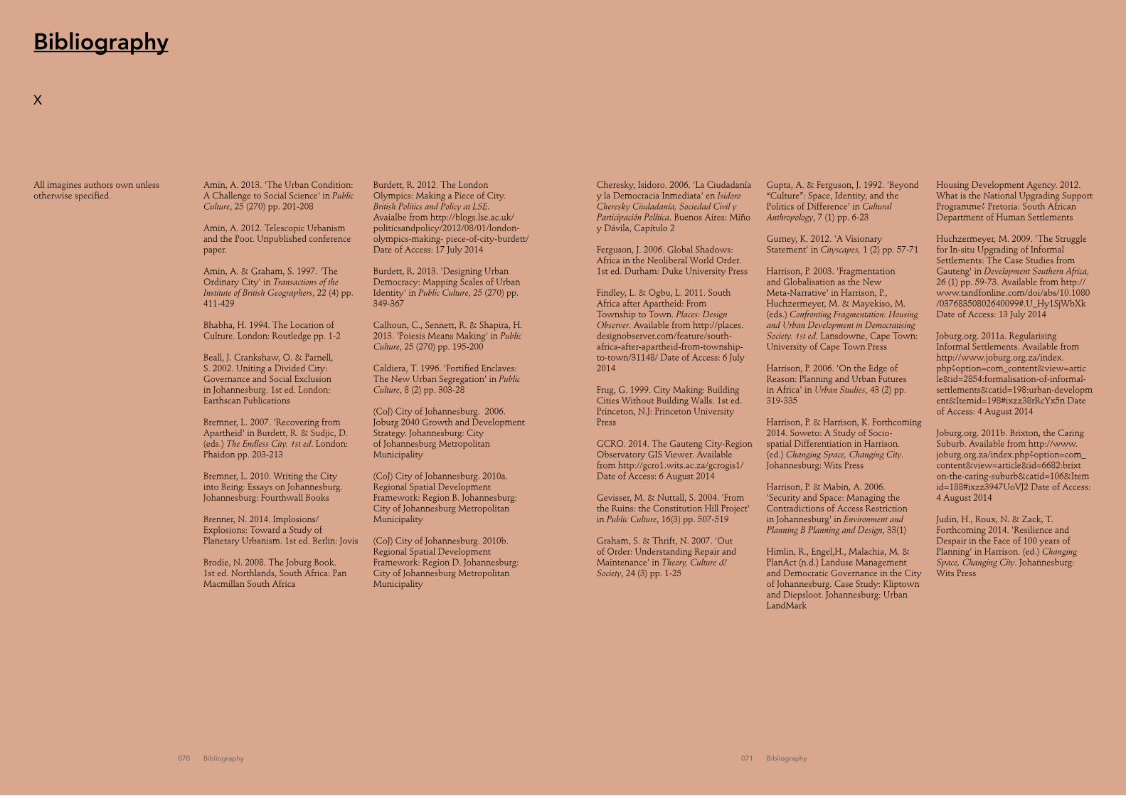
070 Bibliography 071 Bibliography
Bibliography
X
Housing Development Agency. 2012. What is the National Upgrading Support Programme? Pretoria: South African Department of Human Settlements
Huchzermeyer, M. 2009. 'The Struggle for In-situ Upgrading of Informal Settlements: The Case Studies from Gauteng' in Development Southern Africa, 26 (1) pp. 59-73. Available from http://www.tandfonline.com/doi/abs/10.1080/03768350802640099#.U_Hy1SjWbXk Date of Access: 13 July 2014
Joburg.org. 2011a. Regularising Informal Settlements. Available from http://www.joburg.org.za/index.php?option=com_content&view=article&id=2854:formalisation-of-informal-settlements&catid=198:urban-development&Itemid=198#ixzz38rRcYx5n Date of Access: 4 August 2014
Joburg.org. 2011b. Brixton, the Caring Suburb. Available from http://www.joburg.org.za/index.php?option=com_content&view=article&id=6682:brixton-the-caring-suburb&catid=106&Itemid=188#ixzz3947UoVJ2 Date of Access: 4 August 2014
Judin, H., Roux, N. & Zack, T. Forthcoming 2014. 'Resilience and Despair in the Face of 100 years of Planning' in Harrison. (ed.) Changing Space, Changing City. Johannesburg: Wits Press
Amin, A. 2013. 'The Urban Condition: A Challenge to Social Science' in Public Culture, 25 (270) pp. 201-208
Amin, A. 2012. Telescopic Urbanism and the Poor. Unpublished conference paper.
Amin, A. & Graham, S. 1997. 'The Ordinary City' in Transactions of the Institute of British Geographers, 22 (4) pp. 411-429
Bhabha, H. 1994. The Location of Culture. London: Routledge pp. 1-2
Beall, J. Crankshaw, O. & Parnell, S. 2002. Uniting a Divided City: Governance and Social Exclusion in Johannesburg. 1st ed. London: Earthscan Publications
Bremner, L. 2007. 'Recovering from Apartheid' in Burdett, R. & Sudjic, D. (eds.) The Endless City. 1st ed. London: Phaidon pp. 203-213
Bremner, L. 2010. Writing the City into Being: Essays on Johannesburg. Johannesburg: Fourthwall Books
Brenner, N. 2014. Implosions/Explosions: Toward a Study of Planetary Urbanism. 1st ed. Berlin: Jovis
Brodie, N. 2008. The Joburg Book. 1st ed. Northlands, South Africa: Pan Macmillan South Africa
Burdett, R. 2012. The London Olympics: Making a Piece of City. British Politics and Policy at LSE. Avaialbe from http://blogs.lse.ac.uk/politicsandpolicy/2012/08/01/london-olympics-making- piece-of-city-burdett/ Date of Access: 17 July 2014
Burdett, R. 2013. 'Designing Urban Democracy: Mapping Scales of Urban Identity' in Public Culture, 25 (270) pp. 349-367
Calhoun, C., Sennett, R. & Shapira, H. 2013. 'Poiesis Means Making' in Public Culture, 25 (270) pp. 195-200
Caldiera, T. 1996. 'Fortified Enclaves: The New Urban Segregation' in Public Culture, 8 (2) pp. 303-28
(CoJ) City of Johannesburg. 2006. Joburg 2040 Growth and Development Strategy. Johannesburg: City of Johannesburg Metropolitan Municipality
(CoJ) City of Johannesburg. 2010a. Regional Spatial Development Framework: Region B. Johannesburg: City of Johannesburg Metropolitan Municipality
(CoJ) City of Johannesburg. 2010b.Regional Spatial Development Framework: Region D. Johannesburg: City of Johannesburg Metropolitan Municipality
Cheresky, Isidoro. 2006. 'La Ciudadanía y la Democracia Inmediata' en Isidoro Cheresky Ciudadanía, Sociedad Civil y Participación Política. Buenos Aires: Miño y Dávila, Capítulo 2
Ferguson, J. 2006. Global Shadows: Africa in the Neoliberal World Order. 1st ed. Durham: Duke University Press
Findley, L. & Ogbu, L. 2011. South Africa after Apartheid: From Township to Town. Places: Design Observer. Available from http://places.designobserver.com/feature/south-africa-after-apartheid-from-township-to-town/31148/ Date of Access: 6 July 2014
Frug, G. 1999. City Making: Building Cities Without Building Walls. 1st ed. Princeton, N.J: Princeton University Press
GCRO. 2014. The Gauteng City-Region Observatory GIS Viewer. Available from http://gcro1.wits.ac.za/gcrogis1/ Date of Access: 6 August 2014
Gevisser, M. & Nuttall, S. 2004. 'From the Ruins: the Constitution Hill Project' in Public Culture, 16(3) pp. 507-519
Graham, S. & Thrift, N. 2007. 'Out of Order: Understanding Repair and Maintenance' in Theory, Culture & Society, 24 (3) pp. 1-25
Gupta, A. & Ferguson, J. 1992. 'Beyond “Culture”: Space, Identity, and the Politics of Difference' in Cultural Anthropology, 7 (1) pp. 6-23
Gurney, K. 2012. 'A Visionary Statement' in Cityscapes, 1 (2) pp. 57-71
Harrison, P. 2003. 'Fragmentation and Globalisation as the New Meta-Narrative' in Harrison, P., Huchzermeyer, M. & Mayekiso, M. (eds.) Confronting Fragmentation: Housing and Urban Development in Democratising Society. 1st ed. Lansdowne, Cape Town: University of Cape Town Press
Harrison, P. 2006. 'On the Edge of Reason: Planning and Urban Futures in Africa' in Urban Studies, 43 (2) pp. 319-335
Harrison, P. & Harrison, K. Forthcoming 2014. Soweto: A Study of Socio-spatial Differentiation in Harrison. (ed.) Changing Space, Changing City. Johannesburg: Wits Press
Harrison, P. & Mabin, A. 2006. 'Security and Space: Managing the Contradictions of Access Restriction in Johannesburg' in Environment and Planning B Planning and Design, 33(1)
Himlin, R., Engel,H., Malachia, M. & PlanAct (n.d.) Landuse Management and Democratic Governance in the City of Johannesburg. Case Study: Kliptown and Diepsloot. Johannesburg: Urban LandMark
All imagines authors own unless otherwise specified.

072 Bibliography 073 Bibliography
Law Viljoen, B. & Barstow, O. 2011. Fire walker: William Kentridge, Gerhard Marx. 1st ed. Johannesburg: Fourthwall Books
Kihato, C. 2007. 'African Urbanism' in Burdett, R. & Sudjic, D. (eds.) The Endless City. 1st ed. London: Phaidon pp. 214-217 Landman, K. 2006. 'Privatising Public Space in Post-apartheid South African Cities through Neighbourhood Enclosures' in GeoJournal, 66 (1-2) pp. 133 -146
Landman, K, Matsebe, G. & Mmonwa, M. 2009. 'Assessing the Physical Characteristics of Medium Density Mixed Housing in South Africa' in Town and Regional Planning, 54 pp. 15-26
Lefebvre, H. & Enders, M. 1976. 'Reflections on the Politics of Space' in Antipode, 8 (2) pp. 30-37
Lemanski, C. 2004. 'A New Aparthied? The Spatial Implications of Fear and Crime in Cape Town, South Africa' in Environment and Urbanization, 16 (101), Available from doi: 10.11.177/095624780401600201.
Mabin, A. 2007. 'Johannesburg: (South) Africa’s Aspirant Global City' in Segbers, K. (ed) The Making of Global City Regions: Johannesburg, Mumbai/Bombay, Sao Paulo, and Shanghai. Baltimore: John Hopkins University Press pp. 33-63
Mbembe, A. & Nuttall, S. 2004. 'Writing the World from an African Metropolis' in Public Culture, 16(3) pp. 347-372
Mbembe, A, Dlamini, N. & Khunou G. 2004. 'Soweto Now' in Public Culture 16(2): 499–506.
Misselhorn, M. 2008. Position Paper on Informal Settlement Upgrades. Johannesburg: UrbanLandmark
Moodie, T. 1975. The Rise of Afrikanerdom. 1st ed. Berkeley: University of California Press
Mubiwa, B & Annegran, H. 2013. Historical Spatial Change in the Gauteng City-Region. Johannesburg: Gauteng City Region Observatory
Murray, M. J. 2011. City of Extremes. Durham: Duke University Press.
Nuttall, S. 2004. 'City Forms and Writing the ‘Now’ in South Africa in Journal of Southern African Studies, 30 (4) pp. 731-748
Nuttall, S. 2006. 'A Politics of the Emergent Cultural Studies in South Africa' in Theory, Culture & Society, 23 (7-8) pp. 263-278
Mbembe, A . 2008. 'Aesthetics of Superfluity' in Nuttall, S. & Mbembé, A. (eds.) Johannesburg: The Elusive Metropolis. 1st ed. Durham: Duke University Press pp. 37-67
Palmer Development Group (PDG). 2011. Land Release Development Assessment Tool: Pennyville Case Study Report. Pretoria: Urban LandMark. [online] Avaialable from http://www.urbanlandmark.org.za/downloads/lram_pennyville_cs_2011.pdf Date of Access: 20 July 2014
Roy, A. 2012. 'Slumdog Cities: Rethinking Subaltern Urbanism' in Angélil, M. & Hehl, R. (eds.) Informalize!. 1st ed. Berlin: Ruby
Robinson, J. 2002. 'Global and World Cities: A View from Off the Map' in International Journal of Urban and Regional Research, 26(3) pp. 531-554
Robinson, J. 2006. 'Inventions and Interventions: Transforming Cities—An Introduction' in Urban Studies, 43 (2) pp. 251-258
Robinson, J. 2003. 'Johannesburg’s Futures: Beyond Developmentalism and Global Success' in Tomilson, R., Beuaregard, R., Bremner, L. & Mangcu, X. (eds.) Emerging Johannesburg. 1st ed. New York: Routledge, pp. 259-280
Rubin, M. & Gardiner, D. 2013. Developing a Response to Backyarding for Salga. Johannesburg: South African Local Governments Association
Schensul, D. & Heller, P. 2011. 'Legacies, Change and Transformation in the Post-Apartheid City: Towards an Urban Sociological Cartography' in International Journal of Urban and Regional Research, 35 (1) pp. 78-109
Scott, J. 1998. Seeing Like a State: How Certain Schemes to Improve the Human Condition Have Failed. 1st ed. New Haven: Yale University Press
Seedat, R. & Gotz, G. 2006. 'Johannesburg: A World Class African City. Available from http://downloads.lsecities.net/0_downloads/archive/Seedat_and_Gotz-Johannesburg_World_Class_City.pdf Date of Access: 11 July 2014
Sennet, R. (2008) The Public realm. Quant. (Unpublished paper).
Simone, A. (2004) For the City Yet to Come. Durham: Duke University Press.
Sudjic, D. (2007) The View from Outside. In Burdett, R. and Sudjic, D. (eds.) The Endless City. 1st ed. London: Phaidon. pp. 200-202
Tonkiss, F. (2012) Informality and Its Discontents. In Angélil, M. & Hehl, R. (eds.) Informalize!. 1st ed. Berlin: Ruby
UN-Habitat. (2009). The Economic Divide: Urban Income Inequality. Available from http://www.unhabitat.org.jo/en/inp/Upload/2233036_pages%20from%20Report-Englishrd-2.pdf Date of Access: 4 August 2014
UN-habitat.org. 2014. UN-Habitat: Millennium Development Goals Available from http://ww2.unhabitat.org/mdg/ Date of Access: 21 August 2014
Urban LandMark. 2009. Township Renewal Sourcebook. Johannesburg: South African Cities Network. Available from http://www.citiesalliance.org/node/3956 Date of Access: 20 July 2014
Vladislavic, I. 2009. Portrait with Keys: Joburg & What What. 1st ed. New York: W.W. Norton & Co.
Zdiara, A. 2013. The Global City Discourse in Urban Transformations: A Comparative View on Johannesburg and Delhi. Berlin : Lit

074 Appendix
Appendix
STATS SA 2011 (Census Data)Name Area Population Density Households Density Race
per km² per km² per km² Black Other Coloured Indian/Asian WhiteForest Town 0.64 1072 1674.53 398 621.7 29.38% 2.89% 1.21% 7.74% 58.77%Hillbrow 1.08 74131 68418.11 24857 229141.4 98.32% 0.16% 0.86% 0.25% 0.40%Inner City 5.39 43166 8006.98 12233 2269.13 88.55% 1.02% 2.36% 5.62% 2.46%Melville 1.72 3355 1954.15 1608 936.6 33.38% 2.68% 3.19% 5.16% 55.62%Noordgesig 1.28 12115 9470.72 2653 2073.94 4333.00% 0.31% 54.92% 0.54% 0.90%Orlando East 4.47 68210 15274.84 22416 5019.8 9912.00% 0.41% 0.23% 0.13% 0.12%Ormonde 4.99 9823 1970.38 3109 623.63 64.55% 3.94% 8.48% 20.86% 2.18%Ormonde View 0.55 3299 5996.6 1125 2044.91 92.94% 1.73% 3.82% 1.36% 0.15%Parktown/West 3.79 6936 1828.06 1654 435.93 68.40% 1.24% 2.45% 9.27% 18.63%Westcliff 1.36 1790 1312.41 544 398.86 42.63% 1.40% 3.35% 6.98% 45.70%Auckland Park 1.5 3276 2178.09 1661 1104.34 51.68% 1.89% 3.33% 13.19% 29.91%Brixton 0.56 4067 7274.03 1262 2257.15 75.24% 1.43% 7.47% 6.69% 9.17%
Appendix 1 (top)Stats Sa (Census 2011) Data by Neighbourhoodhttp://beta2.statssa.gov.za/
Appendix 2 (middle)Dot Map of Racial Distribution in South Africa (Adrian Firth)http://dotmap.adrianfrith.com/
Appendix 3 (bottom)Dot Map of Household Income in South Africa (Adrian Firth)http://dotmap.adrianfrith.com/


![Complexitat i fenomen (socio)lingüístic [Complexity and (socio)linguistic phenomenon]](https://static.fdokumen.com/doc/165x107/63130623c32ab5e46f0c3b37/complexitat-i-fenomen-sociolingueistic-complexity-and-sociolinguistic-phenomenon.jpg)