Foreword - Biofund
186
-
Upload
khangminh22 -
Category
Documents
-
view
2 -
download
0
Transcript of Foreword - Biofund
Soprintendenza per i Beni Archeologici della Lombardia
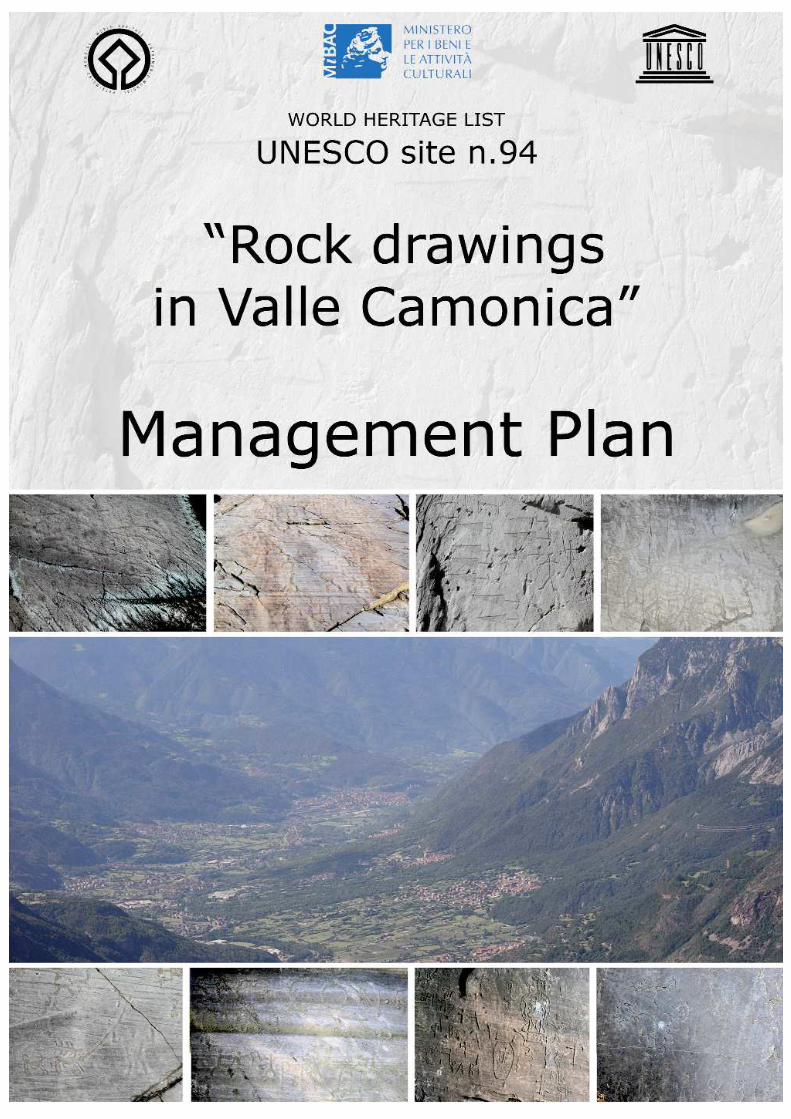
Management Plan of UNESCO Site n.94 “Rock Drawings in Valle Camonica”2005
2
Foreword
The request made by UNESCO to the Italian government to make the preparation ofManagement Plans obligatory for all World Heritage Sites listed before 2002 (inaccordance with the Convention concerning the Protection of the World Cultural andNatural Heritage, Paris 16th November 1972) necessitated the drafting of a Plan forSite N° 94 “Rock Drawings in Valcamonica”, the first Italian site to be recognised asWorld Cultural Heritage, in 1979.
In 2004, the Ministry of Cultural Heritage and Activities (Ministero per i Beni e leAttività Culturali) charged the Lombardy Soprintendenza for Archaeological Heritage(Soprintendenza per i Beni Archeologici della Lombardia) with the coordination ofwork to bring the UNESCO site into line with requirements and to draw up aManagement Plan, together with the local authorities.
During the first six months of 2004, the Soprintendenza conducted a preliminaryinvestigation and collected up-to-date information. Due to the incompleteness ofrecords regarding the heritage (the 1979 Act of Recognition did not include theboundary of the area or a complete list of individual localities), it was agreed withthe Ministry to first define the perimeters of Parks which were already established,or under development, and owned either by the state, local councils or the RegionalAuthority, namely:
-Parco Nazionale delle Incisioni Rupestri di Capo di Ponte -Parco Archeologico Nazionale dei Massi di Cemmo -Parco Comunale di Luine di Darfo-Boario Terme, contained within the Parco Localedi Interesse Sovracomunale del Lago Moro -Parco Archeologico Comunale di Seradina-Bedolina, in Capo di Ponte -Parco Comunale di Sellero -Parco Pluritematico “Coren de le Fate” di Sonico -Riserva Regionale delle Incisioni Rupestri di Ceto, Cimbergo e Paspardo The Park boundaries were mapped at various scales (IGM 1:25,000; CTR 1:10,000;1:2,000/1,000 land register) and Buffer Zones were established. In several cases,the latter had already been defined in Park Plans or in 1960s Landscape ProtectionOrders (on the basis of Law 1497/1939) around protected archaeological areas(Ministerial Decree 14.4.1967) in the municipalities of Capo di Ponte and Ceto.
In the second phase, begun in June 2004, work started on the preparation of theManagement Plan, following ministerial guidelines which were drawn up by the“Advisory Commission for UNESCO Site Management Plans and Local TouristSystems” and presented at the Second National Conference Italian UNESCO WorldHeritage Sites: Management Plans and Periodic Reports, held at Paestum 25th-26th
May 2004. The organization of this work and relative procedures were laid down in Memoranda115 (30th July) and 176 (21st December) “Drafting UNESCO Management Plans”,signed by the deputy-minister, Hon. Nicola Bono. It was stipulated that the Planswere to be finished by April 2005 if possible, and otherwise by the end of the year.The Research, Innovation and Organization Department of the Ministry for CulturalHeritage and Activities (Ministero per i Beni e le Attività Culturali - Dipartimento perla Ricerca, l’Innovazione e l’Organizzazione) provided technical and scientificassistance through the Permanent Working Party for the UNESCO World Heritage List(recently renamed Office for the UNESCO World Heritage List, Ufficio Lista delPatrimonio Mondiale dell’UNESCO), coordinated by Roberto Manuel Guido, whichorganized seminars and periodic meetings. It also established a consultancy group,coordinated by Felice Vertullo, which gave invaluable technical advice, first definingguidelines for the Plans, and then procedures for their development and a basic
Soprintendenza per i Beni Archeologici della Lombardia
Management Plan of UNESCO Site n.94 “Rock Drawings in Valle Camonica”2005
3

model in order to guarantee the uniformity of the operation, which involved morethan thirty Italian sites. We wish to express our gratitude to the Ministry for this help,which greatly facilitated the work.
The Management Plan requires collaboration between the authority responsible fortutelage and the local authorities concerned. In Valle Camonica, due to theimmensity of the area and variety of the heritage (over 180 rock art sites locatedin 24 valley municipalities), the preparation of the Plan regarded an elevatednumber of local authorities, all of which (given the limited time available) could nothave participated directly. It was therefore decided to select as representatives thelocal district authorities (above council level), with which the Soprintendenza hadalready negotiated projects and programme agreements concerning this archaeo-logical sector (and others), together with the local councils whose territoriescontained the Parks listed above.On 20th December 2004, a Declaration of Intent (Dichiarazione di Intenti: ENCLO-SURE 3) was signed by:
- Ministry of Cultural Heritage and Activities– Lombardy Soprintendenza forArchaeological Heritage (Ministero per i Beni e le Attività Culturali-Soprintendenzaper i Beni Archeologici della Lombardia), together with the Lombardy RegionalDirectorate of Cultural and Landscape Heritage (Direzione Regionale per i BeniCulturali e Paesaggistici della Lombardia);- Brescia Provincial Authority (Provincia di Brescia); - Valle Camonica Mountain Community (Comunità Montana di Valle Camonica);- Valle Camonica Drainage Basin Council Consortium (Consorzio Comuni del BacinoImbrifero Montano di Valle Camonica, BIM);- Darfo Boario Terme, Capo di Ponte, Sellero and Sonico Councils and the RockEngravings Consortium of Ceto, Cimbergo and Paspardo Councils.
Each of these bodies, in accordance with Art. 4 of the Declaration of Intent, nomi-nated a representative who was delegated to participate in the “Management PlanWorking Party”, which had the following principal aims:- protect and conserve Valle Camonica’s rock art heritage, listed by UNESCO as aWorld Heritage Site in 1979, with consideration for the archaeological and localcontexts to which it is closely tied;- promote and encourage greater knowledge of the Site, with coordinatedprogrammes of recording, research and study;- develop the Site in suitable ways, using appropriate methods, with constantattention to the integrity and nature of the heritage and its environmental andcultural context;- encourage its inclusion in the cultural tourism circuit and overall organization oftourism in the area;- operate so as to render these priorities compatible with the sustainable develop-ment of the valley, for which the rock art site constitutes a factor promoting eco-nomic and social growth.
After the Management Plan guidelines were decided with the bodies listed above,two separate advisory committees were established to assist the Working Party inthe preparation of documents regarding scientific research and educational matters.The Scientific Research Committee, composed of cultural and scientific organiza-tions specifically concerned with rock art in the valley and whose authoritative rolein the study of the engravings is generally recognised (Valcamonica Centre forPrehistoric Studies, Valcamonica and Lombardy Dept. - Centro Camuno di StudiPreistorici, Dipartimento Valcamonica e Lombardia; “Footprints of Man”Archaeological Cooperative - Cooperativa Archeologica “Le Orme dell’Uomo”; Capodi Ponte Teaching Museum of Prehistoric Art and Life - Museo Didattico d’Arte e Vita
Soprintendenza per i Beni Archeologici della Lombardia
Management Plan of UNESCO Site n.94 “Rock Drawings in Valle Camonica”2005
4

Preistorica di Capo di Ponte) and local bodies involved in the management of areasof landscape and environmental interest (Parco dell’Adamello).The Education Subcommittee, composed of organizations (in some cases, the sameas those cited in the previous paragraph) which provide education and informationservices regarding rock art “Footprints of Man” Archaeological Cooperative; Capo diPonte Teaching Museum of Prehistoric Art and Life, “Archeocamuni”, “Do.Net”, Capodi Ponte Tourist Office - Pro Loco di Capo di Ponte).The representatives of the bodies involved, together with the Techno-ScientificSecretariat, commissioned to work on the preparation of the Management Plan bythe Lombardy Soprintendenza for Archaeological Heritage (in the PrehistoricValcamonica Project - progetto Valcamonica preistorica, 2004 and 2005, funded inthe Ministry Triennial Programme 2004-2006), took part in periodic meetings, calledby the Soprintendenza and held in the Breno offices of the Valle Camonica MountainCommunity during the first six months of 2005. The Working Party discussed, modified, integrated and approved the text submittedby the Coordinator and the Techno-Scientific Secretariat, which also includedcontributions from the participating bodies and was transmitted to all involved forthe evaluation of additions, modifications and variations and periodical evaluation onthe part of the political directors of public authorities who were not directly involvedin the meetings. The Management Plan includes a Scientific and TechnologicalResearch Plan and Training and Publicity Plan drawn up jointly by the ScientificResearch Committee, Education Subcommittee, the Soprintendenza and the Techno-Scientific Secretariat. The text is, however, open to further improvements, additionsand changes, which will certainly be necessary in the future. In particular, in theproject design part of the Management Plan (Parts III and IV), some operationalPlans are presented in complete form, whilst others are only outlined and need to beworked out in detail by specific committees which will be set up for the purpose.Essentially, the aim of the Plan is to furnish technical principals and guidelines ofpractical use to the numerous parties involved with regard to safeguarding theheritage, and the cultural promotion and development of the Site; to be a flexibleinstrument that is able to remain relevant to evolving circumstances and managegrowth in an informed and reactive fashion.
A preview of the Site N° 94 “Rock Drawings in Valle Camonica” Management Planwas presented at the Third National Conference of Italian Sites in the UNESCO WorldHeritage List (Terza Conferenza Nazionale dei siti italiani iscritti nella Lista delPatrimonio Mondiale dell’UNESCO), entitled The Strategy for Managing ItalianUNESCO Sites (La strategia per la gestione dei siti italiani UNESCO) and held in Turin20th – 22th May 2005.On 8th July 2005, the Management Plan was adopted by the bodies which hadsigned the Declaration of Intent and participated in its preparation, and thuscontributed to this first concerted action for the protection, conservation anddevelopment of Valle Camonica’s rock art, which is certainly in itself a positive step,because it has led to the development of a common method of working andselecting operational strategies to guarantee the patrimony’s future. In subsequentdeliberations during summer and autumn 2005, the individual authorities formallyapproved the Management Plan in its final form (ENCLOSURE 31).
Soprintendenza per i Beni Archeologici della Lombardia
Management Plan of UNESCO Site n.94 “Rock Drawings in Valle Camonica”2005
5

Additional Information
UNESCO Site N° 94 “Rock Drawings in Valcamonica” Management PlanWorking Party
Ministry of Cultural Heritage and Activities– Lombardy Soprintendenza forArchaeological Heritage (Ministero per i Beni e le Attività Culturali-Soprintendenzaper i Beni Archeologici della Lombardia), together with the Lombardy RegionalDirectorate of Cultural and Landscape Heritage (Direzione Regionale per i BeniCulturali e Paesaggistici della Lombardia)Angelo Maria Ardovino, Elisabetta Roffia (Superintendents until 31st January 2005and from 1st February 2005 onwards, respectively)Raffaella Poggiani Keller (Coordinating Archaeological Director)
Brescia Provincial Authority (Provincia di Brescia)Aristide Peli (Director, Department of Territorial Innovation, Park and Protected AreasSection-Assessore Area Innovazione Territorio-Settore Assetto Territoriale Parchi eV.I.A.)Elena Tironi, Brescia Provincial Authority delegate (Department for TerritorialInnovation, Park and Protected Areas Section)Riccardo Minini (Director, Department of Economic and Social Development, TourismSection- Assessore Area Sviluppo economico e sociale-Settore Turismo)Sabrina Medaglia (Department of Economic and Social Development, TourismSection)Maddalena Stefini (Department of Economic and Social Development, TourismSection)
Valle Camonica Mountain Community (Comunità Montana di Valle Camonica) Giancarlo Maculotti (Director, Department of Culture)Sergio Cotti Piccinelli (Department of Culture and Territorial Development - ServizioCultura e Valorizzazione del territorio)
Valle Camonica Drainage Basin Council Consortium (Consorzio Comuni delBacino Imbrifero Montano di Valle Camonica, BIM) Francesco Manella (Councillor)
Darfo Boario Terme CouncilFrancesco Abondio (Mayor)Marco Dossena (President of the Lake Moro Inter-Municipal Park - Parco Locale diInteresse Sovracomunale del Lago Moro)
Capo di Ponte CouncilFrancesco Manella (Mayor)Giuseppe Composto (Councillor)
Sellero CouncilEzio Bartolomeo Laini (Mayor)Sonico CouncilRenata Pedrotti (Director, Department of Culture, Tourism, Accounts and TraditionalHandicrafts-Assessore alla Cultura, Turismo, Bilancio e Artigianato)
Consortium of Ceto, Cimbergo and Paspardo CouncilsBernardino Rizza (President)Tiziana Cittadini (Director of the Ceto, Cimbergo and Paspardo Regional RockEngraving Reserve-Riserva Regionale delle Incisioni Rupestri di Ceto, Cimbergo e
Soprintendenza per i Beni Archeologici della Lombardia
Management Plan of UNESCO Site n.94 “Rock Drawings in Valle Camonica”2005
6
Paspardo)Techno-Scientific SecretariatCarlo Liborio (Archaeological Cooperative Society - Società CooperativaArcheologica, SCA, Milan)Maria Giuseppina Ruggiero (Archaeological Cooperative Society, SCA, Milan)Sergio Cotti Piccinelli (Valle Camonica Mountain Community)
Technical SecretariatGian Claudio Vaira (Lombardy Soprintendenza for Archaeological Heritage)Tino Pacchieni (Lombardy Soprintendenza for Archaeological Heritage)
The following participated during the phase of negotiations between public authori-ties:Angelo Maria Ardovino (at the time, Superintendent for the Archaeological Heritageof Lombardy)Edoardo Mensi (President of the Valle Camonica Drainage Basin Council Consortium)Alessandro Bonomelli (President of the Valle Camonica Mountain Community)Cristina Ambrosini (Lombardy Regional Directorate of Cultural and LandscapeHeritage, Ministry of Cultural Heritage and Activities)
And during the final phase of agreement between public authorities:Elisabetta Roffia (Acting Superintendent for the Archaeological Heritage ofLombardy)
The following participated in work and debate:
Scientific Research CommitteeEmmanuel Anati (Valcamonica Centre for Prehistoric Studies-Centro Camuno di StudiPreistorici, CCSP)Tiziana Cittadini (Valcamonica Centre for Prehistoric Studies)Andrea Arcà (“Footprints of Man” Archaeological Cooperative-Cooperativa “Le Ormedell’Uomo”)Angelo Fossati (“Footprints of Man” Archaeological Cooperative-Cooperativa “LeOrme dell’Uomo”)Ausilio Priuli (Teaching Museum of Prehistoric Art and Life-Museo Didattico di Arte eVita Preistorica)Umberto Sansoni (Valcamonica and Lombardy Dept. of the CCSP)Silvana Gavaldo (Valcamonica and Lombardy Dept. of the CCSP) Vittorio Ducoli (Director of the Parco dell’Adamello)and Raffaella Poggiani Keller (Lombardy Soprintendenza for Archaeological Heritage)
Education SubcommitteeAngelo Fossati (“Footprints of Man” Archaeological Cooperative-Cooperativa “LeOrme dell’Uomo”)Alberto e Chiara Galbiati (“Archeocamuni”)Sergio Musatti (“Do.Net”, Museum of the Riserva Regionale delle Incisioni Rupestri diCeto, Cimbergo e Paspardo)Ausilio Priuli (Teaching Museum of Prehistoric Art and Life)Ilaria Zonta and assistants (Capo di Ponte Tourist Office-Associazione Pro Loco diCapo di Ponte)Raffaella Poggiani Keller (Lombardy Soprintendenza for Archaeological Heritage)with the collaboration of Serena Solano (Central Alpine Anthropological ResearchCentre-Centro Ricerche Antropologiche Alpi Centrali, CRAAC) and additionalassistance from Maria Giuseppina Ruggiero (Archaeological Cooperative Society,SCA, Milan)
Soprintendenza per i Beni Archeologici della Lombardia
Management Plan of UNESCO Site n.94 “Rock Drawings in Valle Camonica”2005
7
General CoordinationRaffaella Poggiani Keller (Lombardy Soprintendenza for Archaeological Heritage),with supervision by the Superintendents A. M. Ardovino and E. Roffia
Coordination with UNESCOManuel Roberto Guido (Ministry of Cultural Heritage and Activities, Department ofResearch, Innovation and Organization Office for the UNESCO World Heritage List-Dipartimento per la Ricerca, l’Innovazione e l’Organizzazione Ufficio Lista delPatrimonio Mondiale dell’UNESCO) with the collaboration of Angela Ferroni
Overall Coordination and Specialist Advice on Management PlansManagement Plan Committee - Commissione per i Piani di Gestione - of the Ministryof Cultural Heritage and Activities, directed by Deputy-Minister Hon. Nicola Bono andcoordinated by Felice Vertull with the collaboration of Anna Maria Trimarchi
Preparation and Editing of the TextRaffaella Poggiani Keller (Lombardy Soprintendenza for Archaeological Heritage)Carlo Liborio (Archaeological Cooperative Society, SCA, Milan)Maria Giuseppina Ruggiero (Archaeological Cooperative Society, SCA, Milan)
The following participated in the preparation of the text:Angelo Maria Ardovino, Ministry of Cultural Heritage and Activities – Department ofResearch, Innovation and Organization (Part III, Maintenance and ConservationPlan)
Tiziana Cittadini, Valcamonica Centre for Prehistoric Studies and Riserva Regionaledelle Incisioni Rupestri di Ceto, Cimbergo e Paspardo (Parts I and II: informationconcerning the Riserva Regionale delle Incisioni Rupestri di Ceto, Cimbergo ePaspardo and Valcamonica Centre for Prehistoric Studies and related activities)Sergio Cotti Piccinelli, Valle Camonica Mountain Community (Part IV. Accessibilityand Permeability Plan, 1. The Brescia-Iseo-Edolo Railway, a Strategic Means ofAccess…; Traditional Local Activities Plan)
Angelo Fossati, “Footprints of Man” Archaeological Cooperative (information con-cerning the cooperative and its activity)
Salvatore Lentini, Central Alpine Anthropological Research Centre, CRAAC (Part IV.Scientific and Technological Research Plan, 5. Project for Recording IntangibleHeritage)
Claudio Nodari, architect, Esine (ENCLOSURE 10. Capo di Ponte Planning Regulations- Norme tecniche di attuazione)
Ausilio Priuli, Teaching Museum of Prehistoric Art and Life (information concerningthe museum and its activities)
Cesare Ravazzi, CNR-IDPA (Part IV. Scientific and Technological Research Plan, 1.Palaeoenvironmental Research Project)
Umberto Sansoni and Silvana Gavaldo, Valcamonica and Lombardy Department ofthe CCSP (information concerning the dept. and its activities)
Maddalena Stefini, Brescia Provincial Authority – Tourism Section (Part IV. TerritorialMarketing Plan)
Elena Tironi, Brescia Provincial Authority – Parks and Protected Areas Section (Parte
Soprintendenza per i Beni Archeologici della Lombardia
Management Plan of UNESCO Site n.94 “Rock Drawings in Valle Camonica”2005
8

II. Natural and Environmental Resources; Part III. Recovery and Protection Plan, 1.Woodland Recovery Plan; Part IV. Training and Publicity Plan. 2. Course for OperatorsWho Maintain Green Areas…;)
Gian Claudio Vaira, Lombardy Soprintendenza for Archaeological Heritage (ENCLO-SURE 4. Register of Planning Regulations-Regesto della Strumentazione Urbanistica;ENCLOSURE 27. Manual of Good Practice-Manuale delle Buone Pratiche: Decalogoper la manutenzione delle rocce incise)
GIS MappingTino Pacchieni (Lombardy Soprintendenza for Archaeological Heritage) with the col-laboration of: Gian Claudio Vaira (Lombardy Soprintendenza for ArchaeologicalHeritage); Cartography Office of the Brescia Provincial Authority-Parks andProtected Areas Department; Tiziana Cittadini (Riserva Regionale delle IncisioniRupestri di Ceto, Cimbergo e Paspardo), for maps of the areas under herresponsibility, some still under development; Claudio Nodari (Architect, Esine),extension of the Capo di Ponte and Sellero General Regulatory Plans - PRG (inprogress); DonatoTaboni (Valle Camonica Drainage Basin Council Consortium,BIM); Technical Offices of Darfo-Boario Terme, Angolo Terme and Sonico Councils;Ausilio Priuli (Teaching Museum of Prehistoric Art and Life)
And specialist advice from: Paola Melis (architect, Milan)
Preparation of Maps, Graphics and Image Processing Carlo Liborio (Archaeological Cooperative Society, SCA, Milan)Maria Giuseppina Ruggiero (Archaeological Cooperative Society, SCA, Milan) withtechnical assistance from: Tino Pacchieni (Lombardy Soprintendenza forArchaeological Heritage) and specialist advice from: Thomas Scalera (LombardySoprintendenza for Archaeological Heritage)
IllustrationsLombardy Soprintendenza for Archaeological HeritageValcamonica Prehistoric Studies Centre, CCSPValcamonica and Lombardy Department of the CCSPTeaching Museum of Prehistoric Art and LifeSellero Council
SourcesBrescia Provincial Authority, Tourism Section for tourist statistics regarding thevalley and the provinceBrescia Provincial Authority, Cartography Office for digital maps in scale 1:50,000,CTR 1:10,000 and the vectorial Provincial Pathway PlanValle Camonica Drainage Basin Council Consortium for digital and vectorial maps invarious scales and aerial ortho-photographsValle Camonica Mountain Community for statistics and all available data concerningprojects and socio-economic studiesCapo di Ponte Council for planning regulations
English TranslationJim Bishop (Foreword; Index; Parts I, II, III, IV and V; general revision)Arkadia Translation, Milan (Parts I and II)Coordination: Maria Giuseppina Ruggiero (Archaeological Cooperative Society, SCA,Milan)
Soprintendenza per i Beni Archeologici della Lombardia
Management Plan of UNESCO Site n.94 “Rock Drawings in Valle Camonica”2005
9
CONTENTS
PART ONE The Plan’s General Context1. Definition of the Universal Meaning - p. 141.1 Reasons for the Listing1.2 The Engravings and their Archaeological Context1.2.1 A Brief History of Research1.2.2 Rock Art: Engraving Techniques and Chronology1.3 Cultural Value2. The Site’s Geographical Basis - p. 242.1 Boundaries and Composition2.2 Buffer Zones and Connecting Areas3. Description of the Promoting Parties - p. 303.1 Public Bodies3.2 Private Parties3.3 Agreements and Understandings4. Definition of the Managing Authority - p. 315. Programmes and Issues - p. 315.1 Town Planning and Territorial Coordination Regulations5.2 Sectorial and/or Integrated Plans5.3 Social and Economic Development Plans5.4 Specific Plans for the Tutelage of the Site
PART TWO Territorial Analysis6. Analysis of the Cultural Heritage - p. 406.1 Cultural Heritage, Museums, Environment, Archaeology, Art, History andBuildings6.2 Material Culture: Handicrafts, Traditional Local Products and Natural Resources6.3 Intangible Culture: Events, Cultural Production and Traditions6.4 The State of Conservation of the Cultural Heritage
The State of Conservation of the Rock Art HeritageThe Archaeological, Historical and Artistic Heritage
7. Resource Analysis - p. 657.1 Regular Funding for Conservation Work- Parco Nazionale delle Incisioni Rupestri and Parco Archeologico Nazionale dei Massidi Cemmo, Capo di Ponte - Riserva Regionale delle Incisioni Rupestri di Ceto, Cimbergo e Paspardo- Parco Comunale di Luine, Darfo Boario Terme- Parco Archeologico Comunale di Seradina-Bedolina, Capo di Ponte- Parco Comunale di Sellero- Parco pluritematico del “Còren de le Fate”, Sonico
7.2 Natural and Environmental Resources7.3 Intangible Culture: Events, Cultural Production and Traditions7.4 Organizational and Intellectual Resources8. Analysis of Risks and Limitations - p. 778.1 Public Access to the Heritage
Road and Rail Access to the Valley and its HeritageAccess to, and Appreciation of, Parks with Rock Engravings
8.2 Indicators and the Risk Factor System General Risk Factors Which Affect the Environmental ContextSpecial Risk Factors Determined by the Cultural Context
8.3 Pressure and Cause/Effect Indicators8.4 Risk, Tutelage and Protection Map
Soprintendenza per i Beni Archeologici della Lombardia
Management Plan of UNESCO Site n.94 “Rock Drawings in Valle Camonica”2005
10

Risk Analysis and StudiesConservation Work
8.5 Administration, Regulation and Interference Indicators8.6 Historical Qualities to be Passed On to Future Generations9. Social and Economic Analysis - p. 889.1 Demographic Indicators9.2 Employment Indicators9.3 Types of Productive Activity9.4 Tourism and Related Activities9.5 Cultural Activities9.6 Expectations and Intentions of the Interested Parties
PART THREE Tutelage and Conservation10.1 Plan for the Improvement of Facilities - p. 981.1-Completion of the Legal Establishment Procedures Regarding the Parks1.2-Improvement of Display and Information Facilities1.3-Survey of the Preservation State of the Rock Art Heritage Inside the Rock ArtParks 2- Plan for the Establishment of the National Valle Camonica Prehistory Museum inCapo di Ponte3- Plan for the Development of Prehistoric and Proto-historic Archaeological Sites4- Plan for Mapping, Recording and Developing Additional Valle Camonica Rock ArtSites Not Included in the Rock Art Parks
4.1- Plan for the Addition of Sites Outside the Existing Rock Art Parks to the GISRecords4.2- Plan for the Recording of Sites Outside the Existing Rock Art Parks4.3- Plan for the Development of Sites Outside the Existing Rock Art Parks
5- Historic Way Network Plan6- Valley Floor Renewal Plan 10.2 Maintenance and Conservation Plan - p. 11810.3 Recovery and Protection Plan - p. 1231- Plan for the Recovery of Woodlands and the Rock Art Parks’ NaturalEnvironment in General2- Plan for Protection within the Rock Art Parks (Boundary Fences, Rock ProtectionFences, Walkways, Covers…)10.4 Plan for the Modification of Regulations and Planning Rules - p. 124
PART FOUR Model for Local Cultural Development11.1 Scientific and Technological Research Plan - p. 127Introduction to the Current State of Research1- Palaeoenvironmental Research Project2- Plan for Research into Valle Camonica’s Rock Art3- Plan for Research in Valle Camonica’s Prehistoric and Proto-historicArchaeological Sites4- Plan for the Study of the History of Rock Art Research; Analysis and Study ofHistorical Archives5- Project for Recording Intangible Heritage6- Specialist Publications7- Conference and Cultural Event Plan8- Environmental Monitoring Plan11.2 Local Community Involvement Plan - p. 1391- Projects for Involving Schools and Universities2- Projects for Spreading Knowledge about the World Heritage Site “Rock Drawingsin Valcamonica”3- Publicizing the Management Plan
Soprintendenza per i Beni Archeologici della Lombardia
Management Plan of UNESCO Site n.94 “Rock Drawings in Valle Camonica”2005
11
4- Other Proposals11.3 Accessibility and Permeability Plan- p. 1421- The Brescia-Iseo-Edolo Railway, a Strategic Means of Access to the Rock ArtHeritage2- Signs for Tourists on Valle Camonica’s Roads11.4 Training and Publicity Plan- p. 145Professional Training
Training Course for Technical Personnel Specialized in Field Survey and DigitalGraphics Related to the Conservation of the Lithic Archaeological Heritage, andin Particular to Rock EngravingsCourse for Operators who Maintain Green Areas in Territories Covered by theUNESCO Site N° 94 “Rock Drawings in Valcamonica” Management Plan
Course for Artisans Specialized in Traditional Valley CraftsTraining and Refresher Course for EducatorsCourse for Tourism WorkersTraining Course for Tourism Promoters Who Attract Tourists to Valle Camonica
Spreading AwarenessClientsProvision of ServicesNumber of Personnel Involved in Education and Training ActivitiesThe Publishing of Educational and Information Material
Education and Information Plans1. Professional Qualifications for Education Personnel in the UNESCO Site N° 94“Rock Drawings in Valcamonica”2. Establishment of Reception and Education Centres in Rock Art Parks3. Improvement of Educational Facilities in Rock Art Parks4. Client Opinions Concerning Rock Art Parks5. Educational Projects for Schoolchildren and Young People Resident in ValleCamonica6. Educational Projects for Schoolchildren and Young People Not Resident in ValleCamonica7. Training Courses for Teachers8. Pre-school Visitors9. Information for Adults10. Information for the Disabled11. Information for Visitors from Abroad12. Publishing11.5 Plan for the Reception of Cultural Tourism- p. 15911.6 Traditional Local Activities Plan- p. 16111.7 Cultural Events and Activities Plan- p. 16211.8 Territorial Marketing Plan- p. 163ObjectivesPromotion11.9 Plan of Actions- p. 169
PART FIVE Control and Monitoring of the Management Plan 12. Introduction- p. 17012.1 Control of Maintenance and Conservation Work12.2 Control of Recovery Work12.3 Control of Preventative Measures12.4 Control of Measures Regarding Tutelage12.5 Control of Activities of Transformation 12.6 Control of Protective Measures12.7 Control of Development Activities12.8 Monitoring Sources of Pollution
Soprintendenza per i Beni Archeologici della Lombardia
Management Plan of UNESCO Site n.94 “Rock Drawings in Valle Camonica”2005
12

12.9 Control and Monitoring of Tourism and Human Impact12.10 Control and Monitoring of Resident Consensus
Soprintendenza per i Beni Archeologici della Lombardia
Management Plan of UNESCO Site n.94 “Rock Drawings in Valle Camonica”2005
13
PART ONEThe Plan’s General Context
1. Definition of the Universal Meaning
1.1 Reasons for the Listing Valle Camonica (the “Camonica Valley”), located in northeast Lombardy and one ofItaly’s most extensive valleys (Figs. 1-2), is characterised by the world’s richest her-itage of rock engravings.
In 1979, Valle Camonica and its rock engravings became the first Italian site to beincluded in the UNESCO World Heritage List, for both the rarity of the phenomenonand the important scientific contribution made by the study of this rich heritage ofengravings to our knowledge of man’s prehistory.The proposal’s precise origin is unknown. It grew through contacts and scientificrelations between institutions with no special formalization, as can clearly be seenfrom the Proposition d’Inscription presented on January 24th, 1979 by the LombardyRegional Authority’s Culture Department (Assessore alla Cultura della RegioneLombardia) (UNESCO note Prot. N° 94 dated March 21st 1979) and the scientificsupport of the “Centre for Prehistoric Studies, Valcamonica, Italy” (Centro Camunodi Studi Preistorici) in Capo di Ponte. Since the 1950s the institution had identifiedhundreds of engraved rocks; the historical, cultural and economic circumstances ofthe people who had produced them were reconstructed by the discovery of their linksand contacts with main human groups present in Europe. The listing application wasaccepted because of the remarkable continuity through time of these artistic expres-sions and their similarities to other known European examples.
At the time the institution charged with the tutelage of archaeological heritage(Soprintendenza for Archaeological Heritage of Lombardy-Soprintendenza per i BeniArcheologici della Lombardia), was responsible both for the sites themselves (somewere state property and were directly managed by the same), and for archaeologi-cal research that was conducted both directly and in collaboration (through authori-zations and concessions) with the “Centre for Prehistoric Studies, Valcamonica, Italy”(Centro Camuno di Studi Preistorici), which was not involved in the initiative.The documents demonstrate that the bureaucratic procedure was brief (see ENCLO-SURE 1):- January 24th 1979: the Lombardy Regional Authority Culture Department(Assessorato alla Cultura della Regione Lombardia) presented the application. Theproposal was supported by the “Centre for Prehistoric Studies, Valcamonica, Italy”(Centro Camuno di Studi Preistorici), which was inaccurately defined as the institu-tion in charge of the protection and conservation of the heritage.- March 21st 1979: UNESCO received the application and listed the site, following aconsecutive number sequence, as N° 94.- March 29th 1979: ICOMOS (International Council of Monuments and Sites)conveyed a note to UNESCO stating the documentation complete and adequate forVal Camonica’’s application.- April 10th 1979: ICOMOS informed UNESCO of the need to “add to the file a spe-cially drafted paper for registration as international heritage, defining and specifyingthe areas concerned”.- October 22nd-26th 1979: Val Camonica’s WHL candidacy was presented at theThird Session of the Convention Concerning Protection of the World Cultural andNatural Heritage held in Cairo and Luxor.
Soprintendenza per i Beni Archeologici della Lombardia
Management Plan of UNESCO Site n.94 “Rock Drawings in Valle Camonica”2005
14
The site was registered in 1979 on the basis of Criteria III and VI, as may be readin the ICOMOS report (Registration Proposal dated April 10th 1979). The definitionsof the two criteria cited in UNESCO’s general specifications and ICOMOS’ specificreasons for Val Camonica’s listing are quoted below:
- ICOMOS, Criterion III (English): “The rock engravings of Val Camonica stretchback over the 8 thousand years which precede our present era. It is unnecessaryto accent the conspicuously invaluable nature of human renderings which are of sogreat an antiquity.- ICOMOS, Criterio III (francese): “Les gravures rupestres de Val Camonicas’echelonnent dans le temps sur les 8 millénaires qui ont précédé notre ère. Il n’estpas besoin d’insister sur le caratctère éminemment précieux de manifestationshumaines remontant à une si haute antiquité”.- ICOMOS, Criterion VI (English): “The rock engravings of Val Camonica constitutean extraordinary figurative documentation of prehistoric customs and mentality.The systematic interpretation, topological classification, and the chronological studyof these configurations in stone have brought about a considerable contribution tothe fields of prehistory, sociology and ethnology”.- ICOMOS, Criterio VI (francese): “Les gravures rupestres de Val Camonica con-stituent une extraordinarie documentation figurée sur les moeurs et les mentalitéspréhistoriques. Le déchiffrage , le classement typologique et l’étude chronologiquesystématique de ces petroglyphes aboutit à un apport considérable dans lesdomaines de la préhistoire, de la sociologie et de l’ethnologie”.
The WHL’s recognition of the site thus confirmed in 1979 the international impor-tance of Valle Camonica’s rock engraving heritage.
The preparation of the Site Management Plan provides an opportunity for reflectingupon and analysing the need to involve the various institutions present in the valleyin a synergic process to make compatible with the territory’s integrated developmentthe unquestioned need for protection, conservation and development of the heritage.
1.2 The Engravings and Their Archaeological Context
1.2.1 A Brief History of ResearchIn 1914 Gualtiero Laeng, following up a note published in 1909 (LAENG G. 1909,Scheda di segnalazione al Comitato Nazionale per la protezione del paesaggio e deimonumenti, Touring Club Italiano), described for the first time to the general publicthe engravings present on the two boulders of Cemmo in the Guida d’Italia delTouring Club Italiano: Piemonte, Lombardia e Canton Ticino, Milan, Touring ClubItaliano, p. 595 (Figs. 3-4). The news caught the interest of other scholars, whocame to the valley to see for themselves these manifestations of prehistoric art (seethe Bibliography).In the 1920s and ’30s, the search was extended to other localities in Valle Camonicaby Giovanni Marro, Paolo Graziosi, Raffaello Battaglia and Giuseppe Bonafini. Thelatter was one of the first to propose the creation of an archaeological area (BONAFI-NI G. 1932, Il Parco Nazionale Preistorico di Valcamonica, Brescia, 11/Dicembre,Brescia, pp. 24-30) (Figs. 5-6).During the ’30s Valle Camonica (along with other sites) stimulated the interest ofthe Third Reich in its attempt to legitimize the idea of an Aryan Race, and the rockengravings of the ancient Camuni attracted the attention of Franz Altheim,Professor of Ancient History at the University of Berlin and enthusiastic supporter ofracist theories (ALTHEIM; TRAUTMANN, in Bibliography).
Soprintendenza per i Beni Archeologici della Lombardia
Management Plan of UNESCO Site n.94 “Rock Drawings in Valle Camonica”2005
15
After the interruption of the Second World War, research was continued in the ’50sby Hercli Bertogg (director of the Coira Museum, Switzerland: BERTOGG 1952, 1956,1967) and local scholars such as Gualtiero Laeng and Emanuele Süss (see theBibliography), who worked for the Museo di Scienze Naturali di Brescia (BresciaNatural Science Museum).Süss was commissioned by the Ancient Monuments Superintendent(Soprintendente alle Antichità), Mario Mirabella Roberti, to produce the firstdistribution map of engraved rocks in the Naquane area (SÜSS 1956 a, b), aprerequisite for the establishment in 1955 of the Rock Engravings National Park(Parco Nazionale delle Incisioni Rupestri). This was the occasion of an importantcollaboration between the Municipality of Capo di Ponte and the administration ofthe Provincial Authority of Brescia (Provincia di Brescia), which purchased the landand donated it to the State (transaction dated 20th August 1963, ratified by DPRon 26th October 1967, N° 1358 – ENCLOSURE 2) (Fig. 5).A fresh and decisive impetus to the research was given by the arrival in 1956 ofEmmanuel Anati, who came to compare the Valle Camonica rock art with that ofMount Bego in the French Maritime Alps and settled in Capo di Ponte, where in 1964he founded the “Centre for Prehistoric Studies, Valcamonica, Italy” (Centro Camunodi Studi Preistorici).His group launched systematic field campaigns to record the engraved rocks, usinga method of drawing by direct contact and in some cases employing the casein-car-bon black technique to render the engravings more readily visible (Il trattamentodelle rocce istoriate in ANATI 1982, pp. 65-66 and Fig. 47). In the ’60s Anati, in addition to his rock art studies, conducted archaeological exca-vations (under concession from the Lombardy Archaeological Superintendency(Soprintendenza alle Antichità della Lombardia) at Luine, in the Municipality of DarfoBoario Terme (ANATI 1982 c) and at Capo di Ponte, in the Massi di Cemmo (ANATI1967 b) and Dos de l’Arca localities (ANATI 1979 b, passim). In the latter site afortified Bronze and Iron Age settlement was found, together with several engravedrocks (Figs. 7-10).The “Centre for Prehistoric Studies, Valcamonica, Italy” (Centro Camuno di StudiPreistorici), and its Valle Camonica and Lombardy Department (DipartimentoValcamonica e Lombardia-CCSP), founded in 1987 as a section of the CCSP, haveremained active up to the present, with annual rock art research campaigns drawnup on a yearly basis in collaboration with the Soprintendenza for ArchaeologicalHeritage of Lombardy (Soprintendenza per i Beni Archeologici della Lombardia), withwhom the Centre has stipulated in 1994 a five-year agreement.Research on sites with rock carvings has also been carried since the 1970s by A.Priuli of the Didactic Museum for Prehistoric Art and Life (Museo didattico Arte e Vitapreistorica) at Capo di Ponte and from 1988 by the Footsteps of Man ArchaeologicalSociety (Cooperativa Archeologica “Le Orme dell’Uomo”). Various study groups conduct territorial searches throughout Valle Camonica andevery year report the discovery of new rock art sites.To date, more than 180 engraved rock localities have been discovered, scatteredthrough the lower, mid and (to a lesser extent) upper valley. Sometimes these aregrouped together, or situated near long-inhabited settlement sites, such as at Luine(Darfo-Boario Terme) and Dos de l’Arca (Capo di Ponte). A summary of work on rock art sites is given in the table enclosured (ENCLOSURE28), which lists the research and excavations carried out at each locality by thevarious institutions and study groups active in Valle Camonica. A comparison of the List of Rock Art Sites (infra) with the Table of Research Activitiesgives a picture of the current state of research.
The rock engravings were executed from the late Palaeolithic until the Iron Age, withsporadic persistence during the Roman and Medieval periods and later.Contemporary settlement throughout these epochs was widespread in Valle
Soprintendenza per i Beni Archeologici della Lombardia
Management Plan of UNESCO Site n.94 “Rock Drawings in Valle Camonica”2005
16
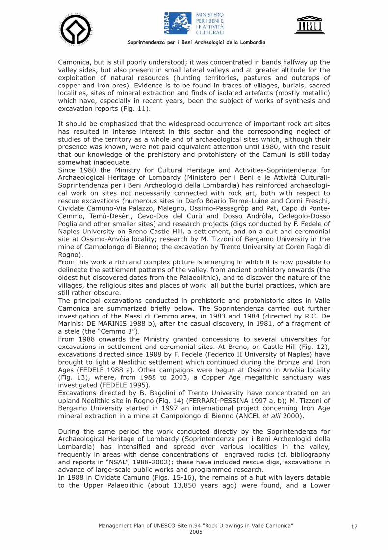
Camonica, but is still poorly understood; it was concentrated in bands halfway up thevalley sides, but also present in small lateral valleys and at greater altitude for theexploitation of natural resources (hunting territories, pastures and outcrops ofcopper and iron ores). Evidence is to be found in traces of villages, burials, sacredlocalities, sites of mineral extraction and finds of isolated artefacts (mostly metallic)which have, especially in recent years, been the subject of works of synthesis andexcavation reports (Fig. 11).
It should be emphasized that the widespread occurrence of important rock art siteshas resulted in intense interest in this sector and the corresponding neglect ofstudies of the territory as a whole and of archaeological sites which, although theirpresence was known, were not paid equivalent attention until 1980, with the resultthat our knowledge of the prehistory and protohistory of the Camuni is still todaysomewhat inadequate. Since 1980 the Ministry for Cultural Heritage and Activities-Soprintendenza forArchaeological Heritage of Lombardy (Ministero per i Beni e le Attività Culturali-Soprintendenza per i Beni Archeologici della Lombardia) has reinforced archaeologi-cal work on sites not necessarily connected with rock art, both with respect torescue excavations (numerous sites in Darfo Boario Terme-Luine and Corni Freschi,Cividate Camuno-Via Palazzo, Malegno, Ossimo-Passagròp and Pat, Capo di Ponte-Cemmo, Temù-Desèrt, Cevo-Dos del Curù and Dosso Andròla, Cedegolo-DossoPoglia and other smaller sites) and research projects (digs conducted by F. Fedele ofNaples University on Breno Castle Hill, a settlement, and on a cult and ceremonialsite at Ossimo-Anvòia locality; research by M. Tizzoni of Bergamo University in themine of Campolongo di Bienno; the excavation by Trento University at Coren Pagà diRogno).From this work a rich and complex picture is emerging in which it is now possible todelineate the settlement patterns of the valley, from ancient prehistory onwards (theoldest hut discovered dates from the Palaeolithic), and to discover the nature of thevillages, the religious sites and places of work; all but the burial practices, which arestill rather obscure. The principal excavations conducted in prehistoric and protohistoric sites in ValleCamonica are summarized briefly below. The Soprintendenza carried out furtherinvestigation of the Massi di Cemmo area, in 1983 and 1984 (directed by R.C. DeMarinis: DE MARINIS 1988 b), after the casual discovery, in 1981, of a fragment ofa stele (the “Cemmo 3”). From 1988 onwards the Ministry granted concessions to several universities forexcavations in settlement and ceremonial sites. At Breno, on Castle Hill (Fig. 12),excavations directed since 1988 by F. Fedele (Federico II University of Naples) havebrought to light a Neolithic settlement which continued during the Bronze and IronAges (FEDELE 1988 a). Other campaigns were begun at Ossimo in Anvòia locality(Fig. 13), where, from 1988 to 2003, a Copper Age megalithic sanctuary wasinvestigated (FEDELE 1995).Excavations directed by B. Bagolini of Trento University have concentrated on anupland Neolithic site in Rogno (Fig. 14) (FERRARI-PESSINA 1997 a, b); M. Tizzoni ofBergamo University started in 1997 an international project concerning Iron Agemineral extraction in a mine at Campolongo di Bienno (ANCEL et alii 2000).
During the same period the work conducted directly by the Soprintendenza forArchaeological Heritage of Lombardy (Soprintendenza per i Beni Archeologici dellaLombardia) has intensified and spread over various localities in the valley,frequently in areas with dense concentrations of engraved rocks (cf. bibliographyand reports in “NSAL”, 1988-2002); these have included rescue digs, excavations inadvance of large-scale public works and programmed research. In 1988 in Cividate Camuno (Figs. 15-16), the remains of a hut with layers datableto the Upper Palaeolithic (about 13,850 years ago) were found, and a Lower
Soprintendenza per i Beni Archeologici della Lombardia
Management Plan of UNESCO Site n.94 “Rock Drawings in Valle Camonica”2005
17
Mesolithic (late 9th millennium BC) occupation deposit. These constitute the oldestevidence of human presence in Valle Camonica (POGGIANI KELLER 1999 c); in thesame site during the Middle and Late Neolithic was founded a village with hut on awooden platform.Other important discoveries (starting from the lower valley) were the Neolithic andEneolithic settlements in the Parco di Luine, Darfo Boario Terme (1999-2000); in1993 at Ossimo, in Passagròp locality, a site with Copper Age steles and menhir-boulders was brought to light; since 1995 at Ossimo, in Pat locality (Figs. 17-18),the Soprintendenza has been excavating a Copper Age ceremonial area withmegalithic burials, near to which a Camunni settlement existed in the Iron Age(POGGIANI KELLER 1999 d, 2004 a, b, d). At Cemmo, after an excavation in 1995 in which a small stele fragment (Cemmo 5)was found, new important remains were found in 2000 during preparatory work forthe establishment of the Parco Archeologico Nazionale dei Massi di Cemmo (Figs. 19-21). The Soprintendenza programmed a series of excavation campaigns, still underway, which brought to light the remains of a megalithic sanctuary founded in theCopper Age and used until the late Roman/Early Medieval period (POGGIANI KELLER2000 a).Traces of prehistoric occupation were found in 1999 inside the Parco Nazionale delleIncisioni Rupestri, in the I Verdi locality (near Rock 33) and in Baitello del Pedù(NSAL 1999-2000).In Upper Valle Camonica, where only sporadic finds were known, the remains of adwelling datable to the late 6th/5th century BC constitute a particularly importantdiscovery; they were excavated by the Soprintendenza in Desèrt locality, Temùduring 2000 (POGGIANI KELLER 2001 a). In 2004 the traces of a middle Iron Age mining settlement, associated with a longinscription in the North-Etruscan alphabet and rocks engraved with cup-shapeddepressions, were investigated at Cevo at an altitude of 2000 m (Figs. 22-24). Inaddition, a dig in Malegno town centre uncovered a village founded in the LateNeolithic and occupied until the middle Iron Age, when a metallurgical workshop forbronze was present.
1.2.2 Rock Art: Engraving Techniques and Chronology
IntroductionThe Valle Camonica rock art constitutes the most important assemblage of this kindof manifestation of human thought in the world. The valley’s rock art heritage,composed of over 140,000 engraved figures, distributed on about 2,400 rocks, is anextraordinary expression of human creativity over the millennia, for a total of over8,000 years, from the epi-Palaeolithic until the Roman and Medieval periods. The number, chronological distribution and variety of the carvings determine theexceptional value of this site.
Engraving techniquesThe carvings were performed on rocks which may be classified as Upper Permiansandstones and conglomerates. They are hard and composed largely of quartz; theerosive effect of the passage of Quaternary glaciers has been to smooth the surfaceof the outcrops. On these rocks the ancient inhabitants of the valley executedengravings which depict aspects of their everyday lives (especially hunting andagricultural scenes) and spiritual lives (divinity figures, cult scenes, ritual practicese.g. dances and initiation rites).
The majority of the engravings were executed using a “hammer” technique in which
Soprintendenza per i Beni Archeologici della Lombardia
Management Plan of UNESCO Site n.94 “Rock Drawings in Valle Camonica”2005
18
the rock surface was subjected to repeated blows with a stone or metal tool, thuscreating small circular concavities. Figures may be portrayed by hammered outlinesonly, or the internal areas may be completely infilled by hammering (Figs. 25-26).Another technique used is that known as “filiform” or “graffito” in which the rocksurface was cut with a pointed instrument, leaving a groove (Figs. 27-28). It is notuncommon to find, amongst the vast assemblage of Valle Camonica rock art, figureswhich have been created using both methods; in these cases the filiform techniquewas used to add detail to the works (Fig. 29).
Chronology The first comprehensive typological and chronological study of the valley’s rock art,based on an analysis of the style, content and superpositions of thousands ofcarvings, was made by Emmanuel Anati, who in 1964 founded the “Centre forPrehistoric Studies, Valcamonica, Italy” (Centro Camuno di Studi Preistorici). In Evoluzione e stile nell’arte rupestre camuna, published in 1975, Anati classifiedthe rock art into four main stylistic groups which correspond to the prehistoricperiod (from the epi-Palaeolithic to the Bronze Age: Styles I-III), distinguished byschematic portrayals of figures in isolation or in symbolic groups (weapons and otherartefacts), and the protohistoric (Iron Age: Style IV), which is characterized by anaturalistic and narrative art with figures in movement and illustrations of events(Fig. 30). The engravings of the latter period may be attributed to the Camunni people (theLatin name of the Camuni), which are referred to by historical sources as the Retic(Strabo) or Euganeic peoples (Pliny).This chronological system is still held to be valid, but over the last fifteen years hasbeen subjected to partial revision on the basis of recent research and the importantnew discoveries which have been made in the valley.
Rock art chronologyAfter the end of the last glaciation, the climate, vegetation and fauna of the Alpineregions underwent a process of gradual change, affecting and profoundly altering thelives of the human populations. The economy of the hunting groups continued to be essentially predatory; due to thespread of the use of the bow and arrow, middle and large-sized animals werehunted, such as roe and other deer (still present in Valle Camonica) and elk. Othermeans of obtaining food were fishing and gathering wild fruits. The oldest evidence of the presence of humans in the valley dates from the UpperPalaeolithic, followed by the Mesolithic; an Upper Palaeolithic hut (radiocarbon dateGX-17274/1991: 13,805±440 B.P.) and a Lower Mesolithic bivouac (radiocarbondate GX-18843 AMS/1993: 8,820±112 B.P.), were excavated in Cividate Camuno(POGGIANI KELLER 1990; 1996; 1999). Other finds of these periods were made atBreno Castle (Upper Paleolithic: FEDELE 1988 a) and at “Rockshelter 2” in Foppe diNadro (Mesolithic: ZANETTIN 1983). A system of seasonal upland bivouacs has beenidentified on the mountains which divide Valle Camonica and Valtrompia (BIAGI1989; 1994; 1997).Rock engravings attributed by scholars (especially ANATI 1982 b, pp. 139-153) tothis period are to be found in the Darfo-Boario Terme area, on rocks in Luine (ANATI1982 c): these are depictions, often large in size, of big animals such as elk, piercedby hunting weapons (Fig. 31). The figures were outlined with irregular hammer blows produced by heavy stonetools, some of which were recovered at the base of the carved rocks.
In the Neolithic (5th – 4th millennium BC) the economy changed from one ofsubsistence to one of production, due to the introduction of agriculture and animalrearing. Other important innovations were ground stone tools, pottery, spinning,weaving and, in the Late Neolithic, the introduction of the plough.
Soprintendenza per i Beni Archeologici della Lombardia
Management Plan of UNESCO Site n.94 “Rock Drawings in Valle Camonica”2005
19

Although in Valle Camonica there are numerous Late Neolithic archaeological sites –in fact at this time villages were founded which remained in use until the Iron Age(Lovere, Luine in Darfo B.T., Cividate Camuno, Malegno, Breno and Dos de l’Arca inCapo di Ponte: POGGIANI KELLER 2003; 2004 b) – it is difficult to indicate featureswhich distinguish the rock engravings of the period (despite past attempts: ANATI1982 b, pp. 154-185). The characteristic figures of the epoch are the schematic “orants”, with symmetricallegs and arms bent at right angles; these carvings have been variously interpretedas people at prayer, in lamentation or dancing (Fig. 32). Several geometrical designs, considered to represent landscape features (cultivatedfields), are dated to the end of the Neolithic or the beginning of the Copper Age (Figs.33, 35). The conclusions of the rock art scholars (ANATI 1982 b; ARCÀ 1999 a, b, c)are confirmed by recent finds in the ongoing excavations of the Ossimo-Patmegalithic sanctuary: Fig. 34 (POGGIANI KELLER 1996 b; 1999 d; 2002 a, f; 2004a, b, d).
During the Copper Age (mid 4th – 3rd millennium BC) the search for and workingof metal and other important technological and cultural innovations, represented bythe introduction of the cart and the spread of the plough, led to expansion into newterritories, increased settlement density determined by the exploitation of resourcesand the control of access routes, the development of agriculture and thestrengthening of long-distance contacts. Alongside the tools made from flaked andground stone, axes, daggers and halberds came into use with the spread of copperproduction.The rock art of this period is typified by steles and menhir-boulders engraved withsymbolic and naturalistic figures, erected in cult and ceremonial localities, whichwere sometimes associated with primary or secondary burials. This phenomenon isknown from all of Europe, from the Atlantic coast and the Iberian peninsula to theUcraine, and dates from the Neolithic to the Bronze Age. It is found in the Alpsduring the Copper Age in an area which extends from Valle d’Aosta to Trentino/AltoAdige, with localized concentrations (in Valle d’Aosta, Vallese, Valcamonica,Valtellina, Trentino and Alto Adige). In Italy such monumental compositions alsooccur in Lunigiana, in the Appennines (Fig. 36).
In Valle Camonica from the Late Neolithic (1st half 4th millennium BC) onwards,long-lasting settlements were founded, which controlled key points along the RiverOglio valley floor, where mountain paths branched off. Over the course of the nextfew centuries, during the Copper Age (2nd half 4th and 3rd millennia BC), strikingand singular monumental religious-ceremonial complexes were constructed (Fig.37). These megalithic cult and ceremonial sites contain engraved rocks, mostlymenhir-boulders made from glacial erratics, with a lesser number of steles. Theyare positioned both along the Oglio (at Corni Freschi, Darfo-Boario; at Cemmo andCedegolo-Campolongo) and in more internal areas crossed by the route whichconnected Valcamonica and Val di Scalve, on the Ossimo-Borno upland (Map, nos.10-16).
In Valle Camonica (and in neighbouring Valtellina) this phenomenon is particularlyevident, unusual and clearly allied to the exceptionally abundant manifestations ofrock art present in the same area. After ten years of excavation, it is evident thatthis distribution of numerous cult and ceremonial sites, sanctuaries distinguished byengraved monoliths, constitutes a novel and distinctive aspect of the rock art of ValleCamonica, which is thus also one of the parts of Europe with the greatest density ofChalcolithic monumental sites. There are over seventy engraved monoliths (stelesand menhir-boulders) distributed between sixteen separate localities (Corni Freschiin Darfo-Boario Terme; Piancogno-Dassine; Ossimo-Pat (Figs. 38-40), Passagròp,L’Anvòia, Asinino, Via S. Carlo; Ossimo Inferiore-case Zendra and Feriti, Via S.
Soprintendenza per i Beni Archeologici della Lombardia
Management Plan of UNESCO Site n.94 “Rock Drawings in Valle Camonica”2005
20

Rocco; Borno-Valzel de Undine, Lazzaretto, Centro; Malegno-Ceresolo; Capo diPonte-Cemmo (Figs. 41-42); Cedegolo-Campolongo; Ceto-Foppe di Nadro). A careful evaluation of the circumstances of these finds suggests that eleven of thelocations correspond to the original monument sites (POGGIANI KELLER 2004 a, b,d, c.s.).In four of them excavations have been carried out, of which three (still under way)by the Soprintendenza for Archaeological Heritage of Lombardy (Soprintendenza peri Beni Archeologici della Lombardia): at Ossimo, in Passagròp (FEDELE 1990 f; POG-GIANI KELLER 1996 b; 1999 d) and Pat localities (POGGIANI KELLER 1996 a; 1999d; 2002 a, f; 2004 a, b, d; c.s.), and at Cemmo in Capo di Ponte (POGGIANI KELLER2000 a; 2002 c). The fourth was recently concluded at Ossimo-l’Anvòia locality(directed by prof. F. Fedele of the Federico II University of Naples under concessionfrom the Ministero per i Beni e le Attività Culturali: FEDELE 1990 f; 1995). Thesesites, together with others that may be hypothesized on the basis of chancediscoveries of one or more engraved monuments, have a special significance in thelandscape of the valley (as in that of nearby Valtellina) and constitute an expressionand consequence of the density of occupation, extending from the valley floor to highaltitudes, which developed from the Late Neolithic onwards, an enduring anddemonstrated possession of the territory.These open-air sanctuaries were monumental and visible from various directions, bymeans of ad hoc visual corridors created by the clearance of extensive portions ofwoodland (Fig. 43), and contained engraved monoliths of various sizes (those knownat present range from 1.95m to 0.5m in height). They formed long-lastingterritorial markers, as Colin Renfrew has observed for other parts of Europe (REN-FREW C. 1984, L’archeologie sociale des monuments mégalithiques, “Pour lascience”, 75, pp. 28-37), to the extent that their presence has influenced andperpetuated the use of these sites through changing millennia and religions. Thismay be seen from recent excavations in Cemmo, where the prehistoric sanctuarybecame an Iron Age and then Roman cult area and, finally, the location of a parishchurch.The presence of metal slag in several of the sites (Ossimo - Passagròp and Patlocalities) and the conversion of large areas of woodland into meadow by burningclearance at the time when the complexes were founded (both of which are record-ed in excavations) indicate possible underlying motives for the occupation of certaininternal zones – the exploitation of minerals and animal rearing – and the conse-quent religious importance of particular sites on the access routes.Two of these sites will be equipped for visitors and opened to the public in 2005: - in Anvòia, Ossimo, where excavation ceased in 2003, there is the ParcoArcheologico di Anvòia, an archaeological area with casts of several monuments,(opened on May 28th 2005: Fig. 44);- at Cemmo in Capo di Ponte the remains of the sanctuary with Rocks 1 and 2 willform part of the Parco Archeologico Nazionale dei Massi di Cemmo (inauguration inOctober 2005).
The abundant variety of figures found on Copper Age monuments includes weapons,ornaments, animals and humans (Figs. 45-48). The wild animals include deer, fawns,ibex, chamois, foxes, wolves and wild boar; the domesticated varieties are dogs, pigsand cattle, the latter at times yoked in pairs to ploughs or carts. The predominantsymbolic figure is that of the sun disc, inscribed towards the top of the more anthro-pomorphic monuments in place of the face. A study of the weaponry, the superposition of some figures with respect to others,and the most common associations has led to the recognition of two chronologicalphases (DE MARINIS 1994 c), which find stratigraphic confirmation in excavationscurrently under way (Figs. 49-50). The earlier is also known as the “Remedello Phase” on the basis of the depictions ofdaggers with triangular blades and straight bases, similar to those found in the bur-
Soprintendenza per i Beni Archeologici della Lombardia
Management Plan of UNESCO Site n.94 “Rock Drawings in Valle Camonica”2005
21
ial ground in Remedello Sotto (Province of Brescia), which are dated to the CopperAge (2800-2400 BC). The second phase (late Copper Age, 2400-2200 BC) is called the “Bell-BeakerPhase”, after the daggers with long narrow triangular blades, slightly curved sidesand ogival handles, which resemble the Ciempozuelos type widespread in the Bell-Beaker culture (characterized by campaniform vases which are found throughoutmost of Europe).The Valle Camonica steles and carved rocks have been interpreted as divinities orheroic entities, represented at first by real and symbolic objects and later by humanfigures. The places where these sacred images were situated seem to have been,in the light of recent discoveries, open-air sanctuaries in which regular ceremonieswould have been held. In the case of the Ossimo–Pat sanctuary, the presence oftumuli indicates that this ceremonial site also had a funerary role, which might sug-gest the interpretation of some carved monuments as ancestor figures (POGGIANIKELLER 2004 a, b, d, c.s.).
During the Bronze Age (2nd millennium BC) metallurgical techniques underwentfurther development with the invention of bronze, made by adding tin to copper.The production of work implements, sickles, axes, daggers, halberds, swords, hel-mets, spearheads and objects for personal use, such as razors, pendants andbrooches for fastening clothing, intensified. In this period Valle Camonica was on the periphery of cultures which developed onthe Po Plain (the Polada culture and that of the inhabitants of pile dwellings and ter-ramara mounds) and also subject to Alpine influences. Important excavations wereconducted in Dos dell’Arca, Capo di Ponte (excavations in the ’60s by the AntiquitiesSuperintendency (Soprintendenza alle Antichità), directed by E. Anati) and at Luine,Darfo (research and excavations by the “Centre for Prehistoric Studies, Valcamonica,Italy” (Centro Camuno di Studi Preistorici), directed by E. Anati, 1968-1970; exca-vations by the Soprintendenza for Archaeological Heritage of Lombardy(Soprintendenza per i Beni Archeologici della Lombardia), 1999-2000: Fig. 51), ofsites occupied for millennia, with dwellings in the same localities as engraved rocks. The Luine locality, Darfo-Boario Terme, which contains the remains of a prehistoricand protohistoric village and 237 engraved rock surfaces, has been a municipal parkarea since 1976 (ANATI 1982 c; CITTADINI 1989), recently included in the ParcoLocale di Interesse Sovracomunale del Lago Moro.
Most of the carvings from this period show weapons, especially daggers, axes andhalberds (Figs. 52-55). Composite engravings are usually, but not always, made upof groups of arms of the same type; they have been compared to the practice ofhoarding metal artefacts, sometimes to be interpreted as votive deposits. A hoardconsists of a group of metal objects (ingots, slag from metalworking, broken or com-plete artefacts) which were hidden at moments of particular difficulty or danger (inthis case these usually belonged to founders). Arms deposited on riverbeds or instreams have a different meaning: they are interpreted as offerings to divinities. Aconnection has recently been proposed between the weapons engraved on the rocksin Foppe di Nadro and the presence of nearby watercourses. Other bronze tools portrayed in the Valle Camonica carvings look like small shovels(Figs. 56-57), and have been subject to a wide variety of interpretations: oars,razors, mirrors, spades or sleds, to cite but a few. The most plausible theory is thatthe engravings show the small bronze shovels which are found as grave goods andwere used to move the ash of the cremated deceased or from domestic hearths. Amongst the other Bronze Age engravings, particularly noteworthy are the plough-ing scenes (Foppe di Nadro, R. 29), looms (Naquane, Roccia 1: Fig. 58)) and orantswhich are still schematic, but distinguished by the presence of anatomic details (Fig.59).
Soprintendenza per i Beni Archeologici della Lombardia
Management Plan of UNESCO Site n.94 “Rock Drawings in Valle Camonica”2005
22

Iron Age carvings are attributed to the Camunni, the ancient population of the ValleCamonica referred to by historical sources (Pliny, Nat. Hist. III, 133-134). Archaeological evidence of Iron Age settlements in the valley has been found inexcavations conducted in the ’60s in Luine (Darfo-Boario Terme) and Dos dell’Arca(Capo di Ponte); there is also an isolated find from Valcamera di Borno (DE MARI-NIS 1989 b) Fig. 60. Especially interesting are the well-stratified remains, datable to the Middle Iron Age,of the mining village of Cevo-Dos Curù (Fig. 61), founded at high altitudes, and alsothe remains of a house excavated in 2000 in Temù, Desèrt locality; various scientif-ic analyses were performed (a Soprintendenza dig: POGGIANI KELLER 2001 a). Thesingle-roomed sunken building contained 6th – 5th century BC pottery. This type ofconstruction remained in use after the Romans annexed the valley, as may be seenfrom the remains of a house discovered in Pescarzo (Capo di Ponte), dated to the 1st
century BC (ROSSI 1999 b), and the village at Berzo-Demo found in 2001 (excavat-ed by the Soprintendenza: “NSAL” 2001-2002, p. 52): Figs. 62-65.
The majority of the Valle Camonica Iron Age rock engravings exhibit a naturalistic,realistic style, distinguished by the progressively more detailed portrayal of anatom-ical detail and attempts to illustrate the movement in the events shown (Figs. 66-76). The figure of the warrior is dominant, involved in various activities appropriate to thearistocratic class: duels (Figs. 77-79), horse riding and hunting (Figs. 80-82), whichhave been interpreted as initiation trials or rites undergone by local young aristocratsin order to enter adulthood. The variety of arms (swords, shields and helmets: Figs. 83-85) with which the war-riors are depicted and the precision of the engraved detail has allowed comparisonswith finds from archaeological excavations.In the hunting scenes the prey shown are almost exclusively deer; the hunter,sometimes on horseback, is in several instances helped by a dog (Figs. 86-88). Examples of other subjects illustrated in this period are buildings (Figs. 89-92),ploughing (Fig. 93), footprints (Figs. 94-95) and aquatic birds (Figs. 96-97). It isinteresting to note that in the ploughing scenes the work is now done by horses(Fig. 93) rather than the cattle shown in the carvings of previous epochs.Of great importance is the appearance during the Iron Age of inscriptions in thealphabet known as “North-Etruscan”, at times clearly associated with frequently illus-trated subjects, such as “sun-boats” and footprints (PROSDOCIMI 1965; 1971 a;MANCINI 1980; TIBILETTI BRUNO 1978; MORANDI 2004): Figs. 98-99.
The end of the 1st century BC, after the definitive Roman conquest of ValleCamonica, saw the foundation of the town of Civitas Camunnorum, now calledCividate Camuno. In the 1st century AD it progressively acquired a monumentalappearance, with the construction of important public buildings, a theatre and anamphitheatre (excavated, and open to the public since the inauguration, in 2003, ofthe Parco Archeologico del Teatro e Anfiteatro: MARIOTTI 2004). The Roman occupation of the valley and the arrival of new cultural models effective-ly brought the sequence of Valle Camonica rock art to a close. In reality, though, thepractice of engraving the rocks did not completely disappear, as may be seen by thepresence of several Latin inscriptions (Figs. 100-101). Figurations in the Iron Agetradition also probably continued for some time.
After the arrival of Christianity, from the 4th century onwards there spread an ener-getic campaign against the idolatry of carved rocks (saxorum veneratio). Officialdocuments from up until the 11th century show the firm intention of the CatholicChurch to extinguish these forms of pagan cult from mountain areas. The campaigntook the practical form of inscribing Christian symbols (especially crosses: Figs. 102-107) on rocks next to the ancient engravings and of building churches and shrines
Soprintendenza per i Beni Archeologici della Lombardia
Management Plan of UNESCO Site n.94 “Rock Drawings in Valle Camonica”2005
23
close to prehistoric and protohistoric sites. The recent excavations conducted by the Soprintendenza at the Massi di Cemmo(Capo di Ponte) shed some light on these events (POGGIANI KELLER 2000): themegalithic sanctuary, founded in the Copper Age (3rd millennium BC) and used untilthe Roman period, fell into disuse in the late Roman/Early Medieval period. Near theold pagan religious site a church was built, dedicated to St. Siro, the saint who,according to tradition, brought Christianity to the valley.
Depictions of towers and castles (Figs. 108-109), symbolic figures such as thoseknown as “Solomon’s Knots”, keys and gallows bear witness to the continuation ofengraving tradition into the Medieval period and beyond. The refined recording tech-niques of recent years have revealed that in this later epoch burins were often usedfor engraving grooves (“filiforme” style); such carving was often practiced on mon-uments and religious buildings as well as rocks. The Campanine site, Cimbergo, isparticularly rich in Medieval inscriptions (SANSONI 1993, 1997). The practice of engraving rocks continued, however, in the following centuries, up tothe modern and contemporary periods. Numerous modern carvings mark privateproperty and municipal boundaries, or record individual names or dates, in additionto illustrations in which the artistic qualities prevail over the simplicity of the engrav-ing.Monticolo locality, Darfo Boario Terme, which is included in the Parco Locale diInteresse Sovracomunale del Lago Moro, contains a large number of historicallyrecent figurations and inscriptions; many of these are of a religious and devotionalnature, such as crosses and elaborate monstrances (Figs. 104-106), and demon-strate that the practice was still common in the 17th and 18th centuries. In fact, itcontinued into the modern epoch, as may be seen from the engraving which com-memorates the construction of the Valle Camonica railway between 1904 and 1908(Fig. 110), an ancient way of recording an important 20th-century event!
1.3 Cultural ValueFor the sheer quantity of engravings, their incredible iconographic variety and thevast span of time they cover (the earliest examples date from c. 8000 years beforethe modern era, and the practice continued up the Medieval period and after),nowhere else in the world is a phenomenon such as Valle Camonica’s rock art to befound. It is a unique manifestation of Alpine and European culture, a huge open-airmuseum that occupies the entire valley. It is therefore an outstandingly preciouspatrimony which must be protected and developed for present and future genera-tions. The thousands of rock engravings provide an exceptional illustrated record of boththe everyday existence and the spirituality of the people of the past. The study ofthese continues to make important contributions to the disciplines of prehistory,proto-history, ancient history, the history of religion and those of linguistics, glot-tochronology, and anthropology in general.
2. The Site’s Geographical Basis
2.1 Boundaries and CompositionNation: ItalyRegion: Lombardy Province: Brescia Name of Site: Rock Drawings in Val CamonicaGeographical Coordinates: The site has been defined by two polygonal bound-
Soprintendenza per i Beni Archeologici della Lombardia
Management Plan of UNESCO Site n.94 “Rock Drawings in Valle Camonica”2005
24

aries, the first of which encloses the total area of rock art sites, and second the areaof Parks with rock engravings. The Gauss-Boaga, Roma40 and WGS84 coordinatesof each of the polygons’ vertices are specified below. These are numbered from 1 to9, starting from the SE corner and proceeding clockwise.
List of the points of the two boundaries, which enclose the area of rock art sites andthe area of Parks with rock engravings.
Lat. = FLong. = l
1) PISOGNELocalità: Monte PontasioFoglio I.G.M.: 34, BrenoCoord. Gauss Boaga (E/N): 1587817.22/5070814.70Coord. Geografiche Roma40: F 45° 47’ 04.0121’’
l -2° 19’ 21.5295’’
Soprintendenza per i Beni Archeologici della Lombardia
Management Plan of UNESCO Site n.94 “Rock Drawings in Valle Camonica”2005
25
2) PISOGNELocalità: La BioscaFoglio I.G.M.: 34, BrenoCoord. Gauss Boaga (E/N): 158659.57/5072958.99Coord. Geografiche Roma40: F 45° 48’ 14.0034’’
l -2° 20’ 13.7452’’Bibliografia: ROSSI 1991, p.163, n.1278
3) ANGOLO TERMELocalità: southwest of the Anfurro hamlet along the main road to Monti(Municipality of Rogno)Foglio I.G.M.: 34, BrenoCoord. Gauss Boaga (E/N): 1588021.13/5080503.44Coord. Geografiche Roma40: F 45° 52’ 17.7835’’
l -2° 19’ 05.7185’’
4) BORNOLocalità: Casa vecchia dei PaiùFoglio I.G.M.: 34, BrenoCoord. Gauss Boaga (E/N): 1593585.74/5089101.30Coord. Geografiche Roma40: F 45° 56’ 53.6560’’
l -2° 14’ 41.6359’’Bibliografia: ROSSI 1991, p.32, n.137
5) CORTENO GOLGILocalità: Cappelletta dell’AddolorataFoglio I.G.M.: 19, TiranoCoord. Gauss Boaga (E/N): 1598854.36/5113660.90Coord. Geografiche Roma40: F 46° 10’ 06.5269’’
l -2° 10’ 18.6300’’Bibliografia: ROSSI 1991, p.68, n.520
6) VEZZA D’OGLIOLocalità: Sass de le Strie, croce del PlazzaFoglio I.G.M.: 19, TiranoCoord. Gauss Boaga (E/N): 1607859.03/5120284.50Coord. Geografiche Roma40: F 46° 13’ 36.1441’’
l -2° 03’ 13.4054’’Bibliografia: ROSSI 1991, p.204, n.1734
7) SAVIORE DELL’ADAMELLOLocalità: near Malga CasentiaFoglio I.G.M.: 19, TiranoCoord. Gauss Boaga (E/N): 1609713.90/5106136.17Coord. Geografiche Roma40: F 46° 05’ 56.8218’’
l -2° 01’ 58.6450’’
8) BIENNOLocalità: Novel, above Campolaro Foglio I.G.M.: 34, BrenoCoord. Gauss Boaga (E/N): 1602781.16/5085048.53Coord. Geografiche Roma40: F 45° 54’ 37.6453’’
l -2° 07’ 37.7757’’Bibliografia: ROSSI 1991, p.28, n.100
Soprintendenza per i Beni Archeologici della Lombardia
Management Plan of UNESCO Site n.94 “Rock Drawings in Valle Camonica”2005
26
9) SONICOLocalità: PradasellaFoglio I.G.M.: 19, TiranoCoord. Gauss Boaga (E/N): 1605425.34/5113272.82Coord. Geografiche Roma40: F 46° 09’ 50.4110’’
l -2° 05’ 12,6091’’
Bibliografia: ROSSI 1991, p.195, n.1641
Site limits. The WHL Site N° 94 “Rock Drawings in Val Camonica” is defined as acomplex site, which covers a large area in the Province of Brescia. The rock engrav-ings, which constitute the site, are found throughout Valle Camonica, with a maxi-mum length of 80 km and a surface area exceeding 1,300 km².The altitude rangesfrom 200 m above sea level, in the valley floor, to 3,539 m at the summit of theAdamello. About 180 rock engraving localities have been identified in 24 of the valley’s 41municipalities, with a total of at least 2,000 engraved rocks (at a conservative esti-mate)1, found at altitudes which generally range from 200 m to 1,300 m. Some arealso present at altitudes of over 2,000 m (Cevo-Dos del Curù, Pian della Regina,etc.). From 1955 to 2005, seven Parks have been created in this extremely rich culturalheritage, whose distribution in lower, middle and upper Valle Camonica varies great-ly. These parks contain the main rock art sites.An eighth park, opened on May 28th 2005 in Ossimo, Anvòia district, features a cer-emonial site dating to the Copper Age. It has been thoroughly studied and openedto the public with plaster casts of carved monoliths on display and information pan-els both on site and at the Reception and Education Centre which is located nearby.There follows a brief description of the seven Rock Art Parks, with an indication ofland ownership.
1) Parco Nazionale delle Incisioni Rupestri (National Rock Engraving Park),Capo di Ponte (state property and private property under with compulsory pur-chase in progress). It is located on the left-hand side of the middle valley, with anaverage altitude ranging from 350 m to 600 m, and includes the Naquane, Còrendel Valento, Bait del Pedù, I Verdi and Ronchi di Zir localities. The Park also com-prises an Antiquarium and service facilities (offices and storage units for archaeo-logical material).The site’s surface area (inclusive of property under compulsory purchase order) is143,935 m².
2) Parco Archeologico Nazionale dei Massi di Cemmo (Massi di CemmoNational Archaeological Park), Capo di Ponte – opened on October 6th 2005(State property). The park is located on the right-hand side of the middle valley atan average altitude of approximately 400 m.Surface area: 8,125 m².
3) Parco Comunale di Luine (Luine Municipal Park), Darfo Boario Terme(council property). The Park, located in the lower valley, is on a hill overlooking thepoint where the Dezzo stream flows into the river Oglio on the right-hand valley side,with an average altitude between 200 m and 350 m. It includes the Luine, Crape andSimoni localities and is contained within the Parco di Interesse Sovracomunale delLago Moro, which was formed in 2000-2001.Surface area: 99,789 m².
4) Parco Archeologico Comunale di Seradina-Bedolina (Seradina-Bedolina
Soprintendenza per i Beni Archeologici della Lombardia
Management Plan of UNESCO Site n.94 “Rock Drawings in Valle Camonica”2005
27

Municipal Archaeological Park), Capo di Ponte – opened on October 8th 2005(council property). It is located on the right-hand side of the middle valley at anaverage altitude ranging from 370 m to 540 m. It includes the Seradina (I, II andIII, Corno di Seradina2) and Bedolina localities. Surface area: 86,528 m².
5) Parco Comunale di Sellero (Sellero Municipal Park) (mixed council and pri-vate property). It is located in the upper valley on the right-hand side, with altitudesfrom 500 m to 800 m. It contains the localities of Carpene-Fradel-Berco and PredaMola-Castello. Other concentrations of rock engravings have been found in Isù-Barnil(north of the Park) and in Pià d’Ort-Còren (to the south, at the border with Capo diPonte). Surface area; 830,261 m².
6) Parco pluritematico del “Còren de le Fate” (“Còren de le Fate” Multi-theme Park), Sonico (mixed council and private property). It is located on the left-hand side of the upper valley at an average altitude of 650 m to 750 m. Surface area: 832,153 m².
7) Riserva Regionale delle Incisioni Rupestri di Ceto, Cimbergo e Paspardo(Ceto, Cimbergo and Paspardo Regional Rock Engraving Reserve) (mixedconsortium, council and private property). It is located on the left-hand side of themiddle valley, partly adjacent (on the northwestern side) to the Parco Nazionale delleIncisioni Rupestri, at an altitude of 360 m to 1,000 m. It includes the localities ofFoppe di Nadro, Verdi, Zurla, Dos Cui, Castelliere (Municipality of Ceto); Campanine-Figna (Municipality of Cimbergo); Vall-Castello-Canneto, Capitello dei Due Pini, DosCustapeta, Dos Sottolaiolo, Deria (Municipality of Paspardo). The Teaching Museumof the Riserva Regionale Incisioni Rupestri di Ceto, Cimbergo e Paspardo, which islocated in the historic centre of Nadro di Ceto, is linked to the Reserve.Surface area: 2,685,803 m².
A complete list of Valle Camonica localities with rock engravings is given in the table“List of Rock Art Sites in Valle Camonica” (Table 1). (The number of sites may vary as some discrepancies have been found in the useof place names by those who made the signposts for these sites: with the creationof a GIS record of rock art sites – which is currently (in 2005) being prepared bythe Soprintendenza for Archaeological Heritage of Lombardia (Soprintendenza per iBeni Archeologici della Lombardia) – locations are being verified and correctionsmade where necessary).
2.2 Buffer Zones and Connecting AreasBuffer zones were defined around the seven main Rock Art Parks. They include a har-monious geographical and historical area, which groups various degrees of interest(geomorphological, environmental, landscape, archaeological and historical) recog-nised, where possible, in the framework of Piani Paesaggistici (Landscape Plans)processed in former Law No. 431/1985 and given due consideration by the BresciaProvincial Authority’s recent Territorial Coordination Plan. The buffer zones of the seven main Parks contained in the UNESCO Site are variedin nature, and include the following features: - areas where landscape is protected, in accordance with former Law N° 1497/1939(or, around the Parco Nazionale delle Incisioni Rupestri in Capo di Ponte, byMinisterial Decree dated 14.4.1967); - geographically and morphologically uniform areas (Parco Archeologico Comunale di
Soprintendenza per i Beni Archeologici della Lombardia
Management Plan of UNESCO Site n.94 “Rock Drawings in Valle Camonica”2005
28
Seradina-Bedolina, whose buffer zone also comprises archaeologically importantrock engraving sites, not currently inserted in the park; Parco Comunale di Sellero;Parco pluritematico del “Coren de le Fate”); - link areas between different sites connected by the ancient road network, and inthe case of neighbouring municipalities which already form a consortium (RiservaRegionale delle Incisioni Rupestri di Ceto, Cimbergo,Paspardo), where the archaeo-logically important areas and buffer zones may not be separately defined ; - geographical link areas between various types of parks – natural, historical andarchaeological – which form a single administrative group (Parco Comunale di Luine,now included in the Parco Comunale di Interesse Sovracomunale del Lago Moro).
Parco Comunale di Luine (Darfo Boario Terme) - The perimeter of the ParcoComunale di Luine’s buffer zone coincides with the boundary of the Parco Comunaledi Interesse Sovracomunale del Lago Moro, which contains the Parco di Luine. Itsoverall surface area is circa 430 hectares of which 131 ha are in Angolo Termemunicipal territory and 299 ha in Darfo Boario Terme municipal territory.The Lake Moro Park comprises the entire lake and the adjacent hilly area including,besides the Parco Comunale di Luine, the hills of Sorline, Castellino and Monticolo,which also contain archaeological remains and engraved rocks.Surface area: 4,058,765 m².
Parco Nazionale delle Incisioni Rupestri (Capo di Ponte) - As mentionedabove, the buffer zone coincides with the protected landscape are, (former Law N°1497/1939; Ministerial Decree dated 14th April 1967).Surface area: 273,609 m². The boundary of the National Park’s buffer zone coin-cides perfectly with that of the Riserva Regionale delle Incisioni Rupestri di Ceto,Cimbergo e Paspardo.
Parco Archeologico Nazionale dei Massi di Cemmo and Parco ArcheologicoComunale di Seradina-Bedolina (Capo di Ponte) - Capo di Ponte Council is cur-rently defining the buffer zone perimeter, which surrounds these two adjacent parksand also includes, in addition to a geographically and morphologically uniform area,some other rock art sites to the northwest. The latter do not yet belong to the munic-ipal park, but will be included in the near future. The Parks’ buffer zone extends asfar as the neighbouring Sellero municipal Park, thus creating a single large protect-ed area. Surface area: 1,497,992 m².
Parco Comunale di Sellero - An extension of the Park’s area and the creation of abuffer zone are currently being approved and will be inserted in the council’s plan-ning regulations, which are currently being revised. This process envisages a south-ward extension, to link up with the buffer zone of the two parks in the neighbouringCapo di Ponte municipality, mentioned above.Surface area: 746,064 m².
Parco Pluritematico del “Coren delle Fate” (Sonico) - The Park’s perimeterand buffer zone borders are currently being defined in collaboration with the coun-cil; both already fall within the Adamello Regional Park.Proposed surface area: 955,978 m².
Riserva Regionale di Ceto, Cimbergo e Paspardo - New boundaries have beendefined for the Reserve and its buffer zone. They were presented for the approval ofthe Managing Institution and the Ceto, Cimbergo and Paspardo Regional RockEngraving Reserve Consortium at the “Services’ Conference” on March 23rd 2005.Surface area, western area (C1) + eastern area (C3): 1,290,118 m².
Soprintendenza per i Beni Archeologici della Lombardia
Management Plan of UNESCO Site n.94 “Rock Drawings in Valle Camonica”2005
29
3. Description of Promoting PartiesThis Management Plan will consider Valle Camonica both as a traditional place for the“conservation of historical culture” and as a living community which can coordinatethe factors necessary for the development of its local economic system.
3.1 Public BodiesThe Management Plan envisages a collaborative process between institutions, withthe involvement of local organizations. On the basis of a Declaration of Intentions(ENCLOSURE 3), approved and undersigned on December 20th 2004, the main par-ties involved are the following:- Ministry of Cultural Heritage and Activities-Lombardy Soprintendenza forArchaeological Heritage (Ministero per i Beni e le Attività Culturali-Soprintendenzaper i Beni Archeologici della Lombardia) (with the Lombardy Regional Directorate forCultural and Landscape Heritage-Direzione Regionale per i Beni Culturali ePaesaggistici della Lombardia);- Brescia Provincial Authority (Provincia di Brescia), to which the Lombardy RegionalAuthority (Regione Lombardia) has recently assigned new functions concerning localmuseum organization, in Deliberation N° 7/9393 dated June 14th 2002 of theRegional Council and Regional Law N° 1/2000, art. 4, paragraph 134, letter a) –Development of “Local Museum Systems”: approval of criteria for the allocation andsupply of contributions to provincial administrations and approval of objectives andguidelines for provincial administrations’ processing of feasibility studies includingthe definition of pilot projects for the associated management of services;- Valle Camonica Mountain Community (Comunità Montana di Valle Camonica);- Valle Camonica Drainage Basin Council Consortium (Consorzio dei Comuni delBacino Imbrifero Montano della Valle Camonica-BIM).
Each of the above institutions, in accordance with art. 4 of the Declaration ofIntentions, has appointed a representative to participate in the “Management PlanWorking Party”.As soon as the Management Plan’s outline was defined with these parties, a second“Scientific and Technical Committee” was formed to provide specialist advice to thosecultural and scientific institutions involved with the specific theme of rock engravingsin the valley – and generally recognised as authoritative is this field - and also forlocal authorities which coordinate and manage areas under landscape and environ-mental protection which involve numerous municipal areas (Parco dell’Adamello).This “Scientific and Technical Committee” includes those who organize educationalactivities concerning rock art as a Sub-committee. The work group is thus composed of these two sectors (scientific research and edu-cational), which are at times conducted by the same organizations:- “Valcamonica Centre for Prehistoric Studies” (Centro Camuno di Studi Preistorici),in particular the Valle Camonica and Lombardy Department- “Footsteps of Man” Archaeological Cooperative (Cooperativa Archeologica “Le Ormedell’Uomo”)- Prehistoric Art and Life Teaching Museum (Museo didattico Arte e Vita preistorica)in Cemmo (Capo di Ponte)- Parco dell’Adamello - Archeocamuni- Do.Net- Capo di Ponte Tourist Office (Pro Loco)plus contributions for other specialists involved in research and surveys, and an edu-cation expert.
Soprintendenza per i Beni Archeologici della Lombardia
Management Plan of UNESCO Site n.94 “Rock Drawings in Valle Camonica”2005
30
3.2 Private PartiesTo be defined in a second phase after the preparation of the Management Plan.
3.3 Agreements and UnderstandingsThe Management Plan Working Party was formalized on 20th December 2004, whenthe public bodies involved in various capacities in the protection, administration andmanagement of the UNESCO Site N° 94 “Rock Drawings in Valcamonica” (ENCLO-SURE 3) approved and signed a Declaration of Intentions.
4. Definition of the Managing AuthorityA correct site management policy must be based on the establishment of commongoals, which requires the full participation of all parties actively involved. The follo-wing primary goals were defined:
1) the creation of a legally-recognised body in charge of Valle Camonica’s rock artsite; its priority functions will be the coordination and definition of guidelines for allactivities which concern the site; it must also fully accept the Management Plan’sfundamental strategy, and respect national, regional and provincial legislationregarding cultural heritage; 2) the definition of a “Territorial Museum System”, which also comprises Parks androck art sites (in collaboration with the Culture Dept. of the Provincial Administration-Assessorato alla Cultura della Provincia);3) coordination with the “Tourist System”.
Following a detailed discussion with the public bodies involved in preparing theManagement Plan, it was decided to postpone the definition of a managing author-ity until a later phase, after a trial period of practical application of the ManagementPlan, which was considered advisable.When the drafting of the Management Plan reached its conclusion, the bodiesinvolved in its preparation met to sign a formal document in which they agreed to itsgoals, programmes, strategies and implementation schedule; in addition, theyundertook to implement the operational Plans regarding all aspects of territorialmanagement and work programming within their competence.
5. Programmes and IssuesDuring the drafting of the Management Plan all relevant existing legal planninginstruments were studied. These are listed below according to category, with com-ments regarding their pertinent specifications.
5.1 Town Planning and Territorial Coordination RegulationsOverall Municipal Development Plans (PRG): all the PRGs of municipalities, whichcontain Parks and their related buffer zones, including that under revision by SelleroCouncil, have been closely studied. For further details, see the Register of CouncilPlanning Documents (ENCLOSURE 4), which has specific instructions for each Park,heritage locations and buffer zones.
It should be emphasized that the Overall Development Plans of municipalities whichform part of the Parco dell’Adamello’s territory must adopt the Park’s regulations
Soprintendenza per i Beni Archeologici della Lombardia
Management Plan of UNESCO Site n.94 “Rock Drawings in Valle Camonica”2005
31
within two years of the publication of the Plan for the Parco dell’Adamello in theLombardy Regional Authority’s Official Bulletin dated 29th November 2001 (2nd spe-cial supplement to issue N° 48, Regional Council Deliberation N° 7/6632 dated 29th
October 2001: “Approval of the Territorial Coordination Plan for the Parco Regionaledell’Adamello”, Regional Law N° 86 dated 30th November 1983, art. 19, paragraph2 and following amendments and integrations).
5.2 Sectorial and/or Integrated PlansRegional Authority Territorial Landscape Plan (PTPR): the bill concerning ter-ritorial government indicates the PTPT as the appropriate tool for building a region-al territorial strategy. Awaiting the new law’s approval, the Lombardy RegionalAuthority (Regione Lombardia) has started (but not completed) the plan’s prepara-tion by means of a comparative study conducted both internally and externally(involving local institutions, professional associations and private citizens).The plan’s drafting was begun in 2002 and has so far involved:- preliminary work to establish general strategies, which involved preparing aProgramming Document with other authorities; - an important opportunity for discussion with the outside world, on the occasion ofthe XXIV INU (Istituto Nazionale di Urbanistica–National Town-Planning Institute)Congress, entitled “Europe’s Metropolitan Cities and Regions” (Milan, June 25th-28th, 2003);- the drafting by the Lombardy Regional Authority (Regione Lombardia) of aStrategic Document: A Proposal for a Comparative Study, containing theplan’s basic elements and themes and the establishment of a research and program-ming strategy.
This plan, built through a process of inter-departmental consultation and collabora-tion within the Regional Authority, and cooperation with other branches of local gov-ernment (Provincial Authority and councils), will be thus the result of extensive dis-cussion with the parties involved and have a solid local basis.
Brescia Provincial Authority’s Plan for Provincial Territorial Coordination(PTCP):The Brescia Provincial Authority’s PTCP was approved on December 22nd 2004 andis currently in force; it is competent with regard to territorial issues and is an instru-ment designed to facilitate the Provincial Administration’s territorial activity by com-bining criteria to be followed and goals.The PTCP is an essential reference tool for appropriate territorial organization andmanagement. It is based upon the principles laid down by the Lombardy RegionalAuthority (Regione Lombardia) in Regional Law N° 1 dated January 5th 2000,“Reorganisation of the autonomy system in Lombardy. Implementation of LegislativeDecree N° 112 dated March 31st, 1998 (the State’s assignment of administrativefunctions and duties to Regional Administrations and local institutions in accordancewith Law N° 59 dated March 15th 1997, heading 1)”, setting legislative and opera-tional limits to be observed by councils in the definition of general regulatory plans.The PTCP stipulates planning guidelines at levels above the municipality and it pro-vides specifications on landscape, environmental and cultural topics. Its generalgoals are environmentally sustainable growth and the development of local land-scape features and territorial, environmental, cultural, social and economicresources.
The Brescia Provincial Authority’s PTCP is organised in three Quaderni (books): thePreliminary Document (Book 1), the Preliminary Project Plan (Book 2) and the Final
Soprintendenza per i Beni Archeologici della Lombardia
Management Plan of UNESCO Site n.94 “Rock Drawings in Valle Camonica”2005
32
Project (Book 3).The Final Project includes the report, applied technical rules, regulations concerningthe protection and development of the province’s landscape zones, lists of individualhistorical and cultural heritage sites, the Provincial Authority’s road network scheme,regulations regarding the functioning of the Conference of Municipalities andMountain Communities and maps illustrating the Provincial Authority’s TerritorialCoordination Plan.Book 1 was distributed to mayors and the Regional Administration in summer 2001and Book 2 in spring 2003. The Provincial Council approved the PTCP Final Project in2004 with Deliberation N° 21 dated April 22nd 2004. The Deliberation approving theProvincial Authority’s Territorial Coordination Plan (N° 21 dated April 22nd 2004),which makes it fully operational in accordance with Regional Law N° 1/2000, art. 3,paragraph 31, was published in the BUR on December 22nd 2004.
The Brescia Provincial Authority’s PTCP, starting from a technical analysis of the envi-ronmental types present, has marked out 72 “eco-mosaics”, which are ecologicallyhomogeneous territorial units. Decisions related to the project for a provincial eco-logical network are based on these eco-mosaics. Each eco-mosaic involves one or more municipal areas and constitutes a point of ref-erence for improvement and certification initiatives focusing on environmental qual-ity organised by councils and groups of councils (e.g. local parks involving more thanone municipality “PLIS”, local “Agenda 21s”, Eco-Management and Audit Scheme -EMAS etc.).
Strategic Projects. The following are strategic projects of provincial importanceoutlined in the PTCP, which concern plans for future projects in Valle Camonica:- Strategic Project for the Development of “Paths of the National Liberation War”(“Sentieri della Guerra di Liberazione Nazionale”).
The Strategic Project for the promotion of sustainable local development based oncreating “Cultural and Natural Heritage Systems” is of vital interest.Among the Strategic Projects based on Local Initiatives, the PTCP includes the“Integrated Plan for Local Development of the Districts of Monte Campione, LowerValle Camonica and Lake Iseo”.
5.3 Social and Economic Development PlansThe Mountain Communities’ Social and Economic Development Plan (Pianodi Sviluppo Socio Economico (PSSE) delle Comunità Montane): the exampleof the Valle Camonica Mountain Community (Comunità Montana di Valle Camonica),2001.
In 2001, Valle Camonica Mountain Community drafted a Social and EconomicDevelopment Plan (PSSE). To plan activities and define development trends, eachmountain community must prepare a PSSE (on the basis of the Unified Text for LocalAuthorities, Legislative Decree N° 267/2000 and, especially, on the basis of RegionalLaw N° 6/2002 “Regulations for Mountain Communities” (Disciplina delle ComunitàMontane), which collects together social and economic analyses conducted in thearea and suggests a series of essential actions interventions to be programmed inyearly plans. If the PSSE is compatible with the Regional Authority’s planning guidelines, it isapproved by the Provincial Authority, which then considers it an integral part of itsown programmes (Regional Law No. 13/1993, art. 18, paragraphs 6 and 7). ThePSSE in turn contributes to the formation of the PTCP (see above; Legislative DecreeN° 267/2000, art. 28, paragraph 4).
Soprintendenza per i Beni Archeologici della Lombardia
Management Plan of UNESCO Site n.94 “Rock Drawings in Valle Camonica”2005
33
Valle Camonica Mountain Community (Comunità Montana di Valle Camonica)approved its own Social and Economic Plan with Deliberation N° 30 dated October12th 2001. This PSSE was then approved by the Brescia Provincial Authority, inDeliberation N° 9 dated February 4th 2002.
The PSSE defines General Objectives, which aim at a general improvement in thepopulation’s standard of living and in the quality of services, and StrategicObjectives, specifying plans for projects. Each action has a Project Sheet, whichrefers to the relevant action types, motivations, project management, degree of pri-ority and implementation times, expected results, resources required and referencesto legislation.The Mountain Community’s Plan, on the basis of territorial, social and economicanalyses, defined three areas and described possible intervention strategies:
- a fringe area, comprising municipalities involved by trends such as a fall in popu-lation, diminished local services, the failure to develop of the tourist market and thesubsequent depopulation towards the valley floor and population ageing. Two possi-ble investment strategies are the promotion of tourism, and relaunching agricultureand animal rearing, with attention to safeguarding the environment. The valley municipalities which fall within the fringe area are: Prestine, Ossimo,Losine, Lozio, Ono S. Pietro, Sellero, Cedegolo, Cevo, Saviore, Paisco Loveno, BerzoDemo, Malonno, Corteno Golgi, Monno, Incudine, Vezza d’Oglio, Vione and Temù.
- an area of consolidated development, characterised by a clear-cut tourism sector(Ponte di Legno) and industrial sector (Pian Camuno, Artogne, Gianico, AngoloTerme, Borno, Braone and Cerveno). In this case, the strategic goals are the devel-opment of tourist services, environmental upgrading and improved provision of serv-ices to companies.
- an area of attraction, whose strength lies in its environmental and cultural offer-ings, composed of good service availability (especially the link system) and touristsector potential (winter, sports, cultural, nature and congress-orientated). Seekingto enhance these strengths would seem to be this area’s best development strategy.The attraction area comprises the municipalities of Darfo Boario Terme, Esine,Piancogno, Berzo Inferiore, Bienno, Cividate Camuno, Breno, Malegno, Niardo, Ceto,Cimbergo, Paspardo, Capo di Ponte, Sonico and Edolo.
5.4 Specific Plans for the Tutelage of the SiteAt present, there is no general overall plan for the protection of Valle Camonica’s rockart site, which comprises a multitude of specific situations which differ with respectto extension, land ownership and legal status.Since all rock engraving sites are part of the archaeological heritage, they are cov-ered by state legislation for the protection of cultural heritage (Legislative Decree N°42 dated January 22nd 2004), which all must comply with. The main rock art localities have been enclosed in Parks (7 in number, describedabove) that are managed by various institutions (the state, councils or council con-sortia). Only some of these have Plans, which vary in type and differ in structure andaccording to the various bureaucratic Plan approval procedures, as described below.
Park Plans (PdP)At present, the National Parks and the Riserva Regionale delle Incisioni Rupestri diCeto, Cimbergo, Paspardo have both multi-year and yearly Plans. In National Parksand rock art sites in Valle Camonica generally, which are under the protection of theMinistry of Cultural Heritage and Activities, “Plans” include the programming of
Soprintendenza per i Beni Archeologici della Lombardia
Management Plan of UNESCO Site n.94 “Rock Drawings in Valle Camonica”2005
34
activities (projects, actions and management) that are periodically defined andapproved as part of the national budget, according to goals established by the lawsregarding tutelage (Legislative Decree N° 42 dated 24th January 2004). The Plan of the Riserva Regionale was definitively approved by the act which accord-ed the Riserva legal status in 1988. It lists goals, methods and general regulationsthat must be respected by annual programmes and is presently under revision(2005).
Triennial and Annual Plans for National Parks (Parco Nazionale delleIncisioni Rupestri e Parco Archeologico Nazionale dei Massi di Cemmo) andthe “Rock Drawings in Valcamonica” SiteNational Park boundaries are defined by formal acts following the compulsory pur-chase of property by the state and are carefully mapped (Carta Tecnica Regionale[Regional Technical Map] 1:10.000; cadastral map 1:2000 with a topographic sur-vey of rocks, a route map, a map of obligations under former Laws N° 1089/1939and 1497/1939, and area ownership and current dispossession process’ map).However, the Parks possess neither an Act of Constitution nor a Special ProtectionPlan, because they are directly managed by the Ministry of Cultural Heritage andActivities (Ministero per i Beni e le Attività Culturali), which is responsible for theprotection of cultural heritage (Legislative Decree N° 42 dated January 22nd 2004,art. 4, paragraph 1), both inside National Parks and throughout the country, bymeans of its regional administrative bodies (in this case the LombardySoprintendenza for Archaeological Heritage - Soprintendenza per i Beni Archeologicidella Lombardia), and on the basis of current regulations, Legislative Decree N° 42dated 22nd January 2004: “Cultural Heritage and Landscape Code” (Codice dei BeniCulturali e del Paesaggio).
Yearly plans are drawn up (subject to the Ministry’s approval), which are composedof various projects (both for specific parks and for the entire valley, that is for thesite “Rock Drawings in Val Camonica” as a whole) related to specific iniativesregarding the archaeological heritage and its development and publicisation. Theyhave always been implemented for Valle Camonica within three-year plans (whichare also subject to ministerial approval). The yearly plan is organised as follows:
1- Maintenance. All the routine maintenance of the archaeological heritage and ofpublic educational and reception facilities, besides that of other buildings present onstate property (boundary and terrace walls, farms, houses, Park facilities and theAntiquarium).
2- Conservation. All conservation work on rock art and archaeological heritage, per-formed both inside National Parks and outside them, on public and private propertythroughout Valle Camonica.
3- Recording and cataloguing. All activities related to surveying, photographicrecording (photogrammetry, chemical-based and digital photographs, laser imag-ing), drawn records, filing and cataloguing of rock engravings, related archaeologi-cal heritage and other archaeological contexts in Valle Camonica.
4- Excavation, archaeological investigation and related activities (including the fol-lowing analyses - palaeoenvironmental, radiometric, on finds etc.). All the research,excavations and surveys conducted on archaeological sites and rock engravings inValle Camonica.
5- Development. All the routine work and special activities aimed at publicising thearchaeological heritage and publishing works concerning it, setting up/reorganiz-
Soprintendenza per i Beni Archeologici della Lombardia
Management Plan of UNESCO Site n.94 “Rock Drawings in Valle Camonica”2005
35

ing/equipping National Parks and museums, updating National Parks’ educationalfacilities and organising exhibitions and congresses.
This Plan, drawn up according to national legislation concerning tutelage, has beencontinually in force since 1955, when the first rock art sites were placed under stateprotection with the foundation of the Parco Nazionale delle Incisioni Rupestri di Capodi Ponte (pertinent records may be found in the archive of the LombardySoprintendenza for Archaeological Heritage (Soprintendenza per i Beni Archeologicidella Lombardia); an itemised summary is enclosed concerning the period 1979-2004, following UNESCO’s World Heritage listing of the site “Rock Drawings in ValCamonica”: ENCLOSURE 5).
Plan for the Riserva Regionale delle Incisioni Rupestri di Ceto, Cimbergo,PaspardoThe Plan currently in force was approved with the Regional Council’s Deliberation N°5/29143 dated November 3rd 1992. The plan is now under revision and its approvalby the end of 2005 is expected. The changes proposed by the managing body, withthe agreement of local institutions and the competent Soprintendenza, (bordermodifications, updated regulations concerning protection) are included here.The Riserva Regionale Plan is the result of the particularly intimate relationshipbetween nature (flora and fauna), landscape and human interventions (which includeprehistoric rock engravings). In particular, in order to understand prehistoric artisticexpression (which has left so much evidence in the Reserve), it is essential to appre-ciate the surrounding environment. It is hence necessary to place under special pro-tection all aspects - environment, vegetation and cultural features – of the Reserve,as these factors have contributed to create the context in which rock art developed.
The plan comprises a study of historical and archaeological remains with plans ofeach area containing rock engravings, an analysis of the Reserve’s geology, flora andfauna with maps of areas of special interest regarding fauna and vegetation; aforestry study of the Reserve involving an analysis of the extent of woods, currenthuman activity and a series of proposals for woodland management.The goals of the Plan for the Riserva Regionale delle Incisioni Rupestri di Ceto,Cimbergo, Paspardo are: the protection and conservation of the environmental,archaeological and ethnographical heritage, enhancement of the heritage withrespect for its preservation, regulation and stimulation of scientific research, and theterritory’s integration in its local context, e.g. through environmental education andthe recovery of economic activities.The Riserva Regionale has been divided into two areas: area A, with archaeologicaland environmental features, as well aspects of botanical and ethnographical impor-tance; area B, to which public access is forbidden due to its special archaeologicaland environmental significance.An essential point in the plan is the regulation of human activities, which are onlypermitted in area A (wood-cutting, pasturing, farming activities, collecting mush-rooms, bush-fruits and chestnuts; scientific research, educational activities andbuilding work only for maintenance purposes). Rules that are more precise will bestipulated, explaining prohibitions, limitations and regulations regarding theseactivities.
The plan is accompanied by the following detailed subject-specific maps (in scale1:5000): 1- General area map showing summary of interdisciplinary studies;2- Map of zoning, access points and roads;3- Map of conservation work, amenities and public facilities;4- Map of boundary changes;
Soprintendenza per i Beni Archeologici della Lombardia
Management Plan of UNESCO Site n.94 “Rock Drawings in Valle Camonica”2005
36

5- Map of areas to be purchased.
The Plan also outlined several initiatives programmed within the protected area: thecreation of the Reserve museum, which currently covers a surface area of 600 m²,with space for welcoming groups, and the creation of hospitality facilities (at pres-ent the Reserve boasts two visitors’ lodgings and three reception facilities).
The Parco Regionale dell’Adamello Territorial Coordination Plan The Parco dell’Adamello is in the heart of the Alpine chain, in the Rhaetian Alps. Itincludes the entire Lombardy portion of the Adamello Group, situated in the northea-stern part of the Province of Brescia, on the left-hand side of Valle Camonica. Itcovers about 51,000 hectares, from the Tonale Pass to the Crocedomini Pass, and tothe east continues into Trentino - Alto Adige. Proceeding southwards from the TonalePass, the municipal areas included in the Park are: Ponte di Legno, Temù, Vione,Vezza d’Oglio, Incudine, Edolo, Sonico, Malonno, Berzo Demo, Cedegolo, Cevo,Saviore dell’Adamello, Paspardo, Cimbergo, Ceto, Braone, Niardo, Breno andPrestine.The Parco dell’Adamello’s significance is enhanced by its position, because it formsbridge between two bordering Parks: to the east it borders on the Trento Province’sAdamello-Brenta Park, and to the north, the Stelvio Park, which in turn shares aboundary with the Engadina Swiss National Park. Together, these constitute a protected area of 250,000 hectares, the largest in theAlps, in the very heart of Europe.Two rock engraving Parks (Riserva Regionale delle Incisioni Rupestri di Ceto,Cimbergo, Paspardo, and Parco pluritematico del “Còren de le Fate”, Sonico) areinside the Parco dell’Adamello, which prompted the creation of the so-called “Parcopluritematico di Sonico”, reference is made here only to the Territorial CoordinationPlan of the Parco Regionale dell’Adamello.The Parco Regionale dell’Adamello was established by Regional Law N° 79 datedSeptember 16th, 1983 (Foundation of the Adamello Natural Park) and followingamendments and integrations (Regional Law N° 23 dated December 1st 2003,Foundation of the Parco Naturale dell’Adamello).The Park is regulated by landscape regulations in accordance with LegislativeDecree N° 490/1999, art. 146, paragraph 1, letter f, later replaced by the currentLegislative Decree N° 42 dated 22nd January 2004.
The Territorial Coordination Plan for the Parco Regionale dell’Adamello, which is clas-sified as a mountain and forest park, was approved by the Regional Council’sDeliberation N° 7/6632 dated October 29th 2001. The Park’s aims and intentions, asstated in the Plan, are as follows:
- protection of biodiversity and preservation and enhancement of the area’s poten-tial related to fauna, flora, vegetation, geology, water resources, ecosystem andlandscape;
- guaranteed use of the territory and heritage in a fashion compatible with its natu-ral quality;
- preservation and improvement of the environment;
- integration between man and the natural environment, through the safeguardingof the anthropological, archaeological, historical and architectural heredity and thevalue of farming, forestry, cattle-breeding and traditional activities;
- promotion and regulation of the area’s use for scientific, cultural, educational and
Soprintendenza per i Beni Archeologici della Lombardia
Management Plan of UNESCO Site n.94 “Rock Drawings in Valle Camonica”2005
37
recreational purposes.
The Plan has the status of a Landscape Plan, coordinated according to LegislativeDecree N° 112 dated March 31st 1998, art. 57 (Conferment of the State’s adminis-trative functions and duties to Regional Authorities and local institutions, in compli-ance with Law N° 59, dated March 15th 1997, heading I) with the landscape con-tents of the Provincial Authority’s Territorial Coordination Plan. It is approved in com-pliance with, and with the contents of, Regional Laws N° 79 dated September 16th
1983 and N° 86 dated November 30th 1983 (Regional plan for protected regionalareas; legislation for the establishment and management of reserves, parks and nat-ural monuments, as well as areas of special natural and environmental importance)and following amendments and integrations. Regional Law N° 23 dated December1st 2003 defined the Natural Park’s area, which is subject to provisions in Law N°394/91, within the Regional Park.The Plan specifies the Park’s territory by defining its perimeter, with amendmentscompared to the perimeter approved by Regional Law N° 79/1983, which wererequired to improve the Park’s framework; it also defines those areas assigned to theNature Reserve and those assigned to the Natural Park. Regulations related to theseareas have the value and effects of a Regional Territorial Plan as per Regional LawNo. 86/1983, art. 16 and following amendments and integrations.It must also be stressed that all provisions are immediately binding, as per RegionalLaw N° 86/1983, art. 18, paragraph 4; hence councils must adjust their respectivegeneral town-planning regulations to meet the specifications of the Park’s TerritorialCoordination Plan within two years of the Plan’s enforcement. The Plan was approvedby the Regional Council’s Deliberation N° 7/6632 dated October 29th 2001.
Listed below are the Park’s implementation tools:- Implementation Plans for operational branches (bodies of water and rivers, humidareas and peat bogs, conservation and wild fauna management, fishing, woodlandmanagement, farming, pasturing and use of woodlands, valley floor farming, civicusage, agritourism, tourism, skiing resorts, protection of historical features andmonuments, archaeological remains and World War 1 sites, construction outside ofbuilt-up areas, fencing, camping sites, roads, parking areas, tracks and paths, fireprevention, areas subject to hydrogeological restrictions and at geological risk, quar-ries and dumps, technical plants and infrastructural upgrading);
- Management Plan (valid for three years, organised in yearly implementationplans);
- implementation rules;- work conducted by the Managing Institution and local councils;
- work conducted under agreements;
- mandatory advice;
- authorizations, concessions and claims.
The Territorial Coordination Plan of the Parco Regionale dell’Adamello also establish-es regulations for behaviour in the Park, under the following headings: General rules,Transit in motor vehicles and flying over the area, Transit on horseback and on bicy-cle, Gathering wild plants and bush-growing fruits, Protection of small animals,Collecting minerals and fossils.
A general plan of the Park is composed of twenty-six sheets drawn to scale 1:10,000.
Soprintendenza per i Beni Archeologici della Lombardia
Management Plan of UNESCO Site n.94 “Rock Drawings in Valle Camonica”2005
38

The Park is managed by the Valle Camonica Mountain Community (ComunitàMontana di Valle Camonica).
Plan for the Parco Locale di Interesse Sovracomunale del Lago Moro(Angolo Terme and Darfo Boario Terme)The Lake Moro Park was officially recognised by the Regional Council Deliberation N°6/49730 dated April 27th 2000. Subsequently, the Brescia Provincial AuthorityDeliberation N° 305 dated July 22nd 2003 defined the boundary of the Park, whichlies in the territories of the Angolo Terme and Darfo Boario Terme municipalities. The two councils concerned adhered to the Park project through special delibera-tions.This Valle Camonica Park was created in order to develop and protect the environ-ment, with full respect for existent territorial framework policies, and constitutes auseful tool for triggering local growth based on the development of the sustainableuse of the area’s cultural and tourist resources.The Park’s primary goal is to become a local reference point, whose developmenttrends will be the fruit of balanced political and territorial coordination between thecouncils involved, in close collaboration with other local authorities. In this regard,both councils approved an agreement concerning the organization of the Park andthe joint management of administrative, technical, maintenance and surveillanceactivities regarding the protected area (Darfo Boario Terme: Deliberation N° 77dated December 16th 2002, Angolo Terme: N° 8 dated March 3rd 2003).Under the terms of the agreement, a Park management institution will be defined bya Mayors’ Coordination Committee, with the collaboration of a Consulting Technicaland Scientific Committee.The decision-making body of the Park’s managing institution is the CoordinationCommittee formed by mayors or their delegates; it has the power to decide all mat-ters related to the attainment of the agreement’s goals.From a political and managerial perspective, the Park’s creation permits practicalcooperation with the Consortium of Lakes Iseo-Endine and Moro, thus combiningregional experience related to lakes.The Park’s special environmental features enable the organisation of a tourist-orien-tated system, whose potential attractions comprises its natural and archaeologicalresources (e.g. the rock engravings in the Parco Comunale di Luine).Local development may also be encouraged by the insertion of the entire park in aplanned tourist circuit, where its landscape and special features of natural beauty areits main elements of interest.
Soprintendenza per i Beni Archeologici della Lombardia
Management Plan of UNESCO Site n.94 “Rock Drawings in Valle Camonica”2005
39
PART TWOTerritorial Analysis
6. Analysis of the Cultural Heritage
6.1 Cultural Heritage, Museums, Environment, Archaeology, Art, History andBuildingsIt is important, in the context of the “Project on Site Knowledge” - to emphasize thatValle Camonica has a rich and complex historical and cultural heritage of huge value. It is the largest valley in Brescia, formed by the River Oglio and contains significanthistorical, archaeological and artistic features, such as the Cividate Camuno andBreno archaeological sites, important remains of the Roman civilization (ROSSI1990; MARIOTTI 2004), and Capo di Ponte, a centre for rock engravings, besidesmany other sites which dot the lower (e.g. Luine di Darfo B.T.), middle and uppervalley: various medieval castles, religious buildings, historic settlements (VIAZZI L.1979, Storia illustrata della Valcamonica, Torino; AA.VV. 1990, Conoscere la ValleCamonica, a cura della Comunità Montana di Valle Camonica, edit. De Agostini,Novara) and traces left by World War I (BELOTTI W. 2004, La guerra bianca: il suoterritorio, le sue genti, vol.I, Dallo Stelvio al Garda, Breno/Brescia).There is important evidence of mining activities that exploited siderite and chalcopy-rite outcrops, which have been known and exploited from prehistoric and proto-historic times (e.g. the Bienno-Campolongo mine: ANCEL et al. 2000) until recently(MACULOTTI G. 1988, I signori del ferro: attività protoindustriali nella ValleCamonica dell’Ottocento, Breno; BONTEMPI F. 1989, Economia del ferro: miniere,forni e fucine in Valle Camonica dal XV al XIX secolo, Breno; FRANZONI O.-SGABUS-SI G.C. 1999, Le miniere della Valle Camonica. Fonti e territorio, Breno; IIDEM 2000,La sorgente dei metalli. Le miniere di Valle Camonica tra Otto e Novecento, Breno).The iron and steelworks in the lower valley also depended upon raw materials frommines in the neighbouring Scalve Valley.An old blast furnace, which dates back to about the 16th century, is preserved inMalonno, in the upper Valle Camonica; it is one of the most important industrialarchaeology sites in the area and provides tangible evidence of the «iron-basedeconomy» which was of primary importance for the people of the valley between the16th and 19th centuries.Sellero Council has recently (2005) started developing some old mines and the cre-ation of a Mining Park is planned in the Carona area, which borders on the ParcoComunale di Arte Rupestre.The tradition of flour-producing windmills with millstones made of local stone, whichhas been documented since the Middle Ages throughout the valley, from Pisogne toPonte di Legno, is still alive.There is also more recent industrial archaeology, such as the abandoned power sta-tions in Cedegolo (already open to the public), the Isola hamlet and in the CevoMunicipality. Sonico Council is also taking steps to open the Edison Power Station inSonico.
ArchaeologyBesides rock engravings - Valle Camonica’s special heritage, which has been registe-red in the UNESCO World Heritage List (concentrated in the Parks listed in thisManagement Plan, Part I – The Plan’s General Reference Framework, The Site’sGeographical Basis, Boundaries and Composition) – the Valley also prides itself onwell-preserved and important archaeological remains which bear witness to settle-ment in the Roman period (Fig. 111). The area around Cividate Camuno is particu-
Soprintendenza per i Beni Archeologici della Lombardia
Management Plan of UNESCO Site n.94 “Rock Drawings in Valle Camonica”2005
40
larly notable for the exceptional quality of its Roman remains, and the town is homeof the Museo Nazionale della Valcamonica, dedicated to the Roman period (Fig. 112).Two archaeological areas have recently been created: - the Cividate Camuno Parco Archeologico del Teatro e dell’Anfiteatro Romano(Roman Theatre and Amphitheatre Archaeological Park) was inaugurated in 2003 fol-lowing a programme agreement between the Lombardy Regional Authority (RegioneLombardia), the Ministry of Cultural Heritage and Activities (Ministero per i Beni e leAttività Culturali) and Cividate Camuno Council, which was approved on February 9th
2005 (Fig. 113);- the Parco Archeologico del Santuario di Minerva di Breno (Sanctuary of MinervaArchaeological Park, Breno) is currently being equipped and is scheduled for open-ing in 2005-2006.
In addition, the Parco Archeologico di Anvòia in Ossimo was inaugurated in May 2005(Fig. 44), opening to the public a ceremonial site dating to the Copper Age. It wasstudied between 1988 and 2003, with excavations conducted by the “Federico II”University of Naples with the authorisation of the Ministry of Cultural Heritage andActivities (Ministero per i Beni e le Attività Culturali). Plaster casts of severalengraved monoliths found there have been placed in their original positions on thesite.
MuseumsWith regard to Valle Camonica’s museums, a distinction can be made between muse-ums which collect archaeological material from the entire valley and local museums,especially ethnographic ones closely related to local traditions (Table 2). Among Valle Camonica’s civic and private museums (i.e. excluding NationalMuseums), only the Museo Etnografico del Ferro, delle Arti e delle Tradizioni Popolari(Ethnographical Museum of Iron, Arts and Folk Traditions) in Bienno has been givenprovisional “museum” status in the Regional Council’s Deliberation N° 7/19262 datedNovember 5th 2004; the same Deliberation also recognised the Museo della GuerraBianca (White War Museum) in Adamello, Temù.The collection of the “Valcamonica Centre for Prehistoric Studies” (Centro Camuno diStudi Preistorici) in Capo di Ponte was not accepted, because it did not have the“special features of a museum”. The collections which are temporarily being studiedin the Centre will, in the future, be exhibited in the appropriate museums, afterstudies have been completed.
The project for the Museo dell’Energia Idroelettrica di Valle Camonica (ValleCamonica Hydroelectricity Museum) in Cedegolo proposes the re-use of the powerstation and the site to create a museum centre, following the “Science Center”model.This initiative, which will be completed in 2008, is based on the wish to preserve ahistorical part of Lombardy’s hydroelectricity industry, and to turn it into a scienceeducation centre for the dissemination of information about energy production andrelated issues, and also to conserve the memory of this important mountain occupa-tion.
The following institutions are also present in the WH Site (Figs. 114-115, Table 3):- Museo Didattico della Riserva Naturale Incisioni Rupestri Ceto, Cimbergo ePaspardo;- Antiquarium del Parco Nazionale delle Incisioni Rupestri (Capo di Ponte)
Valle Camonica’ s museums according to ownership:- State Museums: 3- Municipal Museums: 5- Private Museums: 7
Soprintendenza per i Beni Archeologici della Lombardia
Management Plan of UNESCO Site n.94 “Rock Drawings in Valle Camonica”2005
41
TOTAL MUSEUM: 15
The list below reveals the significant presence of private initiative, evidence of thevalley community’s strong interest in safeguarding and protecting local traditions.
Valle Camonica’s museums according to collection type:- Archaeological: 4- Artistic: 1- House-Museum: 1- Composite: 1- Ethnographical: 4- Specialised: 3- Historical: 1
Lastly, there are privately managed institutions, which cannot be considered truemuseums due to their chiefly educational character and the absence of collectionsof archaeological material, though their popular activities (targeted especially atschool groups) make them in a certain sense complementary to a tour of sites andmuseums. The two private facilities dedicated to experimental archaeology haverecently been joined by a third which specializes in environmental topics, as listedin Table 4.
Buildings of historical, artistic and architectural interestThe following religious buildings, particularly distinguished because of their architec-tural value and/or the works of art they hold, are only a small part of a rich heritageof over two hundred important examples (ENCLOSURE 6, List of the widespread his-torical and artistic heritage):- the oratory of Disciplini, Montecchio di Darfo Boario Terme (14th – 15th century)- the church of S.Maria Assunta, Esine (15th century)- the church of S.Maria Annunciata, Bienno (15th – 16th century)- the church of S.Maria della Neve, Pisogne (16th century)- the church of S.Antonio, Breno (14th – 16th century)- the monastery of S.Salvatore, Capo di Ponte (11th century) (Fig. 116)- the church of S.Siro, Capo di Ponte (11th century) (Fig. 117)
The remains of some medieval castles are also of great historical interest:- Gorzone Castle (Darfo Boario Terme)- Breno Castle- Lozio Castle- Cimbergo Castle
Many towns and villages in the valley have historic centres which conserve perfect-ly their medieval street and house plans.
EnvironmentAreas protected for their natural beauty, another important environmental andtourist resource in Valle Camonica, are listed below:- Riserva Naturale Regionale del Giovetto, Borno (675 ha)- Parco di Interesse Sovracomunale del Lago Moro, Angolo Terme and Darfo BoarioTerme (430 ha)- Parco di Interesse Sovracomunale del Barberino, Cividate Camuno (106 ha)- Parco Regionale dell’Adamello (51,000 ha) (Figs. 118-119)
Soprintendenza per i Beni Archeologici della Lombardia
Management Plan of UNESCO Site n.94 “Rock Drawings in Valle Camonica”2005
42
- Riserva Naturale Regionale delle Valli di S. Antonio, Corteno Golgi (256 ha)- Parco Nazionale dello Stelvio (134,620 ha)
The Riserva Naturale Regionale del Giovetto, as mentioned above, continues into theProvince of Bergamo; the Lombardy section of the Parco Nazionale dello Stelvio,including the provinces of Sondrio and Brescia, has a surface area of 60,126 hectares(the remainder is in the Trentino-Alto Adige region).
Other environment-related resources include the Observatories, such as the AlpineEco-Fauna Observatory in Aprica and the Fauna Observatory at Rifugio Baitone onthe Adamello Massif (Sonico Municipality).
The Paisco Botanical Gardens, at present the only one in the Valley, will be joined ina few years’ time by the Angolo Terme Botanical Gardens, inside the Parco Locale diInteresse Sovracomunale del Lago Moro.It is clear from the foregoing description the valley currently has neither a networkedmanagement of its heritage and facilities, nor the means of integrating resources,activities and experiences.The Plan for Social and Economic Development of Valle Camonica MountainCommunity (Volume I, page 76) refers to the valley’s “Museum System”, consider-ing the Museo Camuno in Breno as a landmark. But at present the Breno museumis being reorganised for transfer to a more appropriate site; hence it has suspendedits activities in recent years.Procedures for the museum’s official recognition (Regional Council’s Deliberation N°11643 dated December 20th 2002 “Criteria and guidelines for the recognition ofmuseums and museum collections in Lombardy, guidelines on the professional pro-files of museum and museum collection operators in Lombardy, as per Regional LawN° 1, paragraph 130-131 dated January 5th 2000”) have been postponed until thecompletion of the work and the renewal of services in accordance with new nationaland regional stipulations, as specified in the Regional Council’s Deliberation N°7/19262 dated November 5th 2004.Valle Camonica’s “Museum System”, although required by current regional regula-tions, has yet to be defined (2005).
6.2 Material Culture: Handicrafts, Traditional Local Products and NaturalResourcesValle Camonica has long made use of its natural resources, clearly recorded in rockengravings, and developed strong traditions regarding production, techniques, andthe ways in which work and life in general were organized; these have left a mod-ern inheritance of industrial localities, traditions and local specialities.
Iron processing (Figs. 120-121), which is still practiced in the middle valley (i.e. theforge-museum of Bienno), has conditioned Valle Camonica’s economy and very land-scape for many centuries. This ancient activity was began in the Iron Age and waslater further developed by the Romans. The mines, furnaces, forges and iron-working industries were distributed throughoutthe valley and constituted its main productive activity (with an international exportmarket), before the serious crises of the 1980s and ‘90s notably reduced the sec-tor’s economic and social importance. Today the smithing tradition is well document-ed in the attractive village of Bienno, where several forges which were used untilrecently have been converted into museums (Fig. 122). An important initiative isunder way in Sellero, where a series of sites and itineraries illustrasting the traditionof mineral extraction and processing is being established.
Soprintendenza per i Beni Archeologici della Lombardia
Management Plan of UNESCO Site n.94 “Rock Drawings in Valle Camonica”2005
43

Stone working (together with wood working, represented by 15th to 18th-centuryworks of artistic importance) is a fundamental component of the valley’s history,from prehistory to the present, as may be seen not only by the wounds left by quar-rying, but also from the quality of the buildings, monuments and beautifully craftedobjects thus made possible (Fig. 123). The Vezza d’Oglio marble quarries werealready in use in the Roman period, and were accompanied by lime kilns, particularycommon in the Concarena area, and a network of various stone quarries which con-stituted a significant, though not principal, economic activity. Today the stone andwood working traditions are continued largely by craftsmen, represented by specificassociations.
The hydroelectric industry is another important sector in the local economy; it oncesustained iron smelting and is now an independent activity. The generating facilitiesat Edolo and Sellero are of national importance, and are fed by an extensive com-plex of canals, dams and artificial bodies of water which have profoundly altered thenatural landscape, especially at high altitude. Edolo power station may be visited bythe public; guided tours are available of one of Europe’s largest and most importantunderground hydroelectric stations. The traditions associated with this activity willbe presented to the public in the new Hydroelectricity Museum which is being creat-ed in the disused “Centrale Bresciana” power station just outside Cedegolo, part ofthe Province of Brescia’s Museum of Industry and Labour, which will be named afterE. Battisti.
We may be certain that for millennia the principal activities of the people of ValleCamonica, by which they maintained themselves, were the tilling the soil, animalhusbandry and hunting (Figs. 124-127). In a sense today, after the crisis of the iron industry, there is a gradual return to agri-culture, distinguished by a more scientific approach, which leaves less to chance andis more closely tailored to the nature of the terrain, aiming to exploit the valley’s spe-cial resources and traditional strengths. Numerous bodies and local associations areinvolved in the development of specific products and the recovery of local traditionsand specialities.In order to further develop this theme, a few of the large number of alimentary prod-ucts which today are being in some measure rediscovered will be described below.These constitute an important resource, an immediate, tangible and day-to-dayexpression of a community’s culture, a historical record of activities, methods andtraditions intimately connected with the local geography. In Valle Camonica, theseare an authentic and often well preserved memory of actions and rituals connectedwith agriculture and such activities as animal rearing and forestry. Dairy products are the most significant in terms of quantity; cheeses are made fromcows’ and goats’ milk, either singly or mixed in varying proportions.
Certification of “protected place of origin” (Denominazione di Origine Protetta, DOP)is in the pipeline for Silter, a semi-hard, mid-fat cheese made only with cows’ milk,surface-skimmed, which can be eaten soft after 100 days of maturation or used forgrating after a year. Formagella is a soft high-fat cheese made with full-creamcows’ milk and ready for eating after 15-20 days, which comes in cylindrical formsgenerally weighing 1-2 kg. A variety of this, produced in particular by the CISSVAConsortium (Caseificio Sociale di Valle Camonica e del Sebino) of Capo di Ponte, hasthe shape of a “Camunian Rose”, and this name, “Rosa Camuna”, recalls traditionalvalley culture and for this reason has had the greatest commercial success. Casolet dell’Adamello, a soft, mid-fat cheese made from surface-skimmed cows’milk and ready to eat after maturing for 15-20 days, had a characteristic triangularshape.The most noted of the numerous goats’ cheeses is called Fatulì, and is obtained
Soprintendenza per i Beni Archeologici della Lombardia
Management Plan of UNESCO Site n.94 “Rock Drawings in Valle Camonica”2005
44
from a local breed of goat known as the “Adamello Blonde” (“Bionda dell’Adamello”);the producers have founded their own association. Fatulì is smoked on grilles placedin chimney cowls, with fires burning green juniper branches as well as firewood. The various varieties of “Casoncelli” are a traditional Valle Camonica pasta course;recipes are passed down from generation to generation, and names and ingredientsdiffer from place to place. Typical examples are: Caicc from Breno, Casunsei fromOno San Pietro and Lozio, Cadonhei from the lower valley and Calsù from the uppervalley, which are filled with cotechino sausage and potatoes. A unusual type areCalsuncei from Monno, shaped like boats and filled with “Spec”, which is not theTrentino cured ham with a similar name, but a sort of protein-rich flour, toasted inbutter.Meat-based products of note are Salsiccia di castrato, a sausage made in Brenofrom the meat of a castrated ram with spices and a broth made by boiling up thebones. Other sausages are made with goats’ meat, as is Berna, obtained by dryingthe meat in the sun.Another typical and unique Valle Camonica product is Cuz, typical of Corteno Golgi,in the upper valley, which is made from the meat of fully-grown sheep, cooked slow-ly for a long time in a copper pot. This is eaten with solid maize porridge (polenta)and mascherpa, a smoked “ricotta” cheese made from goats’ milk. This curiosity ofgastronomic history is probably Hungarian in origin.
Wine has been produced in Valle Camonica for many centuries, although recentlythe activity has declined sharply. The Valle Camonica Mountain Community, togeth-er with other local bodies, has sought to incentivate the making of high quality wine,especially amongst young producers, and obtained in 2003 the certification of “typ-ical geographical indication” (Indicazione Geografica Tipica, IGT) for wines from thevalley. A specific consortium of wine makers assists with publicity and a collectivecellar (cantina sociale) is being organized. Spirits are also produced: grappa (classicor flavoured with berries and woodland fruits), amaro and alcoholic herbal infusions,made with high altitude herbs.Sweet chestnuts, known as “poor man’s flour” in the Valley, have always had a rolein the local economy, diet and cookery. There exists a consortium dedicated to thedevelopment of chestnut-based products, spirits, cakes and biscuits, for which thereis a ready market.Lastly, there is a niche market in Valle Camonica for local honey, tree and bush fruits,herbs and herbal teas, the result of careful studies and field trials, which are begin-ning to show signs of success.
Amongst the activities which contribute to Valle Camonica’s economy, those associ-ated with the spas that are present in several localities should be remembered.These once included Ponte di Legno, Prestine and Angolo Terme, although today theyare largely restricted to the principal centre, Darfo Boario Terme, whose spa waters– much appreciate by the writer Alessandro Manzoni - are famed for their curativeand purifying properties. Valle Camonica contains other powerful tourist attractionsbased on local resources, most significantly the winter snow sports in the upper val-ley. Cultural tourism is a more recent phenomenon, but assumes particular impor-tance because of its potential to stimulate the development of the valley’s immensehistorical, artistic and natural heritage.
For the community projects regarding the promotion and development of craft indus-tries, traditional local products and natural resources, see: “Table with the commu-nity projects regards the promotion and development of craft industries, traditionallocal products and natural resources (years 2002-2003); it is based on the Plan forSocial and Economic Development, Volume I, Valle Camonica Mountain Community(Comunità Montana di Valle Camonica), 2001, pp. 90-95 (with additional material)”(Table 5).
Soprintendenza per i Beni Archeologici della Lombardia
Management Plan of UNESCO Site n.94 “Rock Drawings in Valle Camonica”2005
45
6.3 Intangible Culture: Events, Cultural Production and TraditionsValle Camonica is endowed with a rich and exceptional “intangibile” heritage, whichhas been handed down orally through generations by means of popular beliefs, reli-gious and traditional practices and esoteric knowledge, which tell of a world charac-terised by the inextricability of the physical and the metaphysical, the real and themagical. This evidence provides us with the essential interpretative key to under-stand the geography of the collective imagination and perceive the “activelyinvolved” territory, as well as the economic activities, ethics and culture common tothe valley’s communities in recent centuries. If, on the one hand, the final disappearance of the farming community and the trans-formation of the valley’s economic and social substrate in the post-war period havedeprived this channel of oral transmission of its function and reason to exist, theycreated, on the other, a widespread need to to rediscover the “folk memory”. Thisrecovery occurred in a fragmentary manner and was entrusted to enthusiasts andscholars, who were motivated by the desire to collect “peculiar” folkloristic traditionsand superstitions (Figs. 128-129), rather than to conduct a systematic and detailedstudy and thus create an overall picture of scientific validity.Today, the profound connections between oral tradition, material culture and histor-ical and archive material is evident, as is the essential role of the first of these inreconstructing the traditional perception and use of the territory and the cultural her-itage contained therein. The careful study of intangibile culture must therefore beconsidered a unique and essential tool for the integration, verification and under-standing of knowledge gained from historical and archaeological research.The possibility this reconstruction is today entrusted to a few “informers”, who arethe repositories of knowledge inherited from parents, but no longer handed down tosuccessive generations. These informers form a small part of the valley’s populationand their numbers are rapidly diminishing, thus making it extremely urgent to startsystematic collection of this enormous amount of information and knowledge, whichwill otherwise disappear forever.A digital archive of interviews (over 200 hours of recordings), which collects folkloris-tic material and material from oral culture (bote (myths), popular beliefs and tradi-tions, symbolic and ritual practices) is preserved in the Centro RicercheAntropologiche Alpi Centrali (Central Alps’ Anthropological Research Centre –CRAAC), which was founded by a group of researchers with various study experi-ences and specializations (archaeology, history, anthropology and archive-keeping)in 2003.
Events, cultural production, traditionsThe promotion of Valle Camonica’s local culture is also encouraged by many initia-tives focusing on various cultural aspects, specialist occupational and ethnographicaltraditions. They are designed to attract tourists and local people throughout the year(the Resource Analysis provides a list of the main events).Organization on the part of councils and local cultural associations of many exhibi-tions concerning a wide range of topics (archaeology, art, history and local traditions)during the year is of particular importance in this sector.The numerous events also include music (classical, modern, light and folk music,bands and and choirs), theatre (from classical works to comedies in dialect) and lit-erary events (public drama and poetry readings).Sports events, which involve the inhabitants of the valley and many tourists in inter-national competitions during all seasons of the year, are also important.Finally, folk events, often associated with initiatives designed to promote food andwine traditions and with market-shows, increasingly attract large numbers of visitorsand tourists in many valley towns, especially in summer.
Soprintendenza per i Beni Archeologici della Lombardia
Management Plan of UNESCO Site n.94 “Rock Drawings in Valle Camonica”2005
46
6.4 The State of Conservation of the Cultural HeritageThe protection and conservation of the valley’s cultural inheritance is a primaryobjective of the Italian State, through the competent superintendencies, and of thelocal authorities. In pursuit of this aim, the various types of cultural patrimony pres-ent in the territory have been the object of various initiatives.The rock art heritage, since it is part of the national archaeological patrimony, issafeguarded by a law (Legislative Decree in date 22nd January 2004, N° 42) whichconfers the responsibility for tutelage upon the Ministry of Cultural Heritage andActivities-Ministero per i Beni e le Attività Culturali, (art. 4, c. 1).This same law (art. 88 c. 1) also makes the Ministry responsible for archaeologicalresearch (and other activities which aim at the discovery of archaeological artefacts),to which end it can make use of the collaboration of other bodies (art. 89, c. 1), bygranting them a research concession.The State, which operates on UNESCO Site N° 94 “Rock Drawings of Valle Camonica”in the form of the Lombardy Soprintendenza of Archaeological Heritage(Soprintendenza per i Beni Archeologici della Lombardia, 11 Via E. De Amicis,Milano), is responsible for specialist activities and is in possession of the relevantpersonnel (archaeologists, conservation workers, architects, topographers, photog-raphers and computer specialists), active in the fields of archaeological research,maintenance, conservation, recording and development of sites and museums. Itprovides, in the premises of the Lombardy Superintendency, technical drawingoffices, an archive centre, a photographic laboratory, a specialized library and a con-servation laboratory (which, for the preservative treatment of the engraved rocks,has studied methods and monitoring procedures with the ICR - Istituto Centrale delRestauro of the Ministry, in collaboration with national research institutions, as indi-cated below).These facilities are located in the main Lombardy offices and the technical and spe-cialist staff employed there functions as a consultancy, internal and external, forprojects concerning the UNESCO site, advising other managing authorities anddirecting specialist work in the fields of conservation, protection and research inaccordance with current legislation (Legislative Decree 22 January 2004, N°42). The work is carried out, under contract, by specialized firms operating under thesupervision of the Soprintendenza.For the management and maintenance of UNESCO Site N° 94 “Rock Drawings inValle Camonica”, which includes the seven Parks described above and additional siteswhich lack this status, spread throughout the entire valley, both employees of pub-lic authorities and external personnel are used, in varying numbers and proportions,as may be seen from the Park Authorities’ balance sheets (see Part II, 7. ResourceAnalysis, 7.1 Ordinary Resource Analysis for Conservation). Consequently, while the State possesses personnel (internal and external) in suffi-cient number for the sites it manages and for the work with which it is charged (pro-tection, conservation, restoration, research, cataloguing and development), the localauthorities which administer Parks have scarce personnel, lacking the humanresources for the conservation of the site, but put a lot of effort into promotion.
All of the seven parks currently included within the UNESCO Site N° 94, alreadyoperative or under development, are regulated by specific administrative rules(Regolamento, for the Parchi Nazionali; Delibere Comunali and Delibere Regionali diapprovazione dei Piani, for the Parchi Comunali) which have been integrated intolocal territorial planning instruments (Piani Regolatori Generali and Piano Territorialedi Coordinamento della Provincia). It should not be forgotten that, in accordance with the pertinent laws concerningtutelage (in force since the early 20th century, long before UNESCO’s recognition)the Soprintendenza examines all planning applications for building permits within thevalley (public works, local authority and private projects) in order to safeguardarchaeological and rock art sites and areas held to be at risk, which were catalogued
Soprintendenza per i Beni Archeologici della Lombardia
Management Plan of UNESCO Site n.94 “Rock Drawings in Valle Camonica”2005
47

and mapped in the Carta archeologica della Lombardia. I. La Provincia di Brescia, ed.F. Rossi, Modena 1990, and continually brought up to date. The Soprintendenza Milan headquarters houses the archaeological archive for all ofLombardy, collected continuously since 1909. With respect to Valle Camonica, it con-tains all the survey records of all sites in the valley, together with other recordsregarding discovery and research (over 2700 black-and-white and slide photographs,over 5000 digital photographs and 3700 drawn records, including contact drawingson polyethene sheet, rubbings, smaller scale drawings and copies). TheSoprintendenza Archive also contains the historical archives of the oldSoprintendenza of Antiquities of the Veneto, Lombardy and Tridentine Venezia, andthe archive of rock art drawings and photographs created by V. Fusco, previouslyprofessor of Palaeo-ethnology and Human Palaeontology at the Università degli Studidi Milano.Most of the detailed drawings of the Valle Camonica rock art are kept at theValcamonica Centre for Prehistoric Studies (Centro Camuno di Studi Preistorici,CCSP), a scientific organization founded in 1964, whose members have participatedsince the mid 1950s in annual research campaigns concerning Valle Camonica’s rockart, authorized by the Soprintendenza under concession or, since 1994, in accor-dance with a convention. This institution deserves merit for having publicized Valle Camonica’s rock art inter-nationally, and its Valle Camonica branch has more recently been joined by otherorganizations (in 1975, the Museo Didattico d’Arte e Vita Preistorica, Capodiponte,and in 1992, the Cooperative “Le Orme dell’uomo”). These research groups have, in response to requests from local authorities, offeredspecialist consultancy to Parks administered by local authorities (the CCSP for theRiserva Regionale delle Incisioni Rupestri di Ceto Cimbergo e Paspardo, the Parco diSellero and the Parco di Luine; the Museo Didattico for the Parco pluritematico diSonico).
The State of Conservation of the Rock Art Heritage The engraved rocks are mainly sited in wooded areas, widely spread on both sidesof the valley up to high altitudes (Figs. 130-131). They are at risk from factors relat-ed to climate and environment, both natural and in the form of human activity(increased pollution, soil destabilization which increases erosion) which can lead toserious deterioration of the engraved rock surfaces. This could result in the partialloss of this UNESCO World Heritage Site if suitable conservation treatment is not rap-idly given.Besides damage caused by the growth of vegetation and moss and lichen, whichhas always grown in cracks and on rock surface, in recent years (around 1990) anincrease in biological damage caused by increasing pollution was noticed (Figs. 132-133).
Biological deterioration is caused by the growth of various indigenous plants, leafyand powdery lichens, moss, algae and (especially) cyanophytic algae (Figs. 134-136). The filamentous network produced by the latter causes disaggregation of therock surface over time, causing irreversible damage to the parts with engravings.
A rock’s environmental situation is closely related to the phenomenon of biologicaldamage: its location in a Park, or in untended woodland, can deeply influence theintensity and type of biological attack, as well as the formation of earthy and organ-ic deposits.Rock conformation also has an important effect on the development of this type ofdeterioration; a pronounced inclination, which encourages runoff, and surface con-cavity with preferential stagnation areas, are all factors that enhance biologicalattack.
Soprintendenza per i Beni Archeologici della Lombardia
Management Plan of UNESCO Site n.94 “Rock Drawings in Valle Camonica”2005
48
Furthermore, the intensity of biological attack is closely related to the specific rocktype. For example, the lower Valley (Luine) is distinguished by the presence of therock known as Pietra Simona, which is more friable and coarser grained than theVerrucano Lombardo typical of the rest of the Valley.Another rock conservation problem, which must not be neglected, is the crumblingand erosion of stone, which appears as scaling, exfoliation and detachment, involv-ing the possible loss of engraved details (Figs. 137-138). Very often, detached partsare so historically accepted that it is impossible to establish - except in cases whereindisputable traces of engravings are visible - whether they really had illustratedareas, or whether these portions of rock were discarded from the very beginning asbeing inappropriate for engravings. Erosional intensity depends on various factors: the rock’s geological nature and con-formation (gradient and orientation), temperature changes, biological attack, envi-ronmental context (closeness to trees, vegetation and earth), the passage ofhuman feet (human impact) and any conservation or protective treatment.It was also ascertained that the contrast method applied to highlight engravings byspreading casein and lampblack before the graphic recording of images (a surveymethod designed by the “Valcamonica Centre for Prehistoric Studies” (CentroCamuno di Studi Preistorici) encourages the formation of micro-organisms. Hencethe system, which the Soprintendenza had already forbidden in the mid 1980s, wasdefinitively outlawed after analyses conducted on the materials and treated rocks.
Biological and physical-mechanical deterioration of the rocks cannot be completelyseparated from that due to human actions (passage on foot, vandalism or the use ofinappropriate cleaning methods). The impact of numerous visitors, if not opportune-ly organized (as is the case in numerous rock art areas not in Parks that are scat-tered throughout the valley), can cause damage due to passage on foot and van-dalism.
The magnitude of this patrimony, the fact of its dispersal over an extensive area andthe variability in locations and states of preservation (and the consequent greatresponsibility of safeguarding this world patrimony), have determined the emphasison systematic conservation studies and specific research programmes on the part ofthe authority charged with guardianship, the Soprintendenza, which has had to facethe problem of widespread deterioration of rocks with engravings, partly due to theuse of unsuitable methods on the part of those who first recorded the rock art (theuse of chemical agents for cleaning surfaces, the making of casts and removal ofcovering earth).Since 1992, the Soprintendenza for Archaeological Heritage of Lombardy(Soprintendenza per i Beni Archeologici della Lombardia), in order to deal adequate-ly with the problem and prepare a Conservation Plan using appropriate methods (onthe basis of the examinations and surveys described above), has carried out specif-ic measurements, analyses and studies on the preservation state of rocks withengravings, on the causes of deterioration and the level of pollution.The aim of these analyses and studies was to obtain a detailed knowledge of the var-ious Valle Camonica rock art localities and hence to devise appropriate conservationprocedures and begin a systematic programme (treatment of the rocks in order topreserve them, using methods sanctioned by the Istituto Centrale del Restauro, hasbeen under way since 1980 in the Parco Nazionale delle Incisioni Rupestri, Capo diPonte).The major Italian research institutes in the field of the deterioration and preserva-tion of stone (ICR, CNR) collaborated in the research, as specified below.
The analyses and field examinations conducted indicate that the best preservedrocks are undoubtedly those in the protected areas (the Parks), where routine main-tenance is regularly performed and damage from human passage on foot is eliminat-
Soprintendenza per i Beni Archeologici della Lombardia
Management Plan of UNESCO Site n.94 “Rock Drawings in Valle Camonica”2005
49
ed by the installation of walkways.
This shows the fundamental importance of correct and constant maintenance, whichis the only way to ensure that the effects of conservation treatment are long-lasting;without it, even the most effective treatment may lose its potency.
Conservation WorkThe state of deterioration described above can be contained only by expensive andever-increasing territorial management (with the involvement of numerous authori-ties) and campaigns of rock maintenance and treatment. Since the phenomenon ison the increase, in the future it may be necessary to periodically reinter certain rocksin order to protect them from further deterioration. With the exception of a campaign by Darfo-Boario Terme council in the ParcoComunale di Luine on Rock no. 34 in 1999 and that by the Consorzio della Riservaon Rock 6 of the Riserva Regionale di Ceto, Cimbergo e Paspardo (2005), the Stateis the only body which has contributed funds for the site’s protection and preserva-tion with annual programmes of conservation work. Since 1980 the Soprintendenza for Archaeological Heritage of Lombardy(Soprintendenza per i Beni Archeologici della Lombardia) has carried out annual con-servation campaigns on the rocks (Figs. 139-141).Records of conservation treatment are kept in the archives of the Soprintendenza,which in 1997 created the Rock Art Conservation Monitoring Archive, based ona computerized cataloguing system called IR, which was later revised for use viaInternet and Intranet, and renamed IR Web, a tool for mapping and recording thepatrimony and its conservation history with the use of modern techniques such asphotogrammetry and digital photography, as is more fully explained infra.
The monitoring archive includes a part regarding the site’s conservation history(managed by conservator D. Costantini) which lists the treatment applied to eachrock and the products used (when known) and records changes in the state ofpreservation. Yearly reports on conservation campaigns and methods regarding therock art heritage may be found in the “Notiziario della Soprintendenza per i BeniArcheologici della Lombardia” 1981-2002. The Soprintendenza intends to continually increase protective and conservationmeasures with the following initiatives:
1- Systematic conservation of rocks with engravings. 2- Extension of the computerized rock art catalogue with further campaigns of digi-tal photography and photogrammetry, for recording purposes and conservation pro-gramming. 3- Extension of the Rock Art Conservation Monitoring Archive created in 1997.It also intend to:4- Develop collaboration with local authorities, who are also invited to launch con-servation campaigns regarding the rocks on their property, under the scientificsupervision of the authorit charged with tutelage (the Soprintendenza).5- Propose specific rock engraving cataloguing projects, within the framework ofspecific pluriennial national and Regional Authority programmes, using the IR andIRWeb cataloguing systems that were created by the Soprintendenza and approvedas the official rock art cataloguing system by the MiBAC-ICCD.
These steps serve to compile exhaustive and complete conservation records of theengraved rocks.
Soprintendenza per i Beni Archeologici della Lombardia
Management Plan of UNESCO Site n.94 “Rock Drawings in Valle Camonica”2005
50

The Initiatives of the Soprintendenza for Archaeological Heritage ofLombardy/Ministry of Cultural Heritage and Activities (Soprintendenza peri Beni Archeologici della Lombardia/Ministero per i Beni e le AttivitàCulturali)The Soprintendenza’s initiatives with respect to the rock art have been mainly con-cerned, as explained above, with safeguarding this patrimony, regardless of whetherunder state, local authority or private ownership, within the limits of the financialresources made available in the triennial and annual programmes approved by theMinistry. This tutelage takes the form of long-term programmes aimed at recordingand conserving the engravings, following a protocol of methods and proceduresestablished after careful studies and on the basis of accumulated experience, in col-laboration with specialist national research institutes. Safeguarding the rock art involves the question of its conservation, which is effect-ed by qualified personnel (conservators specialized in the treatment of stone) on thebasis of studies of the initial state of preservation and with the continued monitor-ing of the situation. These heritage management requirements have led to the estab-lishment of a programme which can be summarized under three main headings:
1) recording the rock engravings;2) monitoring;3) conservation.
1-2) Recording and Monitoring. The Soprintendenza for Archaeological Heritageof Lombardy (Soprintendenza per i Beni Archeologici della Lombardia) began in 1997a computerized cataloguing project (“IR”, Incisioni Rupestri) which, as well as cov-ering technical, scientific and administrative aspects, places particular emphasis onmonitoring the state of preservation. This initiative concludes a lengthy period of study and experiment regarding thecomputerization of rock engraving records (the IR Sheet3 was developed in 1984;the Petra cataloguing project was started in 1989 as part of a programme to devel-op the Parco Nazionale delle Incisioni Rupestri di Capo di Ponte and financed by Law449/19874). It constitutes a new development in rock art studies inasmuch as it wascreated as a modifiable and continually updatable inventory which would be acces-sible to all and (as soon as possible) available for online consultation (IRWeb). Within the archive, careful and specific attention is dedicated to the systematicreview of rock preservation states, which is considered fundamental and of vitalimportance for a medium and long-term heritage management strategy. With respect to this last point, it should be noted that the ICCD-Istituto Centrale peril Catalogo e la Documentazione (Central Institute for Catalogue and Documentation)of the Ministry of Cultural Heritage and Activities (Ministero per i Beni e le AttivitàCulturali) certified in July 2003 that the IRWeb system is compatible with its own cat-aloguing system, also with respect to the connection between descriptive data andthe monitoring of the objects’ state of preservation and with regard to the closeinterplay between the descriptive data and the structuring of the information whichthe system guarantees.
The IR (Incisioni Rupestri) Project (Figs. 142-143)The inventory system used for the engraved rocks was designed and created in 1997by the Soprintendenza for Archaeological Heritage of Lombardy (Soprintendenza peri Beni Archeologici della Lombardia) and has been applied not just to the rock art ofValle Camonica, but to all the rock art sites present in other Lombardy provinces(Sondrio, Bergamo, Brescia, Como, Lecco and Varese). It uses modern recordingmethods, such as photogrammetry and digital photography5. In comparison with the rock art cataloguing methods used by other organizationswhich operate in Valle Camonica (infra), the Soprintendenza’s IR Project is distin-
Soprintendenza per i Beni Archeologici della Lombardia
Management Plan of UNESCO Site n.94 “Rock Drawings in Valle Camonica”2005
51

guished by the fact that the entire surface of each rock is taken into consid-eration, not just the area with carvings (or even each single carving). Thiscriterion is of paramount importance, because a detailed analysis of the whole rockpermits a complete evaluation of its condition and thus allows the onset or aggrava-tion of deterioration states that could cause serious damage - and thus prejudice itsconservation for future generations - to be avoided.The IR Project absorbed the results of previous programmes begun in 1984 (schedaIR, according to the Istituto Centrale per il Catalogo e la Documentazione-ICCD) and1989 (Project Petra) by the Soprintendenza, in collaboration with the ICCD and theICR (Istituto Centrale per il Restauro).
This electronic archive, designed to allow monitoring of the preservation state andthe programming of conservation campaigns according to the indications of theMinistry’s Risk Map (Carta del Rischio: Ministero per i Beni e le Attività Culturali andICR), contains an interactive database which is able to hold technical and scientificas well as administrative information together with photographs and drawings andmay be repeatedly updated.
The database for monitoring the rocks’ condition is created by means of the follow-ing steps:1) field recording2) research and collation of archive and bibliographical references3) insertion of digital photographs4) elaboration of computer graphics illustrating conservation data5) database compilation
1) Field recordingThe photogrammetry of rock surfaces is fundamental for recording in the field; ityields high-precision drawings, with levels or in 3D (useful for the construction ofscale models).
The photogrammetry data are subjected to computer elaboration so as to obtain avectorized perimeter plan, on which a grid of 50cm squares (referred to as “Zones”)is superimposed: this enables individual engravings to be positioned with respect tothe entire rock surface. At this juncture a series of photographs from different positions are taken in thefield, so as to record the Zones and the Figurations and Scenes (i.e. groups ofFigurations which together portray of events such as dances or duels, or complexentities e.g. cultivated fields and paths or villages) they contain. At the same time, descriptive sheets recording information such as the morphology,dimensions, orientation and surface preservation state of the rocks, and the quanti-ty, type and legibility of engravings present, are compiled.
2) Research and collation of archive and bibliographical referencesContemporarily with the field recording, a bibliography search is conducted togetherwith an examination of the Soprintendenza archives. The Superintendency head-quarters house the Topographic archive, composed of written records pertinent toarchaeological sites in Lombardy, and Conservation, Drawing and Photographicarchives; there is also the Carta Archeologica della provincia di Brescia (ROSSI 1991)with the catalogue of all the archaeological finds. As far as Valle Camonica rock artis concerned, about 3700 drawings, 2700 black-and-white and slide photographs andmore than 5000 digital photos are currently conserved.
3) Insertion of digital photographs
Soprintendenza per i Beni Archeologici della Lombardia
Management Plan of UNESCO Site n.94 “Rock Drawings in Valle Camonica”2005
52
Every photograph taken in the field is memorized as a JPEG file (this is one of theformats approved for computerized inventories of archaeological finds by the ICCD). All the files are inserted in a central electronic archive, at present based in Milan, inthe head office of the Soprintendenza for Archaeological Heritage of Lombardy(Soprintendenza per i Beni Archeologici della Lombardia).This archive is structured in a systematic fashion: province, municipality, locality,photograph type (panoramic, or of a particular Zone, Scene or Figuration), rockcode, brief photograph description. Each image file has a unique name which refersto the archive structure (for example: C:\ARCHIVIO IR\BS\Ceto\Foppe diNadro\Raffigurazioni\FDN037-Z26 antropomorfo.jpg).
4) Elaboration of computer graphics illustrating conservation dataInformation concerning preservation and conservation, in addition to being present-ed in detail in the Zone Conservation Profile and summarized in the RockConservation Profile, is available visually in files which contain the conservation stateof each Rock Zone in vectorial form. The IR Project developed a method for thegraphic recording and visualization of the affected areas and damage types, usingthe Autodesk programme AutoCAD: this methodology, tested since 1997, was illus-trated during the Third Regional Congress (Terzo Congresso Regionale) at Comoduring October 19996. The boundaries of areas affected by different kinds ofdamage are marked on digital photos, using symbols (Figs. 144-145), and eachdamage type is memorized on a separate layer7 which is distinguished by a particu-lar colour. The use of digital photos allows, during the monitoring activities, to seeand to verify the possible increse of the damages and so to decide the conservationtreatment.These files together constitute a specific archive for monitoring conservation state ofthe rock art, located in the head office of the Soprintendenza.
5) Database compilationTwo versions of the IR inventory programme were developed in 1999, usingMicrosoft Access: one for compilation and the other exclusively for consultation. The first is designed for the insertion and possible modification of data, with unre-stricted descriptive fields, presence/absence fields and fields with drop-down menusfrom which just predefined options may be chosen. The other version enables con-sultation of the archive only. The terminology adopted for conservation matters derives from the CulturalHeritage’s Risk Map (Carta del Rischio del Patrimonio Culturale: Consorzio Metis andIstituto Centrale per il Restauro, of the Ministry of Cultural Heritage and Activities-Ministero per i Beni e le Attività Culturali); the terms used have been adapted to theparticularities of the patrimony in question8.
Purpose-built software was created for internal archive searches, which allows theseto be conducted on the basis of single properties (Scene type, for example) or mul-tiple parameters (such as Scene type + chronology + locality).
This version is divided into seven descriptive modules, five of which are connectedto digital images, and a sub-screen:
- Rock Sheet - Other Data sub-screen- Zone Sheet- Scene Sheet- Figuration Sheet- Zone Conservation Profile- Rock Conservation Profile - Rock History Profile
Soprintendenza per i Beni Archeologici della Lombardia
Management Plan of UNESCO Site n.94 “Rock Drawings in Valle Camonica”2005
53
Rock SheetThe Rock Sheet is the nodal point of the archive, to which all the other modules refer.The morphological characteristics of the rock are described; it is identified by a codewhich makes reference to the locality and a progressive number series. The righthand side of the screen shows a general photo and the vectorial drawing with gridsquares indicated may be visualized by means of a hypertextual connection.The Other Data sub-screen, which contains relevant topographic and administrativeinformation, may be accessed from the Rock Sheet.
Zone SheetThis sheet contains a brief description of the engravings present, with notes on thephotographic conditions and indications concerning engraving overlays, when theseoccur. A digital photo of the relevant Zone is shown and a drawing of the rock gridmay be activated.
Scene Sheet Also connected to the Rock Sheet, this sheet contains fields for identification codes,Scene type, engraving date and description. The left of the screen shows a list of theFigurations which make up the Scene and the Zones involved. On the right a digitalimage of the Scene may be seen.
Figuration SheetThis sheet may be activated from the Scene Sheet and contains, in addition to therelevant identification codes, fields for chronology, technique, type and description.Here too, the sheet is completed by a photograph, of the Figuration.
Rock History ProfileFields are supplied for a description of the rock, its discovery date, morphology anda summary of the engravings present and their chronology, as well as a series ofarchive data (bibliography, and photographic and drawn records to be found in theSoprintendenza for Archaeological Heritage of Lombardy archives).
Zone Conservation ProfileThis may be accessed from the Zone Sheet, and consists of two pages: the first, enti-tled Data, contains a series of fields which refer to the conservation state, the var-ious different kinds of damage and the conservation procedures already carried outor under way on this particular portion of the rock. With reference to the National Heritage Risk Map, the terminology for damage toengraved rock surfaces (“intrinsic risk”) has been used with some adaptation.
List of damage types applicable to stone surfaces with rock art
A Structural damage1 Deformation2 Cracks3 Body cracks4 Deformation and cracks5 Deformation and body cracks
B Physical disaggregation 1 Oxidation/corrosion2 Cement disaggregation/powdering3 Main component disaggregation/powdering 4 Erosion
Soprintendenza per i Beni Archeologici della Lombardia
Management Plan of UNESCO Site n.94 “Rock Drawings in Valle Camonica”2005
54
5 Black crust
C Humidity1 Infiltration2 Capillary action3 Percolating water4 Condensation5 Stagnant water6 Salt efflorescence
D Biological attack1 Macroflora/vegetation2 Animals/insects3 Microflora and macroflora4 Macroflora and insects5 Microflora, macroflora and insects
E Alteration of surface layers1 Layer separation2 Fissuring/flaking3 Encrustations/concretions4 Superficial deposits/smoke blackening5 Vandalism
F Missing parts1 Old breaks/missing parts2 Removal of posts, chains and barriers3 Breakage and removal of barriers
The damage found in each Zone is summarized in the compilation of fields relatingto the level of each damage type – and hence the degree of urgency of conservationtreatment - in the Rock Conservation Profile. The collation of this information is thusof great importance for the short, mid and long-term scheduling of rock conserva-tion programmes.
The second page of the Zone Conservation Profile, entitled Images, allows two pho-tographs to be inserted, showing the condition of the rock before and after conser-vation treatment; these facilitate periodic monitoring of the conservation state.
The Rock Conservation ProfileThe Rock Conservation Profile contains, in two pages, information regarding the uti-lization of the rock, the morphology of its geographical setting and notes regardingaction taken with respect to conservation. Particular attention is dedicated to the rocks’ environmental context, because theextent to which environmental factors may influence negatively their state of preser-vation has become clear. Page 1 contains information on the details of maintenance procedures, protectionand safety structures, on how the rock is equipped for public visits (walkways,explanatory panels etc.) and on the morphology of the surrounding terrain. Themodule is completed, on Page 2, by data concerning the various conservation treat-ments, with reference to the gravity and extensiveness of the damage, and an eval-uation of the degree of urgency of the procedures to be effected. The source of infor-mation regarding conservation treatment (visual, bibliographical or archival) is alsorecorded.The Rock Conservation Profile unites many data relating to factors of extrinsic risk.
Soprintendenza per i Beni Archeologici della Lombardia
Management Plan of UNESCO Site n.94 “Rock Drawings in Valle Camonica”2005
55

The following extrinsic risk factors (a-n) may influence the conservation state of arock:
a) context of locality/utilization: 1. archaeological park2. residence3. production/agriculture/grazing4. production/industry5. production/craft work6. production/services7. mobile find stored under cover8. mobile find in museum9. mobile find kept in the open10. excavation site in progress11. in disuse
b) public access
c) annual visitor load
d) maintenance frequency and type
e) means of protection from the weather:1. seasonal covering2. enclosure3. shoring4. roofing5. absent
f) safety/security systems:1. protective construction2. burglar alarm3. sprinkler system4. lightening conductor5. enclosure6. absent
g) equipment for visitors:1. fixed explanatory panels2. platforms3. platforms and fixed explanatory panels4. walkways 5. walkways and fixed explanatory panels 6. absent
h) custody of the archaeological area:1. continuous2. continuous diurnal3. only at entrances4. continuous nocturnal5. discontinuous6. discontinuous only diurnal7. discontinuous only nocturnal8. absent
Soprintendenza per i Beni Archeologici della Lombardia
Management Plan of UNESCO Site n.94 “Rock Drawings in Valle Camonica”2005
56
i) exposure to the weather:1. total2. partial
l) contiguity of damaging environmental factors:1. grazing area2. watercourse3. water table4. soil5. path6. spring7. pond8. road9. modern constructions10. earth bank11. agricultural land12. vegetation
m) proximity of damaging environmental factors, within a 50m radius: 1. grazing area2. watercourse3. water table4. soil5. path6. spring7. pond8. road9. modern constructions10. earth bank11. agricultural land12. vegetation
n) percolation of water
All data regarding aspects of conservation, visible in files which containing vector-ized forms of information concerning the conservation state, are gathered togetherin an electronic Rock Art Monitoring Archive compiled by the Soprintendenza forArchaeological Heritage of Lombardy (Soprintendenza per i Beni Archeologici dellaLombardia).
The collection of data with respect to “intrinsic and extrinsic risk” for the entire ValleCamonica rock art patrimony will enable an effective heritage management strategyto be put into action, and therefore protect the site for future generations. Furthermore, the recurrence of particular phenomena of degradation or damageshould permit the identification of standards which will guide the management andpublic utilization of this patrimony without allowing its condition to worsen. In correspondence to the diverse circumstances, it would be possible, for example,to control the physical load capacity, regulating the maximum number of visitors orestablishing an itinerary system which did not threaten to compromise the survivaland exceptional value of this cultural inheritance.
The sheets regarding Zone and Rock conservation, because of their highly specificnature, can only be compiled by qualified restorers.
Soprintendenza per i Beni Archeologici della Lombardia
Management Plan of UNESCO Site n.94 “Rock Drawings in Valle Camonica”2005
57
The IRWeb Project (Rock Art on the Internet) (Figs. 146-147)In January 2003 the Soprintendenza for Archaeological Heritage of Lombardy(Soprintendenza per i Beni Archeologici della Lombardia) launched a project to fur-ther extend the reach of the IR database, so that it can be used in Intranet networksand on the Internet, with the possibility of de-localised data insertion9. From a struc-tural point of view, IRWeb is a natural development of IR, because it retains thesame seven-sheet organization, with the same fields and the same lexicons for com-pilation; the data acquisition procedure in the field is also identical. Naturally, thanksto the system’s flexibility, it will be possibile to implement the voices to be compiledaccording to requirements that emerge as work proceeds.
The new IRWeb programme was created using the most widely-used current stan-dards, in order to permit the re-use of data in future versions:
• Database: SOAP interface with database, engine SQL compliant• Interfaces: XHTML, XHTML strict for WAI (Web Accessibility Initiative) conformingversions • Application language: PHP 5.0
It is based on a distributed client/server structure which is able to function efficient-ly in a high-velocity internal network (Intranet) or in a remote web server (Internet)and is remarkably simple to use, thanks to an intuitive graphic interface. The pro-gramme contains an online manual which facilitates data input and archive consul-tation. Another advantage is that access to the archive is immediate; it is not necessary toinstall any software into the client computer, because all that is required is a normalweb browser (such as Internet Explorer) which are by now pre-installed in most PCs.
With a view to data insertion via Internet, careful attention was given to the system’ssecurity, with the introduction of personalized access based on the distinction of var-ious categories of user type, each with different privileges:
User category Access level Activity
Admin System administrator User coordination; database modification;checking sheets compiled by other users
Superuser Privileged internal system Database visualization;user data input;
checking sheets compiledby other user
Cuser Common or normal system Database visualization;user data input
Guest External user Database visualization
The data visualization profile is chosen when a user or user group registers (login).The administrator chooses between these interfaces:- Compiler- Standard
Soprintendenza per i Beni Archeologici della Lombardia
Management Plan of UNESCO Site n.94 “Rock Drawings in Valle Camonica”2005
58
- Student- Other interfaces
At the moment of a user’s login, he or she will access the system, in a completelytransparent fashion, through the interface which has been assigned.Obviously, interfaces which present a reduced set of all the data gathered about arock can be created, in order to design sheets which conform to less detailed stan-dards.A fundamentally important feature of this new database is that all newly compiledsheets, including those inserted via Internet, are temporarily archived in a purpose-constructed Validation List. In this way the correctness of the data and insertionprocedure can be verified and only after all data have been checked by the system“Superusers” are they integrated definitively into the IRWeb archive. This validationsystem has also the function of protecting the sheets of unpublished rocks or thoseunder study, guaranteeing that the information is treated confidentially until thework is completed.
Particular attention was given to the safety of data, with the production of daily back-up copies and rapid procedures for data recovery.
After the phase of software design, the proper functioning of the programme was putto the test, by checking the inventory transferred from the previous version and byverifying the data insertion and consultation procedures.
In July 2003 the ICCD certified that the IRWeb system is compatible with its owncataloguing system, with regard to the close interplay between the descriptive dataand the structuring of the information which the system guarantees.
In 2005, the IRWeb system was adapted to the graphic parameters for accessibilityand usability indicated by MINERVA (“MInisterial NEtwoRk for Valorising Activities indigitisation”) for public cultural websites. With respect to the accessibility of content,the system follows the indications of the Stanca Law (Law N° 4, 9th January 2004),which stipulates parameters that facilitate the access of those with disabilities tocomputer services.
Lastly, it should be emphasized that IRWeb interfaces with the database by meansof a WEB SERVICE, which consents the extraction from the database (after dueauthentication and authorization) of data in “unrefined” form, for use in other appli-cations.
3) Conservation. During the more than twenty years (1979-2004) that havepassed since the inclusion of the site in the Unesco Heritage List, the Soprintendenzahas carried out numerous campaigns which are itemized in the enclosure (ENCLO-SURE 5), with relevant annual reports registered in the archive of theSoprintendenza for Archaeological Heritage of Lombardy (Soprintendenza per i BeniArcheologici della Lombardia) head office and articles published in the “Notiziariodella Soprintendenza Archeologica della Lombardia” (1981-2002) and specialistperiodicals.
Since 1980 annual rock conservation programmes have been conducted, involvingcleaning, consolidation and restoration, financed by the Ministry and involving con-servators specialized in work on stone. The sum spent by the Soprintendenza for conservation and routine maintenance ofrocks inside the National Parks over the period 1980-2004 is estimated at circa€ 750,000.00.
Soprintendenza per i Beni Archeologici della Lombardia
Management Plan of UNESCO Site n.94 “Rock Drawings in Valle Camonica”2005
59
The programmes are carried out systematically in the National Parks; theSoprintendenza has also footed the bill for some work on private property (CorniFreschi, Darfo Boario Terme; Bedolina, Capo di Ponte -“La roccia della Mappa” [TheRock of the Map]-; and Seradina, Capo di Ponte, Rocks A, B and C) and promotedconservation campaigns on council-owned territory (Parco di Luine, RiservaRegionale) in the hope of instilling a culture of maintenance and conservation inorder to ensure the survival of an inheritance which is at ever-increasing risk ofdegradation, especially from atmospheric pollution.
All of the conservation campaigns are organized and conducted so as to reconcileconservation requirements with the public interest, giving priority to rocks sited onvisitors’ itineraries within the Parks.
On the subject of conservation, see also below under: Map of risk, tutelage and pro-tection (Part II, 8. Analysis of Risks and Protection Orders).
The Initiatives of the Soprintendenza for Archaeological Heritage ofLombardy/Ministry for Cultural Heritage and Activities (Soprintendenza peri Beni Archeologici della Lombardia/Ministero per i Beni e le AttivitàCulturali) in Collaboration with Local AuthoritiesIn the period from the late 1990s to 2001, numerous cataloguing projects regardingvarious aspects of Valle Camonica’s cultural heritage were conducted, financed inpart by the European Union and in part by local authorities. These included the production of data banks of rock engravings (in collaboration withthe Soprintendenza for Archaeological Heritage of Lombardy), as well as of historicbuildings, restoration work in churches and buildings in town and village historic cen-tres, the recovery and management of agricultural and forestry resources, and acensus of typical Alpine buildings.Two projects carried out between 1999 and 2001, financed by the European RegionalDevelopment Fund, were of importance for an analysis of the condition of preserva-tion of Valle Camonica’s cultural patrimony. The first, “Project Leader II, Action 5, Ethnographical Support Initiatives” (ProgettoLeader II, Azione 5, Sostegno alle Iniziative Etnografiche) was designed in collabo-ration with the system for computerized monitoring of the rock engravings’ preser-vation state, launched by the Soprintendenza for Archaeological Heritage ofLombardy. The IR Project was tested as part of the European project Leader II-Action 5, on thebasis of a programme agreed in date 18th May 1999 between the Soprintendenzafor Archaeological Heritage of Lombardy and the BIM (Bacino Imbrifero Montano deiComuni della Valle Camonica) and the Valle Camonica Gruppo di Azione Locale. Fifty engraved rocks in the middle and upper Valle Camonica were catalogued by theSCA-Società Cooperativa Archeologica di Milano (commisioned by theSoprintendenza for Archaeological Heritage of Lombardy), and a workstation was setup in Valle Camonica, in the BIM Councils Consortium office in Breno, where therecord sheets of the catalogued rocks were computerized and checked. This work-station functions as a local branch office for the inventory and for consultation of therock art patrimony, in connection with the central archive which is housed in theSoprintendenza Milan offices.The website www.voli.bs.it/ir-incisionirupestri was also created; it may also bereached from the site www.pal.voli.bs.itAs explained below (Cataloguing of the cultural heritage by local authorities), thesecond project, “Leader II, Action 7”, concerned the creation of an archive to therecord buildings of special historic and architectural interest which are widespread inValle Camonica (Inventario e valorizzazione di edifici storici).
Soprintendenza per i Beni Archeologici della Lombardia
Management Plan of UNESCO Site n.94 “Rock Drawings in Valle Camonica”2005
60
Other Rock Art Cataloguing ActivityVarious research organizations have operated in Valle Camonica for many years, inparticular the Centro Camuno di Studi Preistorici (CCSP), Capo di Ponte, theArchaeology Cooperative “Le Orme dell’Uomo”, Cervino, and the Museo Didatticod’Arte e Vita Preistorica, Capo di Ponte.
The Valcamonica Centre for Prehistoric Studies (Centro Camuno di StudiPreistorici) is a Research Institute (a private association which submits a yearlybalance sheet to the Ministry of Cultural Heritage and Activities), founded in 1964 forthe study of rock art in Valle Camonica (and elsewhere in the world), which gathersdata and records. Under concession from the Ministry, it has conducted research intorock art in accordance with agreed annual research programmes, in the course ofwhich it has identified and uncovered hundreds of engraved surfaces, many of whichare now part of the archaeological heritage of Rock Art Parks and Reserves. TheCCSP’s archives contain records pertaining to rock art research over the last 50years, which include over 250,000 images and documents concerning the discoveryand study of Valle Camonica’s (and the world’s) prehistoric rock engravings. From the 1970s onwards, this material has been organized into 4 databases, nowunited in a single computerized archive which contains survey data concerning ValleCamonica’s rock art (engraved rocks are positioned according latitude and longitudeusing GPS), as well as photographs, drawings of individual rocks and descriptivemodules. This new archive unites the following databases:
- The “Surveying Valle Camonica’s Rock Art” Project, which positioned, using GPS,every known engraved rock. The municipal areas currently covered by the projectare: Pisogne (in progress), Darfo Boario Terme (in progress), Pian Camuno (inprogress), Ceto (completed), Cimbergo (completed), Paspardo (in progress), Capodi Ponte (completed, with the exception of the rocks in the Parco Nazionale delleIncisioni Rupestri), Sellero (in progress) and Grevo (completed). Following a proce-dure recently agreed with the Soprintendenza and implemented in the new Seradinae Bedolina Park, engraved surfaces will be identified by means of numbered plaquesfixed to the ground, which are positioned on a vectorial map, and thus guaranteethat the rock surfaces and engraved zones may be localized (even if they are re-cov-ered with earth in the future). This constitutes a fundamental tool for managing theterritory, as well as for programming research. By 1st January 2005, circa 1900engraved surfaces had been positioned and added to the inventory. The projectreceived financial support from the Lombardy Regional Authority as part of theSIRBeC initiative (Sistema Informativo Regionale Beni Culturali) and represents animportant step towards the protection of this patrimony.
- The Italian Prehistoric Art Inventory (Inventario Arte Preistorica Italiana, IAPI),funded by the Ministry of Cultural Heritage and Activities, is a database of over 4,000modules concerning Italian prehistoric art (including Valle Camonica), and is stillbeing updated and enlarged. The computerization is based on a new prototype data-base design which uses a Microsoft Windows™ platform. The application has a hier-archical structure which imitates the SA and RA sheets drawn up by the CentralInstitute for Cataloguing and Recording (Istituto Centrale del Catalogo e dellaDocumentazione, ICCD). The database also provides the possibility of extractingdata and inserting it in ICCD standard formats. The basic features of the applicationare: the structure contains Archaeological Site Sheets (Schede di Sito Archeologico)and Archeological Find – or “artistic object” – Sheets (Schede di RepertoArcheologico) contained within a site (1 or more); the possibility of making queriesin each defined field (geographical, chronological, typological etc.), which may bemultiple (e.g. searches for objects in a geographical region which also conform tocertain criteria); the possibility of queries using key-words (from a list largely
Soprintendenza per i Beni Archeologici della Lombardia
Management Plan of UNESCO Site n.94 “Rock Drawings in Valle Camonica”2005
61
derived from the original WARA archive list); an image archive attached to each indi-vidual find (1 or more images); a GPS coordinate archive available for each find(consisting of points or a perimeter, implemented only for Valle Camonica rock art);general or selective reports;
- Word Archive of Rock Art (WARA), a world rock art database containing 1500 mod-ules describing sites with rock art, that provides a complete picture of the phenom-enon, covering its birth, ancestral features and regional characteristics.The creation of a single archive is planned, which will unite the data currently keptin the WARA and IAPI with the plentiful iconographic records.
The “Footprints of Man” Archaeological Cooperative (CooperativaArcheologica “Le Orme dell’Uomo”). Since its foundation in 1988 the cooperativehas pursued the aim of sharing the results of its research, in part through campaignsof computerized cataloguing of the engravings, which are drawn and studied. Thegroup of researchers which founded the cooperative also created (in 1987) the firstcomputerized catalogue of an area of Valle Camonica rock art, Dos Sottolaiolo (7engraved rocks), whilst still working at the Centro Camuno di Studi Preistorici. Thiszone was published by the cooperative in 1988. The first EUGA Sheet, particularlysuitable for cataloguing the rock art of Valle Camonica, Valtellina and Lake Garda,was developed in 1990, and based on the experience of three different inventorysystems: that used at the time by the CCSP, the recording sheet produced by theLombardy Archaeological Soprintendenza in 1989 (Petra) and the sheets used byvarious bodies in the Western Alps. The EUGA Sheet (comprising Rock Sheet andFigure Sheet) was used to catalogue numerous engraved rocks in the Vite-Deriaarea, a zone in which the cooperative has concentrated its research activities from1990 until the present day. The same module was used in 1995 for recording theRupe Magna in Grosio, Valtellina, as part of the Regional Authority’s SIRBec initiative(Sistema Informativo Regionale Beni Culturali); the cooperative was commissionedby the Consorzio Incisioni Rupestri di Grosio, with funding from the LombardyRegional Authority and supervision by the Lombardy Archaeological Soprintendenza.In the late 1990s, the cooperative participated in the EuroPreArt project, togetherwith a group composed of university groups, museums and archaeological associa-tions from all over Europe (Instituto Politecnico di Tomar, Portugal; CentroUniversitario Europeo per il Patrimonio Culturale di Ravello, Italy; Consejo Superiorde Investigaciones cientìficas di Madrid, Spain; Asociaciòn Cultural ColectivoBarbaòn, Extremadura, Spain; University of Liege, Belgium; University of Gotland,Sweden; University College, Dublin, Ireland; Centro Studi e Museo di Arte Preistoricadi Pinerolo, Italy; l’Associazione Archeo Jovem, Portugal). The EuroPreArt projectwas financed by the European Union, Education and Culture Programme 2000. Thefirst results of this scientific cataloguing project were presented to the XIV Congressof the Unione Internazionale delle Scienze Preistoriche e Protostoriche (UISPP) ofLiege in September 2001. 806 recording modules (Engraved/Painted Rock or CaveSheets) with more than 2700 images were presented by seven European countries:they are available online at www.europreart.net. As well as recording several rocksin the Western Alps, the cooperative covered Valle Camonica and Valtellina, for atotal of 80 records. During 2003, Area (e.g. Valcamonica) and Site (e.g. Foppe diNadro) Sheets were prepared; cataloguing is in progress on the part of various ofthe above-mentioned bodies. The next step will be the creation of a Figure Sheet.
The Prehistoric Art and Lifestyle Teaching Museum, Capo di Ponte (MuseoDidattico d’Arte e Vita Preistorica), is an experimental archaeology laboratory,founded in 1975 by A.Priuli, which houses an abundant collection of drawings (circa1,000), photographs (circa 35,000 slides, which also cover other rock art localitiesin Italy and abroad, and circa 2,000 digital), casts and rubbings which illustrate ValleCamonica’s rock art from the Palaeolithic until the arrival of Christianity.
Soprintendenza per i Beni Archeologici della Lombardia
Management Plan of UNESCO Site n.94 “Rock Drawings in Valle Camonica”2005
62

In the context of the museum’s research activity, particular attention has beendevoted to the development of new methods of recording and cataloguing rockengravings, not just in Valle Camonica, but throughout the Alps and in the rest ofItaly. In order to avoid damaging the engraved rocks, and in the interests of producingcopies of the engravings which were as precise as possible, and therefore of maxi-mum scientific value, rock rubbings were taken, together with photographs underoblique artificial lighting (and adapted to individual circumstances).The results of research and rock art records from Valle Camonica, elsewhere in Italyand numerous other countries have been combined into a multi-media image bank,which was started at the museum in 1989.
The work described above has been generally directed at the study of the icono-graphic and chronological aspects of the rock art, whilst the problem of conservation– of fundamental importance for the long-term preservation of this patrimony,unique for its richness and size, - is touched on only marginally. Furthermore, theanalysis of the engravings in the studies described above is often limited to singleportions of a rock, and not extended to the entire context in which the engravingsoccur.It was to tackle this problem that the IRWeb software was designed with referenceto the Cultural Heritage Risk Map (Carta del Rischio del Patrimonio Culturale), fromwhich terminology regarding the intrinsic and extrinsic risks to which stone surfacesare exposed was borrowed, with adaptation to the particular circumstances ofengraved rocks. The method which underlies the IRWeb system is one of “survey”,with the subdivision of each rock into “zones”, and therefore allows each individualengraving to be precisely positioned with respect to the entire rock surface. Otherinnovations regard the vectorial computer graphics used to record, and visualize, theexact extent and nature of damage, and thus programme conservation work withprecision.
The Conservation Monitoring of the Engraved Rocks: Aims and AnticipatedResultsIn pursuit of the goal of increasing the integration and optimal use of resources andcultural initiatives, our aim is to create a single shared Catalogue, which containsall the information currently available about Valle Camonica’s rock art. During the drafting of the present Management Plan, the Scientific and TechnicalStudy Committee, which is composed of the Centro Camuno di Studi Preistorici,Dipartimento Valcamonica e Lombardia, the Cooperativa Archeologica “Le Ormedell’Uomo” and the Museo Didattico d’Arte e Vita Preistorica, has agreed on the needto use the IRWeb system for the unified rock art catalogue.The primary purpose of the unified catalogue is the continual monitoring of the con-servation state of the engraved rocks, and it is an ideal tool for combining the tute-lage of the heritage with the integrated development of the valley’s resources.
The Archaeological, Historical and Artistic Heritage
The Cataloguing of the Historical and Artistic Heritage by the LocalAuthorities.The project “Leader II, Azione 7, Inventory and Development of Historic Buildings”lead to the creation, in the period 1999-2001, of a data bank concerning the numer-ous buildings of historical and architectural interest spread throughout ValleCamonica. The compilation of a Risk Map (Carta del Rischio) has also been start-ed for this important patrimony, in order to record the state of preservation and thus
Soprintendenza per i Beni Archeologici della Lombardia
Management Plan of UNESCO Site n.94 “Rock Drawings in Valle Camonica”2005
63

be able to programme conservation work. During the three-year-period 2002-2004, the Consorzio Comuni Bacino ImbriferoMontano has continued the cataloguing of buildings of historical and artistic interestin the valley, compiling (in addition to new Risk Map sheets) the Lombardy Regionalauthority “A - Beni Architettonici” (A-Historic Buildings) S.I.R.Be.C. (SistemaInformativo Regionale Beni Culturali) module. This data will form part of a SingleNational Catalogue, with the participation of the regional Soprintendenze and theinclusion of other Regional Authorities’ recording systems. In the S.I.R.Be.C. record-ing modules, which are kept by the Lombardy Regional Authority and by theConsorzio Comuni Bacino Imbrifero Montano, traditional photographic records(black-and-white and slide photos) are accompanied by digital photography.
Development and Conservation of Archaeological, Historical and ArtisticHeritage by Local authorities, in Collaboration with the Soprintendenze.As well as rock art, Valle Camonica possesses a rich and immensely valuable histor-ical and cultural inheritance which the state and local authorities make provision toprotect, conserve and develop by means of various campaigns and projects.In particular, between 2002 and 2003 several European Union projects concerningthe restoration of religious buildings in the municipalities of Breno, Bienno, Niardo,Capo di Ponte and Edolo (Table 6).
For the development of the archaeological heritage and Roman archaeological sitesof Mid Valle Camonica, a Programme Agreement (Accordo di Programma) betweenthe Ministry of Cultural Heritage and Activities and Local Authorities (LombardyRegional Authority, Brescian Provincial Authority, Comunità Montana di ValleCamonica, and Cividate Camuno, Breno, Berzo Inferiore and Bienno Councils) wasaccepted in preliminary form on 20th May 2003 and ratified on 9th February 2005.Under this agreement, numerous initiatives have been programmed, ranging fromconservation to the construction of itineraries for visitors, listed in the Table 7.
Funding was also made available under the agreement for the establishment of cul-tural itineraries in the municipal areas of Bienno and Berzo Inferiore which were notsubject to joint state-local authority management, as specified in Table 8.
Table based on data supplied by the Comunità Montana di Valle Camonica.The Valle Camonica Mountain Community (Comunità Montana) has spent most of itsfunds derived from the Regional mountain Law (Legge Regionale sulla Montagna,R.L. 10/98) between 2001 and 2004 on financing work proposed by Valle Camonicacouncils, with the precise intent of assisting important local projects.
The Comunità Montana thus supports Valle Camonica’s most realistic developmentstrategy: the development of its historic and cultural traditions, the strengthening ofservices to citizens and of the valley’s attractions.Between 2001 and 2004, the following restoration work regarding the valley’s his-torical and artistic heritage was financed.
Data supplied by the Comunità Montana di Valle Camonica.
2001
Project Description: Conservation of artefacts in the local museum “Le Fudine”,MalegnoProject Cost: € 12,911.42Contribution of the Comunità Montana: € 3,747.15
Soprintendenza per i Beni Archeologici della Lombardia
Management Plan of UNESCO Site n.94 “Rock Drawings in Valle Camonica”2005
64
Total project cost: € 12,911.42Total contribution of the Comunità Montana: € 3,747.15
2002
Project Description: Renovation and restoration of the “Ex Comensoli-Africani”Forge-Museum in Via Artigiani, BiennoProject Cost: € 205,197.00Contribution of the Comunità Montana: € 102,598.50Total project cost: € 205,197.00 Total contribution of the Comunità Montana: € 102,598.50
2003
Project Description: Special maintenance, restoration and structural renovation ofthe Medieval Tower of Cividate CamunoProject Cost: € 209,165.04Contribution of the Comunità Montana: € 104,582.00Total project cost: € 209,165.04 Total contribution of the Comunità Montana: € 104,582.00
2004 (work for the period 2005-2006), Table 9
7. Resource analysis
7.1 Regular Funding for Conservation WorkListed below by park are the yearly investments for the three-year period 2002-2004concerning management, maintenance, conservation, research and optimization.The Lombardy Soprintendenza for Archaeological Heritage (Soprintendenza per iBeni Archeologici della Lombardia) yearly allocates part of its funds to conservation,protection, development and research, both inside the National Parks and also inrock engraving sites and prehistoric and proto-historic archaeological sites through-out the valley. In this context, we shall not present the Soprintendenza’s budgetsconcerning the Roman and Early Medieval archaeological heritage present in the valley.
Parco Nazionale delle Incisioni Rupestri and Parco Archeologico Nazionaledei Massi di Cemmo, Capo di PonteThe Lombardy Soprintendenza for Archaeological Heritage (Soprintendenza per iBeni Archeologici della Lombardia) provides for the routine maintenance, conserva-tion and recording of engraved rocks, for archaeological surveys and the manage-ment of Valle Camonica’s National Parks with funds allocated by the Ministry on thebasis of yearly projects inserted in three-year plans.
The yearly budget for the year 2002 comprised the following expense items,totalling € 519,333.88:
Soprintendenza per i Beni Archeologici della Lombardia
Management Plan of UNESCO Site n.94 “Rock Drawings in Valle Camonica”2005
65
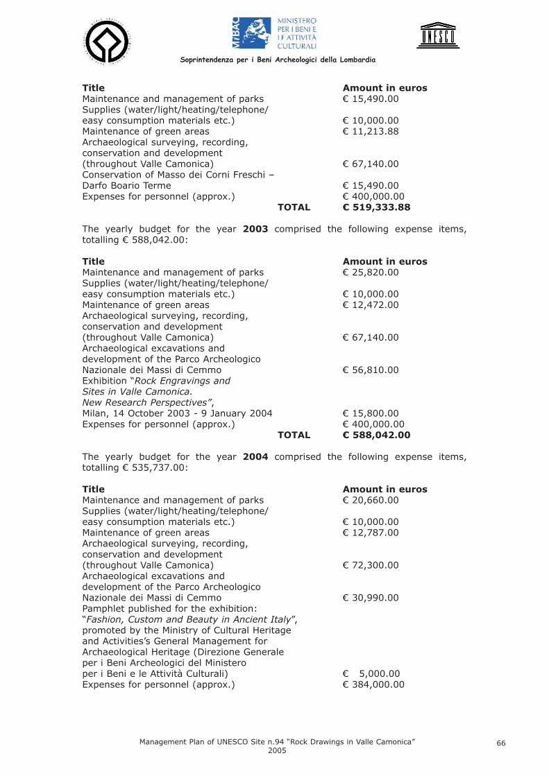
Title Amount in euros Maintenance and management of parks € 15,490.00 Supplies (water/light/heating/telephone/easy consumption materials etc.) € 10,000.00 Maintenance of green areas € 11,213.88 Archaeological surveying, recording, conservation and development(throughout Valle Camonica) € 67,140.00 Conservation of Masso dei Corni Freschi – Darfo Boario Terme € 15,490.00 Expenses for personnel (approx.) € 400,000.00
TOTAL € 519,333.88
The yearly budget for the year 2003 comprised the following expense items,totalling € 588,042.00:
Title Amount in euros Maintenance and management of parks € 25,820.00 Supplies (water/light/heating/telephone/easy consumption materials etc.) € 10,000.00 Maintenance of green areas € 12,472.00 Archaeological surveying, recording, conservation and development (throughout Valle Camonica) € 67,140.00 Archaeological excavations and development of the Parco Archeologico Nazionale dei Massi di Cemmo € 56,810.00 Exhibition “Rock Engravings and Sites in Valle Camonica. New Research Perspectives”, Milan, 14 October 2003 - 9 January 2004 € 15,800.00 Expenses for personnel (approx.) € 400,000.00
TOTAL € 588,042.00
The yearly budget for the year 2004 comprised the following expense items,totalling € 535,737.00:
Title Amount in euros Maintenance and management of parks € 20,660.00 Supplies (water/light/heating/telephone/easy consumption materials etc.) € 10,000.00 Maintenance of green areas € 12,787.00 Archaeological surveying, recording, conservation and development (throughout Valle Camonica) € 72,300.00 Archaeological excavations and development of the Parco Archeologico Nazionale dei Massi di Cemmo € 30,990.00 Pamphlet published for the exhibition: “Fashion, Custom and Beauty in Ancient Italy”, promoted by the Ministry of Cultural Heritage and Activities’s General Management for Archaeological Heritage (Direzione Generale per i Beni Archeologici del Ministero per i Beni e le Attività Culturali) € 5,000.00 Expenses for personnel (approx.) € 384,000.00
Soprintendenza per i Beni Archeologici della Lombardia
Management Plan of UNESCO Site n.94 “Rock Drawings in Valle Camonica”2005
66
TOTAL € 535,737.00
Expenses for state-employed personnel in charge of the Parks in 2004 refer to 19full-time employees (1 technical-scientific assistant, 17 security guards, 1 person incharge of repairs) and 1 part-time (director). In addition there were administrativeand technical personnel and a security guard, whose cost cannot be separately stat-ed, since they are based in the Soprintendenza’s head office and are also involvedwith the National Parks.
Total Expenses for the three-year period 2002-2004: € 1,643,112.88
Riserva Regionale delle Incisioni Rupestri di Ceto, Cimbergo, Paspardo The Managing Institution of the Riserva Regionale is the Ceto, Cimbergo andPaspardo Rock Engravings Consortium, which has entered into agreements with localinstitutions for the joint use of human resources and services.In particular, the “Valcamonica Centre for Prehistoric Studies” (Centro Camuno diStudi Preistorici, Capo di Ponte) has been entrusted with the Reserve’s scientificmanagement, research management, data bank and higher level information serv-ices. The appointed director of the Reserve is employed by the Centre, which thusguarantees his constant services. The firm DO.NET has a special 6-year agreementto manage the museum’s routine administration, providing the following services:caretaking, cleaning, heritage maintenance, security services, ticket office, informa-tion services and tourist promotion in exchange for the use of museum income (tick-et office, educational services and refreshment sales) as payment for these servic-es, as long as they are conducted in accordance with the Reserve Museum’s statu-tory aims. Ceto Council appoints (by deliberation) one if its employees to act as theconsortium’s secretary and administrator.
The yearly budget for the year 2002 comprised the following expense items,totalling € 101,869.80 (see Table 10).
The yearly budget for the year 2003 comprised the following expense items,totalling € 376,269.00 (see Table 11):
The yearly budget for the year 2004 comprised the following expense items,totalling € 239,500.00 (see Table 12):
The yearly budget of the Riserva Regionale does not include the cost of personnel (1in charge of education and 1 for caretaking activities, full time) provided by the firmDo.Net, which manages the Riserve’s services. These expenses, amounting to about€ 40,000.00 a year, are financed by the proceeds of activities and services suppliedto the public.
Other activities and initiatives which are not included in the budgets, are promotedand supported from time to time by sponsors and/or local institutions, i.e. the coun-cils which form the Consortium.
In 2005 the Riserve has programmed work to create a hospitality area in Figna(which will require the renovation of several farmhouses), lay out paths in theCapitello dei Due Pini area, provide toilets in the Foppe di Nadro area, create an area
Soprintendenza per i Beni Archeologici della Lombardia
Management Plan of UNESCO Site n.94 “Rock Drawings in Valle Camonica”2005
67
equipped for those suffering from motor and sight disablement and survey historicalpaths.
Total expenses for the three-year period 2002-2004: € 717,638.80
Parco Comunale di Luine, Darfo Boario TermeYearly expenses on behalf of the local council for the park’s routine administrationamount to about € 26,000.00 (year 2003) and they comprise the cost of personnelassigned to security service and maintenance (one employee), and also caretaking,guarding and maintenance.
Total expenses for the three-year period 2002-2004: € 72,000.00
Parco Archeologico Comunale di Seradina-Bedolina, Capo di PonteThe ParK, inaugurated on 8th October 2005, has still not been allocated funds fromthe yearly budget for personnel, maintenance and development.Capo di Ponte council possesses special funds (amounting to € 520,000.00 in 2005,allocated by SECAS S.p.A. – Intervention Firm for the Development of ValleCamonica, Sebino and Valle Cavallina – Darfo Boario Terme, Brescia) for equippingthe Park: creating visitors’ itineraries, mounting panels and other educational fit-tings, building hospitality facilities.
Parco Comunale di Sellero No expenses (no budget is presently available for the Park).
Parco pluritematico del “Còren de le Fate”, SonicoNo expenses (no budget is presently available for the Park). In 2005 the Sonico municipality will invest approximately € 5,000.00 for a projectinvolving school groups, to increase the younger generation’s knowledge and respectfor the rock art heritage. The initiative consists of a theory course and a practicalpart comprising visits and learning activities in Parco pluritematico del “Coren de leFate”. It should be noted that preparatory work in the Park, which is included with-in the boundary of the Parco dell’Adamello, was promoted and financed by the same.
Funds for this municipal park have been partly allocated by the Lombardy RegionalAuthority (Regione Lombardia), individual councils, the Mountain Community and theValle Camonica Drainage Basin Council Consortium (Consorzio dei Comuni del BacinoImbrifero Montano della Valle Camonica-BIM).
We are unable to quantify donations from banks and private parties, which, to ourknowledge, are generally targeted at publishing papers and organizing conferences.
7.2 Natural and Environmental Resources
The Province of Brescia’s extensive territory may be divided into three geographical
Soprintendenza per i Beni Archeologici della Lombardia
Management Plan of UNESCO Site n.94 “Rock Drawings in Valle Camonica”2005
68
areas: plain, pre-Alpine zone and Alpine area. The mountainous territory isorganised administratively into five “Mountain Communities”: Valle Camonica, ValleTrompia, Valle Sabbia, Alto Garda Bresciano and Sebino Bresciano.Valle Camonica’s territory is rich in natural features. This abundance is sanctioned bythe presence in the valley of 17 sites of European Community Interest (HabitatDirective 42/93/EEC) and an area under special protection (Birds Directive79/409/EEC).
The presence of a National Park (Parco Nazionale dello Stelvio), a Regional Park(Parco Regionale dell’Adamello) and a “Local Inter-municipal” Park (Parco Locale diInteresse Sovracomunale del Barberino) on the left-hand side of Valle Camonicameans that the majority of this part of the valley is under tutelage of some descrip-tion, although of varying degrees. The opposite situation is found on ValleCamonica’s right-hand side, where there are two Regional Reserves at the north andsouth ends (Riserva Naturale delle Valli di S.Antonio to the north, and to the south,the Riserva Naturale dei Boschi del Giovetto) and the Parco Locale di InteresseSovracomunale del Lago Moro at the southernmost extremity, but no protection inthe central portion (although this is adjacent to the Parco Regionale delle OrobieBergamasche and the Parco Regionale delle Orobie Valtellinesi).
The pre-Alpine strip and the River Oglio’s upper course in the valley floor have beenclassified as areas of environmental importance in the terms of Regional law N°86/83.
Valle Camonica’s woodland consists mainly of coniferous and broad-leaved treesthat are periodically cut; tall forests of broad-leaved trees are scarce.Seven forestry consortiums currently operate in Valle Camonica, covering the entireterritory and ensuring well-organized management of council-owned woodlands (seeTable 13).
The following municipalities belong to Valle Camonica‘s forestry consortiums:
1) Consorzio Forestale Alta Valle Camonica: Berzo Demo, Cedegolo, Cevo, CortenoGolgi, Edolo, Saviore, Sonico.
2) Consorzio Forestale Valle dell’Allione: Capo di Ponte, Cerveno, Malonno, OnoS.Pietro, Paisco Loveno, Sellero.
3) Consorzio Forestale del Pizzo Camino: Angolo Terme, Borno, Lozio, Malegno,Ossimo, Piancogno.
4) Consorzio Forestale Bassa Valle Camonica: Artogne, Berzo Inferiore, Bienno,Cividate Camuno, Darfo Boario Terme, Esine, Gianico, Pian Camuno, Prestine.
5) Consorzio Forestale del Pizzo Badile Camuno: Braone, Breno, Ceto, Cimbergo,Losine, Niardo, Paspardo.
6) Consorzio Forestale Due Parchi: Incudine, Monno, Ponte di Legno, Temù, Vezzad’Oglio, Vione.
The consortia have many goals, which are all extremely important for the woodlandheritage’s maintenance and for the management of hydro-geological issues. Theyare also a source of employment in the valley.
The Valle Camonica Mountain Community in Breno also functions as a branch of theE.R.S.A.F. (Regional Authority for Agricultural and Forestry Services). This institution
Soprintendenza per i Beni Archeologici della Lombardia
Management Plan of UNESCO Site n.94 “Rock Drawings in Valle Camonica”2005
69
is a tool of the Lombardy Regional Authority (Regione Lombardia), established withRegional Law N° 3/2002; it carries out technical and promotional activities for thedevelopment of agricultural, forestry and rural sectors.
Water resources form an important part in the valley’s economy - many lakes, bothnatural and artificial, are exploited for the production of hydroelectricity.The main artificial basins at high altitudes are all fed by streams Avio (Avio,Benedetto, Venerocolo and Pantano d’Avio), Remulo (Baitone, Lungo, Rotondo andBianco) and Poia (Dosazzo, Salarno and Arno). In addition, there are large water col-lection tanks located in the Edolo and S. Fiorano power stations near the course ofthe river Oglio. It should be noted that this water storage and collection system has a negativeimpact on the valley’s hydrological balance, because it significantly reduces streamoutflow capacity and cyclically shifts masses of water from one basin to another tomeet the needs of hydroelectricity production.The methods used to collect water in basins at high altitudes are regulatedaccording to capacity parameters set by the Po Basin Authority.
7.3 Intangible Culture: Events, Cultural Production and TraditionsThanks to the cultural institutions present in the valley (research institutes, univer-sities, museums and institutions of tutelage) and the energy devoted to cultural pro-motion by councils and other local bodies (Comunità Montana di Valle Camonica andBIM), many interesting events are organized (in the valley for the valley, or in exter-nal provincial, regional, national or international venues), some of these are period-ical and by now have their place in the local calendar.In addition, every council in the valley promotes exhibitions of work by local artistsduring the course of the year, and, in celebration of the town’s patron saint, variousevents which accompany the sampling of traditional local products.
Events connected with the rock art heritage, 2002-2004Below, the events connected with the rock art – and, more generally, archaeologi-cal–patrimony, are listed; distinction is made between those which are periodicaland those which were special occasions, linked to discoveries, research results, pub-lic information or promotion. These events were held in the three-year period 2002-2004.
Conferences and Study MeetingsFrom 1968 onwards, international conferences on rock art have been held in ValleCamonica (and occasionally abroad); each of these was organized by the CentroCamuno di Studi Preistorici and bears the name Valcamonica Symposium (for a listof the 21 Symposia see ENCLOSURE 7).
2002- XX Valcamonica Symposium “Recent Perspectives on the Documentation andPresentation of Rock Art”, held at Tanum (Sweden).
2004- XXI Valcamonica Symposium “Prehistoric and Tribal Art: New Discoveries, NewInterpretations, New Research Methods”, held at Darfo Boario Terme 8th – 14th
September 2004.- Stones of the Gods, Copper-Age Statue-Steles in Europe: the Current State ofKnowledge, International Congress, Brescia 16th – 18th September 2004, with study
Soprintendenza per i Beni Archeologici della Lombardia
Management Plan of UNESCO Site n.94 “Rock Drawings in Valle Camonica”2005
70
excursion to Valle Camonica, organized by: Università Cattolica del Sacro Cuore diBrescia, Università degli Studi di Milano, Civico Museo Archeologico di Bergamo,Cooperativa Archeologica “Le Orme dell’Uomo”.- The Unknown Foppe di Nadro: GPS Mapping and the Latest Analyses. First studymeeting on the rock engravings in the Riserva Regionale di Ceto, Cimbergo ePaspardo, organized by the Reserve Museum in Ceto, 26th June 2004.
Archaeological Exhibitions
2002- “Culture is an Open Space”, 4th Culture Week, promoted by the Ministry of CulturalHeritage and Activities, with longer opening hours and free entry for NationalMuseums and Parks, 15th-21st April.
2003- 40,000 Years of Contemporary Art, documentary exhibition organized by theCentro Camuno di Studi Preistorici in Brussels, at the European Parliament, 18th-27th March 2003. Repeated in Brescia, Palazzo del Broletto, 1st December2005–26th February 2006. - “Culture is an Open Space”, 5th Culture Week, promoted by the Ministry of CulturalHeritage and Activities, with longer opening hours and free entry for NationalMuseums and Parks, 5th- 11th May.- Engravings and Rock Art Sites in Valcamonica: the Latest Research, exhibitionorganized by the Lombardy Soprintendenza of Archaeological Heritage and sponso-red by the CARIPLO Bank (14th October 2003 – 9th January 2004), in theSoprintendenza Milan premises. The exhibition was organized by R.Poggiani Keller(Soprintendenza), C.Liborio and M.G.Ruggiero (SCA-Società CooperativaArcheologica, Milan).
2004- The Lombardy Soprintendenza of Archaeological Heritage participated in 2003-2004 in the national exhibition cycle entitled Fashion, Costume and Beauty in AncientItaly, promoted by the Central Office of the Ministry of Cultural Heritage andActivities, with itinerary on the theme Aspects of Costume Engraved in Stone: 5000Years of History, organized in the Parco Nazionale delle Incisioni Rupestri in Capo diPonte, and illustrated by the catalogue: LIBORIO C.-RUGGIERO M. G., Aspects ofCostume Engraved in Stone: 5000 Years of History, Bergamo 2003.- 100 Years of Research in Valcamonica: an exhibition organized by the CentroCamuno di Studi Preistorici about the history of the discovery, study and develop-ment of Valcamonica’s prehistoric art (venues: Boario Terme (BS), 1st-30th
September 2004 and Milan, 7th-27th February 2005).- The Voyage in the Labyrinth, an exhibition organized by the Centro Camuno diStudi Preistorici (Boario Terme (BS) - December 2004 - January 2005).- “Art, Monuments and Landscape”, 6th Culture Week, promoted by the Ministry ofCultural Heritage and Activities, with longer opening hours and free entry forNational Museums and Parks, 24th-30th May.- The Lombardy Soprintendenza of Archaeological Heritage participated, in 2004,with finds from one of Valle Camonica’s rock art complexes (the Ossimo-Pat mega-lithic sanctuary), in the international exhibition Warriors, Princes and HeroesBetween the Danube and the Po, from Prehistoric Times Until the Early MedievalPeriod, organized by the Trento Provincial authority in Trento, Castello delBuonconsiglio, 19th June-7th November 2004 (catalogue Warriors, Princes andHeroes Between the Danube and the Po, from Prehistoric Times Until the EarlyMedieval Period, Eds. F. MARZATICO and P. GLEIRSCHER, Trento 2004).- The Lombardy Soprintendenza of Archaeological Heritage took part, in 2004-2005,
Soprintendenza per i Beni Archeologici della Lombardia
Management Plan of UNESCO Site n.94 “Rock Drawings in Valle Camonica”2005
71
in the national exhibition cycle organized by the Central Office of the Ministry ofCultural Heritage and Activities, with the exhibition Food for the Gods, which dealtwith the theme of food offerings in religious rites amongst the Valle Camonica popu-lation between the late Iron Age and the time of Imperial Rome. The venue was theMuseo Archeologico Nazionale in Cividate Camuno (BS).
Other Cultural and Promotional Events in the Valley The main events are listed below, with emphasis on those which recur periodicallyand which reflect particular aspects of Valle Camonica ‘s identity.
Art Exhibitions- The City of Darfo Boario Terme National Art Competition: this event is held everyyear in the first week of September in the historic centre of Darfo Boario Terme.Extemporary Painting Competition, at Darfo Boario Terme: every year, between julyand September, a village just outside the town is taken as the subject for impromp-tu paintings by artists who work “on location”.- “Waiting for Santa Lucia” – children’s painting and drawing competition organizedby Darfo Boario Terme council during November and December.
Religious Events- “Crucifixus–Festival of Spring, Theatre, Music and Religious Traditions”: involvingnumerous Valle Camonica towns and villages, and a few elsewhere in the Provinceof Brescia and the Province of Bergamo. An attempt to rediscover a collective mem-ory of medieval and Renaissance theatrical traditions.- Every ten years, a live Via Crucis (Way of the Cross) is celebrated in Cerveno, withthe involvement of the entire population; preparations for this religious drama takeabout a year. The event is particularly significant, because Cerveno has a Via CrucisSanctuary, where life-size wooden and plaster statues may be admired, made in the18th century by sculptors Beniamino Simoni, and Donato and Grazioso Fantoni.
Music and Theatre- The Song of the Stones: a festival of medieval music organized in October 2004,in the Pieve di San Siro, by Capo di Ponte Council and the Lombardy RegionalAuthority Department of Culture.- Every year between July and August, near the Park “Coren de le Fate” in the munic-ipality of Sonico, an evening theatrical event which resembles a medieval rite isorganized. The itinerary is illuminated for the occasion by flaming torches placedalong the sides of the road.- Theatre Festival, organized in the period from December and April at the SanFilippo Congress Centre and Theatre in Darfo Boario Terme. - Itinerant theatre, during the summer period, in the town of Darfo Boario Terme andsurrounding villages.- “Family Theatre” – a children’s theatre festival in Darfo Boario Terme, held in theSan Filippo Theatre from November to February.- “From Shaman to Showman” – Festival of comical singer-songwriters, held in theDarfo Boario Terme Congress Centre during the month of September.- Festival “Music in the City”, in Darfo Boario Terme: this festival lasts from March toJanuary, with numerous concerts of music and song, some of them religious.- “Great Little Artists: Discovering New Talent”: a provincial festival of music, dance,song and expression with the body, organized in September in the Congress Centrein Darfo Boario Terme.- Jazz concerts organized in July 2004 in the Roman Theatre and AmphiteatreArchaeological Park in Cividate Camuno by the local tourist office and CRAAC (CentroRicerche Antropologiche Alpi Centrali).- “A Nocturnal Voyage Through the Aeneid”, dramatic event held in the Roman
Soprintendenza per i Beni Archeologici della Lombardia
Management Plan of UNESCO Site n.94 “Rock Drawings in Valle Camonica”2005
72
Amphiteatre in Cividate Camuno by the Lombardy Soprintendenza of ArchaeologicalHeritage, in collaboration with the local tourist office and the Breno “C. Golgi”Grammar School (spring 2004).
Cinema- “Mountains in Cinema”: a mountain film festival and meetings with internationallyrenowned mountaineers, organized in June in Darfo Boario Terme.- Festival of art films, held in the Garden Cinema in Darfo Boario Terme during thespring.
Market-exhibitons- Pescarzo Market-exhibition: this fair, and that held in Pisogne, are cultural andtouristic events of great importance for the valley in the 21st century. They bear theslogan “Immaginarti” (imagine/image/art) and are held annually in the first ten daysof August, with hundreds of stalls and many associated activities. Thousands of vis-itors come (in 2002: 8000 visitors; in 2003: 10000; in 2004: 11000), emphasizingthe importance of this attractive annual occasion.- Bienno Market-exhibition: the fair promotes the area’s traditional arts and crafts,using workshops, courtyards, cellars and entrance halls in the old town centre asexhibition spaces. The evenings are enlivened by dramatic productions and music.Guided tours of the rich prehistoric, religious and artistic heritage of Capo di Ponteare orgaized by the tourist office. It is usually held at the end of July and beginningof August.- Pisogne Market-exhibition: this event belongs to the Pescarzo and Bienno fair cir-cuit and offers, in August, important examples of valley craftsmanship and occasion-al international attractions (in 2003, for example, it played host to Moroccan glass-blowers and carpet weavers from Pakistan). - Sellero Market-exhibition “From the Medieval Period to the Third Millennium”: heldin the months of June and July, this fair includes cultural events (concerts ofmedieval music) and the chance to sample local traditional food and wine.- Market-exhibition “Autumn Flavours”: a display of art and artisanship, organized inSellero (Novelle locality) in October.
Shows of Livestock- Cattle Show, Sonico: in this event, which is held every two years in October,Sonico’s farmers bring their livestock to be judged by an expert. Funding from thecouncil and local sponsors assists participants with expenses and provides prizes.School parties come to watch traditional crafts being practiced and sample localproducts. - Livestock Show, Darfo Boario Terme, Isola locality, in April, with an exhibition ofsheep, goats, horses and cattle. Traditional valley fare may be sampled.- Upper Iseo Livestock Show in Rogno, during April, with prizes awarded for Friesianand Brown Alpine Cattle, and an exhibition of sheep and goats.- Spring “Blonde Adamello Goat” Show, organized in Val Saviore with funding fromthe Parco dell’Adamello, Comunità Montana di Valle Camonica and local Val Saviorecouncils. The principal aim of the event is the protection and promotion of this raceof goat, which is indigenous to the Adamello area.- Brown Alpine Cattle Show, Edolo: organized in November in the Livestock Centre(Centro Zootecnico), with an exhibition of cattle and related agricultural and com-mercial sectors.- Summer Pastures, Vezza d’Oglio: traditional local products fair held in August.
Traditional Folk Events and Festivals- Porsèl and Lard Festival: a time of entertainment and consumption of local prod-ucts made from pigs ( “porsèl” in local dialect), organized in Ossimo Superiore in
Soprintendenza per i Beni Archeologici della Lombardia
Management Plan of UNESCO Site n.94 “Rock Drawings in Valle Camonica”2005
73
December.- “Mangialonga”, event held in April in the municipality of Ossimo. The festival is cen-tred on an interesting itinerary pauses to sample local dishes and delicacies, whichalternate with a series of re-evocations of past epochs (prehistory, the medieval peri-od, the 16th and 19th centuries) and the present day.- Carneval Parade, Darfo Boario Terme, with allegorical floats and groups in fancydress.
Sporting Events- “Adamello Rally” Alpine Skiing Tournament: this is a classical Alpine skiing compe-tition, which was started in 1960 and has thus reached its 45th anniversary (April2005). The Adamello Massif, with its famous glaciers (average altitude about 3000m), provides the slopes on which the event is held. The starting and finishing linesmay be situated in Pontedilegno or on the Tonale Pass.- “Al chiar di luna” Moonlight Alpine Skiing Tournament: this traditional rally attractsnumerous enthusiasts to the Tonale Pass every February. - Mortirolo Alpine Skiing Tournament: a non- competitive event held in Monno inMarch. This year marks the 18th anniversary.- Moonlight “Caspolada” (or “Ciaspolada”): an atmospheric sporting event for enthu-siasts of caspe (snow shoes), organized in Vezza d’Oglio in January. In 2005 therewere 3000 participants.- 4th July Path Skyrace, in Corteno Golgi: a skyrunning competition (held on highaltitude mute tracks and paths), over a distance of 42.195 km (including 2750 m inascent and 2880 m in descent), held in July in the mountains of upper ValleCamonica.- Vallecamonica Cyclo-cross, an international cross-country race organized inDecember by Atletica Valle Camonica of Darfo Boario Terme. 2004 marked the 12th
year.- National Athletics Meeting for the Disabled, Darfo Boario Terme: 2004 marked the13th anniversary of this event, which encourages the integration of the disabled inthe world of sport. - Brixia Tour, international cycle race for professionals in July, based in Darfo BoarioTerme.- Timed Ascents (Cronoscalata) Boario Terme-Angolo, valid for the regional cyclechampionship; in 2004 it was held in October.- Hunter & Field, national archery contest. In April 2004 the Gruppo Arcieri AlabardeCamune organized the 6th competition.
7.4 Organizational and Intellectual ResourcesThe various events, cultural and traditions activities described in detail in the previ-ous section have been made possible by the financial support of local institutions,which actively promote their territory and its cultural and production resources. Inseveral cases, these event are organized thanks to economic contributions from theLombardy Regional and Brescia Provincial Authorities, and local banks.The contribution of local sponsors is also highly significant, although probably under-estimated.
Intellectual resources are many, comprising - besides the Lombardy Soprintendenzafor Archaeological Heritage - research institutions, firms and associations, whichhave long operated in the territory to publicize and promote the study of the cultur-al heritage through publications, exhibitions and meetings.
The Lombardy Soprintendenza of Archaeological Heritage (legally chargedwith archaeological tutelage and research since the early twentieth century) has
Soprintendenza per i Beni Archeologici della Lombardia
Management Plan of UNESCO Site n.94 “Rock Drawings in Valle Camonica”2005
74
been a continual presence in Valle Camonica since 1955, when it founded the ParcoNazionale delle Incisioni Rupestri di Capo di Ponte, the first Italian archaeologicalpark, which laid the foundations for the rock art patrimony discovered in 1908. 1965saw the addition of the council-owned area of the Massi di Cemmo, which is current-ly being converted into a National Archaeological Park (2005). In 1981 the NationalMuseum of Cividate Camuno (for Roman material) was added, and in 2003 theArchaeological Park of the Theatre and Amphitheatre of Cividate Camuno. In 2006the public opening of the new National Archaeological Area of the Santuary ofMinerva in Breno is planned, and in 2007 the inauguration of the new NationalPrehistory Museum of Valle Camonica in Capo di Ponte. Through this network ofNational Museums and Archaeological Areas and Parks, the Soprintendenza has cre-ated a system (integrated with local Archaeological Parks and various local muse-ums) of centres for the development of the valley’s archaeological heritage with twomain focal points: rock art, which is concentrated mid-valley (but present through-out the valley) and the monumental Roman remains around Civitas Camunnorum(Cividate Camuno and Breno).In order to perform its functions of tutelage, development and archaeologicalresearch, as require by current law (Legislative Decree in date 22nd January 2004,N° 42, art. 4 c. 1; art. 88 c. 1), the Soprintendenza possesses its own staff of spe-cialists (archaeologists, conservators, architects, surveyors, photographers and ITexperts) as well as technical offices and services and in local branches. According to the multi-year plans approved and financed by the Ministry of which itforms part, the Soprintendenza conducts programmed campaigns and emergencyoperations every year in the following categories:
- archaeological research, with excavations and investigations in various contexttypes, including rock art (such as megalithic sanctuaries with engraved Chalcolithicsteles and boulders), with particular attention to the surroundings;- conservation of rocks with engravings;- recording and cataloguing of the rock art patrimony (IR and IRWeb records), espe-cially with regard to conservation requirements;- development, with the organization of exhibitions, museums and informationareas, Archaeological Areas and Parks, and various modes of publication of scien-tific studies.
The results of the research work, integrated with the specialist studies and analyses(palaeobotanical, dendrochronological, radiometric dating, geological, archaeo-met-allurgical etc.) which are at times needed for a complete, interdisciplinary under-standing and entrusted to specialist scientific institutes (universities, CNR and otherlaboratories), are published annually in the “Notiziario della SoprintendenzaArcheologica della Lombardia” (“NSAL”), 1981-2002 , and in scientific periodicals(Fig. 148), conference proceedings and mongraphs, in Italy and abroad.
The following institutes, associations and cooperatives are concerned with rock art:- Valcamonica Centre for Prehistoric Studies (Centro Camuno di StudiPreistorici, CCSP), Capo di Ponte: founded in 1964 by E. Anati and with its ownpermanent staff. CCSP conducts yearly rock art study campaigns in various valleysites, programmed according to five-year and annual plans wich are periodicallyapproved by the Soprintendenza, with which the Centre accorded a five-yearlyagreement in 1994. International teams also participate in these campaigns. It alsocarries out educational activities and public information, organizing (for example)exhibitions, meetings, seminars and conferences (including international Symposia).CCSP spreads interest in and knowledge about ancient civilizations by means ofresearch work which is published, since 1967, in its periodical “Bulletin of theValcamonica Centre for Prehistoric Studies” (“Bollettino del Centro Camuno di StudiPreistorici”) and in other series of publications (“Archivi”, since 1968; “Studi
Soprintendenza per i Beni Archeologici della Lombardia
Management Plan of UNESCO Site n.94 “Rock Drawings in Valle Camonica”2005
75
Camuni”, since 1972; “Edizioni del Centro”, since 1965; “Valcamonica Symposia”,since 1970) (Fig. 149). The Centro Camuno di Studi Preistorici may be found on theinternet at: www.ccsp.it
- In 1987 the Valcamonica and Lombardy Department (DipartimentoValcamonica e Lombardia), was founded, a section of the Centre concerned withresearch into Alpine rock art; it has its own website: www.simbolisullaroccia.it
- Prehistoric Art and Lifestyle Teaching Museum (Museo Didattico d’Arte eVita Preistorica), Capo di Ponte: created in 1975 by A. Priuli, the museum car-ries out research and educational activites connected with Valle Camonica’s rock art,with a special interest in experimental archaeology. It has also published numerousscientific and popular works and may be visited on the internet at the followingaddress: www.intercam.it/valcam/assoc/archeo/archeo.htm
- “Footprints of Man” Archaeological Cooperative (Cooperativa Archeologica“Le Orme dell’Uomo”), Cerveno: was formed in 1988 by a group of archaeolo-gists and researchers involved in study, teaching, promotion and publishing in con-nection with the rock art of Valle Camonica and other areas of the world (Fig. 150).The cooperative organizes exhibitions, meetings, conferences and seminars andmaintains one of the most-visited internet sites dealing with rock art. It also con-ducts annual rock art research campaigns, with the support of Paspardo Council, fol-lowing programmes agreed with the Soprintendenza. Internet: www.rupestre.net.
- Archaeological Cooperative Society (Società Cooperativa Archeologica-SCA), Milano: was formed in 1994 by a group of archaeologists of varied specialinterests (palaeo-ethnology, etruscology, Greek and Roman, Phoenician and Punic,and Egyptian archaeology). Since 1996, for the Lombardy Soprintendenza ofArchaeological Heritage, SCA has tested and developed the IR (Incisioni Rupestri)database for cataloguing Valle Camonica’s (and the rest of Lombardy’s) rock art heri-tage. Since 2003, it has been occupied with the design, development and implemen-tation of the IRWeb application, the adaptation of the IR database for intranet net-works and internet. SCA’s website is: www.scaweb.it
- Central Alpine Anthropological Research Centre (Centro RicercheAntropologiche Alpi Centrali, CRAAC), Gorzone: is composed of local scholars,who conduct interdisciplinary historical studies of the central Alps (involving archae-ology, history, anthropology, folklore, history of art, religion and the economy). Itpromotes research and local development projects, public information and teaching.CRAAC may be found on the internet at: www.voli.bs.it/craac
The following organizations are principally involved in teaching and public informa-tion activities in Valle Camonica:
- Capo di Ponte Tourist Office (Associazione Pro Loco) : founded in 1967, itpromotes the valley’s archaeological, historical, cultural and natural attractions,offering guided visits to schools and tourists. Its internet site is: www.proloco.capo-di-ponte.bs.it
- Archeocamuni, Capo di Ponte: has been active since 1989 in the educationaland teaching sector, especially with regard to primary and secondary schools, offer-ing guided visits and workshops regarding aspects of archaeology and nature. Worksfor school use have been published. Archeocamuni may be found on the internet at:www.digilander.libero.it/archeocamuni
Soprintendenza per i Beni Archeologici della Lombardia
Management Plan of UNESCO Site n.94 “Rock Drawings in Valle Camonica”2005
76

- Archeodromo, Capo di Ponte: in connection with the Prehistoric Art and LifestyleEducational Museum, in 1993 Archeodromo created a reconstruction of a LateNeolithic village where school groups come into contact with experimental archaeo-logy and re-live the day-to-day life of the valley’s ancient inhabitants. Internet:www.intercam.it/valcam/assoc/archeo/archeo.htm
- ArcheoPark, Darfo Boario Terme: covers an area of over 10,000 m² and offersthe possibility to re-live the past in the form of reconstructions of prehisoric settle-ments (a Palaeolithic cave, rock-shelters, a Neolithic farm, a village of pile-dwellings,hill-top forts, huts made of tree trunks and a labyrinth), and an experimental archa-eology workshop. Archeopark’s internet site is: www.archeopark.net
- Do.Net, Ceto: a company which provides services for tourism, and manages(through an agreement) the museum of the Riserva Regionale delle IncisioniRupestri di Ceto, Cimbergo e Paspardo. Educational initiatives may be viewed on theinternet at: www.arterupestre.it/arterupestre /proposte.html
- Alpine Garden Museum – Graffitipark (Parco tematico Museo GiardinoAlpino-Graffitipark), Capo di Ponte: an open area equipped with workshops forexperimental archaeology and rock art, and which illustrates important aspects ofthe valley’s geology and Alpine flora. See the Park’s website at: www.graffitipark.it
8. Analysis of Risks and Limitations
8.1 Public Access to the HeritageRoad and Rail Access to the Valley and its HeritageVisitors can reach Valle Camonica by train, by means of the Brescia - Edolo line(Northern Milan Railway Network, FNME), and by car from three directions: mainroad (Strada Statale, SS) N° 39 from Aprica, road N° 42 from Tonale and Mendolaand road ex-N° 510, the “Sebina Orientale” (East Lake Iseo Road).
The N° 42 is connected to the A4 Milan - Venice and A22 Modena – Brenner motor-ways: it links the valley to Bergamo, to the southwest, and to Trentino-Alto Adige,to the northeast, over the Tonale Pass. The N° 42 presents some problems withregard to traffic flow due to the many towns through which it passes and the con-siderable volume of traffic.There exists an upgrading project, targeted at reducing the impact of traffic ontowns and at improving access to the valley. This project, whose initial phases dateback to the 1970s, was implemented through the years by individual lots and is cur-rently incomplete. The part of road N° 42 which passes through Capo di Ponte and Sellero (the “Capodi Ponte-Sellero variant”) was revised and modified following a request by theLombardy Soprintendenza for Archaeological Heritage (Soprintendenza per i BeniArcheologici della Lombardia) for a route that better protected the engraved rocks.A new route was designed, which passes through a tunnel at such a depth as to nei-ther alter nor damage the rock engraving heritage. Building work will start soon.
A further link with the A4 motorway is the road ex-N° 510, which runs parallel to theeastern bank of Lake Iseo to reach Brescia. A second, particularly scenic, route (N°469, the “Sebina Occidentale”) runs along the western side of the lake, from Sarnico(south) to Castro, near Lovere (north).
The following roads which join Valcamonica and the Lake Idro area should be notedfor the outstanding beauty of the landscape through which they pass (especially
Soprintendenza per i Beni Archeologici della Lombardia
Management Plan of UNESCO Site n.94 “Rock Drawings in Valle Camonica”2005
77

popular with visitors from north of the Alps, Germans in particular): Passo di CroceDomìni, Passo del Gaver and Passo del Maniva. Valcamonica is connected toValtellina by the Aprica Pass (1181 m), over which the road “Strada Statale 39” runs,and by passes which are open in the summer: Mortirolo (1896 m) and Gavia (2621m). Valle di Scalve (Bergamo) may be reached from Darfo Boario Terme to the southby means of “Strada Provinciale 294”, which flanks the scenic old Via Mala, made inthe second half of the 17th century, and from the north via the Vivione Pass (1828m), which is open during the summer.
Visitors who wish to arrive by bus may make use of the following bus routes:- Bus service FNMA (North Milan bus services), route Brescia-Edolo (www.fer-rovienord.it);- Bus service SAB, route Milan-Bergamo-Lovere-Ponte di Legno (www.sab-auto-servizi.it).
With regard to rail connections, a project called “Una linea verso l’Europa. Il futurodella Linea Ferroviaria Brescia-Iseo-Edolo nella rete alpina dei trasporti” (A Route toEurope. The Future of the Brescia-Iseo-Edolo Railway Line in the Alpine TransportNetwork) is being developed, to renew and strengthen Valle Camonica’s railway ser-vice in a European context (Una linea verso l’Europa. Il futuro della Linea FerroviariaBrescia-Iseo-Edolo nella rete alpina dei trasporti, Conference Abstracts, May 31st -June 1st 2002, Darfo Boario Terme Congress Centre).
Access to, and Appreciation of, Parks with Rock Engravings All parks can be reached from main road N° 42, from which a network of minor roadsbranches off towards the various valley towns. Signs on access roads indicating Parksare not always present and not uniform in appearance.Since the means of access to the Valle Camonica rock engraving Parks differ great-ly from district to district, it would appear useful to consider the factors involved andthe ease of access, together with the extent to which appreciation of the heritagehas been facilitated:1) Parking;2) Visitors’ itineraries (including facilities for persons with motor disablement);3) Walkways;4) Educational tools (panels, explanatory leaflets, publications, audiovisual and com-puter aids, websites);5) Educational activities (guided tours, workshops, classroom teaching etc.)
With regard to Point 1, at present only the Parco Comunale di Luine (Darfo BoarioTerme) and the Riserva Regionale delle Incisioni Rupestri di Ceto, Cimbergo,Paspardo have extensive areas for bus and car parking.The provision of a parking area in the Cemmo locality, which will serve both theParco Archeologico Nazionale dei Massi di Cemmo and the Parco ArcheologicoComunale di Seradina-Bedolina, is programmed in the Plan of the latter Park.
All Parks so far set up in Valle Camonica, have visitors’ itineraries - with differentfeatures and characteristics - designed to enhance appreciation of the engravedrocks. Special walkways have been constructed along the trails in correspondence to largeor steeply sloping rocks, so as to provide better vantage points for viewing theengravings and effective protection of rocks from wear. Explanatory panels (in somecases also in English: Parchi Nazionali di Capo di Ponte, Riserva Regionale delleIncisioni Rupestri di Ceto, Cimbergo, Paspardo and Parco Comunale di Luine) are tobe found near the most important rocks.
Soprintendenza per i Beni Archeologici della Lombardia
Management Plan of UNESCO Site n.94 “Rock Drawings in Valle Camonica”2005
78
Unfortunately, due to their typically rugged terrain, the Parks cannot be visited - orcan only be reached with great difficulty - by people with sight or motor handicaps.In some cases, it is possible to visit specific websites or websites which refer to rockengravings in particular localities, as listed below.
1- Parco Nazionale delle Incisioni Rupestri, Capo di Ponte (Figs. 151-155)A small parking area can be found near the Chiesa delle Sante where buses can tran-sit without parking.In 1989 five itineraries were created, which run for about 3 km inside the park.Some of the rocks located along the routes are equipped with information panels (inItalian and English) - both general in character and concerning the most significantengravings; on request, visitors may also consult a guidebook with the panels’ textsin Braille.Wooden walkways have been built over some rocks (Nos. 1, 35, 50 and 57) to offera better view of the engravings.The Park also houses an Antiquarium - its lower halls temporarily exhibit10 the ste-les Cemmo 3 and Cemmo 4, which were found during the 1983-84 excavations inCemmo, and two rocks inscribed with North-Italic letters from Cevo and Grevo.Educational activities inside the Park are conducted by local associations.
Entrance to the Park, on the basis of Ministerial Decree N° 507 dated 11th December 1997and Ministerial Decree N° 375 dated 28th September 1999, is free of charge for: - Italian and EU citizens under 18 or over 65 years;- Student groups from Italian public and private schools, or from other EU states, with theirteachers;- Tourist guides;- Tourist interpreters;- Ministry of Cultural Activities and Heritage personnel;- Members of the International Council of Museums (I.C.O.M.);- University teachers and students from the architecture, cultural heritage preservation andeducation faculties, and those teaching or studying Italian literature/archaeology or art histo-ry in literature or philosophy faculties;- teachers and students from fine arts’ academies.
Ticket reductions apply to :- Italian and EU citizens between 18 and 25 years;- Permanent teachers at state schools
For non-EU citizens, conditions regarding free entry and reductions are applied on the basisof reciprocity.
Introductory leaflets about engraved rocks, published by the LombardySoprintendenza for Archaeological Heritage (Soprintendenza per i Beni Archeologicidella Lombardia), may be obtained free of charge in the Park ticket office. There isa small privately-run bookshop with specialist publications and souvenirs outside thePark, near the entrance.
The official website of the Parco Nazionale delle Incisioni Rupestri is at the followingtemporary address: www.soprintendenza-archeologica.lombardia.it/parchivalcamo-nica/parco1 (until the Ministry of Cultural Heritage and Activities’ MINERVA(Ministerial NetWork for Valorising Activities in digitation) survey has been completed).
The website, created in 2003 by the Lombardy Soprintendenza for Archaeological Heritage(Soprintendenza per i Beni Archeologici della Lombardia) to make known to the public at largeValle Camonica’s rich rock engraving heritage, introduces the Parco Nazionale delle IncisioniRupestri (Naquane district) and the Parco Archeologico Nazionale dei Massi di Cemmo in Capo
Soprintendenza per i Beni Archeologici della Lombardia
Management Plan of UNESCO Site n.94 “Rock Drawings in Valle Camonica”2005
79
di Ponte.The website presents five visitors’ itineraries in the Parco Nazionale delle Incisioni Rupestri,which run for about 3 km on easy paths which offer panoramic views of one or more rocksand a selection of engraved figures and the possibility to read brief descriptions of these. Besides the trails, the website provides information about the work carried out in recent yearsby the Lombardy Soprintendenza for Archaeological Heritage (Soprintendenza per i BeniArcheologici della Lombardia) on the computerised cataloguing of rock engravings and theprotection and preservation of rock engravings.The website also offers teachers all the information necessary for an accurate presentation ofthe heritage: chronological notes, a selection of some of the most interesting rocks on touristtrails, analyses of some of the most important depictions in the Camuno iconographic reper-toire, comparisons between engravings and archaeological finds etc...The section designed for those with impaired vision (blind or with poor sight) is well-equip-ped; it was created in collaboration with the Milan Institute for the Blind (Istituto dei Ciechi)and is an ultra-modern instruction and information services facility targeted at this categoryof disabled users. The Parks website was created in 2003 and the version dedicated to thosewith sight disablement complies with the Stanca Law N° 4 dated January 9th 2004 “Provisionsto facilitate access of the disabled to IT tools”.The graphics were created with Flash software, which enabled the insertion of small anima-tions in some pages. This software cannot currently be read by the normal screen readersused by the blind, as was demonstrated by attempts made in July 2003 by those in charge ofthe Milan Institute for the Blind IT Service, involving both sighted and sightless. In agreementwith consultants from the institute, it was decided to create an HTML format version of thewebsite. In parallel with text analysis, they worked on the development of an image-readingsystem designed to enable the blind to perceive the figurations engraved on the rocks, basedon one of the tactile perception systems normally employed by instructional centres for theblind. A survey conducted in spring 2003 revealed that some websites offered the possibilityof printing images for the blind using a Braille printer. Direct testing of the Braille printermethod suggests that at present this procedure cannot be applied to engravings: the images’profile is very complex and the Braille line obtained is not easy to understand. Besides, theInstitute for the Blind’s statistics indicate that the number of visually disabled people who havea Braille printer is still very small (due to the high cost of the apparatus).It was thus decided to utilize a relief method using the fusor technique (known as the “Minoltamethod”). Digital photographs of selected engravings were vectorialised with AutoCAD soft-ware – the images thus obtained follow the engraved figure’s profile. Each image was studiedand specially processed with the consultancy of the Institute for the Blind’s EducationalMaterial Centre in Milan. Lastly, the images were combined with written captions for those withpoor sight and in Braille for the blind. All images were saved in PDF format and linked to briefdescriptions in HTML format. Hence any blind person visiting the website can use the speciallink to print images and ask the nearest branch of the Italian Union for the Blind to convert itinto a relief photograph.A Braille copy of the texts of information panels displayed in the Parco Nazionale delle IncisioniRupestri may also be obtained in the Park. This text, which may be consulted by visitors, isdescribed under the “Information” section.
2) Parco Archeologico Nazionale dei Massi di Cemmo, Capo di Ponte (Stateproperty): opened on 6th October 2005 (Fig. 156). An archaeological excavation is underway on the site to distinguish the remainswhich will be put on show inside the Park, which will have a single visitors’ itinerarywith a display area for information panels at the entrance and further panels enroute.The official website of the Parco Archeologico Nazionale dei Massi di Cemmo is:www.soprintendenza-archeologica.lombardia.it/parchivalcamonica/parco1The website was created in 2003 by the Lombardy Soprintendenza for ArchaeologicalHeritage (Soprintendenza per i Beni Archeologici della Lombardia), in part to com-pensate for the current impossibility of visiting the Park, which is still under construc-
Soprintendenza per i Beni Archeologici della Lombardia
Management Plan of UNESCO Site n.94 “Rock Drawings in Valle Camonica”2005
80
tion. The state-owned site of the Cemmo boulders, which bear the first rock engra-vings which reached public notice (in 1914), was established in 1965 to safeguardthese two engraved rocks that date to the Copper Age (3rd millennium BC).Following compulsory purchase, the area was enlarged to create an archaeologicalpark, which is currently being organized after important archaeological finds in 2000during building work. Recent excavations have brought to light the remains of amegalithic sanctuary with walls and steles (some of the latter intact, others fragmen-tary). These recent digs have unfortunately delayed the establishment of the ParcoArcheologico Nazionale dei Massi di Cemmo. The website has therefore been organi-sed so as to illustrate the discoveries of recent excavations against the backgroundof the archaeological research conducted in Cemmo from 1930 to 2000, and a histo-rical reconstruction of the area of the Massi di Cemmo from prehistoric times to theMedieval period.
3) Parco Comunale di Luine, Darfo Boario Terme (council property) (Fig. 157).The Park is furnished with an extensive parking area. Some rocks have accompanying information panels. Three visitors’ itineraries havebeen organised, with a total a length of about 3 km divided in areas (A, B, C). AService Centre at the entrance displays rock art images and sells specialist publica-tions. Educational activities inside the Park are conducted by local associations.Entrance to the Park is free of charge.Website: www.darfobaorioterme.net (this is the council website and is not whollydedicated to the Parco Comunale di Luine; information concerning the latter can befound in the section “Vivere la città” (Experience the town).
4) Parco Archeologico Comunale di Seradina-Bedolina, Capo di Ponte (coun-cil property): opened on 8th October 2005 (Fig. 158). The Park has two entrances, one for the Seradina area, and one for the Bedolinaarea. The project also includes the preparation of information panels. Reference onthe internet may be found within the website www.capodiponte.bs.it (under “Storiae Arte, Incisioni rupestri”).
5) Parco Comunale di Sellero (mixed council and private ownership).The development project is currently being completed; it will soon be fully equippedand the itineraries established, complete with information panels. Particular care willbe given to the connection with the mining area under development to the north(Carona locality), by means of a multi-theme historic way.Entrance to the Park is free of charge.Website: www.comune.sellero.bs.it (this website is not dedicated to the Park; infor-mation can be found in the section “Turismo, arte rupestre” [Tourism – rock art]).
6) Parco pluritematico del “Còren de le Fate”, Sonico (mixed council and pri-vate ownership) (Fig. 159).Some rocks are furnished with information panels and walkways to facilitate theunderstanding of engravings. In view of the locality’s unusual landscape, of great natural interest, a project isbeing studied so as to make it easier to reach the engraved rocks and improve inter-nal communication. Entrance to the Park is free of charge.Website: www.comune.sonico.bs.it (this website is not dedicated to the Park; infor-mation can be found in the section “Turismo, arte rupestre” [Tourism – rock art])and www.parcoadamello.it7) Riserva Regionale delle Incisioni Rupestri di Ceto, Cimbergo, Paspardo(mixed consortium, council and private property) (Fig. 160).Entrance (on payment) to the Riserva Regionale is from Nadro, where the museum
Soprintendenza per i Beni Archeologici della Lombardia
Management Plan of UNESCO Site n.94 “Rock Drawings in Valle Camonica”2005
81
is located, Cimbergo (for Campanine-Figna) or Paspardo (for Capitello, In Vall andSottolaiolo). The Nadro, Campanine-Cimbergo and Sottolaiolo-Paspardo accesspoints have parking areas which are suitable for buses.Some itineraries, which enable visitors to view the many aspects of the RiservaRegionale - archaeological, ethnographical and environmental - in a few hours (ormore), have been laid out. Trails are indicated by signposts, and the most important engraved surfaces are fur-nished with panels reproducing the engraved sectors. Rocks 24 and 27 in Foppe diNadro are equipped with walkways to give a better view of the engravings.Life-size reconstructions of huts portrayed in rock art images can be found inside theReserve.Outside the Riserva Regionale, in a 16th-century rural settlement in the old villageof Nadro (Municipality of Ceto), is the Teaching Museum of the Riserva Regionaledelle Incisioni Rupestri di Ceto, Cimbergo e Paspardo, which displays material onrock art and provides educational services (accorded temporary museum status byRegional Council Deliberation N° 7/19262 dated November 5th 2004). Its scientificmanagement is entrusted under convention to the “Valcamonica Centre forPrehistoric Studies” (Centro Camuno di Studi Preistorici) in Capo di Ponte. A self-rai-sing chair, which enables access to the exhibition area, has been purchased for thedisabled. The museum, where visitors can purchase specialist publications, also pro-vides audiovisual projections to complete the visit, multimedia information facilities(multimedia hall), a café and a lounge for groups.Besides the museum building, theRiserva Regionale also has at its disposal for statutory activities (as of December31st 2004):- 2 guest rooms, in Nadro and Paspardo, for the accommodation of volunteers, schol-ars or students;- 3 hospitality facilities (on payment) in Figna di Campanine, inside the Reserve.Educational services inside the Riserva Regionale are entrusted, by special renew-able 6-year agreements, to the company Do.Net, which also handles the museum’sroutine administration (when it is open or closed) with provision of the followingservices: keeper, cleaning, heritage maintenance, surveillance, ticket sales, informa-tion and tourist advertising.The Riserva Regionale delle Incisioni Rupestri di Ceto, Cimbergo, Paspardo’s officialwebsite is: www.arterupestre.it
Each Park organizes its ticket sales and hospitality services with its own personneland in its own way.Educational and tourist activities inside the parks are conducted by personnel fromlocal companies and associations. During the year, the institutions responsible for park management promote variouscultural events (exhibitions, meetings, seminars etc.) without, however, coordinatingtheir activities.
8.2 Indicators and the Risk Factor SystemA detailed study of the close relations between the rock art patrimony and the sur-rounding environment, where human activity always plays an important role, isessential in the risk factor analysis of Valle Camonica’ s heritage.Described below is a case study, which could be implemented, of the risk factorswhich may threaten the conservation and development of the valley’s cultural her-itage, which have been defined through a critical analysis of the territory.A distinction must be made between “environmental risk factors” and “cultural riskfactors”.
Soprintendenza per i Beni Archeologici della Lombardia
Management Plan of UNESCO Site n.94 “Rock Drawings in Valle Camonica”2005
82
General Risk Factors Which Affect the Environmental ContextThis category designates risk factors resulting from human presence and activities,which have repercussions on environmental quality and therefore on the state ofconservation of the rock art heritage, independently of development.
Risks Related to Human ActivityThis list comprises risk factors which are directly related to the presence of man andhis activities, and can cause quite considerable damage to the rock art heritage ifthey are conducted without specific regulations.
- Agricultural activities, especially ploughing, which can damage engraved rock sur-faces that are still buried. It should be noted, however, that the abandonment ofagricultural, forestry and pastoral activities would not necessarily have positiveeffects, because it could easily encourage the uncontrolled growth of woodland veg-etation in areas where there are rock engravings.- Deforestation and woodland management activities, including that related to theproblem of fires.- Mining, quarrying and excavation work. - Urbanization, considered as the expansion of built-up areas and the construction ofinfrastructures (roads, gas pipelines, electricity lines, aqueducts and hydroelectricpower stations). With regard to the presence of electricity lines in the neighbourhoodof areas with rock engravings, it should be noted that the valley has many high-ten-sion lines. However, these mainly date from a period prior to the site’s WorldHeritage listing (1979), except for the new S. Fiorano-Robbia 380 kV power linewhich runs between Italy and Switzerland, for which the positioning of pylons wasagreed to with (and accurately checked by) the Soprintendenza, which also conduct-ed prior geophysical prospecting and excavations. On this occasion the relocation ofsome pylons was requested, and obtained, to protect rock art and archaeologicalsites. With respect to electricity lines built long ago, the Ministry of Cultural Heritageand Activities (Ministero per i Beni e le Attività Culturali) requested and obtained thetransfer of some sectors near areas with engraved rocks in the Parco ArcheologicoComunale di Seradina-Bedolina and the Parco Archeologico Nazionale dei Massi diCemmo (both in Capo di Ponte municipal territory). Valle Camonica is a technologi-cal corridor of primary importance, crossed from the early 20th century by a seriesof high-tension lines, whose course has been altered to protect the rock engravings,but which cannot however be removed. On the other hand, these power lines can-not be buried, as this could physically interfere with engraved rocks.- Industrial activities and related emissions of pollutants.- Dumps of domestic waste and gravel, rubble etc.- Hydrogeological instability triggered by various types of human activity.- Surface and underground water circulation.- Fires.
Risks Related to Environmental QualityThese factors are closely related to conservation problems and are mainly caused bythe presence of man.The main problems include:
- Air pollution, caused by road traffic, central heating and industrial emissions.- Acid rain, which is (in any case) constantly monitored in the valley for environmen-tal purposes, i.e. to check on the state of health of the woodland heritage(Environmental Observatory in the Riserva Naturale Regionale del Giovetto, Borno);- Electromagnetic pollution, caused by radiation produced especially by power lines.- Leakage of water near rock engraving areas, both with regard to the quality of thewater and the channelling capacity related to hydrogeological instability problems.- Hydrogeological instability, both natural (landslides, slope erosion and the conse-
Soprintendenza per i Beni Archeologici della Lombardia
Management Plan of UNESCO Site n.94 “Rock Drawings in Valle Camonica”2005
83
quent deposition of colluvium, which obliterate engraved rocks) and caused by man(landslips resulting from uncontrolled deforestation or earth removal).- Outbreaks of fire caused by poor maintenance of the land, and a consequent high-er frequency in the formation of points of auto-combustibility, and due human activ-ity, indirect (unintentional) or direct (acts of vandalism).
Special Risk Factors Determined by the Cultural ContextThis category includes potential risk factors for the conservation caused by the waysin which the development of the rock art heritage is managed.Certain critical factors have been identified, which, in the absence of careful man-agement, can cause damage of various types and degrees. They permit an estimateof the degree of human use and exploitation which does not exceed the “carryingcapacity” of the heritage:
Critical physical factors:- An excessive concentration of visitors around rocks which are especially famous forthe images engraved on them.
Critical cultural factors:- Lack of specifications concerning visits (in other words, a set of rules for visitorbehaviour).- Use of inappropriate recording procedures on rock engravings, highlighting themby means of contrast (casein and lampblack). - Taking casts of engravings.- Damage due to intentional removal of portions of engraved rocks;- Deterioration of the rock surfaces due to the fact that more are exposed than maybe maintained with existing resources.
Critical social factors:- Poor awareness of the importance of the rock engravings.- Acts of vandalism due to a poor awareness of the engravings’ importance.- Imbalance of visitor type; a study conducted on the Parco Nazionale delle IncisioniRupestri di Capo di Ponte showed the predominance of school groups, especiallyfrom primary schools (ex-elementary schools); school reform specifications (Law N°53 dated 28th March 2003 and Legislative Decree N° 59 dated 19th February 2004)stipulate the study of prehistory and ancient civilizations in grades 3 and 4;- Restricted opening to international tourism, which might be due to various factors(e.g. poor promotion of the valley’s rock engravings in international tourist circuits,or the valley’s poor accommodation facilities and road networks).
8.3 Pressure and Cause/Effect IndicatorsWith regard to indicators of pressure, certain parameters connected with humanactivity are clearly the causes of specific effects on the rock art heritage’s state ofconservation.
Urban and industrial centres:- Distance of urbanized and industrialized areas from rock engraving sites, also withreference to the deterioration of the valley’s image and landscape;- The sites’ use for local activities: agriculture, cattle breeding, wood cutting etc.
Infrastructures: - The presence of roads, long-distance power lines, etc. near rock art sites.
Development:
Soprintendenza per i Beni Archeologici della Lombardia
Management Plan of UNESCO Site n.94 “Rock Drawings in Valle Camonica”2005
84
- Tourist pressure (flow, quantity, environmental education and respect for the siteetc.).
8.4 Risk, Tutelage and Protection Map In 1980 the Lombardy Soprintendenza for Archaeological Heritage (Soprintendenzaper i Beni Archeologici della Lombardia), the peripheral organ of the Ministry ofCultural Heritage and Activities (Ministero per i Beni e le Attività Culturali) responsi-ble for the UNESCO Site’s tutelage as specified in current legislation (LegislativeDecree N° 42 dated January 22nd 2004), as described in Part II, began yearly cam-paigns of conservation work on engraved rocks inside National Parks, after agreeingon the most appropriate methods to be used with the Istituto Centrale per ilRestauro (ICR). In addition, it has promoted and coordinated conservation andmaintenance work in park areas with engraved rocks managed by local institutions- which to date has been very little (in the Parco Comunale di Luine and the RiservaRegionale delle Incisioni Rupestri di Ceto, Cimbergo, Paspardo) and it has financedconservation work on privately owned rocks (in the Bedolina and Seradina sites inCapo di Ponte and in the Sacca-Corni Freschi site in Darfo Boario Terme).Furthermore (as mentioned above) the Soprintendenza has performed analyses forrisk evaluation, in collaboration with specialist national institutes, and has developeda system for mapping the preservation state of the rock art heritage (IR andIRWEB), described in Part II, 6.4 State of Preservation of the Heritage.
Risk Analysis and StudiesIn 1990, on the basis of the results of the first ten years’ work, the variety of cir-cumstances studied and the increase of deterioration measured (mainly due to thegrowth of atmospheric pollution), the urgent need to face the problem of deteriora-tion through a systematic interdisciplinary study became clear.Specific surveys, analyses and studies have therefore been conducted on theengraved rocks’ state of conservation, the causes of deterioration and on the levelsand nature of pollution, so as to obtain a wide-ranging knowledge of ValleCamonica’s many rock art sites (and those of neighbouring Valtellina, which alsocontains rock art). Subsequently, appropriate conservation procedures were definedand a systematic conservation programme was extended to various sites in the val-ley that had never previously been the subject of conservation treatment (which hadbeen applied, from 1980 onwards, only in the Parco Nazionale delle IncisioniRupestri).The most experienced national research institutions collaborated in conducting thesurveys, as specified below. There were two interlinked study projects - the first promoted by the LombardySoprintendenza for Archaeological Heritage (Soprintendenza per i Beni Archeologicidella Lombardia) in 1992, and the second promoted in 1997 by the ICR and theICCD of the Ministry of Cultural Heritage and Activities, as part of a national projectto create a Risk Map of Italian Cultural Heritage, as described below.
1-Study Commission on the Deterioration of Engraved Rocks, 1992. Promoted by the Lombardy Soprintendenza for Archaeological Heritage(Soprintendenza per i Beni Archeologici della Lombardia), the Commission per-formed surveys, sampling and analyses (lithological, biological, chemical, vegeta-tional, climatic etc.) to define the geological, lithological and conservation situationof Valle Camonica’s main rock engraving sites, investigating the causes and typesof pollution, isolating the causes of deterioration (physical, mechanical and biologi-cal), marking out the plant species most widespread on the rocks, selecting themost appropriate products to remove them (already tested by the ICR for stoneconservation), testing these on lithologically diverse rocks and monuments (Parco
Soprintendenza per i Beni Archeologici della Lombardia
Management Plan of UNESCO Site n.94 “Rock Drawings in Valle Camonica”2005
85
Nazionale delle Incisioni Rupestri in Capo di Ponte; Massi di Cemmo Area; Bedolinaarea; Seradina area; Parco Comunale di Luine; steles and Calcolithic menhirs fromvarious valley sites) and monitoring the results.We are in fact aware that the conservation problem of rock engravings in ValleCamonica is extremely pressing, as rocks are constantly exposed to atmosphericagents. The deterioration is mainly biological, physical and mechanical in nature: the twophenomena – bio-deterioration and erosion, which often coexist - have a synergicaction in most cases.The Commission was composed of:- Lombardy Soprintendenza for Archaeological Heritage (Soprintendenza per i BeniArcheologici della Lombardia);- Autonomous Region of Valle d’Aosta Soprintendenza for Cultural and EnvironmentalHeritage (a chemist expert in weathering phenomena);- Venice Soprintendenza for Historical and Artistic Heritage (a biologist expert inmicro-organisms);- Istituto Centrale per il Restauro;- “Gino Bozza” Centre for the study of the causes of decay of works of art and thedevelopment of conservation methods (CNR-Consiglio Nazionale delleRicerche/National Research Council, Milan);- Municipal Service Firm (ASM) of Brescia (a chemist and a geologist).
Within this commission, the “Gino Bozza” Study Centre performed mineralogicalexaminations to determine lithological features and the extent of deterioration.The Municipal Service Firm (ASM) of Brescia conducted a systematic survey of cli-matic conditions and analysed the air and polluting agents by means of a mobile sur-vey station which was placed inside the Parco Nazionale delle Incisioni Rupestri inCapo di Ponte for six months.
2- In 1997 the Istituto Centrale per il Restauro (ICR) and the Central Institute forCatalogue and Documentation (ICCD) of the Ministry of Cultural Heritage and Affairs(Ministero per i Beni e le Attività Culturali) performed, as work for the production ofthe Risk Map of Italian Cultural Heritage, the experimental recording of cer-tain rocks in lower and middle Valle Camonica (Luine, Naquane, Cemmo, Seradinaand Bedolina) and neighbouring Valtellina (Grosio). This work aimed at an analysis of preservation states, and highlighted how the bio-logical, physical and mechanical deterioration of the rocks was closely related to thehuman factors (wear by trampling, vandalism and rock cleaning performed by non-specialist personnel). The analysis revealed that rocks in protected areas, whereordinary maintenance is constantly performed, are clearly in better states of conser-vation. Hence the crucial importance of careful and regular maintenance, without whicheven the most rigorous restoration work runs the risk of losing its effectiveness.
Conservation WorkThe Lombardy Soprintendenza for Archaeological Heritage (Soprintendenza per iBeni Archeologici della Lombardia) allocates part of its annual resources to the rou-tine and special maintenance of rocks, as specified in the attached report ENCLO-SURE 5 (2-Restauro).For this work it only makes use of conservators specialised in the treatment of stonesurfaces and who have a diploma to practice the profession, as required by currentlegislation. The technical and scientific recording of all conservation treatment given is filed inthe Soprintendenza archives; it created the Rock Art Conservation MonitoringArchive (IR and IRWEB) in 1997. All conservation campaigns are conducted and organised so as to combine conser-
Soprintendenza per i Beni Archeologici della Lombardia
Management Plan of UNESCO Site n.94 “Rock Drawings in Valle Camonica”2005
86
vation requirements with the interests of visitors, and therefore give priority to rockslocated along itineraries inside Parks.
Besides yearly performing routine and special maintenance inside the sites andparks it manages directly, the Lombardy Soprintendenza for Archaeological Heritage(Soprintendenza per i Beni Archeologici della Lombardia) also promotes and coordi-nates conservation and maintenance campaigns in park areas with rock engravingsthat are managed by local institutions.
8.5 Administration, Regulation and Interference IndicatorsThe Parks and heritage which constitute UNESCO Site N° 94 “Rock Drawings inValcamonica” lie in zones covered by a series of legally-binding and detailed plan-ning regulations, which apply to the entire area (PTPR, PTCP), local portions (PSSE),municipal territories (PRG) or specific Parks (PdP); they are also covered by nation-al legislation regarding tutelage (Legislative Decree 42/2004).No study of potential conflicts between the consequences of the various actions oflocal bodies and private parties and the requirements of national laws concerningtutelage is currently available. It is to be hoped that, with full respect for tutelage legislation, all the local authori-ties, uniformly and with active participation, will include precise indicators and rulesin their own planning regulations regarding the numerous different possible relation-ships between the rock art heritage and the surrounding territory:- vicinity of the heritage to a built-up area. Priority should be given to the carefulfield survey and regulation of those parts of the valley where the rock art heritageis most threatened by urban expansion and to the margins of all settlements;- interference between the heritage and public amenities (roads, railway lines, elec-tricity lines, methane pipelines and hydroelectric plants), with direct consequences(new public works) and indirect consequences (the necessity of periodic mainte-nance);- the relationship between the heritage and old roads, which may be subject torepairs of modification (widening, safety measures etc.);- the relationship between the heritage and ski slopes and mountain accommodationor access structures, such as refuges and mechanical plant for ascent (this appliesparticularly to the examples of schematic rock art found at high altitude); - the presence of the heritage in areas of woodland areas, which are subject to peri-odic routine or special maintenance (clearance to thin the woods, with the openingof tracks for vehicle access and the establishment of aerial cableways for transport-ing cut wood); the presence of the heritage in agricultural areas subject to ploughing, levelling, ter-racing or irrigation;- vicinity of the heritage to quarries which are in use or recognised as resources.
When the heritage is in conflict with urban expansion or large-scale public works, astandard procedure should be created and respected: a request for the opinion ofthe competent local authorities and bodies responsible for tutelage, an evaluation ofthe situation, the conduction of further enquires if necessary, the production of aconsidered opinion with stipulations, on-site control of work, verification of results. 8.6 Historical Qualities to be Passed On to Future GenerationsThe Management Plan highlights the strategies to be implemented to solve problemsrelated to the protection, conservation and development of Valle Camonica’s rockengraving heritage: on one hand this involves preserving this inheritance to allowfuture generations to appreciate it and, on the other, aiming to enable currentgenerations to make use of it, to reconcile cultural and economic development. TheManagement Plan thus becomes a dynamic territorial planning and programming
Soprintendenza per i Beni Archeologici della Lombardia
Management Plan of UNESCO Site n.94 “Rock Drawings in Valle Camonica”2005
87
instrument, designed to adjust to the development of cultural, social and economicrealities.In the specific case of Valle Camonica’s rock engravings, the recovery of local cultur-al identity is an essential factor in the development and integration project designedfor the sites. Awareness of cultural roots is the result of a process of knowledge-building and conscious learning about the territory’s cultural and historical value. So,from this perspective it is essential to involve the young, starting from primaryschool, and to reach those who are about to start work, to ensure the knowledge ofrock engravings and local traditions is handed down to new generations.However, it is evident that today the valley still preserves an important heritage oflocal traditions (intangible culture), which are rooted in the rock art phenomenon.
9. Social and Economic Analysis Valle Camonica is a mountainous area in the north of the province of Brescia – itstretches from the banks of Lake Iseo to the Tonale and Aprica passes. From a socialand economic perspective, it has the typical features of Alpine mountain areas - atendency towards depopulation and the abandonment of ancient settlements, espe-cially towns in fringe districts, besides a gradual impoverishment of economic condi-tions and increasing difficulty to trigger positive development processes.Such conditions are worsened by highly inadequate transport networks characterisedby inefficient connections with important local towns and poor communicationbetween the various towns due to the shape of the valley and a rail service that hasnot been adequately strengthened.Hence, faced with the crisis of certain traditional industrial and manufacturing sec-tors – the iron industry in the recent past and the textile sector today – ValleCamonica is finding it hard to implement the necessary reorganisation and upgrad-ing processes. In the near future such processes will invariably influence the archae-ological, historical, artistic and environmental potential of great interest, recognisedwith the establishment of archaeological parks, natural parks and reserves includingthe Parco Nazionale dello Stelvio and the Parco Regionale dell’Adamello, and placesof conservation and appreciation such as various national and regional museums.The very nature and features of this heritage make Valle Camonica a landmark bothfor the Brescia province and for the entire Lombardy Regional Authority (RegioneLombardia), which has made the Rosa Camuna its institutional emblem and organ-ised, together with local institutions and the participation of various ministries,important projects to promote and develop the territory’s tourist resources with theprospect of significant economic and employment results.Collaborations and synergies implemented between the various institutions and theentire community’s renewed interest in a cultural heritage handed down over tenthousand years of history are the necessary premises for economic and social devel-opment focused on new ambitious challenges.
9.1 Demographic Indicators“Variations in the population resident in the Province of Brescia over the past thirtyyears (1971-2000) are similar to the values found in other Lombardy provinceswhose chief towns are located along the main structural east-west line: Milan –Bergamo – Brescia and Verona in the Veneto Region.The central strip of Lombardy shows a concentration of resident population, whilstthe northern Alpine and pre-Alpine zones and the southern area, with its mainly agri-cultural calling, have exhibited a reduction in the number of inhabitants. ...(omis-sis)...A detailed analysis of the Province of Brescia highlights the continuing depopulationof mountain regions and of the main municipalities, while there is an increase in theresident population in municipalities in the hilly strip and the plain, where fluctua-
Soprintendenza per i Beni Archeologici della Lombardia
Management Plan of UNESCO Site n.94 “Rock Drawings in Valle Camonica”2005
88
tions are close to the provincial averages ... (omissis)...... the mountain communities show an increase in the number of family units withvalues near the provincial average, while family unit fragmentation is increasing inthe areas of the lower Val Trompia and lower Val Camonica. The increase in the num-ber of family units in these areas can be explained by the increase in the residentpopulation... omissis...” (excerpt from: Piano Territoriale di Coordinamento dellaProvincia di Brescia, Book 1, Preliminary Document, edited by Marcello Vittorini,2001).
This demographic analysis of Valle Camonica is based on population census data andon a comparison between the lower, middle and upper valley and the Province ofBrescia during the period 1961 - 1999. The analysis of the basic trend in the ValleCamonica Mountain Community population enables us to forecast some long-termpopulation trends (see Table 14).
Forecasts which consider the various demographic dynamics of sub-areas (lower,middle and upper Valle Camonica) into which the valley can be divided were carriedout over a 50-year period divided into 10-year periods. After a downward trend inthe period 1961 - 1971, the tendency is towards a moderate increase, despite fluc-tuations in 1971 - 1999. These trends enable us to assume a basically growing trend,with a gradual and limited increase in the overall population in the near future (esti-mated at approximately 600 in ten years). This basic trend is naturally influenced by contrasting tendencies, both internal andtypical of the various sub-areas. In general terms, an increase has occurred in thevalley floor population, with an exodus from mountain municipalities in the uppervalley.
9.2 Employment IndicatorsConsidering the valley’s special geographical configuration, an accurate analysis ofemployment indicators must refer to the various sub-areas in which Valle Camonicacan be divided (lower, middle and upper valley) and to the relevant production sec-tors (agriculture, manufacturing, construction, business, services and tourist activi-ties) which are peculiar to each area.The lower and middle valley, where most industrial areas are located (municipalitiesof Darfo Boario Terme, Pian Camuno, Esine and Breno), have greater potential formore extensive growth compared to the upper valley, due to geographical featureswhich ensure better access.Diversely, municipalities of lateral valleys and those situated half-way up the valleysides are currently most influenced by the employment crisis, because they aremostly damaged by the road network system. Districts at high altitudes with touristactivities - mainly located in the upper valley - and those in the valley floor, with avibrant fabric of productive firms, present fewer problems on the whole.Lastly, we must report an increase in de-industrialisation in recent years. This hasled to a significant progressive reduction in the size of production units.
9.3 Types of Productive ActivityValle Camonica’s main production sectors are industry and handicrafts - the manu-facturing sector is centred on manufacturing and processing metal products and onthe textile and garment industry, while craft production is much more complex. Thebuilding sector is the most important of Valle Camonica’s industries, together withmanufacturing. Activities based on mineral extraction are only present in the municipalities of
Soprintendenza per i Beni Archeologici della Lombardia
Management Plan of UNESCO Site n.94 “Rock Drawings in Valle Camonica”2005
89
Malonno, Capo di Ponte, Esine, Lozio, and to a lesser degree in Ponte di Legno,Borno, Niardo, Darfo Boario Terme and Pian Camuno, while the production and dis-tribution of electricity, gas and water plays a minor role.Service industries have acquired an increasingly significant role in the valley’s pro-duction and employment, in particular the trade sector (especially supermarkets,and to a lesser degree shopping centres, which are currently expanding). Thesedevelopments obviously threaten the survival of small shops, which are mostly foundin municipalities half-way up the valley sides and in lateral valleys. Berzo Inferiore, Bienno, Breno, Cividate Camuno, Esine, Piancogno and Prestinemunicipalities belong to “Industrial District No. 9, Camuno Sebino” (Law N° 317dated October 5th 1991, art. 36, and Regional Law N° 7 dated February 22nd 1993,art. 3), which is distinguished by the iron industry and textile production.
With regard to production activities related to environmental resources, agricultureis the most important sector in terms of employment in Valle Camonica. Accordingto 1990 agricultural census data, the “total agricultural area” makes up 70% of thevalley’s entire surface area. This is mainly woods, meadows and pastures (about80%), followed by land fit for sowing crops (almost entirely used for cattle fodder)and permanent arboreal crops (grapevines and apple trees), which are widespreadonly in the middle and lower valley.The most numerous livestock are cattle, followed by sheep and goats. Mountain pas-tures are still widely used in Valle Camonica, which has over 150 high-altitude sum-mer farms.
9.4 Tourism and Related ActivitiesThe Lombardy Regional Authority (Regione Lombardia), with Regional Law N° 8dated April 14th 2004 “Legislation for Tourism in Lombardy”, has partly implement-ed the provisions of Law N° 135/2001, art. 5, which identifies “Local TouristSystems” (STL) as models for resource development in uniform territories and forincreasing provision for tourists by creating associations between public and privateentities. The Lombardy Regional Authority (Regione Lombardia) did not, in fact,expressly mention the provisions of art. 5 concerning “Local Tourist Systems”, buthas established “Tourist Systems” which are based on these.As per art. 3, paragraph 1 of the above-mentioned law, “a Tourist System is theseries of programmes, projects and services focused on developing the territory’sprovisions for tourism and tourist attractions consisting of cultural and environmen-tal heritage, including typical local foods and wines”. The promotion and activationof tourist systems is assigned to local authorities, to firms operating in the touristsector (individually or in associations), to specialised business associations, as wellas other entities involved in local social and economic development (art. 3, para-graph 2): the Guidelines for Tourist Systems were defined and approved by aRegional Authority deliberation in date 16th December 2004 N° 7/19893.Provincial Administrations, which contribute to the establishment of regional policies,promote and coordinate Tourist Systems and perform functions once assigned toprovincial tourist offices (dissolved by Regional Law N° 8/2004, art. 11) by granting(on the basis of regional criteria) the authorization to create Tourist Information andHospitality (IAT) facilities. Local Tourist Offices (Pro Loco) still exist, as per Regional Law N° 16/2001 (New reg-ulations on the regional register and activities of Local Tourist Offices), and can cre-ate, individually or with other associations, tourist information and hospitality ameni-ties aimed at facilitating tourist appreciation of the area.The valley has at present 26 Local Tourist Offices (in a total of 41 municipalities). 15of these belong to the Consorzio delle Pro Loco Camuno – Sebine [Consortium ofValle Camonica – Lake Iseo Tourist Offices] in the project InVallecamonica,(www.invallecamonica.it), the Valle Camonica tourist portal set up to ensure web
Soprintendenza per i Beni Archeologici della Lombardia
Management Plan of UNESCO Site n.94 “Rock Drawings in Valle Camonica”2005
90
access to tourist information (with European funding: Leader II, Action 10, tele-information systems).
With respect to guided tours, the Lombardy Regional Authority (Regione Lombardia)has issued guidelines on the differences between tourist guides and instructional andeducational operators in museums, stating that educational museum activities differfrom those covered by Regional Law N° 65/86 (Official Bulletin, 1st SpecialSupplement to N° 48 dated November 23rd 2004, Enclosure B: Issues highlightedby regional recognition and guidelines, letter D - More regional guidelines, point 1). In this regard, only the Parco Nazionale delle Incisioni Rupestri in Capo di Ponte isincluded in the First list of sites which can only be illustrated by specialist guides, asper Presidential Decree dated December 13th 1995 (Lombardy Regional CouncilDeliberation N° 18263 dated September 20th 1996).
Valle Camonica possesses a rich historical, artistic and environmental heritage, whichmake it an attractive provincial, regional and national tourist destination. Tourism isthus important for productive activities, territorial organisation and resourceexploitation.Valle Camonica ‘s tourist activity can be divided into the following types (Figs. 161-162):- winter tourism; - summer tourism/sports and nature-orientated;- cultural tourism;- spa tourism;- congress tourism.Winter tourism and summer nature/sporting tourism are especially important in theupper valley sub-area, whilst cultural tourism connected with rock art (four Parks outof seven) and the archaeological and art-history heritage (the Roman theatre andamphitheatre in Cividate Camuno, the Romanesque church of S.Siro and monasteryof S.Salvatore in Capo di Ponte, the castles of Cimbergo, Breno, etc.) is concentrat-ed in the middle valley. The lower vallry sub-area is distinguished by the renownedspas in Darfo Boario Terme and Angolo Terme, which are associated with a plentifulavailability of hotels (some of which are of high standard). Darfo Boario Terme alsoboasts an important multi-function Conference Centre, equipped with sophisticatedtechnology and designed to host congresses, sporting events, shows, exhibitions andvarious sorts of entertainment. Tourism is a sector of growing economic importance, whose full potential is yet to bedeveloped.This fact clearly emerges from an analysis of the numbers of tourists visiting ValleCamonica (presences in hotels and others), in a comparison between 2001 and 2004for those registered in the Province of Brescia and Valle Camonica; source: Provinciadi Brescia – Assessorato al Turismo – Ufficio promozione e statistica) (see Table 15).
Valle Camonica’s tourist accommodation is characterised by a widespread availabili-ty of amenities and beds, currently distributed in irregular fashion and which couldcertainly be enhanced. Hospitality facilities, except in Darfo Boario Terme and Pontedi Legno, mainly consist of medium and medium-low category hotels. Residences,campsites and farm tourism amenities are limited in number and certainly insuffi-cient to meet the demand. It is hard to assess the numbers and trend of holidayhomes rented to tourists.
School groups play an important role in cultural tourism and account for over twothirds of annual visitors. A considerable drop, though, has been recorded in the past year, probably due to therecent school reform (Law N° 53 dated March 28th 2003 and Legislative Decree N°59 dated February 19th 2004). Consider, for example, the reduction in visitor num-
Soprintendenza per i Beni Archeologici della Lombardia
Management Plan of UNESCO Site n.94 “Rock Drawings in Valle Camonica”2005
91
bers over the period 2002 (32,012), 2003 (27,395) and 2004 (20,132) in the ParcoNazionale delle Incisioni Rupestri, which shows a decrease in young visitors between2002 and 2004 of about 37%. In the Riserva Regionale delle Incisioni Rupestri diCeto, Cimbergo e Paspardo, where visitor numbers are registered by ticket issue, itmay be noted that an increase from 2002 to 2003 (3,906 in 2002 and 4,226 in 2003,an increase of about 8%) was followed by a drop of 5.3% in 2004 (3,999 visitors)(see Table 16).
Information and educational services in Valle Camonica’s museums and rock engrav-ing Parks are currently conducted by personnel from independently organised firms,cooperatives and associations. There is currently only one example of museum hos-pitality services contracted out to firms or associations: the Riserva Regionale delleIncisioni Rupestri di Ceto, Cimbergo, Paspardo, which has an agreement with the“Valcamonica Centre for Prehistoric Studies” (Centro Camuno di Studi Preistorici),Capo di Ponte, for the area’s scientific management, has also tendered out the ordi-nary management to the firm Do.Net. Reciprocal rights and duties are specified bycontract, together with practical details for the provision of routine maintenance,information, ticket office, museum and Park surveillance, and educational services.
The compliance of local institutions with the museum guidelines set out by theLombardy Regional Authority (Regione Lombardia) is also to be recommended; thisrequires official recognition the professional status of the museum director and thatthe information and education personnel be of high professional standard (RegionalCouncil Decree N° 7/11643 dated December 20th 2002, Criteria and guidelines forthe recognition of museums and museum collections in Lombardy and concerningprofessional figures of museum and museum collection operators in Lombardy, asper Regional Law N° 1 dated January 5th 2000, paragraphs 130-131, Enclosure B –“Guidelines on the professional figures of museum and museum collection opera-tors”).
The Riserva Regionale delle Incisioni Rupestri di Ceto, Cimbergo e Paspardo, throughthe company Do.Net, makes use for its educational services of personnel trained bymeans of an ESF (European Social Fund) Course for Cultural Tourism Operators, whoreceive specific instruction for dealing with school groups and preparing educationalprojects.
9.5 Cultural Activities “Library System”Valle Camonica’s District Library System, established in 2001 with funding from theMountain Community, BIM Consortium and Brescia Provincial Authority, is an impor-tant cultural resource. The system is based on data sharing between 14 libraries andactively encourages users to profit from culture and literature.
The Comunità Montana di Valle Camonica offices in Breno also keep a collection ofundergraduate theses (the Fondo Tesi) on Valle Camonica, which start from the aca-demic year 1962-63, in all about 300 manuscripts from various Italian universities.
“Museum System”Although the “Library System” has been in operation for some time, Valle Camonica(together with the Region and Provincial Authorities) has not yet a “Museum System”able to bring its historical and cultural heritage to wider public notice. The establishment of “Local Museum Systems” refers to Regional Law N° 1/2000,art. 4, paragraph 134, letter a: Development of Local Museum Systems: approval of
Soprintendenza per i Beni Archeologici della Lombardia
Management Plan of UNESCO Site n.94 “Rock Drawings in Valle Camonica”2005
92
criteria for the allocation and donation of funds to Provincial Authorities and approvalof goals and guidelines for provinces to plan feasibility studies, including the prepa-ration of pilot projects for the integrated management of services.Implementing this law is the responsibility of the Brescia Provincial Authority’sCulture Department, which at present has still not established the “Valle CamonicaTerritorial Museum System” which should consist of an interdisciplinary frameworkcomposed of single-theme components (the “Archaeological System”, “Art-historySystem” etc.) for the entire Province. In other Lombardy provinces which havealready thus organized their museums, the services (teaching, publishing informa-tive material, specialist consultancies etc.) of each single institution have generallybeen united with those of others, although the museums retain their autonomy. TheLombardy Regional Authority considers it a priority to “incentivate the unification ofservices, the most suitable instrument for guaranteeing the availability of publicservices which satisfy the criteria of total quality, economic and organizational effi-ciency, and effectiveness. The aim is the sharing of equipment, services and special-ist work between all museums, and especially with regard to those in municipalitieswith fewer inhabitants” (Deliberation of the Regional Authority in date 20th
Decembre 2002, N° 7/11643, 2.3).The Culture Department of the Valle Camonica Mountain Community is currentlystudying the problem.
“Territorial Information System”In the latter half of 2000, Valle Camonica’s Territorial Information System (SITAR)(Community Initiative LEADER II, cofinanced by the European Community –European Regional Development Fund) was established in the framework of activi-ties envisaged in the project “Creation of the Territorial Information System”. TheSITAR enables the management and consultation of the geographical and descrip-tive data archive concerning Valle Camonica’s municipal territories which are includ-ed in the Local Action Plan (36 municipalities in middle and upper Valle Camonica).
The goal is to provide a mechanism for the collection, processing and sharing ofsocial, economic, geographical and environmental data regarding Valle Camonica.
The system is based on a client/server model. The server, located in the head officeof the Valle Camonica Drainage Basin Council Consortium (Consorzio dei Comuni delBacino Imbrifero Montano della Valle Camonica-BIM), provides a logical and physi-cal data management service. Clients may use access and research tools organisedby the system’s administrator to consult archive data over a local (intranet) orremote (internet) network.
The SITAR archive comprises: - territorial and environmental data in vector or raster format regarding themunicipalities in question;- hypertextual records consisting of documents in PDF (Portable Document Format)and HTML pages; - metadata (information sheets on data characteristics).The data is organised on three levels: information frameworks, projects and infor-mation elements.There is currently no Website Information System (SIS) which includes the social,economic and cultural data for the entire valley. These initiatives have, however, contributed towards an integrated management ofthe territory’s cultural policy.
UniversitiesMilan University’s School of Agriculture in Edolo has begun a Course on theDevelopment and Protection of the Mountain Environment and Territory, which is atpresent the only one of its kind in Italy and which could constitute a point of special-
Soprintendenza per i Beni Archeologici della Lombardia
Management Plan of UNESCO Site n.94 “Rock Drawings in Valle Camonica”2005
93
ist reference for south, central and north Alpine area. Amongst its aims is the train-ing of professionals skilled in the various aspects of organizing mountain productionactivities, with emphasis on the protection of territorial equilibria, defence of theenvironment and rural development.
Historical and Council ArchivesIn 2003 and 2004 the Mountain Community (Comunità Montana) promoted researchregarding the historical and council archives in Valle Camonica, recording (for eachcouncil) the name of the person responsible for the archive, its location, the partieswho produce archive documents, the groups of documents present and how theseare structured. This is the only such systematic study conducted in the last fifteenyears and constitutes a fundamental basis for future work to develop these archives. The Cividate Camuno Elementary school houses the Ghislandi Historical Archive(Archivio Storico Ghislandi), managed by a Cultural Group bearing the samename. The archive, open for public consultation since 1990, includes a series of doc-uments from the time of the II World War and various groups of records, such asthose of the Breno Working Men’s Association (Società Operaia di Breno), those con-cerning the birth and growth of the valley’s hydroelectric industry (Fondo EnergiaElettrica), those on the Gleno dam disaster, and others regarding mines and iron-smelting furnaces.Another interesting archive is the Archivio Panzerini, kept in the Cedegolo CivicLibrary, which contains documents about the old family after whom it is named andconcerning economic history of iron ore mines and furnaces for metal extraction.The Breno Civic Library houses the Archivio don Romolo Putelli, which containsnumerous documents collected by this local historian regarding the history of ValleCamonica.There are also specialist archives to be found in the valley, such as that kept inthe Centro Camuno di Studi Preistorici in Capo di Ponte since 1964 (with documentsfrom the 1950s), which is currently being reorganized and computerized. Lastly, theMaffessoli brothers of Capo di Ponte have long kept an archive of photographs anddocuments concerning rock art, which is currently being studied in preparation fortwo exhibitions in preparation on the history of research into Valle Camonica’s rock art.
9.6 Expectations and Intentions of Interested PartiesThe main points regarding the expectations and intentions of interested parties aresummarized below. They will be expanded upon in Parts III and IV in the form ofPlans, which are operational projects for action.
Part IIIKnowledge of the SiteThe implementation of a strategy to increase our knowledge of the site wouldappear to be of fundamental importance, based on the stimulation of research andthe organization of a detailed recording system including:
1) The cataloguing of data in a Computerized Rock Art Monitoring System:CIMAR (Catalogo Informatizzato per il Monitoraggio dell’Arte Rupestre),which will unite all currently existing information regarding rocks inside Parks, andplace emphasis upon conservation aspects.2) The collection and verification of all available data concerning rock art localitiesoutside Parks, in preparation for their enclosure, and the insertion of this informa-tion in the CIMAR Archive.3) The systematic and complete recording of all of the heritage not yet recorded andcatalogued, in accordance with a pluriennial work programme. 4) A continuous programme of monitoring of the state of preservation of rocks, both
Soprintendenza per i Beni Archeologici della Lombardia
Management Plan of UNESCO Site n.94 “Rock Drawings in Valle Camonica”2005
94
inside and outside the Parks, for the purpose of organizing conservation campaigns.5) A Survey-based Data Bank designed to contain all the information from theCIMAR Archive. This system will allow the combination and comparison of differenttypes of data, and hence the efficacious planning of protection, conservation anddevelopment work concerning the heritage.
Conservation and Integrity of the SiteIt is also of fundamental importance to prepare a conservation strategy for therock art patrimony of Valle Camonica, considering its environmental, landscape, his-torical and urbanistic context, by:
1) Preparing a Conservation Plan based on data concerning the monitoring of thepreservation state archived in the General rock Art Catalogue (and the drafting of a“Manual of good Practice” regarding maintenance work, the planning of conservationwork, distinguishing between routine and special maintenance, the definition ofmethods and the qualifications required of conservation workers, etc.).2) Extending the conservation strategy to all areas with rock art outside the sevenParks which exist at present.3) Ensuring that the need for conservation and protection, as outlined and describedin this Management Plan, is understood and included in all the planning instrumentswhich operate at various levels in order to safeguard the heritage.4) Increasing levels of control and surveillance of sites in Parks, with adequate per-sonnel in relation to the size of the latter. 5) Ensuring, where possible, the installationg of wooden walkways (made accordingto WHL standards), to avoid erosion of the rocks due to the passage of visitors.6) Educating visitors and local inhabitants to take more care with regard to main-taining the heritage in good condition.
It is also of great importance to implement a strategy for safeguarding and con-serving Valle Camonica itself, by:
1) Ensuring that the requirements for the conservation and tutelage of the country-side which surrounds the rock art heritage are contained in all the instruments of ter-ritorial management (such as landscape plans, regulatory plans… Piani Paesistici,Piani Regolatori etc.) and felt to be of primary importance, so as to improve the locallandscape and increase its protestion. For this, work to renovate and “restore” thelandscape is urgently needed, so as to appreciably redefine the Valle Camonica cul-tural area, at present noticeably deteriorated in the valley floor, the first part to makean impact on a rock art visitor.2) Improving the design of infrastructures (e.g. roads and electricity lines), so as tomeet the standards needed to safeguard the heritage and the landscape which sur-rounds it.
Part IVTourismTourism in Valle CamonicaA correct strategy for managing tourism must be implemented for the Site’s devel-opment, and this objective may be reached by:1) Following and applying the ICOMOS principles for sustainable tourism, which allowa balance between site conservation and growth in tourism to be obtained.2) Creating Reception Centres – or Service Centres – for tourists, which offer infor-mation about rock art, the valley’s various tourist attractions, and road and othertransport facilities. These centres, equipped for the disabled, should contain publictoilets, first-aid amenities, public telephones and internet connections, as well asplay areas for children. 3) Increasing local and regional transport services.
Soprintendenza per i Beni Archeologici della Lombardia
Management Plan of UNESCO Site n.94 “Rock Drawings in Valle Camonica”2005
95

4) Improving road and rail connections.5) Creating a “Graffiti Train”.6) Coordinating the site management system with the Museum and Tourist Systems.
Tourism in the ParksParticular care should be given to the management of tourists within the Parks, soas to avoid conflict between development and promotion on one hand and the neces-sity to protect and conserve the heritage on the other. All Parks should, of course,conform to the minimum standards specified by relevant current legislation. This aim could be achieved by:1) Improving access to Parks by creating new car parks, taking into account theneeds of the disabled (reserved spaces).2) Creating a Combined Ticket for visits to the valley’s Parks and state and local-ly-run museums, perhaps with reductions in the cost of transport connections.3) Optimizing Park opening hours and closing days.4) Creating a bookshop network. 5) Enriching tourist possibilities by combining rock art visits with:- mountain excursions;- lake trips;- spa visits; - conference attendance;- local artistic tourism (creating theme trails);- visits to other sites of archaeological, artistic or historical interest: Roman,medieval etc.;- contact with local traditional products (market-exhibitions, festivals with food anddrink etc.);- intangible culture (connections with events regarding local traditions and prac-tices).
Educational Services The tutelage and conservation of the heritage also require an increased awarenessamongst the younger generations; suitable training must be given to teaching staff,especially in the light of the changes in school education introduced by the recentSchool Reform Bill (Law 28, March 2003, N° 53 and Legislative Decree in date 19th
February 2004, N° 59).The important steps to be taken include:
1) Monitoring the quality of the present educational service in function in the valley,following the guidelines which the Lombardy Regional Authority has laid down inrecent years for the Museum and Territorial Educational Services.2) Training teaching personnel according to uniform standards which are recognisedat regional or national levels.3) Organizing periodic refresher courses for teachers, to improve contacts with localschools.5) Producing high quality publications, specifically designed for various user-groups(including pre-school), with a uniform and recognisable graphic style.
Professional TrainingThe site management strategy recognises the great importance of involving the localpopulation, members of which, with suitable training, will occupy professional rolesand take part in the process of understanding, conserving and developing the site.For example:
1) Technicians for surveying and monitoring the state of conservation of the rock art.2) Personnel for monitoring the cultural and environmental heritage (see theArchitectural Heritage Cataloguing Project promoted by the BIM: SIRBec and Risk
Soprintendenza per i Beni Archeologici della Lombardia
Management Plan of UNESCO Site n.94 “Rock Drawings in Valle Camonica”2005
96
Map, 2002-2005).3) Tourism promoters who attract and direct visitors to Valle Camonica.4) Educational staff.5) Tourist operators and guides able to direct visitors towards and accompany themon itineraries (which may be large scale and involve other parts of the province). 6) Operators for the maintenance of green areas covered by the UNESCO Site N° 94“Rock Drawings in Valle Camonica” Management Plan.7) Artisans specialized in traditional valley craft activities.
The collaboration between the Agriculture Faculty of the Università Statale degliStudi di Milano and the Università di Brescia, based in premises in Edolo, is a prom-ising new development; courses and seminars are organized for the training of spe-cialized personnel.
Collaboration with Local BusinessesThe creation of synergy with local businesses is an important element in the sitemanagement strategy, and should lead to:- the creation of a shared policy, regarding interests and aims, with the industrial,craft and service sectors, leading to sponsorship agreements, especially for the pro-motion of cultural tourism.
PromotionThe active promotion of the rock art sites has a significant contribution to make tothe growth of Valle Camonica, both from the point of view of its national and inter-national renown and from that of its renewed economic development. The followingimportant promotional measures should be taken:
- The creation of a specific internet site administered by the site coordination body(to be defined).- The design of an image-enhancing logo for the UNESCO Site N° 94 “Rock Drawingsin Valle Camonica”.- Connection with other similar UNESCO Sites, for example by twinning.- The development of a coordinated information and promotion campaign, leading tothe production of a uniform and recognisable series of publications, websites withsimilar graphic design, and road signs with content and symbols based on an agreedformula.
The agreed programming should also include the planning of cultural events, such asexhibitions, meetings, seminars and series of conferences. It would be of assistanceto scientific research, heritage development and promotion, public education andlocal economic development if these events could be spread throughout the year, inorder to avoid programming similar events separated by only a few weeks (whichhas happened in the past).
The advantages of such coordinated planning, which would involve all of the researchorganizations in the valley, would be to:- Give events their rightful importance.- Present externally an image intelligent planning.- Contribute to the stimulation of tourism, by distributing it more evenly throughoutthe year.- Optimize sponsorship resources.- Encourage the spreading of knowledge about rock art, so that it becomes a topicof stimulating debate between scholars and involves a wider public.
Soprintendenza per i Beni Archeologici della Lombardia
Management Plan of UNESCO Site n.94 “Rock Drawings in Valle Camonica”2005
97
PART IIITutelage and Conservation
10.1 Plan for the Improvement of FacilitiesThe term “facilities” is used here to mean the Parks in the UNESCO Site N° 94 “RockDrawings in Valcamonica”, which correspond to the major concentrations of rock art,together with associated resources: the information and publicity service, which iscomposed of the educational and information centres at Park entrances (ParcoComunale di Luine and Parco Archeologico Comunale di Seradina-Bedolina), andexhibition areas (museums, antiquaria) sited either inside the Parks (theAntiquarium in the Parco Nazionale delle Incisioni Rupestri di Capo di Ponte) or exter-nally (the Reserve Museum in the village of Nadro, which is connected with theRiserva Naturale Regionale delle Incisioni Rupestri di Ceto, Cimbergo e Paspardo).
The new National Valle Camonica Prehistory Museum (Museo Nazionale dellePreistoria della Valle Camonica), which is being set up in Capo di Ponte inside the18th-century Villa Agostani and due to open in 2008 (2- Plan for theEstablishment of the National Valle Camonica Prehistory Museum, seebelow), also belongs to this category of amenities associated with the valley’s rockart and, more generally, its prehistoric and proto-historic archaeology. The latter isalso represented by a series of important and well-preserved archaeological sitessuitable for future development, which could be opened to the public and included inthe “Historic Way Network” (5- Historic Way Network Plan).
There are numerous archaeological sites which could be developed in the mid term,so as to offer a picture of Valle Camonica both as the “Valley of the Engravings” andas the home of people who, over the millennia, have produced settlements, burialgrounds, religious sites and centres of economic activity. Work has already startedon some of these sites, under projects launched by local councils in collaborationwith the Lombardy Regional Authority and Soprintendenze of Archaeological Heritageand Architectural and Landscape Heritage, coordinated by the Regional Directoratefor Cultural and Landscape Heritage (3- Plan for the Development of Prehistoricand Proto-historic Archaeological Sites). These projects, already programmed and partly under way, will, in the next fiveyears, lead to the creation of an articulated system which will constitute an additionto the complex of Rock Art Parks and other localities with engravings (which will beprogressively opened to the public and included in the itineraries), together with thevalley’s other archaeological sites and museums. The result will surely be an increasein visitors’ knowledge and understanding of Valle Camonica, well known for the greatcomplexity of the “rock art” phenomenon and its duration until relatively recenttimes, as well as for other wider cultural manifestations.
The centenary of the rock art’s discovery in 2009 will offer an important opportuni-ty to take stock of the progress of this detailed and wide-ranging programme.This archaeological complex of Valle Camonica rock art, prehistory and proto-histo-ry will be further enriched by the numerous additional rock art sites listed above(Part I, List of Rock Art Sites), which are scattered throughout the entire length ofthe valley, and from the valley floor to high altitudes, some of which are already opento visitors (4- Plan for Recording and Developing Additional Valle CamonicaRock Art Sites).
The historical and cultural importance of UNESCO Site N° 94 “Rock Drawings inValcamonica” is perfectly complemented by the Cividate Camuno National Museum
Soprintendenza per i Beni Archeologici della Lombardia
Management Plan of UNESCO Site n.94 “Rock Drawings in Valle Camonica”2005
98
of Roman Culture (Museo Nazionale della Civiltà Romana di Cividate Camuno), whichillustrates traces of the “Romanisation” process (the Pescarzo Camunni dwelling) andvarious Roman remains, some of which are monumental public buildings (the the-atre and amphitheatre in Cividate Camuno and the Sanctuary of Minerva nearBreno).
It may thus be appreciated that the Site is more articulated and complex than thesimple reference to “rock art” might suggest: this must, in fact, be considered andstudied in association with contemporary and later archaeological sites, and under-stood as a phenomenon which persisted through time in the entire valley, and is alsoable to throw light on the present situation. It is therefore a sort of “eco-museum”,an inseparable mixture of history, nature, culture and traditions, a highly importantterritorial palimpsest with its own special identity.Particular attention should thus be paid not just to manifestations of rock art, but tothe archaeology of the whole territory in its various aspects: the network of historicways; signs of devotion, historical memory or negation associated with the rock art(religious shrines - “santelle”-, chapels, churches; beliefs and legends; placenames).The UNESCO Site N° 94 “Rock Drawings in Valcamonica” Management Plan must alsoconsider amongst its primary aims that of the “restoration” of the valley’s naturalbeauty, in that there is an intimate connection between landscape and rock artbecause the latter cannot be understood separately from its natural and geographi-cal context.
It follows that the Plan concerning Facilities (here defined as the currently existingRock Art Parks), ought also to concern itself with operations aimed at the restorationof the landscape outside the Parks and rock art sites. The valley floor needs partic-ular attention; it has suffered degradation in several stretches from poorly regulat-ed building activity (industrial premises, workshops and housing), from infrastruc-tures with high physical and visual impact (the road “Strada Statale 42”) and froma closely spaced series of electricity lines (which are, however, of strategic nationalimportance). Valle Camonica is a “technological corridor” of primary importance,used since the early 20th century by a series of power lines, the routes of which havebeen modified in order to safeguard the rock art and which could be furtherimproved.
The aims of the Plan are outlined below:1) Harmonious coordination of initiatives in all the Valle Camonica Rock Art Parks(belonging to various authorities and the state) concerning the recognition of thejuridical status of archaeological parks, improvements in the standard of facilitiesand the provision of necessary services.2) Creation of the National Valle Camonica Prehistory Museum in Capo di Ponte(Museo Nazionale della Preistoria della Valle Camonica a Capo di Ponte), which willhave the additional function of central reference point for the Valley’s rock art andarchaeological heritage, their recording and public presentation.3) Close collaboration concerning planning with the Valle Camonica museum com-plex; the details of which are in course of elaboration by the Brescian ProvincialAuthority in accordance with relevant Regional legislation and with reference to thereality of the valley’s archaeological patrimony. The integration of the Rock Art Parksinto the museum, territorial and local traditions network would make possible the“joint management” of cultural and hospitality facilities for the public (teaching andinformation services, promotion of tourism and reception amenities), so as to ren-der uniform the services offered and better promote cultural tourism. 4) To extend development to all rock art sites, since they all form part of the WorldHeritage Site under tutelage. 5) Coordination of work in rock art parks and sites with the Plan for the Development
Soprintendenza per i Beni Archeologici della Lombardia
Management Plan of UNESCO Site n.94 “Rock Drawings in Valle Camonica”2005
99

of Archaeological Sites and Historic Ways.6) Landscape Recovery.
The following Operational Plans are therefore proposed:1- Rock Art Park Improvement and Development Plan;2- Plan for the Establishment of the National Valle Camonica Prehistory Museum;3- Plan for the Development of Prehistoric and Proto-historic Archaeological Sites;4- Plan for Mapping, Recording and Developing Additional Valle Camonica Rock ArtSites Not Included in the Rock Art Parks;5- Historic Way Plan;6- Valley Floor Renewal Plan.
1- Rock Art Park Improvement and Development PlanThe current situation in the Rock Art Parks contained in UNESCO Site N° 94 (whichare described in Parts I and II of this Management Plan) is dishomogeneous withrespect to administrative norms, design, level of equipment, availability of educa-tional material, explanatory captions and information and exhibition amenities.A detailed plan is therefore needed which programmes the series of actions requiredto bring the existing Parks, within the next five years (2005-2009), to the end oftheir establishment procedures (where necessary) and up to standard with regard toteaching, explanatory and reception facilities, in a fashion that respects their identi-ty (as recognised in the 1979 UNESCO declaration) and is compatible with conser-vation needs and correct criteria of public access. This plan must orchestrate harmony and close coordination between all the ValleCamonica Rock Art Parks (administrated both by the state and by other bodies), withperiodic verification of the state of progress of work under way and the identificationof problems and proposal of corresponding corrective measures, on behalf of all thePark Authorities and those bodies charged with tutelage, development and planning.
The following measures are required during this period, listed in order of priority:
1.1-Completion of the legal establishment procedures regarding the Parks.In first place, it is necessary to complete the procedures, which will lead to thegranting of the full official status of “Park” for all these areas. In some instances,the process has remained stationary at the stage of a proposed definition, with-out the execution of those actions needed to bring it to completion: this is thesituation of the Sonico and Sellero Parks, together with the Seradina-BedolinaPark, which were constituted by decisions of the local councils and for whichrecognition on the part of the Lombardy Regional Authority has never beenrequested (or granted). The latter “has responsibility for the public accessibilityof objects of cultural importance present in institutions and cultural sites whichare not State property or which are administered under concession from theState in accordance with current legislation” (Legislative Decree in date 22nd
January 2004, N° 42, art.102, c.2). The time has clearly arrived for the comple-tion of the procedures regarding Regional regulations, which will lead to the for-mal recognition as Archaeological Parks of three Rock Art Parks, the MunicipalArchaeological Park in Seradina-Bedolina, Capo di Ponte, the municipal Park inSellero and the multi-theme “Coren de le Fate” Park in Sonico, and also of otherParks already officially recognised by the Lombardy Regional Authority (but incategories other than that of “Archaeological Park”) and with their ownManagement Plans, such as the Riserva Regionale delle Incisioni Rupestri di Ceto,Cimbergo e Paspardo and the Parco Regionale dell’Adamello. The Lombardy Regional Authority has not yet adopted the category ofArchaeological Park which was defined in national legislation concerning culturalheritage in 1999 (Legislative Decree 490/1999) and more recently developed
Soprintendenza per i Beni Archeologici della Lombardia
Management Plan of UNESCO Site n.94 “Rock Drawings in Valle Camonica”2005
100

(Legislative Decree in date 22nd January 2004 N° 42, art. 101 CulturalInstitutions and Sites, comma e): “Archaeological Park”, an area of territory dis-tinguished by important archaeological remains and of historical, landscape orenvironmental value, equipped as an open air museum. For this reason, thoseValle Camonica Rock Art Parks which are not directly managed by nationalauthorities are still today defined as Protected Areas, on the basis of RegionalLaw N° 86/1983. This situation has various consequences, such as a difficulty inobtaining funding for conservation, research and recording work regarding thearchaeological patrimony. A different case is that of the Riserva Regionale delleIncisioni Rupestri di Ceto, Cimbergo e Paspardo; the Lombardy RegionalAuthority has recognised only part of the Reserve, the Nature Reserve TeachingMuseum, with the status of “Museum” (Regional Council Decree in date 5th
November 2004, N° 7/19262).This unsatisfactory situation urgently needs to be resolved, with the recognitionof the status of “Archaeological Park” on the part of the Lombardy RegionalAuthority (in a similar fashion to the commendable recent adoption of regulationsconcerning Archaeological Parks by the Lazio Regional Authority, Regional Law N°18 in date 9th December 2004), and its application also to those Parks which asyet lack formal status (the Parco Archeologico Comunale di Seradina-Bedolina diCapo di Ponte and the Parco Comunale di Sellero) and to the Riserva Regionaledelle Incisioni Rupestri di Ceto, Cimbergo e Paspardo, already recognised by theLombardy Regional Authority (Regional Council Decree in date 2nd March 1988,N° IV/938) and in possession of an approved Management Plan (Regional CouncilDecree in date 3rd November 1992, N° 5/29143)11.
1.2-Improvement of Display and Information FacilitiesAs well as the need to complete procedures concerning legal status, it is also nec-essary to equip the Parco Comunale di Sellero, which is lacking in amenities, andimprove the itineraries and information facilities in the other parks. The require-ments of each park are listed below:
1) Parco Nazionale delle Incisioni Rupestri, Capo di Ponte The Park was founded in 1955 and fully equipped in 1989, with subsequent occa-sional updates. It is now in need of widespread improvements to itineraries anddisplay facilities, as follows:
- Renewal of the sign at the entrance with an up-to-date one which is similar toother Park entrance signs and makes reference to the UNESCO Site to which itbelongs.
- Renovation of slopes, which have suffered from erosion in certain zones that areparticularly exposed to “visitor impact” (paths with exposed roots and steepstretches of path that ought to be substituted by more level ones).
- Extension of itinerary improvement so as to facilitate access of the disabled, andthe completion an itinerary for the blind and those with poor sight, which is beingequipped with special panels which complement the information in Braille current-ly available.
- As soon as the compulsory purchase of privately owned land lying inside thePark perimeter is completed (2006), it will become possible to equip the Park withadditional information panels (that cannot be placed on private property).
- Creation of an indoor reception area for the accommodation and protection ofvisitors in case of rain, or for those who wish to rest during their visit to the Park;this could also function as an information centre where groups of visitors could beintroduced to the Park.
Soprintendenza per i Beni Archeologici della Lombardia
Management Plan of UNESCO Site n.94 “Rock Drawings in Valle Camonica”2005
101
- Creation of a public catering facility inside the Park, so that members of the pub-lic who wish to make a longer visit can take a break; the Park contains 104 rocksand is one of the major concentrations of rock art in the valley.
- When the compulsory purchase is concluded, it will be possible to complete theboundary fence on the south side, where the Park touches the Riserva Regionaledelle Incisioni Rupestri di Ceto, Cimbergo e Paspardo. It would be opportune todevise a system allowing the direct passage of visitors from one Park to the other,both those who come from Naquane (a Park with entrance fee) and those whoclimb up from Foppe di Nadro, along the historic track which already joins the twolocalities. The new territory added to the Park following the compulsory purchasewill need to be equipped with information panels and itineraries created, etc.
2) Parco Archeologico Nazionale dei Massi di Cemmo, Capo di PonteThe Park was inaugurated on 6th October 2005, with the necessary amenitiesalready in place. A reduced information service for the blind and those with poorsight has been designed, with the collaboration of the Milan Institute for the Blindand the Società Cooperativa Archeologica (SCA), with the possibility of extensionat short notice.
3) Parco Comunale di Luine, Darfo Boario Terme The Park was recently absorbed into the Parco Locale di Interesse Sovracomunaledel Lago Moro. In recent years it has been improved, with the creation of itiner-aries equipped with information panels, and boasts an information centre andteaching display. In 2005, the Pluriennial Plan for the Parco Locale di Interesse Sovracomunale delLago Moro (total funding € 8,610,280.00 in 5 years) was approved by the twocouncils which administer the Park, Darfo Boario Terme and Angolo Terme. Thisprogrammes the improvement of the Park Centre and the development of the rockart heritage in the Parco di Luine (for an estimated cost of € 350,000.00). In the absence of a detailed project with respect to the above, which needs in anycase to give priority to the problem of the conservation of the engraved rocks,several measures concerning the improvement of display facilities and other pre-liminaries to the elaboration of a suitable conservation plan are listed below: - Formal recognition of the Parco Comunale di Luine on behalf of the RegionalAuthority (as explained above, with the status of “Archaeological Park”).
- A suitable sign indicating that the Park belongs to the UNESCO World HeritageSite should be installed.
- The number of panels illustrating the engraved rocks needs to be increased. Theengravings are poorly visible due to the nature of the rock (conglomerate, local-ly known as “Pietra Simona”) and the preservation state (they urgently need tobe cleaned and subjected to conservation treatment, as specified below).
- It is suggested that the rocks be equipped for visits during the hours of dark-ness, in order to attract the tourists who visit the nearby spa in the summer peri-od. A suitable system for illuminating the rocks with oblique light would have theadvantage of making the engravings more clearly visible.
- It would be opportune to make suitable thematic comparisons with the rest ofthe territory of the Parco Locale di Interesse Sovracomunale del Lago Moro, whichcontains other important areas with rock art (Monticolo locality, Darfo BoarioTerme, and Sorline locality, Angolo Terme).
- It is most urgent that survey and recording of the rocks’ state of preservationbe carried out, in order that an adequate Rock Maintenance and Conservation Plan
Soprintendenza per i Beni Archeologici della Lombardia
Management Plan of UNESCO Site n.94 “Rock Drawings in Valle Camonica”2005
102

may be drawn up. The rocks are poorly legible due to the extensive presence ofmicro-organisms (see the Maintenance and Conservation Plan).
- The construction of an access road, proposed by the local council, that wouldconnect the Parco di Luine directly to the spa in the centre of Boario, would great-ly encourage visitors to come to the site. This route would make pedestrian accessto the Park easier for those already in Darfo or arriving by train.
-The Park boundary should be extended to include the rocks near the car parkand those near the “simona”-stone quarry.
4) Parco Archeologico Comunale di Seradina-Bedolina, Capo di PonteThe Park was opened on 8th October 2005, equipped and ready for visitors. Thetown council has undertaken to establish the most suitable institutional form ofmanagement, taking into consideration the Park’s municipal and geographicallocation. The following matters still need to be decided and concluded: - Formal recognition of the Park by the Regional Authority (as explained above,with the status of “Archaeological Park”).
- Extension of the limits so that they correspond to those of the Park’s cultural andgeographical identity, and not just to the boundaries of the property (recentlyacquired by the council). In this respect, it is suggested that the Park perimetershould be extended to include the areas with engraved rocks to the northwest(Dos del Mirichì and Redondo localities) and northeast (the S. Rocco rock).
- It is necessary to carry out survey and field examination of the rocks’ state ofpreservation, so as to draw up an adequate Rock Maintenance and ConservationPlan (Maintenance and Conservation Plan).
- The installation of educational equipment (the project has been presented to theLombardy Regional Authority, but has not yet received funding).
- The preparation of a project for the renovation of the ancient route between theParco Archeologico Comunale di Seradina-Bedolina and the Parco Comunale diSellero, making use of an existing historic path which crosses the buffer zonessurrounding the two Parks.
- By the end of 2006, a pedestrian connection between the Parco ArcheologicoNazionale dei Massi di Cemmo and the Parco Archeologico Comunale di Seradina-Bedolina, equipped with similar signs indicating the two Parks and with two park-ing areas, will be opened.
5) Parco Comunale di SelleroThis Park, which possesses a number of unique features in the rock art panora-ma, is under construction, both with regard to both its legal status and the cre-ation of itineraries and information resources. We would recommend the exten-sion of its boundaries to include contiguous areas, of limited extension, withengraved rocks. In fact, the local council has already given a favourable recep-tion to this suggestion during the production of the new planning document(Piano Regolatore Generale), and also to the proposed buffer zone which sur-rounds the Park. The town council has undertaken to establish the most suitableinstitutional form of management, taking into consideration the Park’s municipaland geographical location. The following measures need to be programmed: - Formal recognition of the Park on the part of the Lombardy Regional Authority(as explained above, with the status of “Archaeological Park”).
Soprintendenza per i Beni Archeologici della Lombardia
Management Plan of UNESCO Site n.94 “Rock Drawings in Valle Camonica”2005
103
- Extension of the Park boundaries to include the contiguous localities withengraved rocks of Isù-Barnil (immediately to the north) and Pià d’Ort-Coren (tothe south, at the boundary with Capo di Ponte).
- Creation of visitors’ itineraries and the necessary educational facilities andreception and information services;
- In order to implement the above, it will also be necessary to survey and recordthe rocks’ state of preservation, in order to prepare an adequate RockMaintenance and Conservation Plan before the public opening of the Park(Maintenance and Conservation Plan).
6) Parco pluritematico del “Còren de le Fate”, SonicoThis Park, created in recent years, is an archaeological area inside the Parcodell’Adamello. For this reason, it lacks its own boundary and has not been recog-nised by the Regional Authority as a park with rock engravings. It is sited in areaof exceptional natural beauty, but suffers from difficulty of access due to the formof the land. The following measures are required: - Formal recognition of the Park by the Regional Authority (as explained above,with the status of “Archaeological Park”).
- Exact definition of the Park boundary, which has been sketched in preliminaryfashion during the development of the Management Plan. The buffer zones havebeen established with precision.
- Erection at the Park entrances of signs referring to the Park and the fact that itbelongs to the UNESCO World Heritage Site.
- Repair or replacement of existing information panels, some of which have suf-fered deterioration.
- Repair of the wooden walkway present on Rock 1, which has deteriorated in sev-eral points.
- Design of a new (less steep) entrance route, if possible, or the provision of warn-ings to visitors that access is difficult.
- In order to put into practice the above, a recent inspection has confirmed thatit will also be necessary to survey and record the rocks’ state of preservation, soas to prepare an adequate Rock Maintenance and Conservation Plan before thepublic opening of the Park (Maintenance and Conservation Plan).
7) Riserva Regionale delle Incisioni Rupestri di Ceto, Cimbergo e Paspardo The Reserve is the only park managed by local authorities which possesses adetailed Management Plan, with precise descriptions of the recording work andstudies which are needed, together with woodland conservation measures, andthe provision of equipment for conservation and development of the heritage. In2005 it was also decided “to create an educational itinerary for visitors to therocks with prehistoric engravings, with facilities for the disabled and poor-sight-ed” in the area of Dos Sottolaiolo, near the “provincial road” and easily accessi-ble. The Reserve is adequately equipped for public information (including the ReserveMuseum, sited externally, in the village of Nadro), but certain maintenance taskshave suffered neglect due to the large area to be managed and a scarcity of per-sonnel: - Greater attention ought to be given to the cutting and clearance of woods, atleast in the area of the historic pathway which connects the various rock art sites
Soprintendenza per i Beni Archeologici della Lombardia
Management Plan of UNESCO Site n.94 “Rock Drawings in Valle Camonica”2005
104
present in the Reserve.
- A project needs to be designed to programme (probably in a series of phases)the repair or, rather, the renovation of the historic way which crosses the park andgives it a special significance. The Reserve’s large area (290 ha) tends to favour–as the Reserve management has noted and encouraged – trips which combine vis-its to the rock engravings with trekking (by bicycle and on horseback along tracks,as well as on foot). This special quality of the Park suggests that it may require adifferent approach to the tutelage of the engraved rocks and natural heritage withrespect to the others.
- A project should be prepared for the creation of adequate access to, and thedevelopment of, the rocks in the Vite-Deria area (which have recently been sys-tematically mapped and catalogued) so as to meet the standards of the Reserve’sother developed zones.
- Rock cleaning and conservation treatment began in the Reserve in 2005, but thestate of preservation gives cause for concern and cleaning and conservation workneeds to be programmed for several years. This, in turn, makes necessary fieldexamination and mapping of the rocks’ preservation state, so that an adequateOperational Plan may be drawn up (Maintenance and Conservation Plan).
- As was outlined in the paragraph concerning the Parco Nazionale delle IncisioniRupestri, a suitable connecting path which permits visitors to pass from theNational Park to the Reserve, making use of the historic track which currentlyjoins the two areas.
- Lastly, signs, similar to those present (or to be installed) in the other Parks, needto be erected at the entrances to the Reserve. These will contain maps of thepaths in the Reserve and explain that it belongs to the UNESCO World HeritageSite.
In response to the indications which emerged during the preparation of theUNESCO Management Plan, the Governing Committee of the Consortium ofCouncils of the Reserve, in date 10th June 2005, approved (Deliberation N°7/2005, with integration in date 18th July 2005) the Ten-year Plan forInvestments in the Riserva Regionale delle Incisioni Rupestri di Ceto, Cimbergoe Paspardo, which stipulates the following expenditure, by category, for a totalof € 3,084,402.00:- Roads/paths and display facilities (€ 1,085,000.00)- Reception amenities (€ 1,277,652.00)- Information and museum equipment (€ 241,000.00)- Recording, monitoring and conservation of the archaeological and environmen-tal heritage (€ 480,750.00)
ConclusionsIn order to make it clear that the various Parks make up a network belonging toUNESCO Site N° 94 “Rock Drawings in Valcamonica”, similar panels should bemounted at the Park entrances, and internally a panel referring to the other Parksshould be set up.It is further recommended as Good Practice, that during the work to improve publicfacilities in existing Rock Art Parks and equip new Parks and archaeological sites,particular care should be taken to make every possible provision for invalids andthose with poor sight. With regard to the visually handicapped, see, for example,the facilities installed in the Riserva Regionale and the Parco Nazionale dei Massi diCemmo in 2005. The official website of the National Parks may be consulted at www.soprintendenza-
Soprintendenza per i Beni Archeologici della Lombardia
Management Plan of UNESCO Site n.94 “Rock Drawings in Valle Camonica”2005
105
archeologica.lombardia.it/parchivalcamonica, which includes a section designed forthe blind. Furthermore, a copy in Braille of the texts of Parco Nazionale delle IncisioniRupestri di Capo di Ponte information panels is available in the Park.
1.3-Survey of the Preservation State of the Rock Art Heritage inside the Rock ArtParks As outlined for each single Park above (1.2-Improvement of Facilities), the Plan forthe Improvement of Facilities presupposes the systematic evaluation of the state ofconservation of the engraved rocks, which are, after all, the essential component ofthe Rock Art Parks: problems concerned with aspects of conservation will be dis-cussed in the Maintenance and Conservation Plan. The importance of examining inthe field and mapping the engraved rocks’ preservation state in the seven Parksshould be emphasized; it is a preliminary task and strictly linked to the Plan for theImprovement of Facilities. To date, conservation-related field recording using theIRWeb system, and followed by conservation treatment, has only been conducted inthe National Parks (Parco Nazionale delle Incisioni Rupestri and Parco ArcheologicoNazionale dei Massi di Cemmo a Capo di Ponte, with 104 engraved rocks and 13engraved monuments respectively), but is currently under way in the new ParcoArcheologico Comunale di Seradina-Bedolina (over 200 rocks). It is recommendedthat this fieldwork and computerized archiving, which permit preservation monitor-ing, should be systematically extended to the other Parks, which contain over 600rocks (circa 450 in the Riserva Regionale, circa 140 in the Parco Comunale di Selleroand 40 in the Parco pluritematico “Coren de le Fate” in Sonico), within the three-yearperiod 2006-2008. In this regard, it should be remembered that the ManagementPlan Scientific Research Committee has decided to adopt the IRWeb system to cre-ate a Computerized Catalogue for Rock Art Monitoring (C.I.M.A.R.: CatalogoInformatizzato per il Monitoraggio dell’Arte Rupestre), which will unite all the avail-able data for Valle Camonica’s rock engravings. The IRWeb archive will be constantupdated, and progressively extended to all the rocks in the valley, so that conserva-tion programmes may be well organized and fund use optimized, and resourcedevelopment integrated.The actions which follow this monitoring work also regard the OperationalMaintenance and Conservation Plan (Piano attuativo, punto 1).
2- Plan for the Establishment of the National Valle Camonica PrehistoryMuseum in Capo di Ponte (Figs. 163-164)The need to create a museum to illustrate Valle Camonica’s prehistoric and proto-historic archaeological heritage, which is all property of the state under current leg-islation, has existed since the 1980s when it became clear that the “rock art” phe-nomenon needed to be seen in the context of contemporary archaeological finds andsites, which were not then presented to the public in any museum. In addition, thatperiod saw an increase in the number and diversity of research and construction-related excavations, conducted both by the Soprintendenza of ArchaeologicalHeritage and by Universities with excavation concessions agreed by theSoprintendenza and the Cultural Heritage and Activities Ministry. These excavations and other research lead to the discovery of important archaeolog-ical complexes and numerous engraved Chalcolithic monuments which, after twentyyears during which careful attention has been paid to these sites, display great cul-tural richness and variety, and date from the Upper Palaeolithic to the period of thevalley’s Romanization. From 1989 and 1996 the Soprintendenza searched for a building suited to house themuseum collections12 and whose location and dimensions would permit it to accom-
Soprintendenza per i Beni Archeologici della Lombardia
Management Plan of UNESCO Site n.94 “Rock Drawings in Valle Camonica”2005
106
modate the tourists who would pass whilst visiting the Rock Art Parks. Finally, in1996, thanks to the collaboration of Capo di Ponte Council (in particular R. Ghetti,then mayor), ideal premises were found, belonging to the parish and located in thetown centre next to the parish church. The building was known as Villa Agostani andhad once been an episcopal seminary, fallen into disuse for many years.
The use of ex-Villa Agostani (also known as Villa del Sacro Cuore), in Via di S.Martino, was obtained by means of a convention between the state and the parishand since 1997 it has been under reconstruction on the part of the LombardySoprintendenza of Cultural Heritage, with funding from the Ministry for CulturalHeritage and Activities. The villa will reopen as a spacious museum, and a recordingand information centre: the Museo Nazionale della Preistoria della ValleCamonica. The museum is housed in a three-storied building with a large courtyard and anenormous garden. It positioned centrally with respect to the nearby Rock Art Parks,which together constitute the most conspicuous concentration of rock art in the val-ley. In fact, a notable quantity of visitors comes to the local archaeological parks (theParco Archeologico Nazionale delle Incisioni Rupestri, the Parco ArcheologicoNazionale dei Massi di Cemmo and the Parco Archeologico Comunale di Seradina-Bedolina) throughout the year, with obvious benefits for the local economy. It wasthus important to create a focal point, both cultural and organizational, which wouldprepare visitors and inform them about the valley’s various archaeological sites, cur-rently under development (see 3- Plan for the Development of Prehistoric and Proto-historic Archaeological Sites).
In addition, the duty to sort out and put on public display the huge collection ofmaterial concerning Valle Camonica’s prehistory and proto-history which had accu-mulated in the Soprintendenza’s storerooms could no longer be put off. Villa Agostani offered an excellent seat for the new institution, a prestigious buildingwhich was part of a complex of considerable antiquity, adjacent to the monumentalparish church of S. Martino. It consists of a long wing parallel to the road, alongwhich runs a high boundary wall enclosing the courtyard; onto the latter the mainfacade opens, porticoed with low arches supported by stone pillars. The profiles ofthe pillar and window mouldings date the original construction to around the 16th
century. An 18th-century rebuild appears to have conferred uniformity upon a pre-viously heterogeneous collection of structures (which probably belonged, though, toa single residential and agricultural complex). The building is in the old town centre of Capo di Ponte, and may easily be reachedby tourists, and the courtyard, which is walled off from the road and faced by anarcade covered by first-floor rooms, is an ideal place for gathering together and wel-coming both small and large groups of visitors.
The presence of a museum and cultural centre will surely make the experience ofvisitors more culturally complete and, through the stimulation of a better-informedand less-hurried tourism, could serve to increase those local economic activities thatbenefit from tourism (typically, visits to the Parks are swift at present). The transformation of the building from bishop’s seminary to the seat of the NationalValle Camonica Prehistory Museum, begun in 1997 and due to be finished in 2008,has necessitated structural renovation and maintenance work, in addition to modifi-cations connected to the conversion of function. The following sums were spent on this work during the years 1997-1999 and 2002:
- 1997: £ 200,000,000 (equal to € 103,291.20)- 1998: £ 200,000,000 (equal to € 103,291.20)- 1999: £ 450,000,000 (equal to € 232,405.20)- 2002: € 154,940.00
Soprintendenza per i Beni Archeologici della Lombardia
Management Plan of UNESCO Site n.94 “Rock Drawings in Valle Camonica”2005
107
The total estimated cost of completing the conversion during the period 2005-2008is € 1,400,000.00, according to the projects presented in July 2004 and July 2005to the director of the Ministry of Cultural Heritage and Activities, and subdivided asfollows:
- 2005: € 200,000.00; - 2006: € 400,000.00;- 2007: € 400,000.00;- 2008: € 400,000.00.
The museum exhibition spaces will cover over 2000 m², distributed over the groundfloor, adjoining open areas and the second floor, whilst the first floor and part of thesecond will be used for services and other museum activities (offices, temporaryexhibition and conference rooms, multimedia theatre and storerooms).The museum itinerary, which is partly conditioned by display necessities13, is (pro-visionally) planned as follows:
Religion over the millennia. Sanctuaries and prehistoric ceremonial sites (engravedCopper-Age steles and boulders; the cult and ceremonial sites of Cemmo,Campolongo in Cedegolo, Borno Valzel de Undine, Malegno Ceresolo, Ossimo Anvòia,Pat and Passagròp, Ossimo Inferiore etc.).
Earliest occupation of the valley- The Cividate Camuno hut and the use of the Foppe di Nadro rock shelters(Palaeolithic) - The Cividate Camuno site and upland bivouacs (Mesolithic)- Traces of Neolithic occupation
Settlements: distribution and material culture from the Late Neolithic to the periodof Romanization- Rogno, Coren Pagà- Luine, Darfo Boario Terme - Cividate Camuno and Malegno, a settlement controlling movement on the river- Breno, Castello- Capo di Ponte, Dos dell’Arca- Borno, Valcamera- Temù, Desèrt- The Pescarzo Camunni house
Places of work - Prehistoric and proto-historic bivouacs and transhumance sites (various uplandsites; Cevo-Dos del Curù)- The copper mine in Campolongo, Bienno- A 6th-5th-century BC mining settlement in Cevo- The Malegno metallurgical workshop
Burials- The Copper-Age secondary burials in the Foppe di Nadro rock shelters- The Pat tumuli- The Breno tombs
Religion: sites and aspects- The network of megalithic sanctuaries- The upland sanctuaries (Dosso Poglia, Cedegolo; S. Stefano, Cividate Camuno etc.)- Votive offerings in water (Lake Arno etc.)
Soprintendenza per i Beni Archeologici della Lombardia
Management Plan of UNESCO Site n.94 “Rock Drawings in Valle Camonica”2005
108
- Traces of Religion: relation between rock art and votive deposits (important chancefinds; the weapons depicted at Luine…)- Traces of religion in domestic sites - A probable Brandopferplätze in Le Sante, Capo di Ponte
The museum itinerary will be connected, through multimedia aids, to rock art andarchaeological sites which are illustrated in the museum, and which may themselvesbe visited. Thematic itineraries will also be proposed.
3- Plan for the Development of Prehistoric and Proto-historic ArchaeologicalSites Of all the archaeological sites which could be developed in the mid term so as to offervisitors a more complete and detailed picture of Valle Camonica’s prehistory andproto-history in terms of rock art and associated archaeological remains, the follow-ing (settlements; cult, ceremonial and burial sites; places where minerals weremined and metals worked) are proposed:- settlement, Breno Castle;- megalithic sanctuaries in course of excavation in Ossimo;- Dosso Poglia upland cult site, Cedegolo;- Dos dell’Arca settlement, Capo di Ponte;- Iron Age settlement, Temù;- dwelling, Pescarzo;- Iron Age copper mine in Campolongo, Bienno;- mining complex, Cevo
Work has already been started on some of these:- In association with general conservation projects concerning historical areasand buildings: Breno Castle, inhabited from the Neolithic until the Iron Age (FEDELE 1988; 2004),funded by the local council, 2004-2005.
- In association with archaeological excavations and studies: The Dosso Poglia upland site, Cedegolo, in use during the Copper Age (excavationsby the Lombardy Soprintendenza of Archaeological Heritage, 2004-2005), underdevelopment with funding by the firm Terna (Trasmissione Elettricità Rete NazionaleS.p.A.), in collaboration with the Lombardy Soprintendenza of ArchaeologicalHeritage and the Parco dell’Adamello, 2005.
The 6th-5th-century BC settlement in Temù (POGGIANI KELLER 2001); excavationfunded by Temù council, in collaboration with the Lombardy Soprintendenza ofArchaeological Heritage, 2005-2006;
It should also be remembered that the Soprintendenza’s triennial programme,financed by the Ministry for Cultural Heritage and Activities, includes a project for theexcavation and development of prehistoric and proto-historic sites in Valle Camonica,for a total expenditure of € 227,000.00.
- In association with research and excavation projects conducted under con-cession by Universities and partly funded by local authorities:
The early Iron Age mine in Campolongo, Bienno, is being excavated by the Universityof Bergamo, as part of a project of international collaboration (ANCEL et AL. 2000)and with funding from Bienno Council.
Soprintendenza per i Beni Archeologici della Lombardia
Management Plan of UNESCO Site n.94 “Rock Drawings in Valle Camonica”2005
109
The Chalcolithic ceremonial site in Anvoia di Ossimo was excavated between 1995and 2003 (FEDELE 1991; 1995), and on 28th May 2005 was inaugurated as a Park(Parco Archeologico di Anvòia), with the promotion of Ossimo Council and fundingfrom the Regional Authority.
Amongst other known sites which have been excavated in the past, one in particu-lar seems ripe for purchase and development: the Dos dell’Arca site, Capo di Ponte,on what is at present private property, in the vicinity of the Parco Nazionale delleIncisioni Rupestri. Given the notable size of the surviving walls (recorded during anexcavation conducted, under concession from the Soprintendenza, by E. Anati:ANATI 1979) and the long period of settlement (Neolithic – Iron Age), it could bemade an Archaeological Area as an example of prehistoric and proto-historic build-ing techniques in the valley. Its closeness to an existing Rock Art Park which attractsmany tourists would surely mean that it would interest many visitors and thus be asensible investment.
Lastly, with regard to the remaining prehistoric and proto-historic archaeologicalsites, details of which may be found in the Carta archeologica della Lombardia. I. LaProvincia di Brescia (ROSSI 1990) and in the “Archivio Topografico” of the LombardySoprintendenza of Archaeological Heritage, work to plan and position them using GISis under way (Lombardy Soprintendenza of Archaeological Heritage project, 2006-2007), similar to the work programmed for 2005-2006 which concerned rock artsites, which thus completes the relevant proposals in this Management Plan (creationof GIS record of Rock Art Parks). This GIS record will be integrated with the positioning with geographic coordinatesof single engraved rocks (where the latter exists), which was conducted by theCentro Camuno di Studi Preistorici in the sites listed in Part II of the presentManagement Plan.
4- Plan for Mapping, Recording and Developing Additional Valle CamonicaRock Art Sites Not Included in the Rock Art ParksThe rock art sites present in Valle Camonica, as may be seen from the list of rockart sites in Part I, are more than 180 in number; 8 of these have been, or are in thecourse of being, organized as Parks. 17 localities feature engraved Chalcolithic ste-les or boulders, of which at least 11 are cult or ceremonial sites of Chalcolithic age;these might either be subjected to total archaeological excavation, with subsequent“normalization” of the area, or suitably developed, as in the case of the Anvòia diOssimo site, which was transformed into a Park. The other rock art sites contain vari-able numbers of specimens, from a few to tens of inscribed rocks.Many of these rocks with engravings are located near to modern settlements, where-as others are scattered in zones that are difficult to reach, in wooded areas wherethe vegetation renders problematic both access and visibility.Topographic survey of these rocks using GPS needs to be carried out with greaturgency (2005-2007), so as to create GIS records (see below, 4.1), together withthe compilation of preliminary documentation concerning the state of conservation(see below, 4.2). These operations are essential for the subsequent development ofsites, which is already being planned in some cases (see below, 4.3). It should beremembered that those rocks listed in ENCLOSURE 28 have recently been positionedwith geographical coordinates by the Centro Camuno di Studi Preistorici (CCSP), aspart of a Regional Authority cataloguing project (SIRBec: Sistema InformativoRegionale Beni Culturali): this information will be integrated with the LombardySoprintendenza of Archaeological Heritage’s GIS project.
Soprintendenza per i Beni Archeologici della Lombardia
Management Plan of UNESCO Site n.94 “Rock Drawings in Valle Camonica”2005
110
4.1- Plan for the addition of sites outside the existing Rock Art Parks to the GISrecordsDuring the preparation of the Management Plan, priority has been given to the def-inition of Rock Art Park boundaries and relative buffer zones, using GIS, and the cre-ation of a database (Fig. 165). It is our intention to map all the remaining rock art sites, using the same method,and at the same time to establish an archive of geographically-positioned aerial pho-tographs (Lombardy Soprintendenza of Archaeological Heritage project, 2005-2006). The work will conclude with the precise geographical positioning of each individualrock, on the part of the CCSP (see above).
4.2- Plan for the recording of sites outside the existing Rock Art ParksIn addition to the aerial photo archive mentioned above, the rock art site survey willalso be accompanied by the preliminary recording of the rocks’ conservation stateand the compilation of computerized modules using the IRWeb system (LombardySoprintendenza of Archaeological Heritage project, 2005-2006).In this regard, it should be emphasized that respect for “Good Practice” means thateach research programme conducted on unpublished sites, or those whose recordsneed to be brought up to date, should follow exactly the procedure outlined below:
- Survey of the site (following the specifications given in the Manual of GoodPractices–Survey Procedures); - Preliminary cataloguing (Rock and Other Data Sheets, Rock Conservation and RockHistory Profiles), computerized using the IRWeb system, of all rocks contained with-in the site (Fig. 146). After this, the new data in their entirety should be added tothe CIMAR archive, which constitutes a catalogue of the plans, and historical andconservation records of the patrimony (see below, Maintenance and ConservationPlan) and permits the following steps to be programmed:
- Prepare, in concomitance with the preliminary recording of the rocks, a conser-vation plan for these, which specifies useful and suitable cleaning procedures, inorder to facilitate their recording and study. - Produce plans and complete records of the rocks using IRWeb (Zone Sheet,Zone Conservation profile, Scene Sheet, Figuration Sheet), with particular atten-tion to the recording and planning of each part of the rock. The conservationanalysis must be conducted by conservation specialists with specific competenceregarding the treatment of stone.- Evaluate the possibility of developing the site for public visits and prepare a proj-ect in collaboration with the Soprintendenza, the Research Group, the localauthority, site management authorities (in the case of a Park or other situation);- Prepare contemporarily a definitive Conservation Plan for the rocks and theentire site. - Study and publish all the information.- Promote the site and communicate research results using means and channelswhich will reach a diversified public.
This protocol has, in recent years, been communicated by the LombardySoprintendenza of Archaeological Heritage to researchers when granting authoriza-tions and concessions or signing agreements.
4.3- Plan for the development of sites outside the existing Rock Art Parks Studies by conducted Research Institutes (the Centro Camuno di Studi Preistorici,the Cooperativa “Le Orme dell’Uomo”, the Museo Didattico di Arte e Vita Preistoricaand the Università Federico II di Napoli), other authorized researchers and by theLombardy Soprintendenza of Archaeological Heritage precede subsequent steps todevelop some sites, in particular those on public property which are easier to opento visitors (even if they lack the status of “Park”).
Soprintendenza per i Beni Archeologici della Lombardia
Management Plan of UNESCO Site n.94 “Rock Drawings in Valle Camonica”2005
111
Some of these sites are near existing Parks, whilst others have been for years theobject of excavation campaigns and each rock has been planned and studied withpartial or complete publication of the results. Sites which could be developed in the short term (2006-2008) are listed below:
1) Darfo Boario Terme, Monticolo and Corni Freschi localities; Angolo Terme,Sorline locality.
In the Parco Locale di Interesse Sovracomunale del Lago Moro, which containsthe Parco Comunale di Luine, two important rock art sites dating to the Medievaland post-Medieval periods are to be found. One is in Monticolo locality, in themunicipal area of Darfo Boario Terme, and the other in Sorline locality, AngoloTerme. In the Five-year Plan (2005-2009), approved by the two local authoritieswhich administer the Parco Locale di Interesse Sovracomunale, work has beenprogrammed which will facilitate public access to and reception in the Park: theconstruction of car parks and picnic areas with facilities, the creation of itiner-aries and the maintenance of existing paths, the purchase of premises and theirconversion to a Park Centre and a Multi-purpose Centre, and publicity. Measuresare also planned to make the two rock art sites more hospitable to visitors:Angolo Terme Council has included the development of Sorline in a wider-rang-ing project concerning access to and development of the area; Darfo BoarioTerme Council has specifically funded the creation of a panoramic itinerary andimprovement of access to the archaeological sites (€ 360,000.00) and the renew-al of the itinerary and environmental and archaeological renovation of Monticolohill (€ 1,600,000.00). The Monticolo project includes the purchase and develop-ment of the area around the Corni Freschi Rock, an exceptional Copper-Age mon-ument that resembles the Massi di Cemmo (and which was given conservationtreatment by the Soprintendenza in 2002-2003). This should resolve the seriousproblem of protecting this rock, which is widely used for free-climbing, althoughthis activity is expressly forbidden.When Sorline and Monticolo are equipped and opened to visitors, they will con-stitute an important display of the most recent rock art, different from and com-plementary to the Parco di Luine, which contains prehistoric and proto-historicengravings.
2) Capo di Ponte, S.Rocco locality. This great rock on the right-hand bank of the River Oglio marks the northernboundary of the municipal area of Capo di Ponte (on the road “Strada Statale 42”,just beyond the bridge over the Oglio. This rock is most suitable for development(recording, conservation and equipment with information panels), both by virtueof its position on an important route, at the entrance to Capo di Ponte (which isthe major centre of Valle Camonica’s rock art), and because of its closeness tothe Parco Archeologico Comunale di Seradina-Bedolina, which in future will prob-ably be extended to include it. The work will be funded by Capo di Ponte Council,with supervision by the Lombardy Soprintendenza of Archaeological Heritage.
3) Berzo-Demo, Lòa locality. The site, which is inside the Parco Naturale dell’Adamello, was discovered someyears ago (PRIULI 1984 a). In 2004, it was mapped and recorded by theLombardy Soprintendenza of Archaeological Heritage; this computerized record-ing will continue in 2005. The Soprintendenza, together with the Parco Naturaledell’Adamello, is preparing a project for the site’s development as a Multi-themeItinerary (the relevant documents may be found in the Soprintendenza archive).The area contains – as well as engraved rocks, which are of special importancedue to the presence of a series of inscriptions in the North Italic alphabet andassociated with figures of armed men with panoply – numerous structures andremains from the First World War and zones of environmental importance, recog-
Soprintendenza per i Beni Archeologici della Lombardia
Management Plan of UNESCO Site n.94 “Rock Drawings in Valle Camonica”2005
112

nised by the European Community as Sites of European Community Interestunder the Habitats Directive (such as upland peat bogs). The Multi-themeItinerary Project will be commenced before the end of 2006, under the supervi-sion of the Parco Regionale dell’Adamello, in collaboration with Berzo DemoCouncil and the Guerra Bianca Museum of Temù.
4) Edolo, Föbia, Mù Rocca and Via Valeriana localities.Edolo’s position, at the crossroads between routes to and from Valtellina and theprovince of Trento, makes it of special archaeological and historical interest, andthis is confirmed by the striking Rocca di Mù. Numerous rock art sites of limitedextension are known in the vicinity; these are mostly located on the eastern val-ley side, in continuation of those in Sonico (a large proportion of which are in theParco pluritematico di “Coren de le Fate”).The following localities could be most easily developed, in that they may bereached by carriageable roads and are near the town:- Föbia, where there are rocks with cup marks and a rock with geographical com-positions which are maybe Late-Neolithic in date. - The Rocca (and the surrounding plateaux), a medieval fortress and touristattraction, has also rocks with cup marks, one of which resembles an altar ofsorts and is in a dominating position with respect to the Edolo basin and the val-ley which rises towards the Aprica Pass;- Mù: at the eastern margin of the village, at the side of the ancient “ValerianRoad”, there is an erratic boulder which is decorated with a plan composition andsigns of religious devotion;- Dos de la Desma, where numerous rocks with cup marks are to be found, oneof which (in Trangolone locality) is easily reached and readily understood. A project has yet to be prepared.
5) PisogneThe systematic recording and research conducted in recent years throughout theentire municipal territory (SANSONI-MARRETTA-LENTINI 2001) constitutes thepossible base for a project regarding the development of several of the localitiesstudied. A project has yet to be prepared.
6) Piancogno, Annunciata locality.Systematic fieldwork has revealed the widespread presence, in a particularlyrocky area, of many rocks with engravings and inscriptions in North Italic alpha-bet (PRIULI 1993), which the local council, in a consortium with other nearbycouncils (Borno, Ossimo etc.), is planning to develop.
7) Cedegolo, frazione Grevo.A detailed survey of rock art sites, which are largely historical in age (SOLANO-MARRETTA 2004), has revealed the existence of several sites, each with a fewwell preserved engraved rocks, spread along historic ways between areas oflandscape and environmental interest. The local council, together with the Parcodell’Adamello and the Lombardy Soprintendenza of Archaeological Heritage ispreparing a development project which also includes the Dosso Poglia archaeo-logical site, which is at present being excavated by the Soprintendenza (seeabove).
5- Historic Way Network Plan (Figs. 166-167)Valle Camonica is crossed by a dense network of ancient roadways, which connectnumerous rock art and archaeological sites, and in certain stretches follow and per-
Soprintendenza per i Beni Archeologici della Lombardia
Management Plan of UNESCO Site n.94 “Rock Drawings in Valle Camonica”2005
113

petuate trackways and paths which have been in use since the Early Mesolithic (thisis confirmed by the seasonal bivouacs which archaeologists have found on crests andpasses: BIAGI 1989; 1994; 1997).This network branches into lateral valleys, bearing witness to millennial relationshipsbetween neighbouring territories; it patterned over time the development of the val-ley’s settlements, activities and commerce. This network, a good part of which survives and may still be seen, has been studiedwith regard to historical geographical zones and chronological divisions in severalrecent works (AA.VV. 1997, Viaggiare in Valle Camonica, Breno (Brescia); COMEN-SOLI D. 2000, Sui sentieri della Vallecamonica. Le più belle passeggiate ed escursio-ni in alta e media valle, Clusone). We still lack, though, a complete survey and catalogue, which would permit theinsertion of each road or trackway into a reliable and detailed chronological frame-work and facilitate the recognition of archaeologically significant communication net-works. A cultural patrimony of such importance for the comprehension of rock art andarchaeological remains deserves to be surveyed, described and studied with carefulattention, so as to recognise the age of the ways and perceive and understand theirrelationship to the distribution of rock art and archaeological sites. This work has already been started; a campaign of path recording was initiated bythe Brescia Provincial Authority in 2000 and led to the drafting of the Provincial PathPlan (approved by the Provincial Authority in Resolution N° 28/2002).The preparation of the Provincial Path Plan involved, during a phase of discussion andverification, all those groups who are interested, in one way or another, in local path-ways: Comunità Montane, Park authorities, the Club Alpino Italiano (CAI), individualcouncils, the Associazione Nazionale Alpini (A.N.A.) and the Alpine Forces Command.The analysis of the data gathered led to the identification of the principal compo-nents of the province’s path network, according to criteria of accessibility, environ-mental interest, landscape quality, historical and cultural value, homogeneous distri-bution throughout the territory, in relation to the excursional characteristics of dif-ferent geographical zones.
The Plan distinguished main brief and mid-length roadways, which are of provincialimportance in that they constitute a sort of service network for local pathways whichcan be used for connecting with points of availability of public transport.The ways of provincial and regional interest defined in the Plan have been madeavailable in computerized form.The Brescia Provincial Authority (“Settore Assetto territoriale, Parchi e V.I.A.-Valutazione Impatto Ambientale”) is launching a project to rationalize and control allwork conducted on the provincial path network by means of the management ofinformation concerning the need for routine and emergency path repairs using SEN-TIERI.GIS software produced by the Club Alpino Italiano (CAI).
With regard to Valle Camonica, the Provincial Path Plan has identified the followingtheme itineraries based on existing historic ways (several of these are also descri-bed in BELOTTI W. 2004, La guerra bianca: il suo territorio, le sue genti. Una propo-sta di turismo culturale, Vol. 1 Dallo Stelvio al Garda. Alla scoperta dei manufattidella prima guerra mondiale, Breno/Brescia):
- The “Bocchette di Val Massa“ Historic Path, in the Ponte di Legno municipal area,is associated with one of the best preserved and most typical remains from the FirstWorld War, the Bocchetta di Val Massa stone barrier.- The Vezza d’Oglio Archaeo-venatorial Path, which follows an itinerary leading to oldtraps for catching migratory birds. The “green” architecture of these singular struc-tures, the product of a detailed knowledge of plant types and notable manual abili-ties, make these constructions marvellous examples of the traditional relationship
Soprintendenza per i Beni Archeologici della Lombardia
Management Plan of UNESCO Site n.94 “Rock Drawings in Valle Camonica”2005
114
between man and nature.- The Dosso di Turicla Wildlife Path, in the municipal territory of Edolo, is dedicatedto the observation of examples of the natural fauna. - The Val d’Avio Glacier Path, in the municipal area of Temù, offers fascinating oppor-tunities to observe active glacial phenomena and morphological landscape featurescaused by previous glacial activity.- The Corteno Forest Path, in the Corteno Golgi municipal area illustrates the mostsignificant aspects of Brescian forest scenery, including natural and environmentalfeatures as well as forestry. - The Electrical Energy Archaeo-industrial Path, in the Valle di Saviore, aims at illus-trating how the water from the Adamello massif is used in the “Poglia” hydroelectriccomplex. - The Rock Engraving Archaeological Path, which involves the municipal territoriesincluded in the UNESCO Site N° 94 “Rock Drawings in Valcamonica”, is dedicated torock art and connects the original Parco Nazionale delle Incisioni Rupestri di Capo diPonte with other currently less known sites. - The Valle dei Magli Archaeo-industrial Path, in the municipal area of Breno, linksthe natural and man-made components in thousands of years of iron working.
For its part, the Parco dell’Adamello intends to conduct a survey and study of the his-toric ways within its territory (personal communication from the Park Director,December 2004). In view of the numerous projects which have been launched, it remains only tounderline the importance of concluding that started by the Brescia ProvincialAuthority (Settore Assetto territoriale, Parchi e V.I.A.-Valutazione ImpattoAmbientale). In view of the complexity of this research, it would be advantageous to set up a mul-tidisciplinary commission containing archaeologists amongst its personnel, in orderto correlate, in a complete historical framework, Valle Camonica’s rock art andarchaeological heritage with the historic ways network. Similar studies have been conducted for some time in other Alpine areas14, preva-lently for the Roman and Medieval periods, as may be seen from the exhibition cat-alogue Attraverso le Alpi. Uomini. Vie. Scambi nell’antichità, edited by theArchäologisches LandesMuseum Baden- Wüttemberg, Stuttgart 2002. Another study, concerning the Roman road network, must be cited with regard toValle Camonica (GRILLI A. 1997, Tracciato romano in Valle Camonica, in AA.VV.,Viaggiare in Valle Camonica, Breno /Brescia, pp. 53-62). Still more recently, a detai-led and exemplary study concentrated on the representation of historic routes in therock art around Grevo (SOLANO S.- MARRETTA A. –eds.-, 2004, Grevo. Alla scoper-ta di un territorio fra archeologia e arte rupestre, “Archivi”, vol. 15, Edizioni del cen-tro). It is clear that the time has arrived, with the Sentieri.GIS survey under way, to con-duct a specialist study of Valle Camonica’s historic ways which follows their develop-ment through time and identifies (where possible) prehistoric, proto-historic andRoman systems.Besides evidence from rock art (which is particularly useful because of its lengthyduration, from prehistoric until modern times), other important considerations to beborn in mind with regard to the recognition and dating of historic ways are:
1- The connection between places and areas of archaeological importance by track-ways determined by favourable morphology.2- The distribution of archaeological finds which are foreign to the local material cul-tures (objects imported from north and south of the Alps; artefacts made from mate-rials not found in the Alpine area; products of distant workshops etc.).3- The patterns of settlements connected by long-distance trackways (in ValleCamonica a long-lasting settlement distribution has been found, which began in the
Soprintendenza per i Beni Archeologici della Lombardia
Management Plan of UNESCO Site n.94 “Rock Drawings in Valle Camonica”2005
115
Late Neolithic, together with a second group of single-phase villages dating to themiddle Iron Age.4- Remains from passes, to which a particular cultural importance may often beattributed (the “Passfunde”): votive deposits of objects, caches of metal, and specialbuildings.5- The presence of strategic crossroads’ which give rise to characteristic archaeo-logical situations (sanctuaries and cult sites).6- The local density of sites associated with economic activity, such as hunting,mountain grazing, transhumance, mineral extraction and metal working, which arein turn connected to religious sites.
Using similar studies which have been carried out in Alpine areas as models, thestudy of Valle Camonica’s ancient ways, from prehistoric trackways to Roman (andlater) roads, could be programmed as follows:
1- Bibliographical and archive research.2- Study of literary sources and archaeological data, including rock art images andmaps of historical age.3- Survey and recording of individual ways.4- Production of modular written records.5- Comparison with place names.6- Archaeological fieldwork along the ways.7- Final Report.8- Publication of Results.9- The contemporary preparation of a development project for historic ways, payingparticular attention to maintenance and renovation methods.
It is estimated that the Plan for the Archaeological Study of Historic Ways,which needs to be prepared in greater detail, with a specific project produced by apurposely-appointed study commission, could be put into effect over a ten year peri-od (2006-2015), with the involvement of experts from numerous fields (archaeolo-gists specialized in various periods, a historian, a geographer, ancient map, place-name, archive and architectural history specialists, a topographer and probably otherfigures).
6- Valley Floor Renewal Plan The Management Plan of UNESCO Site N° 94 “Rock Drawings in Valcamonica” isobliged to give serious consideration to the first impression which Valle Camonicamakes on a visitor to the World Heritage Site, arriving (from north or south) on the“S.S. 42” road or via the Brescia-Edolo railway. The valley floor appears spoilt and untidy due to the widespread construction ofworkshops, industrial premises and housing, as well as high-impact infrastructureswhich have truncated the visual and ecological continuity between the bottom andsides of the valley, where most of the rock art sites are located. The road S.S. 42,with its viaducts, and the pylons of the various electricity lines (Fig. 168), whichmake Valle Camonica a technological corridor of national importance, create themost disturbance. The “S.S. 42 Variant”, designed in the 1970s, has been constructed piecemeal overthe years and is still not been complete. The stretch which passes Capo di Ponte andSellero (Capo di Ponte-Sellero Variant), designed without taking into account thepresence of the Parco Nazionale delle Incisioni Rupestri, was blocked in 1999 by theLombardy Soprintendenza of Archaeological Heritage, which requested the revisionof the proposed route in order to protect the engraved rocks. A new course has beenplanned, which runs through a deep tunnel and poses no threat to the rock art pat-
Soprintendenza per i Beni Archeologici della Lombardia
Management Plan of UNESCO Site n.94 “Rock Drawings in Valle Camonica”2005
116
rimony (Fig. 169).With regard to the power lines which pass near the site, it should be explained thatnumerous high-tension lines cross the valley, but that these pre-date the site’s WorldHeritage Listing. When new lines were constructed, however, the Ministry for CulturalHeritage and Activities requested and obtained modifications to already existinglines, with notable improvements in correspondence to the Parco ArcheologicoComunale di Seradina-Bedolina and the Parco Archeologico Nazionale dei Massi diCemmo area (Fig. 170).Other situations which may be taken as typical of the degradation of the valley floorscenery and environment are: the industrial premises and workshops at the northend of the Breno tunnel; the extensive area of light industry at the southern marginof the town of Capo di Ponte (Fig. 171) and the scruffy collection of rusty fences,overgrown areas, yards etc. on the northern side; the concentration of industrialbuildings surrounding Sellero, especially to the south (Fig. 172).It is common knowledge that current Italian procedures for the preparation of largepublic construction projects involve the prior verification of preliminary versions,which are examined and commented upon by the various authorities andSoprintendenze involved during the Conference of Public Utilities. Past works, how-ever, especially building work approved by individual local authorities, cannot bemodified, but only “corrected” by renewal/restoration of the landscape, with respectto “its characteristics derived from nature, human history or the reciprocal interre-lations of these” (Safeguarding Landscape Values, art. 131, c. 1 of the LegislativeDecree in date 22nd January 2004, N° 42). Unfortunately, in certain parts of ValleCamonica the delicate relationship between man and nature has been spoilt. Current legislation (Legislative Decree in date 22nd January 2004, N° 42, art. 143,Landscape Plan, c. 2 b) specifically mentions, as a component of landscape qualityto be defined by the Landscape Plan, “the programming of town and housing devel-opment in a way that is compatible with the various levels of value recognised anddoes not diminish the value of the local landscape, with particular attention to safe-guarding listed UNESCO World Heritage Sites ….”. In the light of this law, the renewal of the more degraded parts of UNESCO Site N°94 “Rock Drawings in Valcamonica” ought to be one of the primary aims of theManagement Plan, and a specific Environmental and Landscape Renewal Plan shouldbe drawn up by a multidisciplinary specialist team; a project that would make it pos-sible to proceed with the “recovery and renovation ……of spoilt or degraded areasunder tutelage, with the aim of restoring previously existing values or creating newlandscape values coherent and integrated with these” (art. 143, c. 2 c, LegislativeDecree in date 22nd January 2004, N° 42).
The Plan should:- correct and transform the growth which was previously uncontrolled into sustain-able development, as defined in the 1992 Rio de Janeiro conference (UNED-UnitedNations Conference on Environment and Development);- programme a better integration between valley-floor production facilities and com-munications networks, on one hand, and the lower valley sides on the other, throughenvironmental mitigation measures15;- define planning instruments above the level of single councils, which are able toimplement renewal procedures and territorial management measures for environ-mental and landscape conservation.
In practice, the actions that need to be given priority are:1- The development of a preliminary project by specialists in the field, which shouldinclude: a-survey and planning of the present situation; b-the establishment ofguidelines for the sustainable development of the valley; c-the production of com-plete environmental mitigation projects based on a detailed sample of typical situa-tions. This step could be completed by the end of 2007.
Soprintendenza per i Beni Archeologici della Lombardia
Management Plan of UNESCO Site n.94 “Rock Drawings in Valle Camonica”2005
117

2- Modification of “state roads” (strade statali) to improve tourism. In addition to theproblems outlined above, a second aspect which makes a negative impact consistsof the numerous advertising hoardings of every shape, size and design, which linethe S.S. 42, obstructing travellers’ view of the valley scenery. Again, in this case, itis urgent that solutions be found for the protection of the UNESCO Site, in compli-ance with current legislation regarding the tutelage of the cultural heritage and thelandscape (Legislative Decree in date 22nd January 2004, N° 42, art. 153,Advertising Hoardings). During the preparation of this Plan, the Tourism Departmentof the Comunità Montana di Valle Camonica reached an agreement with the AziendaNazionale Autonoma delle Strade Statali (ANAS) concerning the Modification of ValleCamonica’s state roads to improve tourism. In the near future, a technical commit-tee will be appointed to draw up a project, coordinated by the Comunità Montanaand composed of representatives of ANAS, Brescia Provincial Authority, ComunitàMontana di Valle Camonica, Consorzio dei Comuni del Bacino Imbrifero di ValleCamonica (B.I.M.) and the Lombardy Soprintendenza of Archaeological Heritage.The committee should have concluded its work by April 2006.
10.2 Maintenance and Conservation PlanValcamonica’s patrimony of engraved rocks is naturally exposed to various conser-vation threats, both with respect to individual rocks and groups and the areas inwhich they are situated.
The engravings are found on various types of sandstone, usually schistose; in rocksof this sort the layers tend to separate from one another, and the surfaces are obvi-ously more at risk from flaking, whatever its cause may be. Since the engravingswhich have been incised over the centuries and millennia use a technique in whichonly the surface of the stone is removed and a line or figure created by the contrastbetween the upper layer and the next one down, it is evident that the loss of justone rock layer would cause irreparable damage, because it would mean theinevitable loss of the engraving. The conservation of these rocks is thus a race against time, in which numerous tech-nical problems must be confronted at three different levels: protection, mainte-nance and conservation, and the work distributed between the various pro-grammes of the numerous national and local authorities involved.
We have defined protection as the indirect action taken to safeguard the heritage,which does not involve direct physical contact, but affects its context. In the case ofthe Valle Camonica rock engravings, we identify three types of protection: 1) environmental protection, which involves the entire district; 2) localised protection of a rock or spatially defined rock group, such as a park; 3) protection of moveable artefacts.
Environmental protection implies the elimination of the causes of deterioration on aregional/ environmental scale: acid rain, pollution from iron-working residues, pub-lic infrastructures which interfere with the rocks or may constitute sources of pollu-tion (electricity lines and roads in particular). These problems lie in large part beyondthe jurisdiction of the bodies involved in the management of the Valle Camonica rockengravings, with the exception of the authorization of new constructions that wouldinterfere physically with or be situated close to sites subject to preservation ordersor located in protected areas. They involve more directly and closely those authori-ties with responsibility for safeguarding the territory and for the development ofindustries and services. The body responsible for the UNESCO site may, in general, issue preventative rec-ommendations or report active processes of deterioration.
Soprintendenza per i Beni Archeologici della Lombardia
Management Plan of UNESCO Site n.94 “Rock Drawings in Valle Camonica”2005
118
The localised protection of a rock or group of rocks, or larger grouping (as long asthis is confined), may involve the control of exposure to sunlight, the embankmentof surrounding earth and removal of standing water, the correct routing of accesspaths and tracks, or the adoption of walkways, fences or railings, both to ensure thesafety of visitors and to limit access to those rock surfaces which could be most eas-ily walked upon. Exposure to sunlight must not be excessive, so as not to cause overheating in theschists and provoke cracking due to differential expansion, but neither must it becompletely eliminated, in order to avoid excessive humidity and the development ofcolonizing undergrowth vegetation. This balance may be obtained by an adequatecontrol of the surrounding tree types. In particular, trees whose root growth could,in time, lead to breakage of the rocks must be eliminated; the choice of compatiblespecies (those which do not pose this problem) will vary according to the altitude ofthe rocks and their geographical location The woodland generally found on the val-ley slopes of Valle Camonica, which is characterized by beech at higher levels andnormal copse species lower down, causes no problems. Fruit trees and other non-native species, which have sometimes been introduced experimentally, are not to berecommended.Another problem is avoiding the collection of standing water on the rocks; when thetemperature drops this may freeze and widen fissures already present in the schists.The solution lies in the suitable remodelling of the earth above and below the rocks,so as to avoid the formation of pools of water on them and guarantee rapid drainage. With regard to the positioning of paths, tracks, walkways and fencing, the questionwill be considered here neither as a potential source of damage, through interfer-ence with the rocks due to design errors, nor with regard to visitor safety (both ofthese most important aspects are discussed elsewhere), but with respect to theavoidance of damage caused by human activity and deliberate vandalism.Due to the dispersal of the patrimony over a large part of the valley, prevention mustbe effected largely using means of persuasion, in particular an intensive informationcampaign, not only aimed at local schoolchildren and those who might visit or areeducationally involved, but also through all tourist information points: informationoffices, council tourist centres, various local organizations, hotels etc. Prevention by means of physical barriers is also of fundamental importance, that isby the creation of barriers that impede access to the most important or exposedrocks, or, in situations of lesser risk, through warning signs which remind of accessrestrictions. Moveable finds, such as the so-called “steles”, are few in number and are all housedin Soprintendenza storerooms or other secure places. They are destined to be puton display in the new National Valle Camonica Museum of Prehistory (MuseoArcheologico Nazionale della Preistoria della Valle Camonica) in Capo di Ponte, or insimilar locations. These do not, therefore, pose particular problems of protection.
Maintenance is the sum total of operations (excluding scientific and preservativeconservation) necessary to maintain the value of the heritage (routine maintenance)or to restore this (special maintenance). The engraved rocks and the various struc-tures associated with them are subject to maintenance of the constructions whichafford protection (discussed above) and of boundary fencing etc. which regards roadaccess (the parks are protected areas). Maintenance of museums, antiquaria, allinstallations and systems necessitated by public visits to the rock engravings, and ofstorerooms of archaeological material, is also necessary. The pruning of trees andbushes, grass-cutting near the rocks and the removal of covering vegetation (exceptfor moss and micro-organisms, included in conservation) from the rocks themselvesare also considered to be maintenance. In addition, keeping the parks clean and thecorrect maintenance of computer-linked devices which measure environmental con-ditions and the state of preservation of the engraved rocks are included.
Soprintendenza per i Beni Archeologici della Lombardia
Management Plan of UNESCO Site n.94 “Rock Drawings in Valle Camonica”2005
119
Several types of work, which here are excluded from the category, would certainlybe considered as maintenance in the case of treatment of other types of monument(i.e. not engraved rocks). Firstly, the removal of small roots which infest the schistlayers bearing the engravings; this operation is particularly delicate and better per-formed together with conservation work. The same argument applies to severalother cleaning procedures, not least for the reversal of damage caused by humanactivity, such as the presence of paint or oil from agricultural machinery and the likedue to vandalism or simple carelessness.
Conservation is conducted following a policy of preservative treatment, consistingof a first phase of field observation and recording, and a second phase of direct inter-vention on the rock. Given the nature of the engravings and the usual “intaglio” tech-nique, restoration procedures aimed at improving their appearance involving repairs,the integration of missing portions and suchlike are excluded. In the rare cases inwhich the problem occurs (generally due to natural causes or vandalism), the re-attachment of detached fragments is fully admissible.It should be evident, but needs to be underlined (due to the circulation of contraryopinions several years ago), that the conservation of engraved rocks, with the excep-tion of steles and other moveable monuments, means their preservation in situ. Theengravings form part of a larger body, the engraved rock. This, in turn, is part of agroup of rocks and interacts with the surrounding landscape, with its steep slopesand its woods. Landscape and rocks form a single cultural context and each addsvalue to the other. To remove engravings from this context is to damage the latter,and detracts from the value of the engravings themselves, since their original three-dimensional location is lost when they are displayed on a two-dimensional wall.Removal of any single engraving is certainly technically possible, by cutting deepenough into the rock layers to create a solid slab, whereas the removal of only thoselayers penetrated by the engraving is obviously to be avoided in this schistose mate-rial. Such a procedure should only be employed as a last resort when a rock isdestroyed, in which case the monument may be considered lost and all that can bedone is to recover the pieces. With regard to the possible removal of a whole rockand its transferral to a new location, because, for example, it is on the site of a pub-lic construction project, this strategy is to be excluded because of the complexity ofthe valley landscape (in contrast with that of the Nubian desert, where such opera-tions were carried out several decades ago).Rock conservation rarely necessitates pre-consolidation prior to cleaning, because itis most rare to find schist which has degraded into the powdery form that wouldrequire such treatment. The removal of various kinds of earthy concretion does not present particular prob-lems on this stone type, and neither does that of atmospheric particles formed byindustrial pollution (such as iron compounds from foundries). With trained personnel(see below) these operations, abundantly experimented, may be performed withoutdifficulty. The removal of biological agents and consolidation requires much greater effort.Living organisms are found superficially and internally; under normal circumstancesthey live inside the rock and emerge on the outside only under special conditions.Since most of the vegetation is removed by maintenance work, conservation treat-ment has to deal mainly with surface mosses, algae, fungi and lichens (which maybe stratified, one on top of the other). Afterwards, it is necessary to remove the rootsystems which have penetrated the outer schist layer (which bears the engravings)or, worse, which endangers the adhesion of this to the underlying stone. The biological cleaning procedure continues with the removal of deeply-seated colo-nizing organisms, the presence of which is characteristic of the Valle Camonica rocks,using special chemical treatments. The stone often contains deep-seated colonies ofcyanophytic algae, which exploit the photosynthesis of other organisms and occa-sionally multiply and migrate to the surface, covering the surface of afflicted rocks
Soprintendenza per i Beni Archeologici della Lombardia
Management Plan of UNESCO Site n.94 “Rock Drawings in Valle Camonica”2005
120
with red patches. Consolidation also presents difficulties; the consolidation of sandstone in the open isone of the most challenging categories for conservation specialists. Inorganic or syn-thetic binding substances are applied, following the directives of the Istituto Centraleper il Restauro.
The qualifications of the operators and project designers involved in the variousaspects of the Plan depend on the nature of the work. Protection and maintenanceprocedures are normally similar to types of building work or, in some cases, serviceactivities; there are therefore no restrictive rules limiting the choice of contractingfirms or project designers. It is, however, important to recommend the presence ofarchaeologists amongst the latter, in order to have the best possible understandingof the heritage and hence decide priorities. It is equally important that the authorities involved in administering the parks andother areas containing engraved rocks (the state, consortiums etc.) equip them-selves with workmen, so as to be able to proceed with the most urgent tasks usinginternal forces, as well as guaranteeing a certain continuity of practical expertise(which could also be placed at risk by the participation of an excessive number ofdifferent firms in maintenance work). In order to programme protection, maintenance and conservation work, it is neces-sary to have technical staff for field observation and the computerization of dataregarding the conservation of the rock engravings, suitably instructed by means oftraining courses and employed by the bodies involved in management. These fig-ures, in constructing (or expanding) the digital inventory regarding the engravedrocks, would be able to indicate cases of rock deterioration, of any type or degree,and other problems, and thus constitute an indispensable technical tool aid for con-servation specialists and archaeologists.
The conservation work described above corresponds to that carried out in the fieldon the engraved rocks by qualified operators. These are professionals (as defined byDecree N° 294 of the Ministry for Cultural Heritage and Activities in date 3rd August2000, which regards the specification of qualifications for restoration, conservationand maintenance of moveable artefacts and the decorated surfaces of architecturalmonuments, as modified by Decree N° 420 of the Ministry for Cultural Heritage andActivities in date 24th October 2001) in possession of the relevant diplomas (grant-ed by schools of the Ministry for Cultural Heritage and Activities: the Istituto Centraleper il Restauro, Opificio delle Pietre Dure etc., or diplomas granted by regionalauthorities with additional specific training courses). Only specialists with these qual-ifications may carry out and direct conservation work, with, of course, the possibili-ty of assistance from less qualified workers and other specialists. Conservation work, which may be conducted in the presence of archaeologists (whohave responsibility for defining the importance of the site and the priorities of thecampaign), is necessary both in the planning phase and during implementation.The legislation concerning Cultural Heritage (and in particular Legislative Decree N°30 in date 22nd January 2004) stipulates that detailed project design may be con-tracted to the same conservation specialist who conducts the work; in this it consti-tutes an exception to the general rule in Italian law governing public works, whichclearly separates the functions of project designer and site director. The law alsostates that “work of particular complexity or specificity”, a description that certainlyapplies to the conservation of engraved sandstone rocks, must be preceded by thecollection of technical data on the basis of which the tendering should be organized;this information is to be furnished by conservation specialists (clearly, not the sameones who compete for the contract). In this case, too, the participation of an archae-ologist in the project design process is necessary in order to identify correctly theheritage and priorities.
Soprintendenza per i Beni Archeologici della Lombardia
Management Plan of UNESCO Site n.94 “Rock Drawings in Valle Camonica”2005
121

The organs entrusted with the approval of the protection and maintenance work arethe individual bodies responsible for managing the individual parks or complexes. Itis evident that for each park, group of rocks or single rock recognised as of archae-ological interest according to relevant national legislation (most recently, LegislativeDecree 42/2004), authorization is the responsibility of the Lombardy Soprintendenzafor Archaeological Heritage, on behalf of the Ministry for Cultural Heritage andActivities.Each campaign of conservation work on the engraved rocks, which directly affectsmonuments of manifest cultural importance (independently of whether or not eachrock is the subject of a specific order under the Italian law protecting cultural her-itage), requires the authorization of the Lombardy Soprintendenza for ArchaeologicalHeritage, on behalf of the Ministry for Cultural Heritage and Activities. Apart from the necessity of this authorization process, it is in any case clearly advan-tageous that all campaigns of protection, maintenance and conservation, regardlessof the agency responsible (which could be any of the national or local authoritiesinvolved in the management of the engraved rocks, as long as they are entitled toconduct tenders and award contracts) should be coordinated, in order to optimizeprogramming and fund applications and distribution.
Operational PlanAs described in Part III. Operational Facilities Plan, Point 1.3, in several Rock ArtParks contained in the UNESCO site (those belonging to local authorities), the gen-eral situation concerning the state of preservation of the patrimony is not knownand, except in isolated cases (listed in Part II), conservation work has not beeneffected. It was therefore an urgent priority to draw up a Rock Preservation StateRecording Plan.This stipulates, for each park (and, as a mid-term aim, for all the Valle Camonicarock art sites), the following operations: 1) The field observation and mapping of the state of preservation of all the rocks ineach park, including the creation of a preliminary computerized catalogue (RockSheet, Other Data Sheet, Rock Conservation Profile and Rock History Profile) usingthe IRWeb system. Such recording has already been carried out for the NationalParks, is under way (2005) in the Parco Archeologico Comunale di Seradina-Bedolina, and will be conducted as a matter of priority within the triennial 2006-2008in the remaining parks, which contain over 600 rocks (circa 450 in the RiservaRegionale, circa 140 in the Parco Comunale di Sellero and 40 in the Parco pluritem-atico “Coren de le Fate”, Sonico). Contemporarily and subsequently (2006-2010), therecording will be extended to all rock art sites in the Part I Table and others that maybe discovered in the meantime.The IRWeb inventory will be added to the C.I.M.A.R. Rock Art Monitoring Archive(Catalogo Informatizzato per il monitoraggio conservativo dell’Arte Rupestre), whichwill constitute the basis for the second phase of the Plan.2) The development of a suitable Rock Maintenance and Conservation Plan, organ-ized on the basis of individual parks and sites. As part of the cataloguing activity carried out by specialist archaeologists, an analy-sis of conservation aspects will be conducted by conservation specialists with expe-rience of working on stone, assisted in mapping and recording by specialist person-nel (trained by courses for technical staff prepared in recording stone archaeologicalmonuments (with particular reference to rock engravings) for conservation purpos-es, and computer data insertion, see Part IV, ENCLOSURE 19). The authority respon-sible (The Soprintendenza for Archaeological Heritage), on the basis of experienceacquired during the preliminary computerized cataloguing work (Rock Sheet, OtherData Sheet, Rock Conservation Profile and Rock History Profile) with the IRWeb, sys-tem, will supply an analysis of costs, with prices per rock. The Rock Preservation State Recording Plan will be implemented over the three-yearperiod 2006-2008 for parks already constituted and should be terminated by 2010
Soprintendenza per i Beni Archeologici della Lombardia
Management Plan of UNESCO Site n.94 “Rock Drawings in Valle Camonica”2005
122
for the remaining sites. Contemporarily, in those areas where recording has already been conducted and thesecond phase (Rock Maintenance and Conservation Plan) implemented, the rockconservation programme will be launched.
3) For sites and parks where Phase 1 has already been carried out (the two NationalParks), Phase 3, which involves monitoring the state of rock preservation (withupdating of the CIMAR Archive and the setting up of an air composition recordingcentre for the study of rock deterioration) will be initiated.
4) Routine maintenance of the engraved rocks, according to the indications of theManual of Good Practice.
10.3 Recovery and Protection PlanLandscape recovery, though also relevant to the recovery of the intrinsic value of thescenery which surrounds and interacts with Valle Camonica’s rock art heritage, wastreated as a general theme in point 6 of the chapter “Plan for Improvement ofFacilities”, Valley Floor Renewal Plan. The renovation of historic ways, closely linkedwith the Parks, but also relevant to the theme of “recovery”, has also been coveredunder point 5 of the same chapter, Historic Way Network Plan.This chapter deals with specific and detailed actions to be implemented inside theRock Art Parks, the subject of this Management Plan:
1) Plan for the Recovery of Woodlands and the Rock Art Parks’ Natural Environmentin General.2) Plan for Protection within the Rock Art Parks (boundary fences, rock protectionfences, walkways, covers…).
1) Plan for the Recovery of Woodlands and the Rock Art Parks’ NaturalEnvironment in General During the preparation of this Management Plan it became clear that a “WoodlandPlan” was needed, which established procedures regarding the wooded areas pres-ent inside the Rock Art Parks, and (in view of the close relationship between natureand culture which distinguishes Valle Camonica’s rock art sites) also permitted theprotection and perhaps improvement of the natural woodland. The plan ought to stipulate rules, with regard to tree-cutting and the selection ofindigenous tree species, which take particular care to protect the rocks. It is oppor-tune to avoid the establishment of species that produce fruits, which may stain therock surface when they make contact with the, or small seeds able to enter fissuresin the rock and subsequently germinate, causing or worsening the detachment ofsuperficial portions. Another important matter is the reduction of tree root size, bearing in mind that theroots must not damage the rocks but must be strong enough to support the tree.It is proposed to use as a model for the Woodland plan, and as a general approachto woodland tutelage, a document produced at the beginning of 2005 by the Parcodell’Adamello specifically for the Riserva Regionale delle Incisioni di Ceto, Cimbergo,Paspardo (DUCOLI A. 2005, Le tipologie forestali della riserva delle Riserva Regionaledelle Incisioni di Ceto, Cimbergo, Paspardo. Analisi quali-quantitativa e indicazionigestionali propedeutiche alla redazione del Piano di Gestione Forestale). The gener-al indications contained in this work, which need to be integrated with rules for themaintenance of areas near rocks with engravings, should be extended to the otherRock Art Parks covered by the Management Plan, for which the production of analo-gous, individually-tailored plans is to be strongly recommended.
Soprintendenza per i Beni Archeologici della Lombardia
Management Plan of UNESCO Site n.94 “Rock Drawings in Valle Camonica”2005
123
Similar measures could thus in future be adopted for the other rock art sites spreadthroughout the valley, articulated in a General Plan and specific detailed plans withthe involvement of the bodies responsible for the tutelage of the environment(Brescia Provincial Authority-Assessorato per il Territorio, Parks and V.I.A.,Soprintendenza of Architectural Heritage and Landscape, Parco dell’Adamello, forestconsortia, ente Regionale per i Servizi all’Agricoltura e alle Foreste-ERSAF), the bodyresponsible for the tutelage of the rock art and archaeological heritage (LombardySoprintendenza of Archaeological Heritage), and specialist advice from theAgriculture Faculty of the Università degli Studi di Milano (Edolo branch). The lattercould usefully develop and study, in collaboration with the organizations cited above,and especially the Lombardy Soprintendenza of Archaeological Heritage, suitableprocedures for environmental and landscape maintenance in the “Rock Drawings inValcamonica” site and train personnel able to put them into practice (see above,Training and Education Plan).In order to implement the above, the Comunità Montana di Valle Camonica, which isresponsible for the work in the Parco dell’Adamello, will take the necessary steps toprepare a programme for the protection of the woodland in the Rock Art Parks andsites which at present lack a Woodland Plan.
2) Plan for Protection within the Rock Art Parks (boundary fences, rock pro-tection fences, walkways, covers…)Great care must be taken over any task (however minor) performed near theengraved rocks, whether fencing or work aimed at improving access or visibility (Fig.173). The management bodies must therefore request, and receive, prior approvalfrom the Archaeological Soprintendenza for projects concerning the erection of Park boundary fences, protective barriers around rocks, walkways(which must be made of wood16) or any sort of covers or roofing. The use of walkways is expressly recommended whenever it is necessary to protecta rock (which must not be walked over, as this will erode it) or facilitate and makesafe the crossing of steep or slippery areas.For every supporting component needed in the construction of fencing which pro-tects engraved rocks, walkways or covers, the most suitable anchorage system inthe circumstances should be chosen to avoid damaging the rock surface. Since it is to be recommended that these works, for protection or to improve publicappreciation, should be homogeneous in style and suitable in structure and appear-ance, the Technical Group (made up of Lombardy Soprintendenza of ArchaeologicalHeritage personnel, who have many years’ experience in Lombardy’s Rock Art Parks)should be consulted for project preparation and design assistance. These techniciansare highly competent and have long experience in building walkways, in particularwith regard to construction methods, the consideration of local morphological andenvironmental factors and safety regulations. So as to identify rapidly the work to be programmed in each Park, it is urgent andnecessary for the Management Plan working party to make systematic tours ofinspection in all the Rock Art Parks to verify requirements and cases of urgency andto prepare a definitive Protective Structures Plan before the end of 2005. This plan will programme work for the next five years (2006-2010).
10.4 Plan for the Modification of Regulations and Planning Rules During the drafting of this Management Plan the regulations regarding territorialgovernment were reviewed, in particular the “General Regulatory Plans” (PianiRegolatori Generali: PRG) and, where they existed, the Park Plans, currently avail-able only for the National Parks, the Riserva Regionale delle Incisioni Rupestri diCeto, Cimbergo e Paspardo and the Parco dell’Adamello (which contains several rockart sites on the left-hand side of the valley).
Soprintendenza per i Beni Archeologici della Lombardia
Management Plan of UNESCO Site n.94 “Rock Drawings in Valle Camonica”2005
124
The PRGs of Valle Camonica local councils generally recognise the presence of areaswith rock art, at the very least those areas which are universally known because theyhave established boundaries, are under development and are protected by specificregulations, which often coincide with those providing widespread protection for thewoodland and agricultural heritage which surrounds the rock art sites. In cases where municipal areas include part of the Parco dell’Adamello, there existcompulsory rules for tutelage of the landscape and environment, the conditions ofwhich the councils must meet within a fixed time (two years). Only a part of the sites have been legally protected for their archaeological value bythe ministry responsible for administering national law concerning tutelage. TheLombardy Soprintendenza of Archaeological Heritage has launched a plan for bring-ing protection orders up to date, in concomitance with tracing boundaries using GIS(to be implemented in the three-year period 2005-2007).
The preparation of the Management plan has given an opportunity for the validationof regulations protecting areas with rock art and the relative buffer zones; the latterwere defined expressly for the Management Plan and have been included in localplanning instruments and subjected to specific regulations.In order to facilitate the constructive participation of local authorities in the applica-tion of measures protecting rock art (which is part of the archaeological heritage)and its natural surroundings, a small number of concise rules were formulated forParks and rock art sites. These refer to national laws regarding tutelage (mostrecently: Legislative Decree 42/2004) and have been added to the regulations ofexisting Park Plans; they are listed below:
- in areas of demonstrated archaeological importance, any proposed interventionmust receive prior approval from the Soprintendenza responsible for tutelage; - the same applies to areas “at archaeological risk” (i.e. which have not yet beeninvestigated, but which are close to areas of known archaeological importance, or forwhich this risk may be hypothesized on the basis of topographic or other similaritiesto areas of known archaeological importance); any proposed intervention mustreceive the prior approval of the Soprintendenza responsible for tutelage;- the projects concerning proposed work in localities near areas of demonstratedarchaeological importance in Rock Art Parks, and in buffer zones, must be commu-nicated to the Soprintendenza responsible for tutelage, which may conduct inspec-tions and controls.
For the tutelage of the environmental and landscape patrimony of Rock Art Parks andtheir buffer zones, in addition to the current national legislation cited above, we rec-ommend as an example the detailed regulations regarding environmental and land-scape protection contained in the Plan of the Parco Regionale dell’Adamello (ENCLO-SURE 9), which includes some of the Rock Art Parks on the left-hand side of ValleCamonica, or parts of these (e.g. the Riserva Regionale delle Incisioni Rupestri diCeto, Cimbergo e Paspardo, which contains the same regulations in its Plan, current-ly being updated). In order to make these regulations immediately effective, work is under way toinclude them in the planning instruments listed below:
- The following “General Regulatory Plans” (PRG), in preparation or under modifica-tion:
- Sellero PRG (in preparation), which covers the Parco Comunale di Sellero;- Darfo Boario Terme PRG, which partly covers the Parco Locale di InteresseSovracomunale del Lago Moro (which constitutes the Parco di Luine buffer zone);- Angolo Terme Terme PRG, which partly covers the Parco Locale di InteresseSovracomunale del Lago Moro (which constitutes the Parco di Luine buffer zone);
Soprintendenza per i Beni Archeologici della Lombardia
Management Plan of UNESCO Site n.94 “Rock Drawings in Valle Camonica”2005
125
- The Plans of existing Rock Art Parks, in preparation or under modification:- Riserva Regionale delle Incisioni Rupestri di Ceto, Cimbergo e Paspardo Plan(which is being modified and redefined); - Plan of the Parco Locale di Interesse Sovracomunale del Lago Moro, which hasbeen defined as the buffer zone of the Parco Comunale di Luine, but which alsocontains the rock art sites of Sorline (Angolo Terme) and Monticolo (Darfo BoarioTerme), the archaeological heritage of both of which is under development.
The Parco Pluritematico del “Coren de le Fate” di Sonico, which constitutes anarchaeological zone within the Parco dell’Adamello, already shares the regulationsconcerning landscape and environmental protection contained in the Parcodell’Adamello Plan.
Capo di Ponte Council’s planning regulations are currently being modified, withregard to the recognition of the new Parco Archeologico Comunale di Seradina-Bedolina and associated buffer zones. The Council’s PRG (ENCLOSURE 10) alreadyrecognises and regulates in exemplary fashion the areas with rock engravings, withreference to the indications of the Regional Law N° 12 in date 11th March 2005“Territorial Government Law”. The Seradina-Bedolina buffer zone has been joinedwith the neighbouring Parco Archeologico Nazionale dei Massi di Cemmo and ParcoComunale di Sellero, so as to create a single landscape and environmental conser-vation area. This step had been proposed by the Lombardy Soprintendenza ofArchaeological Heritage and met with agreement from the councils of Capo di Ponteand Sellero and the project designers.
This mode of working “from the bottom upwards”, so to speak, acting directly onplanning rules and Park Plans whilst these are in preparation or under modification,would seem to facilitate collaboration between the body responsible for tutelage andlocal authorities.
Soprintendenza per i Beni Archeologici della Lombardia
Management Plan of UNESCO Site n.94 “Rock Drawings in Valle Camonica”2005
126
PART IVModel for Local Cultural Development
11.1 Scientific and Technological Research PlanFor many years, a research strategy for the UNESCO Site “Rock Drawings inValcamonica” has been pursued by the institutions responsible for its protection andscientific study. This Research Plan is also the result of collaboration between insti-tutions, and has been agreed between the organizations which operate on the Site,at various levels - tutelage, research and study, publicizing and developing the pat-rimony – together with the Lombardy Soprintendenza for Archaeological Heritage,which is responsible for protecting and conducting research into the archaeologicalheritage. In order to define a research strategy during the preparation of the ManagementPlan, the Soprintendenza, as coordinator of the Plan, established a “Scientific andTechnical Working Party”, which included the following research institutes and organ-izations who study the valley’s rock art and whose authoritative role in the study ofrock engravings is generally recognized: the Valcamonica Centre for Prehistoric Studies/Centro Camuno di Studi Preistorici(Emmanuel Anati and Tiziana Cittadini) the Valcamonica and Lombardy Dept. of theCentro Camuno di Studi Preistorici (Umberto Sansoni and Silvana Gavaldo), the“Footprints of Man” Archaeological Cooperative/Cooperativa Archeologica “Le Ormedell’Uomo” (Angelo Fossati and Andrea Arcà), the Teaching Museum of Prehistoric Artand Lifestyles/Museo Didattico d’Arte e Vita Preistorica (Ausilio Priuli).
Advice was also given by the Adamello Park/Parco dell’Adamello, an organization thatcoordinates and manages local inter-municipal areas subject to landscape and envi-ronmental protection (V. Ducoli).
Introduction to the Current State of ResearchResearch into Valle Camonica’s rock art has a long and glorious tradition which beganin 1909, when the geographer G. Laeng first drew public attention to the existenceof the engravings and thus stimulated the interest of scholars which has continueduninterruptedly throughout the 20th century and made a fundamental contributionto the international renown of this extraordinary heritage. The first systematic research started in 1930, coordinated by the AntiquitiesSuperintendency, which also began to build protective structures for the engravings(in the Massi di Cemmo area in Capo di Ponte) and proceeded to issue protectionorders for reasons of archaeological interest that covered huge areas in the Capo diPonte municipality, where in 1955 the Rock Engravings National Park/ParcoNazionale delle Incisioni Rupestri was founded, with the collaboration of local author-ities.The Soprintendenza was joined in 1964 by the Centro Camuno di Studi Preistorici(CCSP), based in Capo di Ponte and founded and directed by E. Anati, which con-ducts systematic research campaigns into the rock art under ministerial concession,and spreads knowledge of it throughout the world by means of the periodical“Bollettino del Centro Camuno di Studi Preistorici” (published since 1967) and theseries “Archivi” (since 1968), “Studi Camuni” (since 1972), Edizioni del Centro (since1965) and “Valle Camonica Symposia” (since 1970). Il CCSP has also contributedover the years to the development of the Parco di Luine, Parco di Sellero and theRiserva Regionale delle Incisioni Rupestri di Ceto, Cimbergo e Paspardo, and toUNESCO’s recognition of the heritage.In recent years, new rock engravings have also been discovered in the valley as a
Soprintendenza per i Beni Archeologici della Lombardia
Management Plan of UNESCO Site n.94 “Rock Drawings in Valle Camonica”2005
127
result of fieldwork by other groups, such as the Valle Camonica and LombardyDepartment of the CCSP, the Cooperativa Archeologica “Le Orme dell’Uomo” and theMuseo Didattico d’Arte e Vita Preistorica.During this time, archaeological excavations have also been conducted on rock artsites, either directly by the Soprintendenza or, under concession, by universities.Since 1992, the Lombardy Archaeological Soprintendenza has been conducting sur-veys, analyses and systematic studies specifically directed at measuring the preser-vation state of engraved rocks, the causes of their deterioration and the levels andnature of pollution, so as to evaluate the risks to the survival of the heritage andlaunch programmes of conservation treatment and allied recording work. Thesestudies were carried out with the collaboration of those Italian research instituteswhich are most highly specialized in the field of the deterioration and conservationtreatment of stone (Istituto Centrale del Restauro or ICR of the Ministry of CulturalHeritage and Activities/Ministero per i Beni e le Attività Culturali, the ConsiglioNazionale delle Ricerche or CNR, the Milan “Centro G. Bozza”, with the collaborationof experts from the Venice and Aosta Soprintendenze). Outlines of the conservationwork and various studies may be found in the “Notiziario della SoprintendenzaArcheologica della Lombardia”, from 1981 onwards, and in articles in national scien-tific periodicals and conference papers (see Bibliography). Fieldwork and studies on engraving recording methods led to the formulation, by theLombardy Soprintendenza for Archaeological Heritage, of a computerized catalogu-ing system known as IR (Incisioni Rupestri), which was later adapted for use viainternet and intranet (IRWeb), designed for the mapping and compilation of histori-cal documentation of the engraved rock patrimony for conservation purposes.In addition the Soprintendenza has (especially since 1980) pursued a strategy ofconducting stratigraphic excavations and context and archaeological finds’ studies,so as to develop an understanding of the relationship between rock art and archae-ological sites and a more detailed knowledge of Valle Camonica’s prehistoric andproto-historic patterns. The research conducted by the Soprintendenza, or by university teams (from theUniversities of Pisa, Trento, Venice and Naples), has extended the time of known set-tlement in the valley, which dates from the Upper Palaeolithic period, and enrichedthe panorama of rock engravings with the discovery of important 4th-3rd millenni-um BC megalithic sanctuaries containing inscribed monoliths that belong to the tra-dition of Mediterranean and Atlantic coast megalithic sites and establish ValleCamonica as one of the richest areas in Europe in this respect. Annual summaries ofexcavation results (published more fully in specialist periodicals and conference pro-ceedings, see Bibliography) are given in the “Notiziario della SoprintendenzaArcheologica della Lombardia”, from 1981 to 2002.The general distribution of archaeological sites in Valle Camonica, essential for a fullunderstanding of the rock art phenomenon, is presented in the published archaeo-logical map of Lombardy (Carta archeologica della Lombardia. I. La Provincia diBrescia, ed. F. Rossi, Modena 1991) which contains all the archaeological and rockart finds known in Valle Camonica at the time of publishing; subsequent updates areavailable in the archive of the Lombardy Soprintendenza for Archaeological Heritage(ATS).
An examination of the current state of knowledge, summarized for each rock artsite17 (ENCLOSURE 28) with the assistance of all research organizations operating inthe valley18 (this table may usefully be compared to that of rock art sites given inPart I), a comparison between what has (in some way) been reported and what stud-ied and published, and an awareness of the many unresolved problems regardingdiverse aspects of settlement, chronology and cultural connections, lead us tostrongly recommend that the Scientific and Technological Research Plan should pur-sue the following aims:
Soprintendenza per i Beni Archeologici della Lombardia
Management Plan of UNESCO Site n.94 “Rock Drawings in Valle Camonica”2005
128
1. Establish standard research procedures for past, present and future studies, withparticular attention to the following priorities:
a) completion of recording which has been begun but not finished in the case ofnumerous rocks in various rock art sites; b) mapping and complete recording of those rocks which have not yet been subject-ed to IRWeb cataloguing, for addition to the rock art monitoring “CIMAR” archive(Catalogo Informatizzato per il Monitoraggio dell’Arte Rupestre); c) study and complete publishing of each site; d) mapping and recording for conservation purposes of the entire rock art heritage,according to the procedures described in Part III (1- Plan for Improving andDeveloping the Rock Art Parks; 4- Plan for Mapping, Recording and DevelopingAdditional Valle Camonica Rock Art Sites Not Included in the Rock Art Parks); e) furthermore, so as to render uniform rock art records and catalogue entries andthus share a computerized data-bank, the CIMAR archive and preliminary IRWebrecording sheets should be compiled for all previously recorded material (following aprogramme agreed with the Lombardy Archaeological Soprintendenza and LombardyRegional Authority –SIRBeC), in collaboration with the organizations and scholarsresponsible for the original research and site records and with authorization from theSoprintendenza.
2. Increase understanding of the wider context of archaeological and rock art sitesby means of palaeoenvironmental evidence, on the basis of the results of palaeob-otanical studies conducted on recent excavations, with the addition of specificresearch in the “natural archives” constituted by lake and peat-bog deposits, accord-ing to a specific CNR project, described below.
3. Increase the study of archaeological sites, both those associated with engravedrocks and those separate from (but connected with) rock art sites, following rigor-ous scientific methods and microstratigraphic analysis (which has yielded interestingresults in poorly-preserved archaeological contexts of problematic interpretation,such as the megalithic sanctuaries which are under excavation in Ossimo and Capodi Ponte, in Cemmo locality).
4. Complete the GIS survey of rock art and archaeological sites, in order to have acomplete picture of their distribution and geographical and functional relationships,and thus draw conclusions which will have useful predictive consequences and thusimprove the tutelage of the valley territory.
5. Reflect upon the history of the research conducted over the past century and deci-de lines for its future development, which should tend towards increased complexi-ty as studies become more interdisciplinary, with collaboration between specialistsfrom various fields (history, history of religion, anthropology, aesthetics, art, tradi-tions and folklore, various archaeological sectors, epigraphists etc). As a first step,in 2005 the Soprintendenza prepared a complete bibliography of writings on ValleCamonica’s rock art, with over 1200 works: Bibliografia sull’arte rupestre e sui con-testi e ritrovamenti preistorici e protostorici della Valle Camonica, edited by A.Marretta and R. Poggiani Keller, “Quaderni del Parco Nazionale delle IncisioniRupestri”, Capo di Ponte, 1, 2005 (Fig. 174).
6. Begin to survey, record and study the historical archives present in the valley andin Italian universities and research institutes.
7. Prepare a Research Plan for the recording and study of the valley’s intangible cul-ture, which (as well as archaeological work) may help in the understanding of themeaning of rock engravings.
Soprintendenza per i Beni Archeologici della Lombardia
Management Plan of UNESCO Site n.94 “Rock Drawings in Valle Camonica”2005
129
Naturally, the study and recording of rock art includes all the work in progress, onthe part of various groups of scholars, with regard to single themes (schematic art,houses, ploughing, “orants”, footprints, inscriptions etc.), which will not be describedhere because they are specific research topics.
1- Palaeoenvironmental Research ProjectAn all-encompassing study of the geographical context in which the rock art phe-nomenon developed (from Palaeolithic roots, according to the chronology developedby E. Anati) must necessarily include a palaeoenvironmental reconstruction. Research of this type began in Valle Camonica with the pioneering work of A.Horowitz in the 1960s (HOROWITZ A. 1975, Holocene pollen diagrams and paleoen-vironments of Valle Camonica, Northern Italy, “BCCSP”, 12, Capo di Ponte, Edizionidel Centro, pp. 29-34), but has not been adequately followed up, and no “naturalarchive” in close proximity to areas settled by the ancient inhabitants has beenexamined. Recent excavations have offered a notable quantity of palaeobotanicalremains which, together with information from lacustrine and peat-bog deposits,would enable a reconstruction of vegetation, and its changes over time due to cli-matic variations and human activity, to be made.The Lombardy Soprintendenza for Archaeological Heritage, which has accumulatednumerous palaeobotanical data from studies performed on prehistoric and proto-his-toric deposits excavated since 1980, requested the Milan section of the Institute ofEnvironmental Process Dynamics of the CNR (Consiglio Nazionale delle Ricerche -Istituto per la Dinamica dei Processi Ambientali, IDPA)19 to prepare a project tostudy the evolution of the environment in middle Valle Camonica. The project(ENCLOSURE 30), is entitled “The Environmental History of Middle ValleCamonica and the Impact of Human Inhabitants After the Last Glaciation”(La storia dell’ambiente della Media Valle Camonica e l’impatto delle popo-lazioni umane dopo l’ultima deglaciazione) and was developed by Prof. CesareRavazzi20. It will be implemented over five years (2006-2010). The study will focus on a selection of natural archives (peat bogs, sinkholes andmarshy areas) chosen within the study area, mid Valle Camonica.
2- Plan for Research into Valle Camonica’s Rock Art An examination of the work hitherto accomplished21 with respect to rock art studiesin Valle Camonica, presented in the table in ENCLOSURE 28, makes sufficiently clearthe current state of research and the nature of the projects pursued: research inindividual sites rarely comprises all the rocks present, research has been repeatedat a distance of several years in the same sites by different study groups (cases ofpointless repetition), a complete lack of records from sites which have been knownfor years or decades, entire rock groups catalogued years ago but never published. These are the principal problems which need to be remedied, with the collaborationof all the research teams involved, so as to reach the first objective set in the intro-duction to the Scientific and Technological Research Plan: to organize research sys-tematically, so as to record all rock art sites, following a detailed and articulated pro-gramme to be pursued at least until completion of phases 1.1 and 1.2, when all ofthe rocks in each site will have been catalogued, and can be published (phase 1.3).
As may be seen from the List of Rock Art Sites that forms part of the ManagementPlan, 182 rock art sites are currently known and may be subdivided as follows:
- 15 localities with Chalcolithic steles and engraved boulders (at present over 80monuments, whole or fragmentary); of these, at least 11 may be considered cultor ceremonial sites22, whilst 4 are find sites of monuments (or parts thereof)which have been re-used and are not in their original positions23; - 167 engraved rock sites (varying in number from 1 to over 100 rocks).
Soprintendenza per i Beni Archeologici della Lombardia
Management Plan of UNESCO Site n.94 “Rock Drawings in Valle Camonica”2005
130
Leaving aside the Chalcolithic religious and ceremonial sites with steles and boulders(15), which have all been studied and published in recent years or are currentlybeing excavated (and will soon published), of the remaining 167 sites, 58 have beenthe object of preliminary recording, 51 completely studied and 58 never studied. Itshould be remembered, though, that this has been conducted using various record-ing modules and methods, and with varying degrees of data accessibility (see PartII, 6.4 The State of Conservation of the Cultural Heritage). It thus be seen that about 35 % of sites with engraved rocks have been recorded,of which only about 30 % thoroughly. Of these, only a small minority have been published completely. The following stud-ies on the sites of Luine (ANATI 1982), Sellero (SANSONI 1987), Piancogno (PRIULI1993), Pià d’Ort (SANSONI-GAVALDO 1995), Sonico (PRIULI 1999), Pisogne andPiancamuno (SANSONI-MARRETTA-LENTINI 2001), Grevo (SOLANO-MARRETTA2004) and Foppe di Nadro (MARRETTA 2005) may be cited as exemplary for the sys-tematic fashion in which they have been conducted and published.
In consideration of the above, the following steps must be taken; these will be fur-ther developed in a joint study and publishing plan which the Scientific ResearchCommittee will prepare as a matter of urgency.
1) Finish fieldwork already under way and complete the documentation and cata-loguing of sites where complete or partial recording is in course; a programme willbe drawn up by June 2006 in agreement with all the study teams involved. Rock recording will be conducted using the computerized cataloguing system IRWeb(for both preliminary and complete procedures), so as to permit the construction ofthe CIMAR Rock Art Monitoring Archive (Catalogo Informatizzato per il Monitoraggiodell’Arte Rupestre). With regard to methods of recording (rock positioning and map-ping, digital photography, drawings) and cataloguing (preliminary and completeIRWeb modules), and the sequence and procedures of the various operations, refer-ence should be made to the relevant descriptions in the Plan for the Improvementof Facilities, sections 1.3 and 4.1-2, the Maintenance and Conservation Plan and the“Manual of Good Practice”. The availability over the Web of records and cataloguedata will encourage a level of communication between scholars which will certainlybe beneficial and promote the bringing up-to-date of studies.
2) Ensure the publication of studied sites. In order to programme a Publications Planand establish timetables, subject matter and participants, the Scientific ResearchCommittee will draft a “Publishing Plan for Valle Camonica’s Rock Art Sites”, cover-ing the next decade.
3) Survey and record completely those sites which have not yet been investigated.In this case, too, the Scientific Research Committee will prepare a rough Plan by theend of 2006, indicating sites, research organizations and estimated timetables, giv-ing priority to sites located near to expanding built-up areas, threatened by otherdevelopment or in a poor state of preservation. For these hitherto un-studied sites,the IRWeb recording system will be used, to enable the construction of the CIMARconservation-state monitoring archive as indicated in the Plan for the Improvementof Facilities (Part III).
Emphasis must be placed on the importance of conducting rock art studies, record-ing and development in a systematic and uniform fashion, following the operationalsequence outlined above in the “Plan for the Improvement of Facilities” (Part III),that is: - survey - recording - study
Soprintendenza per i Beni Archeologici della Lombardia
Management Plan of UNESCO Site n.94 “Rock Drawings in Valle Camonica”2005
131
- publication - and, at the same time, suitable conservation and development measures.
With regard to survey, this should be based on the GIS map prepared by theSoprintendenza for Valle Camonica rock art and archaeological sites; individual rocksshould be positioned according to procedures developed by the Centro Camuno diStudi Preistorici, in every case using methods that have been agreed with theSoprintendenza and described in the Manual of Good Practice.
As has been stressed above, the occurrence of rock art needs to be understood in awider context and in relation to the valley’s history; it is therefore necessary to pur-sue lines of research indicated below in the Plan for Research in Valle Camonica’sPrehistoric and Proto-historic Archaeological Sites. In the future, it is important that attention also be paid to the less renowned aspectsof historical period rock art; the phenomenon does not decline or stop with ValleCamonica’s Romanization, nor with the spread of Christianity, but continues to besignificant right up to recent centuries, marking and accompanying historical, polit-ical, religious, devotional (and personal) events in the valley (SANSONI 1997). Rockengravings need thus to be studied through time, giving more attention to certaingroups hitherto considered of marginal importance and little interest because of theirrecent origin (for example, sites such as Sorline di Angolo, Campanine di Cimbergo,Monticolo di Darfo Boario Terme and others, of particular significance for researchconcerning “intangible culture”).
3- Plan for Research in Valle Camonica’s Prehistoric and Proto-historicArchaeological SitesPrehistoric and proto-historic Valle Camonica is known, and has been studied, large-ly with regard to the extensive and abundant presence of rock art, which in somecases is found together with (or near) settlements inhabited for long periods (forexample, in Luine di Darfo Boario Terme, Seradina and Dos dell’Arca in Capo diPonte). An all-encompassing study of the valley’s history would therefore have to payparticular attention to archaeological sites which were contemporary with examplesof rock art, not just those of prehistoric and proto-historic age, but also of subse-quent epochs, when the phenomenon is more difficult to recognise and date, butdoes not disappear. The tutelage of UNESCO Site N° 94 is based on an ever-deepening knowledge of theterritory which is emerging from the investigation of archaeological sites: a morewidespread and detailed attention to all archaeological aspects has contributed deci-sively to the programming of future research, protective measures and the choice ofdevelopment strategies, as well, of course, of furnishing a more detailed picture ofthe total archaeological heritage (rock art areas, megalithic sanctuaries, upland cultsites, settlements, burial grounds, transhumance sites, places of work and variousactivities, mining areas etc.).The development of rock art from the late Palaeolithic to the Iron Age, not to men-tion the Roman and Medieval periods and later, was accompanied by widespread set-tlement of the valley, about which our knowledge is sadly limited, but which involvedmainly the mid slopes of the valley sides, extending also into lateral valleys and high-er altitudes in order to make use of particular resources (game, pastures, copper andiron ores). The evidence consists of the remains of settlements, burials, religiouslocalities, old mine-workings and sporadic finds, mostly metallic, which have beenpublished as excavation reports and special studies, especially in recent years(ANCEL et alii 2000; DE MARINIS 1982 a-d, 1989 a; BIAGI 1989, 1997; FEDELE1988 a-b, 1990 f, 2003; FERRARI, PESSINA 1997 a; POGGIANI KELLER 1999 a-e,2000 a, 2001 a-b, 2003, 2004 a-c).
Soprintendenza per i Beni Archeologici della Lombardia
Management Plan of UNESCO Site n.94 “Rock Drawings in Valle Camonica”2005
132
Since 1980, the Ministry of Cultural Heritage and Activities/LombardySoprintendenza for Archaeological Heritage (Ministero per i Beni e le AttivitàCulturali-Soprintendenza per i Beni Archeologici della Lombardia) has increasedarchaeological investigation in sites not necessarily associated with rock art, in pre-liminary and rescue excavations (numerous Soprintendenza digs in Darfo BoarioTerme-Luine and Corni Freschi, Cividate Camuno-Via Palazzo, Malegno, Ossimo-Passagròp and Pat, Capo di Ponte-Cemmo, Temù-Desèrt, Cevo-Dos del Curù andDosso Andròla, Cedegolo-Dosso Poglia and other minor sites) and research projects(excavations by F. Fedele of the Università Federico II, Naples, on Breno Hill, a set-tlement site, and in the cult and ceremonial site of Ossimo-Anvòia locality; researchby M. Tizzoni of the Università degli Studi di Bergamo in the mine at Campolongo diBienno; the excavation begun by B. Bagolini of the Università di Trento and G.Cremonesi of the Università di Pisa at Coren Pagà di Rogno, and continued by A.Pessina and A. Ferrari).The picture emerging from this work is rich and complex, and permits a reconstruc-tion to be made of valley settlement from the most ancient periods (the oldestdwelling found dates to the Upper Palaeolithic), settlements, religious and activitysites; less is known at present concerning burial practices. Work for the creation of the new National Valle Camonica Prehistory Museum (MuseoNazionale della Preistoria della Valle Camonica), due to be opened in 2008, includesthe completion of studies concerning all sites known at present, including those dugover thirty years ago and published only in part, such as Dos dell’Arca (ANATI 1982,passim) and Luine di Darfo Boario Terme (ANATI 1982; DE MARINIS 1989).
With regard to settlements, sites of long duration are found in positions which offerstrategic control of principal roads and resources. These were founded in previouslyunoccupied localities during a period bridging the Late Neolithic and the early CopperAge, in the mid 4th millennium BC, which is characterized by the presence of mate-rial referable to the “Vasi a Bocca Quadrata” and “Lagozza” Cultures (the latter indi-cated by the appearance of Breno stamped pottery), and survived on the same sitesuntil the late Iron Age, a notable example of long-term stability. These long-lived settlements were flanked by less permanent villages, all dating tothe mid and Second Iron Age; to date, most of these have been found in the uppervalley. Geographical settlement distribution shows a certain variability, although there is aprevalence of upland settlements. Regarding their organization and structure, littleis known. The design of Bronze Age houses is unknown, whilst the Iron Age exam-ples discovered are isolated, sunken and single-roomed with stone perimeter walls.The sunken, single-roomed model, the so-called “Alpine House”, is found well intothe period of Romanization (1st century BC), as in the case of the Camunni dwellingin Pescarzo (Fig. 11, n. 11), soon to be equipped for public display.
Traces of metalworking have frequently been found in settlement areas: the frequen-cy of iron smelting associated with settlements suggests that it was a common activ-ity in the valley, based on the natural resources present, and may well explain thepresence of several settlements in inhospitable locations. On the basis of present knowledge, a study of mineral resource distribution andancient road networks would seem a promising line of research into proto-historicsettlement patterns. Traces of the exploitation of a vein of copper ore in about the9th – 8th century BC have been found at Bienno-Campolongo (Fig. 11, n. 26) and amining village discovered at an altitude of over 2000 m in Cevo, in association withrock engravings (boulders with cup marks) and Camunni inscriptions.
Little is known with regard to settlement, and even less concerning burial practices(Eneolithic rock-shelter burials in Foppe di Nadro; an inhumation cemetery in Breno-Val Morina, dated to the 5th-4th centuries BC), which remain one of the most
Soprintendenza per i Beni Archeologici della Lombardia
Management Plan of UNESCO Site n.94 “Rock Drawings in Valle Camonica”2005
133
obscure aspects of Valle Camonica’s archaeology. It is most important that the study of the few skeletal remains from the EneolithicFoppe di Nadro burial ground, which belong to a period of great changes charac-terized by migrations, sometimes long-distance, should be completed.
Places of cult and ceremony. The foundation, in the 4th millennium BC, of long-lasting settlements controlling key points in the valley along the course of the Oglio,led, during the next few centuries, to the establishment of striking religious/ceremo-nial complexes of great significance, some of which were at some distance from thevalley itself. These megalithic sanctuaries were distinguished by alignments ofengraved steles and boulders, erected during the Copper Age and sometimes useduntil the historical era, as has been demonstrated by Soprintendenza excavations inOssimo-Passagròp and Pat localities, and in Cemmo, Capo di Ponte (Fig. 11, respec-tively n. 31, n. 15 and n. 16), where important evidence of rituals and ceremonieshas emerged.
The Plan for Research in Valle Camonica’s Prehistoric and Proto-historicArchaeological Sites comprises the following points, which have already been putinto action by the Soprintendenza for Archaeological Heritage, on occasions in col-laboration with local authorities, during the period 2005-2007.
1- Updating of the Archaeological Map of Valle Camonica, including:- GIS mapping of archaeological sites, as described in the Plan for theImprovement of Facilities (Part III) (2005-2006);- New surveys to record a backlog of discoveries and to search for new sites(2006-2007), also with reference to historic ways, which are already the subjectof a specific research project (Part III, Plan for the Improvement of Facilities).
2- Recording and study of archaeological sites for the preparation of the NationalValle Camonica Prehistory Museum (Museo Nazionale della Preistoria della ValleCamonica) in Capo di Ponte. The study of the following sites is programmed for the three-year period 2005-2007:
- Temù/Desèrt (study financed by Temù Council for publication of the 2001 exca-vation results);- Capo di Ponte, Le Sante;- Capo di Ponte, Dos dell’Arca;- Capo di Ponte, Seradina (recovery and study of finds from CCSP test pits); - Darfo Boario Terme, Luine;- Malegno, Via Cavour.
3- Specialist analyses of finds from recent excavations which are especially relevantto the study of anthropological aspects of Valle Camonica’s inhabitants and severalprincipal economic activities:
- Study of human skeletal remains from the Foppe di Nadro rock-shelter andMalegno (2005);- Metallurgical analyses of the furnace complexes and slag from the settlementsof Lovere (Copper Age – Late Bronze Age) and Malegno (Copper Age, EarlyBronze Age, mid Iron Age), the smelting pit in the 6th – 5th century BC settle-ment in Temù-Desèrt, the megalithic sanctuaries at Ossimo-Passagròp and Pat,and Capo di Ponte-Cemmo (Copper Age) (2004-2006);- Research to locate and sample the metal ore veins mined in the past (2006-2008);- Analyses of mollusc and palaeobotanical samples from cult sites in Ossimo andCemmo, evidence of interesting cult practices (votive fires) associated with theprehistoric sanctuaries (2004-2006).
Soprintendenza per i Beni Archeologici della Lombardia
Management Plan of UNESCO Site n.94 “Rock Drawings in Valle Camonica”2005
134

4- Archaeological investigation of prehistoric and proto-historic sites, as indicatedthe Lombardy Soprintendenza for Archaeological Heritage (Soprintendenza per i BeniArcheologici della Lombardia) Triennial Plan (2005-2007) for Research andDevelopment in Valle Camonica, financed by the Ministry of Cultural Heritage andActivities for a total of € 227,000.00.
The importance should not be forgotten of conducting research and verification intorock art sites, by means of specialist microstratigraphic excavations, so as to shedlight on the functions and dating of several sites (Ponte di Legno-Lago di Viso; Breno-Mezzarro; Capo di Ponte-Piè rock-shelters; Ceto-Foppe di Nadro; Cedegolo-Campolongo etc.).
4- Plan for the Study of the History of Rock Art Research; Analysis and Studyof Historical Archives A meditation on the history of the research conducted on rock art, over almost a cen-tury (1909-2009), should lead to a necessary renewal of study methods, which aretending to become more detailed and multidisciplinary, opening to various special-ists. To this end, the Soprintendenza, in collaboration with Capo di Ponte Council,organized in October 2005 a conference on the history of rock art research (ENCLO-SURE 11), to celebrate the fiftieth anniversary of the foundation of the ParcoNazionale delle Incisioni Rupestri.The 2005 event constituted the first in a series of historical studies covering the sur-vey, recording and study of historical archives present in the valley or kept in Italianuniversities or scientific institutes, to be conducted in collaboration with theSoprintendenza competent for archives.Attention is drawn to the following archives, with indications concerning the currentstate of research:- G. Marro Archive, Turin (survey conducted by T.Doro and G.Brunod: DORO-BRUN-OD 1991);- P. Graziosi Archive, Istituto Italian Institute of Prehistory and Proto-history,Florence (study nearing conclusion under the supervision of Prof. A. Vigliardi of theUniversity of Florence);- G. Bonafini Archive;- A. Süss Archive, Brescia;- Brothers Maffessoli Archives, Capo di Ponte (survey and study started in 2005, withfunding from Capo di Ponte Council as part of the activities concerning the history ofrock art research in celebration of the fiftieth anniversary of the foundation of theParco Nazionale Incisioni Rupestri, 1955-2005);- Ateneo di Brescia Archive;- Brescia Natural Sciences Museum Archive;- Borgna Archive, Pinerolo.
In addition, the following should be considered historical archives:- Archive of the Lombardy Soprintendenza for Archaeological Heritage, Milan. Thisincludes documents (ATS-Archivio Topografico), drawn records (ADS-ArchivioDisegni) and photographs (AFS-Archivio Fotografico) from more than a century(from the late 19th century until the present day), that is, from when the stateassumed the tutelage of the archaeological heritage. In 2004, a survey of theSoprintendenza Archive regarding Valle Camonica was conducted and the digitalisa-tion of drawn and photographic records completed.- The Archive of the Centro Camuno di Studi Preistorici, Capo di Ponte, which datesfrom 1964, with additional records (mainly photographs) from the 1950s. The CCSPbegan in 2005 the reorganisation and digitalisation of its archive (a project present-ed in 2005 to the CARIPLO Foundation). A request for it to be considered a Historical
Soprintendenza per i Beni Archeologici della Lombardia
Management Plan of UNESCO Site n.94 “Rock Drawings in Valle Camonica”2005
135
Archive is being examined by the Soprintendenza for Archive Heritage.
5- Project for Recording Intangible HeritageThe symbolic dimension of beliefs and the deeply seated layer of myth and ritual inwhich they are rooted is a theme which has been studied by historians and socialanthropologists; C. Ginsburg’s description in Nocturnal History: Deciphering theSabbath, Turin 1989, is an illuminating example. In Valle Camonica, studies regarding the recording of this inheritance of (still living)traditions have been conducted over the years by the Valcamonica and LombardyDepartment of the CCSP.More recently, the importance and abundance of the information which can beobtained from a micro-geographical study of an area, which takes account of bothmaterial and intangible culture, has clearly emerged from projects carried out by theCentral Alpine Anthropological Research Centre (Centro Ricerche Antropologiche AlpiCentrali, CRAAC), Gorzone. It has proved possible to analyze specific historical-epoch sites and rock engravings in the light of popular beliefs and understanding ofthe local geography, integrating historical and archive records. The research alsouncovered evidence concerning the existence of devotions, beliefs and processionsnot registered in local literature, and made clear the particular importance of thesephenomena in the definition of an “enacted” landscape, and the identity of individ-ual communities and the historical and cultural heritage that it contains.
A project for recording the intangible heritage is thus of fundamental importance,because of its connection with the awareness and understanding of rock art. Theproject is composed of the following points (ENCLOSURE 12):
- The reconstruction and systematic mapping of processional and rogation routes inthe valley’s towns and villages (a basic tool for reconstructing the significance of theterritory in recent centuries). - The reconstruction and systematic mapping of places of spiritual importance, inparticular of santelle (roadside shrines, especially those with offerings), votivechapels, ancient graveyards and sites of miraculous or extraordinary happenings. - The systematic reconstruction of traditional place names, their historical develop-ment, and the economic use of the territory (woodland, cultivated fields, pastures,terraces, mines, charcoal burning sites, lime kilns, mills, roads etc.). - The systematic collection of interviews of ethno-anthropological significance(archived in digital form), which document specific beliefs, stories (bote) and leg-ends, prayers, nursery rhymes and folk medicine practices.- The systematic recording of engravings and graffiti of historical age on rocks orfrescos and their comparison with archive and oral records. - The study of folklore, collected from a historical interdisciplinary perspective.- The creation of a digital and multimedia archive, available to the public and to allresearch workers and enthusiasts, which would encourage the circulation andexchange of information.
It is to be hoped that the bodies involved in the preparation of the Management Planwill establish a public site where the records can be stored.
6- Specialist Publications There already exists an established tradition of scientific publications centred on theorganizations which operate in the valley; in particular, the CCSP/Valcamonica andLombardy Department publish numerous series (periodicals, conference procee-
Soprintendenza per i Beni Archeologici della Lombardia
Management Plan of UNESCO Site n.94 “Rock Drawings in Valle Camonica”2005
136
dings, special monographs and site editions). The Lombardy Soprintendenza forArchaeological Heritage, apart from the “Notiziario della SoprintendenzaArcheologica della Lombardia”, started publishing the “Quaderni del Parco Nazionaledelle Incisioni Rupestri” in 2005. The importance of continuing to publish must be stressed, and in particular, asemphasized above, the large quantity of unpublished material. A Specialist Publication Plan should pursue twin aims, that of presentation and thatof content:
1) Design a uniform graphic package which makes readily identifiable all scien-tific publications regarding UNESCO Site N° 94 “Rock Drawings in Valcamonica”,of course maintaining internal distinctions specific to each institution, museumand Park, which will each have a distinctive logo. The graphic project for special-ist publications (and that for popular publications referred to in the Training andPublicity Plan, see below) could be given to a single studio, selected to create thelogo for UNESCO Site N° 94 “Rock Drawings in Valcamonica”, or be chosen fromcompetition entries.
2) Proceed systematically, following an agreed Publishing Plan, to publish all thatis unpublished, the dimensions of which will be apparent as soon as the ScientificResearch Committee compiles a table containing the relevant information. Thesedata will form the basis of the rock art heritage Publishing Plan, which it is ourduty to push forwards at regular intervals over the next five years (2005-2009). These systematic rock art records, the publication of which constitutes aManagement Plan priority because of its evident importance for tutelage, will beaccompanied by thematic studies, for which a series of titles furnished by thegroups involved in the research are already available: Ploughing and Hierograms,Buildings, Footprints, Mythological Figurations, Schematic Non-Figurative Art.
In order to organize the publication of rock groups, the drafting of a Publishing Plan(2006-2009) by June 2006 is recommended; this will be subdivided into AnnualPlans, with priority given to the complete publication of sites.
7- Conference and Cultural Event PlanThe vivacity of initiatives connected with rock art on the part of local authorities andinstitutions (exhibitions, conferences, meetings and lecture series) is considerable.In order for these to have a more incisive and constructive effect in increasing knowl-edge and raising awareness of the heritage, and involving local people, it is recom-mended that:- the events are programmed in an agreed Plan; - they are distributed evenly throughout the year, with several fixed events whichhave already become established.
The Managing Authority will be responsible for the preparation of an approximatecalendar for the following years, based on several popular and established annu-al events (in the absence of this body, an authority such as the Comunità Montanadi Valle Camonica could fulfil the role. Given the extraordinary longevity of the rock art phenomenon, which lasted untilmodern times and has always been a traditional form of expression in the valley, aninteresting theme for one of the next conferences could be that of chronology, to befollowed in later conferences by discussion of Medieval and post-Medieval rock artand its associations with other cultural, ethnographic and devotional manifestations. It is also important to encourage initiatives expressly aimed at the local inhabitants(conferences, meetings and refresher courses for those who work in the sector), to
Soprintendenza per i Beni Archeologici della Lombardia
Management Plan of UNESCO Site n.94 “Rock Drawings in Valle Camonica”2005
137
keep them informed and involve them in new developments, research findings andnovel initiatives, so as to maintain a lively interest in the UNESCO World HeritageSite and preserve an awareness of the historic value of the valley’s cultural inheri-tance.
It is to be hoped that activity in the Site will be opened to new dimensions which,whilst being rooted in the valley’s great rock art patrimony and based on the insep-arability of its history and natural features, develop themes related to contemporaryart: perspectives such as Art and Nature, Land Art and Landscape Painting, couldwell find fertile ground and stimulating connections and thus contribute to a revalu-ation of the universal meaning of Valle Camonica’s rock art and perhaps lead to thecontinuation of this tradition which has continued, uninterrupted, for centuries.In more concrete terms, this kind of activity could play a part in the correction ormitigation of the valley floor degradation described in Part III: landscape architec-ture projects could help to recreate the conceptual and physical continuity betweenthe floor and slopes of the valley where rock art sites are located, which has beenlost in some places. Another idea would be to involve landscape experts in the designof visitors’ rock art itineraries. An important and interesting example of this kind ofdesign, which manages to “organize the landscape” with a minimum of interference,emphasizing natural geometry and using it as a unifying element, is to be seen inthe work of the Norwegian architects J. O. Jensen & Børre Skodvin, who designedrest areas on Norwegian tourist trails (1995-1998; www.jsa.no).
It is recommended that a plurennial programme should be drawn up for this Plan, asfor the Publishing Plan, so as to encourage a balanced choice of events and regularspacing throughout the year. In the case of major initiatives, these will be four orfive-year plans, organized together with national and international authorities andinstitutes, and two-year plans for other events.
Cultural events are also discussed in the Cultural Events and Activities Plan (seebelow).
8- Environmental Monitoring PlanAs was underscored in Part II of this Management Plan, amongst the factors whichthreaten the survival of the rock art heritage, those connected with human presenceand activities are of particular importance, especially atmospheric pollution due tothe emission of various gases (not necessarily in the immediate vicinity of the sites),which is also responsible for “acid rain”. This causes deterioration of the rock surfaceand consequently a progressive destruction of the engravings.For years in Valle Camonica, in the Riserva Naturale Regionale “Boschi del Giovettodi Paline” in the municipality of Borno, which is managed by the Regional Authorityfor Agricultural and Forestry Development (Ente Regionale per lo Sviluppodell’Agricoltura e delle Foreste, ERSAF), there has been an area subject to perma-nent observation of the forest ecosystems’ state of health. This forms part of theForest Ecosystems Control Programme (Controllo Ecosistemi Forestali, CONECO-FOR), which was launched in 1995 by the state forestry corps (Corpo Forestale delloStato) and is part of an international study to control and monitor forest ecosystems(Forest Integrated Cooperative Programme I.C.P. and I.C.P.-Integrated Monitoring). The Giovetto permanent observation area is part of a “Level II Network” (“Rete diLivello II”) that comprises a series of intensely monitored sites throughout Italy. Inthis area, as in two others in Lombardy (LOM1, in Bagni di Masino-SO, and LOM3, inMoggio-LC), various measurements are conducted (climatic, analyses of rain andwind-borne pollutants, flora and fauna, tree condition etc.). These serve to keep acheck on the health of woodlands and to deepen our understanding of the factors on
Soprintendenza per i Beni Archeologici della Lombardia
Management Plan of UNESCO Site n.94 “Rock Drawings in Valle Camonica”2005
138

which their existence depends.It would seem important to enter into collaboration with this programme, and estab-lish a centre for data collection, equipped with sampling devices and measuringinstruments to control the quality of air and atmospheric precipitation. This informa-tion would contribute to the monitoring of the preservation state of engraved rocksand the determination of protective measures. As the result of an agreement between the Lombardy Soprintendenza forArchaeological Heritage (Soprintendenza per i Beni Archeologici della Lombardia)and ERSAF, one of these data collection centres will be positioned in the ParcoNazionale delle Incisioni Rupestri di Capo di Ponte, where similar research was car-ried out in 1992 (near Rock 33), in collaboration with the Brescia “Azienda ServiziMunicipalizzati”, with the aim of measuring the effect of atmospheric pollution (acidrain) on the engraved rocks.
11.2 Local Community Involvement PlanThe conservation of the cultural identity of the local population constitutes a funda-mental phase of the project of development and integration with local realities.Knowledge of cultural roots comes from a familiarity with and awareness of ValleCamonica’s cultural and historical values. It is indispensable to activate projectsspecifically aimed at the younger generation, starting from primary school and con-tinuing until youngsters enter the employment market, and to involve old people inthe conservation of traditions.An effective strategy for involving the young would be to propose projects which areintegrated in a practical sense with local knowledge and development, as may beseen from the success obtained by the Scuola Elementare Statale “Romolo Galassi”,Angolo Terme, with regard to tourist promotion of the Parco Locale di InteresseSovracomunale del Lago Moro during the school years 2003-4 and 2004-5 (ENCLO-SURE 13). The project involved the whole school and numerous specialists in differ-ent subjects who assisted the children to carry out the various tasks aimed at pro-moting the Park, for example: the design of a logo, the production of an informationleaflet, a cartoon book, wooden panels and pottery bas-reliefs for the creation of a“fantasy trail”. Notice boards and a series of signs and notices indicating local placesof interest were designed. The project was composed of six activities which form partof the work of the Valle Camonica Schools Services Coordination Centre (CentroCoordinamento Servizi Scolastici, CCSS), which links together the state and otherschools in the valley and formulates projects aimed at students or courses for teach-ers and other personnel.Several projects for the promotion and publicizing of rock art and the aims of theUNESCO Site N° 94 Management Plan emerged from the Local CommunityInvolvement Plan, aimed at various sectors of the public. They are outlined below(for further details, see the respective enclosures).
1- Projects for Involving Schools and UniversitiesFor primary and secondary school students, in accordance with the recent SchoolReforms (Law dated 28th March 2003, N° 53 and Legislative Decree in date 19th
February 2004, N° 59), a series of educational activities directed at Valle Camonicaschools will be developed over the next five years (2005-2009), in order to improveknowledge of the valley’s past inhabitants, every-day life and traditions.
a) In this regard, a special project entitled “Adopt a Rock” has been launched(ENCLOSURE 14), which aims to increase the awareness of the younger generationconcerning the rich rock art heritage that their valley contains. The project was mod-elled on “Adopt a Monument”, which was implemented in Lombardy from 1997 until
Soprintendenza per i Beni Archeologici della Lombardia
Management Plan of UNESCO Site n.94 “Rock Drawings in Valle Camonica”2005
139
2001 in collaboration with the Pégase Foundation, based in the European Parliamentin Brussels.
b) Training Courses for Teachers will also be organized, both in Valle Camonicaand in the Province of Brescia, in collaboration with the Regional Schools Service(Ufficio Scolastico Regionale) and the CCSS, on the subjects of archaeology, rock artand Valle Camonica’s art history. These courses will feature the latest researchresults concerning archaeological sites in Valle Camonica and the respective histori-cal and anthropological conclusions.
c) In order to unite Valle Camonica with other parts of Europe, using modern tech-nology, an attempt will be made to involve the valley schools in the “eTwinning”project promoted by the European Community, which aims to “encourage twinningbetween European schools through the use of Internet”. It was inaugurated inBrussels in January 2005 by the commissioner for education, training, culture andmultilingualism, and would permit one or more schools in Valle Camonica to twinwith schools in other countries which have a rock art heritage (France, Spain, UnitedKingdom, Sweden and Austria). The principal goals of the project, which is open toevery type and level of school, are the exchange of experience, the promotion ofintercultural dialogue and the consolidation of a European educational dimension.This initiative could also have the effect of stimulating international scholastictourism in the valley, as the summer archaeology meetings for foreign teachersseem to have done (in 2005 the schools’ director of Capo di Ponte organized a meet-ing for Austrian teachers, with a financial contribution from the Brescia ProvincialAuthority).
d) In 2005, the Valle Camonica Mountain Community (Comunità Montana di ValleCamonica) published an announcement concerning Valle Camonica students (Bandoper studenti Camuni) with the object of assisting those participating in campaignsof field research in and exploration of new archaeological sites (ENCLOSURE 15). Theproposal aims to offer financial assistance to public or private projects involving stu-dents between 15 and 25 years of age, resident in Valle Camonica, in field researchand exploration campaigns concerning new archaeological sites, which have receivedauthorization from the authorities responsible for tutelage in accordance with currentlegislation (Legislative Decree N° 42/2004). After an evaluation of results, the initia-tive will be repeated in future years.
2- Projects for Spreading Knowledge about the World Heritage Site “RockDrawings in Valcamonica”In order to increase the level of awareness concerning the valley’s enormous rock artpatrimony and to spread an appreciation of its worldwide importance amongst localpeople, it is necessary to establish a series of events which, repeated over time, willbe looked forward to and have the function of reinforcing a shared identity, be oppor-tunities for social encounters and relations with the external world, and bring tangi-ble benefits to the local economy. Develop, in other words, local pride in being inpossession of a heritage that is appreciated internationally, and which thereforeneeds to be protected and developed with care. Here are some examples of promo-tional events:
a) In 2005, the Culture Department of the Valle Camonica Mountain Community(Assessorato alla Cultura della Comunità Montana di Valle Camonica) launched aproject entitled “Archeoweek” (ENCLOSURE 16), with the intention of organizing,every year, a series of events to spread knowledge of archaeology, considered notjust from the point of view of research and field work, but also from anthropologi-cal, philosophical and psychological stances. The idea is to involve, in addition to
Soprintendenza per i Beni Archeologici della Lombardia
Management Plan of UNESCO Site n.94 “Rock Drawings in Valle Camonica”2005
140
archaeologists and art historians, personalities known to a wider public (journalistsand well-known literary, political and theatrical figures) who would be asked forwide-ranging opinions centred on the evolution of thought and human behaviourfrom prehistoric times to the present day.
b) Other established national and European cultural occasions (already known inValle Camonica) could provide opportunities for wide-ranging cultural projects, inwhich the valley’s unique rock art heritage would have an important role of highvisibility. It is therefore necessary to take part in the cultural events promoted dur-ing the year by the Ministry of Cultural Heritage and Activities:- Culture Week - Science and Technology Culture Week - Great Exhibitions organized by the Ministry’s head office
c) Support and planning for participation in the following occasions is also recom-mended:- European Heritage Days, promoted by the European Parliament and organized ona national basis in the month of September throughout Europe. For 2005 an evententitled “Del Bene e del Bello” was organized (ENCLOSURE 17), promoted by theComunità Montana di Valle Camonica and Consorzio dei Comuni del Bacino ImbriferoMontano di Valle Camonica (BIM), in collaboration with the competentSoprintendenze, councils, local tourist offices and the Italian Foundation for theEnvironment (Fondo per l’Ambiente Italiano, FAI);- Italian Foundation for the Environment (FAI) Days;- European Park Days (in 2005, 20th–21st May)
3- Publicizing the Management PlanThe UNESCO Site N° 94 “Rock Drawings in Valcamonica” Management Plan was firstpresented during the 7th Culture Week (16th–22nd May 2005) promoted by theMinistry of Cultural Heritage and Activities and at the 3rd National Conference ofItalian Sites in the UNESCO World Heritage List, “The Management Strategy forItalian UNESCO Sites” (“La strategia per la gestione dei siti italiani UNESCO”) (Turin,20th–22nd May 2005).After this national presentation, which concluded the collaborative enterprise ofpreparing Management Plans of all Italian UNESCO Sites, under the coordination ofthe Office for the UNESCO World Heritage List (Ministry of Cultural Heritage andActivities – Research, Innovation and Organization Department) and the NationalUNESCO and Local “Tourist System” Consultancy (Ufficio Lista del PatrimonioMondiale dell’UNESCO, Ministero per i Beni e le Attività Culturali – Dipartimento perla Ricerca, l’Innovazione e l’Organizzazione; Consulta Nazionale UNESCO e sistemituristici locali), the Management Plan was publicly presented in Valle Camonica on8th October 2005.In addition, a series of meetings are planned, covering the whole area, in which thework done and its aims will be explained to local communities, as well as the pro-posed measures and the resultant prospects for local growth. The Management Plan’s aims were also illustrated to rock art scholars during confer-ences held during 2005 in Valle Camonica, which are listed below.
- “Rupestre.DOC. Valle Camonica’s rock art 1955-2005. Tecniques, study andrecording methods: history and prospects” (Breno, 25th-26th June 2005);
- “Valle Camonica’s Rock Art. History of Research; Protagonists, Tendencies andProspects over a Century” (Capo di Ponte, 6th–8th October 2005), organized by theLombardy Soprintendenza for Archaeological Heritage (Soprintendenza per i BeniArcheologici della Lombardia), in collaboration with Capo di Ponte Council, to cele-
Soprintendenza per i Beni Archeologici della Lombardia
Management Plan of UNESCO Site n.94 “Rock Drawings in Valle Camonica”2005
141
brate the 50th anniversary of the foundation of the Parco Nazionale delle IncisioniRupestri di Capo di Ponte: the third day was dedicated to the presentation of thePlan, with the participation of the Office for the UNESCO World Heritage List (Figs.175-176). On this occasion (8th October 2005) the complete Plan was presented,together with a briefer summarized version. The conference was also accompanied by:
1) Inauguration of the Parco Archeologico Nazionale dei Massi di Cemmo, 6th
October 2005;2) Visit to the future National Valle Camonica Prehistory Museum, where work isin progress, 7th October 2005;3) Visit to the Parco Nazionale delle Incisioni Rupestri, Capo di Ponte, where anexhibition had been mounted on the archaeological finds from nearby“Ritrovamenti archeologici intorno al Parco”, 7th October 2005;4) Inauguration of the Parco Archeologico Comunale di Seradina-Bedolina, 8th
October 2005;5) A series of lectures to be held in various localities in the valley, in the periodfrom autumn 2005 and winter 2006, as part of the celebration of the 50th
anniversary of the foundation of the Parco Nazionale delle Incisioni Rupestri diCapo di Ponte (Fig. 177). The lectures will be about archaeological research inprehistoric and proto-historic sites in the valley.
- Press conferences for the presentation of the Site Management Plan, to be held inBrescia and Milan during the winter 2005-2006, the dates and locations of which arestill to be decided.
- International conference on Management Plans, organized in Assisi by the Ministryof Cultural Heritage and Activities (Ministero per i Beni e le Attività Culturali).
- “4th Conference on Schematic, Non-figurative Art in the Alps”, 28th-30th October2005 in Saviore, organized by Saviore dell’Adamello Council and Centro Camuno diStudi Preistorici, Dipartimento Valle Camonica e Lombardia: in addition to theManagement Plan, the results of excavations conducted by the Soprintendenza inOssimo-Pat locality, di Cevo-Dos del Curù locality and other Lombardy sites withschematic art.
4- Other ProposalsAnother point of contact with and involvement of the local people concerns touristsigns, and was developed by the Tourism Dept. of the Brescia Provincial Authority,which approved in 2004 (N° 2940), a public announcement with regardto”Contributions to councils in the Province of Brescia for the production and instal-lation of bilingual signs”. Bilingual, in this context, means in Italian and local dialect.The offer, which expired on 31st January 2005, was taken up in Valle Camonica bythe councils of Angolo Terme, Borno, Capo di Ponte, Ceto and Lozio. Capo di PonteCouncil, in particular, presented a project which included the production of bilingualsigns dedicated exclusively to rock art.A new proposal for 2005 refers explicitly to signs regarding cultural tourism.
11.3 Accessibility and Permeability PlanSince the Efficacy and Implementation of this Management Plan depends on an ade-quate strategy for improving access to Valle Camonica and its internal connectionsbetween localities of cultural interest, an Accessibility and Permeability Plan is pro-posed which privileges rail transport, in particular because of the limited environ-
Soprintendenza per i Beni Archeologici della Lombardia
Management Plan of UNESCO Site n.94 “Rock Drawings in Valle Camonica”2005
142
mental impact (especially with respect to pollution) which this means of transportguarantees. A second project concerns the improvement of road signs, from thepoint of view of the development of tourism at sites of cultural interest, in particularthose with rock engravings, which are not adequately served at present.
1- The Brescia-Iseo-Edolo Railway, a Strategic Means of Access to the RockArt HeritageThe Brescia-Iseo-Edolo railway line (Ferrovie Nord Milano Esercizio-FNME) is of fun-damental importance for guaranteeing and facilitating access to the Valle CamonicaWorld Heritage Site. Not only does the line run the entire length of the valley, connecting almost all of themunicipalities which have Rock Art Parks and sites, but the railway also permits the“sustainable” transport of organized groups of visitors and school parties, overcom-ing the limits of a mountain road system, which are aggravated by the problems ofspecific critical points in the valley.Use of the train’s full potential, in order to facilitate an optimum tourist appreciationof the archaeological heritage, would, however, necessitate changes in organizationwith respect to timetables, routes and stops, not to mention consideration of theconnections between stations and Rock Art Sites. The Provincial Authority (which has been delegated by the Lombardy RegionalAuthority) is reviewing the whole question of public transport in Valle Camonica, andis considering a proposal for integrating road and rail, with a bus transport networkfor the lateral valleys around the central rail link. The Brescia-Iseo-Edolo railway willthus maintain its priority over other modes of transport in the valley; all services willbe tendered out to a single operator. The decision to back the primary importance of railway transport must be fully con-sidered in the management proposals for the UNESCO Site. A specific projectregarding the relationship between the railway and the rock art sites shouldbe prepared, discussing details of timetables, stops, ticket prices, train specifications(guaranteeing, e.g., access for the disabled, a necessity for use by school parties)and the means of integration with connecting transport between stations and RockArt Park entrances.
It is a fact that most Parks and archaeological museums are distant from railway sta-tions, and that no certain method of public transport between one and the otherexists. This lack needs to be overcome by a specific transport project which estab-lishes, in the mid term, pedestrian tracks – including walkways, alternative routesand footpaths – in addition to a bus and taxi service. The need to organize publictransport efficiently and increase its use falls within mobility management policy,which ought to be shared by councils and district authorities (under the coordinationof the Brescia Provincial Authority, which has overall responsibility).
After the Brescia-Iseo-Edolo rail service has been strengthened and improved, it willbe possible to use the train as a tool for the development of Valle Camonica’s rockart sites and associated tourism. In the project “The Graffiti Train” (“Il treno deigraffiti”, ENCLOSURE 18), special educational workshops organized on the trainbecome an unusual learning resource for schoolchildren who come to discover rockart.
Capo di Ponte Council’s Culture and Public Works Departments, in association withthe local tourist association and the “Don Ottavio Tempini” civic library, launched (inJanuary-March 2005) a project entitled “Design/Create the Entrance to Capo diPonte”, as a means of soliciting sketches and proposed designs for a roundabout andpedestrian overpass on the edge of the town, which would consent the road S.S.42to be crossed in total safety in order to reach the Parco Nazionale delle Incisioni
Soprintendenza per i Beni Archeologici della Lombardia
Management Plan of UNESCO Site n.94 “Rock Drawings in Valle Camonica”2005
143

Rupestri. Entries were solicited from children from the middle and upper schools,technical studios (surveyors, architects, engineers and graphic designers), artistsand all interested citizens, without limits of age or area of residence.
2- Signs for Tourists on Valle Camonica’s Roads In Part II of this Management Plan (in the paragraph: Access to, and Appreciation of,Parks with Rock Engravings), it was made clear that the presence in Valle Camonicaof Rock Art Parks is signposted on valley access roads in an inconsistent and (aboveall) insufficient fashion. Clear indications that Valle Camonica’s rock art belongs tothe UNESCO World Heritage List are also lacking. In order to encourage the widest possible tourist appreciation of these resources, itis essential to publicize the sites, especially along principal roads, by placing suitableinformative road signs which would allow the immediate recognition and localizationof areas of archaeological, artistic and natural interest.It was thus decided to prepare a Plan for Main-Road Tourist Signs (especially forStrada Statale 42 “Del Tonale e della Mendola” -S.S. 42) that would offer a uniformimage of Valle Camonica.
Rock Art Park Sign StandardsIt would seem sensible to standardize the signs associated with Valle Camonica’sRock Art Parks, both those which give indications for reaching park areas from majorroads (for example S.S. 42) and those concerned with internal trails. They shouldalways make reference to the World Heritage Listing and the UNESCO Site N° 94Managing Authority.Since at present the Lombardy Regional Authority has not yet formally accepted thedefinition of Archaeological Park adopted in national legislation (Legislative Decree42/2004), no norms exist for the regulation of signs in archaeological areas, whilstwith regard to Regional areas of natural interest, protected in accordance withRegional Law 86/83 (General Plan for Regional Protected Areas. Norms for the estab-lishment and management of nature reserves, natural parks and monuments andareas of special natural and environmental importance), a deliberation of theRegional Council (N° 7/17173 dated 16th April 2004) approved “Norms for Signs inRegional Protected Areas”.Signs are classified as follows:
- Symbols (Type A);- Perimeter and information signs and those giving directions (Type B);- Signs giving comportmental indications (Type C);- Information panels (Type D); - Path signs (Type E).
The areas in Valle Camonica which are currently regulated by these norms are theRiserva Regionale delle Incisioni Rupestri di Ceto, Cimbergo e Paspardo, the ParcoPluritematico di Còren delle Fate a Sonico (inside the Parco Regionale dell’Adamello)and the Parco Comunale di Luine (inside the Parco Locale di InteresseSovracomunale del Lago Moro).
On the occasion of the fiftieth anniversary celebrations for the Parco Nazionale delleIncisioni Rupestri and the inauguration of two new Parks (Parco ArcheologicoNazionale dei Massi di Cemmo and Parco Archeologico Comunale di Seradina-Bedolina) in Capo di Ponte in autumn 2005, signs were increased in number andmade uniform in style, with reference to the World Heritage Listing.
Soprintendenza per i Beni Archeologici della Lombardia
Management Plan of UNESCO Site n.94 “Rock Drawings in Valle Camonica”2005
144
11.4 Training and Publicity PlanProfessional TrainingIn order to reconcile the needs of tutelage and conservation of the heritage with thejob crisis, which affects the young above all, it is important to implement profession-al training schemes, so that the Management Plan can produce concrete economicand employment results in the district. Several courses are briefly described below;when activated, they will help to provide employment for the local inhabitants. Todate, only the course for technical personnel has been approved and financed by theCARIPLO (Bank) Foundation (Cassa di Risparmio delle Provincie Lombarde).
1- Training Course for Technical Personnel Specialized in Field Survey andDigital Graphics Related to the Conservation of the Lithic ArchaeologicalHeritage, and in Particular to Rock EngravingsThese new professional figures, who will not substitute archaeologists and conserva-tors, but rather work with them so as to constantly update information concerningthe engraved rocks’ preservation state and thus maintain the IRWeb monitoringarchive, designed and maintained by the Lombardy Soprintendenza forArchaeological Heritage (Soprintendenza per i Beni Archeologici della Lombardia),which constitutes the base for the actions described in Part V of the ManagementPlan. These technical figures will conduct regular fieldwork on engraved rocks andthe surrounding areas, collaborating in new discoveries and performing carefulrecording (using digital technology), and thus contribute to the acquisition of dataneeded for adoption of conservation tutelage and monitoring plans or measures. The trained personnel produced by the course could be employed on the project tocreate a single unified catalogue, which will enrich our knowledge of the entire val-ley’s rock art and its state of conservation. Furthermore, thanks to the technicalexpertise acquired with regard to surveying stone materials for conservation purpos-es, those completing the course could also find work in non-archaeological fields (forexample concerned with historic buildings).
The UNESCO Site N° 94 Management plan has accepted a “Project for a technicalcourse of survey and digital recording, for conservation purposes, of Lombardy’sarchaeological lithic heritage” (“Progetto per un Corso di Tecnico di Ricognizione eRestituzione Digitale ai fini conservativi del patrimonio archeologico litico dellaLombardia”), proposed in 2005 by the Lombardy Soprintendenza for ArchaeologicalHeritage (Soprintendenza per i Beni Archeologici della Lombardia) and financed bythe CARIPLO Foundation (Cassa di Risparmio della Provincie Lombarde) (ENCLOSU-RE 19).
2- Course for Operators who Maintain Green Areas in Territories Covered bythe UNESCO Site N° 94 “Rock Drawings in Valcamonica” Management PlanIt is, in practice, inevitable that the engraved rocks in their natural surroundings suf-fer the results (direct or indirect) produced by any environmental modification, whichwill affect conservation and visitor appreciation. For this reason, it is particularlyimportant that the management of the entire district and, more specifically, the areasurrounding each rock, should take into account the presence of engraved rocks. Inparticular, attention should be given to the treatment of woodland and other vege-tation, from the perspective of the creation and maintenance of scenic surroundingsand also to avoid that the presence or absence of certain species increases erosion,damage or leads to poor visitor appreciation of engraved rocks (undermining due touncovered roots, the proliferation of rock vegetation, excessive shade or exposure todirect sunlight etc.). Careful consideration must also be given to other maintenance tasks (regardingwoodlands, drainage, roads etc.) which, even if conducted at what is thought to be
Soprintendenza per i Beni Archeologici della Lombardia
Management Plan of UNESCO Site n.94 “Rock Drawings in Valle Camonica”2005
145
a safe distance, may have fairly rapid effects on the engravings’ state of preserva-tion. Since, to date, practical indications for operators who maintain green areas near rockart sites have never been codified, it would seem appropriate to train new profes-sional figures, specially prepared in the problem of reconciling management consid-erations with the tutelage of the archaeological heritage.The most appropriate institutions with regard to these problems are the IstitutoSuperiore in Edolo (previously known as the School of Forestry) and the AgricultureFaculty of Milan University, which runs a degree course in Mountain TerritoryManagement from its branch in Edolo. The involvement of both these levels of train-ing will serve to create professionals with differing degrees of responsibility able towork together for an effective and informed management of the territory surround-ing the engraved rocks.The Agriculture Faculty of Milan University (Edolo branch) intends to develop, with-in currently existing courses, specific themes regarding the environment and land-scape in relation to rock art.
3- Course for Artisans Specialized in Traditional Valley CraftsAs described in Part II of the Management Plan, the Valle Camonica MountainCommunity (Comunità Montana di Valle Camonica) promoted in 2002 and 2003numerous community projects designed to encourage and develop craft activities,traditional local products and the valley’s natural resources. Many subjects areinvolved in these fields, such as centres for professional qualifications and compa-nies that provide training programmes, which are important for the conservation oflocal traditions and products, and increase the level of qualifications in the popula-tion, especially among the young.
4- Training and Refresher Course for EducatorsWith regard to public education in its widest sense, the spreading of the culturalmessage, it became clear during the resource analyses undertaken for Part II of theManagement Plan that in Valle Camonica numerous organizations concerned withteaching and communication aimed at school parties and tourists exist. So as toincrease standardization in these services and treat in greater depth certain teach-ing and education themes, a training and refresher course was prepared for thoseoperating in this sector in the valley.The course is composed of modules ranging from introductions to Valle Camonica’srock art, archaeology and cultural heritage, to multimedia communication and busi-ness management, to give participants the opportunity of continue in their jobs withgreater professionalism, or to create their own businesses (ENCLOSURE 20). Particular attention will be dedicated to questions regarding management and use ofthe environment in relation to the protection and conservation of the rock art her-itage.
5- Course for Tourism WorkersValle Camonica’s tourist resources, in their considerable variety, have not yet founda road which leads to the development and organization of a tourism bringing eco-nomic growth in harmony with the surrounding territory. As has already been men-tioned, the valley’s environmental, historical, artistic and cultural heritage hasalways been firmly rooted in its geography, but only in isolated cases has been per-ceived as a tourist resource. Part of this lack of development in tourism in ValleCamonica is, in fact, due to a lack of awareness of its tourist value. In this momentof reflection upon strategies for the future development of the valley, it is necessaryto consider the training of those who work in tourism. It is difficult to define these
Soprintendenza per i Beni Archeologici della Lombardia
Management Plan of UNESCO Site n.94 “Rock Drawings in Valle Camonica”2005
146

figures with any precision, because various sectors are included, and the variousphases that make up the organization, presentation and implementation of a touristactivity. Hotel and restaurant operators are clearly involved in tourism, as are guidesand those who accompany groups, sport instructors etc. Museum staff, bar and shopmanagers, those who run Bed & Breakfasts and Agritourism outfits may all be con-sidered to work in the tourism sector in its wider sense. (Not to mention those whocome into contact with visitors at some time during their stay, and contribute to theseries of experiences which add up to an enjoyable holiday - or one to be forgottenas soon as possible).In order to tackle this problem, the courses have been divided into three categories:
- Specialist and refresher courses are dedicated to tourism workers as morestrictly defined, with field trips to deepen understanding or to put theory intopractice. The principal subjects offered will be foreign languages, archaeology, arthistory, the psychology of hospitality, an introduction to marketing and the devel-opment of local resources for tourism.- Those who work in tourism in a wider sense will have more to gain from train-ing courses which concentrate on aspects such as local knowledge and hospital-ity. The quality of a service is to be seen in the details; the awareness of oper-ating in a field of great interest to visitors will, when it becomes more wide-spread, create an atmosphere peculiar to places of sojourn which is still lacking.- Young people in search of employment will be offered courses aimed at train-ing new professional figures, such as specialists able to create tourist packageswhich make use of various resources in the valley and, aided by an understand-ing of the nature of potential clients, are attuned to the market. These operatorswill be able to find the right point of contact between demand and supply andwill work singly, assisting local and district authorities with respect to touristactivities and events, or collaborating with travel agencies and tour operators.
6- Training Course for Tourism Promoters Who Attract Tourists to ValleCamonicaThe aim is to design and activate, in collaboration with local Upper Schools and train-ing agencies, a training course for professionals specialized in the promotion of thevalley. The resulting professional figure should be capable of communicating andpublicizing Valle Camonica’s rich tourist patrimony in an interesting fashion and in aforeign language, combining the multiple resources present and with particularattention to rock art. The Tourism Promoter should thus be able to choose a precisemarketing strategy and implement the measures necessary for reaching the goal ofattracting tourists into the valley. The training course would be an essential instrument for reaching a high level of pro-fessionalism, based on a wide and detailed knowledge, not only theoretical, of thevalley’s resources, historical, artistic, cultural (material and intangible), environmen-tal, sporting etc. Knowledge of the territory should be accompanied by linguistic,communicative and educative capabilities, to be developed by expert teachers.The sociology of tourism and analysis of statistical data and tendencies of possiblemarkets will also be required to complete the professional training of a promoter. Thework of a tourism promoter could be developed on various scales, from the Provinceof Brescia to national and international levels. The tourism promoter will publicize the attractions of Valle Camonica itself, and theservices offered in the various individual tourist operators’ proposals, either singly orin packages. He or she may conduct selected publicity campaigns or participate incollective events, such as tourism fairs and exchanges.
Spreading AwarenessThe ‘spreading of awareness’ means the communication of information concerning
Soprintendenza per i Beni Archeologici della Lombardia
Management Plan of UNESCO Site n.94 “Rock Drawings in Valle Camonica”2005
147
the cultural heritage. It was decided to prepare a specific Education andInformation Plan, taking into account the organisations which have been active inthe valley for years and the need to bring local procedures into line with regional andnational standards.
IntroductionThe Legislative Decree dated 22nd January 2004, N° 42, in art. 101, following thepreceding Legislative Decree in date 29th October 1999, N° 490, art. 99, definescultural institutes and localities and in c. 2 e) defines an “Archaeological Park” as anopen-air museum (“...area characterized by the presence of important archaeologi-cal remains and of historical, landscape or environmental interest, equipped as anopen-air museum”). The Archaeological Park therefore shares with the museum“purposes of education and study” (ibid., art. 101 c. 2 a), purposes in relation towhich the state and Regional Authorities have, during the last ten years, proposedguidelines and created working parties.On the subject of instruction concerning the cultural heritage and museum educa-tion, in 1996 the Ministry of Cultural Heritage and Activities (Ministero per i Beni ele Attività Culturali) set up a Study Commission for Museum and Territorial Education(Ministerial Decree in date 16th March 1996), which has studied the problem ofdefining the most important institutional duties of those responsible for EducationServices.In 1998 the Ministry founded the Centre for Museum and Territorial EducationServices (Ministerial Decree in date 28th March 1998), which has the task of nation-ally coordinating and documenting the activities of the Education Services of theSoprintendenze; it also gives guidelines regarding method, organizational modelsand policy with respect to the recruitment and training of personnel, resource acqui-sition and management, and the scientific evaluation of strategies employed.The “Act concerning technical and scientific criteria and functional standards and thedevelopment of museums” (“Atto di indirizzo sui criteri tecnico-scientifici e suglistandard di funzionamento e sviluppo dei Musei”) issued by the Ministry of CulturalHeritage and Activities (Ministero per i Beni e le Attività Culturali) on 10th May 2001,subsequently defined the quality goals for museum management and development;the professional figure responsible for museums’ educational function is the Directorof Education Services (Table 1 in Appendix – Definition of principal museum roleswith reference to professional figures described in current collective contracts), forwhom standards are also listed ( in Appendix – Definition of professional figures –reference standards; Director of Education Services: Degree in subject relevant tomuseum type – post-graduate teaching qualification – referenced teaching experi-ence – specific training courses).This Act was followed by specific Acts passed by individual Regional Authorities; forLombardy, the essential text was passed by the Regional Council on 20th December2002, N° 7/11643 “Criteria and guidelines for the official recognition of museumsand museum collections in Lombardy, and guidelines regarding the professionalqualifications of those who work in museums and with museum collections inLombardy, in accordance with Regional Law dated 5th January 2000, N° 1, commas130-131”, in which minimum requirements 6 and 11 stipulate the presence of theDirector of Education Services and the availability of suitable areas for educationaland cultural activities24.
With respect to Educational Services, the Lombardy Regional Authority has since1998 taken a series of steps, the most important of which was the establishment ofWorking Party for the promotion, coordination and verification of educational activi-ties concerning the cultural heritage, which is still in function.The Working Party, set up following a decree by the Lombardy Regional Authority’sDirector General for Culture on 17th August 1998, is composed of scientific person-nel from various museum types, schools representatives, experts in education con-
Soprintendenza per i Beni Archeologici della Lombardia
Management Plan of UNESCO Site n.94 “Rock Drawings in Valle Camonica”2005
148
cerning cultural heritage, a representative of ICOM Italia (International Council ofMuseums), a functionary from the Milan Soprintendenza per i Beni Storici, Artistici eDemoetnoantropologici and a representative of the Lombardy Schools Office.
The Working Party’s objectives are to: - monitor and coordinate educational activity concerning cultural heritage inLombardy25; - record, verify and evaluate these experiences;- prepare relevant projects;- identify information and publicity channels for both projects and products;- make contacts with partners;- coordinate its activities with those of other Regional Authority working partiesrelevant to museum heritage and services;- furnish indications concerning standards for exhibitions and their respectivecatalogues;- furnish indications concerning the training of education workers.
Amongst the most important achievements of the Working Party is the definition ofcompetences for library and museum staff, which category includes the Director ofMuseum and Territorial Education Services (see Regional Council decision dated 20th
December 2002, N° 7/11643, in particular Enclosure B – “Guidelines for profession-al qualifications of those who work in museums and museum collections”). Theseguidelines were based on research conducted by the Lombardy Regional Authority in2001 into professional figures working in Lombardy’s museums26.Requirements for the “Director of Education Services” mainly involve preparation inteaching and school regulations, together with a general knowledge of museumstudies and specific expertise with regard to collections (regulations, specialist meth-ods and procedures concerning the analysis of territorial resources, research, pres-entation techniques). Familiarity with the use of networked computers and the man-agement of the formalities of inter-institutional cooperation are also requested.These abilities are needed for the implementation of tasks which are important fac-tors in museum development.Regional Council decision in date 20th December 2002, N° 7/11643, indicates asnecessary for the Director of Education Services the same qualifications cited in theMinisterial Decree dated 10th May 2001, : Degree in subject relevant to museumtype – post-graduate teaching qualification – referenced teaching experience – spe-cific training courses.The theme of the quality of museum education services (as well occupying theWorking Party for the promotion, coordination and verification of educational activi-ties concerning the cultural heritage), has been the subject of debate in seminarsand discussion groups since 1996, in the course of which the importance of a struc-tured education service within a museum operated by well-qualified personnel hasbeen repeatedly emphasized. In many cases, the presence of such services has ledto a significant increase in active public (not only scholastic) participation in theactivities of the museum.Since educational functions form part of a museum’s institutional duties, it followsthat the museum itself should decide the lines to be pursued, and control the qual-ity and results achieved.In recent years in Italy there has been a tendency on the part of several NationalMuseums and Soprintendenze (e.g. the “L. Pigorini” National Prehistoric andEthnographic Museum in Rome, the Pompeii Archaeological Soprintendenza and theCapitoline Museums) to manage the educational service, which is considered anadditional activity (Legislative Decree 42/2004, art. 117- Additional services, commae), indirectly, contracting it out to third parties via tender or other procedures(Legislative Decree 42/2004, art. 115 – Forms of management). The organizationswhich manage development activities must guarantee the standards of quality stip-
Soprintendenza per i Beni Archeologici della Lombardia
Management Plan of UNESCO Site n.94 “Rock Drawings in Valle Camonica”2005
149
ulated in uniform fashion by the Ministry, Regional Authorities, district authoritiesand universities (Legislative Decree 42/2004, art. 114 – Levels of quality). An examination of the documents regulating several recent public tenders for edu-cational services reveals that particular attention is paid to the professional qualifi-cations of personnel, and that these constitute one of the fundamental issues onwhich assignment of the contract is decided. In the December 2004 Rules regulat-ing public tendering of the tour guide and educational assistance service, the PompeiiArchaeological Soprintendenza, has made an “indispensable condition for participa-tion” the possession by personnel of a “classical arts degree in archaeology, a degreein cultural heritage conservation, or a post-graduate archaeology qualification forthose who took short degree courses; in all cases, classical archaeology is a neces-sity”. As well as formal qualifications, experience matured in (referenced) didacticactivities was also evaluated on a points system.
The results of studies conducted in 2001 by the Education Services Working Party ofthe Lombardy Regional Authority indicate that there is also variety in the manage-ment of educational services in Lombardy museums: direct management on the partof the museum is the prevailing model, but in a significant proportion, the service iscontracted out or operated under concession.In cases of external management it has emerged that cost must not be the para-mount criterion, but that academic competence, and communicative and teachingabilities on the part of personnel are of fundamental importance (see for examplethe regulations of Milan Council, which has contracted out the management of edu-cational services since 1995, for both the Civic Archaeological and NumismaticCollections and the Applied art Collection and the Castle27). Furthermore, the dura-tion of the concession or contract must be such as to offer a certain continuity: forthe Civic Collections the period is 3 years, whilst the Natural History Museum stipu-lates a 5-year agreement; the Pompeii Archaeological Soprintendenza contract lasts4 years. In response to the high level of professionalism requested, it is therefore essentialto train and provide specialist refresher courses for education services personnelwith regard to museum collections and heritage.
With respect to Valle Camonica, during preparations for present Management Plan,the Education Sub-commission of the Technical and Scientific Working Party conduct-ed a study on personnel working in the valley and specialized in rock art and collect-ed data (for the period 2002-2004) on services offered, subjects covered, type ofapproach (guided visits, experimental or workshop activities), existing educationalorganizations and services, number and qualifications of personnel and client num-ber and type. In particular, it emerged that educational activities are almost always conducted bypersonnel external to the Rock Art Parks, since these do not have internal “educa-tional services for clients” defined and structured according the indications ofMinisterial Decree in date 10th May 2001 (VII, Relations between museum and pub-lic and relative services, Public access, Preliminary conditions for accessibility andpublic appreciation, 3-Special services for clients). The exception is the ReserveTeaching Museum, which is an educational service connected to the RiservaRegionale delle Incisioni Rupestri di Ceto, Cimbergo e Paspardo, managed under a6-year convention by a private firm (Do.Net), which also furnishes other services(surveillance, maintenance, promotion of tourism and hospitality). In other Parks,instruction – directed at schools, parties of adults or single visitors – is conducted bylocal associations and groups, without any control or direction on behalf of the Parkmanagement bodies. The education organizations operating in Valle Camonica (Archeocamuni,Cooperativa Archeologica “Le Orme dell’uomo”, Do.Net.28, Pro Loco di Capo di Ponte,Museo Didattico d’Arte e Vita Preistorica- Archeodromo e GraffitiPark, Archeopark
Soprintendenza per i Beni Archeologici della Lombardia
Management Plan of UNESCO Site n.94 “Rock Drawings in Valle Camonica”2005
150
and, since 2004, Centro Ricerche Antropologiche Alpi Centrali-CRAAC29) have fur-nished a series of dishomogeneous data (ENCLOSURE 21), from which certain inter-esting points emerge; these are outlined below.
ClientsAn analysis of the types of visitor making use of educational and information servic-es in order to organize their visit to Valle Camonica cannot be made without com-paring the figures with data from the Rock Art Parks and tourist numbers in the val-ley. Although the figures were collected in non-uniform fashion, such a comparisonreveals general tendencies which can be checked and further studied.
The picture which emerges from these data shows that between 2002 and 2004there is an overall fall in the number of visitors using educational services in ValleCamonica of 17%, compatible with that registered in the Rock Art Parks, where thereduction over the same period was 24.8% (Table 17: Numbers of visitors who useeducational and information services in Valle Camonica; Table 18: Numbers of visi-tors to the Parco Nazionale delle Incisioni Rupestri, the Parco Comunale di Luine andthe Riserva Regionale delle Incisioni Rupestri di Ceto, Cimbergo e Paspardo).
The principal client category which makes use of educational services is naturallythat of schoolchildren, over 73% of the total visitor numbers (78% in 2002; 80% in2003; 73% in 2004). The adult public is made up of Italian tourists (12-14%) andforeign visitors (only 2-3%). Nations represented are Holland, Belgium, Germany,Switzerland, France and the United Kingdom. A comparison, for the year 2004, with data supplied by the Brescia ProvincialAuthority Tourism Department, Promotion and Statistics Office shows that, of foreigntourists who visit the valley (133,146, an increase of 10.91% with respect to 2003),only a small percentage (2,312, or 1.7% of the total) make use of local guides whenvisiting cultural sites. The Archeopark offers services for pre-school groups, summer children’s groups andthe handicapped (including visually handicapped), a wide range of client types. The“various groups” category includes those from the “Università Popolare” for older cit-izens, which are presumably also represented in the statistics furnished by otherorganizations, although not specified in data gathering procedures.
With regard to school parties (Fig. 178), it should be underlined that during 2004a marked reduction in numbers was registered in the valley, due to the coming intoforce of new school regulations (School Reforms: Law dated 28th March 2003, N° 53and Legislative Decree in date 19th February 2004, N° 59) which limit the study ofprehistory and ancient civilizations to classes III-V of the Primary (previouslyElementary) School. The phenomenon involves both Rock Art parks and educationand information organizations. It should be noted, however, that there is a differencein the reductions registered (-21.6% for structures with educational services and–32.8% for Rock Art Parks), evidence that a certain proportion of school parties, aswell as adult visitors, come to the valley and use education services but do not visitthe Parks (Table 19: Numbers of visitors using education and information services inValle Camonica, divided according to type; Table 20: Visitor categories registered atthe Parco Nazionale delle Incisioni Rupestri di Capo di Ponte and Riserva Regionaledelle Incisioni di Ceto Cimbergo e Paspardo over the period 2002-2004).
Soprintendenza per i Beni Archeologici della Lombardia
Management Plan of UNESCO Site n.94 “Rock Drawings in Valle Camonica”2005
151
For the Parco Nazionale delle Incisioni Rupestri, past visitor statistics are also avail-able, here summarized in a chart for the years 1971-2003. These figures are com-piled annually according to various parameters (type, age, provenance, individualvisitors or groups) (Table 21).
Although the figures should be treated with caution due to the differing data gath-ering methods employed, the underlying trend is striking: in 2004 only the totalnumber of visitors to Rock Art Parks in Valle Camonica fell by over 20%, whereastourism in the valley increased by about 6% (over the period 2002-2004). Thus Valle Camonica, too, suffers from a phenomenon which has been noted in otherItalian UNESCO Sites, where the overall number of visitors in the surrounding areaincreases, but falls in UNESCO World Heritage List sites (reported at the 3rd con-ference on Italian UNESCO Sites, 20th-22nd May 2005, Turin).
Provision of ServicesAll the organizations which provide education services in the valley offer varied pro-grammes of thematic rock art itineraries, but operate in single Parks (the ParcoNazionale delle Incisioni Rupestri di Capo di Ponte in particular) and not in all thosepresent. Publicity in schools is not restricted to those in the valley or the Province of Bresciabut, by means of leaflets and specific websites (see also the chapter “Organizationaland Intellectual Resources in Part II of the Management Plan and ENCLOSURE 22,which has a list of useful links), reaches educational institutions in other areas andregions, and offers programmes of varying duration (half days, full days or threedays).
In recent years the growth of interest in experimental archaeology, which permitschildren (and others) to gain knowledge of the ancient world by means of practicalexperiences, has led most organizations to establish one or more workshops in ornear their operational bases.The most popular subjects are simulated archaeological excavations and metallurgi-cal processes, but the recording of engravings, pottery production, archery, spinningand weaving, music and dance (etc.) are also included. These activities normallyaccompany visits to Rock Art Parks, and thus encourage school parties to pass anentire day in the valley. Only a small proportion (about 3%) remains for more thanone day (Table 22: Education and information organizations: comparison betweennumbers and visits lasting more than one day).
As well as visits dedicated to rock art (about 90% of the total), all of the educationorganizations, in order to cater for all interests, have also developed nature trails andtours of the valley’s historical and artistic attractions.A growing interest in remains of historical age – especially from the Roman period –should also be noted. Visitor numbers increased by 7% between 2002 and 2004,which is certainly due to the development of the National Valle CamonicaArchaeological Museum and the recent opening of the Roman Theatre andAmphitheatre Archaeological Park, both in Cividate Camuno (Table 23: Educationand information organizations: visitor numbers according to itinerary type).
Within this general picture, a special place is occupied by the Archeopark whichalone, in the three-year period under consideration, counted for 49% of all visits byeducational institutions to the valley (45% in 2002, 48% in 2003 and 55% in 2004).It is also the only organization to have recently suffered a but modest reduction invisitor numbers: an increase of 3.6% between 2002 and 2003 was followed by a2.4% decrease between 2003 and 2004. These figures are probably due, on one hand, to the fascination of visiting recon-
Soprintendenza per i Beni Archeologici della Lombardia
Management Plan of UNESCO Site n.94 “Rock Drawings in Valle Camonica”2005
152
structed prehistoric dwellings and the possibility of trying out various activities and,on the other, of efficacious promotion, which is particularly wide-reaching and effec-tive in this case. As well as traditional publicity and an internet site (an option whichoffers high visibility and is used by other valley organizations), inserts in children’s’magazines with discounts and special offers are used, and proposals are offeredtogether with other educational organizations outside Valle Camonica (e.g. theMuseum Educational Association which operates in the Milan Natural HistoryMuseum). Furthermore, the Archeopark is the only organization which currently hasadvertising placards on the road Strada Statale 42, from Trescore Balneario (BG)onwards.It should be noted, however, that in Archeopark’s educational programme forPrimary Schools, a visit to a Rock Art Park (either the Parco Nazionale delle IncisioniRupestri di Capo di Ponte, the Parco Comunale di Luine or the Seradina-Bedolinaarea) is proposed as part of a day’s visit and an “alternative” to the afternoon work-shops offered by the organization. A visit to the Parco Nazionale delle IncisioniRupestri di Capo di Ponte or the Seradina-Bedolina area is included in the one andtwo-day programmes, but it is also possible to pass two whole days inside theArcheopark and thus only visit its educational facilities, without setting foot in a sitewith rock engravings.
Number of Personnel Involved in Education and Training ActivitiesEducation organizations vary in the number of personnel employed, from a minimumof 6 to a maximum of 30, with an average of 14-15. The overall total is 86, to whichfigure should be added another 8-12 who work for Do.Net, whose statistics are givenin the analysis of Parks, under the Riserva Regionale, since the organization conductseducational activities on behalf of the Reserve. The work of the Cooperativa Archeologica “Le Orme dell’Uomo”, and from 2004, ofthe Centro Ricerche Antropologiche Alpi Centrali-CRAAC, with schools and othergroups, constitutes only part of their activities, which include scientific research,including field surveys, and the organization of exhibitions and conferences, and isnot, therefore (as in other cases) their principal or exclusive occupation.
This work is not continuous throughout the year, but concentrated in the months ofautumn and spring, when the schools conduct educational visits and the climate istemperate. The problem of the necessity to provide shelter for children when it rainshas been partly solved by the inauguration of workshops, which permit the transfer-ral indoors of at least a part of the teaching activities and avoid the cancellation ofschool trips. With regard to the low number of foreign tourists registered, this could partly be dueto reduced activity of education personnel during the summer months and also to alimited desire on the part of adult visitors to make use of expert guides duringvisits to cultural localities (not to mention the low visibility of information services).
Most education workers do not possess degrees in archaeology or tourist guide qual-ifications (as defined by Regional Law N° 65, dated 10th December 1986; this func-tion was delegated to Provincial Authorities by Regional Law N°1 in date 5th January2000, art. 44), but they have attended courses on rock art and communication ineducation produced by the organizations that employ them, as well as EuropeanSocial Fund Courses for Cultural Tourism Operators, with specific instruction regard-ing the management of school parties and the preparation of educational projects.
The Publishing of Educational and Information Material All of the education and information organizations operating in Valle Camonica pro-duce their own teaching material, such as booklets which treat in greater depth the
Soprintendenza per i Beni Archeologici della Lombardia
Management Plan of UNESCO Site n.94 “Rock Drawings in Valle Camonica”2005
153
topics covered in lessons and check sheets for compilation by schoolchildren.
At the end of this analysis, several Education and Information Plans are pro-posed (below). These inevitably overlap in part with other development plans forUNESCO Site N° 94 “Rock Drawings in Valcamonica”, especially Improvement ofFacilities, Local Community Involvement, Training, Cultural Tourism Reception andTerritorial Marketing Plans. It should be made clear from the outset that, although the teaching value of thereconstructions derived from experimental archaeology (by now widespread in ValleCamonica) is evident, it is of fundamental importance for the Management Plan toreinforce direct contact between the visitor and the cultural heritage, and thereforethe Rock Art Parks, an unavoidable starting point for any historical reconstruction ofthe valley. A comparison between the number of visitors to the Archeopark and the nearbyParco Comunale di Luine gives pause for thought, although it should be noted thatthe latter does not accurately register visitor numbers. The situation is even morestriking if the Darfo Boario Terme IAT (Informazione Accoglienza Turistica) figuresare included for comparison, which mainly concern the spa present in the town(Table 24: Numbers of visitors to the Archeopark and the Parco Comunale di Luine:2002-2004. Table 25: Numbers of visitors to Darfo Boario Terme, the Archeoparkand the Parco Comunale di Luine: 2003-2004).
It is to be hoped that the disparity could be reduced by closer ties between theArcheopark and the Parco Comunale di Luine and by the implementation of the pro-posed measures regarding the Park in the Piano di intervento per l’adeguamento ela valorizzazione dei Parchi d’Arte Rupestre (Part III of the Management Plan). Measures which could improve tourism to the Parco Comunale di Luine include theconservation treatment of engraved rocks (which would make the inscriptions morevisible), an increased number of information panels, provision of adequate illumina-tion for nocturnal visits (especially in summer to attract visitors to the spa) and the-matic connections with the Parco Locale di Interesse Sovracomunale del Lago Moro,which contains important rock art areas (Monticolo locality in Darfo Boario Terme andSorline locality in Angolo Terme, for which mid-term development is planned).
1. Professional Qualifications for Education Personnel in the UNESCO Site N°94 “Rock Drawings in Valcamonica”According to Italy’s recent school reforms, Primary and Secondary Schools shouldforge closer ties with the their local territory and its cultural resources, and muse-ums play a more active role in educational processes, for example by means of con-tributing teaching experiences (Law 28 March 2003, N° 53 and Legislative Decree indate 19th February 2004, N° 59).
These developments in schooling and the growth in museum teaching, as well asresulting in a probable increase in cultural tourism for UNESCO Site N° 94 “RockDrawings in Valcamonica” after the implementation of the measures contained in thisManagement Plan, will also make it imperative for education personnel in the valleyto update their qualifications, so as to respond to the changing market and offer anoptimum service to clients. It is recommended that, in the future, annual trainingcourses should be held for those who work in education, so that visitor requirementsmay be adequately met (according to indications which result from the monitoringof visitor type: quantity, provenance, age, expectations etc.).
The training of personnel, below divided into two categories for the purpose ofanalysis, is therefore an urgent priority. a) Personnel already employed in the field of education in Valle Camonica for at least
Soprintendenza per i Beni Archeologici della Lombardia
Management Plan of UNESCO Site n.94 “Rock Drawings in Valle Camonica”2005
154

two years, continually concerned with the subject of rock art, documented by cur-riculum vitae;
b) Personnel entering the profession and in possession of the basic requirements(arts or cultural heritage conservation degree in archaeology, a post-graduatearchaeology qualification for those who took short degree courses, a degree in arthistory or architecture).
Personnel belonging to category a) must acquire the minimum qualifications stipu-lated (if they do not already possess these) within three years after the presentationof the Management Plan (i.e. by 2008), by taking a specifically designed course(described above). Furthermore, discussions with the Regional and Provincial Authorities will be initiat-ed with regard to the official recognition of the figure of Specialized Tourist Guide,connected with thematic “Tourist Systems”. For Valle Camonica’s “Tourist System”(yet to be defined) this figure could be tied to rock art, an especially abundant pat-rimony in the valley, which for its exceptional nature has been included in theUNESCO World Heritage List.
Lastly, annual refresher courses or seminars will be organized for workers in thefield, for the communication of the results of recent archaeological, historical andenvironmental research carried out in the valley, so that visitors will be offered acontinually updated historical and cultural background.
2. Establishment of Reception and Education Centres in Rock Art Parks As proposed in the Cultural Tourism Reception Plan, reception centres will be estab-lished in the valley to furnish information to different types of client: schools andItalian and foreign tourists (for whom material will be prepared in English andGerman). Where they do not already exist, educational activity areas will be creat-ed inside the Rock Art Parks, consisting of teaching/visitor reception rooms withqualified personnel and/or workshops, the use of which will be regulated by the man-aging bodies.
3. Improvement of Educational Facilities in Rock Art Parks In the Plan for the Improvement of Facilities, ample space was given to work for theimprovement and development of Rock Art Parks (Part III, Improvement of DisplayFacilities), which are currently dishomogeneous with regard to education, informa-tion and public reception facilities. In the above-mentioned Plan, measures that needto be taken to improve public access to, and appreciation of, each Park were out-lined. A further future reference point for visitors who wish to discover the numer-ous archaeological sites in the valley will be the National Valle Camonica Museumof Prehistory in Capo di Ponte, due to open in 2008. In addition to exhibition areascovering over 2000 m² and offices, spaces are planned for special events and edu-cational and information activities (a temporary-exhibition and conference hall andmultimedia centre).
4. Client Opinions Concerning Rock Art Parks In order to monitor and evaluate rock art development and promotion activities inUNESCO Site N° 94 using standardized parameters, questionnaires will be preparedand distributed, at specific times with prior agreement, in the valley’s Rock Art Parks,national, civic and private museums, sites of culture, reception and education cen-tres. The questionnaire will be directed at Italian tourists and those from other coun-tries, and should therefore also be available (at least) in English. The aim is to gain
Soprintendenza per i Beni Archeologici della Lombardia
Management Plan of UNESCO Site n.94 “Rock Drawings in Valle Camonica”2005
155
an awareness of the salient features of the visiting public and its degree of satisfac-tion, in order to improve the effectiveness of promotional activities.
5. Educational Projects for Schoolchildren and Young People Resident inValle Camonica A basic theme of the Management Plan is the conservation of the local cultural iden-tity, which especially concerns the younger generation, which must be made awareof the importance of the cultural and historical value of Valle Camonica’s rock artinheritance.In the Local Community Involvement Plan (Part III), several projects were present-ed which involved young local residents, from Primary School to university students,in an effort to increase knowledge of the valley’s ancient inhabitants through directcontact with the cultural heritage, i.e. the engraved rocks themselves. The projects, listed below, are described in detail in Part IV, Local CommunityInvolvement and Territorial Marketing Plans:
- Adopt a Rock (ENCLOSURE 14), modelled on the “Adopt a Monument” proj-ect, aims to increase youngsters’ awareness of the valley’s rock art patrimony; - “eTwinning”, promoted by the European Community to “encourage twinningbetween European schools by means of the Internet” (Fig. 179);- participation in the National Network of Italian Schools Associated withUNESCO, to involve valley schools in national and international projects (con-cerning cultural, environmental and social themes); - campaign to support the participation of students resident in ValleCamonica, between 15 and 25 years of age, in seasons of excavation on archae-ological sites, previously authorized by the bodies responsible for tutelage undercurrent legislation (Legislative Decree N° 42/2004) (ENCLOSURE 15). It was pro-moted by the Comunità Montana di Valle Camonica in 2005 and, if judged a suc-cess, will be repeated.
Special attention must be dedicated to the Grade I Secondary (ex Superior)Schools, certainly the most difficult age group to interest in the Parks and muse-ums. Programmes like those promoted by the Valle Camonica School ServicesCoordination Centre (Centro Coordinamento Servizi Scolastici della Valle Camonica,CCSS) are to be encouraged, such as the Liceo di Breno project to make a CD-ROMabout the Parco dell’Anfiteatro e del Teatro Romano in Cividate Camuno. For young-sters in their final year, about to enter the job market, it could be interesting to have“behind the scenes” information concerning the specialized occupations involved inrunning the Parks, with descriptions of the specific tasks and respective qualificationsof workers in maintenance, conservation, cataloguing, promotion, education andmanagement.
6. Educational Projects for Schoolchildren and Young People Not Resident inValle Camonica Several projects directed at schools (including those abroad), which offer contactwith environmental and cultural themes, are described below:
- Following the model of “Nature School” Valle Camonica could organize a vari-ant Archaeology-Nature-School, aimed in particular at Infant Schools,Primary and Grade I Secondary Schools. During a week-long field trip, archaeol-ogy, history and nature trails would lead to the discovery of the valley’s rich her-itage.- For Grade II Secondary Schools, cultural exchanges could be arranged throughplurennial conventions with scholastic institutions in other parts of Italy and otherEuropean nations, in particular those with rock art (France, Spain, Portugal etc.).
Soprintendenza per i Beni Archeologici della Lombardia
Management Plan of UNESCO Site n.94 “Rock Drawings in Valle Camonica”2005
156
These week-long exchange visits should include guided tours to Rock Art Parks,activity sessions, exchange of information and comparisons between territoriesto discover similarities and differences. The European school projects Arion andComenius could be useful starting points.
7. Training Courses for Teachers As well as projects aimed at children, it is fundamental to implement trainingcourses for teachers on the subjects of archaeology, rock art and art history inValle Camonica. These courses would be intended for teachers working in ValleCamonica and the rest of the Province of Brescia, and produced in collaboration withthe Regional Authority Schools Office and the Valle Camonica Schools ServiceCoordination Centre (CCSS).
8. Pre-school Visitors An age group which could most profitably be introduced to rock art is that of pre-school children, for which only recently have several itineraries been organized in thevalley. These clients are difficult to manage because cognitive processes regardingthe “construction of time” have not yet developed. Compared to adolescents,though, young children have high levels of perception of the events they experience. Following procedures used in various museums in Italy and abroad (archaeological,artistic and historical), the first contact between the child and rock art images andengraving techniques takes place as a form of play, without temporal reference.Games such as “Treasure Hunts” in the Parks, aimed at finding the most common orstrangest figures (“Hunt the Image”), could be enjoyable and allow children to dis-cover which human and animal figures are most frequently engraved on certainrocks and why. In such cases, a subsequent workshop on engraving and paintingtechniques (which are available in the valley) would be an important consolidation ofobservations made during the visit, and an opportunity to develop manual skills.
9. Information for Adults The clients of education services, and of the organizations which conduct educationand information activities, are not only schools of every sort, but also adults fromItaly and elsewhere, lone individuals, families and various groups (e.g. cultural orother associations or senior citizens’ universities). Suitable strategies must be stud-ied to reach all of these potential visitors and encourage to come to the valley andsee its Rock Art Parks, for example on the occasion of Culture Week, EuropeanHeritage Days, European Park Days, Italian Fund for the Environment (FAI) Days, asillustrated in more detail in the Local Community Involvement Plan. For youngsters and families, Prehistory Days could be instituted as annual eventsassociated with visits to Rock Art Parks, archaeological sites and experimentalarchaeology experiences.
10. Information for the DisabledRecent years have seen a growth in Italy in the attention paid to the disabled in allsituations, including the cultural and environmental heritage sector. TheManagement Plan has also devoted ample space to considering how best to facilitatethe appreciation of Rock Art Parks by the handicapped, always recommending pro-visions for the access of those with sight or motor handicaps when improve-ment work is carried out in established Parks or new Parks or archaeological sites areequipped. With regard to the visually handicapped, an official website exists for National Parks(www.soprintendenza-archeologica.lombardia.it/parchivalcamonica) with a section
Soprintendenza per i Beni Archeologici della Lombardia
Management Plan of UNESCO Site n.94 “Rock Drawings in Valle Camonica”2005
157
specially designed for those with poor sight. In the Parco Nazionale delle IncisioniRupestri di Capo di Ponte, a Braille copy is available of the texts of information pan-els displayed in the Park. By 2006, a tactile itinerary will be ready in the Parco Nazionale dei Massi di Cemmoand an itinerary for those with motor or visual disabilities in the Dos Sottolaiolo area,inside the Riserva Regionale delle Incisioni Rupestri di Ceto, Cimbergo e Paspardo.With respect to visits designed for the visually handicapped, meetings will be organ-ized for valley education personnel with experts in the education of the blind andthose with poor sight, in which the reception of disabled visitors and explanation oftactile itineraries will be explained.
11. Information for Visitors from AbroadIn order to encourage foreign tourists to visit Valle Camonica, it is necessary that allwho work in various sectors of tourism, and especially guides and education andinformation personnel, are able to communicate effectively and to promote the prod-uct “Valle Camonica”. It is therefore most important that language courses designed for those in the cul-ture and tourism sectors are instituted in the valley. Furthermore, suitable informa-tion leaflets need to be available in Reception Centres, hotels, restaurants and pub-lic centres (see also the Territorial Marketing Plan).
12. Publishing The printed word is undoubtedly an important tool for the national and internation-al diffusion of knowledge of Valle Camonica’s rock art heritage. We will distinguishhere between different types of published material which are aimed at differentrecipients:
- scientific publishing, for which see the Specialist Publishing Plan in thisManagement Plan (Part IV Scientific and Technological Research Plan)- printed material for schools- informative material for the public
With regard to school textbooks, it is most important that the Managing Authoritylaunches a promotion campaign aimed at publishers in this sector, to make sure thatValle Camonica’s rock art receives full consideration in the pages dedicated to Italianprehistory and proto-history, with texts and illustrations that are adequate and up-to-date. It is probable that such action would stimulate renewed attention fromschools and increase the flow of young visitors to the valley.
Educational publications must be carefully divided (on the basis of existing productsand data collected on client types) into categories, listed below, aimed at the vari-ous sorts of intended recipients:
1) material for children of pre-school age, currently non-existent (this categoryincludes games); 2) material for children;3) informative material for adults;4) multimedia products.
Strategic decisions regarding the creation of informative publications may beentrusted to a Working Party which also includes the education organizations oper-ating in the valley and specialists in the field. It is recommended that this WorkingParty should be constituted in autumn 2005, so as to present a finished plan in 2006.Educational and scientific published material should be characterized by an overallsimilarity in appearance which facilitates recognition and connection with theUNESCO Site, naturally respecting the specific production of each research organi-zation and institution. It will be necessary to create a network of bookshops, situat-
Soprintendenza per i Beni Archeologici della Lombardia
Management Plan of UNESCO Site n.94 “Rock Drawings in Valle Camonica”2005
158
ed in strategic locations in the valley, for the distribution of these publications, asindicated in the Plan for the Reception of Cultural Tourism (see below).
11.5 Plan for the Reception of Cultural TourismWith regard to a cultural tourism management strategy for Valle Camonica, thisManagement Plan intends to refer to the principles adopted in October 1999 by ICO-MOS (International Council of Monuments and Sites), during the 12th GeneralAssembly in Mexico. On that occasion a reference document was prepared, theInternational Cultural Tourism Charter, in which guiding principles for sustainabletourism, able to maintain a suitable balance between site conservation and localtouristic development, were established.The Valle Camonica rock art Management Plan also makes reference to Regional LawN° 8 dated 14th April 2004 “Norms for tourism in Lombardy”, with which theLombardy Regional Authority recognised in part the indications contained in art.5 ofLaw N° 135/2001, which defined “Local Tourist Systems” (STL) as models for thedevelopment of the resources of uniform territorial zones and for the organization ofan integrated combination of cultural and environmental heritage and tourist attrac-tions through the creation of collaboration between public and private entities.Specifically, the Lombardy Regional Authority does not make explicit reference to theprincipal of art.5 concerning “Local Tourist Systems”, but has set up “TouristSystems” which follow these indications.
The picture outlined for tourism in Valle Camonica appears extremely positive,although resources and potential are non-uniformly distributed between the threesub-areas (the lower, middle and upper valley). Amongst these, the mid valley is characterized by a high density of Rock Art Parks(it contains four of the seven Parks: Parco Nazionale delle Incisioni Rupestri andParco Archeologico Nazionale dei Massi di Cemmo in Capo di Ponte; ParcoArcheologico Comunale di Seradina-Bedolina; Riserva Regionale delle IncisioniRupestri di Ceto, Cimbergo e Paspardo) and the presence of the National ValleCamonica Prehistoric Museum (under construction in Capo di Ponte), factors whichcreate ample poles of tourist attraction on opposing valley slopes. This sub-area alsocontains a large number of organizations which offer services for school visits (fiveout of six: Associazione Pro Loco, Archeocamuni, Archeodromo, Parco tematicoMuseo Giardino Alpino-Graffitipark in Capo di Ponte and Do.Net in Ceto) and theheadquarters of four of the five Research Institutes which study rock art in ValleCamonica and elsewhere in the Alps (the Centro Camuno di Studi Preistorici and theMuseo Didattico d’Arte e Vita Preistorica in Capo di Ponte, the CooperativaArcheologica “Le Orme dell’Uomo” in Cerveno and the Dipartimento Valcamonica eLombardia in Niardo).
It would seem evident, however, that in order to welcome tourism and distribute itevenly throughout the valley, the Plan for the Reception of Cultural Tourism shouldtake account of all three sub-areas (others of which have also centres of excellencesuch as the Parco Comunale di Luine (inside the Parco Locale di InteresseSovracomunale del Lago Moro).It is also a fact, supported by visitor statistics, that Valle Camonica’s rock art is com-monly associated with a single municipal area and that there is little awareness ofall that is available, even in that same municipality.
It is consequently necessary to:- Welcome tourists and facilitate their first acquaintance with the subject by indi-cating the distribution of the great rock art patrimony throughout the valley. Theidentification of areas, sites and Parks with icons will serve to increase knowledgeconcerning the different types of engravings and diverse historical periods,
Soprintendenza per i Beni Archeologici della Lombardia
Management Plan of UNESCO Site n.94 “Rock Drawings in Valle Camonica”2005
159

together with the numerous environmental resources and tourist attractions thatvarious localities have to offer. The idea is, in brief, to emphasize the availabilityof a selection of itineraries and approaches to the discovery of rock art – and withit, Valle Camonica – by means of visiting several Parks. To further this aim, specific reception areas will be established, known as“Welcoming Areas” situated at the junction of access roads and equipped withample car parks, toilets and play areas. They will also serve to mark the entranceinto the valley, and make a great impact, but with respect for the surroundingenvironment, and be equipped with suitable information placards with icons andcolour photographs indicating the position of Parks, museums, tourist offices anduseful services. Another possibility would be the installation of digital informationservices, with images and basic information: Park opening hours and accessroutes, entrance costs etc.
To welcome and similarly inform visitors to the principal valley tourist centres,such as Boario Terme, Angolo Terme, Edolo, Borno, Ponte di Legno andMontecampione, and those who arrive by train, signs like those described abovecould be placed in these localities and selected railway stations.
- To establish, in each of the three sub-areas, a Tourist Reception – orServices – Centre, with a strategically positioned section dedicated to rock art,networked with the other two centres. The success of this initiative will largelydepend on the level of interaction and collaboration between centres.The centres should offer tourists, Italian or otherwise, all necessary informationconcerning visits to rock art sites, the various cultural and nature-based tourismproposals available in the valley, road connections and local and regional publictransport. Tourist reception and information services in Valle Camonica are provided by theIAT (Informazione Accoglienza Turistica) offices present, with various names andformal statuses, since the 1930s in the municipalities of Darfo Boario Terme,Edolo and Pontedilegno. Their role is defined in particular by Regional Law N°28/86, confirmed by Law N° 8, 2004 “Norms for tourism in Lombardy”. It istherefore appropriate that they continue to fulfil this function, strengthened bythe updating of personnel and the provision of informative material specificallyregarding rock art, computer network connections to rock art parks, museums,accommodation structures etc.
The tourist figures in Valle Camonica for the last three years collected from hotelsand other structures, show that the total number of visitors, Italians and foreigners,is about 10% of the number registered in the entire Province of Brescia (Table 26:Tourist figures for the Province of Brescia and Valle Camonica).
Since Valle Camonica’s tourist potential is considerable, it is essential to implementthe following measures in order to improve the number of visitors attracted to thevalley’s rock art heritage:
- Improve access to the valley, with regard to both public transport (by rail androad) and private (see the Accessibility Plan, including improvement of roadsigns).- Modify the Parks’ opening times and closing days to guarantee that touristshave always the possibility of visiting one or two Parks every day of the week.- Introduce a Combined Ticket that is valid for visits to state-owned Parks andculture sites, including those outside the valley, in collaboration with the city ofBrescia (ENCLOSURE 23).- Encourage tourism by combining visits to Rock Art Parks with different activi-ties, such as nature-based tourism and sporting activities, local material culture
Soprintendenza per i Beni Archeologici della Lombardia
Management Plan of UNESCO Site n.94 “Rock Drawings in Valle Camonica”2005
160

(e.g. market shows, fairs, folk events etc.), intangible culture (events associat-ed with local traditions and customs).- Create a bookshop network, which offers a series of publications with shareddesign features enabling easy recognition (each publication will always be clear-ly marked with the logo of the body responsible for its production). This commonpublishing line will include both educational and specialist material, and respectthe particular appearance that each research centre or institution chooses for itsworks.
In order to evaluate the efficiency of reception structures and the transmission of thecultural message, and verify the level of tourist response, a questionnaire will beproduced for distribution in the valley’s Rock Art Parks, culture sites, WelcomingAreas and other reception centres. These questionnaires will furnish informationabout visitor type (age, academic qualifications, occupation, provenance, length andmeans of stay in the valley, motives for choices, sources of information etc.) and onthe degree of satisfaction with respect to cultural attractions and relative services.This information is essential for the design of more relevant and effective strategies.
11.6 Traditional Local Activities PlanValle Camonica is a land rich in traditions, diverse and persistent, which the inhabi-tants keep alive and promote in various ways.
Of particular interest is iron working, because it has ancient roots in local history andis still practiced, largely in the middle valley (remember the Bienno forge-museum).This industry was born in the Iron Age and expanded in the Roman period. Still todayin Bienno, an important Late Medieval town renowned for iron working, several mod-ern firms of artisans use hammers and other apparatus which derives from that peri-od.
Also present are wood and stone working, the antique craft of embroidery andnumerous activities associated with traditional local alimentary products, whichrange from diverse cheeses (including goats’ and sheep’s’) to wine, grappa, chest-nuts and honey.
Wood sculpture is particularly important in the upper valley, where numerous worksare to be found and a significant tradition persisted from the 15th to the 18th cen-tury.
The Valle Camonica Mountain Community (Comunità Montana di Valle Camonica) hasrecently drawn up a series of community projects (2002-2003) to promote anddevelop craft activities, traditional local products and natural resources in the valley(see table in Part II, Material Culture: Handicrafts, Traditional Local Products andNatural Resources).
Local food, wine and craft products are popular amongst the locals, and are avail-able in restaurants, agritourism centres and shops, and there is an awareness thatthey represent an important part of the local cultural heritage, to be conserved andcommunicated. They therefore form an integral part of the marketing of the local territory, and areimportant promotional tools in this respect. Their value as resources is double, inthat they constitute a significant attraction for tourists who will surely turn theirattention to historical, artistic or other cultural resources present, and are an addi-tional interest for rock art visitors. This added value will be integrated into the vari-ous communication, reception and marketing Plans, well represented in local public-ity material and also be the subject of specific promotion campaigns.
Soprintendenza per i Beni Archeologici della Lombardia
Management Plan of UNESCO Site n.94 “Rock Drawings in Valle Camonica”2005
161
Rock art stands should clearly be present at the main tourist fairs and conventionsheld annually in Italy and abroad, and reference to local food, wine and craft prod-ucts should not be lacking. Together with the distribution of material and sale oftourist packages, tourist operators should arrange for the sampling of local produceand display of craft objects, which will make a powerful contribution to the stimula-tion of curiosity about and interest in Valle Camonica.Every year, the Brescia Provincial Authority puts on show the best of local productsthrough participation in fairs involved in the sector (ENCLOSURE 24) and signingcontracts with tourist operators.
A special commission nominated by the Management Plan Working Party will preparea Plan for the programming of participation in national and international tourist fairsand exchanges, so as to develop an efficacious image promotion campaign of the“Valley of the Engravings”. Reference will also be made to the projects indicated inthe table in Part II, Material Culture: Handicrafts, Traditional Local Products andNatural Resources, which is cited above.
11.7 Cultural Events and Activities PlanSpecialist and educational events can be connected, since we are dealing with a hugecultural site of great scientific importance and it is neither possible nor desirable toseparate completely these two aspects. Organizers must therefore arrange multi-level, or complementary, events designed for participants varying in age, degree ofcultural preparation and interests. An introductory display on the sidelines of a spe-cialist convention, an informative lecture explaining a complex research field, or aguided visit or tour, can increase the understanding of research methods and resultson the part of the general public, local residents and schoolchildren, or involve themin projects, and make them concerned about the protection and conservation of thesite.The following events are in programme in the valley, some recurrent and others not;they have already been partly referred to in the Scientific and TechnologicalResearch Plan.
Conferences:On the occasion of the fiftieth anniversary of the foundation of the Parco Nazionaledelle Incisioni Rupestri di Capo di Ponte (1955-2005), the Lombardy Soprintendenzafor Archaeological Heritage and Capo di Ponte Council have organized a series ofevents:
-“Rock Art in Valle Camonica: History of Research; Protagonists, Tendencies andProspects Throughout the Century”, Conference 6th – 8th October 2005;- Inauguration of the new Parco Archeologico Nazionale dei Massi di Cemmo andParco Archeologico Comunale di Seradina-Bedolina; - Photographic exhibition of the Maffessoli Archivio (rock art, characters andevents); - Presentation of Borno Rock 1, with an information panel dealing with interpre-tation and conservation; - Exhibition in the Parco Nazionale delle Incisioni Rupestri Antiquarium aboutarchaeological finds in the Park and nearby areas (Foppe di Nadro-Riparo 2, Dosdell’Arca, Le Sante etc.);- Presentation of the IRWeb computerized rock art cataloguing system;- Nocturnal opening of the National Park with concert;- Series of meetings, held partly in Capo di Ponte and partly in municipalitieswhere discoveries have been made (autumn-winter 2005-2006);- Official presentation (8th October 2005) of the “Rock Drawings in Valcamonica”
Soprintendenza per i Beni Archeologici della Lombardia
Management Plan of UNESCO Site n.94 “Rock Drawings in Valle Camonica”2005
162
Site Management Plan.
Cup marks and the Like, 4th conference on schematic non-figurative art in the Alps,28th–30th October 2005, organized by the CCSP Valle Camonica and LombardyDepartment at Saviore dell’Adamello. A presentation of new areas with “schematicart”, research and analysis, debate and future prospects, as well as a considerationof the relations between engravings and archaeological remains throughout the Alps.
2006: a conference with other UNESCO rock art sites to share and compare meth-ods, technical procedures and strategies regarding protection, conservation anddevelopment.
Autumn 2006: the biennial Valcamonica Symposium, organized by the CentroCamuno di Studi Preistorici.
2007: a conference on the problem of dating rock art; the programme is yet to bedefined.
2009: celebration of the hundredth anniversary of the rock art’s discovery; the pro-gramme is yet to be defined.
Exhibitions:- Outdoor exhibition: “Valcamonica: the Prehistoric Valley”, introducing rock art andRock Art Parks. The show was organized by the Centro Camuno di Studi Preistoriciand exhibited in town centres, squares and streets during August and September2005.
- Exhibition: “40,000 Years of Contemporary Art: Rock Art Throughout the World”,Brescia, 17th December 2005–20th February 2006, organized by the Centro Camunodi Studi Preistorici (repeat).
11.8 Territorial Marketing PlanObjectivesPromotion involves the activation of processes which stimulate public interest in acertain product or service. It means making contact with and involving the targetedpublic, that thought to be particularly receptive to the proposals. It means makingknown, publicizing, stimulating interest, creating a demand for which we are readyto supply the desired response. In the specific case of Valle Camonica’s rock art, itmeans stimulating a desire to know, to become directly acquainted with, making useof the resources on offer.Before speaking of a Promotion Plan, it is absolutely necessary to have a “product”and “services”, which can be utilized in clearly defined and identifiable ways. Nothingcould be worse than a promotional campaign calling attention to something inexis-tent or not organized. Parting, therefore, from the presupposition that the variouscomponents of Valle Camonica’s rock art heritage are evolving in this direction, theobjective is to communicate and publicize, in Italy and abroad, the image of thisimportant and prestigious resource in order to gain attention, attract visitors andcreate social and economic development. A message must be formulated which,starting from the resource’s cultural and scientific value, expands to become a stim-ulus to tourism, whilst retaining the necessary attention on safeguarding it and mak-ing intelligent use of the surrounding area. With respect to the past, it is necessaryto imbue the rock art heritage with the value of a tourist reference product, put-ting into practice a series of measures, interactions and involvements typical of mar-
Soprintendenza per i Beni Archeologici della Lombardia
Management Plan of UNESCO Site n.94 “Rock Drawings in Valle Camonica”2005
163

keting strategies, in order to overcome the obstacles which have, until now, prevent-ed the general public from becoming familiar with it. This unique phenomenon mustbe recognised as one of the fundamental factors for attracting tourists to ValleCamonica.
It is important to distinguish between communication and promotion, although, ofcourse, promotion uses communication as a vehicle. A distinction should be madebetween promotional communications as means of publicity and informative commu-nication as a means of conveying factual information which facilitates access andappreciation, and which therefore presupposes that interest exists, that the messagehad already been received.
Some actions will be directed at specific areas and sectors, whilst others might be ofgeneral application. As a first step, Lake Iseo and the Provinces of Brescia andBergamo could be used as trial areas in which to look for new clients.
Since knowledge of the heritage and awareness of its value are fundamental for itspromotion, it is essential to create sensibility throughout the valley, with particularattention to workers in the field and others who might have contact with visitors.PromotionImage Creation: Brand-Logo-SloganIt is necessary to begin by creating an image which always, everywhere stands forValle Camonica’s rock art in the mind of all visitors. A competition open to famousItalian and overseas advertising agencies would yield an image of reliable quality,and could itself be a promotional strategy because of the media attention it wouldattract and the involvement of advertising studios obliged to come to grips, perhapsfor the first time, with a singular product.Such a competition has been prepared, aimed at professional graphic designers, forthe creation of a logo for UNESCO Site N° 94 “Rock Drawings in Valcamonica”, whichforms part of the measures for the development and promotion of rock art in the val-ley (ENCLOSURE 25).
Once the logo is chosen, its use and concession will be regulated according to rulesdrawn up by the managing authority of UNESCO Site N° 94 “Rock Drawings inValcamonica”.
Distribution of InformationEase of obtaining information and other material and is an essential factor in promo-tion. Brochures and usefully illustrated and informative publications should be dis-tributed as widely as possible with respect to the Rock Art Parks. Tourist Offices,hotels, restaurants and public centres should be constantly supplied with informationthat is easily consulted and distributed.
Specific Distribution Campaigns in Italy and/or AbroadIt is also essential to distribute advertising material, in paper or digital form, includ-ing specifically targeting certain subjects, such as schools of every sort, knownenthusiasts, cultural groups, associations, clubs, council libraries and (especially)various levels of Italian and European tourist organizations:- ENIT delegations (previously Ente Nazionale del Turismo, renamed AgenziaNazionale del Turismo), which represent Italian tourist resources abroad; - Tour operators active in Italy;- Travel agencies;- The media.
Educational Tours for Journalists and Tour OperatorsThese are typical strategies for allowing small groups of journalists and/or tour oper-
Soprintendenza per i Beni Archeologici della Lombardia
Management Plan of UNESCO Site n.94 “Rock Drawings in Valle Camonica”2005
164

ators to acquire direct knowledge of the places and services that are being promot-ed. In our case, media representatives from the culture and tourism sectors couldbe invited to spend a day or two getting to know Valle Camonica’s rock art. With theaccompaniment of expert guides, they would gain personal experience of theengravings’ scientific importance, the ease of visitor appreciation and the attractive-ness of the localities. During brief periods of distraction, they would also make theacquaintance of local food, wine and landscape, as well as other aspects of the artis-tic and historical patrimony. It is essential to place the rock art in its local surround-ings, together with other features usually sought after by tourists.
Accommodation and Assistance for Journalists and Tour OperatorsThis differs from the previous proposal only in that in this case there is no specialinvitation, but requests stimulated by the promotional campaign. The ENIT officespresent throughout the world receive and transmit them, via the Lombardy RegionalAuthority, and agreements are made with public bodies and private individuals tosustain the expenses of such visits.
Plan for the Stimulation of Interest, Directed in Particular at National,Regional and Local Television and RadioAfter choosing successful television programmes which cover interesting corners ofItaly for the general public, it is necessary to make contacts and negotiate for on-site filming (examples of suitable TV shows: Sereno Variabile, Linea Verde, Geo &Geo, La Domenica del Villaggio, Mela Verde etc.). Radio stations are also highly effective vehicles of promotion. The cultural impor-tance of our product could be relevant to various programmes. Its value as a touristresource could be featured in programmes which propose places for weekend visitsand the like. Even its mere nomination, as an answer to questions, or location of hol-iday prizes, could have a powerful promotional effect.
Road ShowsA series of events for presenting Valle Camonica’s rock art could be prepared, fea-turing film projections, talks by experts, distribution of publicity material, and so on.Local authorities, associations, groups etc. could be invited, together with travelagents from the host town and the local press. Favourable publicity is sure to result. Such occasions could be repeated at varying distances (according to the financialresources available), starting with the immediate hinterland of nearby Provinces andRegions.A variant might be promotional motor caravans which move from place to place,distributing material and organizing small-scale events.
Twinning with other European Sites for Joint Actions (France, Spain, UnitedKingdom, Sweden, Norway, Portugal, Ireland, Malta)The presence of UNESCO Sites with rock art, cave paintings and megalithic struc-tures in many European countries (ENCLOSURE 26) raises the possibility of twinningand joint actions, which would certainly be valuable and advantageous. Promotionalcampaigns and material, websites and joint events, in accordance with EuropeanCommunity guidelines, could substantially reduce costs, reach a much wider publicand build an international reputation.
Creation of a European Rock Art TourThe idea is to create a unique tour circuit which joins together all or some of theUNESCO sites featuring rock art (Valle del Côa in Portugal, Tanum in Sweden, thecave paintings of Altamira in Spain and the Valle del Vézère caves in France), usingsimilar promotional strategies to those described above and the various means of
Soprintendenza per i Beni Archeologici della Lombardia
Management Plan of UNESCO Site n.94 “Rock Drawings in Valle Camonica”2005
165
communication available: printed material, website and advertisements, as well asconferences, educational tours etc. The circuit should be similarly recognizable in all the countries involved (uniformsigns and placards) and have special tickets valid for a year. This idea was inspiredby the success of the Touring Club Italiano (TCI) proposal for visiting the “Treasuresof Italy”, with a prize at the end. In the case of Valle Camonica, it could also be suc-cessful as a tourist package for the American market, as a type of European tour.The interaction with the special features of each area could enrich the itinerary withother items, after the fashion of the wine and gastronomic tours (“strade dei vini edei sapori”).
Sale of Tourist PackagesThese are at the same time a functional tool and an advertisement; publicity clear-ly has its limits if not backed up by adequate facilities that permit the heritage to beenjoyed. The image easily reaches individuals, who can visit locations on their own,but needs to be organized into packages for groups, or for those who want more thana brief visit and want to acquire some experience and knowledge of the territory. Atourist package becomes a promotional device when used as a vehicle for attractingattention to a tour operator’s activities (participation at fairs, direct advertising etc.).The tourist package “Valle Camonica’s Rock Art” could be marketed on its own or incombination with different activities in nearby districts (Lakes Garda and Iseo,Franciacorta and Brescia) or similar tourism in other areas (cf. the European RockArt Tour).
Dynamic PublicityOnce the logo which will represent the valley has been chosen, it can be reproducedon vehicles to increase visibility and emphasize the message. This could be doneboth in the valley and elsewhere in the province (between Brescia and ValleCamonica), as well as in the rest of Lombardy or still further afield, in the main townsof north Italy.
Promotional SignsIn line with the Plan for Main Road Tourist Signs described in detail above, it is pro-posed that placards should be prepared, depicting the chosen logo and significantimages of the valley and its rock art heritage (similar to those on the motorway inValle d’Aosta, which indicate the presence of famous castles). These signs could bepositioned along the entire A4 Motorway (Milan-Venice), which with regard to acces-sibility and traffic quantity constitutes a potent means of publicity, and on the A21Motorway (Turin-Brescia), which is equally close to Valle Camonica and connects withprovinces which have historic links with Brescia, Lake Iseo and Darfo Boario Terme.The spread of this image, and therefore of the call towards Valle Camonica’s rock artcould also catch the attention of airport users at Orio al Serio (BG), Montichiari (BS),Verona and Milano Linate. Air travellers have usually already chosen their destina-tion, but our proposal could suggest novel excursions and visits to them.
Cultural School ExchangesSince schools constitute one of the basic targets of the Rock Art product, the stipu-lation of agreements with scholastic institutions for cultural exchanges would supplya known quantity of clients. Such conventions should last a number of years, in orderto guarantee a certain continuity of interest. The target area would essentially beItaly, but could include other nations involved in the hypothesized “Rock Art Circuit”. Accommodation could consist of hospitality with families, or could make use of theavailability of a great deal of space in hotels etc. during the low season. This wouldalso have the advantage of making school visits less seasonal. Cultural exchanges, which would perhaps last one week, should obviously includeguided visits, educational activities, exchange of material and comparison between
Soprintendenza per i Beni Archeologici della Lombardia
Management Plan of UNESCO Site n.94 “Rock Drawings in Valle Camonica”2005
166
home territories, and aim at a wider exploration of the area.
Projects Involving the Administrative Services Centre (ex “Provveditoratoagli Studi”), to Promote Guided Visits with Particular Attention toEducational AspectsProjects should be selected which serve to spread knowledge of rock art and are notlimited to guided visits, but also include preparatory instruction with audiovisual andother teaching aids and check sheets. The project could also become an interdisci-plinary course at various levels.
Advertising Insertions: Newspapers, Specialist and Non-specialistPeriodicals, TV and RadioOne of the most direct and effective means of gaining attention is still the advertise-ment. The repeated presentation of an image has the effect of increasing its powersof attraction. The large number of tourist magazines to be found is proof that manychoices of holiday destinations are influenced by their presence in these publications.Newspapers and magazines continually receive numerous requests for coverage andare more inclined to collaborate, publishing editorial pieces and press releases, whena commercial relationship already exists.
Selection of a Real or Imaginary TestimonialA well-known strategy for strengthening a product image is to link it with a testimo-nial which gives reinforcement through its popularity. It is necessary to select a per-son of guaranteed popularity, not necessarily of local origin. An imaginary testimo-nial involves the creation of a mascot which always takes part in the advertising cam-paign.
Newspapers/PeriodicalsThe foundation of a bilingual newspaper or periodical could have a clear promotion-al payoff. It is important that this should not be seen as a newssheet for specialists,but rather that it should be a vehicle of cultural tourism proposals, and thereforehave an attractive graphic design, interesting contents, and contain pictures in abun-dance. Collaboration with other UNESCO sites, each of which would contributeimages and information regarding its special characteristics, could increase thepotential readership of such a publication and thus attract advertisers. Since it wouldbe aimed at the general public, it should attempt to attract as wide a readership aspossible.
NewslettersIt is evident that publicity should also be created by means of the internet, and the“electronic newsletter” formula gives the possibility of rapid updates and communi-cations, as well as that of measuring the interest stimulated.
Participation in Italian and European Fairs, Independently, Jointly or onOther StandsThe meeting between demand and supply is mediated, in the field of tourism, byfairs, exchanges and workshops. In the course of the year, there tens of such occa-sions in Italy and abroad, a few of which are dedicated to specific sectors or niches.Cultural tourism, the category to which rock art belongs, is of widespread interest.Amongst numerous tourism exchanges, there is that of archaeological tourism inPaestum (SA) (Fig. 180). Being present at these fairs means spreading the message to a public ready toreceive it, well prepared and attentive. It also means coming face to face with othernational and overseas organizations, establishing relations and entering into collab-oration. Participation can be with one’s own stand, equipment, material and eventsmanaged individually, or inside the stands of institutions such as ENIT, the Regional
Soprintendenza per i Beni Archeologici della Lombardia
Management Plan of UNESCO Site n.94 “Rock Drawings in Valle Camonica”2005
167

or Provincial Authority, or other organizations, with reduced costs.
ToolsIn order to reach the desired objectives, it is essential to be equipped with the nec-essary instruments. The lynchpin of an effective advertising campaign is the personwho coordinates everything, responsible for marketing and press relations, a profes-sional figure that, by means of close contact with all those involved, spreads theimage and publicizes each step taken. This requirement should not be undervalued,because past experience shows that, despite important achievements, the generalpublic has not been closely involved, putting at risk the enormous efforts of the dedi-cated few.Other essential tools for achieving positive results are:
- The availability of a photographic archive, perhaps digital, and the authoriza-tion to distribute and reproduce the images. It is worth remembering that, untilrecently, both press and television experienced considerable difficulty in thisregard, which certainly did not assist the spread of rock art’s image. The resolu-tion of this problem, with a selection of images immediately available, would beof great practical assistance to the promotion campaign.- The creation and installation on-line of a suitable website, in the creation ofwhich it will be necessary to pay attention to its positions in research engines.- Publication of publicity material, also in several foreign languages. - Preparation of publicity material in digital form, also in several foreign lan-guages. - Preparation of professional display material for participation in fairs and otherevents.- Equipment.- Production of give-aways.- Acquisition of mailing lists for media and professional tour operators (Italianand overseas).- Acquisition of market and trend research, conducted by research organizationsand ENIT delegations by means of questionnaires and specific response analyses.- Acquisition of statistical data regarding tourism for promotional purposes, sub-divided into uniform areas.- Creation of contacts and conventions.
TimingThe steps to be taken could be roughly separated into two phases. Absolute priori-ty must be given to the creation of an image/logo and the selection of a promoter,followed by the diffusion of the former. Contemporarily, it is necessary to acquire theinstruments needed for promotion, and negotiate agreements and conventions. Illustrated articles and editorial pieces can be spread well in advance, whilst spe-cific promotional campaigns can only be mounted once the localities and facilities forindividual tourists and group packages are ready for use.Particular attention must be paid to the sequence of events and the publicizing ofthese, remembering that, in general, magazines and other periodicals require copyto be consigned two months in advance. Promotion must also take heed of the fact that, since the “product” rock art is basi-cally situated outdoors because of its very nature, it cannot be visited with the samefacility in all months of the year.
PartnersThe authority which manages the implementation of the Plan could negotiate collab-oration with organizations operating in the valley who are interested, perhaps onlyfor single promotional events, which may be of an economic, cultural or socialnature. The creation of widespread involvement, including by means of training pro-grammes, is fundamental.
Soprintendenza per i Beni Archeologici della Lombardia
Management Plan of UNESCO Site n.94 “Rock Drawings in Valle Camonica”2005
168
The interaction with accommodation facilities, which are present in greatest quanti-ty around Darfo Boario Terme and in the upper valley, is also important. Another strategic sector is that of travel agencies, which can function as tour oper-ators for incoming visitors, thus going beyond the limits which constrain public insti-tutions.
Internal:- Public authorities- Economic entities (craft, commercial and industrial)- Cultural bodies (associations, museums and foundations)- Social organizations (clubs, cooperatives and others)
External:- ENIT- Lombardy Regional Authority
Means of FundingLeaving aside direct funding from the Managing Authority, this Marketing Plan hasalso the status of “Tourist System” project/object, as defined in the guidelines of Law135/2001, received by Regional Law N° 8/2004 and further refined by RegionalCouncil Decisions N° 7/19893, dated 16th December 2004, and N° 7/19895. “Tourist Systems” are distinguished by the provision for concerted action by publicbodies and private partners, in ways that are suitable, supporting and efficacious. Inthis case, it could be advantageous to create a “Transverse Tourist System”.Certain individual actions could be studied to make use of European Community con-tributions, for example through twinning with other UNESCO sites.
Some actions will involve widespread publicity that could attract sponsorship, asregulated by art. 120 of Legislative Decree 42/2004, which concerns any form ofcontribution, in goods or services, by private parties in the field of cultural heritagetutelage and development, with the aim of promoting the name, brand, image orproducts of these.
11.9 Plan of Actions The Plan of Actions Described in Parts III and IV of the Management Plan (ENCLO-SURE 29) has been structured on the basis of a series of parameters which take intoaccount the main features useful for programming the actions contained in Plans inParts III and IV:
1) Type of Action: definition of projects or actions proposed in the Plan;2) Position: it is useful to distinguish between projects or actions which regardall Valle Camonica from those limited to Rock Art Parks;3) Description: a brief description of the project or action;4) Timetable: the year or other time period in which the project or action isimplemented;5) Reference Authority: the body or bodies principally responsible for imple-menting the project or action;6) Financing Body or Bodies: the body or bodies who supply funding;7) Type of Funding: the source of funding (local, Regional, state or EC) and therelevant legislation (Law, Decree, Deliberation etc.);8) Other Parties Involved: other subjects involved, for various reasons, in theproject or action;9) Estimated Cost: the sum available or proposed;10) “IMO” Priority: every project or action is assigned a priority rating accord-ing to the three categories Essential (“Indispensabile”), Improving(“Migliorativo”) and Optimizing (“Ottimale”)30.
Soprintendenza per i Beni Archeologici della Lombardia
Management Plan of UNESCO Site n.94 “Rock Drawings in Valle Camonica”2005
169
PART VControl and Monitoring of
the Management Plan
12. IntroductionThe presentation of the definitive formulation of the Management Plan does not con-stitute its termination, but rather the starting point for a continuing process in whichnew information and the first results of the actions undertaken could lead to modifi-cation of the priorities and strategies adopted for this UNESCO Heritage Site. Newdata and increased understanding will surely result from the regular monitoring andcontrol of the implementation of various projects, and from that of the environmen-tal context (in order to identify potentially damaging factors).
After the formulation of the plans for the recording, protection, conservation anddevelopment of UNESCO Site N° 94 “Rock Drawings in Valcamonica”31, it is neces-sary to establish the parameters (“Key Indicators”) for the implementation of theindividual projects described in the plans and to continually monitor and control theresults of these. According to the definition of the OECD (Organisation for Economic Co-operation andDevelopment32), a Key Indicator is a parameter or value derived from parameterswhich gives information concerning the state of a phenomenon, a sphere or an area.The Key Indicator should be a concise but effective instrument, with the capacity togive as accurate a description as is possible of a phenomenon, and in particular to:
- define an environmental situation using a limited number of parameters andmeasures with respect to that generally used for a precise description of the phe-nomenon;- simplify the explanation of the phenomenon, so that the information derivedfrom the application of a Key Indicator can be easily used by those who are notexperts in the fields of the environmental sciences.
The EEA (European Environment Agency), following the OECD’s instructions, hasdefined the DPSIR (Driving forces Pressures States Impacts Responses) model(translated into Italian as FPSIR: Forze trainanti Pressioni Stato Impatti Risposte),which defines relations between various categories of Key Indicators. These cate-gories may be divided into:
- Driving Forces, which represent primary human activities (agriculture, indus-try, transport, energy, tourism etc.), which produce - Pressures, such as, for example, the pollution of the atmosphere and bodiesof water, the production of refuse, the exhaustion of natural resources etc., whichresult in the changes in the - State of the environment and, especially, its quality. The study of environmen-tal change leads to the identification of- Impacts on ecosystems, the economy, society and health. When there is asocial reaction to these changes, it may be measured by the Key Indicators of - Responses, which consist of legislation and plans for intervention, designed torecreate conditions of sustainability with regard to environmental pressures, ormeasures which aim to protect environmental resources so that these do not suf-fer irreversible damage.
The choice of Key Indicators was made, therefore, with the principal aim of evaluat-ing the condition of the rock art and with the possibility of subsequent corrections inorder to guarantee the most effective application of the Management Plan.
Soprintendenza per i Beni Archeologici della Lombardia
Management Plan of UNESCO Site n.94 “Rock Drawings in Valle Camonica”2005
170
Control and monitoring are therefore the most suitable critical instruments for veri-fying and quantifying project implementation for each of the single OperationalPlans; in this way the Management Plan will pass on, after the phase of analysis andpreparation, to that of application.
In the Operational Financial Plan, the priorities for action were defined, taking intoconsideration technical feasibility, resource availability, execution timescales andwork already programmed. For several Plans, the formation of commissions is envis-aged, with technical assistance from experts from the Management Plan WorkingParty for UNESCO Site N° 94, and from external specialists.
In practical terms, it was found useful to organize the task on two levels, namely:
1) verification, control and monitoring of the state of implementation and qual-ity of results of the constituent projects of the various Operational Plans,through regular work progress checks (K.P.I. – Key Performance Indicatorsand Reporting);
2) Monitoring and evaluation of the mid/long-term territorial impact ofthe Management Plan, in order to control the strong and weak points thatthe Plan identified for the UNESCO heritage throughout the entire valley.
With regard to Point 1), it should be noted that, in the current version of theManagement Plan, the legal status of the responsible body has not yet been defined,for the reason that the public authorities involved in drawing up the Plan have decid-ed to postpone the procedure to a second phase, preferring an initial trial period ofpractical experimentation and evaluation. Notwithstanding the question of the form that the governing authority will take, it isnecessary to outline an administrative structure for managing, controlling and mon-itoring the projects and actions contained in the individual plans.
It should be underlined that the verification of implementation, control and monitor-ing refer only to the Operational Plans illustrated in Parts III and IV of theManagement Plan.These functions will be carried out by a structure formed from the Management PlanWorking Party and Technical Secretariat, composed of an expert or functionary pro-posed by each of the authorities which underwrote the Declaration of Intent on 20th
December 2004, and constituting a permanent rock art board of control (or by astructure defined by the future governing authority).
The Working Party/Technical Secretariat will receive, at suitable intervals, periodicProject Reports compiled by those responsible for individual projects, that is say, theresponsible authorities indicated in the Operational Financial Plan (Part III of theManagement Plan); if two or more bodies are involved, a single point of referencemust be defined.
The Project Reports will be compiled according to the indications contained in“Progetto di definizione di un modello per la realizzazione dei Piani di Gestione deisiti UNESCO”, produced in 2005 by Ernst & Young Financial Business Advisor S.p.A.on behalf of the Ministry for Cultural Heritage and Activities (Ministero per i Beni ele Attività Culturali). The individual Project Modules, in addition to details about the specific project oraction, will supply information concerning the stage of implementation reached,using the following Key Indicators:
- financial (sum invested)- economic (progress report)
Soprintendenza per i Beni Archeologici della Lombardia
Management Plan of UNESCO Site n.94 “Rock Drawings in Valle Camonica”2005
171

- technical- temporal - impactual.
Since the last Indicator, which measures the effects of the project on the environ-ment and on society, will vary according to pre-established aims and is not neces-sarily immediately quantifiable, it will be measured using “Performance Indicators”(e.g., in order to measure the increase in visitors to a museum, the number oftickets sold compared to the previous year’s figures could be employed) (Table 27:Example of Project Module from Progetto di definizione di un modello per la realiz-zazione dei Piani di Gestione dei siti UNESCO”, produced in 2005 by Ernst & YoungFinancial Business Advisor S.p.A. on behalf of the Ministry for Cultural Heritage andActivities).
With regard to Point 2) above, studies by Ernst & Young have shown the need torecord mid and long-term changes (over three to five years) which may affect thepatrimony and the territory in various ways following the application of theManagement Plan.
The implementation of all or some of the Operational Plans will necessarily haveresults and consequences, positive and/or negative, on the environment and on thesocial fabric of the valley.For example, the valley floor rural renewal (Part III, Facilities Plan) and woodlandmanagement programmes should have positive environmental results (assisted bylong-term strategies to lower hydrogeological and forest fire risks due to lack ofmaintenance: Part III, Maintenance and Conservation Plan, and Recovery andProtection Plan). The local population should also derive a series of advantagesfrom the implementation of the Management Plan, such as increased employmentin the tourist sector (increased demand for hotels and other accommodation facili-ties, craft production, food and wine, other commercial activities etc.), and in her-itage protection and conservation, cultural fields, local transport etc. (Part IV,Scientific and Technological Research Plan; Local Community Involvement Plan;Training and Education Plan; Cultural Tourism Reception Plan; Traditional LocalActivities Plan; Territorial Marketing Plan).
On the other hand, the expected and hoped-for increase in cultural tourism in thevalley will inevitably produce negative changes of various sorts, which should betaken into consideration from the outset in order that adequate provisions may beorganized. For example, one of the most predictable negative consequences is an increase inenvironmental pollution (a decrease in air quality due to increased traffic, domesticheating, refuse production etc.), together with an increase in the consumption ofresources (water and electricity). To these factors, which influence the environment, cultural pressure on residentsshould be added (the continual proximity of different lifestyles), with the risk ofdiminished quality of life and therefore increased opposition on the behalf of the localpopulation.
The data obtained from control procedures will be put together with those from mon-itoring the implementation of Operational Plans, thus allowing the measurement ofvariations over time in the territorial impact of the Management Plan, and thereforepermitting the Plan itself to be updated or modified (radically, if need be).
The control and monitoring system will thus be structured according to definedparameters and timetables, so that, on the basis of the actions carried out (the indi-
Soprintendenza per i Beni Archeologici della Lombardia
Management Plan of UNESCO Site n.94 “Rock Drawings in Valle Camonica”2005
172

vidual projects in each Operational Plan), the authority responsible for theManagement Plan (at present, temporarily, the Working Party) will be able toacquire the precise information and indications necessary for programming futurework in the mid and long term. With regard to Project Reports, these will be compiled periodically (every three orsix months), as suggested in the study by Ernst & Young Financial Business AdvisorS.p.A. which was referred to above. In this way, the authority responsible for the Management Plan (initially, theWorking Party and Technical Secretariat) will have continual access to a completeand up-to-date summary of the state of progress of all the actions and projects ineach Operational Plan.
Taking into account all of these considerations, and the fact that one of theManagement Plan’s principal aims is the sustainable development of the area, itwould appear of primary importance to also consider all other initiatives that havethe aim of protecting the environment and encouraging compatible economic devel-opment, which are currently under way in Valle Camonica.The “Valle Camonica Local Agenda 21” project, the preparation of which is atpresent being completed, involves all of the valley’s 41 councils, and is therefore animportant opportunity to coordinate all of the programmes which affect the territo-ry33.
12.1 Control of Maintenance and Conservation Work[Part III: Operational Maintenance and Conservation Plan; Recovery and ProtectionPlan]During the development of the Management Plan, it became clear that it is of fun-damental importance that the Valle Camonica rock art UNESCO Heritage Site be sub-ject to constant maintenance. The related activities of maintenance, protection andconservation contribute in equal measure to safeguarding the heritage, to ensuringits preservation and transmission to future generations.Since, therefore, the control of maintenance work is strictly connected to that of pro-tection and tutelage, the reader is referred to the sections dealing with the controlof these, where the C.I.M.A.R. Rock Art Monitoring Archive (Catalogo Informatizzatodi Monitoraggio dell’Arte Rupestre) is cited as primary instrument of evaluation andanalysis.
Maintenance was defined, during the development of the Management Plan(Operational Maintenance and Conservation Plan, Part III), as “the sum of thoseoperations necessary to maintain the value of a heritage site (ordinary mainte-nance), or restore it (special maintenance), excluding scientific and preservativeconservation treatment”.In the case of UNESCO Site N° 94 “Rock Drawings in Valcamonica”, maintenanceregards essentially:
- rock surfaces;- the natural environment in which the rocks are situated;- the Rock Art Parks and associated structures.
The Maintenance category includes all tasks of “Localised Protection”34, whichincludes as priorities the pruning of trees and bushes, cutting of grass and removalof vegetation (but not lichens and micro-organisms, considered under Conservation)from rock surfaces and the immediate vicinity. The Handbook for the Maintenance ofEngraved Rocks (ENCLOSURE 27, Manual of Good Practice), lists norms to be fol-lowed for the ordinary maintenance of rocks and the ground in the immediate vicin-
Soprintendenza per i Beni Archeologici della Lombardia
Management Plan of UNESCO Site n.94 “Rock Drawings in Valle Camonica”2005
173
ity, season by season.
For all protection work regarding the natural environment which the surrounds therocks (their environmental context), the reader is referred to the Plan for theRecovery of Woodland and, More Generally, of the Natural Environment Surroundingthe Rock Art Parks, which forms part of the Recovery and Protection Plan (Part III),which indicates methods applicable to the woodland areas in which the Rock ArtParks are situated. This is modelled on a publication produced in 2005 by the ParcoRegionale dell’Adamello for the Riserva Regionale delle Incisioni di Ceto, Cimbergo,Paspardo (DUCOLI A. 2005, Le tipologie forestali della Riserva Regionale delleIncisioni di Ceto, Cimbergo, Paspardo. Analisi quali-quantitativa e indicazioni gestio-nali propedeutiche alla redazione del Piano di Gestione Forestale).
It is also necessary to pay particular attention to the maintenance of park facilities,such as access roads, paths, historic itineraries and every variety of equipmentdesigned to improve visitors’ appreciation of the rock engravings (for example: walk-ways, information panels, signs etc.). Maintenance also regards museums, antiquar-ia and storerooms of archaeological material in or associated with the Rock Art Parks.
For the control and monitoring of all maintenance work on or near engraved rocks,it is essential at all times to use the procedures and follow the rules contained in the“Manual of Good Practice” (section: Handbook for the Maintenance of EngravedRocks), the use of which will be subject to periodic verification by specialized per-sonnel on behalf of the responsible authorities.
With regard to the conservation of engraved rock surfaces, the Soprintendenza hasthe authority to release concessions for conservation work and to supervise all workwithin the Parks and in publicly or privately owned rock art sites. Authorizationdepends on the favourable outcome of an evaluation procedure and is followed bysupervision and control of the work and, finally, by the certification of its correct exe-cution. Naturally, the project must formulate all the necessary details concerningmethods, materials and the qualifications of the personnel involved.Regardless of who presents a request for authorization of a conservation project, thespecialists who conduct the work must possess the qualifications indicated in theOperational Maintenance and Conservation Plan (Part III of this Management Plan).
12.2 Control of Recovery Work[Part III: Operational Facilities Plan]
“Recovery work” includes all activity dedicated to the recovery and improvement(through their transformation) of facilities, in the wide sense, which are currently indisuse, in poor condition or which detract from the appearance of the landscape.
Part III of the Management Plan describes the deteriorated condition of several por-tions of the valley floor (in the Operational Facilities Plan; see Point 6, Plan for theRenewal of the Valley Floor), which contribute negatively to the impression that ValleCamonica makes on visitors. In particular, several glaringly obvious cases are cited, involving the impact on thelandscape made by the road “Strada Statale 42” and the advertising hoardings whichflank it, several electricity lines which cross the valley, industrial areas and premises,overgrown zones, extensive yards and numerous rusted iron fences.
Since landscape improvement in the valley requires the collaboration of local andnon-local bodies, considerable investment and an extended timescale (at least ten
Soprintendenza per i Beni Archeologici della Lombardia
Management Plan of UNESCO Site n.94 “Rock Drawings in Valle Camonica”2005
174

years), it is proposed to entrust the project design for landscape recovery of sever-al parts of the valley bottom to a multidisciplinary team of specialists. The team will select the most suitable methods for transforming uncontrolled growthinto sustainable and integrated development and identify trial areas where the firstwork may be started. These aims are attainable through a better integrationbetween the valley floor industries and the lower valley slopes, by means of environ-mental improvement. A provisional list of the bodies involved includes the Valle Camonica MountainCommunity (Comunità Montana di Valle Camonica), the Municipalities of the ValleCamonica Drainage Basin Consortium (Consorzio dei Comuni del Bacino Imbrifero diValle Camonica), the Lombardy Regional Authority (Regione Lombardia), theSoprintendenza for Archaeological Heritage of Lombardy (Soprintendenza per i BeniArcheologici della Lombardia), the Brescia Soprintendenza for Architectural Heritage(Soprintendenza per i Beni Architettonici di Brescia) and the Brescian ProvincialAdministration (Provincia di Brescia).
With regard to the Rock Art Parks and relative buffer zones, emphasis must beplaced on the need to control and monitor all recovery and reconstruction workinvolving rural buildings and infrastructures (such as historical itineraries) withinthem and nearby, so as to respect the historical identity of this part of the valley’scultural heritage (see also the indications in the Territorial Coordination Plan for theParco Regionale dell’Adamello, Art. 24 and Art. 34).
12.3 Control of Preventative Measures[Part III: Operational Facilities Plan; Operational Maintenance and ConservationPlan. Part IV: Scientific and Technological Research Plan]
This category refers to all activities and initiatives having the effect of physically pre-venting processes which damage or could damage the UNESCO patrimony or theenvironment which surrounds it. As indicated in Part III, prevention must act both:
- locally, that is directly on the rock art heritage and- in a delocalised fashion, on the environmental context in which the heritageoccurs (be it an established park or an as yet unstructured area).
It should be made clear that Valle Camonica’s rock art heritage is situated in large-ly wooded areas which are subject to climatic and environmental risks, which maybe of natural origin or due to human activity. A list of factors which put the preservation of the heritage at risk is given in Part IIof the Management Plan. In the implementation phase it will be necessary to con-tinually check on those activities and factors which could give rise to risk situations(for example: agriculture, woodland clearance and management, quarrying andexcavation, urbanization, industrial and other production, and the consequent treat-ment and disposal of refuse, hydrogeological effects and fires).
With respect to individual rocks, the importance of monitoring the preservation stateof the rock surfaces using the IRWeb inventory, which includes the evaluation ofintrinsic and extrinsic risks for each rock, and compiling the C.I.M.A.R. Archive hasbeen frequently emphasized (Parts II, III and IV). This catalogue will compile allavailable data concerning Valle Camonica’s rock art. The IRWeb cataloguing systemwill be progressively extended from the seven Rock Art Parks which already exist toall rock art sites in the valley, enabling adequate conservation programmes to beorganized.
Soprintendenza per i Beni Archeologici della Lombardia
Management Plan of UNESCO Site n.94 “Rock Drawings in Valle Camonica”2005
175
The C.I.M.A.R. Archive will thus become an instrument of control for all the conser-vation monitoring conducted in Valle Camonica, coordinated by the Soprintendenzafor Archaeological Heritage of Lombardy (Soprintendenza per i Beni Archeologicidella Lombardia), which is charged with tutelage by the Ministry of Cultural Heritageand Activities (most recent Legislative Decree 42/2004). The Soprintendenza will check the data inserted in the C.I.M.A.R. Archive, producereports on the catalogued sites and rocks, and be able to furnish information regard-ing the progress of the work and the overall state of preservation of the UNESCOHeritage Site.
Since environmental controls are closely linked to sustainable territorial develop-ment, the reader is referred to the chapter dealing with the monitoring of sources ofpollution.
12.4 Control of Measures Regarding Tutelage[Part IV: Scientific and Technological Research Plan]
Effective tutelage of the heritage necessitates a thorough understanding of it. Forthis reason, the contribution of the Scientific and Technological Research Plan is offundamental importance, since it is an indispensable tool for increasing our knowl-edge of the rock art patrimony in order to safeguard it better.From a practical point of view, it seems desirable that the Scientific and TechnologicalResearch Committee (which, with the coordination of the Soprintendenza, collabo-rated in the formulation of the Management Plan) should, together with theSoprintendenza and others involved in research, participate in the constant updat-ing of the project progress reports, until these are completed (ENCLOSURE 28), thecompletion of rock art site recording and cataloguing (C.I.M.A.R. Archive), fieldrecording, archive studies and publications.
It should be remembered in this context that UNESCO Site N° 94 “Rock Drawings inValcamonica”, recognised as archaeological heritage, is the subject of national legis-lation regarding tutelage which is applied by the locally competent authority, theSoprintendenza for Archaeological Heritage of Lombardy (most recent LegislativeDecree 42/2004), which also constitutes the authority responsible for conservationtreatment of the engraved rocks.
12.5 Control of Activities of Transformation [Part III: Operational Facilities Plan; Plan for the Modification of Regulations andPlanning Rules]
In the Management Plan of UNESCO Site N° 94 “Rock Drawings in Valcamonica”, allactivities which directly affect (at various levels of impact) the morphology of the ter-ritory are defined as “Activities of Transformation”. These could also potentially affectthe rock art heritage and therefore require approval at the project stage by theSoprintendenza for Archaeological Heritage of Lombardy (Soprintendenza per i BeniArcheologici della Lombardia), which exercises functions of tutelage on behalf of theMinistry for Cultural Heritage and Activities (Ministero per i Beni e le AttivitàCulturali).
These activities include the construction of infrastructures such as roads, electricitylines, gas pipelines and, in general, all activities involving excavation (quarries,
Soprintendenza per i Beni Archeologici della Lombardia
Management Plan of UNESCO Site n.94 “Rock Drawings in Valle Camonica”2005
176
building etc.).It is also necessary to monitor all activities which could upset the hydrogeologicalequilibrium and perhaps cause landslips, structural damage or the flooding of rivers.In this case, control should be exercised both by local authorities (such as councils,by means of planning instruments e.g. the “Piani Regolatori Generali”) and by envi-ronmental agencies35 and national bodies, such as the Corpo Forestale dello Stato.
Lastly, the Working Party/Technical Secretariat will control the effective functioningof the Study and Coordination Committee for the Definition of Guidelines for theModification of the Instruments of Territorial Government (see also the OperationalFinancial Plan and the Plan for Modifying Regulations and Planning Rules).
12.6 Control of Protective Measures[Part III: Operational Facilities Plan; Recovery and Protection Plan]
In the plan for protection inside the rock art parks (Part III – Recovery and ProtectionPlan), the urgent need was stressed for each park to be assessed with regard to thedegree of its equipment with protective structures, such as boundary fencing, fencesaround rocks, walkways, roofing etc.On the basis of this information, it will be possible to draw up a Protective StructuresPlan for each park and to programme work for the five-year period
2006-2010.It must not be forgotten that any proposed work in the vicinity of engraved rocks,including fencing or improvement of public facilities, must be approved by theSoprintendenza for Archaeological Heritage of Lombardy (Soprintendenza per i BeniArcheologici della Lombardia). The projects must describe in detail the materials andprocedures to be employed and the qualifications of the personnel involved, andalways follow the indications and norms contained in the “Manual of Good Practice”(ENCLOSURE 27).
12.7 Control of Development Activities[Part III: Operational Facilities Plan. Part IV: Accessibility and Permeability Plan;Cultural Tourism Reception Plan; Territorial Marketing Plan]
Amongst the numerous development activities indicated in the Management Plan,the priority should be given to the installation of educational and informative mate-rial inside the rock art parks. Each body responsible for park management must therefore submit periodic reportson the improvements and modifications made to visitors’ itineraries and relativeequipment which are detailed in the Operational Facilities Plan (Part III of theManagement Plan). In particular, the perfect correspondence between the projectspresented to and approved by the administration authorities, and the methods andmaterials subsequently employed, will be checked.Similarly, the park management authorities must also furnish information concern-ing visitor numbers36 (with assessment of popularity) and the organization of exhi-bitions and other cultural events, including publications. This complex and complete transmission of information is clearly a prerequisite forthe preparation of an effective Territorial Marketing Plan.
Monitoring should also be conducted of projects regarding the presentation ofarchaeological sites which, as is abundantly illustrated in Part III (Operational Plan
Soprintendenza per i Beni Archeologici della Lombardia
Management Plan of UNESCO Site n.94 “Rock Drawings in Valle Camonica”2005
177
for the Development of Prehistoric and Protohistoric Archaeological Sites), can offervisitors both a wider and a more detailed picture of Valle Camonica’s pre- and pro-tohistory. To this end, it is essential that work should be finished on the Museo Nazionale dellaPreistoria della Valle Camonica in Capo di Ponte, due to open in 2007. The role ofthis National Museum will be to present, with illustration and explanation, the entirerock art and archaeological patrimony of the valley.
At the same time, work to improve access to the valley must be carried out, in par-ticular with regard to the Brescia-Iseo-Edolo railway and the road S.S.42; the com-petent authorities will conduct the necessary project control, during both the designphase and as the work progresses. The Welcome Areas and three Reception Centreswill also be constructed; this work will be completed in the mid term, since severalauthorities are involved.
Particular attention will be dedicated to the progressive implementation and controlof the actions specified in the Cultural Tourism Reception and Territorial MarketingPlans, in order to coordinate the numerous initiatives, amongst which the creation ofa logo/image for the UNESCO Site will have absolute priority. This should not detractfrom the need to continue wide-ranging promotional activities to stimulate furtherinterest in Valle Camonica’s rock art heritage.
12.8 Monitoring Sources of Pollution[Part III: Operational Maintenance and Conservation Plan. Part IV: Scientific andTechnological Research Plan]
Safeguarding the environment and natural resources is a subject which has receivedinternational attention for more than thirty years: the UN organized the Conferenceon the Human Environment in Stockholm in 197237 and, in 2002, the Johannesburgsummit: these meetings have reiterated the message that the environment and itsresources are not infinite or necessarily renewable, and the conclusion that modelsof development must be balanced and, above all, compatible with the requirementsof conservation.
We repeat here the importance of monitoring the environment that surrounds therock art heritage, already stated in the paragraph on the Control of PreventativeMeasures (see above). Environmental pollution can have a negative influence on thestate of preservation of the rock surfaces, leading on occasions to the loss of theengraving.Monitoring activity should also take account of the impact that implementation of theactions contained in the Management Plan will have on the valley, in terms of pollu-tion sensu lato and excessive resource exploitation.
Since the sustainable development of the valley constitutes one of the principal aimsof the Management Plan, the birth of Local Agenda 21 in Valle Camonica38 is signif-icant: it is to be hoped that the UNESCO Site N° 94 Management Plan Working Partywill be able to reach mutually advantageous agreement with the movement concern-ing environmental conservation (in the wide sense of “environment as cultural her-itage”).
The environmental monitoring that will be conducted by the Valle Camonica LocalAgenda 21 could most usefully be combined with that foreseen by the EnvironmentalMonitoring Plan (Part IV, Scientific and Technological Research Plan), to be executedin collaboration with E.R.S.A.F. (Regional Authority for Agricultural and Forestry
Soprintendenza per i Beni Archeologici della Lombardia
Management Plan of UNESCO Site n.94 “Rock Drawings in Valle Camonica”2005
178
Services).The responsible authority (or, in the meantime, the Working Party/TechnicalSecretariat) will encourage local and valley authorities to voluntarily commence pro-cedures leading to the acquisition of an environmental management system con-forming to the international norm ISO 14001 and EU regulation EMAS39. With regard to the Rock Art Parks, see also the “Parks of Quality” (Parchi in Qualità)project, produced in 1999 by ENEA (the Ente per le Nuove Tecnologie, l’Energia el’Ambiente) for the Ministry for the Environment and Territory, which involved theParco Fluviale del Po (tratto vercellese/alessandrino) e del Torrente Orba40 and theParco Nazionale del Circeo.
12.9 Control and Monitoring of Tourism and Human Impact[Part III: Operational Facilities Plan; Maintenance and Conservation Plan. Part IV:Scientific and Technological Research Plan; Accessibility and Permeability Plan;Cultural Tourism Reception Plan; Territorial Marketing Plan]
Over the last few decades, tourism has emerged as an important sector in the val-ley’s economic growth, with the creation of many jobs and the potential to createmany more, some for highly qualified personnel. It is therefore vital that the touristindustry itself ensures the protection of the natural and cultural heritage on which itsactivity is based, and that it develops in conformity with the principles of sustainabil-ity, responding to the needs of present generations without compromising those offuture generations41.
The “Charter for Sustainable Tourism” was produced at the 1995 World Conferencefor Sustainable Tourism at Lanzarote; the first point states: “Tourism developmentshall be based on criteria of sustainability, which means that it must be ecologicallybearable in the long term, as well as economically viable, and ethically and sociallyequitable for local communities. Sustainable development is a guided process whichenvisages global management of resources so as to ensure their viability, thusenabling our natural and cultural capital, including protected areas, to be preserved.As a powerful instrument of development, tourism can and should participate active-ly in the sustainable development strategy. A requirement of sound management oftourism is that the sustainability of the resources on which it depends must be guar-anteed”.
Tourism thus defined, though, requires a generalized reflection upon the interactionbetween tourist activity and other sectors of the economy. To this end, it is neces-sary to organize coordinated actions in which all of the parties involved (local author-ities, tour operators, hoteliers etc.) participate, and which have long-term aims,whose purpose is the defence of the environment, the cultural heritage and thetourist industry itself, in a design which responds realistically to visitors’ expecta-tions.
In order to create sustainable tourism, it is therefore necessary to control and mon-itor the flow of tourists in the valley, so as to assess their effect on the cultural andnatural patrimony and on the local population. Tourism has long been considered aclean resource (“smokeless industry”) and the risks to the environment caused byits uncontrolled growth have often been underestimated.
In general, the effects of an excessive tourist load on the territory can be consideredunder various aspects:
- urban growth into rural areas, causing damage (deforestation, landscape dete-rioration etc.);
Soprintendenza per i Beni Archeologici della Lombardia
Management Plan of UNESCO Site n.94 “Rock Drawings in Valle Camonica”2005
179
- increased atmospheric pollution due to increased road traffic;- increased refuse production;- increased energy consumption;- increased pollution of water runoff;- excessive consumption of natural resources; - strain on facilities originally designed for less intense use.
All these parameters, which may be measured through the monitoring of sources ofpollution, must be monitored and controlled with the collaboration of all partiesinvolved in the Management Plan and, especially, those referred to in theEnvironmental Monitoring Plan (Part IV, Scientific and Technological Research Plan).
With regard to the Rock Art Parks, the checks will operate on two levels: - for the engraved rocks, through periodic monitoring of the state of preserva-tion, on the basis of the data gathered in the C.I.M.A.R. Archive;- for the flow of tourists, by means of measurements of monthly and annualnumbers, using suitable questionnaires available in all the Parks.
By correlating the data on the rocks’ state of health and the numbers of visitors tothe Parks it will be possible to estimate the sites’ physical carrying capacity, andeither regulate the maximum number of visitors or adopt other solutions, which donot endanger the integrity or universal values of the rock art heritage. For example,when an excessive concentration of visitors is often present around a rock which isparticularly famous for its engravings, visitors’ itineraries could be modified andinterest encouraged in other less well known and less congested areas. If, on theother hand, there is an increase in acts of vandalism, a determined effort must bemade to communicate with the local population and the general public, and to drawattention to the inestimable cultural and historical importance of the rock art her-itage and the need to safeguard it. Levels of surveillance of the engraved rocks will also be increased, without neglect-ing other forms of protection and dissuasion, such as the installation of fences andwarning signs.
12.10 Control and Monitoring of Resident Consensus[Part IV: Local Community Involvement Plan; Training and Education Plan;Traditional Local Activities Plan]
For tourism to be sustainable, in addition to protecting the environment and the cul-tural heritage, it necessary that the lifestyle of residents should be safeguarded. It has been observed that the attitude of local people towards tourism passesthrough an initial phase of “euphoria”, in which the visitors are well received andaccepted, to one of “apathy”, in which relations are more formal, which evolves intoa phase of “irritation”, when the concentration of tourists saturates the locality andthe first negative effects on infrastructures and services also used by residents beginto become evident. In some cases this last phase may develop into a form of “antagonism”, in whichtourists are seen as the main cause of the territory’s problems and a refusal towardstourism itself is found in all who do not work in the sector and benefit directly andimmediately from it.
As mentioned in the section on the control of tourist flow and the impact of humanactivity, “tourist pollution” exists and is a problem for authorities which have to man-age a phenomenon that is unstable and varies according to season. In order to manage tourism without suffering damage from it, apart from reinforc-
Soprintendenza per i Beni Archeologici della Lombardia
Management Plan of UNESCO Site n.94 “Rock Drawings in Valle Camonica”2005
180
ing in residents the idea that it constitutes an economic resource, it is necessary toavoid considering the local population as an “object of consumption” for the use oftourists and, at the same time, to be careful that tourism does not get blame it doesnot deserve. Often, in fact, difficulties are not due to the volume of tourism, but rather to mis-management, which has undervalued the consequences of the phenomenon andthen attributes responsibility to it. For example, traffic problems are often cause byday-trippers and commuters rather than real tourists who stay for some time in thelocality.Besides, although it is true that tourism may pose a threat to the environment, itmay also constitute an important and effective tool which stimulates authorities tosafeguard and recover local traditions.
Resident consensus should thus be controlled and monitored by means of suitablesystems, which may be divided into:
- interviews with questionnaires, to measure the level of satisfaction; - workshops and meetings, like those used in the Agenda 21 process.
With regard to Point a, the use of methods described in the publication “Towards alocal sustainability profile – European Common Indicators” (ECI), MethodologySheets for testing phase 2001-2002 (May 2001)42 is planned. At the third European Conference on Sustainable Cities, held at Hannover (Germany)in 2000, a set of Indicators for local sustainability, developed within the ECI project,was presented.These Indicators are listed below.
1) Satisfaction of citizens with the quality of the local community2) Local contribution to global climate change3) Local mobility and passenger transport4) Accessibility of green areas and local services5) Local air quality6) Children’s home-school transport7) Sustainable management of local authorities and firms8) Acoustic pollution9) Sustainable land use10) Sustainable products
In 2001, Ecological Footprint43 was added to these ten Indicators.During 2001 and 2002 an experimental phase was put into action, with the involve-ment of numerous partners; support and coordination was provided by AmbienteItalia, in partnership con Eurocities (coordination of the 100 major European cities,based in Brussels) and Legambiente (national headquarters, Rome), with the scien-tific collaboration of West England University (Bristol, UK).
With regard to Point b (workshops and meetings), the fact that Local Agenda 21 hasbeen activated in Valle Camonica at the same time as the implementation of theUNESCO Site N° 94 Management Plan constitutes a good starting point, providing apicture of the situation in 2005. It would be important to reactivate a similar processof resident participation in the mid term, to ascertain whether the objectives associ-ated with a generalized improvement in the quality of life have been reached andwhether the sustainability indicators concerning the local population have changed.
KEY INDICATORS FOR THE CONTROL AND MONITORING OF THE MANAGEMENT PLAN(Table 28)
Soprintendenza per i Beni Archeologici della Lombardia
Management Plan of UNESCO Site n.94 “Rock Drawings in Valle Camonica”2005
181
NOTES
1- Already in the ‘70 scholars wrote about the presence of 2400 engraved rocks (M. Parent in ANATI 1979b, p. 7).
2- Additional names introduced by the “Valcamomica Centre for Prehistoric Studies “ (Centro Camuno diStudi Preistorici) during their engraved rock surveys are given in brackets. These names designate spe-cific rock groups, which were numbered consecutively.
3- In 1984, on behalf of the ICCD-Istituto Centrale per il Catalogo e la Documentazione, the LombardySoprintendenza of Archaeology produced two IR Sheets; one, for rock art (IR Sheet designed by R. DeMarinis), the other, for steles (designed by R. Poggiani Keller).
4- In 1989, as part of a detailed project for developing the Parco Nazionale delle Incisioni Rupestri andthe Massi di Cemmo, financed by special Ministry funds under Law 449/1987, the decision to create a rockengraving data bank – which then did not exist – was taken, and the IR Sheets designed in 1984 weretried out on a sizeable sample. Taking the IR Sheets as a starting point, an archiving programme known as “Petra” was drawn up. Thissystem organized the data in seven complementary archives: a rock archive, scene archive, figure archi-ve, graphic archive, photographic archive, bibliographic archive and conservation archive. A study groupwas formed, coordinated by R. Poggiani Keller of the Soprintendenza and composed of of specialists (Prof.Bertucci of the Università di Genova, Prof. R. De Marinis of the Università degli Studi di Milano, A. Fossatiof the Cooperative “Le Orme dell’uomo”, M. Simões de Abreu, L. Jaffe, M.G. Ruggiero, and C. Modi and C.Baruffi of Ikonos). A Terminological Dictionary was prepared, which served as the basis for subsequentlexicons. This archiving programme was interrupted in 1990, together with the practice of making con-tact drawings of the engravings (the principal recording method employed prior to the 1990s), in orderto find methods that were more objective and rapid, so as to cope with the large number of engravings.
5- The inspiration for the project came from A.M.Ardovino, at the time Lombardy’s ArchaeologicalSuperintendent. F.Iozzi was responsible for software production and programming. The experimentation,development and construction of the database is due to C. Liborio and M.G. Ruggiero (SCA-SocietàCooperativa Archeologica di Milano). Conservation matters were coordinated by the conservator L.Ghedin; photogrammetry was by the firm FOART, Parma; assistance was provided by M. Pacchieni and C.Vaira of the Superintendency.
6- POGGIANI KELLER, GRASSI, LIBORIO, RUGGIERO 2001; POGGIANI KELLER, LIBORIO, PACCHIENI,RUGGIERO 2001.
7- AutoCAD layers are like overlayable manual drawings on transparent polyester sheets and furnish anefficient method of organizing drawing components, keeping them separate in distinct groups. In addi-tion, the use of layers gives great flexibility with regard to which elements are contemporaneously madevisible; it is possible, for example, to turn off one or more layers so as to temporarily remove their con-tent from the “complete” drawing, and to plot the desired combinations.
8- A.M. Ardovino was responsible for conservation aspects and the adaptation of terminology.
9- The system was activated on the Web by D.Vitali e F.Tumiatti. Scientific consultancy, trials and datainput were by C.Liborio and M.G.Ruggiero, of the firm SCA (Società Cooperativa Archeologica di Milano).Aspects concerning rock conservation and engraving restoration were coordinated by the conservatorA.Sechi. Photogrammetry was by the firm FOART of Parma and assistance to the project was provided byM. Pacchieni and C. Vaira of the Superintendency.
10- These finds are destined to be put on display in the new Museo Nazionale della Preistoria della ValleCamonica di Capo di Ponte.
Soprintendenza per i Beni Archeologici della Lombardia
Management Plan of UNESCO Site n.94 “Rock Drawings in Valle Camonica”2005
182
11- The Parco Comunale di Luine in Darfo Boario Terme forms part of the Parco Locale di InteresseSovracomunale del Lago Moro. The Parco pluritematico “Coren de le Fate” di Sonico is part of the ParcoRegionale dell’Adamello.
12- The search was conducted by the Soprintendenza in collaboration with the Ministry, in particularCentral Inspector C. Laviosa who examined the numerous proposals.
13- The collection of over seventy Chalcolithic engraved steles and rocks, from sanctuaries and ceremo-nial sites under excavation on the Ossimo-Borno plateau and in Cemmo, and chance finds, must neces-sarily be exhibited in the ground-floor rooms and open areas.
14- For example in Switzerland A. Planta’s pioneering survey of the roads of the Grisons, begun over thir-ty years ago, led to a reconstruction of the Roman road network (PLANTA A. 1976, Die römischeIulierroute, “Helv. Arch.”, 7, pp. 16-25): for bibliography and updated information, see RAGHET J. 2002,Resti di strade e vie romane nell’area alpina dei Grigioni, in Attraverso le Alpi. Uomini. Vie. Scambi nel-l’antichità, edited by the Archäologisches LandesMuseum Baden-Wüttemberg, Stuttgart, pp. 59-66. InAustria, studies were initiated during the first half of the twentieth century by H. Bulle: bibliography inPoll J. 2002, Tracce di antiche vie nel Tirolo settentrionale- “I solchi carrai”, ibidem, pp. 73-81.
15- See: BATTISTI C. 2004, Frammentazione ambientale connettività reti ecologiche, Provincia di Roma-Assessorato alle politiche agricole, ambientali e Protezione civile, Roma; Jongman R.- PRUGNETTI G.2004, Ecological Networks and Greenways. Concept, Design, Implementation, Cambridge UniversityPress, Cambridge; MALCEVSCHI S. - BISOGNI L.G.- GARIBOLDI E. 1996, Reti ecologiche ed interventi dimiglioramento ambientale, Milano; NEGRI J. (edit.) 2001, Reti ecologiche. Azioni locali di gestione terri-toriale per la conservazione dell’ambiente, “Quaderni di Gargnano”, Centro studi “Valerio Giacobini”,Milano. Several exemplary multidisciplinary environmental mitigation projects (some still in course) havebeen conducted by the University of Bergamo’s Centro per lo studio del Territorio (FERLINGHETTI R.- MAR-CHESI E. 2002, Reti ecologiche in aree urbane a forte criticità. Due casi nel bergamasco, Atti 97°Congresso della Società Botanica Italiana, Università degli Studi di Lecce, 24th-27th September 2002,Lecce).
16- Wood gives the best results with respect to appearance and, especially, protection of the heritage;for these reasons, the Lombardy Soprintendenza for Archaeological Heritage requires the exclusive use ofthis material.
17- Each site is given the same number in the Table as in the list of rock art sites in Part I of theManagement Plan; thus the state of research regarding each site may easily be checked.
18- The Table, entitled Sum Total of Research, also includes the studies and cataloguing (using the IRWebsystem) conducted on behalf of the Lombardy Soprintendenza for Archaeological Heritage in ValleCamonica by the SCA-Società Cooperativa Archeologica since 1997.
19- The CNR is the Italian National Research Council and is active in all sectors, from medicine to phy-sics and geology (www.cnr.it). The IDPA (Istituto per la Dinamica dei Processi Ambientali) is composed of28 research workers specialized in geology (evolution of the Alps, geological resources, geothermal phe-nomena, underground and surface water, earthquakes, ornamental stones, hydrogeological imbalance,landslides and flooding), environmental sciences (botany, plant ecology, the study of past environmentsapplied to archaeology and the history of man), the climate and its variations, environmental chemistryand IT applied to the sciences. The IDPA researchers operate both locally and internationally, with theassistance of 3 technicians and 4 administrative personnel.
20- Researcher for the CNR–IDPA, Milan section, Dalmine branch; Lecturer in Palynology at MilanUniversity and Lecturer in Quaternary Geology at Milan University, Bicocca.
21- This examination only concerns studies conducted in the last forty years, that is since organized sur-
Soprintendenza per i Beni Archeologici della Lombardia
Management Plan of UNESCO Site n.94 “Rock Drawings in Valle Camonica”2005
183
vey and research campaigns have been carried out in rock art sites.
22- Sites: Borno-Dos Averta/Valzel de Undine; Capo di Ponte-Cemmo; Malegno-Ceresolo/Bagnolo;Ossimo-Asinino/Anvòia; Ossimo Inferiore; Ossimo-Passagròp; Ossimo-Pat; Piancogno-Dassine;Cedegolo-Campolongo; Darfo Boario Terme-Corni Freschi; Ceto-Foppe di Nadro.
23- Sites: Borno-town centre Via S. Fermo; Borno-Lazzaretto; Ossimo Superiore-Via S.Carlo; Lozio.
24- Regional Authority Decision in date 20th December 2002, N° 7/11643, Minimum requirement 6: “Thecorrect functioning of museums or museum collections requires the presence of professional figures, adirector and/or a conservator, a technical employee responsible for safety and museum keepers. TheDirector of Education Services is essential for museums, and is also recommended for museum collec-tions”. Minimum requirement 11: “Museums must guarantee the organization of educational and culturalactivities in accordance with museum programmes, and be equipped with the necessary spaces, whichcan be shared with other museums. It is recommended that these activities should also be developed inthe case of museum collections, but are not here considered minimum requirements”.
25- The Lombardy Regional Authority carried out a study in 2001 on the education services available inmuseums in Lombardy by means of questionnaires. The results and the questionnaire used are publishedin AA.VV. s.d., Atti della Quarta Giornata di Studio “Musei e servizi educativi in Lombardia. SistemaStandard Qualità”, Milan, Museo della Scienza e della Tecnologia, 2002. 26- Satef S.r.l., eds., Le professionalità operanti nel settore dei servizi culturali: i Musei lombardi, RegioneLombardia, I.R.e.F., Milan, October 2001.
27- AA.VV. s.d., Atti della Quarta Giornata di Studio “Musei e servizi educativi in Lombardia. SistemaStandard Qualità”, Milano, Museo della Scienza e della Tecnologia, 5th December 2002, pp.118-130 andin particular, art. 3 and 4.
28- Do.Net operates, by means of a convention, inside the Riserva Regionale delle Incisioni Rupestri diCeto, Cimbergo e Paspardo: figures concerning visitor numbers are included in Rock Art Park charts.
29- CRAAC operates mainly in the Parco Archeologico Nazionale dell’Anfiteatro e Teatro romani di CividateCamuno.
30- The IMO rating was used in Plans of Actions in the Lombardy Regional Authority decision dated 16thDecember 2004, N° 7/19893 “Guidelines for “Tourist Systems” as per art. 3 of Regional Law in date 14thApril 2004 N° 8 “Norms for tourism in Lombardy”.
31- Part III: Operational Facilities Plan; Maintenance and Conservation Plan; Recovery and ProtectionPlan; Plan for the Modification of Regulations and Planning Rules; Operational Financial Plan. Part IV:Scientific and Technological Research Plan; Local Community Involvement Plan; Accessibility andPermeability Plan; Training and Education Plan; Cultural Tourism Reception Plan; Traditional LocalActivities Plan; Cultural Events and Activities Plan; Territorial Marketing plan.
32- The OECD, founded on 14th December 1960, operates in the field of international macroeconomics(www.oecd.org).
33- Agenda 21 is an international, national and local plan of action organized by the United Nations, indi-vidual governments and multinationals in every field in which man’s activity has an impact on the envi-ronment. Agenda 21, the Declaration of Rio on the Environment and Development and the Statute ofPrinciples for Sustainable Forest Management were adopted by more than 178 countries at the UnitedNations Conference on the Environment and Development (UNCED) held at Rio de Janeiro, Brazil, betwe-en the 3rd and 14th June 1992.The full implementation of Agenda 21 and support for the Rio Principles were strongly reaffirmed at theWorld Summit for Sustainable Development (WSSD), held at Johannesburg (South Africa), between the26th August and 3rd September 2002.
Soprintendenza per i Beni Archeologici della Lombardia
Management Plan of UNESCO Site n.94 “Rock Drawings in Valle Camonica”2005
184

34- The reader is referred to the definition of “Localised Protection” in the Operational Maintenance andConservation Plan (Part III): “The Localised Protection of a rock or group of rocks, or larger grouping (aslong as this is confined), may involve the control of exposure to sunlight, the embankment of surround-ing earth and removal of standing water, the correct routing of access paths and tracks, or the adoptionof walkways, fences or railings, both to ensure the safety of visitors and to limit access to those rock sur-faces which could be most easily walked upon”.
35- The technical organizations for environmental monitoring and control are mostly managed by theEnvironmental Agencies: APAT (Agenzia per la Protezione dell’Ambiente e per i Servizi Tecnici), ARPA(Agenzia Regionale Prevenzione e Ambiente) and APPA (Agenzia Provinciale per la Protezionedell’Ambiente). These organizations exercise control by means of numerous public laboratories, centralgovernmental institutes and specialist corps (Autorità di Bacino, Magistrato alle Acque, ComandoCarabinieri per la Tutela dell’Ambiente, Corpo Forestale dello Stato etc.) and various technical/scientificinstitutes (Consiglio Nazionale delle Ricerche, Istituto Superiore di Sanità, Ente per le Nuove Tecnologie,l’Energia e l’Ambiente, and universities) which operate in the field of environmental monitoring and con-trol.
36- See also the indications given in the Ministry for Cultural Heritage and Activities Circular N° 51 in date31st March 2005, which gives Key Indicators for the measurement and evaluation of actions with respectto improvements in management and in the quality of the cultural product.
37- 113 heads of state and government participated; the resulting plan of action contained 109 recom-mendations and a declaration with 26 principles concerning man’s rights and responsibilities with respectto the environment. Amongst the results of the Stockholm Conference was the creation of UNEP (UnitedNations Environmental Programme), which promotes campaigns that favour and safeguard the environ-ment, supervises environmental problems and coordinates the environmental policies of the UnitedNations and various governments; UNEP is also involved in important research programmes.
38- The creation of Local Agenda 21s was foreseen in the 2003 planning document, the Piano Territorialedi Coordinamento Provinciale della Provincia di Brescia. Progetto Preliminare di Piano, Quaderno 2,Brescia, 2003, pp. 300-301. See, in particular, paragraph 5.1.2: “... L’Agenda 21 locale è uno strumentodi tutela dell’Ambiente che si basa su un ampio coinvolgimento di soggetti pubblici e privati. Essa può dareun contributo significativo alla formazione ed alla attuazione del PTC e dei PRG, sulla base di una adesio-ne allargata, volontaria e responsabile, di soggetti istituzionali, di categorie economiche, di cittadini.L’Agenda 21 Locale assume come obiettivo il razionale uso delle risorse, secondo criteri di sussidiarietà,di partecipazione, di cooperazione interistituzionale, di pianificazione condivisa, di coprogettazione...”.
39- ISO (International Organization for Standardisation) is an international body which is responsible forthe stipulation of norms. Those regarding the environment (ISO 14000) are defined and discussed by atechnical committee (TC207), with the participation of representatives from those countries which belongto the ISO; EMAS (Environmental Management and Audit Scheme) is a regulation adopted by the parlia-ment of the European Union (CE 761/2001). It is administered through government organisations ofmember states, in Italy by the Ministry for the Environment’s Ecolabel-Ecoaudit or EMAS Italia Committee,which is based in the APAT.Both the ISO 14001 standard and the EMAS regulation have the aim of continually improving the perfor-mance of an organization with regard to the quality of the environment. They provide for the attainmentof continually improving objectives and therefore of continually reduced environmental impact.
40- The Parco Fluviale del Po (tratto vercellese/alessandrino) e del Torrente Orba (or: Po River(Vercellese-Alessandrino Portion) and Orba Stream Park) is the first Protected Area in Piedmont to obtainthe environmental standard certificate (29th November 2004). The Istituto Certiquality (an accreditedofficial organization) recognised that the park has developed and correctly and completely applies an envi-ronmental management system that conforms to the international ISO 14001 standard, identifying envi-ronmental performance improvement and environmental quality goals related to its activity (www.parco-delpo-vcal.it).
Soprintendenza per i Beni Archeologici della Lombardia
Management Plan of UNESCO Site n.94 “Rock Drawings in Valle Camonica”2005
185

41- Sustainable development is development that meets the needs of the present without compromisingthe ability of future generations to meet their own needs (World Commission on Environment andDevelopment, “Our Common Future”, 1987).
42- The use of ECI has the aim of monitoring and evaluating urban existence through categories of sustai-nability as a base and support for a debate on European policies. The indicators system, developed afterprolonged consultation and thus considered a “system of agreed indicators”, is broadly based (it wassigned by 144 officials from 14 European countries) and covers fields which are correlated with alreadyexisting local, national and sectorial indicator systems. In the context of the Strategy on the Urban Environment, the analysis of the data available confirms theimportance of sustainable management of urban mobility and design, land use and building as Europeanstrategy priorities, and throws light on new subjects for future action. The importance of the indicators asinstruments useful for the design of sustainability policies and the development of suitable methods ofaction has thus been confirmed.
43- The Ecological Footprint means the area of land necessary to sustain a given economy and maintainthe same standard of life and consumption; its calculation permits resource consumption and the need toassimilate refuse by a given human population or economy to be estimated and be expressed in terms ofa corresponding area of productive land. The Ecological Footprint thus clearly illustrates the “debt” whichsocieties have with respect to the environment.
Soprintendenza per i Beni Archeologici della Lombardia
Management Plan of UNESCO Site n.94 “Rock Drawings in Valle Camonica”2005
186


![Predgovor [Foreword].](https://static.fdokumen.com/doc/165x107/63333df9ce61be0ae50e8cf4/predgovor-foreword-1681982858.jpg)