Forced folding of the neoautochthonous Late Cretaceous–Early Tertiary sequence at the western end...
25
ORIGINAL PAPER Forced folding of the neoautochthonous Late Cretaceous–Early Tertiary sequence at the western end of the Hatta Zone, Northern Oman Mountains Mohammed Warrak Received: 22 February 2010 / Accepted: 24 June 2010 / Published online: 11 August 2010 # Saudi Society for Geosciences 2010 Abstract At the western end of the Hatta Zone (the Jebel Rawdha area), Northern Oman Mountains, the neoautochth- onous Late Cretaceous–Early Tertiary sequence (“cover”) lies with an angular unconformity on the obducted Semail ophiolite, Haybi Complex and Sumeini Group (“base- ment”). Structural analysis of the faults in both the basement and cover sequences has shown that they are similar in type and configuration to those that develop in a transpressional left-lateral strike-slip deformational regime (a restraining bend) that is characterised by the dominance of the dip-slip component over the strike-slip component. The WNW–ESE (P o ) faults together with the linking NW–SE (P) faults have divided the basement into elongat- ed blocks. These blocks, in turn, are subdivided by transverse normal faults into horst and graben sub-blocks. The cover sequence is gently folded into a generally WNW–ESE-trending ‘Main’ folds and NE–SW-trending ‘Cross’ folds superimposed on them. These folds appear to be dominantly forced folds that developed as a result of repeated uplift and depression of basement blocks. Their trends correspond to the trends of the subjacent basement blocks. Hence, the Jebel Rawdha folds trend differently from other post-obduction major folds in the foreland region of the Northern Oman Mountains, such as the Hafit and Jebel Faiyah folds. Differences in stratigraphic thick- nesses and lateral facies changes of the cover sequence within the blocks and sub-blocks indicate that the earliest differential movement of the blocks must have occurred during the early Maastrichtian, and the latest movement in post-mid-Eocene. Thus, pushing back the initiation of the post-obduction deformation in the Northern Oman Moun- tains to the early Maastrichtian. Keywords Forced folding . Transpression . Post-obduction deformation . Hatta Zone . Northern Oman Mountains Introduction The tectonics of the Northern Oman Mountains of SE Arabia (Fig. 1) is dominated by two compressional events. The first occurred during the Late Cretaceous (Cenomanian to early Maastrichtian) (Searle et al. 2004, Searle 2009) due to movement of the African Plate towards the Eurasian Plate. During this event and as a result of a trench-passive margin collision (Robertson 2004), a slice of oceanic lithosphere and upper mantle (Semail ophiolite), assumed to have been formed by supra-subduction zone-type spreading (Robertson, op.cit.), together with ocean basin and slope sediments and volcanics (Hawasina, Sumeini and Haybi complexes) were obducted onto the eastern conti- nental margin of the Arabian Platform (Glennie et al. 1974). As a consequence of the loading of the Arabian Platform, a foreland basin developed in the depression between the obducted allochthon and an emergent peripheral swell to the west of the mountains. This basin was filled with Late Cretaceous–Tertiary sediments (Warburton et al. 1990; Boote et al. 1990). According to the above model, the rocks comprising the Northern Oman Mountains can be subdivided into four basic tectonostratigraphic units: autochthonous, allochthonous, parautochthonous and neo- M. Warrak (*) 18 Edgecote, Great Holm, Milton Keynes NK8 9ER, UK e-mail: [email protected] Arab J Geosci (2010) 3:369–393 DOI 10.1007/s12517-010-0174-6
-
Upload
independent -
Category
Documents
-
view
0 -
download
0
Transcript of Forced folding of the neoautochthonous Late Cretaceous–Early Tertiary sequence at the western end...
ORIGINAL PAPER
Forced folding of the neoautochthonous LateCretaceous–Early Tertiary sequence at the westernend of the Hatta Zone, Northern Oman Mountains
Mohammed Warrak
Received: 22 February 2010 /Accepted: 24 June 2010 /Published online: 11 August 2010# Saudi Society for Geosciences 2010
Abstract At the western end of the Hatta Zone (the JebelRawdha area), Northern Oman Mountains, the neoautochth-onous Late Cretaceous–Early Tertiary sequence (“cover”)lies with an angular unconformity on the obducted Semailophiolite, Haybi Complex and Sumeini Group (“base-ment”). Structural analysis of the faults in both thebasement and cover sequences has shown that they aresimilar in type and configuration to those that develop in atranspressional left-lateral strike-slip deformational regime(a restraining bend) that is characterised by the dominanceof the dip-slip component over the strike-slip component.The WNW–ESE (Po) faults together with the linkingNW–SE (P) faults have divided the basement into elongat-ed blocks. These blocks, in turn, are subdivided bytransverse normal faults into horst and graben sub-blocks.The cover sequence is gently folded into a generallyWNW–ESE-trending ‘Main’ folds and NE–SW-trending‘Cross’ folds superimposed on them. These folds appear tobe dominantly forced folds that developed as a result ofrepeated uplift and depression of basement blocks. Theirtrends correspond to the trends of the subjacent basementblocks. Hence, the Jebel Rawdha folds trend differentlyfrom other post-obduction major folds in the forelandregion of the Northern Oman Mountains, such as the Hafitand Jebel Faiyah folds. Differences in stratigraphic thick-nesses and lateral facies changes of the cover sequencewithin the blocks and sub-blocks indicate that the earliestdifferential movement of the blocks must have occurred
during the early Maastrichtian, and the latest movement inpost-mid-Eocene. Thus, pushing back the initiation of thepost-obduction deformation in the Northern Oman Moun-tains to the early Maastrichtian.
Keywords Forced folding . Transpression . Post-obductiondeformation . Hatta Zone . Northern Oman Mountains
Introduction
The tectonics of the Northern Oman Mountains of SEArabia (Fig. 1) is dominated by two compressional events.The first occurred during the Late Cretaceous (Cenomanianto early Maastrichtian) (Searle et al. 2004, Searle 2009) dueto movement of the African Plate towards the EurasianPlate. During this event and as a result of a trench-passivemargin collision (Robertson 2004), a slice of oceaniclithosphere and upper mantle (Semail ophiolite), assumedto have been formed by supra-subduction zone-typespreading (Robertson, op.cit.), together with ocean basinand slope sediments and volcanics (Hawasina, Sumeini andHaybi complexes) were obducted onto the eastern conti-nental margin of the Arabian Platform (Glennie et al. 1974).As a consequence of the loading of the Arabian Platform, aforeland basin developed in the depression between theobducted allochthon and an emergent peripheral swell tothe west of the mountains. This basin was filled with LateCretaceous–Tertiary sediments (Warburton et al. 1990;Boote et al. 1990). According to the above model, therocks comprising the Northern Oman Mountains can besubdivided into four basic tectonostratigraphic units:autochthonous, allochthonous, parautochthonous and neo-
M. Warrak (*)18 Edgecote, Great Holm,Milton Keynes NK8 9ER, UKe-mail: [email protected]
Arab J Geosci (2010) 3:369–393DOI 10.1007/s12517-010-0174-6
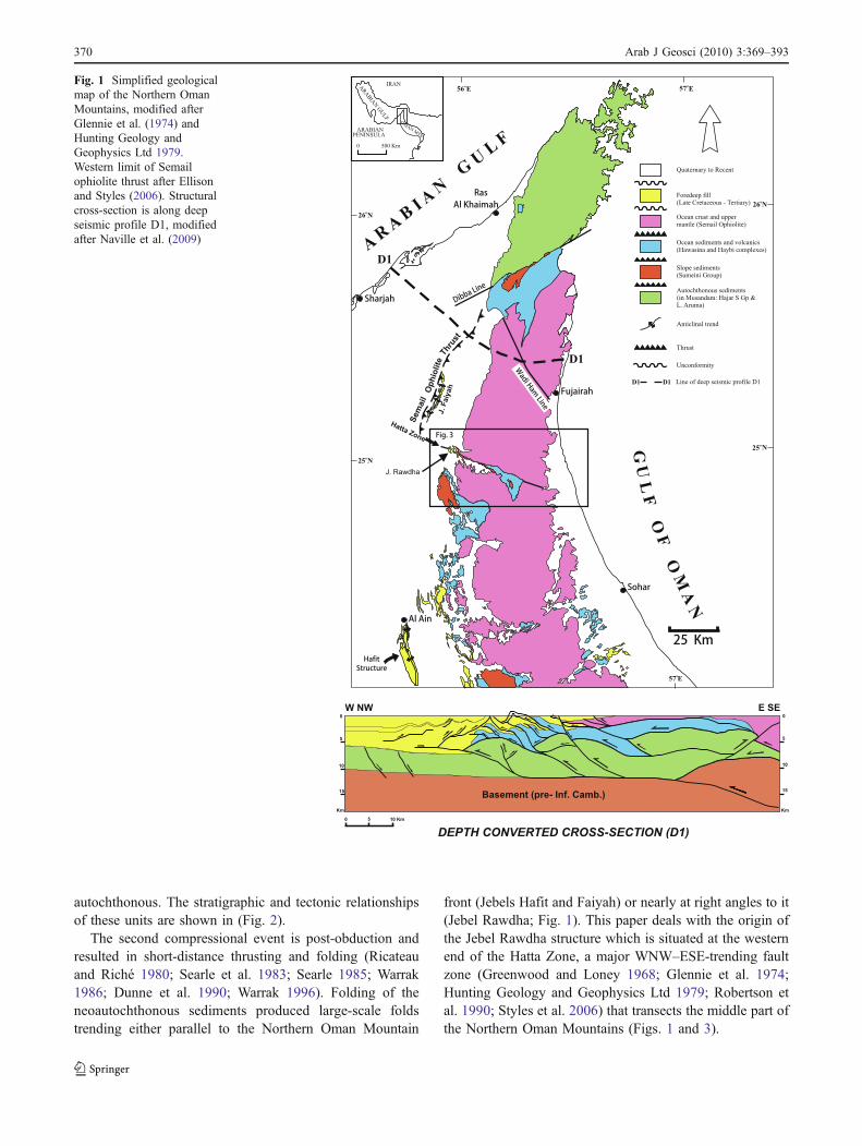
autochthonous. The stratigraphic and tectonic relationshipsof these units are shown in (Fig. 2).
The second compressional event is post-obduction andresulted in short-distance thrusting and folding (Ricateauand Riché 1980; Searle et al. 1983; Searle 1985; Warrak1986; Dunne et al. 1990; Warrak 1996). Folding of theneoautochthonous sediments produced large-scale foldstrending either parallel to the Northern Oman Mountain
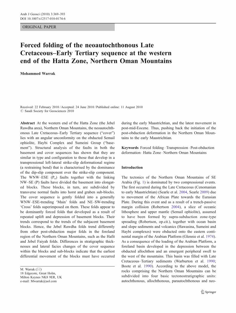
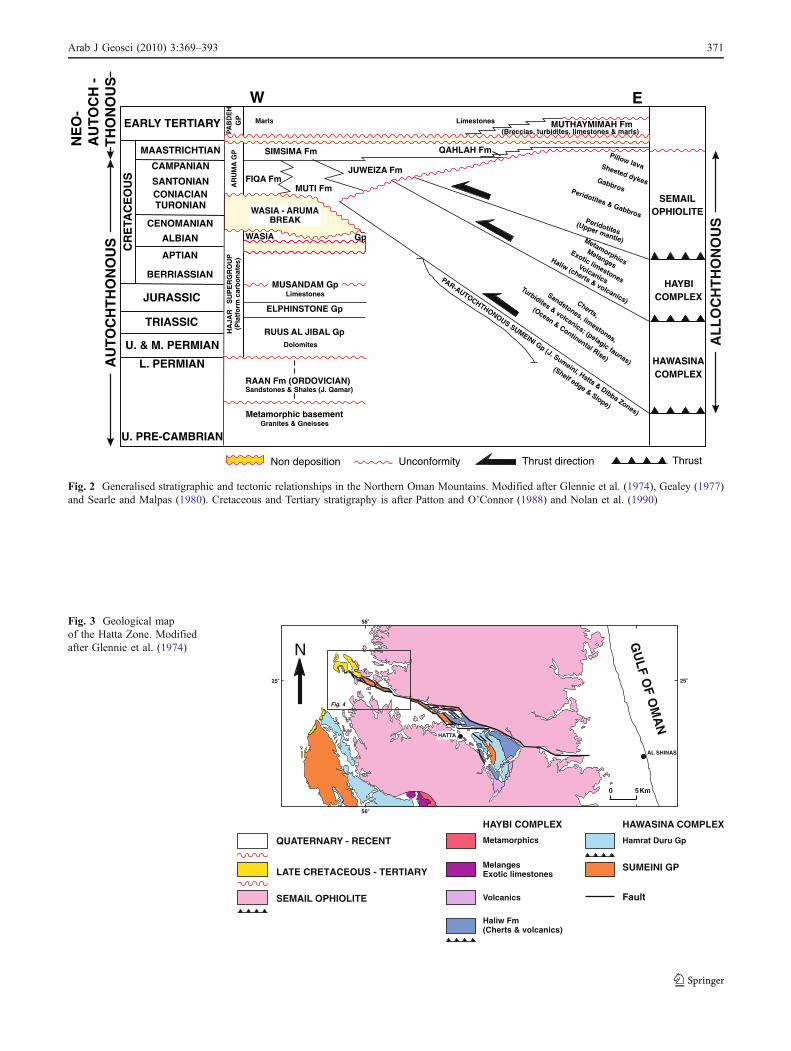
front (Jebels Hafit and Faiyah) or nearly at right angles to it(Jebel Rawdha; Fig. 1). This paper deals with the origin ofthe Jebel Rawdha structure which is situated at the westernend of the Hatta Zone, a major WNW–ESE-trending faultzone (Greenwood and Loney 1968; Glennie et al. 1974;Hunting Geology and Geophysics Ltd 1979; Robertson etal. 1990; Styles et al. 2006) that transects the middle part ofthe Northern Oman Mountains (Figs. 1 and 3).
Fig. 1 Simplified geologicalmap of the Northern OmanMountains, modified afterGlennie et al. (1974) andHunting Geology andGeophysics Ltd 1979.Western limit of Semailophiolite thrust after Ellisonand Styles (2006). Structuralcross-section is along deepseismic profile D1, modifiedafter Naville et al. (2009)
370 Arab J Geosci (2010) 3:369–393
EARLY TERTIARY
MAASTRICHTIAN
CAMPANIAN
SANTONIANCONIACIANTURONIAN
CENOMANIAN
ALBIAN
APTIAN
BERRIASSIAN
CR
ETA
CE
OU
S
JURASSIC
TRIASSIC
U. & M. PERMIAN
L. PERMIAN
U. PRE-CAMBRIAN
PAB
DE
HG
PA
RU
MA
GP
HA
JAR
S
UP
ER
GR
OU
P(P
latf
orm
car
bo
nat
es)
RAAN Fm (ORDOVICIAN)Sandstones & Shales (J. Qamar)
Metamorphic basementGranites & Gneisses
RUUS AL JIBAL GpDolomites
ELPHINSTONE Gp
MUSANDAM GpLimestones
WASIA Gp
FIQA FmMUTI Fm
JUWEIZA Fm
SIMSIMA Fm
Limestones MUTHAYMIMAH Fm(Breccias, turbidites, limestones & marls)
Marls
QAHLAH FmPillow lavaSheeted dykesGabbrosPeridotites & Gabbros
Peridotites(Upper mantle)
SEMAILOPHIOLITE
MetamorphicsMelanges
Exotic limestones
Volcanics
Haliw (cherts & volcanics)
HAYBICOMPLEX
Cherts,
Sandstones, limestones,
Turbidites & volcanics; (pelagic faunas)
(Ocean & Continental Rise) HAWASINACOMPLEX
PAR-AUTOCHTHONOUS SUMEINI Gp (J. Sumeini, Hatta & Dibba Zones)
(Shelf edge & Slope)
AL
LO
CH
TH
ON
OU
S
AU
TOC
HT
HO
NO
US
NE
O-
AU
TOC
H -
TH
ON
OU
S
WASIA - ARUMABREAK
EW
Non deposition Unconformity Thrust direction Thrust
Fig. 2 Generalised stratigraphic and tectonic relationships in the Northern Oman Mountains. Modified after Glennie et al. (1974), Gealey (1977)and Searle and Malpas (1980). Cretaceous and Tertiary stratigraphy is after Patton and O’Connor (1988) and Nolan et al. (1990)
AL SHINAS
GU
LF OF O
MA
N
HATTAHATTA
25o
N
0 5Km
LATE CRETACEOUS - TERTIARY
SEMAIL OPHIOLITE
Metamorphics
MelangesExotic limestones
Volcanics
Haliw Fm(Cherts & volcanics)
HAYBI COMPLEX
Hamrat Duru Gp
HAWASINA COMPLEX
SUMEINI GP
Fault
25o
56o
56o
Fig. 4
QUATERNARY - RECENT
Fig. 3 Geological mapof the Hatta Zone. Modifiedafter Glennie et al. (1974)
Arab J Geosci (2010) 3:369–393 371
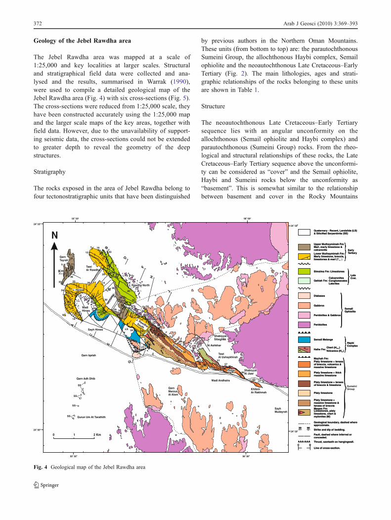
Geology of the Jebel Rawdha area
The Jebel Rawdha area was mapped at a scale of1:25,000 and key localities at larger scales. Structuraland stratigraphical field data were collected and ana-lysed and the results, summarised in Warrak (1990),were used to compile a detailed geological map of theJebel Rawdha area (Fig. 4) with six cross-sections (Fig. 5).The cross-sections were reduced from 1:25,000 scale, theyhave been constructed accurately using the 1:25,000 mapand the larger scale maps of the key areas, together withfield data. However, due to the unavailability of support-ing seismic data, the cross-sections could not be extendedto greater depth to reveal the geometry of the deepstructures.
Stratigraphy
The rocks exposed in the area of Jebel Rawdha belong tofour tectonostratigraphic units that have been distinguished
by previous authors in the Northern Oman Mountains.These units (from bottom to top) are: the parautochthonousSumeini Group, the allochthonous Haybi complex, Semailophiolite and the neoautochthonous Late Cretaceous–EarlyTertiary (Fig. 2). The main lithologies, ages and strati-graphic relationships of the rocks belonging to these unitsare shown in Table 1.
Structure
The neoautochthonous Late Cretaceous–Early Tertiarysequence lies with an angular unconformity on theallochthonous (Semail ophiolite and Haybi complex) andparautochthonous (Sumeini Group) rocks. From the rheo-logical and structural relationships of these rocks, the LateCretaceous–Early Tertiary sequence above the unconformi-ty can be considered as “cover” and the Semail ophiolite,Haybi and Sumeini rocks below the unconformity as“basement”. This is somewhat similar to the relationshipbetween basement and cover in the Rocky Mountains
LS
LS
SS
SS
SS
SS
QarnTayrah
TawiAr Rawdha
J. Rawdha North
J. Hinwa
WadiHinwa
Qarn Adh Dhib
Qurun Um At Tarathith
Qarn Iqelah
J. RawdhaSouth
QarnMarzuzAl Alam
Wadi Andhaira
Andhaira
Ridge
SayhMudayrah
KhitemAr Rakhmah
ShabiyyatAl Jizer
ShabiyyatSibeghah
TawiAl Ushaykhirah
Al Ashkhar
A
B
Sayh Hinwa
C
D
E
F
G
H
I
J
LK
M
N
O
Lower Muthaymimah Fm:Marly limestone, breccia,limestones & marl (Tam
C DLine of cross-section.
0 1 2 Km
N
55o 55
24 55o
56 00o
24 55o
24 50o
55 55o 56 00o
24 50o
Quaternary - Recent, Landslide (LS)& Silicified Serpentinite (SS)
Diabases
Gabbros
Peridotites & Gabbros
Peridotites
SemailOphiolite
Simsima Fm: Limestones
Qahlah Fm:CalcarenitesConglomeratesLaterites
Upper Muthaymimah Fm:Marl, marly limestone &calcarenite Early
Tertiary
LateCret.
Semail Melange
Haliw Fm:Chert (HaCh)Volcanics (HaV)
HaybiComplex
HaChHaV
Mayhah Fm:Platy limestone + lensesof breccia, volcanics &massive limestone
Platy limestone + thickmassive limestone
Platy limestone + lensesof breccia & limestone
Platy limestone
Platy limestone +massive limestone &lenses of brecciaMaqam Fm:Limestones, platylimestone, chert &mylonites (M)
SumeiniGroup
Geological boundary, dashed whereapproximate.
30 90Strike and dip of bedding.
Fault, dashed where inferred orconcealed.
Thrust, sawteeth on hangingwall.
M
6
21
5
36
29
32
7
13
5
16
10
33
2229
3820
28 2835
19
1829
60
30
142633
34
13
14
641
35
19
32 39
25
34
8
18 13
70
87
90
74
54
51
57
84
80 77
C DLine of cross-section.
Quaternary - Recent, Landslide (LS)& Silicified Serpentinite (SS)
Diabases
Gabbros
Peridotites & Gabbros
Peridotites
SemailOphiolite
Simsima Fm: Limestones
Qahlah Fm:CalcarenitesConglomeratesLaterites
Upper Muthaymimah Fm:Marl, marly limestone &calcarenite Early
Tertiary
LateCret.
Semail Melange
Haliw Fm:Chert (HaCh)Volcanics (HaV)
HaybiComplex
HaChHaV
Mayhah Fm:Platy limestone + lensesof breccia, volcanics &massive limestone
Platy limestone + thickmassive limestone
Platy limestone + lensesof breccia & limestone
Platy limestone
Platy limestone +massive limestone &lenses of brecciaMaqam Fm:Limestones, platylimestone, chert &mylonites (M)
Geological boundary, dashed whereapproximate.
30 90Strike and dip of bedding.
Fault, dashed where inferred orconcealed.
Thrust, sawteeth on hangingwall.
M
Lower Muthaymimah Fm:Marly limestone, breccia,limestones & marl ( )Tam
Fig. 4 Geological map of the Jebel Rawdha area
372 Arab J Geosci (2010) 3:369–393
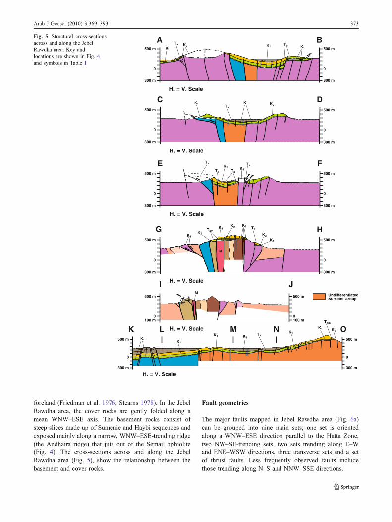
foreland (Friedman et al. 1976; Stearns 1978). In the JebelRawdha area, the cover rocks are gently folded along amean WNW–ESE axis. The basement rocks consist ofsteep slices made up of Sumenie and Haybi sequences andexposed mainly along a narrow, WNW–ESE-trending ridge(the Andhaira ridge) that juts out of the Semail ophiolite(Fig. 4). The cross-sections across and along the JebelRawdha area (Fig. 5), show the relationship between thebasement and cover rocks.
Fault geometries
The major faults mapped in Jebel Rawdha area (Fig. 6a)can be grouped into nine main sets; one set is orientedalong a WNW–ESE direction parallel to the Hatta Zone,two NW–SE-trending sets, two sets trending along E–Wand ENE–WSW directions, three transverse sets and a setof thrust faults. Less frequently observed faults includethose trending along N–S and NNW–SSE directions.
FE500 m
0
300 m
500 m
0
300 m
H. = V. Scale
A B500 m500 m
0
300 m 300 m
0
H. = V. Scale
K2
D500 m
0
300 m
C500 m
0
300 m
H. = V. Scale
TaK2
TaTa
H. = V. Scale
300 m
0
500 m
G H500 m
0
300 m
K1K1
K2
Ta
M
JI500 m
0100 m
500 m
0100 m
H. = V. Scale
M
500 m
0
300 m
K L M N O500 m
0
300 m
H. = V. Scale
K2K1
K1TaK1K1
K1K1
Tam
Tam
Ta K1K1K1
Ta
K1Ta
K1 K2
Tb
K1
K1K2K2
K2
UndifferentiatedSumeini Group
Fig. 5 Structural cross-sectionsacross and along the JebelRawdha area. Key andlocations are shown in Fig. 4and symbols in Table 1
Arab J Geosci (2010) 3:369–393 373
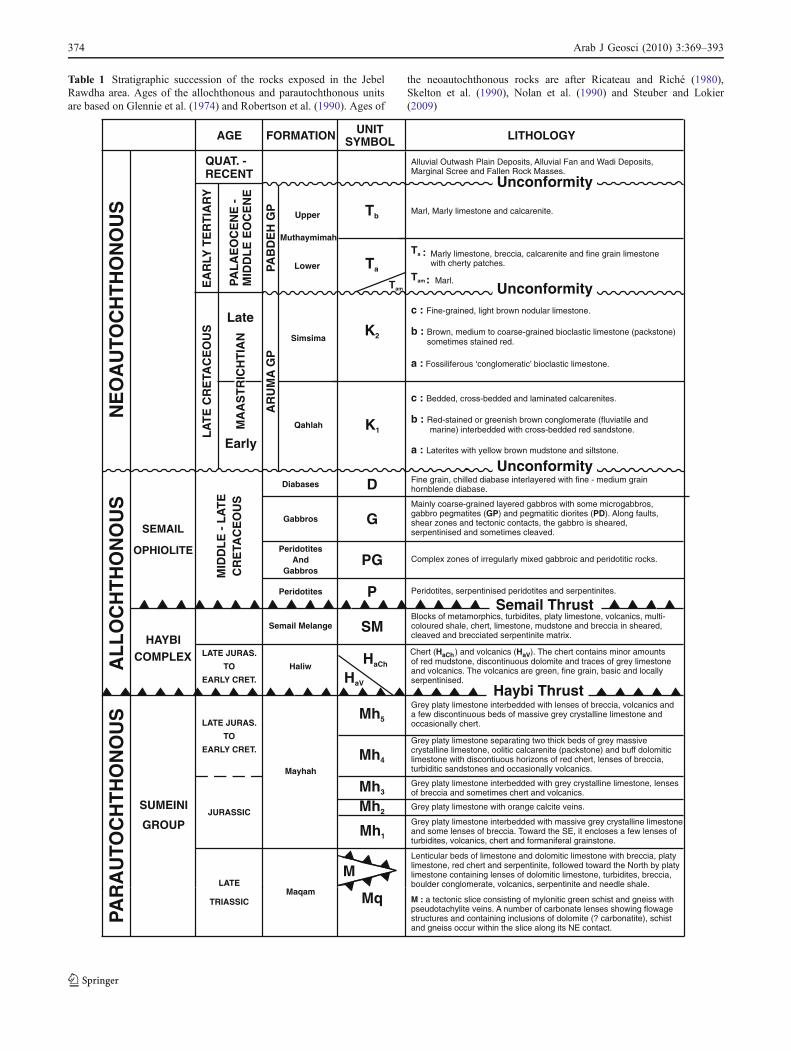
Table 1 Stratigraphic succession of the rocks exposed in the JebelRawdha area. Ages of the allochthonous and parautochthonous unitsare based on Glennie et al. (1974) and Robertson et al. (1990). Ages of
the neoautochthonous rocks are after Ricateau and Riché (1980),Skelton et al. (1990), Nolan et al. (1990) and Steuber and Lokier(2009)
AGE FORMATION UNITSYMBOL LITHOLOGY
QUAT. -RECENT
Alluvial Outwash Plain Deposits, Alluvial Fan and Wadi Deposits,Marginal Scree and Fallen Rock Masses.
EA
RLY
TE
RT
IAR
Y
PAL
AE
OC
EN
E -
MID
DL
E E
OC
EN
E
PAB
DE
H G
P
Muthaymimah
Tb
Ta
Tam
Marl, Marly limestone and calcarenite.
:Ta Marly limestone, breccia, calcarenite and fine grain limestonewith cherty patches.
Tam : Marl.
sometimes stained red.
c :
b :
Fine-grained, light brown nodular limestone.
Brown, medium to coarse-grained bioclastic limestone (packstone)
Fossiliferous ‘conglomeratic’ bioclastic limestone.a :
K2
c :
b :
a :
Bedded, cross-bedded and laminated calcarenites.
Red-stained or greenish brown conglomerate (fluviatile andmarine) interbedded with cross-bedded red sandstone.
Laterites with yellow brown mudstone and siltstone.
K1
AR
UM
AG
P
Simsima
QahlahMA
AS
TR
ICH
TIA
N
LA
TE
CR
ETA
CE
OU
S
Fine grain, chilled diabase interlayered with fine - medium grainhornblende diabase.DDiabases
Mainly coarse-grained layered gabbros with some microgabbros,gabbro pegmatites ( ) and pegmatitic diorites ( ). Along faults,shear zones and tectonic contacts, the gabbro is sheared,serpentinised and sometimes cleaved.
GP PDGGabbros
Complex zones of irregularly mixed gabbroic and peridotitic rocks.PGPeridotites
AndGabbros
Peridotites, serpentinised peridotites and serpentinites.PPeridotites
Semail Thrust
MID
DL
E -
LA
TE
CR
ETA
CE
OU
S
SEMAIL
OPHIOLITE
Blocks of metamorphics, turbidites, platy limestone, volcanics, multi-coloured shale, chert, limestone, mudstone and breccia in sheared,cleaved and brecciated serpentinite matrix.
SMSemail Melange
Chert (HaCh ) and volcanics ( ). The chert contains minor amountsHaVof red mudstone, discontinuous dolomite and traces of grey limestoneand volcanics. The volcanics are green, fine grain, basic and locallyserpentinised.
Haybi ThrustHaV
HaChHaliw
HAYBICOMPLEX
Grey platy limestone interbedded with lenses of breccia, volcanics anda few discontinuous beds of massive grey crystalline limestone andoccasionally chert.
Mh5
Grey platy limestone separating two thick beds of grey massivecrystalline limestone, oolitic calcarenite (packstone) and buff dolomiticlimestone with discontiuous horizons of red chert, lenses of breccia,turbiditic sandstones and occasionally volcanics.
Mh4
Grey platy limestone interbedded with grey crystalline limestone, lensesof breccia and sometimes chert and volcanics.Mh3
Grey platy limestone with orange calcite veins.Mh2Grey platy limestone interbedded with massive grey crystalline limestoneand some lenses of breccia. Toward the SE, it encloses a few lenses ofturbidites, volcanics, chert and formaniferal grainstone.
Mh1
Mayhah
Lenticular beds of limestone and dolomitic limestone with breccia, platylimestone, red chert and serpentinite, followed toward the North by platylimestone containing lenses of dolomitic limestone, turbidites, breccia,boulder conglomerate, volcanics, serpentinite and needle shale.
M : a tectonic slice consisting of mylonitic green schist and gneiss withpseudotachylite veins. A number of carbonate lenses showing flowagestructures and containing inclusions of dolomite (? carbonatite), schistand gneiss occur within the slice along its NE contact.
Mq
MMaqam
SUMEINI
GROUP
NE
OA
UTO
CH
TH
ON
OU
SA
LL
OC
HT
HO
NO
US
PAR
AU
TOC
HT
HO
NO
US
Unconformity
Unconformity
Unconformity
LATE JURAS.
TO
EARLY CRET.
LATE JURAS.
TO
EARLY CRET.
JURASSIC
LATE
TRIASSIC
Late
Early
Upper
Lower
374 Arab J Geosci (2010) 3:369–393
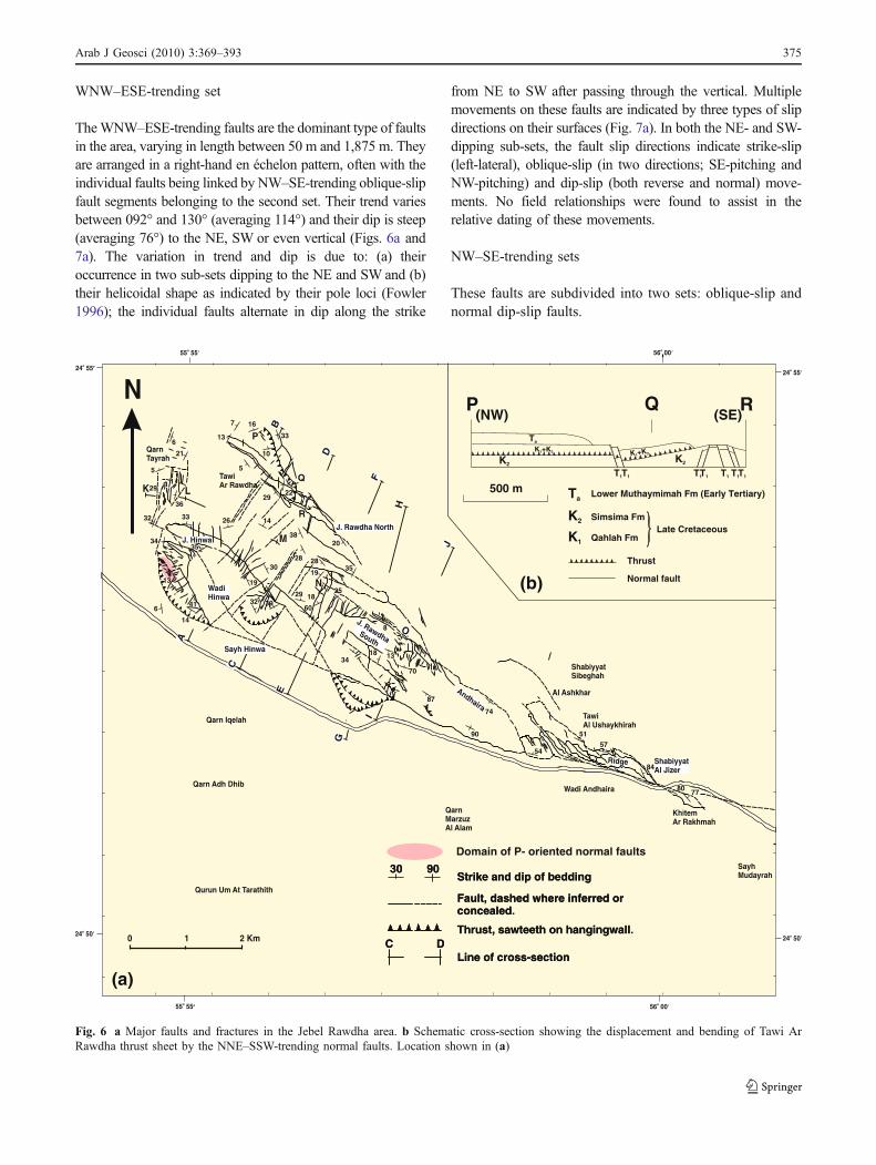
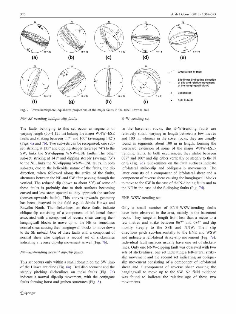
WNW–ESE-trending set
TheWNW–ESE-trending faults are the dominant type of faultsin the area, varying in length between 50 m and 1,875 m. Theyare arranged in a right-hand en échelon pattern, often with theindividual faults being linked by NW–SE-trending oblique-slipfault segments belonging to the second set. Their trend variesbetween 092° and 130° (averaging 114°) and their dip is steep(averaging 76°) to the NE, SW or even vertical (Figs. 6a and7a). The variation in trend and dip is due to: (a) theiroccurrence in two sub-sets dipping to the NE and SW and (b)their helicoidal shape as indicated by their pole loci (Fowler1996); the individual faults alternate in dip along the strike
from NE to SW after passing through the vertical. Multiplemovements on these faults are indicated by three types of slipdirections on their surfaces (Fig. 7a). In both the NE- and SW-dipping sub-sets, the fault slip directions indicate strike-slip(left-lateral), oblique-slip (in two directions; SE-pitching andNW-pitching) and dip-slip (both reverse and normal) move-ments. No field relationships were found to assist in therelative dating of these movements.
NW–SE-trending sets
These faults are subdivided into two sets: oblique-slip andnormal dip-slip faults.
QarnTayrah
TawiAr Rawdha
J. Rawdha North
J. Hinwa
WadiHinwa
Qarn Adh Dhib
Qurun Um At Tarathith
Qarn Iqelah
J. RawdhaSouth
QarnMarzuzAl Alam
Wadi Andhaira
Andhaira
Ridge
SayhMudayrah
KhitemAr Rakhmah
ShabiyyatAl Jizer
ShabiyyatSibeghah
TawiAl Ushaykhirah
Al Ashkhar
A
B
Sayh Hinwa
C
D
E
F
G
H
I
J
LK
M
N
O
C DLine of cross-section
0 1 2 Km
N
30 90Strike and dip of bedding
Fault, dashed where inferred orconcealed.
Thrust, sawteeth on hangingwall.
6
21
5
36
29
32
7
13
5
16
10
33
2229
3820
28 2835
19
1829
60
30
142633
34
13
14
641
35
19
32 39
25
8
18 13
70
87
90
74
54
51
57
84
80 77
C DLine of cross-section
30 90Strike and dip of bedding
Fault, dashed where inferred orconcealed
Thrust, sawteeth on hangingwall
(b)
(a)
Domain of P- oriented normal faults
P
Q
R
55o 55
24 55o
56 00o
24 55o
P Q R
K2K2
K +K1 2
K +K1 2
Ta
T1T1T1 T1T1 T1T1
Ta Lower Muthaymimah Fm (Early Tertiary)
K2 Simsima Fm
K1 Qahlah FmLate Cretaceous
500 m
Thrust
Normal fault
(NW) (SE)
24 50o
55 55o 56 00o
24 50o
34
Fig. 6 a Major faults and fractures in the Jebel Rawdha area. b Schematic cross-section showing the displacement and bending of Tawi ArRawdha thrust sheet by the NNE–SSW-trending normal faults. Location shown in (a)
Arab J Geosci (2010) 3:369–393 375
NW–SE-trending oblique-slip faults
The faults belonging to this set occur as segments ofvarying length (50–1,125 m) linking the major WNW–ESEfaults and striking between 117° and 160° (averaging 142°)(Figs. 6a and 7b). Two sub-sets can be recognised; one sub-set, striking at 135° and dipping steeply (average 74°) to theSW, links the SW-dipping WNW–ESE faults. The othersub-set, striking at 141° and dipping steeply (average 73°)to the NE, links the NE-dipping WNW–ESE faults. In bothsub-sets, due to the helicoidal nature of the faults, the dipdirection, when followed along the strike of the faults,alternates between the NE and SW after passing through thevertical. The reduced dip (down to about 50°) of some ofthese faults is probably due to their surfaces becomingcurved and less steep upward as they approach the surface(convex-upwards faults). This convex-upwards geometryhas been observed in the field e.g. at Jebels Hinwa andRawdha North. The slickenlines on these faults indicateoblique-slip consisting of a component of left-lateral shearassociated with a component of reverse shear causing theirhangingwall blocks to move up to the NE or sometimesnormal shear causing their hangingwall blocks to move downto the SE instead. One of these faults with a component ofnormal shear also displays a second set of slickenlinesindicating a reverse dip-slip movement as well (Fig. 7b).
NW–SE-trending normal dip-slip faults
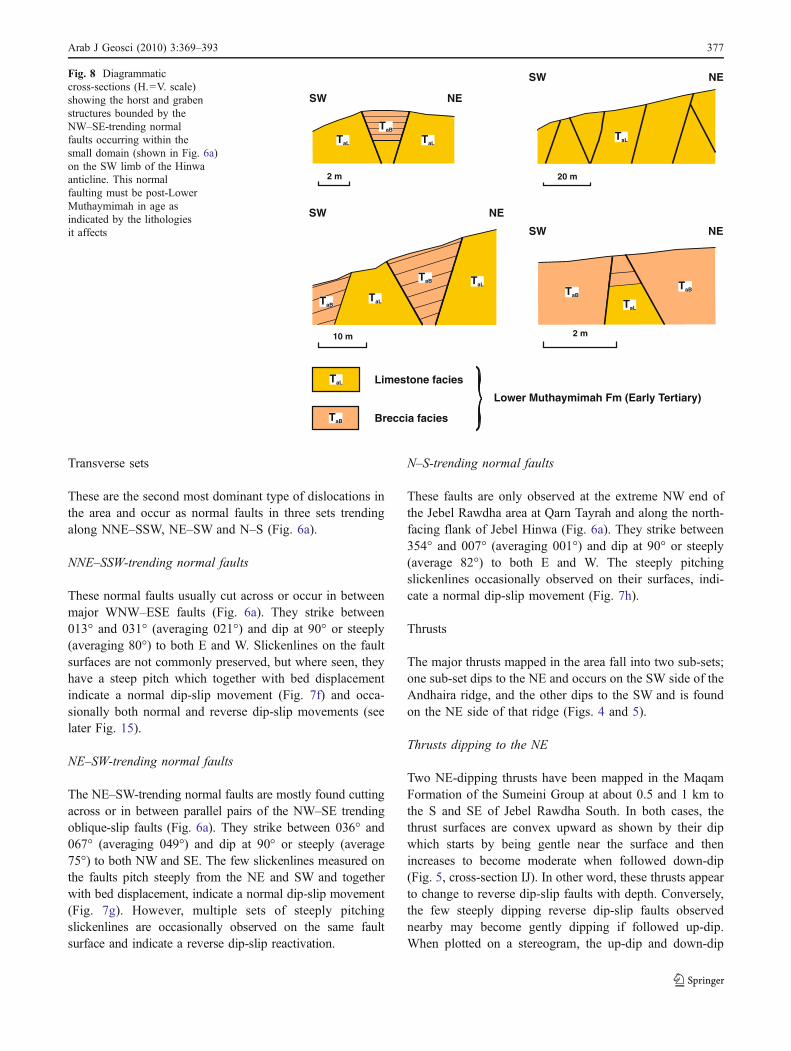
This set occurs only within a small domain on the SW limbof the Hinwa anticline (Fig. 6a). Bed displacement and thesteeply pitching slickenlines on these faults (Fig. 7c)indicate a normal dip-slip movement, with the conjugatefaults forming horst and graben structures (Fig. 8).
E–W-trending set
In the basement rocks, the E–W-trending faults arerelatively small, varying in length between a few metresand 100 m, whereas in the cover rocks, they are usuallyfound as segments, about 100 m in length, forming thewestward extension of some of the major WNW–ESE-trending faults. In both occurrences, they strike between087° and 100° and dip either vertically or steeply to the Nor S (Fig. 7d). Slickenlines on the fault surfaces indicateleft-lateral strike-slip and oblique-slip movements. Thelatter consists of a component of left-lateral shear and acomponent of reverse shear causing the hangingwall blocksto move to the SW in the case of the N-dipping faults and tothe NE in the case of the S-dipping faults (Fig. 7d).
ENE–WSW-trending set
Only a small number of ENE–WSW-trending faultshave been observed in the area, mainly in the basementrocks. They range in length from less than a metre to afew metres and strike between 067° and 084° and dipmostly steeply to the SSE and NNW. Their slipdirections pitch sub-horizontally to the ENE and WSWand indicate a left-lateral strike-slip movement (Fig. 7e).Individual fault surfaces usually have one set of slicken-lines. Only one NNW-dipping fault was observed with twosets of slickenlines; one set indicating a left-lateral strike-slip movement and the second set indicating an oblique-slip movement consisting of a component of left-lateralshear and a component of reverse shear causing thehangingwall to move up to the SW. No field evidencewas found to indicate the relative age of these twomovements.
(b)n = 18
(f)n = 10
(g)n = 19
(h)n = 10
(i)n = 9
Great circle of fault
Slip linear (indicating directionof slip and relative movementof the hangingwall block)
Slickenline
Pole to fault
(a)n = 29 n = 13
(c)n= 14
(d) (e)n = 10
Fig. 7 Lower-hemisphere, equal-area projections of the major faults in the Jebel Rawdha area
376 Arab J Geosci (2010) 3:369–393
Transverse sets
These are the second most dominant type of dislocations inthe area and occur as normal faults in three sets trendingalong NNE–SSW, NE–SW and N–S (Fig. 6a).
NNE–SSW-trending normal faults
These normal faults usually cut across or occur in betweenmajor WNW–ESE faults (Fig. 6a). They strike between013° and 031° (averaging 021°) and dip at 90° or steeply(averaging 80°) to both E and W. Slickenlines on the faultsurfaces are not commonly preserved, but where seen, theyhave a steep pitch which together with bed displacementindicate a normal dip-slip movement (Fig. 7f) and occa-sionally both normal and reverse dip-slip movements (seelater Fig. 15).
NE–SW-trending normal faults
The NE–SW-trending normal faults are mostly found cuttingacross or in between parallel pairs of the NW–SE trendingoblique-slip faults (Fig. 6a). They strike between 036° and067° (averaging 049°) and dip at 90° or steeply (average75°) to both NW and SE. The few slickenlines measured onthe faults pitch steeply from the NE and SW and togetherwith bed displacement, indicate a normal dip-slip movement(Fig. 7g). However, multiple sets of steeply pitchingslickenlines are occasionally observed on the same faultsurface and indicate a reverse dip-slip reactivation.
N–S-trending normal faults
These faults are only observed at the extreme NW end ofthe Jebel Rawdha area at Qarn Tayrah and along the north-facing flank of Jebel Hinwa (Fig. 6a). They strike between354° and 007° (averaging 001°) and dip at 90° or steeply(average 82°) to both E and W. The steeply pitchingslickenlines occasionally observed on their surfaces, indi-cate a normal dip-slip movement (Fig. 7h).
Thrusts
The major thrusts mapped in the area fall into two sub-sets;one sub-set dips to the NE and occurs on the SW side of theAndhaira ridge, and the other dips to the SW and is foundon the NE side of that ridge (Figs. 4 and 5).
Thrusts dipping to the NE
Two NE-dipping thrusts have been mapped in the MaqamFormation of the Sumeini Group at about 0.5 and 1 km tothe S and SE of Jebel Rawdha South. In both cases, thethrust surfaces are convex upward as shown by their dipwhich starts by being gentle near the surface and thenincreases to become moderate when followed down-dip(Fig. 5, cross-section IJ). In other word, these thrusts appearto change to reverse dip-slip faults with depth. Conversely,the few steeply dipping reverse dip-slip faults observednearby may become gently dipping if followed up-dip.When plotted on a stereogram, the up-dip and down-dip
NE
NE
NE
NE
SW
SW
SW
SW
2 m 20 m
10 m 2 m
Limestone facies
Breccia facies
Lower Muthaymimah Fm (Early Tertiary)
TaL
TaL
TaL
TaL
TaL
TaLTaL
TaB
TaB
TaB
TaBTaB
TaB
Fig. 8 Diagrammaticcross-sections (H.=V. scale)showing the horst and grabenstructures bounded by theNW–SE-trending normalfaults occurring within thesmall domain (shown in Fig. 6a)on the SW limb of the Hinwaanticline. This normalfaulting must be post-LowerMuthaymimah in age asindicated by the lithologiesit affects
Arab J Geosci (2010) 3:369–393 377
surfaces of these thrusts would plot as separate great circles(Fig. 7i). Other NE-dipping thrusts include the two thruststhat outcrop between the Gabbro and Diabase hills at about1 km SSE of Jebel Rawdha South and the thrust at SayhHinwa (Fig. 4). The first two thrusts wrap around a lens ofsheared and cleaved serpentinite and link down-dip with themajor WNW–ESE-trending fault that form the SW bound-ary plane of the Andhaira ridge (Fig. 5, cross-section GH).The Sayh Hinwa thrust is the sole thrust of a sheet ofSemail Mélange. It is synformal and bounded on the westand east by NE–SW-trending normal faults forming agraben structure between them (Figs. 4 and 5, cross-sections CD).
Thrusts dipping to the SW
A major thrust (Tawi Ar Rawdha thrust) cuts the NW end ofJebel Rawdha North just to the east of Tawi Ar Rawdha(Figs. 6a and b). This thrust causes a sequence of lateMaastrichtian Simsima (K2) and early Tertiary Muthaymi-mah (Ta) Formations together with a few lenses of earlyMaastrichtian Qahlah Formation (K1) and Semail perido-tites (P) attached to the base, to be thrusted towards the NEover a similar but incomplete sequence (Figs. 4 and 5 cross-section AB). The early Tertiary (Ta) rocks of the footwallsequence appear to have been nearly completely erodedbefore thrusting took place. This is indicated by the thin(0.2–2 m) patches of the lowest parts of this early Tertiaryleft on the exposed thrust surface and the red staining of therocks underneath the thrust, sometimes to a depth of 1 m.Towards the SE, the Tawi Ar Rawdha thrust is downthrownto the ESE by two normal step-faults, and at its SE end, it isbent against the NW edge of a footwall horst (Fig. 6b). Inboth cases, the normal faults displacing the thrust belong tothe NNE–SSW-trending normal faults set and therefore,their movements must post-date the emplacement of thethrust, which is taken as post-Ta and pre-Tb (Table 1), sinceTb is not affected by thrusting.
N–S-trending right-lateral faults
The few N–S-trending right-lateral faults observed, dipsteeply to moderately to W and E. Their slickenlinesindicate a right-lateral strike-slip movement and in onefault an oblique-slip movement consisting of a componentof right-lateral shear and a reverse shear.
NNW–SSE-trending right-lateral faults
The NNW–SSE-trending faults are rarely observed in thearea. They are either vertical or dip steeply to moderately toWSW or ENE. Their slickenlines indicate right-lateral strike-slip or oblique-slip with a component of right-lateral shear.
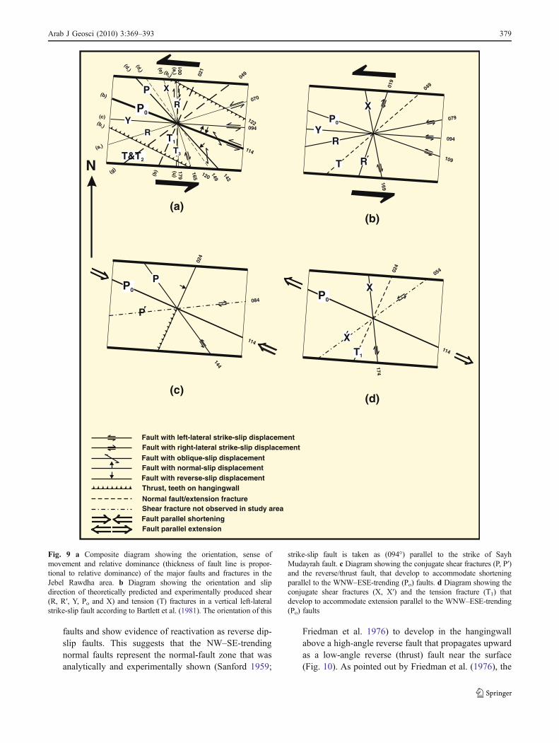
Interpretation of the Jebel Rawdha fault sets
To interpret the above-described sets of faults observed inthe Jebel Rawdha area, a composite diagram, showing theaverage orientation of each set, their sense of movementsand relative dominance in the area, is constructed (Fig. 9a).The resulting configuration of fault sets (Fig. 9a) can beinterpreted in terms of (a) the assemblage of fracturespredicted theoretically and documented experimentally with-in a left-lateral strike-slip fault zone (Sylvester 1988) and (b)the associated fractures that develop as a result of shorteningand extension parallel to the strike-slip fault (Ramsay andHuber 1987; Swanson 1988). Figure 9b shows the fracturesassociated with a left-lateral strike-slip fault zone accordingto the terminology and orientations of Bartlett et al. (1981).The orientation of this strike-slip fault zone (PrincipleDisplacement Zone, PDZ) is taken as 094° parallel to thestrike of the Sayh Mudayrah fault (the segment of the Hattafault Zone situated at the eastern end of the Jebel Rawdhaarea, Fig. 6a). Figures 9c and d show the fracture setsassociated with shortening (P, P´) and extension ( X, X´, T1)parallel to the WNW–ESE-trending fault set.
Fault type and configuration
Comparing Fig. 9a with Fig. 9b, c and d, the following canbe deduced:
a. The ENE–WSW-trending left-lateral and N–S-trendingright-lateral fault sets correspond to the Riedel shearfracture sets R, R´ respectively.
b. The WNW–ESE-trending fault set corresponds to the P-shears of (Skempton 1966; Tchalenko 1970; Tchalenkoand Ambraseys 1970), which are here termed (Po) todistinguish them from the P-shear fractures at slightlyhigher angle that are developed to accommodateshortening parallel to these WNW–ESE-trending (Po)faults. The Po-oriented fault set is the most abundanttype of major faults in the Jebel Rawdha area.
c. The orientation of Sayh Mudayrah fault (the PrincipleDisplacement Zone, PDZ) and the few E–W-trendingleft-lateral faults, which sometimes form the westwardextension of Po- faults, correspond to the Y-shears of(Morgenstern and Tchalenko 1967).
d. The first set of the NW–SE-trending faults i.e. the oblique-slip faults that link the Po-oriented faults, corresponds tothe P-shears that develop to accommodate shorteningparallel to the Po- oriented faults (Fig. 9c).
e. The second set of the NW–SE-trending faults are thenormal faults that form horst and graben structures onthe SW limb of the Hinwa anticline (Figs. 6a and 8).They occur in a small elongated domain situated abovehigh-angle P-faults that curve upward into low-angle
378 Arab J Geosci (2010) 3:369–393
faults and show evidence of reactivation as reverse dip-slip faults. This suggests that the NW–SE-trendingnormal faults represent the normal-fault zone that wasanalytically and experimentally shown (Sanford 1959;
Friedman et al. 1976) to develop in the hangingwallabove a high-angle reverse fault that propagates upwardas a low-angle reverse (thrust) fault near the surface(Fig. 10). As pointed out by Friedman et al. (1976), the
094
122
070
114
142
149
165 120
179
049021
001
(b)
P0
P
(d)1
(d)2
(e)
(a)2(b )2
(c)(b )1
(a )1
(g)
(b)
(h)
YR
R
X
T&T2
T1
T3
N
079
094
109
169
049019
P0
YR
R
X
T
084
114144
P
P
114
174
024
024
054
P0 XP0
XT1
(a)(b)
(d)(c)
Thrust, teeth on hangingwall
Normal fault/extension fractureShear fracture not observed in study areaFault parallel shorteningFault parallel extension
Fault with left-lateral strike-slip displacementFault with right-lateral strike-slip displacementFault with oblique-slip displacementFault with normal-slip displacementFault with reverse-slip displacement
Fig. 9 a Composite diagram showing the orientation, sense ofmovement and relative dominance (thickness of fault line is propor-tional to relative dominance) of the major faults and fractures in theJebel Rawdha area. b Diagram showing the orientation and slipdirection of theoretically predicted and experimentally produced shear(R, R′, Y, Po and X) and tension (T) fractures in a vertical left-lateralstrike-slip fault according to Bartlett et al. (1981). The orientation of this
strike-slip fault is taken as (094°) parallel to the strike of SayhMudayrah fault. c Diagram showing the conjugate shear fractures (P, P′)and the reverse/thrust fault, that develop to accommodate shorteningparallel to the WNW–ESE-trending (Po) faults. d Diagram showing theconjugate shear fractures (X, X′) and the tension fracture (T1) thatdevelop to accommodate extension parallel to the WNW–ESE-trending(Po) faults
Arab J Geosci (2010) 3:369–393 379
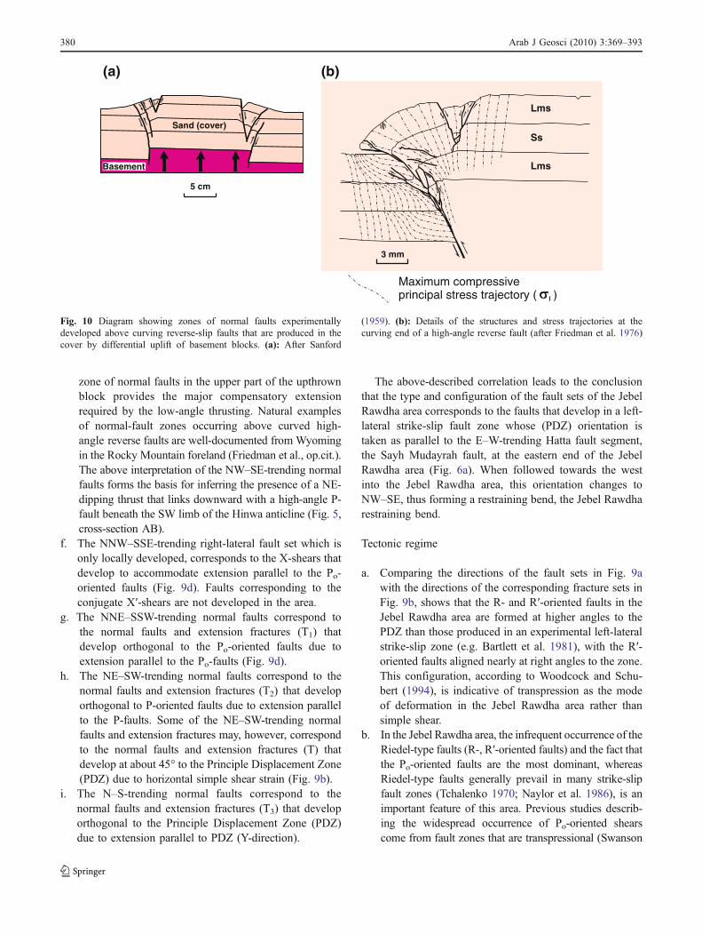
zone of normal faults in the upper part of the upthrownblock provides the major compensatory extensionrequired by the low-angle thrusting. Natural examplesof normal-fault zones occurring above curved high-angle reverse faults are well-documented from Wyomingin the Rocky Mountain foreland (Friedman et al., op.cit.).The above interpretation of the NW–SE-trending normalfaults forms the basis for inferring the presence of a NE-dipping thrust that links downward with a high-angle P-fault beneath the SW limb of the Hinwa anticline (Fig. 5,cross-section AB).
f. The NNW–SSE-trending right-lateral fault set which isonly locally developed, corresponds to the X-shears thatdevelop to accommodate extension parallel to the Po-oriented faults (Fig. 9d). Faults corresponding to theconjugate X′-shears are not developed in the area.
g. The NNE–SSW-trending normal faults correspond tothe normal faults and extension fractures (T1) thatdevelop orthogonal to the Po-oriented faults due toextension parallel to the Po-faults (Fig. 9d).
h. The NE–SW-trending normal faults correspond to thenormal faults and extension fractures (T2) that developorthogonal to P-oriented faults due to extension parallelto the P-faults. Some of the NE–SW-trending normalfaults and extension fractures may, however, correspondto the normal faults and extension fractures (T) thatdevelop at about 45° to the Principle Displacement Zone(PDZ) due to horizontal simple shear strain (Fig. 9b).
i. The N–S-trending normal faults correspond to thenormal faults and extension fractures (T3) that developorthogonal to the Principle Displacement Zone (PDZ)due to extension parallel to PDZ (Y-direction).
The above-described correlation leads to the conclusionthat the type and configuration of the fault sets of the JebelRawdha area corresponds to the faults that develop in a left-lateral strike-slip fault zone whose (PDZ) orientation istaken as parallel to the E–W-trending Hatta fault segment,the Sayh Mudayrah fault, at the eastern end of the JebelRawdha area (Fig. 6a). When followed towards the westinto the Jebel Rawdha area, this orientation changes toNW–SE, thus forming a restraining bend, the Jebel Rawdharestraining bend.
Tectonic regime
a. Comparing the directions of the fault sets in Fig. 9awith the directions of the corresponding fracture sets inFig. 9b, shows that the R- and R′-oriented faults in theJebel Rawdha area are formed at higher angles to thePDZ than those produced in an experimental left-lateralstrike-slip zone (e.g. Bartlett et al. 1981), with the R′-oriented faults aligned nearly at right angles to the zone.This configuration, according to Woodcock and Schu-bert (1994), is indicative of transpression as the modeof deformation in the Jebel Rawdha area rather thansimple shear.
b. In the Jebel Rawdha area, the infrequent occurrence of theRiedel-type faults (R-, R′-oriented faults) and the fact thatthe Po-oriented faults are the most dominant, whereasRiedel-type faults generally prevail in many strike-slipfault zones (Tchalenko 1970; Naylor et al. 1986), is animportant feature of this area. Previous studies describ-ing the widespread occurrence of Po-oriented shearscome from fault zones that are transpressional (Swanson
Basement
Sand (cover)
5 cm
Maximum compressiveprincipal stress trajectory ( )
3 mm
Lms
Ss
Lms
(a) (b)
Fig. 10 Diagram showing zones of normal faults experimentallydeveloped above curving reverse-slip faults that are produced in thecover by differential uplift of basement blocks. (a): After Sanford
(1959). (b): Details of the structures and stress trajectories at thecurving end of a high-angle reverse fault (after Friedman et al. 1976)
380 Arab J Geosci (2010) 3:369–393
1988; Moore and Byerlee 1991; Cunningham et al.1996). Furthermore, fault patterns made up of Po-shearsand subordinate R-shears were also produced in clay-box analogue models of transpression at a restrainingbend (Keller et al. 1997). These experimental resultstogether with the field studies referred to above, ledKeller et al. (op.cit.) to deduce that Po-shears arepreferentially developed during transpressional deforma-tion and are a diagnostic feature of this deformationregime.
Thus, in the Jebel Rawdha area, the observed types offault sets, their orientations in relation to each other and tothe E–W-trending Sayh Mudayrah fault segment, (the Po-oriented faults make 20° step-over angle with it) and thepredominance of the Po-oriented faults over the R-orientedfaults, lead to the conclusion that the Jebel Rawdha faultsets have formed in a transpressional regime at a restrainingbend of a left-lateral strike-slip fault. This restraining bend(the Jebel Rawdha restraining bend), being the mostwesterly within the Hatta fault Zone, is oriented at 294°and linked at its SE end to a straight (Sayh Mudayrah fault)which strikes at 274° (Fig. 6a).
The suggestion that the Jebel Rawdha fault array couldrepresent the tip of the Hatta fault Zone rather than a restrainingbend along its trace is incompatible with the geometry andkinematics of the Jebel Rawdha faults. As can be seen inFig. 6a, the Po/P faults do not form the imbricate fan ofconcave faults (horsetail splays) characteristic of the ends ofstrike-slip faults, nor do they link to the main strike-slip fault(Sayh Mudayrah fault) at the eastern end and lose displace-ment to a fault tip at the western end as would be the case ifthey were to represent the lateral fault tip of a strike-slip fault(Woodcock and Fischer 1986). Furthermore, evidence indi-cating that the Hatta fault Zone continues northwestwards forup to 40 km beyond the Jebel Rawdha area, comes fromseismic information and palaeogeographic study of well data.The Hatta fault Zone is shown on a N–S-oriented seismic lineshot along the western subsurface limit of the Semail ophiolite(Dunne et al. 1990, fig. 6). The western subsurface limit ofthe Semail ophiolite is located at about 20 km to the NW ofthe Jebel Rawdha area (Ellison and Styles 2006, fig. 3.5). TheHatta fault zone is also depicted on a mid-Eocene palaeogeo-graphic map of the northern part of the United Arab Emiratesand Oman, where it is shown to extend for about 40 kmnorthwestward of the Jebel Rawdha area (Hertig et al. 1994,fig. 1).
Basement blocks
The eastern part of the Jebel Rawdha area is dominated bythe Andhaira ridge, whose pre-imbrication geometry is that
of a WNW–ESE-trending wedge, 7 km long and 1.25 kmwide (Fig. 4). The nature of its NE and SW boundaryplanes as steeply dipping (Po) faults is indicated by thefollowing evidence:
a. The two boundary planes are nearly straight, trendingparallel to Po-faults and steeply dipping (75°–85°), withthe NE-boundary plane dipping to the SW and the SW-boundary plane dipping to the NE (Fig. 4).
b. The two boundary planes cut, with a small angle,across the strike of the lithological units comprising theridge (Fig. 4).
c. The contact between the Gabbros (G)/Peridotites andGabbros (PG) units of the Semail ophiolite abuts, witha high angle, against the NE-boundary plane of theridge (Fig. 4).
d. The presence of direct evidence of movement along theboundary planes such as: (1) at various localities, theboundary planes are marked by slickenlines and (2)the rocks along the boundary planes are crushed andbrecciated. Where the boundary planes of the ridge arein contact with gabbro or serpentinite, the gabbro hasbeen serpentinised and both rocks are sheared andfoliated. The resulting gouge fabric is ‘conglomeratic’in appearance, with the foliation wrapping around theserpentinite clasts. Along the NE-boundary plane,below the summit of Jebel Rawdha South, the crushzone is about 45 m wide, and contains serpentiniteclasts of various sizes (up to 1 m) floating in pulverisedand foliated serpentinite matrix, with the Po-orientedfoliation wrapping around the clasts. Similar gougefabric, with Po-oriented foliation wrapping aroundclasts was shown to develop during progressive lateralshearing displacement (Keller et al. 1997, fig. 4).
Therefore, from the above evidence, it is concluded thatthe Andhaira ridge, is a fault-bounded block, bounded byPo-faults that dip steeply in opposite directions; the NE-bounding fault dips to the SW and the SW-bounding faultdips to the NE (Fig. 5). In the western parts of the areawhere the basement is concealed underneath the coversequence, the geometry of the basement faults can still bededuced because these faults have propagated upwardthrough all the units of the cover sequence (Fig. 4). Thisis particularly clear along the slopes under the summit ofJebel Rawdha South, where many of the faults in theSumeini Group have continued upwards into the coverrocks and displaced them. Similarly, the faults in the Semailperidotites/mélange at Jebel Rawdha North and at Wadi andJebel Hinwa have cut through and displaced the coverrocks. Thus, based on the type and geometry of the exposedfaults, a map depicting the basement faults and geometryand composition of the basement blocks bounded by them,
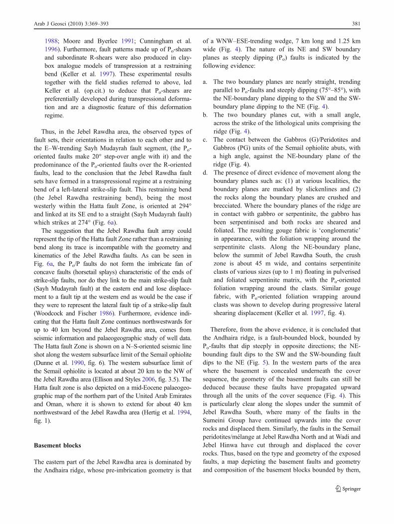
Arab J Geosci (2010) 3:369–393 381
is constructed (Fig. 11). Figure 11 shows that the geometryof the concealed western extension of the Andhaira block tobe wedge-shaped tapering towards the NW to a pointsituated under or near Qarn Tayrah. Its bounding Po-faultsare segmented, with the segments being linked by P-faults.Thus, taken as a whole, the general 3D geometry of theAndhaira block is that of an elongated composite lenscomprised of the Sumeini rocks (Mq and Mh Formations)and incorporating two smaller slices of the Haybi rocks onits sides. One of these slices is composed of the SemailMélange (SM) and occurs along its SW boundary and theother consisting of the Haliw chert and volcanic is situatedalong the NE boundary at its eastern end (Fig. 11).
The other basement blocks shown in Fig. 11, comprise anumber of smaller elongated lens-shaped blocks made up ofthe Semail Peridotites and occurring on the NE and SWsides of the Andhaira block (Fig. 5), where the wedge-shaped deformation zone produced by the Jebel Rawdharestraining bend attains its maximum width. Those blockssituated on the NE side, are arranged in en échelon patternand bounded by arcuate faults that gradually changeorientation from NW–SE (P-orientation) in the east,through WNW–ESE (Po-orientation) to E–W (Y-orienta-tion) in the west at the points of intersection with the NE-bounding fault of the Andhaira block, or even to ENE–WSW (R-orientation) for the bounding faults of the blocks
T1
T1
T1
T2
T2
T2
T2
T2
T2
T2
T2
T2
T1
T1
T3
T3 T3
T3
T2
T1
T2
T2 T1
T1
T1
T1
Andhaira Block
Peridotites (Semail Ophiolite)
Semail Melange
Haliw Fm:Chert (HaCh)Volcanics (HaV)
HaybiComplexHaChHaV
Thrust, sawteeth on hangingwall
UndifferentiatedSumeini Group
P - oriented fault0
P - oriented fault
Y - oriented fault
R - oriented fault
Normal fault (T , T or T )1 2 3
0 1 2 Km
N
55o 55
24 55o
56 00o
24 55o
24 50o
24 50o
55 55o 56 00o
Fig. 11 Geometry and lithological composition of basement blocks
382 Arab J Geosci (2010) 3:369–393
farthest to the West. The blocks located on the SW side ofthe Andhaira block, are sigmoidal in shape and bounded byPo- and P-oriented faults (Fig. 11).
The geometry of the Andhaira block and the smallerelongated blocks on its NE- and SW-sides is furthercomplicated by the normal faults which subdivide theblocks into a series of transverse horst and graben sub-blocks of various sizes (Fig. 5, cross-section KO).These horsts and grabens trend along NNE–SSW, NE–SW and N-S directions depending on the orientation ofthe set of normal faults (T1, T2 and T3) bounding them(Fig. 11). The horsts and grabens bounded by the NNE–SSW-trending normal faults (T1) occur along and be-tween parallel segments of Po-faults, those bounded bythe NE–SW-trending normal faults (T2) are found alongand between parallel segments of P-faults, whilst thehorsts and grabens bounded by the N–S-trending normalfaults (T3) are associated with the Y-oriented faultsegments.
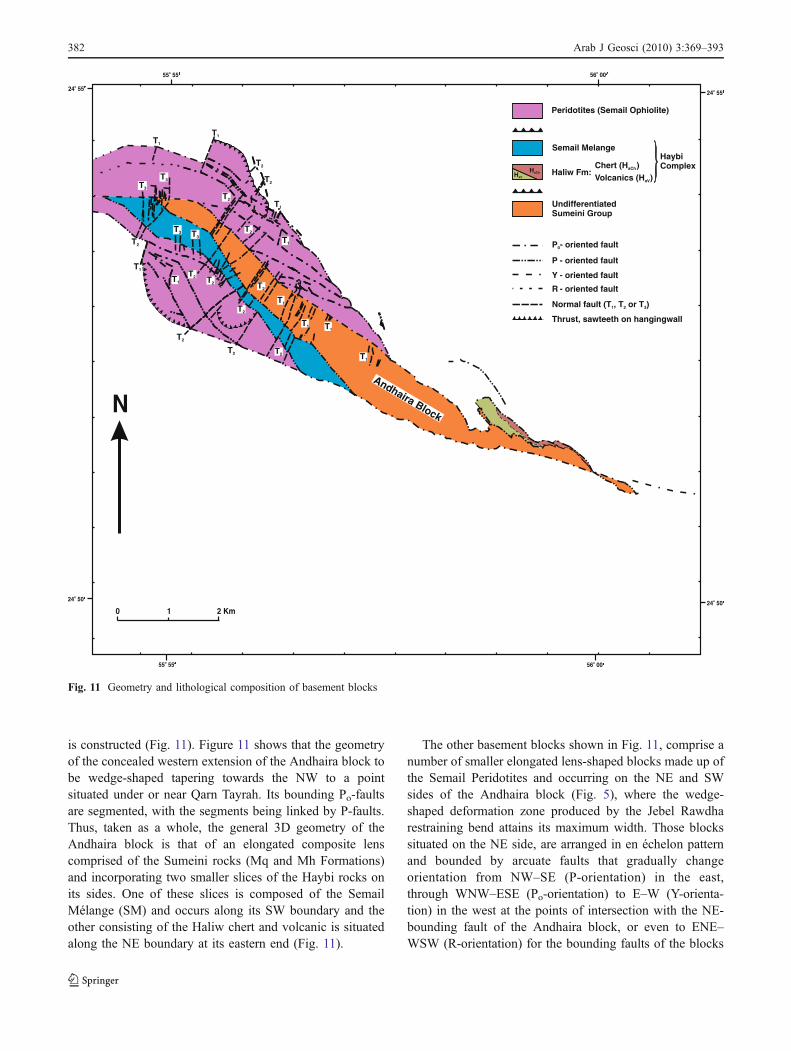
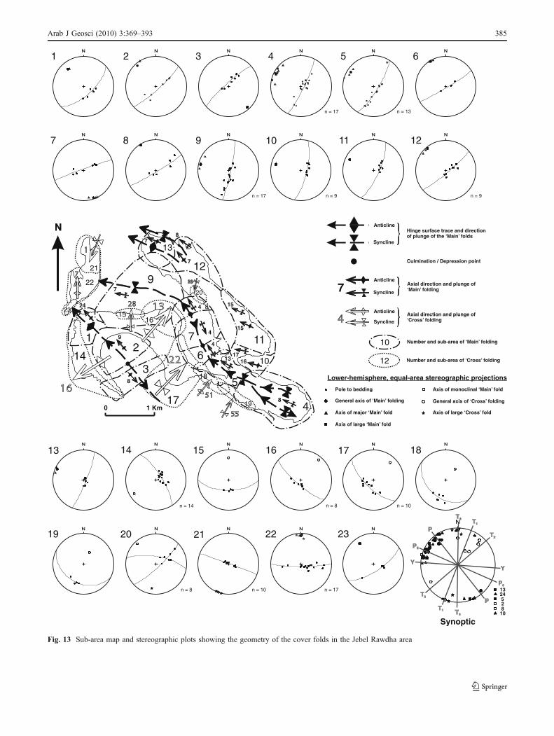
Cover folds
The Late Cretaceous–Early Tertiary cover has been foldedalong two trends; the first, ‘Main’ folding, is along a meanWNW–ESE direction, and the second, ‘Cross’ folding, isnearly at right angles to the ‘Main’ folding direction. The‘Main’ folding gave rise to a major first-order syncline, theJebel Rawdha syncline, and to second-order folds which aredeveloped on the SW- and NE-limbs of the first-ordersyncline, whilst the ‘Cross’ folding produced major andlarge folds superimposed on the ‘Main’ folds (Fig. 12).
The Jebel Rawdha syncline
Near the summit of Jebel Rawdha South, the JebelRawdha syncline starts as a gentle conjugate kink foldplunging gently to the WNW and consisting of a flatmedian segment and short steep flanks. Towards theWNW, at the lower slopes of the mountain, the twohinge lines converge and finally join together and thefold geometry changes to that of a single-hinged,gentle broad fold, still plunging gently to the WNW(Fig. 13, sub-areas 4 and 5). Near the base of the WNWslope, the hinge line changes its trend and continuesNNW towards Tawi Ar Rawdha, passing through syncli-nal depression and culmination points, which causereversals in the direction of plunge (Fig. 13, sub-areas6, 7 and 8). South of Tawi Ar Rawdha, the hinge lineassumes a nearly E–W direction and plunges sub-horizontally to the West (Fig. 13, sub-area 9).
The two limbs of the Jebel Rawdha syncline are folded bysecond-order folds; the SW-limb by the Jebel Hinwa anticline
and the NE-limb by gentle folds with broad, rounded hingezones and hinge lines plunging gently to the WNW (Fig. 13,sub-areas 10 and 11), or sub-horizontally to the NW andWNW (Fig. 13, sub-areas 12 and 13), whilst the flat mediansegment of the syncline, just below the summit of JebelRawdha South, is flexed by three third-order gentle foldsplunging sub-horizontally to the WNW (Fig. 12).
The Jebel Hinwa anticline
The Jebel Hinwa anticline is the largest of the second-orderfolds and occurs on the SW-limb of the Jebel Rawdhasyncline (Fig. 12). It is a gentle, nearly symmetrical, uprightfold with a broad rounded hinge zone (Fig. 5, cross-sectionAB). At Jebel Hinwa, the hinge line plunges gently to theWNW (Fig. 13, sub-area 1), whilst towards the SE at WadiHinwa, it changes its trend and plunges from sub-horizontally to NNW to sub-horizontally to SSE afterpassing through an anticlinal culmination point (Fig. 13,sub-areas 2 and 3).
‘Cross’ folds
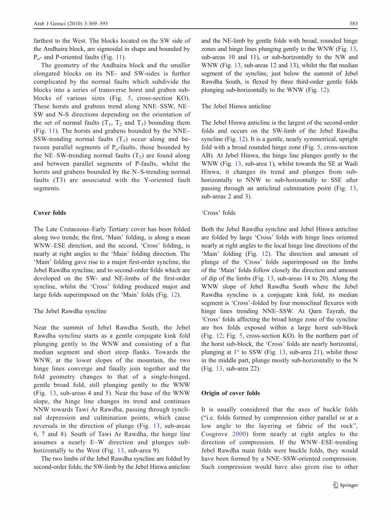
Both the Jebel Rawdha syncline and Jebel Hinwa anticlineare folded by large ‘Cross’ folds with hinge lines orientednearly at right angles to the local hinge line directions of the‘Main’ folding (Fig. 12). The direction and amount ofplunge of the ‘Cross’ folds superimposed on the limbsof the ‘Main’ folds follow closely the direction and amountof dip of the limbs (Fig. 13, sub-areas 14 to 20). Along theWNW slope of Jebel Rawdha South where the JebelRawdha syncline is a conjugate kink fold, its mediansegment is ‘Cross’-folded by four monoclinal flexures withhinge lines trending NNE–SSW. At Qarn Tayrah, the‘Cross’ folds affecting the broad hinge zone of the synclineare box folds exposed within a large horst sub-block(Fig. 12; Fig. 5, cross-section KO). In the northern part ofthe horst sub-block, the ‘Cross’ folds are nearly horizontal,plunging at 1° to SSW (Fig. 13, sub-area 21), whilst thosein the middle part, plunge mostly sub-horizontally to the N(Fig. 13, sub-area 22).
Origin of cover folds
It is usually considered that the axes of buckle folds(“i.e. folds formed by compression either parallel or at alow angle to the layering or fabric of the rock”,Cosgrove 2000) form nearly at right angles to thedirection of compression. If the WNW–ESE-trendingJebel Rawdha main folds were buckle folds, they wouldhave been formed by a NNE–SSW-oriented compression.Such compression would have also given rise to other
Arab J Geosci (2010) 3:369–393 383
similarly oriented folds in the neoautochthonous sequencein the region. The nearest exposed large-scale folds thatdeform neoautochthonous sediments in the foreland regionof the Northern Oman Mountains, are the Jebel Faiyahfolds located at about 25 km to the northwest of the JebelRawdha area. The NNE–SSW trend of the Faiyah foldsand their westerly vergence, suggest deformation by a
WNW-directed compression. Therefore, evidence of aNNE–SSW-oriented compression seems to be lacking inthe region. The localised occurrence of the Jebel Rawdhacover folds at a restraining bend suggests that their originis likely to be linked to the transpressional deformationthat resulted from movements on the WNW–ESE-trendingrestraining bend that underlies the Jebel Rawdha area.
10
11
10
12
15
10
4
5
3
10
14
13
5
3
1
9
1
4
7
125
8
2
9
27
5
2
7
8
10
16
17
15
15
15
20
21
19
3
5
8
6
187
11
0
0
J.R.S.
J.H.A
.
0
1616
1313
2222
5151
5555
2828
20
N
0 1 2 Km
Lower Muthaymimah Fm:Marly limestone, breccia,limestones & marl (Tam
Simsima Fm: Limestones
Qahlah Fm:CalcarenitesConglomeratesLaterites
Upper Muthaymimah Fm:Marl, marly limestone &calcarenite Early
Tertiary
LateCret.
Simsima Fm: Limestones
Qahlah Fm:CalcarenitesConglomeratesLaterites
Upper Muthaymimah Fm:Marl, marly limestone &calcarenite Early
Tertiary
LateCret.
Lower Muthaymimah Fm:Marly limestone, breccia,limestones & marl ( )Tam
QarnTayrah
TawiAr Rawdha
J. Hinwa
WadiHinwa
J. RawdhaSouth
Hinge surface trace and plungeof first-order ‘Main’ syncline.J.R.S. : Jebel Rawdha syncline
Hinge surface trace and plungeof second-order ‘Main’ fold.J.H.A. : Jebel Hinwa anticline
AnticlineSyncline
Hinge surface trace of monoclinal‘Main’ flexure.
Anticlinal
Synclinal
Anticlinal
Synclinal
AnticlineSyncline
Hinge surface trace and plungeof large ‘Cross’ fold.
Hinge surface trace of monoclinal‘Cross’ flexure.
Culmination / Depression point.
Anticline
SynclineAxial direction of‘Cross’ folding.
Axis of first-order‘Main’ fold.
Axis of second-order‘Main’ fold.
Axis of third-order(large) ‘Main’ fold.
Axis of large ‘Cross’fold.
Fig. 12 The cover folds in the Jebel Rawdha area
384 Arab J Geosci (2010) 3:369–393
Anticline
Anticline
Syncline
Syncline7
N
0 1 Km
N
8
13
4
4
4
7
24
9
8
7
7
8
1617
15
15
12
3
4
5
6
7
8
9
10
11
12
13
14
1516
17
18
19
20
21
22
23
Hinge surface trace and directionof plunge of the ‘Main’ folds
Culmination / Depression point
Axial direction and plunge of‘Main’ folding
Anticline
SynclineAxial direction and plunge of‘Cross’ folding
10
12
Number and sub-area of ‘Main’ folding
Number and sub-area of ‘Cross’ folding
Lower-hemisphere, equal-area stereographic projections
Pole to bedding
General axis of ‘Main’ folding
Axis of major ‘Main’ fold
Axis of large ‘Main’ fold
Axis of monoclinal ‘Main’ fold
General axis of ‘Cross’ folding
Axis of large ‘Cross’ fold
1 2 3 4
n = 17
5
n = 13
6
7 8 9
n = 17
10
n = 9
11 12
n = 9
13 14
n = 14
15 16
n = 8
17
n = 10
18
19 20
n = 8
21
n = 10
22
n = 17
23P0
P0
T3
T3
T2
T1
132452810
Synoptic
Fig. 13 Sub-area map and stereographic plots showing the geometry of the cover folds in the Jebel Rawdha area
Arab J Geosci (2010) 3:369–393 385
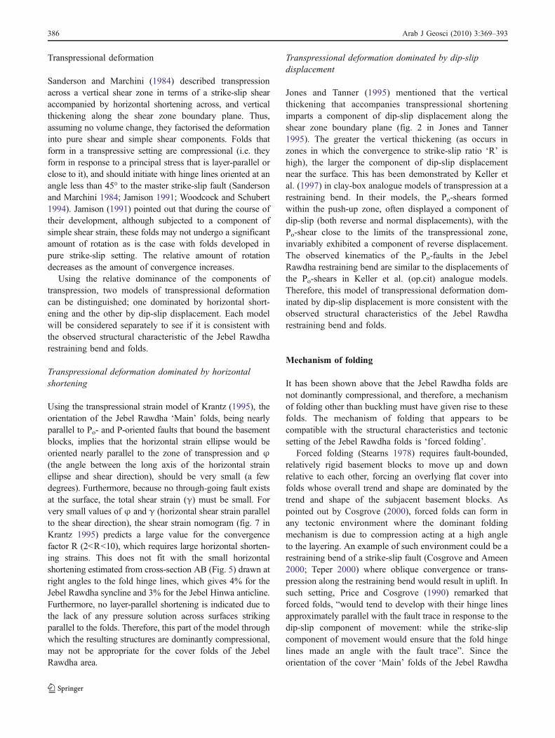
Transpressional deformation
Sanderson and Marchini (1984) described transpressionacross a vertical shear zone in terms of a strike-slip shearaccompanied by horizontal shortening across, and verticalthickening along the shear zone boundary plane. Thus,assuming no volume change, they factorised the deformationinto pure shear and simple shear components. Folds thatform in a transpressive setting are compressional (i.e. theyform in response to a principal stress that is layer-parallel orclose to it), and should initiate with hinge lines oriented at anangle less than 45° to the master strike-slip fault (Sandersonand Marchini 1984; Jamison 1991; Woodcock and Schubert1994). Jamison (1991) pointed out that during the course oftheir development, although subjected to a component ofsimple shear strain, these folds may not undergo a significantamount of rotation as is the case with folds developed inpure strike-slip setting. The relative amount of rotationdecreases as the amount of convergence increases.
Using the relative dominance of the components oftranspression, two models of transpressional deformationcan be distinguished; one dominated by horizontal short-ening and the other by dip-slip displacement. Each modelwill be considered separately to see if it is consistent withthe observed structural characteristic of the Jebel Rawdharestraining bend and folds.
Transpressional deformation dominated by horizontalshortening
Using the transpressional strain model of Krantz (1995), theorientation of the Jebel Rawdha ‘Main’ folds, being nearlyparallel to Po- and P-oriented faults that bound the basementblocks, implies that the horizontal strain ellipse would beoriented nearly parallel to the zone of transpression and ϕ(the angle between the long axis of the horizontal strainellipse and shear direction), should be very small (a fewdegrees). Furthermore, because no through-going fault existsat the surface, the total shear strain (γ) must be small. Forvery small values of ϕ and γ (horizontal shear strain parallelto the shear direction), the shear strain nomogram (fig. 7 inKrantz 1995) predicts a large value for the convergencefactor R (2<R<10), which requires large horizontal shorten-ing strains. This does not fit with the small horizontalshortening estimated from cross-section AB (Fig. 5) drawn atright angles to the fold hinge lines, which gives 4% for theJebel Rawdha syncline and 3% for the Jebel Hinwa anticline.Furthermore, no layer-parallel shortening is indicated due tothe lack of any pressure solution across surfaces strikingparallel to the folds. Therefore, this part of the model throughwhich the resulting structures are dominantly compressional,may not be appropriate for the cover folds of the JebelRawdha area.
Transpressional deformation dominated by dip-slipdisplacement
Jones and Tanner (1995) mentioned that the verticalthickening that accompanies transpressional shorteningimparts a component of dip-slip displacement along theshear zone boundary plane (fig. 2 in Jones and Tanner1995). The greater the vertical thickening (as occurs inzones in which the convergence to strike-slip ratio ‘R’ ishigh), the larger the component of dip-slip displacementnear the surface. This has been demonstrated by Keller etal. (1997) in clay-box analogue models of transpression at arestraining bend. In their models, the Po-shears formedwithin the push-up zone, often displayed a component ofdip-slip (both reverse and normal displacements), with thePo-shear close to the limits of the transpressional zone,invariably exhibited a component of reverse displacement.The observed kinematics of the Po-faults in the JebelRawdha restraining bend are similar to the displacements ofthe Po-shears in Keller et al. (op.cit) analogue models.Therefore, this model of transpressional deformation dom-inated by dip-slip displacement is more consistent with theobserved structural characteristics of the Jebel Rawdharestraining bend and folds.
Mechanism of folding
It has been shown above that the Jebel Rawdha folds arenot dominantly compressional, and therefore, a mechanismof folding other than buckling must have given rise to thesefolds. The mechanism of folding that appears to becompatible with the structural characteristics and tectonicsetting of the Jebel Rawdha folds is ‘forced folding’.
Forced folding (Stearns 1978) requires fault-bounded,relatively rigid basement blocks to move up and downrelative to each other, forcing an overlying flat cover intofolds whose overall trend and shape are dominated by thetrend and shape of the subjacent basement blocks. Aspointed out by Cosgrove (2000), forced folds can form inany tectonic environment where the dominant foldingmechanism is due to compression acting at a high angleto the layering. An example of such environment could be arestraining bend of a strike-slip fault (Cosgrove and Ameen2000; Teper 2000) where oblique convergence or trans-pression along the restraining bend would result in uplift. Insuch setting, Price and Cosgrove (1990) remarked thatforced folds, “would tend to develop with their hinge linesapproximately parallel with the fault trace in response to thedip-slip component of movement: while the strike-slipcomponent of movement would ensure that the fold hingelines made an angle with the fault trace”. Since theorientation of the cover ‘Main’ folds of the Jebel Rawdha
386 Arab J Geosci (2010) 3:369–393
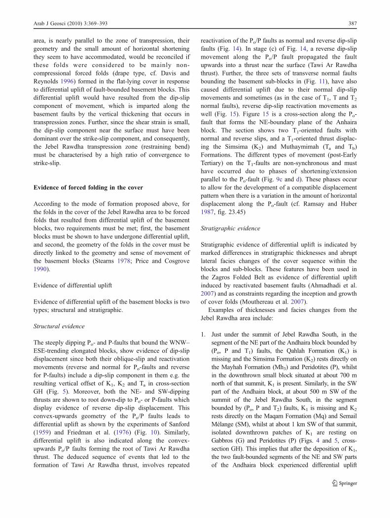
area, is nearly parallel to the zone of transpression, theirgeometry and the small amount of horizontal shorteningthey seem to have accommodated, would be reconciled ifthese folds were considered to be mainly non-compressional forced folds (drape type, cf. Davis andReynolds 1996) formed in the flat-lying cover in responseto differential uplift of fault-bounded basement blocks. Thisdifferential uplift would have resulted from the dip-slipcomponent of movement, which is imparted along thebasement faults by the vertical thickening that occurs intranspression zones. Further, since the shear strain is small,the dip-slip component near the surface must have beendominant over the strike-slip component, and consequently,the Jebel Rawdha transpression zone (restraining bend)must be characterised by a high ratio of convergence tostrike-slip.
Evidence of forced folding in the cover
According to the mode of formation proposed above, forthe folds in the cover of the Jebel Rawdha area to be forcedfolds that resulted from differential uplift of the basementblocks, two requirements must be met; first, the basementblocks must be shown to have undergone differential uplift,and second, the geometry of the folds in the cover must bedirectly linked to the geometry and sense of movement ofthe basement blocks (Stearns 1978; Price and Cosgrove1990).
Evidence of differential uplift
Evidence of differential uplift of the basement blocks is twotypes; structural and stratigraphic.
Structural evidence
The steeply dipping Po- and P-faults that bound the WNW–ESE-trending elongated blocks, show evidence of dip-slipdisplacement since both their oblique-slip and reactivationmovements (reverse and normal for Po-faults and reversefor P-faults) include a dip-slip component in them e.g. theresulting vertical offset of K1, K2 and Ta in cross-sectionGH (Fig. 5). Moreover, both the NE- and SW-dippingthrusts are shown to root down-dip to Po- or P-faults whichdisplay evidence of reverse dip-slip displacement. Thisconvex-upwards geometry of the Po/P faults leads todifferential uplift as shown by the experiments of Sanford(1959) and Friedman et al. (1976) (Fig. 10). Similarly,differential uplift is also indicated along the convex-upwards Po/P faults forming the root of Tawi Ar Rawdhathrust. The deduced sequence of events that led to theformation of Tawi Ar Rawdha thrust, involves repeated
reactivation of the Po/P faults as normal and reverse dip-slipfaults (Fig. 14). In stage (c) of Fig. 14, a reverse dip-slipmovement along the Po/P fault propagated the faultupwards into a thrust near the surface (Tawi Ar Rawdhathrust). Further, the three sets of transverse normal faultsbounding the basement sub-blocks in (Fig. 11), have alsocaused differential uplift due to their normal dip-slipmovements and sometimes (as in the case of T1, T and T2
normal faults), reverse dip-slip reactivation movements aswell (Fig. 15). Figure 15 is a cross-section along the Po-fault that forms the NE-boundary plane of the Anhairablock. The section shows two T1-oriented faults withnormal and reverse slips, and a T1-oriented thrust displac-ing the Simsima (K2) and Muthaymimah (Ta and Tb)Formations. The different types of movement (post-EarlyTertiary) on the T1-faults are non-synchronous and musthave occurred due to phases of shortening/extensionparallel to the Po-fault (Fig. 9c and d). These phases occurto allow for the development of a compatible displacementpattern when there is a variation in the amount of horizontaldisplacement along the Po-fault (cf. Ramsay and Huber1987, fig. 23.45)
Stratigraphic evidence
Stratigraphic evidence of differential uplift is indicated bymarked differences in stratigraphic thicknesses and abruptlateral facies changes of the cover sequence within theblocks and sub-blocks. These features have been used inthe Zagros Folded Belt as evidence of differential upliftinduced by reactivated basement faults (Ahmadhadi et al.2007) and as constraints regarding the inception and growthof cover folds (Mouthereau et al. 2007).
Examples of thicknesses and facies changes from theJebel Rawdha area include:
1. Just under the summit of Jebel Rawdha South, in thesegment of the NE part of the Andhaira block bounded by(Po, P and T1) faults, the Qahlah Formation (K1) ismissing and the Simsima Formation (K2) rests directly onthe Mayhah Formation (Mh3) and Peridotites (P), whilstin the downthrown small block situated at about 700 mnorth of that summit, K1 is present. Similarly, in the SWpart of the Andhaira block, at about 500 m SW of thesummit of the Jebel Rawdha South, in the segmentbounded by (Po, P and T2) faults, K1 is missing and K2
rests directly on the Maqam Formation (Mq) and SemailMélange (SM), whilst at about 1 km SW of that summit,isolated downthrown patches of K1 are resting onGabbros (G) and Peridotites (P) (Figs. 4 and 5, cross-section GH). This implies that after the deposition of K1,the two fault-bounded segments of the NE and SW partsof the Andhaira block experienced differential uplift
Arab J Geosci (2010) 3:369–393 387
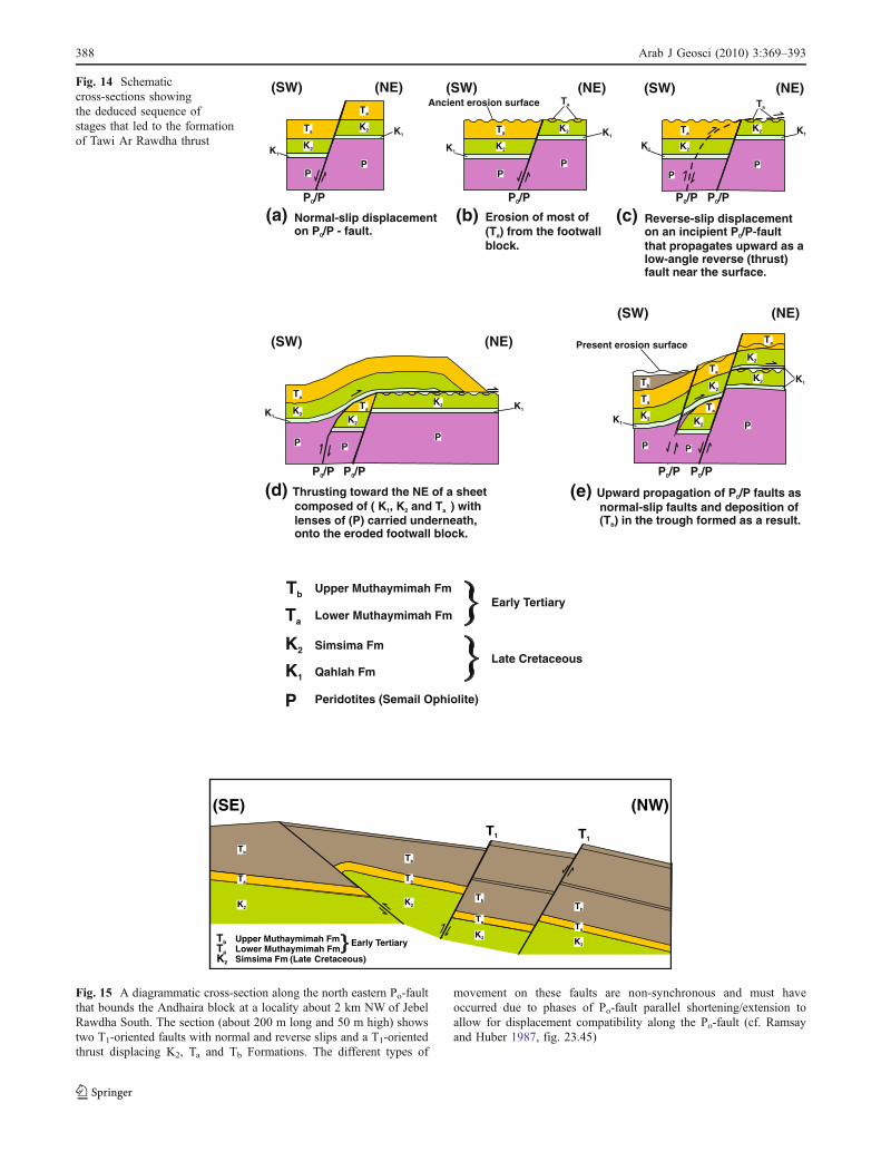
Tb
Tb
Tb
Tb
Ta
TaTa
K2
K2
K2K2
Tb Upper Muthaymimah FmTa Lower Muthaymimah FmK2 (LateSimsima Fm Cretaceous)
Early Tertiary
(SE) (NW)
T1 T1
Ta
Fig. 15 A diagrammatic cross-section along the north eastern Po-faultthat bounds the Andhaira block at a locality about 2 km NW of JebelRawdha South. The section (about 200 m long and 50 m high) showstwo T1-oriented faults with normal and reverse slips and a T1-orientedthrust displacing K2, Ta and Tb Formations. The different types of
movement on these faults are non-synchronous and must haveoccurred due to phases of Po-fault parallel shortening/extension toallow for displacement compatibility along the Po-fault (cf. Ramsayand Huber 1987, fig. 23.45)
(SW) (SW)
(SW)
(SW)
(SW)(NE) (NE)
(NE)
(NE)
(NE)
(a) Normal-slip displacementon P /P - fault.0
(b) Erosion of most of(T ) from the footwalla
block.
(c) Reverse-slip displacementon an incipient P /P-faultthat propagates upward as alow-angle reverse (thrust)fault near the surface.
0
P /P0
P /P0
P /P0 P /P0
P /P0 P /P0P /P0
P /P0
(d) Thrusting toward the NE of a sheetcomposed of ( K , K and T ) withlenses of (P) carried underneath,onto the eroded footwall block.
1 2 a
(e) Upward propagation of P /P faults asnormal-slip faults and deposition of(T ) in the trough formed as a result.
0
b
Tb
Ta
Ta
Ta
TaTa
Ta
Ta
Ta
TaTa
Ta
TaK1
K1
K1
K1
K1
K1
K1
K1
K1
K1
K2
K2
K2
K2
K2
K2
K2K2
K2
K2
K2
K2
K2
K2
P
PPP
PP
PPP
PPP
Present erosion surface
Ancient erosion surface
Tb Upper Muthaymimah Fm
Ta Lower Muthaymimah FmEarly Tertiary
K2 Simsima Fm
K1 Qahlah FmLate Cretaceous
P Peridotites (Semail Ophiolite)
Fig. 14 Schematiccross-sections showingthe deduced sequence ofstages that led to the formationof Tawi Ar Rawdha thrust
388 Arab J Geosci (2010) 3:369–393
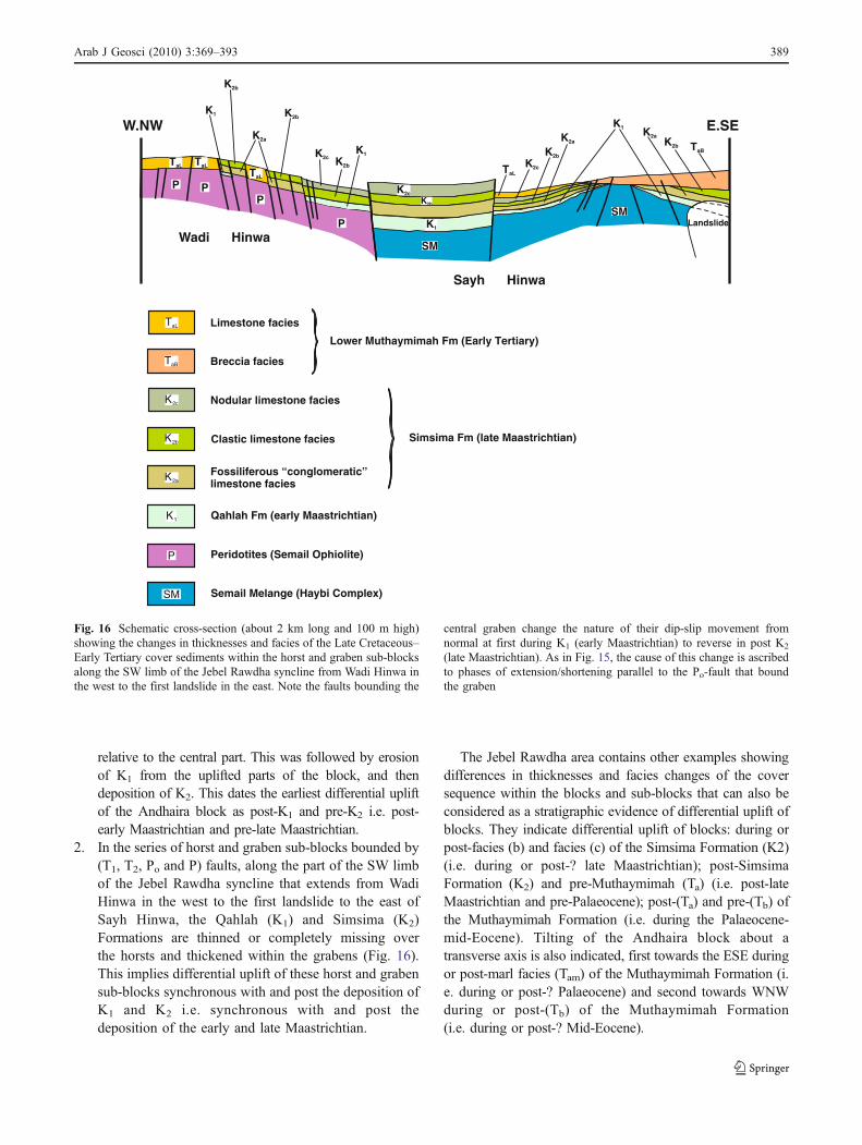
relative to the central part. This was followed by erosionof K1 from the uplifted parts of the block, and thendeposition of K2. This dates the earliest differential upliftof the Andhaira block as post-K1 and pre-K2 i.e. post-early Maastrichtian and pre-late Maastrichtian.
2. In the series of horst and graben sub-blocks bounded by(T1, T2, Po and P) faults, along the part of the SW limbof the Jebel Rawdha syncline that extends from WadiHinwa in the west to the first landslide to the east ofSayh Hinwa, the Qahlah (K1) and Simsima (K2)Formations are thinned or completely missing overthe horsts and thickened within the grabens (Fig. 16).This implies differential uplift of these horst and grabensub-blocks synchronous with and post the deposition ofK1 and K2 i.e. synchronous with and post thedeposition of the early and late Maastrichtian.
The Jebel Rawdha area contains other examples showingdifferences in thicknesses and facies changes of the coversequence within the blocks and sub-blocks that can also beconsidered as a stratigraphic evidence of differential uplift ofblocks. They indicate differential uplift of blocks: during orpost-facies (b) and facies (c) of the Simsima Formation (K2)(i.e. during or post-? late Maastrichtian); post-SimsimaFormation (K2) and pre-Muthaymimah (Ta) (i.e. post-lateMaastrichtian and pre-Palaeocene); post-(Ta) and pre-(Tb) ofthe Muthaymimah Formation (i.e. during the Palaeocene-mid-Eocene). Tilting of the Andhaira block about atransverse axis is also indicated, first towards the ESE duringor post-marl facies (Tam) of the Muthaymimah Formation (i.e. during or post-? Palaeocene) and second towards WNWduring or post-(Tb) of the Muthaymimah Formation(i.e. during or post-? Mid-Eocene).
TaL
TaLTaL
TaL
K2c
K2c
K2c
K2bK2b
K2b
K2b
K2bK2a
K2a
K2a
K2a
K2a
K1
K1
K1
K1
TaB
K2b
SM
SM
P PP
P Landslide
Wadi Hinwa
Sayh Hinwa
W.NW E.SE
Limestone facies
Breccia facies
Lower Muthaymimah Fm (Early Tertiary)
Nodular limestone facies
Clastic limestone facies
Fossiliferous “conglomeratic”limestone facies
Simsima Fm (late Maastrichtian)
Qahlah Fm (early Maastrichtian)
Peridotites (Semail Ophiolite)
Semail Melange (Haybi Complex)
TaL
TaB
K2c
K2b
P
K1
SM
Fig. 16 Schematic cross-section (about 2 km long and 100 m high)showing the changes in thicknesses and facies of the Late Cretaceous–Early Tertiary cover sediments within the horst and graben sub-blocksalong the SW limb of the Jebel Rawdha syncline from Wadi Hinwa inthe west to the first landslide in the east. Note the faults bounding the
central graben change the nature of their dip-slip movement fromnormal at first during K1 (early Maastrichtian) to reverse in post K2
(late Maastrichtian). As in Fig. 15, the cause of this change is ascribedto phases of extension/shortening parallel to the Po-fault that boundthe graben
Arab J Geosci (2010) 3:369–393 389
Evidence of the link between the cover folds and basementblocks
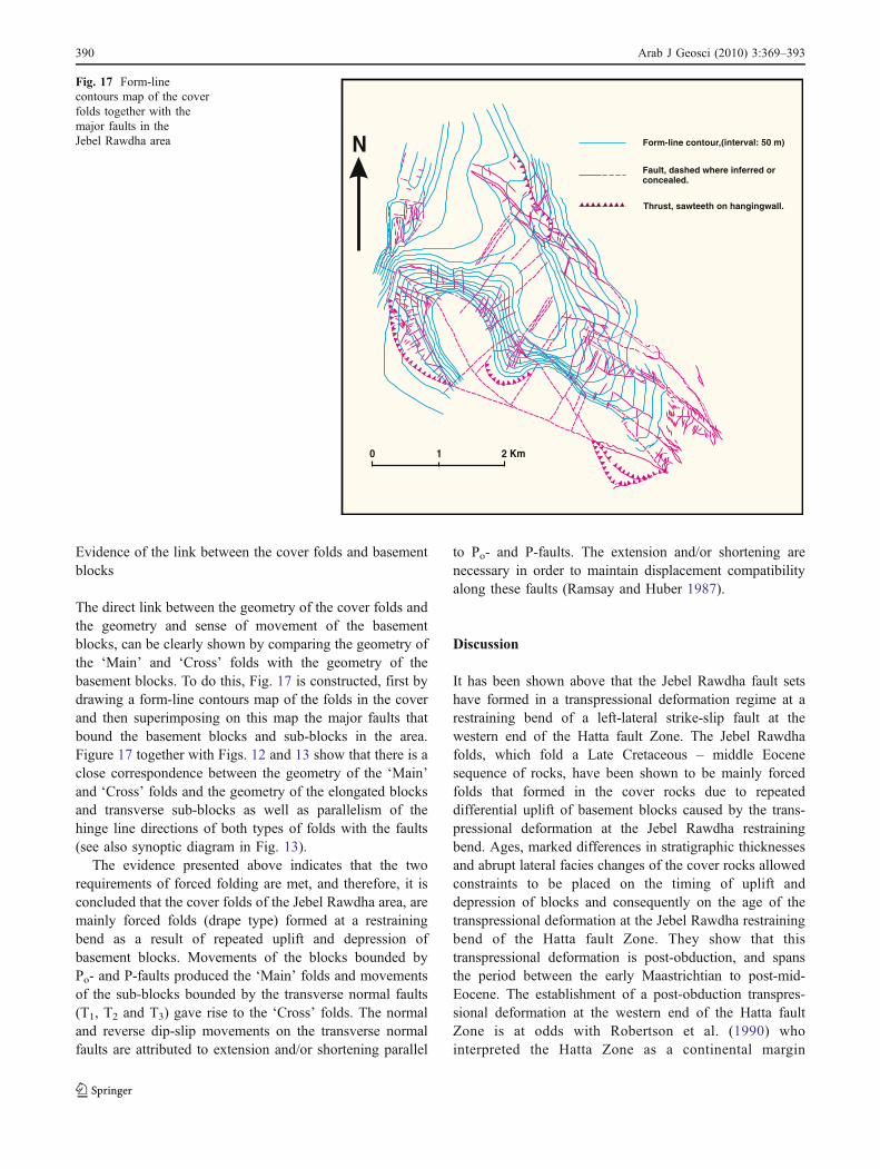
The direct link between the geometry of the cover folds andthe geometry and sense of movement of the basementblocks, can be clearly shown by comparing the geometry ofthe ‘Main’ and ‘Cross’ folds with the geometry of thebasement blocks. To do this, Fig. 17 is constructed, first bydrawing a form-line contours map of the folds in the coverand then superimposing on this map the major faults thatbound the basement blocks and sub-blocks in the area.Figure 17 together with Figs. 12 and 13 show that there is aclose correspondence between the geometry of the ‘Main’and ‘Cross’ folds and the geometry of the elongated blocksand transverse sub-blocks as well as parallelism of thehinge line directions of both types of folds with the faults(see also synoptic diagram in Fig. 13).
The evidence presented above indicates that the tworequirements of forced folding are met, and therefore, it isconcluded that the cover folds of the Jebel Rawdha area, aremainly forced folds (drape type) formed at a restrainingbend as a result of repeated uplift and depression ofbasement blocks. Movements of the blocks bounded byPo- and P-faults produced the ‘Main’ folds and movementsof the sub-blocks bounded by the transverse normal faults(T1, T2 and T3) gave rise to the ‘Cross’ folds. The normaland reverse dip-slip movements on the transverse normalfaults are attributed to extension and/or shortening parallel
to Po- and P-faults. The extension and/or shortening arenecessary in order to maintain displacement compatibilityalong these faults (Ramsay and Huber 1987).
Discussion
It has been shown above that the Jebel Rawdha fault setshave formed in a transpressional deformation regime at arestraining bend of a left-lateral strike-slip fault at thewestern end of the Hatta fault Zone. The Jebel Rawdhafolds, which fold a Late Cretaceous – middle Eocenesequence of rocks, have been shown to be mainly forcedfolds that formed in the cover rocks due to repeateddifferential uplift of basement blocks caused by the trans-pressional deformation at the Jebel Rawdha restrainingbend. Ages, marked differences in stratigraphic thicknessesand abrupt lateral facies changes of the cover rocks allowedconstraints to be placed on the timing of uplift anddepression of blocks and consequently on the age of thetranspressional deformation at the Jebel Rawdha restrainingbend of the Hatta fault Zone. They show that thistranspressional deformation is post-obduction, and spansthe period between the early Maastrichtian to post-mid-Eocene. The establishment of a post-obduction transpres-sional deformation at the western end of the Hatta faultZone is at odds with Robertson et al. (1990) whointerpreted the Hatta Zone as a continental margin
N
20 1 Km
Form-line contour,(interval: 50 m)
Fault, dashed where inferred orconcealed.
Thrust, sawteeth on hangingwall.
Fig. 17 Form-linecontours map of the coverfolds together with themajor faults in theJebel Rawdha area
390 Arab J Geosci (2010) 3:369–393
transform and that the major deformation in the Hatta Zoneis related to the Late Cretaceous obduction of the Semailophiolite. They considered that post-obduction deformationwas mild and due to reactivation of the Hatta transformlineament during the mid-Tertiary. However, Styles et al.(2006), who recently mapped the UAE part of the HattaZone, pointed out that the Hatta fault system clearlytruncates the northern limb of the regional-scale Jebel Jimaantiform, which Robertson et al. (op.cit.) interpreted as amajor transverse culmination formed during the ophioliteemplacement. This truncation indicates that movementalong the Hatta fault system postdated the Jebel Jimafolding event and “more importantly the obduction of theSemail ophiolite” (Styles et al. op.cit., p.284).
The evidence for the early initiation of the post-obduction deformation recorded by the author in the JebelRawdha area (from the early Maastrichtian) and also inother areas along the Northern Oman Mountain front; theHafit structure (Warrak 1996), the eastern parts of the AlAin region (Warrak 1987) and recently the Faiyah folds(unpublished data), contradicts the statement by Searle(2009) that after obduction, “stable tectonic conditionsfollowed for at least 25 million years (from 60–35 Ma)along the WSW flank of the mountain belt”. The lateOligocene–early Miocene deformation recorded by Searle(op.cit.) in the Musandam peninsula (northern Oman) isshown in the Hafit structure which folds Miocene rocks, asan unconformity between the Middle Oligocene and theMiocene, with the Late Oligocene being missing (Warrak1996, table 1). Taking into account that the post-obductionHafit folding spanned the period from pre-mid Eocene untilthe end of the Miocene (Warrak 1996), the late Oligocene–early Miocene deformation in the Musandam, couldrepresent a deformation event that occurred towards thefinal stages of the long, synsedimentary post-obductiondeformation that started in the Jebel Rawdha area from theearly Maastrichtian.
The evidence from the Jebel Rawdha area has alsoshown that the required conditions of forced folding wouldbe fully met at a restraining bend of a strike-slip fault zone,if the transpressional deformation along the bend ischaracterised by the dominance of the dip-slip componentover the strike-slip component. This tectonic setting thatproduced nearly pure forced folds in the Jebel Rawdha areaseems to be unique in the region, since no other similarexample has been reported. The cases of forced folding thathave been reported from the Central Zagros fold belt(Abdollahie et al. 2006, Ahmadhadi et al. 2007 andAhmadhadi et al. 2008) describe large-scale “flexures/forced folds” associated with specific fracture and veinpatterns. They have been interpreted as having been formedin the cover due to early reactivation of deep-seatedbasement faults during the early orogenic stress build up
in the Zagros basin. Whether these “flexures” are realforced folds or buckle folds depends on the type ofreactivation motion on the basement faults. If the reactiva-tion motion on the basement faults was pure strike-slip,only buckle folds would be produced in the cover sequence(Cosgrove 2000, Teper 2000). However, the inclusion of acomponent of vertical motion on the basement faults(Ahmadhadi et al. 2007) would result in the associatedcover folds being a combination of both buckle and forcedfolds. Analysing the profile geometry of these “flexures”would verify if they are pure buckles or a mixture of buckleand forced folds (cf. Teper 2000), and in the latter case,how much of each of the elements of buckle and forcedfolds they contain.
Conclusions
& The faults and fractures in the Jebel Rawdha area aresimilar to those that develop in a transpressional, left-lateral strike-slip deformational regime (a restrainingbend), where the dip-slip component is dominant overthe strike-slip component.
& The neoautochthonous Late Cretaceous–Early Tertiarysequence lies with an angular unconformity on theallochthonous (Semail ophiolite and Haybi complex) andparautochthonous (Sumeini Group) rocks. From the rheo-logical and structural relationships of these rocks, the LateCretaceous–Early Tertiary sequence above the unconfor-mity can be considered as “cover” and the Semail, Haybiand Sumeini rocks below the unconformity as “basement”.
& The cover folds appear to be dominantly forced foldsthat developed as a result of repeated uplift anddepression of basement blocks. Their trend is parallelto the trend of the subjacent basement blocks. Hence thetrend of the Jebel Rawdha folds is different from thetrend of other post-obduction major folds in the region,such as the Hafit and Jebel Faiyah folds.
& Marked differences in stratigraphic thicknesses andabrupt lateral facies changes of the cover sequencewithin the blocks and sub-blocks, indicate that theearliest differential movement of the blocks must beearly Maastrichtian, whilst the latest movement musthave taken place in post-mid-Eocene as inferred fromthe ‘Cross’ folds of Qarn Tayrah which fold mid-Eocene (Tb) sediments. This has an important implica-tion for the timing of the post-obduction deformation inthe Northern Oman Mountains. It pushes back theinitiation of this deformation to the early Maastrichtianand puts it straight after the ending of obduction.Evidence of a similar early start to the post-obductiondeformation has also been recorded by the author fromother parts of Northern Oman Mountain front.
Arab J Geosci (2010) 3:369–393 391
Acknowledgements I wish to thank Dr. N. H. Woodcock forreviewing an early version of the manuscript and Dr. F. Roure for hiscomments and suggestion to improve Fig. 1. Help with the researchfacilities provided by the UAE University is also acknowledged.
References
Abdollahie FI, Braathen A, Mokhtari M, Alavi SA (2006) Interactionof the Zagros Fold-Thrust Belt and the Arabian-type deep-seatedfolds in the Abadan Plain and the Dezful Embayment, SW Iran.Pet Geosci 12(4):347–362
Ahmadhadi F, Lacombe O, Daniel JM (2007) Early reactivation ofbasement faults in Central Zagros (SW Iran): Evidence from pre-folding fracture populations in the Asmari Formation and LowerTertiary paleogeography. In “ Thrust belts and foreland basins :from fold kinematics to hydrocarbon systems”. Lacombe O, LavéJ, Vergés J, Roure F (Eds), Frontiers in Earth Sciences, Springer-Verlag, New York chapter 11, 205–228.
Ahmadhadi F, Daniel JM, Azzizadeh M, Lacombe O (2008) Evidencefor pre-folding vein development in the Oligo-Miocene AsmariFormation in the Central Zagros Fold Belt, Iran. Tectonics 27,TC1016, doi: 10.1029/2006TC001978
Bartlett WL, Friedman M, Logan JM (1981) Experimental folding andfaulting of rocks under confining pressure, Part IX. Wrench faultsin limestone layers. Tectonophysics 79:255–277
Boote DRD, Mou D, Waite RI (1990) Structural evolution of theSuneinah Foreland, Central Oman Mountains. In: RobertsonAHF, Searle MP, Ries AC (eds) The Geology and Tectonics ofthe Oman Region, 49 Special Publication. Geological Society,London, pp 397–418
Cosgrove JW (2000) Forced folds and fractures: An introduction. In:Cosgrove JW, Ameen MS (eds) Forced folds and fractures, 169Special Publication. Geological Society, London, pp 1–6
Cosgrove JW, Ameen MS (2000) A comparison of the geometry,spatial organization and fracture patterns associated with forcedfolds and buckle folds. In: Cosgrove JW, Ameen MS (eds)Forced folds and fractures, 169 Special Publication. GeologicalSociety, London, pp 7–21
Cunningham WD, Windley BF, Dorjnamjaa D, Badamgarov J,Saandar M (1996) Late Cenozoic transpression in southwesternMongolia and the Gobi Altai-Tien Shan connection. Earth PlanetSci Lett 140:67–81
Davis GH, Reynolds SJ (1996) Structural geology of rocks andregions. Wiley, New York
Dunne LA, Manoogian PR, Pierini DF (1990) Structural style anddomains of the Northern Oman Mountains (Oman and UnitedArab Emirates). In: Robertson AHF, Searle MP, Ries AC (eds)The Geology and Tectonics of the Oman Region, 49 SpecialPublication. Geological Society, London, pp 375–386
Ellison R A, Styles MT (2006) The Geology and Geophysics of theUnited Arab Emirates. Volume 1: Executive Summary. BritishGeological Survey
Fowler TJ (1996) The properties and geological environments ofhelicoids: axially symmetric surfaces in torsional and non-torsional deformations. J Struct Geol 18:505–517
Friedman M, Handin J, Logan JM, Min KD, Stearns DW (1976)Experimental folding of rocks under confining pressure: part III.Faulted drape folds in multilithologic layered specimens. GeolSoc Am Bull 87:1049–1066
Gealey WK (1977) Ophiolite obduction and geologic evolution of theOman Mountains and adjacent areas. Geol Soc Am Bull88:1183–1191
Glennie KW, Boeuf MGA, Hughes Clarke MW, Moody-Stuart M,Pilaar WFH, Reinhardt BM (1974) Geology of the Oman
Mountains. Verhandelingen van het Koninklijk Nederlands geo-logisch mijnbouwkundig Genootschap. Nijhoff 31:1–423
Greenwood JEGW, Loney PE (1968) Geology and mineral resourcesof the Trucial Oman Range, a reconnaissance survey of part ofthe Trucial States. Institute of Geological Sciences, OverseasDivision Report
Hertig SP, Hooks JD, Christopher RA, Clowser, DR, Marshall PR(1994) Depositional and Biostratigraphic Framework of PotentialCalci-turbidite Reservoirs in the Dubai U.A.E. part of the OmanMountain Cenozoic Foreland Basin. Geo 94, Middle EastPetroleum Geosciences, Vol. II, 497–504
Hunting (Geology and Geophysics Ltd) (1979) Report on a MineralSurvey of the U.A.E. Volume 1, Survey Programme and Noteson the Geological Map of the U.A.E. Ministry of Petroleum andMineral Resources, U.A.E, pp 1–35
Jamison WR (1991) Kinematics of compressional fold development inconvergent wrench terranes. Tectonophysics 190:209–232
Jones RR, Tanner PWG (1995) Strain partitioning in transpressionzones. J Struct Geol 17:793–802
Keller JVA, Hall SH, McClay KR (1997) Shear fracture pattern andmicrostructural evolution in transpressional fault zones from fieldand laboratory studies. J Struct Geol 19:1173–1187
Krantz RW (1995) The transpressional strain model applied to strike-slip, oblique-convergent and oblique-divergent deformation.J Struct Geol 17:1125–1137
Moore DE, Byerlee JD (1991) Comparative geometry of the SanAndreas fault, California and laboratory fault zones. Geol SocAm Bull 103:762–774
Morgenstern NR, Tchalenko JS (1967) Microscopic structures inkaolin subjected to direct shear. Geotechnique 17:309–328
Mouthereau F, Tensi J, Bellahasen N, Lacombe O, De Boisgrollier T,Kargar S (2007) Tertiary sequence of deformation in a thin-skinned/thick-skinned collision belt: The Zagros Folded Belt(Fars, Iran). Tectonics 26, TC5006, doi:10.1029/2007TC002098
Naville C, Ancel M, Andriessen P, Broto K, Jardin A, Perdrizet T,Ricarte P, Roure F (2009) Current knowledge on the thickness ofthe Semail ophiolite in the Northern Emirates. Lithospheredynamics and sedimentary basins: The Arabian plate andanalogues, 5th workshop of the ILP-Task Force on SedimentaryBasins, Abstracts with Programme, December 6–11, 2009, AbuDhabi (United Arab Emirates)
Naylor MA, Mandl G, Sijpesteijn CHK (1986) Fault geometries inbasement-induced wrench faulting under different initial stressstates. J Struct Geol 8:737–752
Nolan SC, Skelton PW, Clissold BP, Smewing JD (1990) Maastrich-tian to early Tertiary stratigraphy and palaeogeography of theCentral and Northern Oman Mountains. In: Robertson AHF,Searle MP, Ries AC (eds) The Geology and Tectonics of theOman Region 49 Special Publication. Geological Society,London, pp 495–519
Patton TL, O’Connor SJ (1988) Cretaceous flexural history ofNorthern Oman Mountain Foredeep, United Arab Emirates. TheAmerican Association of Petroleum Geologists Bulletin 72:797–809
Price NJ, Cosgrove JW (1990) Analysis of Geological Structures.Cambridge University Press, Cambridge
Ramsay JG, Huber MI (1987) The techniques of modern structuralgeology. Volume 2: Folds and Fractures. Academic Press,London
Ricateau R, Riché PH (1980) Geology of the Musandam peninsula(Sultanate of Oman) and its surroundings. J Pet Geol 3:139–152
Robertson A (2004) Development of concepts concerning the genesisand emplacement of Tethyan ophiolites in the Eastern Mediter-ranean and Oman regions. Earth Sci Rev 66:331–387
Robertson AHF, Kemp AES, Rex DC, Blome CD (1990) Sedimentaryand structural evolution of a continental margin transform
392 Arab J Geosci (2010) 3:369–393
lineament: the Hatta Zone, Northern Oman Mountains. In:Robertson AHF, Searle MP, Ries AC (eds) The Geology andTectonics of the Oman Region, 49 Special Publication. Geolog-ical Society, London, pp 285–305
Sanderson DJ, Marchini WRD (1984) Transpression. J Struct Geol6:449–458
Sanford AR (1959) Analytical and experimental study of simplegeologic structures. Geol Soc Am Bull 70:19–52
Searle MP (1985) Sequence of thrusting and origin of culminations in thenorthern and central Oman Mountains. J Struct Geol 7:129–143
Searle MP (2009) Crustal evolution of the Oman Mountains: fromophiolite obduction to early continental collision. Lithospheredynamics and sedimentary basins: The Arabian plate andanalogues, 5th workshop of the ILP-Task Force on SedimentaryBasins, Abstracts with Programme, December 6–11, 2009, AbuDhabi (United Arab Emirates)
Searle MP, Malpas J (1980) Structure and metamorphism of rocksbeneath the Semail Ophiolite of Oman and their significance inophiolite obduction. R Soc Edinb Trans Earth Sci 71:247–262
Searle MP, James NP, Calon TJ, Smewing JD (1983) Sedimentolog-ical and structural evolution of the Arabian continental margin inthe Musandam Mountain and Dibba zone, United Arab Emirates.Geol Soc Am Bull 94:1381–1400
Searle MP, Warren CJ, Waters DJ, Parrish RR (2004) Structuralevolution, metamorphism and restoration of the Arabian conti-nental margin, Saih Hatat region, Oman Mountains. J Struct Geol26:451–473
Skelton PW, Nolan SC, Scott RW (1990) The Maastrichtiantransgression onto the northwestern flank of the Proto-OmanMountains: sequences of rudist-bearing beach to open shelffacies. In: Robertson AHF, Searle MP, Ries AC (eds) TheGeology and Tectonics of the Oman Region, 49 SpecialPublication. Geological Society, London, pp 521–547
Skempton AW (1966) Some observations on tectonic shear zones.First International Congress on Rock Mechanics. Proceedings1:329–335
Stearns DW (1978) Faulting and forced folding in the RockyMountains foreland. Geol Soc Am Mem 151:1–38
Steuber T, Lokier S (2009) Strontium-isotop stratigraphy andRudists of the Qahlah and Simsima Formations (UAE, Oman).Lithosphere dynamics and sedimentary basins: The Arabianplate and analogues, 5th workshop of the ILP-Task Force onSedimentary Basins, Abstracts with Programme, December 6–11, 2009, Abu Dhabi (United Arab Emirates)
Styles MT, Thomas RJ, Phillips ER, Goodenough KM, Schofield DI,Farrant AR (2006) Geology of the Hatta area, Sheet explanationof the 1:50 000 map sheet 50-5. British Geological Survey,United Arab Emirates
Swanson MT (1988) Pseudotachylite-bearing strike-slip duplexstructures in the Fort Foster Brittle Zone, S. Maine. J StructGeol 10:813–828
Sylvester A (1988) Strike-slip faults. Geol Soc Am Bull 100:1666–1703
Tchalenko JS (1970) Similarities between shear zones of differentmagnitudes. Geol Soc Am Bull 81:1625–1640
Tchalenko JS, Ambraseys NN (1970) Structural analysis of theDasht-e-Bayaz (Iran) earthquake fractures. Geol Soc Am Bull81:41–66
Teper L (2000) Geometry of fold arrays in the Silesian-Cracovianregion of southern Poland. In: Cosgrove JW, Ameen MS (eds)Forced folds and fractures, 169 Special Publication. GeologicalSociety, London, pp 167–179
Warburton J, Burnhill TJ, Graham RH, Isaac KP (1990) The evolutionof the Oman Mountains Foreland Basin. In: Robertson AHF,Searle MP, Ries AC (eds) The Geology and Tectonics of theOman Region, 49 Special Publication. Geological Society,London, pp 419–427
Warrak M (1986) Structural evolution of the Northern OmanMountains front, Al Ain region. Proceedings of Abu DhabiSymposium on: Hydrocarbon Potential of Intense Thrust Zones.Ministry of Petroleum and Mineral Resources, U.A.E. andOrganization of Arab Petroleum Exporting Countries, Kuwait 1,375–431
Warrak M (1987) Synchronous deformation of the neoautochthonoussediments of the Northern Oman Mountains. In: Proceedings ofSPE 5th Conference, Bahrain, 129–136
Warrak M (1990) Structure of Jebel Rawdha area, Northern OmanMountains. Abstracts of Proceedings of Muscat Symposium on:Ophiolite Genesis and Evolution of Oceanic Lithosphere.UNESCO, Sultanate of Oman
Warrak M (1996) Origin of the Hafit structure: implications for timingthe Tertiary deformation in the Northern Oman Mountains.J Struct Geol 18:803–818
Woodcock NJ, Fischer M (1986) Strike-slip duplexes. J Struct Geol8:725–735
Woodcock NJ, Schubert C (1994) Continental strike-slip tectonics. In:Hancock PL (ed) Continental deformation. Pergamon, New York,pp 251–263
Arab J Geosci (2010) 3:369–393 393