Fishers' resource mapping and goliath grouper Epinephelus itajara (Serranidae) conservation in...
10
93 Neotropical Ichthyology, 7(1):93-102, 2009 Copyright © 2009 Sociedade Brasileira de Ictiologia Fishers’ resource mapping and goliath grouper Epinephelus itajara (Serranidae) conservation in Brazil Leopoldo Cavaleri Gerhardinger 1,2 , Mauricio Hostim-Silva 3 , Rodrigo Pereira Medeiros 4 , José Matarezi 2 , Áthila Andrade Bertoncini 1,5 , Matheus Oliveira Freitas 6 and Beatrice Padovani Ferreira 7 Goliath grouper (Epinephelus itajara) aggregations and relative abundances were described and mapped through the use of fishermen’s local ecological knowledge in Babitonga Bay in southern Brazil. Six well-experienced informants were asked to individually provide information about goliath grouper abundance and distribution, drawn over a satellite image of the study area, which was later overlaid and gathered into a final map. According to our informants, the goliath grouper occurs along a broad salinity and depth range, from shallow estuarine areas (less than 5 m deep) with high freshwater input (smaller individuals, up to 150 kg) to coastal marine-dominated environments (at least 35 m deep); (larger individuals more common, frequently reaching more than 300 kg). Fishermen referred to goliath groupers inhabiting hard substrates such as rocky reefs around islands and continental shores, submerged rocky outcrops and shipwrecks (juveniles and adults). At least two aggregation sites mapped (ranging from 2 to 60 individuals) could be concluded as spawning aggregation sites through evidence of high abundance and spawning activity. Priority research and conservation targets were identified and discussed for Babitonga Bay (e.g., design of a tagging experimental program and establishment of a marine protected area). Fishers’ resource mapping provided a means of exchanging information among various disciplines while maintaining methodological rigor in a clear and straightforward way of presenting fishers’ knowledge. The use of fishers’ sketch maps is a promising tool for marine conservation in Brazil, with special regard to adaptive co-management regimes, where frequent environmental re-evaluations are needed. A abundância relativa e agregações de meros Epinephelus itajara foram descritas e mapeadas através do conhecimento ecológico local de pescadores da baía Babitonga, sul do Brasil. Seis informantes muito experientes desenharam individualmente sobre uma imagem de satélite da área de estudo informações sobre abundância e distribuição de meros, seguindo-se de uma sobreposição das imagens em um mapa final. O mero ocorre ao longo de uma larga faixa de salinidade e profundidade (principalmente juvenis), de áreas estuarinas rasas (menos que 5 m de profundidade) com alta incidência de água doce, até ambientes costeiros marinhos (ao menos até 35 m de profundidade); (indivíduos maiores são mais comuns, alcançando mais de 300 kg). A espécie é também encontrada habitando substratos consolidados como recifes rochosos ao redor de ilhas e continente, parcéis submersos e emersos e naufrágios. Ao menos duas das agregações mapeadas (variando de dois a 60 indivíduos observados) puderam ser consideradas agregações reprodutivas através de evidências de alta abundância e atividade reprodutiva. Ações de pesquisa e conservação foram identificadas e discutidas para a baía Babitonga. O mapeamento de recursos possibilitou uma forma de trocar informações entre várias disciplinas, mantendo rigor metodológico e apresentando o conhecimento dos pescadores em uma forma clara e direta. O uso do mapeamento é uma ferramenta promissora para a conservação marinha, com atenção especial para abordagens de co-gestão adaptativas, onde frequentes reavaliações ambientais são necessárias. Key words: Sketch maps, Traditional ecological knowledge, Spawning aggregation, Ethnoecology, Babitonga Bay. 1 Associação de Estudos Costeiros e Marinhos, ECOMAR. Rua Dr. José André da Cruz, 539, Nova Coréia, 45900-000 Caravelas, BA, Brazil. [email protected] 2 Universidade do Vale do Itajaí, CTTMar, Laboratório de Educação Ambiental. Rua Uruguai, 458 - Caixa Postal 360, 88302-202 Itajaí, SC, Brazil. 3 Universidade Federal do Espírito Santo, CEUNES, Departamento de Ciências da Saúde, Biológicas e Agrárias. Rua Humberto de Almeida Francklin, 257, 29933-415 São Mateus, ES, Brazil. 4 Universidade do Vale do Itajaí. Núcleo de Estudos Sociais e Politicos, NESP. Rua Uruguai, 458 - Caixa Postal 360, 88302-202 Itajaí, SC, Brazil. 5 Universidade Federal de São Carlos, Centro de Ciências Biológicas e da Saúde, Programa de Pós-graduação em Ecologia e Recursos Naturais. Rodovia Washington Luiz, Km 235, Monjolinho, Caixa Postal 676, 13565-905 São Carlos, SP, Brazil. 6 Universidade Estadual de Santa Cruz, UESC. Programa de Pós-Graduação em Sistemas Aquáticos Tropicais. Rodovia Ilhéus-Itabuna, Salobrinho, 45662- 000 Ilheus, Bahia, Brazil. 7 Universidade Federal de Pernambuco, Departamento de Oceanografia. Av. Arquitetura, s/n, Cidade Universitária, 50670-901 Recife, Pernambuco, Brazil.
-
Upload
independent -
Category
Documents
-
view
1 -
download
0
Transcript of Fishers' resource mapping and goliath grouper Epinephelus itajara (Serranidae) conservation in...

93
Neotropical Ichthyology, 7(1):93-102, 2009Copyright © 2009 Sociedade Brasileira de Ictiologia
Fishers’ resource mapping and goliath grouper Epinephelus itajara(Serranidae) conservation in Brazil
Leopoldo Cavaleri Gerhardinger 1,2, Mauricio Hostim-Silva3, Rodrigo Pereira Medeiros4,José Matarezi2, Áthila Andrade Bertoncini1,5, Matheus Oliveira Freitas6
and Beatrice Padovani Ferreira7
Goliath grouper (Epinephelus itajara) aggregations and relative abundances were described and mapped through the use offishermen’s local ecological knowledge in Babitonga Bay in southern Brazil. Six well-experienced informants were asked toindividually provide information about goliath grouper abundance and distribution, drawn over a satellite image of the studyarea, which was later overlaid and gathered into a final map. According to our informants, the goliath grouper occurs along abroad salinity and depth range, from shallow estuarine areas (less than 5 m deep) with high freshwater input (smaller individuals,up to 150 kg) to coastal marine-dominated environments (at least 35 m deep); (larger individuals more common, frequentlyreaching more than 300 kg). Fishermen referred to goliath groupers inhabiting hard substrates such as rocky reefs aroundislands and continental shores, submerged rocky outcrops and shipwrecks (juveniles and adults). At least two aggregationsites mapped (ranging from 2 to 60 individuals) could be concluded as spawning aggregation sites through evidence of highabundance and spawning activity. Priority research and conservation targets were identified and discussed for Babitonga Bay(e.g., design of a tagging experimental program and establishment of a marine protected area). Fishers’ resource mappingprovided a means of exchanging information among various disciplines while maintaining methodological rigor in a clear andstraightforward way of presenting fishers’ knowledge. The use of fishers’ sketch maps is a promising tool for marine conservationin Brazil, with special regard to adaptive co-management regimes, where frequent environmental re-evaluations are needed.
A abundância relativa e agregações de meros Epinephelus itajara foram descritas e mapeadas através do conhecimentoecológico local de pescadores da baía Babitonga, sul do Brasil. Seis informantes muito experientes desenharam individualmentesobre uma imagem de satélite da área de estudo informações sobre abundância e distribuição de meros, seguindo-se de umasobreposição das imagens em um mapa final. O mero ocorre ao longo de uma larga faixa de salinidade e profundidade(principalmente juvenis), de áreas estuarinas rasas (menos que 5 m de profundidade) com alta incidência de água doce, atéambientes costeiros marinhos (ao menos até 35 m de profundidade); (indivíduos maiores são mais comuns, alcançando mais de300 kg). A espécie é também encontrada habitando substratos consolidados como recifes rochosos ao redor de ilhas econtinente, parcéis submersos e emersos e naufrágios. Ao menos duas das agregações mapeadas (variando de dois a 60indivíduos observados) puderam ser consideradas agregações reprodutivas através de evidências de alta abundância eatividade reprodutiva. Ações de pesquisa e conservação foram identificadas e discutidas para a baía Babitonga. O mapeamentode recursos possibilitou uma forma de trocar informações entre várias disciplinas, mantendo rigor metodológico e apresentandoo conhecimento dos pescadores em uma forma clara e direta. O uso do mapeamento é uma ferramenta promissora para aconservação marinha, com atenção especial para abordagens de co-gestão adaptativas, onde frequentes reavaliações ambientaissão necessárias.
Key words: Sketch maps, Traditional ecological knowledge, Spawning aggregation, Ethnoecology, Babitonga Bay.
1Associação de Estudos Costeiros e Marinhos, ECOMAR. Rua Dr. José André da Cruz, 539, Nova Coréia, 45900-000 Caravelas, BA, [email protected] do Vale do Itajaí, CTTMar, Laboratório de Educação Ambiental. Rua Uruguai, 458 - Caixa Postal 360, 88302-202 Itajaí, SC, Brazil.3Universidade Federal do Espírito Santo, CEUNES, Departamento de Ciências da Saúde, Biológicas e Agrárias. Rua Humberto de Almeida Francklin, 257,29933-415 São Mateus, ES, Brazil.4Universidade do Vale do Itajaí. Núcleo de Estudos Sociais e Politicos, NESP. Rua Uruguai, 458 - Caixa Postal 360, 88302-202 Itajaí, SC, Brazil.5Universidade Federal de São Carlos, Centro de Ciências Biológicas e da Saúde, Programa de Pós-graduação em Ecologia e Recursos Naturais. RodoviaWashington Luiz, Km 235, Monjolinho, Caixa Postal 676, 13565-905 São Carlos, SP, Brazil.6Universidade Estadual de Santa Cruz, UESC. Programa de Pós-Graduação em Sistemas Aquáticos Tropicais. Rodovia Ilhéus-Itabuna, Salobrinho, 45662-000 Ilheus, Bahia, Brazil.7Universidade Federal de Pernambuco, Departamento de Oceanografia. Av. Arquitetura, s/n, Cidade Universitária, 50670-901 Recife, Pernambuco, Brazil.
Fishers’ resource mapping and goliath grouper conservation94
Introduction
Data required for decisions in marine resource managementare frequently regarded as insufficient or inexistent, especiallywhen considering small geographic scales (Johannes, 1998;Anuchiracheeva et al., 2003; Drew, 2005). Whereas scientificknowledge is well organized and documented, allowing abroad view of ecosystem functioning on a large-scale, fisherspossess detailed ecological knowledge on a local geographicscale (Johannes et al., 1998; Marques, 2001). Ecologicalknowledge of local resource users may be a unique source ofinformation in remote areas, far from research centers, wherelocal ecological attributes and processes are poorly known(Aswani & Lauer, 2006). Fishermen’s local ecologicalknowledge (LEK) and traditional practices can thus play acentral role in local marine resource management (Haggan etal., 2007).
In the last two decades, interest in fishermen’s LEK hasincreased significantly (Ruddle, 1994; Huntington, 2000;Diegues & Arruda, 2001; Davis & Wagner, 2003). Examples ofsuch studies in Brazil include folk taxonomy (Paz & Begossi,1996), research examining fishers’ knowledge of feeding(Costa-Neto et al., 2002), reproductive cycles (Silvano et al.,2006), general aspects of the ecology of marine fishes(Gerhardinger et al., 2006) or ecosystems, and behavior andsocial-ecological changes (Seixas & Berkes, 2003).
The above studies have developed methodologies fordocumenting and using LEK, as well as understanding thepolitical and institutional structures necessary for themanagement of local resources (Davis & Wagner, 2003).Nevertheless, methodological barriers are often consideredsome of the major limiting factors for effective engagement ofLEK in research and management of marine natural resources(Hamilton & Walter, 1999; Neis et al., 1999; Huntington, 2000;Baelde, 2001; Davis & Wagner, 2003; Gerhardinger et al., 2007).The use of resource user sketch maps is a promising tool thathas increasingly been a part of ethno-ecologists’ approachesto fishers’ LEK documentation (Calamia, 1999; Aswani &Lauer, 2006; Begossi, 2006; Langley, 2006; Gerhardinger etal., 2007). This method provides a practical system forgathering a variety of information such as abundance,behavior and migration of local marine resources, andstakeholder spatial use of the seascape (Calamia, 1999; Aswani& Lauer, 2006).
In our study, fishers’ sketch maps were used to documentgoliath grouper, Epinephelus itajara (Lichtenstein, 1822),habitat use and aggregations on the coast of South Brazil.The goliath grouper, E. itajara, is the largest Atlantic grouper(Serranidae), reaching more than 2 m in length and weighingup to 455 kg (Bullock et al., 1992). This species inhabitstropical shallow and coastal waters of the Americas andwestern Africa (Craig et al., 2008). The species is mangrove-dependent, showing a size-related habitat shift (Frias-Torres,2006). Larvae from the pelagic environment settle in shallowcoastal waters. Benthic juveniles live in estuaries, usually
associated with red mangrove shorelines of high structuralcomplexity, and adults occur in offshore areas (less than 50 mdeep), such as coral and rocky reefs and artificial structures(Frias-Torres, 2006; Koenig et al., 2007). E. itajara is nowthreatened by over-fishing throughout its geographical range.Its large size, slow growth, late maturity and habit of formingspawning aggregations all contribute to its vulnerability, whilehabitat degradation of mangrove nursery areas (Frias-Torres,2006) has also caused serious problems (Bullock et al., 1992).The goliath grouper is also recognized as a criticallyendangered species by the World Conservation Union (Tak-Chuen & Ferreira, 2006). Fishing for goliath grouper has beenprohibited since 1990 in U.S. waters and 1993 in the Caribbean(Sadovy & Eklund, 1999). In Brazil, protection was implementedin 2002, when the regulation established a five-year ban onharvesting, possession and commercialization of this species.The moratorium has recently (2007) been expanded until 2012.During this period, research is needed in order to furtherevaluate its conservation status throughout its Brazilian range(Hostim-Silva et al., 2005; Gerhardinger et al., 2007).
Here, we discuss how LEK and sketch maps may be usefulas tools for goliath grouper spawning aggregation study andconservation in the country. We also provide a description ofsome of the ongoing initiatives and prospects for E.itajaraconservation in Brazil.
Material and Methods
Study AreaBabitonga Bay is one of the largest estuarine systems of
South Brazil (Fig. 1) (26 o00’ - 26o40’11”S and 48 o28’56” -49o00’W). The bay has approximately 130 km2 of water surfaceand 6 m of average depth, although some deep navigationchannels are as much as 30 m deep. Several rocky and fluvialislands are found within the bay which has several areas ofrocky and muddy bottoms. Coastal vegetation is dominatedby mangroves (Avicennia schaueriana, Lagunculariaracemosa, Rhizophora mangle), marshes and tropical Atlanticrainforest. Babitonga Bay shelters approximately 33communities, 1089 fishermen and 493 small boats, of whichonly 67% are motorized (Ibama, 1998). The principal fishinggear used consists of gillnets, bottom trawling nets, long-lines, cast-nets and gerival (tide/motor-driven net whichtargets shrimp). The main fishing resources are finfishes(Ariidae, Carangidae, Mugilidae, Paralichthyidae,Pomatomidae, Sciaenidae and Serranidae), shrimp, oysters,clams and crabs, among others (Ibama, 1998; Pinheiro &Cremer, 2004, Gerhardinger et al., 2006a).
Data collection and analysisIn order to identify the most knowledgeable fishers with
regard to E. itajara ecology and distribution, each one of thefive main local fishing communities were visited betweenDecember 2002 and July 2004. Visits lasted a minimum of sixhours, during which we approached fishers, fish markets and

95L. C. Gerhardinger, M. Hostim-Silva, R. P. Medeiros, J. Matarezi, Á. A. Bertoncini, M. O. Freitas & B. P. Ferreira
fishers’ association staff and asked them to indicate thosewho would most likely provide us with the best informationon E. itajara. A small number of fishers were recognized as“goliath grouper experts” at each community, so that expertreferences rapidly converged to a few names (two to three) ineach locality. A final selection was made by the correspondingauthor (LCG) in possession of a final list of fifteen E. itajaraspecialists indicated by the community. Six “informants” wereselected, giving preference to those fishers showing in-depthknowledge of goliath grouper life traits during our preliminaryconversations, ability to communicate with the research team,community recognition and, most importantly, willingness tojoin the project. Other experts could not be engaged in theproject because of their advanced age and consequentlimitation in examining our maps.
Both long-line and spear fishing informants were engagedin order to register a broader picture of the species’ ecologicalattributes in both estuarine (long-line fishing areas) andoffshore marine environments (spearfishing areas). Theresearch team was well received by the specialists in theirhome, and a strong rapport was established between theinformant and interviewer.
Of the six informants selected (mean age of 49 years), twoare long-line fishers in the inner Babitonga Bay (estuarine-dominated environment) and four are spearfishers in the outerbay (marine dominated and rocky reef environment). Long-line fishing has been practiced in the area for at least threegenerations, and it uses a fishing gear devised to target mainlygoliath groupers and other large finfish. Spearfishing,however, is a much newer practice (few decades) (Gerhardingeret al., 2006b). Each informant was interviewed individuallywith previous consent. On every occasion, the objectives of
the present project were presented and discussed before thedata collection.
Each informant was provided with a satellite image of thestudy area (47 x 56 cm) (same geographical area of Fig. 1).Information was then drawn with a pen on a transparent plasticoverlay sheet on the image. Informants were asked to drawthroughout the map the present most abundant goliath groupersites. Goliath grouper abundance categories were: 1 mark =occasional, 2 marks = abundant, 3 marks = very abundant.The areas with no marks were considered as of rare/nooccurrence. Informants were also asked to recall and markeach occasion where at least two goliath groupers weresighted at the same place. Thus, six individual overlays wereproduced and none of the informants had access to theoverlays of other fishers, in order to avoid influences.
The six overlays were condensed into a final layer,prepared with CorelDraw 12. When two informants classifiedthe same site, a mean value was calculated. Values wererounded to the upper category. In order to preserve the preciselocation of the indicated sites, neither scales nor names(localities and islands) are presented.
Results
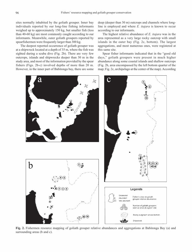
Goliath grouper distribution and habitat useAccording to our informants, E. itajara is present in areas
of estuarine- (Fig. 2a) to marine-dominated environments (Fig.2b). The species is associated with rocky bottoms, especiallycoastal and inner bay islands. At a few sites, the species wasobserved at the continent’s rocky shores (Fig. 2a, three-rowmarkings at upper left corner; 2b, one-row marking at bottomleft). Shipwrecks (Fig. 2b) and outcrops (Figs. 2a-b-c) are also
Fig. 1. São Francisco do Sul Island and Babitonga bay, Southern Brazil. Detached areas (a, b and c) are those detailed in Fig. 2.
Fishers’ resource mapping and goliath grouper conservation96
sites normally inhabited by the goliath grouper. Inner bayindividuals reported by our long-line fishing informantsweighed up to approximately 150 kg, but smaller fish (lessthan 40-60 kg) are most commonly caught according to ourinformants. Meanwhile, outer goliath groupers reported byspearfishermen were frequently larger than 300 kg.
The deepest reported occurrence of goliath grouper wasat a shipwreck located at a depth of 35 m, where the fish wassighted during a scuba dive (Fig. 2b). There are very fewoutcrops, islands and shipwrecks deeper than 30 m in thestudy area, and most of the information provided by the spearfishers (Figs. 2b-c) involved depths of more than 20 m.However, in the inner part of Babitonga bay, there are some
deep (deeper than 30 m) outcrops and channels where long-line is employed and where E. itajara is known to occuraccording to our informants.
The highest relative abundance of E. itajara was in thearea represented as a very large rocky outcrop with smallislands in the outer bay (Fig. 2c, bottom). The largestaggregations, and most numerous ones, were registered atthis same site.
Spear fisher informants indicated that in the “good olddays,” goliath groupers were present in much higherabundance along some coastal islands and shallow outcrops(Fig. 2b, area encompassed by the left bottom quarter of themap; Fig. 2c, archipelago at the center of the map). According
Fig. 2. Fishermen resource mapping of goliath grouper relative abundances and aggregations at Babitonga Bay (a) andsurrounding areas (b and c).

97L. C. Gerhardinger, M. Hostim-Silva, R. P. Medeiros, J. Matarezi, Á. A. Bertoncini, M. O. Freitas & B. P. Ferreira
to our spear fisher informants, the continuous increase offishing effort has drastically diminished the abundance of E.itajara and other species along these surrounding fishinggrounds.
Goliath grouper aggregationsSpear fishers’ information on E. itajara aggregations (Figs.
2b-c) indicated the sites where goliath groupers were sightedin small groups. Such data corroborates the data on relativeabundance. Among eight indicated aggregation sites, fivereceived three marks (very abundant). Three sites aredistinguished by the high number of aggregations pointedout and the amount of fish seen on each occasion (Fig. 2c,islands and adjacent rocky submerged reefs on the bottom ofthe figure; Fig. 2b, right bottom corner; Fig. 2b, islands andsubmerged reefs at the center of the figure).
The deepest E. itajara aggregation (n = 3 individuals)was seen at a shipwreck at 35 m deep. The greatest density offish (n ≈ 60 individuals) was seen at a long stretch ofsubmerged rocky reefs at depths varying from 8 to 18 m (Fig.2b, right bottom corner). Another site with a remarkable E.itajara density record was that of Fig. 2b (right bottom corner),at 26 m. Several other aggregation sites were recorded in Figs.2b-c with a variable number of individuals sighted.
Spear fishers were not familiar with rocky reef sites locatedin the inner bay. The only informant who had practiced spearfishing in this area a few decades ago was our senior informant(83 years old), at times when water transparency was greaterin the inner bay (Gerhardinger et al., 2006a).
Discussion
Goliath grouper distribution and habitat useEpinephelus itajara has a preference for holes, caves and
places where they can find shelter (Sadovy & Eklund, 1999).Through the observation of our sketch maps, we concludethat E. itajara is frequently found inhabiting rocky bottoms(rocky shores and outcrops) and shipwrecks. However, thespecies may also occur inside the bay, associated withstructures formed by the accumulation of drift wood, broughtfrom the upper estuary during strong storms (Gerhardinger,2006b). Our informants were unable to differentiate locationswhere larger (deeper than 40-60 kg) and smaller (less than 40-60 kg) individuals are found. However, when comparingknowledge of spearfishers vs. long-liners, a shift in the size ofobserved fish is evident, with smaller individuals morecommonly seen in estuarine rather than offshore areas.
In the Caribbean and Gulf of Mexico, E. itajara is usuallyfound in waters up to 40 m deep, with few records at depthsof 50-90 m (Sadovy & Eklund, 1999). Our data show that E.itajara may occur deeper than 30 m, but it was not possible todraw conclusions on the exact depth range for the goliathgrouper, based solely on the sketch maps. Spearfishing isusually limited to shallow waters, practiced to 20-25 m deep,and this depth range was the limit of informants’ knowledge.
Analyzing the regional fishing statistics (Univali, 2002), wefound that the goliath grouper is apparently not so vulnerableto the industrial fleet operating along the continental platform,as only a total landing of 513 kg (no number of individualsavailable) of E. itajara was registered for the fleets with doublebottom-trawl gear in 2002.
The data on species relative abundance have contributedto the identification of priority areas for further research andconservation in our region. The use of abundance categoriesis tentative and was an attempt to facilitate the comparison ofour informants’ knowledge. Although this method provides asimple and straightforward way of documenting andpresenting the data, we recognize that the perception ofdifferent abundance levels may have possibly varied amongour informants. This possible bias should be taken intoaccount because fishers of different ages can have differentperceptions of marine resource integrity, a phenomenonknown as “shifting baselines” (Pauly, 1995). Shifting baselinesare intergenerational changes in the way people perceive thestate of the environment. Gradual changes tend to beoverlooked such that today’s generations fail to appreciatethe degree to which coastal habitats and species have beenlost, depleted or altered by past human activities, for instance.The use of different fishing gear may also influence theprocess of LEK generation, thus influencing fishers’perception on fish abundance fluctuations over time(Gerhardinger et al., 2006b). Therefore, we recommend furtherinvestigation of how such variation in resource-user’sperception of marine resources may influence thedocumentation of LEK through the use of sketch maps.Further understanding could be achieved by cross comparingdifferent methodological approaches of LEK (e.g., fishers’resource mapping) and conventional ichthyology surveys(e.g., underwater visual census). It is important to note thatthe idea here is not to test LEK (not even scientific methodsgenerate absolute truths or are error-free), but to create amodel that has the capacity to compliment information fromdifferent sources.
Goliath grouper spawning aggregationsWe considered a fish aggregation to be formed for
reproductive purposes when direct and/or indirect evidenceof spawning was recorded (Colin et al., 2003). Direct evidenceincludes the actual observation of spawning (egg release),females with hydrated eggs and/or the presence of post-ovulatory follicles in the ovaries of aggregating females.Indirect evidence includes the observation of particular fishbehaviors or color patterns (only if these are demonstrablyknown to be associated with spawning) and swollen abdomen(Colin et al., 2003).
We believe that at least two of the goliath grouperaggregations observed by our informants were spawningaggregations (Fig. 2c, n = 60, 20 and 18; Fig. 2b, n = 30 and 18).In fact, our spearfisher informants reported that most of thefish caught in these most abundant aggregations had a

Fishers’ resource mapping and goliath grouper conservation98
swollen abdomen and well-developed gonads. Distinct female/male behavior in spawning aggregations was also reportedby our senior spearfisher informant (Gerhardinger et al.,2006c). Furthermore, this species does not aggregatethroughout the year, and catches in the outer bay area arestrongly seasonal (throughout the austral summer, butapparently higher during December) (Gerhardinger et al.,2006b).
Although the large numbers of E. itajara observed insome areas is strong evidence of a spawning aggregation,not all of our records can be defined as so due to the lack ofconclusive direct/indirect evidence. Our informants also sawa few small groups (two to four individuals) foraging in thewater column, but this could not be linked to spawningpurposes.
It was not possible to determine if E. itajara spawningaggregations are formed on a yearly basis at every siteconsidered as a spawning aggregation site. Still, fish spawningaggregation at reef sites can vary on an annual basis and ondifferent spatial scales, according to some of our spearfisherinformants. We propose the hypothesis that E. itajara mayaggregate at different sites varying on an unknown regionalscale. This hypothesis is being assessed by conventionalmethodologies used in ichthyology studies of spawningaggregations.
Although some long-line fishers have reported catchesof up to three E. itajara individuals at once within BabitongaBay, there is no conclusive evidence regarding direct orindirect observations of mature gonads and/or spawningactivity for such reports.
Throughout the Brazilian coast, goliath groupers formgroups in numbers varying from a few individuals to dozensin several locations along the coastline (LCG, pers.obs.). Thespotting of large aggregations of adults, however, is quiterare nowadays, while small aggregations can still be found inplaces traditionally known by fishermen and researchers. Webelieve some of these aggregations are formed for spawningpurposes, especially those accounting for a substantialincrease in abundance at specific times. The State of Pará inNorth Brazil had the highest national records of goliathgrouper fisheries disembarking from 1998-2002 and duringthe initial moratorium period (2002-2005) (unpublished data).Higher catch rates occurred during December and March,and there is a notable high abundance of the species at specificfishing spots. For instance, reports from fishermen and localgovernment fisheries authorities indicate capture of more than20 large adults on a single fishing spot off the State ofMaranhão coast.
In Northeast Brazil, off the coast of the State of Sergipeand near the mouth of the São Francisco River, a group ofmore than 10 adult E. itajara has been periodically observedaround what is apparently a submerged beach rock reef,located at depths shallower than 30 m, perhaps one of the fewhard substrates in that region.
On the coast of the State of Paraná, high abundances of
goliath grouper also became frequent in a recentlyimplemented artificial reef system. The surrounding area is asandy/muddy shelf, where hard substrata are very rare,therefore the implementation of artificial devices created newhabitats for goliath groupers (LCG, pers.obs.). Though newdiving spots were made available, and goliath groupersightings have been promoted as a tourist alternative, noevidence has been published so far that this new habitat hasproduced a net increase in fish biomass. Indeed, this artificialreef site is of conservation concern, as large goliath groupersattracted to these artificial reefs during a significant period ofthe year have become easy targets for spearfishermen.
Independent of the underlying ecological explanation ofthe aggregations described herein (foraging, spawning, reefhabitat limitation), site-specific conservation measures mustbe put forward at all sites.
Most of the best known reef fish spawning aggregationsin the Atlantic Ocean are reported for the Caribbean Sea(Cornish, 2004). In Brazil, there is evidence that suchaggregations are also not uncommon. In fact, there areanecdotal reports of large schools of the cubera snapperLutjanus cyanopterus sighted along the southeasternBrazilian coast up to the 1970s (Carvalho-Filho, pers. comm.),as well as in northern Brazil in 2005 (Marcovaldi, pers. comm.),and a report of a similar event in South Brazil for this species,provided by one of our informants. Large schools of the duskygrouper Epinephelus marginatus (= Mycteropercamarginata) and the warsaw grouper E. nigritus were alsoreported by divers and fishers in Brazil (Bertoncini et al., 2003;LCG, pers. obs.). This anecdotal information suggests a largescope for the investigation of reef fish spawning aggregationin Brazil. It is also evident that LEK assessments will be oneof the most feasible methods to quickly document suchimportant data (Gerhardinger et al., 2007).
Combining conventional biological surveys with LEK hasalready been proven to be a viable mechanism for researchingand conserving marine fish spawning sites. Aswani andHamilton (2004), for instance, successfully integratedindigenous ecological knowledge and customary sea tenurewith marine and social science for the conservation of acritically endangered species of parrotfish (Bolbometoponmuricatum) in the Roviana Lagoon, Solomon Islands.
Methodological remarksThe reliability of LEK mapping information content
presented herein clearly depended on the informant selectionprocess.
The map scale used in this study did not support an exactdetermination of aggregation localities and species habitatuse, but was indeed enough to approximate generaloccurrence patterns and determine important areas for speciesconservation. Publicizing the exact location of suchaggregations could actually expose them to greater fishingpressure (Sadovy, 2004). Nevertheless, the final map allowedthe spatial representation of LEK content in a clear and

99L. C. Gerhardinger, M. Hostim-Silva, R. P. Medeiros, J. Matarezi, Á. A. Bertoncini, M. O. Freitas & B. P. Ferreira
objective way, providing a useful supportive tool (undercurrent use by the environmental authority of the localgovernment) for management and planning decisionsregarding the conservation of this particular species in theregion. However, it is reasonable to think that science andtraditional knowledge are bridging concepts needed for newmanagement approaches where novelty and innovation arekey conditions for the sustainability of common resources(Armitage, 2008; Armitage et al., 2007). Therefore, newmethodological approaches should be explored in order tolink the empirical and qualitative approach of traditionalknowledge and quantitative scientific knowledge (Berkes &Folke, 2002).
Prospects for E. itajara conservation in BrazilBabitonga Bay is currently a candidate site for a Marine
Protected Area (MPA) which will encompass the entire areaof our study. The presence of two endangered cetaceanspecies (Pontoporia blainvillei and Sotalia guianensis),together with the presence of the goliath grouper and otherendangered species, are the main driving rationale for thecreation of this protected area. The results of the presentwork have been used to guide the process of the area’sdesignation. The foreseen MPA category will allowsubsistence and artisanal fisheries to be developed in thearea. A local management council will be created, bringingmanagement decisions regarding the use of the area to a local
scale. However, many Brazilian MPAs are suffering from alack of government enforcement, apparently due to theshortage of government financial and logistic support forpatrolling. Although this is a no-win situation that requiresurgent measures, the engagement of fishers and their LEK asa core component of local management can play an importantrole in encouraging a stronger partnership among stakeholdersfor the sustainable use and management of local resources.
The prospect for goliath groupers in Brazil is encouraging,as the endangered status of the species has beenacknowledged through a moratorium (2002), recently reneweduntil 2012. The measure was a result of the work of a group ofresearchers and managers from universities and NGOs, whohave now been joined by other stakeholders, including fishersand other community leaderships and government managers,in a multi-institutional network, namely the Meros do BrasilNetwork (Fig. 3). The objective of this network is to generateand amass the best available knowledge on the species andits habitat, through a series of actions (Fig. 3), and thus todevelop a national strategic plan of action to protect thespecies and the severely threatened ecosystems it inhabits,such as mangroves, estuaries, and coral and rocky reefs. Thisnetwork initiative has been articulated since 2002 and nowoperates at four focal points along the Brazilian coast (Fig. 3),with several local initiatives now starting to take place atother sites (e.g., States of Pará, Maranhão, Sergipe and EspíritoSanto). The results of this work will subsidize a national policy
Fig. 3. Schematic representation of the “Meros do Brasil Network”, a multi-institutional partnership promoting coordinatedresearch, environmental education, communication and management actions directed to goliath grouper Epinephelus itajaraand mangrove, coral and rocky reef ecosystems in Brazil.

Fishers’ resource mapping and goliath grouper conservation100
for the conservation of this endangered marine fish species,which will be drafted in collaboration with the Braziliangovernmental environmental agency.
Community collaboration and knowledge was evidentlycrucial in the development of the first stage of the Meros doBrasil Network (2002-2006) and was defined as a majorcomponent of the current stage. Therefore, the project isputting much more effort into trying to develop a parallelprogram that would improve and maximize the work with localcommunities and local knowledge. The multi-institutional“Program on Local Knowledge and Practices” was signed inJune 2007, and aims to effectively make local knowledge aviable mechanism for marine conservation in Brazil. Theimplementation of the Program has opened up the possibilitiesto work not only with goliath grouper research andconservation, but with other important social aspectsconcerning the sustainability of marine resources in Brazil.One important principle of the Program is to empower LEKsystems within current marine management schemes using adualistic approach, in other words, transferring power whiledemanding further environmental responsibility from localresource users.
Conclusions
Goliath grouper spawning aggregations were identifiedin our study area through LEK evidence of high abundancesand spawning activity. This type of knowledge is offundamental importance for species conservation.
Mapping methodologies can play an important role insurveying LEK, as well as generating new researchhypothesis for conventional ichthyologic approaches.Fishers’ resource mapping provided a means of exchanginginformation among various disciplines while maintainingmethodological rigor. It also provided a clear way of presentingthe data gathered from LEK. Thus, we believe it can facilitatethe effective engagement of LEK in the decision-makingprocess of marine conservation initiatives. Furthermore, thesimplicity and the short amount of time needed to generatethese maps could make this methodology suitable for adaptiveco-management approaches, where frequent environmentalre-assessments are needed.
The engagement of fishers’ LEK is an importantcomponent of the ongoing initiative for goliath grouperconservation in Brazil. Thus, the Meros do Brasil Networkhas the challenge and opportunity to bring the LEK of fishers’onto a broad national scale of conservation research andpolicy design.
Acknowledgments
We acknowledge our informants, as well as all other fishers,fishers’ associations and fish market staff that contributedtheir time and knowledge. Comments and suggestions fromSarah Frias-Torres, Michelle Schaerer and two anonymous
referees greatly improved the manuscript. This study wasmade possible due to the financial support from TranspetroTransportes S/A, Padi Aware Foundation, FundaçãoBiodiversitas, Centro de Estudos Ambientais do Nordesteand Petrobras S/A (Programa Petrobras Ambiental) to the‘Meros do Brasil Network’ and the Multi-InstitutionalProgram on Local Knowledge and Practices(www.merosdobrasil.org). These initiatives are co-developedby ECOMAR NGO, Instituto Recifes Costeiros, UniversidadeFederal de Pernambuco, Instituto Vidágua, Universidade doVale do Itajaí - Univali and Instituto Vidamar in Santa CatarinaState, among other local, national and international partnersand collaborators.
Literature Cited
Anuchiracheeva, S., H. Demaine., G. P. Shivakoti & K. Ruddle.2003. Systematizing Local Knowledge Using GIS: FisheriesManagement in Bang Saphan Bay, Thailand. Ocean & CoastManagement. 46: 1049-1068.
Armitage, D. 2008. Governance in a multi-level world. InternationalJournal of the Commons, 2(1): 7-32.
Armitage, D., F. Berkes & N. Doubleday (Eds.). 2007. Adaptiveco-management: collaboration, learning and multi-levelgovernance. Vancouver: University of British Columbia Press.
Aswani, S. & R. J. Hamilton. 2004. Integrating indigenous ecologicalknowledge and customary sea tenure with marine and socialscience for conservation of bumphead parrotfish (Bolpometodonmuricatum) in the Roviana Lagoon, Solomon Islands.Environmental Conservation 31: 1-15.
Aswani, S. & M. Lauer. 2006. Incorporating fishermen localknowledge and behavior into geographical information systems(GIS) for designing marine protected areas in Oceania. HumanOrganization, 65: 81-102.
Baelde, P. 2001. Using Fishers’ Knowledge Goes beyond Filling Gapsin Scientific knowledge - Analysis of Australian Experiences.Proceeding of Conference Putting Fishers’ Knowledge to Work.University of British Columbia, Florida Center for ReadingResearch, Pp.78-86.
Begossi, A. 2006. Temporal stability in fishing spots: conservationand co-management in Brazilian artisanal coastal fisheries.Ecology and Society 11(1):1-25.
Berkes, F. & C. Folke. 2002. Back to the future: ecosystemdynamics and local knowledge. Pp. 121-146. In: Gunderson, L.H. & C. S. Holling. Panarchy: understanding transformations inhuman and natural systems. Washington (USA): Island Press.
Bertoncini, A. A., L. F. Machado, M. Hostim-Silva & J.P. Barreiros.2003. Reproductive biology of the dusky grouper Epinephelusmarginatus (Lowe, 1834). Brazilian Archives of Biology andTechnology, 46(3): 373-381.
Calamia, M. A. 1999. A methodology for incorporating traditionalecological knowledge with geographic information systems formarine resource management in the Pacific. SPC TraditionalMarine Resource Management and Knowledge InformationBulletin, 10: 2-12.
Colin, P. L., Y. J. Sadovy & M. L. Domeier. 2003. Manual for theStudy and Conservation of Reef Fish Spawning Aggregations.Society for the Conservation of Reef Fish Aggregations SpecialPublication No. 1 (Version 1.0).

101L. C. Gerhardinger, M. Hostim-Silva, R. P. Medeiros, J. Matarezi, Á. A. Bertoncini, M. O. Freitas & B. P. Ferreira
Cornish, A. 2004. Development and Summary of Global Database,July 2004. Society for the Conservation of Reef Fish SpawningAggregations.
Costa-Neto, E. M.,C. V. Dias & M. N. Melo. 2002. O conhecimen-to ictiológico tradicional dos pescadores da cidade de Barra,região do médio São Francisco, Bahia, Brasil. Acta Scientiarum,24(2): 561-572.
Craig, M.T., R. T. Graham, R. A. Torres, J. R. Hyde, M. O. Freitas,B. P. Ferreira, M. Hostim-Silva, L. C. Gerhardinger, A. A.Bertoncini & D. R. Robertson. 2008. How many species ofgoliath grouper are there? Cryptic genetic divergence in athreatened marine fish and the resurrection of a geopoliticalspecies. Endangered Species Research, preprint, 1-8.
Davis, A. & J. R. Wagner. 2003. Who knows? On the importance ofidentifying “experts” when researching local ecologicalknowledge. Human Ecology, 31(3): 463-489.
Diegues, A. C & R. S. V. Arruda. 2001. Saberes Tradicionais ebiodiversidade no Brasil. (Biodiversidade 4). Ministério do MeioAmbiente, Brasília, São Paulo: USP, 176p.
Domeier, M. L. & P. L. Colin. 1997. Tropical reef fish spawningaggregations: defined and reviewed. Bulletin of Marine Science.60(3): 698-726.
Drew, J. 2005. Use of Traditional Ecological Knowledge in MarineConservation. Conservation Biology, 19(4): 1286-1293.
Frias-Torres, S. 2006. Habitat use of juvenile goliath grouperEpinephelus itajara in the Florida Keys, USA. EndangeredSpecies Research, 2: 1-6.
Gerhardinger, L. C., A. A. Bertoncini & M. Hostim-Silva. 2006c.Local ecological knowledge and Goliath grouper spawningaggregations in the South Atlantic Ocean: Goliath grouperspawning aggregations in Brazil. SPC Traditional MarineResource Management and Knowledge Information Bulletin,20: 33-34.
Gerhardinger, L. C., M. O. Freitas, R. P. Medeiros, E. A. Godoy, R.C. Marenzi & M. Hostim-Silva. 2007. Local EcologicalKnowledge on the Planning and Management of Marine ProtectedAreas and Conservation of Fish Spawning Aggregations: TheExperience of “Meros do Brasil” Project. Pp. 117-139. In: MMA,Áreas Protegidas do Brasil 4. Brasília, 271p.
Gerhardinger, L. C., M. Hostim-Silva, R. Medeiros & R. C. Marenzi.2006a. Conhecimento Ecológico Local de Pescadores da BaíaBabitonga, Santa Catarina, Brasil: Peixes da Família Serranidae.Acta Scientiarum Biological Science. 28(3): 253-261.
Gerhardinger, L. C., R. Medeiros., R. C. Marenzi., A. A. Bertoncini& M. Hostim-Silva. 2006b. Local Ecological Knowledge on theGoliath Grouper Epinephelus itajara. Neotropical Ichthyology.4(4): 441-450.
Haggan, N., B. Neis & I. G. Baird. 2007. Fishers’ Knowledge inFisheries Science and Management, Coastal ManagementSourcebooks 4, UNESCO LINKS, Paris.
Hamilton, R. & R. Walter. 1999. Indigenous ecological knowledgeand its role in fisheries research design: A case study fromRoviana Lagoon, Western Province, Solomon Islands. SPCTraditional Marine Resource Management and KnowledgeInformation Bulletin, 11: 13-25.
Hostim-Silva, M., A. A. Bertoncini., L. C. Gerhardinger & L. F.Machado. 2005. The Lord of the Rocks conservation programin Brazil: the need for a new perception of marine fishes. CoralReefs. 24: 74.
Huntington, H. P. 2000. Using Traditional Ecological Knowledge inScience: Methods and Applications. Ecological Applications,
10(5): 1270-1274.Ibama (Instituto Brasileiro do Meio Ambiente e dos Recursos Na-
turais Renováveis). 1998. Proteção e controle de ecossistemascosteiros: Manguezal da Baía da Babitonga. Brasília: Ibama.Coleção Meio Ambiente, Série Estudos de Pesca, 146p.
Johannes, R. E. 1998. The case for data-less marine resourcemanagement: examples from tropical nearshore finfisheries.Trends in Ecology & Evolution, 13: 243-246.
Koenig, C. C, F. C. Coleman, A. M. Eklund, J. Schull & J. Ueland.2007. Mangroves as essential nursery habitat for goliath grouper(Epinephelus itajara), Bulletin of Marine Science, 80(3): 567-586.
Langley, J. 2006. Vezo Knowledge: Traditional Ecological Knowledgein Andavadoaka, southwest Madagascar. Blue VenturesConservation Report.
Neis, B., D. C. Schneider., L. Felt., R. L. Haedrich., J. Fischer & J.A. Hutchings. 1999. Fisheries assessment: what can be learnedfrom interviewing resource users? Canadian Journal of Fisheriesand Aquatic Sciences, 56(10): 1949-1963.
Pauly, D. 2005. Anecdotes and the shifting baseline syndrome offisheries. Trends in Ecology & Evolution, 10(10): 430.
Paz, V. A. & A. Begossi.1996. Ethnoichthyology of GamboaFishermen of Sepetiba Bay, Brazil. Journal of Ethnobiology,16(2):157-168.
Pinheiro, L. & M. Cremer. 2004. Sistema pesqueiro da Baía deBabitonga, litoral norte de Santa Catarina: uma abordagemetnoecológica. Desenvolvimento e Meio Ambiente, 8: 59-68.
Pinnegar, J. K. & G. H. Engelhard. 2008. The ‘shifting baseline’phenomenon: a global perspective. Reviews in Fish Biologyand Fisheries, 18: 1-16.
Roberts, C. 2007. The Unnatural History of the Seas. WashingtonDC, Island Press, 435p.
Ruddle, K. 1994. Local Knowledge in the future management of inshoretropical marine resources of inshores tropical marine resources andenvironments. Nature and Resources, 30(1): 28-37.
Sadovy, Y. 2004. The Science and Policy of Protecting SpawningAggregations: Interview with Yvonne Sadovy, Society for theConservation of Reef Fish Aggregations. Marine Protected AreasNews, Washington. 4-5.
Sadovy, Y. & A. M. Eklund. 1999. Synopsis of biological data onthe Nassau grouper, Epinephelus striatus (Bloch 1792) and thejewfish E. itajara (Lichtenstein 1822). NOAA Technical ReportNMFS, 146p.
Sáenz-Arroyo, A., C. M. Roberts., J. Torre., M. Carino-Olivera &R. R Enrýq. 2005. Rapid environmental shifting baseline amongfishers from the Gulf of California. Proceedings of the RoyalSociety, 272: 1957-1962.
Sala, E., O. Aburto-Oropeza., G. Paredes & G. Thompson. 2003.Spawning aggregations and reproductive behavior of reef fishesin the Gulf of California. Bulletin of Marine Science. 72(1): 103-121.
Seixas, C. S. & F. Berkes. 2003. Dynamics of socio-ecological changesin a lagoon fishery in southern Brazil. Pp. 271-298. In: Berkes,F.; J. Colding & C. Folke (Eds.). Navigating socio-ecologicalsystems: building resilience for complexity and change.Cambridge: Cambridge University Press.
Silvano, R. A. M., P. F. L. MacCord, P. F. L. Lima & A. Begossi.2006. When Does this Fish Spawn? Fishermen’s LocalKnowledge of Migration and Reproduction of Brazilian CoastalFishes. Environmental Biology of Fishes, 76(2-4): 371-381.
Tak-Chuen, C. T & B. P. Ferreira. 2006. Epinephelus itajara. In:IUCN 2007. 2007 IUCN Red List of Threatened Species.

Fishers’ resource mapping and goliath grouper conservation102
<www.iucnredlist.org>. Downloaded on 14 February 2008.Univali (Universidade do Vale do Itajaí). 2002. Boletim estatístico
da pesca industrial de Santa Catarina - Ano 2001: açõesprioritárias ao desenvolvimento da pesca e aqüicultura no suldo Brasil. UNIVALI, Pró-Reitoria de Ensino, Centro de Educa-ção Superior de Ciências Tecnológicas, da Terra e do Mar. Itajaí,93p.
Accepted November 2008Published March 31, 2009