Final Engineering Evaluation/Cost Estimate - July 2004
563
FinaA ingineering Evaluation/Cost Analysis Former Camp Butner Butner, North Carolina i CAMP_BUTNER World W i r l l infantry training camp*. hou*#d \xU prUoneri of war. Named for NX. natWe. Gen. Henry W. Butner. Prepared for y*Corps of Engineei Wilmington District and U.S, Army Corps of Engineers Huntsville Center Contract Number D ACA87-95-D-0018 Task Order 0067 FUDS Project Number I04NC000902 100 West Walnut Street Pasadena, CA 91124 200. le I04NC000902 02.16 0002
-
Upload
khangminh22 -
Category
Documents
-
view
0 -
download
0
Transcript of Final Engineering Evaluation/Cost Estimate - July 2004

FinaA
ingineering Evaluation/Cost AnalysisFormer Camp Butner
Butner, North Carolinai
CAMP_BUTNERWorld Wirl l infantrytraining camp*. hou*#d\xU prUoneri of war.
Named for NX. natWe.Gen. Henry W. Butner.
Prepared for
y*Corps of EngineeiWilmington District
andU.S, Army Corps of Engineers
Huntsville Center
Contract Number D ACA87-95-D-0018Task Order 0067
FUDS Project Number I04NC000902
100 West Walnut StreetPasadena, CA 91124
200. leI04NC000902 02.16 0002

Parsons Infrastructure & Technology Group, inc.
n5390 Triangie Parkway • Suite 100 • horcross. Georgia 3C092 • (770)446-4900 • Fax: (770)446-4910 • www.parions.ooni
July 9, 2004
U.S. Army Engineering & Support CenterATTN: CEHNC-OE-DC (Terry Steuart)4820 University SquareHuntsville, AL 35816-1822256-895-1562
Subject: Contract DACA87-95-D-0018, Delivery Order 0067Final Engineering Evaluation/Cost Analysis ReportFormer Camp Butner, Butner, North Carolina
Dear Mr. Steuart:
Enclosed please find three (3) copies of the Final Engineering Evaluation/CostAnalysis Report for the former Camp Butner for your files. Twelve (12) additionalcopies have been prepared and distributed to Mr. Bob Keistler, USACE WilmingtonDistrict for CESAW files, Administrative Record, and other distribution. The Finaldocument submitted includes all post Public Meeting revisions associated with EPAcomments as agreed by the project team during the June 14, 2004 conference call.Preparation of the four Action Memorandums is in progress with submittal of Draftcopies scheduled to be sent on July 19, 2004 for review.
Please contact me at (678) 969-2384 (direct line) or (404) 606-0346 (cell) if youhave any questions regarding this report.
Sincerely,
PARSONS
Don Silkebakken, P.E.Project Manager
cc: Contracting OfficerMr. Bob Keistler, P.E. (CESAW PM, 12 copies)Project File (738001.14000)
u

nFINAL
ENGINEERING EVALUATION/COST ANALYSIS
FORMER CAMP BUTNERBUTNER, NORTH CAROLINA
Prepared For:
U.S. Army Corps of EngineersWilmington District
and
U.S. Army Corps of EngineersHuntsville Center
Contract No. DACA87-95-D-0018Task Order No. 0067
FUDS Project No. I04NC000902
Prepared By:PARSONS
100 West Walnut StreetPasadena, CA 91124
Contributing Authors:Michael Short, Ordnance Expertise
Bai Tian and Brett Weise, GISEd Grunwald, CIH, Health and Safety
John Kertesz and Laura Kelley, Technical ExpertiseNeil Feist, Quality Control
Jae Yun and Greg Van, GeophysicsRichard Satkin, Risk Assessment
July 2004
u QC Reviewer 0Don Silkebakken, PE Laura Kelley

n TABLE OF CONTENTS
EXECUTIVE SUMMARY
Page
ESI
CHAPTER 1 INTRODUCTION 1-11.1 Background 1-11.2 Project Authorization 1-11.3 Purpose and Scope 1-21.4 Project Team 1-2
1.4.1 U.S. Army Corps of Engineers, Wilmington District 1-21.4.2 U.S. Army Engineering and Support Center, Huntsville 1-21.4.3 Parsons 1-31.4.4 USA Environmental, Inc 1-3
1.5 Project Objectives 1-3
CHAPTER 2 SITE DESCRIPTION AND HISTORY 2-12.1 Location 2-12.2 Physical Description 2-1
2.2.1 Terrain and Vegetation 2-12.2.2 Geologic and Soil Conditions 2-12.2.3 Climate 2-2
2.3 History 2-22.4 Demographic Profile 2-42.5 Current and Future Land Use 2-42.6 Previous Investigations 2-5
2.6.1 DERP-FUDS Field Inspection for PreliminaryAssessment 2-5
2.6.2 Findings and Determination of Eligibility 2-62.6.3 1992 Site Investigation Report 2-62.6.4 1993 Archives Search Report (ASR) 2-62.6.5 1998 Site Visit 2-62.6.6 Other Investigations 2-72.6.7 2000 Site Visit 2-72.6.8 2001 Topographic Engineering Center (TEC) Report 2-72.6.9 2003 ASR Supplement 2-7
2.7 Previous Removal Actions 2-8
CHAPTER 3 SITE CHARACTERIZATION 3-13.1 Site Investigation 3-1
3.1.1 Instrumentation 3-13.1.1.1 Geonics® EM-61 TDMD 3-1
1 Revision No 4I:\HUNT-CONUS\PROJECTS\BUTNER\EECA\FINAL\TOC 7/9/2004CONTRACT NO. DACA87-95-D-0O18TASK ORDER 0067

TABLE OF CONTENTS(CONTINUED)
Page
3.1.1.2 Geonics® EM-61 MK 2 TDMD 3-23.1.1.3 Schonstedt Magnetic Locator 3-23.1.1.4 Trimble® 4700 Real Time Kinematic Total
Station Global Positioning System 3-23.1.2 Quality Control of Geophysical Instruments 3-33.1.3 Geophysical Survey 3-4
3.1.3.1 Grid Survey 3-43.1.3.2 Meandering Path Survey 3-53.1.3.3 Analog Detection (Mag and Dig) 3-5
3.1.4 Anomaly Identification 3-53.1.4.1 Data Processing 3-53.1.4.2 Anomaly Selection and Ranking 3-6
3.1.5 Anomaly Dig Sheets 3-83.1.6 Anomaly Reacquisition 3-83.1.7 Intrusive Investigation 3-8
3.1.7.1 Unexploded Ordnance 3-103.1.7.2 Ordnance Scrap (OE Scrap) 3-103.1.7.3 Other 3-10
3.1.7.3.1 Non Ordnance-Related Scrap 3-103.1.7.3.2 Geological Interference 3-10
3.1.7.4 False Positive 3-113.1.8 Intrusive Investigation Findings 3-113.1.9 Recovered UXO 3-113.1.10 OE Scrap Disposal 3-11
3.2 Source, Nature, and Extent of UXO/OE 3-143.2.1 Area 1 3-143.2.2 Area 2 3-153.2.3 Area 3 3-163.2.4 Area 4 3-173.2.5 Area 5 3-19
3.3 Recovered Ordnance Items 3-193.4 Firing Fans 3-193.5 Re-Sectorization of AOI Boundaries 3-20
3.5.1 Area 1A 3-203.5.2 Area 4 3-213.5.3 Area4A 3-223.5.4 Area 4B 3-223.5.5 Area4C 3-233.5.6 Area4D 3-243.5.7 Area4E 3-243.5.8 Area 5 3-243.5.9 Lakeview Subdivision 3-25
11 Revision No. 4I:\HUNT-CONUS\PROJECTS\BUTNER\EECA\FINAL\TOC.DOC 7/9/2004CONTRACT NO. DACA87-95-D-O018TASK ORDER 0067

nTABLE OF CONTENTS
(CONTINUED)
Page
CHAPTER 4 RISK EVALUATION 4-14.1 Introduction 4-14.2 Definition of Risk Evaluation Factors, Categories, and
Subcategories 4-14.2.1 Introduction 4-14.2.2 Presence of UXO Factors 4-34.2.3 Site Characteristics Factors 4-44.2.4 Human Factors 4-5
4.3 Risk Evaluation 4-64.3.1 Introduction 4-64.3.2 Presence of UXO Factor 4-6
4.3.2.1 Type 4-64.3.2.2 Sensitivity 4-94.3.2.3 Density 4-94.3.2.4 Depth 4-9
4.3.3 Site Characteristics Factors 4-104.3.3.1 Site Accessibility 4-104.3.3.2 Site Stability 4-10
4.3.4 Human Factors 4-104.3.4.1 Site Activities 4-104.3.4.2 Population 4-14
4.4 Risk Assessment Summary 4-14
CHAPTER 5 INSTITUTIONAL ANALYSIS 5-15.1 Introduction 5-15.2 Methodology 5-15.3 Recommendations 5-1
5.3.1 Notification During Permitting 5-25.3.2 Notification During Property Transfer 5-35.3.3 Notification on Tax Bills 5-35.3.4 Notification with Hunting Permit 5-35.3.5 Brochure/Fact Sheet 5-35.3.6 Newspaper Articles/Interviews 5-35.3.7 Information Packages to Public Officials 5-45.3.8 Visual and Audio Media 5-45.3.9 Classroom Education 5-45.3.10 Ad Hoc Committee 5-45.3.11 Reverse 911 System 5-55.3.12 Signs 5-55.3.13 Fencing 5-55.3.14 Land Use Restrictions and Regulatory Control 5-55.3.15 Internet Website 5-5
111 Revision No. 4I:\HUNT-CONUS\PROJECTS\BUTNER\EECA\nNAL\TOC.DOC 7/9/2004CONTRACT NO. DACA87-95-D-OO18TASK ORDER 0067

nTABLE OF CONTENTS
(CONTINUED)
Page
CHAPTER 6 IDENTMCATION OF RESPONSE ACTION OBJECTIVES 6-16.1 Response Action Goal 6-16.2 Response Action Objectives 6-1
CHAPTER 7 IDENTMCATION AND ANALYSIS OF UXO/OE RESPONSEACTION ALTERNATIVES 7-17.1 Introduction 7-17.2 Description of UXO Clearance Technologies 7-1
7.2.1 Introduction 7-17.2.2 UXO Detection 7-17.2.3 UXO Recovery 7-27.2.4 UXO Disposal 7-3
7.3 Description of UXO/OE Response Action Alternatives 7-47.3.1 Introduction 7-47.3.2 Alternative 1 - No DoD Action Indicated 7-57.3.3 Alternative 2 - Institutional Controls 7-57.3.4 Alternative 3 - Surface Clearance of UXO/OE 7-67.3.5 Alternative 4 - Clearance of UXO/OE to Depth 7-6
7.4 Introduction of Screening Criteria 7-77.4.1 Effectiveness 7-87.4.2 Implementability 7-127.4.3 Cost 7-13
7.5 Application of the Evaluation Criteria by Alternative for Area1A 7-137.5.1 Alternative 1: No DoD Action Indicated 7-13
7.5.1.1 Effectiveness 7-137.5.2 Alternative 2: Institutional Controls 7-13
7.5.2.1 Effectiveness 7-137.5.2.2 Implementability 7-147.5.2.3 Cost 7-14
7.5.3 Alternative 3: Surface Clearance of UXO/OE 7-147.5.3.1 Effectiveness 7-14
7.5.4 Alternative 4: Clearance of UXO/OE to Depth 7-157.5.4.1 Effectiveness 7-157.5.4.2 Implementability 7-157.5.4.3 Cost 7-16
7.6 Application of the Evaluation Criteria By Alternative for Area4A 7-16
7.6.1 Alternative 1: No DoD Action Indicated 7-167.6.1.1 Effectiveness 7-16
7.6.2 Alternative 2: Institutional Controls 7-16, j 7.6.2.1 Effectiveness 7-16
IV Revision No. 4I :\HUNT-CONUS\PROJECTS\B UTNER\EEC A\FIN ALVTOC. DOC 7/9/2004CONTRACT NO. DACA87-95-D-OO18TASK ORDER 0067

nTABLE OF CONTENTS
(CONTINUED)
Page
7.6.2.2 Implementability 7-167.6.2.3 Cost 7-17
7.6.4 Alternative3: Surface Clearance of UXO/OE 7-177.6.4.1 Effectiveness 7-177.6.4.2 Implementability 7-177.6.4.3 Cost 7-17
7.6.5 Alternative 5: Clearance of UXO/OE to Depth 7-177.6.5.1 Effectiveness 7-177.6.5.2 Implementability 7-187.6.5.3 Cost 7-18
7.7 Application of the Evaluation Criteria by Alternative For Area4B 7-197.7.1 Alternative 1: No DoD Action Indicated 7-19
7.7.1.1 Effectiveness 7-197.7.2 Alternative 2: Institutional Controls 7-19
7.7.2.1 Effectiveness 7-197.7.2.2 Implementability 7-197.7.2.3 Cost 7-19
7.7.3 Alternative 3: Surface Clearance of UXO/OE 7-207.7.3.1 Effectiveness 7-207.7.4 Alternative 4: Surface Clearance of UXO/OE with
7.7.4 Alternative 4: Clearance of UXO/OE to Depth 7-207.7.4.1 Effectiveness 7-207.7.4.2 Implementability 7-217.7.4.3 Cost 7-21
7.8 Application of the Evaluation Criteria by Alternative for Area4C 7-21
7.8.1 Alternative 1: No DoD Action Indicated 7-217.8.1.1 Effectiveness 7-21
7.8.2 Alternative 2: Institutional Controls 7-217.8.2.1 Effectiveness 7-217.8.2.2 Implementability 7-227.8.2.3 Cost 7-22
7.8.3 Alternative 3: Surface Clearance of UXO/OE 7-227.8.3.1 Effectiveness 7-22
7.8.4 Alternative 4: Clearance of UXO/OE to Depth 7-227.8.4.1 Effectiveness 7-227.8.4.2 Implementability 7-237.8.4.3 Cost 7-24
7.9 Application of the Evalutaion Criteria by Alternative for Area4D 7-24
7.9.1 Alternative 1: No DoD Action Indicated 7-24
V Revision No. 4I:\HUNT-CONUS\PROJECTS\BUTNER\EECA\FINAL\TOC.DOC 7/9/2004CONTRACT NO. DACA87-95-D-OO18TASK ORDER 0067
TABLE OF CONTENTS(CONTINUED)
Page
7.9.1.1 Effectiveness 7-247.9.2 Alternative 2: Institutional Controls 7-24
7.9.2.1 Effectiveness 7-247.9.2.2 Implementability 7-247.9.2.3 Cost 7-25
7.9.3 Alternative 3: Surface Clearance of UXO/OE 7-257.9.3.1 Effectiveness 7-25
7.9.4 Alternative 4: Clearance of UXO/OE to Depth 7-257.9.4.1 Effectiveness 7-257.9.4.2 Implementability 7-257.9.4.3 Cost 7-25
7.10 Application of the Evaluation Criteria By Alternative for Area4E 7-26
7.10.1 Alternative 1: No DoD Actional Indicated 7-267.10.1.1 Effectiveness 7-26
7.10.2 Alternative 2: Institutional Controls 7-267.10.2.1 Effectiveness 7-267.10.2.2 Implementability 7-277.10.2.3 Cost 7-27
7.10.3 Alternative 3: Surface Clearance of UXO/OE 7-277.10.3.1 Effectiveness 7-27
7.10.4 Alternative 4: Clearance of UXO/OE to Depth 7-277.10.4.1 Effectiveness 7-27
7.11 Application of the Evaluation Criteria by Alternative for Area 4 7-287.11.1 Alternative 1: No DoD Action Indicated 7-287.11.2 Alternative 2: Institutional Controls 7-28
7.13.2.1 Effectiveness 7-287.11.2.2 Implementability 7-287.11.2.3 Cost 7-29
7.11.3 Alternative 3: Surface Clearance of UXO/OE 7-297.11.3.1 Effectiveness 7-297.11.3.2 Implementability 7-297.11.3.3 Cost 7-30
7.11.4 Alternative 4: Clearance of UXO/OE to Depth 7-307.11.4.1 Effectiveness 7-307.11.4.2 Implementability 7-317.11.4.3 Cost 7-31
7.12 Application of the Evaluation Criteria by Alternative for Area 5 7-317.12.1 Alternative 1: No DoD Action Indicated 7-31
7.12.1.1 Effectiveness 7-317.12.1.2 Implementability 7-317.12.1.3 Cost 7-31
VI Revision No. 4I:\HUNT-CONUS\PROJECTS\BUTNER\EECA\FINAL\TOC.DOC 7/9/2004CONTRACT NO. DACA87-95-D-0018TASK ORDER 0067

TABLE OF CONTENTS(CONTINUED)
nPage
7.12.2 Alternative 2: Institutional Controls 7-327.12.2.1 Effectiveness 7-32
7.12.3 Alternative 3: Surface Clearance of UXO/OE 7-327.12.3.1 Effectiveness 7-32
7.12.4 Alternative 4: Clearance of UXO/OE to Depth 7-327.12.4.1 Effectiveness 7-32
7.13 Application of the Evaluation Criteria by Alternative forLakeview Subdvision 7-32
7.13.1 Alternative 1: No DoD Action Indicated 7-337.13.1.1 Effectiveness 7-33
7.13.2 Alternative 2: Institutional Controls 7-337.13.2.1 Effectiveness 7-337.13.2.2 Implementability 7-337.13.2.3 Cost 7-33
7.13.3 Alternative 3: Surface Clearance of UXO/OE 7-347.13.3.1 Effectiveness 7-34
7.13.4 Alternative 4: Clearance of UXO/OE to Depth 7-347.13.4.1 Effectiveness 7-347.13.4.2 Implementability 7-347.13.4.3 Cost 7-35
7.14 Summary of Remaining UXO/OE Response ActionAlternatives 7-35
CHAPTER 8 COMPARATP/E ANALYSIS OF RESPONSE ACTIONALTERNATIVES 8-18.1 Introduction 8-18.2 Effectiveness 8-2
8.2.1 Introduction 8-28.2.2 Overall Protection of Public Safety and Human
Environment 8-28.2.3 Compliance with ARARs 8-38.2.4 Long-Term Effectiveness 8-48.2.5 Short-Term Effectiveness 8-4
8.3 Implementability 8-218.3.1 Introduction 8-218.3.2 Technical Feasibility 8-218.3.3 Administrative Feasibility 8-218.3.4 Availability of Services and Materials 8-218.3.5 Property Owner Acceptance 8-218.3.6 Local Agency Acceptance 8-318.3.7 Community Acceptance 8-31
V l l Revision No. 4I:\HUNT-CONUS\PROJECTS\BUTNER\EECA\FINAL\TOC.DOC 7/9/2004CONTRACT NO. DACA87-95-D-0018TASK ORDER 0067

oTABLE OF CONTENTS
(CONTINUED)
Page
8.4 Cost 8-318.5 Overall Ranking 8-31
CHAPTER 9 RECOMMENDED RESPONSE ACTION ALTERNATIVE 9-19.1 Introduction 9-19.2 Recommendations 9-1
9.2.1 ArealA 9-19.2.2 Area4A 9-29.2.3 Area 4B 9-29.2.4 Area 4C 9-39.2.5 Area4D 9-49.2.6 Area4E 9-59.2.7 Area 4 9-59.2.8 Area 5 9-69.2.9 TCRA Lakeview Subdivision USAESCH
Recommendation 9-69.2.10 MMR Divisions 9-7
CHAPTER 10 RECURRING REVIEWS 10-110.1 Follow-On Activities 10-1
CHAPTER 11 REFERENCES 11-1
APPENDIX A - STATEMENT OF WORK (SOW)
APPENDIX B - USAESCH TCRA RECOMMENDATIONS REPORT
APPENDIX C - ANOMALY DIG SHEET SUMMARY
APPENDIX D - SCRAP CERTIFICATION FOR DISPOSAL
APPENDIX E - ORDNANCE ITEMS DESCRIPTION
APPENDIX F - INSTITUTIONAL ANALYSIS REPORT
APPENDIX G - RECOMMENDATION COST SUMMARY TABLES
APPENDIX H - KEY CORRESPONDENCES & PROJECT-RELATED NEWSPAPERARTICLES
V l l l Revision No. 4I:\HUNT-CONUS\PROJECTS\BUTNER\EECA\FINAL\TOC DOC 7/9/2004CONTRACT NO. DACA87-95-D-0018TASK ORDER 0067

LIST OF FIGURES
No. Title Page
1.1 Organizational Structure for Former Camp Butner EE/CA 1-4
2.1 General Location Map 2-92.2 General Site Layout Map 2-102.3 Historical Military Land Use 2-112.4 ASR-Designated Project Areas 2-12
3.1 Site Photos of EM-61 Equipment in Operation 3-293.2a Intrusively Investigated Grid Locations 3-303.2b Intrusively Investigated Grid Locations 3-313.3 Completed Grids in Original Area 1 3-323.4 Completed Grids in Original Area 2 3-333.5 Completed Grids in Original Area 3 3-343.6 Completed Grids in Original Area 4 3-353.7 Completed Grids in Original Area 5 3-363.8 Completed Grids in Resectored Area 1A 3-373.9 Completed Grids in Resectored Area 4 3-383.10 Completed Grids in Resectored Areas 4A & 4B 3-393.11 Completed Grids in Resectored Areas 4C 3-403.12 Completed Grids in Resectored Areas 4D &4E 3-413.13 Completed Grids in Resectored Area 5 3-423.14 Intrusively Investigated Grid Locations -Lakeview Subdivision 3-43
4.1 OE Risk Factor Tree 4-2
IX Revision No 4I:\HUNT-CONUS\PROJECTS\BUTNER\EECA\FINAUTOC 7/9/2004CONTRACT NO. DACA87-95-D-0018TASK ORDER 0067

n LIST OF TABLES
No. Title Page
2.1 Former Camp Butner Annual Inspection (Dedudding) Findings (1958-1967) 2-3
3.1 UXO Recovered and Detonated 3-123.2 Breakdown of Re-sectored AOIs 3-263.3 Summary of Recovered UXO/OE by AOI 3-27
4.1 UXO Type Subcategories 4-34.2 UXO Sensitivity Subcategories 4-44.3 Site Accessibility Subcategories 4-54.4 Site Stability Subcategory 4-54.5 UXO Contact Probability Levels 4-64.6 Risk Evaluation 4-12
7.1 Potential ARARs for UXO/OE Removal 7-367.2 Impact Analysis - Area 1A 7-387.3 Impact Analysis - Area4A 7-397.4 Impact Analysis - Area 4B 7-407.5 Impact Analysis - Area 4C 7-417.6 Impact Analysis - Area 4D 7-427.7 Impact Analysis - Area 4E 7-437.8 Impact Analysis - Area 4 7-447.9 Impact Analysis - Area 5 7-457.10 Impact Analysis - Lakeview Subdivision 7-46
8.1 Effectiveness Criteria Application for Area 1A 8-58.2 Effectiveness Criteria Application for Area 4A 8-68.3 Effectiveness Criteria Application for Area 4B 8-78.4 Effectiveness Criteria Application for Area 4C 8-88.5 Effectiveness Criteria Application for Area 4D 8-98.6 Effectiveness Criteria Application for Area 4E 8-108.7 Effectiveness Criteria Application for Area 4 8-118.8 Effectiveness Criteria Application forLakeview Subdivision 8-128.9 UXO/OE Risk Impact Analysis for Area 1A 8-138.10 UXO/OE Risk Impact Analysis for Area 4A 8-148.11 UXO/OE Risk Impact Analysis for Area 4B 8-158.12 UXO/OE Risk Impact Analysis for Area 4C 8-168.13 UXO/OE Risk Impact Analysis for Area 4D 8-178.14 UXO/OE Risk Impact Analysis for Area 4E 8-188.15 UXO/OE Risk Impact Analysis for Area 4 8-19
X Revision No. 4I:\HUNT-CONUS\PROJECTS\BUTNER\EECA\nNAL\TOC DOC 7/9/2004CONTRACT NO. DACA87-95-D-OO18TASK ORDER 0067

n
u
LIST OF TABLES (CONTINUED)
No. Title Page
8.16 UXO/OE Risk Impact Analysis for Lakeview Subdivision 8-208.17 Implementability Criteria Application for Area 1A 8-238.18 Implementability Criteria Application for Area 4A 8-248.19 Implementability Criteria Application for Area 4B 8-258.20 Implementability Criteria Application for Area 4C 8-268.21 Implementability Criteria Application for Area 4D 8-278.22 Implementability Criteria Application for Area 4E 8-288.23 Implementability Criteria Application for Area 4 8-298.24 Implementability Criteria Application for Lakeview Subdivision 8-308.25 Area 1A Clearance to Depth of UXO/OE Cost Estimate 8-328.26 Area 4A Surface Clearance of UXO/OE Cost Estimate 8-338.27 Area 4A Clearance to Depth of UXO/OE Cost Estimate 8-348.28 Area 4B Clearance to Depth of UXO/OE Cost Estimate 8-358.29 Area 4C Clearance to Depth of UXO/OE Cost Estimate 8-368.30 Area 4D Clearance to Depth of UXO/OE Cost Estimate 8-378.31 Area 4 Surface Clearance of UXO/OE Cost Estimate 8-388.32 Area 4 Clearance to Depth of UXO/OE Cost Estimate 8-398.33 Lakeview Subdivision Clearance to Depth of UXO/OE Cost Estimate 8-408.34 Selection Criteria Application for Area 1A 8-418.35 Selection Criteria Application for Area 4A 8-428.36 Selection Criteria Application for Area 4B 8-438.37 Selection Criteria Application for Area 4C 8-448.38 Selection Criteria Application for Area 4D 8-458.39 Selection Criteria Application for Area 4E 8-468.40 Selection Criteria Application for Area 4 8-478.41 Selection Criteria Application for Lakeview Subdivision 8-48
9.1 Summary of Recommended Alternatives and Clearance Costs 9-8
X i Revision No. 4I:\HUNT-CONUS\PROJECTS\BUTNER\EECA\FINAL\TOC.DOC 7/9/2004CONTRACT NO. DACA87-95-D-OO18TASK ORDER 0067

oLIST OF ACRONYMS
A/E architect/engineer
AOI area of interest
AP-T armor piercing w/tracer (Table 3.1)
ARAR applicable or relevant and appropriate requirement
ASR Archives Search Report
bgs Below Ground Surface
CESAW Corps of Engineers, Wilmington District
CERCLA Comprehensive Environmental Response, Compensation and Liability Act
CFR Code of Federal Regulation
DA Department of the Army
DERP Defense Environmental Restoration Program
DGM Digital Geophysical Mapping
DID Data Item Description
DoD U.S. Department of Defense
EE/CA Engineering Evaluation/Cost Analysis
EMS Emergency Management System
EOD Explosives and Ordnance Disposal
ESA Endangered Species Act
FDE Findings of Fact and Determination of Eligibility
FSC Federal Species of Concern
FUDS Formerly Used Defense Site
GIS Geographic Information System
GPS Global Positioning System
HE High Explosive
HTW Hazardous and Toxic Waste
IA Institutional Analysis
IC Institutional Controls
ID Identification
INPR Inventory Project Report
mm millimeter
MMR Military Munitions Response
MSD Minimum Separation Distance
MPM Most Probable Munition
xnI:\HUNT-CONUS\PROJECTS\BUTNER\EECA\FINAL\TOC.DOCCONTRACT NO. DACA87-95-D-0018TASK ORDER 0067
Revision No. 47/9/2004
n NCNG
NCNHP
NCP
NDAI
NHPA
NOES
OE
OERIA
OES
Parsons
PM
POW
PPCA
PTT
QA
QC
RAB
RAC
ROE
RTK
SARA
SC
SOW
SI
SR
SUXOS
TBC
TCRA
TDMD
TEC
TNT
TPP
USA
USACE
LIST OF ACRONYMS (CONTINUED)
North Carolina National Guard
North Carolina Natural Heritage Program
National Contingency Plan
No DoD Action Indicated
National Historic Preservation Act
Non Ordnance-Related Scrap
Ordnance and Explosives
OE Risk Impact Assessment
Ordnance and Explosives Scrap
Parsons, Inc.
Project Manager
Prisoner-of-War
Plant Protection and Conservation Act
Powder Time Train (Table 3.1)
Quality Assurance
Quality Control
Restoration Advisory Board
Risk Assessment Code
Right-of-Entry
Real-Time Kinematic
Superfund Amendments and Reauthorization Act
Species of Special Concern
Statement of Work
Site Investigation
Significantly Rare
Senior UXO Supervisor
To Be Considered
Time Critical Removal Action
Time Domain Metal Detector
Topographic Engineering Center
Trinitrotoluene
Technical Project Planning
USA Environmental, Inc.
U.S. Army Corps of Engineers
xniI:\HUNT-CONUS\PROJECTS\BUTNER\EECA\FINAL\TOC.DOCCONTRACT NO. DACA87-95-D-0018TASK ORDER 0067
Revision No. 47/9/2004

nLIST OF ACRONYMS (CONTINUED)
USAESCH U.S. Army Engineering and Support Center, Huntsville
UXO Unexploded Ordnance
WP Work Plan
XIV Revision No. 4I:\HUNT-CONUS\PROJECTS\BUTNER\EECA\FINAL\TOC.DOC 7/9/2004CONTRACT NO. DACA87-95-D-O018TASK ORDER 0067

n
EXECUTIVE SUMMARY
ESI The former Camp Butner Site is a 40,384 acre site located approximately15 miles north of Durham, partly in Durham, Granville, and Person Counties, NorthCarolina. The U.S. Army Engineering and Support Center, Huntsville (USAESCH)contracted Parsons to perform an Engineering Evaluation/Cost Analysis (EE/CA) at theproject site. The purpose of the EE/CA is to characterize the type, location anddistribution of unexploded ordnance (UXO), assess the risk posed by any residual UXO,evaluate risk management alternatives, and identify and recommend the appropriateresponse action alternatives to address the risk to the public.
ES2 The War Department acquired the former Camp Butner property fromprivate land owners in 1942 to be used as a training and cantonment facility during WorldWar II. The camp was primarily established for the training of infantry divisions(including 78th, 89th, and 4th) and miscellaneous artillery and engineering units. Theordnance used at the camp included rockets, mortars, grenades, and artillery rounds up to240mm. UXO/ordnance and explosives (OE) that may be encountered within the campinclude: 2.36-inch rockets (practice and high explosive [HE]), rifle and hand grenades,20mm through 155mm HE projectiles, 60mm and 81mm mortars, anti-personnel practicemines, and demolition items to include TNT.
ES3 On January 31, 1947, the War Department declared Camp Butner excess.Dedudding operations were initiated in 1947 and subsequent inspections resumed in1949. Six areas identified during dedudding inspections in 1949 and 1950 received landrestrictions to 'surface use only' due to numerous HE duds found (Figure ES-la). Theseareas do not all correspond to known historic training ranges. Most of the affectedproperty was sold back to the original owners, with provisions outlined in the propertydeed restricting land use to 'surface use only'. The State of North Carolina negotiated thepurchase of 10,000 acres to be used to support the existing hospital. On November 3,1947, the State purchased the hospital, later named the John Umstead Hospital, and 1,600acres of the cantonment area to be used for various projects and agricultural development.The North Carolina National Guard (NCNG) was conveyed 4,750 acres of the formerCamp Butner for training purposes.
ES4 As part of the Archives Search Report (ASR), an OE risk assessment wasconducted for the former Camp Butner as a whole using the procedure developed by theU.S. Army Corps of Engineers (USACE) in accordance with MIL-STD-882C and AR 385-10. The site was divided into 6 areas for evaluation purposes (Figure ES-lb). A RiskAssessment Code (RAC) score was calculated and the camp received a RAC score of 1. Asa result, performance of an EE/CA was recommended on Areas 1, 2, 3, and 4. Area 5 was
vjES-1 Revision No: 4
I:\HUNT-CONUS\PROJECTS\BUTNER\EECA\FINAL\EXSUM DOC 7/9/2004CONTRACT NO. DACA87-95-D-O018TASK ORDER 0067

f v defined as uncontaminated. Area 6, the active NCNG training site, was not eligible forX ? characterization under this EE/CA.
ES5 Parsons performed digital geophysical mapping within Areas 1 through 5 forthe purposes of identifying and locating the presence of UXO/OE items. Supplementarygeophysical sampling was conducted using "mag and dig" methods. A total of 7087anomalies were intrusively investigated within the 5 areas of interest (AOIs) coveringapproximately 108 acres of the site during this EE/CA. During intrusive sampling, a totalof 13 UXO items were recovered: 2 UXO (including an Mk II hand grenade and Mlpractice landmine with fuze) in Area 1; and 11 [including a nose fuze, three 37mmprojectiles, three 2.36-inch rockets, one 57mm projectile, two 105mm projectiles, and one155mm projectile] in Area 4. Although OE scrap was recovered, no UXO was identifiedin Areas 2, 3, or 5.
ES6 During the EE/CA investigation, findings made by a property owner at theLakeview Subdivision resulted in the allocation of sampling grids at this location. Based onthe intrusive results, which included the demoliton of a 37mm projectile, a Time CriticalRemoval Action (TCRA) was conducted at the Lakeview Subdivision. The 0 to 6-inchremoval action was conducted over a 26-acre site. A total of six additional UXO itemswere recovered including an electric blasting cap, Ml Al practice landmine fuze, Mk IIhand grenade, 37mm projectile, and two 2.36-inch rocket warheads.
ES7 Based on results of the EE/CA intrusive investigation, the AOIs designatedin the ASR were revised in order to delineate localized regions where UXO was recovered(see Figures ES-lb and ES-lc). The modified AOI boundaries coincided with formerranges identified in the ASR, as well as facilitated the selection of response alternatives. Atotal of 9 sectors were created from the re-sectorization of the original 5 AOI boundaries.The process of re-sectorization combined Areas 1 (excluding the watertower/flamethrower range), 2, 3, and 5 into a modified Area 5. In contrast, Area 4 wasparceled into 7 AOIs which now include: Areas 4A, 4B, 4C, 4D, 4E, 4 (remaining land),and Lakeview Subdivision. Area 1A was formed to capture the unanticipated findingsaround the former Camp Butner water tower/flamethrower range.
ES8 A qualitative baseline risk evaluation was conducted using the OE RiskImpact Assessment (OE RIA) model to evaluate ordnance and explosive risk to the publicfrom residual UXO items within these 9 AOIs. Results of the evaluation concluded thatthe explosive safety risk in Area 4A, Area 4B, Area 4C, and Lakeview Subdivision ishigh. Risk levels for Area 4D, 4E, and Area 4 (proper) ranged from low to moderate.The risk model indicated that the explosive safety risk for Area 1A is moderate to high.Area 5, comprising the largest AOI, was deemed low.
ES9 Four OE response action alternatives were identified and screened for eachAOI within the former Camp Butner. An initial screening was performed using thegeneral criteria of effectiveness, implementability, and cost. The response alternativeremaining after the initial screenings included: No DoD Action Indicated (NDAI);
i J Institutional Controls (ICs); Surface Clearance; and Clearance to Depth. Results from a
ES-2 Revision No: 4I:\HUNT-CONUS\PROJECTS\BUTNER\EECA\FINAL\EXSUM.DOC 7/9/2004CONTRACT NO. DACA87-95-D-0018TASK ORDER 0067

n
u
comprehensive analysis of the screened alternatives identified the most appropriatealternatives for each AOI (Figure ES-ld). Although the NDAI alternative was technicallyrecommended for Area 5 based on strict application of the comparative analysis, theproject team recommends site-wide IC. The Clearance to Depth alternative isrecommended for Areas 1 A, 4A, 4B, and 4C. In light of the recently completed TCRA atthe Lakeview Subdivision and subsequent interpretation of potential remainingsubsurface ordnance, Clearance to Depth is also recommended for this AOI. The SurfaceClearance alternative was analyzed but was not recommended for any of the AOIs withinthe former Camp Butner.
ES10 For Area 4D, Area 4E, and Area 4 (remaining land) site-wide IC strategiesare recommended despite the confirmed presence of UXO during the EE/CA. Thisrecommendation was based on current and future anticipated land use, terrain, exposurepathways, and other factors outlined in Chapter 4 that indicate a removal action is notjustified at this time. However, to ensure public safety associated with the residentialcomponent in each of these areas, a subsurface removal action is recommended(comprising a two-acre residential footprint) encompassing each existing residentialdwelling. It should be noted that site-wide IC components will also be implemented,although not selected as necessary via comparative analysis evaluation, for the entire site.The overall estimated cost (in 2004 dollars) to implement the EE/CA recommendations(identified in paragraphs ES9 and ES10) is $9,618,666.
ES11 The project Administrative Record, which includes the ASR and otherpertinent project documents, is maintained at two locations. The records are available forpublic access at the South Branch of the Granville County Library at 1547 S. CampusDrive, Creedmoor, North Carolina as well as the Town of Butner Operations Center,205C West E Street, Butner, North Carolina.
ES-3 Revision No: 4I:\HUNT-CONUS\PROJECTS\BUTNER\EECA\HNAL\EXSUM.DOC 7/9/2004CONTRACT NO. DACA87-95-D-0018TASK ORDER 0067

Figure ES-la
Deed Restricted Areas
Former Camp ButnerButner, NC
LegendRoad
| | Former Camp Butner Boundary
[ | Firing Fan
^ ^ | Stream and Lake
•Property Deed Restricted Prior toGovernment Release as "SurfaceUse Only" (Areas A-F] Due toExtensive Ordnance Presence(SeeSubchapter2.3)
Site Location in North Carolina
M41 Units: U*D 1963 Hour Caraiint Swe PUiw (Feet)
0 5500 Feel
PARSONS
8T
DS
U.S. ARMY CORPSOF ENGINEERS
HUNTSVILLE CENTER
Deed Restricted Areas
A t Shown • 73BQ01
July 2QO4
ESJ

Rgure ES-lb
ASR-Designated Project Areas
Former Camp ButnerButner, NC
LegendASR-Designaled Areas:
Area 1 - Cantonment Area & Vicinity
Area 2 - Ammunition StorageArea & Dump
I Area 3 - Grenade Training Ranges
Area 4 - Ammunition TrainingRanges 8 Impact Area
Area 5 - Remaining Land
I Area 6 - National Guard1 Training Center
Road
| Firing Fan
| Stream and Lake
Properly Deed Restricted Prior toGovernment Release as "SurfaceUse Only JAreas A-F] Due toExtensive Ordnance Presence(See Subctiapter 2.3)
Site Location in North Carolina
Mag l t * i WO mi 14otn Carolina SQf nane (Feet)
0 5500 F« l
PARSONS
nwirrBT
US ARMY CORPSOF ENGINEERS
HUNTSVILLE CENTER
ASR- DesignatedProject Areas
July 20M
738001
ES-5

\Area1AO
Rgure ES-lc
Final Project Areas
Former Camp ButnerButner, NC
LegendAreas of Interest
I Areas 4A through 4E,I 1A. and Lakeview
Areas 4 through 6
Firing Fan
I Stream and Lake
- Road
Property Deed Restricted Prior toGovernment Release as 'SurfaceUse Only" (Areas A-F) Doe toExtensive Ordnance Presence(See Subchapter 2.3)
Site Location in North Carolina
Map UnK: NAD 1933 North Carolina State Plane (FeM)
0 6000 F M *
U.S. ARMY CORPSOF ENGINEERS
HUNTSVILLE CENTER
Rnal Project Areas
XllyMM
ES-8

Area 4E
Figure ES-ld
OE ResponseRecommendations
Former Camp ButnerButner, NC
LegendAreas of Interest
•Areas 4A through 4E.1A, and Lakeview
| | Areas 4 through 6
Firing Fan
^ ^ ^ Stream and Lake
Road
Recommendation:[ " " " ] Site Wioe IC (Areas 4D. 4E. and 5)
•Subsurface Clearances (Areas 1A,4A, 4B.4C, and Lakeview)
Property Deed Restricted Prior toGovernment Release as "SurfaceUse Only" (Areas A-F) Due toExtensive drdnance Presence(See Subchapler 2.3)
N.C
Site Location in North Carolina
Map U i b : HAD 19H^ Harfo Carolina Sat? F^anc (FHt)
0 6000 Feel
PARSONSU.S. ARMY CORPS
OF ENGINEERSHUNTSVILL6 CgNTER
OE ResponseRecommendations
738001
ES-7
oCHAPTER 1
INTRODUCTION
This Engineering Evaluation/Cost Analysis (EE/CA) report presents acharacterization of the type, location and distribution of ordnance and explosives (OE)and unexploded ordnance (UXO) present within the boundaries of the former CampButner as identified for investigation in the project Work Plan (Parsons, 2002). Inaddition, an assessment of safety risk to the public from residual UXO/OE as well as anevaluation of feasible UXO/OE response actions was conducted.
1.1 BACKGROUND
1.1.1 Camp Butner consists of approximately 40,384 acres that includes the town ofButner and the North Carolina National Guard (NCNG) Camp Butner Training Site.Because the NCNG training site is an active range, the 4,750 acres comprising the rangearea were excluded from the EE/CA investigation.
1.1.2 The War Department acquired the former Camp Butner property from privateland owners in 1942 to be used as a training and cantonment facility during World WarII. The Camp was primarily established for the training of infantry divisions (including78th, 89th, and 4th) and miscellaneous artillery and engineering units. At least 15ammunition training ranges were established within the Camp. The ordnance used at theCamp included rockets, mortars, grenades, and artillery rounds up to 240mm, and variousinitiating and priming material used as obstacles and mine field clearing devices.UXO/OE that may be encountered within the Camp include: 2.36-inch rockets (practiceand high explosive [HE]), rifle and hand grenades, 20mm through 240mm HE projectiles,60mm and 81mm mortars, anti-personnel practice mines, and demolition items to includetrinitrotoluene (TNT). A detailed description of the site and its historical use is presentedin Chapter 2 of this report.
1.1.3 The U.S. Army Corps of Engineers (USACE), U.S. Army Defense andAmmunition Center and School, and the USACE Rock Island District (Rock IslandIllinois), conducted a records search and reconnaissance of the project site in March1993. The findings are documented in the Archives Search Report (ASR) and ASRSupplement (USACE, 1997/2003). A summary of the ASR is presented in Chapter 2 ofthis report.
1.2 PROJECT AUTHORIZATION
Parsons received Contract No. DACA87-95-D-0018, Task Order No. 0067, from theU.S. Army Engineering and Support Center, Huntsville (USAESCH) to conduct an
1-1 Revision No. 4I:\HUNT-CONUS\PROJECTS\BUTNER\EECA\FINAL\CHAPTER-01.DOC 7/9/2004CONTRACT NO. DACA87-95-D-0018Task Order 0067
EE/CA of the former Camp (Appendix A). This EE/CA was performed in a mannerf I consistent with the Comprehensive Environmental Response, Compensation, and
Liability Act (CERCLA), Sections 104 and 121; Executive Order 12580; and theNational Contingency Plan (NCP). All activities involving work in areas potentiallycontaining UXO hazards were conducted in accordance with USAESCH, USACE,Department of the Army (DA) and Department of Defense (DoD) requirements regardingpersonnel, equipment, and procedures. The 29 Code of Federal Regulations (CFR)1910.120 were applied to all actions taken at this site.
1.3 PURPOSE AND SCOPE
The purpose of this EE/CA at the former Camp Butner Site is to characterize OEnature, location, and concentration; provide a description of the OE-related hazardsaffecting human use of the site; identify and analyze reasonable risk managementalternatives; and provide a convenient record of the process for use in final decisionmaking and judicial review. The scope of work conducted to achieve the objectives ofthis EE/CA included a review of existing documents, site visit, collection of geophysicaldata to identify potential OE, subsurface investigation of selected anomalies, andpreparation of this report as detailed in the Statement of Work (SOW [Appendix A]).
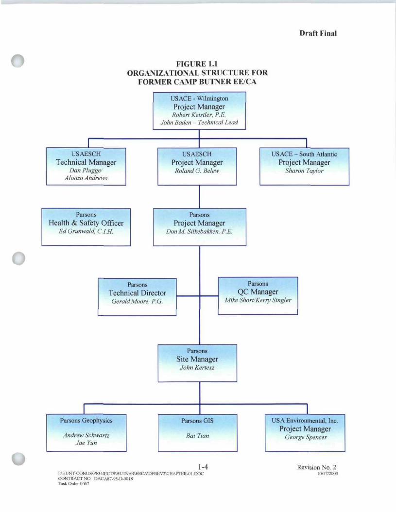
1.4 PROJECT TEAM
The technical project team consisted of USACE Wilmington District (CESAW),USAESCH, Parsons, and USA Environmental, Inc. (USA). The roles of these teammembers are described below and depicted in Figure 1.1. A detailed description of theproject team members can be found in Chapter 3 of the approved project Work Plan (WP,[Parsons, 2002]).
1.4.1 U.S. Army Corps of Engineers, Wilmington District
CESAW is the Life Cycle Project Manager (PM) and funding agency for this project.CESAW's responsibilities include review of project plans and documents, obtainingRight-Of-Entry (ROE) to properties in the investigation areas, working with the newsmedia and the public, and coordinating with State and local regulatory agencies on issuespertaining to protection of ecological and cultural resources. Mr. Robert Keistler isCESAW's PM for this project and Mr. John Baden is the Technical Lead.
1.4.2 U.S. Army Engineering and Support Center, Huntsville
USAESCH is the lead technical agency for this project. USAESCH responsibilitiesinclude procurement of architect/engineer (A/E) services, direction of the A/E contractor,review and coordination of project plans and documents, and working with the newsmedia and the public. USAESCH provided technical expertise for OE activities duringthe field activities. As the technical project manager, USAESCH is also responsible forcontrolling the budget and schedule. Mr. Roland Belew is USAESCH's PM for thisproject.
v - ' 1-2 Revision No. 4I:\HUNT-CONUS\PROJECTS\BUTNER\EECA\FINAL\CHAPTER-01.DOC 7/9/2004CONTRACT NO. DACA87-95-D-0018Task Order 0067

1.4.3 Parsonsn Parsons is the prime A/E contractor to USAESCH and provides overall engineeringsupport and services for the EE/CA. Parsons was responsible for performance of theactivities detailed in the SOW (Appendix A). Parsons' responsibility also included thecontrol of project schedule and budget. Mr. Don Silkebakken is Parson's PM for thisproject.
1.4.4 USA Environmental, Inc.
USA was the UXO subcontractor to Parsons. USA provided qualified UXOpersonnel needed to conduct the field investigation. Services provided by USA includedescort and visual OE clearance of areas designated for geophysical investigation andaccess routes identified by Parsons, and performance of intrusive investigations ofanomalies identified and reacquired by Parsons. USA was also responsible for allUXO/OE operations, including handling, detonating, and storage of OE and OE scrap.Parsons was responsible for ensuring and coordinating final disposal of OE scrap. Mr.George Spencer was USA's PM for this project.
1.5 PROJECT OBJECTIVES
The objective of this task order is for Parsons to prepare an EE/CA report (thisdocument) containing the following elements:
• Characterization of OE nature, location and concentration.
• A description of the OE-related hazards affecting human use of the site.
• Identification and analysis of reasonable risk management alternatives.
• A convenient record of the process for use in final decision-making andjudicial review, if necessary.
^-. * 1-3 Revision No. 4I:\HUNT-CONUS\PROJECTS\BUTNER\EECA\FINAL\CHAPTER-Ol DOC 7/9/2004CONTRACT NO. DACA87-95-D-0018Task Order 0067
Draft Final
o FIGURE 1.1ORGANIZATIONAL STRUCTURE FOR
FORMER CAMP BITNER EE/CA
USACE - WilmingtonProject Manager
Robert Keixller, P.F.John Baden Technical Lead
USAESCHTechnical Manager
Dan PluggeASonzn Andrews
USAESCHProject Manager
Roland GBetew
USACE-South AtlanticProject Manager
Sharon Taylor
ParsonsHealth & Safety Officer
EdGrunwatd, C.I.H.
ParsonsProject Manager
Don M Stlkebakken, P.E
ParsonsTechnical DirectorGerald Moore, P.G.
ParsonsQC Manager
Mike Short/Kerry Singler
1Parsons Geophysics
Andrew SchwartzJae Yun
ParsonsSite ManagerJohn Kerlesz
Parsons GIS
Bat Dan
1-4I: UIUNT-CONT ,'S\PROIECTS\BUTNER\EECAff)FRE V2\CI!AFTER-01 .DOC
1USA Environmental, Inc.
Project ManagerGeorge Spencer
Revision No. 210/17/2003
CONTRACT NO DACA87-95-D-O01STask Order 0067

U
CHAPTER 2SITE DESCRIPTION AND HISTORY
2.1 LOCATION
The former Camp Butner, consists of approximately 40,384 acres andencompasses portions of Person, Durham, and Granville Counties, North Carolina(Figure 2.1). The boundary of the site is loosely defined by the old Range Road, whichmakes a contiguous loop around the site although identified by multiple names andCounty designations. Approximately 75 percent of the Camp is located within GranvilleCounty. The northern and eastern boundary roughly follows Range Road (County Road1126). County Road 1721 (continuation of Range Road into Person County) defines thewestern boundary and continues southward onto Cassam Road. The Southern Railroaddefines the southeastern border. A general layout map of the former Camp Butner Site ispresented in Figure 2.2.
2.2 PHYSICAL DESCRIPTION
2.2.1 Terrain and Vegetation
2.2.1.1 The terrain within the project site area is in the Piedmont Plateauphysiographic province. The topography is characterized by rolling hills with moderateto steep slopes. Lake Butner (Holt Reservoir) is located in the south-central portion ofthe former Camp Butner and stretches northeast into NCNG property. The most commonland use is agriculture and forestry. This combination of land use is typified by croplandclearings within expanses of woodland.
2.2.1.2 The vegetation in the undeveloped areas is primarily moderate to denseforest. The understory is predominantly dogwood, poison ivy, Christmas fern, andJapanese honeysuckle. Wooded areas typically consist of hardwoods and pine locatedthroughout the hillsides. Presently, forested areas in the northeastern region of the site areundergoing commercial logging that has denuded the landscape and created hummockyterrain. Vegetation in farmed areas consists of grasses and agricultural crops, oftentobacco.
2.2.2 Geologic and Soil Conditions
Former Camp Butner is located within the Durham Sub-basin. The predominatebedrock formation is Arkosic Sandstone. The sandstone is tan in color, medium to verycoarse grained, and contains mica. The soil is from the Triassic Age and is an acidicbedrock material. The Site, located within the White Store-Creedmoor soil association,has gently sloping to moderately steep, moderately well drained (sandy loam) soils with asubsoil of firm clay.
2-1 Revision No. 4I:\HUNT-CONUS\PROJECTS\BUTNER\EECA\FINAL\Chapler-02.doc 7/9/2004CONTRACT NO. DACA87-95-D-OO18TASK ORDER 0067

n
u
2.2.3 Climate
The project site is subject to warm, humid summers and mild winters. The lowestmean temperature of 28 °F occurs in January and the highest mean temperature of 90 °Fin July. The annual average rainfall is approximately 47 inches with an average monthlyrainfall between 3 to 4 inches. The estimated maximum frost penetration for the generalarea is 4 inches.
2.3 HISTORY
2.3.1 On February 12, 1942, the War Department issued an order for theacquisition of land near the Durham, North Carolina area to be used as a training andcantonment facility during World War JJ. At the time, the land use was primarily lowdensity residential in nature. The original authorization was for 60,000 acres of realproperty; however, the actual amount of land acquired was approximately 40,384.39acres.
2.3.2 The land to establish Camp Burner was obtained by the War Departmentfrom private landowners primarily by fee with only 128.40 acres in easements, 2.51 acresin licenses, and 52.40 acres in leased tracts. Although the Camp was considered activeuntil 1946, its use for training exercises lasted only for approximately 18 months fromearly 1942 to June 1943.
2.3.3 The construction of Camp Butner began February 25, 1942 and proceededat a high rate until its completion in August of the same year. The camp was primarilyestablished for the training of infantry divisions (including 78th, 89' , and 4 ) andmiscellaneous artillery and engineering units. Camp Butner was designed to house up to40,000 troops. In addition to infantry training, the site was the location of the one of theArmy's largest general and convalescent hospitals and the War Department's ArmyRedeployment Center.
2.3.4 The first Division to arrive at Camp Butner was the 78th "Lightning"Division on August 15, 1942. Soon after that, other Divisions began arriving. Theprimary mission of Camp Butner was to train combat troops for deployment andredeployment overseas. There were approximately 15 live-fire ammunition-trainingranges encompassing a combined approximately 23,000 acres. Other training rangesincluded a grenade range, a 1000-inch range, a gas chamber, and a flame-thrower trainingpad. There was also an ammunition storage area. In September of 1943, the firstPrisoners of War (POWs) arrived at the camp. Figure 2.3 identifies the historical militaryland use for the Camp.
2.3.5 On January 31, 1947, the War Department declared Camp Butner excess.At that time, the Federal government was negotiating with the State of North Carolina fora lease on the hospital. The State was interested in using the hospital as a State mentalhospital. The State was also negotiating the purchase of 10,000 acres to be used tosupport the hospital. On November 3, 1947, the State purchased the hospital, later namedthe John Umstead Hospital, and 1,600 acres of the cantonment area to be used for various
2-2 Revision No. 4IAHUOT-CONUS\PROJECTS\BUTNER\EECA\FINAL\Chapter-02.doc 7/9/2004CONTRACT NO. DACA87-95-D-OO18TASK ORDER 0067

fprojects and agricultural development. The NCNG was conveyed 4,750 acres of theformer Camp Butner for training purposes.
2.3.6 After Camp Butner was declared surplus, dedudding operations wereinitially conducted in 1947 and continued through 1950. The Recapitulation DeduddingReport presented in the ASR stated that 1366 UXO/OE items had been discovered anddestroyed by the completion of dedudding operations. Six areas were identified duringdedudding inspections as warranting land restrictions to 'surface use only' due to thenumerous amount of HE duds found. These six areas (Figure 2.3) identified were definedas the following: Area A (an artillery impact area); Area B (a bazooka and rifle grenadeimpact area); Area C (an artillery and rifle grenade impact area); Area D (a moving targetarea); Area E (a bazooka and rifle grenade impact area); and Area F (a hand grenadecourt). Much of the property was sold back to the original owners, with provisionsoutlined in the property deed restricting land use to 'surface use only'.
2.3.7 Periodic inspections of the six areas with land restrictions were conductedbetween 1958 and 1969. During the inspections and removal of ordnance from therestricted areas other property owners identified ordnance for disposal that had beenfound in unrestricted areas. Table 2.1 lists the type of ordnance items found during theannual/semiannual inspections of restricted areas (as well as general findings withinunrestricted areas) at the former Camp Butner Site:
TABLE 2.1FORMER CAMP BUTNER
ANNUAL INSPECTION (DEDUDDING) FINDINGS(1958 -1969)
AREA RESTRICTED TO'SURFACE USE ONLY' TYPE OF UXO RECOVERED
Area A
AreaBAreaCAreaDArea EAreaF
Other "Unrestricted" Areas
Rifle grenade, 2.36-inch rockets, 37mm, 40mm, 81mm mortar,105mm, 155mm, and 240mm projectiles2.36-inch rockets and 81mm mortars81mm mortars, 37mm, 105mm, 155mm, and 240mm projectiles2.36-inch rocket, 37mm and 40mm projectiles2.36-inch rocketNo findings reportedHand grenades, 37mm, 40mm, 60mm, 81mm, 105mm, and 155mmprojectiles and 2.36-inch rockets
2.3.8 The ordnance used during training at Camp Butner included small arms,grenades, artillery rounds ranging from 20mm through 240mm, and various initiating andpriming material used as obstacles and minefield clearing devices. UXO/OE recoveriesmade during the dedudding operations confirmed historic munitions use. UXO/OE thatmay be encountered within the site include: 2.36-inch rockets (practice and HE), rifle andhand grenades, 20mm through 240mm HE projectiles, 60mm and 81mm mortars, anti-personnel practice mines, and demolition items to include TNT.
I:\HUNT-CONUS\PROJECTS\BUTNER\EECA\FINAL\Chapter-02.docCONTRACT NO DACA87-95-D-0018TASK ORDER 0067
2-3 Revision No. 47/9/2004

2.4 DEMOGRAPHIC PROFILE1 2.4.1 The 2000 census (US Census Bureau) estimates the population of the Town
of Butner at 5,792 and for the County of Granville 48,498. According to the 2000 censusestimates for Granville County, population by gender is 52.5% male and 47.5% female;population by race is 60.7% white, 34.9% black or African American, 4% Hispanic orLatino, 0.5% American Indian and Alaska Native, and 0.4% Asian. The largestpopulation by age is between 35 to 44 years with a median age of 36.2 years. The 2000census for Granville County determined an average household size of 2.58 persons, witha median household annual income of $39,965.
2.4.2 An estimated population growth rate of 17.6% is expected for GranvilleCounty (within which the majority of the areas of interest [AOIs] reside) between theyears 2005 and 2015. Projected economic development for Granville County indicates anincrease in total annual earnings by 29.8% and a rise in employment of 11.6%.Manufacturing is predicted to remain the leading industry in Granville County over thenext ten years. Over the same time period, agricultural production and employment areforecasted to slow, although earnings are still expected to increase (Holland, 2002). Ingeneral, indicators show moderate regional economic and development growth in andaround Granville County over the next ten years.
2.5 CURRENT AND FUTURE LAND USE
2.5.1 The current stakeholders within the former Camp Butner Site include:
• North Carolina Department of Agriculture and Consumer Services - operatesUmstead Farm Unit (4,200 acres);
• North Carolina State University - operates Beef Cattle Field Laboratory (1,300acres);
• NCNG Training Site (4,750 acres);• State Department of Corrections - operates Polk Youth Institution and Umstead
Correctional Center (160 acres);• State Department of Health and Human Services - operates John Umstead State
Hospital and Murdoch Center (394 acres);• U.S. Army Corps of Engineers - northern part of Falls Lake State Park and
Waterfowl Impoundment Reserve (2300 acres);• Federal Government - operates four Federal Correctional Complexes comprised
of a correctional facility and federal hospital (770 acres); and• Various private landowners.
2.5.2 Presently, a large percentage of the land within the former Camp Butner Site isundeveloped, with the exception of the Town of Butner. Current land use assignment forthe areas of the site encompassed by Durham, Granville, and Person Counties arepredominantly agriculture / open space and residential / agriculture (>5 acres) (Holland,2002). Private land ownership parcels may exceed 200 acres in areas utilized foragriculture and forestry. Residential land use also makes up a significant percentage of
; j the site and is typified by low-density development manifesting along main roads. The2-4 Revision No. 4
I:\HUNT-CONUS\PROJECTS\BUTNER\EECA\FINAL\Chapter-02.doc 7/9/2004CONTRACT NO. DACA87-95-D-OO18TASK ORDER 0067

n majority of these parcels are multi-use for a combination of agricultural and residentialpurposes.
2.5.3 Current residential development is encroaching in areas to the south andstretching north along the eastern boundary of the site. Sprawling development willcontinue to be experienced in these regions due to migration from Durham and WakeCounties. With an estimated population growth rate of 17.6% for Granville Countyforecasted by 2015, the projected housing development will increase as well by anestimated 1,748 additional housing units by 2010 (Holland, 2002). The long-range masterplan for the Town of Butner predicts an additional 1,850 acres of residential land will bedeveloped by 2020 (OBrien/Atkins, 1998). The majority of residential development inGranville County is expected to take place in the Butner and Creedmoor areas. As growthand residential development continue throughout the region, land used for agriculture andforestry will consequently diminish.
2.6 PREVIOUS INVESTIGATIONS
2.6.1 DERP-FUDS Field Inspection for Preliminary Assessment
2.6.1.1 During March 1990 USACE CESAW conducted a field inspection of theformer Camp Butner to gather data regarding potential applicability of the DefenseEnvironmental Restoration Program - Formerly Used Defense Sites (DERP-FUDS)(USACE, 1990a). Historical documentation of inspections of restricted areas anddedudding reports were reviewed and numerous interviews were conducted. A summaryof the findings include:
• Identification of a Final Ownership Map of Camp Butner showing the deduddingoperations as of April 6, 1950.
• Confirmation that ordnance has been periodically found within the former rangesand Fort Bragg explosives ordnance disposal (EOD) has been responding.
• Personnel interviewed from the Federal Correctional Institution stated they knewof no reports of ordnance being found on their facility. A POW camp waspreviously located at this location.
• The largest round reportedly used at the Camp was a 240mm projectile.
• Three tear gas chambers existed at the facility.
• Lightning Lake may have a military trash dump beneath it.
2.6.1.2 The report (included as part of the ASR and available in the projectAdministrative Record) concluded that "ordnance is a major problem" and that "there areranges with impact areas for artillery, bazooka, rifle grenades, moving target, rifle, pistol,mortars, rockets, and hand grenades that are not fenced or marked as dangerous areas."The report estimated "the number of rounds per acre" at "10 to 100". Action itemsidentified included preparation of an Inventory Project Report (INPR) and a riskassessment as well as follow-up phone calls to several interviewees.
2-5 Revision No. 4I:\HUNT-CONUS\PROJECTS\BUTNER\EECA\FDMAL\Chapter-02.doc 7/9/2004CONTRACT NO. DACA87-95-D-O018TASK ORDER 0067
n 2.6.2 Findings and Determination of Eligibility
Under the DERP, CESAW prepared a Findings and Determination of Eligibility(FDE) for the former Camp Butner in July 1990 (USACE, 1990b). The report confirmedthat the Camp was formerly used by DoD and eligible for DERP FUDS consideration. Arisk assessment code (RAC) score of 4 (further action and completion of INPRrecommended) was assigned to the Camp as a whole. The report noted the establishmentof deed restrictions on the much of the property prior to sale, as well as area restrictions.Government inspections were conducted at the site until 1973. In October 1990 the INPRwas completed. The preliminary assessment recommended two projects forconsideration. This resulted in the EE/CA investigation (Project Number I04NC000902)conducted by Parsons, as well as a recommendation for Hazardous Toxic Waste (HTW)Project (Project Number I04NC000901). The HTW project was an investigation of theLighting Lake Area. A letter dated January 5, 1999 from the State of North Carolinaconcurred with the classification of the HTW site as a "No Further Action Site".
2.6.3 1992 Site Investigation Report
A site investigation was conducted by Black &Veech Waste Science andTechnology Corporation for the USACE Savannah District dated May 26, 1992. Thisinvestigation addressed the Camp Butner Landfill at the bottom of Lightning Lake. Thelandfill site was part of the former Camp Butner and designated for disposal of excessbrass and ammunition that could not be packed for shipment when the 78th Divisiontransferred to Europe. The report included background information, remedialinvestigation results, and qualitative risk factors at the landfill site (ASR).
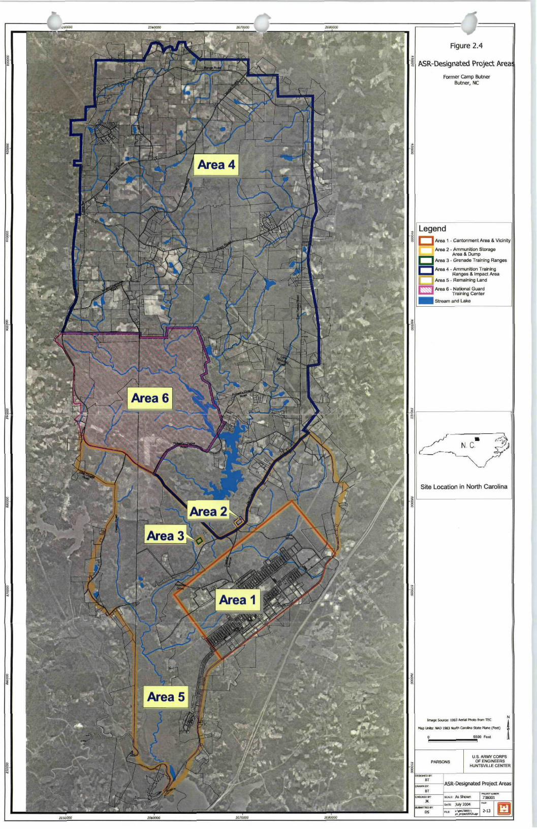
2.6.4 1993 Archives Search Report (ASR)
In September of 1993 the USACE, Rock Island District, conducted a records searchand site inspection for the Camp. The final report, the ASR, documents the extent andnature of their findings of UXO/OE contamination (USACE, 1997/2003). The formerCamp Butner was divided into 6 areas for evaluation purposes (Figure 2.4). Areas 1 and4 were classified as having "confirmed" ordnance present. Areas 2 and 3 were classifiedas "potential" areas for ordnance present. Area 5 was identified as "uncontaminated" andArea 6, which is currently used as the NCNG Training Center, was not assessed due to itsactive status and ineligibility for DERP-FUDS. A RAC score was developed based onbest available information resulting from record searches, field observations, interviews,and measurements. This information was used to assess risk based upon the potential OEhazards identified at the site. The risk assessment was composed of two factors: hazardseverity and hazard probability.
2.6.5 1998 Site Visit
A Site Visit was conducted by USACE on July 21 and 22, 1998 to evaluate theapplicability of implementation of a Time Critical Removal Action (TCRA) and toreevaluate the overall RAC score of 1 (assigned through the ASR process). Theinvestigation team visited Areas 1, 2, 3, and 4. The conclusion was a TCRA was not
2-6 Revision No. 4I:\HUNT-CONUS\PROJECTS\BUTNER\EECA\FINAL\Chapter-02.doc 7/9/20O4CONTRACT NO. DACA87-95-D-OO18TASK ORDER 0067

n warranted although the RAC score was not modified.
2.6.6 Other Investigations
A Final Environmental Impact Statement was prepared for the U.S. Department ofJustice, Federal Bureau of Prisons in May 1992. This report provided an assessment ofthe environmental consequences of a proposed action to expand the existing FederalCorrectional Institution.
2.6.7 2000 Site VisitParsons conducted a Site Visit between June 5 and 7, 2000 (Parsons, 2000a). The
purpose of the Site Visit was to develop a familiarity with the former Camp, visuallyinspect areas identified as confirmed or potentially contaminated with OE in the ASR,and photograph the AOIs for the potential EE/CA. In addition, the intention was toqualitatively evaluate applicability of various geophysical approaches for implementationduring the EE/CA.
2.6.8 2001 Topographic Engineering Center (TEC) Report
Maps created and produced by the U.S. Army Corps of Engineers, EngineerResearch and Development Center, Topographic Engineering Center (TEC), have beencompiled in a report following evaluation of historic aerial photographs of the formerCamp Butner (USACE, 2001a). Although subjective, this process identified potentialground scars and impact areas. This information was used in the preparation of theproject Work Plan to support or refute the locations of suspect ranges impact areas aswell as aid in the selection of grid and transect locations (Parsons, 2002). Ground scarsidentified by TEC could represent ill-defined impact craters or be the result of otherwisebenign military activity to include general construction, logging, small arms ranges,obstacle courses, or a variety of other uses. They only suggest activity at the location wasoccurring during the active military occupation of the facility. Major impact areasidentified by TEC confirm the usage and configuration of many suspect firing rangesdescribed in the ASR (USACE, 1997/2003).
2.6.9 2003 ASR Supplement
In 2003 the USACE, Rock Island District, prepared a supplement to the existingASR in support of preparation of the Military Munitions Response (MMR) RangeInventory (USACE, 2003). The former Camp was divided into five primary areas(encompassing multiple ranges). All of these areas were previously documented in theoriginal ASR (and considered during this EE/CA) only the groupings were revised to fitthe input and evaluation criteria requirements of the MMR database. Subchapters 3.2 and3.5 provide details of the EE/CA range designations. The MMR groupings are presentedbelow:
• Gas Chamber
• Flamethrower Range
i I • Hand Grenade Range
2-7 Revision No. 4I:\HUNT-CONUS\PROJECTS\BUTNER\EECA\HNAL\Chapter-02.doc 7/9/2004CONTRACT NO. DACA87-95-D-OO18TASK ORDER 0067

• Range Complex 1 (South of Enon Road and North of Old NC 75/Southernf ) Range Road excluding the NCNG)
• Central Artillery Impact Area• Rifle Ranges• Landscape 1000 inch .22 caliber Range• AA 1000 inch .22 caliber Range• Pistol Range" AT 1000 inch .22 caliber Range• MG 1000 inch .30 caliber Range• 37mm Range• 60mm/81mm Mortar Range 1• 60mm/8 lmm Mortar Range 2
• Range Complex 2 (North of Enon Road)• West Artillery Impact Area• Rifle/MG Range 1• Rifle/MG Range 2• Mock German Village
Aside from the former Gas Chamber, not considered as a potential source of OEcontamination, each of the above ranges were included within the EE/CA investigationpresented within this document.
2.7 PREVIOUS REMOVAL ACTIONS
2.7.1 A TCRA was initiated at the Lakeview Subdivision in tandem with theEE/CA investigation for removal of the immediate and imminent danger to public safetyposed by the presence of UXO (Parsons, 2003). The removal action was in response topublic concern stemming from several UXO findings at Lakeview Subdivision thatoccurred during this EE/CA investigation. The TCRA was conducted between November2002 and March 2003 and included land survey, brush clearance, intrusive removalaction, and digital geophysical mapping (DGM).
2.7.2 A total of 26 acres were designated for clearance in and around theLakeview Subdivision for the TCRA, inclusive of a 100-foot buffer zone. Parsons andUSA conducted the TCRA inclusive of a clearance of all metallic items comparable inmass or larger than a 37mm projectile in the top 6 inches of soil at the TCRA site.During the clearance, six UXO items were recovered and destroyed including: an electricblasting cap, Mk II hand grenade, 37mm HE projectile, Ml Al Mine fuze, 2.36-inchrocket motor with fuze, and 2.36-inch HE warhead. Following the clearance, DGM wasconducted over the 26-acre site for evaluation as to whether further subsurface removalactions were warranted. The DGM survey conducted after completion of the TCRAsuggests that additional subsurface investigation is warranted (Appendix B). TheUSAESCH reviewed the DGM survey and had the following conclusions:
| "The geophysical maps prepared subsequent to field activities confirm the presence of additional
2-8 Revision No. 4I:\HUNT-CONUS\PROJECTS\BUTNER\EECA\FINAL\Chapter-02.doc 7/9/2004CONTRACT NO. DACA87-95-D-0018TASK ORDER 0067

f |metallic debris concentrated within the immediate vicinity of the Cash Property with lesser amounts
dispersed throughout the Lakeview Subdivision area. Review of the geophysical data collected, historical
information, utility locations, surface feature maps, and the TCRA excavation results indicate the origin of
recovered UXO, OE scrap, and non-OE scrap may be the result of periodic debris disposal in addition to
fired projectiles". "The only way to confirm the remaining anomalies are not UXO is to conduct a
clearance to depth removal action beginning in the northwest corner of the site in the immediate vicinity of
the Cash Property and proceeding grid by grid towards the south and east until no additional UXO are
recovered".
2-9 Revision No. 4I:\HUNT-CONUS\PROJECTS\BUTNER\EECA\FINAL\Chapler-02.doc 7/9/2004CONTRACT NO. DACA87-95-D-0018TASK ORDER 0067

Figure 2.1
General Location Map
Former Camp ButnerButner, NC
USHWY158
0 90 180 270 Miles
Former Camp Butner
RockwMount0
Chapel HillGreenville £*
®Goldsboro
FayettevilleU.S. ARMY CORPS
OF ENGINEERSHUNTSV1LLE CENTER
Jacksonville
General Location Map
Wilmington •

2020000 2040000 2060000 20B0O00 2100000 2120000
Figure 2.2
Former Camp ButnerButner, NC
General Layout
LegendFormer Camp Butnei Boundaiy
Stream and Walerbody
Mi * IWU: NAD 1983 N o * Caraina s « i Pimo (F«i]
8500 0 4S0C Fee!
PARSONS
DESGfCDBV
BT
BT
CHECKED HV:
LK
DS
U.S. ARMY ENGINEERINGAND SUPPORT CENTER,
HUNTSV1LLE
General Layout
KHJECTMUUfKIt
BC«E:1 inchooualsfl.SOOteel 738001
2020000 2040000 2060000 2080000 2100000 2120000

Former Camp Butner
. 1 \
V *
Mock German Village,
•t £
8 9
: 9
t.' .1-
r w j
Figure 2.3
Historical Military Land Use
Former Camp ButnerButner, NC
Legend
Former Camp Butner Boundary
Historic Designated Range
Historic Training Area
Property Deed Restricted Prior toGovernment Release as"Surface Use Only" (Areas A-F)Due to Extensive OrdnancePresence (See Subchapter 2.3)A - Artillery Impact AreaB - Bazooka and Rifle Grenade Impact AreaC - Artillery and Rifle Grenade Impact AreaD - Moving Target AreaE - Bazooka and Rifle Grenade Impact AreaF - Hand Grenade Court
List of Ranges:1-9 Small Arms10 37 mm
11,14 Trench Mcprtar, 60 and 81 mm12,13 Heavy Artillery
Site Location in North Carolina
Image Source: 1945 Aerial Photo from TEC
Map Units: NAD 1983 North Carolina State Plane (Feet)
2600 0 2600 5200 Feet
PARSONS
DESKMDHY
BTDRAWN BY
BTCHFCKEDHV
JKSUBMITTED BY
U.S. ARMY CORPSOF ENGINEERS
HUNTSVILLE CENTER
Historical Military Land Use
i inch equals 2,600 feet
July 2004
PROJECT NUHMR:
738001PAGE:
J
Figure 2.4
ASR-Designated Project AreaFormer Camp Butner
Burner, NC
LegendI Area 1 - Cantonment Area & Vicinity
Area 2 - Ammunition StorageArea & Dump
I Area 3 - Grenade Training Ranges
I Area 4 - Ammunition TrainingI Ranges & Impact AreaArea 5 - Remaining Land
I Area 6 - National GuardI Training Center
I Stream and Lake
Site Location in North Carolina
Imjje Soust: 1993 HOW "Iwto Item TEC
PARSONSU.S. ARMY CORPS
OF ENGINEERSHUNTSVILLE CENTER
ASR-Designated Project Areas
AsShwm 738001
oat Jut, IBM
3-13
CHAPTER 3SITE CHARACTERIZATION
3.1 SITE INVESTIGATION
DGM was performed at the former Camp Butner using the EM-61 and EM-61MK 2 metal detectors to identify and locate surface and subsurface geophysical anomaliesfor intrusive sampling. A ranking algorithm was developed and applied to thegeophysical data in order to select anomalous responses characteristic of suspectordnance for intrusive investigation (see Subchapter 3.1.4.2). The main objective ofgeophysical/intrusive investigation is to characterize the nature and extent of UXO/OE atthe site and support the risk-based recommendations of OE response alternatives. Thischapter describes the geophysical methods and procedures, intrusive results, and thenature and extent of UXO presence.
3.1.1 Instrumentation
Two site-specific geophysical prove-outs were conducted from September 18through September 22, 2000 and from March 12 through March 16, 2001 to identify themost effective geophysical equipment to be used during the EE/CA geophysicalinvestigation. Based on the analysis of current available geophysical technologies,familiarity with site conditions, and Parsons' experience at other sites, two geophysicalmethods selected for testing included time domain electromagnetic metal detectors andflux-gate magnetometers. The results from the prove-out demonstrated that the Geonics®EM-61 and EM-61 MK 2 Time Domain Metal Detectors (TDMD) were most effectiveoverall. These instruments were selected (and USAESCH-approved) for use at the formerCamp Butner Site based on high detection rates and low false alarm rates (Parsons, 2002).The Schonstedt® Magnetic Locator also indicated acceptable performance and was usedfor "mag and dig" clearance of a limited number of grids with particularly rough terrain,as described later in this chapter.
3.1.1.1 Geonics® EM-61 TDMD
The EM-61 instrument is a high-sensitivity high-resolution TDMD, which is usedto detect both ferrous and non-ferrous metallic objects. A transmitting coil emits a pulsedelectromagnetic signal that generates subsurface eddy currents. As the transmitted signaldecays in time, a secondary signal is induced within conductive bodies that oppose thechange in magnetic flux. The decay rate of the secondary magnetic field depends on theconductivity of the subsurface environment. Receiver coils measure the intensity of thesecondary response decay rate by integrating the voltage induced at the receiver coils for agiven duration. The EM-61 data logger collects data at automatic time intervals
i j determined by the user. During the EE/CA at the former Camp Butner Site, the EM-61
3-1 Revision No. 4I:\HUNT-CONUS\PROJECTS\BUTNER\EECA\FINAL\Chapter-03 doc 7/9/2004CONTRACT NO. DACA87-95-D-0018TASK ORDER 0067

was operated in a hand-pulled configuration using automatic time intervals for surveyingj grids. Figure 3.1 presents a photograph showing the usage of the EM-61 at the site.
3.1.1.2 Geonics® EM-61 MK 2 TDMD
The EM-61 MK 2 instrument is a high-sensitivity high-resolution four-channelTDMD. The EM-61 MK 2 operates under the same principles as the standard EM-61,and utilizes the same top and bottom coil system. Receiver coils of the EM-61 MK 2measure the intensity of the secondary response decay rate in a conductor by integratingthe voltage induced in the receiver coils over four different time gates. Data from fourchannels corresponding to four time gates are recorded to provide a more completemeasurement of the response decay rate for improved target characterization. The decayrate is a complex function of the conductivity, magnetic permeability and shape of thetarget, so analysis of the decay rate could allow discrimination to some degree of thesubsurface metallic items. Early time gates enhance the detection of smaller targets; amid-range time gate (channel 3) is the same time gate used for the standard EM-61 and isuseful for comparative analysis. The EM-61 MK 2 was used in the hand-pulledconfiguration and deployed during Phase I data acquisition (comprising approximately50% of the geophysical mapping effort). Because the instrument used on-site was aprototype, difficulties arose when instrument components required replacement. Thedecision was made to discontinue using the EM-61 MK 2 for the standard EM-61 duringPhase n. Since both units have a common recording channel data from both instrumentscan be compared and evaluated.
3.1.1.3 Schonstedt® Magnetic Locator
Schonstedt® Magnetic Locators detect subsurface ferrous metal items. Thetechnology utilizes two fluxgate sensors mounted a fixed distance apart and aligned in agradiometer configuration. The Schonstedt locator is a hand-held unit that detectschanges in the earth's ambient magnetic field caused by ferrous metal (the sensors arefixed and aligned to eliminate a response to the earth's ambient field). The MagneticLocators generate an audible analog response when the two sensors detect a disturbanceof the earth's ambient field associated with a ferrous target. Schonstedt® MagneticLocators were used by UXO-qualified personnel at the former Camp Butner Site prior toadvancement of any stakes, pin flags, or similar subsurface markers, to prescreen anomalylocations for subsequent reacquisition in grids, and for "mag and dig" clearance of alimited number of grids.
3.1.1.4 Trimble® 4700 Real-Time Kinematic (RTK) Total Station GlobalPositioning System (GPS)
The Trimble® 4700 RTK GPS consists of a high precision rover unit linked byradio to a fixed base station that allows real time acquisition of geodetic data. TheTrimble® 4700 RTK GPS is capable of attaining centimeter accuracy dependent onsatellite constellation and unobstructed transmission signal path between satellite andground based receivers. Meandering path surveys were performed using the Trimble®4700 RTK GPS system in conjunction with the EM61 MK 2, which enabled positioning
V. J3-2 Revision No. 4
I:\HUNT-CONUS\PROJECTS\BUTNER\EECA\FlNAL\Chapter-03 doc 7/9/2004CONTRACT NO. DACA87-95-D-0018TASK ORDER 0067
and geophysical data to be merged real time. Due to mature forest canopy and varyingtopography, usage of the Trimble®4700 RTK GPS for meandering path surveys wasconfined to areas of the site that were generally flat and open/non-vegetated. TheTrimble® 4700 RTK GPS was also used for establishing the grid corners andreacquisition of selected geophysical anomalies.
3.1.2 Quality Control of Geophysical Instruments
3.1.2.1 The field crew performed and recorded the following Quality Control(QC) tests for all instruments on a daily basis:
• Static background test twice daily (beginning and end of each day) to recordbackground response for 3 minutes over a quiet area considered to representknown site conditions.
• Static spike test twice daily (beginning and end of each day) to recordinstrument response over a standard QC item for 3 minutes.
• Latency test was conducted before and after data acquisition in a grid ortransect line. The test line was 100 feet or the length of the grid and includeda standard QC item (e.g., trailer ball) placed at a known location. The test linewas traversed twice, once in each direction that data was to be collected inthe grid.
3.1.2.2 Additional QC was achieved by leaving the QC item placed for thelatency test within the grid for the duration of data collection. The location of this itemwas recorded by the field crew and the anomaly response from the QC item was analyzedduring the data processing. The response and location of this item within the survey gridprovided QC of both instrument functionality and data positioning. On occasion, EM-61response to the trailer ball was found to vary by more than 25%, and upon review, thevariations were found to be due to either varying instrument heights over the trailer ballor differences in the orientation of the trailer ball with respect to the instrument sensors.In all such cases, the data were reviewed by the Senior Project Geophysicist and found tobe of good quality and were accepted. Corrective actions were also taken by informingthe survey teams of the variations and providing instructions to modify their procedures.
3.1.2.3 The QC test readings taken at the beginning and end of each day and foreach grid were compared, and if they differed by more than 25%, then the data werereevaluated and, if necessary, the problem was corrected or the instrument was replaced.
3.1.2.4 Quality Assurance (QA) was conducted by USAESCH on selected grids,unknown to Parsons, to verify instrument response and reacquisition of anomalies. QAwas accomplished by the burial of seed items at anonymous grid locations by aUSAESCH Geophysicist. Seed items were selected to generate a response characteristicto ordnance likely encountered at the site. Seed items buried within grids intrusivelyinvestigated were successfully recovered during the EE/CA investigation.
3-3 Revision No. 4I:\HUNT-CONUS\PROJECTS\BUTNER\EECA\FINAL\ChapIer-03 doc 7/9/2004CONTRACT NO. DACA87-95-D-OO18TASK ORDER 0067

-,. 3.1.3 Geophysical Surveyr The geophysical mapping effort conducted at former Camp Butner was performed
in two phases. The first phase was conducted between March 26 and July 11, 2001 andthe second phase between March 18 and May 24, 2002. The total area geophysicallysurveyed was approximately 132 acres. A combination of grids and "meandering paths"were used during the geophysical mapping. The locations of the sampling areas weredispersed as detailed in Section 4.2 of the approved project Work Plan (Parsons, 2002).The selection/location process was dynamic and involved a number of factors includingstatistical validity, representative coverage, biased sampling, available right-of entrygrants from property owners, and project team input. Locations were adjusted in the fieldon occasion due to terrain or vegetation conditions and new information obtained as theresult of the ongoing study. Several grids were relocated to properties where UXO wasrecently found or from comments received at Public Meetings.
3.1.3.1 Grid Survey
3.1.3.1.1 The majority of geophysical mapping was achieved using grid surveytechniques. Data was acquired using the hand-pulled EM-61 and EM-61 MK 2, whichrequired an operator to collect data along survey lines within a pre-established grid. Thehand-pulled unit consisted of a single set of 0.5-meter by 1-meter coils, with a top andbottom coil separation of 40 centimeters. The unit was pulled from a plastic handle thatextended perpendicular from the long axis of the lower coil.
3.1.3.1.2 The grid surveys were conducted by first establishing the corners of agrid using professional land surveyors or qualified Parsons' personnel. Grid corners weresurveyed using conventional land survey techniques in conjunction with GPS. To ensurethe future reestablishment of each grid at the time of reacquisition and intrusiveinvestigation, wood stakes and metal spikes were inserted at each corner of a grid. AUXO-qualified escort conducted a visual and surface sweep using a Schonstedt magneticlocator over the area where a stake or spike was to be driven prior to insertion. Griddimensions were generally 100 feet by 100 feet. The grid was divided into parallel linesspaced 2.5 feet apart for EM-61 and EM-61 MK 2 surveys.
3.1.3.1.3 The grid survey method used by the geophysical data collection teamsrelied on the instrument operator(s) walking straight lines at a constant pace to achieveaccurate reacquisition. The geophysical data were collected by traversing these lines withthe geophysical survey equipment. During data acquisition, the instrument operatorinserted fiducial markers into the data as they were recorded. The fiducial markers wereused to reference the data to positional coordinates at the time of processing.Geophysical data were recorded in automatic mode using a polycorder or Pro4000 datalogger at a rate of 12 samples per second. The data was initially referenced in localcoordinates and translated into U.S. state plane coordinates during the data processingphase. Approximately 118 acres were digitally geophysically mapped using the gridsurvey method.
V J3-4 Revision No. 4
I:\HUNT-CONUS\PROJECTS\BUTNER\EECA\HNAL\Chapter-03 doc 7/9/2004CONTRACT NO. DACA87-95-D-OO18TASK ORDER 0067

3.1.3.2 Meandering Path Surveyf ^
' Prevailing site conditions limited the application of meandering path surveys dueto varying topography and mature tree canopy that limited GPS coverage. Meanderingpath surveys were selectively conducted in open fields and where satellite reception wasunimpeded. The EM-61 MK 2 was used in conjunction with a Trimble 4700 RTK GPSto allow both geophysical and geodetic data streams to be merged during data acquisition.The GPS antenna was set over the center of the coils to capture positional data using alogging rate of one reading per second. The instrument operator then traversed within thelimits of the open area using this hand-pulled system. Approximately 9 acres weredigitally mapped using the meandering path technique.
3.1.3.3 Analog Detection (Mag and Dig)
In addition to the grid survey techniques, a "mag-and-dig" method was also usedduring the geophysical investigation. The "mag-and-dig" method was used in twoinstances: to survey those grids that posed unusually difficult access for the larger EM-61units; and for grids assigned during the intrusive phase of the investigation. ASchonstedt® Magnetic Locator was used to locate ferrous subsurface anomalies in suchgrids. Immediately after anomaly identification, UXO-qualified personnel excavated andidentified the anomaly sources. In cases where large numbers of anomalies weredetected, a method was devised to reduce the digging of non-ordnance anomalies (e.g.ferrous containing rocks). The method involved a UXO-qualified operator sweeping anentire grid and placing a pin flag at each location where a geophysical anomaly wasdetected. The method required the surveyed grid to be divided into four quadrants fromwhich 7 to 8 anomalies per quadrant were selected for excavation. A total of 30anomalies were excavated per "mag and dig" grid in this manner. Approximately 5 acreswere intrusively investigated using this survey technique.
3.1.4 Anomaly Identification
3.1.4.1 Data Processing
3.1.4.1.1 At the end of each day, the geophysical data were downloaded from thedata loggers to the field laptop computer. The downloaded data files (daily static tests,latency tests, and geophysical surveys) were then imported into manufacturer suppliedsoftware programs (DAT61™ for Windows for the EM-61 data and DAT61 MICE™ forthe EM-61 MK 2). Preprocessing of the transferred data was then performed, whichincluded the adjustment of start, end and fiducial marker positions entered by theinstrument operator. Data spikes, defined as a single datum or set of data points thatdiverge significantly from contiguous values, were edited to ensure that terrain-inducedspikes (not representing subsurface metallic debris) were removed. This process involvesreview and interpretation of field notes and other data by the project geophysicist andresults in a clearer picture of anomaly presence.
3.1.4.1.2 Following the preprocessing phase, data files were converted into XYZformat and exported from DAT61™ or DAT61 MKD™ into Geosoft Oasis Montaj for
I i post-processing and graphical display. The geophysical data were leveled, lagged, and
3-5 Revision No. 4I:\HUNT-CONUS\PROJECTS\BUTNER\EECA\FINAL\Chapter-03.doc 7/9/2004CONTRACT NO. DACA87-95-D-0018TASK ORDER 0067

translated from latitude/longitude to state plane coordinates. EM-61 MK 2 data included^ ^ data from 4 channels, corresponding to the 4 separate time gates, from which the sum was
taken to create a fifth channel for use in graphical interpretation. Meandering path surveydata did not require translation because it had been previously merged with positionaldata upon collection. Finally, processed data from the bottom coil response was griddedand graphically displayed in preparation for analysis and interpretation.
3.1.4.2 Anomaly Selection and Ranking
3.1.4.2.1 Interpretation of anomalies was based upon the instrument responsefrom the bottom coil (EM-61) or sum of four channels bottom coil (EM-61 MK 2). Thegridded data were analyzed for anomalous responses characteristic of suspect ordnance.Color contour maps were generated from the gridded data to display anomalous featuresand make anomaly selections. In order for the ranking algorithm to rank reliably,anomalies were selected at the location corresponding to the maximum response value. Adatabase containing the selected anomalies was then compiled in Geosoft and importedinto an Access database where a ranking algorithm was then applied.
3.1.4.2.2 The ranking process focused on assigning higher ranks to anomalies thatwere more likely to be associated with buried or unknown ordnance items, and onreducing the number of false positive anomalies. The ranking process was based on thecomparison and analysis of several anomaly characteristics, including: comparing thedetected anomaly signals to prove-out signatures of known inert ordnance seed items;comparing the anomaly signals to background levels; and, the analysis of responsecharacteristics. Specifically, the ranking process considered the following criteria:
EM-61 and EM-61 MK 2 Anomaly Ranking Criteria:• A data channel distinguishable above "background" (location-specific
baseline signal influenced by numerous factors including power lines,temperature, soil type, etc.).
• Similarity between anomalous responses on all channels compared to theobserved response over inert ordnance seed items detected in the prove-out grid.
• Association between anomalous response characteristics and instrumentnoise or terrain features.
Once each anomaly was compared against these criteria, an anomaly rank was assignedusing the following logic, depending on the instrument used:
EM-61 MK 2 Anomaly Ranking (Phase 1)• Rank 1: The anomaly responses in all 4 channels was within the ranges of
at least two of the inert ordnance seed items detected in the prove-out gridand the anomaly response was distinguishable above background in eitherall or channels 1 through 3.
• Rank 2: The anomaly responses in all 4 channels were within the rangesI of at least one of the inert ordnance seed items detected in the prove-out
v.V3-6 Revision No. 4
I:\HUNT-CONUS\PROJECTS\BUTNER\EECA\FINAUChapter-03 doc 7/9/2004CONTRACT NO. DACA87-95-D-0018TASK ORDER 0067

grid and an above background response in at least channel 1 or the\ I anomaly responses in all 4 channels were within the ranges of 4 of the
inert ordnance seed items detected in the prove-out grid, regardless ofwhether any of the responses were noticeably above background. Inaddition upon review, some anomalies that received rankings of 3 wererevised to 2 based upon professional judgment.
• Rank 3: All anomalies that do not fall within the criteria of Rank 1 orRank 2 anomalies and are not associated with items used to establishnavigation controls or to perform QC functions.
• Rank 4: The anomaly is associated with an item or object observed on theground surface or known to exist in the surveyed area (e.g. corner nail,fence post, utility, etc.); or, the anomaly is associated with a QC object.
EM-61 Anomaly Ranking (Phase 2)• Rank la: The anomaly responses can be associated with three or more
inert ordnance seed items detected in the prove-out grid and both the topand bottom channel readings were distinguishable above background.
• Rank lb: The anomaly responses can be associated with at least one ofthe inert ordnance seed items detected in the prove-out grid and either thebottom or the top and bottom channel readings are distinguishable abovebackground.
• Rank 2: The anomaly responses may be associated with one or more ofthe inert ordnance seed items detected in the prove-out grid but thebottom channel is not distinguishable above background; or, the anomalyis suspected of being associated with instrument noise or terrain features;or, the anomaly could not be associated with any of the items seeded inthe prove-out grid.
• Rank 3: The anomaly is suspected to be the result of geologic features orother cultural features but could not be confirmed through logbook notes.
• Rank 4: The anomaly is associated with an item or object observed on theground surface or known to exist in the surveyed area as documented inthe project logbook (e.g., corner nail, fence post, and other culturalfeatures).
3.1.4.2.3 The ranked anomalies were then categorized by area and area-specificanomaly selections criteria formulated by the project team to enhance anomaly selectionon an area-specific basis. The area specific selection criteria considered both the anomalyrank and the type or types of UXO targets that were anticipated in each of the areas of thesite. However, due to uncertainty regarding potential multiple use ranges and potentialdumpsites, a percentage of anomalies not suspected to be ordnance were investigated atall sites.
3.1.4.2.4 In general 100% of the Rank 1, la, and lb anomalies were selected forintrusive investigation. To account for the possibility that a designated Rank 2 anomaly
* may be associated with a suspected or an unknown ordnance item, percentages of Rank 2
3-7 Revision No. 4I:\HUNT-CONUS\PROJECTS\BUTNER\EECA\FINAL\Chapter-03.doc 7/9/2004CONTRACT NO. DACA87-95-D-0018TASK ORDER 0067
anomalies were selected for intrusive investigation. A smaller percentage of Rank 3( I anomalies were also investigated to validate the anomaly ranking methodology. By
definition, Rank 4 anomalies are comprised of known sources that did not warrantinvestigation.
3.1.4.2.5 The cumulative area geophysically investigated at the former CampButner Site was approximately 132 acres, inclusive of "mag-and-dig" acreage. Finalanalysis from the geophysical mapping effort identified 10,743 Phase 1 anomalies and4,185 Phase 2 anomalies. Based on the area selection criteria, a total of 8,545 Phase 1anomalies were selected for intrusive investigation, inclusive of all Rank 1 anomalies andpercentages of Rank 2 and 3. Similarly, the selection criteria applied to the Phase 2ranked anomalies identified a total of 3,086 anomalies for investigation. Due to therelatively low number of Rank 2 and Rank 3 anomalies (707) in Phase 2, it wasconsidered prudent by the project team to investigate 100% of the Phase 2 anomaliesrather than select percentages by area for investigation as was done in Phase 1. A total of570 "mag-and-dig" anomalies were also intrusively investigated as part of Phase 2.
3.1.5 Anomaly Dig Sheets
All anomalies identified during the field investigation were uniquely numberedand listed on Anomaly Dig Sheets. The unique number included an anomalyidentification (ID), which reflected the grid ID and the sequential anomaly ID for thatgrid. The Anomaly Dig Sheet also included the location of the anomaly in either localgrid coordinate system or North Carolina State plane coordinates, as well as the millivoltresponse of the peak signal associated with the anomaly.
3.1.6 Anomaly Reacquisition
Approximately 11,631 (8545 Phase 1 and 3086 Phase 2) anomalies were selectedas candidates for reacquisition and subsequent intrusive investigation based onapplication of the anomaly ranking and selection strategy. When reacquiring gridanomalies, measuring tapes were initially pulled across the length (y-axis) of the grid; onemeasuring tape was pulled from the southwest to northwest corner and another from thesoutheast to northeast corner. A third measuring tape was then pulled across the width(x-axis) of the grid and held at each end by a member of the dig team in order to facilitatemovement of the tape measure along the y-axis. A non-metallic pin flag (displaying theanomaly ID) was then placed at the point of intersection of the x and y-axes measuringtapes, as indicated in local coordinates on the dig sheet. Finally, the precise anomalylocation was refined using the Schonstedt Magnetic Locator.
3.1.7 Intrusive Investigation
3.1.7.1 The intrusive investigation at former Camp Butner was conducted fromAugust 5 through October 17, 2002. A total of 7071 anomalies were intrusivelyinvestigated including 6501 anomalies selected from the digitally mapped geophysicaldata and the 570 anomalies identified during the "mag-and-dig" survey. Some anomalies,although selected for investigation via the screening process identified above, could not
v j3-8 Revision No. 4
I:\HUNT-CONUS\PROJECTS\BUTNER\EECA\FINAL\Chapter-03 doc 7/9/2004CONTRACT NO. DACA87-95-D-0018TASK ORDER 0067

n be excavated. Although not all inclusive, reasons for deletion of a selected anomaly fromthe investigation included:
• The area or subarea was considered characterized (for example, manyanomalies identified for investigation in Area 3 - Grenade TrainingRange were not investigated following project team concurrence that thefindings indicated that a grenade range was never present at the location).
• The area digitally mapped was subsequently covered by an agriculturalcrop and the property owner would not allow the intrusive investigation toproceed.
• UXO was present within a grid or group of grids. In such cases the grid isdetermined to be characterized and all remaining anomalies are deletedfrom further investigation.
• Evacuation refusal by resident within the minimum separation distance(MSD) for the area of concern.
• High concentration of anomalies in a low-likelihood area (for example,due to the numerous anomalies in Area 1 - Cantonment Area and theabsence of any historical firing fans, anomalies were eliminated whenpresent in large clusters). Anomalies displaying significantly largereadings, representative of potential burial areas, were investigated.
3.1.7.2 The Parsons project geophysicist compared the findings from eachintrusively investigated anomaly (with the exception of "mag-and-dig" anomalies) withthe maximum amplitude originally recorded by the geophysical instrument to ensure theitem recovered was reasonable for the reading. If the item excavated was not consistentwith the selected anomaly data, further investigation of the anomaly location wasconducted.
3.1.7.3 All 7071 anomalies intrusively investigated were excavated by UXO-qualified personnel. During the intrusive excavation, each anomaly was treated as asuspect UXO/OE item until it was determined otherwise. Occasionally, intrusiveinvestigation teams could not identify any metallic objects within the "critical radius"(three feet for grids, five feet for meandering path) at an anomaly location. Theselocations were designated as "false positives" (shown as "no contact" on the dig sheets).Site wide, 390 "false positives" (6%) were identified from the 6,501 anomalies selectedfrom the digitally recorded data. The presence of some "false positives" is inherent ingeophysical/intrusive investigations; with 15% considered the maximum acceptableoccurrence level (USACE Data Item Description [DID] OE-005-05, March 2000,paragraph 10.4.3). Many reasons exist for the presence of "false positives" includingresidual rust in the soil, proximity of power lines, metallic surface debris moved afterinitial survey, rough terrain causing equipment jolts, etc. None of the "mag-and-dig"anomalies, by definition, resulted in a "false positive."
3-9 Revision No. 4I:\HUNT-CONUS\PROJECTS\BUTNER\EECA\FINAL\Chapter-03 doc 7/9/2004CONTRACT NO. DACA87-95-D-OO18TASK ORDER 0067

3.1.7.4 After an anomaly was excavated, the intrusive investigation team1 recorded the anomaly type, a brief description of their finding(s), the anomaly depth and
any actions taken. All of this information was recorded on the Anomaly Dig Sheet. Theavailable choices for anomaly types were predetermined as UXO, Ordnance-RelatedScrap, Non Ordnance-Related Scrap, False Positive, and Other. In addition, the projectgeophysicist continually compared the actual findings with the anticipated findings giventhe anomaly rank and signature. All of the UXO items found as a result of interpretationof DGM survey were Rank 1 anomalies, thus validating the selection scheme.Conversely, several thousand investigated Rank 1 anomalies were not UXO. Further, OEscrap items (indicative of potential UXO presence) cannot be similarly ranked due to theirvariability in size and shape.
3.1.7.5 The anomaly types identified on the Anomaly Dig Sheets are brieflydescribed in the following sub-chapters.
3.1.7.1 Unexploded Ordnance (UXO)
Anomalies were identified as UXO (noted as "U" in the Anomaly Dig Sheets) ifthe recovered item was "a military munition that contains explosive, pyrotechnic, or achemical agent and has been primed, fuzed, armed, or otherwise prepared for action, andwhich has been fired, placed, dropped, launched, projected, and remains unexploded bydesign or malfunction" (USACE, 1998b).
3.1.7.2 Ordnance Scrap (OE Scrap)
Anomalies were identified as Ordnance Scrap items (noted as "OES" in theAnomaly Dig Sheets), if the recovered item was "a military munition or componentthereof which contains no explosive, pyrotechnic, or chemical agent. Fragments ofmilitary munitions, which have functioned as designed or were destroyed, are ordnancescrap if they have no explosive, pyrotechnic, or chemical filler." (USACE, 1998b).
3.1.7.3 Other
By definition, anomalies identified as non-munitions found at ordnance sites aredesignated as Other (USACE, 1998b). Due to the geologic conditions and the highnumber of anomalies attributed to iron-bearing rocks, the Other category was sub-dividedas described below to distinguish between man-made items and geologic conditions.
3.1.7.3.1 Non Ordnance-Related Scrap (NOES)
Anomalies were identified as Non Ordnance-Related Scrap (noted as "NOES" inthe Anomaly Dig Sheets), if the recovered items were not related to any ammunitionand/or ammunition components. These items included metal scrap such as nails, chains,cables, metal wire, and pipes.
3.1.7.3.2 Geological Interference
Anomalies were identified as geological interference (noted as "O" in the dig,: sheets), if the recovered items were not related to ammunition nor were they man-made
3-10 Revision No. 4I:\HUNT-CONUS\PROJECTS\BUTNER\EECA\FINAL\Chapter-03 doc 7/9/2004CONTRACT NO. DACA87-95-D-0018TASK ORDER 0067

metallic debris. These items included materials such as iron-bearing rock (ubiquitous inf the area), ferrous soil with no visible metallic item, and any item not fitting one of the
categories above.
3.1.7.4 False Positive
Anomalies were identified as False Positive (noted as "FP" in the dig sheets), ifno discernable metallic objects were identified at the anomaly excavation location and themagnetometer did not display an audible signal either at the triangulated location or in thegeneral vicinity (approximate 5 foot radius around the pin-flagged location).
3.1.8 Intrusive Investigation Findings
3.1.8.1 A total of thirteen UXO items were recovered during the EE/CAinvestigation, as summarized on Table 3.1. In addition, 6 UXO were recovered duringthe TCRA as described in Subchapter 2.7. A total of 1491 out of the 7,071 anomaliesintrusively investigated during the EE/CA contained items designated by the intrusivefield teams as OE Scrap. A table summarizing all anomaly findings is presented inAppendix C.
3.1.8.2 Following the identification and removal of the anomaly, the excavatedarea was backfilled and restored to its original pre-intrusive condition. Upon completingthe intrusive investigation at the former Camp Butner Site, QC checks were performed inaccordance with the approved Work Plan procedures [Parsons, 2002].
3.1.9 Recovered UXO
UXO recovered during the EE/CA investigation at the former Camp Butner Siteincluded one 155mm projectile, two 105mm projectiles, a 57mm projectile, three 2.36-inch bazooka rockets, three 37mm projectiles, Mk II hand grenade, M52-series nose fuze,and Ml practice mine with spotting charge and fuze. Additionally, 6 UXO wererecovered during the TCRA at the Lakeview Subdivision. A list of the UXO itemsrecovered during the EE/CA and TCRA, as well as the corresponding grid IDs and depthsof findings are tabulated in Table 3.1. Discussion of the UXO items identified at theformer Camp Butner Site is presented in Subchapter 3.3.
3.1.10 OE Scrap Disposal
At the completion of the EE/CA, the recovered OE scrap items were inspected bythe Parsons UXO Safety Officer and the USA Senior UXO Supervisor (SUXOS) andcertified as non-hazardous scrap and disposed of through Swartz and Sons, Inc. inDurham, NC. A DoD Form 1348-1A was completed for the OE scrap items turned in tothe scrap metal dealer. The DoD Form 1348-1 A, signed by the USA SUXOS and theParsons Safety Officer, is provided in Appendix D.
3-11 Revision No. 4I:\HUNT-CONUS\PROJECTS\BUTNER\EECA\FINAL\Chapter-03.doc 7/9/2004CONTRACT NO. DACA87-95-D-O018TASK ORDER 0067

•»*>.* • ,
TABLE 3.1
UXO RECOVERED AND DETONATED (EE/CA AND TCRA)
CAMP BUTNER SITE, DURHAM/GRANVILLE/PERSON COUNTIES, NC
Grid ID
A1G0209 (EE/CA)
A1G0211 (EE/CA)
A4G0020 (EE/CA)
A4G0071 (EE/CA)
A4G0093 (EE/CA)
A4G0284 (EE/CA)
A4G0366 (EE/CA)
A4G0402 (EE/CA)
A4G0418 (EE/CA)
A4G0525 (EE/CA)
A4G1436 (EE/CA)
Depth(inches)
1
10
3
30
10
3
6
1
2
Surface
3
UXO Item
Mk II hand grenade
Ml practice mine with spottingcharge and fuze
105mm projectile unfuzed3
155mm shrapnel round unfuzed
with expelling charge1
2.36-inch warhead unfuzed3
M52 Series nose fuze
57mm HE fuzed
37mm HE fuzed
37mm HE fuzed
105mm projectile unfuzed3
37mm HE fuzed
Comments
Detonated
Detonated
Detonated
Detonated
Detonated
Detonated
Detonated
Detonated
Detonated
Detonated
Detonated
Ordnance ScrapFindings1
Two M15 grenades
NA
Two M51 fuzes and HE fragments
155mm base plate and HE fragments
HE fragments
HE fragments
57mm AP-T
NA
NA
37mm , PTT fuze , 57mm AP-T, and HE
fragments
60mm mortar fin
MapLocation2
D9
D9
C3
C3
C2
C6
C5
B5
B4
C5
C7
Number of OE ScrapItems
2
0
28
22
4
34
1
0
0
11
1
3-12I:\HUNT-CONUS\PROJECTS\BUTNER\EECA\FINAL\Chapter-03.docCONTRACT NO. DACA87-95-D-OO18TASK ORDER 0067
Revision No. 47/9/2004

r --»
TABLE 3.1, CONTINUED
UXO RECOVERED AND DETONATED (EE/CA AND TCRA)
CAMP BUTNER SITE, DURHAM/GRANVILLE/PERSON COUNTIES, NC
Grid ID
A4G1439 (EE/CA)
A4P/3 (EE/CA)
334 (TCRA)
335 (TCRA)
349 (TCRA)
349 (TCRA)
358 (TCRA)
375 (TCRA)
Depth(inches)
18
3
6
1
4
2
1
2
UXO Item
2.36-inch HE
2.36-inch HE
Ml Al Landmine fuze
2.36-inch warhead fuzed
Mk II hand grenade
37mm HE fuzed
2.36-inch warhead unfuzed3
Electric basting cap
Comments
Detonated
Detonated
Detonated
Detonated
Detonated
Detonated
Detonated
Detonated
Ordnance ScrapFindings'
HE fragments
Two 2.36-inch rockets, two 2.36-inchrocket motors, and M9 rifle grenade
NA
2.36-inch nose cone and HE fragments
NA
NA
2.36-inch rocket motors, 60mm mortar
fins and rifle grenade tail boom
Ml mine fuzes
MapLocation2
D4
D5
C7
C7
C7
C7
C7
C7
Number of OE ScrapItems
2
5
0
2
0
0
7
2
NA - Not Applicable, AP-T = Armor piercing w/tracer, PTT = Powder Time Train, HE = High Explosive
1 - All "other ordnance-related findings" were determined inert or fully expended and handled as Ordnance and Explosives Scrap (OES).
2 - Map Location identified on Figures 3.2a and 3.2b
3 - This item was not fuzed, however, it was considered hazardous in its recovered state due to the presence of residual explosives and was detonated.
3-13I:\HUNT-CONUS\PROJECTS\BUTNER\EECA\FINAL\Chapter-03.docCONTRACT NO. DACA87-95-D-0O18TASK ORDER 0067
Revision No. 47/9/2004

\ 3.2 SOURCE, NATURE, AND EXTENT OF UXO/OE
This chapter provides an overview of the results of the intrusive investigationperformed at the former Camp Butner Site. The ASR divided the site into six (6) areasbased on several factors including historic military land use, suspect impact or overshootareas, and property controlled by the NCNG. The AOIs, initially designated as Areas 1through 6, are shown on Figures 3.2a and 3.2b along with the intrusively sampled gridlocations. The property designated as Area 6 (NCNG Training Center) encompassesapproximately 4750 acres of training ranges, impact areas, and buffer zones and is ownedand operated by the NCNG. Area 6 was not included in the EE/CA investigation due toits current status as an active training range. The results of the EE/CA investigation arepresented for each of the remaining five areas discussed in the following paragraphs.
3.2.1 Area 1
3.2.1.1 Area 1, referred to as the Cantonment Area and Vicinity, encompassesapproximately 3,300 acres of the east-central portion of the site now known as theunincorporated Town of Butner (Figure 3.3). The Town of Butner consists of a networkof roadways historically utilized by the Cantonment and presently providing access toresidential communities and institutional facilities. Ranges and training areas known tohave been present in Area 1 included a flamethrower range, a small arms range, a 1000-inch range, an ordnance shipping and receiving area, a magazine storage area, and a teargas chamber (USACE, 1997/2003).
3.2.1.2 The ASR recommended an EE/CA investigation of Area 1 based on the"potential" presence of UXO. Only .30 caliber cartridge cases were discovered during theASR reconnaissance and no records of OE findings since facility closure were found(USACE, 1997). However, interviews with NCNG personnel and other sources indicatedthat OE items have been found in recent years, especially in the vicinity of the "1942"Camp Butner water tower located off Central Avenue (Figures 3.2a and 3.2b). The watertower is situated within proximity to the ASR-designated former flame thrower/smallarms ranges, which may have served other training purposes. A discovery of a 2.36-inchHE rocket located adjacent to the Camp Butner water tower was made in 2000.
3.2.1.3 Approximately 5.3 acres geophysically mapped in Area 1 were intrusivelyinvestigated during the EE/CA investigation. This acreage represents approximately0.2% of the 3,300 acres encompassed by Area 1. Due to widespread development withinthe Town of Butner including: residential housing, public schools, and state and federalfacilities, placement of sampling grids in Area 1 was focused primarily in undevelopedareas.
3.2.1.4 Locations of the intrusively investigated grids are presented in Figures3.2a and 3.2b. Based on the anomaly ranking criteria and selection strategy (described inSubchapter 3.1.4), a total of 315 (311 Rank 1, 2 Rank 2, and 2 Rank 3) anomalies wereintrusively investigated. Results from the intrusive investigation identified two (0.6%)
J 3"14
Revision No. 4I:\HUNT-CONUS\PROJECTS\BUTNER\EECA\nNAL\Chapter-03 doc 7/9/2004CONTRACT NO. DACA87-95-D-O018TASK ORDER 0067

UXO and 5 (1.5%) OE scrap items out of the 311 investigated in Area 1. Thirty-four1 (11%) of the anomalies investigated were considered "false positives" as no discernible
metallic debris were found. The two UXO items were confined to a small training areanear the water tower. Appendix C presents the intrusive findings of the UXO, OE scrap,and non-OE scrap/Other items found in Area 1.
3.2.1.5 The intrusive results from Area 1 show recovered UXO and OE scrapitems concentrated in grids located northeast of the water tower off Central Avenue. Thetwo UXO items recovered from the general area included an Mk II hand grenade and anMl practice mine with spotting charge and fuze recovered at 1 inch and 10 inches belowground surface (bgs), respectively. Intrusive findings identified OE scrap consisting offive inert (expended) Ml5 grenades. The ordnance related intrusive findings andconcrete fortification are indicative of a grenade training range at this location.
3.2.1.6 Area 1 has been found to contain UXO items and OE scrap items asidentified during the EE/CA. The UXO and OE scrap findings of the EE/CAinvestigation were recovered from four of the six total grids within the vicinity of thewater tower located off Central Avenue. Both UXO items recovered were Rank 1anomaly selections. The remainder of intrusive findings, approximately 98% of theanomalies investigated, in Area 1 consisted of non-OE scrap and Other.
3.2.2 Area 2
3.2.2.1 Area 2 is identified as the Ammunition Storage Area and Dump locatednorth of the Town of Butner along State Route 75/County Road 1104 (Figure 3.4). Area2 was designated as an approximately 7 acre tract. The land is owned by the State ofNorth Carolina and is currently idle. Several World War II vintage earth coveredmagazines remain; otherwise the parcel is partially forested with thick underbrush. Somemagazines have been used by local farmers to store agricultural products.
3.2.2.2 The ASR recommended an EE/CA investigation of Area 2 based on the"potential" presence of UXO. Aside from the storage magazines remaining, no OE wasdiscovered during the ASR reconnaissance and no records of OE findings since facilityclosure were found (USACE, 1997).
3.2.2.3 A total of approximately 5.8 acres were geophysically mapped during theEE/CA investigation of Area 2. This acreage represents approximately 83% of the 7acres designated for this area. Sampling was not conducted atop the magazine locations.Figure 3.4 depicts the location of grids sampled in Area 2. Based on the anomaly rankingcriteria and the approved anomaly selection strategy, 288 (235 Rank 1, 34 Rank 2, and 19Rank 3) geophysical anomalies were selected for intrusive investigation.
3.2.2.4 During the intrusive investigation, the Project Geophysicist evaluatedintrusive results for the presence of ordnance related findings. Based on the intrusiveresults, an assessment was made after 195 (77%) of the selected anomalies had been
vJ 3"15
Revision No. 4I:\HUNT-CONUS\PROJECTS\BUTNER\EECA\FINAL\Chapter-03.doc 7/9/2004CONTRACT NO. DACA87-95-D-OO18TASK ORDER 0067

investigated. The results revealed that no UXO or OE scrap items had been recovered inf J Area 2. Thirteen (7%) of the anomalies investigated were considered "false positives" as
no discernible metallic debris was found. Because the distribution of sampling providedrepresentative coverage (approximately 4.2 acres) in conjunction with the lack ofpresence of UXO or OE scrap in the sampled population, the decision was made by theproject team, in accordance with the USAESCH PM, to discontinue further intrusiveinvestigation of Area 2.
3.2.2.5 No UXO items were found in Area 2. Non-OE scrap recovered includeditems such as nails, wires, metal rods, barbed wire, pipes, steel strap, metal scrap, etc.Appendix C presents the intrusive investigation summary of non-OE scrap and Otheritems found in Area 2.
3.2.3 Area 3
3.2.3.1 Area 3 is identified as Grenade Training Ranges that were reportedlylocated within the current Umstead Farm (North Carolina Department of Agriculture andConsumer Services), a dairy cattle research farm (Figure 3.5). The approximately 5-acreparcel designated for the EE/CA investigation is located in open pasture locatedapproximately 0.25 mile west of the intersection of County Road 1004 and County Road1121.
3.2.3.2 The ASR recommended investigation of Area 3 based on the "potential"presence of UXO. No OE was discovered during the ASR reconnaissance and no recordsof OE findings since facility closure were found (USACE, 1997). The Umstead FarmUnit Superintendent was interviewed during the Site Visit (Parsons, 2000) and stated hewas familiar with the history of the grenade range but was unaware of its exact locationwithin the farm.
3.2.3.3 Approximately 8.5 acres were geophysically mapped in and around Area3. A total of 1173 (743 Rank 1, 231 Rank 2, and 199 Rank 3) anomalies were selectedfor intrusive investigation based on the anomaly ranking criteria and the approvedanomaly selection strategy. Concurrent to the intrusive investigation in Area 3, intrusiveresults were evaluated by the Project Geophysicist for the presence of ordnance relateditems. Following the excavation of 829 (71%) of the selected anomalies, a review of theintrusive results found no UXO or OE scrap items recovered from the approximately 6.4acres investigated. Forty (5%) of the anomalies investigated were considered "falsepositives" as no discernible metallic debris were found. The project team, withUSAESCH PM approval, concluded that no further characterization was warranted inArea 3 based on the lack of ordnance related findings.
3.2.3.4 No UXO items were found in Area 3. Non-OE scrap recovered includeditems such as horse shoes, plow blades, leaf springs, hinges, an ax head, nails, wires,metal scrap, etc. Appendix C presents information tabulated from dig sheets thatsummarizes and describes non-OE scrap/Other items found in Area 3.
j 3 ' 1 6
v ^ Revision No. 4I:\HUNT-CONUS\PROJECTS\BUTNER\EECA\FINAL\Chapter-03 doc 7/9/2004CONTRACT NO. DACA87-95-D-O018TASK ORDER 0067

n 3.2.4 Area 4
3.2.4.1 Area 4, the Ammunition Training Ranges and Impact Area, is the largestAOI, comprising the entire northern half and east-central portion of the site (Figure 3.6).Area 4 includes nearly 21,950 acres (greater than 34 square miles) of training ranges,impact areas, and buffer zones. The land is owned by private and state entities with avariety of land uses including agriculture and low density residential development. Theareas not utilized for agricultural or residential purposes consist of moderate to heavyforest.
3.2.4.2 The ASR recommended further investigation of Area 4 based on the"confirmed" presence of UXO (USACE, 1997). This determination was based on directwitness of ordnance items, documented evidence verifying actual witness by others sinceclosure, or statements from individuals with factual knowledge of ammunitionpresence/recovery. Two 155mm projectiles were observed at a homestead located offEnon Road in Area 4, during the ASR reconnaissance (USACE, 1997). The ASR teamlocated the remains of a mock German village and movable ammunition targets, whichwas subsequently verified by Parsons' field teams. During the site visit, the SiteInvestigation (SI) team discovered a large fragment of a 105mm HE projectile located at ahomestead within this sector. Based on the discoveries made by the ASR team, Area 4was confirmed as having ordnance present.
3.2.4.3 During the course of the EE/CA investigation, ongoing field investigationactivities generated public awareness, which triggered numerous calls from localresidents. Parsons received several reports from local residents and authorities thatpertained to past and present ordnance related findings throughout Area 4. For example,one property owner, residing along the eastern boundary of the site, informed ButnerPublic Safety and Parsons of findings uncovered while tilling one of his fields. The itemswere later identified as inert 2.36-inch practice rockets and were disposed of by FortBragg EOD. Another property owner, located in the northern central region of the site,reportedly discovered several fuzes and a 155mm HE projectile on his property andcontacted Fort Bragg EOD for removal and disposal of the ordnance items. This sameproperty owner also subsequently found a 105mm HE projectile. Another finding wasreportedly made by an adjacent neighbor who described discovering a 155mm HEprojectile on his property approximately ten years ago, which Fort Bragg EOD detonated.These reported findings prompted the placement of sampling grids on the aboveproperties in the vicinity of the discovered items.
3.2.4.4 At a public meeting held in April 2002, a Lakeview Subdivision propertyowner informed USAESCH and Parsons of the recent discovery of a 2.36-inch rocket onhis property in November 2001. As a result of the meeting, USAESCH instructedParsons to place sampling grids (A4G1436 and A4G1437) on the property where the2.36-inch rocket was found. A total of 82 anomalies were selected for investigation; allRank 1, Rank 2, and Rank 3 anomalies were excavated. A 37mm projectile (UXO), aninert 60mm mortar tail boom, and various other OE scrap items were recovered during
3 " 1 7
Revision No. 4I:\HUNT-CONUS\PROJECTS\BUTNER\EECA\FINAL\Chapter-03 doc 7/9/2004CONTRACT NO. DACA87-95-D-OO18TASK ORDER 0067

the intrusive investigation. Based on the UXO finding from the EE/CA investigation, af I TCRA was conducted at the Lakeview Subdivision (Parsons, 2003).
3.2.4.5 Due to the large size of Area 4, the implemented sampling strategyfocused on sampling within known impact and suspect areas, while also achieving abroad distribution of sampling coverage (representative coverage). As discussed above,when local residents reported discovering ordnance items coincident to the ongoing fieldinvestigation, sampling grids were placed at the general location of the finding asapproved by USAESCH. Representative coverage was attained mainly by using samplinggrids, but also included small areas mapped by meandering path transects. In areas ofvery rugged terrain and steep inclines, "mag-and-dig" operations were performed (asdescribed in Subchapter 3.1.3) to supplement the geophysical mapping. "Mag and Dig"surveys were also performed on newly assigned grids that were placed in areas of concernidentified during the intrusive phase of the EE/CA investigation.
3.2.4.6 A total of approximately 77 acres were intrusively investigated in Area 4during the EE/CA investigation. This acreage represents 0.4% of the 21,950 acresdesignated within Area 4. Based on the anomaly ranking criteria and the approvedanomaly selection strategy, a total of 4968 anomalies were intrusively investigated. Atotal of 11 UXO (0.2%) and 1485 OE scrap items (30%) were recovered from theanomalies investigated in Area 4. The UXO items found included an M-series nose fuze,two 2.36-inch rockets, a 2.36-inch warhead, three 37mm projectiles, a 57mm projectile,two 105mm projectiles, and a 155mm shrapnel round. These items were recovered fromdepths ranging from ground surface to 30 inches bgs (Table 3.1). Two hundred and thirty(5%) of the anomalies investigated were characterized as "false positives" as nodiscernible metallic debris was found. Included in the total acreage investigated are"mag-and-dig" sampling grids totaling 19 grids with 570 anomalies excavated.Appendix C presents information tabulated from dig sheets that summarizes anddescribes UXO, OE scrap, and non-OE scrap/Other items found in Area 4.
3.2.4.7 An additional 26 acres were intrusively investigated as part of the TCRAat the Lakeview Subdivision. The "mag and dig" method was used during the 0 to 6 inchclearance, which consequently biased findings in this area to within 6 inches bgs. SixUXO were recovered including an electric blasting cap, a Ml Al landmine fuze, a Mk IIhand grenade, a 37mm HE projectile, and (2) 2.36-inch rocket warheads. A total of 66OE scrap items were recovered including remnants of Ml landmine fuzes, 2.36-inchrocket motors and fins, 60mm fins, and rifle grenade tail booms.
3.2.4.8 Area 4 has been found to contain UXO items and OE scrap items asidentified during the EE/CA and TCRA investigations. The spatial distribution of UXOand OE scrap findings in the north, west and central regions of Area 4 is generallyconsistent with known impact areas from former firing ranges. UXO items originallyselected from digitally mapped data consisted of 9 Rank 1 and 1 Rank 2 selections. Theremainder of the UXO items, (1) EE/CA and (6) TCRA, were recovered using the "magand dig" operations.
v J 3"18
Revision No. 4I:\HUNT-CONUS\PROJECTS\BUTNER\EECA\FINAL\Chapter-03 doc 7/9/2004CONTRACT NO. DACA87-95-D-0018TASK ORDER 0067

s 3.2.5 Area 5
3.2.5.1 Area 5, referred to as Remaining Land, is the second largest AOI,comprising most of the southern third of the project site (Figure 3.7). Area 5 includesnearly 10,372 acres (16.2 square miles) of outlying land between the cantonment area andthe artillery training ranges. The land included in Area 5 is currently owned by suchentities as Federal Correctional Facilities, state owned cattle farms, WaterfowlImpoundment Reserve, as well as private property. The majority of the land is dedicatedto agriculture and forestry.
3.2.5.2 The ASR recommended no action for Area 5. This determination wasbased on lack of confirmed or potential evidence of UXO. No OE was discovered duringthe ASR reconnaissance and no records of OE findings since facility closure were found(US ACE, 1997).
3.2.5.3 Approximately 14.3 acres were intrusively investigated during the EE/CAinvestigation. This acreage represents approximately 0.1% of the 10,372 acresencompassed by Area 5. Geophysical survey techniques utilized in Area 5 primarilyconsisted of grid surveys, with some meandering path transects. Sampling coverage inArea 5 was broadly distributed. Based on the anomaly ranking criteria and the approvedanomaly selection strategy, a total of 754 anomalies were intrusively investigated. Asingle "spider" plate (pressure plate) from an Ml anti-tank practice mine was recoveredfrom grid A5G0018 located in a wooded area adjacent to a cultivated field andrepresented the only OE scrap item. Seventy-three (10%) of the anomalies investigatedwere considered "false positives" as no discernible metallic debris were found. No otherordnance related findings were discovered in Area 5.
3.2.5.4 No UXO items were found in Area 5. One OE scrap item was recoveredfrom Area 5 during the EE/CA investigation. The item, an inert "spider" plate (pressureplate) from an Ml anti-tank practice mine, was found at ground surface. Appendix Cpresents information tabulated from dig sheets that summarizes and describes OE scrapand non-OE scrap/Other items found in Area 5.
3.3 RECOVERED ORDNANCE ITEMS
The OE-related items recovered during the EE/CA and TCRA investigations arepresented in Table 3.1. Recovered OE scrap items included remnants from practicemines, various fuzing mechanisms, 2.36-inch bazooka rockets, 37mm projectiles, 57mmprojectiles, 60mm mortars, 81mm mortars, 105mm projectiles, and 155mm projectiles.Appendix E provides a brief description of the UXO items recovered during the EE/CAintrusive investigation at the former Camp Butner.
3.4 FIRING FANS
3.4.1 Presently, the only archival evidence delineating the various firing ranges isthe 1942 Target Range Locations Layout Map contained in the ASR. Firing fans are
3 ' 1 9
Revision No. 4I:\HUNT-CONUS\PROJECTS\BUTNER\EECA\FINAL\Chapter-03.doc 7/9/2004CONTRACT NO. DACA87-95-D-O018TASK ORDER 0067

known only to have been configured throughout Area 4 and Area 6 (currently the NCNGI training site) and are presented in Figure 2.3. The layout map designated Range 10 as a
proposed 37mm Anti-Tank Range. Range 11 was designated for 60mm and 8 lmm trenchmortars and was placed to the north of Range 10. Ranges 10 and 11 were bothestablished for firing west to east. Range 14 was also designated for 60mm and 81mmtrench mortars but was oriented for firing south to north. The impact areas used by eachof these three ranges fall within the same general location of the site.
3.4.2 Range 12 and Range 13 were located in the northern half of Area 4. Range12 was configured to fire from north to south and was originally proposed for rifle andlight machine gun training. Range 13 was originally proposed for the same purpose andconfigured to fire from east to west, consequently sharing the same impact area as Range12. It is unlikely that either Range 12 or Range 13 were used for small arms based onimpact craters and recovered ordnance (consists mostly of 105mm and 155mmprojectiles) from the presumed impact area. Therefore, the most likely designation forboth of these ranges would have been for the firing of 105mm and 155mm artillery. Thededudding map presented in the ASR depicting ordnance found during annual inspectionsbetween 1958 and 1967 confirmed that numerous HE ordnance including 37mm, 40mm,81mm, 105mm, 155mm, 240mm, 2.36-inch rockets, and rifle grenades were discoveredin and around the firing fans and impact area of Area 4. In addition, TEC's historicalaerial photographic interpretation identified numerous impact craters within these firingranges consistent with heavy artillery training (USACE, 2001a).
3.5 RE-SECTORIZATION OF AOI BOUNDARIES
As a result of the EE/CA site characterization, the original AOI boundaries havebeen modified in order to facilitate selection of OE response alternatives. The re-sectoredAOI boundaries are based on UXO type, UXO distribution, and current and near futureland use. Refinement of the area boundaries enhances distinction of the spatialdistribution of UXO and ordnance related findings. In general, grids identified ascontaining UXO and OE scrap usually appear in clusters with findings of similarordnance type. Areas 1 through 5 have undergone boundary modifications as describedbelow. A breakdown of re-sectored AOIs with respective boundary revisions is presentedin Table 3.2.
3.5.1 Area 1A
3.5.1.1 The boundary that now delineates Area 1A includes sampled gridscharacterized with UXO and OE scrap located just north and east of the water tower andis comprised of approximately 20 acres (Figure 3.8). Area 1A falls within theFlamethrower Range identified in the MMR Range Inventory (Subchapter 2.6.9). TheEE/CA findings for this newly designated AOI included two UXO items (a Ml practiceanti-tank landmine with spotting charge and fuze and a Mk II hand grenade) and five OEscrap items (all expended and inert Ml5 smoke grenades) from 98 anomalies investigated(Appendix C). The land is currently undeveloped, primarily wooded, with moderate soil
3-20Revision No. 4
I:\HUNT-CONUS\PROJECTS\BUTNER\EECA\FINAL\Chapter-03.doc 7/9/2004CONTRACT NO. DACA87-95-D-OO18TASK ORDER 0067

erosion in drainage areas caused by storm runoff at the northeast portion of the AOL The- ) Butner Long Range Master Plan proposes future land use in this area will be for
recreational activities and include the passage of a greenway/trail system(O'Brien/Atkins, 1998). However, other uses are actively being considered to include aday care facility and adjacent development.
3.5.1.2 In addition to the UXO findings, several concrete fortifications (possiblyused as grenade throwing bays) located a few hundred feet from the water tower havebeen identified in the ASR and verified by Parsons field teams. Other findings include a2.36-inch bazooka rocket reportedly found in unknown condition by a private citizen nearthe water tower concurrent to this EE/CA investigation. Historically this area wasdesignated as a flame thrower/small arms range; however, the findings from the EE/CAsuggest that this area was also used as a grenade training range.
3.5.2 Area 4
3.5.2.1 Area 4 falls within both Range Complex 1 and Range Complex 2identified in the MMR Range Inventory (Subchapter 2.6.9). Based on results from theintrusive investigation, clusters of sampled grids containing UXO or high density OEscrap emerged in various regions of the AOI (Appendix C). These localized regionswithin this area will be addressed independently. The advantage to partitioning Area 4 isthat response alternatives can be tailored on the basis of site-specific findings that takeinto account local land use and type of UXO recovered. The proposed boundarymodifications will delineate five additional areas (sub-sectors) within Area 4 according tothese criteria. The remainder of land within the original boundary will still be defined asArea 4 and includes approximately 21,139 acres (Figure 3.9).
3.5.2.2 Although 5 UXO were recovered within the modified boundary of Area 4(now 21,139 acres), all of the UXO and much of the OE scrap presence was concentratedin two areas: a generally undeveloped woodland area and an extensive hayfield area. Inthe woodland area, generally adjacent to the northern and eastern boundary of the NCNGtraining site (Area 6), three of the 5 UXO items were recovered. This portion of modifiedArea 4 encompasses the general location of impact areas associated with former Ranges10 (37mm range) and 14 (60-8 lmm mortar range). The terrain consists mostly of forestwith moderate to steep topography characterized by predominantly undevelopedwoodlands well suited for the seasonal hunting activities that occur. Access is limited inthis area due to adverse terrain and a small number of unpaved access roads. Only a fewhomesteads exist with future significant residential development is unlikely. UXO itemsidentified included a 57mm HE projectile, a M-series fuze, and a low-order 105mm HEprojectile (Table 3.3). OE scrap recovered from this same area included a total of 613items consisting of HE projectile fragments from 37mm, 57mm, 75mm, 105mm, and155mm projectiles. All items were recovered from less than 24 inches bgs with themajority recovered within 6 inches of the surface.
3-21Revision No. 4
I:\HUNT-CONUS\PROJECTS\BUTNER\EECA\FINAL\Chapter-03.doc 7/9/2004CONTRACT NO. DACA87-95-D-OOI8TASK ORDER 0067

3.5.2.3 The second area (mostly comprised of hayfields operated by a singleI owner) generally encircles the area from north of the intersection of Moriah Road and
Uzzle Road and southward approximately 10,000 feet and enveloping open areas to theeast and west of Uzzle Road (Figure 3.9). This area lies within the general location ofimpact areas associated with former Ranges 12 and 13 (both former heavy artilleryranges). UXO items recovered from this area included a 155mm shrapnel projectile andan unfuzed 2.36-inch HE bazooka rocket warhead (Table 3.3). OE scrap consistedprimarily of 217 HE projectile fragments recovered from less than 24 inches bgs with themajority recovered within 6 inches of the surface.
3.5.2.4 A total of 288 OE scrap items were distributed throughout the balance ofArea 4 (in addition to those mentioned above). No additional UXO was discovered.Land use is primarily dedicated to agriculture and forestry, with low to moderate densityresidential development distributed along the primary roads.
3.5.3 Area 4A
3.5.3.1 Area 4A encompasses the tract of land approximately 34 acres, borderedto the east by East Range Road (Figure 3.10). The single UXO item recovered from theintrusive investigation was a 2.36-inch HE bazooka rocket from a total of 150 anomaliesinvestigated (Table 3.3). Sixteen out of the twenty OE scrap items recovered wereremnants of 2.36-inch rockets, with one OE scrap item identified as a M9 rifle grenadefragment. All ordnance related items were recovered within 0 to 6 inches bgs. Parsonsobserved land features resembling fox holes in the northern area of the AOI indicative ofa former military training site. These features were included within the EE/CA samplingcoverage.
3.5.3.2 Area 4A lies within the general location associated with former bazookaand rifle grenade training ranges. Evaluation of historic aerial photographs indicated thepresence of ground scars in this area of the site (USACE, 2001a). Further, the regularpresence of UXO, particularly 2.36-inch bazooka rockets and 81mm mortars, during post-closure dedudding inspections confirm "live-fire" military training in Area 4A (within anarea designated as Area B in historical records), as described in Subchapter 2.3.
3.5.3.3 The terrain in Area 4A consists mostly of forest with level to moderateslope topography. Recent findings included inert 2.36-inch rockets discovered by aproperty owner within the AOI. The property has recently been parceled in anticipationof residential development. As of July 3, 2003 some land clearing has been initiated,utilities are actively being sited, and residential lots are currently for sale and/or havebeen sold.
3.5.4 Area 4B
3.5.4.1 Area 4B encompasses the tract of land approximately 20 acres, borderedto the east by East Range Road. (Figure 3.10). The only UXO item recovered from theintrusive investigation of this area was a 2.36-inch HE bazooka rocket (Table 3.3). All
x ) 3"22
Revision No. 4I:\HUNT-CONUS\PROJECTS\BUTNER\EECA\FlNAUChapter-03.doc 7/9/2004CONTRACT NO. DACA87-95-D-0O18TASK ORDER 0067
four OE scrap items recovered from this area were identified as unidentifiable HEfragments, possibly from 2.36-inch rockets. Site characterization was initiated at thislocation following a recent recovery of 2.36-inch inert bazooka rocket and related OEscrap by the property owner (paragraph 3.2.4.3). All OE scrap items were recoveredwithin 0 to 6 inches bgs, although the single UXO item was encountered at 18 inches bgs.
3.5.4.2 Area 4B lies within the general location associated with former bazookaand rifle grenade training ranges. Evaluation of historic aerial photographs indicated thepresence of ground scars and impact craters in this area of the site (USACE, 2001a).Further, the occasional presence of UXO, particularly 2.36-inch bazooka rockets, duringpost-closure dedudding inspections confirm "live-fire" military training in Area 4B(within an area designated as Area E in historical records), as described in Subchapter2.3.
3.5.4.3 Land use in this area is light residential and dedicated for primarilyfarming purposes.
3.5.5 Area 4C
3.5.5.1 Area 4C encompasses the tract of land approximately 126 acresintersected by the power line easement and Uzzle Road (Figure 3.11). One UXO itemwas recovered during the intrusive investigation, which was identified as a 105mm loworder HE projectile (Table 3.3). OE scrap recovered from grids centrally located to theUXO predominantly consisted of HE projectile fragments ranging in depth from 1 to 30inches bgs.
3.5.5.2 Area 4E lies within the general location of impact area associated withformer Range 12. The ASR lay out map designated Range 12 for heavy artillery such as105mm to 240mm. Evaluation of historic aerial photographs indicated the presence ofsubstantial impact craters in this area of the site (USACE, 2001a). Further, the regularpresence of UXO (ranging from 37mm to 240mm and 2.36-inch bazooka rockets) duringpost-closure dedudding inspections confirm "live-fire" military artillery training in Area4C (entirely within an area designated as Area A in historical records), as described inSubchapter 2.3.
3.5.5.3 Historic reports and present day site reconnaissance have identified thestructural remnants of a target area known as the mock German village. Northern andsouthern target structures have been visually identified and are included within the AOIboundaries. Recent discoveries of 105mm and 155mm projectiles have been made by aproperty owner in the southern area of the AOI (paragraph 3.2.4.3).
3.5.5.4 Land use in Area 4C varies and is divided at the power line easementintersection: the northern portion is undeveloped woodland privately owned; and thesouthern portion consists of low density residential development.
3-23Revision No. 4
I:\HUNT-CONUS\PROJECTS\BUTNER\EECA\HNAL\Chapter-03.doc 7/9/2004CONTRACT NO. DACA87-95-D-0018TASK ORDER 0067

3.5.6 Area 4D
3.5.6.1 Area 4D encompasses an area of land approximately 453 acres to the eastof Isham Chambers Road (Figure 3.12). In Area 4D, the only UXO item identified was a37mm projectile recovered at a depth of 2 inches bgs (Table 3.3). A total of 27 OE scrapitems were identified as remnants from 37mm and 57mm projectiles, as well as HEprojectile fragments. All were located at depths less than 10 inches bgs.
3.5.6.2 The ASR identified the general location as an impact area for Range 10and Range 11, which were designated as a 37mm and 60mm/81mm mortar firing ranges,respectively. Evaluation of historic aerial photographs indicated the presence of minimalimpact craters in this area of the site within the former Range 11 firing fan (USACE,2001a). This AOI is not within an area that was included in post-closure deduddinginspections.
3.5.6.3 The area is mostly undeveloped consisting of forest with dense understoryand rugged terrain. Signs of past and present logging activities (e.g. spoils and pinegroves) have been observed at the southern portion of the AOI.
3.5.7 Area 4E
3.5.7.1 Area 4E is a parcel of land approximately 152 acres bordered by IshamChambers Road to the north and east, and forest to the west and south (Figure 3.12). Thesingle UXO item recovered during the intrusive investigation was a 37mm HE projectile(Table 3.3). The OE scrap item found in this area was a single piece of suspected HEprojectile fragment recovered from 1 inch bgs.
3.5.7.2 Area 4E lies within the general location of impact areas associated withformer Range 10. The ASR lay out map designated Range 10 for 37mm training.Evaluation of historic aerial photographs indicated the presence of impact craters andground scars in this area of the site (USACE, 2001a). Further, the occasional presence ofUXO (ranging from 37mm to 40mm and 2.36-inch bazooka rockets) during post-closurededudding inspections confirm "live-fire" military artillery training in Area 4E (entirelywithin an area designated as Area D in historical records), as described in Subchapter 2.3.
3.5.7.3 A local farmer has reportedly uncovered 37mm OE items in the process oftilling the fields encompassed by this AOI over the years. Land use in Area 4E is almostexclusively dedicated to the cultivation of tobacco.
3.5.8 Area 5
3.5.8.1 The initial boundary assignment for Area 5 enveloped, but did not includeArea 1, Area 2, or Area 3 within its confines. Intrusive efforts in Area 5 identified asingle OE scrap item ("spider" plate to an Ml anti-tank mine) recovered from groundsurface near a crop field. Other results from the intrusive investigations of Area 1(excluding water tower findings), Area 2, and Area 3 indicate a lack of UXO/OEpresence.
\ i 3-24Revision No. 4
I:\HUNT-CONUS\PROJECTS\BUTNER\EECA\FINAL\Chapter-03.doc 7/9/2004CONTRACT NO. DACA87-95-D-0018TASK ORDER 0067

3.5.8.2 Due to the consistent lack of UXO/OE findings within each of theseareas, the boundaries previously defining Area 1, Area 2, and Area 3 have been disbandedand these areas are now melded within the modified Area 5, which now totals 13,672acres (Figure 3.13). Land use in this AOI includes agriculture, institutional, recreational,and residential. A comprehensive summary of intrusive results within the modifiedboundary of Area 5 shows 2,028 out of 2,029 anomalies investigated were identified asnon-OE scrap and other findings.
3.5.9 Lakeview Subdivision
3.5.9.1 The Lakeview Subdivision (previously included in Area 4) is defined as aunique AOI due to regional findings and the establishment of boundaries occurring fromthe recently conducted TCRA. The Lakeview Subdivision Site encompassesapproximately 26 acres including 16 acres that comprise the subdivision, and 10 acres ofbuffer zone extending around the entire site (Figure 3.14). Placement of sampling gridsat this site during the EE/CA investigation was in response to a reported 2.36-inch rocketfinding made by a local property owner (paragraph 3.2.4.4).
3.5.9.2 Findings made during the EE/CA investigation included one UXO (37mmprojectile) and various OE scrap items, including 60mm mortar fins, were recovered atdepths of less than 3 inches bgs. Subsequent to the EE/CA investigation, a TCRA wasconducted at the site in which six UXO items (including an electric blasting cap, a Mk IIhand grenade, a 37mm HE projectile, a Ml Al landmine fuze, a 2.36-inch bazookarocket, and a 2.36-inch bazooka rocket warhead) were recovered from within six inchesof the ground surface (Table 3.3). A total of 80 OE scrap items were recovered fromwithin six inches of the ground surface. Review of historic aerial photographs by TECand the ASR findings did not indicate past training activities occurred at the site location.
; 3-25Revision No. 4
I:\HUNT-CONUS\PROJECTS\BUTNER\EECA\HNAL\Chapter-03.doc 7/9/2004CONTRACT NO. DACA87-95-D-O018TASK ORDER 0067

TABLE 3.2BREAKDOWN OF RE-SECTORED AOIs
RE-SECTOREDAOI
Area 1A
Area 4
Area4A
Area 4B
Area 4C
Area 4D
Area4E
Area 5
LakeviewSubdivision
TOTALACREAGE
20
21,139
34
20
126
453
152
13,672
26
BOUNDARY REVISIONS
Independent sub-sector previously part of Area 1
Perimeter boundary remains the same; howeverindependent sub-sectors formed within perimeter
Independent sub-sector previously part of Area 4
Independent sub-sector previously part of Area 4
Independent sub-sector previously part of Area 4
Independent sub-sector previously part of Area 4
Independent sub-sector previously part of Area 4
Perimeter boundary remains the same; however Area 1,Area 2, and Area 3 are now dissolved within the perimeter
Independent sub-sector previously part of Area 4
3-26
I:\HUNT-CONUS\PROJECTS\BUTNER\EECA\FINAL\Chapter-03docCONTRACT NO. DACA87-95-D-0018TASK ORDER 0067
Revision No. 47/9/2004

n TABLE 3.3SUMMARY OF RECOVERED UXO AND OE SCRAP BY AOI
AOI UXO/OE Recovered Depth (inches)
Area 1A
Area 4
Area 4A
Area 4B
Area 4C
Ml anti-tank mine withspotting charge and
fuze
Mk II hand grenade
105mm HE fuzed
57mm HE fuzed
Nose fuze M52 series(likely to a 60mm or
81mm)
2.36-inch HE bazookawarhead unfuzed
155mm shrapnel roundunfuzed w/ expelling
charge
2.36-inch bazooka HErocket
2.36-inch bazooka HErocket
105mm HE unfuzed
10
1
Surface
6
3
10
30
3
18
3~
OE Scrap/Description
5 Items:All expended/Inert
M15 Smoke Grenades
1118 Items:
37mm, 57mm, 75mm,
105mm, and 155mm
HE projectile
fragments
20 Items:2.36-inch rocketdebris, M9 rifle
grenade fragment
4 Items:Unidentifiable HE
fragments
313 Items:81mm, 105mm, and
155mm HE projectilefragments and fuzes
V..3-27
I:\HUNT-CONUS\PROJECTS\BUTNER\EECA\nNAL\Chapter-03.docCONTRACT NO. DACA87-95-D-0O18TASK ORDER 0067
Revision No. 47/9/2004
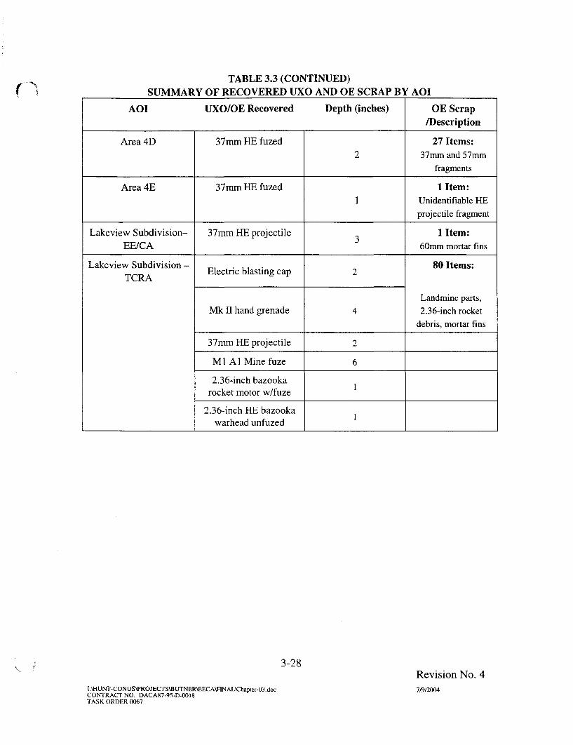
fTABLE 3.3 (CONTINUED)
SUMMARY OF RECOVERED UXO AND OE SCRAP BY AOI
AOI UXO/OE Recovered Depth (inches)
Area4D
Area 4E
Lakeview Subdivision-EE/CA
Lakeview Subdivision -TCRA
37mm HE fuzed
37mm HE fuzed
37mm HE projectile
Electric blasting cap
Mk II hand grenade
37mm HE projectile
M1 A1 Mine fuze
2.36-inch bazookarocket motor w/fuze
2.36-inch HE bazookawarhead unfuzed
2
1
3
2
4
2
6
1
1
OE Scrap/Description
27 Items:37mm and 57mm
fragments
1 Item:Unidentifiable HE
projectile fragment
1 Item:60mm mortar fins
80 Items:
Landmine parts,
2.36-inch rocket
debris, mortar fins
3-28
I:\HUNT-CONUS\PROJECTS\BUTNER\EECA\nNAL\Chapler-03docCONTRACT NO. DACA87-95-D-0018TASK ORDER 0067
Revision No. 47/9/2004
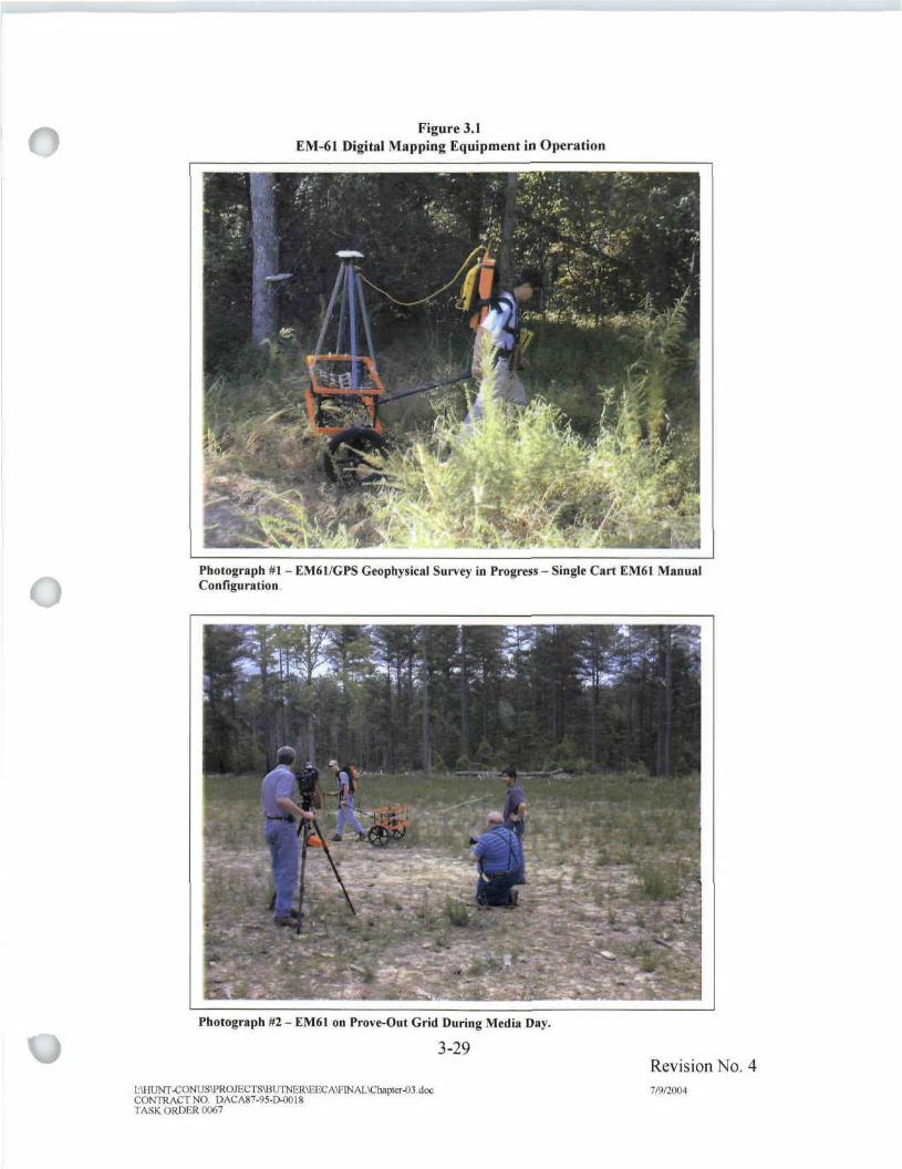
Figure 3.1EM-61 Digital Mapping Equipment in Operation
Photograph #1 - EM61/GPS Geophysical Survey in Progress - Single Cart EM61 ManualConfiguration
Photograph HI - EM6I on Prove-Out Grid During Media Day.
3-29
[ .\HUNT-C ONUS\PRO JECT S\BUTNER\EEC A\FIN AL\ChapCer-O3, docCONTOACTNO. DACA87-95-D-0018TASK ORDER (XJ67
Revision No. 47W2004

2052000 2056000 2060000 2064000 206S0OO 2072000 2076000 2080000
, A4G0213 L -
-A4G0BatfU < < M t Z I
\K"-JS~ ^ i ; .• V J ( '.
ow^mz. x
it »
^WfL4^%!Jft
Kv\V
""^EVffAiaaiaJ iDs^aMKf mmArea6, • IN f
w-ymm^K^i -immMr^.
£ -,JL. '•
NN/;:f!
V 11A5G0033 ^
i I" &
A5G003ij_s (
m_____ - \ ?//<.
/ « ^ ^ /
Swi' - ^
_?4 fraSsV .');.">; M'Jfti^
^^_S3E13feJH:?W!S. >(-»/ \\ Yd'Z^fm A1GC212
^r-^ffl^r
mm V i^/f£h-
M i l - - j ]
/ /Mr
r\wr
SuBnl\ v*~u-'~*$kim
M1U-.- '«B
• • ' ^ • ^ ^ ' :
r <-^
• Tf/M
iilK^?®21-••-« * - • F^ ? ^ i - . » ^ v J .-./-, >rfs^fc ' ^ - •/•-•. 4
2052000 2056000 2060000 2068000 2072000 2076000 2080000
Figure 3,2a
Intrusively InvestigatedGrid Locations
Former Camp ButnerButner, NC
Index Map
LegendFiring Fan
Range Complex 1
Range Complex 2
Dred Areas of Interest
Areas 4A through 4E and 1A
Area 4
Area 5
Area 6
Parcel Boundary
lOO'xiOO'Grid
Intrusively Investigated - No OES
Intrusively Investigated - OES Present/No UXO
Intrusively Investigated - UXO PresentWaterbody(SDTS Data, Buffered 50 Feet)
Completed Transect(Intrusively Investigated - No OES)
Recent Non-EE/CA UXO FindingsRecent Non-EE/CA OES FindingsUXO Findings 10 Years Ago
List of Ranges:1-9 Small Arms
10 37 mm11, 14 Trench Mortar, 60 mm and 81 mm12, 13 Heavy Artillery
Map Units: NAD 1983 North Carolina State Plane (Feet)
2000 2000 4000 Feet
PARSONS
DESIGNED BY:
BT
DRAWN BY:
BTCHECKED BY:
DS
SUBMfTTEDBY:
DS
U.S. ARMY CORPSOF ENGINEERS
HUNTSVILLE CENTER
Intrusively InvestigatedGrid Locations
SCALE: i inch equals 2,000 feet
DATE: July 2004
FILE: x:\gte\736001\av_project\investigated grid.apr
PROJECT NUMBER:
738001PAGE:
3-30
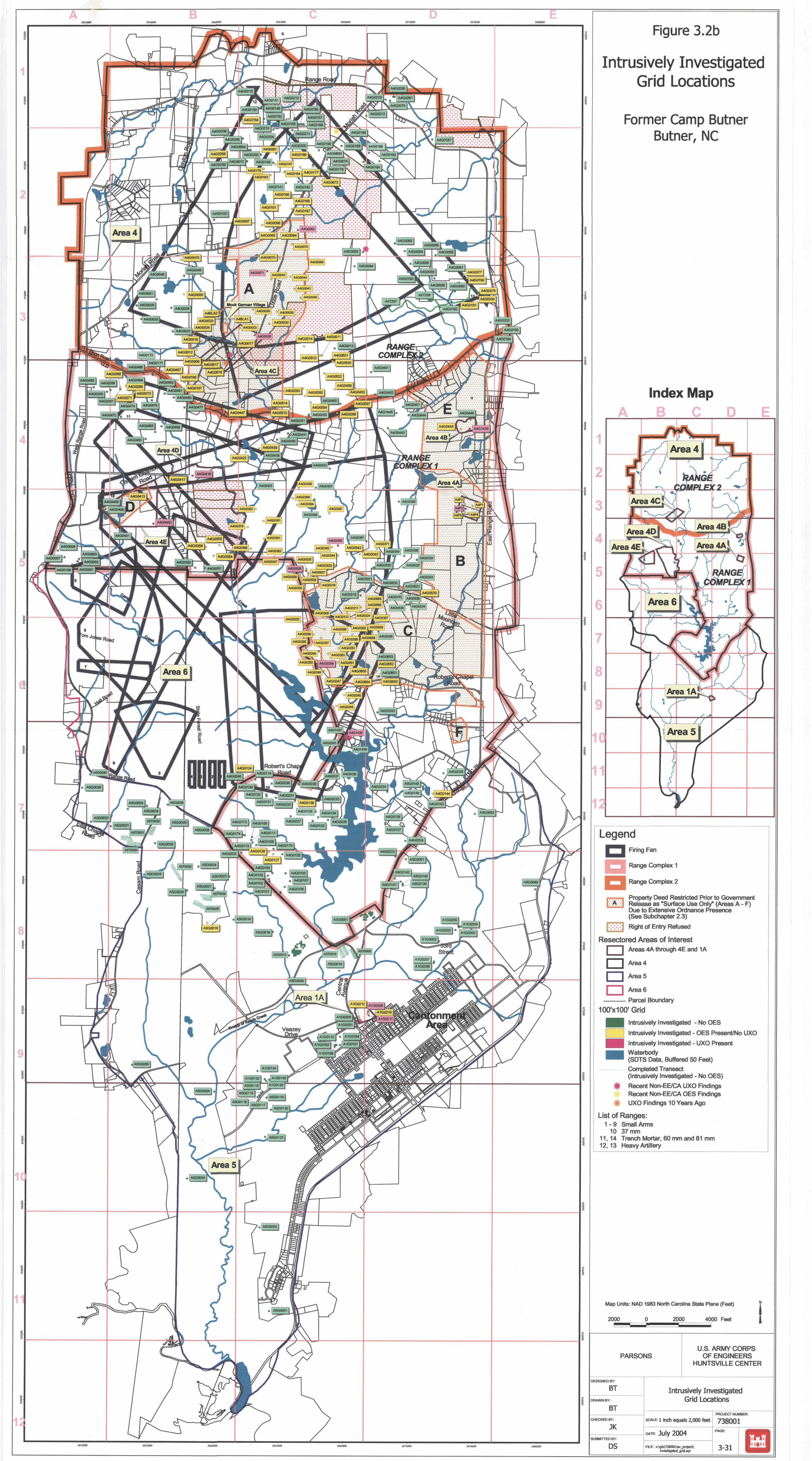
205WOO lOtOOOO 20**OO0 20tt000 2071000 2010000
1
A4G02I
4G0279
A4G0211
i *ni—z^ . I
Area 4
G0202
A4GO195J
COMPL
"JJLi;
71' i . _ • ! _LjA4G0474 I A4GO47B
l » E
, ..A4GO367MB- %
,-- m \ ==
A4G0653 j
A4G0652
Areas
Robert's Cha
A4G0173j:A4G0109
A5T0O1O
A5GCO1OJ
Area 1A
Area 5
207tO00 iosoooo
Figure 3.2b
Intrusively InvestigatedGrid Locations
Former Camp ButnerButner, NC
Index Map
LegendFiring Fan
Range Complex 1
Range Complex 2
Property Deed Restricted Prior to GovernmentRelease as "Surface Use Only" (Areas A - F)Due to Extensive Ordnance Presence(See Subchapter 2.3)
Right of Entry Refused
Resectored Areas of InterestAreas 4A through 4E and 1A
Area 4
Area 5
Area 6
Parcel Boundary
1OO'x1OO'Grid
Intrusively Investigated - No OES
Intrusively Investigated - OES Present/No UXO
Intrusively Investigated - UXO Present
Waterbody(SDTS Data, Buffered 50 Feet)Completed Transect(Intrusively Investigated - No OES)
Recent Non-EE/CA UXO FindingsRecent Non-EE/CA OES Findings
$ UXO Findings 10 Years Ago
List of Ranges:1-9 Small Arms
10 37 mm11, 14 Trench Mortar, 60 mm and 81 mm12, 13 Heavy Artillery
Map Units: NAD 1983 North Carolina State Plane (Feet)
2000 2000 4000 Feet
PARSONS
)ESK3NEDBY:
BTRAWN BY:
BTHECKED BY:
UBMITTED BY:
DS
U.S. ARMY CORPSOF ENGINEERS
HUNTSVILLE CENTER
Intrusively InvestigatedGrid Locations
; PROJECT NUMBER:
SCALE: i inch equals 2,000 feet 7 3 8 0 0 1
DATE: July 2004
FILE: x:\gfe\738001\av_projed\i nvesBgated_grid.a pr
PAGE:
3-31

Figure 3.3Completed Grids in
Original Area 1Former Camp Butner
Butner, NC
Index Map
Area 1Cantonment area & vicinity
Legend100'HIOO1 Grid
^ ^ ^ ntnisivaly InvBatigalefl -NoOES
Inirusiusly Investigatod - OES Present/No UXO
nvBSligated - UXO Prosanl
* Recent Morv-EE/CA UXO Findings
Inuge Sounc: 1995 Aerial <"v*s (ran USESMap U*s : HAD I9B3 UwSi CgrWu so le Plane (Feet)
U.S. ARMY CORPSOF ENGINEERS
HUNTSVILLE CENTER
Completed Grids InOriginal Area 1

Figure 3.4
Completed Grids inOriginal Area 2
Former Camp ButnerButner, NC
Index Map
Area 2 - Ammunition storage area & dumpl*
Legend100'x100' Grd
Intrusively I nvestigatod -NoOES
InlruBively Investigates - OES Present/No UXO
Intrusively investigated - UXO Present
[mage Source IMS Wrlil unms rrwn J5GSMso 1MB: NAD 1963 North Q M I 9 SOW Bare (Fed)
U.S. ARMY CORPSOF ENGINEERS
HUNTSVILLE CENTER
Completed Grids inOriginal Area 2

Figure 3.5Completed Grids in
Original Area 3Former Camp Butner
Butner, NC
Area 3 - Grenade training ranges
10O'x1O0'Grid
^ ^ ^ | ntrusively InveEiigatBd - No OES
Intrusively Investigated - OES Present/No UXO
Intrusively InimefcfjHtBd - UXO Present
trage Source- 1995 to la! Plioto (ran usesMap Unto: MAD 1563 Nwff Cart*™ S(He PIHIF
U.S. ARMY CORPSOF ENGINEERS
HUNTSVILLE CEI^TER
Completed Grids inOriginal Area 3

Area 4 - Ammunition training ranges & impact area
,1
(County Road
Figure 3.6
Completed Grids inOriginal Area 4
Former Camp ButnerButner, NC
•
Legend
100'xtOO'Grid
Intrusively Investigated - No OES
Intrusively Investigated - OES Present/No UXO
Intrusively Investigated - UXO Present
*
Historic Designated Range
Recent Non-EE/CA UXO FindingsRecent Non-EE/CA OES FindingsPossible Well Disposal SiteUXO Findings 10 Years Ago
List of Ranges:1-9 Small Arms10 37 mm
11, 14 Trench Mortar, 60 and 81 mm12, 13 Heavy Artillery
Index Map
Image Source: 1993 Aerial Photo from TEC
Map Units: NAD 1983 North Carolina State Plane (Feet)
2000 2000 4000 Feet
PARSONS
DESIGNED BV.
BT
BTCHECKED HY.
JKSUBMITTED BV
DS
U.S. ARMY CORPSOF ENGINEERS
HUNTSVILLE CENTER
Completed Grids inOriginal Area 4
i inch equals 2,000 feetPROJECT NUMBER
738001
July 2004
HIE: i;Wh\73S0OH»jmi|ea\FfOapr
PMX:
3-35

5 - Remaining land
Figure 3.7
Completed Grids inOriginal Area 5
Former Camp ButnerButner, NC
Legend1OO'x 100'Grid
^ ^ | nlruelvsiy Investlgslad
, | Inlnjeively Invostigaled-
| ^ ^ | Intrusively Investigated -
NoOES
OES ProsenVNo UXO
UXO Present
4|t R>cerl Non-EBCA UXO Findings
Im»jf Source- 1«5 **dal PhMn fmm USGSHtp UMs' mo 1993 Horn caroina Sou Hme {fett)
PARSONSU.S. ARMY CORPS
OF ENGINEERSHUNTSVU-LE CENTER
D5
Completed Grids InOriginal Area 5
Ei1 inch equob 4,000 (oei 738001
3-36

Figure 3.8
Completed Grids inResectored Area 1AFormer Camp Butner
Butner, NC
Index Map
Legend100x100'Grifl
^ ^ | Intrusively Investigated -NoOES
| [ Intrusively Investigated - OES Present/No UXO
^ ^ H | Intrusively Investigated - UXO Present
Aerial Photo Interpretation -USAGE TEC, 2001
1__^J Ground Scar
$ Recent Non-EE/CA UXO Findings
urce 1995 AciUI PIUJOJ from LJSGSHep LJnte- NAD 1S83 Nc«fli Csroira S o u Rsne (F»4)
PARSONS
Err
SUBMITTED BV
DS
U.S. ARMY CORPSOF ENGINEERS
HUNTSVILLE CEMTER
Completed Grids in1A
KME.1 Inch squadB SO0 f«al
HIE i:\5B\738mi\sv_projKl\EECA.ap
738001
3-37
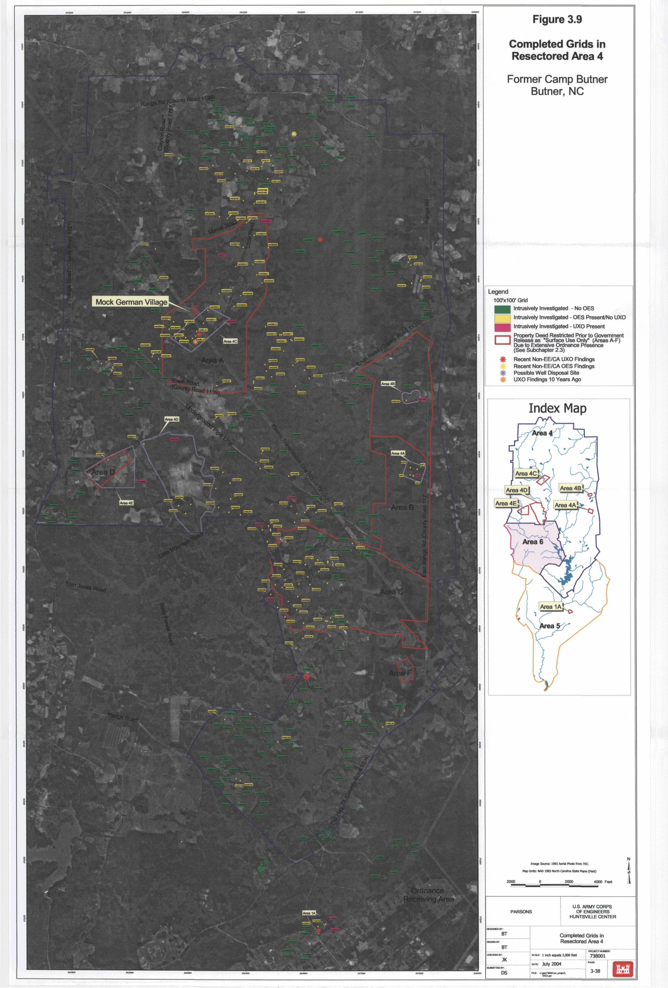
RangCounty Road
f'V'.'H
r f.-: :u
iy."y If* Vi'A'1
Mock German Village
J.T'-'WI
ffr<*"'V .-SE3B ."if
• t.V''1''.!
UJ
ft* "71 m>
dnancejiving Area
Figure 3.9
Completed Grids inResectored Area 4
Former Camp ButnerButner, NC
Legend
100'x100'GridIntrusively Investigated - No OES
Intrusively Investigated - OES Present/No UXO
**
Intrusively Investigated - UXO Present
Property Deed Restricted Prior to GovernmentRelease as "Surface Use Only" (Areas A-F)Due to Extensive Ordnance Presence(See Subchapter 2.3)
Recent Non-EE/CA UXO FindingsRecent Non-EE/CA OES FindingsPossible Well Disposal SiteUXO Findings 10 Years Ago
Index Map
Area 4E
Image Source: 1993 Aalal Photo from TEC
Map Units: NAD 1983 North Carolina State Plane (Feet)
2000 2000 4000 Feet
PARSONS
DESIGNED BY
BT
DRAWN BY
OCCKEDIW:
JKSUBMITTED BV
DS
U.S. ARMY CORPSOF ENGINEERS
HUNTSVILLE CENTER
Completed Grids inResectored Area 4
l inch equals 2,000 feet
DATE: July 2004
738001PAGE:
3-38

COMPLEX2
RANGE COMPLEX 1
Figure 3.10
Completed Grids inResectored Area 4A&4B
Former Camp ButnerButner, NC
Index Map
LegendKWxiOD1 Qfid
^ ^ ^ Inlnjsivnly Investigated -
| [ Intrusively Investigated-
f ~ ^ f l Intrusively Invofitigated-
Aenal Pholo Interpretation -USAGE TEC, 2001
^ ^ ^ 1 Ground Scar
I l l l I I Impact Crater)|t Recent Non-EE/CA UXO
MoOES
OES Present/No UXOUXO Present
Findings
Tmsge Sourt*: IMS Aerial Ftirtu from USGSMap UnlS NAD 1963 Hum CirSI<vi State Pisis ( f e« )
PARSONSU S. ARMY CORPS
OF ENGINEERSHUNTSVILLE CEfJTER
Completed Grids InResectored Area 4A&4B
E 1 Indi eomia I.OOOtool 738001
3-39

205800C
Mock German Village
' — " • 1' -^""•"h> A4G0520 i . .-. A4G0521 l^k^-—-r^H ^
Figure 3.11
Completed Grids inResectored Area 4CFormer Camp Butner
Butner, NC
Index Map
Legend
Intrusively Investigated - No OES
I Intrusively Investigated - OEE Present/No UXO
Intrusively Investigated - UXO Present
Recent Non-EBCA UXO FindingsRecent Non-EE/CA OES FindingsPossible Well Disposal SiteUXO Findings 10 Years Ago
Image Source 1995 ABIal Photo from USGSMop UniQ' WO 19B3 ter^ C^rul'td 92 te Plane (Feet)
1000 Feat
PARSONS
BT
BT
JK
DS
U.S. ARMY CORPSOF ENGINEERS
HUNTSVILLE CENTER
Completed Grids InResectmeO Area 4C
]uiyiC04
EFCljp:
PHCLCCTMJI.BW
3-40
ictsooo

Figure 3.12
Completed Grids inResectored Area 4D&4E
Former Camp ButnerButner, NC
Index Map
RANGE COMPLEX 1
ntrusively Investigated -NoOESIntrusively Investigated - OES Present/No UXOintrusively Investigated - UXD Present
Ground Scar
Impacl Crater
Recent Non-EE/CA UXO Findin
hnaqe Sounvr 1995 Aerial l*>0& r>afn LFS^Map Units: NAD 1963 Hwtti Carolina SDR Want (FM)
U.S. ARMY CORPSOF ENGINEERS
HUNTSVILLE CEMTER
Completed Grlfls InResectored Area 4P&4G
i iFidi meMs 2,000 (sol
>:Ws\7380Dl\»w_pro)«n

mm^mmm
Area 1A
^^^^^^9ft^ L L r ^ ^ f l i r^ ^ ^ ^ ' wy xh ^ IM
Figure 3.13
Completed Grids inResectored Area 5Former Camp Butner
Butner, NC
Legend100x100' Grid
^ ^ ^ | Intrusively Invesiigaled
1 I Intrusively Investigated^ ^ ^ | Intrueivtfy Invostigated
- No OES
OES Present/No UXO
UXO Prasent
4|t Recert Non-EE/CA UXO FinOings
Im«e Source: 1115 tarUIMipLMB-NAD 19B3 North Carolina SBte Wirw (F«t |
PARSONSU.S. ARMY CORPS
OF ENGINEERSHUNTSV1LLE CENTER
•EBOEDBY
BT"
BT
JK
DS
Completed GHds InResectored Area 5
EI Incfl vjnau 4.000 (ml
EECAJpt
738001
3-42

Figure 3.14Intrusively Investigated
Grid Locations
Former Camp ButnerButner, NC
IpcfcxMapWILLETTE JAMES B JR & AUDREY
37mrn>iEj3roiectile (1/20/03) andMK II grenaa&^/20/03)
WILLETTE JAMES B JR & AUDREYw-^^T J '
STATE OF NORTH CAROLINA2.36-in rocket found by owner 11/11/01
37mm HE projectile found during EE/CA 8/21/02
2.36-in rocket found by owner - Cash/^roperty 5/27/02
STATE DF NORTH CAROLINA6-inch HE warhead/ unfused (1/29/03)
ASH DANNY LA:--.<MBEFL RILEY, STAN
NORMA JEAN
100 Extension Area
.36-iKch bazooka rocket,motor with fuze (1/22/03)
SJ3OM »tfe JE ^FRANCES L J JERRY &LEANNE
TCRA at LakeviewMine fuze, Ml (1/22/03 TIMOTHY I-ILL DANIEL C3& CHRISTY S
100'xiOO1 Grid
Intrusively Investigated - No OESIntrusively Investigated - OES Present/No UXO
Intrusively Investigated - UXO PresentWat&rtmdy(SDTS Data. Buffered SO Feet)
Recent Non-EE/CA UXO Findings
OGRC-fVL-P M I C Units' HtD 1963 Horn CjroWi) SBB Plsr* (Feet)
100 0 100 200 F B B I
STATE OF NORTH CAROLINA
U.S. ARMY CORPSOF ENGINEERS
HUNTSVILLE CENTERBlasting cap, electric (1/13/03)
404S 414S Intrusively Inestlgated Grid LocationLakeview Subdivision
CHAPTER 4RISK EVALUATION
4.1 INTRODUCTION4.1.1 A qualitative risk evaluation was conducted using the OE Risk Impact
Assessment (OE RIA) for OE EE/CA Evaluations Interim Guidance document (USACE,2001b) to assess explosive safety risk to the public at the former Camp Butner Site. Thepurpose of the risk evaluation is to communicate the magnitude of the risk at the site andthe primary causes of that risk, and to aid in the development, evaluation, and selection ofOE response alternatives. The risk evaluation presented herein is based on the sitecharacterization findings presented in Chapter 3 for each of the 9 AOIs remaining afterre-sectorization (as described in Subchapter 3.5).
4.1.2 An explosive safety risk is the probability for a UXO to detonate andpotentially cause harm as a result of human activities. An explosive safety risk exists if aperson can come near or into contact with a UXO and act on it to cause a detonation. Thepotential for an explosive safety risk depends upon the presence of three criticalelements: a source (presence of UXO), a receptor or person, and interaction between thesource and receptor (such as picking up the item or disturbing the item by plowing).There is no risk if any one element is missing. Each of the three elements provides abasis for implementing effective risk-management response actions.
4.1.3 The exposure route for a UXO to a receptor is primarily direct contact as aresult of some human activity. Agricultural or construction activities involvingsubsurface intrusion are examples of human activities that will increase the likelihood fordirect contact with buried UXO. A UXO will tend to remain in place unless disturbed byhuman or natural forces, such as erosion or frost heave. Movement of the UXO mayincrease the probability for direct human contact but not necessarily result in a directcontact or exposure.
4.2 DEFINITION OF RISK EVALUATION FACTORS, CATEGORIES,AND SUBCATEGORIES
4.2.1 Introduction
The potential risk posed by UXO was characterized qualitatively by evaluatingthree primary risk factors. The three primary risk factors include: 1) presence of a UXOsource, 2) site characteristics that affect the accessibility or pathway between the sourceand human receptor, and 3) human factors that define the number of receptors and type ofactivities that may result in direct contact between a receptor and UXO source. Byperforming a qualitative assessment of these three factors, an overall assessment of thesafety risk posed by UXO was evaluated. The following paragraphs describe thecomponents of each of the primary risk factors and an overview of the risk evaluation
/ factors is shown in Figure 4.1.
4-1 Revision No. 4I:\HUNT-CONUS\PROJECTS\BUTNER\EECA\FINAL\Chapter-04 7/9/2004CONTRACT NO. DACA87-95-D-0018TASK ORDER 0067

Figure 4.1OE Risk Factor Tree
Primary Risk Factors
Ordnance and Explosives Site Characteristics Human
Categories Categories Categories
Types
OE that may be lethalOE that may causemajor injuryOE that may causeminor injuryInert OE or scrap
Sensitivity
a Veiy sensitive• Less sensitive• Insensitive• Inert OE or scrap
Accessibility
1No restriction to siteLimited restriction to siteComplete restriction toaccess
Activities
• Significant• Moderate• Low
Depth
SurfaceSubsurface
Quantity
May be expressed as the following:
Estimated number of OE;Estimated number of OE per acre; orNumber of OE found per intrusive
anomalies investigated
Stability
Site stable1
Moderately stable1
Site unstable'
Population
Estimated number ofpeople who access siteon daily basis
Notes1 Function of type of activities/use and depth of OE.2. Bulleted items are subcategories for each category.
4-2l:\HUNT-CONUS\PROJECTS\BUTNER\EECA\FINAL\Chapter-04.docCONTRACT NO. DACA87-95-D-0O18TASK ORDER 0067
Revision No. 47/9/2004

4.2.2 Presence of UXO Factors4.2.2.1 There are four categories that are used to evaluate the presence of UXO
risk. These include the UXO type, UXO sensitivity, UXO density, and UXO depthdistribution.
4.2.2.2 Type. The UXO type affects the likelihood of injury and the severity ofexposure. If multiple UXO items are identified in an area, that item which poses thegreatest risk to public health is selected for risk evaluation. There are four subcategoriesof UXO type, as shown in Table 4.1. These subcategories are presented in order ofseverity from highest to lowest risk.
Table 4.1UXO Type Subcategories
Subcategory
Most severe
Moderate severity
Least severity
No injury
UXO Type Description
UXO that may be lethal if detonated by anindividual's activities
UXO that may cause major injury to anindividual if detonated by an individual's
activities
UXO that may cause minor injury to anindividual if detonated by an individual's
activities
Ordnance scrap (inert), will cause no injury
4.2.2.3 Sensitivity. UXO sensitivity affects the likelihood of detonation and theseverity of exposure. Factors considered in evaluating sensitivity include fuzing andenvironmental factors such as weathering. There are four potential subcategories ofUXO sensitivity. The category of sensitivity is based on the results of the EE/CA fieldinvestigation as well as the results of archival searches. When multiple subcategories ofUXO types are discovered in an area, the highest risk subcategory is used in the riskevaluation. The subcategories of sensitivity are defined and presented in order fromhighest to lowest in Table 4.2.
4.2.2.4 Density. UXO density affects the likelihood that an individual will beexposed to UXO. There exists a direct relationship between density and potential forharm. For example, the more ordnance per acre, the greater the likelihood of exposure toa UXO item and thereby an opportunity to create an incident. Density can be estimatedeither qualitatively or quantitatively.
V.
4-3I:\HUNT-CONUS\PROJECTS\BUTNER\EECA\FINAUChapier-04CONTRACT NO. DACA87-95-D-OO18TASK ORDER 0067
Revision No. 47/9/2004

Table 4.2UXO Sensitivity Subcategories
Subcategory
Very Sensitive
Less sensitive
Insensitive
Inert
UXO Sensitivity
UXO that is very sensitive, i.e., electronicfuzing, land mines, booby traps
UXO that has standard fuzing
UXO that may have functioned correctly, or isunfuzed, but has a residual risk
Ordnance scrap (inert), will cause no injury
V
4.2.2.5 Depth Distribution. The UXO depth distribution refers to where the UXOis located vertically in the subsurface. The UXO depth distribution affects the likelihoodthat an individual will be exposed to UXO. There exists a direct relationship between thedepth at which UXO are found and the likelihood of exposure to the UXO. That is, thegreater the depth where the UXO are found, the lower the risk of exposure. There aretwo subcategories within the UXO depth distribution category: surface and subsurface.The surface subcategory includes those items recovered either on the ground surface,protruding from the ground surface, or beneath the leaf litter. The subsurfacesubcategory includes those items recovered from beneath the ground surface.Assessment of this risk category reflects the findings of the EE/CA field investigation.
4.2.3 Site Characteristics Factors4.2.3.1 There are two categories that are evaluated in the site characteristics risk
factor. These are site accessibility and site stability.
4.2.3.2 Site Accessibility. The accessibility of a sector affects the likelihood ofencountering UXO. Natural or physical barriers can limit the accessibility. Naturalbarriers can include the terrain or topography of the site as well as the vegetation.Physical barriers can include walls and fences that limit the publics' accessibility to thesector. Both the physical and natural barriers found at a sector are considered whenevaluating this category. Site accessibility has three subcategories. These subcategoriesare presented in Table 4.3.
4.2.3.3 Site Stability. This category relates to the probability of being exposed toUXO by natural processes. These natural processes include recurring natural events (e.g.,frost heave, sand movement, erosion) or extreme natural events (e.g., tornadoes,hurricanes). The local soil type, topography, climate, and vegetation affect stability ofthe site. The soil type and climate primarily affects the depth of penetration of the UXO.Over time, the soil type and climate will also affect the degree of erosion that takes placeat a site. Topography and vegetation in the area will also affect the rate of erosion thattakes place in an area. Site stability has three subcategories. Table 4.4 describes thesesubcategories.
I:\HUNT-CONUS\PROJECTS\BUTNER\EECA\FINAUChapter-04CONTRACT NO. DACA87-95-D-0018TASK ORDER 0067
4-4 Revision No. 47/9/2004

fTable 4.3
Site Accessibility Subcategories
Subcategory
No Restriction to Site
Limited Restriction to Access
Complete Restriction to Access
Accessibility Description
No man-made barriers, gentlysloping terrain, no vegetationthat restricts access, no water
that restricts access
Man-made barriers, vegetationthat restricts access, water, snow
or ice cover, and/or terrainrestricts access
All points of entry are controlled
Table 4.4Site Stability Subcategories
Subcategory
Site Stable
Moderately Stable Site
Site Unstable
Stability Description
UXO should not be exposed by natural events
UXO may be exposed by natural events
UXO most likely will be exposed by natural events
4.2.4 Human Factors4.2.4.1 There are two categories that are evaluated in the primary human risk
factor. These include activities and population.
4.2.4.2 Site Activity. The types of activities conducted at a site affect thelikelihood of encountering UXO. The types of activities may be generally classified asrecreational and occupational. This category examines whether the impact from anactivity on UXO is significant, moderate or low. In order to assign such a score, thegeneral guidelines presented in Table 4.5 were considered. First, the type of activityshould be identified. Then, the depth of the activity must also be considered. Forexample, at a site where UXO is at the surface, all activities that can impact UXO at thesurface are considered activities that have significant impact or contact level.Conversely, if all UXO is located at depths greater than 1 foot and only surface impactactivities are being performed then the activities are considered as moderate or lowimpact. After the type of activity and depth of UXO are identified, then a score ofsignificant, moderate or low may be assigned.
v.vI:\HUNT-CONUS\PROJECTS\BUTNER\EECA\FIN AL/Chapter-04CONTRACT NO. DACA87-95-D-OO18TASK ORDER 0067
4-5 Revision No. 47/9/2004

Table 4.5UXO Contact Probability Levels
Examples of Activities
Child Play, Picnic, Short Cuts, Hunting,Fishing, Hiking, Swimming, Jogging,
Ranching, Surveying, Off-Road Driving,
Camping, Metal Detecting
Construction, Archaeology, Crop Farming
Actual Depth of UXO
SurfaceBelow Surface-12"
>12"
SurfaceBelow Surface -12"
>12"
SurfaceBelow Surface -12"
>12"
Contact Level
SignificantLowLow
SignificantModerate
Low
SignificantSignificantModerate
V j
4.2.4.3 Population. This category refers to the number of people that potentiallyaccess the AOI on a daily basis. The number of people using the AOI affects thelikelihood of encountering UXO. A direct relationship exists between the number ofpeople and the risk of exposure. An estimate of the number of people accessing the AOIon a daily basis was made using census data and best professional judgment based onknowledge of the type of site, land use, and site accessibility.
4.3 RISK EVALUATION
4.3.1 IntroductionEach of the primary risk factors identified above was evaluated using the data
collected during the EE/CA field investigation, the data presented in the ASR, and theresults of the TCRA. The risk evaluation for the 11 AOIs is presented in Table 4.6. Thefollowing sections discuss the risk evaluation by each primary risk factor.
4.3.2 Presence of UXO Factor
4.3.2.1 Type
4.3.2.1.1 Area 1A: Two UXO items were recovered during the EE/CAinvestigation in Area 1A. One Mk II hand grenade was recovered at a depth of 1 inchand a Ml practice anti-tank landmine with spotting charge and fuze was recovered at adepth of 10 inches. The ASR report indicated that a small arms range and flamethrowerrange was located in this area. During the ASR site visit small arms ammunition casings(.30 caliber) were identified. Ordnance items that are 30mm and smaller are classified assmall arms by the U.S. Military (USACE, 1994). These items pose a very low explosivesafety risk and are not considered a UXO hazard. For small arms, a deliberate effort mustbe applied to a very specific and small point (the primer) to make the round function. Ifthe round functions outside the weapons chamber, the propellant gas would cause thebullet and cartridge to separate and, in addition, the cartridge could also rupture. If thistook place in close proximity to a person, possible injury could result (USACE, 1999).
I:\HUNT-CONUS\PROJECTS\BUTNER\EECA\FINALVChapter-04CONTRACT NO. DACA87-95-D-OO18TASK ORDER 0067
4-6 Revision No. 47/9/2004

The explosive safety risk posed by small arms ammunition is very small and is not9 \ further discussed in this report
4.3.2.1.2 During this EE/CA investigation, a 2.36-inch rocket was reportedly foundin unknown condition near the water tower and detonated by Fort Bragg EOD. Althoughthis potential UXO was found within the confines of Area 1A, it cannot be confirmed asUXO and is uncharacteristic of the items observed within Area 1A during the EE/CA.Based on the verified UXO (grenade and practice mine), the Mk II hand grenade wasselected as the munition of most concern for Area 1A and was assigned a subcategory of"most severe" because it may be lethal if detonated by an individual's activities.
4.3.2.1.3 Area 4A: One UXO item was recovered in Area 4A during this EE/CAinvestigation. One 2.36-inch HE bazooka rocket was recovered at a depth of 3 inches.Area 4B is located entirely within one of six areas restricted for 'surface use only' whenthe government sold the land back to the public (see paragraph 2.3.6, Figure 2.3). Area Bwas designated as a bazooka and rifle grenade impact area in historical records. TheUXO findings corroborate this historical designation. The 2.36-inch HE bazooka rocketwas assigned a subcategory of "most severe" because it may be lethal if detonated by anindividual's activities.
4.3.2.1.4 Area 4B: One UXO item was recovered in Area 4B during this EE/CAinvestigation. One 2.36-inch HE bazooka rocket was recovered at a depth of 18 inches.In addition, coincident with the EE/CA investigation, the property owner uncovered aninert 2.36-inch bazooka rocket. Area 4B is located entirely within one of six areasrestricted for 'surface use only' when the government sold the land back to the public(see paragraph 2.3.6, Figure 2.3). Area 4B was reportedly within a bazooka and riflegrenade impact area. The UXO findings corroborate this historical designation. The2.36-inch HE bazooka rocket recovered during the EE/CA investigation was assigned asubcategory of "most severe" because it may be lethal if detonated by an individual'sactivities.
4.3.2.1.5 Area 4C: One UXO item was recovered during the EE/CA investigationin Area 4E. One unfuzed 105mm HE projectile was recovered at a depth of 3 inches.Additionally, an unfuzed 105mm HE projectile was recovered by a resident during thisEE/CA investigation and disposed of by Fort Bragg EOD. A second projectile (155mm)was found by the resident during preparation of this report. This item was also disposedof by Fort Bragg EOD. Another adjacent resident reported finding a 155mm HEprojectile approximately 10 years ago; however this item was not verified. Area 4C islocated within one of six areas restricted for 'surface use only' when the government soldthe land back to the public (see paragraph 2.3.6, Figure 2.3). Area 4C falls within themain artillery impact area. The TEC historical photographic analysis identified a largenumber of suspect impact craters in this area. In addition, the ASR report identified thestructural remnants of the mock German village used as an artillery target and was laterverified by Parsons' personnel during this EE/CA investigation. The 155mm HEprojectile (UXO item) was assigned a subcategory of "most severe" because it has thepotential to cause the most injury if detonated by an individual's activities.
, 4.3.2.1.6 Area 4D: One UXO item was recovered during the EE/CA investigationV., / in Area 4D. One 37mm HE projectile was recovered at a depth of 2 inches. This AOI is
4-7 Revision No. 4I:\HUNT-CONUS\PROJECTS\BUTNER\EECA\FINAL/Chapter-04 7/9/2004CONTRACT NO. DACA87-95-D-OO18TASK ORDER 0067
located within the former Range 10 (37mm projectile training) and Range 11 (60mmf ^ mortar training) impact areas. Area 4D does not fall within any of six areas restricted for
'surface use only' when the government sold the land back to the public (see paragraph2.3.6, Figure 2.3). The 37mm projectile identified during this EE/CA investigationcorroborates the historical designation of this AOL The UXO item was assigned asubcategory of "most severe" because it may be lethal if detonated by an individual'sactivities.
4.3.2.1.7 Area 4E: One UXO item was recovered during the EE/CA investigationin Area 4E. One 37mm HE projectile was recovered at a depth of 1 inch. Area 4E islocated almost entirely within one of six areas restricted for 'surface use only' when thegovernment sold the land back to the public (see paragraph 2.3.6, Figure 2.3). Area 4Efalls within the area reportedly used as a moving target area within the former Range 10(37mm projectile training range). The 37mm HE projectile (UXO item) was assigned asubcategory of "most severe" because it may be lethal if detonated by an individual'sactivities.
4.3.2.1.8 Area 4: Five UXO and 1118 ordnance scrap items were identifiedduring the EE/CA investigation in Area 4. The peripheries of several firing ranges arelocated throughout this AOL The UXO items included one 105mm HE projectilerecovered at the surface, one 57mm HE projectile recovered at a depth of 6 inches, oneunfuzed 2.36-inch HE bazooka rocket recovered at a depth of 10 inches, an unfuzed155mm shrapnel projectile with expelling charge recovered at a depth of 30 inches, and aM52 series nose fuze recovered at a depth of 3 inches. The likelihood for occurrence ofadditional UXO within this AOI is considered moderate based on both the number ofUXO and ordnance scrap items found as well as the configuration of historical firingranges. The unfuzed 155mm projectile and the 105mm HE projectile recovered duringthis EE/CA were selected as the munitions of most concern for Area 4 and assigned asubcategory of "most severe" because they may be lethal if detonated by an individual'sactivities. Note, however, that the 57mm HE projectile also meets the criteria for thesubcategory of "most severe".
4.3.2.1.9 Historical photographic analysis by TEC identified a large concentrationof suspect impact craters along the northern and eastern portions of Area 4 (adjacent tothe NCNG property) as well as much of the northcentral portion of the AOI near theMock German Village (USACE, 2001a). This AOI includes the former Range 10 (37mmprojectile training) and former Range 14 (60mm mortar training) impact areas as well asthe heavy artillery target areas. All or part of each of the six parcels restricted for'surface use only' when the government sold the land back to the public fall within Area4 (see paragraph 2.3.6, Figure 2.3). The large quantity of ordnance scrap items and UXOrecovered in this area during the EE/CA investigation corroborate the historical usage ofthis AOI as an artillery impact area.
4.3.2.1.10 Area 5: No UXO was identified during the EE/CA investigation inArea 5. Only one ordnance scrap item was recovered from the 750 anomalies that wereintrusively investigated. The ASR report indicated that the cantonment area and smallarms ammunition training range were located within this AOI. Area 5 does not fall within
i I any of the six areas restricted for 'surface use only' when the government sold the land
4-8 Revision No. 4I:\HUNT-CONUS\PROJECTS\BUTNER\EECA\FINAIVChapter-04 7/9/2004CONTRACT NO. DACA87-95-D-00I8TASK ORDER 0067

back to the public (see paragraph 2.3.6, Figure 2.3). The findings from this EE/CA( 1 corroborate the historical use of this AOL The likelihood for occurrence of UXO within
this AOI is considered remote based on the findings from this EE/CA investigation. Theordnance scrap item recovered in this AOI is assigned a subcategory of "no injury".
4.3.2.1.11 Lakeview Subdivision: One UXO item was recovered during theEE/CA investigation and six UXO items were recovered during the TCRA in theLakeview Subdivision. The Lakeview Subdivision is not located within any of six areasrestricted for 'surface use only' when the government sold the land back to the public(see paragraph 2.3.6). A 37mm HE projectile was recovered from a depth of 3 inchesduring the EE/CA. During the TCRA, UXO items recovered include one electric blastingcap, one Mk II hand grenade, one 37mm HE projectile, one Ml Al mine fuze, one 2.36-inch bazooka rocket motor with fuze, and one 2.36-inch HE bazooka rocket warhead. Allthe UXO items recovered during the TCRA were between a depth of 1 - 6 inches. TheMk II hand grenade was assigned a subcategory of "most severe" because it has thepotential to cause the most injury if detonated.
4.3.2.2 SensitivityA subcategory of "less sensitive" was assigned to Areas 1A, 4A, 4B, 4D, 4E, and
the Lakeview Subdivision based on the recovery of munitions in these areas havingstandard fuzes as defined in Table 4.2. Sensitivity affects the likelihood of detonationand the severity of exposure. The UXO items recovered during this EE/CA in Area 4Cdid not have intact fuzing as a result of shearing at impact. However, there is areasonable likelihood that other UXO items may exist in these areas within intact fuzing;therefore, a subcategory of "less sensitive" was also assigned to Area 4C. The UXOsensitivity for Area 4 was also assigned "less sensitive" based on the presence ofprojectiles with standard fuzing. Area 5 was assigned a subcategory of "inert", as onlyordnance scrap that can not cause any injury was recovered in this area.
4.3.2.3 DensityDensity was estimated qualitatively for the each AOI based on the number of UXO
found and the number of acres investigated. No UXO were found in Area 5. A total of13 UXO items were recovered during the EE/CA investigation and 6 UXO items wererecovered during the TCRA in the Lakeview Subdivision. In addition, during the EE/CAinvestigation, two verified UXO items were recovered by a resident at unspecified depthsin Area 4C and one verified UXO item was recovered by another resident at anunspecified depth in Area 4B.
4.3.2.4 Depth
4.3.2.4.1 The UXO depth distribution affects the likelihood that an individual willbe exposed to UXO. There is a direct relationship between the depth at which UXO arefound and the likelihood of exposure to the UXO. There are two subcategories within thedistribution depth category: surface and subsurface (as defined in paragraph 4.2.2.5). NoUXO were found in Area 5. The depth distribution factor is not applicable to this area.The 13 UXO items found at the former Camp Butner Site during the EE/CA investigationranged in depth from 0 - 3 0 inches (one suface UXO in Area 4). The 6 UXO items
V > recovered during the TCRA at the Lakeview Subdivision ranged in depth from 1 inch - 6
4-9 Revision No. 4I:\HUNT-CONUS\PROJECTS\BUTNER\EECA\FINALChapter-04 7/9/2004CONTRACT NO. DACA87-95-D-0018TASK ORDER 0067
inches. It should be noted that the depth distribution of the UXO items found during the^~ TCRA is biased because the TCRA was limited to between 0 - 6 inches.
4.3.2.4.2 Table 4.6 summarizes the results of the EE/CA and TCRA investigationsin terms of the depth of UXO for each area.
4.3.3 Site Characteristics Factors
4.3.3.1 Site Accessibility
All areas investigated during the EE/CA are accessible by both road and foot. Thereare mountainous areas and densely wooded areas with thick understory scatteredthroughout the entire site that limits easy access. The terrain in portions of Area 4 (northand east of NCNG) and Area 4D are more rugged and remote than other areas in theformer Camp Butner Site and provides a natural barrier that limits easy access to much ofthe area. Regions in Area 4 and Area 4D are also heavily forested and almost entirelyundeveloped; however, hunters are known to frequent these areas. All areas are assigneda subcategory of no restriction as the entire area is accessible by road and foot. It shouldbe noted, that the federal correctional facility, which encompasses a very small fractionof Area 5, is completely restricted.
4.3.3.2 Site Stability
The large amount of wooded area makes it possible that UXO may become exposedthrough natural processes, particularly burning initiated by lightning. In addition, frostheave (estimated at 4 inches, see also Subchapter 2.2.3) and localized erosion along creekbanks over time may occur and potentially cause migration of subsurface UXO to thesurface. The site stability is assigned a subcategory of moderately stable for the entireformer Camp Butner Site.
4.3.4 Human Factors
4.3.4.1 Site Activities
4.3.4.1.1 The type of activities conducted at the former Camp Butner Site incombination with the depth distribution of UXO is related to the likelihood of individualsencountering UXO. Table 4.6 describes the type of activity expected in each AOI basedon the current land use. The future land use is anticipated to continue along the existingland use tracks currently in place as discussed in Chapter 2.
4.3.4.1.2 Area 1A is a partially wooded undeveloped area. There are no residenceswithin Area 1A; however, there is the potential for future recreational development(hiking trail) in this area. Current activities in this area are primarily trespassing andhiking. The detection of UXO (above the frost heave depth of 4 inches) combined withthe potential for erosion results in a significant contact level rating for Area 1A.
4.3.4.1.3 Some of Area 4 and the majority of Area 4D is rugged, sparsely populated(few residential dwellings), and primarily used for hunting. Although hunting is a non-intrusive activity, the detection of UXO within the frost heave depth of 4 inches
V: S combined with the surficial hunting activity results in a significant contact level rating for4-10 Revision No. 4
I:\HUNT-CONUS\PROJECTS\BUTNER\EECA\FINAL/Chapler-04 7/9/2004CONTRACT NO. DACA87-95-D-0018TASK ORDER 0067

both areas. Other portions of Area 4 are largely open areas used primarily for farming.1 In these areas, the predominant agriculture activities include grazing, hay production, and
seasonal tilling. The intrusive activities combined with the presence of UXO alsosupports the significant contact level rating assigned to Area 4.
4.3.4.1.4 Area 4A is largely wooded and undeveloped with a single privatelandowner (two residential dwellings). The property has recently been parceled inanticipation of future residential development and initial land clearing has been observed(July 2003). The planned future construction activities combined with recovery of UXO(above the frost heave depth of 4 inches) results in a significant contact level rating forArea 4A.
4.3.4.1.5 Area 4B is largely an open area used primarily for farming. There are tworesidential dwellings in this AOL The current farming practice in this area, as reportedby the property owner, includes tilling to a depth of approximately 10 inches. Theintrusive activity combined with the presence of UXO results in a significant contactlevel rating for Area 4B.
4.3.4.1.6 Area 4C is partly residential (8 total residential dwellings) and partlyundeveloped. The predominant activities include construction, child play, and hunting.The intrusive activities combined with the presence of UXO (above the frost heave depthof 4 inches) results in a significant contact level rating for Area 4C.
4.3.4.1.7 Area 4E is predominantly used for tobacco cultivation. There is oneresidential dwelling in the area. The predominant activities include farming andconstruction. The intrusive activities combined with the presence of UXO (above thefrost heave depth of 4 inches) results in a significant contact level rating for Area 4E.
4.3.4.1.8 Five UXO were recovered in Area 4 and there is considered to be amoderate likelihood of occurrence for additional UXO based on the presence of impactcraters, firing fans, and ordnance scrap items recovered in this area. Intrusive activities inArea 4 include child play, construction, farming, hunting, logging, and forestry. Themoderate likelihood of occurrence for UXO in combination with the site activities, largesize and population of the area results in an overall significant contact level rating forArea 4.
4-11 Revision No. 4I:\HUNT-CONUS\PROJECTS\BUTNER\EECA\FINAL/Chapter-04 7/9/2004CONTRACT NO. DACA87-95-D-OO18TASK ORDER 0067

TABLE 4.6RISK EVALUATION
AOI
Area1A
Area4A
Area4B
Area4C
Area4D
Area4E
Ordnance and Explosives Factors
Type"
EE/CA: (1) Ml anti-tankpractice landmine w/fuze, (1)Mk II hand grenade
EE/CA: (1) 2.36-inch HEbazooka rocket
EE/CA: (1) 2.36-inch HEbazooka rocketOther: (1) 2.36-inch bazookarocketEE/CA: (1) unfuzed 105mmHE projectileOther: (2) 155mm HEprojectile
EE/CA: (1) 37mm HEprojectile
EE/CA: (1) 37mm HEprojectile
MostSevere
MostSevere
MostSevere
MostSevere
MostSevere
MostSevere
Sensitivity
LessSensitive
LessSensitive
LessSensitive
LessSensitive
LessSensitive
LessSensitive
Number of
UXO
Found
2in 1.15acres
1 in 1.15acres
1 in 0.7acre
1 in 2.3acres
1 in 1.15acres
1 in 0.7acre
Number of
UXO by
Depthu
Surface - 0
Subsurface - 2
Surface - 0
Subsurface - 1
Surface - 0
Subsurface - 1
Surface - 0
Subsurface - 1
Surface - 0
Subsurface - 1
Surface - 0
Subsurface - 1
Site Characteristics
Factors
Accessibility
NoRestriction
NoRestriction
NoRestriction
NoRestriction
NoRestriction
NoRestriction
Stability
ModeratelyStable
ModeratelyStable
ModeratelyStable
ModeratelyStable
ModeratelyStable
ModeratelyStable
Human Factors
Contact Level /
Activities
Significant(Trespassing and
hiking)
Significant(Construction,
child play)
Significant(Farming,child play)
Significant(Construction,
child play,hunting)
Significant(Hunting,
hiking,child play)
Significant(Farming andconstruction)
Population
(Daily)
/Number of
Residential
Dwellings
0-5/O
5-10
a2 - 5
12
35-60/8
5-10/6
20-40/I
Summary
Qualitative
OERIA
Safety Risk
Moderate toHigh
High
High
High
Low toModerate
Moderate
I:\HUNT-CONUS\PROJECTS\BUTNER\EECA\FINAL\Chapter-04.docCONTRACT NO. DACA87-95-D-0018TASK ORDER 0067
4-12 Revision No.4
7/9/2004

4.6RISK EVALUATION
• %
AOI
Area4
Area5
Lake-viewSub-divi-sion
Ordnance and Explosives Factors
TypeN1
EE/CA: (1) 105mm HEprojectile, (1) unfuzed155mm shrapnel projectilewith expelling charge, (1)57mm projectile, (1) unfuzed2.36-inch bazooka rocket,and (1) M52 series nose fuze.
EE/CA: Ordnance Scrap
EE/CA: (1) 37mm HEprojectileTCRA: (1) electric blastingcap, (1) Mkl l hand grenade,(1) 37mm HE projectile, (1)Ml Al Mine fuze, (1) 2.36-inch HE rocket motor w/fuze, (1) 2.36-inch HEbazooka rocket warhead
MostSevere
NoInjury
MostSevere
Sensitivity
Less Sensitive
Inert
Less Sensitive
Number of
UXO
Found
5 in 94.32acres
0in30acres
EE/CA: 1in 0.7 acre
TCRA: 6in 26 acres
Number of
UXO by
Depthu
Surface - 1
Subsurface -4
NotApplicable
Surface - 0
Subsurface -7
Site Characteristics
Factors
Accessibility
NoRestriction
NoRestriction
NoRestriction
Stability
ModeratelyStable
ModeratelyStable
ModeratelyStable
Human Factors
Contact Level /
Activities
Significant(Child play,construction,
hunting, farming,forestry, logging)
Low(Child play,construction,
hunting, farming,forestry)
Significant(Construction, child
play)
Population
(Daily)
/Number of
Res. Dwellings
500 - 750/severalhundred
5000 - 8000
30-5011
Summary
Qualitative
OERIA
Safety Risk
Moderate
Low
High
Sl Denotes items found during the EE/CA and TCRA investigations, as indicated. Other denotes items found by residents and disposed of by Fort Bragg EOD during the EE/CAinvestigation.The bolded UXO item was used to establish the Category.u Denotes the number of UXO items found at the surface and in the subsurface during the EE/CA field investigation and TCRA. The TCRA removal was limited to the upper 6 inches.
4-13I:\HUNT-CONUS\PROJECTS\BUTNER\EECA\FINAL\Chapter-04.docCONTRACT NO. DACA87-95-D-0018TASK ORDER 0067
Revision No.4
7/9/2004
4.3.4.1.9 No UXO was recovered in Area 5. There is considered to be a remotelikelihood of occurrence for UXO in Area 5 based on the absence of firing fans, very fewimpact craters, and lack of ordnance scrap findings during the EE/CA investigation.Intrusive activities in Area 5 include child play, construction, farming, hunting, forestry.The remote likelihood of occurrence for UXO in combination with the site activitiesresults in an overall low contact level rating for Area 5.
4.3.4.1.10 The Lakeview Subdivision area is a residential area that presentlycontains seven residences with one additional residence under construction. The primaryactivities in this area include construction and child play. The intrusive activitiescombined with the potential presence of residual UXO in the subsurface results in asignificant contact level rating for the Lakeview Subdivision.
4.3.4.2 Population
The population living within the former Camp Butner is low. The 2000 censusindicates the majority of people live in the Town of Butner in Area 5 and along thewestern and southern perimeter of Area 5. Additional concentrations of people arelocated throughout the site distributed along the main roads. The number of people thatpotentially access an AOI on a daily basis was estimated using professional judgment,site reconnaissance, and census data.
4.4 RISK ASSESSMENT SUMMARY
4.4.1 The risk to public safety associated with the presence of UXO were evaluatedfor each of the AOIs. The explosive safety risk is due to a combination of each of theprimary risk factors that are presented above. The ASR report indicated that over 1000UXO items were recovered during the dedudding operations in 1949 and 1950 (USACE,1997). Following the dedudding operations, the government conveyed property in sixareas with a 'surface use only' deed restriction and recommended periodic inspection ofthese areas (Figure 2.3). The periodic inspections in the six restricted areas(encompassing much of Area 4 proper as well as most or all of Area 4A-4E, except AreaD) were conducted through 1969 and the ASR documented the recovery and destructionof over 100 additional UXO items. UXO items can be lethal if detonated by anindividual's activities.
4.4.2 Despite the dedudding operation and periodic inspections, nineteen UXOitems were identified both on the surface and subsurface in the AOIs during this EE/CAinvestigation and recent TCRA. Even though a removal action has been completedwithin the Lakeview Subdivision, a residual risk still remains because the removalactions were not completed to depth (TCRA limited to 6 inches bgs) and potentialresidual subsurface UXO may become exposed in the future as a result of natural events(erosion or frost heave) and/or human activities.
4.4.3 The explosive safety risk in Area 1A is considered moderate to high. TwoUXO items were identified during the EE/CA and an additional ordnance discovery was
4-14 Revision No. 4I:\HUNT-CONUS\PROJECTS\BUTNER\EECA\FINAL\Chapter-04 7/9/2004CONTRACT NO. DACA87-95-D-O018TASK ORDER 0067
reported by an area resident. Although there are no residents living within this AOI,( \ potential receptors include area residents, hikers, and trespassers. Potential future
construction as a result of the encroachment from the Town of Butner and planned futurepassive recreational use for this area contributes to the explosive safety risk.
4.4.4 The explosive safety risk in AOIs Area 4A, Area 4B, and Area 4C is high.UXO items were identified during this EE/CA investigation in these AOIs. The propertyin each of these areas were originally sold back to private individuals with a 'surface useonly' deed restriction because of the potential for residual UXO. Despite the 'surface useonly' deed restriction, intrusive agricultural activities and significant recent residentialdevelopment has occurred. Ongoing agricultural practices and additional futureresidential development contribute to an explosive safety risk for the area residents andworkers.
4.4.5 The explosive safety risk in Area 4D is considered low to moderate. Theterrain is heavily vegetated and mostly frequented by hunters. Only five residentialdwellings have been identified within this AOI. The primary activities are non-intrusiveand include hunting and hiking.
4.4.6 The explosive safety risk in Area 4E is considered moderate. The land is usedprimarily for agricultural purposes and has been tilled for several decades without anincident. Only one residential dwelling has been identified within this AOI.
4.4.7 The explosive safety risk in Area 4 is considered low to moderate. Five UXOwere recovered during the EE/CA investigation and there is considered to be a moderatelikelihood for additional occurrence of UXO based on the configuration of firing fans.The unrestricted access, intrusive agricultural activities and potential for futuredevelopment (in some areas) contribute to the explosive safety risk.
4.4.8 The explosive safety risk in Area 5 is low. Only one ordnance scrap item wasrecovered during the EE/CA investigation in Area 5; no UXO was found. The ASRreport indicated that this portion of former Camp Butner was used as a cantonment areaand also for small arms ammunition training. The archival evidence does not indicate thepresence of any firing ranges and the likelihood for occurrence of any UXO is consideredremote.
4.4.9 The explosive safety risk in the Lakeview Subdivision is high. Multiple UXOitems were recovered during the EE/CA and the TCRA in this area. The area isresidential (7 residential dwellings) with unrestricted access. Intrusive activities includechild play and construction. Additional residential construction and residential activitiescontribute to the post-TCRA residual explosive safety risk in this AOI.
4-15 Revision No. 4I:\HUNT-CONUS\PROJECTS\BUTNER\EECA\FINAL\Chapter-04 7/9/2004CONTRACT NO. DACA87-95-D-OO18TASK ORDER 0067

r"*\
CHAPTER 5INSTITUTIONAL ANALYSIS
5.1 INTRODUCTION
Parsons prepared an Institutional Analysis (IA) Report as part of the former CampButner Site EE/CA Report. The IA was performed in accordance with USACE guidanceDID OE-100. The report supports the development of institutional control (IC)alternative plans for actions known as institutional control strategies, that are included inChapter 7. These strategies rely on the cooperation of local and state authorities andprivate interest to protect the public at large from potential OE risks. The detailed IA isincluded in this report as Appendix F. The site-wide IC Plan will be prepared by theUSACE CESAW Office subsequent to the public review period. This plan will providedetails on the agreements relative to establishing, managing, and enforcing the specific ICrecommendations presented in this EE/CA.
5.2 METHODOLOGY
The methodology used to analyze potential IC strategies for reducing the ordnance-related risk at the site included the review of government institutions and non-government entities that have some form of jurisdiction or ownership of the propertywithin the site. Because the former Camp Butner Site extends over three counties andencompasses over 40,000 acres, multiple entities exercise control throughout the variousregions of the site including: Durham County Sheriff, Granville County Sheriff, Town ofButner Public Safety, and North Carolina Department of Agriculture and ConsumerServices. Interviews were conducted to determine the capabilities and willingness ofthese public agencies to support and enforce short and long-term IC measures. A list ofthe agencies interviewed and interview results is provided Appendix F. The informationgathered during discussions with these agencies was included in the development of therecommended IC strategies.
5.3 RECOMMENDATIONS
5.3.1 The recommended site-wide IC strategies have been selected as a result ofdiscussions with the USACE; State, County, and City officials; Parsons' professionalexperience with institutional analysis; and overall knowledge of the site and siteconditions. The recommendations are considered to be appropriate methods for reducingthe risk of ordnance hazards to the public. The recommended alternatives are intended tobe an effective complement to the response action alternatives discussed later in thisdocument.
5-1 Revision No.4I:\HUNT-CONUS\PROJECTS\BUTNER\EECA\Final\Chapter-05.doc 7/9/2004CONTRACT NO. DACA87-95-D-OO18TASK ORDER 0067

5.3.2 Upon implementation of the recommended IC components, public accessI | should be restricted or limited in Area 1A until budgets and schedules allow removal
actions in the affected area. For Areas 4A, 4B, and 4C (also recommended for removalactions) UXO construction support for new residential development is recommendeduntil removal actions are implemented. Recommendations for the balance of Area 4consider public education and awareness as the most practical response, so that theintended land-use (agricultural, hunting, hiking, and municipal activities) may continuewith the inclusion of established institutional controls. In addition, UXO constructionsupport for new residential development and removal actions encompassing the"footprint" of existing residential dwellings is recommended for all of Area 4 and itssubsectors (discussed in detail in later chapters). The IC recommendations providedbelow have been recommended to most effectively inform the largest population, modifytheir behavior, and/or adequately restrict public access to areas of potential UXOcontamination.
5.3.1 Notification During Permitting
5.3.1.1 The existing permitting procedures for zoning and building permits providean excellent means to inform property owners regarding the potential presence ofordnance on their property. Currently, each county provides standard application formsand brochures that outline and explain the procedures involved in the zoning and buildingpermit processes. The application for rezoning and/or building permits on propertieswithin the former range area could include an affidavit stating that the owner has beeninformed that ordnance may be present on their property. No applications within theformer Camp Butner areas would be accepted unless accompanied by the signedaffidavit. This process would assure each jurisdiction that the applicant has beeninformed about the unexploded ordnance that may be located on his/her property. At thetime of the writing of this report Granville County was actively developing a notificationprocess.
5.3.1.2 The existing brochures that provide an explanation of the permit review andapproval procedures could include a one-page information document that describesordnance hazards. The document may include information on how to recognize ordnanceand what procedures should be followed if ordnance is found on the site.
5.3.1.3 The proposed affidavit and information sheet can be prepared by the USACEand provided at no charge to the county. The county should agree to include thedisclosure form in land development permitting. The cost for the initial documentswould be approximately $500 and could be photocopied as needed by the counties andincluded in the rezoning, building permit, or utility permit application/informationpacket.
5.3.1.4 The proposed affidavit and information sheet would be distributed only toindividuals applying for zoning, building permits, and utility permits on parcels of landlocated within the former Camp Butner. Each jurisdiction's computer system shouldhave the capability of identifying these parcels via Geographic Information System (GIS)
V J capabilities in planning and zoning departments. The cost to document all properties by
5-2 Revision No.4I:\HUNT-CONUS\PROJECTS\BUTNER\EECA\Final\Chapter-05.doc 7/9/2004CONTRACT NO. DACA87-95-D-0018TASK ORDER 0067

legal description, input this information into the county system, and train employees touse and provide the information is estimated to be between approximately $10,000 and$15,000.
5.3.2 Notification During Property Transfer
The filing of a disclosure document with the Registrar of Deeds Office provides anexcellent means of informing the potential property owners about the potential forordnance to exist within the former Camp Butner. The document would be filed underthe names of all current owners of property within target and safety zones. When titlesearches are carried out pending the sale of property, information on the properties'history and the potential of ordnance would be made known.
5.3.3 Notification on Tax Bills
The insertion of notification of the potential for ordnance in all tax bills sent toproperty owners within the site is a very effective means of public education. Thecounties currently send tax forms through their tax offices; hence, very minimal additionto staffing will be required. This approach will inform property owners on a yearly basisof the potential for ordnance on their property. Additional expense to the county wouldbe minimal.
5.3.4 Notification with Hunting Permit
The inclusion of notification of the potential for ordnance with the issuance ofseasonal hunting permits provides effective public education for non-residents traversingareas of the site. This informative brochure would alert hunters to the potential hazardthat may be encountered within the site. In addition, the document may includeinformation on how to recognize ordnance and what procedures should be followed ifordnance is found on the site. Costs encurred to generate such notifications could beoffset by the addition of a nominal fee to the cost of the permit.
5.3.5 Brochure/Fact Sheet
5.3.5.1 The existing fact sheet should be distributed to all property owners withinthe site. The names and addresses of all property owners have already been collected andare in digital format. The USACE or the counties could distribute the existing brochureto all property owners at a cost of less than $1,000.
5.3.5.2 Later in the EE/CA process, this existing fact sheet should be updated whenadditional details are available on the amount and location of ordnance, plans forremoval, and institutional controls. The cost to prepare, print, and distribute the revisedfact sheet is $10,000.
5.3.6 Newspaper Articles/Interviews
Positive newspaper articles that discuss the existence of ordnance, the potentialdanger, and how that danger can be minimized through education will serve as a veryeffective tool for educating the public at no cost to the county or the USACE.
5-3 Revision No.4I:\HUNT-CONUS\PROJECTS\BUTNER\EECA\Final\Chapter-05 doc 7/9/2004CONTRACT NO. DACA87-95-D-O018TASK ORDER 0067

5.3.7 Information Packages to Public Officialsf \
The existing fact sheet and all proposed updates should be provided to publicofficials in Person, Granville, and Durham Counties. Local public officials will beinvited to the public presentations of the EE/CA. These presentations will provide theofficials with information they require. Copies of the EE/CA will also be made availableto these individuals. The information packets should be updated to reflect current landuse and zoning decisions.5.3.8 Visual and Audio Media
5.3.8.1 An educational visual media program, approximately 7 to 10 minutes inlength, will be prepared television, classroom, and community groups. Throughtelevision and classrooms, this program could reach a majority of the people in theregion. The estimated cost of preparation of the visual media program and makingadequate copies available is $26,000. The estimated annual cost to maintain the videoand update it every 3 years averages $2,000 per year. The target audience should beyouth from Kindergarten age to 18.
5.3.8.2 The use of local radio programming is also recommended to inform andeducate the public about the history, current status, and future information concerning thepresence of ordnance on the former range property. Local talk shows can be tapped toprovide effective venues to have updates and discussions on ordnance safety. Theexisting and future fact sheets should be made available to the radio stations. Publicservice announcements on targeted, youth oriented radio stations are recommended,similar to no-smoking campaigns.
5.3.9 Classroom Education
Short presentations and courses in local schools and the community college are alsorecommended strategies to disseminate information. The 7 to 10 minute visual mediavideo prepared for community groups can be used in the school presentations that are tobe facilitated by the USACE. No additional expenses should be necessary for theschools. The USACE would have expenses of approximately $5,000 for the first yearand $2,500 annually for future years.
5.3.10 Ad Hoc Committee
This committee of community leaders and other interested citizens will oversee theprocess for educating the public about the existence and potential danger of ordnance. Itwould be the responsibility of this committee to see that the other recommendations forpublic education are instituted and maintained. The cost to organize and maintain thecommittee is estimated at $2,000 for the first year with an ongoing annual cost of $1,000.A kickoff meeting for the creation of a Restoration Advisory Board (RAB) wasconducted on May 25, 2004. The RAB will meet twice a year until the selected responseactions are fully implemented.
5-4 Revision No.4I:\HUNT-CONUS\PROJECTS\BUTNER\EECA\Final\Chapter-05.doc 7/9/2004CONTRACT NO. DACA87-95-D-0018TASK ORDER 0067

5.3.11 Reverse 911 System! • Investigate the use of a reverse 911 system with the county emergency management
agency to address potential evacuations. This can be a joint police, fire, and EmergencyManagement System (EMS) function with various federal, state, and local dollars topurchase the system.
5.3.12 Signs
Signs can be posted along the perimeter of specific areas to warn the public about therisk of exposure to ordnance items. Signs can also include information regarding accessrestrictions, how to respond to discoveries of ordnance items, telephone numbers andaddresses to contact with questions or concerns, and any other applicable site-specificinformation.
5.3.13 Fencing
Fencing would provide a physical barrier to prevent the public from entering specificareas and inadvertently coming in contact with ordnance. However, construction offences is generally considered only as a last resort IC strategy due to generally negativepublic acceptance. The only AOI for which fencing was considered a viable option isArea 1A.
5.3.14 Land Use Restrictions and Regulatory Control
5.3.14 The current development patterns involving the ranges at the former CampButner necessitate that adequate notice of safety issues related to unexploded ordnance beprovided through a variety of land use controls. It is recommended that planning andzoning officials revise their respective county comprehensive or master plan and zoningapproval process to reflect knowledge associated with the former Camp Butner. GISmapping and the development permit application process should be utilized as resourcesto convey information and regulate development in areas where unexploded ordnance hasbeen located. Planning changes should be installed as "Smart Growth" or compactdevelopment techniques that minimize construction on target or safety zones. Wheredevelopment does occur in target or safety zones, land use density for residential useshould be low, or should be designated as green space, (i.e. conservation subdivisions).
5.3.15 Recordation of unexploded ordnance potential in individual deeds shouldbe encouraged, but because of the difficulty in establishing whether individual ordnanceis located on a particular parcel, mandatory deed recordation on individual parcels is notconsidered a viable land use control at properties comprising the former Camp Butnersite.
5.3.15 Internet Website
Setup and maintenance of a website on the Internet about the former Camp ButnerSite would provide another means of public information. The site would be effective tonotify the public of changing site restrictions/activities. It would be inexpensive to createand would reach a broad cross section of the region.
V J5-5 Revision No.4
I:\HUNT-CONUS\PROJECTS\BUTNER\EECA\Final\Chapter-05.doc 7/9/2004CONTRACT NO. DACA87-95-D-0O18TASK ORDER 0067

CHAPTER 6IDENTIFICATION OF RESPONSE ACTION OBJECTIVES
6.1 RESPONSE ACTION GOAL
6.1.1 Results from the EE/CA investigation identified one area as warranting animmediate (time-critical) UXO removal action. Intrusive sampling at this location wasinitiated by the reported finding of a 2.36-inch rocket by the property owner's child,which was subsequently identified as UXO by Fort Bragg EOD. Following the recoveryof a 37mm HE projectile (UXO) during the EE/CA investigation, USAESCH deemed itnecessary to conduct a TCRA at the Lakeview Subdivision (Appendix B; Parsons, 2003).The criteria of effectiveness, implementability and cost were used to evaluate thepotential UXO removal action in accordance with USAESCH guidance. The goal of theTCRA was to minimize the explosive risk and achieve an acceptable level of protectionto public safety and the human environment within a reasonable time frame.
6.1.2 No other AOIs within the former Camp Butner Site investigated as part ofthis EE/CA were initially identified as warranting an immediate (time-critical) UXOresponse action. However, fast track residential development in Area 4A warrantscontinued monitoring and periodic reevaluation. In addition, post-EE/CA UXO findingsby a property owner in Area 4C (see paragraph 3.2.4.3) during the preparation of thisreport led to a second TCRA conducted by USAESCH and USA Environmental, Inc.Although a large amount of HE fragments were recovered, no UXO was identified.Several expended intact projectiles, including two 105mm smoke canisters and one81mm mortar trench casing were also recovered. Preparation of a detailed reporting byUSA is pending.
6.1.3 Non-time-critical OE response actions were evaluated for applicability ateach AOI within the former Camp Butner Site. The goal of a non-time-critical UXOresponse action is public safety, which can be achieved by reducing the explosive threatposed by the UXO that potentially remains on the property. This goal was achieved bydetermining the appropriateness of a potential UXO response action for minimizing thepublic's exposure to UXO.
6.2 RESPONSE ACTION OBJECTIVES
6.2.1 A number of factors were considered for establishing the specificobjectives for a response action. The objectives had to meet the requirements set forth inthe applicable or relevant and appropriate requirements (ARARs) while still beingrealistic and achievable in terms of cost. To attain the goal of reducing the explosivethreat posed by the potential for UXO/OE remaining within the former Camp Butner Site,
v j the objectives identified had to be effective, implementable, and economical. The criteria
6-1 Revision No.4I:\HUNT-CONUS\PROJECTS\BUTNER\EECA\Final\Chapter-06.doc 7/9/2004CONTRACT NO. DACA87-95-D-OO18TASK ORDER 0067

of effectiveness, implementability and cost were used to evaluate the potential UXO/OE! f response actions in accordance with USAESCH guidance.
6.2.2 The UXO/OE response action objectives guided the development ofalternatives for the former Camp Butner Site and focused the comparison of potentialUXO/OE response action alternatives. These objectives also assisted in clarifying thegoal of minimizing the explosive risk and achieving an acceptable level of protection topublic safety and the human environment. These objectives included:
• Identifying the degree and horizontal and vertical extent of UXO/OE presence;
• Evaluating the effectiveness of various response alternatives;
• Determining the ability to implement various response alternatives; and
• Determining the cost to implement the various response alternatives.
6-2 Revision No.4I:\HUNT-CONUS\PROJECTS\BUTNER\EECA\Final\Chapter-06.doc 7/9/20O4CONTRACT NO. DACA87-95-D-0018TASK ORDER 0067

CHAPTER 7IDENTIFICATION AND ANALYSIS OF UXO/OE RESPONSE
ACTION ALTERNATIVES
7.1 INTRODUCTION
7.1.1 In this chapter, UXO response action alternatives are identified andanalyzed for the nine AOIs, described in Subchapter 3.5, at the former Camp Butner Site.The alternatives are selected to achieve the UXO response action objectives discussed inChapter 6. The identification of alternatives for the former Camp Butner Site includedtwo principal groups: intrusive and non-intrusive. Non-intrusive alternatives included:the No DoD Action Indicated (NDAI) and IC alternatives; while intrusive approachesincluded surface and subsurface UXO clearance activities. This chapter provides a brief,general description of UXO clearance technologies. From this general description, fourspecific UXO response action alternatives for each sector are introduced and developed.
7.1.2 For each of the UXO response action alternatives identified, an analysisand screening was conducted against the three general categories of effectiveness,implementability, and cost to ensure that they met the minimum standards within each ofthe three categories. This screening was performed on UXO response action alternativeswhere UXO risk was identified. The purpose of this screening was to ensure that onlyviable UXO response alternatives were ranked against each other. Once this screeningwas completed, the remaining alternatives were compared against each other to identifythe most appropriate UXO response action for each sector.
7.2 DESCRIPTION OF UXO CLEARANCE TECHNOLOGIES
7.2.1 Introduction
Various technologies and approaches exist for the clearance of UXO. A UXOclearance operation falls into three distinct areas: detection, recovery, and disposal. Adiscussion of the techniques used in each of these areas is presented in the followingparagraphs.
7.2.2 UXO Detection
7.2.2.1 The detection of UXO includes those methods and instruments that can beused to locate UXO. The selection of the best technology depends on the properties ofthe UXO to be located, including whether the ordnance is likely to be found on thesurface or below the surface and the characteristics of the location where the UXO islocated, such as topography, vegetation, and geology.
7-1Revision No.4
I:\HUNT-CONUS\PROJECTS\BUTNER\EECA\Final\Chapler-07.doc 7/9/2004CONTRACT NO. DACA87-95-D-0O18TASK ORDER 0067

' 7.2.2.2 Detection technologies have two basic forms. One form, visual searching,has been successfully used on a number of sites where UXO is located on the groundsurface. When performing a visual search of a site, the area to be searched is divided intofive-foot lanes that are then, systematically, inspected for UXO. A metal detector issometimes used to supplement the visual search in areas where ground vegetation mayconceal UXO. Typically, any UXO found during these searches is flagged or marked ona grid sheet for later removal.
7.2.2.3 The other form of UXO detection, geophysics, includes a family ofdetection instruments designed to assist in the location of UXO. This family ofinstruments includes magnetic instruments, electromagnetic instruments, and ground-penetrating radar. Each piece of equipment has its own inherent advantages anddisadvantages based on its operating characteristics, making the selection of the type ofgeophysical instrument to be used on an UXO survey key to the success of the project.The equipment designed for UXO geophysical surveys is lightweight, easily maintained,and very effective. However, there are limitations to geophysics. Geophysicalequipment cannot usually distinguish UXO items from other metallic objects locatedbelow the surface. "Cultural interference," such as underground utility lines, constructiondebris, or ferrous rock can result in a similar signature as UXO/OE. Therefore, it isnecessary for the geophysical survey team to carefully document any known culturalinterference while in the survey area. Another limitation to the equipment is that metallicobjects have to be much larger when at greater depths so that the geophysical equipmentcan obtain a reading.
7.2.2.4 Various pieces of geophysical equipment were used during the EE/CAfield investigation of the former Camp Butner Site. This equipment included theGeonics® EM-61 TDMD, Geonics® EM-61 MK 2 TDMD and Schonstedt® fluxgatemagnetometers, as selected during the site-specific geophysical equipment prove-out(Parsons, 2002). While the technical characteristics and operating parameters of each ofthese pieces of equipment varied greatly, each was found to be effective in the specificapplication where the equipment was used in the field investigation.
7.2.3 UXO Recovery
7.2.3.1 Once a site has been surveyed by either visual or geophysical means, therecovery of UXO can begin. Recovery operations can take the form of a surface-onlyclearance of UXO, an intrusive (subsurface) clearance of UXO, or a combination of thetwo. The decision on the degree of clearance operation (depth and lateral extent) toengage in is based on the nature and extent of the UXO presence as well as the future useof the site.
7.2.3.2 During a surface clearance operation, UXO or suspected UXO on theground surface, protruding from the ground, or beneath the leaf litter, are identifiedduring the detection phase. Then the UXO are inspected, identified, and transported to a
u7-2
Revision No.4I:\HUNT-CONUS\PROJECTS\BUTNER\EECA\Final\Chapter-07.doc 7/9/2004CONTRACT NO. DACA87-95-D-0018TASK ORDER 0067

designated area for cataloging and eventual disposal. If it is determined during theinspection that the item cannot be safely moved, it would be destroyed in place.
7.2.3.3 During a subsurface clearance operation, buried UXO or suspected UXOidentified by the geophysical survey or other detection methods requires excavation forremoval. Because the actual nature of the buried UXO item cannot be determinedwithout it being uncovered, non-essential personnel evacuations are necessary and mayalso include the use of engineering controls to ensure the safety of the operation. Theexcavation of the UXO item then takes place with either hand tools or mechanicalequipment depending on the suspected depth of the object. Once the UXO item has beenexposed, it is then inspected, identified, and transported to a designated area forcataloging and eventual disposal. If it is determined during the UXO inspection that theitem cannot be safely moved, it would be destroyed in place.
7.2.3.4 Evacuations are sometimes necessary when conducting intrusiveinvestigations to minimize the risk of the operation. The evacuation area will be within apredetermined MSD to ensure the safety of the operation. The MSD is initially based onthe anticipated type of UXO that may be encountered and is adjusted for the actualidentified UXO item prior to demolition activities. All non-essential/non-UXO personneland the general public must be evacuated from and maintain their distance beyond theMSD during intrusive operations. The MSD may be reduced if appropriate engineeringcontrols are applied, such as sandbag mounds and sandbag walls over and around thepotential UXO item. However, evacuations may be required if excavations take placeclose to inhabited areas and engineering controls cannot reduce the MSD to preclude theneed to evacuate. Available options will be explored, as appropriate, to minimizepotential evacuations with the exception of compromising public safety.
7.2.4 UXO Disposal
7.2.4.1 Disposal of recovered UXO can take one of three different forms: off-sitedemolition and disposal; remote, on-site demolition and disposal; and in-place demolitionand disposal. The decision regarding which of these techniques to use is based on therisk involved in employing the disposal option, as determined by the specific AOIcharacteristics and the nature of the UXO recovered.
7.2.4.2 If a UXO item is transported off-site for destruction, the UXO would betransported by either Army personnel or by a qualified UXO subcontractor. The UXO istypically transported to an active military installation where it can be safely destroyed.The transportation of OE is performed in accordance with the provisions of 49 CFR 100-199, TM 9-1300-206, and applicable state and local laws. A Transportation Plandetailing the route and procedures used during the transportation is prepared andapproved prior to engaging in any off-site OE transport to ensure all safety aspects of themovement have been addressed. Off-site transportation of OE for destruction was notnecessary during this investigation as all items designated as UXO were destroyed inplace.
7-3Revision No.4
I:\HUNT-CONUS\PROJECTS\BUTNER\EECA\Final\Chapler-07.doc 7/9/2004CONTRACT NO. DACA87-95-D-0018TASK ORDER 0067

n 7.2.4.3 If UXO is discovered in proximity to occupied buildings it may not bepossible to safely destroy the UXO item in place without the use of engineering controls.If an OE item is safe to move, it can be moved to a remote part of the project site wheredemolition and disposal can safely take place. A countercharge can be used to destroythe UXO item.
7.2.4.4 Finally, an UXO item may be destroyed in place. This technique istypically employed when the UXO item cannot be safely moved to a remote location or ifthe UXO items are located in an area that is sufficiently remote. When employing thistechnique, procedures similar to those described above are used that will detonate theUXO item. When this technique is employed, engineering controls such as sandbagmounds and sandbag walls over and around the UXO item are often used to minimize theblast effects. All UXO recovered at the former Camp Butner Site during the EE/CA weredestroyed in place due to safety concerns.
7.3 DESCRIPTION OF UXO/OE RESPONSE ACTIONALTERNATIVES
7.3.1 Introduction
7.3.1.1 The alternatives identified for evaluation were selected based on theresults of the characterization activities performed at the former Camp Butner Site. Fouralternatives were developed to address the explosive safety risk that remains at the site.These alternatives are as follows:
• Alternative 1 - No DoD Action Indicated (NDAI);
• Alternative 2 - Institutional Controls (ICs);
• Alternative 3 - Surface Clearance of UXO/OE; and
• Alternative 4 - Clearance of UXO/OE to Depth.
7.3.1.2 Implementation of a recurring review program (see Chapter 10) was notevaluated as a separate alternative, but will be an integral part of any alternative. Therecurring review program will be used in conjunction with the UXO/OE clearancealternatives. As part of this program, visual surveys will be performed on a proposedschedule to ensure that appropriate site safety and security measures remain in place andthe integrity of any site controls is maintained. These visual surveys will also include:inspection of areas within AOIs to determine the effectiveness of the UXO/OE responseaction alternative implemented. During the periodic inspections, changes in the land useswill be assessed. The visual inspections will occur yearly for the first five years after theselected UXO/OE response action has been completed. After five years, the inspectionswill continue at a five-year frequency beginning at the end of the first five-year durationand continuing every five years up to 25 years from the completion of UXO/OE responseaction. If the results of these inspections indicate that the conditions of the AOI havechanged significantly, additional actions may be taken to address the public safety
7-4Revision No.4
l:\HUNT-CONUS\PROJECTS\BUTNER\EECA\Rnal\Chapter-07.doc 7/9/2004CONTRACT NO. DACA87-95-D-OO18TASK ORDER 0067
' associated with the presence of residual UXO/OE. Chapter 10 of this document providesadditional details regarding the recurring review process.
7.3.1.3 Each of the four UXO/OE response action alternatives listed above wasdeveloped for each of the nine AOIs within the former Camp Butner Site investigated inthis EE/CA. This approach has been taken to ensure that a tailored UXO/OE responseaction alternative suitable for each AOI was developed based on the identified receptorsand varying results of the UXO/OE investigation.
7.3.2 Alternative 1: No DoD Action Indicated
Alternative 1 is for the government to take no action in regards to locating,removing, and disposing of any potential UXO/OE present within a specific AOI at theformer Camp Butner Site. The NDAI alternative assumes continued use of the AOI in itspresent state. If the potential exposure and hazards associated with the AOI arecompatible with current and future development in the area as well as the UXO/OEresponse action objectives, then NDAI may be warranted. Revised Area 5 (comprised offormer Area 5 plus most of former Area 1 and all of former Area 2 and former Area 3, asdescribed in Subchapter 3.5.8) is a candidate for NDAI consideration since no UXO/OEwas recovered in this AOI during the EE/CA or other prior investigations. It is importantto note that the government will respond to any future UXO discovery within the formerCamp Butner Site regardless of whether the affected parcel was designated for NDAI.Since either UXO or ordnance-related items were present in all other areas of the site,development of UXO/OE response action alternatives are warranted.
7.3.3 Alternative 2: Institutional Controls
7.3.3.1 Alternative 2, Institutional Controls, would provide a means for the DoDand their representatives to reduce UXO/OE exposure risk to the public through behaviormodification resulting from public awareness programs and administrative restrictions, assummarized in Chapter 5 and Appendix F of this report. The IC alternative can be usedin combination with other UXO/OE response actions or in cases where it may not bepossible or practical to physically clear UXO/OE from the AOI. Successfulimplementation of IC is contingent on the cooperation and active participation of theexisting powers and authorities of other government agencies to protect the public fromUXO/OE risks.
7.3.3.2 IC strategies such as access control, public awareness programs, or acombination of strategies can be used to complement UXO/OE response actions andmanage risk. It is important to understand that the UXO/OE risk is associated with threecausative factors that, if any of these three factors is completely avoided, would preventan UXO/OE-related accident. These three factors are: presence, access, and behavior. Ifthere is no presence of ordnance within the AOI, then there is no possibility of anUXO/OE-related accident. If ordnance exists within the AOI, but people do not haveaccess, then there will be no UXO/OE accident. Even if ordnance exists within the AOI
j and people have access to the ordnance, if their behavior is appropriate, then there will be7-5
Revision No.4I:\HUNT-CONUS\PROJECTS\BUTNER\EECA\Final\Chapter-07.doc 7/9/2004CONTRACT NO. DACA87-95-D-0018TASK ORDER 0067

n no UXO/OE accident. An accident requires all three events or circumstances to bepresent. No UXO/OE accident can happen if any one causative factor is missing. Eachfactor provides the basis for a separate implementation strategy.
7.3.3.3 Behavior modification is an IC that relies on the personal responsibility ofthe property user. Even if the UXO/OE exists and there is open access to it, there isminimal risk if suitable behavior is observed. Appropriate behavior requires anunderstanding of the situation and voluntary reaction in a responsible manner. Asidefrom development in the Town of Butner, land use within the former Camp Butner Site istypified by agriculture and forestland. Much of this land, both private and state owned, isincluded in the managed State Game Lands system and is used by hunters. Mechanismsmay be implemented that modify the behavior of hunters; however, enforcement maypresent a challenge. The power of the federal government is limited in any situationwhere local enforcement is available. Therefore, the local authorities must be convincedthat the risks are sufficient to warrant their participation. The concept of behaviormodification through public awareness extends to agencies that have jurisdiction over theproperty within the former Camp Butner Site. Some behaviors that must be modifiedmay belong to the local government. The full Institutional Analysis Plan for the formerCamp Butner Site is provided in Appendix F.
7.3.4 Alternative3: Surface Clearance of UXO/OE
7.3.4.1 Alternative 3 entails implementation of a surface clearance of UXO/OE.Surface clearance would be completed by experienced UXO-qualified personnel whowould visually search the ground surface for any UXO/OE. In addition, UXO-qualifiedpersonnel would also use metal detection devices for screening to ensure that anyUXO/OE items that may be present under the existing ground cover (leaves andvegetation) are located during the sweep. The UXO-qualified personnel would performthe sweep in fixed width intervals depending on the sweep reach of the type of metaldetection equipment used, to ensure complete surface coverage. All metallic contacts onthe ground surface would then be visually identified.
7.3.4.2 Any UXO/OE located during the sweep would be inspected to ensure itsstability. During this inspection, a determination would be made whether the uncoveredUXO/OE item could be moved. If a determination is made that the item is UXO, then itwould be destroyed in place. Otherwise, removal of the item to a remote location foronsite destruction and disposal may be considered. If necessary, engineering controlswould be used to minimize the need for evacuation of the public. All inert ordnance-related scrap would be removed from the area and transported offsite for disposal.
7.3.5 Alternative 4: Clearance of UXO/OE to Depth
7.3.5.1 Alternative 4 includes clearance of UXO/OE to depth. The removal depthis AOI-specific and defined based on consideration of the depths of the EE/CA findings,types of ordnance found and associated known maximum penetration depth, frost heave(4 inches, see Subchapter 2.2.3), and the current and future land use. This alternative
7-6Revision No.4
I:\HUNT-CONUS\PROJECTS\BUTNER\EECA\Final\Chapter-07.doc 7/9/2004CONTRACT NO. DACA87-95-D-OO18TASK ORDER 0067

would be implemented in one of two scenarios. One scenario would include the surfaceclearance of UXO/OE as described in Subchapter 7.3.4 but inclusive of real-time "magand dig" excavation of subsurface anomalies (to a predetermined maximum depth)otherwise excluded from the surface clearance option. The second scenario would utilizeDGM of the entire site followed by intrusive investigation of selected anomalies. In thismanner the excavation activities would focus only on those anomalies displayingcharacteristics of suspect ordnance in an effort to reduce excavation of smaller inertmetallic debris that could otherwise not have been discriminated in Scenario 1 above.Similar to Scenario 1 the maximum excavation depth would be determined by AOI-specific considerations.
7.3.5.2 For implementation of this alternative, land surveying and brush clearingoperations would be necessary. A professional land surveyor (aided by a UXO-qualifiedindividual performing visual UXO/OE avoidance) would establish control points for theareas that require clearance, as well as establish a contiguous grid network system. Brushclearing crews would clear enough undergrowth so that the UXO/OE clearance crewscould adequately perform their work. Geophysical instruments would be used to conductthe subsurface survey whether real-time "mag and dig" or DGM is implemented.
7.3.5.3 This alternative includes the intrusive investigation of surface andsubsurface metallic anomalies identified during the metal detection survey to determinetheir exact nature. Engineering controls may have to be used to decrease the evacuationdistance that would be required during the conduct of these investigations. Evacuationdistances are determined by USAESCH based on the Most Probable Munition (MPM) orworst-case scenario for the potential detonation of an ordnance item that could be foundat the site (or within the AOI). All non-essential personnel are evacuated based on thisdistance to maximize the safety of the operation. During the intrusive investigation, eachselected anomaly is excavated until the source of the geophysical instrument reading isidentified or until a predetermined clearance depth has been reached. Once the UXO/OEitem is identified, the MSD may be adjusted accordingly for demolition operations.
7.4 INTRODUCTION OF SCREENING CRITERIA
7.4.1 In the EE/CA process, the alternatives described above are analyzed andscreened against the three general categories of effectiveness, implementability, and costto ensure that they meet the minimum standards of the criteria within each category. Thisscreening was performed for all four alternatives identified above for each AOIindividually within the former Camp Butner Site. The three general categories aredescribed below along with the specific evaluation criteria contained within each of thecategories.
7.4.2 The effectiveness of an alternative refers to its ability to meet the clean-upobjective within the scope of the UXO/OE response action. The effectiveness category isdivided into four evaluation criteria. These include Overall Protection of Public Safety
7-7Revision No.4
l:\HUNT-CONUS\PROJECTS\BUTNER\EECA\Final\Chapter-07.doc 7/9/2004CONTRACT NO. DACA87-95-D-O018TASK ORDER 0067

and the Human Environment; Compliance with ARARs (Table 7.1); Long-TermEffectiveness; and Short-Term Effectiveness.
7.4.3 The implementability category includes the technical and administrativefeasibility of implementing an alternative, the availability of various services andmaterials required during its implementation, and the acceptance of local residents andagencies. The implementability category is divided into six evaluation criteria including:Technical Feasibility; Administrative Feasibility; Availability of Services and Materials;Property Owner Acceptance; Local Agency Acceptance; and Community Acceptance.
7.4.4 Finally, each alternative is evaluated to estimate the overallimplementation cost. Included in the cost calculation is an estimate as to the amount oftime that will be necessary to complete the proposed alternative. Each of the evaluationcriteria introduced above will be discussed in greater detail in the following paragraphs.
7.4.1 Effectiveness
7.4.1.1 Overall Protection of Public Safety and the Human Environment:Alternatives are evaluated under this criterion on how well they achieve and maintainprotection of public safety and the human environment. A qualitative risk assessmentprocess known as OE RIA is applied in evaluating this criterion, as described in Chapter4. At this stage of the EE/CA, the OE RIA analysis consists of a qualitative evaluation ofwhether the alternative will have an impact on the potential for harm and the level ofprotectiveness at the AOI if the alternative is implemented, as compared to the existing orbaseline condition. The evaluation is based on the ten factors used in the OE RIApresented in Chapter 4. Tables 7.2 through 7.10 present the evaluation of the OE RIArisk factors at each AOI for the four alternatives identified.
7.4.1.2 Compliance with ARARs: Evaluation under this criterion ensures that allrequirements can be met without regulatory problems. The assessment may also includethe to-be-considered (TBC) criteria. The applications of ARARs for each alternative willprimarily focus on what ARARs apply as well as how they will be met.
7.4.1.3 Section 121(d)(l) of CERCLA, as amended by the SuperfundAmendments and Reauthorization Act (SARA), requires that remedial actions must attaina degree of cleanup that assures protection of human health and the environment.Moreover, all potential ARARs must be outlined. ARARs include federal standards,requirements, criteria, and limitations under state environmental or facility sitingregulations that are more stringent than federal standards.
7.4.1.4 Although the requirements of CERCLA Section 121 generally apply as amatter of law only to remedial actions, USEPA's policy for response actions is thatARARs will be identified and attained to the extent practicable. Three factors were
7-8Revision No.4
I:\HUNT-CONUS\PROJECTS\BUTNER\EECA\FinaI\Chapter-07.doc 7/9/2004CONTRACT NO. DACA87-95-D-OO18TASK ORDER 0067

n applied to determine whether identifying and attaining ARARs at the former CampButner Site was practical in a particular removal situation. These factors included:
• The exigencies of the situation;
• The scope of the potential UXO/OE response action to be taken; and
• The effect of ARAR attainment on the statutory limits for potential responseaction duration and cost.
7.4.1.5 ARARs were identified on a site-specific basis and involved a two-partanalysis: first, a determination was made whether a given requirement was applicable;then if it was not applicable, a determination was made of whether it was neverthelessboth relevant and appropriate. When this analysis resulted in a determination that arequirement was both relevant and appropriate, such a requirement was complied with tothe same degree as if it were applicable.
7.4.1.6 "Applicable" requirements are those cleanup standards, control standards,and other substantive environmental protection requirements, criteria, or limitationspromulgated under federal or state law that specifically address a hazardous substance,pollutant or contaminant, remedial action, location, or other circumstance at a remedialaction site. "Relevant and appropriate" requirements are cleanup standards and controlstandards, and the substantive environmental protection requirements, criteria, orlimitations promulgated under federal or state law that, while not "applicable" toordnance, a remedial action, the location, or other circumstance at a remedial action site,address problems or situations sufficiently similar to those encountered at a site to wheretheir use is well-suited.
7.4.1.7 Three categories of ARARs have generally been used in ordnanceprojects: chemical-specific, location-specific, and action-specific. According to the NCP,chemical-specific ARARs are usually health or risk-based numerical values that establishthe acceptable amount or concentration of a chemical that may remain in, or bedischarged to, the ambient environment. Location-specific ARARs generally arerestrictions placed upon the concentration of hazardous substances or the conduct ofactivities solely because they are in special locations. Some examples of speciallocations include flood plains, wetlands, historic places, and sensitive ecosystems orhabitats. Action-specific ARARs are usually technology or activity-based requirementsor limitations placed on actions taken with respect to hazardous wastes, or requirementsto conduct certain actions to address particular circumstances at a site. Table 7.1summarizes the ARARs identified for the former Camp Butner Site.
7.4.1.8 Non-promulgated advisories or guidance documents issued by federal orstate governments do not have the status of potential ARARs. However, these TBCcriteria may be used in determining the necessary level of cleanup for protection of publicsafety and the human environment. Potential ARARs and TBCs for each of the three
7-9Revision No.4
I:\HUNT-CONUS\PROJECTS\BUTNER\EECA\Final\Chapter-07.doc 7/9/2004CONTRACT NO. DACA87-95-D-0018TASK ORDER 0067

( J
categories (i.e., chemical-specific, location-specific, and action-specific) are listed inTable 7.1 and discussed in the following paragraphs.
7.4.1.9 No chemical-specific ARARs or TBCs were identified for the potentialUXO/OE response actions that may be applicable at the former Camp Butner Site.Removal of UXO is the primary concern of this EE/CA and not residual contaminationthat may have occurred due to ordnance burial, detonation, or disposal. After selectedUXO/OE response actions are implemented, an evaluation of potential chemicalcontamination, if warranted, will be conducted as part of an environmental investigation.
7.4.1.10 The EE/CA investigation at the former Camp Butner Site has beenmanaged pursuant to CERCLA and the NCP. The NCP regulations require that allremoval actions or investigations on the site comply with the substantive requirements offederal, state, and local regulations. However, administrative permitting procedures arenot required.
7.4.1.11 There are five potential location-specific ARARs that have been identifiedfor review prior to implementation of an UXO/OE response action at an AOI within theformer Camp Butner Site. These include the National Historic Preservation Act (NHPA),Protection of Wetlands, Endangered Species Act (ESA), Protection of ArchaeologicalResources, and Preservation of American Antiquities.
7.4.1.12 The ASR indicated archaeological findings from all eras of the regionalprehistoric-early historic period in the piedmont (USACE, 1997). Prior coordination withthe North Carolina State Historic Preservation Office has been conducted by CESAWand Parsons to ensure compliance with all relevant state and/or local historic preservationlegislation. Through the process, no significant resources were identified.
7.4.1.13 Current information regarding endangered, threatened, and protectedspecies was compiled for Durham, Granville, and Person counties using the U.S. Fish andWildlife Service ESA List (updated 02/18/2003) and the North Carolina Natural HeritageProgram (NCNHP), Divisions of Parks and Recreation, Department of Environmentaland Natural Resources List (updated May 2003). The information provided included tenvertebrate animal species (two bird, one reptile, four fish, and three amphibians) and nineinvertebrate animal species that potentially occur in the local area. Federal and Stateagencies identified the following information concerning threatened and endangeredspecies:
• The following species of vertebrates occur within Durham, Granville, andPerson counties with the status of Federal Species of Concern (FSC)under the ESA or as a Species of Special Concern (SC) or SignificantlyRare (SR) under the NCNHP Plant Protection and Conservation Act(PPCA): Roanoke bass (Ambloplites cavifrons) - SC; Pinewoods shiner{Lythrurus matutinus) - FSC, SC; four-toed salamander (Hemidactyliumscutatum) - SC; and the Neuse River waterdog (Necturus lewisi) - SC.
7-10Revision No.4
I:\HUNT-CONUS\PROJECTS\BUTNER\EECA\Final\Chapter-07.doc 7/9/2004CONTRACT NO. DACA87-95-D-0018TASK ORDER 0067

The following species occur within Durham and Granville counties:Carolina darter (Etheostoma collies lepidinion) - FSC, SC and TimberRattlesnake {Crotalus horridus) - SC. The following species occurs inDurham county: Carolina madtom (Noturus furiousus) - SC. Thefollowing species occurs in Granville county: Loggerhead Shrike (Laniusludovicianus) - SC. The following species occurs in Person county:mole salamander (Ambystoma talpoideum) - SC.
• The only vertebrate species that has Federal status as Threatened underthe ESA and Threatened status under the NCNHP PPCA in the projectarea is the Bald Eagle (Haliaeetus leucocephalus) occurring withinDurham and Granville counties.
• The only invertebrate species that has Federal status as Endangered underthe ESA and Endangered status under the NCNHP PPCA in the projectarea is the Dwarf Wedgemussel (Alasmidonta heterodon) occurring inGranville county. There are eight invertebrates (all mollusks) listed asendangered or threatened by the NCNHP PPCA within one or more ofGranville, Durham, or Person counties. Additional information regardingthe NCNHP listed threatened and endangered species can be found at thewebsite http://www.nc-es.fws.gov/es/es.html.
7.4.1.14 The action-specific TBC, AR 385-64 requires that safety measures betaken for the handling of explosive ordnance. Moreover, DoD 6055.9-STD requires thatspecialized personnel be employed to detect, remove, and dispose of ordnance. Thisstandard also defines safety precautions and procedures for detonation or disposal ofordnance. The TBCs and ARARs that define excavation, disposal, and transportationrequirements of OE are summarized in Table 7.1.
7.4.1.15 Long Term Effectiveness: This criterion measures how an alternativemaintains the protection of human health and the environment after the UXO/OEresponse action objective has been met. The long-term effectiveness focuses on:
• the permanence of the UXO/OE response action alternative;
• the magnitude of residual risk following completion of the UXO/OE responseaction; and
• the adequacy and reliability of controls, if any, used to manage the treatedresiduals or untreated wastes that remain at the site following the UXO/OEresponse action.
7.4.1.16 Short-Term Effectiveness: This criterion addresses the effects of analternative during the implementation phase. Alternatives are evaluated for their effectson human health and the environment prior to the UXO/OE response action objectivesbeing met. More specifically, each alternative will be examined for:
7-11Revision No.4
I:\HUNT-CONUS\PROJECTS\BUTNER\EECA\Final\Chapter-07.doc 7/9/2004CONTRACT NO. DACA87-95-D-OO18TASK ORDER 0067

n • protection of the community and workers during the UXO/OE responseaction;
• adverse impacts resulting from construction and implementation; and
• the time required to meet the UXO/OE response objectives.
7.4.2 Implementability
7.4.2.1 Technical Feasibility: This criterion evaluates the ease of implementinga specific alternative. The analysis of the technical feasibility for each course of actionfocuses on difficulties in:
• the operation and construction of the UXO/OE response action;
• the reliability of the UXO/OE response action in relation to implementation;and
• the need and ease of conducting future UXO/OE removalactions/requirements following the initial undertaking.
7.4.2.2 Administrative Feasibility: This criterion focuses on the planning for acourse of action. The evaluation of this criterion considers difficulties in:
• obtaining permits applicable to a proposed alternative;
• coordinating services needed to carry out an alternative; and
• arranging the delivery of services in a timely manner.
7.4.2.3 Availability of Services and Materials: This criterion primarily dealswith the availability of services needed to carry out an alternative. Two issues are ofprimary importance under this criterion:
• convenient delivery of services and materials; and
• availability and timeliness of the quantities needed to implement theUXO/OE response action.
7.4.2.4 Property Owner Acceptance: Each of the alternatives will have avarying degree of impact on the future use of the area. As a result, each alternative israted based on the degree of acceptance expressed by the current property owner, asidentified during the IA (Appendix F). The majority of the land at the former CampButner Site is privately owned, with the remainder owned by State and Federal agencies.
7.4.2.5 Local Agency Acceptance: Each alternative is rated based on the degreeof acceptance expressed by local, county and state environmental government agenciestowards the various alternatives examined in the analysis, as identified during the IA(Appendix F).
U7-12
Revision No.4I:\HUNT-CONUS\PROJECTS\BUTNER\EECA\Final\Chapter-07.doc 7/9/2004CONTRACT NO. DACA87-95-D-0018TASK ORDER 0067

7.4.2.6 Community Acceptance: Each alternative is rated based on the degree ofacceptance expressed by local community members toward each of the UXO/OEresponse actions that are being analyzed, as identified during the IA (Appendix F).
7.4.3 Cost
As the scope of work for each alternative is developed, a cost estimate is calculatedfor costs associated with the implementation of each response action alternative. Thesecosts include the direct and indirect capital costs incurred in implementing the UXO/OEresponse action alternative. The cost estimates are presented in Chapter 8.
7.5 APPLICATION OF THE EVALUATION CRITERIA BYALTERNATIVE FOR AREA IA
Intrusive results from the EE/CA investigation of Area 1A identified two UXO items(Mk II hand grenade and Ml practice anti-tank landmine with spotting charge and fuze)recovered at depths of 1 inch and 10 inches, respectively. A total of five OE scrap items(all inert and expended Ml5 grenades) were recovered at depths ranging from groundsurface to one inch. All other anomalies were encountered within one foot of groundsurface with the majority at depths less than six inches bgs. A summary of the UXOitems recovered during the EE/CA investigation for each AOI is presented in Table 3.3and a summary of the intrusive findings for the re-sectored AOIs is presented inAppendix C. Detailed descriptions and photographs of ordnance items are presented inAppendix E.
7.5.1 Alternative 1: No DoD Action Indicated
7.5.1.1 Effectiveness
During the EE/CA investigation, two UXO items were recovered from Area IA.The NDAI alternative does not have an impact on the overall protection of public safetyand the human environment at any of these areas (see Table 7.2). As this alternative failsthe Effectiveness category, no further analysis of this alternative will be performed.
7.5.2 Alternative 2: Institutional Controls
7.5.2.1 Effectiveness
7.5.2.1.1 The exposure risks associated with the site-specific IC alternative (thoseIC components over and above the site-wide IC) is assumed to be the same as for theNDAI alternative because ordnance will not be removed. It should be noted; however,that a reduction in the number of exposures (although unquantifiable) will result from thesite-specific IC (fencing) for this area. The short-term and long-term effectivenesscriteria are met in this alternative for the area discussed in this chapter, although the riskis not quantifiably reduced (see Table 7.2). It is important to note that the governmentwill respond to any future UXO discovery that may occur within Area 1 A.
7-13Revision No.4
I:\HUNT-CONUS\PROJECTS\BUTNER\EECA\Final\Chapter-07.doc 7/9/2004CONTRACT NO. DACAS7-95-D-0018TASK ORDER 0067

n 7.5.2.1.2 The following site-wide ICs were recommended in Subchapter 5.3 forAOIs with UXO present: Signage; land use restriction; notification during propertytransfer, during permitting, by tax bill, and during issuance of hunting permits;preparation and distribution of visual, audio, and printed media; classroom education;audio/visual media; creation of an internet website; establishment of an Ad Hoccommittee; and reverse 911.
7.5.2.1.3 In addition to site-wide ICs, a site-specific IC (fencing) is applicable inArea 1A due to the relatively localized extent of UXO/OE present and limited acreage ofthe site (approximately 20 acres). This IC will require the construction of a boundaryfence that will encompass the entire area in order to restrict public access to this propertypermanently or until a clearance action has occurred.
7.5.2.2 Implementability
Implementation of the site-wide and site-specific ICs listed above are technically andadministratively feasible and the services and materials necessary to implement such arereadily available.
7.5.2.3 Cost
The estimated cost for construction of a perimeter fence to prohibit public access is$30,400 - $38,000. This cost is based on installation of approximately 3,800 linear feet(20 acres) of standard eight-foot chain-link fence, inclusive of two access gates. Thecost to perform site-wide IC is presented in Subchapter 8.4.
7.5.3 Alternative 3: Surface Clearance of UXO/OE
7.5.3.1 Effectiveness
7.5.3.1.1 Two UXO findings were made during the EE/CA investigation in Area1A, neither of which was located on the ground surface. Of the 7 OE scrap itemsrecovered from the 98 anomalies intrusively investigated within this AOI only one(expended Ml5 smoke grenade) was located on the ground surface. However, all UXOand OE scrap items were recovered from depths 10 inches or less bgs. Completion of theSurface Clearance alternative for Area 1A will not provide significant protection topublic safety and the human environment since the site conditions (minimal understoryand eroded washes) suggest any surface residual UXO or OE scrap would likely havebeen picked up over the last 60 years. The short-term and long-term effectiveness criteriaare also not met in this alternative for the area (see Table 7.2).
7.5.3.1.2 As described in Subchapter 3.5.1, Area 1A was designated as aflamethrower training range. Its proximity to the main base camp precludes the rangefrom being utilized as an impact range. Frequently training ranges served dual purposes.Based on the intrusive findings from Area 1A, the most commonly found ordnance typewas a hand grenade, which typically is hand thrown and not expected to penetrate
s significantly beyond the ground surface. Similarly, the second UXO item (Ml practiceV. i
7-14Revision No.4
I:\HUNT-CONUS\PROJECTS\BUTNER\EECA\Final\Chapter-07.doc 7/9/2004CONTRACT NO. DACA87-95-D-OO18TASK ORDER 0067
n landmine with spotting charge and fuze) was recovered relatively shallow at 10 inchesbgs. However, in light of intrusive findings, the likelihood of residual (practicelandmines and grenades) UXO deeper than ground surface is anticipated. Therefore, thisalternative would not be effective long-term because it would not permanently removethe majority of the residual UXO/OE suspected at the AOI. Therefore, further analysis ofthis alternative will not be performed (Table 7.2).
7.5.4 Alternative 4: Clearance of UXO/OE to Depth
7.5.4.1 Effectiveness
7.5.4.1.1 Two UXO findings were made during the EE/CA investigation in Area1A, neither of which was located on the ground surface. Of the five OE scrap itemsrecovered from the 98 anomalies intrusively investigated within this AOI only one(expended Ml5 smoke grenade) was located on the ground surface. However, all UXOand OE scrap items were recovered from depths 10 inches or less bgs. Completion of theSubsurface Clearance alternative (to a depth of one foot bgs) for Area 1A will providesignificant protection to public safety and the human environment based on the verticaldistribution of UXO and OE scrap identified during the EE/CA. The short-term andlong-term effectiveness criteria are also met in this alternative for the area (see Table7.2).
7.5.4.1.2 As described in Subchapter 3.5.1, Area 1A was designated as aflamethrower training range. Its proximity to the main base camp precludes the rangefrom being utilized as an impact range. Frequently training ranges served dual purposes.Based on the intrusive findings from Area 1A, the most commonly found ordnance typewas a hand grenade, which typically is hand thrown and not expected to penetrate beyondground surface. Similarly, the second UXO item (Ml practice landmine with spottingcharge and fuze) was recovered relatively shallow at 10 inches bgs. However, in light ofintrusive findings, the likelihood of residual (practice landmines and grenades) UXOdeeper than ground surface is anticipated. Therefore, this alternative would be effectivelong-term because it would permanently remove the majority of the residual UXO/OEsuspected at the AOI.
7.5.4.2 Implementability
This type of UXO/OE removal activity is both technically and administrativelyfeasible and the services and materials necessary to implement such a removal are readilyaccessible. The alternative would be implemented as described in Subchapter 7.3.5 forScenario 1 ("mag and dig" technique). Generally, clearance alternatives are acceptable tolocal agencies, property owners and the local community as a means to reduce theresidual UXO/OE risk. In addition, Area 1A is entirely owned by the State of NorthCarolina and other government agencies. Input received from these stakeholders as a partof the public response period for this EE/CA report was incorporated into this finalreport.
7-15Revision No.4
I:\HUNT-CONUS\PROJECTS\BUTNER\EECA\Final\Chapter-07.doc 7/9/2004CONTRACT NO. DACA87-95-D-0018TASK ORDER 0067
7.5.4.3 Cost
The cost to perform this alternative is presented in Chapter 8.
7.6 APPLICATION OF THE EVALUATION CRITERIA BYALTERNATIVE FOR AREA 4A
Intrusive results from the EE/CA investigation of Area 4A identified one UXO item(2.36-inch HE bazooka rocket) recovered at a depth of 3 inches. OE scrap itemsexcavated from this area consisted predominantly of remnants from 2.36-inch rockets,with one OE scrap item identified as an M9 rifle grenade fragment. A total of 20 OEscrap items were recovered from Area 4A at depths ranging from surface to 6 inches. Asummary of the UXO/OE items recovered during the EE/CA investigation is presented inTable 3.3 and a summary of the intrusive findings for the re-sectored AOIs is presented inAppendix C.
7.6.1 Alternative 1: No DoD Action Indicated
7.6.1.1 Effectiveness
During the EE/CA investigation, UXO was recovered from Area 4A. The NDAIalternative does not have an impact on the overall protection of public safety and thehuman environment in this area (see Table 7.3). As this alternative fails the Effectivenesscategory, no further analysis of this alternative will be performed.
7.6.2 Alternative 2: Institutional Controls
7.6.2.1 Effectiveness
7.6.2.1.1 The exposure risks associated with the site-specific IC alternative (thoseIC components over and above the site-wide IC) is assumed to be the same as for theNDAI alternative because ordnance will not be removed. However, althoughunquantifiable, some reduction in the number of exposures will result. For Area 4A, nosite-specific IC components were identified as viable. The short-term and long-termeffectiveness criteria for site-wide IC are met in this alternative, although the risk is notreduced (see Table 7.3). It is important to note that the government will respond to anyfuture UXO discovery that may occur in Area 4A.
7.6.2.1.2 The following site-wide ICs were recommended in Chapter 5.3 for AOIswith UXO present: Signage; land use restriction; notification during property transfer,during permitting, by tax bill, and during issuance of hunting permits; preparation anddistribution of visual, audio, and printed media; classroom education; audio/visual media;creation of an internet website; establishment of an Ad Hoc committee; and reverse 911.
7.6.2.2 Implementability
Implementation of the site-wide ICs listed above are technically and administrativelyfeasible and the services and materials necessary to implement such are readily available.
7-16Revision No.4
I:\HUNT-CONUS\PROJECTS\BUTNER\EECA\Final\Chapter-07.doc 7/9/2004CONTRACT NO. DACA87-95-D-0018TASK ORDER 0067

n 7.6.2.3 Cost
The cost to perform this alternative is presented in Subchapter 8.4.
7.6.3 Alternative 3: Surface Clearance of UXO/OE
7.6.3.1 Effectiveness
7.6.3.1.1 Completion of the Surface Clearance alternative for Area 4A would likelyprovide some protection to public safety and the human environment. The short-term andlong-term effectiveness criteria are also met in this alternative (see Table 7.3). A surfaceclearance of 34 acres would be conducted by qualified UXO clearance personnel, asdescribed in Subchapter 7.3.4. Overall results from the EE/CA investigation identifiedno surface UXO but numerous surface OE scrap was present. The recovered UXO itemand all OE scrap items were all encountered within 6 inches of ground surface.
7.6.3.1.2 Based on the vertical extent of UXO and OE scrap recovered during thisEE/CA investigation, this alternative would be effective long-term because itpermanently removes a portion of the residual UXO/OE suspected at this AOL However,no clearance can ever assure complete removal of all UXO/OE with the current level ofavailable technology and the EE/CA findings suggest UXO is likely present in thesubsurface. In consideration of future land use plans (residential development) in Area4A, this alternative would provide some increased overall protection of public safety andthe human environment. Thus, the Surface Clearance alternative meets the criteria in theEffectiveness category and further analysis will be performed.
7.6.3.2 Implementability
This type of UXO/OE removal activity is both technically and administrativelyfeasible and the services and materials necessary to implement such a removal are readilyaccessible. The alternative will be implemented as described in Subchapter 7.3.4.Generally, clearance alternatives are acceptable to local agencies, property owners andthe local community as a means to reduce the residual UXO/OE risk. Area 4A wasowned by a single private landowner but has recently been parceled and sold to additionalprivate owners for new residential construction. Input received from these stakeholdersas a part of the public response period for this EE/CA report was incorporated into thisfinal report.
7.6.3.3 Cost
The cost to perform this alternative is presented in Chapter 8.
7.6.4 Alternative 4: Clearance of UXO/OE to Depth
7.6.4.1 Effectiveness
7.6.4.1.1 Completion of the Subsurface Clearance alternative for Area 4A wouldlikely provide significant protection to public safety and the human environment. Theshort-term and long-term effectiveness criteria are also met in this alternative (see Table
7-17Revision No.4
I:\HUNT-CONUS\PROJECTS\BUTNER\EECA\Final\Chapter-07.doc 7/9/2004CONTRACT NO. DACA87-95-D-0018TASK ORDER 0067

7.3). There is a high likelihood that UXO/OE items are present in the subsurface basedon the depths of recovery of UXO and OE scrap items during the EE/CA in Area 4A. Asubsurface clearance of 34 acres would be conducted by qualified UXO clearancepersonnel, as described in Subchapter 7.3.5 Overall results from the EE/CA investigationidentified no surface UXO but numerous surface OE scrap was present. The recoveredUXO item and all OE scrap items were all encountered within 6 inches of ground surface.
7.6.4.1.2 This alternative includes clearance to depth for a total of 34 acres. Theclearance removal would be conducted for items identified between the surface and apredetermined depth influenced by the anticipated types of UXO (2.36-inch bazookarockets) and recovery depths of ordnance related items. The UXO recovered with thegreatest potential for depth of penetration is the 2.36-inch bazooka rocket. Studiesconducted at the Jefferson Proving Ground estimated the maximum penetration depth fora 2.36-inch rocket at six inches. Based on this information, and considering the EE/CAfindings and impending residential development, a clearance depth of 12 inches bgswould be effective in mitigating the majority of the explosive safety hazard. Therefore,this alternative would provide significant protection to public safety and the humanenvironment. In addition, considering the imminent residential development, UXOconstruction support is warranted and should be provided to the property owners at theirrequest (provided funds are available). As a result, the Clearance to Depth alternativedoes satisfy the Effectiveness category and further analysis of this alternative will beperformed.
7.6.4.2 Implementability
This type of UXO/OE removal activity is both technically and administrativelyfeasible and the services and materials necessary to implement such a removal are readilyaccessible. Implementation of this alternative is preferred using the technique describedin Subchapter 7.3.5 for Scenario 2 (DGM followed by anomaly selection technique)because of the relatively level terrain and single anticipated UXO type. In this mannerthe excavation activities would focus only on those anomalies displaying characteristicsof suspect ordnance (2.36-inch bazooka rocket) in an effort to reduce excavation ofsmaller inert metallic debris that could otherwise not have been discriminated in Scenario1 ("mag and dig" technique). Generally, clearance alternatives are acceptable to localagencies, property owners and the local community as a means to reduce the residualUXO/OE risk. Area 4A is entirely owned by private landowners. Input received fromthese stakeholders as a part of the public response period for this EE/CA report wasincorporated into this final report.
7.6.4.3 Cost
The cost to perform this alternative is presented in Chapter 8.
U7-18
Revision No.4I:\HUNT-CONUS\PROJECTS\BUTNER\EECA\Final\Chapter-07.doc 7/9/2004CONTRACT NO. DACA87-95-D-0O18TASK ORDER 0067

n
u
7.7 APPLICATION OF THE EVALUATION CRITERIA BYALTERNATIVE FOR AREA 4B
Intrusive results from the EE/CA investigation of Area 4B identified one UXO item(2.36-inch HE bazooka rocket) recovered from a depth of 18 inches. Four OE scrapitems identified as undistinguishable HE projectile fragments were excavated at depthsbetween 2 inches and 6 inches bgs. A summary of the UXO/OE items recovered duringthe EE/CA investigation for Area 4B is presented in Table 3.3 and a summary of theintrusive findings for the re-sectored AOIs is presented in Appendix C.
7.7.1 Alternative 1: No DoD Action Indicated
7.7.1.1 Effectiveness
During the EE/CA investigation, one UXO item was recovered from Area 4B. TheNDAI alternative does not have an impact on the overall protection of public safety andthe human environment in this area (Table 7.4). As this alternative fails the Effectivenesscategory, no further analysis of this alternative will be performed.
7.7.2 Alternative 2: Institutional Controls
7.7.2.1 Effectiveness
7.7.2.1.1 The exposure risks associated with the site-specific IC alternative (thoseIC components over and above the site-wide IC) is assumed to be the same as for theNDAI alternative because ordnance will not be removed. However, althoughunquantifiable, some reduction in the number of exposures will result. The short-termand long-term effectiveness criteria are met in this alternative for Area 4B, although therisk is not reduced (Table 7.4). It is important to note that the government will respond toany future UXO discovery within Area 4B.
7.7.2.1.2 The following site-wide ICs were recommended in Subchapter 5.3 forAOIs with UXO present: Signage; land use restriction; notification during propertytransfer, during permitting, by tax bill, and during issuance of hunting permits;preparation and distribution of visual, audio, and printed media; classroom education;audio/visual media; creation of an internet website; establishment of an Ad Hoccommittee; and reverse 911.
7.7.2.2 Implementabilitv
Implementation of the site-wide ICs listed above are technically and administrativelyfeasible and the services and materials necessary to implement such are readily available.
7.7.2.3 Cost
The cost to perform this alternative is presented in Subchapter 8.4.
7-19Revision No.4
I:\HUNT-CONUS\PROJECTS\BUTNER\EECA\Final\Chapter-07.doc 7/9/2004CONTRACT NO DACA87-95-D-OO18TASK ORDER 0067
n
u
7.7.3 Alternative 3: Surface Clearance of UXO/OE
7.7.3.1 Effectiveness
One UXO finding (2.36-inch HE bazooka rocket) was made during the EE/CAinvestigation in Area 4B at a depth of 18 inches bgs. Similarly, OE scrap items were alsoidentified in the subsurface. Of the four OE scrap items recovered from the 42 anomaliesintrusively investigated within this AOI none were located on the ground surface.However, all UXO and OE scrap items were recovered from depths of 18 inches or lessbgs. Unlike Area 4A, completion of the Surface Clearance alternative for Area 4B willnot provide additional protection to public safety and the human environment since theAOI conditions (regularly tilled agricultural land) suggest any surface residual UXO orOE scrap would likely have been previously encountered over the last 60 years. Theshort-term and long-term effectiveness criteria are also not met in this alternative for thearea (see Table 7.4). Therefore, this alternative would not be effective long-term becauseit would not permanently remove the residual UXO/OE suspected at the AOL Therefore,further analysis of this alternative will not be performed (Table 7.4).
7.7.4 Alternative 4: Clearance of UXO/OE to Depth
7.7.4.1 Effectiveness
7.7.4.1.1 The Clearance to Depth alternative for Area 4B will provide the level ofremoval for this AOI to achieve significant protection to public safety and the humanenvironment. The short-term and long-term effectiveness criteria are met in thisalternative (Table 7.4). The UXO item found was recovered at a depth of 18 inches bgs.
7.7.4.1.2 This alternative includes clearance to depth for a total of 10 of the 20 acreswithin the AOI which is regularly farmed. The balance of the property supports tworesidential dwellings and forest. The primary property owner has indicated that there areno plans for expanding the agricultural portion of his property nor the residence.
7.7.4.1.3 The subsurface clearance (within the 10 acres) would be conducted foritems identified between the surface and a predetermined depth influenced by the type ofUXO and recovery depths of ordnance related items. In Area 4B, the UXO recoveredwas identified as a 2.36-inch rocket, and would not typically be expected to penetrate tothe depth at which it was recovered (Jefferson Proving Ground). Taking into account thetype and the recovery depths (6 inches or less) of the OE scrap items found at this AOI,residual UXO at depths of 18 inches would appear atypical. In determining the depth ofclearance, intrusive farming practices were assessed. In particular, the invasive processof soil tilling which is penetrative to the depth of the tiller tines. The primary propertyowner indicated that for this AOI, tilling is known to penetrate 10 inches bgs. Thereforea clearance depth of 18 inches will effectively mitigate the exposure pathway most likelyto be encountered by tilling associated with the current and future anticipated land use.This alternative will provide significant protection to public safety and the humanenvironment. As a result, the Clearance to Depth alternative does satisfy theEffectiveness category and further analysis of this alternative will be performed.
7-20Revision No.4
I:\HUNT-CONUS\PROJECTS\BUTNER\EECA\Final\Chapter-07.doc 7/9/2004CONTRACT NO. DACA87-95-D-OO18TASK ORDER 0067

u
7.7.4.2 Implementability
This type of UXO/OE removal activity is both technically and administrativelyfeasible and the services and materials necessary to implement such a removal are readilyaccessible. Implementation of this alternative is preferred using the technique describedin Subchapter 7.3.5 for Scenario 2 (DGM followed by anomaly selection technique)because of the relatively level terrain and single anticipated UXO type. In this mannerthe excavation activities would focus only on those anomalies displaying characteristicsof suspect ordnance (2.36-inch bazooka rocket) in an effort to reduce excavation ofsmaller inert metallic debris that could otherwise not have been discriminated in Scenario1 ("mag and dig" technique). Generally, clearance alternatives are acceptable to localagencies, property owners and the local community as a means to reduce the residualUXO/OE risk. Area 4B is entirely owned by two private landowners. Input receivedfrom the property owners as a part of the public response period for this EE/CA reportwas incorporated into this final report.
7.7.4.3 Cost
The cost to perform this alternative is presented in Chapter 8.
7.8 APPLICATION OF THE EVALUATION CRITERIA BYALTERNATIVE FOR AREA 4C
Intrusive results from the EE/CA investigation of Area 4C identified one UXO itemas an unfuzed 105mm HE projectile recovered from 3 inches bgs. A total of 313 OEscrap items were recovered from depths ranging from 1 inch to 30 inches bgs. A largeamount (approximately 259 lbs) of the OE scrap was identified as heavy artillery HEfragments. A summary of the UXO/OE items recovered during the EE/CA investigationis presented in Table 3.3 and a summary of the intrusive findings for the re-sectored AOIsis presented in Appendix C.
7.8.1 Alternative 1: No DoD Action Indicated
7.8.1.1 Effectiveness
During the EE/CA investigation, one UXO item was recovered (unfuzed 105mm HEprojectile) from Area 4C. The NDAI alternative does not have an impact on the overallprotection of public safety and the human environment in this area (Table 7.5). As thisalternative fails the Effectiveness category, no further analysis of this alternative will beperformed.
7.8.2 Alternative 2: Institutional Controls
7.8.2.1 Effectiveness
7.8.2.1.1 The exposure risks associated with the site-specific IC alternative (those ICcomponents over and above the site-wide IC) is assumed to be the same as for the NDAIalternative because ordnance will not be removed. However, although unquantifiable,
7-21Revision No.4
I:\HUNT-CONUS\PROJECTS\BUTNER\EECA\Final\Chapter-07.doc 7/9/2004CONTRACT NO. DACA87-95-D-0018TASK ORDER 0067
' some reduction in the number of exposures will result. The short-term and long-termeffectiveness criteria are met in this alternative for the area discussed in this chapter,although the risk is not reduced (Table 7.5). It is important to note that the governmentwill respond to any future UXO discovery within Area 4C.
7.8.2.1.2 The following site-wide ICs were recommended in Subchapter 5.3 forAOIs with UXO present: Signage; land use restriction; notification during propertytransfer, during permitting, by tax bill, and during issuance of hunting permits;preparation and distribution of visual, audio, and printed media; classroom education;audio/visual media; creation of an internet website; establishment of an Ad Hoccommittee; and reverse 911.
7.8.2.2 Implementability
Implementation of the site-wide ICs listed above are technically and administrativelyfeasible and the services and materials necessary to implement such are readily available.
7.8.2.3 Cost
The cost to perform this alternative is presented in Subchapter 8.4.
7.8.3 Alternative 3: Surface Clearance of UXO/OE
7.8.3.1 Effectiveness
One UXO finding was made during the EE/CA investigation in Area 4C at a depth of3 inches bgs. Of the 313 OE scrap items recovered from the 442 anomalies intrusivelyinvestigated within this 126-acre AOI, approximately 25% were on the surface. Duringthe EE/CA investigation, OE scrap items were recovered from depths up to 30 inches;indicative of the potential presence of UXO at similar depths. Completion of the SurfaceClearance alternative for Area 4C would provide minimal additional protection to publicsafety and the human environment. The short-term and long-term effectiveness criteriaare also met (Table 7.5). As described in Subchapter 3.5.5, Area 4C lies within theprimary impact/target area (inclusive of the Mock German Village target) for severalformer ranges utilizing heavy artillery. These type projectiles tend to have significantpenetration depths and are not frequently present on the ground surface. A surfaceclearance of the entire 126 acres comprising Area 4C would do little, if anything, toreduce the presence of residual UXO within the AOI. Therefore, further analysis of thisalternative will not be performed (Table 7.5).
7.8.4 Alternative 4: Clearance of UXO/OE to Depth
7.8.4.1 Effectiveness
7.8.4.1.1 The Clearance to Depth alternative for Area 4C will provide the level ofremoval for this AOI to achieve significant protection to public safety and the humanenvironment. The short-term and long-term effectiveness criteria are met in this
i | alternative (Table 7.5). The likelihood exists that subsurface UXO/OE items are presentv /
7-22Revision No.4
I:\HUNT-CONUS\PROJECTS\BUTNER\EECA\Final\Chapter-07.doc 7/9/2004CONTRACT NO. DACA87-95-D-0018TASK ORDER 0067
U
based on the type and depths of UXO and OE scrap items recovered during the EE/CAand recovered by one of the property owners in Area 4C. Two projectiles (one 105mmand one 155mm) were reported to local authorities during the time of the EE/CAinvestigation (Subchapter 3.5.5).
7.8.4.1.2 Due to the existence of 8 residential dwellings and potential for futureresidential development in the southern portion of Area 4C (30 acres), the most effectivealternative that would significantly reduce the exposure pathway is the Clearance toDepth. The clearance removal would be conducted for items identified between thesurface and a predetermined depth influenced by the type of UXO and recovery depths ofordnance related items. The UXO recovered with the greatest potential for depth ofpenetration is the 155mm projectile. Based on the deepest penetrating ordnance type andtaking into account the recovery depths of UXO and OE scrap, a clearance depth of 48inches would effectively mitigate the explosive safety hazard. This approach wouldinvolve an initial surface clearance in an effort to mitigate surface debris, which will thenbe followed by DGM survey coverage (Subchapter 7.3.5, Scenario 2). The digitalgeophysical data will then be analyzed and evaluated, and suspect anomalies will beintrusively investigated down to 48 inches bgs. Therefore this alternative will providesignificant protection to public safety and the human environment. In addition,considering the potential for additional residential development, UXO constructionsupport is warranted and should be provided to the property owners at their request(provided funds are available). As a result, the Clearance to Depth alternative does satisfythe Effectiveness category and further analysis of this alternative will be performed.
7.8.4.1.3 Subsurface removal action is not warranted for the undeveloped portionsof the AOIs (approximately 96 acres) given the incomplete exposure pathway. Ifdevelopment of this area for additional residential use or for commercial loggingbecomes evident in the future, UXO support is recommended (if funds are available).
7.8.4.2 Implementability
7.8.4.2.1 This type of UXO/OE removal activity is both technically andadministratively feasible and the services and materials necessary to implement such aremoval are readily accessible. The alternative would be implemented as described inSubchapter 7.3.5 for Scenario 2 (DGM followed by anomaly selection technique). In thismanner the excavation activities would focus only on those anomalies displayingcharacteristics of suspect ordnance (heavy artillery) in an effort to reduce excavation ofsmaller inert metallic debris that could otherwise not have been discriminated in Scenario1 ("mag and dig" technique). In the interim, a TCRA is recommended for a portion ofone of the residential properties within the AOL This approximately 5-acre parcelcontained the two HE projectile (105mm and 155mm) findings and the property ownerhas indicated plans for both a garden and construction of out buildings.
7.8.4.2.2 Generally, clearance alternatives are acceptable to local agencies,property owners and the local community as a means to reduce the residual UXO/OE
7-23Revision No.4
I:\HUNT-CONUS\PROJECTS\BUTNER\EECA\Final\Chapter-07.doc 7/9/2004CONTRACT NO. DACA87-95-D-0018TASK ORDER 0067

• risk. Area 4C is owned by several private landowners. Input received from the propertyowners as a part of the public response period for this EE/CA report was incorporatedinto this final report.
7.8.4.3 Cost
The cost to perform this alternative is presented in Chapter 8.
7.9 APPLICATION OF THE EVALUATION CRITERIA BYALTERNATIVE FOR AREA 4D
Intrusive results from the EE/CA investigation of Area 4D identified one UXO itemas a 37mm projectile recovered at a depth of 2 inches bgs. A total of 27 OE scrap itemswere recovered from depths between surface and 10 inches. A summary of the UXO/OEitems recovered during the EE/CA investigation is presented in Table 3.3 and a summaryof the intrusive findings for the re-sectored AOIs is presented in Appendix C.
7.9.1 Alternative 1: No DoD Action Indicated
7.9.1.1 Effectiveness
During the EE/CA investigation, one UXO item was recovered from within the 453acres comprising Area 4D. The NDAI alternative does not have an impact on the overallprotection of public safety and the human environment at this area (Table 7.6). As thisalternative fails the Effectiveness category, no further analysis of this alternative will beperformed.
7.9.2 Alternative 2: Institutional Controls
7.9.2.1 Effectiveness
7.9.2.1.1 The exposure risks associated with the site-specific IC alternative (those ICcomponents over and above the site-wide IC) is assumed to be the same as for the NDAIalternative because ordnance will not be removed However, although unquantifiable,some reduction in the number of exposures will result. The short-term and long-termeffectiveness criteria are met in this alternative for the area discussed in this chapter,although the risk is not reduced (Table 7.6). It is important to note that the governmentwill respond to any future UXO discovery that may occur in Area 4D.
7.9.2.1.2 The following site-wide ICs were recommended in Chapter 5.3 for AOIswith UXO present: Signage; land use restriction; notification during property transfer,during permitting, by tax bill, and during issuance of hunting permits; preparation anddistribution of visual, audio, and printed media; classroom education; audio/visual media;creation of an internet website; establishment of an Ad Hoc committee; and reverse 911.
7.9.2.2 Implementability
Implementation of the site-wide ICs listed above are technically and administratively^ feasible and the services and materials necessary to implement such are readily available.
7-24Revision No.4
I:\HUNT-CONUS\PROJECTS\BUTNER\EECA\Final\Chapter-07.doc 7/9/2004CONTRACT NO. DACA87-95-D-OO18TASK ORDER 0067

n 7.9.2.3 Cost
The cost to perform this alternative is presented in Subchapter 8.4.
7.9.3 Alternative 3: Surface Clearance of UXO/OE
7.9.3.1 Effectiveness
One UXO finding (37mm HE projectile) was made during the EE/CA investigationin Area 4D at a depth of 2 inches bgs. Similarly, OE scrap items were also identified inthe subsurface. Of the 27 OE scrap items recovered from the 99 anomalies intrusivelyinvestigated within this AOI few were located on the ground surface. However, all UXOand OE scrap items were recovered from depths of 10 inches or less bgs. Completion ofthe Surface Clearance alternative for Area 4D will not provide additional protection topublic safety and the human environment since the AOI conditions (combination ofregularly tilled agricultural and forested land) suggest any surface residual UXO or OEscrap would likely have been previously encountered over the last 60 years. During theEE/CA investigation, OE scrap item was recovered from depths up to 10 inches, whichsuggests there is a potential for residual UXO at similar depths. The short-term and long-term effectiveness criteria are also not met in this alternative for the area (see Table 7.6).Therefore, this alternative would not be effective long-term because it would notpermanently remove the residual UXO/OE suspected at the AOI. Therefore, furtheranalysis of this alternative will not be performed (Table 7.6).
7.9.4 Alternative 4: Clearance of UXO/OE to Depth
7.9.4.1 Effectiveness
7.9.4.1.1 The Clearance to Depth alternative for Area 4D will provide a level ofremoval for this AOI to achieve significant protection to public safety and the humanenvironment. The short-term and long-term effectiveness criteria are met in thisalternative (Table 7.6). There is a high likelihood that UXO/OE items are present in thesubsurface based on the depths of recovery of UXO and OE scrap items during theEE/CA in Area 4D.
7.9.4.1.2 This alternative includes clearance to depth for a total of 453 acres. Theclearance removal would be conducted for items identified between the surface and apredetermined depth influenced by the anticipated types of UXO (37mm-155mmprojectiles) and recovery depths of ordnance related items. The UXO recovered with thegreatest potential for depth of penetration is the 155mm projectile. Based on theordnance type with the greatest penetration depth potential and taking into account therecovery depths of OE scrap, a clearance depth of 24 inches would be effective inmitigating the majority of the explosive safety hazard. Therefore this alternative willprovide significant protection to public safety and the human environment. As a result,the Clearance to Depth alternative does satisfy the Effectiveness category and furtheranalysis of this alternative will be performed.
7-25Revision No.4
I:\HUNT-CONUS\PROJECTS\BUTNER\EECA\FinaI\Chapter-07.doc 7/9/2004CONTRACT NO DACA87-95-D-OO18TASK ORDER 0067

7.9.4.2 Implementability
This type of UXO/OE removal activity is both technically and administrativelyfeasible and the services and materials necessary to implement such a removal are readilyaccessible. The alternative would be implemented as described in Subchapter 7.3.5 forScenario 1 ("mag and dig" technique). Generally, clearance alternatives are acceptable tolocal agencies, property owners and the local community as a means to reduce theresidual UXO/OE risk. Area 4D is entirely owned by private landowners. Input receivedfrom these stakeholders as a part of the public response period for this EE/CA report wasincorporated into this final report.
7.9.4.3 Cost
The cost to perform this alternative is presented in Chapter 8.
7.10 APPLICATION OF THE EVALUATION CRITERIA BYALTERNATIVE FOR AREA 4E
Intrusive results from the EE/CA investigation of Area 4E identified one 37mmprojectile recovered at 1 inch bgs. The only OE scrap item found in this area was a singleHE projectile fragment at a depth of one inch bgs. A summary of the UXO/OE itemsrecovered during the EE/CA investigation is presented in Table 3.3 and a summary of theintrusive findings for the re-sectored AOIs is presented in Appendix C.
7.10.1 Alternative 1: No DoD Action Indicated
7.10.1.1 Effectiveness
During the EE/CA investigation, one UXO item was recovered from Area 4E. TheNDAI alternative does not have an impact on the overall protection of public safety andthe human environment of this area (Table 7.7). As this alternative fails the Effectivenesscategory, no further analysis of this alternative will be performed.
7.10.2 Alternative 2: Institutional Controls
7.10.2.1 Effectiveness
7.10.2.1.1 The exposure risks associated with the site-specific IC alternative (thoseIC components over and above the site-wide IC) is assumed to be the same as for theNDAI alternative because ordnance will not be removed. However, althoughunquantifiable, some reduction in the number of exposures will result. The short-termand long-term effectiveness criteria are met in this alternative for the area discussed inthis chapter, although the risk is not reduced (Table 7.7). It is important to note that thegovernment will respond to any future UXO discovery that may occur in Area 4E.
7.10.2.1.2 The following site-wide ICs were recommended in Chapter 5.3 for AOIswith UXO present: Signage; land use restriction; notification during property transfer,during permitting, by tax bill, and during issuance of hunting permits; preparation and
7-26Revision No.4
I:\HUNT-CONUS\PROJECTS\BUTNER\EECA\Final\Chapler-07.doc 7/9/2004CONTRACT NO. DACA87-95-D-0O18TASK ORDER 0067

U
distribution of visual, audio, and printed media; classroom education; audio/visual media;creation of an internet website; establishment of an Ad Hoc committee; and reverse 911.
7.10.2.2 Implementability
Implementation of the site-wide ICs listed above are technically and administrativelyfeasible and the services and materials necessary to implement such are readily available.
7.10.2.3 Cost
The cost to perform this alternative is presented in Subchapter 8.4.
7.10.3 Alternative 3: Surface Clearance of UXO/OE
7.10.3.1 Effectiveness
Area 4E is generally utilized for tobacco production. One UXO finding (37mm HEprojectile) was made during the EE/CA investigation in Area 4E at a depth of 1 inch bgs.Similarly, only one OE scrap item was identified, also at a depth of 1 inch bgs.Completion of the Surface Clearance alternative for Area 4E will not provide additionalprotection to public safety and the human environment since the AOI conditions(combination of regularly tilled agricultural and forested land) suggest any surfaceresidual UXO or OE scrap would likely have been previously encountered over the last60 years. The short-term and long-term effectiveness criteria are also not met in thisalternative for the area (see Table 7.7). Therefore, this alternative would not be effectivelong-term because it would not permanently remove the residual UXO/OE suspected atthe AOI. Therefore, further analysis of this alternative will not be performed (Table 7.7).
7.10.4 Alternative 4: Clearance of UXO/OE to Depth
7.10.4.1 Effectiveness
Only one UXO and one OE scrap item were recovered (both at 1 inch bgs) fromwithin the 3 grids investigated during the EE/CA. Two of the grids did not contain eitherUXO or OE scrap. Area 4E is located within the former 37mm range but does not extendsignificantly past the firing point. Therefore, it is unlikely that firing targets were presentwithin Area 4E which is supported by the lack of ordnance-related findings.Approximately 70% of the AOI is utilized for tobacco production and has been for manyyears. This land use is expected to continue. The balance of the AOI is undevelopedwoodlands with a total of one residential dwelling within the AOI. A clearance topredetermined depth is expected to have minimal impact on the presence of residualordnance within the AOI (as the EE/CA results do not indicate any significant ordnancepresence). In light of current farming practices and lack of ordnance presence, theClearance to Depth alternative would not meet the short-term and long-term effectivenesscriteria for this AOI. Therefore, further analysis of this alternative will not be performed(Table 7.7).
7-27Revision No.4
I:\HUNT-CONUS\PROJECTS\BUTNER\EECA\Final\Chapter-07.doc 7/9/2004CONTRACT NO. DACA87-95-D-0018TASK ORDER 0067

* 7.11 APPLICATION OF THE EVALUATION CRITERIA BYALTERNATIVE FOR AREA 4
Five UXO items were discovered during the EE/CA investigation within themodified boundaries of Area 4 (105mm projectile, 57mm projectile, unfuzed 155mmshrapnel round, unfuzed 2.36-inch HE bazooka rocket warhead, and M series fuze). Atotal of 1118 OE scrap items (predominantly HE projectile fragments consistent with theAOI location within the impact ranges) were recovered in Area 4 with the majority foundwithin 0 and 12 inches bgs. A summary of the intrusive findings for the re-sectored AOIsis presented in Appendix C. A summary of the UXO/OE items recovered during theEE/CA investigation is presented in Table 3.3 and a summary of the intrusive findings forthe re-sectored AOIs is presented in Appendix C.
7.11.1 Alternative 1: No DoD Action Indicated
There is considered to be a moderate likelihood of occurrence for UXO within Area4 based on the presence of impact craters, historic firing fans, and ordnance scrap itemsrecovered in the area. The NDAI alternative does not have an impact on the overallprotection of public safety and the human environment (Table 7.8). As this alternativefails the Effectiveness category, no further analysis of this alternative will be performed.
7.11.2 Alternative 2: Institutional Controls
7.11.2.1 Effectiveness
7.11.2.1.1 Intrusive findings indicate the potential for residual UXO/OE presencewithin Area 4. Based on this assumption, the exposure risks associated with the site-specific IC alternative (those IC components over and above the site-wide IC) are thesame as for the NDAI alternative because no ordnance will be removed. However,although unquantifiable, some reduction in the number of exposures will result. Theshort-term and long-term effectiveness criteria are met in this alternative, although therisk is not reduced (Table 7.8). It is important to note that the government will respond toany future UXO discovery that may occur in Area 4.
7.11.2.1.2 The following site-wide ICs were recommended in Subchapter 5.3 forAOIs with UXO present: Signage; land use restriction; notification during propertytransfer, during permitting, by tax bill, and during issuance of hunting permits;preparation and distribution of visual, audio, and printed media; classroom education;audio/visual media; creation of an internet website; establishment of an Ad Hoccommittee; and reverse 911.
7.11.2.2 Implementability
Implementation of the ICs listed above are technically and administratively feasibleand the services and materials necessary to implement such are readily available.
U7-28
Revision No.4I:\HUNT-CONUS\PROJECTS\BUTNER\EECA\Final\Chapter-07.doc 7/9/2004CONTRACT NO. DACA87-95-D-OO18TASK ORDER 0067
' ' 7.11.2.3 Cost
U
The cost to perform this alternative is presented in Chapter 8.4.
7.11.3 Alternative 3: Surface Clearance of UXO/OE
7.11.3.1 Effectiveness
7.11.3.1.1 Five UXO findings were made during the EE/CA investigation in Area 4,one of which (105mm HE projectile) was located on the surface. Of the 1118 OE scrapitems recovered during the intrusive investigation within this AOI very few were on thesurface. However, completion of the Surface Clearance alternative for Area 4 willprovide some additional protection to public safety and the human environment. Theshort-term and long-term effectiveness criteria are also met (Table 7.8). As described inSubchapter 3.5.2, portions of Area 4 lies within the impact area for several former rangesand impact areas utilizing projectiles between 37mm and 155mm in size. These typeprojectiles tend to have significant penetration depths and are not frequently present onthe ground surface. A surface clearance of the entire 21,139 acres comprising Area 4would be conducted by qualified UXO clearance personnel, as described in Subchapter7.3.4. Recovery of OE scrap items during the EE/CA investigation from depths of 24inches bgs suggests there is a likelihood of residual UXO at similar depths. Therefore,the Surface Clearance alternative will only mitigate the explosive safety hazard for Area4.
7.11.3.1.2 Based on the vertical extent of UXO and OE scrap recovered during thisEE/CA investigation, this alternative will be effective long-term because it shouldpermanently remove a portion of the residual UXO/OE suspected at this AOI. However,no clearance can ever assure complete removal of all UXO/OE with the current level ofavailable technology. In consideration of the residential component (>200 totaldwellings) and public exposure due to various activities (hunting, hiking, child play, etc)in Area 4, this alternative will provide increased overall protection of public safety andthe human environment. Thus, the Surface Clearance alternative meets the criteria in theEffectiveness category and further analysis will be performed.
7.11.3.2 Implementability
This type of UXO/OE removal activity is both technically and administrativelyfeasible and the services and materials necessary to implement such a removal are readilyaccessible. The alternative will be implemented as described in Subchapter 7.3.4.Generally, clearance alternatives are acceptable to local agencies, property owners andthe local community as a means to reduce the residual UXO/OE risk. Area 4 is owned byprivate landowners. Input received from these stakeholders as a part of the publicresponse period for this EE/CA report was incorporated into this final report.
7.11.3.3 Cost
The cost to perform this alternative is presented in Chapter 8.
7-29Revision No.4
I:\HUNT-CONUS\PROJECTS\BUTNER\EECA\Final\Chapter-07.doc 7/9/2004CONTRACT NO. DACA87-95-D-0018TASK ORDER 0067

M
u
7.11.4 Alternative 4: Clearance of UXO/OE to Depth
7.11.4.1 Effectiveness
7.11.4.1.1 The Clearance to Depth alternative for Area 4 will provide a level ofremoval for this AOI to achieve significant protection to public safety and the humanenvironment. Three of the five UXO items found were recovered at depths less than 6inches bgs (105mm projectile, 57mm projectile, and M series fuze). The two other UXOitems were recovered from 10 inches bgs (2.36-inch bazooka rocket) and 30 inches bgs(155mm shrapnel projectile). The short-term and long-term effectiveness criteria are metin this alternative (Table 7.8). Further, there is a high likelihood that additional UXO/OEitems are present in the subsurface based on the depths of recovery of UXO and OE scrapitems during the EE/CA in Area 4.
7.11.4.1.2 This alternative includes clearance to depth for a total of 21,139 acres,much of which is regularly farmed. In addition, there are in excess of 200 residentialdwellings. The clearance removal would be conducted for items identified between thesurface and a predetermined depth influenced by the anticipated types of UXO (37mm-155mm projectiles) and recovery depths of ordnance related items. The types of UXOand OE scrap recovered confirm multiple use training ranges in this AOI. In addition,TEC interpretation of historical aerial photography indicates the presence of suspectimpact craters (USACE 2001a). The UXO recovered with the greatest potential for depthof penetration is the 105mm projectile. Based on the ordnance type with the greatestpenetration depth potential and taking into account the recovery depths of OE scrap, aclearance depth of 24 inches would be effective in mitigating the majority of theexplosive safety hazard. Residual UXO at depths of 30 inches bgs would appear ayptical.
7.11.4.1.3 In determining the depth of clearance, intrusive farming practices wereassessed. In particular, the invasive process of soil tilling which is penetrative to thedepth of the tiller tines. Tilling is known to penetrate 10 inches bgs based on discussionswith local farmers. Therefore a clearance to a depth to one foot would effectivelymitigate the exposure pathway most likely to be encountered by tilling (despite the factthe UXO would likely remain at greater depths). However, the anticipated cost impact toincrease the effective clearance depth to 2 feet bgs is warranted (based on the residentialcomponent) and would provide additional protection in the event deeper intrusion occursin the future. This alternative will provide significant protection to public safety and thehuman environment, given the current and future anticipated land use. Therefore thisalternative will provide significant protection to public safety and the humanenvironment. As a result, the Clearance to Depth alternative does satisfy theEffectiveness category and further analysis of this alternative will be performed.
7.11.4.2 Implementability
The alternative would be implemented as described in Subchapter 7.3.5 for acombination of Scenario 1 ("mag and dig") and Scenario 2 (DGM followed by anomalyselection technique). In this manner the excavation activities would focus only on those
7-30Revision No.4
I:\HUNT-CONUS\PROJECTS\BUTNER\EECA\Final\Chapter-07.doc 7/9/2004CONTRACT NO. DACA87-95-D-O018TASK ORDER 0067

n anomalies displaying characteristics of suspect ordnance (2.36-inch bazooka rocket andheavy artillery) for farming areas in an effort to reduce excavation of smaller inertmetallic debris. For residential areas all anomalies would be intrusively investigated.Based on the large acreage encompassed by this AOI (approximately 21,139 acres) andopen land, the most effective strategy is to utilize a towed-array during DGM survey toincrease production. Generally, clearance alternatives are acceptable to local agencies,property owners and the local community as a means to reduce the residual UXO/OErisk. Area 4D is owned by numerous private landowners. Input received from theproperty owners as a part of the public response period for this EE/CA report wasincorporated into this final report.
7.11.4.3 Cost
The cost to perform this alternative is presented in Chapter 8.
7.12 APPLICATION OF THE EVALUATION CRITERIA BYALTERNATIVE FOR AREA 5
No UXO items were discovered during the EE/CA investigation within the modifiedboundaries of Area 5. A total of 754 anomalies were intrusively investigated in Area 5,from which a single OE scrap item (pressure plate to M15 anti-tank mine) was recoveredat ground surface.
7.12.1 Alternative 1: No DoD Action Indicated
7.12.1.1 Effectiveness
For Area 5, the NDAI alternative complies with ARARs since no UXO/OE itemswere recovered during the EE/CA investigation. Therefore, UXO/OE response actionalternatives will not be further developed for these areas. The short-term and long-termeffectiveness criteria are met in this alternative for both areas although the risk is notreduced (Table 7.9). It is important to note that the government will respond to anyfuture UXO discovery within Area 5, regardless of whether the affected parcel wasdesignated for NDAI.
7.12.1.2 Implementablility
The NDAI alternative is both technically and administratively feasible. No servicesor materials are necessary for implementation.
7.12.1.3 Cost
The NDAI alternative is a no-cost alternative. However, for all sectors a recurringreview process will be implemented, as described in Chapter 10, to ensure therecommended alternative remains appropriate. The cost for the recurring review processwill be developed as part of a Recurring Review Plan to be developed as part of aseparate project after completion of the EE/CA process.
7-31Revision No.4
I:\HUNT-CONUS\PROJECTS\BUTNER\EECA\Final\Chapter-07 doc 7/9/2004CONTRACT NO. DACA87-95-D-0018TASK ORDER 0067
n 7.12.2 Alternative 2: Institutional Controls
7.12.2.1 Effectiveness
7.12.2.1.1 The exposure risks associated with the IC alternative (those ICcomponents over and above the site-wide IC) are the same as for the NDAI alternativebecause no ordnance will be removed. However, no UXO/OE items were discoveredduring the EE/CA investigation Area 5.
7.12.2.1.2 Based on the intended future land use in Area 5 (agriculture, hunting, andresidential development), no additional IC components (above the site-widerecommended components) were considered effective (see Table 7.9). As a result,neither the short-term nor long-term Effectiveness criteria are met in this alternative noris the risk reduced. Thus, the IC alternative does not satisfy the Effectiveness criteria andfurther analysis of this alternative will not be performed.
7.12.3 Alternative 3: Surface Clearance of UXO/OE
7.12.3.1 Effectiveness
No UXO findings were made during the EE/CA investigation in Area 5. The singleOE scrap item recovered from the 754 anomalies intrusively investigated within this AOIis an inexplicable outlier that does not merit a removal action in light of intrusive andarchival evidence. Therefore, the finding does not indicate a public safety risk is presentin Area 5 and implementation of a Surface Clearance alternative is not warranted, as itwould not meet the Effectiveness criteria. Therefore, further analysis of this alternativewill not be performed (Table 7.9).
7.12.4 Alternative 4: Clearance of UXO/OE to Depth
7.12.4.1 Effectiveness
No UXO/OE items were recovered during the EE/CA investigation of Area 5. Thefindings do not indicate a public UXO/OE safety risk is present, implementation of aClearance to Depth alternative is not warranted, as it would not meet the Effectivenesscriteria. Therefore, further analysis of this alternative will not be performed (Table 7.9).
7.13 APPLICATION OF THE EVALUATION CRITERIA BYALTERNATIVE FOR LAKEVIEW SUBDIVISION
Intrusive results from the EE/CA and TCRA investigation of the LakeviewSubdivision Site identified 7 UXO items (1 during EE/CA and 6 during TCRA)recovered at depths from 0 of 6 inches bgs. OE scrap items excavated from this areaconsisted of landmine elements, 2.36-inch bazooka rockets and parts, 60mm mortar,75mm projectile, and rifle grenade components. A total of 81 OE scrap items wererecovered from this AOI at depths ranging from surface to 6 inches bgs. A summary ofthe UXO/OE items recovered during the EE/CA and TCRA investigation is presented in
7-32Revision No.4
I:\HUNT-CONUS\PROJECTS\BUTNER\EECA\Final\Chapter-07 doc 7/9/2004CONTRACT NO. DACA87-95-D-0018TASK ORDER 0067

Table 3.3 and a summary of the intrusive findings for the re-sectored AOIs is presented inAppendix C.
7.13.1 Alternative 1: No DoD Action Indicated
7.13.1.1 Effectiveness
During the EE/CA investigation, one UXO item (37mm HE projectile) wasrecovered from Lakeview Subdivision. In addition, several 2.36-inch bazooka rocketswere discovered by one of the property owners. As a result, the TCRA was conductedduring which another 6 UXO items were recovered. The NDAI alternative does not havean impact on the overall protection of public safety and the human environment in thisarea (Table 7.10). As this alternative fails the Effectiveness category, no further analysisof this alternative will be performed.
7.13.2 Alternative 2: Institutional Controls
7.13.2.1 Effectiveness
7.13.2.1.1 The exposure risks associated with the IC alternative (those ICcomponents over and above the site-wide IC) is assumed to be the same as for the NDAIalternative because ordnance will not be removed. However, although unquantifiable,some reduction in the number of exposures will result. The short-term and long-termeffectiveness criteria are met in this alternative for the area discussed in this chapter,although the risk is not reduced (Table 7.10). It is important to note that the governmentwill respond to any future UXO discovery that may occur at this site.
7.13.2.1.2 The following sitewide ICs were recommended for AOIs with UXOpresent: Signage; land use restriction; notification during property transfer, duringpermitting, by tax bill, and during issuance of hunting permits; preparation anddistribution of visual, audio, and printed media; classroom education; audio/visual media;creation of an internet website; establishment of an Ad Hoc committee; and reverse 911.
7.13.2.2 Implementability
Implementation of the site-wide ICs listed above are technically and administrativelyfeasible and the services and materials necessary to implement such are readily available.
7.13.2.3 Cost
The cost to perform this alternative is presented in Chapter 8.4.
7.13.3 Alternative 3: Surface Clearance of UXO/OE
7.13.3.1 Effectiveness
Completion of the Surface Clearance alternative for the Lakeview Subdivision Sitehas already been conducted as part of the TCRA to provide immediate significantprotection to public safety and the human environment. The short-term and long-term
I #'7-33
Revision No.4I:\HUNT-CONUS\PROJECTS\BUTNER\EECA\Final\Chapter-07.doc 7/9/2004CONTRACT NO. DACA87-95-D-OO18TASK ORDER 0067

n effectiveness criteria were met in this alternative (Table 7.10). A surface clearance of the26-acre site was completed by qualified UXO clearance personnel to a depth of 6 inches,as described in Subchapter 7.3.4.
7.13.4 Alternative 4: Clearance of UXO/OE to Depth
7.13.4.1 Effectiveness
7.13.4.1.1 No UXO or OE scrap was recovered beyond a depth of 6 inches bgs inthe Lakeview Subdivision, the maximum depth investigated during the TCRA. TheDGM survey conducted after completion of the TCRA suggests that additionalsubsurface investigation is warranted (Appendix B). The USAESCH reviewed the DGMsurvey and had the following conclusions:
"The geophysical maps prepared subsequent to field activities confirm the presence of additionalmetallic debris concentrated within the immediate vicinity of the Cash Property with lesser amountsdispersed throughout the Lakeview Subdivision area. Review of the geophysical data collected, historicalinformation, utility locations, surface feature maps, and the TCRA excavation results indicate the origin ofrecovered UXO, OE scrap, and non-OE scrap may be the result of periodic debris disposal in addition tofired projectiles". "The only way to confirm the remaining anomalies are not UXO is to conduct aclearance to depth removal action beginning in the northwest corner of the site in the immediate vicinity ofthe Cash Property and proceeding grid by grid towards the south and east until no additional UXO arerecovered".
7.13.4.1.2 This alternative will provide significant protection to public safety andthe human environment, given the current and future anticipated land use. As a result,the Clearance to Depth alternative does satisfy the Effectiveness category and furtheranalysis of this alternative will be performed.
7.13.4.2 Implementability
This type of UXO/OE removal activity is both technically and administrativelyfeasible and the services and materials necessary to implement such a removal are readilyaccessible. The alternative would be implemented as described in Subchapter 7.3.5 forScenario 2 (DGM [already completed] followed by anomaly selection technique). In thismanner the excavation activities would focus only on those anomalies displayingcharacteristics of suspect ordnance (2.36-inch bazooka rockets, grenades, 37mm HEprojectiles) in an effort to reduce excavation of smaller inert metallic debris that couldotherwise not have been discriminated in Scenario 1 ("mag and dig" technique).Generally, clearance alternatives are acceptable to local agencies, property owners andthe local community as a means to reduce the residual UXO/OE risk. The LakeviewSubdivision is owned by several private landowners with portions of the buffer zoneowned by the State of North Carolina. Input received from the property owners and theState as a part of the public response period for this EE/CA report was incorporated intothis final report.
U7-34
Revision No.4I:\HUNT-CONUS\PROJECTS\BUTNER\EECA\final\Chapter-07.doc 7/9/2004CONTRACT NO. DACA87-95-D-0018TASK ORDER 0067
n 7.13.4.3 Cost
The cost to perform this alternative is presented in Chapter 8.
7.14 SUMMARY OF REMAINING UXO/OE RESPONSE ACTIONALTERNATIVES
The UXO/OE response action alternatives for the former Camp Butner Site thatremained after the initial screening of the four response action alternatives against thethree general categories of effectiveness, implementability, and cost include:
Alternative 1 - No DoD Action Indicated at Area 5;
Alternative 2 - Site-specific Institutional Controls at Area 1A; Site-wide forall others;
Alternative 3 - Surface Clearance of UXO/OE at Area 4A and Area 4
Alternative 4 - Clearance to Depth of UXO/OE at Area 1 A, Area 4, Area 4A,Area 4B, Area 4C, Area 4D, and Lakeview Subdivision.
U7-35
Revision No.4I:\HUNT-CONUS\PROJECTS\BUTNER\EECA\Final\Chapter-07.doc 7/9/2004CONTRACT NO. DACA87-95-D-O018TASK ORDER 0067

fTable 7.1
Potential ARARs for UXO/OE RemovalCamp Butner, North Carolina
Activity ARAR/TBC Citation Applicability or Relevance
Chemical-Specific
None
Location-Specific
Location of anaction withinan area whereit may causeirreparableharm, loss ordestruction ofsignificantartifacts orhistoriclandmarks
National HistoricPreservation Act
36 CFR Part 65, and 800
Protection ofWetlands
Endangered SpeciesAct
33 CFR 320 et. seq.
Executive Order 11988
16USC5l531et. Seq.
Protection ofArchaeologicalResources
43 CFR Part 7 (also: 36CFR Part 296, 32 CFR Part229, and 18 CFR Part 1312- same regulations)
During removal action, anymaterial that may be consideredhistorical will be reportedpursuant to requirements
Requires action to be taken tominimize loss or degradation ofwetlands.
Requires that authorized actionsdo not jeopardize the continuedexistence of endangered orthreatened species, or theirhabitats.
Requires a permit to excavate,remove, or otherwise alter anyarchaeological resource
Preservation ofAmerican Antiquities
43 CFR Part 3 Requires a permit for theexamination of ruins, excavationof archaeological sites, andgathering of objects of antiquity
U7-36
I:\HUNT-CONUS\PROJECTS\BUTNER\EECA\Final\Chapter-07.docCONTRACT NO. DACA87-95-D-0018TASK ORDER 0067
Revision No.47/9/2004

Table 7.1Potential ARARs for UXO/OE Removal
Camp Butner, North Carolina
Activity ARAR/TBC Citation Applicability or Relevance
Action-Specific
Excavation
Transportation
Disposal
Action-Specific
Excavation
Transportation
Department of DefenseOrdnance SafetyStandards
D.O.T. HazardousMaterial TransportationRegulations
E.P.A. HazardousMaterials ManifestingRequirements
Disposal of OrdnanceItems
D.O.T. HazardousMaterial TransportationRegulations
Department of DefenseOrdnance SafetyStandards
D.O.T. HazardousMaterial TransportationRegulations
E.P.A. HazardousMaterials ManifestingRequirements
DoD 6055.9-STD Requires specialized personnel beemployed in the detection, removal, anddisposal of UXO/OE.
49 CFR 107, 171-177, Regulates transportation of hazardous100-199 materials such as ordnance.
40 CFR 262, 263 Manifesting for transportation ofordnance items may be requiredpursuant to RCRA.
40 CFR 264, Subpart Established ordnance disposalX requirements.
49 CFR 107, 171-177 Regulates transportation of hazardousmaterials such as ordnance.
DoD 6055.9-STD
49 CFR 107, 171-177,100-199
40 CFR 262, 263
Requires specialized personnel beemployed in the detection, removal, anddisposal of UXO/OE.
Regulates transportation of hazardousmaterials such as ordnance.
Manifesting for transportation ofordnance items may be requiredpursuant to RCRA.
Disposal Disposal of OrdnanceItems
D.O.T. HazardousMaterial TransportationRegulations
40 CFR 264, SubpartX
49 CFR 107, 171-177
Established ordnance disposalrequirements.
Regulates transportation of hazardousmaterials such as ordnance.
7-37
I:\HUNT-CONUS\PROJECTS\BUTNER\EECA\Final\Chapter-07.docCONTRACT NO. DACA87-95-D-0018TASK ORDER 0067
Revision No.47/9/2004

TABLE 7.2IMPACT ANALYSIS
Area 1A
Alternative
Existing Condition
NDAI
Institutional Controls
Surface Clearance
Clearance to Depth
Ordnance and Explosive Factors
Type"
Area 1A:EE/CA: (1) Ml anti-tank practice minew/fuze, (1) Mk II handgrenade
No Impact
No Impact
No Impact
No Impact
Sensitivity
LessSensitive
No Impact
No Impact
No Impact
No Impact
Numberof UXOFound
2in 1.15acres
No Impact
No Impact
No Impact
Impact
Number ofUXO byDepthu
Surface - 0
Subsurface - 2
No Impact
No Impact
No Impact
Impact
Site CharacteristicsFactors
Accessibility
NoRestriction
No Impact
Impact
No Impact
No Impact
Stability
ModeratelyStable
No Impact
No Impact
No Impact
No Impact
Human Factors
ContactLevel /
Activities
Significant
(Construction,trespass,hiking)
No Impact
Impact
No Impact
Impact
Population/Number ofResidentialDwellings
0-5/O
No Impact
Impact
No Impact
No Impact
u Denotes items found during the EE/CA investigation, as indicated.u Denotes the number of UXO found at the surface and in the subsurface during the EE/CA field investigation.Note - For all subsites implementation of site-wide IC components (varying by area) are considered viable and prudent and will therefore be retained through the screeningprocess.
7-38I:\HUNT-CONUS\PROJECTS\BUTNER\EECA\Final\Chapter-07.docCONTRACT NO. DACA87-95-D-00I8TASK ORDER 0067
Revision No.47/9/2004

TABLE 7.3IMPACT ANALYSIS
Area 4A
Alternative
Existing Condition
NDAI
Institutional Controls
Surface Clearance
Clearance to Depth
Ordnance and Explosive Factors
Type"
EE/CA: (1) 2.36-inchHE bazooka rocket
No Impact
No Impact
No Impact
No Impact
Sensitivity
LessSensitive
No Impact
No Impact
No Impact
No Impact
Number ofUXO
Found
1 in 1.15acres
No Impact
No Impact
Impact
Impact
Number ofUXO byDepthu
Surface - 0
Subsurface -1
No Impact
No Impact
Impact
Impact
Site CharacteristicsFactors
Accessibility
NoRestriction
No Impact
No Impact
No Impact
No Impact
Stability
ModeratelyStable
No Impact
No Impact
No Impact
No Impact
Human Factors
ContactLevel /
Activities
Significant(Construction& child play)
No Impact
Impact
Impact
Impact
Population/Number ofResidentialDwellings
5 - 1 0
a
No Impact
Impact
No Impact
No Impact
u Denotes items found during the EE/CA, as indicated.u Denotes the number of UXO found at the surface and in the subsurface during the EE/CA field investigation.Note - For all subsites implementation of site-wide IC components (varying by area) are considered viable and prudent and will therefore be retained through the screeningprocess.
7-39I\HUNT-CONUS\PROJECTS\BUTNER\EECA\Pinal\Chapler-07.docCONTRACT NO. DACA87-95-D-00I8TASK ORDER 0067
Revision No.47/9/2004

/•*•"*•
TABLE 7.4IMPACT ANALYSIS
Area 4B
Alternative
Existing Condition
NDAI
Institutional Controls
Surface Clearance
Clearance to Depth
Ordnance and Explosive Factors
Typeu
EE/CA: (1) 2.36-inchHE bazooka rocketOTHER: (1) 2.36-inchbazooka rocket
No Impact
No Impact
No Impact
No Impact
Sensitivity
LessSensitive
No Impact
No Impact
No Impact
No Impact
Number ofUXO Found
1 in 0.7 acre
No Impact
No Impact
Impact
Impact
Number ofUXO byDepthu
Surface - 0
Subsurface - 1
No Impact
No Impact
Impact
Impact
Site CharacteristicsFactors
Accessibility
NoRestriction
No Impact
No Impact
No Impact
No Impact
Stability
ModeratelyStable
No Impact
No Impact
No Impact
No Impact
Human Factors
ContactLevel/
Activities
Significant(Farming,child play)
No Impact
Impact
Impact
Impact
Population/Number ofResidentialDwellings
2 - 512
No Impact
Impact
No Impact
No Impact
u Denotes items found during the EE/CA, as indicated. "Other" denotes items found during prior investigations or by the Public.u Denotes the number of UXO found at the surface and in the subsurface during the EE/CA field investigation.Note - For all subsites implementation of site-wide IC components (varying by area) are considered viable and prudent and will therefore be retained through the screeningprocess.
7-40I:\HUNT-CONUS\PROJECTS\BUTNER\EECA\Final\Chapter-07.docCONTRACT NO. DACA87-95-D-0O18TASK ORDER 0067
Revision No.47/9/2004
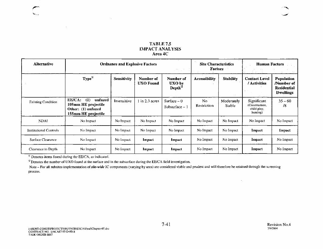
TABLE 7.5IMPACT ANALYSIS
Area 4C
Alternative
Existing Condition
NDAI
Institutional Controls
Surface Clearance
Clearance to Depth
Ordnance and Explosive Factors
Typevl
EE/CA: (1) unfuzed105mm HE projectileOther: (1) unfuzed155mm HE projectile
No Impact
No Impact
No Impact
No Impact
Sensitivity
Insensitive
No Impact
No Impact
No Impact
No Impact
Number ofUXO Found
1 in 2.3 acres
No Impact
No Impact
Impact
Impact
Number ofUXO byDepthu
Surface - 0
Subsurface - 1
No Impact
No Impact
Impact
Impact
Site CharacteristicsFactors
Accessibility
NoRestriction
No Impact
No Impact
No Impact
No Impact
Stability
ModeratelyStable
No Impact
No Impact
No Impact
No Impact
Human Factors
Contact Level/ Activities
Significant(Construction,
child play,hunting)
No Impact
Impact
Impact
Impact
Population/Number ofResidentialDwellings
35-60/8
No Impact
Impact
No Impact
No Impact
u Denotes items found during the EE/CA, as indicated.X2 Denotes the number of UXO found at the surface and in the subsurface during the EE/CA field investigation.Note - For all subsites implementation of site-wide IC components (varying by area) are considered viable and prudent and will therefore be retained through the screening
process.
7-41I:\HUNT-CONUS\PROJECTS\BUTNER\EECA\Final\Chapter-07.docCONTRACT NO. DACA87-95-D-OO18TASK ORDER 0067
Revision No.47/9/2004

/ * ' •
TABLE 7.6IMPACT ANALYSIS
Area 4D
Alternative
Existing Condition
NDAI
Institutional Controls
Surface Clearance
Clearance to Depth
Ordnance and Explosive Factors
Type"
EE/CA: (1) 37mm HEprojectile
No Impact
No Impact
No Impact
No Impact
Sensitivity
LessSensitive
No Impact
No Impact
No Impact
No Impact
Number ofUXO
Found
1 in 1.15acre
No Impact
No Impact
Impact
Impact
Number ofUXO byDepthu
Surface - 0
Subsurface - 1
No Impact
No Impact
Impact
Impact
Site Characteristics Factors
Accessibility
No Restriction
No Impact
No Impact
No Impact
No Impact
Stability
ModeratelyStable
No Impact
No Impact
No Impact
No Impact
Human Factors
ContactLevel /
Activities
Significant(Hunting,
hiking,child play)
No Impact
Impact
Impact
Impact
Population/Number ofResidentialDwellings
5-10/6
No Impact
Impact
No Impact
No Impact
u Denotes items found during the EE/CA, as indicated.u Denotes the number of UXO found at the surface and in the subsurface during the EE/CA field investigation.Note - For all subsites implementation of site-wide IC components (varying by area) are considered viable and prudent and will therefore be retained through the screeningprocess.
7-42I:\HUNT-CONUS\PROJECTS\BUTNER\EECA\Final\Chapter-07.docCONTRACT NO. DACA87-95-D-0O18TASK ORDER 0067
Revision No.47/9/2004

• " • >
TABLE 7.7IMPACT ANALYSIS
Area 4E
Alternative
Existing Condition
NDAI
Institutional Controls
Surface Clearance
Clearance to Depth
Ordnance and Explosive Factors
Type"
EE/CA: (1) 37mm HEprojectile
No Impact
No Impact
No Impact
No Impact
Sensitivity
LessSensitive
No Impact
No Impact
No Impact
No Impact
Number ofUXO Found
1 in 0.7 acre
No Impact
No Impact
Impact
No Impact
Number ofUXO byDepthu
Surface - 0
Subsurface - 1
No Impact
No Impact
Impact
No Impact
Site CharacteristicsFactors
Accessibility
NoRestriction
No Impact
No Impact
No Impact
No Impact
Stability
ModeratelyStable
No Impact
No Impact
No Impact
No Impact
Human Factors
ContactLevel /
Activities
Significant(Farming, child
play,construction)
No Impact
Impact
Impact
No Impact
Population/Number ofResidentialDwellings
20-40/I
No Impact
Impact
No Impact
No Impact
u Denotes items found during the EE/CA, as indicated.u Denotes the number of UXO found at the surface and in the subsurface during the EE/CA field investigation.Note - For all subsites implementation of site-wide IC components (varying by area) are considered viable and prudent and will therefore be retained through the screeningprocess.
7-43I:\HUNT-CONUS\PROJECTS\BUTNER\EECA\Final\Chapler-07.docCONTRACT NO. DACA87-95-D-O018TASK ORDER 0067
Revision No.47/9/2004

r~
TABLE 7.8IMPACT ANALYSIS
Area 4
Alternative
Existing Condition
NDAI
Institutional Controls
Surface Clearance
Clearance to Depth
Ordnance and Explosive Factors
EE/CA: (1) 105mm HEprojectile, (1) 57mm HEprojectile, (1) M52 seriesnose fuze, (1) 2.36-inchHE bazooka rocketwarhead, (1) unfuzed155mm shrapnelprojectile withexpelling charge.
No Impact
No Impact
No Impact
No Impact
Sensitivity
LessSensitive
No Impact
No Impact
No Impact
No Impact
Number ofUXO
Found
5 in 94.32acres
No Impact
No Impact
Impact
Impact
Number ofUXO byDepth^
Surface - 1
Subsurface - 4
No Impact
No Impact
Impact
Impact
Site Characteristics Factors
Accessibility
NoRestriction
No Impact
No Impact
No Impact
No Impact
Stability
ModeratelyStable
No Impact
No Impact
No Impact
No Impact
Human Factors
ContactLevel /
Activities
Moderate(Child play,construction,
hunting,fanning,forestry,
residential)
No Impact
Impact
Impact
Impact
Population/Number ofResidentialDwellings
500 - 750/>200
No Impact
Impact
No Impact
No Impact
u Denotes items found during the EE/CA, as indicated. V2 Denotes the number of UXO found at the surface and in the subsurface during the EE/CA field investigation.Note - For all subsites implementation of site-wide IC components (varying by area) are considered viable and prudent and will therefore be retained through the screeningprocess.
7-44I:\HUNT-CONUS\PROJECTS\BUTNER\EECA\Final\Chapler-07.docCONTRACT NO. DACA87-95-D-OO18TASK ORDER 0067
Revision No.47/9/2004

J
TABLE 7.9IMPACT ANALYSIS
Area 5
Alternative
Existing Condition
NDAI
Institutional Controls
Surface Clearance
Clearance to Depth
Ordnance and Explosive Factors
Typevl
EE/CA: Ordnance Scrap
No Impact
No Impact
No Impact
No Impact
Sensitivity
Inert
No Impact
No Impact
No Impact
No Impact
Number ofUXO
Found
0 i n 3 0acres
No Impact
No Impact
No Impact
No Impact
Number ofUXO byDepthu
NotApplicable
No Impact
No Impact
No Impact
No Impact
Site CharacteristicsFactors
Accessibility
NoRestriction
No Impact
No Impact
No Impact
No Impact
Stability
ModeratelyStable
No Impact
No Impact
No Impact
No Impact
Human Factors
ContactLevel /
Activities
Low(Child play,construction,
hunting,farming,forestry)
No Impact
Impact
No Impact
No Impact
Population
5000-8000
No Impact
Impact
No Impact
No Impact
u Denotes items found during the EE/CA, as indicated. "Other" denotes items found during the ASR SI although specifics were not provided.u Denotes the number of UXO found at the surface and in the subsurface during the EE/CA field investigation.Note - For all subsites implementation of site-wide IC components (varying by area) are considered viable and prudent and will therefore be retained through the screeningprocess.
7-45I:\HUNT-CONUS\PROJECTS\BUTNER\EECA\Final\Chapter-07docCONTRACT NO. DACA87-95-D-OO18TASK ORDER 0067
Revision No.47/9/2004
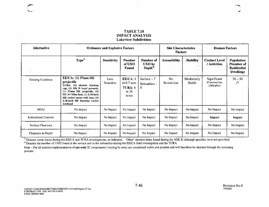
TABLE 7.10IMPACT ANALYSISLakeview Subdivision
Alternative
Existing Condition
NDAI
Institutional Controls
Surface Clearance
Clearance to Depth
Ordnance and Explosive Factors
Type"
EE/CA: (1) 37mm HEprojectileTCRA: (1) electric blastingcap, (1) Mk II hand grenade,(1) 37mm HE projectile, (1)Ml Al Mine fuze, (1) 2.36-inchHE rocket motor with fuze, (1)2.36-inch HE bazooka rocketwarhead
No Impact
No Impact
No Impact
No Impact
Sensitivity
LessSensitive
No Impact
No Impact
No Impact
No Impact
Numberof UXOFound
EE/CA: 1in 0.7 acre
TCRA: 6in 26acres
No Impact
No Impact
No Impact
No Impact
Number ofUXO byDeptlT
Surface - 7
Subsurface -0
No Impact
No Impact
No Impact
No Impact
Site CharacteristicsFactors
Accessibility
NoRestriction
No Impact
No Impact
No Impact
No Impact
Stability
ModeratelyStable
No Impact
No Impact
No Impact
No Impact
Human Factors
Contact Level/ Activities
Significant(Construction,
child play)
No Impact
Impact
No Impact
No Impact
Population/Number ofResidentialDwellings
30-5011
No Impact
Impact
No Impact
No Impact
u Denotes items found during the EE/CA and TCRA investigations, as indicated. "Other" denotes items found during the ASR SI although specifics were not provided.u Denotes the number of UXO found at the surface and in the subsurface during the EE/CA field investigation and the TCRA.Note - For all subsites implementation of site-wide IC components (varying by area) are considered viable and prudent and will therefore be retained through the screeningprocess.
7-46I:\HUNT-CONUS\PROJECTS\BUTNER\EECA\Final\Chapter-07ducCONTRACT NO. DACA87-95-D-0OI8TASK ORDER 0067
Revision No.47/9/2004

f
1.
CHAPTER 8COMPARATIVE ANALYSIS OF RESPONSE ACTION
ALTERNATIVES
8.1 INTRODUCTION
8.1.1 The four alternatives identified for the former Camp Butner Site were analyzedin Chapter 7 with three evaluation criteria: effectiveness, implementability, and cost. Theanalysis was performed to screen the alternatives based on their compliance with theminimum requirements of the evaluation criteria. All four alternatives were retained forcomparative analysis as outlined below:
Alternative 1 - No DoD Action Indicated at Area 5;
Alternative 2 - Site-specific Institutional Controls at Area 1A; Site-wide forall others;
Alternative 3 - Surface Clearance of UXO/OE at Area 4A and Area 4
Alternative 4 - Clearance to Depth of UXO/OE at Area 1 A, Area 4, Area 4A,Area 4B, Area 4C, Area 4D, and Lakeview Subdivision.
Each of the above four alternatives met the minimum requirements of the evaluationcriteria for at least one AOL As discussed in Chapter 7, the criteria for NDAI is met forArea 5; therefore no further analysis is warranted. It should be noted that a subsurfaceclearance (to a depth of six inches bgs) has already been implemented at one AOI,Lakeview Subdivision, as part of the TCRA. Therefore, an analysis of the surfaceclearance alternative was not conducted for this AOI. A comparative analysis of theretained UXO/OE response action alternatives was conducted for the ten remainingAOIs.
8.1.2 A comparative analysis is presented in this chapter to determine the relativeperformance of the retained alternatives for each of the evaluation criteria. The purposeof this comparison was to determine the advantages and disadvantages of each of thealternatives relative to one another. This comparison was used to support the selection ofthe most appropriate UXO/OE response actions for each AOI. Similar to the initialalternative screening conducted in Chapter 7, the comparative analysis was performed byranking each alternative relative to the other alternatives for effectiveness,implementability, and cost. However, each of the evaluation criteria were furtheranalyzed by subcomponents.
8-1 Revision No. 4
:\HUNT-CONUS\PROJECTSVBUTNER\EECA\Final\Chapter-08.doc 7/9/2004CONTRACT NO. DACA87-95-D-0018 =TASK ORDER 0067

8.1.3 For each of the subcomponents of an evaluation criterion, a ranking valuewas assigned for each of the retained alternatives, with " 1 " representing the best choice.In the case of two or more alternatives being equal for a criterion, an average rankingvalue was used for each alternative that is of equal value in the criterion. Ranking valueswere totaled for each alternative within the three evaluation criteria of effectiveness,implementability, and cost. However, not all subcomponents within each of the threeevaluation criteria were weighted equally. The rankings for each evaluation criterionwere combined and the alternative with the lowest overall score was selected as thepreferred alternative for the AOL
8.2 EFFECTIVENESS
8.2.1 Introduction
The retained alternatives for each AOI were ranked under the effectiveness category.The results of this ranking process are outlined in Tables 8.1 through 8.8. Based on thisanalysis, the site-wide IC only ranked highest in the effectiveness category for Area 4 andArea 4E (no other alternatives were retained during initial screening). Clearance toDepth ranked highest for the remaining areas (Area 1A, Area 4A, Area 4B, Area 4C,Area 4D, and Lakeview). The logic behind the rankings for the evaluation criteria isprovided in the following paragraphs.
8.2.2 Overall Protection of Public Safety and Human Environment
8.2.2.1 The OE RIA process as described in "Interim Guidance, OE Risk ImpactAssessment" (USACE, 2001b) was used to evaluate each alternative for overallprotection of public safety and the human environment. This process provided aqualitative indication of the change in the potential for harm and level of protectiveness atthe AOIs for each of the remaining alternatives. The impact of each of the remainingalternatives was evaluated by assigning an impact evaluation score of 'No Impact' or analphabetical rank of 'A', 'B', or ' C - with 'A' being the highest impact in reducing thepotential for harm and increasing the level of protectiveness at the sector and a rank ' Cnoting the lowest impact. This evaluation included three primary UXO/OE risk factorsthat were used in the risk assessment presented in Chapter 4 and the screening of thealternatives presented in Chapter 7. This evaluation is illustrated in Tables 8.9 through8.16.
8.2.2.2 The implementation of site-wide ICs, as described in Chapter 7, wouldmodify the behavior of the public and the activities they perform throughout the formerCamp Butner Site. In Area 1A, an additional site-specific IC component was evaluated.This component includes installation of a boundary fence enclosure around the entireArea 1A AOI. This alternative was ranked as 'B' in Table 8.9 for the projected futureactivities and land use. The fence will restrict access to Area 1A, thus serving to modifybehavior of pedestrian traffic. Finally, an overall rank of 'B' (moderate impact) wasassigned to this alternative because while the fence will deter access by the public, it willnot, by itself, eliminate the potential for harm from UXO/OE present in Area 1A.
8-2 Revision No. 4:\HUNT-CONUS\PROJECTS\BUTNER\EECA\Final\Chapter-08.doc 7/9/2004CONTRACT NO. DACA87-95-D-O018 =TASK ORDER 0067

Implementation of this alternative will not reduce the risk to the public from residualf | UXO/OE since it does not include any removal activity.
8.2.2.3 The Surface Clearance of OE alternative as described in Chapter 7 wouldremove UXO/OE items located on the surface in Area 4A, as described in Chapter 7. InArea 4A one UXO item (105mm HE projectile) and some ordnance related scrap wasrecovered on the ground surface. Therefore, surface clearance will provide some level ofincreased protection to the public in the AOI (over no removal action), based on currentand future anticipated land use as well as contact level (see Chapter 4). This alternativewas rated as having a moderate impact ('B') for most categories (Table 8.10).
8.2.2.4 The Clearance to Depth alternative for the remaining AOIs provides forenhanced overall protection of human health and the environment by removing residualUXO/OE suspected below the ground surface. Based on the confirmed presence of UXOcombined with the current farming practices (primary land use) in Area 4B and Area 4D,the Clearance to Depth alternative will reduce the risk to the explosive hazardencountered from farm workers and other receptors (hunters, hikers, low-densityresidential, etc). Few residential dwellings are present (ranging from a low of two inArea 4B to a high of six in Area 4D) and near-term future development is not anticipated.
8.2.2.5 In Area 1A, Area 4A, and Area 4C, the exposure pathway is significantbased on the confirmed presence of UXO, the definitive evidence of a pre-existing impactarea (with exception of Area 1A), and the current and projected residential developmentin these AOIs. Although Area 4D consists of mostly undeveloped land (6 residentialdwellings) the risk of exposure does potentially exist, and subsurface removal of residualUXO will increase the level of public protection.
8.2.2.6 The TCRA and DGM survey in the residential Lakeview SubdivisionAOI indicate subsurface metallic debris remains, thus subsurface clearance wouldprovide additional protection to the residential population. Therefore, the Clearance toDepth alternative would be more effective in reducing the explosive safety risk as it willmitigate UXO/OE items confirmed to be present in the subsurface.
8.2.2.7 Based on this evaluation, the Clearance to Depth alternative is the mostprotective of public safety for Area 1 A, Area 4A, Area 4B, Area 4C, Area 4D, and theLakeview Subdivision. In Tables 8.1 through 8.8 each alternative was ranked in order ofoverall effectiveness, ranking the Clearance to Depth alternative as Rank 1.
8.2.3 Compliance with ARARs
As described in Chapter 7, special consideration of ARARs that address activities withinwetlands or areas exhibiting the characteristics of a wetland may be necessary for thesurface clearance of UXO/OE alternative. For the purpose of this evaluation it isassumed that steps necessary to comply with these ARARs would be addressed if either
8-3 Revision No. 4
:\HUNT-CONUS\PROJECTS\BUTNER\EECA\Final\Chapter-08.doc 7/9/2004CONTRACT NO. DACA87-95-D-0018 iTASK ORDER 0067
of the clearance alternatives were implemented for any of the AOIs. Therefore, since all; i the alternatives would comply with ARARs, they have been ranked equally.
8.2.4 Long-Term Effectiveness
The Clearance to Depth of UXO/OE alternative provides the best long-term effectivenessfor all AOIs for which this alternative was retained after initial screening, with evaluationof each of the other alternatives resulting in a decreasing degree of long-termeffectiveness. This ranking order has been selected for the same reasoning as thatprovided under the overall protection of public safety and environment criterion.
8.2.5 Short-Term Effectiveness
In Area 1A, the site-specific IC component (fencing) provides an increased level ofprotection to the public with regards to access restriction than does no action. However,because the IC alternative does not mitigate the explosive hazard risk from Area 1A, theClearance to Depth alternative ranked higher with respect to effectiveness. The properimplementation of the IC alternative does directly impact public access to the AOI, thusproviding short-term effectiveness to public safety (Table 8.1).
U 8-4 Revision No. 4:\HUNT-CONUS\PROIECTS\BUTNER\EECA\Final\Chapter-08.doc 7/9/2004CONTRACT NO. DACA87-95-D-OO18 '-TASK ORDER 0067

- \
TABLE 8.1EFFECTIVENESS CRITERIA APPLICATION
FOR AREA 1A
ALTERNATIVE
Institutional Controls (site-specificIC)
Clearance to Depth of UXO/OE
EFFECTIVENESS
Protection of Public Safety& Human Environment
2
1
Compliancewith ARARs
1
1
Long-TermEffectiveness
2
1
Short-TermEffectiveness
1
2
SCORE
6
5
RANK
2
1
Note: Ranking from best to worst; best = 1, worst = 3
8-5
I:\HUNT-CONUS\PROJECTS\BUTNER\EECA\Final\Chapter-08.docCONTRACT NO. DACA87-OO-D-OO38TASK ORDER 0003
Revision No. 4
7/9/2004

• - * • > .
TABLE 8.2EFFECTIVENESS CRITERIA APPLICATION
FOR AREA 4A
ALTERNATIVE
Institutional Controls (site-wide)
Surface Clearance of UXO/OE
Clearance to Depth of UXO/OE
EFFECTIVENESS
Protection of Public Safety& Human Environment
3
2
1
Compliancewith ARARs
1
1
1
Long-TermEffectiveness
3
2
1
Short-TermEffectiveness
1
2
3
SCORE
8
7
6
RANK
3
2
1
Note: Ranking from best to worst; best = 1, worst = 3
I:\HUNT-CONUS\PROJECTS\BUTNER\EECA\Final\Chapter-08.docCONTRACT NO. DACA87-OO-D-OO38TASK ORDER 0003
8-6Revision No. 4
7/9/2004

/ • "
TABLE 8.3EFFECTIVENESS CRITERIA APPLICATION
FOR AREA 4B
ALTERNATIVE
Institutional Controls (site-wide)
Clearance to Depth of UXO/OE
EFFECTIVENESS
Protection of Public Safety& Human Environment
2
1
Compliancewith ARARs
1
1
Long-TermEffectiveness
2
1
Short-TerniEffectiveness
1
2
SCORE
6
5
RANK
2
1
Note: Ranking from best to worst; best = 1, worst = 3
I:\HUNT-CONUS\PROJECTS\BUTNER\EECA\Final\Chapter-08.docCONTRACT NO. DACA87-0O-D-O038TASK ORDER 0003
8-7Revision No. 4
7/9/2004
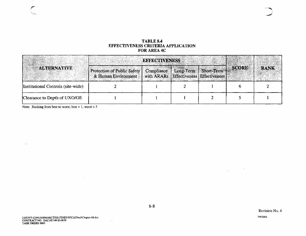
/ • * • "
TABLE 8.4EFFECTIVENESS CRITERIA APPLICATION
FOR AREA 4C
ALTERNATIVE
Institutional Controls (site-wide)
Clearance to Depth of UXO/OE
EFFECTIVENESS
Protection of Public Safety& Human Environment
2
1
Compliancewith ARARs
1
1
Long-TermEffectiveness
2
1
Short-TermEffectiveness
1
2
SCORE
6
5
RANK
i
2
1
Note: Ranking from best to worst; best = 1, worst = 3
8-8
I\HUNT-CONUS\PROJECTS\BUTNER\EECA\Final\Chapter-08.docCONTRACT NO. DACA87-0O-D-0O38TASK ORDER 0003
Revision No. 4
7/9/2004

c •*">,
TABLE 8.5EFFECTIVENESS CRITERIA APPLICATION
FOR AREA 4D
ALTERNATIVE
Institutional Controls (site-wide)
Clearance to Depth of UXO/OE
EFFECTIVENESS
Protection of Public Safety& Human Environment
2
1
CompliancewithARARs
1
1
LpngrTermEffectiveness
2
1
Short-TermEffectiveness
1
2
SCORE
6
5
RANK
2
1
Note: Ranking from best to worst; best = 1, worst = 3
I:\HUNT-CONUS\PROJECTS\BUTNER\EECA\Final\Chapter-08.docCONTRACT NO. DACA87-0O-D-0O38TASK ORDER 0003
8-9Revision No. 4
7/9/2004
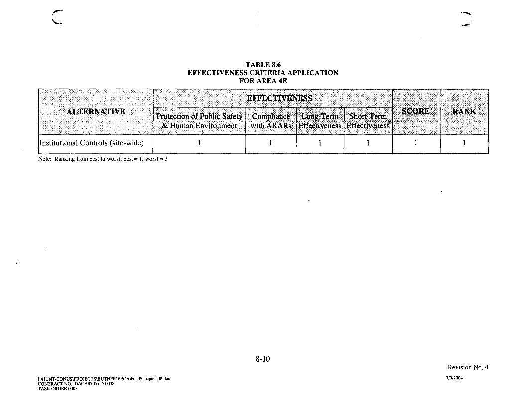
TABLE 8.6EFFECTIVENESS CRITERIA APPLICATION
FOR AREA 4E
ALTERNATIVE
Institutional Controls (site-wide)
EFFECTIVENESS
Protection of Public Safety& Human Environment
1
Compliancewith ARARs
1
Long-TermEffectiveness
1
Short-TermEffectiveness
1
SCORE
1
RANK
1
Note: Ranking from best to worst; best = 1, worst = 3
8-10
I:\HUNT-CONUS\PROIECTS\BUTNER\EECA\Final\Chapter-08.docCONTRACT NO. DACA87-0O-D-0O38TASK ORDER 0003
Revision No. 4
7/9/2004

• ' * %
TABLE 8.7EFFECTIVENESS CRITERIA APPLICATION
FOR AREA 4
ALTERNATIVE
Institutional Controls (site-wide)
Surface Clearance of UXO/OE
Clearance to Depth of UXO/OE
EFFECTIVENESS
Protection of Public Safety& Human Environment
3
2
1
Compliancewith ARARs
1
1
1
Long-TermEffectiveness
3
2
1
Short-TermEffectiveness
1
2
3
SCORE
8
7
6
RANK
3
2
1
Note: Ranking from best to worst; best = 1, worst = 3
I:\HUNT-CONUS\PROJECTS\BUTNER\EECA\Final\Chapter-08.docCONTRACT NO. DACA87-OO-D-0O38TASK ORDER 0003
8-11Revision No. 4
7/9/2004

TABLE 8.8EFFECTIVENESS CRITERIA APPLICATION
FOR LAKEVIEW SUBDIVISION
ALTERNATIVE
Institutional Controls (site-wide)
Clearance to Depth of UXO/OE
EFFECTIVENESS
Protection of Public Safety& Human Environment
2
1
Compliancewith ARARs
1
1
Long-TermEffectiveness
2
1
Short-TermEffectiveness
1
2
SCORE
6
5
RANK
2
1
Note: Ranking from best to worst; best = 1, worst = 3
8-12
I:\HUNT-CONUS\PROJECTS\BUTNER\EECA\Final\Chapter-08.docCONTRACT NO. DACA87-00-D-0038TASK ORDER 0003
Revision No. 4
7/9/2004

r
TABLE 8.9UXO/OE RISK IMPACT ANALYSIS
FOR AREA 1A
Alternative
Existing Condition
Institutional Controls(site-specific)
Clearance to Depth
Ordnance and Explosive Factors
Type"
Area 1A:EE/CA: (1) Ml anti-tankpractice mine w/fuze, (1)Mk II hand grenade
No Impact
No Impact
Sensitivity
LessSensitive
No Impact
No Impact
Number ofUXO
Found
2in 1.15acres
No Impact
A
Number ofUXO byDepthT
Surface - 0
Subsurface -2
No Impact
A
Site CharacteristicsFactors
Accessibility
NoRestriction
A
No Impact
Stability
ModeratelyStable
No Impact
No Impact
Human Factors
ContactLevel /
Activities
Significant(Trespassingand hiking)
B
A
Population/Number ofResidentialDwellings
0-5/0
A
No Impact
Overall
Rank"
B
A
u Denotes items found during the EE/CA, as indicated.V2 Denotes the number of UXO found at the surface and in the subsurface during the EE/CA field investigation.u Overall Rank 'A' being the alternative with most significant impact in reducing the safety risk within the sector and Rank 'B' indicating the least impact.
8-13
I:VHUNT-CONUS\PROJECTSYBUTNER\EECA\Final\Chapter-08.docCONTRACT NO. DACA87-0O-D-O038TASK ORDER 0003
Revision No. 4
7/9/2004

TABLE 8.10UXO/OE RISK IMPACT ANALYSIS
FOR AREA 4A
Alternative
Existing Condition
Institutional Controls(site-wide)
Surface Clearance
Clearance to Depth
Ordnance and Explosive Factors
Type"
EE/CA: (1) 2.36-inchHE bazooka rocket
No Impact
No Impact
No Impact
Sensitivity
LessSensitive
No Impact
No Impact
No Impact
Numberof UXOFound
1 in 1.15acres
No Impact
B
A
Number ofUXO byDepth*
Surface - 0
Subsurface -1
No Impact
B
A
Site Characteristics Factors
Accessibility
NoRestriction
No Impact
No Impact
No Impact
Stability
ModeratelyStable
No Impact
No Impact
No Impact
Human Factors
Contact Level/ Activities
Significant(Construction,
child play)
A
B
B
Population/Number ofResidentialDwellings
5-10/2
B
No Impact
No Impact
OverallRank0
C
B
A
u Denotes items found during the EE/CA, as indicated.u Denotes the number of UXO found at the and in the subsurface during the EE/CA field investigation.u Overall Rank 'A' being the alternative with most significant impact in reducing the safety risk within the sector and Rank ' C indicating the least impact.
8-14
I:\HUNT-CONUS\PROJECTSVBUTNER\EECA\Final\Chapter-08.docCONTRACT NO. DACA87-OO-D-OO38TASK ORDER 0003
Revision No. 4
7/9/2004

C
TABLE 8.11UXO/OE RISK IMPACT ANALYSIS
FOR AREA 4B
Alternative
Existing Condition
Institutional Controls(site-wide)
Clearance to Depth
Ordnance and Explosive Factors
Type"
EE/CA: (1) 2.36-inch HEbazooka rocketOther: (1) 2.36-inchbazooka rocket
No Impact
No Impact
Sensitivity
LessSensitive
No Impact
No Impact
Number ofUXO
Found
1 in 0.7 acre
No Impact
A
Number ofUXO byDepth*
Surface - 0Subsurface - 1
No Impact
A
Site Characteristics Factors
Accessibility
No Restriction
No Impact
No Impact
Stability
ModeratelyStable
No Impact
No Impact
Human Factors
ContactLevel /
Activities
Significant(Farming,child play)
A
B
Population/Number ofResidentialDwellings
2-512
B
No Impact
OverallRank*
B
A
u Denotes items found during the EE/CA, as indicated.u Denotes the number of UXO found at the surface and in the subsurface during the EE/CA field investigation.^ Overall Rank 'A' being the alternative with most significant impact in reducing the safety risk within the sector and Rank 'B' indicating the least impact.
8-15
I\HUNT-CONUS\PROJECTS\BUTNER\EECA\Final\Chapter-08.docCONTRACT NO. DACA87-OO-D-OO38TASK ORDER 0003
Revision No. 4
7/9/2004

"'•*%_
TABLE 8.12UXO/OE RISK IMPACT ANALYSIS
FOR AREA 4C
Alternative
Existing Condition
Institutional Controls(site-wide)
Clearance to Depth
Ordnance and Explosive Factors
Typeu
EE/CA: (l)unfuzed105mm HE projectileOther: (2) unfuzed155mm HE projectiles
No Impact
No Impact
Sensitivity
Insensitive
No Impact
No Impact
Number ofUXO
Found
1 in 2.3acres
No Impact
A
Number ofUXO byDepthu
Surface - 0
Subsurface - 1
No Impact
A
Site CharacteristicsFactors
Accessibility
NoRestriction
No Impact
No Impact
Stability
ModeratelyStable
No Impact
No Impact
Human Factors
Contact Level /Activities
Significant(Construction, child
play, hunting)
A
B
Population/Number ofResidentialDwellings
35-60/8
No Impact
No Impact
OverallRank^3
B
A
u Denotes items found during the EE/CA, as indicated. "Other" denotes items found by others during the EE/CA investigations.u Denotes the number of UXO found at the surface and in the subsurface during the EE/CA field investigation.u Overall Rank 'A' being the alternative with most significant impact in reducing the safety risk within the sector and Rank 'B' indicating the least impact.
8-16
l:\HUNT-CONUS\PROJECTS\BUTNER\EECA\Final\Chapter-08.docCONTRACT NO. DACA87-OO-D-OO38TASK ORDER 0003
Revision No. 4
7/9/2004

V-
TABLE 8.13UXO/OE RISK IMPACT ANALYSIS
FOR AREA 4D
Alternative
Existing Condition
Institutional Controls(site-wide)
Clearance to Depth
Ordnance and Explosive Factors
Type*
EE/CA: (1) 37mmHE projectile
No Impact
No Impact
Sensitivity
LessSensitive
No Impact
No Impact
Number ofUXO Found
1 in 1.15acres
No Impact
A
Number ofUXO byDepth^2
Surface - 0
Subsurface -1
No Impact
A
Site Characteristics Factors
Accessibility
NoRestriction
No Impact
No Impact
Stability
ModeratelyStable
No Impact
No Impact
Human Factors
ContactLevel/
Activities
Significant(Hunting,
hiking, childplay)
A
B
Population/Number ofResidentialDwellings
5-10/6
B
No Impact
OverallRank*
B
A
u Denotes items found during the EE/CA, as indicated.u Denotes the number of UXO found at the surface and in the subsurface during the EE/CA field investigation.u Overall Rank 'A' being the alternative with most significant impact in reducing the safety risk within the sector and Rank 'B' indicating the least impact.
8-17
I\HUNT-CONUS\PROJECTS\BUTNER\EECA\Final\Chapter-08.docCONTRACT NO. DACA87-0O-D-OO38TASK ORDER 0003
Revision No. 4
7/9/2004

TABLE 8.14UXO/OE RISK IMPACT ANALYSIS
FOR AREA 4E
Alternative
Existing Condition
Institutional Controls(site-wide)
Ordnance and Explosive Factors
Type*
EE/CA: (1) 37mmHE projectile
No Impact
Sensitivity
LessSensitive
No Impact
Number ofUXO
Found
1 in 0.7acres
No Impact
Number ofUXO byDepthu
Surface - 0
Subsurface - 1
No Impact
Site CharacteristicsFactors
Accessibility
NoRestriction
No Impact
Stability
Moderately Stable
No Impact
Human Factors
Contact Level /Activities
Significant(Farming
construction)
A
Population/Number ofResidentialDwellings
20-40/I
B
OverallRank0
A
u Denotes items found during the EE/CA, as indicated.u Denotes the number of UXO found at the surface and in the subsurface during the EE/CA field investigation.u Overall Rank 'A' being the alternative with most significant impact in reducing the safety risk.
8-18
I\HUNT-CONUS\PROJECTS\BUTNER\EECA\Final\Chapter-08.docCONTRACT NO. DACA87-OO-D-OO38TASK ORDER 0003
Revision No. 4
7/9/2004
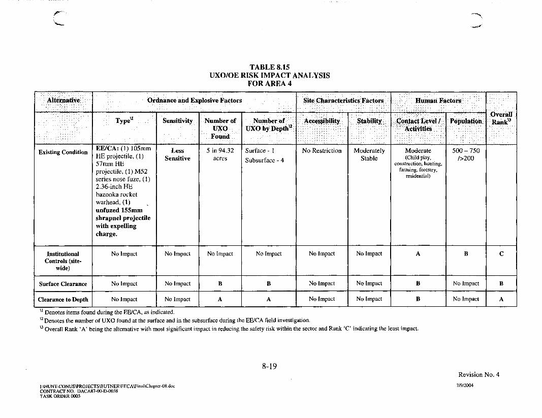
TABLE 8.15UXO/OE RISK IMPACT ANALYSIS
FOR AREA 4
Alternative
Existing Condition
InstitutionalControls (site-
wide)
Surface Clearance
Clearance to Depth
Ordnance and Explosive Factors
Typeu
EE/CA: (1) 105mmHE projectile, (1)57mm HEprojectile, (1) M52series nose fuze, (1)2.36-inch HEbazooka rocketwarhead, (1)unfuzed 155mmshrapnel projectilewith expellingcharge.
No Impact
No Impact
No Impact
Sensitivity
LessSensitive
No Impact
No Impact
No Impact
Number ofUXO
Found
5 in 94.32acres
No Impact
B
A
Number ofUXO by Depth*
Surface - 1
Subsurface - 4
No Impact
B
A
Site Characteristics Factors
Accessibility
No Restriction
No Impact
No Impact
No Impact
Stability
ModeratelyStable
No Impact
No Impact
No Impact
Human Factors
Contact Level /Activities
Moderate(Child play,
construction, hunting,farming, forestry,
residential)
A
B
B
Population
500 - 750/>200
B
No Impact
No Impact
OverallRank0
C
B
A
u Denotes items found during the EE/CA, as indicated.u Denotes the number of UXO found at the surface and in the subsurface during the EE/CA field investigation.u Overall Rank 'A' being the alternative with most significant impact in reducing the safety risk within the sector and Rank ' C indicating the least impact.
8-19
I:\HUNT-CONUS\PROJECTS\BUTNER\EECA\Final\Chapter-08.docCONTRACT NO. DACA87-OO-D-OO38TASK ORDER 0003
Revision No. 4
7/9/2004

TABLE 8.16UXO/OE RISK IMPACT ANALYSIS
FOR LAKEVIEW SUBDIVISION
Alternative
Existing Condition
InstitutionalControls (site-wide)
Clearance to Depth
Ordnance and Explosive Factors
Type"
EE/CA: (1) 37mm HEprojectileTCRA: (1) electricblasting cap, (1) Mkllhand grenade, (1) 37mmHE projectile, (1)M1 AlMine fuze, (1) 2.36-inchHE rocket motor withfuze, (1) 2.36-inch HEbazooka rocket warhead
No Impact
No Impact
Sensitivity
LessSensitive
No Impact
No Impact
Number ofUXO Found
EE/CA: 1 in0.7 acre
TCRA: 6 in26 acres
No Impact
A
Number ofUXO byDepth*
Surface - 0
Subsurface -7
No Impact
A
Site Characteristics Factors
Accessibility
NoRestriction
No Impact
No Impact
Stability
ModeratelyStable
No Impact
No Impact
Human Factors
Contact Level /Activities
Significant(Construction,
child play)
A
B
Population/Number ofResidentialDwellings
30-50
n
B
No Impact
OverallRank0
B
A
u Denotes items found during the EE/CA and TCRA investigations, as indicated.u Denotes the number of UXO found at the surface and in the subsurface during the EE/CA field investigation and the TCRA.u Overall Rank 'A' being the alternative with most significant impact in reducing the safety risk within the sector and Rank 'B' indicating the least impact.
8-20
I\HUNT-CONUS\PROJECTS\BUTNER\EECA\Final\Chapter-08.docCONTRACT NO. DACA87-0O-D-0038TASK ORDER 0003
Revision No. 4
7/9/2004

8.3 IMPLEMENTABILITY
8.3.1 Introduction
The alternatives for each of the AOIs were ranked within each of the six criteriawithin the implementability category based on a subjective analysis of the merits of eachalternative. The results of this analysis are presented in Tables 8.17 through 8.24. Basedon this comparative analysis, the site-wide IC alternative was ranked highest for Area 4D,Area 4E and Area 4. The Surface Clearance alternative did not rank the highest for anyAOI. The Clearance to Depth alternative ranked highest in implementability for Area 1 A,Area 4A, Area 4B, Area 4C, and Lakeview Subdivision. The logic behind the rankingsfor the evaluation criteria is provided in the following paragraphs.
8.3.2 Technical Feasibility
In this criterion, the alternatives for all ten AOIs were ranked with the site-wide ICalternative being the easiest to implement from a technical standpoint. In comparison, theSurface Clearance alternative increases in technical difficulty to implement while theClearance to Depth of UXO/OE alternative is the most difficult to implement.
8.3.3 Administrative Feasibility
The site-wide IC alternative requires coordination between the local agenciesassociated with the former Camp Butner Site. This alternative also requires a long-termcommitment from local agencies, including annual reinforcement and repair.Administratively, the clearance alternatives will likely be somewhat more difficult toimplement than the IC alternative.
8.3.4 Availability of Services and Materials
The site-wide and site-specific IC alternatives, described in Chapter 5 require amoderate amount of readily available services and materials for implementation. Thelevel of difficulty increases with the Surface Clearance alternative due to securingsufficient qualified labor resources. Difficulty increases further with the Clearance toDepth alternative given the services and materials associated with the involvement ofmore extensive excavation (greater land survey, more extensive brush clearance,mechanized excavation, etc.).
8.3.5 Property Owner Acceptance
Each alternative was rated based on the degree of acceptance anticipated by theproperty owner. This criteria is weighted in importance by a factor of two. Given theproject team correspondence, public meetings responses, and direct interaction of Parsonspersonnel with local property owners, the level of acceptance to a particular UXO/OEresponse alternative can be gauged on a case by case basis. For example, in Area 4D theIC alternative was ranked highest due to the likely perception anticipated by land ownersthat any surface or subsurface removal action will displace them from their property andrender the land unusable (for hunting) during the clearance interim. The Clearance to
8-21i Revision No.4
:\HUNT-CONUS\PROJECTS\BUTNER\EECA\Final\Chapter-08.doc 7/9/2004CONTRACT NO. DACA87-95-D-0O18TASK ORDER 0067

n Depth was ranked highest in Area 1A, Area 4A, Area 4B, Area 4C, and the LakeviewSubdivision where the property owners are perceived as amenable to UXO/OE clearanceof their land as a means of reducing the explosive risk hazard. Because of the numerousproperty owners and various land uses within the greater Area 4, the IC alternativeranked highest based on the likelihood of majority acceptance in this area.
U 8-22f Revision No.4
:\HUNT-CONUS\PROJECTS\BUTNER\EECA\Final\Chapter-08.doc 7/9/2004CONTRACT NO. DACA87-95-D-0018TASK ORDER 0067
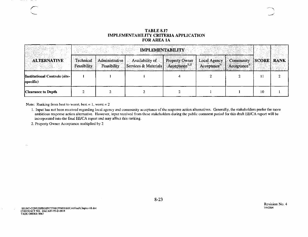
TABLE 8.17IMPLEMENTABILITY CRITERIA APPLICATION
FOR AREA 1A
ALTERNATIVE
Institutional Controls (site-specific)
Clearance to Depth
IMPLEMENTABILITY
Technical
Feasibility
1
2
AdministrativeFeasibility
1
2
Availability of
Services & Materials
1
2
Property Owner
Acceptance"'2
4
2
Local Agency
Acceptance"
2
1
Community
Acceptance"
2
1
SCORE
11
10
RANK
2
1
Note: Ranking from best to worst; best = 1, worst = 21. Input has not been received regarding local agency and community acceptance of the response action alternatives. Generally, the stakeholders prefer the more
ambitious response action alternative. However, input received from these stakeholders during the public comment period for this draft EE/CA report will beincorporated into the final EE/CA report and may affect this ranking.
2. Property Owner Acceptance multiplied by 2
8-23
:\HUNT-CONUS\PROJECTS\BUTNER\EECA\Final\Chapter-08.docCONTRACT NO. DACA87-95-D-0O18TASK ORDER 0067
Revision No. 47/9/2004
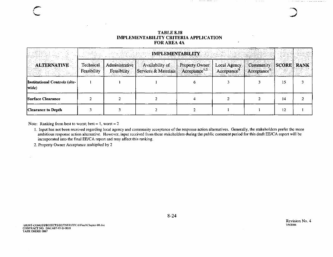
cTABLE 8.18
IMPLEMENTABILITY CRITERIA APPLICATIONFOR AREA 4A
ALTERNATIVE
Institutional Controls (site-wide)
Surface Clearance
Clearance to Depth
IMPLEMENTABILITY
TechnicalFeasibility
1
2
3
Administrative
Feasibility
1
2
3
Availability of
Services & Materials
1
2
2
Property OwnerAcceptanceu'2
6
4
2
Local Agency
Acceptance^1
3
2
1
Community
Acceptance^
3
2
1
SCORE
15
14
12
RANK
3
2
1
Note: Ranking from best to worst; best = 1, worst = 21. Input has not been received regarding local agency and community acceptance of the response action alternatives. Generally, the stakeholders prefer the more
ambitious response action alternative. However, input received from these stakeholders during the public comment period for this draft EE/CA report will beincorporated into the final EE/CA report and may affect this ranking.
2. Property Owner Acceptance multiplied by 2
8-24
:\HUNT-CONUS\PROJECTS\BUTNER\EECA\Final\Chapter-08.docCONTRACT NO. DACA87-95-D-0018TASK ORDER 0067
Revision No. 47/9/2004

TABLE 8.19IMPLEMENTABILITY CRITERIA APPLICATION
FOR AREA 4B
ALTERNATIVE
Institutional Controls (site-wide)
Clearance to Depth
IMPLEMENTABILITY
TechnicalFeasibility
1
2
AdministrativeFeasibility
1
2
Availability of
Services & Materials
1
2
Property OwnerAcceptance^1"2
4
2
Local AgencyAcceptance^
2
1
Community
Acceptance^1
2
1
SCORE
11
10
RANK
2
1
Note: Ranking from best to worst; best = 1, worst = 21. Input has not been received regarding local agency and community acceptance of the response action alternatives. Generally, the stakeholders prefer the more
ambitious response action alternative. However, input received from these stakeholders during the public comment period for this draft EE/CA report will beincorporated into the final EE/CA report and may affect this ranking.
2. Property Owner Acceptance multiplied by 2.
8-25
:\HUNT-CONUS\PROJECTS\BUTNER\EECA\Final\Chapter-08.docCONTRACT NO. DACA87-95-D-OO18TASK ORDER 0067
Revision No. 47/9/2004

TABLE 8.20IMPLEMENTABILITY CRITERIA APPLICATION
FOR AREA 4C
ALTERNATIVE
Institutional Controls (site-wide)
Clearance to Depth
IMPLEMENTABILITY
TechnicalFeasibility
1
2
Administrative
Feasibility
1
2
Availability of
Services & Materials
1
2
Property OwnerAcceptance"'2
4
2
Local AgencyAcceptanceu
2
1
CommunityAcceptance^1
2
1
SCORE
11
10
RANK
2
1
Note: Ranking from best to worst; best = 1, worst = 21. Input has not been received regarding local agency and community acceptance of the response action alternatives. Generally, the stakeholders prefer the more
ambitious response action alternative. However, input received from these stakeholders during the public comment period for this draft EE/CA report will beincorporated into the final EE/CA report and may affect this ranking.
2. Property Owner Acceptance multiplied by 2.
8-26
:\HUNT-CONUS\PROJECTS\BUTNER\EECA\Final\Chapter-08.docCONTRACT NO. DACA87-95-D-0018TASK ORDER 0067
Revision No. 47/9/2004

TABLE 8.21IMPLEMENTABILITY CRITERIA APPLICATION
FOR AREA 4D
ALTERNATIVE
Institutional Controls (site-wide)
Clearance to Depth
IMPLEMENTABILITY
Technical
Feasibility
1
2
Administrative
Feasibility
1
2
Availability ofServices & Materials
1
2
Property OwnerAc,ceptanceu"2
2
4
Local Agency
Acceptance^1
2
1
Community
Acceptanceu
2
1
SCORE
9
12
RANK
1
2
Note: Ranking from best to worst; best = 1, worst = 21. Input has not been received regarding local agency and community acceptance of the response action alternatives. Generally, the stakeholders prefer the more
ambitious response action alternative. However, input received from these stakeholders during the public comment period for this draft EE/CA report will beincorporated into the final EE/CA report and may affect this ranking.
2. Property Owner Acceptance multiplied by 2.
8-27
:\HUNT-CONUS\PROJECTS\BUTNER\EECA\FinaI\Chapter-08.docCONTRACT NO. DACA87-95-D-OO18TASK ORDER 0067
Revision No. 47/9/2004

/ " " • •
TABLE 8.22IMPLEMENTABILITY CRITERIA APPLICATION
FOR AREA 4E
ALTERNATIVE
Institutional Controls (site-wide)
IMPLEMENTABILITY
Technical
Feasibility
1
Administrative
Feasibility
1
Availability of
Services & Materials
1
Property Owner
Acceptanceu'2
2
Local Agency
Acceptance*1
1
Community
Acceptance^
1
SCORE
7
RANK
1
Note: Ranking from best to worst; best = 1, worst = 21. Input has not been received regarding local agency and community acceptance of the response action alternatives. Generally, the stakeholders prefer the more
ambitious response action alternative. However, input received from these stakeholders during the public comment period for this draft EE/CA report will beincorporated into the final EE/CA report and may affect this ranking.
2. Property Owner Acceptance multiplied by 2.
8-28
:\HUNT-CONUS\PROJECTS\BUTNER\EECA\Final\Chapter-08.docCONTRACT NO. DACA87-95-D-0018TASK ORDER 0067
Revision No. 47/9/2004

• * >
TABLE 8.23IMPLEMENTABILITY CRITERIA APPLICATION
FOR AREA 4
ALTERNATIVE
Institutional Controls (site-wide)
Surface Clearance
Clearance to Depth
IMPLEMENTABILITY
Technical
Feasibility
1
2
3
Administrative
Feasibility
1
2
3
Availability of
Services & Materials
1
2
2
Property Owner
Acceptance^1'2
2
4
6
Local Agency
Acceptancexi
3
2
1
Community
Acceptancey
1
1
1
SCORE
9
13
16
RANK
1
2
3
Note: Ranking from best to worst; best = 1, worst = 31. Input has not been received regarding local agency and community acceptance of the response action alternatives. Generally, the stakeholders prefer the more
ambitious response action alternative. However, input received from these stakeholders during the public comment period for this draft EE/CA report will beincorporated into the final EE/CA report and may affect this ranking. The size and demographic diversity of Area 4 combined with varying land use suggest thatconcurrence on a specific action may be difficult to obtain.
2. Property Owner Acceptance multiplied by 2.
8-29
:\HUNT-CONUS\PROJECTS\BUTNER\EECA\final\Chapter-08.docCONTRACT NO. DACA87-95-D-OO18TASK ORDER 0067
Revision No. 47/9/2004

cTABLE 8.24
IMPLEMENTABILITY CRITERIA APPLICATIONFOR LAKEVIEW SUBDIVISION
ALTERNATIVE
Institutional Controls (site-wide)
Clearance to Depth
IMPLEMENTABILITY
TechnicalFeasibility
1
2
AdministrativeFeasibility
1
2
Availability of
Services & Materials
1
2
Property OwnerAcceptance^1'2
4
2
Local AgencyAcceptance^1
2
1
CommunityAcceptance*11
2
1
SCORE
11
10
RANK
2
1
Note: Ranking from best to worst; best = 1, worst = 21. Input has not been received regarding local agency and community acceptance of the response action alternatives. Generally, the stakeholders prefer the more
ambitious response action alternative. However, input received from these stakeholders during the public comment period for this draft EE/CA report will beincorporated into the final EE/CA report and may affect this ranking.
2. Property Owner Acceptance multiplied by 2.
8-30
\HUNT-CONUS\PROJECTS\BUTNER\EECA\Final\Chapter-08.docCONTRACT NO. DACA87-95-D-0018TASK ORDER 0067
Revision No. 47/9/2004

8.3.6 Local Agency Acceptance
Each alternative is rated based on the degree of acceptance expressed by localagencies. The local agency acceptance of the remaining alternatives is not fully known atthis time; however, local agencies generally prefer the most ambitious clearancealternative. For the AOIs within the former Camp Butner Site, Clearance to Depth wasranked as the preferred alternative from the local agencies' perspective (for AOIs inwhich subsurface clearance was retained) and the IC alternative alone was ranked as theleast preferred. Input received from local agencies as part of the public comment periodfor this EE/CA report was incorporated into this final report.
8.3.7 Community Acceptance
Each alternative is rated based on the degree of acceptance expressed by the localcommunity. Through public meetings and IA interviews, the community places publicsafety as the primary goal. A heightened public awareness and concern has beengenerated in the course of the EE/CA and TCRA investigation at the former Camp ButnerSite. It is anticipated that the community will generally support the most ambitiousalternative based on input gathered to date. Input received from the community as part ofthe public comment period for this EE/CA report was incorporated into this final report.
8.4 COST
The IA performed for the former Camp Butner Site (Appendix F) indicated the initialcapital cost to implement the recommended site-wide and site-specific ICs (as describedin Appendix F, Section 4.5) is approximately $80,750 with an estimated $10,500 annualcost. The estimated cost Tables 8.25 through 8.33 present the estimated cost for theSurface Clearance and / or Clearance to Depth alternatives for the eight AOIs withconfirmed or suspect UXO/OE. The recommended NDAI alternative for Area 5 has noinitial cost. Recurring review costs are discussed in Chapter 10.
8.5 OVERALL RANKING
8.5.1 The overall ranking of the alternatives for the ten AOIs with confirmed orsuspect UXO/OE are presented in Tables 8.34 through 8.41. Using the samemethodology used in the previous categories, the preferred alternative is the one with thelowest overall score. Based on this analysis, site-wide Institutional Controls alternativeranked highest for Area 4D, Area 4E, and Area 4. The Clearance to Depth alternative isthe preferred alternative for Area IA, Area 4A, Area 4B, Area 4C, and the LakeviewSubdivision.
8.5.2 Further input from stakeholders will be solicited during subsequent PublicMeetings and incorporated, where appropriate, into the recommended alternative foreach of the AOIs.
8 - 3 1
Revision No. 4:\HUNT-CONUS\PROJECTS\BUTNER\EECA\Final\Chapter-08.doc 7/9/2004CONTRACT NO. DACA87-95-D-0018TASK ORDER 0067

n Table 8.25
Area 1A1
Clearance to Depth of UXO/OE Cost EstimateCamp Butner EE/CA
Item
Clearance to Depth OE Removal2
A-E Field Oversight3
A-E Project Management4
Land Survey5
Brush Cut6
Institutional Controls7
Evacuation Costs8
Costs Contracting & Oversight9
Cost per Acre
$10,320
$1,238
$825
Lump-Sum
$3000
N/A
N/A
N/A
Acreage
20
20
20
20
20
N/A
N/A
N/A
Subtotal
10% Contingency
Total Cost Estimate*
Total Costs
$276,000
$33,120
$22,080
$10,000
$60,000
$0
$17,000
$51,180
$410,000
$39,000
$449,000
* Note: The total cost estimate is rounded to the nearest $1000 for the EE/CA. Detailed cost estimates are presented inAppendix G. There are no existing residential dwellings within Area 1A although development is present to the immediatesouth.1 The costing is based on the assumption that the Subsurface Clearance to 1 foot will be implemented independently of anyother OE removal action. The costs may be less if the clearance is contracted and implemented concurrently with other sites.2 Cost for OE Removal is based on the USAESCH Cost Estimating Guide and professional judgment for site-specificconditions. Cost is based on "Mag and Flag" removal technique. The number of anomalies requiring investigation isestimated to be between 100 - 300 per acre based on the EE/CA data. A multiplier of 1.2 was used to account for vegetationand terrain. Two UXO items recovered during the EE/CA at depths of 1 inch and 10 inches. All other anomalies wereencountered within 1 foot of ground surface, with most less than 6 inches in depth.3 A-E Reid Oversight estimated at 12% of total ordnance removal costs. Includes documentation and reporting.4 A-E Project Management estimated at 8% of ordnance removal costs.5 Land survey costs are lump sum estimates derived from actual costs incurred on similar efforts and include marking siteboundaries and establishing a 100'xlOO' contiguous grid network within the site.6 Brush cutting costs based on the moderate vegetation density at the site and is obtained from USAESCH CostEstimating Guide combined with professional judgment and costs incurred for this task at similar sites.7 Site Specific Institutional Controls measures are not planned for this site.8 Evacuation Costs estimated based on estimated project duration and residential population - see Appendix G.9 Costs for Contracting and Oversight are estimated at 15% of the subtotal cost.
u 8-32
:\HUNT-CONUS\PROJECTS\BUTNER\EECA\Final\Chapter-08.docCONTRACT NO. DACA87-95-D-0018TASK ORDER 0067
Revision No. 4
7/9/2004

nTable 8.26
Area 4A1
Surface Clearance of UXO/OE Cost EstimateCamp Butner EE/CA
Item
Surface OE Removal2
A-E Field Oversight3
A-E Project Management4
Land Survey5
Brush Cut6
Institutional Controls7
Evacuation Costs8
Costs Contracting & Oversight9
Cost per Acre
$2,640
$317
$211
Lump-Sum
$1,700
N/A
N/A
N/A
Acreage
34
34
34
34
34
N/A
N/A
N/A
Subtotal
10% Contingency
Total Cost Estimate*
Total Costs
$89,760
$10,771
$7,181
$17,000
$57,800
$0
$3,060
$27,377
$213,000
$21,000
$234,000
* Note: The total cost estimate is rounded to the nearest $1000 for the EE/CA. Detailed cost estimates are presented inAppendix G. There are 2 existing residential dwellings within Area 4A as of July 3, 2003 according to county records(both owned by the same property owner).1 The costing is based on the assumption that the Surface Clearance will be implemented independently of any otherOE removal action. The costs may be less if the clearance is contracted and implemented concurrently with other sites.2 Cost for OE Removal is based on the USAESCH Cost Estimating Guide and professional judgment for site-specificconditions. The number of surface anomalies requiring investigation is estimated to be between 100 - 300 per acre basedon the EE/CA data. A multiplier of 1.2 was used to account for vegetation and terrain. No UXO items were recoveredduring the EE/CA on the surface in 1.15 acres investigated although several OE scrap items were present and thepenetration depth of 2.36-inch rockets suggests UXO on the surface may be present.3 A-E Field Oversight estimated at 12% of total ordnance removal costs. Includes documentation and reporting.4 A-E Project Management estimated at 8% of ordnance removal costs.5 Land survey costs are lump sum estimates derived from actual costs incurred on similar efforts and include markingsite boundaries and establishing a 5OO'x5OO' contiguous grid network within the site.6 Brush cutting costs based on the moderate vegetation density at the site and is obtained from USAESCH CostEstimating Guide combined with professional judgment and costs incurred for this task at similar sites.8 Evacuation Costs estimated based on estimated project duration and residential population - see Appendix G.9 Costs for Contracting and Oversight are estimated at 15% of the subtotal cost.
8-33
:\HUNT-CONUS\PROJECTS\BUTNER\EECA\Final\Chapter-08.docCONTRACT NO. DACA87-95-D-0018TASK ORDER 0067
Revision No. 4
7/9/2004

nTable 8.27
Area 4A1
Clearance to Depth of UXO/OE Cost EstimateCamp Butner EE/CA
Item
Clearance to Depth OE Removal2
A-E Field Oversight3
A-E Project Management4
Land Survey5
Brush Cut6
Institutional Controls7
Evacuation Costs8
Costs Contracting & Oversight9
Cost per Acre
$10,320
$1,238
$826
Lump-Sum
$2,100
N/A
N/A
N/A
Acreage
34
34
34
34
34
N/A
N/A
N/A
Subtotal
10% Contingency
Total Cost Estimate*
Total Costs
$350,880
$42,106
$28,071
$21,000
$71,400
$0
$5,100
$27,377
$595,000
$60,000
$655,000
* Note: The total cost estimate is rounded to the nearest $1000 for the EE/CA. Detailed cost estimates are presented inAppendix G. There are 2 existing residential dwellings within Area 4A as of July 3, 2003 according to county records(both owned by the same property owner).1 The costing is based on the assumption that the Subsurface Clearance (estimated to be generally not greater than 1foot bgs based on EE/CA findings, ordnance types anticipated, and soil/terrain) will be implemented independently ofany other OE removal action. The costs may be less if the clearance is contracted and implemented concurrently withother sites.2 Cost for OE Removal is based on the USAESCH Cost Estimating Guide and professional judgment for site-specificconditions. Cost is based on manual digital geophysical mapping (DGM). The number of anomalies requiringinvestigation after DGM is estimated to be 25-75 per acre based on EE/CA data. A multiplier of 1.2 was used toaccount for vegetation and terrain. One UXO item was recovered during the EE/CA at a depth of 3 inches. All otheranomalies were encountered within 6 inches of ground surface.3 A-E Field Oversight estimated at 12% of total ordnance removal costs. Includes documentation and reporting.4 A-E Project Management estimated at 8% of ordnance removal costs.5 Land survey costs are lump sum estimates derived from actual costs incurred on similar efforts and include markingsite boundaries and establishing a 100'xlOO' contiguous grid network within the site.6 Brush cutting costs based on the moderate vegetation density at the site and is obtained from USAESCH CostEstimating Guide combined with professional judgment and costs incurred for this task at similar sites.7 Site Specific Institutional Controls measures are not planned for this site.8 Evacuation Costs estimated based on estimated project duration and residential population - see Appendix G.9 Costs for Contracting and Oversight are estimated at 15% of the subtotal cost.
u 8-34
:\HUNT-CONUS\PROJECTS\BUTNER\EECA\Final\Chapter-08.docCONTRACT NO. DACA87-95-D-0018TASK ORDER 0067
Revision No. 4
7/9/2004

C)Table 8.28
Area 4B1
Clearance to Depth of UXO/OE Cost EstimateCamp Butner EE/CA
Item
Clearance to Depth OE Removal2
A-E Field Oversight3
A-E Project Management4
Land Survey5
Brush Cut6
Institutional Controls7
Evacuation Costs8
Costs Contracting & Oversight9
Cost per Acre
$12,200
$1,464
$976
Lump-Sum
$250
N/A
N/A
N/A
Acreage
10
10
10
10
10
N/A
N/A
N/A
Subtotal
10% Contingency
Total Cost Estimate*
Total Costs
$122,000
$14,640
$9,760
$8,000
$2,500
$0
$680
$23,535
$181,000
$18,000
$199,000
* Note: The total cost estimate is rounded to the nearest $1000 for the EE/CA. Detailed cost estimates are presented inAppendix G. There are 2 existing residential dwellings within Area 4B as of July 3, 2003 according to county records.1 The costing is based on the assumption that the Subsurface Clearance (estimated to be generally not greater thanl-2feet bgs based on EE/CA findings, ordnance types anticipated, and soil/terrain) will be implemented independently ofany other OE removal action. The costs may be less if the clearance is contracted and implemented concurrently withother sites.2 Cost for OE Removal is based on the USAESCH Cost Estimating Guide and professional judgment for site-specificconditions. Cost is based on manual digital geophysical mapping (DGM). The number of anomalies requiringinvestigation after DGM is estimated to be 25-75 per acre based on EE/CA data. A multiplier of 1.0 was used to accountfor vegetation and terrain. One UXO item was recovered during the EE/CA at a depth of 18 inches but not from withinthe farmed area. All other anomalies were encountered within 6 inches of ground surface.3 A-E Field Oversight estimated at 12% of total ordnance removal costs. Includes documentation and reporting.4 A-E Project Management estimated at 8% of ordnance removal costs.5 Land survey costs are lump sum estimates derived from actual costs incurred on similar efforts and include markingsite boundaries and establishing a 100'xlOO' contiguous grid network within the site.6 Brush cutting costs based on the light vegetation density at the agricultural portion of the site proposed for removalaction and is obtained from USAESCH Cost Estimating Guide combined with professional judgment and costs incurredfor this task at similar sites.7 Site Specific Institutional Controls measures are not planned for this site.8 Evacuation Costs estimated based on estimated project duration and residential population - see Appendix G.9 Costs for Contracting and Oversight are estimated at 15% of the subtotal cost.
u 8-35
:VHUNT-CONUS\PROJECTS\BUTNER\EECA\Final\Chapter-08.docCONTRACT NO. DACA87-95-D-0018TASK ORDER 0067
Revision No. 4
7/9/2004

Table 8.29
Area 4C1
Clearance to Depth of UXO/OE Cost EstimateCamp Butner EE/CA
Item
Clearance to Depth OE Removal2
A-E Field Oversight3
A-E Project Management4
Land Survey5
Brush Cut6
Institutional Controls7
Evacuation Costs8
Costs Contracting & Oversight9
Cost per Acre
$13,000
$1,560
$1040
Lump-Sum
$500
N/A
N/A
N/A
Acreage
16
16
16
16
16
N/A
N/A
N/A
Subtotal
10% Contingency
Total Cost Estimate*
Total Costs
$208,000
$24,960
$16,640
$15,000
$8,000
$0
$8,160
$40,890
$321,000
$32,000
$353,000
* Note: The total cost estimate is rounded to the nearest $1000 for the EE/CA. Detailed cost estimates are presented inAppendix G. There are 8 existing residential dwellings within Area 4C as of July 3, 2003 according to county records.1 The costing is based on the assumption that the Subsurface Clearance (estimated to be no greater than 30 inchesbgs based on EE/CA findings, ordnance types anticipated, and soil/terrain) will be implemented independently of anyother OE removal action. The costs may be less if the clearance is contracted and implemented concurrently with othersites.2 Cost for OE Removal is based on the USAESCH Cost Estimating Guide and professional judgment for site-specificconditions. Cost is based on manual digital geophysical mapping (DGM). The number of anomalies requiringinvestigation after DGM is estimated to be >75 per acre based on EE/CA data. A multiplier of 1.0 was used to accountfor vegetation and terrain. One UXO item was recovered during the EE/CA at a depth of 3 inches. All other anomalieswere encountered within 30 inches of ground surface, most within the top 12 inches.3 A-E Field Oversight estimated at 12% of total ordnance removal costs. Includes documentation and reporting.4 A-E Project Management estimated at 8% of ordnance removal costs.5 Land survey costs are lump sum estimates derived from actual costs incurred on similar efforts and include markingsite boundaries and establishing a 100'xlOO' contiguous grid network within the site.6 Brush cutting costs based on the light vegetation density at the site and is obtained from USAESCH Cost EstimatingGuide combined with professional judgment and costs incurred for this task at similar sites.7 Site Specific Institutional Controls measures are not planned for this site.8 Evacuation Costs estimated based on estimated project duration and residential population - see Appendix G.9 Costs for Contracting and Oversight are estimated at 15% of the subtotal cost.
u 8-36
:\HUNT-CONUS\PROJECTS\BUTNER\EECA\Final\Chapter-08.docCONTRACT NO. DACA87-95-D-0018TASK ORDER 0067
Revision No. 4
7/9/2004

nTable 8.30
Area 4D1
Clearance to Depth of UXO/OE Cost EstimateCamp Butner EE/CA
Item
Clearance to Depth OE Removal2
A-E Field Oversight3
A-E Project Management4
Land Survey5
Brush Cut6
Institutional Controls7
Evacuation Costs8
Costs Contracting & Oversight9
Cost per Acre
$15,000
$1,800
$1,200
Lump-Sum
$250
N/A
N/A
N/A
Acreage
317
317
317
317
317
N/A
N/A
N/A
Subtotal
10% Contingency
Total Cost Estimate*
Total Costs
$4,755,000
$570,600
$380,400
$180,000
$79,250
$0
$16,320
$894,7880
$6,877,000
$686,000
$7,563,000
* Note: The total cost estimate is rounded to the nearest $1000 for the EE/CA. Detailed cost estimates are presented inAppendix G. There are 6 existing residential dwellings within Area 4D as of July 3, 2003 according to county records.1 The costing is based on the assumption that the Subsurface Clearance (estimated to be generally not greater than 2
feet bgs based on EE/CA findings, ordnance types anticipated, and soil/terrain) will be implemented independently ofany other OE removal action. The costs may be less if the clearance is contracted and implemented concurrently withother sites. Estimated 70% of site has been cleared for agricultural use (317 acres). Undeveloped/wooded tracts are notproposed for clearance.2 Cost for OE Removal is based on the USAESCH Cost Estimating Guide and professional judgment for site-specificconditions. Cost is based on "Mag and Flag" technique as terrain deemed to difficult to DGM. The number ofanomalies requiring investigation is estimated to be between 100 - 300 per acre based on the EE/CA data. A multiplierof 1.2 was used to account for vegetation and terrain. One UXO item was recovered during the EE/CA at depths of 2inches. All other anomalies were encountered within 1 foot of ground surface, with most less than 6 inches in depth.3 A-E Reid Oversight estimated at 12% of total ordnance removal costs. Includes documentation and reporting.4 A-E Project Management estimated at 8% of ordnance removal costs.5 Land survey costs are lump sum estimates derived from actual costs incurred on similar efforts and include markingsite boundaries and establishing a 100'xlOO' contiguous grid network within the site.6 Brush cutting costs based on the light vegetation density at the site (agriculturally-used fields) and is obtained fromUSAESCH Cost Estimating Guide combined with professional judgment and costs incurred for this task at similar sites.7 Site Specific Institutional Controls measures are not planned for this site.8 Evacuation Costs estimated based on estimated project duration and residential population - see Appendix G.9 Costs for Contracting and Oversight are estimated at 15% of the subtotal cost.
8-37
:\HUNT-CONUS\PROJECTS\BUTNER\EECA\Final\Chapter-08.docCONTRACT NO. DACA87-95-D-0018TASK ORDER 0067
Revision No. 4
7/9/2004

Table 8.31
Area 41
Surface Clearance of UXO/OE Cost EstimateCamp Butner EE/CA
Item
Surface OE Removal2
A-E Field Oversight3
A-E Project Management4
Land Survey5
Brush Cut6
Institutional Controls7
Evacuation Costs8
Costs Contracting & Oversight9
Cost per Acre
$2,750
$330
$220
Lump-Sum
$750
N/A
N/A
N/A
Acreage
21139
21139
21139
21139
21139
N/A
N/A
N/A
Subtotal
10% Contingency
Total Cost Estimate*
Total Costs
$58,132,250
$6,975,870
$4,650,580
$3,000,000
$15,854,250
$0
$1,377,000
$13,291,942
$103,282,000
$10,191,000
$113,473,000
* Note: The total cost estimate is rounded to the nearest $1000 for the EE/CA. Detailed cost estimates are presented inAppendix G. There are 225 existing residential dwellings within Area 4 as of July 3, 2003 according to county records(both owned by the same property owner).1 The costing is based on the assumption that the Surface Clearance will be implemented independently of any otherOE removal action.2 Cost for OE Removal is based on the USAESCH Cost Estimating Guide and professional judgment for site-specificconditions. The number of surface anomalies requiring investigation is estimated to be between 50+ per acre based onthe EE/CA data. A multiplier of 1.25 was used to account for vegetation and terrain.3 A-E Reid Oversight estimated at 12% of total ordnance removal costs. Includes documentation and reporting.4 A-E Project Management estimated at 8% of ordnance removal costs.5 Land survey costs are lump sum estimates derived from actual costs incurred on similar efforts and include markingsite boundaries and establishing a 5O0'x5OO' contiguous grid network within the site.6 Brush cutting costs based on the moderate vegetation density at the site and is obtained from USAESCH CostEstimating Guide combined with professional judgment and costs incurred for this task at similar sites.8 Evacuation Costs estimated based on estimated project duration and residential population - see Appendix G.9 Costs for Contracting and Oversight are estimated at 15% of the subtotal cost.
8-38
:\HUNT-CONUS\PROJECTS\BUTNER\EECA\Final\Chapter-08.docCONTRACT NO. DACA87-95-D-0018TASK ORDER 0067
Revision No. 4
7/9/2004

nTable 8.32
Area 41
Clearance to Depth of UXO/OE Cost EstimateCamp Butner EE/CA
Item
Clearance to Depth OE Removal2
A-E Field Oversight3
A-E Project Management4
Land Survey5
Brush Cut6
Institutional Controls7
Evacuation Costs8
Costs Contracting & Oversight9
Cost per Acre
$14,700
$1,764
$1,176
Lump-Sum
$1,500
N/A
N/A
N/A
Acreage
21139
21139
21139
21139
21139
N/A
N/A
N/A
Subtotal
10% Contingency
Total Cost Estimate*
Total Costs
$310,743,300
$37,289,196
$24,859,464
$3,000,000
$31,708,500
$0
$3,000,000
$61,140,069
$471,741,000
$46,874,000
$518,615,000
* Note: The total cost estimate is rounded to the nearest $1000 for the EE/CA. Detailed cost estimates are presented inAppendix G. There are 225 existing residential dwellings within Area 4 as of July 3, 2003 according to county records(both owned by the same property owner). '1 The costing is based on the assumption that the Subsurface Clearance (estimated to be generally not greater than 1foot bgs based on EE/CA findings, ordnance types anticipated, and soil/terrain) will be implemented independently ofany other OE removal action.2 Cost for OE Removal is based on the USAESCH Cost Estimating Guide and professional judgment for site-specificconditions. Cost is based on towed digital geophysical mapping (DGM combined with mag and dig). The number ofanomalies requiring investigation after DGM is estimated to be >300 per acre based on EE/CA data. A multiplier of 1.5was used to account for vegetation and terrain.3 A-E Field Oversight estimated at 12% of total ordnance removal costs. Includes documentation and reporting.4 A-E Project Management estimated at 8% of ordnance removal costs.5 Land survey costs are lump sum estimates derived from actual costs incurred on similar efforts and include markingsite boundaries and establishing a 100'xlOO' contiguous grid network within the site.6 Brush cutting costs based on the moderate vegetation density at the site and is obtained from USAESCH CostEstimating Guide combined with professional judgment and costs incurred for this task at similar sites.7 Site Specific Institutional Controls measures are not planned for this site.8 Evacuation Costs estimated based on estimated project duration and residential population - see Appendix G.9 Costs for Contracting and Oversight are estimated at 15% of the subtotal cost.
u 8-39
:\HUNT-CONUS\PROJECTS\BUTNER\EECA\Final\Chapter-08.docCONTRACT NO. DACA87-95-D-0018TASK ORDER 0067
Revision No. 4
7/9/2004

Table 8.33
Lakeview Subdivision1
Clearance to Depth of UXO/OE Cost EstimateCamp Butner EE/CA
Item
Clearance to Depth OE Removal2
A-E Field Oversight3
A-E Project Management4
Land Survey5
Brush Cut6
Institutional Controls7
Evacuation Costs8
Costs Contracting & Oversight9
Cost per Acre
$8,400
$1,008
$672
Lump-Sum
$400
N/A
N/A
N/A
Acreage
26
26
26
26
26
N/A
N/A
N/A
Subtotal
10% Contingency
Total Cost Estimate*
Total Costs
$224,172
$26,900
$17,934
$5,000
$10,400
$0
$13,600
$42,661
$337,000
$37,000
$374,000
* Note: The total cost estimate is rounded to the nearest $ 1000 for the EE/CA. Detailed cost estimates are presented inAppendix G. There are 7 existing residential dwellings within Lakeview as of July 3, 2003 according to county records.1 The costing is based on the assumption that the Subsurface Clearance (estimated to be generally no greater than 24inches bgs based on EE/CA findings, ordnance types anticipated, TCRA DGM interpretation, and soil/terrain) will beimplemented independently of any other OE removal action. Assumes reacquisition/investigation of approximately1500 anomalies identified from interpretation of TCRA DGM survey (Appendix B). The costs may be less if theclearance is contracted and implemented concurrently with other sites.2 Cost for OE Removal is based on the USAESCH Cost Estimating Guide and professional judgment for site-specificconditions. Cost excludes manual digital geophysical mapping (DGM) which was already conducted as part of theTCRA. The number of anomalies requiring investigation after DGM is estimated to be 25-75 per acre based on EE/CAdata and USAESCH TCRA DGM interpretation. A multiplier of 1.2 was used to account for vegetation and terrain.Seven UXO items were recovered during the EE/CA and TCRA at a depths less than 6 inches.Includes police support costs for securing MSD and Road Closure, as detailed in Appendix G.3 A-E Field Oversight estimated at 12% of total ordnance removal costs. Includes documentation and reporting.4 A-E Project Management estimated at 8% of ordnance removal costs.5 Land survey costs based on actual costs incurred during TCRA and include marking site boundaries and re-establishing a 100'xlOO' contiguous grid network previously surveyed during the TCRA.6 Brush cutting costs based on the light vegetation since the site was recently brush cut as part of the TCRA.7 Site Specific Institutional Controls measures are not planned for this site.8 Evacuation Costs estimated based on estimated project duration and residential population - see Appendix G.9 Costs for Contracting and Oversight are estimated at 15% of the subtotal cost.
u 8-40
:\HUNT-CONUS\PROJECTS\BUTNER\EECA\Final\Chapter-08.docCONTRACT NO. DACA87-95-D-0018TASK ORDER 0067
Revision No. 4
7/9/2004

TABLE 8.34SELECTION CRITERIA APPLICATION
FOR AREA 1A
Alternatives
Institutional Controls (site-wide and site-specific)
Clearance to Depth
Effectiveness
2
1
Implementability
2
1
Cost
1
2
Total
5
4
Rank
2
1
Note: Ranking from best to worst; best = 1, worst = 2
8-41
:\HUNT-CONUS\PROJECTS\BUTNER\EECA\Final\Chapter-08.docCONTRACT NO. DACA87-95-D-0018TASK ORDER 0067
Revision No. 4
7/9/2004

TABLE 8.35SELECTION CRITERIA APPLICATION
FOR AREA 4A
Alternatives
Institutional Controls (site-wide)
Surface Clearance
Clearance to Depth
Effectiveness
3
2
1
Implementability
3
2
1
Cost
1
2
3
Total
7
6
5
Rank
3
2
1
Note: Ranking from best to worst; best = 1, worst = 3
•\HUNT-CONUS\PROJECTS\BUTNER\EECA\Final\Chapter-08.docCONTRACT NO. DACA87-95-D-0018TASK ORDER 0067
8-42Revision No. 4
7/9/2004

TABLE 8.36SELECTION CRITERIA APPLICATION
FOR AREA 4B
Alternatives
Institutional Controls (site-wide)
Clearance to Depth
Effectiveness
2
1
Implementability
2
1
Cost
1
2
Total
5
4
Rank
2
1
Note: Ranking from best to worst; best = 1, worst = 2
:\HUNT-CONUS\PROJECTS\BUTNER\EECA\Fina!\Chapter-08.docCONTRACT NO. DACA87-95-D-OO18TASK ORDER 0067
8-43Revision No. 4
7/9/2004

TABLE 8.37SELECTION CRITERIA APPLICATION
FOR AREA 4C
Alternatives
Institutional Controls (site-wide)
Clearance to Depth
Effectiveness
2
1
Implementability
2
1
Cost
1
2
Total
5
4
Rank
2
1
Note: Ranking from best to worst; best = 1, worst = 2
:\HUNT-CONUS\PROJECTS\BUTNER\EECA\Final\Chapter-08.docCONTRACT NO. DACA87-95-D-0O18TASK ORDER 0067
8-44Revision No. 4
7/9/2004

c
TABLE 8.38SELECTION CRITERIA APPLICATION
FOR AREA 4D
Alternatives
Institutional Controls (site-wide)
Clearance to Depth
Effectiveness
2
1
Implementability
1
2
Cost
1
2
Total
4
5
Rank
1
2
Note: Ranking from best to worst; best = 1, worst = 2
;\HUNT-CONUS\PROJECTS\BUTNER\EECA\Final\C hapter-08.docCONTRACT NO. DACA87-95-D-0018TASK ORDER 0067
8-45Revision No. 4
7/9/2004
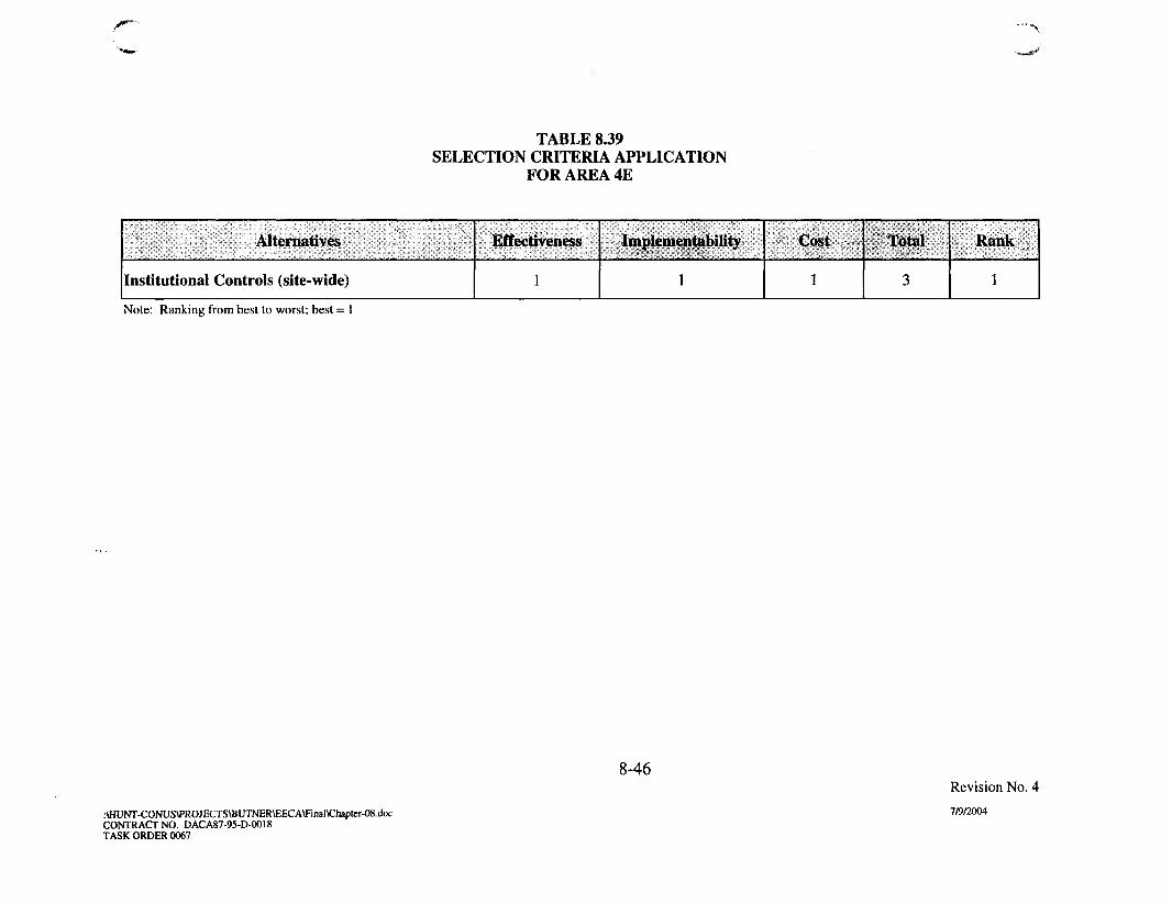
TABLE 8.39SELECTION CRITERIA APPLICATION
FOR AREA 4E
Alternatives
Institutional Controls (site-wide)
Effectiveness
1
Implementability
1
Cost
1
Total
3
Rank
1
Note: Ranking from best to worst; best = 1
8-46
:\HUNT-CONUS\PROJECTS\BUTNER\EECA\Final\Chapter-08.docCONTRACT NO. DACA87-95-D-0018TASK ORDER 0067
Revision No. 4
7/9/2004

TABLE 8.40SELECTION CRITERIA APPLICATION
FOR AREA 4
Alternatives
Institutional Controls (site-wide)
Surface Clearance
Clearance to Depth
Effectiveness
3
2
1
Implementability
1
2
3
Cost
1
2
3
Total
5
6
7
Rank
1
2
3
Note: Ranking from best to worst; best = 1, worst = 3
t\HUNT-CONUS\PROJECTS\BUTNER\EECA\Final\Chapter-08.docCONTRACT NO. DACA87-95-D-0O18TASK ORDER 0067
8-47Revision No. 4
7/9/2004

TABLE 8.41SELECTION CRITERIA APPLICATION
FOR LAKEVIEW SUBDIVISION
Alternatives
Institutional Controls (site-wide)
Clearance to Depth
Effectiveness
2
1
Implementability
2
1
Cost
1
2
Total
5
4
Rank
2
1
Note: Ranking from best to worst; best = 1, worst = 2
:\HUNT-CONUS\PROJECTS\BUTNER\EECA\Final\Chapter-08.docCONTRACT NO. DACA87-95-D-0018TASK ORDER 0067
8-48Revision No. 4
7/9/2004

u
CHAPTER 9RECOMMENDED RESPONSE ACTION ALTERNATIVES
9.1 INTRODUCTION
9.1.1 UXO/OE response action alternatives were evaluated for each of the AOIswithin the former Camp Butner Site that were investigated during this EE/CAinvestigation. Each potential alternative was initially screened against the generalevaluation criteria of effectiveness, implementability, and cost. The screening ofalternatives detailed in Chapter 7 was used to identify candidate UXO/OE responsealternatives for further qualitative evaluation as tabulated in Chapter 8. Site-wide ICcomponents were evaluated and selected as presented in Appendix F. As a result of thecomprehensive evaluation of alternatives by AOI, the following paragraphs present therecommendations for implementation.
9.1.2 A recommendation of implementation of site-wide IC only (no removal atthis time) has been deemed appropriate for several areas (Area 4, Area 4D, and Area 4E).The presence of UXO was confirmed either during the EE/CA or inferred based on thepresence of HE projectile fragments in these areas but current and future anticipated landuse, terrain, exposure pathways, and other factors (outlined in Chapter 4) indicate aremoval action is not justified at the present time. However, to ensure public safetyassociated with the existing residential component in each of these areas, a subsurfaceremoval action is recommended (comprising a two-acre residential footprint)encompassing each existing dwelling. The depth of the removal action will be based onthe EE/CA findings but as a general rule all anomalies identified by the geophysicalequipment will be excavated. The cost associated with each residential removal actionwithin the IC sectors is estimated as $32,367 (per 2 acres), as detailed in Appendix G.Following property owner request, USACE will request funds for implementation of theremoval action.
9.2 RECOMMENDATIONS
9.2.1 Area 1A
9.2.1.1 Presently, the 20 acres comprising Area 1A are undeveloped with nocurrent land use assignment. The property is not within an area deed-restricted for"surface use only" following military occupation and property transfer. Future plans atthis AOI include land use for recreational activities and the passage of a greenway / trailsystem. Recently obtained information also indicates plans for a day care facility andother development within, and adjacent to, this property. During the EE/CA
9-1 Revision No: 4:\HUNT-CONUS\PROJECTS\BUTNER\EECA\Final\Chapter-09.doc 7/9/2004CONTRACT NO. DACA87-95-D-0018TASK ORDER 0067

n
u
investigation, two UXO items were recovered including a Mk II hand grenade and a M4practice landmine with spotting charge and fuze. A total of 5 OE scrap items identifiedas inert/expended M15 hand grenades were recovered at this AOL Both UXO items andall OE scrap were found at 10 inches or less bgs.
9.2.1.2 EE/CA findings suggest that former military land use included grenadetraining (in addition to flamethrower training) and confirmed the risk of UXO explosivehazards within Area 1 A. As discussed in Subchapter 7.5.3, the majority of residual UXO(if not all) is anticipated to be subsurface and extend to a depth of ten inches bgs.Therefore, the Subsurface Clearance and Institutional Controls (site-wide) alternativesare both recommended as the OE response alternative for implementation at Area 1A.The estimated cost to implement the subsurface clearance alternative for Area 1A is$448,618. Site-wide IC costs are estimated at $80,750 with $10,500 annual maintenance.
9.2.2 Area 4A
9.2.2.1 Area 4A, comprising approximately 34 acres, has been parceled inanticipation of residential development and is actively being marketed. Althoughcurrently most of the land remains wooded and undeveloped, some grading and treeremoval has been initiated. The ASR and TEC report indicates former military use ofthis general area as a bazooka and rifle grenade range Area 4A falls entirely within theboundary of the area deed-restricted for "surface use only" (see paragraph 2.3.6)following military occupation and property transfer. The single UXO and majority of OEscrap items recovered from this AOI were associated with 2.36-inch rockets. The onlyother ordnance type recovered from the AOI was a single OE scrap item identified as acomponent of an M9 rifle grenade. All ordnance related items were recovered within 6inches bgs.
9.2.2.2 The EE/CA findings concurred with ASR designation of the AOI. Basedon the types of ordnance found and those historically reported in this area, depth ofpenetration is not anticipated to exceed 6 inches bgs (Subchapter 7.6.3.1). Therefore, theSubsurface Clearance to Depth and Institutional Controls (site-wide) alternatives areboth recommended as the OE response alternative for implementation at Area 4A. Inaddition, considering the imminent residential development, UXO construction supportis warranted and will be provided to the new property owners at their request (providedsufficient advance notice). The estimated cost to implement the subsurface clearancealternative for Area 4A is $654,622. Site-wide IC costs are estimated at $80,750 with$10,500 annual maintenance. In the interim, it is recommended that CESAW issue"prudent man letters" to the new property owners and residents within the AOI advisingthem of the potential presence of UXO on their property and appropriate actions to take ifUXO is encountered.
9.2.3 Area 4B
9.2.3.1 Land use within the approximately 20 acres comprising Area 4B isdedicated to farming, with future land use anticipated to remain the same. Findings
9-2 Revision No: 4:\HUNT-CONUS\PROJECTS\BUTNER\EECA\Final\Chapter-09.doc 7/9/2004CONTRACT NO. DACA87-95-D-OO18TASK ORDER 0067

n
1J
reported in the ASR refer to former military use of this AOI for bazooka and rifle grenade t /
training (similar to Area 4A). Area 4B falls entirely within the boundary of the areadeed-restricted for "surface use only" (see paragraph 2.3.6) following military occupationand property transfer. Findings made during the EE/CA investigation included one UXOidentified as a 2.36-inch rocket (recovered at 18 inches bgs) and four OE scrap itemsidentified as HE fragments recovered within 6 inches bgs. Other findings include thereported discovery of numerous inert 2.36-inch rockets made by one of the propertyowners in recent years as well as during the EE/CA investigation.
9.2.3.2 Based on the types of ordnance found and historically reported in thisarea, depth of penetration is not expected to exceed 6 inches bgs. The recovery of the2.36-inch HE bazooka rocket (UXO) at 18 inches bgs in a wooded area is not consideredindicative of the vertical extent of contamination. However due to intrusive farmingactivities (e.g. tilling) over a portion of the AOI, the top layer of soil is regularly beingturned over which potentially affects the vertical distribution of and contact with residualUXO/OE. Per the property owner, tilling at this AOI only penetrates the top ten inches ofsoil. Therefore, the Subsurface Clearance to Depth and Institutional Controls (site-wide) alternatives are both recommended as the OE response alternative forimplementation within the agriculturally used portion of Area 4B (approximately 10acres). No removal action within the undeveloped balance of the 20 acre AOI iswarranted at this time. For the two existing homesteads identified within the AOI, a 2-acre subsurface removal action (per homestead) will be conducted encompassing theprimary residential footprint. If conditions at this AOI significantly change, re-evaluation will be conducted as part of the recurring review process (Chapter 10). In theinterim, it is recommended that CESAW issue "prudent man letters" to both residentswithin the AOI advising them of the potential presence of UXO on their property andappropriate actions to take if UXO is encountered. The estimated cost to implement thesubsurface clearance alternative for Area 4C is $199,159. Site-wide IC costs areestimated at $80,750 with $10,500 annual maintenance.
9.2.4 Area 4C
9.2.4.1 Land use in the approximately 126-acre Area 4C is divided into lowdensity residential development (8 total dwellings) in the southern half and undevelopedwoodland in the northern half. Based on the current status of development in this area,future additional development is anticipated, particularly in the southern region. Analysisof TEC historic aerial photographs identifies suspect impact craters within the borders ofArea 4E. The ASR and verified structural remnants indicate Area 4C was the location ofthe mock German village, an artillery target area. As a result, Area 4C falls within the rboundary of the area deed-restricted for "surface use only" (see paragraph 2.3.6)following military occupation and property transfer. One UXO (105mm projectile) *••recovered at 3 inches bgs and approximately 217 pounds of HE projectile fragments wereremoved from this AOI. Other findings by an adjacent property owner in the southernportion of the AOI include one 105mm projectile and one 155mm projectile.
9-3 Revision No: 4:\HUNT-CONUS\PROJECTS\BUTNER\EECA\Final\Chapter-09 doc 7/9/2004CONTRACT NO. DACA87-95-D-0018TASK ORDER 0067

f I 9.2.4.2 During the screening process several factors were assessed in thedetermination of the most suitable response action in Area 4C. These factors includeland use, vertical extent of contamination, and associated costs with a UXO/OE removalaction over 126-acre site. Initial, consideration was given to the different land uses forthis AOI which can be divided at the power line easement into residential andundeveloped. Based on the ordnance type identified in this area and potential ofexposure for local inhabitants, a removal action is recommended for the southern half ofthe AOI where the eight residential dwellings currently exist. Therefore, the SubsurfaceClearance to Depth and Institutional Controls (site-wide) alternatives are bothrecommended as the OE response alternative for implementation within readilyaccessible and open residential parcels located within the southern half (estimated toencompass approximately 16 acres). In addition, UXO construction support iswarranted and should be provided to the residential property owners at their request(provided sufficient advance notice). The estimated cost to implement the subsurfaceclearance alternative for Area 4C is $352,999. Site-wide IC costs are estimated at$80,750 with $10,500 annual maintenance.
9.2.4.3 Due to the current lack of development and limited public access, thenorthern half of Area 4C does not warrant the same level of clearance as is recommendedfor the southern half. Considering the potential for residential development, UXOconstruction support is warranted and should be provided to the property owners attheir request (provided sufficient advance notice). In the interim, it is recommendedthat CESAW issue "prudent man letters" to all the property owners and residents withinthe AOI advising them of the potential presence of UXO on their property andappropriate actions to take if UXO is encountered.
9.2.5 Area 4D
9.2.5.1 Area 4D (comprised of approximately 453 acres) is largely wooded andgenerally undeveloped. The majority of the AOI is owned by a single owner/family whohas indicated he plans to retain the property for same indefinitely. The residentialcomponent is low-density with only six established residential dwellings known to existwithin the AOI. In addition, this area has limited near-term development potential due topoor infrastructure and minimal frontage along primary roads. Signs of logging activitieshave been observed at the southern portion of the AOI. The only UXO item recovered /from this AOI was a 37mm projectile recovered at a depth of 2 inches bgs. A total of 27 *OE scrap items were also recovered ranging from depths from 0 to 10 inches bgs.
9.2.5.2 The findings from this EE/CA investigation, supported by archivalevidence, confirm that the AOI is within a likely impact area. However, Area 4D doesnot fall within the boundary of an area deed-restricted for "surface use only" (seeparagraph 2.3.6) following military occupation and property transfer. A number offactors were considered in the determination of the most suitable response actionalternative for this AOI which included: limited public access; generally passive siteactivities (hunting and hiking); continuation of similar future land use; and unlikelihood
v ' 9-4 Revision No: 4:\HUNT-CONUS\PROJECTS\BUTNER\EECA\Final\Chapter-09.doc 7/9/2004CONTRACT NO. DACA87-95-D-0018TASK ORDER 0067

u
for additional residential development. Therefore, the implementation of site-wideInstitutional Controls will provide the necessary public awareness of the formermilitary use of Area 4D to residents and workers in the area and no removal action iswarranted at this time. For the six existing homesteads identified within the AOI, a 2-acre subsurface removal action (per homestead) will be conducted encompassing theprimary residential footprint. If conditions at this AOI significantly change, re-evaluation will be conducted as part of the recurring review process (Chapter 10). In theinterim, it is recommended that CESAW issue "prudent man letters" to all residentswithin the AOI advising them of the potential presence of UXO on their property andappropriate actions to take if UXO is encountered. Costs associated with the Area 4Fresidential removal action are estimated at $194,202. Site-wide IC costs are estimated at$80,750 with $10,500 annual maintenance.
9.2.6 Area 4E
Area 4E is a parcel of land dedicated primarily to the farming of tobacco. Similar >land use is anticipated to continue in the future. A single 37mm projectile was recovered *from the AOI at 1 inch bgs as well as a single piece of OE scrap (both from the samesample grid). The AOI is located within the firing fan for the historical 37mm range,however, its orientation is adjacent to the firing point. Therefore it is unlikely that firingtargets were present within Area 4E. The lack of EE/CA findings supports this assertion.Additionally, Area 4E falls almost entirely within the boundary of the area deed-restricted for "surface use only" (see paragraph 2.3.6) following military occupation andproperty transfer. Therefore, the implementation of site-wide Institutional Controls willprovide the necessary public awareness of the former military use of Area 4E toresidents, hunters, and workers in the area and no removal action is warranted at thistime. For the five existing homesteads identified within the AOI, a 2-acre subsurfaceremoval action (per homestead) will be conducted encompassing the primaryresidential footprint. If conditions at this AOI significantly change, re-evaluation will beconducted as part of the recurring review process (Chapter 10). In the interim, it isrecommended that CESAW issue "prudent man letters" to all residents within the AOIadvising them of the potential presence of UXO on their property and appropriate actionsto take if UXO is encountered. Costs associated with the Area 4E residential removalaction are estimated at $32,367. Site-wide IC costs are estimated at $80,750 with$10,500 annual maintenance.
9.2.7 Area 4
Land use in Area 4, comprised of 21,139 acres, is primarily dedicated to agricultureand forestry, with low density residential development spread along the main roads.Portions of Area 4 fall within the boundary of the areas deed-restricted for "surface useonly" (see paragraph 2.3.6) following military occupation and property transfer. No UXOwas recovered within the boundaries of this AOI. A total of 5 UXO items and 1118 OE *scrap items were identified during the intrusive investigation. Because the majority of theAOI is privately owned, public access is limited or restricted throughout much of this
9-5 Revision No: 4:\HUNT-CONUS\PROJECTS\BUTNER\EECA\Final\Chapter-09.doc 7/9/2004CONTRACT NO. DACA87-95-D-OO18TASK ORDER 0067
1 AOI. Therefore, the implementation of site-wide Institutional Controls will providethe necessary public awareness of the former military use of Area 4 to residents,hunters, and workers in the area and no removal action is warranted at this time. Forthe existing homesteads identified within the AOI (estimated to be nearly 225), a 2-acresubsurface removal action (per homestead) will be conducted encompassing theprimary residential footprint. In the interim, it is recommended that CESAW issue"prudent man letters" to all residents within the AOI advising them of the potentialpresence of UXO on their property and appropriate actions to take if UXO isencountered. Costs associated with the Area 4 residential removal action are estimated at ]/$7,282,575. Site-wide IC costs are estimated at $80,750 with $10,500 annualmaintenance.
9.2.8 Area 5
Land use in Area 5, comprised of approximately 13,672 acres, is diverse andincludes agriculture, institutional, recreational, and residential. No UXO was recoveredfrom this AOI. A solitary OE scrap item identified as a landmine pressure plate wasrecovered at ground surface; however it is not considered indicative of UXO/OE presenceat this AOI. Although no findings were made in support of UXO/OE presence, the mostprudent response action includes the implementation of a public awareness program inArea 5. Therefore, the implementation of Institutional Controls (site-wide) shouldprovide the necessary public awareness of the former military use of Area 5 toresidents, hunters, and workers in the area.
9.2.9 TCRA Lakeview USAESCH Recommendation
During the EE/CA investigation UXO was encountered within the LakeviewSubdivision. In addition, several UXO items have been reported to local officials andrequired military EOD response. However, the AOI does not fall within the boundary ofthe area deed-restricted for "surface use only" (see paragraph 2.3.6) following militaryoccupation and property transfer. Based on the UXO findings a TCRA was conductedwhich removed UXO from the ground surface to a depth of six inches bgs. Consideringthe residential land use and the diversity of UXO and OE scrap encountered, the potentialpresence of residual UXO in the subsurface remains. Therefore, the SubsurfaceClearance to Depth and Institutional Controls (site-wide) alternatives are bothrecommended as the OE response alternative for implementation within the LakeviewSubdivision. Digital mapping of the 26-acre site conducted following completion of thesix inch removal was evaluated by USAESCH (Appendix B). USAESCHrecommended an iterative removal action centered around the areas showing highresidual anomaly concentrations with criteria for stopping based on lack of UXOpresence. However, in order to ensure the subdivision property owner's confidencethat their property is safe, investigation and removal of all anomalies within the 26-acre site is recommended. The estimated cost to implement the subsurface clearancealternative for the Lakeview Subdivision is $363,612. Site-wide IC costs are estimated at$80,750 with $10,500 annual maintenance.
9-6 Revision No: 4:\HUNT-CONUS\PROJECTS\BUTNER\EECA\Final\Chapter-09.doc 7/9/2004CONTRACT NO. DACA87-95-D-0018TASK ORDER 0067

n 9.2.10 MMR Divisions
As discussed in subparagraph 2.6.9, the former Camp Butner was divided into fiveprimary ranges as part of a range inventory in the 2003 Supplemental ASR. Therefore,the summary of recommended clearance costs has been presented to coincide with thesenew designations. Similarly, separate Action Memorandum(s) will be prepared for eachMMR range following the preparation of this Final EE/CA Report. Area 1A falls entirelywithin the designated "Flamethrower Range". The MMR designated "Range Complex 1"encompasses Area 4A, Area 4B, Area 4D, and Area 4E. Area 4C falls within "RangeComplex 2". Area 4 falls with the confines of both Range Complex 1 and RangeComplex 2.
U 9-7 Revision No: 4:\HUNT-CONUS\PROJECTS\BUTNER\EECA\Final\Chapter-09.doc 7/9/2004CONTRACT NO. DACA87-95-D-0018TASK ORDER 0067

I -\ Table 9.1Summary of Recommended Alternatives and Clearance Costs
MMR Range/Site
FLAMETHROWERRANGE
Site 1A
SUBTOTAL -FLAMETHROWERRANGE
RANGE COMPLEX 1
Site 4A
Site 4B
Site 4D
Residential
Site 4E
Residential
Site 4 (South of Enon)
Residential
Lakeview Subdivision
SUBTOTAL - RANGECOMPLEX 1
RANGE COMPLEX 2
Site 4C
Site 4 (North of Enon)
Residential
SUBTOTAL - RANGECOMPLEX 2
Recommended Action
Subsurface Clearance to Depth
Subsurface Clearance to Depth
Subsurface Clearance to Depth (10agricultural acres only)
Site-Wide Institutional Controls
Residential Footprint
Clearance to Depth
6 Dwellings
Site-Wide Institutional Controls
Residential Footprint
Clearance to Depth
1 Dwelling
Site-Wide Institutional Controls
Residential Footprint
Clearance to Depth
140 Dwellings
Subsurface Clearance to Depth
Subsurface Clearance to Depth (16acres residential only)
Site-Wide Institutional Controls
Residential Footprint
Clearance to Depth
85 Dwellings
ClearanceAcreage
20
34
10
NA
12
NA
2
NA
280
26
16
NA
170
Cost
$448,618
$448,618
$654,622
$199,159
NA
$194,202
NA
$32,367
NA
$4,531,380
$373,374
$5,985,104
$352,999
NA
$2,751,195
$3,104,194
9-8:\HUNT-CONUS\PROJECTS\BUTNER\EECA\Final\Chapter-09.docCONTRACT NO. DACA87-95-D-OO18TASK ORDER 0067
Revision No: 47/9/2004

f Table 9.1 (Continued)Summary of Recommended Alternatives and Clearance Costs
MMR Range
/Site
Site 5
Site-Wide IC
Recommended Action
Site-Wide Institutional Controls
NA
Total
Clearance
Acreage
NA
NA
Cost
NA
$8O,75O/$1O,5OOyear
$9,618,666$10,500 year
•Number of residential dwellings as of July 3, 2003 per County records.Removal action to consist of clearance to depth for a 2-acre residential footprint around each existing dwelling. Cost isestimated at $32,367 per 2-acre residential removal, as detailed in Appendix G and in 2004 dollars.
9-9:\HUNT-CONUS\PROJECTS\BUTNER\EECA\Final\Chapter-09.docCONTRACT NO. DACA87-95-D-0018TASK ORDER 0067
Revision No: 47/9/2004

n
U
CHAPTER 10RECURRING REVIEWS
10.1 FOLLOW-ON ACTIVITIES
10.1.1 Follow-on activities associated with the former Camp Butner Site will beconducted by the USACE in the form of recurring reviews. The recurring review processis consistent with Section 121(c) of CERCLA, as amended by SARA, and Section300.430 (f) (4) (ii) of the NCP. Recurring review, as outlined by these statutes, requiresthat periodic (at least every five years) reviews be conducted for sites where hazardoussubstances, pollutants, or contaminants remain at the site above levels that allow forunlimited use and unrestricted exposure following the completion of all remedial actions.
10.1.2 Recurring reviews will be conducted at the former Camp Butner Site to:
• Ensure that public health, safety, and the environment are being protected by theresponse actions that were implemented.
• Verify the integrity of any site controls.
• Determine if new information has become available that was not available forconsideration during the EE/CA that may warrant further action.
• Determine if there is an immediate threat to the public or environment that mayrequire an Accelerated Response.
• Review decision for Technical Impracticability to determine if new technology willaddress explosives safety risk.
10.1.3 The recurring review team will gather data to determine if any changeswithin AOIs are relevant and may affect the prior recommendations of the EE/CA.Changes to be evaluated consist of:
• Physical conditions of the AOL
• Public accessibility and land use.
• New technology or techniques that have become available and may warrantreconsideration of the EE/CA recommendations.
• Effectiveness of the response action to reduce risk.
10-1 Revision No. 4AHUNT-CONUS\PROJECTS\BUTNER\EECA\Final\Chapter-10.doc 7/9/20O4CONTRACT NO. DACA87-95-D-0O18TASK ORDER 0067

10.1.4 Data gathered during the review process will be used to determine iffurther action needs to be taken to protect public safety and the human environment. Ifno changes have taken place, the AOIs will continue to be monitored at the specifiedintervals. At the completion of the review, a Recurring Review Report will be prepared,a public notice will be placed in the local newspaper concerning the continuedeffectiveness of the OE response action, and a formal Decision Document referencing anyactions taken will be prepared.
10.1.5 The initial recurring review will be scheduled by the government after thecompletion of the removal action phase to address the issues and evaluate the data asdescribed above. The estimated cost for the site visit and review procedures is expectedto be $35,000.
U10-2 Revision No. 4
:\HUNT-CONUS\PROJECTS\BUTNER\EECA\Final\Chapter-10.doc 7/9/2004CONTRACT NO. DACA87-95-D-OO18TASK ORDER 0067

f
CHAPTER 11REFERENCES
Code of Federal Regulations (CFR). 1993. National Oil and Hazardous Substances PollutionContingency Plan (NCP). 40 CFR 300.430, July 1993.
Department of Defense 1999. DOD Ammunition and Explosives Safety Standards, DOD 6055.9-STD. July 1999.
Holland Consulting Planners, Inc. Granville County, North Carolina, Comprehensive Plan.Adopted by the Granville County Board of Commissioners: February 4, 2002.
OBrien/Atkins Associates in association with Law Engineering and Environmental Services, Inc.Butner Long Range Master Plan. December 1998.
Parsons, Inc. 2000. Site Visit Report for the former Camp Butner. Prepared for U.S. ArmyEngineering and Support Center, Huntsville, June 2000.
Parsons, Inc. 2002. Final Work Plan for Engineering Evaluation/Cost Analysis for the formerCamp Butner Site. Prepared for U.S. Army Engineering and Support Center, Huntsville,July 2002.
Parsons, Inc. 2003. Draft Final Time Critical Removal Action Report for Lakeside Subdivision,Former Camp Butner. Prepared for U.S. Army Engineering and Support Center,Huntsville, July 2003.
The County of Granville, North Carolina, 1999. Land Development Ordinance. Adopted July12, 1999, Effective September 15, 1999.
U.S. Army Corps of Engineers (USACE), 1983. Army Regulation 385-63, Policies andProcedures for Firing Ammunition for Training, Target Practice, and Combat.November 15, 1983.
U.S. Army Corps of Engineers (USACE) Wilmington District, 1990a. DERP-FUDS FieldInvestigation for Preliminary Assessment, Camp Butner, Durham, North Carolina, SiteNo. I04NC000900. April 30, 1990.
U.S. Army Corps of Engineers (USACE) Wilmington District, 1990b. Findings andDetermination of Eligibility Report for Former Camp Butner. July 5, 1990.
U.S. Army Corps of Engineers (USACE), 1994. Ammunition Data Sheets, Small CaliberAmmunition, Technical Manual (TM) 43-0001-27, April 1994.
11-1 Revision No. 4
:\HUNT-CONUS\PROJECTS\BUTNER\EECA\final\Chapter-ll.doc 7/9/2004CONTRACT NO. DACA87-95-D-O018TASK ORDER 0067

/ ~ U.S. Army Corps of Engineers (USACE) Rock Island District, 1997 (original 1993). Ordnancef I and Explosive Archives Search Report Findings for the Former Camp Butner.
September 1993, revised February 1997.
U.S. Army Corps of Engineers (USACE), 1998a. Procedures for Demolition of Multiple Rounds(Consolidated Shots) on Ordnance and Explosives (OE) Sites. August 1998(Terminology Updated March 2000).
U.S. Army Corps of Engineers (USACE), 1998b. Reportable Material at Ordnance andExplosives (OE) Response Sites, OE Center for Expertise (CX) Interim GuidanceDocument (IGD) 98-04, March 1998.
U.S. Army Corps of Engineers (USACE), 1999. Small Arms Determinations, Ordnance andExplosives (OE) Center for Expertise (CX) Interim Guidance Document (IGD) 99-02,April 1999.
U.S. Army Corps of Engineers (USACE), 2000. Ordnance and Explosives Response, OE Centerof Expertise (CX) Engineering Pamphlet EP 1110-1-18. April 2000.
U.S. Army Corps of Engineers (USACE) Topographic Engineering Center (TEC), 2001a. GIS-Based Historical Time Sequence Analysis. September 2001.
U.S. Army Corps of Engineers (USACE), 2001b. OE Risk Impact Assessment for OE EE/CAEvaluations. Interim Guidance Document 01-01. March 27, 2001.
U.S. Army Corps of Engineers (USACE) Rock Island District, 2003. Ordnance and ExplosiveArchives Search Report Supplement for the Former Camp Butner. June 2003.
11-2 Revision No. 4
:\HUNT-CONUS\PROJECTS\BUTNER\EECA\Final\Chapter-ll.doc 7/9/2004CONTRACT NO. DACA87-95-D-0O18TASK ORDER 0067
n
APPENDIX ASTATEMENT OF WORK
U

cTask Name V ^
Prepare Draft EE/CA
CESAW Requested HOLD
CESAW Meeting #1
Continue EE/CA Draft Prep
Submit PreDralt to Roland
Roland Review of Recs
Onsite CESAW Recs Review
Revise for Draft Submittal
CESAW Requested HOLD
CESAW Meeting #2
CESAW Requested HOLD
Submit Draft EE/CA
NCDENR Meeting
Government comments
Incorporate Gov Comments
Submit Draft Final EE/CA
Government Backcheck
CESAW Comments on DF
Parsons Revise DF
Gov. Backcheck
DF to NCDENR
Thanksgiving Break
Public Meeting
Public Review Period
Public Review Extension
NCDENR/EPA Comment Resc
Conference Call EPA
Revise for Reg Comments
Submit Final EE/CA
Task 15 - Action Memorandum
Prepare Draft Action Memort
Submit Draft Action Memo
Government Review
Receive Govt. Comments
Prepare Final Action Memon
Submit Final Action Memora
Public Meeting
Public Meeting/RAB Kickoff
RAB Meetings (semi-annual)
Duration
51 days
15 days
2 days
10 days
0 days
10 days
2 days
26 days
27 days
1 day
28 days
Odays
2 days
Odays
12 days
Odays
10 days
Odays
10 days
3 days
21 days
8 days
Odays
20 days
14 days
81 days
Odays
19 days
Odays
42 days
25 days
Odays
12 days
Odays
5 days
Odays
115 days
Odays
Odays
Odays
Project: Camp Butner EE/CADate: Fri 7/9/04
Start
Mon 12/9/02
Tue 2/18/03
Tue 3/11/03
Thu 3/13/03
Wed 3/26/03
Thu 3/27/03
Mon 4/14/03
Wed 4/16/03
Thu 5/22/03
Tue 6/3/03
Wed 6/4/03
Fri 7/11/03
Tue 7/29/03
Wed 8/20/03
Thu 8/21/03
Fri 9/5/03
Mon 9/8/03
Mon 10/6/03
Mon 10/6/03
Mon 10/20/03
Thu 10/23/03
Fri 11/21/03
Tue 12/16/03
Tue 12/16/03
Tue 1/13/04
Mon 2/2/04
Mon 6/14/04
Tue 6/15/04
Fri 7/9/04
Tue 6/15/04
Tue 6/15/04
Mon 7/19/04
Tue 7/20/04
Wed 8/4/04
Thu 8/5/04
Wed 8/11/04
Tue 12/16/03
Tue 12/16/03
Tue 5/25/04
Wed 7/28/04
Task H I
Progress • •
Milestone 4 ^
Forme' ~vp Butner *"^L
Finish
Mon 2/17/03
Mon 3/10/03
Wed 3/12/03
Wed 3/26/03
Wed 3/26/03
Wed 4/9/03
Tue 4/15/03
Wed 5/21/03
Fri 6/27/03
Tue 6/3/03
Fri 7/11/03
Fri 7/11/03
Wed 7/30/03
Wed 8/20/03
Fri 9/5/03
Fri 9/S/03
Fri 9/19/03
Mon 10/6/03
Fri 10/17/03
Wed 10/22/03
Thu 11/20/03
Tue 12/2/03
Tue 12/16/03
Mon 1/12/04
Fri 1/30/04
Mon 5/24/04
Mon 6/14/04
Fri 7/9/04
Fri 7/9/04
Wed 8/11/04
Mon 7/19/04
Mon 7/19/04
Wed 8/4/04
Wed 8/4/04
Wed 8/11/04
Wed 8/11/04
Tue 5/25/04
Tue 12/16/03
Tue 5/25/04
Wed 7/28/04
Nov Dec2003
Jan Feb I Mar ADf~T"Mav I Jun I Jul I Aua I Sea I Oct I Nov Dsc
fat
•f /26
itTil—T^
•PI
• ~ I 1 1
K^k-,10/6
ftL.I
2004 MJan I Feb I Mar I ADr I May I Jun I uT^KlBrj I Sen I Oct
^ 1 2 / 1 6
T
*• 1
•-.6/1
f
J2/16 I
^ 5/25
H i
^ 8/11
^ 7/28
^ m i ^ B Summary ^ ^ ^ " ^ ^ ^ ^ Rolled Up Progress • • • M H B I H Split External Milestone ^
I ^ M B H Rolled Up Task | f p i l l l f | j j p t l j External Tasks I "•"V/ "^-?'- ] Rolled Up Split Deadline :
Rolled Up Milestone <Q> Project Summary ^ • • • • • • • ^ p i External Milestone 4 ^
l:/COE-HUNT/BUTNER/EE_CA/PM/butner07062004forwardlook.mpp

o APPENDIX AANNEX
SCOPE OF WORKFOR
ORDNANCE AND EXPLOSIVE (OE)ENGINEERING EVALUATION/COST ANALYSIS (EE/CA)
ATTHE FORMER CAMP BUTNERDURHAM, NORTH CAROLINA
10 December 2001Revised 16 August 2002
General Comment 16 August 2002. The purpose of this modification is to have the contractorcoordinate and pay for evacuation of local residents to be placed in local hotels for the day or daysthey are asked to evacuate their homes while the contractor is performing intrusive investigationswithin the frag radius of peoples homes. $2,500 is the amount of this mod and will be increased ifand as required.
General Comment: 10 December 2001. The purpose of this task order is to add additional inscopeeffort to the Butner EECA started under Contract DACA87-95-D-0018 Task Order 0067. That oldParsons contract is at its monetary limit and can not be added to. This task order will be undercontract DACA87-00-D-0038 and will be for additional funds needed for tasks 6, 8, 9 and 17 only.AH future modifications involving funding increases will be on this new task order and not on the oldcontract.
1.0 BACKGROUND AND OBJECTIVE1.1 The objective of this delivery order is for the A-E to perform an Engineering Evaluation/Cost Analysis(EE/CA). The effort shall result in the characterization of ordnance and explosives (OE) according tonature, location and concentration, provide a description of the OE related problems affecting human use ofthe site, identify and analyze reasonable risk management alternatives and provide a convenient record ofthe process for use in final decision making and judicial review, if necessary. The effort shall allow anddocument meaningful stakeholder participation.The A-E is expected to use geophysical techniques to identify anomalies in the subsurface for subsequentOE sampling. The A-E shall conduct OE sampling and render safe any uncovered UXO and dispose of theUXO and other scrap uncovered during the OE sampling effort.
1.2 OE may be a safety hazard and may constitute an imminent and substantial endangerment to sitepersonnel and the local population. This action will be performed in a manner consistent with theComprehensive Environmental Response, Compensation, and Liability Act (CERCLA), Sections 104 and121; Executive Order 12580; the National Contingency Plan (NCP). In accordance with the above, nofederal, state or local permits are required nor will be obtained for actions, include on-site destruction ofunexploded ordnance (UXO), that may be required. However, substantive permit requirements shall befulfilled. In addition, all activities involving work in areas potentially containing unexploded ordnancehazards shall be conducted in full compliance with CEHNC, USACE, DA and DoD requirements regardingpersonnel, equipment and procedures. 29 CFR 1910.120 shall apply to all actions taken at this site.
1.3 The work required under this Scope of Work (SOW) falls under the Defense EnvironmentalRestoration Program (DERP) and the Formerly Used Defense Site (FUDS) program. Ordnance andExplosives (OE) may exist on property that was formerly owned, used or controlled by the Department ofDefense. The framework underlying this response is the National Contingency Plan (NCP).
1.4 Others will accomplish the Archeological Survey to identify potential archeological sites. TheGovernment will provide this survey for the A-E to consider in preparing the Work Plan. The A-E shall
n
u
provide awareness training to all personnel involved with fieldwork, as outlined in the approved WorkPlan.
1.5 Others will identify endangered/threatened species of concern. The Government will provideinformation that identifies areas of concern. The A-E shall consider this information in preparing the WorkPlan. The A-E shall provide awareness training to all personnel involved with the field investigation.
2.0 INTRODUCTION2.1 Background.Camp Butner, a former U.S. Army installation, was located in the north central part of North Carolina inthe counties of Granville, Durham and Person. Authorized for construction in 1942, the Camp, occupyingapproximately 40,384 acres, was officially activated in August 1942. The Camp was established fortraining of infantry divisions and miscellaneous artillery and engineer units within the Fourth ServicesCommand, the Army Ground Forces. In addition to the troop cantonment area, the reservation included atleast 15 ammunition training ranges, a 1000-inch small arms ammunition range, hand grenade ranges, a gaschamber, flame-thrower training range, a small arms training range and ammunition shipping, receivingand storage areas. Additionally, the Camp supported a large hospital and a prisoner of war camp.Currently, the former Camp area is comprised of an area used by the North Carolina National Guard(approximately 4750 acres), areas of private agricultural and commercial use and variouscommunity/state/federal agency activities such as corrections, farming, natural and humanservices/resources, commerce, crime control and university/college involvement.
2.2 Site Definition. The "site" consists of all areas previously under DoD control except for the currentNational Guard area. This will amount to approximately 35,600 acres.
2.3 Chemical Warfare Material (CWM). The site is not suspected to contain Chemical Warfare Materiel(CWM). However, if suspect CWM is encountered during any phase of site activities the A-E shallwithdraw upwind from the work area, secure the site and contact CEHNC.
2.4 Areas To Be Evaluated. The areas identified below are to be evaluated under this SOW. Evaluationefforts shall be completed in cooperation with project stakeholders, which include the landowners, theGovernment, interested regulatory agencies, and others that may be identified prior to work planfinalization.
- Cantonment Area and vicinity - 3300 acres- Ammunition Storage Area and Dump - 7 acres- Grenade Training Area - 5 acres- Ammunition Training Range and Impact Area - 21,950 acres- Remaining Land - 10,372 acres
3.0 SPECIFIC REQUIREMENTS3.1 (Taskl) Not Used3.2 (Task 2 ) Not Used3.3 (Task 3) Not Used3.4 (Task 4) Not Used
3.5 (Task 5) Not Used
3.6 Site Characterization. The A-E shall characterize the site by implementing the work described inthe Project Work Plans. Three things must be done to accomplish this. First the AE must prepare thesurface, identify any surface OE and remove any UXO. Secondly, the AE must prepare a Geophysical TestPlot to establish methods of investigation and select proper equipment. The final step is to performgeophysical mapping. This work includes but is not necessarily limited to the following :
3.6.1 (Task 6) Surface Preparation, OE Identification and Removal. The A-E shall provide allnecessary qualified personnel and equipment to perform surface preparation, as well as surface OEidentification, removal and disposal on the sampling grids (total sampling area to be proposed by the

-., contractor). The A-E shall perform the minimum amount of work necessary to clear the areas off I vegetation, surface OE and OE scrap where these impede the progress, effectiveness or safety of the
geophysical investigation team. Trees two inches in diameter or greater shall not be cut unless specificallyapproved in writing by the Government. All OE-related activities shall be performed in accordance withapplicable sections of the approved work plan.
3.6.2 (Task 7) Not Used
3.6.3 (Task 8) Geophysical Investigation. The total cumulative area to be geophysically investigatedand evaluated under this SOW shall be proposed in the work task proposal by the contractor. Actualnumber and location of grids may increase or decrease from that proposed based upon conditionsencountered in the field, if so directed by the Contracting Officer. All aspects of anomaly evaluation,selection, and dig-sheet production shall be routinely reported in a weekly field activity report. See section4.0 for additional reporting requirements and schedule.
3.6.3.1 Evaluation. After the site is geophysically mapped, the A-E shall utilize a qualified geophysicistto check and evaluate the geophysical data collected. The geophysicist shall make a professionaldetermination regarding the identification of anomalies at the site. Based on this determination, the A-Eshall provide a "dig-sheet" showing predicted location and character of all suspected anomalies to theCEHNC Project Manager and OE support staff. In addition, the A-E shall continually compare predictedresults with actual results so that the A-E's geophysical evaluation methodology is constantly refined overthe life of the project.
3.6.3.2 Anomaly Selection. Note that not all geophysical anomalies meeting the criteria to be considered apotential UXO will be dug. Representative anomalies will be excavated in order to characterizegeophysical anomalies and to provide information necessary to estimate location, concentration and natureof UXO present at the site. The A-E shall propose methodology for selection of anomalies to be excavated.This might be based on OE calculator, percentages of anomalies, a specific number of excavations,anomaly apparent size, work-days, statistical approaches, or some other approach or combination ofapproaches. Also, the approach for individual anomalies might differ from the approach used forpits/trenches. Generally the Government expects more anomalies selected for sampling at the beginning ofthe effort with the amount of samples selected for digging reduced over the duration of the sampling effort.The particular approach for this project shall be described in the work plan.
3.6.3.3 Data Format and Storage.The A-E shall utilize an appropriate data format and storage system for geophysical mapping data that isconsistent with CEHNC computer/CADD systems in accordance with DID OT-005-05 and as described inthe approved Work Plan. In addition the A-E shall maintain the data in such a way that the Government canremotely access any individual file or multiple files as necessary without day or time restrictions. SeeSection 4.0 for additional data requirements.
3.7 (Task 9) Intrusive Investigations (OE Sampling).The A-E shall, utilizing qualified personnel, implement site OE sampling as specified in the approved workplan. All aspects of the activities related to this task shall be reported in a weekly field activity reportincluding DRMO turn in forms. This task shall be accomplished as follows:
3.7.1 OE Access, Evaluation and Management.The A-E shall perform UXO sampling as described in the approved Work Plan. The A-E shall provide allnecessary qualified personnel and equipment to perform surface and subsurface UXO sampling, evaluationand management.
3.7.2 Investigating Anomalies.3.7.2.1 The A-E shall investigate anomalies identified by the geophysical investigations and as directed
by the Contracting Officer. The A-E shall, using qualified UXO personnel, determine whether theUXO can be moved or destroyed in-place. This is a safety-driven decision that will be basedsolely on DoD munitions safety standards and requirements.

3.7.2.2 Evacuation of local residents. In conjunction with the Corps of Engineers, the contractor willcoordinate evacuations with local residents trying to work while the home owner or others are notpresent but if required will pay for hotel rooms or other accommodations for the day or daysrequired to dig anomalies in areas affecting that persons home.
3.7.3 OE Scrap Disposal.The A-E shall be responsible for the destruction, if required, of all UXO and subsequent disposal of allscrap encountered during site investigations. This will be done utilizing qualified personnel in accordancewith the approved Work Plan. The A-E shall establish in the Work Plan a method of disposal, if required,for all OE.
3.7.4 Backfilling Excavations.All access/excavation/detonation holes shall be back-filled by the A-E. The A-E shall restore such areas totheir prior condition.
3.7.5 OE Accountability.The A-E shall maintain a detailed accounting of all OE items/components encountered. This accountingshall include the amounts of OE, the identification and condition, depth located, disposition and location.The accounting system shall also account for all demolition materials utilized to detonate OE on-site. Thisaccounting shall be a part of an appendix to the EE/CA report.
3.7.5.1 DD Form 1348-1 A.The A-E shall complete a DD Form 1348-1A as turn-in documentation. Instructions for completing thisform are contained in the Defense Utilization and Disposal Manual, DoD 4160.21-M. The Senior UXOSupervisor shall sign a certificate as follows:
"I certify that the property listed hereon has been inspected by me and, to the best of my knowledge andbelief, contains no items of a dangerous nature."
DRMO turn-in documentation receipts shall be submitted as an appendix to the EE/CA Report.
3.7.5.2 UXO Quality Control (QC) Specialist.UXO QC shall be a separate function and is not envisioned as a full-time position. The UXO QC Specialistshall meet the minimum prerequisites of an UXO Supervisor and have the training, knowledge andexperience necessary to implement the A-E's QC plan as outlined in DID OT-025. The Contracting Officermust approve any exceptions.
3.7.6 Quality Assurance Sampling Areas.In order to evaluate the effectiveness of the geophysical investigation and evaluation methods utilized bythe A-E, the Contracting Officer may direct an independent contractor provided by the Government or mayprovide Government personnel to independently map, locate and access some detected subsurfaceanomalies as deemed necessary.
3.8 (Task 10) Not Used
U
3.9
3.10
3.11
3.12
3.13
(Task
(Task
(Task
(Task
(Task
11)
12)
13)
14)
15)
Not Used
Not Used
Not Used
Not Used
Not Used

u
3.14 (Task 16) Not Used
3.15 (Task 17) Meetings and Project Management. The A-E shall perform project managementfunctions, as necessary to maintain project control and to meet required reporting requirements. This taskwill be in conjunction with task 17 in Contract DACA87-95-D-0018 task order 0067.
4.0 SUBMITTALS AND CORRESPONDENCE4.1 Format and Content of Engineering Reports. Engineering Reports presenting all data, analyses, andrecommendations shall be prepared and submitted by the A-E. All drawings shall be of engineering qualityin drafted form with sufficient detail to show interrelations of major features. The contents and format ofthe engineering reports shall be arranged in accordance with all pertinent guidance documents. Whendrawings are required, data may be combined to reduce the number of drawings. Reports shall consist of 8-1/2 inch by 11-inch pages with drawings other than the construction drawing folded, if necessary, to thissize. A decimal paragraphing system shall be used, with each section and paragraph of the reports having aunique decimal designation. The report covers for each submittal shall consist of durable 3-ring bindersand shall hold pages firmly while allowing easy removal, addition, or replacement of pages. A report titlepage shall identify the site, the A-E, the Corps of Engineers District, Huntsville Center, and the date. TheA-E identification shall not dominate the title page. All data, including raw analytical and electronic data,generated under this delivery order are the property of the DoD and the Government has unlimited rightsregarding its use.
4.2 Computer Files. All final text files generated by the A-E under this contract shall be furnished to theContract Officer in MS Word 6.0 or higher software, IBM PC compatible format. All final CADD/GISdata, design drawings and survey data generated by the A-E under this delivery order shall be submitted inthe proper format and media that will permit their loading, storage, and use without modification oradditional software on the Huntsville Center CADD/GIS workstations. All maps, figures, drawings ortables shall be conveyed on either 3-1/2 " HD floppy disks or PC CD-ROM. PC CD ROM is the preferredformat for all electronic submittals.
4.3 HTML Deliverables. In addition to the paper and digital copies of submittals identified above, thefinal version of the EE/CA and the Action Memorandum shall be submitted, uncompressed, on one floppydisk or CD ROM in hypertext markup language (HTML) along with a linked table of contents, linkedtables, linked photographs, linked graphs and linked figures included and suitable for viewing on theInternet. The contractor shall post the draft and final versions of the work plan, EEC A report and ActionMemo on the Web.
4.4 Review Comments. Various reviewers will have the opportunity to review submittals made by the A-E under this contract. The A-E shall review all comments received through the CEHNC Project Managerand evaluate their appropriateness based upon their merit and the requirements of the SOW. The A-E shallissue to the Project Manager a formal, annotated response to each in accordance with the schedule inparagraph 4.13
4.5 Draft Reports. Each page of draft reports shall be stamped "DRAFT". Submittals shall includeincorporation and notation of all previous review comments accepted by the A-E.
4.6 Identification of Responsible Personnel. Each report shall identify the specific members and title ofthe A-E's staff and subcontractors that had significant, specific input into the reports' preparation or review.All final submittals shall be sealed by the registered Professional Engineer-In-Charge.
4.7 Minutes of Meetings. Following the presentation, the A-E shall prepare and submit minutes of allmeetings attended to the Contract Officer or his representative within 10 calendar days.
4.8 Correspondence. The A-E shall keep a record of each phone conversation and written correspondenceaffecting decisions relating to the performance of this IDO. A summary of the phone conversations andwritten correspondence shall be submitted with the monthly progress report to the Contract Officer.

f 4.9 Project Control and Reporting. The A-E shall prepare and submit a master network schedule (usingMicrosoft "Project" software), cost and manpower plan, monthly progress reports, technical progressreports, monthly individual performance reports and cost/schedule variance report, work task proposal plan,and a program control plan.
4.10 Monthly Progress Report. The A-E shall prepare and submit a monthly progress report describingthe work performed since the previous report, work currently underway and work anticipated. This reportshall show the earned value curves for the amount of funds obligated, planned and actually spent to date onthe project. This will allow the continuous tracking of the actual cost versus the proposed cost oat thebeginning of the project. The report shall state whether current work is on schedule. If the work is not opschedule, the A-E shall state what actions are anticipated in order to get back on-schedule. The report shallbe submitted not later than the 10th day of the following month.4.11 Public Affairs. The A-E shall not publicly disclose any data generated or reviewed under thiscontract. The A-E shall refer all requests for information concerning site conditions to the local CorpsDistrict's Public Affairs Office, with a copy furnished to the CEHNC Project Manager. Reports and datagenerated under this contract are the property of the DoD and distribution to any other source by the A-E,unless authorized by the Contract Officer, is prohibited.
4.12 Addresses. The following addresses shall be used in mailing submittals:
ADDRESSEE QUANTITYCommanderUS Army Corps of Engineers, Huntsville CenterATTN: CEHNC-OE-DC (Roland Belew)P.O. Box 1600Huntsville, Alabama 35807-4301 8
CommanderU.S. Army Corps of Engineers, Wilmington DistrictATTN: CESAW-PM-C (John Baden)P.O. Box 1890Wilmington, North Carolina, 28240-1890 8
CommanderU.S. Army Corps of Engineers, South Atlantic DivisionATTN: CESAD-PM (Sharon Taylor)77 Forsyth StAtlanta, Georgia 30335-6801 1
Others TBD
4.13 Schedule and Submittals. The A-E shall submit all deliverable data to the Contract Officer and otherreviewers shown in Paragraph 4.12 in accordance with the following schedule. All submittals shall bedelivered to all addressees no later than the close of business on the day indicated in this paragraph. Inaddition, submittals to regulatory reviewers shall be shipped by registered mail or other method where asigned receipt is obtained indicating the date received and the individual accepting the submittal.
DOCUMENTASSHPSite VisitSite Visit Letter ReportWTPEE/CA Work Plan, DraftEE/CA Work Plan, Draft Final
comments
DATE DUE5 days prior to Site Visit
Upon notice to KO3 working days after site visit
20 Days after site visit45 days after NTP10 working days after receipt of Gov.
o Geophysical Equipment Test Report TBDEE/CA Work Plan, Final TBD but after Geo. Equipment Test
ReportGovernment Grants approval to commence field work. TBDWeekly Field Report * Every Monday for the previous weekMonthly Progress Report NLT 10th of the following monthRisk Evaluation & QC Report, Draft TBDRisk Evaluation & QC Report, Final TBDEE/CA Report, Draft TBDEE/CA Report, Final TBDDraft Action Memorandum TBDPublic Meeting TBDFinal Action Memorandum & Responsiveness Summary TBDProject Meeting, Alabama TBDProject Meeting, North Carolina TBDMinutes of Meetings NLT 10 days after each meeting
The overall completion date of this delivery order is TBD.
5.0 SAFETY AND HEALTH PROGRAMThe A-E shall develop and maintain a Health and Safety Program (HSP) in compliance with therequirements of OSHA standards 29CFR1910.120(b)(l) through (b) (4). The A-E shall provide writtencertification the HSP has been submitted to the CO and make the HSP available upon request by theGovernment. The SSHP required by 29CFR1910.120(b)/29CFR1926.65(b)(4), and as defined by DID OT-005-06, shall be prepared and submitted with the Work Plan for approval. On-site activities shall notcommence until the plan has been reviewed and accepted. The A-E's Site Safety and Health Officer(SSHO) shall have the training, knowledge and experience necessary to implement the SSHP and have thesame minimum qualifications as an UXO Supervisor.
6.0 REFERENCES.6.1 National Contingency Plan, 40 CFR 300.6.2 Federal Acquisition Regulation, F.A.R. Clause 52.236-13: Accident Prevention.6.3 Army Corps of Engineers Safety and Health Requirements Manual, EM-385-1-1, 3 September 1996.6.4 Army Corps of Engineers, ER-385-1-92, Appendix B, Safety and Occupational Health DocumentRequirements for Hazardous Toxic and Radioactive Waste (HTRW) and Ordnance and Explosive Waste(OE) Activities, 18 March 1994.6.5 Occupational Safety and Health Administration (OSHA) General Industry Standards, 29 CFR 1910and Construction Industry Standards, 29 CFR 1926; especially 1910.120/29CFR1926.65-"HazardousWaste Site Operations and Emergency Response."6.6 NIOSH/OSHA/USCG/EPA, "Occupational Safety and Health Guidance Manual for Hazardous WasteSite Activities", October 1985. (DHHS(NIOSH) Publication No. 85-115).6.7 CEHNC 1115-3-86, "Ordnance and Explosives Cost-Estimating Risk Tool (OECert) StandingOperating Procedure (SOP)", November 1996.6.8 Explosives Safety Submission format, CEHNC, October 1998.
6.9 Explosives Safety Submission format, CEHNC, October 1998.
The following references are available on the CEHNC Web Page athttp://www.hnd.usace.army.mii/oew/policy/dids/didindx.html
6.10 CEHNC Data Item Description OE-001 000303 Type I Work Plan6.11 CEHNC Data Item Description OE-005-02 000303 Technical Management Plan6.12 CEHNC Data Item Description OE-005-03 000303 Explosives Management Plan6.13 CEHNC Data Item Description OE-005-04 000303 Explosives Siting Plan6.14 CEHNC Data Item Description OE-005-05 000303 Geophysical Mapping Plan6.15 CEHNC Data Item Description OE-005-06 000303 Site Safety and Health Plan6.16 CEHNC Data Item Description OE-005-07 000303 Location Surveys and Mapping Plan6.17 CEHNC Data Item Description OE-005-08 000303 Work, Data, and Cost Management

n 6.18 CEHNC Data Item Description OE-005-09 000303 Property Management Plan6.19 CEHNC Data Item Description OE-005-10 000303 Sampling and Analysis Plan6.20 CEHNC Data Item Description OE-005-11 000303 Quality Control Plan6.21 CEHNC Data Item Description OE-005-12 000303 Environmental Protection Plan6.22 CEHNC Data Item Description OE-005-13 000303 Investigative Derived Waste Plan6.23 CEHNC Data Item Description OE-005-14 000320 Geographical Information System Plan6.24 CEHNC Data Item Description OE-010 000303 Engineering Evaluation/Cost Analysis (EE/CA)
Report6.25 CEHNC Data Item Description OE-015 000303 Accidents/Incidents Reports6.26 CEHNC Data Item Description OE-025 000303 Personnel/Work Standards6.27 CEHNC Data Item Description OE-030 000303 Site Specific Removal Report6.28 CEHNC Data Item Description OE-040 000303 Disposal Feasibility Report6.29 CEHNC Data Item Description OE-045 000303 Report/Minutes, Record of Meetings6.30 CEHNC Data Item Description OE-055 000303 Telephone Conversation/Correspondence Records6.31 CEHNC Data Item Description OE-060 000303 Conventional Explosives Safety Submission6.32 CEHNC Data Item Description OE-080 000303 Monthly Status Report6.33 CEHNC Data Item Description OE-085 000303 Weekly Status Report6.34 CEHNC Data Item Description OE-090 990427 Ordnance Filler Report6.35 CEHNC Data Item Description OE-100 000303 Analysis of Institutional Controls
7.0 GOVERNMENT-FURNISHED.7.1 Right-of-entry.7.2 Available maps.7.3 Not used.
7.3 Not used.
o
n
u
APPENDIX AANNEX
SCOPE OF WORKFOR
ORDNANCE AND EXPLOSIVE (OE)ENGINEERING EVALUATION/COST ANALYSIS (EE/CA)
ATTHE FORMER CAMP BUTNERDURHAM, NORTH CAROLINA
10 December 2001
General Comment: The purpose of this task order is to add additional inscope effort to the ButnerEEC A started under Contract DACA87-95-D-0018 Task Order 0067. That old Parsons contract is atits monetary limit and can not be added to. This task order will be under contract DACA87-00-D-0038 and will be for additional funds needed for tasks 6, 8,9 and 17 only. AH future modificationsinvolving funding increases will be on this new task order and not on the old contract.
1.0 BACKGROUND AND OBJECTIVE1.1 The objective of this delivery order is for the A-E to perform an Engineering Evaluation/Cost Analysis(EE/CA). The effort shall result in the characterization of ordnance and explosives (OE) according tonature, location and concentration, provide a description of the OE related problems affecting human use ofthe site, identify and analyze reasonable risk management alternatives and provide a convenient record ofthe process for use in final decision making and judicial review, if necessary. The effort shall allow anddocument meaningful stakeholder participation.The A-E is expected to use geophysical techniques to identify anomalies in the subsurface for subsequentOE sampling. The A-E shall conduct OE sampling and render safe any uncovered UXO and dispose of theUXO and other scrap uncovered during the OE sampling effort.
1.2 OE may be a safety hazard and may constitute an imminent and substantial endangerment to sitepersonnel and the local population. This action will be performed in a manner consistent with theComprehensive Environmental Response, Compensation, and Liability Act (CERCLA), Sections 104 and121; Executive Order 12580; the National Contingency Plan (NCP). In accordance with the above, nofederal, state or local permits are required nor will be obtained for actions, include on-site destruction ofunexploded ordnance (UXO), that may be required. However, substantive permit requirements shall befulfilled. In addition, all activities involving work in areas potentially containing unexploded ordnancehazards shall be conducted in full compliance with CEHNC, USACE, DA and DoD requirements regardingpersonnel, equipment and procedures. 29 CFR 1910.120 shall apply to all actions taken at this site.
1.3 The work required under this Scope of Work (SOW) falls under the Defense EnvironmentalRestoration Program (DERP) and the Formerly Used Defense Site (FUDS) program. Ordnance andExplosives (OE) may exist on property that was formerly owned, used or controlled by the Department ofDefense. The framework underlying this response is the National Contingency Plan (NCP).
1.4 Others will accomplish the Archeological Survey to identify potential archeological sites. TheGovernment will provide this survey for the A-E to consider in preparing the Work Plan. The A-E shallprovide awareness training to all personnel involved with fieldwork, as outlined in the approved WorkPlan.
1.5 Others will identify endangered/threatened species of concern. The Government will provideinformation that identifies areas of concern. The A-E shall consider this information in preparing the WorkPlan. The A-E shall provide awareness training to all personnel involved with the field investigation.
2.0 INTRODUCTION
2.1 Background.Camp Butner, a former U.S. Army installation, was located in the north central part of North Carolina inthe counties of Granville, Durham and Person. Authorized for construction in 1942, the Camp, occupyingapproximately 40,384 acres, was officially activated in August 1942. The Camp was established forfraining of infantry divisions and miscellaneous artillery and engineer units within the Fourth ServicesCommand, the Army Ground Forces. In addition to the troop cantonment area, the reservation included atleast 15 ammunition fraining ranges, a 1000-inch small arms ammunition range, hand grenade ranges, a gaschamber, flame-thrower fraining range, a small arms fraining range and ammunition shipping, receivingand storage areas. Additionally, the Camp supported a large hospital and a prisoner of war camp.Currently, the former Camp area is comprised of an area used by the North Carolina National Guard(approximately 4750 acres), areas of private agricultural and commercial use and variouscommunity/state/federal agency activities such as corrections, farming, natural and humanservices/resources, commerce, crime control and university/college involvement.
2.2 Site Definition. The "site" consists of all areas previously under DoD control except for the currentNational Guard area. This will amount to approximately 35,600 acres.
2.3 Chemical Warfare Material (CWM). The site is not suspected to contain Chemical Warfare Materiel(CWM). However, if suspect CWM is encountered during any phase of site activities the A-E shallwithdraw upwind from the work area, secure the site and contact CEHNC.
2.4 Areas To Be Evaluated. The areas identified below are to be evaluated under this SOW. Evaluationefforts shall be completed in cooperation with project stakeholders, which include the landowners, theGovernment, interested regulatory agencies, and others that may be identified prior to work planfinalization.
- Cantonment Area and vicinity - 3300 acres- Ammunition Storage Area and Dump - 7 acres- Grenade Training Area - 5 acres- Ammunition Training Range and Impact Area - 21,950 acres- Remaining Land - 10,372 acres
3.0 SPECIFIC REQUIREMENTS3.1 (Taskl) Not Used3.2 (Task 2 ) Not Used3.3 (Task 3) Not Used3.4 (Task 4) Not Used
3.5 (Task 5) Not Used
3.6 Site Characterization. The A-E shall characterize the site by implementing the work described inthe Project Work Plans. Three things must be done to accomplish this. First the AE must prepare thesurface, identify any surface OE and remove any UXO. Secondly, the AE must prepare a Geophysical TestPlot to establish methods of investigation and select proper equipment. The final step is to performgeophysical mapping. This work includes but is not necessarily limited to the following :
3.6.1 (Task 6) Surface Preparation. OE Identification and Removal. The A-E shall provide allnecessary qualified personnel and equipment to perform surface preparation, as well as surface OEidentification, removal and disposal on the sampling grids (total sampling area to be proposed by thecontractor). The A-E shall perform the minimum amount of work necessary to clear the areas ofvegetation, surface OE and OE scrap where these impede the progress, effectiveness or safety of thegeophysical investigation team. Trees two inches in diameter or greater shall not be cut unless specificallyapproved in writing by the Government. All OE-related activities shall be performed in accordance withapplicable sections of the approved work plan.
3.6.2 (Task 7) Not Used

3.6.3 (Task 8) Geophysical Investigation. The total cumulative area to be geophysically investigated( %t and evaluated under this SOW shall be proposed in the work task proposal by the contractor. Actual
number and location of grids may increase or decrease from that proposed based upon conditionsencountered in the field, if so directed by the Contracting Officer. All aspects of anomaly evaluation,selection, and dig-sheet production shall be routinely reported in a weekly field activity report. See section4.0 for additional reporting requirements and schedule.
3.6.3.1 Evaluation. After the site is geophysically mapped, the A-E shall utilize a qualified geophysicistto check and evaluate the geophysical data collected. The geophysicist shall make a professionaldetermination regarding the identification of anomalies at the site. Based on this determination, the A-Eshall provide a "dig-sheet" showing predicted location and character of all suspected anomalies to theCEHNC Project Manager and OE support staff. In addition, the A-E shall continually compare predictedresults with actual results so that the A-E's geophysical evaluation methodology is constantly refined overthe life of the project.
3.6.3.2 Anomaly Selection. Note that not all geophysical anomalies meeting the criteria to be considered apotential UXO will be dug. Representative anomalies will be excavated in order to characterizegeophysical anomalies and to provide information necessary to estimate location, concentration and natureof UXO present at the site. The A-E shall propose methodology for selection of anomalies to be excavated.This might be based on OE calculator, percentages of anomalies, a specific number of excavations,anomaly apparent size, work-days, statistical approaches, or some other approach or combination ofapproaches. Also, the approach for individual anomalies might differ from the approach used forpits/trenches. Generally the Government expects more anomalies selected for sampling at the beginning ofthe effort with the amount of samples selected for digging reduced over the duration of the sampling effort.The particular approach for this project shall be described in the work plan.
3.6.3.3 Data Format and Storage.The A-E shall utilize an appropriate data format and storage system for geophysical mapping data that isconsistent with CEHNC computer/CADD systems in accordance with DID OT-005-05 and as described inthe approved Work Plan. In addition the A-E shall maintain the data in such a way that the Government canremotely access any individual file or multiple files as necessary without day or time restrictions. SeeSection 4.0 for additional data requirements.
3.7 (Task 9) Intrusive Investigations (OE Sampling).The A-E shall, utilizing qualified personnel, implement site OE sampling as specified in the approved workplan. All aspects of the activities related to this task shall be reported in a weekly field activity reportincluding DRMO turn in forms. This task shall be accomplished as follows:
3.7.1 OE Access, Evaluation and Management.The A-E shall perform UXO sampling as described in the approved Work Plan. The A-E shall provide allnecessary qualified personnel and equipment to perform surface and subsurface UXO sampling, evaluationand management.
3.7.2 Investigating Anomalies.The A-E shall investigate anomalies identified by the geophysical investigations and as directed by theContracting Officer. The A-E shall, using qualified UXO personnel, determine whether the UXO can bemoved or destroyed in-place. This is a safety-driven decision that will be based solely on DoD munitionssafety standards and requirements.
3.7.3 OE Scrap Disposal.The A-E shall be responsible for the destruction, if required, of all UXO and subsequent disposal of allscrap encountered during site investigations. This will be done utilizing qualified personnel in accordancewith the approved Work Plan. The A-E shall establish in the Work Plan a method of disposal, if required,for all OE.
i 'v 3.7.4 Backfilling Excavations.

s ^ All access/excavation/detonation holes shall be back-filled by the A-E. The A-E shall restore such areas to| | their prior condition.
3.7.5 OE Accountability.The A-E shall maintain a detailed accounting of all OE items/components encountered. This accountingshall include the amounts of OE, the identification and condition, depth located, disposition and location.The accounting system shall also account for all demolition materials utilized to detonate OE on-site. Thisaccounting shall be a part of an appendix to the EE/CA report.
3.7.5.1 DD Form 1348-1 A.The A-E shall complete a DD Form 1348-1A as turn-in documentation. Instructions for completing thisform are contained in the Defense Utilization and Disposal Manual, DoD 4160.21-M. The Senior UXOSupervisor shall sign a certificate as follows:
"I certify that the property listed hereon has been inspected by me and, to the best of my knowledge andbelief, contains no items of a dangerous nature."
DRMO turn-in documentation receipts shall be submitted as an appendix to the EE/CA Report.
3.7.5.2 UXO Quality Control (QC) Specialist.UXO QC shall be a separate function and is not envisioned as a full-time position. The UXO QC Specialistshall meet the minimum prerequisites of an UXO Supervisor and have the training, knowledge andexperience necessary to implement the A-E's QC plan as outlined in DID OT-025. The Contracting Officermust approve any exceptions.
3.7.6 Quality Assurance Sampling Areas.In order to evaluate the effectiveness of the geophysical investigation and evaluation methods utilized bythe A-E, the Contracting Officer may direct an independent contractor provided by the Government or mayprovide Government personnel to independently map, locate and access some detected subsurfaceanomalies as deemed necessary.
3.8 (Task 10) Not Used
3.9 (Task i n Not Used
3.10 (Task 12) Not Used
3.11 (Task 13) Not Used
3.12 (Task 14) Not Used
3.13 (Task 15) Not Used
3.14 (Task 16) Not Used
3.15 (Task 17) Meetings and Project Management. The A-E shall perform project managementfunctions, as necessary to maintain project control and to meet required reporting requirements. This taskwill be in conjunction with task 17 in Contract DACA87-95-D-0018 task order 0067.
4.0 SUBMITTALS AND CORRESPONDENCE4.1 Format and Content of Engineering Reports. Engineering Reports presenting all data, analyses, andrecommendations shall be prepared and submitted by the A-E. All drawings shall be of engineering qualityin drafted form with sufficient detail to show interrelations of major features. The contents and format ofthe engineering reports shall be arranged in accordance with all pertinent guidance documents. When
I j drawings are required, data may be combined to reduce the number of drawings. Reports shall consist of 8-^-> ' 1/2 inch by 11-inch pages with drawings other than the construction drawing folded, if necessary, to this

u
size. A decimal paragraphing system shall be used, with each section and paragraph of the reports having aunique decimal designation. The report covers for each submittal shall consist of durable 3-ring bindersand shall hold pages firmly while allowing easy removal, addition, or replacement of pages. A report titlepage shall identify the site, the A-E, the Corps of Engineers District, Huntsville Center, and the date. TheA-E identification shall not dominate the title page. All data, including raw analytical and electronic data,generated under this delivery order are the property of the DoD and the Government has unlimited rightsregarding its use.
4.2 Computer Files. All final text files generated by the A-E under this contract shall be furnished to theContract Officer in MS Word 6.0 or higher software, IBM PC compatible format. All final CADD/GISdata, design drawings and survey data generated by the A-E under this delivery order shall be submitted inthe proper format and media that will permit their loading, storage, and use without modification oradditional software on the Huntsville Center CADD/GIS workstations. All maps, figures, drawings ortables shall be conveyed on either 3-1/2 " HD floppy disks or PC CD-ROM. PC CD ROM is the preferredformat for all electronic submittals.
4.3 HTML Deliverables. In addition to the paper and digital copies of submittals identified above, thefinal version of the EE/CA and the Action Memorandum shall be submitted, uncompressed, on one floppydisk or CD ROM in hypertext markup language (HTML) along with a linked table of contents, linkedtables, linked photographs, linked graphs and linked figures included and suitable for viewing on theInternet. The contractor shall post the draft and final versions of the work plan, EEC A report and ActionMemo on the Web.
4.4 Review Comments. Various reviewers will have the opportunity to review submittals made by the A-E under this contract. The A-E shall review all comments received through the CEHNC Project Managerand evaluate their appropriateness based upon their merit and the requirements of the SOW. The A-E shallissue to the Project Manager a formal, annotated response to each in accordance with the schedule inparagraph 4.13
4.5 Draft Reports. Each page of draft reports shall be stamped "DRAFT". Submittals shall includeincorporation and notation of all previous review comments accepted by the A-E.
4.6 Identification of Responsible Personnel. Each report shall identify the specific members and title ofthe A-E's staff and subcontractors that had significant, specific input into the reports' preparation or review.All final submittals shall be sealed by the registered Professional Engineer-In-Charge.
4.7 Minutes of Meetings. Following the presentation, the A-E shall prepare and submit minutes of allmeetings attended to the Contract Officer or his representative within 10 calendar days.
4.8 Correspondence. The A-E shall keep a record of each phone conversation and written correspondenceaffecting decisions relating to the performance of this IDO. A summary of the phone conversations andwritten correspondence shall be submitted with the monthly progress report to the Contract Officer.
4.9 Project Control and Reporting. The A-E shall prepare and submit a master network schedule (usingMicrosoft "Project" software), cost and manpower plan, monthly progress reports, technical progressreports, monthly individual performance reports and cost/schedule variance report, work task proposal plan,and a program control plan.
4.10 Monthly Progress Report. The A-E shall prepare and submit a monthly progress report describingthe work performed since the previous report, work currently underway and work anticipated. This reportshall show the earned value curves for the amount of funds obligated, planned and actually spent to date onthe project. This will allow the continuous tracking of the actual cost versus the proposed cost oat thebeginning of the project. The report shall state whether current work is on schedule. If the work is not onschedule, the A-E shall state what actions are anticipated in order to get back on-schedule. The report shallbe submitted not later than the 10th day of the following month.
n 4.11 Public Affairs. The A-E shall not publicly disclose any data generated or reviewed under thiscontract. The A-E shall refer all requests for information concerning site conditions to the local CorpsDistrict's Public Affairs Office, with a copy furnished to the CEHNC Project Manager. Reports and datagenerated under this contract are the property of the DoD and distribution to any other source by the A-E,unless authorized by the Contract Officer, is prohibited.
4.12 Addresses. The following addresses shall be used in mailing submittals:
ADDRESSEE QUANTITYCommanderUS Army Corps of Engineers, Huntsville CenterATTN: CEHNC-OE-DC (Roland Belew)P.O. Box 1600Huntsville, Alabama 35807-4301 8
CommanderU.S. Army Corps of Engineers, Wilmington DistrictATTN: CESAW-PM-C (John Baden)P.O.Box 1890Wilmington, North Carolina, 28240-1890 8
CommanderU.S. Army Corps of Engineers, South Atlantic DivisionATTN: CESAD-PM (Sharon Taylor)77 Forsyth StAtlanta, Georgia 30335-6801 1
Others TBD
4.13 Schedule and Submittals. The A-E shall submit all deliverable data to the Contract Officer and otherreviewers shown in Paragraph 4.12 in accordance with the following schedule. All submittals shall bedelivered to all addressees no later than the close of business on the day indicated in this paragraph. Inaddition, submittals to regulatory reviewers shall be shipped by registered mail or other method where asigned receipt is obtained indicating the date received and the individual accepting the submittal.
u
DOCUMENTASSHPSite VisitSite Visit Letter ReportWTPEE/CA Work Plan, DraftEE/CA Work Plan, Draft Final
commentsGeophysical Equipment Test ReportEE/CA Work Plan, Final
ReportGovernment Grants approval to commence field work.Weekly Field Report *Monthly Progress ReportRisk Evaluation & QC Report, DraftRisk Evaluation & QC Report, FinalEE/CA Report, DraftEE/CA Report, FinalDraft Action MemorandumPublic MeetingFinal Action Memorandum & Responsiveness Summary
DATE DUE5 days prior to Site Visit
Upon notice to KO3 working days after site visit
20 Days after site visit45 days after NTP10 working days after receipt of Gov.
TBDTBD but after Geo. Equipment Test
TBDEvery Monday for the previous weekNLT 10th of the following monthTBDTBDTBDTBDTBDTBDTBD
n
u
Project Meeting, Alabama TBDProject Meeting, North Carolina TBDMinutes of Meetings NLT 10 days after each meeting
The overall completion date of this delivery order is TBD.
5.0 SAFETY AND HEALTH PROGRAMThe A-E shall develop and maintain a Health and Safety Program (HSP) in compliance with therequirements of OSHA standards 29CFR1910.120(b)(l) through (b) (4). The A-E shall provide writtencertification the HSP has been submitted to the CO and make the HSP available upon request by theGovernment. The SSHP required by 29CFR1910.120(b)/29CFR1926.65(b)(4), and as defined by DID OT-005-06, shall be prepared and submitted with the Work Plan for approval. On-site activities shall notcommence until the plan has been reviewed and accepted. The A-E's Site Safety and Health Officer(SSHO) shall have the training, knowledge and experience necessary to implement the SSHP and have thesame minimum qualifications as an UXO Supervisor.
6.0 REFERENCES.6.1 National Contingency Plan, 40 CFR 300.6.2 Federal Acquisition Regulation, F.A.R. Clause 52.236-13: Accident Prevention.6.3 Army Corps of Engineers Safety and Health Requirements Manual, EM-385-1-1, 3 September 1996.6.4 Army Corps of Engineers, ER-3 85-1-92, Appendix B, Safety and Occupational Health DocumentRequirements for Hazardous Toxic and Radioactive Waste (HTRW) and Ordnance and Explosive Waste(OE) Activities, 18 March 1994.6.5 Occupational Safety and Health Administration (OSHA) General Industry Standards, 29 CFR 1910and Construction Industry Standards, 29 CFR 1926; especially 1910.120/29CFR1926.65-"HazardousWaste Site Operations and Emergency Response."6.6 NIOSH/OSHA/USCG/EPA, "Occupational Safety and Health Guidance Manual for Hazardous WasteSite Activities", October 1985. (DHHS(NIOSH) Publication No. 85-115).6.7 CEHNC 1115-3-86, "Ordnance and Explosives Cost-Estimating Risk Tool (OECert) StandingOperating Procedure (SOP)", November 1996.6.8 Explosives Safety Submission format, CEHNC, October 1998.
6.9 Explosives Safety Submission format, CEHNC, October 1998.
The following references are available on the CEHNC Web Page athttp://www.hnd.usace.army.mil/oew/policy/dids/didindx.html
6.10 CEHNC Data Item Description OE-001 000303 Type I Work Plan6.11 CEHNC Data Item Description OE-005-02 000303 Technical Management Plan6.12 CEHNC Data Item Description OE-005-03 000303 Explosives Management Plan6.13 CEHNC Data Item Description OE-005-04 000303 Explosives Siting Plan6.14 CEHNC Data Item Description OE-005-05 000303 Geophysical Mapping Plan6.15 CEHNC Data Item Description OE-005-06 000303 Site Safety and Health Plan6.16 CEHNC Data Item Description OE-005-07 000303 Location Surveys and Mapping Plan6.17 CEHNC Data Item Description OE-005-08 000303 Work, Data, and Cost Management6.18 CEHNC Data Item Description OE-005-09 000303 Property Management Plan6.19 CEHNC Data Item Description OE-005-10 000303 Sampling and Analysis Plan6.20 CEHNC Data Item Description OE-005-11 000303 Quality Control Plan6.21 CEHNC Data Item Description OE-005-12 000303 Environmental Protection Plan6.22 CEHNC Data Item Description OE-005-13 000303 Investigative Derived Waste Plan6.23 CEHNC Data Item Description OE-005-14 000320 Geographical Information System Plan6.24 CEHNC Data Item Description OE-010 000303 Engineering Evaluation/Cost Analysis (EE/CA)
Report6.25 CEHNC Data Item Description OE-015 000303 Accidents/Incidents Reports6.26 CEHNC Data Item Description OE-025 000303 Personnel/Work Standards6.27 CEHNC Data Item Description OE-030 000303 Site Specific Removal Report6.28 CEHNC Data Item Description OE-040 000303 Disposal Feasibility Report6.29 CEHNC Data Item Description OE-045 000303 Report/Minutes, Record of Meetings

6.30 CEHNC Data Item Description OE-055 000303 Telephone Conversation/Correspondence Records6.31 CEHNC Data Item Description OE-060 000303 Conventional Explosives Safety Submission6.32 CEHNC Data Item Description OE-080 000303 Monthly Status Report6.33 CEHNC Data Item Description OE-085 000303 Weekly Status Report6.34 CEHNC Data Item Description OE-090 990427 Ordnance Filler Report6.35 CEHNC Data Item Description OE-100 000303 Analysis of Institutional Controls
7.0 GOVERNMENT-FURNISHED.7.1 Right-of-entry.7.2 Available maps.7.3 Not used.
7.3 Not used.
u

n
APPENDIX AANNEX
SCOPE OF WORKFOR
ORDNANCE AND EXPLOSIVE (OE)ENGINEERING EVALUATION/COST ANALYSIS (EE/CA)
ATTHE FORMER CAMP BUTNERDURHAM, NORTH CAROLINA
20 March 2000
1.0 BACKGROUND AND OBJECTIVE1.1 The objective of this delivery order is for the A-E to perform an Engineering Evaluation/Cost Analysis (EE/CA).The effort shall result in the characterization of ordnance and explosives (OE) according to nature, location andconcentration, provide a description of the OE related problems affecting human use of the site, identify and analyzereasonable risk management alternatives and provide a convenient record of the process for use in final decisionmaking and judicial review, if necessary. The effort shall allow and document meaningful stakeholder participation.The A-E is expected to use geophysical techniques to identify anomalies in the subsurface for subsequent OE sampling.The A-E shall conduct OE sampling and render safe any uncovered UXO and dispose of the UXO and other scrapuncovered during the OE sampling effort.
1.2 OE is a safety hazard and constitutes an imminent and substantial endangerment to site personnel and the localpopulation. This action will be performed in a manner consistent with the Comprehensive Environmental Response,Compensation, and Liability Act (CERCLA), Sections 104 and 121; Executive Order 12580; the National ContingencyPlan (NCP). In accordance with the above, no federal, state or local permits are required nor will be obtained foractions, include on-site destruction of unexploded ordnance (UXO), that may be required. However, substantive permitrequirements shall be fulfilled. In addition, all activities involving work in areas potentially containing unexplodedordnance hazards shall be conducted in full compliance with CEHNC, USACE, DA and DoD requirements regardingpersonnel, equipment and procedures. 29 CFR 1910.120 shall apply to all actions taken at this site.
1.3 The work required under this Scope of Work (SOW) falls under the Defense Environmental Restoration Program(DERP) and the Formerly Used Defense Site (FUDS) program. Ordnance and Explosives (OE) may exist on propertythat was formerly owned, used or controlled by the Department of Defense. The framework underlying this response isthe National Contingency Plan (NCP).
1.4 Others will accomplish the Archeological Survey to identify potential archeological sites. The Government willprovide this survey for the A-E to consider in preparing the Work Plan. The A-E shall provide awareness training to allpersonnel involved with fieldwork, as outlined in the approved Work Plan.
1.5 Others will identify endangered/threatened species of concern. The Government will provide information thatidentifies areas of concern. The A-E shall consider this information in preparing the Work Plan. The A-E shall provideawareness training to all personnel involved with the field investigation. Work shall comply with the NationalEnvironmental Policy Act (NEPA).
2.0 INTRODUCTION2.1 Background.Camp Butner, a former U.S. Army installation, was located in the north central part of North Carolina in the counties ofGranville, Durham and Person. Authorized for construction in 1942, the Camp, occupying approximately 40,384 acres,was officially activated in August 1942. The Camp was established for training of infantry divisions and miscellaneousartillery and engineer units within the Fourth Services Command, the Army Ground Forces. In addition to the troopcantonment area, the reservation included at least 15 ammunition training ranges, a 1000-inch small arms ammunitionrange, hand grenade ranges, a gas chamber, flame-thrower training range, a small arms training range and ammunitionshipping, receiving and storage areas. Additionally, the Camp supported a large hospital and a prisoner of war camp.
u

Currently, the former Camp area is comprised of an area used by the North Carolina National Guard (approximately4750 acres), areas of private agricultural and commercial use and various community/state/federal agency activitiessuch as corrections, farming, natural and human services/resources, commerce, crime control and university/collegeinvolvement.
2.2 Site Definition. The "site" consists of all areas previously under DoD control except for the current NationalGuard area. This will amount to approximately 35,600 acres.
2.3 Chemical Warfare Material (CWM). CWM activities were associated with the training activities at Camp Burner.Items that may be present include gas identification kits, decontaminating agents and CWM munitions. Based on thelack of specific documentation citing CWM use, the site is not suspected to contain Chemical Warfare Materiel(CWM). However, if suspect CWM is encountered during any phase of site activities the A-E shall withdraw upwindfrom the work area, secure the site and contact CEHNC.
2.4 Areas To Be Evaluated. The areas identified below are to be evaluated under this SOW. Evaluation efforts shall becompleted in cooperation with project stakeholders, which include the landowners, the Government, interestedregulatory agencies, and others that may be identified prior to work plan fmalization.
- Cantonment Area and vicinity - 3300 acres- Ammunition Storage Area and Dump - 7 acres- Grenade Training Area - 5 acres- Ammunition Training Range and Impact Area - 21,950 acres- Remaining Land - 10,372 acres
3.0 SPECIFIC REQUIREMENTS3.1 (Task 1) Site Visit & Records Review. The A-E shall make a site visit, review pertinent records (see Paragraph6.0) and interview personnel knowledgeable of site conditions. The purpose of this task is to permit the A-E's staffwith direct project responsibility to gain necessary information about site conditions. It is not intended that this task bea "records locating task " where new information is located or developed. Prior to the site visit the A-E must obtain aGovernment approved Abbreviated Site Safety and Health Plan (ASSHP). A qualified UXO specialist must escort sitevisitors to areas potentially contaminated with OE. The A-E shall ensure that the site visit is fully coordinated and thatall members of the site visit team maintain compliance with the ASSHP. A site visit letter report shall be provided tothe Contracting Officer after the site visit.
3.2 (Task 2 ) Work Task Proposal. The A-E shall develop a work task proposal (WTP) to describe and plan theaccomplishment of the related activities described in this SOW. Prior to initiating work on any task, the A-E shallsubmit, for Government concurrence, a WTP. The proposal shall be submitted to the Contracting Officer (CO) forreview and concurrence. The WTP shall describe the work to be accomplished, recommendations on approach,coordination, organization, methods, personnel, schedule and estimated budget. The WTP shall identify the variouselements of the work plans. The WTP is intended to be a brief description of the A-E's understanding of the proposedwork.
3.3 (Task 3) - EE/CA Work Plan. The A-E shall prepare an EE/CA Work Plan in accordance with DID OT-005-01.The A-E shall include the following aspects in Chapter 10 of the work plan.
Quality Control Plan (QCP) and Quality Assurance. The A-E shall describe the A-E's Quality Control and theexpected Government's Quality Assurance roles and responsibilities for this project. Note that the Contractor isresponsible for developing and implementing only the project QCP. The Government will perform Quality Assurance.However, the plan shall describe both activities. The QCP shall specifically address digital data delivered in the OEGIS data standard format with communications, transmissions and receipt by the various participants. A flow chart maybe used to identify the data collection, analysis, storage, transfer and QA/QC process to generate the final dig-sheets.The A-E shall ensure that the corporate quality policy is understood, implemented, and maintained at all levels in theorganization. The A-E shall propose a system to manage, control, and document the performance of these tasks. TheQuality Control Plan shall include:
Location Surveying and Mapping QC,Geophysical QC,Data QC: digital data (communications; transmissions and receipt), along with all analog data
u
n
(administrative; contractual; survey and geophysical field notes).GIS System QCAnomaly reacquisition QCVariance of surface & subsurface influence on geophysical data output across the site.
The most critical component in this project is the geophysical data. The Contractor shall perform continuous tracking,checks, representations, adjustments and visualization of the field data daily for quality control and to establish efficientfield procedures. In addition a portion (approximately 2 to 4%) of the site shall be resurveyed and analyzed andcompared to the previous results by the Government. The methodology to accomplish the quality control shall beproposed in the WP in accordance with Chapter 5 of the CX OE Quality Management Plan, dated 28 November 1994,which identifies the minimum QC activities. The QC activities shall be documented and included in the finalinvestigation report. Note: The Geophysical Test Plot (Task 7) shall be completed simultaneously with the WorkPlan preparation so that the geophysical instrumentation recommendations can be incorporated into the Plan.
3.4 (Task 4) Location Surveys and Mapping. The A-E shall perform topographic and location surveys asdescribed in the approved Work Plan and in accordance with DID OT-005-07.
3.5 (Task 5) Establishment and Management of GIS. The A-E shall take the GIS Tri-Service Spacial DataStandard data, manual, file, and database structures from the Huntsville Center Ordnance GIS standard and apply it tothis project. The Government will provide a digital copy of the required data structure. The standard will be used tocreate project-specific GIS for the specific OE investigative needs of this site. The GIS shall be assembled and used todirect the daily geophysical investigative activities and to compile and analyze the daily digital data into the GIS. Anychanges from the standard shall be proposed to the contracting officer with fully documented changes and the reason orbenefit of the proposed change. The A-E shall establish and manage the GIS as described in the approved Work Planand in accordance with approved DID (currently being written).
3.6 Site Characterization. The A-E shall characterize the site by implementing the work described in the ProjectWork Plans. Three things must be done to accomplish this. First the AE must prepare the surface, identify any surfaceOE and remove any UXO. Secondly, the AE must prepare a Geophysical Test Plot to establish methods ofinvestigation and select proper equipment. The final step is to perform geophysical mapping. This work includes butis not necessarily limited to the following :
3.6.1 (Task 6) Surface Preparation, OE Identification and Removal. The A-E shall provide all necessaryqualified personnel and equipment to perform surface preparation, as well as surface OE identification, removal anddisposal on the sampling grids (total sampling area to be proposed by the contractor). The A-E shall perform theminimum amount of work necessary to clear the areas of vegetation, surface OE and OE scrap where these impede theprogress, effectiveness or safety of the geophysical investigation team. Trees two inches in diameter or greater shallnot be cut unless specifically approved in writing by the Government. All OE-related activities shall be performed inaccordance with applicable sections of the approved work plan.
3.6.2 (Task 7) Geophysical Test Plot. The A-E shall design and construct a test plot at the site to verify that thegeophysical methods, equipment and procedures based upon the results of the Geophysical Test Plot are best suited tothe site and data collection requirements. During proveout, the A-E shall coordinate with CEHNC to ensure that aCEHNC representative will be on site for verification and quality assurance. The A-E shall use the informationgathered in this phase of work to evaluate the relative efficiencies of potentially appropriate geophysical investigationprocedures. Various procedures must be defined such as, but not limited to, daily equipment standardization, dataquality checks and data error resolution process. Afterwards, the A-E shall propose specific geophysical methods,equipment and personnel appropriate and necessary to accomplish the required geophysical investigations. The resultsof the test shall be documented in a letter report and submitted to the Government for concurrence. The A-E shallincorporate the appropriate methods and equipment into the work plan once Government concurrence is received.
u

3.6.3 (Task 8) Geophysical Investigation. The total cumulative area to be geophysically investigated and evaluatedunder this SOW shall be proposed in the work task proposal by the contractor. Actual number and location of gridsmay increase or decrease from that proposed based upon conditions encountered in the field, if so directed by theContracting Officer. All aspects of anomaly evaluation, selection, and dig-sheet production shall be routinely reportedin a weekly field activity report. See section 4.0 for additional reporting requirements and schedule.
3.6.3.1 Evaluation. After the site is geophysically mapped, the A-E shall utilize a qualified geophysicist to check andevaluate the geophysical data collected. The geophysicist shall make a professional determination regarding theidentification of anomalies at the site. Based on this determination, the A-E shall provide a "dig-sheet" showingpredicted location and character of all suspected anomalies to the CEHNC Project Manager and OE support staff. Inaddition, the A-E shall continually compare predicted results with actual results so that the A-E's geophysicalevaluation methodology is constantly refined over the life of the project.
3.6.3.2 Anomaly Selection. Note that not all geophysical anomalies meeting the criteria to be considered a potentialUXO will be dug. Representative anomalies will be excavated in order to characterize geophysical anomalies and toprovide information necessary to estimate location, concentration and nature of UXO present at the site. The A-E shallpropose methodology for selection of anomalies to be excavated. This might be based on OE calculator, percentages ofanomalies, a specific number of excavations, anomaly apparent size, work-days, statistical approaches, or some otherapproach or combination of approaches. Also, the approach for individual anomalies might differ from the approachused for pits/trenches. Generally the Government expects more anomalies selected for sampling at the beginning of theeffort with the amount of samples selected for digging reduced over the duration of the sampling effort. The particularapproach for this project shall be described in the work plan.
3.6.3.3 Data Format and Storage.The A-E shall utilize an appropriate data format and storage system for geophysical mapping data that is consistentwith CEHNC computer/CADD systems in accordance with DID OT-005-05 and as described in the approved WorkPlan. In addition the A-E shall maintain the data in such a way that the Government can remotely access any individualfile or multiple files as necessary without day or time restrictions. See Section 4.0 for additional data requirements.
3.7 (Task 9) Intrusive Investigations (OE Sampling).The A-E shall, utilizing qualified personnel, implement site OE sampling as specified in the approved work plan. Allaspects of the activities related to this task shall be reported in a weekly field activity report including DRMO turn informs. This task shall be accomplished as follows:
3.7.1 OE Access, Evaluation and Management.The A-E shall perform UXO sampling as described in the approved Work Plan. The A-E shall provide all necessaryqualified personnel and equipment to perform surface and subsurface UXO sampling, evaluation and management.
3.7.2 Investigating Anomalies.The A-E shall investigate anomalies identified by the geophysical investigations and as directed by the ContractingOfficer. The A-E shall, using qualified UXO personnel, determine whether the UXO can be moved or destroyed in-place. This is a safety-driven decision that will be based solely on DoD munitions safety standards and requirements.
3.7.3 OE Scrap Disposal.The A-E shall be responsible for the destruction, if required, of all UXO and subsequent disposal of all scrapencountered during site investigations. This will be done utilizing qualified personnel in accordance with the approvedWork Plan. The A-E shall establish in the Work Plan a method of disposal, if required, for all OE.
3.7.4 Backfilling Excavations.All access/excavation/detonation holes shall be back-filled by the A-E. The A-E shall restore such areas to their priorcondition.
U

n
3.7.5 OE Accountability.The A-E shall maintain a detailed accounting of all OE items/components encountered. This accounting shall includethe amounts of OE, the identification and condition, depth located, disposition and location. The accounting systemshall also account for all demolition materials utilized to detonate OE on-site. This accounting shall be a part of anappendix to the EE/CA report.
3.7.5.1 DD Form 1348-1 A.The A-E shall complete a DD Form 1348-1A as turn-in documentation. Instructions for completing this form arecontained in the Defense Utilization and Disposal Manual, DoD 4160.21-M. The Senior UXO Supervisor shall sign acertificate as follows:
"I certify that the property listed hereon has been inspected by me and, to the best of my knowledge and belief,contains no items of a dangerous nature."
DRMO turn-in documentation receipts shall be submitted as an appendix to the EE/CA Report.
3.7.5.2 UXO Quality Control (QC) Specialist.UXO QC shall be a separate function and is not envisioned as a full-time position. The UXO QC Specialist shall meetthe minimum prerequisites of an UXO Supervisor and have the training, knowledge and experience necessary toimplement the A-E's QC plan as outlined in DID OT-025. The Contracting Officer must approve any exceptions.
3.7.6 Quality Assurance Sampling Areas.In order to evaluate the effectiveness of the geophysical investigation and evaluation methods utilized by the A-E, theContracting Officer may direct an independent contractor provided by the Government or may provide Governmentpersonnel to independently map, locate and access some detected subsurface anomalies as deemed necessary.
3.8 (Task 10) Project Documentation. Project documentation including all correspondence generated by CEHNCwill be given to the contractor monthly to scan onto CDs. This scanning is in addition to any documents that thecontractor produces. The documentation will consist of but not be limited to all project correspondence both formaland email, contracts, modifications, and deliverables of all types. The purpose is to have a set of CDs at the end of theproject that can be sorted to search for any document created on this project by the AE or by the Government. The AEshall propose in the work task proposal an estimate of pages that will be scanned based on past projects plus a unit pricefor any pages required about the estimate.
3.9 (Task 11) Technical Project Planning Recommendations. The A-E shall prepare a technical project-planningdocument for Camp Burner recommendations. This effort will be accomplished in four phases. These phases are;Phase I Identify Current Project, Phase II Determine Data Needs, Phase III Develop Data Collection Options, andPhase IV Finalize Data Collection Program. The goal of this effort is to start the project with the end or project closeoutin mind. The A-E shall provide the following requirements or seek the appropriate input from others. The A-E shallfacilitate all stakeholder input into finalizing the project recommendations. The Government will direct the A-E on anyissues not resolved upon task completion. This task will involve 3 meetings to meet with stakeholders in the RaleighDurham area. The contractor shall propose with 2 people for these 3 meetings lasting 2 days including travel.
3.9.1 Phase I, Identify Current Project & develop a Conceptual Site Model. The A-E shall identify:The A-E shall identify the decision makers (USACE, land owner(s), regulatory agencies.The A-E shall identify Project Objectives which includes the decision makers' perspectives and community
needs and interests.The A-E shall identify site constraints and dependencies.The A-E shall identify Legal and regulatory constraintsThe A-E shall identify Conceptual Site Model (known impact areas, disposal sites, other OE issues; all
potential types of UXO expected at the site; geological setting; estimate of maximum probable depth for sampling).The A-E shall identify a site closeout statement for each land use category or sector as appropriate. The closeoutstatement shall consider the current and future land use, incorporate local initiatives, enlist community support, andencourage recurring reviews. The closeout statement may identify more than one process to achieve site closure. Thecloseout statement shall identify decision points associated with each desired process.
u

n
3.9.2 Phase II, Data Needs. Data must be collected to address the decision point requirements. The A-E shall identifythe data need requirements, intended use of the data, and appropriate sampling and analysis methods, and state dataquality objectives for each data type. Some types of site data required may include, but is not limited to, physical natureof the site, regulatory framework, demographics, land use and nature and extent of UXO. The A-E must define the dataneeds, evaluate the usability of existing data, and identify the data gaps that must be filled. Generally this phase mustdocument:
"Who" needs the data?"What" data is needed?"What" project objectives will the data help to satisfy?"What" is the intended data uses?"What" number of samples is required to satisfy the intended uses?"What" are the performance requirements?"Where" is the area/location/depth of interest?
3.9.3 Phase III, Data Collection Options. The A-E shall develop and document data collection and analysis strategies.Items that should be presented include sampling strategy constraints, use of probabilistic or non-probabilistic sampling,and use of field screening and analysis techniques. Data types and needs should be categorized as screening data ordefinitive data. Data quality should be defined for each data type which is based upon the intended use of the data andaccepted practices. Once the data "world" is defined for the project each data set shall be classified as "basic" (requireddata), "optimum" (data would facilitate better decisions and is cost effective to gather), and "excessive" (data would benice to have but may not be worth the cost to gather the data)
3.9.4 Phase IV, Data Collection Program Design. The A-E shall present the data collection program requirements asoptions and schedules with the budget effects for the various options. Other items such as constraints and uncertaintiesand regulatory factors must be presented. Qualitative and quantitative comparisons of data collection requirementsshall be performed. The A-E must clearly present the "optimum" data collection plan that ties together the data needrequirements, data sampling and analysis methods, and the intended use of the data to satisfy the requirements of thecloseout statements established in Phase I into a viable and appropriate process for completing site closure.
3.10 (Task 12) Performance of an Institutional Analysis. The A-E shall perform an institutional analysis inaccordance with CEHNC guidance.
3.11 (Task 13) Performance of an Impact Analysis.3.11.1 The A-E shall refine the Qualitative Impact Analysis (QIA) model CEHNC developed for the Jefferson ProvingGround EE/CA to determine the baseline public exposure and the predicted risk reduction for the selected riskreduction option for any areas recommended for removal action as a result of this EE/CA. These refinements willinclude but are not limited to developing numerical scales (i.e. rather than using qualitative terms) and adapting theQIA model to address site-specific conditions at the Former Camp Butner. These refinements will be provided toCEHNC for approval before use. Although OECert will not be usedfor this task, the A-E shall write a risk report inaccordance with the OE Cert Standing Operating Procedure that supports the EE/CA report and that determines thebaseline public exposure and the resultant public exposure for each alternative under consideration.
3.11.2 Site UXO Statistical Report. As part of the risk evaluation report the A-E shall write a statistical report thatshows how the UXO densities were determined. The A-E shall use the UXO Calculator methodology for determininga range of sector densities unless the Government has approved an alternate statistical method.
3.12 (Task 14) Prepare EE/CA Report.The A-E shall prepare and submit an EE/CA report fully documenting the field work and subsequent evaluations andrecommendations made by the A-E. The textual portions of the report shall be fully supported with accompanyingmaps, charts, and tables as necessary to fully describe and document all work performed and all conclusions andrecommendations presented.
3.13 (Task 15) Prepare Action Memorandum. The A-E shall, based upon close consultation with the ContractingOfficer, prepare an Action Memorandum in accordance with applicable CEHNC guidance documents.
^.J

3.14 (Task 16) Community Relations Support. The A-E shall attend and participate in public meetings as directedby the Contract Officer. The support shall include preparation and delivery of briefings, graphics and presentations,and participation in site visits. The actions are independent of the field activities that involve interaction with thecommunity.
3.15 (Task 17) Meetings and Project Management. The A-E shall perform project management functions, asnecessary to maintain project control and to meet required reporting requirements. The contractor shall plan on 8 twoperson meetings of 3 days each including travel over the life of this task order. 4 trips to Huntsville and 4 Trips to thesite are anticipated. These meetings are in addition to any meeting / trip requirements of Task 11.
4.0 SUBMITTALS A N D CORRESPONDENCE4.1 Format and Content of Engineering Reports. Engineering Reports presenting all data, analyses, andrecommendations shall be prepared and submitted by the A-E. All drawings shall be of engineering quality in draftedform with sufficient detail to show interrelations of major features. The contents and format of the engineering reportsshall be arranged in accordance with all pertinent guidance documents. When drawings are required, data may becombined to reduce the number of drawings. Reports shall consist of 8-1/2 inch by 11-inch pages with drawings otherthan the construction drawing folded, if necessary, to this size. A decimal paragraphing system shall be used, with eachsection and paragraph of the reports having a unique decimal designation. The report covers for each submittal shallconsist of durable 3-ring binders and shall hold pages firmly while allowing easy removal, addition, or replacement ofpages. A report title page shall identify the site, the A-E, the Corps of Engineers District, Huntsville Center, and thedate. The A-E identification shall not dominate the title page. AH data, including raw analytical and electronic data,generated under this delivery order are the property of the DoD and the Government has unlimited rights regarding itsuse.
4.2 Computer Files. All final text files generated by the A-E under this contract shall be furnished to the ContractOfficer in MS Word 6.0 or higher software, IBM PC compatible format. All final CADD/GIS data, design drawingsand survey data generated by the A-E under this delivery order shall be submitted in the proper format and media thatwill permit their loading, storage, and use without modification or additional software on the Huntsville CenterCADD/GIS workstations. All maps, figures, drawings or tables shall be conveyed on either 3-1/2 " HD floppy disks orPC CD-ROM. PC CD ROM is the preferred format for all electronic submittals.
4.3 HTML Deliverables. In addition to the paper and digital copies of submittals identified above, the final versionof the EE/CA and the Action Memorandum shall be submitted, uncompressed, on one floppy disk or CD ROM inhypertext markup language (HTML) along with a linked table of contents, linked tables, linked photographs, linkedgraphs and linked figures included and suitable for viewing on the Internet. The contractor shall post the draft andfinal versions of the work plan, EECA report and Action Memo on the Web.
4.4 Review Comments. Various reviewers will have the opportunity to review submittals made by the A-E under thiscontract. The A-E shall review all comments received through the CEHNC Project Manager and evaluate theirappropriateness based upon their merit and the requirements of the SOW. The A-E shall issue to the Project Manager aformal, annotated response to each in accordance with the schedule in paragraph 4.13
4.5 Draft Reports. Each page of draft reports shall be stamped "DRAFT". Submittals shall include incorporation andnotation of all previous review comments accepted by the A-E.
4.6 Identification of Responsible Personnel. Each report shall identify the specific members and title of the A-E'sstaff and subcontractors that had significant, specific input into the reports' preparation or review. All final submittalsshall be sealed by the registered Professional Engineer-In-Charge.
4.7 Minutes of Meetings. Following the presentation, the A-E shall prepare and submit minutes of all meetingsattended to the Contract Officer or his representative within 10 calendar days.4.8 Correspondence. The A-E shall keep a record of each phone conversation and written correspondence affecting
decisions relating to the performance of this IDO. A summary of the phone conversations and written correspondenceshall be submitted with the monthly progress report to the Contract Officer.
u

4.9 Project Control and Reporting. The A-E shall prepare and submit a master network schedule (using Microsoft"Project" software), cost and manpower plan, monthly progress reports, technical progress reports, monthly individualperformance reports and cost/schedule variance report, work task proposal plan, and a program control plan.4.10 Monthly Progress Report. The A-E shall prepare and submit a monthly progress report describing the work
\ performed since the previous report, work currently underway and work anticipated. This report shall show the earned' value curves for the amount of funds obligated, planned and actually spent to date on the project. This will allow the
continuous tracking of the actual cost versus the proposed cost oat the beginning of the project. The report shall statewhether current work is on schedule. If the work is not on schedule, the A-E shall state what actions are anticipated inorder to get back on-schedule. The report shall be submitted not later than the 10th day of the following month.
4.11 Public Affairs. The A-E shall not publicly disclose any data generated or reviewed under this contract. The A-Eshall refer all requests for information concerning site conditions to the local Corps District's Public Affairs Office,with a copy furnished to the CEHNC Project Manager. Reports and data generated under this contract are the propertyof the DoD and distribution to any other source by the A-E, unless authorized by the Contract Officer, is prohibited.
4.12 Addresses. The following addresses shall be used in mailing submittals:
ADDRESSEE QUANTITYCommanderUS Army Corps of Engineers, Huntsville CenterATTN: CEHNC-OE-DC (Roland Belew)P.O. Box 1600Huntsville, Alabama 35807-4301 8
CommanderU.S. Army Corps of Engineers, Wilmington DistrictATTN: CESAW-PM-C (John Baden)P.O. Box 1890Wilmington, North Carolina, 28240-1890 8
CommanderU.S. Army Corps of Engineers, South Atlantic DivisionATTN: CESAD-PM (Sharon Taylor)77 Forsyth StAtlanta, Georgia 30335-6801 1
Others TBD
4.13 Schedule and Submittals. The A-E shall submit all deliverable data to the Contract Officer and other reviewersshown in Paragraph 4.12 in accordance with the following schedule. All submittals shall be delivered to all addresseesno later than the close of business on the day indicated in this paragraph. In addition, submittals to regulatoryreviewers shall be shipped by registered mail or other method where a signed receipt is obtained indicating the datereceived and the individual accepting the submittal.
DOCUMENT DATE DUEASSHP 5 days prior to Site VisitSite Visit Upon notice to KOSite Visit Letter Report 3 working days after site visitWTP 20 Days after site visitEE/CA Work Plan, Draft 45 days after NTPEE/CA Work Plan, Draft Final 10 working days after receipt of Gov. commentsGeophysical Equipment Test Report TBDEE/CA Work Plan, Final TBD but after Geo. Equipment Test ReportGovernment Grants approval to commence field work. TBDWeekly Field Report * Every Monday for the previous weekMonthly Progress Report NLT 10th of the following month
u

Risk Evaluation & QC Report, Draft TBDRisk Evaluation & QC Report, Final TBDEE/CA Report, Draft TBDEE/CA Report, Final TBDDraft Action Memorandum TBDPublic Meeting TBDFinal Action Memorandum & Responsiveness Summary TBDProject Meeting, Alabama TBDProject Meeting, California TBDMinutes of Meetings NLT 10 days after each meeting
The overall completion date of this delivery order is TBD.
5.0 SAFETY AND HEALTH PROGRAMThe A-E shall develop and maintain a Health and Safety Program (HSP) in compliance with the requirements of OSHAstandards 29CFR1910.120(b)(l) through (b) (4). The A-E shall provide written certification the HSP has beensubmitted to the CO and make the HSP available upon request by the Government. The SSHP required by29CFR1910.120(b)/29CFR1926.65(b)(4), and as defined by DID OT-005-06, shall be prepared and submitted with theWork Plan for approval. On-site activities shall not commence until the plan has been reviewed and accepted. The A-E's Site Safety and Health Officer (SSHO) shall have the training, knowledge and experience necessary to implementthe SSHP and have the same minimum qualifications as an UXO Supervisor.
6.0 REFERENCES.6.1 National Contingency Plan, 40 CFR 300.6.2 Federal Acquisition Regulation, F.A.R. Clause 52.236-13: Accident Prevention.6.3 Army Corps of Engineers Safety and Health Requirements Manual, EM-385-1-1, 3 September 1996.6.4 Army Corps of Engineers, ER-385-1-92, Appendix B, Safety and Occupational Health Document Requirementsfor Hazardous Toxic and Radioactive Waste (HTRW) and Ordnance and Explosive Waste (OE) Activities, 18 March1994.6.5 Occupational Safety and Health Administration (OSHA) General Industry Standards, 29 CFR 1910 andConstruction Industry Standards, 29 CFR 1926; especially 1910.120/29CFR1926.65-"Hazardous Waste SiteOperations and Emergency Response."6.6 NIOSH/OSHA/USCG/EPA, "Occupational Safety and Health Guidance Manual for Hazardous Waste SiteActivities", October 1985. (DHHS(NIOSH) Publication No. 85-115).6.7 CEHNC 1115-3-86, "Ordnance and Explosives Cost-Estimating Risk Tool (OECert) Standing OperatingProcedure (SOP)", November 1996.6.8 Explosives Safety Submission format, CEHNC, October 1998.
The following references are available on the CEHNC Web Page athttp://www.hnd.usace.army.mil/oew/policy/dids/didindx.html
6.9 CEHND-OE-CX, (28 NOV 94), OE Quality Management Plan.6.10 CEHNC Data Item Description OT-005-01 990205 Work Plan6.11 CEHNC Data Item Description OT-005-02 990205 Technical Management Plan6.12 CEHNC Data Item Description OT-005-03 990205 Explosives Management Plan6.13 CEHNC Data Item Description OT-005-04 990205 Explosives Siting Plan6.14 CEHNC Data Item Description OT-005-05 990205 Geophysical Mapping Plan6.15 CEHNC Data Item Description OT-005-06 990205 Site Safety and Health Plan6.16 CEHNC Data Item Description OT-005-07 990205 Location Surveys and Mapping Plan6.17 CEHNC Data Item Description OT-005-08 990205 Work, Data, and Cost Management6.18 CEHNC Data Item Description OT-005-09 990205 Property Management Plan6.19 CEHNC Data Item Description OT-005-10 990205 Sampling and Analysis Plan6.20 CEHNC Data Item Description OT-005-11 990205 Quality Control Plan6.21 CEHNC Data Item Description OT-005-12 990205 Environmental Protection Plan6.22 CEHNC Data Item Description OT-005-13 990205 Investigative Derived Waste Plan6.23 CEHNC Data Item Description OT-015 990205 Accidents/Incidents Reports

f
6.24 CEHNC Data Item Description OT-025 990205 Personnel/Work Standards6.25 CEHNC Data Item Description OT-030 990205 Site Specific Removal Report6.26 CEHNC Data Item Description OT-040 990205 Disposal Feasibility Report6.27 CEHNC Data Item Description OT-045 990205 Report/Minutes, Record of Meetings6.28 CEHNC Data Item Description OT-055 990205 Telephone Conversation/Correspondence Records6.29 CEHNC Data Item Description OT-060 990205 Conventional Explosives Safety Submission6.30 CEHNC Data Item Description OT-080 990205 Monthly Status Report6.31 CEHNC Data Item Description OT-085 990205 Weekly Status Report6.32 CEHNC Data Item Description OT-090 990427 Ordnance Filler Report
7.0 GOVERNMENT-FURNISHED.7.1 Right-of-entry.7.2 Available maps.7.3 Not Used.7.4 Personnel to perform controlled burns of the range if required. The HNC contractor must provide escorts.
)

f
APPENDIX BUSAESCH TCRA RECOMMENTATIONS REPORT
U
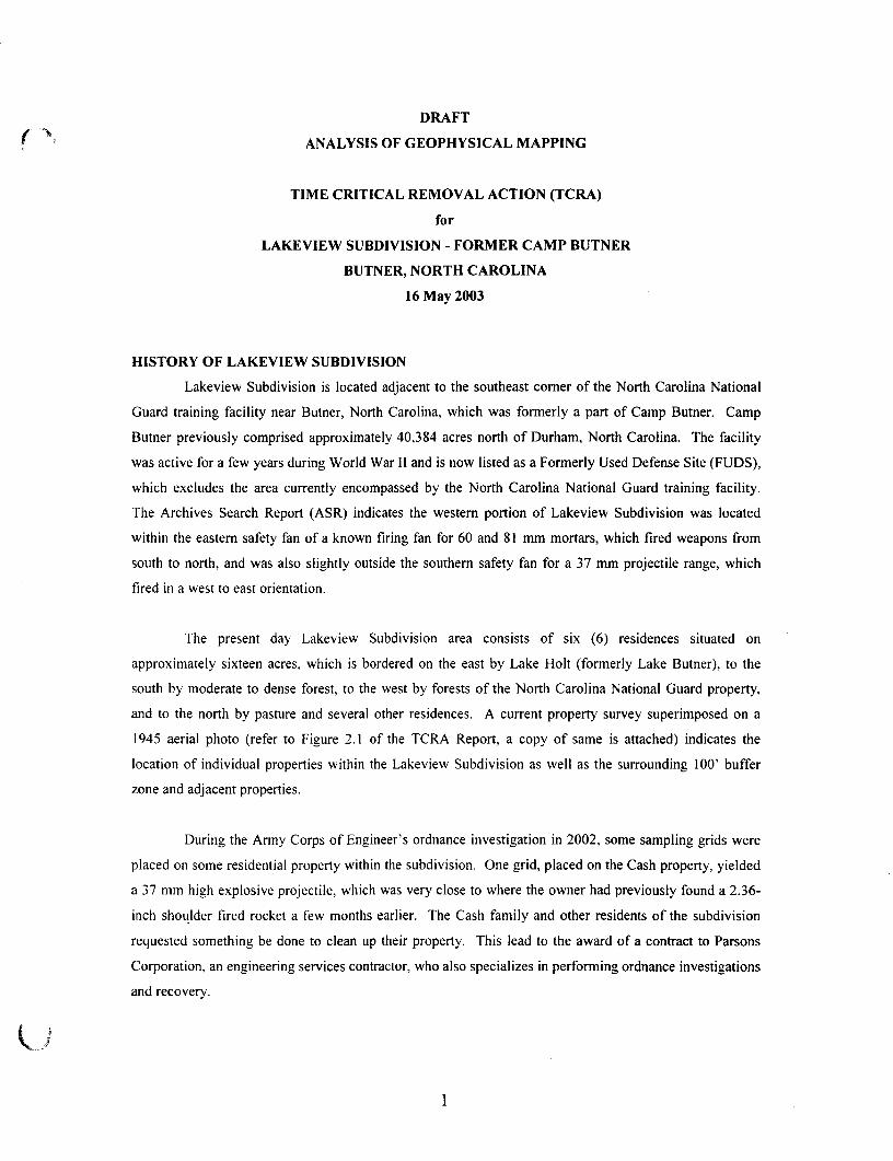
DRAFT
( '• ANALYSIS OF GEOPHYSICAL MAPPING
TIME CRITICAL REMOVAL ACTION (TCRA)
for
LAKEVIEW SUBDIVISION - FORMER CAMP BUTNER
BUTNER, NORTH CAROLINA
16 May 2003
HISTORY OF LAKEVIEW SUBDIVISION
Lakeview Subdivision is located adjacent to the southeast corner of the North Carolina National
Guard training facility near Burner, North Carolina, which was formerly a part of Camp Butner. Camp
Butner previously comprised approximately 40,384 acres north of Durham, North Carolina. The facility
was active for a few years during World War II and is now listed as a Formerly Used Defense Site (FUDS),
which excludes the area currently encompassed by the North Carolina National Guard training facility.
The Archives Search Report (ASR) indicates the western portion of Lakeview Subdivision was located
within the eastern safety fan of a known firing fan for 60 and 81 mm mortars, which fired weapons from
south to north, and was also slightly outside the southern safety fan for a 37 mm projectile range, which
fired in a west to east orientation.
The present day Lakeview Subdivision area consists of six (6) residences situated on
approximately sixteen acres, which is bordered on the east by Lake Holt (formerly Lake Butner), to the
south by moderate to dense forest, to the west by forests of the North Carolina National Guard property,
and to the north by pasture and several other residences. A current property survey superimposed on a
1945 aerial photo (refer to Figure 2.1 of the TCRA Report, a copy of same is attached) indicates the
location of individual properties within the Lakeview Subdivision as well as the surrounding 100' buffer
zone and adjacent properties.
During the Army Corps of Engineer's ordnance investigation in 2002, some sampling grids were
placed on some residential property within the subdivision. One grid, placed on the Cash property, yielded
a 37 mm high explosive projectile, which was very close to where the owner had previously found a 2.36-
inch shoulder fired rocket a few months earlier. The Cash family and other residents of the subdivision
requested something be done to clean up their property. This lead to the award of a contract to Parsons
Corporation, an engineering services contractor, who also specializes in performing ordnance investigations
and recovery.

TIME CRITICAL REMOVAL ACTION (TCRA) SUMMARY
* The U.S. Army Corps of Engineers contractor, Parsons, performed a Time Critical Removal
Action (TCRA) at the Lakeview Subdivision in January and February 2003. A final clearance report was
written by Parsons and is available for detailed information regarding the clearance activities conducted.
Twenty-six (26) acres were investigated, which included sixteen (16) acres of the Lakeview Subdivision
and a one hundred (100) foot buffer zone comprising ten (10) acres. The land was cleared using a
magnetometer followed by digital geophysical mapping of the area. An analysis of the geophysical data
collected by Parsons was done by Corps of Engineers geophysicists and is presented in this report along
with recommendations for further action. All anomalies detected during the magnetometer search were
investigated to a maximum depth of six (6) inches below ground surface (BGS) to mitigate the immediate
hazard to residents of the subdivision and clear the shallow subsurface of any metallic objects, which could
interfere with the subsequent geophysical mapping. A TCRA by regulation is implemented to remove the
immediate threat to the population by doing a surface removal only followed by performance of an
Engineering Evaluation Cost Analysis (EE/CA). After the EE/CA investigation is completed, a final long-
term recommendation would be made. During this TCRA, a clearance was done to six (6) inches BGS
because a 37mm high explosive projectile was found only three (3) inches deep near a child's play area. It
is possible at that depth for small children to possibly dig up items while playing with toy shovels, etc. It
was for this reason that the TCRA was scoped for a six (6) inch clearance. Finally, the Government felt
that it would be prudent to geo-physically map the area after the removal action to get an indication of the
degree of anomalies that remained below six (6) inches. All of these scoped actions were completed. Of
the 8230 anomalies investigated during the magnetometer search, eighty (80) were described as OE scrap,
six (6) were identified as UXO, and the remainder considered non-OE scrap. The recovered UXO items
included a 37 mm HE projectile, two 2.36-inch bazooka rockets, a MKII hand grenade, an Ml mine fuze,
and an electric blasting cap, which were all disposed by demolition. Refer to the Lakeview Subdivision
TCRA Report for additional information related to specific project activities.
GEOPHYSICAL MAP INTERPRETATION
Corp of Engineer's personnel walked the Lakeview Subdivision area on 13 May 2003 with a map of all
anomalies and marked on the map what clearly was not a suspect anomaly. Things like swing sets, water
wells, utilities, and fences were noted. It was also noted that the roads within the Subdivision contained
magnetic rock as can be observed on the attached geophysical maps. An aerial photo from 1945 details the
locations of roads previously used by the military in the vicinity of Lakeview Subdivision. Of particular
interest is the previous route of Lakeview Drive (Refer to Figure 2.1 of the TCRA Report, a copy of same
is attached), which turned toward the north and crossed the western edge of the Cash Property instead of
heading westward toward Roberts Chapel Road as the road is situated at present. Also shown on the aerial
photo are several cleared areas adjoining Lakeview Drive, particularly two areas, one in the center of the
Cash Property and the other immediately adjacent to the western edge of the Cash Property. These two
U

areas coincide with concentrated areas of geophysical anomalies, UXO, OE scrap, and non-OE related
scrap detected in the northwest portion of the Lakeview Subdivision (primarily in the vicinity of the Cash
Property) and associated buffer zone (west of the Cash Property) during the TCRA (refer to Figure 2.2,
Figure 2.3, and Table 2.3 of the TCRA Report, copies of same are attached). The UXO, OE scrap, and
non-OE related scrap items discovered during the TCRA appear to be concentrated along former roadways
within the northwest portion of the Lakeview Subdivision. The UXO and OE scrap found in the
Subdivision account for approximately 1% of the total anomalies detected and excavated. It is possible
that in addition to impacts from fired weapons, some of the contamination in the vicinity of the Cash
Property may be the result of periodic debris disposal at that time. Refer to the attached geophysical grid
maps, which detail subsurface anomaly locations and annotated comments for anomalies identified as
surface features.
CONCLUSION
The geophysical maps prepared subsequent to field activities confirm the presence of additional
metallic debris concentrated within the immediate vicinity of the Cash Property with lesser amounts
dispersed throughout the Lakeview Subdivision area. Review of the geophysical data collected, historical
information, utility locations, surface feature maps, and the TCRA excavation results indicate the origin of
recovered UXO, OE scrap, and non-OE scrap may be the result of periodic debris disposal in addition to
fired projectiles. The majority of anomalies identified on the attached geophysical maps can be discounted
through surface feature verification, subsurface utility locations, magnetic rocks, and/or construction debris
from residential homes (refer to Figure 2.3 of the TCRA Report, a copy of same is attached). The only way
to confirm the remaining anomalies are not UXO is to conduct a clearance to depth removal action
beginning in the northwest corner of the site in the immediate vicinity of the Cash Property and proceeding
grid by grid towards the south and east until no additional UXO are recovered. The property owner
immediately north of the Cash Property denied Right of Entry access so additional delineation to the north
is not considered possible at this time. Additional delineation to the west is also not possible since the
Lakeview Subdivision abuts the active North Carolina National Guard Property. If no additional UXO are
found within 200' south or east of Grids 334 and 358 (refer to Figure 2.2 of the TCRA report, a copy of
same is attached), then the removal action for Lakeview Subdivision will be considered complete. If
additional UXO are found the removal action shall continue until a 200' clear area is established.
Additional investigation of the area surrounding Grid 375 is unwarranted considering the previous UXO
found in that grid was an electric blasting cap. which was obviously dumped in that location and could not
have been an overshoot from the aforementioned firing fans.

2067500 2068000 2068500 2069000 20695Q0 2070000 2070500
W1LLETTE JAMES B JR & AUDREY
North Carolina.National Guard
i—,
~ASH DANNY I.AMAR SKIMBERL\ AN
tJORMA JEANI 100'Clearance Buffer
S TOMAN B JR 8." » FRANCES LJ DANIEL WILLIAM
JERRY & LEANNELA1NE & ROBYN S.
TCRA SiteLakeview Subdivision111 & CHRISTY S
MOORE RAlPJR & MARY A
Lane HolL^ Butner)
Figure 2.1
Former Camp ButnerButner, NC
Index Map
Legend| | 1001 TCRA Clearance Buffer
| ~ ~ | North Carolina National Guard
|~~] Hatorlcal Rring Fan UmN
^ ^ H Stream and
Image Sourw: 1&45 Aeilil Ptiob> ITE™ TFC, US Armv Fn^lnResearch S De^elopmer* CaWBr
Mac units: IWD L983 Nortli Csrall™ s o n Plane (Fret)
100 0 100 2W 300 Feel
PARSONS
HSHJhEDBY1
BT
BT
DS
DS
U.S. ARMY ENGINEERINGAND SUPPORT CENTER
HUNTSVILLE
Time Critical Removal ActionLakeview Suodh/isirm(1945 Aerial Photo)
. 1 Inch oquaPi 300 feet
April 2003
RLE i:\gts\730OIJ l^gi/_prTCRA apt
742752
2067000 2067500 2061000 2069500 207MOO 2070500

\
WILLETTE JAMES B JR & AUDREY
WILLETTE JAMES B JR & AUDREY
WIGGS, JEFFREYSTATE OF NORTH CAROLINA2.36-in rocket found by owner 11/11/01
37mm HE projectile found during EE/CA 8/21/D2
2.36-in rocket found by owner - CashProperty 5/27/02
STATE DF WORTH CAROLINA
ASIH DANNY LA.KIMBERL RILEY, STAN
NORMA JEAN
| 100' Extension Area |
DANIE_WILLIAu--, VTR ROMAN
355\DANIFI r i l lEYmMQTHY
CHR STY S354
395QGRERAL-PI
STATE OF NORTH CAROLINA
TCRA at Lakeview
414S
• :
Figure 2.2
Intrusively InvestigatedGrid Locations
Former Camp ButnerButner, NC
]
••, -
- " •
' - ^ ^
i
ndex Map
MoMR
VLegendlOO'xiOO'Grid
Intrvsively Investigated - No OESIntrusively Investigated - OES Present/No UXOIntrusively Investigated - UXO PresentWaTerbody(SOTS Data, Buffered 50 Feet)
# Recent Non-TCRA UXO FlnOlngs
Map Unrts. w<0 I9B3 Htxtti CarolifiB Sta« FHanfl (FaK)
500 0 100 200 Fee!
PARSONSU.S. ARMY CORPS
OF ENGINEERSHUNTSVILLE CENTER
BT
BT
DS
DS
Intnisively Inestigated Grid LocationLakeview Subdivision
. 1 Inch equals 200 r
U I E Aphl 2003
742752

o
100'Clearance Buffer
Figure 2.3
Former Camp ButnerButner, NC
Index Map
LegendI | 100" TCRA Clearance Butler
| | 100-K 100'Grid
Ngrth Carolina NattonBl Guard
Historical Firing Fan Ejmrt
Slream end Watertoody
ObsbucliDn Feature
Image Source: 1 W Aenal Ptiato From TEC, Its ArmyRee^rcK B DevElarynaiT Ctttttt
Map units: NBD 1983 North Carolina s a t ! Plane (Feet)
150 D ISO Feel
PARSONSU.S. ARMY ENGINEERINGAND SUPPORT CENTER,
HUNTSVILLE
BT
BT
DS
DS
Geophysical SurveyTime Critical Removal Aclion
Lake view Subdivision
1 inch equals 150 reel
Apia 3003
i:\gls\73SD01\a._proiect\TCRA.apr
PflOJECl 4JMBBI'
7427S2

vAFT
Table 2.3Total UXO and OE Scrap Recovered by Grid
Time Critical Removal Action, Former Camp Butner/Lakeview SubdivisionButner, North Carolina
Grid
300
300S
300W
301
301W
302
302W
303
304
304S
305
306
307
308
308W
309
309W
310
311
312
Ml PracticeMine Fuze
2.36-inch BazookaRocket
MKII HandGrenade
37mm UKProjectile
Electric BlastingCap
OE ScrapContacts OE Scrap Description
Non-OE ScrapContacts
65
10
33
49
16
91
3
125
14
3
51
75
62
142
56
107
2
5
14
85
I:/Hunt-Conus/Projects/Butner/TCRA/TCRA Report/Draft/T-2-3Contract No. DACA87-00-D-0038Delivery Order 0028 2-22
Rev 04/18/2003

»AFT
Table 2.3Total UXO and OE Scrap Recovered by Grid
Time Critical Removal Action, Former Camp Butner/Lakeview SubdivisionButner, North Carolina
Grid
313
314
315
316
317
317W
318
318W
320
320S
321
322
323
324
325
326
327
328
330
331
Ml PracticeMine Fuze
2.36-inch BazookaRocket
MKII HandGrenade
37mm HEProjectile
Electric BlastingCap
OE ScrapContacts
1
1
1
1
2
1
1
3
4
1
1
OE Scrap Description
2.36" nose cone
0.3 lb ordnance fragment
cone, 2.36" rocket
2.36" rocket motor
grenade fuze, Ml mine partial fuze
fragment
fragment
60mm tail boom, grenade fuze, frag
60mm mortar fin, frag
grenade debris
fragment
Non-OE ScrapContacts
76
204
208
285
416
132
60
8
66
20
24
13
88
93
88
87
77
84
10
24
l:/Hunt-Conus/Projects/Butner/TCRA/TCRAReport/Draft/T-2-3Contract No. DACA87-00-D-0038Delivery Order 0028 2-23
Rev 04/18/2003

Table 2.3Total UXO and OE Scrap Recovered by Grid
Time Critical Removal Action, Former Camp Butner/Lakeview SubdivisionButner, North Carolina
Grid
332
333
334
335
336
337
338
339
341
341S
342
343
344
345
346
347
348
349
350
352
Ml PracticeMine Fuze
1
2.36-inch BazookaRocket
1
MKII HandGrenade
1
37mm HEProjectile
1
Electric BlastingCap
OE ScrapContacts
4
2
2
5
1
2
5
8
OE Scrap Description
fragments
2.36" nose cone, fragment
grenade fuze, partial 2.36" rocket
60mm fins, grenade tail, 2.36" rocket motor
rifle grenade tail boom
rifle grenade tail boom, 60mm fins
2.36" motor and nose cone, 60mm fins, grenade fuze
60mm fins, grenade tail, 2.36" rocket motor
Non-OE ScrapContacts
15
24
35
207
292
175
67
12
22
3
41
49
46
75
139
224
138
33
1
90
l:/Hunt-Conus/Projects/Butner/TCRA/TCRAReport/Draft/T-2-3Contract No. DACA87-00-D-0038Delivery Order 0028 2-24
Rev 04/18/2003
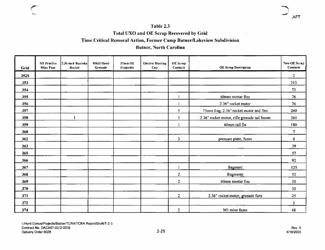
r **-%
Table 2.3Total UXO and OE Scrap Recovered by Grid
Time Critical Removal Action, Former Camp Butner/Lakeview SubdivisionButner, North Carolina
>AFT
Grid
352S
353
354
355
356
357
358
359
360
362
363
365
366
367
368
369
370
371
372
374
Ml PracticeMine Fuze
2.36-inch BazookaRocket
1
MKII HandGrenade
37mm HEProjectile
Electric BlastingCap
OE ScrapContacts
1
1
5
5
1
3
1
2
2
2
2
OE Scrap Description
60mm mortar fins
2.36" rocket motor
75mm frag, 2.36" rocket motor and fins
2.36" rocket motor, rifle grenade tail boom
60mm tail fin
pressure plate, fuzes
fragment
fragments
60mm mortar fins
2.36" rocket motor, grenade fuze
M1 mine fuzes
Non-OE ScrapContacts
2
213
73
76
76
260
261
180
7
6
39
57
92
125
52
50
30
25
3
48
I:/Hunt-Conus/Projects/Butner/TCRA/TCRA Report/Draft/T-2-3Contract No. DACA87-00-D-0038Delivery Order 0028 2-25
Rev 04/18/2003

_.<AFT
Table 2.3Total UXO and OE Scrap Recovered by Grid
Time Critical Removal Action, Former Camp Butner/Lakeview SubdivisionButner, North Carolina
Grid
374S
375
376
377
378
379
380
381
382
384
384S
385
386
387
388
389
390
391
392
394
Ml PracticeMine Fuze
2.36-inch BazookaRocket
MKIIIIandGrenade
37mm HEProjectile
Electric BlastingCap
1
OE ScrapContacts
2
1
1
OE Scrap Description
Ml mine fuzes
M1 mine fuze
Ml mine fuze
Non-OE ScrapContacts
0
86
49
14
10
50
32
36
13
30
8
74
43
11
47
43
47
12
12
18
l:/Hunt-Conus/Projects/ButnerfTCRA/TCRAReport/Draft/T-2-3Contract No. DACA87-00-D-0038Delivery Order 0028 2-26
Rev 04/18/2003
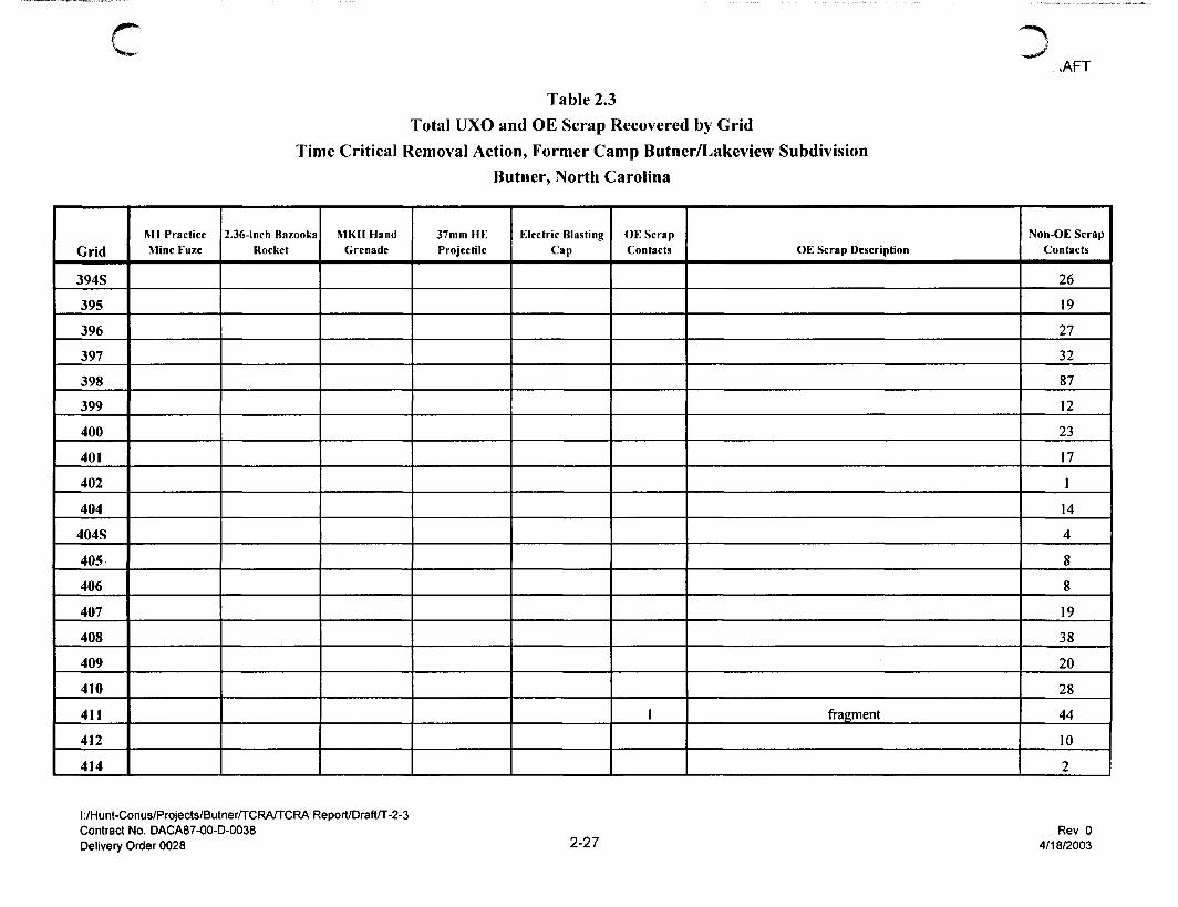
r
Table 2.3Total UXO and OE Scrap Recovered by Grid
Time Critical Removal Action, Former Camp Butner/Lakeview SubdivisionButner, North Carolina
.AFT
Grid
394S
395
396
397
398
399
400
401
402
404
404S
405
406
407
408
409
410
411
412
414
Ml PracticeMine Fuze
2.36-inch BazookaRocket
MKII HandGrenade
37mm HEProjectile
Electric BlastingCap
OE ScrapContacts
1
OE Scrap Description
fragment
Non-OE ScrapContacts
26
19
27
32
87
12
23
17
1
14
4
8
8
19
38
20
28
44
10
2
I:/Hunt-Conus/Projects/Butner/TCRA/TCRA Report/Draft/T-2-3Contract No. DACA87-00-D-0038Delivery Order 0028 2-27
Rev 04/18/2003
cTable 2.3
Total UXO and OE Scrap Recovered by GridTime Critical Removal Action, Former Camp Butner/Lakeview Subdivision
Butner, North Carolina
1 jNumber of UXO items present in grid.
l:/Hunt-Conus/Projects/Butner/TCRA/TCRAReport/Draft/T-2-3Contract No. DACA87-00-D-0038Delivery Order 0028
.AFT
Grid
414S
415
416
417
418
419
420
421
422
424
425
426
427
428
429
430
431
432
Total
Ml PracticeMine Fuze
1
2.36-inch BazookaRocket
2
MKIIllandGrenade
1
37mm UKProjectile
1
Electric BlastingCap
1
OE ScrapContacts
1
2
1
80
OE Scrap Description
fragment
fragments
fragment
Non-OE ScrapContacts
1
10
18
23
37
58
101
103
29
1
4
9
3
87
147
2
1
2
8144
2-28Rev 0
4/18/2003

c,/sons' Lakeview Grids 300W (1 ) & 300 EM61 Bottom Coil
CEHNC JAD 25 Apr 03 -20mV to 20mV CI=2mV, (-20 to -3/3 to 20)
art Tipped88830C
8882E
888280-
888270
888260
888250
888240
888230-
888220-
888210-
888200
./• ?
2067620
* r
* • "
a?. f* fallen iTre
tfff**..
J ;$U
V
#-
r *
• * " • -
2067640 2067660 2067680 2067700 2067720 2067740- " t -
2067760 2067780
I '4
2067800

Parsons' Lakeview Grids *. A & 302 EM61 Bottom CoilCEHNC JAD U May 03 _2Qmy t Q 2 0 m V c | = 5 m VMonument Log
888500-J
L__ ,
u_
1__—-j
,
,
,
, ^
88849CH
•—-——
-—;
; =L- —
r
888480-T-—:
—
;
•
: —f-
888470—
-r-rr-^ - -
-—
— j-
888460-—T-*-—
=
— —j-
888450-]--1-
:
^ * • ;
t
888440
-•
*->
-;
888430 i
-r—I
:
:
~]
888420-' J* -•
^—f :
:
^
1* " -^
888410—w——-—;
:
"-*• Lj-
1—'
~—
888400
• —
T-:—'
£—i
888390
•
; ^
:
*—. : —
888380
888370-: y-
j.| ' f
:
^ -^~-
888360
—
:
'^
888350
——•
;
—-
888340
—
:
—
888330
: :
888320
:
'-
-•••
•'
-^
88830CH 1 1 1 1 1 1 )—
1 1 :
2067700
2067720
2067740
2067760
2067780

DButner - Lakeview Subdivision EM61 data Grid 301W & 302W
Data Processed by RJS - 1 May 2003 Bottom coil (-20 to 20 by 5, 1st @+-5mV)

CButner - Lakeview Subdivision EM61 data Grids 303 & 308W
Data Processed by RJS - 1 May 2003 Bottom coil (-20 to 20 by 5, 1st @+-5mV)
oooooo
8Q
O
33
gl
ooooooen
8
> V
8
• \ i ,
8O)1
8
ooooooen
:::K >:\

Butner - Lakeview Subdivision EM61 data Grid 304 & 305Data Processed by RJS - 1 May 2003 Bottom coil (-20 to 20 by 5, 1st @+-5mV)
Butner - Lakeview Subdivision EM61 data Grid 304S
n
88820O -%*-
888190-
888180-
88817a
fc 1
888160^
888150-
•#
888140- -
2067800 2067810 2067820 2067830 2067840 2067850 2067860 2067870 2067880 2067890 2067901
uData Processed by RJS - 1 May 2003 Bottom coil (-20 to 20 by 5, 1st @+-5mV)
Butner - Lakeview Subdivision EM61 data Grid 306
n
888500-JT
888490-
fgftf
888480—T
888470-
888460-
r .(fi
888450-
.- n
Sptke-
888440-
**
888430-
.*§
888420-
888410-^
888400^
2067800 2067810 2067820 2067830 2067840 2067850 2067860 2067870 2067880 2067890 2067!
Data Processed by RJS - 1 May 2003 Bottom coil (-20 to 20 by 5, 1st @+-5mV)

Butner - Lakeview Subdivision EM61 data Grid 307 & 308
Data Processed by RJS - 1 May 2003 Bottom coil (-20 to 20 by 5, 1st @+-5mV)888700-
888690-
888680-
888670-
888660-
888650-
888640-
888630-
888620-
888610-
888600-
888590-
888580-
888570-
888560-
888550-
888540-
888530-
888520-
888510-
888500-2067800
2067820
2067840
2067860
2067880

c DButner - Lakeview Subdivision EM61 data Grid 309 & 317W
Data Processed by RJS - 1 May 2003 Bottom coil (-20 to 20 by 5, 1st @+-5mV)
00

nButner - Lakeview Subdivision EM61 data Grid 310
888200
888190
888180
88817i
888160
888150
888140
888130
888120
888110
eak mag
2067900 2067920 2067940 2067960 2067980 2068000
uData Processed by RJS - 1 May 2003 Bottom coil (-20 to 20 by 5, 1st @+-5mV)

cButner - Lakeview Subdivision EM61 data Grid 311 & 312
Data Processed by RJS -1 May 2003 Bottom coil (-20 to 20 by 5, 1st @+-5mV)
oo
O
55
l\3oo>-jcoo
to
•vlco
8co
g
oO>-vlco00o
IOoo>§oo
oo0300N>POQ
"i- •*
oos 00ooooroo>o
ooooooN>ooQ
00
gCO
03
CO
oooooo
52Q
o0)
•oT3CD 00
0000
* *$ t
'•I,
\ V \
;:. AV
•X;
(0
\ \
1 " 1 * ^
» + • *
000300CO03Q
, ^ . .
00
Building Materials
Butner - Lakeview Subdivision EM61 data Grid 313
Data Processed by RJS - 1 May 2003 Bottom coil (-20 to 20 by 5, 1st @+-5mV)
Oo
House

nButner - Lakeview Subdivision EM61 data Grid 314
Cart tip
2067900 2067920 2068000888600
888590
888580
888570
888560
888550
888540
888530
888520
888510
trees
2067960 2067980
trees
2067900 I 2067920 2067940 2067960 2067980 2068000
vinly siding
uData Processed by RJS - 1 May 2003 Bottom coil (-20 to 20 by 5, 1st @+-5mV)

cButner - Lakeview Subdivision EM61 data Grid 315 & 325
Culvert
88870CH
888680
888660
888640
888620
888600^2067900 2067920 2067940 2067960 2067980 ^2068000 206/1020 2068040 2068060 2068080 2068100
V
Data Processed by RJS -1 May 2003 Bottom coil (-20 to 20 by 5, 1st @+-5mV)

c arsons' Lakeview Grid 316_vCEHNC JAD 14 May 03
1303 a EM61 Bottom Coil-20mVto20mV CI=5mV
•I 3
888800
Labled Culvert -(Preliminary)Sign & MonurflWhon field notes
888700-)
Note: Check RoadLocation Survey
2067900 2067910 2067920 2067930 2067940 2067950 2067960 2067970 2067! 2068000

Butner - Lakeview Subdivision EM61 data Grid 317 & 327
Surveyspik
88890O
Truck
88888
88886O
888840
Joadtccatio
88882a
8888O(HP-2067900 2067920 2067940 2067960 2067980 2068000 2068020 2068040 2068060 2068080 2068100
Data Processed by RJS - 1 May 2003 Bottom coil (-20 to 20 by 5, 1st @+-5mV)

Butner - Lakeview Subdivision EM61 data Grid 318
889000
888990
888980
888970
888960^
888950
888940
888930
88892a
888910-
> -byffer pound
2067900 2067910 2067920 2067930 2067940 2067950 2067960 2067970 2067980 2067990 2068000
Data Processed by RJS -1 May 2003 Bottom coil (-20 to 20 by 5, 1st @+-5mV)

Butner - Lakeview Subdivision EM61 data Grid 320
Survey Nail
888200
888190
888180
888170
888160
888150
888140
888130
888120
888110
888100
888090
888080^
888070^
.Carttipped
2068000 2068020 2068040 2068060 206/080
Nail ???
2068100
Data Processed by RJS - 1 May 2003 Bottom coil (-20 to 20 by 5, 1st @+-5mV)

r
8co
8ooo>00oN>O
8ooo4
too
ro
§o
O
Butner - Lakeview Subdivision EM61 data Grid 321 & 322Data Processed by RJS - 1 May 2003 Bottom coil (-20 to 20 by 5, 1st @+-5mV)
Q)
Butner - Lakeview Subdivision EM61 data Grid 323
n
888500
888490
888480
88847i
888460
88450
88844'
88843'
888420
888410
888400
2*8000 2068010 2068020 2068030 20680*L 2068050 2068060 2068070 2068080 2068090 2068100
PropaneTank (now buried) well
Data Processed by RJS - 1 May 2003 Bottom coil (-20 to 20 by 5, 1st @+-5mV)
oButner - Lakeview Subdivision EM61 data Grid 324
diffuse mag hit (weak)
888600-
88859>
888580
888570
888560
^88550
888540
888530^
888520
888510
888500
2068000 2068010 2068020 2068030 2068040 2068050 2068060 2068070 2068080 2068090 206810(
uData Processed by RJS - 1 May 2003 Bottom coil (-20 to 20 by 5, 1st @+-5mV)

Butner - Lakeview Subdivision EM61 data Grid 326
o
888800
888790-t
888780
^85577
888700
88876a
888750
888740
888730-^
888720
888710
2068000 2068010 2068020 2068030 2068040 2068050 2068060 2068070 2068080 2068090 206813040
sNote - Several linear anomalies (manmade)
Data Processed by RJS - 1 May 2003 Bottom coil (-20 to 20 by 5, 1st @+-5mV)

Parsons' Lakeview Grid 32t 339 EM61 Bottom CoilCEHNC JAD 28 Apr 03 -20mVto20mV CI=1mV
8889002068000 2068020 2068040 2068060 2068080 2068100 2068120 2068140 2068160 2068180
Note - Several Linear anomalies (manmade)

o
u
Parsons' Lakeview Grid 330 & 331 EM61 Bottom CoilCEHNC JAD 28 Apr 03 -20mV to 20mV CI=5mV
888200
888190
888180
888170
888160
888150
888140
888130
888120
888110
888100
888090
888080
888070
888060-1
888050
888040
2068100 2068120 2068140 2068160 2068180 2068200

cParsons' Lakeview Ghu 332 & 333 EM61 Bottom Coil
CEHNC JAD 30 Apr 03 -20mVto20mV CI=5mV
Note: Multiple area's of downed trees (no data)

Butner - Lakeview Subdivision EM61 data Grid 334
o
888500-
888490-
888480^
888470-
888460-
t
{8450-i-
888440-
888430-
888420-r
888410-
888400-
r/
•
9
Cart tippedr
• • a ?
Swamp area
:•*"'
2068100 2068110 2068120 2068130 2068140 2068150 2068160 2068170 2068180 2068190 2068200
uData Processed by RJS - 1 May 2003 Bottom coil (-20 to 20 by 5, 1st @+-5mV)

rv Parsons' Lakeview Grk ->35 & 336 EM61 Bottom Coil
CEHNC JAD 28 Apr 03 ~20m v to 20m v d=
D
Note : Data gaps are downed trees

c rsons' Lakeview Grid 337 C 3303 a EM61 Bottom CoilCEHNC JAD 28 Apr 03 O
888800
888790
888780
888770
888760
888750
888740
888730
888720
888710-
888700-
power pole(37'from gazebo)o
-20mV to 20mV CI=5mV
2068100 2068110 2068120 2068130 2068140 2068150 2068160 2068170 2068180 2068190 2068200

cParsons' Lakeview Grid 338 c 49 EM61 Bottom Coil
CEHNC JAD 28 Apr 03 -20mV to 20mV CI=5mV
Telephone pole (3 lines into ground)
888900
888890
888880
888870
888860
88880a2068100 2068140 2068160 2068180 2068200 2068220 2068240 2068260 2068280 2068300
n
Parsons' Lakeview Grid 341 EM61 Bottom CoilCEHNC JAD 01 May 03 -20mV to 20mV CI=5mV
T-888100
888090
888080
888070
888060
888050
888040
888030
888020
888010
888000
o 2068220 2068230 2068240 2068250 2068260 2068270 2068280 2068290 2068300

Parsons' Lakeview Grid 342 EM61 Bottom CoilCEHNC JAD 01 May 03 -20mV to 20mV CI=5mV
o
888200-
88819a
88818O
888170-
« : . » . « •
I, ::Sf
888160-
888150-
888140-
888130-4-
888120-
888110H-
888100-
§Sb
- # -
-0*
-I* *
•W
••4P
Mr .t"
0)3CD0
oQ
2068200 2068210 2068220 2068230 2068240 2068250 2068260 2068270 2068280 2068290 2068300
"- arsons' Lakeview Grid 343 .1803 A EM61 Bottom Coil- 'CEHNC JAD 01 May 03 -20m V to 20m V Cl=5m V
888300
888290
888280
888270
888260
888250
888240
888230
888220
888210
888200
2068200 2068210 2068220 2068230 2068240 2068250 2068260 2068270 2068280 2068290 2068300

r
Parsons' Lakeview Grid 344_021803_a EM61 Bottom CoilCEHNC JAD 01 May 03 -20mV to 20mV CI=5mV
U
888440-
888430-
888420-
888410^
888400-
888390-
888380-
88837Ch
888360-
888350-
888340-
888330^
:'.*, -:'
888320^
888310-
888300-
..« *J! Jf
"J
df*
.f
2068200 2068220 2068240 2068260 2068280 2068300

Parsons' Lakeview Grid 345 022103 A EM61 Bottom Coil
n CEHNC JAD 01 May 03 -20mVto20mV CI=1mV
ooooOO—
888480-
888430-
ftftRAnn—-i
. f ••$
A
; *"
. , ;
4
s- ,«*
> • • • . * • •
-
: . '
Lo<
•
-<
A"
1
m
•
r
d
3* f
:•- • m
-<•
<
J"
,r '
^ ,<
?rf > ^
• . -a
i
JF*.
? sign
*
«
-
~#•** •' i
a*'.
!
• • * . - • • |
I
i
•'.hr
•
2068200 2068210 2068220 2068230 2068240 2068250 2068260 2068270 2068280 2068290 2068300

/ * " • • -
Parsons' Lakeview Grid 34 21303 a EM61 Bottom CoilCEHNC JAD 01 May 03 _ 2 0 m V t o 2 0 m V c | = 5 m V
888800
888790
888780
888770 f
888760
888750
Well orLP gas tankunder birdbath
888710^
888700+
Dip from did Po
m
€> ff^^
2068200 2068210 2068220 2068230 2068240 2068250 2068260 2068270 2068280 2068290 2068300

Parsons' Lakeview Grid 352_021903_a EM61 Bottom CoilCEHNC JAD 01 May 03 -20m V to 20m V Cl=5m V
n
Pool Driveway \8881
888090
888080
888070
888060
888050
888040
888030-
888020
888010
888000
2068300 2068310 2068320 2068330 2068340 2068350 2068360 2068370 2068380 2068390 2068400

^arsons' Lakeview Grid 353_0219< a EM61 Bottom CoilCEHNC JAD 01 May 03 -20mV to 20mV CI=5mV
888200
888190
888180
888170
888160 -
888150
888140^
888130
888120
888110
888100
2068300 2068310 2068320 2068330 2068340 2068350 2068360 2068370 2068380 2068390 2068400

r Parsons' Lakeview Grid 354_021 1_a EM61 Bottom CoilCEHNC JAD01 May 03 -20mV to 20mV Cl=5mV
888300 — —
888290
Hit Bump888280
888270
888260
888250
888240
888230
888220^
888210
888200—
2068300 2068310 2068320 2068330 2068340 2068350 2068360 2068370 2068380 2068390 2068400

nParsons' Lakeview Grid 355 021803 a EM61 Bottom Coil
CEHNC JAD 01 May 03 .2OmV to 20mV CI=5mV
888400-
888390-
888380-
888370-
888360-
QQQOCA ,OOOOOU^
QQQQ/1A—
888330-
888320-
888310-
•r'
j r
-••r
, • jj£
•
•r
, & • •
• • - • • * -
j
f
w
*-
iff*SSP
• * ^
?
.*-
- :- -
.4*
p- it'
r.f",< ,'V-ar-
1
m $
r ' , . ! ? * • *.#•
*
•m m
^ ^
sr
f
3rush
*^ »
Sidn
fc *
Pile
f asp'
ft .
- ^r
*
1
• c '
4*
w
^ ' ' •
r j *r #
^ * / :
«#" #>-4
• •
• & • •
2068300 2068310 2068320 2068330 2068340 2068350 2068360 2068370 2068380 2068390 2068400
Parsons' Lakeview Grid 356 & 357 EM61 Bottom CoilCEHNC JAD 01 May 03 -20mV to 20mV CI=5mV

cCD(D VLCD
Parsons' Lakeview Grid v & 359 EM61 Bottom CoilCEHNC JAD 01 May 03 -20mV to 20mV CI=5mV
Note: Check Utility lines before digging
o
ro

Parsons'Lakeview Grid 359 021803 a EM61 Bottom CoilCEHNC JAD 01 May 03 -20mVto20mV CI=5mV
888800
888790
888780
888770
2068300 2068310 2068320 2068330 2068340 2068350 2068360 2068370 2068380 2068390 2068400

r
Parsons' Lakeview Grid 360 & 372 EM61 Bottom CoilCEHNC JAD 01 May 03 -20mV to 20mV CI=5mV
888860
8888002068300 2068320 2068340 2068360 2068380 2068400 2068420 2068440 2068460 2068480 2068500

Parsons' Lakeview Gria 362 & 363 EM61 Bottom CoilCEHNC JAD 01 May 03 -20mV to 20mV CI=5mV
Note: Verify location of Well referenced on field notes, multiple metal pin flags in driveway area.

cParsons' Lakev»>w Grid 365 -367
EM61 Bottom CoilCEHNC JAD 01 May 03 -20mVto20mV CI=5mV
<D

Butner - Lakeview Subdivision EM61 data Grid 370
888700
88869'
888680
888670
888660
38650
888640
888630
8886204
888610
88860042068400 2068410 2068420 2068430 2068440 2068450 2068460 2068470 2068480 2068490 206850C
Data Processed by RJS -1 May 2003 Bottom coil (-20 to 20 by 5, 1st @+-5mV)

r
888800
888790
888780
888770
888760
888750
Parsons' Lakeview Grid 371 & 52 EM61 Bottom CoilCEHNC JAD 01 May 03 '2OmV to 2OmV CI=5mV
SurveySpike
88874a
888730
88872'
888710-
888700-1
2068400 2068420 2068440 ^Oifi^gO 2068480 2068500 2068520 2068540 2068560 2068580
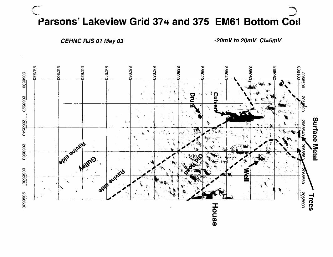
Parsons' Lakeview Grid 374 and 375 EM61 Bottom Coil
CEHNC RJS 01 May 03 -20mVto20mV CI=5mV

Parsons' Lakeview Grids 37b & 377 EM61 Bottom Coil
CEHNC JAD 01 May 03 '20mV tO 2OmV CI=1mV
Utility P
ost
Rusty D
ebris
Transformer
Cu
l-de-sac
-eti-ciej f

cButner - Lakeview Subdivision EM61 data Grid 378 & 379
Data Processed by RJS - 1 May 2003 Bottom coil (-20 to 20 by 5, 1st @+-5mV)
o000000
rooCOCD
onl\3
00
oo00COr\3
oooooow
rosoo
£o8O)oo •-oi
oen
CO
o
rooCD
8"oo
Do
a
(O.W..
"2-
0
oooos
00ooooCO
oooo
2§
oooosroo
00
oo
' * • •
00oo00
, \ •
fc)'. I

Butner - Lakeview Subdivision EM61 data Grids 380 & 381
Data Processed by RJS - 1 May 2003 Bottom coil (-20 to 20 by 5, 1st @+-5mV)
(0
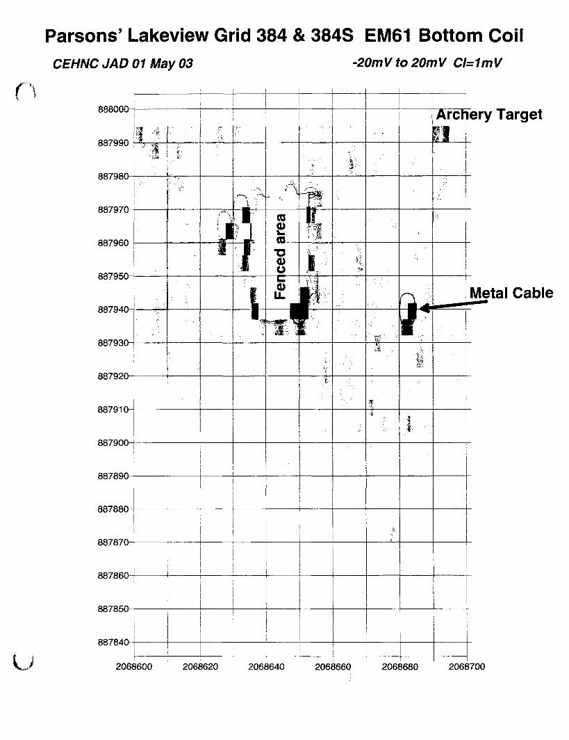
r
Parsons' Lakeview Grid 384 & 384S EM61 Bottom CoilCEHNC JAD 01 May 03 -20mV to 20mV CI=1mV
888000
887990
887980
887970
887960
887950
887940
887930-4
887920
887910
887900^
887890-
88788CH
887870
887860
887850
887840
U
Archery Target
i
Metal Cable
2068600 2068620 2068640 2068660 2068680 2068700

Parsons' Lakeview Grid 385 022403 b EM61 Bottom Coil
CEHNC JAD 01 May 03 -20mVto20mV CI=1mV
888100-
888090-
888080-
888070-
888060-
888050-
888040^
88803CH-
888020-
888010-
888000-
House
U 2068600 2068610 2068620 2068630 2068640 2068650 2068660 2068670 2068680 2068690 2068700

Parsons' Lakeview Grid 386 021803 b EM61 Bottom Coil
OCEHNC JAD 01 May 03 •20mVto20mV CI=5mV
888200
888190
888180
888170
888160
888150
888140
888130
888120
888110
888100
2068600 2068610 2068620 2068630 2/S68640 2068650 2068660 2068670 2068680 2068690 2068700
birdfeeder post
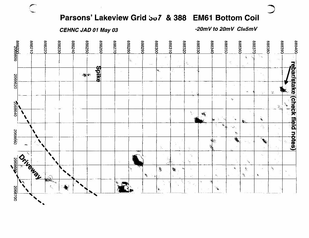
CO00
o>
CO
sQ
CDcoCO
IS
Parsons' Lakeview Grid koo7 & 388 EM61 Bottom CoilCEHNC JAD 01 May 03 -20mV to 20mV CI=5mV
COCOCOroco
cococorot
cococoro
COCOCON>O)O
CO
§too
coCO
88co§§roco
oos8
COcocoCO
co
coro
co co
8 £
COcococoo>o
oococoCO
coCO
8CO
oocoCOCOCO
o
coCO
cor
82
ro
8
'1 e). (D(0
rooco
8

/**"*"
Parsons' Lakeview Grid 38a & 390 EM61 Bottom Coil
CEHNC JAD 01 May 03 ~20mVto20mV CI=5mV
oo

arsons' Lakeview Grids 391, 39^, 401, & 402 EM61 Bottom CoilCEHNC JAD 01 May 03 -20mV to 20mV CI=5mV
888740
888720
888700
88868C
88866C
888640
888620-
888600-1--
•» m
-m-
m
m
m
~w
tic.
m m
-M-* # •
2068600 2068620 2068640 2068660 2068680 2068700 2068720 2068740 2068760 2068780 206880>0»*
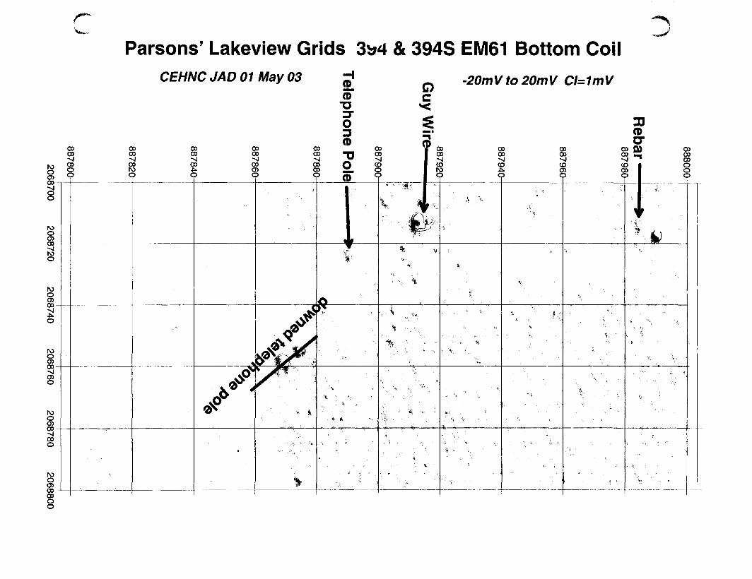
Parsons' Lakeview Grids 3b4 & 394S EM61 Bottom CoilCEHNC JAD 01 May 03 -20mVto20mV CI=1mV

aParsons' Lakeview Uriels 395 & 396 EM61 Bottom Coil
CEHNC JAD 01 May 03 -20mV to 20mV CI=1mV
CO
co•vl
8
85-2
100
|
o0
000)
ooo
\
oooooo
8
0000ooot
ooV)•o(D
.1ooooooo
(D
0)
T
ooooooo
B
00oooo
00
sQ
i v
\ V
l\
\.
oo
§ oo
Q
00oooo
.... flL
^ .
>' ."• ;
0000oo
K)
o
00
%' r
'. Is ••
\
I %
• * •
•VI K
f i r .
It . <
* s < 1

Parsons' Lakeview Gri^o 397 & 398 Bottom CoilCEHNC JAD 14 May 03 -20mV to 20mV CI=5mV
QC
Spike
Mag
hits
Bounce off tree stum
p
Metal H
oot Basket
:fMtf
%Well
2068700
2068720
2068740
2068760
2068780
2068800
cButner-Lakeview Subdivision Grids 399 & 400 EM61 bottom coil
Data Processed by RJS-1 May 2003 (-5,5 by 5 to 20mV)
00

r
Parsons' Lakeview Grids 4u4, 404S & 405 Bottom CoilCEHNC JAD 14 May 03 -20mV to 20mV CI=5mV
)902
5800
2068820
20688402068860
2068880
20
05
888000
887980
887960
887940
887920
887900
887880
887860
887840
887820
887800
887780
VSt,
•
-v
V . -. • »
. . • •••> ' <
3 .-
- v - x ••'••« x , . •
-.. ' V ' ' •=« ""*-
• • - _
• V •
• < •«. V • x
v X X
*> "V.
• i t , "* •. -•
i • . Xr "* \vi •• v . s < . ».
, ' % ' ' • - - .
• '•- to
•• N ,
"i s*X ^ '- .,
v -- ^X ,
•• ••» , f t * '••
• • ' X
V '- ^ •"S - "*•
COoo

V...
Parsons' Lakeview Grids 406 & 407 Bottom CoilCEHNC JAD 14 May 03 -20mV to 20mV CI=5mV
N>OCOco-cooo
IVJOat00-00roo
00
SoIV)Q
00oooo
g
00
o<J)Q
oo
§?
oooooo
00ooootoQ
oooo00
oo0)
(D
oooooo
ooooooooo
ooooooN>oQ
IV)
8oo-
toroo
g.0005
o
'•••: k
ft *
V.. - *t X '*
g00-
o
\ .'.
CDoo
Parsons' Lakeview Grids 408 & 409 Bottom CoilCEHNC JAD 14 May 03 -20m V to 20m V Cl=5m V
QC
Spike I
? Stjone Structure ?
Dijivew
ay |
o0)(D
2068800
2068820
2068840
2068860
2068880
2068900
888400-
888380-
888360-
888340-
888320-
888300-
888280-
888260-
888240-
888220-
888200-

Parsons'Lakeview Grid^ 410 & 420 Bottom CoilCEHNC RJS 14 May 03 -20mV to 20mV CI=5mV
Underground Electric(Check Utility Survey)
8885004-
888480-
. * ;
•*.* -r " f -
t 4 *f4 i 4 * " • '
* < • # - #
888460-
V? Brush
888440-
' I4
,t t
888420-
2068800
Concrete Pads Downed ree4- ' 4
2068820 2068840 2068860 2068880 2068900 2068920 2068940 2068960 2068980 2069000

Parsons' Lakeview Grids 411 & 421 Bottom CoilCEHNC RJS 14 May 03 -20mV to 20mV CI=5mV
888600
88858'
888560
88854i
888520
8885002068800 206f8:20 2068840 2068860 2068880 2068900 2068920 2068940 2068960 2068980 2069000
Underground Electric(Check Utility Survey)

Parsons' Lakeview Grids -r12 & 422 Bottom CoilCEHNC RJS 14 May 03 -20mV to 20mV CI=5mV
888680
88866O
88864
888620
8886002068800 2068820 2068840 2068860 2068880 2068900 2068920 2068940 2068960 2068980 2069000

Parsons' Lakeview Grids 414, 414S & 415 EM61 Bottom CoilCEHNC RJS 14 May 03 _2(JmV to 20mV c,=5mV
os!900
roo2>5920
ro
CO
o
roo2>i960
?
ooooooc
> %
>•
oo00-vl
oor\3
'%-> t " '••
oococo
i)
\
ooooooc
>
D
%
' %
V
*
oooooo
« t. i.
•
?
• *
D
H \
-
•i.
4
-
- •
>
•
V
I 1
§8-j8cp
•
V
% V * *« it
t. » *
A »•• \w% *,*1 V
»11 t-1 i.
|
oo0)
oooo-siCO
f•
4 j
-
oo ooco ooCO CO
V•V
%
> < *
• •»
%
• \
• \ 4
^ V
>•
» • •, -
r > » »
ft
-
V
* \ -. - \-
00ooCO
c
* ** V
* •
<* >• ' • > \ • •
0
V
\
\
oooooooc
\ ' -1
"... t
%\ >
\ ' ' • %
* % *
i. .
V
•
fi)(O

Parsons'Lakeview Grids ^ J&417 EM61 Bottom CoilCEHNC RJS 14 May 03 -20mVto20mV CI=5mV
CO00
00GO00
o
00oooo
00ooooo
00ooooo
oooooo
g
0000ooo
00oo00
5
oooooooooo
oooooo_L
o
00oo00
o
oo
oooooo
8oo
ooooooOl
oooooooo
oooooo
*>*
oooooocoO
oooooo
-B
v *.scoO *. t
too00
1 't
i. v
O0)ooco
§
%
* — «
4
CO00
o
oo>coo

arsons' Lakeview Grids 425, .6 & 427 EM61 Bottom CoilCEHNC RJS 14 May 03 _2QmV tQ 20mV a=5mV
888400r
888380-
888360-
888340-
88832Q1
888300-
888280-
888260-
888240-
888220-
888200-
888180-
888160-
888140
888120
888,100;2069000
2069020
2069040
2069060
2069080

Parsons' Lakeview Grids 42b <* 429 EM61 Bottom CoilCEHNC RJS 14 May 03 o
3.c
-20m V to 20m V Cl=5m V (8,10,15,20)
oooogo
s
00
oo00—A
00
ro
oooo
co

Grid ^ J & 419 EM61 Bottom Channal Ca...^ Butner Parsons Lakeview Subdiv.oion
CEHNC JAD 13 Feb 03 -20 to 20 mV Cl=4 mV
APPENDIX CANOMALY DIG SHEET SUMMARY

cSUMMARY OF THE INTRUSIVE INVESTIGATION
AREA1
GrUW
Phase 1/
Phase!!/
M & F
Grids from Area IA
AIG9209
A1G0201
AIG0101
A 1(70210
A1G9211
AIG0212
Ph.,. 1
Phasel
Phase I
Phut I
Phase I
Phasel
TofkfarArflA
Grids from Former Area I
AHS0O0J
AHM93
A1GMU
A1G0I90
AIGOltl
A1C0W1
AlGOlti
AWHK
A1G01M
AIG01I7
AlGtlM
AwnnAlGOIlt
A1C0I11
AIG0U2
AIGBI1J
A1G0132
AIG0D4
AlGtllS
AlGtlit
A1C0I17
A1G9139
AIGO142
A1G0M
A1G9U7
Aicom
Phase I I
Phasel
Phasel
Phasel
Phase I
Phasel
Phase I
Phasel
Phasel
PhaicI
Phasel
Phasel
Phasel
Phasel
PhaicI
Phase I
Phasel
Phasel
Phasel
Phasel
Phasel
Phasel
Phasel
Phasel
Phasel
Phasel
instrument
UwJ
EM61MK2
EM6IMK2
EM6IMK2
F.M6IMK2
EM61MK2
EM61MK2
EM-61
F.M6IMK2
EM6IMK2
EM61MK2
EM6IMK2
EM61MK2
EM6IMK2
EM6IMK2
EM61MK2
EM61MK2
EM6IMK2
EM6IMK2
EM6IMK2
EM61MK2
EM61MK2
EM6IMK2
EM6IMK2
EM6IMK2
EM61MK2
EM61MK2
EM61MK2
EM61MK2
EM6IMK2
EMGIMK2
EM61MK2
EM61MK2
Grid
Locathm
C-9
C-9
D-9
D-9
D-9
C-9
D-8
C-9
C-9
C-9
C-9
C-9
C-9
C-9
C-9
C-9
C-9
C-9
C-9
C-9
C-2
C-9
Total
Anamalies
Selected
10
28
I I
6
17
26
»»
1
82
3
16
9
16
7
16
Number
erOES
Anomalies
0
0
3
2
1
1
7
0
0
0
0
0
0
0
0
Range of
OES Depth
(Inehe.)
N A
N A
1", including UXO
2"
10"
0"
N A
N A
N A
NA
NA
NA
NA
NA
Number
UXO
0
0
1
0
1
0
2
0
0
0
0
0
0
0
0
Description
UXO
Hems
NA
MA
Mk II HandGrenade
2-MK15jrenades (inert)
M4 PracticeMine v*7 Hve fuze
M15 grenade(inert)
NA
NA
NA
NA
NA
NA
NA
NA
Other
Findings
AN NOES • drain pipe, metal scrap, andhot rocks.
AH NOES - rod, nail, rake, metal scrap,and hot rock.
UXO - Mk II hand grenade, OES - TwoM15 grenades (expended and Inert).
NOES - nails, wire, and hot rock.
OES - Two M15 grenades (expendedand inert). NOES - hammerhead, spike,
metal scrap.
UXO - M4 Practice Mine wflive fuzeand spotting charge, NOES - wire,
pipe, horse shoe, and hot rock.
OES - M15 grenade (expended andinert). NOES - plow point, wire, metal
scrap, and hot rock.
All NOES - horse shoe
AH NOES - nails, wire, scrap metal, andhot rocks.
All NOES - nails, wire, and metal scrap
All NOES - hot racks.
All NOES - horse shoe, wrench, fencepost
All NOES - horse shoe. nail, scrap metaland hot rock.
All NOES • horse shoe, plow point, hookrod, and hot rock.
Welch!
afOES
(It..)
0.00
0.00
1.50
2.00
1.50
0.00
5
0 0 0
0.00
0.00
0.00
0.00
0.00
0.00
0.00
Weight
otNOES
(IF.,)
5.00
2.00
0.50
6.20
10.00
7 5 0
31
2.00
6.00
0.00
3.30
0.00
16.00
6.00
12.50
Number
False
Pwiklvn
0
3
0
0
0
0
3
0
I I
3
4
0
0
0
0
lntrusive_Summary_Table C-1

*JIX CSUMMARY OF THE INTRUSIVE INVESTIGATION
AREA 1
CrUID
Atom
AlGtliS
AIGI1U
AlGtISS
AlGtIK
A1GHS*
AIGOIU
AIG9I6I
A1G9I62
AIG9163
A1G9292
A1G9203
A1G0204
A1G02K
A1G0286
AIGI40
Phase 1/
Phaseil/
H«r
riia«i
PhaMl
PhaicI
Phaiel
FhaMl
F IMMI
PhMCl
Fhncl
Phaul
rhaul
FhaKl
Ftiasel
PhaKl
Phaul
PtMMl
PhaicI
Imtmmrnt
Used
F.M61MK2
EM6IMK2
EM6IMK2
EM61MK2
EM6IMK2
EM61MK2
EM6IMK2
EM6IMK2
EM6IMK2
EM6IMK2
EM6IMK2
EM6IMK2
EM6IMK2
EM6IMK2
EM6IMK2
RM61MK2
TeOhft FetmtrAm 1 ftalmilmf IA)
Grid
Localion
C-9
C-9
C-9
C-9
C-9
C-9
D-8
D-8
D-8
D-8
D-8
C-9
Tolal
Anonuliei
Selected
18
10
1
1
2
7
28
217
Niimhcr
ofOES
Anemalkf
0
0
0
0
0
0
0
•
Range of
OES Depth
(incho)
NA
NA
NA
NA
NA
NA
NA
Number
of
UXO
0
0
0
n
0
0
0
e
Description
UXO
NA
NA
NA
NA
NA
NA
NA
Other
Findings
All NOES - plow point, rebar, scrapm«tal. and hot dirt.
All NOES - horse shoe, metal scrap, andhot rocks.
All NOES- hot rock.
All NOES - metal can lid.
All NOES bolt and nail.
All NOES - cans, pipe, and scrap metal
All NOES - nan pit and hot rock.
Weigh!
of OES
(IE.,)
0.00
0.00
0.00
0.00
0.00
0.00
0.00
t
Weight
•fNOES
(ft.)
13.00
3.00
0.00
0.10
0.20
2.20
2.00
M
Number
Falie
Potirhci
2
2
0
0
0
3
6
31
lntrusive_Summary_Table C-2

fSUMMARY OF THE INTRUSIVE INVESTIGATION
AREA 2
CridlD
A2Uimi
A2G0M3
A2G0904
AWM06
A2GM07
Aiaooos
A2G0KH
A2GM10
A2GMII
A2G9912
A2GM13
A2GM14
A2GM1S
A2GM16
A2GM1I
A2GM21
A2GM2S
A2GM26
A2G9927
A2GM2I
A2GM31
A2GM12
A2GM3S
A2GM3t
A2GM3I
A2GMJ9
A2G0M
A2G994S
A2GM4*
A2GM47
A2GM4<
A2GM5t
A2CMS1
Phase U
Fhaiell/
M * F
PhaKl
PluucI
Phase I
Ph.it I
PhaKl
Phase I
PlMKl
PhaKl
Fluid
Phasel
Phasel
PhaKl
PhaKl
PhaKl
P I U K l
Pltasel
PhaKl
PhaKl
PhaKl
PhaKl
PhaKl
Phanl
Phaul
PhaKl
PhaKl
PhaftI
PhaKl
PhaKl
Phan l
PhaKl
PhaKl
Phasel
PhaKl
Instrument
lli.J
EM6IMK2
EM6IKDC2
EM61MK2
EM6IMK2
EM61MK2
EM6IMK2
EM6IMK2
EM6IMK2
EM61MK2
EM6IMK2
EM6IMK2
EM61MK2
EM6IMK2
EM6IMK2
EM61MK2
EM61MK2
EM61MK2
EM6IMK2
EM6IMK2
EM61MK2
EM6IMK2
EM61MK2
EM6IMK2
EM61MK2
EM6IMK2
EM6IMK2
EM6IMK2
EM6IMK2
EM6IMK2
EM61MK2
EM6IMK2
F.M6IMK2
EM6IMK2
Grid
Location
C/D8
C/D-8
C/D-8
C/D-g
C/D-8
C/D.8
C/D-8
C/D-8
C/D-8
C/D-8
C/D-8
C/D-8
C/D-8
C/D-8
C/D-8
C/D-8
C/D-8
C/D-8
Total
Aiwmalki
Investigated
0
U
41
11
5
4
18
7
10
25
7
1
1
4
3
3
4
14
4
20
Number
orOES
Anomalies
0
0
0
0
0
0
0
0
0
0
0
0
0
0
0
0
0
0
0
0
Range of
OES Depth
(inches)
NA
N A
NA
N A
NA
NA
NA
NA
NA
NA
NA
N A
NA
NA
NA
NA
NA
NA
NA
NA
Number
of
I K O
0
0
0
0
0
0
0
0
0
0
0
0
0
0
0
0
0
0
0
0
Description
UXO
Items
NA
NA
NA
NA
NA
NA
NA
NA
NA
NA
NA
NA
NA
NA
NA
NA
NA
NA
NA
NA
Other
Findings
None
NOES- horseshoe, bucket, bolts, licensedate. pipe, few hot rocks.
NOES- many nails, wire, metal pins.Some hot rocks.
NOES- horseshoes, steel strapping,spikes, pipe, nails, minor hot rocks.
NOES- barbed wire, nails, plow blade,wing nut..
NOES- washer, wire, nails, barbed wire.
NOES- nails, pins, steel plates, uboK.pipe, steel cable, barbed wire.
NOES- steel cable, barbed wire, nans.
NOES- nails, barbed wire, rebar, misc - 1hot rock.
NOES- nails, barbed wire, hinges, lewhot rocks.
All NOES-barb wire.
None
NOES-nail
NOES - bolt, grounding rod, misc.
NOES • 2 hot rocks and a grounding roc
NOES - hot rocks
NOES - nails, survey pin, hot rock.
NOES - nails, hot bricks, hot rocks.
NOES - rebar, metal misc, hot rocks.
All NOES - barb wire, metal scrap, andhot rock.
Weight
or OES
(lbs)
0.00
0.00
o.oo
0.00
0.00
0.00
0.00
0.00
0.00
0.00
0.00
0.00
0.00
0.00
0.00
0.00
0.00
0.00
0.00
0.00
Weight
or NOES
Ob.)
0.00
9.50
20.00
7.00
5.00
2.00
10.00
5.00
3.00
3.00
3.00
0.00
0.10
1.50
1.00
0.00
0.50
1.50
2.50
16.30
Number
false
Positives
0
2
0
0
0
0
0
0
1
5
0
1
0
0
0
1
1
1
0
1
C-3

rAPPENDIX C
SUMMARY OF THE INTRUSIVE INVESTIGATIONAREA 3
GriilD
Aictmi
A3G9002
A3G0993
A3GIXH7
A3G009S
A3G09I9
A3GMII
A3GM13
A3GMU
A3GM1S
A3GM17
A3C00II
A3GMH
A1G0020
A3GM22
A3G0O23
AKOO24
A3GM2S
A3GW26
A3GM27
A3GM2S
A3GM2*
A3GOO38
Aiami
A3G0032
A)GU>33
A3GM34
A3G0O3S
A3GM33
A3G0O36
A3GM37
Phase U
Phascll/
M i r
Phasel
Phasel
Phase]
Phasel
Ph.it 1
Phasel
Phase I
Phasel
Phasel
Phase 1
Phasel
Phasel
Phasel
Pk .« l
Phuel
Ph»*el
P I M M I
Phuel
Pluuel
Pluul
Ptuutl
Phuel
Phase 1
Phuel
Phasel
Phasel
Fhasel
Phne l
Phue l
Phasel
Phasel
Instrument
Used
EM6IMK2
EM61MK2
EM61MK2
EM6IMK2
EM6IMK2
EM6IMK2
EM6IMK2
EM6IMK2
EM61MK2
EM61MK2
EM6IMK2
EM6IMK2
EM6IMK2
EM6IMK2
EM6IMK2
EM6IMK2
EM61MK2
EM61MK2
EM61MK2
EM6IMK2
EM6IMK2
EM6IMK2
EM61MK2
EM61MK2
EM6IMK2
EM6IMK2
EM61MK2
EM61MK2
EM6IMK2
EM61MK2
EM6IMK2
Grid
Location
C-8
C-8
C-8
C-8
C-8
C-8
C-8
C-8
C-8
Total
Anomalies
Inve.U..ted
39
31
64
12
23
82
64
53
52
no
Number
ofOES
Anomalies
0
0
0
0
0
0
0
0
0
0
Range of
OES Depth
(Inches)
NA
N A
N A
N A
N A
N A
N A
N A
N A
N A
Number
of
U X O
0
0
0
0
0
0
0
0
0
0
Description
UXO
Hems
NA
NA
NA
NA
NA
NA
NA
NA
NA
NA
Other
Findings
All NOES - Horseshoes, latch, barbedwire, hinge, spring, plow blade, ax head,
nails, rebar, chain, iron water barrel,cable, some hot rocks.
All NOES - Rebar, wire, nails, chain,manv hot rocks.
All NOES - Nails, plow blades, bolts,ence post, wire, steel barrel, chain, steepins, angle iron, ax head, S steel bath
tubs, few hot rocks.
All NOES - Wire. bolt, unidentified scrapmetal, few hot rocks.
AH NOES - bucket, chain, bars, wire,banding, leaf spring, some hot rocks.All NOES - mower Made, fence posts,
horseshoes, metal brackets, shovelhead, ax head, wire, chain, pipes.
Several hot rocks.All NOES - plow blade, horse shoe, leaf
spring, scrap metal, and hot rock.
All NOES - wire, nails, magnets, bolt,anchor, misc scrap metal, moderate
amount of hot roeks/soil.
AH NOES - horseshoes, chain, bolts,nuts, wire, ax head, steel banding, nails
pipes. Several hot rocks/soil.
AH NOES - bolts, horseshoes, nails,staples, plow blades, hinges, steel
banding, hatchet. Several hot rocks/soi
Weight
ofOES
01")
0.00
0.00
0.00
0.00
0.00
0.00
0.00
0.00
0.00
0.00
Weighl
or NOES
(lbs)
75.00
7.00
318.00
5.00
23.00
91.00
41.00
25.00
75.00
150.00
Number
fake
Poilthei
0
6
6
0
2
3
5
6
1
2
C-4

c APPfc^OIXCSUMMARY OF THE INTRUSIVE INVESTIGATION
AREA 3
A3G0031
AIGIKIII
A3G0049
A3G0U2
Pluul
Fhln l
PhaxI
FhaxI
KM6IMK2
EM61MK2
EM61MK2
EM6IMK2
C-8
C-8
C-8
C-8
59
86
103
51
0
0
0
0
NA
NA
NA
NA
0
0
0
0
NA
NA
NA
NA
All NOES - wire, nails, magnets, bolt,anchor, misc scrap metal, moderate
amount of hot rocks/soil.Alt NOES - numerous horseshoes,
bucket, wires, hinges, bolt, rebar, hook,wire, nails, chain, moderate hot
rocks/soil.
All NOES - plow blades, manyhorseshoes, wire, nails, and many other
metal scrap. Little to no hot rock/soil.
All NOES - nails, chain, numerousunidentified scrap. Little to no hot
rock/son.
0.00
0 0 0
0.00
0.00
2200
75.00
100.00
50.00
4
1
4
0
C-5

cAPPENDIX C
SUMMARY OF THE INTRUSIVE INVESIGATIONAREA 4
Grid ID
Area 4A Grids
A4GP1
A4GV2
A-tai'3
A4GV4
A4GP5
Total* for Area 4A
\rea 4B Grids
A4G1439
A4G0445
A4G0446
Totals for Area 4B
\rea4C Grids
A-IHIAI
A4BLA2
A4G0009
A4G0017
A4GQ020
A4GOO23
A4G0SI6
A4GO5I7
A4G0523
A4G0S24
Total* for Area 4C
\rea 4D Grids
A4G03S4
A4G03SS
Phase V
Phased/
M & F
M&F
M&F
M&F
M&F
M&F
PhHMll
Phase 11
P tMt t l l
M & F
M & F
Phase 11
Phase 11
Phase 11
Phase I I
Phase I
Phase I
Phase!
Phase 1
Phase 11
Phase II
Instrument
USMI
Sthiinsicdl
Schonsledi
Schunsicdi
Sdionstedl
Sdionsledi
EM 61
EM-61
EM 61
Sclu.nsledt
SthiHislcdf
EM-61
EM -61
EM 61
EM-61
EM61MK2
EMMMK2
EM61MK2
EMM MIC
EMM
EM-61
Grid
Location
D-4/D-5
IM/D-5
D-4/D-5
IW/U-5
l>4/l>-5
l >4
D-4
I W
B-3
B-3
C-3
C-3
B-3
B-3
C-4
B-3
B-5
B-5
TUIHI
Anomalies
Investigated
30
30
t o
30
30
150
IK
6
]R
42
30
30
52
25
28
41
64
62
86
24
442
49
19
Number
uTOES
Anomalies
2
4
2
7
20
3
1
0
4
28
30
13
13
2fi
31
52
5fi
52
12
313
7
10
Rangeirf
OKS Depth
4inctH3)
4-6"
I-41
O-.l"
2"
0-3 •
ft", UXO fuunu at 1
4"
NA
1-81
1-12"
2-30"
1-3"
3-8"
1-12"
1-18"
2-6"
1-10"
1-6"
0-10"
2-fi"
Number
oT
UXO
0
0
]
0
0
1
I
0
0
1
0
0
0
0
1
0
0
0
0
0
1
0
0
Description
UXO
Items
Other
Findings
u m = 2.36' Bazooka Kockel motor and2.36 Bazooka unidentifiable Irag. NOES = variousRocket (inert) unidentifiable scrap metal with numerous
hot rocks
2.36 BazookaRocket (inert)
2.36' BazookaRocket
2.36 BazookaRocket (inert)
Rocket (inert)
OES = Two 2.36' Bazooka Rocketmotors and unidentifiable frag. NOES -chain, barbed wire, various unidentifiable
scrap metal with numerous hot rocks.
UXO/OES • 2.36 Bazooka Rocket BtP,2 expended rocket motors. 2.36' rocketfins, M9 Rifle Grenade Scrap. NOES =wire, nails, counter weight, misc scrap
metal plus many hot rocks.
u t t i = 2.3t>~ uazooKa HOCKBI motor andunidentifiable frag. NOES = cans, wife,
hoe head, banding, metal tube, bedsprings, stove parts with numerous hot
rocks
fins. NOES * all hot rocks.
2.36' HE rocket
NA
NA
OES - unidentifiable trag (likely trom2.36'1. NOES - wire, scrap metal.
OES • unidentifiable frag. NObS - hotrock.
All NOES • wire fence, metal scrap, andhot rock.
NA
155 mm frag
105mm inertsmoke roundcasings
NA
105mm HE loworder, fuzemissing
M51 Fuze (inert)
NA
NA
NA
M51 fuze (inert)
UtS - unidentifiable frag. NOES - wireand scraD metal.
All OES • 155mm frag and unidentifiablefraa.
OES • Two 105mm inert smoke projectilecasings, HE frag. NOES • wire, nails,
rabar, plow blade, scrap metal.
OtS • unidentifiable frag. NOES - metalscrap, barb wire and hot rock.
UXO/OES - 105mm HE low order,w/shearad fuze (UXO) BIP. OES - fuzes
and frag. NOES • hot rock.
ObS • M51 fuze and unidentifiable frag.NOES - hot rock.
OES - m51 series frag and unidentifiablefrag. NOES - metal scrap and hot rock.
OES - unidentifiable frag. NOES - hotrocks.
UtS • 105mm base plates, Bi mm tailtins, unidentifiable Irag. NOES - barb
wire, metal scraD. and hot rock.OES - M51 fuze (inert) and unidentifiable
frag. NOES barb wire and hot rock.
NA
NA
metal and hot rock.OES* unidentifiable frag. NOES • metal
scrap and traa
Weight
.if OKS
(Ihs)
2.25
9 25
13.00
2.25
10.50
37
1 00
1.50
0.00
3
7.50
33.00
35.00
5.00
15.00
0.00
86.00
42.00
5 00
30.00
259
5.00
BOO
Weight
uTNOES
(Ihs)
3.75
7.50
8.50
31.00
0.00
51
4.00
0.00
1.50
6
0.20
0.00
200.00
2.00
3.50
0.00
1.00
1.00
20K
30.00
XOO
Number
Fake
Positives
0
0
0
0
0
0
1
1
0
2
0
0
0
0
0
0
0
0
0
0
0
0
0
lntrusive_Summary_Table.xls C-6Rev 2
10/17/2003
APPENDIX CSUMMARY OF THE INTRUSIVE INVESIGATION
AREA 4
Grid ID
A4GO3S6
A4G04I7
A4G04IB
Totah for Ana 4D
Krea 4E Grids
A4GO4O2
A4G0408
A4G04I3
Totals far Ana 4E
ptuitti/
PhtLWlI/
Phase 11
Phase I I
Phase I I
Phase I I
PlUUell
Phase I I
Mkeview Subdivision
A4GI436
A4CI437
A4G143H
Phase U
Phase 11
Phase U
Totals for Lakeview Subdivision
ire* 4 Proper Grids
A4G0244
A4G0245
A4G0247
A4G0249
A4G0261
A4G0262
A4GO263
A4G02B3
A4G0284
A4G028S
A4G02K7
A4G028S
A4G02X9
Phase I I
PhHHl I
Phase 1]
Phase 11
Phase 11
Phase 11
Phase I I
Phase I I
Phase 11
Phased
Phase I I
Phase I I
Phase I I
Instrument
Used
EM-61
EM-61
EM-fil
BM-fil
KM-fit
E M M
KM-61
EM-fil
EM-fcl
EM-fil
EM-61
EM-61
KM-61
EM-61
EM-61
HM-M
EM-6]
EM-fil
EM-fil
EM-fil
E M M
EM-61
CHd
Location
B-5
B-4
B-5
A-5
B-5
C-7
C-7
C-7
C-6
C-6
C-6
C-fi
C-6
C-6
C-6
C-6
C-6
C-6
C-6
C-fi
C-6
T.rtul
Amimalles
Investigated
19
4
It
91
10
19
34
30
52
K
90
33
4
23
20
30
31
34
18
35
45
39
36
48
NumhL-r
ufOES
Anomalies
X
2
0
27
0
0
1
1
2
0
0
2
3
2
7
11
2«
19
28
g
29
43
36
31
34
RflltgL' (if
OES Depth
(inches)
0-h"
2-3"
UXO found al 2", n
ati;, first anomaly di
NA
I"
2"
NA
NA
4-7"
1-2"
1-5"
2-6"
0-8"
0-14"
0-10"
0-4"
1-12"
0-18"
1-10"
2-24"
Number
UXO
0
0
1
1
1
0
0
1
0
0
1
0
0
0
0
0
0
0
0
1
0
0
0
0
Dttcription
UXO
turns
57mm APT
2 37mm (inert)
37mm HE
Other
Finding*
UXO - 57mmAPT. OES • unidentifiablefrag. NOES - scrap metat and hot rocks.
OES - Two 37 mm (inert}. H 6 E 5 - metalscrao and hot rock
37mm HE
NA
NA
All NOES • wire, scrap metal and hotrock.
OES - unidentifiable trag. NOES - metal' scrap and hot rock.
37mm HE
UXO/OES 37mm HE BIP from anomaly«24,60mm mortar (Ins. NOES - leal•prlng, nails, chain, atova lag. A law
hot rocka.
Alt NOES - plow blades, nails, banding,chain, wire, nails, misc.
NAAll NOES - horseshoe, large steel loop,
unidentifiable scrap metal, few hot rocks.
NA
NA
NA
57mm, FUZE
NA
NA
NA
NA
M Series Fuze
NA
NA
NA
M51 PDFU2E
OfcS is unidentifiable small irag. NOtSis horseshoe, wire, various unidentified
scraD metal. A few hot rocks.OES is unidentifiable small frag. NOES
is hot rocks.OES - Unidentifiable larger ftag. NOES •
horse shoe. wire, and hot rocks.
57mm AP-T demo for poaslble HEUXO tram Grid 249, anomaly #19.WAS NOT HE. Other Frag - Fuze,
various HE Irag (unsp*citiad).
OES - Unidentifiable H t frag. NOES -Hot Rock and unidentified scraD.
ObS Hag • Jimmy Walker identified as155mm Frag. Other NOES tcrap metal-
a lew hot rocks/soil.
OES - Unidentifiable HE (rag. NOES •Unidentifiable scrap and few hot rocks.
OES - Unidentifiable HE frag. NOES -Unidentifiable scrap and few hoi rocks.
UXO/OES M Series Fuze from anomaly#16 determined to be live and waa
BIP. NOES lew hot rocka.
OES • Unidentifiable HE frag. NOES •Horseshoe and small scraD.
OES • Unidentifiable HE irag. NOES -Unidentifiable scraD and hot rock.
OES • Unidentifiable HE frag. NOES -Unidentifiable scrap and few hoi rocks.
U t i i • Lots ot Ibbrnm I-HAO, M51 HUFUZE. NOES • Bolts, some hot rock andsoil, pipe, mule shoes, nails, wire, plow
hlarifts car narts ate.
Wright
«TOES
<lt»)
fiOO
2.00
0.00
21
0.00
0.00
0.20
0
7.00
0.00
0 00
7
1.00
0.50
8.00
14.50
9.50
18.00
17.50
3 00
9.00
50.00
27.00
3K.00
51 00
Weight
of NOKS
(l l ' . l
4.00
1.00
0.00
43
0.00
6.00
0.10
6
22.00
2K.O0
13.00
23.00
0.00
10.00
2.00
1.00
9.00
0.25
3.00
0 0 0
1.50
1.00
1.00
153.00
Number
Fake
PIMIUVU
0
0
]
1
0
0
1
1
0
I
4
0
0
1
0
0
0
0
0
0
0
0
0
0
lntrusive_Summary_Table.xls C-7Rev 2
10/17/2003

cAPPENDIX C
SUMMARY OF THE INTRUSIVE INVESIGATIONAREA 4
Grid ID
A4G0295
A4G0296
A4G0303
A4G030S
A4G0307
A4G0310
A4G03II
A4G0312
A4G03I5
A4G03I9
A4G0320
A4GQ32I
A4G0324
A4G0329
A4GQ332
A4GO333
A4G0340
A4G0342
A4G0343
A4G0344
A4G034S
A4G0347
A4G03M
A4G0361
A4G0362
PhiueV
PhascII/
M & F
1'h.ue I I
Phase 11
Phase 11
Phasi- I I
Phase 11
Pints* I I
Phase I I
Phase 11
Phasu 11
Phase 11
Phase 11
Phase 11
Phase II
Phtuel l
Phase 11
Phase 11
Phase 11
Pluue 11
Phase 11
Phase I I
Phase I I
M & F
Phase I I
Phase U
Phase I I
Instrument
Used
KM-fil
EM 61
KM 61
EM-fil
EM-fil
fiM-ftl
KM-61
EM-61
HM-61
E M M
EM-fil
KM-M
E M M
EM-61
EM-61
KM-61
E M M
EM-61
KM 61
EM-61
EM-61
Scbonsittli
EM-61
EM 6]
EM-fil
(.rid
Location
C-6
D-6
C-fi
C-5
l>-5
D-S
C-5
C-5
C-5
C-5
C-5
l>-5
C-6
C-5
I)-5
C-5
D-5
C-5
C-5
C-5
C-5
C-5
C-5
C-5
C-5
Anomalies
Investigated
2R
27
12
21
5
IV
14
17
10
20
45
5
4
49
2
17
6
11
I I
18
16
30
11
16
Ifi
Number
ofOKS
Anomalies
l i t
()
2
20
3
0
1
5
0
IV
.W
0
1
2S
0
15
0
$
3
5
5
25
12
12
Rangi- <>T
OES IH-pth
(inches)
1-4"
N A
3-S"
2-8"
3-H"
NA
4 "
2-1"
NA
3-K"
1-13"
NA
6'
1-15 "
NA
1-4"
NA
1-5"
2-r
3-K"
0-4"
1-3"
0-6"
0-12'
Number
uxo
0
0
0
0
0
0
0
0
0
0
0
0
0
(1
0
0
0
0
0
0
0
()
0
0
0
Description
UXO
Items
NA
NA
57mm
M51 PDFUZE
57mm
NA
37rnm
M51 PD FUZE
NA
MS1 PD FUZE
37 mm
NA
NA
37mm/75mm/105mm (rag
NA
NA
NA
57mm AP-T andM51 Fuze (inert)
NA
57mm
NA
NA
NA
0
0
Oth.r
Finding*
OES • HE Frag - Designated as 155mmwhere identifiable, a few 'hot rocks'
NOES - Plow blades, horseshoes, spoon,nails, shears, some hot rocks.
57mm AP-T <inert).Un.dent.fiable HEfrag. NOES - plow blade, metal atrap,
wire, tew hot recks
O t a - Mbi Series t-uze (inert) andunidentifiable HE frag. NOES -
Unidentifiable scrap metal and a few hotrocks.
57mm AP-T (Inert). OES - HE Frag
NOES - Unidentifiable scrap and lew hoirocks
37mm (lnert).NOES - Unidentifiablescrap, plow blade, horse shoe, steel
rod, steel bar, and tew hot rocks
UfcS - M51 Series huze (inert) andunidentifiable HE frag. NOES •
Unidentifiable scrap metal and a few hotrocks
NOES • wire, scrap metal, and hot rock.
u t b • M51 Series f-uze (inert) andunidentifiable HE frag. NOES •
u t s - 2 3/mm projectiles (inert), 'l MbiSeries Fuzes (inert) and unidentifiable
HE frag. NOES • nails, steel hook,scrao. and mAtal Rnikjeg,
NOtS • bracket from power line and hotrocks.
OES - Unidentifiable HE frag. NOES -few hot rocks.
u t s - Large irag identified as 37mm,75mm, and 105mm (inert),. NOES-
plow blades, conduit, wire, sheet metal,and tint rocks
All NOES - hot rock.
OES • 51 senes tuze Irag andunidentifiable fraa. NOES • hot rock.
NOES • Unidentifiable scrap metal, barbwire, and few hot rocks
ObS - 57mm AP1 (inert), M51 fuze(inert), and unidentifiable frag. NOES-
hot rocks.OES • unidentifiable trag. NOES - hot
rock.Ubti - i /mm AP-1 projectile (inert) and
unidentifiable HE Irag. NOES •unidentifiable scrap metal and few hot
Uba • Unidentifiable Hfc trag. NObS -Unidentifiable scrap metal and few hoi
rocks.ObS - Unidentifiable Hb Irag. NObS -
metal ball and several hoi rocks.ObS - Unidentifiable Hb trag. NObS -
plow blade, unidentifiable scrap, and hotrocks.
ObS • Unidentifiable Hb trag. NObS -few hot rocks and hot soil.
OES - Unidentifiable HE frag. NObS -tew hot rocks and plow part.
Wdfj i t
of OES
<ll»)
45.00
0.00
6.00
¥.50
11.50
0.00
5.00
8.50
0.00
10.00
13.00
0.00
1.00
38.00
0.00
6.50
0.00
8.00
1.00
10.50
1.00
25.00
2.10
3.00
3 50
Weight
uT NOES
(lbs)
5.00
50.00
11.50
4.00
2.00
12.50
13.00
6.00
0.50
3.00
5.00
2 0 0
0.00
27.00
0.00
0.00
4.00
0.00
0 00
6 0 0
0.00
1.25
9.00
0.00
25.00
Number
Fabe
Punitive*
0
0
1
0
1
0
0
0
0
0
0
0
0
0
I
0
0
0
0
0
0
0
0
1
0
lntrusive_Summary_Table.xls C-8Rev 2
10/17/2003

cAPPENDIX C
SUMMARY OF THE INTRUSIVE INVESIGATIONAREA 4
i-
Grid ID
A4G03M
A4G0367
A4G037I
A4GO37S
A4GQ387
A4G03S8
A4G0391
A4G0392
A4G0394
A4G0399
A4GQ42*
A4G0427
A4G052S
A4G0526
A4G052S
A4G0S29
A4G0S3Q
A4G0S3I
A4G0532
A4G065Q
A4G06S2
A4G0655
Phase V
Phasell/
M & F
Phase I I
Phase I I
Phase I I
Phase I I
Phase 11
Phase I I
Phase U
Phase 11
Phase I I
Phase 11
Phase I I
Phase I I
Phase 1
Phase I
Phase 1
M&F
M&F
M&F
Phase 1
Phase I
Plume 1
Phase I
Instrument
Used
EM 61
EM-61
EM-61
KM 61
EM-61
EM -61
EM-61
EM-fil
RM-61
EM-61
EM-61
EM-61
HM61MK2
EM61MK2
EM6IMK2
Schunsledt
Schnnsledl
Schonstedl
EMMMK2
EM61MK2
EM61MK2
EM61MK2
Crid
Locatitm
C-S
D-5
D-5
C-S
c-s
C-5
C-S
C-5
C-S
C-S
C-4
C-4
Includes 526
C-S
Includes 527
C-6
Include 651
Includes AS3
Includes 654
Total
Anomalies
Investigated
7
11
13
8
3
8
37
5
5
It
7
66
m
30
30
30
48
2R
11
36
Number
ofOF-S
Anomalies
0
2
K
0
0
2
3
2
1
,
0
11
23
I
0
0
32
4
1
18
Range i>f
OES Depth
(Inches)
Stopped (figging
aflcr UXO found (6
12")
NA
3-4"
0-6"
NA
NA
„
2-6"
2-3"
2"
3"
NA
0-12"
2-11"
r
NA
NA
1-4"
3-10
5"
2-6"
Numl.tr
UXO
1
0
0
0
()
0
0
0
0
0
0
0
1
0
0
0
0
0
0
0
0
Description
UXO
Ittms
57mm HE
NA
M51 FUZE
57mm
NA
NA
105mm Base
Plate
NA
NA
NA
NA
NA
105mm HE
NA
57mm AP-T
(inert)
NA
NA
57mm, M51
FUZE, 37mm
Frag
57 mm {inert)
NA
NA
Oth*r
Findings
UXO/OES 57mm HE BIP and 67mm AP
T (intrt).
M6E5 - Steel banding, wire, and few hot
rocks
OES • M51 Series Fuze (inert) and
unidentiliabte frag. NOES • Unidentified
scrap, hot soil, and hot rocks
u t a • 57mm AK-l projectile (inert) and
unidentifiable HE (rag. NOES - Hot
rocks.
All NOES - barb wire and hot rock
NOES - few hot rocks
UbS - 105mm base Plate and tewunidentifiable HE frag. NOES • plow
blade, wrench, pipe, and few hotrocks/snil
OES - Unidentifiable HE frag. NOES •
plow blade, wrench, pipe, steel bucket,
handle, barbed wire, steel banding, nails,
steel braces, skillet, steel bar, mule shoe,
horse shoe, chain, hinge, hasp, stove
parts and a few hot rocks/soil.
ObS - unidentifiable Hb trag. NObS •
Unidentifiable scrap metal and several
hot rocks.OES - Unidentifiable HE frag. NOES -
Larqe cable LIP and several hot rocks.OES - Unidentifiable HE Irag. NOES •
Several hot rocks.NOES - unidentifiable scrap metal, hot
rocks.
OES • 57mm AP-T projectile (inert),
37mm projectile (inert), M series Fuze,
and unidentifiable HE frag. NOES • Leaf
spring, steel bars, nails, spikes, bolts,nnri m-imo hot rnrk«Mnil
OES • 37mm pratice (inert), luze Irag,
and unidentifiable trag. NOES - banding,
red brick, wire, fence post, and hot rock.
OES - 57mm AP-T (inert). Noes •
electrical box, metal scrap, and hot rock.
All NOES - metal scrap and hoi rock.
All NOES -hot rock.
VJbti * a/mm Ah*-i (inenjM&i aeries
Fuze (inert) 37mm fragments, and
unidentifiable (rag. NOES •
unidentifiable scrap metal, and lew hot
rs k ROfcS • 57 mm AH-1 and unidentifiable
HE fragments. NOES - horseshoe, hook,
ax head. nail, and hot rock.OES - unidentifiable Irag. NOES • hot
rocks.Ubb - 81 mm mortar (inert), 7-60 mm
mortar (inert), 81 mm tail boom. NOES -
wire horse shoe, and hot rocks.
Wdght
at OES
(lbs)
14.00
0.00
ISO
8.00
0.00
0.00
5.50
0.2S
0.50
0.25
0.33
0.00
.16.00
7.00
12.00
0.00
0.00
24.00
1.00
15.00
Weight
uT NOES
<H»)
0.00
4.00
1,00
5.00
0.00
0.00
6.00
69.00
0.25
5.00
0.00
4.00
36.00
22.00
2.00
0.50
0.00
0.00
0 0 0
soo
Numhcr
False
Positives
0
1
0
0
0
0
0
0
0
0
0
1
0
o
0
0
0
0
3
0
lntrusive_Summary_Table.xls C-9Rev 2
10/17/2003

APPENDIX CSUMMARY OF THE INTRUSIVE INVESIGATION
AREA 4
Grid ID
A4G065S
A4O06S9
A4G0MK
A4GM6V
A4GM30
A4G0039
A4G0039
A4G0040
A4G004I
A4G0043
A4G0044
A4G0069
A4GOO70
A4G0071
A4G0079
A4GQQ93
A4G9094
A4GOO95
A4G0096
A4GO097
A4G0IH
A4GQH5
A4G01U
A4G0I67
A4G0Q0I
A4G09Q3
A4G0007
PhMMil/
M & F
Phase I
Phase I
PhastI
Phaiit I
Phase I I
P d i w l l
Phase 11
Phase 11
Phase I I
Phase 11
Phase I I
Phase11
Phase I I
Phase I I
Phase 11
Phase I I
Phase H
Phase I I
Phase I I
Phase 11
Phase I
PhMcI
Phase!
P h u e l
Phawl
Phasel
Phasel
Instrument
Used
RM61MK2
EM61MK2
KM61MK2
KM61MK2
KM 61
BM-61
HM-61
KM-61
fcM -61
EM-ftl
EM-61
KM-ftl
KM-61
RM 61
BM-M
EM-61
EM-61
EM 61
E M M
EM-61
EM6IMK2
KM61MK2
EMfilMK
EM61MK2
EM6IMK2
EM6IMK2
EM61MK2
Grid
Location
D-6
l>5
IJ-S
C 3
C-3
C-3
C-3
C-3
C-3
C-3
C-3
C-2/C-3
C-3
C-2
C-2
C-2
C-2
C-2
C-2
C-2
C-2
C-2
C-2
A-5
A-5
A-5
Total
Anomalies
Investigated
34
20
3
34
17
44
26
37
10
13
20
16
22
9
10
34
IS
«J
13
23
14
8
7
20
21
Number
ufOES
Anomalies
1
1
26
17
3K
I I
26
10
7
3
11
14
19
1
2
8
2
3
9
,
4
0
0
0
Kungeur
O f * Depth
(Inches)
5"
24"
8"
-VI2"
3-14"
I-24'-
0-6"
2-12"
3-12"
4,8"
4-6"
2-16"
2-30" (UXO=30")
3-H11
3 4 '
7"
1-6"
2-R" ,
2-5"
2-10"
3-K"
6'"
2-3"
NA
NA
NA
Number
of
UXO
()
0
0
0
0
„
0
0
0
(}
0
0
1
0
1
0
0
0
0
0
0
0
0
0
0
0
Description
UXO
llama
NA
57mm
NA
NA
M51 PD FUZE
NA
NA
37mm (inert)
M51 Fuze (inert)
NA
NA
NA
155mm
Schrapnel
NA
2.36- HE rocket
NA
NA
NA
NA
NA
NA
NA
NA
NA
NA
NA
Othar
Finding*
OES • 1 small unspecified (rag - could be
mislD. NOES - Numerous plow blades, a
horseshoe, tools, several hot rocks/soil.
OES - 57mm AP-T projectile (inert).
NOES • Unidentifiable scraD metal
OES - 1 piece of HE fragment NOES -
unidentifiable scrap metal and hot rock
OfcS • fuze and unidentifiable Irag.
NOES • metal scrap and hot rock.OES • M51 PD Fuze. Unidentifiable HE
fraa. NOES • None.O t b • Lots ot unidentifiable Hfc frag.
NOES • Several hot rocks and 1 scrap
metal.
ObS - Lots ot unidentifiable HL frag.NOES - Several hot rocks. Also SEEO
I|EM B-2OfcS • 3/mm projectile (inert), huza, Lots
ol unidentifiable HE Irag. NOES -
Several hot rocks and unidentified scrap
metal AIRO SFED ITEM R-1OES - M51 Fuze (inert), Lots ol
unidentifiable HE fraa. NOES-None
OES - Unidentifiable HE frag, NOES -
Several hot rocks.
OES • unidentifiable frag. NOES - Seed
Item B-3, metal scrap, and hot rock.
OES -unidentifiable Irag. NOES • hot
rock.
UXO/OES - 155mm Shrapnel
w/sheared luze and black powder
expelling charge (or lead balla (UXO)
BIP, 155mm Baie Plate, mfic
unidentified fragments. NOES • metal
rake head and several hot rocks.
OES - unidentifiable Irag. NOES - Saed
Item B-4. and hot rock.
UXO/OES unfuzed 2.36' Bazooka
Round from anomaly #4 • confirmed
HE poit BIP. OES - unidentifiable
frag. NOES • hot rock.
OES • half ol 37mm shell. NOES • scrap
metal and hoi rock.
OES • unidentifiable Irag. NOES - plow
blades, nails, scrap metal, and hoi rocks.
OES - unidentifiable Irag. NOES - barb
wire, plow blade, and hot rock.
OES - unidentifiable trag. NOES • plow
blade and hoi rocks.
OES • unidentifiable trag. NOES - wire,
nail, and hot rock.
OES • unidentifiable HE frag. NOES -
metal scraD and hot rock.OES • unidentifiable HE Irag. NOES -
scrap metal and hot rocks.OES - unidentifiable frag. NOES - wire
and metal scraD.All NOES - pipe, scrap metal, and hot
rock.
All NOES - scrap metal and hot rocks.
All NOES - nail, chain, plow point, metal
scrao. and hot rock.
Wclxht
of OES
<lt»)
0.00
8.00
0.I0
IK 50
12.00
25.50
5. SO
10 00
4.50
1.75
0.75
5.00
H2.00
6.00
0.75
11.00
7.00
1.00
10.00
0.50
1.50
0.20
1.00
0.00
0.00
0.00
Weight
of NOES
(lbs)
45.00
15.00
0.25
3.50
0.00
0.50
2 0 0
2.50
0.00
0.00
9.00
4.00
5.00
0.00
0.25
2,00
21.00
6.00
1.00
0.10
1.20
4.00
1.00
8.20
Number
False
ftxitlro
0
1
0
0
0
0
2
0
0
0
0
1
0
1
1
2
2
2
0
4
0
0
0
4
0
0
lntrusive_Summary_Table.xls C-10Rev 2
10/17/2003

APPENDIX CSUMMARY OF THE INTRUSIVE INVESIGATION
AREA 4
0
Grid ID
A4G0Q0S
A4G0012
A4G00I3
A4G0014
A4G00IS
A4G0002
A4G0022
A4G0027
A4G0033
A4G0034
A4G0035
A4G004H
A4G0049
A4G0OSO
A4G00XI
A4G0058
A4G00S9
A4G0060
A4G006I
A4GO06S
A4G0066
A4GOO75
A4G0082
A4G0084
A4G008S
A4G00S4
A4G01Q0
A4G0I0I
A4G0102
A4G0103
A4G0104
A4G0I05
A4G0I06
A4G01Q7
A4GQIQH
A4G0I09
A4G0III
Phase 1/
PhaMll/
M & F
Phase I
Phase U
M A K
Phme 11
Phase I I
Phase I
Phase I I
Phase I
Phase I I
Phase I I
Phase I I
Phase 11
Phase I I
Phase I I
Phase 11
Phase 11
Phase 11
Phase 11
Phase I I
Phase I I
Phase 11
Phase I I
Phase I I
Phase 11
Phase U
Phase I I
Phase I
Phase I
Phase I
Phase I
Phase 1
Phase I
Phase 1
Phasel
Phase 1
Phase 1
Instrument
Used
KM6IMK2
EMM
Schcinsicdl
KM 61
EM-61
KMMMK2
KM 61
EM61MK2
EM-61
EM-61
EM-fii
E M M
EM-61
EM-61
EM-Al
EM fil
EM-61
BM 61
EM-61
KM-61
EM-61
EM-61
EM-61
EM-61
EM-61
EM-61
EMMMK2
EM61MK2
EM61MK2
BM61MK2
EM61MK2
EMMMK2
EM61MK2
EM61MK2
EMMMK2
EM61MK2
Crld
Location
A S
B-3
C-3
C-3
B-3
A S
B-3
I>-3
B-3
B-3
B-3
B-3
B-3
B-3
B-3
l>3
D-3
l>3
1X3
1X1
D-2
B-3
C-2
D-2
l)-2
l>2
A-5
C-8
C-8
C-8
C-8
C-8
C-8
C-7
C-7
C-7
Total
Anomalies
Investigated
9
21
30
S9
27
7
19
1
14
1
A
S
10
2
11
3
1
7
2
3
18
3
S
13
12
19
I I
3
21
12
10
A
4
8
2
Number
i i fOKS
Anomalies
0
11
0
32
IX
0
0
0
0
o
0
1
i)
0
0
0
0
0
0
0
0
0
0
0
0
0
0
0
0
0.00
ooo
0
<)
0
Kanjce of
OES Ui-pth
(Indus)
NA
3-6"
NA
1-4"
4-8"
NA
,,.
NA
NA
NA
NA
NA
4"
NA
NA
NA
NA
NA
NA
NA
NA
NA
NA
NA
NA
NA
NA
NA
NA
NA
NA
NA
NA
NA
NA
Number
of
uxo
0
0
0
0
0
0
0
0
0
0
I)
()
0
0
0
0
0
0
0
0
0
0
0
0
0
0
<l
0
0
0
u
0
0
0
0
Description
uxoHems
NA
NA
Other
Findings
All NOES - wrench, nail, metal scrap,and hoi rock.
OES - Unidentifiable HE frag. NOES -hot rock.
NA All NOES • hoi rock.
37mm (inert)
NA
NA
2.36' rocket inert
NA
ObS - 3/mm projectile 1H (inert) andunidentifiable HE frag. NOES - mule
shoa and hot rock.OES - Unidentifiable H t frag. NOES •
scraD matal and hot rocks
All NOES - scrap metal and hoi rock
No anomalies present.
OES • 2.36' rocket (inert). NOES - Plowpoint, survey marker, and hot rocks.
All NOES - Hot rock (Note: qc spike dug)
NA Ail NOES - wire, rods, and nails.
NA
NA
NA
NA
NA
NA
NA
NA
NA
All NOES - Hot rock
All NOES • nail and Seed tUm B-9
All NOES • scrap metal, wire, and hotrocks
OES - Unidentifiable. NOES - plow point,scrap metal, and hot rock.
All NOES • hot rock.
All NOES • Barb wire, scrap metal, andhot rock.
All NOfcS • Scrap metal and hot rock.Note: ac spike dua as false positive.
All NOES - hot rock
All NOES • hot rock
NA All NOES - hot rock
NA
NA
NA
NA
NA
NA
NA
NA
NA
NA
NA
NA
NA
NA
NA
NA
All NOES - scrap metal and hot rock.
All NOES - scrap metal, can, hot rock,and Seed Item B-6.
No anomalies present.
All NOES • hot rock.
All NOES - hot rock.
All NOES • cable, scrap metal, and hotrock.
Atl NOES - scrap metal and hot rock.
All NObS • nails, metal scrap, and hotrock.
All NOES - horse shoe, plow point, wire,and hot rock.
All NObS - spike, metal scrap, and hotrock.
All NOES • bolts, screwdriver, plowpoint,scrap metal, and hot rocks.
Atl NOES - hot rocks.
All NOES - Latch hook, wrench, andhorse shoe.
All NOES - washer, bolt, and hot rock
All N6E5 - shipping clip, wire, and metalsDike.
All N6E5 • Morse shoe, bolt, wrench,metal scraD. and hot rock.
All NOES - hot rock.
Weight
of OES
(lbs)
OOO
4.00
0.00
6 00
0 0 0
2.00
0.00
0 00
0 0 0
0.00
0.00
0.00
0.00
0 00
0.00
0.00
0 00
0.00
0.00
0.00
0.00
0.00
0.00
0.00
0.00
0,00
0.00
0.00
0.00
0
0
0 0 0
0.00
O.00
Wright
of NOES
(lbs)
1.30
0.00
0.00
2.00
0.50
2.00
0.00
0.00
0.00
1.00
3.00
0.00
2.00
1.00
0.00
0.00
0.00
0.10
0.00
0.00
57.00
2.50
2.00
0.00
0.00
1.00
0.00
Number
False
PiwiUves
4
0
0
1
1
O
5
0
o
0
2
0
0
0
0
0
0
0
0
0
2
0
1
0
A
0
0
0
3
0
0
0
0
0
0
lntrusive_Summary_Table.xls C-11Rev 2
10/17/2003
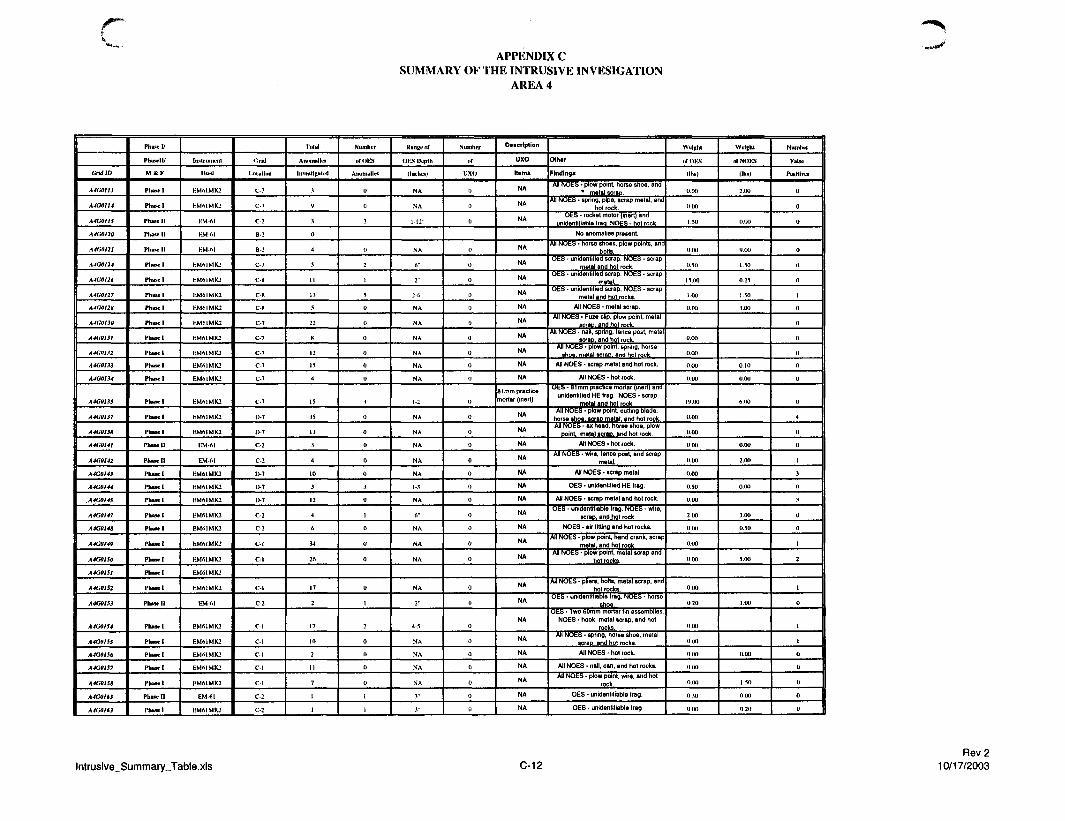
rAPPENDIX C
SUMMARY OF THE INTRUSIVE INVESIGATIONAREA 4
Grid ID
A4G01I3
A4G0II4
A4G0IIS
A4GO120
A4G0I2I
A4G0I24
A4G0I26
A4G0127
A4G0I2H
A4G0I30
A4GOI3I
A4C0I32
A4G0I33
A4G0I34
A4G013S
A4G0I37
A4G0I38
A4G014I
A4G0I42
A4G0143
A4G0I44
A4GOI4S
A4G0I47
A4G0148
A4G0I49
A4GO150
A4G01SI
A4G01S2
A4G0I53
A4G0154
A4G0I55
A4G0IS6
A4GO1S7
A4G0I58
A4GOM3
A-l(iOU3
Phase 1/
Phusell/
M & F
Phase I
Phase 1
Phase I I
Phase 11
PhHWll
Phasul
Phase I
Phase 1
Phase 1
Phase I
Phase I
Phase I
Phase 1
Phase 1
Phase 1
Phase 1
Phase 1
PhaSClI
Phase I I
Phase I
PhascI
Phase I
Phase I
Phase 1
Phase I
Phase I
Phase I
Phase I
Phase I I
Phase I
Phase I
Phase 1
Phase I
Phase I
Phase I I
Phase 1
Instrument
Used
KMMMK2
KMAIMK2
BM-61
KM-A1
HM-61
KM61MK2
HM61MK2
BM6IMK2
EM6IMK2
EMMMK2
EMf>lMK2
F.MMMK2
KMA1MK2
E-M61MK2
EMMMK2
EMAIMK2
EMAIMK2
EM-61
EM-A]
EM61MK2
EM61MK2
EMAIMK2
BM61MK2
EMA1MK2
EMMMK2
KMMMK2
EMSIMK2
EM61MK2
EM-61
EM61MK2
EMA1MK2
EM61MK2
EMAIMK2
EMMMK2
EM-fil
RMAIMK2
(-.rid
Location
C-7
C-7
C-2
B-2
B-2
C-7
C-8
C-8
c-x
C-7
C-7
C-7
C-7
C-7
C-7
D-7
D-7
C-2
C-2
D-7
l>7
l>7
C-2
C-2
C- l
C-l
C-l
C-2
C-l
C-1
C-l
C-l
C-1
C-2
C-2
Trial
Anomalks
Investigated
3
y
3
0
4
5
I I
LI
5
22
8
12
IS
4
15
.15
13
3
4
10
3
12
4
A
34
26
17
2
17
10
2
I I
7
1
1
NumliLT
Anomalies
()
0
2
0
2
i
s
0
0
0
0
0
0
^
0
0
»
0
0
3
0
1
0
0
0
0
1
2
0
0
0
0
1
1
Kunneof
OES IK-pth
finches)
NA
NA
1-12"
NA
6"
2"
2-6"
NA
NA
NA
NA
NA
NA
i-2"
NA
NA
NA
N A
NA
1-3"
NA
A"
NA
N A
NA
NA
2"
4-S'1
N A
NA
NA
NA
3"
3"
Number
«f
uxo
()
0
0
0
o
0
0
0
0
{)
0
0
0
(>
0
0
0
0
0
0
0
0
0
0
0
0
0
0
0
0
0
0
()
0
D»*crlptlon
uxoKami
NA
NA
NA
NA
NA
NA
NA
NA
NA
NA
NA
NA
NA
81mm practice
mortar (inert)
NA
NA
NA
NA
NA
NA
NA
NA
NA
NA
NA
NA
NA
NA
NA
NA
NA
NA
NA
NA
Other
Finding!
All NOES • plow point, horse shoe, and
* metal scraDAll NOES • spring, pipe, scrap metal, and
hot rockOES • rocket motor (inert) end
unidentifiable fraa. NOES - hot rock.
No anomalies present.
All NOES • horse shoes, plow points, ana
bolts.OES - unidentified scrap. NOES - scrap
metal and hot rockOES • unidentified scrap. NOES - scrap
metal.OES - unidentified scrap. NOfcS - scrap
metal and hot rocks.
All NOES - metal scrap.
All NOES • Fuze clip, plow point, metal
scrap, and hot rock.All NOES - nail, spring, tence post, metal
scrap, and hot rock.All NOtS - plow point, spring, horse
shoe, metal scrao. and hot rock
All NOES • scrap metal and hot rock.
All NOES-hot rock.
O t S - 81 mm practice mortar (inert) and
unidentified HE fraa. NOES • scrap
metal and hot rock.All NOES • plow point cutting blade,
horse shoe. scraD metal, and hot rock.All NOES - ax head, horse shoe, plow
Doint. metal scrap, and hot rock.
All NOES - hot rock.
Ail NOES • wire, lence post, and scrap
metal.
All NOES - scrap metal
OES - unidentified HE Irag.
All NOES - scrap metal and hot rock.
OES - unidentifiable frag. NOES - wire,
scrac and hot rock
NOES • air fitting and hot rocks.
All NOES - plow point, hand crank, scrap
metal, and hot rockAll NOES - ptow point, metal scrap and
hot rocks.
All NOES - pliers, bolts, metal scrap, and
hot rocks.OES • unidentifiable frag. NOES - horse
shoe.OhS • Iwo 60mm mortar tin assemblies.
NOES - hook, metal scrap, and hot
rocks.Alt NOES • spring, horse shoe, metal
scraD. and hot rocks.
All NOES • hot rock.
All NOES - nail, can, and hot rocks.
All NOES • plow point, wire, and hot
rock.
OES - unidentifiable Irag.
OES - unidentifiable frag
WuKht
tfOKS
<ihs)
0.00
0.00
1.50
0.00
0.50
15.00
I 00
0.00
0.00
0.00
0.00
0.00
19.00
0.00
0.00
0 0 0
0.00
0.00
0.5O
0 00
2.00
0.00
0.00
0.00
0.00
0.20
0.00
0 0 0
0.00
0.00
0.00
0 3 0
0.00
Weight
of NOES
III"!
2.00
0.00
9.00
1.50
0.25
1.50
3.00
0.10
0.00
A.00
0.00
2.00
0.00
3.00
0.50
5.00
1.00
0.00
1.50
0.00
0.20
Number
False
Positives
0
0
0
0
0
0
1
()
0
0
0
0
0
0
4
0
0
I
3
0
3
0
0
1
2
1
0
1
1
0
0
0
0
0
lntrusive_Summary_Table.xls C-12Rev 2
10/17/2003

cAPPENDIX C
SUMMARY OF THE INTRUSIVE INVESIGATIONAREA 4
Grid ID
A4G0I64
A4G017I
A4G0I73
A4G0174
A4G017S
A4G0I7*
A4GO177
A4G0I7S
A4G01S2
A4G01B4
A4G0I86
A4G0IX7
A4G01M
A4G0I89
A4G0I90
A4G0I9I
A4G0I92
A4G0193
A4GQI94
A4G0I95
A4G0I96
A4G0I97
A4G0I9H
A4GOI99
A4G0200
A4G0201
A4G0202
A4GO2O3
A4G9204
A4G0205
A4G020S
A4G02I0
A4O02JI
A4G02I2
A4G02I3
A4GO215
A4G0222
A4G0223
A4G0224
Phasell/
M &F
Phase 1!
Phase!
Phase I
Phue!
Phase 1
Phase I I
Phase II
Phase I I
Phase 11
Phase 11
Phase I I
Phase 11
Phase 11
Phase I I
Phase!
Phase I
Phase I
Phase 1
Phase I
Phase I
Phase I I
Phase 1
Phase!
Phase I I
Phase 11
Phase I I
Phase!
Phase I I
Phase I I
Phase I I
Phase I I
Phase I I
Phase 11
Phase 11
Phase I I
Phase I I
Phase I I
Phase I I
Phase 11
Instrument
Used
EM-61
EM61MK2
EM61MK2
F.M61MK2
EM61MK2
EM-61
EM-61
EM-61
EM-61
EM-61
KM-61
EM-61
KM-61
EM-61
EM61MK2
EM61MK2
EM61MK2
EM61MK2
EMMMK2
EM6IMK2
EM-61
EM6IMIU
EM6IMK2
EM-61
EM-61
EM-61
EM61MK2
EM-61
EM-61
EM-61
EM-AI
EM-61
EM-61
EM 61
EM-61
EM-61
EM-61
EM-61
EM-61
Crld
Locution
C-2
B-4
C-7
C-7
C-7
C-2
C-2
C-2
D-2
C-2
l>2
D-2
C-2
C-2
D-3
D-3
D-3
D-3
E-3
E-3
C-2
C-2
C-2
C-2
D-3
C-2
C-2
C-2
B-2
C-2
C-2
C-l
C/D-l
C-l
D-8
D-7
Tutal
Anotnallu
InvesUgated
3
63
4
3
<i
5
3
4
2
1
6
11
4
18
14
4
6
4
<i
32
21
2
1
1
5
1
4
2
0
0
1
15
7
55
6
30
11
Number
of OES
Anomalies
3
0
0
0
0
3
1
(>
0
0
0
0
0
1
3
0
0
0
0
(1
X
5
0
0
1
0
0
0
0
0
0
0
0
0
0
0
KunneoT
OES Depth
(inches)
3-6"
NA
NA
NA
NA
2-3"
4"
NA
NA
NA
NA
NA
NA
V
0-3"
NA
NA
N A
NA
NA
1-8"
0-4"
NA
NA
N A
NA
NA
NA
N A
NA
NA
NA
N A
NA
NA
NA
Numhix
of
UXO
0
0
0
0
()
0
0
0
0
0
0
0
0
0
()
()
0
<)
0
()
0
0
0
0
0
0
0
0
0
(I
a
0
0
0
0
0
Description
UXO
Ittmi
NA
NA
NA
NA
NA
NA
NA
NA
NA
NA
NA
NA
NA
2.36' rocket[inert)
NA
NA
NA
NA
NA
NA
NA
NA
NA
NA
NA
NA
NA
NA
NA
NA
NA
NA
NA
NA
NA
NA
Oihtr
Findings
OES • unidentifiable frag
All NOES - horse shoe, plow blade,chain.metal scraD. and hot rocks.
All NOES - horse shoe, wrench, andmetal seraD
All NOES - plow point and scrap metal.
All NOES • scrap metat and hot rock.
OES - unidentifiable frag.
OtS - unidetitiable trag. NUbS - SeedItem 5B, wrench, plow blade, and hot
rocks.All NOES - wire and plow blade.
All NOES - hot rocks.
Ail NOES - hot rocks.
No anomalies present.
All NOES - scrap metal.
All NOES - hot rock.
All NOES • wire and scrap metal.
OES - 2.36' rocket (inert). NOES - plowpoint and metal scrao.
OES • unidentifiable HE frag. NOES -metal scrap and hot rock.
All NOES - wire, lid, bar, scrap metaf,and hot rock.
All NOES - hot rocks
Alt NOES • scrap metal and hot rocks.
All NOES • scrap metat
All NOES - shipping clip for fuze and hotrocks.
OES - unidentifiable frag. NOES - metalscrap and hot rock.
OES * unidentifiable frag. NOtS - notrocks.
All NOES • hot rock.
All NOES • hot rock.
All NOES - 50 cal. shell.
All NOES - scrap metal and hot rock.
Ml NOES - wrench, lid, bed spring.
All NOES - plow blade and scrap.
No anomalies present,
No anomalies present
All NOES - hot rock
All NOES • plow point, horse shoe, andhot rocks.
All NOES - scrap metal and hot rocks.
All NOES - scrap metal and hot rocks.
Alt NOES - banding and hot rocks.
All NOES - plow point, naif, metal scrap,and hot rock.
All NOES - plow point, barb wire, andmetal scrap.
Wditht
•JOES
(Ibi)
1.00
0.00
0.00
0.00
0.00
1.10
0 20
0.00
0.00
0.00
0.00
0.00
0.00
1.50
7.00
0.00
0 00
0 0 0
0 00
0.00
2.00
1.50
0 00
0.00
0.00
0.00
0.00
0.00
0.00
0.00
0.00
0 0 0
0.00
0.00
0 00
0 0 0
0.00
Wd|h l
of NOES
(lbs)
0.00
1.50
0.00
5.00
3.00
0.00
0.00
0.50
0.00
1.00
2-50
8.00
0.00
1.00
4.00
0.10
1.00
0.00
0.00
0.00
0.05
0.10
0.00
3.00
3.00
2.00
0.00
6.00
2.00
22.00
1.00
3.00
3.00
Number
False
Positives
0
1
0
0
2
0
0
0
0
0
0
2
3
0
1
0
0
1
0
0
1
0
0
1
0
2
1
0
0
0
0
7
0
0
0
4
9
lntrusive_Summary_Table.xls C-13Rev 2
10/17/2003
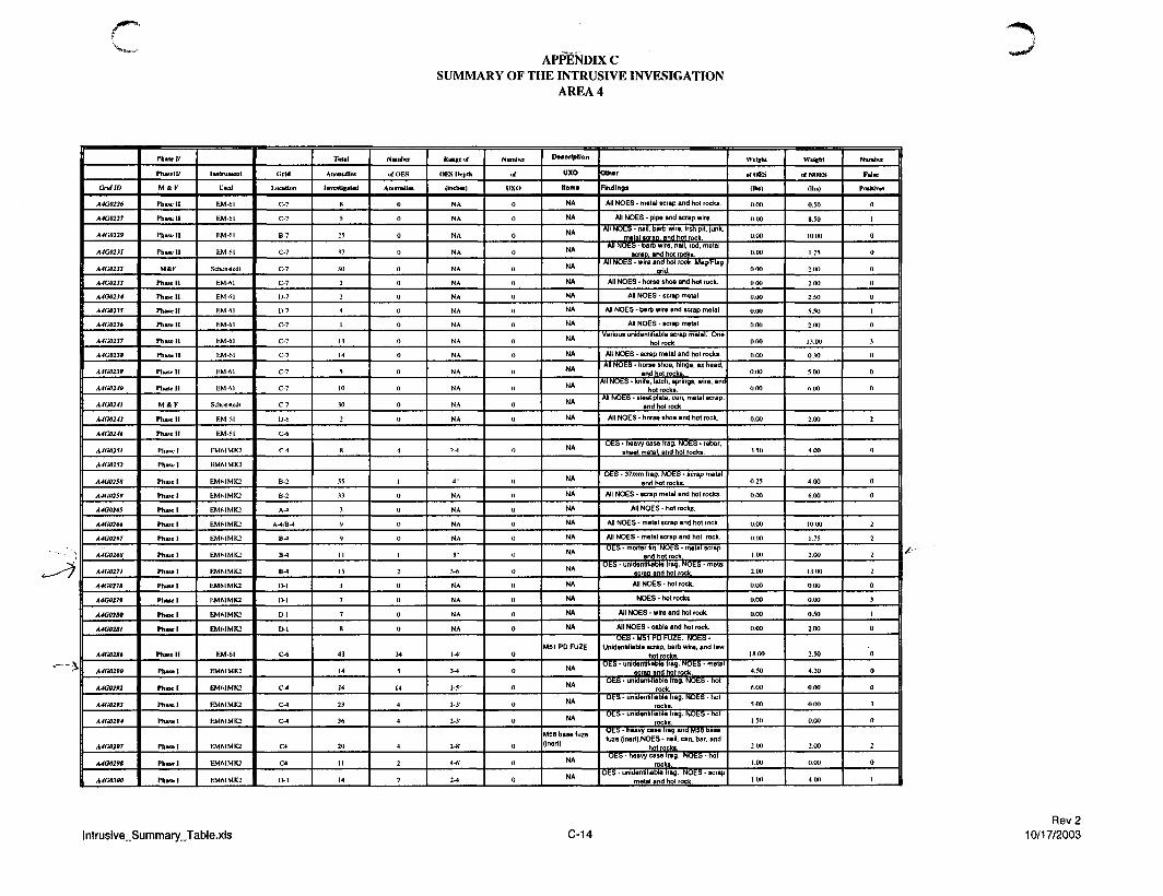
APPENDIX CSUMMARY OF THE INTRUSIVE INVESIGATION
AREA 4
Grid ID
A4G0226
A4GO227
A4G0229
A4G023I
A4G0232
A4G0233
A4G0234
A4GO23S
A4GU236
A4G0237
A4G023S
A4G0239
A4G0240
A4G024I
A4G0243
A4G0246
A4G02SI
A4G02S2
A4G02SS
A4G02S9
A4G026S
A4G0266
A4G0267
A4G026H
A4G027I
A4GO278
A4GO279
A4G0280
A4G0281
A4G02S6
A4G029Q
A4G0292
A4G0293
A4G0294
A4G0297
A4G029S
A4GO3OO
Phase!/
Phasell/
MftF
Phase I I
Phase I I
Phase I I
Phase 11
M & F
Phase 11
Phase 11
Phwe l l
Phase I I
Phase 11
Phase 11
Phase 11
Phase 11
M&K
Phase 11
Phased
Phasel
Phasel
Phasel
Phasel
Phasel
Phase)
Phase I
Phase!
Phasel
Phasel
Phasel
Phase!
Phasel
Phase I I
Phasel
Phasel
Phasel
Phase I
Phasel
Phasel
Phasel
Instrument
Used
E M M
E M M
E M M
EM 61
Schnnsludl
EM-M
EM-61
KM-6)
EM-61
EM-61
EM-M
EM-61
EM-61
SctumsUxIt
BM-M
EM-M
EM61MK2
EM61MK2
EM6IMK2
EMMMK2
EM61MK2
BM6IMK2
EM6IMK2
EM6IMK2
EM61MK2
EMMMK2
EM61MK2
EM61MK2
EM61MK2
EM -61
EM61MK2
EM61MK2
EM61MK2
EM6IMK2
EM6IMK2
EM6IMK2
EM61MK2
c;rld
location
C-7
C-7
B-7
C-7
C-7
C-7
U-7
D-7
C-7
C-7
C-7
C-7
C-7
C-7
l>fi
C-6
CM
B-2
B-2
A-4
A-4/B^J
B-*
B-l
B-4
D-l
D-l
D-l
D-l
C-6
C-4
C-4
C-4
C4
C4
D-3
Tulal
Anomalies
Investigated
8
5
25
37
30
2
2
4
I
13
14
5
10
30
2
8
55
33
3
9
•>
11
15
3
7
7
8
43
14
24
23
36
20
11
14
Number
of OES
Anomalies
0
o
0
0
0
0
0
0
0
„0
0
0
0
0
4
1
0
0
0
0
1
2
0
0
0
0
34
5
14
4
4
4
2
7
Range uf
OES Depth
(Inches)
NA
NA
NA
NA
NA
NA
NA
NA
NA
NA
NA
NA
NA
NA
NA
2-4"
4"
NA
NA
NA
NA
8"
3-6"
NA
NA
NA
NA
1-4"
3-4"
1-5"
2-3"
2-3"
2-8"
4-6"
2-4"
Number
UXO
0
0
0
0
0
0
0
0
0
0
0
„0
0
0
0
0
0
0
0
0
0
0
0
0
0
0
0
0
0
0
0
0
0
0
Description
uxoHem*
NA
NA
NA
NA
NA
NA
NA
NA
NA
NA
NA
NA
NA
NA
NA
NA
NA
NA
NA
NA
NA
NA
NA
NA
NA
NA
NA
M51 PD FUZE
NA
NA
NA
NA
USB base fuze
(inert)
NA
NA
Other
Findings
All NOES - metal scrap and hot rocks.
All NOES • pipe and scrap wire.
All NOES • nail, barb wire, trsh pit, junk,
metal scraD. and hot rockAll NOES - barb wire, nail, rod, metal
scrao. and hot rocks.All NOES • wire and hot rock. Mag/Flag
arid.
All NOES • horse shoe and hot rock.
All NOES - scrap metal
All NOES - barb wire and scrap metal.
All NOES - scrap metal
Various unidentifiable scrap metal. Onehot rock.
All NOES • scrap metal and hot rocks.
All NOES • horse shoe, htnge, ax head,
and hot rocks.Ad NOES - knife, latch, springs, wire, and
hot rocks.All NOES • steel plate, can, metal scrap,
and hot rock.All NOES - horse shoe and hot rock.
OES • heavy case frag. NOES - rebar,
sheet metal, and hot rocks.
OES - 37mm frag. NOfcS • scrap metal
and hot rocks.
All NOES • scrap metal and hot rocks.
Alt NOES - hot rocks.
All NOES - metal scrap and hot rock.
All NOES - metal scrap and hot rock.
OES - mortar fin. NOfcS • metal scrap
and hot rock.OES - unidentifiable Irag. NOES - metal
scrap and hot rock.All NOES - hot rock.
NOES • hot rocks
All NOES - wire and hot rock.
All NOES • cable and hot rock.
UbS • M51 HU r-UZfc. NUt t i -
Unidentifiable scrap, barb wire, and few
hot rocks.OES • unidentifiable Irag. NOES • metal
OES - unidentifiable frag. NOES - hot
rock.OfcS - unidentifiable frag. NOES • hot
rocks.OES • unidentifiable frag. NOES - hot
rocks.Ofcb - heavy case Irag and M58 base
fuze (inert).NOES - nait, can, bar. and
hot rocks.OES - heavy case frag. NOES - hot
rocks.OES - unidentifiable frag. NOES - scrap
metal and hoi rock.
Weight
rfOKS
(Ihs)
0.00
0 00
0.00
0.00
0.00
0 0 0
0.00
0.00
0.00
0.00
0.00
0.00
0.00
0.00
.1.50
0.25
0.00
0.00
0 0 0
1.00
2.00
0.00
0.00
0.00
0.00
18.00
4.50
6.00
5.00
1.50
2.00
1.00
1.00
Weight
of NOES
(Ihs)
0.50
8.50
10.00
1.25
2.00
2.00
2.50
5.50
2.00
13.00
0.30
5.00
6.00
2.00
4.00
4.00
6.00
10.00
1.75
2.00
13,00
0.00
0.00
0.50
2.00
2.50
4.20
0.00
O.00
0.00
2.00
0.00
4 0 0
Number
False
Positives
0
1
0
0
0
0
0
1
0
3
0
0
0
2
0
0
0
2
2
2
2
0
3
1
0
0
0
0
3
0
2
0
I
lntrusive_Summary_Table.xls C-14Rev 2
10/17/2003

APPENDIX CSUMMARY OF THE INTRUSIVE INVESIGATION
AREA 4
tlridW
A4G03I3
A4G03I4
A4G0323
A4G0337
A4O033S
A4G0339
A4G034H
A4G03SI
A4G03S2
A4G037t
A4G0377
A4GQ398
A4GQ401
A4G0409
A4G0422
A4G042S
A4G0433
A4G0439
A4G9439
A4G0440
A4G0441
A4G0443
A4G0444
A4G0447
A4G04S0
A4G04SI
A4G0452
A4GO453
A4G04S*
A4G0461
A4G04f3
A4G0465
A4G0469
A4GO472
A4GO474
A4G0477
A4G047S
A4G04SO
Phase 1/
PhllSell/
M & F
Phasel
Phase I I
Phase I I
P b u e l l
Phased
Phase I I
Phase 11
Phase 11
Phase 11
Phase 1
Phase 1
Phase U
Phase I I
Phase I I
Phase I I
M&F
Phase U
Phase I I
Phase 11
Phase I I
Phase I I
Phase I I
Phase I I
Phase 11
M & F
Phase U
Phase I I
Phase I I
PIUKH
M & F
Phase 11
Phase I I
Phase I I
Phase I I
Phase I I
Phase I I
Phase I I
Phase I I
Instrument
Used
F.M61MK2
EM-61
EM (SI
KM (SI
EM-61
EM-61
EM-61
BM-A1
KM 61
F.MMMK2
EM6IMK2
EM 61
F:M<6I
E M M
EM-61
SchonsUnit
EM-fil
EM-61
EM-61
EM-61
EM-61
EM-61
EM-61
EM-6]
Sthonslthji
EM-61
EM-61
EM-61
EM-61
Schonstedt
EM-61
F.M-61
EM-61
EM-61
EM-61
EM 61
EM-61
EM-61
t.r ld
Location
C-5
D-5
D-5
D-5
D-5
C-3
B-3
B-5
l>5
B-3
A-5
C-4
C-4
CA
C-4
C-4
C-4
C-4
D-4
l>4
C-4
C-4
D-4
l>4
C-4
C-4
B-4
B-4
B-4
B-4
B-4
B-4
B-4
B-t
Tula)
Anomalies
Investigated
0
6
2
4
3
41
it
.1
5
5
1
5
30 ^
4
22
26
4
4
4
4
3
.10
3
3
10
I t
50
I
1
7
2
2
5
A
2
NumlRT
oTOES
Anomalies
0
0
0
<)
13
0
0
0
0
0
1
0
0
0
,
0
0
0
0
2
0
0
0
4
3
0
0
0
0
0
0
0
0
0
Range of
OES Depth
(Incites)
N A
NA
NA
NA
, , ,
NA
NA
NA
NA
N A
.1"
NA
NA
NA
3-4"
NA
NA
NA
NA
3-4"
NA
NA
NA
1-5"
2-A'"
NA
NA
NA
NA
N A
NA
NA
NA
N A
INuiiibir
<>T
uxo
0
0
0
0
II
0
0
0
0
0
0
0
0
0
0
0
0
0
0
0
0
0
0
0
0
0
0
0
0
0
0
0
0
0
Description
UXO
Hams
NA
NA
NA
NA
2 M51 PD Fuzes(inert)
NA
NA
NA
NA
NA
NA
NA
NA
NA
37mm luze (inert)
NA
NA
NA
NA
NA
NA
NA
NA
NA
NA
NA
NA
NA
NA
NA
NA
NA
NA
NA
Othar
Finding*
No anomalies present.
NOES - Barb wire and few hot rocks
NOES - Few hot rocks
NOES • Few hot rocks
NOES - Unidentifiable scrap metal andfew hot rocks
U t S • two M51 h*U huzea (inert) andunidentifiable frag. NOES • rod. wire,
handle, plowbtade. horse shoe, and hotfocks
All NOES • metal scrap and hot rocks.
All NOES • hot rocks.
NOtS - Unidentifiable scrap, plow blada,few hot rocks
All NOES - scrap metal and hot rocks.
Alt NOES - plow point.
OES • unidentifiable scrap. NOES -metal scrap.
NOES - can, small unidentifiable scrapmetal, manv hot rocks.
NOES • unidentifiable scrap metal, hotrocks.
All NOES • metal scrap.
Oba • 37mm fuze (men) andunidentifiable frag. NOES - metal scrap
and hot rock.All NOES - metal scrap and hot rock.
All NOES - hot rocks.
All NOES • metal scrap and hot rock.
All NOES - plow point and hot rock.
OES - unidentifiable frag.
All NOES - hot rocks.
All NOES • hot rocks.
All NOES - hoi rocks.
ObS • heavy case frag. NOES - hotrocks.
OES • unidentifiable frag. NObS - hotrocks.
All NOES - hot rocks.
All NOES - scrap
All NOES-metal scrap.
All NOES - metal scrap and hot rock.
All NOES - metal scrap.
All NOES - hot rock.
All NOES - hot rock.
All NOES - metal scrap and hot rock.
All NOES - rod and hot soil.
Weight
of OES
(lbs)
0.00
0.00
0.00
0.00
Ifi.M)
0.00
0.00
0.00
0.00
0.00
LOO
0.00
0.00
0,00
2.50
0.00
0.00
0.00
2.00
0.50
0.00
0.00
0.00
2.00
2.00
0.00
0.00
0.00
0.00
0 00
0.00
0.00
0 00
0.00
Wright
of NOES
(lbs)
0.50
0.00
0.00
2.00
45.00
5.00
0.00
6.00
4.20
4.00
4.00
1.00
1.00
14.00
19.00
0.60
0.00
0.50
0.00
0.00
0.00
0.00
0.00
0.00
0 00
0.00
0.50
0.50
3.00
1.00
0.00
o.oo
2.00
1.00
Numlivr
False
Pur i t i * *
0
0
0
0
0
0
0
0
o
0
0
0
0
0
1
1
1
0
0
1
0
0
0
0
1
0
0
0
0
0
0
0
0
()
lntrusive_Summary_Table.xls C-15Rev 2
10/17/2003

APPENDIX CSUMMARY OF THE INTRUSIVE INVESIGATION
AREA 4
Grid ID
A4G0481
A4G0482
A4G0483
A4G0484
A4G04K6
A4G04S7
A4G051I
A4G0SI2
A4C0SI3
A4G0SI4
A4GQ520
A4G0521
A4G0522
A4G0534
A4G0S3S
A4G053*
A4GQM4
A4G0670
A4G0672
A4GO673
A4G0674
A4GO700
A4G6S00
A4GI44S
A4T02S7
A4T0259
Phase 1/
Phasell/
M & F
Phase I I
Phase 11
Phase U
Phase 11
Phase 11
Phase 11
Phase!
Phase!
Phase 1
Phase-1
Phase I
Phase 1
Phase 1
Phase 1
Phase 1
Phase I
Phase I
Phase 1
Phase 1
Phase I
Phase 1
Phase 1
Phusel
Phase I I
Phase I
Phase I
T1aU for Area 4 Proper Grids
Instrument
Used
E M M
EM-61
E M M
KM-fil
BM-M
EM-61
EM61MK2
HM61MK2
EMMMK2
HMMMK2
EMMMK2
EMMMK2
EMMMK2
EMMMK2
EMMMK2
EM61MK2
EM61MK2
EM61MK2
EM6IMK2
EM61MK2
EMMMK2
EMMMK2
EM61MK2
EM (SI
EMA1MK2
EM61MK2
CJrld
Location
B-4
A- *
B 4
B-4
B 4
B-4
C-3
C-4
C-4
C-4
C-4
l>5
D-5
C-2
C-2
C-2
C-2
C-2
C-6
C-2
n
D-3
Total
Anomallui
Investigated
4
29
6
5
12
12
47
7
23
17
18
13
2
8
LS
(S
7
5
55
2
3
52
57
4137
Number
ofOKS
Anomalies
0
()
0
0
()
2
15
4
7
4
f,
0
0
0
2
0
0
2 *
0
0
()
0
H I S
Range «f
CIES Depth
(inches)
NA
NA
NA
NA
NA
1-8"
2-fi"
5"
1 -5"
2-.V
1-2'1
NA
NA
NA
2"
NA
3-12"
NA
1-10"
NA
NA
NA
NA
Numhtr
«f
vxo
0
0
0
0
0
0
0
0
I)
0
0
0
0
0
0
0
0
0
0
0
0
0
(}
5
Description
uxo
Itams
NA
NA
NA
NA
NA
NA
NA
NA
37mm practice(men)
NA
NA
NA
NA
NA
NA
NA
NA
NA
MSI FUZE
NA
NA
NA
NA
Oth«r
Findings
All NOES - horse shoe and hot rock.
All NOES • metal scrap and hot rock.
All NOES - Seed Item B-B, nail, plowblade, and hot rock.
Alt NOES • pipe, horse shoe, cable.
All NOES - Seed Item B-10, barb wire,and hot soil.
OES - unidentifiable frag. NOES - muleshoe wire naifs and hot soil
6 t S - unidentifiable trag. NOES - canand hot rock
OES - heavy case (rag. NOES - horseshoe and hot rocks.
OES - 3^ mm practice (inert) and heavycase fraa. NOES • hot rock.
OhS - unidentifiable (tag. NOfcS • hotrock.
OES - heavy case Irag. NOES - hotrocks.
NOES - Horse shoe, axe head, metalbar. and hot rocks
NOES - 1 2 gauge cartridge and hot rocks
All HOES • horse shoe, feeder, plowblade, and hot rocks.
OfcS - unidentifiable frag. N O t S • 50 cal.AP, plow blade, metal scrap, and hot
rock.NOES - nails and hoi rock.
OES - unidentifiable Irsg. NOES • spring,pipe, metal scrap, and hot rock.
All N6Es - spring, plow blade, and hotrock.
ObS - MSI Series f-uze (inert) andunidentifiable frag. NOES - horse shoe
and hot dirt and hoi rocksAll NOES - hot rock.
All NOES - hot rocks
All NOfcS - bolts, metal scrap, and hotrock.
All N O E S - barb wire, shot gun shells,plow blades, cable, metal scrap, and hot
Weight
of OES
(lbs)
0.00
0.00
0.00
0.00
0.00
0.50
K.00
5.00
0.00
0.00
0.00
0.00
0.25
0.00
0.25
0.00
14.50
0.00
0.00
0.00
960
Wright
of NOES
(lbs)
2.00
14.00
5.00
5.00
1.00
2.00
0 00
2.00
0.00
0 0 0
0.00
6.50
0.10
10.00
3.00
0.00
2.00
2.00
0.50
0.00
0.00
0.20
1154
Number
False
Positives
1
0
0
2
6
0
0
0
0
0
0
0
0
1
1
0
0
0
0
0
0
0
149
lntrusive_Summary_Table.xls C-16Rev 2
10/17/2003

APK^DIXCSUMMARY OF THE INTRUSIVE INVESTIGATION
AREA 5
Grid ID
ASGMOI
ASGO0O2
ASGB906
ASG0099
ASG0919
ASG9012
A3G0916
ASG09U
ASGM11
A5GM20
ASGM21
ASGOO23
ASGW24
ASGM2S
ASGM26
ASGM2I
ASGM29
ASGM3I
A5GM32
ASGM33
ASGW34
ASGW3S
ASGM39
A5GM4I
ASGM46
ASGOtSI
A3GMS2
ASGMS3
ASG0K4
ASG0I1S
ASGOllt
Fluid/
Phase 11/
M*F
Phase I I
Phase I I
Phase I I
Phase I I
Phase 11
Phase I I
Phase I I
Phase I I
Phase I I
Phase I I
P h u c l l
Phase I I
Phase I I
Phase I I
Phase I I
M&F
Phase I I
Phase I I
Phase I I
Phase 11
Phase I I
Phase I I
Phase I I
Phase I I
Phase I I
M & F
Phase I I
Phase I I
Phase I I
Phasel
Phase 1
Instrument
Used
EM-61
EM-61
EM-61
EM-61
EM-61
EM-61
EM-61
EM-61
EM-61
EM-61
EM-61
EM-61
EM-61
EM-61
EM-61
Schonstedt
EM-61
EM-61
EM-61
EM-61
EM-61
EM-61
EM-61
EM-61
EM-61
Schonstedt
EM-61
EM-61
EM-61
EM6IMK2
EM6IMK2
Crid
Location
C-ll
C-l!
B-9
C-9
C-8
C-8
C-8
B-8
B-8
B-8
B-8
B-8
B-8
B-8
B-7
B-7
B-7
B-7
A-7
B-7
B-7
B-7
A-7
A-7
E-8
D-8
D-7
D-7
B-10
C-10
C-10
Total
Anomalies
Selected
7
0
24
4
16
4
41
9
1
0
45
2
3
9
0 - qc spike was selectedto be dug
30
,
15
6
2
1
8
8
32
6
30
0
36
2
1
2
Number
afOES
Anomalies
0
0
0
0
0
0
0
1
0
0
0
0
0
0
0
0
0
0
0
0
0
0
0
0
0
0
0
0
0
0
0
Range of
OES Depth
(Inches)
N A
NA
NA
N A
N A
N A
0"
NA
N A
NA
N A
NA
NA
N A
NA
N A
NA
NA
N A
N A
N A
N A
N A
N A
NA
NA
NA
N A
Nurnher
of
U X O
0
0
0
0
0
0
0
0
0
0
0
0
0
0
0
0
0
0
0
0
0
0
0
0
0
0
0
0
Description
U X O
Items
NA
NA
NA
NA
NA
NA
Rate to M4 anti-tank mine
NA
NA
NA
NA
NA
NA
NA
NA
NA
NA
NA
NA
NA
NA
NA
NA
NA
NA
NA
NA
NA
Other
FMmis
All NOES - nail and plow point
to anomalies present.
All NUbS - wire, rebaf, scrap metal,and hot rode.
All NOES - horseshoe* and chain.
All N u t s - trash pit, metal scrap,and hot rock.All NUt t i - i norsesnoes. piece otscrap metal, 1 hot rock.All NUbti - metal scrap and hotock.
ObS - spider plate to a MIS anti-tank mine. NOES - scrap metal andhot rock.t-r1 - identified as stump, wnicninduced instrument response.
No anomalies present.
All NOES - horse shoe, hinges,handles, scrap metal, and hot rock.
All NOES > hot rock.
All NOES • Hot rock.
All NUbB - plow point, rod, and hotrock.u c spike location was determinedto be hot rock.All NObSS- plow point, horse shoe,scrap metal and hot rock.All NUbU - sprinkler parts and hotrocks.
All NOES • plow point, rod, buckle,cultivator tine, and metal scrap.
all NUbS - horse shoe, boft, metalscrap, and hot rock.
AH NOES - hot rock.
All NOES - hot rock.
All NUbS - wire and unKlentitiarjIescrap metal.All NUbb - door nook, horse shoe,and hot rock.All NUbts - wire, nails, miscunidentifiable scrap metal, steelrods.
AH NOES - hot racks.
and hot rock.
duo.
and hot rocks.
AH NOES - metal sptke
All NOES - pipe.
All NOES - bolt and hot rock.
Weight
•fOES
(H»>
0.00
0.00
o.oo
0.00
0.00
0.00
1 00
0.00
0.00
0.00
0.00
0.00
0.00
0.00
0.00
0.00
0.00
0.00
0.00
0.00
0.00
0.00
0.00
0.00
0.00
0.00
0.00
0.00
Weight
• fNOES
•>.)
4.10
19.50
4.00
16.00
3.00
18.00
3.50
0.00
23.00
0.00
0.00
5.50
0.00
11.00
1.00
20.00
3.50
0.00
0.00
1.00
3.00
34.00
0.00
1.00
27.00
0.25
1.00
0.05
Number
Pali*
Poiirives
3
0
0
0
0
0
3
1
0
0
1
4
0
0
1
0
0
1
0
4
0
0
2
0
0
1
0
0
lntrusive_Summary_Table C-18

APPL-UIXCSUMMARY OF THE INTRUSIVE INVESTIGATION
AREA 5
A5G0117
ASG01IS
ASGtllf
ASG0I28
ASG1122
ASGO139
ASG0140
ASG0141
A5G0I42
ASTOOOt
AST0019
ASTMSt
ASTB032
AST0033
AST9034
Phase 1
Phaiel
Fhiul
Pluuel
Phaul
Ftvuel
Hun I
PhucI
Phut I
Phuil
Fluuel
Phaiel
PhucI
Phaiel
FhucI
TMbferAmSGrUt
EM6IMK2
EM6IMK2
EM6IMK2
EM6IMK2
EM6IMK2
EM6IMK2
EM6IMK2
EM6IMK2
EM61MK2
EM6IMK2
EM61MK2
EM6IMK2
EM6IMK2
EM6IMK2
EM6IMK2
CMO
C-10
C-10
C-10
C-10
D-8
D-8
D-8
D-8
C-8
C-8
B-7
B-7
B-8
B-8
4
8
6
0
5
9
5
g
5
110
63
60
56
30
29
75t
0
0
0
0
0
0
0
0
0
0
0
0
0
0
0
N A
N A
N A
N A
N A
N A
N A
N A
N A
N A
N A
N A
N A
N A
0
0
0
0
0
0
0
0
0
0
0
0
0
0
•
NA
NA
NA
NA
NA
NA
NA
NA
NA
NA
NA
NA
NA
NA
All NOfcS - plow point, horse shoe,bolt, and hot rock.
All NUtS - plow point, pipe, nut,and metal scrap.All NUtt> - pipe, bolt, scrap metal,and hot rock.
No anomalies present.
AH NUtt> - plow point and norseshoe.
AD NOES-hot rocks.
AH NOES - hot rocks.
Ail NUfcb - wire, hooks, ana scrapmetal.Ail NUts - norse snoe, ana notrock.All NUtu - scrap metal ana notrock.AII Nuts - scrap metal and notrock.All N U t i - Unidentifiable scrapmetal, pipe, fence posts plusnumerous hot rocks/hot soil.All NOkfci - unidentifiable scrapmetal and wire plus numerous hotrocks/hot soil.
metal plus numerous hot rocks.
metal scrap, and spring.
0.00
0.00
0.00
0.00
0.00
0.00
0.00
0.00
0.00
0.00
0.00
0.00
0.00
0.00
1
5.00
12.00
3.00
4.50
0.00
0.00
0.00
2.00
30.00
5.00
34.00
7.75
15.50
8.00
3 M
0
0
0
3
3
0
0
0
16
15
3
10
2
0
•a
lntrusive_Summary_Table C-19
n
APPENDIX DSCRAP CERTIFICATION FOR DISPOSAL

35c
14 M4IHM1. AMV (Jlf NCCflVfll 8 »K)N»IIJ«f ONO UAIEl
rnevioui t oinoM MAV BCUSIO 000 SINGLE LINC ITEM RELEASEMECEN>T OOCUMCNT
I certify that the property listed heron has been inspected by me and. In the best of my knowledge and belief, contains no items of adangerous nature
Certified: hintedNamc:AQiHP.itr /fo
Verified: Printed Name: Kfrrttif fl . C/yOfc-c,^ Signature: K. & . Date: O "
uoroou
CO
TJIIITM03M
men
COi-»COI
entn
r

VUMMOUSJ
rREVIOUS COITION MAV BE U8C0 000 SINGLE UN€ ITEM RElEASEmECEITT DOCUMENT
1 certify that the property listed heron has been inspected by me and, lo the best of my kmnvledgc and belief, contains no items of adangerous nature
Certified: I'rinled Name. KJtflfeY 3 / /u^ /v<- Signature:/;
Verified: Printed Name: A \ / ^ 7 . &J9Y/_££ 4/ Signature:
oro
ouuio
TJIkiTI/I03W
mU)
to
CO
UIUI>]I
CO
o

o
APPENDIX EORDNANCE ITEMS DESCRIPTION
uI:\HUNT-CONUS\Projects\Butner\EECA\Draft_Final\Apx E OE Data.doc REVISION NO. 1CONTRACT NO. DACA87-00-D-0038 08/30/2003
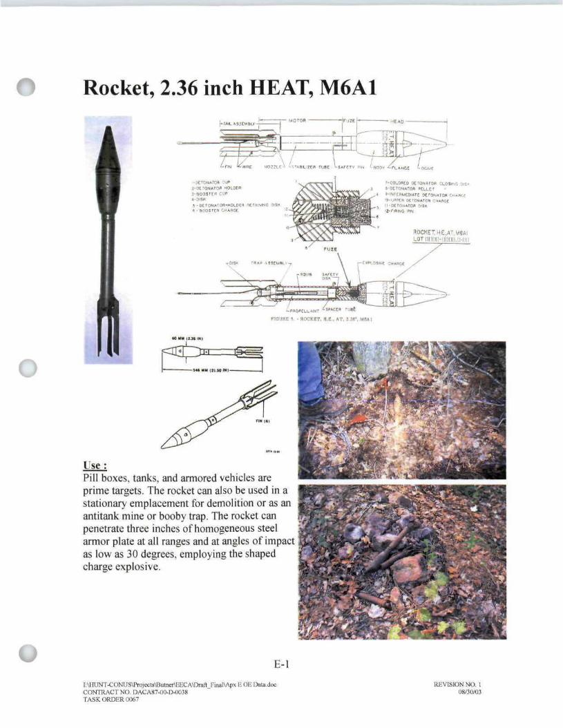
Rocket, 2.36 inch HEAT, M6A1
Irmune r - HOCKIT, H.« . AT. i.as
l T s e :Pill boxes, tanks, and armored vehicles areprime targets. The rocket can also be used in astationary emplacement for demolition or as anantitank mine or booby trap. The rocket canpenetrate three inches of homogeneous steelarmor plate at all ranges and at angles of impactas low as 30 degrees, employing the shapedcharge explosive.
E-l
[:\tnJN"['-CONUSMIrojects\Bulner\KKCA\Dratt FrnaMpx E OE Dala.docCONTRACT NO. DACA87-O0-1XM3STASK ORDER 0067
REVISION NO 108/30/03

O Rocket, 2.36 inch HEAT, M6A1 (Con't.)Description :The M6 rocket consists of three principal parts: the high explosive head, the stabilizertube, and the fin assembly.
The head consists of metal parts which are similar in function to the parts of the ATgrenade head. These parts are the ogive and the body. The bursting charge is similar, bothin that it is a "hollow" or a "shaped charge," and also in its composition which is mainly50/50 pentolite with a 10/90 pentolite booster surround. The stabilizer tube consists oftwo principal parts: the fuze body, which threads into the union and contains the fuzemechanism, and the powder tube to which the fuze body is permanently joined, andwhich contains the propellant charge.
The fuze is similar in all its components to that of the AT grenade. It is, however, ofheavier construction, as is the entire rocket, and contains heavier booster and detonatorcharges. The parts of the fuze are a spring restrained striker; a detonator of primingmixture, lead azide, and tetryl; and a booster of tetryl. The striker is held in the unarmedposition prior to loading into the launcher, by a safety pin which engages an annulargroove in the striker as it passes through opposed holes in the fuze body. The safety pinclips to the stabilizer tube and must be removed prior to firing of the rocket.
( ) The power tube or remainder of the stabilizer tube in this case serves as a housing for thepropellant powder and an electric safety match or squib. The electric safety match withan igniting charge of black powder is located at the upper end of the powder tube. Twocontact wires pass down through the powder tube and out through the nozzle portion ofthe fin assembly. The fin assembly consists of three parts: the nozzle, which is a venturitube; the trap, which is a spider ring closing the nozzle opening above the venturi andholding the propellant powder in place; and finally, the fins themselves.
• Dimensions• Length, complete-21.5 inches• Length, head - 8.6 inches• Length, body -4.11 inches• Length, ogive
• M6A1 (cone shaped) - 4.5 inches• M6A3 (hemispherical) - 4.56 inches
• Length, motor tube - 6.32 inches• Diameter, body - 2.23 inches• Diameter, ogive - 2.25 inches
• Weights• Complete - 3.5 lbs
U E-2
I:\HUNT-CONUS\Projects\Butner\EECA\Draft_Final\Apx E OE Data.doc REVISION NO. 1CONTRACT NO. DACA87-00-D-0038 08/30/03TASK ORDER 0067
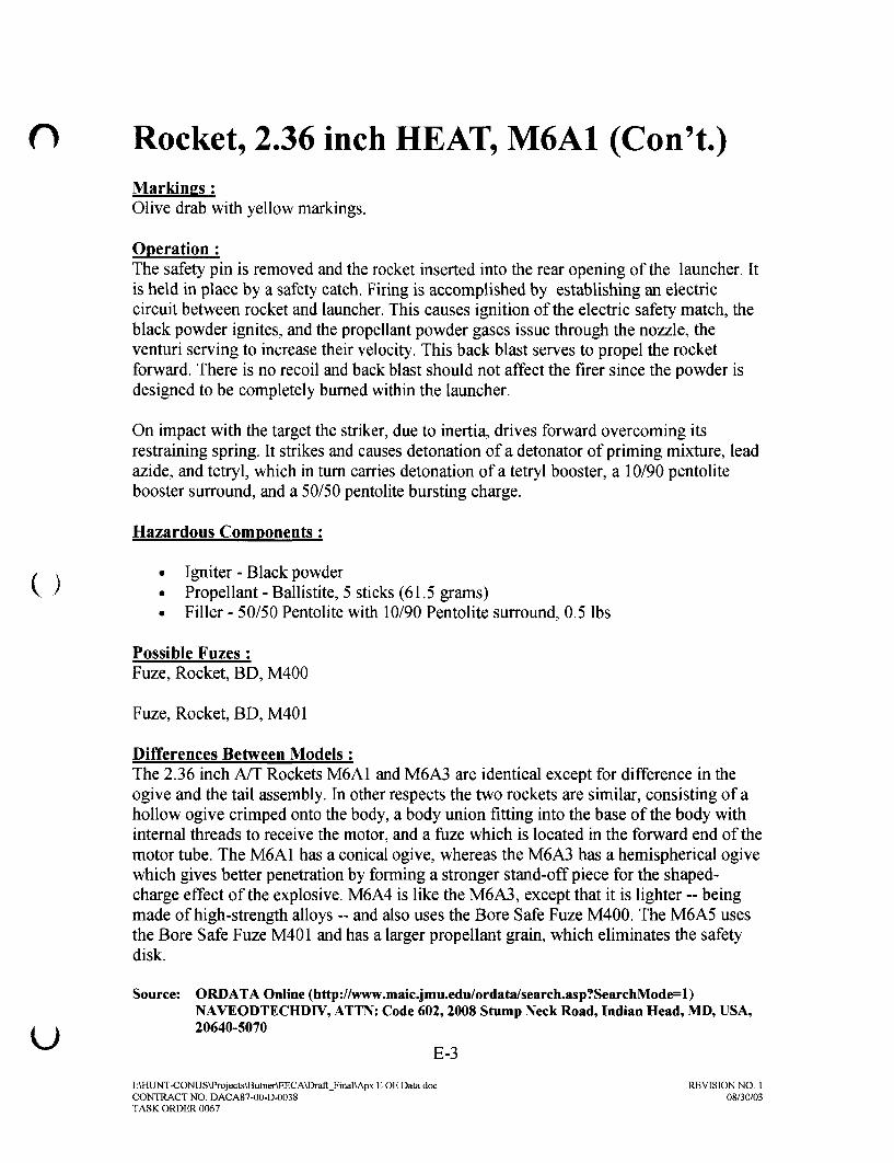
O Rocket, 2.36 inch HEAT, M6A1 (Con't.)Markings ;Olive drab with yellow markings.
Operation :The safety pin is removed and the rocket inserted into the rear opening of the launcher. Itis held in place by a safety catch. Firing is accomplished by establishing an electriccircuit between rocket and launcher. This causes ignition of the electric safety match, theblack powder ignites, and the propellant powder gases issue through the nozzle, theventuri serving to increase their velocity. This back blast serves to propel the rocketforward. There is no recoil and back blast should not affect the firer since the powder isdesigned to be completely burned within the launcher.
On impact with the target the striker, due to inertia, drives forward overcoming itsrestraining spring. It strikes and causes detonation of a detonator of priming mixture, leadazide, and tetryl, which in turn carries detonation of a tetryl booster, a 10/90 pentolitebooster surround, and a 50/50 pentolite bursting charge.
Hazardous Components :
/ x • Igniter - Black powderV / • Propellant - Ballistite, 5 sticks (61.5 grams)
• Filler - 50/50 Pentolite with 10/90 Pentolite surround, 0.5 lbs
Possible Fuzes :Fuze, Rocket, BD, M400
Fuze, Rocket, BD, M401
Differences Between Models :The 2.36 inch A/T Rockets M6A1 and M6A3 are identical except for difference in theogive and the tail assembly. In other respects the two rockets are similar, consisting of ahollow ogive crimped onto the body, a body union fitting into the base of the body withinternal threads to receive the motor, and a fuze which is located in the forward end of themotor tube. The M6A1 has a conical ogive, whereas the M6A3 has a hemispherical ogivewhich gives better penetration by forming a stronger stand-off piece for the shaped-charge effect of the explosive. M6A4 is like the M6A3, except that it is lighter ~ beingmade of high-strength alloys ~ and also uses the Bore Safe Fuze M400. The M6A5 usesthe Bore Safe Fuze M401 and has a larger propellant grain, which eliminates the safetydisk.
Source: ORDATA Online (http://www.maic.jmu.edu/ordata/search.asp?SearchMode=l)NAVEODTECHDIV, ATTN: Code 602,2008 Stump Neck Road, Indian Head, MD, USA,
i x 20640-5070
^ E-3
I:\HUNT-CONUS\Projects\Butner\EECA\Draft_Final\Apx E OE Data.doc REVISION NO. 1CONTRACT NO. DACA87-00-D-0038 08/30/03TASK ORDER 0067
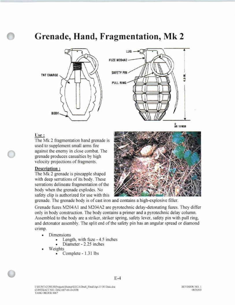
Grenade, Hand, Fragmentation, Mk 2
TNT CHARGE
LJE—»Q?{
FUZE M204A2
SflFETV PIN
PULL RING
BODY
Use:The Mk 2 fragmentation hand grenade isused to supplement small arms fireagainst the enemy in close combat. Thegrenade produces casualties by highvelocity projections of fragments.
Description :The Mk 2 grenade is pineapple shapedwith deep serrations of its body. Theseserrations delineate fragmentation of thebody when the grenade explodes. Nosafety clip is authorized for use with thisgrenade. The grenade body is of cast iron and contains a high-explosive filler.
Grenade fuzes M204AI and M204A2 are pyrotechnic delay-detonating frizes. They differonly in body construction. The body contains a primer and a pyrotechnic delay column.Assembled to the body are a striker, striker spring, safety lever, safety pin with pull ring,and detonator assembly. The split end of the safety pin has an angular spread or diamondcrimp.
• Dimensions• Length, with fuze - 4.5 inches• Diameter - 2.25 inches
• Weights- Complete- 1.31 lbs
E-4
[;\HUNT-CONi;S\Projects\BuincrtEECA\Dnift_FioalV\px E OF. Dato.dpcCONTRACT NO DACA87-UO-D-OO38TASK ORDER (MG7
REVISION NO. 1Q8/3O/O3

O Grenade, Hand, Fragmentation, Mk 2(Con't.)Markings :Olive drab, or olive drab with yellow band around top of fuze well. World War I eragrenades were painted battleship gray.
Operation ;Removal of the safety pin permits release of the safety lever. When the safety lever isreleased, it is forced away from the grenade body by a striker acting under the force of astriker spring. The striker rotates on its axis and strikes the percussion primer. The primeremits a small, intense spit of flame, igniting the delay element. The delay element burnsfor 4 to 5 seconds, then sets off the detonator. The detonator explodes, thus initiating theexplosive charge. The explosive charge explodes, rupturing the body and projectingfragments.
Hazardous Components;
• Filler - Flaked or granular TNT, 2 ounces• Primer - M42• Detonator - Lead azide, lead styphnate, and RDX
Possible Fuzes :Fuze, Grenade, M204A1
Fuze, Grenade, M204A2
Source: dudbusters.com (http://www.dudbusters.com/Iibrary/online.htm)
U E-5
I:\HUNT-CONUS\Projects\Butner\EECA\Draft_Final\Apx E OE Data.doc REVISION NO. 1CONTRACT NO. DACA87-00-D-0038 08/30/03TASK ORDER 0067

o
LandMine, AT, M4fUZC M l
EIQTtQM —ACT IV A1 ORWCLLACTIVATOR HI CHftllOt COMMHlufNI
Use :These are pressure-actuated, high-explosive (blast),antitank (AT) mines.
Description :The metallic Anti Tank Mine M4 is identical to theMl Al type except for the booster, the fuze, and theactivator wells.
• Dimensions• Length - Not available
• Weights• Complete - Not available
Markings:H.E. types are painted a lusterless olive drab with yellow base and black stencil. The H.E.fuze has a yellow striker head.
Operation :No information on functioning available.
Possible Fuzes :No information on fuzing.
Sources: dudbusters.com (http://www.dudbusters.com/library/online.htm)ORDATA Online (http://www.maic.jmu.edu/ordata/search.asp?SearchMode=l)NAVEODTECHDIV, ATTN: Code 602, 2008 Stump Neck Road, Indian Head, MD,USA, 20640-5070
E-6
l:\HUNT-CONUS\Projecls\Bulner\EECA\Draft_Final\Ap?(£ OE Data.doeCONTRACT NO. DACA87-O0-LVO038TASK ORDIiR 0067
REVISION NO. 108/30/03

O Grenade, Rifle, M9/M9A1
CONE
P£NTOLIT£
8OOSTER
PRIMERDETONATORCREEPSTRIKER
•SAFETY PIN
Use :The M9 is an earlier model of the M9A1 HEAT riflegrenade designed primarily for use against tanks andother armored or resistant targets.
Description ;The M9 weighed about 1.3 pounds, contained ashaped charge similar to the bazooka AT rocket,could penetrate 3 to 4 inches of armor, and had amaximum effective range of 250 yards (probableeffectiveness about 100 yards).
• Dimensions• Length - 11.24 inches• Diameter - 2.25 inches
• Weights• Complete -1.3 lbs
Markings :The M9 has the same tail assembly as the M9A1, butthe head is acorn shaped and is equipped with apoint detonating fuze. It is slightly less sensitivethan the M9A1. The safety pin of the M9 is locatedin the base of the grenade body instead of in thestabilizer tube. Its pull ring is secured to the bodywith adhesive tape. Olive drab in color.
Operation :The grenade is fired from a rifle by means of aspecial launcher attachment. A special cartridge isused for propulsion. The grenade must be placed onthe launcher before the safety pin is withdrawn. Thesafety pin is removed before firing. When the grenade is fired, set-back holds the strikeraway from the detonator. On impact, the striker overcomes the creep spring and hits thedetonator.
Gases produced when the hand-loaded grenade cartridge is fired launch the grenade. Formost of the designed rifle grenades, however, the thrust was not great enough to lift themto the desired altitude or propel them with enough force. Therefore, a propelling charge,ignited by flame from the fired cartridge, was assembled in the base of some of the riflegrenades to provide the additional boost. At the same time, the flame from the propellingcharge would ignite the black powder of any time train for a time delay fuze, if needed.Fuzes were standard in signal and illumination pyrotechnic rifle grenades.
E-7
STABILIZER
I:\HUNT-CONUS\Projects\Butner\EECA\Draft_Final\Apx E OE Data.docCONTRACT NO. DACA87-O0-D-O038TASK ORDER 0067
REVISION NO. 108/30/03

O Grenade, Rifle, M9/M9A1 (Con't.)Because of the heavy recoil generated by the grenade cartridge, the rifle (or carbine) wasfired by firmly planting the butt on the ground, turned sideways to avoid damaging thestock.
Possible Fuzes :
Impact fuzing
Hazardous Components ;
• Filler - TNT 4 ounces
Source: U.S. Army Technical Publications OP 1664
I:\HUNT-CONUS\Projects\Butner\EECA\Draft_Final\ApxEOEData.doc REVISION NO. 1CONTRACT NO. DACA87-00-D-0038 08/30/03TASK ORDER 0067

Grenade, Hand, Smoke, WP, M15
O
HHE
FILLING
FUZf WELL
SMOKEWP
BURSTING TYPE
E A - 9 - 6 9.LOT-123
AR '9102a
Use:WP smoke hand grenade Ml 5 is a bursting type grenade used for signaling, screeningand incendiary purposes.
Description :The grenade body is of sheet steel and is cylindrical in shape. The body has a fuze wellliner and is filled with WP.
The screening effect of the smoke is limited because WP burns with such intense heat,the smoke tends to rise rapidly. Pieces of WP will bum for about 60 seconds, igniting anyflammable substance contacted. The hand grenade M206A1 and M206A2 pyrotechnicdelay-detonating fuzes. They differ only body construction. The body contains a primerand pyrotechnic delay column. Assembled to the body are striker, striker spring, safetylever, safety pin with pull ring, and a detonator assembly. The split end of safety pin hasan angular spread or a diamond crimp.
Safety clips are not required with these grenades.
• Dimensions• Length -4.5 inches• Diameter - 2.37 inches
• Weights. Complete- 1.94 lbs
E-9
I:\HUNT-CONUSM>nijects\BumBrJinCA\DrBft_Fmal\Ap)i E OE I3ala.docCONTRACT NO DACA87-OO-D-OD38TAHKORDiiRUW.7
REVISION NO 108/30/03

O Grenade, Hand, Smoke, WP, M15 (Con't.)Markings ;Gray with yellow band and yellow markings. The fuze is olive drab with black markings.
Operation :Removal of the safety pin permits release of the safety lever. When safety lever isreleased, it is forced away from the grenade body by a striker acting under the force of astriker spring. The striker rotates on its axis and strikes the percussion primer. The primeremits small, intense spit of flame, igniting the delay element. The delay element burns for4 to 5 seconds, then sets off the detonator. The detonator explodes rupturing the body andexposing the WP filler to air. The WP will burn approximately 60 seconds.
Hazardous Components;
• Filler - White Phosphorous, 15 oz.
Source: dudbusters.com (http://www.dudbusters.com/library/online.htm)
u E-10
I:\HUNT-CONUS\Projects\Butner\EECA\Draft_Final\ApxEOEData.doc REVISION NO. 1CONTRACT NO. DACA87-00-D-0038 08/30/03TASK ORDER 0067
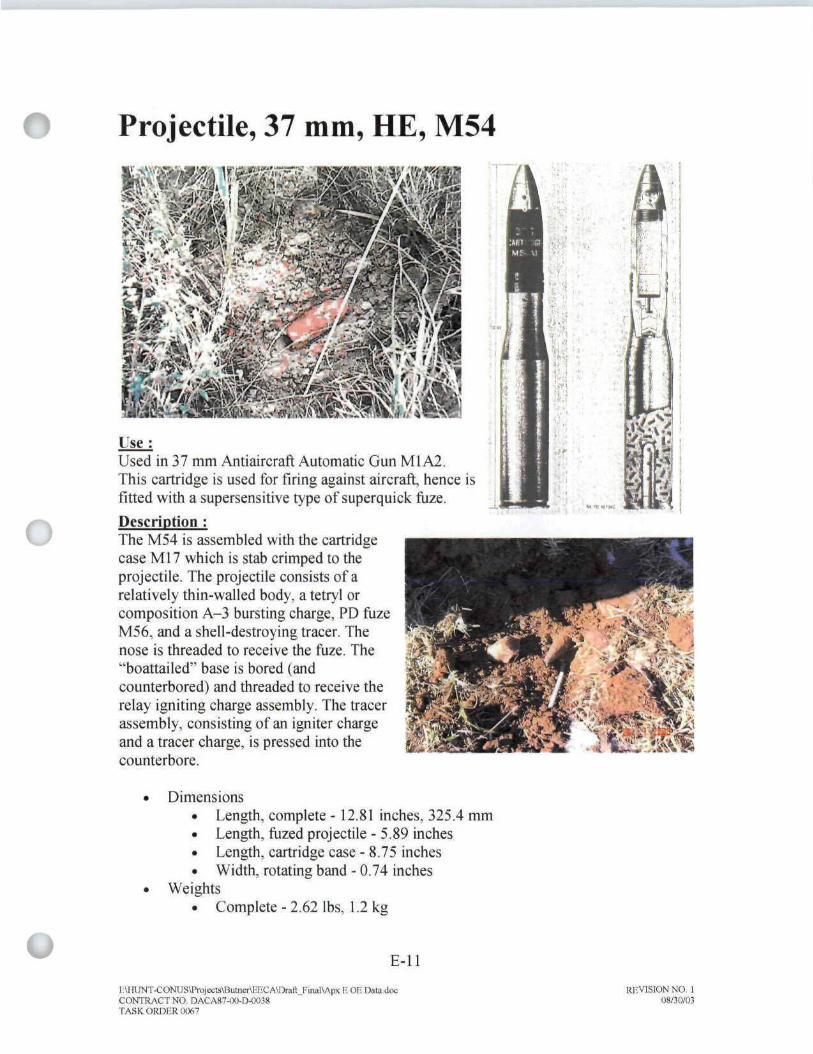
Projectile, 37 mm, HE, M54
o
^•vw?§ | i n p ^
Use:Used in 37 mm Antiaircraft Automatic Gun Ml A2.This cartridge is used for tiring against aircraft, hence isfitted with a supersensitive type of superquick fuze.
Description :The M54 is assembled with the cartridgecase M17 which is stab crimped to theprojectile. The projectile consists of arelatively thin-walled body, a tetryl orcomposition A-3 bursting charge, PD fuzeM56, and a shell-destroying tracer. Thenose is threaded to receive the fuze. The"boattailed" base is bored (andcounterbored) and threaded to receive therelay igniting charge assembly. The tracerassembly, consisting of an igniter chargeand a tracer charge, is pressed into thecounterbore.
^'4• ;
Dimensions• Length, complete -12.81 inches, 325.4 mm• Length, fuzed projectile - 5.89 inches• Length, cartridge case - 8.75 inches• Width, rotating band - 0.74 inches
Weights• Complete - 2.62 lbs, 1.2 kg
E-ll
I:\HUNT-CONUS\Projectg\BulnertEECAM3rail_Fiiifll\AiK E OE Data.docCONTRACT NO DACA87-OO-D-OO38TASK ORDER IW67
REVISION NO. 108/30/03

O Projectile, 37 mm, HE, M54 (Con't.)Markings :Olive drab with yellow markings. Older projectiles had yellow bodies.
Operation ;When the cartridge is fired, the burning propellant initiates the igniter charge which, inturn, ignites the tracer charge. The tracer burns with a visible trace for about 8 seconds,equivalent to a range of about 3,500 yards. As the tracer burns out, the relay ignitingcharge is ignited and causes the bursting charge to detonate if prior functioning has notbeen caused by fuze impact.
Hazardous Components :
• Propellant - FNH, 0.38 lbs• Primer - M23A2• Tracer - Self destroying. Filler
• Tetryl, 0.1 lbs• Composition A-3, 0.1 lbs
Source: dudbusters.com (http://www.dudbusters.com/library/online.htm)
u E-12
I:\HUNT-CONUS\Prpjects\Butner\EECA\Draft_Final\ApxEOEData.doc REVISION NO. 1CONTRACT NO. DACA87-00-D-0038 08/30/03TASK ORDER 0067

Projectile, 57 mm, HEAT, M307A1 andM307
IB IS MAX
SHAPED HE CH
BOOSTER
PROPELLING CM ARSELINER.
Use:This cartridge is employed againstarmored targets and used with 57 mmRifles M18 and M18A1.
Description :HEAT Cartridge M307A1 includes aperforated metal cartridge casecontaining a plastic liner and apercussion primer and is crimped tothe projectile just behind the pre-engraved rotating band of theprojectile. The projectile forward capis threaded to receive a point detonating fuze. A hemispherical copper liner crimped tothe interior of the projectile forms a shaped charge to the rear and space forward toprovide the standoff necessary for penetration. A steel sleeve brazed to the neck of thecopper liner provides a passage from the fuze to a booster pellet in the base of theprojectile. The booster pellet extends into the high explosive charge.
E-13
[AHTJNT-CONUSTrojeeia\BulnertEECA«)raft Fii»l\Af* E OE Data.docCONTRACT NO. DACAS7-0O-EWM3STASK ORDER 01)67
REVISION NO t08/30/03

O Projectile, 57 mm, HEAT, M307A1 andM307 (Con't.)
• Dimensions• Length -18.78 inches
• Weights• Complete - 5.43 lbs
Markings :Olive drab with yellow markings.
Operation :The primer ignites the propellant when struck by the weapon firing pin, and the burningpropellant generates gases to propel the projectile through the barrel. Recoil is eliminatedbecause the design of the cartridge case permits controlled release of some gas pressurethrough apertures in the rifle breech block. The rotating band engages the barrel rifling tospin the projectile. The fuze functions upon impact and fires through the steel sleeve tothe booster pellet. Detonation of the explosive charge collapses the copper liner andcreates a focused, high velocity shock wave containing a jet of metal particles thatpenetrates the interior of the target.
V Hazardous Components:
• Cartridge case -M30A1, M30A1B1• Propellant-Ml 0• Primer - M60, M60A1• Booster - Integral (Tetryl)• Filler - Composition B or 50/50 Pentolite, 0.4 lb
Possible Fuzes :Fuze. Projectile. Point Initiating. M90
Differences Between Models:M307 uses a paper lined Cartridge M30 and Percussion Primer M46.
Source: dudbusters.com (http://www.dudbusters.com/library/online.htm)
U E-14
I:\HUNT-CONUS\Prqjects\Butaer\EECA\Draft_Final\Apx E OE Data.doc REVISION NO. 1CONTRACT NO. DACA87-00-D-O038 08/30/03TASK ORDER 0067
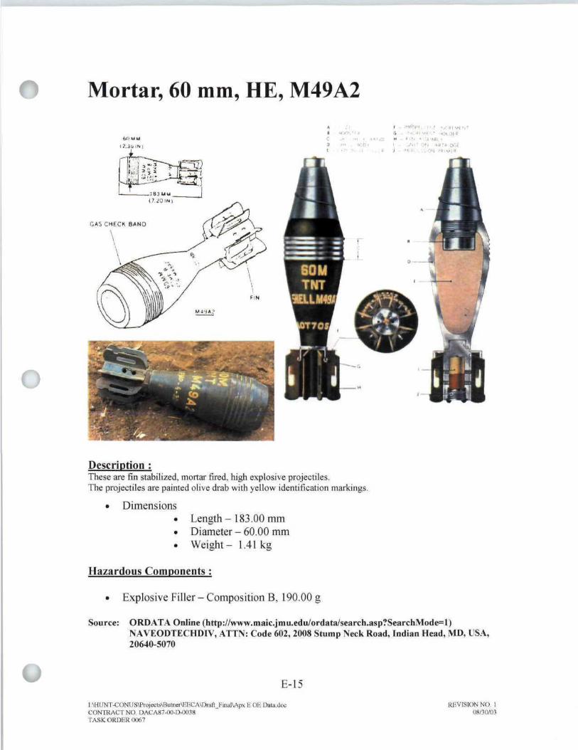
Mortar, 60 mm, HE, M49A2
O
;i f - s"«vii i r-.r. roi 'n ft - •<J(MI-, ' .. . ..1 • l . - . o W - U N •-.'.(•«»L
t
Description :These are fin stabilized, mortar fired, high explosive projectiles.The projectiles are painted olive drab with yellow identification markings.
• Dimensions. Length-183.00 mm• Diameter - 60.00 mm• Weight- 1.41 kg
Hazardous Components:
• Explosive Filler-Composition B, 190.00 g
Source: ORDATA Online (hrtp://www.maic.jmu.edu/ordata/search.asp?SearchMode=1)NAVEODTECHD1V, ATTN: Code 602, 2008 Stump Neck Road, Indian Head, MD, USA,20640-5070
E-15
l:\HUOT-C OWS\Projects\ButneriEECA\Ttoft_Finiil\Ap>; E OE DatadqcCONTRACT NO QACA87-OO-EM)038TASK ORDER 0067
REVISION NO. 108/30/03

Mortar, 60 mm, Training, M69
»HOjfcnii<4
Use:This cartridge is used for training in the loading and firing of 60mm mortars M2 andM19.
Description :Unlike other mortar ammunition, the components of this round are issued separately. Thisfacilitates replacement of damaged, worn, or expended parts. The complete roundconsists of an inert projectile, a fin assembly, an ignition cartridge, and a percussionprimer. The pear-shaped, cast iron projectile has no provision for a fuze and is internallythreaded at the base to accept the fin assembly.
• Dimensions• Length, complete - 7.72 inches
• Weights• Complete - 4.43 lbs
Markings :Black or blue with white markings.
Operation :When the cartridge is loaded, it slides down the mortar tube until the percussion primer inthe ignition cartridge strikes the firing pin in the base cap of the mortar. The primerdetonates the ignition cartridge. Since this round is fired only at Charge 0, the gases fromthe ignition cartridge expel the projectile from the mortar tube and propel it to the target.The projectile is fin-stabilized in flight. Since the cartridge is inert, there is no detonationupon impact and the cartridge may be recovered for reuse.
E-16
T;VMJNT-CONUS\Pro)e<:ts\ButnertEECA1J>-afl Kindl\Apx E OE Daw docCONTRACT NO DACA87-00-D-0038TASK ORDER (1067
REVISION NO 1

O Mortar, 60 mm Training, M69 (Con't.)Hazardous Components:
• Ignition cartridge - M4, M5A1• Propellant - None• Primer - M32
Sources: dudbusters.com (http://www.dudbusters.com/library/online.htm)
ORDATA Online (http://www.maic.jmu.edu/ordata/search.asp?SearchMode=l)NAVEODTECHDIV, ATTN: Code 602, 2008 Stump Neck Road, Indian Head, MD,USA, 20640-5070
U E-17
I:\HUNT-CONUS\Projects\Butner\EECA\Draft_Final\Apx E OE Data.doc REVISION NO. 1CONTRACT NO. DACA87-00-D-0038 08/30/03TASK ORDER 0067

Mortar, 81 mm, Training, M68?!5 MM
• IN M I T MBLV
0«
MIICUICIOM ANOMM
S-ASSEUBLED
mmasmUse :This cartridge is used for training inthe loading and firing of the 81mm
Description :Unlike other mortar ammunition, thecomponents of this round are issuedseparately to facilitate replacementof damaged, worn, or expendedparts. The complete round consistsof an inert projectile, a fin assembly,and an ignition cartridge. The pear-shaped, cast iron projectile has no provision for a fuzeand is internally threaded at the base to accept the fin assembly.
• Dimensions• Length, complete - 11.08 inches
• Weights• Complete- 10.79 lbs
E-18
l.\HUNT-CONTJS\Project3\BuMiBT\EECA\Draft hinal\Ap*E OEDaliLdocCONTRACT NO DACA87-0O-D-O03STASK ORDER 0067
REVISION NO 108/30/03

O Mortar, 81 mm, Training, M68 (Con't.)Markings ;Black with white markings. Items of later manufacture are bronze, or not painted.
Operation :When the cartridge is loaded it slides down the mortar tube until the percussion primer inthe ignition cartridge strikes the firing pin in the base cap of the mortar. The primerignites the ignition cartridge. Since this round is fired only at Charge 0, the gases fromthe ignition cartridge expel the projectile from the mortar tube and propel it to the target.The projectile is fin-stabilized in flight. Since the projectile is inert, there is no detonationupon impact, and the cartridge may be recovered for reuse.
Hazardous Components :
u
• Ignition cartridge - M3, M6• Propellant charge - None• Primer - M34 percussion• Filler - Inert
Possible Fuzes:No information on fuzing.
Source: dudbusters.com (http://www.dudbusters.com/library/online.htm)
E-19
I:\HUNT-CONUS\Projects\Butner\EECA\Draft_Final\Apx E OE Data.doc REVISION NO. 1CONTRACT NO. DACA87-00-D-0038 08/30/03TASK ORDER 0067

Projectile, 105 mm HE, Ml
The projectile contains high explosive and is used for fragmentation, blast, and mining insupport of ground troops and armored columns.
Description :The projectile consists of a hollow steel forging with a boat tail base, a streamlined ogive,and gilding metal rotating band. A base cover is welded to the base of the projectile foradded protection against the entrance of hot gases from the propelling charge duringfiring. The high explosive (HE) filler within the projectile may be either cast TNT orComposition B. A fuze cavity is either drilled or formed in the filler at the nose end of theprojectile. This cavity may be either shallow or deep. A cavity liner, to preclude dustingof HE during transportation and handling, is seated in the cavity and expanded into thelower projectile fuze threads. A supplementary charge is placed in the fuze cavity ofprojectiles having deep cavities. Projectiles with shallow cavities or deep cavities con-
EMffllDUrMCPiLLIK3 CKlflQE
ZHtHOt
CHMKECtOSINd >UIQ*
ROWTItlCMMD
taining a supplementary charge use only short intrusionfuzes, PD, or MT. Those with deep cavities will acceptthe long intrusion proximity fuze after removing the
supplementary charge. Projectiles may be shipped with a PD or MTSQ fuze or with aclosing plug. When shipped with a closing plug, a chip board spacer is assembledbetween the supplementary charge and plug to limit movement of the former duringtransportation and handling.
The cartridge case contains a percussion primer assembly and seven individually baggedand numbered propelling charge increments. The base of the cartridge case is drilled andthe primer assembly is pressed into the base. The percussion primer assembly consists ofa percussion ignition element and a perforated flash tube containing black powder. Theseven numbered increment bags are tied together, in numerical order, with acrylic cord.These are assembled into the cartridge case, around the primer flash tube, with Increment1 at the base of the cartridge case and Increment 7 toward the mouth of the cartridge case.
E-20
[AHUNT-CONlJS\Pro)eols\Buiner\EECA\Dralt_Final\Ap!(E OH Data.docCONTRACT NO DACAS7-0O-D-OO38TASK ORDER 0067
REVISION NO. 1OK/30/03
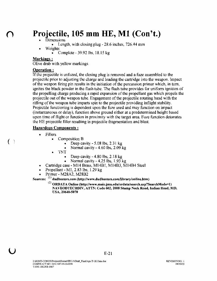
O Projectile, 105 mm HE, Ml (Con't.)• Dimensions
• Length, with closing plug - 28.6 inches, 726.44 mm• Weights
• Complete - 39.92 lbs, 18.15 kg
Markings :Olive drab with yellow markings.
Operation ;If the projectile is unfuzed, the closing plug is removed and a fuze assembled to theprojectile prior to adjusting the charge and loading the cartridge into the weapon. Impactof the weapon firing pin results in the initiation of the percussion primer which, in turn,ignites the black powder in the flash tube. The flash tube provides for uniform ignition ofthe propelling charge producing a rapid expansion of the propellant gas which propels theprojectile out of the weapon tube. Engagement of the projectile rotating band with therifling of the weapon tube imparts spin to the projectile providing inflight stability.Projectile functioning is dependent upon the fuze used and may function on impact(instantaneous or delay), function above ground either at a predetermined height basedupon time of flight or function in proximity with the target area. Fuze function detonatesthe HE projectile filler resulting in projectile fragmentation and blast.
Hazardous Components:
• Fillers/ s • Composition BV ' • Deep cavity-5.08 lbs, 2.31kg
• Normal cavity - 4.60 lbs, 2.09 kg• TNT
• Deep cavity - 4.80 lbs, 2.18 kg• Normal cavity - 4.25 lbs, 1.93 kg
• Cartridge case - M14 Brass, M14B1, M14B3, M14B4 Steel• Propellant - Ml, 2.83 lbs, 1.29 kg. Primer - M28A2, M28B2
Sources: dudbusters.com (http://www.dudbusters.com/library/online.htm)(2)
ORDATA Online (http://www.maic.jmu.edu/ordata/search.asp?SearchMode=l)NAVEODTECHDIV, ATTN: Code 602, 2008 Stump Neck Road, Indian Head, MD,USA, 20640-5070
U E-21
I:\HUNT-CONUS\Prqjects\Butner\EECA\Draft_Final\Apx E OE Data.doc REVISION NO. 1CONTRACT NO. DACA87-00-D-0038 08/30/03TASK ORDER 0067

Projectile, 155 mm, Shrapnel, Mk 1
o 3ANS1
g/*n.
Use:The 155mm shrapnel projectile was used inpre-World War II and was regarded as themost efficient type of ammunition againsttroops in the open. The 155mm shrapnelpacked a lethal load of 800 lead balls eachabout a half inch in diameter in addition to anexplosive charge to scatter the shot as well asfragments of the shell casing.
Shrapimi, Mk, I f<>r IDescription :Each projectile was practically a shotgun which was fired, by means of the time fuze,ideally at the height which would produce the maximum effect on the enemy. At themoment of burst, the bullets shot forward with increased velocity, normally withoutfracturing the case. The result was a cone of bullets which swept an area generally muchlarger than the area made dangerous by the burst of a high explosive shell of the samecaliber. The effective area at a range of 4,000 yards was about 35 yards wide and 50yards long. In addition, some balls with equally effective velocity were scattered lessdensely over a zone roughly twice as wide and several times as long. The height of bursthad to be adjusted by observation of the smoke puff produced at the moment ofexplosion, and by proper changes in the setting of the time fuze.
• Dimensions• Length, with fuze - 18.82 inches• Diameter - 5.95 inches
• Weights• Complete-95 lbs
E-22
r:\mJNT-CONUS\Projeets\Butner\EECA\Draft KinuMpx E OE Dala.docCONTRACT NO. DACA87-QO-&-O038TASK ORDER 0067
REVISION NO 108/30/03

O Projectile, 155 mm, Shrapnel, Mk 1(Con't.)Markings :Projectile, except rotating bands, painted red with black stenciling: "155 G (or H)."
Operation :The height of burst had to be adjusted by observation of the smoke puff produced at themoment of explosion, and by proper changes in the setting of the time fuze.
Hazardous Components;
• Filler - 800 lead spheres• Propellant - 26.2 lbs. of non-hygroscopic powder• Igniter - 9 ounces of black powder sewed to bottom of base charge
(propellant)
Source: U.S. Army Center of Military History Online (http://www.armv.mil/cmh-pg/faq/shrapnel.htm)
I:\HUNT-CONUS\Projects\Butner\EECA\Draft_Final\Apx E OE Datadoc REVISION NO. 1CONTRACT NO. DACA87-00-D-0038 08/30/03TASK ORDER 0067

Projectile, 155 mm HE, M101• f- -fat: '•'•' '"
-KIN6;6F. fou^
3F;Cf i -^ i:'S INTtAlS flND LOT NUMBER' . ~j<] '' |
H J . J I ".;•• MODEL pp PROJECT:li:,.
OLIVE DRAB (MARKING IN YELLOW)
Use :This is an Army, spin stabilized, gun fired, high explosive (HE)projectile.
Description :The projectile is painted olive drab with yellow markings.
• Dimensions• Length-605.00 mm
• Weights• Complete - 44.00 kg
Markings :
Yellow
Hazardous Components:
Filler - TNT
Source: ORDATA Online (http://www.maic.jmu.edu/ordata/search.asp?SearchMode=l)NAVEODTECHDIV, ATTN: Code 602, 2008 Stump Neck Road, Indian Head, MD, USA,20640-5070
E-24
JAHUNT-CONUS\Prtjjects\BulnCTM-ECA\Drafl_Fiiiul\Aps E OE Dala.ilocCONTRACT NO. I3ACA87-00-I>003BTASK ORDER 0067
REVISION NO. 108/30/03

APPENDIX FINSTITUTIONAL ANALYSIS REPORT

Institutional Analysis Former Camp Butner EE/CA
Institutional Analysis ReportFormer Camp Butner
Durham, Granville, and Person Counties,North Carolina
Prepared for:U.S. Army Engineering and Support Center, Huntsville
Huntsville, Alabama
Prepared by:
ParsonsAtlanta, Georgia
July 2004
I:\Hunt-Conus\projects\Butner\Appendix\lACover.doc Parsons

Institutional Analysis Former Camp Butner EE/CA
Table of Contents
Table of Contents i
1.0 Purpose of Study Fl-11.1 Introduction Fl-11.2 Institutional Controls Fl-11.3 Study Approach Fl-11.4 Study Overview Fl-2
2.0 Institutional Controls F2-12.1 Site Background F2-1
2.1.1 Site Description F2-12.1.2 Site History F2-32.1.3 Environmental Setting and Ecology F2-32.1.4 Archaeology/Historical Resources F2-4
2.2 Methodology F2-52.2.1 Response Strategies F2-52.2.2 Analysis Methodology F2-5
2.3 Scope of Work/Selection Criteria F2-62.3.1 Interview Selection F2-62.3.2 Interview Categories F2-6
2.4 Interview Summary F2-72.4.1 Interview Questions F2-72.4.2 Interview Results F2-7
3.0 Institutional Control Alternatives F3-13.1 Introduction F3-1
3.2 Physical Removal F3-13.2.1 Removal and Human Behavior F3-23.2.2 Removal Responsibility F3-2
3.3. Access Control F3-23.3.1 Signage F3-23.3.2 Fencing F3-23.3.3 Land Use Restrictions and Regulatory Control F3-33.3.4 Effectiveness F3-33.3.5 Implementation F3-43.3.6 Cost F3-43.3.7 Management, Execution and Support Roles F3-4
Parsons

Institutional Analysis Former Camp Butner EE/CA
3.4 Public Awareness Program F3-43.4.1 Land Use Controls F3-53.4.2 Notice F3-53.4.3 Effectiveness F3-63.4.4 Implementation F3-73.4.5 Cost F3-8 3-5
3.5 Printed Media F3-93.5.1 Brochures/Fact Sheet F3-93.5.2 Newspaper Articles/Interviews F3-93.5.3 Information Packages for Public Officials F3-103.5.4 Effectiveness F3-103.5.5 Implementation F3-103.5.6 Cost F3-113.5.7 Management, Execuation, and Support Roles F3-11
3.6 Visual and Audio Media Awareness Program F3-11 F3-?3.6.1 Video Tapes , F3-113.6.2 Television F3-123.6.3 Radio F3-123.6.4 Effectiveness F3-123.6.5 Implementation F3-123.6.6 Cost F3-133.6.7 Management, Execution, and Support Roles F3-13
3.7 Classroom Education and Awareness Program F3-133.7.1 Ordnance Identification F3-133.7.2 Ordnance Safety F3-133.7.3 Effectiveness F3-143.7.4 Implementation F3-143.7.5 Cost F3-143.7.6 Management, Execution, and Support Roles F3-14
3.8 Exhibits/Displays F3-143.8.1 Effectiveness F3-143.8.2 Implementation F3-143.8.3 Cost F3-153.8.4 Management, Execution, and Support Roles F3-15
3.9 Internet Website Awareness Program F3-153.9.1 Effectiveness F3-153.9.2 Implementation F3-153.9.3 Cost F3-153.9.4 Management, Execution, and Support Roles F3-15
3.10 Ad Hoc Committee Awareness Program F3-163.10.1 Effectiveness F3-16
Parsons

Institutional Analysis Former Camp Butner EE/CA
3.10.2 Implementation F3-163.10.3 Cost F3-163.10.4 Management, Execution, and Support Roles F3-16
3.11 Reverse 911 System F3-163.11.1 Effectiveness F3-173.11.2 Implementation F3-173.11.3 Cost F3-17
3.12 Other Methods of Behavior Modification Through Public Awareness F3-17
4.0 Recommendations F4-14.1 Introduction4.2 Recommended Alternatives F4-1
4.2.1 Notification During Permitting F4-24.2.2 Notification During Property Transfer F4-24.2.3 Notification on Tax Bills F4-24.2.4 Brochure/Fact Sheet F4-24.2.5 Newspaper Articles/Interviews F4-34.2.6 Information Packages to Public Officials F4-34.2.7 Visual and Audio Media F4-34.2.8 Classroom Education F4-34.2.9 Ad Hoc Committee F4-44.2.10 Reverse 911 System F4-44.2.11 Land Use Restrictions and Regulatory Control F4-44.2.12 Internet Website F4-4
4.3 Phasing of Alternatives F4-44.4 Alternatives Not Recommended F4-5
4.4.1 Signs and Fencing F4-54.4.2 Deed Notification/Restriction F4-54.4.3 Exhibit/Display F4-5
4.5 Cost F4-5
List of TablesTable 4-1 - Institutional Control Alternatives F4-6
AppendicesAppendix A - Institutional Data Survey Forms
iii Parsons

SECTION 1INTRODUCTION
1.1 INTRODUCTION
This Institutional Analysis Report was prepared by Parsons for the U.S. ArmyEngineering and Support Center, Huntsville (USAESCH), under contract numberDACA87-95-D-OO18. The report is prepared to support the institutional controlalternative plans for actions that are included in the former Camp Butner EngineeringEvaluation/Cost Analysis (EE/CA). Local and state authorities that will support andexert long-term institutional controls recommended for the former Camp Butner arepresented. Each institutional control alternative is described, and the level or degree ofsupport required for each is described.
1.2 INSTITUTIONAL CONTROLS
Institutional controls rely on the existing powers and authorities of governmentagencies to protect the public at large from ordnance and explosives (OE) risks. Insteadof direct removal of the OE from the site, these plans rely on behavior modification andaccess control strategies to reduce or eliminate OE risk. This analysis documents whichgovernment agencies have jurisdiction over the former Camp Butner and assesses theircapability and willingness to assert control that would protect the public at large fromexplosives hazards. This report also documents the mission of the government,corporate, or private landholders of lands containing ordnance to protect citizens fromsafety hazards under the law.
1.3 STUDY APPROACH
Parsons has prepared this detailed analysis of institutional control alternatives inaccordance with guidance developed by the USAESCH. This analysis supports thedevelopment of institutional control alternative plans of action known as institutionalcontrol strategies. If these strategies are to be successful, the cooperation of local andstate authorities and private interests is required. Representatives of local, state andfederal government agencies with jurisdiction over the former Camp Butner have beeninterviewed as to their concern and capability to exercise institutional controls over theproperty. Other stakeholders have also been identified and interviewed to determine theircommitment, interest, and involvement in institutional controls. This study includesoutlines of these interviews, discussion of potential control strategies, andrecommendations for specific control strategies.
Fl-1
I:\HUNT-CONUS\PROJECTS\BUTNER\EECA\APPENDICES\IASECTION_1 DOC 7/9/2004DELIVERY ORDER 0067 REVISION NO: 4
1.4 STUDY OVERVIEW
1.4.1 This study outlines which agencies have jurisdiction over the former CampButner and assesses their capabilities and willingness to support and enforce short andlong-term institutional control measures. This report is structured as follows:
1.4.2 Section 2.0: summarizes the site background, the institutional controlmethodology, and interviews with agencies that have site jurisdiction and/or react withcurrent and future land users.
1.4.3 Section 3.0: describes the potential institutional control alternatives. Theeffectiveness, feasibility, and cost of each alternative is discussed, and managementexecution, and support roles are defined.
1.4.4 Section 4.0: presents the final institutional control recommendations to reducethe risk of exposure to ordnance.
Fl-2
I:\HUNT-CONUS\PROJECTS\BUTNER\EECAVAPPEND1CES\1ASF.CTIONJ DOC 7/9/2004DELIVERY ORDER 0067 REVISION NO: 4

SECTION 2DESCRIPTION OF THE SITE AND EXISTING INSTITUTIONAL
FRAMEWORK
2.1 SITE BACKGROUND
The former Camp Butner (the Camp) is located in Durham, Granville, and PersonCounties, in north central North Carolina. The property is located 15 miles northeast ofthe City of Durham, North Carolina and is adjacent to Stem, North Carolina. The siteconsist of all areas previously under the Department of Defense control when the Campwas active from 1942 until 1947.
2.1.1 Site Description
2.1.1.1 The former Camp includes approximately 40,385 acres of land area. Theapproximate boundary of the Camp is defined by Range Road that, although contiguous,now has multiple names and County designations. The northern and eastern boundaryfollows County Road 1126. County Road 1728 (continuation of County Road 1126 intoPerson County) defines the western boundary and continues southward onto CassamRoad. The southern boundary roughly follows Interstate 85. For the purposes of thisstudy, the Camp has been divided into six areas, described below.
2.1.1.2 Area 1: Cantonment Area and Vicinity. Area 1 is located in the southeastcorner of the former Camp. This area contains the town of Butner North Carolina, andtwo State hospitals, the John Umstead Hospital, and the Murdock Center. Residentialareas and several schools, Butner-Stem Elementary and Middle, are located within theTown of Butner, NC. The remaining portion of the area is wooded. Area 1 is locatedwithin Granville County, however it is under the jurisdiction of the State of NorthCarolina.
2.1.1.3 Area 2: Ammunition Storage Area and Dump. Area 2 is a square-shapedarea that lies on the southern boundary of Area 4. The area is wooded and located onproperty controlled by the State of North Carolina Wildlife Resources Commission. Aroad leading to Holt Reservoir dissects the Area 2. There are no residential homes withinthe area. Area 2 is located within Granville County, however the property is under thejurisdiction of the State of North Carolina.
2.1.1.4 Area 3: Grenade Training Ranges. Area 3 is a square-shaped propertylocated within Area 5. The area is composed of pasture land owned by Umstead Farm, aNorth Carolina State University Dairy Research farm. Area 3 is located within GranvilleCounty, however the property is under the jurisdiction of the State of North Carolina.
F2-1
I:\HUNT-CONUS\PROJECTS\BUTNER\EECA\APPENDICES\IASECTION_2.DOC 7/9/2004DELIVERY ORDER 0067 REVISION NO: 4

2.1.1.5 Area 4: Ammunition Training Ranges and Impact Areas. Area 4composes the northern portion of the former Camp. The majority of the area is in privateownership and is utilized for agricultural purposes. Most tracts in Area 4 are in excess of200 acres. A large portion of the land is undeveloped and forested. Private residencesare located across the area. Timber harvesting is a common practice throughout the area.Approximately 75% of Area 4 is located in Granville County, the remaining portion islocated within Person County.
2.1.1.6 Area 5: Remaining land. Area 5 composes the southern portion of the site.The majority of the property with in the area is under public ownership. Tenants withinthe area include Umstead Farm, a North Carolina State University Dairy Research farm,Butner Beef Cattle Field Lab, a North Carolina State University Beef Cattle FeedResearch farm, four Federal prisons operated by the United States Department of Justice,Federal Bureau of Prisons, and land under the stewardship of the North Carolina WildlifeResources Commission. Most of this area (95%) is located within Granville County, theremaining portion is located in Durham County. This property is under the jurisdiction ofthe State of North Carolina.
2.1.1.7 Area 6: National Guard Training Center. Area 6 is located in the westcentral portion of the former Camp. The land is owned by the State of North CarolinaNational Guard (NCNG) and is utilized as a training center. Approximately 50% of theNCNG property is located within Durham County, and accounts for the majority of theformer Camp within the County. The remaining portion of the property is located inGranville County.
Table 2.1 Camp Butner Land Use
Area of Interest(per FinalWorkplan)
1
2
3
4
5
6
Size(acres)
3.300
7
5
21,950
10.372
4,750
Current Owner
Town of Butner
State of North CarolinaState of North Carolina
Various private land owners
State of North Carolina
State of North Carolina
Current Land Use
Residential,InstitutionalState ForestAgriculture,ForestryResidential,Forestry,AgricultureAgriculture,InstitutionalNCNG TrainingCenter
Zoning /Future Land Use
Residential,InstitutionalState ForestAgriculture.ForestryResidential,Forestry,AgricultureAgriculture.InstitutionalNCNG TrainingCenter
F2-2
I:\HUNT-CONUS\PROJECTS\BUTNER\EECA\APPEND1CES\IASECTION_2.DOCDELIVERY ORDER 0067
7/9/2004REVISION NO: 4
2.1.2 Site History
2.1.2.1 The Camp Butner Training Center was established in 1942 and usedprimarily as a training and cantonment facility. The Camp was first established for thetraining of infantry divisions and miscellaneous artillery and engineering units.Approximately 15 training ammunition ranges were present. One range encompassedapproximately 23,000 acres and was used for live-fire ammunition training. Other rangesincluded a grenade range, a 1000-inch range, a gas chamber, and flame-thrower trainingpad. The ordinance used at the Camp included rockets, morters, grenades, artilleryrounds ranging from .22-caliber through 240mm, and various initiating and primingmaterials used as obstacles and mine field clearing devices. An ammunition storage areawas also located on the Camp.
2.1.2.2 In, addition to infantry training, the site was the location of one of the Army'slargest general and convalescent hospitals and the War Department's ArmyRedeployment Center. The Camp was designed to house up to 40,000 troops. Prisonersof War were housed at the Camp in September 1943.
2.1.2.3 On January 31, 1947 the War Department declared Camp Butner excess. Atthe time, the Federal government was negotiating with the State of North Carolina for alease on the hospital. On November 3, 1947, the State purchased the hospital and 1,600acres of the former cantonment area to be used for various projects and agriculturaldevelopment. The North Carolina National Guard was given 4,750 acres of the formercamp for training purposes. Much of the remaining land was sold back to the originalowners; however, covenants were placed in the property deeds restricting the use of theland to surface use only.
2.1.2.4 During March 1990, the U.S. Army Corps of Engineers (USACE) conducteda field inspection and archive search to determine the status of the former Camp Butner.Historical inspections reports of restricted areas and dedudding reports were reviewedand numerous interviews were conducted. Findings of the inspection and archive searchindicate that ordnance had been found within the former ranges. Fort Bragg explosiveordnance disposal (EOD) has been the responding team. Other findings indicated thelargest round used at the Camp was a 155mm projectile, three tear gas chambers existedat the facility and Lighting Lake may have a military trash dump beneath it. Interviewswith personnel from the Federal Correctional Institute indicated no reports of ordnancehaving been found on their facility. A final ownership map of the Camp was obtainedshowing dedudding operations as of April 6, 1950.
2.1.3 Environmental Setting and Ecology
2.1.3.1 The Camp is located within the Durham Sub-basin. The predominatebedrock formation is Arkosic Sandstone. The sandstone is tan in color, medium to verycoarse grained, and contains mica. The sandstone is Triassic Age and is an acidicbedrock material. The site lies within the White Store-Creedmoor soil association and ischaracterized by gently sloping to moderately steep, moderately well drained (sandyloam) soils with a subsoil of firm clay.
F2-3
I:\HUNT-CONUS\PROJECTS\BUTNER\EECA\APPENDICES\IASECTION_2 DOC 7/9/2004DELIVERY ORDER 0067 REVISION NO: 4

2.1.3.2 The region is characterized by rolling topography with rounded hills andlong, low ridges. The undeveloped hills are covered with hardwoods and various pines.The understory is predominantly dogwood, poison ivy, Christmas fern, and Japanesehoneysuckle. Lake Butner (the source of potable water for the City of Butner; a.k.a. HoltReservoir) and adjacent Lightning Lake are located on the south end of the Camp. TheCamp also contains several streams and tributaries.
2.1.3.3 The area is subjected to warm, humid summers and mild winters. Thelowest mean temperature of 28 °F occurs in January and the highest mean temperature of90 °F in July. The annual average rainfall is approximately 47 inches with an averagemonthly rainfall between 3 to 4 inches.
2.1.3.4 The Federal and State agencies identified the following informationconcerning threatened and endangered species:
• The USFWS lists the bald eagle (Haliaeetus leucocephalus) as endangered inDurham and Granville Counties. The dwarf wedgemussel (Alasmidontaheterodon) is also listed as endangered by the USFWS in Granville County.There are no federally listed threatened or endangered species in Person County.
• The North Carolina Natural Heritage Program lists the bald eagle (Haliaeetusleucocephalus) as endangered in Durham County. The triangle floater(Alasmidonta undulata), Atlantic pigtoe (Fusconaia masoni), yellowlampmussel (Lampsilis cariosa), green floater (Lasmigona subviridis), andsquawfoot (Strophitus undulates) are listed as threatened or endangered inDurham, Granville, and Person Counties. Granville County also lists the dwarfwedgemussel (Alasmidonta heterodon), brook floater (Alasmidonta varicosa),and the yellow lance (Elliptio lanceolata) as threatened or endangered.
2.1.4 Archeological / Historical Resources
2.1.4.1 Camp Butner has been subjected to at least one previous cultural resourcessurvey. In December 1994, Greiner, Inc., of Raleigh, North Carolina (Klein and Brown1995) conducted an archaeological survey of nine historic farm sites on Camp Butner thathad been previously identified by NCNG. This survey indicated that all nine of theresources were potentially eligible for inclusion on the National Register of HistoricPlaces (NRHP). The sites were recorded and assigned state site numbers (31DH619through 31DH624, 31GV204 through 31GV206). During the survey, two additionalhistoric sites were identified but not assigned site numbers, as they required additionalsurvey work. It was not stated in the report if artifacts were collected. All nine of thesesites, as well as the two sites that were not assigned state site numbers, are subject toFederal laws and regulations governing their evaluation and preservation, if necessary.World War II era structures were also noted during the archaeological survey at CampButner; however, there is no record of an architectural survey conducted for the facility.
F2-4
I:\HUNT-CONUS\PROJECTS\BUTNER\EECA\APPENDICES\1ASECTION_2.DOC 7/9/2004DELIVERY ORDER 0067 REVISION NO: 4

2.2 METHODOLOGY
2.2.1 Response Strategies
2.2.1.1 There are three general categories of response strategies to ordnanceremaining on sites formerly used for training and firing practice. These included:
• Removal,
• Access Control, and,
• Behavior Modification.
2.2.1.2 Ideally, identification and removal of all ordnance would always bepreferred but this goal is neither technically or financially feasible. Therefore, strategiesmust be defined to alert the population within and around the site that will be potentiallyaffected by the presence of ordnance and protect them as much as possible from ordnanceaccidents. These strategies, Access Control and Behavior Modification, may be utilizedin conjunction with a removal action or in the absence of a removal action, depending ona variety of evaluation parameters.
2.2.1.3 Access control and behavior modification are defined as institutional controlresponse strategies or institutional controls. These strategies require local cooperation,responsible land-use control, and/or police powers for enforcement. These strategies areinherently non-federal and require a high level of community involvement. Institutions,defined as local and state governmental agencies and other organizations that can assist,are the vital elements needed to implement any of the recommended institutionalcontrols. Assessment and development of institutional controls, like all response plans,starts with data collection, including obtaining responses to the following questions:
• What institutions hold control over the site?
• What authority do they have?
• Do they have specific responsibility in land-use control and/or public safety?
• What capabilities do they have?
• What resources do they have?
• Are they willing to play a role?
2.2.2 Analysis Methodology
The methodology used to analyze potential institutional control strategies forreducing the ordnance-related risk at the former Camp included the review of thegovernment institutions and non-government entities that have some form of jurisdictionor ownership of the properties within the site. Once jurisdictions and ownership weredetermined, representatives of these entities were contacted and interviewed. Theprocedure is defined below:
F2-5
I:\HUNT-CONUS\PROJECTS\BUTNER\EECA\APPENDICES\IASECTION_2 DOC 7W20O4DELIVERY ORDER 0067 REVISION NO: 4

• Based on knowledge of the area, discussions with US ACE, and preliminarytelephone calls to the various institutions, a list of organizations and majorlandowners was outlined.
• Onsite and telephone interviews were conducted with representatives ofinstitutions that have jurisdiction. The governmental agencies exercisingcontrol over the land are the State of North Carolina, North Carolina StateUniversity, Durham, Granville and Person Counties, and the Town of Butner,NC. Various state, county, and city departments were contacted individuallywith the intent to determine the degree of jurisdiction and to assess thecapability and willingness to assert control over the land containing ordnancehazards.
• Basic data was collected on forms provided by USACE.
• An Institutional Summary was produced for each institution selected for review.
2.3 SCOPE OF WORK/SELECTION CRITERIA
2.3.1 Interview Selection
Actual interviews were conducted on June 25lh thru 29th, 2001. Follow-up phoneinterviews and additional information requests were made in the weeks that followed tofinalize the recommendations in the report. A set of criteria was utilized in the selectionof agencies to be interviewed. These organizations and agencies should:
• Have jurisdiction as a public agency.
• Have primary concern for ordnance hazards because of ownership or use.
• Have technical capability for access control and/or behavior modificationstrategies.
• Provide a variety of sources (i.e., print, and visual) that would provide completecoverage/contact with users.
• Repeat the same or different strategy at a later date.
• Have authority to assist in implementation of institutional controls.
• Have responsibility for land-use control and/or public safety.
• Have capacity to conduct public information and education activities.
• Expressed an ability and willingness to assist.
2.3.2 Interview Categories
After identifying a list of agencies, individuals representing these agencies andgroups were contacted and interviews scheduled. During the interview process,additional organizations and individuals that were relevant to the institutional controlprocess were identified, and interviews were held with these additional contacts. Theinterview process is summarized in Section 2.4.
F2-6
I:\HUNT-CONUS\PROJECTS\BUTNER\EECA\APPENDICESUASECTION_2.DOC 7/9/2004DELIVERY ORDER 0067 REVISION NO: 4

2.4 INTERVIEW SUMMARY
2.4.1 Interview Questions
Fifteen topic areas concerning the interviewee and the organization were represented.The following information was requested:
• Name and Title of Respondent.
• Name and Address of Organization.
• Type and Purpose of Organization.
• Basis for Creation of Organization.
• Jurisdictional Level of Organization.
• Power and/or Authority of Organization.
• Geographic Area Served by Organization.
• Organization's Concern for Public Safety and Related Land Management.
• Organization' s Activities.
• Organization's Work Categories and Subjects.
• Organization's Contacts.
• Organization's Regulations for Public Safety
• Organization's Stake in Property.
• Organization's Jurisdiction over Other Organizations.
• Timeframe for Future Development by the Organization.
• Miscellaneous Interview Information.
2.4.2 Interview Results
The request for information identified above was included on a survey formpresented to the interviewees. The responses to the returned survey questionnaire aresummarized in this section. Appendix B includes the completed survey forms. Theseforms were filled out by the interviewees. Key interviews included:
Durham County
Durham County Sheriff DepartmentName: Wes CrabtreeTitle: Chief Deputy SheriffAddress: P.O. Box 170, Durham, NC 27710Type of Organization: Local GovernmentPurpose of Organization: Law EnforcementBasis for Creation of Organization: State LawJurisdictional Level of Organization: Durham CountyPower and/or Authorities: Enforce laws and make contracts
F2-7
I:\HUNT-CONUS\PROJECTS\BUTNER\EECA\APPENDICES\IASECTION_2 DOC 7/9/2004DELIVERY ORDER 0067 REVISION NO: 4
Granville County
Granville County Fire DepartmentName: Douglas P. LoganTitle: Emergency Management CoordinatorAddress: P.O. Box 598, Oxford NC 27565Date: June 28, 2001Type of Organization: Local GovernmentPurpose of Organization: Emergency and Disater preparedness response, recoveryand mitigationBasis for Creation of Organization: State Law, local lawJurisdictional Level of Organization: Granville CountyPower and/or Authorities: Enforce laws and receive gifts
Granville County Sheriff DepartmentName: Davis T. SmithTitle: SheriffAddress: 143 Willamsborro Street, Oxford, NC 27565Date: June 15, 2001Type of Organization: Local GovernmentPurpose of Organization: Serve and protect citizens, Serve criminal and civil papers,Enforce laws of North CarolinaBasis for Creation of Organization: Local lawJurisdictional Level of Organization: Granville CountyPower and/or Authorities: Enforce laws
Granville County Development Services County Planning DivisionName: Scott PhillipsTitle: Planning DirectorAddress: P.O. Box 877, 122 Williamsboro Street, Oxford NC 27565Date: June 28, 2001Type of Organization: Local GovernmentPurpose of Organization: Regulate building construction and land useBasis for Creation of Organization: State Law, local lawJurisdictional Level of Organization: Granville CountyPower and/or Authorities: Land use controls, enforce laws
Granville County Assessors OfficeName: Danny FauctteTitle: Tax AdministratorAddress: P.O. Box 219, Oxford NC 27565Date: June 28, 2001Type of Organization: Local GovernmentPurpose of Organization: To assess and collect taxes
F2-8
I:\HUNT-CONUS\PROJECTS\BUTNER\EECA\APPENDICES\IASECTION_2.DOC 7/9/2004DELIVERY ORDER 0067 REVISION NO: 4

Basis for Creation of Organization: Local LawJurisdictional Level of Organization: Granville CountyPower and/or Authorities: Taxing power
Granville County School SystemName: Ernest ThompsonTitle: Assistant Superintendent Granville County SchoolsAddress: Delacroix Street, Oxford, NC 27565Date: June 27, 2001 (via fax)Type of Organization: State GovernmentPurpose of Organization: NABasis for Creation of Organization: State Law and local lawJurisdictional Level of Organization: Granville CountyPower and/or Authorities: NA
Person County
Person County Planning and Zoning DepartmentName: Paula MurphyTitle: Planning DirectorAddress: 20A Court Street, Roxboro, NC 27573-5597Date: June 26, 2001Type of Organization: Local GovernmentPurpose of Organization: To administer zoning ordinance, subdivision ordinanceBasis for Creation of Organization: NAJurisdictional Level of Organization: Person CountyPower and Authorities: Land use control.
Person County Assessors OfficeName: Russell JonesTitle: Tax AdministratorAddress: P.O. Box 1116, Roxboro, NC 27573Date: June 27, 2001Type of Organization: Local GovernmentPurpose of Organization: Property taxBasis for Creation of organization: State LawJurisdictional level of Organization: Person CountyPower and Authorities: Taxing power
Person County School SystemName: Brenda LongTitle: Community Schools CoordinatorAddress: 304 South Morgan Street, Roxboro, NC 27573Date: June 27, 2001Type of Organization: School SystemPurpose of Organization: Education
F2-9
I:\HUNT-CONUS\PROJECTS\BUTNER\EECA\APPENDICES\1ASECTION_2 DOC 7/9/2004DELIVERY ORDER 0067 REVISION NO: 4

Basis for Creation of organization: Federal Law, State lawJurisdictional Level of Organization: Person CountyPower and Authorities: Schools/Education
Person County School SystemName: Leon HamlinTitle: Administrative AssistantAddress: 304 South Morgan Street, Roxboro, NC 27573Date: June 27, 2001Type of Organization: School SystemPurpose of Organization: EducationBasis for Creation of Organization: Federal Law, State LawJurisdictional Level of Organization: Person CountyPower and Authorities: Schools/Education.
Town of Butner
Butner, North CarolinaName: Thomas McGeeTitle: Town ManagerAddress: 205C West E Street, Butner, NC 27509Date: June 28,2001Type of Organization: State GovernmentPurpose of Organization: Operate the Town of Butner for the State of NorthCarolinaBasis for Creation of Organization: State LawJurisdictional Level of Organization: Town of ButnerPower and Authorities: Make contracts, sell bonds, land use control, enfore laws,zoning
Butner, North CarolinaName: Rufus SalesTitle: Public Safety DirectorAddress: 611 Central Avenue, Butner, NC 27509Date: June 26,2001Type of Organization: State GovernmentPurpose of Organization: Provide police and fire protectionBasis for Creation of Organization: State LawJurisdictional Level of Organization: Granville and Durham CountiesPower and Authorities: Enfore laws
North Carolina Department of Health and Human Services, Murdoch CenterName: Scott ElliottTitle: Business ManagerAddress: 1600 East C Street, Butner, NC 27509Date: June 26,2001
F2-10
I:\HUNT-CONUS\PROJECTS\BUTNER\EECA\APPENDICES\1ASECTION_2DOC 7/9/2004DELIVERY ORDER 0067 REVISION NO: 4

Type of Organization: State GovernmentPurpose of Organization: Residential and habilitative service for adults with mentralretardationBasis for Creation of Organization: State LawJurisdictional Level of Organization: State of North CarolinaPower and Authorities: Make rules, purchase property, make contracts, receive gifts
North Carolina Department of Agriculture and Consumer Services, Umstead FarmName: Reid EvansTitle: SuperintendentAddress: 2652 Old 75, Butner NC 27509Date: June 25,2001Type of Organization: State GovernmentPurpose of Organization: Agricultural ResearchBasis for Creation of Organization: State LawJurisdictional Level of Organization: State of North CarolinaPower and Authorities: Make rules, purchase property, make contracts, receive gifts
North Carolina Department of Agriculture and Consumer Services, Butner BeefCattle Field Lab.Name: Dean AskewTitle: SuperintendentAddress: 8800 Cassam Road, Bahama NC 27503Date: June 27,2001Type of Organization: State GovernmentPurpose of Organization: Feed research for beef cattleBasis for Creation of Organization: North Carolina State UniversityJurisdictional Level of Organization: State of North Carolina. Granville County,Durham CountyPower and Authorities: Land use controls
North Carolina Department of Health and Human Services, John UmsteadHospitalName: Al JuddTitle: Hospital EngineerAddress: Butner, NC 27509Date: June 26.2001Type of Organization: State Government, State Psychiatric HospitalPurpose of Organization: Treat people with mental illnessBasis for Creation of Organization: State LawJurisdictional Level of Organization: State of North CarolinaPower and Authorities: Make policy
F2-11
I:\HUNT-CONUS\PROJECTS\BUTNER\EECA\APPENDICES\IASECTION_2 DOC 7/9/2004DELIV ERY ORDER 0067 REVISION NO: 4

SECTION 3INSTITUTIONAL CONTROL ALTERNATIVES
3.1 INTRODUCTION
3.1.1 Risks related to ordnance hazards may be managed through conventionalremovals, access controls, public awareness programs, or a combination of thesestrategies. Ordnance hazards are associated with the following three causative factors:
• Presence of Ordnance,
• Access to Ordnance, and
• Behavior with Ordnance.
3.1.2 If there is no presence of ordnance on the site, then there is no possibility of anordnance-related accident. If ordnance exists on-site, but access is restricted, then therewill be no accident. Even if ordnance exists on-site and people have access to theordnance, if their behavior is appropriate, then it is unlikely that an accident would occur.An accident requires all three events or circumstances to be present. An accident will nothappen if any one of the causative factors is missing. Each factor provides the basis for aseparate accident prevention strategy. The presence of ordnance can be modified byremoval; access to ordnance can be modified by prevention; and behavior can bemodified by information and education. Access control and behavior modificationthrough public awareness are defined as institutional controls.
3.1.3 Discussions of the alternatives and recommendations presented in thisInstitutional Analysis report are based on the assumption that informing and educatingthe public of the potential risks associated with the ordnance remaining on the formerCamp Butner will reduce the possibility of injury. However, it is also understood thatpublic awareness may incite a reverse reaction from a small segment of the populationthat may view the dangerous handling of ordnance as an adventure. This possibility isaccepted and it is understood that there will always be some portion of the populace whorefuse to heed warnings or follow directions.
3.2 PHYSICAL REMOVAL
Although physical removal is a means of reducing risk, it is not an institutionalcontrol alternative and will not be detailed in this report. Physical removal, including itseffectiveness, implementability and cost are detailed in the EE/CA, which may be viewedat www.proiecthost.com.
F3-1
I:\HUNT-CONUS\PROJECTS\BUTNER\EECA\APPENDICES\IASECTION_3.DOC 7/9/2004DELIVERY ORDER 0067 REVISION NO: 4

3.2.1 Removal and Human Behavior
There are many instances where removal of surface or subsurface ordnance is theappropriate and recommended alternative for reduction of the risk associated withordnance hazards. The removal produces a condition where there is less ordnance onsite. If human behavior is the same before and after the removal, then the risk issubstantially reduced. However, if the removal results in a behavior that is less cautiousor less prepared than the behavior prior to removal, then a situation exists where risk mayeven be intensified. Therefore, it is recommended that any removal action be augmentedby institutional controls that include behavior modification strategies such as publiceducation and information programs.
3.2.2 Removal Responsibility
Contracted removal actions to reduce the risk of exposure to ordnance will becoordinated through the Army Corps of Engineers (USACE). This agency will beresponsible for preparation and negotiation of scopes of services, fees, and schedules, andfor retaining organizations skilled in the removal of ordnance. Also, the USACE will beresponsible for coordinating public information to local government and the public atlarge concerning the removal activities being performed. Day-to-day operations areexecuted and managed by the contractor in accordance with a Work Plan and Health andSafety Plans. These are prepared by the contractor and are approved by the USACE priorto the start of work.
3.3 ACCESS CONTROL
Access controls limit the use of properties which may be contain ordnance. This canbe accomplished by implementing various restrictions or dedicating the property tolimited allowable uses. The target strategy is to remove the human element from thechain of events that could lead to an accident. Access control can be facilitated in theform of signage, fencing, land-use restrictions, and/or regulatory control.
3.3.1 Signage
Posting of signage is completed to inform people that entry is prohibited or thatactivities within the property are restricted in some manner. Defiance of theserestrictions may be subject to disciplinary legal action. The use of signage is based uponthe concept of respect for property rights. Trespass laws are the key element ofenforcement together with cooperation between landholders, law enforcement, and thegeneral public. These laws are encouraged by other elements of the plan. The linkbetween not trespassing and explosive safety must be made. Signs informing the publicof potential dangers could be created and posted around the area to prevent or discourageentry or discourage physical contact with ordnance. Signage is only effective if the signsare well placed and maintained.
3.3.2 Fencing
As with signage, fencing is one element of a plan that is dependent upon the conceptof respect for property rights. Trespass laws are the key element of enforcement. They
F3-2
I:\HLJNT-CONUS\PROJECTS\BUTNER\EECA\APPENDICES\IASECTION_3.DOC 7/9/2004DELIVERY ORDER 0067 REVISION NO: 4

are dependent upon cooperation between landholders, law enforcement, and the generalpublic. As with signage, the plan must include other elements that reinforce the linkbetween not trespassing and explosive safety. Fences provide a physical barrier toinadvertent entry. Therefore, it may be easier to enforce trespass restrictions if fencing ispresent.
3.3.3 Land Use Restrictions and Regulatory Control
Land use restrictions and regulatory controls provide the access control that can beexercised over areas where ordnance is present. Through these controls, localgovernments can dictate the type of development that will occur on a site, and themethods in which that development occurs. Higher development intensities result inincreased access to the area, which increases the potential for ordnance-related accidents.
3.3.4 Effectiveness
3.3.4.1 Signs and Fencing
3.3.4.1.1 Signs and fencing are not considered effective institutional controls. Theyare valid for use only in reducing the risk of exposure to potential accidents involvingordnance through restraint and provision of information based on the concept of propertyrights. However, fencing does not keep out those who are determined to enter theproperty. The posting of signs along the perimeter and within the interior of the propertyprovides "on the spot" warnings of the potential presence of ordnance and the hazards ofphysical contact. Signs however, become convenient targets for vandalism and must beregularly maintained to be effective. Because of the large area encompassed by the siteand the thousands of individual ownerships indicated in approved development plans, theposting of signs would be of little value.
3.3.4.1.3 Fencing is presently used in the former Camp. In Area 4, fencing is usedas a means of containing livestock and to mark property boundaries. In Area 5, fencing isused to contain livestock, restrict access to the North Carolina State University DairyResearch farm and Beef Cattle Feed Research farm, and to control assess aroundproperties operated by the Federal Bureau of Prisons. "No Trespassing" signs exist alongthe perimeter of the NCNG and NCSU property. No other warning signs were seenduring the site inspection. Signs and fencing do not exist that directly address ordnancehazards. The large number of private properties concentrated in Area 4 do not havestandard fencing around each property. The placement of fencing to restrict access for allof the private properties would be cost prohibitive and difficult to implement. Because ofthe large area encompassed by the site and the thousands of individual ownerships, theposting of signs would be of little value.
3.3.4.2 Land Use Restrictions and Regulatory Control
3.3.4.2.1 The former Camp is under the jurisdiction of Granville, and PersonCounties, the Town of Butner, North Carolina, and the State of North Carolina. Thelands comprising the former Camp are regulated by NCNG, and each land use and zoningplan of the respective jurisdiction. Presently, all lands under the jurisdiction of theNCNG and the Town of Butner, NC are zoned for military, institutional or residential
F3-3
I:\HUNT-CONUS\PROJECTS\BUTNER\EECA\APPENDICES\1ASECTION_3 DOC 7/9/2004DELIVERY ORDER 0067 REVISION NO: 4

use. Lands residing in Granville County have an agricultural zoning of R-40. Lands inPerson County have a zoning code of rural conservation. Both of these zoning codeshave few restrictions for development. There are no existing regulations specificallyresponding to the concern for ordnance hazards on the former Camp property.
3.3.4.2.2 The existing planning and zoning restrictions and its permitting process arevaluable institutional control tools. Zoning regulations dictate the type of uses that canoccur within the site and therefore the extent of the public's access to the properties. It isreasonable to recommend that the future land uses and existing zoning be revised toprohibit certain development types and to negotiate or restructure current developments.Since the majority of the land is expected to remain zoned for rural or agricultural use,limiting a further increase in density provides considerable control over the number ofusers of the land and less ordnance-related risks.
3.3.5 Implementation
3.3.5.1 The installation of fencing and signage to limit access to the former Camp isnot feasible because of the size of the site and the vast number of private properties.
3.3.5.2 Land use restrictions or rezoning to limit public use and reduce access to theland is recommended for areas of high ordnance and explosive risk currently slated forresidential development. For lands already developed, rezoning is not recommended.Much of these lands have been developed for residential, forestry and agricultural usesthat provide some access to the general public. However, although some minorexpansion is foreseen, land use is expected to remain the same at the former Camp.
3.3.6 Cost
If fencing and signage are implemented for access control, USACE will coordinatewith individual property owners and provide the initial funds for implementation.Maintenance and replacement costs in subsequent years may be provided by USACE orbecome the responsibility of local government.
3.3.7 Management, Execution, and Support Roles
There would be no additional management, execution or support roles required.
3.4 PUBLIC AWARENESS PROGRAMS
Behavior modification is dependent upon the awareness and personal responsibilityof the site user. If the ordnance exists and there is open access to it, there is no risk if thebehavior is appropriate. For behavior to be appropriate, one must understand thesituation and voluntarily react in a responsible manner. The power of the federalgovernment is limited in any situation where local enforcement is available. Therefore,the local authorities must be convinced that the risks are sufficient to warrant theirparticipation. The concept of behavior modification through public awareness extends toagencies that have jurisdiction over the site. The governing jurisdictions have a majorresponsibility to notify all current and future property owners of the potential forordnance hazards at the former Camp. Raising public awareness for the hazards that
F3-4
I\HUNT-CONUS\PR0JECTS\BUTNER\EECA\APPENDICES\IASECTION_3.DOC 7/9/2004DELIVERY ORDER 0067 REVISION NO: 4

exist within the former Camp can be facilitated in a variety of ways. Modification ofbehavior through public awareness is essentially an education/information process.Various techniques considered as institutional controls are listed below.
• Land Use Controls - Land use restrictions that limit the use of the land basedon acceptable behavior of users;
• Notice - Notifications during tax bill distribution, deed restrictions, propertytransfers, and permitting;
• General Printed Media - Including brochures, fact sheets and news articles;
• Visual and Audio Media - Including videotapes and announcement in localtelevision programs;
• Education Classes - Including ordnance identification, safety presentations tovarious audiences, and preparation of packages for administrators and publicofficials;
• Exhibits/displays;
• Internet Website; and
• Ad hoc Committees.
3.4.1 Land Use Controls
Behavior modification can be facilitated through land use controls. The planningoffices have the authority to restrict uses of property in the public interest. These landuse controls are the most direct and effective tools for behavior modification becausethey require a level of performance in order for certain development actions to occur.Currently, there is no notification of potential hazards on this site by County zoning,planning or tax officials who provide land use approvals for new development.
3.4.2 Notice
Appropriate notice can exert a strong influence on individual behavior. When noticeof ordnance hazards is given, it can affect the expectations of potential users.Appropriate uses can be sought, and the land may still be used for economic gain.However, the hazard must be considered in the design and use of any site improvementsor activities. Notices can be placed on a property as described in the following sections.
3.4.2.1 Deed Notifications/Restrictions
3.4.2.1.1 In many areas of the country, land purchased by the War Department orthe DOD for military use was later transferred to public or private ownership. Becausethe subject land was utilized for ordnance manufacture, testing, or troop training activitiesthat would potentially have unexploded ordnance, restrictions indicating this potentialhazard was included in the property deeds.
3.4.2.1.2 Properties within the Camp were used as a training center during WWII.Parts of the training center were used as target areas for aerial bombing training. Notice
F3-5
I:\HUNT-CONUS\PROJECTS\BUTNER\EECA\APPENDICES\IASECTION_3.DOC 7/9/2004DELIVERY ORDER 0067 REVISION NO: 4

of the land use was conveyed to the first property owners, and covenants were placed inthe property deeds restricting the use of the land to surface use only.
3.4.2.2 Notification During Property Transfers
Property owners have a responsibility to protect themselves and the public fromdangers associated with their property. This should extend to informing buyers of all orportions of the property about the possibility of ordnance hazards. There are no recordsthat would indicate that successive purchasers of land within the Camp have received anynotification concerning the potential presence of ordnance, unless viewed in the propertydeed.
3.4.2.3 Notification During Permitting
3.4.2.3.1 Typically, controls are in place to protect property owners and theirneighbors through permits for certain developments to be carried out. Permit approvalsgenerally ensure that proper notice is given, reasonable plans are prepared, and the land isdeveloped for an appropriate use.
3.4.2.3.2 Portions of the site are zoned by each jurisdiction in accordance with theirplanning and zoning ordinances to allow for conforming uses. The counties also have abuilding permit process that requires application for and receipt of a building permit forall construction, whether for new buildings or additions to existing buildings. Propertyowners and/or contractors are required to submit applications for new zoning,development, and construction activities to be approved. This application and reviewprocess can include notification to the property owner or contractor as to the potential ofordnance hazards of a property, and can include a requirement for landowners to informend users (lessees and tenants) of the properties on the potential hazards of ordnance.
3.4.2.3.3 During permitting, property owners and/or contractors should review theComprehensive or Master Plan for each jurisdiction. These plans should advise theapplicants of the historical use on the site, and provide land use maps which depict thelocations of past activities where the potential for ordnance hazards may exist.
3.4.2.4 Notification by Tax Bill
All property owners within the jurisdictions receive annual tax bills. Notification tothe property owner of the potential for ordnance hazards on his/her property can beincluded as an insert to the tax bills of all property owners within the site.
3.4.3 Effectiveness
3.4.3.1 Land Use Controls
The use of planning and zoning controls to limit development is considered veryeffective for the undeveloped areas in the former Camp.
F3-6
I:\HUNT-CONUS\PROJECTS\BUTNER\EEC A\AI'PENDICES\I ASECTION_3.DOC 7/9/2004DELIVERY ORDER 0067 REVISION NO: 4

3.4.3.2 Notice
3.4.3.2.1 Deed Notifications/Restrictions - In 1947 when the Camp ButnerTraining Center was declared surplus, the land was turned over to the original propertyowners. At that time, covenants were placed in the property deeds restricting the use ofthe land to surface use only. It is recommended that the covenants remain in place andcontinue to exist during property transfer. Therefore, the addition of deedrestrictions/notifications would be ineffective.
3.4.3.2.2 Notification During Property Transfers - There are no records toindicate that there has been notification of the possibility of ordnance hazards duringproperty transfers, unless viewed in the property deed. The USACE could file adocument describing the past history of the site. This document could include astatement indicating where a potential for ordnance is present. The document would befiled in the county's Registrar of Deeds Office under the name of all individuals whocurrently own property within the former Camp. When title searches are conductedpending the sale of property, information on the history of the property and the potentialfor ordnance would be obtained. This is an effective approach of informing individualsabout the potential existence of ordnance before purchasing the property.
3.4.3.2.3 Notification During Permitting - Currently, the counties providestandard application forms and brochures that explain the procedures involved in thezoning and building permit processes. The application for rezoning and/or buildingpermits on properties within the site could include an affidavit to be provided to propertyowners. A signed affidavit would attest to the property owner's knowledge of thepotential for unexploded ordnance on their property. This process assures the jurisdictionthat the applicant has been informed that unexploded ordnance may be located on his/herproperty.
3.4.3.2.4 Notification by Tax Bill - The insertion of notification of the potential forordnance in all tax bills sent to property owners is a very effective means of publiceducation. This approach would inform landowners of the potential for ordnance on theirproperty on an annual basis.
3.4.4 Implementation
3.4.4.1 Notification During the Permitting Process
3.4.4.1.1 According to the standard permit application process of the jurisdictions,when an applicant applies for a rezoning or a building permit request, information aboutthe possibility of ordnance hazards could be given to them. The property owners wouldbe required to sign an affidavit to confirm that they have been provided the informationand have understood. No certificates of occupancy related to areas within the site wouldbe approved unless accompanied by the signed affidavit.
3.4.4.1.2 The county planning office or official website provides an explanation ofthe zoning, development, and building permit review and approval procedures. A one-page information document could be included in these explanations that would describe
F3-7
I:\HUNT-CONUS\PROJECTS\BUTNER\EECA\APPENDICES\IASECT1ON_3 DOC 7/9/2004DELIVERY ORDER 0067 REVISION NO: 4

how to recognize ordnance, and what procedures should be followed if ordnance is foundon site.
3.4.4.1.3 In order to effectively implement the notification of property ownersthrough the rezoning and building permit procedures, the county GIS system shouldinclude information to identify land located within the former Camp. Each parcel withinthe site would be marked/identified as such. Target zones and safety zones should beseparately indicated. When a parcel number is input by a clerk for a zoning applicationor building permit application, the property would be recognized . The clerk would thenprovide the applicant the affidavit and the information on ordnance recognition.
3.4.4.2 Notification During Property Transfer
The Registrar of Deeds Office in each jurisdiction maintains all informationconcerning the registry of property deeds. By filing a document describing the pasthistory of the former Camp, potential purchasers of properties within the Camp would benotified of the potential of ordnance. The document would be filed under all currentowners names. When title searches were being conducted pending the sales ofproperties, information on the site history would be obtained.
3.4.4.3 Notification by Tax Bill
The Tax Assessor's Office in each jurisdiction is responsible for sending out taxbills. The tax statements may include a statement such as: "This property is locatedwithin the boundaries of the former Camp Butner Training Center and may containunexploded ordnance. If ordnance or unidentified material is found, do not touch. Callthe County Police Department immediately."
3.4.5 Cost
3.4.5.1 The proposed affidavit and information sheet can be prepared by the US ACEand provided at no charge to the County. The cost for the initial documents would beapproximately $500.00 to the USACE. They would then be photocopied as needed andincluded as a part of the existing zoning and building permit information packets.
3.4.5.2 The proposed affidavit and information sheets would be distributed toindividuals applying for zoning or building permits on parcels of land located within thesite. The cost of updating the computer system to include the capability of identifyingthese parcels should be borne by the County government. The cost to document allproperties by legal description, input this information into the county system, and traincounty employees to call up and provide the information is estimated to be betweenapproximately $10,000 and $15,000. This is generally a component of existing countygeographic information systems.
3.4.5.3 The identification capability installed in the computer system could also beutilized to add information concerning the potential presence of ordnance to the tax billfor properties within the former Camp. Those owners within the area would receive a tax
F3-8
I:\HUNT-CONUS\PROJECTS\BUTNER\EECA\APPENDICES\IASECTION_3.DOC 7/9/2004DELIVERY ORDER 0067 REVISION NO: 4

bill that would include the information about the potential presence of ordnance discussedabove.
3.4.5.4 Information obtained from the county computer system would provide alisting of current property owners within the former Camp target and safety zones.Minimal additional funding would be required to draw up a document for filing with theregistrar's office. The cost is estimated to be approximately $2,500 to $5,000.
3.4.6 Management, Execution, and Support Roles
Each county can implement the above recommendations through their normal staffprocedures, with assistance from the USACE.
3.5 PRINTED MEDIA AWARENESS PROGRAM
Ordnance awareness, acknowledgement of the risk involved, and reinforcement ofthe message are key in minimizing the risk of ordnance hazards. Another avenue tofacilitate this awareness and understanding is through printed media, in the form of newor updated brochures, fact sheets, newspaper articles, and other information packages.The opportunity to disseminate information through the printed media is readily availableand can be easily facilitated. Through the use of printed media, property owners andresidents from within and outside the region can be informed about the existence ofordnance hazards within the former Camp.
3.5.1 Brochures/Fact Sheets
Brochures and fact sheets describing the history of the former Camp and explanationof ordnance hazards can be produced or updated. Text and graphics can be used todescribe how to identify ordnance, warnings to avoid physical contact in any way,instructions for dealing with ordnance if encountered, including how to report ordnancesightings. These printed materials could be produced or updated by the USACE, butshould also include local sponsorship and ownership. They can be distributed as follows:
• Provided by mail to all property owners within the site;
• Provided by mail to all businesses within the site;
• Enclosed in tax or power bills;
• Enclosed as flyer in local newspaper;
• Provided through schools to all students in the region; and
• Provided to all professional and civic/community groups.
3.5.2 Newspaper Articles/Interviews
Newspaper articles and interviews provide another means of informing the publicabout the potential presence of ordnance. Articles can be supplied as press releases from
F3-9
I:\HUNT-CONUS\PROJECTS\BUTNER\EECA\APPENDICES\1ASECTION_3 DOC 7/9/2004DELIVERY ORDER 0067 REVISION NO: 4

the USACE. Interviews with the USACE, with local residents, and other institutions canbe included on an ongoing basis. Continued regular coverage should result in betterinformation and understanding of the actual existence and hazards of ordnance.Interviews with people who lived in the former Camp areas, or who were involved intraining at the Camp, would add interest to these articles.
3.5.3 Information Packages for Public Officials
Some county officials are aware of the potential ordnance hazards on the site.However, they should be provided with more detailed information on the concept ofinstitutional controls and on the extent of ordnance hazards. An information packageproduced by USACE, including maps defining primary areas of concern, would bevaluable for public officials. The maps would include boundaries of potential areas ofconcern, an abstract of studies completed to date, a brief history of the range, types of andpotential danger posed by ordnance, and relevant contact information.
3.5.4 Effectiveness
3.5.4.1 Production and dissemination of brochures/fact sheets, newspaper articlesand interviews, and the production and distribution of information packages for publicofficials are considered to be very effective institutional controls.
3.5.4.2 Newspaper articles can be very informative, and can be presented in apositive manner. This kind of participation by local press can effectively reduce the riskof improper handling of ordnance. The distribution of the existing fact sheet has alsobeen proven to be an effective way to educate the public, and can also be viewed atwww.proiecthost.com. The updated fact sheet should be mailed to all property owners,distributed to county officials, placed on the project website, and be made availablethroughout the community.
3.5.4.3 Ongoing exposure to information about ordnance hazards should result in amore receptive public. The dissemination of printed media should be targeted to includenew residents, visitors, or others not currently aware of the potential ordnance hazards.The addition, reinforcement, and augmentation of current knowledge will be helpful inkeeping constant awareness of ordnance risk.
3.5.5 Implementation
3.5.5.1 The existing fact sheet includes enough information for a press release aboutthe EE/CA that is being conducted. This press release can be prepared by the USACEand presented to the local newspapers. When a new fact sheet is prepared to describe thefindings of the EE/CA and the proposed plans for removal and institutional controls,another press release should be prepared by the USACE for the local newspapers.
3.5.5.2 It is recommended that the existing fact sheet be mailed to all propertyowners and residents within the former Camp. The names and addresses of all ownershave been compiled for the EE/CA Study and are available from the USACE.
F3-10
I:\HUNT-CONUS\PR0JECTS\BUTNER\EECA\APPENDICES\IASECTION_3.DOC 7/9/2004DELIVERY ORDER 0067 REVISION NO: 4

3.5.5.3 The existing fact sheet should later be updated by the USACE when moreinformation on the presence of ordnance, plans for removal, and plans for institutionalcontrols are defined. The new fact sheet can be designed in the same format as theexisting fact sheet. The USACE will provide the funding and production of the new factsheet. Information packages to local officials could also be prepared and funded by theUSACE. Each jurisdiction would be responsible for the distribution of this information.
3.5.6 Cost
3.5.6.1 Brochures/Fact Sheets
The estimated cost to produce an original professional quality, multi-color, one pagefact sheet on an 8 Vi inch x 11 inch format suitable as a mailer or handout isapproximately $5,000.00. The fact sheet would be prepared to include primarily graphicswith minimal text description to provide information about the presence of ordnance,plans for removal and institutional controls; plus information on the identification,handling, and reporting of ordnance. The cost to print and distribute the fact sheet willdepend on the number of copies to be distributed. Assuming that 7,500 fact sheets are tobe printed and mailed (at a $1.50 each), and 5,000 fact sheets are to be printed anddistributed by local institutions ($1.00 each), the total cost for design and preparation ofthe brochure (printing 12,500 copies and mailing 7,500 copies) would be $21,250.Revision of the fact sheet is anticipated to be done once.
3.5.6.2 Newspaper Articles/Interviews
There would be no foreseen cost for this type of public education.
3.5.6.3 Information Packages for Public Officials
The existing fact sheet and proposed fact sheet would be utilized together withabstracts of additional information on ordnance cleanup, mapping, and proposed removal,and institutional analysis plans can be provided to local officials. The production cost forthese information packages is already included in the production cost of the fact sheets.
3.5.7 Management, Execution, and Support Roles
Revision, production, and distribution of fact sheets can be executed directly by theUSACE or through a contractor with experience in the production of printed media forpublic education. Distribution can be facilitated by mailing directly to all propertyowners and residents within the site. Distribution of news releases and distribution ofinformation to government officials will also be done by the USACE. Although mostdistribution will de done directly by the USACE, other media distribution to communitygroups would necessitate coordination with local government offices.
3.6 VISUAL AND AUDIO MEDIA AWARENESS PROGRAM
Aside from printed media, audio and visual media, such as educational videos,segments on local television stations, radio news and talk shows are available avenues tofacilitate awareness and understanding of ordnance hazards. The opportunity to
F3-11
I:\HUNT-CONUS\PROJECTS\BUTNER\EECA\APPENDICES\IASECTION_3 DOC 7/9/2004DELIVERY ORDER 0067 REVISION NO: 4
disseminate information through visual and audio media is readily available and can beeasily facilitated.
3.6.1 Videotapes
Professional quality videos that contain information similar to what is included in theprinted materials can be produced by the USACE and could include interviews with localcitizens, business owners, county and elected officials. Videotapes can be produced aspart of the classroom education as discussed in Section 3.7. Copies of the videotapesshould be provided to local libraries, government offices, schools and museums.
3.6.2 Television
3.6.2.1 The local public information television station could provide excellent localaccess of programs since they already provide local information reporting andprogramming. Public service programs could be presented on how to identify and dealwith ordnance. Local contact information on handling ordnance and emergencies can beprovided. It is suggested that the television programs include interviews with USACEpersonnel, local residents, and others who have knowledge of the history of the formerCamp. A sample video from the Southwest proving Ground was prepared by USACEand can be viewed to evaluate the potential for a similar program in Butner, NorthCarolina.
3.6.2.2 To be most effective, the length of the television program would beapproximately 30 minutes. A shorter version (5 to 7 minutes) could be produced forsmaller group instruction.
3.6.3 Radio
Local radio stations in Butner and Creedmor, North Carolina include WDCG,WFXC, and WDNC. These and other radio stations are a potential medium to publicizethe ordnance situation within the site, the EE/CA, removal plans, and institutionalcontrols. Talks shows or news reports are both possible formats for the radio programs.Programs could be repeated as more information about the former Camp and theincidence of ordnance becomes available.
3.6.4 Effectiveness
3.6.4.1 The provision of information using visual media would be an effectivemethod of modifying behavior and educating the public. Production and disseminationof videotapes and presentation of the message over local television are consideredeffective institutional controls. However, the message must be reinforced. Regular re-broadcasts of the original television presentation is recommended. Periodic updates ofthe videotapes is also recommended to ensure the accuracy and timeliness of theinformation presented. Additional footage and editing of the original videotapes may berequired every 2 to 3 years.
3.6.4.2 The use of local radio programming will also be a very effective means ofinforming and educating the public on ordnance issues. Local television stations include:
F3-12
l:\HUNT-CONUS\PROJECTS\BUTNER\HEC A\APPEND1CES\1 ASECTION_3.DOC 7/9/2004DELIVERY ORDER 0067 REVISION NO: 4

WTVD 11 (ABC affiliate), WRAL 5 (CBS affiliate), WXH 12 (NBC affiliate), andWRAZ FOX 50 (FOX affiliate).
3.6.5 Implementation
With USACE providing the funding and producing the videotapes and fact sheets,local television and radio stations would readily agree to assist in distribution of theinformation. Educational channels such as UNC TV and local public radio station,WUNC would be options to provide free airtime for public service announcements.
3.6.6 Cost
The estimated cost to produce a professional quality 30-minute videotape fortelevision broadcast and a 5- to 7-minute videotape for distribution to the localinstitutions and the community is approximately $25,000. The estimated cost to copyand distribute videotapes to various institutions and to television stations would dependon the number of copies needed. Assuming 50 copies of videotapes are required, at $4.50each, not including postage the cost would be approximately $225. The estimated totalcost to implement visual media programs would be $26,000. To reinforce the message,annual costs are estimated at $2,000 per year.
3.6.7 Management, Execution, and Support Roles
USACE will be responsible for the production of the videotapes. This can beexecuted directly by USACE or through a contract professional with experience in theproduction of public information and education programs. Support from the localtelevision stations and other organizations and institutions will be needed for broadcast ofthe videotapes and to make them readily available to the public.
3.7 CLASSROOM EDUCATION AWARENESS PROGRAMS
Public awareness can be facilitated through the classroom. The student needs tounderstand the nature of ordnance hazards and be able to properly identify and avoidordnance if encountered. By asking students to share information with parents, thenetwork of information will be amplified. A properly educated public is more likely tomake correct decisions related to the safe and proper precautions of found ordnance.Classroom education can be offered in two major categories:
• Ordnance Identification, and
• Ordnance Safety.
3.7.1 Ordnance Identification
Because access to different parts of the site cannot be fully controlled, it may benecessary to have public training in ordnance identification. The basic message shouldbe to not touch anything that looks like ordnance, shrapnel, or any other unidentifiedmaterial. Ordnance identification classes may be conducted through assistance fromDurham, Granville and Person County Public School Systems, Butner Schools, all privateschools, and community colleges.
F3-13
I:\HUNT-CONUS\PROJECTS\BUTNER\EECA\APPENDICES\1ASECTION_3.DOC 7/9/2004DELIVERY ORDER 0067 REVISION NO: 4

3.7.2 Ordnance Safety
The affected public should be educated about the potential dangers associated withordnance and should understand the safety procedures to follow if they encounter anysuspected ordnance item. Safety presentations should be made as a part of the ordnanceidentification classes.
3.7.3 Effectiveness
Providing education through the classroom would be a very effective method ofmodifying behavior. However, to be fully effective over a period of time, the messagemust be reinforced. Ordnance identification classes should be conducted on a regularbasis and ordnance safety should be incorporated as a regular part of the current classes.
3.7.4 Implementation
Providing classroom education should be easily implementable. Local institutionswould likely agree to participate and support the program with the funding and theeducational information package provided by the USACE. Professionals and experts inthe field and could be provided by the USACE to conduct ordnance identification andsafety lectures.
3.7.5 Cost
The ordnance presentations to local schools would be sponsored by the USACE withno cost to the city and county school systems or private schools. The cost for travel andpresentation materials (other than the videos) for a USACE employee to makepresentations to local schools for one week is $5,000.00. Costs for ongoing biannualpresentations are estimated at $3,000.00.
3.7.6 Management, Execution, and Support Roles
To facilitate the classroom education alternative, the USACE must first contact allinstitutions that are willing to assist in the ordnance safety education process and makeinformation available to them.
3.8 EXHIBITS/DISPLAYS
Placing exhibits/displays in museums or other areas where the public will be exposedto educational information is method of generating and preserving general awareness andeducating the public on the possible risk associated with the ordnance on the formerCamp property.
3.8.1 Effectiveness
The presentation of information through exhibits/displays is not considered aneffective approach to modifying the public's behavior concerning the presence ofordnance. Any exhibits that are used should be directed and coordinated through thelocal school system, or through the Granville County Museum in Oxford, NC. The cost
F3-14
I:\HUNT-CONUS\PROJECTS\BUTNER\EECA\APPEND1CES\1ASECTION 3.DOC 7/9/2004DELIVERY ORDER 0067 REVISION NO: 4

of producing, maintaining, and updating displays and exhibits is significantly higher thanthe potential positive effect this method may have.
3.8.2 Implementation
The implementation of exhibits and mobile displays is not recommended.
3.8.3 Cost
The implementation of exhibits and mobile displays is not recommended.
3.8.4 Management, Execution, and Support Roles
The implementation of exhibits and mobile displays is not recommended.
3.9 INTERNET WEBSITE AWARENESS PROGRAM
The creation of a website on the Internet or the update and use of existing websitescould be used in raising and preserving general awareness and educating the public aboutthe presence of ordnance on the site. Currently, a website exists at www.proiecthost.comfor the former Camp Butner and other UXO projects in which Parsons is involved. Thewebsite is designed and updated by Parsons to include the history of the Camp, abackground on ordnance finds and cleanup, maps, and other project related documents.
3.9.1 Effectiveness
3.9.1.1 The website is very effective in terms of presenting substantial and updatedinformation about ordnance hazards on the site. The website provides unlimited andunrestricted access to most documents for those individuals that are willing and have thecapacity to access the website.
3.9.1.2 If the USACE decides to enhance website awareness, it would be necessaryto update the website as additional studies are implemented pertaining to the presence ofordnance. The existence of the website could be presented in the fact sheet to beprepared, and in television and radio coverage discussed above. The website could alsoinclude historical perspectives, local residents associated with the site, current and futureland uses, ordnance identification and safety procedures.
3.9.2 Implementation
Creation and maintenance of the Camp Butner ordnance awareness website iscurrently completed by the USACE and Parsons. An additional website could be createdand maintained by the USACE and each jurisdiction, State of North Carolina, or jointlylinked. Information to be included in the website will be provided by the USACE studiesand other information sources.
3.9.3 Cost
The cost to design a website varies from $50.00 to $150 per hour. Assuming that thedesign would require 100 hours at $100.00 per hour (including review, revisions, andplacing the site on the web), the total cost would be $10,000.00.
F3-15
I:\HUNT-CONUS\PROJECTS\BUTNER\EECA\APPENDICES\IASECTION_3.DOC 7/9/20O4DELIVERY ORDER 0067 REVISION NO: 4

3.9.4 Management, Execution, and Support Roles
To create a website, USACE should coordinate with local advertising professionalswho could be contracted to prepare the website and establish it on the Internet. Thewebsite could provide links to other important government agencies relevant to ordnancehandling and identification. Similarly, local government and community organizationscould also include a link to the Camp Butner EE/CA website.
3.10 AD HOC COMMITTEE AWARENESS PROGRAM
Creation of an ad hoc committee comprised of community leaders and arepresentative from the USACE would serve as a mechanism for implementing therecommendations of the EE/CA. This committee would serve as the primary proponentfor public awareness of the ordnance issue. It would work to ensure the successfulimplementation of each of the recommended institutional control awareness programs.The committee would be responsible for analyzing the effectiveness of the differentprograms on a regular basis and recommending changes as necessary to bring themessage to the largest sector of the public.
3.10.1 Effectiveness
The ad hoc committee would be very effective in providing a proponent for publicawareness. This group would provide a direct and flexible administration overinformation dissemination programs. With the committee's regular evaluation, moreeffective alternatives could be enhanced and less effective ones could be discontinued.This type of committee is most effective for ensuring the implementation of institutionalcontrol programs.
3.10.2 Implementation
The USACE should invite officials from Durham, Granville and Person Counties,the Town of Butner, NCNG and the State of North Carolina to jointly appoint membersto the partnership. Community leaders, including students, veterans, and agencyrepresentatives should be contacted and invited to join the committee.
3.10.3 Cost
Joining the ad hoc committee would be by invitation and serving would bevoluntary. The members will not be compensated for their time. To implement ad hoccommittees as a mechanism for information dissemination, it would cost approximately$2,000 for the first year and $1,000 for each subsequent year. The costs include retainingthe services of a stenographer to record meeting minutes, overhead administrative costs,and other miscellaneous expenses.
3.10.4 Management, Execution, and Support Roles
The USACE must contact and invite community leaders to join the committee.Meeting rooms and a stenographer must be secured. It is suggested that a minimum oftwo meetings be conducted the first year and at least one meeting per year thereafter.
F3-16
I:\HUNT-CONUS\PROJECTS\BUTNER\EECA\APPENDICES\IASECTION_3.DOC 7/9/2004DELIVERY ORDER 0067 REVISION NO: 4

3.11 REVERSE 911 SYSTEM
Reverse 911 is an interactive community notification system which can be used toquickly contact citizens in every specific geographic area to communicate urgentinformation. The installation of a reverse 911 computer system could be used innotifying the public about ordnance issues which arise within their community. Thecounty should assume responsibility for the reverse 911 system to address potential siteaccidents as well as natural and policing issues.
3.11.1 Effectiveness
The reverse 911 system would be a very effective form of notification for thecitizens of Durham, Granville and Person Counties. The system would enable eachcounty's emergency communications center to send a recorded message to hundreds ofhomes in the event of an ordnance related emergency.
3.11.2 Implementation
The purchase and installation of a reverse 911 system could be accomplishedthrough funding received through grants and other sources.
3.11.3 Cost
The cost of a basic eight line system is $25,000.
3.12 OTHER METHODS OF BEHAVIOR MODIFICATION THROUGHPUBLIC AWARENESS
3.12.1 This institutional analysis report includes the most common, appropriate, andeffective institutional control alternatives that are recommended.
3.12.2 These recommended institutional control alternatives are the bestrecommended practices for public awareness. Technological advances that will result inthe creation of new opportunities to improve the information/education process areanticipated. Local conditions not addressed in the report, or future conditions, maywarrant a change of outreach techniques.
F3-17
I:\HUNT-CONUS\PROJECTS\BUTNER\EECA\APPENDICES\IASECTION_3.DOC 7/9/2004DELIVERY ORDER 0067 REVISION NO 4

SECTION 4SUMMARY AND RECOMMENDATIONS
4.1 INTRODUCTION
4.1.1 This section summarizes the list of recommended institutional controlalternatives that could be implemented to promote public awareness of potential ordnancehazards. These alternatives have been proposed as a result of discussions with theUSACE and with local county officials; property owners and citizens; Parsons'professional experience with institutional analysis; and an overall knowledge of the siteand conditions. The recommendations are considered to be appropriate methods forreducing the risk of ordnance hazard to the public. They are intended to be an effectivecomplement to the removal activities discussed in the EE/CA.
4.1.2 The recommended alternatives are presented to inform and educate allproperty owners within the former Camp Butner property. The recommended alternativesshould also inform and educate the surrounding community about the potential ofordnance on the site, and lay the groundwork for complementary land use, and citizensafety.
4.2 RECOMMENDED ALTERNATIVES
All of the institutional control alternatives presented and discussed in Chapter 3 aresubstantially effective and are feasible for implementation. However, thoserecommended below have been selected because they provide the approach to influencethrough the education process, the largest number of people and a target audience ofchildren ages 5-18. Special emphasis should be placed upon targeting children ages 5-18,since these individuals are more apt to explore off-limit areas. Historically, pastaccidents on former sites have been to children. The following discussion includes therationale for selection of the preferred alternatives. Table 4-1 summarizes theserecommendations.
4.2.1 Notification During Permitting
4.2.1.1 The existing permitting procedures for zoning and building permits providean excellent means to inform property owners regarding the potential presence ofordnance on their property. Currently, each county provides standard application formsand brochures that outline and explain the procedures involved in the zoning and buildingpermit processes. The application for rezoning and/or building permits on propertieswithin the former range area could include an affidavit stating that the owner has beeninformed that ordnance may be present on their property. No applications within theformer Camp areas would be accepted unless accompanied by the signed affidavit. This
F4-1
I:\HUNT-CONUS\PROJECTS\BUTNER\EECA\APPENDICES\IASECTION_4.DOC 7/9/2004DELIVERY ORDER 0067 REVISION NO:4
process would assure each jurisdiction that the applicant has been informed about theunexploded ordnance that may be located on his/her property. This notificationprocedure will occur early in the permit process and no later than the issuance ofcertificates of occupancy.
4.2.1.2 The existing brochures that provides an explanation of the permit review andapproval procedures could include a one-page information document that describesordnance hazards. The document may include information on how to recognizeordnance, and what procedures should be followed if ordnance is found on the site.
4.2.1.3 The proposed affidavit and information sheet can be prepared by the US ACEand provided at no charge to the County. The county should agree to include thedisclosure form in land development permitting. The cost for the initial documentswould be approximately $500.00, and be photocopied as needed by the counties andincluded in the rezoning, building permit or utility permit application/information packet.
4.2.1.4 The proposed affidavit and information sheet would be distributed only toindividuals applying for zoning, building permits, and utility permits on parcels of landlocated within the former Camp. Each jurisdiction's computer system should have thecapability of identifying these parcels via GIS capabilities in planning and zoningdepartments. The cost to document all properties by legal description, input thisinformation into the county system, and train employees to use and provide theinformation is estimated to be between approximately $10,000 and $15,000.
4.2.2 Notification During Property Transfer
The filing of a disclosure document with the Registrar of Deeds Office provides anexcellent means of informing the potential property owners about the potential forordnance to exist within the former Camp. The document would be filed under thenames of all current owners of property within target and safety zones. When titlesearches are carried out pending the sale of property, information on the properties'history and the potential of ordnance would be made known.
4.2.3 Notification on Tax Bills
The insertion of notification of the potential for ordnance in all tax bills sent toproperty owners within the site is a very effective means of public education. Thecounties currently send tax forms through their tax offices; hence, very minimal additionto staffing will be required. This approach will inform property owners on a yearly basisof the potential for ordnance on their property. The similar software discussed in Section3.4.4.1 for notification during permitting can also be utilized to identify the propertyowners and send ordnance warnings via tax bills. Additional expense to the countywould be minimal.
4.2.4 Brochure/Fact Sheet
4.2.4.1 The existing fact sheet should be distributed to all property owners withinthe site. The names and addresses of all property owners have already been collected and
F4-2
I:\HUNT-CONUS\PROJECTS\BUTNER\EECA\APPENDICES\IASECTION_4.DOC 7/9/2004DELIVERY ORDER 0067 REVISION NO:4

are in digital format. The USACE or County could distribute the existing brochure to allproperty owners at a cost of less than $1,000.
4.2.4.2 Later in the EE/CA process, this existing fact sheet should be updated whenadditional details are available on the amount and location of ordnance, plans forremoval, and institutional controls. The cost to prepare, print, and distribute the revisedfact sheet is $10,000.
4.2.5 Newspaper Articles/Interviews
Positive newspaper articles that discuss the existence of ordnance, the potentialdanger, and how that danger can be minimized through education will serve as a veryeffective tool for educating the public at no cost to Horry County or the USACE.
4.2.6 Information Packages to Public Officials
The existing fact sheet and all proposed updates should be provided to publicofficials in Horry County. Local public officials will be invited to the publicpresentations of the EE/CA. These presentations will provide the officials withinformation they require. Copies of the EE/CA will also be made available to theseindividuals. The information packets should be updated to reflect current land use andzoning decisions.
4.2.7 Visual and Audio Media
4.2.7.1 Two visual media programs, a 30-minute television special and a 5 to 7minute videotape for television, classroom, and community groups are recommended.Through television and classrooms, these programs could reach a majority of the peoplein the region. The estimated cost of preparation of the two visual media programs andmaking adequate copies available is $26,000. The estimated annual cost to maintain thevideos and update them every 3 years averages $2,000 per year. The target audienceshould be youth aged 10 to 18.
4.2.7.2 The use of local radio programming is also recommended to inform andeducate the public about the history, current status, and future information concerning thepresence of ordnance on the former range property. Local talk shows can be tapped toprovide effective venues to have updates and discussions on ordnance safety. Theexisting and future fact sheets should be made available to the radio stations. Publicservice announcements on targeted, youth oriented radio stations are recommended,similar to no-smoking campaigns.
4.2.8 Classroom Education
Short presentations and courses in local schools and the community college are alsorecommended strategies to disseminate information. The 5 to 7 minute visual mediavideo prepared for community groups can be used in the school presentations that are tobe facilitated by the USACE. No additional expenses should be necessary for theschools. The USACE would have expenses of approximately $1,500 for the first yearand $1,000 annually for future years.
F4-3
I:\HUNT-CONUS\PROJECTS\BUTNER\EECA\APPENDICES\IASECTION_4 DOC 7/9/2004DELIVERY ORDER 0067 REVISION NO:4

4.2.9 Ad Hoc Committee
This committee of community leaders and other interested citizens will oversee theprocess for educating the public about the existence and potential danger of ordnance. Itwould be the responsibility of this committee to see that the other recommendations forpublic education are instituted and maintained. The cost to organize and maintain thecommittee is estimated at $2,000 for the first year with an ongoing annual cost of $1,000.
4.2.10 Reverse 911 System
Investigate the use of a reverse 911 system with the county emergency managementagency to address potential evacuations. This can be a joint police, fire, and EMSfunction with various federal, state, and local dollars to purchase the system.
4.2.11 Land Use Restrictions and Regulatory Control
It is recommended that planning and zoning officials revise their respective countycomprehensive or master plan and zoning to reflect knowledge associated with the Camp.The development patterns and approvals of new zoning on the ranges fail to providenotice of safety issues related to unexploded ordnance potential. Planning changesshould be installed as "Smart Growth" or compact development techniques that minimizeconstruction on target or safety zones. Where development does occur in target or safetyzones, land use density for residential should be low, or should be designated as greenspace (i.e. conservation subdivisions).
4.2.13 Internet Website
A website or an updated website on the Internet provides information that should beadvertised if the creation of a website is desirable. It would be inexpensive to create andwould reach a broad cross section of the region.
4.3 PHASING OF ALTERNATIVES
4.3.1 Existing institutional systems that readily allow for public informationprograms are the zoning, development and building permitting process, and the taxbilling process. These two methods are the most important institutional controls becausethey ensure direct notification of property owners about the issue of ordnance hazards.Each jurisdiction would have to help establish the computer support that enables the cityand county officials to identify the properties within the Site.
4.3.2 The most immediate action that can be taken is the distribution of the existingfact sheet to all property owners, newspaper, local access television, and local accessradio. This fact sheet has been distributed previously at meetings about the former Camp.There has been no effort to date to distribute the fact sheet more widely.
4.3.3 Newspaper coverage of ordnance and ordnance safety provides information ona community and regional level with no additional funding requirement. The preparationof the two visual media presentations to use on television, in schools, and civic groupswill be a good investment because they can be re-used in future information programs
F4-4
I:\HUNT-CONUS\PROJECTS\BUTNER\EECA\APPENDICES\IASECTIONL4DOC 7/9/2004DELIVERY ORDER 0067 REVISION NO:4

and can reach a large diverse population that may not be accustomed to attending civicmeetings. The ad-hoc committee is a must if the other controls are to be instituted andmaintained.
4.3.4 It is recommended that the US ACE form pubic/private partnership toimplement the recommendations presented above. This partnership would be responsiblefor analyzing the effectiveness and appropriateness of the different recommendationswith regards to the surrounding community.
4.4 ALTERNATIVES NOT RECOMMENDED
The following institutional controls are not as effective in informing a substantialpart of the population and are not recommended.
4.4.1 Signs and Fencing
Existing private property within the site is fenced by the property owners. Noadditional fencing is recommended to be placed by the government because fencing theentire area would be economically and physically prohibitive and provide little controlover access. Because of the large area encompassed by the site and thousands ofindividual property owners, the posting of signs would be of little value.
4.4.2 Deed Notification/Restriction
Currently, covenants exist on property deeds restricting land use on the former Campto surface use only. It is recommended that these notifications and restrictions remain inplace and continue to exist during property transfer.
4.4.3 Exhibit/Display
Although educational, the preparation of a mobile exhibit/display will require a highdegree of maintenance and relocation and will not reach as many individuals as that ofother media presentations. This technique can be included if USACE staff identifies keytarget neighborhoods within the overall site that require formal attention.
4.5 COST
The actual cost to implement the previous institutional control measures might beless than estimated cost because a large part of the necessary system needed forimplementation is already in place and funded. The new costs envisioned include thefollowing:
F4-5
I:\HUNT-CONUS\PROJECTS\BUTNER\EECAVAPPENDICES\IASECTION_4 DOC 7/9/2004DELIVERY ORDER 0067 REVISION NO:4

Institutional Control
Permitting, Property Transfer and Land UseUpdate
Distribute Existing Fact Sheet
Prepare and Distribute Updated Fact Sheet
Prepare & Distribute Videos
Classroom Education
Ad hoc Committee
Internet Website
*Reverse911
Tax Bill
Newspaper Articles/Interviews
TOTAL
Initial Cost
$15,500
$1,000
$21,250
$26,000
$5,000
$2,000
$10,000
$25,000(*Shared Cost)
Minimal
Minimal
$80,750
AnnualCost
$5,000
None
Minimal
None
$3,000
$1,000
Minimal
None
Minimal
Minimal
$10,500
4.6 MANAGEMENT, EXECUTION AND SUPPORT ROLES
4.6.1 To implement the recommended institutional control alternatives, the USACEmust first establish a steering committee with local government officials, areastakeholders, chambers of commerce and schools. The recommended approach for theUSACE is as follows:
1. Provide assistance in organizing the ad hoc committee.
2. Distribute the existing fact sheet.
3. Prepare and distribute information packages.
4. Continue to update and publicize the existing Camp Butner project websitewww.proiecthost.com.
5. Encourage county planning and zoning departments to prepare GIS/computersystem to identify properties within the former Camp, relative to the target andsafety zones.
6. Prepare affidavit and inserts to existing zoning and building permit applicationpackages.
7. Include fact sheet inserts in tax form/packages.
8. Prepare educational videotapes.F4-6
I:\HUNT-CONUS\PROJECTS\BUTNER\EECA\APPEND1CES\1ASECT1ON_4.DOCDELIVERY ORDER 0067
7/9/2004REVISION NO:4

9. Conduct signage study with the counties and provide recommendations for thecomprehensive plan in each jurisdiction.
10. Prepare press releases for local media.
11. Encourage counties to investigate Reverse 911 system for neighborhoods andbusinesses.
12. Encourage ongoing public/private partnerships for monitoring these issues.
4.6.2 The USACE will provide the basic information and assistance required toorganize the institutional controls. The success of these measures however, require morethan the effort of the USACE. Local commitment and support will also be necessary.Local assistance will be needed primarily from the jurisdictions. Support from manyother local institutions will also be needed to enforce the institutional controls.
F4-7
I:\HUNT-CONUS\PROJECTS\BUTNER\EECA\APPENDICES\IASECTION 4 DOC 7/9/2004DELIVERY ORDER 0067 " REVISION NO:4

Table 4.1 Summary of Institutional Control Alternatives
Alternative
Access Control
Fencing
Signage
Land Use Restrictions& Regulatory Control
Notice
Deed Notification
At Property Transfer& At Permitting
Tax Bills
Reverse 911
Printed Media
Distribute existing factsheet
Brochures/Fact Sheets
Newspaper Articles
Information Packagesto Officials
Visual Media
Videotapes
Television
Classroom Education
Exhibits/Displays
Internet Website
Ad hoc Committee
Effectiveness
Not Effective
Uncertain Effectiveness
Very Effective
Very Effective
Very Effective
Effective
Effective
Effective
EffectiveEffective
Somewhat Effective
Effective
Effective
Effective
Somewhat effective,but high maintenance
Somewhat effective.
Effective means ofensuringimplementation ofother alternatives
Implementation
Not recommended
Recommendedstudy
Changesrecommended
Not recommended
Recommended**
Recommended
Recommended
Recommended
RecommendedRecommended
Recommendeddistribution of factsheet only
Recommended
Recommended
Recommended
Not recommended
Recommended
Recommended
Initial Cost
ND
ND
ND
$15,500
Minimal
Shared Cost
$1,000
$21,250None
Included inproductioncosts for thebrochures/factsheets
$26,000
$5,000
ND
$10,000
$2,000
Annual Cost
ND
ND
ND
$5,000
Minimal
None
None
NoneNone
None
None
$3,000
ND
Minimal
$1,000
ND = Not Determined**Notice can be completed through building and subdivision development pennitting.
F4-8
I:\HUNT-CONUS\PROJECTS\BUTNER\EECA\APPENDICES\IASECTION_4.DOCDELIVERY ORDER 0067
7/9/2004REVISION NO:4

Institutional Analysis Former Camp Butner EE/CA
Appendix A
Institutional Data Survey Forms
Parsons

Institutional Analysis Former Camp Butner EE/CA
Appendix A Institutional Data Survey Form
All persons contacted at meetings, by telephone, and by mail were provided with the Former CampButner Survey Form included on the following pages. Some of the forms were completed by theindividual interviewed and returned. Others were completed by Parsons utilizing the informationprovided during the interview.
Parsons

Institutional Analysis Former Camp Butner EE/CA
Completed Institutional Data Survey Forms
Parsons

PARSONS ENGINEERING SCIENCE, INC.
A UNIT OF PARSONS INFRASTRUCTURE & TECHNOLOGY GROUP
5390 Triangle Parkway • Suite 100 • Norcross, Georgia 30092 • (770)446-4900 • Fax: (770)446-4910
June 7, 2001
Ms. Paula MurphyPerson County Planning & Zoning Department20-A Court St.Roxboro,NC 27573
Subject: Former Camp Butner Training CenterButner, North CarolinaInstitutional Analysis
Dear Ms. Murphy:
Parsons Engineering Science, Inc. is contracted by the Department of the Army, HuntsvilleDivision, Corps of Engineers, to provide engineering services at the former Camp ButnerTraining Center, North Carolina. The enclosed survey will assist in the development of anInstitutional Analysis Report, which supports alternative plans to reduce risks associated withordnance removal action. Parsons has requested participation in the survey from governmentagencies in Durham, Granville, and Person counties, as well as the town of Butner.
Representatives from Parsons will in the Camp Butner area to conduct interviews regardingthe enclosed survey June 25-29, 2001. Please contact me at (678) 969-2411 if you have anyquestions. Thank you for your participation in this survey.
Sincerely,
jtuq k (ILeigh Ann Valletti
Associate Environmental Scientist
PARSONS ENGINEERING SCIENCE, INC.
cc: Don Silkebakken P.E.
Project Manager

Institutional Data Survey Form Former Camp Butner Training Center
Former Camp Butner Training CenterInstitutional Analysis
The purpose of this inquiry is to determine the organizations that will have ownership, jurisdiction, or other impacton the proposed reuse of the former Camp Butner Training Center. This information will be utilized in thepreparation of recommendations for institutional controls for the proposed reuse. Not all of the questions may applyto you and your organization.
Your participation in this interview is appreciated.
1. Name of Respondent: Paula Murphy
Title: Planning Director
Name and address of organization: Person County Planning and Zoning
20A Court Street Roxboro. NC 27573
Type of organization (check one)
Private BusinessFederal GovernmentState GovernmentLocal Government
Special DistrictCivic or Service Org.Professional Society
Special Interest GroupQ EnvironmentalO RecreationO Other (specify below)
4 . What is the overall purpose of this organization?
To Administer Zoning Ordinance. Subdivision Ordinance
5. What is the basis for the creation of your organization?
Federal LawState LawLocal LawOther (specify below)
Public CharterSpecial ActPrivate Charter
6. What is the jurisdictional level of the organization?
| | National• State of North Carolina• City of Butner
Person CountyGranville CountyDurham County
Other (specify below)
Institutional Analysis for UXO EE/CA Study Page I

Institutional Data Survey Form Former Camp Butner Training Center
7. What powers and/or authorities does your organization exercise?
• Make Laws O Purchase Property • Receive Gifts• Make Rules • Condemn Land (HI Land Use ControlQ Make Policy Q Make Contracts O Enforce laws• Taxing Power • Sell Bonds • Other (specify below)
8. What geographic area(s) is (are) served by the organization?Person County
9. Does your organization have a concern or responsibility for public safety and related land management?
S Yes • No
10. Which of the following categories of work best describe your organization's activities (morethan one may be checked)?
13 Regulation S AdvisoryO Finance O EnforcementO Operation of existing facilities Q Basic researchQ Maintenance of existing facilities Q Legislative involvementQ Planning new facilities Q Public educationQ Engineering and/or construction Q Resource use
11. Which of the following subjects are important to the work of your organization?
O Public safety [El Control of land useQ Recreational use of water/land resources Q Environmental preservationQ Conservation of wildlife Q OtherO Management of resources related to water
12. What organizations do you regularly contact during the course of work?
Department of Transportation, Building Inspections, Health Department
13. What specific regulations/rules dealing with public safety/management does your organization use?
S Federal laws/regulations • Agency rules/policies
• Other sources [El State laws/regulations
14. Does your organization have jurisdiction over other organizations?
• Yes [El No
Institutional Analysis for UXO EE/CA Study Page 2.

Institutional Data Survey Form Former Camp Butner Training Center
15. If the answer to question 14 is yes, please list these organizations.
a.
b.
c.
16. Other Information:
Institutional Analysis for UXO EE/CA Study p a g e 3
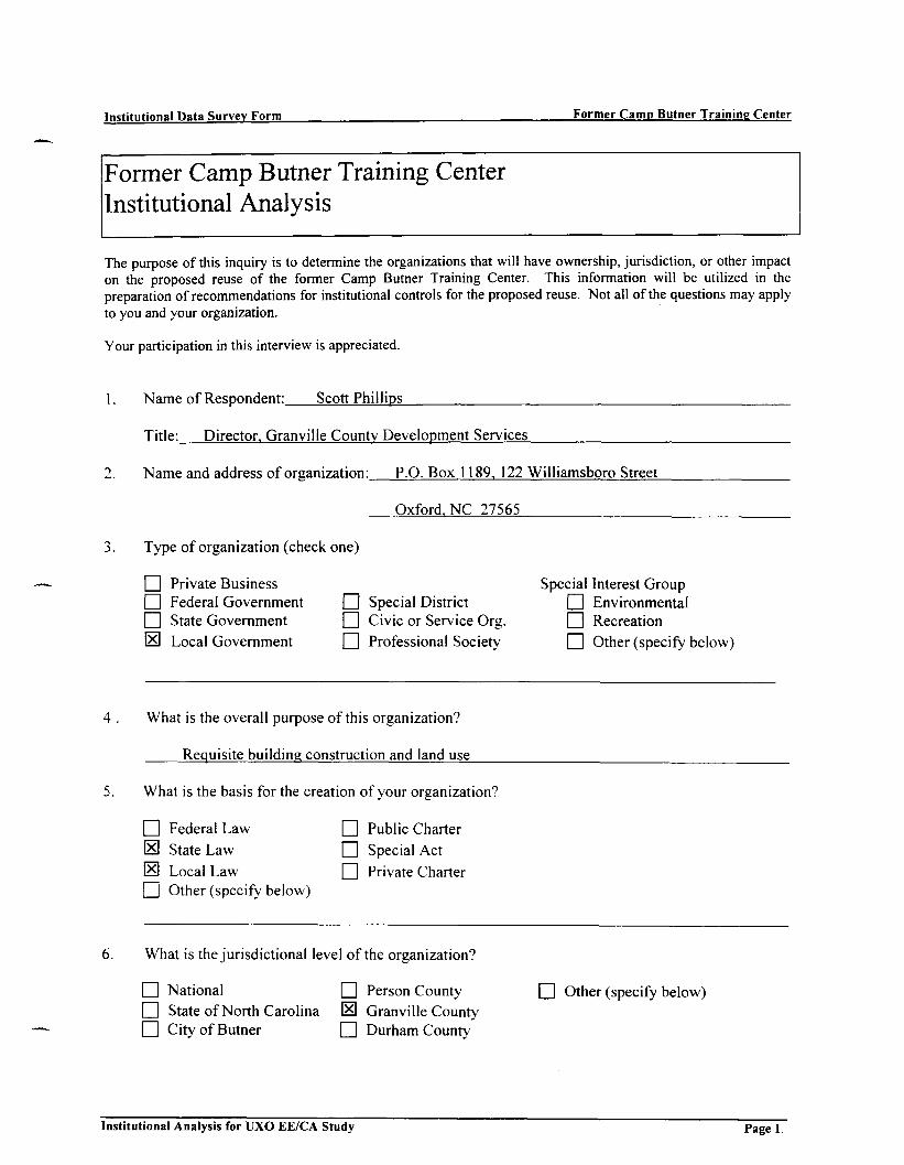
Institutional Data Survey Form Former Camp Butner Training Center
Former Camp Butner Training CenterInstitutional Analysis
The purpose of this inquiry is to determine the organizations that will have ownership, jurisdiction, or other impacton the proposed reuse of the former Camp Butner Training Center. This information will be utilized in thepreparation of recommendations for institutional controls for the proposed reuse. Not all of the questions may applyto you and your organization.
Your participation in this interview is appreciated.
1. N a m e of Respondent: Scott Phillips
2.
3.
Title: Director. Granville County Development Services
N a m e and address of organization: P.O. Box 1189, 122 Will iamsboro Street
Oxford. N C 27565
Type of organization (check one)
Q Private BusinessHH Federal Governmentn State Government
IE] Local Government
Special DistrictCivic or Service Org.Professional Society
Special Interest GroupCD EnvironmentalHH RecreationO Other (specify below)
4 . What is the overall purpose of this organization?
Requisite building construction and land use
5. What is the basis for the creation of your organization?
Federal Law
State Law
Local LawOther (specify below)
Public Charter
Special Act
Private Charter
6. What is the jurisdictional level of the organization?
National
State of North CarolinaCity of Butner
Person CountyGranville CountyDurham County
Other (specify below)
Institutional Analysis for UXO EE/CA Study Page 1.

Institutional Data Survey Form Former Camp Butner Training Center
7. What powers and/or authorities does your organization exercise?
• Make Laws • Purchase Property • Receive GiftsO Make Rules Q Condemn Land IE] Land Use Control• Make Policy CH Make Contracts IE] Enforce laws• Taxing Power • Sell Bonds • Other (specify below)
8. What geographic area(s) is (are) served by the organization?Granville County
9. Does your organization have a concern or responsibility for public safety and related land management?
S Yes • No
10. Which of the following categories of work best describe your organization's activities (morethan one may be checked)?
IE] Regulation O AdvisoryQ Finance IE0 EnforcementO Operation of existing facilities Q Basic research["""] Maintenance of existing facilities Q Legislative involvement0 Planning new facilities O Public education
IE] Engineering and/or construction Q Resource use
11. Which of the following subjects are important to the work of your organization?
[El Public safety [E] Control of land useO Recreational use of water/land resources O Environmental preservationO Conservation of wildlife • OtherH Management of resources related to water
12. What organizations do you regularly contact during the course of work?
North Carolina Department of Insurance
13. What specific regulations/rules dealing with public safety/management does your organization use?
O Federal laws/regulations • Agency rules/policies
S Other sources IE] State laws/regulations
14. Does your organization have jurisdiction over other organizations?
• Yes IE3 No
Institutional Analysis for UXO EE/CA Study Page 2.

Institutional Data Survey Form Former Camp Butner Training Center
15. If the answer to question 14 is yes, please list these organizations.
a.
b.
c.
16. Other Information:
Institutional Analysis for UXO EE/CA Study p a g e 3
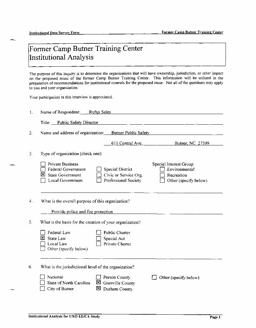
Institutional Data Survey Form Former Camp Butner Training Center
Former Camp Butner Training CenterInstitutional Analysis
The purpose of this inquiry is to determine the organizations that will have ownership, jurisdiction, or other impacton the proposed reuse of the former Camp Butner Training Center. This information will be utilized in thepreparation of recommendations for institutional controls for the proposed reuse. Not all of the questions may applyto you and your organization.
Your participation in this interview is appreciated.
1. Name of Respondent: Rufus Sales
Title: Public Safety Director
Name and address of organization: Butner Public Safety
611 Central Ave. Butner. NC 27509
Type of organization (check one)
[I] Private BusinessO Federal Government0 State Government1 I Local Government
Special DistrictCivic or Service Org.Professional Society
Special Interest GroupO Environmental| | Recreation| | Other (specify below)
4. What is the overall purpose of this organization?
Provide police and fire protection
5. What is the basis for the creation of your organization?
[~] Federal LawS State Law[ | Local Lawd l Other (specify below)
• Public Charter• Special Act| | Private Charter
6. What is the jurisdictional level of the organization?
• National • Person Countyn State of North Carolina IE) Granville CountyO City of Butner IE) Durham County
Other (specify below)
Institutional Analysis for UXO EE/CA Study Page 1.

Institutional Data Survey Form Former Camp Butner Training Center
7. What powers and/or authorities does your organization exercise?
• Make Laws EH Purchase Property O Receive Gifts• Make Rules • Condemn Land • Land Use ControlO Make Policy CH Make Contracts 0 Enforce laws• Taxing Power • Sell Bonds • Other (specify below)
8. What geographic area(s) is (are) served by the organization?Butner Community
9. Does your organization have a concern or responsibility for public safety and related land management?
S Yes • No
10. Which of the following categories of work best describe your organization's activities (morethan one may be checked)?
O Regulation O AdvisoryLT] Finance W EnforcementO Operat ion of existing facilities HH Basic researchQ Maintenance of existing facilities Q Legislative involvementQ Planning new facilities Q Public educationO Engineering and/or construction O Resource use
11. Which of the following subjects are important to the work of your organization?
S Public safety O Control of land useO Recreational use of water/land resources O Environmental preservationO Conservation of wildlife Q Other[7] Management of resources related to water
12. What organizations do you regularly contact during the course of work?
Many
13. What specific regulations/rules dealing with public safety/management does your organization use?
[El Federal laws/regulations H Agency rules/policies
0 Other sources S State laws/regulations
14. Does your organization have jurisdiction over other organizations?
• Yes S No
Institutional Analysis for UXO EE/CA Study Page 2.

Institutional Data Survey Form Former Camp Butner Training Center
15. If the answer to question 14 is yes, please list these organizations.
a.
b.
c.
16. Other Information:
Institutional Analysis for UXO EE/CA Study p a g e 3

Institutional Data Survey Form Former Camp Butner Training Center
Former Camp Butner Training CenterInstitutional Analysis
The purpose of this inquiry is to determine the organizations that will have ownership, jurisdiction, or other impacton the proposed reuse of the former Camp Butner Training Center. This information will be utilized in thepreparation of recommendations for institutional controls for the proposed reuse. Not all of the questions may applyto you and your organization.
Your participation in this interview is appreciated.
1.
2.
Name of Respondent: David T. Smith
Title: Sheriff
Name and address of organization: Granville County Sheriff Department
143 Williamsboro Street Oxford, NC 27565
3. Type of organization (check one)
Private BusinessFederal GovernmentState GovernmentLocal Government
171 Special District[7] Civic or Service Org.O Professional Society
Special Interest GroupO EnvironmentalO RecreationO Other (specify below)
4 . What is the overall purpose of this organization?
Serve and protect citizens, serve criminal and civil papers, enforce laws of N.C.
5. What is the basis for the creation of your organization?
Federal LawState LawLocal LawOther (specify below)
• Public Charter• Special Actn Private Charter
6. What is the jurisdictional level of the organization?
Q National• State of North CarolinaO City of Butner
• Person County'IE] Granville County• Durham County
I I Other (specify below)
Institutional Analysis for UXO EE/CA Study Page 1.

Institutional Data Survey Form Former Camp Butner Training Center
7. What powers and/or authorities does your organization exercise?
• Make Laws • Purchase Property • Receive Gifts[_ Make Rules _ ] Condemn Land _ ] Land Use Control• Make Policy [_ Make Contracts H Enforce laws_ ] Taxing Power _ ] Sell Bonds _ ] Other (specify below)
8. What geographic area(s) is (are) served by the organization?County and county property within the city
9. Does your organization have a concern or responsibility for public safety and related land management?
• Yes IEI No
10. Which of the following categories of work best describe your organization's activities (morethan one may be checked)?
_ ] Regulation _ ] Advisory_ ] Finance 0 Enforcement_ ] Operation of existing facilities _ ] Basic research[_ Maintenance of existing facilities _ ] Legislative involvement[_ Planning new facilities [__ Public education_ ] Engineering and/or construction [_ Resource use
11. Which of the following subjects are important to the work of your organization?
0 Public safety _ ] Control of land use_ ] Recreational use of water/land resources [_ Environmental preservation_ ] Conservation of wildlife [_] Other_ ] Management of resources related to water
12. What organizations do you regularly contact during the course of work?
Clerk of Court, Magistrate, other L.E. agencies, 911 center
13. What specific regulations/rules dealing with public safety/management does your organization use?
• Federal laws/regulations IE1 Agency rules/policies_ ] Other sources [_ State laws/regulations
14. Does your organization have jurisdiction over other organizations?
• Yes (HI No
Institutional Analysis for UXO EE/CA Study Page 2.

Institutional Data Survey Form Former Camp Butner Training Center
15. If the answer to question 14 is yes, please list these organizations.
a.
b.
c.
16. Other Information:
Institutional Analysis for UXO EE/CA Study Page 3.
Institutional Data Survey Form Former Camp Butner Training Center
Former Camp Butner Training CenterInstitutional AnalysisThe purpose of this inquiry is to determine the organizations that will have ownership, jurisdiction, or other impacton the proposed reuse of the former Camp Butner Training Center. This information will be utilized in thepreparation of recommendations for institutional controls for the proposed reuse. Not all of the questions may applyto you and your organization.
Your participation in this interview is appreciated.
1. Name of Respondent: Ernest Thompson
Title: Assistant Superintendent
Name and address of organization: Granville County Schools
3. Type of organization (check one)
O Private Business[71 Federal GovernmentS State GovernmentO Local Government
| | Special District
[771 Civic or Service Org.1771 Professional Society-
Special Interest Group1771 Environmental1771 Recreation[771 Other (specify below)
4 . What is the overall purpose of this organization?
5. What is the basis for the creation of your organization?
[771 Federal Law
[El State Law
[HI Local Law
Q Other (specify below)
• Public Charter
[7] Special Act
1771 Private Charter
6. What is the jurisdictional level of the organization?
| 1 National• State of North Carolina• City of Butner
I | Person CountyIHI Granville County[771 Durham County
[771 Other (specify below)
Institutional Analysis for UXO EE/CA Study Page 1.
Institutional Data Survey Form Former Camp Butner Training Center
7. What powers and/or authorities does your organization exercise?
Q Make Laws EH Purchase Property Q Receive Gifts• Make Rules • Condemn Land • Land Use ControlQ Make Policy d Make Contracts O Enforce lawsO Taxing Power Q Sell Bonds [El Other (specify below)
8. What geographic area(s) is (are) served by the organization?
9. Does your organization have a concern or responsibility for public safety and related land management?
B Yes • No
10. Which of the following categories of work best describe your organization's activities (morethan one may be checked)?
Q Regulation O AdvisoryQ Finance O EnforcementQ Operation of existing facilities O Basic researchQ Maintenance of existing facilities Q Legislative involvementQ] Planning new facilities W Public educationQ Engineering and/or construction Q Resource use
11. Which of the following subjects are important to the work of your organization?
S Public safety • Control of land use0 Recreational use of water/land resources IE! Environmental preservationO Conservation of wildlife Q OtherO Management of resources related to water
12. What organizations do you regularly contact during the course of work?
13. What specific regulations/rules dealing with public safety/management does your organization use?
S Federal laws/regulations Q Agency rules/policies• Other sources • State laws/regulations
14. Does your organization have jurisdiction over other organizations?
• Yes 0 No
Institutional Analysis for UXO EE/CA Study Page 2.

Institutional Data Survey Form Former Camp Butner Training Center
15. If the answer to question 14 is yes, please list these organizations.
a.
b.
c.
16. Other Information:
Institutional Analysis for UXO EE/CA Study Pagt 3

Institutional Data Survey Form Former Camp Butner Training Center
Former Camp Butner Training CenterInstitutional Analysis
The purpose of this inquiry is to determine the organizations that will have ownership, jurisdiction, or other impacton the proposed reuse of the former Camp Butner Training Center. This information will be utilized in thepreparation of recommendations for institutional controls for the proposed reuse. Not all of the questions may applyto you and your organization.
Your participation in this interview is appreciated.
1. Name of Respondent: T. Dean Askew
Title: Superintendent
2. Name and address of organization: Butner Beef Cattlefield Lab
8800 Cassam Road Bahama, NC 27503
3. Type of organization (check one)
Q Private Business[31 Federal Government0 State Governmentr~l Local Government
Special DistrictCivic or Service Org.Professional Society
Special Interest GroupQ EnvironmentalCH RecreationO Other (specify below)
What is the overall purpose of this organization?
Field Research with Beef Cattle
What is the basis for the creation of your organization?
Federal LawState LawLocal LawOther (specify below)
NCSU
• Public CharterO Special ActQ Private Charter
What is the jurisdictional level of the organization?
O National • Person CountyS State of North Carolina IE1 Granville CountyQ City of Butner 0 Durham County
I I Other (specify below)
Institutional Analysis for UXO EE/CA Study Page 1.

Institutional Data Survey Form Former Camp Butner Training Center
7. What powers and/or authorities does your organization exercise?
O Make Laws ED Purchase Property d Receive GiftsQ Make Rules Q Condemn Land IE] Land Use Control• Make Policy Q Make Contracts • Enforce laws• Taxing Power • Sell Bonds • Other (specify below)
8. What geographic area(s) is (are) served by the organization?
9. Does your organization have a concern or responsibility for public safety and related land management?
S Yes • No
10. Which of the following categories of work best describe your organization's activities (morethan one may be checked)?
O Regulation O AdvisoryQ Finance O EnforcementO Operation of existing facilities IE] Basic researchQ Maintenance of existing facilities Q Legislative involvement\~\ Planning new facilities O Public educationn Engineering and/or construction Q Resource use
11. Which of the following subjects are important to the work of your organization?
O Public safety IE! Control of land useQD Recreational use of water/land resources Q Environmental preservationQ Conservation of wildlife O OtherQ Management of resources related to water
12. What organizations do you regularly contact during the course of work?
N C S U _ _ ^ _ _
13. What specific regulations/rules dealing with public safety/management does your organization use?
O Federal laws/regulations IE] Agency rules/policies
Q Other sources IE] State laws/regulations
14. Does your organization have jurisdiction over other organizations?
• Yes S No
Institutional Analysis for UXO EE/CA Study Page 2.

Institutional Data Survey Form Former Camp Butner Training Center
15. If the answer to question 14 is yes, please list these organizations.
a.
b.
c.
16. Other Information:
Institutional Analysis for UXO EE/CA Study pag e 3

Institutional Data Survey Form Former Camp Butner Training Center
Former Camp Butner Training CenterInstitutional Analysis
The purpose of this inquiry is to determine the organizations that will have ownership, jurisdiction, or other impacton the proposed reuse of the former Camp Butner Training Center. This information will be utilized in thepreparation of recommendations for institutional controls for the proposed reuse. Not all of the questions may applyto you and your organization.
Your participation in this interview is appreciated.
1. Name of Respondent: Wes Crabtree
2.
3.
Title: Chief Deputy
Name and address of organization: Durham County Sheriffs Office
P.O. Box 170 Durham. NC
Type of organization (check one)
O Private BusinessQ Federal Government[U State Government
IHl Local Government
Special DistrictCivic or Service Org.Professional Society
Special Interest GroupQ EnvironmentalCD RecreationO Other (specify below)
4 . What is the overall purpose of this organization?
Law Enforcement
5. What is the basis for the creation of your organization?
Federal LawState LawLocal LawOther (specify below)
• Public Charter|~1 Special ActI I Private Charter
6. What is the jurisdictional level of the organization?
O NationalO State of North Carolina• City of Butner
Person CountyGranville CountyDurham County
LZ1 Other (specify below)
Institutional Analysis for UXO EE/CA Study Page 1

Institutional Data Survey Form Former Camp Butner Training Center
7. What powers and/or authorities does your organization exercise?
• Make Laws • Purchase Property- • Receive Gifts• Make Rules • Condemn Land • Land Use Control• Make Policy 0 Make Contracts IE1 Enforce laws• Taxing Power • Sell Bonds • Other (specify below)
8. What geographic area(s) is (are) served by the organization?Durham County
9. Does your organization have a concern or responsibility for public safety and related land management?
S Yes • No
10. Which of the following categories of work best describe your organization's activities (morethan one may be checked)?
IE1 Regulation Q Advisory0 Finance [HI EnforcementS Operation of existing facilities O Basic researchO Maintenance of existing facilities Q Legislative involvementO Planning new facilities Q Public educationO Engineering and/or construction Q] Resource use
11. Which of the following subjects are important to the work of your organization?
Public safety Q Control of land useRecreational use of water/land resources Q Environmental preservationConservation of wildlife Q OtherManagement of resources related to water
What organizations do you regularly contact during the course of work?
13. What specific regulations/rules dealing with public safety/management does your organization use?
Q Federal laws/regulations S Agency rules/policies
CD Other sources S State laws/regulations
14. Does your organization have jurisdiction over other organizations?
• Yes S No
Institutional Analysis for UXO EE/CA Study Page 2.

Institutional Data Survey Form Former Camp Butner Training Center
15. If the answer to question 14 is yes, please list these organizations.
a.
b.
c.
16. Other Information:
Institutional Analysis for UXO EE/CA Study Page 3

Institutional Data Survey Form Former Camp Butner Training Center
Former Camp Butner Training CenterInstitutional Analysis
The purpose of this inquiry is to determine the organizations that will have ownership, jurisdiction, or other impacton the proposed reuse of the former Camp Butner Training Center. This information will be utilized in thepreparation of recommendations for institutional controls for the proposed reuse. Not all of the questions may applyto you and your organization.
Your participation in this interview is appreciated.
1. Name of Respondent: Scott Elliott
Title: Business Officer
2. Name and address of organization: Murdoch Center
1600 East C Street Butner. NC 27509
3. Type of organization (check one)
EH Private BusinessED Federal GovernmentIE] State GovernmentED Local Government
ED Special District
ED Civic or Service Org.ED Professional Society
Special Interest GroupED EnvironmentalED RecreationED Other (specify below)
4 . What is the overall purpose of this organization?
Residential and habilitative services for adults with mental retardation
5. What is the basis for the creation of your organization?
ED Federal Law
S State LawED Local LawED Other (specify below)
D Public CharterED Special ActED Private Charter
6. What is the jurisdictional level of the organization?
ED National ED Person County
0 State of North Carolina ED Granville CountyED City of Butner ED Durham County
ED Other (specify below)
Institutional Analysis for UXO EE/CA Study Page 1.

Institutional Data Survey Form Former Camp Butner Training Center
7. What powers and/or authorities does your organization exercise?
O Make Laws IE] Purchase Property S Receive GiftsIE1 Make Rules Q Condemn Land Q Land Use ControlO Make Policy IE) Make Contracts O Enforce lawsO Taxing Power O Sell Bonds ED Other (specify below)
8. What geographic area(s) is (are) served by the organization?North Central DP Region
9. Does your organization have a concern or responsibility for public safety and related land management?
E Yes • No
10. Which of the following categories of work best describe your organization's activities (morethan one may be checked)?
[~1 Regulation Q AdvisoryQ Finance CH EnforcementS Operation of existing facilities Q Basic researchIE! Maintenance of existing facilities O Legislative involvementQ Planning new facilities Q Public education
IE] Engineering and/or construction Q Resource use
11. Which of the following subjects are important to the work of your organization?
IE] Public safety • Control of land use
O Recreational use of water/land resources Q Environmental preservationO Conservation of wildlife O OtherO Management of resources related to water
12. What organizations do you regularly contact during the course of work?
13. What specific regulations/rules dealing with public safety/management does your organization use?
|~] Federal laws/regulations Q Agency rules/policies
O Other sources IE! State laws/regulations
14. Does your organization have jurisdiction over other organizations?
• Yes S No
Institutional Analysis for UXO EE/CA Study Page 2.

Institutional Data Survey Form Former Camp Butner Training Center
15. If the answer to question 14 is yes, please list these organizations.
a.
b.
c.
16. Other Information:
Institutional Analysis for UXO EE/CA Study p a g e 3

Institutional Data Survey Form Former Camp Butner Training Center
Former Camp Butner Training CenterInstitutional Analysis
The purpose of this inquiry is to determine the organizations that will have ownership, jurisdiction, or other impacton the proposed reuse of the former Camp Butner Training Center. This information will be utilized in thepreparation of recommendations for institutional controls for the proposed reuse. Not all of the questions may applyto you and your organization.
Your participation in this interview is appreciated.
1. Name of Respondent: Reid Evans
Title: Superintendent
2. Name and address of organization: Umstead Farm Unit, NCOATCS
2652 Old 75 Butner. NC 27509
3. Type of organization (check one)
Q Private BusinessQ Federal GovernmentS State Governmentn Local Government
Special DistrictCivic or Service Org.Professional Society
Special Interest Group| | EnvironmentalO RecreationHH Other (specify below)
4 . What is the overall purpose of this organization?
Agricultural Research (Pain)
5. What is the basis for the creation of your organization?
Federal LawState LawLocal LawOther (specify below)
• Public CharterHH Special ActI I Private Charter
6. What is the jurisdictional level of the organization?
NationalState of North CarolinaCity of Butner
Person CountyGranville CountyDurham County
I I Other (specify below)
Institutional Analysis for UXO EE/CA Study Page 1.

Institutional Data Survey Form Former Camp Butner Training Center
7. What powers and/or authorities does your organization exercise?
Q Make Laws d ) Purchase Property Q Receive GiftsQ Make Rules d ] Condemn Land CH Land Use Control• Make Policy • Make Contracts • Enforce laws• Taxing Power • Sell Bonds • Other (specify below)
8. What geographic area(s) is (are) served by the organization?18 research stations serve the State of North Carolina
9. Does your organization have a concern or responsibility for public safety and related land management?
0 Yes • No
10. Which of the following categories of work best describe your organization's activities (morethan one may be checked)?
Q Regulation CD AdvisoryQ Finance O Enforcement
O Operation of existing facilities 0 Basic researchQ Maintenance of existing facilities Q Legislative involvement
Q Planning new facilities IE] Public educationQ Engineering and/or construction Q Resource use
11. Which of the following subjects are important to the work of your organization?
Q Public safety IE! Control of land useQ Recreational use of water/land resources Q Environmental preservationQ Conservation of wildlife Q OtherQ Management of resources related to water
12. What organizations do you regularly contact during the course of work?
Wildlife Commission
13. What specific regulations/rules dealing with public safety/management does your organization use?
H Federal laws/regulations [El Agency rules/policies
O Other sources [El State laws/regulations
14. Does your organization have jurisdiction over other organizations?
• Yes S No
Institutional Analysis for UXO EE/CA Study Page 2.

Institutional Data Survey Form Former Camp Butner Training Center
15. If the answer to question 14 is yes, please list these organizations.
a.
b.
c.
16. Other Information:
Institutional Analysis for UXO EE/CA Study pag e 3

Institutional Data Survey Form Former Camp Butner Training Center
Former Camp Butner Training CenterInstitutional Analysis
The purpose of this inquiry is to determine the organizations that will have ownership, jurisdiction, or other impacton the proposed reuse of the former Camp Butner Training Center. This information will be utilized in thepreparation of recommendations for institutional controls for the proposed reuse. Not all of the questions may applyto you and your organization.
Your participation in this interview is appreciated.
1. Name of Respondent: Danny Faucelte
Title: Tax Administration
Name and address of organization: Granville County
3. Type of organization (check one)
O Private BusinessO Federal GovernmentO State Government[El Local Government
Special DistrictCivic or Service Org.Professional Society
Special Interest GroupCH Environmentald l RecreationCD Other (specify below)
4 . What is the overall purpose of this organization?
To assess and collect tax
5. What is the basis for the creation of your organization?
O Federal Law• State Law
IE] Local LawO Other (specify below)
Public CharterSpecial ActPrivate Charter
6. What is the jurisdictional level of the organization?
I I National
• State of North Carolina• City of Butner
Person CountyGranville CountyDurham County
I I Other (specify below)
Institutional Analysis for UXO EE/CA Study Pagel.

Institutional Data Survey Form Former Camp Butner Training Center
7. What powers and/or authorities does your organization exercise?
O Make Laws O Purchase Property O Receive Gifts• Make Rules • Condemn Land • Land Use Control• Make Policy • Make Contracts • Enforce lawsS Taxing Power • Sell Bonds • Other (specify below)
8. What geographic area(s) is (are) served by the organization?Granville County
9. Does your organization have a concern or responsibility for public safety and related land management?
[El Yes • No
10. Which of the following categories of work best describe your organization's activities (morethan one may be checked)?
O Regulation \Z\ AdvisoryO Finance O EnforcementO Operation of existing facilities Q Basic researchLZI Maintenance of existing facilities Q Legislative involvementHH Planning new facilities Q Public educationO Engineering and/or construction Q] Resource use
11. Which of the following subjects are important to the work of your organization?
O Public safety Q Control of land useQ Recreational use of water/land resources O Environmental preservationO Conservation of wildlife (HI Other Assessment and Collection of Taxes
O Management of resources related to water
12. What organizations do you regularly contact during the course of work?
NCAAO - NCTCA - NCDR - IOG
13. What specific regulations/rules dealing with public safety/management does your organization use?
\Z\ Federal laws/regulations • Agency rules/policies
• Other sources IE1 State laws/regulations
14. Does your organization have jurisdiction over other organizations?
• Yes B No
Institutional Analysis for UXO EE/CA Study Page 2.

Institutional Data Survey Form Former Camp Butner Training Center
15. If the answer to question 14 is yes, please list these organizations.
a. .
b.
c.
16. Other Information:
Institutional Analysis for UXO EE/CA Study Page 3
Institutional Data Survey Form Former Camp Butner Training Center
Former Camp Butner Training CenterInstitutional Analysis
The purpose of this inquiry is to determine the organizations that will have ownership, jurisdiction, or other impacton the proposed reuse of the former Camp Butner Training Center. This information will be utilized in thepreparation of recommendations for institutional controls for the proposed reuse. Not all of the questions may applyto you and your organization.
Your participation in this interview is appreciated.
1. Name of Respondent: Russell Jones
Title: Tax Administrator
2. Name and address of organization: Person County Tax
P.O. Box 1116 Roxboro.NC 27573
Type of organization (check one)
Q Private BusinessQ Federal GovernmentO State Government
[El Local Government
Special DistrictCivic or Service Org.Professional Society
Special Interest GroupQ Environmentald ] RecreationCH Other (specify below)
4 . What is the overall purpose of this organization?
Property Tax
5. What is the basis for the creation of vour organization?
Federal LawState LawLocal LawOther (specify below)
• Public CharterO Special Act• Private Charter
6. What is the jurisdictional level of the organization?
NationalState of North CarolinaCity of Butner
Person CountyGranville CountyDurham County
Other (specify below)
Institutional Analysis for UXO EE/CA Study Page 1.

Institutional Data Survey Form Former Camp Butner Training Center
7. What powers and/or authorities does your organization exercise?
O Make Laws Q Purchase Property Q Receive GiftsQ Make Rules E] Condemn Land d Land Use ControlQ Make Policy d Make Contracts EH Enforce lawsS Taxing Power • Sell Bonds • Other (specify below)
8. What geographic area(s) is (are) served by the organization?Person County Roxboro
9. Does your organization have a concern or responsibility for public safety and related land management?
• Yes • No
10. Which of the following categories of work best describe your organization's activities (morethan one may be checked)?
O Regulation O AdvisoryS Finance Q EnforcementO Operation of existing facilities Q Basic researchO Maintenance of existing facilities Q Legislative involvementO Planning new facilities Q Public educationO Engineering and/or construction Q] Resource use
11. Which of the following subjects are important to the work of your organization?
O Public safety Q Control of land useO Recreational use of water/land resources Q Environmental preservationO Conservation of wildlife Q Other[3~1 Management of resources related to water
12. What organizations do you regularly contact during the course of work?
13. What specific regulations/rules dealing with public safety/management does your organization use?
O Federal laws/regulations Q Agency rules/policiesO Other sources • State laws/regulations
14. Does your organization have jurisdiction over other organizations?
n Yes 0 No
Institutional Analysis for UXO EE/CA Study Page 2.
Institutional Data Survey Form Former Camp Butner Training Center
15. If the answer to question 14 is yes, please list these organizations.
a.
b.
c.
16. Other Information:
Institutional Analysis for UXO EE/CA Study p a g e 3

Institutional Data Survey Form Former Camp Butner Training Center
Former Camp Butner Training CenterInstitutional AnalysisThe purpose of this inquiry is to determine the organizations that will have ownership, jurisdiction, or other impacton the proposed reuse of the former Camp Butner Training Center. This information will be utilized in thepreparation of recommendations for institutional controls for the proposed reuse. Not all of the questions may applyto you and your organization.
Your participation in this interview is appreciated.
1. Name of Respondent: Al Judd
Title: Hospital Engineer
2. Name and address of organization: John Umstead Hospital NC DHHS
Type of organization (check one)
Q Private BusinessQ Federal Government QIE! State Government [IO Local Government Q
State Psychiatric Hospital
Special DistrictCivic or Service Org.Professional Society
Special Interest GroupO EnvironmentalO RecreationQ Other (specify below)
What is the overall purpose of this organization?
Treat people with mental illness
What is the basis for the creation of your organization?
Federal LawState LawLocal LawOther (specify below)
Public CharterSpecial ActPrivate Charter
6. What is the jurisdictional level of the organization?
O NationalEl State of North Carolina• City of Butner
Person CountyGranville CountyDurham County
Other (specify below)
Institutional Analysis for UXO EE/CA Study Page 1.
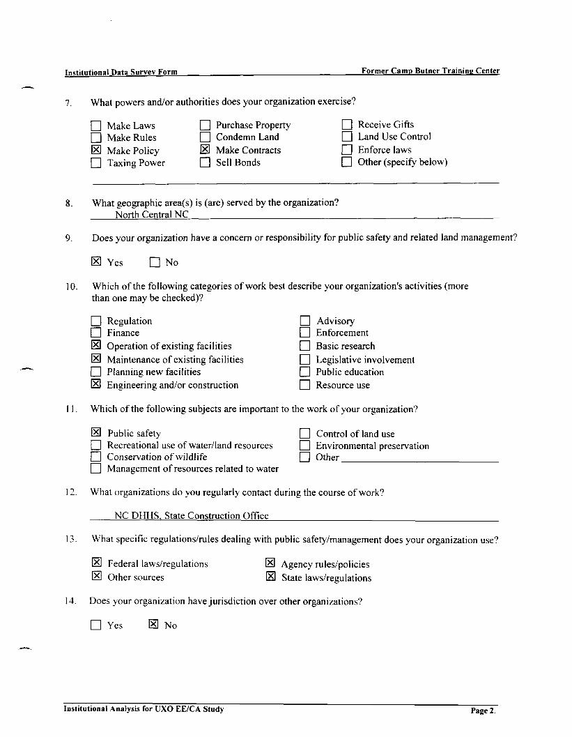
Institutional Data Survey Form Former Camp Butner Training Center
7. What powers and/or authorities does your organization exercise?
O Make Laws O Purchase Property O Receive GiftsO Make Rules Q Condemn Land EH Land Use Control[El Make Policy 0 Make Contracts Q Enforce lawsO Taxing Power Q Sell Bonds HU Other (specify below)
8. What geographic area(s) is (are) served by the organization?North Central NC
9. Does your organization have a concern or responsibility for public safety and related land management?
~~ Yes • No
10. Which of the following categories of work best describe your organization's activities (morethan one may be checked)?
O Regulation [~~ Advisory[~] Finance [~~ EnforcementIE) Operation of existing facilities Q Basic researchIE! Maintenance of existing facilities Q Legislative involvement[71 Planning new facilities ~~| Public educationIE] Engineering and/or construction |~~ Resource use
11. Which of the following subjects are important to the work of your organization?
IE] Public safety O Control of land use| I Recreational use of water/land resources [~~ Environmental preservation| | Conservation of wildlife Q Other| | Management of resources related to water
12. What organizations do you regularly contact during the course of work?
NC D H H S . State Construction Office
13. What specific regulations/rules dealing with public safety/management does your organization use?
S Federal laws/regulations IE] Agency rules/policies
[El Other sources (El State laws/regulations
14. Does your organization have jurisdiction over other organizations?
• Yes S No
Institutional Analysis for UXO EE/CA Study Page 2

Institutional Data Survey Form Former Camp Butner Training Center
15. If the answer to question 14 is yes, please list these organizations.
a.
b.
c.
16. Other Information:
Institutional Analysis for UXO EE/CA Study pag e 3

Institutional Data Survey Form Former Camp Butner Training Center
Former Camp Butner Training CenterInstitutional Analysis
The purpose of this inquiry is to determine the organizations that will have ownership, jurisdiction, or other impacton the proposed reuse of the former Camp Butner Training Center. This information will be utilized in thepreparation of recommendations for institutional controls for the proposed reuse. Not all of the questions may applyto you and your organization.
Your participation in this interview is appreciated.
1. Name of Respondent: Douglas P. Logan
Title: Emergency Management Coordinator
Name and address of organization: Granville County Emergency Management
P.O. Box 598 Oxford, NC 27565
3. Type of organization (check one)
Q Private BusinessO Federal GovernmentO State GovernmentS Local Government
Special DistrictCivic or Service Org.Professional Society
Special Interest GroupO EnvironmentalO RecreationQ Other (specify below)
4 . What is the overall purpose of this organization?
Emergency and Disaster Preparedness, Response, Recovery and Mitigation
5. What is the basis for the creation of your organization?
Federal LawState LawLocal LawOther (specify below)
• Public CharterO Special Act["I Private Charter
6. What is the jurisdictional level of the organization?
I I National Q] Person CountyQ State of North Carolina IE] Granville CountyO City of Butner O Durham County
| | Other (specify below)
Institutional Analysis for UXO EE/CA Study Page 1.

Institutional Data Survey Form Former Camp Butner Training Center
7. What powers and/or authorities does your organization exercise?
• Make Laws EH Purchase Property S Receive GiftsED Make Rules EH Condemn Land Q Land Use ControlEH Make Policy ED Make Contracts S Enforce laws• Taxing Power • Sell Bonds • Other (specify below)
8. What geographic area(s) is (are) served by the organization?All areas within Granville Counts
9. Does your organization have a concern or responsibility for public safety and related land management?
[HI Yes • No
10. Which of the following categories of work best describe your organization's activities (morethan one may be checked)?
ED Regulat ion S AdvisoryED Finance 0 EnforcementED Operat ion of exist ing facilities S Basic researchED Maintenance of existing facilities [HI Legislative involvementED Planning new facilities IE1 Public educationED Engineering and/or construction S Resource use
11. Which of the following subjects are important to the work of your organization?
E Public safety ED Control of land useED Recreational use of water/land resources ED Environmental preservationED Conservation of wildlife Q OtherQ Management of resources related to water
12. What organizations do you regularly contact during the course of work?
Multiple agencies (public and private sector)
13. What specific regulations/rules dealing with public safety/management does your organization use?
S Federal laws/regulations S Agency rules/policies
• Other sources E State laws/regulations
14. Does your organization have jurisdiction over other organizations?
• Yes S No
Institutional Analysis for UXO EE/CA Study Page 2.

Institutional Data Survey Form Former Camp Butner Training Center
15. If the answer to question 14 is yes, please list these organizations.
a.
b.
c.
16. Other Information:
Institutional Analysis for UXO EE/CA Study pap e 3

Institutional Data Survey Form Former Camp Butner Training Center
Former Camp Butner Training CenterInstitutional Analysis
The purpose of this inquiry is to determine the organizations that will have ownership, jurisdiction, or other impacton the proposed reuse of the former Camp Butner Training Center. This information will be utilized in thepreparation of recommendations for institutional controls for the proposed reuse. Not all of the questions may applyto you and your organization.
Your participation in this interview is appreciated.
Name of Respondent: Brenda Long/Leon Hamlin
Title: Community Schools Coordinator/Administrative Assistant
Name and address of organization: Person County Schools
304 S. Morgan Street, Room 25 Roxboro, NC 27573
Type of organization (check one)
O Private BusinessO Federal GovernmentQ State GovernmentO Local Government
School System
Special DistrictCivic or Service Org.Professional Society
Special Interest GroupQ EnvironmentalO RecreationIE] Other (specify below)
What is the overall purpose of this organization?
Education
What is the basis for the creation of your organization?
Federal LawState LawLocal LawOther (specify below)
• Public CharterHU Special ActO Private Charter
6. What is the jurisdictional level of the organization?
[71 National| I State of North Carolina• City of Butner
Person CountyGranville CountyDurham County
Other (specify below)
Institutional Analysis for UXO EE/CA Study Page 1

Institutional Data Survey Form Former Camp Butner Training Center
7. What powers and/or authorities does your organization exercise?
• Make Laws • Purchase Property • Receive Gifts• Make Rules • Condemn Land • Land Use Control• Make Policy • Make Contracts • Enforce laws• Taxing Power • Sell Bonds IE! Other (specify below)
Schools/Education
8. What geographic area(s) is (are) served by the organization?Person County
9. Does your organization have a concern or responsibility for public safety and related land management?
S Yes • No
10. Which of the following categories of work best describe your organization's activities (morethan one may be checked)?
O Regulation \Z] AdvisoryO Finance Q Enforcement[I] Operation of existing facilities Q Basic researchQ Maintenance of existing facilities Q Legislative involvementO Planning new facilities IE1 Public education
O Engineering and/or construction O Resource use
11. Which of the following subjects are important to the work of your organization?
| | Public safety Q Control of land use[~[ Recreational use of water/land resources Q Environmental preservationO Conservation of wildlife IE! Other Educational Issues
CU Management of resources related to water
12. What organizations do you regularly contact during the course of work?
State Department of Public Instruction13. What specific regulations/rules dealing with public safety/management does your organization use?
S Federal laws/regulations [E! Agency rules/policies
\Z\ Other sources [El State laws/regulations
14. Does your organization have jurisdiction over other organizations?
• Yes S No
Institutional Analysis for UXO EE/CA Study Page 2.

Institutional Data Survey Form Former Camp Butner Training Center
15. If the answer to question 14 is yes, please list these organizations.
a.
b.
c.
16. Other Information:
Institutional Analysis for UXO EE/CA Study pag e 3

Institutional Data Survey Form Former Camp Butner Training Center
Former Camp Butner Training CenterInstitutional Analysis
The purpose of this inquiry is to determine the organizations that will have ownership, jurisdiction, or other impacton the proposed reuse of the former Camp Butner Training Center. This information will be utilized in thepreparation of recommendations for institutional controls for the proposed reuse. Not all of the questions may applyto you and your organization.
Your participation in this interview is appreciated.
1. Name of Respondent: Thomas N. McGee
Title: Town Manager - Butner, NC
Name and address of organization: 205-C West East Street
Butner. NC 27509
3. Type of organization (check one)
O Private BusinessQ Federal Government[El State GovernmentO Local Government
Special DistrictCivic or Service Org.Professional Society
Special Interest GroupQ EnvironmentalQ RecreationQ Other (specify below)
4 . What is the overall purpose of this organization?
Operate the town of Butner for the State of North Carolina
5. What is the basis for the creation of your organization?
• Federal LawS State LawO Local LawO Other (specify below)
• Public CharterIE1 Special Act• Private Charter
6. What is the jurisdictional level of the organization?
• National| | State of North CarolinaS City of Butner
• Person CountyQ Granville CountyO Durham County
Other (specify below)
Institutional Analysis for UXO EE/CA Study Page 1.

Institutional Data Survey Form Former Camp Butner Training Center
7. What powers and/or authorities does your organization exercise?
• Make Laws • Purchase Property • Receive Gifts• Make Rules • Condemn Land IE! Land Use ControlO Make Policy IE1 Make Contracts IB) Enforce laws• Taxing Power 0 Sell Bonds • Other (specify below)
8. What geographic area(s) is (are) served by the organization?
+/- 18.000 acres owned by State of NC
9. Does your organization have a concern or responsibility for public safety and related land management?
O Yes O No Not for public safety - we do manage landNC Dept. Crime Control and Public Safety resp. for police and fire
10. Which of the following categories of work best describe your organization's activities (morethan one may be checked)?
O Regulation IE] AdvisoryO Finance 1E1 EnforcementE Operation of existing facilities Q Basic research1*0 Maintenance of existing facilities IE! Legislative involvementS Planning new facilities S Public education[El Engineering and/or construction IE! Resource use
11. Which of the following subjects are important to the work of your organization?
n Public safety [El Control of land use[El Recreational use of water/land resources [El Environmental preservationO Conservation of wildlife [El Other Operation of Utilities[El Management of resources related to water
12. What organizations do you regularly contact during the course of work?
Too many to list
13. What specific regulations/rules dealing with public safety/management does your organization use?
[El Federal laws/regulations (El Agency rules/policiesO Other sources [El State laws/regulations
14. Does your organization have jurisdiction over other organizations?
• Yes IE1 No
Institutional Analysis for UXO EE/CA Study Page 2.

Institutional Data Survey Form Former Camp Butner Training Center
15. If the answer to question 14 is yes, please list these organizations.
a. .
b.
c.
16. Other Information:
Institutional Analysis for UXO EE/CA Study pag e 3
APPENDIX GRECOMMENDATION COST SUMMARY TABLES
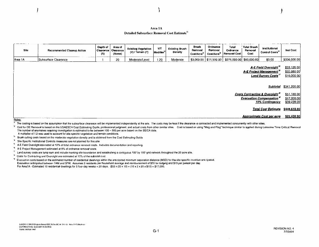
Area 1A
Detailed Subsurface Removal Cost Estimate"
Site
Area 1A
Recommended Cleanup Action
Subsurface Clearance
Depth ofClearance
1
Area ofClearance
(Acres)
20
Existing Vegetation(V) / Terrain (T)
Moderate/Level
vnModifier"
1.20
Existing BrushDensity
Moderate
BrushRemoval
Cost/Acre0
$3,000.00
OrdnanceRemoval
Cost/Acreu
$11,500.00
TotalOrdnance
Removal Cost
$276,000.00
Total BrushRemoval
Cost
$60,000.00
InstitutionalControl Costs"
$0.00
A-E Field Oversight"5
A-E Project Management '6
Land Survey Costs u
Subtotal
Costs Contracting & Oversiaht*Evacuation Compensation *
70% Contingency
Total Cost Estimate
Approximate Cost per acre
Net Cost
$336,000.00
$33,120.00
$22,080.00
$10,000.00
$341,200.00
$51,180.00
$17,000.00$39,238.00
$448,618.00
$22,430.90
u The costing is based on the assumption that the subsurface clearance will be implemented independently at the site. The costs may be less if the clearance is contracted and implemented concurrently with other sites.u Cost for OE Removal is based on the USAESCH Cost Estimating Guide, professional judgment, and actual costs from other similar sites. Cost is based on using "Mag and Flag' technique similar to applied during Lakeview Time Critical Removal
The number of anomalies requiring investigation is estimated to be between 100 - 300 per acre based on the EE/CA data.A multiplier of 1.2 was used to account for site specific vegetation and terrain conditions.
u Brush cutting costs based on the moderate vegetation density and is obtained from the Cost Estimating Guide'* Site Specific Institutional Controls measures are not planned for this site.a A-E Field Oversight estimated at 12% of total ordnance removal costs. Includes documentation and reporting.a A-E Project Management estimated at 8% of ordnance removal costs." Land survey costs are lump sum and include marking site boundaries and establishing a contiguous 100' by 100' grid network throughout the 20 acre site.M Costs for Contracting and Oversight are estimated at 15% of the subtotal cost.B Evacuation costs based on the estimated number of residential dwellings within the anticipated minimum separation distance (MSD) for the site-specific munition anticipated.
Evacuation anticipated between 7AM and 5PM. Assumes 2 residents per household average and reimbursement of $55 for lodging and $15 per person per day.For Areal A - Estimated 10 residential dwellings for 5 four-day weeks = 20 days. ($55 x 20 x 10) + (10 x 2 x 20 x $15) = $17,000.
l:\HUNTCONUS\rTujuas\BiiuicrtEECA\Fiuiil\C<»c_F.« xls Ana 1A SuhsurlaicCONTRACT NO. DACAK7-M-D-00IKTASK ORDER <X*>7 G-1
REVISION NO. 47/7/2004

BrushRemoval
Cost/Acre"
OrdnanceRemoval
Cost/Acre"Recommended Cleanup Action Depth of
Clearance (ft)
Area ofClearance
(Acres)
Existing Vegetation(V) / Terrain (T)
V/TModifier"
Existing BrushDensity
Total OrdnanceRemoval Cost
Total BrushRemoval Cost
Institutional ControlCosts"
Area 4A Surface Clearance NA 34 Moderate/Level 1.20 Medium Density $1,700.00 $2,200.00 $89,760.00 $57,800.00 $0.00 $147,560.00
A-E Field Oversight"A-E Protect Management"
Land Survey Costs'7
Subtotal
Costs Contracting It Oversight"Evacuation Compensation"
10% Contingency
Total Cost Estimate
Approximate Cost per acreNotes:" The costing is based on the assumption that the surface clearance will be implemented independently at this site. The costs may be less it the clearance Is contracted and Implemented concurrently with other sites.^ Cost lor OE Removal is based on the USAESCH Cost Estimating Guide, professional judgment, and actual costs from other similar sites. Cost is based on magnetometer-assisted surface clearance only.
The number ot surface anomalies requiring Investigation is estimated to be 50+ per acre based on the EE7CA data.A multiplier of 1.2 was used lo account for moderate vegetation and relatively flat terrain.
u Brush cutting costs based on the moderate vegetation density and Is obtained Irom the Cost Estimating Guide" Site Specific Institutional Controls measures are not planned for this site.a A-E Field Oversight estimated at 12% of total ordnance removal costs. Includes documentation and reporting.* A-E Project Management estimated at 6% of ordnance removal costs." Land survey costs are lump sum and it will include marking site boundaries and establishing a contiguous 500' by 500' grid network throughout the 34 acre site.* Cosls for Contracting and Oversight are estimated at 15% ol the subtotal cost."' Evacuation costs based on the estimated number of residential dwellings within the anticipated minimum separation distance (MSD) for the site-specific munition anticipated.
Evacuation anticipated between 7AM and 5PM. Assumes 2 residents per household average and reimbursement of $55 for lodging and $15 per person per day.For Area 4A • Estimated 3 residential dwellings for 3 four-day weeks = 12 days. ($55 x 12 x 3) + (12 x 2 x 3 x $15) = $3,060.

Area 4A
Detailed Subsurface Cast Estimate1'
BrushRemoval
OrdnanceRemoval
Coal/Acre"Site Recommended Cleanup Action
EstimatedDepth of
Clearance n't)
Area ofClearance
(Acres)
Existing Vegetation(V)/ Terrain (T)
vnModifier12
Existing BrushDensity
Total OrdnanceRemoval Cost
Total BrushRemoval Cost
Institutional ControlCosts"
Area 4A Subsurface Clearance 1-2 34 Moderate/Level 1.20 Medium Density $2,100.00 $8,600.00 $350,880.00 $71,400.00 $0.00 $422,280.00;
A-E Field Oversight*A-E Protect Management*
Land Survey Costs "
Subtotal
Costs Contracting a Oversight"Evacuation Compensation "
10% Contingency
Total Cost Estimate
Approximate Cost per acreNotes:" The costing is based on the assumption that the subsurface clearance will be Implemented Independently at this site. The costs may be less if the clearance is contracted and implemented concurrently with other sites.^ Cost for OE Removal is based on the USAESCH Cost Estimating Guide, professional judgment, and actual costs from other similar sites. Cost Is based on manual digital geophysical mapping (DGM).
The number of anomalies requiring investigation after DGM is estimated to be 25-75 per acre based on the EE/CA data.A multiplier of 1.2 was used to account for vegetation and terrain.
0 Brush cutting costs based on the moderate vegetation density and is obtained from the Cost Estimating Guide" Site Specific Institutional Controls measures are not planned lor this site.15 A-E Field Oversight estimated at 12% of total ordnance removal costs. Includes documentation and reporting.* A-E Project Management estimated at 8% of ordnance removal costs.vr Land survey costs are lump sum and it will Include marking site boundaries and establishing a contiguous 100' by 100' grid network throughout the 34 acre site.* Costs for Contracting and Oversight are estimated at 15% of the subtotal cost." Evacuation costs based on the estimated number of residential dwellings within the anticipated minimum separation distance (MSD) for the site-specific munition anticipated.
Evacuation anticipated between 7AM and 5PM. Assumes 2 residents per household average and reimbursement of $55 for lodging and $15 per person per day.For Area 4A - Estimated 3 residential dwellings for 5 four-day weeks = 20 days. ($55 x 20 x 3) + (20 x 2 x 3 x $15) • $5,100.
I:\HUNT CONUS\I'liije«:k\DuUici*HCAUU1NTRACTNO. DACAH7 91 I) IXMR
G-3REVISION NO. 2
10/17/2003

Ana 4BDetailed Subsurface Cost Estimate"
Site Recommended Cleanup Action
EstimatedDepth ol Area of
Clearance(Acres)
Existing Vegetation(V) / Terrain (T) Modifier"
Existing BrushDensity
BrushRemoval
Cost/Acre"
OrdnanceRemoval
Cost/Acre12
TotalOrdnance
Removal Cost
Total BrushRemoval
Cost
Institutional ControlCosts"
Net Cost
Area 4B Subsurface Clearance 1-2 10 Open/Level 1.00 Light Density $250.00 $12,200.00 $122,000.00 $2,500.00 $0.001 $124,500.00
A-E Field Oversight* $14.640,
A-E Protect Management" $9.760.00
Land Survey Costs " $8,000.00
Subtotal $156.900.00
Costs Contracting & Oversight $23.535,Evacuation Compensation " $680.00
10% Contingency $18,043.50
Total Cost Estimate $199,158.50
Approximate Cost per acre $19,915.85Notes:' The costing Is based on Ihe assumplion that the subsurface clearance will be Implemented individually at this site. The cosls may be less il the clearance Is contracted and Implemented concurrently with other sites.
a Cost lor OE Removal is based on the USAESCH Cost Estimating Guide, professional ludgment, and actual costs from other similar sites. Cost is based on manual digital geophysical mapping (DGM).The number ol anomalies requiring investigation alter DGM is estimated to be 25-75 per acre based on the EE/CA data and land use (plow parts and other farm equipment).A multiplier ol 1.0 was used to account for vegetation and terrain.
* Brush cutting costs based on the vegetation density and is obtained from the Cost Estimating Guide14 Site Specific Institutional Controls measures are not planned lor this site.16 A-E Field Oversight estimated at 12% of total ordnance removal costs. Includes documentation and reporting.* A-E Project Management estimated at 8% of ordnance removal costs.17 Land survey costs are lump sum and it will Include marking site boundaries and establishing a 100' by 100' grid system within the site for clearance.* Costs for Contracting and Oversight are estimated at 15% of the subtotal cost.*" Evacuation costs based on the estimated number of residential dwellings within the anticipated minimum separation distance (MSD) for the site-specific munition anticipated.
Evacuation anticipated between 7AM and 5PM. Assumes 2 residents per household average and reimbursement of $55 for lodging and $15 per person per day.For Area 4B - Estimated 1 residential dwelling for 2 four-day weeks * 8 days. ($55 x 8 x 1) + ( 8 x 2 x 1 x $15) = $680.
l:\MUm-CI INUS\(lni|ixis\l3uin>.T\hKCA\CONTHACTNO DACAR7 YS-D-OOIK
G-4REVISION NO. 2
10/17/2003

Area 4CDetailed Subsurface Cost Estimate
Site
Area 4C
Recommended CleanupAction
Subsurface Clearance
EstimatedDepth of
Clearance(ft)
2+
Area ofClearance
(Acres)
16
ExistingVegetation (V) /
Terrain (T)
Open/Level
V/TModifier"
1.00
ExistingBrush
Density
LightDensity
BrushRemoval
Cost/Acreu
$500.00
OrdnanceRemoval
Cost/Acreu
$13,000.00
Total OrdnanceRemoval Cost
$208,000.00
Total BrushRemoval Cost
$8,000.00
InstitutionalControl Costs"
$0.00
A-E Field Overslaht*A-E Protect Management"
Land Survey Costs "
Subtotal
Costs Contractlna A Oversiaht*Evacuation Compensation "
10% Contingency
Total Cost Estimate
Approximate Cost per acre
Net Cost
$216,000.00
$24,960.00$16,640.00$15,000.00
$272,600.00
$40,890.00$8.160.00
$31,349.00
$352,999.00
$22,062.44Notes:
" The costing is based on the assumption that the clearance will be implemented individually at this site. The costs may be less if theclearance is contracted and implemented concurrently with other sites.
12 Cost for OE Removal is based on the USAESCH Cost Estimating Guide, professional judgment, and actual costs from other similar sites. Cost is based on manual digital geophysical mapping (DGM).The number of anomalies requiring investigation after DGM is estimated to be >75 per acre based on the EE/CA data, proximity to former target, and cultural residential debris.A multiplier of 1.0 was used to account for vegetation and terrain.
13 Brush cutting costs based on the vegetation density at each site and they are obtained from USAESC-Huntsville Cost Estimating Guideu Site Specific Institutional Controls measures are not planned for this site.B A-E Field Oversight estimated at 12% of total ordnance removal costs. Includes documentation and reporting.16 A-E Project Management estimated at 8% of ordnance removal costs." Land survey costs are lump sum and it will include marking residential site boundaries and establishing a 100' by 100' grid system within the residential subsites for clearance.'" Costs for Contracting and Oversight are estimated at 15% of the subtotal cost.18 Evacuation costs based on the estimated number of residential dwellings within the anticipated minimum separation distance (MSD) for the site-specific munition anticipated.
Evacuation anticipated between 7AM and 5PM. Assumes 2 residents per household average and reimbursement of $55 for lodging and $15 per person per day.For Area 4C - Estimated 8 residential dwellings for 3 four-day weeks = 12 days. ($55 x12x8) + (12x2x8x $15) = $8,160.
l:\HUNTCONUS\Pr.i]Lils\Biuiu.r\EECA\l)FKoCONTRACT N( 1. DACAH7-95-D IKH HTASK ORDER <XKi7 G-5
REVISION NO. 210/17/2003

OrdnanceRemoval
Coat/Acre"Site Recommended Cleanup Action
EstimatedDepth of
Clearance (ft)
Area ofClearance
tAcresl
Existing Vegetation(V)/Terrain (T)
WTModifier"
Existing BrushDensity
BrushRemoval
Coat/Acre"
Total OrdnanceRemoval Cost
Total BrushRemoval Cost
Institutional ControlCosts*
Net Cost
Area 4D Subsurface Clearance 2 Feet 317 Light/Moderate 1.20 Light Density $250.00 $12,500.00 $4,755,000.00 $79,250.00 $0.00 $4,834,250.00
A-E Field Oversight"A-E Project Management"
Land Survey Costs "
Subtotal $5.965.250.00
Costs Contracting & OversightEvacuation Compensation"
10% Contingency$16.320.00
3.7)
Total Cost Estimate S7.562.361.25
Approximate Cost per acre $23,856.03
The costing Is based on the assumption that the subsurface clearance wilt be Implemented Independently at this site. The costs may be less if the clearance Is contracted and implemented concurrently with other sites.Cost for OE Removal Is based on the USAESCH Cost Estimating Guide, professional judgment, and actual costs from other similar sites. Cost is based on magnetometer-assisted subsurface clearance - Mag and Dig.The number ol anomalies requiring investigation is estimated to be 100-300 per acre based on the EE'CA data.A multiplier of 1.2 was used to account for light vegetation and rough terrain. Only agriculturally-used portion of site (estimated at 317 acres) would be cleared.Brush cutting costs based on the light vegetation density (agricultural use fields) and Is obtained from the Cost Estimating Guide.Site Specific Institutional Controls measures are not planned for this site.A-E Field Oversight estimated at 12% of total ordnance removal costs. Includes documentation and reporting.A-E Project Management estimated at 8% of ordnance removal costs.Land survey costs are lump sum and it will include marking site boundaries and establishing a contiguous 100' by 100' grid network throughout the 1837 acre site.Costs for Contracting and Oversight are estimated at 15% of the subtotal cost.Evacuation costs based on the estimated number of residential dwellings within the anticipated minimum separation distance (MSD) tor the site-specific munition anticipated.Evacuation anticipated between 7AM and 5PM. Assumes 2 residents per household average and reimbursement of $55 for lodging and $15 per person per day.For Area 4D • Estimated 8 residential dwellings for 6 lour-day weeks = 24 days. ($55 x 24 x 8) + (24 x 2 x 8 x $15) = $16,320.

Site
Area 4
Recommended Cleanup Action
Surface Clearance
Depth ofClearance (ft)
NA
Area ofClearance
(Acres)
21139
Existing Vegetation(V)/Terrain (T)
Moderate/Moderate
WTModifier"
1.25
Existing BrushDensity
Medium Density
BrushRemoval
Cost/Acre"$750.00
OrdnanceRemoval
Cost/Ac re"$2,200.00
Total OrdnanceRemoval Cost
$58,132,250.00
Total BrushRemoval Cost
$15,854,250.00
Institutional ControlCosts"
$0.00
A-E Field Oversight*A-E Protect Management*
Land Survey Costs "
Subtotal
Costs Contracting 4 Oversight*Evacuation Compensation"
10% ContlnaencvTotal Cost Estimate
Approximate Cost per acre
Net Cost
$73,986,500.00
$6,975,870.00
$4,650,580.00
$3,000,000.00
$88,612,950.00
$13,291,942.50$1,377,000.00
$10,190,489.25$113,472,381.75
$5,367.92Notes:
The costing is based on the assumption that the surface clearance will be implemented independently at this site.Cost (or OE Removal is based on Ihe USAESCH Cost Estimating Guide, professional judgment, and actual costs from other similar sites. Cost is based on magnetometer-assisted surface clearance only.The number of surface anomalies requiring investigation is estimated to be 50+ per acre based on the EE/CA data.A multiplier of 1 25 was used to account for moderate vegetation and terrain.
" Brush cutting costs based on the moderate vegetation density and Is obtained from the Cost Estimating Guide. Mechanized equipment would be utilized to reduce per acre cost. Portion ol site is agricultural use and/or logged.Surface clearance would not require clearance level as would be needed for subsurface clearance.
" Site Specific Institutional Controls measures are not planned for this site.•' A-E Field Oversight estimated at 12% ol total ordnance removal costs. Includes documentation and reporting.J' A-E Project Management estimated at 6% of ordnance removal costs." Land survey costs are lump sum and it will include rnarking site boundaries and establishing a contiguous 500' by 500' grid network throughout the 21,000 acre site." Costs for Contracting and Oversight are estimated at 15% of the subtotal cost.w Evacuation costs based on the estimated number of residential dwellings within the anticipated minimum separation distance (MSD) for the site-specific munition anticipated.
Evacuation anticipated between 7AM and 5PM. Assumes 2 residents per household average and reimbursement of $55 for lodging and $15 per person per day.For Area 4 - Estimated 225 residential dwellings {on average and not same throughout) for 12 four-day weeks = 2700 days. ($55 x 2700 x 6) + (2700 x 2 x 6 x $15) = $1,377,000.

Site
Area 4
Notes:
Recommended Cleanup Action
Subsurface Clearance
EstimatedDepth of
Clearance (ft)
2 Feet
Area ofClearance
(Acres)
21139
Existing Vegetation(V)/Terrain (T)
Moderate/Moderate
V/TModifier1-1
1.50
Existing BrushDensity
Medium Density
BrushRemoval
Cost/Acre"
$1,500.00
OrdnanceRemoval
Cost/Acreu
$9,800.00
Total OrdnanceRemoval Cost
$310,743,300.00
Total BrushRemoval Cost
$31,708,500.00
Institutional ControlCosts"
$0.00
A-E Field Oversight*A-E Pro/ecf Management"
Land Survey Costs"
Subtotal
Costs Contract/no A Oversight"Evacuation Comoensatlon "
10% Contlnqencv
Total Cost Estimate
Approximate Cost per acre
Net Cost
$342,451,800.00
$37,289,196.00$24,859,464.00
$3,000,000.00
$407,600,460.00
$61,140,069.00$3,000,000.00
$46,874,052.90
$518,614,581.90
$24,533.54
The costing is based on the assumption that the subsurlace clearance will be implemented independently at this site. The costs may be less if the clearance is contracted and Implemented concurrently with other sites.Cost lor OE Removal is based on the USAESCH Cost Estimating Guide, professional judgment, and acluai costs from other similar sites. Cost Is based on magnetometer-assisted subsurface - Mag and Dig. clearance only.The number ol anomalies requiring Investigation is estimated to be > 300 per acre based on the EE/CA data.A multiplier ol 1.5 was used to account for moderate vegetation and rough terrain.Brush cutting costs based on the moderate vegetation density and Is obtained from the Cost Estimating Guide Mechanized equipmenl would be utilized to reduce per acre cosl. Portion ol site is agricultural use and/or logged.Subsurface clearance would require clearance level over and above thai needed for surlace clearance only.Site Specific Institutional Controls measures are not planned lor this site.A-E Field Oversight estimated at 12% of total ordnance removal costs. Includes documentation and reporting.A-E Project Management estimated at 8% of ordnance removal costs.Land survey costs are lump sum and It will include marking site boundaries and establishing a contiguous 100' by 100' grid network throughout the 1837 acre site.Costs for Contracting and Oversight are estimated al 15% of the subtotal cost.Evacuation costs based on the estimated number of residential dwellings within the anticipated minimum separation distance (MSD) for the site-specific munition anticipated.Evacuation anticipated between 7AM and 5PM. Assumes 2 residents per household average and reimbursement of $55 for lodging and $15 per person per day.For Area 4 - Estimated 225 residential dwellings (on average and not same throughout) for 12 four-day weeks = 2700 days. ($55 x 2700 x 6) + (2700 x 2 x 6 x $15) » $1,377,000.

Lakeview SubdivisionDetailed Subsurface Cost Estimate
Site
Lakeview Subdivision
Recommended CleanupAction
Subsurface Clearance
EstimatedDepth of
Clearance(ft)2
Area ofClearance
(Acres)
26
ExistingVegetation (V) /
Terrain (T)
Moderate/Level
vrrModifier"
1.20
ExistingBrush
Density
Light
BrushRemoval
Cost/Acre"
$400.00
OrdnanceRemoval
Cost/Acre0
$7,185.00
Total OrdnanceRemoval Cost
$224,172.00
Total BrushRemoval Cost
$10,400.00
InstitutionalControl Costs*
$0.00
A-E Field Overslaht*A-E Protect Manaaement*
Land Survey Costs u
Subtotal
Costs Contracting & Oversiaht*Evacuation Compensation "
10% Continaencv
Total Cost Estimate
Approximate Cost per acre
Net Cost
$234,572.00
$26,900.64$17,933.76
$284,406.40
$42,660.96$13,600.00$32,706.74
$373,374.10
$14,360.54Notes:
The costing is based on the assumption that the subsurface clearance will be implemented individually at this site. The costs may be less if theclearance is contracted and implemented concurrently with other sites.
12 Cost for OE Removal is based on the USAESCH Cost Estimating Guide, professional judgment, and actual costs from other similar sites. Cost is based on magnetometer-assisted subsurface clearance - Mag and Dig.The number of anomalies requiring investigation is estimated to be 25-75 per acre based on the EE/CA data and the USAESCH TCRA DGM interpretation.A multiplier of 1.2 was used to account for moderate vegetation and rough terrain.Assumes worst-case that all 26 acres require subsurface investigation. Application of iterative approach as specified in Appendix B is planned.Based on review of DGM survey map: Estimated 1500 total anomalies for reacquisition and further subsurface investigation.Since the residential dwellings are in proximity to an active public road (Roberts Chapel), costs associated with local police guarding of MSD Included here. Assume 12 days x 2 guards x 10 hours/day x $20/hour = $4800.
13 Brush cutting costs are minimal for the Lakeview Subdivision as most of the necessary vegetation removal was completed during the TCRA.14 Site Specific Institutional Controls measures are not planned for this site.s A-E Field Oversight estimated at 12% of total ordnance removal costs. Includes documentation and reporting." A-E Project Management estimated at 8% of ordnance removal costs.17 Land survey costs are lump sum and would be limited only to re-establishing grids previously set during the TCRA.18 Costs for Contracting and Oversight are estimated at 15% of the subtotal cost.(9 Evacuation costs based on the estimated number of residential dwellings within the anticipated minimum separation distance (MSD) for the site-specific munition anticipated.
Evacuation anticipated between 7AM and 5PM. Assumes 2 residents per household average and reimbursement of $55 for lodging and $15 per person per day.For Lakeview- Estimated 10 residential dwellings for 4 four-day weeks = 16 days. ($55 x 16 x 10) + (10x2 x 16x$15) = $13,600.
l:\HUNT-CONUS\Pnijccls\B ullK:r\F.ECA\DFRcv2\CiCONTRACT NO. UACAH7<J5-D (X)IKTASK ORDER (X)fi7
..Esl.xls LakcvjcwSubsurliit
G-9REVISION NO. 2
10/17/2003

Residential Fouiprinl Removal Costa
EstimatedDepth of
Clearance(ft)
SiteRecommended Cleanup
Action
Area ofClearance
(Acres)
ExistingVegetation (V) /
Terrain (T)
V/T
Modifier"
ExistingBrush
Density
BrushRemoval
Cost/Acreu
OrdnanceRemoval
Cost/Acre12
Total OrdnanceRemoval Cost
Total BrushRemoval Cost
Institutional
Control Costs"Net Cost
Residential Footprint Subsurface Clearance Up to 4 Moderate/Level 1.00 Light $400.00 $9,600.00 $19,200.00 $800.00 $0.00 $20,000.00
A-E Field Oversight"
A-E Protect Management'*
Land Survey Costs w
Subtotal
Costs Contracting & Oversight*
Evacuation Compensation "70% Contingency
Total Cost Estimate
$1.200.00
$25.040.00
$690.00$2,879.60
$32.365.60
Approximate Cost per acre $16,182.80Notes:
The costing is based on the assumption that the 2-acre subsurface clearance will be implemented at each residence within the subsector concurrently.Cost for OE Removal is based on the USAESCH Cost Estimating Guide, professional judgment, and actual costs from other similar sites. Cost is based on magnetometer-assisted subsurface clearance - Mag and Dig.The number of anomalies requiring investigation is estimated to be 400 per acre based on the EE/CA data, the USAESCH TCRA DGM interpretation, and likely cultural building debris contamination.A multiplier of 1.0 was used to account for anticipated low vegetation removal and level residential terrain.Since most residential dwellings will be in proximity to an active public road, costs associated with local police guarding of MSD included here. Assume 3 days x 2 guards x 10 hours/day x $20/hour = $1200.
Brush cutting costs are assumed relatively low since the clearance area is the primary residential footprint.Site Specific Institutional Controls measures are not planned for the individual residential dwellings.A-E Field Oversight estimated at 12% of total ordnance removal costs. Includes documentation and reporting.A-E Pro|ect Management estimated at 8% of ordnance removal costs.Land survey costs are lump sum and would be limited only to establishing grids and boundary of residential footprint.Costs for Contracting and Oversight are estimated at 15% of the subtotal cost.Evacuation costs based on the estimated number of residential dwellings within the anticipated minimum separation distance (MSD) for the site-specific munition anticipated.Evacuation anticipated between 7AM and 5PM. Assumes 2 residents per household average and reimbursement of $55 for lodging and $15 per person per day.Estimated 2 residential dwellings tor 3 days per action, as locations are generally isolated. ($55 x 2 x 3) + (2 x 4 x 3 x $15) = $690.

APPENDIX HKEY PROJECT CORRESPONDENCE
&PROJECT-RELATED NEWSPAPER ARTICLES
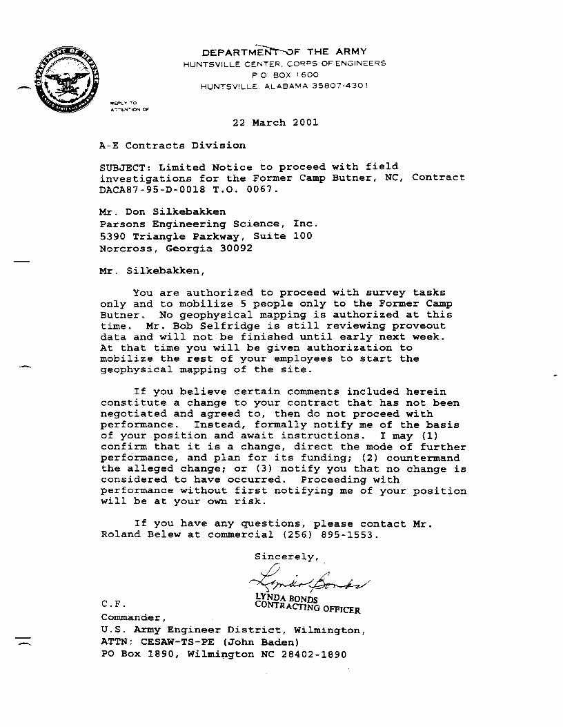
REPUV TOATTENTION OF
DEPARTMEKJT-OF THE ARMYHUNTSVILLE CENTER. CORPS OF ENGINEERS
P.O BOX 1 6OOHUNTSVILLE ALABAMA 35807-4301
22 March 2001
A-E Contracts Division
SUBJECT: Limited Notice to proceed with fieldinvestigations for the Former Camp Butner, NC, ContractDACA87-95-D-0018 T.O. 0067.
Mr. Don SilkebakkenParsons Engineering Science, Inc.5390 Triangle Parkway, Suite 100Norcross, Georgia 30092
Mr. Silkebakken,
You are authorized to proceed with survey tasksonly and to mobilize 5 people only to the Former CampButner. No geophysical mapping is authorized at thistime. Mr. Bob Selfridge is still reviewing proveoutdata and will not be finished until early next week.At that time you will be given authorization tomobilize the rest of your employees to start thegeophysical mapping of the site.
If you believe certain comments included hereinconstitute a change to your contract that has not beennegotiated and agreed to, then do not proceed withperformance. Instead, formally notify me of the basisof your position and await instructions. I may (1)confirm that it is a change, direct the mode of furtherperformance, and plan for its funding; (2) countermandthe alleged change; or (3) notify you that no change isconsidered to have occurred. Proceeding withperformance without first notifying me of your positionwill be at your own risk.
If you have any questions, please contact Mr.Roland Belew at commercial (256) 895-1553.
Sincerely,
Commander,U.S. Army Engineer District, Wilmington,ATTN: CESAW-TS-PE (John Baden)PO Box 1890, Wilmington NC 28402-1890

DEPARTMENT OF THE ARMY
HUNTSVILLE CENTER, CORPS OF ENGINEERSP.O. BOX 16OO
HUNTSVILLE, ALABAMA 35807-4301
27 March 2001
A-E Contracts Division
SUBJECT: Notice to proceed with field investigationsfor the Former Camp Butner, NC, Contract DACA87-95-D-0018 T.O. 0067.
Mr. Don SilkebakkenParsons Engineering Science, Inc.5390 Triangle Parkway, Suite 100Norcross, Georgia 30092
Mr . Silkebakken,
Your revised work plan dated February 2 001 hasbeen back cheeked and found to be acceptable. The datacollected from your field prove out the week of 12March 2001 has been analyzed and is also found to beacceptable. You are authorized to proceed with fullfield mobilization to perform site characterization atthe former Camp Butner. You may proceed on 1 April2001. Be sure to keep a correct,pH c-opy c?f_jrVio workplan and your copies of tfieirights of en try-on sitewith you. Further more you are""Htrected to notify theHuntsville Project Manager of in writing of the dateyou plan to do intrusive operations so that aHuntsville Safety employee can be present.
If you believe certain comments included hereinconstitute a change to your contract that has not beennegotiated and agreed to, then do not proceed withperformance. Instead, formally notify me of the basisof your position and await instructions. I may (1)confirm that it is a change, direct the mode of furtherperformance, and plan for its funding; (2) countermandthe alleged change,- or (3) notify you that no change isconsidered to have occurred. Proceeding withperformance without first notifying me of your positionwill be at your own risk.
If you have any questions, please contact Mr.Roland Belew at commercial (256) 895-1553.
Sincfirel
CHUN S. 'TtJCKERContracting Officer

Parsons engineering science, INC.A UNIT OF PARSONS iNFRASTRUCTWrt TECHNOLOGY GROUP
5390 Tnanflte Parfcway « Stfte 100 . Worcwas. Soerflra 30082 . (770) 446^900 . Fax (77P) 44B-W0
January 16,2002
ToUS Army Engineering & Support CenterATTN: CEHNC-OE-DC, Roland Belew4820 University SquareHuntsviUe.AL 35816-1822256-895-1S53
Subject: Proposed Phase I Geophysical Anomaly Ranking Methodology and AnomalySelection StrategyEngineering Evaluation/Cost AnalysisFormer Camp Burner, North CarolinaContract DACA87-95-D-0018, Delivery Older 0067
Dear Mr. Belew:
Parsons ES conducted the Phase I geophysical survey (approximately 100 acres) in supportof the Camp Burner EE/CA between March 26,2001 and July 13,2001 using the EM-61 MK2geophysical survey instrument This letter is intended to document the project team concurrenceof the Phase I Camp Burner Anomaly Ranking Methodology and associated Anomaly SelectionStrategy as presented by Parsons ES in Huntsville on January 10 and 11,2002. The processoutlined below is intended to be a blueprint for the selection of the anomalies for intrusiveinvestigation at the site. The ranking process developed for this project, and presented during theproject review meeting of 10 January, 2002, -was accepted without modification by all teammembers. This ranking process was applied to the population of 10,743 anomalies detected inthe Phase 1 geophysical data, and resulted in the following breakdown of anomalies by rank:
• Rank 1 Anomalies: 3,893 total• Rank 2 Anomalies: 3,624 total• Rank 3 Anomalies: 2,268 total• Rank 4 Anomalies: 958 total
The anomalies were then categorized by area and area-specific anomaly selection criteriawere formulated by the project team. The area specific selection criteria considered both theanomaly rank and the type or types of UXO targets that arc anticipated in each area. The area-specific selection criteria are summarized below. The attached spreadsheet summarizes thespecific anomalies in each category (or subcategory) by site. From these lists the Parsons ESlead geophysicist will identify the proposed selections to USAESCH for final approval prior tocommencement of intrusive activities. USAESCH will add discretionary QA selections forinclusion to the list.
For the purposes of the anomaly selection process, an anomaly response was considereddistinguishable above background if it was 1.5 times greater than the upper background thresholdas determined by the interpreting geophysicist By definition, Rank 4 are of known sources

;ar&cns engineering science. INC.
•' Mr. Roland BclewPage 2January 16, 2002
(utilities, comer spikes, QC spikes, surface fences, etc) and were excluded frond furtherconsideration. In the event a UXO item is encountered, intrusive investigation of the grid willimmediately cease, the remaining anomalies identified for intrusive investigation will be banked,and the grid will be considered contaminated.
Area 1 — Cantonment Area and VicinitySuspected or potential UXO: Mostly small atros but 2.36-rocket found near water tower.Anomaly Selection Criteria:
• Rank 1 anomalies: 100%• Rank 2 anomalies with above-background responses on channels 1 through 3 or 1
through 4: 50%• Rank 2 anomalies with above-background responses on channel 1 or channels 1 and 2:
10%• Rank 2 anomalies with no channels distinguishable above background; 10%• Rank 3 anomalies with above-background responses on channels 1 through 3 or 1
through 4; 50%• Rank 3 anomalies with above-background responses on channel 1 or channels 1 and 2:
10%• Rank 3 anomalies with no channels distinguishable above background: 10%• Rank 3 anomalies with anomalous responses: 10%
Area 2 - Ammunition Storage Area St DampSuspected or potential UXO: 20mm-15 5mm HE Projectiles, 60nnn-240mm mortars, 2.36-rockets.Anomaly Selection Criteria:
• Rank 1 anomalies: 100%• Rank 2 anomalies with above-background responses on channels 1 through 3 or 1
through 4: 25%: • Rank 2 anomalies with above-background responses on channel 1 or channels 1 and 2:
10%• Rank 2 anomalies with no channels distinguishable above background: 25%• Rank 3 anomalies with above-background responses an channels 1 through 3 or 1
through 4: 25%• Rank 3 anomalies with above-background responses on channel 1 or channels 1 and 2*
10%• Rank 3 anomalies with no channels distinguishable-above background: 10%• Rank 3 anomalies with anomalous responses: 10%
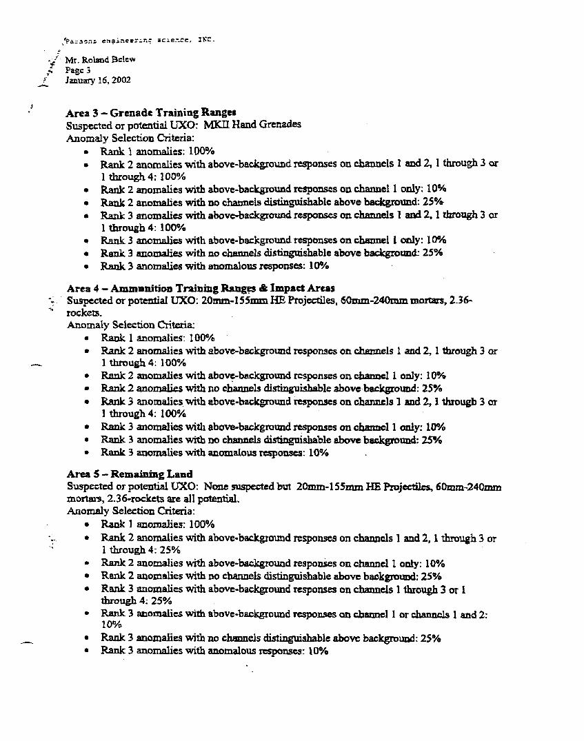
/Paraons enaineer-r-.c scie.-.ce, IVC.
/ Mr. Roland BelewPage 3January 16, 2002
Area 3 - Grenade Training RangesSuspected or potential UXO: MKII Hand GrenadesAnomaly Selection Criteria:
• Rank 1 anomalies: 100%• Rank 2 anomalies with above-background responses on channels 1 and 2,1 through 3 or
1 through 4:100%• Rank 2 anomalies with above-background responses on channel 1 only: 10%• Rank 2 anomalies with no channels distinguishable above background: 25%• Rank 3 anomalies with above-background responses on channels 1 and 2,1 through 3 or
1 through 4: 100%• Rank 3 anomalies with above-background responses on channel 1 only: 10%• Rank 3 anomalies with no channels distinguishable above background: 25%• Rank 3 anomalies with anomalous responses: 10%
Area 4 - Ammunition Training Ranges & Impact Areasv Suspected or potential UXO: 20mm-155mm HE Projectiles, 60mm-240mm mortars, 2.36-
rockets.Anomaly Selection Criteria:
• Rank 1 anomalies: 100%• Rank 2 anomalies with above-background responses on channels 1 and 2,1 through 3 or
1 through 4: 100%• Rank 2 anomalies with above-background responses on channel 1 only: 10%• Rank 2 anomalies with no channels distinguishable above background: 25%• Rank 3 anomalies with above-background responses on channels 1 and 2,1 through 3 or
1 through 4: 100%• Rank 3 anomalies with above-background responses on channel 1 only: 10%• Rank 3 anomalies with no channels distinguishable above background: 25%• Rank 3 anomalies with anomalous responses: 10%
Area 5 - Remaining LandSuspected or potential UXO: None suspected but 20mm-155mm HE Projectiles, 60mm-240mminortai-s, 2.36-rockets are all potential.Anomaly Selection Criteria:
• Rank 1 anomalies: 100%• Rank 2 anomalies with above-background responses on channels 1 and 2,1 through 3 or
1 through 4: 25%• Rank 2 anomalies with above-background responses on channel 1 only: 10%• Rank 2 anomalies with no channels distinguishable above background: 25%• Rank 3 anomalies with above-background responses on channels 1 through 3 or 1
through 4: 25%• Rank 3 anomalies with above-background responses on channel 1 or channels 1 and 2'
10%• Rank 3 anomalies with no channels distinguishable above background: 25%• Rank 3 anomalies with anomalous responses: 10%

j'Pars=>ns engineering science, INC.
Mr. Roland BelewPage 4January 16,2002
When less than 100% of a given group of anomalies is to be investigated, the selection willbe made on a case-by-case basis for each grid or transect, and will be performed by one of theproject geophysicists and based on professional judgment.
If you have any questions regarding this letter or need additional information, please contactme at (678) 969-2384 or (404) 606-0346 (cell).
Sincerely,
PARSONS ENGINEERING SCIENCE, INC.
Don Silkebakken, P£ .Project Manager
cc. Andrew Schwartz/Laura Kelley (Parsons)Bob Selfridge/Dan Pluggcs/Kevin Healy (USAESCH)Project File (738001)
Concurrence
Bob^elfiidg/(US4ESCH Sr. Geophysicist) Dan Plugge (15SAESCH ProjectGeophysicist)
Kevin Healy^r5SAESCH TM) Roland Belew (USAESCH PM)
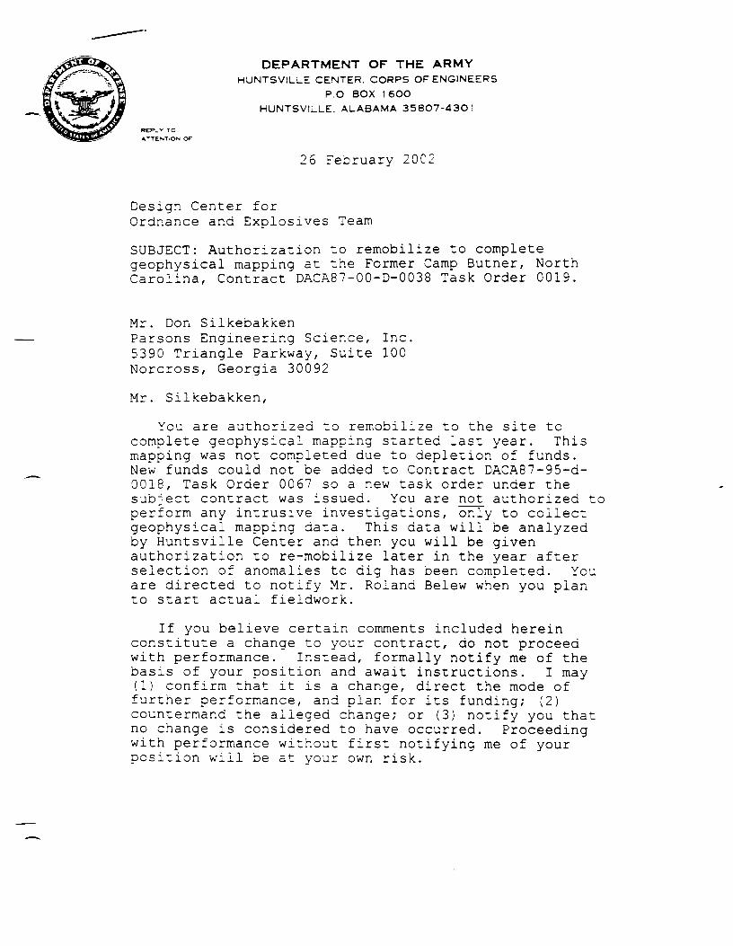
DEPARTMENT OF THE ARMYHUNTSV1LLE CENTER. CORPS OF ENGINEERS
P.O. BOX 16OOHUNTSVILLE. ALABAMA 358O7-43O1
REPLV TO
ATTENTION OF
26 February 200;
Design Center forOrdnance and Explosives Team
SUBJECT: Authorization to remobilize to completegeophysical mapping at the Former Camp Butner, NorthCarolina, Contract DACA87-00-D-0038 Task Order 0019.
Mr. Don SilkebakkenParsons Engineering Science, Inc.5390 Triangle Parkway, Suite 100Norcross, Georgia 30092
Mr. Silkebakken,
You are authorized to remobilize to the site tocomplete geophysical mapping started last year. Thismapping was not completed due to depletion of funds.New funds could not be added to Contract DACA87-95-d-0018, Task Order 0067 so a new task order under thesubject contract was issued. You are not authorized toperform any intrusive investigations, only to collectgeophysical mapping data. This data will be analyzedby Huntsville Center and then you will be givenauthorization to re-mobilize later in the year afterselection of anomalies to dig has been completed. Youare directed to notify Mr. Roland Belew when you planto start actual fieldwork.
If you believe certain comments included hereinconstitute a change to your contract, do not proceedwith performance. Instead, formally notify me of thebasis of your position and await instructions. I may(1) confirm that it is a change, direct the mode offurther performance, and plan for its funding; (2)countermand the alleged change; or (3) notify you thatno change is considered to have occurred. Proceedingwith performance without first notifying me of yourposition will be at your own risk.

- 2 -
If you have any questions, please contactMr. Roland Belew at commercial (256) 895-1553
Sinpjerely,
iia TadesseContracting Officer
Copy Furnished:Commander, U.S. Army Engineer District, Wilmington,ATTN: CESAW-TS-PZ (John Baden), P.O. Box 1890,Wilmington NC 28402-1890

DEPARTMENT OT I PTt ARMY
HUNTSVILLE CENTER. CORPS OF ENGINEERS
P.O BOX 1 6OO
HUNTSVILLE. ALABAMA 35807-4301
PEPLV TO
ATTENTION July 10, 2002
Design Center for Ordnanceand Explosives Directorate
SUBJECT: Mag and Dig Characterization change to Work Planfor the Former Camp Butner, North Carolina, Contract DACA87-95-D-0018 Task Order 0067
Mr. Don SilkebakkenParsons Engineering Science, Inc.5390 Triangle Parkway, Suite 100Norcross, Georgia 30092
Dear Mr. Silkebakken:
This letter is in reference to your email dated July 1,2 002, in which you request to make a change in fieldoperations to modify the geophysical mapping operations toinclude mag and flag and dig technology. You submitted inthis email what you call Standard Operating Procedures forAnalog Detection and Removal Actions. This is not thecorrect procedure for a change in field operatingprocedures. You must revise the existing work plan toreflect the proposed changes. The revised work plan willthen be reviewed and approved for the change. The reviseddocument should identify the revision date on the cover,include a cover letter stating what changes were made and anerrata sheet showing what pages in the document werechanged. You left 2 copies of the work plan in Mr. Belew'soffice on July 9, 2002. These copies had the originalapproval date of February 2001 on the cover and youroriginal cover letter dated March 6, 2001, however, they hadmaps in them dated July 2002, but with no text changesreferring to the proposed mag and flag and dig changes.
You are directed to provide 2 complete revised copies ofthe work plan to me as soon as possible. The revision mustinclude an explanation for the revision as well as a meansof pointing out and easily finding the changes in therevised document. The footer of every page that was changedmust reflect the current date of the revision as well as thefront cover.

-2-
You may proceed with intrusive investigations for thoseareas that were geophysically mapped under phase 1 and phase2 field efforts, but you may not proceed with mag and flagcharacterization until you receive notification from me thatyou are authorized to do so. You may proceed to the site noearlier than July 28, 2002 for non-mag and dig work. Afterthe mag and flag work plan changes are approved, I willissue you another letter authorizing you to proceed withthat portion of the work.
If you believe certain comments included hereinconstitute a change to your contract that has not beennegotiated and agreed to, then do not proceed withperformance. Instead, formally notify me of the basis ofyour position and await instructions. I may (1) confirmthat it is a change, direct the mode of further performance,and plan for its funding; (2) countermand the allegedchange; or (3) notify you that no change is considered tohave occurred. Proceeding with performance without firstnotifying me of your position will be at your own risk.
If you have any questions, please contact Mr. RolandBelew at commercial (256) 895-1553 or via cellular phone at(256) 426-3717.
Sincerely,
Lfctfa TadesseContracting Officer
Copy Furnished:Commander,U.S. Army Engineer District, Wilmington, ATTN: CESAW-TS-PE(Mr. John Baden), P.O. Box 1890, Wilmington, North Carolina28402-1890

REPLY TOATTENTION OT:
DEPARTMENT OF THE ARMYHUNTSVILLE CENTER. CORPS OF ENGINEERS
P.O. BOX 16OOHUNTSVILLE, ALABAMA 35807-4301
July 15, 2002
Design Center for Ordnanceand Explosives Directorate (200-lc)
SUBJECT: Authorization for Mobilization to the Former CampButner, North Carolina, Contract DACA87-95-D-0Q13 Task Order 0067
Mr. Don SilkebakkenParsons Engineering Science, Inc.5390 Triangle Parkway, Suite 100Norcross, Georgia 30092
Mr. Silkebakken,
You are authorized to mobilize two people to the former CampButner or. 23 July 2002 to perform logistics in advance cf themain crew mobilizing on 28 July.
If you believe certain comments included herein constitute achange to your contract that has not been negotiated and agreedto, then do not proceed with performance. Instead, formallynotify me of the basis of your position and await instructions.I may (1) confirm that it is a change, direct the mode of furtherperformance, and plan for its funding; (2) countermand thealleged change; or (3) notify you that no change is considered tohave occurred. Proceeding with performance without firstnotifying me of your position will be at your own risk.
If you have any questions, please contact Mr. Roland 3elew atcommercial (256) 895-1553 or via cellular phone at (256) 426-3717.
Sincerely,
EDNA. SHERIDANCONTRACTING OFFICER
Copy Furnished:Commander, U.S. Army Engineer District, Wilmington, ATTN: CESAW-TS-PE (John Baden), P.O. Box 1890,Wilmington North Carolina 28402-1890

ATENTlON Of
DEPARTMENT OF THE ARMYHUNTSVILLE CENTER. CORPS OF ENGINEERS
P.O. BOX 1 6OOHUNTSVILLE. ALABAMA 35807-4301
July 31, 2002
Design Center for Ordnanceand Explosives Directorate
SUBJECT: Approval to use Mag, Flag, and Dig Intrusiveon 35 acres at the Former Camp Butner, North Carolina,Contract DACA87-00-D-0038 Task Order 0019
Mr. Don SilkebakkenParsons Engineering Science, Inc.5390 Triangle Parkway, Suite 100Norcross, Georgia 30092
Dear Mr. Silkebakken:
Your revisions to Mr. Jim Walker's comments areacceptable. Your revisions to the work plan insertsare acceptable. You may proceed with mag and flagoperations at this site.
If you believe certain comments included hereinconstitute a change to your contract that has not beennegotiated and agreed to, then do not proceed withperformance. Instead, formally notify me of the basisof your position and await instructions. I may (1)confirm that it is a change, direct the mode of furtherperformance, and plan for its funding,- (2) countermandthe alleged change; or (3) notify you that no change isconsidered to have occurred. Proceeding withperformance without first notifying me of your positionwill be at your own risk.
If you have any questions, please contactMr. Roland Belew at commercial (256) 895-1553 or viacellular phone at (256) 426-3717.
Sincerely,
anda H. HamptonContracting Officer

JOB NO.
FILE DESIGNATIONCALL DATETIME OF CALL
"4129101
08 19/0211:30 AM
INTERVIEW MEMO
INTERVIEWEE: Bill and Bradlev Jones
(Name)
Local Resident(s) PHONE NO: 919-693-7949
(Affiliation) *919-405-9751(Pager)
INTERVIEWER(S): Don SilkebakkenJohn Baden
Parsons PMCESAW PM
PHONE NO: 678-969-2384
(Name) (Company)
Summary of Events Prior to Discussion
John Baden of CESAW had been trying to interview Mr Bill Jones for some time and he was never in. He travels andworks long hours and Mr. Baden had spoken to others in his family but not Mr. Jones. Others had told Mr. Baden that Mr.* " es knew a lot about the historical Camp Butner operation as he lived along range road (at his current residence) when he was
aild.
Summary of Discussion
Mr. Baden and Mr. Silkebakken drove out to Mr. Jones' house in hopes of finding him home. He lives on the comer of oldNC 75 (parallels East Range Road) and Enon Road in a house circa 1880. Mr. Jones has a number of shop buildings locatedadjacent to his house and we located him working in one building and he agreed to talk to us.
I showed Mr. Jones a set of topo maps of the site which included firing fan, proposed grid, and other information. Hedetailed very specifically memories from his childhood as well as ordnance-related findings over the years. He provided hisphone number and invited us back at any time to discuss further. He also introduced us to his younger brother Bradley wholater took us on a tour of their property and pointed out things we had discussed. The items below summarize the discussions::
> Bill stated when he was a boy he often observed night firing from his house. He observed the heavy artillery, mostly155mm, originating not from the northern firing fans as we have been led to believe but from what remains theNational Guard property. Thus firing north generally at the Mock German Village. He said the 155mm rounds make awhistling sound distinctive from the 105mm rounds and he was sure that much of the firing was with 155mm. He saidthere was a fair amount of night fire and could see the illumination rounds very well from his house. His house wasjust outside the range road and was thus spared from demolition and government seizure for Camp Butner. He statedhis father had a pass to go on the Camp anytime there was no live fire and he often went as well. Although young atthe time he was adamant regarding the direction of fire based on where is home is located and where he observedfiring. The Jones family owns upwards of 2000 acres north or Enon and east of Moriah. They owned much of theproperty before the Camp was established and were able to get it back and then some as a result of his father'sconnections.
> Upon looking at the maps, Bill stated to his knowledge the large firing point at the northern site extreme (pointed duesouth) was not used for 155mm firing.
I ,HUNT-CONUS\PROJECTS«UTNER\PM\INTERVIEW WILLIAMBJONES081902.DOC

CALL MEMO^ge2
August 29, 2002
> The large firing fan (with firing point along East Range Road) Bill stated was used for 2.36-inch bazooka training andstated numerous rockets had been found historically several thousand feet or so west of this point
> Bill and Bradley both spoke of an old well that exists on their property that was filled up with 2.36 rockets many yearsago. Bradley drove us to the location which is near one of his relative's homes. He pointed to a location and said itwas within 30 feet of the spot. He said we were welcome to investigate it further with our equipment. If we areinterested we need to let him know when so he can alert his relatives we are coming. NEED TO FOLLOW UP ONTHIS - JOHN.
> Bill confirmed the location of the Mock German Village on Moriah and that it was a target for heavy artillery firing(from now NCNG). Bill pointed on the map to a large area (totally undeveloped) where they have historically foundmany 155mm rounds during road grading and logging of their property. He commented on a 155mm placed on a rockby loggers a couple of years ago. Coincidently, an intact 155mm round was found in mat area on a rock several dayslater and detonated by Ft. Bragg EOD.
> Bradley drove John and I throughout much of the Jones' property and pointed out areas where craters were located andwhere his family has found ordnance or ordnance debris. This information was documented on the field office sitemaps.
> Bradley drove us to a location where two suspect howitzer firing points were located just south of the old Jone's house.These concrete structures have been the source of recent local debate as to what they were. Some believe they hadsomething to do with an adjacent cemetery (on the opposite side of the road). Both Bill and Bradley believe thestructures held howitzers based on the angled shape and apparent track marks. If this is true, no historical firing fansare shown originating from this area. Further, the firing points would actually be outside of the Camp Burnerboundary.
I HUNT-CONUS PROJECTS BUTNER PMINTERV1FW WILL1AMBJONES0S1W: DOC

DEPARTMENT OF THE ARMYHUNTSViLLE CENTER, CORPS OF ENGINEERS
P.O. BOX 16OOHUNTSVILLE, ALABAMA 35807-4301
August 13, 2002
Design Center for Ordnanceand Explosives Directorate (200-lc)
SUBJECT: Government QA Dig List fcr the Former Camp Butner, NorthCarolina, Contract DACA57-00-D-0039 T.O. 0019
Mr. Don SiikebakkenParsons Engineering Science, Inc.5390 Triangle Parkway, Suite 100Norcross, Georgia 30092
Mr. Silkebakken,
Your proposed dig sheets for the entire site (except the 35acres to be sampled using mag and dig technology) have beenreviewed. Huntsville Center geophysicists have also prepared foryou a list of anomalies you are to also dig as part of ourquality assurance process. The government selected digs areattached here.
Government comments or. Quality Control (QC) concerns on someof the above digs were addressed by Mr. Greg Vann on 1 August2002. The government concerns are related to an apparent lack ofQC by Parsons Engineering during data analysis. These concernswill be addressed in another letter no later than 19 August 2002by Mr. Bob Selfridge.
If you believe certain comments included herein constitute achange to your contract that has not been negotiated and agreedto, then do not proceed with performance. Instead, formallynotify me of the basis of your position and await instructions.I may (I) confirm that it is a change, direct the mode of furtherperformance, and plan for its funding; (2) countermand thealleged change; or (3) notify you that no change is considered tohave occurred. Proceeding with performance without firstnotifying me of your position will be at your own risk.

- 2 -
If you have any questions, please contact Mr. Roland Belewat commercial (256) 895-1553 or via cellular phone at (256)426-3717.
Sincerely,
cting Officer
Copy Furnished:Commander, U.S. Army Engineer District, Wilmington,ATTN: CESAW-TS-PE (Mr. John Baden), P.O. Box 1890, WilmingtonNorth Carolina 28402-1890

August 14, 2002
US Army Engineering & Support CenterATTN: CEHNC-CT-E, Lydia Tadesse4820 University SquareHuntsville, AL 35816-1822
Subject: Contract DACA87-OO-D-0038. Delivery Order 0019Request to Use Open Front BarricadesFonner Camp Butner Site, near Durham, North Carolina
Dear Ms. Tadesse:
Parsons Infrastructure & Technology Group, Inc. (Parsons) is currently conducting intrusive fieldwork forEE/CA investigation at the fonner Camp Butner site near Durham, North Carolina. In order to reduce the amountof evacuations required to ensure the appropriate minimum separation distances (MSD) for each area, Parsons'requests approval to use open front barricades (OFBs) where feasible. The OFBs ("Bud Lights") were constructedin accordance with US AESCH specifications and are currently stored at the site location. Appendix E of theapproved project Work Plan includes the signed documentation and requirements for use and resultingmodification of the MSD for this engineering control per Ms. Michelle Crull. The OFBs will not be used in areas
—'here the most probable munition (MPM) is larger than the maximum rating for the OFB or where other morel i means of conducting the investigation are available.
Written documentation of approval is required per approved Work Plan sections 5.1.9.4, 7.2.5, and 7.8.6.4. Ifyou have any questions regarding this letter or need additional information, please contact me at (678) 969-2384 or(404) 606-0346 (cell).
Sincerely,
Parsons Infrastructure & Technology Group, Inc.
cc: Roland Belew (CEHNC-OE-DC)Ken Stoekwell, (Parsons)Project File (741291)
Don Silkebakken, P.EProject Manager
Tadesseracting Officer

August 16, 2002
US Army Engineering & Support CenterATTN: CEHNC-CT-E, Lydia Tadessc4820 University SquareHuntsville. AL 35816-1822256-895-1169
Subject Contract DACAS7-00-D-O03S, Delivery Order 0019Request for Re-Evaluation of Approved MSDFormer Camp Butner Site. Butner. North Carolina
Dear Ms Tadesse:
Parsons is currently conducting intrusive field investigations in support of the EE/CAinvestigation at the former Camp Butner site near Durham, North Carolina. The Final EE/CAWork Plan was approved on 27 March 2001 under contact DACA87-95-D-OO18, DO 0067 andintrusive ficldwork was initiated on July 29. 2002.
investigation of Area 3 - Grenade Training Ranges has progressed fcrtv.c izryz and yicluedonly numerous non-O£ scrap to include bolts, plow parts, horse shoes, etc. No ordnance scrap ofany kind has been recovered. The current Minimum Separation Distance (MSD) approved forthis area is based on a Most Probable Munition (MPM) MKH hand grenade with MSD equal tof)50 feet (see Work Plan map Figure 2.4). Area 3 encompasses 5 acres of mostly undevelopedpasLureland However, several moderately traveled roads arc partially within the MSD. Parsons'hclicvcs a reduction to the MSD is justified and requests approval to employ the one hazardousfragment per 6(K> square feet criteria lor a this MPM (until such lime as unexploded ordnance isencountered) thus reducing the MSD to 4<M> feet. This will alleviate some road guard andevacuation requirements. The on-site USAESCI'l Safety Officer. Jimmy Walker, concurs withthe request and can substantiate the findings.
I!" you have any questions regarding this ICUCP or need additional information, please contactme at <f.73)lX><;-23S4or(404)606-0346 (cell). : p ^ ^ j ^ y , ^
Sincerely, / '
Parsons Infrastructure & Technology Group, Inc.
Ruiamlllck-u'UlillNC-OlMX)Wjync (/allowiiy (( LIINC-OL-S)Ken Slock well. (Parsons)I'mjcct l:ilc<74l29n
T3onProject Manager

CEHNC-OE-S (200-lc) 19 August 2002
MEMORANDUM FOR CEHNC-OE-DC {Roland Belew)
SUBJECT: Minimum Separation Distance, Contract Number DACA87-95-D-0018, Delivery Order 0067, Area 3, Camp Butner, Durham,NC
1. References:
a. CEHNC-OE-CX, Interim Guidance Document 00-01, 2 March2000.
b. Memo, Parsons Infrastructure & Technology Group, Inc,16 August 2002.
2. Your request to reduce the Minimum Separation Distance (MSD)for intrusive work at Area 3, Camp Butner, Durham, NC, isapproved- You may use the 1/600 MSD for the MK II HE HandGrenade. The 1/600 distance is 400 feet.
3. This reduced distance is based on the MK II HE Hand Grenadehaving the greatest 1/600 distance for the known munitionslocated. No UXO are anticipated in this area. Should UXO orany live munition be located, all intrusive work shall stop,this office notified, and this approval reevaluated.
4. Questions regarding this matter should be directed toMr. Greg Parsons, OE Safety Group, at 256-895-1589.
WAYNE H. GALLONChief, Safety (Sfoup
for Ordnance and Explosives Directorate
CF:OE-DC ReadOE ReadOE-S ReadED File/Read
Parsons/jc/1589/1/600-Former Camp Butner

Minimum Separation DistancesFormer Camp Butner
Mk II Grenade12 October, 2000
REQUESTED BY: Roland BelewPREPARED BY: Sherene Rizvi
This form shows calculated distances only. It does not constituteapproval. Concurrence of CEHNC-OE-S is required to determine theapplicable distance for a specific site.
In accordance with (1AW) OE Center of Expertise Interim Guidance Document00-01, use of the range to no more than 1 hazardous fragment/600 sq ft as theminimum separation distance for accidental detonations requires writtenjustification, a risk analysis, calculation of this distance by CEHNC-ED-CS-S, andconcurrence of CEHNC-OE-S.
CALCULATIONS FOR UNINTENTIONAL DETONATIONS
Maximum Fragment Range = 650 ftRange to No More Than 1 Hazardous Fragment/600 sq ft = 400 ftRange to 0.9 psi Overpressure = 27 ft
IAW OE Center of Expertise Interim Guidance Document 00-01, the minimumseparation distance for intentional detonations may not be less than the defaultdistance provided in DoD 6055.9-STD or the maximum fragment range or theK328 overpressure distance.
CALCULATIONS FOR INTENTIONAL DETONATIONS
Maximum Fragment Range = 650 ftK328 Overpressure Range = 174 ft
The primary fragmentation characteristics used in the calculation of the valueslisted above were computed 1AWCEHNC-ED-CS-S-98-1. The maximumfragment range was calculated using the maximum weight fragment and theinitial velocity from these characteristics in the computer software TRAJ. Therange to no more than 1 hazardous fragment/600 sq ft was calculated IAWCEHNC-ED-CS-S-98-2.
SANDBAG ENCLOSURE FOR INTENTIONAL DETONATIONS
Required Sandbag Thickness = 12 in. with 6" standoff between munition andsandbagsSandbag Throw Distance = _25_ ftMinimum Separation Distance = 200 ft
1 of 3

Minimum Separation DistancesFormer Camp Butner
Mk II Grenade12 October, 2000
The required sandbag thickness and the sandbag throw distance werecalculated IAW CEHNC-ED-CS-S-98-7. The minimum separation distance isbased on the largest of the sandbag throw distance or 200 ft or the K328distance for the total NEW (munition plus donor charge). A copy of HNC-ED-CS-S-98-7, "Use of Sandbags for Mitigation of Fragmentation and Blast Effects Dueto Intentional Detonation of Munitions" must be available on site. This reportmay be downloaded from the USAESCH homepage athttp^Arww hnd.usace.anny.mil/oew/tech/AnalyticalTools;a;uilind\ htm. T h e first t ime yOU access
the site you will have to register. You will be notified by e-mail when your loginand password have been activated. You must have a login and password todownload the report.
MINIMUM SEPARATION DISTANCES WHILE USING MOFB DURINGINTRUSIVE ACTIVITIES
Design of the Miniature Open Front Barricade (MOFB) is in accordance withHNC-ED-CS-S-98-8, "Miniature Open Front Barricade" This document wasapproved by the DDESB. This report may be downloaded from the USAESCHhomepage at hup://www.hiid.iisacfc3nny.mil/oew/tech AnalviicalTools/analindxJnm. T h e firsttime you access the site you will have to register. You will be notified by e-mailwhen your login and password have been activated. You must have a login andpassword to download the report DDESB has placed certain restrictions on theapproved usage of the MOFB. These are listed in the approval letter in the frontof the report
Thickness of Aluminum Required to Prevent Perforation = 1.QQ in
The MOFB is designed to defeat fragments to the rear and sides of the MOFB inthe case of an accidental/unintentional detonation during intrusive activities. Thefragment distances to the front of the MOFB are the same as the fragmentdistances without the MOFB (see figure). The MOFB is not designed to reducethe effects of blast overpressure. The MOFB may not be used for intentionaldetonations. The minimum separation distances to the rear and sides of theMOFB must be maintained based on the expected throw distance of the MOFBitself.
Minimum Separation Distance to sides and rear = 200 ftMinimum Separation Distance to front = 650 ftK50 distance = 27 ft
2 of 3

Minimum Separation DistancesFormer Camp Butner
Mk II Grenade12 October. 2000
MINIUJM SEPARATION DISTANCE FOR JNINTENTIONAL DETONATIONSUSING MINIATURE OPEN FRONT BARRICADE TURING INTRUSIVE ACTIVITIES
SIGNATURES
77/.Subject Matter Expert Chief
3 of 3

DEPARTMENT OF THE ARMY
HUNTSVILLE CENTER. CORPS OF ENGINEERS
P.O. BOX 1 6OO
HUNTSVILLE. ALABAMA 35807-4301
August 16, 2002
Design Center for Ordnanceand Explosives Directorate
SUBJECT: Approval of workplan modifications at the Former CampButner, North Carolina, Contract DACA87-00-D-0038 T.O. 0019
Mr. Don SilkebakkenParsons Engineering Science, Inc.5390 Triangle Parkway, Suite 100Norcross, Georgia 30092
Dear Mr. Silkebakken,
Your corrections to your 31 July 2002 work plan revisionshave been reviewed and are acceptable as attached. You mayproceed with your work based on these revisions.
If you believe certain comments included herein constitute achange to your contract that has not been negotiated and agreedto, then do not proceed with performance. Instead, formallynotify me of the basis of your position and await instructions.I may (1) confirm that it is a change, direct the mode of furtherperformance, and plan for its funding; (2) countermand thealleged change; or (3) notify you that no change is considered tohave occurred. Proceeding with performance without firstnotifying me of your position will be at your own risk.
If you have any questions, please contact Mr. Roland Belew atcommercial (256) 895-1553 or via cellular phone at (256) 426-3717.
Sincyerely,
\Jjf\i TadesseContracting Officer
Enclosure
Copy Furnished:Commander, U.S. Army Engineer District, Wilmington, ATTN: CESAW-TS-PE (Mr. John Baden), P.O. Box 1890, Wilmington North Carolina28402-1890

Record of Changes/Revisions
Page Number
VUl
Appendix M
3-12
4-5
4-6
4-8
6-12
6-14
7-1
Figures 6.1-6.8
Global
Paragraph#
NA
New
3.11.2.2
Table 4.2
4.2.2.6
4.3.2.3
6.6.4.1.4
6.6.8.1
7.2.2
NA
Global
Change
Add Appendix Mreference to TOCSOP for Mag andFlag/Mag and Dig
Survey30 anomalies per acreto 75 anomalies per
acreFor Area 4 and 5
added Mag and Flagto Type of Survey.Added reference tonew Appendix M
Added reference tonew Appendix M
Added reference tonew Appendix M
Added reference tonew Appendix M
Added reference tonew Appendix MFigures Updated
HFA to USA
Reason for Change
Addition of Appendix Mto document.
Adverse terrain andvegetation in some
areas.Project modification
Adverse terrain andvegetation in some
areas.Revision of field
procedureRevision of field
procedureRevision of field
procedureRevision of field
procedureRevision of field
procedureFigures updated to show
actual grid locationsChange in UXOSubcontractor
Date
7/9/02
7/9/02
7/9/02
7/9/02
7/9/02
7/9/02
7/9/02
7/9/02
7/9/02
7/9/02
7/9/02
I:\COE-HUNT\BUTNER\WORKPLAN\finalDelivery Order 0067
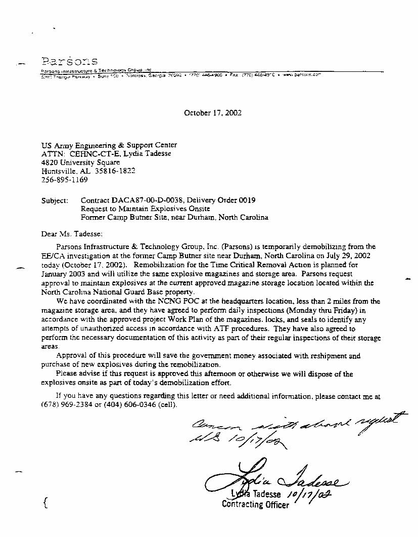
Rsrsonsure & Technology Grouu me
• Narcross. GeorGla SOCKCs • '77C1 4*J-a9G0 • FHX (77C!) SC6-49-0 « www.parsois.car
October 17, 2002
US Army Engineering & Support CenterATTN: CEHNC-CT-E, Lydia Tadesse4820 University SquareHuntsville. AL 35816-1822256-895-1169
Subject: Contract DACA87-00-D-0O38, Delivery OTder 0019Request to Maintain Explosives OnsiteFormer Camp Butner Site, near Durham, North Carolina
Dear Ms. Tadesse:
Parsons Infrastructure &. Technology Group, Inc. (Parsons) is temporarily demobilizing from theEE/CA investigation at the former Camp Butner site near Durham, North Carolina on July 29, 2002today (October 17, 2002). Remobilization for the Time Critical Removal Action is planned forJanuary 2003 and will utilize the same explosive magazines and storage area. Parsons requestapproval to maintain explosives at the current approved magazine storage location located within theNorth Carolina National Guard Base property.
We have coordinated with the NCNG POC at the headquarters location, less than 2 miles from themagazine storage area, and they have agreed to perform daily inspections (Monday thru Friday) inaccordance with the approved project Work Plan of the magazines, locks, and seals to identify anyattempts of unauthorized access m accordance with ATF procedures. They have also agreed toperform the necessary documentation of this activity as part of their regular inspections of their storageareas.
Approval of this procedure will save the government money associated with reshipment andpurchase of new explosives during the remobilization.
Please advise if this request is approved this afternoon or otherwise we will dispose of theexplosives onsite as part of today's demobilization effort.
If you have any questions regarding this letter or need additional information, please contact me at(678) 969-2384 or (404) 606-0346 (cell).
{J ^ Tadesse
Contracting Officer

Ms TadcssePage 2October 17, 2002
Sincerely,
Parsons Infrastructure & Technology Group, Inc.
Project Managercc: Roland Belew fCEHNC-OE-DC)
Wayne Galloway
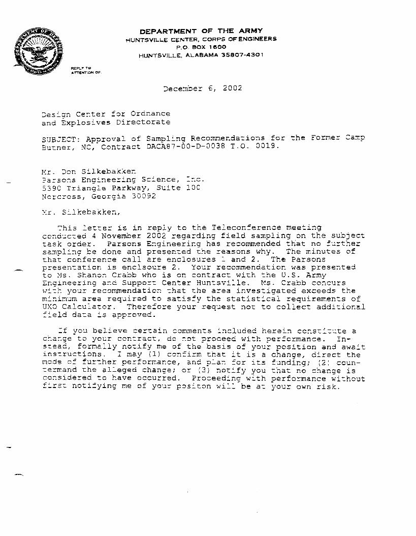
REPLT TOATTENTION OF'
DEPARTMENT OF THE ARMYHUNTSVILUE CENTER, CORPS OF ENGINEERS
P.O. BOX 1 6OOHUNTSVIL.LE, ALABAMA 358O7-A3O1
December 6, 2002
Design Center for Ordnanceand Explosives Directorate
SUBJECT: Approval of Sampling Recommendations for the FormeBurner, NC,*Contract DACA87-00-D-0038 T.O. 0019.
r Camp
Mr. Dor. SilkebakkenParsons Engineering Science, Inc.53S0 Triangle Parkway, Suite 100Norcrcss, Georgia 30092
Mr. Silkebakken,
This letter is in reply to the Teleconference meetingconducted 4 November 20C2 regarding field sampling on the subjecttask order. Parsons Engineering has recommended that nc furthersampling be done and presented the reasons why. The minutes ofthat conference call are enclosures 1 and 2. The Paraonspresentation is enclsoure 2. Your recommendation was presentedto Ms. Shanon Crabb who is on contract with the U.S. ArmyEngineering and Support Center Huntsville. Ms. Crabb concurswith your recommendation that the area investigated exceeds theminimum area required to satisfy the statistical requirements ofUXO Calculator. Therefore your request not to collect additionalfield data is approved.
If you believe certain comments included herein constitute achange to your contract, do not proceed with performance. In-stead, formally notify me of the basis of your position and awaitinstructions. I may (1) confirm that it is a change, direct themode of further performance, and plan for its funding; (2) coun-termand the alleged change; or (3) notify you that no change isconsidered to have occurred. Proceeding with performance withoutfirst
g pnotifying me of your positon will be at your own risk.

- 2 -
If you have any questions, please contact Mr. Roland Belew atcommercial (256) 895-1553.
TadesseContracting Oificer
2 Enclosures
Copy Furnished:Commander, U.S. Army Engineer District, Wilmington, ATTN: CESAWTS-FE (Mr. John Baden), P.O. Box 1890, Wilmington NC 28402-1890

ATTENTION OF
DEPARTMENT OF THE ARMY
HUNTSVILLE CENTER. CORPS OF ENGINEERS
P O. BOX 1 6OO
HUNTSVILLE. ALABAMA 35807-430 1
March 13, 2003
Design Center for Ordnanceand Explosives Directorate
SUBJECT: Delivery of Blast Containment Structures to theWilmington Corps of Engineers Resident office in Falls Lake N.C.on the Former Camp Butner, NC, Contract DACA87-00-D-0038 T.O.0023.
Mr. Don SilkebakkenParsons Engineering Science, Inc.5390 Triangle Parkway, Suite 100Norcross, Georgia 30092
Dear Mr. Silkebakken,
This letter is to confirm that you were asked to move theblast containment structures to the Wilmington Corps of EngineersResident Engineers warehouse after completion of your ordnanceremoval at Lake View Subdivision. The units will remain thereand be available for future ordnance removals at former CampButner.
If you believe certain comments included herein constitute achange to your contract, do not proceed with performance. In-stead, formally notify me of the basis of your position and awaitinstructions. I may (1) confirm that it is a change, direct themode of further performance, and plan for its funding; (2) coun-termand the alleged change; or (3) notify you that no change isconsidered to have occurred. Proceeding with performance withoutfirst notifying me of your position will be at your own risk.
If you have any questions, please contact Mr. Roland Belew atcommercial (256) 895-1553.
Sincerely, .
Tadesseracting Officer

PROJECT-RELATED NEWSPAPER ARTICLES
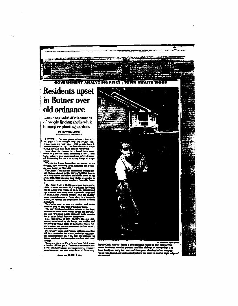
Residents upsetin Butner overold ordnance
tales arc common>f people rinding shells whik>
hunting or planting garden*
1ITHCT Dtrianaat i^min i»*r w* t*ua>< nrua i j i i n i f - that U Haul Onr «-
mi prfciehj up a b*c b t a
ir (Mil ItBTc a m* » I n * c an
u'lll dnnllol WwfaMln br KM t'-S Amy C«*» «f t>«i-
— <•» H0 taUt UN IW«(t > • • far n sfMraMH.Tfcc Cakm* •mmy m M r rt« ctfktKO ma mmt•M» « > !• Itmo fad di n n i m r •*»<!»»
«• • • i *«%•>•• • • * • M M K a>«i •>•••*• K « law. I4M\ kd • * M i m "San Urn • *« • o# MM, Pwtmj be
• a m i !»• kno h? Or Cw L >H a»wl Ikr «O» asnt «f Be araa
l»t imuan.Caytmti P*naaa ofltaaMaar. ttav»U U»T« iWaiila* a a n g c o a X a i —fluffm nttaatH«*ta«i aMt>Dk Call Will dfOal IkeM m and Mat a> dean up'

FWDAY, AUGUST 23, 2002
SHELLSFROM PAGE B1
S. they hive found more thanljOOO pounds of tnrseshoex ptowblades and nails — and at lean200 rragmeativ fuses or entireahells at exptouve devices.
Loggers found a lrve 155 Bunshell Thursday in the woodsnorth of the Cash**' home. The3? mm shell found Wednesdayinside one of these grids sat 11yards from the Cashes' fromdoor.
Carps officials assure the fam-ily and the other peopte bring on
THE H3ULD-SUN |!
old Caoif Briitnrr property thattheir land will be rid of at least 95percent of explosives oocc tbecleanup a finished.
But Cash and her neighbors intbe 13-Kre LaJurview EstatessutHllviaian want thetr propertycieansd up now.
"1 dont want to Kve here, and Idant want to go home,' Cashsaid, "My family could be sleep-iflsj (MI top of 80 mm snpiis.
Roman rod Prances Vos aimednext door to the Casbes m 1997.They said they bought theirhome for tbe "Qirief and sereai-
-Vfnen we boqght tbe property,[the fact mat this was once anammunition range] was not dis-cloBcd to us," Roman Vos said. *UI had of known, we would barepatted'
Tbe Voaes have hired a lawyerID tnemrer wtry there was no d»s-ckisure of the luunitJuttB.
Prance* Von, a retired UmcteadHospital nune. said che wasUral of "old-nmera in the areaurinti, Ithe tntanltioes] hare•hWys been there.'"
"Sometimes in America, people
LOCAL |
KimberiyCishdwiratand
I in their ywd in Butner.
i m » «4wi« the hMd of • buootai on an old round that htrpor* found
say, TJfc, it's always been ttwtwwy; - she said. -Bot wtoen t kidDsta binwn up. ther a}-, "Now weh hfe ""
ithi c» jicivW aau.
In 1983, inn ft-ytar-otd bof» inSan DICBD dleJ when a 37 nunsheO they brought borne and tia-kered with exploded. And a «-year-old chad blew off ao armtwo years ago wtien be picked upa live shell Thr San Dit»D ino-dem spurred legislative acOoa,aad n the late lWOa, a MailpioaiaiB was crcaiml ID startckatate up areax around old milHjB-)-trainiiiK (grounds.
Jotn Baden and Rolaod Beirw>nfficsits w«h the Cope who haveworked on teverai cleanup pro-)ecu nshnmidc. asaared theCa&hrt and the Vcwej. at a meet-ing Thursday nigh: that thty wUfacto therr inunedtaie attention
on the LTaaf! .
"We're hereto help, and we willdo ao as tmt as we can."
Baden and Betew cooid a n acta timetable for bow long theUaUUa HHaawV nRUllnajpf 1M a W I ^ Wordnance would a** Their firsthurdle is securing moocr fromthe federal • m n m e n t K> Fandthe cleanup. No small feat, they
Ab h BtetDbe lonad.
IhnKtaberty Cash oread thecnto tarry
"If it was your chtldm. wouldyou let them stay in my houaeraheMfceU
Ccrp« offkiafaurse pmcae whodisoorer ordnanoe ID Hay a%nyfnm it and can tool authorities.On tn> m * mwm^tmaonijam

Caap Batter 2.3* iaea iAr t tnlc UXO - Tito pallmMaOver it with al» ridmt OMWCT. thca hfc9 jearoUtM picked hapaad draped HoaPorcB. n Braf{ EOD caaw aan dcasa d it taBackyard. March2M2.

* *
Y^SEPTEMBER 2, 2002
1CT1ONBOBITUARIES B2SCHOOLS B4
i JHOV7ES B5/COMICS B6
* Ron Landfried, day editor419-6630: rtandfned»hcrald«jn.coni
Mark Schultz, night editor419-6646; h t a P h l d
As a new ear
HOLIDAY CLOSINGS:LABOR DAY
After recent slayings a!look at the culture si
dangers of debtAttorney general
id pickle harvester Mame1>$^~^ke through an inter*
old about his experi-e of M Oli»>u ai/vui IUS expen-
ai one of Mount Olive'suppliers.
said that he worked forfour weeks picking cucum-ad tobacco. He told his boss> had a pain in his side andto be taken to a hospital butfused, Chai said,said that I was probablyind I should just take some," Chai said.Chai took a taxi to the hos-e next day, be had to have' for appendicitis. He wasvo weeks later and toldxe was no money to pay
JSO told of other abuses hej from his boss whileon the farm.
ould threaten us, and heome to our trailers withand say he could kill uswouldn't take anything
im him," Chai said. "Heways threaten us, and Ijjsr why. We were work-in.".id he became involved?arja_Labor Organizing'te ich helped him3i ,r workers recoupi.
ike students at Sunday'sag to the organization,roup with members onnadents Against Sweat-participated.
v**uh vii ail U1Ura my anuiery range raise questionsabout who's to blame.
This is a unique legal situation,"said Dan Flebotte, a Durham attorneyrepresenting Kmberjy and DannyCash,' woo live in Lakeview Estates.• In November, the Cashes' 9-year-oldson picked up a live bazooka roundwhile raking leaves in their front yard.Since then, three more shells or piecesof them have been found there, includ-ing a live 37 mm high-explosive shelluncovered and safely detonated twoweeks ago by the Army Corps of Engi-neers.
The latter find is part of an extensivesurvey by Parsons Inc., an engineer-ing firm hired by the Corps. Parsons .was hired to determine, how many "••shells remain and bow much danger, u
- • * 5 * . ' ^ ' '' >*» .1'-'
mem ou years age' "We're looking r—MUl-ty of the U.S. government, of priorowners' disclosure am} of tbe effectivescope of title insurance that frequent-,ly insures [homeowners] from envi-ronmental issues," Flebotte said.
Flebotte cautions that it's too early totell who is legally responsible for whatcould be scores of remaining explo-sives. -^JUV
"But it's a very serious cttiMtym" hesaid. '' - .•• |T ;-;
As a real estate lawyer with 25 yearsof experience including 7,500 proper-ty transactions, Flebotte sayibe hadnever previously heard of a disputeover abandoned munitions an U& res-idential property. - ' . /:•••$**•?
In land issues, North Camftna isknown as a caveat emptor, or "buyer
•,«jw(*Lcsaia.i ~'As a real estate lawyer, we're c
'required to doa title search 40 yeaiback," be said "Any lawyer involvein [lakeview Estates] would go bacl40 years and not see there are livjbombs. Enough time passes wherthings are not seen."
The Cashes bought their modulaihome from Jim Wiilerte in 1996. Thejand neighbors Roman and FranceVos say WiJIene never disclosed tthe 13-acre subdivision was once tt.target area of one of eight artillerranges. j
Wiilette would not discuss the matiter, and his lawyer, Tom Burnette ofOxford, could not be reached for <
please see SHELLS | B3
STREET SMARTS;
Lanes will^eoperi1f§ trip home

MSOCunOHVIS
«4or. n M M M of tht families hit by<ted history of domestic turmoil.
Agencies such as the DurhamCenter will no longer providedirect assistance. Instead, theywill contract out private mental health services, much likethe way private managed careworks.More stringent eligibility cri-
teria will mean fewer peoplewill receive services The slateis targeting people with severeand persistent menial illness-es. In Dm ham, about 7,300 peo-ple currently receive servicesAbout 2,800, or less than half,would be eligible for servicesin the new system
Local money could fund ser-vices the state doesn't requirebut which county residentsconsider essential.
i •he's not surprised: problems are kept
These are superhuman*, louhave to remernber," she ifys.They dont have to have help —s u p p o s e d l y . " * •:;.••+*• ;
Flitcraft, who is no* fearing forher three orrihaned grandchil-dren at Alliance, Ohio, says it's"like an unspoken rule that youdo not exhibit ftny inability to bein control of every aspect df yfcurlife.-) ' '\i
She feels equallyrsad foriHerson-in-law. "He was overtrainedand' underhelped," she sa^d1.through sobs. • • f '
One soldier's wife, Janice Huf-ton, says she's tired of seeing the
jmyfm«w«Hr;
take care of their sol-;take care of their
be pan of the prob-says Black
iTtaeVre very good at takingate of the problems and helping
'out families." says Black "Hutthere are some problems thatthey may not have the training toknow that they need to be han-dled by somebody else."
The team sent to investigatethe problem at Bragg may offersome recommendations, butHaney, the 20-year veteran, saysit's all just window dressing ifsome fundamental changes
1 arent made. • '"I don't believe they're going to
'do a blessed thing other than go'through the motions," he says.'They'll go overboard with it forsix months, and there'll bemandatory classes for every
' returning special bpefations sol-'dier on not killing your wife.
"I mean, it's just the militaryway of doing things."
f HXTOR'S NOTE: Allen G. Br«ed Is the,• AP\ Southeast regional writer, based
in Raleigh, RCI
owwar mow r wi i
neroy-crntic primary opponents, for-mer Mate House speaker DanBlue and N.C. Secretary of SlateKlainc Marshall.
"This guy really has substan-tial experience in Washington,"said 'Ibwnsend Ludington, aUNC professor who in Januarywrote Bowles a check for $300,the most he's ever Riven to acandidate.
Dole, a former U.S. Cabinet
SHELLS•% FROM PAGE B1
ment. 'In an earlier interview, Roman
Vos said he would not havebought his home if he hadknown about the shells. TheVoses also have hired a lawyer.
"I'm concerned about thevalue of our property," yos said."It was never disclosed whatwe're sitting on top of. If wewere to sell, our consciencewould not allow us to not revealwhat we are sitting on." :
Meanwhile, the Corps of Engi-
utor mr tms ctec ,nns noonpolitical scieni JrofcssnrRobert Kcohane, who hasdonated $7,000, including several donations to Family's List,according to PoliticalMoneyLine. Keohane is the husbandof Duke President Nan Keo-hane.
Dole, a Duke graduate, hasreceived the most supjwrt of theSenate candidates: five donaturns totaling $4,000
neers is seeking federal moneyfor a comprehensive cleanup ofthe shells. •'
But Kimberly Cash said shedoesn't want to jeopardize thesafety of her six children anylonger. , '.
"We're actively looklng'foranother place to stay, but wecan't find a place to rent whilepaying mortgage," she said."This is turning into ^some-thing; very big,1 and it's 'notgetting* the attention If heeds.I'm a little person In a littlehouse with a big family.
"We didnt grow up here, but Idon't think people comprehendwhat the situation is."
• MireI'I.IM amuch
r . SHCll.'• sa id .
ity l o
is plani l i e a l l l i
M'.'ims'ore
'al
DEgf* IFROM PAGE B1
since 2000. About 83 percent ofall undergradu.-ite students own.'it least one card.
My the end of their freshman ••year, students have accumuxlated an average $1,500 cred-it card balance, Cooper said.My the junior year, that number rises to $2,700, and bygraduation ii increases to$3,200.
Added to student loans, thedebt burden can be onerous.On average, graduates leaveschool with combined loan andcredit card debt of $20,402,Nellie Mae notes.
Cooper stressed that stu
card interest rates and annualand late fees, as well as cardlimits
In an informal survey, Coop-er asked how many students inthe audience had a credit card.Most raised their hands Whenhe asked how many of themknew their card's interestrate, most hands went down.
"Some credit card interestrates are up to 18 or 19 per-cent," he said
Students should try to findcards that don't charge amonthly or annual fee anddon't add fees for late pay-ments, Cooper advised
NCCU sophomore ChereseMitchell said she has threecredit cards that she prompt-ly pays off every month. Thecredit limits are $200 or less
credit card] for emergencyreasons," she said. "I'm prettyresponsible when I use them."
Credit cards can be good forbuilding credit or handlingemergencies, Cooper said, butstudents should limit them-selves to one card and pay itoff before the payment date toavoid interest charges.
Mitchell and Banks, whoboth attended the session ledby Cooper, said they gained alot of useful information.
The most important messageMitchell got was to seek finan-cial counseling if necessary.
"Whenever you need help, talkto someone about your creditcard problems," she said.
Other tips from the AttorneyGeneral's Office:
• Shop around for cards that
ffees, no^ the ones that handout the coolest gifts
• Compare interest rates andread the fine print to knowhow they can change
• Don't fall for the teaseSome cards offer a low introductory rate, which then canrise steeply.
• Select cards that providegrace periods to avoid payingmore interest. Also rememberthat nearly all cards chargeinterest on cash advances,with no grace period' • Tell your credit companyyou don't want them to sellyour personal information toother businesses, to protectyour privacy and reduce additional offers.
• Pay off the full balance onyoui card every month if |»>
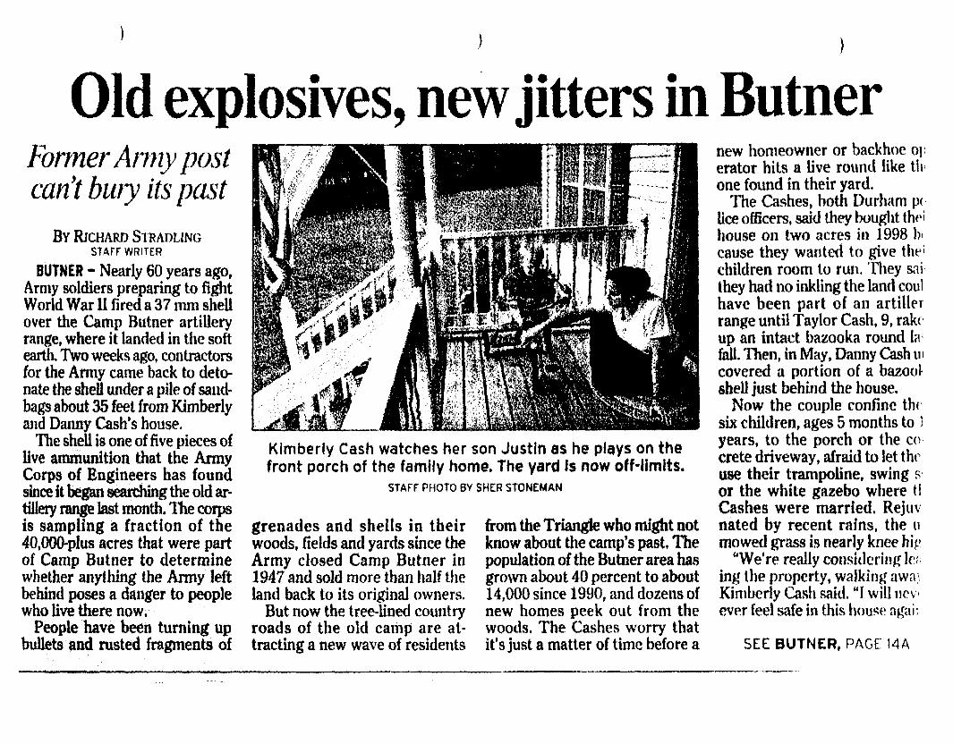
Old explosives, new jitters in ButnerFormer Army postcan't bury its past
BY RICHARD STRADLINGSTAFF WRITER
BUTNER - Nearly 60 years ago,Army soldiers preparing to fightWorld War U fired a 37 mm sheUover the Camp Butner artilleryrange, where it landed in the softearth. Two weeks ago, contractorsfor the Army came back to deto-nate the shell under a pile of sand-bags about 35 feet from Kimberlyand Danny Cash's house.
The shell is one of five pieces oflive ammunition that the ArmyCorps of Engineers has foundsince it began searching the old ar-tillery range last month. The corpsis sampling a fraction of the40,000-plus acres that were partof Camp Butner to determinewhether anything the Army leftbehind poses a danger to peoplewho live there now.
People have been turning upbullets and rusted fragments of
Kimberly Cash watches her son Justin as he plays on thefront porch of the family home. The yard is now off-limits.
STAFF PHOTO BY SHER STONEMAN
grenades and shells in theirwoods, fields and yards since theArmy closed Camp Butner in1947 and sold more than half theland back to its original owners.
But now the tree-lined countryroads of the old camp are at-tracting a new wave of residents
from the Triangle who might notknow about the camp's past. Thepopulation of the Butner area hasgrown about 40 percent to about14,000 since 1990, and dozens ofnew homes peek out from thewoods. The Cashes worry thatit's just a matter of time before a
new homeowner or backhoe operator hits a live round like tlione found in their yard.
The Cashes, both Durham p<lice officers, said they bought thrihouse on two acres in 1998 hcause they wanted to give the1
children room to run. They saithey had no inkling the land coulhave been part of an artillerrange until Taylor Cash, 9, rakeup an intact bazooka round lafall. Then, in May, Danny Cash incovered a portion of a bazootshell just behind the house.
Now the couple confine th<six children, ages 5 months to 1years, to the porch or the cocrete driveway, afraid to let theuse their trampoline, swing sor the white gazebo where tlCashes were married. Rejuvnated by recent rains, the umowed grass is nearly knee hip
"We're really considering le;ing the property, walking awa\Kimberly Cash said. "I will nev>ever feel safe in this house a^ai;
SEE BUTNER, PAGE 14A

THE Xras 6: OBSERVER +
FRIDAY. SEPTEMBER 6,2002
FORMER CAMP BUTNEREstablished in 1942, Camp Butner covered 40,384 acres. Most ofthe land went back to private use after the base was closed in1947. The Army Corps of Engineers is concentrating its search forexplosives and other debr.s on the old artillery ranges, except forthe N.C. Army National Guard training area.
*T«T>C-« .
,-!.i^ *'!-yOST» ' \J&
BUTNERCONTINUED FROM PAGE »A
She fears a repeat of what hap-pened in San Di^D in 1983. whena tank shell on a former Armytraining range exploded in a sub-division, killing two 8-year-oldboys. That incident helped promptthe Army to begin assessing whatmight be buried at more than 250former military properties.
Last month, contractors hiredby fee corps began combing Bul-ge r using magnets and a globalpositioning system to search forwhat they call anomalies, "objectsyou wouldn't expect to see in theground," said corps spokeswomanPenny SchmitL The search, whichwill continue trough November,covers the federal prison complex,John TJmstead Hospital and vari-ous other state institutions, butexcludes the 4,750acre N.C ArmyNational Guard training camp.
The corps wiQ report its find-ings next July, along with a rec-ommendation of whether theArmy should do more to dean upthe area and an estimate of whatit might cost So far, in additionto the shell next to the Cashhouse, the corps has found anddetonated 57 mm. 105 mm and2.36-inch shells, Sehmitt said.
Clarence Riley isn't surprised.In 1949, RSey earned 90 cents anhour on a crew of civilians thathelped the Army dear shells anddebris from the old Butner ar-tillery ranges. He remembers com-ing across a shell that was 3 feetlong and as big around as a five-gallon bucket
"When they blew that one, youcould bear it for five or six miles,"said RSey, 73, who still lives onthe family farm outside die formercamp. "We got a right good waysback from that"
Riley said the crew inevitablyleft explosives behind, because theycleared only what they could see.
"We weren't going to rake allthat ground to see what was underthe leaves or the vines," he said.There's stffl some spots up therethat I would hesitate to go in."
The Army has spent about$2.3 million on the Butner studyso far, the final cost depends onhow much the engineers uncover.The Army doesn't have moneyfor cleanup, though, which is whythe Cashes remain is limbo.
When the Annv sold Butner
Kfmberty Cash holds thenonexplosive portion ofshell her husband found.STAFF PHOTO BY SHERSTONCMA\
back to its original owners, itplaced covenants on the deeds re-stricting use of the land to thesurface only, according to a 1993corps report Over the years, anymention of the artillery range andwhat might lie in the soil wasdropped from many deeds,Sehmitt said.
Some residents are ambivalentabout the Army's legacy. ClaudeCampbell has lived inside theboundaries of the old camp foreight years but had not thoughtmuch about it until recent newsaccounts of the corps study. He re-cently moved into a new housealong a stretch of Range Roadthat is lined by new homes andsigns advertising land for sale.
T guess it doesn't concern me,"said Campbell who runs the elec-tronic systems at the federalprison. 1 don't know if they didany bombing down this way."
But B J . Elmore thinks it's amiracle no one has been killed onthe range.
Elmore, who works for Xerox inResearch Triangle Park, has livedoff Range Road for 1H4 years andkeeps two exploded mortalrounds on her bookshelf. Thejlook like rusted pipes with finsand one end "peeled back almostlike a banana," she said. Shestubbed her toe on one and hilthe other with a lawn mower.
"We know it's here," she said."We take a chance every time wtdig a hole in the ground to put £fence post in. You never know.*
Staff writer Richard StrwKfngcan be reached «t 829-4739
or rstrajJO^newsofcserverxom.

CLBSSIFiaJOES - CftftS - M M . ESTftTE
n'HBT SHRPPEIUM.DliUOG - MOVES
COmmunmES ntusobstrvtr.comSHOPWfiO - W C O W I V J S - THE SCHtt fiEV.'J • E UilrtEJS • SPORTS
SEARCH ARCHIVES: |
HOMEEDITORIAL
OBITUARIES
TRAFFIC.
An online resource of The News & Observer. Raleigh. NC
FRONT : story Past Editions
Friday, August 23, 2002 9:24AM EDT
Full Text Archives
Letters to the Editor
Subscribe to The N&O
Place a Display Ad
Place a Classified Ad
Contact The N&O
About The N&O
78"F Sunny
TODAY: High 92"F; Low58"F. Partly sunny; windy,hot.
TOMORROW: High 80°F;Low 52*F Mostly sunnyand nice.
More live rounds found near Butner
DOW8,720.72
NASDAQ1,343.29
S&P 500922.42
113.11
UPDATED12:10 Eastern
Associated Press
BUTNER - Kimberly and Danny Cash hadno idea when they bought their house herethat it rested on the edge of a World War II-era target range.
Then, while the two Durham police officerswere raking leaves in their front yard lastNovember, their 9-year-old son discovered alive bazooka shell.
STORY TOOLS
^ printer friendly version
Q send this storyto a friend
SITE TOOLS
gL_ subscribe to our email lists
I Q 9 e t news, weather, movies onI W your PDA
r Since then, the Cashes have found three more shells or pieces of them,including a live 37 mm high-explosive shell uncovered and safely detonatedWednesday by the U.S. Army Corps of Engineers. "This is my dream home that
Triangle, world remember JU s t t u m e d i n t 0 a disaster," Kimberly Cash Said.MORE STORIES
Bowles. Dole look to Nov.5
A tight race for GOP innew 13th District
More election news
Stories abound in this town of 5,000 of people stumbling across old bullets andshells, some as big as 155 mm, while plowing their fields or hunting in theforests in this part of southern Granville County.
The Army built a 40,000-acre base in Butner in the 1940s to house and train40,000 soldiers for World War II. Along with barracks, an Army hospital and aprisoner-of-war camp were a grenade range and 15 ammunition trainingranges.
And the Cashes' home - unbeknownst to them when they bought it - sits justoutside the target zone for one of those old ranges. They won't let their sixchildren walk in the woods or play on their playground anymore.
• See the Town- view ourlive web cam!
. The Wireless Co. - Seeour current promotions.
. Colonial Wlliamsburg- Fallpackages start at just $55 anight!
"We can't let them feed the chickens or the dogs, because we don't know what1 s coupons for Pinehurstunder the ground," she said. "If s going to take someone to die to make this an courses!issue. I don't feel safe being here."
Roman and Frances Vos moved next door to the Cashes in 1997. They saidthey bought their home for the "quiet and serenity."
Vos has hired a lawyer to determine why there was no disclosure about themunitions.
"When we bought the property, the fact that this was once an ammunition rangewas not disclosed to us," Roman Vos said. "If I had of known, we would haveDassed"
. Plan your beach vacationhere!
• Triangle Life Magazine
• NC Seafood: Print thiscoupon!
• 5th Annual Half Marathon!
• caii Boat Show and Sa'e'

Since the spring of 2000, Parsons Inc., an engineering firm hired by the Corps,has studied and surveyed the 40,000 acres of the former Camp Butner todetermine how contaminated the land is with ordnance and explosives.
By January, Corps and Parsons officials say, they will have a detaileddocument, called an engineering evaluation/cost analysis, that will explain thedangers and cost to clean up hundreds of shells and casings.
To sample the area, Parsons workers mark several 100-by-100-foot grids. Thenwith handheld Global Positioning Systems and an industrial-strength metaldetector, workers scan the grid. Since Aug. 5, they have found more than 1,000pounds of horseshoes, plow blades and nails - and at least 200 fragments,fuses or entire shells of explosive devices.
. 123NC.comCriminal records instantlyonline
triangle.com
Weddings
. make your announcement
• email a friend
Travel
. Travel Directory
. FREE Travel Brochures
Personals
. people2people
Loggers found a live 155 mm shell Thursday in the woods north of the Cashes' P r i z e Centerhome. The 37 mm shell found Wednesday inside one of these grids sat 11 • v«n Movie Madnessyards from the Cashes' front door. Tickets
Corps officials assure the family and the other people living on old Camp Butnerproperty that their land will be rid of at least 95 percent of explosives once thecleanup is finished. They held a public hearing Thursday night to discuss theordnance problem.
Kimberiy Cash and her neighbors want quick action.
CLASSIFIED ONLINE
Jobs:
. Post your resume
. Search 1658 jobs
. Jobs at The N&O
"If it was your children, would you let them stay in my house?" she asked.
|Go To Section gj
Help || Feedback || Parental Consent ||Pnvacy Policy || User Agreement
Cars:. Find a car
Real Estate:. Commercial Properties. Apartments
© Copyright 2002, The News & ObservePublishing Company. All material found on triangle cor^inciudingnewsobserver.com. carynews.corn chapelhillnews.com,knightdaletimes.comsmithfieldherald.com,wendellclanon.comand zebulonrecord.corr) is copyrighted The News & Observer Publishing Company andassociated news services. No material may be reproduced or reused without explicit permission from The p l a c e a n a " bY phone:News & Observer PublishingCompany, Raleigh, North Carolina. 9 1 9 829.4600
800.662.6040
The News 4 Observer Publishing Company is owned by ThWcClatchy Company. # Place an ad "r-m=

vlore live rounds found near Butner
\ssocJaied Press
}UTNER -- Kimberly and Danny Cash had no idea when they bought their house here that it rested on the edge of a World War Hera target
lien, while the two Durham police officers were raking leaves in their front yard last November, their 9year-old son discovered a livelazooka shell.
Since then, the Cashes have found three more shells or pieces of them, including a live 37 mm highexplosive shell uncovered and safelyietonated Wednesday by the U.S. Army Corps of Engineers. "This is my dream home that just turned into a disaster," Kimberly Cash said.
mp: www.nevvs-observer.com front'ston.' 166649lp-1688285c.html
Brunswick County
Nourishment Program Helps Tourism, TurtlesBy Don Bordner
Last fall's beach nourishment projects attracted both vacationers and sea turtles to the South Brunswick Countybeaches, according to members of the Brunswick Beaches Consortium (BBC). The state recently reported area rentalsand tourism held their own this summer, which the consortium credits much to nourishment projects. Preliminary seaturtle nesting reports indicate a significant increase in nesting activities along the South Brunswick County beaches,according to consortium members. While members smiled at the positive news, they buckled down to prepare foruppcming beach nourishment projects and Coastal Resource Commission (CRC) appointments at their monthlyn ig Aug. 15. Glenn Mclntosh of U.S. Army Corps of Engineers updated consortium members on the status of theWilmington Harbor Project and provided a brief outline of claims for more funds for additional work required duringthe project by dredging company Bean-Stuyvesant.
http://vvww.bmnswickbeacon.com/headline%20web%20page/brunsco.html

lera;un
home :g ranvillecounty
ranvilleersonlathamctions3 II on.Wo ridate:ortssmesseather:<nioncnnologyalth/Med:s & Featuresn & Gameslery
sources: Topics:mvesClipFile
TravelOS
eBook
gnnvilleOctober rains fill lakes,hamper harvests inPerson, GranvilleAfter months of dry days and parched crops,Motfw Nature has lent the region a wetOctober hand, ending short-term droughtand making harvesting a muddy chore.
North Carolinians join Washingtonmarch against^warWASHINGTON - the North Carolina flagstood out in a sea of posters, banners andsigns in a crowd of more than 100,000people who gathered at the Mall inWashington on Saturday to protest the waragainst Iraq and President Bush's pre-emptive strike doctrine.
Pharmacy to open South GranvillefacilityCREEDMOOR - The Professional Pharmacyof Oxford has announced plans to join theSouth Granville Medical Center inCreedmoor. The pharmacy, an Oxfordmainstay, will lease about 2,000 square feetand offer a complete prescription service andhealth care products for its first satellitelocation.
Creedmoor in crossfire from hunters,land ownersCREEDMOOR - When the leaves begin tofall, complaints about trespassing deerhunters begin to rise. The first volley wasfired at the Creedmoor Town Commissioner'smeeting earlier this week when two residentspleaded with the commissioners to help stophunters with dogs from trespassing on theirproperty. The landowners say the dogs andhunters endanger their families and farmanimals.
Jobless rate dips in most countiesDURHAM — The unemployment ratedecreased in 90 North Carolina counties inSeptember, including Durham, Granville,Orange and Person, the N.C. EmploymentSecurity Commission reported Friday.
Area colleges will show off biotech workat State FairRALEIGH — Representatives from areacolleges will be at the North Carolina StateFair through Sunday to showcase trainingtheir schools can provide for those interestedin the growing field of biotechnology.
Granville native tells county historyDURHAM ~ All brawn and no brains? With abuzz haircut and broad shoulders, LewisBowling, a professor of physical education at
The Herald-Sun/Kevin SeifertCaution tape surrounds the Cash's home at 653Lake view Drive in Butner while their lawn beginsto overgrow on Thursday. The Cash familyabandoned the home for their safety asmunitions left from the days of Camp Butnercontinue to be discovered in their yard.
Butner residents warned of World WarI I ordnajrtceBUTNER — Having found 12 unexplodedartillery shells around Butner during the pastfew months, the U.S. Army Corps ofEngineers warns residents and visitors to thearea not to search and dig for the World WarII ordnance.
Creedmoor board approves zoningchangeCREEDMOOR — Building near Creed moor'sstreams and Lake Rogers just got tougher.On Tuesday night, The CreedmoorCommissioners approved new zoningordinances for new development. The changewidens natural buffers — a designated spaceof vegetation — to extend out 100 feet fromthe town's stream banks. The change wasmade to bring the town's zoning laws up tosnuff with the state's Division of WaterQuality regulations.
Granville panel OKs half-cent sales-taxhike __ _OXFORD — Granville County's residents andvisitors will pay a half-cent more in sales taxbeginning Dec. 1. The Granville CountyCommissioners approved the tax increaseMonday night on the heels of a quiet publichearing.
Creedmoor relaxes water restrictionsCREEDMOOR — Creedmoor officials havesoftened the city's water restrictions afterlast week's heavy rains filled Lake Rogers tothe brim. Under mandatory waterconservation measures since the summer,the city will move back to voluntaryconservation with the exception of wateringlawns, plants and gardens.
granville calendarOctober27 28 29 30 21
november
Customer ServiceCommunity InfoClassifiedsYellow PagesObituariesAnnouncementsAdvertising Info

heraldsun
Granville3ersonChathamSection*Nation/WorldStateSoorts3usiness.VeatherDpinion"echnoiogyHealth/Med^rts & Featuresrun & GamesSallery:esourc«s•<ot Topics-rchives/ly ClipFileraffic• ir TravellapsoteBook
home :granvillecounty :Story
< u v t to my clipfils • <#-m«fl this article << prlnttr-frtentf ty varslon » >
Butner residents warned of World War I I ordnance
By Hunter Lewis : The [email protected] 24, 2002 : 10:10 pm ET
BUTNER — Having found 12 unexploded artillery shells around Butner during the pastfew months, the U.S. Army Corps of Engineers warns residents and visitors to the areanot to search and dig for the World War I I ordnance.
"We are aware that quite a few people are exploring with metal detectors, either ontheir own property or in other areas," said Colonel Ray Alexander, commander of theCorps' Wilmington District. "We are extremely concerned that this could lead to a deathor a serious injury."
Ranging in size from 155 mm shells shot from long cannons to shells shot frombazookas, the ordnance dates back to 1942, when the Army built Camp Butner, atraining facility for 40,000 troops.
Community Info
Classifieds
Yellow Pages
Obituaries
Announcements
Advertising Info
Until recently, Danny and Kimberly Cash lived in the target area of one of 15 artilleryranges. They have found at least five shells or pieces of them, including a live 37 mmhigh-explosive shell uncovered and safely detonated by the Corps in August.
But last month, after "sleepless nights and constant stress," they walked out of theirhome, packed their six kids into the their Chevrolet Suburban and moved to anapartment in Creedmoor.
The Cashes, who are Durham police officers, left behind a mortgage and what theythought was their dream home. Safety was more important than "financial ruin,"Kimberly Cash said.
Their grass has grown shin-high. Yellow caution tape surrounds their property. Postedsigns warn not to trespass.
On a recent visit back to her home in Lakewood Estates, a small subdivision south ofStem, Cash saw tire tracks and dug-up dirt in her front yard.
"We moved our children and ourselves to a safe location, but this does not protect theignorant, complacent or stupid," Kimberly Cash said, speaking of "treasure hunters"with metal detectors and shovels.
In November, an engineering firm contracted by the Corps will survey the 26-acre tractin what is called a Time Critical Removal Action. During the three-month, $685,000process, engineers will explore the area around the Cashes' neighborhood with metaldetecting equipment and Global Positioning devices. If they detect metal objects, theengineers will mark and remove anything down to six inches deep.
The project stems from a $2 million spot survey over the 45,000-acre area where theengineers tested small plots of land and identified the 26-acre tract for further study.
The earlier survey turned up enough explosive material in the [Lakeview] area thatjustified a removal," said Corps spokeswoman Penny Schmitt. "[Engineers] really didn'tneed to wait any further."
But the Corps wants locals and f ' v - * - . — I _ _ I . : ^ _ * - _ < . ! . - -

"If you detect something, there is an overwhelming temptation to see," she said."Digging can be extremely dangerous."
Of the five families living off Lakeview Drive, the Cashes are the only ones to move. Butnext-door-neighbor Frances Vos said that doesn't mean she is not concerned.
"I'm concerned not only what we're living on, but the future," she said. The newsubdivisions going up. The logging. Wake up. I really fear sometime, somewhere thereis going to be a death. I really do."
Vos referred to two San Diego boys killed in 1983 when they fiddled with an old shellfound where a base once stood.
But for many who live in this bucolic part of southern Granville County, the old shellsare just as much a part of the landscape as the thick oaks and rolling hills. Storiesabound in this area of residents stumbling across old bullets and shells while plowingtheir fields or hunting.
Edward Eakes, 46, and Billy "Red" Wayne, 40, grew up down the road from LakeviewEstates long before Roberts Chapel Road was paved and before the hills were dottedwith homes. Eakes, who rents a small white home just south of Lake Holt and theCashes' neighborhood, said the engineers marked a few spots in the woods behind hisland last week where ordnance may be buried.
But the shells don't bother him.
"I like it here," Eakes said. The bombs ... don't bother me a bit. You got to worry moreabout people shooting you while you're pumping gas. These bombs ain't going tobother you unless you dig them up."
Wayne agreed.
"Ain't no telling what you'll find out here," he added. "It's been here for years andyears."
I t is this mindset that bothers Vos.
"A lot of this stuff is just swept under the carpet," she said. The people have a mindsetof 'it's always been here, nobody's got killed.' I want to scream to the state of NorthCarolina, %Hey, in Granville County and parts of Person County there is live ammo. Theyhave dumped piles of ammo in this area.'"
:: privacy statement : © 2002 The Durham Herald Company : terms of use ::

heraldsunLocal News
Granvme
Sections
A TSMHCU 019)644-0339
Resources
Where family, fun and fitness meet!• «• : granvuie county
Caution tape surrounds the Cash's home at 653LaKeview Drive in Butner while their lawn Beginsto overgrow on Thursday. The Casn familyabandoned the home for their safety as munitionsleft from the days of Camp Butner continue to Dediscovered in their yard,
Butner residents warnedof World War I IU l U i I Ci I 1 C CBUTNER -- Having found 12 unexplodedartillery shells around Butner during the pastfew months, the U.S. Army Corps ofEngineers warns residents and visitors to thearea not to search and dig for the World WarI I ordnance.
DURHAM -- All brawn and no brains7 With abuzz haircut and broad shoulders, LewisBowling, a professor of physical education atN.C. Central University, doesn't buy into thetired stereotype. In July, Arcadia Publishingreleased Bowling's "Images of America:Granville County," a 128-page pictorialretrospective of life in Granville County.
CREEDMOOR -- Building near Creeamoorstreams and Lake Rogers just gotOn Tuesda> nigru Trie O
ordinances for new development Thechange widens natural buffers -- adesignated space of vegetation -• to extendout 100 feet from the towns stream banksThe change was made to onng the town szoning laws up to snuff with the state sDivision of Water Quality regulations
RALEIGH -- Representatives from areacolleges will be at the North Carolina StateFair through Sunaay to snowcase trainingtheir schools can provide for those interestedm the growing fieid of biotechnology
G i J ii v .11e ridne *JKb ' . . . i1 - .cn : ->.i •-> '. ti •
OXFORD -- Granville County's residents anavisitors will pay a naif-cent more in sales taxoeginning Dec. 1. The Granville CountyCommissioners approved the ta* .ncreaseMonday night on the heels of a quiet puDiichearing.
CREEDMOOR -- Creedmoor officials havesoftened the city s water restrictions afterlast week s heavy rams filled Lake Rogers tothe brim Under mandatory waterconservation measures since the summer,the city will move back to voluntaryconservation with the exception of wateringlawns, plants ana gardens
granville calendarOctober20 2127 28
november
3 4io i:17 16
2229
\ _'• z
2330
613
2431
714*•? •
25
18' C
26
2916
J ! juei : i © OXFORD -- Authorities were still on tne lookout Friday nignt for twe mer wrcnvaded the moPile home of a Vance County snenf*'s deputy, Dear us wife ana set the nomeon fire.
_' "3 5 U 1 111 P H I S U I I ^ J I I U L J I . i - , I
- . ; . . - f i 10 © ROXBORO -- Person and Granville County officials put their highway wisn listson the taDle for the Department of Transportation this week, but Granville leaders may not be
hup: \v\>.\\ heraid-sun.com,granville U) 25 u :
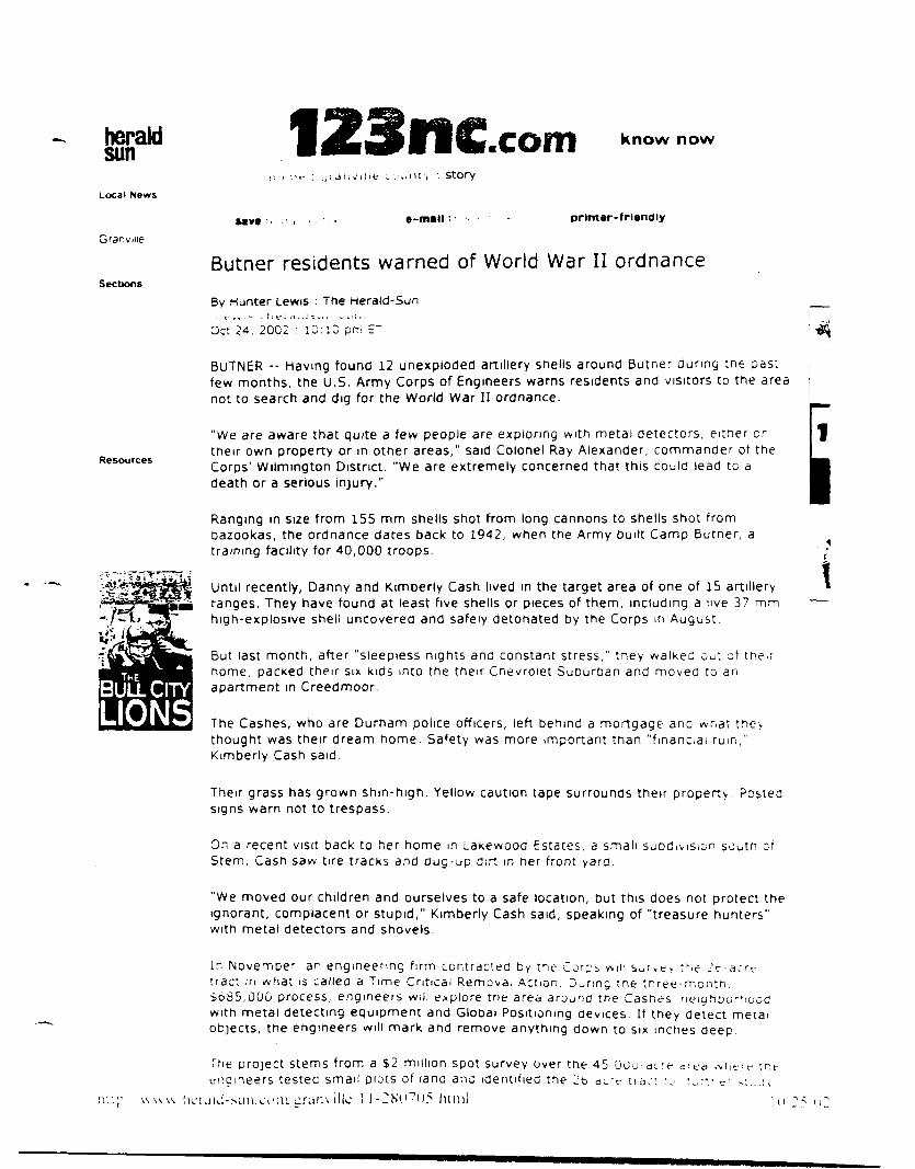
heraldsun
Local News
Granviiie
Sections
123llCCOfTI Know now
> : StOP/
M V t • -mal l • • print ar-friendly
Butner residents warned of World War II ordnance
By Hunter Lewis : The Herald-Sun
Oci 24, 2002 : 10:10 pm ET
BUTNER -- Having found 12 unexploded artillery shells around Butner during tne pastfew months, the U.S. Army Corps of Engineers warns residents and visitors to the areanot to search and dig for the World War II ordnance.
Resources
"We are aware that quite a few people are exploring with metai detectors, eitner o r
tneir own property or m other areas," said Colonel Ray Alexander, commander of theCorps' Wilmington District. "We are extremely concerned that this could lead to adeath or a serious injury."
Ranging in size from 155 mm shells shot from long cannons to shells shot frombazookas, the ordnance dates back to 1942, when the Army built Camp Butner, atraining facility for 40,000 troops.
Until recently, Danny and Kimberly Cash lived in the target area of one of 15 artilleryranges. They have found at least five shells or pieces of them, including a live 37 mmhigh-explosive shell uncovered and safely detonated by the Corps in August.
\
BULL CITYLIONS
But last month, after "sleepless nights ana constant stress," tney walkec out of theirhome, packed their six kids into the their Chevrolet SuDurban and moved to anapartment in Creedmoor.
The Cashes, who are Durham police officers, left behind a mortgage ana what theythought was their dream home. Safety was more important tnan "financial ruin,1
Kimberly Cash said.
Their grass has grown shin-high. Yellow caution tape surrounds their property Postedsigns warn not to trespass.
On a recent visit back to her home in Lakewooa Estates, a small subdivision south ofStem, Cash saw tire tracks and Oug-up dirt in her front yard.
"We moved our children and ourselves to a safe location, but this does not protect theignorant, complacent or stupid," Kimberly Cash said, speaking of "treasure hunters"with metal detectors and shovels.
In November, an engineering firm contracted by tne Corps wilt s u i v t . the 2c-acrrtract m what is called a Time Critical Removal Action. During the tnree-montn,$685,000 process, engineers will explore trie area around the Casnes neighoorhcodwith metal detecting equipment and Global Positioning aevices. If they detect metaiobjects, tne engineers will mark and remove anything down to six inches deep
The project stems from a $2 million spot survey over the 45 Ou'jengineers testec small piots of lana anc identified the 26-ai.rc ti
i i J - sun .c i ' i n ^ r a n \ illc 1 1 -2KO"7U5.him]
d i e d tr.t

"The earlier survey turned up enough explosive material in the [Lakeview] area thatjustified a removal," said Corps spokeswoman Penny Schmitt. "[Engineers] reallydidn't need to wait any further."
But the Corps wants locals and visitors to refrain from looking for the shells.
"If you detect something, there is an overwhelming temptation to see," she said."Digging can be extremely dangerous."
Of the five families living off Lakeview Drive, the Cashes are the only ones to move.But next-door-neighbor Frances Vos said that doesn't mean she is not concerned.
"I'm concerned not only what we're living on, but the future," she said. "The newsubdivisions going up. The logging. Wake up. I really fear sometime, somewhere thereis going to be a death. I really do."
Vos referred to two San Diego boys killed in 1983 when they fiddled with an old shellfound where a base once stood.
But for many who live in this bucolic part of southern Granville County, the old shellsare just as much a part of the landscape as the thick oaks and rolling hills. Storiesabound in this area of residents stumbling across old bullets and shells while plowingtheir fields or hunting.
Edward Eakes, 46, and Billy "Red" Wayne, 40, grew up down the road from LakeviewEstates long before Roberts Chapel Road was paved and before the hills were dottedwith homes. Eakes, who rents a small white home just south of Lake Holt and theCashes' neighborhood, said the engineers marked a few spots In the woods behind hisland last week where ordnance may be buried.
But the shells don't bother him.
"I like it here," Eakes said. "The bombs ... don't bother me a bit. You got to worry moreabout people shooting you while you're pumping gas. These bombs ain't going tobother you unless you dig them up."
Wayne agreed.
"Ain't no telling what you'll find out here," he added. "It's been here for years andyears."
It is this mindset that bothers Vos.
"A lot of this stuff is just swept under the carpet," she said. "The people have amindset of'it's always been here, nobody's got killed.' I want to scream to the state ofNorth Carolina, 'Hey, in Granville County and parts of Person County there is liveammo. They have dumped piles of ammo in this area.'"
:: privacy statement : © 2002 The Durham Herald Company : terms of use ::
hup:/'\\Av\v.herald-sun.com gramiHe'l 1 -280705.html 1 o.'25/02

Ldfuiina piece?.
www.news14.com
Dangerous pieces of history in the groundUpdated: 10/26/2002 3 23.02 PMBy: News 14 Carolina Web Staff
Treasure hunters in Butner should think twice before pulling anythingout of the ground.
In recent months, 12 unexploded World War II artillery shells havesurfaced around the town once known as Camp Butner; an Armytraining facility
Caution tape and 'No Trespassing' signs now surround at least onehome on Lakeview Drive whose owners have opted to pack up theirkids and move out for safety's sake. 'We're all concerned,' saidLakeview resident Roman Voss. "This whole area was part of themilitary firing range. They found live ammo over there, I've found acouple of pieces of ammo in my yard, and I understand anotherneighbor over here, former neighbor, has picked all kinds of stuff outof their yard."
Despite the danger, the Army Corps of Engineers said people havebeen searching for shells with metal detectors and shovels andthey're concerned someone could be killed.
An engineering firm along sidethe Army Corps of Engineers willbegin removing the shells."They're supposed to startclearing the property, get all ofthis brush out of here, and thendo a six inch, metal detector typesearch and pull out anything theyfind, any old metal, nails and ofcourse any ordinance and if theyfind anything significant they The people who lived in this house movedmight be back after the first Of the wne" I've shells were found around theiryear and do a more thorough property,search," Voss said.
About 23 acres of land make up the residential area around theLakeview subdivision in Butner.
Copyright © 2002 TWEAN d.b.a. News 14 Carolina
http://rdu.news 14.com/shared/print/default.asp?ArID= 17036 10/28/2002

newsobserver.com
Army to comb Butner landBy RICHARD STRADLING. Staff Writer
Oc:cce- :=• ; : , :
BUTNER •- The Army will soon send a cleanup crew into a small Butner subdivision where two live rounds of ammunition aatmgback to World War II have turned up in the last year
Army contractors will go through the 16-acre Lakeview subdivision and the surrounding 10 acres inch Dy inch investigating everypiece of metal in the top half-foot of soil. The subdivision was built on land used as an Army artillery range during the war anareturned to private use in 1947
Residents of the six-home subdivision are anxious about what might be under their lawns. Lakeview residents Danny andKimberly Cash and their six children have already moved to an apartment in Creedmoor after the Army found a live 37 mm shellburied in their yard in August
"We're not real sure when they get in here what they're going to find," said Frances Vos. who lives next door to the Cashes "Tmsis a hot spot"
In August, US Army Corps of Engineers contractors began surveying what was once Camp Butner a 40.384-acre Army trainingcamp from 1942 to 1947 The Army wants to know if debris left on the camp's artillery ranges 55 years ago poses any dangertoday It has found 16 live rounds so far.
The Corps plans to report its findings next summer but decided that the Lakeview subdivision couldn't wait because the two liverounds were so close to people's homes, spokeswoman Penny Schmitt said In addition to the shell the Army found 9-year-oldTaylor Cash raked up an intact bazooka round last fall
"It was apparent we needed to go right ahead and clear that area." Schmitt said.
People have been finding bullets and rusted pieces of artillery shells on Camp Butner land for decades But a new wave ofresidents from the Triangle, attracted by the areas forests and fields, are learning of the camp's legacy for the first time as theybuild or buy new homes
The state and federal governments still use much of the Butner land for a federal prison complex, an N.C Army National Guardtraining camp and other institutions
But the Army sold more than half of it back to its original owners It placed covenants on the deeds restricting the land to "surfaceuse only." according to a 1993 Corps report, but many of those covenants were dropped over the years as property changedhands. Schmitt said
The Army suspended its search of Butner on Oct. 17 because of a lack of money but should resume after Congress passes a newfederal budget The Army has $300,000 to start cleaning up the Lakeview subdivision but needs $385,000 more to complete thework, Schmitt said
Army contractors will begin early next month by clearing brush over the 26-acre area and methodically going over the ground withsophisticated metal detectors After mapping the area, they'll begin removing metal objects, probably in January and will likelycontinue through April if money is available
Don and Mary Ann Moore have lived in Lakeview for 3 1/2 years and would like to stay after the Army cleanup is complete Theylove the tranquility but aren't sure it's worth the risk
•When we were planning the house, you could literally hear the sound of bat wings at twilight That is how quiet it is here " DonMoore said "To imagine that if you took a stroll through the woods you could blow yourself up is disturbing "
The Cashes, both Durham police officers, said they moved out in part because Army representatives clearly were nervous aboutwalking in their yard
"If they weren't comfortable being there, I wasn't going to keep my children there," said Kimberly Cash, whose children range from7 months to 13 years

Army officials told the Cashes that they will remove, the vast mejortyget it all Kimberly Cash said she expects they eventually w l M l M hOdM- fc
"I don't think I, in good conscience, can go back." Cash saM. "My M d t m flU** IWptWBWl
C Copyngn: 2002 The News & Observer Publishing Company All mattntt touno on tncngw com (nOuOMQ n t * N M » i i l >^mgniaaietimes com smithfiewneraia com. wenoeiiclanon com and ztDutomvcorfl com) • cserflghM T>» " " — * "*"news services No material may be reproduced or reused without txptaat pamuaion from Th» N««rt A OM
The News & Observer Publishing Company is owned by Tne McCiatcny Company

News, Thursday. Nuvemoer . . 200ii
Corps Warns Of Dangers Of Exploringby David Rogers
\e*s tcji.'o'
l'ni- L'S Army Corps of
••.ngineer- is warning people
•.,. retrain from amateur
i-t!or:.- tu detect and find
..;.exploded ordnance at the
:>.rmcr -r.e ot lamp Butner
"We are aware that quite
.1 tew people are exploring
>vith metal detectors, either
on their own property or in
other areas." said Colonel
Kav Alexander. Commander
u\ the Wilmington District.
"We are extremely con-
a-riioi mat tins could lead to
a .iiMtn or a -enous injury"
Meta; detectors uy them-
-eives won't set offbuned un-
expiuded ordnance, Col.
Alexander said, but striking
a -hell, hand grenade or
ij.i.-ouKa round with a
uiggiiig implement could
"T:u- 37 mm rounds are
particularly sensitive," he
.-aid "Hitting one with a
-no.ei could be fatal."
Since the summer, the
Corps :i.i> tound 12 unex-
piodeu artillery shells dating
o.i CK iu World War II
Residents of Lakeview
Estates, a subdivision off of
Roueris Chapel Road, have
.i.-o.'.i'ivii tnai the area in
.-• : . .* : . t lie. v homes are
.....r.i-i.: i.- a prune location for
:.: . ; . : i ng unexploded
:V.::ance
7:u area .:i winch they
...i. -a.- used J.~ part otfiring
:.i:.^es ior -oiUlcrs at Camp
o..::.er .luring World War 11
Camp iiutner was estab-
..M.ui! in lfc»4'-J as a 40,384-
-ii.: v training and housing
:.K . i n v tor World War 11
'.: oops The training grounds
.nciudfd approximately 15
t.rmg ranges, a grenade
range, a 1000-inch range, a
^.» Liuiinbi'i1 and a flame-
' : ' . : • •••>•• i-r i r a m i n g p a d
' in.- >ite was also home to
one of the Army's largest uer.-
eral and convalescent hospi-
tals and the War Depart-
ment's Redeployment
Center
In 1947, the War Depart-
ment closed Camp Butner
and the land was sold in
public and private interests
The general hospital was
acquired by the state and
named the John L'mstead
Hospital
The North Carolina Na-
tional Guard was given 4.750
acres of the Camp to be used
for training Some of the
land was developed iniu
residential propertv and
farming. Some is North
Carolina state land.
Over the past few months,
awareness of the potential
for unexploded ordnance in
the area has been heightened
as the US Array Corps of
Engineers conducted an
Engineering Evaluation on
the site.
About a dozen explosive
objects were found during
the investigation, some of
them on residential propertv
"We understand that peo-
ple axe very concerned about
the potential for explosive ob-
jects on their property
" A s t i l t - : a t t i c i o :
teenagers, I also know mat
young people can be curious
and might want to investi-
gate." Col. Alexander said
"We ask thai people '.aKe
the right steps if they happen
to find anything that looks
suspicious, but we also as*
that people nut uig tor
possible ordnance We iion't
want to see unvoiie hurl or
killed1"
Steps To Take
What snould vim iln if vou
find a suspicious object'.'
• Don't touch or attempt '."
m o v e t i l e o D j e c l• C a l l - . o u r i o ^ . i . . . : . ' . . :.
BSMS Honor Roil•' 'Ht ir.'jcd frorti ua^e 3bi
now to identity ordnance ar.c
who to contact
• Don't dig for objects you
have 'seen' with a metai
detector
"We appreciate property
owners willingness to wurs
with us during tne Engineer-
ing Evaluation, and we want
to make sure that they ana
any visitors to the former
Camp Butner site stay sale,"
Col. Alexander said.
Based on findings to date
during the Engineering
Evaluation/Cost Analysis
conducted by tne Corps, the
26-acre area near Range
road which encompasses the
Lakeview Estates
subdivision has been
identified for a Time Critical
Removal Action (TCRA-.
Propert\ owners in this area
nave been notified according
tu the Corps
During tnis action, the en-
tire 26 acres will be sur-
veyed, and any objects tound
to a depth of 6 inches below
the surface will be
investigated and if necessary
removed
The survey portion of the
TCRA will end m November
2UU2. and the .:ivestigatiun
portion will Seg: n in Jan^arv
Other actions may be rec-
ommended later based on
more cuinpiele findings o!
the Engineer::.t; Evaluation
IVnir. Sci-.i-.-itt o! tile L" S
Anm Corps 1/ Engineers :.-
tile cunt act person tor an . ur.e
navmg quest.wiis about the
removal project She . ^ : . :n-
re.ic!) ' ' i i .it i' . J-'llj \ --i'V^'j
Home No Longer Safe
T:.e home J: IJ.I:.:. . .inc.
Kimueriy Ca.-:i o; LaKeview
r.stiite- ..- .ocated m tne
large', .ire.i >! one of the1 . i : : . . \'J ..'. . . . • : a r t . ' . i . • : ' .
i : . . ' > u O O . . i S l o r . . 1 . A ! l l c T .
i He L as r . - :i . : ;e • v „ :
s o v. i a \' i u:' : . « : . . :
oazooKa rounQ wr.ue :\-.
leaves m tne tan.... .-
iajit NovemDer
Since that t»nie. tin. :„
oL p i e c e s ^: t i l e : ; . . ; . ^ . _ . . . .
a Live O' tulU H.gli-eAjj..;.-.•
i f ie l i u i icu^ e l eU - ; . J -..:•.
detonated D> the ^ uip> ^
August 21
.Alter the disco', e:"1. : : :
37 mm shell ir. Aug-s
Kimberly Casn says tnai ; :
no longer felt ;'. was -.-.v :
her family to stu> . . . : :
nouse
nignts truiii wurr....^. .ii
were under constant st res-
she said. In the first a.i.. .-
September, the t.iivi.
decided that the r:.-,K ••• >i.<
worth it and iiioveu
apartment ir, C:e.eu::.wo:'
Though tne aio^L- :.,i.- .
tne family in a rina:ic:a. :..:
the couple says that .-.if
for themselves ana the;:
children was more '.n.por'..
than money
Kimberl'y Cash mainta
that she is disappointed w
the response that sne nas
ceived from the Co!';;.- ! ,r
uieas tor help .n jr.,: .: ,; .•
'.lie s i t u a t i o n
"1 Iia^ e :.e'. e: Lvr . . ..i^.
gel a straight ansv. e: :
tne Cul'ps .J It ic . . . . -
whetner prudent ;.e
-^riOUicl s^a'.' .:'.L \)Ti'jjf; ' .
;_rs or leave. .-!.«.• -'. .;'.r
1 J iUcC '..'.ell: . : '.:.e . .
::ie. w o u l d tilt-. s t a . . : .
n o *_. S e w I • . e a . e . i;.,: . .;
'. Mem '.Mijlil t n e ' . .. ' '.
. r i . l u r e : . ;.ui/. , ; . : . . . .
. ! l e . : . i - . e ! . • . > . . . . . :
Hie. Slle -.i.O
C a s t i a i s u . - . i . - t ; . . i '
Corps has "giver, in-." '.'n
a r o u n d ' AJH-I , , : , k - :..-.
q o e . - l e t l a . e ' . ' . e : : : • : ; .
- l a ; ; i . > ; i : . . . - . . - . . - : . • - . .
I l l v : . ; ; . . . . . : , . . . , . : .
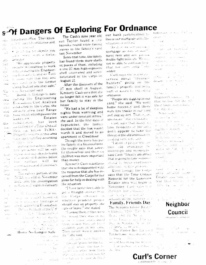
Dangers Of Exploring>:ve:'..e:. ; They know
urcmance and
d e
d e ' . . t • •
. i - e e ; . .'. : t ! , a I l i e l a i
I e v. I u r
"We appreciate property.ners W'liwngness to work'.:. ..- during me Engineer-
- r . n
-.u
l.'is
•^•- -..;i- mat ihev and,.;.::_- u, me former
p hai:ier site stav safe."A...^a:;uer saia.-i-u >•:. :";:iuings u> date
he E n g i n e e r i n g;: Cost Analysisu> me Corps, therrd near Range. encompasses the
E s t a t e s
":. has been:.>;• a Taiie CriticalAciiun TCKA;.
.« I.L'.'-.-. ai this area
-..oiified according
>.'1111;'.. t i l e e 11 •
w i l ; o e > u r -
o O j e c l s l u u l l d
inches beioww 11 i be
i 6
a>. e
a J i I . e t .
' :.e . - U I ' H - I pur t io l i ol li ie
:L\ .'.:;. e.'u: i1,: November.•_ am: tne invest igat ion"t.e.. ••...! ;)egm in J a n u a r y
The Cash's nine year oldTaylor f o u n d a 11 v e
oka r o u n d wni ie ratiinii
m t n e l ami iy ' s v a i d
last November
Since that time, tne familyhas found three more shellsor. pieces of them, includinga live 37 mm high-explosivesheH uncovered and &a!ei>Detonated by the Corps onAugust 21.
After the discovery of the37 mm shell in August.Kamberly Cash says thai sheno longer fell it was safe lorher family to stay in thehouse
"We had a lot of sleeplessnights from worrying andwere under constant stress."she said. In the first days u!September, the lamn;.decided that the risk wasn'iworth it and moved to anapartment in Creedmoor
Though tile move has putthe family in a financial bind,the couple says that saier.lor themselves and their - , \children was more importantthan money
ivrr.berl'v Cash maintain.-inai she is disappointed withthe response that she has re-ceived from the Corps for herpleas for help in dealing withthe situation
For Ordnanceo u r b a n k j u s t i f i c a t i o n t
f e l i .
t r e e z e o u r m o r t g a g e a ; ; t : . l i .
"I h a v e IK-Ve!" IJee!1.
l :: " t r . l l g h t ai i -v.
. aUie U
lig L'.'- ai ualU'lli.iti ' j : tiu- L" ?
: :.:• ( ' . i v p . - w ! ! . , . ; , i : - ' ; .
A n e t h i ' l " p i U i l e l . I ( i i ' i i | ) i i
should slay on property like.:urs or leave." she staled
"1 a s k f C UlrMi :: lhe> w c i v
::.v A u..ici l i ) e \ s; a \ ;:: :'.; •
a v ; a a l I \ d i . ' . I ! ' 1 - . . . " ' . e > - . . ; . .
Famil\. Friends l)a>T h e S \ n a m a dru\r H. : : . ; . - '
I lla'.
t in .
" A s . I i s . A e . . : '• . . . . . • • •_ -
m o r t g a g e a . - A V I . a - a p a r t -
m e n t r e n t a n d ai . -> p a . i i . u
d o u b l e l i g h t D i l i . - , c iv . W e •••.. .
n o t D e a b l e I n c u i i l i n u i - t i ' ' i
t i l a t I u i " . e r \ . i i n g ' - n ••
a d d e d
i. a s h s a \ s s i n . s a i s o ^ •:.
C e I" 11 e d d U u u l I '. e a .- u . •
h u n t e r s " g o i n g m . tr:<-
l a m i i y ' s p rope r* ' . a :u ; : ie . : .^
n u r t i i r K . i i e d ! . . ' . - \ ; a n : . : . u
o r u n a n c e
" P e o p l e a r e d i g g i n g in imr
y a r d , " s h e s a i d "We w e n t
h o m e r e c e n t l y a n d t h e r e
w e r e t i r e t r a c k s n: our ; . a id •"•' " • ; :
a n a d u g u p d i r t T h a t . - a - : ' : ' ' '
i g I l a l i i 1 i c e . - l i e f . ' . \ \ ' ; a . i i i r . .
*. a s i " . 5 . I ; . 1 ' . . " . a t i l i a i i ; > a . - .
l i l l l e r e s i d e n t s u\ t i l e a i ' ;
d o n ' t a p p e a r t o t a K e t i n : ; ' - •• •' •
t h r e a t o ! t h e o l d o r d n a n c e e \ - : • • •
p a i d i a g ' - ' e : ' \ s e l ' i . - . . s ; \
" 1 K I l w V . , i ! | n ' u ; i , i - \ \ ! i i . . . . - t • • " • • • '
t i l l s a i d u r d I: a l i c e • i > • " " ' "
( l i n n s i u p s a n d D i i u k i - n i i - • ' • ' " • • '
said Cash "1 rea lh am aira.v: ^"'•" "'t n a i i s g o i n g i n i . i K i - i i n i e a i ; . "' • •••'•• •
d \ , : . g t ' . ! I H " •.. - e v. e i". u i. e -
a t t e : . ' . i w : . . - : . : : . . - ,n u i M e n .
C V e n t : m u g l . t i l e I. u l | . - - . . . / . . . •
s a y s t h a t t h e T u n e C n t i c . i ; •""••-
R e m o v a l tor t h e L a k t - v n - ^ r . . - ;a te
E s t a t e s a r e a w , l ; b e g i n .:. ' l l i : ' :
N o v e m b e r . C a s h -.-. >- ::..:' ••"•' '
NeighborCouncil
Nil l.ungei Safe
. , • 1 • . A , i u I ( I t i n - 1 . • i ' ' '• .' • > '
: . . H I : e ! : p i . I V • ' • " ' > • • " • >
r . e \ : . e \ e ! « u i h ( i a n - ' A
. e . " s h e s a i d
_'[li r _ . . ( H - . ! : . .
T h e i ' a s ; . . | - . ) < v . : . . : ••• • • • : :
! i : ] ' . I ) e : " : . i K e •.'. i : . v ! i • . . . i • : '. : • •
Curl's Corner
few month*.the potential
ordnance in
Hat they midHhe former
tatner mu- 5tay safe."lander saidl«n findings to date
tirig the Kngineenng|))uation/Cosl AnalysisJuried by the Corps, the
tQ-arre area neat Rangeroad which encompasses theLakeview Estatesnubdivision has beenidentified for a Time CriticalRemoval Action (TCRA)
laBen heightened Property owners in this areaArmy Corps of have been notifiod according
W«rld War II•f Lahfvirw
r • avbdiviKinn off ofChaprl Road, have
ml thai the area itiiheir limne- are
fimimp II in1 \ |i I ml rd
• •'•IM.IIIIV
1 t.i- area in « Inch I heyrV. • *• . i" tis*"d as p.iri " I f i r i ngi.!'!(•••> lor soldier .i i < a m pIt IT riff during Wm III \ \ . ii 11
• H u p I l i i l m i »•• a.- ' • t .ili
Ii I . . I in I!t-I2 as .i H' -IS-t
, i . ' • 11,lining .mil In m- i i | 'I.,. i l n \ l i . i Win I.I W.i i I Ii i i . ip- Tin 11 Mining c i i iu in I-
Ml. hided ,l|)|ll ilMIII.II r l \ | *i
11 • i ng i a l ines, .i i' i i• i,.i<11•I I I I I ' I1 . ,1 11)110 mi Ii I . i l l ) ' r . ,i'.:. i- i l iaml ie i ami .i l i m ni In IIV.'CI t ra in ing p,ul
I I n 1 s i l i ' w a s , i l - n I n . I I , . i . i
Engineers conducted anEngineering Evaluation onthe site
About a dozen explosiveobjects were found duringthe investigation, some ofthem on residential property
"We understand that peo-ple arc very concerned aboutthe potential for explosive ob-jects nn their pioperty
As the father ofteenagers, I also know thatyoung people can be curiousand miglil waul to investi-gate. < 'ol Alexander said
' \\ e ask thai people lakethe right steps if 11 lev happenIII hud anvt lung t li.il lookssusph i on - , b i l l w i al.-n ii.' k
I 11 a I p i . i p Ie 11' 11 d i g 11' i
" i i i n .nn i
• re- . m \ m i .
\ \ ipi is- i l l l .
w . l i l l 11
killed'"Steps I'd Tal<e
Whal - li.iiilil tun do
11 ml a ll- pi i loll ' oli|i i '
ilnn I
I MI
• I )'iii l i..inmo\ e I lir oli|
ni i
o i . i l I r l l i
to the Corps.During this action, the en-
tire 2(> acres wi l l be sur-veyed, and any objects foundto a depth of 6 inches belowthe surface wi l l beinvestigated and if necessaryremoved
The survey portion of theTCRA will end in November2002. and the investigationportion will Segin in January2003
()ther ;u lions may be rec-ommended later based onmore complete findings ofthe Knginecring Kvaluat ion
Penny Schmitt of the I ' SAnm ( ol ps of Kngiueeis isthe i iini.K i pel sun Im a n \ one
hav ing ip ies ln i i i s a l io i i t the
I e i l in \ il project She can be
rein l i . i l ai '!• I l l L'M KiL ' l i
Home No Longer Safel l n humr of | l aun \ and
Ki in l i . 1l\ i ash ol I . . ike\ ' i rw
K s l a i .
I a i ) • . I
e r l
I • I l l l .1 I I ' l l I I I t i l .
. I i l l I l l l I ' I I I I I I I '
I '. I I I I I I ' I . I I I I I I I I \
I I
BSMS Honor Roll<< m i l i i l l M . I l i o l l i | > a ^ i - - f i n
l . i g h i b <; i a d i ' A / i r A 1,1. > l \ . n l .
Illllliil Hull Kill I' I "in im.
i I l . i '
l . i i i i .
I ...
i mi'.
I I .
I I I . " ,
. I n . I .
I i i I l i •
i i l i . l r . i- I M I i I I I w 11 Ii 11
. n - la I. <! I n h i i n
l l . . ' I l l l : . I | I I I. . i l
11 \ i I I " ( I i i n I. .1 I.
Uiloiuileil hy the 1 oi ps onAugust 21
After the discovery of the37 mm shell in August.Kiinherly ('ash says that sheno longer felt it was safe foiher family to stay in thehouse
"We had a lot of sleeplessnights from worrying andwere under constant stress,"she said In the first days ofSeptember, the familydecided that the risk wasn'tworth it and moved to anapartment in Creed moor.
Though the move has putthe family in a financial bind,the couple says that safetyfor themselves and their sixchildren was more importantthan money.
Kimberl'y Cash maintainsthat she is disappointed withthe response that she has re-ceived from the Corps for beipleas for help in dealing withthe situation
"I have never been able togel a Straight answer (mmI be ('in ps o i l i n a I • miw bet hei prude n t peopleshould slay on properlv likiours HI leave," she si ated
' I asked them if I hey wei iiin would they slay in millnlise HI leave, and I asked
I In in would I he v lei I In 11
i l u ld i i n pla v i n m v \ a i d
I he V ne Ve I won Id ; i l l : « r i
me," she said
Cash also s. I \ s I 11 a I l l i .
I " I p- has "g ivr l l l i i ' l I he i no
.11 nu lid w l i r 11 > lie has I.
.pii'sl i d ,i I I I 11 i 11 urn I In n
- I al in,1 t li.it H I- mil salr l"i
i l i r I.iin 11 \ in l ive in i In 11
1 . i n . '
.ml
i I I S l I M l ) S S l . t I ' I I I M I « n i l
ce r tied i l i u m l | ' i i • u i .
h nnt i i s " ,;o i I I , ' . on l l i .
l i l i n i l v • pi ope i I \ and bi - i i i i '
h u l l in k i l l e d l>\ . v p l i ' i l i i i |
oi ( Ina in i
'Peop le are i l l g g l l l | ' in ' " n
y a r d , " - b e s a i d "We w . nl
h o m e i ei e n l I y a n d I In i >
w e r e t i re I racks in m n \ a id
and dug up d i r t 'I 'b.it i pi• I
i g n o r a n c e ! " s in C M l a u n i d
Cash says I hat m a n \ old
t i m e r e s i d e n t s ol t h e area
d o n ' t a p p e a r t o l a k e t h e
threat of the old ordnam e e\ploding very seriously
"I know ol people who usethis old ordnance fmdoorstops and bookends.'said ('ash "1 really am afi aidthat is going to take someonedying to locus everyone'sa t t e n t i o n on t h i s p rob lem
K v e n I h o u g h I he < ' in |is
says tha i the T i m e < t i l n . i l
Remova l lot t h e I .akeview
K s t a l e s a i . a w i l l be, : in in
N o v e m b e i . ( ash savs t h a i
Parsons i b e c o m p a n \ who
t h e ( in ps i . m t t a i l . ' i.i
ac tua l l y dn the surveys a m i
Family, I rienris l)a>The Svnama < irove Mapl i- tC h i n i l i i i i ; > ; l . I I K i \ . i
Koad . I l \ I. I I i l \ ( u i l l .il
serve I a in 11 \ a n d I i n m l
111) V i in S 1111 d ; i \ . \ 11\ t • 11 d i. '
17, :>.t)<V.' I I ( I I I a i l l
T i l l ' I'.l I . i l K e \ I l l l . ' . . .n i l
T n n b e i I . I I M \s i l l d . Ii . i i i l i .
i n e s s a g r I h i i i H i w i l l I.,
set \ ed l o l l . i w i n , ' l l n • . i \ i. .
l l n p u l i l i , i h a l l
l l i \ l i e d
Lit I .
l i . i
.' , ' i I
I nr
I l i . i l
I I n i i
I n i in
S o
i i n I n
K n i i i ,
W i l l 1
in,: iIi
p.nl <
l inll l
al loti
why Iand Ii
i an Ii.
situat
( "a-
I OIK I
I l l l i l l
a i I- a
I I l l l l
II . I I .
,: i 11 11
- i i n i
I I . i l l
• r 1 1 r i J
Curl's Con"I \ i a- I .'.I I In n i ..
• i i c , 1 1 1 . I ' • i < I ' l l ,
l l l l l M I I I l l I
T I - . •|,
I . . I I I p . l | ' .

M - . - . i .l HE IJA:LY UA
i ;. i
The Independent Voice oj the Capital
him. h lu-ll • rang Suinla v. hul
nuns sang hymns and prayed. Is- The sicnr leminded the Kevracli loto-s allowed about l> Ibrahim K.ill,is ol .111 even more Seel'RIKNT. V.iy.>
Group warns of unexploded bombs in U.S.IHMK.l'l I HI SI II IOf us .Arnvlrs / IMHA
I In' leili'i il t'ovei nmenl h.is nnili-isi.iieil ll» si ,ik- ol ihc s.ilrivI'lnhlein pnsed l<y olil hoiuh*. and1l1e1nii.1l .mil biological weaponshurled ,i( luiiner iiiilil.iry sitesihiotighoui llie United States.ai.i.ording lo documents disclose)II'v .1 group 1I1.11 ;iirs .iccns.iiionsliom whistle blowing bureaucrats.
In one ol the documents, ,1 pn\ it)- briefing paper lor the I I.S I nMi11111nenl.il I'rotection Agency'snew i i i lon eiiient director |ohn
" I he source lot the documents! is someone in Aposition 10 provide it."
Jeff RuchPublic Employees for Environmental Responsibility
Suarez, I I'A 'ifieials stated licitfinding and removing the leftoverweapons 'has ihe potential to hethe largest environmental cleanupprogram evci 10 be implementedin the United states." The morethan 16.000 military installationscontaining uiicsplowed ordnancecover an are.i l.irger than Horida,the briefing p.i| •• r stated.
Yet many ol the sites have al-ready l)i-i-ii converted lo civilianuses despite the presence olbomlis, and the IVpartment of IV-Icnsc has heen takinn "ill-advise)lshortcuts to limit costs" on manycleanups, according to the pa|x-r.which was leaked along with otherrelated documents by an Kl'A otli-cial to I'uhlie I inployees for I nvi
mnmcntal Ui .pi'ii-ihihiv. a W i .hmgtnn-basi'il eiiuip that in, i i«whist le-blower, anil puhli, i , <their claims
l l l i ' group planned In ri le i .<• i'lol die ili H nun ni . li si iv I In •.i hull an early diall " I in I I' \ •mvey on the une\plmled iniiiiii«•!•»problem thai * out l ined t i i i u 'Iconclusions imi l l t t i l l imn tin- tin i;OIIK ial dralt. ^ h i i h «• i i rel< •«<!two years ago
" The sol i n e" nl I he . U M I I I H HI >"is someone in a position in p i ,vii l i ' i l , " said |t ll K I K I I , t-\e\iili><director ol l'uhli> l i u p l n w v . I.
See (.KIM I'. l'.»>». \
" l o r Ion main generations(hey have p.u ified and .u com-moilaled themselves to the mnsiextreme. I.main al. violenl elelin ills ol Islam, and (hnsc rlcmints have now hulled nil usand the resi ol the woi Id."
Added Mi Cain 'The Saudinival lainiK lias been engagedin a l.iusiian bargain loi ve.us inkeep themselves in powei
Still, none nf the law makci sknew whelhei llu print, ess had
SeelAWMAKTRN, I'ilge A I
INDHXAnnie's Mail. A10 li!cstyles...A9-10Arts A7 Obituaries B7Bridge A10 Opinion Al 1Classified ..C6 10 Sports Cl 5Comics Cl l Television AHHoroscope ..A 10 Your Money. _£H
i.nlitn >i 11 ,il||sso|i .i Hiss.i hi\\n| |n r.'ii |r. i \\ y smi|(| l.iwi'l.•ip pur \.'||r \ i>l)li -S|SSII\J i.>\\n|n|l n| •• i '\\i>i|s p.M.illl' >s .illl |,|
| | n \ pin mi |, | ll.l,)i| l l u ' - <i| I" I p n• w i•. ' wipnos pu.'i\.< ||i >\innll p|n • lll.i|S\s lu.li'is . >« | |
\ >-i.\\ ' l | l
i n • . l . i \ M H |
A| )> CCM I Mi1; \ cA.) 1 > 01
.|' i i A I H A \ I I | | O | III>I.ipi -; ||t.sx p|o.> >ii u v
l l | . 'M I .WI l ,l||) H im I >.l
||(,v\ inp si • ,\oi|s ,N\OIIS pur uir i Aj> > LI 0t"p.iir|osi w .| • |o .vuiftp .up pur n > o? IE
*M > ')E IVM ' Li ri9'I ' Ct'i • a
r I'|II|A\ i' ' 'pu>N up |o sr.nr ^, , ( ) f
I I I . U p i o l l i ' i - U ^ s Minus . \p i l - i l A11 > 0(. i l l l i q | | i .. i .mss . i i d \\'tU\ | 1IM > " i
ss.uupn.up jo
UOlM.M]sn| .UIIAOUI ,ii|
>| |o i',)ir ^r.iw
s Ai'poi s,v\oi|
\>z
ni,t
JOAUOtl
I'|UB|)Viilirioipuv
,inbi.mtinq|VA
S V . l / , 1 C ' H ' I " ' s v \-' ' ' I /
i M i r | i i n I \ | • • I- ,
in >|do.iil | n s p u r s i i o i p mi H. • i
|n)l . 'Sinn | i | | i ' mil |s . ' .In,
ppio.w ili ' |d .up M . . i ,• \ r \\un i u 'U .<.' n| i ' i I
i ' | s 11 it' A\ iil.Ul 111 i » ' • ' . ;imp.in |
I mil n \ ' p.' isiir I', ii' li mi |'|HU|
" I p-.i>ili>iil r I,»AI|()
P•• T 'N " I I. •wnip. poo|
lll'ISI \. ' | 'I .U|i|.lno i i | I • nn |
(i. i i l lr,! i HI ,\

Group warns of bombs on U.S. basesContinued from Page Al p r e s e n c e of u n e x p l o d e d muni - i t n j > tn.u tin.- oiiuss.»>::•> A . : ,
t ions. m.icc u n d e r p r e s su re truii. . . . .
Environmental Responsibil.iy. Militarv olf.cial. .ire conduct- ^ P - ' " ™ " 1 " ' ^ l < n 4 c , W 1 " ' "Ke described his organization a, ^ o f a l , [ n r c e C a h , o r . had pu.d .or me survey, u c u , , -jii -information laundromat nja siics> ° " asnmgton J ^ L.VIthat protects conscientious pub- ' respond to requests 101 - v.;i,-he servants from retribution. T h t > E P A survey lound that nu-nt.
the military otten n^J used open ,. . , . ., . , .Among the documents is an b u r n i n j , a n d a e l o i u l l o l l l c c h - '!.V ' '. " • - - • ^ • -
hl'A =»unev oi closed military a l q u ^ u , . c l n J o,- n i u l . . ! l l i n f l v- ; " . ' : ; . \ ' - ; ' ° ' u - " - '
DUM^ ir. 200U mat louno mat W l l n o u l p r o per environment. ""'". •"'1ieJ"1'-V • " r-' t7mor. than haii o. the ..tes p c r m i t b _ a n d h a d I a i l e d t o c r ^ . , —;;. J,;.; ." ; .;,;;;;;;_po led - including tort Ore on l e l l c m g o r w a r n i n g s i g n s a , h a l f R i a ( f l t f r m i n c n o , u , ^.lt..i|
Cahlormas Monterey Pemnsu- of the old sites still containing M t c s U conciuoeo ;tvn :;-.,• •.-l a - e i t h e r had located chemical munitions, even though many pan m-.-nt of Defense has re.\cc;or biological weapons or sus- a re close to housing, parks ana u,v, ncjv.i\ v.i. ^.alisi,..,: s..:;:-pecicJ that me\ were present. other civilian locations. pai.g u. J c : . : ::..;•<.• :;,c ::r,...
Fort Ora previously reported Most o\ inosc fnidmgs were presence ^; r.u::.;^that a liaJ lound such weapons either modifieo oi * oinitied lroir. T;, i.l'A u:,.:: •,.;..' .:.. . .on site and. along with two oth- the final El'A report, which was pannicni oi jcii.-.,^ a.s. 3;., ... jer Calilornia sites — the balton later made public, a comparison have been e\jir..::w;i; n.su.rSea Test Base in Imperial Coun- shows. Public Employees tor records and conducting moiet\ and Mare Island Naval Ship- Environmental Responsibility visual i n spec t ions ui the old t:r-yard in Vallejo — reported the said its source at the EPA con- ing ranges

NEWS-RECORD.COM Search |Site for!
Go!Sports W Business H Community^ Classifieds H Calendars W Opinion
ome
ClassifiedsApartmentsCarsClassified AdsHomesJobsPersonalsYellow PagesWeb AdsAdvertisers
NewsHeadlinesGreensboroHigh PointRandolphRockinghamEducationGovernmentReligionTechnologyDesktop News
- -"NewsecialReports
e-Archive
OpinionEditorialsLetters
SportsHeadlinesACCCollegePrepsPro BaseballPro BasketballPro FootballGolfHockeyNASCAR
LifeFeaturesCityLifeHealthvLifeHomeLife
jviesi"ne ArtsDiningTriad Style
NEWS UPDATE
Project to clean up old ordnance at WWIImilitary camp near Butner
1-6-03
News & Record
Posted 5:42 p.m.
BUTNER (AP) - A $600,000 project to clean up old ammunition at thesite of a World War II military camp near Butner is scheduled to beginTuesday.
The U.S. Army Corps of Engineers announced Monday that the project,expected to run through mid-February, will include a survey of 26 acresand a clean-up where items are found.
Previous surveys of the land found unexploded shells and bullets leftfrom training exercises in the 1940s.
Initial evaluation of the land was conducted last spring and summer andnumerous objects were found at Lake View Subdivision.
Ground will be cleared to a depth of six inches and families living nearthe area where work is conducted will be housed in motels if necessary,said corps spokeswoman Penny Schmitt.
She said the contractor will scan land with a sophisticated metaldetector that can detect anything from "bazooka rounds to tractor parts,nails and horse shoes."
Camp Butner was established in 1942 as a 40,384-acre training andhousing facility for World War II troops. The training grounds includedsome 15 firing ranges and a grenade range as well as a hospital forreturning troops.
The camp was closed in 1947 and land was sold to the state and privateinterests. Some 4,750 acres were given to the North Carolina NationalGuard and other parts were used for residential development andfarming.
Online Updates
• Local/N.C. News• Business• Nation/World• Sports• E-mail newsletter
Site Tools
E l Tell someoneabout this page* Most e-mailed stones
S i Print this articleT Help/FAQ• Free downloads
Top AP News• Marines, FighterPilots Heading toGulf• N. Korea Willingto Discuss NukeCrisis• U.N. ArmsOfficial MeetingWith Powell• N.C. Plane'Looked Heavy'Before Crash• Pay Cuts Orderedfor UnitedMachinists• Companies Slash101.000 Jobs inDecember• Stocks Post

_amsnedia
to gallerv
neyBusiness NewsTop 50Personal
FinancePublic
Records
CommunityWelcome FAQBecome a
PartnerPartner PagesFind anv
OrganizationPeople &
Places
CalendarsObituariesSite Index
"Because some explosive objects were found in people's yards veryclose to homes, the risk to this neighborhood justifies this clearanceaction," said Col. Ray Alexander, commander of the corps' Wilmingtondistrict.
See details of all the day's news in tomorrow's News & RecordSubscribe today | Electronic archives
B Tell someone about this page
i Print this article
Modes; Losses• Browns NameCampo DefensiveCoordinator• More from AP
At TO ft
I Regional News * J [Sports ^ [Life ^ |Community ^ j [Classifieds ^ j
Return to the Top
""ontact Us | Web Design & Advertising | Print Advertising | News & Record Corporate | News & Record Jobs
• News & Record 2003

Gffck he visit other RealClties sites Charlotte Observer Ads Onlir )
Our Local Chj
4HE PAVE
News
Free 7-Day trial of leading acid reflux medication1 Do you sufferfrom frequent and persistent heartburn two or more days per weeK?Click Here for more informal ion and a FREE 7-Day trial.
Search
» Search the Archive*
A-Scction
Local News» Cabarrus» Catawba» Gaston/Lincoln» Iredell» Mecklenburg» Union» York
Opinion>» Perspective
Business» Click
Sports» Outdoors
Carolina Living» Arts» Books» E&T» Faith» Family» Food» (hardening>» Health» Home» Travel
Business Sports Entertainment Living Classifieds
Back to Home > Charlotte Observer >I Help I Contact Us I Site Index I Archives I Place an Ad I
Monday, Jan 27, 2003
Local NewsSelect a day: M | T | W | Th | F | S | Su
Posted on Mori, Jan. 06, 2003
Project starting to clean up old ordnanceAssociated Press
BUTNER, NX. - A $600,000 project to clean up old ammunition at the site of a World War I I military campnear Butner is scheduled to begin Tuesday.
The U.S. Army Corps of Engineers announced Monday that the project, expected to run through mid-February, will include a survey of 26 acres and a clean-up where items are found.
Previous surveys of the land found unexpioded shells and bullets left from training exercises in the 1940s.
Initial evaluation of the land was conducted last spring and summer and numerous objects were found atLake View Subdivision.
Ground will be cleared to a depth of six inches and families living near the area where work is conducted willbe housed in motels if necessary, said corps spokeswoman Penny Schmitt.
She said the contractor will scan land with a sophisticated metal detector that can detect anything from"bazooka rounds to tractor parts, nails and horse shoes."
Camp Butner was established in 1942 as a 40,384-acre training and housing facility for World War I I troops.The training grounds included some 15 firing ranges and a grenade range as well as a hospital for returningtroops.
The camp was closed in 1947 and land was sold to the state and private interests. Some 4,750 acres weregiven to the North Carolina National Guard and other parts were used for residential development andfarming.
"Because some explosive objects were found in people's yards very close to homes, the risk to this
Newspaper Subscription1-
Shopping & Services
Find a Job
Find a Car
Find a Home
Find an Apartment
Classifieds Ads
Shop Nearby
wNewspaper ails
now online!
NEWS COLUMNISTS
Updated Monday,January 27, 2003
» Tommy Tomllnson
» Don Hudson
» Dannye RomlnePowell
» Dr. Traffic
» Gerry Hostetler
» Gaston: Dave Baity
» York: Dan Huntley
FROM THE OBSERVER
» Weddings,anniversaries
» The Sunday Page
» Item Eyes
» Home Page
» The Worship Directory
>> Funeral Directory
r.aid
News,m
OrangeGranvillePersonChathamSectionsNation/WorldStateSoortsBusinessWeatherOpinionTechnologyHealth/MedArts & FeaturesFun & GamesGalleryResourcesHot TopicsArchivesMy ClipFileTrafficAir TravelMapsVoteBook
M*f CHAEL JORDAN
home : granville county : story
«SM*tomyelipfll*» I « •-•nil tH* vbd« » I « printer-Manrfy vtrtfon » | « owmant onttts wtfc<* i
Corps clearing ammo in 26-acre Butner area
By Hunter Lewis : The [email protected] 7, 2003 : 11:37 pm ET
BUTNER — The U.S. Army Corps of Engineers begandigging Tuesday in a rural neighborhood labeled "highrisk" after workers and residents found two unexplodedartillery shells and several pieces of exploded shells.
The 26-acre area, including Lakeview Estates, asubdivision of six homes near Lake Butner, sits in whatwas the line of fire of an old World War I I artillery range.The firing range was one of 15 that existed in the 1940s,when the 40,000-acre Camp Butner housed and trainedabout 40,000 U.S. Army troops for combat.
| j j ARCHIVED STONES
Residents warned of WWIIordnance: Ammo found inButner area still could bedeadly (October 25, 2002)Old shells raise new legalquestions: Live ordnance onWWII firing range createsproblems for new homeownersin Butner (September 2, 2002)
^ EXTERNAL SITES
Army Corps of Engineerssurvey efforts
The $600,000, five-week survey and dig off Lakeview Drive follows a spot survey thecorps did last spring and summer on the old Army installation. The investigationrevealed about 12 explosive objects, including some in the subdivision.
Engineers began focusing on Lakeview Drive in late 2001 when 9-year-old Taylor Cashpicked up an exploded bazooka shell and placed it on his family's porch.
In August 2002, the corps found and detonated a live 37 mm round in the Cashes' frontyard. Also in August, loggers found a live 155 mm shell in the woods north of theCashes' home.
Customer Service
Community Info
Obituaries
Announcements
Advertising Info
SpecialC&lledihleJGifts & Collectibles
"When we find two [unexploded] items, yes, we consider that risk high," said JohnBelew, project manager with the corps. There's no way that you cannot say there's arisk there if you find two live items in a person's yard."
Fearful of what may lie beneath their home and in their yard, Kimberly and Danny Cashmoved their six children to a Creedmoor apartment in the fall.
"You want to go to sleep feeling like you'll be there and wake up in the morning," saidKimberly Cash, a Durham police officer.
In what is called a Time Critical Removal Action, engineers will clear brush and useheavy-duty metal detectors to locate old shells in the neighborhood down to 6 inchesbelow the surface. If an unexploded shell is found, the corps will alert residents andmove them to a hotel. Engineers will then uncover the shell — which may range in sizefrom a shell shot from a bazooka to one shot from a long cannon — and detonate itbeneath wood and a pile of sandbags.
No shells were detonated Tuesday, but Butner Public Safety officers stopped trafficoutside of the subdivision for 15 minutes so workers could dig near Robert's ChapelRoad, Belew said.
If the current survey reveals evidence of widespread contamination of explosives, thecorps will continue with a deeper dig, Belew said, though he "doubts seriously that [thecorps] will need to."

The discovery of the old shells raises legal questions as to who is responsible, ifanyone, for disclosing what some call contaminated land. When the Army pulled out ofButner in 1950 and sold the land, the deed mentioned unexploded shells. But overtime, as the land was parceled out and sold, the original deed was not consulted.
On Dec. 10, 1983, two 8-year-old San Diego boys were killed when they found anabandoned, World War Il-era mortar round and detonated it against a rock. In 1989,the families of the two dead boys received a total of $6.3 million in settlements withSan Diego County, city and the developers and builder of the community where theboys died.
Officials have repeatedly warned locals not to dig or search for old shells. People whofind a suspicious object should not touch or try to move it. Instead, they should reportit to their local law enforcement agency.
On the Net:
View the Corps' survey efforts at www.projecthost.com
privacy statement : © 2003 The Durham Herald Company : terms of use
CHAEL JORDANoutomoNv* group

Corps clearing ammo in 26-acre Butner areaBY HUNTER LEWIS
Mewis9henldsunxom; 419-6651
WINER — The VS. Army
gmg Tuesday in aborfaoodafter
The $600,000, five-week sur-vey and dig off Lakeview Drivefollows a spot survey the corpsdid last
BUTNER
home."When we find two [nnexplod-
ed] items, yes, we consider thatrisk high," said John Betew, pro-ject manager wtth the
yard,moved their oatCrcedmoor
"You wantakeyouTlbein theCasb,«
In what i8cal Removalwfltctearduty metalshells in the neighborhood downto 6 inches below the surface. Ifan unexptoded shell is found, thecorps will afert Tegwigirtit aadmove them to a i . ^ . .,,will then uncover the sheB —-which, may ODgeia size tram aehefl shot from abazoaka to oneshot from a Joag-caonon — anddetonate it beneath wood and apile of sandbags..
No shei&were detonated Ihes-day, but Buiuer Pattic Safetyofficers stopped traffic outside-ofthe subdivision for IS ndndSes BOworkers could dig near Boberf sChapel Road, Belew said.r ~ v
ffttieevidence ofnation of explp&vwill continue-wiBekrw said,seriouslyneedtD."
Tfae^&scovay of Sieold sheik
Hatreceived m
itlementswMiSanlfegoCoun-

h avid RogersNews Editor
The US Army Corps ofEngineers began work tosurvey and clear unexplodedordnance from property atLake View Subdivision nearButner on January 7, 2003.
Previous surveys of thearea found unexploded ord-nance remaining from train-ing exercises conducted inthe 1940s. The currentclearance action will con-tinue until mid-February2003.
Since the summer, theCorps has found 12 unex-ploded artillery shells dat-ing back to World War II.Residents of LakeviewEstates, a subdivision off ofRoberts Chapel Road, havediscovered that the area inwhich their homes are lo-cated is a prime location forfinding unexploded ord-nance.
The area in which theylive was used as part of fir-ing ranges for soldiers atCamp Butner during WorldWar II.
The approximately 26acres to be cleared weresurveyed earlier as part ofan Engineering Evaluationof the Camp Butner areaconducted last spring andsummer.
During that evaluation,the number of objects foundin that subdivision led theCorps to recommend that aremoval action be taken inthe neighborhood
During the clearance ac-tion, the ground will becleared to a depth of sixinches. Residents will be ac-commodated away from thearea if it is necessary to re-move potentially explosiveobjects.
"The Department ofDefense policy on unex-ploded ordnance is that weuse our limited resources toaddress the highest risksfirst," said WilmingtonDistrict Commander Col.Ray Alexander.
, "Because some explosiveobjects were found in peo-ple's yards very close tohomes, the risk to thisneighborhood justifies thisclearance action. The effortwill cost more than$600,000.
Camp Butner was es-tu.jshed in 1942 as a40,384-acre training andhousing facility for WorldWar II troops. The traininggrounds included approxi-mately 15 firing ranges, agrenade range, a 1000-inchrange, a gas chamber and aflame-thrower training pad.
The site was also hometo one of the Army's largestgeneral and convalescenthospitals and the WarDepartment's Redeploy-ment Center.
In 1947, the WarDepartment closed CampButner and the land wassold to public and privateinterests. , The general hos-pital was acquired by thestate and named the JohnUmstead Hospital.
Ordnance ClearanceStarts At Lakeview
The Biitnel-Cretdmoor NewsCOMMUNITY NEWS1-09-03
1OF2
The North Carolina N;-tional Guard was giv»4,750 acres of the Camp tobe used for training. Someof the land was developedinto residential propertyand farming. Some is NorthCarolina state land.
Over the past fewmonths, awareness of thepotential for unexplodedordnance in the area hasbeen heightened as the USArmy Corps of Engineersconducted an EngineeringEvaluation on the site.
About a dozen explosiveobjects were found duringthe investigation, some ofthem on residential property.
The US Army Corps ofEngineers is warning peopleto refrain from amateur ef-forts to detect and find un-exploded ordnance at theformer site of Camp Butner.
"We are aware thatquite a few people are exploring with metal detec-tors, either on their ownproperty or in other areaVAlexander.
uWe arc extremely concerned that this could leadto a death or a serious injury." Metal detectors bythemselves won't sot oilburied unexploded ord-nance, Col. Alexander said,but striking a shell, handgrenade or bnzookn roundwith a digging implementcould.
"The 37 mm rounds nrcDarticularlv sensitive." he

n in::,_'-hove! could be fatal "
"We understand thatpeople are very concernedabout the pofential for ex-plosive objects on theirpy
As the father ofteenagers, I also know thatyoung people can be curiousand might want to investi-gate," Col. Alexander said.
"We ask that peopletake the right steps if theyhappen to find anythingthat looks suspicious, butwe also ask that people notdig for possible ordnance.We don't want to see any-one hurt or killed!"
Steps To TakeWhat should you do if
you find a suspicious object?• Don't touch or attemptto move the object.• Call your local law en-forcement office. They knowhow to identify ordnanceand who to contact.• Don't dig for objects youhave 'seen' with a metal de-tector.
"We appreciate propertyMKaers' willingness to work
i us during ' t h eL^gineering Evaluation,and we want to make surethat they and any visitorsto the former Camp Butnersite stay safe," Col.Alexander said.
Based on findings todate during the EngineeringEvaluation/Cost Analysisconducted by the Corps, the26-acre area near Rangeroad which encompassesthe Lakeview Estates sub-division was identified for aTime Critical RemovalAction (TCRAi. Propertyowners in this area havebeen notified according tothe Corps.
During this action, theentire 26 acres was sur-veyed, and any objectsfound to a depth of 6 inchesbelow the surface will be in-vestigated and if necessaryrgmoved.
The survey portion of<-. - TCRA ended inNovember 2002. and theinvestigation portion will
Other actions may :•<recommended later basedon more complete findings ofthe Engineering Evaluation.
Penny Schmitt of theU.S. Army Corps ofEngineers is the contactperson for anyone havingquestions about the re-moval project. She can bereached at (910-251-4626.
Home No Longer SafeThe home of Danny and
Kimberly Cash of LakeviewEstates is located, in thetarget area of one of theCamp Butner artilleryranges.
The Cash's nine yearold son Taylor found a livebazooka round while rakingleaves in the family's yardin November, 2001.
Since that time, thefamily has found three moreshells or pieces of them, in-cluding a live 37 mm high-explosive shell uncoveredand safely detonated by theCorps on August 21, 2002.
After the discovery ofthe 37 mm shell in August,Kimberly Cash says thatshe no longer felt it wassafe for her family to stay inthe house.
"We had a lot of sleep-less nights from worryingand were under constantstress," she said. In thefirst days of September, thefamily decided that the riskwasn't worth it and movedto an apartment inCreedmoor.
Though the move hasput the family in a financialbind, the couple says thatsafety for themselves andtheir six children was moreimportant than money.
In a prior article,Kimberly Cash maintainedthat she has been disap-pointed with the responsethat she has received fromthe Corps for her pleas forhelp in dealing with the sit-uation.
"I have never been ableto get a straight answerfr&m the Corps officials onwhether prudent peopleshould stay on property like
ours or ieavt>. <nc aiau-u"I asked then-, if they
were rue, would they stay inmy house or leave, and Iasked them would they lettheir children play in myyard. They never would an-swer me," she said.
Cash said in the articlethat she was concernedabout "treasure hunters" go-ing on the family's propertyand being hurt or killed byexploding ordnance.
"People are digging inour yard," she said. "Wewent home recently andthere were tire tracks in ouryard and dug up dirt. Thatis just ignorance!" she ex-claimed.
Cash says that manyold time residents of thearea don't appear to takethe threat of the old ord-nance exploding very seri-ously.
"I know of people whouse this old ordnance for
sa:a Cash l really arafraid that is going to takesomeone dying to focus ev-eryone's attention on th:~problem."
Some Lakeview resi-dents, including the Cashesand Roman Vos, say thatthey were not told beforepurchasing their propertythat it was part of a formerarmy range. Both familieshave hired &£i attorneyseeking to find out why theywere not informed and tcsee if any other action canbe taken to rectify their sit-uation.
Cash also stated thatshe was concerned aboutother subdivisions going upin the area aroundLakeview Estates and said."1 really fear that sooner orlater there is going to be adeath—it shouldn't takesomeone getting killed to dcsomething about this."
Ordnance ClearanceStarts At Lakeview
The Butnw-Creedmoor NewsCOMMUNITY NEWS1-09-03
: O F :

...-raidsun.com: printer-inendiv sior> ''"=•- ' *•'' -
[back]
herald*s u n • :•:"Corps clearing ammo in 26-acre Butner area
By Hunter Lewis, The Herald-SunJanuary 7,2003 11:37 pm
BUTNER ~ The U.S. Army Corps of Engineers began digging Tuesday in a rural neighborhood labeled"high risk" after workers and residents found two unexploded artillery shells and several pieces ofexploded shells.
The 26-acre area, including Lakeview Estates, a subdivision of six homes near Lake Butner, sits in whatwas the line of fire of an old World War II artillery range. The firing range was one of 15 that existed inthe 1940s, when the 40,000-acre Camp Butner housed and trained about 40,000 U.S. Army troops forcombat.
The $600,000, five-week survey and dig off Lakeview Drive follows a spot survey the corps did lastspring and summer on the old Army installation. The investigation revealed about 12 explosive objects,including some in the subdivision.
Engineers began focusing on Lakeview Drive in late 2001 when 9-year-old Taylor Cash picked up anexploded bazooka shell and placed it on his family's porch.
In August 2002, the corps found and detonated a live 37 mm round in the Cashes' front yard. Also inAugust, loggers found a live 155 mm shell in the woods north of the Cashes' home.
"When we find two [unexploded] items, yes, we consider that risk high," said Roland Belew, projectmanager with the corps. "There's no way that you cannot say there's a risk there if you find two liveitems in a person's yard."
Fearful of what may lie beneath their home and in their yard, Kimberly and Danny Cash moved their sixchildren to a Creedmoor apartment in the fall.
"You want to go to sleep feeling like you'll be there and wake up in the morning," said Kimberly Cash,a Durham police officer.
In what is called a Time Critical Removal Action, engineers will clear brush and use heavy-duty metaldetectors to locate old shells in the neighborhood down to 6 inches below the surface. If an unexplodedshell is found, the corps will alert residents and move them to a hotel. Engineers will then uncover theshell — which may range in size from a shell shot from a bazooka to one shot from a long cannon — anddetonate it beneath wood and a pile of sandbags.
No shells were detonated Tuesday, but Butner Public Safety officers stopped traffic outside of thesubdivision for 15 minutes so workers could dig near Robert's Chapel Road, Belew said.
hup: WAWV.herald-sun.com tools r>rip.tfriendlv.cfrn°StorvID=?0682"' i 'O-»nrr.

If the current survey reveals evidence of widespread contamination of explosives, the corps willcontinue with a deeper dig, Belew said, though he "doubts seriously that [the corps] will need to."
The discovery of the old shells raises legal questions as to who is responsible, if anyone, for disclosingwhat some call contaminated land. When the Army pulled out of Burner in 1950 and sold the land, thedeed mentioned unexploded shells. But over time, as the land was parceled out and sold, the originaldeed was not consulted.
On Dec. 10,1983, two 8-year-old San Diego boys were killed when they found an abandoned, WorldWar II-era mortar round and detonated it against a rock. In 1989, the families of the two dead boysreceived a total of $6.3 million in settlements with San Diego County, city and the developers andbuilder of the community where the boys died.
Officials have repeatedly warned locals not to dig or search for old shells. People who find a suspiciousobject should not touch or tiy to move it. Instead, they should report it to their local law enforcementagency.
On the Net:
View the Corps' survey efforts at www.projecthost.com
Links related to this article:Army Corps of Engineers survey efforts: www.projecthost.com
URL for this article: http://www.herald-sun.eom/granville/l 1-306827 Jitml
© Copyright 2003. All rights reserved. All material on heraldsun.com is copyrighted by TheDurham Herald Company and may not be reproduced or redistributed in any medium except asprovided in the site's Terms of Use.
[back]
hnr: \v\wv herald-sun.com tools printfriendh .cfm°StorvID=30682"' 1 '9'2003

PaHTOfThe IB?
hbc17.comf Careernct 17 Y Great G e t a w a y s ! Modern Home T Autonet 1 7 f Politics Y Military
News I Weather | Health [ Consumer | Traffic | Sports | Community | Entertainment NBC 17Recipes X Schools X Personals J[ Shopping \ Yellow Pages \ Law X TV Listings J
MARS
«back to home | News
GJ EMAIL THIS STORY I S PRINT THIS STORY
S t a r s o n I c e 1 vi>
Click hefc for more information1
Ammunition Cleanup Project Begins In ButnerPOSTED: 1:28 p.m. EST January 8, 2003
BUTNER, N.C. — The U.S. Army Corps of Engineers has begun a $600,000 project to clean up oldammunition at the site of a World War II military camp near here.
The project, which began Tuesday and is expected to run through mid-February, will include a survey of 26acres and a clean-up of the items, according to the corps.
Previous surveys of the land found unexploded shells and bullets left after training exercises in the 1940s.
Public safety officers stopped traffic outside the Lakeview Estates subdivision for about 15 minutes Tuesday soworkers could dig, said Roland Belew, project manager with the corps.
Engineers were clearing brush and using metal detectors to locate shells to a depth of 6 inches below thesurface. No shells were detonated Tuesday, Belew said.
If an unexploded shell is found, the corps will alert residents and move them to a hotel. Engineers will thenuncover the shell and detonate it beneath wood and a pile of sandbags.
If the survey reveals evidence of widespread contamination of explosives, the corps will continue with adeeper dig, Belew said, although he indicated it was unlikely.
Engineers began focusing on the subdivision in late 2001 when 9-year-old Taylor Cash picked up anunexploded bazooka shell and placed it on his family's porch.
Raleigh-Durham Airport:26°F, Clear
MarketplaceCOMMUNITY
Community CalendarHEALTH
Health And Fitness Festival'RECIPES
Winter Warmersmore categories:
Win Tickets to Billy Joel 8. EltonJohn
Baby's First BirthdayHigh School HelsmanCommunity Calendar
Jobs With NBC 17NBC Good Health FeedRoom
sponsor
Coming to Huleiyh. NCMarch 1B

lie
liveips IUUDCI and detonated in August a live 37 mm round :-\the Cash's front yard. Loggers also found a5 mm shell that month in the woods north of the horn
"When we find two unexploded items, yes, we consider that risk high," Belew said. "There's no way that youcannot say there's a risk there if you find two live items in a person's yard."
Kimberly and Danny Cash moved Taylor and their five other children to a Creedmoor apartment in the fall.
"You want to go to sleep feeling like you'll be there and wake up in the morning," Kimberly Cash said.
Camp Butner was established in 1942 as a 40,384-acre training and housing facility for World War I I troops.The training grounds included some 15 firing ranges and a grenade range as well as a hospital for returningtroops.
The camp was closed in 1947 and land was sold to the state and private interests. About 4,750 acres weregiven to the North Carolina National Guard and other parts were used for residential development andfarming.
Copyright 2003 by The Associated Press. All rights reserved. This material may not be published, broadcast,rewritten or redistributed.
NBC 17 WeatherBugReal-time weather conditions direct to your computer!
Get the JBug Now!
£2 EMAIL THIS STORY | fi PRINT THIS STORY
More HeadlinesNewsSoldier Arrested For Sex With MinorU.N. Inspectors To Deliver Key Iraq ReportDuke Power Customers Lose Power Overnight
EntertainmentCity To Put Statue Of Andy And Ople In Park
Health WatchTwins Study Suggests Marijuana Leads To Harder Drugs
Consumer WatchOmcmmttmr NC Unmmpiovmmrt • Month

i nc lnutpenueru V\CCMJ..
IMPENDENT
Blasts from the PastAging bombs in Butner's backyard-andnewly leaked EPA documents - igniteconcerns about unexploded ordnance,
BY JON ELLISTON
Danny and Kimberly Cash thought they had found an ideal spot tosettle and raise their six children. When they said their weddingvows at a gazebo outside their new home in 1997, h was, for bothof them, a second try at marriage, and it seemed just the place tostart a new life: The Cashes were the first occupants of LakeviewEstates, a modest but scenic subdivision a few miles north ofButner. "We moved out there to keep our kids kind of isolatedfrom what we do in our profession," Kimberiy explains; both sheand Danny are Durham police officers. "We pound the streets inDurham, so we didnt want to live there, too."
For a time, the home in theC O V E R F E A T U R E country seemed to fit the bill.
There was room for the kids toroam around fields, forests and waterways, to grow up safelyaway from the bustle of the Bull City. But then, in 1999, therecame a subtle warning sign of potential problems when two three-foot wide sinkholes opened up on their property. The Cashesasked around, but no one offered an alarming explanation, so theypaid the holes little mind.
FRONT PORCH
COLUMNS
ARTS I (imRUWNENT
WLKIC
KOVIES
IfST IHS
ONUHl 6ACI TALK
CUSSfflEM
STAff
UAKCH
HOW
•I'l
http://www.indyweek.com/durham/2003-02-26/cover.html 04/26/2003

i ne Independent v\eeki\. Diasis iroai
at-v
Photo By Jon EHtston
Last August, Army contractors found a livebazooka round in the Cash family's yard anddetonated it in place after covering it withsandbags.
"It really was our dream house," Kimberly says, "a foundation forour family." All that changed on the afternoon of Nov. 11, 2001,when her son Taylor hollered, "Look what I found!"
Taylor, then eight, had been raking leaves on the edge of the yardwhen he heard his rake scrape metal, and picked up somethinghe'd never seen before. He was scurrying with it toward the housewhen his 10-year-old brother, James, yelled a warning. Taylordropped the hem on the grass, a few feet from the concretedriveway.
The metal object, the Cashes would soon learn from the military,was exactly what it looked like: A live bazooka round, with partof its fins and all of its payload intact. Local authorities calledFort Bragg, which promptly dispatched a bomb squad. When thesoldiers arrived, they donned protective gear, wrapped the roundin a Kevlar blanket, carried it to their vehicle and drove off at acrawl to the nearby National Guard post. There, they usedexplosives to detonate the round.
Back at the Cash house, the questions came in waves. Danny andKimberly fired off e-mails to the Defense Department, she says,asking: "Is this an isolated event? Should we be concerned? Canyou come out here and have a look at our she? What should wedo?" When answers were not forthcoming, the Cashes went intoinvestigative mode, and started devoting their rare spare momentsto finding the truth about Burner's thinly buried secret:unexploded ordnance (or UXO, in military shorthand).
Around Butner, this was anything but an isolated incident. Thebazooka round in the yard, the Cashes learned, was one ofthousands of pieces of UXO that are believed to lie on andbeneath the surface of their community. That's because thefamily's homestead sat on part of the Army's former CampButner, a 40,000-acre, World War Il-era training facility thathosted 15 munitions ranges in its heyday. Sixty years ago, infantryunits pounded the soil here to prepare for fighting the Nazis. Topractice urban warfare, the Army even built a mock Germanvillage, the bullet-ridden and cratered remains of which still sitjust off a public road north of Butner.
http://www.indyweek.com/durham/2003-02-26/cover.html 04/26/2003

I ne Independent Vveekn: oiasii rrom me
explosive remnants in the Carolina countryside. The effected landstraddles portions of Durham, Person and Granville counties, in atraditionally rural area that is one of the next frontiers of Trianglegrowth. Today, subdivisions are sprouting on the former bombranges.
"The bombs were there before we were there, but we were nevertold any of this information," Kimberiy Cash says. "We didn'tknow the history." Now that they do know, the Cashes arentsticking around to witness further discoveries. In October 2002,after additional munitions turned up in their neighborhood-including several more on their property—they decided to move.
"The stress level was way too high," she says. Suddenly their ownyard was an off-limits danger zone, and "every time the kidswould jump in the house, I was now nervous." Though they stillhave to make the mortgage payments, leaving Lakeview Estatesseemed like the only thing to do. The family relocated to anapartment complex in Creedmoor, but they're still preoccupied bytheir bout with bombs, and still asking questions. Who, theywonder, is responsible for their plight? More directly, who, ifanyone, is liable?
It's taken awhile to try to find out, but recently the Cashes, alongwith three of their former neighbors, hired a Raleigh law firm,Abrams & Abrams, to look into potential litigation. MargaretAbrams, a partner at the firm, declined to discuss the matter,citing the firm's policy of not commenting on pending cases. Herclients say the attorneys have told them they have legitimate andactionable legal grievances—though not, perhaps, against thegovernment.
The Army Corps of Engineers, which is responsible for cleaningup former military sites, is currently conducting a mukimilliondollar spot survey of the 26,000 acres that are most likely tocontain UXO, and recently oversaw an ordnance cleanup, downto 6 inches beneath the surface, on 26 acres in and aroundLakeview Estates. During the cleanup they discovered anddisposed of six additional explosive rounds.
But still the military has accepted no culpability in the matter.Corps officials note that the Army, which transferred most of itsland back to private hands after the war, in most cases did so onlyafter adding deed restrictions that forbade digging anddeveloping. On many properties, however, farmers anddevelopers ignored the restrictions, and over the years, as thelands were sold and re-sold to new owners, the warnings weredropped from replacement deeds. To complicate matters further,some at-risk areas—including the lots at Lakeview Estates—never
http://www.indyweek.com/durham/2003-02-26/cover.html 04/26/2003
1 nc lnaepcnucni v>ee^\: oiaais ironi me
littered with ordnance. (The property that is now Lakeview, itappears, sat just next to. but not directly on, a target range.)
The Cashes and some of their former neighbors think that the manwho sold them their land, Jim Willett, of Willett Investments,should shoulder some blame. They say that Willett, who lives nextdoor to Lakeview Estates on a 50-acre plot his family has ownedfor decades, kept information about the ordnance hazards tohimself, though they believe he'd known about them for years.
Not so, says Willett, though he qualifies his denial a bh. "IVenever seen a bomb," Willett told The Independent in a telephoneinterview last week. "When the fields were cleared for pasturesfor cows and horses, you'd occasionally come across someordnance, some real decayed bazooka or something of thatnature. But they [the Army] come out here and found some andthey took care of it, they exploded them. They come out andcleaned h up completely, and gave us a clean bill of health."Besides, Willett says, "We purchased the land just like any otherland, with a clean deed and a clean title. I was unaware that therewas any ordnance, any more than what's on my property."
The recent furor at Lakeview is much ado about nothing, Willettsays, expressing a view that is not uncommon in a communitywhere scattered munitions—duds and live ones—have been a factof life for decades. "There is no risk," he says flatly. "I dont knowthat anybody's ever been killed, I don't know of anyone who'sever been hurt. I guess the biggest hazard we have out here isdeer. I hit one last night."
Miraculously, there has been only one injury, and no deaths,reported from the many mishaps with Camp Burner's leftoverordnance. But the lurking risks remain real, here and at hundredsof other retired ranges, as civilians increasingly find themselves onformer military lands that were not sufficiently cleared. Thescenario can be deadly: In 1983, two eight-year-old boys in SanDiego found a 37-mm shell in their subdivision—which, likeLakeview Estates, was built on a World War II artillery range—and as they played with h, the shell exploded, killing both boys.
The Cashes have several news reports about the incident in theirfiles. Reading them, they're reminded of how close the familycame to experiencing a similar tragedy. In addition to the shellTaylor raked up, in August 2002, Army contractors foundanother shell of the same type while searching Lakeview Estates.It was located three inches beneath the surface of the Cashes'yard, 30 feet from their front door. Like the one in San Diego thatproved fatal, and like the one Taylor discovered, the round wasstill live.
http://www.indyweek.com/durham/2003-02-26/cover.html 04/26/2003

l ne independent v\eekj>; cwasis iiom me
A 'sleeping giant'Due in large part to cases like that of the Cash family, a long-unnoticed homeland security threat with leftover ordnance isfinally getting some attention. Similar problems have beenencountered in dozens of states, and the number of danger sitessuggests that civilian sprawl and former bomb ranges will remaina troublesome mix for the foreseeable future. The DefenseDepartment has issued rough estimates that there are alreadysome 1,500 former defense sites in the United States that requirecleanup of dangerous materials, and that ordnance could linger atsome 16 million acres of old training grounds.
Photo By Jen EHIston
UXO refugees: Danny and Kimberty Cash, andtheir six children, abandoned their home whenbombs turned up in their yard. Taylor Cash(kneeling, at right) discovered the first onewhile raking leaves.
"UXO contamination is the sleeping giant of the military cleanupprogram," says Lenny SiegeL, director of the Center for PublicEnvironmental Oversight, a California-based research group thatserves as a clearinghouse for military pollution information. "It'sbasically been a local story," he says, but one that is unfolding inhundreds of localities across the country. "Very rarely doessomeone try to put h together nationally."
Siegel and other experts say there is a new groundswell ofconcern brewing around the issue, however, as concernedindividuals and interest groups, and even some governmentagencies, are taking steps to raise national awareness. LastNovember, the issue received a rare spate of media coveragewhen Public Employees for Environmental Responsibility, aWashington, D.C., nonprofit that supports governmentwhistleblowers, released scathing Environmental ProtectionAgency documents about the Pentagon's mishandling of the UXO
http://www.indyweek.com/durham/2003-02-26/cover.html 04/26/2003

l nc inucpenacni V\CCKA. niaii.:> nun* Luc t
threat. Among them was an internal briefing paper, prepared inthe summer of 2002, which warned the EPA's enforcementdirector that "cleanup of UXO on military ranges has the potentialto be the largest environmental cleanup program ever to beimplemented in the United States."
The document eked the military's "failure ... to comply withexisting regulations" concerning ordnance cleanup. Further, itdecried the "disturbing trend for the [military] services and theCorps of Engineers to limit their responses or take ill-advisedshort-cuts to limit costs." Another document, from April 2000,described an EPA survey of 206 former ranges, reporting that theranges "pose potentially significant threats to human health andthe environment." Many of the dangerous shes, the documentnoted, are now occupied and trafficked by civilians: "Althoughmost ranges are in rural or remote areas, or are near small towns,there are residences in close proximity to most of the ranges. Inaddition, 33 percent are on or near surface water, wetlands, orfloodplains, thus potentially exposing ecological receptors andmaking cleanup more difficult. UXO has been found at most ofthe ranges in this survey, and at 50 percent of the ranges thepresence of chemical or biological weapons is known orsuspected."
Following up on the publicity of the leaked documents, Sen. JonS. Corzine (D-N.J.), one of Congress' leading voices on ordnancecleanup issues, pressed for the Senate Committee on theEnvironment and Public Works to hold hearings to assess thethreat. "It is the government's responsibility to examine the statusof these cleanups and to ensure that they proceed quickly andsafely," he said. "There is no excuse for taking shortcuts when itcomes to protecting the health and safety of Americans fromhazardous environmental risks."
Hearings would help, but what is most desperately needed,cleanup advocates say, is definitive data on the scope of theproblem. As the EPA's assessments noted, official estimates havethus far been hazy, because, despite years of prodding byCongress, the Defense Department has yet to produce aninventory of its former training sites. Hard numbers should finallybecome available this spring, as the Pentagon is slated tocomplete a long-delayed, comprehensive listing of the placeswhere training left explosives behind.
That inventory, more than anything else, could convincepoliticians and their constituencies of the size and severity of theproblem at hand. So says Jeff Swanson, a UXO expert for theInterstate Technology Research Council, which trains andconsults state and federal employees involved in military cleanupprojects. "If there's a watershed now," Swanson says, referring to
http://www.indyweek.com/durham/2003-02-26/coveT.html 04/26/2003
i ne inaepenacni v\ eeto): r>iasi:> uoni me
the recent wave of interest in ordnance contamination, "the floodis going to be when this listing comes out. and local communitiesfind out, first of all, that they're living next to problem sites thatthey didn't know about, and second, that there is not sufficientplanning or resources to clean them up and make them safe."
More worry than cleanupAfter it has identified all the risk areas, the Defense Departmentwill face the gargantuan task of picking priority cleanup sites andfunding years of survey and clearance operations. Based on itstrack record so far, the military has given ordnance cleanupadvocates little hope that the process will be quick or thorough.But despite its shortcomings in assessing the problem, theDefense Department has begun to take some concrete, ifincomplete, steps toward addressing it.
The department's budget for "UXO response" in fiscal year 2003is $252 million. While most of that will go to current survey andcleanup efforts like the one near Butner, roughly $20 million willbe spent on research and development of munitions detection andcleanup technologies, which have been found lacking during manyrecent cleanups. Among the more promising approachesintroduced in recent years is aerial detection of buried ordnance.Helicopter-mounted metal-detection gear, for example, wasdeveloped to assist cleanups of huge training ranges in Alaska.And several Pentagon-funded research projects are looking forways to track and mitigate groundwater contamination on andnear former ranges—a worry above and beyond the threat of theold bombs exploding. There's even a "green munitions" campaignunderway to develop non-toxic ammunition and trainingordnance.
The advancement of such technologies, however, has done tittleto stem the worries in communities like Butner, where the slowflow of cleanup funds has left many residents angry. A keyproblem, say experts from both inside and outside thegovernment, is that the Corps of Engineers' cleanup budget fallsfar short of its needs.
"If you talk to the Army, they say it's going to take them between70 and 200 years to address the [UXO] problem at formerly useddefense sites," Siegel says. "It's totally inadequate. By the timeyou deal with the high-priority sites, there's hardly any othermoney around to address the other sites. It's not the fault of theCorps people in the field, or the Corps people at headquarters,who say there's not enough money. It's people at the DefenseDepartment and Congress who won't put enough in to do thejob."
http://www.indyweek.com/durham/2003-02-26/cover.html 04/26/2003

i nc inucpciidcru
renny acnmiu, spoKesperson ior me u.a. /\rmy ^.orps 01Engineers branch in Wilmington, which is overseeing the work atthe former Camp Butner, makes a very similar case when askedwhy it's taken so long to begin the partial cleanup there. "Theprincipal factor in how fast we can work is funding," she says."We can only get work done when we have money. There aresomething more than a thousand sites nationwide that need to beaddressed, and we have spent more than $3 million at this she.There's competition for those funds, and the funding is scarce."
Frankie Vos, a retired nurse who lives in Lakeview Estates onproperty adjoining the Cashes' with her husband and her elderlyparents, says she thinks the government's skimping is putting herfamily at risk. "They're putting a price on our safety," she says."You're talking about people's lives, people out here who havechildren and dont even know about this. What's a life worth?1
Denying the dangerThe history of the Camp Butner site suggests that military policiesand budgets arent the only reasons the former training groundsmake for uneasy living grounds. Local civilians, as well, haveplayed a role in overlooking, downplaying, and sometimes evendenying the danger.
As h abandoned its training areas after the war, the militaryclaimed it had done its best to clean up explosives. "Deduddingoperations have recently been completed on the ranges at CampButner," the Army Corps of Engineers announced in an April1950 press release. "Tons of practice missiles were gathered anddisposed of and several thousand high explosives duds weredestroyed in place. The duds were comprised of hand grenades,rifle grenades, rockets and Howitzer shells up to 240 millimeter.Any one of the duds could have caused serious injury or tragedyto the persons disturbing it." The release hinted that the bombscould long grace the Butner landscape. Thousands of acres werebeing sold back to private citizens, but with a major caveat:"There are several areas that will be disposed of with a restrictionplaced on them against sub-surface use. These areas received aheavy concentration of fire of high explosive shells and there is agreat possibility of unexploded duds remaining underground."
In many cases, the warnings and restrictions went ignored.Throughout the 1950s and '60s, as farmers plowed into formerrange areas, several tractor blades were damaged when theystruck and ignited buried bombs. Hikers and hunters came acrosshundreds of explosives, and many handled the hems. One farmerlater said that he'd chucked more than 70 rounds into a pile,without incident. There was a close call in the summer of 1958,when someone took a pile of scrap metal that included a mortar
http://www.indyweek.com/durham/2003-02-26/cover.html 04/26/2003

The Independent V^eeRiy: Blasts rrom me
yard melted the pile down, the shell exploded, sending flamingdebris over neighboring buildings. No one was hurt, according tolocal news reports.
It wasnt until the 1970s that reports surfaced of an UXO casualtyat Butner, and details of the incident are few. In 1976, a formergame warden told the Durham Morning Herald about a hunterfrom Chatham County who had found a shell near Butner a fewyears before. The hunter, who is not named in the newspaperarticle, reportedly took the shell home, where it exploded,injuring his arm.
The prospect of such accidents kept the Camp Butner ranges onthe military's radar long after World War II. Army demolitionteams from Fort Bragg made annual visits until the late 1960s,and their reports indicate that they disposed of an average of 13live explosives each year. But that, it appears, was more of ascattershot effort than a comprehensive plan for removing the oldbombs, for many remained. So common were the UXO findings,potentially lethal items came to seem benign. People evendisplayed shell remnants on their mantelpieces and used them asdoorstops, as though they were some kind of bizarre local folkart.
Courtesy Of Aitny Caps of Enjjineere
This Army photo shows the variety ofmunitions found on Camp Burner's formertraining ranges.
But the problem, while submerged in the local consciousness,keeps rearing its head. The 1983 deaths of the two boys in SanDiego was a reminder of the genuine dangers. Shortly after that,the Defense Department began surveying selected sites thought toharbor similar risks. An April 1990 Corps of Engineers report onButner affirmed that "ordnance is a major problem,'1 and thatformer target zones rife with munitions "are not fenced or marked
http://www.indyweek.com/durham/2003-02-26/coveT.html 04/26/2003

nc lnuepcnucni w CCKI\ . DM^U iroru me
<v>
Today, the dangers on a given property can be hard to gauge,given that many homeowners are living on contaminated landswith "clean" deeds, which had been prepared by title lawyers andinsurers as the properties changed ownership over the years. Andeven many of those who are aware of the problem tend tominimize the dangers. That's understandable, says Frankie Vos,because discussion of buried bombs can hurt property values.Nonetheless, she thinks such people are making the wrongcalculus. "Anybody dealing with real estate in this area is going tomore than likely shrug it ofE" she says. "It's all about the dollarbill. I know some of the old-timers in the community will say,•Well, it's always been here.' And I get so sick of hearing that,because it shouldn't be here. It shouldn't be anywhere."
Lives on holdThe Corps of Engineers' work at Burner is far from complete. Atpresent, the Corps' contractor, Atlanta-based Parsons EngineeringScience, is winding up work on an evaluation, using 200statistical sampling plots, of more than 20,000 acres that maycontain ordnance. In the 26 acres at Lakeview Estates, they'rescanning the land again, this time using gear that should detectany suspect objects buried as low as four feet. To do similar in-depth surveys and cleanups elsewhere, the Corps will have torequest and be granted additional Defense Department funds, aprocess that can take years.
Meanwhile, some residents living at nearby trouble spots saythey're not getting the help they need to determine if their land issafe. Amy and Wyatt Blalock, a married couple in their thirties,bought a house a few miles north of Lakeview in January 2000.At the time, they say, they'd heard nothing about ordnanceproblems in the area, from the person who sold them the propertyor anyone else. Then, on Sept. 18, 2002, Wyatt was stepping outof his truck in the driveway when he turned his ankle on acylindrical brass object. It turned out to be a detonator for atraining round.
"So I got my brother-in-law's metal detector, because I wanted tosweep the yard," he says. "And within the first five minutes, Ifound a 155 mm shell, about two feet from the comer from one ofour barns. It was 35 feet from our back door, and it was in thebasketball court where [the previous owners'] kids were dribblingballs on top of it." The Army informed the Blalocks that the hemwas a white phosphorous shell, and strongly advised againstlooking for additional ordnance.
Despite such clear and present dangers, the Blalocks say, Corps
http://www.indyweek.com/durham/2003-02-26/cover.html 04/26/2003

i ne independent wcewy: oiasib irom me
the government will fund a cleanup of the site, given the budgetconstraints. "Now this is putting our whole life on hold," Wyattsays. "We had a lot of plans for the house and the land, and wedon't want to proceed with that, if the place is not safe to live.And we were basically told that it's not safe to plant a flowergardea"
"We're stuck," Amy adds. "We cant leave. I could not even tookat myself in the mirror if I were to sell this house withoutdisclosing it, like it was done to us."
"We sympathize," says Penny Schmht, the Corps spokesperson inWilmington, about complaints the Army is doing too little, toolate. "This is something that really gets at people's sense of theirsecurity in their own homes. We cant do everything that peoplewish we could do, and we understand very much their wishes, butwe have to work within the limitations of the resources that wehave."
Lenny Siegel says that even as public awareness of the problemrises, the funding shortages that have plagued UXO cleanupefforts may well continue. "The Defense Department is of twominds," he says. "There are people on the inside who recognizethe problem and really would like to see funding not only for thecleanup but for the research. And then there are people who wantto use the money for other things. And particularly whenever itlooks like we're going to war, it's easier to get money to createmore problems than to solve them."
More Cover Features in This Issue:
RECENTLY:
-NorthCarolinians of all ages and backgrounds marched againstthe looming war with Iraq. We asked them why. - BobGeary, Richard Hart, Fiona Morgan and Barbara Solow
- - Fiona Morgan
- - Bob Geary
http://www.indyweek.com/durham/2003-02-26/cover.html 04/26/2003

V* KAL.com -
RALEK5H-DURI
comSHOPPING I CAREER I AUTO | LAW I TRAVEL | HOUSE & HOME ! REAL ESTATE ! YELLOW PAGES ! EDU<
i: i i i 1 1 E I ISite/Keyword Web Yellow Pages
T
EeliaQuoteSAVE MONEY
Backyard Bombs Cause GranvilleCounty Couple To Tread Lightly
BUTNER, N.C. — A Granville County couplemade a terrifying discovery this week when theystumbled across a bomb in their backyard.
The bomb was found near an area whereexplosives have been found before. But thediscovery had W.C. and Amy Blaylock feeling likehostages in their own home.
They've been forced to live a cautious lifestyle,they said, in which they never know where to puttheir feet.
Over time, the Blaylocks have realized that theirsprawling 10-acre estate is a virtual mine field.Since 2000, the Army has found eight live shellson the land where Camp Butner used to sit.
The most recent discovery is a foot-longmunition, believed to be left over from trainingexcercises performed during World War I I .
W.C. Blaylock stepped right on it Thursday night.
"I landed on what felt like a turnip," he said. "Butthen I looked down, and, knowing what I knowabout this area, I just got away."
Said Amy Blaylock: "He could have been killed."
The Blaylocks also found a bomb last Septemberthat created a hole in the ground just 30 feetfrom their kitchen.
http://www.wral.com/news/2160766/detail.html
Find Similar
Two_KiMed._InSampson__Cp untyCar Accident
DeployedSoldier's FamilyStays Busy To
.Distracted
NewP eyejp. p m e n ts. I nPeiersqn_CasejN o_ One'js. Ta I kingChapel Hill PoliceInvestigateSeries Of Break-Ins
UNC-PembrpkeDefends.Use.OfSchool Nickname
Pick-Your OwnFarmers Fired.UpQverJDOTRoadside SignRemoval
Primary Voters-Edwards NeedsMore Face TimeIn NewHampshire
Raleigh Gets Go-Ahead For BlountStreetRedevelopment
WilsonL PoliceInvestigate 2Shootings, 1Fatal
CLICK
Search Now!
| Select Category •»•'
04/27/2003
WRAL.com - News -
In the 18 months they've lived here, they've alsofound bullet shells and weapons casings.
The Army has told the Blaylocks to watch wherethey step and to call emergency officials if theyfind anything that appears dangerous.
Saturday, the Army Corps of Engineers will comeout to the Blaylock residence and remove theexplosive from their property.
"We want them to clean it up," Amy Blaylocksaid. "We want it in writing that it's going to besafe, that our kids will be safe."
Copyright 2003 by \'r-:~~- All rights reserved. This material maynot be published, broadcast, rewritten or redistributed.
T-eer. Receive:Posthumous
FromStateBallanceApologizes, ButStands Up ForHymanFoundation
NX. State'sCyber DefenseLabjSetJJpJToKeepTerroristsOffline
Military WifeCelebratesMotherhoodWhUeJdusband?Aa bis _I_riJWar
Suspect RemainsHospitalizedAfter 11-HourStandoff_XnHenderson
FirefighterRecovering Afte?Suffering HeartAtta ck_At_Scen eOf Car Fire
MoreJLocalHeadlines(2003)
Entire Site © 2003, Internet Broadcasting Systems, Inc. and Casito; Broadcast-Oick here for the :BS_p_a-v_ac_yjjoj.ic\r te.rrns_of_Lise.
Dick here for aryg.-t'STC ^formation.
Stock Box Cspyr^"t : : : : ; , Standard & Poor's,a division of The McGraw-Hill Companies, Inc.
All rights reserved.
http ://www. wral.com/ne ws/2160766/detail.html 04/27/2003

WKAjL.com -
RALEKSH-DUR.
comSHOPPING | CAREER | AUTO | LAWJ TRAVEL | HOUSE & HOME | REAL ESTATE | YELLOW PAGES | EDU'
I I I 1 I I 1 II Site/Kivwortl web Yellow Pages
Granville County Familes Wary Of'Hot Zone' Of Former ArmyTraining GroundUnexploded Army Munitions Discovered InResidents' Yards
BUTNER, N.C. — Bombs from a different erahave a Granville County family fearing each stepmay be their last ~ after another family left theirhome due to the potential danger.
Many families inthe area live onland that used tobe a World WarII-era Armytraining ground.Now they'refinding some ofthe leftoverexplosives.
Unexploded artillery shells andother Army munitions have beenfound in Granville County yards W.C. and Amy
Blaylock boughta home in January 2002. Then they discoveredthey could be surrounded by unexploded Armymunitions from a time when their land was partof Camp Butner.
"We were told we were in a hot zone," Amy said."A heavy artillery range is what the Army Corpsof Engineers told us that we lived in."
W.C. stepped on a 150-millimeter high explosivein the woods near his home last week. Saturday,
http ://www. wral.com/news/2161467/detaiLhtml
•v
Find Similar
Backyard BombsCausejGranvjileCounty CoupleTo Tread Lightly
Two .Killed . InSampson CountyCar AccLdentDeployedSoldier's FamilyStay_s_JHisy_TPStay Distracted
NewDevelopments InPeterson Case;No One's Talking
Chapel Hill PoliceInvestigateSeries Of Break-Ins
UNC-PembrokeDefends Use OfSchool Nickname
Fa rrners_Fired UpOver DOTRoadside_SjgnRejmoyal
Primary Voters:Edwards NeedsMore Face Time
HampshireRaleigh Gets Go-AheajtJFor_BloujrtStreetRedeye_lpp_ment
Search Now!
|S«fect Category ~
04/27/2003

WRAL.com - .News -
an army explosives team removed it.
Six months ago, the Blaylocks found a similarshell next to their shed.
The Blaylocks live 10 miles from the Lakeviewsubdivision, where another family found two liveshells last summer.
"Living here, we feel we are in imminentdanger," Danny Cash said at the time.
The Army Corps of Engineers committed tosearching the Cash's subdivision for moreordnance. But Kim and Danny Cash and their sixchildren left, anyway, for safety's sake. They nowrent an apartment in Creedmoor.
The Cashes are planning to sue those who soldthem the land, as well as Government entitiesthat kept them in the dark about the potentialdanger on the property. They're fighting forthemselves and others like the Blaylocks, whoare waking up to the same horror.
"We fully intend to stay here," W.C. Blaylocksaid, "and we expect something to be done aboutthe problem in the ground."
The Army Corps of Engineers has funding tosearch for ordnance in the Lakeview Estatessubdivision. But they have no plans to search theland where the Blaylocks live.
Previous Stories:
• April 25, 2003: 3ackyaj^LBcrrlos_C_ajjse_G
• September 6, 2002: 5utr_e^a~:;jy Fears =c- 5 =Ujiexgijo_d£d_.Sliej'_s_F_o.und lr< Neighborhccc
Wayne CountyTeen ReceivesPosthumousHonor FromState
BallanceApologizes. ButStands Up_F_prHyrnanFoundation
N.C. StatelsCyber .DefenseLab.Set Up_TpKeep TerroristsOffline
Military WifeCelebratesMotherhoodWhil_e_HusbandFights In War
Suspect RemainsHospital! zeeAfter 11-HpurStandoff InHendersonFirefighterRecovering AfterSuffering HeartAttack._At_SceneOf Car Fire
More LocalHeadlines(2.003}
Copyright 2003 by :~. All rights reserved. This material may not be published,broadcast, rewritten or redistributed.
Entire Site © 2003, Internet Broadcasting Systems, Inc. and Za^'z Eroacca;Click here for the : = =. : : V H ^ _ ; : C; - S : ~ ? ?-. „";=,
Click here for aiJ;Z~J.J~.Z_-Z.~~~Z~ Z
Stock Box Crry-c— l.JL—Z, Standard & Poor's,a division of The McGraw-Hill Companies, Inc.
http://vvww.wral.eom/news/2161467/detaiLhtml 04/27/2003

heraldsun
Local NewsDurhamOrangeGranvillePersonChathamSectionsNation/WorldStateSportsBusinessWeatherOpinionTechnologyHealth/MedAit;"- 5 f on'uu.:Fun ft GamesGalleryResourcesHot TopicsArchivesMy ClipFileTrafficAir TravelMapsVoteBook
home : granville county : story
** Mveto my c l ipt ik »» | << t-mall thi? article >.» | ** printer-friendly v«rsion »• | «•« comment on this article
calendar j classlieds | car* | real estate j jobs | ihoppb«j movies contact US -»1
Customer ServiceCommunity InfoObituariesAnnouncementsAdvertising Info
Army Corps of Engineers expands war munitions search in ^ ^ |oauto|jnk|two locations
BY HUNTER [email protected]; 419-6651Jun 28, 2003 : 8:47 pm ET
BUTNER -- The U.S. Army Corps of Engineers expanded its search for World War II-eramunitions last week in a subdivision where at least eight live shells have been found,and on a Rougemont couple's property about eight miles away, where two additionallive shells were found.
Corps official Roland Belew said the team surveyed two acres of Norma Reilly's propertyin Butner's Lakeview Estates and about three acres of Wyatt and Amy Blaylock's 10-acre property in Rougemont.
The Corps won't know for sure whether more shells or other metal objects, such as oldplows or horseshoes, are embedded in the soil, however, unless it decides to dig forthem, he said.
Engineers used sophisticated metal-detecting equipment to probe six inches below thesurface and pinpointed any buried metal with global-positioning devices. The Corpsperformed similar surveys in the 26-acre Lakeview Estates in January and March.
Belew said the Corps will use the surveys to develop a plan of action, called a draftengineering evaluation and cost analysis, by late September that will explain the extentof the ground contamination around Butner and what the Corps intends to do about it.The plan could involve a multimillion-dollar cleanup and a program to educate thepublic about the dangers of old shells.
In the 1940s, soldiers fired thousands of shells on 15 munitions ranges in the area nearwhere Granville, Durham and Person counties meet. The 40,000-acre base, CampButner, housed and trained some 40,000 U.S. Army troops for combat in World War I I .
Lakeview Estates sits on the edge of a 37 mm munitions range. The Blaylocks' land wasonce a mock German village pounded by 105 mm and 155 mm shells.
TheCurtain.. ShopIF**.....
PlannersI You plan yourgrocery list -why notplan your mortgage?
SmWlialYov'riMbshg
When the Army turned the land back over to the state and private residents in 1947, it

disclosed the leftover shells in the deed. But over time, as the l ^ d was parceled outVind sold to private homeowners, that deed was not consulted. }
Roman and Francis Vos moved into the modest subdivision in 1997, and they knewnothing about the shells until their neighbor's 8-year-old son picked up a live bazookaround in 2001 while raking leaves in his yard.
"When we purchased this land, there was no disclosure of [shells]," said Francis Vos,56. "Are the new homeowners being told about this when they're coming in?"
Vos said she put up a sign outside the subdivision in December that read: "Beware,Live Bombs." Someone took the sign down by the next morning, she said. Vos saidlocal real estate agents and developers feared mention of the explosives would drivedown property values and hurt the county's tax base.
"It's amazing to me that the county, the state, that nobody I know of is saying, ' Look,we've got to put a stop to this,' " she said. "It's all about the money, money, money."
Durham police officers Kimberly and Danny Cash, whose son Taylor found the livebazooka shell, moved their six children to a Creedmoor apartment in fall 2002 after theCorps found two more live shells in their yard.
Kimberly Cash said her family received at least one angry phone call a day fromresidents who told her to stop making a big deal of the ground contamination. Someteachers at Butner-Stem Elementary School even asked her why she continued topursue the issue, she said.
"These are well-educated people who are turning their backs," Cash said.
Members of the Cash family, afraid for their safety, have since moved to northernOrange County, where they are renting a home while still paying the mortgage on theirLakeview Drive house.
About a mile from Lakeview Drive, several new houses and cleared lots boast "for sale"signs.
Mike Arrington owns 190 acres where some of the new homes sit. He bought the landlast year and said his father farmed the land for 30 years and never found any oldshells.
"I'm not concerned," he said. "I haven't heard of anyone finding anything except forabout a mile away.
"Right now, I don't see a necessity to disclose it," he continued. "Everybody sees thenewspaper. I didn't feel that by not mentioning that I'm being deceitful in any manner."
fiewsc feerver.com ) Tuesday )WM811AMM1,
Jncle's sloppy habits3y BARRY SAUNDERS, Staff Writer
To Don Moore, buying a house in the bucolic Lakeview Estates subdivision in Butner took him a step closer to heaven
f Unfortunately for him and the handful of other Lakeview Estates residents, they now fear that every step they take could literally land them in heaven -- if they perchancestep on or somehow detonate one of the unexploded bombs the Army left in the area when it was a training site during World War II.
Moore, an Air Force veteran and outdoorsman who thinks nothing of sitting for hours in a tree to get a good shot at a deer with his bow and arrow, moved to Butner fromupstate New York.
"This is where I want to be," he said while sitting on his back porch, a placid lake visible a couple of hundred yards away. "It's a rural, tranquil area.
"It's so quiet at night that you can hear bats' wings flapping.... This is heaven. But heaven has become tainted."
The taint affixed itself to Moore's heaven when a neighbor's 9-year-old son, while raking the front yard, raked up a 37 mm mortar round.
The Army Corps of Engineers started a search for munitions in the area soon thereafter. Moore said he and the neighbors whose child found the mortar, Danny andKimberly Cash, were not satisfied with the corps' proposed cost-benefit analysis - "They were going to weight the cost of searching for explosives against the cost ofsomeone actually being blown up," he said.
The Cashes and their six children moved away, but they continue to pay the mortgage on a house in which they're afraid to live. The corps has expanded its munitionssearch, which should allow residents to sleep ~ and walk - better.
When the Army was running Camp Butner during World War II, soldiers launched thousands of rounds of ammunition into the local woods and fields. In recent years, atleast eight live rounds have been found near people's houses, and the Army has agreed to survey the area to help figure out what to do next.
Aware of the area's history and of the possibility that live rounds were just beneath my feet, I approached Moore's house like Tiny Tim: tiptoeing through the tulips
"Am I bitter?" Moore asked, repeating my question.
"Yes. This was supposed to be the last spot we were ever going to live. ... They found a blasting cap in my driveway. Now, we're on a powder keg," Moore said
There's one thing about Moore's situation that I envy, but it's not enough to make me want to change places with him or his neighbors. He said, in essence, that he fearsan explosion every time he mows his lawn, which was neatly trimmed.
Perhaps I can use that excuse - a fear of going "Kablooey" - the next time my persnickety neighbors stick a note in my door asking me to mow my lawn
Picking up after yourself when you're done is one of the first things your parents teach you.

I oo bad our u y- Uncle Sam - didn't get the message. If he had, Moore and his ^"'qhbors wouldn't be tiptoeing through the tulips every tune they vemuie
••::> Copyright 2003, The News & Observer Publishing Company. All material found on triangle com (including newsobserver com, carynews.com, chapelhillnews.com, smithfieldherald.com, and easternw.. ,4ws com) iscopyrighted The News & Observer Publishing Company and associated news services. No material may be reproduced or reused without explicit permission (rom The News & Observer Publishing Company, Raleigh, NorthCarolina.
I he News & Observer Publishing Company is owned by The McClatchy Company.
[BACK]