(2004) PUSILHA ARCHAEOLOGICAL PROJECT: 2004 ANNUAL REPORT
80
I r I 1 t. PUSILHA ARCHAEOLOGICAL , PROJECT It • "'. 2004 Annual Report (}1Jf:. o .. <> " 0 D ... a\", ... A "" aJ .. 6 of:.\j t:> • CJ01 8 0,,-- 00 - £t Do {) Geoffrey E. Braswell Sonja Schwake , Cassandra Bill '
Transcript of (2004) PUSILHA ARCHAEOLOGICAL PROJECT: 2004 ANNUAL REPORT

I
r
I
1
t.
PUSILHA ARCHAEOLOGICAL ,PROJECT
q~~ ~
It • "'.
2004 Annual Report
~
(}1Jf:.
o
.. <> ~Ih
~o " 0 ~<0 D
... a\", ~ '" ... A "" aJ
,~ .. 6
of:.\j ~ t:> • CJ01 8
0,,-- 00 -£t Do
{)
Geoffrey E. Braswell Sonja Schwake
, Cassandra Bill '
~
~
~tJ

, PUSILHA ARCHAEOLOGICAL PROJECT
tJCI~ ~
o CiJ Po
2004 Annual Report
~
(J{J~
19
~ ()<'>.f:{) q\) <2J Q ,~fr> CJ
<:::::s: <@ o c::J 0 0 Ot" \)6 o .Q 0 . D 0
a() D O \) 61 f3 c::::=J
G () q:; () a . ~
Geoffrey E. Braswell Sonja Schwake Cassandra Bill
<:;-,
=:::::::,
~IJ (J7I "'\x)c\ K9'l O
>zy~

ACKNOWLEDGMENTS
The 2004 field and laboratory seasons of the Pusilhci Archaeological Project were generously supported by awards from the National Science FOW1dation Archaeology Program (SBE-0215068) and the National Science Foundation International Research Fellowship Program (INT -0202581) to Geoffrey E. Braswell.
Our 2004 research team included University of California, San Diego anthropology graduate student Sonja A. Schwake, as well as unexpected and welcome help from Nadine Gray (University of British Columbia) and Gerald Trainor. Co-Directors Braswell (UCSD) and Cassandra R. Bill (Tulane University) also supervised excavations in the field and conducted laboratory analyses.
A note on the authorship of the various chapters that constitute this report is warranted. The brief introduction was written by Braswell. Chapter 2 was written by Sonja Schwake and discusses work conducted by her and Braswell in the Operation 3 and 4 Structures of the Gateway Hill Acropolis. Chapter 3, written by Braswell, discusses excavations he and Bill supervised (with occasional much needed help from Gray and Schwake) in Lower Group I. A preliminary draft of the Op. 1/25 test pit was prepared by Schwake. Chapter 4, by Bill, presents new interpretations of the Late and Terminal Classic ceramics of Pusilh,i
Special thanks are due to Dr. Jaime Awe and Dr. John Morris of the Institute of Archaeology for their help and support. We also thank Dr. Morris and Mr. Eduardo Cus for their most helpful intervention at a critical juncture of our project.

TABLE OF CONTENTS
1. Archaeological Research at Pusilha: The 2004 Field Season...... .................................... ....... 1
2. Excavations of the Gateway Hill Acropolis: The Operation 3 and 4 Structures............ ........ 6
3. Excavations in Lower Group I: East Structure (Operation 5), South Structure (Operation 6), West Structure (Operation 7) and Test Pits (Operations 1125 and 1I25A) ............................ 36
4. Chronological Patterns of Variation in the Late Classic Ceramics from Pusilha, Belize...... 65
5. References Cited...................................................................................................................... 76

1. ARCHAEOLOGICAL RESEARCH AT PUSILHA: THE 2004 FIELD SEASON
Reports from the 2001 and 2002 field seasons of the Pusilha Archaeological Project concentrated on the theoretical questions that are the foci of the project, and the results of surface survey, test-pit operations, and epigraphic studies. Chapters in the 2002 report also described our first horizontal excavations in the "Bulldozed Mound" and a preliminary descriptive typology of the ceramics of Pusilha. Although epigraphic studies revealed a rich and complex dynastic history stretching back into the Early Classic period, excavations of the Bulldozed Mound and ceramic analyses revealed much unexpected evidence of a late occupation dating to the Terminal Classic and Postclassic periods.
In 2004, although we continued surface survey, descriptive analyses of recovered ceramics, and even test-pitting operations, our efforts were focused on the extensive horizontal and vertical excavations of five structures. Two of these, called the Op. 3 and Op. 4 Structures, are range structures located at the south end of the Gateway Hill Acropolis (Figure 1.1). Excavations at the heart of the regal center ofPusiIha were designed to reveal much information about the daily lives (and deaths) of the apical elite of the site, particularly during its Late Classic apogee. Three other platforms (called the Op. 5, Op. 6, and Op. 7 Structures) were either excavated in full or tested in a second group, which we have called Lower Group I (Figure 1.2). The inhabitants of this rather elaborate architectural group just below the acropolis also are thought to have been elites, although almost certainly of non-royal status. In future years, we hope to increase the range of our sample by excavating the non-elite households of individuals who lived beyond the center of the city.
Excavations in the Gateway Hill Acropolis and Lower Group I are described in detail in Chapters 2 and 3. A total of 10 burials (called Burials 1, lA, IB, 2, 3 and 5-9) containing at least 13 individuals were located during these excavations, providing a wealth of information on the funeral practices of the Late and Terminal Classic periods. In the near future, we plan to conduct stable isotope and DNA studies to determine the relationship between principal individuals, to deduce dietary practices and differences, and even to understand if "companion heads" (partial individuals included in two important burials) were sacrificed foreigners, sacrificed locals, or revered ancestors.
Excavations of structures have also provided much new evidence on the construction techniques and architectural features that are to be expected at Pusilha. This information will be of eventual use to consolidators working at the site.
Two other facets of field work are worthy of note, but will be described in more detail in future reports. In April 2004, inhabitants of San Benito Poite cleared and bum~d a large portion of the site measuring some 50 hectares in area. A total of 136 platforms were mapped in this region (Figure 1.1), and more than 3000 topographic points were shot into the master grid using a total station. This survey was conducted during the last week and a half of field work, and final maps are still being drawn. These maps and an analysis of settlement patterns will be presented in the next repoli. In all, approximately 1.2 km2 of the site have now been surveyed.
1

Two project members, Tracy Sweely and Gerald Trainor, conducted limited and nonintrusive electromagnetic conductivity survey of two grids near Lower Group I (Figure 1.2). The purpose of their survey was to test the viability of this method in identifying buried features such as hidden structures and trash pits. Operation 1125, a test-pit excavation, was dug at a spot that they identified as likely having a deep trash pit (see Chapter 3). Unfortunately, none was found. Sweely and Trainor are currently completing a final report based on their work at Pusilha. and elsewhere in Belize.
Finally, great progress was made this year in understanding temporal variation in the ceramics of Pusilha. Chapter 4, by Dr. Cassandra Bill, describes differences between Late Classic and Terminal Classic ceramics. The latter were recovered from surface, slump and fill contexts in the Bulldozed Mound and in the Moho Plaza (see 2002 report), in Burial 3 on the Gateway Hill Acropolis (Chapter 3), and especially in surface and slump contexts on both the Op. 3 and Op. 4 Structures. Although we have yet to determine phase names, Bill has identified distinctive Late Classic (Tepeu VII), Terminal Classic (Tepeu III), and Early(?) Postclassic facets of occupation at the site. Possible differences between the Tepeu I and II assemblages also are noted in Chapter 4, but questions still remain about possible temporal overlap. Although we have yet to define an Early Classic occupation, two sherds dating to this period were recovered from fill contexts in the Op. 7 Structure. Nevertheless, it still seems likely that major occupation and all the architecture yet investigated at Pusilha dates to the period A.D. 650-1050. At present, we suspect that Early Classic occupation of the area was limited to the temporary ritual use of caves. Nonetheless, hieroglyphic texts at the site refer to historic events in the late 6th century A.D. (i.e., the end of the Early Classic), and a major goal of the 2004 season will be to recover and define ceramic materials dating to this period.
2

Figure 1.1. Location of excavations and survey conducted in 2004.
Figure 1.2. Lower Groups I and II showing location of electromagnetic survey grids and the Op. 1125 test pit.
3

..... ~) .1
N
~l'l -;; !J 2 i =
\ '::i}'~\ ;q/$ > .' \' '( " ', .. . ' - /'
. ---
Guiful UCl'ico
- - -o 50001
Areas mapped in 2001-2002
, Areas mapped in 2004
to MOh~azat±~>~~·"
·' Weller's .)
, ·Group
~
;:1 Northeast Seltiement Zone'
~~
:.~'.'
·t;~~.. Poltery · .. · Cave Group
*j\\ , \'1""" Gateway Hill J.:~ ' i \ Acropolis
"\~ ~ .f;h:~::~~: .: . ', Lower Group I The Maya Site of
Pusilha, Belize
====
Figure 1.1. Location of excavations and survey conducted in 2004.

g.~ (1) _ .
(')CTei ,.... = "'"' '"I o ('t> 8 _ PJ •
(JQ N ::s • ~t"""' -. 0 ~ ~ = (D ~ "'"' (D a '< (3 (JQ = :J. '"0 0..C/l C/l ....... PJ PJ ::s ::s 0..0..
;;.:=: (D C/l
o::T '"0 0 . ~ ...... 5' N(JQ
VI -..... 0 (D (') C/l PJ ,...,. C.
'"0 0 ~. ~ . 0 .....,
_660--!--------L-------L ----- L-------L------L------L---- __ 1_
-680-i
-700--i I
i 1 I
-720 -; !
-740-1 I i I I I
-760--: ! i i I -780-T
380 I
400
.. -:--:- ...... ::..--:-""='-.
I---T----~---------r----~-- -- --- -r- -420 440 460 480 500 520
! --
. -or I
540 560 I
580 600
.J
I !
I I
I-
i I I
~ -I !
I I i ______ L I
620

2. EXCAVATIONS OF THE GATEWAY HILL ACROPOLIS: THE OPERATION 3 AND 4 STRUCTURE
The 2004 excavation season at Pusilha, Toledo District, Belize, included two operations at the dynastic center and palace complex of the site, called the Gateway Hill Acropolis. Two range structures located on the southeast comer of the acropolis were excavated and these investigations are reported here.
The Gateway Hill Acropolis fills the oxbow in which Gateway Hill is located and rises some 60 m above the river in a series of terraces containing stone platforms (Figure 2.1; Braswell et al 2004: 335). The 2004 excavations were undertaken in the southeast comer ofthe central acropolis itself. The north-south oriented range structure on the eastern side of this comer ofthe acropolis was designated the Op. 3 Structure, while the east-west southern range platform was labeled the Op. 4 Structure. We anticipated that these structures would contain material · remains reflecting elite status occupation and activities. Their location, as well as the evident quality of the masonry on the surface of the structures, in such a prominent part of the acropolis led to this initial supposition.
OPERATION 3 STRUCTURE
The structure is a nOlth-south oriented range structure defining the eastern side of the southeastern corner of the Gateway Hill acropolis (Figure 2.2). To the immediate east of the structure is a steep drop-off to the fields below. Investigations of the Op. 3 Structure began with horizontal clearance excavations of the terminal architectural phase of the entire structure. Next, an assessment of the quality of preservation of the structure was undertaken in consultation with the Institute of Archaeology of Belize, and an additional vertical excavation (i.e., a central trench) was undertaken along the east-west axis of the structure. The purpose of these excavations was mUltiple: (1) to recover ceramic materials from the surface and fill in order to define the chronology of the structure; (2) to reveal and understand the construction and use history of the building; and (3) to gather and analyze portable material objects in association with the structure itself. This category includes both utilitarian objects and ritual materials from deliberate burial and cache deposits.
A total of seven 2 m (N-S) by 8 m (E-W) units were set-up across the entire structure. From north to south, the units or suboperations were: Op. 317, 3/3, 3/2, 3/1,3/4,3/5, and 3/6. Figure 2.4 contains contextual descriptions of the relevant lots of these suboperations.
Operation 3/1
Operation 3/1 was placed along the center of the structure, and included the east-west axial transect of the structure. Op. 3/1/1 consisted of surface material of an average depth of 23 cm. This material included organic matter and reddish black soil (Munsell 2.5 YR 2.5/1, reddish
6

black). The south-central end of the unit had some surface looting, while the west end of the unit had a large hole from a fallen tree. For these reasons, architectural features were somewhat churned up. For example, the upper level or top course of the stair was damaged by looting. As this material was removed, it revealed the architectural elements of the main western stair block, designated F. 3/3/1 (Figure 2.3). Although the main stair was damaged, it had at least 6 treads remaining, with the sixth equivalent to the top of the west platfonn wall (F. 3/5/1) of the Op. 3 Structure. There probably was an additional tread to the stair, bringing the total tread count to seven, but this is not reflected in the preservation of the feature. in this unit. Two human adult canine teeth were found within the surface material in the eastern end of the unit, along with nine jute shells.
Op. 3/1/2 consists ofthe fall material above the platform and some platform fill to the east of the top course of the stair. The lot is made up of large haphazard rocks atop the mound, as well as about 30 cm of buried A and 0 horizon soils. A burial, designated Burial 1 (Figure 2.5), was located within this lot towards the eastern end of the unit. The poorly preserved but articulated remains of an adult individual were recovered. These remains sat directly in the platfonn fill, in fact the only evidence of a formal intennent included two large capstones over the head ofthe individual. This is consistent with Welsh's (1988) head cyst burial type. The body was oriented in a north-south direction, in an extended position with the head to the north. In association with the individual was a dish with an approximate diameter of 22 cm. This was a flat redware dish that was placed exactly along the east-west axis ofthe building, in the area of the individual's pelvis. Within the dish itself were several ribs, a clavicle, a radius and an ulna fragment. Directly underneath the dish were more bones, including finger bones and other long bones. Initially, it seemed curious to find a clavicle within the dish placed near the pelvic area of the individual. It quickly became apparent though, that the partial remains of an additional adult individual were placed in relation to the primary individual. The partial remains consisted mostly of teeth and some bones of the proximal torso, including cervical vertebrae, the clavicle, and possible cranial fragments. Because of the elements represented and the placement (atop the pelvic area of the main, articulated individual), these remains were deemed secondary. In other words, what came to be referred to as a "companion head" may be an offering accompanying the principal individual interred within Burial 1. Additional grave goods include a partial vessel or sherd concentration in the southeast comer of the lot, comprised of an orange ware bichrome dish or plate, and 30jute shells. Many extra teeth were found near the cranial fragments of the primary individual. These include five teeth (an upper right central incisor, both upper lateral incisors, and both upper canines), with either hematite inlays or holes drilled for inlays. But an upper right lateral incisor (undriIled) was also found lodged in place in the cranial remains of the principal figure, implying an MNI of two. Thus, it seems likely the drilled teeth (one of which still had a hematite inlay) come from a second "companion head"
The evidence initially seemed contradictory because the main individual in Burial 1 had characteristics of high status. A prominent burial location (axially atop the Operation 3 mound), associated grave goods, and secondary human remains found in association with the intennent support this interpretation. But the fonn of intennent (head cyst) seemed at odds with this high status. As the area around the burial was excavated, a north-south running line of cut stones was revealed about 180 cm west ofthe east wall of the unit. This was designated F. 31111, and it ran
7

across the center of the top of the platform. This feature, resembling a bench, ran across the extent of the Op. 3/1 unit, and served as a linear demarcation of the entire area of the mound devoted to burials and ritual interments. So in fact, there was a high degree of care taken to prepare a large interment enclosure within the Structure 3 mound.
Op. 3/1/3 covers the area from the top stair to the west end of the unit. The lot consists of disturbed terminal architecture, and was removed to reveal the remaining stair stones, although this area was highly disturbed by the growth of a tree. In addition to the limestone blocks, the matrix was comprised of mixed A and 0 horizon soils (Munsell 10YR 2/2, very dark brown). 153 jute shells were removed from this lot, as well as some unidentified faunal bones. Some scattered human remains including several small unidentified bones and a single tooth were located to the west of the basal stair.
Op. 3/114 consisted of platform fill east ofF. 3/1/1, to the eastern end ofthe unit. This material was beneath Buriall, and it consisted of relatively sterile, redeposited A and B horizon soils (Munsell 7.5 YR 5/3). Eight jute shells and some unidentified faunal bone were recovered from this lot.
Op. 3/1/5 is analogous to the previous lot, but was removed from the west (front) of F. 3/1/1 to the eastern edge of the stair block. The matrix consisted of buried A horizon soil (Munsell 5 YR 2.5/1, black) beneath large limestone blocks. This matrix continued throughout the platform fill in a very uniform fashion. One reason this lot was distinguished from the previous was to fully reveal the F. 3/1/1 wall to see how deep it extends into the platform itself. After removal of this lot however, the feature was shown to have only two courses, thus was a relatively shallow feature near the top of the platform, incorporated into the fill of a summit platform. The fmal depth of the lot was approximately 196 cm below the level of the mound surface. Beneath the level of the F. 3/1/1 wall, the lot was equivalent to the platform fill materials of Op. 3/114 all the way to the east edge of the unit. One hundred twenty jute shells and two bivalve fragments were recovered from within this lot. Two figurine fragments also were recovered, including a small foot with a sandal and a small head with a black-painted headdress and earrings. There also were two bead fragments recovered from this lot. The first is a fragment of a thick, unifacially drilled bead that is black-gray in color. The approximate size ofthis bead is 2 cm by 1.2 cm by 0.5 cm. The second bead is a fragment of a thick bead that had been bifacially drilled. The surface was highly polished and White/gray in color with green speckles throughout. The dimensions of this bead fragment are 1.3 cm by 1.2 cm by 0.5 cm.
Due to the poor preservation of the central area of the stair block, it was deemed appropriate to excavate a vertical trench along the east-west axis of the Operation 3 structure. The material from the removal of the terminal stair to the terminal floor was excavated as Op. 3/1/6. The area of excavation was the entire western end of the unit from the west wall of the ' building (F. 3/5/1). The stair fill consists of limestone blocks and a matrix of dark brown soil (Munsell10YR 3/3, 'dark brown) interspersed with cobbles. The depth of the material reached up to 175 cm near the west platform wall itself. One interesting artifact recovered from just atop the terminal floor and along the axis of the structure was a ceramic tube thought to be the handle of a ladle-type incense burner. This could relate to a ritual burning event related to the initial consecration of the ground where the Op. 3 Structure was about to be built. Eighty-one jute shells, one pomacea shell, and several unidentified faunal bone fragments were recovered from
8

this lot. As well, two figurine heads were recovered, one depicting the young maize god, and another was a head with a braided headdress.
Op. 3/117 consists of the material removed from the same area as the previous lot (Op. 3/1/6), but beneath the level of the plaza floor upon which the stair block was built. The matrix consists of floor fill, and was primarily redeposited A horizon soil mixed with lots of small limestone cobbles that made up the un-mortared ballast layer of the floor. Very few artifacts, including three jute shells, were recovered from this lot. After completion of the vertical trench through the stair block, the unit was backfilled and the stair reassembled in situ.
Op. 3/1/8 consists of the material removed from a special exploratory excavation in front of the Op. 3 Structure. From the surface, a feature comprised of a large limestone outcrop appeared to be the remains of a possible stela. The area was a 2.S m by 2 m unit surrounding the feature designed to examine this possibility. The matrix was comprised of 0 and A horizon soils (Munsell 10YR 2/1, black) and had a depth of about 60 cm. Although a high density of ceramic sherds, a complete vessel rim, a greenstone axe, a fragment of a thick groundstone bead, 72 jute shells, one bivalve fragment, and several unidentified faunal bones were found immediately surrounding the bedrock feature. The rock itself was too large to have been a stela monument, and is, in fact, protruding bedrock. These artifacts and the axial location of the bedrock in front of the Op. 3 Structure suggest that there was a reverential treatment of the large bedrock feature as it was buried within the terminal floor, or as the construction of the terminal floor was built around it.
Op. 3/1/9 consists of material directly beneath Op. 3/1/S, within the platform itself and below the level of the terminal plaza floor. The matrix consists of buried A horizon soils (Munse1l2.SY 4/4) and large limestone core fill, as well as smaller limestone cobbles (unmortared floor ballast). The final depth of this lot was 288 cm beneath the surface of the mound. The lot was excavated to recover ceramic material predating the construction of the terminal floor. There were also 32 jute shells recovered from this lot.
Operation 312
Op. 3/2 was adjacent and to the north ofOp. 3/1,just north of the center line of the structure. Op. 312/1 consists ofthe surface material including organic matter and 0 and A horizon soils (Munse1l2.SYR 2.S/1, reddish black). This material was removed to reveal the best preserved section of the F. 3/3/1 stair block, with at least six treads still intact. A total of eight jute shells were recovered from this lot.
Op. 3/2/2 consists of fall material to the west of the top course of stairs and is comprised of fallen limestone blocks and mixed A and 0 horizon soils. This soil is black in color (Munsell 2.SY 2.S/1, black) and particularly thick to the west of the basal course of the stair. This area -the stair block F. 3/3/1 - also has a high density of ceramic sherds. Additional artifacts recovered within this lot include 96 jute shells, five pomacea shells, and several unidentified bone fragments. Three eroded figurine heads and five fragments were recovered from this lot. Just to the west of the basal stair (at the northern end of what we later defined as Burial 3), two almost complete vessels were located. One was a "brandy-snifter"-shaped cup carved outside with what appears to be pseudo-writing. The other is a fine red-ware plate or dish with small molded ball
9

shaped foot supports and a filleted basal flange. Both of these forms date to the Tenninal Classic (see Chapter 4). The dish was located immediately proximal to the basal stair, while the cup was to the west of the dish. The vessels were both placed vertically, and hence formed part of a deliberately placed offering.
It soon became apparent that these two vessels were in fact part of the grave furnishings for a burial at the base of the stairs. This burial, designated Burial 3 (Figure 2.8), was a simple crypt according to Welsh's (1988) typology. The principal body was interred within a crypt created by limestone uprights and surmounted by large capstones spanning the top of the uprights. The crypt itself was intrusive into the level of the plaza floor. That is, the burial postdates the construction of the Op. 3 Structure. The grave was oriented north-south, as was the primary individual interred within it. The single adult individual was in an extended, supine position with the head to the north. A high percentage of this individual's bones were recovered, as they were articulated and well-preserved. The upper canines and lateral incisors were all drilled for inlays, and central jade inlays were found in the upper right canine and upper left lateral incisor. A large, complete Belize Red plate was placed at the feet of the primary individual, also providing evidence that Burial 3 dates to the Tenninal Classic period (see Chapter 4). In close proximity to this plate were the partial remains of a second individual. The second individual again represents a "companion head" as the remains present include several skull fragments, teeth, a few other longbones and hand bones. These partial remains were crammed in a flexed position at the feet ofthe primary individual, and thus are thought to be secondary to that individual due to the relative lack of care in their placement.
Op. 3/2/3 consists of fall material to the east of the top step of the main stair block and fill material from the platfonn itself. Op. 3/2/3 was dug to an approximate depth of 85 cm below the surface of the platform. The matrix consists of 0 and A horizon soils (Munsell lOYR 3/2) as well as very large fill rocks probably pertaining to a summit platform built atop the main platform. Once these large fill rocks were removed, a clear surface consisting of a buried A horizon soil beneath and the F. 311/1 west-facing alignment was discovered. Again, this feature, as well as the buried A-horizon surface, seem to have functioned as a temporary dedicatory "stage" that was buried after the interments on top ofthe platform were complete. Once F. 3/111 was revealed, the area of excavation for this lot concentrated on only the material to the east of (behind) the F. 3/1/1 wall. Thirty-sevenjute shells were recovered from within this lot. More significantly, another burial, designated Burial lA was located within the matrix of this lot (Figure 2.6).
BuriaiiA had a single individual interred within the same matrix as Burial 1, which was located directly to the south of Burial lA. Again there was no crypt or chamber prepared for the individual, however a single, large capstone was placed at waist and leg level. The body was oriented in a north-south direction with the head to the north. The position of the body was flexed with the individual lying on his or her left side, facing east. The grave goods associated with BuriallA include two vessels in proximity to the lower extremities/mid-section of this individual. Like other paired funerary vessels at Pusilha, one was a plate and the other a drinking vessel, in this case a vase.
Op. 31214 consists of dry core fill from within the Op. 3 Structure from the F. 31111 line of stones to the eastern unit wall, that is, beneath BuriallA). The dry core fill had a sediment mix of A and B horizon soils that were reddish brown in color (Munsell 7.5YR 5/3, brown). Large air
10

pockets were interspersed throughout the matrix as well. The matrix of this lot was removed until it was felt that it would no longer be safe to continue excavating. The total material removed had an average depth of 61 cm.
Operation 3/3
Operation 3/3 was adjacent and to the north of the Operation 3/2 unit. This unit encompassed the north stair edge of the stair block, including F. 3/311 and F. 3/3/2, defined as the north wall of the stair. Op. 3/311 consisted of 0 horizon surface material (MunseIl2.5YR 2.5/1, reddish black). This material had an average depth of 14 cm. Faunal remains from the lot include 31 jute shells, and one bivalve fragment.
Op. 3/3/2 consisted of fall material to the west of the top course of stairs, that is, on top of the stair block. The fall was comprised oflimestone blocks (about 30% of the matrix) and buried A and 0 horizon soils (about 70% ofthe matrix). The soils were black in color (Munsell2.5Y 2.511). Again, there was a high density of sherds recovered from the area to the west of the basal stair, but this is the expected location for materials to collect after washing down its face. Sixtyeight jute shells, two Pomacea shells, and one faunal bone fragment were recovered from this lot. Also, one small unidentified figurine fragment was located within the matrix of this lot.
Op. 3/3/3 consisted of boulder sized fill from the west platfonn edge to the eastern edge of the unit, that is, on top of the platform. One of the reasons for excavating this lot was to further reveal the F. 31111 wall along the top of the platfonn, as well as any associated offerings to the east of the feature. The matrix consisted of both boulder fill and buried A horizon soil that was dark yellowish brown in color (MunselllOYR 3/4). This soil had an average depth of 14 cm. Remains within the matrix include 55 jute shells and 1 Pomacea shell. Op. 3/3/4 consisted of the material to the east and west ofF. 3/1/1. The matrix consisted of boulders and A horizon soil (Munsell 10YR 3/4, dark yellowish brown). Associated remains include thirty jute shells.
The importance of the Operation 3/3 unit was to continue the horizontal exposure of features such as the stair block and the F. 31111 wall on top of the mound. There were no significant ritual deposits located in association with this area of investigation.
Operation 3/4
Op. 3/4 was placed adjacent to the south side of the Operation 311 trench. This unit encompassed the south central portion of the stair. Op. 3/411 consisted of organic 0 horizon soil (MunseIl2.5YR 2.511, reddish black) and organic surface materials. The average depth of this lot was 20 cm. Faunal remains from this lot include 15 jute shells. Op. 3/4/2 was the fall from the top stair to the western edge of the unit (i.e., the lot was limited to stair block clearing). As this material was removed, 5 visible treads from the main stair emerged in the unit. The fall consisted of mixed A and 0 horizon soils (Munsell 5Y 2.5/2, black), and had an average depth of 30 cm. Faunal remains include 134 jute shells.
Op. 3/4/3 extended from the top stair to the eastern edge ofthe unit, or the surface of the platform. The matrix consisted of large limestone rocks and buried 0 and A horizon soils (Munsell 5YR 2.511). The purpose of this lot was to further reveal the extent of the F. 31111 wall,
11

as well as any additional ritual deposits to the east of the feature. After F. 3/1/1 was exposed, the lot was continued only on the eastern side (i.e., behind) the feature. A large vase and deteriorated plate were found along the southern edge of the unit. Underneath the plate was a skull, designated BuriallB (Figure 2.7). Because Burial IB extended into the Operation 3/5 unit, it is described there. Other materials recovered from this lot include 57 jute shells, a thin fragment of a greenstone ornament, and a small triangular fragment of greenstone that is polished on one side. The final depth of this area of excavation reached about 50 cm below mound surface.
Operation 3/5
Operation 3/5 is located adjacent and to the south of Operation 3/4 and it encompasses the south wall of the stair (F. 3/5/2). A small terrace (F. 3/5/3), probably constructed in part to help support the platform wall (F. 3/5/1), also was discovered in this unit. Op. 3/5/1 consists of the surface material, primarily 0 and A horizon reddish black organic soil (Munsell 2.5YR 2.5/1) with an average depth of 15 cm. The east end of the unit had some looter's backdirt from the nearby deep looter's hole. Several sub-adult human teeth were recovered from this backdilt. The south end of the stair block was revealed as Op. 3/5/1 was excavated. Faunal remains from the lot include 62 jute shells and one bivalve fragment.
Op. 3/5/2 consists of the fall from the top stair to the western edge of the unit (from the talus slope, not the top surface of the mound). The matrix is primarily mixed A and 0 horizon soils (Munsell 5Y 2.512, black) sitting atop the stair, and beside it to the south. Many ceramics, 4 unidentified figurine body fragments, and a high density of jute (693 shells) were recovered from this lot. Additional faunal remains include large mammal bones, either deer or dog. All of these materials were found sitting on the plaza floor just south of the stair block. Beside the south end of the stair block is a north-south running terrace wall that is aligned with approximately the fourth stair of the stair block. This was designated F. 3/5/3. To the east of this feature is the north-south running west platform wall (F. 3/5/1), roughly in line with the sixth stair. The seventh or most eastern stair, set back (east) of the F. 3/5/1 wall (see Op. 3/4 and Op. 3/5 in Figure 2.3) probably represents the summit or super-structural platform of the Op. 3 structure.
Op. 3/5/3 consisted of material from F. 3/1/1 to the eastern edge of the unit. The matrix was comprised of A horizon soil (Munselll0YR 2/1, black). Within this section of the platform was the continuation of Burial 1 B (Figure 2.7). This interment had a formal chamber in the form of a simple crypt grave, oriented north-south. The two vessels mentioned from Op. 3/4/3 had a mostly complete skull underneath them. Although these remains were poorly preserved, they were found in a patterned way suggesting that the individual had been interred in an extended position with head to the north. In addition to the mostly complete skull, the represented remains include teeth, ribs, upper and lower arm bones, femurs and lower leg bones. A single, complete forest-green bead was located in proximity to the Burial IB interment. Additionally, 530 jute shells were recovered from this lot, as well as a bivalve fragment. The lot was only excavated to a depth that would ensure the collection of all materials associated with Burial 1 B, which was approximately 99 cm below the mound surface.
Op. 3/5/4 consists of the circumscribed material within the terrace (F. 3/5/3) adjacent to the southern edge of the main stair block. This terrace fill consisted of A horizon soil with some
12

limestone cobbles mixed throughout. A total depth of 110 cm of material was removed from the terrace, including 33 cm that were below the level of the plaza floor. At this maximum depth, the large boulder core fill of the plaza floor was evident. No cached materials analogous to those in the northern flanking terrace were found, although 43 jute shells recovered.
Operation 3/6
Operation 3/6 was placed adjacent and to the south of Operation 3/5. The purpose of this unit was to clear south of the stair block and F. 3/5/3 terrace, revealing the F/ 3/5/1 platform wall, and its east-west extension that constitutes the southern end of the platform. Op. 3/6/1 consisted of fall and surface material including large boulders, and mixed A and 0 horizon soils (Munsell 10YR 2/1). Because the eastern end of this unit, atop the platform, had been heavily damaged by looting, the lot only focused on the material to the west (below) of the west platform wall F. 3/5/1. A high density of jute shell was removed from this lot; a total of 1075 shells. As well, a figurine head depicting a "puffy" faced individual and another figurine fragment of an upper torso were recovered from this lot. Finally, a small square greenstone fragment was found within the matrix of this lot.
Op. 3/6/2 consists of platform fill from the west platform wall east towards the F. 3/1/1 wall, that is, on top of the platform. The purpose of this excavation was to locate the southern extent of the F. 3/1/1 wall. The looter's trench abutted the eastern side of this feature. The matrix of platform fill contained A and 0 horizon soils (Munsell 5Y 2.5/1, black), with the buried A surface beneath the boulder fill of the platform surface. The lot was excavated to a total depth of about 60 cm. The F. 3/1/1 wall was very jumbled though at this southern end, and it could not be determined with any certainty if the southern end of the feature was found. Eighty-ninejute shells were recovered from this lot, along with a very tiny triangular greenstone bead fragment.
Operation 317
Op. 317 was a unit to the north of Op. 3/3, encompassing the northern terrace (not assigned a feature number) to the north of the stair block. Op. 317/1 consisted of the surface and fall above the top of the flanking platform, and the material sitting over the west platform wall, F. 3/5/1. Faunal remains recovered from the lot include 588jute shells, one partial bivalve fragment, and several unidentified bone fragments. There also were seven figurine fragments recovered from this lot, at least two of which represented arms. In addition, a single finely worked ocarina fragment was recovered from the lot. It has a beautiful carved face.
Op. 317/2 consisted of material to the east of the western platform wall (F. 3/5/1). The matrix consisted of platform fill. Tthe purpose ofthis lot was to expose the northern extent of the F. 3/1/1 wall. The fill contained buried A horizon soil (Munsell 5Y 2.5/1, black) also large limestone boulders. Very little material ended up being removed from this lot. The end ofF. 3/1/1 was very hard to define. Thus both the north and south ends of the F. 3/1/1 wall were indeterminate. The lot had a total depth of approximately 50 cm. Faunal remains associated with the lot include 24 jute shells.
13

The final lot excavated in association with the Operation 3 structure was Op. 3/7/3. This focused on the materials within the terrace adjacent to the stair block. The matrix consisted of terrace fill comprised of A horizon grayish brown soil (Munsell 10YR 3/2, very dark grayish brown). The soil was very clay-like in consistency and has very few limestone cobbles throughout, but 11 jute shells were found. At the level of the plaza floor, two capstones were uncovered. Underneath the western capstone was half of a white-green bead and several small fragment of red-painted plaster. This cache was placed before or at the time of the construction of the flanking terrace. Also, several incense-burner fragments were recovered from atop and within the terrace fill, suggesting that ritual offerings related to burning were placed at this location. The depth of material removed was between 57 and 62 cm, while the cache material was at an approximate depth of70 cm,just beneath or at the level of the plaza floor. No plaster surface at the level of the plaza was observed.
Archi tectural In terpretati 0 n
The Op. 3 Structure platform was built in a single stage during the Late Classic period, probably during the period A.D. 650-770. The platform was built as a single unit, with a wellbuilt wall (F. 3/5/1) separating the fill of the platform from the fill of the stair block. Along the center line of the building and at the level of the plaza floor, a fairly large polychrome sherd depicting a deer was placed, apparently as a minor dedicatory offering. Next, the stair block (F. 3/3/1,3/3/2,3/5/2) was added in front of the wall. The walls of the stair block are not at all integrated with the platform wall, instead they were built against it. By separating the fill of the stair block from the fill of the platform, additional stability is given to the front of the platform. Two cubical terraces approximately half the height of the platform wall were added at an unknown time immediately north and south of the stair block. These have served to protect the platform from collapse, pmticularly along the southwestern end of the structure.
Before the structure was completed, a "performance" wall (F. 3/1/1) was built floating on platform fill. A temporary dirt floor was placed in front (west) of this two-course wall. Three distinct interments - Burials 1, 1 A, and IB were then placed behind the feature. The nOlth and south burials were the least elaborate, but contained both a drinking vessel and a plate. These were crypt burials. The central burial was laid out in clear extended position but without a crypt. Two capstones were placed over the head of the individual, a plate was placed near his or her waist, and the partial remains of a second individual were also placed there, perhaps on the plate
. itself. A large number of teeth were also found around the poorly-preserved head ofthe principal individual, implying a second "companion head." After completion of interment rites, more fill was added to the platform, and a summit or super-platform was built on top of the platform itself. Sometime later, but clearly in the Terminal Classic period, Burial 3 was placed near the central axis at the foot of the stairs. Like the individual from Burial 1, this figure had inlaid teeth. Three vessels (cup and plate near the head, additional plate near the feet) were recovered, as were the partial remains of the head upper body of another individual crammed into the crypt near the feet. We speculate that the principal individuals in Burials 1 and 3 were related and separated by at least one (and perhaps several) generations, while the "extra heads" that accompanied them may have been sacrificed captives or the curated remains of other relatives. The individuals in Burials
14

1 A and 1 B, both primary depositions, appear to have been interred at the same time as Burial 1, so they probably were sacrificed victims.
OPERATION 4 STRUCTURE
The excavation methodology employed for the Op. 4 Structure was similar to that used for the Op. 3 Structure. The goals of excavation also were the same: (1) to recover ceramic materials from the surface and fill of the structure in order to define its chronology; (2) to reveal and understand the construction and use history of the building; and (3) to gather and analyze portable material objects found in association with the structure itself.
Within a brief period no more than two months before the beginning of the 2004, the Op. 4 Structure was subject to devastating looting. The central portion of the platform was completely destroyed, and the small western annex to the main platform (Figure 2.2) was thoroughly buried in fill. Only the eastern portion of the building was preserved up to, but not much beyond, the eastern end of the stair block. Thus, the central 2/3 of structure was destroyed and the western, low annex was completely buried. Excavation plans, therefore, needed to be altered to account for this destruction. To this end, a simple salvage operation was also undertaken within the looter's trench in order to gather information regarding a partially exposed substructure and to collect disturbed artifacts left on the surface.
The Op. 4 Structure is a north facing, east-to-west range structure that defines the southern edge of the plaza group near the southern end of the Gateway Hill Acropolis. To the immediate south of the structure is a steep drop-off to the fields below. Excavations concentrated on the preserved eastern portion of the platform. At first, two north-south units were defined, each measuring 2 m (E-W) by 6 m (N-S). The easternmost of these units was Op. 4/1, and Op. 4/2 was placed closer to the stair block (Figure 2.9). Later, an additional 2 m (E-W) by 6 m (N-S) unit, called Op. 4/3, was added east of the platform wall itself, and a fourth 2 m (E-W) by 6 m (N-S) unit, called Op. 4/4, was placed west of Op. 412. A final excavation, called Op. 4/5, was placed west of Op. 4/4 within the large looter's crater. This salvage excavation was irregularly shaped, and consisted of cleaning operations around an interior wall pertaining to an earlier substructure. Figure 2.10 contains contextual descriptions of excavated lots.
Operation 411
The easternmost unit within the bounds of the structure, Op. 411, was excavated in seven discrete lots. The first lot (Op. 411/1) consists of surface material made up of black (Munsell 10 YR 211) mixed 0 and A horizon soils. The lot was approximately 20 cm deep. Few artifacts were recovered from this lot, but these include five jute shells. Tentative field identification of artifacts suggests there may be obsidian from the Ixtepeque source as well as Terminal Classic basalflanged bowls. The only feature visible in this unit at the start of excavations was the wellpreserved northern wall of the structure. This east-west wall was designated F. 4/1/1.
The second lot within the Op. 4/1 unit, Op. 4/1/2, consisted 6fmaterial from the F. 4/1/1 wall to the northern edge of the unit, or about the northernmost 180 cm of the unit in front of the platform. This lot was comprised of the fallen limestone rocks that had slumped off the structure,
15

as well as the dirt that was intermixed with these rocks. The material averaged about 51 cm deep, but was about 92 cm deep right up against the F. 4/1/1 wall. At the northern end of the unit, soils were only a few centimeters deep above the plaza floor. This layer of fallen materials was comprised of cut limestone blocks, and mixed buried 0 and A horizon soils (Munsell 7.5 YR 2.5/2, very dark brown). Near the plaza floor level and close to the F. 4/1/1 wall, the matrix color changed to a Munsell 2.5 Y 4/3 that is probably derived fTom dissolved plaster. This material could have fallen off of the wall, or it may have been part of the plaza floor itself. The removal of this lot allowed for the F. 4/1/1 wall to be exposed. The wall is approximately 120 cm high, and is rather well built for Pusilha. Faunal remains recovered from the lot included 177 jute and one Pomacea shell. Additionally, two partial jadeite beads were recovered from this lot. The first was a very small (0.8cm by 0.7cm), bright mottled green bead fragment. The second was half of a dark gray and white thick bead (1.3 cm by 1.5 cm by 1.1 cm) that had been bifacially drilled. Both of these were found within the fall material.
A concentration of human bone was found approximately 30 cm east and 20 cm south of the northwest stake of the unit as the lot was removed. This material was given the designation Burial 2 (Figure 2.11), despite the fact that the individual was clearly left on the final surface of the plaza, presumably at or after the period of abandonment. A large red sandstone slab was placed over the head of the individual, whose remains consisted of a poorly preserved shattered cranium, a partial mandible with teeth in situ, several ribs and some long bones (including arm bones). A few additional scattered remains were recovered at the same level about 1 m to the west and within the Op. 4/212 lot, and these consisted ofa few more well-preserved long bones, as well as bones of the hand. Most of the bones were missing, and perhaps were carried away by carnivores or scavenging animals. A fragment of a thin orange vessel with partial large glyphs depicted on it was found in association with these remains. In addition, a fragment of a thick bead with a unifacial drill hole on one side was found near the bones. The bead had a polished outside with a brown, tan and grey color mix as well as slight linear bands and some reflective material running throughout the bead. This fragment was about 1.7 cm by 1.5 cm in size.
The next lot (Op. 4/1/3) consists of material atop the mound surface. While clearing in the looter's trench (Op. 4/5), an eight course east-west wall was revealed approximately 100 cm south of the north wall (F. 4/1/1). This new feature was designated F. 4/5/1. To determine whether this feature extended the entire length of the structure, the surface material within the Op. 4/1 unit was excavated just to the level of the top of this wall to expose it. The material removed was very shallow, varying from 1 cm to a total depth of20 cm. The matrix consisted of mixed A and 0 horizon soils (Munsell 10 YR 3/1, very dark brown) along with some limestone blocks. Faunal remains from this lot include 40 jute shells. The reason that the investigation of these features was initiated within the Op. 4/1 unit was because that area of the building was the least disturbed by looting activity. Ideally, the materials both in front of and behind the F. 4/5/1 wall were sealed intact within their respective contexts. Materials closer to the looter's trench were more likely disturbed.
Op. 4/1/4 consisted of fill material between the F. 4/5/1 east-west wall and the north platform wall (F. 4/1/1). The lot was distinguished from Op. 4/1/5 (south ofF. 4/5/1) because materials from north of the wall pertained to a later expansion of the platform, and hence, might contain materials different from those found in the fill south ofF. 4/511. The platform fill in Op.
16

4/1/4 was removed to an approximate depth of 110cm, or just above the plaza surface. This material was sealed by Op. 4/1/3 , the platform surface, and consists of mostly yellowish-brown A horizon soil (Munsell 7.5 YR 3/2, dark brown) with some small limestone cobbles mixed throughout. The fill excavated as Op. 4/1/4 was placed during a construction effort that buried F. 4/5/1, and extended the size of the Op. 4 structure by approximately 1 m to the north. Initially, a line of east-west cut stones was located 130 em south ofF. 4/1/1 (the north platform wall), but as excavation of this lot continued downward, a parallel line of cutstones was located about 20cm to the north of the upper line. This second line of cutstones, at approximately 110 cm from F. 4/1/1, represents the F. 4/5/1 wall itself and is multi-coursed. The upper line of stones represents a summit or superstructural platform. Superstructural platforms were also identified on the Op. 3 and 5 Structures, and are an element of local construction. Faunal remains from this lot include 10 jute shells.
Op. 4/1/5 consists of platform fill to the south of the F. 4/5/1 wall. This fill dates to a time before the northern expansion of the platform collect as Op. 4/1/4. Excavated material was sealed by the platform surface (Op. 4/1/3), and was comprised of buried redeposited A horizon soil and limestone rocks. Several limestone boulders were excavated from the surface of this lot, then the matrix changed to a buried A horizon soil (Munsell 5Y 2.5/1, black) that was about 30 cm deep, then there was a greater percentage of dry ballast, and finally larger boulder core fill deep within the platform itself. Materials recovered from this lot included 14 jute shells. The lower, terminal boundary of the lot was arbitrary.
Op. 4/1/6 consistsedof platform material within the large boulder core fill at the bottom of the Op. 4 Structure behind (south of) F. 4/5/1. This material consisted of limestone boulders and redeposited A horizon soil (Munsell 2.5 Y 3/2, very dark grayish brown). Although the F. 4/5/1 wall continued deeper than the terminal plaza floor (in fact, Op. 4/5 revealed that it continued approximately 110 em below the level of the last plaza floor), the restricted space ofOp. 4/1/5 and Op. 4/1/6 prevented excavation to the bottom of the F. 4/5/1 construction. A singlejute shell was recovered from the fill of Op. 4/1/6.
Op. 4/1/7 consists of platform fill beneath the level of the previous lot, or beneath the level of the terminal plaza floor. The matrix consists of buried A horizon soil (Munsell 2.5 Y 3/2, very dark grayish brown) and limestone cobbles. In contrast to the previous level, many orange ware sherds were recovered from this level, below the terminal plaza floor. The lot was excavated until it was physically impossible to continue in the available space, however neither the bottom course ofthe F. 4/5/1 wall nor an associated floor were reached. Additional associated materials from this lot included 31 jute shells.
Operation 4/2
Op. 4/2 was a 2 m (E-W) by 6 m (N-S) unit immediately to the west and adjacent to Operation 4/1 . The first lot, Op. 4/2/1, consisted of surface material. The lot was of variable depth, however the average was about 18 cm. The matrix was comprised of 0 and A horizon soils (Munsell 10 YR 2/1, black). Materials recovered from this lot included fourjute shells.
Op. 4/2/2 consisted of fallen and slumped stones and fill north of the F. 4/1/1 platform wall. The material excavated was about 15 em deep in the northern portion of the lot area, and
17

terrace fill. The matrix was approximately 35 cm thick, and was comprised of mixed A and 0 horizon soils (Munsell 2.5Y 312, very dark grayish brown), and a few limestone cobbles. Although no discrete cache was located within the matrix of this lot, a high density of ceramics was recovered (particularly in relation to the surrounding lots). One ofthese sherds is a large piece of a black-slipped vessel lid. An obsidian blood-letter fragment and several other obsidian blade fragments were also recovered from within the terrace feature. Faunal remains from this lot include 21 jute shells, several bivalve fragments, and some fragments of burned bone. It is hard to interpret these remains definitively, however it is reasonable to suggest that the presence and increased density of artifacts recovered from within the terrace hold some significance related to its construction.
Op. 4/3/3 represents analogous material to the Op. 4/3/2 terrace fill except that in this case, the terrace south of narrow stair was excavated .. Although some limestone rocks were, most excavated materials were buried A and 0 horizon soils of very dark grayish brown color (Munse1l10YR 3/2). The depth ofthe material removed was about 65 cm, while the extent of the area excavated was approximately 86 em north-south by 57 cm east-west. The amount of material removed from this terrace was much less than that recovered from the northern terrace of the Op. 4 Structure. Nevertheless, 41 jute shells recovered from this lot.
Operation 4/4 .
Op. 4/4 was a 2 m (E-W) by 6 m (N-S) unit adjacent to the west side of Op. 4/2. Prior to excavation, there were two areas within this unit that had been looted. The first was a mediumsized hole on top of the mound towards the south end of the unit, but there also was some disturbance due to looting in front of the structure itself. This looting activity considerably obscured the terminal stair on the north side of the structure. As excavations revealed the stair, it was given the designation F. 4/4/1. One purpose of excavating this unit was the goal of more complete horizontal exposure of the north face of the Operation 4 structure. As well, the excavations in front ofthe structure were aimed at salvaging information related to the central north-south axis of the building. Because most of the northern stair had been destroyed by looting, it was hoped that at least the eastern side of the stair block would remain, and that F. 4/1/1, the north platform wall could be followed to its articulation point with the north stair block.
Op. 4/4/1 consisted of excavating the surface and fall material north ofthe platform wall of the structure (F. 4/1/1). This material had an average depth of 11 cm and consisted of 0 and A horizon surface soils (Munsell 7.5 YR 2.5/1, black). There were numerous fallen limestone blocks as well. Faunal materials from this lot included 44 jute shells and 2 unidentified animal bones. Once the lot was removed, the remains of the north-eastern corner of the north stair block were revealed. Additionally, there was a low wall that ran parallel to the F. 41111 north platform wall. This feature, designated F. 4/412, seemed to function as a retaining wall for the ballast fill south of it (between the F. 411/1 wall and this retaining wall). Unfortunately, the proximity to the surface prevented the preservation of this architectural feature, and it was difficult to pinpoint the exact extent of this feature. It is probable that it functioned as yet another example of a stair-side terrace, but preservation makes this identification tentative.
19

Operation 4/5
Op. 4/5 was an irregular area defined by the large central looter's trench in the center of the Operation 4 structure. Excavations were undertaken within this pit to salvage information relating to the structure's north-south profile, as well as to recover any materials left behind within the trench itself. Op. 4/5/1 consists of the initial clearing of mixed materials from the trench as well as exploratory vertical excavations downwards within it. Removed matrix consisted of mixed A and 0 horizon soils, numerous limestone boulders, and additional organic materials. The total depth of this lot extended to approximately 228 cm. Materials recovered from within the lot include a figurine head with a leaf or scallop shell headdress, and 25 jute shells.
Of great significance was that when the east side of the looter's trench was cleaned up, an 8-course east-west wall was revealed (F. 4/5/1). This wall clearly extended beneath the level of the terminal plaza floor, and thus was evidence that the Op. 4 structure was constructed in more than one building phase. The earlier phase of the Op. 4 Structure, built on a plaza level deeper than that of the Op. 3 Structure, clearly predates that other structure.
Op. 4/5/2 was separated from the previous lot as it consisted of platform core fill from beneath the level of the terminal plaza floor, or in other words, material from the deepest section of the looter's trench area. The matrix consisted of A horizon soil (Munsell 2.5 Y 3/2, very dark grayish brown) and large limestone boulders. The depth of this lot was about 89 cm. The stability of the core decreased the deeper the excavations got in this location, and excavations had to be stopped in plaza fill well below the F. 4/5/1 wall.
Architectural Interpretation
The Op. 4 structure was built in at least two distinct phases. The earliest phase is represented by the F. 4/5/1 wall, the north wall of a platform of unknown size and orientation. This wall was eight courses high and rested on an early plaza floor 110 cm below the current plaza level. This original platform structure was 2.0 m high above that surface. At a later time, the level of the entire plaza was raised to its current level, and new north and east walls were constructed, increasing the size of the Op. 4 Structure by about 110 cm (to the north) and 65 cm (to the east). The top of the platform was raised by only about another 20 cm, representing one course of masonry. Hence, the apparent height of the final structure was only about 110 cm. A superplatform was added, on or just south of the location of the original F. 4/5/1 wall.
In 2001, we observed that the final stage structure had a very well-preserved northern stair with clearly visible steps. Unfortunately, looting activities conducted in early 2004 destroyed two thirds of the structure, including nearly all of the stair block. Still, it was located and - as on the Op. 3 Structure - it seems likely that it was flanked by small rectangular terraces. Unfortunately, only the eastern terrace remains, and it is poorly preserved. A surprise of excavations was the discovery of a very narrow eastern stair, also flanked by two small square terraces. These did not contain any offerings. An empty cavity with a capstone was found near the northeast comer of the structure, probably representing a (now empty) comer cache associated with the final stage of construction.
20

Only one "burial" (Burial 2) was found associated with the remains of the Op. 4 Structure. It consisted of a very fragmentary individual left on the final plaza surface with a capstone over his or her head. The remains, including part of a vessel that seems to be associated with the deceased, are important because they almost certainly date to the very end of, or even after, Terminal Classic occupation of the Gateway Hill Acropolis.
Both the Op. 3 and 4 Structures share two features distinctive of southern Belize architecture. These are low terraces flanking stairs and summit platforms. These are not usual in many places in the Lowlands, except at the nearby site of Lubaantun which does exhibit stairside flanking structures. The presence of either a cache at the base of these flanking platforms, or at the least, a high density of ceramics including incense burner fragments, indicates that they may have fulfilled a role related to ritual, and served a function in addition to the support of exterior platform walls.
21

Figure 2.1. Location of the Gateway Hill Acropolis, Pusilha, Belize.
Figure 2.2. Locations of the Op. 3 and Op. 4 Structures, Gateway Hill Acropolis, Pusilha, Belize.
Figure 2.3. Plan of Op. 3 Structure showing relevant features and boundaries of suboperations.
Figure 2.4. Contextual descriptions of lots from Op. 3 Structure.
Figure 2.5. Plan of Burial 1. See Figure 2.3 for location.
Figure 2.6. Plan ofBuriallA. See Figure 2.3 for location.
Figure 2.7. Plan of Burial 1 B. Upper level (a) and lower level (b). See Figure 2.3 for location.
Figure 2.8. Plan of Burial 3. Upper level (a) and lower level (b). See Figure 2.3 for location.
Figure 2.9. Plan of Op. 4 Structure showing relevant features and boundaries of sUboperations.
Figure 2.10. Contextual descriptions of lots from Op. 4 structure.
Figure 2.11. Plan of Burial 2. See Figure 2.9 for location.
22

')) ·1
"! "
N
~l'l~ ~, ~ ~ ~
y,;,( .t~ :~: !
.... /' /
~ /
Gl,:rl.." I.~c~ . .,;.o
......
- - -o 50001
Areas mapped tn 2001·2002
Areas mapped ill 2004
~ ... q; ment rJ Northeast Settle ~ _ r-
i,:, ~~~ .. Zone '--=~/
, ~:\'
M'~; g~(;},~; \' ':'1;./"/: :.' :,'
~
}3 ,tt;:;; 'fj;\~'!~~~!~~"~~';\\ ;: ~j1rA Gateway Hill
. l ~: :
\~\~:. Pouery "':-::Cave Group
1.- .• c.".;,'}):,.;
'" M.~jr;;,:;5[~
:d~~. Acropolis
;;,: , .• ::'\r-\.::.:.'.~ , Lower Group t The Maya Site of
Pusilha, Belize
Figure 2.1. Location of the Gateway Hill Acropolis, Pusilha, Belize,

I --.----~ - - ----------_._------ -------- .. _----- .---.- --------- - - ._- - - -------
-400 \ :, ~\
-450 '
-500-'
-550-'
i
-600 -1 I
, I
-650 --;
excavated ,__________ ____ , _____ __________ _______________ __ .1.0_:2..9Q4
;
650 700 750
Figure 2.2. Locations of the Op. 3 and Op. 4 Structures, Gateway Hill Acropolis, Pusilha, Belize.

'SUO~rBl::)doqns JO S::)pBpunoq
pUB S::)lrt)B::)j lUBA::)Pl 'aU!MOl{S ::)1nl::mIlS £: 'dO JO UBld TZ ;}.In~!.!1 r-------· ----
I 1
~ I I I
I
:1 °1
';;r=:--. n . , , , ' .. -.
1-1 - -.. ---=. ~=-. --+---H-----I:::=I-,~
I-~ '
~ I 0. 1 0, I I
~ I ~ I
('I i (;) 1
0. 1 0 1
I I
I (") ,
?i i 0. ' 0 1
I
I
I'-- i ~ I
(") 1 0. 1 0 1
i
iii ';:: :::J. o:J
L____ 1 ----------------
w ~ 0 1
N

Figure 2.4. Contextual descriptions of lots from Op. 3 Structure.
Unit 3/1 Unit 312 Unit 3/3 Unit 3/4 Unit 3/5 Unit 3/6 Unit 3/7 311/1- 3/2/1- 3/3/1- 3/4/1- 3/5/1- 3/6/1- 3/7/1-surface surface surface surface surface surface surface
and fall and fall 3/212-fall 3/3/2-fall 3 I4I2-fal I 3/5/2-fall west of the west of the west of the west of the top course top course top course top course of stairs/ of stairs/ of stairs/ of stairs/ stair block stair block stair block stair block
3/1/2-fall 3/2/3-fall 3/3/3- 3/4/3- 3/6/1- 3/7/1-east of the east of the mixed fall mixed surface surface top course top course east of the surface/fall and fall and fall of stairs of stairs top course east of the (top of (top of of stairs top course mound) mound) (top of of stairs
mound) (top of mound)
3/1/3- 3/3/3-terminal mixed fall archi tecture and fill east of the east of the top course top course of stairs of stairs (top of (top of mound) mound) 3/114- 31214- 3/314- 3/5/3- 3/6/2- 3/712-platform platform platform platform platform platform fill from fill from fill from fill from fill fill Feature Feature west Feature between between 3/1/1 to 3/1/1 to platform 3/1/1 to west west east edge east edge wall to east east edge platform platform of unit of unit edge of of the unit wall and wall and (top/rear of (top/rear of unit (entire (top/rear of Feature Feature mound) mound) top of mound) 3/1/1 3/1/1
mound)

3/1/5- 3/3/4-buried A platfonn horizon fill from between west Feature platfonn 31111 and wall to east top of stair edge of (top/front unit (entire of mound) top) 3/1/6-stair fill from west wall of building to western edge of unit (stair block) 31117-same as above, but beneath tenninal floor (stair block) 3/1/8-surface material in discrete aream front of Operation 3 structure 3/1/9-platfonn and floor fill beneath lot 3/1/5 (within mound)

3/5/4- 317/3-terrace fill terrace from the fill from southern northern terrace terrace flanking flanking the Feature the 3/3/1 stair Feature block 3/3/1
stair block

/'~
: V'.A ~; I - .... - ;' ;..-
( cibo ii -11 ' I '-
N-.
o
I
(area where many disturbed bones were recovered)
~ ~c::2:, ~, ~~ ""'" 'l§> • ." ~"'. ~1l ~ ~ c--;O ~D (""-""""i<:lc=.~, ~ () ~
" \ '<;//'/" '. ~ r----O~-"" '.' ..... . ~ ~ v-
"::":5 ., ~ ~ ... ~~ ~ ~
Figure 2.5. Burial 1, See Figure 2.3 for location.

w~o£ o
• N

-----..
a.
o
'~~.
'·rw'r~ .. ~,,__ <'" , ...
.,"\ ....
~'. <" . ~ .........
I \ I <
. - " -- ~_~.~ . . .. n· · ·J .. ~· .. ~7 \}
' ........ ..,/ ' .... - .. -<-.~."' ...... -'"
N ..
o
._--r··~ l
I ~/"" .. -,~ I/~/ ··'···'·'r
'! If
30cm
r--------
/i
.' <
~~ ... ~ , , ~~
#8 c:=~
b.
Figure 2.7. Plan of Burial lB. Upper level (a) and lower level (b). See Figure 2.3 for location.
/ , l
-'

N"
o 30 em
( I
J
I
l a. I
----_J
/ --, /" /"'-' \
V \ I ~:-. ,---- ---~./ 4""~·~ ~.~ "-
0=<;:' j ~ ~ I 1/ '-, ~ ~"""- '~ 1~ ~l\,~ -
! • ' I~~ . ~
, I
- '::- -,' -- - - . b.
Figure 2.8. Plan of Burial 3. Upper level (a) and lower level (b). See Figure 2.3 for location.

o
Op. 4/5
N
t 1m
Op. 4/4 Op.4/2 Op.4/1
Burial 2
UJ . 9 F. 4/4/2 .
io8~ F.4I1I1 I I I ,
" I ~ _1 - _ _
0, "---------------f ·_4!?12 - - - - - - - -'~~
, ! I ~. '. __ _
I: I . . I
I 1 Summit, , i ! ! Platform I
! I~ : (15 j ~ i LL
1
Op. 4/3
Corner Cache
0·,
, , ' ..
________ .1 ............ J
Figure 2.9. Plan of Op. 4 Structure showing relevant features and boundaries of suboperations.
~ ~ u.:

Figure 2.10. Contextual descriptions of lots from the Op. 4 Structure.
Unit 411 4/1/l-surface
4/1/2-fall to the north of structure
4/l/3-shallow mound surface material 41l/4-fill between F.4ll/l and F.4/5/l 4/1/5-platform fill from FAI5/1 south 4/1/6-platform core fill, as above, to the level of the terminal floor 4/l/7-core fill beneath level of terminal floor
Unit 412 412Il-surface
4/2/2-fall to the north of the structure
Unit 4/3 Unit 4/4 4/3/1 (surface and 4/4/1 (surface fall) . and fall) 4/3/t-material to 4/4/l-material the east of the to the north of structure the structure 4/3/2-terrace fill from northern flanking structure (east stair block) 4/3/3-terrace fill from southern flanking structure (east stair block)
Unit 4/5
4/5/1- mixed material from within looter's trench 4/5/2- material from deepest level of looter's trench

NW Corner
X of Op. 4/1
~
~~
N
t o 30 em
Figure 2.11. Plan of Burial 2. See Figure 2.9 for location.
3. EXCAVATIONS IN LOWER GROUP I: EAST STRUCTURE (OPERATION 5), SOUTH STRUCTURE (OPERATION 6), WEST STRUCTURE (OPERATION 7),
AND TEST PITS (OPERATIONS 1125 and 1I25A)
Excavations were conducted not only at the southern end of Gateway Hill, but also in a large group approximately 230 m west and 60 m south of the Op. 3 Structure of the Acropolis (Figure 3.1). This second architectural compound, centered at coordinates 520 m E by 690 m S, is one of at least two distinct groups below the southwestern edge of the Acropolis (Figure 3.2). For this reason it has been given the field name "Lower Group I." Because of its location near but not on Gateway Hill, we initially assumed that the occupants of Lower Group I were highstatus but non-royal elites. When compared to the Op. 3 and Op. 4 Structures of the Acropolis, the lower quality of masonry construction, the smaller size of the buildings, and the somewhat reduced variety of the artifacts (except for those in the elaborate crypt Burial 7) recovered from Lower Group I support this hypothesis.
Lower Group I consists of eight visible precolonial structures and the foundations of two 20th century Q'eqchi' buildings (Figure 3.2). Although relatively steep slopes define the group to the north and west, entrance to the plaza group from these sides was provided by stairs or ramps. The southern half of the eastern side was completely open, and a large ramp or stair on the eastern structure also provided easy access. The group, therefore, is very open and access was not restricted.
The north end of Lower Group I is defined by two small mounds flanking a stair or ramp. This clearly was one of the principal accesses to the group. The eastern side of Lower Group I contains a low range structure in the north, but is open and flat in the south. Facing this eastern structure across the plaza is a long range structure (the largest construction in the group). The southwestern side of Lower Group I contains a much smaller platform with east-facing steps. This may have stood at the top of a flight of steps that gave access to the group from the west. The southern end of Lower Group I contains a nearly square structure whose shape suggests that it supported a shrine or other special-function building. This southern structure is the second largest in the group. Two additional platforms, including a low L-shaped platform, are located west and southwest of the southern structure. They define a small auxiliary patio.
Three structures in Lower Group I were subject to excavation. Investigations ofthe eastern structure (referred to below as the Op. 5 Structure) was the most thorough. All four sides of the platform were revealed, and most of its architectural fill were excavated. A similar strategy was planned for the southern structure (called the Op. 6 Structure), but excavations of the stair block and sides of the platform were closed before the structure was completely liberated of slump, collapsed stones, and overburden. The fill of the platform itself, however, was excavated almost in its entirety. The west structure (Op. 7 Structure) was subject only to test excavation on its sununit, which was already significantly damaged by looters. Finally, a test pit (Op. 1/25) and an extension of it (Op. 1I25A) were placed 45 m east of the Op. 6 Structure on a
36

slope just below a small platform. Non-intrusive soil conductivity survey suggested that a trash pit may have been dug at this location.
OPERATION 5 STRUCTURE
The Op. 5 Structure is 10m in length and 8 m width (Figure 3.3). It stands only about 1.3 m above the northern end of the plaza, but is much lower (only one course of stones high) at its southern end. The reason for this apparent difference in height is that the plaza on which this level structure was built slopes down to the north. Access to the Op. 5 platform was provided by a single step or low terrace running the length of the western side of the platform, and by a stair block on the northwest half of the structure (i.e., the high end). A large ramp or stair abutted nearly all of the eastern half of the platform, allowing access from the back side of the structure. Both accesses to the summit of the platform are poorly preserved, but not looted. The asymmetrical placement of the stairs on the northwest side of the platform is particularly odd, but probably is due to the fact that the platform was built on a sloping plaza. A stairblock was needed only on the northern half of the structure because here the level platform stands highest above the sloping plaza.
The Op. 5 Structure was excavated in eight suboperations. Six initial units, called Op. 511 to Op. 5/6, were placed Eerpendicular to and over the length of the structure. These units were numbered sequentially beginning with Op. 511 at the southern end of the structure and ending with Op. 5/6 at the northern end. Op. 5/7 was placed immediately south of Op. 511 with the goal of determining if an alignment of stones observed below the structure continued beyond it (and hence, predated and had nothing to do with the Op. 5 Structure). A final suboperation was placed perpendicular to Op. 5/6 at the north end of the building. The purpose of this final unit was to find a preserved portion of the north wall of the structure (none was found).
Figure 3.4 contains information on the cultural contexts of each lot from the Op. 5 Structure, and indicates which lots are analogous.
Operation 5/1
The first unit measured 8 m (E-W) by 2 m (N-S), and was placed over the southern end of the structure. The southern platfOlm edge, defined by a single course of masonry, was clearly visible on the surface before excavation. This wall was called F. 511/1. The purpose of the unit was to expose this feature, as well as a north-south wall or step defining the western edge of the structure, and a north-south feature on the eastern side of the platform. The single step running the length of the western wall of the platform, called F. 5/1/2, was first identified in this unit, as was the edge of the top of the platform, called F. 5/1/3, defined by a single course of masonry.
The unit was excavated in four lots. Op. 511/1 consisted of 0 and some A horizon soil on top of the three features just described. The highly organic soil contained much ash from recent burning. The lot covered the entire unit. Op. 5/112 consisted of clearing of slump and fall from the western end of the unit, with the goal of revealing the F. 5/1/2 step or terrace as well as any traces of the plaza floor. After exposure ofF. 5/1/2 was complete to the level of the plaza floor, the lot was continued along the eastern edge of the structure with the goal of revealing an eastern
37

platform wall. After a little digging, it became clear that: (1) F. 5/1/1 ends approximately 5.8 m from the its westernmost point; (2) that a short (30 cm) right angle jog occurs at this southeastern corner; (3) that a poorly-preserved ramp or stair block extends about another 2.6 m on the eastern side; and (4) that we were now digging into collapsed fill of that ramp or stair block. The extremely poor preservation of this eastern access was due in part to the fact that the stair block or ramp was not built against an eastern platform wall. Instead, a single mass of fill was used both for the platform and the eastern access. This mass offill had badly slumped, pushing out and jumbling even the basal course of the eastern stair block or ramp. Like Op. 5/1/1, the soil matrix of Op. 5/1/2 contain a mixture of dark black 0 and A horizon soils, as well as some sandy orange inclusions.
Op. 5/1/3 was excavated between the step or terrace (F. 5/1/2) on the eastern side of the platform and the higher west-facing alignment of stones constituting the platform summit (F. 5/1/3). The context, therefore, was fill behind F. 5/1/2. We assumed that we would find more than one course of masonry in F. 5/1/3, and that it constituted a platform wall behind the step. As with the ramp or stair block on the back ofthe Op. 5 Structure, however, the platform and step shared a unitary fill. F. 511/3, therefore, consisted of nothing more than a single course of masonry placed on top offill that could not be differentiated from material removed as Op. 5/1/3. The lot was terminated as a fourth feature (F. 5/2/1, first observed in Op. 5/2) was revealed. F. 5/211 was yet another single-course of masonry, but this one faced east. Because it appeared at the level of the plaza, just below the base of the F. 5/1/2 step, we assumed that its construction preceded and was unrelated to the building of the Op. 5 Structure. This was tested further in Op. 5/7, where F. 5/2/1 was found to run beyond (i.e., to the south) the structure. The soil matrix of Op. 5/1/3 was largely black A horizon, but roots and a yellowish-red, more mineralized soil were exposed as the excavation neared the level of the F. 5/2/1 east-facing alignment. Op. 5/1/4 continued in the space between the F. 5/1/3 platform summit wall and the newly exposed eastfacing F. 5/2/1 wall. The soils here were a transition from a black buried A horizon to a loose reddish-yellow B horizon, distinct from the darker A horizon above it. It is not entirely clear if this mixing was artificial, but it appears likely that two distinct soils - A and B horizons - were both incorporated into the fill. Excavations revealed that these soils were placed below the structure in order to support it.
The interpretation of the east-facing wall (F. 5/2/1) is that it represents the top course of the eastern edge of the plaza as it stood sometime before the construction of the Op. 5 Structure. The fill soils excavated as Op. 5/1/4 were added to make a level construction surface just east and off ofthe plaza platform. The Op. 5 Structure, therefore, was not built immediately on top of the plaza, which required first the expansion of the plaza platform.
Operation 5/2
Like Op. 5/1, the dimensions of Op. 5/2 were 8 m (E-W) by 2 m (N-S). The unit was placed parallel and adjacent to the north side of Op. 5/1. The lots of this suboperation, therefore, are very similar to those of Op. 5/1. Op. 5/2 was excavated in a total of five lots.
Op. 5/2/1 consisted of the removal of 0 and A horizon overburden, particularly on top of the F. 5/1/2 step and the F. 5/1/3 upper platform wall. It became quickly apparent that the latter
38

platform wall (F. 5/1/3). The lot, therefore, was designed to reveal these features. The stair block (F. 5/6/1) that abuts against F. 5/1/2 was not excavated in this lot. Op. 5/4/2 was terminated at the top of the F. 5/1/2 step. Op. 5/4/3 was an excavation between F. 5/1/2 and F. 5/1/3 down to the plaza level (i.e., the top of the F. 5/3/1 upper east-facing wall of the plaza platform). The soils of this fill, principally dark A horizon, were similar to those of other units, but the fill stones were small throughout rather than grading into larger boulders at greater depths. Elsewhere, there was a pattern of ballast near the top of the step fill, with larger stones below. Here, ballastsized cobbles appeared down to plaza level.
Op. 5/4/4 was excavated in platform fill east of the F. 5/1/3 platform wall. East ofthe plaza platform terrace (F. 5/3/1), the lot was continued down to the paleosurface off the plaza platform. No excavations comparable to Op. 5/3/6 (i.e., into the terrace itself) were conducted. The terrace feature ends 80 cm south of the northern edge of the unit. It seems likely that the terrace takes a tum to the west at this point. In contrast, F. 5/2/1 continues further north. Thus, the plaza platform terrace does not run the entire length of the plaza platform itself. Op. 5/4/4 itself consisted of many large, loose fill boulders and a gradation of 0, A, and B horizon soils beginning near the platform surface (i.e., just below Op. 5/4/1) and continuing to the paleosurface. No human remains were recovered in the lot.
Operation 5/5
Op. 5/5 was an 8 m (E-W) by 2 m (N-S) unit north of Op. 5/4 and south of Op. 5/6. Its northern edge was just south of the northern edge of the platform. Op. 5/4 was excavated in four lots.
Op. 5/5/1 was a surface clearing lot over the entire unit, including the F. 5/6/1 stair block. In front of the stair block, the lot was terminated at plaza level, but the stair block itself was not excavated. Soils were 0 and A horizon and dark black in color. A small collection of human remains was found eroding out of the slumping platform fill about 47 cm south of the northern edge of the unit and 520 cm south of the northwest comer. The bones were jumbled, some lying flat and others straight up and sticking out of the fill. The bones recovered from the lot consist of a long bone and possible metacarpals or metatarsals. Additional materials were later found in Op 5/6. Although the context is clearly disturbed, the association strongly suggests that the collection represents a burial that was eroding out of slumped fill. This is called Burial 6. No clear artifactual offerings were found with the disturbed body.
Op. 5/5/2 removed slump and fall, in order to expose the F. 5/1/3 platfOlm wall. The lot was limited to the top of the platform and just west of the F. 5/1/3 wall. It did not continue to plaza level because of its location. Within Op. 5/5/2, yet another west-facing alignment of stones was found above the F. 5/1/3 platform wall. This appears to be a summit platform ofthe type excavated on the Op. 3 Structure and observed elsewhere. Called the F. 5/5/1 summit platform, only about 2.5 m at the northern end of the mound is preserved. Op. 5/5/3 was an excavation into the fill of the platform, beginning 76 cm east of the F. 5/1/3 edge ofthe platform and behind (east) of the F. 5/5/1 summit platform alignment. Excavations were terminated at the deep paleo surface east of the plaza platform. Traces of the lower F. 5/3/1 plaza platform terrace wall were not found. It either ends or, more likely, turns west in Op. 5/4. Many large boulders were
41

removed in the loose fill of the Op. 5 Structure, and a gradation from dark A to yellowish-brown B horizon soils was noted.
Op. 5/5/4 was dug west of the F. 5/1/3 platform wall and east of the F. 5/1/2 step, with the goal of tracing the F. 5/2/1 east-facing plaza platform wall and the step itself. Settling and the natural slope of the plaza cause the F. 5/2/1 alignment to "run deep" in Op. 5, and it was exposed only in the southern end of the unit. Here, however, the stones ofF. 5/1/2 are much smaller and like cobbles, rather than carefully fitted cut stones. The fill consisted of cobbles and dark A horizon soil.
Operation 5/6
Op. 5/6 was an 8 m (E-W) by 2 m (N-S) unit north of Op. 5/5 and overlapping the northern end of the Op. 5 Structure. Except in the northwest comer of the platform, preservation is very poor. Most of this northern wall (called F. 5/6/2) collapsed long ago, and only ajumble of fallen and slumped fill remains. The unit was excavated in four lots.
Op. 5/6/1 was a surface cleaning lot covering the entire unit. Soils were dark 0 and A horizons with lots of ash from farming activities. Despite the presence of Burial 6 near the north edge of Op. 5/5/1, no bones were observed on the surface.
Like Op. 5/6/1, Op. 5/6/2 was excavated over the entire unit. In this process, the poorly preserved stair block, F. 5/6/1, was rust identified. It is built against the F. 5/112 step, and is limited to the northern end of the building. Its asymmetrical placement, as mentioned above, reflects the need to provide access to the top of the level platform from the downward sloping plaza. On top ofthe mound, in what is best considered slump, more bones from Burial 6 were recovered in near surface contexts. A crushed skull was found to the north of a bone scatter containing jaw fragments and teeth. Other remains include a scapula, wrist bones, and rib fragments. Thus, although the burial is in a disturbed state, its head was found oriented north of more distal fragments.
Op. 5/6/3 was excavated into slumped fill and fall along the northern edge of the platform with the goal of revealing the north wall ofthe platform, called F. 5/6/2. A jumble of large boulders and other loose fill stones predominated, but dark A horizon soils also were excavated. In the northwestern comer of the platform, the F. 5/6/2 north platform wall was revealed to a depth of 1.4 m. Although the wall is very poorly preserved elsewhere, it could be traced for 3.9 m east of the comer before disappearing completely in fall. Clearing near the northern edge of the wall revealed a rib fragment that probably is from the disturbed Burial 6.
Op. 5/6/4 was limited to the northwestern corner of the unit and also was dug into slump and fall. The purpose of the lot was to reveal the edge of the F. 5/6/1 stair block and to understand how the stair block and the Op. 5 Structure articulate with the plaza platform comer. Unfortunately, all that was revealed was jumbled fall and slump with a dark A horizon matrix.
Operation 517
Op. 517 was really two distinct, small test excavations appended to the southern edge of Op. 5/1, that is, just beyond the southern edge of the structure. Op. 517/1 measured 1.0 m (N-S)
42

by 50 cm (E-W) and was designed to see if the F. 5/2/1 east-facing plaza platform wall extended beyond the south wall (F. 5/1/1) of the Op. 5 structure. The goal, then, was to determine whether F. 5/2/1 was part ofthe structure or was unrelated and predated its construction. The lot revealed a total of six stones in the alignment beyond the structure. The soils here were dark 0 and A horizon overburden representing near-surface deposits that accumulated since the abandonment of the platform.
Op. 5/7/2 was a separate test pit measuring 1.2 m (N-S) by 1.1 m (E-W). It was added to the south side of Op. 5/1 in order to trace the F. 5/3/1 plaza-platform terrace south of the structure. The lot consisted of dark 0 and A horizon soils with some small cobbles. It is culturally similar to Op. 5/7/1. A total of 110 cm ofF. 5/3/1 were traced south and beyond the Op. 5 Structure, demonstrating that it was built above the terrace feature.
Operation 5/8
Op. 8 was a final trench measuring 7.5 m (N-S) by 2 m (E-W) perpendicular to and just north ofOp. 5/6. The purpose of the unit was to try to locate the northern face of the plaza platform and to identify any terraces or steps. No such features were found, so we assume that F. 5/6/2, the northern edge of the Op. 5 Structure, represents both the northern end of the building and of the plaza platform. Soils were mixed 0 and A horizons, but for the most part what was excavated was fallen and slumped rocks from the platform. Since no internal differences were observed, the unit was dug as the single lot Op. 5/8/1. It was terminated at the paleo surface below the plaza platform.
Architectural Interpretation
The Op. 5 Structure was discovered in an apparently unlooted condition. Nevertheless, it was poorly preserved and, to start with, was not well built. Excavations revealed a terrace (F. 5/3/1) deeply buried beneath the core of the structure, and a second shallow alignment(F. 5/2/1) about 2.1 m to the west. These east-facing features form the edge of the plaza platform and predate the structure.
The structure was not built on top of an existing substructure, nor was not built directly on the plaza surface. Instead, a loose rubble and boulder fill was added as an eastern extension of the platform. The Op. 5 Structure was built on top ofthis, and its western step (F. 5/1/2) just overlies the eastern edge of the plaza platform. There is no distinction between the underlying fill and the Op. 5 Structure fill, so the two apparently were added as one construction.
The Op. 5 structure has a large ramp or stair on its east side that runs almost the entire length of the building. The fill of the ramp or stair was not separated from that of the platform, and slumping caused by the lack of a retaining wall has resulted in the near total destruction of this access. On the western side, the step (F. 5/1/2) provides access along the entire length of the structure. The western face of the platform (F. 5/1/3) is only one course high and rests on the same fill as the step. That is, there is no retaining wall on this side either, and consequently slumping is significant. I have called the fills of the platform and steps Fill 5.1 and Fill 5.2 (Figure 3.4), but the lack of a separating retaining wall implies that they are identical.
43

A separate stair block (F. 5/6/1) containing an unknown number of steps (but no more than three) was added to the northwestern half the structure. This strange arrangement was made necessary by the fact that the plaza platform slopes downward to the north, yet the top of the Op. 5 Structure was level. The apparent height of the structure is therefore much higher at this end, requiring additional steps.
Like many other structures at Pusilha, the Op. 5 Structure was surmounted by a onecourse summit platform (F. 5/5/1). This is preserved only at the northern end of the structure.
Two burials were recovered from the Op. 5 Structure, but no ceramics were recovered from either, making dating difficult. Burial 5 was placed near the center line of the structure, in platform fill just above the step. It was not part of the original construction, but instead was cut into the platform. The gap in the F. 5/1/3 platform wall was only crudely repaired by stacking fill stones. The head of the child was placed in the south, and the only preserved burial furniture was a shell necklace. At least four of the child's deciduous incisors were inlaid with jade, suggesting elevated status of its family. Such inlays are vittually unknown in milk teeth. Burial 6 was placed near the northern end ofthe platform, and was found eroding out of slumped fill. It is poorly preserved and no grave goods were recovered. It seems likely that the individual's head was in the north, but it is possible that its position changed dramatically since original deposition. It is not known if it was deposited during or after construction.
Ceramic analysis is ongoing, but materials suggest that the Op. 5 Structure was built and occupied during the Late Classic period. Compared to the Gateway Hill Acropolis (Operations 3 and 4) and salvage operations in the Bulldozed Mound (Operation 2, see 2002 field report), very few or no sherds of types diagnostic of the Terminal Classic were recovered from surface or slump contexts on the Op. 5 Structure.
Despite its location on the eastern edge of Lower Group I, it is unlikely that the Op. 5 Structure is an "eastern shrine" of the sort so common in eastern Peten and western Belize. It is a range structure and in several ways is similar to the Op. 3 structure of the Acropolis. In contrast, "shrines," by which I mean roughly square, higher platforms with a well-defined stair, are generally found in the north or south ends of habitat iona I groups at Pusilha. In sum, "eastern shrines" seem to be absent from Pusilha, nevertheless some burials were placed in eastern platrforms, including range structures like the Op. 3 and Op. 5 Structures.
OPERATION 6 STRUCTURE
The Op. 6 structure, located at the southern. end of Lower Group I, is a rectangular platform facing north and measuring 10.5 m (E-W) by 9 m (N-S). It currently stands 1.6 m above the plaza. A large stair block provides access to the top of the platform from the north. Because of its roughly square shape, relative height, short and centrally placed stair block, small summit, and location in the group, itwas assumed that the platform served a special purpose and did not support a residence. Despite its comparatively diminutive size, it is similar in many ways to structures that have been called shrines or temples. It therefore was chosen for excavation because of perceived differences in its function from that of the Op. 5 Structure. Moreover, despite its deteriorated and collapsed condition, it lacked evidence of significant looting.
44

Six units were originally planned for the Op. 6 Structure. These were laid out as north to south, parallel, and contiguous trenches. The units were designed to completely reveal the four sides of the building and to excavate into the stair block and platform core. The original plan was modified for two reasons. First, clearing made obvious that most of the facing stones on the front and stair block of the structure were missing, and preservation was therefore extremely poor. The reason for this is that they had been scavenged and used to construct the foundations
. of two modem Q'eqchi' structures just north of the Op. 6 Structure (dashed platforms in Figure 3.2). Mr. Manuel Ack, one of the founders of the village of San Benito Poite, confirmed that two abandoned houses still stood in the spot in the early 1960s. The poor preservation of the stair block and front face of the platform made them exceedingly difficult to identify as features, and suggested that the potential of the structure for consolidation was minimal.
Excavation plans also were changed because strife in the village required that we shut down investigations for ten days. When these problems were resolved, there was not enough time to complete excavations as originally planned. Instead, we focused on excavating the core of the platform itself in an effort to salvage information before the end of the season. We were certain that, having begun excavation, the structure would be looted shortly after our departure.
In all five of the original six planned suboperations (called Op. 6/1 to Op. 6/5) were excavated. The two suboperations located near the eastern and western ends of the structure (respectively Op. 611 and Op. 6/5) were closed before completion. These would have continued into slump, fall, and whatever remained of the platform walls. Op. 6/2, 6/3, and 6/4 were excavated through the platform fill to a level below the plaza surface. Figure 3.6 contains information regarding the cultural contexts of each excavation lot in the Op. 6 Structure.
Operation 6/1
The first unit on the Op. 6 Structure, Op. 611, measured 10 m (N-S) by 2 m (E-W), and was placed over the eastern edge of the talus of the mound in an area that certainly was beyond the original eastern platform wall. The original purpose of the unit was to clear back to this feature, as well as the northeast comer of the structure. Because of the constraints discussed above, Op. 6/1 was closed and backfilled after just two lots.
Op. 6/1/1 consisted of surface cleaning of the entire unit. Dark 0 and A horizon soils were uncovered, and many large slumped and fallen fill stones were revealed. Op. 611/2 was limited to the northern portion of the unit, as slump and fall was removed in an attempt to locate the northeastern comer of the structure. No such feature was identified in the fall and slump. Most soils were A horizon (but some 0 matrix also was excavated) of a very dark grayish brown color. Excavations reached the plaza level before being terminated.
Operation 6/2
Op. 6/2 also measured 10m (N-S) by 2 m (E-W) and was placed immediately west of Op. 611 and east of the central trench, Op. 6/3. Surface contours suggested that the eastern edge of the stair block were present in Op. 6/2, and the unit passed over the platform itself. The unit was excavated in a total of four lots.
45

Op. 6/211 was a surface clearing lot covering the entire unit. Dark black 0 and A horizon soils were removed, as well as the smallest and loosest fallen stones on the surface. Op. 61212 was limited to the northern portion of the unit, and consisted of the removal of fallen and slumped stones from the north wall of the platform and stair block. The purpose of the lot was to remove the fall and slump down to plaza level, and to expose these features, particularly the outer (northeast) and inner (southeast) corner of the stair block. A few stones of the eastern and northern side of the stair block were found in place, but most had collapsed. IdentifYing the northern face of the structure proved more difficult. We terminated the southern end of the lot where we estimated that the wall should be, but it was not at all obvious. It is possible that we inadvertently excavated into platform fill (rather than slump), because no facing stones were found in place. The matrix consisted of mixed A and 0 horizon soils of a very dark grayish brown color.
Op. 6/2/3 was placed on top of the platform immediately below Op. 6/2/1. It consisted of an excavation into the fill of the platform core to a level just beneath the materials called Burial 7 and the elaborate crypt. Op. 61213 consisted of large, loose, and unstable boulder fill. At the top of the lot, soils that had filtered downward were a very dark grayish brown A horizon, that quickly graded into an olive brown color. At a depth of 107 cm above the plaza surface an apparent row of casually placed rocks was encountered in a north-south pattern. These rocks formed the low and ill-defined eastern limits of the elaborate crypt discussed in Op. 6/3/2 (Figure 3.7). Several metatarsals and a tibia and fibula fragment were observed next to the rocks, so the stones were removed and additional femur fragments were recovered. These leg and foot bones, as well as a thoroughly smashed ceramic container (called Vessel Four), were labeled as Burial 7 and considered as belonging to the elaborate crypt. Curiously, the leg bones and the vessel were found under and just outside (to the east) of the crude alignment of stones described above, implying that the stones were placed: (1) after the leg and foot remains were interred; and (2) rather carelessly with regards to the remains.
Despite' no apparent changes in the fill, the lot was arbitrarily changed to Op. 61214 at a point just beneath Vessel 4 and the lowest bone fragment from Burial 7, some 56 cm above the plaza floor, and continued to a level slightly below the plaza floor. No clear surface was encountered, suggesting that the Op. 6 structure was built slightly off the plaza platform (like the Op. 5 structure) or only a short time after the plaza platform was filled and before a final plaza floor was built. Very little material was recovered from this nearly sterile lot, and excavations terminated when it seemed likely that the loose fill would collapse.
Operation 6/3
Op. 6/3 was a 10 m (N-S) by 2 m (E-W) unit placed over the stair block and centerline of the Op. 6 Structure. For this reason the most important feature of the Op. 6 excavations, the 2 mwide elaborate crypt called Burial 7, fell precisely within the unit, with the western and eastern stone alignments of the crypt exactly underlying the western and eastern borders of the unit (Figure 3.7). Op. 6/3 was excavated in a total of five lots.
46

Op. 6/3/1 was a surface clearing lot that extended over the entire length of the unit. Protruding roots, dark 0 and A horizon soils, and small, loose stones were removed during excavation.
Op. 6/3/2 was limited to the top of the platform and consisted of excavation through the possible remains of a summit platform into platform fill. The purpose of the excavation was to remove fill along the centerline of the structure in order to uncover burials similar to those found in the Op. 3 and Op. 5 Structures. To reiterate, because problems in the village had caused us to lose 10-days excavation time and because we were confident that the structure would be looted as soon as we left, it was imperative that we carefully but quickly conclude pre-emptive salvage operations. The matrix of Op. 6/3/2 consisted of very dark grayish brown A horizon soil, but excavations consisted primarily of removing the very large and unstable boulders in the loose platform core.
Not far below the surface of the platform, at an average level of 148 cm above the plaza, a north-facing alignment of 10 stones was uncovered. This was called F. 6/3/1. The alignment, which turned out to be a wall of three courses, was only 2 m long, and was located about 2/3 of the distance from the platform front to the presumed back wall. That is, it was set back about 1.0 m from the center of the platform. The front face ofF. 6/3/1 was 187 cm north ofthe south end of the unit. With the exposure ofF. 6/3/1, Op. 6/3/2 was further limited to the space in front (north) ofF. 6/3/1 and south ofthe top of the stair block and north wall of the Op. 6 Structure.
As excavations continued, a second wall (F. 6/3/2) was found 1.2 m north ofF. 6/3/1, and facing towards it. The top ofF. 6/3/2 was about 50 cm lower that top ofF. 6/3/1, and the wall consisted of only two courses. Other stones were exposed forming crude alignments defining eastern and western margins of an elaborate crypt. The area inside the crypt measured about 1.9 m (E-W) by 1.2 m (N-S). No capstones were found over or fallen into the crypt. Instead, it seems to have been deliberately packed with platform fill. All four sides of the crypt, including F. 6/3/1 and F/ 6/3/2, were found floating on top of platform fill. That is, these walls and alignments Were not built on any prepared surface. The greater height of the F. 6/3/1 wall and its somewhat finer masonry suggest that it served as a ceremonial back drop designed to face the individuals who interred the materials within the crypt.
Materials recovered from the interior of the crypt include two plates or bowls (Vessel 1 and Vessel 3), one of which was a polychrome (Vessell; Figure 3.7). Fragmentary remains of a third vessel (called Vessel 2) also were recovered, but it is clearly incomplete. Vessel 2 seems to have been deposited in the elaborate crypt in a broken and incomplete state. Also found were a dark slate "paddle" or "wrench" and a white limestone baton (both associated closely with Vessel 1), small fragments of the slate back of a mirror, and many pyrite mirror stones (Figure 3.8). In the northwest comer of the crypt, a complete wheel-shaped shell ornament (and fragments ofa second) was recovered, as well has several small hematite buttons. Teeth and very fragmentary cranial bones also were found in this comer. Two upper right central incisors had filed out distal comers, two upper canines had drilled holes for inlays, and an upper premolar had a central jade inlay. Given the location of the teeth and cranial fragments, the impression is that the individual whose remains constitute Burial 7 was interred in the crypt with his or her head in the west and legs in the east (see Op. 6/2/3). Given their location, the wheel-shaped shell ornaments could be earrings, and the hematite buttons may be associated with a headdress. Vessel I, the slate paddle,
47

limestone baton, and slate-backed pyrite mirror were probably placed to the right side of the torso (assuming it was supine, which is not at all clear), and Vessel 3 was placed at waist level to the left. Finally, a nearly complete spondylus shell was found under the center of the crypt. It should be pointed out that no ribs, vertebrae, or aim long bones were found, suggesting that only a head and leg were placed in an approximation of a supine anatomical position.
There are strong suggestions that the human remains that constitute Burial 7 represent a secondary burial. To begin with, they are very fragmentary. Leg and feet bones were found in Op. 6/2/3, teeth (including examples with inlays) and cranial fragments in Op. 6/3/2, but very little additional remains were recovered. Several of the offerings, particularly Vessel 2, one of the wheel-shaped ornaments, and the pyrite mirror were fragmentary when deposited in the crypt. The mirror, in particular, looks as if two handfuls were deposited: the mirror stones to the east and the partially disintegrated slate back over a broader area. Finally, the alignment of stones that constitutes the eastern edge of the crypt actually covered the distal leg remains. That is, part of the body was placed in the platform fill, then part of the crypt was built on top of these fragmentary remains, and then the offerings, teeth, and cranial fragments were added to the crypt itself. Of course, it is possible that the distal and proximal remains do not come from the same individual, but this seems somewhat unlikely. Moreover, Cassandra Bill suggests that Vessels 1 and 3 probably were not contemporaneous, specifically that one was early Late Classic (with a ring base) and the other late Late Classic or Terminal Classic in form (see Chapter 4 for temporal differences in ceramic modes). Analyses of these materials are incomplete and ongoing, but my working hypothesis is that the fragmentary individual in the Burial 7 elaborate crypt was once interred elsewhere, and was later re-buried in the Op. 6 Structure with some of his or her original burial furnishings and one or two new additions.
Op. 6/3/2 was terminated at a depth of 44 cm above the plaza, 104 cm below the highest point on the F. 6/3/1 wall of the crypt, and 48 cm below the level of the base of the feature. No artifacts clearly pertaining to the crypt were found at or below this level.
Op. 6/3/3 continued to remove platform fill from the Op. 6 Structure, within but well below the area defined by the crypt. The goal was to find a plaza floor or other surface upon which the structure was built. None was found and the unit was terminated at a level 24 cm below plaza level. The lack of a clear floor below the Op. 6 Structure suggests that it may have been built off of the plaza platform (like the Op. 5 Structure) or was constructed before the plaza floor was leveled. Soils from the nearly sterile Op. 6/3/3 are classified as redeposited and very dark grayish brown A horizon soils. Fill stones were large and loose, creating an instability that led to the closing of the lot.
Op. 6/3/4 was dug behind (south of) the F. 6/3/1 wall of the crypt to the southern end of the unit. In ali, the lot was 2 m wide (E-W) by 2.4 m long (N-S). The purpose of the lot was to explore platform fill behind the elaborate crypt of Burial 7 from the level of the top of F. 6/3/1 (148 cm above plaza level). Op. 6/3/4 was terminated arbitrarily at an average depth of 85 cm above the plaza level and roughly even with the bottom ofF. 6/3/1. Fill consisted oflarge limestone blocks and boulders in a black redeposited A horizon soil matrix. The fill was very unstable. Very few artifacts were recovered.
Op. 6/3/5 was excavated directly below Op. 6/3/4 at the southern end of the unit. There was no notable difference in the fill, but since excavations had reached the level of the bottom of
48

I.
the F. 6/3/1 wall, lots were changed. At 12 cm above the plaza level a capstone pertaining to a simple cyst in the platform fill was encountered. The center of this capstone was 122 cm south of the front of the F. 6/3/1 wall, and 165 cm north and 45 cm east ofthe southeast corner of the unit. Below the capstone fragmentary remains, called Burial 9, were recovered (Figure 3.9). No artifacts were found in clear association with Burial 9, whose remains were located roughly at plaza level to a depth 20 cm below the plaza. The lot continued through fill to an average depth of 30 em below plaza level. Again, no evidence of a prepared surface beneath the structure was noted.
Operation 6/4
Op. 6/4 was yet another 10m (N-S) by 2 m (E-W) unit, located immediately west of Op. 6/3 and east ofOp. 6/5. Its position, therefore, was over the central stair block and body of the mound. The eastern edge of the unit was precisely 1 m west of the central axis of the structure. As with Op. 6/2, the edge of the unit passed directly over an alignment of stones that constituted a side - in this case, west - of the elaborate crypt. Excavations were conducted in a total of four lots.
Op.6/411 was a surface clearing lot over the entire length of the unit. Small loose stones, black 0 and A horizon soils, and roots were removed. Op. 6/4/2 was limited to the northern end of the unit, and was planned to remove slump and fallen stones associated with the stair block and to locate the bottom riser/tread. Most of these stones had been removed to build the Q'eqchi' house just a few meters beyond the unit, but a few candidates for basal risers were located at plaza level. Mixed 0 and A horizon soils of a dark grayish brown, along with numerous slumped stones, were removed.
Op. 6/4/3 was placed on top of the platform immediately below Op. 6/4/1. It consisted of an excavation into the fill of the platform core to a level beneath the materials called Burial 7 and the elaborate crypt, roughly 58 cm above the plaza surface. Op. 6/2/3 consisted of large, loose, and unstable boulder fill. Soils were black A horizon materials that had been deposited with the fill and had filtered down through the surface of the mound. At a level of about 157 em above the plaza level- near the top of Op. 6/4/3 - the westernmost stone in nOlih-facing F. 6/3/1 wall was encountered. The westenunost stone of the south-facing F. 6/3/2 was found at a level of 128 cm above the plaza surface. A crude alignment of overlapping stones connecting the two numbered features constituted the western edge of the elaborate crypt and passed directly under the eastern boundary of Op. 6/4. Compared to Op. 6/3/2 (within the crypt itself) and Op. 6/2/3 (just east of the crypt), very little cultural material was recovered from the nearly sterile fill ofOp. 6/4/3.
Op. 6/4/4 was distinguished arbitrarily from Op. 6/4/3, and ended at the approximate level of the plaza floor. In some places, excavations continued 40 em below the plaza level, in others it terminated 20 cm above that level. The fill here consisted of very large boulders that were not only difficult for four men to move, but also were unstable and dangerous to remove. Soils were very dark grayish brown A horizon materials, and nearly no artifacts were recovered. No signs of a plaza floor upon which the structure was built were observed.
49

Operation 6/5
Op. 6/5 was a 10 m (N-S) by 2 m (E-W) unit immediately west ofOp. 6/4, and the westerrunost one on the Op. 6 structure. It was placed over the presumed location of the western wall of the platform and most of the western talus of slump and fall. The purpose of the unit was to reveal construction features, including the western wall, and northwestern and southwestern comers of the platform. No such features were unearthed, particularly in the northern end of the unit, and the suboperation was closed without completion. Op. 6/5 consisted of just two lots.
Op. 6/5/1 was a surface cleaning lot that removed rootlets and some dark 0 and A horizon soils. Fragments of a curious green glass bottle were found on the surface, presumably discarded by residents of the Q'eqchi' house. The lot covered the entire unit. Op. 6/5/2 was limited to the northern edge of the unit, and was excavated in an attempt to reveal the northern platform wall and northwest corner. Fallen and slumped stones were removed to the level of the plaza, but no such features were located. The matrix was A horizon soil of dark grayish brown color.
Architectural Interpretation
The unexpected poor preservation of the front Op. 6 Structure, as well as time constraints created by village strife, precluded complete excavation and limit discussion of the construction sequence of the Op. 6 Structure. Like the Op. 3,5, and 7 structures, however, no evidence of a substructure was encountered. We may conclude, therefore, that the Op. 6 Structure was built in a single construction phase. It is unknown if the stair block was added separately to a well-built platform wall (as in the Op. 3 and 4 Structures) or ifit shared fill with the platform itself (as in the Op. 5 Structure). The top of the Op. 6 Structure was poorly preserved, but it is possible that it, too, supported a summit platform.
The Op. 6 Structure was not built on top of a plaza surface, making it similar to the Op. 5 Structure. Instead, the loose boulder fill of the Op. 6 Structure continues well below plaza level. This suggests either: (1) the Op. 6 Structure was added beyond the south edge of the plaza platform (as the Op. 5 Structure was built just east of the plaza platform); or (2) the Op. 6 Structure was built before ballast and plaster were applied to the surface of the plaza. The analysis of materials from the Op. 6 Structure has just begun, hut it seems likely that it was built during the Late Classic period.
The elaborate crypt (Burial 7) at the core of the platform is the most complex burial found to date at Pusilha, but it appears for several reasons to be a secondary interment, perhaps dating to the 8th or even early 9th centuries. The materials collected from it, particularly the pyrite mirror, slate paddle, and baton, suggest that the interred individual was an elite male. In the fill, less than 2 m south of the crypt, a simple cist burial was encountered. Burial 9 may represent a sacrifice inten·ed as the structure was built.
Analysis of ceramics from the Op. 6 Structure are incomplete, but it seems likely that, like the Op. 5 Structure, the platform was built in the early facet of the Late Classic period.
50

OPERATION 7 STRUCTURE
The Op. 7 Structure is located along the northwestern side of Lower Group I (Figure 3.2). Measuring 20 m in length, 10m in width, and 1.8 m in height, it is the largest structure in the group. It is faced on the east by a large and apparently well-built stair block. Like all other structures of its size at Pusilha, the Op. 7 Structure has been subject to substantial looting, particularly on the top of the platform. For this reason, it was not chosen for horizontally extensive excavation. Instead, a quick salvage excavation was conducted in order to determine if the platform was built in one phase and if looters had left any burials near the central axis of the building.
Operation 711
Excavations in the Op. 7 Structure consisted of a single salvage trench called Op. 711 placed on top of the platform about 1.5 m north of the apparent central axis. The irregular trench, measuring 3.67 m (E-W) in length and 2.50 m (N-S) in width was deliberately placed between two large looter's pits with the hope of finding a burial that was somehow missed by the looters. A third large pit is locate south of these two primitive excavations, and several shallower holes riddle the rest of the platform. The front (eastern) end of the unit was on the summit of the platform, but the western end was some 30 cm lower on the talus slope near the back of the structure.
Op. 711/1 consisted of surface clearing. Large fill rocks discarded by looters, as well as smaller stones were removed. The matrix was a black, mixed 0 and A horizon soil. An apparent east-west alignment of stones was revealed during clearing. Initially, I defined two lots: Op. 7/1/2 (to the east and in front of the alignment) and Op. 7/1/3 (to the west and behind the alignment). Excavations, however, revealed that the alignment was probably accidental. Materials from Op. 7/112 and Op. 7/113, therefore, should be considered together.
Op. 7/1/2 and Op. 7/1/3 continued into the platform fill, which contained black A horizon soils and many large fill rocks. No features were encountered and very few artifacts were recovered. A carbon sample was collected from the southwest comer of the unit at a depth of 112 cm below mound-surface level. The lot was terminated in undifferentiated fill at a depth of 144 cm below the surface, about 36 cm above the plaza platform level.
Although we had hopes of salvaging a burial or offering in the Op. 7 Structure, none were found, and no features were defined in the fill of the structure.
OPERATION 1125 and 1125 A
Operation 1125 was excavated in conjunction with Gerald Trainor and Tracy Sweely's electromagnetic explorations of Pusilha. Their research is currently being written up and will be submitted to the Institute of Archaeology as part of a later annual report. The location of the Op. 1/25 test pit was selected on the basis of the preliminary analysis of their scans, which showed a "soft spot" within their grid east of Lower Group I (Figure 3.2). Sweely suggested that this location, west and downhill of a recognizable mound, was the location of a trash pit or other
51

excavated midden deposit located within 75 em of the surface. The Op. 1125 test pit, a 2 m by 2 m excavation unit, was oriented according to magnetic north and centered on the D 1 0(20) stake of the Trainor's grid. The purpose ofthis unit was to provide verification of the effectiveness of the conductivity testing method for sub-surface feature location and identification. Alternately, the results of the excavation serve to assist in the refinement of Sweely and Trainor's testing methodology .
The test unit was excavated in two separate lots. The first, Op. 112511, consisted of an approximately 32 cm thick layer of surface material and mixed A and 0 horizon soils that were deposited by downhill erosion (Figure 3.10). This predominantly black soil (Munsell 1 OYR 212, very dark brown) contained many sherds, but not of a sufficient density to designate the area as a midden. Moreover, no stratified layers, ofthe sort one would expect to find in a midden context, were encountered, and the "greasy" dark gray soils of typical Maya middens were entirely absent. Additional artifacts located from Op. 112511 include a small but complete jadeite bead and several figurine fragments. Although the figurine fragments were eroded, they include the following: (1) an eroded head; (2) a head with knotted hair above the forehead; (3) a head with a necklace and earflare (in 2 pieces); (4) an eroded head with partial body including an animal grasped under one arm; and (5) one arm piece. Figurines are common at Pusilha, but their quantity here was somewhat unusual.
The second lot, Op. 1125/2, averaged 45 cm in thickness, and consisted of mixed A and B horizon soils deposited by erosion. Near the top of the lot the soil was a brown A horizon soil (Munsell 10 YR 212, very dark brown) grading into a B horizon, sterile orange clay near the bottom of the lot. At the point of the B horizon clay, the density of sherds recovered dropped to ·almost zero. There were no figurine fragments recovered from this lot. Excavations elsewhere at Pusilha suggest that the current A-B horizon interface often represents or approximates the location of an archaeosurface dating to the Classic occupation. The deposition at this interface of several large, slumped stones (Figure 3.10) from the mound uphill from the test pit support this interpretation. In sum, artifacts recovered from the A horizon (as well as the soils themselves) above this transition almost certainly were deposited after the abandonment of the site, and probably washed downhill from the mound above the test pit.
Initial indications of the electromagnetic survey suggested that potential material of interest would be located at a depth of approximately 75cm below ground surface. In fact, this depth is solidly located within the sterile B horizon clay, where virtually no artifact remains were found.
At a depth of approximately 52 em below the ground surface level, a partial skull, half of a right mandible and several teeth were located along the eastern edge of the unit. These were within the B horizon clay, so preservation was poor. Preliminary, in situ identification indicated that these remains represent a juvenile individual, due to the presence of incomplete roots and unerupted permanent teeth within the jaw itself. The concentration was given the designation Burial 8. The only artifacts possibly associated with these remains include several scattered incense-burner fragments, but the association is ambiguous. It should be noted that the jade bead and the figurine fragments found within Op. 1/25/1 were not recovered from the same area of the unit as the human remains. The artifacts were found in the western half of the unit in the A
52

horizon soils, while the human remains were located along the eastern edge in the deeper B horizon. Thus, these two concentrations of items are not thought to be related.
An extension of Op. 1125 was excavated in order to recover any additional human remains in the proximity of the east wall of the unit. The extension, called Op. 1/25A, was excavated along the east (up hill) wall of Op. 1125, and consisted of a 2 m (N-S) by 1 m (E-W) excavation unit. The first lot, Op. 1I25A11, consisted of very dark brown (Munsell 10 YR 2/2) mixed 0 and A horizon soils to an approximate depth of35 cm. A few limestone cobbles were encountered within the matrix. Numerous sherds were recovered from within Op. 1125 AI 1 , but again, there was nothing in their deposition suggesting a trash pit or midden. A single figurine head, depicting a bloated-faced individual, was found near the southeast comer of the unit.
Near the transition between the A horizon soil (Op. 1I25A11) and the underlying B horizon clay (Op. 1I25A12), several large limestone blocks were found. These were situated just above the level where the human remains were discovered in the adjacent Op. 1125/2 lot. In Op. 1I25A12, however, the rocks did not sit atop any additional human or artifact remains. Therefore they can be ruled out as capstones functioning to seal an interment chamber for the remains. This further supports the hypothesis that the human remains called Burial 8 had simply washed down to this location from elsewhere.
The final lot excavated in the Op. 1I25A extension was Op 1I25A12, an approximately 50cm thick layer ofB horizon clay. The matrix consisted ofa dense clay deposit that was orange in color. The lot was excavated to an approximate depth of75cm below ground surface, although there were very few artifacts recovered (only a handful of sherds and a couple of lithic flakes).
Interpretation
The Op. 1/25 and Op. 1I25A test units were meant to provide on-the-ground verification of the electromagnetic survey undertaken by Sweely and Trainor. Although some interesting remains were recovered, they were not consistent with the existence of a trash pit or other sort of midden deposit, as originally predicted. Instead, the cultural materials found in the test pit and its extension were deposited by washing down from higher up the western slope of Gateway Hill. On a positive note, A horizon soils, which are loose and much less compact than underlying B horizon clays, were encountered to a relatively deep level within the unit. Thus, although electromagnetic survey failed to locate an excavated feature such as a trash pit, it did successfully identify an area: (1) where the compacted B horizon appears relatively deep below the surface; and (2) where comparatively few rocks are located.
53

Figure 3.1. Location of Lower Group I, Pusilha, Belize.
Figure 3.2. Lower Groups I and II, showing locations of Op. 5, Op. 6, and Op. 7 Structures, as well as Op. 1125 and 1I25A excavations.
Figure 3.3. Plan of Op. 5 Structure showing relevant features and boundaries of suboperations.
Figure 3.4. Lots and Contexts in Op. 5. (* indicates materials relevant to Burial 5, ** indicates materials relevant to Burial 6). Fills 1 and 2 are contemporary with the construction of the Op. 5 Structure, Fill 3 predates it and is associated with the construction of the underlying plaza platform terrace.
Figure 3.5. Burial 5. See Figure 3.3 for location.
Figure 3.6. Lots and Contexts in Op. 6. (* indicates materials relevant to the elaborate crypt Burial 7, ** indicates materials relevant to Burial 9).
Figure 3.7. Plan of the elaborate crypt (Burial 7) located at the center of the Op. 6 Structure. Unlabeled objects are bones; Spondylus shell and objects in Op. 6/2 were found 20-30 cm below the other items.
Figure 3.8. Artifacts recovered from the elaborate crypt (Burial 7), Op. 6/3/2. (a) Wheel-shaped shell ornaments; (b) limestone baton and slate "paddle" or "wrench"; ( c) pyrite mirror stones; (d) hematite sequins and fragments .
Figure 3.9. Burial 9. Located in Op. 6/3 1.22 m south ofF. 6/3/1 wall of Burial 7, located from 12 cm above to 20 cm below plaza level.
Figure 3.10. Profiles of Operation 1/25, Lower Group I. Black objects are limestone rocks.
54

.~) :.~
N
'''1 -1 L~ <
\ . :~~.)~; ('" I
~~~:~ .r
.... .... ,/ ..... /'
G:~'(uI
.~~Cl·,'C.O
(
/ - - -o 500 III
Areas mapped in 2001·2002 b~:7'NortheaSI $cfllemnnt
Zone
<.
"I;>: f-ti . .<.;. Areas mapped in 2004
Mound f~\)'~:,.~~~~.: :~:>
;;is::t;t::~,~:, ;;~~l;: ' :,," ' ;" : .oJ: " ,.\, .. ~ ... ~ .. ~ ... : ' .. 'Cave Group
;;(' \):' (!~f:~\':>:"'>:",i;:~~ " ':"~~~ ~ (i i.'; .. '
'~'.' I I
~g\\ , ;«~\ Galeway Hill
J;qc,,~il,; ~O~,;, ';, : Lower Group I
....
Group
~
-~ ~Chaca {_ ~~-t! IYI~laza I
10 Moho Plaza
The Maya Site of Pusilha, Belize
Figure 3.t. Location of Lower Group I, Pusilha, Belize .
-:/

'SUO!lBAB;)X~
VSZ/I pUB ~Z/l 'dO SB II;;).M. SB 'S~JI1PI111S L 'dO pUB '9 'dO '~ 'dO JO suoqB;)Ol 8U!MOqS 'II pUB I sdnOlD J~M0'1 ','f .unil!.tI
I "'-J co
I "'-J Q') o
I
.?! I
-...,J N o
I -...,J o o
I I Q') Q') co Q') o 0 w O
CO -'f-' --o
, <:;:> i ----------l----r
..p... . 0 -; o !
..p... ; co--, o ·
CJ1 O -i o
CJ1 N -o
CJ1 ~ o
CJ1 Q') - -o
CJ1 co o
Q') 0 --0 ,
Q')
- - -"-~ . .
r o
~ G) (3 c u
N ~-------.--------------~-o
r o :'! co -,
(3 c
U
~:.:::.
o '0
~
1-
. "'\11: -.~ :-- - ';.,··>" .. ::··'~Y - .... - Olill11i\\/i L " , " . ,' -.,~. . I,,, I ' ~ '~~ .. ' """ 11~!\\!j i j ~ ,"_ \~~~ ~I i!~.:! \ !
I~had'· . · 1
U1 I,
:. ~
~ i>

~ L()
0. o
0. o
0. o
0. o
-~I
8/9 "dO

Figure 3.4. Lots and Contexts in Op. 5. (* indicates materials relevant to Burial 5, ** indicates materials relevant to Burial 6). Fills 1 and 2 are contemporary with the construction of the Op. 5 Structure, Fill 3 predates it and is associated with the construction of the underlying plaza platform terrace.
ContextT~ Description Disturbedl? Lot Numbers
Surface Surface cleaning Yes, surface 5/1/1,5/2/1,5/3/1, 5/4/1,5/5/1 **,5/6/1, 5/7/1,5/7/2,5/8/1
Slump/Fall Near surface clearing, Yes, fallen close to 5/1/2, 5/2/2, 5/3/1, exposing of architecture, modem surface 5/4/1 , 5/4/2, 5/5/2, If relevant, down to plaza 5/6/2** , 5/6/3**, level 5/6/4, 5/8/1
Fill 5.1 Fill of step (F. 5/1/2) to Perhaps, close to 5/1/3, 5/2/3, 5/3/2, level of F. 5/2/1 modem surface 5/4/3, 5/5/4
Fill 5.2 Fill below step, east of Probably not, 5/1/4, 5/2/4*, 5/3/3 F. 5/2/1 buried
Fill 5.2 Fill of structure platform, No, but some 5/2/5*,5/3/4*,5/3/5* , behind (east of) F. 5/1/3 slumping 5/4/4, 5/5/3
Fill 5.3 Fill of plaza platform No 5/3/6 ten·ace, W of F. 5/3/1 terrace wall and into the terrace proper down to natural underlying B horizon

~,,~ <:::::v ~ ~, D ~
N-.
o 30cm
Cranial ~ragments
\0
Figure 3.5. BurialS. See Figure 3.3 for location.

I
Figure 3.6. Lots and Contexts in Op. 6. (* indicates materials relevant to the elaborate crypt Burial 7, * * indicates materials relevant to Burial 9).
Context Type
Surface
Slump/Fall
Fill 6.1
Description
Surface cleaning
Near surface clearing, exposing of architecture
Platform fill
Disturbedl?
Yes, surface
Yes, fallen close to modem surface
No, well sealed
Lot Numbers
Op. 6/111,6/211, 6/311, 6/411, 6/5/1
Op. 611/2, 6/2/2, 6/4/2, 6/5/2
Op. 6/2/3*,6/2/4, 6/3/2*,6/3/3,6/3/4, 6/3/5* *, 6/4/3, 6/4/4

Op.6/4
Teeth Shell
<;J6. ~ Ornament ~ Q) (/
D <) Hematite Sequins
Slate Paddle
Op. 6/3
Spondy/us ~lJb
Shell \\@ 0
Slate Pyrite Fragments C\()" \fJ o Mirror
~ ~~o S A ~ ~ tones .. ~~ L0
o Limestone~
Baton 0 CJ 60 o () .
0t \Jt> 0 Bead
'J ~ (3 Vessel 1 ~ <0 D (j;J
"--../l::::::J 0 ()
qJt)o [) Vessel 2
•• • o 50 em
Op.6/2
~
~
~fJ (J7I o~a /(9,,0
>'2Y~ Vessel 4
N
1 Figure 3.7. Plan of the elaborate crypt (Burial 7) located at the center of the Op. 6 Structure. Unlabeled objects are bones; Spondylus shell and objects in Op. 6/2 were found 20-30 cm below the other items.
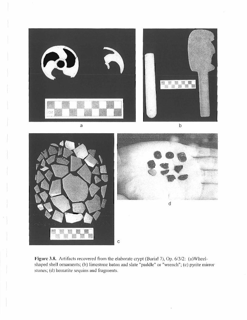
a b
~~ .. :"!, ~' :,'~( r-;'r;
fi~~~.;~ ';
d
Figure 3.8. Altifacts recovered from the elaborate crypt (Burial 7), Op . 6/3/2: (a)Wheelshaped shell ornaments; (b) limestone baton and slate "paddle" or '\.vrench"; (c) pyrite mirror stones; (d) hematite sequins and fragments .

,.. - -,,\
N
I o 30 em
Figure 3.9. Burial 9. Located in Op. 6/3 1.22 m south ofF. 6/3/1 wall of Burial 7, located from 12 cm above to 20 cm below plaza level.

East South
AHor~zon
B Horizon
o 50 em
West North
' -. '
,iA:Ho.riior:J ,t.: .. .
. ::,.,: .... ~~ ,~ ~ . '
B Horizon
C Horizon
Figure 3.10. Profiles of Operation 1125, Lower Group I. Black objects are limestone rocks.

4. CHRONOLOGICAL PATTERNS OF VARIATION IN THE LATE CLASSIC CERAMICS FROM PUSILHA, BELIZE
Ceramic analysis undertaken in 2004 was aimed at establishing a preliminary sequence for Pusilha. The results of this analysis are applied to establishing the time frame of occupation and construction activity at the site, as well as to identifYing changes in the local ceramic assemblage over time and what these may reflect about the affiliations and economic connections of Pusilh<i with other regions.
With few exceptions (including burials), the recovery of well-preserved ceramic material from primary contexts at Pusilha is made difficult by soil conditions at the site that have badly degraded both pottery and plaster floors. Ceramic material present in trash deposits behind structures, for example, was almost entirely disintegrated, as were the floors upon which it was originally deposited. The analysis reported on here is therefore based primarily on the pottery collected in the surface clearing of mounds and architectural features (referred in the following text as "surface contexts") and samples retrieved from construction fill exposed in trenching operations undertaken to reveal architectural sequences (referred to in the following text as "sealed contexts"). Despite the obvious potential for contamination and chronological mixing in such deposits, clear patterns in both assemblage composition and modal frequencies are evident in the comparison of ceramic material from these two types of contexts. The results of this analysis thus provide a baseline model of ceramic development at Pusilha to be further refined by future analyses of pottery from other, more well-defined, contexts.
CHRONOLOGICAL VARIATION IN THE LATE CLASSIC CERAMICS FROM PUSILHA
Ceramics recovered from previous explorations of several cave sites in the vicinity of Pusilh<i include Early Classic markers (such as basal-flanged polychrome bowls, as well as even earlier "shoe pots"). The ceramic material recovered from excavated architectural contexts at Pusilha, however, is predominantly Late Classic in date.
The general Late Classic assemblage from Pusilha includes elements common throughout most of the Maya lowlands (see Braswell et al. 2002 for detailed type descriptions). Such components include unslipped striated jars, modeled and appliqued censers, both plain and decorated polished black wares, and a wide assortment of orange-slipped and cream-slipped polychrome vessels in a variety of forms including bowls, cylinders, and shallow dishes or plates. Also present are red-slipped jars, some of which are decorated with impressed designs along the shoulder, and large red-slipped bowls. As detailed in Figure 4.1, however, the presence or absence and relative frequencies of certain types, as well as the predominance of certain form modes, distinguish the Late Classic ceramic assemblages recovered from surface and sealed contexts.
65

Differences in Assemblage Composition
As can be seen in Figure 4.1, there are notable differences between surface and sealed contexts in the relative frequencies of Utilitarian Wares (including cooking, storage, and processing vessels) and Fine Wares (including smaller serving and eating vessels, some of which are elaborately decorated). Special Function Wares, including censers and urns, occur in similar low frequencies in both early and late subphases. This shift in relative frequencies, reflecting a decline in fine wares (particularly polychrome serving vessels), is a common pattern throughout the lowlands, characterizing the end of the Late Classic period and the Terminal Classic period across the entire region.
Within the Utilitarian ware assemblage, later surface contexts are characterized by a higher percentage of striated jars, while earlier sealed contexts have a higher percentage of redslipped jars and bowls. Com ales occur in similar relative frequencies (at around 16% of utilitarian wares), in both early and late contexts, although red-slipped comales are rare to absent in late contexts, but occur in earlier contexts. Later surface contexts are also characterized by the presence of vessels belonging to the Puluacax Unslipped type (see 2002 report), which was established by Hammond (1975 :299-301) at Lubaantun.
Although modeled/appliqued censers are common in both surface and sealed contexts at Pusilha, Special Function wares from early contexts also include a large number of urns (large vertical-walled cylinders with everted rims), while late contexts are marked by the presence of ladle censers, a form dating to predominantly late (i.e., Terminal Classic or Late-Terminal Classic transition) contexts elsewhere (e.g., see Sabloff 1975: 178-179).
Certain Fine Wares, including Polished Black vessels and polychrome vases, occur in similar frequencies in both surface and sealed contexts. Polychrome bowls occur at a somewhat higher frequency in later surface contexts, while polychrome dishes/plates are much more common in earlier sealed contexts.
Later surface contexts at Pusilha are also distinguished by the presence of red-slipped bowls with short vertical or slightly incurving upper walls, flat to slightly rounded bases, and hollow conical or cascabel tripod supports. These vessels from Pusilha are very similar to those illustrated for the Lazaro Red type at Lubaantun (see Hammond 1975: Figure 113a) and the Tinaja Red type at Seibal (see Sabloff 1975: Figure 300) and Uaxactun (see Smith 1965: Figure 50bl-7,9). These types of vessels appear to be solidly Terminal Classic in date, occurring in Bayal phase (A.D. 830-920) deposits at Seibal and in Tepeu 3 (A.D. 830-890) contexts at Uaxactun, and, according to Chase (1994: 170), represent the "most diagnostic form for Caracol's Terminal Classic".' They date almost exclusively to the latest phase (Phase 5) of occupation at Lubaantun, a pattern of occurrence mirrored at Pusilha.
The surface assemblages at Pusilha are also characterized by the presence of vessels imported from two different regions of the Maya lowlands. These include a small number of
I Vessels of this same distinctive form are also found in Terminal Classic Fine Paste types, including Altar Orange (e.g., see Sabloff 1975: Figure 376) and Tres Naciones Fine Gray (e.g., see Sabloff 1975: Figure 422), in the lower Pasi6n River region.
66

sherds from Altar (Fine) Orange vessels as well as a larger amount of Belize Red pottery imported from the Belize Valley. Although most of the Belize Red sherds are small and heavily eroded, a number of the modal characteristics observable in the present sample would appear to tie these imports to the Terminal Classic period. In particular, the Belize Red pottery from Pusilha includes a number of sherds with basal notching, as well as stubby hollow oven feet. Chase (1994: 170, 173) has identified both of these as Terminal Classic modes at Caracol, where vessels with these features have been found with the same kinds of distinctive red-slipped tripod bowls described above.
Further support for a Terminal Classic dating for the Belize Red pottery at Pusilha comes from Burial 3, an interment discovered at the base of the Op. 3 Structure, post-dating the construction of the building (see Chapter 2 for detailed descriptions of the burial context). Included in this burial were an imported Belize Red vessel (a tripod dish with hollow oven feet belonging to the Platon Punctated-Incised type) and a Terminal Classic red-slipped tripod bowl of the type described above; Also present in Burial 3 was a squat "brandy-snifter"-form vessel on a low pedestal base with modeled-carved decoration and coated with a possible black slip or paine Similar modeled-carved "brandy snifters" or pyriform vases on pedestal bases are also common in Terminal Classic assemblages elsewhere (e.g., see Smith 1955: Figures 44a-g; Smith and Gifford 1966:143), including certain Altar (Fine) Orange types from the Pasion region (see Sabloff1975:195-204 and Figures 384, 386a).
Modal Variation
In addition to the differences between sealed (early) and surface (late) assemblages in terms of the relative frequencies of different types and classes of vessels, there are also notable patterns of chronological variation in the relative frequencies of certain form modes associated with different types.
(a) Striated Jars. Striated storage jars at Pusilha occur in two major form categories. The first consists of vessels with tall straight necks and short, sharply everted rims (Form A), which tend to be more common in earlier sealed contexts. The second major form category of striated vessels (Form B) consists of very short-necked or neckless vessels with sharply everted rims, which tend to be more common in later, surface contexts.
(b) Red-Slipped Jars. The most common form of red-slipped jars in both early and late contexts consists of vessels with tall straight necks and direct rims that are sharply everted horizontally or at an oblique angle (Form A). Like the striated jars of similar form (Folm A), the neck/shoulder break is sharp and thickened on the interior. A second major form category (Form B), more common in earlier contexts, consists of vessels with a similarly tall straight neck and sharply defined, reinforced shoulder break, but with a shorter and more gradually everted or outcurving rim that sometimes consists simply of a short, rounded eversion at the top of the neck; a form common in red-slipped jars of the Tinaja Red and Pantano Impressed types from the sites
2 Very similar vessels are described by Gifford (1976:266) for the Puhui-Zibal Composite type from the Belize Valley, and it is possible that the vessel from Burial 3 was also imported from that region. More detailed paste analyses are necessary, however, to confirm this identification.
67

in the Pasi6n River region and the Peten (see, for example, Sabloff 1975: Figures 296a-e, 297a,e, 311c-g). Form C vessels, which are more common in later contexts, consist of short-necked jars with a gradually outcurving neck and a direct or wedged rim.
There appears to be a strong correlation between vessel form and surface treatment. Where enough of the shoulder is preserved to determine whether or not a vessel carried decoration, almost all of the vessels of Forms B (ca. 85%) and C (100%) are decorated with impressed designs along the shoulder, while most ofthose of Form A (i.e., ca. 85% of rim sherds with attached shoulder areas) are plain. Based on this pattern and the distribution of form modes in sealed and surface contexts, it appears that roughly half the red-slipped jars in both early and late assemblages are decorated, although a slightly higher percentage of decorated body sherds from red-slipped jars were recovered from surface contexts (ca. 10% vs. 2% in earlier sealed contexts).
(c) Red-Slipped Bowls. There are marked differences between sealed and surface contexts in the relative frequencies of different forms of large utilitarian bowls with red-slipped interiors. Sealed contexts have a predominance of large vessels with vertical (Form A) or slightly incurving (Form B) upper walls and bolstered rims, while later contexts are characterized by a much higher frequency of smaller round-sided vessels, often with slightly incurving walls, and direct or slightly thickened rims (Form C). Also somewhat more common in later contexts are tecomates, or vessels with markedlyincurving upper walls (Form D) that are also slipped red on the exterior.
(d) Polychrome Dishes and Plates. A large percentage of polychrome vessels in both subphases consists of large open dishes or plates with outflaring upper walls and slightly rounded lower walls. Some of these vessels have narrow lateral ridges (present only in vessels from sealed contexts); others have thin basal ridges, or larger basal flanges that are occasionally notched (more common in later surface contexts). Notable differences also exist in the typical base forms associated with the polychrome dishes/plates from sealed and surface contexts. The majority of those from earlier sealed contexts have ring bases, while virtually all of those from later surface contexts have tripod supports.
Basal-flanged polychrome dishes/plates with tripod supports are common in Tepeu 2 (A.D. 650-850) assemblages throughout most of the Maya lowlands, although they do not appear to be represented in the Spanish Lookout phase polychromes from the Belize Valley (Gifford 1976; Nadine Gray, personal communication, 2004). Ring-based polychrome dishes with lateral or basal ridges, on the other hand, are generally more characteristic of Tepeu 1 assemblages (ca. A.D. 600-650). Vessels of this form, for example, occur in the Saturday Creek Polychrome type of the Tiger Run phase (ca. A.D. 600-690) in the Belize Valley, the Late Acbi (A.D. 500-600) Gatito Polychrome type at Copan, and are also associated with certain Mac phase (A.D. 550-600) polychromes at Altun Ha (see Pendergast 1979: Figure 39k, for example). Ring-based polychrome dishes do not appear to be common in the Pasion or Peten regions, however, where early Late Classic lateral ridge dishes (e.g., of the Tepeu 1 Saxche Orange-Polychrome type) have tripod supports (see, for example, Smith 1955: Figure 36).
Thus, the development of polychrome dish/plate forms at Pusilha would appear to represent a mixture of form modes typical of different regions at different points in time. That is,
68

the vessels from Pusilha share early ring-based dish forms with other sites in Belize/ and later basal-flanged tripod plate forms with sites in the Pasion and Peten.4 Interestingly, a pattern similar to that observed at Pusilha also seems to characterize the Late Classic burial subcomplex sequence at Caracol (Chase 1994), where ring-based polychrome dishes/plates are common in the earliest burial subcomplex (at least by A.D. 5375
) and continue to occur alongside various types of tripod dishes/plates which are introduced in the second subcomplex (perhaps around AD. 6506
). The third and final subcomplex is characterized by "Peten-style polychrome tripod plates" (Chase 1994: 170), seemingly similar to those common in surface contexts at Pusilha.
CONCLUSIONS
The chronological variations observed in the Late Classic ceramic assemblages from sealed and surface contexts at Pusilha have a number of significant implications regarding both the time frame of occupation and construction activity at the site, as well as developments in Pusilha's inter-regional affiliations.
Chronology of Construction and Occupation at Pusilha
The predominance of ring-based polychrome dishes in sealed contexts at Pusilha raises certain questions concerning the dating of early periods of construction and occupation at the site. Given the association of these kinds of vessels with Tepeu 1 (or earlier) contexts at other sites, their prevalence in fill contexts at Pusilha (as well as in the enOlmous deposit of material in Pottery Cave) may reflect major occupation and construction at the site beginning around AD. 600 (or even earlier). This relatively early time frame for construction fitswell with the corpus of hieroglyphic inscriptions from Pusilha, where the earliest historical rather than retrospectively mythological, inscription refers to events in AD. 570. The continuation of ring-based polychrome dishes/plates into the second Late Classic burial assemblage at Caracol, however,
3 Ring-based polychrome dishes at Copan appear to be relatively rare and many, if not most, are likely imports.
4 Hanunond (1975:319) reports only tripod dishes/plates from Lubaantun, many of which have basal ridges that are often notched, features which are also common in the polychrome tripod dishes/plates recovered from late surface contexts at Pusilha.
5 According to Chase (1994:166), "[t]he basic Late Classic assemblage [at Caracol] is apparently in place prior to AD. 537 (based on the contents of the Structure B20-3 rd tomb)" which contains a ring-based polychrome dish.
6Chase (1994: 181) notes that the typical Late Classic burial assemblage at Caracol after AD. 650 consists of a single cylinder vessel and tripod plate. Both of these forms are introduced in sUbcomplex 2 of the Caracol burial assemblage sequence (Chase 1994: 170).
69

presents the possibility for a later (Tepeu 2) date for early construction efforts at Pusilh<i (i.e., around A.D. 650 or somewhat later) 7. This later date provides a better fit with the overall composition of the ceramic deposits from sealed contexts (as well as Pottery Cave). That is, ring-based polychrome dishes at Pusilh<i consistently occur with strong Tepeu 2 markers, including in particular, red-slipped jars with stamped decoration around the shoulder. These vessels are clearly related to the Pantano Impressed type of the Pasion and Peten regions, and also occur at Lubaantun and Caracol throughout the Late Classic period. The possibility exists, of course, that the ceramics recovered from Pottery Cave include a mixture of Tepeu 1 and 2 materials resulting from long-term deposition, and a Tepeu 1 or even earlier date for the occupation of the site cannot therefore be ruled out. Early Classic materials recovered from other caves in the vicinity also suggest some kind of early activity around Pusilha, but we have yet to find evidence of architecture and full-time occupancy of the site dating to a period before the Late Classic. The existence of Tepeu 2 markers in all currently analyzed fill contexts (the Op. 2 "Bulldozed Mound" and the Op. 3,4, and 5 Structures) suggests that major construction in those areas of the site excavated to date began in Tepeu 2, albeit quite possibly at the beginning of this phase, at or around A.D. 650.
Ceramic data pertaining to the time frame associated with the end of the sequence of occupation at Pusilh<i are somewhat more straightforward. Surface contexts at the site, as well as Burial 3, indicate occupational activity (if not construction) during the Tenninal Classic period (i.e., after A.D. 830). As previously noted, surface assemblages include red-slipped bowls with short vertical or incurving upper walls and tripod supports identical to those recovered from Terminal Classic deposits elsewhere in the Maya lowlands, as well as a few sherds of Altar (Fine) Orange and' Belize Red vessels with Terminal Classic modes. It is significant to note, however, that these diagnostics are not present in the surface material recovered from all parts of the site, nor are vessels belonging to the Puluacax Unslipped type, which typically occurs in surface deposits containing Terminal Classic pottery. For example, the collection of surface material recovered from Structure 5 (Op. 5/1/1) produced none of these late markers and, in fact, looks very similar in assemblage profile to the material from earlier sealed contexts, with the notable exception of a predominance of polychrome dishes/plates with tripod supports (85%) rather than ring bases (15%).8 It may be the case, therefore, that Terminal Classic activity at the site was concentrated in a few locales a pattern not uncommon elsewhere and one that may indicate a reduction in population during this phase of occupation. The areas include the south end of Gateway Hill, where the Op. 3 Structure is located, Moho Plaza, and the area of the "Bulldozed Mound" in the modem village of San Benito Poite. The majority of possible Postclassic pottery recovered from Pusilh<i (as described in Braswell et al. 2002) also comes from these same locations.
7 As previously noted, ring-based polychrome dishes also occur in the Tiger Run phase in the Belize Valley which ends around A.D. 700.
8 A predominance of tripod plate forms is characteristic all surface contexts whether or not other late (i.e., Terminal Classic) diagnostics are present.
70

Regional Affiliations and Economic Connections
The ceramic inventory ofPusilha, including both elite and utilitarian wares, demonstrates significant connections with a number of different regions both within and beyond the Maya lowlands (see also Bill and Braswell 2004). The strongest ties appear to be with the Pasion region and also to a certain extent, with the northern Peten. Features of the southern Belize assemblage shared with these lowland regions to the west include red-slipped jars, especially those with impressed and stamped designs. Such jars are common in the upper and lower Pasion, the Dolores Valley, and northern Peten, but are rare or absent in the Belize Valley. They do, however, appear at sites just to the north of the Maya Mountains, including various caves in the Chiquibul region (Hammond 1975:305) and at Caracol (Chase 1994: 174).
In addition to these more widely shared types and modes, certain components of the Pusilha assemblage have a more circumscribed distribution. Such elements include comales, which are common at Pusilha and in the Upper Pasion and the Dolores Valley regions just to the west (Bill 2001; Juan Pedro Laporte, personal communication, 2000), but are not a typical component of Late Classic assemblages elsewhere in the lowlands. Thus, although perhaps not as frequent at Lubaantun as at Pusilha 9, comales appear to be a functional class of vessels characteristic of utilitarian traditions in the southeastern lowland region.
Also noteworthy at Pusilha are certain design elements on polychrome bowls that appear to be extremely rare elsewhere in the Maya lowlands but are very common in various polychrome traditions of the southeastern Mesoamerican periphery. These include the "twist-and-bud" pattern, which consists of undulating lines with small oval elements attached to them. This common design element at Pusilha also occurs on certain polychromes from eastern El Salvador and other parts ofthe southeast periphery. Additional common motifs on polychromes from Pusilha include small seated birds and monkeys. Seated birds are a frequent decorative element on bichrome and polychrome vessels from western Honduras and other parts of the southeast periphery. Monkeys also occur on incised vessels from Pusilha and other parts of the lowlands, including the Pasion River region, and are a common motif on polychromes from Altun Ha. Although polychrome vessels with these particular motifs are not reported from Lubaantun, it is significant that some of these same elements (including monkeys and birds) are typical of the stamp designs on the impressed red-slipped jars from that nearby site, and that these motifs do not occur on the stamped jars from other parts ofthe lowlands.
While Pasion- and Peten-related types comprise strong components of both early and late ceramic assemblages at Pusilha, terminal occupation contexts reflect the development or strengthening of connections with other regions as well, including, in particular, closer affiliations with other southern Belize centers. The distinctive Puluacax Unslipped type, which occurs in surface contexts at Pusilha, appears to be restricted to parts of the south Toledo district of Belize (Hammond 1975:301), occurring also at Uxbenka (Keith Prufer, personal communication, 2004) as well as at sites on the cayes off the coast of this region (Heather McKillop, personal communication, 2004). Although associated with both earlier and later Late Classic subphases of occupation at Lubaantun (Hammond 1975:299), vessels of this type appear
9 Hammond (1975 :298) reports "a few fragments of almost flat disks or comales" for Lubaantun.
71

to be more common in later contexts at that site (Hammond 1975:301), and the present sample of Puluacax Unslipped at Pusilha is similarly restricted to late occupation surface contexts. The appearance of a distinctive form of red-slipped tripod bowl in late occupation contexts at both Pusilha and Lubaantun represents an additional close link between the two sites during their late occupation, as well as the continuing strong ties of both to ceramic developments in the Peten, and particularly lower Pasion, regions.
Compared to other regions, Pusilha's ceramic ties to the Belize Valley are relatively weak throughout the Late Classic period, consisting for the most part of widespread types, like striated utilitarian jars, or generic modes, like ring-based polychrome dishes. The most direct ceramic link to the Belize Valley in the Pusilha assemblage is imported Belize Red pottery, which appears only toward the very end of occupation of the site during the Terminal Classic period. Hammond's (1975:312) analysis similarly indicates a late occurrence for the Belize Red pottery recovered at Lubaantun. These developments are significant, as they suggest that economic links between southern Belize and the Belize Valley were strengthened, or perhaps even initiated for the first time, during the Terminal Classic period.
The major focus of the Pusilha Archaeological Project is to investigate patterns of sociopolitical and economic interaction with different regions of southeastern Mesoamerica during the history of the polity, and to determine the effects of shifting connections on the local domestic and elite economy. An obvious requirement in achieving these goals is a delineation of chronological changes in the material culture inventory at Pusilha and the patterns of regional and extra-regional affiliations reflected in such changes. The data and patterns discussed here provide a preliminary picture of the development ofPusilha and its interregional connections - a model that will no doubt be further refined or revised as our investigations and analyses of the site and its material remains proceed.
72

Figure 4.1. Summary of Chronological Trends in Late Classic Types and Modes
73

Figure 4.1. Summary of Chronological Trends in Late Classic Types and Modes
Surface Sealed Contexts t Contextst
(n=290 rims)* (n=322 rims)*
Utilitarian Wares % AssemblaAe 79% 62% I
I Striated Jars % Utilitarian Wares 41% 22% I FormA % Striated Jars 28% 81% I
FormB % Striated Jars 72% 19%
I Red-Slipped Jars % Utilitarian Wares 10% 19%
FormA % Red-Slil2£ed Jars 55% 51%
FormB % Red-Slipped Jars 23% 43%
FormC % Red-Slipped Jars 23% 6%
Red-Slipped Bowls % Utilitarian Wares 18% 41%
FormA % Red-Slipped Bowls 7% 55%
FormB % Red-Slipped Bowls 2% 20%
FormC % Red-Slip~ed Bowls 81% 20%
FormD % Red-Slipped Bowls 10% 4%
Comales % Utilitarian Wares 14% 18%
Plain % Comales 100% 81%
Red-Slipped % Comales 0% 19%
Puluacax Unslipped % Utilitarian Wares 17% 0%
Special Function Wares % Assemblage 3% 3%
Fine Wares % Assemblage 18% 35%
Polychromes % Fine Wares / (% Assemblage) 71% / (13%) 97% / (34%)
Polychrome Plates % Fine Wares 29% 71%
Ring Bases % Polychrome Plates 0% 83%
Tripod Supports % Polychrome Plates 100% 17%
Polychrome Bowls % Fine Wares 29% 15%

Polychrome Vases % Fine Wares 13% 11%
Polished Black Vessels % Fine Wares 6% 3%
Red-Slipped Tripod Bowls % Fine Wares 17% 0%
Belize Red % Fine Wares 6% 0%
Fine Orange Present! Absent J=>resent --
Absent
(*The percentages of ceramic types and modes reported in Figure 4.1 were calculated on the basis of rim sherds only in order to provide a more accurate estimate ofthe relative number of vessels represented in each category. (Large storage vessels, for example, will theoretically produce a larger number oftotal sherds than will smaller serving and eating vessels, potentially inflating the relative abundance ofthe former over the latter in calculations based on numbers of total sherds.)
t The percentages reported in Figure 4.1 are calculated on combined rim sherd counts from selected surface and sealed contexts. The data on surface contexts comes from Op. 3/2/2, Op. 3/3/2, and Op. 3/5/2. The data on sealed contexts comes from materials recovered from Op. 3/1/5,3/1/6, and 41117. (See Chapter 2 for detailed descriptions of these operations.)

5. REFERENCES CITED
Bill, Cassandra R. 2001 Tipologfa y analisis preliminar de la ceramica de Cancuen. In Proyecto arqueol6gico
Cancuen: informe no. 2, temporada 2000, edited by Arthur A. Demarest and Tomas Barrientos, pp. 170-255. Instituto de Antropologfa e Historia, Guatemala and the Department of Anthropology, Vanderbilt University, Nashville.
Bill, Cassandra R. and Geoffrey E. Braswell 2004 Life at the Crossroads: New Data from Pusilha, Belize. Paper presented at the Belize
Archaeology Symposium, 2004: Archaeological Investigations in the Eastern Maya Lowlands. Belize City, Belize. July 7th-9 th, 2004.
Braswell, Geoffrey E., Cassandra R. Bill, Sonja A. Schwake, and Christian Prager 2002 Pusilhci Archaeological Project: 2002 Annual Report. Ms. on file, Institute of
Archaeology, Belmopan, Belize.
Braswell, Geoffrey E., Christian M. Prager, Cassandra R. Bill, Sonja A. Schwake, and Jennifer B. Braswell 2004 The Rise of Secondary States in the Southeastern Periphery of the Maya World: A Report
on Recent Archaeological and Epigraphic Research at Pusilha, Belize. Ancient Mesoamerica 15:219-233.
Chase, Arlen F. 1994 A Contextual Approach of the Ceramics of Caracol, Belize. In Studies in the
Archaeology ofCaracol, Belize, edited by Diane Z. Chase and Arlen F. Chase, pp. 157-193. Pre-Columbian Art Research Institute Monograph 7, San Francisco.
Gifford, J. C. 1976 Prehistoric Pottery Analysis and the Ceramics of Barton Ramie in the Belize Valley.
Memoirs of the Peabody Museum, Vol. 18. Cambridge.
Hammond, Norman 1975 Lubaantun: A Classic Maya Realm. Monographs of the Peabody Museum, No.2.
Harvard University, Cambridge, MA.
Pendergast, David M. 1979 Excavations at Altun Ha, Belize, 1964-1970: Volume 1. Royal Ontario Museum,
Toronto, Ontario.
76

Sabloff, Jeremy A. 1975 Ceramics. In Excavations at Seibal, Department 0/ Peten, Guatemala. Memoirs of the
Peabody Musewn of Archaeology and Ethnology, Volume 13, No.2. Harvard University, Cambridge.
Smith, Robert E. 1955 Ceramic Sequence at Uaxactun, Guatemala. Middle American Research Institute,
Publication No. 20. Tulane University, New Orleans, LA.
Smith, Robert E. And James C. Gifford 1966 Maya Ceramic Varieties, Types, and Wares at Uaxactun: Supplement to "Ceramic
Sequence at Uaxactun, Guatemala ". Middle American Research Institute, Publication No. 28:125-174. Tulane University, New Orleans.
Welsh, W. B. M. 1988 An Analysis a/Classic Lowland Maya Burials. BAR International Series 409. British
Archaeological Reports, Oxford.
77


t
! I , 1
. 1
1
t


![Projekt archeologicznego odrodzenia Babilonu [A Project for an Archaeological Revival of Babylon]](https://static.fdokumen.com/doc/165x107/6332ff9a4e0143040300eac8/projekt-archeologicznego-odrodzenia-babilonu-a-project-for-an-archaeological-revival.jpg)