Final EIA Report - Lucknow-Ayodhya Stretch on - World Bank ...
332
National Highways Authority of India (Ministry of Road Transport & Highways) New Delhi, India Final EIA Report - Lucknow-Ayodhya Stretch on NH-28 and Gorakhpur Bypass August, 2004 E895 Volume 6 AA~~~~~~~~~~~~~~~~~~~~~~.~ . -. . 7 - N \ / 4') - >P1 -- - - -. _. > r- Nautanw IE i -- o} sln quarry . sSrbga< i d ur ~~~ ~~~AB .>ti~~' .~' _ - BiIy t _\one 1 > D PACWl A J/ 7 7 4~ ~ ~ W DHVConsultantsinventurewith MDP Consultants Pr ;),arry Lt Grd. ~~~~~~~~~~~V. -A , , r ao. qwr,0ua, *17-_ .4es aagn DHV Consultansinontvt whMD NConspultnsPv.Ld Public Disclosure Authorized Public Disclosure Authorized Public Disclosure Authorized Public Disclosure Authorized Public Disclosure Authorized Public Disclosure Authorized Public Disclosure Authorized Public Disclosure Authorized
-
Upload
khangminh22 -
Category
Documents
-
view
0 -
download
0
Transcript of Final EIA Report - Lucknow-Ayodhya Stretch on - World Bank ...

National Highways Authority of India (Ministry of Road Transport & Highways)New Delhi, India
Final EIA Report - Lucknow-Ayodhya Stretch onNH-28 and Gorakhpur Bypass August, 2004
E895Volume 6
AA~~~~~~~~~~~~~~~~~~~~~~.~ . -. .
7 - N \ /4') - >P1 -- - - -. _. > r- Nautanw
IE i --o} sln quarry . sSrbga< i d ur
~~~ ~~~AB
.>ti~~' .~' _ - BiIy t _\one 1 > DPACWl A J/ 7 7
4~ ~ ~ W
DHVConsultantsinventurewith MDP Consultants Pr ;),arry Lt Grd.
~~~~~~~~~~~V. -A , , r ao. qwr,0ua, *17-_ .4es aagn
DHV Consultansinontvt whMD NConspultnsPv.Ld
Pub
lic D
iscl
osur
e A
utho
rized
Pub
lic D
iscl
osur
e A
utho
rized
Pub
lic D
iscl
osur
e A
utho
rized
Pub
lic D
iscl
osur
e A
utho
rized
Pub
lic D
iscl
osur
e A
utho
rized
Pub
lic D
iscl
osur
e A
utho
rized
Pub
lic D
iscl
osur
e A
utho
rized
Pub
lic D
iscl
osur
e A
utho
rized

Shri V.K. ShanmaGeneral Manager DHV Consultants
Social & Environmental Development Unit Branch Office
National Highway Authority of India C-154, GreaterKailashl
Plot No. G 5 & G 6 New Delhi - 110 048
Sector - 10, Dwarka Telephone+91-11-646 6433/6455/5744
New Delhi Fax +91-11622 6543E-mail: [email protected]
New Delhi, 1IOh August 2004
Our Ref. MSP/NHAI/0408.094Subject Submission of Final Report: Independent Review of EIA, EMP and EA
Process Summary for Lucknow-Ayodhya section of NH-28 and GorakhpurBypass Project
Dear Sir,
We are submitting the Final Report of Independent Review of EIA, EMP and EA Process Summary forLucknow Ayodhya section of NH-28 and Gorakhpur Bypass Project for your kind consideration.
We hope you would appreciate our efforts in carrying out the assignment.
Thanking you,
Yours sitiberelyDHV Corsultan s
M.S. Prakash (Dr.)Team Leader
ll
D.DUman4gNH-28FmaI Report Augut lDovigr.doc
I __ffi\ -2 DHV Consultants Is part of the DHV Group.Bahrain, Bangladesh, Belgium, Botswana, Brazil, China, Czech Republic, Ecuador, Egypl Germany. Guatemala, Hungary, Hong Kong, India, Indoesia. Israel, Kenya, Laos,Mozambique, Namibia, Nepal, the Netherlands. Nigeria. Pakistan, Poland, Portugal, Qatar, Russia, South Afrca, Spain, Sri Lanka, Taiwam Tanzania, Thailand, Tunisia, United
x / m Kingdom, Vietnam, Zimbabwe.The quality management system of DHV Consultants has been approved against NEN ISO 9001.

I~~~~~~~~~~~~~~~~~~~~~~~~~~~~~~~~~~~~~~~~~~~~~~~~~~~~~~~~~~Independent Review and Consolidation of EIA, EMP & RAP for Lucknow - Ayodhya Section of NH 28 and Gorakhpur BypassConsolidated Environmental Impact Assessment Report
| INDEPENDENT REVIEW AND CO ION OF EIA, EMP & RAP FOR LUCKNOW - AYODHYA28 AND GORAKHJ*11~
CONSOLoAt NMENTAL IMPACT ASEMEN REPORT
TABLE OF CONTENTS
CONTENTS PAGE NO
1.1 Background of the Project 1-1
1.2 DPR Consultants 1-2
1.3 Independent Environmental Reviewers 1.2
1.4 Concept and Need for Road Expansion and Construction of BY-pass for Gorakhpur Town 1-2
1.5 Selection of Present alignment (Analysis of Alternatives) 1-3
| 1.5.1 Analysis of Altemative Options for Widening of Existing Road 1-3
1.5.2 Analysis of Altemative Alignments of Bypasses 1-4
1.5.3 Altemative Options for Gorakhpur Bypass 1-7
1.6 Environmental Impact Assessment Process Adopted 1-9
1.6.1 Environmental Screening 1-9
1.6.2 Environmental Impact Assessment and Management Plans 1-9
1.7 Structures of this EIA Report 1-9
1.8 Stand Alone Environmental Management Plans 1-10
2.0 Project Descnption 2-1
2.1 Proposed Carniageway Details 2-2
2.2 Details of ROW 2-3
2.3 Median Width 2-5
2.4 Salient Features 2-5
2.5 Service Roads 2-6
2.6 Major Settlements En-route 2-6
2.7 Railway Crossings and Railway Over Bridges (ROB) 2-6
2.8 Under Passes 2-7
2.9 Intersections, Interchanges and Flyovers 2-7
2.10 Bridges, Culverts and Other Structures 2-8
2.11 Traffic Mix and Volume 2-8
2.12 Highway Facilities 210
2.13 Road Drainage d 2-12
2.14 Row and Land Acquisition 2-12
2.15 Project Cost 2-15
3.1 Policy, Legal and Administrative Frame Work 3-1
3.2 Institutional Setting for the Project 3-1
3.3 Legal Frame Work 3-2
Page I ofl7
in Joint venture withI~~~~~

Independent Review and Consolidation of EIA, EMP & RAP for Lucknow - Ayodhya Section of NH 28 and Gorakhpur BypassConsolidated Environmental Impact Assessment Report
3.3.1 The Environment (Protection) Act, 1986 and the Environmental Impact Assessment Notification, 1994 3-2
3.3.2 The Water and Air (Prevention and Control of Pollution) Acts 3-4I 3.3.3 The Forest (Conservation) Act, 1980 34
3.3.4 The Wild Life (Protection) Act, 1972 3-6
3.3.5 The Motor Vehicles Act, 1988 3-6I 3.3.6 The Ancient Monuments and Archaeological Sites and Remains Act, 1958 3-6
3.3.7 State Level Legislation and Other Acts 3-6
3.4 Institutional Setting in the Environmental Context 3-7
* 3.4.1 Ministry of Environment and Forests (MOEF) 3-7
3.4.2 MOEF Regional Offices 3-8
3.4.3 Central Pollution Control Board (CPCB) 3-8
* 3.4.4 State Pollution Control Boards (SPCB) 3-8
3.4.5 Departments of Forests (DoF) of Uttar Pradesh 3-8
3.5 Environmental Clearance Requirements 3-9
* 3.5.1 GOI Requirements 3-9
3.5.2 State Level Clearance Requirements 3-9
3.5.3 World Bank Requirements 3-10
3.6 Summary of Mandatory Clearances from GOI and GOUP 3-10
3.7 Guidelines and Norms to be followed in the Project 3-113 3.8 Status of Various Clearances 3.11
| 4.1 Methodology I 1
4.2 Environmental Considerations Incorporated in the Feasibility Study 4-1
4.3 Environmental Impact Assessment I 1
4.3.1 Scoping 4 1
4.3.2 Reconnaissance Surveys 4-1
4.3.3 Assembly and Analysis of Data 1 23 4.3.4 Documentation of Baseline Conditons 4-2
4.3.5 Assessment of Altematives 1 2
4.3.6 Assessment of Potential Impacts 4 2I 4.3.7 Integration of Environmental Impacts in the Design Process: "Mainstreaming the Environmental Component 1-2
4.3.8 Identified Mitigation and Enhancement Measures 4 2
4.3.9 Community Consultations 4 2I 4.3.10 Preparation of the Environmental Management Plans 4 3
4.4 Finalizing the Environmental Assessment 1.3
4.4.1 Completing the Baseline --------- - 4 3I 4.4.2 Impact Assessment and Modelling ----- 1 4
4.4.3 Mitigation and Enhancement Measures 4 4
4.4.4 Stand Alone Environmental Management Plans for All Three Construction Packages 4 1I 4.4.5 Environmental Budget 4 4
| 5.0 Baseline Environmental status 5-1
5.1 Air Environment 5-1
5.2 Noise Environment 5-7I 5.3 Water Environment: Water Resources and Drainage 5-11
5.3.1 Drainage 5-14
5.3.2 Surface Water Quality 5-15I 5.3.3 Ground Water Resources 5-17
5.3 4 Ground water Quality 5-17
Page 2 of 7in Joint venture with

Independent Review and Consolidation of EIA, EMP & RAP for Lucknow - Ayodhya Section of NH 28 and Gorakhpur BypassConsolidated Environmental Impact Assessment Report
5.4 Land Environment 5-19
5.4.1 Topography, Geology and Seismicity 5-19
5.4.2 Soils 5-1 9
5.4.3 Land use 5-21
* 5.4.4 Land Use of new Alignment 5-23
5.4.5 Land acquisition 5-24
5.5 Natural Resources Consumption 5-26I 5.5.1 Borrow Areas 5-26
5.5.2 Quarry Areas 5-27
5.5.3 Fly Ash 5-28
5.6 Biological Environment: Flora, Fauna and Ecological Sensitive Areas 5-295.6.1 Flora 5-29
5.6.2 Fauna 5-33
5.6.3 Eco-Sensitive Areas 5-35
5.6.4 Socio-economic EnvironmenV Human Use Values 5-35
6.0 Public Consultations and Information Disclosures 6-13 6.1 Introduction 6-1
6.2 Objectives 6-1
6.3 Methodology Adopted for Public Consultations 6-2
6.3.1 Stages and Levels of Consultation 6-2
* 6.3.2 Tools for Consultation 6-26.4 Issues Raised and Community Perception 6-12
6.5 Addressal of Issues 6-13I 6.6 Continued Participation 6-14
6.6.1 Information Disclosure 6-153 6.6.2 Community Participation 6-15
7.1 Background 7-1
7.2 Meteorological Parameters 7-17.3 Natural and Biophysical Environment 7-1
7.3.1 Impact Assessment on Air Environment 7-11 7.3.2 Noise 7-12
7.3.3 Water Resources 7-23
7.3.4 Land 7-28I 7.3.5 Consumption of Natural Resources 7-307.3.6 Impact on Ecology / Flora / Fauna 7-33
7.4 Human Use Values 7-36
* 7.4.1 Land Acquisition 7-36
7.4.2 Project Affected Area 7-36
7.4.3 Highway Amenity and Facilities 7-36
* 7.4.4 Educational Institutes 7-37
7.4.5 Health Centers/ Hospitals 7-37
7.4.6 Religious / Archeological Structures 7-38
7.4.7 Safety 7-38
7.5.1 Project Affected Persons (PAFs) 7-38
| Page 3 of 7in Joint venture with
I <+,

Independent Review and Consolidation of EIA, EMP & RAP for Lucknow - Ayodhya Section of NH 28 and Gorakhpur BypassConsolidated Environmental Impact Assessment Report
8.1 Avoidance h to Mitigation Measures 8-1
81.1 Meteorological Parameters 8-2
8.1.2 Air 8-2
8.1.3 Noise 8-6
8.1.4 Water Resources 8-9
8.1.5 Land Environment 8-12
8.1.6 Procedure for selection of sites for construction camps 8-19
8.1.7 Prevention of Water Quality Degradation 8-19
8.1.8 Flora 8-20
8.1.9 Fauna 8-20
8.1,10 Accidents involving hazardous materials 8-21
8.1.11 Safety Measures 8-22
8.1.12 Cultural Properties 8-26
8.2 Environmental Enhancements 8-27
8.2.1 Enhancement of Common Property Resources 8-27
8.2.2 Road Side Plantation 8-28
8.3 Environmental Management Plans 8-29
8.3.1 Monitoring Plans 8-29
8.3.2 Reporting System 8-30
8.3.3 Environmental Budget 8-30
9.1 Introduction 9-1
9.2 Existing Institutional Arrangements 9-1
9.2.1 Corporate Level 9-1
9.2.2 Project Implementation Units 9-1
9.2.3 Environmental Unit at the NHAI Corporate 9-2
9.3 Other Stakeholders 9-2
9.3.1 DPR Consultants 9-3
9.3.2 Independent Reviewers 9-3
9.3.3 Supervision Consultants (SC) 9-3
9.3.4 Non-Govemmental Organisations 9-3
9.3.5 Contractors 9-3
9.4 Institutional Needs Assessment 94
9.4.1 Need for further Strengthening of NHAI - ESDU at Corporate Office 94
9.4.2 Need for additional capacity 94
9.5 Proposed Set-up 94
9.5.1 Institutional Setting for the Project 94
9.5.2 Project Implementation Unit 94
9.5.3 Construction Supervision Consultants (CS) 9-6
9.5.4 Contractors 94
9.5.5 Other Agencies 9-7
9.5.6 Environmental Reporting System (ERS) 9-7
9.5.7 Intemalising Environmental Expertise in the NHAI 9-8
9.6 Operationalisation 9-8
9.6.1 Identification and Appointment of Staff 9-9
9.6.2 Procurement of NGOs and other Agencies 9-9
9.6.3 Supervision Consultants (SC) 9-9
9.6.4 Contractors 9-9
1 Page 4 of 7in Joint venture with ~y
I~~~~~4ar/ A

Independent Review and Consolidation of EIA, EMP & RAP for Lucknow - Ayodhya Section of NH 28 and Gorakhpur BypassConsolidated Environmental Impact Assessment Report
9.6.5 Training 9-9
lTable-1.1 Contract Packages of the Project Road 1-2
Table 1.2: Widening Options for the Existing Road 1-3I Table 1.3: Comparative Evaluation of Altemate Alignments of Barabanki Bypass 1-8
Table 1.4: Comparative Evaluation of the Altemative Alignment of Ramsaneighghat Bypass 1-8
Table 1.5: Comparative Evaluation of the Altemative Alignment for Gorakhpur Bypass 1-11I Table 2.1 Carriage way Details 2-3
Table 2.2 Important Settlements along the Lucknow-Ayodhya Stretch including Faizabad Bypass 2-5
Table 2.3: List of Railway Over Bridges / Level Crossings 2-5
* Table 2.4 List of Proposed Intersection Development 2-6
Table 2.5. List of Proposed Bridges, Viaducts & ROBs along the Gorakhpur Bypass 2-7
Table 2.6 Projected Normal Traffic (per day) on the Lucknow -Ayodhya Stretch including Faizabad 2-7I Table 2.7 Projected Normal Traffic (per day) on the Barabanki Bypass 2-8
Table 2.8 Projected Normal Traffic (PCU per day) on the Lucknow -Ayodhya Stretch including Faizabad 2-8
Table 2.9 Projected Traffic on the Gorakhpur Bypass 2-8
Table 2.10 Location of Bus Bays and Truck Lay-Byes 2-9
Table 3.1 Summary of Relevant Legal Requirements Considered for this Project and Institution Responsible for that: 3-6
Table 4.1: List of Public Information Campaign, Date and place 4 3
* Table 5.1. Summary of Climatological Data of the study corridor 5-1
Table 5.2 Details of Ambient Air Quality Monitoring stations 5-4
Table 5.3. Onsite 24-Houriy Average Ambient Air Quality along the Lucknow -Ayodhya Section of NH-28 5-6
Table 5.4. Onsite 24-Hourly Average Ambient Air Quality along the Gorakhpur Bypass 5-6
Table 5.5. Details of Noise Monitoring Stations 5-73 Table 5.6. National Ambient Noise Level Standards (as per CPCB, India) 5-9
Table 5.7 Ambient Noise Levels along the Project Corridor Package-I 5-9
Table 5.8. List of River/Canal/Drain Crossings the Lucknow-Ayodhya Section of Project Road 5-113 Table 5.9 List of River/Canal/Drain Crossings the Gorakhpur Bypass 5-12
Table 5.10 List of Ponds within or Close to RoW 5-13
Table 5.11 Catchment Areas and Drainage of Major and Medium Rivers / Streams 5-15
| Table 5.12. Details of Surface Water Quality Monitoring Locations 5-15
Table 5.13. Surface Water Quality Monitoring Results (February 2003) 5-15
Table 5.14 Details of Ground Water Quality Monitoring Locations 5-17
| Table 5.15 Results Ground Water Quality Monitoring (GW1 to GW5 monitored in February, 2003 and GW6 to GW8 monitored in April, 2003) 5-18
Table 5.16 Physico-Chemical Characterstics of Soil in the Lucknow-Ayodhya Section 5-20
Table 5.17 Physico-Chemical Characteristics of Soil in the Gorakhpur Bypass Area 5-20
Table 5.18 Detail of Land Use along Project Road Stretch (Lucknow-Ayodhya Stretch on NH-28) 5-21
Table 5.19 Land Use Pattem along the Proposed Gorakhpur Bypass 5-24
Table 5.20 Package wise Summary of Land Requirement (Lucknow-Ayodhya Stretch) 5-253 Table-5.21 Details of Land Requirement of Lucknow-Ayodhya Section of NH-28 5-25
Table-5.22 Details of Land Requirement within ROW of the Proposed Gorakhpur Bypass 5-26
Table 5.23 Details of Borrow Areas for Lucknow-Ayodhya Section including Faizabad Bypass 5-27I Table 5.24 Quarries Identified for Coarse and Fine Aggregates 5-28
Table 5.25 Abundance of Various Tree Species along the Project Road 5-30
Table 5.26 Detail Girth Size and Species Wise List of Trees to be Cut 5-313 Table 5.27 List of Tree Species in Zaidpur RF 5-32
Table 5.28 Forests Present in Surroundings of the Project Road 5-33
Table 5.29 List of Forest in the Study Corridor 5-33
3 Page 5 of 7in Joint venture with s>zZ
I 9V

Independent Review and Consolidation of EIA, EMP & RAP for Lucknow - Ayodhya Section of NH 28 and Gorakhpur BypassConsolidated Environmental Impact Assessment Report
Table 5.30 List of Predominant Tree Species in Ramgarh Reserved Forest 5-34
Table 5.31 List of Fauna in Ramgarh Reserve Forest 5-34
Table 5.32 List of Avifauna 5-35
Table 5.33 List of Weekly Markets along the Project Road 5-37
Table 6.1 Initial Focus Group Discussions held at 12 Major Locations in the Project Area 6-3
Table 6.2 Initial Focus Group Discussions held at the Major Locations in the BaraBanki Bypass Stretch 6-4
Table 6.3 Initial Focus Group Discussions held at the Major Locations in the Ramsunehighat Bypass Stretch 6-5
Table 6.4: Local Level Public Consultations held at the Major Locations in the Barabanki Bypass Stretch 6-6
Table 6.5 Local Level Public Consultabons Held at the Major Location at Ramsanaighat Bypass Stretch 6-6
Table 6.6 Local Level Public Consultabons held at the Major Location in the Project area 6-7
Table 6.7 Local Level Public Consultations held at the Major Location in the Project area 6-8
Table 6.8 Initial Focus Group Discussions held at 9 Major Locations in the Project Area 6-10
Table 6.9 Addressal of General Issues and Concems under the project 6-14
Table 7.1 Various Impacts on Water Resources due to Construction Activities 7-2
Table 7.2 Package Wise List of Proposed Bridges 7-3
Table 7.3. Number of Affected Ponds in Lucknow-Ayodhya Stretch 7-5
Table 7.4. Raw Materials Requirement durng Construction 7-8
Table 7.5. Fresh Water Requirement during Construction 7-9
Table7.6. Number of Trees Existing and Number of Trees to be felled 7-13
Table 7.7. District Wise Details of the Project Stretch 7-14
Table7.8. Amenities and Facilities affected due to the Project 7-15
Table 7.9. Lists of Impacted Educational Institutes 7-15
Table7.10. Medical Institutions to be demolished 7-16
Table -7.11. Project affected Population (Title holders) 7-16
Table 8.1. Locations of Proposed Bridges 84
Table 8.2: Culverts Planned Along Allahabad Bypass to Facilitate Cross Drainage 8-5
Table 8.3. Locations Where Slope Protection in the form of Retaining Walls needs to be provided 8-8
Table 8.4. List of Underpass along the Project Stretch 8-16
Table 8.5. Location of Proposed Service Roads 8-18
Table 8.6. Package Wise Location of Proposed Bus Bays 8-19
Table 8.7. Package Wise Location of Proposed Truck Lay-byes 8-19
Table 8.8 Total Budget for Environmental Monitoring for Lucknow-Ayodhya Section of NH-28 8-24
Table 9.1: Stage-wise Reporting system 9-8
Table 9.2: Detailed Training Program 9-10
Figure 3.1: Flowchart for obtaining Environmental Clearance 3-3
Figure 3.2: Flowchart showing various steps involved in examination of cases received under Forest Conservation Act and Clearance Act 1980 3-5
Figure 9.1: Structure of PIU Unit 9-2
Figure 9.2: Proposed organizational structure 9-5
Annexure 1.1: Package wise details of side of widening
Annexure 3.1: Ministry of Environment and Forests Notification
Annexure 4.1: Monitoring Methodology
Annexure 5.1: Baseline status data for Lucknow-Ayodhya and Gorakhpur Bypass
Annexure 5.2: Chainage wise location of tubewells
Annexure 7.1: List of Trees to be cut from proposed ROW of Lucknow-Ayodhya section including Faizabad Bypass
Annexure 7.2: List of Trees to be cut from proposed ROW of Gorakhpur Bypass
Annexure 8.1: List of Ponds present on proposed ROW with their mitigation /enhance measure
3 Page 6 of 7in Joint venture withI~~~~~~~~~~~~~~~~~~~~~~~~~~~~~~~~~~~~~~&A4A

Independent Review and Consolidation of EIA, EMP & RAP for Lucknow - Ayodhya Section of NH 28 and Gorakhpur BypassConsolidated Environmental Impact Assessment Report
Annexure 8.1: List of Ponds present on proposed ROW with their Mitigation /Enhancement Measures
Annexure 8.2: Details of proposed culverts on Lucknow-Ayodhya section of NH-28
* Annexure 8.3: Tree plantations strategy along Lucknow-Ayodhya stretch of NH-28 and Gorakhpur Bypass
Annexure 8.4: List of religions structure and their Mitigation/Enhancement Measures
Annexure 8.5: List of Educational Institutions with Proposed Mitigation/Enhancement Measures
* Annexure 8.6: List of Medical Amenities along the Lucknow-Ayodhya Stretch of Project Road
Annexure 8.7: List of Affected State Banks and their Mitigation/Enhancement Measures
lllllIlIIIIII
|It P81l@age 7 of 7in Joint venture with V J

I
IIIIIII1II CHAPTER-I:
I INTRODUCTION
IIIII1III

Independent Review and Consolidation of EIA, EMP & RAP for Lucknow - Ayodhya Section of NH 28 and Gorakhpur BypassConsolidated Environmental Impact Assessment Report
1 1 INTRODUCTION
1.1 Background of The Project
India has embarked on a 10-year highway transportation improvement program to globalize itseconomy to increase safety and efficiency in trade and business and also free movement of traffic.National highways comprise about 2% of total road length and yet they carry over 40% of totaltraffic of the country. The first and foremost task mandated to National Highways Authority of India(NHAI) is the implementation of National Highways Development Project (NHDP) comprising ofGolden Quadrilateral and North-South and East-West corridors. NHAI is also responsible for thedevelopment, maintenance and management of other national highways of India.
Ministry of Road Transport and Highways has embarked on a staged up gradation program ofvarious National Highway corridors. The widening is necessary to develop National Highwaycorridors where traffic intensity has increased significantly and there is a requirement ofaugmentation of capacity for safe and efficient movement of traffic. Lucknow-Ayodhya section ofNH-28 (km 8.25 to km 138.0) is such a section, which is proposed to be developed as 4-lanehighway. For the purpose of project preparation, corridor has been divided into convenient sectionson the basis of traffic characteristics, industrial growth, geographic location and other considerations.Most of the corridor sections are proposed to be developed as fully or partially access controlledtolled highways. The project is being prepared for implementation under the Phase-III program.
The Index Map (Figure-1.1) shows the project road along with the road network in the area. Theproject road starts from km 8.25 on NH-28 near the beginning of under construction LucknowBypass (near Kamta Village) and then proceeds up to km 122.275 and thereafter the road moves,along Faizabad bypass to proceed to Ayodhya. The project road under study terminates at km 15.0 ofFaizabad bypass at a point 2 km before the bridge over river Sarju. The length of the project roadstretch is approximately 130 km. The road alignment passes through districts of Lucknow, Barabankiand Faizabad in the state of Uttar Pradesh. On its way, the project road crosses three small riversnamely Reth, Kalyani and Kasera and Barabanki, Ramsanehighat, Faizabad and Ayodhya towns.
The other section of the study road, Gorakhpur bypass is about 110 km east of Ayodhya towardsMuzafarpur on NH-28. This 32.2 km section is construction of new road to bypass congested areasof Gorakhpur town.
Gorakhpur city is situated in eastern part of Uttar Pradesh on the left bank of the confluence of riversRapti and Rohini. The city is 102 m above mean sea level and between latitudes 26°42' to 26°47'Nand longitudes 83°20' to 83 025'E. The city is about 5 km in length in north-south direction and 8 kmwide in east-west direction. The main railway line of North Eastern Railway has divided the city innorthern and southern parts.
Contract Packages and Project Cost
Lucknow -Ayodhya section of NH 28 is proposed to be divided into three contract packages whileGorakhpur bypass is divided into two contract packages stated under in Table-1.1. Construction of allfive packages is expected to start at the same time and it should take 36 months of timeframecommencing in the beginning of the year 2004 to complete construction work by 2007.
I zd7r 1 - /1 6t0win joint venture with
l

- ~~~~$3S~~ i rA
;~~~~~~~~~~~~~~~~~~~~,
~~~~~~~~~ i"'~~~~~~~~~~~~~~~~~~~~~~~~~~~~~~~'
An _ RAMSANEHIGHAT
) MAJORBY PASS NH- GOCRIRS :
%~ ~ ~ ~ ~ ~ ~~~~~~~~B PRASS OA
>~~~~~~RAE ~~~~~10..BAREAJ ...... ,I.TA,N .../
L.~~~~~~~~~~~~~~~~~~~~~~~~~~~~~~~~~~~~~~~~~~~~
LEGEND:
SRINAGAR ~~~~~~~~~~~~ ~ ~~~~N. H. Number 28
IA~~~~~~~ ~~MAJOR NH-CORRIDORS
PROJECT ROAD
DELHI 8 Lucknow IGorakhpur 58,
h g 2S 7 Ayodhya 8 7
7~~~~~~~~~ ~~~SILCHAR88 1yh}/ss b 8iS.iiW 12/ip I<i,kIk r -
( ~~~~~~~~~~~~~~21,8A ,2
7 N \t,.I,,,7 .)I 158.1 fll P ,SuvlS y / KOLKATA
PORBANDAR I
MUMBAI 7/
A P / I lInn a8.1
BANGALO CHENNAI
N .bS.. S
I u_ i47
71KANYAKUMARI
Fig. 1.1 INDEX MAP
U

Ar-AIt
ABARA BANKI JKm I Z370
(NH-26. Krn. 32.170 b,o f
i�N ir
77 39 711414-26 - j 1.
Byp.4t
PROJEC'r ROAD D-AM
f,l(NH.AA u;j -
START POINT-Km S.M 0 rk.
BARA BANKI BYPASS MM
b
`74t
rM �a
el-ICL
�m7W.
�N: #74- BYPASS STARTKm. O-W
(MM-29 Km. 627761
LEGEND Km.59.0 BYPASS END
DISTRIBUTARY LINE ir - Km. 7al
�NH.29_ PROJECT ROAD -Z�,o I. ;
(MINOR CANAL) 14 -1.4.
PROPOSED10,00 Fe Mt== RIVER Jb-
V RAMSAMENIGHAT ISYPASSNH ROAD NALA (DRAIN)
K4 Pui
LSH ROADS PONDS (JHrzEL) 14P
OTHER ROADS RESERVE FOREST -4
RAILWAY LINESErrLEMENTS
MAJOR CANAL (BUILT UP AREA)
mo j.
0 $Do 1000 2000 3000
Fig. 1.2 BASE MAP SCALE

r NIL
A,12 J-4;A.7: 7?V.A
% 14. !A7 J. < JL4 -w L4m
T,. - ;Ai' - (;e ,- - 0-14 7.a; 17 .A
1160-t -4p
A ,nfAltt
cw,fli!AA6 144,
06
3 AM'7.VT-i .4"-Tt
-A "i V4-t" . . _.�r
Lip
ven % 'tdWl A
lk
25_27"l%Z9
LN7'1
A
R1.41. BYPASSEND
P-(GHAT Km iSAO
4wBYPASS END
KnINH
dL
'.A 4r_ _T�l AT,u -A A
ABYPASSSTAFrrrl
Km. 0.00P4 28 NH-26 Krn. 122-..D. C�Awl DALSVA'M� l URM
K 'tiKfn. 7.4 I..%
KWLISK; 11.3 DKImou I 1.%� M. KM. IMKm iiQ(h K14,kq

- - - -m m - - -m m m m m - - -~~~~~- C,r - s.. - .
@~~~ ~~~~~~~~~ ~ ~~~ ~ ~~~~~~~~ C.CA 9.. , , , . o .C _ ,
_* * *r 1 ; e w ~~~*A~9 4" - '
25 3 N2 7 S_26' 47 37 N47'- - = _.'47
N C26' 47' 37C N w~~~~~~~~~~~~~~~~~~~~~-. CCA CC _* s o.. A . _ --AC, ~
_ -CC '.:r .9 ,C N- . -- _ -- 9". ~ C-.
WA. C4C, _-X
> ,_, G I D ~~~~AA A ! ' / -'C o- -CCaCw.. ; -3~*2.; "'CC-
r -*"v b T <, [ \ / i b tE5XbED fT^5Tr > ~~~~~~~~~~~~~~~~~~~~~~~~~~~~~~~~~--C - C-
gj -- - -- ' CC'.' ICCC - C. 9.CCCCCC -UCCiC - '-.. C- - t -''C- -- - '
2N' 40~~~ N _, ... rC C* CACC 26' .40 37 N ,.. . CC\^2'. NC CC-*C A. 26' 470S N'
~~~~~~~~~~~~~~~~~~~~~~~~~~~~~~~~~~~~~~~-- ~- AN-C4\g r
t s-26' C 8 25 N s - 26' Nt 23 N t _ 26'|V25 2 N_ 4b \ - 4N' N" 2S N
- *C
NC.CA~~~~~~~~~~~~~~~~~~~~~~~~~~~~~~~~~~~~~~~~~~~~WE.C
l£GE8D:-~~~~~~'_ IOA D A ANANE
NH' 40 -CA .e -26 40561<
2- -N -n..
.A.0 C'
A Tn BYPA55" _N" 26 BUND 23 N E LN 3" VLD /+ RBNASA
LEGERNBDY PROP05D APPURT + ILAENA_J__NCERPA5:
RNH- - _ *'CC- P Nl __-T AC- -w
-_ - - ---- I -_ --CF 1.2: BASE MAP
WAE OY RPSD YASUNEPS
RESERVED FOREST PLAtfrATION ~ ~ ~ ~ ~ ~ ~ ~ ~ ~ ~ Cm~ .~~ C.CAC~C~CACC
Fig 1.2: BASE MAP~~NCC1C& C ~'C C

Independent Review and Consolidation of EIA, EMP & RAP for Lucknow - Ayodhya Section of NH 28 and Gorakhpur BypassConsolidated Environmental Impact Assessment Report
Table-1.1 Contract Packages of the Project Road
I Package Length Proposed Existing PWD Proposed Bypass in Project Cost(km) Chainage (km) Chainage (km) the Package (Rs. Crores)
From To & its Length
J Package-I 36.750 8.250 45.000 8.250 to 44.762 on NH- Barabanki bypass- 327.0128 12.462 km
Package-I1 48.075 45.000 93.075 44.762 to 92.683 on NH- Ramsanehighat 266.7428 bypass- 6.700 km
* Package-III 44.925 93.075 138.00 92.683 onNH-28to 15 - 256.61on Faizabad Bypass
Total Project Cost 850.36
Gorakhpur Bypass
Package 1 13.9 0.0 13.9 247.80Package II 18.569 13.9 32.469 331.04
| 32.2 Total Project Cost 578.84
1.2 DPR Consultants
* The detailed project report has been prepared by Consulting Engineering Services Pvt. Ltd. (CES),New Delhi for all the five construction packages of Lucknow - Ayodhya section of NH 28 andGorakhpur bypass. Preparation of separate environmental and social assessment reports along withthe detailed technical report for Lucknow - Ayodhya section and Gorakhpur bypass was part ofassignment for DPR consultants.
1.3 Independent Environmental Reviewers
Lucknow - Ayodhya section of NH 28 and Gorakhpur bypass project has been categorized ascategory 'A' project due to its cumulative magnitude of social and environmental impacts. Becauseof this reason and as per policy of the World Bank, independent reviewers have been appointed toreview the EIA process adopted in project preparation and to consolidate EIA and SIA documents.The independent reviewers are consortium consisting of DHV Consultants and MDP consultants (P)Ltd., New Delhi.
| The reviewers have reviewed the EA process adopted and have prepared Independent EnvironmentalReview Report. Having identified the missing gaps in EA process adopted the independent reviewershave consolidated EIA documents after collecting the missing data.
1.4 Concept and Need for Road Expansion for Luckhnow - Ayodhyastretch of NH-28 and Construction of By-pass for GorakhpurTown
National Highway-28 is an important link under East -West corridor connecting Lucknow in UttarPradesh with Muzaffarpur in Bihar via Ayodhya and Gorakhpur. The upgrading and widening ofI Lucknow to Ayodhya section of NH-28 has been taken up due to frequent traffic congestion andaccident on the existing two lane road. Widening is necessary to develop National Highway corridorswhere traffic intensity has increased significantly and there is a requirement of augmentation ofcapacity for safe and efficient movement of traffic. Like other highway widening projects thisLucknow-Ayodhya section of NH-28 (km 9 to km 135) is proposed to be developed as 4-lanehighway to cater increased traffic.
Gorakhpur is district headquarter and headquarter of North Eastern Railway. The town is connectedwith Lucknow and Muzaffarpur by NH 28, Varanasi by NH 29 and Deoria with State Highway (SH-3 1). Two national highways and one state highway, which, are passing through the city, have created
3 , W 1 -2 VAXin joint venture with 4-t* .
l

Independent Review and Consolidation of EIA, EMP & RAP for Lucknow - Ayodhya Section of NH 28 and Gorakhpur Bypass 0Consolidated Environmental Impact Assessment Report
severe congestion in the city limits. To relieve Gorakhpur city from congestion and to allow smoothflow of transit traffic through the city, NHAI has planned to construct a new bypass Gorakhpur onsouth side of the city.
1.5 Selection of Present Alignment (Analysis of Alternatives)
1.5.1 Analysis of Alternative Options for Widening of Existing Road
Lucknow Ayodhya section of NH-28 passes through two congested towns namely Barabanki andRamsanehighat. In the preliminary project planning stage it was decided to have bypasses to thesetwo towns to avoid congestion and land acquisition for widening. These bypasses will be provided atI chainage km 20 to 32 for Barabanki town and chainage km 62.8 to 69.0 for Ramsanehighat town.Analysis of alternatives for bypass alignments is discussed in the later section of this chapter. Thuswidening of existing road has been considered for the sections from km 8.25 to 20, km 32 to 62.8 andI - km 69 to 122.538 and then along Faizabad bypass from km 0 to 15.
The factors that are taken into account to decide the widening option (concentric, eccentric left or| eccentric right) include location of community facilities and religious structures, residential,
commercial and industrial structures, availability of land, trees/orchards on or close to the ROW.Side of widening and availability of ROW is given in Annexure 1.1. Justification of widening option3 is provided in Table 1.2 below
Table 1.2: Widening Options for the Existing RoadFrom To Length Road Location Side of Available Prop- Med- Justification of
* (km) Stretch Widening ROW (m) osed ian WideningROW (m)
(m)
Package I8+250 20+000 11.750 NH28 Kamta, Concentric 28.35- 36.7-60 1.2 Congested built upChinhat, 38.10 area on both sides.*Tewriganj,
* Anorakala,Safedabad
20+000 32+107 12.370 NH28 Barabanki Bypass 0 60 7.5-12 Dense plantationU Town (e.g., mangoorchard), built uparea (e.g., number offactories, burial
* ground) on both sideof NH-28.
32+107 34+012 19.050 NH28 Agricultural Right 24.39- 45-60 4.5-12 Built up area (likeland 25.00 leprosy mission
hospital, TechnicalInstitute) on left side.
34+012 34+637 6.250 NH28 Rasouli Concentric 24.69- 36.7- 1.2 Congested built upI 26.52 40.7 area on both sides.*34+637 43+062 8.425 NH28 Agricultural Right 24.39- 45-54 4.5- Schools, religious
land 26.52 9.5 structure (mosque)I on left side.43+062 43+327 0.265 NH28 Pyarepur Concentric 25 45.0 4.5 No special feature on
Sariya both sides*.
"7fl/W 1-3 #ZPjW
in joint venture with

Independent Review and Consolidaton of EIA, EMP & RAP for Lucknow - Ayodhya Section of NH 28 and Gorakhpur Bypass Consolidated Environmental Impact Assessment Report
From To Length Road Location Side of Available Prop- Med- Justification of(km) Stretch Widening ROW (m) osed ian WideningI ROW (m)
(m)Zaidpur RF on Forests on both theboth sides sides. No land is
43+327 44+062 0.735 NH28 Concentric 24.39- 24.39- 1200 Acquired. The road25.6 25.6 alignment is adjusted
within the existingI ROW.
Zaidpur RF on 4.5- Forest present on the44+062 44+762 0.700 NH28 right Left 25 45.0 9.5 right side.I Package II44+762 48+382 3.620 NH28 Agricultural Left 23.78- 45 4.5- Mango Grove and
land 30.18 9.5 pond on right side.3 48+382 48+957 0.575 NH28 Baghora Concentric 27.43- 36.7-45 1.2- Built up area on both30.18 4.5 sides.
48+957 50+052 1.095 NH28 Agricultural Right 20.42- 45-54 4.5- Pond on left side.land 29.57 9.5
50+052 50+982 0.930 NH28 Udhouli Concentric 25.00- 36.7- 1.2 Built up area on bothUdhouli ~~~~~25.30 40.7 sides*.
50+982 56+090 5.108 NH28 Right 24.39- 45-54 4.5- Schools, religious* Agricultural 29.87 9.5 structure (temple)
land and orphanage onleft side.
56+090 58+019 1.929 NH28 Kotwa Sarhak Concentric 29.26- 36.7-45 1.2- Built up area on the* 32.01 4.5 both sides*.
58+019 62+775 4.756 NH28 Mohammadpur Right 25.60- 45-54 4.5- Hospital, schools,Kirath 30.13 9.5 number of wells onI left side.
62+775 69+679 7.050 Ramsanehigh Bypass 0 60 4.5-12 Both side of the NH-at Town 28 congested
township*.1 69+679 69+764 0.085 NH28 Left 38 45 4.5- Large number ofAgricultural 9.5 hutments and denseland plantation on rightI side.
69+764 71+079 1.315 NH28 Ranimou, Concentric 30.00- 36.7- 1.2 built up area on bothBakarpur 38.00 40.7 the sides*.
71+079 72+479 1.400 NH28 Agricultural Right 30 45 4.5 Religious structure,Arclturalschool and pond on
land ~~~~~~~~~~~~~~the left side.
72+479 73+304 0.825 NH28 Mathura ka Concentric 30.00- 40 4.5 Built up area on bothPurwa 32.00 the sides.*
73+304 75+871 2.567 NH28 Agricultural Right 30 45 4.5- Mango garden,
land 9.5 plantation etc. on theleft side.
75+871 76+746 0.875 NH28 Kazi ka PurwaConcentric 30 36.7 1.2 Built up area on boththe sides.*
76+746 80+886 4.140 NH28 Agricultural Right 30 45 4.5 Schools, workshopsland etc. on the left side.
80+886 83+636 2.750 NH28 Rauzagaon, Concentric 30 40 4.5 Built up area (likeDalsarai Chow. commercial
establishments,houses schools etc.on both the sides. *
83+636 86+333 2.697 NH28 Agricultural Right 30 45 4.5 Large pond on theland left side.
| l/7 1-4
in joint venture with

Independent Review and Consolidabon of EIA, EMP & RAP for Lucknow - Ayodhya Section of NH 28 and Gorakhpur BypassConsolidated Environmental Impact Assessment Report
From To Length Road Location Side of Available Prop- Med- Justification of(km) Stretch Widening ROW(m) osed ian Widening
* ROW (m)(m)
86+333 87+558 1.225 NH28 Bhilsar Concentric 30 36.7- 1.2 Built up area40.7 (commercial
establishments, StateBank of India) onboth the sides. *
* 87+558 92+683 5.125 NH28 Agricultural Right 30.00- 45-54.9 4.5- Ponds, commercialland 39.50 9.5 establishments,
mango garden anddense roadsideplantation on the leftside.
Package IIII 92+683 98+322 5.639 NH28 Barai Khurd Right 39.50- 45-54.9 4.5 Ponds, Hand pumps,54.86 schools, built up area
on both the sides.I 98+322 99+872 1.550 NH28 Basaha Left 54.86 54.86 4.5 Dense plantation onthe right side.
99+872 100+57 0.707 NH28 Agricultural Right 54.86 54.86 4.5 Dense plantation9 land built up area on theI left (after km 100).
100+57 101+50 0.925 NH28 Godwaa Concentric 54.86 54.86 4.5 Built up area on the9 4 both sides. *I 101+50 104+17 2.675 NH28 Digambarpur, Right 54.86 54.86 4.5 Dense plantation4 9 Mubarakganj patches, built up
areas on the left side.104+17 105+08 0.905 NH28 Arkuna Concentric 54.86 54.86 1.2 Built up area on both
| 9 4 the sides. *105+08 108+60 3.525 NH28 Dinkarpur Left 54.86 54.86 4.5 Hand pumps, mango
4 9 garden, orchards etc.| ~~~~~~~~~~~~~~~~~~~~~~~~~~~~~~on the right side.
108+60 110+83 2.222 NH28 Maksoomganj Concentric 54.86 54.86 1.2 Built up area on both9 1 the sides. *
110+83 112+18 1.350 NH28 Agricultural Left 54.86 54.86 4.5 Mango gardens,I I land groves, market etc.
on the right side.112+18 113+05 0.870 NH28 Magai Concentric 54.86 54.86 1.2 Built up area on both
I I the sides. *
113+05 114+48 1.430 NH28 Agricultural Left 54.86 54.86 4.5 Mango gardens, inter1 I land college, school on
s ~~~~~~~~~~~~~~~~~~~~~~~~~~~~~~~the right side.114+48 115--09 0.613 NH28 Jaapr Concentric 54.86 54.86 4.5 Built up area on both
1 114+ 4 Jaganpur the sides. *115+09 115+86 0.775 NH28 Agricultural Right 54.86 54.86 4.5 Dense plantation onI 4 9 land the left side.115+86 116+76 0.900 NH28 Mohmadpur Concentric 54.86 54.86 1.2 Built up area on both
9 9 the sides. *
116+76 117+61 0.850 NH28 Agricultural Right 54.86 54.86 4.5- Dense plantation on9 9 land 9.5 the left side.
117+61 118+31 0.700 NH28 Kotsarai Concentric 54.86 54.86 4.5 Built up area on the9 9 both sides. *
118+31 119+49 1.175 NH28 Agricultural Left 54.86 54.86 4.5 Mango gardens on9 4 land the right side.
119+49 121+41 1.925 NH28 Mumtaznagar Concentric 54.86 54.86 1.2 Built up area on theI 4 9 both sides. *
g 4/W 1-5 Vin joint venture with
l1

Independent Review and Consolidation of EIA, EMP & RAP for Lucknow - Ayodhya Section of NH 28 and Gorakhpur Bypass 0Consolidated Environmental Impact Assessment Report
From To Length Road Location Side of Available Prop- Med- Justification of(km) Stretch Widening ROW(m) osed ian WideningI ROW (m)
(m)121+419 121+71 0.300 NH28 Faizabad Left 54.86 54.86 1.2 Commercial
9 establishmenttelephone exchangeon the right side.
121+719 122+27 0.556 NH28 Faizabad Right 54.86 54.86 1.2 Commercial| 5 establishments on
the left side.0+000 2+919 2.919 FB Faizabad Right 54.86 54.86 1.2 Commercial
establishments onthe left side.
2+919 4+494 1.575 FB Hawaipatti Concentric 54.86 54.86 1.2 Built up area on theboth sides. *
4+494 7+062 2.568 FB Agricultural Right 54.86 54.86 4.5 Dense plantation onland the left side.
7+062 7+912 0.850 FB Devkali Concentric 54.86 54.86 1.2 Built up area on theI ~~~~~~~~~~~~~~~~~~~~~~~~~~~~~~both sides. *7+912 15+000 7.088 FB . Right 54.86 54.86 4.5 Commercial
Alt establishments onl zand the left side.
* Note: * To avoid the massive destruction of properties on one side and to reduce the displacement concentricwidening has been suggested, where congested built up area is present on both side of existing Ro W.
1.5.2 Analysis of Alternative Alignments of Bypasses
3 Factors taken into account to decide the alternative option are location of community facilities andreligious structures, trees/orchards residential, commercial and industrial structures, availability ofland on or close to the ROW.
Barabanki Bypass
| Three alternatives were selected for the alignment of this bypass and that are shown in Figure 1.3.Comparative evaluation of three options based on various environmental and social criteria ispresented in Table 1.3.
Table 1.3: Comparative Evaluation of Alternate Alignments for Barabanki BypassSi. Particulars Alternative-I (km 9 Alternative-2 (2-3-5-6) Alternative-3 (4-5-6)
No - km 32)* (km 13.9 - km 32) (km 20-km 32)* 1. Length (km) 27.40 21.05 (approx) I1 75 kun tapprox)
2. ROW (m) NA 60 m 60m3. Water logged area NA Near Reth River (Dhawa, Near Reth River (Sehila
Darapur, Ganeshpur, Luch Village ) and nearpurwa) Rasauli Distributary
(Chhatarpal village)4. Forests NA - Sehila village (0.3 ha.).I At later stage the
alignment shifted toavoid forest patch.
5. Orchard Mango, Litchi, Mango Mango, Lichi (0.96ha.), Sheesam,
Eucalvprus, Bamboo3 6. Village Ponds 3-Ponds 5-Ponds 5- Ponds
5 ~~~~~~~~~~~~~~~~~~~~1-6 -19in joint venture with
lI

Independent Review and Consolidation of EIA, EMP & RAP for Lucknow - Ayodhya Section of NH 28 and Gorakhpur Bypass3 Consolidated Environmental Impact Assessment Report
7. Road (metal/ non-metal) 6-Metallic, 2-Non 6- Metallic, 2- Non 6- Mietallic. I - Nonmetallic metallic metallic
8. Rail crossing/ROB NA 1-(ROB proposed at 1- I ROB proposed atSalargunj) Dharsania crossing)
9. Cross drainages 2-River (Gomti, Reth), 6- Canals, 2- Nallas, I- I- Rirer. 5-Canals1- Canal (Sharda River
Feeder)10. School/ college etc. NA I School11. Temple/ Mosque etc. NA - 1- Temple (Near ReLh
* Rix er)12. Low lying area NA Dhawa, Darapur (Reth I 5-2 km near Reth
River) River and nearChhaLarpal Village
13. Bridge NA I over (Reth River) & I I over Sharda Canalover (Sharda Canal)
14. Culvert NA 8 515. Underpass NA 8 716. Intersection NA At kml3.9 and 32.0 km Al km 20.0 tstart) and
(end) near Leprosy km 32 (end) nearHospital on NH-28 Leprosy Hospital on
NH-2817. Recommendation Not Suitable Not Suitable Suirable3 * The option of 'a Iterna tive I 'is rejected by N H A I a t the initia l stag e therefore, d eta i environm entstu dy w a s n
Alternative-1: From km 9 to km 32
This alignment is approximately 27.40 km long. The alignment starts from Lucknow Bypass at km9 and passes through semi-urban section of the Lucknow town on the RHS. After crossing Gomtiriver the alignment passes through irrigated fertile agricultural land and through several patches ofMango, Lichi plantations. Water bodies that cross this alignment are three small ponds, Gomti River,branch of the Sharda Feeder Canal and Reth river. The alignment also cuts across six metalled andtwo non-metalled roads. This would require construction of cross road structures (underpasses) and1 cross drainage structures (culverts) and resettlement in initial stages of the road. This will haveadditional financial cost besides minor changes in drainage pattern of the area. Hence this alignmentis not a viable option. NHAI has rejected this option in the initial stage because the LucknowU bypass is already under construction. Moreover, as the alignment passes through the Gomti Nagar,which is an upcoming urban posh residential area of Lucknow, therefore, availability of land will bedifficult and costly in the Gomti Nagar. As the option was rejected therefore, no detail environmental
f assessment was done for this alignment option.
Alternative-2: From km 13.9 to km 32
This alignment has length of 21.05 km. The road alignment passes through irrigated flat, fertileagricultural land. The alignment cuts across six metalled and two non-metalled roads for which eightunderpasses should be constructed. It will also require construction of major bridge over river Reth,eight culverts over the small branch canals distributaries, and two nalas and one ROB over north-eastern railway. This alignment has longer length compared to third option; hence alternative 2 is notrecommended.
Alternative-3: From km 20 to km 32
I This alignment has length of 11.75 km approximately. This alignment passes through well-irrigated,flat, fertile agricultural land with patches of plantations comprising Mango, Lichi, Sheesam,Eucalyptus and clusters of Bamboo. A patch of forest on government land near SehIla accounting for0.3 ha also falls in the line of alignment. At the later stage, the alignment has been shifted to
|5- ;^7F7 1 -7 ,9ZA
injoint venture with

Independent Review and Consolidation of EIA, EMP & RAP for Lucknow - Ayodhya Section of NH 28 and Gorakhpur BypassConsolidated Environmental Impact Assessment Report
avoid the Sehila forest patch. The alignment cuts across six metalled and one non-metalled roadsfor which seven underpasses are required. One major bridge across river Reth and five culverts overI small distributaries are required in addition one railway over bridge (ROB) near Dharsamia needs tobe constructed. The alternative 3 is recommended as most suitable option due to its lesser-cost andless land acquisition.
Ramsanehighat Bypass
| Three alternative alignments were selected for this bypass. These are shown in Figure 1.4 comparedin Table 1.4 described below:
3 (i) Alternative-i: Southern Alignment from km 61.4 to km 69.7 (not suitable)
(ii) Alternative-2: Northern Alignment from km 62.8 to km 69 (not suitable)
| (iii) Alternative-3: Northern Bridge Option from km 67.3 to km 69 (suitable)
3 Table-1.4: Comparative Evaluation of Alternate Alignments for Ramsanehighat Bypass
Si. Particulars Southern Alignment km Northern Alignment km Bridge Alignment o%erNo 61.4 to km 69.7 (Node 1- 62.8 to km 69 River Kalyani
4) (Node 2-3) km 67.3 lo km 69(Node 5-5a-3}
I. Length (km) 8.3 km (approx.) 7.6 km (approx.) 1.7 km i approx.)3 2. ROW (m) 60 m 60 m 60 m3. Water logged area Malinpur in rainy season Bhunderi in rainy season -
(2 km area)4. Orchard Mango Mango (0.72 ha) Mango5. Water Bodies 2 ponds 5 Ponds I pond6. Road crossing 4-Metal Road 5-Metalic, 2-Non-metallic l-Metalfic
7. River/ canal/ nalla I River (Kalyani) I One River (Kalyani) One River (Kalvani)Canal, 3 Nalla
8. Temple/ Mosque etc. - I Temple9. Lake/pond 2- Pond Ponds-5 I-Pond
J 10. Low lying area Malinpur (approx. 2 km Near Dharauli villagearea) (approx. 0.2 ha)
11. Reserve/ protected Reserved Forest,I forests (approx.4.2 ha.) Malinpur12. Bridge Kalyani River (100 m) Kalyani River (30-40 m) Kalsani Rher (30-35)13. Culvert 414. Underpass 4 7 115. Intersection At km 61.4 (start) and km At km 62.8 (start) and km At km 67,300 (start) and
69.7 (end) with NH-28 69 (end) with NH-28 after 69.0 (end) with NH-28patch of Sal Forest
16. Recommendation Unsuitable Unsuitable Suitable
3 | Alternative-1: Southern Alignment from km 61.4 to km 69.7
This alignment option has length of 8.3 km approximately. This alignment passes through irrigated,flat, fertile agricultural land and on a thick patch of open scrub with mixed jungle of approximately
* 4.2 ha. near Malinpur. One canal, Kalynai river and three drains cross the alignment. Two ponds alsocomes on the alignment. The alignment passes through mango orchards' and two ponds. Thealignment cuts four metalled roads that would require four underpasses and a bridge on river Kalyani.
3 1-8 Ain joint venture with
l

Independent Review and Consolidation of EIA, EMP & RAP for Lucknow - Ayodhya Section of NH 28 and Gorakhpur Bypass3 Consolidated Environmental Impact Assessment Report
Two km of alignment near Malinpur gets flooded during the monsoon season. This option is not| suitable option as it takes longer route compared to other options.
Alternative-2: Northern Alignment from km 62.8 to km 69
I The alignment has a total length of 7.6 km approximately. It passes through agricultural fields.
There are five metalled and two non-metalled road crossings that require seven underpasses. A major
bridge across river Kalyani has to be constructed. Five ponds also come along the alignment. A small
* patch of low lying land near Dharauli village just adjacent to the Kalyani River, which getswaterlogged during the monsoon, also falls in the line of the bypass alignment. The alignment 2 is
also not suitable option.
Alternative-3: Northern Alignment with Bridge from km 67.3 to km 69
3 The alignment has a total length of 1.7 km approximately. This alignment passes through well-
irrigated, flat, fertile agricultural land. Only one pond is coming on the alignment. The alignment cuts
across only one metalled road and Kalyani river for which one underpass and a major bridge has toI be constructed. This alignment option is recommended as most suitable option for this bypass.
1.5.3 Alternative Options for Gorakhpur Bypass
Three alternative alignments for Gorakhpur bypass were selected and are shown in Figure 1.5.and
compared in Table- 1.5.These options are briefly discussed and evaluated below:
3 * Alternative-I: Skirting GIDA starts at chainage km.245.8 of NH-28 (length: 38.5 km)
* Alternative-2: Through GIDA starting at chainage km 251.7 of NH-28 (length: 32.469 km)3 * Alternative-3: Southern Alignment starting at chainage km. 245.8 of NH-28 (length: 44.283 km)
Table-1.5: Comparative Evaluation of Alternate Alignments for Gorakhpur Bypass
N. Particulars Alternative-1 Alternalive-ll Alternative - III
l. Length (km) 38.5 32.469 44.2832. ROW (m) 60 60 603. Terrain Flat Flat Flat4. Slope NW-SE NW-SE NW - SE
Near Rapti River, Gaura Near Rapti Riv,er. Gaura Rier. Near Rapti River, Gaura5. Water logged area River, Sonwan Nala, Pharend Son%%an Nala. Tura Nala and River, Sonwan Nala, Tura
Nala and Tura Nala Pharend Nala Nala and Pharend Nala6. Orchard Guava, Mango Guava, Miango Mango7. Water bodies (Ponds) - - 2
8. Metalled Road crossings 20 23 15
9 Non-metalled Road 23 25 27I ' crossings
10. Rail crossing I I I11. River crossing 2 Rivers (Rapti and Gaura) 2 Rivers (Rapti & Gaura) 2 Rivers (Rapti & Gaura)
. 3 - Nallas (Sonwan , Tura and 3 - Nalas (Son%u an, Tura and 3- Nallas (Sonwan, Tura| 1. Nalla/Canal crossing Pharend) Pharend)- and Pharend)
2.Religious structures 2-Tmls15 (14 Temples and I -I2. affected 2- Temples Mosque)
1 1 -9 Orin joint venture with 4 4',
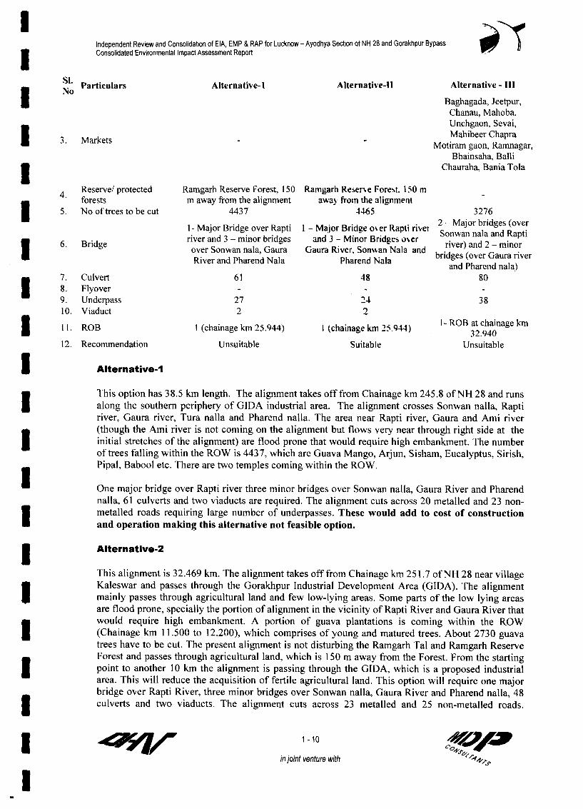
Independent Review and Consolidation of EIA, EMP & RAP for Lucknow - Ayodhya Section of NH 28 and Gorakhpur Bypass5 Consolidated Environmental Impact Assessment Report
Si* Particulars Alternative-I Alternative-lI Alternative - IIINoN Baghagada, Jeetpur,
Chanau, Mahoba,Unchgaon, Sevai,
3.Mrkt Mahibeer ChapraMarkets Motiram gaon, Ramnagar,
Bhainsaha, Balli3 Chauraha, Bania Tola
4 Reserve/ protected Ramgarh Reserve Forest, 150 Ramgarh Reser'e Forest. I 10 mforests m away from the alignment away from the alignmentIS 5. No of trees to be cut 4437 4465 3276
1- Major Bridge over Rapti l - Major Bridge over Rapli rive2 S nala anged (oRpr6. Bridge river and 3 - minor bridges and 3 - Minor Bridges o%er river) and 2- minorI 6. Brldge over Sonwan nala, Gaura Gaura River. Son%kan Nala and river a ura river
River and Pharend Nala Pharend Nala bridges (over Gaura river
E 7. Culvert 61 48 808. Flyover9. Underpass 27 24 3810. Viaduct 2 2
11. ROB I (chainage km 25.944) 1 (chainage km "5.944) 1- ROB at chainage k2
12. Reconmnendation Unsuitable Suitable Unsuitable
| Alternative-I
This option has 38.5 km length. The alignment takes off from Chainage km 245.8 of NH 28 and runsI along the southern periphery of GIDA industrial area. The alignment crosses Sonwan nalla, Raptiriver, Gaura river, Tura nalla and Pharend nalla. The area near Rapti river, Gaura and Ami river(though the Ami river is not coming on the alignment but flows very near through right side at the
8 initial stretches of the alignment) are flood prone that would require high embankment. The numberof trees falling within the ROW is 4437, which are Guava Mango, Arjun, Sisham, Eucalyptus, Sirish,Pipal, Babool etc. There are two temples coming within the ROW.
* One major bridge over Rapti river three minor bridges over Sonwan nalla, Gaura River and Pharendnalla, 61 culverts and two viaducts are required. The alignment cuts across 20 metalled and 23 non-metalled roads requiring large number of underpasses. These would add to cost of constructionand operation making this alternative not feasible option.
3 Alternative-2
This alignment is 32.469 km. The alignment takes off from Chainage km 251.7 of NH 28 near villageKaleswar and passes through the Gorakhpur Industrial Development Area (GIDA). The alignmentI mainly passes through agricultural land and few low-lying areas. Some parts of the low lying areasare flood prone, specially the portion of alignment in the vicinity of Rapti River and Gaura River thatwould require high embankment. A portion of guava plantations is coming within the ROWI (Chainage km 11.500 to 12.200), which comprises of young and matured trees. About 2730 guavatrees have to be cut. The present alignment is not disturbing the Ramgarh Tal and Ramgarh ReserveForest and passes through agricultural land, which is 150 m away from the Forest. From the startingI point to another 10 km the alignment is passing through the GIDA, which is a proposed industrialarea. This will reduce the acquisition of fertile agricultural land. This option will require one majorbridge over Rapti River, three minor bridges over Sonwan nalla, Gaura River and Pharend nalla, 483 culverts and two viaducts. The alignment cuts across 23 metalled and 25 non-metalled roads.
I 71 K 1-10in joint venture with

Independent Review and Consolidation of EIA, EMP & RAP for Lucknow - Ayodhya Section of NH 28 and Gorakhpur Bypass Consolidated Environmental Impact Assessment Report
Compared to the other two alternatives this option has less cross road structures and cross drainagestructures and takes shorter route. This would reduce the cost of construction, operation andmaintenance of the road. The environmental damage would be minimized as it has shorter lengththan the other two options. Hence, the alignment 2 is recommended for selection .
Alternative-3
The length of this option is 44.283 km. The alignment takes off from Chainage km 245.8 of NH 28and runs along the southern periphery of GIDA industrial area. On its way the alignment crossesSonwan nalla, Rapti River, Gaura River, Tura nalla and Pharend nalla. It mainly passes through vastlow-lying areas and agricultural land. Some parts of the low-lying areas are flood prone, specially theportion of alignment in the vicinity of Rapti River and Gaura River. Within the flood zone of theRapti River, high embankment is required for this alignment.
This alignment cuts across 15 metalled and 27 non-metalled roads. In comparison to Alternative-I &2, 80 culverts and 38 underpasses are to be provided. Apart from that this alternative has the highestlength, which will increase the cost of construction, operation and maintenance. Hence, thealternative 3 is rejected as not feasible option.
1.6 Environmental Impact Assessment Process Adopted
Incorporation of Environmental considerations into the project planning and design has been takenup as an integral part of the project preparation. The major steps in EA process, which have beenadopted for this project are presented in the following subsections.
1.6.1 Environmental Screening
The feasibility study included a social and environmental screening. In this screening stage allenvironmental and social aspects of road expansion and bypass were identified. The impacts orvarious environmental and social aspects were also considered in project influence area. Informallocal level public consultations were held during screening to access likely impacts on projectinfluence area (PIA). Based on screening, EIA was focused on potentially significant environmentalissues.
1.6.2 Environmental Impact Assessment and Management Plans
The detailed design of NH-28( Luckhnow- Ayodhya ) and Gorahkpur bypass alignment has beenclosely coordinated with the preparation of Environmental Impact Assessment Study and preparationof environmental management plan. The EIA preparation led to identification of potentialenvironmental hotspots and their feasible remedial measures (including avoidance, mitigation andenhancements), based on that detail construction package wise environmental management plan(EMP) is prepared for the implementation. EMP is made appropriate to make it a contract clause.
1.6.3 Independent Review of EIA, EMP and Consolidation of Lucknow.Ayodhya Section of NH-28 including Faizabad Bypass Section andGorakhpur Bypass
The EIA and EMP documents of both Lucknow-Ayodhya section of NH-28 including Faizabadbypass and Gorakhpur bypass is reviewed by the Independent Review Consultants (IRC).
IRC have incorporated the missing gaps in all the reports based on the additional informationcollected and information gathered through repeated field survey. Moreover, IRC have consolidated
I u r 1-11cspwin joint venture with
l

Independent Review and Consolidation of EIA, EMP & RAP for Lucknow - Ayodhya Section of NH 28 and Gorakhpur BypassConsolidated Environmental Impact Assessment Report
the reports of both the projects. They have re-structured the report according to the requirement ofthe World Bank.
IRC also have re-structured and consolidated the EMP reports of both the projects. The DPRconsultants prepared no separate EMP for Gorakhpur Bypass project. IRC have freshly prepared thepackage wise EMP reports for Gorakhpur Bypass. They have also prepared the combined EA processsummary of consolidated reports.
1.7 Structures of this EIA Report
This EIA report is prepared as per requirements of the Environmental Impact Assessment notificationof Ministry of Environment and Forests (MoEF) under the Environment Protection Act, 1986, andWorld Bank Operative Directives. In the report preparation guidelines of the Indian Road Congress(1989), Environmental guidelines for Rail / Road / Highway projects of MoEF and World BankOperative Directives have been followed. Entire report has been discussed in remaining eightchapters. Brief of coverage in each chapter is described below:
Chapter 2 Project Description In this chapter selected road and bypass alignment have beendiscussed from an environmental perspective along with salient features such as RoW, cross section,community facilities, etc. The traffic projections are also presented. An overview of impacts of theentire project, mainly benefits, is given in the last section. This chapter also includes the generalfeatures, man made features, highway design and planning and also bridge design and planning, etc.
Chapter 3 discusses the Policy, Legal and Administrative Framework within which the project isset. The major stakeholder departments of the State and Central Govemments with their specificroles are described here along with the applicable Acts and Laws. This chapter also covers theclearance requirements at various levels and their current status.
Chapter 4 details out the Methodology adopted for the Environmental Impact Assessment.Descriptions are provided for survey procedures, modelling methods and environmental designs.
Chapter 5 describes the Existing Environmental Scenario in detail. The sections onMeteorological baseline, components of the physical and natural environments, cultural propertiesalong the corridor and quality of life add up to give a comprehensive picture of the existingenvironment along the road and bypass alignment and its area of influence.
Chapter 6 gives an overview of the Community Consultation carried out during the projectpreparation stage. It also provides an insight into the processes involved, its importance to projectdesign and methods adopted to document the entire exercise.
Chapter 7 on the Assessment of Impacts determines the extent of the impacts of the project activityon the existing environment. The focus of section is on the adverse impacts. The beneficial impactson the environment due to the project have been detailed in subsequent chapter under theenhancement measures. The impacts have been detailed in the same sequence as described in Chapter5 for ease of understanding.
Chapter 8 entitled Mitigation, Avoidance and Enhancement Measures forms the basis of thegeneration of coherent, comprehensive and concise Environmental Management Plans for the projectcorridors. In addition to the avoidance and mitigation measures for the physical and naturalenvironmental components, this chapter discusses various environmental enhancements suggested forthe project including the enhancement of common property resources.
3gr 1 -1 2
in joint venture with

Independent Review and Consolidabon of EIA, EMP & RAP for Lucknow - Ayodhya Section of NH 28 and Gorakhpur Bypass3 Consolidated Environmental Impact Assessment Report
Chapter 9 reviews the existing Implementation Arrangements and suggests further institutionalstrengthening for ease of implementation of the environmental component of the project. It goes on
* to describe the set-up required, a reporting system and training needs to ensure that the environmentalexpertise required for the effective implementation of EA provisions is intemalised at NHAI. An3 Executive Summary has also been prepared.
1.8 Stand Alone Environmental Management Plans
I Construction package-wise stand-alone environmental management plans has been preparedseparately for all the five construction packages. The EMPs include monitoring plans; enhancementplans, environmental management costs, monitoring frequency, detail of mitigation and responsibleagency for implementation.
llllIl1lll1
* qfl/ 1-13 AVAJ in joint venture with 4

T 41
is
IT
Io- T
lpv ik.
ig-,A
ovww-7
T Aedw,.,�
AC,
#NAA,x 01
N,
Z
15�1 AIr, vK-Q,,W
o -L
,C
J.9
ib
41 , N-,� I-7 1.4
am 1.
(LINDER
Pp
1
Fig. 1.3 ALTERNATIVE ALIGNMENT OF BARABANKI BYPASS .0 SW low 2M 3m
SCALE

4- - m -, m m -X m - -~~hqwd?ef~ ~ 7Y7'. Td*tou r-
A;<4
Flg.~ ~ 1. ALENTV LGMN FRMAEIHTBPS
601sovoprOrINd,
CM &. A
Kds * .S
wci8 ~~~cW X~~~ * ~~' Kw
INA~~~~~~~~~~~~~~~~~~~~~~~~~~~~~~~~~~~~~~~~~~~~~~~~~~~~~~~~~~~~~~~
-v'-
W~~~~~~~~~~
T fQ I. !'I. 11
Fig. 1.4 ALTERNATIVE ALIGNMENT OF RAMSANEHIGHAT BYPASSo SW boo 20W 300
SCALE

'en, Ar, 26- 47- 37" N4f - -
.4' . ~ ~ ~ ~ ~ ~ ~ ' 44.-~6
.~~~~6- 40' N 1 26' 4O'N~~~~~~~~~~~~~~~~-44 S'~4
"'26' 47 37 N 26' ' N ~~~~~~~~~~~~~~~~~~~~~~~~~~~~~~ ~ ~ ~ '.26' 47' 37' N~ ~ ~ ~~~~~~~~~~~6'40
Z5- 2F -38' 2W 38- 23"N4-/ r-
ALTERNATTVE I 2-4-.-7-"t' -'
.4 -8- .
ALT'E N ATIV 2 9 - -7 -- AT-" ... *.4 .. + * .7 , - - 4
-. s..,Fig.405- 'LENAIE LGMETOFGRKHU BPS

I
IIIIIIIII
I CHAPTER-2:I PROJECT DESCRIPTION
I
I
I
I
I
II

Independent Review and Consolidation of EIA, EMP & RAP for Lucknow - Ayodhya Section of NH 28 and Gorakhpur Bypass| Consolidated Environmental Impact Assessment Report
1 2 PROJECT DESCRIPTION
I U
2.0 PROJECT DESCRIPTION
The 130.0 km long Lucknow-Ayodhya section of NH-28 starts from km 8.25 near the initiation ofLucknow Bypass (under construction) near Kamta village and then proceeds up to km 122.275 beforeFaizabad, and thereafter, the project road bypasses the Faizabad town to go into Ayodhya along theFaizabad bypass. The project road finally terninates at chainage km 15.0 of Faizabad bypass at apoint 2 km before the end of the Faizabad Bypass.
I After chainage km 251.7 of NH-28, the Goprakhpur bypass alignment takes off near villagesKaleswar, just before the starting of Rapti flood protection bund, which forms the north boundary ofexisting RoW of NH-28. The 32.469 km long alignment ends at chainage km 279.8 near Jagdishpursettlement.
Construction Packages
Lucknow- Ayodhya section of NH 28 is divided into three construction packages and Gorakhpurbypass is in one construction packages, which are described below:
Road Section Package Chainage (km) Length Cost in(km) Crores3 From To (Rs)
Lucknow-Ayodhya Package l 8.25 45.0 36.75 327.01section of NH 28
| Packagell 45.0 93.07 48.07 266.74
Package lll 93.075 135.0 44.92 256.61
Gorakhpur Bypass Package I 0.0 (km 251.7 on 13.9 13.9 247.80existing NH-28)
Package 11 13.9 32.469(km 279.8 on 18.569 331.04existing NH-28)
1 Project Highlights
Road stretch Lucknow-Ayodhya section of NH-28 Gorakhpur bypass3 Road length 130 km 32.469 kmProposed bypass Barabanki and Ramsanehighat bypasses Goprakhpur bypass
Start point Km 8.25 near Kamta Village (Lat: 26°52'40"N, km 251.7 of NH-28 just before the
Long: 81°00'20"E) Rapti flood protection bund nearvillage Kaleswar
End point Km 122.275 before Faizabad and then 15.0 km km 279.8 of NH-28 near Jagdishpur
along Faizabad bypass. settlement.
(Lat: 26°47'55"N, Long: 82°13'10"E)
Existing 2-lane with 7.0 m carriageway, 0-1.5 m of paved Nil
carriageway shoulder and 1.0 m of earthen shoulders on either
side.
I P 2-1in joint venture with

Independent Review and Consolidation of EIA, EMP & RAP for Lucknow - Ayodhya Section of NH 28 and Gorakhpur BypassConsolidated Environmental Impact Assessment Report
Road stretch Lucknow-Ayodhya section of NH-28 Gorakhpur bypass
| Existing ROW 20-39 m till km 92 and 55 m for the rest NilProposed ROW 45 m for widening, 60 m for new alignment 60 mDistricts en-route Lucknow, Barabanki and Faizabad GorakhpurImportant towns Barabanki, Ramsanehighat, Faizabad, Ayodhya Nil
* Major river crossing Reth, Kalyani, Kasera RaptiRail crossing/ level 3 Railway over bridges and 2 level crossings IcrossingRoad crossings 15 5
Description of Proposed Alignment of Bypass on New ROW
Barabanki Bypass
| * The alignment takes off from chainage km 20 on NH-28 to the right side of the existing road andimmediately crosses Lucknow-Varanasi rail link, where an ROB has to be constructed.
* After that it passes through the agricultural land in between villages Darsanian and Pipraha, andthen it passes through the northern outskirts of Ganeshpur village.
* Thereafter, it runs through the northern outskirts of village Daudpur and crosses Reth river* After crossing the Reth river, it crosses Satrik road and SH-13 and then follows existing SH-13
| ~~~~bypass up to 2 km* It leaves SH-13 bypass just before crossing Rasouli escape canal and finally it joins NH-28 at km
32.107.
Ramsanehighat Bypass
| I . * The alignment takes off from chainage km 62.775 on NH-28 to the left side of the existing road andpasses through the southern outskirts of village Bhaison Purwa
* The alignment then runs through southern side of village Narayanpur and Bhunderi| * Then it passes near to the plantations of Asarafpur Ban Block and finally meets with NH-28 at km
69.679.
I Gorakhpur Bypass
* The Gorakhpur bypass takes off from chainage ,,km 251.7 of NH-28 just before the Rapti floodprotection bund (present along the northboundary of existing ROW of NH-28), near _ -
village Kaleswar (Photo Plate 2.1).* The initial 10.7 km the bypass alignment passes
through Gorakhpur Industrial Development Area(GIDA) area towards southeast. Then it traverseswest to east after crossing Sonwan Nalla, MDR-49 and NH 29 before crossing Rapti river atI chainage km 11.2 to 11.5
* After crossing Rapti river it passes through Photo Plate 2.1: Starting of Gorakhpur Bypass
Guava plantation from chainage km 11.5-12.2 then it continues towards east till SH bypass. ItI goes along SH bypass about a kilometer in the same direction and continues further 5 to 6kilometers where it turns towards southeast direction then it takes a turn towards north directionand continues about 10 kilometers before it meets NH-28 at chainage km 279.8 on the way it3 crosses Gaura Nadi, Tura nala and Pharend nala
2-2 OF A>in joint venture with 0 *
*1 4

Independent Review and Consolidation of EIA, EMP & RAP for Lucknow - Ayodhya Section of NH 28 and Gorakhpur BypassConsolidated Environmental Impact Assessment Report
The alignment mainly passes through agricultural land except at few places through village3 orchards
2.1 Proposed Carriageway Details
I This project is for widening of existing 2-lane road to 4-lane divided carriageway and constructingbypasses to avoid the major settlements. The geometric designs have been followed therecommendations of IRC: 73. However, existing road has certain limitations due to presence of
* settlements in some stretches. Thus some compromise in design standard has been made as per therequirement. The details of the carriage way are given below in Table 2.1. The cross section ofdifferent stretches of road are depicted in Fig 2.1 to Fig 2.12.
Table 2.1 Carriageway Details
S. Attributes Lucknow-Ayodhya Stretch Gorakhpur BypassN. including Faizabad bypass
1. Design Life a) Flexible pavement 20 years 20 yearsI, b) Rigid pavement 30 years 30 years2. Design Speed a) Rural 100 kmph 100 kmph
b) Through settlements 60 kmph 40-50 for service road3. Carriageway width 3.5 m 7.0 m for four lane part
J 10.5 m six lane partNumber of lanes in main carriageway 4 lanes
4. Edge strip adjacent to kerb 0.5 mI Main carriage way 0.25 mBypass 0.5 m
5. Paved Shoulder 1.5 m 1.5 m6. Earthen/Granular Shoulder 1.0 m 1.0 m (hard shoulder)7. Median Width a) Rural Stretches 4.5 to 9.5 m 12.0 m including 2x0.25 m
b) Built-up Stretches 1.2 m edge strips for 4 lanec) New bypasses 12 m 5.0 m including 2x0.25 mI edge strips for 6-lane
8. Embankment Slope (V: H) 1:2 1:29. Footpath along service road at built-up areas 2.0 m
(Footpath is generally over drain withcover)
10 Longitudinal Gradienta) Ruling Maxim 2.0 %
| ~~~~~~~~~~b) Absolute Maxim 3.3 %11 Carriage way (m) a) On bridges/culverts 11.0 m 11.0 m
12 Footbridge on Bridge and culverts (m) 1.2 m 1.2 m3 13 Service Road 5.5 m 5.5 m
2.2 Details of ROW
The existing Right of Way (ROW) on the project stretch of NH-28 (as per the records obtained fromPWD), ranges between 20-39 m from the start point, chainage km 8.25 up to km 93, and thereafter itI is about 55 m till km 122.5 and the Faizabad Bypass section. Chainage wise details of existing ROWare presented in Annexure 1.1. In the widening stretch a 45 m wide ROW has been proposed alongthe existing alignments (except urban/semi-urban areas with significant roadside developments) andI 60 m ROW along proposed new alignments of Barabanki and Ramsanaighat bypass (Table- 1.2). Atisolated locations like intersections, rest areas, toll plazas etc. more ROW are required. Retainingwall structure will be used wherever necessary in case of embankment stretches or locations where
| service roads are being provided.
2-3in joint venture with ' s A,
I s*~~~~~~~~~~~~~~~~~~~~~~~~

Independent Review and Consolidation of EIA, EMP & RAP for Lucknow - Ayodhya Section of NH 28 and Gorakhpur Bypass3 Consolidated Environmental Impact Assessment Report
The RoW of proposed Gorakhpur bypass is 60 m. retaining wall is proposed in high embankment3 stretches and low lying areas or area where water accumulations are recorded.
2.3 Median Width
In open rural stretches of existing road, median width of 4.5-9.5 m with 0.25 edge strips has beenadopted (Table-1.2). At places of space limitation i.e. at the congested towns, the median widthadopted is 1.2 m with 0.25 m edge strips. Median width is reduced to 1.5 m at median openings toI accommodate Right-turning lanes. In the proposed Barabanki and Ramsanehighat and GorakhpurBypass the median width is 12 m.
| 2.4 Salient FeaturesS. Features Lucknow-Ayodhya stretch GorakhpurN. bypass
f Package-I Package-lI Package-IlIl Total1. Length of road 36.750 km 48.075 km 44.925 km 129.75 km 32.469 km2. Length of Bypass 12.370 km 7.050 km - 19.42 km -
3. Length of Service Road 23.670 km 26.090 km 50.933 km 100.693 km 18.7 kmI 4. District Boundary: Lucknow, GorakhpurBarabanki, Faizabad
5. Landtobeacquired(ha) 111.48 104.87 0.45 216.8ha 193.8I 6. No.ofTreestobecut 5456 6168 4995 16619 44657. Rivers Reth Nadi Kalyani and - Rapti
Kasera Nadi8. No. of Culverts 56 66 66 188 48
a)Slab/box Culvert 38 42 14 94 22b) H P Culvert 18 24 52 94 26
9. No. of Major Bridge - I - I I1 (over Sarda)
10. No. of Minor Bridge 8 6 4 18 311. No. of Underpasses 9 9 12 30 24
2__ a) Vehicular 5 1 7 13 14b) Pedestrian 4 8 5 17 8
12. No. of Flyover I - 4 513. ROB I 1 3 5 114.No.ofTruckLaybyes 2 2 10 6 215. No of Bus Bays 8 1 - 20 816. Toll plaza - I - I
2.5 Service Roads
I Service roads of width 5.5m have been provided in urban areas to give access and to provide parking
facilities to local traffic. Service road has been proposed at various locations along the Gorakhpurbypass alignment to connect the villages through existing village roads to underpasses that are not
connected with the bypass alignment.
| 2.6 Major Settlements En-route
The project road passes through predominantly agricultural and rural areas except at a few stretches
where it runs near or through the urban/semi-urban areas. The important villages/settlements along
the Lucknow -Ayodhya stretch of project road are given in Table 2.2. Proposed Gorakhpur bypassavoid the settlement of Gorakhpur town and passes through agricultural field and river flood plain, it3 does not cross any major settlements.
1 2-4 4Z90in joint venture with 19 VAP
3 :

Independent Review and Consolidation of EIA, EMP & RAP for Lucknow - Ayodhya Section of NH 28 and Gorakhpur BypassConsolidated Environmental Impact Assessment Report
Table 2.2 Important Settlements along the Lucknow-Ayodhya Stretch includingFaizabad Bypass
Si. Chainage Name of the Si. Chainage Name of theNo. From To Settlement No. From To SettlementI 1. 8.250 9.500 Kamta (Ismailgunj) 23. 78.500 79.000 Ganouli
2. 9.500 13+400 Chinhat 24. 81.200 82.200 Rauzagaon3. 13.600 14+300 Tiwari Ganj 25. 83.400 84.100 Dalsarai Chauraha4. 19.000 20.000 Safedabad 26. 86.500 88.500 Bhilsar5. 34.200 34.800 Rasouli 27. 94.300 94.950 Barai Khurd6. 40.000 40.300 Dadra 28. 98.600 99.380 Basaha7. 42.500 42.900 Pyarepur Sariya 29. 100.150 100.450 Godwaa
a 8. 44.100 45.600 Safdarganj Chawraha 30. 102.000 102.500 Digambarpur9. 45.700 45.900 Palhari 31. 102.780 103.580 Mubarakganj10. 48.400 48.700 Baghora 32. 104.400 104.780 ArkunaI 11. 50.000 50.400 Udhouli 33. 105.600 106.450 Dinkarpur12. 51.600 51.900 Ahmedpur 34. 111.400 111.990 Maksoomganj13. 57.000 58.400 Kotwa Sarhak 35. 112.350 112.600 Magalsi1 14. 59.700 59.950 Mohammadpur Kirath 36. 113.800 114.800 Jaganpur15. 61.000 61.300 BadelaNarayanpur 37. 117.900 119.100 Kot Sarai16. 64.400 66.900 Ramsanehighat 38. 119.700 120.600 Mumtaznagar17. 70.200 70.800 Ranimou 39. 121.500 122.275 Faizabad18. 71.250 71.600 Bakarpur 40. 1.900 2.500 Godhopur19. 73.600 74.300 Mathra Ka Purwa 41. 4.800 5.350 Hawaipatti20. 75.100 75.700 Kazi Ka Purwa 42. 7.400 8.150 Devkali1 21. 76.200 76.650 Miya Ka Purwa 43. 8.300 8.800 Darshan Nagar22. 77.350 77.600 Jarala Kala
3 2.7 Railway Crossings and Railway Over Bridges (ROB)
The Lucknow-Ayodhya section of NH-28 alignment has five rail crossings of which three have overbridges and two have manually operated level crossing. In Gorakhpur bypass there is only onerailway crossing on north-eastern railway on Gorakhpur-Muzaffarpur route at chainage km 25.944.The locations of these RoBs and level crossing are presented in Table 2.3 below:
| Table 2.3: List of Railway Over Bridges / Level Crossings
Lucknow-Ayodhya stretch including Faizabad Bypass
Si. Name of the Road Location/ chainage Name of the railway lineNo km
NH-28 (20.6) Northern railway Varanasi -Lucknow loop line manned levelU I crossing at Safedabad2 NH-28 (82.97) North Eastern Railway line manned crossing at Rauzagaon
3 Faizabad Bypass 1.2 Northern railway Varanasi -Lucknow loop line (ROB)3 4 Faizabad Bypass 1.9 Northern Railway crossing (Allahabad - Faizabad Branch) (ROB)
5 Faizabad Bypass 10.6 Northern railway crossing (Varanasi - Lucknow loop) (ROB)
I Gorakhpur Bypass6 | Gorakhpur bypass 25.944 North Eastern Railway line (between stations Chaumi - Kusmi)
1 2.8 Under Passes
In Lucknow -Ayodhya stretch of project road, 13 vehicular under passes (VUP) and 17 pedestrian* cum cattle under passes are proposed are proposed. In Gorakhpur bypass alignment 22 underpasses
I P ~~~~~~~~~~~~~~~2-5Ain joint venture with s6^q <A
I toF 4

Independent Review and Consolidabon of EIA, EMP & RAP for Lucknow - Ayodhya Section of NH 28 and Gorakhpur BypassConsolidated Environmental Impact Assessment Report
have been proposed The under passes have the vertical clearance of 3.5 m or 5.5 m (depending onthe importance of the road) and a 5.5 m carriageway with 1.5 m footpaths on either side on theproject road.
| 2.9 Intersections, Interchanges and Flyovers
Beside the existing major junctions four new junctions have been proposed at the start and end of theproposed Barabanki and Ramsanehighat Bypass. Grade-separators are proposed at most of theexisting and proposed major junctions.
There are four major junctions on Gorakhpur bypass including the Y-junctions formed at thebeginning and end of the bypass. Two more intersections have been proposed at the crossings of NH-29 of Gorakhpur-Varanasi section at km 9.749 and at the crossing of SH- I of Lucknow-Deoria sectionat km 24.567 of proposed bypass.
The details of cross sections, Intersections, interchanges are given in Table 2.4.
3 Table 2.4 - List of Proposed Intersection Development
Lucknow-Ayodhya Stretch including Faizabad BypassS. Chainage (km) Location Nature of Interchange
No
Package-II . 8.550 End of Lucknow Bypass Unidirectional Flyover1 2. 20.000 Beginning of Barabanki Bypass Flyover3. 32.107 End of Barabanki Bypass Vehicular Underpass
Package-llI 4. 62.775 Start of Ramsanehighat Bypass5. 69.679 End of Ramsanehighat Bypass
Package-Ill7. 122.275 Beginning of Faizabad Bypass Unidirectional Flyover8. 3.425 Naveen Chowk, intersection of Faizabad bypass Flyover
with Raiberily Road (SH)9. 4.000 Naka Chowk, intersection of Faizabad bypass with FlyoverI NH-2610. 7.475 Devkali Chowk, intersection of Faizabad bypass Flyover
i _ with Varanasi Road (MDR)
Gorakhpur bypass1. 251.680 Junction of NH-28 at start point Grade inter section2. 9.749 Crossing of NH-29 Inter changes3. 24.713 Crossing of NH- I Inter changes4. 278.800 Junction of NH-28 at end point Grade inter section
3 2.10 Bridges, Culverts and Other Structures
There is one major bridge of nearly 60 m length and 24 minor bridges, and 188 culverts (94 slab| culverts, 94 Hume pipe culverts) on the Lucknow-Ayodhya section. Some of these culverts are weak
and would require reconstruction.
In Gorakhpur bypass alignment one major bridge over Rapti River, 3 minor bridges over SonwanNalla, Gaura River and Pharend Nalla and 47 culverts have been proposed. In addition, three viaductshave also been planned. The location of bridges and viaducts on the Gorakhpur bypass are presented3 in Table 2.5.
| 1 f | 2 -6 Ord- 9 _in joint venture with N

Independent Review and Consolidation of EIA, EMP & RAP for Lucknow - Ayodhya Section of NH 28 and Gorakhpur BypassConsolidated Environmental Impact Assessment Report
Table 2.5: List of Proposed Bridges, Viaducts and ROBs along the Gorakhpur Bypass
Si. Chainage (km) Name Span Arrangement Type of Type ofNo. Superstructure FoundationI . 5.013 Sonwan Nallah I x 18.4 m RCC T-beam OpenI 2. 9.387 to 10.362 Viaduct-1 39 Spans of 25 m PSC T-beam Pile3. 11.335 Rapti Bridge 8 spans of 52.2 m PSC Box Girder Well4. 15.085 to 15.510 Viaduct-2 17 spans of 25 m PSC T-beam Pile3 5. 17.864 GauraNadi I Span 26 m PSC T-beam Pile6. 24.407 to 24.782 Viaduct-3 15 spans of 25 m PSC T-beam Pile7. 31.557 Pharend Bridge 2 spans of 25 m PSC T-beam Pile
* 2.11 Traffic Mix and Volume
At the Feasibility stage necessary traffic study including origin-destination study was conducted todetermnine the expected growth rate and volume of the traffic at different time horizons.
The following growth rate of traffic in the Lucknow-Ayodhaya stretch and Gorakhpur Bypass was* arrived in the study:
Growth Rate (% per year)
Existing Road on Lucknow-Ayodhya Stretch of NH-28 including Faizabad Bypass: The trafficprojections have been made applying vehicle-wise growth rates to the base year (2002) traffic. TheU projected traffic up to 2035 on the project road for cardinal years is presented in Table-2.6. Thisrefers to the normal traffic on the project road.
3 Table 2.6 Projected Normal Traffic (per day) on the Lucknow -Ayodhya Stretch includingFaizabad
Year Lucknow to Barabanki Section Barabanki to Faaizabad Section Faizabad to Ayodhya Sectionear Car Bus Truck VPD PCU Car Bus Truck VPD PCU Car Bus Truck VPD PCU
2002 3002 1241 3164 14829 19314 1547 653 2446 10346 13768 818 833 3704 7293 151162005 3813 1482 3855 17998 23457 1906 780 2980 12153 16392 1007 995 4512 8680 181432010 5551 1983 5281 24746 32163 2624 1044 4083 15755 21743 1386 1331 6182 11501 243702015 7642 2654 7001 33023 42882 3511 1397 5412 20259 28380 1855 1781 8195 14987 320232020 9987 3387 9281 42406 55678 4481 1783 7175 25498 36467 2368 2274 10864 19270 417062025 13053 4323 11901 54208 71338 5719 2276 9201 31905 46169 3022 2902 13931 24374 530972030 17060 5517 15262 69453 91504 7299 2904 11799 40032 58554 3857 3703 17865 30882 676662035 22297 7042 19571 89161 117486 9316 3707 15131 50350 74367 4923 4726 22910 39183 86303
Barabanki Bypass: The estimated traffic using OD analysis for Barabanki bypass is given in Table3 2.7. This traffic is projected by vehicle type.
3 Table 2.7 Projected Normal Traffic (per day) on the Barabanki Bypass
Year Car Bus LCV HCV MAV VPD PCU/ Day2007 1679 1145 563 2400 42 5829 133462010 2034 1363 680 2899 51 7027 160692015 2722 1824 902 3843 67 9358 213782020 3474 2329 1196 5094 89 12181 279352025 4434 2972 1533 6532 114 15585 35760I 2030 5659 3793 1966 8377 146 19941 457762035 7222 4841 2521 10743 188 25515 58598
I ~~~~~~~~~~~~~~~~~~~2-7/oin joint venture with
3 :

Independent Review and Consolidation of EIA, EMP & RAP for Lucknow - Ayodhya Section of NH 28 and Gorakhpur BypassConsolidated Environmental Impact Assessment Report
Projected Normal Traffic (PCU per day) on the Lucknow -Ayodhya Stretch including Faizabad hasbeen shown in Table 2.8.
Table 2.8 - Projected Normal Traffic (PCU per day) on the Lucknow -Ayodhya StretchI including Faizabad
Year Lucknow to Barabanki to Faizabad to Ayodhya Barabanki BypassYear Barabanki Section Faaizabad Section Section2002 19314 13768 151162005 23457 16392 18143 133462010 32163 21743 24370 16069I 2015 42882 28380 32023 213782020 55678 36467 41706 279352025 71338 46169 53097 357602030 91504 58554 67666 457762035 117486 74367 86303 58598
Gorakhpur Bypass: Proposed Gorakhpur Bypass is introduced to the base network. This bypassemerged out of NH-28 at chainage 251+700 km. Connecting NH-29 and SH-1 it bypasses thecongested parts of the Gorakhpur town and meets NH-28 again at 279.80km.
| The bypass sections are attracting traffic ranging between 14900 and 15900 PCUs in the bypass-opening year 2005 and relieve congestion on existing alignment of NH-28. The traffic on the mostcritical section of the existing alignment gets reduced by 24% from over 66,000 PCUs to 50,000 PCUsafter opening of the bypass in the year 2005. The section-wise traffic assignment on the bypass for thecardinal years is presented in Table 2.9.
3 Table 2.9: Projected Traffic on the Gorakhpur Bypass
Year Car Bus LCV 2/3-Axle MAV Total PCUsSection-I: Seehapar to Nausar1 2005 330 121 251 4740 122 158392025 1098 390 780 14716 380 492972035 1875 667 1221 23046 595 77525Section-2: Nausar to Kooraghat2005 375 121 249 4719 120 158072025 1250 390 774 14650 372 492062035 2135 667 1213 22942 583 77404Section-3: Kooraghat to Jagdeeshpur
^ ~~~~2005 308 56 209 4563 112 149822025 1025 181 648 14168 347 46604
12035 1750 310 1014 22188 543 73208
1 2.12 Highway Facilities
In addition to offering a safe and fast travel facility to the road users, the upgrading/ construction ofnew bypass road project also includes provision of bus-bays, truck lay byes like wayside amenities,which has been describe below.
I Bus Bays and Truck Lay Byes:
. 10 bus bays on Lucknow - Ayodhya stretch with passenger shelters and four bus bays onI Gorakhpur Bypass
I ~~~~~~~~~~~~~~2-8orVJin joint venture with*1*s

Independent Review and Consolidation of EIA, EMP & RAP for Lucknow - Ayodhya Section of NH 28 and Gorakhpur Bypass| Consolidated Environmental Impact Assessment Report
3 truck lay-byes at km 1.0 (near Barabanki) and km 106.9 (Tashenpur) on NH-28 and at km7.125 on Faizabad Bypass and two truck lay byes at chainage km 251.650 (Kaleshwar) and km280.400 (Jagdeshpur) on the proposed Gorakhpur bypass have been proposed.
Details of the bus bays and truck lay byes are presented in the following Table 2.10.
Table 2.10 Location of Bus Bays and Truck Lay-ByesS.N. Right Side of Carriage way | Chainage (km) I Left Side of Carriage way | Chainage (km)3 Bus-Bays
Lucknow-Ayodhya section of NH-28 and Faizabad bypassPackage-I
1. Chinhat 9.40 Chinhat 9.41 2. Beginning of Barabanki bypass 3.8 Beginning of Barabanki Bypass 3.73. Barabanki Bypass 8.5 Barabanki Bypass 27.85
X 4. End of Barabanki Bypass 32.7 End of Barabanki Bypass 32.9X ~~~Packa e-11
a I. |Tala| 67.200 |Tala | 67.100Package-Ill
dII . Beginning of Faizabad Bypass 0.425 Beginning of Faizabad Bypass 0.3252 Naveen Chowk 2.725 Naveen Chowk 2.8253. Naka Chowk 4.025 Naka Chowk 4.1254 Devkali Chowk 7.425 Devkali Chowk 7.5255. End of Faizabad Bypass 15.000 End of Faizabad Bypass 15.665
Gorakhpur Bypass| I1. Kaleshwar* 251.700
2. Junction with NH 29# 9.5503. Junction with SH 1# 24.467 to 24.6673 4. Jagdeeshpur* 280.200
Truck Lay-Byes
Lucknow-Ayodhya section of NH-28 and Faizabad bypassPackage I
1. I Barabanki | 1.0 Barabanki 1.0| ~~~Packa e-illlI k1. Tashenpur 106.900 Tashenpur 106.90
2. IFaizabad Bypass 7.125 Faizabad Bypass 7.125
| Gorakhpur Bypass
Kaleshwar* (L-200m)
2. - Jagdeeshpur 280. 400I Jagdeeshpur* ~~~~~~~~~~~~~~~~(L=200m)Direction: Lucknow to Gopalgang in Lucknow-Ayodhya Section* Along the existing alignment of NH-28; #along the proposed bypass
Toll Plaza: Lucknow-Ayodhya section of project road is proposed to operate as partial access-
controlled facility, NH 28 portion is not a toll way however, the Ramsanehighat Bypass is proposed
to operate as partial access-controlled facility. The toll plaza is proposed to be located at
Ramsanehighat Bypass between Km 3.20 and Km 3.62. The length of toll road portion is 6.7 km.
The cost of developing Gorakhpur bypass is proposed to be recovered by collecting toll from the
users accordingly, toll plaza for this bypass is proposed at chainage km 3.5.
A combined system of Electronic Toll Collection (ETC) and semi-auto toll collection has been
proposed. It gives customers the flexibility of paying toll though cash, cheque or credit cards. For
Ir 2-9 Ain joint venture with

Independent Review and Consolidation of EIA, EMP & RAP for Lucknow - Ayodhya Section of NH 28 and Gorakhpur BypassConsolidated Environmental Impact Assessment Report
this, the toll facility operator has to tie up with credit card issuing agencies. Customers can alsoreceive monthly statements detailing their toll usage and will not have to ask for receipts.
Traffic Safety Features: Metal Beam Crash Barriers will be provided on road edges with highembankment (height >3m) and approaches of bridges and on sharp curve locations as per MoRT&Hspecifications (Section 809 and 810). Moreover, Concrete Crash Barriers (New Jersey Type) havebeen proposed on all major structures to prevent vehicles going out of control at bridge locations.These barriers will be provided as per drawings and installed as per MoRT&H Specifications(Section 809). Pedestrian Railing is also proposed in junctions.
Road Sign, Road Marking and Road Furniture: Traffic informatory, mandatory and cautionarySigns have been proposed at appropriate locations for guidance, information and warning and tocontrol the traffic on highways and bypass roads. All the signs will be of retro reflective sheeting andhigh intensity grade as per IRC: 67 - 1997.
The roads will be provided with proper road marking for safe and hazard free journey. Theseincludes broken white centerlines, solid yellow edge lines, arrows, chevron markings, kerb paintingsin thermoplastic paint with glass beads and as per IRC: 35-1977.
Kilometer Stones will be provided on either sides of the road. The design and placement of thesestones, the dimension of stones, size, color, arrangement of letters will be as per IRC: 26-1967 andIRC: 8-1980.Overhead gantry signs will be provided on approaches of Toll Plaza locations, grade separators andnear rest areas. These will be refectories type with high intensity retro reflective sheeting.
Roadway Delineators will be provided as visual aids for user safety at night especially at highembankments, substandard/sharp curves with poor visibility, approaches of bridges etc. The design,location and material will be as per IRC: 79-1981.
2.13 Road Drainage
The drainage of the proposed project road is taken care by different types of drains. Longitudinaldrains have been provided on the both sides of the project road. Semi-circular drains are providedwithin median area to take care of runoff from wide median and upper half carriageway in case ofsuper elevated stretches. Chute drains are proposed to channelise and discharge the surface flowthrough a system of kerbing and chuting where the height of embankment is more than 3.0 m.
In the Gorakhpur Bypass an open trapezoidal toe drain (lined/unlined) is proposed to the right side ofthe alignment in rural areas. Urban drains are proposed in between service roads and maincarriageway. At the stretches where embankment height is greater than 3 m, it has been proposed toprovide the kerbing and chuting arrangement. Stretches that are predominately waterlogged, stonepitching has been proposed up to the HFL level with cutoff wall and dumped rubble at the toe of theembankment.Different types of proposed drains are described below:
Longitudinal Drain: Longitudinal drains are provided on the both sides of the project road. The outfall for the drains are generally the nearby culverts but due to undulating ground profile and lack ofadequate number of drainage outlet points, in some stretches it is suggested to discharge the surfacerunoff to the adjacent low-lying agricultural fields / pond etc. at appropriate locations.
Median Drains: Semi-circular drains are provided within median area to take care of runoff fromwide median and upper half carriageway in case of super elevated stretches. The catch pits areproposed at appropriate locations to de-water median drains.
37 2 -10 v2rin joint venture with

Independent Review and Consolidation of EIA, EMP & RAP for Lucknow - Ayodhya Section of NH 28 and Gorakhpur BypassConsolidated Environmental Impact Assessment Report
Chute Drains: When the embankment is high, the water flow may cut gullies through the earthenshoulders and embankment side slopes. The problem gets accentuated when road is in grade in whichcase the flow gets concentrated to cut deep gullies. For avoiding such situations, it is proposed tochannelise and discharge the surface flow through a system of kerbing and chuting where the heightof embankment is more than 3.0 m.
2.14 RoW and Land Acquisition
For the widening as well as the bypass, land needs to be acquired depending upon the geometricproposals and other facilities such as service roads, flyovers, etc. At isolated locations like junctions,rest areas, toll plazas etc. additional land will be required.
Total additional land requirement is about 216.8 ha, out of which only 21.1 ha (i.e. about 10% of totalrequirement) is residential and commercial land, the rest 90% is agricultural and waste land. About49% (i.e. 106.1 ha) of the total land requirement is for the two new bypasses of total length 19.162 km.
In Gorakhpur bypass area total land required for the proposed RoW is 193.8 hectares, out of which100.74 hectares are agricultural land, 62.17 hectares is Notified Industrial Area (GIDA area) and 30.89hectares is river flood plain.
2.15 Project Cost
Total project cost of Lucknow- Ayodhaya section of the NH 28 is Rs 850.36 crore, in this landacquisition cost will be Rs. 87.8 crores. The costs of Gorakhpur bypass are Rs. 578.84 crores.
Environmental mitigation and enhancement costs have been summarized in chapter-8.
lllll
l
3 n2 -11 4wZ4xin joint venture with 00* 4

- ----- - - - - - - -
V '-
Proposed ROW = 40700
/\2000 5500 R2f l 2500 7000 250 1200 250 7000 2500 2! io 5500 2000
/ FDrotpath Servi Rrod tro h Srrer Slo a Pakinge Corriogewy U " bdialn Carriogeway Slow Paring Ietal eam Service Road Drain/ \Crash ~~~~~~~~~nw
1000~~v c
Ln Crash ~arlr Dorain/
Footpath Foatp(do( *ri *)
l Fne aohtpc% Footpath
w W0 0/\/ 200mm J pPe where ever requred Metol Beam Crashoh er
200mmSr pip. where requi \/ r rea Z0or m utrty pape O 20m Flexible Pavement
qp I : Are for uility servce
SOmm 20 5 2.5X
02m_/cX
200NrnP piPPip20 c/
Fi. 2.1 TYPICA CROSS SETO'ORFU AN IIE
TYPE - 1 (CONCENTRI3C WIDENIN WITHOU SPCSOCOD IEN PCFRGENBL
PTIO )Existing Carriageay DMChoke GSB
~~Sub grade 0S Cok
Sub grade ~~~~~~~~~~~~~~~~~~-sma Pmll Carfv co
Sub grade--450mm C NP3 Pip.
Fig.: 2.1 TYPICAL CROSS SECTION FOR FOUR LANE DIVIDEDCARRIAGEWAY WITH SERVICE, ROAD AND FOOTPATH ON BOTH SIDENOSAEFRG ENELTYPE -1I (CONCENTRIC WIDENING WITHOUT SPACE FOR ROAD SIDENOSAEFRG ENBLPLANTATION)

m m -m - -m - -
P-ad ROW . 56000
~~~~ S~~$= t 5.. 7000 250 Vsr,ss(7500-9500 j?ov5.j J j E~~~~~~~~~~~~~~~~~~~~s~~~~~~~p~~~.a m-w Im'Ijjr e* fo.
Lasj,_.'@ _ , _' r 25-
I ~L LE\ _-SX h-I,E
(CROSS SECTON TYPE-02A a THE MROR 1MGE OF CROSS YC P IE-2)
Dowlt VA|lES 75 3D0 ' 2 VARIS(75-9500 0 '1
I11*SER ROAD POPO CAPGEEY m r CA AY C ROAE
5~~~~~~~~~~~~~~~~~~~~~~~~~~~~~~~~~~~~~~~~~~~~~~~~~~~~~~~~~~~~~~~~~~~~~S Zi~~~~~~~~~~1 S W ow *#l
I *1 1 .e 0 1I *0;* # *
.1 I . .1I 1.
Legend:Fig.: 2.2 TYPIc AL CROSS SE( TION FOR FOUR LANE DIVIDED(TARRIAUEWAY WITH SERVICE ROAD (N B(TH SIDE - Proposed Large Tree e Shrubs Mlddle Size Conspicuous Trees
TYPE - 2 (ECCENTRIC WiD)ENING WITH PLANTATION AT MEDIUM) * Existing lArge Tree . Conical Shaped Trees

Pm.d ROW5- 45000
Sp. for Gnn yg 500 Vnl 1000 1500
b.MMEWi .MI i2 o oo IO ra EaIatnqCarraqawayEaSt COragwq- ~ J SIEr.ankV-t
fiSt ( sw7ih Ž 2 SeIc. Earh fl- ___
y 2Y5 ,&S d E'. F2.5.X N E F
- _Gir C1 LdEorthFWLwPCC S~~~~~~~~~~~~~~~~~~D l - G_
SW E" mL mu Pe E,.W-S POM t
(CROSS SECTION TYPE-3A IS THE MIRROR IMAGE OF CROSS SECTION TYPE-3)SPACE FOR GPF0N eaT YAR1I 5 05,CS 100W 1500 70C0 2 ffOO 250 7000 1500 1000 VWs '0tYAP SPACE FOR C WITS M EBAKMENT 7RPROPOSED CARRNIAYOA 4M5M N OOiNGCNRMOWA I VJANKMNT SPAE FR I
tmp) PROPOSED CARRIAGEWAY I : EXISTING CARRIAGEWAY
S a zm X X # X X m n _~~rn r0~~- I1 1 I I * -1
O~~~~~~~a 1c. , **i c. NtO I
I 01 1I, * I I. I*
Fig.: 2.3 TYPICAL CROSS SECTION OF FOUR LANE )IVIIED Legend:CARRIAG(EWAY WITH PAVEI) SHOULI)ER ON BOTH SII)E Proposed Large Tree C Shrubs 0 Middle Size Conspicuous TreesTYPE-3 (ECC('ENTRIC' WII)ENIN(; WITH PLANTATION AT Existing Large Tree ( Conical Shaped Trees
MEI)IUM ANI) BOTH SII)ES)

- -m m - -m - - - - - - * -l
Propo ROW -45000
Sp.o. fo ,. 500 d 0 10V-" ond 0. ' 1 lE;n t1..k t 1 7000 250 Vor_ (4f00-9500) 20 7000 CI000 0 0D 00R
SW.It.d th fill2 1
Y~~~~~~~~~~o -d fmi}c LI i 0 1 7 - 055ro drOln Exr Pe_nnt S.bg,.d. Eel
SPACE FOR 00Th MIT VARWMO0
VARIES 1 1500 (CROSS Sg()ON TYPE-4A IS THE MIRROR IMAGE 2 CROSS SECTION TYPE-4)ORMS 5 E1IBE 1 KM f PROPOSE1 CARRIaOEWAY 4500-9500 7000 M io VW S 5 AE l_ CPFN I T
I 0 0 I M I IA I A t 1 D 9(SWP) I v LS PROPOSED CARRIAGEWAY * EXISTING CARRIAGEWAY |
(9 I I 0c I I I O
0 3 d m * g tI* * ! 2 * m > 3 0~~~~~~~~~~~~~~~~~~~~~~~~~~~~~~~~~~~~~~~~~~~~~~~~~~~~~~~~~~~~~~~~~~~~~~~~~~~~~~~~~~~~~~~~~~~~~~~~~~~~~~~~~~~~~~~~~~~~~~~~~~~~~~~~~~~~~~~~~~~~~~~~~~~~~~~~~~~~~~~~~~~~~~~~~~~~ I
O ~ ~~~~ ~~~~~ ~~~~ S * *: I* : O@ I 1 1 @ I 1 1 {3>~~~~~~~~~~~~~~~~~~~~~~~~~~~~~~~~~~~~~~~~~~~~~~~~~~~~~~~~~~~~~~~
z Is~~~~. I
Fig.: 2.4 TYPICAL CROSS SECTION OF FOUR LANE D)IVII)EI) Legend:CARRIAGEWAY WITH PAVEI) SHOULI)ER BOTH SII)E Proposed Large Tree 0 Shrubs * Middle Size Conspicuous Trees
TYPE -4 (ECCENTRIC WIDENING WITH PLANTATION AT o A
MED)IUM ANI) BOTH SII)ES) Existing Large Tree L Conical Shaped Trees

- m - m fl m m m a a - a - a a a a a - - -
PFooo ROW -45CO0
.5AW R wd 10 7000 250 250 c= I; 100
r 20tom Co PfI LoM 0 O o 4~~~~~,1 2.s 5X +l,2S v)
/ \L/ \. 9b b *S .wl. Cc/c" ,ru .ec _t / II~~~~~m IL. 0 0
/ PV5nm * FbIC MqSL
(CROSS SECTION TYPE-SA IS THE MIRROR IMAGE OF CROSS SECTON TYPE-5)
2000 5502000 2000 1RPS 000 250 4jw 220is 1500 0 ICE P-tc 500-- SePA1
ww FOR GWOO1.1 SERVICE ROAD ~ROPSEDCARRIAGEWAY W MEDE W 4KTM CARRIAGEWAY - nO..NKsJ4 Dp-j
SERVICE ROAD PROPOSED CARRIAGEWAY j * EXISTING CARRIAGEWAY I - I
I H
I1. D3 m
Fig.: 2.5 TYPICAL CROSS SECTION OF FOUR LANE I)IVII)EI) Legend:CARRIAGEWAY WITH SERVICE ROAI) ANI) FOOTPATH ON ONE SII)E WProposed Large Tree * Shrubs Mlfiddle Size Conspicuous Trees
TYPE-5 (ECCENTRIC W1I)ENING WITH PLANTATION AT MEI)IUM ANI) AONE SI)E) wEisting Large Tree Conical Shaped Trees

mm- - - - - - --
Prpod.. ROW - 45000
Space f C;reen500 500Span. far GUO;Wn b Vore 1000 15007000 250 4500 250 7000 1500 1000 aSpac ft GreeoVa.rgaad UtiOty Rol..&I ,n .r Emb., t il' I I.--- uaea- I0 E. . Crrk wy a a,- IE'0,n I Vo .. ad UfOlty Rafacfla.Sho.kld -
2.51 2.51 Seleted earth fill
_A A_ _ _ GL _) 3 / t6 north fill | | LT~~~~LDBM earth fill L LDBU oProfll Correci Cour.-IG. Existing Carrioqe.ay
SPACE FOR CRFFN RnrI SW VARS 1000 1500 7000 250 4500 250 7000 1500 1000 VARIP4 5 00
VARIF SPACE FOR RFFN RFI TR2 KMENT PROPOSED CARRIAGEWAY MEDAN PROPOSED CARRIGAY r | D
0 2 1:t Z i j g , jN Dm: N 4 * Z :aj0 300D
~3000~ . 30D)
.1~~~~~~~~~~~~.
_ a :~~ ~~~~m PL : .: 6 S m 0-I I I I -01 1 *~1 1 PRPOE CARRIGEWA
Fig.: 2.6 TYPICAL CROSS SE(1TION FOR FOUR LANE DIVIDED Legend:CARRIAGEWAY WITH PAVED SHOULDER ON BOTH SIDE @ Proposed Large Tree Shrubs Middle Size Conspicuous TreesTVPE-6 (CO(NC'ENTRIC1 WIDENING, WITH PLANTATIONNATT
MEDIUM AND BOTH SIDES) Existing Large Tree Conical Shaped Trees

- --- - m i n -
Proposed ROW - 36700
2000 5500 SC 500 9250 1200 9250 500 500 5500 2000Footpath | Service Rood |E Corriogeway do| Corriogewoy I Serice Rood Footpath
-0
-a RCC Crash Borre2.0%X 2.0%
0-~~~~~~~~~~~~~~~~~~~~~~~~~~~~~~~-c; r- \, A . A .*.' . . . .
I
2_5% / 2.5%
(m m -Wheel Guard Wheel Gu0r so -
BM-SOmm * NP) Pipe wGu 600mm 0 NP) Pi
for Utility Service gS for Utility ServiceSubgrad
H'=5000 For Vehicular Underpass
H*=3500 For Light Vehicular Underpass
H'=2500 For Pedestrian Underposs
Fig.: 2.7 TYPICAL CROSS SECTION FOR UNDERPASS WITHSERVICE ROAD AND FOOTPATH ON BOTH SIDE NO SPA( E FOR (GREEN BELT
TYPE-7

- ----- - - - m m
Proposed ROW - 40000
2000 5500 5 500 9250 4500 9250 500 900 5500 20
Foot oth | IdNice Rood | 1 ml Corriageway Medion m Corogeway IS ice Rod DrFit/Ser.ice Rood I~~~~~~~~~~~~~~~~~~~~~I ICa' Footpath
a 2.0% J3-$ 2.0% RCC Crash Borrier
S ''"' '':' V.D* . - . , _ _
0
I5% I / \/ 2.5%
(tI2~0n,m -Wheel Guord Wheel Guord- SD
5 NPN Pipe hM 600mm 0 NP. P
for Utility Se,i.e GSB for Utilty SeNpieSubgrade
Fig.: 2.8 TYPICAL C'ROSS SECTION FOR UNDERPASS WITH WIDEMEDIAN, SERVICE ROAD AND FOOTPATH ON BOTH SIDE NO SPA( E FOR (;KEEN HELT
TYPE-8

Sp- -
- - m - - m -. Woo - - - -
W.W. c-ew"." V." VM.1T 5W
~~~~~~~~~~
Boo
S 5Af FO -W T5 500
CJ_I V "gYa00 I .1 PROPD CRIACY1'
PROPOSED CARRIAGEWAYI PRP* CRIAKA
-rA S~~~~~~~~~. =I * I.W | I|4|CWY| t11
I *o I I I m * I I 1I O~~~~~~~~~~~~~~~~~~* I* .1O< I. _
Legend:
Fig.: 2.9 TYPICAL CROSS SECTION FOR BIYPASS Proposed L.rge Tree e Shr-bs Middle Size Conspicuous Trees
TYPE-9 # EzisUg Uarge Tree 0 Conical Shaped Trees

-~~~ m m -m m m - m-
1000 1500 700250 4500-7500 250 7000 1500 1000zz z LEFT CARRAGEWAY M UEOWN EXISTING CARRIAGEWAY
W9 9 n' 9wx I ,:) ~ ~ ~ ~ ~ ~ ~ ~ ~ L ~ :
.0 io 0~~0 4 I
w )o CONCRETE SEMI-CIRCULAR DAIN
CHANNEL 600 DA 2
F2~~~~~~~~~~~~~~~~~~~~~~~~~o
II B~ ~ ~~~~~~~~~~~~~~~~C BCDBM It L 3M L_Earth Fill
POC ~ ~ ~~~~~~~~~~~~EISTING PAVEMENT GSBEarth Fill -GSBCMedan mi SUBGRADEEarth Fill G~~SBORA -SELECTED E-aT FIL
t092 150Q ROSE 7000 250 4500 250 7000 -1500 1~00Qz W. cc PROPOSED CARRIAGEWAY MEDIAN A PROPOSED CARRIAGEWAY x z
0~~~~ *
* ~~~~~~~~
.9 mcom i -ROPOSED CARRIAG iWAY R 'iROPO 3ED CARRIAGEWAY
* v * *I
Legend:
Fig. 2.10 TYPICAL CROSS SECTION IN SUPER ELEVATED Proposed Large Tree * Shrubs Middle Size Conspicuous Trees
AREA TYPE-12 Existing Large Tree ( Conical Shaped Trees

- - m - - - - - - - -l_
Propo-d ROW - 45000
0~~~ ~ ~ Exmm .e. G. drd
Verln 1000 1500 70 25f 1200-4500 25 0 7000 1500 1000 Vorl
EXSIGCARRAEA POSD CARRIAE1IY
2 2.15X
RUV LVerOD 100 15001 7000 250 1200-4500 250 7000 1501 00io V0a
CARL Y OWWAY
EXSTING CARRIAGEWAY PROPOSED CARRIAGEWAy
0.~~~~~~~~~~~~~~~~~~~~~~~~~~~~~~0
Legend:
Fig. 2.11 TYPICAL CROSS SECTION FOR FOUR LANE Proposed Large Tree 0 Shrubs Middle Size Conspicuous Trees
D)IVIDED CARRIAGEWAY ON HIl(H EMBANKMENT Existing Large Tree 0 Conical Shaped Trees
TYPE-13

- m - - m - - - - - - - -------_
Pd ROW -o600O
20M 100 Voil. 10lSow I 25 1200 '0 15001 100 Vn.1070000 I Me. HI 250 14500 250
- ~~~~~~~~~~~L KER i OIL 2S
2 pZTX 2FDA: _ 22
S> A . -. -) >. / ---. . . . . .. ,07 -
2000 1000 7000 1500 VARIES 1000 1500 7000 250 12&-4500 250 7000 1500 1000 VARIES 1500 7000 1000 2000
5 1w Dfte I (BThGcAmevmy ~ NPO0 M.W Y
J SERVICE ROAD EaSTING CARRIAGEWAY PROPOSED CARRIAGEWAY SERVICE ROAD RE:* 0 0
* * 0
Legend:
Fig.: 2.12 LANE DIVIDED 'ARRIAGEWAY ON HIt,H EMBANKMENT WITH 5.Om Legend:
WID)E MEDIAN AND BOTH SIDE SERVI(E ROAD ON GROUND LEVEL , PrPO-ed lar1e 1ree Shrub, Middle Si.. C-picuou Tre,,
TVPE-14 SEnsting lArge Tree ( Conle.1 Sh.ped Tree"
11

I
I
I
I
I
III
I
I POLICY, LEGAL AND
I ~~~~ADMINISTRATIVE FRAME WORK
IIIIIII
l

Independent Review and Consolidation of EIA, EMP & RAP for Lucknow - Ayodhya Section of NH 28 and Gorakhpur BypassI Consolidated Environmental Impact Assessment Report
3 3 POLICY, LEGAL AND ADMINISTRATIVEFRAME WORK
3.1 Policy, Legal and Administrative Frame Work
Four laning of Lucknow to Ayodhya stretch of NH-28 and construction of Gorakhpur bypass are partof East-West corridor improvement project implemented by NHAI. Though the primaryresponsibility of the project rests with the NHAI, a brief discussion on the various institutionsinvolved and their level of responsibilities in the project implementation is presented in the followingsections.
3.2 Institutional Setting for the Project
The National Highways Authority of India (NHAI)
The mandate for the planning, design, implementation and maintenance of the 30,000 km NationalHighway network in India rests with the Ministry of Road Transport and Highway (MORT&H),Government of India. The MORT&H carries out its duties of maintaining these highways through thevarious state PWDs.
To plan and implement projects on a fast track and to expedite the improvements of the importantNational Highways, the Government of India has established the National Highways Authority ofIndia (NHAI). Of the total national highways network in India, the NRAI has been entrusted withthe planning, development and management of 13,000 km forming part of the Golden Quadrilateral(connecting the four major metropolitan cities in India, viz., Delhi, Kolkata, Mumbai and Chennai)and the North-South and the East-West Corridors connecting Kashmir to Kanyakumari and Silchar toPorbandar.
With an ambitious plan of the improvement of 13,000 km national highway stretch by 2011, NHAIhas initiated several highway development projects in various parts of the country on a war footing,with funding from World Bank and Asian Development Bank apart from its own sources of funds.
NHAI, through the Member (World Bank) will be responsible for the effective implementation of theproject activities. General Manager (technical), General Manager (Environment) and the ProjectDirectors of the various project packages assist the Member (WB). Separate NHAI units known asProject Implementation Unit (PIU) headed by a Project Director have been established for each ofthese packages. International consultants have been appointed for carrying out the feasibility studyand preparation of the detailed project reports and designs for four-laning of the project packages.
Project Implementation Units
These are separate NHAI units established at the project locations for each of the project packages,with a Project Director (PD) as its head. The Project Director is assisted on all technical issues bytwo managers, which include a manager (Technical and Environment), and a manager (R&R). ThesePIUs play a key role in implementation of the project including the overall control of constructionactivities and implementation of contracts. The various Project Directors, in turn report to theGeneral Manager (WB), who is responsible for the co-ordination of the project activities of thedifferent project packages. On top of the GM (WB), there is an chief General Manager at corporateoffice as administration head.
Ir in joint vent with Z3-1in joint venture with A

Independent Review and Consolidation of EIA, EMP & RAP for Lucknow - Ayodhya Section of NH 28 and Gorakhpur BypassConsolidated Environmental Impact Assessment Report
The review of the Environmental and Social assessments for the project and ensuring the effectiveimplementation of the Environmental Management Plan / Resettlement Action Plan is carried out bythe Environment and R and R managers at the PIU, in due consultation with the environmental andsocial development unit (ESDU) at the Corporate Office.
Environmental and Social Development Unit at the NHAI Corporate
NHAI, primarily being a road agency, till recent past did not have the capacity to address theenvironmental/social issues related to the projects. To assess advice and monitor the environmentalperformance of the various projects being planned, designed and implemented by the NHAI, anESDU has been established at the Corporate Office of the NHAI. The General Manager(Environment), who is assisted by a Deputy General Manager (DGM) and two managers - one eachfor the Environmental and Resettlement aspects, heads the ESDU.
The ESDU is responsible for the co-ordination of the environmental and social issues of the variousproject packages and works in close interaction with the environmental managers at the various PIUs.
3.3 Legal Frame Work
The Indian constitution makes environmental protection an explicit duty for every citizen by theinclusion of the following in the fundamental duties of Indian citizens.
"It shall be duty of every citizen of India to protect and improve the environment including forests,lakes, rivers, wild life, and to have compassion for living creatures".
In addition, Government of India has laid out various policy guidelines, acts and regulationspertaining to sustenance of environment.
The legal framework for the project is summarized in following sections.
3.3.1 The Environment (Protection) Act, 1986 and the EnvironmentalImpact Assessment Notification, 1994
The Environmental (Protection) Act, 1986 is the umbrella legislation providing for the protection ofenvironment in the country. This act provides the Environment (Protection) Rules, which wereformulated in 1986. The Environmental Impact Assessment Notification, 1994 and the variousamendments thereto have been notified under this act. As per the amendment, formal environmentalclearance from the ministry is required for highway widening and strengthening projects if theyinvolve land acquisition of more than 20m, on either side put together and/or cut across or passthrough environmentally sensitive areas as reserved forests, wildlife sanctuaries, biosphere reservesetc. Also, the bypasses are to be treated as separate projects and require an EIA only if each one costsmore than INR 1000 million (Annexure 3.1). Under 'The Environment (Protection) Act', 1986, thedevelopmental project requires clearances from the State Pollution Control Board and Ministry ofEnvironment and Forests, New Delhi. The procedure for obtaining environmental clearance has beendepicted in Figure 3.1.
I
u r ~~~~~~~~~~~~~~~in joint venture with t
l

Independent Review and Consolidation of EIA, EMP & RAP for Lucknow - Ayodhya Section of NH 28 and Gorakhpur Bypass3 ~~~~~Consolidated Environmental Impact Assessment Report
Figure 3.1 Flow Chart for Obtaining Environmental Clearance
SCOPING BY 3 ~~~~~~~~~~W~ESTOR INVESTOR
SUBMITS PROJECTQUESTIONNAIRE TOCONCERNED SPCB SUBMISSION OF THE PROJECT TO
THE MIN. OF ENN.. & FORESTSI ~~~~~~~~~~~~~~~~~~~~~~ALONG NTfH ALL DOCUMENTS
I YES ~~~~REVIEWBYSPCB
IS THEI ~ ~~~~~~~~ENVIRONMENTAL INITIAL SCRUTINY BYMANAGEMENT PLAN STAFF OF MIN. OF ENV. &
SATISFACTORY FORESTS3 ~~~~~~~S NOCAN ISUESBE N
RESOLVED REJECT REVIEW BYF-I ~ ~~~~~~~~~ENVIRONMENTAL IS THEAPPRAISAL COMMITTEE OF PROJECT SITEI ~~~~~~~~~~~~~YES MIN. OF ENV. & FORESTS -,-SACCEPTABLE
HAS PUBLIC HEARING BEEN INOCARRIED OUT SUCCESSFULLY TO
INCORPORATE VIEWS, VSUGGESTIONS AND OBJECTIONS jIS THE INFORMATION wI ~ ~~~~~~~~~OF PUBLIC IN PROJECT PROVIDED ADEQUATE EAC MEMBERS
t ~~UNDERTAKEYES +SITE VISITS
~~~~~YES ~ ~ ~ ~ ~ ~ ~~~ESPCB ISSUES NOC E
w
DOES TtPROJECT NOALCEP BEFALL UNDER YES
SCHEDULE -I OF EIA NONOTIFICATION
PREPAREI ~ ~~~~~~~~~~~~~ ~~~~~~~COMPREHENSIVE IVSOEIA OR ANY ADVISEDTORI +~~~~~~~~~~~NO SPECIFIC STUDY LOOIS FOR
U' SUGGESTED BY ALTEKFRNTVTHE COMMITTEE SITERNTV
APPLY TO STATE APPLY TO UNION STDEPARTM4ENT OF MIN. OF ENV. &
ENVIRONMENT FOR FORESTS INENVIRONMENTAL PRESCRIBED3 ~~~~~~~~~CLEARANCE QUESTIONNAIRE
NO CAN ISSUES BE IS THE PROJECT YEIRECOMMENDED BYI H ~~~~~~~~~ ~ ~~RESOLVED ACCEPTABLE EAC
REJECT YES
IENVIRONMENTAL CLEARANCE ISSUED BY MIN. OFENV. & FORESTS ALONG WITH STIPULATIONS
3 ~~~~~~~~~~~~~~~3-3in joint venture with

Independent Review and Consolidation of EIA, EMP & RAP for Lucknow - Ayodhya Section of NH 28 and Gorakhpur BypassConsolidated Environmental Impact Assessment Report
3.3.2 The Water and Air (Prevention and Control of Pollution) Acts
The Water (Prevention and Control of Pollution) Act, 1974 resulted in the establishment of theCentral and State level Pollution Control Boards (CPCB and SPCB) whose responsibilities includemanaging water quality and effluent standards, as well as monitoring water quality, prosecutingoffenders and issuing licenses for construction and operation of certain facilities similarly. The Air(Prevention and Control of Pollution) Act, 1981, empowers the SPCBs to enforce air qualitystandards set by the CPCB.
The project requires the obtaining of clearance from the State Pollution Control Board of UttarPradesh pursuant to the Water (Prevention and Control of pollution) Act of 1974, the cess Act of1977 and Air (Prevention and Control of Pollution) Act of 1981. The UPPCB has already establisheda review panel and circulated the application for public review and comment in each affected district.Public hearings have been completed in all districts and NOC from the UPPCB is awaited.
3.3.3 The Forest (Conservation) Act, 1980
The Forest (Conservation) Act, 1980 pertains to the cases of diversion of forest area for non-forestryuse. The process of obtaining forest clearance under this varies with the legal status of the forestlandto be diverted.
In case of Reserved Forest:
* If the area of forests to be cleared or diverted exceeds 20 ha (or, 10ha in hilly area) then priorpermission will be granted by MoEF, Gol, New Delhi
* If the area of forest to be cleared or diverted is between 5 to 20 ha, then the case would be put tothe state advisory committee for consideration. The committee after studying the case willrecommend to MoEF, Gol for formal approval.
* If the area of forest to be cleared or diverted is below or equal to 5 ha, than the MoEF regionaloffice is empowered to give the approval.
* If the area to be clear-felled has a forest density of more than 40%, permission to undertake anywork is needed from the Central Government, irrespective of the area to be cleared.
In case of Protected Forest
MoEF regional office is empowered to accord Forest clearance for an area up to 5 hectares, which isto be cleared.
In UP state, for the clearance of roadside plantation rose by the forest department on the land of thePWD/ NHAI and subsequently declared as protected forests. The proposal has to be submitted to theregional office of the ministry irrespective of the area as per the notification (Reference no.4/1/97/FCdated 18/2/98 circulate on 16/7/99) of MoEF. Moreover, it does not require any compensatoryaforestation scheme.
Other than road side plantation, no forestland is involved in the Lucknow- Ayodhya section includingBarabanki, Ramsanehighat and Faizabad Bypass section as well as Gorakhpur Bypass. Hence, thenecessary forests clearance (only for the cutting of roadside plantation , which is designated asprotected forests) can be taken from regional forest office and state forest department.
I
u r ~~~~~~~~~~~~~~in jointventure with s>
I QC

Independent Review and Consolidation of EIA, EMP & RAP for Lucknow - Ayodhya Secton of NH 28 and Gorakhpur BypassConsolidated Environmental Impact Assessment Report
3.3.4 The Wild Life (Protection) Act, 1972
The Wildlife (Protection) Act, 1972 has allowed the government to establish a number of NationalParks and Sanctuaries over the past 25 years, to protect and conserve the flora and fauna of the state.The act will not be applicable, as the proposed alignment does not pass through any National Park orSanctuary.
3.3.5 The Motor Vehicles Act, 1988
In 1988, the Indian Motor Vehicles Act empowered the State Transport Authority (usually the RoadTransport Office) to enforce standards for vehicular pollution and prevention control. The authorityalso checks emission standards of registered vehicles, collects road taxes, and issues licenses. InAugust 1997, the Pollution Under Control Certificate (PUC) programme was launched in an attemptto crackdown on the vehicular emissions in the States. Since this act is applicable for all states, thiswill be applicable for this project also.
3.3.6 The Ancient Monuments and Archaeological Sites and RemainsAct, 1958
According to this Act, area within the radii of 100m and 300m from the "protected property" aredesignated as "protected area" and "controlled area" respectively. No development activity(including building, mining, excavating, blasting) is permitted in the "protected area" anddevelopment activities likely to damage the protected property are not permitted in the "controlledarea" without prior permission of the Archaeological Survey of India (ASI), if the site/remains/monuments are protected by ASI. The proposed alignment is not close to any protected property andtherefore, this act will not be applicable for the project. However, there may be chance find ofartefacts or coins, structures, fabrics or any other archaeological relics during construction phase. Insuch situation this act will be applicable.
3.3.7 State Level Legislation Other Acts
The Forest (Conservation) Act, 1980 has been amended to include roadside plantations as protectedforest. Under this, the NHAI has to obtain clearance from the Forest Department for cutting the trees.
Consent of the SPCB will be required for setting up hot-mix plants, batching plants, etc., under theAir (Prevention and Control of Pollution) Act of 1981 and the Water (Prevention and Control ofPollution) Act of 1974. Clearance from the State Department of Mining is required for establishingnew quarries. Clearance from the State Ground Water Boards/Authorities is required forestablishment of new tube-wells/bore-holes, etc.
Further sand will be mined from Rapti, Kalyani and other local rivers (Reth, Kasera) for blending inearth to meet the earth work requirements. The clearance is required from the river authorities.
3.3.8 Other Acts
In addition, with respect to hygiene and health, during the construction period, the provisions as laiddown in the Factories Act, 1948 and the Building and Other Construction Workers (Regulation ofEmployment and Conditions of Service) Act, 1996 would apply.
I
injoint venture with *I 1~~~~~~~~~~~~~~~~~~~~~~~~~~~~~~~~~~4,

Independent Review and Consolidation of EIA, EMP & RAP for Lucknow - Ayodhya Section of NH 28 and Gorakhpur BypassConsolidated Environmental Impact Assessment Report
With limited possibility, the provisions of the Hazardous Wastes (Management and Handling) Rules,1989 and the Chemical Accidents (Emergency Planning, Preparedness and Response) Rules, 1996would also apply during the construction and the operation periods.
The applicability of Acts and Rules to the Lucknow-Ayodhya section of NH-28 and GorakhpurBypass project has been summarised in Table 3.1 below:
Table 3.1: Summary of Relevant Legal Requirements Considered for this Project and InstitutionI Responsible for that:Act Year Objective Responsible Institution Applicability to
Project
Environmental 1986 To protect and improve the MOEF, DOF, CPCB, UPPCB, Yes(Protection) Act overall environment.
Notification on 1994 To provide environmental MOEF, DOF, CPCB, UPPCB YesEnvironment Impact clearance to new developmentI Assessment of activities followingDevelopment environmental impactProjects (and assessment.amendments)I (referred as theNotification onEnvironmentalClearance,Annexure 3.1)
Water (Prevention 1974 To control water pollution by UPPCB Yesand Control of controlling discharge ofPollution) Act (and pollutants as per the prescribedsubsequent standardsamendments)
Air (Prevention and 1981 To control air pollution by UPPCB & Transport Yes
Control of controlling emission of air Department.Pollution) Act (and pollutants as per the prescribedsubsequent standardsamendments)
Public Hearing 1997 To Provide procedure of public UPPCB. Yesnotification of hearingMOEF of I0th April,1997
National Highways 1956 To acquire land NHAI Yest Act
Wildlife 1972 To protect wildlife in general Wildlife Division, Forests No
(Protection) Act and particular to National Parks Department, GOUPand Sanctuaries
* Ancient Monuments 1938 Conservation of Cultural and Archaeological Survey of India Noand Archaeological historical remains found in India and State Department ofSites and Remains ArchaeologyAct.
3.4 Institutional Setting in the Environmental Context
The environmental regulations, legislations, policy guidelines and control that may impact thisproject, are the responsibility of a variety of government agencies. In all, as discussed in theI subsequent sections, the following agencies play important roles in this project.
3.4.1 Ministry of Environment and Forests (MoEF)
4I507 3-6 36- in joint venture with
I

Independent Review and Consolidation of EIA, EMP & RAP for Lucknow - Ayodhya Secton of NH 28 and Gorakhpur BypassConsolidated Environmental Impact Assessment Report
The primary responsibility for administration and implementation of the Government of India'spolicy with respect to environmental management, conservation, ecologically sustainable
* development and pollution control rests with the Ministry of Environment and Forests (MoEF).Established in 1983, MoEF is the agency primarily responsible for the review and approval of EIApursuant to GOI legislation.
3.4.2 MoEF Regional Offices
| The Ministry of Environment and Forests has set up regional offices, in the four regions of thecountry. The regional office for the present project is located at Lucknow. This office is responsiblefor collection and furnishing of state information relating to EIA of projects, pollution controlI measures, status of compliance of various conditions in projects cleared by MoEF, legal andenforcement measures and environmental protection in special conservation areas such as wetlands,and other biological reserves.
3.4.3 Central Pollution Control Board (CPCB)
3 CPCB is a statutory authority attached to the MoEF and located in New Delhi. The mainresponsibilities of CPCB include interalia the following
3|. Plan and implement water and air pollution monitoring programs
* Advise the Central Government on water and air pollution monitoring programs
* Set air and water standards, and
| * Co-ordinate with the State Pollution Control Boards.
3.4.4 State Pollution Control Boards (SPCB)
The Uttar Pradesh Pollution Control Board (UPPCB) will be the government agency responsible forensuring the compliance with the relevant standards related to discharge of pollutant into the
| environment. The following activities of the UPPCB will be relevant to the project.
* Planning and executing state level air and water quality initiatives* Advising state government on air, water and industry issues* Establishing standards based on National Minimum standards* Enforcing monitoring of all activities within the state under The Air Act, The Water Act and the
Cess Act etc., and* Issuing No Objection Certificate (NOC) for various developmental projects.
3.4.5 Departments of Forests (DoF) of Uttar Pradesh
The department of forests, Govt. of Uttar Pradesh is responsible for the management andadministration of forest resource in the state. The road side plantations in the state of Uttar Pradeshhave been designated as protected forests. Only along existing National Highway-28 that is adeclared protected forest, permission from state forest department has to be taken for cutting of treesas per the Forest (Conservation) Act, 1980. Compensatory afforestation work will be undertaken in
* lieu of tree cutting from the designated protected forests area on the existing NH-28 section. All theproposed bypass including Gorakhpur Bypass being new alignment does not fall under category ofprotected forests, however, permission to cut private trees also has to be obtained from forest
department.
* injoint enture with 4 I

Independent Review and Consolidabon of EIA, EMP & RAP for Lucknow - Ayodhya Section of NH 28 and Gorakhpur BypassConsolidated Environmental Impact Assessment Report
3.5 Environmental Clearance Requirements
3.5.1 GOI Requirements
The primary responsibility for administration and implementation of the Govt. Policy with respect toconservation, ecologically sustainable development and pollution control rests with the MoEF. TheMoEF is responsible to enforce the regulations established pursuant to the National ConservationStrategy, National Forest Policy, the Policy for Abatement of Pollution (1992) and the IndianEnvironmental (Protection) Act 1986.
The Environmental Impact Assessment Notification, 1994 identified highways (item 21 of Schedule-I) as one of the projects requiring prior clearance from the MoEF. Therefore, the environmentalimpact assessment (EIA) is a statutory requirement for obtaining clearance.
In April 1997, MoEF amending Schedule-I of the EIA Notification, 1994, which lists projectsrequiring Environmental Clearance, issued a circular.
'...Environmental Clearance from the MOEF is not required for Highway project relating to improvementwork including widening and strengthening of roads with marginal land acquisition along the existingalignments provided the highways do not pass through ecologically sensitive areas such as NationalParks, Sanctuaries. Tiger Reserve, Reserve Forests etc.'
Source: Gazette Notification, Government of India, dated April 19, 97
I'...As per the provisions of the EIA Notification of 27th January 94 and as amended on 10th April, 97,environmental clearance is required for highway projects except projects relating to improvement workI including widening and strengthening of roads with marginal land acquisition along the existingalignments provided they do not pass through ecologically sensitive areas such as national parks,sanctuaries, tiger reserves, reserve forests. It is hereby clarified that marginal land acquisition means landacquisition not exceeding a total width of 20 meters on either side of the existing alignment put together.Further, it is also clarified that bypasses would be treated as stand-alone projects and would requireenvironmental clearance only if the cost of the projects exceed Rs.100 crores each'.
Source.]. MOEF Circular No. 2101Z126-99-/A-M dated 13 October 1999.2. MOEF Circular No. Z-12013/4/89-IA. I (Part) dated 13 June, 2002
| The project corridor passes through Zaidpur reserve forest (from chainage km 43.327 to 44.707),which is an ecologically sensitive area, and the cost of the road is Rs 850.36 crores, which exceedsRs 100 crores, therefore, environmental clearance is required for this project.
3.5.2 State Level Clearance Requirements
3 Besides, the GOI environmental clearance requirements, the project also requires clearance fromsome of the state level agencies as discussed below.
| . Forest Clearances
Though from chainage 43.327 to km 44.707 NH-28 is passing through Zaidpur reserve forest but3 widening is restricted within the available RoW, therefore, no forestland is involved in this project.Forest Clearance will have to be obtained only for the cutting of roadside plantation along theexisting NH-28 from the regional office of MoEF and state forest department. In case of new
I 7K 3-8 Ain joint venture with ,

Independent Review and Consolidation of EIA, EMP & RAP for Lucknow - Ayodhya Section of NH 28 and Gorakhpur BypassConsolidated Environmental Impact Assessment Report
alignment permission to cut private trees has to be accorded by the state forest department as per theexisting local laws of state.
* State Pollution Control Board (SPCB) Requirements
Project also requires obtaining 'No Objection Certificate' (NOC) from UPPCB in pursuant to theWater (Prevention and 'Control of Pollution) Act of 1974, The Cess Act of 1977 and the Air(Prevention and Control of Pollution) Act of 1981.
* Public Hearings
In order to obtain a No Objection Certificate (NOC) from the State Pollution Control Board andultimately environmental clearance from the MoEF, SPCBs have to organize the public hearings.
These consultations should be coordinated by state pollution control Board. Necessaryadvertisements should be given in local newspaper one month in advance and people should bereminded by announcement on loud speakers a day before public hearing was conducted.
3.5.3 World Bank Requirements
The World Bank environmental assessment (EA) requirements vary based on classification system ofthe projects such as 'Category A', 'Category B' and 'Category C'. A project designated as 'CategoryA', requires a full environmental assessment (EA), 'Category B' projects require a lesser level ofenvironmental investigation where as 'Category C' projects require no environmental analysisbeyond the determination of possible impacts.
Lucknow-Ayodhya section of NH-28 and Gorakhpur Bypass project is a "Category A" project, dueto its cumulative magnitude of environmental and social impacts and therefore, detailedenvironmental and social assessment is mandatory for this project. The independent reviewers haveverified conformance of the World Bank Operational Policies in the project and have consolidatedthe EA and EMP accordingly. The emphasis of the World Bank is on integration of the mitigationmeasures into the project design and mainstreaming environment in all stages of planning,implementation and operation.
3.6 Summary of Mandatory Clearances From GOI and GOUP
The project would need the following clearances from GOI and GOUP
1. Environmental Clearance from the MoEF
2. Forest Clearance from the MoEF regional office
3. Permission from state forest department for private tree cutting
4. State Forest Department clearance for cutting of trees from the RoW of existing NH-28 portion
5. No Objection Certificate (NOC) from the Uttar Pradesh State Pollution Control Board (UPPCB)
6. Clearance from the Uttar Pradesh State Pollution Control Board under the Air Act, the Water Actand the Cess Act, if stipulated by the State Pollution Control Board while giving the NOC
7. Clearance of Ground Water Board for withdrawal of ground water for construction
5r in joint venture with ' "
I~~~~~~~~~~~~~~~~~~~~~~~~;

Independent Review and Consolidation of EIA, EMP & RAP for Lucknow - Ayodhya Section of NH 28 and Gorakhpur BypassConsolidated Environmental Impact Assessment Report
8. Clearance for sand mining from river authorities9. Consent from Sate Pollution Control Board for setting up of hot mix plants, batching plant,
construction workers' camp, etc.
3.7 Guidelines and Norms to Be Followed In the Project
Following road construction standards and norms and management procedure have to be adopted toadhere to standards and guidelines maintained by the Indian Roads Congress (IRC):
I . Guidelines for Environmental Impact Assessment of Highway Projects, IRC: 104-1988
2. Recommended Practice for Treatment of Embankment slopes for erosion control, IRC: 36-1974
3. Recommended Practice for Borrow pits for Road Embankment for Road manual operation,IRC: 10-1961
4. Recommended Practice for the construction of Earth Embankments for Road Works, IRC:36-1970
5. Guidelines for the Use of Fly Ash in Road Embankments, IRC: SP:58, 2001
1 6. Highway Safety Code, IRC, special publication no. 44
7. Guidelines on Bulk Bitumen Transportation and Storage Equipment, IRC, special publicationI 39
8. Recommended Practice for Tools Equipment and Appliances for Concrete PavementConstruction, IRC: 43-1972
1 9. Recommended Practice for use and Upkeep of Equipment, Tools and Appliances forBituminous Pavement Construction, IRC: 72-1978.Road Accident Forms A-I and 4, IRC:33-1982
10. The factories act 1956 for hygiene and safety requirements of construction workers
11. Other relevant codes of Bureau of Indian Standard (BIS) and National Building Codes.
3.8 Status of Various Clearances
After completion of Environmental Impact Assessment report, EMPs and the RAP, applications willbe moved to various state departments and MoEF for various clearances. At the time of completionof this document public hearing exercise was not completed.
IIll
3 3-10 OFin joint venture with A'0I +/Qs
I

I
IIIIIIIII
I ~~~~~~~CHAPTER-4:
I APPROACH & METHODOLOGY
III'IIIIII

Independent Review and Consolidation of EIA, EMP & RAP for Lucknow - Ayodhya Section of NH 28 and Gorakhpur Bypass3 Consolidated Environmental Impact Assessment Report
1 4 APPROACH & METHODOLOGY
I U
4.1 Methodology
The environmental assessment in this project employed an iterative approach in which potentialenvironmental issues have been examined in successive levels of detail and specificity at each step inthe process. This chapter presents the methodology adopted for the EIA preparation for theLucknow-Ayodhya section of NH 28 and Gorakhpur bypass project for the mainstreaming of theenvironmental considerations in this project.
4.2 Environmental Considerations Incorporated in the Feasibility Study
The environmental assessment for Lucknow-Ayodhya section of NH 28 and Gorakhpur bypassproject began with the adoption of an environmental and social screening procedure during thefeasibility stage. The purpose of the screening was to identify at the outset, key environmental andsocial parameters likely to be impacted by the project. The information gathered on these issuesduring the screening was subjected to detail assessment during EIA study. The features studiedincluded settlement facilities, land use, drainage pattern of the area, flora, fauna, ecosystems withinROW of the alignment, river crossing, cross roads, etc. The study of the above helped in enumeratingareas of concern and identifying critical issues.
4.3 Environmental Impact Assessment
The environmental impact assessment was undertaken simultaneously with detailed design of theproject. The important findings of the assessment gave important feedback to the design team,especially in terms of the sensitive receptors, utility /facilities to be impacted. It helped modify thedesigns at locations where impacts had to be avoided and incorporate mitigation measures whereverthe impacts were unavoidable due to other constraints. The stepwise methodology adopted for theEIA is as follows:
4.3.1 Scoping
The Terms of Reference of the DPR Consultants, the statutory requirements for the area of influencerequired by the Ministry of Environment and Forests, and consultations with experts determined thescope of the assessment for this study. In addition the screening study undertaken identified valuedecosystem components (VECs) in the project. The valued ecosystem components identified weremajor rivers ecosystems (Reth, Kalyani, Kasera), forest (Zaidpur reserve forest,), community watersources, ponds/wetlands (Dhamaiya Tal, Tara Jheel) etc. Other ecosystems such as agricultural landsand Mango and litchi orchards are other economically valuable ecosystems.
4.3.2 Reconnaissance Surveys
The study team of DPR consultants visited the selected alignment and information on each kilometrewas collected. Detailed strip mapping carried out as part of the detailed design data collection alsoprovided valuable information regarding area adjacent to the alignment.
l4i - I venurewit
> 7 ~~~~~~~in joint venture with co., > A

Independent Review and Consolidation of EIA, EMP & RAP for Lucknow - Ayodhya Section of NH 28 and Gorakhpur BypassConsolidated Environmental Impact Assessment Report
4.3.3 Assembly and Analysis of Data
The data from surveys was fed to customised spreadsheets for ease of analysis. Supplementaryinformation was collected from Survey of India toposheets, census handbooks and other governmentpublications as well as reports prepared for other projects in Uttar Pradesh. Standard statisticaltechniques were used for analysis of the socio-economic data, the tree count, etc. Qualitative analysiswas done for more descriptive data.
1 4.3.4 Documentation of Baseline Conditions
The documentation of the baseline conditions was completed for a 7 km wide strip on both sides ofthe road alignment as Project Influence Area (PIA) as per the MoEF guidelines. Primary surveyswere carried out for determination of ambient air quality, water quality, soil quality at variouslocations along the proposed alignment and noise levels were also measured at different locations tohave an idea of prevailing noise levels in the area. A detailed chainage tree count at km interval in theROW of bypass was taken.
I 4.3.5 Assessment of Alternatives
Alternatives were continuously assessed throughout the process. DPR consultants did a detailedstudy on selection of alternatives during feasibility report preparation. A more formal assessment wasalso undertaken as a part of the environmental assessment process, including the assessment of the"No Action" alternative as is customarily included as a part of the formal assessment methodologiesto ensure that it has been given proper consideration.
4.3.6 Assessment of Potential Impacts
Potential and significant impacts were identified on the basis of analytical review of baseline data;review of land uses and environmental factors; analytical review of the socio-economic conditionsI within the PIA; and review of assessment of potential impacts as identified by previous highwayprojects.
3 4.3.7 Integration of Environmental Impacts in the Design Process:"Mainstreaming the Environmental Component"
| The design and decision-making process integrated environmental, resettlement and rehabilitationissues and prompted the early identification of appropriate actions. Such actions included, forexample, shifts in alignments based on awareness of the locations of settlements cultural resources,and biological resources along the bypass alignment.
4.3.8 Identified Mitigation and Enhancement Measures
Positive and suitable actions were determined, not only to avoid adverse impacts, but also tocapitalize on opportunities and to correct environmental degradation or improve environmentalI conditions.
4.3.9 Community Consultations
Extensive consultations were held at various stages of the project. Chapter six of this report detailsg out the methods, approaches and outcomes of the public consultations held.
I ~~~~~~~~~~~~~~4-2in joint venture with 0*
I 44+4s,

Independent Review and Consolidation of EIA, EMP & RAP for Lucknow - Ayodhya Section of NH 28 and Gorakhpur Bypass3 Consolidated Environmental Impact Assessment Report
Public Information Campaign (PIC)
I For this project public consultations/opinions have been done at eight places in three districts throughwhich the alignment is passing. Dates and locations of these public hearings are summarized below
| in Table 4.1:
Table 4.1: List of Public Information Campaign, Date and Place
| District Location DateLucknow Chinhat near chainage kn 11.5 13/01/2003Barabanki Safedabad village near Chainage 14/05/2003
km 19.5Barabanki Darapur village near chainage km 13/05/2003
3.70Barabanki Shelia village near chainage km 12/05/2003
* 7.1Barabanki Kotwa Sarhak village near 14/01/2003
chainage km 57.2I Barabanki Chandauli village near chainage 11/05/2003km 2.5
Faizabad Bhilsar village near chainage km 15/01/200388.3
Faizabad Darabganj village near chainage 16/01/2003km 121.8
3 These consultations were coordinated by Consulting Engineering Services (India) Private limited.The issues rose by the communities and the various stakeholders were incorporated in the design andconstruction/operation plan of the project highway. The consultations held are more in line withI World Bank requirements.
4.3.10 Preparation of the Environmental Management Plans
Environmental management plans have been prepared for each construction package separately aspart of the Environmental Assessment. Responsibilities have been assigned for the various actionsI identified to limit the adverse impacts of the project and budget allocations have been made for thefunds required for mitigation as well as enhancement measures. The environmental managementplans have been prepared for three phases namely Pre Construction, construction and Operation (Post
| Construction) phase.
4.4 Finalising the Environmental Assessment
Environmental assessment has been completed based on input received from World Bank Missionduring the DPR preparation and experience of reviewers on similar other projects. In addition, thefield visits of reviewers provided valuable inputs into the completion of the EA. The baselineenvironmental setting, the potential impacts and the plausible mitigation measures have beensupplemented based on the field visits.
4.4.1 Completing the Baseline
The baseline has been completed by measuring air, water and soil quality and noise level in the areaof influence of project. The information was evaluated using the same VECs, which were identifiedduring the environmental screening.
in joint venture with
4,'rz,3~~~~~~~~~~~

Independent Review and Consolidation of EIA, EMP & RAP for Lucknow - Ayodhya Section of NH 28 and Gorakhpur BypassConsolidated Environmental Impact Assessment Report
4.4.2 Impact Assessment and Modelling
Impact assessment was carried out for the baseline environmental quality, which has been establishedalong the alignment. In addition, the updated baseline and other information collected about sensitivereceptors during the subsequent site visits by the independent reviewers provided the basis of makingmore concrete assessment of impacts. Detailed monitoring methodology for individual environmentalcomponent i.e., air, water, noise etc is given in Annexure 4.1.
I 4.4.3 Mitigation and Enhancement Measures
In view of the presence of sensitive receptors along the proposed alignment, appropriate mitigationmeasures were chalked out where adverse impacts could not be avoided. Enhancement measuresincluding generic landscape plans for, enhancement for cultural properties identified along the
| alignment has been prepared.
4.4.4 Stand Alone Environmental Management Plans for All Five ConstructionI Packages
Since the EMPs are to become a part of the contract documents, they must contain all the informationthat may be required for the successful implementation of the mitigation and/or enhancementmeasures envisaged as part of the assessment. The summary impacts for each construction packagehas been given in EMP and mitigation and enhancement measures have been given along with a cleardemarcation of responsibilities of the various institutions responsible. Monitoring systems have beenestablished to ensure ease of follow-up activities.
3 4.4.5 Environmental Budget
The budgetary provisions for implementing various environmental measures have been rationalisedfor all construction package. The unit costs have been examined and appropriately modified toincorporate the changes.
III
I
q r ~~~~~~~~~~~~~~~in joint venture with >5z7
I <sU ~ ~ ~ ~ ~~~~11 11

I
IIIIIIIII
I CHAPTER-5:I ENVIRONMENTAL SCENARIO
IIIIIIIII
U

Independent Review and Consolidation of EIA, EMP & RAP for Lucknow - Ayodhya Section of NH 28 and Gorakhpur Bypass 3 Consolidated Environmental Impact Assessment Report
1 ;5 Environmental Scenario
I U
5.0 Baseline Environmental status
I The existing environmental set-up of the study corridor (7 km on either side of the project road), ingeneral, and within the right of way (ROW), in particular, has been studied as described in3 subsequent sections.
5.1 Air Environment
5.1.1 Baseline Status of Meteorology/Climate and Air Environment
3 Meteorological/Climatic Conditions
Regional metrological conditions particularly micro-meteorological setting air basin of the project| corridor is of high significance. In road development projects because the transportation and
diffusion of all ambient air pollutants generated during project implementation and/or operationalphase. Once they are in gaseous form they are governed by local metrological parameter.
I The entire stretch of the projects corridor (Lucknow-Ayodhya Section of NH-28 and GorakhpurBypass) is located in humid sub-tropical region with four distinct seasonal characteristics.
Hot: Summer . April to JuneWarm Humid: Rainy season : July to SeptemberTransition: Post-monsoon season : December to NovemberCold: Winter : December to February
Meteorological/Climatic Conditions of entire project corridor presented in Table 5.1.
Table - 5.1. Summary of Climatological Data of the Study Corridor(Based on Records of IMD, 1951-80)
Parameter IST Monthly Range AnnualI l Mean/TotalLucknow-Ayodhya Stretch
Mean daily maximum temperature (°C) 22.4 (Jan) - 40.3 (May) 31.8Mean daily minimum temperature (°C) 8.1 (Jan) - 27.1 (Jun) 18.5Relative humidity (%) 0830 43 (Apr)- 87 (Aug) 70
1730 26 (Apr) - 80 (Aug) 52Total rainfall (mm) 2.0 (Nov) - 348.9(Aug) 1021.5Wind speed (kmph) 1.4 (Nov) - 4.8 (Jun) 3.2
| ~~~~~~~~~~~GorakhpurMean daily maximum temperature (°C) 23.2 (Jan) - 39.5 (May) 31.9Mean daily minimum temperature (°C) 9.5 (Jan) - 26.2 (Jun) 19.6Relative humidity (%) 08.30 43 (Apr) - 84 (Aug) 69
17.30 25 (Apr) - 77 (Aug) 53Total rainfall (mm) 4.5 (Nov) - 349.5 (Aug) 1228.13 Wind speed (km/h) 1.7 (Nov) - 6.7 (May) 4.1
3 5-1 /60
in joint venture with 's
l

Independent Review and Consolidation of EIA, EMP & RAP for Lucknow - Ayodhya Section of NH 28 and Gorakhpur BypassConsolidated Environmental Impact Assessment Report
Thunder Average 12.9.-32.5 days in a year mainly during March-SeptemberFog : Average 3.1-14 days in a year during December-FebruaryDust storm Average 0.9-2.5 days in a year during March-June
The key meteorological parameter governing the impacts due to ambient air quality changes duringroad project implementation are:
- Wind speed/Direction- Temperature/Humidity/Rainfall.- Vertical temperature and wind velocity profile mixing depths.
General Climate
The climate of the area is moderate and tropical characterized by a hot and dry summer from Marchto middle of June, a humid monsoon or rainy season stretching from middle of June to September, ashort pleasant post-monsoon concentrated during October and November, and a cool and dry winterspanning between December and February. The climate of the area is having four seasons viz.summer (pre-monsoon), monsoon, post-monsoon and winter could be deciphered comprising thefollowing months:
For analysis of meteorological parameters long terms trends (recorded and documented by IMD) atLucknow as well as Faizabad were analyzed and are summarized in 3 Tables with details provided inAnnexure 5.1. The relevant meteorological setting of the project corridor air basin is alsosummarized below:
Temperature/Humidity/Rainfall
Temperature: Along the project corridor Jan is a typical coldest month with the mean dailyminimum temperature of 8.1-8.80C and maximum of 22.4-23.40C (Annexure 5.1). March onwardstemperature begins to rise rapidly and by May it becomes hottest with the mean daily maximumtemperature of 39.5-40.30C and during hot summer even the minimum being in the range of 24-25.5 0C and thereafter, the advent of monsoon brings down the temperature. Monsoon withdraws byOct but the temperature continues to fall gradually up to middle of January, which is the peak ofwinter. The annual average maximum, and minimum, of mean daily temperatures fall between theranges of 31.8-32 0C and 18.5-19.6°C respectively.
Relative Humidity: The atmosphere all along the project corridor remain fairly dry through themajor part of the year but the mean relative humidity rises to above 65% during monsoon months butconfining to Jul to Sept months with a range of 80-87% in the morning hours (0830 IST) and 72-80%in the evening hours. (1730 IST) (Table annexed in 5.1.). Where as, climate is primarily dry in theother months. Summer season is prevails between Apr to May during which the mean relativeranging between 43-53% in the morning and 25-34% in the evening experienced. With the annualmean ranges of 69-72% and 52-59% in morning and evening respectively, the climate can becategorized as typical of tropical humid climate
Rainfall: Rainfall is scanty throughout the major part of the year (almost 8 months from October toMay) because wet spell is confined over 4 months (Jun to Sept). The annual rainfall received in thewhole project air basin is about 1021-1128 mm (Annexure 5.1) and rainfall confined to 47-54 rainydays. Among the four months rainfall peaks during August month (mean monthly being about 317-350 mm) and minimum is during November experiencing rainfall in the range of 2-4.5 mm. The pre-monsoon months (Jun to September) experience about 87-88% of the total annual rainfall.
* ~ c7fl/w 5-2 `Z7A
in joint venture with 14't s
*1

Independent Review and Consolidation of EIA, EMP & RAP for Lucknow - Ayodhya Section of NH 28 and Gorakhpur BypassConsolidated Environmental Impact Assessment Report
Wind Speed and Direction
Wind Speed: Winds are generally low to moderate in winter, which strengths during the summerand pre-monsoon seasons with the annual mean wind speed of 3.2 km/h (the monthly average of Novrange in 1.4-1.7 km/h and during May and June it is 4.6-6.7 km/h (Annexure 5.1). During summermonths (Mar to May) the monthly means wind speed fall in the range of 3.9-4.7 km/h and during premonsoon months the mean monthly speed falls to range of 3.9-6.7 km/h. During post monsoon andwinter months of Oct. to Feb. the wind speed condition in the whole project corridor are relativelylow (mean monthly means being in the range 1.4-4 km/h) and therefore, three winter months formthe critical months for impacts an air environment.
Wind Direction: During monsoon months winds generally blow from the North-East and South-West directions. Thereafter, westerly winds blows and it these winds predominate for whole winterup to summer season relatively calm condition predominates during post-monsoon and winter.Predominant wind directions along the project road in Lucknow - Ayodhya Section of NH-28 arefrom east and west with respective mean percentage of these conditions being about 10% and 22-28% of the total (Annexure- 5.1). In Gorakhpur Section while, the direction being same i.e., fromeast to west, the wind frequencies in the project stretch are 21% and 23 %. Clam conditions (windspeed less than 1.8 km/hr) prevail over a large percentage of line: about 41% of the total year.Percentages of calm conditions (less than 0.5 m/sec) are important for maximum air pollutionexposure of the receptors near to ROW on both side of the corridor.
Other Weather Phenomena
Incidence of certain other weather components dominated within the project air basin is presented inAnnexure 5.1. Thunderstorms generally occur during whole seasons and pre-monsoon period ofMar to Sept (0.4-6.5 days) as compared to rest of the year from Oct to Feb probability being (0.1 -1.4 days). Such being incidence becomes more probable during Jun to Aug (1.5-6.5 days). Whereas, fog is common during winter months of Dec. to Feb., and maximum occurrence of fog is recordedin Jan (1.5-5.9 days). Fogy days are particularly important from air pollution point of view becausevehicular emitted pollutant remain trapped within the ground layer. Dust storms (locally called andhi)are common during pre-monsoon months and these are also important for high background ambientdust levels.
Vertical Temperature and Wind Profit/mixing Depths
Mixing depths : Knowledge of certain other site-specific metrological parameters (viz. mixingheights or convective stable boundary layer and inversion heights or nocturnal boundary layer) arecrucial in realistic adoption of vertical dispersion component for air quality modeling. IMDgenerates data on mixing depth at 35 locations in the country using the Radio Sonde technique, withtwo readings a day (at OOGMT and 12 GMT. Using three years data (1990-1991) of representiveseasonal months of three prominent seasons using hourly mixing depths based on Holzworth (1971)and Ludwig (1978) techniques, national mixing depth profits have been documented by CPCB forthe benefit of air quality modelers of the country.
Their information reflect that during winter evening, the hourly mixing depth at 1800 (IST) inLucknow-Ayodhya air basin may be 500 m; where as the mixing depth of 1000 m., prevails at 1500IST. The low mixing depths are critical for vertical air pollution diffusion. During summer monthsmaxim of vertical dilution is available because of high mixing depths of 2000 m. (at 15 IST) and thisdepths is also more than 800 m. at 1800 IST. But information of such ranges on mixing depths isgood for modeling of industrial point source (high stack) emission. For road projects modeling themost important parameter is ground based atmospheric stability and its frequency of occurrence. Forworst case metrological conditions leading to highest ground level pollution built up, most stable
7d7~~~~~~~~~ -3 /Z05 win joint venture with

Independent Review and Consolidation of EIA, EMP & RAP for Lucknow - Ayodhya Section of NH 28 and Gorakhpur Bypass3 Consolidated Environmental Impact Assessment Report
atmosphere along with low wind speed (combination) is used for predictions (stability classification3 of E or F and wind speed of Im/sec.
Cloud Cover: During the monsoon months, particularly Jul. and Aug., as expected, the sky isheavily clouded (mean months) cloud (total) coverage being between 5.3-6.4 octas). The cloudinessI decreases thereafter, in the post-monsoon, winter and summer months and sky is generally clear(heaving mean monthly total cloud coverage between 0.7-2.1 octas) except occasional short durationsof heavy cloud coverage during winter rains. There is an increase of cloudiness from June onwardsI and cloud coverage progressively increases during the months of June to September (mean monthlycloud coverage between 3.2-4.6 octas).
3 The cloud coverage period is also important for modeling because during cloudy heights heat istrapped near ground surface and atmosphere becomes neutral in stability class where as during clearnights stable atmosphere become prominent.
5.1.2. AIR QUALITY
3 Lucknow - Ayodhya Section of NH-28 passes through settlements and agricultural field. Trafficvolume will increase on the highway after widening and this will be the major source of air and noisepollution.
* Ten sampling stations were set up for monitoring of ambient air quality within the study corridor (orstudy area) i.e., Luckhnow-Ayodhya section of NH-28 and Gorakhpur bypass. The locations of themonitoring stations were selected so as to accord an overall idea of the ambient air quality scenario inthe project corridor. The locations of the monitoring stations were based on preliminary analysis ofthe meteorological conditions, particularly predominant/frequent wind directions.
3 The locations of the ambient air quality monitoring stations in the study area are summarized inTable-5.2. The monitoring locations depicted in Figure 5.1.
3 Table:5.2: Details of Ambient Air Quality Monitoring StationsLuckhnow-Ayodhya Section of NH-28
St. Locn. Ch. Location Description Dist. (m) Present Land Use3 No. Code (km) from C/LI. AQI 13.4 Chinhat 100 Residential area.2. AQ2 Daudpur village on 200 Rural (agricultural fields)
proposed Barabankibypass
3. AQ3 33.5 Rasouli 100 Rural (settlements and agricultural fields)4. AQ4 58.6 Kotwa Sarhak 100 Rural (settlements and agricultural fields).
* 5. AQ5 65.7 Ramsanehighat 70 Rural (market place with some settlementsinterspersed)
6. AQ6 88.3 Bhilsar 100 Rural (village huts and agricultural fields)I 7. AQ7 108.2 Raunahi 100 Rural (settlements and agricultural; fields)8. AQ8 114.3 Jaganpur 100 Rural (residential area)9. AQ9 118.5 Kot Sarai 100 Rural (settlements and agricultural fields)
* 10. AQIO 17.2 Ayodhya on Faizabad 100 Semi urban (residential area)Bypass
GorakhpurI 1. AQI 0 Starting point of 100 Rural (side of NH-28, congested area near
bypass village Kaleswar)2. AQ2 9.7 Junction of bypass & 100 Rural (near village Bhagagara, agricultural
NH-29 fields on both sides)
5 -5-4 ?9 A
in joint venture with

Independent Review and Consolidation of EIA, EMP & RAP for Lucknow - Ayodhya Section of NH 28 and Gorakhpur BypassConsolidated Environmental Impact Assessment Report
3. AQ3 25.95 Junction of bypass & 100 Rural (near village Shivpur, agriculturalODR fields on both sides)
4. AQ4 32.2 End point of bypass 100 Rural (side of NH-28 near villageJagdishpur).
Ambient Air Quality in the Study Area
The detailed on-site twice a week 24-hourly monitoring results of SPM, RPM, SO2, NO, and COcorresponding to air quality stations AQ I to AQ 10 are presented.
Suspended Particulate Matter (SPM)
Arithmetic mean of the 24-hourly average values of SPM varied station-wise between 34 jig/mr3 (atAQ2, Daudpur village on proposed Barabanki bypass) and 538 jIg/n 3 (at AQIO, Ayodhya onFaizabad bypass) with overall mean of the 10 stations being 270 ,ug/m3.
SPM levels are high at six monitoring stations (AQ1, AQ3, AQ5, AQ7, AQ9 and AQIO) because ofvehicular pollution and high particulate matter in the air as these are congested areas adjacent to theNational Highway.
For Gorakhpur Bypass the arithmetic mean of the 24-hourly average values of SPM varied station-wise between 156 jIg/M3 (at AQ3, Junction of bypass and ODR) and 288 gg/M3 (at AQI, Startingpoint of bypass) with overall mean of the 4 stations being 226 jig/m 3.
SPM levels are high at three monitoring stations (AQI, AQ2 and AQ4) in Gorakhpur bypass becauseof vehicular pollution and high particulate matter in the air due to continuous traffic movement asthese stations are close to the National Highway.
Respirable Particulate Matter (RPM)
Arithmetic mean of the 24-hourly average values of RPM varied station-wise between 16 jg/M3 (atAQ2, Daudpur village on proposed Barabanki Bypass) and 319 ,ug/m3 (at AQ10, Ayodhya onFaizabad Byapss). The overall mean for 10 stations was 158 jg/m3 .
RPM levels are high at almost all the monitoring stations except AQ2; AQ6 and AQ8 because ofvehicular pollution and high particulate matter in the air due to traffic congestion and settlements.At Gorakhpur bypass the arithmetic mean of the 24-hourly average values of RPM varied station-wise between 72 jig/M3 (at AQ3, Junction of bypass and ODR) and 112 jg/M3 (at AQ4, end point ofbypass). The overall mean for the 4 stations was 95 jg/M3.
In Gorakhpur bypass RPM levels are high at two monitoring stations (AQI and AQ4) because ofvehicular pollution and high particulate matter in the air due to continuous traffic movement as thesestations are close to the National Highway.
Sulphur Dioxide (SO2)
The overall mean of 24-hourly average values of SO2 over the study area was derived to be 17.8jg/M3 with station-wise variation of arithmetic mean values at the 10 stations between 6.3 jig/M3 (atAQ6, Bhilsar) and 31.9 jig/m3 (at AQ 10, Ayodhya on Faizabad Bypass).
7 1 r~~~~~~~~ ~~~~ 5-5 OF=
in joint venture with

Independent Review and Consolidation of EIA, EMP & RAP for Lucknow - Ayodhya Secton of NH 28 and Gorakhpur BypassConsolidated Environmental Impact Assessment Report
The overall mean of 24-hourly average values of SO2 over the Gorakhpur bypass area was derived tobe 15.5 ,tg/m3 with station-wise variation of arithmetic mean values at the 4 stations between 11.4*,g/m3 (at AQ3, Junction of bypass & ODR) and 18.3 .tg/m3 (at AQ4, End point of bypass).
Oxides of Nitrogen (NOx)
The overall mean of 24-hourly average values of NO, over the entire area was 25.4 gg/m3 whileindividual arithmetic mean levels computed at the 10 stations ranged between 12.1 1Lg/m 3 (at AQ6,Bhilsar) and 38.5 p.g/m3 (at AQ3, Rasouli).
In Gorakhpur bypass the overall mean of 24-hourly average values of NO, over the entire area was19.2 jig/M3 while individual arithmetic mean levels computed at the 4 stations ranged between 13.1,ug/m3 (at AQ3, Junction of bypass and ODR) and 29.8 gg/M 3 (at AQI, Starting point of bypass).
3 Carbon monoxide (CO)
The overall mean of 1-hourly average values of CO over the entire area was 1392 ,ug/m3 whileindividual arithmetic mean levels computed at 10 stations ranged between 74 jIg/M3 (at AQ2,Daudpur on proposed Barabanki Bypass) and 2769 jig/M3 (at AQ 1, Chinhat).
The overall mean of 1-hourly average values of CO over the entire Gorakhpur bypass area was 1220jig/im3 while individual arithmetic mean levels computed at the 4 stations ranged between 440 jLg/m3(at AQ3, Junction of bypass & ODR) and 1800 jig/mr3 (at AQI, Starting point of bypass).
| Table: 5.3: Onsite 24- Hourly Average Ambient Air Quality along the Lucknow -AyodhyaSection of NH-28
Name of the SPM RPM SO 2 NO, COLocation (Pg/m3) (g/rm 3) (ig/M3) (pg/M3) (pg/M3)
CPCB Standards (60-100pg/m3 (60-80pg/m3 (60-80pg/m3 1000(jig/m3)*
Chinhat 397.25 (427- 195.125 (220- 25.762 (31.8- 32.387 (36.7- 2768.75 (2865-* 234) 145) 20.1) 28.6) 2640)
Daudpur 33.875 (50-24) 16.5 (24-12) 9.275 (12.1-6.1) 17.737 (23.1- 74 (140-30)12.9)
Rasouli 268.875 (291- 161.375 (190- 25.45 (30.3-20.4) 38.55 (43.4-32.6) 1286.25 (1600-236) 126) 1025)
KotwaSarhak 212.875 (269- 125.25 (184-89) 12.1875 (16.6- 19.675 (24.3- 1411.875 (1675-182) 9.1) 16.3) 1140)
Ramsanehighat 224.375 (271- 172.125 (190- 16.963 (21.4- 25.6125 (29.3- 1346.25 (1600-187) 156) 13.3) 20.2) 960)
Bhilser 146 (195-106) 87.25 (108-59) 6.313 (8.9-4.5) 12.137 (15.2-9.3) 582.75 (710-455)
Raunahi 253.625 (276- 138.875 (160- 14.96 (17.3-12.6) 19.637 (26.9- 727 (820-615)1 232) 116) 14.6)Jaganpur 201 (228-174) 99.375 (109-82) 10.14 (12.9-7.5) 15.2 (17.3-12.5) 685.375 (810-585)
Kot Sarai 425.25 (520- 269.625 (326- 25.5 (29.8-21.1) 35.61 (39.3-30.2) 2271.75 (2800-I 320) 230) 1925)Ayodhya 537.875 (604- 319.375 (410- 31.94 (38.9-26.1) 37.29 (42.3-33.8) 2762.38 (2965-
469) 258) 2455)
Table: 5.4: Onsite 24- Hourly Average Ambient Air Quality along the Gorakhpur BypassName of the SPM RPM SO 2 NO 1 COLocation (jig/m3) (jig/rn3) (jig/rn3) (jg/M3 ) (g/rM 3)
CPCB Standards (60-100Ig/m3 (60-80jgIm3 (60-80pg/m3 1000(pg/m3)*
Starting point 287.75(325-222) 109.375(120- 17.1375(23.6- 29.7625(35.1- 1681.25(1800-U of bypass 100) 10.2) 22.4) 1565)
5-6 Ain joint venture with 41 s

Independent Review and Consolidation of EIA, EMP & RAP for Lucknow - Ayodhya Section of NH 28 and Gorakhpur BypassConsolidated Environmental Impact Assessment Report
Junction of 186.625 (210- 87.875 (96-84) 15.2 (20.6-8.6) 14.725 (18.4- 1076.25 (1200-900)bypass and 168) 11.2)
* NH-29Junction of 156.125(180- 72.125(90-56) 11.5875(16.4- 13.1125(18-7.1) 508.75(600-440)bypass & ODR 120 6.4)
I End point of 272.25(306-218) 111.875(125- 18.3125(26.6- 19.0125(26.6- 1611.875(1700-bypass 100) 10.5) 13.8) 1540)
| 5.2 Noise Environment
Status of Noise Pollution in Lucknow Ayodhya Section of NH-28 andGorakhpur Bypass
A total of 20 locations mostly within the study corridor of I km on either side of the project road are
presented in Table - 5.5. Monitoring locations are shown in Figure 5.1.
Table. 5.5 Details of Noise Monitoring Stations
SI. I Locn. Ch. Location Dist. (m) from Surrounding Land Use
No. Code (km) Identification C/L
Package-I Lucknow-Ayodhya Section of NH-28I Package -II NQ 1 11.300 Chinat 20 Commercial (side of NH-28,
congested area having shops)
I 2 NQ 2 11.900 Chinat 100 Residential areas
3 NQ 3 13.400 Chinat 100 Silence (Educational
institutions)
I 4 NQ 4 17.800 Mohammadpur 30 Residential (village
Mohammadpur)
5 NQ 5 33.600 Rasouli 20 Residential (Village Rasouli)
I 6 NQ 6 44.100 Safdargunj 20 Silence (Forest area)
7 NQ 7* Daudpur village Residential (having vast
on proposed agricultural fields in vicinity)
Barabanki bypass
Package -II
I NQ 8 45.700 Safdargunj 20 Commercial (side of Nh-28,
congested area having shops)
7 NQ 9* 57.900 Banikodar 100 Silence (Educational
Institutions)
2 NQ 10 58.600 Kotwa Sarhak 20 Residential areas
3 NQ 11 60.800 Barela 50 Silence (Educational
Narayanpur Institutions)
4 NQ 12 64.400 Ramsanehighat 100 Residential
* 5 NQ 13 65.600 Ramsanehighat 15 Commercial (side of NH-28,
congested area having markets
shops, petrol pumps, garages
I etc.)
6 NQ 14 88.200 Bhilsar 30 Residential (village Bhilsar)
Package -IIII I | NQ 15 108.000 Raunahi 30 Residential (village Raunahi)
2 NQ 16 114.300 Jaganpur 30 Residential (village Jaganpur)
I5 -7 /OWZMV
in joint venture with P& 5

Independent Review and Consolidation of EIA, EMP & RAP for Lucknow - Ayodhya Section of NH 28 and Gorakhpur BypassConsolidated Environmental Impact Assessment Report
3 NQ 17 118.600 Kot Sarai 30 Residential area with a fewshops
* 4 NQ 18 122.630 Durabgunj 30 Commercial (side of Nh-28,congested area having shops)
5 NQ 19 17.400 Ram ki Peri on 100 Residential* Faizabad Bypass
6 NQ20* 121.000 Durabgunj 100 Silence (Educationalg ~~~~~~~~~~~~~~~~~~~~~~~institutions)I Gorakhpur Bypass
1. NQI 0.05 Starting point of 50 Commercial (side of NH-28,bypass congested area having shops)I 2. NQ2 4.2 Junction of 50 Commercial (shops nearbypass & MDR- junction)49I 3. NQ3 9.7 Junction of 50 Commercial (shops nearbypass & NH-28 junction)
4. NQ4 16.5 Junction of 50 Residential (village Ramgarh)| bypass & SH
Bypass5. NQ5 25.95 Close to Ramgarh 50 Sensitive
* RF6. NQ6 32.2 End point of 50 Commercial (side of NH-28,
bypass congested area having shops*The noise levels of these locations are considered as the back ground noise level of Lucknow Ayodhya (including
Faizabad bypass) Area.
Methodology of Noise Monitoring: Ambient noise level or sound pressure levels (SPL) weremeasured directly in dB (A). A-weighted Equivalent sound pressure level (Leq) values werecomputed from the values of A-weighted SPL measured with the help of noise meter. Noisemeasurements were conducted as per IS: 4954 and also adopted by CPCB, standard.
Ambient noise level monitoring was carried out during the month of April & May 2003. At eachlocation, noise measurements were conducted continuously over a period of twenty four hours toobtain day and night time Leq values separately and for each hour Leq values have been computedfrom SPL readings taken at uniform time intervals of 30 seconds using the formula:
Leq = 10log I n 10 SPLI ~~~~~ ~~n,= 10
Where, n = number of equal time intervalsSPL in dB (A) SPL value of the ith time interval as d B (A)
Finally at each location, day and night Leq values have then been computed from the hourly Leq
values so that the comparison could be made with the national ambient noise standards for respectiveday and night the exposure as given Table 5.3.2.
Leq(day) = log 610[° Leq(night) = lOlog-E101°16 ,=I 8
I Where, Li = Leq of the ith hourly time interval
i 5-8 vetue it
in joint venture with 4 s

Independent Review and Consolidation of EIA, EMP & RAP for Lucknow - Ayodhya Section of NH 28 and Gorakhpur BypassConsolidated Environmental Impact Assessment Report
National Noise Standards: CPCB India has specified ambient noise levels for different land uses forday and night times. Importance was given to the timing of exposure and areas designated assensitive.
Table: 5.6 National Ambient Noise Level Standards (as per CPCB, India)Area Code Category Limits in Decibels (dBA)
Day Time Night TimeA Industrial 75 70B Commercial 65 55I C Residential 55 45D Silence 50 40
Note: (1) Daytime: 6 AM tol0 PM, Night Time: /0PM to 6AM: (2) Silence zone is an area up to 100 m aroundpremisesI as hospitals, educational institutions and courts.
Day time Leq (day) has been computed from the hourly Leq values between 6.00 a.m. and 10.00 p.m. andnight time Leq (night) from the hourly Leq (im) values between 10.00 p.m. and 6.00 a.m.
a Survey Results and Discussion
The noise pollution status recorded in three different packages is summarized in Table 5.7
3 Table : 5.7 Ambient Noise Levels along the Project Corridor Package-I(Based on On-site Noise Monitoring during April and May 2003)
Locn. Laocation Area Leq(dBA) | L(dBA)3 Code i l Cat l Day | Night Lmin I Lmax
Lucknow- Ayodhya Section of NH-28Package- I
NQ I Chinhat C 88.4 61.4 54.3 125.2NQ 2 Chinhat R 54.8 43.5 39.5 93.4NQ 3 Chinhat S 51.8 39.8 35.7 75.1NQ 4 Mohammadpur R 81.2 48.2 42.1 103.7NQ 5 Rasouli R 80.8 59.8 54.6 100.4NQ 6 Safdargunj S 60.4 40.6 38.7 105.8
NQ 7* Darapur village on proposed R 52.3 37.7 37.2 76.5Barabanki bypass
Package-IINQ 8 Safdargunj C 82.1 60.3 55.5 111.5U NQ 9 Kotwa Sarhak R 83.1 59.6 53.9 98.5NQ 10 BarelaNarayanpur S 77.2 60.4 57.4 100.9NQ 11 Ramsenehighat R 60.5 43.7 41.6 79.7I NQ 12 Ramsenehighat C 86.2 67.5 58.2 108.8NQ 13 Bhilsar R 88.9 51.1 45.8 112.6
NQ 14* Banikodar S 54.8 38.1 36.0 63.7I Package -IIINQ 15 Raunahi R 82.3 54.6 50.1 102.4NQ 16 Jaganpur R 83.5 50.3 47.9 102.6I NQ 17 KotSarai R 86.1 56.9 51.3 104.7NQ 18 Durabgunj C 92.7 58.7 55.2 121.8NQ 19 Ram ki Peri on Faizabad Bypass R 73.6 44.7 41.6 96.6
NQ 20* Durabgunj S 58.3 43.5 40.1 89.6Gorakhpur Bypass
NQI Starting point of bypass I C 60 54 40 80NQ2 Junction of bypass & MDR-49 C 58 53 42 76
I 4r 5-9 Wa,in joint venture with
l

Independent Review and Consolidation of EIA, EMP & RAP for Lucknow - Ayodhya Section of NH 28 and Gorakhpur Bypass 3 Consolidated Environmental Impact Assessment Report
NQ3 Junction of bypass & NH-29 C 56 50 40 72NQ4 Junction of bypass & SH Bypass R 46 42 36 54NQ5 Close to Ramgarh RF S 48 43 39 58NQ6 End point of bypass C 58 53 42 78
*The noise levels could be considerd as the background noise levels of the study areaArea category: I-Industrial, C-Commercial. R-Residential. S-Silence ZoneDay time: 6.00 a.m. to 1 0.00 p.m. Night time: 1 0.00 p.m. to 6.00 a.m.
The observed ambient air noise levels on an average are exceeding the permissible standard of 55dBA and 45 dB (A) prescribed for residential area in all day as well as night observation and also forthe whole project road. Maximum noise pollution recorded was between 80 to 125 dB(A). It is on avery high side such high values indicate that even any occasional single event exposure is also veryI high. The noise levels at the locations representing regional background are relatively closer topermissible levels for residential zones. There is no significant difference between the noise levelsrecorded from different locations.
Package - I: In comparison to sampling station of regional background and also in comparison toCPCB prescribed standards, the noise exposure to the residential location near to the existing
f highway corridor between Chinhat (km 11.5) to Darapur (km 3.7 on Barabanki Bypass) are morethan permissible levels. In this package there are many locations, which can be classified as silentzones (vie. educational center and hospitals) so the ambient noise levels even at these locations isexcepted to be much higher than the permissible CPCB standards. The differences between day andnight time noise levels reflect that difference in levels is general about 20 dB (A), which is relativelyan unlikely observation.
* Package - II: This particular stretch between Safdargunj and Bhilsar (km 45.5- km 88) seem to behaving relatively higher noise levels in comparison to package - I otherwise, in comparison to CPCBstandards for residential and silent zones, the current noise levels are exceeding the respectivestandards.
Package - III: After Bhilsar (km 88.9) to end of Faizabad bypass (km 15) the current noise levelsare in general exceeding the releasable levels for residential area located adjacent to existing nationalhighway. In this stretch also there are number of hospitals and educational center, which should beexperience under higher noise levels than prescribed for silent zone but the current higher value areI expected to raise full in future.
Gorakhpur Bypass: In the Gorakhpur bypass area the day time equivalent noise level varied3 between 46-60 dB (A). Correspondingly, the night time equivalent noise level ranged between 43-54dB (A). As far as instantaneous noise level is concemed, the maximum (80 dBA) was observed atStarting point of bypass (NQI close to existing NH-28,) in day time and the minimum (36 dBA) at
| Junction of bypass and SH Bypass (NQ4, presently agricultural field) at night time.
The current ambient air noise levels on an average are exceeding the permissible standard of 55 dBAand 45 dBA prescribed for residential area on most of the days as well as night observation and alsofor the whole project road.
On two locations junction of bypass, and SH bypass near to Ramgarh RF, the major observations forI day as well as night duration were lower than standards. Infact these two locations are free of anyhuman interference. Therefore, the noise levels can be considered as regional background of noisepollution levels in this Gorakhpur bypass area. Maximum noise pollution level recorded was between1 54 to 80 d B (A). It is not high as there is no major development in this section. Infact monitoringwas designed to record the pollution states of rural zone through which the new alignments shallpass. There is no sensitive receptor located near to this new proposed alignment, so the noise levels3 at the locations represent the background of the villages. The pollution levels are relatively closer to
I 5-10 oZr
in joint venture with 4-s

Independent Review and Consolidation of EIA, EMP & RAP for Lucknow - Ayodhya Section of NH 28 and Gorakhpur BypassConsolidated Environmental Impact Assessment Report
permissible levels for residential zones. There are highly significant differences between the noiselevels recorded in this Gorakhpur Bypass Package and in Lucknow - Ayodhya Corridor because, theribbon development along the Lucknow-Ayodhya Corridor was quite high.
3 5.3 Water Environment: Water Resources and Drainage
Surface Water Resources
I+. > - >ilt The Lucknow-Ayodhya stretch: In this section the-I - i__ >h i - - project road crosses three rivers namely, Reth,
Kalyani and Kasera, among these, first two aretributaries of Gomoti River and third one is tributaryof Ghaghra River. This section of road is also crossesBarabanki branch canal, Sultanpur branch canal andnumber of small to large distributaries of the Sardaand Ghaghara canal system.3 Photo Plate 5.1: Sonwan Nalla Crossing
Beside these, a number of confined water bodies mainly small ponds (water tanks), jheel (lake) andI ditches also form a part of the surface water system. The details of river, canals and natural drainscrossing the project road have been presented in Table 5.8 and Figure 5.2.
3 The Gorakhpur Bypass crosses two rivers (Rapti and Garura nadi) and four natural streams nallas(Sonwan nalla, Kurwa nala, Tura Nalla and Pharend nalla). These rivers and nallas form the mainwater system of the Gorakhpur bypass area. The river, canal and drain crossings of Gorakhpur bypass3 are listed in the Table 5.9.
Table- 5.8. List of River/Canal/Drain Crossings the Lucknow-Ayodhya Section of Project RoadSi. DescriptionNo. Chainage (km) Rivers/Streams Irrigation Canals Natural Drains/ Nalla
Package II . 10.575 Naubasta minor2. 13.34 Dhoakalpur nala3. 15.079 Imlibandhan nala4. 15.54 Indira canal
J 5. 2.45 Loshari Drain (Barabanki bypass)6. 5.5 Reth Nadi (on
Barabanki Bypass)I 7. 32.495 Indira canal (Barabanki Bypass)8. 43.72 Nala near Zaidpur R. F.Package ll9. 54.58 Local nallaI 10. 5.96 Kalyani Nadi11. 72.28 Sarda canal (Sultanpur branch)12. 80.85 Local nallaI 13. 83.238 Local nalla14. 84.109 Rudauli distributory15. 92.55 Kasera Nadi3 Package il116. 111.263 Gharghara canal17. 119.59 Local nalla18. 121.646 Local nalla
Total Numbers 3 7 8
3 7r 5-11 ,^ZAin joint venture with "s
l

Independent Review and Consolidation of EIA, EMP & RAP for Lucknow - Ayodhya Section of NH 28 and Gorakhpur Bypass3 Consolidated Environmental Impact Assessment Report
Table 5.9. List of River/Canal/Drain Crossings the Gorakhpur BypassSi. No. Chainage (km) | Description
* Package I1 5.0 Sonwan Nalla2 10.75 Kurwa NallaI 3 11.2-11.5 Rapti RiverPackage ll4 17.862 Gaura River5 24.35 Tura Nalla6 31.567 Pharend Nalla
3 Among the stagnant water bodies, the largest one is Tara Jheel (Lake), which are approximately 700m long and 60-80 m wide, present on both the side ofexisting road at chainage km 84.7. A narrow culvertacross the road connects the both side of the lake. Thelake on left side of the road ((while going fromLucknow-Ayodhya side) is about 500 m long, 60-80m wide and runs straight up to 400 m, and then itI takes left turn and become narrow. The water of thisside is clear, however, sporadic growth of waterhyacinth has been observed near shallow edges. In i3 this part of the lake, water remains through out theyear and is used for pisciculture (Photo plate 5.2). Photo Plate 5.2: Left wing of Tara Jheel
One fish seed firm with the name of Hind Fish SeedI i Firm is located near NH-28 on the left wing of thesame side of the lake. Further down stream of thesame side of the lake one small molasses extractionunit is present on its right wing. The wastes from
,X-. .... : . . -F3-~~ this unit are dumped on the edge of the lake;" - .,¢ -- . - * * - ^J .. ; therefore, adjacent part of the lake is partially filled
and has become shallow. Cultivation on both thesides of the lake is prominent feature. The waterfrom this lake is used for irrigation of surrounding
| - '~ agricultural fields. On the other hand, the lake on the
Photo Plate 5.3: Right wing of Tara Jheel
right side of the road (while going from Lucknow to Ayodhya), which is about 200 m long, and 50-70 m wide has turned into a swamp because of aquatic weed infestation, mainly water hyacinth(Photo plate 5.3). This part of the lake is shallow, dries up during summer and not used by local
| community.
Ramgarh Tal is an extensively large lake that exists on the left of the proposed Gorakhpur bypass at adistance of half kilometer. Another medium lake, Kandaila Tal is located on the right, also at adistance of 500m.
Several tiny and small ponds/water tanks used for domestic and irrigation purposes are situated closeI to the Lucknow- Ayodhya stretch of NH-28.No pond / water tank is located in the proposed newalignment of Gorakhpur bypass Chainage wise list of these ponds are listed in Table 5.10.
1~~~~3 i 7 5-12 AM
in joint venture with 4Ft5

Independent Review and Consolidation of EIA, EMP & RAP for Lucknow - Ayodhya Section of NH 28 and Gorakhpur Bypass3 Consolidated Environmental Impact Assessment Report
Table 5.10 List of Ponds within or Close to RoWS.N. | Left hand side I Ch. (km) | Right hand side | Dist. From C/L (m)
* Lucknow-Ayodhya stretch of NH-281. 10.05 Pond 152. 11.9 Pond 15I 3. 12.26 Pond 124. Pond 13.425 205. Pond 13.525 206. Pond 13.55 157. Pond 14.52 Pond 178. 14.93 Pond 179. 18.35 Pond 25
* 10. Pond 19.65 1711. Bigpond 35.65 1512. 35.74 Pond 15I 13. Big pond 39.1 1014. 39.1 Pond 1515. 41.05 Pond 1816. Pond 45.06 2017. 46.12 Pond 1618. 47.25 Pond 1519. 56.77 Pond 14I 20. 61.24 Pond 1021. 66.29 Pond 1522. Pond 71.59 203 23. 71.59 Pond 1524. 73.865 Pond 1825. 73.96 Pond 1826. 75.28 Pond 18IP 27. 78.29 Pond 1528. 82.96 Pond 1529. Pond 84.55 15I 30. 84.61 Pond 1531. 85.32 Pond 1532. 86.03 Pond 1533. Pond 87.625 1434. 87.63 Pond 2235. Pond 90.33 2236. 94.03 Pond 18
* 37. 94.83 Pond 1738. 94.94 Pond 1739. 95.04 Pond 10I 40. 96.82 Pond 1841. Pond 96.85 2342. Pond 101.53 2043. Pond 101.6 2044. 13.715 Pond 1545. Pond 103.720 2046. 106.17 Pond 12I 47. 112.95 Pond 1848. 113.96 Pond 1549. Pond 114.535 2050. 118.250 Pond 14
Water Resources on Barabanki Bypass Area: The water bodies falling on the ROW of the| Barabanki Bypass alignment comprises of 5 small ponds, Reth river and the branch of the Sharda
5 -13 / 0'
in joint venture with
l

Independent Review and Consolidation of EIA, EMP & RAP for Lucknow - Ayodhya Section of NH 28 and Gorakhpur Bypass| Consolidated Environmental Impact Assessment Report
feeder canal named Itaunja distributary traversing north-west to south-east and north to south| direction, respectively.
Water Resources on Ramsanehighat Bypass Area: The water bodies, which fall within the ROWof the alignment comprises one ponds and Kalyani River, at chainage km 68.4 of the bypass. A
* small patch of low-lying land, which gets waterlogged during monsoon and adjacent to Kalyani rivernear Bhunderi village is also present on the alignment. Another patch of low-lying area is present atDharauli, which is approximately of 0.2 ha. located approximately 600 m away on right hand side ofthe alignment, unlikely to be affected by the proposed bypass.
Water Resources on Gorakhpur Bypass: Proposed Gorakhpur bypass crosses Rapti river andGaura nadi and four natural streams i.e., Sonwan nalla, Kurwa nalla, Tura nalla and Pharend nalla.
5.3.1 Drainage
Lucknow-Ayodhya Section of NH-28 including Faizabad Bypass: The natural drainage in theinitial and middle stretch of the project road from Lucknow to Bhilsar flows into the river Gomti and
S its tributaries (Reth nadi and Kalyani nadi). The river Ghaghara drains the area in the last stretch.Gomati River is running parallel to the road to the right side of the alignment. In the middle portionof the alignment, general flow pattern is from right to left as Kalyani river runs almost parallel to theroad for some distance. However, near Faizabad i.e., the last reach of the alignment, general flowingpattern is again from right to left as river Ghagra is flowing to the left of the alignment. Most of thecross drainage structures follow the existing drainage pattern of the adjacent area. Some crossdrainage structures where defined channel does not exists, act as balancer to release the water fromupstream side.
Gorakhpur bypass:The Rapti and its tributaries and natural nullas carry out the natural drainage of the* Gorakhpur bypass area, which generally flows northwest to southeast. The river Ami drains the southern
part of the bypass of initial 5-6 km stretch then it takes right turn and goes away from the bypassalignment. The Sonwan and Kurwa nalla drains rest of the area and ultimately drains into Ami river. TheI valleys of the Rapti and the Ami at places of broad depression in their lower reaches confine their floodswithin the limits of the high banks on either side.
| The Rapti river is constantly carving out new channels for itself and occasionally shifts wholevillages from one bank to another because of which left and right bank of the river is guarded by highearthen bund.
I The Gaura river carries the overflow from Ramgarh tal after taking off from the tal it flows for adistance of about 6 km almost parallel to the proposed bypass alignment then turn south ward and3 goes away from project road.
The Tura river is a small stream, which flows south ward through the Ramgarh forest to the east ofGorakhpur city and crosses the proposed alignment at chainage km. 24.35 and continues towardssouth till the village Jhangha, which is more than 10 km down (south) of proposed Gorakhpurbypass, then it joins the Gaura river.
| The last stretch of the Bypass is drained by Pharend nalla, which flows from north (left) side of theGorakhpur bypass to southward (right). It crosses bypass alignment at chainage km 31.567 and flowsalmost parallel to proposed bypass alignment from a distance of about 1.5 km for 4.5 km then turns3 southward and goes away from the alignment.
The discharge and catchment area of major rivers/streams/drains has been calculated and presented in5 Table 5.11.
5r ~5-14 VA>
in joint venture with
l

Independent Review and Consolidation of EIA, EMP & RAP for Lucknow - Ayodhya Section of NH 28 and Gorakhpur BypassConsolidated Environmental Impact Assessment Report
3 Table 5.11: Catchment Areas and Drainage of Major and Medium Rivers / Streams
SI No River Chainage (km) Catchment Area (Sq km)I . Reth 5.500 on Proposed Barabanki Bypass 452.0I 2. Kalyani 5.960 on Proposed Ramsanehighat Bypass 512.83. Kasera 92.553 onNH-28 15.75
3 5.3.2 Surface Water Quality
Eleven samples are collected from surface water sources, which comprise both flowingI (rivers/nallas,) and stagnant water bodies (ponds/lakes) to establish the baseline status of surfacewater quality of the project area. Details of sampling location are given inTable 5.12.
| Table -5.12. Details of Surface Water Quality Monitoring Locations
SI. I Locn. I Ch. | Location description Present useNo. Code (km) |
* Lucknow-Ayodhya stretch on NH-281. Swl 13.6 Reth river near Daudpur village, 800 m Domestic Use: Bathing, washing cloths
north of proposed Barabanki bypass and utensilsI 2. Sw2 68.4 Kalyani river (near NH-28 bridge) Irrigation and fishing3. Sw3 72.4 Sultanpur branch of Sarda canal (near Irrigation
NH--28 bridge)4. Sw4 84.7 Tara jheel (lake), beside NH-28 Irrigation and fishing5. Sw5 92.7 Kasera river (near NH-28 bridge) Irrigation and fishing6. Sw6 111.2 Ghagra canal (near NH-28 bridge) Irrigation and fishing7. Sw7 17.469 Saryu river (near bridge on Faizabad Irrigation and fishing
bypass)Gorakhpur bypass8. Sw8 11.3 Rapti river Irrigation and fishing9. Sw9 19.0 Raingarh tal Boating and fishing10. Sw10 22.4 Kandoila tal Irrigation and Fishing11. Swl 1 24.2 Tura nalla Irrigation
Details of the surface water quality monitoring results have been presented in Table 5.13.
Table -5.13. Surface Water Quality Monitoring Results (February 2003)>l Monitoring Stations
Parameter Limits*and Unit SWI SW2 SW3 SW4 SW5 SW6 SW7 SW8 SW9 SW10 SWII
Temperature - 18.5 19.5 20 19.1 18.7 18.4 18.9 25.5 24 25.5 25(OC)Odor - U U U U U U U U U U UI Turbidity - 2 2 10 4 6 8 6 8 4 2 4(NTU)pH 8.5 7.97 8.63 8.43 8.58 8.45 8.4 8.56 7 7.4 6.9 7.3U Conductivity - 551 665 533 973 497 697 562 650 544 392 517(iurmhos/cm)DO (mg/L) 4 7.4 7.2 7.4 7.2 7.1 7.3 7.6 7 7.6 6.8 7.8
I BOD(3 daysat 3 2 3 3 2 6 1 3 3 6 3 127°C) (mg/L)
Total Coli - 31 21 11 70 120 15 34forms
37 5 -15 /<.
in joint venture with
l

Independent Review and Consolidation of EIA, EMP & RAP for Lucknow - Ayodhya Section of NH 28 and Gorakhpur Bypass3 Consolidated Environmental Impact Assessment Report
Monitoring Stations
* ~~~~~~~Limits** Parameter
and Unit SWI SW2 SW3 SW4 SW5 SW6 SW7 SW8 SW9 SW1O SWII(MPN/100 mL)I TSS (mg/L) - 6 8 36 12 26 45 10 16 16 12 10TDS (mg/L) 1500 358 447 356 621 335 457 366 407 354 242 333
Oil andGrease 0.1 BDL BDL BDL 2.6 BDL BDL BDL BDL BDL BDL BDL(mg/L)
Free Ammonia - BDL BDL BDL BDL 0.85 BDL 0.5 - - - -(mg/L as NH3 )
Cyanide (mgIL 0.05 BDL BDL BDL BDL BDL BDL BDL - - - -as CN)
Phenol (mgIL 0°005 BDL BDL BDL BDL BDL BDL BDL BDL BDL BDL BDLas C6H5OH)
| Total Hardness(mg/L as - 180 240 210 260 180 260 200 230 210 149 210CaCO3 )
TotalAlkalinity - 148 217 164 218 160 203 154 142 152 76 140(mg/L CaCO3 )
Chloride (mg/L 600 65 53 40 120 35 72 60 97.5 62.5 60 62.5I ~ ~~~as Cl)Sulphate (mg/L 400 14.1 16 24 56 18 18 20 20 12.5 17.5 12.5as S0 4)
Nitrate (mg/L 50 0.85 0.6 1.5 1.1 1.6 0.7 2.1 0.7 0.5 3 0.6as NO3)
Phosphate - 4.2 1.4 0.8 2.8 0.7 0.5 1.9 1.2 BDL BDL BDLI (mg/L as P04)
Fluoride (mg/L 1.5 0.56 0.5 0.5 0.6 1.8 0.8 1.1 0.5 1.3 0.6 1.3as F)Sodium (mg/L - 31 28 14 76 19 26 23 25 16 10 10
* as Na)
(mg/L as K) - 5.7 6.3 4.6 16.6 6.85 6.3 7.43 12.8 7 8 7
| Calcium (mg/L 44.1 52.1 52 56.1 40.1 60.1 44.1 56.1 48 36 48as Ca)
Magnesium - 17 26.7 19.4 29.1 19.4 26.7 21.8 21.8 22 14.5 22(mg/L as Mg)I Iron (mg/L as 50 1.2 1.9 0.3 1.6 0.65 0.25 0.41 0.5 0.2 1 0.3Fe)
|inc (mg/L as 15 BDL BDL BDL BDL BDL BDL BDL BDL BDL BDL BDLI ~~~Zn)Boron (mg/L as BDL BDL BDL BDL BDL BDL BDL BDL BDL BDL BDLB)I Arsenic (mg/L 0.02 BDL BDL BDL BDL BDL BDL BDL BDL BDL BDL BDLas As)Mercury (mg/L - BDL BDL BDL BDL BDL BDL BDL BDL BDL BDL BDL-as Hg)
Lead (mg/L as 0.1 BDL BDL BDL BDL BDL BDL BDL BDL BDL BDL BDLPb)
Cadmium 0.01 BDL BDL BDL BDL BDL BDL BDL BDL BDL BDL BDLI ~ ~~~(mg/L as Cd)Chromium 005 BDL BDL BDL BDL BDL BDL BDL BDL BDL BDL BDL(mg/L as Cr)I Selenium 0.05 BDL BDL BDL BDL BDL BDL BDL BDL BDL BDL BDL
* 5-16 A,7in joint venture with f4l

Independent Review and Consolidation of EIA, EMP & RAP for Lucknow - Ayodhya Section of NH 28 and Gorakhpur Bypass3 Consolidated Environmental Impact Assessment Report
Monitoring Stations
I Parameter Limits*and Unit SWI SW2 SW3 SW4 SW5 SW6 SW7 SW8 SW9 SW1O SWII(mg/L as Se)
Percent Sodium - 26.5 19.7 12.4 37 18 17.4 19.3 18.1 13.7 12 9.02
SodiwmAbsorption - 1.01 0.786 0.421 2.05 0.616 0.702 0.708 0.717 0.48 0.356 0.3Ratio
rl Water quality of stagnant water bodies;*Limits- Stipulatedfor Inland Surface Water Class C, which is suitable as drinking source with conventional treatment
after disinfections; U- Unobjectionable; N- Normal; D- Disagreeable; BDL- Beyond detectable level
It is revealed from the surface water quality monitoring results that water of the area is slightlyalkaline (pH, ranges between 7.97-8.40) except Rapti river which neutral (pH 7) and Kandoila talwhich is little acidic (pH 6.9).
TSS varied between 6-84 mg/I, while turbidity ranges between 2-20 NTU. Low values of turbidityand TSS indicate very low sediment load in surface water bodies. The water is free from organic loadas BOD is in 80 % cases below 3 mg/l (permissible limit for water of category C).
| Average phosphate level of SWI to SW8 (all the water bodies in the Lucknow-Ayodhya stretch andRapti river is 1.58 mg/l, which is higher than the average nitrate nitrogen level (1.23 mg/I). Thisindicates that nitrogen was a potentially more limiting nutrient than phosphorous for primaryI productivity. While the Phosphate level in the water bodies in the Gorakhpur bypass area exceptRapti river water (SW9 through SWI 1) phosphate level is below detectable level which is muchbelow the average nitrate nitrogen level (0.65 mg/I). Which indicates that in these water bodiesphosphorous is potentially more limiting factor than nitrogen for primary productivity.
Except Kasera nadi and Ramgarh tal (where BOD, 6 mg/I) BOD in other water bodies is belowpermissible limit (3 mg/I), which indicate that water bodies are comparatively clean and load of bothorganic and inorganic pollutants are less. Moreover, absence of toxic constituents and heavy metalsindicate that surface water of the project influenced area as drinking water source with conventional3 treatment followed by disinfection
5.3.3 Ground Water Resources
There are 446 numbers of hand pumps on the proposed ROW of Lucknow-Ayodhya section of NH-28 (including Faizabad bypass), in which 420 are affected by this project and need relocation.3 Chainage wise details of hand pumps are presented in Annexure 5.2.
5.3.4 Ground Water Quality
To establish the baseline status of ground water, samples were collected from eight hand pumpspresents in the study corridor. The location and brief description of the ground water qualitymonitoring stations are listed in Table 5.14 and depicted in Figure 5.1.
Table 5.14: Details of Ground Water Quality Monitoring Locations
3 Si. | Sampling | Ch. I Location description Present useNo. no (km)Lucknow-Ayodhya stretch of NH-28I. GWI 12.5 |Tube well situated in residential areas of Chinhat Drinking and domestic purpose
on NH-28
5 -17 01020 4
in joint venture with 1

Independent Review and Consolidation of EIA, EMP & RAP for Lucknow - Ayodhya Section of NH 28 and Gorakhpur Bypass3 Consolidated Environmental Impact Assessment Report
2. GW2 12.8 Tube well situated at village Bhikhari Purwa on Drinking and domestic purposeproposed Barabanki bypass
* 3. GW3 65.8 Tube well situated at Ramsenehighat on NH-28 Drinking and domestic purpose4. GW4 88.2 Tube well situated at village Bhilsar on NH-28 Drinking and domestic purpose5. GW5 17.2 Tube well situated near Ayodhya on Faizabad Drinking and domestic purpose
| ~~~~~~~~~~bypassGorakhpur bypass6. GW6 4.2 Tube well, within ROW, situated beside MDR-49 Drinking and domestic purpose7. GW7 15.3 Tube well, within ROW. Both sides have Drinking and domestic purpose
agricultural field.8. GW8 27.8 Tube well situated beside ODR Drinking and domestic purpose
| All the ground water sources monitored were tube wells (water being drawn through hand pump).Details of ground water quality monitoring results are presented in Table-5.15.
| Table- 5.15: Results Ground Water QualityParameter and Unit Monitoring Stations
GWI GW2 GW3 GW4 GW5 GW6 GW7 GW8I Temperature (°C) 22.5 21.4 22.1 22 21.7 30 28 27.5Odor Odorless Odorless Odorless Odorless Odorless Odorless Odorless OdorlessTaste Normal Normal Normal Normal Normal Normal Normal Normal3 Turbidity (NTU) BDL BDL BDL BDL BDL NIL NIL NILpH 7.45 7.76 8.04 7.59 7.84 7.3 7.3 7.47Conductivity (.mhos/cm) 1900 1330 1335 1100 1925 1242 697 610TSS (mg/L) BDL BDL BDL BDL BDL BDL BDL BDLTDS (mg/L) 1202 885 816 680 1228 788 445 406Cyanide (mg/L as CN) BDL BDL BDL BDL BDL BDL BDL BDLPhenol (mg/L as BDL BDL BDLI C6 H5 OH) BDL BDL BDL BDL BDLTotal Hardness (mg/L as 459 227 250CaCO3 ) 659 369 469 280 669I Total Alkalinity (mg/L 284 159 188CaCO 3) 427 379 236 198 457Chloride (mg/L as Cl) 225 110 190 180 220 140 80 48I Sulphate (mg/L as S0 4 ) 130 60 110 45 120 90 45 25Nitrate (mg/L as NO3) 1.6 0.8 1.4 1.4 1.1 1.1 0.7 1.6Phosphate (mg/L as P04 ) BDL BDL BDL BDL BDL BDL BDL BDLFluoride (mg/L as F) 1.7 0.7 1.1 0.8 1.8 1.7 0.5 0.8Sodium (mg/L as Na) 93 69 64 76 93 52 35 14Potassium (mg/L as K) 16 61 9.14 42.3 16.6 2.93 12.8 1.74Calcium(mg/LasCa) 140 80.2 100 64.1 144 112 56.1 64.1
* Magnesium (mg/L as Mg) 75.1 41.2 53.3 29.1 75.2 43.6 21.2 22Iron (mg/L as Fe) 1.2 0.6 0.5 0.3 1.1 0.5 0.6 0.6Zinc (mg/L as Zn) BDL BDL BDL BDL BDL BDL BDL BDLI Boron (mg/L as B) BDL BDL BDL BDL BDL BDL BDL BDLArsenic (mg/L as As) BDL BDL BDL BDL BDL BDL BDL BDLMercury (mg/L as Hg) BDL BDL BDL BDL BDL BDL BDL BDLI Lead (mg/L as Pb) BDL BDL BDL BDL BDL BDL BDL BDLCadmium (mg/L as Cd) BDL BDL BDL BDL BDL BDL BDL BDLChromium (mg/L as Cr) BDL BDL BDL BDL BDL BDL BDL BDLI Selenium (mg/L as Se) BDL BDL BDL BDL BDL BDL BDL BDLPercent Sodium (%) 22.9 25.1 22.4 33.1 22.7 19.6 23.8 10.8Sodium Absorption Ratio 1.58 1.56 1.28 1.98 1.56 1.06 1.01 0.385Monitoring ( GWI to GW5 monitored in February,2003 and GW6 to GW8 monitored in April, 2003)*Limit: CPCB prescribe desirable limit; BDL: Below detection limit
3 5-18
in joint venture with

Independent Review and Consolidation of EIA, EMP & RAP for Lucknow - Ayodhya Section of NH 28 and Gorakhpur BypassConsolidated Environmental Impact Assessment Report
The ground water of the area is also slightly alkaline, pH ranges between 7.3-8.04. Conductivity(1100-1925 ltmhos/cm) and TDS (610-1228 mg/I). Moreover, level of iron, calcium, magnesium,total alkalinity (198-457 mg/l), and hardness (280-669 mg/I) values in 80% cases ranges above thedrinking water standards. From these analytical results, it could be concluded that the ground waterof the project area, in general, is hard in nature and the physico-chemical quality does not satisfy thedesired limit of the drinking water standards. However, all the parameters are well within themaximum permissible limit and it does not pose threat to the health of the population concerned.
5.4 Land Environment
5.4.1 Topography, Geology and Seismicity
Topography: The project road runs on flat terrain in between the Gomti and Ghaghara rivers in theGangetic plain. The ground level along the project between the starting and ending point variesbetween 103.7-119.4 m above mean sea level (msl). Form Lucknow (km 8.275) to the end point ofBarabanki bypass (km.32), the ground level varies between 115.3-119.4 m above msl. BetweenBarabanki (km 32) to end of Ramsanehighat bypass (km 70), the ground level varies between 109.3-118.3 m above msl. From Ramsanehighat to Faizabad (up to the end point, km 122.00) the groundlevel varies between 103.7-119.4 m above msl. The Gorakhpur bypass runs on flat to sloping terrainand in some stretches through low lying areas especially while crossing the Rapti river. The groundlevel along the bypass alignment between the start and end point varies between 64.496 m msl (atRapti river bed) to 77.009 m msl (at chainage 2.4 km in GIDA area). The general slope in theGorakhpur bypass alignment is towards southeast i.e. towards the Ami and Rapti river. A continuousearthen bund exists on the either side of the Rapti river where it crosses the bypass alignmentdemarcating its flood plain. The flood plain of the same river on the eastern side is clearly marked bya distinct flood plain - a marshy area.
Geology: The road alignment is geo-morphologically part of Alluvium deposition of Gangetic plainwhich is not old. The nodular limestone conglomerate, known as kankar found in fairly deep depths.The initial part of the Ayodhya-Lucknow section of NH-28 and Gorakhpur bypass area passesthrough the Vindhyan sedimentary cover, which has formed, between upper Proterozoic to lowerPaleozoic age and rest of the stretch of Lucknow-Ayodhya section of NH-28 passes throughsedimentary covers of the Neogenic age. The predominant geo-morphological features along theRapti River are the presence of a fairly well defined flood plain terrace with deposits of alluviumtransported by the river from the north. This alluvium is rich in nutrients and serves as very suitablesoil for vegetation and cultivation.
Seismicity: According to seismic map of India (IS: 1893, part 1, 2002), the Lucknow -Ayodhyastretch of project road is situated in the Seismic zone III (having moderate seismic intensity),therefore, has a moderate risk of potential damage due to earthquake. While the region throughGorakhpur bypass falls under seismic zone IV (having sever seismic intensity) having high risk ofpotential damage due to earthquake. No major earthquake occurred in the project area.
5.4.2 Soils
The soil in the Lucknow -Ayodhya stretch of project road -influenced area is alluvial type, which isoriginally deposition of Ganga river. In general the soil adjacent project road is light to deep brown incolor and silty clay to sandy loam in texture. The riverbanks and channels contain alluvial clay andcoarse sand in abundant quantities.
The soil in the area through which proposed Gorakhpur Bypass is passing is light brown to deepbrown in color and silty clay in texture. The riverbanks and channels contain coarse sand in abundantquantities. The soil profile is extending down to more than 30m. The upper layer of almost 1.5 m is
5 -19 .4 AIR
in joint venture with
I~~~~~~~~~~~~~~~~~~~~~~~~~~~~~~~~~~~~~~~~~~~~~~~~~~~~~~~~~~~~~~~~~~~~~~~~~~~~

Independent Review and Consolidaton of EIA, EMP & RAP for Lucknow - Ayodhya Section of NH 28 and Gorakhpur BypassConsolidated Environmental Impact Assessment Report
rich in humus, while the lower layer up to 2.5 m is clay and light sandy loam but devoid of organic| matter. The soil characteristics of the project-influenced area have been shown in Figure 5.3.
To assess the soil quality of the area, soil monitoring has been done in ten different locations. Thephysico-chemical characteristics of the soils in the study area, as obtained from the analysis of thesoil samples, are presented in Table -5.16 and 5.17.
Lucknow-Ayodhya Stretch: Soils in the study corridor are found to be silty clay in most places andI sandy loam in a few places particularly in the middle stretch of Lucknow Ayodhya section of NH-28.Soils are slightly acidic to alkaline with pH range 6.93-.8.1. Electrical conductivity (ec) is low,generally varying between 139-258 jtmhos/cm. Sodium level (38.3-72.9 ptg/g) in the soil samples isI also found low. In comparison to sodium, potassium level (61.4-183.7[ig/g) is found to be high.Nitrogen level (42 .4-89.6jig/g) and phosphorous level (6.0-32.5 Rg/g) have been found medium.Organic matter content (organic carbon 0.16-1.64%) is fairly high indicating good vegetativepotential of the soils.
Table -5.16: Physico-Chemical Characteristics of Soil in the Lucknow-Ayodhya SectionSamp Grain Size
SI ling Texture Distribution pH 'ondu )rganic Nitrog Phosp Sodi- Potta- LeadNo. Station Sand Silt Clay tivity matter en horus um cium
s s % % %I 1. Sql Silty clay 16.96 48.54 34.5 7.98 202 0.246 85.14 11.0 39.8 108.0 BDL2. Sq2 Silty clay 14.15 47.65 38.2 7.79 192 0.416 70.42 13.4 60.60 117.5 BDL3. Sq3 Silty clay 3.75 50.14 46.11 7.00 381 1.64 49.5 32.64 72.90 86.4 18.1I 4. Sq4 Sandyloam 40.25 40.16 19.59 7.00 258 0.516 56.46 7.08 38.30 90.0 16.45. Sq5 Silty clay 8.16 45.14 46.7 7.50 217 0.816 76.54 29.81 63.60 114.5 21.26. Sq6 Sandyloam 41.05 38.25 20.70 7.57 202 0.342 69.10 10.4 60.6 104.0 BDL7. Sq7 Sandyloam 39.25 36.54 24.21 7.48 184 0.412 42.4 6.24 59.7 61.4 BDL8. Sq8 Silty clay 15.24 49.16 35.6 7.46 139 0.167 63.4 6.0 62.8 183.7 BDL
y ~~~~~~9. Sq9 Silty clay 13.87 50.24 35.89 8.10 235 0.210 89.6 18.5 48.5 123.3 26.63 10. SqlO Silty clay 16.15 54.12 29.73 7.6 208 0.516 55.4 12.4 56.4 111.7 30.2Conductivity of 10% w,v of slurry at 30 °c; BDL- Beyond Detectable Limit
Gorakhpur Bypass Area: Soils in the area through which Gorakhpur bypass is passing has beenfound to be silty clay. Soil is slightly alkaline with pH 7.06-8.25. Electrical conductivity (EC, 102-160 p.tmhos/cm) and Sodium level (34.1-104.3 ,tg/g) in the soil samples are found low, which isgood from agricultural point of view. In comparison to sodium, potassium level (34.6-66p.g/g) isslightly higher. Nitrogen level (47.1-90.6ltg/g) is normal but phosphorous level (5.1-18.51lg/g) isfound comparatively low. Organic matter content (organic carbon 0.12-1.84%) is fairly high
| indicating good vegetative potential of the soils.
Table -5.17: Physico-Chemical Characteristics of Soil in the Gorakhpur Bypass Area
Grain Size pH Conducti Potta LeadSi Sampling Chain Distribution (10% viy" OrganicNitro- Phosph Sodi- (i)P; g
No. Stations age Texture Sand W/V (pmhos/ matter gen -orus um rgn3 (km) Silt Clay slurry c.)* (g/g (n/g/g) (4ig/g)
I g)
40m from pnSilty 12.2 47.3 40.5 8.14 110 0.36 80.4 14.6 37.4 38.0 BDLstart point) clay
2. cro 49 4.2 Silty 18.4 44.1 37.5 7.06 102 0.12 40.5 5.1 46.5 43.3 BDLcrossing clay
|3 Raptiriver 11.2 Silty 13.4 48.2 38.4 8.25 145 1.84 76.4 7.6 39.4 66.0 BDLbed clay
| 1 4 7 5 - 20 W A?,in joint venture with e-e 5
lI

Independent Review and Consolidaton of EIA, EMP & RAP for Lucknow - Ayodhya Section of NH 28 and Gorakhpur Bypass3 Consolidated Environmental Impact Assessment Report
Guava4 plantation at 11. Silty 14. 43.4 42.5 7.89 131 0.61 47.1 10.1 34.1 45.3 BDL
* east bank of 6 clay IRaptiOne km beforeI 5. endpointon 3 Sltay 2 48.6 35.2 7.92 160 0.41 90.6 18.5 104.3 34.6 BDLalignment3 * Conductivity of 10% w/v of slurry at 30 'c: BDL- Beyond detection level
From the overall level of organic matter, potassium, and nitrogen and phosphorous it can beconcluded that the soils in the area have moderate to high fertility and have good agricultural
| potential.
5.4.3 Land use
Lucknow-Ayodhya Section of NH-28: The project stretch of NH-28 and all the new bypasses hasmainly agricultural land on either side interspersed with frequent human settlements, mainly villages3 and a few towns.
The Lucknow -Ayodhya section of project road alignment passes through various urban stretcheswith towns namely, Ismailganj (Kamta), Chinhat, Safedabad, Kuraili, Barabanki, Rasauli,
* Baghurapadv, Udhauli Chauraha, Kotwa sarak, Bhitaria, Sumerganj, Ramsenehighat, Tala, Ranimou,Bakarpur, Mavai, Ganauli, Raujagaon, Bhelsar, Arkuna, Kashipur, Maksoomganj, Mahammadpurand Kotsarai. At certain locations in some of the urban stretches passing through congested areasI such as Barabanki, Kurli chauraha, Rasuli, Baghurapadav, Udhauli Chauraha, Kotva sadak,Sumerganj, Mavai Chauraha, Dalsari, Bhelsar Chauraha (km 86 to km 87.4) the RoW has beenencroached due to ribbon development. RoW in Ronhai, Jaganpur, Kotsarai, Faizabad and Ayodhyapasses through commercial and residential areas. Among these, Barabanki town, particularly betweenkm 29 to km 30 is heavily congested specially near Haidergarh intersection and the situationdemands separation between the conflicting traffic streams. Therefore, a bypass at Barabanki hasI been proposed. Similarly, at Ramsanaighat, chainage between km 63-68 are also very congested andexisting RoW is encroached due to roadside development, this stretch also needs a bypass. Chainagewise land use pattern is given in Table 5.18.
Table-5.18: Detail of Land Use along Project Road Stretch (Lucknow-Ayodhya Stretch on NH-28)
Ch. (km) Name of Area Major Roadside Features/ Land use| ~~~~~8.275-15.00 Katnta, Chinhat, Built up
Tiwariganj15-16.5 Agricultural land16.5-18.5 Mohammadpur Built up area mixed with rural patches (comprises school, college. hospital.
temple, mosque, commercial /residential bldg., industry, mango garden, pond,farm house )
18.5-19.5 Mohammadpur Agricultural land, mango garden, farm house19.5-20 Mohammadpur Village settlements comprises school, hospital, temple, commercial/ residential
establishments, industry)20-21 Mohammadpur Agricultural land, hospital, railway crossing21-24 Mohammadpur Built up area mixed with rural patches (comprises school, hospital, temple,
commercial/ residential establishments, industry, mango garden, farm house etc.)I Barabanki Bypass Mohammadpur Mainly cultivated land with sparse settlements village plantation and natural(starts at km. 20 drainage channels (nalla), Reth nadiand ends at km. 32on NH-28)32-33.5 Mohammadpur Built up area mixed with rural patches (comprises agricultural land, college.
hospital, mango garden etc.)33.5-35 Rasauli Built up area mixed with rural patches (comprises school. mosque. commercialI /residential establishment).
5-21
in joint venture with
l

Independent Review and Consolidation of EIA, EMP & RAP for Lucknow - Ayodhya Section of NH 28 and Gorakhpur Bypass 03 Consolidated Environmental Impact Assessment Report
Ch. (km) Name of Area Major Roadside Features/ Land use35-42.5 Rasauli Agricultural landI 42.5-44 Rasauli Built up area (school only) mixed with agricultural land, mango garden44-45 Rasauli Built up area comprises school, hospital, temple. commercial / residential
establishments and orchard45-48.5 Rasauli Agricultural land, mango garden. pond
* 48.5-49 Baghora parao Built up area comprises hospital, commercial / residential establishments49-50 Baghora parao Agricultural land and pond50-51 Udhauli Built up area comprises school. college, hospital, temple, commercial /residential
chauraha establishments, along with agricultural land* 551-56 Udhauli Built up area comprises school, temple, commercial/ residential establishments,
chauraha along with agricultural land and pond56-57 Udhauli Built up area comprises temple. commercial / residential establishments along with
* chauraha agricultural land57-59 Udhauli Built up area (comprises school, hospital, temple, commercial / residential
chauraha establishments,) along with agricultural land59-62 Udhauli Built up area (comprises hospital, temple, commercial , residential establishment)
chauraha along with pond and agricultural land62-63 Udhauli Residential buildings and agricultural land
chauraha63-66 Sumergani Built up area (comprises school, hospital, mosque, commercial/ residentialI establishmenis) along with agricultural land66-68 Malinpur B uilL up area (comprises temple. commercial! residential establishments), along
with pond and agricultural land68-69.5 Malinpur Temple and agricultural land
* 69.5-70.5 Ramaika and Built up area comprises mosque, commercial /residential establishments alongRanimau with agricultural landchauraha
Ramsanaighat Ramaika and Mainly cultivated land with sparse settlements village plantation and naturalI bypass (starts at Ranimau drainage channels (nullah), Kalyani nadikm. 62.775 and chaurahaends at km. 69.679on NH-28)
* 70.5-71 Ramaika and Agricultural landRanimauchauraha
71-72 Wakarpur Built up area comprises school, temple, residential buildings along with pond andagricultural land
72-73 Dullarpur and Built up area comprises commercial/ residential establishments along withmawai chauraha agricultural land1 73-74 Built up area comprises Temple, residential bldg., pond, agricultural land
74-76 Mathura ka Built up area comprises school, temple, mosque. commercial / residentialpurwa establishments along with agricultural land and mango garden
76-77 Miya ka purwa Built up area comprises school, mosque, commercial/ residential establishmentsalong with pond and agricultural land
77-78 Jairela bazar Residential buildings, pond, agricultural land78-80 Ganauli Built up area comprises School, hospital, mosque, commercial /residential
establishments, mango garden, agricultural land, mango garden80-82 Bhampur Temple, commercial/ residential establishments along with pond and agricultural
land82-84 Bhampur Built up area comprises school, commercial / residential establishments mango
garden, and agricultural land* 84-86 Bhampur Built up area comprises Residential establishments bldg., pond, agricultural land
86-88.5 Vhelsar Built up area comprises school, temple, commercial / residential establishmentsalong with mango garden, pond, and agricultural land
88.5-90 Vhelshar Built up area comprises mosque, residential establishments, along with mangophoukia garden and agricultural land,
90-91 Makhwapur Built up area comprises commercial / residential establishments, along with mangogarden, pond, and agricultural land
91-92 Jagdishpur Built up area comprises commercial/ residential establishments along withagricultural land
92-93 Jagdishpur Residential buildings and agricultural land93-95 Barai kalan Built up area comprises school, commercial / residential establishments along withI pond and agricultural land
r7fl/W 5-22
in joint venture with

Independent Review and Consolidaton of EIA, EMP & RAP for Lucknow - Ayodhya Section of NH 28 and Gorakhpur Bypass3 Consolidated Environmental Impact Assessment Report
Ch. (km) Name of Area Major Roadside Features/ Land use95-97 Barai kalan Built up area comprises residential establishments along with mango garden. pondU and agricultural land97-99 Raunahi Built up area comprises school, temple, residential buildings along with mango
gardens and agricultural land99-100 Godawa Built up area comprises school, temple. commercial /residential establishments3 along with agricultural land100-101.5 Godawa Built up area comprises school, temple,. commercial / residential establishments
along with agricultural land101.5-102.5 Digambapur Built up area comprises school, temple, commercial / residential establishments
* along with agricultural land102.5-105 Mubararganj Built up area comprises school, hospital. temple, commercial/ residential
establishments along with mango garden, and agricultural land105-106 Arkuna chauraha Built up area comprises School. residential establishments along with mango
& khudiya garden and agricultural land106-107 Tasipur and Built up area comprises school, temple, residential building along with mango
Kurmipur garden, farm house and agricultural landI 107-109 Tasipur and Built up area comprises Commercial /residential establishments, mango garden,Kurmipur agricultural land
109-110 Raunahi Built up area comprises mosque, commercial/ residential establishments alongwith mango garden, pond and agricultural land
110-111 Sohwan chaurah Built up area comprises Commercial / residential establishments along with mangogarden and agricultural land
111-112 Maqsum ganj Built up area comprises school, temple, commercial/, residential establishmentsalong with mango garden and agricultural land
* 112-113 Yakob ganj Built up area comprises commercial / residential establishments along withagricultural land
113-115 Jaganpur Built up area comprises school, hospital, residential establishments along withmango garden and agricultural landI 115-116 Mohmadpur Built up area comprises mosque, commercial/ residential establishments alongwith mango garden and agricultural land
116-118 Salarpur Built up area comprises residential establishments along with pond andagricultural land
118-118.5 Kot sarai Built up area comprises temple, residential buildings along with agricultural land118.5-120 Kot sarai Built up area comprises commercial / residential establishments along with mango
garden and agricultural land120-121 Mumtag nagar Built up area comprises school, hospital, commercial / residential establishments,
industry and agricultural land121-122.280 Mirzapur Built up area comprises college, temple, commercial/ residential establishments
along with, agricultural landI Stretch on NH 28 which is bypassed
5.4.4 Land Use Pattern of the New Alignment
Barabanki Bypass: From km 20 to km 32: This alignment has a total length of 11.75 kmapproximately. The total land requirement for this bypass is 75 ha. The road alignment passes1 entirely through plain area with a gentle slope towards SE or NE. The alignment passes through wellirrigated, flat, fertile agricultural land (90%) with patches of plantations of Mango, Lichi, Seesam,Eucalyptus, Poplar and clusters of Bamboo which account for 0.96 ha area approximately. Thisalignment also passes through a patch of grazing land, which has an area of 0.33 ha. and patch offorest near Village SehIla accounting for 0.3 ha. is present, which is known as Shella forest, smallpatch of un-notified degraded forest on private land. The proposed alignment is avoiding thispatch. One river and many irrigation canals also cris-crossed the area. Alignment also crosses onerail line at (near Dharsamia). Beside that five ponds and few tube wells also are coming on thealignment.
* Ramsanaighat bypass: from km 62.775 to km 69.679: The alignment has a total length of 7.6 kmapproximately. The total land requirement for this bypass is 38 ha. The land use of proposedRamsanaighat bypass is also passing through similar kind of area. The alignment passes through
3 7 5-23 #z7*fA,
in joint venture with
I~~~~~~~~~~~~~~~~~~

Independent Review and Consolidation of EIA, EMP & RAP for Lucknow - Ayodhya Secton of NH 28 and Gorakhpur Bypass3 Consolidated Environmental Impact Assessment Report
plain area with a gentle slope towards Southwest. This alignment mostly passes through a well -
irrigated, flat, fertileagricultural land (Photo Plate 5.4), which accounts for approximately 85-90% of the total land area.
-i il_ viw ,* , , This alignment passes through severa I patches ofplantation comprising of Mango, Lichi, Imli, Seesam,
___a | "|-~ j ',,;. Neem, Eucalyptus and clusters of Bamboo which- -- F ll E l n ................... accounting for 0.72 ha. area approximately. Thealignment also cuts across 5 metalled and 2 non-metalled roads. The water bodies, which fall within theROW of the alignment comprises five ponds(approximate 0.77 ha) and Kalyani River, whichtraverses NW to SW direction of bypass. A small patchof low lying land which gets waterlogged during themonsoon adjacent to Kalyani river near Bhunderi
| Photo Plate 5.4: Crops on the Proposed RoW village also present on the alignment. Another patch
of low-lying area is present at Dharauli, which is approximately of 0.2 ha. located approximately 600m on right hand side of the alignment, unlikely to be affected by this bypass alignment.
* Gorakhpur Bypass: The 32.469 km long alignment of the proposed Gorakhpur bypass passesthrough agricultural land, which is cultivated for wheat, mint, sugarcane, pulses, oilseeds, andvegetables. This cultivated land interspersed with mango and guava orchards. Chainage wise land use
* pattern is given in Table 5.19. The land between left and right bund is the flood plain of the riverRapti which is used for cultivation in non-monsoon season, flooding is common phenomenon hereat least at an interval of every alternative year.
Table 5.19: Land Use Pattern along the Proposed Gorakhpur BypassCh. (km) Description Major Roadside Features/Land UseI 0-9.750 Initial few kilometers Initial few kilometers of bypass alignment runs through
GIDA area, where agricultural land is present on either sideof alignment. GIDA area ends at chainage km 9.750.
9.750 Junction of bypass alignment Agricultural land and some shops on NH29. Right bund* with NH29. (west side) for Rapti river starts from opposite side of
NH29.9.750-15.390 Rapti river basin Low lying and flood prone are, interspersed with
agricultural land. Guava plantation at Ch. Km 11.500-12.200. Rapti river crosses alignment at Chainage km11.200-11.475.
15.390- 18.825 Cultivated land Agricultural fields.* 18.825-19.950 RoW of existing SH bypass SH bypass intercepts the alignment at Chainage km
18.825.About a kilometer bypass will run through theexisting alignment of SH bypass then it will be diverted.I 19.590-24.567 Cultivated land Agricultural land
24.567- 25.944 Mostly developed area but Crossing of SH I at Chainage km 24.567 and Tura nalaagricultural lands presents in shortly after that .Ramgarh Reserved Forest is about 150 mpatches away on right side of alignment from km 24.500-24.700.
One railway crossing is present at Chainage km 25.944.25.944-27.617 Cultivated Land mixed with Agricultural land and shops present. ODR crossing at
some built up area Chainage km 27.617.27.617- 32.3 Cultivated Land Agricultural land and shops present. End of bypass
alignment at Chainage km 279.8 of NH28
3 The land use pattern of the project area is depicted in Figure 5.4.
Major crops in the region are cereals, wheat and rice; pulses like gram and arahar; oilseeds mustard,| and cash crop like sugarcane. In some patches of the land vegetables including potato is also
I*,qr 5-24 404
in joint venture with
I~~~~~~l

I~~~~~~~~~~~~~~~~~7 I
- m m - m
._ 'Vb~i ,q ah$ X
LEGEND
1 YOUNGER ALLUVIAL SOILS OLDER ALLUVIAL SOILS
SALINE & SALINE ALKALI SOILS TARAI SOILS
Fig. 5.3 TOP SOIL CHARACTERISTICS

VF 0: 'r�11 7- X.Y
P..", 1. 54
IBARA BAWI o7kK ATm 123
X,NH 28. i(m V 7'01
A
T'N
;-"ROJECT ROADSTAFIT IlOiNT-Km 827 K
FBARA SA
AP
41W VIP.
Ap
d
&
V'A
F 4- Km 0.00
INH-29 Km tv-�
LEGENDDISTRIBil-lARS L-NE(MINOF :ArOL,
'X7 oil .ANH-2B
Bw, P-A S-S gE N D,
PROJECT ROAD �7 J�6
Krn 7
FIIVER
Ar! INH 2B K
PROPOSED
%000000"' BYPASSROAC)NALA
NH-28 NH ROAD
I 1�
PONDS I-E ELI7! Y
SH ROADSRESER� E F --Aj-T
OTHER PIOADS
-W
SETTLE,.'F Cl-
RAILWAY LI NE (BUILT L-9 AAF A, APAGGRIClATlJAfiL Lfirql-'
MAJOR CANAL
0 500 1000 2000 3000
Fig. 5.4 LAND USE PATTERN I %im-iSCALE

W- -v
se
rW ZZ LW)4 k' WN I . .
-10W /Ul LUVA SSVFdASOa, W.
Lc4r- X
00' L
iVHE
CN3 Ss
Lofh -4 0.AP
.71Of
Z e
Ar V
4P-1-n--w 77-
tl 4.
6 A7-
ve
�-4A- , I.It
44 r/
ir N,
-16/
F 4F
710t7 , .. - , , .-t-, ---. --,., - .- , A
X, 1.V 7A ..r
LX
10
--f r 4 % q,L t

Independent Review and Consolidation of EIA, EMP & RAP for Lucknow - Ayodhya Section of NH 28 and Gorakhpur Bypass
3 Consolidated Environmental Impact Assessment Report
cultivated. Mango orchards are quite common and are one of the major sources of livelihood of the
| project area.
5.4.5 Land Acquisition
I Total land requirement for Lucknow-Ayodhya section of NH-28 including two new bypasses and
proposed Gorakhpur bypass is 216.8 ha and 193.8 ha, respectively.
I Lucknow -Ayodhya section of NH-28: The available RoW ranges from 20 m to 39 m in the stretch
between chainage km. 8.275 to km 93 and thereafter it is about 55 m till the end of the project
stretch including the Faizabad bypass. The proposed RoW is 45 m all along the existing road and 60
i m RoW along the new alignment of two proposed bypasses. Total land acquisition for this project is
about 216.8 hectares (ha) of which about 70.5 ha is for the Barabanki bypass and 35.6 ha for
Ramsanaighat bypass while the balance land acquisition required for widening of the existing RoW
I between Lucknow-Ayodhya stretch with the provision of service road, inter section, truck and bus
lay byes etc.
3 Package wise summary of land to be acquired is presented in Table 5.20. Chainage wise details of land
acquisition have been presented in Annexure 1.1. Total additional land requirement is about 215.37ha,
out of which only 20.05 ha (i.e. about 9 % of total requirement) is residential and commercial land, the
rest 91% is agricultural and wasteland. About 49 % (i.e. 106.1 ha) of the total land requirement is for
the two new bypasses measuring 19.162 km.
Table-5.20: Package wise Summary of Land Requirement (Lucknow-Ayodhya Stretch)
Type of Land Land Requi rement (ha)
Package-I Package-ll Package-IlIl Total Project
Residential and commercial 11.67 8.38 0 20.05
Agricultural 98.79 96.53 0.0 195.32
Total 111.46 104.91 0.0 215.37
I Item-wise breakup of land use pattern is summarized below in Table-5.21.
| Table-5.21: Details of Land Requirement for Lucknow-Ayodhya Stretch of NH - 28
Purpose Additional Land Required (m Type of Land
Package-I Package-Il Package-IlIl TotalI _______________________ _____________ P ro je c t
Widening 116661.26 83824.92 0.00 200486.18 Residential and
a)Concentric commercial
b) Left 14000.00 82446.24 0.00 96446.24 Agricultural
c) Right 204197.77 440291.22 0.0 644488.99 Agricultural
Sub-total 334859.03 606985.88 0.0 941844.91
Bypass 704703.90 356379.25 0.00 1061083.15 Agricultural
ROB 52582.50 23250.00 0.00 75832.50 Agricultural
Truck Lay-byes 12478.00 0.00 0.0 12478 Agricultural
Toll Plaza 0.00 62500.00 0.00 62500.00 Agricultural
Total 1104623.43 1049115.13 0.0 2153738.56
The total additional land requirement will be 215.37 hectare out of which 20.05 m (9%) of total
requirement) is residential and commercial land. The rest 91% is agricultural and wasteland, About
49% (i.e. 106.11 hectare) of the total land requirement is for the two new bypasses of the length
19.42 km
I3z r 5-25 #Z7in joint venture with &415
l

Independent Review and Consolidation of EIA, EMP & RAP for Lucknow - Ayodhya Section of NH 28 and Gorakhpur Bypass
5 Consolidated Environmental Impact Assessment Report
Gorakhpur Bypass: The total land required for proposed ROW of the Gorakhpur bypass including
3 present land use is presented in Table 5.22.
Table-5.22: Details of Land Requirement within ROW of the Prop sed Gorakhpur Bypass
SN Existing Land Use Area (ha) Total (%)
1. Agricultural land 100.74 51.98
2. River flood plain and river bed 30.89 15.94
3. Notified Industrial Area (GIDA area) 62.17 32.08
Total 193.8 100
It is observed that majority (about 52%) of the land is agricultural land, followed by land under
GIDA area, which is also agricultural land (about 32%). While about 16% of required land falls in
the Rapti river flood plain.
| 5.5 Natural Resources Consumption
This section describes availability and locations of suitable borrow area for borrowing-filling
3 materials, quarries for stone/aggregate material for road construction and water.
5.5.1 Borrow Areas
The soils to be used, as sub-grade, select sub-grade and shoulder materials need to be hauled from
designated borrow areas. Suitable borrow areas for supply of soil to the project road is identified.
Based on the total requirement and availability of each soil type, estimates of soil quantity to be
* obtained from each of the borrow areas has been worked out in accordance with the National
Standards, recommended by the Indian Roads Congress (IRC)'. The Lucknow-Ayodhya stretch
including Faizabad bypass passes through the plain terrain, very few barren land or elevated land
(locally called tillas) are present near the project road. The areas selected for borrowing earth for
embankment fill and sub grade are mostly high land or riverside land.
3 While in the Gorakhpur bypass area no barren land or high land could be find out within the
economic lead of the project road. In these stretch DPR consultants have identified borrow areas in
low productive land and in the land already used for borrowing earth.
In the selection of the borrow areas, care has been taken to ensure that:
* Sufficient quantity of suitable soil is available from the borrow pit
* The borrow areas are close to the proposed alignment road.
* Loss of productive and fertile agricultural soil is minimum and
* There is minimum loss of vegetation.
I Details of borrow pits identified along the Lucknow -Ayodhya section of NH-28 including Faizabad
bypass and Gorakhpur bypass are given in Table 5.25. The design team has estimated that the
3 material available from these pits will not be enough for the construction works.
The total quantity of earth required for Lucknow-Ayodhya stretch of NH-28 is 32, 14,172 cum and
* s Gorakhpur bypass is 77, 70,741 cum.
Total eighteen numbers of borrow areas have been identified for the Lucknow-Ayodhya including
Faizabad stretch of project road among which four are in Package-I, six are in Package-lI and eight
I are in Package-III (Table 5.23). The location with leads of these borrow areas are shown in Figure
3 ' IRC (1989). Recommended Practice for Borrow Pits for Road Embankments constructed by Manual Operation.
I in ont5- 26 A
in joint venture with
Ii~111

Independent Review and Consolidation of EIA, EMP & RAP for Lucknow - Ayodhya Section of NH 28 and Gorakhpur Bypass
5 Consolidated Environmental Impart Assessment Report
5.5. The balance quantity of the fill materials will be met by using fly ash from near by Thermal
3 Power Plants present at Panki near Kanpur and at Tanda.
Table- 5.23: Details of Borrow Areas for Lucknow-Ayodhya Section including Faizabad Bypass
Chainage/ Side of Borrow Yield Lead Access Village/Town Land Owner- Remarks
Yield Area (mi3 ) from Road Use ship
No. x 105 NH-28
I (km)Reth Nadi on BA-I 10 5.5 E Daudpur A/B Pvt.
Barabanki
Bypass (R)
35+860 (L) BA-2 6 1.0 E Kuddarpur B/A Pvt
37+890 (R) BA-3 10 1.0 BT Raipur A/B Pvt
44+020 (R) BA-4 10 1.0 - Zaidpur B/A Pvt. Near village Zaidpur
48+300 (R) BA-5 >20 1.0 BT Bariarpur A Pvt. High land
55+000 (R) BA-6 >20 1.5 BT Maduva A Pvt. High land
59+680 (R) BA-7 >20 5.0 BT Puradulanu B/A Pvt. Land not much of
agricultural use
69+650 (R) BA-8 >20 2.0 BT Kussar B Pvt. Land not much of
agricultural use
75+050 (R) BA-9 >40 1.0 BT Kazi Ka A Pvt. High land
Purva
* 85+515 (R) BA-10 >10 1.0 E Gul Chappa A Pvt. On opposite side at
_______________ ________ Firozpur village (I km.)
99+850 (R) BA-I I >10 1.5 BT Godva A Pvt. High land
109+100 (R) BA-12 >10 0 BT Shakkupur A Pvt. At 2 km - Bisrampur
village soil is available
115+265 (R) BA-13 20 1.0 E Mohammed A Pvt. At 3 km sand quarry on
pur the opposite side (Firozpur
village); sand same as RS-
1; soil is available
121+700 (R) BA-14 20 2.0 BT Mirzapur A Pvt. Nearly 2 km away river
________________ _________ sand is available
121+700 (L) BA-15 10 1.0 BT Banvirpur B/A Pvt. High land
Faizabad Bypass
7+450 (R) BA- 5 1.0 BT Firozpur A Pvt. High land
16
11+150 (R) BA- 5 3 BT Halatara B/A Govt/ 3-4 Tillas are present,
17 Pvt. pernission from Gram
U Saba required and
approach road of 0.75 km
not good
11+900 (R) BA- 5 3 BT Kalu Purva A Pvt. Lifting of soil closed by
w______________ 181 DM in Faizabad District
Access road: BT-Bitumen, E-Earthen
Land Use: A-Agricultural, B-Area use for borrowing earth
For proposed Gorakhpur Bypass, seven borrow areas have been identified in low productive land and
the land already used for borrowing earth (Photo Plate 5.5). Though the entire Gorakhpur bypass is
passing through fertile land, it is very difficult to get the borrow area adjacent to the road. Therefore
land already used for borrowing earth for other purposes i.e., land covered by grass near river bank or
side of the road, from where villagers borrow earth or a patch of land, which is not used for
agriculture, lying as a waste land though it is at a distance (from proposed bypass alignment) are
selected for borrowing earth for Gorakhpur bypass. The location with leads of these borrow areas are
shown in Figure 5.6.
l* >7fl/W 5-27
in joint venture with
I
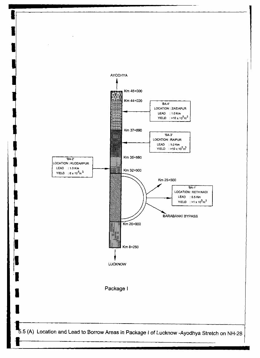
I~~~~~~~~~~~~~~~~~~~~~~~~~~~~~~~~~~~~~~~~~~~~~~~~~~~~~~~~~~~~~~~~~~~~~~~~~~~~~~~~~~~~~~~~~~~~~~~~~~~~~~~~~~~~~~~~~~~~~~~~~~~~~~~~~~~~~~~~~~~~~~~~~~~~~~~~~~~~~~~~~~~~~~~~~~~~~~~~~~~~~~~~~~~~~~~~~~~~~~~~~~I
U
AYODHYA
Km 45+000
Km 44+020 'BA-4'
LOCATION: ZAIDAPUR
LEAD :1.0 Km
YIELD :>10x105 m
3
_ Km 37+890'BA-3'
LOCATION: RAIPUR
LEAD : 1.0 Km
YIELD :>10xlo53m3
'BA-2' tttKm 35+860LOCATION: KUDDARPUR
LEAD : 1.0 Km__Km3+0
YIELD :6 x 10⁵m 3 Km 3200
| ~~~~Km 25+500
& / ~~~~~~~LOCATION: RETH NADI
| 2 / ~~~~~~~YIEALDD :. .1 x 105m3 _
=</ ~~BARABANKIBYPASS
l~~~~~~~~~~~~~~~~~~~~~~~
Km 20+000
IKm 8+250
LUCKNOW
IPackage I
5
p5.5 (A) Location and Lead to Borrow Areas in Package I of Lucknow -Ayodhya Stretch on NH-28
I

AYODHYA
Km 93+075
Km 75+050
a a ~~~~~~~~~BA-10'a ' Ia LOCATION ZAIDAPUR
_n _ .. LEAD :1.0 Km
_n YIELD :>10x105 m3
Km 75+050'BA-9'
LOCATION : KAZIPURVANo ~~~LEAD :1.0 Km
YIELD >40 x 1 m
Km 69+650
Km 68+450
RAMSANEHIGHAT
BYPASS 'BA-'LOCATION: KUSSAR
LEAD :2.0 Km
YIELD :>20x 10 5m3
KM_ +
Km 59+680 'BA-7'
LOCATION: PURADULANU
LEAD : 5.0 Km
YIELD : >20 x 105m3
_Km 55+000
'BA-6'LOCATION : MADUVA
LEAD :1.5 Km
YIELD :>20x10 5m3
Km 48+310 A5'BA-S'
LOCATION: BARIARPUR
LEAD :1.0 Km
Km 45+000 YIELD :>20x 5m3
I ILUCKNOW
| Package ll
5.5 (B) Location and Lead to Borrow Areas in Package 11 Lucknow -Ayodhya Stretch on NH-28
U

AYODHYA
Km 138+000
'BA- 18'Km 11+900 LOCATION: KALUPURVA
~~~~~~~~LEAD : 3.0 Km
YIELD :5x 10⁵m3Km 11+150
BA-17'J | \\ LOCATION: HALATARA
| _ \\ ~~~~~~LEAD :3.0 Km
YIELD :5x x105m
Km 7+450 FAIZABAD BYPASS
'BA-16'I ___. // LOCATION: FIROZPUR:~~:~~:: ~~ 7/ ~LEAD : 1.0 Km
YIELD :5x10⁵m3
Km 0+000 .--m Km 122+500 (STARTING OF FAIZABAD BYPASS)
| 'BA-15' Km 121+700 Km 121+700 'BA-14'
| LOCATION: MIRZAPUR - LOCATION: BANVIRPUR
LEAD : 1.0 Km . _ 1 _ _ LEAD :2.0 Km| YIELD : 10 x 105m3 M YIELD :20x105 m3
| _ ~~~~~~~~~~~~Km 115+300
'BA-13'LOCATION: MOHAMMEDPUR
_ 9 _LEAD : 1.0 Km
YIELD :20x105m3
'BA-i12'LOCATION: SHAKKUPUR
LEAD :1.0 Km
YIELD :>20x105 m3
b i ~~~~~~~~~~~~Km 99+850
O l ll l | ~~~~~~~~~~~~~LOCATION: GODVA
-< I ~~LEAD :1.5 Km j
Km 93+075 |YIELD : >10 x 105m3|
LUCKNOW
Package III
I 5.5 (C) Location and Lead to Borrow Areas in Package III Lucknow -Ayodhya Stretch on NH-28
I

MUZAFFARPUR
Km 138+000
Km 29+000LOCATION: MOTI RAM :
LEAD :0.5 Km _
I~~~~~~~~~~~~~~~~~
YIELD :1lxi1o6 r3 3
I~~~~~~~~~~~~~~~~~
. , | zc ~~~~~~~~~~Km 27+600
'BA-6'
_ . ~~LOCATION: SHIVPR .^ . ~~~LEAD : 0.5 Km_.
YIELD :6x0105m3 E
. | ~~~~~~~~~~~~Km 18+600
. .
l l ~~~~~~'BA-5'_-LOCATION: ROA SIDE__.
| ~~~LEAD :0.5 Km_ -_ _
YIELD : 3 xlS 153 -'
Km 13+200_ _, z l~~~~~~~~~~~c 'BA-4'
D D _ | ~~LOCATION: MAHABIR CHAPRA
I ~~~~~~LEAD :6.5 Km
Y - t~~~~YELD :15xlO5m 'BA-3' 1 O . - ~~Km 11 +500
LOCATION: RAT IVER C _
LEAD : 2.5Km
YIELD * 5x 10⁵m3_Km 9+000
LOCATION: SHEGARH
| ~~~LEAD : 4.0 Km_
* ~~~YIELD :17 xa 18m3]|
| I lill l § ~~~~~~~~~~~~LEAD :1.8Km
s | fi ~~~~~~~~~~~~~m 0+000 |YIELD .>10x 0m
LUCKNOW
Fig 5.6 Location and Lead of Borrow Areas in GorakhpurBypass on NH-28

Independent Review and Consolidation of EIA, EMP & RAP for Lucknow - Ayodhya Section of NH 28 and Gorakhpur BypassConsolidated Environmental Impact Assessment Report
5.5.2 Quarry Areas
Quarry Areas for Coarse Aggregates
The project road is situated within the alluvialdeposition of river Ganga, therefore, no stone quarryhas been found near by (within the economic lead). The aggregate has to be procured from distance. DPRI Consultants have identified five quarries as sources ofcoarse aggregates, in which quarries at Kabrai andJhansi are identified for Package-I and Package-III (distance of which is more than 250 kim) ofLucknow-Ayodhya section of project road andquarries at Dala, Billy and Nautanwa, which are near Nepal boarder are identified for GorakhpurI bypass and Package-III (which are 300 km away from road. However, the Nautanwa quarry hasbeen rejected by local PWD because of its inferior quality of materials and high costs. Number ofcrusher plants has been identified near these quarries.
Quarry Areas for Fine Aggregates
Fine aggregated are required for pavement works, concrete construction and also for filling back ofthe earth retaining structure. Generally natural sand is used as fine aggregates if sand is availablewithin 'the economic lead. Detailed investigations of sources of sand have been carried out by theDPR Consultants. Hamirpur sand quarry has been identified for Package-I and Package-II, which isat a distance of 172 km from Lucknow City, sufficient quantity of sand is available from this quarry.Further, stone dust from Kabrai Quarry is available for using as fine aggregates and in concrete work.
3 Three sand quarries at Chopan, Kota and Hetimpur have been identified for Package-III of LucknowAyodhya stretch including Faizaba bypass and Gorakhpur bypass. In addition, Nautanwa sand quarryis also identified for Gorakhpur bypass. Except this, stone dust from Dala and Billy is available for
| using as fine aggregates and in concrete work.
Location details of the selected quarries have been presented in Table 5.24 and Figure 5.7.
l Table- 5.24: Quarries Identified for Coarse and Fine AggregatesLucknow-Ayodhya Section i cluding Faizabad Bypass Type of
Type of Gorakhpur MaterialsType of Package-I Package-Il Materials Package-Ill Bypass Available
Materials AvailableDistance Distance Distance DistanceName (km) Name (km)Name (km) Name (km)
Kabri 250 Kabri 250 Stone Dala 300 Dala 329.5 Lime-stone
Aggregate Jhansi 250 Jhansi 250 Granite Billy 300 Billy 325.5 StoneNaut- 300 Naut- 110.0 Stoneanwa anwa Aggregate
l Chopan >300 Chopan 320.0 Sand
Hamir- 172 Hamir 172 Sand Kota >300 Kota 343.0 SandFie pur pur Htm
Aggregate Hetim- >300 Hetim- 51.0 SandU ~~~~~~~~~~~~~~~~~~~~~~~~pur pur__ _ __ _ _
Stone Naut- 110.0 Sanddusts anwa
I Kabri 250 Kabri 250 Dala 300 Dala 329.5 Stone_________ __________________________________ Billy 300 Billy 325.5 dusts
5-28 4, aq
in joint venture with 44,
l

fl m a a a a a a a a a - a a a a - - a a a
N A X W ~ Fig. 5.7 -Location of QuarriesUrP t" K.rI,h g
-l $- r> \ tdha gh Nagi. Tq anakpur quarry (Ouadrtzfe & Gramrte aggregate)
4 ,t, _ al A u~~~~~~~Z~1Aa & Benpa o quarry (Ouartznes aggregate)J
& - 7 -- t -' V'- stoner quarryr_.
oath >- ____$ I' ---- rw Hhdo <,--\--- sfr guPtr Netimpur LEC-ENDsP e 4 t sndxnff ndz ~~~ /~~ MahtijX sand tluarry r. * CJstrict Fre3dqu alers,
>¢tW , . Lu ee, > 4 >~ ~ ~~~~~~~~~~~~~~~~ Nodes ; vu
Jhansr stone quarry --!- nho-P vn 4 t,'fi aICrt
(Granrie aggrf?,egattX t<< tt; ', ,, , 'la
C } S Igranif~~~~~~~~~~~~~~~~~~(adsoe aggregate) Sakrahsoeqa< ,l \ Kt adqar
b3 i > ~~Banda Sand Quarryr (Sandstone aggregate) _ / £ana stone quarry<SH -1 X ~~~~~~~~Chopan sand quarry r J(Limestone aggregate)
Kff ~~~~~~~~~~~~~Billy Stone Quarry/ Sonblndr. CL
<<;g>/~~~~~~~~~ 0 r 50 rc tso *1;rret;i
a~~~~~~~~~~~~~~~~~~~~~~~~~~~~~~~~~~~~~~~~~~~~~~~~~~~~~~~~~~~_________________________________________________-

Independent Review and Consolidation of EIA, EMP & RAP for Lucknow - Ayodhya Section of NH 28 and Gorakhpur Bypass3 Consolidated Environmental Impact Assessment Report
3 5.5.3 Fly Ash
DPR consultants have studied the feasibility of "use of fly ash" in the construction of embankment ofNH-28 including two proposed new bypasses. Two sources of fly ash have been identified withinI100 km radius of the project road (Figure 5.8). One is the Panki Power Plant near Kanpur, and theother is the Tanda Power Plant near Faizabad. Fly ash from Panki will be utilised for roadembankment in the initial stretch of the project road i.e., Package-I (starting point to km 45 including
* Barabanki bypass), while fly ash from Tanda will be utilised for road embankment in the, Package-Iland III (from km 45 to km 138 including Ramsanaighat bypass and Faizabad bypass) of the projectroad. According to DPR Consultants, total 556200 cum of fly as will be required, in that include
i 458,100 cum for package-I, 26,600 cum for package-IL and 71,500 cum for package-ILL. Totalquantity of fly ash available from each from Panki and Tanda thermal power plants is still not known,DPR consultants are still corresponding with respective thermal power plants authorities for detail1| information and finalizing the other logistic. It is revealed from the independent reviewer'sinvestigation that no fly ash will be available from Panki Thermal Power Plant as Power Plantauthority has already been committed to provide fly ash for Kanpur bypass road construction project.
5.6 Biological Environment: Flora, Fauna and Ecological Sensitive Areas
3 5.6.1 Flora
The NH-28 is passing through village settlements, roadside rural markets and cultivated agriculturalland. In few cases orchards and forests plantations (spotted at least in three places) are also observed.Throughout the road except the village clusters or market places, both the side of the road are linedwith old roadside trees which consists Mango, Lichi, Jamun, Imli, Kadam, Bargard, Amla, Semul,Sesame, Mehgini etc. Beyond the roadside tree line, cultivated lands starts where, wheat, paddy,I sugar cane, mustard potato and seasonal vegetables are dominated crops. Lands are very fertile andwell irrigated by canal system or ground water and give four crops in a year. At Some placespresence of a narrow strip of grasslands between roadside tree line and crops can be observed.I Besides, at the boundary of agricultural field or near the rivers, nullah, irrigation canals or in someisolated patches, presence of tall grasses, mainly Saccharum spontaneum, S, bengalensi, which are3 commonly known as Munj are also observed.
Proposed new alignment of Barabanki Ramsanaighat and Gorakhpur bypasses are passing throughpredominantly agricultural land where major crops are paddy, wheat, sugarcane, mustard, different3 kinds of pulses (i.e., arohar, motor, chana etc.), potato and other seasonal vegetables. Beside thecrops, other vegetation on these proposed bypass influenced area particularly on the proposedalignment are common native tree species, as found along the existing NH-28.
I Flora of the study area is classified into two categories:* Existing plantation along the project roadI * Forest flora
Trees within the ROW:
| Lucknow-Ayodhya section including Faizabad Bypass: Total 43,120 trees are present on theproposed RoW of existing NH-28 including proposed Barabanki Ramsanaighat and Faizabadbypasses. Out of total 43,120 trees, 16,619 numbers of trees are identified to cut from RoW ofI existing NH-28 section, in which 1147, 571 and 1769 numbers of trees are from Barabanki(proposed), Ramsanaighat (proposed) and Faizabad bypass (existing), respectively.
l3 5-29
in joint venture with

~. TETRI BZK N A~~~~~~~~~~~~~~~~~~~~~~~~~~~~~~~~~~~~~~~~~~~~~~~~~~~~~~
a~' e~R
N ~ ~ ~ ~ ~ ~ ~ ~~ - A LOCATION TANKAI
~~~~~ZA B ~ ~ ~ ~ ~ ~ ~ NTH
LOCATION PANKI IG~~MANHA PU AH
Fig. 5.8 Flyash Sources~~~~~~~~~~~~~~~~~~')Krgr

Independent Review and Consolidation of EIA, EMP & RAP for Lucknow - Ayodhya Section of NH 28 and Gorakhpur Bypass3 Consolidated Environmental Impact Assessment Report
Total 36 different species are identified to be cut from the proposed ROW, among which Sissam(4194), Mango (2,679), Chilwal (1,505), Arjun (1,458), Ficus (1101), Jamun (799), Neem (734),
Ashok (727), Khajur (597), Eucalyptus (398), Babool (290), Gulhar (287), Shagun (255), Gulmohar(226), Mehendi (168), Singri (150) are dominated species. Abundance of various tree species present3 along the project road including two proposed bypass are presented in Table 5.25.
Table-5.25: Abundance of Various Tree Speci es along the Project Road
SL. Common Scientific LHS RHS GrandName
30- 60- 90- >10Ttl< 30- 90-No. Name Girth Size -* <30 60 90 180 > 180 Total <30 60 60-90 180 > 180 Total Total3 I . Amaltush Cassia fistula 4 22 26 2 46 1 49 75
2. Amla Emblica 2 1 3 2 2 5____ _________officinalis__
3. Amrud Psidium guaja 6 6 12 9 12 1 22 34
a 4. Arjun Terminalia 29 40 136 419 32 656 40 83 79 594 6 802 1458
5. Ashok Polyathia 149 39 47 19 254 294 73 67 37 2 473 727I __ ______~~~~roseaI
6. Babool Acacia nilotica 4 12 40 85 1 142 14 9 21 104 148 290
7. Bamboo Dandrocalamu 3 3 _ 9 10 13____ _______ s sstrictus3 319 10 3
8. Bargad Ficus 2 35 37 46 46 83bengalensis __
9. Bet Aegle 16 16 19 19 351 marrnelos__
10. er Ziziphus 38 2 40 89 6 1 1 97 137*~~~~~1 mauritiana_
11. Chameli Jasmidnum 3 1 4 1 2 3 7_____ ____ nitidumII
12. Chilwal integrolea 9 11 17 45 476 558 34 16 26 132 739 947 1505
13. Coconut Cocos nucifera 3 1 4 414. Eucaliptus Eucalyptus sps. 19 2 1 5 1 25 2 118 80 46 55 82 1 7 280 398
15. Gulhar Ficus 2 16 41 32 91 34 25 19 71 47 196 287
16. Gulmohar Delonix regia 4 5 65 8 82 1 10 15 94 24 144 226
17. Imli Tamarindus 4 7 _ _ 18 8 26 37___ ___ ___ indica
18. Jamun Syzygium 2 3 15 112 149 281 8 27 233 250 518 799cumini
19. Kadam Anthocephalus 1 I 18 7 27 13 4 7 35 8 67 94chinensis
20. Kathal AntocarpusII 23 420. Kathal heterophyllus 1 1 1 2 3 4
21. Khajur Phoenix 141 43 30 12 3 229 252 69 13 32 2 368 597
22. Mahua Madhuca 1 1 6 5 13 1 3 23 10 37 50indica
23. Mango Mangd a 43 39 132 730 210 1154 21 59 100 932 413 1525 2679_____ ____ indica
24. Mehendi Lawsnia 49 21 1 1 72 64 30 1 1 96 168inermis
25. Neem Azadiracta 9 233 31 273 10 1 341 99 461 734indica
> 7~~~~~~~~ ~~~~~~~ 5-30 =
in joint venture withI~~~~~~~~~~~~~~~~~~~~~~~~~~~~~~r_

Independent Review and Consolidation of EIA, EMP & RAP for Lucknow - Ayodhya Section of NH 28 and Gorakhpur Bypass3 Consolidated Environmental Impact Assessment Report
SL. Common Scientific LHS RHS GrandI __~~~~~~~~~~~Nm 30- 60- 90- 30- 90-No. Name Girth Size -* <30 60 90 180 > 180 Total <30 60 60-90 180 > 180 Total Total
26. eem Millingtonia 2 5 22 29 1 - 2 10 29 43 72* Chameli hortensis
27. Pakaria Ficus sp. 2 5 309 49 8 373 9 14 511 130 64 728 1101
28. Palm Borassus 2 1 3 6 1 1 1 9 12____ ~~~flabellifer
29. Pipal Ficus religiosa 1 16 17 2 1 10 40 53 70
30. Sagun Tectona 13 45 58 21 35 26 106 9 197 255___ ~~~grandis
31. Sahijan Moringa 1 13 16 13 1 44 4 4 15 4 27 71oleifera
32. Sahtut Morus alba I 1 13 5 20 1 3 17 5 26 46I 33. Sal Shorea robusta 5 22 4 1 32 1 26 12 4 1 44 7634. Semul Bombax ceiba 1 3 24 7 35 2 5 56 28 91 126
35. Singri Pithecolobium 4 25 22 51 8 55 36 99 150I ~ ~~~~~~dulce36. Sissam Dalbargia 38 46 187 1111 55 1437 100 102 286 2155 114 2757 4194sissoo
Grand 553 343 108 3103 1117 6202 1109 660 1413 5264 1971 10417 16619___Total _________ _______
Gorakhpur Bypass: Total 4465 trees are identified to be cut from the proposed RoW of new
alignment. In which 2730 numbers are Guava trees present in the stretch between km 11.5-12.2
where the alignment passes through Guava plantation. Species wise detail lists of affected trees are3 presented in the Table -5.26.
Table 5.26. Detail Girth Size and Species Wise List of Trees to be Cut
Within ROW of Proposed Alignment For Junction Development, Viaduct, Total Number of Trees to be Felled* Diversion of SH-bypass
Girth Size (cm) Girth Size (cm) Girth Size (cm)
30-60 60-90 90-180 >180 Total 30-60 60-90 90-180 >180 Total 30-60 60-90 90-180 >180 Total
Arjun 3 2 0 5 133 2 1 136 136 4 1 141
Babul 242 10 252 39 16 55 281 26 307
Banyan 1 I 1 3 I 1 1 2 I 4
Bel 2 5 5 12 2 2 4 5 5 14
Ber I I I I
Date Palm 4 2 6 8 8 12 2 14
Eucalyptus 75 9 11 95 18 I 19 93 9 1 I 114
Guava 1577 912 357 2846 19 1 20 1596 913 357 2866
Jackfruit 16 20 9 2 47 16 20 9 2 47I Jamun 6 5 6 17 3 1 3 7 9 5 7 3 24
Litore 12 12 5 5 5 12 17
Mahua 3 6 4 13 3 6 4 13
Mango 106 80 143 49 378 13 19 24 15 71 119 99 167 64 449
Mulberry 2 2 1 1 3 3
Neem 17 4 3 24 1 3 4 18 7 3 28
Phakar 2 1 2 5 1 1 2 3 1 1 2 7
Palm 6 6 6 6
Pipal 1 2 3 6 3 4 7 5 7 13
Sagun 24 14 38 10 2 1 13 34 14 2 5 1
I afl/w 5-31 .4
in joint venture with

Independent Review and Consolidation of EIA, EMP & RAP for Lucknow - Ayodhya Section of NH 28 and Gorakhpur Bypass3 Consolidated Environmental Impact Assessment Report
Within ROW of Proposed Alignment For Junction Development. Viaduct, Total Number of Trees to be FelledSimar - -3-F- 3 1 ~~~~~Diversion of SH-bypass 44
Simar 031 13 I[ r X r l 1 1 4 4
Sins 1 2 3 5 5 1 0 6 2 5 13
Sisham 106 69 1 5 190 90 24 18 1 133 196 93 33 1 323
*_ _ _ _ _ _ _ _ _TamarindL 5 | S II 1 | 6 6 6
Total 2191 1154 555 69 3969 349 65 56 26 1 496 2540 1219 611 95 1 4465
* Forests
Lucknow-Ayodhya Section including Faizabad Bypass: There are four prominent forests patchesadjacent to the Lucknow-Ayodhya stretch and Faizabad bypass project road namely, Zaidpurreserved forests (km. 43.327to 43.600 on right hand side and km 43.722 to 43.958 on left side),Kuseriban ban block and Asarafpur ban block forests patches. Besides this roadside plantation, whichI are designated as the project road also influences protected forests. Details of these forests aredepicted bellow.
* = ,f--s |*Zaidpur Reserve Forest (RF): Zaidpur reservedI , - - U '9, - forest is present on the right side of the (Figure 5.9)project road between chainage km 43.327 to 44.707.However, forest stretch in between km 43.327-I I-. 43.600 has a width of only 60-70 m and just behindthis forest patch agricultural land starts. This portion
-- Y,M of forests is degraded due to human interference and* interrupted by the patches of agricultural land andI - -I' t- grasslands (Photo Plate 5.6). The forest stretch after| chainage km 43.600 to 44.707 is dense and has depth
* of about 1 km. Zaidpur RF is basically an openPhoto Plate 5.6: Road Front of Zaidpur mixed forest consisting mainly of Lac (Kusum)Reserved Forests at Chainage km 43.600 trees. Tree species in Zaidpur RF are listed in Table
5.27.
3 Table 5.27: List of Tree Species in Zaidpur RF
S.N. Common Name Scientific Name1. Arjun Terminalia arjuna2. Babool Acacia nilotica3. Bamboo Dandrocalamus strictus4. Imli Tamarindus indica
f_5. Jamun Syzigium cumini6. Katsagun7. Khair Acacia catechu8. Lac (Kusum) Schleichera oleosa9. Mango Mangifera indica10. Sagun Tectonagrandis" 11. - Semal Bombax ceiba| 12. Sisham Dalbergia sisoo
Description of the other forests, which are present within the 7 km strip on both side of the projectroad is depicted in the Table 5.28.
* r 5-32 .1sc p w
in joint venture with
il

Independent Review and Consolidation of EIA, EMP & RAP for Lucknow - Ayodhya Section of NH 28 and Gorakhpur Bypass3 Consolidated Environmental Impact Assessment Report
Table-5.28: Forests Present in Surroundings of the Proiect Roadl Sl.No. | Name Ch. (km) Side Dist. from NH- Status Extent of Forests Area (ha)
SI.No. Name Ch. (kin) ~S id 28 (km) Sau Apprx.
District BarabankiI - Shahpur Murarpur Ban 28.500 LHS 7 RF 40
2. Palhri Ban Block 44.600 LHS I RF 58.613. Zaidpur (Safdargunj) Ban 43.722-43.958 LHS 0 RF 134.61
Block 43.327-44.707 RHS 04. Niyamatpur Ban Block 44.100 LHS 3.5 RF 244.99
District FaizabadI. Kusehri Ban Block 68.800-69.650 RHS 0 PF 21.852. Asarafpur Ban Block 69.300-69.500 LHS 0 PF 11.57
Source of informations:Divisional Forest Office, Barabanki District, BarabankiForest Range Office, Ramsahenighat, District BarabankiForest Range Office, Safdargunj. District BarabankiDivisional Forest Office, FaizabadForest Range Office, Rudauli. District FaizabadWorking Plan for the Afforestation, Division Faizabad, Eastem Circle, UP
I A dense strip of forest exists on the left side of the project road in between chainage km 43.722-43.958. This forest strip is surrounded by cultivated land, which connects with Niyamatpur andPalhri forests behind.
Asarafpur Ban Block: On the left side of the road at chainage km 69.300-69.500 there is another11.57 ha strip of dense plantation called Asarafpur Ban Block protected forest. The area was a piece3 of barren land where agriculture was not feasible, about 20 years ago extensive plantation had beentaken up, now it become a dense forest patch and declared as protected forests.
Kusehri Ban Block: At Ramsanehighat, after crossing the Kalyani Nadi there is dense plantation of21.85 ha land at chainage km.68.800-69.650 on the right side of the project road called Kusehri BanBlock protected forest. Trees planted are Katsagun, Sisham and Sagun. The end part of theRamsanaighat bypass is touching tip of the forest patch.
Other Forests: The trees planted on both sides of NH-28 are the property of the forest departmentand falls under the category of protected forests (as per Notification 3208/XIV dated 23.08.1955I declaring PWD roads as protected forests). The road, widening will involve cutting of someprotected forests trees.
Though various forests patches are present on both the side adjacent to project road but no forestsland need to be acquired for widening of the project road. The widening is proposed within theavailable RoW except 0.33 ha of forests land from the Kusehri ban block forests, which will be3 acquired for Ramsanaighat bypass at the end point where it is merging with NH-28.
Gorakhpur Bypass: Forest area lying close to the bypass alignment is the Ramgarh ReservedForest, which is about 150 m away on the left side of the proposed alignment. There is anotherI forests on left side across the existing NH-28 is Talkonia reserved forests which is about 7 km awayfrom the Zaidpur reserved forests. Both the forests are linked with a cultivated land with sparsevillage settlement and plantations. The detail distance and chainage of forests present within the NH-
| 28 is presented below in Table5.29.
Table-5.29: List of Forests in the Study CorridorSi. Name Ch. (km) Side Approx. Dist from StatusNo. | NH-28 (km)1. Ramgarh Reserve Forest 24.6 LHS 0.15 RF2. Tilkonia Reserve Forest - LHS 7.0 RF
Source of information: Divisional Forest Office, Gorakhpur, District Gorakhpur
I*zdqr 5-33 VAJ4in joint venture with 'S
I

1 S -- -- --- -- m - m m m m m m m m mZakaria
I IB hi N Vinatpur
MushkbdI
I 04 Na.ir;mr AP Nimatpur Rroeie Forst Aullapur Burnul
Lalpur i
KarnulIahpurUCKAiW La°hhbVt SLadhhbr d
Turkani\pur D A Safdarganj
Aghel
Chanwara Ramganj
D a m pu r a Z rS d w mn K h i d r ap u r
Reipur ~ ~ ~ ~ ~ ~ ~ ~ ~ ~ ~ ~ ~ \, bnu
Kobg urbrl JaD salpuri
Chilauki ~~~~~~~~~~~~~~KithurdPaihrILichnspur l~~~~~~~~~chaulla KAi43 R
M irzapuD u rr
RF RF Paihi
aulipur Z dp tr Al^r aulZ Plh
RF~R
Kolagarbrl Barbasaug
uniu)( Canal Akbarpur
Indhaulm
a f ~~~~~~~~~~~~~~~~~~~~~~~~~~~~~~ ShahpurTagapur ~~~~~~~~~ ~~~~~~~~Dhranmpur Udlhal
Fig. 5.9 LOCATION OF FORESTS

Independent Review and Consolidation of EIA, EMP & RAP for Lucknow - Ayodhya Secton of NH 28 and Gorakhpur BypassConsolidated Environmental Impact Assessment Report
Ramgarh Reserved Forest: Ramgarh Reserved Forest boundary is about 150 m away from theGorakhpur bypass alignment at Chainage km 24.5-24.7. The proposed Gorakhpur bypass alignmentis not touching any part of the forest. This forest is a part of the Tilkonia Forest Range. Ramgarhreserved forest is a moist deciduous forests characterized by a dense cluster of trees dominated by Saltrees (Shorea robusta). The other side of the forests (north boundary) is lined by the existing NH-28.The forests continues even across the RoW of existing NH-28 but the other part of forests isdegraded due to human interferences and soon it merges with villages and agricultural land. Theprincipal tree species in the forest are listed in Table 5.30.
Table -5. 30: List of Predominant Tree Species in Ramgarh Reserved Forest
SN Common Name Scientific Name1. Sal (saklu) Shorea robusta2. Bijay Sal Pterocarpus marsupium3. Bargad Ficus bengabasis4. Gular Ficus glomerata5. Pipal Ficus neligosaI 6. Mahua Madhuca indica7. Mango Magifera indica8. Jamun Syrygium cumini
_* 9. Imli Tamarindus indica10. Sagun Tectona grandis11. Arjun Terminalia arjuna12. Khajur Bridelia redusa
Source of information: District Forest Office, Gorakhpur. District Gorakhpur
5.6.2 Fauna
Wildlife
Zaidpur Reserved Forests: Zaidpur Reserve Forest is adjacent to the road. But this forests patch isalready degraded due to human interferences. It has been confirmed from forests department(Divisional forests office, Barabanki and Forests range offices of Ramsanaighat and Safdergang) andI local people that no wild life is present in this forests patch except fox and snakes. In Palhri RF andNiyamatpur RF, which is about 1 km and 3.5 km away from the project road on left side, animals like3 Nilgai, fox, wild boar, monkey, mongoose and snakes have been reported.
Ramgarh Reserved Forests: Common species reported from Ramgarh reserved forests are JungleCat (Felis chaus), Toddy Cat (Paradoxurus hermaphroditus), Jackal (Canis aureus), Grey musk
h shrew ((Suncus murinus), Blue bull (Boselaphus tragocamelus), and Common Langur (Presbytisentellus). The list of animals reported from this forests as collected from secondary sources likeForest Department and Gorakhpur University and are listed in Table 5.31.
I Table-5.31: List of Fauna in Ramgarh Reserve ForestsSN Common Name Scientific Name Status *
1. Bandicoots Bandicota indica2. Common Langur Presbytis entellus Schedule II3. Common Mangoose Herpestes edwardsi Schedule IV4. Common Yellow Bat Scotophilus heathi5. Fulvous Fruit Bat Rousettus leschenalite Schedule V6. Grey musk shrew Suncus murinus7. House Mouse Mus musculus Schedule V8. House Rats Rattus rattus Schedule V
46K7qr~~~~~~~~~~~ 5-34 1,4rin joint venture with
I

| Independent Review and Consolidation of EIA, EMP and RAP for Lucknow-Ayodhya section of NH-28 and Gorakhpur BypassConsolidated Environmental Impact Assessment Report -^
-I- I Fig. 5.10 Location of Sanctuaries
* RY
,-' LAKHrMPUR*.+
APUR VAHR_ .~~~ .\ R~',
* GON f ~~~~~~ BGKANNAUY," BP
. AG~
~~~~~~~~~~~~~~~~~~~I *'(A -- h; e
* -1 e~~~~~~~~S. \ ULtA?SPbR , Z)$ -AiAMGAHMh1~ U
1 i ~~~~~~~~~~~~~~~~7 '
| - - - , r~~~. ' , Tn4Fj
. ,, ' ' ROBFATE d. '
,P .N ' * .PU .... _.I -~~ - >MIRZAPtJAZA GA,
MAN~~~~OJT- R8"AN '
3 H oslat In Joint venture with MDP Consultants Pvt. Ltd.
I l l l D

Independent Review and Consolidation of EIA, EMP & RAP for Lucknow - Ayodhya Section of NH 28 and Gorakhpur BypassConsolidated Environmental Impact Assessment Report
SN Common Name Scientific Name Status *
9. Indian Fox Vulpes bengalensis Schedule II10. Indian Hare Lepus nigricollis Schedule IV11. Indian porcupine Hystrix indica Schedule IV12. Jackal Canis aureus Schedule II13. Jungle Cat Felis Chaus Schedule II14. Nilgai Boselaphus tragocamelus Schedule III15. Rhesus monkey Macaca mulatta Schedule 1116. Toddy Cat Paradoxurus hermaphroditus
* Status as per Schedules of the Wildlife Protection Act
I Avifauna
The bird species in the project area including proposed Gorakhpur bypass are listed in Table~~~~5.32.
Table-5.32: List of Avifauna
l SN Common Name Scientific Name Status*1. Bulbul Molpaster cafer Schedule IV2. Kite Milvus migrans govinda Schedule IV3. Little cormorant Phalacrocorax niger Schedule IV4. Little egret Butorides striatus Schedule IV5. Mynah Acridotheres tristis Schedule IV
lI6. Parrot Psittacula eupatria Schedule IV7. Quail Coturnix coturnix Schedule IV8. Sparrow Passer domesticus Schedule IV1 9. Vulture Gyps bengalensis Schedule IV10. White stork Ciconia ciconia Schedule IV
* Status as per Schedules of Wildlife Protection Act
Aquatic Fauna
The species of fish which are commonly found in both Lucknow-Ayodhya section and Gorakhpurbypass area are Rohu (Labeo rohita), Karounch (Labeo calbasu), Bata (Labeo bata), Khursa (Labeogonious), Bhakur (Catla catla), Nain (Cirrihina mirgala), Raiya (Cirrihina reba), Darhi (Barbussarana), Putia (Barbus stigma), Parhan (Wailagonia attu), Tengra (Mystus aor), Tingan (MystusI vitatus), Cheagna (Ophicephalaus straitus), Girai (Ophicephalaus gachuwa), Patra (Notopeternusnotopeternus), Moi (Notopeternus chitala), Mangur (Clarias batrachus), Singhi (Heteropneustesfossilis), Chelwa (Chela bacaila), Belgagra (Rita rita) and Gonch (Bagarius bagarius).
5.6.3 Eco-Sensitive Areas
National Parks, Sanctuaries and Biosphere Reserve
The entire length of project road falls under the administrative control of Barabanki and Faizabad and| Gorakhpur divisional forests offices. From the start point to Kalyani nadi project road belongs to
Barabanki Divisional Forests office and rest of the stretch including Faizabad bypass belongs toFaizabad divisional forests Office. The project road passes through Zaidpur Reserved Forest.
| However, there will not be any forestland acquisition as widening is proposed within existing ROWin that stretch. No other ecological sensitive areas like national parks/ wildlife sanctuaries/ tigerreserves/ biosphere reserves etc. exist in the vicinity of the project road. Location of nearestsanctuary/ national parks/ wildlife sanctuaries/ tiger reserves/ biosphere reserves along with thedistance from the project road has been presented in Figure 5.10.
I1 5-35 54V win joint venture with
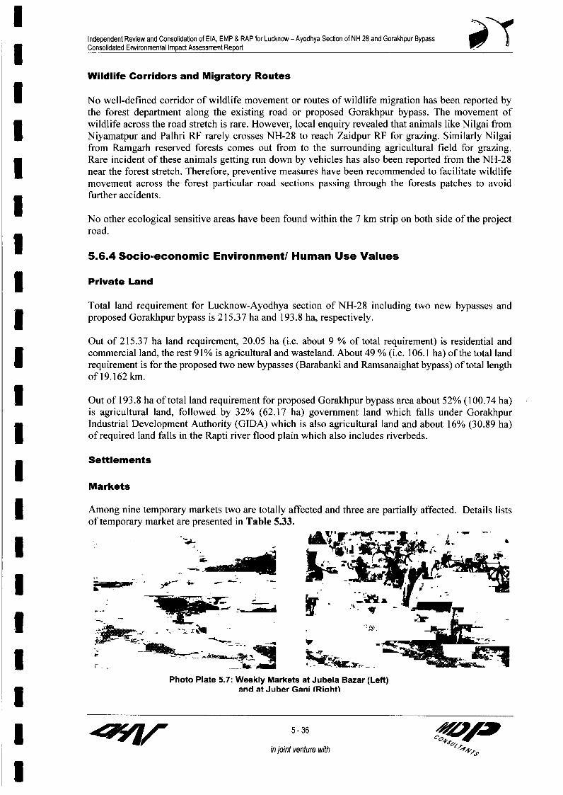
Independent Review and Consolidation of EIA, EMP & RAP for Lucknow - Ayodhya Section of NH 28 and Gorakhpur BypassConsolidated Environmental Impact Assessment Report
Wildlife Corridors and Migratory Routes
* No well-defined corridor of wildlife movement or routes of wildlife migration has been reported bythe forest department along the existing road or proposed Gorakhpur bypass. The movement ofwildlife across the road stretch is rare. However, local enquiry revealed that animals like Nilgai from3 Niyamatpur and Palhri RF rarely crosses NH-28 to reach Zaidpur RF for grazing. Similarly Nilgaifrom Ramgarh reserved forests comes out from to the surrounding agricultural field for grazing.Rare incident of these animals getting run down by vehicles has also been reported from the NH-28I near the forest stretch. Therefore, preventive measures have been recommended to facilitate wildlifemovement across the forest particular road sections passing through the forests patches to avoidfurther accidents.
No other ecological sensitive areas have been found within the 7 km strip on both side of the projectroad.
5.6.4 Socio-economic Environment/ Human Use Values
3 Private Land
Total land requirement for Lucknow-Ayodhya section of NH-28 including two new bypasses and| proposed Gorakhpur bypass is 215.37 ha and 193.8 ha, respectively.
Out of 215.37 ha land requirement, 20.05 ha (i.e. about 9 % of total requirement) is residential andcommercial land, the rest 91% is agricultural and wasteland. About 49 % (i.e. 106.1 ha) of the total landrequirement is for the proposed two new bypasses (Barabanki and Ramsanaighat bypass) of total lengthof 19.162 kin.
| Out of 193.8 ha of total land requirement for proposed Gorakhpur bypass area about 52% (100.74 ha)is agricultural land, followed by 32% (62.17 ha) government land which falls under GorakhpurIndustrial Development Authority (GIDA) which is also agricultural land and about 16% (30.89 ha)I of required land falls in the Rapti river flood plain which also includes riverbeds.
Settlements
Markets
Among nine temporary markets two are totally affected and three are partially affected. Details listsof temporary market are presented in Table 5.33.
* ; ;S ' S £. F-~~~!J
Photo Plate 5.7: Weekly Markets at Jubela Bazar (Left)3 and at Juber Gani (Riahtl
I5z 1 5-36
in joint venture with s

Independent Review and Consolidation of EIA, EMP & RAP for Lucknow - Ayodhya Secton of NH 28 and Gorakhpur Bypass3 Consolidated Environmental Impact Assessment Report
Table 5.33: List of Weekly Markets along the Project RoadSI. Chainage Side Distance Name of Market Days of StatusNo (km) C/L (m) Operation1. 34.500 L 500 Rasouli Market: Tuesday Big vegetable Market in the area. The
and market is far from the project road and7 ________ Saturday will not be affected
2. 45.700 L 25 Goat Market Saturday Animals are brought both on foot and(Bakra Mandi) carriages to this market. Widening being on
the same side, the market needs to be* shifted.
3. 59.800 L Vegetable Market Thursday Market sets on the cross road (leading toMohammadpur Kirathi) and encroaches a1 part of existing ROW. The portion of themarket on NH-28 needs to be relocated.
4. 62.400 L 20 Animal Market Tuesday Big Market, domestic animals like buffalo,(Barela Bazar) and cow etc. sold here. Animals brought in
* Saturday trucks and small carriages. 7-8 tea & foodvendors' sets temporary stalls on marketdays. Widening being on opposite side, the
* market will not be affected.5. 77.100 R 20 Jarela Bazar Wednesday Big Market of all kinds of household items
Saturday and vegetables. The market meets thedemand of number of nearby villages.Widening being on the same side, themarket needs to be shifted.
6. 87.900 L 10 Vegetable Market Wednesday Roadside market of vegetable and domesticSunday items. Portion of the market on NH-28
needs to be relocated.7. 110.800 R 20 Juberganj Market Wednesday Big vegetable market. Portion of the market
Sunday on ROW of NH28 needs to be shifted.* 8. 112.400 R 30 Buffalo Market Sunday Biggest animal market on the project road.
Large number of trucks and other animalcarriages come to the place and parkedJ beside the road on market days. Few foodand tea vendors also set up their temporarystalls. The market will remain unaffected
___ ________ ______________ due to widening of the project road.I 9. 112.550 L 30 Goat Market Tuesday Goat market inside the market complex with(Bakra Mandi) a boundary wall. A good number of animal
carriages and other vehicles comes to thisI market and parked on the side of the road onmarket days. The market will remainunaffected due to widening of the project
| ~ ~ ~ ~ ____ _____ ________ road.
L-Left; R-Right
Educational Institutes
Total 97 numbers of educational institutes are present along the project stretch between Lucknow-Ayodhya (including Faizabad bypass). Out of 97 educational institutes, 11 will be totally demolished.No educational institute is affected due to proposed Gorakhpur bypass alignment.
Health Centers/ Hospitals
Total 19 health centers/ hospitals are located adjacent to project stretch between Lucknow-Ayodhya(including Faizabad bypass). In addition, three veterinary clinic/hospitals are also present in this3 stretch of project road. No health center is coming on the proposed Gorakhpur bypass alignment.
17 5-37 c<0 4
in joint venture with
l

Independent Review and Consolidation of EIA, EMP & RAP for Lucknow - Ayodhya Section of NH 28 and Gorakhpur BypassConsolidated Environmental Impact Assessment Report 0
3 Religious / Archeological Structures
Total 82 religious structures are located adjacent to project stretch between Lucknow-Ayodhya(including Faizabad bypass) in which 67 are temples, ten are mosques, four are idgahs and remainingone is mazar.
Commercial Institutes /Industries
There are five Banks present between chainage km 19.75 to km 87.32. Out of these five banks four_-- of them are getting affected. Besides,
_ _ _ ____ zF one brick kiln is also coming on the___________________ proposed RoW of Barabanki Bypass.
No commercial building is present onthe proposed Gorakhpur bypass exceptpart of one brick kiln present atchainage km 4.2 in Khanpur vatta3 ~~~~~~~~(Photo plate 5.8).
Photo Plate 5.8! Affected Brirk Kiln at Khannur
Il
I
I
IU
I
I zzz 5-38 Orw
in joint venture with

IIII
IIII
CHAPTER-6:PUBLIC CONSULTATIONS ANDI INFORMATION DISCLOSURES
IIIIIIIII

Independent Review and Consolidaton of EIA, EMP & RAP for Lucknow - Ayodhya Section of NH 28 and Gorakhpur BypassConsolidated Environmental Impact Assessment Report
3 51 PUBLIC CONSULTATIONS ANDINFORMATION DISCLOSURES
6.0 Public Consultations and Information Disclosures
3 6.1 Introduction
The project is likely to affect the communities residing around Lucknow-Ayodhya section of NH-28I and Gorakhpur Bypass alignment and may influence their day-to-day activities. These communitieshave therefore, been recognised as the "Primary Stakeholders" for the project. The influence of theproject will, however not be limited to the so-called "influence zone" only. Impacts of various3 degrees are bound to occur in people residing much far away from the project location. Thestakeholders of the project area, therefore many and have been identified at various levels, viz., local,district, regional, state and national level. Successful implementation of the project requirescoordinated efforts of various stakeholders at different levels. Hence, consultations at different levelswere used as a tool to inform and educate stakeholders about the proposed action both before andafter the development decisions were made. Public consultation was useful for gatheringenvironmental data, understanding likely impacts and communities' needs and preferences. The
* various alternatives could be evolved and sustainable mitigation measures could be formulatedthrough consultations. It assisted in identification of the problems associated with the project as wellas the needs of the population likely to be impacted. This participatory process helped in reducing theI public resistance to change and enabled the participation of the local people in the decision makingprocess. The involvement of the various stakeholders ensured that the affected population and otherstakeholders are informed consulted and are allowed to participate at various stages of projectI preparation. A separate chapter on Public Consultations is also provided in Resettlement Action Plan(RAP).
3 6.2 Objectives
The main objective of the consultation process was to capture people's perceptions on the project,minimise negative impacts of the project and to maximise the benefits of the project. Other objectivesof the consultation process were the following:
| To promote public awareness about the proposed project especially amongst the potentiallyimpacted communities/individuals;
* to educate the potentially impacted communities/individuals about the proposed course ofaction and the project alternatives;
* . to solicit the views of affected communities/individuals on environmental and social problems;to gather inputs from the affected communities/individuals in crucial decisions regardingmitigation of the identified environmental and social impacts;I . to stimulate community self evaluation and analysis;
a to inform Project Affected Persons (People) about the entitlement framework and ResettlementAction Plan (RAP), and to settle their problems with mutual consent and to assist them duringI relocation and resettlement; and
. to ensure lessening of public resistance to change by providing them a platform in the decisionmaking process.
I in joint venture with

Independent Review and Consolidation of EIA, EMP & RAP for Lucknow - Ayodhya Section of NH 28 and Gorakhpur Bypass| Consolidated Environmental Impact Assessment Report
6.3 Methodology Adopted for Public Consultations
6.3.1 Stages and Levels of Consultation
Public consultation was conducted both at screening stage as well as project preparation stage.Consultations conducted at screening stage played an important role in scoping the level and extentof consultation to be taken in the project preparation stage.
I Public consultations have been held at three levels as follows:
Local level (Village level/Block level) involving villagers whose properties, land, etc. are being* affected by the project;
District level consultations involving NGOs, CDOs, BDOs, district magistrate, revenue department,NHAI officials, local forest department;
Institutional level consultations with State Forestry Department, State Pollution Control Board, the3 World Bank, the Ministry of Environment and Forest of the Government of India.
6.3.2 Tools for Consultation
Public Consultation was done using various tools including, interviews with government officials,questionnaire based information with stakeholders, formal presentation of project proposals atorganised district level seminars and workshops; briefly discussed as under:
(i) Informal discussion: A reconnaissance survey at the time of screening was carried outinformally drawing affected people (AP) into dialogue to obtain an overview of likely impacts andconcerns of the community. The key informants during the project preparation phase included bothindividuals and groups namely:
1 Head and members of the households likely to be affected* Groups/clusters of Affected People* Village Panchayats: Sarpanch and members1 Local voluntary organizations and NGOs* Government agencies and departments* Other project stakeholders with special focus on women and people belonging to the vulnerable
group.
A checklist of questions was kept ready and responses were elicited from people and guidelines wereissued to field assistants for the purpose. The questions were kept simple for people to comprehend.Notes were made for the responses and viewpoints presented by people.
(ii) Focus Group Discussions: Group Discussions (GDs) were held at selected locations alongLucknow-Ayodhya NH-28 and Gorakhpur Bypass. During the GD, interaction/discussion were heldwith the general public. Tables 6.1, 6.2 and 6.3 present the location of GDs. The public consultationsin the project area were mainly conducted at the local level i.e. at village level and district level. Thefocus group discussions were held during initial environmental study (Phase l), feasibility study(Phase II) and during final survey for primary data collection (Phase IlI).
l
in joint venture with c0

Independent Review and Consolidation of EIA, EMP & RAP for Lucknow - Ayodhya Section of NH 28 and Gorakhpur BypassConsolidated Environmental Impact Assessment Report
Stage I - LOCAL LEVEL CONSULTATIONS
I Table 6.1 Initial Focus Group Discussions held at 12 Major Locations in the Project Area
Month Location No of Male/ Issues Discussed Outcome/Year Female
Participants
March, Safedabad at 27/7 * Fair market price /replacement * During the FGD, the affectedI 2003 km 19.0 cost must be given to people for their persons were assured of a fairland, building, shop and other market price/ replacement costestablishments. for their loss of assets and land.I * As the land for shops wereleased from Zila Parishad, hence same * Assurance has been given thatland when acquired would mean compensatory assistance wouldcompensation first to the Zila Parishad be provided to the tenants/I and thereafter other compensatory lessees through proper channel.assistance would have to be provided
* _______ to the tenants/lessees.
March, Kurauli at 13/4 * Compensation issues * Adequate compensation would2003 km 23.0 be paid to the affected persons.
* Issues related to whether theI Agricultural land would be dug up * People were informed that theirfor road filling purpose. fertile land will not be used for3 _______ road filling
March, Rasauli 18/6 * People demanded that road widening * Assurance has been given that in2003 at km 35.0 should be done on both sides of the the congested stretches,
road on equitable basis. widening will be on both the sideon equitable basis and in other
* People were concem about road stretches side of widening willsafety. be depended on the road sideI ~~~~~~~~~~~~~~~~~~~~~~~~~~~features.
* Assurance was given to peopleregarding adequate provision forroad safety measures, whichwould be incorporated in the
___________ ____________ ______________ ______________________________________ p roject d esig n .
March, Ramsanehi- 10/3 * Compensation issues2003 ghat at km * Assurance wads given for
63.0 * People expressed their discontent adequate compensation to theover road widening and affecting affected persons.their assets
March, Tala at km 9/2 * Relocation issues * Gram sabha land would be2003 67.0 available for relocation purposeI * Livelihood loss and compensation will be given
for livelihood loss.
3 March, Muwai 20/7 * People demanded that road * Assurance has been given that in2003 Chauraha widening should be done on both the congested stretches,
at km 71 sides of the road on equitable widening will be on both the sidebasis and within the available on equitable basis and in otherROW. stretches side of widening will be
depended on the roadside* Assistance must be provided as features.
* _________ ___________ _____________ per WB guidelines * People were assured that
in joint venture with C,

Independent Review and Consolidaton of EIA, EMP & RAP for Lucknow - Ayodhya Section of NH 28 and Gorakhpur Bypass3 Consolidated Environmental Impact Assessment Report
Month Location No of Male/ Issues Discussed Outcome/Year Female
Participants
assistance would be in* Relocation of community accordance to WB guidelines.
* properties* Gram sabha land would be
* Provision of road safety measures available for relocation purpose3 of community properties.
* Assurance was given to peopleregarding adequate provision forroad safety measures, whichwould be incorporated in the
______________ project design.I March, Mian Ka 12/4 * Relocation of religious structure - * PAP agreed on relocation of the2003 Purwa imambara structure
at km 76.0
March, Rozagaon 12/4 * Compensation issues * People were assured that* 2003 at km 82.0 compensation would be in
* Provision of road safety measures accordance to WB guidelines.
3 * Assurance was given to Peopleregarding adequate provision forroad safety measures, whichwould be incorporated in theproject design.
March, Raunahi at 21/7 * Compensation issues * People were assuredI 2003 km 108 compensation would be in* Relocation of religious structure accordance to WB guidelines.
* Relocation issues * Gram sabha land would beI available for relocation purpose.
* The road widening would be| ~~~~~~~~~~~~~~~~~~~~~~~~~~~~done upto the gate of the
religious structure so that itdoesn't affect the whole
l _ _ _ _ _ _ _ _ _ _ _ _ _ structure.
March, Kotsarai at 23/8 * Compensation issues * People were assured2003 km 118 compensation would be in
* Road safety issues accordance to WB guidelines.
* Widening on both sides of the * Assurance was given to Peopleroad regarding adequate provision for
road safety measures, whichwould be incorporated in the3 project design.
* Assurance has been given that inthe congested stretches,I widening will be on both the sideon equitable basis and in otherstretches side of widening willbe depended on the road sidefeatures.
3 ~~~~~46-4 llo0
in joint venture with 5* A P
I 4w

Independent Review and Consolidation of EIA, EMP & RAP for Lucknow - Ayodhya Section of NH 28 and Gorakhpur BypassConsolidated Environmental Impact Assessment Report
Month Location No of Male/ Issues Discussed Outcome3 NYear Female| ~~~~~~~Participants
Local Level Consultation at District level LocationLucknow District
* Chinhatat 30/10 * PIC meeting was conducted at * Widening of road welcomedMarch, km. 11.5 Chinhat near the crossing of Deva2003 Road with NH-28. The Lucknow city * People were assured thatI has expanded tremendously in recent assistance would be in
years and as a consequence this area accordance to WB guidelineshas undergone rapid urbanization.Participants expressed satisfaction * The road widening would beover the proposed road widening as it done up to the gate of thewill offer smooth flow of traffic in religious structure so that itthe road, which is highly congested doesn't affect the wholeI at present and long traffic snarls at structurebusy hours are a regular feature.
* Participants put emphasis on * People were assured that theminimum demolition of residential widening of the road will bestructures as well as relocation of done as such, that there isaffected educational institutions, minimum cutting of the trees.medical amenities and places ofreligious interest at nearest possible * People were assured that thelocation. They preferred cash affected tube wells will becompensation for the demolished relocation at nearest possibleI residential buildings. locations.
* There is a big Idgah at Chinhat,which draws large crowd during * Assurance was given to peoplefestivals. Boundary wall and small regarding adequate provisionI part of its ground will be affected due for mitigation measures whichto widening. Participants did not would be incorporated in theobjected to this proposed acquisition project designbut urged strongly to restore theboundary wall before festivals.
* There are good number of shadingtrees on both sides of the road, whichI are old enough and also amplifies theaesthetic value of the road.Participants opined that felling ofthese trees should be kept tominimum extent and plantationactivity should be undertaken tocompensate the loss of vegetative
* ~~~~~~~~~~~~~~cover.They requested for relocation of theaffected tube wells at nearest possiblelocations.
* 2 ponds will be affected due towidening. These water bodies arepresently not in use by the localI population other than waste disposal.People have not expressed anyconcern regarding partial filling up of
* these water bodies.* Participants envisaged increased
pollution load during constructionperiod and felt the necessity of
*_________ ___________ _____________ adopting control measures to mitigate I
6 -5 /<0 w
in joint venture with <
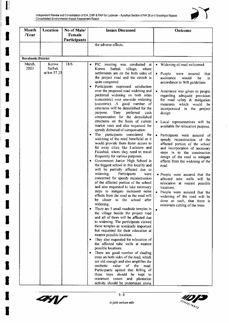
Independent Review and Consolidabon of EIA, EMP & RAP for Lucknow - Ayodhya Section of NH 28 and Gorakhpur Bypass3 Consolidated Environmental Impact Assessment Report
Month Location No of Male/ Issues Discussed Outcome/Year Female
*_________ Participants
the adverse effects.
Barabanki District
March, Kotwa 18/6 * PIC meeting was conducted at * Widening of road welcomedI 2003 Sarhak Kotwa Sarhak village, whereat km 57.25 settlements are on the both sides of * People were assured that
the project road and the stretch is assistance would be inquite congested. accordance to WB guidelinesParticipants expressed satisfactionover the proposed road widening and * Assurance was given to peoplepreferred widening on both sides regarding adequate provision(concentric) over one-side widening for road safety & mitigation(eccentric). A good number of measures which would bestructures will be demolished for the incorporated in the projectpurpose. They preferred cash designcompensation for the demolishedstructures on the basis of current * Local representatives will bemarket rates and also requested for available for relocation purpose.speedy disbursal of compensation.The participants considered the * Participants were assured ofwidening of the road beneficial as it speedy reconstruction of thewould provide them faster access to affected portion of the schoolfar away cities like Lucknow and and incorporation of necessaryFaizabad, where they need to travel steps in to the constructionfrequently for various purposes. design of the road to mitigate
* Government Junior High School is effects from the widening of thethe biggest school in this locality and road.will be partially affected due towidening. Participants were * People were assured that theconcerned for speedy reconstruction affected tube wells will beof the affected portion of the school relocation at nearest possibleand also requested to take necessary locations.I steps to mitigate increased noise * People were assured that theeffects from the road as the road will widening of the road will bebe closer to the school after done as such, that there is
* widening. minimum cutting of the treesw * ~~~~~~~~~~~~~There are 5 small roadside temples in-
the village beside the project roadand all of them will be affected dueto widening. The participants viewedthese temples as nominally importantbut requested for their relocation atnearest possible location.
* They also requested for relocation ofthe affected tube wells at nearestpossible locations.
* * There are good number of shadingtrees on both sides of the road, whichare old enough and also amplifies theaesthetic value of the road.Participants opined that felling ofthese trees should be kept tominimum extent and plantation
*_________ ___________ _____________ activity should be undertaken along
5 6-6
in joint venture with e9

Independent Review and Consolidation of EIA, EMP & RAP for Lucknow - Ayodhya Section of NH 28 and Gorakhpur Bypass3 Consolidated Environmental Impact Assessment Report
Month Location No of Male/ Issues Discussed Outcome/Year Female
Participants
the widened road to compensate theloss of vegetative cover.2 ponds will be affected due towidening. Participants have notexpressed any concern regardingI partial filling up of these waterbodies.
* Participants anticipatedaugmentation of pollution related
* problems, particularly air pollutionduring the construction period in thearea and felt the necessity ofadopting control measures to
I mitigate the adverse effects.Faizabad District
March, Bhelsar 24/8 * Initial resentment amidst people * People were pacified and2003 (Rudauli) a regarding road project assured that minimum impact
km 86 would be there and adequatecompensation will be paidI*______ * Demand for road widening on both * Road would be widened on
sides of the road both sides
March, Bhilsar 34/10 * PIC meeting was conducted at Bilsar * Road would be widened onI 2003 at km 88.3 village, where settlements and shops both sidesare on the both sides of the projectroad and the stretch is quite * People were assured thatcongested. assistance would be in
* * Participants have preferred widening accordance to WB guidelineson both sides (concentric) over one-side widening (eccentric). A good * Local people will assistnumber of structures will be relocation & the process will bedemolished for the purpose. They done at a war footing.preferred cash compensation for thedemolished structures on the basis of * The road widening would beI current market rates and also done up to the gate of therequested for speedy disbursal of religious structure so that itcompensation. However, the kiosk doesn't affect the wholeowners whose shops will be structure.demolished due to wideningpreferred relocation over cash * People were assured that thecompensation. affected tube wells will beI * The participants considered the relocation at nearest possiblewidening of the road beneficial as it locations.would provide them faster access to3 far away cities like Lucknow and * People were assured that theFaizabad, where they need to travel widening of the road will befrequently for various purposes. done as such, that there is
* A mosque, located just beside the minimum cutting of the trees.* existing road is the biggest of its kind
in the locality and will be partially * People were assured of speedyaffected due to widening. relocation of the mosqueI Participants were concerned forspeedy reconstruction of the affected * Assurance was given to peopleportion. regarding adequate provision
* Participants requested for relocation for road safety & mitigation* _________ ___________ of the affected tube wells at nearest measlres which wouild he
6-7 -7q
in joint venture with cS
I~~~~~~~~~~~~~~~~~~~~~~~~~~~~~~~~~~~~~~~~'4

Independent Review and Consolidation of EIA, EMP & RAP for Lucknow - Ayodhya Section of NH 28 and Gorakhpur Bypass3 Consolidated Environmental Impact Assessment Report
Month Location No of Male/ Issues Discussed Outcome/Year Female
Participants
possible locations. measures which would be* Participants opined that felling of incorporated in the project
* trees for road construction should be designkept to a minimum and plantationactivity should be undertaken alongthe widened road to compensate theloss of vegetative cover.
* 2 ponds will be affected due towidening. Participants have not
* expressed any concern regardingpartial filling up of these waterbodies.
* Participants anticipated augmentationof pollution related problems,particularly air pollution during theconstruction period in the area andfelt the necessity of adopting controlmeasures to mitigate the adverseeffects.
March, Darabganj 20/7 * PIC meeting was conducted at * Widening of road welcomed2003 at km 121.8 Darabganj area of Faizabad, near the
end point of NH-28. The existing * Assurance was given to PeopleROW being 54.86m, there will be no regarding adequate provisionI land acquisition in this area. for road safety & mitigation
* Participants expressed satisfaction measures which would beover the proposed road widening as it incorporated in the projectincludes construction of a flyover at design.the junction of NH-28 and FaizabadBypass, because this will smoothen * People were assured that thethe traffic flow and also minimise affected tube wells will beaccidents at the junction. relocation at nearest possible
* Participants put emphasis on locationsrelocation of tube wells at nearestI possible location. * Participants were assured of
* A number of schools, polytechnic speedy reconstruction of thecolleges and factories are located in affected schools, polytechnic,the area, thus the participants have colleges and incorporation ofI highlighted the requirement of necessary steps in to theservice roads. construction design of the road
* Participants felt that felling of trees to mitigate effects due tofor construction activity should be pollution from the widening ofkept to a minimum and plantation the road.activity should be undertaken tocompensate the loss of vegetativeI cover. People were assured that the
* They want access route to carry out widening of the road will be donetheir daily activities and requested as such, that there is minimumI for providing an underpass at cutting of the treesDarabganj crossing.
* Participants envisaged increased airpollution during the construction ofnew flyover (ROB) and felt necessityof adopting control measures to3 mitigate the impacts.
5n u6-8 /ih>
in joint venture with 00 J

Independent Review and Consolidation of EIA, EMP & RAP for Lucknow - Ayodhya Section of NH 28 and Gorakhpur Bypass| Consolidated Environmental Impact Assessment Report
Table 6.2 Initial Focus Group Discussions held at the Major Locations in the Barabanki Bypass_ _ _ _ _ _ _ _ _ _ _ _ _ _ _ _ _ _ _ _ _ _ _ _ _ _ _ _ _ __Stretch
SL. MONTH VILLAGE MAIN FEATURES OF THE ISSUES DISCUSSED IN THE FGD AND ITS3 NO /YEAR OUTCOME
I March, Darapur * Villagers were in favour of the bypass2003 * The agricultural land affected has mainly crops grown such as paddy, wheat,I peppermint, sugarcane, pulses and green vegetables.
* Cash was the preferred mode of compensation for land acquisition by people.
2 March, Chhatarpal * Villagers were initially not in favour of bypass as their previous experience2003 with the construction of SH-13 bypass had been not very good and
compensation was not paid adequately* No structures in the village would be affectedI 3 April, 2003 Narek Purwa * The villagers were initially not in favour of bypass as they have very
smallholdings, which is their only source of income.* No structure or pond would be affected.I * Suggestions were made that instead of a new bypass, if the existing SH-13
could be widened.* A demand was made with regard to the improvement of the intersection of SH-
13 with NH-28.. Intersection needs proper road signs or should be manned by police.
4 April, Sehila * Villagers are in favour of bypass and they want cash compensation for landI 2003 acquisition.* People were ere concerned about the road safety issueZ * Structures, ponds, community grazing grounds- none would be affected.I 5 April, Ganeshpur * Villagers are in favour of bypass and preferred cash compensation for land
2003 acquisition.* People were concerned about the road safety issue* Structures, ponds, community grazing grounds- none would be affected.I 6 April, Dhawa * Villagers are in favour of bypass and prefer cash compensation for land
2003 acquisition.* No community structures would be affected by the projectI * People were concerned that the existing tube wells should not be affected as
they were deep captive tube wells built from the aid of the government forirrigation of their fields.I*____ * Intersection of the village road with NH-28 should be improved.
Table 6.3 Initial Focus Group Discussions held at the Major Locations in the Ramsanehighat*________ Bypass Stretch
SL. MONTH VILLAGE MAIN FEATURES OF THE FGD AND ITS OUTCOMENO /YEAR
I 1 March, Chandauli * Villagers were in favour of bypass and wanted the cash compensation for2003 land acquisition.
l * People wanted cash compensation for the number of trees to be cut
2 April, Bhunderi * They want cash compensation for the land acquired and the trees that that2003 would get acquired as well.3 * No structures in the village would be affected
I3r in joint veent with 06-9
in joint venture withI~~~~?1

Independent Review and Consolidation of EIA, EMP & RAP for Lucknow - Ayodhya Section of NH 28 and Gorakhpur Bypass3 Consolidated Environmental Impact Assessment Report
STAGE 11 - LOCAL LEVEL CONSULTATIONS
The number of participants increased at the second stage of the project. The issues, which were raisedduring the initial stage, sought solution during these consultation processes as well as through indepth interviews. One by one each issue was raised, discussed in the public meeting and probableoutcomes have been suggested in Table 6.4
3 Table 6.4: Details of Local Level Public Consultations held at the Major Locations
Month Village No Of Main Features of The Issues Discussed In The PC Outcomes/Year Male/
* ~~~~~~~~~Female_________ h __________________ Participants
I lT Chandauli Villag 12/3 * For the purpose of construction of Bypass, only * People wereMay, on (Proposed agricultural land of this village will be acquired. assured that assistance2003 Ramsanehighat No residential structures will be affected. There would be in
Bypass) at km 2. are about 25 no. of PAPs in this village. Main accordance to WBcrops cultivated in this fertile land are paddy, guidelineswheat, sugar cane, pulses and green vegetables. * BypassVillagers are in favour of the proposed Bypass. alignment acceptedThey raised no objection to the proposed * Participants werealignment of the Bypass but preferred cash as assured ofcompensation and requested for speedy disbursal incorporation ofof compensation. The price of the land varies necessary steps in tobetween Rs. 40,000 to 50,000 per bigha. the construction design
* They want access route to carry out their daily of the road to mitigateactivities. Underpasses should be provided on effects from thevillage cross roads. widening of the road &
* Villagers demanded compensation for private to provide road &| ~~~~~~~~~~~~~~~~~trees at current market rate, which will be traffic safety.
removed to facilitate the construction of theproposed bypass.
12th Shelia at km. 7.1 28/4 * For the purpose of construction of Bypass, only * AdequateMay, (Chainage of agricultural land of this village will be acquired. compensation would2003 Barabanki No residential structures will be affected. There be paid to the affected
Bypass) are about 25 no. of PAPs in this village. Main persons.* crops cultivated in this fertile land are paddy,
wheat, sugar cane, pulses and green vegetables. * Bypass alignmen* Villagers are in favour of the proposed Bypass. acceptedI They raised no objection to the proposed
alignment of the Bypass but preferred cash as * Participants werecompensation and requested for speedy disbursal assured ofof compensation. The price of the land varies incorporation ofbetween Rs. 60,000 to 70,000 per bigha. necessary steps in toThey also requested for relocation of the the construction designaffected tube wells at nearest possible locations. of the road to mitigateI * They want access to the proposed bypass for effects from thebetter communication links with other places and widening of the road &also suggested provision of underpasses on to provide road &important village cross roads so that their routine traffic safety.life is not hampered.
13th 3.7 km Darapur 29/5 * For the purpose of construction of Bypass, only * AdequateMay, (Barabanki agricultural land of this village will be acquired. compensation wouldI 2003 Bypass) No residential structures will be affected. There are be paid to the
about 35 no. of PAPs in this village. Main crops affected personscultivated in this fertile land are paddy, wheat,
_______ ________________ ___________ sugar cane, pulses and green vegetables. * Bypass alignment
1 a t7p w iin joint with 0I <+

Independent Review and Consolidation of EIA, EMP & RAP for Lucknow - Ayodhya Section of NH 28 and Gorakhpur BypassConsolidated Environmental Impact Assessment Report
Month Village No Of Main Features of The Issues Discussed In The PC Outcomes/Year Male/
| ~~~~~~~~~FemaleParticipants
* Villagers are in favour of the proposed Bypass. accepted.They raised no objection to the proposed alignment
* of the Bypass but preferred cash as compensationand requested for speedy disbursal ofcompensation. The price of the land varies betweenI Rs. 60,000 to 80,000 per bigha.
* Nag panchami fair is held during rainy season fortwo days near a temple located on the right bank ofReth river, which is flowing a few kilometresahead of the village. Villagers expressed the viewthat the new road should not block their access tothe fair ground.
| *~~~~~~~~~~~~~~ They want access to the proposed bypass for bettercommunication links with other places and alsosuggested provision of underpasses on importantvillage cross roads so that their routine life is nothampered.
* There are three temples and four ponds in thevillage and none of them will be affected. Butsome deep tube wells bored by the government forirrigation purposes having depth within the rangeof 300-350 feet will be within the bypassalignment. Villagers opined that relocation of theseI tube wells should be avoided to the maximumpossible extent and where relocation is inevitable,new tube wells should be bored at nearest possible
w ~~~~~~~~~~~~~~~~location.* The villagers told that soil for the construction of
road can be taken from their village by paying theprice of the soil at market rate. They also suggestedthat as the 4 ponds in their village are seasonal innature, water for road construction should be taken
*_____ *________ from Reth River and deep tube wells.1 14th Safedabad 21/7 * PIC meeting was conducted at Safedabad village, * Bypass alignmentMay, at km 19 near the starting point Barabanki Bypass. The accepted2003 (Starting point Northern Railway Varanasi-Lucknow Loop Line * Gram sabha land
of Barabanki as well as North-Eastern Railway Main Line would be availableBypass) crossing with NH28 is just I km ahead of this for relocation
village. purpose.* Participants expressed satisfaction over the * People were assured
* proposed road widening as it includes construction that the widening ofof a flyover (ROB) at the railway level crossing. the road will be doneThe gate of this crossing closes in every five as such, that there isminutes to cope with high volume of railway minimum cutting oftraffic, causing great difficulty towards movement the treesof vehicular traffic across the railway track.
* Participants put emphasis on minimum demolition * People were assuredI of residential structures as well as relocation of that the widening ofaffected educational institutions, medical amenities the road will beand places of religious interest at nearest possible done as such, thatlocation. They preferred cash compensation of for there is minimumthe demolished residential buildings. demolition of the
* Participants felt that felling of trees for structuresconstruction activity should be kept to a minimum * Assurance was given
*______ and plantation activity should be undertaken to to people regarding
3 1r6-11
412 yZed in joint venture with 4 4 sI~~~~~~~~~~~~~~~~~~~~~~~~~~~~~~~~~~~~~~~~'4

Independent Review and Consolidation of EIA, EMP & RAP for Lucknow - Ayodhya Section of NH 28 and Gorakhpur BypassConsolidated Environmental Impact Assessment Report U
Month Village No Of Main Features of The Issues Discussed In The PC Outcomes/Year Male/
| ~~~~~~~~~FemaleParticipants
compensate the loss of vegetative cover. adequate provision* They also requested for relocation of the affected for road safety &
tube wells at nearest possible locations. mitigation measures* Rajokio Pashu Hospital (Veterinary Hospital) is which would be
located in this village just beside the project road, incorporated in thewhich is the only hospital of this kind among the project designneighbouring villages. This hospital will be partly * People were assuredaffected due to widening. Participants expressed of speedyconcern over the temporary withdrawal of service reconstruction of theduring reconstruction of the affected portion of the hospital near thehospital and urged for avoidance of the same. village.
* Participants envisaged increased air pollution* during construction of new flyover (ROB) and felt
necessity for adopting control measures to mitigate______________ the impacts.
May, Nanek Purwa 18/3 * Villagers were not in favour of bypass as it would * The villagers were2003 affect their agricultural land. Land holdings of made to
villagers are small. understand thatthough they had
* Similar alternate suggestion for bypass as in the smallholdings butcase of Chhattarpal was made - that is widen the only bypass couldexisting SH-13 bypass provide long-term
solution and the* Improve the existing intersection of SH-13 with R&R policy would
that of NH-28. ensurereplacement valueof land acquired.
* Alternatesuggestion couldnot be followedbecause oftechnical reason.
* Assurance has* been given to
improve the*_________________ ____________ _________________________________________________________ in tersectio n .3 May, Dhawa 16/4 * Participants were in favour of a bypass * Alignment for the
2003 bypass would be* Did not suggest any other alternate but fixed ensuring
cautioned the project authorities about affecting safety for the* the existing tube well in the bypass existing tube well
and assurance has* Cash compensation for land to be acquired been given that ifI any tube well is* Intersection of the village road with NH-28 affected that will
should be improved. be relocated orcompensated
* Compensationwould be paid tothe affected3 families atreplacement value
* Requirement of anunderpass in the
_ _ _ _ _ __ ____ ___ __ _ ____ ___ ____ ____ ____ ___ ____ ____ ___ ____ ____ ___ event o f a bypass
in oi6-12 OwtF
in joint venture with

Independent Review and Consolidation of EIA, EMP & RAP for Lucknow - Ayodhya Section of NH 28 and Gorakhpur BypassConsolidated Environmental Impact Assessment Report
Month Village No Of Main Features of The Issues Discussed In The PC Outcomes/Year Male/
| ~~~~~~~~~FemaleParticipants
was discussedwith the highwaydesignPeople suggestionwould beincorporated in thedesign
May, Bhunderi 18/3 * Those who participated in the PC were in * CompensationI 2003 favour of bypass and did not give any alternate would be paid tosuggestion. the affected
* Access road for the villagers to carry out their families atday to day activities. replacement value
* Favour of cash compensation for landacquisition
May, Kotwa Sadak 14/5 * Those who participated in the meetings were in * The R & R policy2003 Lalpur favour of bypass and did not give any alternate would ensure land
suggestion. for land as* Compensation for trees to be cut compensationI * Compensation
would be paid tothe affectedfamilies for treesto be cut
May, Sohilpur 21/6 * Those who participated in the PC were initially * Requirement of an2003 not in favour of bypass and also did not give underpass would
any alternate suggestion. be discussed with* Access road for the villagers to carry out their the highway
day to day activities with provision of design engineers,* underpass in the village if feasible -
* Land should be compensated by land suggestion wouldbe followed.The R & R policywould ensure landfor land as
* ________ _ _ _ _ _ compensation.
May, Kutti 22/4 * Participants were initially not in favour of * People were made2003 bypass and provided alternate suggestion for to convince that
another road further north of this alignment the existing optionjoining Lalpur, Sukhlanpur, Piprahiya with was the bestMohhamadpur option
* Access road for the villagers to carry out their * Requirement of an* day to day activities with the provision of underpass would
underpass in the village be discussed with* Land should be compensated by land the highway
Compensation for trees to be cut design engineers,if feasible suggestion wouldbe followed.
* The R and Rpolicy wouldensure land for3*_ _ _ _ _ _ _ _ _ _ _ _ _ _ _ _ _ _ _ _ _ _ _ _ _ _ _ _ _ _ _ _ _ _ _ _ _ _ _ land a s
6-13 /i]n:ei
in joint venture with '°+ AP

Independent Review and Consolidation of EIA, EMP & RAP for Lucknow - Ayodhya Section of NH 28 and Gorakhpur BypassConsolidated Environmental Impact Assessment Report 0
Month Village No Of Main Features of The Issues Discussed In The PC Outcomes/Year Male/
_______________Participants_______________________________
compensation.Compensationshall be paid to theaffected familiesfor trees to be cutI ~ ~~May, Bhelsar Bypass 18/5 * Participants were initially not in favour of * Compensation
2003 Bhelsar bypass and no alternate suggestion was would be paid toprovided the affected
* Cash compensation for land to be acquired families at* Compensation for trees to be cut replacement value.
* Compensationwould be paid toI ~~~~~~~~~~~~~~~~~~~~~~~~~~~~~~~the affectedfamilies for trees
_______ ~~~~~~~~~~~~~~~~~~~~~~~to be cutMay, Darapur 16/6 a People consulted were finally in favour of o Widening of road2003 bypass as bypass would be a long termn solution. welcomed
* Cash c-ompensation is preferred for land to be * Compensationacquired, however it was felt that provision of would be paid toI ~ ~~~~~~~~~~~~~~~~bypass would have adverse impact on the affectedagricultural land, a few structures and related families for treesfamilies/persons. It would have comparatively to be cut and landI ~ ~~~~~~~~~~~~~~~~less impact than widening the existing road acquiredsection between km 20 to km 32. * People were
* Compensation should be paid to the affected assured that assistancefamilies at replacement value, would be inI ~~~~~~~~~~~~~~~~~~~~~~~~~~~~~~accordance to WB
guidelines
I ~ ~~May, Chhatarpal 17/5 * The villagers were initially not in favour of2003 bypass as they felt that it would affect their *People were made
agricultural land and feared that it would be a to convince thatrepetition of a bad example of proper the existing optionI ~ ~~~~~~~~~~~~~~~~compensation being paid to them of Land was the bestAcquisition that was held for SH-13 option
* Alternate suggestion for bypass was made - i.eI ~ ~~~~~~~~~~~~~~~~to widen the existing SH-13 bypass for which *People wereland has already been acquired by the State assured thatGovt, but this suggestion could not be followed assistance wouldbecause of technical reasons be in accordanceI *~~~~~~~~~~~~~~~ It was ensured that the affected persons were to WB guidelinesproperly compensated ie. at replacement value.
I ~ ~~May, Ganeshpur 12/4* Villagers were in favour of bypass and Widening of road2003 preferred cash compensation for land welcomed
acquisition.I * ~~~~~~~~~~~~~~~~People were assured about the road safety issue *People wereassured thatassistance wouldbe in accordance
to WB guidelines
in joint vnuewith

Independent Review and Consolidation of EIA, EMP & RAP for Lucknow - Ayodhya Section of NH 28 and Gorakhpur BypassConsolidated Environmental Impact Assessment Report 0
STAGE III - FOCUS GROUP DISCUSSIONS
lThe third stage of FGD was held wherein all the project related issues were discussed at 10 criticallocations and on the basis of previous consultations these extensive Focus Group Discussions (FGDs)I were held with the potential people. These were subsequently made into transcripts and summarized asfollows in Table 6.5:
3 Table 6.5 Local Level Public Consultations held at the Major Location in the Project AreaSL. MONTH LOCATION OUTCOME OF THE CONSULTATIONNO. /YEAR
1 15.09.2003 Rasauli * Several advantages were identified by the locals that would occur due to* road widening:
* Time saving along with fuel saving* Number of accident cases would reduceI * Among disadvantages, chief would be loss of livelihood and crop
production would get adversely affected due to land acquisition.* People had several suggestions as to the design of the project which
would facilitate them. For example:* * They demanded underpass for animals and also humans to pass easily and
suggested a location for construction of the same. This has been alreadyconsidered and underpass has been provided at this village crossing.
2 15.09.2003 Baghora * Two points were very clear from the discussion that incase of loss of landPurwa and livelihood, People demand cash compensation at market rate and
secondly all compensation must reach them before the projectcommences.
* LA should be from both sides of the road and to facilitate crossing ofhumans and animals, underpass was suggested. But it was also mentionedI that anti-social activities like dacoity, take place at underpass locations,so they preferred both underpass and over bridge for locals to cross fromone side to the other. Also the underpasses should be properly lit to avoidsuch incidents.
3 15.09.2003 Kotwa Sadak * In case of religious structures, respective committees should be consultedfor re-establishment issue. They are open for negotiations.
4 15.09.2003 Sursanda * People recognised the advantages of road widening as increased businessactivity for the local people, lesser number of accidents especially forchildren, land rate would increase and finally tree plantation wouldimprove air quality to some extent.
* * The chief disadvantages seemed to be loss of home and livelihood.* Road alignment should be such that LA takes place equally from both
sides. If not, then tensions among the local community might arise. AlsoI they preferred no roundabouts near the bypass as that might createdifficulty for road users.
* They wanted separate side-laning for slow moving vehicles like cycle orthose simply walking (many women from this village walk to their place
* of work mainly cold storages at Barabanki town and face difficulty) andthereby accidents could be further avoided.
* Cuts near the Chowk and Breakers near Abadi are other demands, whichI seemed reasonable.* Bus stops should never be on the main highway and should be constructed
on the side lanes so that traffic along the highway can move freely andunnecessary congestion can be avoided.I * There was another very important issue raised by the locals- establishmentof a primary health centre with minimum first -aid facilities. It seemedabsence of such a facility have created misery for the local people as the
| ~ ~ _ __ ____ ____ __ __ ___M___ __ __ _M __ __________ ___________ nearest first-aid available is only after 18 kms from Barabanki.
in 6-15 in:w
in joint venture with '4s6 9?V

Independent Review and Consolidation of EIA, EMP & RAP for Lucknow - Ayodhya Section of NH 28 and Gorakhpur Bypass5 Consolidated Environmental Impact Assessment Report
SL. MONTH LOCATION OUTCOME OF THE CONSULTATIONNO. /VEAR
* 5 16.09.2003 Sohawal * People acknowledged the advantages of road widening as it would improveChouraha the business activities because of increased traffic
* Among disadvantages, the most striking being loss of shelter andlivelihood. Felling of trees to widen road and increased vehicular trafficwould both lead to increased air pollution.
* As for compensation, there was divided opinion. Many surprisingly prefercircle rate (Rs. 125/sq.mt along road side) to market rate and they seemedreasonable in their demands and were aware of what was happeningelsewhere where LA was in progress.
* Any land was good as far as resettlement was concerned but should be~~~~~~preferably along the road.U _ _ _ __ __
6 16.09.2003 Firozepur/ * Compensation should be at market rate and not circle rate. GovernmentMohammadpur should consider those whose land was not registered but the Panchayat3 Bhawanipurwa was aware of such owners
* Mostly agricultural people who seemed to be a bit hostile here andexpressed negative attitude towards the project.
* Interestingly, they pointed out that tree felling would reduce rainfallI which would affect crop production negatively. Being predominantly anagricultural community, their concern seemed genuine. Tree plantationalong road side would take away their grazing land so they preferredI trees along the median
* They expressed concern on the ways of water drainage and demandedcovered drains along the road side to facilitate this process.
* Religious structures could be relocated only after consultation with the* respective authorities. Similarly hand pumps could be readjusted
according to water table.7 17.09.2003 Maitri at * All unanimously agreed that to adjust the heavy traffic, road widening
Chinhat was essential or more suitably a bypass would serve the purpose.* Underpasses/ traffic lights near the Chowk had been another demand.
Divider should be provided within 50m from the main Chowk so thatpeople need not unnecessarily take detour to cross road.
* Also railings should be provided along the road as a safety measureespecially for the school going children.
* The shopkeepers wanted compensation either from landlord or from the* Govt. in such a fashion that their livelihood was maintained.
* The cash mode of compensation should be according to the currentmarket rate and not prevalent circle rate.I * There seems to be a temple and a mosque, which were likely to getaffected and it was felt that if only the boundary wall was affected thenthere would not be any problem. Otherwise the issue would be discussedwith the concerned temple authorities.
* * The Chinhat people raised the question of tree felling and made a cleardemand that they wanted the Govt. to plant trees, which would grow fastand absorb most of the carbon that would be emitted from the vehiclespassing by the highway. They expressed their willingness to cooperatewith the Govt. agency in tree maintenance.
* People were conscious of the HIV-AIDS syndrome but it is a non-issuehere.I 8 17.09.2003 Mian Ka * People consulted were in favour of bypass and did not give any alternate
Purwa suggestion.* Cash compensation for land to be acquired.I * Requirement of an underpass in the event of a bypass was discussed with
the highway design engineers - suggestion followed.*The Rand Rpolicy would ensure replacement value of land acquired.
in joint with

Independent Review and Consolidation of EIA, EMP & RAP for Lucknow - Ayodhya Section of NH 28 and Gorakhpur Bypass5 Consolidated Environmental Impact Assessment Report
SL. MONTH LOCATION OUTCOME OF THE CONSULTATIONNO. /YEARI 9 17.09.2003 Bhelsar * They were not opposed to the idea of commercial complex where many
Chouraha displaced shopkeepers could be rehabilitated.* They raised a very valid point that there would be many people who have1 no documents/ paper showing their ownership rights. In those cases it
was emphasized that they should not be out of the compensation packageand that to identify such cases, the Panchayat or Gram Pradhan wouldcertify those claimants.
* * This widened road should provide underpass for animals and humans topass. Also the divider should provide cuts at village crossings (Abadi) sothat people can cross road easily.I * For free water drainage, they wanted covered drains along the serviceroad. People in slow moving vehicles like cycles would use service road
* 2 mosques and I temple would get affected because of the project. Effortshould be made to save those structures, even if that means lesseningI | ROW. If unavoidable, then people agreed that any religious structurecould be re-built along the road side.
* But there was one graveyard and they were opposed to the shifting of theJ same.
* Tree plantation can take place in the divider and tree guard was necessaryto protect the saplings. People shade-giving trees.
* HIV-AIDS was a non-issue here.* 10 17.09.2003 Rozagaon * Primary school and temple were likely to get affected because of the
project and can be established elsewhere along the road.* People raised two issues, those without documentary evidence of
ownership right and the claiming rights of tenants. They wantedcompensation for these categories of people mainly.
* Regarding road design, they suggested, cuts along the divider at strategicpoints (village crossings), traffic signals to facilitate road crossing.
* * Sidelanes for bus stops if provided would help in unrestricted traffic flow.* HIV-AIDs was a non-issue here but due to increased vehicular traffic if
the problem arises then the Panchayat would take all necessary action to* caution people and take preventive measures.
Gorakhpur Bypass
During the census and socio-economic surveys, people incurring losses as a result of the project wereidentified. Public Information and Consultation (PIC) meetings were arranged in the villages ofKurmol, Khanipur, Ekla, Manjharia Bistaul, Chauri and Araji Basdila. Also these PICs wereconducted for the alignment outside the GIDA. Affected people, the village leader (Heads) and alsothe local populance expressed their views regarding the forthcoming project in these forum and alsogave suggestions on how to carry rehabilitation procedure. These PICs were subsequently made intotranscripts and summarized as follows in Table 6.6:
Table 6.6 Initial Focus Group Discussions Held at Nine Major Locations in the Project AreaSL MONTH VILLAGE ISSUES DISCUSSED OUTCOME
NO. /YEAR
1 10.09.2002 Adilapur * Villagers were tensed * The villagers were convinced thatand agitated initially with compensation would be paid at thethe prospect of losing replacement cost basis.land. * Villagers were told that with the
* The women villagers compensation training facilities wouldwere concerned that they also be given to peoplewill be losing entirequantum of land and will3 ^ be reduced to BPL
6 -17 rewih
in joint venture with ,,

Independent Review and Consolidation of EIA, EMP & RAP for Lucknow - Ayodhya Section of NH 28 and Gorakhpur BypassConsolidated Environmental Impact Assessment Report
SL MONTH VILLAGE ISSUES DISCUSSED OUTCOMENO. /YEAR
2 10.09.2002 Amtaura * The villagers were not in * Training facilities would be given tofavour of giving the land peopleas it would affect their * Adequate compensation be paid to thesocial status and will be affected persons.reduced to BPL * Villagers were also convinced that
* Provision of road safety adequate road safety measures will bemeasures taken and underpasses will be
*_____ ______ provided in the existing village road
crossings.
3 11.09.2002 Ekala * The villagers were * People were convinced that landI initially not in favour of acquisition would be done at thebypass as they have very replacement cost basis.smallholdings, which istheir only source of * Assurance was given to people
* income. regarding adequate provision for road* Road safety issues must safety measures, which would be
be taken care of incorporated in the project design.4 11.09.2002 Manjharia * Loss of livelihood o * Compensation would be paid at the
Vistaul people replacement cost basis.* Compensation issues * Training facilities would also be
____________ __________________________ given to people
5 12.09.2002 Jungle * Compensation issues Assurance were given to the villagers thatRamgarh * People expressed their * For adequate compensation would beChauri discontent over road paid to the affected persons.I widening and affecting * Religious structures could be relocated
their assets only after consultation with the* The villagers expressed respective authorities. Similarly hand
their resentment that pumps could be readjusted according* schools, houses, trees and to water table.
religious structures would * Compensation of hand pumps, borebe affected wells would be paid at the market
* ______________ price.
6 12.09.2002 Araji * Villagers were initially not * Compensation would be paid at theBusdila in favour of bypass as replacement cost basis.
their previous experience * Training facilities would also be* had not been very good given to people.
and compensation was not____________ paid adequatelyI 7 13.09.2003 Kurmol * Compensation issues * Compensation would be paid at the
* The women villagers were replacement cost basis.concerned that they will * Training facilities would also bebe losing entire quantum given to people
* of land and will be * Assurance was given to peoplereduced to BPL regarding adequate provision for road
* Provision of road safety safety measures, which would be___________ ____________ measures incorporated in the project design.
8 13.09.2003 Khanipur * Training facilities would be given to* Villagers were in favour people
of bypass and preferred * Adequate compensation be paid to thea cash compensation for affected persons.
land acquisition
9 17.09.2003 Motiram * The villagers expressed * Compensation would be paid at theI Adda- their resentment that their replacement cost basis.Kusumi permanent structures, semi * Training facilities would also beBazaar permanent structures, given to people
mobile structures would*__________ ____________ be affected
i 6 -18
in joint venture with °+sKz
*Id6

Independent Review and Consolidation of EIA, EMP & RAP for Lucknow - Ayodhya Section of NH 28 and Gorakhpur Bypass5 Consolidated Environmental Impact Assessment Report
| Public Hearing, Schedule IV, under EIA notification of MOEF dated April 10, 1997
Public hearing has been included in Environmental Impact Assessment Notification issued in 1994,under Environment Protection Act for all development projects under Environment Protection Act'1986. This is also a statutory procedure to involve the public in the project and to disseminate theinformation. The public hearing should be organised by State Pollution Control Board. In the presentcase public hearing procedure is applicable for the Gorakhpur Bypass that will require environmental
* clearance from Ministry of Environment and Forests, New Delhi. But public hearing for Gorakhpurbypass is not yet held.
6.4 Common Issues Raised during Community Consultations andCommunity Perception
* Some of the general issues rose during the different consultation sessions can be summed up asfollows.
I Water Logging and Drainage
Participants had a fear that road widening and bypass alignment will alter natural drainage pattern inIl the area and construction of new bypass may cause flooding and water logging in the agriculturefields if adequate cross drainage structures are not provided.
3 Loss of Livelihood and Income Restoration Options
This issue was raised by maximum number of villagers as loss of fertile land will deteriorate their3 income sources. Instead of lump sum money they were more interested for limited regular income.
Particularly squatters/encroachers were concerned about loss of livelihood. Most of the peoplereported that their business depends more on the settlements than the highway users. Hence, in caseof displacement, they should be relocated within the village. People also suggested that shops shouldnot be removed altogether, rather can be shifted little back.
I Road Safety
Safety issues were paramount in all the consultation sessions. Woman participants raised the issue oftheir children's safety.
Land Acquisition and Mode of Compensation
People were concerned about the land requirement of the project and impact on their agriculturefarms. They were also of the view that community should be consulted before the road designs areI finalised. Cash compensation was preferred more by people and at market rate. Encroachers andsquatters also expect compensation under the project.
3 Loss of Idols/Shrines
Participants showed resistance for shifting of burial grounds and other religious structures at certain| locations. Whereas, others in the community agreed to relocation of shrines on account of proper
rituals and further consultation with the locals.
3 inpfnOvtntuh6 -190
in joint venture with 0P ?, A

Independent Review and Consolidation of EIA, EMP & RAP for Lucknow - Ayodhya Secton of NH 28 and Gorakhpur BypassConsolidated Environmental Impact Assessment Report
Loss of Trees Due to Road Widening and Bypasses Construction
Respondents were of the opinion that trees cutting should be avoided or else minimised. For trees tobe cut compensatory afforestation should be done. Some villagers expected additional plantation tobe done. Recommended tree species for plantation were Seesham, Mango, Neem, Babool and otherlocal varieties of fruit bearing trees. Social forestry with involvement of local people was alsosuggested.
Impacts on Health
Separate consultation sessions were organised to identify issues pertaining to health due toconstruction of bypass specifically for sexually transmitted diseases (STDs). Settlements alongexisting NH-28 were reported to be getting exposed to such diseases both due to long distancehighway users and labour camps. Health problems due to water pollution and generally poor livingconditions were also reported. Few villagers expected that provisions should be made under theproject for health facilities.
Increased Level of Pollutants due to Increase in Traffic
People were concerned about pollution levels in the area after construction of bypass. At present thearea is very neat and clean and depleting tree/green cover will have adverse impact. Plantation wasrecommended as a solution. Effective measures were expected in the project to arrest rising trend ofpollution. Some of the participants were also concerned about noise pollution after construction ofbypass.
Perceptions and Expectations of Local Community
Perceptions and expectations of the community recorded during the consultation sessions can bebroadly listed as:. The public and people appreciate the road widening and bypass project;. People understood/appreciate the overall benefits to the community resulting due to project
development.. People realise the illegal status of encroacher/squatter, but do expect assistance or
compensation for them.* Vulnerable groups are hopeful of some kind of assistance in the form of having kiosks donated
from Government and employment opportunities in the project.. People are aware of the benefits of the road widening and bypass.. People express loss of belongingness to the corridor but seem to understand the situation due to
perceived benefits of project development.. People expect better management of traffic and necessary noise barriers at educational and
health facilities; and* People express satisfaction on environmental enhancement measures such as pond
beautification, compensatory plantation, protection for cultural heritages, etc.
6.5 Addressal of Issues
The project has tried its best to address all the issues raised during consultations under the constraintsof suitability from engineering point of view. Issues raised by the community during consultationswere more or less same in both Lucknow-Ayodhya stretch and Gorakhpur bypass. Therefore, acombined table of general issues raised during public consultations (Photo Plate 6.1) and theiraddressal has been presented in Table 6.7.
I6 - 20 p
I 6-2in joint venture with C0 J P

Independent Review and Consolidation of EIA, EMP & RAP for Lucknow - Ayodhya Section of NH 28 and Gorakhpur Bypass5 Consolidated Environmental Impact Assessment Report
Table 6.7: Addressal of General Issues and Concerns under the project
3 Issue/Concern Addressal under the projectWater Logging And Lined rectangular drains with proper outfalls have been planned as part of projectDrainage design in left and right side of main carriageway and median. Adequate cross
drainage structures have been planned after study of hydrology of the region. All
* the cross drainage structures present in the existing road also proposed to retain and
extended to new carriageway.
Loss of Livelihood And People will be compensated as per R&R framework approved by NHAI.I Income Restoration
Option
Road Safety Under passes (Vehicular and Pedestrian), service roads in the selected locations
(near to settlements), and bus bays have been proposed for the safety of localI ~ ~~~~~~~~~~people.Land Acquisition and In general there will be acquisition for a 60 m RoW for the new bypass area but in
Mode of Compensation existing road stretches it varies. But widening has been proposed to left/right
/concentric to avoid the existing structures as far as possible thereby minimizes the
damages to them. The acquisition will be of mainly agriculture land except incertain urban stretches and compensation will be paid as per R&R framework
approved by NHAI.I Loss of Idols/Shrines Efforts have been made in design to avoid the impact on religious structures in the
alignment to the maximum extent possible. For those to be impacted, relocation
would be done under the project cost only after consultations with the community.I Provisions have been made in the NGOs to consult the community in identificationof new relocation sites.
Loss of Trees Compensatory forestation would be done at the ratio of two trees for each tree to be
cut. Landscape plan has been prepared and local species of trees have been selectedI for plantation.
Impact on Health Further study has been suggested to study the impact of highways on community's
health. Results of testing for ambient air and water quality showed that theI pollution levels are well within the prescribed limits of pollution control board.Although plantation has been proposed to screen emissions from the trafficreaching the settlement areas.
Increased Pollution Pollution levels are not crossing the prescribed limits of CPCB. Noise barriers are
Levels planned at sensitive receptors.
Assistance To Special provisions have been made in the entitlement framework for assisting
Vulnerable Groups vulnerable groups to improve their quality of life.I Utilities And Basic All the utilities to be impacted will be relocated under the project cost.Infrastructure
Enhancement of Typical designs have been prepared to enhance the community resources such as
Community Resources ponds, water bodies, temples etc. Budgetary provisions are also made under the
project.Employment During The locals will be given preference for employment during construction provided3 Construction they meet job requirements.
The specific location wise issues raised and their incorporation in the design has been explained in3 Tables 6.1 to 6.7.
6.6 Continued Participation
I The following plan for the continued participation of the various stakeholders, especially the project
affected people has been worked out to ensure time bound and effective achievements of the
implementation of the various EA measures proposed.
6.6.1 Information Disclosure
-~~~~~~~~~~~~~~~~~~~~~~~~~~6-2
I j v er

Independent Review and Consolidation of EIA, EMP & RAP for Lucknow - Ayodhya Section of NH 28 and Gorakhpur Bypass5 Consolidated Environmental Impact Assessment Report
The EA / EMP will be disclosed at several locations, for the benefit of the interested community, and3 the stakeholders.
Public Disclosure of the Summary EA Report
I The EA will be disclosed and kept for public reference at the following locations,
| Public Libraries of the districts| Office of Chief Development Officer> Office of the respective district collectorZ Libraries of selected colleges in the district> NHAI office at Gorakhpur
The report will also be available at World Bank Infoshop Washington DC as per World Bankdisclosure policy.
6.6.2 Community Participation
It has been fully realized that, to redress the environmental issues likely to surface duringconstruction and operational phases, a constant communication needs to be established with theaffected communities and the road users. This has been ensured by regular progress monitoring of theconstruction with co-operation of the NGOs. Meetings will be organized with the project affectedpeople and the various stakeholders at regular intervals at the potential hotspots/sensitive locationsbefore and during the construction period. Several additional rounds of PAP and host communityconsultations with regard to formation of self help groups in management of community assets androadside plantation will form part of the future consultation exercises.
l~~~~~~~~~~~l
I 0r -*if
1 i -- 2
I_, ,,nu wi
3 P 6s 6-22 'en t v r
^t ~~~~~in joint venture with J+a3 Photo Plate 6.1: Public Consultation by Independent Reviewers

Ill
| ~~~~~~~CHAPTER-7:
I ASSESSM ENT OF IM PACTS
l
l
llIll
I -1I

Independent Review and Consolidation of EIA, EMP and RAP for Lucknow - Ayodhya Section of NH 28 and Gorakhpur Bypass3 Consolidated Environmental Impact Assessment Report
zJ XASSESSMENT OF IMPACTS
l1 7.1 Background
The widening of NH-28 project envisages four lane divided carriageway with provisions of serviceroad in selected stretches construction of two bypasses at Barabanki, Ramsanehighat andconstruction of Gorakhpur bypass. The impacts of activities proposed as part of project can occurduring:
Pre construction StageConstruction StageOperation Stage
| The impacts have qualitatively been weighed on low, high or moderate based on level of impacts dueto the project.
1 7.2 Meteorological Parameters
The entire project area is in a sub-tropical region with marked monsoon effects. Though no changein the macro-climatic setting (precipitation, temperature and wind) is envisaged due to the project,the microclimate is likely to be temporarily modified by vegetation removal and laying of pavementsurface. The overall impact on meteorology of the region is not going to be significant and therefore
b the impacts have been categorised as low.
7.3 Natural and Biophysical Environment
7.3.1 Impact Assessment on Air Environment
* Besides, direct impacts of three phases of any road development project, the growth of towns or citiestaking place along the main national or state highway also results in impacting the ambientenvironment along the road. Such ribbon development on one hand adds to the pollution load allalong the corridor and on the other, it impact proves being subject to receptors the road.
Motor vehicles have emerged as one of the most important source of air pollution especially in urbanarea. The road development projects like this are aimed at to enhance the efficiency of road transportsystem and there by the vehicle number plying on such corridor increases absolutely, so impactassessment on ambient air environment is among the most significant impacts of all such projects.
Air quality all along the project corridor will be impacted during all the three phases of the projecti.e., preconstruction, construction and post construction (operational) phase. The operational stageimpacts though may not be as serve in terms of dust level as that of construction phase impacts,which are localized and temporary. The impacts during this phase will be of a long term nature andthe intensity well be confined to the band of width of 75 m to 100 m from the edge of ROW on theboth side of the corridor depending up wind direction. However, both the construction andI operational stage impacts can be effectively mitigated if the impacts are correctly assessed at thedesign stage itself and adequate mitigation measures are delineated and also properly implemented.
3i 7 7 -1
in joint venture with tJ,
l

Independent Review and Consolidation of EIA, EMP and RAP for Lucknow - Ayodhya Section of NH 28 and Gorakhpur Bypass3 Consolidated Environmental Impact Assessment Report
Nature and Characteristics of Pollution Sources
Preconstruction Phase: The preconstruction stage activities include site clearance, shifting ofvarious obstruction including ancient trees falling within ROW, transportation of man and material,1 construction of labor colonies, offices, material storage and maintenance yards etc. Besides it alsofocuses on the proper selection of borrow pits and other sources of raw materials for (aggregateflyash) supplier and establishment of transport roads etc.
* Typical pre-construction tasks during this phase include:
| - Use of heavy vehicles and machinery etc. during site clearance and for trees obstructionand shifting of center.
- Man and material transportation to the construction sites and installing camps and yard.w - Organization and construction of approach road for transport of earth from borrow pits/
quarries to construction site in the pre construction phase.
Dust during such activities would be the predominant pollutant during pre-construction stage andparticularly so in case the pre-construction tasks are per found during dry summer or during premonsoon season.
3 But the impacts will be confined to specific location of stockyards labor colonies, width of ROW.Locations of such impacts shall shift throughout the project road as the program progresses. Thus, themagnitude of impacts cannot be quantified because they will be location specific. However,preventive action measures such as proper sprinkling of water on ROW around sites where pre-construction activities concerning site clearances are being undertaken, covering all the materialbeing transported in trucks especially carrying filling materials such as earth aggregates sand/fly ash,should be adequate to mitigate the impacts during preconstruction. All such activities may generateI dust but the level of activities at a single location will not be intensive to cause any significantadverse health impact. It may be pertinent to mention that such impacts could be significant on anew alignment. In the two new bypass areas, disturbance and these activities without precaution canbecome adverse impacts because the alignment passes through virgin area and agricultural fields.
Construction Phase: During construction stage the most predominated air pollutant would beparticulate matter along with various other gaseous pollutants due to different type of fuels used (indifferent types of vehicles, and in toxic construction equipment, domestic fuel in construction/ laborscamps etc.) along with certain other hazardous emission which are highly toxic pollutants from hotI mix plants and leakage/ spillage of hazardous chemical used during construction.Dust and other pollutants generation will be high on the road stretches (under construction), andaround construction yards/ plants etc. due to different construction activities including:
I - Asphalt mix plant generating emission of various hazardous toxic pollutants due toheating and mixing of aggregate with bitumen.
- Material storage, transportation and handling (loading/unloading) of differentI construction materials such as sand, fly ash, earth from borrow bits, aggregate from stonequarries etc.
- Stone-crushing operation in the aggregate yards.I - Construction and other allied activities particularly more intensive on new bypass (newalignments for borrow pits.
- Concrete batching plants.
Operational Phase: Though during construction phase the major air pollutant of concern wasparticulate matter, but during operational stage dust generation from vehicular movements on high
t 1 ~~~~~~~~7 - 2 '.10 VAJ><in joint venture with

Independent Review and Consolidation of EIA, EMP and RAP for Lucknow - Ayodhya Section of NH 28 and Gorakhpur BypassConsolidated Environmental Impact Assessment Report
way roads are primarily confined to diesel powered vehicles besides toxic dust emission for vehiculartyres as wind blown road side dust should be minimum because all road shoulder shall be paved.
The toxic dust emission form diesel vehicles (though the emission shall decline progressively afteradopting emission Bharat State III and Bharat Stage IV) as well as due to abrasive action of tyres onroads shall continue to pollute the project corridor. But at this stage there is no well-definedmitigation action possible. Infact, by having a better road surface during operational stage of thisproject the toxic dust from vehicular tyres shall be less. The severity of impact of gaseous pollutantsdue to vehicles plying on the highway at any given time shall depend upon the traffic volumeemission rates of auto exhausted pollutants and prevailing metrological condition within the projectcorridor. However, such emission is a part and panel of an overall infrastructural (roads and transportsystem) development process and efficiency augmentation of transport system. However,compliance of future statuary regulatory requirements and policy plan with respect to emission limits,auto-technology, vehicular fuel quality (including adulteration etc.) which is a dynamic process andcharges with economic development along with implementation of preventive/mitigative measuresfor control pollution exposure should be adequate to prevent any public health impacts of this project.
Impact Predictions
As discussed earlier, the impact assessment based is required for pre-construction phase as well as foroperational phases of the project road for the whole designed life of the project.
Impacts During Construction Phase for Lucknow-Ayodhya and GorakhpurBypass
(Note: As construction phase activities as well as the typical emissions sources shall be same forLucknow-Ayodhya and Gorakhpur Bypass Project Corridors, the predictions of ground levelconcentrations are same. )
Most of the emissions during construction phase are of fugitive nature value nature. As the soilaround all along the project corridor has high silt content and therefore, whenever variousconstruction activation are undertaken particularly during dry seasons (when the air humidity is lowand wind speed are high) the dust generation from construction activities will be significantly high.The spatial dispersion of dust and all other pollutants generated (though low) during constructionshall have adverse impacts firstly on health of workers working in on quarries or on mixing plants,stone crushers and on other construction equipments and secondly, the pollution spread shall alsoimpact the nearby residential activities with corridor ribbon developments. Volatile toxic gasesreleased through the heating and mixing process during (based on bitumen) asphalt production shallrequire more focus attention for prediction because of high risk occupational exposure of workers aswell as residents by locating hot mix plant and aggregate stock yard away from all residentialcolonies (of local residents as well as of temporary construction labor colonies).
Impact Predictions during Operational Phase
To asses the likely impacts for operational phase on ambient air quality, the prediction of thepollutant concentration has been carried out using CALINE-4 model, which is based on Gaussianpollutant dispersion algorithms.
The model application for operational phase CALINE-4 is among the latest version of modelsproposed for EIA studies by US, EPA and most frequently used productive tool for all importanthighway projects. It is infact; an updated and expanded version of CALINE-3 developed by theCalifornia Department of Transportation, CALINE-4 the latest in the series, is based on basicGaussian diffusion equation and employs a mixing zone concept to characterize pollutant dispersion
zdgr~~~~~~~~ 7-3 A04in joint venture with
Independent Review and Consolidation of EIA, EMP and RAP for Lucknow - Ayodhya Section of NH 28 and Gorakhpur Bypass3 Consolidated Environmental Impact Assessment Report
over the highway stretch. The model is being used to predict the pollutant concentration up to 500 m3 from ROW for all major vehicular related pollutants of public health concern.
Common Input Parameters for Modeling on Lucknow-Ayodhya and3 Gorakhpur Bypass Corridors
There are certain common input data sets for air quality modeling on two different road project3 corridors (Lucknow-Ayodhya and Gorakhpur). Such common data inputs are summarized below:
Composite Emission Factor Used: Composite Emission Factor has been calculated from varioustypes of vehicle likely to play on different section. The basic information on the emission factor
* existing (in use) for vehicles has been derived from IIP publication. These have been also adopted byCPCB for vehicles emission from 2000 onwards. Where as for future projection for the years 2010,2025 and 2035, the recently declared GOI policy has for the auto emission has been taken intoI consideration. The following information obtained various secondary sources has providedimportant impacts while calculating composite EF.
3 The criteria adopted to arrive at the emission factor include the following:
* Emission factors for various categories of petrol and diesel driven vehicles have been assumed3 on the basis of the existing notified vehicular emission norms in India and there year ofenforcement.
* BS-I (1-2000) norms have been enforced all over India from the year 2000 for all types ofI vehicles. In 4 metro cities B.S.-II has been enforced in the years 2000-2001. In a press releaseon release on 6th October 2003, Ministry of Petroleum and Natural Gas has announced theNational announced the National Auto Fuel Policy and a road map for vehicular norms for new3 vehicles in India. As per this road map, in the entire country all new vehicles have to meet B.S-IIw.e.f. 01/04/2005 and B.S-IIl (for 2/3 wheelers)/ Euro-Ill equivalent (for other vehicles) w.e.f.01/04/2010. In the 11 major cities all passenger cars, LCVs and heavy-duty diesel cars have tomeet B.S.-II, Euro-Ill equivalent and Euro-IV equivalent w.e.f. 01/04/2003, 01/04/2005 and01/04/2010 respectively. Therefore, it may be expected that in the entire country Euro-IVequivalent will be effective by 2020.3 * Based on the above scenarios, on a conservative side it is assumed that in the current year 2003 a,vehicles conform only 1996 emission norms. Similarly, in the opening year 2007, it is assumedthat all vehicles that will run on the project road will be upto the 1-2000 mark. By the year 2010and 2020, the vehicles running on the project road will conform to B.S.-II and Euro-Illrespectively. As the date of enforcement of Euro-IV throughout India is expected by 2020, itmay be assumed that in the year 2035 all the vehicles running on the project road will match theEuro-IV norms.
* * Emission factors for 2/3-wheelers and cars have been assumed same as the maximum permissiblelimits as per notified vehicular emission norms. However, as the norms for diesel vehicles ofGVW>3.5 tonnes are given as a function of the engine capacity, and notified standard enginecapacity data of diesel vehicles is absent, the emission factor of LCV has been taken same as themaximum emission norm for light duty diesel driven vehicle of GVW<3.5 tones. The emissionfactors for Bus, HCV, MAV and Tractor have been taken 3.3, 4.5 and 1.5 times of the emissionfactor of LCV respectively. The vehicle wise emission factors arrived at on the basis of theabove assumptions is given in Table 7.1.
* As the notified emission norms applies to new vehicles only. To be realistic, it has been assumed* that there is a time lag of 5 to 10 years between the declared effective date of a particular
emission norm and the date when all the vehicles actually meet that norm.
I 7 a r 7~4 vuwin joint venture with s

Independent Review and Consolidation of EIA, EMP and RAP for Lucknow - Ayodhya Secton of NH 28 and Gorakhpur Bypass3 Consolidated Environmental Impact Assessment Report
Table 7.1: Vehicle Wise Emission Factors (g/km/vehicle)
l Pollutant Year 2-Wh Auto Car BUS LCV HCV MAV TractorCO 2003 (current year) 4.5 6.75 12.4 27 9 27 40.5 13.5
2007 (opening year) 2 4 2.72 20.7 6.9 20.7 31.05 10.35I 2010 1.5 2.25 2.2 4.5 1.5 4.5 6.75 2.252020 1 1.25 2.3 2.85 0.95 2.85 4.275 1.4252035 1 1.25 1 2.22 0.74 2.22 3.33 1.11
NO, 2003 (current year) 3.6 5.4 4.36 12 4 12 18 62007 (opening year) 2 2 0.97 5.1 1.7 5.1 7.65 2.55
2010 1.5 2 0.5 3.6 1.2 3.6 16.2 1.82020 1 1.25 0.15 2.34 0.78 2.34 3.51 1.172035 1 1.25 0.08 1.17 0.39 1.17 1.755 0.585
Hourly composite emissionfactors have been calculated by applying weighted averagefor all types of vehicles.
I Link Geometry: Each of the three sections of the project road (for which traffic projection has beenmade) has been considered as a single link. All the three links have been considered for air pollutionmodeling purpose. Lucknow-Barabanki is about 12 km long link passing through suburban area.I While the other two links (Barabanki-Faizabad of about 90 km and Faizabad bypass of 15 km) passthrough rural areas.
3 Meteorological Parameters: The data regarding concerned metrological parameter such as windspeed/ direction, atmospheric stability conditions, roughness coefficient, mixing height were obtainedfrom secondary sources such IMD climatological table for Lucknow and Faizabad and CPCBpublication for National Mixing Depths (2002). For predicting ground level concentrations for threefuture years (2007, 2025 and 2035), the worst case scenario was evolved adopting meteorologicalparameter such as persistence of like F stability class with minimum wind speed of I hr/s and mixing3 depths restricting 10 mts all along the corridor. This scenario often prevails during winter nights.
Selection Criteria for Important Receptor on Both Sides of Corridor:_lmportant receptors are thespecific locations, which are likely to be potentially impacted by vehicle emission in project road airI basin. For the purpose of assessing exposure impacts, various potential receptors have beenidentified located within the immediate vicinity zone up to 100 mts on either side of the projectcorridor as many hospitals, educational institute are located within this zone. The coordinates of thereceptors are relative to the link coordinate in the down wind direction.
Specific Input Parameters to the Model for Lucknow-Ayodhya Corridor: Traffic data the projectI road has been divided into three sections for traffic projection. The section wise average annual dailytraffic (AADT) has been discussed caline in Chapter-I. The section wise peak hour and trafficpercentage in peak hour has been shown in Table 7.2.
I Table: 7.2. Observed and Predicted Peak Hour Traffic Density in Three Packages Lucknow -Ayodhya Corridor
Section and Year 2-Wh Auto Car Bus LCV HCV MAV Tractor Total1 ~~~~HourI Package- ILucknow- 2002 249 1 278 56 36 154 3 3 780Barabanki 2007 404 2 438 79 52 221 4 3 1202
2020 1042 4 1078 172 117 502 10 4 2929Evening: 2035 2496 9 2583 380 262 1120 22 6 687819.00-20.00 HRS* Package -11Barabanki- 2002 192 2 184 40 34 146 0 10 608Faizabad 2007 | 275 | 3 | 273 | 56 | 49 | 209 I 0 l 11 I 876
_______________ 2020 601 7 607 123 111 476 0 14 1939
z 7 - 5 C >#s><04>7-5 I~ ~~~~~IVin joint venture with tj.
1

Independent Review and Consolidation of EIA, EMP and RAP for Lucknow - Ayodhya Section of NH 28 and Gorakhpur Bypass3 Consolidated Environmental Impact Assessment Report
2035 1 1323 15 1336 1 271 247 1 1062 0 19 4273
Package - IIIFaizabad Bypass 2002 10 0 38 50 32 224 4 2 360
2007 14 0 56 71 46 321 6 2 516* Night: 2020 31 0 125 154 104 730 13 3 1161
02.00-03.00 HRS 2035 69 0 276 339 233 1629 29 4 2579Base year: 2002, Projection Operational data: 2007, Projections for future year 2020 and 2035
I To arrive at the category wise distribution of the peak hourly traffic for the future years, same ratio ofcategory-wise peak hourly traffic to the annual average daily traffic (AADT) as observed during thebaseline traffic studies (2002 survey data) was assumed. The opening year of completed project is2007. It is evident from the motorized traffic volume that:
* Traffic is highest in the Lucknow-Barabanki section due to the presence of local and othercommuter traffic (mainly 2-wheelers and cars) between Lucknow and Barabanki.
* The truck traffic is the highest in the Faizabad bypass section.
Prediction Results and Discussions
3 Background levels among the 10 ambient air quality monitoring locations, only Duadpur village(close to the alignment of the proposed Barabanki bypass) is located far away from the NH-28 (about2 km), and there is no other road within I km of this village. No industry is found within 7 km radiusof Duadpur. As it is free from the influence of vehicular and industrial emissions, the air qualitylevel measured in Duadpur (CO: 35 g/m3 and NOx: 4g/m3) has been taken as the absolutebackground level for the entire project road. Air quality prediction for CO and NOx has been3 presented in Table 7.3 and Table 7.4, respectively.
Table -7.3: - Results of Air Quality Prediction for CO in pg/M3 (Worst Case)3 (Without project scenario: 2003,With project scenario: 2007, 2010, 2020 and 2035)
Section Dist fm Worst Case Concentration + Background Regional* C/L(m) 2003 l 2007 2010 l 2020 2035 Background
Package - I
Lucknow- 15 472 425 248 313 418 35Barabanki 25 321 371 224 278 366 351 _0 407 352 216 266 347 35
75 407 352 216 266 347 35100 407 352 216 266 347 35
Package- l IBarabanki- 15 434 416 228 273 253 35Faizabad 25 386 350 203 237 304 35
| S~ ~ ~~~ ~ ~~0 363 327 194 225 285 3575 366 324 193 153 282 35100 361 321 192 228 280 35
Package - III
Faizabad 15 397 345 201 221 293 35Bypass 25 356 378 185 202 261 35
50 343 355 178 194 248 35__________ 75 342 354 178 193 247 35
100 342 354 178 193 247 35
*-i 7j-i 6 venture wt
in joint venture with s

Independent Review and Consolidation of EIA, EMP and RAP for Lucknow - Ayodhya Section of NH 28 and Gorakhpur Bypass3 Consolidated Envimnmental Impact Assessment Report
Table 7.4: Results of Air Quality Prediction for NO, in ig/rm3 (Worst Case)Without Project Scenario: 2003; With Project Scenario: 2007, 2010, 2020 and 2035.
Section Dist fm Worst Case Concentration + Background RegionalC/L(m) 2003 2007 2010 2020 2035 Background
Package - ILucknow- 15 192 127 116 127 192 4Barabanki 25 163 109 99.8 109 153 4
50 157 103.1 94.3 103.1 153 4___________ 75 157 102.9 94.1 102.9 153 4
100 157 102.9 94.1 102.9 153 4Package - IIBarabanki- 15 170 119 105 114 157 4Faizabad 25 148 98.2 86.8 94.2 128 4
50 138 90.9 80.5 87.3 118 4*________ _____75 139 89.7 79.6 86.3 116 4__________ 100 139 88.9 79 85.5 115 4Package - III
Faizabad 15 149 103.7 94.7 105 117 4Bypass 25 131 89.5 82.1 90.3 100.3 4
50 125 83.8 77.0 84.4 93.6 4___________ 75 125 83.5 76.7 84.1 93.2 4
100 125 83.5 76.7 84.1 93.2 4
Form the above tables it is evident that between 2003 and 2035, on an average, CO emission willreduce by 78-92% depending on the vehicle categories, but the predicted CO concentration willreduce only by 0-5% depending upon day and night time, because traffic will increase by 8 times.The increase in number of vehicles will offset, to a large extent, the positive impact of reduction ofemission due to stringent emission norms. Nevertheless, the predicted CO level in 2035 will be lesscompared to 2003, and of course well within the permissible limit of 4000 ,ug/m3 (assuming ruralareas).
As far NO, is concerned between 2003 and 2035, on an average, emission will reduce by 72-98 %depending on the vehicle categories, but the predicted NOx concentration will marginally increase11-7 % depending upon day and night time, because traffic will increase by 8 times. The increase innumber of vehicles will offset, to a large extent, the positive impact of reduction of emission due tostringent emission norms. Therefore, the predicted NO, level in 2035 will be marginally highercompared to 2003, but of course well within the permissible limit of 80 jig/m3 (assuming rural areas).
It is also evident that between 2003 and 2035, in general, both CO and NO, levels will reduce from2003 up to 2010, and then will increase till 2035. It can also be observed that while CO levels will bemaximized in 2003, NOx will attain maximum levels in 2035.
The maximum predicted concentrations between 50-300 m from the road CAL are shown in Table-7.5.It is evident from this table that the maximum predicted CO level is 182 jig/M3 in 2003 (withoutproject) at nighttime in Lucknow-Barabanki section, which is well within the permissible limit of 4000jg/M3. For NO, the maximum predicted level are 71.2 Rg/M 3 occurring in 2035 at the same time andsame section, which is also below the permissible limit of 80 jig/M3 .
Table -7.5: Maximum Predicted Concentrations between 50-300 m from Road C/L: Worst Low
Pollutant Limit Time 2003 2007 2010 2020 2035 Section for Max Cocn.CO (pig/m 3) 4000 Worst Case 407 355 216 | 266 347 Lucknow-Barabanki
NO, (g/m 3 80 Worst Case 157 103.1 94.3 1103.1 153 Lucknow-Barabanki
I ~~~~~~~~~~YV ~~~~~~~~7 -7 1in joint venture with f45
l
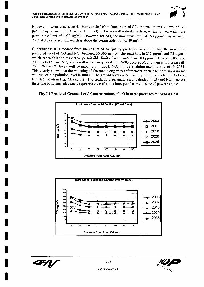
Independent Review and Consolidation of EIA, EMP and RAP for Lucknow - Ayodhya Secbon of NH 28 and Gorakhpur BypassConsolidated Environmental Impact Assessment Report
However in worst case scenario, between 50-300 m from the road C/L, the maximum CO level of 372
|tg/M3 may occur in 2003 (without project) in Lucknow-Barabanki section, which is well within the
permissible limit of 4000 jig/M3. However, for NO, the maximum level of 153 jtg/M3 may occur in
2003 at the same section, which is above the permissible limit of 80 jig/m3 .
* Conclusions: It is evident from the results of air quality prediction modelling that the maximum
predicted level of CO and NO, between 50-300 m from the road C/L is 217 jg/M3 and 75 Pg/M3 ,
which are within the respective permissible limit of 4000 jig/M3 and 80 jig/M3 . Between 2003 and
* 2035, both CO and NO, levels will reduce in general from 2003 upto 2010, and then will increase till
2035. While CO levels will be maximum in 2003, NO, will be attaining maximum levels in 2035.
This clearly shows that the widening of the road along with enforcement of stringent emission norms
* will reduce the pollution level in future. The ground level concentration profiles predicted for CO and
NO, are shown in Fig. 7.1 and 7.2. The predictions parameters are restricted to CO and NO, because
u these two pollutants adequately represent the emissions from petrol as well as diesel power vehicles.
Fig. 7.1 Predicted Ground Level Concentrations of CO in three packages for Worst Case
l Lucknow - Barabanki Section (Worst Case)
450 - ____
400 --X2003
E 300s 2007
l 8 '50 2 02
15 25 50 75 100 150 200 300
Distance from Road C/L (m)
Barabanki - Faizabad Section (Worst Case)
450
400-_ - 2003350 ~~
l E 2000 - 07l 250 A 2010
-a 200. 202I ~ ~ ~ so - ~~~~ -~~~-2020~s100 ~~~~~~~~~~--2035
15 25 50 75 100 150 200 300
Distance from Road C/L (m)
l
in joint venture with

Independent Review and Consolidation of EIA, EMP and RAP for Lucknow - Ayodhya Section of NH 28 and Gorakhpur BypassConsolidated Environmental Impact Assessment Report
Faizabad Bypass Section (Worst Case)
l E 3~~~~~~~~~~~~~~00i- 5
450
400 20
300 E3 2007 OA 250 __ 2010
200
L)150 -u.202050 ------
0
15 25 50 75 100 150 200 300
Distance from Road CIL (m)
U Fig. 7.2 Predicted Ground Level Concentrations of NO, in three packages for Worst Case
3 Lucknow - Barabanki Section (Worst Case)
200
l 175 2
l~~~~~~~~~~~~~~~~~~~~ii
125 -. 2007
100 -*--~~~~~~~~20100 ~~~~~~~~~~2020
0
15 25 50 75 100 iSO 200 300
Distance from Road CIL (in)
I ~~~~~~~~~~~Barabanki - Faizabad Section (Worst Case)
200
I 175~~~~~~~~~~~~~~~~150 - 2003
15 2 010 10 0 0 -2020
7 -9 VAJIin joint venture with

Independent Review and Consolidation of EIA, EMP and RAP for Lucknow - Ayodhya Section of NH 28 and Gorakhpur BypassConsolidated Environmental Impact Assessment Report
Faizabad Bypass Section (Worst Case)
l ~~~~~~~~~~~~~200
l E ' ~~~~~~~~~~~ >~0 _______ __________________________________________175 _
E s ------- 2003
| 1008 ' i 1X-2010I Zo ~ ~ ~ I I -*.-02020
25 -NE- 03
15 25 50 75 100 150 200 300
Distance from Road C/L (m)
Operation Phase Predictions of Air Quality for Gorakhpur Bypass Corridor
* Specific Input Data Sets for Gorakhpur Bypass Corridors
Besides common input data sets summarized earlier under section, there are certain specific dataI inputs for this package as summarized below:
Traffic Data: The project road has been divided into three sections for traffic projection. The
section wise average annual daily traffic (AADT) has been discussed in earlier Chapter on Traffic
Density Projections in DPR. The section wise peak hour and traffic percentage in peak hour has been
shown in Table- 7.6 to 7.8.
Table-7.6: Projected Daily Traffic on the Gorakhpur Bypass
Year Car Bus LCV 2/3-Axle MAV Total PCUs
Section-I: Seehapar to Nausar
2005 330 121 251 4740 122 15839
2025 1098 390 780 14716 380 49297
2035 1875 667 1221 23046 595 77525
Section-2: Nausar to Kooraghat
2005 375 121 249 4719 120 15807
2025 1250 390 774 14650 372 49206
2035 j 2135 667 1213 22942 583 77404
Section-3: Kooraghat to Jagdeeshpur
2005 308 1 56 209 4563 112 149822025 1025 1 81 648 14168 347 46604
2035 1750 310 1014 22188 543 73208Note: Excluding slow moving vehicles like tractor, tractor-trailor and non-mo otorised vehicles
Table- 7.7: Average Operative Speed (kmph) Predicted for Gorakhpur Bypass(Based on traffic volume of secti n-l)
Year Car Bus LCV HAV MAV
2005 86.89 71.21 66.50 59.59 45.27
X 2025 80.41 67.58 61.58 55.53 42.16
2035 76.66 65.48 58.73 53.18 40.36
I zfl/W 7-10
in joint venture with

Independent Review and Consolidation of EIA, EMP and RAP for Lucknow - Ayodhya Section of NH 28 and Gorakhpur Bypass| Consolidated Environmental Impact Assessment Report
Table-7. 8: Speed Corrected Emission Factors (g/km) for Gorakhpur BypassPollutant Diesel Vehicles (Trucks) for Speed (kmph)
10 20 30 40 50 60 70 80CO 37.60 18.80 12.53 9.40 7.52 6.27 5.37 4.70
NOX 66.83 22.42 22.28 16.71 13.37 11.14 9.55 8.36* Petrol Vehicles (Independent of Speed)
Cars 2 Wheelers 3 WheelersCO 2.72 2.0 4.0NOX 0.58 0.05 0.05
Results and Discussion: The results of air quality modeling using CALINE-4 has been presented inTable - 7.9 The prediction has been made at different distances downwind from the road in winterseason. From this table it may be noted that CO concentration will be maximum (3221.5 pg/m3 ) in2035, which is within the permissible limit prescribed by CPCB (4000 .tg/m3). The SO, and NO2concentration will be maximum (23.5 ,ug/m3 and 56 pIg/m3 respectively) in the year 2035 which are alsowithin the permissible limits (80 jig/M3). In case we take regional background concentrations of COand NOx as 35 (,ug/m3) and 4 (jig/M3) respectively then the predicted values shall accordingly increase.
* Table- 7.9: Results of Air Quality Prediction (jig/M3)
Year Predicted lc of CO* NOx**Dist. (m) from C/L-+ 20 50 100 200 20 50 100 200
2005 812.7 808.0 805.0 802.9 40.3 36.5 34.1 32.42025 821.7 813.7 808.5 805.0 46.8 40.6 36.6 33.92035 833.0 820.8 812.7 807.4 53.6 44.9 39.3 35.4
Noe * I hourly average values ** 24 hourly average values
7.3.2 Noise
Impact Assessment on Noise Environment
Nature of Impacts and Source Characteristics: From an acoustical point of view, environmentalnoise particularly highway traffic noise is a complex phenomenon because its intensity andcharacteristics varies with time depending upon the frequency as well as type of vehicle that passeson the road. A large number of vehicles on road will make the exposure situation of the road sidereceptors one of almost continuous nature of noise exposure, fluctuating between the high levelsgenerated by typical noisy vehicles such as trucks/ buses and the lower noise generated by cars. Afew events with a high noise levels will have the same Leq (see footnote) as a large number of
* exposure events but at a lower noise levels. But from biological point of view, it is unlikely that thesetwo-noise scenario's sharing same Leq but different exposure character will cause an equal effects onthe exposed pollution. So main problems in road side traffic noise exposure is the question of toI what extent is the number of different exposure events related to the human perception ofenvironmental stimulation. The health effects that we measure in the exposed population may bediscrete physiological reactions particularly of certain complex human responses, such as sleepI disturbance or an effect on work performance efficiency. For human responses, those appearing aftera single but a rare high exposure as well as those accruing after repeated low noise exposures(Chronic exposure) need to be evaluated carefully. Box 7.1 shows a certain Indian experience.3 Box : 7.1
Health Impact Observations in India
A study conducted by the Indian Institute of Road Traffic (IRT) examined whether road-traffic noise affectedpeople with respect to noise impacts such as: annoyance, sleep disturbance interference with communicationand hearing impairment. It showed that 35% of the population in four major Indian cities have bilateralsensory neural hearing loss at vehicular noise emission levels above 82 dBA. This is of particular concern inlight of a second study, showing that Leq (24 hrs ) at curbside location is Calcutta were 80-92 dBA(Chakraborty et. Al. 1997).
3 z 7-11
in joint venture with
l
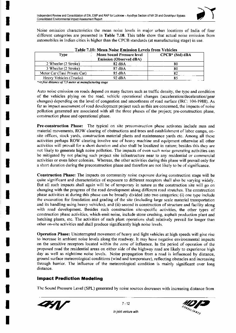
Independent Review and Consolidation of EIA, EMP and RAP for Lucknow - Ayodhya Section of NH 28 and Gorakhpur BypassConsolidated Environmental Impact Assessment Report
Noise emission characteristics the mean noise levels in major urban locations of India of fourdifferent categories are presented in Table 7.10. This table show that actual noise emission fromautomobiles in Indian cities is higher than the CPCB standards (at manufacturing stage) in use.
Table 7.10: Mean Noise Emission Levels from VehiclesType Mean Sound Pressure level CPCB* (Std) dBA
Emission (Observed dBA)2 Wheeler (2 Stroke) 82 dBA 80
* 3 Wheeler (2 Stroke) 87 dBA 80Motor Car (Taxi Private Car) 85 dBA 82
Heavy Vehicles (Trucks) 92 dBA 85| *Atfree distance of 7.5 meter at manufacturing stage
Auto noise emission on roads depend on many factors such as traffic density, the type and conditionof the vehicles plying on the road, vehicle operational changes (acceleration/deceleration/gearI changes) depending on the level of congestion and smoothness of road surface (IRC: 104-1988). Asfar as impact assessment of road development project such as this are concerned, the impacts of noisepollution generated are associated with all the three phases of the project; pre-construction phase,construction phase and operational phase.
Pre-construction Phase: The typical on site preconstruction phase activates include man andmaterial movements, ROW clearing of obstructions and trees and establishment of labor camps, on-site offices, stock yards, construction material plants and maintenance yards etc. Among all theseactivities perhaps ROW clearing involve use of heavy machine and equipment otherwise all otheractivities will prevail for a short duration and also shall be localized in nature; besides this they are
* not likely to generate high noise pollution. The impacts of even such noise generating activities canbe mitigated by not placing such project site infrastructure near to any residential or commercialactivities or even labor colonies. Whereas, the other activities during this phase will prevail only fora short duration during the preconstruction phase and therefore are not likely to be of significance.
Construction Phase: The impacts on community noise exposure during construction stage will bequite significant and characteristics of exposure to different receptors shall also be varying widely.But all such impacts shall again will be of temporary in nature as the construction site will go onchanging with the progress of the road development along different road stretches. The constructionI phase activities at during this phase can be broadly divided into two categories; (i) one type includethe excavation for foundation and grading of the site (including large scale material transportationand its handling using heavy vehicles), and (ii) second is construction of structure and facility alongwith road development. Besides such construction site-specific activities, the other types ofconstruction phase activities, which emit noise, include stone crushing, asphalt production plant andbatching plants, etc. The activities of such plant operations shall relatively prevail for longer thanother on-site activities and shall produce significantly high noise levels.
Operation Phase: Uninterrupted movement of heavy and light vehicles at high speeds will give riseto increase in ambient noise levels along the roadway. It may have negative environmental impactsI on the sensitive receptors located within the zone of influence. In the period of operation of theproposed road the residential areas on either side of the highway road are likely to experience highday as well as nighttime noise levels. Noise propagation from a road is influenced by distance,I ground surface meteorological conditions (wind and temperature), reflecting obstacles and increasingthrough barrier. The influence of the meteorological condition is mainly significant over longdistance.
Impact Prediction Modeling
| The Sound Pressure Level (SPL) generated by noise sources decreases with increasing distance from
73r 7-12 < V
in joint venture with p44,s

Independent Review and Consolidation of EIA, EMP and RAP for Lucknow - Ayodhya Section of NH 28 and Gorakhpur BypassConsolidated Environmental Impact Assessment Report
the source due to energy wave divergence. An additional decrease in SPL with distance from thesource is expected due to atmospheric effect or its interaction with objects/ barrier in the transmissionpath.
Estimating highway noise impact involves complex process, which will require a large computerI analysis to model in detail. However, the model presented below is a general highway noise modelthat predicts the equivalent noise level (Leq) and is adequate for most noise prediction requirementsof highway projects. The advantage of the model, which predicts Leq is that Leq is the "EnergyAverage" noise level, and as such as is not dependent on the statistics of SPL in dBA.
Prediction for Construction Phase of Lucknow-Ayodhya and GorakhpurBypass
(Note. As construction phase activities as well as the typical emissions sources shall be same forLucknow-Ayodhya and Gorakhpur Bypass Project Corridors, the predictions of noise pollution levelsare same).
3 Common Data Inputs for Lucknow-Ayodhya and Gorakhpur Bypass: During constructionphase, the major sources of noise pollution are movement of vehicles transporting the constructionmaterial, operation of various plants, such as: crushers at stone aggregate concrete heavy mixtures,
h hot mix plants besides occasional blasting if required etc. But these activities will be at differencelocations and uniformly distributed over the entire construction period and its site shall go on shiftingon the corridor with the road development progress. Further, the major work will be carried outduring daytime.
Algorithms Used for Construction Phase Predictions: Algorithm used for relationship betweensound power levels (which can be assumed to be constant for a given locations for a configuration ofconstruction activities) and sound pressure level at receptor (located at different distance) is givenbelow:
| Lp Lw - 2010g r- 8 |(i)
I |Lp = LW-20 log r8Ae -|8A (ii)
I Where Ae (is the total noise attenuation before it reaches to receptor)= Aei + Ae2 + Ae3 + Ae4 + Ae5
Ael = Attenuation by absorptionAe2 = Attenuation by rain, snow, sleet or fogAe3 = Attenuation by different noise barriers (existing or constructed)Ae4 = Attenuation by vegetative built up in bitumen
* Ae5 = Attenuation due to atmospheric in homogeneitiesLw = Sound pressure level generated from a source (dBA)Lp = Sound pressure level at receptor (dBA)r = Distance of the source from the receptor
For a noise source such as a plant can be assumed as a point source located over a flat rigid surfaceand the noise radiation pattern is approximately hemispherical.
Prediction Results and Discussions: Adopting a scenario that at any given time two or three3 constructive equipment/ activities under operation or a stone crushers shall not collectively generate
I zfl/1 7-13 "O
in joint venture with
I

Independent Review and Consolidation of EIA, EMP and RAP for Lucknow - Ayodhya Section of NH 28 and Gorakhpur BypassConsolidated Environmental Impact Assessment Report
more than 95 dB(A) and when these activities are enclosed with some kind of temporary noise barrier(corrugated iron sheets or some other solid barrier of 4 to 5 mts height) than the noise intensity at the
* receptor located more than 500 mts shall be less than less than 60 dBA; (because noise attenuationdue to some temporary solid barrier erected can be as high as 10-25 dB(A) and noise level shallfurther drop by 3 or even 4.5 dB(A) with every doubling of distance). The indoor noise exposureshall be much less than 50 dBA which is safe for day time exposure (6 AM to 9 PM).
Besides, the existing background noise levels as measured on the project corridor are much higherthan 60 dB(A). Hence, the preventive measures proposed for construction phase should be adequatefor required noise attenuation.
3 Noise Level Prediction for Operational Phase
For prediction modelling in noise environment during operational phase there are, certain commoninput database for modelling of two corridors and also there are specific data inputs. Here first the* common data inputs/information for modelling of both the corridors are summarized below:
I Common Data Sets/ Information
The most impact is considered when wind blows from the project road to nearest receptor(s). Theimpact of noise levels from the existing and the proposed highway on the neighboring communities3 is predicted by carnying out computations using Highway Noise Model developed by FederalHighway Administration (FHWA). Further, the model presented below can be applied equally wellto high and low traffic volume roadways.
Algorithms Used: Algorithms used for impact predictions : The Highway Noise Model algorithmspresented below: are the basis for calculating or each hour Leq or for the whole timing period ofinterest. (like day time and night timings separately-matching with the promulgated standards fordifferent automobiles.
Leq (for 6 am to 10 pm)
=LOE +lIOLog CNi ~+1I0Log 1 ),+ +A, - (B)( Six T ) ( D)
Leq (for 10 pm to 6 am)
I = LOEI + 1 OLogQ Ni + 1OLog( D )! +!AS-13
| Where,
Lq (i) : Equivalent noise level for day period and night period for vehicle type 'i'(there are four major categories of vehicle).
Loei : Reference mean energy level for (ith ) vehicle type.Ni : Number of vehicles 'ith' class passing in time 'T' time is taken as nightI duration (10 pm to 6 am) and day duration (6 am to 10 pm) for which Leq
standard are promulgated Leq CP(B)S : Average Speed of vehicles of 'ith' each class of vehicular (kmph).3 T : Time duration corresponding to Ni, (this is same as that is taken for Leq
calculation)D : Perpendicular distance in (m) from centerline of the traffic lane to the3 different observers/receptors
5 zF7/ 7- 14 40
in joint venture with

Independent Review and Consolidation of EIA, EMP and RAP for Lucknow - Ayodhya Section of NH 28 and Gorakhpur Bypass3 Consolidated Environmental Impact Assessment Report
a (Alpha) Factor relating to absorption or reflection characteristics of the ground coverbetween edge of ROW and observers receptor.
6 (Delta S) : Shielding factor for example for provision of barrier.
The preceding equations are used three times, once for heavy vehicles trucks/buses, once for medium
size automobile (car, other light domestic/commercial vehicles), and once for two stroke engine (twoand three wheeler) and Leq (night) total can he obtained by logarithmically adding the values asfollows.
The combined impact effect of all the four vehicle types covered in the modeling can be determined3 at various distance where receptors of important are station using the following equation.
Leq (day time) total = 10 LogE1 O Leq(daytime )i
3 Leq (night time) total = 1 OLogE Leq(daytime)i )
For operational phase highway nose predictions, the model development by Federal HighwayAdministration Department of Transportation (US) based on above mentioned algorithms wasapplied along with the assumptions: (i) there are no major grade differences in the project as it isplain terrain and have gentle slope, (ii) the traffic plying on the proposed section is assumed to flowI simultaneously in the both lanes and in both directions, (iii) noise from other sources apart fromhighway is not being accounted for in the modeling and (iv) the receptor is considered to beindependent of the noise emitted from adjacent roads.
Data Input for Prediction Modeling
I Noise Emission Factors: To asses the noise levels at the various sensitive receptors located atdifferent distances all along the corridor, the prediction of noise level due to traffic growthprojections were made for the year 2007, 2005 and 2035 (representing the whole designed period ofhighway), and the following data inputs were developed for the purpose:
The vehicular noise emission levels significantly vary with vehicle speed (particularly heavy vehiclesfor speed above 50 km/ph) it is therefore, necessary that speed depended noise emissions for variouscategories of vehicles are taken into account while evolving the noise produced (Loe) from ROW.
In this work the speed-noise relations (Table 7.11) evolved by National Environmental EngineeringResearch Institute (NEERI) in their report on Environmental and Social Assessment (which areessentially based on similar US - EPA proposed emission factor) were used here.
* Table 7.11: Noise Levels Variation with Vehicle Speed
Speed (kmph) Vehi cle Type (Noise Lev els in dB(A) at 15 m ter)Cars* Trucks Buses 2/3 Wheelers
* 40 59.0 76.0 76.0 61.0
50 63.0 80.0 80.0 66.060 65.0 81.0 81.0 68.0
70 68.0 81.5 81.5 70.0
80 70.0 82.0 82.0 72.0= ~~ ~ ~~~~90 72.0 83.0 83.0 74.0| ~~~ ~ ~~~100 74.0 1 83.5 83.5 76.0
*Noise levelsfor new cars are 5 dB(A) lower
7-15 - 4
injoint venture with

Independent Review and Consolidation of EIA, EMP and RAP for Lucknow - Ayodhya Section of NH 28 and Gorakhpur Bypass3 Consolidated Environmental Impact Assessment Report
For 'Do Nothing' scenario, the traffic was assumed to travel at a speed of 35 km/hr and 30 kmph on3 the existing roads in the year, 2025 and 2035.
Since new (designed for less noise) cars can be foreseen hitting the roads by the year 2025 and theirnoise generation level would even be reduced by at least 5 dB(A) across the whole range of vehicles.I The reduction may be even more for diesel driven vehicle. So even by doubling the vehicles volume,the noise emitted may increase by 3 dB(A). Accounting for the noise mandated by federal law. Thecurrent regulations limiting motor vehicle noise at the time of manufacturing has been given earlierin Table 7.11.
But as India has adopted EU standards along with their engineering design for vehicular air pollutantemission but adopting these standards will also reduce noise emission levels. EU requirements onvehicle noise during the last decade have reduced engine noise by 10 dB (A) so it may be applicableto India.
Noise Prediction for Operational Phase of Lucknow-Ayodhya Corridor
3 Data Inputs: For noise level modeling of this phase the specific data inputs are concerned with thetraffic density and typology projected for different years in the total design life of the project (up to2035).
* Traffic Data: Projection for three different section of Lucknow-Ayodhya Corridors are given inTable- 7.12.
____ Table-7.1,: Average Operative/Journey Speed (kmph)Year Lucknow-Barabanki_Sec tion Barabanki-Faizabad Se tion Faizabad B pass Section
2Wh Car Bus LCV HCV MAV 2Wh Car Bus LCV CV MAV 2Wh Car Bus LCV HCV MAV2007 70 80 60 60 60 40 70 80 60 60 60 40 70 80 60 60 60 402010 63 72 54 54 54 36 63 72 54 54 54 36 63 72 54 54 54 362015 63 72 54 54 54 36 63 72 54 54 54 36 63 72 54 54 54 362020 56 64 48 48 48 32 63 72 54 54 54 36 63 72 54 54 54 36| 2025 47 54 41 41 41 27 56 64 48 4848325664484848322030 44 50 08 38 38 25 56 64 48 4848 3256 64 484848322035 46 52 39 393926566448484832566448484832
I Results and Discussion
Results : The model results for three horizon years traffic growth and noise emission, with respect tothe distance from the center of the road were worked out. The Leq noise levels at various distancesfor each type of vehicle were computed for the day (6 am to 10 pm Lday) and night time (10 pm to 6am Lnight,) separately and the cumulative Leq noise levels for day (6 am to 10 pm L&y) and night time(l0 pm to 6 am Ln,ght) were obtained up to 500 mts within which different sensitive receptors aslocate.
5 The predicated noise levels at various receptor distances between 25-100 m from the road for the years2007, 2010, 2020 and 2035 are presented in Table - 7.13
From the predicted noise levels it is evident that, in general, both day and nighttime noise levels willincrease slightly but steadily between 2003 and 2035. Though the noise emission level of vehicles isreducing between 2003 and 2035 due to reduction of speed, but the predicted noise levels willslightly increase, because traffic will increase by 8 times. The increase in number of vehicles willoffset the effect of the reduction of noise emission level due to speed reduction.
It can also be observed that daytime noise levels will be maximum in Lucknow-Barabanki section,whereas nighttime noise levels will attain maximum levels in Faizabad Bypass section. This is due to
5 7-16 40w
in joint venture with

Independent Review and Consolidation of EIA, EMP and RAP for Lucknow - Ayodhya Secton of NH 28 and Gorakhpur Bypass3 Consolidated Environmental Impact Assessment Report
the fact that the truck traffic is maximum in Faizabad Bypass section during night, whereas total3 traffic is maximum in Lucknow-Barabanki section during daytime.
Table 7.13 Predicted Noise Level in dB(A)Section Dist m 2007 2010 | 2020 2035
C/L (m) Day Night Day I Night Day Night Day I NightPackage-- ILucknow- 25 70.5 70.2 70.7 70.5 72.1 72.0 72.5 72.2Barabanki 50 66.0 65.7 66.2 66.0 67.6 67.4 68.0 67.7
100 61.5 61.1 61.7 61.4 63.1 62.9 63.4 63.1Package - IIBarabanki- 25 69.3 67.3 69.5 67.6 72.1 70.2 74.3 72.5Faizabad 50 64.8 62.8 65.0 63.1 67.6 65.7 69.8 68.0
100 60.3 58.3 60.5 58.5 63.1 61.2 65.3 63.5Package - IIIFaizabad 25 69.2 71.0 69.5 71.3 72.1 73.9 74.4 76.3Bypass 50 64.7 66.5 65.0 66.8 67.6 69.4 69.9 71.8*____________ 100 60.2 62.0 60.5 62.3 63.1 64.9 65.4 [ 67.2
Conclusion: It is evident from the results of noise prediction that between 2007 and 2035 between 25and 100 mts distance from the road C/L the predicted maximum daytime noise level are 69 to 75 and61.5-69.9 dB (A) respectively occurring mostly in the Lucknow-Barabanki section, while maximumnighttime noise level for 50 to 100 mts is 62.8-71.8 dB (A) occurring in the Faizabad Bypass section.Between 2007 and 2035, though the noise emission level of vehicles is reducing due to reduction ofspeed but the noise level will increase slightly by 3.9-5.3 dB(A) due to 8 times increase in traffic
* volume. Since there are substantial increases, in noise level over the existing noise level, the impact onthe surrounding receptors will not be significant
| Noise Predictions for Operational Phase of Gorakhpur Bypass Corridor
Specific Data Input: The specific data input for this corridor concerns the traffic density andJ typology profile for the future years to work out the noise emission levels from the corridor.
To asses the noise levels at the various sensitive receptors located at different distances all along thecorridor, the prediction of noise level due to traffic growth projections were made for the year 2007,2005 and 2035 (representing the whole designed period of highway), and the following data inputswere developed for the purpose:
Noise Emission Levels
3 The Traffic Data Inputs: The traffic growth as well as expected changes in traffic speed asprojected in DPR has been used. The vehicular noise emission levels significantly vary with vehiclespeed (particularly heavy vehicles for speed above 50 km/ph) it is therefore, necessary that speeddepended noise emissions for various categories of vehicles are taken into account while evolving thenoise produced (L0.) from ROW. The Table 7.14 presents the operative speed on Gorakhpur Bypass
Table- 7.14: Average Operative/Journey Speed (km ph) on Gorakhpur Bypass CorridorYear i Seehapar- Nausar Nausar- Kooraghat Kooraghat- Jagdeeshpur
Car I Bus and Truck Car Bus and Car Bus and TruckTruck __ __
2007 80.5 62.2 80.4 62.3 80.5 62.12010 80.1 61.6 80 61.7 80.1 61.52015 79.7 61.1 79.6 61.3 79.7 612020 1 79.7 61.3 79.6 61.4 79.7 61.1
5 7-17 Ain joint venture with 14..
l~~~~~~~~~~~~~~~~~~~~~~~~~~~~~~~~~~~~~~~~4

Independent Review and Consolidation of EIA, EMP and RAP for Lucknow - Ayodhya Section of NH 28 and Gorakhpur Bypass3 Consolidated Environmental Impact Assessment Report
Year Seehapar- Nausar Nausar - Kooraghat K oraghat- JagdeeshpurCar Bus and Truck Car Busand Car Bus and Truck_ _ _ _ _ _ _ _ _ _ _ _ _ _ _ _ _ _ _ _ _ _ _ _ _ _ T ru c k _ _ _ _ _ _ _ _ _ _ _ _ _ _ _
2025 79.2 61 77.8 60.4 79.4 612030 78.7 60.6 77 59.8 79.1 60.72035 78.2 60.2 76.2 59.2 78.8 60.4
As mentioned earlier in this predictions the speed-noise relations evolved by National Environmental| Engineering Research Institute (NEERI) in their report on Environmental and Social Assessment
(which are essentially based on US - EPA projections) were used.
3 Results and Discussion
The predicated noise levels at various receptor distances between 25-500 m from the road for the years| 2007, 2010, 2020 and 2035 are presented in Table-7.15
Table-7.15: Predicted Noise Level in dB(A) for Gorakhpur BypassSection Dist fm 2007 2010 2020 2035
C/L (m) Day Night Day Night Day Night Day NightSeehapar- 25 70 72.1 70.9 73 73.4 75.5 76.3 78.5
Nausar 50 65.5 67.6 66.3 68.5 68.9 71 71.8 74I 100 61 63.1 61.8 64 64.3 66.5 67.3 69.4200 56.4 58.6 57.3 59.4 59.8 62 62.8 64.9300 53.8 55.9 54.7 56.8 57.2 59.3 60.2 62.3500 50.5 52.6 51.3 53.5 53.9 56 56.8 59
Nausar- 25 70 72.1 70.8 73 73.4 75.5 76.3 78.4Kooraghat 50 65.4 67.6 66.3 68.5 68.8 71 71.8 73.9
100 60.9 63.1 61.8 63.9 64.3 66.5 67.3 69.4200 56.4 58.6 57.3 59.4 59.8 61.9 62.8 64.9300 53.8 55.9 54.6 56.8 57.2 59.3 60.1 62.2500 50.4 52.6 51.3 53.5 53.8 56 56.8 58.9
Kooraghat- 25 69.7 71.9 70.6 72.8 73.1 75.3 76.1 78.2Jagdeeshpur 50 65.2 67.4 66.1 68.2 68.6 70.8 71.6 73.7
100 60.7 62.9 61.6 63.7 64.1 66.2 67 69.2200 56.2 58.3 57 59.2 59.6 61.7 62.5 64.7300 53.5 55.7 54.4 56.6 56.9 59.1 59.9 62500 50.2 52.4 51.1 53.2 53.6 55.8 56.6 58.7
I It is evident that, in general, both day and nighttime noise levels will increase slightly but steadilybetween 2003 and 2035. though the noise emission level of vehicles is reducing between 2003 and2035 due to reduction of speed, but the predicted noise levels will slightly increase, because trafficwill increase by 8 times. The increase in number of vehicles will offset the effect of the reduction ofnoise emission level due to speed reduction.
3 It may also be observed that daytime noise levels will be maximum in Seehapar-Nausar and Nausar-Kooraghat section during all the projected years the maximum is expected in 2035 whereby thelevels will be 76.3 dB(A), similarly the night time noise levels will attain maximum levels in these3 two sections upto 78.4 dB(A) within 25 mts from centre line. This may be due to truck traffic, whichis maximum in these sections during night.
It is evident from this table that between 2007 and 2035 at 50 to 100 m distance from the road C/Lthe predicted maximum daytime noise level is 68.9 to 65 dB(A) occurring mostly in the same twosections.
I1 z 7-18
in joint venture with
l~~~~~~~~~~~~~~~~~~~~~~~~~~"

Independent Review and Consolidation of EIA, EMP and RAP for Lucknow - Ayodhya Section of NH 28 and Gorakhpur Bypass3 Consolidated Environmental Impact Assessment Report
It may also be noted that between 2007 and 2035 the noise level will increase slightly by 2 to 6 dB(A)I due to increasing traffic volume. Since there will be no substantial increase in noise level [<10 dB(A)]over the existing noise level, the impact on the surrounding receptors will not be significant. Themitigation measures shall be evolved so that night time noise levels are within permnissible limits of 40to 50 dB(A) for day time and night time respectively. The predictions made here also represent theworst-case scenario because the maximum peak hour traffic has been considered. Further more it isexpected that beyond 2020 there will be reduction by at least 10 dB(A) in noise emissions due to betterI engine design. Such considerations are also not taken into account for predictions.
7.3.3 Water Resources
3 Lucknow - Ayodhya Section of NH-28 including Faizabad Bypass: The project corridor traversesacross the basins of the Gomoti (flows through the southern side of the project road). There are 26natural flowing water bodies, which include three rivers (Reth, Kalyani and Kasera), fourteen
4 irrigation canals and nine natural drains. These will be impacted due to widening of the projectstretch including construction of the new bypasses. There is no record of flood in these water bodiesparticularly in rivers. To facilitate the cross-drainage at these water crossings, cross-drainagestructures are being proposed including improvements in the existing structures. The surface waterflow in the project area is predominantly from the north to the south. Besides flowing water bodies65 ponds are affected in which 28 will be totally filled up and 37 ponds will be partially affected due3 to widening and construction of Barabanki and Ramsanehighat bypass.
Gorakhpur Bypass: The proposed Gorakhpur bypass is traversed the Rapti river flood plain, twosmall streams (Sonwan and Kurwa) and three more natural nullahs (Gaura, Tura and Pharhend),I which carry out the natural drainage of the Gorakhpur bypass area. Drainage of the area is towardsRapti river. On right bank of the Rapti river natural drainage is northwest to southeast and on theright bank, northeast to southwest. Adjacent to the existing streams and nalla, drainage is towards theI respective water bodies. All these water bodies will be impacted due to construction of proposedbypass. To facilitate the cross-drainage at these water crossings, cross-drainage structures are beingproposed. River Rapti has definite flood plain between the left and right bund, which experiencesI flood every alternative years. Besides these rivers /streams one water tank is also affected due toproposed alignment.
| The impacts have been identified medium on water resources during construction.
Water table along the alignment varies from 10-15 m. In all about 414 tube wells will be impactedfrom the Lucknow-Ayodhya section and in Gorakhpur bypass area five hand pumps and two tubewells are affected. All these tube wells are the sources of potable and irrigation water. The typicalimpacts on water resources during the construction of the road are summarised in Table 7.16.3 Table 7.16. Various Impacts on Water Resources due to Construction Activities
Impacts Due To Construction IndicatorsLoss of water bodies Area of water bodies affectedLoss of other water supply sources Number of wells affectedAlteration of drainage, run off, flooding Number of cross drainage channelsDepletion of ground water recharge Area rendered impervious particularly proposed
bypass area3 Use of Water Supply for Construction Quantum of water usedContamination from fuel and lubricants Nature and quantum of contaminantsContamination from improper sanitation and Area of camp / disposal site and proximity to waterWaste Disposal in Construction Camps bodies / channels
3 7-19
in joint venture with
l

Independent Review and Consolidation of EIA, EMP and RAP for Lucknow - Ayodhya Secton of NH 28 and Gorakhpur Bypass3 Consolidated Environmental Impact Assessment Report
Alteration of Drainage
* There are one major bridge approximately 60 m length, 18 minor bridges, and 188 culverts arepresent in the NH-28 section of project stretch including Faizabad bypass area. Some of theseculverts are weak and would require reconstruction. During the road widening of respective stretchesall these bridges, culverts and cross drainage structures will be provided in the newly constructedpart. In addition, two bridges, 19 culverts on the alignment of proposed Barabanki bypass, onebridge, 12 culverts on the proposed alignment of Ramsanehighat bypass and five bridges and 47culverts along the proposed Gorakhpur bypass alignment are proposed.
The construction of new bridges and culverts / extension of existing one (culverts and bridges) overI rivers, streams, canals, and natural nallas require training of the water bodies during the constructionperiod. During construction alteration of drainage channel may lead to soil erosion of adjacent areas,and may disturb local vegetation. For long construction period, there are chances of local ecologyI being impaired. However, as mostly bridge works are done in lean seasons (winter and summer)when the water levels are low in the water bodies, the impacts due to alteration of drainage channelcan be minimized effectively with adequate mitigation measures and pre planned constructionschedules.
Since there will be widening of existing road the impact on the natural drainage pattern ofthe area will be minimum. But the area where new alignment is proposed in the proposedBarabanki, Ramsanehighat and Gorakhpur bypass area the main carriageway will be higherthan the ground level mainly in Ramsanehighat and Gorakhpur bypasses; therefore, impact
| on drainage pattern of the area will be significantly high. The impact on this aspect has beenassessed in detail in subsequent sections.
Pre Construction Stage: No alteration of drainage of surface flow (rivers/streams) is envisagedduring pre-construction period.
Construction Stage: Though construction over the water bodies is to be carried out in the lean flowperiods but the diversion of water will still be required for the rivers, streams and canals. InLucknow-Ayodhya stretches (including proposed Barabanki, Ramsanehighat and existing Faizabadbypasses) 19 bridges and about 188 culverts are to be constructed on streams and canals and nullahs.I While in proposed Gorakhpur bypass four bridges over major rivers/streams, three viaducts and 47culverts will be constructed. Their construction will involve diversion of waterway. The diversion ofwater way will be within the RoW. The waterway will be constricted, increasing velocityI downstream of the bridge. This will mean increased sediment load with the flow. However, theimpact shall be restricted during construction period of the project.
3 The drainage pattern of the area has been studied in detail by the DPR Consultants. Based on thestudy, additional cross drainage structures have been provided to facilitate natural drainage across thealignment particularly in new alignment portion. Moreover, except the new alignment ofRamsanehighat and Gorakhpur bypasses road level of rest part of the project road (Barabanki andstretch of widening) is almost on the ground level. Therefore, significant impacts in the drainagepattern due to the raising of the road profile are not likely; however, the road design itself takes care3 of the cross-pavement drainage.
The alignment of proposed Gorakhpur bypass passes through Rapti river flood plain. Designproposes the raising of the embankments by a minimum of 1.8 above the high flood level so as toprevent any impacts due to any water seepage in the pavement.
5 g * 7-20
in joint venture with
l

Independent Review and Consolidation of EIA, EMP and RAP for Lucknow - Ayodhya Section of NH 28 and Gorakhpur BypassConsolidated Environmental Impact Assessment ReportIOperation Stage: One of the unavoidable aftermaths of road construction is the increased surfacerun off. The construction of road in the project area will increase surface runoff due to pavedimpervious surface of main carriageway and service roads.
Impacts due to surface runoff include increased soil erosion and local flooding or water logging.However, as the proposed road (widening and new alignment in the bypass areas) has been designedwith side and median drains to take care of runoff, therefore this runoff shall be drained to the nearestcross drainage structure. The engineering design includes design of adequate cross drainagestructures, which shall take care of the extra flow. The adequacy of these cross drainage structureshas been discussed in detail in mitigation chapter.
3 Increased Sedimentation and Degradation of Water Quality
Pre-construction and Construction Stage:
I Effect on Ecosystem: The degradation of water quality can occur during construction stage fromincreased sediment load into watercourses near the construction site. As soil in the study area isalluvial type (silty clay to sandy loam) with a high silt/sand composition, the impacts due to theI increased sediment load will be significant and need to be addressed for all water bodies along thealignment. The irrigation canals that cross the project road have properly raised berms on their banks
* and are unlikely to be subjected to such run-off discharges.
Increased load of fine sediment will make the water more turbid which reduces the light penetrationin lower strata. Reduction in intensity of light will adversely affect the primary productivity of theconcerned ecosystem. But such impact will be restricted only during construction period and for ashort period, after the first rainfall of monsoon. Proper treatment of the embankment i.e., compactionof earth and grass turfing on the slop will prevent such soil erosion; this has been elaborated in the3 subsequent sections under the heading of soil erosion and compaction of soil.
Degradation of water quality is also possible due to accidental discharges into watercourses fromdrainage of workers' camps and from spillage in vehicle parking and/or fuel and lubricant storage
areas.
Since the soil is alluvial and contains a large proportion of silt/sand, percolation to underlying aquiferwill be very fast. Therefore, any pollutant discharge may quickly percolate into the depths of theearth and may contaminate ground water.
Operation Phase: In the operation phase, there is little chance of degradation of water quality andI the aquatic ecosystem during normal operations. The implications of accidental discharge arepotentially disastrous. But, it must be emphasised that the probability of such an accident is quite
3 low.
Loss of Water bodies / Groundwater sources
414 numbers of hand pumps/ wells are identified to be removed from the proposed widening sectionof existing NH-28 between Lucknow-Ayodhya and Faizabad bypass. The loss of these sources ofdrinking water would be a direct negative impact. However, the project envisages replacement ofeach source of water supply before removing them. The location of these new sources will bedecided in consultation with affected population. Therefore, the eventual impact of the proposedproject may only be marginal.
3 In road widening and construction of new bypasses, 66 ponds will be affected in which 28 will betotally affected and 38 ponds will be partially affected. Package wise details of the affected ponds arepresented in Table 7.17. These ponds sometimes are used for irrigation purposes. Therefore, the
7 -21 Ain joint venture with
l~~~~~~~~~~~~~~~~~~~~~~~~~~~~~~~~~~~~~~~~4
I

Independent Review and Consolidation of EIA, EMP and RAP for Lucknow - Ayodhya Section of NH 28 and Gorakhpur Bypass3 Consolidated Environmental Impact Assessment Report
impact of this project will be moderate. Some of these ponds will be relocated and the details are3 discussed in the mitigation chapter.
Table 7. 17: Number of Affected Ponds in Lucknow-Ayodhya Stretch3 Package Fully Affected Partly Affected Not Affected Total
Package-I 3 10 7 20Package-ll 17 19 0 36Package-III 8 9 4 21Grand Total 28 38 11 59
It may be mentioned that beds of existing ponds will not be excavated for borrowing earth for theconstruction of embankment.
3 Flood Hazard
Lucknow-Ayodhya Stretch including Faizabad Bypass: Flood is rare phenomenon in the rivers inLucknow-Ayodhya stretch including proposed Barabanki and Ramsanehighat bypass area. However,
* bridges/culverts are present over all the flowing water bodies crossing the RoW will also be extendedin the widening part. All the flowing water bodies present in the proposed Barabanki andRamsanehighat bypass are retained providing bridges or culverts over them to facilitate the naturalI drainage of the area. In addition, 34 additional cross drainage structures (CDS) are designed tomaintain the smooth flow and avoid the water logging due to the new embankment of the proposedbypasses. Average distance between two CDS is one km and such CDS are designed to handle 25years peak flood level while the bridges are designed considering 50 years peak flood level.
Gorakhpur bypass: The alignment passing through Rapti river flood plain between the left and rightbund from chainage 9.750 to km 15.300 which remains under water during flood. The streams Gaura,Tura and Pharhend discharges into Rapti river duringflood at about 8-1 0 km down stream of newalignment, when water level rises in Rapti river, thereI is a back flow in all these streams. Gaura nadioriginates from the Ramgarh tal and drains to Raptiriver during its coarse it crosses many depression and lI | ponds. The bed level of Gaura is lower than the bed -.level of Rapti during monsoon. However, in monsoonseason the flow of Gaura is controlled by a sluice gatelocated 700 m upstream before joining Rapti river.
I This sluice gate is closed during high flood period Photo Plate 7.1: Location of Viaduct before Rapti Riverto check the back flow and thereby flood in upstreamI | stretches. On the other hand the water from the upstream stretches including spill from Ramgarh Taldo not get any escape from the Gaura river so it fills all the depressions/ponds present in the travelpath of Gaura. Proposed alignment crosses this submerged area at many locations.
| * To avoid the submergence area of Rapti flood plain three viaducts have been designed (Photo Plate7.1). However, to save the pavement and road sections in other stretches, the embankment height isfixed about 4-5 meter above ground level and at least 1.8 meter above HFL level. Therefore, it isexpected that road surface will not be flooded. Further, adequate sized drains in median and oneither side of main carriage way/service roads are also designed.
| 1 7.3.4 Land
I I z r 7-22 A pwin joint venture with t'
11

Independent Review and Consolidation of EIA, EMP and RAP for Lucknow - Ayodhya Section of NH 28 and Gorakhpur BypassConsolidated Environmental Impact Assessment Report
Physiography
The impact of road construction on physiography is a function of the terrain of the area. Since entirelength of bypass passes through plain areas and the main carriageway will be raised, therefore, therewill be visible and significant impact on physiography of the region.
Seismicity
The entire area of Lucknow-Ayodhya stretch of project road including Faizabad bypass falls inseismic Zone III having moderate seismic intensity and the region through Gorakhpur bypass fallsunder seismic zone IV (having sever seismic intensity) as per IRC: 6, having high risk of potentialdamage due to earthquake. Road construction in these areas will have little impact on its overallearthquake potential since no blasting is envisaged at the construction sites. In the light of above,insignificant impact is anticipated due to seismicity. However, the bridge designs have been madeconsidering the seismicity of the project area.
Loss of Productive Soil
Pre-construction stage: Loss of productive soil, albeit during the construction stage only, isenvisaged at locations of workers' camps, stockyards, storage godowns etc. if these are located oncultivated areas. Provision has been made in EMP to ensure that no productive areas are used forthese purposes. In any case, though it would be a direct impact, it would be reversible and low innature.
Construction stage: The soil in the Lucknow -Ayodhya stretch of project road -influenced area isalluvial type, capable of producing high yields, largely due to the rich soil nutrients deposited by theGharghara and Gomoti and its tributaries. While soil of the area through which Gorakhpur bypass ispassing is nutrient rich alluvium deposition of Rapti and its tributaries, capable of producing highyield and four crops in a year.
The loss of productive topsoil due to road construction is a direct adverse long-term impact. All theproposed new alignment areas (Barabanki, Ramsanehighat and Gorakhpur bypass) and most of thesection of widening portion is agriculture field and thus there will be permanent loss of fertile soiland land due to construction of bypass. In addition to this there will be temporary impact onproductive soil at diversions and labour camp due to leasing of land for construction period. Hence,during construction there will be significant impact on soil.
Land Use
The land use in all the bypass alignments will be converted into concrete permanently due toconstruction of the road. Thus fertile agriculture land coming within the RoW will be lostpermanently. During the construction period there will be temporary land acquisition for access roadfor construction site in the new alignment area, location of crushers, hot mix plants and workerscamp for all the construction packages.
Impact on Ribbon Development: In addition to the above, there will be induced land use changesparticularly adjacent to RoW where service road is planned on certain stretches along the side of themain carriage way. Though, the service roads are not continuous even this proposed service road inselected stretches will provide better connectivity to the villages present nearby. Land adjacent to theproject stretch of NH-28 and along the bypasses is very fertile and irrigated, wherein farmers getgood revenue out of each acre. Therefore, landowner may not be interested to convert theirproductive agricultural land for other use. But certain amount of roadside development isunavoidable near to the settlements as evident from the many section on the existing NH-28 and
* 7-23
in joint venture with
I

Independent Review and Consolidation of EIA, EMP and RAP for Lucknow - Ayodhya Section of NH 28 and Gorakhpur BypassConsolidated Environmental Impact Assessment Report
Faizabad bypass. Hence, it can be envisaged that there will not be any radical changes in land usepattern except minor development along the service roads or road junction and major settlements.Expected land use changes will include establishment of repair shops, tea stall and other smallcommercial establishments. These induced land use changes may lead to encroachment of RoW,wherever are available by the community. To control unauthorised ribbon development along theproject road and proposed bypasses some legislative measures need to be taken-up jointly by theLocal Development Authority and UP state government in consultation with revenue authority,which is discussed in next mitigation chapter.
Soil Erosion
The soil in the study area varies silty clay and sandy loam. Therefore, the potential for erosion ismoderate. Erosion will be exacerbated if the vegetation is removed from the sides since roots areknown to hold soil together. This will however be for the duration until the roadside turfing hasmatured. In stretches where raised carriageway has been planned, slope protection measures are amust.
It will not be possible to construct the road whether widening or new construction without denudingthe soil and therefore, erosion will be unavoidable. However, to prevent the eroded material fromentering the watercourse, silt fencing or cascade arrangements can be provided at the end of ditchesas they enter into the water bodies. While the former requires frequent cleaning to prevent built-up,the voids in the cascade will be filled up by eroded material and eventually vegetation will beestablished there.
No soil erosion is envisaged when the road is in operation as all the slopes and embankments of theproject road shall be stabilized. Moreover, the issue has been addressed at the design stage itself andall slopes have been designed with a gradient of 1:2 (V: H), which shall ensure stability of theembankment.
Compaction of soil
Pre-Construction Stage: Compaction of soil will occur in the pre-construction stage (particularlyduring site clearance stage) due to movement of heavy machinery and vehicles. Similarly,compaction will take place during setting up of construction camps and stockyards. However, this isa short duration impact. Appropriate measures need to be specified in the EnvironmentalManagement Plan to minimize the area of soil compaction.
Construction Stage: Movement of vehicles during road construction is the major cause of soilcompaction. Compaction occurs beyond the carriageway and within the vegetated area of the RoWby the movement of vehicles and heavy machinery. This impact is direct and will be maximum in theRoW. It is necessary to ensure that there is no adverse impact of soil compaction in areas other thanthe RoW.
Operation Stage: Compaction cannot be said to be an impact of the operation stage as the pavementitself is a function of compacted base and sub base. During the operation period compaction in thearea out side of the carriageway will not occur.
Contamination of Soil
Pre-Construction Stage: Contamination of soil in the pre-construction stage may be considered as ashort-term residual negative impact. Soil contamination may take place due to moving vehicles orsolid waste contamination from the labour camp set up during pre-construction stage. This impact issignificant at locations of construction camps, stockyards, hot mix plants etc.
3d7 7-24 / p
in joint venture with

Independent Review and Consolidation of EIA, EMP and RAP for Lucknow - Ayodhya Section of NH 28 and Gorakhpur BypassConsolidated Environmental Impact Assessment Report
Construction Stage: Contamination of soil during construction stage is primarily due to constructionand allied activities. The sites where construction vehicles are parked and serviced are likely to becontaminated because of leakage or spillage of fuel and lubricants. Pollution of soil can also occur atthe place of hot-mix plants from leakage or spillage of asphalt or bitumen. Refuse and solid wasteI from labour camps can also contaminate the soil. Contamination of soil during construction might bea major long-term residual negative impact. Unwarranted disposal of construction spoil and debriswill add to soil contamination. This contamination is likely to be carried over to water bodies in caseI of dumping being done near water body.
Operation Stage: During the operation stage, soil pollution due to accidental vehicle spills or leaks| is a low probability but potentially disastrous to the receiving environment. These impacts can be
long term and irreversible depending upon the extent of spill. The contamination due to deposition ofheavy metals such as Lead is a cause of concern. However, the proportion of petrol-driven vehicles isnot large and since phasing out of Lead from petrol has become a priority. Lead from vehicularemissions is expected to be reduced at a considerable rate, as the Govt. of India is making Lead freegasoline available. However, monitoring of soil quality may be continued during construction and3 operation phases
7.3.5 Consumption of Natural Resources
I The proposed road and bypass construction envisages the use of massive quantities of the earth, stoneand grit and sand along with bitumen. The Table 7.18 indicates the quantities required for the
| ~~~~project.project. Table 7.18. Raw Materials Requirement during Construction
Item OuantityI Package-I | Package -11 Package -111 Total
Lucknow-Ayodhya Stretch including Faizabad Bypass
Blue metal (m3) 369037 371229 379669 1119935* Bricks (nos.) 6290800 8858100 9329200 24478100
Sand (m 74880 104794 91539 271213Cement (MT) 71657 97418 89489 258564Bitumen (MT) 9310 9320 10400 29030Diesel (liters) 6190728 6654397 6064888 18910013Steel (MT) 2005 2037 3022 7064Earth (m3) 1104091 962759 71500 5562001 Fly ash (m3) 458100 26600 71500 556200
Gorakhpur Bypass
Blue metal (m3) 1279391Bricks (nos.) _
Sand (m3) 778491
Cement (MT) 75316Bitumen (liters) 19534733
Diesel (liters) 590388554
Water Consumption
In addition to resources mentioned above there will be requirement of water for constructionactivities and for environmental mitigatory measures the water consumption has been estimated asgiven below in Table 7.19:
1i 7 7-25
in joint venture with vf4s

Independent Review and Consolidation of EIA, EMP and RAP for Lucknow - Ayodhya Section of NH 28 and Gorakhpur BypassConsolidated Environmental Impact Assessment Report
Table 7.19. Fresh Water Requirement during Constr uctionPurpose Lucknow -Ayodhya stretch Gorakhpur bypass
including Faizabad Bypass
Qty (liter/day) Qty (liter/day)For road construction: Package I Package 11 Package - IIIa) Construction related to Earthwork 10,000 10,000 10,000 77,074
including dust suppression
b) Construction of related to road 75,813 55,278 59,730 146,885construction
Sub-total 223,959c) For drinking and other household purpose 10,400 10,400 10,400 10,400
fo h eople involved in the project*
Grand total 196,213 175,678 80,130 234,359* Lucknow Ayodhya stretch: Assuming 65 liter per capita per day forI 480 people for project duration of3O months
Gorakhpur bypass: Assuming 65 liter per capita per day for 160people for project duration of 30 months
Quarries
The excavation of quarries and borrow pits used for obtaining soil, rocks and aggregate materials for
road construction can cause direct and indirect long-term adverse impacts on the environment.
Significant quantities of materials will be required from quarry and borrow areas for the proposed
project road including widening the existing road stretch and proposed three new bypasses. The
significant impact of quarrying and crushing could have a critical impact especially on the air quality
of the area the area in downwind to the quarry. The stage wise impacts are as described below.
Pre Construction Stage: Existing quarries that are already identified for the road network in Uttar
Pradesh have been identified as the material source for this project also, and no new quarries have
been proposed. The bulk of the materials needed for the construction of the embankments will be
procured from the already existing quarries. This has been verified that necessary environmental
mitigative measures recommended by the state pollution control board are being followed at these
quarries. The impacts, which arise from borrowing the materials from this quarries, have already
been taken care of as these quarries already have requisite environmental clearances and
redevelopment plans.
Construction Stage: A major source of dust during the construction stage is from stone crushing
operations from the crusher and the vibrating screen. The dust, reduces visibility thereby increasing
safety concerns. Dust is generated due to procurement and transport of raw materials from quarriesand borrows sites to the road construction area. These impacts will persist till the activity ceases.I The regions especially downwind to the quarries/borrow areas are more vulnerable to air pollution.As no new quarry needs to be opened for this project, therefore, no new impacts are likely to arise
due to quarrying operations.
Though the quarry materials are to be transported over long distances to the construction sites, almost
all the quarries identified have proper access roads, therefore, no major impacts during the haulage ofI materials is envisaged. The issue of dust generation along the haul roads needs to be addressedthrough proper enforcement of dust suppression measures.
Crushers and Vibrating Screens: Crushers and vibrating screens will generate significant dust
during crushing and screening operations. These crushers and screens will be installed at constructionyard. The dust from these crushers normally has impacts up to a downwind distance of 500 m.
| Necessary mitigatory measures have been suggested in the mitigation chapter.
7-26 ,E.^ Vin joint venture with 4,
I

Independent Review and Consolidation of EIA, EMP and RAP for Lucknow - Ayodhya Section of NH 28 and Gorakhpur BypassConsolidated Environmental Impact Assessment Report
Embankment Filling Materials:
Earth from Borrow Pits
Cartage of the borrow materials to the construction sites is of significance, as almost all such areasare accessible through dirt tracks only and therefore, spillage and compaction of soil along thesetracks will be a significant impact. Proper protection measures need to be worked out for theminimising such impacts during the haulage of borrow materials.
As the borrowing of earth is to be carried out in accordance to the guidelines laid out in IRC-10-1961, no major adverse impacts are anticipated. Also, productive agricultural areas have beenavoided as far as possible for borrowing. However, the borrow area pits, if not treated properly afterthe borrowing is complete, can form stagnant pools and pose health hazards. To prevent theseredevelopment of borrow areas need to be worked out.
The DPR consultant has identified a part of Rapti river flood plain as borrow area for Gorakhpurbypass in Sherghar. The patch of the land (flood plain) extends from the toe of bund (present alongthe existing NH-28) to river Rapti and ground level of which is not very high from the water level ofriver. The identified patch of flood plain is presently used for cultivation (Photo plate 7.2). As perthe surveillance of Independent reviewers, the concerned area might have been formed
I I __ _ __ _ _-
Photo Plate 7.2: The Borrow Area Identified in the Sherghar
due to deposition of silts from river Rapti as river course has taken a curve in this part and gone awayfrom NH-28. Thus formed a triangular shaped flood plain, two sides of which is bordered by riverRapti and the third side is bounded by earthen bund which separates NH-28 from the river floodplain, identified as borrow area. As per the independent reviewer's observation, if earth is taken fromthis patch of land, river course may change and shifted towards bund, thereby near to existing NH-28. Therefore, the earth should not be borrowed from this particular area.
To meet the deficits of borrow materials DPR consultants suggested the use of fly ash from thermalpower plants located in Panki and Tanda. Particularly from Panki (located near Kanpur) for packageI (km 8.275 to 45), while from Tanda for package II (km 45 to 93.075) and package III (km 93.075to 122 on NH-28 and 15 kms on Faizabad bypass).
Fly Ash: As per the recent directive of India Government (order issued by MoEF, New Delhi ondated 18/06/2002), embankments of any new road/ fly over located within 100 km periphery of anythermal power station should be constructed using pond ash. Hence, DPR consultant is criticallyevaluating the viability and technical suitability of 'fly ash use' from Panki and Tanda. But detaildesigning is still in progress.
DPR consultants have found that fly ash from these power plants are technically suitable for theembankment construction. As per the India government directive (mentioned above) fly ash will beavailable free of cost from the plants but users have to pay for loading and haulage.
It is revealed from the investigation made by the independent reviewers, sufficient quantity of fly ashis not available from Panki thermal power plant as the plant authority already committed fly ash forKanpur bypass project. Anyway, the issues are still under discussion and DPR consultants areworking on the availability and other logistic of fly ash use in this project.
* 7-27 <^p
in joint venture with
I

Independent Review and Consolidation of EIA, EMP and RAP for Lucknow - Ayodhya Section of NH 28 and Gorakhpur BypassConsolidated Environmental Impact Assessment Report F
However, as per the DPR consultants, 556,200 m3 of fly ash will be required to transport from theidentified power plants to project site if fly ash option is finalised. Cartage of the fly ash to theconstruction sites is of significance though road network is already exists only concrete road may notbe available for the new alignment part (Barabanki and Ramsanehighat). In certain stretch of theproposed new alignments may be accessible through dirt track and therefore, spillage and compactionof soil along these tracks will have significant impact. Proper protection measures need to be workedout to minimise such impacts during the haulage of fly ash.
Major Environmental Concerns of Use of Fly Ash in Embankment are as Follows:
| 1. Contamination of groundwater and surface water due to leaching of heavy metals and ionicsolutions containing calcium, sulphate, magnesium, sodium, potassium, and silicate from thefly ash
* 2. Water contamination also may occur due to spillage of excess water from moist fly ash duringtransportation or after dumping on the embankment and contaminate nearby surface waters orgroundwater
3. Fly ash will not be stockpiled. This will be transported in wet condition in covered dumptrucks to the project site and will be directly dumped on the embankment. Bulldozer willI spread the material and a compactor will be used for compaction. But if the fly ash delivered tothe project site is too wet, it has to be dried by aeration and exposure to Sun, till the moisturecontent is acceptable for compaction. During such handling and also after placing onI embankment, if the fly ash surface is dried up completely, it will pose dust problem. In suchcases, proper dust suppressing measures will be adopted to control dust
4. Fly ash embankment is prone to severe erosion by runoff and high winds, if left unprotectedwhich may cause dust as well as water pollution. Proper erosion control measures will beadopted to protect the fly ash embankment
* 5. Many times fly ash is reactive to concrete because of its sulphate content; therefore,appropriate mitigative measures will be adopted to protect the concrete structures
| 6. Certain fly ash is potentially corrosive to metals. To know the corrosively potential eachsource of fly ash will be individually evaluated and if it is found to be corrosive precautionarymeasures will be taken to protect metal structures, which are placed within the embankment.
7.3.6 Impact on Ecology/ Flora/ Fauna
* Impact on Soil Fertility and Habitat Settings:
Road is a linear feature, moreover major part of the project road is already existing except the newbypass area of Barabanki, Ramsanehighat and Gorakhpur bypass will not bring any major change inthe habitat setting. But in new alignment areas embankment of the proposed bypasses will dissect acontinuous land into two halves. Both the halves will have the similar features, as originally it was apart of single piece of land. After construction of the road this continuity can be maintained bypedestrian and vehicular crossings, cross roads, cross drainage structures, planting the native plantsand grasses on the embankment. Moreover, continuity will be maintained along the stream or otherI water bodies on which bridges and culverts will be provided. Riparian zone below these structuresalso will serve as the natural link between the left and right halves, which will serve as naturalpassages of wild animals. Thus continuity between the right and left side of the bypass will bemaintained. No significant impact is envisaged on soil fertility and habitat settings due to the project.
7 7-28 ,0,02"q
in joint venture with 9f4l
I

Independent Review and Consolidation of EIA, EMP and RAP for Lucknow - Ayodhya Section of NH 28 and Gorakhpur BypassConsolidated Environmental Impact Assessment Report
Impact on Altered Sheet Flow and Natural Drainage on Soil Fertility:
* All the existing flowing water bodies on which culverts and bridges and all the existing crossdrainage structures will be extended in widening part of carriageway. Further, all the rivers, streamsand natural nallas, moreover, several cross drainage structures will be provided along the natural
* depression across the new bypass alignments to maintain the natural smooth flow of water duringrain. Therefore, it is expected that the proposed widening and construction of the new bypasseswould not have any significant influence on soil fertility on the land of either side of the project road.
The proposed alignment of Gorakhpur bypass in many places passes through low lying area , thatremain under water during monsoon particularly from km 9.750 to 15.390, which is passes throughRapti river flood plain. To avoid this low lying areas DPR consultants designed three viaduct, detaillocation of which are given in Table 7.20.
3 Beside the viaducts all the rivers, streams, and natural nallas provided with bridges and culverts andseveral cross drainage structures are also proposed. Therefore, there will be no obstruction in naturalflow of water.
Species Loss and Loss of Green Coverage:
Lucknow-Ayodhya stretch of NH-28 including Faizabad bypass: Out of 41,402 existing roadsidetrees along the project stretch of NH-28 and Faizabad bypass, only 16,619 trees have been identifiedfor cutting. About 75 % trees are saved. Details of trees to be cut along with species names, girth sizeand chainage are provided in Annexure 7.1. In addition, 1147, 571 and 4465 number of trees
* identified to be cut from the proposed Barabanki, Ramsanehighat and Gorakhpur bypass,respectively. Summary of the affected species identified for cutting from this section of project roadhas been presented in Table 7.21.
Gorakhpur Bypass: In the proposed Gorakhpur bypass area, 4383 numbers of trees will be cut forthe construction of the bypass, in which 211 number of trees belong to forest department. Details ofI trees to be cut along with species names, girth size and chainage are provided in Annexure 7.2. Treesto be cut are categorized as follows:
i) Trees fall within the ROW: A total no of 3969 trees fall within the ROW. Predominant speciesinclude Guava, Mango, Babul and Shisham. This includes part of Guava Plantation that falls atChainage km 11.5-12.2. About 2846 guava trees have to be cut.
| ii) Trees on either side of the junctions: Trees at the junctions include those on either side of thetake off point from NH-28 (i.e. 251.6 km) and end point on NH-28 (i.e. 279.8 kin) about 196trees have to be cut.I iii) Trees to be cut for viaducts: 242 trees are to be cut for the construction of 3 viaducts. Thelocations of the viaducts, their respective chainage and the number of trees to be cut arepresented in Table 20 as follows:
* Table 7.20: Details of Viaducts on Gorakhpur BypassViaduct Chainage (in km) Trees to be Cut
Viaduct 1 10.700-10.900 44Viaduct 2 15.300-15.400 3Viaduct 3 24.350-24.750 195
TOTAL 242
iv) Trees to be cutfor diversion of SHBypass: About 58 trees are to be cut for diversion ofexisting SH Bypass.
* qfl,w 7-29 ,000 04
in joint venture with

Independent Review and Consolidation of EIA, EMP and RAP for Lucknow - Ayodhya Section of NH 28 and Gorakhpur BypassConsolidated Environmental Impact Assessment Report
All these trees are common native plants; no endangered or rare plants are present among them.Hence, there is no threat of rare and endangered species loss.
Table 7.21. Number of Trees Existing and Identified for CuttingRoad Stretch Number of Existing Trees Number of Trees to be FelledI Package-* I 11 III Total I 11 III Total
(a) NH-28 11785 17371 10477 39633 4309 5597 4602 14508(b) Existing Faizabad bypass - - 1769 1769 - - 393 393I Sub-total (a)+(b) 11785 17371 12246 41402 4309 5597 4995 14901Proposed Barabanki bypass 1147 - - 1147 1147 - - 1147Proposed Ramsanehighat - 571 - 571 - 571 - 571bypass__ _ _ _ _ _
TOTAL 12932 17942 12246 43120 5456 6168 4995 16619
Tree cutting from RoW will reduce the green coverage, which may have a temporary effect on theI micro climatic condition of the area. But the effect would not be prominent because of similar landuse set-up in adjoining areas. The area is basically rural, and about 80 percent of which is agriculturalland. Lot of plantations including orchards are present in this area. Therefore, ecological effect ofI loss of trees would not be felt significantly. Moreover, the loss of green coverage will becompensated by the roadside plantation in the ratio of 1:2 (as per the tree plantation strategy ofNHAI).
Among the affected trees private fruit bearings trees are also present. Loss of such fruit bearing treeswill have economical implication to the owner, which will be contended by monitory compensation.
Impact on Wild Fauna:
Impact on the wild animals of this area will not be significant. The forests present near/ adjacent tothe project road are surrounded by human settlementand therefore forests patches are already disturbed dueto human interferences. These forests patches harbor
* few common wild animals which usually found in the MLout skirt of the villages like, Fox, Jackal, monkey,Mongoose, Nilgai etc. As reported by the local ;people, wild animals in this area are occasionallyencountered except Nilgai (Photo Plate 7.3), whichfrequently found in the crop field. There are no1 identified breeding grounds for any wild fauna in theproject area. Therefore, the project including proposedthree bypasses would not have any significant impacton the wild animals of the area. Photo Plate 7.3: Nilgai Grazing on the Agricultural
Land Near the Proposed Alignment
Impact on River Ecosystem:
* No major impact has been anticipated in the river ecology due to the construction of bridge overrivers/streams. Precaution has been already taken and incorporated in the engineering design tominimize
the impact on river ecology.
Increase of turbidity is the only impact envisaged during construction phase. This could be manageI by taking necessary precautionary measures during construction phase, which is discussed in themitigation chapter.
4 77 7-30 VAXin joint venture with

Independent Review and Consolidation of EIA, EMP and RAP for Lucknow - Ayodhya Section of NH 28 and Gorakhpur BypassConsolidated Environmental Impact Assessment Report
No major fisheries are present in any rivers/streams present in the project area including new bypass-influenced area. Whatever aquatic fauna including fishes are present in the project-affected stretch ofany water body are not localized to any certain point. It is expected that during the construction,fishes and other aquatic animals will be migrated to other undisturbed stretches of streams.Therefore, the impact of the proposed project on aquatic ecosystem including fisheries isinsignificant.
Besides, flowing water bodies (rivers/streams/ natural drains), which will be retained providingappropriate cross drainage structures, 28 ponds will be completely filled up which means thepermanent loss of water bodies but many of these ponds will be relocated. In addition, 37 ponds willbe partially filled in Ayodhya -Lucknow stretch including Faizabad bypass while in Gorakhpurbypass area one water tank will be filled up. No wetland is getting affected due to the widening orfor any of the three proposed bypass alignment. Whatever marshy lands are coming on the alignmentare seasonal. Therefore, impact on stagnant water bodies will be moderate.
7.4 Human Use Values
7.4.1 Land Acquisition
It has been estimated that total 216.8 hectors of land will required for Lucknow-Ayodhya stretchincluding existing Faizabad bypass and proposed Barabanki and Ramsanehighat bypass. While193.8 hectors of land is required for Gorakhpur bypass. More than 85% of the land, which has to beacquired for the widening and for new bypasses are agricultural land that, will be permanently lost(converted into concrete land).
7.4.2 Project Affected Area
The road stretch passes through many settlements and the proposed new alignments of Barabanki andRamsanehighat bypass avoids the congested stretch of respective townships. On the other handGorakhpur bypass avoids the traffic congestions of the city of Gorakhpur. The total number oftehsils, blocks and villages affected from the project is presented in Table 7.22.
Table 7.22: District Wise Details of the Project StretchChainage Chainage Districts Tehsils Villages
(start Km) (end Km)
8.275 17.00 Lucknow Sadar tehsil 817.00 69.00 Barabanki Nawabganj, Ramsanehighat 4769.00 135.00 Faizabad Rudauli, Sohawal and Sadar 63
Bypasses
Name Chainage (start Km Chainage (end Km) Villages
* Barabanki 20.00-(Sarthara Village) 32.46 (Sursunda village) Sarthara, Bhuhera,Bypass Dharsania, Asaini,
Kurauli, Darapur, Badel,* ________ ____________ Sukalai, Plahari, Dulhipur
and Susunda
Ramsanehighat 63.00 (Kashipur village) 69.70 (Asraf Gangraila) Kashipur, Dilona,Bhendua, Brahaman,Chandauli, Dharauli,Narayanpur, Bhundehri,Malinpur, Kushari and
*_______________ Asraf GanrailaGorakhpur 251.680 279.80 37Bypass I _ _I Source: Primary data
7-31
in joint venture with

Independent Review and Consolidation of EIA, EMP and RAP for Lucknow - Ayodhya Secton of NH 28 and Gorakhpur Bypass W IConsolidated Environmental Impact Assessment Report
7.4.3 Highway Amenity and Facilities
A number of facilities important for the residents of area around the bypass alignment exist along theedge of the widening and bypass area, which has been presented in Table 7.23.
Table7.23. Amenities and Facilities Affected due to the Project
Si Community Properties Lucknow-Ayodhya Section of Gorakhpur BypassNo. NH-28
100% Partially 100% PartiallyAffected Affected Affected Affected
I Hand pumps/ tube wells/ 420 - 7Iwells
2 Religious | Temple 39 3 1Structures | Mosque 2 1 -
3 Schools 12 104 Ponds 28 41 15 Brick Kiln I - -6 State Banks 4 -7 Health Hospitals 1 7
centers Clinic I -
8. Veterinary I IM~ ~~ ____ Hospitals ________
7.4.4 Educational Institutes
Out of 96 educational institutes present adjacent to project stretch between Lucknow-Ayodhya(including Faizabad bypass), 12 will be totally demolished and reconstructed else where (in mutuallyi decided places by local community, Gram Panchayat and NHAI) and Ten educational institutes willbe partially affected because either their front portion including boundary wall or only boundary wallis affected. No educational institute is affected due to proposed Gorakhpur bypass alignment. Lists ofeducational institutes identified to demolish are presented in Table 7.24.
Table 7.24: Lists of Impacted Educational InstitutesSi. No. Chainage (km) Name of the school Name of the place
1. 15.980 Bal Siksha Kendra Anourakalal 2. 19.75 Krishna Montessori Girls Inter Safedabad
2. ~~~~~~College3. 34.78 Primary School Rasouli4. 44.5 Netaji Shyamlal Yadav Safdarganj5. 73.95 Janata School Mathura ka PurvaX 6. 76.4 Magdum Ashraf Mission Public Miya ka Purva
6. ~~~~~~School7. 83.45 Flax Montessori School Dalsarai Chauraha8. 83.5 R.V. Public School Dalsarai Chauraha9. 87.5 Vikas Mission School Bhilsar10. 87.9 Purva Madhyamic Vidyalaya Bhilsar11. 120.6 Modem English School Mumtaz Nagar
7.4.5 Health Centers/ Hospitals
Out of 19 health centers/ hospitals present adjacent to project stretch between Lucknow-Ayodhya(including Faizabad bypass), two will be totally demolished, seven will be partially affected, becauseeither their front portion including boundary wall or only boundary wall is affected. In addition, there
* 7fl,w 7 -32
in joint venture with

Independent Review and Consolidation of EIA, EMP and RAP for Lucknow - Ayodhya Secbon of NH 28 and Gorakhpur Bypass| Consolidated Environmental Impact Assessment Report
are three veterinary clinic/hospitals are also present in this stretch of project road, in which one istotally affected, one is partially affected and remaining one is not affected. No health center isaffected due to proposed Gorakhpur bypass alignment. Detail lists of health centers to be demolisheddue to the widening the project road is listed in Table 7.25.
| Table7.25: Medical Institutions to be DemolishedSi. No. Chainage (Km) Name of the Hospital Place
_ ~~~~Totally Affected__I | 39.1 Vetenary Hospital | Jalalpur2 l 72.4 Manas Chikitsalaya Mawaii ChaurahaPartially Affected
1. 10.9 Chandra Hospital Chinhat2. 11.42 Deepti Medical Centre Chinhat3. 14.35 Saraswati Dental College & Tewariganj
Hospital4. 17.1 Dr. B. R. Ambedkar Hospital Mohammadpur5. 19.4 Rajkiya Pashu Hospital Safedabad6. 50.85 Naya Prathmik Swasthya Udhauli
___________ ~~~~~Kendra7. 57.35 Prathmik Swasthya Kendra Kotwa Sadak
1 7.4.6 Religious I Archeological Structures
- ;r r = Religious Structures: Out of 82 numbers of religiousstructures present adjacent to project stretch betweenLucknow-Ayodhya (including Faizabad bypass), 41
* 1wlf -@ .^ wI religious structures will be demolished in which 38 areI - e bL | - -1 |i _i small temples and two are mosques (Photo Plate 7.4). Inaddition, three temples will be partially affected becauseeither their boundary wall or front portion is gettingdemolished due to the widening of road. While no templeI 3 ~ - _ _ _ will be demolished due to proposed Gorakhpur bypass
Photo Plate 7.4: Affected Religious alignment.Structures
Archaeological Protected Monuments
* No protected monument is present in the near vicinity of the existing stretch of Lucknow-Ayodhyaand Faizabad bypass and proposed Barabanki, Ramsanehighat, and Gorakhpur bypasses.
* 7.4.7 Safety
The widening stretch and all the new alignment will be provided with service roads near to thesettlements, and pedestrian/ cattle, animal and vehicular under passes in strategic location along themain carriageway of existing NH-28 and Barabanki, Ramsanehighat and Gorakhpur bypassalignment, which will ensure the safety of local people.
7.5.1 Project Affected Persons (PAFs)
| People likely to be affected mainly belong to two broad categories; viz., Titleholders and Non-titleholders. Titleholders are the ones have legal papers for the property units in their name, whereasNon-titleholders include encroachers, squatters, tenants and kiosk owners. Despite best efforts toI minimize the negative social impact, there would be considerable number of persons who would be
in joint venture with if+15

Independent Review and Consolidation of EIA, EMP and RAP for Lucknow - Ayodhya Section of NH 28 and Gorakhpur BypassConsolidated Environmental Impact Assessment Report
-- --- --- ,affected/displaced by the project (Photo Plate 7.5).The details of Project area for Lucknow-AyodhyaI ' f " .+ section NH-28 and Gorakhpur Bypass forTitleholders and Non-Titleholders has beenprovided in Annexure 1.1-1.7 of the RAPdocument.
.5 Census and Socio-economic survey has enumeratedI -_ _~ '~^~* 4153 PAHs and 21190 PAPs among Titleholders.This includes both land and structure affected
*^ . persons (Residential, Commercial, Residential cumCommercial, Agriculture etc.) and also accounts for
Photo Plate 7.5: Project Affected Properties people loosing other property units like well, handpump/ tube well, boundary walls etc. Detail of
impact of the project on Titleholders in terms of type of loss is provided in Table 7.26 below:
Table -7.26. Project Affected Households Losing Land and Structures (Titleholder)
l Lucknow Barabanki Faizabad Total Gorakhpur TotalType of loss PAHs PAHs PAHs PAHs PAHs PAHs
Land 79 1250 371 1700 1436 3136Residential 20 53 106 179 23 202
Commercial 114 148 127 389 2 391
Residentialcum 43 75 82 200 8 208
commercialI OtherProperty 97 69 50 216 0 216
Units
Total 353 1595 736 2684 1469 4153
The percentage distribution of the Non Titleholders exhibits that kiosks account for maximum share(54.62 percent) followed by Tenants (17.45 percent), Encroachers (16.60 percent) and Squatters(9.54 percent). The distribution of PAHs analyzed further in terms of use of the structures has beenelucidated in Table 7.27 below:
Table 7.27: Affected Households Losing Structures (Non-Titleholder)Lucknow Barabanki Faizabad Gorakhpur Total
Type of use En Sq Te Sh K En Sq Te Sh. K EnSqlTe Sh K En Sq Te S En Sq Te Sh. KC I Sq cKnCT c KEST cK I _ ___
Residential 5 0 1 0 0 18 3 13 0 0 180 133 26 0 0 16 8 00 0 219 144 40 0 0
3 Commercial 26 6 78 0 196 52 9 157 0 486 101 106 166 0 1407 0 0 0 0 15 179 121 401 0 2104
Residentialcum 8 25 22 0 0 57 26 77 0 0 87 48 89 0 0 1 4 0 0 0 153 103 188 0 0
commercial -
Agriculture 0 0 0 0 0 0 0 0 35 0 0 0 0 15 0 0 0 0 19 0 0 0 0 69 0
OtherProperty 28 0 14 0 0 18 0 20 0 0 43 0 11 0 0 0 0 0 0 0 89 0 45 0 0Units -
Total PAHs 67 31 115 0 196 145 38 267 35 486 411 287 292 15 1407 17 12 0 191 I 640 368 674 69 2104
* K-Kosks, Sq-Squatters, Te-Tenants, Sh C-sharecropper
1 4W W 7-34 < Awin joint venture with
I

IIIIIIIIII CHAPTER-8:I MITIGATION, AOIDANCE AND
ENHANCEMENT MEASURES
IIIIIIII
I

Independent Review and Consolidation of EIA, EMP and RAP for Lucknow - Ayodhya Section of NH 28 and Gorakhpur BypassConsolidated Environmental Impact Assessment Report
| 81 MITIGATION, AVOIDANCE ANDENHANCEMENT MEASURES
lIn the Impact Chapter it has already been discussed that the widening of existing road stretch anddevelopment of bypasses will have certain negative impacts on various environmental components,U during pre-construction, construction and operation stages of the project. Though conscious effortshave been made to minimise the impacts on environmental and social components, certain adverseimpacts are inevitable.
The formulation of mitigation as well as avoidance of adverse impacts of the proposed roaddevelopment has been an iterative process. There has been continued interaction between the designI and environmental teams to arrive at measures acceptable to both. The reduction in magnitude of theadverse impacts during various stages of the project has been achieved through:
| Alterations in the design, avoid adverse impacts; and* Suitable mitigation measures for unavoidable negative impacts on the environmental
components.
I These measures have been incorporated into the various stages of the project. Based on theirapplicability, both general and case specific measures were incorporated as follows:
* Standard: The 'Standard designs' of various sections of existing road and bypasses, were arrived atafter detailed deliberations between the highway design engineers and the environment experts.
| General measures: To avoid or mitigate impacts on environmental components, general mitigationmeasures were identified.
Generic: For various typologies, enhancement designs have been prepared at a generic level so thatthey could be applied to locations selected by the supervision consultant in consultation with the PIUfor implementation.
The selection of the side (left /right/ concentric) for widening of existing alignment and the alignmentof bypasses were seen as a two-way process between the design and the environment teams. In-depthinvestigations on the site have been carried out so that encroachments onto the environmentalresources are effectively avoided, and the alignment (for widening and new both) selected is theenvironmentally best-fit alignment alternative. The approach to arrive at various mitigation measureshas been an interactive and interdisciplinary exercise involving expert advice from all the fields ofhighway design. Closely interacting with the highway design team and apprising them ofenvironmental repercussions of the alignment in later stages of the project did this.
| The avoidance of adverse impacts on sensitive receptors close to RoW of bypass has been the firstpreference of the environmental team. The following sub sections detail the mitigation measures3 adopted to minimize the adverse impacts envisaged due to the project.
8.1 Avoidance and Mitigation Measures
The avoidance and mitigation measures are discussed in the same order as impacts identified inChapter 7 where impacts have been assessed for each of the environmental components.
lI AD}O{O8 -1
in joint venture with "oqV0

Independent Review and Consolidation of EIA, EMP and RAP for Lucknow - Ayodhya Section of NH 28 and Gorakhpur BypassConsolidated Environmental Impact Assessment Report
8.1.1 Meteorological Parameters
Avoidance measures such as minimising the number of trees to be cut have been worked out byadjusting the alignment of bypass. This is done by physically traversing the bypass alignment.However, there will be a significant tree felling due to the project as all trees in ROW are proposed tobe cut. Though no change in the macro-climatic setting (precipitation, temperature and wind speed) isenvisaged due to the project, the microclimate is likely to be temporarily modified by vegetationremoval, plantations and pavement surface.
Plantation along the median and landscaping shall help in restoring the green cover along thecorridor. This will be accomplished in close co-ordination among supervision consultants,contractors and NHAI shall help in restoring the green cover along the corridor.
8.1.2 Air
Mitigative, Preventive and Enhancement Measures for Lucknow-Ayodhya and GorakhpurBypass Road Corridors
For evolving different preventive and mitigative measures, for all the three stages of the projectimplementation (pre-construction, construction and operational stage) the first preference shall begiven to preventive measures and control at source or point of pollution generation and the lastpreference is for the measures for protection from exposure of different receptors. The analysis ofexpected levels of pollutants emitted from different sources over and above the contribution fromback ground sources reflected that major air pollutant of concern are dust and toxic pollutantsgenerated during construction stage are from construction equipment or from the construction plantssuch as hot mix and stone crushers used. For future operational stage the vehicular emission controland fuel modification policy of GOI (Box 8.1) indicate that pollutant emission after 5 years shall bereduced substantially. The future predictions on ambient air quality also reflect that pollutantsemitted from vehicles after adopting the required emission standards shall not be of major concern.
Pre-construction Stage
The design consideration for project itself such as different alternatives of bypass alignments,relieving of congestion in built-up stretches at critical section along the congested stretches of thehighway, improving road geometry, widening of road to smoothen the traffic flow etc. have beenalready incorporated. Such design criteria check the impacts of air pollutants from vehicularemission. Bypassing settlements and consequent elimination of the slow moving local traffic alsohelp in pollution reduction.
Construction Stage
During construction stage as mentioned above, there are two major sources: the first are constructionactivities themselves which cause primarily dust emission and second are operations of differentplants like hot mix and batching plant and stone or aggregate crushers, which emit different toxicpollutants. The mitigation measures for second category shall include control measures like the gastreatment system for exhaust control and locating them at a significant distance from nearest humansettlement in the prominent down wind direction.
The specific measured include:
* Vehicles delivering loose and fine materials like sand and fine aggregates shall be covered toreduce spills on existing roads.
in joint venture with

Independent Review and Consolidation of EIA, EMP and RAP for Lucknow - Ayodhya Section of NH 28 and Gorakhpur BypassConsolidated Environmental Impact Assessment Report
* Watering of all the roads and construction site shall be done to reduce the air born dust emissionwithin limits so that good visibility is maintained. The guidelines that can be adopted are givenin Table 8.1.
* Water will be sprayed on earthworks, temporary haulage and detour roads on a regular basis.During and after compaction of the sub-grade, water will be sprayed at regular intervals toprevent dust generation. The guiding obstruction is visibility should be up to 50 m.
| * The hot mix plant will be fitted with dust extraction units: It shall be ensured that the dustemissions from the crushers and vibrating screen from the stone quarries do not exceed thestandards prescribed of UP PCB under EPA (1986) rules
* To ensure the control of exhaust gas emissions from the various construction activities, the* contractor shall also take up the following mitigation measures:
- An adequate cyclone/scrubber to control emissions from the stack of hot mix plants will needto be provided in the event of the emissions exceeding the SPCB norms. Other measures asplanting of vegetation around periphery of the construction sites shall be taken up.
- To ensure the efficacy of the mitigation measures suggested, air quality monitoring should becarried out at least once a month during the period of the plant is in operation.
- All vehicles, equipment and machinery used for construction will be regularly maintained toensure that the pollution emission levels conform to the SPCB norms. A vehiclemanagement schedule prepared by the contractor and approved by the Engineer shall beadhered to.
| * Air pollution monitoring plan has been delineated for construction phase separately. The randomambient air monitoring shall ensure that the significant impacts are being mitigated adequately.If not then the site engineer shall also enforce certain additional control measures.
Table- 8.1. Percentage Reduction to Emission Factor during Construction Phase
Mitigation Measure Factor of Reduction (%)Watering- periodic spraying 35Watering - wind activated spraying system 65
l Chemical wetting agent or foam 70Surface crusting Agent 80Source: US- EPA - /985
Operation Stage
The prediction of ambient air quality levels obtained using CALINE - 4 indicate that along the roadcorridors of the three packages, the concentrations of the pollutants of NO, and CO will exceed thelimits for residential areas located within 25m of the centerline of the road. Here it may be pertinentto mention that predictions have been made hourly and also for the worst-case scenario (which is for
x wind speed less than I m/sec and for most stable atmosphere). The vehicle emission and fuel used invehicles should be meeting the limits projected under GOI policy framework would be implementedat least by 2010 (Box 8.1 and Box 8.2). For control at source there is very little, which NHAI can doI by itself to further reduce pollutant concentrations from vehicle sources. However, additionalmitigation measures have been worked out to minimize the adverse impacts on the air quality. Forexample the barriers suggested for noise protection of sensitive receptor shall protect these receptors
4 ledd* w in joint venture with 0

Independent Review and Consolidation of EIA, EMP and RAP for Lucknow - Ayodhya Section of NH 28 and Gorakhpur BypassConsolidated Environmental Impact Assessment Report
from exposure from NOx or CO also as because of barrier the pollutants shall always pass from levelsat least two times of barrier height, which become more then 1O m. (good for 3 story buildings).
Additional measures/proposed are below:
| * The certain mitigation measures such as restricting the heavy vehicles and their speed restrictionin night on certain specific road stretches having sensitive receptor shall also protect thesereceptor from adverse air pollution exposure because nights are worst for air pollution diffusion.
* Pollution resistant species, which can grow in high pollutant concentrations or even absorbpollutants, can be planted in the first row. Broad-leaved tree species can help settle particulatesI with their higher surface areas along with thick foliage, which can reduce the distance for whichparticulates are carried from the road itself.
| * To minimize the impacts due to the vehicular pollutants on the receptors along side the corridorfor further, new development shall not be permitted within 1 00 mts on either side of the corridor.All development and its control in this area shall be approved only after taking precaution for airpollution exposure under category of permitted, prohibited and conditionally pernitted. Anyproposal for development would be submitted to the respective land use development andplanning authority for a formal approval. Institutional mechanisms have been suggested in thePolicy Document of Expert Committee (Box 8.1) and Corridor Management Study for the
* obtaining of a mandatory NHAI clearance for any new development within the NH notified area.Budgetary provisions shall be made to facilitate the working of these mechanisms. This measureis most important for Gorakhpur Bypass as it is a new alignment and at this stage there areno existing development on the proposed road alignment.
* Monitoring of air pollution levels at important location shall be carried out all through theoperation stage to check that the pollution levels are within standards prescribed by CPCB. If notthen additional mid course correction shall be adopted to bring the levels in permeable limits inaddition to these proposed mitigation measures. The effectiveness of improvement in designs to3 reduce the pollutant levels with increase in traffic shall also be monitored. A monitoring plan tothis effect has been prepared for all three-contract packages separately and is presented in theindividual EMPs.
Expert Committee Recommendation on National Auto! Fuel Policy of GOI
Fuel Policy Matching Emission Standards: In India, The European Model for Emission (EU), regulatorI strategy has been adopted for passenger car; light commercial vehicles; buses and heavy duty trade. In thecase of 2 and 3 wheelers, Indian norms, which are even more stringent than EU standards are beingfollowed.
l The Government, in January 2002 has decided to extend Bharat Stage II emission, which are equivalents toEURO-I1 norms in the entire country from 1.4.2005. The refineries are also implementing qualityupgradation projects, to produce Bharat Stage II specification petrol and diesel for entire country. AndI also feel matching requirements for EURO-III equivalent of petrol and diesel for certain priorities cities,scheduled to be completed by the end of the year 2004 of beginning of year 2005. The expert committeehas recommended for introduction of Euro IV equivalent emissions norms (Bharat Stage -IV) in the major3 cities from 2010.
As far as upgradition of fuel quality is concerned, a number of position have been recommended requiringa minimum of 33-39 months of time after the project investment approvals are obtained, which also requiremonths, followed by 6-12 months for making the up-graded quality available at all the retails outlet in the
in joint venture with 0 r
I :

Independent Review and Consolidation of EIA, EMP and RAP for Lucknow - Ayodhya Section of NH 28 and Gorakhpur Bypass3 Consolidated Environmental Impact Assessment Report
country.
l Institutional Mechanism for Implementation of policy: Expert Committee on Auto Fuel Policy also
recommended that the current system operated by multiple authority should be brought under one umbrella
by setting up of a National Automobile Pollution and Fuel Authority (NAPFA) to be empowered by
national parliament. NAPFA shall have responsibilities for the monitoring of actions and will eventually
evolve into an Environment Protection Authority with wide ranging responsibilities for ensuring the
required air quality in major cities and towns: The responsibilities of NAPFA:
* Accreditation of inspection and certification of centers for in-use vehicles
* Conducting surveillance programs for fuel quality monitoring at national level
* Ensuring emission compliance on road and fuel quality at the retail out lets
l * Implementing and monitoring of regulation through regional centers/ laboratories.
l | Box: 8.2
National Fuel Oualitv Policy of GOI
* Petrol Quality Improvements:
* Lead was being added to petrol to increase the octane number. The specification of lead in IndianI petrol used to be 0.56 gram/litre max. in 1994. Lead has been removed from petrol in phases andfrom 1" February, 2000 only unleaded petrol is produced and sale in the entire country
* Octane number has been increased with effect from April 1, 2000* The sulplhur content in petrol has been reduced by 50% from 0.20% max. to 0.10% max. in the
entire country from April 1, 2000 and shall be reduced to 0.05% in 2010.* In addition, the 4 metro towns and NCR are being supplied with petrol of 0.05% max. Sulphur
content, a reduction of 75%* There was no benzene content limit in India as in most countries of the world. This has been
introduced from April 1, 2000 as 3% max. for the metros and 5% max. for the entire country. Thiswill also be reduced further to 1% max. for entire country.
f * The actual benzene content is lower than the maximum specification. In NCT/NCR and GreaterMumbai, benzene limit has been reduced to 1% max.
* Various improvements in the other specifications have also become effective from I April 2000.
I Diesel Quality Improvements
* The sulphur content in diesel has been reduced by 75% from 1.0% max. in 1996 to 0.25% max. inthe entire country in a period of four years from I April 1996 to I January, 2000.
* Supply of diesel with 0.25% max. sulphur content is being made in the entire country from IJanuary, 2000.
p f In addition, in the 4 metro towns, sulphur content in diesel has been reduced by 95% to 0.05%max.
* Octane number signifies the ignition performance of diesel engines. A higher Octane numberindicates better performance and lower pollutants emissions. Octane number in diesel has beenincreased from 45 to 48 from April 1, 2000.
* Improvements have been made in the distillation specification of diesel from April 1, 2000thereby improving the performance and life of diesel engines and emission reductions.
0 In addition to the above, various improvements in other specifications have been made from April1,2000.
in joint venture with

Independent Review and Consolidation of EIA, EMP and RAP for Lucknow - Ayodhya Section of NH 28 and Gorakhpur BypassConsolidated Environmental Impact Assessment Report
8.1.3 Noise
* Mitigation, Avoidance and Enhancement Measures of Noise Environment for Lucknow-Ayodhya and Gorakhpur Bypass Road Corridors
I An integrated noise mitigation strategy is proposed, which include preventive and control measuresat different stage while noise propagates from sources to receptors. The first among the prefences isto control emission of noise at the source itself then comes noise control within the soundI transmission path way (that is between the ROW and the receptor housed in the nearest buildings)and then lastly are the options on the protection of the receptor from exposure through measures atother end like double glazing of walls. Ideally, one should give priority to certain precautionaryI measures that prevent noise generation and there by avoid exposures permanently for exampleadopting proper land use plans.
3 Noise levels measured during base line studies as well as predicted noise levels for the operationphase of the project at different locations of the receptors at different distances reflected that theexposure shall exceed the CPCB standards for sensitive category of receptors (viz. educationinstitutes, hospitals, residential colonies etc.). At such locations the distance between the road sidereceptor(s) and the edge of ROW is very less for any significant noise reduction during propagationof noise. In all three packages of Lucknow-Ayodhya, the numbers of such sensitive receptors arehigh warranting a continuous barrier for the entire length of the highway but since safety of vehiclesusing road is also of paramount importance and therefore, certain clear distance is essential to bemaintained from the edge of ROW and barrier. The most important questions to be addressed here ison the type of noise barriers and their proper locations.
The WHO guidelines given in Table 8.2, besides CPCB Standards has are considered for evolving3 the extent of noise attenuation required.
Table - 8.2: WHO Guideline for Community Noise in Specific Environments
Specific Environment Critical Health Effect(s) Leq (dB) Time base La max, fast(hours) (dB)
Outdoor living area Serious annoyance, daytime 55 165 and evening
Moderate annoyance, daytime 50 16and eveningI Dwelling, indoors Speech intelligibility and 35 16 -
moderate annoyance, daytimeand evening
I Inside bedrooms Sleep Disturbance, night-time 30 8 45Outside bedrooms Sleep disturbance, window 45 8 60
open (outdoor values)I School class rooms and Speech intelligibility 35 During class -
pre-school, indoors disturbance of informationextraction, messagecommunication
* Pre-school bedrooms, Sleep disturbance 30 Sleeping time 45indoorsSchool, playground Annoyance (external source) 55 During play -
_* outdoorHospital, ward room, Sleep disturbance, night-time 30 8 40indoors Sleep disturbance, daytime and
evenings 30 16Hospitals, treatment Interference with rest and As low
I~~~~~~ 8-6 / > win joint venture with ' ,l

Independent Review and Consolidation of EIA, EMP and RAP for Lucknow - Ayodhya Section of NH 28 and Gorakhpur BypassConsolidated Environmental Impact Assessment Report
room, indoors recovery as_______________________ ~~~possible
Industrial, commercial Hearing impairment 70 24 110shopping and trafficareas, indoors andI outdoorsOutdoors in parkland Disruption of tranquilityand conservation areas
* Construction Phase
Noise emission control at the source shall be the prime focus of mitigation planning strategy duringconstruction phase. Because during construction stage the workers on the job are the first to beprotected from occupational exposure, therefore, proper selection of equipment machinery or plantsemitting is essential. Further, in case, the required low noise equipments are not available then
* enclosing them with insulation barrier of adequate design shall be required. During construction, thepersonal protection of workers by adopting earmuff shall also from a part of over all mitigationstrategy. Besides careful planning on scheduling of operation or locating noisy plants, constructionI yards etc., at a safe distance with respect to the residential colonies, hospitals, labor colonies etc.shall also be able to avoid or reduce unwanted noise exposure. Based on these criteria the proposedmitigation measures are:
* For procuring equipments, the noise emission standards (in absence of suitable Indian normsthe appropriate international guideline on the subject will be considered) in the case of allvehicles, plants, equipments and construction machinery selection shall be taken intoconsideration. First priority shall be is to avoid occupational exposure and keep emission tosafe levels of 9FdB(A) for eight hours.
* Equipments, machinery and vehicles will be operated and monitored with particular attentionto minimize noise mission adopting silencers and mufflers.
* Whenever blasting is required it should be restricted to daytime and all statutorylaws/reputation should be complied pertaining to handling and transporting of explosives orduring conduction of blast(s).
5 * For mitigating noise exposure from construction plants during its propagation pathway, asafe distance between noise source and receptor (more than 200 mts) in addition to enclosingthese plants by barriers (through temporary) to enclose the whole construction zones shall be
j done.
* Mitigation measures to protect worker from exposure will include providing earplugs toworkers.
Operational Phase
J The specific measures proposed for this phase are:
* Limiting noise emission from different vehicles through design regulation in future is alwaysthe best strategy of steps noise control. EU requirements on vehicle noise during the lastdecade have reduced engine noise up to 10 dBA and India, who follows the foot steps of EUin vehicular engine design may also reduce noise emission for future vehicles. Another,S source of noise from traffic on such highway projects is rolling noise. Designing quite roadsurface has reduced this.
l8 8-7 ,<=
in joint venture with °*
I +

Independent Review and Consolidation of EIA, EMP and RAP for Lucknow - Ayodhya Section of NH 28 and Gorakhpur Bypass3 Consolidated Environmental Impact Assessment Report F
* Limiting of speed, on certain roads particularly during night, can also reduce Road trafficnoise. At 30 km/h cars produce maximum sound pressure levels that is 7 dBA lower andequivalent sound pressure levels that is 5 dBA lower than the cars driving at 50km/m.Advocating deferent awareness programs should encourage low noise behavior of drivers.
I * During operational phase, certain precautionary measures on the control of vehicle flow likeidentifying low noise zones for horn restriction or even restricting noisy vehicles on certainI road stretches.
* One of the most prominent mitigation measures is to attenuate noise pressure levels duringits propagation path from source (edge of the ROW) to the nearest sensitive receptors. ForI designing a suitable barrier it is essential to know the total reduction required in dB (A) onpropagation path. Predicting noise levels at the receptors has done this. Noise Shieldingfactors for different noise barriers are presented in Table 8.3 below.
Table- 8.3:Noise Shielding Factors of Different Noise Barrier
Si. No. Type of Barrier Shielding Effectss I Ve2etation Barrier
5 dB for Is 30mtsDense Vegetation (with o line of sight between source 5 dB for 2nd 30 mtsand the receptor) of >60 mts (10 dB max.)
2 Solid Wall3 Solid Wall of adequate height (breaking the line of sight Max: 20 dBA* ~~~~~~between the receptor and noise source and long enough
such that leads do not occur on its edge).
* 3 Earthen Basin
| ~~~~~~~Earthen formn can attenuates 3dBA more than as solidMa:2dBwall (Just like a solid wall with a cavity). But earthen Max :23 dBAform require much longer area since the angle ofresponse of the material used for the basin govern theheight it can be said.
4 Row of Houses
5 If the first row of houses cover at last 40 to 60 percent Max: 3 dBAof area, then additional attenuate than the distanceeffects shall results.
For area of coverage 70 to 90% 5 dBA
Reference: Environmental Impact Analysis Handbook by John G. Rau and David C Wooten, chapter 4 (Page 4-1)
| Selection of location specific barriers has been worked out and presented in Table 8.4.
5 The design are evolved after considering various factors such as:
- Length and height of the barrier required for affecting the required attenuation in noise arebased on the guideline given in Table 8.3 and also on the earlier experience on such projects.
- Availability of space for location of barrier beyond ROW.
3 - The extent open space available between barrier and receptor building as well as on both sideof the building.
3 - The weight (per square meter) and material of barrier construction.
injoint venture with 0 V

Independent Review and Consolidation of EIA, EMP and RAP for Lucknow - Ayodhya Secton of NH 28 and Gorakhpur Bypass3 Consolidated Environmental Impact Assessment Report
- Structural stability and cost.
I The installation of Noise Barriers are not applicable to Gorakhpur Bypass as this is newalignment passing through rural and without any sensitive receptor.
I Table - 8.4. Location of Noise Barriers
Si. No. Chainage Name of the School Length of Village/ Town
J (km) Noise Barrier
3l1. 11.020 Wisdom Way Progressive Inter College 25 Chinhat
2. 13.200 Banarsi Babu Das Engineering College 50 Chinhat
3. 16.970 C. G. Girls High School 20 Anourakala
* 4. 44.500 Netaji Shyamlal Yadav Memorial 22 SafdarganjSchool3 5. 50.500 Smt. Shanti Devi Memorial Shikshan 20 UdhauliSansthan
6. 51.650 Good Shepherd School 15 Ahmedpur
7. 57.100 Junior High School 10 Kotwa Sadak
8. 57.650 P.R. Memorial Public School 25 Kotwa Sadak
3 9. 71.000 Madrasa 26 Ranimou
10. 82.200 Shri. Rajeshwari Bal Satya Niketan 18 Rauzagaon
(Jr.)
11. 113.700 Maulana Azad National Urdu 40 Jaganpur
University
8.1.4 Water Resources
3 Surface Water Bodies and Other Water Resources
Design Stage: The impacts on surface water bodies have been avoided by suitable designmodifications. About 414 numbers of hand pumps will be impacted due to the project. It has beenplanned that new facilities will be created in the vicinity in consultation with locals before removingthem. The probable locations of these new sets of facilities may be on Gramsabha land. In addition,28 ponds will be totally and 37 ponds will be partially filled up due to widening and proposedalignment of Barabanki and Ramsanaighat bypass. Some of these ponds will be relocated packagewise lists of these ponds including their mitigation/ enhancement measures are presented in
| Annexure 8.1.
Construction Stage: The excavation for replacement of water bodies that are entirely lost due to theproject will be carried out at the closest possible location with respect to the original water body. Part
* filling of existing water bodies, shall be compensated by the excavation of an equal volume of earthfrom elsewhere of the water body. When the excavation is undertaken in the wet area of the water3 body, the banks will be protected, such that the slopes are not steeper than I vertical to 2 horizontal.
Training of the water bodies during the construction period is planned. Local people need to beinformed prior to the construction work particularly the water bodies, which are in use of localI people for irrigation and other domestic purposes. Mostly bridge works are done in summers when
injoint venture with s ,
I~~~~41V71 "qs

Independent Review and Consolidation of EIA, EMP and RAP for Lucknow - Ayodhya Section of NH 28 and Gorakhpur BypassConsolidated Environmental Impact Assessment Report
the water levels are low in the rivers; therefore, the impacts due to alteration of drainage will beminimum. Increase in turbidity is the only impact, which needs to be controlled during constructionof bridge over rivers/streams and other flowing water bodies. To keep the turbidity under control siltand slurry produced from the base of piers during the construction of bridge over Kalyani and Raptirivers shall be collected and disposed at the designated disposal site by the contractor. Constructionshould be restricted in the lean season. Construction site, inside the riverbed (i.e., the base of thefoundation wells of piers in case of river Rapti) will be guarded to avoid the contamination of riverwater with construction materials. Construction debris shall be collected and disposed to thedesignated site by the contractor.
Operation Stage: Future development that may involve the filling up of water bodies, or adverselyimpact the water quality of these resources shall be discouraged. As part of the monitoring plan, waterquality monitoring of various surface water bodies have been proposed at several locations along thealignment.
Relocation of Other Water Supply Sources
Design Stage: Conservation / avoidance of water supply sources as tube wells/ ponds etc. have beenworked out in the design of the alignment. However, at several locations, the impacting of thesecommunity resources has been unavoidable. Any source of community water (potable or otherwise),such as wells, ponds lost due to the project will be replaced.
Pre-construction Stage: The relocation of these water supply sources, both private and communitysources, shall be completed prior to the commencement of the construction by the contractor, inaccordance to the utility and community assets relocation plan prepared for the project. To preventany stress on the local water sources due to the relocation, the process of dismantling shallcommence only after the community agrees upon the provision of the water supply source at therelocation site.
Drainage
Design Stage: To ensure efficient cross-drainage and to prevent water logging along the sides,adequate size and number of cross-drainage structures have been provided. All cross-drainagestructures except major bridges in Lucknow-Ayodhya stretch including Barabanki, Ramsanaighatand Faizabad bypass have been designed to handle a 25-year peak flood level while in Gorakhpurbypass all cross drainage structures are designed to handle 50-year peak flood level. For roadwaydrainage the side of the service road and in the median provides lined drains. These side drains are oftrapezoidal section. The V-shaped median drains are with terminal transition to trapezoidal section atdrop inlet gutter. Drop Inlets with pipe outlet arrangement has been envisaged. Roadway drainagewater will finally go to field channels and streams with necessary discharge arrangements andprotective measures. Locations of drop inlets for the side drains and the median drains have beenshown in the plan and profile drawings of the road. For drainage of roadway at high embankments,kerbed gutter turnout for pavement water and down drains (chutes) with pre cast concrete elementshas been proposed. For calculation of discharge for the down drains the limit of flooding of thepavement has been taken at the lowest edge of the driving lanes (edge of paved shoulder andcarriageway). Calculation of discharge and size of the drains has been made as per IRC: SP: 42 -"Guidelines on road drainage". For design of the open drains Rational Method has been used forcalculation of the discharge and Manning's Formula has been used for calculation of the size asprescribed in it.
Justification and Adequacy of Cross Drainage Structures
I 8-10
in joint venture with I*qvAp
U~~~~~~~~~~~~~~~~~~~~~~~~~~~~~~~~~~~~~~~~/S

Independent Review and Consolidation of EIA, EMP and RAP for Lucknow - Ayodhya Section of NH 28 and Gorakhpur BypassConsolidated Environmental Impact Assessment Report
For the larger waterways the cross-drainage has been fixed on the basis of discharge calculated bycatchment / area-velocity method. For smaller water ways opening has been provided on the basis ofopening provided in the vicinity of road alignment on some stretch, which have been found adequateby experience.
The terrain in the area is flat with a gentle slope from left to right as the Gomti river flowing throughthe right side of the alignment in first stretch of the road then in the middle portion of the alignment,general slop is from right to left as Kalyani river runs almost parallel to the road for some distance.However, near Faizabad i.e., the last reach of the alignment, general slop pattern is again from left toright as river Ghagra is flowing to the left of the alignment. Most of the cross drainage structuresfollow the existing drainage pattern of the adjacent area. In addition, there also exists the irrigationsystem comprising of major distribution channels and their tributaries, which will be traversed by theroad alignment as well. A terrain study report has been prepared as a part of DPR and cross drainagestructures were designed after careful study of this report and consultation with locals. The locationsof major bridges are shown in Table 8.5 and Table 8.6. The location of proposed culverts have beenproposed to facilitate cross drainage are presented in Annexure 8.2. This is clear from the Table 8.6that on an average there is one culvert of varying sizes (slab/box/pipes) per kilometer to take care ofdrainage requirements and number of culvert appears quite adequate.
Table 8.5: Locations of Proposed Bridges
I Lucknow-Ayodhya Stretch of NH-28 including Faizabad BypassSi. Pwd Existing Existing Span Proposed Span Carriage- RemarksNo No. /new Arrangement Arrangement way width___ _____ Chainage
Package-I
1. 11/2 10.575 1 x 7.8 1 x 8.5 10.3502. 14/1 13.347 2 x 10.0 2 x 10.0 10.350 Over DhoakalpurNala3. 16/1 15.079 2 x 3.6 + 3 x I x 24.0 10.250 Over Imlibandhan Nala
5.64. 16/2 15.540 4 x 13.20 2 x 27.0 10.250 Over Indira Canalg 5. * 2.450 - I x 13.0 10.250 New bridge over Losary drain
6. * 5.50 _ 2 x 21 10.250 New bridge over Reth river
7. 33/1 32.495 3 x 6.75 1 x 21.0 10.250 Over Indira Canal8. 44/3 43.720 2 x 6.5 1 x 13.0 10.250 Over Nala near Zaidpur RF
Package-l1
1. 55/1 54.450 2 x 5.0 1 x 10.0 10.250
2. 5.96 2 x 21.0 10.250 New bridge over Kalyani river3. 73/1 72.280 3 x 10.0 2 x 35.13 10.250 Major bridge over Sarda Canal4. 81/1 80.85 3 x 2.5 I x 7.0 10.250_
5. 84/1 83.238 3 x 7.0 1 x 21.0 8.375 _
6. 85/1 84.109 3 x 10.2 1 x 31.0 10.250 Over Rudauli Distributory7. 93/2 92.553 I x 19.8 1 x 21.0 10.250 Over Karera River
Package-Ill
I1. 108/1 107.176 3 3x4.0 1x 13.0 10.250
2. 112/1 111.262 3 x 3.3 I x 10.0 10.250
5. 120/1 119.595 3 x 7.0 x 21.0 10.2503 6. 122/1 121.646 2 x 6.0 Ix 13.0 10.250
Table 8.6: Bridges Planned along the Proposed Gorakhpur Bypasses
* ~~~~~~Chainage Name of Design Proposed Exiting Waterway on SI- / NHl HFLl r(km) river / Discharge Waterway MDR (m) (m)
l 5+013 ]Sonwan 113 IX18.4 3x6 at existing MDR (upstream of 74.476__ __ _ Nala___ _ I__ _ _ _ _ _ _ _ _ _ the proposed bridge) _ _ _
Nala ~~~~~~~8-11 4e!
in joint venture with *c 0
I <+s

Independent Review and Consolidation of EIA, EMP and RAP for Lucknow - Ayodhya Section of NH 28 and Gorakhpur Bypass3 Consolidated Environmental Impact Assessment Report
Chainage Name of Design Proposed Exiting Waterway on SH / NH / HFL(km) river / Discharge Waterway MDR (m) (m)
stream (cumec) (m)Total Span
IX51.75+6X =7X48.8+2X38=409.11+335 Rapti rive 8094 51.2+ 6, Clear Waterway =- 77.34
1X51.75 389.40 on existing________ ~~~NH-28
3 17+864 Gaura river * IX 25 24 on SH bypass 24 on MDR 74.2
Vidacut is 55 on Railway24+567 Tura Nala 140 proposed at 36 on NH-28 73.2
this location
31+557 Pharend 224 2X25 54 on NH-28 74Nala
* -Indicates entirely new bridges. Others are existing two lane bridges and new additional 2 lane carriageways.
Construction Stage: The contractor will remove obstructions that may cause any temporary floodingof local drainage channels during construction. No spoil or construction material will be storedoutside the proposed RoW or at places obstructing the natural drainage system.
Based upon the findings of field investigations, it has been decided that lined drain will be providedin median and side of the main carriageway on either side of median. Bypass alignment is plannednot to pass through any built up areas, hence no provisions has been made for drains in built up areas3 to facilitate drainage.
In sections along watercourses, and locations close to cross-drainage channels, the contractor willensure that earth; stone or any other construction material shall be disposed off immediately at thedesignated landfill site so as to avoid blocking the flow of water along those channels. Silt fencingshall be provided at construction sites in proximity of water bodies.
3 All necessary precautions will be taken to construct temporary or permanent devices to preventinundation. Temporary drains for collection and disposal of runoff into natural drainage system willbe constructed. The contractor will take all the necessary measures to prevent temporary or
| permanent flooding of the work site or any adjacent area.
Operation Stage: To maintain an efficient storm water flow, the roadside ditches will be cleanedregularly, especially prior to the monsoons for cleaning of weeds, cleaning of debris and blockage,de-silting, and repairing the damage part.
1 8.1.5 Land Environment
3 Seismicity
The proposed road stretch between Lucknow to Ayodhya including Faizabad bypass passes throughseismic zone III, as per IRC: 6. Therefore, major bridges having an overall length more than 60 mI and /or the bridges with prestressed concrete super structures shall be designed for seismic effects.The seismic forces shall be calculated as per seismic coefficient method outlined in CI.222.5 ofIRC:6 with a basic horizontal seismic coefficient of 0.06 and importance factor of 1.50. The verticalI seismic forces shall not be considered in the design, as road stretch lies in zone III.While Gorakhpur bypass passes through seismic zone IV, as per IRC:6 with a horizontal seismiccoefficient of 0.05, importance factor of 1.5 and b coefficient depending upon the type of foundation
I ^ " t 8-12 A4 injjoint venture with Ci*v

Independent Review and Consolidation of EIA, EMP and RAP for Lucknow - Ayodhya Section of NH 28 and Gorakhpur BypassConsolidated Environmental Impact Assessment Report
system as 1.2. Vertical seismic coefficient has also been considered in the design. Its value has been| taken as half of the value of horizontal seismic coefficient.
Soil
Conservation of Productive Lands
Design Stage: In the selection of borrow areas for the project, productive agricultural areas havebeen avoided as far as possible.
Traffic detours, temporary diversions especially at the SH and ODR crossing during construction willbe chosen to avoid or minimise temporary acquisition of productive agricultural lands.
Construction Stage: There will be substantial land acquisition both for the widening and newalignments of Barabanki, Ramsanaighat and Gorakhpur bypass. More than 85% land acquisition willbe of agriculture productive land. In areas where acquisition of productive agriculture land occurs,such as RoW of alignment, construction camps, and borrow areas, all the top soil will be stripped to aI specified depth of 150 mm and stored in stockpiles of height not exceeding 2 m. The stockpiling willbe done in slopes of 2:1 (H:V), to reduce surface runoff and enhance percolation through the mass ofstored soil. Since topsoil will be in substantial quantities it is suggested that it will be stored instockpiles at each km.
The stored topsoil will be utilised for:3 * Covering all disturbed areas including borrow areas;* Top dressing of the newly constructed road embankments and fill slopes;* Filling up of tree pits, in the median; and3 * In the agricultural fields of farmers, acquired temporarily.
Operation Stage
* Land Use
The road is already existing therefore it will not have any additional affect on the land use in therespective stretch but in the new bypass area access will be improved as a result of the service roadsin strategic locations. Other stretches though no fencing will be present but in general the level of theembankment is 2-3 meter high where in high embankment stretches embankment height will be at 6-I 9 meter above the ground level. These differences in the level will also deter the development alongthe new alignment. But still project road has the potential to induce land use changes along the newcorridor and can result in the conversion of the adjacent agricultural land to other land uses such asindustrial or commercial. However, the chances of a drastic change in land-use are only around thearea where access is allowed. Nevertheless, the possibility of change in land-use pattern cannot beruled-out from the other stretches of the road including bypasses.
To avoid the unregulated change in land uses along bypass, land use regulation controls have to beadopted. This calls for inter-agency co-ordination with local authorities for implementation ofdevelopment controls. Particularly in the proposed bypass areas will induce increased trafficmovement and economic activity in the region, special area development plans will be required.Local Development Authority (Barabanki, Ramsanaighat and Gorakhpur Developmental Authority)and State Government with its line should plan future coarse of action for balanced regionaldevelopment, wherein NHAI could provide the relevant data/information and act as facilitator. Aland use zoning may be prepared, under which up to a particular distance from the bypass alignmentthere will not be any development allowed. A separate body may be formed with the representationof local development authority existing revenue department and NHAI persons with the power to
I " t 8-13in joint venture with
I1Z

Independent Review and Consolidation of EIA, EMP and RAP for Lucknow - Ayodhya Section of NH 28 and Gorakhpur BypassConsolidated Environmental Impact Assessment Report
remove the unauthorised development /encroachment. In order to control ribbon development outsideRoW budgetary provisions have been made in EMP. This special body in association with localgoverning bodies will hold meetings periodically to check the ribbon development along the serviceroad of bypass. Necessary hoardings will also be erected as a part of EMP to protect RoW.
Soil Erosion
The problem of soil erosion is likely to be more pronounced during the construction stage alongbridge-end fills, over steep banks and embankment slopes. Soil erosion results in the loss of soilcover, slope stability and sediment loading to drainage channels. Soil erosion measures incorporatedin project design are summarised below:
Design Stage:
Lucknow - Ayodhya stretch including Faizabad bypass: The carriageway in the existing roadsection is on the ground level except in certain selected stretches where the height might be 1-2 mabove ground level. But in the Barabanki and Ramsanaighat bypass area where average height of the
4 embankment is 2-3 m and in high embankment area i.e., approach to bridges/ RoBs the carriagewayheight varies from 6-9 m above ground level following slope protection measures is proposed:
3 (i) In general slope of the embankment is 2:1 (H:V)
(ii) High Embankment places- Stone pitching with filter media upto 0.6 m above HFL in water logged area
* - Turfing above drainage layer- Chute drain with turn around arrangement at shoulder for drainage of roadway
| (ii) Embankment height up to 3 m- Turfing above and below drainage layer
3 Gorakhpur bypass: In general slope of the embankment is 1:2 up to height embankment. In averageheight of the proposed embankment is 4-5 m in the approach of bridges and low-lying areacarriageway height varies from 6-10 m. In the high embankment stretches retaining wall has beenplanned. Chainage wise locations of slope protection in Gorakhpur have been summarised in Table8.7.
Table 8.7. Locations Requiring Slope Protection Walls
Chaina eLeft Side Right Side
From To From To0+900 1+575 0+000 0+2752+075 2+225 0+900 1+5752+300 2+325 2+075 3+0752+450 3+075 3+750 4+6503+750 4+650 5+275 8+5005+275 8+500 8+825 9+3758+825 9+375 10+375 11+12510+375 11+125 11+550 15+07511+550 15+075 15+525 15+67515+525 15+675 15+950 17+82515+950 17+825 17+900 18+07517+900 18+075 18+125 18+800
tt 8-14
injoint venture with

Independent Review and Consolidation of EIA, EMP and RAP for Lucknow - Ayodhya Section of NH 28 and Gorakhpur Bypass3 Consolidated Environmental Impact Assessment Report
Chaina eLeft Side Right Side
From To From To18+125 18+800 18+925 19+075
18+925 19+075 19+600 21+950
19+125 19+12519+600 21+950 22+100 22+150
* 22+100 22+150 22+425 22+50022+250 22+250
22+425 22+500 22+550 23+500* 22+550 23+500 24+300 24+550
24+300 24+550 24+950 25+22524+950 25+225 25+300 25+325I 25+300 25+325 25+600 26+05025+600 26+050 26+125 26+57526+125 26+575 26+650 26+725
* 26+650 26+725 26+800 27+12526+800 27+125 27+550 28+000
27+550 28+000 29+350 29+950
29+350 29+925 31750
31+750 l
* Construction Stage: Impacts perceived in the construction stage due to soil erosion are mainly at theconstruction sites of bridges / high embankments and along the edges of the waterway diversion3 channels.
Severe erosion of earth slopes is usually caused by a concentration of storm water flowing from theroadway section or from the top of cut slopes. Preventing concentration of water in these criticalareas is essential. Channels, ditches, berms, or shoulder dikes for diverting water to satisfactoryoutfalls should be constructed at appropriate locations early in the construction of the project.Rainfall on cut and fill slopes will cause erosion to varying degrees, depending on the intensity of1 rainfall, the type of soil, the degree of slope, the length of the exposed surface, the climatic exposure,and the effectiveness of the vegetative or other protective cover. Benches or terraces, encloseddrainage systems, or the mulching or covering of the soil with various materials may be required to3 reduce slope erosion - especially while constructing high embankments.
Slope Justification
I Slope stability analysis has been done and factor of safety has been calculated. The DPR Consultantshave worked out the safety factor particularly in the high embankment stretches based on shearfailure analysis with slip circles. The above safety factor is more than acceptable value of 1.5.
* Provision of 1:2 (V: H) slope for high embankments is based on angle of repose of soil to ensureslopes and stability of embankments. In Gorakhpur bypass retaining wall is designed to retain andstabilised the earth.
Borrowing of Earth
3 Design Stage: For borrowing of earth for the project, several borrow area locations have beenidentified and recommended.
I zr ~~~~ ~~~~~~~~~~8-15 =4in joint venture with1 . 4,D

Independent Review and Consolidaton of EIA, EMP and RAP for Lucknow - Ayodhya Section of NH 28 and Gorakhpur BypassConsolidated Environmental Impact Assessment Report
Construction Stage: To avoid any embankment slippages, the borrow areas will not be dugcontinuously. In case borrow areas other than specified are selected, the size and shape of borrow pitswill be decided by the Supervision Consultant.
Certain precautions have to be taken to restrict unauthorised borrowing by the contractor:
* No borrow area shall be opened without permission of the Supervision Consultant.* The borrowing shall not be carried out in cultivable lands, unless and until, it is agreed upon byI the Supervision Consultant that there is no suitable uncultivable land in the vicinity for
borrowing, or* There are private landowners willing to allow borrowing on their fields.I * It will be ensured by the contractor that, there will be no loss of productive soil and the requisite
environmental considerations are met with.
3 Location of source of supply of materials for embankment or sub-grade and the procedure forexcavation or transport of materials shall be in compliance with the environmental requirements ofthe MORTH and as specified in IRC: 10-1961.
* Redevelopments of the identified borrow areas worked out, as part of the project will be implementedto mitigate the impacts.
* Borrowing of earth shall be carried out at locations recommended as per IRC: 10-1961 whose salientfeatures are described below:
Non-Cultivable Lands: Borrowing of earth will be carried out up to a depth of 1.0 m from theexisting ground level. Borrowing of earth shall not be done continuously. Ridges of not less than 8 mwidth shall be left at intervals not exceeding 300 m. Small drains shall be cut through the ridges, ifnecessary, to facilitate drainage. Borrow pits shall have slopes not steeper than I vertical to 4horizontal.
3 Public or Private Agricultural Lands: Borrowing of earth shall not be carried out onproductive lands. However, in the event of borrowing from productive lands, topsoil shall bepreserved in stockpiles. A 150 mm layer of the top soil shall be stripped off from the area designatedI for borrowing and it shall be stored in stock piles in a designated area for height not exceeding 2 mand side slopes not steeper than 1:2. At such locations, the depth of borrow pits shall not exceed 45cm and it may be dug out to a depth of not more than 30 cm after stripping the 15 cm top soil aside.
Borrow Pits on the Riverside: The borrow pit should be located not less than 15 m from the toeof bank of any water bodies, distance depending on the magnitude and duration of flood to be3 withstood.
Precautionary measures like the covering of vehicles will be taken to avoid spillage during transportof borrow materials. To ensure that the spills likely to result from the transport of borrow and quarry
* materials do not impact the settlements, it will be ensured that the excavation and carrying of earthwill be done during day time only. The unpaved surfaces used for the haulage of borrow materialswill be maintained properly.
The contractor shall evolve site-specific redevelopment plans for each borrow area location, whichshall be implemented after the approval of the Supervision Consultant.
Quarries
-I > wV 8-16 jv e
> ^ ~~~~~~~~~~~~in joint venture with ,

Independent Review and Consolidation of EIA, EMP and RAP for Lucknow - Ayodhya Section of NH 28 and Gorakhpur BypassConsolidated Environmental Impact Assessment Report
Design Stage: As part of the project preparation process, evaluation of all existing quarries in UttarPradesh is carried out and the status in terms of the suitability of the quarry material and their legalstatus are assessed. Recommended lists of selected quarries, which are operational and licensed, havebeen provided in the baseline chapter.
Construction Stage: If the contractors decide to use quarries not in the recommended list, theywould require obtaining clearance from mines department and State Pollution Control Board. TheEMPs have incorporated requirements that the contractor will have to fulfil before materials can beprocured from quarries and crushers. These include verification of availability, currently validpermissions from regulators for operations. To offset any possibility of spillage of quarry materialsdue to transport, proper precautionary measures as the covering of vehicles carrying materials shallbe carried out. Since haulage of materials will require use of some village roads especially in case ofbypass stretches, therefore, haul road management has been included in EMPs.
Operation Stage: In case new quarries are opened the NHAI in association with the UPPCB shallcarry out the monitoring of the redevelopment of the quarries so as to ensure that the redevelopmentplan has been carried out as laid down in the conditions of UPPCB clearance. This condition hasbeen included in EMP.
Fly Ash
Pre construction Stage: Actual handling of fly ash will be in construction stage; but proper haulageroad network for transportation will be worked out in the pre-construction stage. If any village road isidentified for transportation of fly ash, the road will be improved before starting the transport work.
Construction Stage: The use of fly ash for the construction of embankment will necessitateprotective measures. Details are discussed below:
i) Leaching and water contamination: Coal used in Indian thermal power plants usually containshigh ash content. Fly ash produced from such coal contains less heavy metal residues. Chemicalanalysis and leaching test will be performed to determine if there are compounds, which will leachout of the embankment. If leaching problem is detected hydrated lime may be used to elevate the pHto prevent the leaching of heavy metals. The soil of the area is silty-clay to sandy-loam in textureand neutral to moderately alkaline (pH ranges between 7.0 to 8.1), which naturally will preventleaching. Moreover, as precautionary measure, under drains should be constructed for the collectionof leachate that accumulates with time to prevent ground water contamination. However, the leachingproblem can be minimised by controlling the amount of water, which infiltrates into fly ashembankment. Use of weathered fly ash also will reduce the possibility of water contamination due toleaching of heavy metals. Further, to keep a check on the problem, supervision consultants willmonitor ground water regularly to determine, if any compounds are leaching from the site. Watersamples from near by ground water sources both from up gradient and down gradient wells will becollected. Sampling will be done prior to construction of the embankment to obtain backgroundlevels and will be continued on a routine basis for an extended period of time. The tests will belimited only to few compounds depending on the nature of compounds in the fly ash of the respectiveembankment. The values from these tests will be compared to the test values taken before theembankment is constructed to determine if any leaching is occurring and appropriate correctiveaction will be taken, if required.
Water contamination also may occur due to spillage of excess water from moist fly ash duringtransportation or after dumping on the embankment and contaminate nearby surface waters orgroundwater. In such cases, periodic inspections and lifting of ash from relatively dry areas will berequired. Run-off from the fly ash stockpile will be collected and discharged into proper drainagesystem.
*r inpinOverith8 -17in joint venture with

Independent Review and Consolidation of EIA, EMP and RAP for Lucknow - Ayodhya Section of NH 28 and Gorakhpur BypassConsolidated Environmental Impact Assessment Report
Fly ash is difficult to dry. Therefore, fly ash surface will be graded and sloped at the end of eachworking day to provide drainage and to prevent the ponding of water or the formation of runoffchannel, which may erode the slopes and produce sediment in the nearby surface waters. Run-offfrom the fly ash embankment will be collected and discharged into proper drainage system. The sideslope will be properly benched and covered with soil and later vegetation will be grown to preventthe erosion. Further, embankment will be constructed as per the specification given in IRC: SP: 58.
At locations where water table is high and the soil has potential for rapid and relatively greatI migration of moisture by capillary action, the fly ash should be placed on an aggregate drainageblanket to prevent water from rising into the fly ash by way of capillary action. The fly ash layer alsoshould be separated from the drainage blanket by an appropriate filter fabric. Sand blanket ofadequate thickness over full width of embankment is an effective capillary cut-off, may be used ifsuch locations are present in any section of road where fly will be used for embankment.
ii) Dust Problem: Fly ash will be transported in wet condition if it is too wet; it has to be dried byaeration and exposure to sun, till the moisture content is acceptable for compaction. During suchhandling if the fly ash surface is dried up completely it will pose dust problem in that case water willbe sprinkled at regular interval to keep the surface moist.
Usually fly ash will be directly dumped on embankment but temporary stockpiling at site may berequired if the rate at which is supplied to the project site is more than the contractor's demand for anI efficient rate of placement. Such cases should be avoided to the extent possible, and in casestockpiling at site is inevitable, fly will be stockpiled within RoW and adequate precaution will betaken to prevent dusting by spraying water on stockpiles at regular interval. Otherwise, surface of thefly ash will be covered with tarpaulin or polyethylene sheets.
iii) Corrosion: Fly ash is reactive to concrete because of its sulphate content; therefore, sulphate-resistant cement will be used wherever fly ash embankment comes in contact with concrete structuresor concrete faces will be painted with tar or asphalt cement, using a water proof membrane such aspolyethylene sheets or tar papers.
If the fly ash is found corrosive, all the metal structures placed within the embankment and in contactwith fly ash will be coated with tar or asphalt cement, if any pipe is present, will be wrapped withpolyethylene sheets or will be backfilled with sand or an inert material.
iv) Human Exposure: The workers while working will come in direct contact with the fly ash.Measures like wearing gloves, masks, headgear and boots will be taken to mitigate the adverseimpacts or health risks involved in handling fly ash.
Operational Stage: Haulage roads used for fly ash transportation will be repaired once thetransportation work is completed. If any area other than RoW is used for storing of fly ash will beproperly cleaned and covered with a layer of topsoil stored for reclamation of degraded area.Supervision consultants will monitor ground water regularly to determine if any contamination takingplace due to leaching of compounds from the fly ash embankment.
Contamination of Soil from Fuel and Lubricants
With an increase in the traffic volume, the contamination of the soil adjacent to the highway is likely,even though the effect due to this will be very localised.
Construction Stage: At the various construction sites, the vehicles and equipment will bemaintained and refuelled in such a fashion that oil/diesel spillage does not contaminate the soil. Itwill be ensured that the fuel storage and refuelling sites are kept away from drainage channels, majorrivers, canals and other water bodies in use of Community.
8 -18in joint venture with c 64 Z

Independent Review and Consolidation of EIA, EMP and RAP for Lucknow - Ayodhya Section of NH 28 and Gorakhpur BypassConsolidated Environmental Impact Assessment Report i
All spills and petroleum products shall be disposed off in accordance to the UPSPCB Guidelines.Fuel storage and fuelling areas will be located at least 500 m from all cross drainage structures andsignificant water bodies.
In all fuel storage and refuelling areas located on agricultural lands or productive lands, the topsoilpreservation shall be carried out. Since haulage of material from quarries will require use of somevillage road therefore haul road management has been included in EMPs.
Operation Stage: Probability of contamination of soil being only from the road runoff, which isdirected into nearest water bodies through well-designed drains and oil/grease separators, therefore,mitigation of such soil contamination is already taken care. There is apprehension of lead depositionin future years due to its presence in gasoline. But consultant feel that lead content is not going toincrease, as Government of India is making lead free gasoline available. This condition has beenincluded in EMP.
Contamination of Soil from Construction Wastes and Quarry Materials
Design Stage: The terrain of the project area is plain. Therefore, no spoil materials will be generated.
Construction Stage: It will be required that the cut and fill works are carried out strictly inaccordance to the design drawings. The spoils can be used to reclaim borrow pits, low-lying areas inbarren lands and in settlements along the project road alignment. All spoils will be disposed off andthe site will be fully cleaned before handing over. The construction wastes will be dumped inselected pits, developed on infertile land. Non-bituminous wastes from construction activities will bedumped in borrow pits and covered with a layer of the conserved topsoil. Bituminous wastes if any,will be disposed off in a dumping site approved by the Supervision Consultant.
Vibrating Screen and Crushers
The crushing operations will be carried out in a boundary of adequate height. The ambient air qualitywill be measured in this area. In case supervision consultants feel that there is need of watersprinkler, or any other measures like wind-breaking walls/covers the environmental specialist ofsupervision consultant will decide accordingly.
8.1.6 Procedure for Selection of Sites for Construction Camps
The contractors of respective packages will identify potential sites based on requirement of land area,accessibility, distance from stretch under construction, surface water sources, settlements, etc.Consultations facilitated by local NGO will be held on site and the perceptions / aspirations of localvillagers and other stakeholders will be recorded. The contractor will then select one site based onan aggregation of all these factors and conditions imposed upon him by the EMP (includingminimum distance criteria) and forward the same for approval by the Supervision Consultant (SC).The Contractor will confirm the registration of the land in the revenue records and provide evidenceof the same to the SC for the selected site. The SC will approve the site after ascertaining that theContractor has considered the views of the local people as well as satisfied all conditions of the EMP.A conceptual layout for the Construction Camp has been prepared and attached to each EMP. As partof the EMP, monitoring of the construction campsites has also been devised and formalised.
8.1.7 Prevention of Water Quality Degradation
Construction Stage: To avoid contamination of the various surface water bodies and drainagechannels in the vicinity of the construction site, construction work close to the streams or other water
* in joint ventl with w8-19
in joint venture with 04 A
Independent Review and Consolidation of EIA, EMP and RAP for Lucknow - Ayodhya Section of NH 28 and Gorakhpur BypassConsolidated Environmental Impact Assessment Report
bodies will be avoided, especially during monsoon period. All necessary precautions will be taken toconstruct temporary or permanent devices to prevent water pollution due to increased siltation andturbidity. All wastes arising from the project will be disposed off, as per SPCB norms, so as not toblock the flow of water in the channels. The wastes will be collected, stored and taken to the3 approved disposal sites.
The vehicles and equipment will be properly maintained and refuelled, so as to avoid contaminationof the water bodies and drainage channels from fuel and lubricants. The slopes of embankmentI leading to water bodies will be modified and re-channelised so that contaminants do not enter thewater body. Oil and grease traps will be provided at fuelling locations, to prevent contamination ofwater. The sewage system for construction camps will be properly designed and built so that no
| water pollution takes place to any water body or watercourse.
Operation Stage: Proper maintenance of the drains and protection measures as suggested in theEMP would be ensured by the NHAI through the efforts of the Supervision Consultant as describedin the previous subsection. The drains will be periodically cleaned particularly before the rainyseasons and sludge will be disposed to the nearest municipal solid waste disposal site.
1 8.1.8 Flora
Design Stage: The loss of trees is being compensated in accordance to the NHAI tree plantationstrategy in the alignment and in accordance to the principles laid out in the Forest (Conservation)Act, 1980 in the section along the existing road portion and new bypass alignment. Typical landscapeplant has been prepared based on geographic, climatic and soil conditions. Detail Plantation Schemehas been presented in Annexure 8.3. Trees earmarked for felling will be removed only with priorapproval of the respective Divisional Forest Officer.
3 Construction Stage: Apart from trees earmarked for felling, no additional tree outside the RoW willbe felled. No tree will be removed in the zone of construction (apart from those trees earmarked forfelling) without the prior approval of the Department of Forests, through the Supervision Consultant.
| Construction vehicles, machinery and equipment will move or be stationed in the RoW only, toprevent compaction of soil outside the RoW. While operating on temporarily acquired land for trafficdetours, storage, material handling or any other construction related or incidental activities, it will beensured that the trampling of soil and damage to naturally occurring herbs and grasses will beavoided. As an mitigation measures of loss of green coverage an amount of Rs. 1.496 and 0.203 crorehas been year marked in the Environmental budget for Lucknow-Ayodhya section of NH-28 andGorakhpur bypass respectively for compensatory afforestation. Compensatory afforestion will be
J done @ 1:2 ratio of trees identified to cut for road widening or new bypasses. Moreover, anadditional amount of Rs. 18.403 and 3.09 crore has been budgeted for roadside plantation of both theLucknow-Ayodhya section and Gorakhpur bypass respectively.
8.1.9 Fauna
Construction Stage: Though two forests patch are present adjacent to the project road, i.e., Zaidpurreserve forests at Chainage 43.327 to 44.707 km in Lucknow-Ayodhya Stretch and Ramgarh reserveforests at Chainage km 24.6 of proposed Gorakhpur bypass but these forests patches do not harbourI wild animals. The occurrence of wild fauna in these forests patches is rare. No permanent habitat ofany wild fauna exists within the near vicinity (within 7 km) of the project road as revealed duringthee base line study. The local people and forests department reports the presence of common wildI animal like, fox, snakes, monkey and Nilgai. Nilgai comes out of the forests patches and graze on thesurrounding crop fields some times, Nilgai also cross the roads as told by the local people. Rareincident of accident of these animals with vehicle also has been reported. As a precautionaryI measure, fencing is suggested between 'km 43.327 to 44.707' in Lucknow-Ayodhya stretch and
|I7 q r 8 -20 °ts> 0
injoint venture with

Independent Review and Consolidation of EIA, EMP and RAP for Lucknow - Ayodhya Section of NH 28 and Gorakhpur Bypass3 Consolidated Environmental Impact Assessment Report
between 'km 24.5 to 25.5' in the proposed X
Gorakhpur bypass. Furthermore, the culvert presentat km 44.600 in Lucknow Ayodhya stretch in theZaidpur reserved forests area has been proposed to -
rose and widen beyond water coarse, and plantedI the native grass species like Sachharum sp. on boththe side of the water channel and approaching road i
embankment so that it can serve as animal passage . -.
and link the forests patches across the road (PhotoPlate 8.1).
Photo Plate 8.1: Culvert Proposed to Widen and Raise
Moreover,aconstruction activities will be carried to Serve as Animal Crossings Across the Roadg ~~~Moreover, construction activities wn ecrd( at Chainage km 44.60)
out in such a fashion that damage and disruption to
forests is minimum (this is already covered in this chapter while discussing about the cutting of trees,
| denuding the soil, diversion of water bodies, avoiding use of productive soil for ancillary work etc.).The construction workers will be educated to intimate the higher officer in charge, if they encounter
any wild fauna (adult, or juvenile or eggs) during construction work. The officer in-charge ofrespective contractor will report to the near by forest range office/divisional forest office and will take
appropriate steps/measures, if required in consultation with the forest officials.
3 8.1.10 Accidents involving Hazardous Materials
Operation Stage: Accidents involving hazardous chemicals will generally be catastrophic to theenvironment, though the probability of occurrence is low. Prevention of an accident involving
* hazardous material is a better way of minimising the impacts. The provisions mandated by 'TheHazardous Wastes (Management and Handling) rules, 1989' and "Manufacture Storage and import ofHazardous Chemicals Rules" 1989 under the Environmental (Protection) Act, 1986 will be complied
with. Vehicles delivering hazardous substances will be printed with appropriate waming signs.
In case of spillage, the report to relevant departments will be made and instructions followed intaking up the contingency measures will be taken. Response System should address the followingfeatures/ issues
| * All residents and employees need to be informed using the PA system to stay indoors and not
to use any roads crossing, which may get affected* The ambulance and fire tender need to be informed to be ready3 * Emergency response team should be put on alert and district authorities to be notified rescue
operations need to be carried out
3 Response due to Fuel Leakage
* The affected area should be evacuated and cordoned off immediately
* Only trained and experienced emergency response team members approach the area
* * Ensure that only concemed personnel are present in the affected area and all other personneland guests are moved to the nearest assembly points
* Source of leakage to be traced and isolated from all the other areas. In case of a fire followthe instructions in case of fire.
Response in Case of Fire
* On sighting a fire the first person should immediately inform the nearestresource center/ and the exact location and type of fire in detail5 * If the fire is small engage in extinguishing the fire using the nearest fire
I 8 -21in joint venture with ,

Independent Review and Consolidation of EIA, EMP and RAP for Lucknow - Ayodhya Section of NH 28 and Gorakhpur BypassConsolidated Environmental Impact Assessment Report
extinguisher* Move the staff to the emergency assembly point
* * The control room will immediately inform the first aid Center and the quick responseteam which consists of trained fire fighting personnel
* Mobilize the fire tenderI * The Quick Response team will immediately move to the point of fire and take allnecessary steps to stop the fire. If the fire is beyond control and spreads further then
* immediately inform the security post who would in turn inform the district authorities and* call for external help
* First aid team will provide immediate relief to the injured personnel or guests at the scene* of incident.
8.1.11 Safety Measures
Health/Safety Measures for Labors
Labor camps will be provided with First Aid boxes. Moreover, arrangements with nearby healthcenters and local doctors will be made for health care of workers. Protective equipment will beprovided for work force as safety measures.
During construction phase, workers will be provided personal protective equipments, which are listedbelow:
- masks to avoid dust- earplug to avoid high noise level- gum boot, gloves and helmets for general safety.
Traffic Safety Plans
Design Stage: Safety of pedestrians as well as of the vehicles plying on the road has been givenhighest importance and adequate measures have been incorporated in the design of the alignment.For the safety and convenience of the local people 13 vehicular and 17 pedestrian under passes havebeen proposed in Lucknow -Ayodhya stretch (including Barabanki, Ramsanaighat and Faizabadbypasses) and 21 vehicular cum pedestrian underpasses have been provided in Gorakhpur bypassalignment. It has been decided to make provisions of crossing for heavy commercial vehiclesthrough vehicular under passes with minimum 5.5 m free headroom, and for pedestrian and smallvehicular traffics, pedestrian underpasses with 3.5 m free headroom depending on the importance oflocal road. These have been planned for uninterrupted and safe movement of fast moving vehicles inthe main carriageway. The list of under passes has been given in Table 8.8. In addition, provision of5.5 m wide service road has been made at various locations along the main carriageway to connectthe villages and underpasses. The details of service roads presented in Table 8.9. Besides, there arenumber of towns, village settlements along the project corridor. Hence, a considerable movement ofpassengers using bus takes place in these locations detail lists of Bus bays listed in Table 8.10. Asper the recommendations of MORT and H truck lay byes also provided in number of places nearwayside amenities. Detail lists of truck lay byes are given in Table 8.11.
I
In joit8 -22in joint venture withI~~~~~~~~~~~~~~~~~~~~~~~~~~~~~~~~~~~~~~~~~~~~~~'"

Independent Review and Consolidation of EIA, EMP and RAP for Lucknow - Ayodhya Section of NH 28 and Gorakhpur Bypass3 Consolidated Environmental Impact Assessment Report
Table 8.8. List of Underpass along the Project Stretch
Lucknow-Ayodhya Stretch of Project Stretch
Si. No. Chainage (km) Location Type
Vehicular Underpasses
Package-I1. 11.350 Chinhat Vehicular Under Pass
________ __2. 0.30 Barabanki Bypass LMV* Under Pass
3. 2.165 Barabanki Bypass LMV Under Pass4. 8.020 Barabanki Bypass Vehicular Under Pass5. 10.95 Barabanki Bypass Vehicular Under Pass
Package-1l1. | 1.625 | Ramsanehighat Bypass |Vehicular Under Pass
Package-III1. 105.805 Dinkarpur LMV Under Pass2. 108.330 Maksoomganj LMV Under Pass3. 110.020 Near Maksoomganj LMV Under Pass
* 4. 120.52 Darabganj LMV Under Pass6. 1.850 Faizabad Bypass Vehicular Under Pass7. 10.350 Faizabad Bypass Vehicular Under Pass3 8. 10.800 Faizabad Bypass Vehicular Under Pass
Pedestrian/Cattle UnderpassesSi. No. Chainage (km) Location
Package-I
9.870 Chinhat
*______________ 13.730 Chinhat
______________ 16.400 Anaorakala
34.400 Rasauli
Package-ll1. 48+615 Baghura Padav Village2. 50.330 Udhouli Chowraha3. 57.3 Kotwa Sarhak4. 72.845 Mawai Chowraha5. 76.290 Miya ka purwa
6. 82.7 Rozagaon
3 7. 83.15 Rozagaon
8. 87.04 Bhelsar
Package-Ill1. 1 93.155 BadiaKalan2. | 102.03 Mubarakganj
3. 112.635 Juberganj
4. 118.140 Kot Sarai5. 5.78 Faizabad bypass
SII.No. Proposed Gorakhpur BypassI Sl.No. ProposedChainage Span Arrangement
(km)I. 1.369 1 x 16.7 m2. 2.665 1 x 16.7 m3. 4.203 8.5 x 5.5 m clear box
4. 5.889 1 x 16.7 m
I 8-23in joint venture with

Independent Review and Consolidaton of EIA, EMP and RAP for Lucknow - Ayodhya Section of NH 28 and Gorakhpur BypassI Consolidated Environmental Impact Assessment Report
5. 7.373 1 x 16.7 m6. 9.254 8.5 x 5.5 m clear box7. 12.164 8.5 x 5.5 m clear box8. 14.175 8.5 x 5.5 m clear box9. 16.292 8.5 x 3.5 m clear box10. 18.434 8.5 x 5.5 m clear box
11. 20.023 8.5 x 5.5 m clear box12. 21.228 8.5 x 5.5 m clear box1 13. 21.768 8.5 x 5.5 m clear box
14. 22.912 8.5x5.Smclearbox
15. 24.349 8.5 x 5.5 m clear box16. 25.344 8.5 x 3.5 m clear box
_17. 26.261 8.5 x 3.5 m clear box17. 26.261 8.5 x 5.5 m clear box18. 26.909 8.5 x 3.5 m clear box19. 27.617 8.5 x 5.5 m clear box*21. 287.89 8.5 x 3.5 m clear box
20. 27.809 8.5 x 3.5 m clear boxw ~~~~22. 29.809 8.5 x 3.5 m clear boxILM 'Light Motor Vehicle
Table 8.9. Location of Proposed Service Roads
I Si Chainage (km) Length (km) Side Width (m)No From IToPackage II . 8+250 20+200 11.950 Both 5.52. 1+930 2+535 0.605 Both 5.53. 7+690 8+310 620 Both 5.5
4. 34+000 35+125 1.125 Both 5.55. 42+625 43+550 0.925 Left 5.56. 44+375 45+000 0.625 Left 5.5Package-II
I1. 145+000 145+080 10.080 Left 5.52. 148+610 149+200 10.590 Both 15.53. 50+250 51+200 0.950 Both 5.54. 57+180 58+885 1.705 Both 5.55. 1+325 1+925 0.600 Both 5.5
6. 70+100 70+530 0.430 Right 5.57. 70+530 70+925 0.395 Both 5.58. 72+850 73+550 0.700 Both 5.59. 76+200 77+000 0.800 Both 5.510. 82+400 83+950 1.550 Both 5.5II. 85+200 85+900 0.700 Both 5.512. 86+650 87+775 1I.125 Both 5.5Package-Ill1. 93+075 93+900 0.825 Both 5.52. 101+900 102+750 0.850 Both 5.53. 104+500 105+425 0.925 Both 5.54. 105+750 106+575 0.825 Both 5.55. 107+875 111+200 3.325 Both 5.56. 111+680 112+215 0.535 Left 5.57. 112+550 113+420 0.870 Both 5.5
I 8-24 Ain joint venture with N<I~~~~~~~~~~~~~~~~~~~~~~~~~~~~~~~~~~~~~~~~~~~~~~~',

I~~~~~~~~~~~~~~~~~~~~~~~~~~~~~~~~~~~~~~~~~~~~~~~~~~~~~~~~~~~~~~~~~~~~~~~~~~~~~~~~~~~~~~~~~~~~~~~~~~~~~~~~~~~~~~~~~~~~~~~~~~~~~~~~~~~~~~~~~~~~~~~~~~~~~~~Independent Review and Consolidation of EIA, EMP and RAP for Lucknow - Ayodhya Secton of NH 28 and Gorakhpur BypassConsolidated Environmental Impact Assessment Report
Si Chainage (km) Length (km) Side Width (m)No From To
8. 117+450 118+900 1.450 Both 5.5
9. 120+075 122+000 1.925 Both 5.5
10. 0+025 1+125 1.100 Both 5.5
11. 3+550 5+175 1.625 Both 5.5_ _
12. 6+025 6+850 0.825 Both 5.5
13. 7+625 8+700 1.075 Both 5.5
14. 11+475 12+000 0.525 Both 5.5
Gorak hpur BypassI . 0+000 0+275 270.642 Right2. 2+250 2+650 404.28 Right3. 3+800 4+200 416.495 Left4. 5+590 7+975 2428.707 Right
* 5. 5+590 8+500 2926.446 Left6. 13+950 14+175 456.46 Both7. 29+350 29+950 1196.423 Both
Table 8.10: Package Wise Location of Proposed Bus Bays
Lucknow-Ayodhya Stretch of Project Stretch* S.N. Right Side of Carriage way Chainage (km) Side of Carriage way Chainage
(km)Package -I
I . Chinhat 9.400 Chinhat 9.4002. Beginning of Barabanki Bypass 3.8 Beginning of Barabanki Bypass 3.73. Barabanki Bypass 8.5 Barabanki Bypass 8.54. End of Barabanki Bypass 32.700 End of Barabanki Bypass 32.900
w ~~~Package-II1. I Tala | 67.200 [Tala | 67.100
Package-Ill
1. Beginning of Faizabad Bypass 0.425 Beginning of Faizabad Bypass 0.3252. Naka Chowk 2.725 Naka Chowk 2.8253. Near Allahabad Road, NH-96 4.025 Near Allahabad Road, NH-96 4.125
4. Devkali Chowk 7.425 Devkali Chowk 7.5255. End of Faizabad Bypass 15.000 End of Faizabad Bypass 15.665
Gorakhpur Bypass
Si. Location Name Cha inage (km)No. Upstream Down stream
I . Kaleshwar* 251-+700 251+7002. Junction with NH 29# 9+550 9+9503. Junction with SH I# 24+467 24+6674. Jagdeeshpur* 280+200 280+200
Direction: Lucknow to Ayodhya: *along the existing alignment; #along the proposed bypass
Table 8.11: Package Wise Location of Proposed Truck Lay-byes
l Lucknow-Ayodhya Stretch of Project Stretch
SI.No. IRight Side of Carriage way Chainage (km) Left Side of Carriage way
Package-II 1. I Barabanki 1.0 BarabankiPackage-Ill
1. I Tashenpur I 106.900 I Tashenpur2. Faizabad Bypass 7.125 Faizabad Bypass
8-25 OrI in joint venture with 09r6.

Independent Review and Consolidation of EIA, EMP and RAP for Lucknow - Ayodhya Section of NH 28 and Gorakhpur BypassConsolidated Environmental Impact Assessment Report
Gorakhpur BypassSi. No. Location Name Chainage (km)I . Kaleshwar* 251+650 (L=200m)2. Jagdeeshpur* 280+400(L=200m)
Direction: Lucknow to Ayodhya: * along the existing alignment
Construction Stage: Construction activities cause hindrance to traffic movement and are alsohazardous for the traffic. Traffic management plans shall be prepared and temporary diversion routeswill be identified to divert traffic from construction locations. Sign boards indicating constructionsites on the road and flags shall be erected. All the signboards giving caution, barricades for divertingthe traffic shall be as per MoRTH specifications. These above cited measures would be taken atcrossings of bypass alignment at MDR, ODRs and State Highways.
Operation Stage: Unrestricted access to the highway and other extraneous activities on the road is asafety hazard. Certain precautionary measures such as under passes, service roads have been plannedalong the project road. Service roads have been provided for slow moving and local traffic. All thesefeatures of the project road will help in reduction of accidents.
Justifications of Underpasses
The project road section between Lucknow-Ayodhya , Wstretches including Faizabad Bypass crosses onenational highway, two state highways, twelve districtroads and fourteen village roads. Against these 1L O-existing cross roads six interchanges at the national s h a msand state highways, and major districts roads, 30 Sf t _
underpasses at the junction of ODRs and selected -
village roads are provided (Photo Plate 8.2).
While The proposed Gorakhpur bypass is crossingone national highway, one state highway, one state
highway bypass, two district roads and 24 village Photo Plate 8.2: Junction of NH-28 and Dhiva Road
roads. Against these cross roads two inter changesat national highway and state highways and 24 underpasses at the junction of district roads and othervillage roads are provided.
Vehicular/ pedestrian underpasses are proposed depending on traffic load. For example, a freeheadroom of 5.5 m is required for the easy movement of the trucks and bus through the under passes.But the underpasses with 3.5 m headroom have been provided for junctions of some select villageroads allowing pedestrian and vehicular traffic other than trucks and bus to cross the highway.Details of the cross roads intersecting the project road and type of underpasses proposed on them arepresented in Table 8.8.
Adequacy of Cross Roads
The service roads in selected stretches near the settlements in strategic location of the project stretchof NH-28, Faizabad bypass section and proposed Gorakhpur bypass are the possible collector of localtraffic and links to nearest underpass for terminating cross roads. Thus, the service road together withthe underpass will remove whatever disturbance /severance is caused in pedestrian as well asvehicular mode of traffic movement in the existing local traffic network due to the widening ofexisting NH-28 / construction of the new bypass. Service roads are provided near the settlementsonly and the service road is further discontinued in stretches where the other local roads/ underpasses
I ~~~~~~~~~~~~~~~~8 -26 OFin joint venture with V5, AX
I +5

Independent Review and Consolidation of EIA, EMP and RAP for Lucknow - Ayodhya Section of NH 28 and Gorakhpur BypassConsolidated Environmental Impact Assessment Report
in the vicinity meet the need. Hence, service roads along with underpasses will provide better safety3 ~~~~and mobility to the local people.
8.1.12 Cultural Properties
I ~~~Design Stage: Widening and new alignment of proposed bypasses i.e., Barabanki, Ramsanaighat andGorakhpur has been worked out to minimise impacts on cultural/religious properties. At locationswhere this was unavoidable, and where the community was willing to relocate the religious property,I ~ ~~relocation has been proposed. Detailed discussions with the community and various stakeholdershave been conducted for relocation or shifting of cultural properties. The details of the culturalproperties, which are being relocated, are given in the EMP and RAP.
Construction Stage: All necessary and adequate care will be taken to minimize impacts on culturalproperties which includes cultural sites and remains, places of worship including temples, mosques,I ~ ~~churches and shrines, etc., graveyards, monuments and any other important structures as identifiedduring design and all properties/sites/remains notified under the Ancient Sites and Remains Act.Since the project road and all proposed bypass alignment passes through r-ural area mainly agricultureland no archaeological monuments / cultural properties other than ordinary temples and mosques are
likely to be affected. If any valuable or invaluable articles such as fabrics, coins, artefacts, structures,or other archaeological relics are discovered, the construction works will be stopped and the Uttar3 ~~~Pradesh Archaeology Directorate will be intimated.
At these chance find locations, the contractor shall take reasonable precaution to prevent hisworkmen or any other persons from removing and damaging any such article or thing and shall,I ~ ~~immediately upon discovery thereof and before removal acquaint the Supervision Consultant (SC) ofsuch discovery and carry out the SC's instructions for dealing with the same, awaiting which all workshall be stopped within a radius of IlOOm from the site of discovery.
The SC shall seek direction from the Directorate of Archaeology, Uttar Pradesh, before instructingthe Contractor to recommence work on the site. Archaeologists will supervise the excavation to avoid3 ~~~~any damage to the relics.
8.2 Environmental Enhancements
I ~~~In accordance to the World Bank Operative Directives, additional positive actions are encouraged tobe taken up as part of the EA process apart from the remedial /mitigation measures that are beingproposed to address the negative impacts due to the project. These positive actions are in addition to
several other enhancements that occur inherently because of the very nature of the project such asimproved drainage, pedestrian facilities, prevention of existing erosion, overtopping and flooding etc.3 ~~~as these improvements are in-built in the Highway design, as part of good engineering practices.
Environmental Enhancements specifically refer to these positive actions to be taken up during theimplementation of the project for the benefit of the road users and the communities living close toproject road including all proposed bypass alignments. The enhancements have been carr ied out withthe following objectives:
3 . ~~~~To enhance the appeal and aesthetics quality of the project road* To enhance visual quality along the highway and* To generate goodwill amongst the local community towards the project, by the enhancement ofI ~ ~~~common property resources.
8.2.1 Enhancement of Common Property Resources
I ~~~~~~~~~~~~~~~~~~~~~~~8 -27in joint venture with % VI~~~~~~~~~~~~~~~~~~~~~~~~~~~~~~~~~~~~~'4

Independent Review and Consolidation of EIA, EMP and RAP for Lucknow - Ayodhya Section of NH 28 and Gorakhpur BypassConsolidated Environmental Impact Assessment Report
The positive actions identified are directed towards meaningful use of the social resources of theenvironment and improved aesthetics and sustainable use of the natural environment. Accordinglythe typologies of sites have been identified and detailed designs prepared for each case. These arediscussed below. The supervision consultant (SC) will have the discretion to decide which designshall form the base for a specific location. Generic designs for typical situations as well as the detailsfor the elements used in these are also given in the drawings annexed to EMP for each constructionpackage.
Common Elements
Typical designs have been worked out for the individual elements such as railing, paving and seating.There has been a conscious attempt to integrate the original character of the road within the design toreflect the primacy of the community resources and local heritage.
Roadside Ponds
Village ponds are common in the area through which project road is passing are coming on RoW butthis project will give an opportunity to make the roadside ponds more attractive to the localpopulation as well as for road users (by enhancing aesthetics beauty).
The proposal for the enhancement of ponds in the vicinity of settlements envisages a two- prongedapproach to enhancement:
* Provision of retaining wall to prevent the bank erosion/scouring* Provision for structures, which increase the utility of the ponds such as platforms for washing
clothes and utensils, bathing ghats etc. These will increase the acceptance of the proposedscheme by the local population
* Provision for seating to attract the road-users and local public to enjoy the surroundings.
Tara Jheel (lake), a large water body present adjacent to RoW at km 84.4 may be enhanced. Rightside of this water body have been covered with water hyacinth and almost become a swamp.Consequently, water spread area has been reduced to half of its original size and rest of the area hasbeen degenerated because of weed infestation. Removing of these weeds, which will increase thewater holding capacity as well as improve its ecological condition, may be enhance this water body.Some other community water bodies may also be improved and provided facilities for communityuse as per the need of local population if they agree for appropriate maintenance agreements.Possible locations (ponds) for enhancements may be decided consulting the local residents during theconstruction stages of the road by the supervision consultants and PIU jointly.
Temple/Shrines
The beautification of temples along the roadside is an important part of the enhancement scheme.Since 41 religious structures (Lucknow-Ayodhya stretch) are coming in proposed widening sectionand one temple (Gorakhpur bypass) is coming in the proposed bypass alignment, which will berelocated. Therefore, there are significant opportunities for the project to become more attractive forthe local population. It underlines the importance the project attaches to the sentiments and values ofthe local population and thus tries to build trust and ownership for the project.
In all, 41 religious structures are coming in RoW of NH-28 and bypass alignment, which will berelocated in consultation with local people. Necessary consultations have been done with local peopleduring EA preparation. Since these temples will be constructed in the vicinity, with the enhancementmeasures, which has been described below will also form part of construction. Moreover, fourtemples will be partially affected which will also be enhanced. In addition, the following measuresare incorporated in the proposed design appended to each Environmental Management Plan:
* Provision of seating around existing trees, if any* Paving using bricks will also be provided
I 8-28 VAXin joint venture with
I +

Independent Review and Consolidation of EIA, EMP and RAP for Lucknow - Ayodhya Section of NH 28 and Gorakhpur Bypass3 Consolidated Environmental Impact Assessment Report
* Appropriate plantation will be carried out where free space is available; and| * Drainage in the vicinity of the structure will be improved by providing drains where needed.
Other Community Utilities
I Other Community utilities like Religious structures, educational institutes, medical amenities, andothers i.e. state banks, markets will be relocated or compensated or enhanced. Details are given in3 Annexure 8.4, 8.5, 8.6 and 8.7, respectively.
8.2.2 Road Side Plantation
The environment along the proposed corridor shall be enhanced, principally through plantation ofvarious types of shade and ornamental trees along with shrubs. Landscape strategy has beendeveloped to enhance the visual quality of the bypass. Tree plantations have manifold benefits. Theymay help in reducing the air pollution levels, especially SPM in the surrounding area. A marginaldecrease of 3 to 4 dB(A) in noise levels may also be expected due to the plantation used forlandscaping.
| The NHAI will sign a MoU with the Forests Department for the tree cutting as well as compensatoryplantation and maintenance for 3 years. The NHAI will deposit necessary money for felling of treesand compensatory plantation along NH-28 and new bypass areas. The environmental management3 plans envisage monitoring of the plantation for 3 years. The state forest department will monitor thesurvival rate of trees. The plantation in median and side where ever space is available will be done byrespective contractors in consultation with state forest department. NHAI will supervise survival rateof trees either through internal agency or its PIU. Later NHAI themselves or through private operatorwill maintain the plantation.
| 8.3 Environmental Management Plans
Standalone Environmental Management Plans have been prepared for each construction packagealong with a common Generic EMP where common issues have been discussed and are intended to
* become a part of the contract documents so that implementation of all the environmental measurescan be ensured. The implementation actions, responsibilities and timeframes have been specified foreach component and adverse impact anticipated. Separate sections detail out the monitoring plan, acomprehensive monitoring system and budgetary estimates for each corridor.
3 8.3.1 Monitoring Plans
The purpose of the monitoring programme is to ensure that the envisaged objectives of the project areachieved and result in desired benefits to the target population. To ensure the effective3 implementation of the EMP, it is essential that an effective monitoring programme be designed andcarried out. The broad objectives are* To evaluate the performance of mitigation measures proposed in the EMP;* To evaluate the adequacy of Environmental Impact Assessment;* To suggest improvements in management plan, if required;* To enhance environmental quality; and
| * To satisfy the legal and community obligations.
Various physical, biological and social components identified as of particular significance inaffecting the environment at critical locations in various stages of the project have been suggested asPerformance Indicators (PIs). These are listed below and shall be the focus for monitoring.
I Air quality, i.e., SPM, RSPM and CO;* Water quality, i.e., DO, BOD
I > t 8-29 VAOin joint venture with
U

Independent Review and Consolidation of EIA, EMP and RAP for Lucknow - Ayodhya Section of NH 28 and Gorakhpur BypassConsolidated Environmental Impact Assessment Report
* Noise levels around sensitive locations; and3 * Plantation success / survival rate.
The monitoring plans during construction and operation stages have been described in detail in therespective EMP documents for each of the project routes. For each of the environmental components,
* the monitoring plan specifies the parameters to be monitored; location of monitoring sites; frequencyand duration of monitoring. The monitoring plan also specifies the applicable standards,implementation and supervising responsibilities.
8.3.2 Reporting System
3 The Monitoring and Evaluation of the management measures envisaged are critical activities inimplementation of the Project. The rationale for a reporting system is based on accountability toensure that the measures proposed as part of the Environmental Management Plan get implementedI in the project. The reporting system envisaged as part of the project is dealt with in detail inChapter 9.
3 8.3.3 Environmental Budget
An indicative estimate of the cost component involved in mitigation of impacts, enhancements
| (through landscaping or specific enhancement measures for cultural properties and typicalenhancements such as ponds) monitoring and evaluation of various components in pre-construction,
construction and operation period as well as institutional strengthening of the NHAI has been workedout. A total of Rs. 235.577 million has been allocated for the environmental management forLucknow-Ayodhya section of project and Rs. 36.877 million has been allocated for the Gorakhpurbypass. A summary of the budget under different heads is presented in Table 8.12. Detailed budget3 for each construction package is presented in the individual EMPs.
Table 8.12 Total Budget for Environmental Monitoring for Lucknow-Ayodhya Section of NH-28
Lucknow-Ayodhya Section _ Gorakhpur Bypas s Grand TotalItem Package I Package ll Package 111 Subtotal Package I Package 11 Total
3 !Z1itigation
Cosis 66492110h 2h16'hII9- tY99'i '8 219069711 13 Wi5'.il 8I Shy 131 32604000 2516'3711
NlonitoringCosis I 12 ll I I III 1ii 115 I I IR9 -l(i 33300100 9% -;1 111 I'll 9'1 l ii 1977000 5 3¢'0'OOTraining . .C osts I 5 11)11 1 11111111 2 IIBIII 1960000 32111 ' '111 11111 540000 25 lotlOI
Sub Total 69132536 83966597 '12605'8 224359711 15240200 198811800 35121000 2594807113 Confingenc~ 345626 8 -4liIS329 85 35hl3o28 9 11217985.55 N6CI1I1 9)94141l 1756050 129'41035 55
Grand Total '2589162.8 88164926.85 '4823606.9 235577696.6 16002210 20874840 36877050 272454746.6
lIllI t 8 - 30
in joint venture with I O,^

IIIIIIIIIII CHAPTER-9:
I IMPLEMENTATION ARRANGEMENT
IIIIIIIII
t~ ~ ~~~~

Independent Review and Consolidation of EIA, EMP & RAP for Lucknow - Ayodhya Section of NH 28 and Gorakhpur BypassConsolidated Environmental Impact Assessment Report
9 S IMPLEMENTATION ARRANGEMENT
l9.1 Introduction
The Monitoring and Evaluation are critical activities in implementation of the Project. Monitoring
involves periodic checking to ascertain whether activities are going according to the plans. It
provides the necessary feedback for project management to keep the program on schedule. The
rationale for a reporting system is based on accountability to ensure that the measures proposed aspart of the Environmental Management Plan get implemented in the project. This chapter
summarizes the existing institutional structure, proposed reporting structure and training needs forNHAI for implementing EMP.
9.2 Existing Institutional Arrangements
The existing organization structure of NHAI and other stakeholders is summarized in the following
section. NHAI has an organization structure at the corporate and project level. The reporting structure
between the two levels is shown in the Figure 9.1.
9.2.1 Corporate Level
The NHAI, through the member (WB) will be responsible for the effective implementation of the
project activities. The member is assisted by a General Manager (Technical), General Manager
(Environment) and the Project Directors of the various project packages. Separate NHAI units,
Project Implementation Unit (PIU) with a Project Director as its head have been established for each
of these packages. International consultants have been appointed for carrying out the feasibility study
and preparation of the Detailed Project Reports and designs for four-laning, of the project packages.
9.2.2 Project Implementation Units
These are separate NHAI units established at the project locations for each of the project packages,
with a Project Director (PD) as its head. The Project Director is assisted on all technical issues
related to environment and R&R by a manager. The various Project Directors, in turn report to the
General Manager (WB), who is responsible for the co-ordination of the project preparation activitiesof the various project packages.
The review of the preparation of the Environmental and Social assessments for the project and
ensuring effective implementation of the Environmental Management Plan / Resettlement ActionPlan will be carried out by the GM (Environment) at Corporate office in due consultation with themanager (Environment) and manager (R&R) at PIU. The structure of PIU has been shown in Figure9.1.
Ill
^ in joint ~~~~~~~venture with
I

Independent Review and Consolidation of EIA, EMP & RAP for Lucknow - Ayodhya Section of NH 28 and Gorakhpur BypassConsolidated Environmental Impact Assessment Report
Figure 9.1: Structure of Existing PIU
MemberChier GeneralManager (WB)
General Manager i Technical)
| | ~~~~~~~F Proiect Director
l [ Mlanager
Environmental Officer ofSupervision Consultants
Environmental Officer of | _ _
Contractor
9.2.3 Environmental Unit at the NHAI Corporate
NHAI, primarily being a road agency, till recent past did not have the capacity to address the
environmental/social issues likely to result because of the project. To assess advice and monitor the
environmental performance of the various projects being planned, designed and implemented by the
t NIIHAI, an Environmental and social development (ESDU) has been established at the CorporateOffice of the NHAI. The Environmental Unit is headed by the General Manager (Environment), and
is assisted by one Deputy General Manager (DGM). Based on the existing workload it is suggested| that one manager for each construction packages should be appointed.
The ESDU is responsible for the co-ordination of the environmental and social issues of the variousproject packages and shall work in close interaction with the environmental managers at the various
PlUs.
9.3 Other Stakeholders
The other stakeholders, who assist NHAI, include DPR consultants, independent reviewers,
supervision consultants, NGO's and contractors.
7U7 in jointventure with 0

Independent Review and Consolidation of EIA, EMP & RAP for Lucknow - Ayodhya Section of NH 28 and Gorakhpur BypassConsolidated Environmental Impact Assessment Report
9.3.1 DPR Consultants
The DPR Consultants assist the PIU during project preparation. The Environmental and Socialexperts of the DPR consultants have been responsible for the preparation of EA as per the ToRapproved by the World Bank. The major inputs of the DPR consultants end with submission of draftdocuments. However, their technical inputs continue for the entire project duration on a limited scale.
9.3.2 Independent Reviewers
Since Lucknow - Ayodhya section of NH 28 and Gorakhpur Bypass project has been categorised ascategory 'A' project due to cumulative environmental and social impacts, therefore, independentreviewers have been appointed. The reviewers reviewed the environmental and social assessmentscarried out by the DPR consultants and have identified missing gaps. These missing gaps have beenrectified and consolidated environmental and social assessment reports along with environmentalmanagement plan are submitted to the World Bank and NHAI along with Independent ReviewReport.
9.3.3 Supervision Consultants (SC)
The project envisages the use of Supervision Consultants for the implementation stage to assist thePIU during construction stage. The SC will assume the role of the Engineers and will have thepowers and responsibility for the approval of bills, etc. normally vested with the client. Theseconsultants will be selected through International Competitive Bidding (ICB) and it is expected thatthey will have substantial capability to supervise the implementation of the environmental componentof the project as part of their assignment. Implicitly, the construction supervision consultants areexpected to have specialists to advice and co-ordinate implementation of the measures developed aspart of the Environmental Management Plans for various construction packages of the Lucknow -Ayodhya section of NH 28 and Gorakhpur Bypass.
9.3.4 Contractors
The execution of the works will be responsibility of the contractor. International Competitive Bids(ICB) will appoint five contractors for the five construction packages of this project. It is expectedthat the same contractors who will execute the road and bridgework will also implement theenvironmental measures. It will be ensured that each contractor will have enoughenvironmental/social expertise to incorporate environmentally sensitised construction practices.Though each contractor will have a set-up for executing works specified in the EMP, it is expectedthat staff will be appointed to implement EMP for the successful completion of the works entrusted.
9.4 Institutional Needs Assessment
9.4.1 Need for further Strengthening of NHAI - ESDU at Corporate Office
There is a need to strengthen the ESDU unit by inducting manpower as many projects are goingsimultaneously. Additional social and environmental managers need to be inducted to assist GMenvironment. This induction should be according to HR policy of NHAI.
9.4.2 Need for Additional Capacity
During the implementation stage, construction will proceed simultaneously on the five sub packagesof Package 111. It has been estimated that the present resources of the PIU will be extremely stretcheddue to overlap of construction activities. It is therefore, recommended that one manager for eachconstruction package should be appointed.
injoint venture with ,

Independent Review and Consolidation of EIA, EMP & RAP for Lucknow - Ayodhya Section of NH 28 and Gorakhpur BypassConsolidated Environmental Impact Assessment Report
9.5 Proposed Set-up
* The proposed set up for project envisages covering the following aspects.
* Strengthening the environmental component of the PIU and ESDU* Associate the other stakeholders in the existing team in order to implement the provisions of
the Environmental Management Plan* Integrated approach to implement EMP and RAP* Monitor and upgrade EMP
9.5.1 Institutional Setting for the Project
Important issues and recommendations relevant to their identified role and responsibilities in the* project implementation is presented in the following sections.
9.5.2 Project Implementation Unit
3 , * Strengthening of NHAI's PIU environment team by recruiting one environmental Expert whowill be responsible for looking after environment issues mainly Implementation of EnvironmentManagement Plan (Compliance of the EMP)
I * PIU needs to identify laboratories approved by UP Pollution Control Board and develop adatabase of laboratories to carryout onsite monitoring formulated in EMP.
* The contractor and supervision consultants should be informed of this database so that they canprocure services of only empanelled laboratories for monitoring.
* PIU need to be adequately equipped with instrumentation and should have trained manpower to| address environmental emergencies.
* There is a need to develop an organised reporting system in association with headquarters.
lIll
I
I
Injo9 - w OAVA
^ ~~~~~~~~~~~~in joint venture with
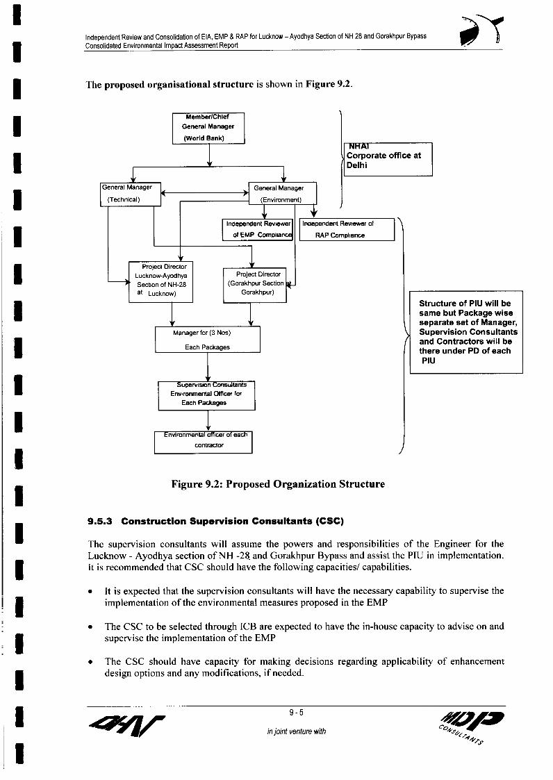
Independent Review and Consolidation of EIA, EMP & RAP for Lucknow - Ayodhya Section of NH 28 and Gorakhpur Bypass3 Consolidated Environmental Impact Assessment Report
The proposed organisational structure is shown in Figure 9.2.
Member/Chief l ~~~~~~~~~~~General Managerl
(World Bank)lNH
Corporate office atI Delhi
l ~~~~~~~~(Technical) F (Evionet) )
Inoependenl Reviewer Inoependent Revewr ol
l _f OEMP Compian RAP Compliance
* ~~~~~~~~~~~Project Director lI __Lucknow-Ayodhya Project Director- ~~~~~~~~~~Section of NH-28 (Gorakhpur Section l
at Lucknow) Gorakhpur)l
Structure of PIU will besame but Package wiseseparate set of Manager,
Manager for (3 Nos) > Supervision Consultants
Each Packages and Contractors will be* 1 ! there under PD of each
PIU
U Thesupesrvision lsumtants lh ~~~~~~~~~~~~~Env,romental Olffier forl
Each Packagesl
Environmental officer of eachlV~~~~~~~~~~~~~~~~~~ -otactorJ
Figure 9.2: Proposed Organization Structure
9.5.3 Construction Supervision Consultants (CSC)
* ~~~The supervision consultants will assume the powers and responsibilities of the Engineer for the
Lucknow - Ayodhya section of NH -28. and Gorakhpur Bypass and assist the PIU in implementation.It is recommended that CSC should have the following capacities/ capabilities.
* It is expected that the supervision consultants will have the necessary capability to supervise theimplementation of the environmental measures proposed in the EMP
* The CSC to be selected through ICB are expected to have the in-house capacity to advise on and3 | supervise the implementation of the EMP
* The CSC should have capacity for making decisions regarding applicability of enhancementdesign options and any modifications, if needed.
I in joint venture with

Independent Review and Consolidation of EIA, EMP & RAP for Lucknow - Ayodhya Section of NH 28 and Gorakhpur BypassConsolidated Environmental Impact Assessment Report
It is expected that the CSC will employ a full time Environmental Specialist. A sample of duties and| qualifications for such a specialist are given in Box 9-1.
Box 9-1: Draft Terms of Reference for 'Supervision Consultants' EnvironmentalSpecialist
The Lucknow - Ayodhya section of NH -28 and Gorakhpur Bypass Road Project, financed bythe World Bank, integrates environmental and social issues in the planning and design of theHighway. An Environmental Management Plan (EMP) has been prepared for each constructionpackage and is integrated in the technical specification and contract documents. The prime dutyof the Environmental Specialist is to supervise the implementation of the EMP by the1 Contractors and to ensure that the day-to-day construction activities are carried out in anenvironmentally sound and sustainable basis. The scope includes development of environmental
l procedures and good construction practices, development and delivery of training programs, etc.
Qualifications and Experience
5 . Civil engineer / masters in environmental science. 5 - 10 years of working experience related to the integration of environmental and social
issues in the design, construction and operation of transport projects. Experience inl construction management and operational maintenance of highways is preferred.
Principal Duties
U . Supervise the implementation of the EMP by the Contractors.. Hold regular consultation meetings with the environmental manager at PIU* Review the Contractors' Environmental Implementation Plans to ensure compliance with the
* Environmental Management Plan (EMP).. Organise periodic environmental training programmes and workshops for the staff of the
Contractors, Construction Supervision Consultants and the Project Implementation UnitsI (PIU).
. Develop good practices construction guidelines to assist the contractors in implementing theEMP.
. Monitor tree plantation programmes and the periodic environmental monitoring (air, noise,water, etc.) Programmes to ensure compliance with the statutory requirements and the EMP.
l . Prepare and submit regular environmental monitoring and implementation progress reports.
9.5.4 Contractors
The Contractors are the major implementing agencies of EMP. The contractors are recommended toemploy Environmental Engineer/s. The roles and responsibilities of these engineers are given below.
* * Ensure proper construction and maintenance of the facilities for the labour camps* Measurement and verification of quantities for environmental enhancement* Ensuring that proper environmental safeguards are being maintained at borrow sites and quarries* Prepare the bills of quantities for the work carried out for enhancement* Ensure that proper facilities are available for the monitoring of ambient air quality and collection
of water and soil samples as mentioned in the environmental monitoring plan* Ensure analysis and reporting of monitoring results
3 9.5.5 Other Agencies
in joint venture with 0

I~~~~Independent Review and Consolidation of EIA, EMP & RAP for Lucknow - Ayodhya Section of NH 28 and Gorakhpur Bypass
| Consolidated Environmental Impact Assessment Report
The other agencies involved in project activities include the NGO procured for the implementation of| the RAP.
9.5.6 Proposed Independent Review Consultants of EMP Compliance (IRC of EMP3 Compliance)
It is proposed to appoint an independent reviewer of the EMP compliance for the entire LMNHP| Section.
Objectives of appointing an independent reviewer of EMP compliance are
| * to monitor the implementation of suggested environmental mitigation measuresto take the timely measures in case of non compliance3 * to suggest or modify the EMP measures for any particular environmental issue, if required
The main responsibilities of this IR of EMP Compliance will be:
5 1. Quarterly monitoring of the implementation of the EMP till the completion of the civilworks.
2. Examine the provisions given in the EMP, along with the relevant drawing/ designs andmonitoring parameters.
3. Prepare the computerized database using the available data to monitor the progress of the* environmental management activities against the targeted performance indicators.
A sample of duties and qualifications for such a specialist are given in Box 9-2.
Box 9-2: Draft Terms of Reference for 'Independent Reviewer Consultants (EnvironmentalU Specialist)' for EMP Compliance
For the all construction packages of LMNHP section of NH -28 and Gorakhpur BypassRoad Project, financed by the World Bank, integrates environmental and social issues inthe planning and design of the Highway. An Environmental Management Plan (EMP)has been prepared for each construction packages and is integrated in the technical
* specification and contract documents. The prime duty of the 'Independent ReviewerConsultants (EnvironmentalSpecialist)' for EMP Compliance is to supervise the implementation of the EMP by theI Contractors and monitoring by the Supervision Consultants to ensure that the day-to-dayconstruction activities are carried out in an environmentally sound and sustainable basis.
3 Qualifications and Experience
. Master degree in Environmental engineering /Civil engineering /masters inenvironmental science
* 5 years of working experience in the field of environmental management in highway/other linear projects.
l
I 7 ~~~~~~~~~~~~~~~~~~~~~in joint venture with; r<
I <8w

Independent Review and Consolidation of EIA, EMP & RAP for Lucknow - Ayodhya Section of NH 28 and Gorakhpur Bypassj Consolidated Environmental Impact Assessment Report
3 Contdt of box 9.2
Principal Duties
l Supervise the implementation of the EMP by the Contractors.. Hold regular consultation meetings with the environmental manager at PIU. Review the Contractors' Environmental Implementation Plans to ensure
compliance with the Environmental Management Plan (EMP).* . Organise periodic environmental training programmes and workshops for the staff
of the Contractors, Construction Supervision Consultants and the ProjectImplementation Units (PIU).
* . Develop good practices construction guidelines to assist the contractors inimplementing the EMP.
* Monitor tree plantation programmes and the periodic environmental monitoring(air, noise, water, etc.) Programmes to ensure compliance with the statutoryrequirements and the EMP.
* Prepare and submit regular environmental monitoring and implementationprogress reports.
The quarterly monitoring of the implementation of the EMP for the project shall include3 but not limited to monitoring the following:
* Appointment of the required staff by the contractor;* Training and workshops on environmental management;* The institutional arrangement and capacity to implement the EMP.* Follow up of the specifications listed in the EMPs;* Road Safety and accessibility;* Traffic diversions;* Cautionary signage;* Health and hygiene of the workers;* Personal safety of the workers;* Checking the procedure and results of the environmental (air, water, noise,
soil) monitoring done by the contractor;* Pollution control measures taken by the contractor;* Top soil management;* Borrow area management;* Quarry site management;* Solid waste management both at labor camp and construction site;* Hazardous waste management;* Maintenance of haul roads;* Dust control;* Construction Camp and labor camp management;
* * Handling of fly ash;* Handling of materials like fuel, grease, bitumen etc.* Treatment of wastewater, and pollutants like exhausts, dust etc;
* * Construction scheduling with respect to environmental impacts;* Tree cutting;* Plantation programme;I * Environmental enhancement measures;* Any deviation from the EMP;* The process of implementation of the EMP;* Transparency.
I 9-8in joint venture with 49 A

Independent Review and Consolidation of EIA, EMP & RAP for Lucknow - Ayodhya Section of NH 28 and Gorakhpur BypassConsolidated Environmental Impact Assessment Report 0
Contd of box 9.2
Time Frame: The consultancy services of the IRC of EMP compliance are requiredfor about 36 months, which is the period overlapping with the time frame for the civilcontractors.
I Reporting: The IRC of EMP Compliance shall submit the Draft Quarterly MonitoringReports a Final Quarterly Monitoring Reports till the completion of construction
l activities.
Along with the monitoring reports, the consultant will submit a brief note on thecritical issues and suggest actions required from various partners, i.e., NHAI,contractor. The consultant will submit all the reports and the accompanying notes inproperly bound hard copies, along with the soft copies on CD.
9.5.7 Environmental Reporting System (ERS)
Environmental monitoring will involve periodic checking to ascertain whether environmentalactivities are going according to the EMP. It provides the necessary feedback for project managementto keep the program on schedule. The evaluation is essentially a summing up of the projectassessment of whether those activities have actually achieved their outcomes. The important featuresof ERS are summarised below.
* The reporting system will operate linearly with the contractor who is at the lowest rank of the* implementation system. The contractor will report to the Supervision Consultant, who in turn
shall report to the PIU and Environmental and Social Development unit of NHAI at corporateoffice. Top of that an independent reviewer of EMP compliance will submit draft and finalquarterly report to GM environment of ESDU at Delhi along with note specifying the criticalissues along with suggested actions necessary to take by the NHAI / contractor.
| * All reporting by the contractor, Supervision Consultant and independent reviewer of EMPcompliance shall be on a quarterly basis throughout the construction period.
1 * The ESDU in association with the independent reviewer of EMP compliance shall be responsiblefor preparing targets for each of the identified EMP activities.
I * The Supervision consultants shall monitor all subsequent reporting by the contractor as per thetargets set by them before the contractor move on to the site.
* The compliance monitoring and the progress reports on environmental components may beclubbed together and submitted to the ESDU at corporate office and PIU, quarterly during theimplementation period for each construction packages by the Supervision consultants.
I * IR Consultants of EMP compliance will consolidate the environmental monitoring reports andother environmental compliance progress reports along with his/her comments and submit toESDU at corporate office quarterly.
* The operation stage monitoring reports may be annual or biannual, provided the ProjectEnvironmental Completion Report shows that the implementation was satisfactory.
* During the implementation period, a compliance report may include description of the items ofEMP, which were not complied with by any of the responsible agencies. This would help in1 rationalising the implementation of the EMP during the remaining duration of implementation.
I~~~~~~~~~~~in joint venture with O4,
l

Independent Review and Consolidation of EIA, EMP & RAP for Lucknow - Ayodhya Section of NH 28 and Gorakhpur BypassI Consolidated Environmental Impact Assessment Report
Solutions for further effective implementation should also come out as a result of the compliance3 monitoring reports.
* Responsibilities for overseeing will rest with the Supervision Consultant's staff reporting to thePIU and ESDU corporate office and top of that to the IR consultant of EMP compliance.
* Capacity to quantitatively monitor relevant ecological parameters would be an advantage butmonitoring will primarily involve ensuring that actions taken are in accordance with contract andspecification clauses, and specified mitigation measures as per the EMP.
I * Photographic records will also be established to provide useful environmental monitoring tools.
* A full record will be kept as part of normal contract monitoring. Reporting and MonitoringSystems for various stages of construction and related activities have been proposed to ensure
| timely and effective implementation of the EMP.
The reporting system has been prepared for each of the stage of road construction namely:
I - Pre construction stage- Construction StageI - Operation Stage
This reporting shall be done through:
- Reporting by the Contractor to the SCReporting by SC to PIU/ EDSU
- Reporting by IRC of EMP Compliance to ESDU
3 The stage-wise reporting system is detailed out in the following Table 9.1.
Table 9.1 Stage-wise Reporting SystemSupervision Consultant IRC of EMP Project Implementation Team World BankU ~~~~~~~~~Contractor| | , ........ . (SC) Compliance in PIl (WB)l
Item Implementati EMP Oversee/on and Reporting to Compliance Field Desired
Reporting to PSupervison PlIUNHAI Monitoring Compliance Report to W Supervision* on..iructin Phas SC Monitoring
w z ~~~~~on%iructioln Phiasel
r,loniiorink!oiconstruction iE-llosite and Before start of Quarterly Quarterly Quarterly Half yearlyconstruction workcamp
Plhaw,lul,n wsrequired \fter Q~u3rierl% t.luarerhf Arier \onuoinnin hal %1 earl\ Nuntlumring required Nionitoring ' . ' n - % i
* |INknitorine ol Beftre cleaning water monsoon or as Atter cleaning Quarterly Quarterly Halt yearly E earlybodies ~~~~~cleaningbodies necessaqy .- ....... -. ......... .. .. - ..* | Top soil | Weekly Weekly Monthly Quarterly Half yearly Yearlypreservations ..... ........... ..........
Borrow area& Iquarry area Weekly Weekly Monthly Quarterly Quarterly Half yearly Yearlymanagement ....... .......................-
f | Tree cutting Weekly Weekly Monthly Quarterly Quarterly Half yearly Yearly.. .. ...... .... .tabon.. . ... ..... .. .. ....- ... .. ... ..... ............ .. ... .. . .......-.. .. .. ......... ..,. ........... ... .. ....... ...... .......
l Operational Phase ..... . ........ .........Pollution ~~~~~~~~~~~~~~~~~~~~~~~As per Twice during
monitoring After monitoring operationI ...... .. .plMonitoring pn phase
Monitoring of Twice duringcleaning water Quarterly After monitoring operation3 bodies phase
I .dg i.7p#-Ep in joint venture with

Independent Review and Consolidation of EIA, EMP & RAP for Lucknow - Ayodhya Section of NH 28 and Gorakhpur BypassConsolidated Environmental Impact Assessment Report
The formats for the reporting of the various environmental issues through the various stages of theproject implementation are annexed to the Generic EMPs.
9.5.7 Internallsing Environmental Expertise in the NHAI
It is expected that NHAI will develop in house capability over the next decade in the highways sectorin India. It is important that there should be substantial environmental capacity beyond the staff,directly responsible for implementing the EMP in different projects. This may be achieved throughtraining and dissemination of information.
9.6 Operationalization
Operationalization of the environmental setup for this project would involve the following aspects.These are:
- Identification and appointment of staff- Procurement of NGOs, supervision consultants, contractors and other agencies
responsible for implementation
Each of these aspects is described below.
9.6.1 Identification and Appointment of Staff
At the project level, the PIU has already been functional. Five managers (Three for Lucknow-Ayodhya, one for each package and two for Gorakhpur bypass) are proposed for the environmental,social and technical components of the project, who will be inducted when implementation begins.
9.6.2 Independent Review Consultants (IRC) for EMP Compliance
The NHAI will appoint an independent review consultant for EMP compliance of entire TMNHPsection of NH-28 through the advertisement in the national newspapers.
9.6.3 Supervision Consultants (SC)
The NHAI will appoint supervision consultant selected through Intemational Competitive Bid (ICB).
9.6.4 Contractors
Five separate contractors need to be appointed for the five construction packages. These contractorswill be appointed through intemational competitive bids.
9.6.5 Training
The ESDU at the NHAI headquarters and the PIU, responsible for the implementation of EMP, needto be trained on the effective implementation of the environmental issues. To ensure the success ofthe proposed implementation set up there is a need for training and skill up gradation.
Looking into the potential requirements of each of the target groups, following training modules aresuggested as part of Lucknow-Ayodhya section of NH-28 and Gorakhpur Bypass.
0 Module 1: Environment Overview) Module 2: Environmental Regulations and ActsI , Module 3: Pollution Related to Road Projects) Module 4: Environmental Impact Assessment
I in~~~~~~~~~~~~~~~~~~~~ jont 11
injointventure with
U4V VAP

Independent Review and Consolidation of EIA, EMP & RAP for Lucknow - Ayodhya Section of NH 28 and Gorakhpur Bypass3 Consolidated Environmental Impact Assessment Report
) Module 5: Environmental Management Plan)0- Module 6: Highways Projects and Environmental Issues
* > Module 7: Environmental Issues in the Project> Module 8: The Environmental Management Plan for Highway Project> Module 9: Environmentally Sound Construction Management
Module 10: Planning for Environmentally Sustainable Operation of Highways> Module 11: Long Term Environmental Issues in Highway Management
3 9.6.6 Additional Training
A training program under Lucknow-Ayodhya section of NH-28 and Gorakhpur Bypass project has| been formulated taking into account the existing training program imparted under TNHP and the
budgetary allocations. The training is focused on the environmental issues related with roadconstruction and both theoretical and practical aspects are covered in it. The detailed trainingI program for the Lucknow - Ayodhya section of NH-28 and Gorakhpur Bypass project is given inTable 9.2.
Table 9.2: Detailed Training Program
l oS. Target group Subject(s) Method Time FrameNo.
I All NHAI staff, Environmental Overview: Lectures 3 working days; at* Supervision Environmental Regulations, Highway least 3 months
Consultants' related provisions of various Acts, EIA before the beginningEnvironmental notifications, process and methodology for of theI ___ Specialists EIA, EMPs and their use implementation of
the this project
2 All Managers Implementation of EMPs: Workshops 3 Working days;(Env.) at NHAI Basic features of an EMP, Planning, and one month beforePIU, designing and execution of environmental Seminars the constructionZ Supervision mitigation and enhancement measures, beginsU Consultants' monitoring and evaluation ofEnvironmental environmental conditions - duringSpecialists construction and operation
_ 3 All Managers Environmentally Sound Construction Seminars, I week; just before(Env.) at NHAI Practices: Lectures the constructionPIU, Clean Highway construction technology, and SiteSupervision alternatives materials and techniques for visitsConsultants' Highways, Waste Management andEnvironmental minimization in construction, pollutionI Specialists, control devices and methods forContractors' construction sites and equipment,staff Environmental clauses in contract
documents and their implications,Environmental monitoring duringconstruction, Borrow Area andConstruction Camp Management
4 All Managers Monitoring Environmental Performance Lectures, 2 days during initial(Env.) at NHAI during Construction: Workshop phases ofPIU, Air, Water and Noise Monitoring and site constructionSupervision requirement and techniques, Evaluation visitsConsultants' and Review of results, PerformanceEnvironmental Indicators and their applicability,
3 ~~~~~~~~~~~~~~~~~~~9 -12
in joint venture with O,
I vZ

Independent Review and Consolidation of EIA, EMP & RAP for Lucknow - Ayodhya Section of NH 28 and Gorakhpur Bypass3 Consolidated Environmental Impact Assessment Report P I
S. Target group Subject(s) Method Time Frame| ~~~No.
* Specialists corrective actions possible, reportingrequirements and mechanisms
5 All Managers Long-term Environmental Issues in Workshops 3 days during* (Env.) at NHAI Highway Management: and implementation of
(HQ & PIU) Designing and implementing seminars Lucknow-Ayodhyaenvironmental surveys for ambient air, section of NH-28I noise, biological and water quality surveys, and Gorakhpurdata storage, retrieval and analysis, Bypasscontract documents and environmentalI clauses, Risk assessment and management,contingency planning and management,Highways as assets-management and value
f____ ______________ addition and highway diseases.
I _ _ _ __9i
IIII1lI1Il
in joint~~~~~~~~~~~~~venture with acK

1 l-7
UIIIIIII
I
I Z ANNEXURES
IIIIIIIIII

IlIndependent Review and Consolidation of EIA, EMP & RAP for Lucknow - Ayodhya Secbon of NH 28 and Gorakhpur BypassConsolidated Environmental Impact Assessment Report
Annexure- 1.1
Package Wise Details of Side of Widening
From To Length Road Location Side of Available Proposed Media(km) Stretch Widening ROW (m) ROW n
_ ~~~~~~~~~~~~~~~~~~~~~~~~~~~~~~~~(m) (m)Package I
* 8+250 20+000 11.750 NH28 Kamta, Chinhat, Tewriganj, Concentric 28.35-38.10 36.7-60 1.2Anorakala, Safedabad
20+000 32+107 12.370 NH28 Barabanki Town Bypass 0 60 7.5-1232+107 34+012 19.050 NH28 Agricultural land Right 24.39-25.00 45-60 4.5-1234+012 34+637 6.250 NH28 Rasouli Concentric 24.69-26.52 36.7-40.7 1.234+637 43+062 8.425 NH28 Agricultural land Right 24.39-26.52 45-54 4.5-9.543+062 43+327 0.265 NH28 Pyarepur Sariya Concentric 25 45.0 4.5
24.39-43+327 44+062 0.735 NH28 Zaidpur RF on both sides Concentric 24.39-25.6 25.6 120044+062 44+762 0.700 NH28 Zaidpur RF on right Left 25 45.0 4.5-9.5Package 1144+762 48+382 3.620 NH28 Agricultural land Left 23.78-30.18 45 4.5-9.548+382 48+957 0.575 NH28 Baghora Concentric 27.43-30.18 36.7-45 1.2-4.548+957 50+052 1.095 NH28 Agricultural land Right 20.42-29.57 45-54 4.5-9.550+052 50+982 0.930 NH28 Udhouli Concentric 25.00-25.30 36.7-40.7 1.250+982 56+090 5.108 NH28 Agricultural land Right 24.39-29.87 45-54 4.5-9.556+090 58+019 1.929 NH28 Kotwa Sarhak Concentric 29.26-32.01 36.7-45 1.2-4.558+019 62+775 4.756 NH28 Mohammadpur Kirath Right 25.60-30.13 45-54 4.5-9.562+775 69+679 7.050 Ramsanehighat Town Bypass 0 60 4.5-1269+679 69+764 0.085 NH28 Agricultural land Left 38 45 4.5-9.5I 69+764 71+079 1.315 NH28 Ranimou, Bakarpur Concentric 30.00-38.00 36.7-40.7 1.271+079 72+479 1.400 NH28 Agricultural land Right 30 45 4.572+479 73+304 0.825 NH28 Mathura ka Purwa Concentric 30.00-32.00 40 4.5I 73+304 75+871 2.567 NH28 Agricultural land Right 30 45 4.5-9.575+871 76+746 0.875 NH28 Kazi ka Purwa Concentric 30 36.7 1.276+746 80+886 4.140 NH28 Agricultural land Right 30 45 4.580+886 83+636 2.750 NH28 Rauzagaon, Dalsarai Chow. Concentric 30 40 4.583+636 86+333 2.697 NH28 Agricultural land Right 30 45 4.586+333 87+558 1.225 NH28 Bhilsar Concentric 30 36.7-40.7 1.287+558 92+683 5.125 NH28 Agricultural land Right 30.00-39.50 45-54.9 4.5-9.5Package_III92+683 98+322 5.639 NH28 Barai Khurd Right 39.50-54.86 45-54.9 4.598+322 99+872 1.550 NH28 Basaha Left 54.86 54.86 4.53 99+872 100+579 0.707 NH28 Agricultural land Right 54.86 54.86 4.5100+579 101+504 0.925 NH28 Godwaa Concentric 54.86 54.86 4.5101+504 104+179 2.675 NH28 Digambarpur, Mubarakganj Right 54.86 54.86 4.5104+179 105+084 0.905 NH28 Arkuna Concentric 54.86 54.86 1.2
* 105+084 108+609 3.525 NH28 Dinkarpur Left 54.86 54.86 4.5108+609 110+831 2.222 NH28 Maksoomganj Concentric 54.86 54.86 1.2110+831 112+181 1.350 NH28 Agricultural land Left 54.86 54.86 4.5112+181 113+051 0.870 NH28 Magalsi Concentric 54.86 54.86 1.2113+051 114+481 1.430 NH28 Agricultural land Left 54.86 54.86 4.5114+481 115+094 0.613 NH28 Jaganpur Concentric 54.86 54.86 4.5115+094 115+869 0.775 NH28 Agricultural land Right 54.86 54.86 4.5115+869 116+769 0.900 NH28 Mohmadpur Concentric 54.86 54.86 1.2
I in joint venture with
I1
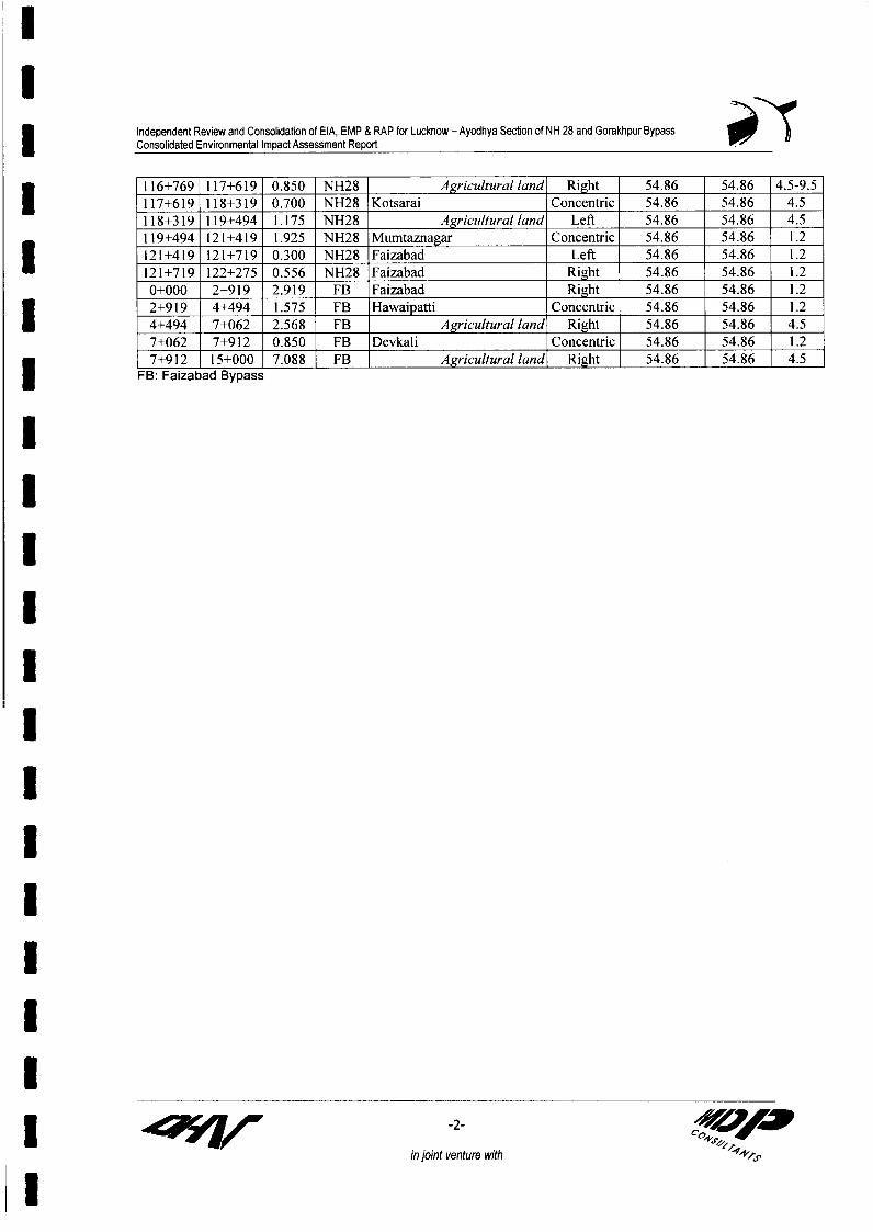
I
Independent Review and Consolidation of EIA, EMP & RAP for Lucknow - Ayodhya Section of NH 28 and Gorakhpur Bypass* Consolidated Environmental Impact Assessment Report P?
116+769 117+619 0.850 NH28 Agricultural land Right 54.86 54.86 4.5-9.5I 117+619 1 18+319 0.700 NH28 Kotsarai Concentric 54.86 54.86 4.5118+319 119+494 1.175 NH28 Agricultural land Left 54.86 54.86 4.5119+494 121+419 1.925 NH28 Mumtaznagar Concentric 54.86 54.86 1.2121+419 121+719 0.300 NH28 Faizabad Left 54.86 54.86 1.2
121+719 122+275 0.556 NH28 Faizabad Right 54.86 54.86 1.20+000 2+919 2.919 FB Faizabad Right 54.86 54.86 1.22+919 4+494 1.575 FB Hawaipatti Concentric 54.86 54.86 1.2
4+494 7+062 2.568 FB Agricultural land Right 54.86 54.86 4.57+062 7+912 0.850 FB Devkali Concentric 54.86 54.86 1.27+912 15+000 7.088 FB Agricultural land Right 54.86 54.86 4.5U FB: Faizabad Bypass
III1* I
II3IU
z 7 ~~~~~~~~~~~-2- ws<<
in joint venture with
U

Environmental Impact Assessment Report forAllahabad Bypass of NH-2
Annexure -3.1
Il A.i A iuenidmc n t i tdaivc Jtnie 3 I 2'IMinistry of Environment and Forests
3 Notification
New Delhi, the 13th June, 2002
S. 0. 632 (E). - Whereas by notification of the Government of India in the Ministry ofEn,irorr,t.nt and Forests No. S.O. 60(E), dated 27 th January, 1994 (hereinafter referred to asthe said notification) issued under sub-section (1) and clause (v) of sub-section (2) of section1 3 of the Environment (Protection) Act, 1986 (29 of !986) (hereinafter referred to as the saidAct), read with clause (d) of sub-rule (3) of rule 5 of the Environment ;Protection) Rules, 1986
tihrer- inafter referred to as the said Rules), the Central Government imposed certainr,strr, r,ons and prohinition on the expansion or modernization of any acti\,ity or theirridi:rttsi. of any Ornjert, unless environment clearance has been grarted by the Central
Govemment;
I And 01rici as, sub-rule (4) of rule 5 of the said F ule; provides that, whenever it appears to theCentral Government that it is in F,LtiNIC interest to do so it may dicp,-n .e :.,Ith the requirementof notice under clause (a) of sub-rule (3)of rule 5 of the said rules;
And '.'r,,,, the central Government is of the opinion that it is in pu-blic interest to -jr.ponseith the requirement of notice under clause (a) of sub-rule (3) of rule 5 of the said Rules;
! * Now, therefore, in exercise of 1 powers conferred by _n.-L- :irn (1) and clause (v) of sub-section (2) of section 3 of the said Act read with sub-rule (4) of rule 5 of the said Rules, theCentral Government hereby makes the illo'AIncl further amendments in the said notification,
In the said .-,rifi , 1i:r -
I (i) in paragraph 2, in sub-para I , .t. r clause (a), the 1:11 .uii.j provisos shall be added,
namely: -
3 F P-.,Mec that for s ,-* r , projects, Environmental Impact -c . r r report willnot be required:
P -...- further, that for pipeline and [-jh.. -, (, tr j-,ri hearing shall beconducted in each district through which the pipeline or highway passes through":
(ii) in rr.ir.-irliph 3, for sub para (b), the r"vJiro sub-para shall be jltrtur .,1. namely:-
"(b) any item 'allirei under entry no. 1,2,3,4,5,7,9,10,13,14,16,17,V?,21,?52,2/ ofSchedule-I if the investment is less than Rs 100 crores for new .r i.i:t:, and lessthan Rs. 50 crores for , I / modernization ., j.";
:. n paragraph 3, for sub-para (e), the following sub-para -1i ll be substituted, nanmely -
ll asscimhcnsl
1

Environmental Impact Assessment Report forAllahabad Bypass of NH-2
II I i \".rIiii .ioln An icindticflit klWitd Junku 13. 210)2
"(e) any item -! r,io under entry no, 8 of Schedule-1, if that product is covered byI the notification G.S.R. I -1 3; EF dated 5th December, 1989.
(f) Modernization r:r'.-:f: in rr viti r sector if idd, .rj3i command area is lessthan; ui,u(Jr) hectares or project cost is less than Rs. 100 crores.";
(iv) in Schedule IV, in paragraph (1), for item (i) the f.-hl,rA., item r liii he substituted,namely-:I '(i) An executive summary containing the salient features of the project both in
English as well as the local language along with Environmental Impact Assessment(EIA). However, for pipeline project, Environmental Impact Assessment report :.,illnot be required. But Environmental r--riagem.-nt Plan -rcini,n, risk -niiriqi,ti-'nmeasures is required."
(*, in paragraph (4), for the words "Executive Summary", the words .'F ,t.r-.-I Summary and Environmental Impact Assessment ri -u ri shall be substituted.
2. This -w1i .1 -r, shall come into force on the date of its publication in the Official Gazette.
[No. Z-I 1 I [A. I (Part)]
3 Dr. V. RA_igwA A AN, It. Secy.
Foot note - The Prinoipal NotficaVon wmas pub'ishLd v.de rumber S. 0. 6F(E) iated t1e .' ' ~anriry, 199'4 andsubsequently drnended vide number 5.O. 356 (E) dated the 4t' May, 1994, 50., 318 (1f) dated the Ln0" April,199/, S0. 73(E) dated the 2714' lanuary, 2000, S.O. 11i9 (E) dated the 13tt' December, 2000. 50. 737(F) datel
tFe1 uciust, 2001 and S.0. l 1-i8 (E) dJatet3 2 !''oveliilber, 200,I.
lIIIII j S 60
sr ln#sUClAt@F~~~ ~ ~ ~~~~~~~~~i m -x

Independent Review and Consolidation of EIA, EMP & RAP for Lucknow - Ayodhya Section of NH 28 and Gorakhpur BypassConsolidated Environmental Impact Assessment Report
Annexure 4.1
Monitoring Methodology
Introduction
The extent of impact on the critical bio-physical environmental parameters i.e. ambient air quality,Noise quality, water quality, soil and socio-economic environmental parameter under discussion inthis section, due to the implementation of the project are required to be gauged as theseenvironmental conditions not only have a vital link to the human health issues but also play animportant role in maintaining the overall ecosystem.
The present environmental monitoring program was launched to collect field data pertaining to theenvironmental components as already mentioned above, from various survey stations spreaded allalong the Lucknow-Ayodhya and proposed Gorakhpur bypass alignment.
Objectives
The basic objective was to study the baseline conditions (no project scenario) of the environmentalparameters and to assess impact on them and the future scenario due to the implementation of theproject. The monitoring programme thus aimed to acquire field data from different geo-physicallocations along the project route to build up a comprehensive and representative sample data basefor impact forecast and onward usages by the NHAI during and after construction stage formonitoring purpose.
Methodology followed for collection of data:
The various parameters to be studied under each environmental features i.e. air, noise, water andsoil had been finalized based on CPCB procedures and MOEF clearance requirements acceptable tothe World Bank. Also within the framework, consideration had been given to those parameters,which might have road-induced impact.
The numbers and locations of survey stations to record data on each environmental feature had beenchosen so as to cover comprehensively various locations characteristics namely, rural, semi-urbanand urban land uses under each project route. The sample survey points are thus representative ofenvironmental conditions of the entire project routes.
The apparatus used to record data were as per guidelines of the relevant IS codes of standards.Detail methods followed during monitoring of baseline condition are described below:
Air Quality: Ten and four sampling stations were set up for monitoring the ambient air quality forthe study corridor of Lucknow-Ayodhya stretch in January-February 2003 and during mid April tomid May 2003 in Gorakhpur bypass area, respectively. List of the monitoring locations are given inTable 1.
Table 1: Locations of Air Monitoring along the Project Road
Si. Location Chainage Location Description Dist.ance Present Land UseNo. Code (km) from C/L
(in)
Lucknow-Ayodhya Stretch1. I AQI 1 13.4 | Chinhat 100 | Residential area.
-vi-
la musScla111111U1111 wfl

Independent Review and Consolidation of EIA, EMP & RAP for Lucknow - Ayodhya Section of NH 28 and Gorakhpur BypassConsolidated Environmental Impact Assessment Report
2. AQ2 Daudpur village on 200 Rural (agricultural fields)I proposed Barabankibypass
3. AQ3 33.5 Rasouli 100 Rural (settlements and agricultural fields)4. AQ4 58.6 Kotwa Sarhak 100 Rural (settlements and agricultural fields).5. AQ5 65.7 Ramsanehighat 70 Rural (market place with some settlements
interspersed)I 6. AQ6 88.3 Bhilsar 100 Rural (village huts and agricultural fields)7. AQ7 108.2 Raunahi 100 Rural (settlements and agricultural; fields)8. AQ8 114.3 Jaganpur 100 Rural (residential area)U 9. AQ9 118.5 Kot Sarai 100 Rural (settlements and agricultural fields)10. AQIO 17.2 Ayodhya on Faizabad 100 Semi urban (residential area)
BypassPro osed Gorakhpur Bypass
. L AQI 0 Starting point of bypass 100 Rural (side of NH-28, congested area nearvillage Kaleswar)
2. AQ2 9.7 Junction of bypass & 100 Rural (near village Bhagagara, agriculturalNH-29 fields on both sides)
3. AQ3 25.95 Junction of bypass & 100 Rural (near village Shivpur, agriculturalODR fields on both sides)
4. AQ4 32.2 End point of bypass 100 Rural (side of NH-28 near village___ _______ I Jagdishpur).
Noise Quality: To assess the background noise levels, ambient noise monitoring has been done inI 15 locations in the Lucknow-Ayodhya stretch and six locations along the proposed Gorakhpurbypass alignment. In both the study areas monitoring was conducted during the month of April andMay 2003. At each location noise monitoring was conducted continuously over a period of twenty-four hours to obtain Leq values at uniform time intervals of one hour in each hourly time interval Leqvalues have been computed from SPL readings taken at uniform time intervals of 30 seconds.Details of sampling locations are listed in Table 2 below.
|_______ ________ Table-2 Details of Noise Monitoring Stations
Si. Location. Chainage Location Description Distance Present Land UseNo. Code (km) from C/L
* Luckow-Ayodhya Stretch1 NQI 11.300 Chinhat 20 Commercial (side of NH-28,
*_________________________ _________ congested area having shops)I 2. NQ2 11.900 Chinhat 100 Residential areas3. NQ3 13.400 Chinhat 100 Silence (Educational institutions)4. NQ4 17.800 Mohammadpur 30 Residential (village Mohammadpur)5. NQ5 Daudpur village on proposed Residential (having vast agricultural
Barabanki bypass fields in vicinity)6. NQ6 33.600 Rasouli 20 Residential (Village Rasouli)
* 7. NQ7 44.100 Safdargunj 10 Silence (Forest area)8. NQ8 45.700 Safdargunj 20 Commercial (side of NH28,
congested area having shops)9. NQ9 57.900 Banikodar 100 Silence (Educational institutions)10. NQIO 58.600 Kotwa Sarhak 20 Residential areas11. NQ 11 60.800 Barela Narayanpur 50 Silence (Educational institutions)12. NQ12 64.400 Ramsanehighat 100 ResidentialI 13. NQ 13 65.600 Ramsanehighat 15 Commercial (side of NH28,
congested area having marketsshops, petrol pumps, garages etc.)I1 14. NQ14 88.200 Bhilsar 30 Residential (village Bhilsar)
15. NQ15 108.000 Raunahi 30 Residential (village Raunahi)
- ii-
1n yacia aueilm ,,
I

Independent Review and Consolidation of EIA, EMP & RAP for Lucknow - Ayodhya Section of NH 28 and Gorakhpur BypassConsolidated Environmental Impact Assessment Report
* 16. NQ16 114.300 Jaganpur 30 Residential (village Jaganpur)17. NQ17 118.600 Kot Sarai 30 Residential area with a few shops18. NQ18 121.000 Durabgunj 100 Silence (Educational institutions)19. NQ19 122.630 Durabgunj 30 Commercial (side of NH-28,
congested area having shops)20. NQ20 17.400 Ram ki Peri on Faizabad 100 Residential
BypassI Propsed Gora khpur Byplass5. AQI 0 Starting point of bypass 100 Rural (side of NH-28, congested
area near village Kaleswar)6. AQ2 9.7 Junction of bypass & NH-29 100 Rural (near village Bhagagara,I __ agricultural fields on both sides)7. AQ3 25.95 Junction of bypass & ODR 100 Rural (near village Shivpur,
agricultural fields on both sides)8. AQ4 32.2 End point of bypass 100 Rural (side of NH-28 near village*___ _________ ________ __________________________ _________ Jagdishpur).
Water Quality: Eight surface water samples and five ground water samples were collected fromthe water sources present in Lucknow-Ayodhya stretch, and four surface water samples and threeground water samples were collected from Gorakhpur bypass area. Surface water samples werecollected both from flowing and stagnant water bodies. Grab samples were collected once in themonth of February 2003 in Lucknow-Ayodhya stretch and in the month of April 2003 in Gorakhpurbypass area. Details of sampling locations are given in Table 3 below.
3 Table-3: Details of Water Quality Monitoring Stations
Si. Chainage Location Present UseNo. Location (km) Type Description
C o d e __ _ _ _ ___ _ _ _ _ _ _ _ _ _ _ _ _ _ _ _ _ _ _
Lucknow-Ayodhya StretchSurface Water
I SWI 13.6 Surface Water Reth River near Daudpur village, Domestic use800m north of proposed BarabankiByapss
2. SW2 34.7 Surface Water Dhamaiya Tal (lake), near Rasouli Domestic use____________ _________village
3. SW3 68.4 Surface Water Kalyani River (near NH-28 bridge) Irrigation and fishing4. SW4 72.4 Surface Water Sultanpur branch of Sarda Canal Irrigation
(near NH-28 bridge)5. SW5 84.7 Surface Water Tara Jheel (lake), beside NH 28 Irrigation & fishing6. SW6 92.7 Surface Water Kasera River (near NH-28 bridge) Irrigation & fishing7. SW7 111.2 Surface Water Ghagra Canal (near NH-28 bridge) Irrigation & fishing8. SW8 17.469 Surface Water Saryu River (near bridge on Irrigation & fishing
Faizabad Bypass)Ground Water
J I . GWI 12.5 Ground Water Tube well situated in residential Drinking & domestic purposeareas of Chinhat on NH-28
2. GW2 12.8 Ground Water Tube well situated at village Drinking & domestic purposeBhikhari Purwa on proposedI ____ Barabanki Bypass
3. GW3 65.8 Ground Water Tube well situated at Drinking & domestic purposeRamsenehighat on NH-28I 4. GW4 88.2 Ground Water Tube well situated at village Drinking & domestic purposeBhilsar on NH-28
5. GW5 17.2 Ground Water Tube well situated near Ayodhya Drinking & domestic purposeGorakhpur Bypass on Faizabad Bypass
w ~Gorakhpur Bypass
1 viii -
I~~~~~~~~~~~~~~~~nasiunW ?

Independent Review and Consolidation of EIA, EMP & RAP for Lucknow - Ayodhya Section of NH 28 and Gorakhpur BypassConsolidated Environmental Impact Assessment Report
Surface Water1. SWi 11.3 Surface Water Rapti River Irrigation and fishing2. SW2 19.0 Surface Water Ramgarh Lake Boating & fishing3. SW3 22.4 Surface Water Kandoila Lake Irrigation and fishing
_4. SW4 24.2 Surface Water Tura Nalla IrrigationGround Water
I1. GWI 4.2 Ground Water Tube well, within ROW, Drinking & domestic purposesituated beside MDR-49
* 2. GW2 15.3 Ground Water Tube well, within ROW. Drinking & domestic purposeBoth sides haveagricultural field.
3. GW3 27.8 Ground Water Tube well situated beside Drinking & domestic purposeODR
3 Soil Quality: Soil samples were collected from ten representative sampling stations along theLucknow-Ayodhya stretch and from five representative sampling locations of the proposedGorakhpur bypass area. Soil samples were collected in February 2003 in Lucknow-Ayodhya stretchand in April 2003 from Gorakhpur bypass area. Details of sampling locations are listed in Table 4.
Table-4: Details of Soil Quality Monitoring StationsSI. Locn. Ch. Location Description
I No. Code (km)1. SQI 15.300 Agricultural field of Outer Chinhat Area, 50 m away from NH282. SQ2 12.500 Agricultural field near village Bhikhari Purwa, 50 m away from proposed Barabanki
Bypass3. SQ3 35.100 Agricultural field of village Rasouli, 50 m away from NH 284. SQ4 58.100 Agricultural field of village Kotwa Sarhak, 50 m away from NH 28U 5. SQ5 67.800 Agricultural field outside Ramsahenighat, 50 m away from NH 286. SQ6 84.900 Agricultural field outside Bhilsar Village, 50 m away from NH 287. SQ7 109.200 Agricultural field before Raunahi village, 50 m away from NH 28I 8. SQ8 115.400 Agricultural field outside Jaganpur village, 50 m away from NH 289. SQ9 119.600 Agricultural field outside Kotsarai village, 50 m away from NH 2810. SQIO 15.900 Agricultural field near Ayodhya, 50 m away Faizabad Bypass
= ____ _______ Gorakhpur Bypass11. SQI 0 40 m away from NH-28, starting point of the bypass (agricultural field)12. SQ2 4.2 Crossing of bypass alignment and MDR-49 (near brick kiln at Khanpur Vatta)13. SQ3 11.2 Rapti river bed14. SQ4 11.6 Guava plantation on the bank of Rapti river
115. SQ5 31.3 One km away from the end point of the alignment (agricultural field)
The Table 5 illustrates the entire method of approach adopted i.e. parameters recorded, frequencyI and duration of records, apparatus used and standard followed etc. for each environmental features.Results are presented in Chapter 5.
3 Table-5: Environmental Parameters Monitored
Feature DurationsRecoanddApparatus used RemarksEnvironmental ParameersRecorded Frequency
1. Ambient Air * Suspended Over one month High volume samples SPM was estimated as per IS-Quality Particulate penod at a Mylarbags/Bladder 5182 (Part V)- 1975,
Matter(SPM) frequency of*Respirable particulate twice a week @ SO was estimated as per IS-
* matter(RPM) 24 hourly 5182) Part-11)- 1969..*Sulphur dioxide ,sapel
Sulphurdioxide samples NOX estimated as per IS-5182| | ~ ~~~~ ~ ~ ~ (Oxide ofnitroge (Patt VI-1 1975.
In 111=111111118111 wm °00 > 0I~~~~~~~~~c w I.~~~~~~~~~~~~~~~</

Independent Review and Consolidation of EIA, EMP & RAP for Lucknow - Ayodhya Section of NH 28 and Gorakhpur BypassConsolidated Environmental Impact Assessment Report
Enarnturentl Parameters Recorded DFuruoenncyd Apparatus used Remarks
* Carbon Monoxide duration and CO estimated as per IS-5182(CO) SPM /RPM (PartX)-1975
9 Lead (Pb) sample 24 hour Lead estimated as per IS: 12074._ - i ~~~~~~~~~~~~duration)l
2. Noise a) Max Noise Level (L At each location, Noise level meter The following criteria adoptedmax) noise monitoring for measuring noise level:
b) Min noise level was conducted Measurement of 'A(Lmin) continuously over weighted" sound level
c) Maximum hourly a period oftwenty continuously using noise level*I| Leq four hours at meter at one minute interval
d) Minimrum hourly unifonn time for one day in each surveyLeq intervals of I hour locations as per the CPCB
e) Day time Leq value In each hourly approved method IS: 4954.(6 am-10 pm) time interval Leq
f) Leq value 9 hourly values at uniformT(I10 p.m. - 6 am) time interval of
30 seconds
3. water Surface ater Ouafih (One rime Rele% ant apparatus From each 'ater sanplingI pH value used as per codes station grab samples were2 Conductivity collected and transported to3 Turbidity laboratory for physico-chemical4 Total dissolved solid - analysis. l
l ~~~~(TDS)l5Total Suspended Parameters like pH temperature
Solid (TSS) and dissolved oxygen were6 Dissolved Oxygen measured in-situ.
(DO)7 BOD (27°C, 3 days): Analysis ofthe samples was
* | 8 COD canied out as per the standard9 Chloride as Cl methods for examination of
10 Sulphate as SO4 water and wastewater published11 Potassium . by APHA et.al. and relevant ISI | 12 Nitrate codes l13 Phosphate
l14 Fluoridel15 CadrniumI | -16 Chromium as Crl17 Selenium.l18 Iron as Fe::19 Zinc
* l 20 Boron21 Merctuy22 Lead as Pb23 Arsenic24 Total Hardness as
CaCO325 Total Alkalinity26 Calcium27 Magnesium28 Sodium29 Oils and grease*30 Free ammonia31 Cyanide:32 Phenol*33 Sodium AbsorptionI | ratio
Ground water Oualitv' One time Relevant apparatus Grab samples were collected1. Specific used as per codes from hand pumps present on theU ! conductivity adjacent to the existing as well as
-x-
J 7asR1p/1Ev Inassc |uI wm .
I

Independent Review and Consolidation of EIA, EMP & RAP for Lucknow - Ayodhya Section of NH 28 and Gorakhpur BypassConsolidated Environmental Impact Assessment Report
enroanmrental Parameters Recorded D;urationnd Apparatus used RemarksFeature Frequency
2. pH value Proposed road alignment3. Conductivity4. Turbidity5. Total Dissolved
solid (TDS)6. Total Suspended
Solid (TSS)7. Total Hardness as
CaCO38. Total Alkalinity9. Calcium10. Magnesium11. Sodium12. Chloride as ClI 13. Sulphate as SO414. Potassiumn15. Nitrate16. PhosphateI 17. Fluoride18. Cadmium.19. ChromiumasCr20. SeleniumT
| ~~~~~~~21. Iron as Fe22. Zinc23. BoronasFe
@ ~~~~~~24. Mercury25. Lead as Pb26. Arsenic27. Cyanide28. Phenol1 29. Sodium Absorption.
ratio30. Total coliform
(MPN/I00 ml)I 31. Faecal coliform(MPN/100 ml)
4. Soil I. Texture One time Analysis done in Sampling and analysis was2. Grain size Atomic Absorption conducted as per standard
distribution Spectrophoto-meter methods and procedures| a) Sand (°/0) (AAS) prescribed in IS:2720 and AST
b) Silt (%)c) CIay (%/O)
3. pH9100/ow/vI ' sluny)4. Conductivity5. Organic
I 6. Nitrogen7. Phosphate
8. SodiumI 9. Potassium10. Lead
Source: Consultant
Ecology
In am-l-I 1 c 7 $ 1p# In ascIcln wmita
I

Independent Review and Consolidation of EIA, EMP & RAP for Lucknow - Ayodhya Section of NH 28 and Gorakhpur BypassConsolidated Environmental Impact Assessment Report
An area of 7.0 km on both sides from the centerline of the Lucknow-Ayodhya stretch includingproposed Barabanki and Ramsanehighat bypass and proposed Gorakhpur bypass alignment hasbeen considered to study for the ecological study as per the MoEF guidelines. The inhabitance ofwild animals around the Zaidpur reserve forests in Lucknow-Ayodhya stretch and RamgarhIl reserved forests in proposed Gorakhpur bypass has also been studied.
Secondary data on the presence of wild animals in forest divisions have been collected fromrespective range/divisional forest offices (Barabanki, Faizabad divisions in Lucknow-AyodhyaI section and Gorakhpur Divisional Forest office for Gorakhpur bypass). Moreover, presence ofwildlife within the study area, as recorded by forest officials of respective forest divisions, wasverified through extensive survey and personal inquiries with local people and forest officials ofrespective forest range offices at different locations.
Source of Information
The information for the study have been collected from:
| - Divisional Forest Office of Barabanki, Uttar Pradesh
- Divisional Forest Office of Faizabad, Uttar Pradesh
- Divisional forests Office of Gorakhpur, Uttar Pradesh
- Zoology Department, Lucknow University
- Zoology department of Gorakhpur UniversityI The data collected from different sources have been crosschecked and a comprehensive list ofanimals/ species mentioned by all the above sources is prepared. Moreover, this list was alsoverified by discussing with the local people of the area, different forest personnel like DivisionalForest Officers, the range officers, foresters of the concerned forest offices in the region.
Road side Plantation /Vegetation Cover
The base line data on the roadside plants and vegetation cover in proposed new bypass area havebeen derived through extensive field studies during the study period January to April 2003. PlantI species were identified and classified by plant taxonomy expert, which has been crosschecked withthe literatures available in the respective forest divisions. Girths of the trees were physicallymeasured during the survey.
Aquatic Ecology
b3 Studies were conducted mainly in the water bodies present adjacent to the existing road and waterbodies present on/ adjacent the proposed bypasses.
|3 Source of Information
a) Primary data on physico-chemical characteristics of major water bodies were collected
b) Fish fauna recorded within the study area have been collected from office StateFisheries Department, Lucknow and Gorakhpur, and department of Zoology,3 Gorakhpur
l-xii-VA
I~~~~~~~~~~~~NMIMNI *

l
Independent Review and Consolidation of EIA, EMP & RAP for Lucknow - Ayodhya Secton of NH 28 and Gorakhpur Bypass3 Consolidated Environmental Impact Assessment Report
Annexure: 5.1
5 Baseline Status Data for Lucknow-Ayodhya and Gorakhpur Bypass
Meteorological Data of the Area (Lucknow -Ayodhya)
Mean Monthly Weather Phenomena of the Study Corridor(Based on Records of IMD Gorakhpur, 1951-80)
l Month Number of Days with!___________ PPT20.3mm Hail Thunder Fog Dust Storm Squall
January 2.7 0.0 0.3 1.5 0.0 0.0February 1.9 0.0 0.4 0.2 0.0 0.0March 1.8 0.1 0.7 0.0 0.1 0.0April 1.2 0.0 0.4 0.0 0.4 0.0May 2.3 0.0 0.9 0.0 0.2 0.0Jun 8.0 0.0 1.3 0.0 0.1 0.0July 15.6 0.0 2.5 0.0 0.0 0.0August 18.5 0.0 3.6 0.0 0.0 0.0September 11.8 0.3 1.9 0.1 0.1 0.0October 3.6 0.0 0.5 0.0 0.0 0.01 November 0.4 0.0 0.1 0.0 0.0 0.0December 0.7 0.0 0.3 1.3 0.0 0.0Total 68.5 0.4 12.9 3.1 0.9 0.0Source: India Meteorological Department (IMD)
Summary of Recent Climatological Records of the Study Corridor (Jan-Dec 2001)
Month Daily Tem erature (OC) Total Rainfall No of Rainy DaysMax Min (mm)
January 20.9 8.5 0.6 0February NA 12.1 Traces 0March NA 16.6 Traces 0
l April 36.9 21.8 0.6 0May 35.3 24.8 83.6 3Jun 32.2 25.7 334.1 17July 32.2 26.5 284.5 12August 32.6 26.2 362.2 11September 32.1 25.0 365.4 12October 32.2 22.3 129.8 4November 29.9 15.6 4.3 IDecember 21.6 10.7 0 03 Mean/Total 23.8 19.7 1564.5 60
I3~ ~ -1- c za
in joint venture with s

l
Independent Review and Consolidation of EIA, EMP & RAP for Lucknow - Ayodhya Section of NH 28 and Gorakhpur Bypass3 Consolidated Environmental Impact Assessment Report
Mean Monthly Weather Phenomena of the Study Corridor
(Based on Records of IMD, 1951-80)
Month Number of Days with
Lucknow PPT20.3mm Hail Thunder Fog Dust Storm Squall
* ~~~LucknowJanuary 2.4 0.1 0.5 1.6 0.0 0.0
February 2.0 0.2 0.9 0.1 0.0 0.0
March 1.3 0.2 1.1 0.2 0.1 0.0
April 0.5 0.1 0.4 0.0 0.1 0.0
* May 1.8 0.0 1.4 0.1 1.0 0.0
Jun 6.3 0.2 3.2 0.1 0.5 0.0
July 14.9 0.0 2.2 0.0 0.0 0.0
August 17.1 0.0 1.5 0.0 0.0 0.0
September 9.7 0.0 0.8 0.0 0.0 0.0
October 2.5 0.0 0.8 0.1 0.0 0.0
November 0.5 0.0 0.0 0.2 0.0 0.0
1 December 1.0 0.0 0.4 1.9 0.0 0.0
Total 60.0 0.8 13.2 4.3 1.7 0.0
Faizabad3 January 2.4 0.0 1.0 5.9 0.0 0.0
February 2.2 0.0 1.2 2.4 0.0 0.0
March 1.5 0.0 1.4 0.4 0.0 0.0
1 April 1.0 0.0 1.5 0.0 0.3 0.0
May 2.4 0.0 3.0 0.0 1.5 0.0
Jun 6.7 0.0 5.5 0.0 0.6 0.0
July 16.6 0.0 6.5 0.0 0.0 0.0
August 17.3 0.0 6.3 0.0 0.0 0.0
September 10.4 0.0 4.2 0.0 0.1 0.0
October 3.4 0.0 1.4 0.2 0.0 0.0
November 0.6 0.0 0.1 1.0 0.0 0.0
December 1.0 0.0 0.4 4.1 0.0 0.0
Total 65.5 0.0 32.5 14.0 2.5 0.0Source: India Meteorological Department (IMD)
| Mean Monthly Frequency Distribution of Wind in the Study Corridor(Mean of 0830 and 1730 IST for 1951-80, Based on Records of IMD Gorakhpur)
l Month No of Days with Percentage (%) Frequency of Wind from DirectionWind Speed (km/h)
<1 1-19 >19 N NE E SE S SW W NW Calm1 January 14.5 16.5 0 1.5 2.0 6.5 1.5 2.5 10.0 27.0 3.5 45.5February 8.5 19.5 0 3.5 1.5 6.5 1.5 4.0 10.0 39.5 2.0 28.5March 6 25 0 3.0 3.0 10.0 1.5 2.5 8.0 47.5 5.5 19.03 April 3 27 0 3.5 5.0 21.0 2.5 2.0 7.0 44.0 4.5 10.5May 3 28 0 5.5 9.0 35.5 5.0 1.5 4.5 25.5 5.5 8.5Jun 3 27 0 6.0 12.0 44.5 6.0 3.5 2.5 11.5 2.5 11.53 July 5.5 25.5 0 4.5 10.0 41.0 6.5 6.5 5.5 6.5 2.0 17.5August 7.5 23.5 0 2.5 9.5 38.5 7.0 4.0 4.5 7.0 1.5 25.5
3 > 7 -2- Ain joint venture with

l
Independent Review and Consolidation of EIA, EMP & RAP for Lucknow - Ayodhya Secton of NH 28 and Gorakhpur Bypass3 Consolidated Environmental Impact Assessment Report 7?
Month No of Days with Percentage (%) Frequency of Wind from DirectionWind Speed lkm/h)
<1 1-19 >19 N NE E SE S SW W NW CalmSeptember 7 23 0 4.5 8.5 30.0 6.0 5.0 5.5 13.0 2.5 25.0October 12.5 18.5 0 4.5 4.0 15.0 2.5 3.5 5.5 20.0 5.0 40.0November 17.5 12.5 0 2.5 2.0 6.0 1.5 2.5 5.0 17.5 5.5 57.5December 16 15 0 2.5 1.5 3.0 0.5 2.5 9.0 23.5 3.5 54.0Mean 8.7 21.8 0.0 3.7 5.7 21.5 3.5 3.4 6.4 23.5 3.6 28.6Source: India Meteorological Department (IMD)
f Mean Monthly Weather Phenomena of the Study Corridor(Based on Records of IMD Gorakhpur, 1951-80)
Month Number of Days with3 PPT20.3mm Hail Thunder Fog Dust Storm SquallJanuary 2.7 0.0 0.3 1.5 0.0 0.0February 1.9 0.0 0.4 0.2 0.0 0.0
l w March 1.8 0.1 0.7 0.0 0.1 0.0April 1.2 0.0 0.4 0.0 0.4 0.0May 2.3 0.0 0.9 0.0 0.2 0.0Jun 8.0 0.0 1.3 0.0 0.1 0.0July 15.6 0.0 2.5 0.0 0.0 0.0August 18.5 0.0 3.6 0.0 0.0 0.0September 11.8 0.3 1.9 0.1 0.1 0.0October 3.6 0.0 0.5 0.0 0.0 0.0November 0.4 0.0 0.1 0.0 0.0 0.0December 0.7 0.0 0.3 1.3 0.0 0.0Total 68.5 0.4 12.9 3.1 0.9 0.0Source: India Meteorological Department (IMD)
3 Summary of Recent Climatological Records of the Study Corridor (Jan-Dec 2001)
Month Daily Temp erature (OC) Total Rainfall No of Rainy DaysMax Min (mm)
January 20.9 8.5 0.6 0February NA 12.1 Traces 0I March NA 16.6 Traces 0April 36.9 21.8 0.6 0May 35.3 24.8 83.6 3I Jun 32.2 25.7 334.1 17July 32.2 26.5 284.5 12August 32.6 26.2 362.2 11September 32.1 25.0 365.4 12October 32.2 22.3 129.8 4November 29.9 15.6 4.3 13 December 21.6 10.7 0 0Mean/Total 23.8 19.7 1564.5 60
I
in joint venture with

s--- - - -m m " -- - - - - - m s
Independent Review and Consolidation of EIA, EMP & RAP for Lucknow - Ayodhya Section of NH 28 and Gorakhpur BypassConsolidated Environmental Impact Assessment Report
Annexure - 5.2Tube Wells Tube Wells Tube Wells Tube Wells
SL Ch. (km) Side Dist fm Affected SL Ch. (km) Side Dist fm Affected SL Ch. (km) Side Dist fm Affected SL Ch. (km) Side Dist fm AffectedNo. C/L (m) No. C/L (m) No. C/L (m) No. C/L (m)1. 9.020 L 10.5 A 40. 34.410 L 7.5 A 79. 45.500 L 10.5 A 118. 54.300 R 18.5 A2. 9.050 R 10.5 A 41. 34.410 L 7.5 A 80. 45.900 L 11.5 A 119. 54.700 R 18.2 A3. 9.500 R 22.5 NA 42. 34.420 R 8.0 A 81. 46.080 R 14.5 A 120. 54.990 L 13.8 A4. 12.030 R 14.60 A 43. 34.425 L 7.0 A 82. 46.100 L 11.5 A 121. 55.500 R 25.0 A5. 12.035 R 15.0 A 44. 34.450 L 7.5 A 83. 46.600 L 13.00 A 122. 55.600 L 9.5 A6. 12.150 R 14.50 A 45. 34.450 R 8.2 A 84. 47.100 L 10.0 A 123. 55.705 L 10.0 A7. 12.200 R 14.50 A 46. 34.580 R 8.5 A 85. 47.500 R 8.5 A 124. 55.705 L 11.2 A8. 12.210 R 16.00 A 47. 34.700 L 8.0 A 86. 48.350 L 12.8 A 125. 55.800 L 12.0 A9. 12.300 R 14.9 A 48. 34.800 L 16.0 NA 87. 48.450 R 16.0 A 126. 55.800 L 12.5 A10. 12.430 R 7.5 A 49. 34.900 L 7.2 A 88. 48.600 R 14.5 A 127. 55.805 L 12.5 A11. 13.200 L 10.0 A 50. 34.910 R 8.2 A 89. 48.600 R 13.0 A 128. 56.400 L 16.0 A12. 14.430 L 19.2 A 51. 35.100 L 11.0 A 90. 48.620 L 11.5 A 129. 56.400 R 18.0 A13. 14.650 R 15.1 A 52. 35.800 R 7.5 A 91. 48.680 R 11.8 A 130. 56.600 R 8.5 A14. 16.600 L 17.0 A 53. 35.820 R 10.5 A 92. 48.690 R 11.5 A 131. 56.700 L 14.0 A15. 16.900 R 11.0 A 54. 35.840 L 10.0 A 93. 48.700 L 10.5 A 132. 56.720 R 8.0 A16. 17.100 L 15.2 A 55. 36.600 L 11.0 A 94. 48.780 L 8.8 A 133. 56.800 L 16.0 A17. 17.120 L 15.3 A 56. 36.600 R 12.0 A 95. 48.900 R 11.0 A 134. 56.820 R 7.5 A18. 17.180 L 16.5 A 57. 36.900 R 13.0 A 96. 50.290 R 12.0 A 135. 56.900 L 16.5 A19. 18.300 R 8 A 58. 37.200 R 7.0 A 97. 50.300 L 10.0 A 136. 56.900 R 17.2 A20. 18.320 R 11.5 A 59. 37.580 R 7.0 A 98. 50.300 R 11.0 A 137. 56.920 R 9.6 A21. 19.100 L 13.5 A 60. 39.100 L 9.5 A 99. 50.350 R 12.0 A 138. 56.950 L 15.2 A22. 19.100 L 13.5 A 61. 39.960 R 15.0 A 100. 50.400 L 11.0 A 139. 57.000 R 7.5 A23. 19.400 L 14.0 A 62. 42.500 L 8.0 A 101. 50.420 L 12.5 A 140. 57.300 L 10.5 A24. 19.400 R 16.0 A 63. 42.600 R 9.0 A 102. 50.430 R 13.0 A 141. 57.320 L 12.2 A25. 19.500 L 13.0 A 64. 43.900 L 10.5 A 103. 50.500 L 11.0 A 142. 57.400 L 10.5 A26. 19.500 L 28.0 A 65. 44.000 R 7.0 A 104. 50.500 R 9.8 A 143. 57.400 R 19.0 NA27. 19.620 R 15.0 A 66. 44.100 L 8.2 A 105. 50.610 R 13.0 A 144. 57.430 R 13.6 A28. 19.640 R 13.0 A 67. 44.120 L 8.3 A 106. 50.700 R 13.0 A 145. 57.550 R 14.0 A29. 19.750 L 11.0 A 68. 44.150 L 10.5 A 107. 50.800 R 9.8 A 146. 57.550 R 12.3 A30. 19.900 L 8.0 A 69. 44.160 L 7.0 A 108. 50.900 L 16.0 A 147. 57.650 L 15.5 A31. 19.900 R 7.0 A 70. 44.180 L 10.5 A 109. 51.640 R 10.5 A 148. 57.650 R 14.0 A32. 20.00 L 9.0 A 71. 44.185 L 11 A 110. 51.650 R 11.0 A 149. 57.750 R 8.5 A33. 33.300 R 11.5 A 72. 44.220 L 12.1 A 111. 51.660 L 11.0 A 150. 58.300 L 12.0 A34. 33.300 R 26.0 A 73. 44.260 L 12.0 A 112. 51.750 L 10.0 A 151. 58.500 R 13.4 A35. 33.750 L 10.5 A 74. 44.380 L 11.5 A 113. 51.800 L 16.0 A 152. 58.650 L 14.0 A36. 33.900 L 10.5 A 75. 44.440 L 12.0 A 114. 51.800 R 10.8 A 153. 58.700 L 18.0 NA37. 34.200 R 7.5 A 76. 44.700 L 10.5 A 115. 52.750 L 17.0 A 154. 58.800 L 14.0 A38. 34.300 L 7.0 A 77. 45.410 R 11.0 A 116. 54.100 L 16.5 A 155. 58.950 L 9.5 A39. 34.400 L 7.5 A 78. 45.480 R 13.0 A 117. 54.200 L 17.0 A 156. 59.350 R 14.5 A
in jiv-1-enturethg ~~~~~~~~~~~~~~~~~~~~~~~~~~~~~~in joint venture with 1t44

- ----- - - - - - -s s
Independent Review and Consolidation of EIA, EMP & RAP for Lucknow - Ayodhya Section of NH 28 and Gorakhpur BypassConsolidated Environmental Impact Assessment Report
Annexure - 5.2Tube Wells Tube Wells Tube Wells Tube Wells
SL Ch. (km) Side Dist fm Affected SL Ch. (km) Side Dist fm Affected SL Ch. (km) Side Dist fm Affected SL Ch. (km) Side Dist fm AffectedNo. C/L (m) No. CIL (m) No. C/L (m) No. C/L (m)157. 59.350 R 11.0 196. 72.460 L 12.00 A 235. 76.200 R 25.2 NA 274. 84.800 R 22.0 A158. 59.800 L 11.5 A 197. 72.460 R 13.00 A 236. 77.150 L 13.0 A 275. 85.00 L 26.0 A159. 59.900 L 12.0 A 198. 72.500 L 9.0 A 237. 77.250 L 16.900 NA 276. 85.200 L 22.0 A160. 60.000 L 15.0 A 199. 72.510 L 11.5 A 238. 77.300 L 9.2 A 277. 86.400 L 14.0 A161. 60.100 L 11.0 A 200. 72.550 L 11.0 A 239. 77.350 L 14.9 A 278. 86.500 L 11.5 A162. 60.400 L 9.50 A 201. 72.550 R 9.0 A 240. 77.500 L 16.900 NA 279. 86.500 R 9.5 A163. 60.650 L 17.0 NA 202. 72.620 L 16.0 A 241. 78.600 R 12.500 A 280. 86.600 L 11.6 A164. 61.400 L 13.0 A 203. 72.780 R 15.0 A 242. 78.650 L 12.8 A 281. 86.620 R 15.00 A165. 61.400 R 1.5 A 204. 72.810 L 15.0 A 243. 78.950 R 14.0 A 282. 86.620 R 9.8 A166. 61.700 L 16.8 NA 205. 72.810 R 16.0 A 244. 79.400 R 15.5 A 283. 87.000 L 11.0 A167. 62.400 L 13.5 A 206. 72.850 L 13.5 A 245. 79.550 L 20.00 NA 284. 87.150 L 11.5 A168. 62.650 L 8.5 A 207. 72.850 R 16.0 A 246. 79.550 L 23.00 NA 285. 87.200 L 9.5 A169. 62.750 L 11.2 A 208. 72.870 L 15.0 A 247. 79.680 L 24.00 NA 286. 87.250 L 24 NA170. 62.900 L 12.5 A 209. 72.900 R 14.5 A 248. 79.750 L 21.00 NA 287. 87.300 L 10.5 A171. 69.750 R 13.00 A 210. 73.450 L 16.8 A 249. 80.500 R 10.5 A 288. 87.400 R 9.8 A172. 69.800 R 13.5 A 211. 73.700 L 13.5 A 250. 80.550 L 9.5 A 289. 87.430 L 9.0 A173. 70.030 R 13.2 A 212. 73.900 L 10.8 A 251. 80.900 L 20.800 NA 290. 87.450 L 20.0 NA174. 70.050 R 14.0 A 213. 73.900 R 19.0 A 252. 80.900 R 14.300 A 291. 87.450 R 11.0 A175. 70.150 R 9.5 A 214. 73.910 L 10.8 A 253. 81.080 R 8.0 A 292. 87.460 R 11.5 A176. 70.150 R 15.5 A 215. 73.950 L 10.8 A 254. 82.200 L 10.5 A 293. 87.480 L 21.9 NA177. 70.200 L 9.5 A 216. 73.950 R 18.5 A 255. 82.220 L 11.0 A 294. 87.500 L 11.6 A178. 70.220 L 8.0 A 217. 73.950 R 15.0 A 256. 82.300 R 10.8 A 295. 87.500 R 17.5 A179. 70.220 R 7.5 A 218. 73.950 R 15.0 A 257. 82.305 L 7.5 A 296. 87.510 L 16.2 A180. 70.220 R 7.0 A 219. 74.000 R 11.5 A 258. 82.350 R 10.5 A 297. 88.000 R 13.500 A181. 70.250 L 7.5 A 220. 74.200 L 11.0 A 259. 82.400 L 7.0 A 298. 88.100 L 20.800 NA182. 71.00 L 18.5 A 221. 74.200 L 11.0 A 260. 82.405 R 12.2 A 299. 88.300 R 12.500 A183. 71.250 L 11.0 A 222. 74.250 R 12.8 A 261. 82.425 R 13.2 A 300. 88.400 L 22.00 NA184. 71.400 L 10.5 A 223. 74.250 R 12.8 A 262. 82.430 L 10.0 A 301. 88.400 L 14.500 A185. 71.980 L 10.0 A 224. 74.300 R 11.5 A 263. 82.480 L 16.0 A 302. 88.450 L 11.00 A186. 72.250 L 11.0 A 225. 74.300 R 10.2 A 264. 82.480 R 9.0 A 303. 89.100 L 13.000 A187. 72.250 R 10.0 A 226. 74.350 R 11.5 A 265. 82.500 R 9.8 A 304. 89.850 R 7.8 A188. 72.350 L 12.0 A 227. 74.350 R 11.5 A 266. 82.905 R 8.0 A 305. 89.900 L 14.0 A189. 72.365 L 12.3 A 228. 74.400 L 23 NA 267. 82.910 L 12.5 A 306. 89.920 L 13.0 A190. 72.400 R 8.0 A 229. 75.050 R 18.5 A 268. 82.920 L 7.5 A 307. 89.920 R 9.0 A191. 72.400 R 11.00 A 230. 75.100 R 19.0 A 269. 83.400 L 9.5 A 308. 89.930 L 11.8 A192. 72.420 L 13.5 A 231. 75.200 R 12.0 A 270. 83.500 R 12.3 A 309. 89.940 R 12.000 A193. 72.450 L 13.50 A 232. 75.400 L 12.7 A 271. 83.520 R 14.5 A 310. 89.945 L 16.5 A194. 72.450 L 13.50 A 233. 75.520 L 25 NA 272. 83.750 R 12.5 A 311. 89.945 R 12.00 A195. 72.460 L 12.00 A 234. 76.150 L 8.0 A 273. 84.000 L 13.0 A 312. 89.960 L 21.00 NA
|49 rin/W`n -2- 4
in joint venture with

we - - - - - - -a sIndependent Review and Consolidaton of EIA, EMP & RAP for Lucknow - Ayodhya Secion of NH 28 and Gorakhpur BypassConsolidated Environmental Impact Assessment Report
Annexure - 5.2Tube Wells Tube Wells Tube Wells Tube Wells
SL Ch. (km) Side Dist fin Affected SL Ch. (km) Side Dist fm Affected SL Ch. (km) Side Dist fm Affected SL Ch. (km) Side Dist fm AffectedNo. CIL (m) No. C/L (m) No. CC/L (m) No. C/L (m)313. 89.960 R 11.00 A 347. 103.200 L 15.8 A 381. 115.200 L 21.0 A 415. 118.200 L 12.5 A314. 90.600 L 20.5 NA 348. 104.200 L 16.0 A 382. 115.400 L 24.3 A 416. 118.250 R 13.4 A315. 90.750 R 11.0 A 349. 104.600 R 14.0 A 383. 115.450 R 22.5 A 417. 118.350 R 7.5 A316. 90.760 R 9.8 A 350. 104.750 R 15.0 A 384. 116.050 R 15.6 A 418. 118.450 R 9.0 A317. 90.950 R 9.5 A 351. 105.300 R 12.0 A 385. 116.100 R 26.0 A 419. 118.500 L 15.6 A318. 91.150 L 24.0 NA 352. 105.320 R 18.0 A 386. 116.150 R 14.0 A 420. 118.600 L 20.0 A319. 91.250 R 12.0 A 353. 105.350 R 14.0 A 387. 116.200 L 24.0 A 421. 119.800 L 15.0 A320. 91.255 R 14.00 A 354. 106.350 L 11.5 A 388. 116.400 L 23.5 A 422. 119.850 L 13.5 A321. 91.400 L 16.5 NA 355. 108.050 L 14.0 A 389. 116.500 R 24.5 A 423. 119.850 R 16.0 A322. 91.850 L 12.0 A 356. 108.500 L 26.0 A 390. 116.600 L 24.8 A 424. 120.000 R 22.8 A323. 91.900 L 21.5 NA 357. 108.550 R 17.5 A 391. 116.630 L 23.0 A 425. 120.100 L 20.1 A324. 92.00 R 23.5 A 358. 108.850 L 22.0 A 392. 116.630 R 19.5 A 426. 120.200 R 12.5 A325. 92.950 R 11.5 A 359. 109.100 L 12.00 A 393. 116.700 R 15.8 A 427. 120.250 R 10.5 A326. 93.200 L 7.5 A 360. 109.400 R 25.00 A 394. 116.740 R 22.5 A 428. 120.600 R 26.2 A327. 93.200 R 9.0 A 361. 110.800 L 14.500 A 395. 116.750 L 25.0 A 429. 120.700 L 17.0 A328. 93.300 L 13.8 A 362. 111.300 L 18.00 A 396. 116.750 L 20.5 A 430. 120.710 L 14.0 A329. 94.000 L 12.5 A 363. 111.600 L 12.8 A 397. 116.750 R 14.8 A 431. 120.712 L 18.5 A330. 94.400 L 13.00 A 364. 111.600 R 13.5 A 398. 116.840 R 13.0 A 432. 120.900 R 13.5 A331. 94.600 L 24.00 A 365. 111.750 R 14.5 A 399. 116.850 L 20.5 A 433. 121.100 R 26.0 A332. 95.700 L 10.5 A 366. 112.200 L 20.2 A 400. 116.900 L 23.5 A 434. 121.150 L 24.0 A333. 95.700 R 11.5 A 367. 112.400 L 20.4 A 401. 116.900 R 11.5 A 435. 121.150 R 25.0 A334. 95.800 L 8.0 A 368. 112.400 L 19 A 402. 117.030 L 25.0 A 436. 121.450 L 16.0 A335. 96.750 R 24.0 A 369. 112.550 L 21.2 A 403. 117.040 L 24.5 A 437. 121.900 L 16.5 A336. 98.00 L 11.0 A 370. 112.800 L 14.6 A 404. 117.050 L 24.0 A 438. 122.240 R 8.0 A337. 100.600 R 24.0 A 371. 113.750 R 19.5 A 405. 117.050 R 19.2 A Faizabad Bypa ss338. 100.900 R 26.0 A 372. 114.400 L 15.0 A 406. 117.100 R 14.8 A 439. 13.800 | L 80 | A339. 100.920 L 12.5 A 373. 114.900 R 10.5 A 407. 117.250 L 21.0 A 440.114.050 L 13.0 1 A340. 100.920 R 26.0 A 374. 114.920 R 11.5 A 408. 117.890 R 13.0 A341. 101.00 L 14.5 A 375. 114.922 R 11.5 A 409. 117.950 R 18.5 A342. 101.900 L 15.0 A 376. 115.000 L 15.8 A 410. 118.000 L 21.8 A343. 101.920 L 15.2 A 377. 115.020 L 16.5 A 411. 118.050 L 19.6 A344. 101.950 L 20.4 A 378. 115.100 L 17.0 A 412. 118.100 L 24.0 A345. 102.700 L 21.0 A 379. 115.150 L 15.8 A 413. 118.100 R 13.5 A346. 103.100 L 19.0 A 380. 115.150 R 23.5 A 414. 118.120 L 13.5 AA- Structurally Affected, NA -Structurally Not Affected
i 3 win joint venture with

Independent Review and Consolidation of EIA, EMP & RAP for Lucknow - Ayodhya Section of NH 28 and Gorakhpur Bypass3 Consolidated Environmental Impact Assessment Report
Annexure 7.1
I List of Trees to be cut from Proposed ROW of Lucknow -Ayodhya Section including Faizabad Bypass
Chainage S peiesJ LHS LHS RHS RHS Grand(kmn) pce____
Girth Sz <3e 0 60 90- 120- >180 Total <30 30 60-9090012 0- 1 180 Total Total_______ _(cm)_-- 60 90 120 180 __ 60 120 180 180 _I Package-I
Arjun 13 4 3 20 1 6 4 10 11 31Ashok 0 3 1 1 5 53 ~~~~~~~Babool 2 1 1 4 4
Ber 1 1 I__
Chilwal 1 1 1Gulhar 1 5 4 10 10
Gulmohar _ 1 I 1 2 2Jamun 1 2 1 1 5 1 1 6
8.250- Kadam 1 1 19.000 Khajur 10 2 6 18 5 5 23
* ~~~~~~~Mahua I I II Mango _ 3 2 1 7 4 4 11Neem 1 I 1
ChaneliPakauria I= 1 6 2 2 4 = 6 7Sagun __ _ _ 2 2 4 4 4
Sahijan 3 I 1 6 6____ Sissam 4 1 3 8 5 7 28 12 8 20 20 48
Arjun 3 8 19 10 7 1 48 2 1 3 51Ashok I I 1 1Babool I I I = _=
Ber 2 1 1 3 3Chilwal 1 4 6 4 10 3 18 18
Eucaliptus 5 1 _ 6 2 1 2 9 6 15 4 24 30Gulhar 1 1 2Jamun 1 2 2 1 3 1 7 7
9.000- Kathal I I I10.000 Khajur 3 = 3 = = 3
Mango 2 2 1 1 6 1 1 1 7Neem 1 3 2 1 7 2 1 3 10Pakaria 1 2 1 3 2 6 63 ~~~~~~ ~~Palm 1 1 1 1
Pipal 1 1 2 1 3 3Sahijan I I I ISingri __ _4 1 1 5 5
Sissam 2 2 16 7 5 1 32 2 5 13 16 11 27 9 56 8810.000- Arjun 1 1 5 7 5 3 22 2211.000 Chilwal 1 1 2 2
Eucaliptus 3 1 1 1 6 2 1 1 2 1 5 11rImli I I I I 1 2
_________ Jamun 2 1 1 4 4 2 6 3 9 13
- I- 4nVI~~~~~~~~~~~~~I Jon VoIr wId _0~

Independent Review and Consolidation of EIA, EMP & RAP for Lucknow - Ayodhya Section of NH 28 and Gorakhpur Bypass3 Consolidated Environmental Impact Assessment Report
Chainage SpeciesJr LHS LHS RHS RHS Grand
Girth Size <30 -0 60- 90- 120- >180 Total < 306 60-990- 120- 90- >180 Total Total(cm)-*. 60 90 120 180 __ 60 120 180 180Khajur 3 2 1 1 7 7Mango I 1 2 2 4 4 5Neem 1 3 2 2 8 1 4 2 6 8 15 23Pakaria 1 2 1 1 1 2 3 5
Palm 1 1 I 1 2Pipal _____I I I ISingri I_ I I
Sissam 4 5 15 17 11 3 55 7 7 19 25 17 42 3 78 133Amrud I I 1Arjun 3 1 1 2 7 7Ashok 1 2 2 1 6 1 2 3 2 5 8 14
Chilwal 2 3 1 1 7 3 2 1 3 6 13Eucaliptus 1 1 1 3 5 1 1 1 7 10
Gulhar 3 3 2 2 511.000- Jamun 1 1 1 3 1 1 2 3 63 12.000 Khajur 2 1 3 1 1 1 2 5
Mango I __ 1 I1 3 1 4 3 7 6 14 17Neem 7 7 13 13 20Pakaria 1 1 2 1 1 8 9 11
Pipal 1 1 5 5 6Sahijan 1 1 1 2 2Sissam 2 4 2 1 9 1 2 3 5 4 9 15 24Arjun 1 2 3 2 8 8Ashok 1 1 4 1 1 6 73 ~~~~~~~~Bel I__ 1 1Ber 2 _ 2 2
Chilwal 1 1 1 2 5 2 2 7Eucaliptus 1 3 2 1 7 9 I 1 10 17
Gulhar 2 2 2 1 7 _ _ 7Jamun 1 I 1 3 1 1 1 2 5
12.000- Kadam . 3 1 2 5 513.000 Khajur 2 2 3 _ 7 2 1 3 10
Mango 2 6 2 1 11 4 1 2 5 4 9 7 23 34Neem 1 I 3 2 1 1 7 13 14NeemI II
Chameli 1 1 1Pakaria 1 3 2 1 7 3 1 1 1 1 2 5 12 19
Pipal 2 2 1 1 1 2 4Sagun 4 4 4Sissam 3 1 11 7 5 1 28 3 6 5 4 9 2 20 48
13.000- Arjun 2 1 3 _ 314.000 Ashok 4 2 6 6 1 1 8 14
* Bargat . 1 1 _ 1Ber I 1 1
Chameli _ . 1 1 1
3 -~~~~~~~~~~~~~~~2-
In llE Vouuru wih
III

Independent Review and Consolidation of EIA, EMP & RAP for Lucknow - Ayodhya Section of NH 28 and Gorakhpur Bypass3 Consolidated Environmental Impact Assessment Report
Chainage specie4 LHS LHS RHS RHS Grand
(k) Size 30- 60- 90- 120- 30- 90- 120-90Girth <30 >180 Total <30 60-90 90 >180 Total Total(cm)--> 60 90 120 180 60 __ 12010 180 >180 ToaTtlChilwal 11 11 1 2 1 4 15
* Eucaliptus I 1 I 1 2 5 5Gulhar I I1 1 4 6 _ 6
Gulmohar I I I 1 1 2Imli I___ 1 1
Jamun 1 1 2 2Kadam I I IKhajur 4 1 5 2 2 2 1 3 7 12Mahua I I 1 2 3 6 6Mango 3 2 2 7 4 3 1 1 10 7 17 3 38 45
Mehendi I I 1Neem I 1 2 1 1 1 2 7 10 12Neem 1 2 1 1 4 4
ChameliPakaria 1 4 5 5Pipal 1 1 1 1 1 4 6 7Sahtut I__ 1 2 2Sissam 14 10 24 1 4 5 8 16 14 8 32 56Arjun __ 1 2 1 _ 4 __4
Ashok 7 5 12 2 1 2 2 4 7 19Babool 1 1 1Bargat I 1 1I __Bargat_ __ __ __ __ __ ____
I_
Chameli ____ I ___I _____I
Chilwal 18 18 1 1 1 193 Eucaliptus 6 6 14 1 2 1 3 18 24Gulhar 1 = 1 1
Gulmohar 1 1 13 ~~~~~~Imli 1 1I__ 114.000- Jamun 1 14 15 1515.000 Kadam 1 1 2 1-1 3
_ ~~~~~~Pakaria 13 _13 I I I 9 I I1 24
| ~~~~~~Sagun I - I =I=I = I ____Sahijan I __I .__Sissaum 15 10 1 25 3 2 2 9 6 125 11 33 58
1.0-Amrud I _ _I .__ _ _ = 16.000 Anok 2 5 4 = 2 = = = 2
15N000- Babool I I 1 3 3 316.000 Bargat 2 = = = = I I 2I = =
Chaeri 2 2 2
3 Pipal 1 1 ~~ ~ ~~~~~~~~ 1 1 1 2 3
Sagun 1 1 lelmn__u_1 04, 4
I ___ I__ __

Independent Review and Consolidation of EIA, EMP & RAP for Lucknow - Ayodhya Section of NH 28 and Gorakhpur Bypass3 Consolidated Environmental Impact Assessment Report
Chainage speciesJ LHS LHS RHS RHS Grand
Girth Size <30 -0 60- 90- 120 >180 Total <30 30 60-90 -0 120- 90- >180 Total Total(cm)-* 60 90 120 180 60 12010 180 >180 ToaTtlChilwal 20 20 2 1 3 3 23
Eucaliptus 2 I 3 I 4 4Gulhar 3 3 3
Gulmohar 1 1 2 _ _ _ 2Imli 2 2 2
Jamun I I 1 3 1 1 2 3 6Kadam 1 IKhajur 3 3 5_ 3
Mehendi 2 2 2Neem 4 2 6 1 1 1 2 4 7 133 ~~~~~~Pakaria 3 1 4 2 2 6Pipal I 1 1 1 2
'Sahijan 1 I 13 ~~~~~~Sahtut 1 1 I_ __
Sissam 17 1 1 28 13 1 3 32 22 54 14 85 113Amaltush 2 2 2
Arjun 3 6 4 13 = 13Ashok 4 2 1 7 5 1 1 7 14
Ber 2 2 23 Chilwal 4 4 2 1 3 3 7Eucaliptus 1 5 1 5 3 8 2 17 17
Gulhar 1 1 2 2Gulmohar 1 1 _ 1
16.000- Jamun 6 6 1 1 2 2 817.000 Khajur 3 1 4 1 2 3 7
Mahua I I 1 2 2Mango 7 4 1 12 1 1 1 2 3 15
Mehendi 1 I 1Neem_22_
Pakaria 6 1 7 2 3 2 5 7 14 21Pipal 1 1 1 2 1 3 6 10 11
Sissam 10 7 17 4 1 8 13 9 22 6 41 5817.000- Amaltush 2 1 3 318.000 Arjun 5 3 8 _1 1 1 9
Ashok 3_ 1 1 5 2 2 7Bargat 2 2 2
Ber I_ 1 1 IChilwal 8 8 1 1 9
Eucaliptus 1 1 1 2 3 3Gulhar _ 1 1 2 4 7 4 3 2 5 3 23 25
Gulmohar 2 1 3 3Imli I 1 2 __ __ _ = =_ 2
I4I - _

Independent Review and Consolidation of EIA, EMP & RAP for Lucknow - Ayodhya Section of NH 28 and Gorakhpur Bypass3 Consolidated Environmental Impact Assessment Report
Chainage S pecie |LHS LHS RHS RHS GrandGirth Size 30- 60- 90-10- 30- 90- 120- 90-CGirth Size <30 60 90 120 120 >180 Total <30 60 60-90 120 180 180 >180 Total Total
Jamun I 1 5 7 7Khajur 22 23 5Mahua I I 1Mango 7 4 11 4 3 6 12 8 20 33 44
Mehendi 6 1 7 7Neem 8 5 13 1 1 1 14NeemI II
Pakaria 17 1 18 2 1 2 3 2 5 6 16 34Pipal II Sagun I 1 2 1 2Semul 1 2 2 5 ___5
Singri 1 4 2 2 9 9* Sissam 14 9 23 17 9 13 11 7 18 4 61 84
18.000- Amrud I I _ 119.000 Arjun 4 2 6 __ _ 6
Ashok 2 2 2Babool 2 1 3 3Bargat I 1 1I ~~~~~Ber 1 1I
Chilwal 7 7 1 1 1 8Eucaliptus 1 1 I 1 2 2
Gulhar 4 1 1 6 4 10 2 18 1818.000- Jamun 1 1 I 119.000-
Khajur 1 1 2 2Mango 5 3 5 13 2 1 10 6 16 5 24 37
Mehendi 1 1 13 ~~~~~Neem 2 1 1 3 13Pakaria ___ I I ___I
Sahtut 1 I 1| Sissam 13 9 22 1 12 8 20 19 40 62
19.000- Arjun 5 4 9 9i 20.000 Ashok 3 1 1 5 9 9_ _ 9 14
Babool I 1 2 2Bel I I ___I
Ber 20 20 20Chilwal 11 I 1 I 1 2 13Coconut 3 1 1 4 4
Eucaliptus 4 3 2 2 4 11 1 1Gulhar 4 2 3 2 5 1 12 12
Gulmohar I 1 2 1 1 2 2 4Jamun 2 2 7 11 1 1 1 2 13Kadam I 1 2 2_Khajur 7 6 13 _ 13Mahua 1 1 I 1
5 -hlrWm m
rI"sI^"unwla~00 <+,
I~~~~~~~~~~~~~~nJitvlr u

Independent Review and Consolidation of EIA, EMP & RAP for Lucknow - Ayodhya Section of NH 28 and Gorakhpur Bypass3 Consolidated Environmental Impact Assessment Report
Chainage speciesJ LHS LHS RHS RHS Grand
Girth Size 30- 60- 90- 120- 30- 90- 120-1 90-Cirth (cm)--z c30 60 90 120 120 >180 Total <30 6 0-90 120 180 180 >180 Total Total
Mango 2 1 18 12 5 38 1 3 3 2 5 9 47
Neem 7 5 1 13 2 1 1 1 2 1 6 19
NeemI 22Chameli . 1 2 2Pakaria 6 1 7 2 1 3 3 10Sagun 2 2 4 1 1 5 1 17 21
Sissam 1 1 I 1 7 1 21 4 5 5 14 9 23 7 44 65I Arjun 2 8 19 22 14 17 82 6 4 6 4 10 1 21 103Ashok I 1 1 I
Ber 4 1 5 5
Chilwal 10 3 1 3 2 5 19 19Eucaliptus 1 4 2 1 8 8
332. 10°o7- Gulhar 1 1 2 2 1 4 2 6 1 1 12
Jamun 1 9 6 15 2 18 18
Khajur 1 1 2 1 1 3 2 5 2 9 11Neem 2 1 3 _3
Pakaria 1 I II II 1 _ 2 2 3Sissam 8 10 7 5 1 1 41 1 1 4 20 14 34 40 81Arjun 1 3 1 1 2 8 8
* Ashok 7 1 = 1 1 9 9Bamboo 2 2 2
Ber 4 11 __5 5
Chilwal = 4 2 4 10 6 16 2 28 28Eucaliptus 12 4 3 7 5 12 31 31
33.000- Gulhar 1 2 1 1 2 5 534.000 Jamun 1 5 4 9 1 11 11
Kadam 10 1 1 6 4 10 22 22Khajur 4 1 5 5 5 4 4 2 6 20 25Mango I I 4 3 7 9 9Neem 2 1 3 1 4 4Pakaria _ 4 4 4Sissam 2 1 2 10 6 16 2 23 23
34.000- Arjun 1 2 9 4 3 1 20 2 2 2 4 6 2635.000 Bamboo 1 4 5 5
Ber 3 3 334.000- Chilwal 5 3 5 3 8 1 17 17
35.000 Eucaliptus 1 1 1 3 = = = -1 1 1 2 5Gulhar 1 I I I I 1 3 3Jamun 1 1 2 1 3 5 5Kadam I 1Khajur 1 3 7 4 2 2 19 7 5 12 12 31Mango I 11 8 19 2 21 21
Neem 2 2 3 3 5Pakaria I 1 1 1 23 ~~~~~~ ~~Pipal _ _ _ _ _ _ _ _ _ _ _ _ ___ __ _ _ __ __ 2 2 2
* -~~~~~~~~~~~~~~~~~6 - 1W O
InisJoitvnlmuraWuI Ui

Independent Review and Consolidation of EIA, EMP & RAP for Lucknow - Ayodhya Section of NH 28 and Gorakhpur Bypass3 Consolidated Environmental Impact Assessment Report
Chainage species1 LHS LHS RHS RHS Grand
G(rth Size 30- 60- 90- 120- Tt<3 30- 90- 120- 90-Girth S(cm)- <30 60 90 120 180 >180 Total <30 60 60-90 120 180 180 >180 Total Total
Sissam 2 2 5 5 3 2 19 1 10 6 16 1 18 37Arjun 1 13 3 1 1 2 19 19
Ber 4 4 4Chilwal 2 1 3 2 1 3 9 9
* Eucaliptus 2 1 1 1 4 4Gulhar I 1 4 15 15
35.000- Jamun I I 136.000 Khajur 4 1 1 2 6 6
Mango 2 10 6 16 2 20 20Neem 1 1 2 2 2Pakaria 2 2 2
Pipal _ I I 1Sissam 1 3 13 9 22 3 29 29Arjun 4 2 1 7 11 7 4 4 2 6 28 35
Chilwal 2 4 1 1 2 9 93 Eucaliptus 3 6 1 4 2 6 1 17 17Gulhar 1 I 1 4 = 4 5
36.000- Jamun I I1 2 2 237.000 Khajur I I I 1 2
Mango I I I 1 13 9 22 2 26 27Neem 1 2 1 3 4 4Pakaria 1 1 1Sissam 3 3 2 8 13 8 21 31 34Arjun I I I I 1 5 1 8 1 1 1 11 16| Ashok _ 8 8 8
Chilwal 10 2 1 1 1 2 15 15Gulhar 5 1 6 6
378.0°00 Jamun 4 10 7 17 5 26 2638.000--19 4 1 61 1Mango 3 9 29 19 48 1 61 61Neem 2 2 2Pakaria 1 1 1 1 1 2 3Sissam 3 _ 2 1 _ 6 2 2 35 24 59 1 64 70Arjun 2 1 3 3 2 2 1 3 8 11Bargat_I_I _
Chilwal I I I 1 3 3Eucaliptus 2 2 2Gulmohar 3 1 4 2 6 10 10
38.000- Jamun 1 2 2 4 5 539.000- - _ _
Khajur 1 1 2 2Mango 4 4 6 4 10 1 19 19Neem I I 1 2 23 Pakaria I I I 2 1 3 4 4w Sissam 1 1 2 15 49 33 82 97 99
39.000- Arjun 2 1 1 1 4 440.000 Ashok _ = = = = =
7 - 1/0
In Joint Venturi en04
I

Independent Review and Consolidation of EIA, EMP & RAP for Lucknow - Ayodhya Section of NH 28 and Gorakhpur BypassConsolidated Environmental Impact Assessment Report
Chainage speciesl LHS LHS RHS RHS Grand(kmn) peeGitrth Size <30 -0 60- 90- 120- >180 Total < 306 60- 90- 120- 90- >180 Total Total
(cm)-> 60 90 120 180 60 12010 180 >180 ToaTtlBargat I 1 I
4 Chilwal I I 1 1Eucaliptus I I = 2 2 4 1 5 5
Gulhar 1 1 1 2 2JamunI 23 3Khajur 1 1 1Mango 4 3 7 2 9 9Neem 1 I 1 2 2
39.000- Pakaria 1 3 4 4 2 6 14 1440.000 Sagun I 1 1 1 2 26 26
Sissam 1 9 6 15 2 18 18Arjun 2 1 3 3Ashok 1 1 2 2Chilwal 1 1 2 2 2
Eucaliptus 10 10 10Gulhar 1 1 2 2 2
40.000- Jamun 1 1 2 3 5 541.000 Khajur 6 6 6
Mango 4 3 7 2 9 9Pakaria 1 2 2 4 5 5Sagun 5 5 5I ~~~ ~ ~~~~Sal I I I ISissam 14 9 13 10 7 17 53 53Arjun 2 3 1 3 2 5 11 11I ~~~~~~~Ashok 1 I 1Bargat I__ _ 1 1I 1Chilwal 1 5 4 9 1 0 1 0
Gulmohar 1 1 I 1Jamun 3 2 5 5 5
4 1.000-42.000 Khajur 1 6 7 7
Mango 19 13 32 32 32Neem 1 2 3 3Pakaria 1 2 2 4 3 8 8
Sahijan = = == = = = 2 2 2 4 3 2 2Sissam 3 11 11 13 8 21 46 46
42.000- Arjun 5 3 4 3 7 15 1543.000 Bamboo 1_ 1 1
Ber ___2- 2 2
Chilwal 6 10 I 11 11Gulmohar 2 1 1 2 1 5 5
Jamun __4 3 2 5 9 9Khajur 6 6 6o Mango 1 4 7 42 28 70 2 84 843 _________ Neem =__ ____ ___ 1 I 1 2 2
-8 - /8-
In Jill! Vmuur wiui 0
I

Independent Review and Consolidation of EIA, EMP & RAP for Lucknow - Ayodhya Section of NH 28 and Gorakhpur BypassConsolidated Environmental Impact Assessment Report
Chainage Species4 LHS LHS RHS RHS Grand
(k) Size 30- 60- 90- 120-> 30- 90- 120- 90-__Girth cm)-* <30 60 90 120 120 180 Total <30 6 0-90 120 180 180 >180 Total Total
Pakaria 3 2 5 5 5Palm 3 3 3
Sal 1 6 1 1 9 9Sssam I1 4 1 7 1 1 2 8 1 3 4 34I ~ ~~~~~Arjun 2 1 3 1 1 1 4
Ashok 5 5 5Bel I I I
Chilwal I = 4 4 1 1 1 _ 5Gunhar =I I I IJamun 1 I I1 1 2Kadam 1 I 1
43.000- Khajur 3 1 4 4 4 844.000
Mango 1 1 3 5 5
Neem 1I1I 1Pakaria 2 2 _ 1 1 3
Pipal 2 2 2Sagun 1-1 1
Sal 7 I 1 8 8Sissam I 1 2 4 10 4 2 6 3 23 25Arjun 1 1 2 2Ashok 2 1 3 ___3
44.000- Babool 1 1 2 245.000
Chilwal 2 2 ___2
Jamun 1 1 1I ~ ~~~Kadam111Mango 1 1 2 2
44.000- Neem I__ 1 2 2
4500 Pakaria 5 5 5_________ Sissam 5 4 9 3 1 1 1 4 13Total 143 91 286 428 266 2163 9 420 285 32 865 541 1-10 364 2831
G total _ 948 = 9 = 529 = = = = = = = = = = =
LHS RHS3 Tree<120 948Trees>120 529
Chainage Species| LH S RHS(km) j_ __ _ _ _ _ _ _ _ LHS RSRHS Grand
|| _Girth |Size ( 30- 60- 90- 120- >18Total <30 30 60- 90- 120- Total Total_________ (cm)- - 60 90 120 180 10 <03-0 90 120 180 >8
Package - 1145.000- Arjun | 1 4 2 | | 7 | _ ____ 746.000 |Ashok | 2 | | 2 | ||4 4 _ _ __|4
Babool 1 4 2 7 | || 7Bel I I | 1 | | ____ 1
I_|_ Ber2 | 2 |_|| | | |2| ||Ber 22 2
*7r 41.

Independent Review and Consolidation of EIA, EMP & RAP for Lucknow - Ayodhya Section of NH 28 and Gorakhpur BypassConsolidated Environmental Impact Assessment Report
Chainage Speciesi LH LHS RHS RHS Grand
U Girth Size < 30- 60- 90- 120- >180 Total <30 30-600- 90- 120- >180 Total Total(cm)-> 60 90 120 180 10 <03-0 90- 120 180 __
Chameli 1 I
Chilwal 10 10 10Jamun 2 2 2Khajur 2 = 2 2Mango 3 2 2 7 7Neem 2 2 4 4
Pakaria I I 2Sahtut I I 1Sissam 8 6 = 14 14Arjun 2 1 3 3Ashok I I I
Chilwal 5 5 5I ~ ~~~~~~Gulhar 1 I 1Jamun 1 I 1
46.000- Khajur 1 1 147.000 Mango 1 1 2 2
Neem 2 1 3 3Pakaria 1 1 1
Semul I I 1Singri I 1 I
_____ _____ Sissam 1 1 2 2
Amaltush 2 1 3 3
A rj'un I_ 1 2 2
47.000- Chilwal 4 4 _448.000 Mahua 1 1 I
Pakaria 3 3 3Sagun I 1 1Sissam 2 2 4 4Arjun 3 2 5 2 15 10 27 32Ashok 2 2 1 2 2 5 7
Chilwal I 1 I 1 2Gulhar 4 4 4
Jamun I 1 2 2Khajur 3 1 4 4
48.000- Mahua I 149.000 Mango _ 3 2 4 9 1 1 2 11
Neem 1 1 2 4 6 12 14
Neem2Chameli1 121
Pakaria 4 = 4 2 4 3 1 10 14Sagun I I 1Sissam 5 4 9 8 6 14 23
49.000- Arjun 4 2 6 6 5 1 1 13 19
| q r flitit""hi rn In Joint vemmm Wftb ~ ~ ~ ~ 4 x~t~l~4

Independent Review and Consolidation of EIA, EMP & RAP for Lucknow - Ayodhya Section of NH 28 and Gorakhpur BypassConsolidated Environmental Impact Assessment Report
Chainage Speciesl LHS LHS RHS RHS Grand| ~~~(km) LH_H rn
*IGirth Size <30- 6060- 90- 120- Total 60- 90- 120- Total TotalGirth Sie <3030>10oa ;O06018(cm)-+ 60 90 120 180 10 <03-0 90 120 180 >850.000 Ashok I I I 1 4 4
I Ber _ 5 5 5Chilwal 4 4 1 4 3 8 12Gulhar 1 1 1
Gulmohar 2 2 4 4
Jamun I 1 2 2
Khajur 1 2 _ 3 3 2 _ 5 8Mango _ 5 3 3 11 1 13 8 4 26 37Neem 3 2 1 6 2 1 2 5 11I Pakaria 3 1 4 5 3 8 12
49.000- Sagun I 1 2 250.000 Sissam 2 1 3 2 5 10 6 23 26
Arjun 3 4 3 10 10Ashok 6 2 1 9 9Bargat I 1 1
Bel 2 2 2Chilwal 5 3 5 13 13
Eucaliptus 6 8 1 I 1 17 7 1 8 25
Gulhar 4 1 5 5
50.000- Gulmohar I 1 2 251.000 Imli 1 I 1
Jamun 2 2 1 10 I 1 13
Khajur 3 1 4 3 _ 3 7Mango 10 11 7 28 4 4 32Neem 1 1 4 6 2 2 8
Chameli I 1 1 1 2
Pakaria 1 1 4 6 6Sissam 2 7 4 2 15 4 31 21 5 61 76Arjun 1 1 2 1 3 4
Babool I I 1
Chilwal I 9 9 9
Gulmohar I 1 1 2
51.000- Jamun 2 1 3 352.000 Kadam I 1 1
Mango 1 I 1 3 10 10 13Neem 1 1 2 2
Pakaria 1 12 2
Sahtut I 1 1
Sissam 2 _ 1 3 1 2 2 1 6 952.000- Arjun 1 8 3 2 14 1453.000 Bargat = = 1 _ 1 2 __ 3
In uint Veanure Wiu

Independent Review and Consolidation of EIA, EMP & RAP for Lucknow - Ayodhya Section of NH 28 and Gorakhpur Bypass5 Consolidated Environmental Impact Assessment Report
Chainage Species4 . LH LHS RHS RHS Grand
Girth Size < 30- 60- 90- 120- >180 Total <30 30 60 60- 90- 120- >180 Total Total(cm)--* 60 90 120 180 90 120 180
Bel 2 2 2Ber 2 2 2
Chilwal 2 1 3 I I 4 5 8
Eucaliptus 3 3 7 4 1 12 15
Gulhar - 2 2 = = 2
Gulmohar I I 1 3 3
Jamun 1 1 1
Kathal 1 1 1
Khajur 3 1 4 1 1 5
Mango 2 1 3 4 4 7
Neem 4 2 6 2 1 3 9
Chameli
3 Pakaria I I I 1 2
Sissam 5 2 8 7 5 4 31 7 5 12 43
Arjun 3 3 1 2 2 5 8
Ashok 2 1 1 4 4
Chilwal I 1 2 1 1 2 4
Eucaliptus I 1 1
53.000- Imli I I 154.000 Jamun 1 1 3 33 Kadam I I 1
Khajur I 1 1Mango 1 _I 1 2
Neem I 1 2 I 1 3
Sissam 2 2 1 5 3 2 5 10
Arjun 2 2 4 4
Ashok 4 2 6 6
54.000- Chilwal 1 2 3Z ~~~~55.000 Gulhar I 4 5 5
| ~~~~~~~Gulmohar I I 1
Jamun 1 1 2 2
Khajur 5 5 5
Mango 10 10 10
Mehendi I I 1
54.000- Neem I 1 2 255.000 Pakaria 3 1 4 4
Sagun 2 2 4 4
Semul I I 1
Singri 2 2 2
Sissam ___ _ 5 4 9 9
3 -nlulinbmet12-
In Joint Venture YM 0~~4X&e r

Independent Review and Consolidaton of EIA, EMP & RAP for Lucknow - Ayodhya Section of NH 28 and Gorakhpur Bypass5 Consolidated Environmental Impact Assessment Report
Chainage Speciesl LH LHS RHS RHS Grand
Girth Size <30 -0 60- 90- 120- >180 Total <30 30- 60- 90- 120- >180 Total Total(cm)-+ 60 90 120 180 10 <03-0 90 120 180 >8Arjun 1 6 4 1 1 11
Chilwal = 3 3 3
Jamun 1 1 1 3 3
55.000- Mango 6 6 6
56.000 Neem _ 3 3
Pakaria 5 5 5Singri = = 1 2 1 1 5 5
Sissam 7 4 1 12 12
Arjun I 1 2 1 2 2 5 7
Ashok 2 2 2 1 3 5
Babool I 1 2 1 5 5
Chilwal 2 1 1 4 2 2 14 18 22
Eucaliptus 2 9 4 2 17 17
Gulhar 2 2 2
56.000- Jamun 1 1 1 1 4 4 3 2 9 13
57.000 Mahua 1 1 1
Mango 1 4 2 1 1 9 5 5 14
Neem 1 1 2 1 4 7 8
I Pakaria 9 1 1 11 11
Pipal __ = = = = = =2 2 2
Sagun 2 1 3 3
Sissam 1 2 5 4 3 3 18 - 16 10 1 27 45
57.000- Amaltush 3 3 3
Amla 1 1 3 3
Arj un 3 4 2 9 1 8 5 14 23
Ashok 1 1 2 9 2 1 1 1 3 15
Babool 1 1 1 2 2 = 5 6
Bargat 1I
Bel 1I 1
Chilwal 1 5 2 1 9 2 2 1 6 11 20
Gulhar 1 1 1 3 3
Gulmohar 1 1 2 2 1 2 5 7
Jamun 5 1 1 7 1 1 1 3 10
Khajur 7 7 7
Mahua 1 1 2 2
Mango I 1 3 I 1 6 14 14 20
Mehendi 1 1 2 2
Neem 1 1 2 5 3 3 11 13
I ~ ~~~~~~NeemIChameli
Pakaria = == == = 14 1 = 15 15
Sagun 3 2 5 5
I Irl|RflrZ -C013-
IlnitvunturewtU 04,.

Independent Review and Consolidation of EIA, EMP & RAP for Lucknow - Ayodhya Section of NH 28 and Gorakhpur Bypass5 Consolidated Environmental Impact Assessment Report
Chain age Seis H H(kim) Species _ _ LH LHS SHS =HS Grand
Girth Size <30 -0 60- 90- 120- >180 Total :30 30 60- 90- 120- >180 Total Total(cm)--* 60 90 120 180 10 <03-0 90 120 180 >8Sahijan 4 4 4
Sissam 1 1 6 4 3 1 16 8 6 14 30Arjun I 17 4 11 11
Ashok 1 1 2 3 1 1 5 7
Babool I I
58.000- Chilwal - - 2 2 2 6 16 16 2259.000 Gulhar 1 I I
Gulmohar I I 1 3 4 5
Jamun 3 5 5Khajur 5 5 5
I Mahua I 1
Mango _ 25 25 25
Mehendi 1 1 2 2
Neem 1 1 2 3 2 1 6 8
Neem 1 1
58.000- Chameli59.000 Pakaria 7 1 8 8
Sagun 3 2 5 5
Sahtut 1 I___ 1
Semul 1 1 1
Singri =_=_=_=_=_=_=1 4 2 1 8 8
Sissam 1 3 4 14 9 1 24 28
Arjun 2 1 3 3Ashok ___ __I I 1Babool 1 1 2 2
Chilwal 12 12 12
Eucaliptus 2 1 1 4 4
Gulhar I 1 2 260.000 Khajur 1 I _ 1
Mango 9 9 9Neem I 1 1
NeemIChameli
I ~~~~~~~Pk&ari 17 1 Sissam _17 3 28 28
60.000- Arjun I 4 3 8 861.000 Ashok 3 3 3
Bagat I I 1
3 __________ ~Chilwal __ _ _ __12 12 12
InJo ntuvlrs wnm 004

Independent Review and Consolidation of EIA, EMP & RAP for Lucknow - Ayodhya Section of NH 28 and Gorakhpur BypassConsolidated Environmental Impact Assessment Report
Chainage SpeciesJ LHS RHS(kin) peLH LHS RSRHS Grand
Girth Size < 30- 60- 90- 120- >180 Total <30 30-60 60- 90- 120- >180 Total Total(cm)--* 60 90 120 180 >10903- 0 120 180
Eucaliptus 2 2 2
Gulmohar I 1 I
3 ~~~~~~~Imli I I I
Jamun 1 1 1
Kadam I I I
Mango 10 10 10
Mehendi 1I 1
Neem I I I
Paaria _ 2 Sahtut I I I
| ~~~~~~~Sissam I14 9 24 24
; ~~~~~~~Amrud =- _ _ 2 _ _ 2 -
5 ~~~~~~~Ashok 5 6 6Babool 1 2 2 5 5
Bargat I__ _ _ _ _ 1 1I ~~~~~~~~Bel 1 1 1Ber __5 5 5
Chilwal 26 26 26
I ~ ~~~~~Eucaliptus 2 7 2 1 12 12
Gulmohar 2 1 3 3
61.000- Jamun 2 2 1 5 562.000
Kathal 1 1 1
Khajur __5 5 5
Mango 12 12 12
Neem 3 2 4 9 93 ~~~~Neem2 2 2Chameli
Pakaria ___ 1 3 1 5 5
Pipal 1 1 1Sahijan 1 1 2 2
Semul _ = = 1 2 2
Sissam 28 18 46 46Amaltush 1 2 3 3
1 ~ ~~62.000- Arj un 1 2 262.775 Ashok 5 2 18 8
62.00- Chilwal 7 7 7
62.000- Gulmohar 1 1 1
Jamun __1 2 2 1 1 7 7
Kadam __ _ __
1 ~~~~~~~~~~~~~~~~~~In Joint V- 15- k 0

Independent Review and Consolidation of EIA, EMP & RAP for Lucknow - Ayodhya Section of NH 28 and Gorakhpur Bypass5 Consolidated Environmental Impact Assessment Report
Chainage Seis H H(km) Spec LH LHS RHS RHS Grand
Size 30- 60- 90- 120- Total 60- 90- 120- Total TotalGirth (cm)-* 60 0 90 120 180 >180 <30 30-60 90 120 180 >180
Khajur 2 1 3 3
Mango 3 3 3Neem 1 1 1
Semul 1 1 2 2Sissam 5 4 9 9
Amrud I 1 I__
Arjun 1 3 2 5 4 3 7 12
Ashok I 1 2 7 2 2 11 13Babool 2 1 3 1 1 4
Bel I 1 1
Ber 2 2 ___2
Chameli 1 1 1
Chilwal 13 13 4 4 17
Eucaliptus 3 3 3
Gulhar I 1 1 3 1 1 4
Imli I I I 1 2
69.679- Jamun 1 6 7 2 2 7 11 18
70.000 Kadam 1 1 =__ _1
Khajur 3 3 4 = 4 7Mango 1 1 6 6 7
Mehendi 1 1 1
Neem 4 3 7 1 1 2 9I ~ ~~~NeemChameli 1 11 1 2
* Pakaria 4 4 6 1 7 11
Pipal 1 1 3 3 4Sagun _ 2 2 1 5 5
Sahijan 2 2 2
Sissam 20 13 33 10 6 16 49
70.000- Amaltush I I 1
Arjun 2 1 3 1 2 2 5 8
Ashok 2 2 5 9 2 1 3 12
=Babool I 1 2 - 1 1 2 4Bargat _I_I I
Ber 2 2 1 1 3
Chilwal 1 1 2 = = 13 13 15
Gulhar 1 2 3 3
Jamun I = = 1 2 3 43 Khajur 2 2 4 _ 4 6
Mango 1 6 1 1 9 3 3 12
5 ___________ Mehendi 1 2 3 3
I - 1 6 -
hInelinvnturwnim 04,I s

Independent Review and Consolidation of EIA, EMP & RAP for Lucknow - Ayodhya Section of NH 28 and Gorakhpur Bypass5 Consolidated Environmental Impact Assessment Report
Chaiage Species4 - LHS H(kim) LHS RHS RHS GrandGirth Size < 30- 60- 90- 120- >1T0 otal <30 30-60 60- 90- 120- >180 Total Totala Girth ~~~~~em) <30 60 90 12 1180 80 <03-090 120 >18 1 1
s ~~~~~~ ~~Neem I 1 2 5 3 2 10 12* Pakaria I I 1 3 8 1 9 12
Pipal I I ISagun I 1 1Sahijan 1 2 1 1 5 = = = _ 5Singri I 1 2 2Sissam 1 5 4 7 17 10 6 16 33
Amaltush 1 2 3 3
Arjun 1 3 2 6 2 14 10 26 32Ashok 10 1 3 1 15 15Babool 3 2 5 5Bargat 1 1 1
Bel I__I__
71.000- Chilwal 21 21 21
72.000 Gulmohar 1 1 3 5 5
Imli I I IJamun 4 2 6 12 12Kadam I 1 2 2Khajur 5 5 5Mahua 1 1 2 2Mango 1 5 7 5 18 23 23 41
Mehendi 2 2 2
Neem _ 7 4 2 13 13
Neem ~~~~~~~~~~~~2 2 271.000- Chameli72.000 Pakaria 20 1 1 22 22
Sagun 4 3 7 73 ~~~~~~~~Semul 1 1 4 6 6Singri 2 1 1 4 4Sissam 26 17 43 433 772.000- Amaltush 1 1 1
73.000Amrud I_1 1Arjun I 1 4 8 5 1 20 5 4 9 29Ashok 2 1 2 5 5Babool 1 4 6 15 1 3 2 6 21
Ber 2 2 2Chilwal 2 2 2 6 12 12 18Gulhar _ I 1 3 5 53 ~~~~~~ ~ ~~Imli I I IJamun 1 8 9 9Kadam I I IKhajur 1 __ = = = 1 6 1 = = 7 8
-17- /<4EA
Ilmnut Venre un 0

Independent Review and Consolidation of EIA, EMP & RAP for Lucknow - Ayodhya Section of NH 28 and Gorakhpur Bypass5 Consolidated Environmental Impact Assessment Report
Chainage Speciesl LH S RHS(kin) LHS HSRHS Grand
C:Girh Size <30 0- 60- 90- 120- >180 Total <30 30-6 0- 90- 120- >180 Total TotalGirth ~(cm)--- 60 90 120 180 10 <03-0 90 120 180 >8
Mango 7 4 11 14 14 25
Mehendi 1 4 5 5
Neem =__ 2 2 5 3 8 10
Pakaria = = 7 1 1 9 9Sagun I_ _ _ _ _ _ _ _ _ I 1
Sahijan 1 1 1 4 3 10 10
Semul I 1 2 2Sissam I_ 1 14 9 23 24
Arjun 2 4 3 5 4 18 1 5 4 10 28
Ashok 4_4_4
Babool 1 1 2 23 ~~~~~~~~Bamboo I I I
Chilwal 9 9 9Gulhar =__ ______ _ 2 2 2
Jamun 2 2 12 16 16
Kadam I 1 2 2
73.000- Khajur 3 1 4__474.000 Mahua I I 1
Mango ___6 6 6
Neem 2 1 3 3Neem I I 1
Chameli
Pakaria 7 7 7Sagun 7 7 2 1 3 10
Sal 1 9 _ 10 10Semul 1 1 1
Sissam 1 14 10 25 26 17 43 68
Arjun 1 I 1
74.000- Eucaliptus __2 _ 4
* 75.000 Jamun _ _ 4 4 4
5 Khajur 2 2 2Mango 3 313Neem 1 1 2 2
essam 7 4 1 1 11
75.000- Amaltush 3 3 376.000 3Arj un 3 3 2 8 4 2 6 14
Ashok 2 4 1 7 7
3 Eucaliptus _ I I I
3 - ~~~~~~~~~~~~~~~~18 - /W
In ishitventrew mm 04. W

Independent Review and Consolidation of EIA, EMP & RAP for Lucknow - Ayodhya Section of NH 28 and Gorakhpur Bypass5 Consolidated Environmental Impact Assessment Report
Chainage SpeciesJ- LH LHS RHS RHS Grand
l Girth Size <30 -0 60- 90- 120- >18 Total <30 30-6 0- 90- 120- >180 Total Total(cm)-+ 60 90 120 180 10 <03-0 90 120 180 >85 Gulmohar 2 1 3 3
Jamun 1 3 4 4Khajur ____2 2 2Mango 3 2 5 _ 3 3 8
Mehendi 2 2 2
Pakaria 6 = = 6 675.000- Pipal 1 1 176.000 Sagun I 1 2 2
Sahijan I_I_ 1 I_I__Sal 4 12 16 = = = 16
Semul ____2 1 1 4 4Sissam _ __ _ 7 5 12 12
Amaltush 3 3 3
Arjun 5 3 8 2 11 7 20 28Ashok 3 1 4 5 1 1 7 11Babool I_ _ I 1
I f 3BBbegakt f HBargat 2 2 2Ber 2 2 2
Chilwal 1 1 1 3 12 12 15
Gulohar 2 1 133 3Gulmoha I I 3 3
76.000- Jamun 1 I 1 4 5 677.000 Kadam = = == = = = _=_ 1
Khajur IIIMango 1 2 8 5 16 15 15 31I Mehendi 2 1 3 3Neem 3 2 2 7 3 2 5 12
Pakaria = 2 4 2 1 9 21 1 1 23 323 ~~~~~Pipal I__ _ _ _ _ 1 1Sahtut I 1 2 2Semul 2 2 4 8 85 Singri _ 1 2 1 1 5 5Sissam 2 4 1 14 9 30 18 12 30 60
77.000- Amrud I I 178.000 Arjun 1 7 4 12 12
Ashok 8 3 1 12 12Babool 1 5 3 9 9
Bel I___I_ _I_
Chilwal = = 27 27 27
Gulmohar 1 1 1 1 4 4
-19 -,/ ,In Joiut Veumr WuI

Independent Review and Consolidation of EIA, EMP & RAP for Lucknow - Ayodhya Section of NH 28 and Gorakhpur BypassConsolidated Environmental Impact Assessment Report
Chainage SpeeiesJ LH S RHS(kin) LHS RSRHS Grand
Girth Size < 30- 60- 90- 120- >180 Total <30 30 60- 90- 120- >180 Total Total(cm)--> 60 90 120 180 10 <03-0 90 120 180 >8Jamun 1 4 5 5I Kadam 1 1 2 2Khajur 7 7 7Mahua 1 1 2 2
NeeM_ a 10 7 17 17
MangoI 1 9 2 19 1Chameli______ 2Z
Pakaria 16 1 1 18 18
Sag_ 7 7 7Sissam ~~~20 14 34 34
Amaltush_ 3 3 3
Arjun I 11 8 20 20Ashok 7 1 2 1 10 10Babool I 1 1Bargat _ I I 1
Chilwal 17 17 17
Gulhar 2 2 4 4
Gulmohar 2 1 3 378.000---79.000 Imli I 1 2 2
Jamun 2 1 16 19 19
Khajur 6 1- I 7 73 ~~~~~~~~Mahua 1 1 1Mango _ 30 30 30
Mehendi 7 7 7
Neem 5 4 9 9
NeemIIChameli
Pakaria 16 1 1 18 1878.000- Sagun 3 1 1 5 5
789.000- Semul ___ 1 2 2 2 7 7Singri __2 1 1 4 4Sissam = 20 13 33 33
79.000- Amrud I 1 180.000 Arjun 1 7 5 13 13
Ashok 9 1 2 12 12Babool 1 2 2 5 5
Bargat 4__ _ _=_=_ 4 4 43 ~~~~~~~~~Ber 4 14 4Chilwal ___ __25 25 25
Gulmohar 2 2 1 5 5
Iq r Inlol"Vonrowm S>,

Independent Review and Consolidation of EIA, EMP & RAP for Lucknow - Ayodhya Section of NH 28 and Gorakhpur BypassConsolidated Environmental Impact Assessment Report
Chainage Speciesl LI- LHS RHS RHS Grand
Girth size 30- 60- 90- 120- >8 Total <30 30- 60- 90- 120- >180 Total Total(Cmn)-+~ 60 90 120 180 __ 90 120 180 ____
Jamun I I 10 12 12Kadam I=_ 1 1 2 2Mango _ _ 26 26 26
Mehendi 1 3 4 4
Neem 7 5 12 12Pakaria 7 1 8 8
Singri 6 2 10 10Sissam 23 16 39 39
Arj un 1 4 4 2 10 11Ashok I I 1Babool I I 2 2 5 6Bargat 1 I 13l Chilwal 2 2 _ 25 25 27
Eucaliptus 2 1 3 3
80.000- Gulhar 1 1I__ 181.000 Jamun I 1 0 1 1 1 1
Khajur 4 ___ 4 4Mahua 1 1 1Mango 14 14 14Neem 1 1 4 2 6 7
Neem I 1 1Chameli1 1
Pakaria 1 1 I__ 0 1 11 1 2Sissam 4 3 7 32 21 53 60
81.000- Arjun 2 1 3 5 3 8 1182.000 Ashok 9 2 1 12 12
1 Bamboo I I 1
Bargat I I=_ 1 1 1
Bel 2 2 1_____3
Chilwal 12 12 15 15 27
Eucaliptus 1 6 1 8 1 1 2 10
Gulhar I 1 2 1 1 4 5Imli 1 1 2 2
KJamun I I = 7 8 = = 3 3 11Kadam I_ 1Khajur 2 1 ___3 3
Mango __ 4 4 __5
____________ Neem 1 _ _ _ _ _ 1- 2 1 3 4
I s3 Iw -I I I II 21 -
In slE utre wE

Independent Review and Consolidation of EIA, EMP & RAP for Lucknow - Ayodhya Section of NH 28 and Gorakhpur BypassConsolidated Environmental Impact Assessment Report
Chainage Speciesl LH LHS RHS RHS Grand
Girth Size < 30- 60- 90- 120- Total 30-600- 90- 120- >180 Total Total(cm)-* _ 60 90 120 180 >180 t <3 30-60 90 120 180 >8
Neem I I I 2
Pakaria 3 1 4 6 6 10
Pipal 1 1 1
Sahijan11 1
Semul111Sissam 38 25 63 18 12 30 93
Amrud 1 I 1
82.000- Arjun ____ 4 2 6 3 5 3 11 17
83.000 Ashok 7 4 3 14 8 1 1 10 24Babool 2 1 3 1 1 4Bargat I I 1 1 23 ~~~~~~~Bet 1 I 1
Ber 12 2 _ 25;Chameli I 1 1
Chilwal 19 19 19 19 38
Gulhar I 1 2 4 2 1 1 4 8
Gulmohar 2 1 1 4 2 1 1 4 8
Imli I I 1
Jamun 2 2 5 5 7
Kadam I I I 1 2 382.000- Khajur 4 4 4 4 883.000 Mango 14 14 1 1 10 12 26
Mehendi 2 2 2
Neem 2 1 3 5 3 8 11
Neem 1 1 IChameli
Pakaria 5 1 6 5 1 6 12Pipal 1 1 I 1 2
Sahijan 1 I 1 1 2
Sahtut I 1 2 1 1 2 4Sissam 15 10 25 17 11 28 53
83 .000- Amaltush 3 3 384.000__ _
Arjun I 1 1 3 12 20 23Ashok 6 2 1 9 9
Bargat I==I 2- I I 2
Bel 12 2 2Ber 1 1 I
Chilwae 15 15 12 12 27
Eucaliptus 3 1 4 4
Gulhar I__I __3_3
-22 -
In liii Vetrs with

independent Review and Consolidation of EIA, EMP & RAP for Lucknow - Ayodhya Section of NH 28 and Gorakhpur Bypass3 Consolidated Environmental Impact Assessment Report
Chainage Seis H Hkm) Species LH LHS RHS RHS Grand1 Girth Size 30- 60- 90- 120- Total 60- 90- 120- Total TotalGirth ~ ize <30 >180 <30 ~; 30-60 >180(Cm)--) 60 90 120 180 ____ 90 120 180 ____
Gulmohar 1 1 I 1 2 3
Imli I I 1Jamun 1 6 7 1 1 5 7 143 Kathal I I 1
Khajur 4 4 4Mango 4 4 14 9 1 24 28
I Mehendi 4 2 1 7 7
Neem 1 1 I _ 2 = 5 3 8 10
I ~~~~~~~~Neem2 22Chameli
Pakaria 3 3 10 I 11 14
Sagun 2 2 4 4Sahijan 2 2 23 Semul I 1 2 3 2 1 6 8Singri I =I== = 1 4 4
Sissam 18 12 30 15 10 25 55Arjun 7 4 11 11
Ashok 4 1 1 1 7 7
Babool I I 13 Bargat 2 2 2
Ber 2 2 2
Chilwal 19 19 19
I Gulmohar 2 1 1 4 4
Jamun = 1 5 6 6
Kadam I I IMahua I I I
84.000- Mango 7 4 2 13 1385 .000___
Mehendi 4 4 4
Neem 5 3 8 83 ~~~~~~~~Neem 1 1IChameli
Pakaria 15 1 1 17 17
Sahtut 2 2 2Semul 1 2 2 5 5
h ~~~~~~~~Singri = = == = = = = 3 _ _ = 5 5Sissam I 1 1 3 32 33
885 00O0O- .Amrud _ -==_=_=_1
85 .000- Arjun 8 6 14 14
86.000 Ashok 6 7 7
___________ Babool = === 1 5 3 9 9
3 1§@y1/wurnh -W23-

Independent Review and Consolidation of EIA, EMP & RAP for Lucknow - Ayodhya Section of NH 28 and Gorakhpur BypassConsolidated Environmental Impact Assessment Report
Chainage3 (kmn) specA(kLHS LHS RHS RHS Grand
| Girth Size <30 -0 60- 90 120- >180 Total <30 60- 90- 120- >180 Total TotalGirth (cmn)-+ 60 90 120 180 10 <03-0 90 120 180 >8
I _~~~~~~~~e
Chilwal 18 18 18
Gulmohar 1 I 2 2
Jamun 7 7 7
Kadam 1 1 2 2
Khajur = 6 I 1 7 7I ~~~~~~~Mahua 1 1 2 2Mango 7 5 6 18 18
Neem 7 4 11 11
I Neem 2 2 2Chameli
3 Pakaria 13 13 13
Sagun 4 3 7 7
Sissam 14 9 23 23
I Amaltush 2 1 3 3
Amrud I I 1
Arjun I 6 4 11 8 5 13 24
Ashok 3 I 1 5 7 1 2 1 11 16Babool 1 2 2 5 1 1 6
Bargat I = 2 2_ 1 1 = = 1 1 2
Ber 2 2 2
Chilwal =_ ==_=_= 16 16 18 18 34I ~ ~~~~~~Gulhar 1 4 5 5Gulmohar I 1 1 3 2 1 3 63 ~~~~~~~Jamun 4 2 6 6
86.000- Khajur 4 = = 4 5 5 10 1487.000 Mahua I I 13 Mango ____22 22 12 8 4 24 46
Mehendi I 1 3 2 5 6
3 Neem 4 3 7 _ 7 5 12 19
NeemIIIChameli I 1 1 1 2
I Pakaria 7 1 8 17 1 1 19 27
Sagun = 4 3 7 7
Sahtut 1 1 2 2
Semul 2 1 2 5 5
Singri 5 5 587.000- Sissam 16 10 26 13 8 21 47878.000- Amaltush 3 3 3
Amrud I I_ 1 Arjun 1 2 1 4 3 7 5 1 16 20
3 -nlUlntlbn"24-
In Jail! Veture with 4, J

Independent Review and Consolidation of EIA, EMP & RAP for Lucknow - Ayodhya Section of NH 28 and Gorakhpur Bypass5 Consolidated Environmental Impact Assessment Report d
Chainage SpeciesJ LH LHS RHS RHS Grand
Girth Size <30 30- 60- 90 120- >180 Total <3T 30 60- 90- 120- >180 Total Total(cm)-> 60 90 120 180 _ 90 120 180 ___
Ashok 4 1 5 6 1 1 1 1 10 15
Babool __ _ 1 1 2 ___ 3 2 5 7
Bargat 2 2 2
Bel 1 I 1
Ber 2 2 2
Chilwal 11 I 1 18 18 29
3 Gulmohar 1 1 2 1 1 2 4 6
Imli 1 I 1
Jamun 1 4 5 2 2 2 6 11
I Kadam 1 1 2 1 1 3
Khajur 3 3 3
Mahua 1 1 1
Mango 4 4 10 7 3 20 24
Mehendi 4 4 43 ~~~~~~~~Neem 3 2 5 4 3 7 12Pakaria 9 9 13 1 14 23
Sagun 4 4 4
* Sahtut I 1 2 2
Semul 1 2 1 2 6 6Singri 2 2 1 5 5
Sissam 8 6 14 20 33 47
88.000- Arjun 5 3 8 889.000 Aru5 38 8I ~~~~~~~Ashok 2 1 3 3
Babool I 1 2 2Chilwal 6 6 6I ~~~~~~~Jamun 9 9 9Kadam 1 1 2 2
Khajur _ _ 1
88.000- Mahua 1 1 189.000 Mango 7__ 7 5 1 13 133 ~~~~~~~~Neem 5 3 8 8
NeemChameli I I I
3 ~~~~~~~Pakaria 7 I 8 8Sagun = === 2 1 3 3
Sissam 21 14 35 35
89.000- Arj um I__2790.000 Ashok 1 2 3 3
Bel 1 1 1
Ber 2 2 2Chilwal 6 6 6
Mango ___ _ _ _ ---- 3 2 2 7 7
Neem I_I_I I I 1
I ~~~~~~~~~~~~* ~~~~~~~25 /

Independent Review and Consolidation of EIA, EMP & RAP for Lucknow - Ayodhya Section of NH 28 and Gorakhpur Bypass3 Consolidated Environmental Impact Assessment Report
Chainage SpceLHRS(km) Species LH LHS RHS RHS Grand
Size 30- 60- 90 120- Total 60- 90- 120- Total TotalGirth (cm)-+ 3 60 90 120 180 >180 <30 30-60 90 120 180 >180
Sahtut 1 1 II Sissam 8 6 14 14Amrud I 1 2 2Arjun 1 1 1 3 3
* Ashok 9 1 4 14 14Babool 3 2 5 5
Ber I 1 1
Chilwal 19 19 19
Eucaliptus 1 5 6 690.000-91.000 Gulmohar 1 1 1
Jamun 2 2 2Khajur 1 1Mango 2 2 2 6 6Neem 4 2 6 6I Pakaria 7 1 8 8Pipal I I 1
Sissam 20 14 34 34I Arjun 5 3 8 8Ashok 5 1 1 1 8 8Bargat I I = =I==_=_= = = =1_ 1_Gulhar 2 1 1 4 4
Gulmohar I 1 2 21 ~~~~~~Imli I 191.000- Jamun 1 1 2 292.000 Khajur 7 7 7
Mahua I 1 1Mango 3 2 1 6 6Neem 4 2 6 6I ~~~~~~Pipal I 1 1 1
Sagun 2 1 3 3Sahijan 2 = = 2 2Sissam 7 4 11 11
92.000- Amaltush 3 3 3
93|000 Ao=Arj un 2 4 2 8 8Ashok 5 1 6 6
Bargat =_ = = =_= =_=_=_= =_=_2 2 2* Ber I _ I I
Chilwal _ 7 7 7
Eucaliptus 14 1 2 1 1 19 19
Gulmohar I I 1
Jamun = = = = = = =_=_= = 3 2 1 6 6
3 -q r InlulmVenuret26-
In Joint Venture wrn

Independent Review and Consolidabon of EIA, EMP & RAP for Lucknow - Ayodhya Section of NH 28 and Gorakhpur Bypass3 Consolidated Environmental Impact Assessment Report
Chain age Seis H H(kin) Species __ LH LHS RHS RH S Grand
Girth Size <30 30- 60- 90 120- >180 Total <30 30- 60- 90- 120- >180 Total Total(cm)-+ 60 90 120 180 10 <03-0 90 120 180 >8Kadam I I I
Mango 3 2 1 6 6
Mehendi I 1
3 Neem 2 1 3 392.000- Pakaria 11 1 12 12
93.000) AnSemul 1 5 4 1 11 11
Singri __2 2 4 4J nSissam 12 8 20 203 ~~~~~~~~~113 91 243 14581 265 5 1456 L367 119 50 34 74 16 16 558~4
Chainage Spece LHS RHS
Girth <30 30-1 60- 1 90- 1 120- 1 90- >180 Total 3 30- 60- 90- 1120-1 Total TotalSize (cm) 1601 90 j120 180 180 13060 90 120 18018>80__ _- -lLi
Package-tll
93.000- Aru2 33 3* 994.000 AuI
Ashok 3 1 1 5 5
Chilwal 8 8 8
Gulmohar I I IjJamun 2 2 4 4 8 8
Kadam 1 1 2 2 2
I ____
Khajur ~~~ ~~~~~4 4 4Mango 20 13 32 3 35 353 - - - - - - - -Neem - 5 3 8 - 8 8
Neem Chameli I I I
Pakaria 2 1 1 3 3
Sagun 1 I 2 2 2Sahtut II I
900- Sissam 1115 4 9 9 10I 94.000- ~Amaltush I 195.000
Arjun 5 3 8 8 8
Ashok II IBargat 2 2 2
Chilwal 7 7 7
Gulhar 3 3 3Khajur 3 1 4 4
Mahua 1 1 IMango1 7 25 1 41 2 69 9Mehendi 4 2 17 7
Neem
3 ~~~~~~~~~~~~~~~-27-
InJoint vaimurs uwn04 x

Independent Review and Consolidation of EIA, EMP & RAP for Lucknow - Ayodhya Section of NH 28 and Gorakhpur Bypass3 Consolidated Environmental Impact Assessment Report
Chainage | Specie LHS RHS3 (km) SeiL LHLHS RH RHS Grand
Girth 30- 60- 90- 120- 90- Total -30- 60- 90- 120- 90- Total TotalSize (cm) 60 90 120 180 180 >180 <30 60 90 120 180 180 >180
Neem Chameli 1 1 1
Pakaria 5 5 5
Singri 4 4 4
Sissam 2 4 4 495.000- Amaltush 3 3 3
9600 Arjun 1 2 12 4 1 5 1 5
Ashok 2 2 1 1 5 5
Bargat 4 4 4
Ber 2 2 2
Chilwal 7 7 7
Gulmohar I I 1
Jamun = _ = = = = = = = = = 2 1 3 3 6 6
Kadam I I I
Mango 10 7 17 17 17
Mehendi 3 1 4 4
Pakaria 7 7 7
Sahtut I I 1 2 2
Semul 3 3 3
Singri 6 1 1 2 8 8
Sissam 8 6 14 14 1496.000- Amrud __ 1
900 Arjun 02 5 3 8 = 10 t
Ashok _I1 1 13 13
Babool = 3 2 5 5 6 6
* ~~~~~~~Bet I = ==
Chilwal 32 32 32
| Gulmohar 2 I 3 3 3
w ~~~~~~Jamun = = == = = == =-3 3 3
Khajur _ = =4 1 5 5
Mahua I I = 1 2 2
Mango === = = = = = == 3 2 5 5 5
h ~~~~~~Neem = = 7 5 12 12 12
| 96.000oO- Neem Cha[meli __ _ = _ _- _ =_ _ 2 2 2
" ~~~~~~Pakaria _ 18 I 1 19 19
| ~~~~~~Sagun I = -2 =2 2
Sissam _ = 16 1 0 26 26 26
9978.0°00 Arjun ___ = = _ _-_ 3 10 6 16 _ 19 19
Ashok __4 I 2 1 I 2 9 I9
* ~~~~~~Bargat I I =I == = -
| ~~~~~~Chilwal = _ = = 3 1 3
-28 - /<=pw
IR 1911nV8n"" W"" S+/S~~~~~~~~4
l~~~~~~~~~~~~~~ljitemok

Independent Review and Consolidation of EIA, EMP & RAP for Lucknow - Ayodhya Section of NH 28 and Gorakhpur BypassConsolidated Environmental Impact Assessment Report
Chainage Specie LHS RHS(km) LHS _ RHS Grand
Girth 30- 60- 90- 120- 90- Total 30- 60- 90- 120- 90- Total TotalSize (cm) <30 60 90 120 180 180 >180 <30 60 90 120 180 180 >180
Gulhar 1 1 2 3 5 5
Gulmohar I 1 1 2 2
Imli 1 I I 1
Jamun 2 2 4 14 18 18
Khajur 8 8 8
Mahua 1 I 1
Mango 16 10 26 26 26
Mehendi 6 6 6
3 Neem 4 3 7 7 7
Neem Chameli I I I
Pakaria 8 1 1 2 10 10
Sagun 4 2 6 6 6
Semul I I I _
Singri _ 3 1 1 4 4
Sissam 13 8 21 21 21
Amaltush 3 3 3 3 6
98.000- Arjun 2 5 4 9 1_ 1 1 1 2 4 15
Babool I==
| ~~~~~~Bargat = 1l===
Chilwal _ = = 10 10 = = = = 2 2 12
* Gulhar 2 1 3 2 5 5
Gulmohar 1 = 2 2 1 1 3
Jamun 4 2 6 6 6
Khajur 4 1 5 5
Mahua I I I 1
Mango 7 4 11 11 4 2 6 6 17
Mehendi 4 4 2 2 6
Neem 4 3 7 7 2 1 3 3 10
Neem Chameli I 1 1
Pakaria 8 1 1 9 9 9 18
Sagun 3 2 5 5 = 5
Semul I 1 1 2 1 4 1 1 5
Singri 1 2 1 _ 2 5 5
Sissam 8 5 13 13 5 3 8 8 21
100.000 Arjun 1 3 2 5 6 1 1 2 2 8
Ashok 6 6 6
Bargat 2 2 2
Ber 1 I 1
Chilwal 7 7 8 8 15
__ Gulmohar III II I
* s* 29
I -

Independent Review and Consolidation of EIA, EMP & RAP for Lucknow - Ayodhya Section of NH 28 and Gorakhpur BypassConsolidated Environmental Impact Assessment Report
Chainage Specie LHS RHS(km) LHS RHS Grand
Girth 30- 60- 90- 120- 90- Total 30- 60- 90- 120- 90- Total Total<3090 >8 30 >8Size (cm) < 60 90 120 180 180 >180 <30 60 90 120 180 180 >180
Jamun 3 2 5 1 6 = 6Kadam 2 I 1 1
Mango 25 16 41 2 43 2 2 4 4 47
Mehendi I I I I I I
* ~~~~~~Pakaria 3 1 _ 4 = 4 4 _ 8| ~~~~~~Sahtut I I- I -
Semul I 1 2 2 2Singri 2 2 4 4 4
Sissam 13 8 21 21 6 4 10 10 31
I 01000- Arjun 3 2 5 5 4 2 6 6 11Ashok 9 = = = 1 1 11 11Bargat 2 2 = 1 1 3
100.000- Bel = 3 3 3I 101.000 Chilwal 1 1 20 20 21
Eucaliptu 3 3 3
Gulhar 4 4 4Gulmohar =I I
Imli 2 2 2Jamun 2 2 4 5 9 9Khajur 1 1 2 1 2 3 5Mango 6 20 14 34 12 52 2 1 3 3 55Mehendi I INeem 4 3 7 7 2 1 3 3 10
Neem Chameli _ _I I
Pakaria 6 _ 6 6I Pipal |I I
Sahijan |I ISingri 4 1 1 5 5Sissam 3 2 5 5 41 28 69 69 74
101.000- Amrud 1 12 2102.000
Arjun 5 3 8 8 7 4 111 1 19Ashok 1 1 4 1 1 6 7Babool I I 1 I 1 2 1 1 2 5 6
* X Bargat I I I
Ber 5 5Chilwal - 6 6 20 20 26
Eucaliptu 4 2 _ 3 7 7
Gulhar 3 3 1 1 2 2 4 7
zyI/w -30- AO
In islElVenuri wil

Independent Review and Consolidation of EIA, EMP & RAP for Lucknow - Ayodhya Section of NH 28 and Gorakhpur BypassConsolidated Environmental Impact Assessment Report
Chainage Specie LHS RHS(km) LHS RHS Grand
Girth 30- 60- 90- 120- 90| Total 30- 60- 90- 120- 901 Total TotalSize (cm) 3060 90 120 180 180 >180 <370 60 90 120 180 180 >8
Gulmohar 1 1 2 I 2 2 2 2
Jamun 2 1 3 3 1 1 4
Kadam I I 1 I
Khajur 2 2 6 6 8
Mahua I I
Mehendi 2 2 1 5 1 1 6
Neem 1 1 2 2 4 3 7 7 9
Neem Chameli 1 1 1 2
Pakaria 5 5 8 8 13
Sagun 2 1 3 3 3
Sahtut 1 1 2 2
Semul 1 1
Sissam 5 4 9 9 9 13 9 22 31 40
103.000 Arjun IIIIZ8 5 I3 13 13
| ~~~~~~Ashok = = = = = 5 = =- _ = 6 6
* Babool I 1 2 2 2
Chameli I 1 1
Chilwal 9 9 9
Gulmohar 1 1 2 2 2
Jamun 2 2 4 5 9 9
Kadam I 1 1 2 2
Khajur 4 4 4
* ~~~~~~Mahua I I I
| ~~~~~~Mango = = = = = = == 6 4 10 10 10
Neem 6 4 10 Io 1o
Neem Chameli I I I I _
Pak-aria 9 9 9
S Sagun | = =1 3 2 5 3 5 5
| Sahijan =I I
Sissam_ 4 6 4 5 o 14 14
10034.00000- A maltush _ __ =- =-- 6 = -- 6 6
Arjun I= = 7 15 12 1 2 1 12
* ~~~~~~Ashok _ == = = = = = 3 3 _ 1 7 7
| ~~~~~~Chilwal 15 15 IS
Gulhar I = - 2 3 5 5
| ~~~~~Gulmohar 2 5 = 5 5
* I~~~~~~~mli I _ I I I
Jamun < = =_ 3 3 3
103 .°°0°- Khajulr _ -= 4 __ = _ = 5 5
"*t -31- ' a0
In1111vmnutro wal O4,
l~~~~~~~~~~~~~~~~~~~~~~~~~~~~~~~~~~~~~~~~~~~1 ~J

Independent Review and Consolidation of EIA, EMP & RAP for Lucknow - Ayodhya Section of NH 28 and Gorakhpur BypassConsolidated Environmental Impact Assessment Report
Chainage Specie LHS-RS(km) LHSLHS R __ RHS Grand
Girth 30- 60- 90- 120- 90- Total 30- 60- 90- 120- 90- Total TotalSize (cm) '30 60 90 120 180 180 >180 <30 60 90 120 180 180 >180
Mango 6 4 10 10 10
Mehendi 2 4 6 6
Neem 4 2 6 6 6
Pakaria 1 8 18 18
Sagun I _ 2 2 2
* ~~~~~~Semul = = = = 5 4 9 2 11 1 1_ ~ ~ _ _
Singri 2 1 1 2 4 4Sissam = 4 1 1 8 19 23 23
104.000- Amrud I 1 1
Arjun 1 5 4 9 10 4 3 7 7 17
Ashok 2 1 = = 3 1 1 1 = 3 6
Babool 1 3 2 5 6 6
Bargat I I I
| ~~~~~~Chilwal _ 17 17 25 25 42* ~~~~~~Gulhar I- 1 2 3 5 = = = = = = = = 5
Gulmohar I I 1 2 1 3
lmli I- = I I 1 2
Jamun 2 2 4 8 12 2 2 14Kadam I 1 I
Khajur 4 4 4Mahua 1 I 1 1 1 2
Mango 3 2 5 5 8 6 14 14 19
Mehendi 6 6 1 1 7
Neem I-= - 2 = 2 = = = 4 3 7 = 7 9
Neemz Ch 1"I T l -2
Pakaria = _ 8 2 _ 3 = _ 9 - 9 20
* Sagun 2 1 3 3 1 1 2 2 5
Sahtut I I ISemul I I I ISingri 3 1 1 4 4
Sissam 10 7 17 17 3 14 10 24 27 44
105.000- Amaltush 3 3 3
106I000 Arjun 1 9 6 15 16 8 6 14 14 30Ashok 7 1 1 1 I 2 11 3 1 4 15
Bargat 2 2 2
Ber 2 2 2Chilwal I I I I 4 4 15
Gulmohar 1 2 1 3 4 1 1 1 5
Jamun 2 ± ± ± 9 ± 3 12
| ~~~~~~Kadam I I I
| K~~~~~F hajur 3 _ = 3 5 = = = = 8
-32 -
In Joint Vinur with

Independent Review and Consolidation of EIA, EMP & RAP for Lucknow - Ayodhya Section of NH 28 and Gorakhpur Bypass3 Consolidated Environmental Impact Assessment Report
Chainage Specie LHS RHS(km) LHS RHS Grand
Girth 30- 60- 90- 120- 90- Total 30- 60- 90- 120- 90- Total Total<30 >8 T>8Size (cm) 60 90 120 180 180 >180 <30 60 90 120 180 180 >180
Mango 9 6 15 1571 7 4 1 2 _ 26Mehendi 3 1 4 1 1 2 6
Neem I = 6 = 10 10 I = 3 2 5 5 15
Neem Chameli I I I
Pakaria 14 1 1 15 5 5 20
Sagun 1 1 1 _ 3 2 5 5 6
Sahtut I 1 2 2 _ 2Semul I I I
Singri 1 I I 1 3 3
Sissam 15 10 25 25 10 7 17 17 42106.000- Amaltush I = 1107.000 _____
Amrud 1 1 2 2Arjun 1 3 2 5 6 6
Ashok 5 2 _1 1 1 9 9Babool 6 4 10 10 10
Bargat 2 2 2
Ber 2 2 2Chilwal 26 26 26
Gulmohar 2 1 3 3 1 1 1 4Jamun 3 2 5 1 6 6Kadam I I IMango I = 8 19 19 19
106.000- Mehendi 1 1 2 2107.000 11
Neem 8 5 13 13 13Pakaria 5 5 4 4 9Sahtut I 1 1 2 2
Singri 2 11 2 2 4 Sissam 16 10 26 26 26
107.000- Arjun 7 4 11 1 1 11
Bargat I I I
Bel 2 2 2
Chilwal = == = = 17 1 7 = 1 17_ ~~~~~~Euctaliptut 3 3 _3
1 1Jamun I = 2 5 7 7Khajur 3 1 4 4Mahua I 1 1Mango 9 6 115 = 5 1 5
Neem I 1 2 2 2
Neem Chameli _ 1 _ _ 1 _ _
-33 -
In Joint enWrewM VA

Independent Review and Consolidation of EIA, EMP & RAP for Lucknow - Ayodhya Section of NH 28 and Gorakhpur Bypass3 Consolidated Environmental Impact Assessment Report
Chainage Specie LHS RHS(km) LHS RHS Grand
Girth 30- 60- 90- 120 90- Total 30- 60- 90- 120- 90- Total Total<30 9-110 <30>8
Size (cm) 60 90 120 180 180 1 <30 60 90 120 180 180 >180
Pakaria 8 8 8
Sagun 2 1 3 3 3
Sissam 34 22 56 56 56
3 108.000- Arjun 1 1 2 2 3 2 5 1 6 8
Ashok 4 4 4
3 Bargat 1 1 1
Bel 1 I 1
Ber 2 2 2
Chilwal 8 8 8
Gulmohar I 1 2 2 2
Jamun I 1 2 1 3 3I Khajur 4 4 4
Mango 30 2 10 11 8 19 17 78 13 8 21 21 99
Mehendi I I 1
Neem I 1 2 2 2
Neem 2 3 4Chameli 2 = 3 1 1 1 4
Pakaria 7 7 4 4 11
Pipal I I I
Sahijan I I
Sahtut I 1 1
Sissam 1 1 7 18 18 4 3 7 7 25
109.000- Amrud 1 1 2 2110.000 I I__
Arjun 2 2 4 4 _ 3 2 5 5 9
3\ Ashok 4 11 6 2 2 4 10
Babool 1 2 2 2 4 7 1 1 2 9
Bargat 1 I 1
Ber 3 3 2 22
Chameli I I I
Chilwal 22 22 15 15 37
Eucaliptu 4 4 4
Gulhar 2 2 _ 2
Gulmohar- 1I1
Jamun 2 2 4 4 8 11 11 19
Kadam I I 1 2 1 1 3
Khajur 6 6 7 1 8 14
Mahua I I _
Mango 1 1 1 7 4 11 II 12
Mehendi =I =
Neem 5 4 9 9 9
3 ~~~~~Neem Chamneli I 1 1 2 2
_ /~~~~~~~~~~~~~~~3 - .4O _ c 2t
ln io voiiImmurwe CwitO A4

Independent Review and Consolidation of EIA, EMP & RAP for Lucknow - Ayodhya Section of NH 28 and Gorakhpur Bypass3 Consolidated Environmental Impact Assessment Report
Chainage Specie LHS RHS(km) LHS _ RHS Grand
Girth 30- 60- 90- 120- 90- Total 30- 60- 90- 120- 90- Total Total<30>1030 >8Size (cm) < 60 90 120 180 180 >180 <30 60 90 120 180 180 >180
Pakaria 12 12 14 14 26
Sagun 2 1 3 3 3
Sahijan I I II ~~~~~Sahtut 1 1I1 2 22
Semul 1 1 1
Sissam 1 2 1 3 14 8 6 14 14 28
110.000- AmrudII111.000 Aru4 2613
Arjun = = = 4 2 6 = 6 = = 2 _ 3 = 3 9
I _ _Ashok 3 5 4 I I 6 11
Chilwal = _ = = = = 7 7 16 16 23
Gulhar I 1 2 3 5 5
Gulmohar I 1 1 1 2Jamun 3 3 3
Khajur 6 1 7 3 1 4 11Mahua I I 1
Mango 1 1 1 5 4 9 9 10
Mehendi 1 3 4 4
Neem 3 2 5 5 2 1 2 2 7
Neem Cha.meli 1 1
Pakaria 10 10 10
Sagun I = 2 2 2
Singri = 2 1 1 2 4 4Sissam 3 7 5 12 15 8 8 6 14 22 37
1112.000 Amaltush 3 3 3
1200 Amrud I I IAshok 2 1 1 4 4
Babool 2 _ 3 3 3Bargat 2 2 2
Ber 2 2 2
Chilwal 20 20 20Gulmohar I 2 1 3 4 4
Jamun 5 5 5
Kadam I I 1Khajur = _ = = = = = = -= = = = 2 2
| ~~~~~Mango 2 1 5 4 9 3 1 5 1 161 Mehendi 2 2 4 2 2 6
Neem _ _ = = _ = _ = = = = = = = = 1
Neem Chameli 1 _ _
Pakaria 19 I19 19
Sahtut _ _ I _ - = - = - 1I
35 -/4CV
Inuilutvmn.inir aw4

Independent Review and Consolidation of EIA, EMP & RAP for Lucknow - Ayodhya Section of NH 28 and Gorakhpur Bypass3 Consolidated Environmental Impact Assessment Report
Chainage Specie LHS RHS(km) LHS RHS Grand
Girth 30- 60- 90- 120- 90- Total 30- 60- 90- 120- o0- I Total Total<3090 1030 >8Size (cm) < 60 90 120 180 180 >10<0 60 90 120 180 180 >83 ~ ~ ~~ ~~Sem emu2 412 2 4 1 5 51 Singri 2 1 1 3 3
Sissam 3 6 15 18 18112.000- Amaltush 3 3 3113.000 Amluh
Arjun 1 1 2 2 2Ashok 8 2 1 11 2 3 5 16
Babool 1 1 2 2 2Bargat 1 _ 1
Bel I I I
Chilwal 7 7 8 8 15
Gulmohar I 1 1 I 3 3
I Imli II - I I
Jamun I 1 2 2 2 2 4 4 6
Khajur 5 5 5 5 10
Mango 5 1 10 13 8 21 17 54 2 2 4 9 13 67Mehendi 2 2 2
Neem 2 2 4 4 2 1 3 1 4 8
Neem Chameli _I I
Pakaria 4 4 10 10 14
* Sagun 1 1 2 2 1 1 1 3
Semul 2 1 3 2 5 5
Singri 3 1 1 2 5 5
Sissam 2 i 3 3 6 4 10 10 13
113.000- Amaltush 3 3 3
1400 Amrud 1 I 1Arjun 4 2 6 6 6
Ashok 6 1 1 1 8 1 1 9
Babool 3 2 5 5 5
Bargat 1 1 1
Ber 2 22
113-000 Chilwal 6 6 1 1 7114.000 _ __
Gulmohar 1 1 2 2 2
Jamun 2 2 I 1 2 2 4
Kadam _ _ _3 ~~~~~~Khajur I1Mango 1 1 19 12 31 1 34 1 1 1 35
Mehendi 2 2 1 I 3I Neem 5 3 8 8 8Pakaria 18 18 1 1 193 Sahtut 1 1 1
I ~~~~~, *~~~~~~~ -~~36-04,, 4?R IR I'Rl4't"N

Independent Review and Consolidation of EIA, EMP & RAP for Lucknow - Ayodhya Section of NH 28 and Gorakhpur Bypass3 Consolidated Environmental Impact Assessment Report
Chainage LHS - RHS(km) i L LHS RHS RHS Grand3 Specie~ ~~~~~~~~~~~~~TialTtl oa
Girth <30 30- 60- 90- 120- 90- Total 30- 60- 90- 120- 90- Total TotalSize (cm) 60 90 120 180 180 >180 <30 60 90 120 180 180 >1
Sissam 9 6 15 _ 5 1 1 1 16114.000- Amrud I I _115.000 ____I_I
Arjun 5 3 8 3 I _ 11
Ashok 5 1 2 8 4 1 1 6 14
Babool 1 2 1 3 - 4 1 1 1 5
Bel I I I
Chilwal = _ = = = = 14 14 16 16 30
* ~~~~~Gulmohar I _ 1 2 = 2 == = = = = = 23 Jamun I 1 2 10 12 12
Kadam 2 2 2
Khajur 8 8 2 2 10
Mahua 1 I 1 1 I
Mango 1 6 4 10 1- I1 1 2 2 13
Mehendi 2 2 2
Neem 3 2 5 5 2 1 3 1 4 9
Neem Chameli 2 2 2
Pakaria 17 17 6 6 23
Sagun 2 2 4 4 = = 4I 5.000-Sissam 1 8 5 13 24 4 2 6 6 30
116.000 Arjun 8 6 14 14 14
Ashok 1 1 2 1 1 I 1 5 6
Babool 1 2 2 4 = 5 5
Bel I_ I I II Chilwal 1 I = 14 14 15
Gulmohar 1 I 1 1 2 2 3
Jamun 5 5 1 1 5 6 11
Kadam 1 11 2 11 2 2 4
Khajur 2 1 3 2 2 5
Mahua 1 1 2 2 2I Mango 13 8 21 12 12 12 33
Neem 5 3 8 1 9 9
Neem Ch meli 2 2 2
Pakaria I I 8 = = 8 9
Sagun 4 3 7 7 7
Sissam 1 1 2 2 1-5 1 25 25 27116.000- Amrud I I _117.000 ______
Arjun 2 1 3 3 2 1 3 3 6Ashok 5 1 3 9 4 2 1 7 16
Babool 1 1 3 2 5 7 7
I _ _ _ _,
Bargat I I I
3 ~ ~ ~ ~ ~ ~ ~ ~ ~ ~ , ~~~~~~~~~3 -: r.

Independent Review and Consolidation of EIA, EMP & RAP for Lucknow - Ayodhya Section of NH 28 and Gorakhpur BypassConsolidated Environmental Impact Assessment Report Y
Chainage Specie LHS RHS(km) LHS RHS Grand
Girth 30- 60- 90- 120- 90- Total 30- 60- 90- 120- 90- Total Total<3090 1030 >8Size (cm) 60 90 120 180 180 >180 <30 60 90 120 180 180 >1801 ~~~~~~~Ber 222 Chilwal 21 21 5 5 26
Gulmohar 1 I 1 2 2 2Jamun 5 5 1 1 10 I I 16Khajur 5 5 4 1 5 10Mango 2 2 4 4 1 1 2 3 5 93 Mehendi 1 I 1 2 2 3Neem 2 1 3 3 1 1 2 1 3 6
Pakaria 5 5 11 11 16
Sagun 1 1 2 2 2Sahtut =I I
117.000- Sissam 1 6 4 10 1 4 3 7 7 18
118.000 Arjun 1 8 6 14 1 5 _ _ _ _1 1 1 16117. 000- Ashok 5 1 1 1 1 8 2 1 3 1 1118.000 ___
Babool I I I 2 3 3Bargat = = = = = = = = = = = = = = 2 2 2
* Ber I _ 2 2 2Chilwal 10 10 7 7 17
Gulmohar 2 2 4 4 4Imli I = =
Jamun 2 = 5 6 = = 3 4 10Kadam I 1 2 2 1 1 1 3
Khajur 5 2 _ _ _ _ _ 2 _7 7Mahua 1 1 2 2
Mango 6 4 10 10 4 3 7 7 17Mehendi 2 2 1 1 2 43 Neem = 2 2 4 4 2 2 4 4 8
Neem Chameli 1 I
Pakaria 9 9 8 8 17I Palm 2 2 2Sagun 1 4 2 6 = 7 = = = 7Semul I 1 1 2 2Singri 4 1 _ 5 2Sissam 14 10 6 16 30 8 6 14 14 44
118. 000- Amaltush 3 3 3I119'.000Arj un 7 5 12 12 _ 4 3 7 7 19Ashok I 1 1 1 3 3
Chilwal_ 5 5 _4 4
Gulhar I I I I5Gulmohar 1 12 1 I 1 3
-38-
Jif' nihltVsnzurwn-I~~~~~~~~~~~~~~~~i sn eumW
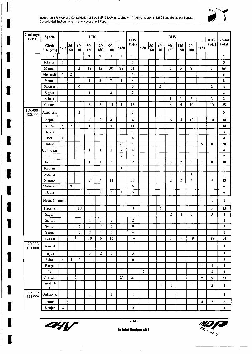
Independent Review and Consolidation of EIA, EMP & RAP for Lucknow - Ayodhya Section of NH 28 and Gorakhpur Bypass3 Consolidated Environmental Impact Assessment Report
Chainage Specie LHS RHS(km) LHS RHS Grand
Girth 30- 60- 90- 120- 90- Total 3 30- 60- 90- 120- 90- Total TotalSize (cm) 60 90 120 180 180 >180 <30 60 90 120 180 180 >180I Jamun 2 2 4 2 5 _ _Khajur 5 5 5Mango 3 18 12 30 28 61 5 3 8 8 69Mehendi 4 2 6 6
Neem 4 3 7 1 8 8Pakaria 9 9 2 2 11 _ I Sagun 1 2 2 2Sahtut 1 1 2 2 2Sissam 8 6 14 1 15 6 4 10 10 251119.000-Aaluh2 2 446 4 110 4
120.000 Amaltush 3 3 3Arjun _ 2 2 4 4 6 4 10 10 14Ashok 8 2 3 1 1 14 14Bargat 3 3 3
Ber 4 4 4Chilwal 20 20 8 8 28
Gulmohar I 1 2 2 4 43 Imli 2 2 2Jamun 1 1 2 2 3 2 5 3 8 10Kadam 1 1 13 Mahua 1 1 1 1
Mango 7 4 11 1 1 2 2 4 4 15Mehendi 4 2 6 6
Neem 3 2 5 1 6 6
Neem Chameli _ _
Pakaria 1 8 _18 5 5 23Sagun 2 1 3 = 3 3Sahtut I 1 2 = 2 = 2Semul 1 3 2 5 3 9 9Singri 3 2 1 3 6 6
12.0- Sissam 10 6 16 1 6 1 i 7 1 8 18 34
120.000- Amrud I I _
Arjun 3 2 5 5 5Ashok 4 1 1 6 6Bargat I I I
Bel 2 2 2Chilwal 23 23 9 9 32
Eucaliptu 1 1 1 2 2
120 .000- Gulmohar I I I I
Jamun 5 5 53 Khajur 2 2 2 2
-39 - < p3 i(J4/W ~ii ut hElms..h +
i

Independent Review and Consolidation of EIA, EMP & RAP for Lucknow - Ayodhya Section of NH 28 and Gorakhpur Bypass3 Consolidated Environmental Impact Assessment Report
Chainage Specie LHS RHS(km) LHS _ _ -_ RHS Grand
Girth <30 30- 60- 90- 120- 90- Total 30- 60- 90- 120- 90- Total TotalSize (cm) 60 90 120 180 180 >180 <30 60 90 120 180 180
Mango 2 1 3 12 15 1 1 2 2 17
Neem _ 1 1
Neem Chameli _ _ 1
Pakaria 12 12 4 4 16
Sissam 7 5 12 12 11 7 18 18 30
122.000- Arjun 5 4 9 9 5 4 9 9 18
Ashok 5 2 1 1 1 9 6 4 10 19Babool I 1 1
Bargat 1 1Bel I I 1
Ber 2 2 2Chilwal 7 7 4 4 11
EucaliptuI IS
Gulhar111 1Gulmohar 1 1 2 2 =1 3
Imli = 2 2 2Jamun I = _ = 7 8 = = 2 _ 3 = 3 11
0 ~~~~~~Kadam _I I 2 2 2| ~~~~~~Khajur 7 _ 1 8 - = = 9 -
Mango 2 2 4 3 7 2 2 4 4 11
s Mehendi 2 2 = = = = = 2 2 4
* _ _Neem 3 2 5 2 7 1 1 2 2 9
Neem Ch meli I 1 1 1 2
Pakaria _ 9 9 5 5 14Palm = 1 ±Sahtut
Sissam 9 6 15 15 10 7 17 17 32
122.000- Amrud I 1 1122.275 ____
Arjun 3 2 5 5 5
Ashok I I _ 3 1 2 3 6
I ___~~~~BbotII
Bargat I I = = 1 - -
Chilwal 6 6 5 5 5 IGulhar 2 1 3 3 3
Gulmohar _I IJamun 9 9 9
Mango I 1 2 2 2 1 3 3 5Mehendi 3 2 5 5
Neem 1_1 1 I IPakaria I 10 10 _ 2 2 12
3 -40 - /10
Ilnininniux- +Sl~~~~~~~~~~~~~~~~~~~iiltVluewl

Independent Review and Consolidation of EIA, EMP & RAP for Lucknow - Ayodhya Section of NH 28 and Gorakhpur Bypass3 Consolidated Environmental Impact Assessment Report
Chainage Specie LHS RHS(km) LHS RHS Grand
Girth 30- 60- 90- 120- 90- Total 30- 60- 90- 120- 90- Total Total<~30901>830 10Size (cm) 60 90 120 180 180 >10<060 90 120 180 180 >8
Sagun I 1 I 1
Singri 1 2 3 3
Sissam 2 2 4 4 4
Sissam_ 255 68 365 686 442 1141 534 3491 201 49 329 685 447 1135 487 3333 6824
Summary of Package IIIz | LHS RHS Total Grand Total
Trees<120 1374 1264 2638 6824| Tree>120 2117 2069 4186
I Trees to be Cut from Proposed ROW of Barabanki Bypass
Girth Sizes (cm)Chain)ge <_30= 30-60 60-90 _ 90-120 120-180 >180
(km)___ Species No. Species No. Species No. Species | | Species No.
Arjun 6 Chilwal 1 13 Ashok 3 Ashok 5 Ashok 1
Eucalyptus I Eucalyptus 9 Eucalyptus I Eucalyptus I
Jamun I Jamun 7 5 Jamun 2Mango 1 Mango 2 Mango 4 Mango 10 6
Neem 2 1 Neem I
3 _ _ | | Pakaria I_________ _________ ______ ____~~~~~~~~___ PipalI
Sissam 2 Sissam 4 Sissam 11 7 Sissam 3
Ashok 4 Mango 4 Mango 10 7 Mango IChilwal 5 Chilwal 4 Chilwal 1 Chilwal I I
2 Gulhar 2 Chilwal 2 Jamun 1 Jamun 4 3 Jamun 2
_____ Pakaria 2 1 Pakaria I
Sissam 9 6 Sissam 23Jamun I Arjun 3 Arjun 1 Jamun 1 1 Jamun I
Khajur 4 Khajur 4 Babool I Gulmohar 2 1 Bargat 1
3 Eucalyptus 5 Eucalyptus 1 Chilwal 3
Mango 3 Mango 2 Mango 7 4 Mango 2
Sissam 3 Sissam 2 Sissam 8 Sissam 17 11 Neem 1= = Arjun 1 Arjun I
Gulmohar 1 Gulmohar 3 Gulmohar 4 Gulmohar 5 3
4 = Mango 5 Mango I
________ _ __________ _________ Pakaria I I
Sissam 18 Sissam 20 14" 5 _______Arjun 3 Arjun I Arjun 2 2
I_______ _________ __________ _____ Chilwal 1 Chilwal I
-41- 40
IIinlti wi,

Independent Review and Consolidation of EIA, EMP & RAP for Lucknow - Ayodhya Section of NH 28 and Gorakhpur BypassConsolidated Environmental Impact Assessment ReportI
Girth Sizes (cm)Chainage <30 30-60 60-90 90-120 120-180 >180s ~~(km)
Species No. Species No. Species No. Species Species No.Gulmohar 2 - Gulmohar 2 21 ____ Mango 3 2 Mango I
___=__=__ = Neem 1 1Pakaria I Pakaria 2 1 Pakaria 2
Gulmohar 2 Arjun I Gulmohar I I ArjunChilwal I Chilwal 2 1 Bargat 23 Jamun I Jamun 2 1 Chilwal 1
6 Khajur I Khajur I Eucalyptus 3 2 Eucalyptus I_________ -____ _________ _________ G ulhar 2 1 G ulhar I
*______ = Mango 1 Mango 2 Mango 6 4 Mango I
Shagun 17 Pakaria I Pakaria 2 I Neem I3 Sissam 5 Sissam 6 4 Sissam 4Arjun I Arjun 6 Arjun I_
Ashok I = = Ashok 1Gulmohar I 1
7 = = Jamun I Jamun 1 1________ ____ ________ ________ ____ M ango 10 7 M ango 5
Pakaria 2 Pakaria 7 Pakaria 3 PakariaShagun 9 Shagun I Shagun 2
_______ ________ ____ ________ Shijan 2 Sissam 10 73 _ ___ __ _ _ ___ _ _ ___ __
Chilwal I Arjun 1 Arjun I
Khajur 4 Gulhar I Jamun 2 1 Jamun 18 Mango I Mango 13 8 Neem 3
Pakaria I I Pakaria 5Sissam 4 Sissam 19 Sissam 7 Sissam 16 1 1 Sissam 2
Arjun 10 Arjun I I Bargat IChilwal I _ Chilwal I Chilwal 6 4 Chilwal I
Gulhar 2 19 = Khajur 3 = Jamun 1
._______ _____ ________ M ango 5 4 Neem 2
*________ = _________ Pakaria I Pakaria 3 2 Pakaria 1_________ _____ Sahijan 2 Sal 2 1 Papal 2
Sissam 15 Sissam 14 10 Sissam
________ ____ Arjun 5 Arjun 5 4 Bargat I
_________ Gulhar 2 Gulhar 3 Gulmohar 2 1 Neem
Khajur 2 Sahijan 2 Jamun I I Papal I
10 Papal I Mango I Mango 10 6
Sahijan 4 Pakaria I Pakaria 7 Sahijan I
Sahijan 33 =_______ _____ Sissam 8 Sissam 8 6
11 Chilwal I Arjun I Ashok 3 Arjun 3
Ber I Ber I Chilwal I3 _________ Gulmohar I Gulmohar 2 Jamun I
42 -2I I 7 1 ~~~~~~~~~~~~~ ~~~In Joint Vo wmr Wft

Independent Review and Consolidation of EIA, EMP & RAP for Lucknow - Ayodhya Section of NH 28 and Gorakhpur BypassConsolidated Environmental Impact Assessment Report
Girth Sizes (cm)
Chainage <30 30-60 60-90 90-120 120-180 >180Species No. Species No. Species No. Species Species No.
Khajur I Neem I Neem I Neem IMango I Mango I Mango 13 9 Papal I
_ _________ ______ _________ Pakaria 3 2 Pakaria 1
Sissam 2 Sissam 7 Sissam 17 11
11-12.37 _ Arjun 8 Arjun 4 Arjun 4 2
. ____ _________ ______ _________ _____ Chilw al 3 2 Chilw al I
Gulmohar 2 1
Khajur 6 Jamun 2 Jamun 14 9 Jamun IMango 1 Mango 5 Mango 5 Mango 19 12 Mango 2
Palm 3 Neem 1 Neem 3
Sal I Pakaria 4 Pakaria 4 2 PakariaSahijan I _ Papal 2
Sissam 1 Sissam 7 4 Sissam I
Total 50 151 178 362 228 101
Grand Total 1070
- LHS RHSTrees<120 741 1922
5 Trees>120 329 2315
3 List of Trees to be Felled from the Proposed RoW of Ramsanehighat Bypass
Girth Sizes (cm)
Chainage < 330 30-60 60-90 90-120 120-180 >180Species No. Species No. Species No. Species | | Species No.
_____ Babool 1 Mango I Mango 19 13 Pipal I_______ _____ Sahijan 7 Sahijan 1 Chilwal 5 3 Sahijan 7 7
Khajur 5 Khajur I Neem 3 21 0.00- 1.0 Sal I Sal 10 Sal I
________ =__=__ =_ Sissam I._______ ______ ____ _______ Arjun 12 Arjun 7 5
Babool 2 Ber 2 Babool 3 Mango 5 3 Bamboo I
._____ ____ Mango I Mango 3 Chilwal 4 2 Bargat I
Sissam I Sissam 4 Sissam 5 4 Sissam I
3 1.0 - 2.0 Arjun 2 Arjun 4 2________ ~~~~~~ ~~~ ~~ ~~~Gular I___
*____ ________ Gulmohar I Gulmohar I Gulmohar I
Jamun 2 Jamun 2 TPakaria I Pakaria 1
2.0 - 3.0 Ber 1 Babool I Babool 3 2 Babool I
______ = Mango I Mango 2 Chilwal 4 3
Khajur 3 Khajur 11 Sahijan 2 Mango 7 53 = = Neem 2 1 Neem I
3 -~~~~~~~~~~~~~~~~~~~~~43 - 100941:;VY7?11W In sletImIvaubruwIUi S ,
; 4+ r4,

Independent Review and Consolidation of EIA, EMP & RAP for Lucknow - Ayodhya Section of NH 28 and Gorakhpur Bypass3 Consolidated Environmental Impact Assessment Report
Girth Sizes (cm)
Chainage < 30 30-60 60-90 90-120 120-180 >180
Species No. Species No. Species No. Species Species No.
Sissam 17 Sissam 7 5 Sissam 23 =______ = Gular I I
Gulmohar I
Jamun 1 Jamun 1 Jamun 4 33 ________ = Pakaria 3 Pakaria 2 1
Arjun 4 Arjun 8 Arjun 3 Babool 2 2
Sissam 3 Sissam 13 Sissam 4 3 Sissam 4
3.0 - 4.0 Pakaria I Pakaria I Pakaria I I 8
Sagun 4 Sagun I
4.0 - 5.0 Khajur 7 Khajur 5 =Bamboo Sissam I Sissam 11 Sissam 15 Sissam 33 22 Sissam 2
Sal 12 Babool 5 Papal I
5.0 - 6.0 Khajur 5 Khajur I Papal I Neem I I Neem I
Sissam 2 Sissam 3 Sissam 7 5 Sissam 2
Arjun 6 Arjun 2 2 Bamboo I
Babool 2 Babool 5 Babool I1 Babool
6.0 - 7.0 Khajur 7 Khajur I Sal 4 Jamun 5 3
Sissam 32 Arjun 15 Arjun I
Total 41 110 142 0 156 103 28Grand Total 580
SummaryTreec120 449 580Tree>120 131
IIII
I
* -1IonrOI~~~~~~~~~A

Independent Review and Consolidation of EIA, EMP & RAP for Lucknow - Ayodhya Section of NH 28 and Gorakhpur Bypass3 Consolidated Environmental Impact Assessment Report
Annexure 7.2
I List of Trees to be Cut from Proposed RoW of the Gorakhpur Bypass
3 Girth Sizes (cm)
Chainage 90- 120- ~~~~~~~~~~~~~~~~otalChainage 30-60 60-90 90- 120- >180 (forest(kin) 120 180 ~~~~~~~~~~~~~~~~~~~~trees)
Species |No |Species I No Species |_| _|Species NoPackage II of Gorakhpur Bypass3 0-1 =_ _= Mango 2 1
Gulmohor I (L) Be! I(R) Sagun 1(L) _ Jamun 3 (L) 6Arjun 2 (R) Aijun 4 (R) Arjun 10 (R) 6 (R) Mango 5 (L) 27
Eucalyptus I(R) Gulrnohor I (R) Pipal 3 (L) SForest Dept. M_mgo I (R) I (R) Shagun 3 (L) 5Trees to be Sisham 1(L) Sisham I(L) Sisham 2 (L) I (L) Sisham 2 (L) 7I = Sagiun I (R) I = _
Sisham I (R) Sisham I (R) Sisham 2 (R) 1 (R) 51 ____ Eucalyptus I (R) I
Neem 2 Litore 4 Banyan I Mahua 12 Jackfruit 2 Mango 8 Sisham 3 Mango 2
Jamun I Sisham 2 MangoI I SishamI
Phakar I3 Pipal II ~~~~4
Babul I Tamarind 25 Neem I
___________ _SSiris 1Forest Dept. SajTinaI 3 3 .
________ ____ ~~Tamnarind 3
6 Babul 8
" 7 Babul I Shagun 11
Sisham 10 Sisham 2_I8 Babul 5 Mango 29 Babul 31 Mango 5 4
Viaduct I Arjun 2 Arjun I(km 9+387.5 Babul 13 Babul 10
to
10+362.5) Phakar 1 Banyan IDate Palm 8 Mango I
10 Babool 7 Bel 2
9+253.885 ArjunI I*____ _____ Babul 13 13
9+387.5 to Bakain I Bakain 1 2 10+362.5 Bel 2 I 3Viaduct I = =_Pil 23 ~over NH-29 __ _ _ _ __ ___ _ _ _ _ _ _ Pipal 2 2
Babul I 0
Sisham 11 Sisham 4 .
in joint venture with3 @@a0m4:9V

Independent Review and Consolidation of EIA, EMP & RAP for Lucknow - Ayodhya Section of NH 28 and Gorakhpur Bypass3 Consolidated Environmental Impact Assessment Report
Girth Sizes (cm)
Chainage 3-090- 120- >10(oreta(kim) 30-60 60-90 120 1818t0 (orees
Species No Species No Species Species No
Babul 16
12 Guava 960 Guava 742 Guava 155 103
Mango I I
1 3 Babul 15 Jamun 3 Jamun I
Guava 556 Guava 170 Guava 59 40
Subtotal 1656 974 255 161 48 82
5 Grand total 3094 (including 82 forest trees)
Forestdepartment
Net Trees in Package I of Gkp bypass
Trees<120 2885 3094
_ Tree>120 209
Chainage Girth Sizes (cm) Forests
* (km) 30-60 60-90 90-120 120- >180 trees180
Species I No Species No Species Species NoPackage II of Gorakhpur Bypass13-14 Babul 20 Mango 2
Guava I Neem I
Pate Palm I Litore 8
Eucalyptus 2
|I Sisham 814-15 Babul 60
Guava 47
Viaduct 2 Phakar 1(km 15.085 to
15.510) Siris 1 1
15-16 Babul 18 Arjun I
Mango 316-17 Mango 2 Jamun 2 |
Mulberry 2 Mango 2_|_I_|
Neem 5 Neem 1
3 Phakar I
Babul 14Bel I Bel 2 Bel 13 _ _ _ _ _ _ _ _ _ ~ ~~~~~Ber
17-18 Babul 20 Babul 10
Private treesto be cutfor Eucalyptus 2 Guava ISH Bypass Mango I Neem I
3 Sisham 2
in joint venture with

Independent Review and Consolidation of EIA, EMP & RAP for Lucknow - Ayodhya Section of NH 28 and Gorakhpur Bypass3 Consolidated Environmental Impact Assessment Report
Chainage Girth Sizes (cm) Forests
(km) 30-60 60-90 90-120 120- >180 trees180
Species I No Species No Species Species No
Babul 3 Phakar I
Sisham 2 Sisham 4Date
* Mango 2 Palm I
Neem 3 _
____________ Pipal I Pipal I
19-20 Date palm 2 Siris I Pipal 1 I Pipal I
Guava 2
Jamun I Jamun 2 Jamun IMango I I
Neem 3 Phakar ISH__bypass_ Sisham 6 Sisham 9 Sisham 3 2Sll bypass Sisham I
from 19.1 to Jamun I Pipal I19.219.2 to 19.3 Neem I
Sisham I
19.3-19.4 Eucalyptus 4
Sisham 4 _
19.4-19.5 Eucalyptus 1
Jamun I Mango ISimar I
Sisham 819.5-19.6 Bel I
Mango 11
Sisham 6 Sisham 3 2 Shsham I19.6-19. 7 Sisham 2 _
20-21 Arjun I
Mahua I
Mango 7 _ -21-22 Eucalypt
Eucalyptus 5 us 2
Mango 4 Mango 2 Mango ISisham I
22-23 Jackfruit 6 Jackfruit 10 Jackfruit 4 2
Mango 84 Mango 40 Mango 18 12 Mango IPalm 6
Sisham 423-24 Mango 6 Mango 3 2
Viaduct 3 Arjun 64
24+53m.295 Eucalyptus 4 Mango 14 Mango 8 5to Guava 10 Neem 1
24+928.295) Jackfruit 2
Litore 5 _
Shagun 10 .
in joint venture withI -Np, ~ ~ ~ ~ ~ ~ A

Independent Review and Consolidation of EIA, EMP & RAP for Lucknow - Ayodhya Section of NH 28 and Gorakhpur BypassConsolidated Environmental Impact Assessment Report
Chainage Girth Sizes (cm) Forests(km) 30-60 60-90 90-120 120- >180 trees
180Species No Species No Species Species No
___________ Sisham 43km Arjun I I
24+553.29 to Babul I Babul I =2=_-24+928.295
Viaduct 3 Bel I 1Eucalyptu
_ _ _ ~s 4 2 _ _ _4
Simar 2 Simar I Gutail 4 3 Simar 1 8_______ Mango I Pipa 1 = 2
*_________ _________ Sisham 3 Sisham I I _ 425-26 Date
Bel I Palm 2 Bel I I Banyan I
Sisham 2 Neem I
Jackfruit 3
Guava 5
Jamun I
Mango I Mango 17 Mango 8 5 Mango ISagun 5
26-27 EucalyptuSisham 6 Siris I s 5 4 Mahua IArjun I Arjun I
Eucalyptus 18 Banyan I
Guava 6 Bel 3 Jackfruit 2 1 Jackfruit 2Eucalypt
Jackfruit 5 us 3Neem 2 Mango 2 Mango 13 8 Mango 8Sagun 14 Neem 3 Neem I
Shagun 3 __ = =27-28 Mango 5 Jamun 3 Mango 2
Neem I3 Sisham 5 Sisham 328-29 Date Palm 3 Mahua I3 Eucalyptus 22 Mango 4 2 Mango 2
Shagun 429-30 Eucalypt Eucalyptu
Eucalyptus 3 us 3 s I I
Sisham 23 Jackfruit 10 Jamun I
Mahua I I3 Mango 12 8 7
Sisham 4 230-31 Eucalyptu
Mahua 2 Mango 7 s 12 8 Mango 10Sisham 19 Sisham 5 Mango 10 7
31-32.2 Eucalyptus 3 Mahua 2 1 Mahua 2
Phakar I Mango 2 2 Mango 5Sisham 16 Shagun 1 _
in joint venture with
I so @@y'mw-.~~VA

Independent Review and Consolidation of EIA, EMP & RAP for Lucknow - Ayodhya Section of NH 28 and Gorakhpur BypassConsolidated Environmental Impact Assessment Report
Chainage Girth Sizes (cm) Forests(km) 30-60 60-90 90-120 120- >180 trees
180Species I No Species No Species Species No
I (L) 6 (L)Arjun 4 (R) Aun IArjun 1 8 12 56
1 (L)Mango _(L) Babul I (L) Babul I 0 7 = = 21Chiwal I(R) Siris I (L) Siris 3 2 _ 7Jamun I(R) Sisham 3(R) Sisham I (L) Mango 7 12Sisham I (R) Mango I R) Jamun I(L) 3
__________ ~Siris 2® ____
Subtotal '7 24 =_ 2221 1_'2 1091 62 121ITotal 1289 (Inclusive 121forests trees)Forestdepartment 121
Net Trees in Package 11 of Gkp bypassITrees<120 I 1118 1289
*Tree>120 I 171
l Number of Trees Under Forest Department to be cut in Shaded PortionU Abbreviation: (L)-Left Hand Side, (R) RightHand Side.All Italicized Numbers for Private Trees to be cut for the Diversion for the Existing SH Bypass.
IIl1Il
I
U ~ ~k Injon vntr with 4

Independent Review and Consolidation of EIA, EMP & RAP for Lucknow - Ayodhya Section of NH 28 and Gorakhpur BypassConsolidated Environmental Impact Assessment Report
Annexure 8.1I
List of Ponds Present on Proposed RoW with their Mitigation/ Enhancement MeasuresPackage-ISi. Ch. Side istanc Area Present Use Status Mitigation/EnhancementNo. (kin) rOm (in) Measures
IL(in1. 10.05 R 15.0 20 x 12 It is not in use, highly Partially As this pond is not in use
eutrophic. Affected therefore, digging for new(About 42%) pond is not suggested.
2. 1 1.90 R 13.0 15 x 40 Not in use, highly eutrophic Partially Remaining portion toand covered by water Affected be cleaned. Retaininghyacinth, it receives sewage (About 18%) wall to be provided forfrom near by settlements and embankmentserves as mosquito breeding protection.I ~ ~~~~~~~~~~~ground.
3. 12.26 R 35.0 15 x 15 Used for animal bathing, it Not Affected No enhancement measurealso receives sewage. is suggested.
4. 14.60 R 17.0 16 x 28 Pisciculture Partially Retaining wall to beAffected provided for embankment(About 12%) protection.
5. 17.36 R 12.0 40 x 25 Not in use, turned into Partially Remaining portion to be___ ~~~swamp, become a mosquito Affected cleaned and reclaimed.______ ~breeding ground. (About 33%)
6. 17.40 R 12.0 30 x 45 Not in use turned into swamp Partially Remaining portion to beI ~ ~~~~~~~~~~~~~and serves as mosquito Affected cleaned and excavated.breeding ground (About 19%) Retaining wall to be
provided for embankmentprotection.
7. 18.35 R 12.0 60 x 25 Used for irrigation, washing Partially New pond to be dugfor bathing, washing cloths Affected nearby or compensation toand utensils and also used for (About 33% ) be given to the owner.
____pisciculture.
8. 19.60 R 10.0 15 x 30 Not in use. Domestic waste Partially Pond is not in usewater is drained into it from Affected therefore, digging of newsurrounding households. (About 66%) pond is not suggested butI ~ ~~~~~~~~~~~~~~~~~~~~~~~will be compensated.
9. 19.65 L 10.0 15 x 12 It is not in use, covered by Affected Pond is not in useWater Hyacinth. (100%) therefore, digging of new
pond is not suggested butwill be compensated..
10. 34.50 L 9.0 55 x 60 Not in use. Pond is eutrophic, Partially Remaining portion to bewater is dark greenish as Affected cleaned. Retaining wall toI ~ ~~~~~~~~~~~~~covered by algal bloom, solid (About 16%) be provided.wastes is disposed on the west
____bank of the pond.11. 34.50 R 10.5 30 x 15 Not in use, Water Hyacinth Partially Water Hyacinth to be
growth found in rare part. Affected removed to clean the(52%) pond. Retaining wall to be
provided for embankmentprotection.
12. 34.55 L > 500 - Used for pisciculture, and Not Affected As enhancement measure,washing cloths cleaning of the pond isDomestic wastes dumped in suggested.the rare end though front parthas clear water.
13. 35.65 L 15.0 ~25 x 20 Not in use, Wate-r Hyacinth Not Affected As enhancement meaisure
growth is observed cleaning of the pond is
in joint venture with

Independent Review and Consolidation of EIA, EMP & RAP for Lucknow - Ayodhya Section of NH 28 and Gorakhpur BypassConsolidated Environmental Impact Assessment Report
Package-ISi, Ch. Side istance Area Present Use Status Mitigation/EnhancementNo. (km) from (m) Measures
C/L (mn)suggestedI 14. 35.80 L 13.0 12 x 16 Not in use, extensive hyacinth Not Affected As enhancement measures
growth is observed cleaning of the pond issuggested
15. 36.00 R 13.0 35 x 25 Not in use. Highly eutrophic Partially As pond is not usedand serves as breeding Affected therefore. digging of newground for mosquitoes. (About 80%) pond is not suggested but
will be compensated.16. 39.10 L 12.0 40 x 35 Not in use. Covered by Not Affected As enhancement measures
aquatic weeds. cleaning of the pond is______ suggested
17. 39.60 R 70.0 60 x 20 Used for irrigation but Not Affected As enhancement measurespartially covered by water cleaning of the pond isHyacinth suggested.
18. 40.10 R 8.0 20 x 20 Not in use. Covered by Water Affected As pond is not in use,Lily. (100%) therefore replacement by
digging new pond is notsuggested but will be
* ~~~~~~~~~~~~~~~~~~~~~~compensated.19. 40.10 L 12.0 10 x 8 Very small ditch. Not in use. Not Affected No enhancement measure
is suggested20. 41.05 R 10.0 10 x 10 Not in use. Affected It is not in use, therefore,
(100%) digging of new pond isnot suggested but will be
* compensated.
Package II
Si. Ch. Side Distance Area Present Use Status Mitigation/EnhancementNo. (km) from (m) Measures
_C/L (m)21. 45.06 L 9.0 30 x 7 Pond is not in use. Affected As it is not in use, therefore,
l__ ___ (100%) relocation is not suggested but itwill be compensated
22. 46.23 R 9.0 30 x 20 It is not in use. Water Lilies are Affected As it is not in use, therefore,present. (100%) relocation is not suggested but it
____ ______ will be compensated23. 47.25 R 10.0 40 x 14 Mainly used for irrigation Partially As enhancement measures
purpose. Affected construction of retaining wall is(About suggested28%)
24. 51.00 R 18.0 18 x 18 Pond is not in use. Partially Construction of retaining wall isAffected suggested
* ___ (About25%)
25. 52.40 R 9.0 18 x 9 Mainly used for irrigation Affected Pond is suggested topurpose and infested with Water (100%) relocate/compensate.
_ ~~~~~~Lilies26. 56.95 R 9.0 20 x 30 It is not in use. Partially Pond is suggested to
Affected relocate/compensate.* (About
73%)27. 57.00 L 17.0 35 x 30 Pond is used for pisciculture. A Partially Construction of retaining wall isI ____________________ waste water drain opens into it Affected suggested
-2- , pa
in joint venture with /

Independent Review and Consolidation of EIA, EMP & RAP for Lucknow - Ayodhya Section of NH 28 and Gorakhpur Bypass3 Consolidated Environmental Impact Assessment Report
Package ll
Si. Ch. Side Distance Area Present Use Status Mitigation/EnhancementNo. (km) from (m) Measures
5/L (m) __(About
i_____ _____ 19% )28. 61.00 R 9.0 20 x 14 It is not in use and infested with Affected As it is not in use, therefore,
Water Lily (100%) relocation of the pond is notsuggested but it will becompensated
29. 61.40 R 9.0 20 x 25 It is not in use and infested with Affected As it is not in use, therefore,Water Lily (100%) relocation of the pond is not
suggested but it will becompensated
30. 69.80 R 8.5 10 x 9 Mainly used for irrigation. Affected Pond will be relocated*_____ (100%)
31. 70.90 R 13.0 10 x 15 Mainly used for irrigation Affected Pond will be relocated(100%)
32. 71.60 R 12.0 20 x 10 Pond is used for irrigation and Affected Pond will be relocatedpisciculture. (100%)
33. 71.60 L 8.0 10 x 5 It is not in use and infested with Affected As it is not in use, therefore,Water Hyacinth (100%) relocation of the pond is not
* suggested but it will becompensated
34. 73.90 R 7.0 7 x 8 It is not in use. Affected As it is not in use, therefore,U (100%) relocation of the pond is notsuggested but it will becompensated
35. 73.96 R 8.0 7 x 7 It is not in use. Affected As it is not in use therefore* (100%) relocation of the pond is not
suggested but it will becompensatedI 36. 74.65 L 7.0 30 x 12 Pond is used for irrigation and Affected Pond will be relocated
pisciculture (100%)37. 74,65 R 7.0 10 x 7 Mainly used for irrigation. Affected Pond will be relocated
______ (100%)38. 75.30 L 10.0 30 x 15 Mainly used for irrigation. Affected Pond will be relocated
(I100%)
39. 76.60 R 7.0 10 x 7 Pond is not in use Affected As it is not in use, therefore,(100%) relocation of the pond is not
suggested but it will be______ compensated
* 40. 76.95 R 8.0 14 x 12 Pond is used for drinking and Affected Pond will be relocated orbathing of cattles (100%) compensated
41. 78.30 R 10.0 25 x 10 Mainly used for irrigation Affected Pond will be relocated or______ purpose. (100%) compensated
42. 82.30 L 7.0 17 x 17 It is not in use. Affected Pond will be relocated or(100%) compensated
43. 83.10 R 8.0 20 x 7 It is not in use Affected Pond will be relocated or(100%) compensated
44. 84.60 Both 6.0 60 x The water body is very old and Partially Retaining wall to be constructedsides 1600 present across the road. Left side Affected on the both wing present across
* is used for irrigation and (1.3%) the road. Moreover, the cleaningpisciculture. One Fish seed farm and excavation is suggested foris present on the left side. But the right side, which currentlyright side is infested with Water became a swamp.
_____ ____ ______ ______ Hyacinth and become a swamp
-3- W A,in joint venture with
I

Independent Review and Consolidation of EIA, EMP & RAP for Lucknow - Ayodhya Section of NH 28 and Gorakhpur Bypass3 Consolidated Environmental Impact Assessment Report
Package ll
Si. Ch. Side istance Area Present Use Status Mitigation/EnhancementNo. (km) from (m) Measures
C/L (mn)____
45. 84.90 L 7.0 20 x 12 Not in use and infested with Affected Relocation is not suggested butwater lily (100%) it will be compensated
46. 85.35 R 7.0 30 x 25 Pond is used for cultivation of Affected Pond will be relocated orSirigadha ( Trapa sp.) (100%) compensated
47. 85.60 R 7.0 60 x 8 Not in use and infested with Affected Relocation is not suggested butWater Lily (100%) it will be compensated
48. 86.60 R 7.0 20 x 12 Pond is used for bathing, washing Affected Pond will be relocated orof cloths, utensils etc. (100%) compensated
49. 87.65 L 8.5 30 x 60 Used for pisciculture and bathing Partially Construction of retaining wall isAffected suggestedI~~~~~~~~~~~~~~~~~~~~~~( %
50. 87.65 R 8.5 25 x 25 It is not in use and infested with Affected As pond is not in use, therefore,Water Hyacinth (100%) relocation is not suggested but it
will be compensated51. 87.70 L 8.5 150 x Pond is used for bathing, washing Partially As enhancement measures
80 of cloths, utensils etc. Affected construction of retaining wall is(About 8%) suggested
52. 87.70 R 8.5 25 x 40 Pond is not in use. Affected Relocation is not suggested butI I (100%) to be compensated
53. 88.15 R 8.5 25 x 25 Pond is used for irrigation Affected Pond will be relocated orI (100%) compensatedI 54. 90.55 L 9.0 25 x 12 Pond is used for irrigation Affected Pond will be relocated or
(100%) compensated55. 90.60 R 20.0 100 x Used for irrigation. Partially As enhancement measures
50 Affected constructing retaining wall is* (About suggested to ensure
20%) embankment protection.
l Package ll1SI Chainag Sid Distanc Area Present Use Status Mitigation/Enhancement
No e from (m) Measures(kin) e C/L _ _ _ _ _ _ _
- ~~~(m)56. 93.15 R 11.0 5 x 20 It is not in use. Affected As it is not in use, therefore,
(100%) relocation is not suggested but itI will be compensated.57. 94.10 R 10.0 40 x Mainly used for irrigation, Affected To be relocated.
125 bathing, washing cloths and (100%)utensils.
58. 94.25 R 10.0 5 x 5 Used for cattle bathing. Affected As it is not in use, therefore,(100%). relocation is not suggested but it
_________________________ _ _will be compensated.59. 94.50 R 50.0 40 x 50 Mainly used for irrigation, Not Affected Retaining wall to be provided as
washing for bathing, washing enhancement measurecloths and utensils.
60. 94.85 R 14.0 8 x 10 It is not in use and infested with Affected As it is not in use, therefore,Water Hyacinth. (100%). relocation is not suggested but it
will be compensated.61. 94.95 R 9.0 10 x 12 Pond is not in use. Affected As it is not in use, therefore,
(100%) relocation is not suggested but willbe compensated
62. 95.00 L 8.5 40 x 15 Used for cattle bathing. Affected Pond will be*(100%) relocated/compensated
in joint venture with
l~~~~~~~~~~~~~~~~~~~~~~~~~~~~~~~~~~~~~4<

Independent Review and Consolidation of EIA, EMP & RAP for Lucknow - Ayodhya Section of NH 28 and Gorakhpur Bypass3 Consolidated Environmental Impact Assessment Report
63. 95.00 R 9.0 15 x 12 Pond is not in use. Affected As it is not in use, therefore,(100%) relocation is not suggested but
l _ l will be compensated64. 98.70 L 70.0 40 x 60 Mainly used for irrigation. Not Affected No enhancement measure is
________l__ suggested65. 101.60 L 30.0 100 x 30 Used for cattle bathing and for Not Affected As enhancement measure
-irrigation. retaining wall to be provided.66. 105.20 R 8.0 20 x 15 Pond is used for irrigation but Affected Pond will beI | _ infested with Water Hyacinth (100%) relocated/compensated67.111.70 L 10.5 10 x 20 Used for cattle bathing and for Affected Pond will be
irrigation. (100%) relocated/compensated68. 113. 960 R 15.0 70 x 70 Not in any use and infested Affected As pond is not in use relocation is
| * with Water Hyacinth. (100%) not suggested but will becompensated
69. 114.60 L 11.5 60 x 40 Pond is very shallow mainly Affected Pond will beused for irrigation and infested (100%) relocated/compensatedwith Water Hyacinth
70.117.90 R 8.0 12 x 8 Pond is not in use. Affected As pond is not in use, therefore,(100%) relocation is not suggested but it
will be compensated71.118.25 R 12.0 45 x 50 Not in any use. Affected As pond is not in use, therefore,
(100%). relocation is not suggested butF * ~~~~~~~~~~~~~~~~~~~~~~~~will be compensated
72. 120.30 R 42.0 40 x 10 Not in any use and infested Not Affected Cleaning is suggested as_ _ with Water Hyacinth. enhancement measure.
Faizabad By assI 73. 3.30 R 9.0 45 x 45 Not in any use and infested Affected As pond is not in use, therefore,with Water Hyacinth. (100%). relocation is not suggested but it
will be compensated74. 9.40 L 10.0 70 x 25 Used mainly for irrigation Affected Pond will be
l l l l l _ (100%). relocated/compensated75. 9.40 R 10.0 50 x 25 Mainly used for irrigation. Affected Pond will be
________ l____ l_________ l______________________ _ l l(100%). relocated/compensated
| 76. 11.4 | L 15.0 100 x 30 Mainly used for irrigation. Affected Pond will be(100%). relocated/compensated
IIlIl
-5-
in joint venture with
I

I
Independent Review and Consolidation of EIA, EMP & RAP for Lucknow - Ayodhya Section of NH 28 and Gorakhpur Bypass| Consolidated Environmental Impact Assessment Report
3 | Annexure 8.2
Details of Proposed Culverts on Lucknow - Ayodhya Section of NH-28SL No Project Type of Size Existing Size Type of Recommendation
Chainage Existing Proposed New(km) Structu res Structu re
Package I1. 08+445 | x 0.9 HPC
2. 08+520 I x 0.9 HPC3. 09+707 SLC I x 0.8 1 x 0.8 SLC To be extended4. 10+894 SLC I x3 I x 3 SLC To be extended5. 11+380 SLC 3 x 1.5 3 x 1.5 SLC To be extended6. 11+872 SIP I x 0.3 1 x 0.9 HPC To be replaced7. 12+616 SLC Ix 5.5 I x 5.5 SLC To be extended8. 16+870 SLC Ix 1.8 I x 1.8 SLC To be extended9. 17+941 SLC I x 1.5 l x 1.5 SLC To be extended10. 18+415 SLC I x 3 1 x 3 SLC To be extended11. 18+789 SLC Ix 2 I x 2 SLC To be extended12. 19+159 SLC Ix 1.5 x 1.5 SLC To be extended13. 19+975 - I x 5 HPC Additional on Bypass
_________ AlignmentI 14. 20+406 - - I x 0.9 HPC Additional on BypassAlignment
15. 21+200 - - I x 5 SLC Additional on Bypass________________ __________ A lignm ent
16. 22+150 - - I x 0.9 HPC Additional on BypassAlignment
17. 23+225 - - 1 x0.9 HPC Additional on BypassAlignment
18. 23+571 - - I x 5 SLC Additional on Bypass___________ _________ A lignm ent
19. 24+651 - - I x 0.9 HPC Additional on BypassAlignment
20. 25+000 - - I x 3 SLC Additional on Bypass*___________ _________ Alignment
21. 25+050 - - I x 3 SLC Additional on BypassAlignment
22. 25+250 - - I x 0.9 HPC Additional on Bypass*___________ _________ __________ _________ A lignm ent
23. 25+700 - - I x 3 SLC Additional on Bypass_________ Alignment
24. 27+450 - - I x 0.9 HPC Additional on BypassAlignment
25. 28+050 - - I x 0.9 HPC Additional on Bypass_________ _________ _________ A lignm ent
26. 28+200 - - I x 0.9 HPC Additional on BypassAlignment
27. 28+450 - - I x 0.9 HPC Additional on Bypass*_______ ______________ ___________ _________ A lignm ent
28. 28+795 - - I x 3 SLC Additional on BypassAlignment
29. 29+000 - - I x 0.9 HPC Additional on BypassAlignment
I zrij t -1- v
in joint venture with <o

I
Independent Review and Consolidation of EIA, EMP & RAP for Lucknow - Ayodhya Section of NH 28 and Gorakhpur Bypass 0Consolidated Environmental Impact Assessment Report
30. 31+750 I x 0.9 HPC Additional on BypassAlignment
31. 32+025 I x 0.9 HPC Additional on BypassAlignment
32. 32+125 I X 0.9 HPC Additional on BypassI__I____ Alignment
33. 33+028 SLC I x 1 I x 1 SLC To be extended34. 33+331 SLC Ix 3 1 x 3 SLC To be extended35. 34+714 SLC I x 4 1 x 4 SLC To be extended36. 35+067 SLC I x 3 1 x 3 SLC To be extended37. 35+400 SLC I x 1 I x 1 SLC To be extended38. 36+268 SLC Ix 3 1 x 3 SLC To be extended39. 36+455 SLC Ix 3 1 x 3 SLC To be extended40. 36+881 SLC Ix 0.5 l x I SLC To be replaced41. 37+970 SLC I x 0.9 I x 0.9 SLC To be extended42. 38+175 SLC I x 0.9 I x 0.9 SLC To be extended43. 38+987 SLC I x 3 1 x 3 SLC To be extended44. 39+291 SLC I x2 I x 2 SLC To be extended45. 39+417 SLC Ix 2 1 x 2 SLC To be extended46. 39+678 SLC I x 1 I x 1 SLC To be extended47. 40+316 SLC Ix 1.5 I x 1.5 SLC To be extended48. 40+673 SLC I x I I x I SLC To be extended49. 41+205 HPC I x 0.6 I x I HPC To be replaced50. 41+385 SLC IxI IxI SLC To be extended51. 42+081 SLC Ix 5 I x 5 SLC To be extended52. 43+411 SLC I x 5 I x 5 SLC To be extended53. 43+673 SLC Ix 2 I x 2 SLC To be extended54. 44+-170 SLC Ix 1.5 l x 1.5 SLC To be extended55. 44+285 SLC Ix 1.5 I x 1.5 SLC To be extended56. 44+608 AR 2 x I I x 3 SLC To be replaced
I Proposed CD- Structures for Barabanki BypassS.No. Chainage Type of CD- Span (m) Remarks
Structure1. 19+975 Slab Culvert lx5.0 Canal2. 20+400 Pipe Culvert lxl.0+3. 21+200 Slab Culvert lx5.0 On small and well defined natural3 stream.4. 22+150 Pipe Culvert Ix1.0 Balancing culvert5. 22+450 Bridge Ix 10.0 Bridge over Lohsari Drain6. 23+225 Pipe Culvert Ix1.047. 23+570 Slab Culvert Ix5.0 Local nala8. 24+650 Pipe culvert Ixl.09. 25+000 Slab Culvert 1x3.010. 25+050 Slab Culvert I x3.010. 25+250 Slab Culvert 1x3.012. 25+500 Bridge 2x20.0 Bridge over Reth River13. 25+700 Slab Culvert I x3.014. 27+450 Pipe Culvert Ix1.0 _
15. 28+050 Pipe Culvert Ixl.016. 28+200 Pipe Culvert Ixl.017. 28+450 Pipe Culvert Ix1.0 _
3 7 1/W -2-in joint venture with
I

I
Independent Review and Consolidation of EIA, EMP & RAP for Lucknow - Ayodhya Section of NH 28 and Gorakhpur BypassConsolidated Environmental Impact Assessment Report
18. 28+792 Slab Culvert Ix3.0
19. 29+000 Pipe Culvert lxl.0 _
20. 31+750 Pipe Culvert IxI.0 _
* 21. 32+125 Pipe Culvert lxI.0 _
Package II57. 45.162 SLC 1 x0.9 1 x 0.9 SLC To be extended58. 45.370 SLC Ixl Ix SLC To be extended59. 45.717 SLC I xlI I xlI SLC To be extended
| 60. 46.174 HPC I x 0.6 I x I HPC To be extendedI ___61. 46.438 SLC Ix1.5 I x I.5 SLC To be extended62. 46.661 SLC Ix 1.5 I x 1.5 SLC To be extended63. 47.561 SLC Ix 2 I x2 SLC To be extended64. 47.778 HPC I x 0.3 I x I HPC To be extended65. 48.575 SLC I x 5 1 x 5 SLC To be extended66. 49.141 SLC Ix 2.5 I x 2.5 SLC To be extended
_67. 49.525 SLC 2 x 1.5 2 x 1.5 SLC To be extended68. 50.485 SLC I x 1.5 2 x 1.5 SLC To be extended69. 51.509 SLC Ix 1.5 I x 1.5 SLC To be extended70. 53.225 SLC 2 x 1.5 2 x 1.5 SLC To be extended71. 53.542 SIP I x 0.3 2 x 0.9 HPC To be replaced72. 53.750 SIP I x 0.3 1 x 0.9 HPC To be replaced73. 55.022 HPC I x 0.6 1 x I HPC To be extended74. 55.463 SLC I x 1 1 x I SLC To be extended75. 56.234 SLC Ix 1.5 I x 1.5 SLC To be extended76. 56.471 SLC I x2 I x2 SLC To be extended77. 57.183 AR 2 x 1.5 2 x 1.5 SLC To be extended78. 58.350 SLC Ix 1.5 I x 1.5 SLC To be extended79. 58.715 SLC I x 5 1 x 5 SLC To be extended80. 59.017 AR 2 x 1.5 2 x 1.5 SLC To be extended81. 59.943 SLC I x3 I x 3 SLC To be extended82. 60.480 SLC I x 5 1 x 5 SLC To be extended83. 61.116 SLC 2 x 1.5 2 x 1.5 SLC To be extended84. 61.492 SLC Ix 3 I x 3 SLC To be extended85. 61.700 HPC Ix 0.3 I x I HPC To be extended86. 63.025 - - I x 0.9 HPC To be extended87. 62.225 - - I x 0.9 HPC To be extended88. 63.400 - - I x 5 SLC Additional on Bypass
Alignment89. 63.525 - - I x 1.2 HPC Additional on Bypass
Alignment90. 64.425 - - I x 1.2 HPC Additional on Bypass
__________ AlignmentI 91. 64.850 - - I x 1.2 HPC Additional on BypassAlignment
92. 65.300 - - I x 3 SLC Additional on Bypass
I Alignment93. 65.875 i _ _ I x 1.2 HPC Additional on Bypass
Alignment
94. 66.900 - - I x 1.2 HPC Additional on BypassAlignment
-3-"o
in joint venture with

Independent Review and Consolidabon of EIA, EMP & RAP for Lucknow - Ayodhya Section of NH 28 and Gorakhpur BypassConsolidated Environmental Impact Assessment Report
95. 67.150 - - I x 1.2 HPC Additional on BypassAlignment
96. 67.800 - - I x 5 SLC Additional on Bypass__________ Alignment
97. 69.360 - - I x 1.2 HPC Additional on BypassAligment
98. 69.850 - - I x 5 SLC Additional on Bypass_____________ _________IA lignm entI 99. 69.950 - - I x 1.2 HPC Additional on Bypass
Alignment
100. 71.175 SLC I x I I x I SLC To be extended101. 72.166 AR I x0.9 lxI SLC Tobeextended102. 73.330 SLC Ix 1.5 lx 1.5 SLC To be extended103. 74.375 HPC I x 0.9 1 x 1 HPC To be extended3 104. 74.670 HPC I x 0.3 1 x 1 HPC To be extended105. 75.110 SLC I x0.9 1 x0.9 SLC To be extended106. 76.336 SLC I x I 1 x 1 SLC To be extended107. 77.143 SIP Ix0.3 1 x0.9 HPC To be replaced108. 77.398 HPC Ix 0.9 1 x 3 HPC To be extended109. 82.031 SLC Ix 1.5 lx 1.5 SLC To be extended110. 82.640 HPC I x0.9 I x0.9 HPC To be extended111. 83.225 HPC I x0.9 I x0.9 HPC To be extended112. 84.720 SLC Ix 1.5 lx 1.5 SLC To be extended113. 85.096 SLC I x 4 I x4 SLC To be extended3 114. 85.800 SLC I x 1.5 lx 1.5 SLC To be extended115. 86.068 SLC I x 1.5 lx 1.5 SLC To be extended116. 86.430 SLC Ix 1.5 Ix 1.5 SLC To be extended117. 86.875 SLC Ix 1.5 Ix 1.5 SLC To be extended118. 87.930 SLC I X 3 I X3 SLC To be extended119. 88.116 SLC I x 4 I x4 SLC To be extended120. 88.227 SLC I x 4 1 x4 SLC To be extended121. 89.962 HPC I x 0.9 1 x 0.9 HPC To be extended122. 92.391 HPC Ix0.9 I x 0.9 HPC To be extended
Proposed CD-Structure For Ramasanehigh t BypassS.No. Chainage Type of CD- Span(m) Remarks
Structure1. 63+400 Slab Culvert lx5.0 On small well defined natural
stream.2. 63+575 Pipe Culvert Ixl.03. 64+425 Pipe Culvert Ixl.04. 64+925 Pipe Culvert lxl.05. 65+300 Slab Culvert Ix3.0
6. 65+875 Pipe Culvert lx1.0 _
7. 66+900 Pipe Culvert Ixl.0 _
8. 67+150 Pipe Culvert Ixl.0 _
9. 67+800 Slab Culvert Ix5.0 Local nala10. 68+735 Bridge 1x3.0 Bridge over Kalyani River11. 69+360 Pipe Culvert IxI.0 _
12. 69+850 Slab Culvert lx5.0 Local nala13. 69+950 Pipe Culvert Ixl.0 _
7 qr ~~~~~~~~~~-4- 2VFs< vin joint venture with
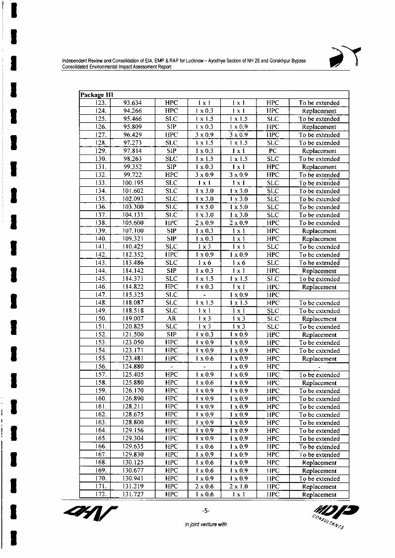
Independent Review and Consolidation of EIA, EMP & RAP for Lucknow - Ayodhya Section of NH 28 and Gorakhpur BypassConsolidated Environmental Impact Assessment Report
I Package III ___Pcka e ll123. 93.634 HPC 1 x 1 1 x 1 HPC To be extended124. 94.266 HPC I x 0.3 1 x I HPC Replacement125. 95.466 SLC I x 1.5 I x 1.5 SLC To be extended126. 95.809 SIP I xO.3 I x 0.9 HPC Replacement127. 96.429 HPC 3 x 0.9 3 x 0.9 HPC To be extended1 128. 97.273 SLC I x 1.5 Ix 1.5 SLC To be extended129. 97.814 SIP I x 0.3 l x I PC Replacement130. 98.263 SLC Ix 1.5 lx 1.5 SLC To be extended131. 99.352 SIP I x 0.3 l x I HPC Replacement132. 99.722 HPC 3 x 0.9 3 x 0.9 HPC To be extended133. 100.195 SLC IxI IxI SLC To be extended134. 101.602 SLC Ix 3.0 1 x 3.0 SLC To be extended
_135. 102.093 SLC I_x 3.0 I x 3.0 SLC To be extended
136. 103.300 SLC I x 5.0 1 x 5.0 SLC To be extended137. 104.131 SLC I x 3.0 1 x 3.0 SLC To be extended138. 105.600 HPC 2 x 0.9 2 x 0.9 HPC To be extended139. 107.100 SIP I x 0.3 l x I HPC Replacement140. 109.321 SIP I x 0.3 l x I HPC Replacement141. 110.425 SLC I x 3 l x I SLC To be extended142. 112.352 HPC I x 0.9 1 x 0.9 HPC To be extended143. 113.486 SLC I x 6 I x 6 SLC To be extended144. 114.142 SIP I x0.3 l x I HPC Replacement145. 114.371 SLC Ix 1.5 lx 1.5 SLC To be extended146. 114.822 HPC I x 0.3 1 x I HPC Replacement147. 115.325 SLC I xO.9 HPC
148. 118.087 SLC Ix 1.5 lx 1.5 HPC To be extended149. 118.518 SLC IxI IxI SLC Tobeextended150. 119.007 AR I x 3 1 x 3 SLC Replacement151. 120.825 SLC Ix 3 1 x 3 SLC To be extended152. 121.500 SIP I x 0.3 I x 0.9 HPC Replacement153. 123.050 HPC I xO.9 I xO.9 HPC To be extended154. 123.171 HPC I x0.9 I xO.9 HPC To be extended155. 123.481 HPC I x0.6 I x O.9 HPC Replacement156. 124.880 I x 0.9 HPC
157. 125.405 HPC Ix0.9 I xO.9 HPC To be extended158. 125.880 HPC Ix 0.6 1 x 0.9 HPC Replacement159. 126.170 HPC I x 0.9 1 x 0.9 HPC To be extended160. 126.890 HPC Ix 0.9 1x 0.9 HPC To be extended161. 128.211 HPC I xO.9 I xO.9 HPC To be extended162. 128.675 HPC I x 0.9 Ix 0.9 HPC To be extended
163. 128.800 HPC Ix 0.9 1x 0.9 HPC To be extended164. 129.156 HPC I x 0.9 1 x 0.9 HPC To be extended165. 129.304 HPC I xO.9 I xO.9 HPC To be extended166. 129.635 HPC Ix 0.6 Ix 0.9 HPC To be extended
167. 129.830 HPC Ix 0.9 1x 0.9 HPC To be extended168. 130.125 HPC I x 0.6 I x 0.9 HPC RepTacement169. 130.677 HPC I x 0.6 1 x 0.9 HPC Replacement170. 130.941 HPC 1x 0.9 1x 0.9 HPC To be extended171. 131.219 HPC 2 x 0.6 2 x 1.0 HPC Replacement172. 131.727 HPC 1 x0.6 l x I HPC Replacement
r ~~~~ ~~~~~-5- A,=in joint venture with 'f4s
I

Independent Review and Consolidation of EIA, EMP & RAP for Lucknow - Ayodhya Section of NH 28 and Gorakhpur BypassConsolidated Environmental Impact Assessment Report
173. 132.146 HPC I x0.6 lxI HPC Replacement174. 132.354 HPC I x0.6 Ix 1.2 HPC Replacement175. 132.595 HPC 1 xO.9 1 x0.9 HPC To be extended176. 132.752 HPC I x 0.6 1 x 0.9 HPC Replacement177. 132.977 HPC I x 0.6 1 x 0.9 HPC Replacement178. 133.450 HPC I xO.9 1 xO.9 HPC Replacement179. 134.255 HPC 3 x 0.9 3 x 0.9 HPC To be extended1 180. 134.430 HPC I xO.9 1 x0.9 HPC To be extended181. 134.605 HPC I x0.6 lx 1.0 HPC Replacement182. 134.795 HPC I xO.9 I xO.9 HPC To be extended183. 135.145 HPC 3 x 0.9 3 x 0.9 HPC To be extended
_ _184. 135.366 HPC IxO0.9 Ix.9 HPC To be extended
185. 135.640 HPC I xO.9 1 xO.9 HPC To be extended186. 135.812 HPC 1 xO.9 1 xO.9 HPC To be extended187. 136.107 HPC I xO.9 1 xO.9 HPC To be extended
188. 137.375 HPC I xO.9 1 xO.9 HPC To be extended
i ( nCulverts Planned along the Proposed Gorakhpur B passes to Facilitate Cross DrainageStructure Flow Invert Name of the
Si. No Chainage Type Size Direction Level Waterways
1 0+425 HPC Ix 1.21 L <- R 72.802 1+000 HPC Ix 1.27 L-> R 73.003 2+125 HPC Ix 1.2 L-> R 74.70| 4 2+600 HPC Ix 1.2 1 L-> R 75.505 3+075 HPC Ix 1.2 1 L <- R 74.706 3+410 HPC Ix1.2 L-> R 74.90Z 7 3+910 HPC Ix 1.2 7 L-> R 73.908 4+535 HPC 2x 1.2 L-> R 72.069 5+605 BOX Ix 3.0 m L-> R 72.3010 6+060 BOX Ix 5.0m L-> R 71.8011 6+450 BOX Ix 3.0 m L-> R 72.0012 7+050 BOX Ix 3.0 m L-> R 71.9013 7+550 BOX Ix 3.0 m L-> R 71.9014 8+150 BOX Ix 5.0 m L-> R 71.30 Jokahan Nala15 8+710 BOX Ix 3.0 m L-> R 71.8016 10+520 BOX Ix 5.0 m L-> R 73.0017 11+970 BOX Ix 5.0 m L-> R 74.3018 12+120 BOX Ix 5.0 m L-> R 74.2019 12+420 BOX IxS5.0rm L-> R 73.30 CRelef20 13+320 BOX I x5.Om L <- R 72.20 ulverts21 14+170 BOX Ix 5.0 m L <- R 72.6022 14+880 BOX Ix 5.0 m L <- R 71.0023 16+445 BOX I x5.0 m L-> R 70.10 Gaura Nala24 17+075 HPC Ix1.2 L-> R 71.4025 18+395 HPC Ix1.2 L-> R 71.1026 18+750 HPC Ix 1.2 L-> R 70.3027 19+070 HPC Ix 1.2 L-> R 70.9028 19+745 BOX Ix 5.0 m L-> R 70.00
3 ~ fl, -6- 's4< 0
in joint venture with

I
Independent Review and Consolidation of EIA, EMP & RAP for Lucknow - Ayodhya Section of NH 28 and Gorakhpur Bypass| Consolidated Environmental Impact Assessment Report
Structure Flow Invert Name of theSI. No Chainage Type Size Direction Level Waterways
29 20+075 BOX I x 3.0 m L -> R 70.6030 20+669 BOX I x 3.0 m L -> R 71.5031 21+515 HPC Ix 1.21 L -> R 71.1032 21+765 HPC I x 1.2 - L ->R 71.6033 22+327 BOX I x 3.0 m L ->R 75.5534 22+764 BOX I x 3.0 m L -> R 76.30 Canal35 23+260 BOX I x 3.0 m L -> R 76.0036 23+500 HPC I x 1.27 1 L -> R 75.40
37 25+616 HPC I x 1.27] L ->R 74.8038 26+520 HPC I x 1.2'1 L-> R 75.2039 27+014 HPC I x 1.21i L ->R 75.0040 27+714 HPC I x 1.21 L-> R 74.2041 27+941 HPC I x 1.21 L-> R 73.8042 28+541 HPC I x 1.2 L-> R 73.6043 28+966 HPC I x 1.2[ L-> R 73.9044 29+615 HPC I x 1.2 L ->R 74.5045 29+996 HPC I x 1.2 L ->R 75.3046 30+471 HPC I x 1.2 L ->R 74.8047 31+117 HPC I x 1.2 L->R 72.60
| ~~~At Ramp _____________
* At South East ramp of48 0+075 BOX I x 5.0 m L -> R 72.50 NH-29 Junction
* HPC- Hfume Pipe Culvert
I
I
II
I 4 r ~ -7- OFin joint venture with

Independent Review and Consolidation of EIA, EMP & RAP for Lucknow-Ayodhya Section of NH-28 and Gorakhpur Bypass3 Environment Impact Assessment Report
Annexure 8.3
Tree Plantation Strategy along Lucknow-Ayodhya Stretch of NH-28 and3 Gorakhpur Bypass
1. Introduction
One of the most effective, economical and useful remedies for control of environmental pollution istree plantation. Plants purify air by assimilating carbon dioxide and releasing oxygen thus keepsI check on the vehicular pollution on road and its surroundings. It also helps in soil and waterconservation, and offers shades. Big foliage trees also help in reducing noise and dust pollution.
| The main objectives of planting along the project road are as follows:
1. To reduce the impacts of air and dust pollution2. To provide shade on glaring hot road surface during summer3. To reduce the impact of vehicular noise caused due to movement of vehicles4. To arrest soil erosion at the embankment slopes5. Beautification of the project corridor by planting selective ornamental trees, landscaping
* and turfing with grasses and shrubs6. Prevention of glare from the headlight of incoming vehicles
3 The plantation scheme prepared for Lucknow-Ayodhya section of NH-28 including the existing andall proposed bypasses, (i.e., Barabanki, Ramsanaighat) and Gorakhpur Bypass in accordance withthe plantation strategy of GTRIP and TNHP to maintain the harmony in roadside plantation alongI the highways in the states.
2. Plantation Scheme
The proposed plantation schemes has been broadly classified into 3 categories which are as follows:
A. Tree plantation along the side of main carriage wayB. Plantation (low height trees and shrubs) on the mediansC. Grass turfing on the median and at the embankment slope
A. Avenue Plantation
The plant species are selected based on the climatic condition, soil characteristics and conditions ofthe strip like alkaline soil / water logged areas (particularly near water bodies in Gorakhpur bypass)etc. The last row along the main carriage way will be of shade plants. Similarly, first andsubsequent rows will comprise of ornamental and flowering species. The stretches, where space isavailable beyond third row will be planted the trees, which are tall and conical shaped.
Mainly native deciduous species, which retain their foliage longest, with high crown forms,* resistant to fungus and insects with rapid growth rate are selected for avenues. In the road stretches
because of land constraints where only one row of plantation is possible, ornamental trees will be3 planted instead of shade tree species.
Species Selected for the Avenue Plantation
3 i) Ornamental Trees
Islet vn"tr wth C

Independent Review and Consolidation of EIA, EMP & RAP for Lucknow-Ayodhya Section of NH-28 and Gorakhpur Bypass3 Environment Impact Assessment Report
The low height ornamental tree species recommended for the first and subsequent rowsexcept the last rows of avenue based on the land availability within the RoW are listed inthe Table 1.
3 Table 1. Flowering Tree Species for Second Row of Avenue Plantation andCentral Part in the Median
Local name Botanical nameSilty -Clay, Loamy and Sandy -Loa y Soil
Gulmohar Delonix regiaAmaltas Cassia fistulaKachnar Bauhinia sps.Jacaranda Jacaranda mimosaefoliaSilver oak Gravillea robustaPeltophorum PeltophorumferrugineumI Jarul LagerstomiaflosregineaBakain Malia azadiractaKanji Pongamia pinnata
A caccia auriculiformisKala siris Albizzia lebbekShisam Dalbergia sissoo
Hetrophregma adenofillumArjuna Terminalia arjuna
Water Logged ConditionArjun Terminalia arjunaJamun Syzynium cuminiiLasoda Cordia dicotma
Alkaline Soils (usar)Arjun Terminalia arjunaKanji Pongamia pinnataKala Siris Albizzia lebbek
I ii) Shade Trees
Lists of the species recommended as shade plants for avenues are given below (Table 2):
Table 2. Shade Trees Recommended for Roadside Avenues(Both the side of the corridor)I Species
Local Name Botanical NameStretch with Silty -clay to Lo my Soils
Peepal Ficus religiosaPaker Ficus infectoriaMahua Madhuca indicaMango Mangifera IndicaNeem Azadirachta indicaImli Tamarindus indicaJamun Syzynium cuminiiShisam Dalbegia sissoo
Stretch with Sandy-loam to Sandy SoilsShisam I Dalbergia sissoo
Stretch with Alkaline S ils (usar)Neem Azadirachta (up to 8.5 pH)Kanji Pongamia pinnata (normal to 9.0 pH)Arjun Terminelia arjuna
I ~~~~~~~~~~~~~~~jint meilWmn wAfllStnnUn U <0Sp->~6

Independent Review and Consolidation of EIA, EMP & RAP for Lucknow-Ayodhya Section of NH-28 and Gorakhpur BypassEnvironment Impact Assessment Report
Water logged areaJamun Syznium cuminiiArjun Terminalia arjuna
I r Long Conical Shaped Trees for Third RowPoplar Populas nigraDevdaru Polyalthia longifolia
B. Plantation of Shrubs at Median
3 Main purpose of plantation at median is beautification and prevent glare from the headlights ofincoming vehicles. The existing NH-28 section will be four lane divided carriage way and in certainstretch of the widen road will have a wide median ranging from 4.5 to 9.5 m. This wide median hasbeen designed to retain the existing roadside trees to minimize cutting of existing trees. Besidesthese existing trees in the median, shrubs are proposed to plant.
For all proposed new bypasses, four lanes divided carriageway will be constructed at present andthe 3.5 m land for the future expansion (ultimate 3-lane, six lane divided carriageway) will be lefton the both sides of the 5 m wide median. Hence, now 12 m wide medians will be available forplantation in all new bypasses. Shrubs are suggested for entire 12 m wide central part [the 5 mI wide central part (original median) and 3.5 m (future lane) wide strip on the both side of themedians].
* Species for Median
The names of the shrubs recommended for median are listed in the Table 3.
Table 3. Shrubs Recommended for Side and MedianS.No. Shrubs/Local Name Botanical Name3 1. Kaner Thavetia nerifolia
2. Chandini Ervatamia divericala3. Bouganvillea Bouganvillea sps.4. Gurhal Hibiscus sinensis5. Cassia glauca Cassia glauca6. Chameli Jouminum grandiflorum7. Lantana Lantana camara8. Oleander Thevetia peruviana
3 C. Turfing with Grasses:
Grass lines are used to provide a strong surface cover at the slope. But turfing also suggested at theside of carriageway where sufficient space is not available (below 2.5 m) on RoW or at medianeven for shrubs. Grass turfing needs a well-prepared surface in which to be planted. If grass is to bean effective form of surface cover then it must be allowed to establish properly on a slope whichdoes not subject to undue stress from erosion and mass movement in its initial stages. To ensurethis following measures are suggested for the grass turfing:
| * A cover of 25 grams of grass seed per square m. of surface will be made
* Bed will be prepared in June. The seed sowing must be carried out before the onset ofmonsoon so that they yield desired results. Till the onset of the monsoon, watering of thesurface to be done by tankers
I .i-jint "111n1111r mmltb
q4r I l"" n u 0 4?

Independent Review and Consolidation of EIA, EMP & RAP for Lucknow-Ayodhya Section of NH-28 and Gorakhpur Bypass3 Environment Impact Assessment Report
* After sowing, mulch of prepared and dried out herbs will be laid over the whole seededarea in a thin layer so that the direct sunlight and transpiration loss may not affect thegrasses
| * The grass species recommended for median are Cynodon dactylon, Cythocline purpurea,Solanum nigrum, Xanthium strumerium etc.
* Saccharum spontaneum, and Saccharum bengalensis two common local grass species are* recommended for the embankment slope at major rivers and stream crossings. These are
locally available species and good soil bounder. Sowing of these species on theembankment will help in maintaining the habitat continuity across the bypass. Such waterI crossings will serve as natural passages of wild animals because of presence of nativegrasses
| * Desmostachya bipinnata, Cenchrus ciliaris and Aristida hysterix are recommended forthe side embankment of eroded and dry patches. All these species are locally available inthe surrounding area of proposed bypass.
* Contractor will ensure that the condition of the site is good enough for the successful establishmentof grasses. They will also supervise all field operations like preparation of surface, sowing of3 grasses and quality of grass seeds used.
Besides the embankment slop, grasses are suggested mainly on the carriageway or median havingbelow 2.5 m of space to provide a strong surface cover, which needs a well-prepared surface.
* Therefore, it is suggested to remove all loose debris, fill up all convexities and concavities by goodsoil to level the median before planting. To ensure better growth and survival of grasses andshrubs, surface should have sufficient layer of good quality soil (up to 45 cms).
3. Technical Specification of Plantation at Avenue and Median
The technical specifications for planting of median height ornamental and shade trees along the maincarriageway and shrubs along the median and the available space below 4 m along the maincarriageway are as follows:
i) Low Height Ornamental Trees along the Carriageway
Distance from edge ofshoulder of original median I m.
| Spacing between plant to plant: 3 m.Size of the pits:
Normal soil- 60 x 60 x 60 cmsAlkaline soil- 1.25 m deep x 0.35 m.Water logged areas- Mounds with 60 cm top and 100 cm base height vary
depending on the water level
| Species recommended: As per Table 1.No. of plants per km: 333 (for each row)Height of the plants: More than I m.Age of the Plants: Not less than 3 years
ii) Row of Shade Plants (Third Row)
* Spacing between plant-to-plant: 12 m.
I lIlnlvujters with

Independent Review and Consolidation of EIA, EMP & RAP for Lucknow-Ayodhya Section of NH-28 and Gorakhpur BypassEnvironment Impact Assessment Report
* Spacing between the row(plant-to-plant): 3 m.
* * Size of the pits:* Normal site - 60 x 60 x 60 cms.* Alkaline soil - 1.25 m. deep x 0.35 m diaI * Water logged areas- Mounds with 60 cm top and 100 cm.
base height vary depending onthe water level
* Species recommended: List of species provided in Table 2.* Number of plants per km.: 84 (Approximately I tree/12 m.)I * Activity and time schedule: As per Table 4.* Height of the plant: Not less than 2 m.
* * Age of the Plant: Not less than 3 years
Soil along the project is normal to alkaline in certain patches (pH 6.93-.8.1) in Lucknow-Ayodhya| stretch and soil is slightly alkaline with pH 7.06-8.25 in Gorakhpur bypass area. It is proposed to
use the same species on either side of a road for at least 5 m or so. This will secure regularly grownavenues of the same form and type. Such avenues will mature at about the same time, give pleasant
| avenue appearance and can be replaced with minimum sacrifice.
To provide ample growing space for most species an average spacing of 12 m is suggested for 84| plants per km.
iii) Row of Shrubs (below four meter space, along with avenue plantationand at median)
* Distance from edge of shoulder: I m.* Spacing between plant-to-plant: 1.5 m.* Size of the pits:
* Normal site - 45 x 45 x 45 cms.I * Alkaline soil - 0.5 m. deep x 0.25 m dia* Water logged areas- Mounds with 30 cm top and 50 cm.
base height varying depending onI the water level
* Species recommended: List of species provided in Table 3.| * Number of plants per km.: 666 (Approximately I shrub/I .5 m.)
* Activity and time schedule: As per Table 4* Height of the plant: Not less than I feet* Age of the Plant: Not less than I year
The trees/shrubs in the consecutive rows will be planted in such a manner that the trees in the| second row will come in between the two plants of first row and the tree of third row will come on
the line of tree of first row.
| 5. Protection Measures:
Barbed wire fencing around the plantation area will be provided to protect the plants. Angle iron| will be fixed at a spacing of 5 m. and 3-stand barbed wire will be stretched.
1 1 I@T-Vh 10,voI lm with

Independent Review and Consolidation of EIA, EMP & RAP for Lucknow-Ayodhya Section of NH-28 and Gorakhpur BypassEnvironment Impact Assessment Report
| 6. Detail Activity Schedule
Detail activity schedule for plantation along the Lucknow-Ayodhya stretch and Gorakhpur bypass are| presented bellow in Table 4.
Table 4. Activities Schedule for Plantation
l Year Month Activities to be doneJan-March 1 Surveying and cleaning of the area
Ist Year 2 Digging of pits3 Procurement of angles iron and barbed wire
April-June I Purchase of farm yard manure2 Fixing up angle iron
_____________ 3 Stretching of barbed wire*____________ 4 Filling up of pits with farmn yard manure and soilJuly-Aug. 1 Transportation of plants
2 Planting of saplings2nd Year 3 Watering
4 Weeding and hoeingSep-Nov. I Weeding and hoeing
2 Watering four times a month-Dec.-Feb. I Weeding and hoeing
2 MaintenanceMarch 1 Watering four times a monthApril-June I Watering six times a monthJuly-Aug. 1 Casualty replacement (20% of the total tree)
2 Weeding
3 rd year 3 Maintenance by Mali-Sep-Nov. 1 Watering two times a month
2 Maintenance by Mali__________________ Dec-Feb. 1 Maintenance by Mali*________________ Dec.-Feb. I Maintenance by Mali
March 1 Watering four times a month2 Maintenance by Mali
4 th Year Apr.-Mar. I Watering2 Casualty replacement (10% of the total planted saplings)
_ _ _ 3 Maintenance by Mali
7. Precautionary Measures
| * Plantation will be made in the monsoon months (July -August)* The height of the plants should not be less than I ft. and should be in polythene bags and these
are not to be removed until the moment of planting* All plants supplied must be planted within three days of removal from the nursery* The contractor will be required to water the area in case of insufficient rains after planting* 2 kgs of compost / manure are suggested for each pit before plantation
8. Tree Planting along the Main Carriage Way on Lucknow-Ayodhya Section3 including Faizabad Bypass
The availability of space along the side of the main carriageway varies in different stretchof the existing NH-28 section of the project road. Over all plantation strategy for the side of
I d+8vi-
I I I I Isis ust Wmir. wI _

Independent Review and Consolidation of EIA, EMP & RAP for Lucknow-Ayodhya Section of NH-28 and Gorakhpur BypassEnvironment Impact Assessment Report
the main carriageway has been divided into six categories depending on the availability ofspace, which has been described below:
A. Space available upto 4 m -only shrubs
I Below 2.0 m space -grass turffingUpto 2.5 m space - one row of shrubsUpto 4 m space - two rows of Shrubs/ one row of low height ornamental tree
B. Space available from 5 m to 7 m- two rows of median height ornamental treesC. Space available from 8 m to 10 m- two rows of ornamental trees and one row of shade
I treesD. Space available from I I m to 13 m - four rows of avenue plantationE. Space available above 14 to 16 m - five rows of avenue plantation*F. Space available upto >17 m - six rows of avenue plantation*
*Applicable where level of embankment is same with the ground level; in high embankmentstretches, number of rows will be decided as suggested by the engineer considering theembankment safety.
Chainage-wise details of the availability of the space along with suggested plantation scheme forLucknow-Ayodhya stretch including Faizabad Bypass are given in tabular form at the end of thisannexure in Table 5.
| For Gorakhpur Bypass no avenue plantation is suggested because of high embankment.Only shrubs will be planted at the 12 m wide median as per the suggestion made in thisplantation scheme.
Table 5. Area Available for Plantation in Various Stretches* ~~~Package I_l
Packagel ~ ~~~~~~Side of Area of SuggestedChainage (kin) Service Road Total Total Area Plantation on Plantation
Width of Median WidthoROW Constructed Width m) Servieof for Side of Side (m) Category
- - ~enth (in) Coasrutem Widt i) SRvice Plantation WideningFrom To (k) Left Right (m) (ml Left Right
8.25 9.00 0.75 39.2 19.5 1.2 5 5 10 8.5 Concentric 4.25 4.25 A
9.00 11.00 2.00 40.7 19.5 1.2 5 5 10 10 Concentric 5 , 5 B
11.00 11.60 0.60 36.7 19.5 1.2 5 5 10 6 Concentric 3 3 A
l 11.60 13.45 1.85 40.7 19.5 1.2 5 5 10 10 Concentric 5 5 B
13.45 13.95 0.50 36.7 19.5 1 .2 5 5 10 6 Concentric 3 3 A
13.95 19.40 5.45 40.7 19.5 1.2 5 5 10 10 Concentric 5 5 B
19.40 19.80 0.40 60 19.5 1.2 5 5 10 29.3 Concentric 14.7 14.65 E
19.80 19.95 0.15 40.7 19.5 1.2 5 5 10 10 Concentric 5 5 B
19.95 20.00 0.05 60 19.5 0 5 5 10 30.5 Concentric ROB ROB ROB
0.00 0.85 0.85 60 19.5 0 0 0 0 40.5 Bypass ROB ROB ROB
0.85 1.70 0.85 60 19.5 12 0 0 0 28.5 Bypass 14.3 14.25 E
1.70 1.93 0.23 60 19.5 12 0 0 0 28.5 Bypass 14.3 14.25 E1.93 2.54 0.605 60 19.5 12 5 5 10 18.5 Bypass 9.25 9.25 C
2.54 3.20 0.665 60 19.5 12 0 0 0 28.5 Bypass 14.3 14.25 E
3.20 7.69 4.49 60 19.5 12 0 0 0 28.5 Bypass 14.3 14.25 E
7.69 8.31 0.62 60 19.5 12 5 5 10 18.5 Bypass 9.25 9.25 C
I oviiII 4~~fl,# W islEt veIrs wi _

Independent Review and Consolidation of EIA, EMP & RAP for Lucknow-Ayodhya Section of NH-28 and Gorakhpur BypassEnvironment Impact Assessment Report
Package I
Chainage (k) Side of Total Area of Suggested
Widh o MeianService Road Wit fTotal Area Plantation on Plantation- -h__ ai na ye (km) ROW Constructed Width Service for Side of Side (mi ) Category
From To Length (ein Pight ( m) (ml) Left Right(kmn) Lf ih
8.31 12.11 3.8 60 19.5 12 0 0 0 28.5 Bypass 14.3 14.25 E
12.11 12.37 0.26 60 19.5 7.5 0 0 0 33 Bypass 16.5 16.5 E
32.11 32.39 0.28 60 19.5 7.5 0 0 0 33 Bypass 16.5 16.5 E
32.39 32.49 0.1 60 19.5 12 0 0 0 . 28.5 Bypass 14.3 14.25 E
32.49 32.80 0.313 45 19.5 4.5 5 0 5 16 Bypass 3 13 A/D
32.39 32.49 0.1 60 19.5 12 0 0 0 28.5 Bypass 14.3 14.25 E
32.49 33.74 1.25 45 19.5 4.5 0 0 0 21 Right 10.5 10.5 C
33.74 34.00 263 54 19.5 4.5 0 0 0 30 Right 15 15 E
34.00 34.01 0.01 54 19.5 12 5 5 10 12.5 Right 6.25 6.25 B
34.01 34.17 0.16 40.7 19.5 1.2 5 5 10 10 Concentric 5 5 B
34.17 34.64 0.47 36.7 19.5 1.2 5 5 10 6 Concentric 3 3 A
34.64 35.04 0.40 54 19.5 4.5 5 5 10 20 Right 10 10 C
35.04 35.13 0.09 45 19.5 4.5 5 5 10 11 Right 5.5 5.5 B
35.13 42.63 7.50 45 19.5 4.5 0 0 0 21 Right 10.5 10.5 C
42.63 43.06 0.44 45 19.5 4.5 5 0 5 16 Right 3 13 A/D
43.06 43.33 0.265 45 19.5 1.2 5 0 5 19.3 Concentric 4.65 14.65 AIE
43.33 43.55 0.223 24.39 19.5 1.2 5 0 5 . Concentric Zaidpur forest
43.55 43.60 0.05 24.4 19.5 1.2 0 0 0 3.69 Concentric 1.85 1.845 A
43.60 43.80 0.2 25.6 19.5 1.2 0 0 0 4.9 Concentric 2.45 2,45 A
43.80 44.06 0.262 25 19.5 1.2 0 0 0 I 4.3 Concentric 2.15 2.15 A
44.06 44.76 0.7 45 19.5 4.5 5 0 5 16 Left 3 13 A/D
44.76 45.00 0.238 45 19.5 4.5 5 0 5 16 Left 3 13 A/D
Package ll
Width Side of Total Area of
| Chainage (km) Length ROW cof Median Service Width Total Area ide f Plantation SuggestedChaiage kin)Length ROW Const- Width Road (in) of for Widening (n in) Plantation
(km) (m) ructed Servici Plantation CategoryPart (in) Road- (in) - Ctgr
From To (m) Left Right (i) |Left Right
45.00 45.08 0.08 45 19.5 4.5 5.5 0 5.5 15.5 Left 2.75 12.75 A/D
45.08 48.382 3.302 45 19.5 4.5 0 0 0 21 Left 10.5 10.5 C
48.382 48.61 0.228 36.7 19.5 1.2 0 0 0 16 Concentric 8 8 C
48.61 48.832 0.45 36.7 19.5 1.2 0 0 0 16 Concentric 8 8 C
48.832 48.957 0.125 45 19.5 4.5 5.5 5.5 11 10 Concentric 5 5 A
48.957 49.20 0.243 45 19.5 4.5 5.5 5.5 11 10 Right 5 5 A
4920 49782 0.582 45 19.5 4.5 0 0 0 21 Right 10.5 105 C
49.782 50.052 0.27 54 19.5 4.5 0 0 0 30 Right 15 15 E
| 50.052 50.25 0.198 36.7 19.5 1.2 0 0 0 16 Concentric 8 8 C
50.25 50.567 0.515 36.7 19.5 1.2 5.5 5.5 11 5 Concentric 2.5 25 A
I X iiit
457/w Ilslutventure MMitI ZO

Independent Review and Consolidation of EIA, EMP & RAP for Lucknow-Ayodhya Section of NH-28 and Gorakhpur BypassEnvironment Impact Assessment Report
Package 11
* Width Side of Total Area ofof Median Sv Width Total Area PlantationChainage (km) median Serv ofifor Side of oSie Suggested
Chaiage kin)Length ROW Const- Width Road (in) offerWdeiniocSd Plantation Ctgr(kin) (in) ructed Wideningataton(mn) Patto
Part (in) Road- (in)Ctgr
From To (m) Le (m) Left Right
50.567 50.982 0.415 40.7 19.5 1.2 5.5 5.5 11 9 Concentric 4.5 4.5 A
50.982 51.20 0.218 45 19.5 4.5 5.5 5.5 11 10 Right 5 5 A
51.20 51.732 0.532 45 19.5 4.5 0 0 0 21 Right 10.5 10.5 C
51.732 53.415 1.683 45 19.5 4.5 0 0 0 21 Right 10.5 10.5 C
53.415 56.09 2.675 54 19.5 4.5 0 0 0 30 Right 15 15 E
56.09 56.415 0.325 45 19.5 4.5 0 0 0 21 Concentric 10.5 10.5 C
56.415 56.999 0.584 40.7 19.5 1.2 0 0 0 20 Concentric 10 10 C
56.999 57.18 0.181 36.7 19.5 1.2 0 0 0 16 Concentric 8 8 C
57.18 57.569 0.389 36.7 19.5 1.2 5.5 5.5 11 5 Concentric 2.5 2.5 A
57.569 58.019 0.45 40.7 19.5 1.2 5.5 5.5 11 9 Concentric 4.5 4.5 A
58.019 58.419 0.4 54 19.5 4.5 5.5 5.5 11 19 Right 9.5 9.5 C3 58.419 58.885 0.466 45 19.5 4.5 5.5 5.5 11 10 Right 5 5 B
58.885 62.775 3.89 45 19.5 4.5 5.5 5.5 11 10 Right 5 5 B
0 1.325 1.325 60 19.5 12 0 0 0 28.5 Bypass 14.25 14.25 E3 1.325 1.925 0.6 60 19.5 12 5.5 5.5 11 17.5 Bypass 8.75 8.75 C
1.925 3.02 1.095 60 19.5 12 5.5 5.5 11 17.5 Bypass 8.75 8.75 C100- Toll Toll
3.02 3.62 0.6 125 Plaza Plaza 0 0 0 #### Toll Plaza #### ##### Toll Plaza
3.62 6.7 3.08 60 19.5 12 0 0 0 28.5 Bypass 14.25 14.25 E
6.7 7.05 0.35 60 19.5 12 0 0 0 28.5 Left 14.25 14.25 E
69.679 69.764 0.085 45 19.5 4.5 0 0 0 21 Left 10.5 10.5 C
69.764 70.1 0.336 36.7 19.5 1.2 0 0 0 16 Concentric 8 8 C
70.1 70.289 0.189 36.7 19.5 1.2 5.5 5.5 11 5 Concentric 2.5 8 A/C
70.289 70.925 0.636 40.7 19.5 1.2 5.5 5.5 11 9 Concentric 4.5 4.5 A
70.925 71.079 0.154 40.7 19.5 1.2 0 0 0 20 Concentric 10 10 C
71.079 72.479 1.4 45 19.5 4.5 0 0 0 21 Right 10.5 10.5 C
72.479 72.85 0.371 40 19.5 4.5 0 0 0 16 Concentric 8 8 C
72.85 73.304 0.454 40 19.5 4.5 5.5 5.5 11 5 Concentric 2.5 2.5 A
73.304 73.55 0.246 45 19.5 4.5 5.5 5.5 11 10 Right 5 5 B
73.55 75.871 2.321 45 19.5 4.5 0 0 0 21 Right 10.5 10.5 C
75.871 76.20 0.329 36.7 19.5 1.2 0 0 0 16 Concentric 8 8 C
76.20 76.746 0.546 36.7 19.5 1.2 5.5 5.5 11 5 Concentric 2.5 2.5 A
76.746 77.00 0.254 36.7 19.5 1.2 5.5 5.5 11 5 Right 2.5 2.5 A
77.00 88.886 11.886 45 19.5 4.5 0 0 0 21 Right 10.5 10.5 C
80.886 81.936 1.05 40 19.5 4.5 0 0 0 16 Concentric 8 8 C
81.936 82.086 0.15 45 19.5 4.5 0 0 0 21 Concentric 10.5 10.5 C
82.086 82.40 0.314 45 19.5 0 0 0 0 25.5 Concentric 12.75 12.75 D
82.40 82.636 0.236 45 19.5 0 5.5 5.5 11 14.5 Concentric 7.25 7.25 B82.636 83.636 1 45 19.5 0 5.5 5.5 11 14.5 Concentric 7.25 7.25 B
83.636 83.95 0.314 45 19.5 0 5.5 5.5 11 14.5 Concentric 7.25 7.25 B
83.95 85.20 1.25 45 19.5 4.5 0 0 0 21 Right 10.5 10.5 C
85.20 85.90 0.7 45 19.5 4.5 5.5 5.5 11 10 Right 5 5 A
85.90 86.333 0.433 45 19.5 4.5 0 0 0 21 Right 10.5 10.5 C
86.333 86.65 0.317 40.7 19.5 1.2 0 0 0 20 Concentric 10 10 C
hllnt vi nrs wi ,AlP

Independent Review and Consolidation of EIA, EMP & RAP for Lucknow-Ayodhya Section of NH-28 and Gorakhpur Bypass3 Environment Impact Assessment Report
Package ll
I ~~~~~ ~ ~~~~~~~~~Width Side of Total Area ofC hainag (km LengthROWCcnst-of Median Service Width Total Area Side of Plantation Suggested
Chaiage kin)Length ROW Const- Width Road (mn) Servicdein oSd Plantation Ctgr(km) (m) ructed Servic Plantat Widening (m) Plantation
Part (m) Road (m)
From To (m) Left Right (mI) Left Right
86.65 86.683 0.033 40.7 19.5 1.2 5.5 5.5 11 9 Concentric 4.5 4.5 A
86.683 87.558 0.875 36.7 19.5 1.2 5.5 5.5 11 5 Concentric 2.5 2.5 A
87.558 87.775 0.217 45 19.5 4.5 5.5 5.5 11 10 Right 5 5 A
87.775 92.76 4.985 45 19.5 4.5 0 0 0 21 Right 10.5 10.5 C
92.76 93.00 0.24 54.86 19.5 4.5 0 0 0 30.86 Right 15.43 15.43 E
Package-111Side of Total Area of
Chainage (kmn) Width of Median Service Width Total Area Side of Plantation on SuiggestedLength ROW Constructed Width Road (m) of for Widening Side (i) Plantation
From | To (kin) (m) Part (m) Service Plantation Category
From To m)Left Right (in) (m Left Right
93.00 93.08 0.08 54.86 19.5 4.5 0 0 0 30.86 Right 15.43 15.43 E
93.08 93.90 0.83 54.86 19.5 4.5 5 5 10 20.86 Right 10.43 10.43 C
93.90 | 98.32 4.42 54.86 19.5 4.5 0 |0 0 30.86 Right 15.43 15.43 E
98.32 99.87 1.55 54.86 19.5 4.5 0 |0 0 30.86 Left 15.43 15.43 E
99.87 100.58 0.71 54.86 19.5 4.5 0 0 0 30.86 Concentric 15.43 15.43 E
100.58 101.50 0.93 54.86 19.5 4.5 0 0 0 30.86 Concentric 15.43 15.43 E
101.50 101.90 0.40 54.86 19.5 4.5 0 0 0 30.86 Right 15.43 15.43 E
101.90 102.75 0.85 54.86 19.5 4.5 5.5 5.5 11 19.86 Right 9.93 9.93 C
102.75 104.179 1.43 54.86 19.5 4.5 0 |0 0 30.86 Right 15.43 15.43 E
104.179 104.50 0.32 54.86 19.5 1.2 0 0 0 34.16 Concentric 17.08 17.08 F
104.50 | 105.084 0.58 54.86 19.5 1.2 5.5 5.5 11 23.16 Concentric 11.58 11.58 D
105.084 105.425 0.34 54.86 19.5 4.5 5.5 5.5 11 19.86 Left 9.93 9.93 CI 105.425 105.659 0.23 54.86 19.5 4.5 0 0 0 30.86 Left 15.43 15.43 E
105.659 105.75 0.09 54.86 19.5 4.5 0 0 0 30.86 Left 15.43 15.43 E
105.75 106.575 0.83 54.86 19.5 4.5 5.5 5.5 11 19.86 Left 9.93 9.93 C
106.575 | 107.875 1.30 54.86 19.5 4.5 0 0 0 30.86 Left 15.43 15.43 E
107.875 108.609 0.73 54.86 19.5 4.5 5.5 5.5 11 19.86 Left 9.93 9.93 C
108.61 110.831 2.22 54.86 19.5 4.5 5.5 5.5 .I 19.86 Concentric 9.93 9.93 C
110.831 111.2 0.37 54.86 19.5 1.2 5.5 5.5 11 23.16 Left 11.58 11.58 D
111.2 111.311 0.11 54.86 19.5 4.5 0 0 0 30.86 Left 15.43 15.43 E
111.311 111.68 0.37 54.86 19.5 4.5 0 0 0 30.86 Left 15.431 15.43 E
111.68 112.181 0.50 54.86 19.5 4.5 5.5 0 5.5 25.36 Left 7.68 17.68 F
112.181 112.215 0.03 54.86 19.5 1.2 5.5 0 5.5 28.66 Concentric 9.33 19.33 C/F
j 112.215 112.55 0.33 54.86 19.5 1.2 0 0 0 34.16 Concentric 17.08 17.08 F
112.55 113.051 0.50 54.86 19.5 1.2 5.5 |5.5 11 23.16 Concentric 11.58 11.58 C
113.051 | 113.42 0.37 54.86 19.5 4.5 5.5 5.5 _I 19.86 Concentric 9.93 |9.93 C
113.42 | 114.481 1.06 54.86 19.5 4.5 0 0 0 30.86 Left 15.43 15.43 E
114.481 115.094 0.61 54.86 19.5 4.5 0 0 0 30.86 Concentric 15.43 15.43 E
115.094 115.869 0.78 54.86 19.5 4.5 0 0 0 30.86 Right 15.43 15.43 E
115.869 116.769 0.90 54.86 19.5 1.2 0 0 0 34.16 Concentric 17.08 17.08 F
116.769 117.45 0.68 54.86 19.5 4.5 0 0 0 30.86 Right 1543 15.43 E
I IuInIvuiu-X-^ > 7 ~~~~~~~~~~~~loilntwntil wih -41 V A

Independent Review and Consolidation of EIA, EMP & RAP for Lucknow-Ayodhya Section of NH-28 and Gorakhpur Bypass| Environment Impact Assessment Report
Package-IlIl
Side of Total Area ofChainage (km) Length ROW Constructed Median Service Width Total Area Side of Plantation on Suggested
(ken)t O ( on) sPrute Width Road (in) of for Widening Side (in) Plantation(kin) (m) Part ~~Service Plantation Category
From To (m) Im) Left Right Road (im) Left Right
117.45 117.619 0.17 54.86 19.5 4.5 5.5 5.5 11 19.86 Right 9.93 9.93 C
117.619 118.319 0.70 54.86 19.5 4.5 5.5 5.5 1 1 19.86 Concentric 9.93 9.93 C
118.319 118.9 0.58 54.86 19.5 4.5 5.5 5.5 11 19.86 Left 9.93 9.93 C
118.9 119.494 0.59 54.86 19.5 4.5 0 0 0 30.86 Left 15.43 15.43 E
119.494 120.075 0.58 54.86 19.5 1.2 0 0 0 34.16 Concentric 17.08 17.08 F
120.075 121.419 1.34 54.86 19.5 1.2 5.5 5.5 11 23.16 Concentric 11.58 11.58 D
121.419 121.719 0.30 54.86 19.5 4.5 5.5 5.5 11 19.86 Left 9.93 9.93 C
121.719 122.00 0.28 54.86 19.5 1.2 5.5 5.5 11 23.16 Right 11.58 11.58 D
122.00 122.119 0.12 54.86 19.5 1.2 0 0 0 I 34.16 Right 17.08 17.08 F
122.119 122.275 0.16 54.86 19.5 0 0 0 0 35.36 Right 17.68 17.68 F
0 0.025 0.03 54.86 19.5 0 0 0 0 35.36 Right 17.68 17.68 F
0.025 0.344 0.32 54.86 19.5 0 5.5 5.5 11 24.36 Right 12.18 12.18 D
0.344 0.594 0.25 54.86 19.5 1.2 5.5 5.5 11 23.16 Right 11.58 11.58 D
0.594 1 .125 0.53 54.86 19.5 0 5.5 5.5 11 24.36 Right 12.18 12.18 D
1.125 2.494 1.37 54.86 19.5 0 0 0 0 35.36 Right 17.68 17.68 F
2.494 2.919 0.43 54.86 19.5 4.5 0 0 0 30.86 Right 15.43 15.43 E
2.919 3.55 0.63 54.86 19.5 1.2 0 0 0 34.16 Concentric 17.08 17.08 F
3.55 4.494 0.94 54.86 19.5 1.2 5.5 5.5 11 23.16 Concentric 11.58 11.58 D
4.494 5.175 0.68 54.86 19.5 4.5 5.5 5.5 11 19.86 Right 9.93 9.93 CI 5.175 6.025 0.85 54.86 19.5 4.5 0 0 0 30.86 Right 15.43 15.43 E
6.025 6.85 0.82 54.86 19.5 4.5 5.5 5.5 1 1 . 19.86 Right 9.93 9.93 C
6.85 7.062 0.21 54.86 19.5 4.5 0 0 0 30.86 Right 15.43 15.43 E
* 7.062 7.625 0.56 54.86 19.5 1.2 0 0 0 34.16 Concentric 17.08 17.08 F
7.625 7.912 0.29 54.86 19.5 1.2 5.5 5.5 11 23.16 Concentric 11.58 11.58 D
7.912 8.70 0.79 54.86 19.5 4.5 5.5 5.5 11 19.86 Right 9.93 9.93 C
8.70 9.962 1.26 54.86 19.5 4.5 0 0 0 30.86 Right 15.43 15.43 E
9.962 11.309 1.35 54.86 19.5 0 0 0 0 35.36 Right 17.68 17.68 F
11.309 11.775 0.47 54.86 19.5 4.5 0 0 0 30.86 Right 15.43 15.43 E
11.775 12.00 0.23 54.86 19.5 4.5 5.5 5.5 11 19.86 Right 9.93 9.93 C
12.00 15.00 3.00 54.86 19.5 4.5 0 0 0 30.86 Right 15.43 15.43 E
III
I xl-I

Independent Review and Consolidation of EIA, EMP & RAP for Lucknow-Ayodhya Section of NH-28 and Gorakhpur Bypass3 Environment Impact Assessment Report
I
Front Edge of the Road
I\4 Rare Edge of the Road
6 6m 1.5 rmn
7.5m
I 6 m Rare Edge of the Road
* ~ ~ ~~~~~6m n 4 f5 m~ .6m- 5m + 1.5m* 1m -0
13.5 m am3 6 m 4~~~~~~~~'F1. 5 m -1.n$ 5 m MI4 L~
| * 6 ~~~~~~~m 15 m+* 0 1.5 1.l5 rT_ 1.5 m 1 .5 m w1.5 m
16.5 m
Schematic Diagram of Avenue Plantation in Variable Width of AvailableI Area in Different Stretches along the Side of the Main Carriageway
J ._ ___ __ _ ____ _ _
I
I
7flp#-tEirois Z

Independent Review and Consolidation of EIA, EMP & RAP for Lucknow - Ayodhya Section of NH 28 and Gorakhpur Bypass3 Consolidated Environmental Impact Assessment Report
Annexure 8.4
List of Religious Structures and their Mitigation/Enhancement MeasuresSi. Ch. (km) Name Status of itigation/ Enhan. MeasuresNo. impact l
Package I1 9.021 Shiva temple: Small private temple. Boundary wall Affected Relocation of the temple is
at 16m from C/L, temple at 19m. suggested within the factoryThe temple is within proposed ROW and will be premises.demolished.
2 9.960 Hanuman and Shiva temple: Very small roadside Affected Relocation of the temple is* temple. Boundary at 8m from C/L, temple at 1Om. recommended.
Built on existing ROW.The temple will be demolished.
3 10.100 Durga temple: Very small roadside temple of a height Partially Relocation of the temple isof 4 feet. Built on existing ROW. Affected recommended.The temple will be demolished.
4 10.900 Shiva temple: Very small roadside temple of a height Affected Relocation of the temple isJ of 4 feet. Built on existing ROW. recommended.
The temple will be demolished.5 11.380 Vardan Hanuman temple: Two storied temple. Affected Relocation of the temple isI Boundary wall at 12m from C/L, temple at 16m and recommended.
the temple complex end at 19.5m.The temple is within proposed ROW and will bedemolished.I 6 12.300 Devi temple: Very small Private Mandir, belongs to Affected Construction of new boundaryMitsubishi showroom (speed motors). Boundary wall wall is proposed.at 21.5m from C/L, temple at 23m.I Boundary wall will be affected due to widening.Temple remains unaffected.
8 13.050 Durga temple: Small temple inside Goyal Pipe Affected Relocation of the temple withinFactory premises, worshipped by the workers. the factory premises isI The temple is within the proposed ROW and will be suggested.demolished.
9 13.300 Ganesh temple: An under construction temple inside Affected Relocation of the temple withinI BBD Engineering College complex. Boundary wall at the campus is suggested.17m from C/L, temple at 19m.Boundary wall and the temple will be affected due towidening.I 13 16.950 Satyatirth Aashram: Big complex inside brick Partially As mitigation measuresboundary. Complex includes Shakti Shanti Mandir, Affected construction of new boundarycowshed and recently installed big statue of Lord wall and relocation of theI Krishna. Boundary Wall at 16m, cowshed adjoining cowshed within the sameboundary wall. Other structures and temple at 28m. complex are recommended.Boundary wall and cowshed will be affected due towidening. Other structures and temple remain
*__ unaffected.
14 17.700 Shiva Temple: Medium sized temple inside a tile Affected Relocation of the temple withinfactory. The temple is within the proposed ROW and the factory premises isI will be demolished. suggested.
15 35.800 Shiva Temple: Medium sized temple. No boundary Affected Relocation of the temple withinwall. Vacant land inside temple premises. its own premises isWidening being on the same side, the temple will be recommended.I demolished.
16 44.100 Sidheshwar Nath Temple: Very small but old Affected Relocation of the temple istemple, established in 1939. Built on existing ROW. recommended.
___ _________ The temple will be demolished.
1 7 1 -1- Spw
in joint venture with

Independent Review and Consolidation of EIA, EMP & RAP for Lucknow - Ayodhya Section of NH 28 and Gorakhpur Bypass3 Consolidated Environmental Impact Assessment Report
3 ~ Package IISi. Ch. (km) Name Status of Mitigation/ Enhan.No. impact MeasuresI . 56.750 Jai Durga Temple: Very small roadside temple of a Affected Relocation of the temple
height of 3 feet. Built on existing ROW. or appropriateThe temple will be demolished. compensation is
suggested to be arranged.* 2. 57.050 Durga devi Temple: Very small roadside temple of a Affected Relocation of the temple
height of 3.5 feet. Built on existing ROW. or appropriateThe temple will be demolished. compensation is
suggested to bearranged..
3. 57.200 Vishwakarma Temple: Small roadside temple on Affected Relocation of the templeexisting ROW. The temple will be demolished. or appropriate
compensation issuggested to be arranged.
4. 57.900 Hanuman temple: Very small roadside temple. No Affected Construction of aI well-defined temple structure. boundary wall around theOutside the proposed ROW, therefore remains temple is recommended.unaffected, but the road will draw very close to thetemple.I 5. 71.250 Durga temple Small roadside temple on existing Affected Relocation of the templeROW. in a suitable new place isThe temple will be demolished. suggested.I 6. 72.500 Durga temple: Small roadside temple on existing Affected Relocation of the templeROW. in a suitable new place isThe temple will be demolished. suggested.
7. 73.900 Durga temple: Small roadside temple on existing Affected Relocation of the templeROW. in a suitable new place isThe temple will be demolished. suggested.
8. 75.520 Shiva temple: Small temple. Affected Relocation of the templeWidening being on the same side, the temple will be in a suitable new place isdemolished. suggested.
9. 80.500 Hanuman temple: Small temple. Boundary wall 20m Affected Relocation of the templefrom C/L, temple at 23m. in a suitable new place isI Widening being on the same side, the temple will be suggested.demolished.
10. 82.450 Shiva temple: Small roadside temple on existing Affected Relocation of the templeI __ ____ ROW. in a suitable new place isThe temple will be demolished. suggested..
11. 90.700 Hanuman temple: Small roadside temple on existing Affected Relocation of the templeROW. in a suitable new place is
*__ The temple will be demolished. suggested.12. 92.950 Hanuman and Shiva temple: Two separate temple in Partially Construction of new
same compound. Boundary wall not well constructed. Affected boundary wall,Boundary wall and Hanuman temple will be Relocation of thedemolished due to widening. demolished temple.The Shiv temple remains unaffected.
IPackage IIISi. Chainage. Name Status of Mitigation/ Enhan.No. (ki) impact Measures1 93.150 Durga Temple: Small roadside temple on existing Affected Complete relocation of
ROW. the temple in a suitableThe temple will be demolished. new place is suggested..
-2-
in joint venture with

lIndependent Review and Consolidation of EIA, EMP & RAP for Lucknow - Ayodhya Section of NH 28 and Gorakhpur BypassConsolidated Environmental Impact Assessment Report
4 101.950 Jai Bajrangbali Temple: Small roadside temple on Affected Complete relocation ofexisting ROW. the temple in a suitableThe temple will be demolished. new place is suggested...
8 106.100 Shankar temple: Small roadside temple on existing Affected Complete relocation ofROW. the temple in a suitableThe temple will be demolished. new place is suggested.
9 106.250 Shiv Temple: Small roadside temple on existing Affected Complete relocation ofROW. the temple in a suitableThe temple will be demolished. new place is suggested.
15 117.250 Hanuman & ShivTemple: Two small temples on Affected Complete relocation ofexisting ROW. the temple in a suitable
___ The temples will be demolished. new place is suggested.* 16 117.950 Mansa devi Temple: Small temple on existing ROW. Affected Complete relocation of
The temples will be demolished. the temple in a suitablenew place is suggested.
17 118.150 Shiv Temple: Small roadside temple on existing Affected Complete relocation ofROW. the temple in a suitableThe temple will be demolished. new place is suggested.
18 118.350 Ram & Janki Temple: Roadside temple on existing Affected Complete relocation of* ROW. the temple in a suitable
The temple will be demolished. new place is suggested.19 118.450 Ram & Shiv temple: Built on existing ROW. Affected Complete relocation of
The temple will be demolished. the temple in a suitablenew place is suggested.
20 120.000 Maa Vaishno Devi Temple: Small temple on existing Affected Complete relocation ofROW. the temple in a suitable
J The temple will be demolished. new place is suggested.23 120.850 Kali Devi Temple: Small roadside temple on existing Affected Complete relocation of
ROW. the temple in a suitable___ __________ The temple will be demolished. new place is suggested
Faizabad bypass26 9.600 Small temple under construction on existing ROW. Affected Complete relocation of
The temple will be demolished. the temple in a suitable* new place is suggested
27 9.650 Shiv Temple: Small roadside temple on existing Affected Complete relocation ofROW. the temple in a suitableI The temple will be demolished. new place is suggested
28 10.100 Shiv temple: Small roadside temple on existing ROW. Affected Complete relocation ofThe temple will be demolished. the temple in a suitable3 _ new place is suggested
lIll
-3- -14
in joint venture with ',

Independent Review and Consolidation of EIA, EMP & RAP for Lucknow - Ayodhya Section of NH 28 and Gorakhpur Bypass3 Consolidated Environmental Impact Assessment Report
Annexure 8.5
* List of Educational Institutions with Proposed Mitigation/Enhancement MeasurePackage ISi Chainage Side Distance CIL Name Part of the
* No. (km) (m) Structure Mitigation MeasuresAffected
1. 10.55 R 25.0 Arunodaya Public High Not affected No mitigation/enhancementI School: Small private measure is suggested.school with no boundarywall. Backside of theschool faces the project6road. Outside the proposedROW, therefore unaffecteddue to widening.I 2. 10.900 L 18.0 St. Mary's Inter College: Partially Boundary wall will be shiftedSmall private primary affected behind; trees will be plantedcoeducational school in two rows along the
periphery of the school forI noise attenuation.
3. 10.9 L 50.0 Naveen Chatravaas Not affected No mitigation / Enhancement(Hostel): Private boys measures suggested1 hostel, just besides St.Mary's school. Big openspace in front of the hostel.1 _ It exists away from the road
4. 10.9 R 100.0 Diamond Public Girls Not affected No Mitigation/enhancementIntercollege: Medium measures are suggested.sized private high school.1 5. 11.020 L 50 Wisdom Way Progressive Partially Construction of newInter College: Big private affected boundary wall is suggested.high school Relocation of demolished
portion of school building* and elevation of new
boundary wall to a height of5.5m as noise barrier aresuggested as mitigationmeasures.
6. 12.500 R 100.0 Children Convent School: Partially Shifting of boundary wall andPrivate primary school. affected plantation of trees in two
rows along the periphery fornoise attenuation aresuggested.
7. 13.200 R 16.0 Banarsi Babu Das Partially Shifting of boundary wall,I Engineering College: affected elevation of new boundaryPrivate engineering college. wall to a height of 5.5m as
noise barrier and relocationof the temple within thecollege campus are suggestedas mitigation measures.Plantation along theperiphery of the campus is
X also suggested asenhancement measures.
8. 13.250 L 55.0 Oxyopia Academy: Very Not affected As enhancement measuresmall primary private plantation of trees along the1 school, opposite to BBd periphery is suggested.engineering college. Away
l from the road.
1 1fl/W -1-00in joint venture with 04,j.r
I~~~~~~~~~~~~~~~~~~~~~~~

Independent Review and Consolidation of EIA, EMP & RAP for Lucknow - Ayodhya Section of NH 28 and Gorakhpur Bypass3 Consolidated Environmental Impact Assessment Report
9. 13.55 R 125.0 City Academy Secondary Not affected Shelter at bus stop on bothSchool: Medium sized, sides of the road arePrivate Secondary school. suggested as enhancement
________ ___ ___ _______ _______ _______m easure.
10. 13.600 L 26.0 Little Angel's Girls Inter Not affected Plantation of trees along theCollege: Medium sized periphery is suggested asprivate school. enhancement measure.
11. 13.7 L 25.0 Ashtum Memorial Not affected Construction of newMission school: Boundary boundary wall is suggested aswall will be affected due to mitigation measures andwidening. Main school Plantation of trees along the
buligwill remain periphery is suggested asbuilding we enhancement measure.I unaffected.12. 14.30 L 100 Pragna Vidyalaya: Small Not affected Plantation of trees along the
private school upto 8h periphery is suggested asstandard. enhancement measure.
13. 15.1 R 120.0 Sri BMPMemorial Inter Not affected No enhancement measurecollege: Medium sized. suggested.Private inter college.
14. 15.980 L 18.0 Bal Shiksha Kendra: A Affected Reconstruction of theone room Educational educational center at suitablecenter location is suggested.
Plantation along theboundary wall is alsosuggested as enhancementmeasure.
15. 16.950 R 35 Shiv Shiksha Niketan: A Not affected. No enhancement measure isI small school primary suggestedschool.
16. 16.970 L 15.2 C. G. Girls High School: Partially Reconstruction of thePrivate girls high school. affected demolished classrooms is
suggested. Elevation of newboundary wall to a height of5.5m as noise barrier is alsosuggested as enhancementmeasure.
17. 17.380 R 550 Corporate International Not affected No enhancement measure isSchool: Private school suggested.I * 18. 19.750 R 14.5 Krishna Montessori Girls Affected Relocation of the schoolInter College: Medium through proper R & Rsized private school with measure is suggested.
* double storied building19. 19.9 R 100 Jai bharat School: Not affected No mitigation/enhancement
Medium sized private measures are suggested.school upto 8h standard
located at Safedabad.20. 32.800 L 12.5 Sagar Institute of Not affected Plantation of trees in two
Technology and rows along the periphery ofI Management: Recently the college for noiseopened big private attenuation is suggested asengineering college enhancement measure.
21. 34.500 R 170 Chandrasukla Azaad Not affected As enhancement measuresVidya Mandir Higher construction of boundarySecondary School: Newly wall and plantation of treesconstructed big private along the periphery of the3 _ ____________________ _ co ol school are suggested.
-2-
in joint venture with C 4,
III

Independent Review and Consolidation of EIA, EMP & RAP for Lucknow - Ayodhya Section of NH 28 and Gorakhpur Bypass3 Consolidated Environmental Impact Assessment Report
22. 34.500 R 170.0 Rajkiyo Prathamik Not affected As enhancement measuresVidyalaya: Government construction of boundaryprimary school, wall and plantation of trees
along the periphery of theschool are suggested .
23. 34.780 L 13.5 Primary School: Affected As mitigation measureGovernment primary relocation of the school
measures is suggested.
l24. 38.800 L 13.5 Baba Narayan Das Not affected As enhancement measures
Smarak Jr. High School: construction of brickPrivate school up to 8th boundary wall around thestandard. school premises as well as
plantation of tress along theperiphery are suggested.
25. 40.200 L 25.0 New Way Public School: Not affected Plantation of trees in twoMedium sized private rows along the periphery ofsecondary school. the school for attenuation of
noise is suggested26. 42.500 R 45 Prathamik Vidyalaya: Not affected Construction of brick
Small Government primary boundary wall around theschool, school premises and
plantation of tress in tworows for noise attenuation aresuggested as enhancementmeasures.
27. 42.800 L 15.5 Raghunath Prasad Not affected Plantation of trees along theMemorial Inter College: periphery of the school isBig private high school suggested as enhancement
measure.28. 42.900 L 15.5 Parijat Vidyapeeth: Not affected No specific enhancement
Medium sized school up to measure is suggested.
8 th standard
29. 44.350 L 150 Rachna Bal Vidya Not affected No specific enhancement_____Mandir: Small private measure is suggested.
school up to 8 'h standard.
30. 44.500 L 15 Netaji ShyamlalYadav Affected Construction of brickMemorial School: Medium boundary wall around thesized private school up to school, elevation of new8th standard. boundary wall to a height of
5.5m as noise barrier andplantation of tress aroundschool building and templeare suggested as
l_______ _____ ____________ ___________________________ enhancem ent m easure
Package II
Si. Status of Mitigation/ Enhance- mentNo Zhainag) Side Distance Name Impact Measures
(kin) CIL (in)
31. 45.700 L 65.0 Prathamik Vidyalaya: Small Government Not No mitigation/ enhancementI primary school up to 5h standard. affected measure is suggestedThough widening on the same side, but theschool will not be affected
32. 48.400 L 30.0 Prathamik Vidyalaya: Small Government Not No mitigation/ enhancementprimary school up to 5th standard. affected measure is suggestedThough widening on the same side, the3 school will not be affected
in joint venture with
l

Independent Review and Consolidation of EIA, EMP & RAP for Lucknow - Ayodhya Section of NH 28 and Gorakhpur Bypass3 Consolidated Environmental Impact Assessment Report
Package II
Si. _ Status of Mitigation/ Enhance- mentNo h(aina)g SdDistance Name ImatMeasuresNo (kin) Side C/L (mn) Impact Maue
* 33. 50.350 R 90.0 Purva Madhyamik Vidyalaya: Medium Not Construction of brick boundarysized government school up to 8h standard. affected wall and plantation of trees aroundNo boundary wall is present. Big vacant the school premises are suggestedland in front of the school is present as enhancement measures.I Away from the project road, therefore, itremains unaffected
34. 50.400 R 130.0 Prathamik Vidyalaya: Government Not Construction of brick boundaryprimary school beside the Purva affected wall and plantation of trees aroundI Madhyamik Vidyalaya. No boundary wall the school premises are suggestedis present. as enhancement measures.Away from the project road, therefore, itI remains unaffected.
35. 50.500 L 23.0 Smt. Shanti Devi Memorial Shikshan Not Construction of boundary wall to aSansthan: Medium sized private school, affected height of 5.5m as noise barrier isjust outside the proposed ROW. No suggested as enhancement
* boundary wall is present. measure.The school will not be affected due towidening, but the road will draw very closeto the school.
36. 51.650 R 32.5 Good Shepherd School: Private English Not Construction of boundary wall to amedium school up to 5th standard, affected height of 5.5m as noise barrier isAs widening is on the same side, the road suggested as enhancementI will draw very close to the school and measures which will also work asvirtually no place will be left between noise barrierschool and road. The school building,U however, will remain unaffected.
37. 51.750 L 20.5 Chandrabhanu Gupta Memorial Purva Not Construction of brick boundaryMadhyamik School: Big private affected wall and plantation of treessecondary school. No boundary wall is around the school premises are
* present. suggested as enhancementWidening being on the opposite side, the measures.school will not be affected.I 38. 55.600 L 15.3 Shri Babadin Shishu Mandir Not Repairing of school building andNo boundary wall is present. The school affected construction of boundary wall arebuilding is in very poor state. suggested as enhancementWidening being on the opposite side, the measures.school will not be affected.
39. 57.100 R 15.0 Junior High School: Big Government Partially No mitigation/ enhancementprimary and secondary school, operates in affected measure is suggested.I shifts. Boundary wall at 15m from C/L, Construction of new boundaryschool building at 25.2m. wall to a height of 5.5m as noiseBoundary wall, part of the administrative barrier is also suggested asunit of the school will be affected due to mitigation measures.widening. The road will draw very close tothe school building.I 40. 57.650 R 22.5 P.R. Memorial Public School: Private Not Elevation of the school boundaryschool up to 8th standard. affected wall to a height of 5.5m isThe school will not be affected due to suggested which will work as awidening, but the road will draw very close noise barrier.I to the road.
41. 57.900 R 38.5 Shri. Advait Kala Shiksha Niketan: Not No mitigation measure isSmall private art school. Boundary wall is affected suggested3 38.5m from C/L, building is 45m away I
in joint venture with s
I

Independent Review and Consolidation of EIA, EMP & RAP for Lucknow - Ayodhya Section of NH 28 and Gorakhpur Bypass3 Consolidated Environmental Impact Assessment Report
Package II
Si. Status of Mitigation/ Enhance- mentNo haia)g Side Cistanc Name Impact Measures
from C/LSchool is outside the proposed ROW,therefore remains unaffected due to
*___ ______ ___ widening.I 42. 59.800 L 65.0 Purva Madyamik Vidyalaya: Small Not No mitigation measure isprivate school. affected suggested.Away from the project road, therefore3 _ remains unaffected.
* 43. 61.000 L 30.0 Prathamik Vidyalaya: Small primary Not Construction of boundary wall isschool. No boundary wall is present. affected suggested as enhancementVacant land is present in front of the measure.
| ~~~~~~~~~school.Widening being on the opposite side, the
_ school will not be affected.X 44. 71.000 L 18.0 Madarsa: Medium sized Madrasa. No Partially Construction of new boundaryX boundary wall is present. affected wall to a height of 5.5m as noise
Widening being on the opposite side, the barrier and plantation of treesMadrasa will not be affected. around the Madrasa are suggestedI - _ aenhancement measures.
45. 73.950 R 24.0 Janata School: Small secondary school. Affected Relocation of the school throughEntire school building will be affected due proper R & R measures isI... ___ to widening. suggested
* 46. 75.150 R 31.0 Prathamik Vidyalaya: Small primary Not Construction of boundary wall andschool. No boundary wall is present. affected plantation of trees in two rows forWidening being on the same side, the road noise attenuation are suggested aswill draw very close to the school. The enhancement measures.school building, however, will remainunaffected.
47. 76.150 R 50.0 Madhyamik School: Big school up to 8th Not No enhancement measure isstandard inside boundary wall. affected suggestedAway from the road, therefore remainsunaffected.
48. 76.180 R 26.8 Prathamik Vidyalaya, Pureshahlal: Not Construction of boundary wall andGovernment primary school. No boundary affected plantation of trees along thewall is present. Vacant land beside the periphery are suggested asschool is present. enhancement measures.I Well outside the proposed ROW, therefore,remains unaffected due to widening.
49. 76.400 R 9.0 Magdum Ashraf Mission Public School: Affected Relocation of the school though1 Medium sized private school up to 8th proper R &R measures isstandard. Boundary wall is 9m from C/l, suggested.and school building is at 11 m.The school is within proposed ROW andwill be demolished.
50. 77.350 L 28.0 Prathamik Vidyalaya: Government Not Construction of boundary wall andprimary school. No boundary wall is affected plantation of trees along thepresent. periphery of the school areWidening being on the opposite side, the suggested as enhancementschool will not be affected. measures.
l 51. 78.500 L 15 Purba Madhyamik Vidyalaya: Not Plantation of tress along theGovernment primary school with boundary affected periphery is suggested aswall. enhancement measure3 Widening being on the opposite side, the
in joint venture with

Independent Review and Consolidation of EIA, EMP & RAP for Lucknow - Ayodhya Section of NH 28 and Gorakhpur BypassConsolidated Environmental Impact Assessment Report
Package ll
Si. Status of Mitigation/ Enhance- mentNo hkaig S istance Name Impact Measures
l _ = _ school will not be affected.52. 78.600 R 29.0 Shri. Avadh Prasad Madhyamaik Partially Construction of new boundary
School: Semi Government secondary affected wall is suggested as enhancementschool with very short height boundary measure.I wall.Boundary wall will be affected due towidening, but the school building willremain unaffected.
53. 78.900 L 15.0 Junior High School: Small school. Not No enhancement measure isBoundary wall is 15m from C/L and school affected suggested.building is at 18m.Widening being on the opposite side, theschool will not be affected.
54. 81.300 L 120.0 DSM Lions Public School: Not Tree plantation along theBig private school. Boundary wall at 120 affected periphery is suggested asm from C/L. Big vacant non-agricultural enhancement measure.land in between the school and road.Far away from the project road, therefore
*______ no impact.
55. 82.200 R 15.0 Shri. Rajeshwari Bal Satya Niketan (Jr.) Partially Construction of new boundarySri Hans Madhyamik Vidyalaya: One affected wall to a height 5.5 m as noiseprimary and one secondary medium sized barrier is suggested asprivate school inside the same campus. enhancement measure.Boundary wall is at 15m from C/L andschool building is at 28m.I Boundary wall will be affected due towidening, but the school building willremain unaffected.
56. 82.950 L 50.0 Kanya Purva Madhyamik Vidaylaya: Nopt Construction of boundary wall andGovernment girl's junior high school. No affected plantation of trees along thewell-defined boundary wall is present. periphery of the school areFar away from project road, therefore, suggested as enhancement1I remains unaffected measures.
57. 83.450 L 15.0 Flax Montessori School: Private Affected Relocation of the school thoughMontessori school. Main building is at proper R & R measure is15m from C/L. suggested.The school is within proposed ROW andwill be demolished.
58. 83.500 R 15.0 R.V. Public High School: Small private Affected Relocation of the school withhigher secondary school. Building is at proper R & R measure is15m from C/L. suggested.Major portion of the building will bedemolished for widening; as a result rest ofthe building will be come unstable,therefore, entire structure will be affected.
59. 87.150 L 110 Damatul Haque Madarsa: Big Madrasa Not Development of vacant land asI and hostel inside a complex. Vacant land in affected playground and plantation of treesfront of Madrasa. along the periphery of theFar away from project road, therefore Madrasa are suggested asremains unaffected. enhancement measures.
60. 87.500 R 18.0 Vikas Mission School: Small private Affected Relocation of school with R & Rprimary school. Building at 18m from C/L. measure is suggested3 Major portion of the building will be
-6-
in joint venture with e,4

Independent Review and Consolidation of EIA, EMP & RAP for Lucknow - Ayodhya Section of NH 28 and Gorakhpur BypassConsolidated Environmental Impact Assessment Report
Package II
I Si. Status of Mitigation/ Enhance- mentNo haia)g Side istance Name Impact Measures
demolished for widening; as a result rest ofthe building will be come unstable,therefore entire structure is affected.
61. 87.900 R 15.0 Purva Madhyamik Vidyalaya: Small Affected Relocation of the school with* junior high school up to 8* standard. Proper R & R measure is
The school is within proposed ROW, and suggested_ _ __ will be demolished.
Package III
Si Chain Side Dista Name Status of Mitigation/ Enhance ment measuresNo. age nce Impact
(kmn) /
| -~~~~(m)*6 62. 94.40 L 27.0 Ekta Mission School: Small private Not Plantation of trees in two rows along the
primary school. affected periphery of the school for noiseThe school will remain unaffected attenuation is suggested as enhancementU due to widening, but the road will measure.draw close to the school.
63. 94.80 L 28.0 Prathamik Vidyalaya: Small Not Construction of boundary wall isgovernment primary school. No affected suggested. Plantation of trees in two rows
* boundary wall is there. along the periphery of the school for noiseThe school will remain unaffected attenuation is suggested as enhancementdue to widening, but the road will measure.I - ~draw close to the school.
64. 98.70 R 25.0 Vishwanath Sheetla Purva Partially As mitigation measures shifting ofMadhayamik Vidyalaya: Small affected boundary wall and plantation around theprivate junior high school. Boundary boundary wall are suggested. Plantation of
* wall at 25m from C/L but the main trees along the periphery will help noiseschool building is at 30m distances. attenuation.Boundary wall will affected due towidening but main school buildingwill remain unaffected.
65. 100.2 L 35.0 Godwaa Prathamik Vidyalaya: Not As enhancement measure construction ofSmall government primary school. affected boundary wall is recommended.
* No well-defined boundary wall ispresent.Widening being on the oppositeside, the school will remain
unaffected.66. 101.0 L 31.0 Rajkala Verma Arya Kanya Not No enhancement measure is suggested
Madhyamik Vidyalaya: Private affected* girls secondary school.
Widening being on the oppositeside, the school will remainI- unaffected.
67. 102.3 L 30.0 Gyan Samaj Vidya Inter College: Not No enhancement measure is suggestedMedium sized private higher affectedsecondary school.
* Widening being on the oppositeside, the school will remain
* _____ - ___ unaffected.
168. 102.7 L 32.0 National Convent School: Private Not No enhancement measure is suggested
I7- Ain joint venture with t4 5
I

I ~N
Independent Review and Consolidation of EIA, EMP & RAP for Lucknow - Ayodhya Section of NH 28 and Gorakhpur Bypass3 * Consolidated Environmental Impact Assessment Report
Package III
SI Chain Side Dista Name Status of Mitigation/ Enhance ment measures_ No. age nce Impact
(kmn) C/L
* English medium school. Widening affectedbeing on the opposite side, theschool will remain unaffected.I 69. 104.6 R 30.0 Prathamik Vidyalaya: Small Not As enhancement measures construction ofGovernment primary school. No affected boundary wall and plantation along theboundary wall is present. School is periphery is suggested.of proposed ROW, therefore,
* remains unaffected.70. 105.5 L 35.0 Prathamik Vidyalaya: Medium Not Construction of boundary wall and
sized Government primary school. affected plantation along the periphery areI No boundary wall is present. It is suggested as enhancement measureslocated outside of proposed ROW,therefore, remains unaffected.
71. 111.6 L 28.0 Children Education Society: Small Not No mitigation measure is suggestedprivate primary school. affectedIt is located outside of proposedROW, therefore, remains
* ~~~~~~~unaffected.72. 112.25 L 34.0 Poore Ram Din Prathamik Not Construction of boundary wall and
Vidyalaya: Small Government affected plantation along the periphery areprimary school. suggested as enhancement measures.I No boundary wall is present. It islocated outside of proposed ROW,
* - therefore, remains unaffected.73. 113.6 R 27.0 AIT Inter College: Medium sized Not No mitigation measure is suggested
private higher secondary school. affectedWidening being on the oppositeside, the school will remain
unaffected.74. 113.7 R 27.0 Maulana Azad National Urdu Not Elevation of existing bounding wall to
University: Big University study affected 5.5m as noise barrier is suggested.center for BA, B.Com and MA inUrdu.Widening being on the oppositeside, the institute will remain
* _ _ unaffected.75. 114.4 L 70.0 Jafar Memorial Girls Higher Sec. Not Construction of boundary wall is
School: Big private school. No affected suggested as mitigation measure.I boundary wall is present. It is awayfrom the road, therefore, it will notbe affected due to road widening.
* 76. 117.9 R 30.0 Prathamik Vidyalaya: Small Not No mitigation measure is suggested* government primary school. affected
Outside of proposed ROW,*1 - therefore, remains unaffected.* 77. 119.85 L 27.0 Himayatullah Qidwai Memorial Not No mitigation measure is suggested
Public School: Small private affectedsecondary school.Outside proposed ROW, thereforeremains unaffected.
78. 119.9 L 29.0 Pioneer Bal Vidya Mandir School: Not No mitigation measure is suggested3 _ Small private primary school. affected
3--8-
in joint venture with
I~~~~~~
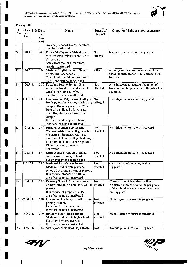
Independent Review and Consolidation of EIA, EMP & RAP for Lucknow - Ayodhya Section of NH 28 and Gorakhpur BypassConsolidated Environmental Impact Assessment Report
Package lll
Si Chain Side Dista Name Status of Mitigation/ Enhance ment measuresNo. age nce Impact
(km) C(L
* Outside proposed ROW, thereforeremains unaffected.
79. 120.2 L 80.0 Purva Madhyamik Vidyalaya: Not No mitigation measure is suggested* Medium sized private school up to affected
8"' standard.Away from the road, therefore,remains unaffected.
W 80. 120.6 R 8.0 Modern English School: Small Affected As mitigation measure relocation of theprivate primary school. school though proper R & R measure willThe school is within of proposed be done.
__ - ROW, and will be demolished.
81. 120.8 R 28.0 Faizabad Public School: Big Not As enhancement measure plantation ofschool enclosed in boundary wall. affected trees around the periphery of the school isOutside of proposed ROW, suggested.
*____ ____ therefore, remains unaffected.
82. 121.45 L 28.0 Government Polytechnic College: Not No mitigation measure is suggested.Boy's polytechnic college inside big affectedcampus. Boundary wall is at 28mfrom C/L, college building is at50m. Big playground inside thecampus.I It is outside of proposed ROW,
____ therefore, remains unaffected.83. 121.8 R 27.0 Rajkiya Women Polytechnic: Not No mitigation measure is suggestedI Women polytechnic college inside affected
big campus. Boundary wall is at27m from C/L and college buildingis at 45m. It is outside of proposed
* ROW, therefore, remainsunaffected.
84. 121.9 L 80 Little Angel's School: Medium Not No mitigation measure is suggestedI __ sized private primary school. affectedl___ Far away from the project road85. 122.2' R 28.0 National Brain's Academy: Not Construction of boundary wall is
Medium sized private primary affected suggested.! * school. No boundary wall is present.
It is outside proposed of ROW,Itherefore, remains unaffected. II 86. 1.900 R 35.0 Primary School: Small government Not Construction of boundary wall andprimary school. No boundary wall is affected plantation of trees around the peripherypresent. of the school as enhancement measuresIt is outside of proposed ROW, are suggested.
* therefore, remains unaffected.87. 2.800 L 500 Grammar Academy: Small private Not No mitigation measure is suggested
primary school. affectedI Far away from project road,therefore, remains unaffected
88. 3.000 R 300 Brilliant Rose High School: Not No mitigation measure is suggestedMedium sized private high school. affected1 Far away from project road,therefore, remains unaffected1 89. 4.800 L 33.0 Smt. Jyoti Memorial Boys Hostel: Not No mitigation measure is suggested
in joint venture with
l

Independent Review and Consolidation of EIA, EMP & RAP for Lucknow - Ayodhya Section of NH 28 and Gorakhpur BypassConsolidated Environmental Impact Assessment Report
Package li1
Si Chain Side Dista Name Status of Mitigation/ Enhance ment measuresNo. age nce Impact
(km) CIL
Big boys hostel. affectedIt is outside of proposed ROW,therefore remains unaffected.
90. 5.060 L 33.0 K T Public School: Medium sized Not Plantation of trees around the peripheryprivate English Medium school. affected of the school is suggested asIt is outside of proposed ROW, enhancement measure.therefore remains unaffected.I 91. 5.060 R 45.0 Luv Kush Chatravaas (Boys Not No mitigation measure is suggestedHostel): Boys hostel, boundary wall affectedis located at 30m from C/L andI building is at 60m.away from the project road,therefore, remains unaffected.
92. 5.100 L 35.0 H C J Academy: Big English Not As enhancement measure plantation ofI medium private school in big affected trees around the periphery of the schoolcampus. Boundary wall is present at is suggested35m from C/L and school building isI at 45m.It is present outside of proposedROW, therefore, remains unaffected.I 93. 7.400 L 35.0 Jai Ganesh Shiv Sagar Mahilla Not No mitigation measure is suggestedMaha Vidyalaya: Private girls affectedschool.It is present outside of proposedI ROW, therefore, remains unaffected.
94. 8.380 R 31.0 Choudhury Mahendra Singh Not Construction of boundary wall andKisan Junior High School: Small affected plantation of trees along the peripheryprivate school up to 8"' standard. No are suggested as enhancement measure.I boundary wall is present.It is outside of proposed ROW,
l ___ ______ ____ therefore, remains unaffected.
IIII
4I7y -10-
in joint venture with
I

- l- -- - - m m - m m - m m m m - m - -Independent Review and Consolidation of EIA, EMP & RAP for Lucknow - Ayodhya Section of NH 28 and Gorakhpur BypassConsolidated Environmental Impact Assessment Report
Annexure 8.6
List of Medical Amenities along the Lucknow-Ayodhya Stretch of Project Road
Si. Ch. (Km) Side Dist. Type Name Status of Village/Town Mitigation/EnhancementNo. C/L (m) Impact Measures
1. 9.950 L 22.5 Hospital A.K. Hospital: Medium sized Not Affected Chinhat Tirahaprivate hospital & diagnosticcenter. Boundary wall at 22.5mfrom C/L, main building at 28m.Outside the proposed ROW,therefore remain unaffected.
2. 10.750 L 30.0 Hospital Jeet Hospital: Small private Not Affected Chinhathospital. Building 30m from C/L.Outside the proposed ROW,therefore remain unaffected.
3. 10.900 R 17.0 Hospital Chandra Hospital: Medium sized Partially Chinhat Relocation of the affected portion withinprivate hospital with 17 beds, I Affected the space available.operation theatre. No boundarywall. Building at 17m from C/L.Front portion of the building willbe demolished for widening; theentire structure will not be affected.
4. 11.420 R 17.0 Medical Deepti Medical Centre: Medium Partially Chinhat Relocation of the affected portion withinCentre sized private hospital with 10 beds, Affected the space available.
I operation theatre. Boundary wall17m from C/L, building at 21m.Boundary wall and the front portionof the building will be affected.
5. 14.350 L 18.0 Hospital Saraswati Dental College & Partially Tewariganj Construction of new boundary wall and re-Hospital: Big private hospital with Affected turfing of the lawn.college and hostels, Boundary wallat 18m from C/L., building at 26m.Boundary wall and part of the lawnwill be affected. Main building will
-1 - o S 6 tin joint venture with 44
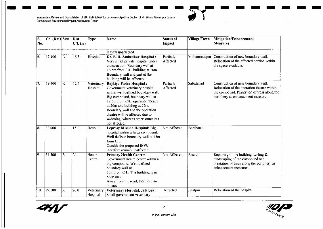
1--- -- - - - --- -- >-- - --- - -Independent Review and Consolidaton of EIA, EMP & RAP for Lucknow - Ayodhya Section of NH 28 and Gorakhpur BypassConsolidated Environmental Impact Assessment Report 0
Si. Ch. (Km) Side Dist. Type Name Status of Village/Town Mitigation/EnhancementNo. C/L (m) Impact Measures
remain unaffected.6. 17.100 L 16.5 Hospital Dr. B. R. Ambedkar Hospital: Partially Mohammadpur Construction of new boundary wall.
Very small private hospital under Affected Relocation of the affected portion withinconstruction. Boundary wall at the space available.16.5m from C/L, building at 20m.Boundary wall and part of thebuilding will be affected.
7. 19.400 R 12.5 Veterinary Rajkiya Pashu Hospital: Partially Safedabad Construction of new boundary wall.Hospital Government veterinary hospital Affected Relocation of the operation theatre within
within well defined boundary wall. the compound. Plantation of tress along theBig compound, boundary wall at periphery as enhancement measure.12.5m from C/L, operation theatreat 20m and building at 27m.Boundary wall and the operationtheatre will be affected due towidening, whereas other structuresnot affected.
8. 32.000 L 15.0 Hospital Leprosy Mission Hospital: Big Not Affected Barabankihospital within a large compound.Well defined boundary wall at 15mfrom C/L.Outside the proposed ROW,therefore remain unaffected.
9. 34.500 R 24 Health Primary Health Centre: Not Affected Rasauli Repairing of the building, turfing &Centre Government health center within a landscaping of the compound and
big compound. Well defined plantation of trees along the periphery asboundary wall at enhancement measures.50m from C/L. The building is inpoor state.Away from the road, therefore noimpact.
10. 39.100 R 26.0 Veterinary Veterinary Hospital, Jalalpur: Affected Jalalpur Relocation of the hospital.Hospital Small government veterinary
-2- VA
in joint venture with +4s

-------- --- --- ---- -m
Independent Review and Consolidation of EIA, EMP & RAP for Lucknow - Ayodhya Section of NH 28 and Gorakhpur BypassConsolidated Environmental Impact Assessment Report
Si. Ch. (Km) Side Dist. Type Name Status of Village/Town Mitigation/EnhancementNo. C/L (m) Impact Measures
hospital. No boundary wall.Building at 26m from C/L.The hospital is within the proposedROW and will be demolished.
11. 39.100 L 16.0 Health Baba Narayan Das Seva Not Affected Jalalpur Construction of boundary wall asclinic Sansthan: Small clinic cum enhancement measure.
dispensary for charitable purpose,maintained by a NGO (BabaNarayan Das Seva Sansthan). Noboundary wall. Building at 16mfrom C/L.Widening being on the oppositeside, the clinic remains unaffected.
12. 50.400 R 130 Health Primary Health Centre: Not Affected Udhauli Construction of boundary wall andCentre Government health center. No plantation of tress along the periphery as
boundary wall. Building at 130m enhancement measures.from C/L.Far away from the project road,therefore no impact.
13. 50.850 R 15 Health Naya Prathmik Swasthya Kendra Partially Udhauli Construction of new boundary wall.Centre : Government health center within Affected Plantation of trees along the periphery as
a compound. Well defined enhancement measure.boundary wall at 15.2m from C/L,building at 28.5m.Only boundary wall will beaffected due to widening, thebuilding will remain unaffected.
14. 51.000 L 50 Veterinary Veterinary Hospital: Government Not Affected Udhauli Construction of boundary wall,Hospital veterinary hospital within a big landscaping of the vacant land within the
compound. No boundary wall. compound and plantation of tress along theAway from the project road, periphery as enhancement measures.therefore no impact.
15. 57.350 L 16.5 Health Prathmik Swasthya Kendra: Partially Kotwa Sadak Construction of new boundary wall.
-3- vnuewt
in joint venture with ,

- - - - - - - - - m m - m - - m - m m m
Independent Review and Consolidation of EIA, EMP & RAP for Lucknow - Ayodhya Section of NH 28 and Gorakhpur BypassConsolidated Environmental Impact Assessment Report .
Si. Ch. (Km) Side Dist. Type Name Status of Village/Town Mitigation/EnhancementNo. C/L (m) Impact Measures
Centre Small Government health center Affectedwithin a compound. Well-constructed boundary wall at 16.5mfrom C/L, building at 27m.Only boundary wall will beaffected due to widening, thebuilding will remain unaffected
16. 58.500 L 18.5 Hospital Chandrabhan Gupt Hospital: Not Affected HathaundaMedium sized private hospital.
Well-defined boundary wall at18.5m.Widening being on the oppositeside, the hospital remainsunaffected.
17. 72.400 R 12 Hospital Manas Chikitsalaya: Small Affected Mawaii Relocation of the clinic.private clinic on the first floor. ChaurahaBuilding at 12m from C/L.
18. 120.650 L 26 Health Maternity Centre: Small Not Affected Mumtaznagar Construction of boundary wall,Centre Government maternity center landscaping of the vacant land within the
within a compound. No boundary compound and plantation of tress along thewall. Building at 26m from C/L. periphery as enhancement measures.Outside proposed ROW, thereforeremain unaffected due to widening.
FaizabadBypass
19. 3.8 F R 35 Hospital City Hospital: Medium sized Not Affected Anand Viharprivate hospital. Building at 35mfrom C/L.Outside the proposed ROW,therefore remain unaffected due towidening.
in joint venture with

Independent Review and Consolidation of EIA, EMP & RAP for Lucknow - Ayodhya Section of NH 28 and Gorakhpur BypassConsolidated Environmental Impact Assessment Report 0) L
Annexure 8.7List of Affected State Banks and their Mitigation/Enhancement Measures
Chainage Status of Impact Mitigation/Enhancement Measuresl 19.750 Affected As a mitigation measure reconstruction of New bank building
19.750 Affected ~~~is suggested.
34.370 Affected As a mitigation measure reconstruction of bank building issuggested.
82.10 Affected As a mitigation measure reconstruction of bank building is__________________ ~~suggested
87.3 Not affected No mitigation measure is suggested.l 87.32 Affected As a mitigation measure reconstruction of bank building is
87.32 Affected ~~suggested
I
II IlI
IIII
I q r ~~ ~ ~ ~~~~~~~~~~~~~~-1- cZ
in joint venture with
'I.III_