Fatimid, Ayyubid and Mamluk Jordan and the Crusader Interlude
47
Transcript of Fatimid, Ayyubid and Mamluk Jordan and the Crusader Interlude

Copyright © 2001 Sheffield Academic Press
Cover Photograph Petra, rock-cut façade of ad-Dayr
(‘the monastery’), c. AD 100 Photograph by S. Schmid
Published by Sheffield Academic Press Ltd Mansion House
19 Kingfield Road Sheffield S11 9AS
England www.SheffieldAcademicPress.com
Printed on acid-free paper in Great Britain by Bookcraft,
Midsomer Norton, Bath
British Library Cataloguing in Publication Data
A catalogue record for this book is available from the British Library
ISBN 1-84127-136-5

15. Fatimid, Ayyubid and Mamluk Jordan and the Crusader Interlude
Alan Walmsley
No longer hidden: a new archaeologicalview of middle Islamic Jordan
For over half a century archaeologists have generallyassumed that the middle Islamic period of Jordan(roughly mid-ninth to fifteenth centuries) was, on thewhole, historically inconsequential. To Jordan’s pioneerarchaeologist, G.L. Harding, it was a prolonged periodof depressing decline:
In the ninth century ad the conquering Abbasidestransferred the capital to Baghdad, and Jordan beganto be forgotten; not being on any trade route, or pro-ducing any natural wealth, the country was left tofall into decay. But it was still of sufficient impor-tance for the Crusaders in the twelth (sic) cen-tury to occupy part of it and build castles there,the chief of which were Shobak and Karak. Afterthat its prosperity declined still further, and it was acountry of small, poor villages, scraping a bare exis-tence among the ruins of past splendour (Harding1967: 52).
For apart from a few castles, and then mostly per-ceived as Crusader constructs, there was little mon-umental architecture to report and no major sites thatcould compete with those from earlier periods—thatis, the equivalent of biblical Dhiban, Nabataean Petra,or Roman Jarash for instance.
Based more on unsubstantiated Eurocentric percep-tions than any concrete evidence, this attitude grew outof biased and unchallenged nineteenth-century atti-tudes: a belief in the true magnificence of Classical andearly Christian civilization and the ‘desolation of Islam’.Writing of the Hauran, the American explorer SelahMerrill lamented the decimation of an early Christiansociety in a historical reconstruction sounding morelike an imaginative Hollywood script than impartialscholarship: ‘The crosses and other Christian symbolswhich exist on the buildings here indicate that thehouses remain as they were left in the early centuries,when the Moslems swept away the inhabitants of thisregion, leaving the cities and the land in desolation’(Merrill 1986 [1881]: 22).
This theme of social and urban devastation in thewake of an Arab/Muslim/Bedouin invasion, embracedwith enthusiasm by Merrill apparently after readingDe Vogue (Merrill 1986 [1881]: 60-70), dominatesmuch nineteenth-century writing (Johns 1994: 1). Fewexplorers, it seems, could resist its attention-grabbingappeal; and likewise neither could many archaeolo-gists of the early twentieth century. At Jarash C.S.Fisher was oblivious to any major Islamic presence,even though there was overwhelming archaeologicalevidence (including numismatic) to the contrary. Fromthis point the belief in the collapse of civilization withthe ‘Arab conquest’ easily entered popular literature,for instance the frequently reprinted Pleasure of Ruinsby Rose Macaulay:
Entering someArabvillage of squalidhovels,we are ina Roman colony, among temple columns, triumphalarches, traces of theatres and baths which no one hashad the intellect or the cleanliness to use since theArabs expelled the civilized Graeco-Roman-Syrianinhabitants and squatted among their broken monu-ments, stabling their horse in the nave of a Christianbasilica, their camels in a richly carved pagan temple(Macaulay and Beny 1977 [1953]).
Clearly it was going to be difficult to discard this biased,indeed bigoted, viewpoint and allow for the appropriaterecognition of middle Islamic Jordan.
The concept of Muslim ‘thundering hoards’ wasfinally superseded in the academic world (but not,unfortunately, in popular belief) by a new and more rea-soned theory on the socio-urban collapse of late antiqueJordan. This argued for the continuation of urban com-munities (mostly Christian) after the Islamic Conquest,but their dispersion in the mid-eighth century due toa combination of natural factors (notably earthquakes)and the relocation of the capital of the Islamic empirefrom Damascus to Iraq. This was the chronology forthe breakdown of urban society in Jordan presentedin brief by Harding in his seminal Antiquities of Jordan(above). Only with the fall of the Umayyads, it wasnow believed, did Jordan become politically inconse-quential and a cultural backwater. Another change sawa developing awareness of widespread rural settlement
515

Alan Walmsley
in Mamluk times, seen in some way as connected tothe active market economy of Mamluk Egypt and thesugar industry. This view, however, did not allow for amajor urban component in the settlement of MamlukJordan.
Archaeological research of the 1970s and 1980slargely bypassed the middle Islamic period, with afew notable exceptions. Consequently there was lit-tle motive or information to question prevailing ideas,and Harding’s explanation for the supposed social andurban disintegration of Islamic Jordan developed, bydefault, into a three-stage model. It presented a mostgloomy scenario.
Stage 1: urban collapse and rural depopulation
It was widely accepted that by the Fatimid period theabsence of strong central government after the fall ofthe Umayyads had precipitated a rapid collapse of theurban infrastructure and growing political chaos. Thishad opened up the region to predatory Bedouin incur-sions, resulting in rural depopulation and economicrecession, especially in the south. The ‘desert’ had wonat the expense of the ‘sown’.
Stage 2: crusader reassertion
In the twelfth century the Crusaders re-imposed cen-tral authority over south Jordan, constructing imposingcastles at ash-Shawbak, Wadi Musa and, later, al-Karakin particular. This resulted in an improvement in thelevel of rural settlement. As a zone of conflict, how-ever, the north was sparsely populated except for mili-tary outposts of both sides, notably the castles at ‘Ajlunand as-Salt.
Stage 3: mamluk revival
The expulsion of the Crusaders after the Battle ofHattin (1187) and the eventual reunification of greaterSyria (Bilad ash-Sham) with Egypt under the Mam-luks in the late thirteenth century heralded a new eraof moderate prosperity based on a rejuvenated ruraleconomy, especially a flourishing sugar industry in thetropical climate of the Jordan Valley. The widespreadoccurrence of brightly coloured glazed pottery on thesurface of many sites in Jordan attests, it is oftensuggested, a population increase due to stable adminis-tration until the invasion of ash-Sham by Timur-Leng
and growing political division and economic impover-ishment at the onset of the fifteenth century.
This three-stage model was convenient, seeminglyauthoritative, and popular, especially as it dealt quicklywith a bothersome period of little concern to archae-ologists whose primary interest (and that of their fund-ing bodies) was biblical, Classical and early ChristianJordan. Reflections of this model have emerged, unwit-tingly it seems, in overviews of the settlement historyof many sites, for instance Pella (Smith 1973; Smithand Day 1989) and Hisban (LaBianca 1990; but notethe review by McQuitty 1993), and also in more gen-eral accounts of Islamic history (for instance Kennedy1986: 293).
It is unlikely that many contemporary archaeol-ogists would be brave enough to offer such a sim-plistic scenario for middle Islamic Jordan, especiallyas single-cause explanations for social transforma-tions in the early Islamic period have been effectivelydiscarded in the last few years. In a recent reviewBienkowski wisely adopted a neutral stance, althoughmention was made of the Mamluk revival and subse-quent decline (Bienkowski 1991: 28). A major con-cern of this chapter is to challenge the three-stagemodel outlined above by drawing upon available tex-tual and archaeological data. Recent archaeologicalwork has gone some way to reassessing the charac-ter and extent of Fatimid, Seljuq, Crusader, Ayyubidand Mamluk settlement in Jordan, although these peri-ods are grossly underrepresented in current research.Significant contributions have been made by, amongothers, Brown (1984, 1992), Johns (1992, 1994),Kareem (1993), Lenzen and Knauf (1987), Schick(1997) and Whitcomb (1995a, 1997b), while theauthor has researched Fatimid and Mamluk Jordan(Walmsley 1987, 1992b). The objective is to depict asociety in the throes of major cultural and economictransformations that saw it progressively integrated, inuneven stages, into the Arab-Muslim world of Egyptand ash-Sham, perhaps in such a manner and to such anextent that it became almost imperceptible to modernresearch. Yet it can be confidently maintained that themajor centres and the rural population—agriculturaland pastoral—can be identified through textual andarchaeological sources. The assumed hiatus in thesettlement history of middle Islamic Jordan can nowbe sufficiently filled so as to seriously question thatassumption, and permanently consign to the rub-bish bin the eighteenth–nineteenth-century European‘romance’ of a Bedouin influx at the expense of urbanand settled life.
516

Fatimid, Ayyubid and Mamluk Jordan and the Crusader Interlude
Between history and archaeology:the contribution of written sources
The failure of past scholarship
Past scholarship has, with only rare exceptions, shownscant interest in promoting the archaeological studyof the post-antique world in the east Mediterranean(Whitcomb 1995a: 496). Archaeology ‘properly’ termi-nated with the Islamic Conquest, or even earlier withConstantine’s empire; the Middle Ages belonged to his-torical studies and art history. One major reason forthe poor showing of Islamic archaeology in Jordan wasthe obvious discrepancy between the few archaeolog-ical reports available and written sources—historical,biographical and geographical. While the sources men-tioned towns and an active rural sector, archaeolo-gists reported urban decline and a depopulation ofthe countryside. It comes as no surprise, therefore,that Islamic historians have happily ignored obviouslyflawed archaeological results.
This rather pessimistic picture has changed in thelast 10 years, mostly through the actions of a hand-ful of archaeologists. It would now be inconceivableto consider the progress of archaeological researchinto Fatimid, Seljuq, Crusader, Ayyubid and MamlukJordan without reference to written material, espe-cially the detailed works of geographers and trav-ellers. The information preserved in these sources willserve as a starting point for this study, and offers aninformative complement to the archaeological studiesavailable.
The historical view
Since the time of Ahmad Ibn Tulun (d. A.H. 270/ad 84), if not long before, most of Bilad ash-Shamcame within the political and cultural orbit of Egypt,and the extension of Fatimid control over ash-Shamin 359/970 represented a straightforward historicalcontinuation of this arrangement. Control extendedto the region east of the Jordan Rift Valley throughgarrisons and tribal alliances, and it seems that theregion played a continuous role in the social andeconomic life of Fatimid Palestine-Jordan. This isparticularly apparent from the detailed account ofthe geographer al-Maqdisi (al-Muqaddasi, d. 1000),a native of Jerusalem (Bayt al-Maqdis) who wroteabout 985 (Muqaddasi [al-Maqdisi] 1994). Accord-ing to al-Maqdisi, the area of Jordan north of Wadiaz-Zarqa’, called Jabal Jarash, was included in the
Figure 15.1. The geo-political features of tenth-century Jordan,based on the account of the Arab geographeral-Maqdisi.
district of al-Urdunn and had Adhri‘at (Dar‘a) as itschief town (Figure 15.1). The area was populatedwith many villages and produced olives, various fruitsincluding grapes, and honey. This agricultural produc-tivity was such, reports al-Maqdisi, that it contributedto the wealth of Tabariyah (Tiberias), al-Urdunn’s capi-tal. Between Wadi az-Zarqa’ and Wadi al-Mujib was theal-Balqa’ area, which belonged to the district of Filastin(Palestine). Around its principal town of ‘Amman werevillages, farms, grain-fields, mills and flocks, and nearbywas ar-Raqim where pilgrims could visit the Cave ofthe Sleepers. Perhaps the most interesting aspect ofal-Maqdisi’s account is his identification of a separate
517

Alan Walmsley
district south of Wadi al-Mujib called ash-Sharah. Thecapital was located at Sughar (Zughar, Zoar) in theGhawr as-Safi, south of the Dead Sea, and had sixother townships including Ma’ab (Rabbah, Areopolis),Mu‘an (Ma‘an), Udhruh and Waylah (Ayla, Aila).Ma’ab, the principal town in the mountains, had manyproductive villages and the holy site of Mu’tah with thetombs of the Prophet’s companions. Ayla and Zughar,strategically located at either end of Wadi ‘Arabah, werethriving commercial centres. The well-populated RedSea port of Ayla served Filastin and the Hijaz, withroads heading northwards to ar-Ramlah (six marches)and Zughar (four marches). From Zughar, roads contin-uedonto Jerusalem,Nablus, and ‘Amman (Figure 15.2).Another important road described by al-Maqdisi wasthe Hajj or pilgrimage route from Damascus. Thispassed through Adhri‘at and az-Zarqa’ to ‘Amman,which was a major assembly place for pilgrims fromPalestine, and continued south by way of two water-ing stops to Mu‘an and then Tabuk, three stopslater.
From al-Maqdisi’s account it is difficult to avoidthe conclusion that Fatimid Jordan supported a mini-mum of eight major population centres (and probablymore; Maqdisi’s description appears incomplete espe-cially for north Jordan) through an active rural econ-omy and considerable inter- and intra-regional trade.In particular, southern Jordan came to benefit from therevival of the Red Sea trade routes under the Fatimidcaliphs of Egypt, which found expression in the politicalevents of the later tenth and early eleventh centurieswhen the tribal shaykhs of south Palestine and Jordanplayed an active, and sometimes counter-productive,role in the affairs of Filastin, either as allies of orrivals to Fatimid domination (Kennedy 1991: 307,320-40). Facing often formidable opposition, the Jar-rahids’ strength lay in a stable and prosperous basein ash-Sharah and the northern Hijaz, held througha number of strongholds including al-Karak (Schick1997).
Following the imposition of Seljuq control over Biladash-Sham (1071–79), the Arabic sources continued torefer to the old districts of al-Balqa’, Ma’ab, al- Jibal andash-Sharah, but within these districts political powerhad already shifted to other population centres, par-ticularly Wadi Musa (for Sharah) and al- Karak (forMa’ab). Accordingly, Crusader sources identify WadiMusa, ancient Petra (McKenzie 1991), as the principalobject of military activity south of the Dead Sea duringthe first quarter of the twelfth century (Schick 1997).The first expedition took place in 1100 when Baldwin
Figure 15.2. The pilgrimage route (divided line) and other majorroads of Jordan in the tenth and eleventh centuries.
I (r. 1100–18) led a campaign across the Jordan, reach-ing Wadi Musa by way of Zughar south of the Dead Sea(Figure 15.3), causing the (Muslim) inhabitants of bothlocalities to flee. After staying three days and visitingthe monastery of St Aaron on Jabal Harun, Baldwinreturned to Jerusalem by the same route (Fulcher ofChartres 1969: 145- 47; William of Tyre 1976 [1941]-a:427). Another campaign to Wadi Musa was undertakenin 1106–1107. This succeeded in evicting a Seljuqforce under al-Ispahbad sent from Damascus to regaincontrol over ash-Sharah, al-Jibal, Ma’ab and al-Balqa’,after which Baldwin returned to Jerusalem by a routenorth of the Dead Sea. Together al-Ispahbad’s mission,
518

Fatimid, Ayyubid and Mamluk Jordan and the Crusader Interlude
Figure 15.3. Crusader holdings in Jordan in the twelfth century.
Baldwin’s response and his return route indicate theconsiderable spread of Crusader control as far north asal-Balqa’. Also in the same year, the Crusaders cam-paigned in the Sawad (Crusader Terre de Suete, essen-tially the Jawlan and north Jordanian plains) and JabalAwf (the ‘Ajlun district), thereby gaining (or regain-ing) a measure of control over north Jordan. This defacto situation was soon formalized by the signing ofshare agreements with Tughtigin, Atabeg of Damascus,in 1109 and 1111. The agreements covered nearly allJordan, from the Sawad to ash-Sharah in the south,although the status of ‘Amman and al-Balqa’ is unclear(Ibn al-Qalanisi 1967 [1932]: 74-75, 81-82, 92, 113;William of Tyre 1976 [1941]-a: 429-30, 1976 [1941]-b:470). The agreements show that at the time of thearrival of the Crusaders (and presumably before) Jordanwas under the jurisdiction of the atabeg of Damascus,
but that by 1111 the Crusaders under Baldwin haddeeply penetrated this territory and established a per-manent presence, probably with the tacit support ofsections of the local Christian population.
The Latin kings of Jerusalem now set about con-solidating their control over Jordan, and were partic-ularly successful in the south. In 1115 Baldwin builta castle at ash-Shawbak, which he named Krak deMontreal (Fulcher of Chartres 1969: 215; Kennedy1994: 23-25; William of Tyre 1976 [1941]-a: 506-507).This ensured Crusader domination of ash-Sharah, theSyria Sobal and Arabia Tertia of the Crusader sources(earlier in 1105 Baldwin had failed in a similar attemptto secure the Sawad). In the following year Baldwinextended control as far as Ayla (al-‘Aqaba) on the RedSea (Fulcher of Chartres 1969: 215-16; William of Tyre1976 [1941]-a: 513), occupying or possibly building afortress there. At about this time Christians from otherpresumably less protected regions (perhaps al-Balqa’and the Jarash region) were encouraged to migrateand settle in Jerusalem (William of Tyre 1976 [1941]-a:507-508). Soon after (in 1120), Tughtigin built a castleat Jarash to enforce his interests in Jabal Awf, but thiswas destroyed in the following year by a Crusader raidunder Baldwin II (r. 1118–31). Fulcher (d. 1127) is theprincipal source on the castle:
The inhabitants of the area called this fortress Jarash.It was inside a city wondrously and gloriously built inancient times on a strong site. The castle was built oflarge squared stones. But when the king consideredthat he had taken the place with difficulty and that itwould be hard to provide it with the necessary menand provisions, he ordered the castle destroyed andall his men to return home (Fulcher of Chartres 1969:235; see also William of Tyre 1976 [1941]-a: 538-39).
In the south, control of the strategically located set-tlement of Wadi Musa was not without its problemsfor the Latin kings. Baldwin II suppressed a revoltthere in 1127 (Ibn al-Qalanisi 1967 [1932]: 182), and,although fortified and garrisoned with a formidable cas-tle (Li Vaux Moise, al-Wu‘ayra, built by 1115–16), thetown again rebelled against Crusader domination in1144. The townsfolk managed to capture the castlewith the help of a small Seljuq force (William of Tyre1976 [1941]-b: 144-45), but the youthful Baldwin III (r.1143–62) besieged and eventually captured the fortressthrough brutal economic warfare. Perhaps at this timethe Crusader outpost at al-Habis in the heart of ancientPetra was erected to monitor the activities of thecave-dwelling Arabs and the Wadi ‘Arabah routes. Toboost Crusader domination over south Jordan another
519

Alan Walmsley
castle, this time on a massive scale, was constructed in1142 at al-Karak in Ma’ab (Crusader Arabia Secunda,William of Tyre 1976 [1941]-b: 127). This site, the for-mer Jarrahid stronghold (above), was endowed withformidable natural defences and controlled the prof-itable Dead Sea routes. The move completed Crusaderdomination over the fertile wheat-growing and pastorallands south of the strategic Wadi al-Mujib and heraldedthe establishment of the great Lordship of Oultrejour-dain based at al-Karak.
While providing a clear outline of Crusader activ-ity in Jordan, the Latin sources also preserve a valu-able glimpse of socio-economic conditions in theearly twelfth century. Dates grew at Zughar, villageslined the route to Wadi Musa, itself a valley ‘veryrich in the fruits of the earth’ with ‘luxuriant olivegroves which shaded the surface of the land like adense forest’ and mills on its streams, while aroundash-Shawbak was ‘fertile soil, which produces abun-dant supplies of grain, wine, and oil’. In other areaswere ‘many Christians living in villages’ who left forJerusalem with their ‘flocks and herds’, while camelsand asses were common booty from raids (Fulcher ofChartres 1969: 146-47; William of Tyre 1976 [1941]-a:506-508; 1976 [1941]-b: 145). Although only scatteredreferences, Fulcher and William nevertheless depictJordan as having a mixed settled and nomadic pop-ulation actively engaged in agricultural and pastoralpursuits.
The Crusader presence east of the Jordan wasshort-lived, for Oultrejourdain including the still dis-puted lands in the north were all lost in the secondhalf of the twelfth century through the actions of Nurad-Din (d. 1174) and the famous Salah ad-Din b.Ayyub or Saladin (d. 1193). Unlike the fortified south,Crusader claims over north Jordan were always weak,consisting of an agreement to share the crops (wine,grain, olives) and revenues with the rulers of Damascus.This could only last as long as the Damascus atabegsagreed, and Nur ad-Din—who gained control of Dam-ascus in 1154—certainly did not. Continuing the jihadagainst the Franks begun by his father Zangi, atabegof Aleppo and Mosul (d. 1146), Nur ad-Din besiegedthe Crusader outpost of al-Habis Jaldak on the southbank of Wadi Yarmuk, but after battle with Baldwin IIIretreated to Damascus (1158). Towards the end of hisrule, Nur ad-Din, with the ambiguous support of Salahad-Din (at this point governor of Egypt), penetratedOultrejourdain with the intention to take al-Karakand ash-Shawbak, but without success. Salah ad-Dinreturned in 1173, causing ‘everything found outside
the fortresses to be burned, bushes and vines to be cutdown, and villages to be destroyed’ (William of Tyre1976 [1941]-b: 272-73, 387-90, 470).
The real losses, however, came with the rise of Salahad-Din, and culminated in the decisive Muslim vic-tory at Hattin in northern Palestine (1187). Althoughit took Salah ad-Din 12 years after the death of Nurad-Din to effect the political unification of Syria andEgypt, he was active during much of this period. In1182 he encamped at Jarba and conducted raids aroundash-Shawbak before continuing to Damascus, whileother Muslim forces took al-Habis Jaldak, only to loseit a few months later. In 1183 and 1184 al-Karak wasbesieged for months on end, and although the castlewithstood Salah ad-Din’s armies the lower town waslooted with great loss of property: ‘all their house-hold possessions, all their furniture and utensils ofevery quote, were seized by the enemy’ (Ibn Jubayr1952: 301, 311, 313-14; William of Tyre 1976 [1941]-b:467-72, 482-85, 498-504). The brutish and rash lordof Oultrejourdain, Reynald de Chatillon (r. 1177–87),attracted Salah ad-Din’s rage by raiding the pilgrim-age routes from Damascus and Cairo, attempting toattack the holy sites of Makkah and Madinah, andhis barbarous treatment of prisoners (Maalouf 1984:186-88). Once Salah ad-Din had brought Syria andEgypt under his control (1183), he was able to drawon vast resources to oppose the Latin Kingdom. In thefollowing year he entered Crusader territory north ofTabariyah (Tiberias) and took the town. The Crusadersresponded and, as was their practice, brought togetherall available manpower to repel the Muslim force. Inthe resulting battle (July 1187) the Crusader force wastotally defeated with great loss of life. Of the capturedleaders, Salah ad-Din’s greatest wrath was reserved for‘the most malicious, evil and treacherous’ Reynald,who was promptly executed (Holt 1986; Maalouf 1984:190-94). The Crusader disaster at Hattin left Oultre-jourdain, as with the whole Latin Kingdom, largelyundefended, so in 1188 al-Karak and ash-Shawbakcapitulated with little resistance to al-‘Adil (d. 1218),Salah ad-Din’s brother and his viceregent in Egypt. By1193, the year of Salah ad-Din’s death, the Arabicsources reveal that Jordan was divided between twoadministrations. The area south of Wadi az-Zarqa’,including as-Salt and al-Balqa’, was governed fromEgypt by al-‘Aziz Uthman, one of Salah ad-Din’s sons,while Jabal Awf (‘Ajlun) and the Sawad in northJordan belonged to al-Afdal ‘Ali, Salah ad-Din’s eldestson based in Damascus (Humphreys 1977: 63-64,75-77, 83).
520

Fatimid, Ayyubid and Mamluk Jordan and the Crusader Interlude
For the remainder of the Ayyubid period (to 1263in Jordan) and in the subsequent Mamluk period(1263–1517) Jordan and its castles, of both Crusaderand Muslim origin, continued to play a leading rolein the political and social history of Egypt and Biladash-Sham. In addition to the existing Crusader con-structs in south Jordan, Muslim castles were built at‘Ajlun (between 1188 and 1192), al-Azraq (1236–37)and as-Salt (1220), which had become the chief townof al-Balqa’. These were intended to oversee com-munication routes and the local population, beingbuilt after the Crusader threat to Jordan had beenlargely neutralized. Most frequently mentioned in theAyyubid-Mamluk historical sources was the immenselystrong and strategically located castle of al-Karak (seein general Humphreys 1977; Irwin 1986; Thorau 1987[1992]: esp. 134-41). As in earlier times, this castlecontrolled the Red Sea–Wadi ‘Arabah trade routesto the west and the Hajj road from Damascus tothe east, but most significantly it dominated move-ment between Cairo and Damascus, while the Cru-saders continued to hold sections of coastal Palestine.For a while in the mid-thirteenth century al-Karakremained independent of both Damascus and Cairo,becoming particularly active in political affairs underthe Ayyubid prince al-Mughith Umar (d. c. 1264),the great grandson of al-‘Adil. Although al-Mughithbacked Baybars during the turbulent first decade of theMamluk sultanate (1250–60), soon the essentially cen-tralized nature of the Syro-Egyptian Mamluk adminis-tration as constituted by Baybars (r. 1260–77) could notallow an independent-acting al-Karak, and al-Mughithwas treacherously deposed by his former confederate(1263). Al-Karak, with ash-Shawbak, now became oneof six Syrian provinces, but it often served as a distantoutpost of Egypt, a place of refuge, exile and sometimesrebellion. Its most celebrated residents, willing or not,were:
• as-Sa‘id Muhammad Baraka Khan (d. 1280), thedeposed son of Baybars, along with his brothersand the queen-mother (in al-Karak 1279-96);
• an-Nasir Muhammad (d. 1341) on two occasions,firstly as a child (1297–99) then in 1309–10 in asuccessful ploy to regain the sultanate;
• an-Nasir Ahmad (d. 1344), son of an-NasirMuhammad who grew up in al-Karak and, afterbecoming sultan, removed himself and much ofthe treasury back there before being deposed(1342). Seven campaigns were required before al-Karak was taken and an-Nasir Ahmad captured;
• Barkuk (d. 1399), the first of the CircassianMamluk sultans, who gained support while exiledin al-Karak during 1389–90 to reclaim thesultanate.
Geographical works and the journals of travellersoffer a particularly valuable source of information onsocio-economic conditions in Ayyubid and MamlukJordan. There is much material from the thirteenthto fifteenth centuries: the encyclopaedic work of Yaqut(d. 1229) with numerous and often extensive entrieson places and regions arranged alphabetically, thegeography of Dimashqi (d. c. 1327), a sometimes con-fusing mixture of brief first-hand and copied accounts,also that of Abu ’l-Fida (d. 1331) extensively drawnfrom personal observations, the travelogue of IbnBattuta (d. 1377) and al-Qalqashandi’s authoritativeencyclopaedic work (d. 1418). In these works aredescribed the administrative divisions, places and local-ities in Jordan, although the quality and detail ofthe accounts vary considerably. The mostly originalfourteenth- and fifteenth-century works emphasize thecastle towns (especially al-Karak, ash-Shawbak and‘Ajlun), holy sites (Mu’tah/Mazar, Amata, ar-Raqim)and the stopping points along the pilgrimage routebetween Damascus and the Hijaz. The evidence fromthe written sources suggests that these three settlementtypes dominated Mamluk Jordan. The sources alsopay attention to the vibrant rural economy in whichpastoral industries and agriculture, both subsistenceand cash crops, played an equally important role.
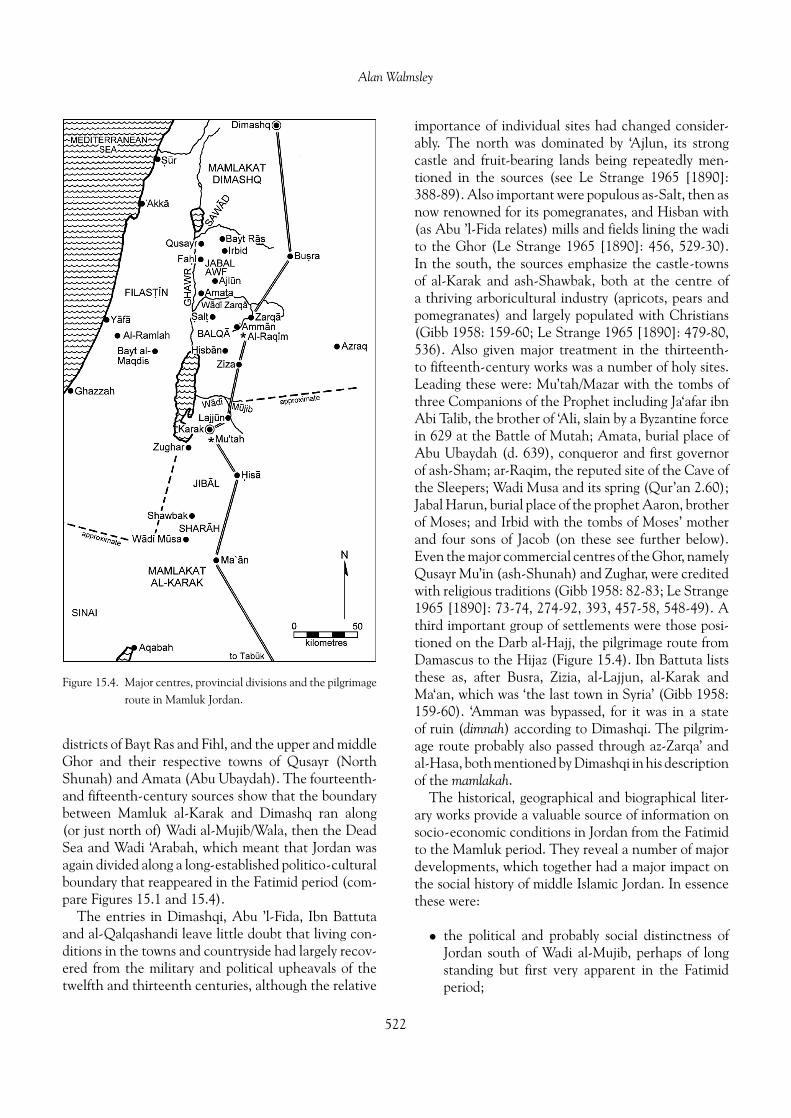
Jordan in the Mamluk period was divided betweentwo administrative divisions called mamlakah, ‘king-doms’: al-Karak and Damascus. As in Ayyubid times,much of Jordan was administered from al-Karak.The Mamlakat al-Karak included the castle-towns ofal-Karak and ash-Shawbak, and extended northwardsto Zizia (al-Jiza), westwards to include Zughar, Wadi‘Arabah and the Sinai peninsula, and into the northernHijaz (Figure 15.4). Other places mentioned includeMa‘an, Mutah, al-Lajjun, al-Hasa and Wadi Musa,plus the districts of al-Jibal and ash-Sharah. WhileDimashqi also placed ‘Amman, as-Salt, az-Zarqa’,al-Azraq and the Balqa’ in the Mamlakat al-Karak,this probably reflected the earlier Ayyubid struc-ture. He again lists the Balqa’ and the towns ofas-Salt, ‘Amman and az-Zarqa’ as part of the Mam-lakat Dimashq, adding Hisban (which was the capi-tal of the Balqa’, according to Abu ’l-Fida). Certainlyincluded in Dimashq were Jabal Awf, the district ofJarash with its castle-town of ‘Ajlun, the Sawad, the
521
Alan Walmsley
Figure 15.4. Major centres, provincial divisions and the pilgrimageroute in Mamluk Jordan.
districts of Bayt Ras and Fihl, and the upper and middleGhor and their respective towns of Qusayr (NorthShunah) and Amata (Abu Ubaydah). The fourteenth-and fifteenth-century sources show that the boundarybetween Mamluk al-Karak and Dimashq ran along(or just north of) Wadi al-Mujib/Wala, then the DeadSea and Wadi ‘Arabah, which meant that Jordan wasagain divided along a long-established politico-culturalboundary that reappeared in the Fatimid period (com-pare Figures 15.1 and 15.4).
The entries in Dimashqi, Abu ’l-Fida, Ibn Battutaand al-Qalqashandi leave little doubt that living con-ditions in the towns and countryside had largely recov-ered from the military and political upheavals of thetwelfth and thirteenth centuries, although the relative
importance of individual sites had changed consider-ably. The north was dominated by ‘Ajlun, its strongcastle and fruit-bearing lands being repeatedly men-tioned in the sources (see Le Strange 1965 [1890]:388-89). Also important were populous as-Salt, then asnow renowned for its pomegranates, and Hisban with(as Abu ’l-Fida relates) mills and fields lining the wadito the Ghor (Le Strange 1965 [1890]: 456, 529-30).In the south, the sources emphasize the castle-townsof al-Karak and ash-Shawbak, both at the centre ofa thriving arboricultural industry (apricots, pears andpomegranates) and largely populated with Christians(Gibb 1958: 159-60; Le Strange 1965 [1890]: 479-80,536). Also given major treatment in the thirteenth-to fifteenth-century works was a number of holy sites.Leading these were: Mu’tah/Mazar with the tombs ofthree Companions of the Prophet including Ja‘afar ibnAbi Talib, the brother of ‘Ali, slain by a Byzantine forcein 629 at the Battle of Mutah; Amata, burial place ofAbu Ubaydah (d. 639), conqueror and first governorof ash-Sham; ar-Raqim, the reputed site of the Cave ofthe Sleepers; Wadi Musa and its spring (Qur’an 2.60);Jabal Harun, burial place of the prophet Aaron, brotherof Moses; and Irbid with the tombs of Moses’ motherand four sons of Jacob (on these see further below).Even the major commercial centres of the Ghor, namelyQusayr Mu’in (ash-Shunah) and Zughar, were creditedwith religious traditions (Gibb 1958: 82-83; Le Strange1965 [1890]: 73-74, 274-92, 393, 457-58, 548-49). Athird important group of settlements were those posi-tioned on the Darb al-Hajj, the pilgrimage route fromDamascus to the Hijaz (Figure 15.4). Ibn Battuta liststhese as, after Busra, Zizia, al-Lajjun, al-Karak andMa‘an, which was ‘the last town in Syria’ (Gibb 1958:159-60). ‘Amman was bypassed, for it was in a stateof ruin (dimnah) according to Dimashqi. The pilgrim-age route probably also passed through az-Zarqa’ andal-Hasa, both mentioned by Dimashqi in his descriptionof the mamlakah.
The historical, geographical and biographical liter-ary works provide a valuable source of information onsocio-economic conditions in Jordan from the Fatimidto the Mamluk period. They reveal a number of majordevelopments, which together had a major impact onthe social history of middle Islamic Jordan. In essencethese were:
• the political and probably social distinctness ofJordan south of Wadi al-Mujib, perhaps of longstanding but first very apparent in the Fatimidperiod;
522
Fatimid, Ayyubid and Mamluk Jordan and the Crusader Interlude
• the dynamic economy of Fatimid Jordan,embracing agriculture and arboriculture, pastoralindustries, and trade and commerce;
• the geographical extent of Crusader control overmuch of Jordan, which was achieved by treaty(for the north) or direct rule (the lordship ofOultrejourdain) south of Wadi al-Mujib/Walacatchment;
• a permanent shift in settlement from sites alongthe badia fringe (e.g. ‘Amman, Ma’ab) to a lineof defensive sites (e.g. al-Karak, ‘Ajlun) onhigh points along the Jordan Valley scarp. Thisdevelopment first appeared in the Fatimid periodbut intensified in Crusader and Ayyubid times.A parallel development is the greater importanceof Holy Places (e.g. Mu’tah, ar-Raqim, AbuUbaydah), again beginning in the Fatimid periodbut increasing in Ayyubid and Mamluk times;
• the social and economic reconstruction of Jordanafter the Crusader experience, concentratingon arboriculture and commercial crops such assugar.
Site settlement: an archaeological survey
The archaeology of tenth- to sixteenth-century Jordanis beset with difficulties, for the paucity of researchmeans that there is no established starting point andthe quality of data is patchy. Few excavations havebeen undertaken with the specific purpose of inves-tigating the nature and extent of site occupation, andlittle attention has been paid to determining the range,characteristics and development of material culturein middle Islamic Jordan. Likewise, regional surveyshave frequently cursorily, sometimes recklessly, treatedthe usually abundant architectural and ceramic evi-dence for the occupation of sites in the Islamic peri-ods, and a disinterested attitude to the middle Islamicperiods has introduced considerable distortion to set-tlement profiles as a result. Archaeologically, Fatimidand Seljuq Jordan are almost invisible, the twelfth cen-tury solely evidenced by Crusader and Muslim castles,while Ayyubid and Mamluk Jordan (the two periods,covering 250 years, are commonly clumped together)are typified by the many small village sites identified inregional surveys.
Due to this haphazard approach, it becomes exceed-ingly difficult to build up an archaeological profilethat faithfully represents the full extent of social andeconomic life in the formative middle Islamic period.
Inevitably, then, given the current state of research,this study ends up concentrating on the architecturalfeatures of surviving monuments—predominantly cas-tles, mosques and shrines—and on the distributionof mostly poorly recorded village and hamlet siteslocated by regional surveys. Only a scattering ofmiddle Islamic sites, large and small, has been exca-vated (and then usually unintentionally) and littleresearch has been done on urban sites, many ofwhich are the major towns of modern Jordan. Theabsence of reliable, well-contexted and sufficientlyextensive archaeological data imposes considerablelimitations on its usefulness in accurately detailingthe form and development of socio-economic struc-tures and the emergence of modern Jordan out ofthe middle ages into a key player in the Middle Easttoday.
Sites of the Fatimid and Seljuq periods(tenth and eleventh centuries)
Archaeological evidence for settlement during thetenth and eleventh centuries is particularly sparse,which is at variance with al-Maqdisi’s positive accountof urban and rural conditions in the late tenth cen-tury. Only a few sites—‘Amman and Ayla (al-‘Aqaba)are the important examples—have clearly identifiedFatimid occupation levels, and then usually associatedwith structures of an earlier Islamic date. Other majorsites with reported Fatimid occupation include: Pella,Tall Abu Qa‘dan, Nimrin and Khirbat Shaykh ‘Isa inthe Rift Valley; and Hisban, Dhiban, Bayt Ras, Farisand Qam in the mountains.
At ‘Amman, excavations between 1975 and 1979 byBennett and Northedge on behalf of the Department ofAntiquities produced clear evidence for settlement onthe Citadel in the Fatimid period (eleventh century),with occupation concentrated in the Umayyad Palacecomplex and adjacent domestic structures (Northedge1992: 159). Stratum III of the excavations, datedto the eleventh century, was the last major periodof occupation on the citadel, and represented anunbroken continuation of the previous stratum (IVb,ninth–tenth centuries). In Area C, two parallel linesof squares sectioned the west slope to the Umayyadfortification wall, revealing two streets and four build-ing complexes. Although probably constructed in theAbbasid period, these buildings were substantially mod-ified in Fatimid times. Their sudden and simultane-ous destruction was perhaps due to the earthquake
523

Alan Walmsley
of 1068. Dating is provided by two coins, a dinarof al-Hakim (407/1016–17) and a worn dirham ofaz-Zahir (411-27/1021–36), the latter found embeddedin the terminal floor surface of Building 3. A sim-ilar sequence is found in Areas B and D, whereUmayyad-period houses were continuously utilized andmodified until the Stratum III destruction. In Area Bfive buildings and a street were excavated, althoughone unit (Building C) produced some evidence ofAyyubid-period reuse. The Palace also continued tobe occupied into Fatimid times but was subdividedinto smaller units; these were residential accordingto Northedge, indicating a reduced or non-officialrole for the palatial complex by the eleventh century.Most notably, the reception hall was converted into aself-contained building, which required the insertion ofa wooden roof over the central court (Northedge 1992:78, 81, 83-84, 88). The fortification wall surroundingthe upper terrace of the citadel had fallen out of uselong before the eleventh century as it had been builtover by Abbasid-Fatimid domestic structures in AreasC and D (Wood 1992: 124-25).
The archaeological evidence on the nature ofFatimid and Seljuq settlement at ‘Amman is paral-leled by the discoveries at Islamic Ayla, although therole of Ayla, which was primarily commercial, wasquite different from the political and military functionsserved by ‘Amman. At Ayla, the Fatimid and Seljuqperiods coincide with the end of the early Islamic IIand the first half of the middle Islamic I periods, asdefined by Whitcomb. In this last phase of occupation,which ended with the Crusader conquest of 1116, theoriginally Umayyad-‘Abbasid structures showed contin-ued use and modifications, although construction stan-dards were poorer. Excavations, directed by Whitcomb,of the town gates and wall towers, the Central Pavilionbuilding in the middle of the town, the Egyptian street(one of four axial roadways that led from the gatesto the Central Pavilion), the beach-side suq alongthe south wall, and the congregational mosque havedetailed an uninterrupted sequence from late Abbasidinto Fatimid times. Particularly revealing is the lateroccupation of the Pavilion Building, excavated in 1986and 1987 (Whitcomb 1988a and 1988b). Originallyset up as a public monument at the junction of Ayla’sfour axial streets, the structure in its last manifesta-tion was a well-appointed residence of eight roomsaround a central courtyard, onto which opened a deepiwan (porch). The courtyard, iwan and adjacent roomsformed the domestic nucleus of the house. In a 4.2 m2
corner room, entered from a doorway in the west wall
of the iwan, a polychrome fresco-decorated wall wasuncovered. This room and another on the east pro-duced an astounding collection of luxury and everydayceramics as well as other objects, including a dirhamof al-Hakim (996–1020). A bath, latrine and kitchenwere exposed to the north of the courtyard, while to theeast the piers of a staircase to the roof or a second storeywere identified. Entrance to the house was from EgyptStreet to the west through an anteroom, with doorwayspositioned off-axis to protect the privacy of the house-hold. Whitcomb’s excavations at Ayla have revealeddramatic evidence for a major urban dislocation in themid-eleventh century, involving ‘slumping and possiblymassive subsidence of walls and buildings of the city’and due, in all likelihood, to the powerful earthquake of1068 (Whitcomb 1995b: 505). There is no archaeolog-ical evidence for a comprehensive rebuilding programafter the earthquake, suggesting that the town neverrecovered from this major setback and hence presentedan easy target for Baldwin’s forces.
The archaeological work at ‘Amman and Aylareveals a shared trend in their urban history: a severereduction, if not end, to their political and administra-tive functions, probably in the second half of the tenthcentury but no later than the early eleventh century.The clearest evidence for the change is the usurpa-tion and conversion of public buildings into privatedwellings, notably the palace on the ‘Amman Citadeland the Central Pavilion at Ayla. While constructiontechniques were generally mediocre, levels of personalwealth were still good as illustrated by the quality andquantity of objects recovered from these structures. Asimilar downgrading of urban functions can be docu-mented for the towns of north Jordan, although the evi-dence from Fihl/Pella, Bayt Ras and Jadar suggests thatthis transformation happened more than a century ear-lier, about the middle of the ninth century (Walmsley1992a).
The evidence for Fatimid and Seljuq occupationat other sites in Jordan is patchy and undistin-guished when compared with ‘Amman and Ayla,but nevertheless suggests a settlement profile simi-lar to what probably were the two major towns intenth–eleventh-century Jordan. Bayt Ras Phase IVb,dated 900–1100, saw the continued utilization of urbanstructures including a line of vaults in Area A, thoughtto have been a market place of the Byzantine andearly Islamic town (Lenzen 1995; Lenzen and Knauf1987). During Phase IVb, the original Byzantine-periodtessellated pavement of Phase VI (300–600) wassubstituted with flagstones. However, a continuing
524

Fatimid, Ayyubid and Mamluk Jordan and the Crusader Interlude
public role for the vaults appears unlikely especiallyas the church opposite the vaults had seemingly fallenout of use in the preceding Phase V (600–900). Else-where, eleventh-century ceramics attest continuedoccupation of Bayt Ras during the Fatimid period. AtPella, the Abbasid town centre has revealed domes-tic and industrial occupation continuing into the earlyFatimid period (Walmsley 1995). Continuity of occu-pation throughout the Fatimid and Seljuq periods atZughar, modern Khirbat Shaykh ‘Isa, has been estab-lished by two surveys of the site (Whitcomb 1992a:115-17).
A continuing use of existing stone buildings andambiguous ceramic typologies for Fatimid and SeljuqJordan could well account for the absence of reportedtenth–eleventh-century occupation at other majorarchaeological sites in Jordan. Any major hiatus inoccupation at historically important sites such asHisban and Dhiban is difficult to accept. Sauer cor-rectly recognizes early Fatimid pottery at both sites(Sauer 1982: 333; on ceramics, see further below), butthe architectural evidence from the Dhiban excava-tions for Fatimid and Seljuq occupation on the tell,while tantalizing, is impossibly confused (Tushingham1972: 77-83). Also contributing to the shortage of datais the lack of excavation or publication of a number ofsites including some of the major centres mentionedin al-Maqdisi, notably Ma‘an (unexcavated), Ma’aband Udhruh (both partially excavated but not pub-lished). In other cases the substantial redevelopment ofleading eleventh-century centres in later times wouldhave largely destroyed the evidence for Fatimid andSeljuq-period settlement: al-Karak is the obvious exam-ple. Admittedly, this reasoning relies on mostly negativeevidence, but then neither does the absence of availableevidence demonstrate site abandonment. The mate-rial from ‘Amman, Ayla, Bayt Ras, Pella and Zugharsuggests a continuing settlement history into Fatimidtimes for many of the major towns of Jordan, althoughtheir politico-administrative and hence urban role wasconsiderably diminished or even extinguished duringthe ninth and tenth centuries.
Fatimid and Seljuq occupation at other sites is notwidely reported, although there are some notable exam-ples, especially in the Jordan Valley. Soundings at TallAbu Qa‘dan (Gourdan), next to Tall Dayr ‘Alla, pro-duced 19 phases (A to T, omitting I), all of Islamicdate (Franken and Kalsbeek 1975). The soundingscame across a long sequence of courtyard surfacesover mudbrick collapse but few other features. Unlikethe other sites considered so far, the buildings at Tall
Abu Qa‘dan were of mudbrick, and, as they had amuch shorter life, a more representative early to middleIslamic sequence has been preserved. Chronology, how-ever, is a problem, as dating the finds (mostly ceramics)was not the purpose of the excavations and no firmdating evidence (namely coins) was found. A reinter-pretation of the pottery (in progress) indicates that,while Phase A is possibly eighth-century Umayyad,the sequence properly begins with the early Abbasidperiod (B-C = ninth century) and continues with lateAbbasid and early Fatimid occupation (Phases D-G= tenth–eleventh centuries). The stratigraphic andpottery evidence very strongly suggests that the major‘destruction’ at the end of Phase E can be equated withthe end of the Abbasid town centre at Pella, maybeearly in the Fatimid period. If so, Phases F and G wouldbe firmly Fatimid, and specifically of eleventh-centurydate. Phases H-T continue the sequence into the Ayyu-bid and Mamluk periods, making eight centuries ofsettlement that, contrary to the view of Franken andKalsbeek, would not allow for any significant gap insite occupation. A similar picture emerges from theimportant excavations at Tall Qudsiyah, 15 km southof North Shuna in the north Jordan Valley (Kareem1987: 92-123). Again, the main building material wasmudbrick, and by trimming bulldozer cuttings andexcavating soundings Kareem has identified a majorunbroken sequence extending from late antiquity tothe Ottoman period. The Fatimid levels, consisting ofash, soil and mudbrick layers (courtyards?), were datedby lustre and other glazed wares and also decoratedcream wares.
In the mountains, the use of stone as the pri-mary building material has resulted in evanes-cent Fatimid remains, yet the identification ofeleventh–twelfth-century levels has not been animpossible obstacle for problem-driven projects suchas Khirbat Faris (Johns et al. 1989; McQuitty andFalkner 1993). Excavations in and around House 2have recorded the continuous use of this stone struc-ture from its construction (first century) until todaywith Stage 3, made up of a series of surfaces 60-70 cmdeep, ranging across the ninth/tenth–twelfth centuries.Interestingly, this time span was barely accounted forin the surface sherding survey, with only five out of the246 squares surveyed producing material identified asninth–twelfth centuries. The lesson is obvious, oftenstated, but bears repeating: surface collections, evenwhen correctly read, do not accurately represent eitherthe periods of settlement or extent of occupation ofa site.
525

Alan Walmsley
The Faris project demonstrates unequivocally thatlittle weight can be given to the results of regional sur-veys based upon surface collection (note the commentsof Johns 1994: 3-9). Thus the low representation ofFatimid and Seljuq occupation in many surveys, in boththe north and south of the country, reflects neither thenature nor extent of urban and rural settlement andland use in the tenth–twelfth centuries. Clearly, therewere important differences with the situation in theByzantine and Umayyad periods, but simply to stipulatea settlement ‘gap’ or site abandonment in the Fatimidand Seljuq periods based on the ‘presence/absence’ ofvery imperfectly known ceramic types (especially thoseof the middle Islamic period) avoids a fuller consid-eration of a more complex series of human land-useissues (Brown 1991: 229-32; Johns 1994; Miller 1991:19-20). A number of related reasons can be postulatedto explain the poor showing of Fatimid and Seljuq sitesin surveys: the imperfect and cursory nature of surveytechniques; the substantial refurbishment of towns, vil-lages and holy sites after the expulsion of the Crusaders(and hence the virtual absence of major structures suchas shrines and mosques, see below); different exploita-tion strategies; and, as already noted, a very poor under-standing of the material culture of the period, especiallyceramics. In those areas where middle Islamic ceramicsare better known, for instance the north Jordan Valley,survey results have been considerably more success-ful in identifying widespread settlement (e.g., Kareem1987: 450-52).
While it is probably unfair to single out any one sur-vey, for the error is widespread, the high-profile Hisbansurvey offers a clear example of unrepresentativesurvey results and their skewed interpretation. Froma Byzantine high of 126 inhabited sites in the Hisbanregion, only 33 Umayyad and seven Abbasid periodsites were identified; no Fatimid and Crusader occu-pation was recorded. From these figures it has beenproposed that the population plunged from an all-timehigh of over 70,000 in 635 (the Islamic Conquest) toas few as 1200 in 900. Concurrently, intensive land-usestrategies based on cereals, gardens and orchards werereplaced by extensive pastoral/nomadic strategiesuntil there was no sedentary occupation at or aroundHisban during the three centuries of Fatimid, Seljuqand Crusader domination (Geraty and LaBianca1985; LaBianca 1990). As McQuitty (1993: 168-69)points out: ‘LaBianca does not offer any differentinterpretations of the settlement history of Jordan.He fits the food-system concept into the conventionalmodels of the last fifty years despite tantalizingly
touching on the necessity of discussing the type ofland-use and settlement if the complexity of eachperiod is to be characterized.’ Johns (1994: 8-9) pre-cisely summarizes the problem plaguing many surveys:often early Islamic wares, originating in a Byzantinetradition, are misassigned to the earlier period, whilethe origin of many Ayyubid-Mamluk types (especiallyhand-made wares) in the Fatimid and Seljuq periodshas yet to be recognized, leading to similar mistakesin periodization; and the situation is probably worsesouth of Wadi al-Mujib. As Whitcomb (1992b: 388)has noted, ‘there are more than enough ceramics pub-lished as Umayyad and Ayyubid/Mamluk to fill in theAbbasid/Fatimid period and make it quite a respectableoccupation in Jordan’s history’. Not surprisingly, giventhe differences of approach and interpretation, weseem to be in completely different worlds when readingLaBianca on Hisban and Johns on the Ard al-Karakduring the early to middle Islamic periods.
Sites of the Crusader period (twelfth century)
The archaeology of Crusader-period Jordan (1100–88)suffers from all the problems associated with Fatimidand Seljuq-period archaeology. Apart from the fewmonumental castles at ash-Shawbak, al-Karak andPetra, where later Ayyubid and Mamluk additions haveoften obscured the original Crusader structures (seeChapter 27), the twelfth century is virtually invisi-ble in archaeological terms. The castle at ‘Ajlun, nowthought to date from between 1188 and 1192, is anAyyubid construct and will be considered with thethirteenth-century castles of as-Salt and al-Azraq inthe following architecture section.
Few excavated sites have produced identifiabletwelfth-century occupation, but one major exceptionis al-Wu‘ayra, the Crusader castle of Li Vaux Moisethat dominated the entrance to Petra (Brown 1987;Kennedy 1994: 25-27; Vannini and Tonghini 1997).Excavations by Brown during 1987 in two areas ofthe castle identified two distinct architectural anddepositional phases. Phase I was Crusader and dated1108/1116–88, while Phase II was early Ayyubid anddated to the late twelfth to early thirteenth centuries.In Square 4, set in front of the northeast corner tower,a ceramic-rich sequence of occupational levels wasexcavated. The earliest was Phase IA, a series of court-yard levels, above which came Phase IB character-ized by a floor and domestic occupation levels, andfinally Phase II when a secondary enclosure was erected
526

Fatimid, Ayyubid and Mamluk Jordan and the Crusader Interlude
for domestic occupation. At the east tower, Phase IIwas also identified by the erection of secondary struc-tures, again for domestic purposes. More recent workat al-Wu‘ayra has expanded Brown’s original conclu-sions (Vannini and Tonghini 1997; Vannini and VanniDesideri 1995). Phase I represents the original Cru-sader castle, built between 1107 and 1116; Phase II thesubstantial remodelling of the castle defences in the1140s; Phase III Crusader occupation levels; PhasesIIIa and IV a short span of non-military use in theAyyubid period (roughly equivalent to Brown’s PhaseII); and four major collapse levels (V-VIII). Crusaderto early Ayyubid material, similar to the al-Wu‘ayrafinds, was also recovered by Brown from Phase I of theAyyubid Palace at ash-Shawbak (Brown 1988: 230-32).The work at al-Wu‘ayra and ash-Shawbak, by suc-cessfully isolating twelfth- to early thirteenth-centuryoccupational strata, carries major implications for othermiddle Islamic sites with reputedly ‘Ayyubid-Mamluk’levels, for instance, Dhiban where the Ayyubid-periodmaterial includes ceramics of the previous century;hence twelfth-century occupation at Dhiban should besuspected.
Other evidence for twelfth- to early thirteenth-century settlement in Jordan comes from Jarash wheretwo occupation levels were identified in the vaultedpassages of the Zeus complex, terminating with a 1202destruction level containing copious amounts of pot-tery. Considering the degree of occupation around theZeus temple and the absence of comparable materialat the Temple of Artemis, Seigne has quite plausiblysuggested that Tughtigin’s stronghold was located inthe Zeus area, probably at the south theatre (cf. theSeljuq-Ayyubid fortress at Busra). One site that seemsto have experienced a considerable erosion of its posi-tion at this time was ‘Amman, as the excavations onthe citadel, unwalled since the Abbasid-Fatimid period,produced no significant occupation between the 1068earthquake and the late twelfth century at the earliest(Northedge 1992: 161). Similarly Whitcomb suggeststhat the early Islamic town of Ayla, badly damaged inthe earthquake of 1068, was abandoned with Baldwin’sexpedition of 1116 (1997a). As no archaeological workhas been undertaken around the Mamluk fort to theeast where the Crusader stronghold (if it existed) mayhave been located, any evidence for twelfth-centuryAyla (now al-‘Aqaba) has yet to be found.
Regional surveys make scant mention of the twelfthcentury as this period is equally, if not more, invisibleas the Fatimid and Seljuq centuries. Of particu-lar hindrance has been the amorphous nature of
Hand-Made Geometrically Painted Ware (HMGPW),generally but inaccurately identified as a hallmark ofa generalized ‘Ayyubid-Mamluk’ phase of occupation.However, current understanding of HMGPW does notrecognize any differentiation within a 300-year-plusperiod nor, until recently, a pre-Ayyubid (i.e., lateFatimid-Crusader) variety of the hand-made pot-tery (on HMGPW, see more below). Furthermore,Ayyubid-Mamluk redevelopment of settlements afterthe Crusader occupation would have also obscuredthe twelfth century, and, as with the Fatimid andSeljuq periods, few reliable conclusions can be drawnfrom survey data on settlement density in the twelfthcentury.
Sites of the Ayyubid and Mamluk periods(thirteenth–sixteenth centuries)
The range of Ayyubid and Mamluk-period sites inJordan is extensive, and includes examples with sig-nificant architectural features. The major categoriesrange from holy sites adorned with mosques or shrinesto fortified localities, typically town-based castlesand forts/khans, and from agricultural and indus-trial establishments to innumerable villages, some-times with identified cemeteries. The contrast withthe earlier Islamic periods, between the Abbasid andFatimid-Seljuq, is immediately apparent: this was anage of reconstruction and building after the Crusaderdebacle and has left, in the archaeological record, amore tangible and high-profile presence. Consequently,the number of excavated and surveyed sites with iden-tifiable Ayyubid-Mamluk occupation is considerablygreater, although the period is often poorly reported,particularly when the recovery of Islamic remains isnot the primary intention of a project.
Important work on sites with major architec-tural remains includes the controlled excavations atal-Karak and ash-Shawbak by Brown (1988, 1989a,1989b, 1989c); a study of the castle at ‘Ajlun (Johns1932; Minnis and Bader 1988); the exposure of abathhouse complex at Hisban (de Vries 1986, 1994),the survey of Mamluk forts at az-Zarqa’, Zizia andal-‘Aqaba (Glidden 1952; Petersen 1991); soundings ina Mamluk khan at Dhra‘ al-Khan (Kareem 1997); andthe excavation of village mosques at Pella and al-Lahun(Whitcomb in Homes-Fredericq 1989; Walmsley1992b). The architectural component of these andother sites will be considered in the next section(see also Chapter 27). The intentional (com-pared to accidental) excavation of settlements with
527

Alan Walmsley
Ayyubid-Mamluk occupation includes Khirbat Faris,Bayt Ras, Khirbat ‘Ayn Jenin (Hart 1987: 45), Nakhal(Schick et al. 1994), Tall Abu Qa‘dan and TallAbu Sarbut (Haas et al. 1989; 1992), Tall Qudsiyahand Pella. Sites with evidence (usually ceramic) foran Ayyubid-Fatimid presence figure prominently inlarge-scale regional surveys. Usually the sites aremulti-period with evidence for earlier settlement peri-ods but in other instances sites appear to have onlyan Ayyubid-Mamluk presence, perhaps an indicationof settlement expansion to some degree in thethirteenth–fourteenth centuries.
Up to 1994, excavations and surveys in Jordan hadidentified Ayyubid and Mamluk occupation at 795 outof a total of 3843 historical sites (i.e. excluding pre-historic and unknown-period sites), or 20.69 percent,with 442 of these sites (55.6 percent) also recordingUmayyad-Fatimid occupation (Palumbo 1994). Whilethis latter figure is almost certainly too low for the rea-sons already elucidated, these figures do suggest twoaspects of Ayyubid-Mamluk settlement in Jordan: areasonably high proportion of site occupation and con-siderable and largely unbroken continuity from the ear-lier Islamic periods. The JADIS figures, however, whentreated by individual sector (Table 15.1), also indicatethat the density of site occupation was much higher inthe north of the country (range 20-40 percent, aver-age 28.19 percent) while south of al-Karak the den-sity abruptly fell to within a low 3-12 percent range(average 4.84 percent). As far as it is possible to tell,the figures show greater uniformity across the differentenvironmental zones of the Jordan Valley, the elevatedmountains and plains, and badia.
While this rather severe dichotomy between thenorth and south of Jordan may be a product of botha poor understanding of regional ceramic traditionsin the thirteenth–sixteenth centuries and the researchobjectives of survey teams, it may alternatively indicatea relatively lower density of sedentary population in thesouth due to the greater resources of the north with theintensification of a village-based, cash-crop economy.Unfortunately, developments during the three cen-turies of Ayyubid-Mamluk hegemony in Jordan can-not be chronologically isolated due to an elementaryknowledge of the pottery. Similarly, as it is impossible toisolate early Ottoman ceramics, the number of north-ern sites attributed to the Ayyubid-Mamluk periodcould have been inflated by the inclusion of sites withlate sixteenth–seventeenth-century occupation (Johns1994: 19-22). Thus, any settlement processes that pro-duced this differential cannot be identified on the basis
JADIS Ayyubid- Total no.sector Mamluk historic sites % of total zone
1 187 531 35.22 Irbid/N.Jordan Valley
2 176 525 33.52 ‘Ajlun/Jarash3 29 135 21.48 al-Mafraq4 121 530 22.83 ‘Amman/S.
Jordan Valley5 38 111 34.23 Kharraneh6 28 178 15.73 Dhiban7 11 44 25.00 Qasr al-Tuba8 8 20 40.00 al-Azraq/
Ruweished9 93 362 25.69 al-Karak
10 29 298 9.73 Ader11 16 306 5.23 At-Tafila12 49 439 11.16 Wadi al-Hasa13 0 2 0.00 Bayir14 10 340 2.95 al-‘Aqaba/Petra15 0 22 0.00 Ma‘an/al-Jafr
Table 15.1. Total number of Ayyubid-Mamluk sites and percentageof total number of historical-period sites by JADIS sectors.
of these figures alone, although they raise tantalizingissues of variable site density, changing land use anddivergent economies.
A relatively good record of regional surveys andexcavations in the al-Karak district has permitted anunusually reliable and particularly illuminating surveyof Ayyubid-Mamluk occupation in the towns and thecountryside of the Ard al-Karak (Brown 1984, 1992;Johns 1994: 20-22; Miller 1991). The excavationsby Brown at al-Karak and ash-Shawbak castles havebeen particularly decisive in identifying Ayyubid andMamluk phases in a continuous site history from theCrusader period to the recent past. At ash-Shawbak,Brown (1988, 1989c) conducted excavations in theAyyubid Palace complex, concentrating on the Recep-tion Hall, the North Palace and the East Palace.Four major phases were identified: Phase I (Ayyubid),the construction of the Palace complex; Phase II(later Ayyubid), represented by additions and rebuildsin the North Palace; Phase III (Mamluk, perhapsfourteenth–fifteenth century), which saw major spa-tial changes with the abandonment of the ReceptionHall and alterations to the North and East palaces;and Phase IV (Ottoman). The phases were determinedby architectural changes. Few chronological indicatorswere recovered except a limited number of ceramics;unfortunately their broad dating makes them partic-ularly unsuitable for the task. Interestingly, however,HMGPW was largely absent from the otherwise over-whelming Mamluk assemblage of Phase III, and was
528

Fatimid, Ayyubid and Mamluk Jordan and the Crusader Interlude
seen by Brown as a reflection of the higher socialstatus of the castle occupants. A small-scale exca-vation at al-Karak also concentrated on the IslamicPalace, a large building complex on the upper courtoriginally interpreted as Crusader private apartments(Brown 1989a, b). A sounding in the south iwan(recess) of the Palace Reception Hall identified twomajor occupational phases: Phase I (Mamluk), whichproduced ceramic and numismatic evidence for afourteenth-century construction date (indicating thatthis complex should be equated with the Palace ofSultan as-Nasr Muhammad, built in 1311); and PhaseII, Ottoman. As at ash-Shawbak, HMGPW and localmonochrome glazed wares were scarce in the Mamluklevels whereas imported glazed and wheel-made creamwares dominated the corpus. Again this was seen asevidence for the bifurcated nature of Mamluk societyin Jordan, divided between the urban ruling elite andthe rural peasantry.
Stemming from a detailed analysis of the results ofMiller’s al-Karak Plateau survey, Brown (1992) hasargued for a major demographic shift on the Ardal-Karak from the highly productive arable plains in thecentre of the plateau to the more broken and isolatedterrain located on the south and southwest. As a zoneof perennial springs but limited cultivable land, foodproduction became more intensive, revolving aroundirrigated fields and orchards. Brown suggests that thisshift took place after the fifteenth century as a resultof competition for resources with nomadic groups (theBedouin), but Johns (1994: 22) has firmly and convinc-ingly argued for a seventeenth- or eighteenth-centurydate for this change and rejected the theory of compe-tition for land with pastoral groups.
Architecture: religious and secular,public and private
The architectural heritage of middle Islamic Jordan ismodest and almost exclusively Crusader, Ayyubid andMamluk in date. This is not to say that nothing wasbuilt in the Fatimid period. Very possibly, the Shi’iteFatimids enlarged or embellished the shrine at Mazarto commemorate the three Companions of the Prophetincluding Ja‘afar ibn Abi Talib, brother of the OrthodoxCaliph ‘Ali most favoured by the Shi’ites. Tombstonesand other finds certainly attest a strong Fatimid inter-est in Mazar. The burial places of other Compan-ions, for instance, that of Abu Ubaydah in the JordanValley, could have received similar attention. However,these and any other possible Fatimid structures have
not survived due to the extent of Ayyubid-Mamlukreconstruction. The holy sites of Palestine and Jordangenerally attracted a higher profile in the ninth andespecially tenth centuries, and quite probably the erec-tion of a new Ayyubid-Mamluk mosque or shrine wasundertaken at the expense of an existing (but perhapsderelict) Fatimid, or Fatimid-augmented, structure.
Castles, forts and other fortifications
One of the most tangible expressions of the Crusaderpresence in south Jordan is the presence of impres-sive, if ruined (to varying degrees), castles at al-Karak,ash-Shawbak and Petra (detailed in Chapter 27). TheAyyubid and, after them, Mamluk elites that replacedthe Crusader lords at al-Karak and ash-Shawbakrepaired and extended the fortifications of both cas-tles, building towers and walls. At ash-Shawbak, theAyyubids inserted a palace in an Islamic style, and atal-Karak the Mamluks did likewise; these palaces par-allel examples at Raqqa, Cairo and Jerusalem (Brown1988, 1989a, 1989b, 1989c).
The Ayyubid princes similarly secured their domina-tion over north Jordan following the Crusader defeatat Hattin (1187) by constructing castles at ‘Ajlun(between 1188 and 1192) and as-Salt (1220), a watchtower over ‘Amman, a fortlet at az-Zarqa’, and a moresubstantial fort at al-Azraq (by Izz ad-Din Aybeg, Lordof Salkhad in 1236–37).
The watch tower at ‘Amman was built on the southedge of the Citadel, overlooking the lower town wherethe Ayyubid and Mamluk settlement would have beenlocated. Its plan is a 9.45 by 7.55 m rectangle, with asingle internal chamber measuring 4.8 by 3.1 m andentered through a doorway in the north wall (Wood1992: 113-14, 125). As with other Ayyubid towers,this chamber would have been vaulted. Arrow slitsin rectangular recesses penetrate the west, south andeast walls, while a staircase within the north wall onceled to the roof. The tower was constructed out oflarge limestone blocks, many re-used from the nearbyRoman-period Temple of Hercules. Of particular noteare two column drums laid horizontally in the southwall and wedged in place with triangular-shaped stones.Horizontally laid column drums were a feature ofAyyubid military architecture (cf. the theatre/fort atBusra, with towers dated 1202–28), and the discov-ery of an Ayyubid fals from Damascus sandwichedbetween two floor levels confirms an Ayyubid date (latetwelfth or early thirteenth century) for the tower at‘Amman.
529

Alan Walmsley
Of probable similar date, based on architectural com-parisons, is the small fort at az-Zarqa’ named QasrShabib (Petersen 1991). The fort sits on an elevatedwadi spur above the az-Zarqa’ River, and is an uncom-plicated structure. Made of large limestone blocks,some of which are clearly reused, the plan is a plain13.75 m square with walls about 3 m thick. The sin-gle entrance is located in the north wall, and con-sists of a pointed-arch doorway set back within a 3.4 mhigh double-voussoired arch similarly pointed. A recessabove the doorway once held an inscription (cf. theal-Azraq castle, below), while behind the outer archand above the doorway was a concealed machicoulis(cf. the outer gateway at ‘Ajlun, below). The doorwayleads into a barrel-vaulted chamber and a single room,from the northeast corner of which a staircase led tothe roof. Arrow slits, now blocked, in pointed-archrecesses are visible in the west, south and east walls.The building once stood much higher than its surviv-ing 8 m, but the upper storey is considerably ruined.Nevertheless, its plan and architectural features (door-way, arrow slits) suggest a thirteenth-century date forQasr Shabib.
The Ayyubid castle at as-Salt, now largely destroyed,was built on a hill top to the north of the town, andboasted stout towers of undressed stone and rock-cutdry moats. That as-Salt was equipped with a castleand ‘Amman, it seems, only with a watch tower repre-sents the changing fortunes of these two centres in thetwelfth–thirteenth centuries, for by this date as-Salt, asalready noted, had replaced ‘Amman as the chief townof the Balqa’.
Also to benefit from its strategic position was thevillage of ‘Ajlun in the Jabal Awf, immediately abovewhich was built a small castle on a hilltop overlook-ing the central Jordan Valley and Wadi Kafrinji, amajor route into the Jordanian highlands from thevalley. Constructed by the Amir Izz ad-Din Usamabetween 1188 and 1192 (and probably not the com-monly accepted date of 1184; see Humphreys 1977:77), the castle centred on an unevenly shaped quadri-lateral, determined by the shape of the hilltop, withfour square towers at each corner and a single entrancein the east wall (Figure 15.5). An outer gate waspositioned between the northeast and southeast tow-ers, and, while seemingly part of the original structure(it bonds with the southeast tower), the doorway propermight be a later reconstruction. At a lower level on theeast and south sides were two baileys, of which the east-ern was the larger and better equipped having a towerat either end. All the towers and intervening walls
were periodically pierced by plain arrow slits. Waterwas provided by five rock-cut cisterns under the cas-tle. In the early thirteenth century, after the castle wascaptured from Izz ad-Din Usama, the defences werestrengthened by the construction of a massive tower onthe south side and the original structure given addedheight to match the new tower. To accommodate thesechanges, two new gates were added, the inner one ofwhich was decorated with birds and provided with amachicoulis accessed from the first floor (Figure 15.6).An inscription on the south tower dates these addi-tions to 1214–15, and they were undertaken by Izzad-Din Aybeg, Lord of Salkhad, for the Ayyubid princeal-Mu‘azzam (d. 1227), son of al-‘Adil and his successorin Damascus (1218). The dry moat that surrounds thecastle must have been cut, or at least completed, as partof these additions for it makes allowance for the pro-jection of the south tower. Today the castle at ‘Ajlun,named Qal‘at ar-Rabad, shows evidence of later repairsbut the plan is as Izz ad-Din Aybeg left it, and hence itis a fully Ayyubid structure.
The al-Azraq fort was also constructed by Izz ad-DinAybeg, but later, in 1236–37 as recorded in an inscrip-tion over the entrance (Figure 15.7). Perhaps origi-nally Diocletianic in date, the solely basalt structureapproaches a square (c. 79 by 72 m) with projectingrectangular corner towers and intervening towers ofirregular spacing and number (Kennedy 1982: 75-96;Figure 15.8). The basic plan conforms to a late Romantype, and the original masonry is identifiable in places,especially the outer walls. Differing construction stylesindicate that the thirteenth-century work involvedconsiderable reconstruction of the towers, walls andinternal features, even taking into account Druze addi-tions in the twentieth century. Entry to the centralcourtyard of the Ayyubid fort was through a project-ing tower set off-centre in the south wall (the originalentrance, now gone, was probably between the two tow-ers in the east wall). The tower defended a right-angledentrance with a doorway set back under a slightly point-ing arch and equipped with heavy basalt door leaves,the left of which is a recent restoration. Above the archis the inscription, an arrow slit (one of four in the roomabove the entrance, each set in pointed arches) and amachicoulis. The tower once had a third storey, nowlargely destroyed. Inside the fort are rooms of varyingdimensions opening out onto a spacious courtyard. Theoriginally three-storied group in the middle of the westwall had three large windows in the courtyard wall ofthe second storey, and has been appropriately called the‘praetorium’ for it was clearly the nucleus of the fort.
530

Fatimid, Ayyubid and Mamluk Jordan and the Crusader Interlude
Figure 15.5. Ajlun castle: plan showing the original structure (1188–1192) with gateway at (A), and early thirteenth-century additions withan inner (B) and outer (C) gateway (based on C.N. Johns 1932: plate 21).
Large rectangular arched rooms along the north wallprobably functioned as stables. Water could be accessedthrough a subterranean room on the east wall. Very pos-sibly, these parts of the fort served similar functions inboth the late Roman and the Ayyubid periods, as thestructures appear to form part of the original fort yetretained their essential architectural integrity with Izzad-Din Aybeg’s rebuild. In the northeast quadrant ofthe courtyard is a small free-standing mosque, whichprobably dates to the Ayyubid garrisoning of the fort(see below).
The extent of military building in the later twelfthand thirteenth centuries reveals that the Ayyubidprinces and their governors paid particular attentionto securing the regions of north and south Jordan.The Crusaders, although critically weakened by theloss at Hattin, still remained firmly entrenched oncoastal Palestine, which ensured the continued promi-nence of the inland Jordanian routes between Cairoand Damascus. Existing Crusader castles in the southwere restored and improved while new strongholdswere built in the north to defend the main routes and
monitor the local population, some of whom had spentnearly three generations under Crusader influence ifnot rule.
In the following Mamluk period, especially afterthe final expulsion of the Crusaders from Palestine,attention shifted to improving security on the mainroads especially those that passed between Damascus,the Hijaz and Egypt. On the Darb al-Hajj (Pilgrimageroute) from Damascus to Makkah (Mecca) a smallbut solid fort was built at the strategic site of Jiza(az-Zizia), where a large reservoir provided water fortravellers especially pilgrims and armies (Petersen 1991;see Chapter 28). Although modified in more recenttimes by the addition of second-storey windows, theplan is original and consists of a main rectangularstructure 21.5 (N–S) by 12.2 (E–W) m and a smallersquare annex on the east side which continues theline of the southern facade of the fort. Walls of largesquared limestone blocks average 2.5 m thick, andwere originally perforated by slit windows. The door-way, positioned flush with the south facade, has aflat lintel and is surmounted by a slit window then a
531

Alan Walmsley
Figure 15.6. Ajlun castle: the inner gateway to the additionsof 1214–15 (at B on the plan), featuring a broadmachicoulis and an arch decorated with two birds.View to the northwest (photo by A. Walmsley).
graceful triple-arched window. Inside are two storeys.The ground floor is a large chamber with a slightlypointed barrel vault, from which a staircase leads to theupper floor in the thickness of the east wall. Upstairsis a complex of four rooms around a courtyard, all oflater (probably nineteenth-century) construction. Thedoorways have charming rosette-decorated flat lintelssurmounted by a relieving arch and a circular vent inthe spandrels. Other structures once existed near thefort, including a mosque, but these are no longer extant.To the west of az-Zizia at Hisban soundings have iden-tified a large and well-built early Mamluk structure,suggested to be a khan, southwest of the acropolis (deVries 1994: 163). A khan at Hisban is to be expected;the town served as a major road station and functionedas the capital of al-Balqa’ for a while.
A fortified khan was also constructed at al-‘Aqabawhich, although substantially modified inside, has awell-preserved gateway of the late Mamluk period(Glidden 1952). The current fort seemingly replaced
Figure 15.7. Azraq: entrance to the fort, 1236–37. View to thenorthwest (photo by A. Walmsley).
a Crusader or, more likely, Ayyubid structure aroundwhich a new settlement had arisen in place of theruined Ayla to the west (Whitcomb 1997a). Abundantfresh water and the reinstitution of the pilgrimage routearound the north shore of the Red Sea ensured thetown’s importance throughout the Mamluk period. Thefort is constructed of small squared blocks laid in evencourses of alternating colours. It was equipped withstout round corner towers and an unpretentious gate-way, consisting of an arched entrance between twohalf-round towers, mid-point in the north wall. Aninscription spanning both sides of the doorway declaresthat the fort was constructed in the time of Sultan Qan-sawh al-Ghawri (1501–16), the penultimate Mamluksultan and a great builder. The doorway, which wasreduced in size at a later date, leads into a passage-way roofed with a pointed barrel vault. Beyond standsa large open courtyard, which once was flanked withstables, storehouses and sleeping quarters for trav-ellers and pilgrims. The style and construction of theal-‘Aqaba fort confirms a late Mamluk date, although
532

Fatimid, Ayyubid and Mamluk Jordan and the Crusader Interlude
Figure 15.8. Azraq: plan of the fort, with the mosque in the centre (based on Kennedy 1982: 74, fig. 14).
al-Ghawri’s contribution may have been limited to asubstantial refurbishment around the gateway ratherthan a complete rebuilding of the fort (cf. the Citadelof Aleppo). The fort played a key role during the ArabRevolt in the drive for independence from the Ottomanempire, as recalled by the Hashemite coat of arms abovethe fort entrance.
Road stations were also constructed on the routeknown as the Darb al-Quful that passed from Damas-cus into Palestine through Irbid and the north JordanValley in the Mamluk period. At Dhra’ al-Khan, atthe foot of the pass to Irbid in the Jordan Valley,excavations have exposed a major caravanserai, rect-angular in plan (64 by 54 m) with 1.2 m thick but-tressed walls constructed from large limestone blocks(Kareem 1992, 1997). Rooms were arranged around acentral courtyard, entered by a gateway in the middleof the northern wall. Coins suggest a constructiondate under the Mamluk sultan Qalawun (1280–90)and a major reconstruction under an-Nasr Muhammad(third reign, 1310–41). Occupation continued into theOttoman period. To support these developments Bay-bars, Barquq and other Mamluk sultans had bridges
built or rebuilt over the Jordan river at a number of loca-tions between Damiyeh (in 1265 under Baybars) andJisr al-Majamia‘ to connect north Jordan with Baysan(Beth Shan), Tabariyah and Nablus.
Mosques and shrines
The Ayyubid and Mamluk reconstruction of Jordanfollowing the Crusader interregnum was especiallydirected towards restoring and improving the religiousinfrastructure of the region. Two categories of mosquewere built: commemorative mosques (mashhad) at holysites usually constructed at state expense, and con-gregational mosques (masjid) in towns and villagesfinanced by the local community. At the Muslim holysites new mosques replaced earlier and, especially inthe former Crusader regions, probably neglected struc-tures, including Mazar and Mu’ta south of al-Karak,at the tombs of Abu Ubaydah at Amata and Mu‘adhbin Jabal near North Shuna in the Jordan Valley, and atar-Raqim near ‘Amman. Most notably a shrine was builtatop JabalHarunnearWadiMusa (Petra), for seeminglythe Christian monastery encountered by Baldwin I in
533

Alan Walmsley
1100 did not continue after the mid-thirteenth century.Numerous mosques were also built to meet the needsof towns and villages, and these are known from themodest specimens from al-Lahun, Tabaqat Fahl andal-Azraq.
The commemorative shrine on the summit of JabalHarun was constructed over the reputed tomb ofAaron, the brother of Moses (Musa) and also a prophetin Islam (Qur’an 19.53, ‘Miriam’). Later Muslim tradi-tions recount the death of Aaron in a cave after heand his brother were attracted to enter by a brightlight, and, seeing there a golden throne, Aaron wasdrawn to sit upon it at which moment the Angel ofDeath struck. Moses was subsequently accused by theIsraelites of killing his brother, but miraculously hisinnocence was proven. The present structure, which atc. 1350 m above sea level is visible from a great distance,is dated by an inscription to the year 1338–39 in thetime of the third reign of the Sultan an-Nasr Muham-mad. Constructed from local stone, much of it re-used,the shrine measures 12.5 (N–S) by 9 (E–W) m and hasa flat stone roof with a prominent dome in the south-east corner. The single chamber, roofed with low vaultsresting on a central pier, is entered by an arched door-way located at the south end of the west wall. Insideby the south wall stands the cloth-draped cenotaph ofAaron, positioned midway between the doorway anda mihrab. Above the mihrab stands the dome. At theopposite (northern) end of the chamber in the westcorner a descending staircase leads to the sepulchre ofAaron, a rock-cut chamber with 19 loculi and clearly atomb of much earlier date (Nabataean or Roman?). Themid-fourteenth-century Muslim shrine partially restson the foundations of an earlier and larger memorial,almost certainly a Byzantine-period church, which in1217 was still inhabited by two Greek monks (Petermanand Schick 1996). That only fragments of the churchwere incorporated in the Muslim shrine, including mar-ble screen and column pieces, suggests that the summitchurch was abandoned for a period before the construc-tion of the current structure. On a plateau to the west ofthe summit are the remains of a large monastic complexsome 60 (N–S) by 50 (E–W) m in area, consisting ofrooms, a chapel/church, courtyards and cisterns. Con-ceivably, this was the monastery ‘joyously found’ byBaldwin I, although this reference could equally applyto the summit church.
Another holy site to receive renewed attention inthe Mamluk period was the Cave of the Sleepers(Ahl al-Kahf ar-Raqim), located a short distance fromthe Hajj route southeast of ‘Amman. Although the
Christian legend of the sleepers locates the cave nearEphesus in Turkey, the al-Balqa’ cave of ar-Raqim isspecifically linked to the Qur’anic version of the story,for instance by two tenth-century geographical sources(al-Istakhri, al-Maqdisi) and al-Yaqut in the thirteenthcentury. In the Qur’an (18.9-26; the whole chapteris named ‘al-Kahf’ after the tale) the youths, vari-ously given as three, five or seven in number, andtheir dog hide in a cave to preserve their faith inone God, for others had taken to believing in othergods. They sleep for 309 years, the youths turningoccasionally (as one does in sleep), with their dog,forelegs outstretched (as dogs can sleep, yet remainalert, with their heads resting on their forelegs), at thedoorway. Upon waking, they reckon that they havebeen asleep no more than one day. It is a miracu-lous story, conveying the promise of resurrection andextolling the virtues of Islamic monotheism in the faceof persecution and rejecting compromise—preciselythe challenges facing the fledgling Muslim communityin Makkah at the time this chapter was revealed toMuhammad.
The inspiration to build a mosque over thecave would have come directly from the Qur’an(18.21):
Thus did We make their case known to the people,that they might know that the promise of God is true,and that there can be no doubt about the Hour ofJudgement. Behold, they dispute among themselvesas to their affair. (Some) said, ‘Construct a build-ing over them’: Their Lord knows best about them:those who prevailed over their affair said, ‘Let ussurely build a place of worship over them’ (Yusufalitranslation).
There are, however, two mosques at al-Kahf, a squarestructure with a courtyard and minaret above the cave,and a rectangular building with a long east–west axisin front of the cave. The latter mosque conforms to aMamluk style in Jordan and in all probability is thir-teenth or fourteenth century (Figures 15.9, 15.10);architecturally the mosque above the cave appears ear-lier as one would expect from the Qur’anic account.The walls of the upper mosque survive to 1.5 m or lessin height, and are made from large limestone blocksup to a metre in length. A deep mihrab in the southwall confirms that this building functioned as a mosque,but the large blocks suggest the conversion of an exist-ing Roman or Byzantine structure (if in situ) or arere-used. Two rows of columns and wall pilasters sug-gest that the mosque roof was originally supported by
534
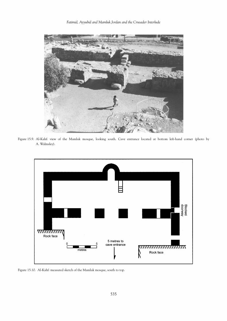
Fatimid, Ayyubid and Mamluk Jordan and the Crusader Interlude
Figure 15.9. Al-Kahf: view of the Mamluk mosque, looking south. Cave entrance located at bottom left-hand corner (photo byA. Walmsley).
Figure 15.10. Al-Kahf: measured sketch of the Mamluk mosque, south to top.
535

Alan Walmsley
arches. A doorway in the east wall opened out onto aportico as evidenced by two columns, and was flankedon the north by a minaret and staircase, of which foursteps remain. The date of this mosque is uncertain, butthe square plan, side entrance and deep mihrab com-plies with the small mosque style of Umm al-Walid,Khan az-Zabib and Jabal Usays, usually attributed tothe Umayyad period by association with larger adjacentcomplexes (King et al. 1983: 399-405). Interestingly, aswith the mosque at Umm al-Walid, the upper struc-ture at al-Kahf was mistakenly interpreted as a tem-ple (Brunnow and von Domaszewski 1905: 195-206).The lower mosque sits immediately in front of the caveentrance and, as side walls butt up to the rock face,access to the cave entrance was only through two door-ways, one later blocked, in the west wall (Figure 15.10).The open doorway gave entry into an irregular court-yard positioned between the mosque and the rock face.From here entry to the mosque, measuring c. 19.6(E–W) by 4.65 (N–S) m, was through three broad(2.37 m) doorways in the north wall, probably origi-nally arched and permanently open. In the centre ofthe south wall was a 2 m-deep mihrab and, to its right(west), a minbar built of stone blocks with four stepsremaining. As the layout of this mosque is very simi-lar to the village mosques of the thirteenth and four-teenth centuries at Tabaqat Fahl and al-Azraq (below),a late Ayyubid or early Mamluk date is very likely. Thecave, the centre of all this activity, is a much earlier(late Roman or Byzantine) construct. A doorway inthe decorative facade leads down into a rock-cut cham-ber flanked with three deep arcosolia, the two lateralarcosolia having three graves apiece. Apart from itslegendary associations, the tomb has no exceptionalfeatures.
As already discussed, particular attention was paidto embellishing the burial places of the Companionsof the Prophet in the Ayyubid and Mamluk periods,notably Abu Ubaydah in the Jordan Valley and thetombs of Ja‘afar ibn Abi Talib, Zayd ibn al-Harithahand Abd Allah bin Rawahah at Mazar. Accordingly,these sites figure prominently in the sources of thethirteenth–fifteenth centuries. Accompanying thesedevelopments was the recognition of many burial placesbelonging to a local ‘saint’ or wali. One example is theshrine of Abu Sulayman ad-Dirani near ash-Shawbak(Khammash 1986: 81-83). Of probable Mamluk date,the shrine is rectangular in shape (17 by 8.2 m) witha dome emphasizing the burial place at the west end(Figure 15.11). A single doorway in the north wallgives entry to a rectangular, tunnel-vaulted room with a
recessed, pointed-arched mihrab in the south wall oppo-site the entrance. To the west, the tomb is marked bya headstone and foot stone of marble within an oval ofstones, above which is the partly collapsed dome. Thetomb chamber is a modest but elegant structure witha second, plain mihrab in the centre of the south wall.The remains of the dome rest on an octagon supportedby four low-slung pointed arches that spring from piersin each corner of the room. The octagon, with fourcorner decorative squinches and four small windows atthe apex of the arches, cleverly and decoratively acts asa transition between the square room and the circularbase of the dome. Khammash (1986: 83) records aninteresting account of the ceremonies at the shrine:
In weekly ceremonies at the gravesite, the vil-lages would pay tribute by drumming and lightingoil lamps or candles. They would bring new fab-ric to cover the grave and would tear off smallpieces of the old fabric to keep for good fortune.Prayers for the sick and other supplications wereaddressed to the wali. Women dyed their handsand their hair with henna, which was also appliedto the walls as an offering. ‘They bring incense,henna and sacrifices. Women walk about the shrine.Before, it was said that there used to be ostrich eggshanging in the dome in a net. There were lamps,some of glass and some of clay,’ explained the oldcaretaker.
Similar, if not the same, ceremonies have proba-bly been enacted at this shrine, and many others likeit, since Ayyubid-Mamluk times (and possibly longbefore), as local holy men served an important func-tion especially in rural communities. Country womenin particular were attracted to local shrines as accessto the congregational mosque of the town proved geo-graphically and socially difficult.
The restoration of the social infrastructure of Jordanafter the expulsion of the Crusaders equally requiredthe erection of community mosques in towns andvillages. Serving both a social and political purpose,this activity was widespread with numerous examplesknown and many more being identified as archaeo-logical and anthropological work intensifies in Jordan.At Tibnah near Irbid Khammash has documented the‘old mosque’ (al-jami‘a al-qadim) of the village whichhe suggests is of Ottoman date (eighteenth century).Built over a cave, the mosque is ‘simply and pow-erfully proportioned, . . . a perfect square, 12.5 by12.5 meters, approximately 5 meters high’ (Khammash1986: 60). Walls are solidly built in even courses ofroughly dressed stone blocks averaging 24 by 34 cm,
536
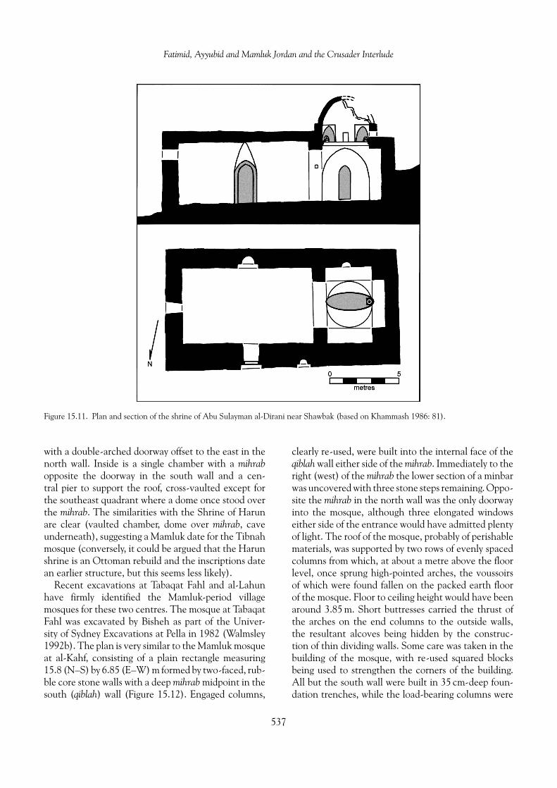
Fatimid, Ayyubid and Mamluk Jordan and the Crusader Interlude
Figure 15.11. Plan and section of the shrine of Abu Sulayman al-Dirani near Shawbak (based on Khammash 1986: 81).
with a double-arched doorway offset to the east in thenorth wall. Inside is a single chamber with a mihrabopposite the doorway in the south wall and a cen-tral pier to support the roof, cross-vaulted except forthe southeast quadrant where a dome once stood overthe mihrab. The similarities with the Shrine of Harunare clear (vaulted chamber, dome over mihrab, caveunderneath), suggesting a Mamluk date for the Tibnahmosque (conversely, it could be argued that the Harunshrine is an Ottoman rebuild and the inscriptions datean earlier structure, but this seems less likely).
Recent excavations at Tabaqat Fahl and al-Lahunhave firmly identified the Mamluk-period villagemosques for these two centres. The mosque at TabaqatFahl was excavated by Bisheh as part of the Univer-sity of Sydney Excavations at Pella in 1982 (Walmsley1992b). The plan is very similar to the Mamluk mosqueat al-Kahf, consisting of a plain rectangle measuring15.8 (N–S) by 6.85 (E–W) m formed by two-faced, rub-ble core stone walls with a deep mihrab midpoint in thesouth (qiblah) wall (Figure 15.12). Engaged columns,
clearly re-used, were built into the internal face of theqiblah wall either side of the mihrab. Immediately to theright (west) of the mihrab the lower section of a minbarwas uncovered with three stone steps remaining. Oppo-site the mihrab in the north wall was the only doorwayinto the mosque, although three elongated windowseither side of the entrance would have admitted plentyof light. The roof of the mosque, probably of perishablematerials, was supported by two rows of evenly spacedcolumns from which, at about a metre above the floorlevel, once sprung high-pointed arches, the voussoirsof which were found fallen on the packed earth floorof the mosque. Floor to ceiling height would have beenaround 3.85 m. Short buttresses carried the thrust ofthe arches on the end columns to the outside walls,the resultant alcoves being hidden by the construc-tion of thin dividing walls. Some care was taken in thebuilding of the mosque, with re-used squared blocksbeing used to strengthen the corners of the building.All but the south wall were built in 35 cm-deep foun-dation trenches, while the load-bearing columns were
537

Alan Walmsley
Figure 15.12. Tabaqat Fahl: plan of the Mamluk mosque (drawing: Hart/Pella Excavations).
sunk 50–75 cm below ground level. Ceramics and coinssuggest a fourteenth- to fifteenth-century date for theconstruction and use of this mosque. Village housescontemporary with the mosque have been located tothe north, and excavations in this area, while limitedin extent, have uncovered a well-stratified sequence ofMamluk ceramics.
The similarities in overall plan between the mosquesof Tabaqat Fahl and al-Azraq are immediately appar-ent. The al-Azraq mosque is a free-standing structureof local basalt in the courtyard of the fort, one imag-ines built as part of Izz ad-Din Aybeg’s reconstructionin the mid-thirteenth century. Essentially rectangularin plan, the long axis of the mosque runs parallel tothe qiblah wall, as does a double line of high pointedarches that rest on deeply buried columns. However, atal-Azraq the mosque is not as wide as the example atTabaqat Fahl, with two instead of three arches per row,while the arches terminate on pilasters, not engagedpillars. Also different is the location of the doorway,which at al-Azraq is in the short east wall, and theinclusion of only two elevated windows in the qiblahwall makes the mosque interior very dark. In spite ofthe differences, these two mosques clearly belong toa common tradition—the arch spans are within 5 cm
of each other—that can be dated to the late Ayyubidand early Mamluk period (thirteenth–fourteenth cen-turies) in Jordan.
The small mosque at al-Lahun, investigated byWhitcomb as part of the Belgian Committee of Exca-vations in Jordan (D. Homes-Fredericq, Director), isrectangular in shape with walls of rough field stones. Inthe short south wall is a deep mihrab, and facing it inthe north wall is the sole doorway. Thus, the long axisof the mosque is orientated N–S. No windows or minbarare present. Pottery and a coin recovered from withinthe building suggest a late Mamluk date (c. fifteenthcentury) for the al-Lahun mosque. Houses belongingto a small village have been identified nearby.
Other secular architecture: urban and rural,domestic and industrial
Evidence for secular architecture in the Fatimid andSeljuq periods is meagre due, in part, to the exten-sive building programs of the Crusader, Ayyubid andMamluk elites. From the eleventh century the empha-sis in secular architecture is on military or quasi-militaryarchitecture (castles, forts and khans as describedabove). Furthermore, in the highlands, stone-built
538

Fatimid, Ayyubid and Mamluk Jordan and the Crusader Interlude
domestic structures, often of Roman date, show con-tinuity of use from earlier periods, with superimposedfloors and internal modifications to the structures theonly evidence for ongoing occupation. Better preservedis the domestic and industrial architecture of the JordanValley. Construction was widespread due to a prosper-ous agricultural economy, while at village sites the useof unbaked brick and the frequency of earthquakes hasresulted in the preservation of superimposed levels ofdomestic architecture.
The few sites with reported Fatimid-Seljuq domes-tic occupation indicate an easy continuity from theAbbasid period; structures were modified or rebuilt,depending on requirements. As described earlier, thecentral monument of al-‘Aqaba was redesigned in theFatimid period as an aristocratic residence, featuringa central courtyard with a porch and eight rooms(Whitcomb 1988b). Similarly, on the ‘Amman Citadel,the Umayyad Palace, including the Reception Hall, wasextensively converted into dwellings and the nearbystone houses of Umayyad and Abbasid constructionwere substantially modified before their destruction inthe mid-eleventh century (Northedge 1992: 159 andabove).
The improved economic environment after theexpulsion of the Crusaders had a deep but varied impacton the new generation of domestic architecture in theAyyubid and Mamluk periods. In many places, espe-cially in the uplands, the erection of completely newhouses was unnecessary as existing stone structuressimply continued to be used and, where necessary, werealtered to meet domestic requirements. This reutiliza-tion of architectural resources is clear from work atKhirbat Faris. Structures in the House 2 area showan unbroken sequence of occupation, represented by aseries of surfaces, through the twelfth/thirteenth cen-tury until perhaps as late as the sixteenth century(McQuitty and Falkner 1993). This sequence followedon without major interruption from earlier Fatimidand Seljuq settlement outlined earlier. Yet betweenabout the eighth and nineteenth centuries, no majorconstruction work was undertaken, as existing struc-tures, when re-roofed and given new floors, made per-fectly adequate quarters. While investigations at otherupland sites do not match the detail of the Faris work,instances of existing architecture being continuouslyused or reutilized in the Ayyubid and Mamluk periodsare recorded from Bayt Ras, ‘Amman, Umm al-Quttayn(after a proposed hiatus from the mid-eighth century),Umm ad-Dananir, Qastal and Udhruh. Of particularinterest are the reoccupied sites of Balu‘, al-Lahun
and ‘Ara‘ir, where the Mamluk village was constructedwithin, and by re-using elements from, the derelict IronAge houses.
Surveys and excavations have turned up evidencefor new Ayyubid and Mamluk domestic architectureat a number of sites, for instance Gharandal, Nakhal,Hisban, Dhiban and Khirbat ‘Ayn Janin. However,detailed information is scarce, as sites with thick Islamicdeposits have been assiduously avoided in the past, andmost discoveries have been incidental to wider researchprogrammes. Consequently, the archaeological evi-dence may favour sites with continuous or resettledhistories, and overlook developments and innovationsin the domestic architecture of new establishments.At Dhiban part of a large house and other struc-tures were uncovered (Tushingham 1972: 83-84). Thehouse, made from re-used stone, comprised a courtyardand large rooms (c. 6 by 7 m), each spanned with closelyspaced transverse arches. Bins, ovens and a cistern werefound in associated occupation levels. However, else-where at Dhiban pre-existing structures, obviously stillextant at the time, were converted into dwellings. Atthe multi-period sites of Gharandal and Nakhal domes-tic structures were built within the remains of Byzantinechurches. The Gharandal structures, part of a largersettlement (Figure 15.13), incorporated existing wallsbuilt in a continuous sequence from the ninth cen-tury, when the ecclesiastical function of the church hadapparently ceased. Well reported are the thick Mamlukstrata at Hisban (Str. 3, 1260–1400; Str. 2, 1400–56),where a housing quarter was excavated to the westof the acropolis complex of bath and reception hall(de Vries 1994: 161-65). These were new stone struc-tures, haphazardly built on a freshly cut terrace, witheach unit typically consisting of a number of originallyvaulted rooms around a court. The Hisban regionalsurvey located many outlying sites with Ayyubid andMamluk occupation (52, or 35 percent of all sites) witha village architecture distinguished by arches, vaultedbuildings, semi-subterranean rooms and caves (Ibach1987: 191-94).
Differences in domestic architectural styles to thosein the uplands can be observed in the Jordan Valley. Amajor variation was in the building materials utilized,with most houses on the valley floor being made ofsun-dried mudbrick, not stone (which is scarce in thevalley), during the middle Islamic period. Where nec-essary, houses were replaced as they became derelictor collapsed, resulting in deep, stratigraphically dis-tinct sites made up of a long sequence of surfaces andmudbrick collapse as uncovered at Tall Abu Qa‘dan
539

Alan Walmsley
Figure 15.13. Gharandal, near Tafila: plan of the Department of Antiquities area showing Mamluk structures within and around earlierNabataean and Byzantine monuments (Barnes/Gharandal Archaeological Project).
and Tall Abu Sarbut, both village sites near Dayr ‘Alla(Franken and Kalsbeek 1975; Haas et al. 1992). At TallAbu Sarbut walls of mudbricks were built on founda-tions of field stones before both the walls and floor werecovered with a yellowish plaster.
Overall domestic constructions of the Ayyubid andMamluk periods were basic and practical, representingpersonal undertakings rather than state or communityprojects. Houses were generally one to three adjacentsingle-storied rooms with independent doorways to acommon walled courtyard. In stone-built houses, trans-verse arches were employed in larger rooms to supportthe roof. Mudbrick rooms were generally small enoughto be bridged by wooden beams, and while domes couldhave been employed, surviving walls do not appearthick enough.
Surviving public architecture in an urban context israre for middle Islamic Jordan as most of the impor-tant sites (e.g., as-Salt, al-Karak), being major cen-tres in modern Jordan, have undergone considerableurban renewal especially in the last half century and
the evidence is lost or hidden. The written sourcesrecord the construction of a mosque, bath, khan, hospi-tal and madrasah (school) at al-Karak besides the palace(Brown 1989b). Similarly at Hisban, the capital of theBalqa’ region for a time in the Mamluk period, theurban accruements of a mosque and/or palace, khanand bath are attested (de Vries 1994). The bath, exca-vated in 1973 by Van Eldreren (de Vries 1986), is amodest 14.5 by 4.0–5.5 m in size, constructed of stoneand originally roofed with barrel vaults. The layout con-sisted of an entry hall, a dressing room with storageniches and two elevated platforms where bathers couldrest, a lateral transitional corridor to the bath room witha rest bench, and the bathing room with a water tank,benches either side and a heated floor. Beyond, and notaccessible from the bath, were the water tanks above afurnace, reached by way of a service room. The Hisbanbath is very similar in layout to the Hammam al-‘Ayn inJerusalem, although on a smaller scale. The Hammamal-‘Ayn, a typical Mamluk public bathhouse (hammam),forms part of the large Suq al-Qattanin (‘Market of
540
Fatimid, Ayyubid and Mamluk Jordan and the Crusader Interlude
the Cotton Merchants’) complex west of the Haramash-Sharif and built in 1336–37 during the sultanateof an-Nasir Muhammad (Burgoyne 1987: 273-98).However, the bath itself appears to have been builta little earlier, as it was in existence by 1330. The Ham-mam al-‘Ayn begins with an architecturally appealingchange-room featuring a domed roof, central octag-onal fountain and raised platforms in pointed-archedrecesses, very similar to (although grander than) thedressing room at Hisban. A doorway, as at Hisban, givesentrance to a transverse corridor but (properly) with asmall cold room at the far end, not simply a bench. Fromthe corridor a doorway leads directly into the warm andthen hot rooms, unusually six in number; at Hisban thefunctions of these rooms were condensed into a singlehot room. While considerably smaller than Hammamal-‘Ayn, the Hisban bathhouse conforms to a standardearly Mamluk type and probably dates to sometime inthe fourteenth century.
One significant architectural legacy of the economicrestructuring of rural post-Crusader Jordan was theerection of water mills for sugar cane crushing andthe grinding of grain. In the face of declining agricul-tural production in fourteenth- and fifteenth-centuryEgypt, the Mamluk elite directly invested in develop-ing the resources of the Jordan Valley including thegeneral utilization of water energy through the con-struction of mills (Rogan 1995). Along the edge of themany valleys that open out into the east bank of theJordan Valley stand the ruins of numerous stone-builtmills, but their construction dates are problematical.While a Mamluk date can be (and often is) plausiblyoffered for the widespread construction of water-drivenmills in the Jordan Valley, many of the mills as theyexist today appear to be substantially mid-nineteenthto early twentieth century, in some (perhaps many)instances the result of major restorations of derelictMamluk-period mills. For instance, 10 water mills wereidentified along the upper Wadi Hisban during theHesban Regional Survey, but Ayyubid/Mamluk pot-tery was found at only one of these (Ibach 1987: 194).Numerous mills were located during the East JordanValley Survey in 1975, ‘often with millstones in situand often associated with large quantities of “sugarpots”’ (Ibrahim et al. 1976: 182-83, 202-203). How-ever, the excavation of a horizontal-wheel flour millin the fast-flowing Wadi Jirm near Tabaqat Fahl pro-duced a firm late Ottoman date with no evidence of anearlier Mamluk-period structure or occupation. Never-theless, mills are widely reported in the written sourcesfor the Mamluk period and earlier, specifically Fatimid,
times. The earlier Islamic mills were, perhaps, mostly ofthe vertical wheel variety, for at Tabaqat Fahl a heavypottery vase recovered from the mid-eighth-centurydeposits was originally intended for roping to a verticalwater wheel (Walmsley 1982: 149, pl. 145.4).
The economy, trade, pilgrimageand routes
The dearth of archaeological data on the Fatimid andSeljuq periods in Jordan is especially apparent whenattempting to describe economic activity in the tenthand eleventh centuries. The prevailing view for thehighlands, typified by the conclusions of the HeshbonExpedition (LaBianca 1990: 218), is for a shift to ‘lowintensity configuration’ of land use in the Abbasidperiod, that is from plough agriculture to pastoralactivities, and a ‘retreat’ from a sedentary lifestyle tonomadism by the Fatimid and Seljuq periods. How-ever, this view does not rest comfortably with the tex-tual evidence, particularly as the tenth-century geog-raphers Ibn Hawqal and al-Maqdisi depict Jordan asagriculturally productive. North Jordan was populatedwith villages producing olives, honey and fruits espe-cially grapes, the Balqa’ was an area of villages, fieldsand water mills with grain, fruit and honey as the mainproduce, the Ma’ab region was renowned for its grapesand especially almonds, while Jibal and ash-Sharahwere also prosperous. These sources further remarkupon the cultivation of tropical crops, specifically dates,indigo, rice and bananas, in the Jordan Valley. Bothwriters also note that around ‘Amman and farthersouth the herding of sheep and goats played a sig-nificant role in the economy. As mentioned earlier,the Crusader sources of the early twelfth century like-wise describe Jordan as widely settled with villages.The crops are unchanged: grain, grapes (for wine),dates, olives and oil, again with sheep and goat herd-ing. Just before the Muslim reconquest of south JordanIbn Jubayr (1952: 301) could still describe the al-Karakregion as ‘the choicest part of the land . . . it beingsaid that the number of villages reaches four hun-dred’. Together the tenth-century Islamic geographiesand the twelfth-centuryCrusader-period sources depictJordan as supporting a mixed settled and nomadic pop-ulation engaged in mutually beneficial agricultural andpastoral activities.
The rise of the Fatimid dynasty in Egypt stimulatedthe Indian Ocean trade, with ships reaching as far asChina, Sumatra and Java (Chaudhuri 1985: 34-62).
541

Alan Walmsley
Ceramic evidence from Fustat indicates that the vol-ume of Red Sea trade to China increased markedly afterabout ad 1000 (Scanlon 1970). At this time, al-‘Aqaba,strategically positioned at the eastern head of the RedSea, was described by al-Maqdisi as Palestine’s port onthe ‘Chinese Sea’, and the excavations of Whitcombhave vividly illustrated the international outlook of thetown in the Fatimid period. Of particular note is theglazed pottery from the Pavilion Building (Whitcomb1988b). Two large blue-green jars with barbotine dec-oration seemingly originated from Basra in southernIraq (Figure 15.15.5), lustre wares came from Iraq andperhaps Egypt, while fine celadons and porcelains orig-inated in China. A hoard of 32 gold dinars of the earlyeleventh century and a collection of glass and bronzeweights further attest the importance of the IndianOcean and Far East trade to Fatimid Ayla. In addi-tion to Palestine, land routes from Ayla linked Udhruh,Mu‘an, Ma’ab and ‘Amman to the Red Sea trade net-works.
In part, the Crusader occupation of Wadi Musaand Ayla was an attempt by Baldwin I to gain somecontrol over the Red Sea trade, thereby restrictingFatimid domination and weakening the economic ben-efits to Egypt. Under Reynald, Lord of al-Karak, raidingreached the Holy Cities of the Hijaz, but in general Cru-sader activity in the Red Sea was limited and endedaltogether with the recovery of south Jordan by Salahad-Din in 1188. However, within the Crusader realmsthere was a flourishing trade in agricultural produceand minerals. Wheat, oil, wine, dates, sugar, bitumenand salt in particular were shipped in boats acrossthe Dead Sea from the southern Ghor and the high-lands of Oultrejourdain to Jericho and Jerusalem (Johns1994: 10-14). Annual fairs were held in the Sawad andal-Karak, while shipping and caravan traffic was subjectto taxes.
The return of all Jordan to Islamic hegemony andits economic reintegration into the market systems ofDamascus and Cairo revived the many traditional agri-cultural practices temporarily disrupted, but clearly notcompletely destroyed, by the political and social par-titioning of Jordan in the Crusader period. The crit-ical destructive factor was the protracted period ofwarfare between Salah ad-Din and Reynald, whichappears to have inflicted considerable damage on thevillage economy of south Jordan (Johns 1994: 12-13).Conditions did not improve substantially until wellinto the thirteenth century. In the rural context, thereturn to normality resulted in the restoration of avillage-based economy, founded upon conventional
agricultural pursuits (grain, legumes and aboriculture),pastoral activities and a revival of cash crops, espe-cially sugar and indigo. The produce was destinedfor the large urban markets of Damascus, Cairo, andar-Ramlah, locally to al-Karak, as-Salt and other cen-tres, and for export to more distant locations.
Sugar cane cultivation was introduced to the JordanValley and coastal Palestine perhaps as early as the sev-enth century, and had become a major crop by thetenth century (Galloway 1989: 23-47; Watson 1983).Arab-Islamic society of the seventh and eighth cen-turies provided a favourable political and economicenvironment for the growth of the sugar industry. Irri-gation technology, a requisite for water-thirsty cane,was improved and diffused throughout the Islamicrealm, enforceable legal frameworks controlled thedistribution of water, investment capital was plentifulto finance the expensive cane processing factories, anda burgeoning urban population— increasingly wealthyand sophisticated—was keen to adopt new tastes infood. After the expulsion of the Crusaders these factorsre-emerged to promote a revival of the sugar indus-try, which flourished until the mid-fourteenth century.Arabic sources and travel accounts concur that canewas cultivated in the Jordan Valley wherever waterwas available in copious quantities, including east andsouth of the Dead Sea (Ashtor 1981: 92-93). Al-Karakisugar was highly regarded in Europe. The process ofobtaining sugar from the cane was laborious, ineffi-cient and costly (Galloway 1989: 37-40). The juicewas extracted by milling and pressing, usually througha combination of both techniques, which required thecane to be cut into short lengths. Mill technology dif-fered little from that used to grind wheat or extractliquids from olives or grapes. Two types of mills wereused in Palestine and Jordan: the upper rotating stonevariety with either a flat or conical millstone, and the‘edge-runner’ in which a vertically fixed round stonewas rolled on a pivot in a circle over the cane. Theywere powered by flowing water, animals or humans.Once extracted, the juice was boiled to thicken it, andthen poured into thick pottery cones to crystallize. Thecones were set upon bag-shaped jars to collect molasses.Repeated boiling improved the quality of the sugar, butconsumed great quantities of fuel. Olive waste, usedin earlier times for firing pottery kilns, was an obvioussource.
Sherds from sugar cones and jars are common discov-eries at Mamluk sites in the Ghor (Figure 15.17.10-13),and numerous stone-built mills have been identifiedalong the east bank including south of the Dead
542

Fatimid, Ayyubid and Mamluk Jordan and the Crusader Interlude
Sea (see, for instance, Abu Dalu 1995; Greene 1995;Ibach 1987: 194; King et al. 1987; McQuitty 1995;Whitcomb 1992a: 114-18). As already noted, a Mam-luk date for many of these mills is not assured; indeed,an Ottoman date is more likely for the majorityof them.
The decline of the Mamluk sugar industry in theJordan Valley and the rest of Syria-Palestine was justas sudden and complex as its thirteenth-century resur-gence (Ashtor 1981). A fall off in cultivation can bedetected in the fourteenth century, but by the six-teenth century the sugar industry had disappeared.The principal factors behind the failure were economicand technological. The industry was labour and energyintensive and became increasingly expensive to oper-ate following a major decline in the population, perhapsby a third, due to a series of plagues and warfare dur-ing the fourteenth and fifteenth centuries. In addition,the policies of the Mamluk elite perpetuated inefficien-cies and corruption, while mills were not maintainedor technologies improved due to the prohibitive costsinvolved (Rogan 1995). The arrival of cheap and bet-ter sugar from the Americas in the sixteenth centuryprecipitated the final collapse.
Other primary and secondary industries in Jordanthrived under the direct or indirect patronage of theMamluk elites. The horses, camels and sheep of theal-Karak region were highly prized in Cairo for trans-port, wool and meat (Irwin 1986: 185-86). Iron wasmined and smelted at Mugharat al-Wardah in the‘Ajlun mountains throughout the Ayyubid and Mamlukperiods. Alongside the mine-smelting furnaces, anore-roasting oven, slag and ash were identified anddateable by the associated pottery (Coughenour 1989).Copper and perhaps iron mining and smelting wasresumed at Faynan in the ‘Arabah, and copper fingerrings and earrings were commonly worn for personaladornment. Many local industries flourished at a vil-lage level. For instance, glass may have been manufac-tured into bracelets and other items at Dayr ‘Alla inthe Jordan Valley, and cottage potting industries pro-ducing the ubiquitous Hand-Made Geometric PaintedWare (see below) must have been a feature of everyvillage of note. Unquestionably, other village indus-tries such as weaving, woodworking, basketry and matmaking would have equally prospered, but these arerarely recorded as they are archaeologically ‘invisible’and were of no great interest to scholars or travellers.
A major boost to the local economy would have beenthe passage of the annual pilgrimage to the Holy Cityof Makkah in the Hijaz. The pilgrimage route changed
a number of times during the period under considera-tion, mostly in response to the Crusader occupationof south Jordan in the eleventh century, hence dif-ferent centres benefited at different times. During theFatimid period, the path followed a set route throughthe badia (eastern steppe lands) of Jordan (Figure 15.2),and is described in some detail in the geographicalaccounts, especially al-Maqdisi (Musil 1926: 326-31and Appendix 15; 1927: 516-20). Going southwardsfrom Adhri‘at (Dar‘a in Syria), az-Zarqa’ was reachedafter a day, then another day led to the major assem-bly point of ‘Amman where pilgrims from surround-ing districts could join the caravan. After ‘Amman twounspecified watering places (most likely al-Qatrana andal-Hasa) were needed to reach Mu‘an (Ma‘an) whereprovisions could be obtained, after which the route con-tinued south to Tabuk and the Hijaz.
The badia route continued in use during the Cru-sader occupation of Jordan, but while this route avoidedCrusader territory it still left the caravans liable toat-tack. In 1180 a caravan of merchants was looted onits way to Makkah by Reynald de Chatillon, Lord ofal-Karak. More seriously, in 1186 merchants and pil-grims were attacked and summarily executed or cap-tured in blatant violation of a truce with Salah ad-Din.All protestations were ignored, leading Salah ad-Din torevive the jihad against the Crusaders, and which sawvictory—and the immediate execution of Reynald—within the year (Maalouf 1984: 186-94).
As already described, the prolonged strugglebetween the Crusaders and Muslims of Syria and Egyptbrought to prominence the fortress towns of Jordan,especially al-Karak. By the Mamluk period al-Karakserved as a major stop for the Damascene pilgrimagebefore entering the more physically challenging desertterritory to the south. Two sources of the fourteenthcentury present a comparatively detailed picture of theroute and conditions on the journey (Abu’ l-Fida 1983;Ibn Battuta 1958; Peters 1994: 79-86). Ibn Battutagives a full account of the route he followed in 1326(Figure 15.4). From Damascus the caravan made twostops before Busra, where a stop of four nights allowedlatecomers to catch up and the pilgrims to buy pro-visions. From Busra the caravan travelled to the Poolof az-Zizia. The most likely route for the caravan wasthrough az-Zarqa’, as suggested by the construction of asmall fort in the thirteenth century (described above).‘Amman, seemingly not repopulated to any extent sinceCrusader times, held no attraction so was bypassed.From az-Zizia, where there was also a Mamluk fort(above), the caravan continued to al-Lajjun, where
543

Alan Walmsley
water was plentiful, and then reached al-Karak. Aftera stop of four days at al-Karak the pilgrims set out forMa‘an, almost certainly by way of al-Hasa where therewas a toll station, and then Tabuk. The brief account ofAbu’ l-Fida shows that the wealthy travelled by horse-back to al-Karak, sending their baggage and servantsin advance, and from there went by camel (1983: 65).The Mamluk caravans were always large. In 1432 some3000 camels returned to Damascus; in 1503 35,000camels, 40,000 people and a guard of 60 Mamluksset out from the same city (Peters 1994: 80-85). Thefigures are obviously inaccurate guesses, but never-theless reveal the considerable size of the annualpilgrimage.
Other roads transversed Jordan, linking the settle-ments on the Hajj route to places to the west and south.In the Fatimid period, a major road joined ‘Ammanwith Jerusalem by way of Hisban, Bayt ar-Ram andJericho (Figure 15.2). A second route from ‘Ammanran down the highland range to Ma’ab, probably by wayof Hisban, and then to Zughar in the ‘Arabah. Fromhere, the road travelled down the ‘Arabah throughGhamr (where another road left to ar-Ramlah), ‘AynGharandal and Ghadhian to Ayla. From Zughar, asecond road ascended the scarp to Udhruh and Mu‘an,probably by way of Wadi Musa. As Ibn Jubayr (1952:300-301) makes clear, roads remained open despitewarfare between the Muslims and Crusaders, with taxesbeing widely imposed on travellers by both sides. Animportant route ran from Busra and Adhri‘at to Tiberiasand Safad by way of Bayt Ras and Jadar (Figure 15.3),and both Crusader and Muslim armies marched alongthis road in the battle for Tiberias and the north JordanValley (Mershen and Knauf 1988: 132-36). Later a tollstation was placed in the village of Jadar, resulting ina name change to mkis (from which the Umm Qays oftoday).
The Ayyubid and especially Mamluk road system wasextensive in its coverage, consisting of the official barid(postal service) roads, which doubled as trade routesand were usually well maintained, and a network ofconnecting routes. The Darb al-Quful, mentioned ear-lier, crossed into north Jordan near Baysan (Beth Shan)at Jisr al-Majamia‘, and continued eastwards throughal-Qusayr (Shuna) before ascending the scarp to Irbid.As an official state road, the Darb al-Quful remainedpopular until the late fifteenth century, when Safad roseto prominence and the northern crossing at Jisr BinatYa‘qub gained greater popularity. Another importantroad was the southern route from Cairo to ash-Shawbakand al-Karak, transversed by Baybars in June 1276 in
only 11 days (Zayadine 1985). The first five days werespent crossing the Sinai to Wadi Musa (Petra), enteringfrom Wadi ‘Arabah. Once watered, he continued ontoash-Shawbak and al-Karak, where a rebellion was sup-pressed. From al-Karak the link to Damascus followedthe Hajj route through az-Zizia and az-Zarqa’, whileanother route crossed at Zughar to Khalil (Hebron)and Jerusalem. A third route ran up the mountainrange between Dhiban, Hisban (link to Jericho andJerusalem), as-Salt, ‘Ajlun (link to Nablus) and Irbid,finally joining the Darb al-Quful at Umm Qays. Far-ther east, a circuit route through the badia joined Petraand al-‘Aqaba with Ma‘an, then to Bayir and al-Azraq(link to az-Zarqa’), and northwards to the Hauran. Asalready mentioned, most of these strategically placednodules in the communications network were progres-sively fortified in Ayyubid and Mamluk times. Otherroads crossed between the major routes and centres andvery possibly many were restored in the Mamluk periodand marked out with edging stones. Frequently, one sus-pects, these roads are mistakenly classified as Romanconstructs, especially as many would have traced oldRoman routes.
Material culture
At first glance, the more than five hundred yearsbetween the late tenth century and the start of thesixteenth century coincided with significant changes,in keeping with neighbouring Palestine and Syria, inthe material culture of Jordan. These changes haveoften been seen as indicative of, and explained by,broader trends in the socio-economic regime of IslamicJordan. The view has been largely negative: the collapseof urban life, political disintegration, external dom-ination, the end of specialized manufacturing indus-tries (wheel-thrown pottery, for instance), a short ruralboom especially in the Jordan Valley, and a rusticationof the population. Many of these judgments were osten-sibly supported by an assessment of the relative worthof wheel-made and hand-made ceramics, based on theassumption that the latter—of coarse fabric and softfiring—were definitely inferior. The hand-made wareswere interpreted as representing an easy if misleadingpicture of small, isolated communities surviving at littlemore than a subsistence level. Likewise, the large andheavy bowls and jars used in the sugar industry cameto portray equally disadvantaged migrant labour in thecane fields of the Jordan Valley.
The material culture of middle Islamic Jordan clearlydid experience major shifts in the tenth to sixteenth
544
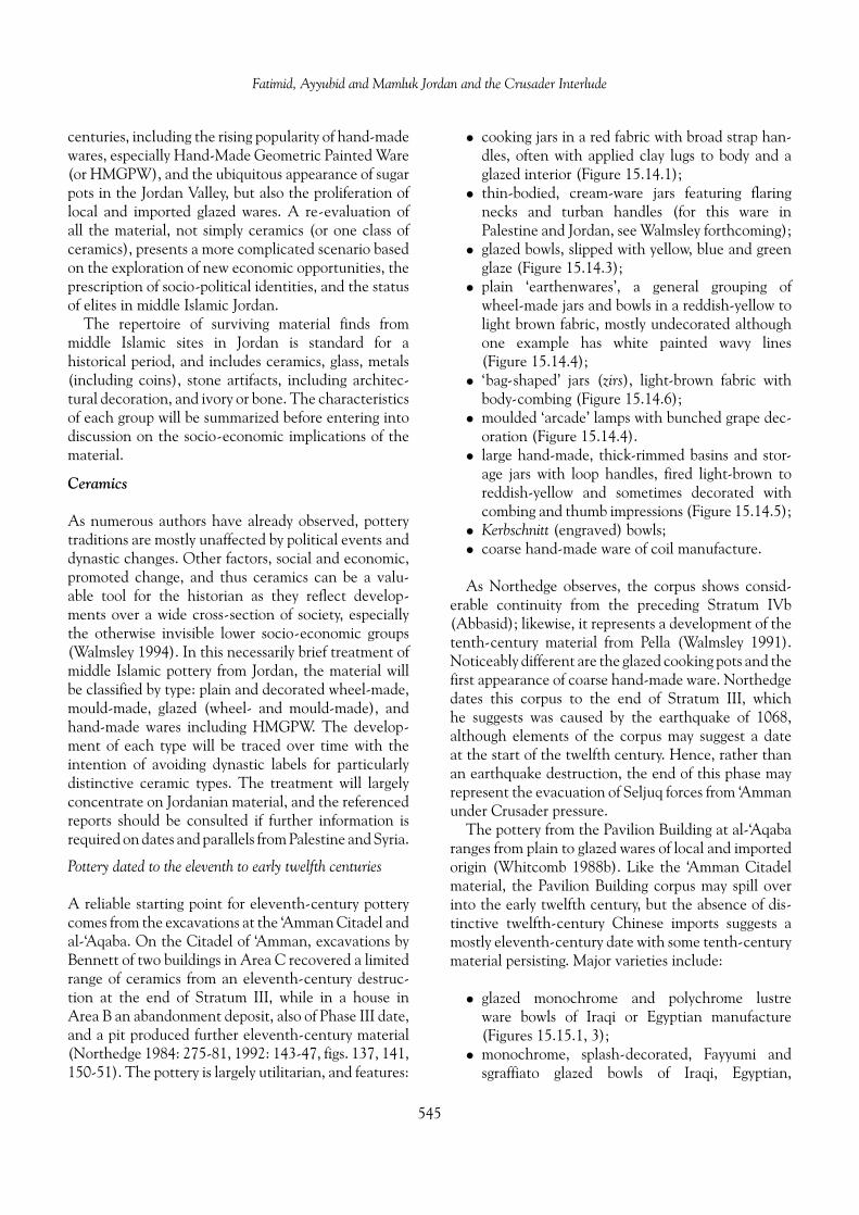
Fatimid, Ayyubid and Mamluk Jordan and the Crusader Interlude
centuries, including the rising popularity of hand-madewares, especially Hand-Made Geometric Painted Ware(or HMGPW), and the ubiquitous appearance of sugarpots in the Jordan Valley, but also the proliferation oflocal and imported glazed wares. A re-evaluation ofall the material, not simply ceramics (or one class ofceramics), presents a more complicated scenario basedon the exploration of new economic opportunities, theprescription of socio-political identities, and the statusof elites in middle Islamic Jordan.
The repertoire of surviving material finds frommiddle Islamic sites in Jordan is standard for ahistorical period, and includes ceramics, glass, metals(including coins), stone artifacts, including architec-tural decoration, and ivory or bone. The characteristicsof each group will be summarized before entering intodiscussion on the socio-economic implications of thematerial.
Ceramics
As numerous authors have already observed, potterytraditions are mostly unaffected by political events anddynastic changes. Other factors, social and economic,promoted change, and thus ceramics can be a valu-able tool for the historian as they reflect develop-ments over a wide cross-section of society, especiallythe otherwise invisible lower socio-economic groups(Walmsley 1994). In this necessarily brief treatment ofmiddle Islamic pottery from Jordan, the material willbe classified by type: plain and decorated wheel-made,mould-made, glazed (wheel- and mould-made), andhand-made wares including HMGPW. The develop-ment of each type will be traced over time with theintention of avoiding dynastic labels for particularlydistinctive ceramic types. The treatment will largelyconcentrate on Jordanian material, and the referencedreports should be consulted if further information isrequired on dates and parallels from Palestine and Syria.
Pottery dated to the eleventh to early twelfth centuries
A reliable starting point for eleventh-century potterycomes from the excavations at the ‘Amman Citadel andal-‘Aqaba. On the Citadel of ‘Amman, excavations byBennett of two buildings in Area C recovered a limitedrange of ceramics from an eleventh-century destruc-tion at the end of Stratum III, while in a house inArea B an abandonment deposit, also of Phase III date,and a pit produced further eleventh-century material(Northedge 1984: 275-81, 1992: 143-47, figs. 137, 141,150-51). The pottery is largely utilitarian, and features:
• cooking jars in a red fabric with broad strap han-dles, often with applied clay lugs to body and aglazed interior (Figure 15.14.1);
• thin-bodied, cream-ware jars featuring flaringnecks and turban handles (for this ware inPalestine and Jordan, see Walmsley forthcoming);
• glazed bowls, slipped with yellow, blue and greenglaze (Figure 15.14.3);
• plain ‘earthenwares’, a general grouping ofwheel-made jars and bowls in a reddish-yellow tolight brown fabric, mostly undecorated althoughone example has white painted wavy lines(Figure 15.14.4);
• ‘bag-shaped’ jars (zirs), light-brown fabric withbody-combing (Figure 15.14.6);
• moulded ‘arcade’ lamps with bunched grape dec-oration (Figure 15.14.4).
• large hand-made, thick-rimmed basins and stor-age jars with loop handles, fired light-brown toreddish-yellow and sometimes decorated withcombing and thumb impressions (Figure 15.14.5);
• Kerbschnitt (engraved) bowls;• coarse hand-made ware of coil manufacture.
As Northedge observes, the corpus shows consid-erable continuity from the preceding Stratum IVb(Abbasid); likewise, it represents a development of thetenth-century material from Pella (Walmsley 1991).Noticeably different are the glazed cooking pots and thefirst appearance of coarse hand-made ware. Northedgedates this corpus to the end of Stratum III, whichhe suggests was caused by the earthquake of 1068,although elements of the corpus may suggest a dateat the start of the twelfth century. Hence, rather thanan earthquake destruction, the end of this phase mayrepresent the evacuation of Seljuq forces from ‘Ammanunder Crusader pressure.
The pottery from the Pavilion Building at al-‘Aqabaranges from plain to glazed wares of local and importedorigin (Whitcomb 1988b). Like the ‘Amman Citadelmaterial, the Pavilion Building corpus may spill overinto the early twelfth century, but the absence of dis-tinctive twelfth-century Chinese imports suggests amostly eleventh-century date with some tenth-centurymaterial persisting. Major varieties include:
• glazed monochrome and polychrome lustreware bowls of Iraqi or Egyptian manufacture(Figures 15.15.1, 3);
• monochrome, splash-decorated, Fayyumi andsgraffiato glazed bowls of Iraqi, Egyptian,
545

Alan Walmsley
Figure 15.14. ‘Amman Citadel: pottery of the second half of the eleventh century: 1. red ware cooking jar; 2. moulded lamp with grapedecoration; 3. white-slipped bowl with blue-green glaze; 4. red fabric jar with white paint; 5. pale brown storage jar; 6. lightbrown bag jar (based on Northedge 1992: figs. 137, 141, 150).
north Syrian and local manufacture (Figure15.15.2);
• Chinese celadons and porcelains, most commonlyfine Qingbai porcelains including comb decoratedvariety (Figure 15.15.4);
• large ‘Arab-Sassanid’ jars, with incised andapplied decoration and a heavy blue-green glaze(Figure 15.15.5);
• common earthenwares, including jars, juglets andbowls in red to orange-red and tan fabric and
546

Fatimid, Ayyubid and Mamluk Jordan and the Crusader Interlude
Figure 15.15. Ayla: pottery of the eleventh century from the Pavilion Building: 1, 3. glazed polychrome lustre ware bowls; 2. polychromeglazed sgraffiato bowl; 4. Qingbai porcelain bowl; 5. blue-green glazed jar with applied and incised decoration; 6. buff-colouredincised juglet; 7. black painted and incised hand-made jar; 8. red to buff-coloured jar with incised decoration; 9-10. buff-orangeto cream incised bowls, 10 with dark green glaze on interior (based on Whitcomb 1988b).
with instances of combed and incised decoration(Figure 15.15.6, 8-10);
• large storage jars with fattened rims and loop han-dles in a red to red-orange gritty fabric, sometimes
with applied decoration below neck (similar to theCitadel types);
• hand-made bowls, basins, cups and jars withsand temper (no chaff), fired buff, orange to
547

Alan Walmsley
Figure 15.16. 1-3. Ayla, lamps of the eleventh century (Whitcomb 1994); 4-13. Shawbak, hand-made, red-painted coarse wares of thetwelfth–early thirteenth centuries (Brown 1988); 14-18. Tabaqat Fahl (Pella), dark red to purplish painted jars and bowlsin Hand-Made Geometric Painted Ware of the second half of the fourteenth to fifteenth centuries (Walmsley 1992b andunpublished).
grey and sometimes decorated with red paint(Figure 15.15.7).
It needs to be noted that most of the recovered pot-tery was common earthenwares (around 60 percent
of the count). Glazed wares were always rarer (about10 percent) while the coarse hand-made wares onlybecome common in the last period.
Another significant eleventh-century change atal-‘Aqaba was the appearance of two quite different
548
Fatimid, Ayyubid and Mamluk Jordan and the Crusader Interlude
types of lamps. Islamic lamps in Jordan were tra-ditionally almond-shaped with moulded decorationof arcades, vine tendrils, grape bunches, animalsand palmettes, as with the ‘Amman Citadel exam-ple (above). Glazed examples are known from theninth and tenth centuries (Figure 15.16.1). Both of thenew eleventh-century forms at al-‘Aqaba are notablydifferent in shape and manufacture. The first hasa wheel-made enclosed bowl with a deep channelspout, raised loop handle and a green or yellow glaze(Figure 15.16.2). The form is most likely of Egyptianorigin, with parallels at al-Fustat. The second type,first attested in the later eleventh century, is the saucerlamp, also wheel-made with a loop handle and centralreservoir (Figure 15.16.3). Both types develop in thefollowing centuries; most notably the central reservoirof the saucer lamp diminishes in size to almost vestigialproportions by the fifteenth century.
The ‘Amman Citadel and al-‘Aqaba present a reli-able ceramic horizon for Jordan in the eleventh cen-tury (with perhaps elements from the very beginningof the twelfth century). The material ranges fromimported and local glazed wares to utilitarian storagevessels and gritty-fabric cookers. At al-‘Aqaba new lamptypes, conventionally considered Ayyubid-Mamluk indate, were in circulation, while at both sites coarsehand-made wares had made an appearance. Some ofthe hand-made pottery was decorated with paint, andmay be a precursor for the ubiquitous Hand-Made Geo-metric Painted Wares of the thirteenth–fourteenth cen-turies and later. Fortunately, a twelfth-century link hasnow been established.
Pottery dated to the twelfth and early thirteenthcenturies
Excavations in the Crusader castles of al-Wu‘ayraand ash-Shawbak have identified a limited corpusof twelfth- to early thirteenth-century pottery forJordan, but overall this period is poorly represented.In a preliminary treatment of the ceramics from the1987 excavations at al-Wu‘ayra, Brown (1987) notedthe preponderance of hand-made wares with only afew wheel-thrown zirs and glazed bowls. In the earlier(‘Crusader’, twelfth century) phase, the hand-madecoarse wares were decorated with linear designs anddots in red paint, while in Phase II (‘Ayyubid’, latetwelfth to early thirteenth centuries) the linear-paintedware persisted but geometric painting in red to grey wasmore prevalent. Wheel-made bowls glazed in yellowand green, common in later assemblages (below), first
appeared in Brown’s Phase II. More recent excava-tions at al-Wu‘ayra by Vannini and Tonghini (1997)confirmed the predominance of hand-made wares,but without being able to duplicate the sequencefrom linear to geometric painted. However, theydid observe that most Syrian gritwares of Phase III(‘Crusader occupation levels’ of the later twelfthcentury) gave way to monochrome glazed wares byPhase IV (‘Ayyubid’). Overall, glazed wares constituteda small percentage of recovered pottery. Unglazedpottery made on a wheel was also attested, includingcream ware with stamped decoration from Phase IV.One interesting feature of the twelfth-century potteryfrom al-Wu‘ayra is its overwhelmingly local character.To Brown (1987: 284), there was ‘absolutely nothingspecifically “Crusader” ’ about the pottery corpus sherecovered at al-Wu‘ayra, but Vannini and Tonghini(1997: 382) recognized a Crusader presence in thePhase III north Syrian fritwares.
At ash-Shawbak castle, Brown (1988) was againable to identify a discrete twelfth- to early thirteenth-century date for early hand-made coarse wares inthe constructional Phase I (‘Ayyubid’) of theAyyubid Palace complex. The coarse wares includedlinear-painted types, often with criss-cross patterns(Figure 15.16.4-13). The assemblage also contained afew examples of HMGPW and monochrome glazed,as would be expected of a corpus that ran intothe thirteenth century. By Phase III (‘Mamluk’,fourteenth–fifteenth centuries) monochrome glazedbowls, underglaze painting, celadons, wheel-throwncream wares and HMGPW had become typical (seebelow).
Admittedly the twelfth- and early thirteenth-century pottery groups from al-Wu‘ayra and ash-Shawbak are limited in size, and caution mustbe exercised in their use. However, some supportfor Brown’s thesis of an early series of hand-madecoarse wares including linear red painting comesfrom the excavations at Khirbat Faris, where a similarhand-made pottery painted in red line and dot patternswas recovered in a ninth- to twelfth-century context(Falkner in McQuitty and Falkner 1993: 53-54).Similarly, a preliminary analysis of the middle Islamicpottery from new excavations at Gharandal, nearat-Tafilah, has identified a precursor for HMGPW.The Gharandal material is thin-walled and heavilytempered with chaff, unlike al-‘Aqaba where therewas no chaff but much sand. These initial impressionssuggest hand-made wares exhibited considerablelocal variability in fabric and decoration between the
549

Alan Walmsley
eleventh and early thirteenth centuries, whereas by thefourteenth century HMGPW had, in relative terms,attained a much greater degree of regional standard-ization. Generally, the extent of ceramic variabilityin the eleventh–thirteenth centuries, and hence theabsence of an easily identified corpus, would accountfor the poor showing of these centuries in regionalsurveys. Understandably, the tendency would be tolump the early coarse wares into the Mamluk, or evenOttoman, periods, thereby greatly under-representingover two centuries of settlement in Jordan. The extentof the error is demonstrated by a reconsideration ofthe stratigraphy and pottery from a number of sites inJordan, for instance Dhiban and Tall Abu Qa‘dan, inwhich strata and material of the eleventh–thirteenthcenturies can be successfully identified (and is thesubject of a separate study in progress).
Farther north at Tall Hisban, a discrete ‘Ayyubid’(c. 1174–1263) corpus has been isolated and datedby coin evidence by Sauer (1994: 268-70). HMGPWwas ‘abundant’ and decorated with set designs indark purplish red and brown paint. Glazed waresare rarer, and included glazed cookers. No earliertwelfth-century coarsehand-madewares could be iden-tified, and both the Hisban coins and the al-Wu‘ayraand ash-Shawbak pottery suggest that this Ayyubid cor-pus is mostly mid-thirteenth century and after. Finally,excavations at Rujm al-Kursi have produced three earlythirteenth-century lamps from a coin-dated context.They were hand made in two parts from a coarse grittyfabric, and feature a central filling hole, handle andpierced wick hole.
Pottery dated between the later thirteenthand fifteenth centuries
The equation between certain pottery types andMamluk-period occupation in Jordan has almost exclu-sively concentrated on two distinct varieties: slippedwheel-made bowls supporting a yellow or green glazeand, more usually, HMGPW. They have the advan-tage of being easily identified during surveys and area relatively common feature of the archaeologicallandscape in Jordan, in that they represent the lastmajor pre-modern phase in the occupation of manysites. As with earlier periods, the material is generallypoorly published and dating imprecise, and similarlythis assessment of pottery from the later thirteenth tofifteenth centuries relies upon the more reliable reports.
The excavation of the mosque on the main moundat Tabaqat Fahl (Pella) produced a representative range
of ceramics that can be dated, substantially on coin evi-dence, to the second half of the fourteenth and earlyfifteenth centuries (Walmsley 1992b). The major pot-tery varieties were:
• Hand-Made Geometric Painted Ware(HMGPW), slipped and sometimes burnished andliberally decorated with painted monochrome orbichrome geometric designs in dark red, purpleand black. Jars, jugs, bowls and basins were thecommon shapes (Figures 15.16.14-18, 15.17.1-2).
• ‘Cooking pot’ ware; coarse with numerous inclu-sions and used in the hand manufacture of large,splayed-necked cooking jars with solid handles inthe shape of a pointed ear (Figure 15.17.15-16).
• Plain ware, wheel-made elongated jars andstraight-sided bowls in a soft, light yellow-brownto reddish-yellow ware and linked with the sugarindustry (Figure 15.17.10-13).
• Thin-walled painted ware, wheel-made andreddish-yellow to pink in colour with lime-stone grits, freely painted in reddish-brown tobrown-black on the rim, handles and body.
• Underslipped glazed ware bowls, internally slippedor decorated with brush strokes and over-glazedwith brilliant yellow or green glazes over awheel-made bowl (Figure 15.17.3, 5-7).
• Underglaze painted ware with very fine bichromeand polychrome painted designs under a clearglaze (Figures 15.17.8-9).
• ‘Silhouette’ ware, with black paint underturquoise, blue or green glaze.
• Sgraffiato ware, white-slipped and incised with ayellow to green glaze (Figure 15.17.41).
HMGPW, sugar-pot ware and underslipped glazedware bowls, all seen as local products, formed the largestgroups in the corpus. Only a few sherds of the last threeglazed varieties, most likely imports from north Syria,were recovered. They are conventionally dated to thefourteenth and fifteenth centuries, which neatly com-plies with the numismatic evidence.
Also in the Jordan Valley, the neighbouring sitesof Tall Abu Qa‘dan and Tall Abu Sarbut producedlarge quantities of pottery of about the same date asthe material from Tabaqat Fahl. At Tall Abu Qa‘dana long sequence of thirteenth- to fifteenth-centurypottery was recovered, although there are consider-able problems with stratigraphy and dating (Frankenand Kalsbeek 1975: 107-203; but note the review ofSauer 1976). The different pottery types as identifiedby Franken and Kalsbeek are:
550

Fatimid, Ayyubid and Mamluk Jordan and the Crusader Interlude
Figure 15.17. Tabaqat Fahl, pottery of the second half of the fourteenth to fifteenth centuries: 1-2. HMGPW bowls; 3-7. green and yellowglazed bowls with brushed (3, 5) or full slip (6-7) and some sgraffiato (4); 8-9. bichrome and polychrome underglaze paintedwares; 10-13. light brown to reddish-yellow sugar pots; 14-16. heavy hand-made coarse wares including cooking jars (Walmsley1992b and unpublished).
• HMGPW, found in profusion. It appears in adeveloped form, typically with a burnished sur-face and decorated with care at first. Later formsare slipped and the decoration poorer.
• Glazed wares, predominantly slipped wheel-madebowls and including sgraffiato decoration. Amajor change in firing technology occurred inthe fourteenth century when bowls were stacked
551

Alan Walmsley
right-side up (previously upside down) in thekiln.
• Faience bowls decorated in blue and black.• Hand-made cooking pots with large pierced
handles.• Sugar pots, both jars and bowls, mass produced
in large kilns roughly 5 m in height. This type ofpottery was completely absent before Period 2.
• Red-firing wheel-made pottery, often with a saltbloom, used in the manufacture of cooking pots,bowls, jars and jugs, some of the latter with coarseand fine sieve necks and spouts.
• Light red, hard-firing jars (equivalent tothin-walled painted ware at Tabaqat Fahl).
• White wares, but very scarce (and perhaps rem-nants from earlier levels).
Franken considered HMGPW unrelated to theprevailing ceramic traditions in Islamic Jordan andPalestine, and decided upon a North Africaninspiration for the ware (Franken and Kalsbeek1975: 213-22; Homes-Fredericq and Franken 1986:239-44). However, the identification of eleventh-and twelfth-century precursors with linear decoration(above) would argue that HMGPW was an entirelylocal development. Volumes of wheel-made waresat Tall Abu Qa‘dan were much less frequent thanHMGPW, and were mostly confined to Phase 2 (whichis more satisfactorily dated to the later thirteenthand fourteenth centuries). Franken also saw thesethrown wares as sufficiently different as to indicatean independent tradition, but this view is also difficultto accept.
Few sites in the highlands have produced dis-tinct later thirteenth- to fifteenth-century ceramicsfrom stratigraphically sound and coin datable levels.The most accessible material has come from Hisban,Rujm al-Kursi, Khirbat Faris, the al-Karak plateausurvey, ash-Shawbak and, most interestingly from asocio-economic aspect, al-Karak. Based on the coinevidence, Sauer has differentiated two pottery groupsdating to the later thirteenth and fourteenth centuriesat Tall Hisban. These were labelled ‘Early Mamluk I’(EMI), dated c. 1263–1300, and ‘Early Mamluk II’(EMII), c. 1300–1401, and mostly originate from awell-stratified cistern (Sauer 1994: 270-73). In EMIbrown became the preferred paint colour on HMGPW,while glazed wares were more common. In EMII thepaint had become darker brown or black and the potsurface lighter (light yellowish to greenish); glazedwares continued. Sauer also suggested that a ‘Late
Mamluk’ (c. 1401–1516) stratum was distinguishablein which HMGPW, featuring a darker paint and nar-rower lines, was present but glazed wares were scarce.In a combined study of all HMGPW groups at His-ban, Sauer (1973: 55-56) identified 13 major designs:squares, waves, single and double zigzags, hourglass,diamond nets, semi-spirals, interlocking triangles, dot-ted lines, fine-lined lozenges, lined dots, nets and wavylines. A single vessel often was decorated with a com-bination of designs, which currently do not appear tohave chronological significance. At Rujm al-Kursi themid-thirteenth-century corpus of HMGPW, dated bycoins, was slipped and decorated with reddish-brownpaint in 10 design categories (Khadija 1992). In addi-tion to seven of Sauer’s 13 groups, Khadija identi-fied three new categories of motifs: diamonds, trianglesand stars. A selection of HMGPW has also been pub-lished from Khirbat Faris, although no firm dates areoffered (McQuitty and Falkner 1993). However, thecomment is made that some doubt still exists as toa terminal date of HMGPW, and a post-sixteenth-to seventeenth-century date is not unreasonable asHMGPW sometimes appears with tobacco pipes,which cannot be dated earlier than the seventeenthcentury.
A very valuable assessment of thirteenth- tofifteenth-century pottery in Jordan was undertakenby Brown as part of an archaeological survey of theal-Karak plateau directed by Miller (Brown 1991:232-41). The study was based on pottery pickedup during the survey that, from this period, wasmostly HMGPW with some monochrome glazedwheel-thrown bowls. Very rare were:
• unglazed wheel-thrown wares, both householdvessels (e.g., strainer jugs) and industrial (sugarpots), and ranging in colour from buff to pink andred; glazed bowls with sgraffiato decoration;
• glazed moulded vessels of pink, white and redfabric;
• a hard, metallic grey ware used in the productionof small moulded conical vessels, probably con-tainers for mercury or other precious liquids;
• imported glazed wares.
Brown provides a full evaluation of each category,referencing widely published and unpublished materialfrom sites in Jordan, neighbouring Syria and Palestine,and beyond. While the range of sites with compar-ative material is extensive, no new conclusions onthe chronology of forms and decoration were possible
552

Fatimid, Ayyubid and Mamluk Jordan and the Crusader Interlude
as all the sherds came from unprovenanced surfacecollections.
Based upon her investigation of al-Karak castle,Brown has been able to draw a sharp distinctionbetween the ceramic profile in the countryside, as iden-tified by the al-Karak plateau survey, and the pot-tery recovered from within the castle confines (Brown1992). Unlike the countryside, where monochromeglazed wares and especially HMGPW predominated,the castle ceramics included many fine imported waresand, in proliferation, wheel-made pale-bodied glazedbowls and many types of plain vessels. Importedglazed wares included Chinese celadons and imita-tion celadons, polyglaze sgraffiato, underglaze paintedin blue and black, and ‘Rusafa’ ware. Apart from theceladons, these glazed varieties demonstrate wide inter-regional contacts between al-Karak, north Syria andEgypt in the period. HMGPW, by way of contrast,was uncommon even though it was readily availablelocally. Brown argues convincingly that the contrastbetween the rural and urban assemblages at al-Karakreflected the deep socio-economic gap that existedbetween the town of al-Karak and the surroundingcountryside. The Mamluk elite of al-Karak, which(as has been seen) included high-profile exiles fromthe ruling class of Cairo, enjoyed a lifestyle consider-ably better than that in rural areas, where fine andimported wares—indicative of a wider consumption ofluxury goods—were exceedingly rare. In Brown’s anal-ysis, the ceramics reveal that urban al-Karak and ruralArd al-Karak were located at the opposite ends of thesocio-economic scale under Mamluk rule.
Non-ceramic finds
Non-ceramic finds manufactured from materialsincluding stone, glass, ivory, bone and metals have onlybeen sporadically mentioned and erratically described,as most writers with any interest in middle IslamicJordan have concentrated on pottery in an attempt toestablish a basic ceramic chronology for the eleventhto fifteenth centuries. Accordingly, no general surveycan be offered at this time. However, specific mentionshould be made of select categories of non-ceramicfinds, especially in the few instances where these arereported in sufficient detail.
A significant collection of stone, glass, metal andivory artifacts, dating to the later tenth and eleventhcenturies, was recovered from the upper levels atal-‘Aqaba (Whitcomb 1994). Outstanding were themany ivory decorative plaques, probably furniture
inlays, depicting enigmatic scenes military and heroicin tone, some seemingly of quite ancient inspiration.Other Fatimid-period objects from al-‘Aqaba includedsteatite bowls from western and southern Arabia(also popular in earlier periods), and a collection ofeleventh-century glass and bronze weights used to mea-sure precious-metal coins. The weights are testimonyto the expanding commercial role of al-‘Aqaba in theFatimid period, a development further supported bythe discovery of a hoard of 32 dinars just inside thenorth gate. All but three (which are standard Fatimidissues) originated far to the west in Morocco, and wereminted under the authority of the Spanish UmayyadCaliph Hisham II of Cordoba (r. 976–1009). They trav-elled as a group, probably with a merchant, until theirconcealment near the mosque of al-‘Aqaba. Also dat-able to the Fatimid period is a group of engraved stonetombstones at Mazar, including a refined marble panelin decorative Kufic from the tomb of Ja‘afar ibn AbiTalib, brother of ‘Ali and a favourite of the Fatimidcaliphs. The tenth- and eleventh-century finds fromsouth Jordan, while still extremely limited in scope, arefurther evidence for the prevailing influence of Egypt,the Hijaz and south Arabia on the cultural matrix ofthe region under Fatimid hegemony.
The non-ceramic finds from the twelfth to fif-teenth centuries betray the richness of the period,but little has been adequately reported. At Hisban, awide range of finds were recovered, mostly domestic,commercial and personal objects manufactured fromstone, clay, bone, ivory, metals and glass. Likewise atTabaqat Fahl, the partial excavation of a fourteenth-and fifteenth-century settlement and cemetery hasproduced a corpus of copper finger rings, earringsand bangles for arms and ankles. Also present werebangles of glass, mostly made by twisting and join-ing multi-coloured canes. Similar glass bracelets wererecovered at Tall Abu Sarbut and the cemetery on TallDayr ‘Alla, with some evidence for a local manufactur-ing centre. Copper coins struck under the Ayyubids andMamluks are a relatively common discovery at largersites, although no Ayyubid or Mamluk mints oper-ated in Jordan. At Tabaqat Fahl, 11 Mamluk coppercoins were found, all of fourteenth-century date andspanning the reigns of al-Mansur Abu Bakr (1341) toaz-Zahir Barquq (second reign, 1390–99). The posi-tively identified mints were Damascus and Cairo, withothers possibly originating in Hamah, Alexandria andTarablus. The geographical spread of mints revealslong-distance contacts with districts in Egypt andash-Sham. From Hisban, a total of 39 copper and one
553

Alan Walmsley
silver Ayyubid-period coins were recovered, increasingto 65 copper and 71 silver in the Mamluk period. Mostof the Mamluk silver coins were found as a hoard of66 concealed in a lamp. A larger hoard of 2244 earlyMamluk silver coins was found at al-Karak in a ceramicpot. All were struck in the short period between 1257and 1296, but as many were worn they were probablyconcealed after the end of the thirteenth century.
While the evidence is tantalizing for an abundantand varied cultural horizon in Ayyubid and MamlukJordan, the available evidence continues to be patchyand incomplete. Until large-scale, systematic exca-vations are undertaken on a major Ayyubid andMamluk site in Jordan (which probably requires work-ing in a currently occupied town), and while exist-ing excavations remain unpublished, the prevailingnarrow view of ‘Ayyubid-Mamluk Jordan equals onlyrough hand-made pottery’ will persist unchallenged.The Hisban results—its architecture, coins, ceramicsand the many other finds—indicate the great promiseof any future project.
Settlement patterns and population:towards a social history of middleIslamic Jordan (a parting note)
The Arabic and Crusader written sources, archaeologi-cal results (what little exists) and, most critically, theactivities of the Crusaders east of the Jordan Riftvalley point to a sustained level of socio-economicactivity in the eleventh and twelfth centuries. Therewere at least eight major population centres relianton Jordan, supported by a vibrant rural sector, tradeand commerce. The importance of trade, especially inthe eleventh century, is demonstrated by the finds atAyla (al-‘Aqaba), but the benefits would have spreadup the main communication routes. There is growingevidence, at Khirbat Faris and Dhiban for instance, thatmany sites with easily recognized Ayyubid and Mamlukoccupation were also settled in Fatimid, Seljuq and per-haps Crusader times, the later material often disguisingearlier evidence (a problem especially apparent in sur-veys). If so, the supposed ‘settlement gap’ between theearly Abbasid and Mamluk periods quickly disappears.Settlement levels were probably not significantly lessthan in the Ayyubid and Mamluk periods.
The emergence of new local power nodules, espe-cially the Jarrahids, in eleventh-century Jordan hada profound impact on urban and rural settlement,especially the relative importance of the major
population centres. In the mountains of south Jordan,where the trend is very clear, the traditional politi-cal and social functions of Ma’ab were taken over byal-Karak, strategically placed on major communica-tion routes and easier to defend. Likewise Wadi Musa,astride routes leading into the ‘Arabah, took the placeof Udhruh. In the north, a similar trend can be rec-ognized, although the evidence is more circumstantial.Probably during the eleventh century, the traditionalsocio-political roles of ‘Amman and Jarash were trans-ferred to as-Salt and ‘Ajlun, for again both sites couldbe defended and were strategically placed on JordanValley routes. Equally, the ascendancy of Irbid at theexpense of Bayt Ras probably began at this time. Geo-graphically, the overall shift was westwards, away fromthe open badiyah to strategic, defensible locations onhigh points along the east Jordan rift—to citadels inother words. In the gestation of these strongholds threeimportant points need emphasizing:
• The rise of citadels was in response to the polit-ical uncertainties of the eleventh and twelfthcenturies, and represents the political aspirationsof local shaykhdoms, usually of Bedouin ori-gin, and their opposition to expanding Fatimiddomination.
• They did not originate in a ‘desert and sown’ con-flict. Indeed many of the shaykhdoms gained pow-erful backing from the urban populations.
• This movement marked the final phase in theurban eclipse of many of the once dominantClassical-period centres, for instance Udhruh,Ma’ab, ‘Amman, Jarash and Bayt Ras. They werestill occupied, obviously, but served no majorpolitico-military role.
The changes appear to have happened quite rapidlyand may have been accompanied by a severe, if rela-tively brief, impact on overall occupation levels. Hencethe rise of citadels in Jordan, as strong points for theruling elite, was well under way before the arrival of theCrusaders in the early twelfth century.
Seen in this light, the Crusader occupation of southJordan and their attempts in the north represent anintensification of a process already underway. Majorcastles were built at ash-Shawbak and Wadi Musain 1115–16, and al-Karak in 1142 (replacing theJarrahid stronghold). In the north, the Muslims builta fort at Jarash in 1120, but it was soon destroyed. TheCrusader–Muslim struggle brought fortified towns tothe fore in the twelfth century, a process that continued
554
Fatimid, Ayyubid and Mamluk Jordan and the Crusader Interlude
into the Ayyubid period. Further castles were built bythe Ayyubids at ‘Ajlun (1188–92), as-Salt (1220) andal-Azraq (1236–37). In addition, al-Karak and its ancil-lary but equally impregnable castle of ash-Shawbakwere both substantially renovated under the Ayyubidsand early Mamluks. Walls were strengthened, towersadded and palaces built to house the elite in suitablestyle, although all this activity essentially ceased afterthe rise of the Circassian Mamluks in 1382. In gen-eral, the Mamluks were more interested in securingthe major roads, especially the Darb al-Hajj and thepostal routes between major centres. A number of fortsand caravanserais were erected at major passage points,especially where there was water, and toll stations wereestablished. The Mamluks also directed their atten-tion to the Muslim holy sites of Jordan, for instanceMu’tah-Mazar, Amata, Jabal Harun and ar-Raqim. TheFatimids had taken particular interest in developingthese holy sites, notably Mazar, and in part the Mamlukintention was to reduce the Fatimid-Shi’ite presence byreasserting Muslim orthodoxy. The holy sites representanother important example of social continuity fromthe Fatimid period into Mamluk times.
In the fields of settlement, society and culture, thethreads of continuity are demonstrably very strongbetween the Fatimid and Mamluk periods although,as has been seen, change is undeniably apparent. Theceramics further reflect this dichotomy. Hand-MadeGeometric Painted Wares were clearly present inthe later eleventh to twelfth centuries, but in theseearly stages it displayed considerable regional varia-tion in fabric and manufacture. By the thirteenth cen-tury there was greater standardization across Jordan,Palestine and Syria, with the wares continuing intothe fifteenth century and probably beyond. The riseof HMGPW took place at the expense of wheel-madeutilitarian pottery, although it can still be found inurban contexts. The ceramics at al-Karak, especiallythe fine glazed and wheel-made wares, argue for a highdegree of social bifurcation in the Mamluk period, thefinal outcome of more than 300 years of socio-culturaldevelopment in south Jordan.
The tone of this chapter has been deliberately‘upbeat’. It has tried to redress the mistakenly nega-tive view of Jordan under Fatimid, Seljuq, Crusader,Ayyubid and Mamluk hegemony. The availablehistorical and archaeological information has beeninterpreted within a positive and assertive framework,using the limited data at hand to develop an imageof Islamic Jordanian society in the throes of deep andpermanent political, cultural and economic change in
the immediately pre-modern age. Only when middleIslamic Jordan is evaluated in this manner, freed ofirrelevant concepts of state and society devised fromClassical and biblical archaeology, will a more honestassessment become possible, and the modern MiddleEast more accessible to the Western mind.
Acknowledgments
I am very grateful to Ahmad Shboul for assist-ing with the Qur’anic passages, to Lawrence Pontinfor research in ‘Amman and to Peter Magee forlibrary work in Sydney. Many thanks are also dueto Nigel Oram and John Couani at the Arts Fac-ulty IT Unit for assisting with the illustrations.A Mamluk bibliography provided over the WorldWide Web by the Middle East DocumentationCenter at the University of Chicago gave usefulpointers (http://www.lib.uchicago.edu/e/su/mideast/MamBib.html).
The research for and writing up of this paperwas completed while the author was an AustralianResearch Fellow in the Department of Semitic Studies,University of Sydney, Australia, through fundingprovided by the Australian Research Council.
References
Abu Dalu, R.1995 The Technology of Sugar Mills in the Jordan Valley
during the Islamic Periods (in Arabic). In K. ‘Amr,F. Zayadine and M. Zaghoul (eds.), Studies in the Historyand Archaeology of Jordan, V: 37-48. Amman: Depart-ment of Antiquities.
Abu’l-Fida1983 The Memoirs of a Syrian Prince. Wiesbaden: Steiner.
Ashtor, E.1981 Levantine Sugar Industry in the Late Middle Ages: A
Case of Technological Decline. In A.L. Udovitch (ed.),The Islamic Middle East, 700–1900, 91-132. Princeton,NJ: Darwin.
Bienkowski, P. (ed.)1991 Treasures from an Ancient Land: The Art of Jordan. Liver-
pool: National Museums and Galleries on Merseyside.
Brown, R.M.1984 Late Islamic Settlement Patterns on the Kerak Plateau,
Trans-Jordan. Unpublished MA thesis, State Universityof New York, Binghamton.
1987 A 12th century A.D. Sequence from Southern TransJor-dan: Crusader and Ayyubid Occupation at el-Wu‘eira.Annual of the Department of Antiquities of Jordan 31:267-88.
555
Alan Walmsley
1988 Summary Report of the 1986 Excavations: Late IslamicShobak. Annual of the Department of Antiquities of Jordan32: 225-45.
1989a Excavations in the 14th Century ad Mamluk Palace atKerak. Annual of the Department of Antiquities of Jordan33: 287-304.
1989b Kerak Castle. In D. Homes-Fredericq and J.B. Hennessy(eds.), Archaeology of Jordan. II/1. Field Reports: Sur-veys and Sites A-K, 341-47. Akkadica Supplementum 7.Leuven: Peeters.
1989c Shaubak. In D. Homes-Fredericq and J.B. Hennessy(eds.), Archaeology of Jordan. II/2. Field Reports: SitesL-Z, 559-66. Akkadica Supplementum 8. Leuven:Peeters.
1991 Ceramics from the Kerak Plateau. In J.M. Miller (ed.),Archaeological Survey of the Kerak Plateau, 168-279.Atlanta, GA: Scholars Press.
1992 Late Islamic Ceramic Production and Distribution in theSouthern Levant: A Socio-economic and Political Inter-pretation. Unpublished PhD dissertation, State Univer-sity of New York, Binghamton.
Brunnow, R.E. and A. von Domaszewski1905 Die Provincia Arabia. Strassburg: Trubner.
Burgoyne, M.H.1987 Mamluk Jerusalem: An Architectural Study. London:
British School of Archaeology in Jerusalem/World ofIslam Festival Trust.
Chaudhuri, K.N.1985 Trade and Civilisation in the Indian Ocean: An Eco-
nomic History from the Rise of Islam to 1750. Cambridge:Cambridge University Press.
Coughenour, R.A.1989 Mugharat el Wardeh. In D. Homes-Fredericq and
J.B. Hennessy (eds.), Archaeology of Jordan. II/2. FieldReports: Sites L-Z, 386-90. Akkadica Supplementum 8.Leuven: Peeters.
De Vries, B.1986 The Islamic Bath at Tell Hesban. In L.T. Geraty and L.G.
Herr (eds.), The Archaeology of Jordan and Other StudiesPresented to Siegfried H. Horn, 223-35. Berrien Springs,MI: Andrews University.
1994 Hesban in the Ayyubid and Mamluk periods. InD. Merling and L.T. Geraty (eds.), Hesban after 25 Years,151-166. Berrien Springs, MI: Andrews University.
Franken, H.J. and J. Kalsbeek1975 Potters of a Medieval Village in the Jordan Valley. Leiden:
North Holland.
Fulcher of Chartres1969 A History of the Expedition to Jerusalem 1095-1127.
Knoxville: University of Tennessee.
Galloway, J.H.1989 The Sugar Cane Industry: An Historical Geography from
its Origins to 1914. Cambridge: Cambridge UniversityPress.
Geraty, L.T. and Ø.S. LaBianca1985 The Local Environment and Human Food-procuring
Strategies in Jordan: The Case of Tell Hesban and itsSurrounding Region. In A. Hadidi (ed.), Studies in theHistory and Archaeology of Jordan, II: 323-30. Amman:Department of Antiquities.
Gibb, H.A.R.1958 The Travels of Ibn Battuta. Cambridge: Cambridge Uni-
versity Press/The Hakluyt Society.
Glidden, H.W.1952 The Mamluk Origin of the Fortified Khan at al-‘Aqabah,
Jordan. In G.C. Miles (ed.), Archaeologica Orien-talia: In Memoriam Ernst Herzfeld, 116-18. New York:Augustin.
Greene, J.A.1995 The Water Mills of the ‘Ajlun-Kufranja Valley: The
Relationship of Technology, Society and Settlement. InK. ‘Amr, F. Zayadine and M. Zaghloul (eds.), Studies in theHistory and Archaeology of Jordan, V: 757-65. Amman:Department of Antiquities.
Haas, H. de, H.E. LaGro and M. Steiner1989 First Season of Excavations at Tell Abu Sarbut, 1988: A
Preliminary Report. Annual of the Department of Antiq-uities of Jordan 33: 323-26.
1992 Second and Third Season of Excavations at Tell AbuSarbut, Jordan Valley (Preliminary Report). Annual ofthe Department of Antiquities of Jordan 36: 333-43.
Harding, G.L.1967 The Antiquities of Jordan. New York: Praeger.
Hart, S.1987 Five Soundings in Southern Jordan. Levant 19: 33-47.
Holt, P.M.1986 The Age of the Crusades: The Near East from the Eleventh
Century to 1517. London: Longman.
Homes-Fredericq, D.1989 Lehun. In D. Homes-Fredericq and J.B. Hennessy (eds.),
Archaeology of Jordan. II/2. Field Reports: Sites L-Z,349-59. Akkadica Supplementum 8. Leuven: Peeters.
Homes-Fredericq, D. and H.J. Franken1986 Pottery and Potters—Past and Present: 7000 Years of
Ceramic Art in Jordan. Tubingen: Attempto.
Humphreys, R.S.1977 From Saladin to the Mongols: The Ayyubids of Damascus,
1193– 1260. New York: State University of New York.
Ibach, R.D.1987 Archaeological Survey of the Hesban Region: Catalogue of
Sites and Characterisation of Periods. Berrien Springs, MI:Andrews University.
556

Fatimid, Ayyubid and Mamluk Jordan and the Crusader Interlude
Ibn al-Qalanisi1967(1932)
The Damascus Chronicle of the Crusades. London: Luzac.
Ibn Battuta1958 The Travels of Ibn Battuta, A.D. 1325–1354. Cambridge:
Cambridge University Press.
Ibn Jubayr1952 The Travels of Ibn Jubayr. London: Jonathan Cape.
Ibrahim, M., J.A. Sauer and K. Yassine1976 The East Jordan Valley Survey, 1975. Bulletin of the
American Schools of Oriental Research 222: 41-66.
Irwin, R.1986 The Middle East in the Middle Ages: The Early Mamluk
Sultanate 1250–1382. London: Croom Helm.
Johns, C.N.1932 Medieval ‘Ajlun. Quarterly of the Department of Antiqui-
ties of Palestine 1: 21-33.
Johns, J.1992 Islamic Settlement in Ard al-Karak. In M. Zaghloul et al.
(eds.), Studies in the History and Archaeology of Jordan, IV:363-68. Amman: Department of Antiquities.
1994 The Longue Duree: State and Settlement Strategies inSouthern Transjordan across the Islamic Centuries. InE.L. Rogan and T. Tell (eds.), Village, Steppe and State:The Social Origins of Modern Jordan, 1-31. London:British Academic Press.
Johns, J., A. McQuitty and R.K. Falkner1989 The Faris Project: Preliminary Report upon the 1986
and 1988 Seasons. Levant 21: 63-95.
Kareem, J.M.H.1987 Evidence of the Umayyad Occupation in the Jordan
Valley as Seen in the Jisr Sheikh Hussein Region.Unpublished MA thesis, Yarmouk University.
1992 Darb al-Quful in the Light of Archaeological and His-torical Evidence. Newsletter of the Institute of Archaeologyand Anthropology, Yarmouk University 13: 3-8.
1993 The Settlement Patterns in the Jordan Valley in the Mid-to Late Islamic Period. Unpublished PhD dissertation,Freie Universitat Berlin.
1997 The Site of Dhra‘ al-Khan: A Main Caravanserai onDarb al-Quful. In G. Bisheh, M. Zaghloul and I. Kerberg(eds.), Studies in the History and Archaeology of Jordan,VI: 365-69. Amman: Department of Antiquities.
Kennedy, D.L.1982 Archaeological Explorations on the Roman Frontier in North
East Jordan. Oxford: British Archaeological Reports.
Kennedy, H.1986 The Prophet and the Age of the Caliphates: The Islamic
Near East from the Sixth to the Eleventh Century. London:Longman.
1991 Nomads and Settled People in Bilad ash-Shamin the Fourth/Ninth and Fifth/Tenth Centuries. InM.A. Bakhit and R. Schick (eds.), Proceedings of the
Fifth International Conference on the History of Biladash-Sham: Bilad ash-Sham during the Abbasid Period(English and French Section), 105-13. Amman: Historyof Bilad ash-Sham Committee.
1994 Crusader Castles. Cambridge: Cambridge UniversityPress.
Khadija, L.1992 Designs on Painted Ayyubid/Mamluk Pottery from Rujm
al-Kursi, 1990 Season. Annual of the Department of Antiq-uities of Jordan 36: 345-56.
Khammash, A.1986 Notes on Village Architecture in Jordan. Lafayette: Uni-
versity of Southwestern Louisiana.
King, G., C.J. Lenzen and G.O. Rollefson1983 Survey of Byzantine and Islamic Sites in Jordan: Second
Season Report, 1981. Annual of the Department of Antiq-uities of Jordan 27: 385-436.
King, G.R.D. et al.1987 Survey of Byzantine and Islamic Sites in Jordan. Third
Season Preliminary Report (1982): The Southern Ghor.Annual of the Department of Antiquities of Jordan 31:439-59.
LaBianca, Ø.S.1990 Sedentarization and Nomadization: Food System Cycles at
Hesban and Vicinity in Transjordan. Hesban I. BerrienSprings, MI: Andrews University.
Le Strange, G.1965(1890)
Palestine under the Moslems. Beirut: Khayats.
Lenzen, C.J.1995 From Public to Private Space: Changes in the Urban
Plan of Bayt Ras/Capitolias. In K. ‘Amr, F. Zayadine andM. Zaghoul (eds.), Studies in the History and Archae-ology of Jordan, V: 235-39. Amman: Department ofAntiquities.
Lenzen, C.J. and E.A. Knauf1987 Beit Ras/Capitolias: A Preliminary Evaluation of the
Archaeological and Textual Evidence. Syria 64: 21-46.
Maalouf, A.1984 The Crusades through Arab Eyes. London: Al Saqi
Books/American University in Cairo.
Macaulay, R. and R. Beny1977(1953)
The Pleasure of Ruins. London: Thames & Hudson.
McKenzie, J.1991 The Beduin at Petra: The Historical Sources. Levant 23:
139-45.
McQuitty, A.1993 Book Review of Ø.S. LaBianca, Sedentarization and
Nomadization, Hesban I. Palestine Exploration Quarterly125: 167-69.
557

Alan Walmsley
1995 Water-mills in Jordan: Technology, Typology, Dat-ing and Development. In K. ‘Amr, F. Zayadine andM. Zaghloul (eds.), Studies in the History and Archae-ology of Jordan, V: 745-51. Amman: Department ofAntiquities.
McQuitty, A. and R.K. Falkner1993 The Faris Project: Preliminary Report on the 1989, 1990
and 1991 Seasons. Levant 25: 37-61.
Merrill, S.1986(1881)
East of the Jordan: A Record of Travel and Observation inthe Countries of Moab, Gilead, and Bashan. London: Darf.
Mershen, B. and E.A. Knauf1988 From Gadar to Umm Qais. Zeitschrift des deutschen
Palastina-Vereins 104: 128-45.
Miller, J.M. (ed.)1991 Archaeological Survey of the Kerak Plateau. Atlanta, GA:
Scholars Press.
Minnis, D. and Y. Bader1988 A Comparative Analysis of Belvoir (Kawkab
al-Hawa) and Qal‘at al-Rabad (‘Ajlun Castle).Annual of the Department of Antiquities of Jordan 32:255-63.
Muqaddasi (al-Maqdisi)1994 The Best Divisions for the Knowledge of the Regions (Ahsan
al-Taqasim fi ma‘rifat al-Aqalim). Reading: Garnet.
Musil, A.1926 The Northern Hegaz: A Topographical Itinerary. New York:
American Geographical Society.1927 Arabia Deserta. New York: American Geographical
Society.
Northedge, A.E.1984 Qal‘at ‘Amman in the Early Islamic Period. Unpublished
PhD dissertation, University of London.
Northedge, A.1992 Studies on Roman and Islamic ‘Amman: The Excavations
of Mrs C.-M. Bennett and Other Investigations. Oxford:Oxford University Press.
Palumbo, G. (ed.)1994 JADIS The Jordanian Antiquities Database and Information
System: A Summary of the Data. Amman: Departmentof Antiquities of Jordan/American Center of OrientalResearch.
Peterman, G.L. and R. Schick1996 The Monastery of Saint Aaron. Annual of the Department
of Antiquities of Jordan 40: 473-80.
Peters, F.E.1994 The Hajj: The Muslim Pilgrimage to Mecca and the
Holy Places. Princeton, NJ: Princeton UniversityPress.
Petersen, A.1991 Two Forts on the Medieval Hajj Route in Jordan. Annual
of the Department of Antiquities of Jordan 35: 347-59.
Rogan, E.L.1995 Reconstructing Water Mills in Late Ottoman Transjor-
dan. In K. ‘Amr, F. Zayadine and M. Zaghloul (eds.),Studies in the History and Archaeology of Jordan, V:753-56. Amman: Department of Antiquities.
Sauer, J.A.1973 Heshbon Pottery 1971: A Preliminary Report on the Pottery
from the 1971 Excavations at Tell Hesban. Berrien Springs,MI: Andrews University.
1976 Pottery Techniques at Tell Deir ‘Alla (review article).Bulletin of the American Schools of Oriental Research 224:91-94.
1982 The Pottery of Jordan in the Early Islamic Period. In A.Hadidi (ed.), Studies in the History and Archaeology ofJordan, I: 329-37. Amman: Department of Antiquities.
1994 The Pottery at Hesban and its Relationship to the His-tory of Jordan: An Interim Hesban Pottery Report,1993. In D. Merling and L.T. Geraty (eds.), Hesban after25 Years, 225-281. Berrien Springs, MI: Andrews Uni-versity.
Scanlon, G.T.1970 Egypt and China: Trade and Imitation. In D.S. Richards
(ed.), Islam and the Trade of Asia: A Colloquium, 81-95.Oxford: Bruno Cassirer.
Schick, R.1997 Southern Jordan in the Fatimid and Seljuq Periods. Bul-
letin of the American Schools of Oriental Research 305:73-85.
Schick, R., H. Mahasneh and S. Ma’ani1994 Nakhal. American Journal of Archaeology 98: 553-54.
Smith, R.H.1973 Pella of the Decapolis I. The 1967 Season of the College
of Wooster Expedition to Pella. Wooster, OH: College ofWooster.
Smith, R.H. and L.P. Day1989 Pella of the Decapolis II. Final Report on the College
of Wooster Excavations in Area IX, the Civic Complex,1979–1985. Wooster, OH: College of Wooster.
Thorau, P.1987(1992)
The Lion of Egypt: Sultan Baybars I and the Near East inthe Thirteenth Century. London: Longman.
Tushingham, A.D.1972 The Excavations at Dibon (Dhiban) in Moab: The Third
Campaign 1952–53. Annual of the American Schoolsof Oriental Research 40. Cambridge, MA: AmericanSchools of Oriental Research.
Vannini, G. and C. Tonghini1997 Medieval Petra: The Stratigraphic Evidence from
Recent Archaeological Excavations at al-Wu‘ayra.
558

Fatimid, Ayyubid and Mamluk Jordan and the Crusader Interlude
In G. Bisheh, M. Zaghloul and I. Kehberg (eds.), Stud-ies in the History and Archaeology of Jordan, VI: 371-84.Amman: Department of Antiquities.
Vannini, G. and A. Vanni Desideri1995 Archaeological Research on Medieval Petra: A Prelim-
inary Report. Annual of the Department of Antiquities ofJordan 39: 509-40.
Walmsley, A.G.1982 The Umayyad Pottery and its Antecedents. In A.
McNicoll, R.H. Smith and B. Hennessy (eds.), Pellain Jordan I. An Interim Report on the Joint University ofSydney and The College of Wooster Excavations at Pella1979–1981, 143-57. Canberra: Australian NationalGallery.
1987 The Administrative Structure and Urban Geography ofthe Jund of Filastin and the Jund of al-Urdunn: TheCities and Districts of Palestine and East Jordan duringthe Early Islamic, ‘Abbasid and Early Fatimid Periods.Unpublished PhD dissertation, University of Sydney.
1991 Architecture and Artifacts from Abbasid Fihl: Implica-tions for the Cultural History of Jordan. In M.A. Bakhitand R. Schick (eds.), Proceedings of the Fifth Interna-tional Conference on the History of Bilad ash-Sham: Biladash-Sham during the Abbasid Period (English and FrenchSection), 135-59. Amman: History of Bilad ash-ShamCommittee.
1992a Fihl (Pella) and the Cities of North Jordan during theUmayyad and Abbasid Periods. In K. ‘Amr et al. (eds.),Studies in the History and Archaeology of Jordan. IV:377-84. Amman: Department of Antiquities.
1992b The Islamic Period: The Later Islamic Periods. In A.W.McNicoll et al. (eds.), Pella in Jordan II: The SecondInterim Report of the Joint University of Sydney and Col-lege of Wooster Excavations at Pella 1982–1985, 188-98.Sydney: Mediterranean Archaeology.
1994 Ceramic Analysis and Social Processes: Pottery andSociety in Antiquity. In C.C. Sorrell and A.J. Ruys(eds.), Proceedings of the International Ceramics Confer-ence, Austceram94 (International Ceramic MonographsVolume 1 issues 1), 10-15. Sydney: Australian CeramicSociety.
1995 Tradition, Innovation, and Imitation in the MaterialCulture of Islamic Jordan: The First Four Centuries. InK. ‘Amr, F. Zayadine and M. Zaghoul (eds.), Studies in theHistory and Archaeology of Jordan, V: 657-68. Amman:Department of Antiquities.
forth-coming
Turning East: The Appearance of Islamic Cream Waresin Jordan—The End of Antiquity? In E. Villeneuve andP.M. Watson (eds.), Byzantine and Early Islamic Ceramicsin Syria–Jordan (IVth–VIIIth Centuries): Actes du colloqueinternational. Beirut: Institut francais d’archeologie duProche-Orient (IFAPO).
Watson, A.M.1983 Agricultural Innovation in the Early Islamic World: The
Diffusion of Crops and Farming Techniques, 700–1000.Cambridge: Cambridge University Press.
Whitcomb, D.S.1988a. Aqaba: ‘Port of Palestine on the China Sea’. Chicago: Al
Kutba.1988b A Fatimid Residence at Aqaba, Jordan. Annual of the
Department of Antiquities of Jordan 32: 207-23.1992a The Islamic Period as seen from Selected Sites. In
B. MacDonald et al., The Southern Ghors and Northeast‘Arabah Archaeological Survey, 113-18. Sheffield Archae-ological Monographs 5. Sheffield: J.R. Collis.
1992b Reassessing the Archaeology of Jordan of the AbbasidPeriod. In K. ‘Amr et al. (eds.), Studies in the History andArchaeology of Jordan, IV: 385-90. Amman: Departmentof Antiquities.
1994 Ayla: Art and History in the Islamic Port of Aqaba.Chicago: The Oriental Institute, University of Chicago.
1995a Islam and the Socio-Cultural Transition ofPalestine—Early Islamic Period (638–1099 CE).In T.E. Levy (ed.), The Archaeology of Society in the HolyLand, 488-501. London: Leicester University Press.
1995b A Street and the Beach at Ayla: The Fall Season ofExcavations at ‘Aqaba, 1992. Annual of the Departmentof Antiquities of Jordan 39: 499-507.
1997a The Town and Name of Aqaba: An Inquiry into the Set-tlement History from an Archaeological Perspective. InG. Bisheh, M. Zaghloul and I. Kehrberg (eds.), Stud-ies in the History and Archaeology of Jordan, VI: 359-63.Amman: Department of Antiquities.
1997b Mamluk Archaeological Studies: The State of the Art.Mamluk Studies Review 1: 97-106.
William of Tyre1976(1941)-a
A History of Deeds Done beyond the Sea, I. New York:Octagon.
1976(1941)-b
A History of Deeds Done Beyond the Sea, II. New York:Octagon.
Wood, J.1992 The Fortifications. In A. Northedge, Studies on Roman
and Islamic ‘Amman: The Excavations of Mrs C.-M.Bennett and Other Investigations, 105-27. Oxford: OxfordUniversity Press.
Zayadine, F.1985 Caravan Routes between Egypt and Nabataea and
the Voyage of Sultan Baibars to Petra in 1276. InA. Hadidi (ed.), Studies in the History and Archae-ology of Jordan, II: 159-74. Amman: Department ofAntiquities.
559