f24380cd392a66548e2341a5c8... - Arundeep Self Help
61
-
Upload
khangminh22 -
Category
Documents
-
view
1 -
download
0
Transcript of f24380cd392a66548e2341a5c8... - Arundeep Self Help
9 789385 140754

https://www.arundeepselfhelp.info

https://www.arundeepselfhelp.info

Arundeep’s A Textbook of Geo. 10th Arundeep’s A Textbook of Geo. 10th
Contents
1. Interpretation of Topographical 1—11
Maps - I
Exercise 1—7
Additional Questions 8—11
2. Interpretation of Topographical 12—53
Maps - II
Exercise - I 12—16
Exercise - II 16—19
Exercise - III 19—21
Additional Questions 22—53
Section B Map of India 54—56
Additional Questions 57—67
3. Location, Extent and Physical 68—78
Features of India (Through Map Only)
Exercise 68—69
Additional Questions 70—78
4. Climate of India 79—101
Exercise 79—91
Additional Questions 92—101
5. Soil Resources in India 102—122
Exercise 102—108
Additional Questions 109—122
6. Natural Vegetation 123—141
Exercise 123—130
Additional Questions 131—141
7. Water Resources 142—166
Exercise 142—152
Additional Questions 153—166
8. Mineral and Energy Resources-I 167—173
Exercise 167—168
Additional Questions 169—173
9. Mineral and Energy Resources-II 174—194
Exercise 174—182
Additional Questions 183—194
10. Agriculture in India - I 195—207
: Introduction
Exercise 195—199
Additional Questions 200—207
11. Agriculture in India -II 208—220
: Food Crops
Exercise 208—210
Additional Questions 211—220
12. Agriculture in India -III 221—238
: Cash Crops
Exercise 221—229
Additional Questions 230—238
13. Manufacturing Industries 239—252
in India -I : — Agro-based
Exercise 239—241
Additional Questions 242—252
14. Manufacuring Industries in 253—261
India -II : Mineral-based
Exercise 253—261
Additional Questions 262—272
https://www.arundeepselfhelp.info
Arundeep’s A Textbook of Geo. 10th Arundeep’s A Textbook of Geo. 10th
15. Transport 273—289
Exercise 273—278
Additional Questions 279—289
16. Waste Management — 290—299
Impact of Waste Accumulation
Exercise 290—294
Additional Questions 295—299
17. Waste Management — 300—307
Need for Management of Waste
Exercise 300—301
Additional Questions 302—307
18. Waste Generation & Management 308—315
— Methods of Safe Disposal of Waste
Exercise 308—311
Additional Questions 312—315
19. Need and Method for 316—323
Reducing, Reusing & Recycling Waste
Exercise 316—318
Additional Questions 319—323
https://www.arundeepselfhelp.info
Arundeep’s A Textbook of Geo. 10th Arundeep’s A Textbook of Geo. 10th1 2
Interpretation ofTopographical Maps - I
EXERCISE
1. How many types of maps are there ?
Ans. Maps are classified as follows :
(i) Plans or Cadastral maps (ii) Wall maps
(iii) Atlas maps (iv) Physical maps
(v) Topographical maps (vi) Thematic maps
(vii) General Purpose or Cultural maps.
2. What is the significance of colours in TopographicalMaps?
Ans. Significance of colours in Topographical Maps are givenbelow :
For studying a topographical sheet, one has to be familiar withthe colours used in a topo sheet. These colours are calledconventional colours.
The conventional symbols are given in these colours asrepresenting particular features.
For example :
Yellow - Cultivable land.
Green - Forest area.
White - Rock area/bad land, hence uncultivable.
Blue - Perennial lined wells, streams, lakes and ponds.
Brown - Contour lines and their heights.
Black - All dry streams and surveyed trees.
Red - Permanent Huts.
3. List the objectives of Survey of India map.
1Chapter
1
Ans. The objectives of Survey of India maps are :
(a) To have all tropographical control and conduct required ofsurveys within the country.
(b) Mapping and production of political and physical map andaeronautical charts.
(c) Demarcation of external boundaries of (the Republic of India).
(d) Research and development in the fields of cartography, printing,photography related to topographical surveys of India.
4. Draw the symbols of the following conventional signs inappropriate colours —
(i) Broken ground (ii) Temple (iii) Church
(iv) Contours showing one side steep, the other side gentleslope
(v) Survey tree
Ans. (i) Broken ground
(ii) Temple
(iii) Church
(iv) Contours showing one side steep,
the other side gentle slope
(v) Survey tree
5. Define the following terms and draw the symbols for thesame :
(i) Causeway (ii) Contours (iii) Depression
(iv) Stony Waste (v) Fire line (vi) Surveyed Tree
(vii) Brackish (viii)Meander (ix) Broken ground
https://www.arundeepselfhelp.info

Arundeep’s A Textbook of Geo. 10th Arundeep’s A Textbook of Geo. 10th3 4
(x) Embankment
Ans. (i) Causeway : A raised road or platform across a minor stream.A stream having a causeway is motorable during dry season.Hence too many causeways indicate scanty or seasonal rainfall.
Or
Causeway is raised road across a lake, stream, minor river orshallow marshy area. Links important or developing areas.
(ii) Contours : These are lines drawn in brown colour, joining placeshaving same elevation above sea level.
(iii) Depression : Found in sandy regions at the top of a mound ordune where the wind easily blows the sand away leaving ahollow.
(iv) Stony Waste : The land covered with rock boulders and stonesand where cultivation is not possible. It is shown as a whitepatch in the survey-sheet. It is printed on the survey-sheet.
(v) Fire line : A clearing made in the forest to prevent spread offire.
(vi) Surveyed Tree : Serves as a prominent survey point, shownin black.
(vii) Brackish : Brackish written beside a perennial lined wellindicates that the water of the well is salty, and not fit for irrigationor drinking.
(viii) Meander : It is a bend in the river flowing through a flat landor plain during its middle stage.
(ix) Broken ground : Generally found in arid regions where thetop soil gets eroded due to flooding during rainy season. It isuncultivable.
(x) Embankment : A bank or mound constructed along a tank orartificial lake to prevent flooding.
6. What is the significance of conventional signs and symbolsin topographical survey maps ? Explain with the help ofexamples.
Ans. A variety of features, both natural and man-made are depictedwith the help of symbols on the topgraphical sheet. These arecalled conventional signs. They are used in the survey of Indiamaps.
Significance of conventional signs and symbols inTopographical survey maps are given below :
(i) The conventional signs help in giving maximum informationsabout a place or area.
(ii) Locating features with the help of four figure or a six figure gridreference.
https://www.arundeepselfhelp.info

Arundeep’s A Textbook of Geo. 10th Arundeep’s A Textbook of Geo. 10th5 6
(iii) Identification of land forms marked by contours (steep slope,gentle slope, hill, valley, ridge/water divide, escarpmenttriangulated height, spot height, bench mark, relative height/depth.
(iv) Interpretation of colours units and conventional symbols usedon a topographical survey of India map.
(v) Marking directions between different locations using eightcardinal points.
(vi) It help the identification of drainage (direction of flow andpattern) and settlement patterns.
(vii) It help the identification of natural and man-made features.
7. Define the following conventional signs and symbols andexplain in brief.
(i) (a) (b) (c) Sheet rock
(d) Rock-out-crop (e) (f)
(g) Stone quarry (h)
(ii) (a)
(b)
240
230(c) (d)
Fire line
(e) (f) Brackish
Ans. (i) (a) Depression - Found in sandy regions at the top of amound or dune where the wind easily blows the sand awayleaving a hollow.
(b) Stony waste - The land covered with rock boulders and stonesand where cultivation is not possible. It is shown as a whitepatch in the survey-sheet. It is printed on the survey sheet.
(c) Sheet rock - A region covered by a sheet of rock, shown inwhite. It is printed on the survey sheet.
(d) Rock out-crop - Subsoil is exposed in such areas and cultivationis not possible. It is printed on the survey sheet.
(e) Surveyed tree - Serves as a prominent survey point, shown inblack.
(f) Embankment - A bank or mound constructed along a tank orartificial lake to prevent flooding.
(g) Stone quarry - Its presence indicates the occupation of thepeople in the region. It is printed on the survey sheet.
(h) Meander - It is a bend in the river flowing through a flat landor plain during its middle stage.
(ii) (a) A ridge - The contours of a ridge are elliptical or elongated inshape.
(b) Spot heights - Spot height is the height of a particular pointmeasured and is shown on the survey map as .240. It meansthat the height of that particular point is 240 metres above sealevel.
(c) Relative height - 3r. besides a river bank, tank withembankment or sand dune shows the relative height betweentop and bottom. Hence it should be explained as the relativeheight of the embankment of the tank is 3 metres.
(d) Fire line - A clearing made in the forest to prevent spread offire.
(e) Causeway - A raised road or platform across a stream. A streamhaving a causeway is motorable during dry season. Hence toomany causeways indicate scanty or seasonal rainfall.
https://www.arundeepselfhelp.info

Arundeep’s A Textbook of Geo. 10th Arundeep’s A Textbook of Geo. 10th7
(f) Contours - These are lines drawn in brown colour, joining placeshaving same elevation above sea level.
(g) Brackish - Brackish written beside a perennial lined wellindicates that the water of the well is salty, and not fit for irrigationor drinking.
8. What can we learn from a globe ?
Ans. Globe is an accurate representation of the Earth in threedimensions.
We can learnt from the globe the distribution of continents andoceans, major relief features, countries, chief cities and otherfeatures. Line of latitude and longitude are also marked on theglobe. The globe shows the relative sizes and shapes ofcontinents and other features correctly.
9. What information do we get from a map ?
Ans. Map provide us invaluable information. They help us in gettinginformation of tremendous magnitude at a glance. Maps helpsto explores to find new continents and seas. To traders to findthe right directions, to defence departments to fight their battlesand safeguard and National boundaries, to students to gain theknowledge of the world and their surroundings etc.
10. What is meant by map reading ?
Ans. Map Reading means analyzing the map by interpreting thevarious symbols used in the construction of a map.
Or
In other words, it is the translation of these symbols, colours andconventional equivalents, back to original features they represent.
12
Interpretation ofTopographical Maps - II
Exercise I1. Define contour.
Ans. Contour is defined as the an imaginary lines joining all placeswhich are at the same height. The coast line is a simple exampleof a contour line since it joins all places at sea level.
Contouring is the most widely used method of showing reliefon the map.
2. What is hachuring used for ?
Ans. Hachures are short lines used to representing the directions ofa slope.
For steep slopes they are drawn closer together than for thegentle slopes.
3. What is a gradient ? How is it determined ?Ans. Gradient or Slope is the ratio between the vertical interval and
horizontal equivalent. To determined/calculated the gradientbetween two points marked on a map at first vertical interval isto be obtained by finding the difference in the value of the twopoints. Secondly, the horizontal equivalent would have to becalculated with the help of a scale. Then, the gradient can bedetermined by using the below-mentioned formula. i.e. Gradient
= Vertical interval
Horizontal equivalent or
V. I.
H. E.
4. What are Form lines ?
Ans. Form Lines : Form lines are contour lines, but show onlyapproximate heights above sea level as they are used to indicatethe elevations of the area which are not accessible for propersurvey. Hence they are drawn as broken lines and are called‘Form lines’.
Chapter
2
https://www.arundeepselfhelp.info
Arundeep’s Geography 10th Arundeep’s Geography 10th8 9
ADDITIONAL QUESTIONS
I. Short answer questions :
1. What is a ‘map’ ?Ans. A map is a representation of the earth’s crust or a part of it on
a flat surface having been shown the natural, as-well-as man-made features, too.
2. State the essential features of a map.Ans. There are five essential features of a map. These are :
(i) Title - It indicate the subject of the map. e.g, distribution ofnatural vegetation, water bodies, climate, etc.
(ii) Scale - It denotes the relationship between map distancesand actual ground distances.
(iii) Direction - It refers to the cardinal direction, i.e., North, South,East and West, Conventionally, a map is aligned with the Northtowards the top.
(iv) Key or Legend - It explains the meaning of the symbols thatare used in the map.
(v) Grid system, usually formed by the cross-conjugation of thelines of longitudes and latitudes.
3. What do you mean by the ‘Key’ of a map ?Ans. The ‘Key’ of a map explains the meaning of the symbols used
in the map.4. Into how many categories have the maps been classified?
Ans. The maps have been basically classified into two categories :(i) Large Scale Maps. (ii) Small Scale Maps.5. What are the topographical maps ?
Ans. Topographical maps show natural as well as man-madefeatures of an area. They are usually drawn on large scales, soit is possible to show considerable details of natural and man-made features, such as hills, forests, rivers, villages, towns,roads, canals, railways, bridges and telegraph lines etc.
6. What are the contours maps ? State their properties.Ans. The imaginary lines which are drawn on a map to joining places
having the same height above the sea level.Properties of the contours are as follows :
(i) Contour lines join all places of the same height above sea level.(ii) Distant contour lines indicate gentle slopes.(iii) Closely spaced contour lines indicate the steepy slopes.(iv) Uniformly spaced contour lines indicate a uniform slope.(v) Contour intervals also differ according to the scale of the map.(vi) Contour lines generally do not intersect each other on the map.
However, in some places they intersect, where it indicates asteeper cliff or a waterfall.
7. What is a National Grid Reference (NGR) ?Ans. A system of co-ordinates in which the area is divided into 100
km × 100 km squares, with each square identified by two letterssuch as PQ, UA, UQ, etc. Each 100 km square is furthersubdivided into suares of one km. This system of map drawingis known as the National Grid Reference (NGR).It was prepared by the Survey of India about a hundred yearago dividing the then Indian sub-continent into 137 divisions.Each division was divided into sixteen parts, and each partdenoted by capital letters from A to P. Each part is further dividedinto sixteen parts. These are prepared on a scale of 1 : 1000000and named as National Grid Reference.
8. What are ‘hachures’ ?Ans. The short, disconnected lines drawn along the direction of the
steepest slope are called ‘hachures’.9. What is the ‘Bench Marks’ ?
Ans. Bench marks : The marks inscribed on a stone or been shownon a building to mainifest the exact height being determinedthrough surveys.
10. What do you understand by V.I. and H.E. ?Ans. (i) Vetical Interval (V.I. ) : The vertical distance between any
two contour lines is called Vertical Interval (V.I.).
https://www.arundeepselfhelp.info
Arundeep’s Geography 10th Arundeep’s Geography 10th10 11
(ii) Horizontal Equivalent (H.E.) : The actual distance betweentwo points on two contour-lines is called Horizontal Equivalent(H.E.).
11. What advantages do contours have over hill shading andhachuring ?
Ans. Hill shading and hachuring only give an impression of the slopebut do not indicate the heights of the land above sea level,whereas the contours show both impression of the slope aswell as the heights of the land above the sea level.
12. What does the intervisibility mean ?Ans. When two places in two different contours are mutually visible,
they are called intervisible.II. Distinguish between :(a) Eastings and Northings(b) Four-figure grid reference and Six-figure grid reference
Ans.Eastings Northings
(i) The vertical lines running from The horizontal lines runningSouth to North in a topograph from East to West in a-ical map are called Eastings. topographical map are
called Northings.(ii) In grid reference, the Eastings In grid reference the
are given first. Northings are referred afterEastings.
(iii) They represent a distance east They represent a distanceof the origin of the grid reference. north of the origin of the grid
reference.(iv) While representing the object the While representing the
Eastings left of the object is read. object the Northings belowthe object is referred.
(v) The Eastings increase in value The Northings increase ineastwards. value northwards.
(b) Four-figure reference : (i) The four-figure grid reference isused to find out the location that lies within a particular square.
(ii) In this type of reference, the first two figures give the Eastings,whereas the last two give the Northings. For example :large lakes, meanders, streams, settlements, embankments,physical features, etc.
(iii) These pinpoint locations roughly.Six-figure reference : (i) In six figure reference we obtainedthe location of a place to the nearest 100 metres. e.g. spotheights, bench marks, causeways, temples, post offices, policestations, wells, bridges, etc.
(ii) In the six-figure grid reference the first three figures are theEastings and the last three are the Northings.
(iii) These pinpoint locations with greater accuracy.III. Structured Questions
1. Give the four-figure referencefor points X, Y, Z in the figure givenon the right hand side.Ans. X = 6135
Y = 6133Z = 6334
2. Give the six-figure reference forA, B, C, D, E in the figure givenon the right hand side.Ans. A = 615354
B = 634356C = 625346D = 635337E = 618337
61 62 63 6436
35
34
33
X
Y
Z
61 62 63 64
61 62 63 6436
35
34
33
A
E
B
61 62 63 64
C
D
https://www.arundeepselfhelp.info

Arundeep’s A Textbook of Geo. 10th Arundeep’s A Textbook of Geo. 10th7
(f) Contours - These are lines drawn in brown colour, joining places
having same elevation above sea level.
(g) Brackish - Brackish written beside a perennial lined well
indicates that the water of the well is salty, and not fit for irrigation
or drinking.
8. What can we learn from a globe ?
Ans. Globe is an accurate representation of the Earth in three
dimensions.
We can learnt from the globe the distribution of continents and
oceans, major relief features, countries, chief cities and other
features. Line of latitude and longitude are also marked on the
globe. The globe shows the relative sizes and shapes of
continents and other features correctly.
9. What information do we get from a map ?
Ans. Map provide us invaluable information. They help us in getting
information of tremendous magnitude at a glance. Maps helps
to explores to find new continents and seas. To traders to find
the right directions, to defence departments to fight their battles
and safeguard and National boundaries, to students to gain the
knowledge of the world and their surroundings etc.
10. What is meant by map reading ?
Ans. Map Reading means analyzing the map by interpreting the
various symbols used in the construction of a map.
Or
In other words, it is the translation of these symbols, colours and
conventional equivalents, back to original features they represent.
12
Interpretation of
Topographical Maps - II
Exercise I
1. Define contour.
Ans. Contour is defined as the an imaginary lines joining all places
which are at the same height. The coast line is a simple example
of a contour line since it joins all places at sea level.
Contouring is the most widely used method of showing relief
on the map.
2. What is hachuring used for ?
Ans. Hachures are short lines used to representing the directions of
a slope.
For steep slopes they are drawn closer together than for the
gentle slopes.
3. What is a gradient ? How is it determined ?
Ans. Gradient or Slope is the ratio between the vertical interval andhorizontal equivalent. To determined/calculated the gradientbetween two points marked on a map at first vertical interval isto be obtained by finding the difference in the value of the twopoints. Secondly, the horizontal equivalent would have to becalculated with the help of a scale. Then, the gradient can bedetermined by using the below-mentioned formula. i.e. Gradient
= Vertical interval
Horizontal equivalent or
V. I.
H. E.
4. What are Form lines ?
Ans. Form Lines : Form lines are contour lines, but show only
approximate heights above sea level as they are used to indicate
the elevations of the area which are not accessible for proper
survey. Hence they are drawn as broken lines and are called
‘Form lines’.
Chapter
2
https://www.arundeepselfhelp.info
Arundeep’s A Textbook of Geo. 10th Arundeep’s A Textbook of Geo. 10th13 14
Index Contour
5. What are spot heights ? How are they represented on
the map ?
Ans. Spot Heights : Spot heights are used to provide more
information about land surfaces between the contours. These
are represented by a number preceded by a dot.
Representation : Look at the sample survey map which shows
a number of dots with a number beside them, denoting the height
of that point above mean sea level. For example, if the height of
the place is 60 m, it is written as 60.
240300
200
220300
400
350 450
200
400
250
270
260
Spot Heights
6. What is meant by Bench marks ? How are they
represented on the map ?
Ans. Bench Marks: The marks inscribed stones or shown on
buildings to indicate the exact height determined through the
surveys, are called the Bench Marks.
7. What is meant by index contours ? In what way are they
useful ?
Ans. Index Contours : To make the maps easier to read, contour
lines are thickened at regular intervals. These thickened contour
lines are called Index Contours.
8. Differentiate between vertical interval and horizontal
equivalent ?
Ans.
Vertical Interval (V.I.) Horizontal Equivalent
(H.E.)
The vertical distance between The actual distance between
any two contour lines is called two points on two contour
Vertical Interval (V.I.). lines is called Horizontal
Equivalent (H.E.).
9. What is a grid ?
Ans. A set of lines used to locate the places accurately on a map
called a grid.
Or
The network of horizontal and vertical lines, or the Eastings
and Northings, is called the grid.
10. What points should be kept in mind while reading a grid
reference ?
Ans. The following points, should be kept in mind while reading the
grid refrence.
(i) Origin is the South-West (SW) corner of the map. The reading
on the map is always taken with reference to this origin.
(ii) Eastings are always read to the North of the origin.
(iii) Northings are always read to the North of the origin.
(iv) While giving a grid reference, Eastings are always stated first,
followed by the Northings.
https://www.arundeepselfhelp.info

Arundeep’s A Textbook of Geo. 10th Arundeep’s A Textbook of Geo. 10th15
(v) The readings are always taken to the right of the Eastings and
to the North of the Northings.
11. Identify and name the relief features represented in the
grid diagrams, A, B, C, D, E and F.
Ans. (A) Plateau (B) A V-shaped Valley
(C) A Ridge (D) A Gentle and Steep Slope
(E) A convex slope (F) A concave slope
A Plateau
A
BA V-shaped Valley
A Ridge
C
16
A Gentle and steep slope
D
A convex slope
E
A convex slope
F
Exercise II
(Refer to the topographical map no. 45 D/7, 2007, on page 48)
1. What is the direct distance of Karja from Rampura in
kms?
https://www.arundeepselfhelp.info
Arundeep’s A Textbook of Geo. 10th Arundeep’s A Textbook of Geo. 10th17 18
Ans. The distance of Karja from Rampura is 4.2 cms.
Scale of the map :
2 cms = 1 km
4.2 cms = 2.1 kms.
2. What is the direction of Banas River ? Give a reason for
your answer.
Ans. The direction of Banas river is from North East to South West.
This is because the spot heights are receding from N.E. to S.W.
3. On which bank of the river is Arniwada situated ? Give a
reason for your answer.
Ans. Arniwada is situated on the right bank of river Banas.
4. What is the area of the given survey sheet in kms ?
Ans. Area of the given survery sheet is Length × Breadth
Length of the map = 91
4 grids
breadth of the map = 10 grids
Scale of the map is 2cm = 1km
Grid is = 2 cm or 1km
Length = 9×1
4×1 km = 9
1
4km
Breadth = 10 × 1 km = 10 km
Area = 91
4 × 10 = 92.5 sq. kms.
5. State the drainage pattern in grid squares 9574, 9674 and
9675.
Ans. The drainage pattern in grid square 9574 is Dendritic.
The drainage pattern in grid square 9674 is Trellis.
The drainage pattern in grid square 9675 is disappearing.
6. (a) Give a four figure grid reference of the following —
(i) Broken ground (ii) A survey tree
(iii) A col and spot height 381.
Ans. The four figure grid references of the
(i) Broken ground is 9679
(ii) A survey tree is 9873
(iii) A col and spot height 381 is 9874
7. Explain the following terms :
(i) Disappearing stream (ii) Broken ground
Ans.
(i) Disappearing stream — The water of the streams or
tributaries is absorbed in the soil before it joins the main river.
Hence it seems as if the stream has disappeared, especially in
the region of limestone rock. At times the river may flow
underground and reappear again. Sometimes the scanty rainfall
and early evaporation results in disappearing streams.
(ii) Broken ground — Broken ground is caused by erosion during
rain when the river is in flood. It is found along the banks of a
river, the area devoid of vegetation.
8. State two man-made and two natural features in grid
square 9282.
Ans. The man-made features in Grid Square 9282 are temples,
settlements, pack-track.
And the natural features are Trees(vegetation) , streams.
9. What does 16 r mean in grid square 9475 ?
Ans. 16 r in grid square 9475 means the height of sand dunes is 16
metres.
10. Measure the length of the metalled road shown in the
S.E. corner of the map.
Ans. The length of the metalled road in S.E. corner is 7.1 cms.
Scale of the map 2 cms = 1km
Scale of the map 7.1 cms = 7.1
2 = 3.55 kms.
https://www.arundeepselfhelp.info

Arundeep’s A Textbook of Geo. 10th Arundeep’s A Textbook of Geo. 10th19 20
11. What is meant by watershed or water divide ?
Ans. A watershed or water divide means “A ridge of highland dividing
two areas that are drained by different drainage systems.”
12. Draw the conventional symbols in appropriate colours for
the following :
(a) Causeway (b) artificial tank with embankment
(c) broken ground (d) Nucleated settlement
(e) Permanent hut.
Ans.
(a) (b)
(c) (d)
(e)
Exercise III
(Refer to the topographical map no. 45 D/7, 2007, given for
exercise on page 48)
1. What are the means of transport shown in the S.E. Corner
of the map ?
Ans. The means of transport shown in the S.E. Corner of the map
are :
(i) Metalled roads
(ii) Western Railway
(iii) Cart Track.
2. Compare and contrast the area north and south of the
Banas river. (Any two points).
Ans. The area North of the Banas river are :
(i) Rocky area with sheet rock.
(ii) Radial drainage pattern.
The area south of the banas river :
(i) Sandy area with many sand dunes.
(ii) Disappearing streams.
3. What is the chief source of irrigation in the cultivable
area of the survey sheet ?
Ans. The chief source of irrigation in the cultivable area is Wells.
4. What type of rainfall does the region receive ?
Ans. The region receives seasonal rainfall shown by broken grounds
and dry streams.
5. Why is Chitrasani considered a well developed town as
compared to Pirojpura ?
Ans. Chitrasani is considered a well developed as it is connected
with metalled roads and western Railways, having wells for
irrigation.
Priojpura is having sandy area and have only cart track.
6. Give four-figure grid reference of the following —
(i) Sheet rock (ii) Open scrub
(iii) Linear settlement (iv) Nucleated settlement
(v) Rock out - crop
Ans. (i) Sheet rock : 9582
(ii) Open scrub : 9573
(iii) Linear settlement : 9282
(iv) Nucleated settlement : 9576
(v) Rock out - crop : 9583
7. What is the direction of Antroli town from Arniwada ?
Ans. Antroli is situated South of Arniwada.
https://www.arundeepselfhelp.info

Arundeep’s A Textbook of Geo. 10th Arundeep’s A Textbook of Geo. 10th21 54
8. What is the scale of the given map ?
Ans. The scale of the map is 1 : 50000 i.e. 2cms to 1 km.
9. What is the occupation of the people in the north of Banas
river ? Give a reason for your answer.
Ans. The Occupation of the people in the North of Banas river is
forestry and Cattle rearing.
The vegetation grown or open scale show it.
10. Identify the conventional sign in red broken lines in grid
square 9777.
Ans. The conventional sign in red broken lines in grid square 9777
shows the pack track, which is only used by man and animals
only.
Section B
Map of India
https://www.arundeepselfhelp.info

Arundeep’s A Textbook of Geo. 10th Arundeep’s A Textbook of Geo.22
ADDITIONAL QUESTIONS
Questions Based on Contours
I. Give the terms used in contours for each of the following:
(1) A number preceded by a dot.
Ans. Spot height
(2) The numerical difference between two contour lines.
Ans. Vertical Interval or V.I.
(3) A number preceded by a triangle.
Ans. A triangulation point.
4. The difference between maximum and minimum height in
areas of steep slope.
Ans. Relative Height (‘r’)
5. The accurate height of some point marked above the
ground.
Ans. Spot Height
II. Describe the following terms :
1. Contour Interval 2. Vertical Interval
3. Horizontal Equivalent 4. Gradient
Ans. 1. Contour Interval — Contour interval means the difference
of height between two consecutive contours. In fig. one thick
contour shows the height 300 metres and the next thin contour
depicts the height of 320 metres. The contour interval is 20
metres.
https://www.arundeepselfhelp.info

Arundeep’s A Textbook of Geo. 10th Arundeep’s A Textbook of Geo.23 24
2. Vetical Interval (V.I. ) : The vertical distance between any
two contour lines is called Vertical Interval (V.I.).
3. Horizontal Equivalent (H.E.) : The actual distance between two
points on two contour-lines is called Horizontal Equivalent (H.E.).
4. Gradient : The ratio between the vertical height and the
horizontal distance of a slope of land measured along the
ground is called Gradient (G).
III. Explain how would you distinguish between the following
on the basis of contours : 1. Gentle Slope and Steep Slope
2. Scarp and Dip 3. Ridge and Water Divide
Ans. 1. Gentle Slope and Steep Slope
Gentle Slope Steep Slope
In such a slope, the change When the land suddenly
of elevation is gradual. slopes up or down, it is
Normally about 1:25 known as a steep slope.
gradient is called a gentle In a steep slope the contours
slope. The contours in such are drawn close to one
a slope are placed wide apart. another.
2. Scarp and Dip :
Dip Scrap
(i) A dip has a narrow top A scarp has a narrow top
with a gentle slope. with a steep slope.
(ii) The contour lines are The contour lines get more
spreaded far apart. closer.
(iii) It has a gradient of about 1:12. It has a gradient of 1 : 3
3. Ridge and Water Divide :
Ridge : It is a long and narrow highland sloping steeply
downwards on its sides. It has a number of summits. It is a
ridge, which separates the tributaries draining towards one side
of it from those draining towards the other.
Contours showing a ridge are elongated and are closely spaced.
Somethings there occur peaks and passes across a ridge.
Water Divide : A line which separates two adjacent drainage
basins is known as water divide. It resembles the shape of a
ridge on both sides of which a number of streams flow. On the
two sides of the watershed or water divide the slopes must be
opposite and downwards. The side on which the ridge is steeper,
the contours are drawn closely together, whereas the side on
which the ridge is gentle, the contours are drawn far apart.
IV. Short Answer Questions
1. What is a ‘Contour’ ?
Ans. The imaginary lines which are drawn on a map to joining places
having the same height above the sea level.
2. Give two points of difference between Bench Mark and
Spot Height.
Ans. Bench marks : The marks inscribed on a stone or been shown
on a building to mainifest the exact height being determined through
surveys. Where as :
Spot Height is represented only by a small dot and the height
in metres e.g. 150 m.
3. What do you understand by V.I. and H.E. ?
Ans. Refer to Ques. no. II (2, 3) Page 23 of this book.
4. What advantages do contours have over hill shading and
hachuring ?
Ans. Hill shading and hachuring only give an impression of the slope
but do not indicate the heights of the land above sea level,
whereas the contours show both impression of the slope as
well as the heights of the land above the sea level.
5. Why two contours never intersect each other ?
Ans. The two contours never intersect each other because of the elevation
of the land and as well as for its relief feature. Although it may
happen only in the case of very steep cliff, which is a rare landscape.
V. Structured Questions
https://www.arundeepselfhelp.info
Arundeep’s A Textbook of Geo. 10th Arundeep’s A Textbook of Geo.25 26
1. What is meant by relief ? State the three methods used
to show the earth’s relief features.
Ans. Relief refers to actual configuration of land which includes its
altitude and slope. The relief features found on the earth’s surface
include mountains, valleys, hills, plains and plateaus. All these features
have three dimensions, namely length, breadth and height. But the
map on which they are shown represent only two dimensions, i.e.,
length and breadth.
To show the earth’s relief features. The principal methods used
are hachures, hill shading, form-lines and contours.
Hachures - These are short disconnected lines which follow
the direction of the slope. In fact, hachures portray the direction in
which water would flow down the slope over the surface, if allowed
to flow freely.
Hill Shading : In hill shading method, the relief of an area is
shown by ‘light and shadow effect’ i.e., it is based on the assumption
that when a source of light like a big lamp is used to illuminate the relief
model of the concerned area, shadows of landforms are obtained.
Form-lines : Form-lines are broken contour lines joining places
with same height above the sea level. They represent only the general
pattern of the ground and give no idea about definite heights. This
method is resorted to when relief of an area is complicated and accurate
data is not available.
2. What do the contour lines represent ? How do contour
lines show different slopes of land ?
Ans. Contour lines are imaginary lines joining places which have the
same height above mean sea level.
The contour lines are shown by brown colour in two ways :
(i) thick brown lines ; and (ii) thin brown lines.
Contour lines show :
(a) Elevation of land : The height of a contour is indicated by
figures inserted in a break in the line.
(b) Steepness of its slope : When the contours are very close,
they represent steep slopes. When they are farther apart, they
represent gradually increasing slopes. Absence of contour lines
indicates that the land is flat i.e., a low land.
(c) Shape of land at various heights : The contour lines indicate
the shape of land. For example, almost circular contours whose
value decreases inside represent a lake.
Questions Based on Scales and Directions
I. Short Answer Questions :
1. How is a direction shown on a map ?
Ans. Direction is shown on a map by a system of angular bearingwhich is the horizontal angle between the North-South line andthe line that joins the position of the observer and the object ina clockwise direction.
2. What do you mean by R.F. ?
Ans. The ratio between the unit distance on the map and thecorresponding unit distance on the ground is calledRepresentative Fraction (R.F.).
3. What are the advantages of R.F. ?
Ans. The advantages of the Representative Fraction are that any unitof distance may be adopted and it can be applied universally.
4. Explain Magnetic declination with the help of a diagram.
Ans. The angular distance between True North and Magnetic Northscalled Magnetic Declination. In most large scale maps it isrepresented by two arrows arising from a common point- oneindicates True North while the other explores Magnetic North
and the angle between those is the Magnetic Declination.
https://www.arundeepselfhelp.info
Arundeep’s A Textbook of Geo. 10th Arundeep’s A Textbook of Geo.27 28
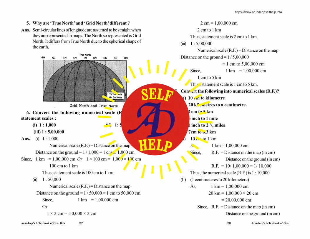
5. Why are ‘True North’ and ‘Grid North’ different ?
Ans. Semi-circular lines of longitude are assumed to be straight when
they are represented in maps. The North so represented is Grid
North. It differs from True North due to the spherical shape of
the earth.
6. Convert the following numerical scale (R.F.) in to
statement scales :
(i) 1 : 1,000 (ii) 1: 50,000
(iii) 1 : 5,00,000
Ans. (i) 1 : 1,000
Numerical scale (R.F.) = Distance on the map
Distance on the ground = 1 / 1,000 = 1 cm to 1,000 cm
Since, 1 km = 1,00,000 cm Or 1 × 100 cm = 1,000 × 100 cm
100 cm to 1 km
Thus, statement scale is 100 cm to 1 km.
(ii) 1 : 50,000
Numerical scale (R.F.) = Distance on the map
Distance on the ground = 1 / 50,000 = 1 cm to 50,000 cm
Since, 1 km = 1,00,000 cm
Or
1 × 2 cm = 50,000 × 2 cm
2 cm = 1,00,000 cm
2 cm to 1 km
Thus, statement scale is 2 cm to 1 km.
(iii) 1 : 5,00,000
Numerical scale (R.F.) = Distance on the map
Distance on the ground = 1 / 5,00,000
= 1 cm to 5,00,000 cm
Since, 1 km = 1,00,000 cm
1 cm to 5 km
Thus, statement scale is 1 cm to 5 km.
7. Convert the following into numerical scales (R.F.)?
(a) 10 cm to kilometre
(b) 20 kilometres to a centimetre.
(c) 2 cm to 5 km
(d) 6 inch to 1 mile
(e) 1 inch to 2 1/2 miles
(f) 7cm to 6.3 km
Ans. (a) 10 cm to 1 km
As, 1 km = 1,00,000 cm
Since, R.F. = Distance on the map (in cm)
Distance on the ground (in cm)
R.F. = 10/ 1,00,000 = 1/ 10,000
Thus, the numerical scale (R.F.) is 1 : 10,000
(b) (1 centimeteres to 20 kilometere)
As, 1 km = 1,00,000 cm
20 km = 1,00,000 × 20 cm
= 20,00,000 cm
Since, R.F. = Distance on the map (in cm)
Distance on the ground (in cm)
https://www.arundeepselfhelp.info
Arundeep’s A Textbook of Geo. 10th Arundeep’s A Textbook of Geo.29 30
R.F. = 1/ 20,00,000
Thus, the numerical scale (R.F.) is 1 : 20,00,000.
(c) 2 cm to 5 km
As, 1 km = 1,00,000 cm
5 km = 1,00,000 × 5cm
= 5,00,000 cm
Since, R.F. = Distance on the map (in cm)
Distance on the ground (in cm)
R.F. = 2/ 5,00,000 = 1/ 2,50,000
Thus, the numerical scale (R.F.) is 1 : 2,50,000
(d) 6 inch to 1 mile
We know that,1 mile = 63,360 inches
Since, R.F. = Distance on the map (in inch)
Distance on the ground (in inch)
R.F. = 6/ 63,360 = 1/ 10,560
Thus, the numerical scale (R.F.) is 1 : 10,560
(e) 1 inch to 2 1/
2 mile
As, 1 mile = 63,360 inches
We know that 2 1/
2 miles = 63,360 × 2.5 inches = 1,58,400 inches
Since, R.F. = Distance on the map (in inch)
Distance on the ground (in inch)
R.F. = 1/ 1,58,400
Thus, the numerical scale (R.F.) is 1 : 1,58,400
(f) 7 cm to 6.3 km
As, 1 km = 1,00,000 cm
6.3 km = 1,00,000 × 6.3cm = 6,30,000 cm
Since, R.F. = Distance on the map (in cm)
Distance on the ground (in cm)
R.F. = 7/ 6,30,000 = 1/ 90,000
Thus, the numerical scale (R.F.) is 1 : 90,000
II. Distinguish between :
(a) Statement Scale and Graphic Scale.
(b) True North and Magnetic North.
Ans. (a) (i) A statement scale : in this method, scale is stated in
words or we make a statement about it : e.g., 1 cm. to 1 km
1 inch to 5 miles.
The value on the left hand side usually represents the map-
distance. This method is not suitable, as we require to know
the units of measurements in different countries.
(ii) Liner or Graphic Scale : In this method, the scale is
represented by a straight line divided into equal parts (primary
and secondary) to show what these markings represents on the
actual ground. The Primary Divisions are the Major Divisions
on the scale graduated from left to right. The Secondary
Divisions are smaller units grauduated from right to left on one
primary division.
(b) The True North is the direction indicated by the North Star,
while the Magnetic North is the direction pointed by the needle
of a Magnetic Compass.
III. Long answer questions :
1. With regard to scale, answer the following questions :
(i) Name the main methods of representing the scale of a
map.
(ii) Convert the following statements into R.F.
(a) 25 cm on the map = 5 km on ground.
(b) 2 1/
2 inches on the map = 5 miles on ground
(c) 7 cm on the map = 63000 metres on ground
(d) 5 cm = 500 metres
(e) 15 cm = 6 km. (f) 10 cm = 1 km.
https://www.arundeepselfhelp.info
Arundeep’s A Textbook of Geo. 10th Arundeep’s A Textbook of Geo.
(g) 12 cm = 72000 metres
Ans. There are three main methods, of representing scale.
(i) A statement scale : in this method, scale is stated in words or
we make a statement about it : e.g.,
1 cm. to 1 km
1 inch to 5 miles.
The value on the left hand side usually represents the map-
distance. This method is not suitable, as we require to know
the units of measurements in different countries.
(ii) Liner or Graphic Scale : In this method, the scale is
represented by a straight line divided into equal parts (primary
and secondary) to show what these markings represents on the
actual ground. The Primary Divisions are the major divisions
on the scale graduated from left to right. The Secondary
Divisions are smaller units grauduated from right to left on one
primary division.
(iii) Representative Fraction : In this method, the scale is
represented as the ratio of the length of a line on the map and
the corresponding actual distance on earth’s surface. The
numerator is always expressed as unity i.e., one unit map-
distance is equivalent to a number of units of ground-distance.
This fraction is called Representative Fraction.
(ii) (a) 25 cm on the map = 5 km on ground
As, 1 km = 1,00,000 cm
5 km = 1,00,000 × 5 cm
= 5,00,000 cm
Since, R.F. = Distance on the map (in cm)
Distance on the ground (in cm)
R.F. = 25/ 5,00,000 = 1/ 20,000
Thus, R.F. is 1 : 20,000
(b) 2 1/2 inches on the map = 5 miles on ground
As, 1 mile = 63,360 inches
5 miles = 63,360 × 5 inches
= 3,16,800 inches
Since, R.F. = Distance on the map (in inch)
Distance on the ground (in inch)
R.F. = 2.5/ 3,16,800 =1/ 1,26,720
Thus, R.F. is 1 : 1,26,720
(c) 7 cm on the map = 63,000 metres on ground
As, 1 m = 100 cm
63,000 m = 100 × 63,000 cm
= 63,00,000 cm
Since, R.F. = Distance on the map (in inch)
Distance on the ground (in inch)
R.F. = 7/ 63,00,000 = 1/ 9,00,000
Thus, R.F. is 1 : 9,00,000
(d) 5 cm = 500 metres
As, 1 m = 100 cm
500 m = 100 × 500 cm
= 50,000 cm
Since, R.F. = Distance on the map (in cm)
Distance on the ground (in cm)
R.F. = 5/ 50,000 = 1/ 10,000
Thus, R.F. is 1 : 10,000
(e) 15 cm = 6 km
As, 1 km = 1,00,000 cm
6 km = 1,00, 000 × 6 cm
= 6,00,000 cm
Since, R.F. = Distance on the map (in cm)
Distance on the ground (in cm)
R.F. = 15/ 6,00,00 = 1/ 40,000
Thus, R.F. is 1 : 40,000
31 32
https://www.arundeepselfhelp.info
Arundeep’s A Textbook of Geo. 10th Arundeep’s A Textbook of Geo.33 34
(f) 10 cm = 1 km
As, 1 km = 1,00,000 cm
Since, R.F. = Distance on the map (in cm)
Distance on the ground (in cm)
R.F. = 10/ 1,00,000 = 1/ 10,000
Thus, R.F. is 1 : 10,000
(g) 12 cm = 72,000 metres
As, 1 m = 100 cm
72,000 m = 100 × 72,000 cm
= 72,00,000 cm
Since, R.F. = Distance on the map (in cm)
Distance on the ground (in cm)
R.F. = 12/ 72,00,000 = 1/ 6,00,000
Thus, R.F. is 1 : 6,00,000
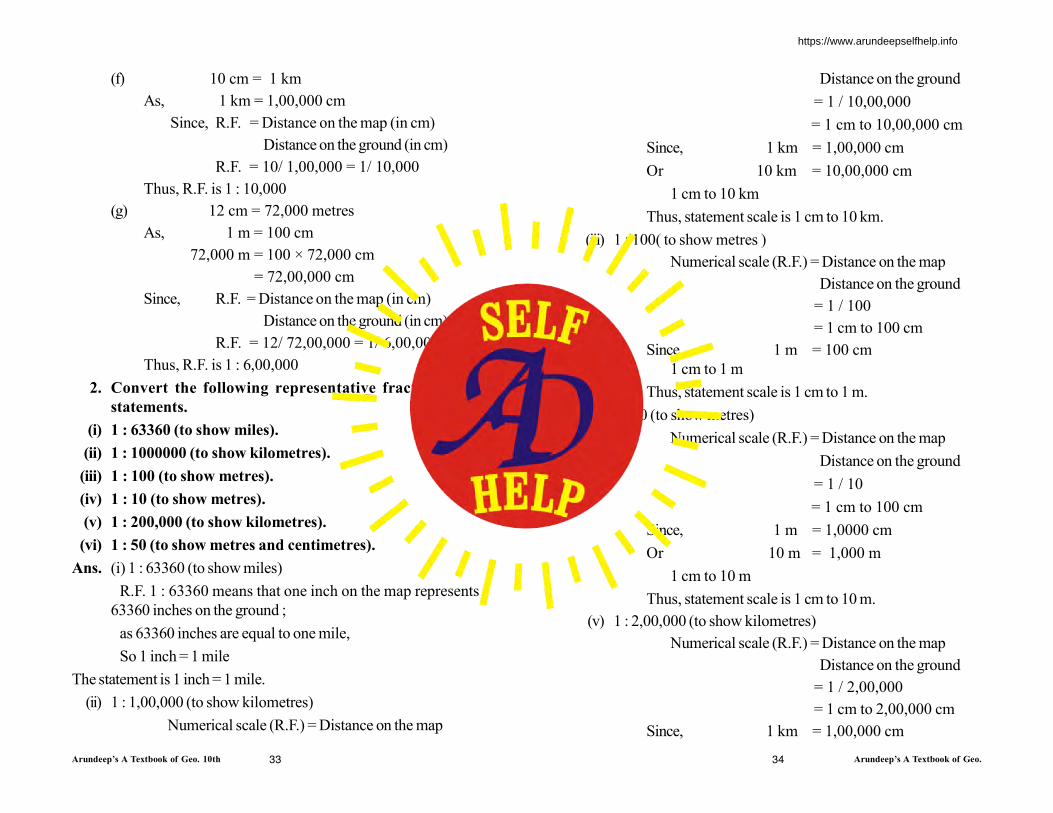
2. Convert the following representative fractions into
statements.
(i) 1 : 63360 (to show miles).
(ii) 1 : 1000000 (to show kilometres).
(iii) 1 : 100 (to show metres).
(iv) 1 : 10 (to show metres).
(v) 1 : 200,000 (to show kilometres).
(vi) 1 : 50 (to show metres and centimetres).
Ans. (i) 1 : 63360 (to show miles)
R.F. 1 : 63360 means that one inch on the map represents
63360 inches on the ground ;
as 63360 inches are equal to one mile,
So 1 inch = 1 mile
The statement is 1 inch = 1 mile.
(ii) 1 : 1,00,000 (to show kilometres)
Numerical scale (R.F.) = Distance on the map
Distance on the ground
= 1 / 10,00,000
= 1 cm to 10,00,000 cm
Since, 1 km = 1,00,000 cm
Or 10 km = 10,00,000 cm
1 cm to 10 km
Thus, statement scale is 1 cm to 10 km.
(iii) 1 : 100( to show metres )
Numerical scale (R.F.) = Distance on the map
Distance on the ground
= 1 / 100
= 1 cm to 100 cm
Since, 1 m = 100 cm
1 cm to 1 m
Thus, statement scale is 1 cm to 1 m.
(iv) 1 : 10 (to show metres)
Numerical scale (R.F.) = Distance on the map
Distance on the ground
= 1 / 10
= 1 cm to 100 cm
Since, 1 m = 1,0000 cm
Or 10 m = 1,000 m
1 cm to 10 m
Thus, statement scale is 1 cm to 10 m.
(v) 1 : 2,00,000 (to show kilometres)
Numerical scale (R.F.) = Distance on the map
Distance on the ground
= 1 / 2,00,000
= 1 cm to 2,00,000 cm
Since, 1 km = 1,00,000 cm
https://www.arundeepselfhelp.info
Arundeep’s A Textbook of Geo. 10th Arundeep’s A Textbook of Geo.35 36
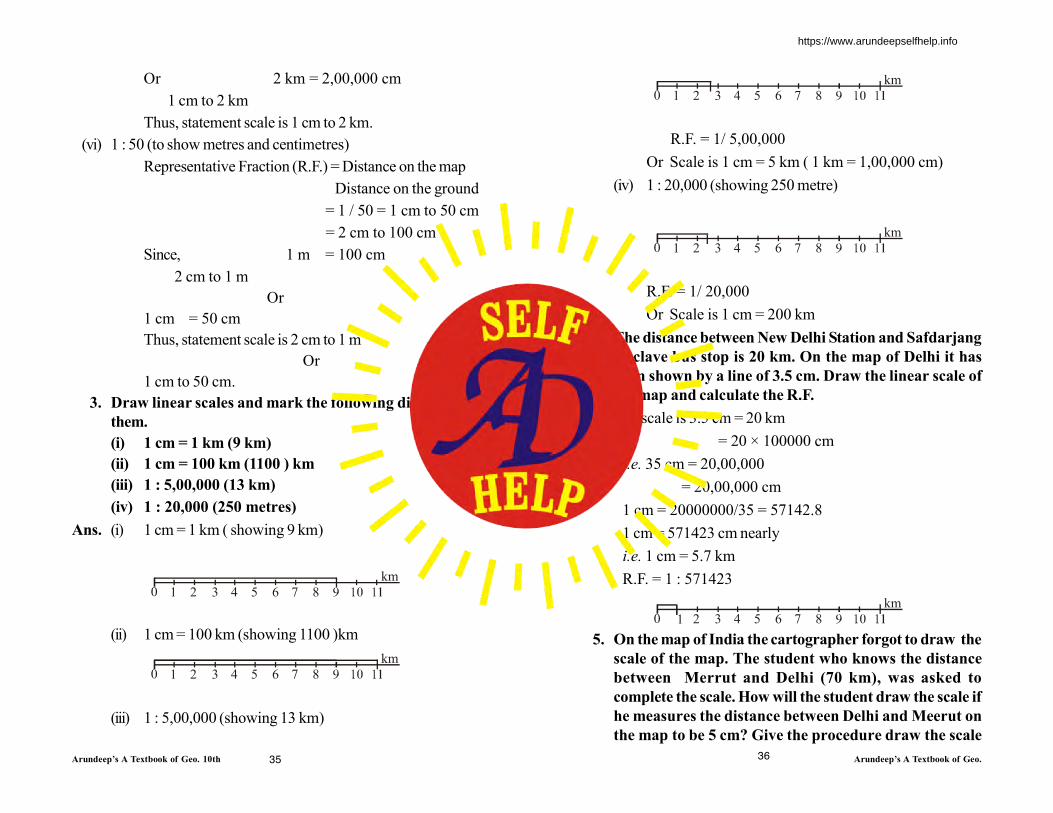
Or 2 km = 2,00,000 cm
1 cm to 2 km
Thus, statement scale is 1 cm to 2 km.
(vi) 1 : 50 (to show metres and centimetres)
Representative Fraction (R.F.) = Distance on the map
Distance on the ground
= 1 / 50 = 1 cm to 50 cm
= 2 cm to 100 cm
Since, 1 m = 100 cm
2 cm to 1 m
Or
1 cm = 50 cm
Thus, statement scale is 2 cm to 1 m
Or
1 cm to 50 cm.
3. Draw linear scales and mark the following distances on
them.
(i) 1 cm = 1 km (9 km)
(ii) 1 cm = 100 km (1100 ) km
(iii) 1 : 5,00,000 (13 km)
(iv) 1 : 20,000 (250 metres)
Ans. (i) 1 cm = 1 km ( showing 9 km)
0 1
km
2 3 4 5 6 7 8
(ii) 1 cm = 100 km (showing 1100 )km
0 1
km
2 3 4 5 6 7 8
(iii) 1 : 5,00,000 (showing 13 km)
0 1
km
2 3 4 5 6 7 8
R.F. = 1/ 5,00,000
Or Scale is 1 cm = 5 km ( 1 km = 1,00,000 cm)
(iv) 1 : 20,000 (showing 250 metre)
0 1
km
2 3 4 5 6 7 8
R.F. = 1/ 20,000
Or Scale is 1 cm = 200 km
4. The distance between New Delhi Station and Safdarjang
Enclave bus stop is 20 km. On the map of Delhi it has
been shown by a line of 3.5 cm. Draw the linear scale of
the map and calculate the R.F.
Ans. The scale is 3.5 cm = 20 km
= 20 × 100000 cm
i.e. 35 cm = 20,00,000
= 20,00,000 cm
1 cm = 20000000/35 = 57142.8
1 cm = 571423 cm nearly
i.e. 1 cm = 5.7 km
R.F. = 1 : 571423
0 1
km
2 3 4 5 6 7 8
5. On the map of India the cartographer forgot to draw the
scale of the map. The student who knows the distance
between Merrut and Delhi (70 km), was asked to
complete the scale. How will the student draw the scale if
he measures the distance between Delhi and Meerut on
the map to be 5 cm? Give the procedure draw the scale
https://www.arundeepselfhelp.info
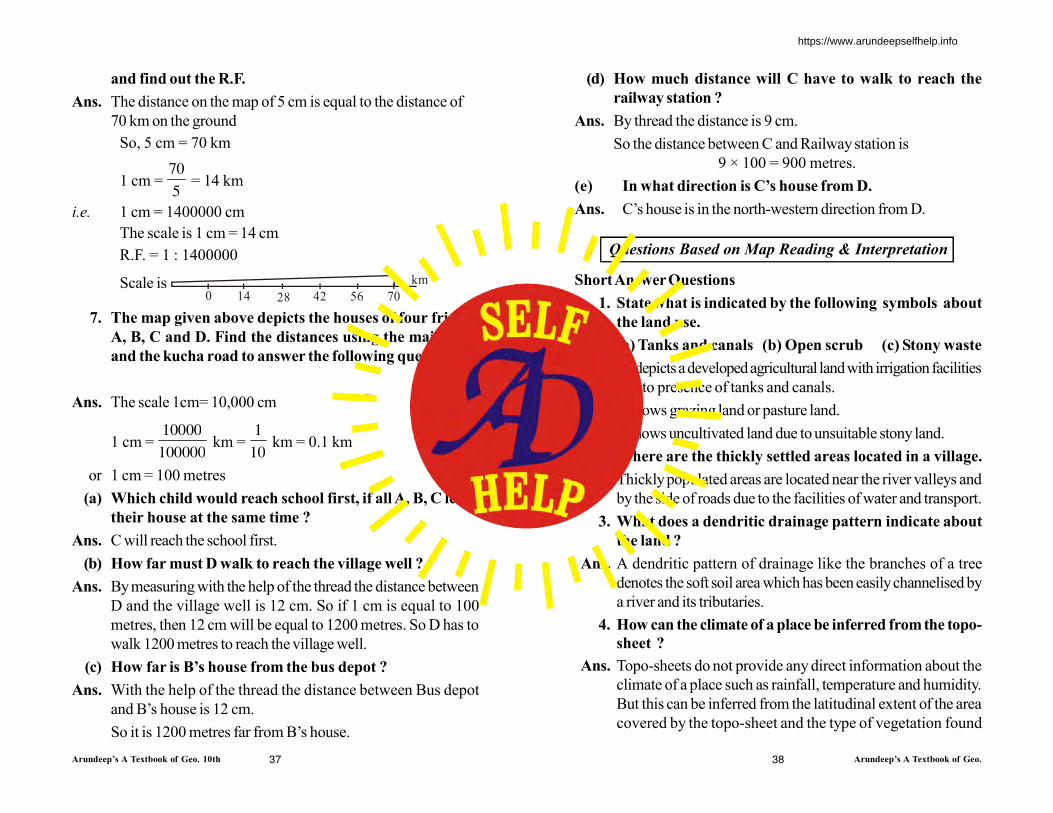
Arundeep’s A Textbook of Geo. 10th Arundeep’s A Textbook of Geo.37
and find out the R.F.
Ans. The distance on the map of 5 cm is equal to the distance of
70 km on the ground
So, 5 cm = 70 km
1 cm = 70
5 = 14 km
i.e. 1 cm = 1400000 cm
The scale is 1 cm = 14 cm
R.F. = 1 : 1400000
Scale is 0 14 28 42 56 70
km
7. The map given above depicts the houses of four friends
A, B, C and D. Find the distances using the main road
and the kucha road to answer the following questions.
Ans. The scale 1cm= 10,000 cm
1 cm = 10000
100000 km =
1
10 km = 0.1 km
or 1 cm = 100 metres
(a) Which child would reach school first, if all A, B, C leave
their house at the same time ?
Ans. C will reach the school first.
(b) How far must D walk to reach the village well ?
Ans. By measuring with the help of the thread the distance between
D and the village well is 12 cm. So if 1 cm is equal to 100
metres, then 12 cm will be equal to 1200 metres. So D has to
walk 1200 metres to reach the village well.
(c) How far is B’s house from the bus depot ?
Ans. With the help of the thread the distance between Bus depot
and B’s house is 12 cm.
So it is 1200 metres far from B’s house.
(d) How much distance will C have to walk to reach the
railway station ?
Ans. By thread the distance is 9 cm.
So the distance between C and Railway station is
9 × 100 = 900 metres.
(e) In what direction is C’s house from D.
Ans. C’s house is in the north-western direction from D.
Questions Based on Map Reading & Interpretation
Short Answer Questions
1. State what is indicated by the following symbols about
the land use.
(a) Tanks and canals (b) Open scrub (c) Stony waste
Ans. (a) It depicts a developed agricultural land with irrigation facilities
due to presence of tanks and canals.
(b) It shows grazing land or pasture land.
(c) It shows uncultivated land due to unsuitable stony land.
2. Where are the thickly settled areas located in a village.
Ans. Thickly populated areas are located near the river valleys and
by the side of roads due to the facilities of water and transport.
3. What does a dendritic drainage pattern indicate about
the land ?
Ans. A dendritic pattern of drainage like the branches of a tree
denotes the soft soil area which has been easily channelised by
a river and its tributaries.
4. How can the climate of a place be inferred from the topo-
sheet ?
Ans. Topo-sheets do not provide any direct information about the
climate of a place such as rainfall, temperature and humidity.
But this can be inferred from the latitudinal extent of the area
covered by the topo-sheet and the type of vegetation found
38
https://www.arundeepselfhelp.info

Arundeep’s A Textbook of Geo. 10th Arundeep’s A Textbook of Geo.39 40
there. For example, the climate of a place at 10°N latitude
would be warmer than the place at 35°N latitude.
5. What are the factors that affect settlements in an area ?
Ans. (a) The relief and climate of the area : Settlements are not
found in steep hill sides or marshy lands or areas that become
waterlogged. People tend to settle where the land is flat and
arable.
(b) Security : In order to have security for people and property,
settlements usually develop on higher ground to avoid flooding.
The settlement may grow in a place which has a strategic position
as a defence centre. The settlement could be a result of the
advantage of protecting people and property from enemies
and controlling access to important passes, harbours and
factories.
(c) Availability of transport and communication : Towns and
villages develop where roads, rivers, railways, etc., help in
transport and trade. Ports develop at mouths of rivers, which
are also connected by roads and railways.
(d) Centrally located settlement : A settlement may develop if
it is centrally located with regard to other settlements (villages).
It becomes the administrative as well as the trade centre for
the other settlements around it. Many small towns and villages
in India hold markets and fairs (melas) for this purpose.
(e) The availability of water and land for cultivation and other
purposes.
(f) The potential for mining and industry.
II. Match the following :
Evidences Occupations
1. Settlement near the main road (a) Agriculture
2. Parks (b) Forestry
3. Coast, Lakes (c) Cattle grazing
4. Yellow patch (d) Fishery
5. Meadows (e) Entertainment
6. Green patch (f) Trade
Ans.
Evidences Occupations
1. Settlement near the main road (f) Trade
2. Parks (e) Entertainment
3. Coast, Lakes (d) Fishery
4. Yellow patch (a) Agriculture
5. Meadows (c) Cattle grazing
6. Green patch (b) Forestry
III. What do the following diagrams indicate ? Write short
notes on the features as indicated by each diagram.
Ans. (i) First diagram indicates dispersed or scattered settlements.
https://www.arundeepselfhelp.info

Arundeep’s A Textbook of Geo. 10th Arundeep’s A Textbook of Geo.41 42
These settlements are found in the areas of sparse population,
sheltered valleys or at foot hills. Here buildings are far away
from each other. They are almost isolated. There are large farm-
houses.
(ii) Second diagram displays nucleated settlements, a dense
settlement on the both sides of Kutcha roads in which farms
and other buildings are clustered together, often around some
central feature like a church or temple or police chowki, post
office etc. Some of the factors which encourage nucleated or
compact sites include the need for defence, the availability of
water supply at particular locations and the development of
modern means of transport.
Questions Based Map Reading Practice
Question 1.
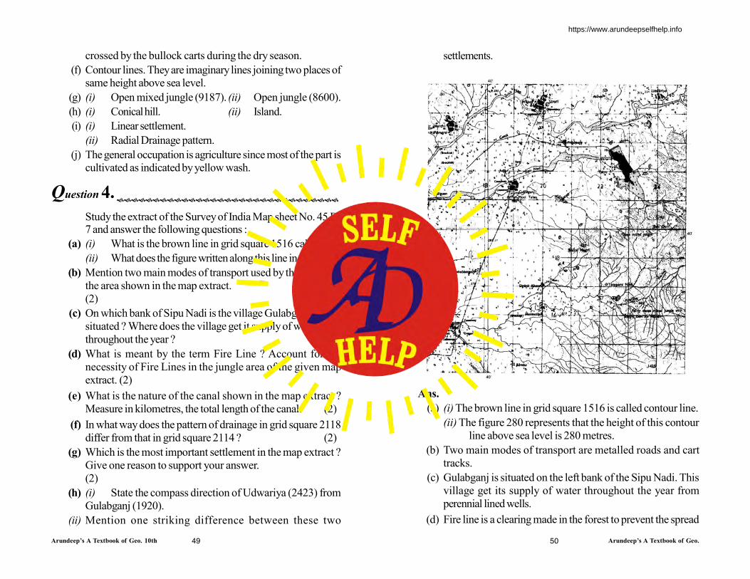
Study the extract of the Survey of India Map Sheet No. 45D/7 and answer the following questions :
(a) Give the six-figure grid reference of :
(i) Triangulated height 225 ;
(ii) A lined well near Ganguwada.
(b) Name the most important perennial source of irrigation
shown on the map extract.
(c) (i) What does 6r in the grid square 8495 means ?
https://www.arundeepselfhelp.info
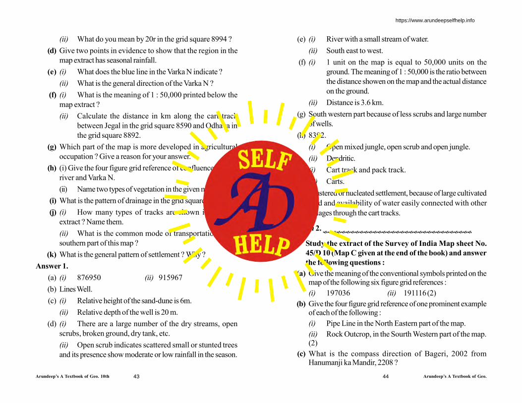
Arundeep’s A Textbook of Geo. 10th Arundeep’s A Textbook of Geo.43 44
(ii) What do you mean by 20r in the grid square 8994 ?
(d) Give two points in evidence to show that the region in the
map extract has seasonal rainfall.
(e) (i) What does the blue line in the Varka N indicate ?
(ii) What is the general direction of the Varka N ?
(f) (i) What is the meaning of 1 : 50,000 printed below the
map extract ?
(ii) Calculate the distance in km along the cart track
between Jegal in the grid square 8590 and Odhava in
the grid square 8892.
(g) Which part of the map is more developed in agricultural
occupation ? Give a reason for your answer.
(h) (i) Give the four figure grid reference of confluence of Sipu
river and Varka N.
(ii) Name two types of vegetation in the given map extract.
(i) What is the pattern of drainage in the grid square 8599 ?
(j) (i) How many types of tracks are shown in the map
extract ? Name them.
(ii) What is the common mode of transportation in the
southern part of this map ?
(k) What is the general pattern of settlement ? Why ?
Answer 1.
(a) (i) 876950 (ii) 915967
(b) Lines Well.
(c) (i) Relative height of the sand-dune is 6m.
(ii) Relative depth of the well is 20 m.
(d) (i) There are a large number of the dry streams, open
scrubs, broken ground, dry tank, etc.
(ii) Open scrub indicates scattered small or stunted trees
and its presence show moderate or low rainfall in the season.
(e) (i) River with a small stream of water.
(ii) South east to west.
(f) (i) 1 unit on the map is equal to 50,000 units on the
ground. The meaning of 1 : 50,000 is the ratio between
the distance showen on the map and the actual distance
on the ground.
(ii) Distance is 3.6 km.
(g) South western part because of less scrubs and large number
of wells.
(h) 8392.
(i) Open mixed jungle, open scrub and open jungle.
(ii) Dendritic.
(j) (i) Cart track and pack track.
(ii) Carts.
(k) Clustered or nucleated settlement, because of large cultivated
land and availability of water easily connected with other
villages through the cart tracks.
Question 2.
Study the extract of the Survey of India Map sheet No.
45/D 10 (Map C given at the end of the book) and answer
the following questions :
(a) Give the meaning of the conventional symbols printed on themap of the following six figure grid references :
(i) 197036 (ii) 191116(2)
(b) Give the four figure grid reference of one prominent exampleof each of the following :
(i) Pipe Line in the North Eastern part of the map.
(ii) Rock Outcrop, in the Sourth Western part of the map.(2)
(c) What is the compass direction of Bageri, 2002 fromHanumanji ka Mandir, 2208 ?
https://www.arundeepselfhelp.info

Arundeep’s A Textbook of Geo. 10th Arundeep’s A Textbook of Geo.
(d) Name the type of drainage pattern found in grid square 2209.
(e) What are the brown lines covering most of the map extractcalled ? What do these brown lines indicate ? (2)
(f) What do the words “falls 25 m” in grid square 2307 means ?
(g) (i) What would be the main source of water supply for Mt.Abu?
(ii) Give a reason for your answer.
(h) There are no roads connecting Mt. Abu to the settlements inthe South West. Why ?
(i) Calculate the area of land enclosed within Eastings 17 and 21
and Northings 05 and 09.
(j) Comment on the nature of the well in grid square 1906.
(k) Name any two types of forested regions mentioned in themap extract.
(l) Give in kilometres the length of the entire region depicted onthe map from North to South. Show your working.
(m) What is the settlement pattern of the largest town on the mapextract supplied to you ?
(n) Describe the nature of roads connecting Gautam MaharishiMandi 2007 and Shri Vashist Ashram 2207.
Answer.
(a) (i) 197036-6r-relative height of the embankment.
(ii) 191116-A Temple.
(b) (i) 2209. (ii) 1402.
(c) South west. (d) Trellised.
(e) Contours. They indicate height/hilly terrain.
(f) It means there is waterfall which falls from 25m or the heightof waterfall is 25m above the sea level.
(g) (i) Nakhi Talao or Kodra reservoir is the main source ofwater supply for Mt. Abu.
(ii) Perennial source of water around which the settlementhas come-up, is indicated by the blue colour of theTalao.
(h) There are no roads connecting Mt. Abu to the settlements in theSouth west because middle part of the region is a high hilly areashown by brown lines, where construction of roads is notpossible.
(i) 16 km2.
(j) Water of well is Brackish or salty which is not suitable fordrinking and agriculture.
(k) Fairly dense mixed jungle and Dense mixed jungle withbamboo.
(l) Length is 10 cm. and the Scale of the map is 1 cm = 0.5 km
45 46
https://www.arundeepselfhelp.info

Arundeep’s A Textbook of Geo. 10th Arundeep’s A Textbook of Geo.
10 cm = 0.5 × 10 = 5 km
(m) Nucleated/Nodal.
(n) Foot Path.
Question 3.
Study the extract of the Survey of India Map Sheet No. 45
D/7 and answer the following questions :
(a) Give the six-figure grid reference of :
(i) 592
(ii) The temple where the Annual Fair is held in the month
of February. (2)
(b) (i) State the general direction of Arado N.
(ii) What does the blue line in Arado N indicate ? (2)
(c) Calculate the distance in kilometres along the cart track
between Velavas (868895) and Ranol (883888). (2)
(d) (i) What does 7r in grid square 8689 indicate ?
(ii) State the main source of irrigation at Dhariawada
(Fatepura). (2)
(e) What type of rainfall is experienced in the region shown in the
map extract ? Justify your answer giving one reason. (2)
(f) Name and explain the term used for the brown lines in the
map extract. (2)
(g) Name any two types of vegetation found in the map extract.
Give a four figure grid reference for each. (2)
(h) (i) What is the main relief feature seen in grid square 9284
?
(ii) Which prominent feature can be seen in the river bed,
grid reference 9380 ? (2)
(i) State the pattern of :
(i) Human settlement in grid square 8989 and
(ii) Drainage in grid square 9185 (1)
(j) What inference can be drawn about the general occupation
of the people of the region shown in the western half of the
map extract ? Give one reason to justify your answer. (2)
Ans.
(a) (i) 928890
(ii) 912883
(b) (i) North to south.
(ii) Perennial Channel.
(c) 2.5 kms.
(d) (i) Relative height.
(ii) Wells.
(e) Seasonal rainfall as cart tracks are running right across the
river which indicates that the bed of the river is dry and can be
47 48
https://www.arundeepselfhelp.info
Arundeep’s A Textbook of Geo. 10th Arundeep’s A Textbook of Geo.
crossed by the bullock carts during the dry season.
(f) Contour lines. They are imaginary lines joining two places of
same height above sea level.
(g) (i) Open mixed jungle (9187). (ii) Open jungle (8600).
(h) (i) Conical hill. (ii) Island.
(i) (i) Linear settlement.
(ii) Radial Drainage pattern.
(j) The general occupation is agriculture since most of the part is
cultivated as indicated by yellow wash.
Question 4.
Study the extract of the Survey of India Map sheet No. 45 D/7 and answer the following questions :
(a) (i) What is the brown line in grid square 1516 called ?
(ii) What does the figure written along this line indicate ?(2)
(b) Mention two main modes of transport used by the people in
the area shown in the map extract.
(2)
(c) On which bank of Sipu Nadi is the village Gulabganj (1920)
situated ? Where does the village get it supply of water from
throughout the year ? (2)
(d) What is meant by the term Fire Line ? Account for the
necessity of Fire Lines in the jungle area of the given map
extract. (2)
(e) What is the nature of the canal shown in the map extract ?
Measure in kilometres, the total length of the canal. (2)
(f) In what way does the pattern of drainage in grid square 2118
differ from that in grid square 2114 ? (2)
(g) Which is the most important settlement in the map extract ?
Give one reason to support your answer.
(2)
(h) (i) State the compass direction of Udwariya (2423) from
Gulabganj (1920).
(ii) Mention one striking difference between these two
settlements.
Ans.
(a) (i) The brown line in grid square 1516 is called contour line.
(ii) The figure 280 represents that the height of this contour
line above sea level is 280 metres.
(b) Two main modes of transport are metalled roads and cart
tracks.
(c) Gulabganj is situated on the left bank of the Sipu Nadi. This
village get its supply of water throughout the year from
perennial lined wells.
(d) Fire line is a clearing made in the forest to prevent the spread
49 50
https://www.arundeepselfhelp.info
Arundeep’s A Textbook of Geo. 10th Arundeep’s A Textbook of Geo.
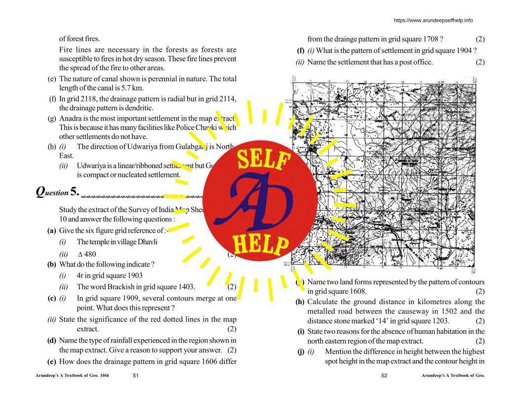
of forest fires.
Fire lines are necessary in the forests as forests are
susceptible to fires in hot dry season. These fire lines prevent
the spread of the fire to other areas.
(e) The nature of canal shown is perennial in nature. The total
length of the canal is 5.7 km.
(f) In grid 2118, the drainage pattern is radial but in grid 2114,
the drainage pattern is dendritic.
(g) Anadra is the most important settlement in the map extract.
This is because it has many facilities like Police Chauki which
other settlements do not have.
(h) (i) The direction of Udwariya from Gulabganj is North-
East.
(ii) Udwariya is a linear/ribboned settlement but Gulabganj
is compact or nucleated settlement.
Question 5.
Study the extract of the Survey of India Map Sheet No. 45D/
10 and answer the following questions :
(a) Give the six figure grid reference of :-
(i) The temple in village Dhavli
(ii) 480 (2)
(b) What do the following indicate ?
(i) 4r in grid square 1903
(ii) The word Brackish in grid square 1403. (2)
(c) (i) In grid square 1909, several contours merge at one
point. What does this represent ?
(ii) State the significance of the red dotted lines in the map
extract. (2)
(d) Name the type of rainfall experienced in the region shown in
the map extract. Give a reason to support your answer. (2)
(e) How does the drainage pattern in grid square 1606 differ
from the drainge pattern in grid square 1708 ? (2)
(f) (i) What is the pattern of settlement in grid square 1904 ?
(ii) Name the settlement that has a post office. (2)
(g) Name two land forms represented by the pattern of contours
in grid square 1608. (2)
(h) Calculate the ground distance in kilometres along the
metalled road between the causeway in 1502 and the
distance stone marked ‘14’ in grid square 1203. (2)
(i) State two reasons for the absence of human habitation in the
north eastern region of the map extract. (2)
(j) (i) Mention the difference in height between the highest
spot height in the map extract and the contour height in
51 52
https://www.arundeepselfhelp.info

Arundeep’s A Textbook of Geo. 10th Arundeep’s A Textbook of Geo.
grid square 1006.
(ii) What is the compass direction of Patlawa ka Goliya
(590) from Kacholi Dungar (443) ? (2)
Ans.
(a) (i) The six figure grid reference of the temple in village
Dhavli is 111073.
Note : [There are two temples in Dhalvi (i) 111073 (ii)
107077 (across the river)]
(ii) For the 480 is 137046.
(b) (i) The relative height of dry tank is 4 meter.
(ii) A saline water, not fit for human or animal consumption.
It can also be unfit for cultivation being salty or brackish.
(c) (i) Steep slop or sudden fall of water.
(ii) This is a pack-track used by the pack animals.
(d) Season rainfall, because of presence of dry tanks and
seasonal streams.
(e) In grid square 1606 the drainage pattern is radial as
numerious streams emerges from central highland and in grid
square 1708 it is trellis, streams joining the river by making
right angle.
(f) (i) Scattered type of settlement.
(ii) Settlement Dattani.
(g) Two landforms represented by the pattern of contours in grid
square 1608 are hilly ridge (scarped ridge) on the western
side and plateau type features on southern side.
(h) The distance is 4 km.
(i) (i) Hilly terrain
(ii) Numerious streams.
(j) (i) The difference in height is 763 meter.
(ii) North-East
53
https://www.arundeepselfhelp.info

Arundeep’s A Textbook of Geo. 10th Arundeep’s A Textbook of Geo. 10th21 54
8. What is the scale of the given map ?
Ans. The scale of the map is 1 : 50000 i.e. 2cms to 1 km.
9. What is the occupation of the people in the north of Banas
river ? Give a reason for your answer.
Ans. The Occupation of the people in the North of Banas river is
forestry and Cattle rearing.
The vegetation grown or open scale show it.
10. Identify the conventional sign in red broken lines in grid
square 9777.
Ans. The conventional sign in red broken lines in grid square 9777
shows the pack track, which is only used by man and animals
only.
Section B
Map of India
https://www.arundeepselfhelp.info

Arundeep’s A Textbook of Geo. 10th Arundeep’s A Textbook of Geo. 10th55 56
1. On the outline map of India, mark and name the following:
(a) Eastern and Western Ghats
(b) Indo-Gangetic plains (c) Gulf of Khambhat
(d) Nathu-La Pass (e) Tropic of Cancer
(f) Direction of North East Monsoon
(g) Offshore oilfields
(h) A place where coal is found in Jharkhand
(i) An area having red soil
(j) Hyderabad
Ans.
Tropic of Cancer
(b) Indo-Gangetic Plains Nathu-La Pass
Jharkhand
Coal (h)
(b) N
orth
-Eas
t Mon
soon
Gulf of Khambhat
(i) Red soil
Hyderabad G
hats
Easte
rn G
hats
Mumbaihigh (g)
Weste
rn g
hats
(a)
(c)
(d)
2. On the outline map of India, mark and name the following:
(a) Vindhya range (b) Konkan coast
(c) A tributary of Ganga (d) Palk Strait
(e) Karakoram Pass
(f) Standard Meridian of India — 82° 30’ E
(h) Iron ore in Singhbhum
(i) Allahabad
(j) A state with highest density of population
Ans.
Vindhya Range (i)Allahabad
Karakoram Pass
(j) bihar
(h) singbhum
Ret
reat
ing
S.W
. Mon
soon
Palkstrait
Standard Median
KonkanCoast
(C) R
. Ganga
https://www.arundeepselfhelp.info
Arundeep’s A Textbook of Geo. 10th Arundeep’s A Textbook of Geo.57
ADDITIONAL QUESTIONS
Questions Based on Map of India
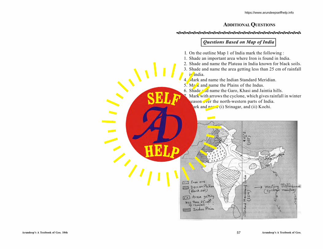
I. On the outline Map 1 of India mark the following :
1. Shade an important area where Iron is found in India.
2. Shade and name the Plateau in India known for black soils.
3. Shade and name the area getting less than 25 cm of rainfall
in India.
4. Mark and name the Indian Standard Meridian.
5. Mark and name the Plains of the Indus.
6. Shade and name the Garo, Khasi and Jaintia hills.
7. Mark with arrows the cyclone, which gives rainfall in winter
season over the north-western parts of India.
8. Mark and name (i) Srinagar, and (ii) Kochi.
Ans.
https://www.arundeepselfhelp.info

Arundeep’s A Textbook of Geo. 10th Arundeep’s A Textbook of Geo.58 59
II.On the outline Map 2 of India mark the following :
1. Mark and name Sundarbans.
2. Mark the town of Chennai.
3. Mark and name of Himalayas.
4. Mark with a thick line and name the Satpura Range.
5. Mark and name (i) River Indus and (ii)River Brahmaputra.
6. Shade and name the Rajasthan Plains.
7. Mark and name the Kosi River.
8. Mark and name with arrows the direction of winds blowing in
Kerala during summer season from the Arabian Sea.
9. Shade and name the Chotanagpur Plateau.
Ans.
III. On the outline Map 3 of India mark the following :
1. Name and mark with arrows the direction of the tropical
cyclone over the Bay of Bengal.
2. Mark and name two regions each in India, rich in
(i) Coal (ii) Petroleum (iii) Iron ore
(iv) Bauxite (v) Manganese.
3. Mark and name Karakoram range and the Western and
Eastern Ghats.
4. Mark and name one region in India with each for the following
:
(i) Alluvial soil (ii) Laterite soil (iii) Red soil.
5. Shade an area in India receiving 100-200cm of annual rainfall.
6. Mark and name (i) Delhi and (ii) Vishakhapatnam.
7. Mark and name Mount Everest and the Eastern Ghats.
8. Mark and name the River Mahanadi and River Yamuna.
9. Mark the Karakoram and Nathu La Passes.
10. Mark the Tropic of Cancer and Standard Meridian.
11. Mark the direction of South West and North East Monsoon.
Ans.
https://www.arundeepselfhelp.info

Arundeep’s A Textbook of Geo. 10th Arundeep’s A Textbook of Geo.60 61
IV. On the outline Map 4 of India mark the following.
1. Mark the following towns - (i) Hyderabad, (ii) Allahabad (c)
Kolkata.
2. Mark and name two rivers in India draining into the Arabian
Sea.
3. Shade and name an area in India that receives maximum
rainfall from North-East Monsoon.
4. Shade and name Aravalli ranges.
5. Shade the level plains of Northern India.
6. Mark and name the Nilgiris.
7. Mark with arrows the direction of winds blowing during the
winter season in India.
8. Shade and name the area in India which receives rainfall from
three sources.
Ans.
V. On the outline Map 5 of India mark the following :
1. The following cities and towns : Mumbai, Kolkata, Chennai,
Hyderabad, Bangalore, New Delhi, Kochi, Srinagar and
Vishakhapatnam.
2. Mark and name the following rivers : Ravi, Beas, Chenab,
Jhelum, Sutlej, Ganga, Narmada, Godavari, Tapti, Krishna
and Cauveri.
3. Shade and name the areas which are densely populated and
sparsely populated.
Ans.
https://www.arundeepselfhelp.info

Arundeep’s A Textbook of Geo. 10th Arundeep’s A Textbook of Geo.62 63
Few More Additional Questions
1. On the outline map of the Indian sub-continent provided to youat the end of this questions paper :
(a) Label the River Ravi.
(b) Mark with a thick line and name the Satpura Hills. (1)
(c) Name the River Godavari. (1)
(d) Mark with a dot and name, in the appropriate place, the capitalcity of Madhya Pradesh. (1)
(e) Shade and name the area where mangrove forests occur. (1)
(f) Print Uttar Pradesh in its proper location. (1)
(g) Mark with a thick line and name the Sulaiman Range. (1)
(h) Shade an area having winter rainfall in South India. (1)
(i) Print the world GOLD over one area where it is mined. (1)
(j) Draw the line of latitude 10ºN which passes near Kochi(Cochin). (1)
(k) Print in bold letter ‘W’ in the region in Pakistan where wheat isgrown and ‘T’ for tabacco in one region in western India whereit is widely grown. (1)
(l) Shade and name the Rann of Kutchh. (1)
Ans.
2. On the outline map of the Indian sub-continent, provided to you atthe end of this question paper:
(a) Mark and name the Mahadeo range. (1)
(b) Mark and label the Chambal river. (1)
(c) Shade and label the Rann of Kutchh. (1)
(d) Shade and label a major coffee producing area in South India.(1)
(e) Print C over one important region where copper is mined inIndia. (1)
(f) With the help of arrow marks, name the winds that bring rainfallto the Tamil Nadu coast in winter. (1)
(g) Mark and name the longitude from which India takes itsstandard time. (1)
(h) Mark with a dot and name (i) Islamabad. (i) Kolkata. (2)
(i) Mark and label the Sutlej river. (1)
(j) Mark and name the multipurpose project constructed on RiverSon. (1)
(k) Shade and name a region receiving less than 50 cm of rainfall inNorthern India. (1)
Ans.
10 N Latitudeo
Rann of
Kutchh
Uttar Pradesh
India
Rann of
R
https://www.arundeepselfhelp.info
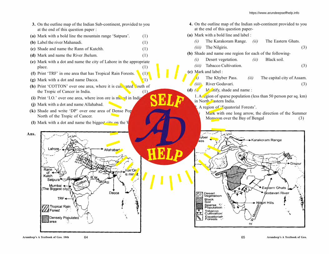
Arundeep’s A Textbook of Geo. 10th Arundeep’s A Textbook of Geo.64 65
3. On the outline map of the Indian Sub-continent, provided to you
at the end of this question paper :
(a) Mark with a bold line the mountain range ‘Satpura’. (1)
(b) Label the river Mahanadi. (1)
(c) Shade and name the Rann of Kutchh. (1)
(d) Mark and name the River Jhelum. (1)
(e) Mark with a dot and name the city of Lahore in the appropriate
place. (1)
(f) Print ‘TRF’ in one area that has Tropical Rain Forests. (1)
(g) Mark with a dot and name Dacca. (1)
(h) Print ‘COTTON’ over one area, where it is cultivated South of
the Tropic of Cancer in India. (1)
(i) Print ‘I.O.’ over one area, where iron ore is mined in India.(1)
(j) Mark with a dot and name Allahabad. (1)
(k) Shade and write ‘DP’ over one area of Dense Population in
North of the Tropic of Cancer. (1)
(l) Mark with a dot and name the biggest city on the West Coast.
(1)
Ans.
4. On the outline map of the Indian sub-continent provided to youat the end of this question paper-
(a) Mark with a bold line and label :
(i) The Karakoram Range. (ii) The Eastern Ghats.
(iii) The Nilgiris. (3)
(b) Shade and name one region for each of the following-
(i) Desert vegetation. (ii) Black soil.
(iii) Tabacco Cultivation. (3)
(c) Mark and label :
(i) The Khyber Pass. (ii) The capital city of Assam.
(iii) River Godavari. (3)
(d) (i) Identify, shade and name :
1. A region of sparse population (less than 50 person per sq. km)in North Eastern India.
2. A region of ‘Equatorial Forests’.
(ii) Mark with one long arrow, the direction of the SummerMonsoon over the Bay of Bengal (3)
Ans.
https://www.arundeepselfhelp.info
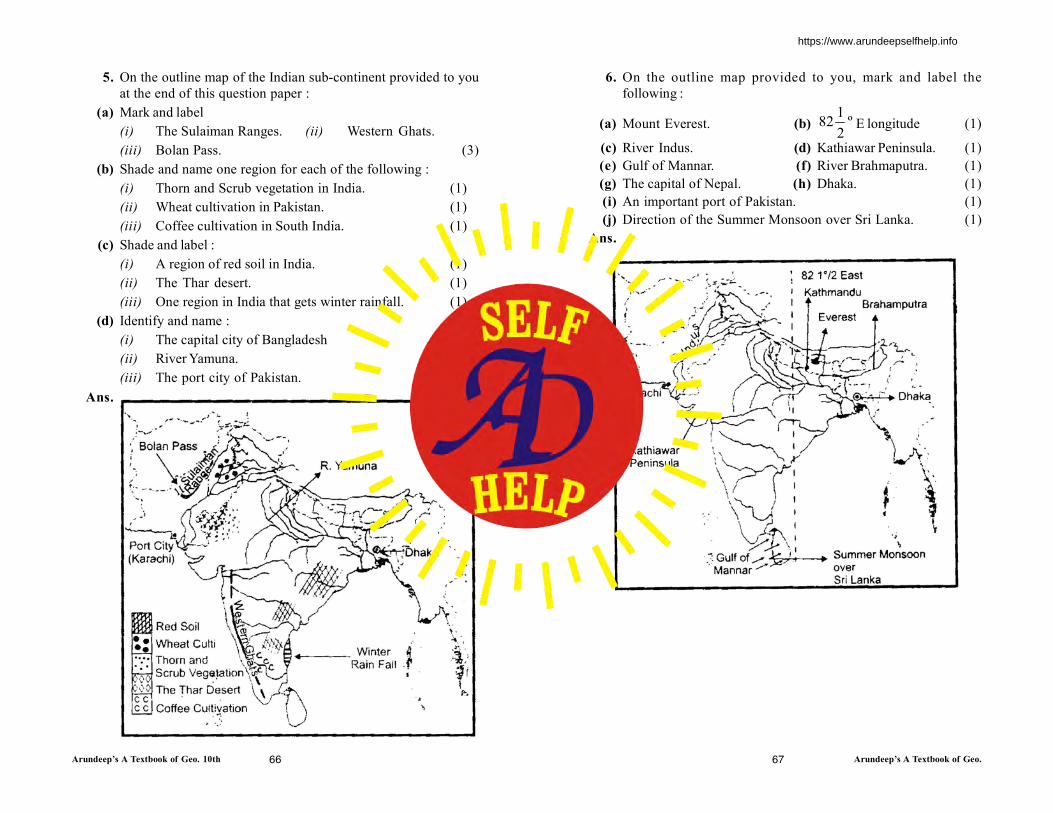
Arundeep’s A Textbook of Geo. 10th Arundeep’s A Textbook of Geo.66 67
5. On the outline map of the Indian sub-continent provided to you
at the end of this question paper :
(a) Mark and label
(i) The Sulaiman Ranges. (ii) Western Ghats.
(iii) Bolan Pass. (3)
(b) Shade and name one region for each of the following :
(i) Thorn and Scrub vegetation in India. (1)
(ii) Wheat cultivation in Pakistan. (1)
(iii) Coffee cultivation in South India. (1)
(c) Shade and label :
(i) A region of red soil in India. (1)
(ii) The Thar desert. (1)
(iii) One region in India that gets winter rainfall. (1)
(d) Identify and name :
(i) The capital city of Bangladesh
(ii) River Yamuna.
(iii) The port city of Pakistan. (2)
Ans.
6. On the outline map provided to you, mark and label the
following :
(a) Mount Everest. (b) º2
182 E longitude (1)
(c) River Indus. (d) Kathiawar Peninsula. (1)
(e) Gulf of Mannar. (f) River Brahmaputra. (1)
(g) The capital of Nepal. (h) Dhaka. (1)
(i) An important port of Pakistan. (1)
(j) Direction of the Summer Monsoon over Sri Lanka. (1)
Ans.
https://www.arundeepselfhelp.info

Arundeep’s A Textbook of Geo. 10th Arundeep’s A Textbook of Geo. 10th68 69
Location, Extent and
Physical Features of India
(Through Map Only)
Exercise I
1. On the outline map of India : (a) Mark the following
mountains : Himalayas, Aravali, Garo, Khasi, Jayantia,
Vindhya, Satpura, Eastern and Western Ghats, K2,
Kanchenjunga. (b) Mark the rivers : Indus, Ravi, Betwa,
Son, Gomti, Mahanadi, Brahmaputra, Narmada, Tapi,
Krishna, Kaveri, Turgabhadra and Godavari. (c) Mark
and name the Plains, plateaus and Coastal plains, as given
in the map syllabus.
Ans.
2. On an outline map of India :
(i) Mark and name the Tropic of Cancer.
(ii) Mark and name the Standard Meridian of India.
(iii) On a political map of India, mark the 29 states and name
their capitals.
(iv) Mark and name the Union Territories of India.
(v) Mark and name the National Capital Territory (NCR) of
India.
Ans.
Chapter
5
Chapter
3
https://www.arundeepselfhelp.info
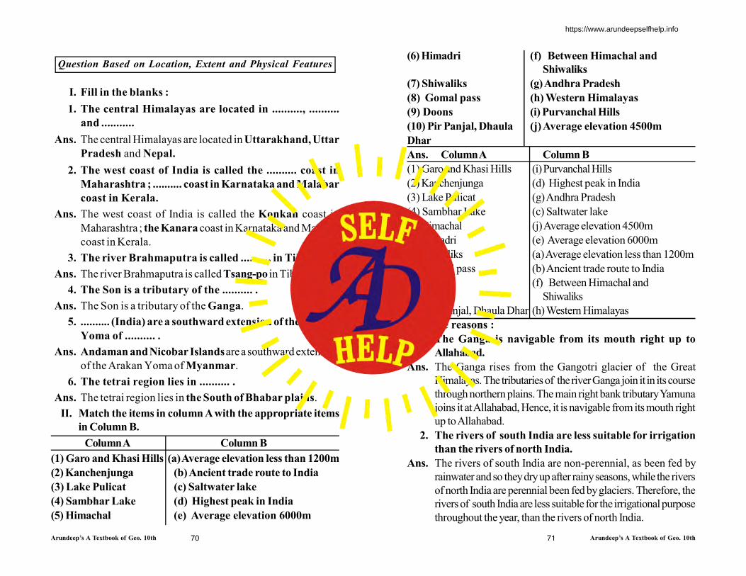
Arundeep’s A Textbook of Geo. 10th Arundeep’s A Textbook of Geo. 10th70 71
Question Based on Location, Extent and Physical Features
I. Fill in the blanks :
1. The central Himalayas are located in .........., ..........
and ...........
Ans. The central Himalayas are located in Uttarakhand, Uttar
Pradesh and Nepal.
2. The west coast of India is called the .......... coast in
Maharashtra ; .......... coast in Karnataka and Malabar
coast in Kerala.
Ans. The west coast of India is called the Konkan coast in
Maharashtra ; the Kanara coast in Karnataka and Malabar
coast in Kerala.
3. The river Brahmaputra is called .......... in Tibet.
Ans. The river Brahmaputra is called Tsang-po in Tibet.
4. The Son is a tributary of the .......... .
Ans. The Son is a tributary of the Ganga.
5. .......... (India) are a southward extension of the Arakan
Yoma of .......... .
Ans. Andaman and Nicobar Islands are a southward extension
of the Arakan Yoma of Myanmar.
6. The tetrai region lies in .......... .
Ans. The tetrai region lies in the South of Bhabar plains.
II. Match the items in column A with the appropriate items
in Column B.
Column A Column B
(1) Garo and Khasi Hills (a) Average elevation less than 1200m
(2) Kanchenjunga (b) Ancient trade route to India
(3) Lake Pulicat (c) Saltwater lake
(4) Sambhar Lake (d) Highest peak in India
(5) Himachal (e) Average elevation 6000m
(6) Himadri (f) Between Himachal and
Shiwaliks
(7) Shiwaliks (g) Andhra Pradesh
(8) Gomal pass (h) Western Himalayas
(9) Doons (i) Purvanchal Hills
(10) Pir Panjal, Dhaula (j) Average elevation 4500m
Dhar
Ans. Column A Column B
(1) Garo and Khasi Hills (i) Purvanchal Hills
(2) Kanchenjunga (d) Highest peak in India
(3) Lake Pulicat (g) Andhra Pradesh
(4) Sambhar Lake (c) Saltwater lake
(5) Himachal (j) Average elevation 4500m
(6) Himadri (e) Average elevation 6000m
(7) Shiwaliks (a) Average elevation less than 1200m
(8) Gomal pass (b) Ancient trade route to India
(9) Doons (f) Between Himachal and
Shiwaliks
(10) Pir Panjal, Dhaula Dhar (h) Western Himalayas
III. Give reasons :
1. The Ganga is navigable from its mouth right up to
Allahabad.
Ans. The Ganga rises from the Gangotri glacier of the Great
Himalayas. The tributaries of the river Ganga join it in its course
through northern plains. The main right bank tributary Yamuna
joins it at Allahabad, Hence, it is navigable from its mouth right
up to Allahabad.
2. The rivers of south India are less suitable for irrigation
than the rivers of north India.
Ans. The rivers of south India are non-perennial, as been fed by
rainwater and so they dry up after rainy seasons, while the rivers
of north India are perennial been fed by glaciers. Therefore, the
rivers of south India are less suitable for the irrigational purpose
throughout the year, than the rivers of north India.
https://www.arundeepselfhelp.info

Arundeep’s A Textbook of Geo. 10th Arundeep’s A Textbook of Geo. 10th72 73
3. The Peninsular rivers are not navigable.
Ans. The Peninsular rivers are marked by a number of waterfalls
which are being harnessed for the production of hydroelectricity.
These rivers have also been impounded for irrigation and
hydroelectric power. Hence, they are not navigable.
4. The Peninsular Plateau of India is considered to be a part
of Gondwanaland which was been dissected form each
other hundreds of million years ago.
Ans. The Peninsular Plateau of India is considered to be a part of
Gondwana land before hundreds of millions ago, because the
rocks that constitute the Plateau are identical to those of Africa
in respect of the type age and the layer sequence. Africa was
considered also to be another part of Gondwana land.
5. The deltas on the east coast are not suitable for harbours.
Ans. The deltas on the east coast are not suitable for harbours because
their mouths are full of silt.
6. The Narmada and Tapi do not form deltas.
Ans. The Narmada and Tapi rivers have a short upper course (or
mountain stage), so they do not carry enough sediment to form
the deltas in their lower course.
7. Less land is available for agriculture on the West coast
than on the East coast.
Ans. On the western coast, there are less rivers than the eastern
coast, outstanding to the sea, and furthermore only the two
rivers, Narmada and Tapi, have no delta at their meeting point
to the sea at the western coast.
On the contrary, towards the eastern side, there are a number
of rivers, like, Godavari, Krishna, Kaveri and Mahanadi having
the delta as well as a great extent of alluvial formation at their
meeting points with the sea. For that reasons on the western
coast, just besides of the Western ghats mountains the narrow
coast land has been formed; and on the eastern side, the rivers;
formed alluvial plains have been widen up at the eastern side of
the discontinued and lower Eastern ghats.
8. The Brhamaputra is a braided river.
Ans. The Brahmaputra carries a lot of sediment during its long upper
course. It so deposits these sediments in its river channel during
its middle course due to which it split into two or more channels
forming various islands in its course. Therefore, the Brahmaputra
is said to be a braided river.
9. Access through the Western Ghats is difficult.
Ans. Access through the Western Ghats is difficult because the hills
use to rise steeply form the coastal plain.
10. The Peninsular Plateau of India is rich in mineral
resources.
Ans. The Peninsular Plateau of India is rich in mineral resources as
it is made up of hard and crystalline igneous rocks.
11. The Western Ghats are covered by thick evergreen
forests while the Eastern Ghats are covered by deciduous
type forests.
Ans. The Western Ghats, having more altitude than the Eastern
ghats, are standing on the wind ward side to the monsoons,
and consequently gets a considered amount of rainfall, which
causes of the thicker evergreen forests. But the eastern sides
does not get the great content of rainfall as it is not having the
comparable higher altitude to winder the south-west monsoon.
Only the retreating north-east monsoon cause a meagre quantity
of rainfall as it contains the lesser water-vapour than its south-
west counterpart. So, the eastern coast is mainly covered with
deciduous type of forests. It is well known that heavier rainfall
will cause move evergreen forests rather than the deciduous
type of forests.
12. The Northern Plains of India are one of the most densely
populated regions of the world.
Ans. The Northern Plains of India are a rich agricultural land owing
to their fertile soil and assured water sources. That is why the
Northern Plains of India are one of the most densely populated
regions of the world.
https://www.arundeepselfhelp.info
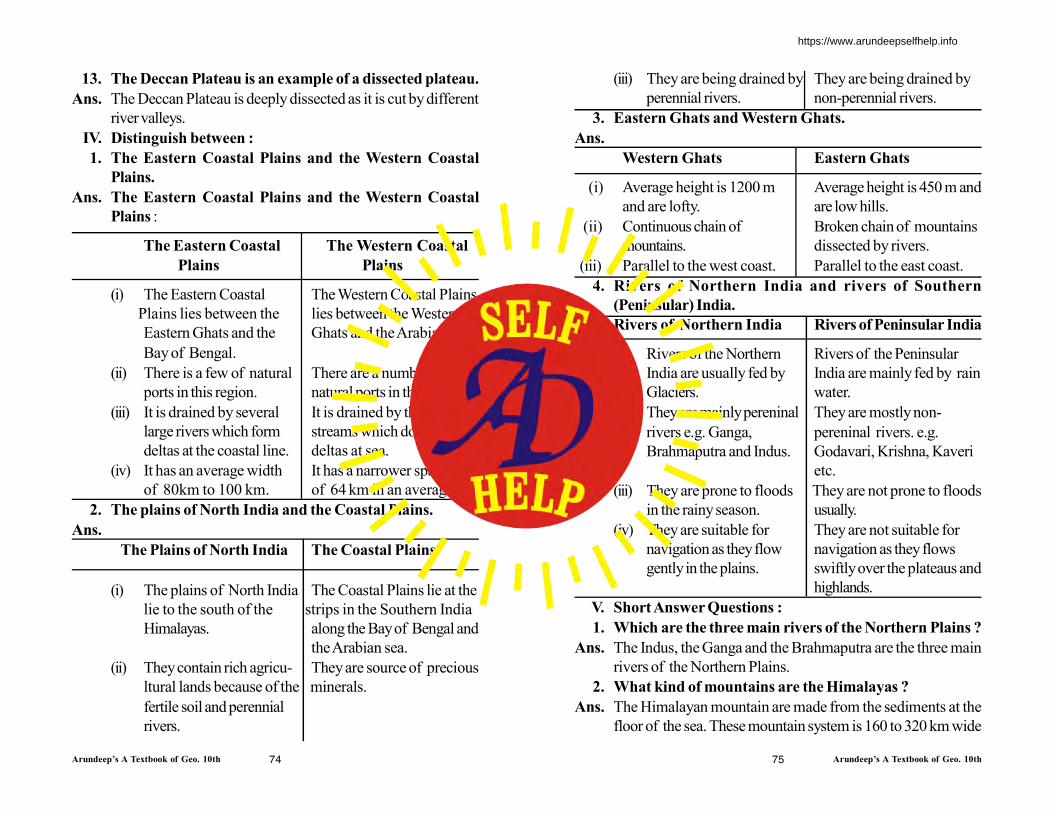
Arundeep’s A Textbook of Geo. 10th Arundeep’s A Textbook of Geo. 10th74 75
13. The Deccan Plateau is an example of a dissected plateau.
Ans. The Deccan Plateau is deeply dissected as it is cut by different
river valleys.
IV. Distinguish between :
1. The Eastern Coastal Plains and the Western Coastal
Plains.
Ans. The Eastern Coastal Plains and the Western Coastal
Plains :
The Eastern Coastal The Western Coastal
Plains Plains
(i) The Eastern Coastal The Western Coastal Plains
Plains lies between the lies between the Western
Eastern Ghats and the Ghats and the Arabian sea.
Bay of Bengal.
(ii) There is a few of natural There are a number of
ports in this region. natural ports in this region.
(iii) It is drained by several It is drained by the short
large rivers which form streams which do not form
deltas at the coastal line. deltas at sea.
(iv) It has an average width It has a narrower spanning
of 80km to 100 km. of 64 km in an average.
2. The plains of North India and the Coastal Plains.
Ans.
The Plains of North India The Coastal Plains
(i) The plains of North India The Coastal Plains lie at the
lie to the south of the strips in the Southern India
Himalayas. along the Bay of Bengal and
the Arabian sea.
(ii) They contain rich agricu- They are source of precious
ltural lands because of the minerals.
fertile soil and perennial
rivers.
(iii) They are being drained by They are being drained by
perennial rivers. non-perennial rivers.
3. Eastern Ghats and Western Ghats.
Ans.
Western Ghats Eastern Ghats
(i) Average height is 1200 m Average height is 450 m and
and are lofty. are low hills.
(ii) Continuous chain of Broken chain of mountains
mountains. dissected by rivers.
(iii) Parallel to the west coast. Parallel to the east coast.
4. Rivers of Northern India and rivers of Southern
(Peninsular) India.
Ans. Rivers of Northern India Rivers of Peninsular India
(i) Rivers of the Northern Rivers of the Peninsular
India are usually fed by India are mainly fed by rain
Glaciers. water.
(ii) They are mainly pereninal They are mostly non-
rivers e.g. Ganga, pereninal rivers. e.g.
Brahmaputra and Indus. Godavari, Krishna, Kaveri
etc.
(iii) They are prone to floods They are not prone to floods
in the rainy season. usually.
(iv) They are suitable for They are not suitable for
navigation as they flow navigation as they flows
gently in the plains. swiftly over the plateaus and
highlands.
V. Short Answer Questions :
1. Which are the three main rivers of the Northern Plains ?
Ans. The Indus, the Ganga and the Brahmaputra are the three main
rivers of the Northern Plains.
2. What kind of mountains are the Himalayas ?
Ans. The Himalayan mountain are made from the sediments at the
floor of the sea. These mountain system is 160 to 320 km wide
https://www.arundeepselfhelp.info
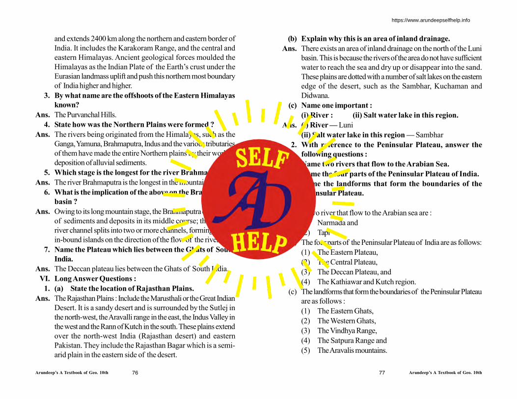
Arundeep’s A Textbook of Geo. 10th Arundeep’s A Textbook of Geo. 10th76 77
and extends 2400 km along the northern and eastern border of
India. It includes the Karakoram Range, and the central and
eastern Himalayas. Ancient geological forces moulded the
Himalayas as the Indian Plate of the Earth’s crust under the
Eurasian landmass uplift and push this northern most boundary
of India higher and higher.
3. By what name are the offshoots of the Eastern Himalayas
known?
Ans. The Purvanchal Hills.
4. State how was the Northern Plains were formed ?
Ans. The rivers being originated from the Himalayas, such as the
Ganga, Yamuna, Brahmaputra, Indus and the various tributaries
of them have made the entire Northern plains by their work of
deposition of alluvial sediments.
5. Which stage is the longest for the river Brahmaputra ?
Ans. The river Brahmaputra is the longest in the mountain stage.
6. What is the implication of the above on the Brahmaputra
basin ?
Ans. Owing to its long mountain stage, the Brahmaputra carries a lot
of sediments and deposits in its middle course; thereby the
river channel splits into two or more channels, forming the
in-bound islands on the direction of the flow of the river.
7. Name the Plateau which lies between the Ghats of South
India.
Ans. The Deccan plateau lies between the Ghats of South India.
VI. Long Answer Questions :
1. (a) State the location of Rajasthan Plains.
Ans. The Rajasthan Plains : Include the Marusthali or the Great Indian
Desert. It is a sandy desert and is surrounded by the Sutlej in
the north-west, the Aravalli range in the east, the Indus Valley in
the west and the Rann of Kutch in the south. These plains extend
over the north-west India (Rajasthan desert) and eastern
Pakistan. They include the Rajasthan Bagar which is a semi-
arid plain in the eastern side of the desert.
(b) Explain why this is an area of inland drainage.
Ans. There exists an area of inland drainage on the north of the Luni
basin. This is because the rivers of the area do not have sufficient
water to reach the sea and dry up or disappear into the sand.
These plains are dotted with a number of salt lakes on the eastern
edge of the desert, such as the Sambhar, Kuchaman and
Didwana.
(c) Name one important :
(i) River : (ii) Salt water lake in this region.
Ans. (i) River — Luni
(ii) Salt water lake in this region — Sambhar
2. With reference to the Peninsular Plateau, answer the
following questions :
(a) Name two rivers that flow to the Arabian Sea.
(b) Name the four parts of the Peninsular Plateau of India.
(c) Name the landforms that form the boundaries of the
Peninsular Plateau.
Ans.
(a) Two river that flow to the Arabian sea are :
(1) Narmada and
(2) Tapi
(b) The four parts of the Peninsular Plateau of India are as follows:
(1) The Eastern Plateau,
(2) The Central Plateau,
(3) The Deccan Plateau, and
(4) The Kathiawar and Kutch region.
(c) The landforms that form the boundaries of the Peninsular Plateau
are as follows :
(1) The Eastern Ghats,
(2) The Western Ghats,
(3) The Vindhya Range,
(4) The Satpura Range and
(5) The Aravalis mountains.
https://www.arundeepselfhelp.info

Arundeep’s A Textbook of Geo. 10th Arundeep’s A Textbook of Geo. 10th78
3. With reference to the Gangetic Plain, answer the
following:
(a) List the left bank tributaries of the Ganga.
(b) Trace the course of the river from its source to its mouth.
(c) Why is it a perennial river ?
(d) Name four towns set up the course of the Ganga or its
tributaries.
Ans. (a) The left bank tributaries of the Ganga are :
(1) Kosi, (2) Gandak,
(3) Gomti and (4) Ghaghara.
(b) The river Bhagirathi originates from the Gangotri Glacier at
Gaumukh. Further, the River Alaknanda been originated from
the Alakapuri Glacier joins the River Bhagirathi to form the
River Ganga and flows towards west. After 30 km from the
meeting point, it turns, south crossing over the Siwaliks and
enters the Northern plains at Haridwar and proceeds in the
south-westerly direction.
During its course throughout the northern plains several
tributaries join the River Ganga. These tributaries are Yamuna,
Kosi, Gandhak, Gomti, Ghaghara, Son and Damodar.
Flowing along the eastern edge of the Deccan Plateau, the
Ganga enters Bengal. Here, the main branch named ‘Padma’
has been departed from Ganga and flowing towards east it
enters Bangladesh. The remaining branch named as ‘Bhagirathi’;
flows towards the south and finally meets with the Bay of Bengal.
(c) The Ganga is been sourced from the Gangotri Glacier and such
a way, it has been fed by ice melt water resources throughout
the year. For that reason it is a perennial river.
(d) Four towns set up on the course of the Ganga or its tributaries
are as follows :
(1) Haridwar - at the bank of Ganga.
(2) Allahabad- at the meeting point of Ganga and Yamuna.
(3) Lucknow- at the bank of Gomti, a tributary of Ganga.
(4) Patna- at the bank of Ganga.
https://www.arundeepselfhelp.info
Arundeep’s A Textbook of Geo. 10th Arundeep’s A Textbook of Geo. 10th79 80
Climate of India
Exercise
1. Name the factors affecting the climate of a place.
Ans. The climate of a place is mainly affected by the temperature,
rainfall, atmospheric pressure and direction of winds.
The climate of the Indian subcontinent, is greatly influenced
by two factors :
(i) Tropic of cancer (23 1/2ºN) dividing the country into two
halves-North Temperature Zone and South Tropical Zone.
(ii) Great Himalayan Range separating the Indian subcontinent form
the east of Asia.
2. Name type of climate in India.
Ans. Tropical Monsoon Type of climate in India.
3. What is the chief characteristic feature of the tropical
monsoon type climate ?
Ans. The important features of tropical monsoon are :
(a) Most of the country gets rain from the South-West Monsoon.
(b) The rain is unevenly distributed.
(c) It is erratic and unpredictable.
(d) It is seasonal mostly coming in rainy season.
(e) Presence of mountain. It is mainly orographic in nature.
(f) Monsoon rains have great effect on our economy.
4. What are onshore winds and offshore winds ?
Ans. Onshore winds — Onshore wind is a gentle wind blowing
from sea toward land, that develops over bodies near land due
to difference in air pressure.
Offshore winds — Winds starts blowing from the high pressure
area over the land to low pressure area over the sea in a general
North-East direction.
5. State the importance of Monsoon season in India.
Ans. Importance of the Monsoon season in India :
(i) India’s entire agriculture calendar and the total life of the India
people revolve around the monsoons.
(ii) Indian agriculture is gamble of monsoons and the production of
agriculture depends on timely arrival of monsoons.
(iii) Most of the rivers of India get their water from the monsoons.
6. Name a few local winds that pass through India.
Ans. First local wind is known as ‘100’ (hot wind) along the northern
plain of India due to extremely rising temperatures pushed by
the trade winds. Second local wind is known as ‘Kal-Baisakhi’
(The month of April causing death) in W.Bengal and Assam,
where due to rapid cyclonic winds with high speed cause
maximum loss and deaths in this area. These are called
Nor’westers in geographical term, as the winds come very fast
from northwestern direction towards the eye of the cyclones.
7. Which is the more important branch—the Arabian Sea
Branch or the Bay of Bengal Branch ? Why ?
Ans. The Arabian Sea Branch is the more important branch than the
Bay of Bengal. Due to following reasons :
(i) The Arabian Sea Branch is much larger than the Bay of Bengal.
(ii) The whole of the Arabian Sea branch is used up by the entire
country whereas only part of the Bay of Bengal branch enters
India through North-East India, the rest goes toward Myanmar
and Thailand.
8. Which is the first State to receive the monsoon and the
last to see it retreat in India ?
Ans. Kerala is the first State to receive the monsoon and Kachch,
Eastern Rajasthan, U.P., Haryana, Himachal Pradesh and
Chapter
5
Chapter
4
https://www.arundeepselfhelp.info
Arundeep’s A Textbook of Geo. 10th Arundeep’s A Textbook of Geo. 10th81 82
Eastern Punjab are the last to see it retreat in India.
9. State two important characteristic features of the Indian
monsoons.
Ans. Following are the characteristic features of the Indian monsoons:
(i) Most of the rainfalls during the months of June-September.
(ii) During the season it also causes heavy downpours. Such heavy
downpour results in soil erosion.
(iii) Our monsoons are unreliable, uncertain, erratic, undependable.
(iv) It is orographic in nature.
10. Name the different seasons of India, stating the months
when they are experienced.
Ans. The different seasons of India are :
(i) The Hot Dry Season (March to May)
(ii) The rainy season or the season of south-west monsoon. (June
to September)
(iii) The season of the retreating south-west monsoon (October to
November)
(iv) The cold season or the season of the north-east monsoon
(December to February).
11. What is the meaning of the word ‘monsoon’ ?
Ans. The term ‘Monsoon’ is dervied from an Arabic word Mausinm
which means season.
Or
Monsoons are periodic seasonal winds. They develop because
of differential heating as well as cooling of the land and sea.
12. How are monsoon winds different from the land and sea
breezes ?
Ans. A land and sea breeze occurs on a daily basis as the land gets
hotter than the sea during the day and cooler at night.
A monsoon occurs on an annual basis as the interior of a
continents gets hotter than the ocean in summer and colder in
winter.
13. Why are there great variations in India’s climate ?
Ans. There are great variations in the climate India’s due to
(i) The vast latitudinal expanse.
(ii) The varied topographical features.
(iii) Size of land.
(iv) Distance from the sea.
14. Give reasons to justify that Himalayas act as a perfect
climatic divide.
Ans. The Himalayas act as a perfect climate divide, there are following
reasons :
(i) The great Himalayas range obstructs the bitter cold winds from
Siberia from entering the Indian subcontinent.
(ii) The Himalayan range intercepts the rain-bearing south-west
monsoon winds, forcing them to shed their moisture , resulting
in heavy rainfall in the Northest and Indo Gangetic Plain.
15. Which winds are responsible for the rainfall experienced
over the greater part of India ?
Ans. South-West monsoon winds are responsible for the rainfall
experienced over the greater part of India.
16. During which part of the year is this rain experienced ?
Ans. Meghalaya
17. How are the sources of rianfall in the north-west part of
India different from the rainfall experienced on the coastal
areas of Eastern India in Winter ?
Ans. The rainfall in the North-West part of India is mainly caused
due to Arabian Sea-branch of South-West summer monsoon
while the rainfall experienced on the coastal areas of Eastern
India in caused by the cyclonic winds of North-East monsoons.
18. Why does Kanyakumari experience an equable climate?
[1998]
https://www.arundeepselfhelp.info
Arundeep’s A Textbook of Geo. 10th Arundeep’s A Textbook of Geo. 10th83 84
Ans. Kanyakumari is located at 8 degree North. It is also closer to
the Equator. It receives vertical rays of the sun at the Equator
hence, there is not much difference in temperature here. So we
can say Kanyakumari experiences equable/oceanic/ maritime
influence.
19. Why does central Maharashtra receives scanty rainfall.
Ans. Most of central Maharashtra has only scanty rainfall because it
lies in the rain shadow area of the Western Ghats.
20. Why is western part of India a desert region ?
Ans. Western part of India or Thar is desert due to following reasons:
(i) Thar experiences very little summer rain.
(ii) By the time, the Bay of Bengal branch of the South-West
Monsoon reaches Thar after passing through the Ganga Valley,
it has little or no moisture. Only windward side of the Aravalli
Hills receive a little rain but no rain in Thar as it is in rain shadow
area.
(iii) As the Aravalli Hills lie parallel to the Arabian Sea branch of
the south-west monsoon, so it does not give much rainfall.
(iv) North-East monsoon does not give much winter rainfalls.
(v) Thar lacks water sources and humidity is very low in summer.
21. What are western disturbances ?
Ans. These are shallow cyclonic depressions originating over
Mediterranean sea, disturbing fine weather conditions in
north-western parts of India during winter season.
22. Name one part of India that has its rainfall in winter and
summer as well.
Ans. One part that experiences rainfall both in winter and summer-
Tamil Nadu Coast/ coromandel Coast.
23. Explain how retreating monsoon winds are different from
the north-east trades.
Ans. The Retreating Monsoon or South-West Monsoon (October-
November) : By 1st September, with the apparent movement
of the sun towards south the low pressure in central India starts
weakening, and is no longer able to attract the monsoon winds
towards land. During Autumn equinox when the sun shines
directly over Equator, the high pressure begins to build over
mainland and subsequently with low pressure over the sea while
the North-East Trade (December to March). The cold weather
season commences at the end of November and continues till
march. Clear sky, pleasant weather, low temperature and
humidity, high range of temperature and slow northern winds
are the chief characteristics of this season.
24. Name a place in India which receives the heaviest rainfall.
To which state does this place belong ?
Ans. The place in India which receives the maximum rainfall is
Mawsynram in Meghalaya.
25. Name the winds that are responsible for causing this rain
in the above question ?
Ans. South-West monsoon winds is responsible for the rainfall
experienced over the greater part of India.
26. What is meant by ‘rain shadow area’ ? Give an example
and state the mountains which are responsible for the
rain shadow area.
Ans. The area which experiences scanty rainfall due to the existence
of the mountains parallel to the monsoon winds is called ‘rain
shadow area’. The part of the western Rajasthan is the rain
shadow area as it is located at the Aravali ranges lying parallel
to the direction of the moisture containing winds.
27. Name the winds that bring rain to the Tamil Nadu coast?
Ans. North-east trade winds bring rain to the Tamil Nadu coast.
28. Give reasons :
(a) In spite of Aravalis Range Rajasthan receives very less
rain.
Ans. (i) The Aravalis lie parallel to the direction of the South-
West monsoon Arabian sea streams, so these hills do not
https://www.arundeepselfhelp.info

Arundeep’s A Textbook of Geo. 10th Arundeep’s A Textbook of Geo. 10th85 86
intercept these winds.
(ii) Rajasthan lies on the leeward side of the Aravalis.
(b) The Malabar coast has less rainy months but more rain
than the Coromandal coast.
Ans. The Malabar coast lies on the western coast on the windward
side of the Western Ghats and gets the full impact of the
southwest monsoon from June-September only where as the
Coromandel Coast experiences less rainfall as it receives rain
from the retreating monsoon during October-November and
the Northeast Monsoons which do not bring much rainfall but
is spread over a long period.
(c) Punjab has three sources of rain.
Ans. Punjab is the state that receives rainfall from three different
sources and the sources are :
(i) Northest Retreating Monsoons
(ii) Westerly depressions and
(iii) Southwest Monsoons or cyclonic disturbances originating in
the Mediterranean Sea.
(d) Mawsynram receives more rain than Shilong.
Ans. Mawsynram lies in the Khasi hills in Meghalaya and gets more
rainfall from the Bay of Bengal branch of the summer monsoon.
Here the hills are funnle shaped so the moisture laiden monsoon
have to take a sudden rise which cause heavy rain (1221 cm).
On the other hand Shilong lies in the rain shadow area of the
Khasi hills and gets less rainfall.
29. Explain how is the winter rain caused. How is the rain
beneficial ?
Ans. The causes of winter rain are :
(a) In Tamil Nadu, the north-east monsoon winds pick up moisture
from the Bay of Bengal and bring rain.
(b) The cause of the rain in all the northern states are the western
disturbances that originate in the Mediterranean Sea.
Benefit of Winter Rain.
This rainfall is cyclonic rain and is beneficial to crops, especially
wheat and barely.
30. On an outline map of India, mark the low pressure area
during summer.
Ans.
31. On an outline map of India, mark with arrows the
withdrawal of the South-West Monsoon.
Ans.
https://www.arundeepselfhelp.info

Arundeep’s A Textbook of Geo. 10th Arundeep’s A Textbook of Geo. 10th87 88
32. On an outline physical map of India :
(a) Mark the direction of western disturbances.
(b) Mark the S.W. Monsoon. (Bay of Bengal branch)
(c) Mark the direction of the North-East Monsoon.
(d) The direction of tropical cyclone over the Bay of Bengal.
(e) The direction of winds during the summer from S.W. to
N.E.
Ans.
WesternDisturbances
Directio
n of
Tropical
Cyclones
N.E
. Mon
soon
S.W
. Mon
soon
33. (Refer for data of Chennai, Pune, New Delhi and Kolkata
to answer this question)
Answer the following questions :
(a) Calculate the annual range of temperature.
(b) What is the total rainfall experienced by the station ?
(c) When does the station receive maximum rainfall ? State
a reason for your answer.
Ans. (a)
https://www.arundeepselfhelp.info
Arundeep’s A Textbook of Geo. 10th Arundeep’s A Textbook of Geo. 10th89 90
(i) Annual Rnage of temperature = 20.5 °C – 29.7°C
(ii) Total Annual Rainfall = 0.15 + 0.15 + 0.15 + 1.5 + 2.7 + 11.4
+ 16.7 + 9.0 + 13.4 + 9.0 + 2.7 + 0.3
= 67.150 m
(iii) Pune receive maximum rainfall in July because it lies on the
leeward side of the Western Ghats which is a rainshadow region
due to which the Arabian Sea branch of SW monsoon loses its
moisture contant after passing over the ghats.
(b) Chennai
(i) Annual Range of temperature = 24.5°C – 32.5°C
(ii) Total Annual Rainfall = 2.8 + 0.7 + 0.7 + 1.5 + 4.5 + 5.1 + 9.5
+ 11.3 + 12.4 + 28.1 + 34.5 + 13.6 = 124.6 cm
(iii) Chennai receive its maximum rainfall in November-December
from the north-east monsoon winds which blow over the bay
of Bengal and meet with the moist wind of the retreating
monsoons.
(c) New Delhi
(i) Annual Range of temperature = 13.8°C – 33.6°C
(ii) Total Annual Rainfall
= 2.5 2.1 1.3 0.8 1.3 7.7 17.9 18.4 12.3 1.0 0.2 1.0
12
= 66.5 cm
(iii) Delhi receives maximum rainfall in August from the South West
Monsson Arabian sea branch. These winds blow from the South
West and hence Delhi receive rainfall late in August.
(d) Kolkata
(i) Annual Range of temperature = 19.4°C – 30.6°C
(ii) Total Annual Rainfall = 0.7 + 2.8 + 3.6 + 4.8 + 14.5 + 30.2 +
31.8 + 32.3 + 25.1 + 10.6 + 1.8 + 0.4
= 158.6 cm
(iii) Kolkata receives maximum rainfall in the month of June to August
because It lie in the lower Ganga plain/valley. So when the South
West Monsoon Bay of Bengal branch comes up the power
Ganga Valley it sheds its moisture.
34. Give reasons for the following :
(i) Mumbai gets more rainfall than Pune.
Ans. Mumbai receives more rainfall than Pune because it is located
on the coast and Pune is in the interior.
Mumbai lies on the windward side of Western Ghats while Pune
is located on the leeward side. Windward refers to the direction
from which the rain-bearing south west monsoon winds
approach the land from sea. Lee ward refers to the region that
is shielded from these winds by a natural barrier, in this case,
the hills of Western Ghats. This region is drier and is referred to
as rain-shadow due to this feature.
(ii) The moisture laden winds passing over Rajasthan do not
saturate.
Ans. During the summer the temperature of the place is so high that
the monsoon winds get dry and do not cause rain and do not
saturate.
(iii) S.W. monsoon withdraws from India in October/
November.
Ans. The withdrawl of the South-West monsoon is a much slower
process than reversal of the process. As the South-West
Monsoon had travelled towards the north, now it retreats
towards the South. This process starts in October and is over
by the end of November.
Or
By 1st September, with the apparent movement of the Sun
towards south, the low pressure in central India starts
weakening, and is no longer able to attract the monsoon winds
towards land. During Autumn equinox when the sun shines
directly Over Equator, the high pressure begins to build over
mainland and subsequently with low pressure over the sea, the
https://www.arundeepselfhelp.info

Arundeep’s A Textbook of Geo. 10th Arundeep’s A Textbook of Geo. 10th91 102
South-West Monsoon begins to withdraw from the mainland
of India.
35. Answer in one word :
(i) Withdrawal of SW monsoon.
(ii) Low pressure depressions during winter in North West
India.
(iii) Land and sea breeze on a large scale.
Ans. (i) Retreating Monsoons
(ii) Western Disturbance
(iii) Monsoons
Soil Resources in India
Exercise
1. How are Soils formed ?
Ans. Soils are formed from parent material through a process of
break-up or wear and tear. Its formation is associated with the
relief, climate and vegetation. Animal, insects and man also play
an important role in the soil formation.
Soil is formed under specific natural conditions. It is a mixture
of minerals or inorganic matter which results from denudation
and disintegration of rocks. Soils, in this way is a renewable
natural resource though it takes a long time to regenerate.
The process of the formation of soil is known as pedogenesis.
2. Name the factors responsible for soil formation.
Ans. The factors responsible for soil formation include parental
material, climatic conditions, the most important aspect of which
is weathering, then living things such as plants and animals, and
finally the surface relief and drainage.
3. Name the main components of soil.
Ans. The main components of soil are :
(i) Inorganic Components : The soil is composed of three main
substances. These are silica, clay and chalk (calcium carbonate)
(ii) Organic Components : The ultimate form of organic matter
is humus which is formed by the decomposition of plant remains,
animal waste and dead animals.
In addition, soil also contains moisture and air which vary from
Chapter
5
https://www.arundeepselfhelp.info

Arundeep’s A Textbook of Geo. 10th Arundeep’s A Textbook of Geo. 10th92 93
Question Based on Climate of India
I. Give Reasons for the following :
1. Mumbai is warmer than Kanpur in December.
Ans. Mumbai is warmer than Kanpur in December because Mumbai
is located within the moderating influence of the sea while
Kanpur is far away from the sea and hot within the moderating
effect of the sea.
2. Punjab gets winter rainfall.
Ans. Punjab gets winter rainfall due to westerly depressions originating
in the Mediterranean region.
3. The Himalayas act as a perfect climatic divide.
Ans. The Himalayas act as a perfect climatic divide as they separate
the Indian subcontinent from the rest of Asia. On one hand
they prevent the chilly cold winds from Central Asia from
entering the Subcontinent and force the South-West monsoon
winds for rain on the other.
4. The Indo Gangetic Plain gets some rainfall in the months
of December and January.
Ans. Because of offshore winds, the Indo Gangetic plain gets some
rainfall in the months of December and January.
5. Chennai has more rainy season months but less rain than
Mumbai.
Ans. Chennai receives most of the rainfall from the North-East
monsoon with less moisture thereby causes less rain while
Mumbai receives rainfall from the South-West monsoon laden
with plenty moisture thereby causes heavy rain.
6. It is cooler on the mountain slopes than on the plains
during summer.
Ans. It is cooler on the mountain slopes than on the plains during
summer due to high altitudes as there is a drop of 6ºC for
every ascent of 1000 metres.
7. The monsoon rain is unevenly distributed over India.
Ans. The amount of rain received by an area depends on its releif,
for example, windward side of the mountains receives more
rain while leeward side receives less rain. That is why, the
monsoon rain is unevenly distributed over India.
8. Excessive cold in north India during winter season.
Ans. The excessive cold in north India during winter season is due to
the following reasons :
(a) In the month of February, the cold winds from the Caspian Sea
and Turkmenistan bring cold wave over the northwestern parts
of India.
(b) Punjab, Haryana and Rajasthan experience continental type of
climates as they are located far away from the sea to experience
its moderating influence ; and
(c) The snowfall in the nearby Himalayan ranges creates cold wave
situation.
9. Tamil Nadu Coast remains dry during the South-west
monsoon season.
Ans. The Tamil Nadu coast remains dry during monsoon season.
This is because the Tamil Nadu coast is located parallel to the
Bay of Bengal branch of the south-west monsoon. Further, it
lies in the rainshadow area of the Arabian Sea branch of the
south-west monsoon.
II. Short Answer Questions.
1. Name the place in India which receives the heaviest
rainfall and in which States does this place belong ?
Ans. Cherrapunjee receives the heaviest rainfall in India and it belongs
to Meghalaya.
2. Describe the process of retreat of the Summer Monsoon.
Ans. The process of retreat of the Summer Monsoon is opposite
of the onset of the Summer Monsoon but it is a gradual
process. The South-West Summer Monsoon retreats toward
the south.
ADDITIONAL QUESTIONS
https://www.arundeepselfhelp.info
Arundeep’s A Textbook of Geo. 10th Arundeep’s A Textbook of Geo. 10th94 95
The low pressure area over the North-Western part of India
weakens due to the aparent movement of the sun towards the
south of the Equator. This results in the withdrawal of the South
West monsoon. It withdrawas from Rajasthan by the beginning
of September then from Punjab and Haryana. The monsoon
retreat from most parts of North India by the first week of
October. Then it withdraws from Central India. When it
approaches the eastern coast, it is checked by the Southern
range of the Eastern Ghats and causes rain to the eastern part
of Tamil Nadu, Karnataka, Andhra Pradesh and Orissa.
3. Why is western part of India a desert region ?
Ans. Thar is desert due to following reasons :
(i) Thar experiences very little summer rain.
(ii) By the time, the Bay of Bengal branch of the South-West
Monsoon reaches Thar after passing through the Ganga Valley,
it has little or no moisture. Only windward side of the Aravalli
Hills receive a little rain but no rain in Thar as it is in rain shadow
area.
(iii) As the Aravalli Hills lie parallel to the Arabian Sea branch of
the south-west monsoon, so it does not give much rainfall.
(iv) North-East monsoon does not give much winter rainfalls.
(v) Thar lacks water sources and humidity is very low is summer.
4. What is meant by ‘Burst of Monsoon’ ?
Ans. The sudden violent onset of rainfall during the period of
‘Monsoon’ is called the ‘Burst of Monsoon’.
5. What is the direction of the summer monsoon on the Indo-
Gangetic Plain ?
Ans. The summer monsoon moves from east to west direction on
the Indo-Gangetic Plain.
6. Name two regions, which get very little rain from the
summer monsoon.
Ans. The rain shadow region of the Western Ghats (the leeward
side) and Western Rajasthan get very little rain from the summer
monsoon.
7. Name the place in Southern India which receives highest
rainfall from the summer monsoon.
Ans. Mahabaleshwar receives the highest rainfall in South India from
the summer monsoon.
8. Why does Coromandel coast receive most of its rain during
the winter ?
Ans. The Northeast Monsoon winds blow over the Bay of Bengal.
Before reaching the Coromandel coast they become moisture
laden and give rain to this area during winter season (December-
February).
9. Name any two local winds which blow in India in the
summer season.
Ans. First local wind is known as ‘100’ (hot wind) along the northern
plain of India due to extremely rising temperatures pushed by
the trade winds. Second local wind is known as ‘Kal-Baisakhi’
(The month of April causing death) in W.Bengal and Assam,
where due to rapid cyclonic winds with high speed cause
maximum los and deaths in this area. These are called
norwesters in geographical term, as the winds come very fast
from northwestern direction towards the eye of the cyclones.
10. Name any two states that receive rain in January-
February.
Ans. Jammu and Kashmir and partially Punjab receive rain in January-
February.
11. What causes the winter rain of Northern India ?
Ans. The winter rain at Northern India is caused by westerly
disturbances moving eastwards from the Mediterranean sea.
12. Name an area, which gets sufficient rainfall in the winter
monsoon.
Ans. The Coromandel coast in Tamil Nadu gets sufficient rainfall in
the winter season due to the retreating north-east monsoon.
13. Name on region, which gets rainfall from the Retreating
Monsoons.
Ans. Coastal area of Tamil Nadu gets rainfall from the Retreating
https://www.arundeepselfhelp.info
Arundeep’s A Textbook of Geo. 10th Arundeep’s A Textbook of Geo. 10th96 97
Monsoons.
14. Name two areas, which get more than 200 cm of rainfall
in India.
Ans. The Western coastal plains and mainly the western slopes of
the western Ghats get more than 200 cm of rainfall in India.
15. Name the winds that bring rain to the Tamil Nadu coast
in winter season.
Ans. North-East monsoon winds bring rain to the Tamil Nadu coast
in winter.
16. Which winds is responsible for the rainfall experienced
over the greater part of India ?
Ans. South-West monsoon winds is responsible for the rainfall
experienced over the greater part of India.
III. Structured Questions
1. Study the data of temperature and rainfall for two places
X (Altitude 219 m) and Y (Altitude 6.7 m).
Temp( C)
Jan.
15
Feb.
18
Mar.
24
Apr.
29
May
37
June
41
July
31
Aug.
30
Sep.
29
Oct.
27
Nov.
16
Dec.
18
Rain
2.6 1.6 1.3 0.8 1.5 7.6 19.5 18.1 12.0 1.1 0.4 1.7
2.8 0.7 0.7 1.5 4.5 9.5 11.3 12.4 28.1 34.5 13.6
Station XO
5.1
Station Y
Temp( C) 25 27 29 31 34 33 31 30 30 252529O
Rain(cm)
(cm)
(a) Give the annual rainfall at both places.
(b) What are the annual ranges of temperature for the places
X and Y ?
(c) Name the winds bringing rain to the above places.
(d) Name a city where the above temperature and rainfall
conditions are likely to be found.
(e) Justify your choice of the city.
Ans. (a) X — 68.2 cm Y — 124.7 cm rainfall
(b) X — Annual range is 36.6oC
Y — Annual range is 33.8oC
(c) X gets rainfall from S.W. Monsoon
Y gets rainfall from S.W. Monsoon and Retreating monsoon
(d) X — Chandigarh
Y — Vishakhapatnam
(e) X — The Temperature and rainfall conditions tally with
Chandigarh.
Y — The conditions match with Vishakhapatnam.
2. Despite the broad climate unity, the climate of India has
many regional variations, Justify this statement giving
suitable examples.
Ans. Despite the borad unity of the monsoon type of climate,
variations in climate occur in different regions of the country.For
example, the climate of Bihar and Uttar Pradesh in the north
are so different from that of Kerala and Tamil Nadu in the south,
yet all of these States have a similar monsoon type of climate.
These variations are expressed in the pattern of winds,
temperature and rainfall, rhythm of seasons and the degree of
wetness or dryness. These regional diversities are known as
the sub-types of monsoon climate.
3. With reference to the climate conditions in India, briefly
answer the following questions :
(a) Why does Kanyakumari experience an equable climate?
[1998]
Ans. Kanyakumari is located at 8 degree North. It is also closer to
the Equator. It receives vertical rays of the sun at the Equator
hence, there is not much difference in temperature here. So we
can say Kanyakumari experiences equable/oceanic/ maritime
influence.
(b) Why has Chennai a lower annual range of temperature
than Lucknow.
Ans. Chennai experiences equable or oceanic climate because it has
the influence of the sea; while Lucknow lies in the interior and
experiences the continental climate/extreme climate. Hence the
annual range of temperature is more in Lucknow than in
https://www.arundeepselfhelp.info

Arundeep’s A Textbook of Geo. 10th Arundeep’s A Textbook of Geo. 10th98 99
Chennai.
(c) Give one reason to justify that the Himalayas act as a
‘Climatic Divide’. [1998]
Ans. There are two reasons to justify that the Himalayas act as a
Climatic Divide :
(i) The Himalayas trap the rain bearing winds and stop them form
leaving our country and cause them to shed their moisture in
India.
(ii) The Himalayas protect India from the bitter cold winds from
Central Asia and stop them from entering India so that our
winters are warmer, than they otherwise would be.
(d) What is the cause of winter showers in western Uttar
Pradesh and Punjab ? [1998]
Ans. Punjab and Western Uttar Pradesh get rainfall in winter due to
the westerly depression or western disturbances/temperate,
cyclones/cyclones originating from the Mediterranean Sea.
(e) Why does most of central Maharashtra have only light
rainfall ? [1995 & 98]
Ans. Most of central Maharashtra has only light rainfall because it
lies in the rain shadow area of the Western Ghats.
4. With reference to the Retreating Monsoon, answer the
following questions :
(a) What is meant by the season of retreating monsoons ?
[1992]
Ans. During the period of the withdrawal, southwards of the
southwest monsoon from the Subcontinent during October-
November or also due to apparent migration of the Sun
towards the south-a high pressure center begins to build up
over the entire land mass. The months are October and
November.
(b) An Inter-School Football Match at Vishakhapatnam from
November 1 to 3 had to be cancelled because of bad
weather. Give an explanation for this happening. You
explanation should provide the technical name of this
season in India, the pressure conditions over the Bay of
Bengal.
Ans. The match is cancelled due to rainy weather. The name of the
season is the Retreating monsoon and the low pressure
conditions are over the Bay of Bengal.
5. What is meant by ‘rain shadow area’ ? Give an example
and state the mountains which are responsible for the
rain shadow area.
Ans. The area which experiences scanty rainfall due to the existence
of the mountains parallel to the monsoon winds is called ‘rain
shadow area’. The part of the western Rajasthan is the rain
shadow area as it is located at the Aravali ranges lying parallel
to the direction of the moisture containing winds.
6. What is the economic importance of the following :
(a) Kalbaisakhis in West Bengal and Assam.
Ans. Kalbaisakhis in West Bengal and Assam: This type of
rainfall is good for the rice and jute crops in West Bengal and
the tea crop in Assam.
(b) Mango showers in Kerala and Karnataka.
Ans. Mango showers in Kerala and Karnataka: These rain
showers are good for the mango trees.
(c) Cyclonic rainfall in Punjab.
Ans. Cyclonic rainfall in Punjab: Cyclonic rainfall in Punjab is good
for rabi crops like wheat and barley. It helps to swell the grains.
(d) Relief rainfall on the Coromandel Coast.
Ans. The coromandel coast, being in the leeward side of the western
Ghats, does not receive much rain from South- West monsoon
during summer season. But it receives most of its rain during
winter season when North-East monsoons blowing over the
Bay of Bengal meet with moisture laden winds of the retreating
summer monsoon and blow over the coromandel coast after
crossing the Bay of Bengal.
7. State important characteristic features of monsoon rainfall
in India. [1998]
https://www.arundeepselfhelp.info

Arundeep’s A Textbook of Geo. 10th Arundeep’s A Textbook of Geo. 10th100
Ans. Following are the characteristic features of monsoons :
(i) Most of the rainfalls during the months of June-September.
(ii) During the season it also causes heavy downpours. Such heavy
downpour results in soil erosion.
(iii) Our monsoons are unreliable, uncertain, erratic, undependable.
(iv) It is orographic in nature.
8. Explain the role of the Himalayas in determining the
climate of India during :
(a) The hot weather season.
(b) The S.W. Monsoon season.
(c) The cold weather season.
Ans.
(a) During the hot weather season - Firstly, it protects the
expansion of Middle Asian desert towards the Indian peninsula,
being standing errect in between two physical formations.
Secondly, it cools the climatic condition as having the higher
altitudes and moderating also the land breezes more cooler
blowing towards the sea upon the Indian plain land. Further,
more the humid, water vapour containing monsoon winds, being
originated from the low-pressure region upon the Bay of
Bengal, have been confronted by the Himalayas and cause a
considerable amount of rainfall on vast region.
(b) The Himalayas traps the South-West monsoon winds,
causing torrential rains in India.
(c) During the cold weather season - The Himalayas blocks the
chilly winds coming from northern Asia and saves the Indian
Sub-continent from the extreme continental weather attributes
hence moderating the severity of cold winters.
9. Give two reasons as to why Thar is desert area. [1996]
Ans. The two reasons are :
(a) In winter the winds are off-shore winds.
(b) It lies on the leeward side of the Aravalis which are very
low and these winds run parallel to the Aravalis and get dry
when they reach the other side.
10. What are the main characteristics of the rainfall in India?
Ans. Main features of the rainfall in India are :
(i) There is rainfall over three months and the rest of the year is
mostly dry. Seventy per cent of annual rainfall occurs in the
rainy season.
(ii) The rains are mainly of relief type. The windward slopes of the
mountains get more rainfall than the leeward side.
(iii) Only a small portion of the rainfall is received from sources
other than the monsoon, like cyclonic rainfall and convectional
rainfall.
(iv) The quantity and the time of occurrence of rainfall cannot be
predicted as the rainfall is erratic. It is because of this uncertainty
that sometimes there are floods ; and sometimes droughts.
(v) India has an agrarian economy dependent on rainfall. As such
rainfall affects the economy of the country.
11. With reference to the climatic conditions in India briefly
answer the following questions :
(a) Name the seasons during which the North-East Trade
Winds dominate.
(b) How are the sources of rianfall in the North-West part of
India different from the rainfall experienced on the coastal
areas of Eastern India in Winter ?
Ans.
(a) The North-East Trade winds dominate the Indian Sub-continent
during winter season.
(b) The rainfall in the North-West part of India is mainly caused
due to Arabian Sea-branch of South-West summer monsoon
while the rainfall experienced on the coastal areas of Eastern
India in caused by the cyclonic winds of North-East monsoons.
101
https://www.arundeepselfhelp.info

Pages 102 to 323 are missing
Click on the link to buy Complete Book
https://www.arundeepselfhelp.info/index.php?route=product/produ
ct&path=113_120&product_id=328
https://www.arundeepselfhelp.info