
Exploring relationships between municipal and provincial government SDI implementers in South Africa
18
Exploring relationships between municipal and provincial government SDI implementers in South Africa Julian Smit 1 , Prestige Makanga 1 , Kate Lance 2 and Walter de Vries 3 1 Geomatics Division, School of Architecture, Planning and Geomatics, University of Cape Town, E-Mail: [email protected] , E-Mail: [email protected] 2 Yale School of Forestry & Environmental Studies, Yale University, E-Mail: [email protected] 3 International Institute for Geo-Information Science and Earth Observation, E-Mail: [email protected] Abstract Worldwide, nations are implementing National Spatial Data Infrastructures development policies. In most countries national governments are spearheading this process. The predominant view is that a hierarchical approach following administrative jurisdictions is most effective; hereby the SDI policy is implemented at a national level first, and then dependent provincial governments and municipalities harmonize their policies with the national ones. The result would be a seamless spatial data management and sharing practice across vertical jurisdictions, whereby national level policy can support uniform NSDI standards and foster interoperability at lower levels of government. Reality provides however a contrasting picture. Smaller jurisdictions may be innovating faster than national government bodies and may not be mirror images of the SDI design from ‘above’. This research takes a closer look at what appears to be an alternative SDI development paradigm. The focus is on the vertical institutional relationships that exist between the Provincial government and Local Authorities within the Western Cape province of South Africa. Our aim is to evaluate whether a hierarchical top down approach truly exists or whether SDI in the province is more a result of a bricolage of bottom up activity. We therefore evaluate the extent to which National policy has affected SDI activity at the local level or vice versa. Keywords: spatial data infrastructure, integration, government 1. INTRODUCTION A Spatial Data Infrastructure (SDI) is defined as a relevant base collection of technologies, policies and institutional arrangements that facilitate the availability and access to spatial data (GSDI, 2004). Worldwide national governments are implementing SDI development policies in different stages. The underlying justifications for the creation of these SDI policies are; 1. Reduction of duplication in spatial data creation and maintenance 2. More efficient use of spatial data by third party users in disparate locations 3. Creating homogeneity in spatial data through prescribing standards 4. Ease of access to spatial data to improve decision making with regards to specific location related phenomenon (e.g. Environmental in the case of the Infrastructure for spatial information in Europe INSPIRE (Vandebroucke & Jansse, 2008)) Most of the SDI policies in Africa, Asia and South America reflect the SDI efforts of either the United States or Europe. The United States SDI through the Federal Geographic Data Committee is normally made reference to as one of the earliest SDI
Transcript of Exploring relationships between municipal and provincial government SDI implementers in South Africa

Exploring relationships between municipal and provincial government SDI implementers in South Africa
Julian Smit1, Prestige Makanga1, Kate Lance2 and Walter de Vries3
1Geomatics Division, School of Architecture, Planning and Geomatics, University of Cape Town, E-Mail: [email protected], E-Mail: [email protected]
2Yale School of Forestry & Environmental Studies, Yale University, E-Mail: [email protected]
3International Institute for Geo-Information Science and Earth Observation, E-Mail: [email protected]
Abstract
Worldwide, nations are implementing National Spatial Data Infrastructures development policies. In most countries national governments are spearheading this process. The predominant view is that a hierarchical approach following administrative jurisdictions is most effective; hereby the SDI policy is implemented at a national level first, and then dependent provincial governments and municipalities harmonize their policies with the national ones. The result would be a seamless spatial data management and sharing practice across vertical jurisdictions, whereby national level policy can support uniform NSDI standards and foster interoperability at lower levels of government. Reality provides however a contrasting picture. Smaller jurisdictions may be innovating faster than national government bodies and may not be mirror images of the SDI design from ‘above’.
This research takes a closer look at what appears to be an alternative SDI
development paradigm. The focus is on the vertical institutional relationships that exist between the Provincial government and Local Authorities within the Western Cape province of South Africa. Our aim is to evaluate whether a hierarchical top down approach truly exists or whether SDI in the province is more a result of a bricolage of bottom up activity. We therefore evaluate the extent to which National policy has affected SDI activity at the local level or vice versa. Keywords: spatial data infrastructure, integration, government 1. INTRODUCTION
A Spatial Data Infrastructure (SDI) is defined as a relevant base collection of technologies, policies and institutional arrangements that facilitate the availability and access to spatial data (GSDI, 2004). Worldwide national governments are implementing SDI development policies in different stages. The underlying justifications for the creation of these SDI policies are;
1. Reduction of duplication in spatial data creation and maintenance 2. More efficient use of spatial data by third party users in disparate
locations 3. Creating homogeneity in spatial data through prescribing standards 4. Ease of access to spatial data to improve decision making with
regards to specific location related phenomenon (e.g. Environmental in the case of the Infrastructure for spatial information in Europe INSPIRE (Vandebroucke & Jansse, 2008))
Most of the SDI policies in Africa, Asia and South America reflect the SDI efforts
of either the United States or Europe. The United States SDI through the Federal Geographic Data Committee is normally made reference to as one of the earliest SDI
initiatives in the way that we refer to SDI today (Masser, 1999). The creation of an NSDI policy was part of the objectives of the Clinton Government as part of their Information Highway initiative (Groot, 1997). This was a project aimed to facilitate access to and use of information to improve decision making. The information infrastructure Directive preceded formal policies and an institutional framework for the NSDI. The emphasis in these “first generation of SDIs” laid on improving data availability and data access. Clearinghouses emerged therefore as the main products of this period.
Subsequently, the concept of SDI shifted from a data focus to a systems focus. This is not surprising as SDI possess the characteristics of Complex Adaptive systems (CAS) (Grus, Crompvoets, & Bregt, 2006, De Man, 2006). Such CASs comprise of different elements which interact dynamically to exchange information. The information exchange needs therefore be a holistic SDI approach rather than one making reference to the component parts (Barnes, Matka, & Sullivan, 2003). Another characteristic of new SDI view is the emergent complexity. This is driven by simple patterns that combine to generate an infinite variety. Therefore, when dealing with an SDI one cannot tell the end from the beginning. SDIs have evolved and are evolving to Information infrastructures that had not been imagined when the idea of SDI was conceived.
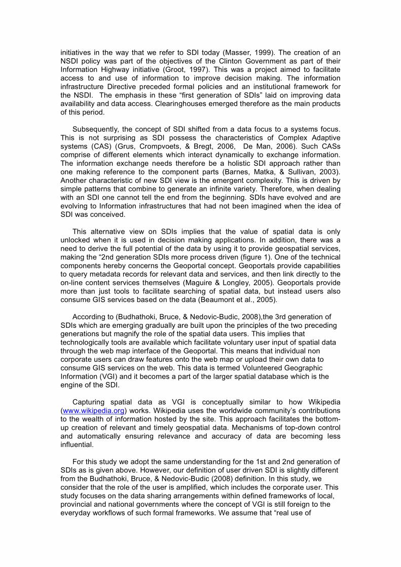
This alternative view on SDIs implies that the value of spatial data is only unlocked when it is used in decision making applications. In addition, there was a need to derive the full potential of the data by using it to provide geospatial services, making the “2nd generation SDIs more process driven (figure 1). One of the technical components hereby concerns the Geoportal concept. Geoportals provide capabilities to query metadata records for relevant data and services, and then link directly to the on-line content services themselves (Maguire & Longley, 2005). Geoportals provide more than just tools to facilitate searching of spatial data, but instead users also consume GIS services based on the data (Beaumont et al., 2005).
According to (Budhathoki, Bruce, & Nedovic-Budic, 2008),the 3rd generation of SDIs which are emerging gradually are built upon the principles of the two preceding generations but magnify the role of the spatial data users. This implies that technologically tools are available which facilitate voluntary user input of spatial data through the web map interface of the Geoportal. This means that individual non corporate users can draw features onto the web map or upload their own data to consume GIS services on the web. This data is termed Volunteered Geographic Information (VGI) and it becomes a part of the larger spatial database which is the engine of the SDI.
Capturing spatial data as VGI is conceptually similar to how Wikipedia
(www.wikipedia.org) works. Wikipedia uses the worldwide community’s contributions to the wealth of information hosted by the site. This approach facilitates the bottom-up creation of relevant and timely geospatial data. Mechanisms of top-down control and automatically ensuring relevance and accuracy of data are becoming less influential.
For this study we adopt the same understanding for the 1st and 2nd generation of SDIs as is given above. However, our definition of user driven SDI is slightly different from the Budhathoki, Bruce, & Nedovic-Budic (2008) definition. In this study, we consider that the role of the user is amplified, which includes the corporate user. This study focuses on the data sharing arrangements within defined frameworks of local, provincial and national governments where the concept of VGI is still foreign to the everyday workflows of such formal frameworks. We assume that “real use of
Geographic Information” in such governance settings requires an SDI that is strongly driven by the users, who are corporate in this instance. Our pool of users are the individual departments and people that use spatial data on a daily basis for making various decisions and therefore have data and information needs that the SDI try to meet. Figure 1: The evolution of the Spatial Data Infrastructure. Adapted from (Budhathoki, Bruce, & Nedovic-
Budic, 2008)
2. SDI IMPLEMENTATION STRATEGIES
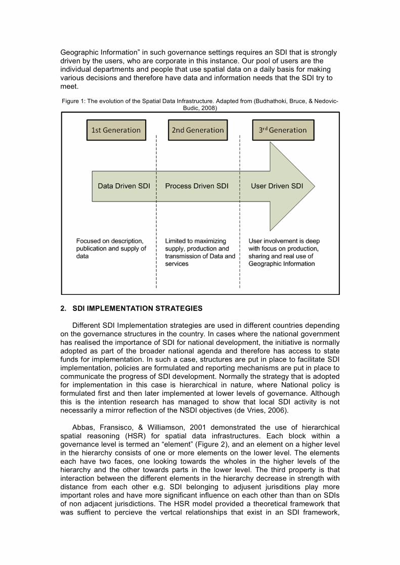
Different SDI Implementation strategies are used in different countries depending on the governance structures in the country. In cases where the national government has realised the importance of SDI for national development, the initiative is normally adopted as part of the broader national agenda and therefore has access to state funds for implementation. In such a case, structures are put in place to facilitate SDI implementation, policies are formulated and reporting mechanisms are put in place to communicate the progress of SDI development. Normally the strategy that is adopted for implementation in this case is hierarchical in nature, where National policy is formulated first and then later implemented at lower levels of governance. Although this is the intention research has managed to show that local SDI activity is not necessarily a mirror reflection of the NSDI objectives (de Vries, 2006).
Abbas, Fransisco, & Williamson, 2001 demonstrated the use of hierarchical spatial reasoning (HSR) for spatial data infrastructures. Each block within a governance level is termed an “element” (Figure 2), and an element on a higher level in the hierarchy consists of one or more elements on the lower level. The elements each have two faces, one looking towards the wholes in the higher levels of the hierarchy and the other towards parts in the lower level. The third property is that interaction between the different elements in the hierarchy decrease in strength with distance from each other e.g. SDI belonging to adjusent jurisditions play more important roles and have more significant influence on each other than than on SDIs of non adjacent jurisdictions. The HSR model provided a theoretical framework that was suffient to percieve the vertcal relationships that exist in an SDI framework,
these have been labelled as (1) in Figure 2. The research proposed an addition of horizontal interractions to adapt the HSR model for SDI. These are labelled (4) in figure 2.
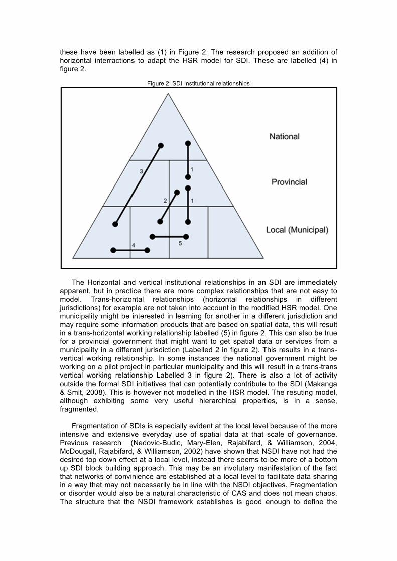
Figure 2: SDI Institutional relationships
The Horizontal and vertical institutional relationships in an SDI are immediately
apparent, but in practice there are more complex relationships that are not easy to model. Trans-horizontal relationships (horizontal relationships in different jurisdictions) for example are not taken into account in the modified HSR model. One municipality might be interested in learning for another in a different jurisdiction and may require some information products that are based on spatial data, this will result in a trans-horizontal working relationship labelled (5) in figure 2. This can also be true for a provincial government that might want to get spatial data or services from a municipality in a different jurisdiction (Labelled 2 in figure 2). This results in a trans-vertical working relationship. In some instances the national government might be working on a pilot project in particular municipality and this will result in a trans-trans vertical working relationship Labelled 3 in figure 2). There is also a lot of activity outside the formal SDI initiatives that can potentially contribute to the SDI (Makanga & Smit, 2008). This is however not modelled in the HSR model. The resuting model, although exhibiting some very useful hierarchical properties, is in a sense, fragmented.
Fragmentation of SDIs is especially evident at the local level because of the more
intensive and extensive everyday use of spatial data at that scale of governance. Previous research (Nedovic-Budic, Mary-Elen, Rajabifard, & Williamson, 2004, McDougall, Rajabifard, & Williamson, 2002) have shown that NSDI have not had the desired top down effect at a local level, instead there seems to be more of a bottom up SDI block building approach. This may be an involutary manifestation of the fact that networks of convinience are established at a local level to facilitate data sharing in a way that may not necessarily be in line with the NSDI objectives. Fragmentation or disorder would also be a natural characteristic of CAS and does not mean chaos. The structure that the NSDI framework establishes is good enough to define the

overall objective of the SDI. Forcing structure on how the component of the SDI function is not a good idea because for any CAS to survive, it must cultivate variety in its internal controls (Pascale, 1999). 3. DESCRIPTION OF CASE
In line with many other countries in the world, South Africa has been developing
their spatial data infrastructure since 1997, when the National Spatial Information Framework (NSIF) was established (Tabhethe, 2008). The NSIF was formed under the Department of Land Affairs (DLA) in an attempt to facilitate access to disparate spatial data holdings within the country. Since then, the NSIF has spearheaded the implementation of the South African Spatial Data Infrastructure (SASDI).
One of the most remarkable achievements of the NSIF if the enactment of the
SASDI act in 2003. The purpose of the act is:
“…to establish the South African Spatial Data Infrastructure, the Committee for Spatial Information and an electronic metadata catalogue; to provide for the determination of standards and prescriptions with regard to the facilitation of the sharing of spatial information; to provide for the capture and publishing of metadata and the avoidance of duplication of such capture; and to provide for matters connected therewith.” (Government Gazette, 2003)
The NSIF is in the process of creating regulations that support the act. Once the
regulations are passed, they are meant to be a guiding framework for all who use or require access to spatial data. The act has however been available to the public as a guide with regards to spatial data sharing, creation and use. The NSIF is also planning to launch the second version if their Spatial Data Discovery Facility (SDDF). This will be a web based application that will allow users to discover the different spatial datasets that are in the country. The SDDF contains 23 nodes that are populated with +/- 3200 metadata records.
The main purpose of this research is to investigate the institutional relationships
that are in place towards building a National Spatial Data Infrastructure (NSDI). The question that we seek to answer:
1. Is there evidence of SDI integration between national-provincial-local
government levels in South Africa? 2. Does the national SDI Act have sufficient impact on the implementation
of SDI at a local level? To answer this question we have formulated two hypotheses that we will try to
prove through this research:
Hypothesis 1 The Top-Down interactions between the National Government and the and Provincial Government neglect practices of local user-driven content and data exchange at local level; Hypothesis 2 The SDI implementation interactions between the Provincial and Local Governments are only based on national SDI objectives.
4. CASE STUDY In order to test the hypotheses we focus our data collection on process and organizational interactions between National-Provincial-Local Government levels
The particular case study is based on SDI activities which are focussed on the NSIF at National level, Western Cape Provincial Government at Provincial level and the City of Cape Town at Local Government level. These particular government structures were chosen as a result of availability of information to the researchers. As there is little or no published record of GIS or SDI activities within the Provincial or Local Government tier in South Africa, the use of personal interviews and e-mail correspondence with relevant Government officials proved to be the only suitable means of understanding their current SDI activities. 3.1. National Government
The SDI activities at this level of government are managed by the Department of Land Affairs (DLA) and more specifically the National Spatial Information Framework (NSIF), which was formed in 1997. The emphasis has been on the establishment of national policies and regulations within which SDI activities are to take place in South Africa. This top-down approach which is inherent, and indeed necessary, in higher levels of government as they are responsible for the establishment of the legislative framework within which lower levels of government operate.
To date the NSIF has successfully guided the enactment of the Spatial Data
Infrastructure Act (Act No. 54 of 2003) which aims to provide for the establishment of the South African Spatial Data Infrastructure (SASDI) in order to regulate the collection, management, maintenance, integration, distribution and use of spatial/geographical information in South Africa (GISSA, 2006).
The Act furthermore makes for the provision of a Committee for Spatial
Information (CSI) which is responsible for decisions regarding the use of national spatial information, including the determination of prescribed standards. The Act also addresses the issue of metadata capture and cataloguing, in order to promote greater access to information and reduce duplication in the capture of spatial information (GISSA, 2006).
Although the SDI Act was tabled before Parliament in November 2003 and
assented by the State President in January 2004 (Thabethe, 2009), the completion of the Regulations to the Act is still to take place. In this regard, the NSIF has completed draft Regulations which have been discussed with stakeholder forums throughout the country during the course of 2008 (NSIF, 2009). The final Regulations to the SDI Act are expected to be completed in the near future.
The development of national standards to govern the acquisition, management
and dissemination of geographical information, although within the ambit of the NSIF, has been administered by the South African Standards Bureau (SABS) through the Standards South Africa (StanSA) body (Copper, 2004). These South African National Standards (SANS) are essentially an adoption of relevant ISO standards (Gavin, 2001). There have been four standards developed in South Africa for geographical information (Thabethe, 2009):
• SANS 1876 – Feature instance identifier standards • SANS 1877 – Land cover classification • SANS 1878 (part 1) – Metadata
• SANS 1880 – South African geospatial data attribute dictionary and its application
The NSIF is also involved in the development of information flow policies which
will detail collaborative maintenance agreements and determine flows of information between various levels of government. The focus is on interdependencies between data sets rather than on data custodians themselves, where derivative data sets are sent to the originating data custodian for updating of spatial base data sets (Thabethe, 2009). While conceptually a good idea, such policies will require political good-will between the various data producer and user organisations.
The development of a National GIS Strategy has also fallen under the authority of
the NSIF. This proposed strategy aims to guide government regarding the use and management of GIS and define the future applications portfolio of the governments’ spatial information. Through this national strategy it is anticipated that spatial data will find a greater role in the context of decision making, governance, planning and development in all government spheres (Thabethe, 2009).
Perhaps most importantly has been the work of the NSIF in the development of a
metadata database. The Spatial Data Discovery Facility (SDDF) contained around 3000 records on spatial data holdings both in the public and private sectors of Southern Africa. This facility provided information on data holdings covering the Southern African development Community (SADC), achieved with the co-operation of the Remote Sensing Unit in Harare, Zimbabwe (Gavin, 2001). The SDDF site for metadata is currently inactive and the last data entries took place in the year 2000 (Cooper, 2006). A new South African geo-spatial data clearinghouse, the Spatial Metadata Discovery (SMD) portal, is currently being tested and is expected to be available to the public in the first quarter of 2009 (NSIF, 2009). 3.2. Provincial Government
Due to the proximity to the principal investigators and hence availability of suitable contacts within the relevant Provincial Government departments, the case study of the Western Cape Provincial Government (WCPG) has been chosen.
The WCPG consists of 12 Departments, covering all of the administrative
portfolios held at national government level. These departments are responsible for implementing laws and providing services to the people of the Western Cape (Cape Gateway, 2007). Many of these Departments are responsible for spatial data acquisition and management in order to conduct their core business.
In an effort to centralise the spatial data management within the WCPG, the
Department of the Premier, through the Centre for e-Innovation, has undertaken the design and development of a Provincial SDI for the Western Cape (Heald, B. 2008).
Although very little information is available at present, the initial SDI design
involves the integration of spatial data holdings from six of the Provincial Departments. In addition there is planned data supply from the City of Cape Town municipality (to be discussed under local government below) and various other relevant national level Departments and public sector organisations as well as selected private spatial data service providers (Van Rensburg, 2008). This design is illustrated in figures 3 and 4 below.

Figure 3: PGWC Spatial Data Flow Process. (van Rensburg, 2008)
Figure 4: PGWC Spatial Web Hosting Process. (van Rensburg, 2008)
To date activities in this regard have involved to soliciting of a priority list of spatial data from the various provincial Departments concerned. This has led to the establishment of a “top-forty” spatial data layers which are currently the focus of SDI
efforts within the Centre for e-Innovation. Metadata is being captured and stored and the base data layers are being cleaned and undergoing consistency checks. It is the intention of the WCPG to fully support the intention of the SDI act. It is noted from personal correspondence with Mr. Basil Heald (Business Intelligence & Geographic Information Systems Team Leader, Centre for e-Innovation, Provincial Government of the Western Cape) that both budget and skill resources restrict the design to focus on delivering GIS as a service to the internal PGWC Departments, complying to the governance of the SDI act (Heald, 2009).
Currently, in the absence of Regulations to the SDI act, the WCPG SDI activities adhere to national specifications and in particular SANS_1883 for core metadata elements (Heald, 2009).
Information on the specific data layers being gathered or the plans to integrate
provincial SDI activities through the various Government levels could not be obtained. It is also not clear whether the SDI, once operational, will be made available to the general public.
There is a clear adherence to the national policy framework in the development of
the WCPG SDI and a seemingly large concern about data security and privacy within their design. It is also noteworthy that although the WCPG Departments have relatively large spatial data holdings, the focus of correct SDI activities is only with a selection of the “top-forty” data layers, leaving the rest in obscurity within the silos of departmental spatial databases (Heald, 2008). 3.3. Local Government
As with the WCPG, the case study of the City of Cape Town municipality was chosen for this investigation due to access to information through personal contacts within the organisation. There is also little or no published detail on GIS activities within the Local Government levels in South Africa.
In 2001 the seven local authorities merged to make up the Cape Metropolitan
Council amalgamated into the City of Cape Town, with the intention of consolidating and streamlining the municipal services provision across the entire Cape Town metropolitan area. As a result of this, the integration of the existing legacy IT systems into one seamless IT infrastructure became a high priority for the city. One of these IT systems which needed to be integrated was GIS. The legacy municipal structures saw GIS technology being used throughout various local councils and departments, but generally operated as stand-alone systems with little standardisation and limited compatibility (Baumann, 2007).
Initial efforts involved the implementation of an enterprise GIS based on the ESRI
ArcGIS platform. The basis was thus established for greater interoperability and effective spatial data management. GIS databases were held within individual departments and the city focussed on integration issues, such as user profiles, standardisation of data capture procedures and maintenance of departmental spatial databases. The establishment of a common data model for GIS use throughout the city saw large savings in terms of operational procedures and led to the development of a GIS that promoted data sharing while minimising data redundancy (Baumann, 2007).
The Department of Strategic Development Information and GIS was
subsequently established in an effort to centralise spatial data management within the City of Cape Town. The stated goal of the Strategic Development Information and
GIS Department is to “strengthen the use of information and knowledge in contributing to the future development of Cape Town”. This goal is to be achieved in part by “developing systems and processes to promote the sharing of information and knowledge across the organisation”, which entails the development of a city-wide SDI (City of Cape Town, 2008).
The Corporate GIS branch of the Strategic Development Information and GIS
(SDI&GIS) Department is responsible for delivering GIS services to the city. This branch incorporates spatial data capture, analysis and warehousing as well as dissemination. In this regard, SDI&GIS have formulated a “spatial information strategy” to provide the basis for better management and coordination of the City of Cape Town’s information assets. The application and use of GIS is a critical factor in the consideration and implementation of this strategy (Bhunu, 2009). The intention of the strategy is to support two enterprise information databases:
• ERP – enterprise resources planning (SAP based, focussing on business transactions)
• ISIS – integrated spatial information system In the context of the Integrated Spatial Information System (ISIS), the strategy outlines the processes and procedures to:
• effectively manage spatial data holdings (data acquisition and capture, metadata cataloguing, information standards and custodianship);
• facilitate integration and sharing of data; • disseminate information to ensure accessibility and ease of use; • manage information flows through appropriate governance structures; • provide support infrastructures (systems, people and technology).
It is still found that the degree of interdepartmental co-operation in the City of
Cape Town is limited, resulting in fragmented data holdings and uncoordinated distribution of information. The ISIS is addressing this situation by setting up the framework and structures within which integration of departmental data is facilitated. The initial project is working with 6 departments who have GIS capacity and will be extended to the remaining 16 departments within the city in the coming years (Bhunu, 2009). The ISIS project operates within the constraints of the SDI Act and there are clear reporting systems within the municipal structures to ensure adherence to the Act.
Initial efforts by the Corporate GIS branch involved the establishment of a
metadata catalogue for the city. This task, which spanned three years, required individual departments to capture metadata according to a prescribed format, in accordance with national spatial data standards and the SDI act. This required the interpretation of the South African National Standards (SANS) into policy framework documents, a process which was outsourced to GIS consultants (Bhunu, 2009).
Spatial data management has also been centralised within the City of Cape Town
through the Corporate GIS structures and current work is focussed on information (or knowledge) management. This is being done in the form of thematic information provision through relevant indicator data sets for the cities integrated development planning processes (Haskins, 2008).
The process of interaction between Departments and the Corporate GIS is
described in figure 5 below. The corporate role focuses on ensuring agreement on the standards and procedures to be used by the various departments as well as providing support and monitoring the implementation of information management
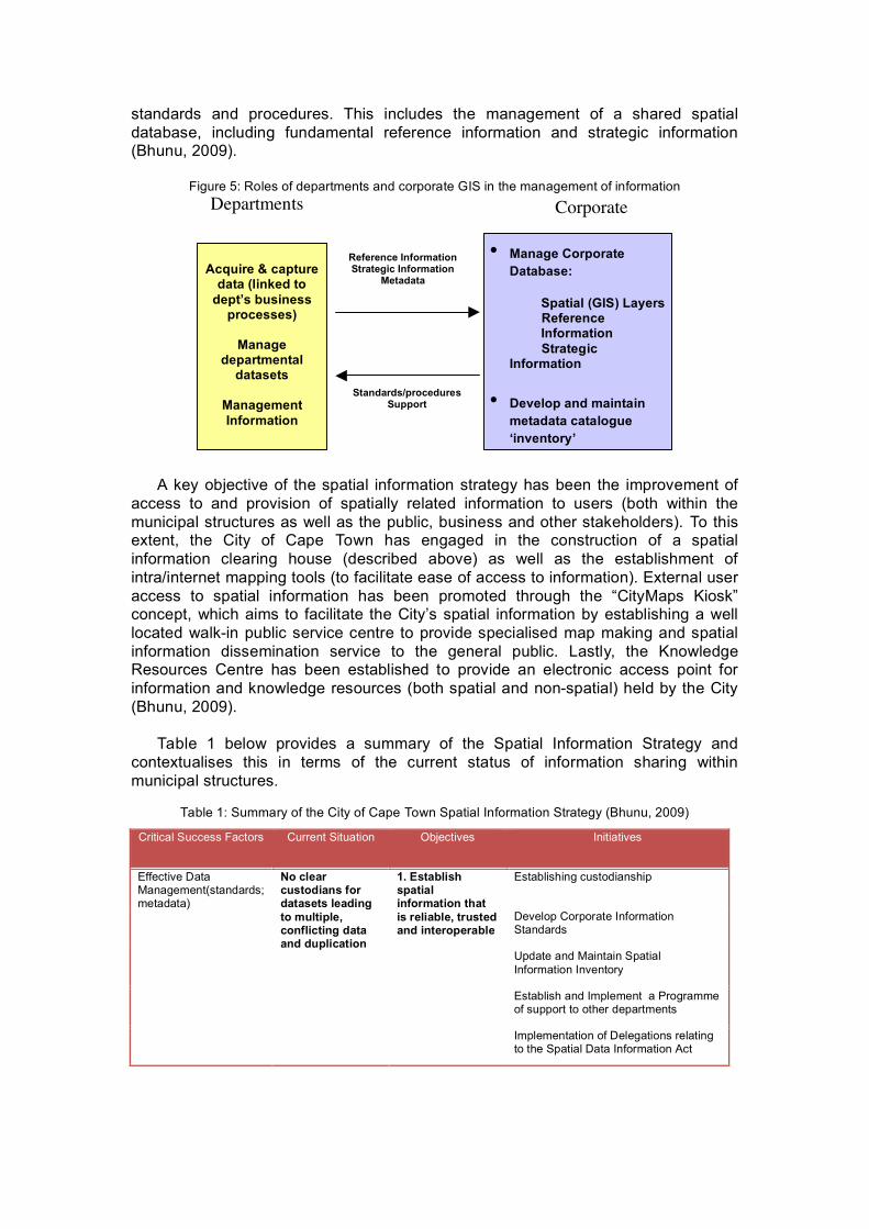
standards and procedures. This includes the management of a shared spatial database, including fundamental reference information and strategic information (Bhunu, 2009).
Figure 5: Roles of departments and corporate GIS in the management of information
A key objective of the spatial information strategy has been the improvement of
access to and provision of spatially related information to users (both within the municipal structures as well as the public, business and other stakeholders). To this extent, the City of Cape Town has engaged in the construction of a spatial information clearing house (described above) as well as the establishment of intra/internet mapping tools (to facilitate ease of access to information). External user access to spatial information has been promoted through the “CityMaps Kiosk” concept, which aims to facilitate the City’s spatial information by establishing a well located walk-in public service centre to provide specialised map making and spatial information dissemination service to the general public. Lastly, the Knowledge Resources Centre has been established to provide an electronic access point for information and knowledge resources (both spatial and non-spatial) held by the City (Bhunu, 2009).
Table 1 below provides a summary of the Spatial Information Strategy and
contextualises this in terms of the current status of information sharing within municipal structures.
Table 1: Summary of the City of Cape Town Spatial Information Strategy (Bhunu, 2009)
Critical Success Factors Current Situation Objectives Initiatives
Establishing custodianship
Develop Corporate Information Standards
Update and Maintain Spatial Information Inventory
Establish and Implement a Programme of support to other departments
Effective Data Management(standards; metadata)
No clear custodians for datasets leading to multiple, conflicting data and duplication
1. Establish spatial information that is reliable, trusted and interoperable
Implementation of Delegations relating to the Spatial Data Information Act
Reference Information Strategic Information
Metadata
Standards/procedures Support
Acquire & capture
data (linked to dept’s business
processes)
Manage departmental
datasets
Management Information
Departments
• Manage Corporate Database:
Spatial (GIS) Layers Reference Information
Strategic Information
• Develop and maintain metadata catalogue ‘inventory’
• Common set of standards & procedures to ensure “interoperability”
• System/process for dissemination of information
Corporate

Reference/Base/Core Information
Develop Corporate Strategic Information Repository
Metadata Catalogue
Sharing and Integration Cetain data stored on corporate warehouse but data sharing tends to be limited
2. Strengthen the integrated, enterprise-wide management of spatial information to ensure information integration and sharing Establish Partnerships/Agreements with
External Agencies
Establish Spatial Information clearinghouse
Intra/Internet Mapping Tools
CityMaps Kiosk
Accessibility of information
No access to information via Internet / Intranet viewers based on older technology
3. Create effective ways of information dissemination in order to improve accessibility to and use of information
Knowledge Resource Centre
Political Level
Senior Management input
Operational Management input
Technical Working Groups
Governance Depts work together on an ad hoc basis / Need for stronger senior mgmt buy in and support
4. Governance Model
Corporate Support Centre
Invest in appropriate technology Technology and Human Resources
CCT has established technology; human resource gaps in certain areas; need for broader information management training
5. Effective Supporting Infrastructure (Technology; Human Resources)
Develop and implement an appropriate Skills Development and Training Programme
5. SPATIAL DATA INTEGRATION
Although South Africa has made substantial developments in the area of spatial data sharing in the past decade, there have also been fairly substantial impediments to the development and maintenance of a National Spatial Data Infrastructure (NSDI). Most notable is the inoperability of the Spatial Data Discovery Facility (SDDF) for the past eight years, which was a serious setback to regional data sharing efforts.
The adoption of the Promotion of Access to Information Act (Act 2 of 2000) has
paved the way for integration of spatial data management throughout all levels of the public sector and should also permeate into data, information and knowledge flows between the public and private sectors of society (SAHRC, 2009).
The development and passing into law of the SDI act in 2003 has been a positive

highlight, but the implementation of the act has been all but nonexistent, due to the lack of Regulations and the inability to constitute the Council for Spatial Information (CSI).
Furthermore, the adoption of ISO standards for spatial information by the South
African Bureau of Standards (SABS), thereby forming South African National Standards (SANS) for spatial information, has been a positive development. The interpretation of these very lengthy and complex standards into a common set of policy documents for the guidance of spatial data capture, management and dissemination is lacking.
In the absence of the practical guides to the development of SDI activities within
South Africa, most notable SDI activities have been at the lower levels of government. 4.1. National Government
The National Spatial Information Framework (NSIF) has been largely occupied with the business of setting policies and regulations to guide the governance of SDI activities. They are also engaged with the establishment of the successor to the now defunct SDDF and are due to have the new national spatial data clearing house, the Spatial Metadata Discovery (SMD) portal, in operation shortly.
The NSIF by its very nature is concerned with the first and second phases of SDI
development which are primarily data and process driven. Integration, at this level of government, is limited to a top-down approach of policy setting and to some extent enforcement. There has been an attempt, through the SMD, to allow for greater multi-level integration of NSDI activities by incorporating metadata from lower levels, but the main focus at this stage is on the cataloguing of national departments’ spatial data holdings. 4.2. Provincial Government
The work that is taking place within the Department of the Premier at the Centre for e-Innovation is relatively new and largely dedicated to the first phase of SDI development, as described by Maguire & Longley (2005), with the focus being on data. As far as can be determined, user involvement is limited and most of the efforts are dedicated to metadata creation, spatial data cleaning and data distribution within the Provincial Government ranks.
Interaction with organisations outside of the Western Cape Provincial
Government (WCPG) is largely in the form of data supply and it is not evident that the WCPG SDI will be made available outside of the organisation. It is however evident that there is limited data sharing happening between individual Departments in the WCPG and the City of Cape Town Strategic Development Information and GIS. This co-operation is largely attributed to efforts on the part of individuals rather than structured data sharing policies (van Rensburg, 2008).
In terms of integration with national activities, the WCPG does subscribe to the
intent of the SDI act and in particular the adherence to national spatial data specifications (Heald, 2009). Activities are hampered by the lack of clear policy guidance from national level and a lack of resources (both financial and skills). 4.3. Local Government
The City of Cape Town’s Department of Strategic Development Information and GIS has made substantial headway towards establishing an integrated SDI in recent years. This can be largely attributed to a progressive approach of information and knowledge management, rather than focus purely on data. The initial phases of SDI development (user consultation and education) formed a solid grounding to build a very well integrated system.
Although the city operates within the constraints of the SDI act and the relevant
national standards, they have not been hampered by a lack of clear policy directives (SDI act regulations and standards policy framework) from national level. The involvement of external consultants in the process of standards interpretation has been a clear example of this approach.
The focus on information and knowledge rather than data, which places the City
of Cape Town SDI in the second phase of the SDI development model, has also seen a greater acceptance of its implementation within the individual Departments.
The city has strong bi-directional links with multiple levels of data providers at
national, provincial and local government levels. This is evident in their relationship with the Chief Surveyor General’s Office, where the city takes on the role of creating and maintaining GIS enabled cadastral data layers. The city furthermore has a wealth of their own regularly updated spatial data which is made available to the public (other local municipalities as well as provincial and national government departments) and private sector.
Recent developments have seen the establishment of a formal memorandum of
understanding between the City of Cape Town and the PGWC to enable data sharing between these two levels of government (Bhunu, 2009).
The approach of the city has been a bottom-up one, with strong user and
stakeholder participation in all phases of the SDI design and implementation. This is a symptom of the 3rd generation nature of the SDI activity of the City of Cape Town. Presently the city SDI is only available within the organisation, but the launch of the City of Cape Town SDI as a public facility is expected during the course of 2009 (Bhunu, 2009). 4.4. Other Initiatives The Cape Urban Observatory and its counterpart in Gauteng Province, the Gauteng Urban Observatory, are local attempts to facilitate greater co-operation and information sharing at the provincial and local government levels. The Cape Urban Observatory (CUO), formed in July 2008, has set out contribute to the development of sustainable human settlements in the greater Cape Town area. This is to be achieved by facilitating “evidence-based decision-making and improved collaboration and learning by providing a public platform for the storage, dissemination and analysis of timely and reliable geo-spatial information and analysis on themes relevant to integrated development planning” (CUO, 2008). In essence, the aim of the CUO is to facilitate greater integration of spatial data between national, provincial and local government in the Western Cape to allow for improved information and knowledge management to allow for better management of human settlements. This will, in the first instance, be achieved through the development of a regional SDI to serve the stakeholder forum, essentially satisfying phases one and two of the SDI development model. The second phase of

development, which will largely run concurrently, is planned around the development and calculation of relevant thematic indicators, thereby integrating multiple data sources and leading to improved information and knowledge provision (satisfying the third phase of SDI development). 6. CONCLUSIONS Reflecting on the three hypotheses leads to the following conclusions:
1) There is a clear disconnect between national policies and emerging practices. Integration of SDI activities from national-provincial-local government levels primarily follows a top-down approach, with the National Spatial Information Framework being responsible for the establishment and management of policies and regulations to govern SDI activities throughout all levels of government.
2) Provincial SDI implementation, although currently non-existent, is under development. This has led to relatively slow development of SDI linkages between national and provincial levels in South Africa.
3) The user-driven bottom-up approach adopted by the City of Cape Town is symptomatic of successful local government SDI activities. This approach has also led to greater horizontal and vertical integration of spatial data resources on the local and regional scales.
The current status of South African Government SDI activities, as revealed through this investigation, is summarised in Figure 6 below. Most vertical integration activities are based on spatial data sharing which has been facilitated by the Access to Information Act, while SDI policy directives are driven by national government in a top-down approach. Although most user-driven SDI activities are restricted to local levels of government, there has been limited user input into the development of national policy directives.
Figure 6: National-Provincial-Local Government SDI activity
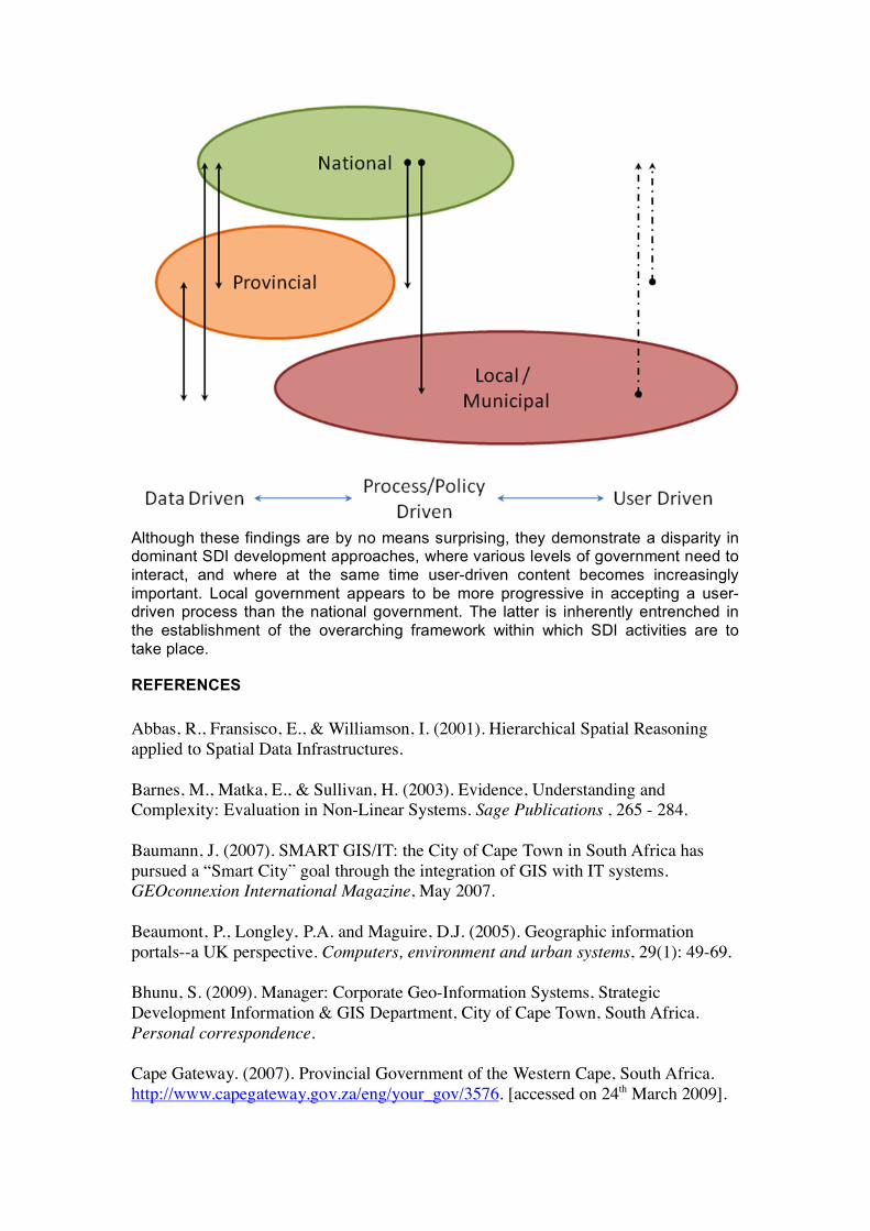
Although these findings are by no means surprising, they demonstrate a disparity in dominant SDI development approaches, where various levels of government need to interact, and where at the same time user-driven content becomes increasingly important. Local government appears to be more progressive in accepting a user-driven process than the national government. The latter is inherently entrenched in the establishment of the overarching framework within which SDI activities are to take place.
REFERENCES Abbas, R., Fransisco, E., & Williamson, I. (2001). Hierarchical Spatial Reasoning applied to Spatial Data Infrastructures. Barnes, M., Matka, E., & Sullivan, H. (2003). Evidence, Understanding and Complexity: Evaluation in Non-Linear Systems. Sage Publications , 265 - 284. Baumann, J. (2007). SMART GIS/IT: the City of Cape Town in South Africa has pursued a “Smart City” goal through the integration of GIS with IT systems. GEOconnexion International Magazine, May 2007. Beaumont, P., Longley, P.A. and Maguire, D.J. (2005). Geographic information portals--a UK perspective. Computers, environment and urban systems, 29(1): 49-69. Bhunu, S. (2009). Manager: Corporate Geo-Information Systems, Strategic Development Information & GIS Department, City of Cape Town, South Africa. Personal correspondence. Cape Gateway. (2007). Provincial Government of the Western Cape, South Africa. http://www.capegateway.gov.za/eng/your_gov/3576. [accessed on 24th March 2009].

City of Cape Town. (2008). Strategic Development Information & GIS Department, City of Cape Town, South Africa. www.capetown.gov.za/en/stats/Pages/default.aspx. [accessed on 24 March 2009]. Cooper, A. (2004). Status of the Standardization of Geographical Information in Africa. Geoinfromation Standards ISO Workshop, Nairobi, Kenya, October 2004. Cooper, A. (2006). Data collection, transfer and the development of national standards – critical components necessary for the success of a GIS in South Africa. GIS, Earth Observation and Government Interoperability South Africa Conference, Johannesburg, South Africa. 2006. CUO. (2008). The Cape Urban Observatory, African centre for Cities, University of Cape Town, South Africa. http://www.acc.uct.ac.za/capetown.htm. [accessed 24th March 2009]. De Man, E. W. (2006). Understanding SDI; complexity and institutionalization. International Journal of Geographical Information Science , 329–343. de Vries, W. (2006). Why Local Spatial Data Infrastructures are not just mirror reflections of the National SDI objectives - Case study of Bekasi, Indonesia. The electronic Journal on Information Systems in Developing Countries , 1-28. Haskins, C. (2008). Manager: Strategic Information, Strategic Development Information & GIS Department, City of Cape Town, South Africa. Personal correspondence. Gavin, E.J.O. (2001). Building SDI in Africa: a South African Experience. GSDI-5 Conference Proceedings. Cartagena, Colombia, 2001. GISSA. (2006). Geographical Information Society of South Africa, http://www.gissa.org.za/government/sdiact, [accessed on 23rd March 2009]. Government Gazette. (2003). SPATIAL DATA INFRASTRUCTURE .4CT. 7003. Government Gazette REPUBLIC OF SOUTH AFRICA. Grus, L., Crompvoets, J., & Bregt, A. (2006). Defining National Spatial Data Infrastructures as Complex Adaptive. GSDI-9 Conference Proceedings, 6-10 November 2006. Santiago, Chile: GSDI. GSDI. (2004). Developing Spatial Data Infrastructures: The SDI Cookbook. GSDI. Heald, B. (2008). Business Intelligence & Geographic Information Systems Team Leader, Centre for e-Innovation, Department of the Premier, Provincial Government of the Western Cape, South Africa. Presentation and comments during the Cape Urban Observatory inception workshop. November 2008. University of Cape Town, Cape Town, South Africa. Heald, B. (2009). Business Intelligence & Geographic Information Systems Team Leader, Centre for e-Innovation, Department of the Premier, Provincial Government
of the Western Cape, South Africa. Personal correspondence. Maguire, D.J. and Longley, P.A. (2005). The emergence of geoportals and their role in spatial data infrastructures. Computers, environment and urban systems, 29(1): 3-14. Makanga, P., & Smit, J. (2008). A review of the status of Spatial Data Infrastructure Implementation in Africa. Free and Opensource software for Geospatial (Foss4g) conference, (pp. 357 - 365). Cape Town, South Africa. Masser, I. (1999). All shapes and sizes: the first generation of national spatial data infrastructures. International journal of geographic information science, 13(1): 67-84. Mavima, R. (2004). The Zimbabwe Spatial Data Infrastructure Outreach workshop. Harare: http://www.gsdi.org/SDIA/docs2004/ByoSDIOutreachReport.pdf [accessed 22 March 2009]. McDougall, K., Rajabifard, A., & Williamson, I. (2002). From Little Things Big Things Grow: Building the SDI from Local Government Up. Joint AURISA and Institution of Surveyors Conference. Adelaide, South Australia. Nedovic-Budic, Z., Mary-Elen, F. F., Rajabifard, A., & Williamson, I. (2004). Are SDIs serving the needs of local planning? Case study of Victoria, Australia and Illinois, USA. Computers, Environment and Urban Systems , 329-351. NSIF. (2009). National Spatial Information Framework. http://www.nsif.org.za/News/news.htm. [accessed on 23rd March 2009]. Pascale, R. T. (1999). Surfing the edge of Chaos. Sloan Management Review , 83 - 94. SAHRC. (2009). South African Human Rights Commission. http://www.sahrc.org.za/sahrc_cms/publish/cat_index_40.shtml#11. [accessed on 24th March 2009]. Thabethe, A. (2008). The South African Spatial Data Infrastructure (SASDI): Where are we since 1997. ” The SDI that is need driven. The SDI in the South African Context”? GSDI 10 Conference. GSDI. Thabethe, A. (2009). Acting Director: National Spatial Information Framework, Department of Land Affairs, South Africa. Personal communication. Vandebroucke, D., & Jansse, K. (2008). INSPIRE State of Play: Generic approach to assess the status of NSDI. Van Rensburg, R. (2008). Director: Planning, Research and Policy Development, Department of Local Government and Housing, Provincial Government of the Western Cape. Personal correspondence.