exhibit "a" - BidNet
59
A-1 EXHIBIT "A" SCOPE OF SERVICES FOR CONSULTANT STRUCTURE INSPECTION PROGRAM (NORTH SYSTEM) TABLE OF CONTENTS 1.0 PROJECT OBJECTIVE .............................................................................................................. A-3 2.0 GENERAL DESCRIPTION ........................................................................................................ A-3 3.0 STRUCTURE INSPECTION STANDARDS OF PRACTICE................................................. A-6 4.0 PERSONNEL REQUIREMENTS............................................................................................... A-8 5.0 INSPECTION PREPARATION .................................................................................................. A-8 6.0 FIELD INSPECTIONS................................................................................................................ A-9 7.0 INSPECTION REPORTS .......................................................................................................... A-10 7.1 Report Submissions 7.2 Turnpike Files at CONSULTANT Office 7.3 Organization of Bridge Inspection Reports 7.4 Organization of Sign Structure Inspection Reports 7.5 Organization of High Mast Light Pole Inspection Reports 7.6 Inspection and Reporting of Non-Qualifying Culvert Inspection Reports 7.7 Structure Inventory and Appraisal Records 7.8 Load Rating Analysis 8.0 ELECTRONIC DOCUMENT MANAGEMENT ..................................................................... A-18 9.0 BRIDGE LOCATION MAPS ................................................................................................... A-18 10.0 QUALITY CONTROL AND QUALITY ASSURANCE PROGRAM .................................... A-19 10.1 Quality Control Plan 10.2 Quality Assurance Plan 10.3 Quality Report 10.4 Quality Reviews by the Turnpike Enterprise 11.0 CONSULTANT MATERIALS ................................................................................................ A-20 11.1 Materials to be Furnished to the CONSULTANT
-
Upload
khangminh22 -
Category
Documents
-
view
0 -
download
0
Transcript of exhibit "a" - BidNet
A-1
EXHIBIT "A"
SCOPE OF SERVICES
FOR
CONSULTANT STRUCTURE INSPECTION PROGRAM (NORTH SYSTEM)
TABLE OF CONTENTS
1.0 PROJECT OBJECTIVE .............................................................................................................. A-3 2.0 GENERAL DESCRIPTION ........................................................................................................ A-3 3.0 STRUCTURE INSPECTION STANDARDS OF PRACTICE ................................................. A-6 4.0 PERSONNEL REQUIREMENTS ............................................................................................... A-8 5.0 INSPECTION PREPARATION .................................................................................................. A-8 6.0 FIELD INSPECTIONS ................................................................................................................ A-9 7.0 INSPECTION REPORTS .......................................................................................................... A-10
7.1 Report Submissions
7.2 Turnpike Files at CONSULTANT Office
7.3 Organization of Bridge Inspection Reports
7.4 Organization of Sign Structure Inspection Reports
7.5 Organization of High Mast Light Pole Inspection Reports
7.6 Inspection and Reporting of Non-Qualifying Culvert Inspection Reports
7.7 Structure Inventory and Appraisal Records
7.8 Load Rating Analysis
8.0 ELECTRONIC DOCUMENT MANAGEMENT ..................................................................... A-18 9.0 BRIDGE LOCATION MAPS ................................................................................................... A-18 10.0 QUALITY CONTROL AND QUALITY ASSURANCE PROGRAM .................................... A-19
10.1 Quality Control Plan
10.2 Quality Assurance Plan
10.3 Quality Report
10.4 Quality Reviews by the Turnpike Enterprise 11.0 CONSULTANT MATERIALS ................................................................................................ A-20
11.1 Materials to be Furnished to the CONSULTANT
A-2
11.2 Materials Available at the Turnpike Operations Center
11.3 Manuals 12.0 WORK SCHEDULE AND PROGRESS REPORTS ................................................................ A-21
12.1 Notice to Proceed Meeting
12.2 Work Schedule, Cost Flow Graph, and Organizational Chart
12.3 Progress Reports 13.0 MISCELLANEOUS .................................................................................................................. A-23
13.1 Legal Proceedings
13.2 Errors and Omissions
13.3 Contradictions
13.4 Term and Commencement of Work LIST OF ATTACHMENTS
A1. Bridge Inventory ........................................................................................................... A1-1
A2. Overhead Sign Structure Inventory ............................................................................. A2-1
A3. High Mast Light Tower Inventory ................................................................................ A3-1
A4. Large Non-Qualifying Culvert Inventory ..................................................................... A4-1
A5. Comprehensive Inventory Data (CID) Items for Which the Consultant Is Not Responsible
During a Routine Inspection. ........................................................................................ A5-1

A-3
EXHIBIT “A” SCOPE OF SERVICES
1.0 PROJECT OBJECTIVE 1.1 For the purpose of this Scope of Services, reference to a “structure” includes bridges, overhead sign
structures, high mast light poles and large non-qualifying culverts. An inventory of the Turnpike North System Structures is provided in Attachments A1 through A4. These Attachments include information for the next structures inspection cycle (to be accomplished 2015-2017).
1.2 Structures located within Florida’s Turnpike Enterprise North System, to include the Turnpike
Mainline from Milepost 200 to the Northern terminus, the Beachline Expressway, the East-West Expressway, the Seminole County Expressway, the Western Beltway, the Veterans Expressway, the Southern Connector Extension, the Polk County Parkway, and the Suncoast Expressway shall be inspected in compliance with federal regulations (National Bridge Inspection Standards, CFR Title 23, Part 650, Subpart C); Section 335.074, Florida Statutes; Safety Inspection of Bridges; State of Florida Department of Transportation Rules, Chapter 14-48, F.A.C., Bridge Inspection Standards; and OSHA 29 CFR, Part 1926.
2.0 GENERAL DESCRIPTION 2.1 The CONSULTANT shall perform structure inspection services as described in this Scope of
Services for Florida's Turnpike North System (See paragraph 1.2). The frequency of inspection shall comply with Florida Statutes and Section II of the Bridge and Other Structures Inspection and Reporting Procedure.
2.2 The following portions of this Scope are subject to change. Therefore, the quantity for each work
item is estimated below:
2.2.1 390 Routine Bridge Inspection: Bridges listed in Attachment No. A1 shall require biennial Routine Bridge Inspections. Structure inspection and reporting shall be in compliance with Florida Statutes, the Bridge and Other Structures Inspection and Reporting Procedure and the requirements of this Scope as set forth herein.
2.2.2 Bridges not listed in Attachment No. A1 shall require Initial Bridge Inspections or Post
Rehabilitation Inspection.
Bridges identified for Routine Inspection that are found to be under construction for widening or major rehabilitation may be rescheduled for Post Rehabilitation Inspection at a later date if the construction is more than 90% complete at the time of the scheduled routine inspection at the discretion of FDOT’s Turnpike Enterprise Structures Maintenance (hereinafter referred to as the DEPARTMENT).
The CONSULTANT shall conduct the bridge inspection and provide a preliminary report of deficiencies to include a copy of the cover sheet and the Element Detail sheets, not later than three (3) calendar days after notification by the DEPARTMENT. The complete bridge inspection report, including all required bridge record file sections, shall be submitted within (45) calendar days of the inspection.
10 Initial Bridge Inspection: Bridges newly constructed or inventoried requiring Initial
Bridge Inspection shall require that a bridge record file be established in the format designated in the Bridge and Other Structures Inspection and Reporting Procedure and the
A-4
requirements of this Scope as set forth herein. 50 Post Rehabilitation Bridge Inspection: Bridges, which will undergo “substantial”
rehabilitation, as determined by the DEPARTMENT, shall require Post Rehabilitation Bridge Inspection. The Post Rehabilitation Inspection Report shall be prepared in the same manner as an Initial Inspection with the exception of the legal size folder. Each section of the bridge record file shall be revised in the format designated in the Bridge and Other Structures Inspection and Reporting Procedure and the requirements of this Scope as set forth herein.
2.2.3 5 Post Repair Bridge Inspection: Bridges which will undergo "substantial" repair, as
determined by the DEPARTMENT, shall require Post Repair Inspection. The Post Repair Inspection report shall be prepared with emphasis on the satisfactory or non-satisfactory completion of repair work.
The CONSULTANT shall conduct the bridge inspection and provide a preliminary report of deficiencies evaluating only those items that were included in the repair plans, with a copy of the cover sheet and the Element Detail sheets. This preliminary report should be submitted no later than three (3) calendar days after notification by the DEPARTMENT. The complete bridge inspection report shall be submitted within (45) calendar days of the inspection.
2.2.4 35 Underwater Bridge Inspection: Bridges with portions of the bridge located in water
deeper than three feet at the time of the scheduled inspection and where the underwater portions cannot be adequately inspected without the use of divers shall require Underwater Inspection, or as requested by the DEPARTMENT. Notification to the DEPARTMENT should be made if an Underwater Inspection is required.
2.2.5 10 Load Rating Analysis: Bridges which are newly built, rehabilitated, newly inventoried,
or as recommended by the CONSULTANT due to significant deterioration, may require Load Rating Calculations as determined by the DEPARTMENT. The Load Rating Calculations shall be submitted with the associated inspection report or, if a stand-alone rating, then it shall be submitted within seven (7) calendar days of the authorization. For Initial or Post Rehabilitation Load Ratings performed by others, the CONSULTANT shall request a copy of the Load Ratings prior to submitting the reports (See Section 7.8 for Load Rating Requirements).
2.2.6 11 Special Bridge Inspection: Bridges with conditions that warrant additional time to
perform a bridge inspection, such as bridge lengths greater than 1,000 feet, or bridge inspection at night to reduce traffic inconveniences (at the discretion of the DEPARTMENT), shall require a Special Inspection. A Special Bridge Inspection will be used in conjunction with the required bridge inspection (Routine, Initial, Post Rehabilitation, Post Repair, etc.).
2.2.7 5 Interim Bridge Inspection: Bridges with low condition and/or appraisal ratings as to be
determined by the DEPARTMENT shall require Interim Bridge Inspection. This inspection will emphasize deficient elements of the structure.
2.2.8 2 Emergency Bridge Inspection: Emergency Bridge Inspection shall be performed as
directed by the DEPARTMENT. The CONSULTANT shall respond on-site within one (1) hour of notification. A recommendation of whether to continue or restrict normal traffic flow shall be determined on site by the CONSULTANT. A "hands-on" inspection shall be performed to determine the complete extent of the damage, and a damage assessment (preliminary report) of those items affected shall be submitted within 24 hours of
A-5
notification. The Inspector will make an effort to remove any free or loose debris to determine the complete extent of the damage, and/or that could possibly pose as a threat to the public. The Emergency Bridge Inspection Report, including recommendation of corrective actions with alternative methods of repairs, shall be submitted within five (5) calendar days of notification of the Emergency by the DEPARTMENT. The Inspection Report shall clearly indicate that no substantial reduction to the structural capacity of the bridge has resulted from the Emergency Incident.
2.2.9 2 Emergency Bridge Inspection & Load Rating: Emergency Bridge Inspection and Load
Rating shall be performed as directed by the DEPARTMENT. The CONSULTANT shall respond on-site within one (1) hour of notification. A recommendation of whether to continue or restrict normal traffic flow shall be determined on site by the CONSULTANT. A "hands-on" inspection shall be performed to determine the complete extent of the damage, and a damage assessment (preliminary report) of those items affected shall be submitted within 24 hours of notification. The Inspector will make an effort to remove any free or loose debris to determine the complete extent of the damage, and/or that could possibly pose as a threat to the public. A load rating analysis is to be done as part of the Emergency Inspection. It shall be submitted within 48 hours of notification. The final Emergency Bridge Inspection Report, including recommendation of corrective actions with alternative methods of repair, shall be submitted within five (5) calendar days of notification of the Emergency by the DEPARTMENT.
2.2.10 2 Lake Jessup Bridge Inspection: Due to the unique length of these structures
(approximately 7,934 feet each) the Routine Inspection of Lake Jessup bridges is identified as individual work items. These two parallel structures, numbered 770054 and 770055, are located on the Seminole County Expressway over Lake Jessup.
2.2.11 440 Routine Sign Inspection: Sign structures listed in Attachment No. A2 shall require
"hands-on" biennial Routine Inspection. This item may also include Interim Inspections for sign structures with low condition and/or appraisal ratings, substantial repairs, or accident damage, or as determined by the DEPARTMENT.
2.2.12 120 Initial Sign Inspection: Sign structures not listed in Attachment No. A2 shall require
"hands-on" Initial Sign inspections and application of sign numbers since prior inspections of these newly constructed or newly inventoried structures have not been performed. A sign record file shall be established in the same format as the bridge record file designated in the Bridge and Other Structures Inspection and Reporting Procedure excluding Inventory Section II, Topic "I" - Channel and Scour Information and Topic “D” – Load Capacity Information.
The CONSULTANT shall conduct the sign inspection and provide a preliminary report of deficiencies to include a copy of the cover sheet and Element Detail Sheet, not later than three (3) calendar days by email after notification by the DEPARTMENT. The complete sign inspection report, including all required sign record file sections, shall be submitted within (45) calendar days of the inspection.
2.2.13 250 Routine High Mast Light Tower (HMLT) Inspection: High Mast Light Towers with a
proposed inspection date in Attachment No. A3 shall require biennial Routine Inspections. This item may also include Interim Inspections for towers with low condition and/or appraisal ratings, substantial repairs, or accident damage, or as determined by the DEPARTMENT.
2.2.14 15 Initial High Mast Light Tower Inspection: HMLT structures not listed in Attachment
No. A3 shall require "hands-on" Initial HMLT Inspections and application of HMLT
A-6
numbers since prior inspections of these newly constructed or newly inventoried structures have not been performed. An HMLT record file shall be established in the same format as the bridge record file designated in the Bridge and Other Structures Inspection and Reporting Procedure excluding Inventory Section II, Topic "I" - Channel and Scour Information and Topic “D” – Load Capacity Information.
The CONSULTANT shall conduct the HMLT inspection and provide a preliminary report of deficiencies to include a copy of the cover sheet and Element Detail Sheet, not later than three (3) calendar days by email after notification by the DEPARTMENT. The complete HMLT inspection report, including all required HMLT record file sections, shall be submitted within (45) calendar days of the inspection.
2.2.15 50 Routine Large Non-Qualifying Culvert (LNQC) Inspection: Large non-qualifying
culverts with a proposed inspection date in Attachment No. A4 shall require routine inspection this cycle.
2.2.16 10 Initial Large Non-Qualifying Culvert Inspection: LNQC structures not listed in
Attachment No. A4 shall require "hands-on" Initial LNQC Inspections and application of LNQC numbers since prior inspections of these newly constructed or newly inventoried structures have not been performed. An LNQC record file shall be established in the same format as the bridge record file designated in the Bridge and Other Structures Inspection and Reporting Procedure excluding Inventory Section II, Topic "I" - Channel and Scour Information and Topic “D” – Load Capacity Information.
The CONSULTANT shall conduct the LNQC inspection and provide a preliminary report of deficiencies to include a copy of the cover sheet and Element Detail Sheet, not later than three (3) calendar days by email after notification by the DEPARTMENT. The complete LNQC inspection report, including all required LNQC record file sections, shall be submitted within (45) calendar days of the inspection.
2.2.17 5 Penetration Dive Inspection: An underwater culvert inspection penetration dive shall be
required if the culvert is submerged or at least one (1) foot of freeboard above the water level is not available at the time of inspection. Culverts requiring an Underwater Penetration Dive Inspection shall be conducted in accordance with applicable OSHA regulations and the FDOT Bridge Underwater Operations Procedure. This item shall be used as a stand-alone inspection item and shall be inclusive of all inspection requirements as required by either the Routine or Initial LNQC inspection items identified above.
3.0 STRUCTURE INSPECTION STANDARDS OF PRACTICE
All services provided by the CONSULTANT shall conform to the latest edition following State and National Publications covering structure inspection standards of practice which are hereby incorporated by reference and made a part of this contract as if fully set forth herein:
3.1 National Bridge Inspection Standards Code of Federal Regulations 23 - Highways, Part 650, Subpart C 3.2 State of Florida Statute 335.074, Safety Inspection of Bridges 3.3 Manual for Bridge Evaluation (MBE) American Association of State Highway and Transportation Officials (AASHTO)
A-7
3.4 Bridge Inspectors Reference Manual (BIRM) U.S. DEPARTMENT of Transportation/Federal Highway Administration 3.5 Underwater Inspection of Bridges FHWA-DP-80-1, U.S. Department of Transportation/Federal Highway Administration 3.6 Bridge and Other Structures Inspection and Reporting Procedure State of Florida Department of Transportation, Procedure 850-010-030 3.7 Bridge Load Rating Manual State of Florida Department of Transportation, Procedure 850-010-035 3.8 Bridge Underwater Operations State of Florida Department of Transportation, Procedure 850-010-011 3.9 Manual on Uniform Traffic Control Devices U.S. Department of Transportation/Federal Highway Administration 3.10 Loss Prevention Manual State of Florida Department of Transportation
Procedure 500-000-015 3.11 State of Florida Roadway and Traffic Design Standards State of Florida Department of Transportation 3.12 Standard Specifications for Road and Bridge Construction State of Florida Department of Transportation, and all supplements thereto 3.13 Bridge Maintenance and Repair Handbook State of Florida Department of Transportation 3.14 AASHTO Standard Specifications for Highway Bridges American Association of State Highway and Transportation Officials 3.15 AASHTO LRFD Bridge Design Specifications American Association of State Highway and Transportation Officials (AASHTO) 3.16 User’s Manual, Bridge Management System BrM (PONTIS) Release 4.5 or Current Release American Association of State Highway and Transportation Officials (AASHTO) 3.17 Bridge Work Order Handbook State of Florida Department of Transportation 3.18 AASHTO Guide Manual for Bridge Element Inspection American Association of State Highway and Transportation Officials (AASHTO) 3.19 AASHTO Manual for Bridge Element Inspection
American Association of State Highway and Transportation Officials (AASHTO)
A-8
4.0 PERSONNEL REQUIREMENTS 4.1 All final documents, such as structure inspection reports, CID reports and bridge load rating reports
shall be individually sealed by a Professional Engineer in accordance with Section 471.025, F.S. The individual signing and sealing structure inspection reports must have completed the FHWA-NHI 130055 Safety Inspection of In-Service Bridges training. Bridge load rating determinations and the load rating calculations shall be sealed by the Professional Engineer which confirms the accuracy and completeness of the contents of the load rating report.
4.2 The CONSULTANT shall provide a qualified lead inspector at the structure site to supervise
inspection activities at all times. This individual shall be registered as a Professional Engineer in Florida, and experienced in the inspection of bridges according to the National Bridge Inspection Standards, or be confirmed officially by the DEPARTMENT as a Certified Bridge Inspector (CBI). Qualifications for certification as a bridge inspector are stated in the Rules of the Florida Department of Transportation, Chapter 14-48, F.A.C.
4.3 The CONSULTANT's work shall be respectively directed and performed by the key personnel
identified in the CONSULTANT's Technical Proposal as presented by the CONSULTANT, and considered by the DEPARTMENT during the evaluation process. Any changes in proposed personnel within the approved organization will be subject to required review and approval by the DEPARTMENT prior to changes in the key personnel working on the Project.
4.4 The CONSULTANT will provide to the DEPARTMENT the completed Exempt Document Forms
and copies of the photo ID’s for all employees and subconsultants that will work on the Project. 4.5 The CONSULTANT will be authorized to subcontract specialty services under the provisions of
this document (e.g., underwater inspections). 4.6 Subconsulting firms and the work they will perform shall be identified in the original proposal.
Work performed by subconsulting firms shall be the direct responsibility of the CONSULTANT. Subconsulting firms shall be approved in writing and qualified by the DEPARTMENT prior to initiation of any work. The percentage of total contract work performed by subconsulting firms shall not exceed forty-nine percent (49%) of the total contract. Any changes in the subconsulting firms, or the work they will perform, or key personnel, as indicated in the CONSULTANT's proposal, shall be subject to required review and approval by the DEPARTMENT.
5.0 INSPECTION PREPARATION 5.1 The frequency of structure inspections shall comply with Florida Statutes, the Bridge and Other
Structures Inspection and Reporting Procedure, and the requirements of this Exhibit "A". The CONSULTANT shall monitor the required inspection cycle to establish an inspection interval of each structure such that no inspection delinquencies occur. In accordance with the Bridge and Other Structures Inspection and Reporting Procedure, an inspection will not be considered delinquent if it is inspected within the month scheduled. Required Interim Inspections shall be scheduled and monitored by the CONSULTANT. The CONSULTANT shall request approval from the DEPARTMENT to conduct the Interim Inspection two weeks prior to the scheduled date of inspection.
5.2 Each required underwater inspection shall be conducted within two weeks of the scheduled date of
the above water inspection.
5.3 The CONSULTANT shall comply with the Florida’s Turnpike Enterprise’s lane closure policy. The Request for Lane Closure form shall be submitted two weeks prior to the requested date of
A-9
closure. The appropriate FDOT Index should be referenced, and a sketch showing the traffic control setup and site specific conditions shall be attached to the form, if needed. The inspection shall be conducted at a time that will cause minimal impact to the traveling public. Lane closures in the vicinity of a Toll Plaza shall be coordinated with the Toll Plaza Manager.
6.0 FIELD INSPECTIONS 6.1 Field inspections of all structures, to be inspected as a part of this Scope, shall be conducted in
accordance with the publications listed in Section 3.0 of this Scope as set forth herein and the requirements of this contract. The Professional Engineer (P.E.) or Certified Bridge Inspector (C.B.I.) on site shall be responsible for the detection of deficiencies and the determination and recording of the structure's condition, which shall include the personal inspection and documentation of significant deficiencies.
6.2 The CONSULTANT shall not allow an inspector to perform consecutive inspections of the same
structure. If this occurs, the CONSULTANT shall re-inspect the structure using another inspector at no charge to the DEPARTMENT.
6.3 Traffic control procedures shall be in accordance with the FHWA/USDOT Manual on Uniform
Traffic Control Devices and the Florida Department of Transportation Roadway and Traffic Design Standards, latest editions.
6.4 The CONSULTANT shall be responsible for painting the bridge numbers, when illegible, on the
wingwall of all of Florida’s Turnpike Enterprise-owned structures, and on the substructures of overpassing roadway’s bridges. Overhead sign structures and high mast light towers shall have legible structure numbers painted on respective sign column, or on the high mast light towers, and clearly visible from an approaching vehicle. Each large non-qualifying culvert shall have a number painted on both end headwalls. The painted structure number shall match the structure numbering in Bridge Management System BrM (PONTIS). A photo of the number will be included in the report.
6.5 Every visible surface of all members of each structure shall be examined. The CONSULTANT’s
Inspector shall perform cleaning, as necessary, to permit a thorough examination of the members. Incidental cleaning of structure elements shall be performed to effectively inspect the item (caps, bearings, slope protection, gutters, etc.). The bases of overhead signs and high mast light towers should be cleaned of vegetation, dirt, and debris. If the depth of fill is less than 2 feet above the base plate, the CONSULTANT’s Inspector shall remove fill, inspect and document as necessary with each inspection performed. If the depth of fill is 2 feet or greater and the buried components have not been unearthed and evaluated within the past 5 years, the CONSULTANT shall unearth and evaluate the buried components during the course of the inspection. Structure members and elements that cannot be inspected prior to report publication shall be documented in the report as such, along with the reason for not inspecting. Sign structures shall require a hands-on inspection of all components.
6.6 Any loose bolts on bridges, overhead signs, or high mast light towers, identified by the Inspector
shall be snug tightened by the Inspector, if possible. Identify loose or missing bolts with sufficient detail (i.e., type, material, size, and thread) such that the fastener can be replaced or tightened as required.
6.7 Where deficiency dimensions are documented, the actual size or dimension (width, length, and
depth) of the deficiency and location on the member shall be recorded. Where dimensioning every deficiency is impractical, the standard Department Table of Deficiency Dimension Classes shall be used in lieu of general terms such as narrow, fine, or similar terminology.
A-10
6.8 If, by field observation, deficiencies are found which cause safety hazards, and are sufficiently critical to warrant immediate and substantial traffic restriction, or closing of the bridge or roadway, the DEPARTMENT or designated representative shall be immediately notified verbally. Verbal notification shall be confirmed in writing within 24 hours.
6.9 All Bridge Management System BrM (PONTIS) data fields shall be reviewed by the
CONSULTANT as a part of the structure inspection, verified for accuracy, and, if required, updated with the exception of the items in Attachment A5. All data items shall be field verified unless the item is not visible. Items which cannot be field verified should be coded using As-Built plans or proven documentation. The latitude and longitude for each structure shall be verified/confirmed such that it matches with available satellite imagery. Coordinate data in Bridge Management System BrM (PONTIS) shall be accurate to the hundredth’s place in the seconds’ field for both latitude and longitude and shall be confirmed with hand-held Global Positioning System (GPS) equipment during the field inspection.
6.10 As a part of each inspection of any bridge over water, the CONSULTANT shall take channel
bottom soundings at mid-span and supports (bent or pier), on both sides of the bridge, where accessible.
6.11 Scour concerns addressed in Section H - Scour Evaluation - of the bridge file folder shall be
reviewed and readdressed in both the Element Detail Section and Inspector's Recommendation Section.
6.12 All bridges shall be reviewed for proper height restriction, weight restriction, and narrow bridge
signing in conformance with DEPARTMENT standards. 6.13 The Structure Record Content sheet, with elevation view photograph, shall be updated for all
bridges, HMLT’s, LNQC’s and signs that have been altered or have not been updated within the past (10) years. At least one (1) photo of an elevation view of the structure shall be included in the inspection report or with the extra photos submitted.
6.14 A photograph of the upstream and downstream view of all water crossings shall be included in the
structure report. 6.15 A photograph of culvert endwalls shall be included in the structure inspection report for each
culvert (bridge or large non-qualifying culvert) inspected, and labeled to indicate the appropriate end.
6.16 As a minimum, a photograph shall be included for each deficiency recommended by the
CONSULTANT for corrective action. When a photograph is taken of a specific deficiency, an object that provides a sense of relative dimensional scale such as a ruler shall be placed by the element in the photograph. The essential features of a deficiency shall be emphasized by marking arrows or dimensions directly on the photograph. The date the photograph was taken and the structure number shall be marked on the front.
6.17 Photographs shall be taken in digital and printed in color. The digital camera should have the
following minimum specifications: 7 Mega pixels Minimum resolution: 3072 X 2304 pixels Compatible with Windows 7 and above
7.0 INSPECTION REPORTS

A-11
7.1 Report Submissions 7.1.1 The CONSULTANT shall develop structure reports utilizing the most current version of the
DEPARTMENT’s Bridge Management System software (PONTIS or BrM). PONTIS shall be accessed via the internet, the web address is https://fdotnfuse.dot.state.fl.us/Citrix/MetaframeXP/default/login.asp?ClientDetection=On
The minimum hardware requirements to run PONTIS are:
Intel Pentium III, 500+ MHz, 128+ MB RAM(Minimum: Intel Pentium II; 300 MHz,64 MB RAM);
Windows 2000 or Windows XP; Hard Drive with 300+ MB free disk space; Microsoft-compatible mouse or other pointing device; CD ROM; Windows compatible laser, inkjet or standard dot matrix printer; SVGA 15” color monitor (800x600 pixels).
Information will be provided regarding access to and usage of AASHTOWare Bridge Management software (BrM) when available. The DEPARTMENT’s transition to the AASHTOWare Bridge Management software (BrM) is to accommodate the inspection and recording requirements as outlined in the AASHTO Manual for Bridge Element Inspection. Prior to official implementation of the BrM software, the CONSULTANT shall provide “dual inspection” documentation of at least (1) structure inspection per team per month which meets all the requirements of the Manual for Bridge Element Inspection until such time as full implementation of BrM has been accomplished.
7.1.2 Deficiencies described in previous structure inspection reports shall be addressed again in the current report. Structure inspection reports shall provide a comprehensive description of bridge deficiencies and state probable causes of the deficiencies, specify recommended corrective action, and contain an evaluation of previous corrective action. Deficiencies noted in the report that were also in previous reports will be clearly indicated as increased in severity, decreased in severity, or not changed. Any deficiencies noted by the CONSULTANT in the report that were not in the previous inspection report will be clearly indicated as not having been previously noted. If a previously noted deficiency no longer exists, and there was no work order issued to correct it, the report will clearly indicate this. If a deficiency does not require corrective action, it should be noted as such in the report. Terminology not commonly understood by non-inspection personnel shall be minimized and undefined values or ratings shall not be used.
7.1.3 Any recommendations regarding upgrading the structure elements to the current standards should
be stated in the element notes. 7.1.4 The CONSULTANT’s report shall identify missing bolts, or those requiring tightening or
replacement, to include ASTM markings, size (diameter and length) and location in the Inspector’s Recommendation Comments Module of Bridge Management System BrM (PONTIS).
7.1.5 All units shall be reported in the English format unless directed otherwise by the DEPARTMENT. 7.1.6 Each structure inspection report shall be a "stand alone" document with a closed page numbering
system. All sheets in the inspection report shall be 8-1/2" x 11". Standard header information shall be included on each page: structure number and date of inspection. An index of the attachments shall be included in the inspection notes field. All attachments shall be scanned and included in Bridge Management System BrM (PONTIS) with the structure inspection information.
A-12
7.1.7 For any bridge over water, the original bridge channel cross section and successive channel bottom soundings shall be shown on an elevation view of the bridge. The bridge channel cross section measurements shall be input into Bridge Management System BrM (PONTIS) through the add-on applet to generate the graph. The plot shall show the actual vertical profile of the bridge relative to the channel profile. A print out shall be added to the inspection reports for these bridges.
7.1.8 An updated Comprehensive Inventory Data (CID) Report shall be provided with each bridge, sign,
HMLT, and LNQC inspection report or Load Rating Analysis. Any other updates to the inventory data shall require a CID report submittal within five (5) calendar days.
7.1.9 For each bridge inspection conducted, the CONSULTANT shall provide a cursory review of the
bridge load rating information on file to determine if it is sufficiently reflective of the current bridge conditions. If it is determined that the load rating information on file is consistent with current conditions, a statement shall be provided in the bridge inspection notes indicating such. If it is determined that the bridge load rating information is in need of updating, the CONSULTANT shall notify the DEPARTMENT. Load ratings performed as part of the inspection shall require the load rating summary sheet to be attached to the inspection report.
7.1.10 Each final structure inspection report, load rating summary sheet and analysis, and structure
inventory and appraisal report shall be signed, dated, and sealed in accordance with Section 471.025, F.S., by the CONSULTANT’s Professional Engineer in charge, registered in the State of Florida, which confirms accuracy and completeness.
7.1.11 The CONSULTANT shall develop and publish an original report and electronic copies of the
structure inspection report for each existing structure. Each structure report submittal shall conform to the requirements of this Scope as set forth herein, and the Bridge and Other Structures Inspection and Reporting Procedure or as revised herein, in addition to the Bridge Management System BrM (PONTIS) User’s Manual. Each final electronic report submittal shall consist of separate electronic files for each of the following items: Summary Report, Inspection Report, CID Report, SLD, Overflow Photos and Inventory Photos (if update required). For any non-routine inspection conducted, electronic files shall also be provided for the necessary Green Folder file update items such as Notice to Proceed Documents, Legal Tabs, Location Maps, Plan Updates, etc. All electronic files for inspection reports shall contain the following naming convention: (Structure Number) (Inspection Date YYYYMMDD) (Inspection Type). For example, “75T123 20130101 Routine” would be the name of the electronic file for the routine inspection of overhead sign structure 75T123 which was performed on Jan. 1st, 2013.
7.1.12 Original structure reports shall be submitted to the DEPARTMENT for review no later than
forty-five (45) calendar days after completion of each individual structure field inspection. The DEPARTMENT will return reports, which do not conform to this Scope to the CONSULTANT within five (5) DEPARTMENT working days. These reports shall be corrected and resubmitted to the DEPARTMENT within five (5) DEPARTMENT working days after being returned to the CONSULTANT.
7.1.13 Any additional photos taken during the inspection that are not used in the inspection report must
be loaded in the Bridge Management System BrM (PONTIS) add-on applets, Inspection, Media file copy utility with an unchecked inspection box. In addition, all photos Inspection and Inventory must be printed on a separate Adobe PDF electronic file format document (limit (4) photos per page) outside of Bridge Management System BrM (PONTIS). Each initial structure inspection report transmitted to the DEPARTMENT shall be top bound in a file folder as specified in the Bridge and Other Structures Inspection and Reporting Procedure with the structure number and structure name printed on the index tab. All other structure reports shall be stapled and top-punched with two holes to fit in the structure file folder mentioned above. The inspection report shall have the name of the CONSULTANT's firm on the cover sheet. File folders for bridges with unique
A-13
conditions such as containing fracture critical members shall be flagged as specified in the Bridge and Other Structures Inspection and Reporting Procedure.
7.1.14 Any load rating or underwater inspection not associated with a structure inspection, if so required
by the DEPARTMENT, shall be completed and submitted within seven (7) calendar days from the date of notification.
7.1.15 The CONSULTANT shall submit a Bridge Management System BrM (PONTIS) Summary
Inspection Report for all deficiencies included in the Work Order Module. The Bridge Management System BrM (PONTIS) Summary Inspection Report for each structure shall be submitted with the structure inspection report (bridge, sign, HMLT, LNQC) attached using a paper clip. Each recommendation in the Summary Inspection report will be assigned a priority in accordance with the Bridge Operations and Maintenance Manual. The Feasible Action Review Committee (FARC) meeting will be held monthly, or as needed. All reports accepted since the previous meeting and prior to the FARC meeting will be reviewed at the meeting. Within seven (7) calendar days after the FARC meeting, the CONSULTANT shall submit in Adobe PDF electronic file format, final Work Orders and the inspection report.
7.1.16 The CONSULTANT shall submit a copy of the SLD drawings for the on route and under route if
available for bridges. For signs, HMLT’s and LNQC’s, the SLD drawings will also be required. 7.2 Turnpike Files at CONSULTANT Office 7.2.1 Bridge File Folders 7.2.1.1 The CONSULTANT shall maintain, at its office, a bridge file folder in the format as described in
the Bridge and Other Structures Inspection and reporting Procedure, for transmittal to the DEPARTMENT at the end of the Project, or at any other time if so directed by the DEPARTMENT.
7.2.1.2 The CONSULTANT shall retain all materials transmitted by the DEPARTMENT in the
appropriate section of the bridge file folder including: full set of structure plans, shop drawings, calculations, load rating analysis output, correspondence, and final work orders.
7.2.2 Other Structure File Folders 7.2.2.1 The CONSULTANT shall maintain a file folder for overhead sign structures, high mast light
towers, and large non-qualifying culverts in a format designated by the DEPARTMENT. 7.2.2.2 The CONSULTANT shall retain all materials transmitted by the DEPARTMENT in the
appropriate section of the structure file folder including; the partial roadway plan, shop drawings, calculations, and correspondence.
7.3 Organization of Bridge Inspection Reports 7.3.1 All Sections of the bridge report shall be developed by the CONSULTANT including those sections
not provided by Bridge Management System BrM (PONTIS). 7.3.2 The organization of the Bridge Inspection Report shall conform to the specifications of the Bridge
and Other Structures Inspection & Reporting Procedure and the Bridge Management System BrM (PONTIS) User’s Manual.
7.3.3 Any Inspection Report entry that exceeds the 2000 character limit shall be included as a scanned
document in the photograph section of Bridge Management System BrM (PONTIS). In addition, all photographs and sketches shall be included in the same format.

A-14
7.3.4 Traffic Restrictions will be reported in the Inspection Notes field in Bridge Management System
BrM (PONTIS). 7.3.5 Recommendations for corrective action shall be noted in the Bridge Management System BrM
(PONTIS) add-on applets under the Comments Navigator Module. 7.3.6 Deficiencies serious enough to cause an immediate traffic safety hazard shall be rubber-stamped in
red ink with the word "CRITICAL" in capital letters in the left margin. Critical deficiencies are identified in the Bridge and Other Structures Inspection and Reporting Procedure. The CONSULTANT shall inform the DEPARTMENT of critical deficiencies immediately and photos showing the deficiency shall be e-mailed to the DEPARTMENT within 24 hours.
7.3.7 The Florida Turnpike Enterprise will supply the CONSULTANT with microstation drawings for
the SLD. The CONSULTANT shall update the drawings as changes occur. By the end of contract, the CONSULTANT shall provide final microstation drawings electronically.
7.4 Organization of Sign Structure Inspection Report 7.4.1 All sections of the inspection report shall be developed by the CONSULTANT including those
sections not provided by Bridge Management System BrM (PONTIS). 7.4.2 The organization of the Inspection Report shall conform to the specifications of the Bridge and
Other Structures Inspection and Reporting Procedure, Bridge Management System BrM (PONTIS) User’s Manual.
7.4.3 Any Inspection Report entry that exceeds the 2000 character limit shall be included as a scanned
document in the photograph section of Bridge Management System BrM (PONTIS). In addition, all photographs and sketches shall be included in the same format.
7.4.4 Recommendations for corrective action shall be noted in the Bridge Management System BrM
(PONTIS) add-on applets under the Comments Navigator Module. 7.4.5 Deficiencies serious enough to cause an immediate traffic safety hazard as determined by the
CONSULTANT, shall be rubber-stamped in red ink with the word "CRITICAL" in capital letters in the left margin. The CONSULTANT shall inform the DEPARTMENT of critical deficiencies immediately and photos showing the deficiency shall be e-mailed to the DEPARTMENT within 24 hours.
7.4.6 The CONSULTANT shall field verify all signs SLD Mile Points, and update the Microstation
drawings as appropriate. This page must be submitted with Inspection Report. 7.4.7 Florida’s Turnpike Enterprise will supply the CONSULTANT with microstation drawings for the
SLD. The CONSULTANT shall update the drawings as changes occur. By the end of contract, the CONSULTANT shall provide final microstation drawings electronically.
7.5 Organization of High Mast Light Pole Inspection Report 7.5.1 All sections of the inspection report shall be developed by the CONSULTANT including those
sections not provided by Bridge Management System BrM (PONTIS). 7.5.2 The organization of the Inspection Report shall conform to the specifications of the Bridge and
Other Structures Inspection and Reporting Procedure, Bridge Management System BrM (PONTIS) User’s Manual.
A-15
7.5.3 Any Inspection Report entry that exceeds the 2000 character limit shall be included as a scanned
document in the photograph section of Bridge Management System BrM (PONTIS). In addition, all photographs and sketches shall be included in the same format.
7.5.4 Recommendations for corrective action shall be noted in the Bridge Management System BrM
(PONTIS) add-on applets under the Comments Navigator Module. 7.5.5 Deficiencies serious enough to cause an immediate traffic safety hazard as determined by the
CONSULTANT, shall be rubber-stamped in red ink with the word "CRITICAL" in capital letters in the left margin. The CONSULTANT shall inform the DEPARTMENT of critical deficiencies immediately and photos showing the deficiency shall be e-mailed to the DEPARTMENT within 24 hours.
7.5.6 The CONSULTANT shall field verify all HMLT’s SLD Mile Points, and update the Microstation
drawings as appropriate. This page must be submitted with Inspection Report. 7.5.7 Florida’s Turnpike Enterprise will supply the CONSULTANT with microstation drawings for the
SLD. The CONSULTANT shall update the drawings as changes occur. By the end of contract, the CONSULTANT shall provide final microstation drawings electronically.
7.6 Inspection and Reporting of Large Non-Qualifying Culverts 7.6.1 Inspection of Non-Qualifying Culverts 7.6.1.1 Definitions - A non-qualifying culvert is defined as a structure that does not meet the statutory
definition of a bridge. A non-qualifying culvert shall be grouped into the following two categories: A Small Non-Qualifying Culvert is defined as a circular, elliptical, arch, or box type of culvert with a height of four (4) feet or less and a clear span of less than 10 feet. Inspection of these structures will not be required under this contract.
A Large Non-Qualifying Culvert is defined as a circular, elliptical, arch, or box type of culvert with a height greater than four (4) feet, or clear span of 10 feet or greater, but less than 20 feet. Inspection of these structures shall be performed as part of this contract.
7.6.1.2 Inventory - Large non-qualifying culverts within the Turnpike System Right-of-Way shall be inspected and the following information collected and recorded in the inspection notes field:
Location - Structure number, local FDOT district, county, section number, route number, route direction, straight line diagram (SLD) milepost, and location description referencing the nearest crossroad; Size - Inside opening height and inside opening width as measured perpendicular to the centerline of the culvert and total culvert width measured along the centerline of the roadway; Orientation - Perpendicular to the centerline of the roadway or skew at a given angle; Type - Circular, elliptical, arch, or box; Material - Reinforced concrete, pre-cast concrete, steel, aluminum, timber, or material; Year Built - if this is not known, then an approximate date should be listed;

A-16
Depth of Embankment; Clear Zone - Measured from roadway edge of pavement to the back of the culvert headwall.
7.6.1.3 If the CONSULTANT determines based on field measurements that a culvert qualifies as a bridge,
the CONSULTANT shall notify to and request a bridge number from the Florida’s Turnpike Enterprise Structures Maintenance Office and inspect the structure as a bridge in accordance with the Bridge and Other Structures Inspection and Reporting Procedure and the requirements of this Exhibit "A".
7.6.2 Elements of Inspection 7.6.2.1 Channel:
Evaluation of channel for a distance of 50 feet upstream and downstream from the headwall; The channel shall be inspected to determine if debris or vegetation accumulation would restrict the flow; Degradation and aggregation shall be checked to determine if there is evidence of the removal or deposit of material in the channel bed causing undermining of the culvert or reduced hydraulic capacity of the channel; The embankment and channel slopes shall be checked for evidence of erosion for a distance of 50 feet upstream and downstream from the headwall.
7.6.2.2 Headwalls and wingwalls shall be visually checked for structural soundness and signs of settlement; 7.6.2.3 The roadway above the culvert shall be visually checked for signs of settlement. 7.6.2.4 The interior of large non-qualifying culverts shall be inspected. The depth of sediment on the floor
of the culvert shall also be measured and documented. The method of interior inspection shall be in accordance with the following:
If the culvert is submerged or at least 1 foot of freeboard above the water level is not available at the time of inspection then a penetration dive inspection shall be required. Diving operations shall be conducted according to the Bridge Underwater Operations Procedure. If the senior diver deems the conditions unsafe to conduct the dive, the dive shall be canceled. If the culvert is dry or adequate freeboard exists above the water level, then an underwater dive shall not be required.
7.6.3 Organization of Report 7.6.3.1 All sections of the inspection report shall be developed by the CONSULTANT including those
sections not provided by Bridge Management System BrM (PONTIS). 7.6.3.2 The organization of the Inspection Report shall conform to the specifications of the Bridge and
Other Structures Inspection and Reporting Procedure, Bridge Management System BrM (PONTIS) User’s Manual.
7.6.3.3 Any Inspection Report entry that exceeds the 2000 character limit shall be included as a scanned
document in the photograph section of Bridge Management System BrM (PONTIS). In addition, all photographs and sketches shall be included in the same format.
A-17
7.6.3.4 Recommendations for corrective action shall be noted in the Bridge Management System BrM
(PONTIS) add-on applets under the Comments Navigator Module. 7.6.3.5 Deficiencies serious enough to cause an immediate traffic safety hazard as determined by the
CONSULTANT shall be rubber-stamped in red ink with the word "CRITICAL" in capital letters in the left margin. The CONSULTANT shall inform the DEPARTMENT of critical deficiencies immediately and photos showing the deficiency shall be e-mailed to the DEPARTMENT within 24 hours.
7.6.3.6 The CONSULTANT shall field verify all LNQC’s SLD Mile Points, and update the Microstation
drawings as appropriate. This page must be submitted with the Inspection Report. 7.6.3.7 Florida’s Turnpike Enterprise will supply the CONSULTANT with microstation drawings for the
SLD. The CONSULTANT shall update the drawings as changes occur. By the end of contract, the CONSULTANT shall provide final microstation drawings electronically.
7.7 Comprehensive Inventory Data (CID) Records. 7.7.1 The DEPARTMENT maintains, for every public structure within the Florida’s Turnpike Enterprise
System of toll roads, a computer file referred to as the CID file which contains data items pertaining to a structure’s identity, condition, and description. The CONSULTANT shall code all necessary CID items for each required inspection activity. All CID fields, except those identified in Attachment A5, shall be verified for accuracy and completeness, and thoroughly edited by the CONSULTANT. The CONSULTANT shall input or update the CID items in Bridge Management System BrM (PONTIS).
7.7.2 When records are added or updated on the computer, every Bridge Management System BrM
(PONTIS) data field included in the modules except those identified in Attachment A5 shall be reviewed by the CONSULTANT as a part of the bridge inspection, verified for accuracy and, if required, updated. The CONSULTANT shall periodically review these fields for illogical or questionable data. The CONSULTANT shall review and correct inaccurate data only for the most recent inspection.
7.7.3 All CID items, which are updated, shall have a "check" mark placed next to the item on the CID
reports submitted as a Quality Control measure. 7.8 Load Rating Analysis 7.8.1 Inventory and operating load ratings shall be determined for each load rating analysis as specified
in the Bridge Load Rating Manual, Procedure 850-010-035. 7.8.2 The inventory and operating ratings shall be used to code their respective CID items and shall be
reported by gross vehicular weight. The standard DEPARTMENT maximum legal load cases and rating summary forms shall be used for determining and documenting legal vehicle operating ratings for the evaluation of traffic load restrictions.
7.8.3 When plans are not available for concrete bridges that do not display significant deficiencies, an
area of reinforcing steel and a load rating based on the AASHTO design specification of the era in which the bridge was constructed may be assumed, or non-destructive field testing may be performed to determine the bridge's load-carrying capacity. Either the field testing or the load rating assumptions shall be pre-approved by the DEPARTMENT.

A-18
7.8.4 The load rating documentation shall include but is not limited to the FDOT Summary Forms and Summary Detail Sheets, bridge inspection information (considered in the evaluation), bridge plans and details, load rating calculations (hand calculations, computer input, computer output, etc.), and an "updated" CID report reflecting the necessary item revisions.
The controlling rating should be identified in the computer output with a check mark. All assumptions shall be clearly described and sufficiently documented. Copies of the load rating analysis, plans, and pertinent information shall be stored in the CONSULTANT’s bridge file record.
7.8.5 The CONSULTANT shall recommend traffic restrictions based on the DEPARTMENT’s policy of posting by controlling operating rating.
7.8.6 The CONSULTANT shall review the load rating analyses to verify that the current condition of
the bridge is reflected and noted in the Traffic Restrictions statement. This section shall be included in the report if only to note that no traffic restrictions are required.
7.8.7 Load Ratings done as part of an Emergency Bridge Inspection should take into consideration the
damaged conditions. The governing load rating from the structure as a whole will be reported on the Load Rating Summary Sheet.
7.8.8 Each Load Rating Analysis shall be inclusive of the entire structure and based on current
information. For example, in the analysis of a widening bridge structure, both new and old structure elements shall be investigated.
8.0 ELECTRONIC DOCUMENT MANAGEMENT
All new inspection reports (including the CID and work orders) and load rating reports, produced as part of this contract will be scanned into the Electronic Documentation Management System (EDMS) by the CONSULTANT. All documents that are scanned into EDMS will be attributed and archived in a fashion outlined by the EDMS QA/QC Process. The CONSULTANT doing business with Florida’s Turnpike Enterprise (Program Manager, etc.) will require a single named user license for each vendor site (physical location) rather than tracking individual names for CONSULTANT staff within a site. The CONSULTANT may purchase licenses directly from OpenText. The purchased license is valid only for use with FDOT Applications. Read and follow the steps outlined in the FDOT Process for obtaining OpenText from:
http://www.dot.state.fl.us/computersecurity/Consultants/obtain_EDMS.shtm 9.0 BRIDGE LOCATION MAPS 9.1 Florida’s Turnpike Enterprise will supply the CONSULTANT with an electronic bridge location
map of each county. The CONSULTANT shall update the map using GIS Software, as changes occur in order to show the addition or deletion of bridges or to correct errors found on the map. The method of illustrating the location and number of each bridge shall conform to that previously used on each map. The CONSULTANT shall furnish the DEPARTMENT with a copy of the updated maps on March 1, September 1, and December 1 of each year and upon request. The CONSULTANT shall furnish the DEPARTMENT with a copy of the full set of maps on June 1 of
A-19
each year and upon request. Hard copies and electronic copies of the updated bridge location maps shall be returned to the DEPARTMENT as directed.
As a minimum, the following is required for County Bridge Maps:
Each map must be printable (with all text legible) to a size of 11” x 17”. If multiple sheets are required for a particular county, a key sheet shall also be provided
for reference. A detailed index of all bridges included on each sheet shall be provided. If colors or symbols are utilized, a legend must be provided on the map. Bridge labels shall include, at a minimum, bridge number and direction of traffic if
applies (North, East, South, West or no direction if bi-directional bridge). Major roadways, such as Interstates, US Highways and State Roads shall be identified
using the appropriate symbols. Front cover page shall be provided which shows the District (Turnpike) and the major
roadways intersecting with the Turnpike within the limits of this project. 10.0 QUALITY CONTROL AND QUALITY ASSURANCE PROGRAM 10.0.1 The CONSULTANT shall develop and submit Quality Control procedures to Florida’s Turnpike
Enterprise at the kick-off meeting for review and approval. 10.1 Quality Control Plan 10.1.1 The CONSULTANT shall include a Quality Control Plan as part of the proposal. As part of the
Quality Control Plan, the CONSULTANT shall conduct field and office quality reviews to ensure that the CONSULTANT's organization is in compliance with the requirements cited in the scope of services. Quality reviews shall evaluate the adequacy of materials, documentation, processes, procedures, training, guidance, and staffing to be used.
10.1.2 The Quality Control Program shall have a second peer review level. The peer review can be
conducted internally by the CONSULTANT's organization or by subcontracting the review to another CONSULTANT firm.
10.1.3 Work performed by a firm subcontracted by the CONSULTANT shall be the direct responsibility
of the CONSULTANT and shall be included in the Quality Assurance Program review. 10.2 Quality Assurance Plan 10.2.1 The CONSULTANT shall include a Quality Assurance Plan in the proposal. The Quality
Assurance Plan shall detail the CONSULTANT's procedures, evaluation criteria, and instructions to the CONSULTANT's organization to assure conformance with the contract requirements. No payments will be made to the CONSULTANT until the Quality Assurance Plan is approved by Florida’s Turnpike Enterprise. The CONSULTANT shall revise the Quality Assurance Plan to keep it current with the Scope of Services. The plan shall include, but not be limited to, the following areas:
10.2.1.1 Organization - A description of the CONSULTANT's Quality Control organization and its
functional relationship with that part of the organization performing the work under the contract. The authority, autonomy, and responsibilities of the Quality Assurance organization shall be detailed as well as the names and qualifications of personnel in the Quality Control organization.
10.2.1.2 Quality Reviews - The CONSULTANT's Quality Assurance methods used to monitor and assure
A-20
compliance of its organization with the contract requirements for services and products. 10.2.1.3 Quality Records -The types of records and forms generated and maintained by the
CONSULTANT during execution of the Quality Control Program. 10.2.1.4 Quality of subconsultants and vendors – The methods used by the CONSULTANT to control the
quality of Subconsultants and Vendors. 10.2.1.5 Quality Assurance Certification - An officer of the CONSULTANT shall sign and seal a
certification accompanying each submittal stating that the structure inspection reports, load ratings, etc., have been prepared and checked in accordance with the DEPARTMENT’s specifications.
10.3 Quality Reports 10.3.1 The CONSULTANT shall develop and submit a quarterly report of the Quality Assurance actions
performed by the CONSULTANT including subconsultants and vendors. The report shall indicate the nature and number of observations made, the number and type of deficiencies found, and the corrective actions taken. Any modifications to inspection reports found to be necessary during the Quality Assurance inspections after the report has been accepted shall be made by submitting a letter to the DEPARTMENT indicating the Bridge No., Section of the report, element of the structure, and written description of the change.
10.3.2 The CONSULTANT shall submit a Weekly Status Report of report processing indicating the
number of days each report has been in process. It shall also list those reports that have not been submitted to Florida’s Turnpike Enterprise and are over (45) calendar days since the date of inspection.
10.4 Quality Reviews by Florida’s Turnpike Enterprise 10.4.1 The Florida’s Turnpike Enterprise Structures Office reserves the right to conduct quality reviews
to verify that the CONSULTANT is in compliance with the requirements of this Scope of Services. The CONSULTANT will be notified not less than one week in advance prior to quality reviews and will be required to submit a schedule of inspection in order to assist and coordinate quality field reviews with Florida’s Turnpike Enterprise Structures representatives. The CONSULTANT is required to notify Florida’s Turnpike Enterprise of any changes made to the schedule.
10.4.2 Quality reviews will evaluate the adequacy of materials, documentation, processes, procedures,
training, guidance, and staffing used. 10.4.3 Subconsultants or vendors may be included as part of the Quality Review. 11.0 CONSULTANT MATERIALS 11.1 Materials to be Furnished to the CONSULTANT 11.1.1 Bridge Location Maps for each county required; 11.1.2 State of Florida Department of Transportation Urban Area Functional Classification Maps are
available for review at Florida’s Turnpike Enterprise Offices; 11.1.3 Structure Inspection Reports from the last inspection period and articles from the last inspection
period deemed necessary by the DEPARTMENT;
A-21
11.1.4 Current Master Pay Item List; 11.1.5 Previously-issued Bridge Work Orders; 11.1.6 The latest Load Capacity Summary Form; 11.1.7 Sample File Folders for Bridges, Sign Structures, High Mast Light Towers and Large Non-
Qualifying Culverts; 11.2 Materials Available at Florida’s Turnpike Enterprise Operations Center (Located in Pompano Service Plaza, MP 65 Florida’s Turnpike) 11.2.1 Complete Structure record files for existing bridges, sign structures, high mast light towers, and
large non-qualifying culverts; 11.2.2 Available Bridge Plans (reproduction of structure plans shall be the responsibility of the
CONSULTANT); 11.2.3 Bridge Load Rating Analysis information; 11.2.4 The latest Bridge Analysis from previous inspection periods. 11.3 Manuals Manuals listed in this document may be purchased from the vendors listed below. 11.3.1 FDOT Manuals Florida Department of Transportation Maps and Publication Sales, Mail Station 12 605 Suwannee Street Tallahassee, Florida 32399-0450 850/414-4050 11.3.2 AASHTO Publications American Association of State Highway and Transportation Officials P.O Box 96716 Washington, D.C. 20090-6716 800/231-3475 11.3.3 FHWA Manuals U. S. Government Printing Office Washington, D.C. 20402 12.0 WORK SCHEDULE AND PROGRESS REPORTS 12.1 Notice To Proceed Meeting 12.1.1 Florida’s Turnpike Enterprise will conduct a Notice To Proceed meeting after the CONSULTANT
has received the Notice To Proceed letter. As a minimum, the meeting will include the following personnel:
A-22
DEPARTMENT Project Manager; CONSULTANT Project Manager; CONSULTANT Deputy Project Manager. 12.1.2 Florida’s Turnpike Enterprise will explain the financial and administrative details of the contract,
establish ground rules upon which the work will be conducted, and transfer materials to be furnished by Florida’s Turnpike Enterprise.
12.1.3 The CONSULTANT shall provide the DEPARTMENT with a proposed work schedule, an
organization chart, and a proposed cost flow graph. 12.2 Work Schedule, Cost Flow Graph, and Organization Chart 12.2.1 A proposed work schedule shall be submitted to the DEPARTMENT for approval. The schedule
shall show how the CONSULTANT anticipates the work will progress from month to month to completion of the contract time.
12.2.2 A cost flow graph shall be submitted to the DEPARTMENT that will show anticipated cost flow
by monthly increments. The work schedule and cost flow graph shall be in a format acceptable to the DEPARTMENT.
12.2.3 An organizational chart shall be submitted to the DEPARTMENT for approval. The organizational
chart shall include personnel names and titles, team sizes, and personnel assigned to each work team.
12.3 Progress Reports 12.3.1 The CONSULTANT shall submit monthly progress reports showing work completed as measured
against the proposed schedule. Monthly progress reports shall describe the work performed on each task and shall include a listing of work performed on each inspected structure by structure identification number. Accumulated project cost shall also be reported and compared to the proposed project cost. Progress reports shall be delivered to the Turnpike Enterprise with the monthly invoice.
12.3.2 The CONSULTANT shall submit a revised weekly structure inspection schedule on a monthly
basis to the DEPARTMENT. 12.3.3 The CONSULTANT shall submit a monthly status report listing the item description and the work
performed on each item. Monthly Project Costs shall also be reported and compared to the proposed project cost.
12.3.4 The CONSULTANT shall submit a monthly report projecting the estimated billing through the end
of the Project. The report will show anticipated monthly billing by item description and estimated number of units. A Cost Flow Graph shall be included showing the original anticipated cost flow, the actual cost flow to the current date, and the projected cost flow from the current date to the end of the Project.
12.3.5 The CONSULTANT's Project Manager shall meet with the DEPARTMENT or a designated
representative on a monthly basis at Florida’s Turnpike Enterprise Operations Center office located at Pompano Service Plaza, MP 65, Florida’s Turnpike.
12.3.6 The DEPARTMENT will compare the actual work accomplished against the CONSULTANT's
proposed schedule to determine if work is progressing at an acceptable rate.

A-23
13.0 MISCELLANEOUS 13.1 Legal Proceedings The CONSULTANT shall serve as an expert witness, in any legal proceedings related to the work,
if so requested by the DEPARTMENT’s Turnpike Enterprise Legal Counsel. The fee for these services shall be established if, and when, they are needed.
13.2 Errors and Omissions The CONSULTANT shall be responsible for the professional quality, technical accuracy, and
coordination of all analyses, reports, drawings, specifications, and other services furnished by the CONSULTANT under the contract. The CONSULTANT shall, without additional compensation, correct or revise errors and omissions (and approved corrections of same) that result from the CONSULTANT's substandard performance of the services described herein.
13.3 Contradictions In the event of a contradiction between the provisions of this Exhibit "A", Scope of Services, and
the CONSULTANT's technical proposal, the provisions of Exhibit "A" shall apply. 13.4 TERM AND COMMENCEMENT OF WORK A. Duration of Contract
The contract time shall be 24 months beginning on the date established in the Notice to Proceed from the DEPARTMENT’s Turnpike Enterprise Contractual Services Office.

Attachment A1
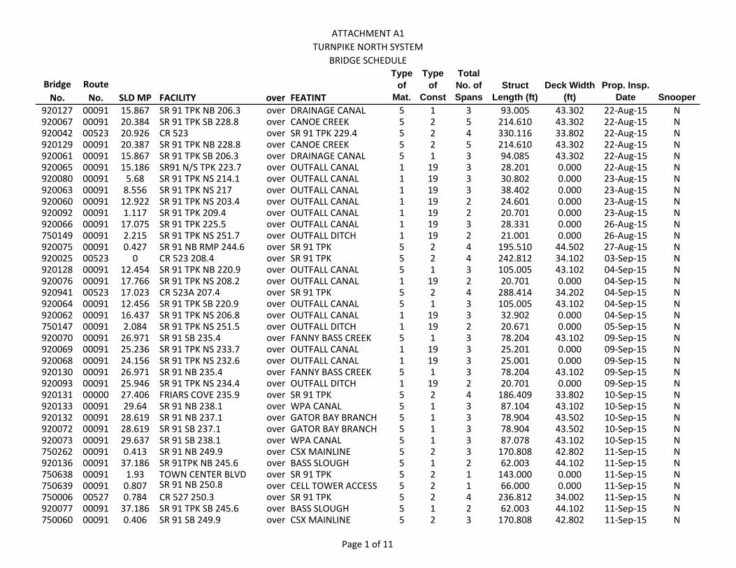
ATTACHMENT A1TURNPIKE NORTH SYSTEM
BRIDGE SCHEDULE
Bridge No.
Route No. SLD MP FACILITY over FEATINT
Type of
Mat.
Type of
Const
Total No. of Spans
Struct Length (ft)
Deck Width (ft)
Prop. Insp. Date Snooper
920127 00091 15.867 SR 91 TPK NB 206.3 over DRAINAGE CANAL 5 1 3 93.005 43.302 22‐Aug‐15 N920067 00091 20.384 SR 91 TPK SB 228.8 over CANOE CREEK 5 2 5 214.610 43.302 22‐Aug‐15 N920042 00523 20.926 CR 523 over SR 91 TPK 229.4 5 2 4 330.116 33.802 22‐Aug‐15 N920129 00091 20.387 SR 91 TPK NB 228.8 over CANOE CREEK 5 2 5 214.610 43.302 22‐Aug‐15 N920061 00091 15.867 SR 91 TPK SB 206.3 over DRAINAGE CANAL 5 1 3 94.085 43.302 22‐Aug‐15 N920065 00091 15.186 SR91 N/S TPK 223.7 over OUTFALL CANAL 1 19 3 28.201 0.000 22‐Aug‐15 N920080 00091 5.68 SR 91 TPK NS 214.1 over OUTFALL CANAL 1 19 3 30.802 0.000 23‐Aug‐15 N920063 00091 8.556 SR 91 TPK NS 217 over OUTFALL CANAL 1 19 3 38.402 0.000 23‐Aug‐15 N920060 00091 12.922 SR 91 TPK NS 203.4 over OUTFALL CANAL 1 19 2 24.601 0.000 23‐Aug‐15 N920092 00091 1.117 SR 91 TPK 209.4 over OUTFALL CANAL 1 19 2 20.701 0.000 23‐Aug‐15 N920066 00091 17.075 SR 91 TPK 225.5 over OUTFALL CANAL 1 19 3 28.331 0.000 26‐Aug‐15 N750149 00091 2.215 SR 91 TPK NS 251.7 over OUTFALL DITCH 1 19 2 21.001 0.000 26‐Aug‐15 N920075 00091 0.427 SR 91 NB RMP 244.6 over SR 91 TPK 5 2 4 195.510 44.502 27‐Aug‐15 N920025 00523 0 CR 523 208.4 over SR 91 TPK 5 2 4 242.812 34.102 03‐Sep‐15 N920128 00091 12.454 SR 91 TPK NB 220.9 over OUTFALL CANAL 5 1 3 105.005 43.102 04‐Sep‐15 N920076 00091 17.766 SR 91 TPK NS 208.2 over OUTFALL CANAL 1 19 2 20.701 0.000 04‐Sep‐15 N920941 00523 17.023 CR 523A 207.4 over SR 91 TPK 5 2 4 288.414 34.202 04‐Sep‐15 N920064 00091 12.456 SR 91 TPK SB 220.9 over OUTFALL CANAL 5 1 3 105.005 43.102 04‐Sep‐15 N920062 00091 16.437 SR 91 TPK NS 206.8 over OUTFALL CANAL 1 19 3 32.902 0.000 04‐Sep‐15 N750147 00091 2.084 SR 91 TPK NS 251.5 over OUTFALL DITCH 1 19 2 20.671 0.000 05‐Sep‐15 N920070 00091 26.971 SR 91 SB 235.4 over FANNY BASS CREEK 5 1 3 78.204 43.102 09‐Sep‐15 N920069 00091 25.236 SR 91 TPK NS 233.7 over OUTFALL CANAL 1 19 3 25.201 0.000 09‐Sep‐15 N920068 00091 24.156 SR 91 TPK NS 232.6 over OUTFALL CANAL 1 19 3 25.001 0.000 09‐Sep‐15 N920130 00091 26.971 SR 91 NB 235.4 over FANNY BASS CREEK 5 1 3 78.204 43.102 09‐Sep‐15 N920093 00091 25.946 SR 91 TPK NS 234.4 over OUTFALL DITCH 1 19 2 20.701 0.000 09‐Sep‐15 N920131 00000 27.406 FRIARS COVE 235.9 over SR 91 TPK 5 2 4 186.409 33.802 10‐Sep‐15 N920133 00091 29.64 SR 91 NB 238.1 over WPA CANAL 5 1 3 87.104 43.102 10‐Sep‐15 N920132 00091 28.619 SR 91 NB 237.1 over GATOR BAY BRANCH 5 1 3 78.904 43.502 10‐Sep‐15 N920072 00091 28.619 SR 91 SB 237.1 over GATOR BAY BRANCH 5 1 3 78.904 43.502 10‐Sep‐15 N920073 00091 29.637 SR 91 SB 238.1 over WPA CANAL 5 1 3 87.078 43.102 10‐Sep‐15 N750262 00091 0.413 SR 91 NB 249.9 over CSX MAINLINE 5 2 3 170.808 42.802 11‐Sep‐15 N920136 00091 37.186 SR 91TPK NB 245.6 over BASS SLOUGH 5 1 2 62.003 44.102 11‐Sep‐15 N750638 00091 1.93 TOWN CENTER BLVD over SR 91 TPK 5 2 1 143.000 0.000 11‐Sep‐15 N750639 00091 0.807 SR 91 NB 250.8 over CELL TOWER ACCESS 5 2 1 66.000 0.000 11‐Sep‐15 N750006 00527 0.784 CR 527 250.3 over SR 91 TPK 5 2 4 236.812 34.002 11‐Sep‐15 N920077 00091 37.186 SR 91 TPK SB 245.6 over BASS SLOUGH 5 1 2 62.003 44.102 11‐Sep‐15 N750060 00091 0.406 SR 91 SB 249.9 over CSX MAINLINE 5 2 3 170.808 42.802 11‐Sep‐15 N
Page 1 of 11
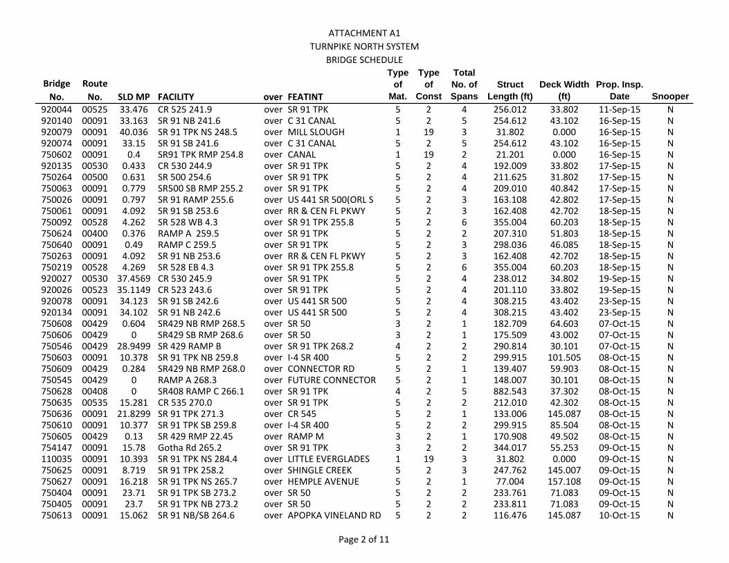
ATTACHMENT A1TURNPIKE NORTH SYSTEM
BRIDGE SCHEDULE
Bridge No.
Route No. SLD MP FACILITY over FEATINT
Type of
Mat.
Type of
Const
Total No. of Spans
Struct Length (ft)
Deck Width (ft)
Prop. Insp. Date Snooper
920044 00525 33.476 CR 525 241.9 over SR 91 TPK 5 2 4 256.012 33.802 11‐Sep‐15 N920140 00091 33.163 SR 91 NB 241.6 over C 31 CANAL 5 2 5 254.612 43.102 16‐Sep‐15 N920079 00091 40.036 SR 91 TPK NS 248.5 over MILL SLOUGH 1 19 3 31.802 0.000 16‐Sep‐15 N920074 00091 33.15 SR 91 SB 241.6 over C 31 CANAL 5 2 5 254.612 43.102 16‐Sep‐15 N750602 00091 0.4 SR91 TPK RMP 254.8 over CANAL 1 19 2 21.201 0.000 16‐Sep‐15 N920135 00530 0.433 CR 530 244.9 over SR 91 TPK 5 2 4 192.009 33.802 17‐Sep‐15 N750264 00500 0.631 SR 500 254.6 over SR 91 TPK 5 2 4 211.625 31.802 17‐Sep‐15 N750063 00091 0.779 SR500 SB RMP 255.2 over SR 91 TPK 5 2 4 209.010 40.842 17‐Sep‐15 N750026 00091 0.797 SR 91 RAMP 255.6 over US 441 SR 500(ORL S 5 2 3 163.108 42.802 17‐Sep‐15 N750061 00091 4.092 SR 91 SB 253.6 over RR & CEN FL PKWY 5 2 3 162.408 42.702 18‐Sep‐15 N750092 00528 4.262 SR 528 WB 4.3 over SR 91 TPK 255.8 5 2 6 355.004 60.203 18‐Sep‐15 N750624 00400 0.376 RAMP A 259.5 over SR 91 TPK 5 2 2 207.310 51.803 18‐Sep‐15 N750640 00091 0.49 RAMP C 259.5 over SR 91 TPK 5 2 3 298.036 46.085 18‐Sep‐15 N750263 00091 4.092 SR 91 NB 253.6 over RR & CEN FL PKWY 5 2 3 162.408 42.702 18‐Sep‐15 N750219 00528 4.269 SR 528 EB 4.3 over SR 91 TPK 255.8 5 2 6 355.004 60.203 18‐Sep‐15 N920027 00530 37.4569 CR 530 245.9 over SR 91 TPK 5 2 4 238.012 34.802 19‐Sep‐15 N920026 00523 35.1149 CR 523 243.6 over SR 91 TPK 5 2 4 201.110 33.802 19‐Sep‐15 N920078 00091 34.123 SR 91 SB 242.6 over US 441 SR 500 5 2 4 308.215 43.402 23‐Sep‐15 N920134 00091 34.102 SR 91 NB 242.6 over US 441 SR 500 5 2 4 308.215 43.402 23‐Sep‐15 N750608 00429 0.604 SR429 NB RMP 268.5 over SR 50 3 2 1 182.709 64.603 07‐Oct‐15 N750606 00429 0 SR429 SB RMP 268.6 over SR 50 3 2 1 175.509 43.002 07‐Oct‐15 N750546 00429 28.9499 SR 429 RAMP B over SR 91 TPK 268.2 4 2 2 290.814 30.101 07‐Oct‐15 N750603 00091 10.378 SR 91 TPK NB 259.8 over I‐4 SR 400 5 2 2 299.915 101.505 08‐Oct‐15 N750609 00429 0.284 SR429 NB RMP 268.0 over CONNECTOR RD 5 2 1 139.407 59.903 08‐Oct‐15 N750545 00429 0 RAMP A 268.3 over FUTURE CONNECTOR 5 2 1 148.007 30.101 08‐Oct‐15 N750628 00408 0 SR408 RAMP C 266.1 over SR 91 TPK 4 2 5 882.543 37.302 08‐Oct‐15 N750635 00535 15.281 CR 535 270.0 over SR 91 TPK 5 2 2 212.010 42.302 08‐Oct‐15 N750636 00091 21.8299 SR 91 TPK 271.3 over CR 545 5 2 1 133.006 145.087 08‐Oct‐15 N750610 00091 10.377 SR 91 TPK SB 259.8 over I‐4 SR 400 5 2 2 299.915 85.504 08‐Oct‐15 N750605 00429 0.13 SR 429 RMP 22.45 over RAMP M 3 2 1 170.908 49.502 08‐Oct‐15 N754147 00091 15.78 Gotha Rd 265.2 over SR 91 TPK 3 2 2 344.017 55.253 09‐Oct‐15 N110035 00091 10.393 SR 91 TPK NS 284.4 over LITTLE EVERGLADES 1 19 3 31.802 0.000 09‐Oct‐15 N750625 00091 8.719 SR 91 TPK 258.2 over SHINGLE CREEK 5 2 3 247.762 145.007 09‐Oct‐15 N750627 00091 16.218 SR 91 TPK NS 265.7 over HEMPLE AVENUE 5 2 1 77.004 157.108 09‐Oct‐15 N750404 00091 23.71 SR 91 TPK SB 273.2 over SR 50 5 2 2 233.761 71.083 09‐Oct‐15 N750405 00091 23.7 SR 91 TPK NB 273.2 over SR 50 5 2 2 233.811 71.083 09‐Oct‐15 N750613 00091 15.062 SR 91 NB/SB 264.6 over APOPKA VINELAND RD 5 2 2 116.476 145.087 10‐Oct‐15 N
Page 2 of 11

ATTACHMENT A1TURNPIKE NORTH SYSTEM
BRIDGE SCHEDULE
Bridge No.
Route No. SLD MP FACILITY over FEATINT
Type of
Mat.
Type of
Const
Total No. of Spans
Struct Length (ft)
Deck Width (ft)
Prop. Insp. Date Snooper
750071 00091 11.941 SR 91 TPK NS 261.4 over OUTFALL DITCH 1 19 3 38.402 0.000 10‐Oct‐15 N110605 00091 4.466 SR91 TPK NS 278.5 over NATURE 1 19 1 20.011 0.000 13‐Oct‐15 N110033 00091 3.109 SR 91 TPK SB 277.5 over BLACKSTILL LAKE RD 5 2 3 131.606 43.902 14‐Oct‐15 N750622 00429 5.3 SR 429 NB 10.9 over SEIDEL ROAD 5 2 1 143.507 43.102 14‐Oct‐15 N750621 00429 5.3 SR 429 SB 10.9 over SEIDEL ROAD 5 2 1 143.507 43.102 14‐Oct‐15 N110052 00455 0.987 CR 455 276.0 over SR 91 TPK 5 2 4 216.411 33.802 14‐Oct‐15 N110038 00091 3.105 SR 91 TPK NB 277.5 over BLACKSTILL LAKE RD 5 2 3 131.896 43.902 14‐Oct‐15 N110069 00000 1.968 CR 3 281.0 over SR 91 TPK 5 2 4 248.044 29.901 15‐Oct‐15 N110920 00091 7.841 SR 91 TPK SB 282.2 over CR 561 5 2 3 124.006 44.002 15‐Oct‐15 N110070 00091 7.839 SR 91 TPK NB 282.2 over CR 561 5 2 3 124.006 44.002 15‐Oct‐15 N110068 00091 0.286 SR 91 NB RMP 285.9 over SR 91 TPK LEESBURG 5 2 4 193.409 43.902 15‐Oct‐15 N110037 00091 1.261 SR 91 TPK NB 275.6 over SR 438 5 2 4 294.514 43.402 16‐Oct‐15 N110071 00091 11.093 SR 91 TPK 285.4 over SR 19 5 2 3 128.506 44.102 16‐Oct‐15 N110012 00091 11.097 SR 91 TPK SB 285.4 over SR 19 5 2 3 128.506 44.102 16‐Oct‐15 N110032 00091 1.241 SR 91 TPK SB 275.6 over SR 438 5 2 4 294.514 43.402 16‐Oct‐15 N750282 00091 24.687 SR 91 TPK NB 274.1 over JONES RD 5 2 3 121.506 44.002 16‐Oct‐15 N750284 00091 0.847 SR91 TPK RMP 259.9 over I‐4 SR 400 5 2 4 244.106 44.002 17‐Oct‐15 N750188 00091 24.682 SR 91 TPK SB 274.1 over JONES RD 5 2 3 121.506 44.202 18‐Oct‐15 N750386 00408 0.37 SR 408 RAMP 266.1 over SR 91 TPK 4 2 2 366.118 43.002 21‐Oct‐15 N750285 00091 0.673 SR91 TPK RMP 267.9 over SR 50 5 2 3 178.209 43.302 21‐Oct‐15 N750626 00091 6.044 SR 91 TPK 255.5 over US 441 3 2 1 186.799 158.008 21‐Oct‐15 N750047 00438 24.179 CR 438 273.6 over SR 91 TPK 5 2 4 255.912 34.102 21‐Oct‐15 N750601 00091 6.019 SR 91 TPK 255.5 over CANAL 1 19 2 20.751 0.000 22‐Oct‐15 N110006 00091 14.827 SR 91 TPK SB 289.2 over US 27 SR 25 CLERMT 5 2 4 207.010 43.302 22‐Oct‐15 N110072 00000 1.276 OBRIEN RD 285.9 over SR 91 TPK 5 2 4 196.910 33.802 22‐Oct‐15 N110073 00091 14.835 SR 91 TPK NB 289.2 over US 27 SR 25 CLERMT 5 2 4 207.010 43.302 22‐Oct‐15 N110600 00470 0.92 CR 470 296.7 over SR 91 TPK 5 2 2 264.013 47.102 04‐Nov‐15 N920610 00429 4.49699 SR 429 NB 4.5 over SR 530/US 192 3 2 1 174.409 43.102 05‐Nov‐15 N920604 00429 1.363 SR 429 NB 2.3 over SAND HILL ROAD 5 2 1 70.543 45.102 05‐Nov‐15 N920605 00429 3.506 SR 429 SB 4.5 over FUNIE STEED ROAD 5 2 1 142.507 43.102 05‐Nov‐15 N920606 00429 3.5 SR 429 NB 4.5 over FUNIE STEED ROAD 5 2 1 142.507 43.102 05‐Nov‐15 N920603 00429 1.363 SR 429 SB 2.3 over SAND HILL ROAD 5 2 1 70.703 49.102 05‐Nov‐15 N920609 00429 4.49399 SR 429 SB 4.5 over SR 530/US 192 3 2 1 174.409 55.103 05‐Nov‐15 N920608 00000 0.286 DREAMER'S DR 3.45 over SR 429 5 2 2 222.811 41.302 06‐Nov‐15 N924178 00000 0.067 INDIAN CK BLVD 3.6 over SR 429 W BELTWAY 5 2 2 230.811 45.002 06‐Nov‐15 N750099 00528 8.115 SR 528 WB 8.2 over SR 482 MCCOY RD 5 2 3 207.410 73.094 06‐Nov‐15 N750225 00528 8.133 SR 528 EB 8.2 over SR 482 MCCOY RD 5 2 3 207.410 75.084 06‐Nov‐15 N
Page 3 of 11
ATTACHMENT A1TURNPIKE NORTH SYSTEM
BRIDGE SCHEDULE
Bridge No.
Route No. SLD MP FACILITY over FEATINT
Type of
Mat.
Type of
Const
Total No. of Spans
Struct Length (ft)
Deck Width (ft)
Prop. Insp. Date Snooper
750097 00528 7.041 SR 528 WB 7.1 over SCL RR MAINLINE 5 2 7 438.581 71.086 07‐Nov‐15 N750223 00528 7.04 SR 528 EB 7.1 over SCL RR MAINLINE 5 2 8 438.581 71.083 07‐Nov‐15 N750096 00528 4.944 SR 528 WB 5.0 over SCL RR SPUR 5 2 3 162.008 71.083 07‐Nov‐15 N750222 00528 4.968 SR 528 EB 5.0 over SCL RR SPUR 5 2 3 162.008 79.644 07‐Nov‐15 N750224 00528 7.194 SR 528 EB 7.2 over SR 527 ORANGE AVE 5 2 2 176.009 71.083 08‐Nov‐15 N750098 00528 7.2 SR 528 WB 7.2 over SR 527 ORANGE AVE 5 2 2 175.862 71.083 08‐Nov‐15 N750617 00429 1.353 SR 429 NB over W ORANGE LAKE BLVD 5 2 1 134.507 43.102 11‐Nov‐15 N750616 00429 1.331 SR 429 SB 6.9 over W ORANGE LAKE BLVD 5 2 1 134.507 55.103 11‐Nov‐15 N750620 00429 2.175 SR 429 NB 7.8 over WESTERN WAY 3 2 1 172.008 43.102 11‐Nov‐15 N750619 00429 2.18 SR 429 SB 7.8 over WESTERN WAY 3 2 1 172.008 43.102 11‐Nov‐15 N750618 00429 0.29 SR 429 SB RAMP 7.8 over WESTERN WAY 3 2 1 174.509 30.101 11‐Nov‐15 N180009 00091 7.265 SR 91 SB 305.5 over US 301 SR 35 WILDWD 5 2 3 164.408 44.102 12‐Nov‐15 N180025 00091 7.735 SR 91 SB 305.9 over SCL RAILROAD 5 2 4 224.511 43.202 12‐Nov‐15 N180060 00091 7.735 SR 91 NB 305.9 over SCL RAILROAD 5 2 4 224.511 43.302 12‐Nov‐15 N180058 00091 7.27 SR 91 NB 305.5 over US 301 SR 35 WILDWD 5 2 3 163.008 43.502 12‐Nov‐15 N110039 00091 17.184 SR 91 TPK SB 291.5 over PALATLAKAHA CREEK 5 1 5 160.108 43.002 13‐Nov‐15 N110029 00091 20.19 SR 91 TPK NB 294.5 over CR 48 5 2 4 257.613 43.302 13‐Nov‐15 N110016 00091 20.19 SR 91 TPK SB 294.5 over CR 48 5 2 4 257.613 43.302 13‐Nov‐15 N110075 00091 17.195 SR 91 TPK NB 291.5 over PALATLAKAHA CREEK 5 1 5 160.108 43.002 13‐Nov‐15 N180007 00468 2.997 CR 468 301.6 over SR 91 TPK 5 2 4 254.512 34.302 14‐Nov‐15 N750637 00429 2.75199 SR 429 over WHITE HORSE CREEK 1 19 2 20.401 0.000 14‐Nov‐15 N750623 00429 1.251 SR 429 over BOGGY CREEK 1 19 3 39.302 0.000 14‐Nov‐15 N180024 00000 1.368 BAILEY RD 299.6 over SR 91 TPK 5 2 4 183.809 23.201 18‐Nov‐15 N110001 00033 18.636 CR 33 293.0 over SR 91 TPK 5 2 4 281.014 34.102 18‐Nov‐15 N110074 00000 15.739 BRIDGES RD 290.1 over SR 91 TPK 5 2 4 199.010 34.102 18‐Nov‐15 N180062 00091 10.532 SR 91 TPK NB 308.8 over LITTLE JOHN CREEK 1 19 2 21.601 0.000 18‐Nov‐15 N750633 00091 0.287 SR50 RMP C 268.028 over SR 91 TPK ORL W INT 5 2 2 217.344 59.086 19‐Nov‐15 N180026 00091 10.376 SR 91 SB 308.6 over I‐75 NB SR 93 5 2 3 223.761 34.102 19‐Nov‐15 N750634 00091 19.514 SR 91 TPK NS 268.9 over BEULAH ROAD 5 2 1 78.604 145.087 19‐Nov‐15 N750093 00528 4.532 SR 528 WB 4.6 over US 441 US 17 US 92 5 2 5 406.620 72.204 20‐Nov‐15 N750221 00528 4.789 SR 528 EB 4.8 over LANDSTREET RD 5 2 3 218.011 60.203 20‐Nov‐15 N750095 00528 0.363 SR 528 EB RAMP 4.7 over LANDSTREET RD 5 2 3 207.010 45.502 20‐Nov‐15 N750181 00528 4.521 SR 528 EB 4.6 over US 441 US 17 US 92 5 2 6 406.940 60.203 20‐Nov‐15 N750094 00528 4.765 SR 528 WB 4.8 over LANDSTREET RD 5 2 3 218.011 60.203 20‐Nov‐15 N750389 00050 0.627 SR 50 CNNCTR 1.5 over SR 408 EW 4 2 2 278.014 43.302 21‐Nov‐15 N750387 00000 0.987 HEMPEL RD 0.4 over SR 408 EW 5 2 2 217.011 43.502 21‐Nov‐15 N750632 00528 0.545 SR 528 RAMP X 4.96 over SCLRR 5 2 2 154.404 43.085 21‐Nov‐15 N
Page 4 of 11
ATTACHMENT A1TURNPIKE NORTH SYSTEM
BRIDGE SCHEDULE
Bridge No.
Route No. SLD MP FACILITY over FEATINT
Type of
Mat.
Type of
Const
Total No. of Spans
Struct Length (ft)
Deck Width (ft)
Prop. Insp. Date Snooper
750089 00528 1.885 SR 528 WB 1.9 over ORANGEWOOD BLVD 5 2 2 202.438 51.102 03‐Dec‐15 N750215 00528 0.838 SR 528 EB 0.9 over INTERNATIONAL DR 5 2 2 177.009 51.203 03‐Dec‐15 N750088 00528 0.838 SR 528 WB 0.9 over INTERNATIONAL 5 2 2 177.009 51.203 03‐Dec‐15 N750216 00528 1.885 SR 528 EB 1.9 over ORANGEWOOD BLVD 5 2 2 202.410 51.102 03‐Dec‐15 N750600 00528 5.231 SR 528 5.4 over CANAL 1 19 2 20.998 0.000 03‐Dec‐15 N750217 00528 2.707 SR 528 EB 2.8 over SHINGLE CREEK 5 2 5 207.710 43.302 04‐Dec‐15 N750090 00528 2.709 SR 528 WB 2.8 over SHINGLE CREEK 5 2 5 207.710 54.103 04‐Dec‐15 N750091 00528 3.098 SR 528 WB 3.1 over CR 423 JOHN YOUNG 5 2 4 290.014 51.002 04‐Dec‐15 N750218 00528 3.092 SR 528 EB 3.1 over CR 423 JOHN YOUNG 5 2 4 290.014 51.002 04‐Dec‐15 N750087 00528 0 SR528 EXIT RMP 0.0 over INTERSTATE 4 SR 400 5 2 8 621.030 43.002 05‐Dec‐15 N750180 00528 0.235 SR 528 RAMP 0.0 over INTERSTATE 4 SR 400 5 2 4 307.115 30.201 05‐Dec‐15 N770053 00417 0.319 SR 417 NB RMP 38.5 over PAVED TRAIL 5 2 1 70.003 30.101 09‐Dec‐15 N770052 00417 0.834 SR 417 NB 38.5 over PAVED TRAIL 5 2 1 83.004 43.102 09‐Dec‐15 N770051 00417 0.806 SR 417 SB 38.5 over PAVED MULTI‐USE 5 2 1 70.903 50.902 09‐Dec‐15 N770069 00417 0.059 SR 417 NB 49.9 over AIRPORT BLVD 5 2 2 120.106 43.102 09‐Dec‐15 N770050 00417 0.482 SR 417 NB 38.2 over SR 426 ALOMA AVE 5 2 1 116.236 43.002 10‐Dec‐15 N770057 00417 6.067 SR 417 NB 43.7 over SR 434 5 2 1 142.807 43.102 10‐Dec‐15 N770056 00417 6.07 SR 417 SB 43.7 over SR 434 5 2 1 142.807 43.102 10‐Dec‐15 N770049 00417 0.482 SR 417 SB 38.2 over SR 426 ALOMA AVE 5 2 1 116.236 43.002 10‐Dec‐15 N770060 00417 3.044 SR 417 SB 40.7 over SLAVIA ROAD 5 2 1 80.104 43.102 11‐Dec‐15 N770065 00417 4.07 SR 417 NB 41.8 over LIGHTWOOD KNOX 5 2 3 109.805 44.702 11‐Dec‐15 N770061 00417 3.06099 SR 417 NB 40.7 over SLAVIA ROAD 5 2 1 80.104 43.102 11‐Dec‐15 N770064 00417 4.07 SR 417 SB 41.8 over LIGHTWOOD KNOX 5 2 3 109.805 58.103 11‐Dec‐15 N770046 00417 11.344 SR 417 NB 49.0 over CR 427 3 2 1 158.308 43.102 16‐Dec‐15 N770063 00417 3.677 SR 417 NB 41.4 over RED BUG LAKE RD 5 2 2 174.108 43.102 16‐Dec‐15 N770062 00417 3.668 SR 417 SB 41.4 over RED BUG LAKE RD 5 2 2 174.209 51.102 16‐Dec‐15 N770045 00417 11.34 SR 417 SB 49.0 over CR 427 3 2 1 158.308 43.102 16‐Dec‐15 N770066 00000 2 RD BUG LK RD 41.3 over BEAR GULLY CANAL 1 19 2 24.901 0.000 16‐Dec‐15 N770043 00417 10.646 SR 417 SB 48.3 over SANFORD AVE 5 2 1 133.507 43.102 06‐Jan‐16 N770058 00417 5.496 SR 417 SB 43.2 over PEDESTRIAN TRAIL 5 2 1 77.434 47.602 06‐Jan‐16 N770044 00417 10.668 SR 417 NB 48.3 over SANFORD AVE 5 2 1 137.507 43.102 06‐Jan‐16 N770059 00417 5.484 SR 417 NB 43.2 over PEDESTRIAN TRAIL 5 2 1 77.434 43.002 06‐Jan‐16 N770042 00417 10.972 SR 417 NB 48.6 over CSX RAIL ROAD 5 2 1 64.703 43.102 07‐Jan‐16 N770941 00417 10.966 SR 417 SB 48.6 over CSX RR 5 2 1 64.703 55.203 07‐Jan‐16 N750478 00417 1.51 SR 417 SCE SB 5.1 over PROPOSED ROAD A 5 2 2 143.707 43.302 07‐Jan‐16 N750479 00417 1.51 SR 417 SCE NB 5.1 over PROPOSED ROAD A 5 2 2 143.707 43.302 07‐Jan‐16 N770067 00417 4.464 SR 417 SB 42.1 over WINTER SPRINGS 5 2 5 597.129 43.102 08‐Jan‐16 N
Page 5 of 11
ATTACHMENT A1TURNPIKE NORTH SYSTEM
BRIDGE SCHEDULE
Bridge No.
Route No. SLD MP FACILITY over FEATINT
Type of
Mat.
Type of
Const
Total No. of Spans
Struct Length (ft)
Deck Width (ft)
Prop. Insp. Date Snooper
770068 00417 4.46 SR 417 NB 42.2 over WINTER SPRINGS 5 2 5 597.129 43.102 08‐Jan‐16 N770048 00417 11.555 SR 417 NB 49.2 over LAKE MARY BLVD 3 2 1 155.508 43.302 08‐Jan‐16 N770047 00417 11.561 SR 417 SB 49.2 over LAKE MARY BLVD 3 2 1 155.508 47.102 08‐Jan‐16 N750474 00417 1.185 SR 417 SCE SB 4.8 over SR 535 5 2 2 186.409 43.302 09‐Jan‐16 N750477 00417 1.855 SR 417 SCE NB 5.9 over RAMP B 5 2 1 98.105 43.302 09‐Jan‐16 N750475 00417 1.185 SR 417 SCE NB 4.8 over SR 535 5 2 2 186.409 43.302 09‐Jan‐16 N750476 00417 1.825 SR 417 SCE SB 5.8 over RAMP B 5 2 1 98.102 43.302 09‐Jan‐16 N770055 00417 6.902 SR 417 NB 44.6 over LAKE JESUP 5 2 90 7935.388 43.102 13‐Jan‐16 N770054 00417 6.902 SR 417 SB 44.6 over LAKE JESUP 5 2 90 7935.388 43.102 13‐Jan‐16 N920162 00417 0.226 SR 417 NB SCE 2.3 over OSCEOLA PKWY 3 2 1 167.008 30.201 14‐Jan‐16 N920160 00417 2.29 SR 417 SB SCE 2.3 over OSCEOLA PKWY 3 2 1 157.808 43.002 14‐Jan‐16 N920154 00417 0 SR 417 NB SCE 0.0 over CELEBRATION PL 5 2 1 114.676 47.202 14‐Jan‐16 N920153 00417 0 SR 417 SB SCE 0.0 over CELEBRATION PL 5 2 1 114.676 47.202 14‐Jan‐16 N920161 00417 2.303 SR 417 NB SCE 2.3 over OSCEOLA PKWY 3 2 1 164.008 43.002 14‐Jan‐16 N920156 00417 1.004 SR 417 SB SCE 1.0 over CELEBRATION AVE 3 2 1 149.007 43.202 15‐Jan‐16 N920157 00417 0.998 SR 417 NB SCE 1.0 over CELEBRATION AVE 3 2 1 149.007 43.202 15‐Jan‐16 N920600 00417 0.707 SR 417 SCE 1.8 over C 2 CANAL 1 19 4 40.702 0.000 15‐Jan‐16 N750551 00429 0.042 RAMP I 268.3 over TURNPIKE & SR 429 4 2 12 2016.198 33.202 20‐Jan‐16 Y750607 00091 0.295 RAMP FLYOVR 268.3 over SR 91 & SR 429 4 2 10 1730.084 36.102 21‐Jan‐16 Y750604 00429 0.3 SR 429 SB 268.3 over SR 91 TPK & SR 429 4 2 12 1910.093 43.102 21‐Jan‐16 Y920159 00417 1.608 SR 417 NB SCE 1.6 over US 192/I DR/BONNET 4 2 2 1220.532 43.002 22‐Jan‐16 Y920158 00417 1.58 SR 417 SB SCE 1.6 over US 192/I DR/BONNET 4 2 3 1220.860 43.002 22‐Jan‐16 Y920601 00429 2.01699 SR 429 NB RAMP B over I‐4 & SR 429 SB RAMP 4 6 5 1038.051 49.102 23‐Jan‐16 Y920602 00429 0 SR 429 SB RAMP C over I‐4 & CR 545 4 6 7 1167.857 49.102 23‐Jan‐16 Y920169 00417 0.18 SR 417 SB SCE 0.4 over INTERSTATE 4 SR 400 4 6 4 627.655 49.502 24‐Jan‐16 Y160273 00570 10.848 SR 570 WB 10.8 over Reynolds Road 5 2 14 1465.972 43.002 27‐Jan‐16 N160274 00570 10.845 SR 570 EB 10.8 over Reynolds Road 5 2 14 1495.773 43.002 27‐Jan‐16 N770611 00417 14.45 SR 417 NB 52.1 over CR 46A 5 2 1 125.606 43.002 28‐Jan‐16 N770610 00417 14.453 SR 417 SB 52.1 over CR 46A 5 2 1 125.306 43.002 28‐Jan‐16 N770609 00417 13.631 SR 417 NB 51.3 over CSX RR & OLD LK 5 2 12 1456.471 43.002 28‐Jan‐16 N770608 00417 13.631 SR 417 SB 51.3 over CSX RR & OLD LK 5 2 12 1475.472 43.002 28‐Jan‐16 N770612 00417 16.057 SR 417 SB 53.7 over UPSALA RD CR 15 5 2 1 117.106 43.002 29‐Jan‐16 N770613 00417 16.053 SR 417 NB 53.7 over UPSALA RD CR 15 5 2 1 117.006 43.002 29‐Jan‐16 N770605 00417 12.846 SR 417 NB 50.5 over AIRPORT BLVD 3 2 1 207.710 43.002 29‐Jan‐16 N770606 00417 13.475 SR 417 SB 51.1 over LIVE OAK BLVD 5 2 1 78.704 43.002 29‐Jan‐16 N770604 00417 12.833 SR 417 SB 50.5 over AIRPORT BLVD 3 2 1 179.509 43.002 29‐Jan‐16 N770617 00417 17.421 SR 417 WB 55.0 over TOWN CENTER BLVD 5 2 1 123.376 54.203 29‐Jan‐16 N
Page 6 of 11
ATTACHMENT A1TURNPIKE NORTH SYSTEM
BRIDGE SCHEDULE
Bridge No.
Route No. SLD MP FACILITY over FEATINT
Type of
Mat.
Type of
Const
Total No. of Spans
Struct Length (ft)
Deck Width (ft)
Prop. Insp. Date Snooper
770614 00417 16.998 SR 417 EB 54.6 over RINEHART ROAD 3 2 1 247.412 42.002 29‐Jan‐16 N770616 00417 17.421 SR 417 SB 55.0 over TOWN CENTER BLVD 5 2 1 123.376 42.302 29‐Jan‐16 N770615 00417 16.981 SR 417 WB 54.6 over RINEHART ROAD 3 2 1 247.412 54.203 29‐Jan‐16 N770607 00417 13.47 SR 417 NB 51.1 over LIVE OAK BLVD 5 2 1 78.704 43.002 29‐Jan‐16 N770601 00417 12.282 SR 417 NB 50.0 over AIRPORT BLVD 5 2 2 167.008 47.202 03‐Feb‐16 N770603 00417 12.596 SR 417 NB 50.3 over US 17 92 3 2 1 153.908 60.103 03‐Feb‐16 N770602 00417 12.602 SR 417 SB 50.3 over US 17 92 3 2 1 154.208 55.103 03‐Feb‐16 N770600 00417 12.298 SR 417 SB 50.0 over AIRPORT BLVD 5 2 2 177.809 43.002 03‐Feb‐16 N100539 00589 5.557 SR 589 VET NB 7.1 over CSX RR 5 2 1 114.206 43.002 11‐Feb‐16 N100536 00589 5.051 SR 589 VET SB 6.5 over HENDERSON ROAD 5 2 3 134.507 43.302 11‐Feb‐16 N100541 00589 5.661 SR 589 VET NB 7.2 over LINEBAUGH AVE 5 2 4 293.014 50.902 11‐Feb‐16 N100538 00589 5.581 SR 589 VET SB 7.1 over CSX RR 5 2 1 109.905 53.503 11‐Feb‐16 N100537 00589 5.051 SR 589 VET NB 6.5 over HENDERSON ROAD 5 2 3 134.507 43.302 11‐Feb‐16 N100540 00589 5.673 SR 589 VET SB 7.2 over LINEBAUGH AVE 5 2 4 292.014 43.002 11‐Feb‐16 N100547 00589 6.738 SR 589 VET NB 8.2 over GARDNER RD 5 2 3 137.507 43.002 12‐Feb‐16 N100546 00589 6.738 SR 589 VET SB 8.2 over GARDNER RD 5 2 3 137.507 43.002 12‐Feb‐16 N100508 00589 5.377 SR 589 VET 6.9 over DRAINAGE CREEK 1 19 3 31.502 0.000 12‐Feb‐16 N100544 00589 6.431 SR 589 VET SB 7.9 over ROCKY CREEK II 5 2 5 355.017 43.002 12‐Feb‐16 N100545 00589 6.431 SR 589 VET NB 7.9 over ROCKY CREEK II 5 2 5 341.217 58.703 12‐Feb‐16 N100634 00589 0 ANDERSON RAMP over SR 589 VET 4 6 2 392.000 0.000 12‐Feb‐16 N100635 00589 0 RAMP A over CSX RAILROAD 3 2 1 198.200 0.000 12‐Feb‐16 N100636 00589 0 WILSKY BLVD over SR 589 VET 5 2 3 100.000 0.000 12‐Feb‐16 N100523 00589 2.333 SR 589 VET NB 3.8 over HENRY ST DITCH 2 1 3 90.904 68.003 13‐Feb‐16 N100518 00589 1.581 SR 589 VET N/S 3.1 over AIR CARGO DITCH 1 19 2 24.901 0.000 13‐Feb‐16 N100522 00589 2.33 SR 589 VET SB 3.8 over HENRY ST DITCH 2 1 3 90.904 55.503 13‐Feb‐16 N100521 00000 0 GEORGE RD 2.8 over HENRY ST DITCH 2 1 3 78.104 47.903 13‐Feb‐16 N100533 00589 4.091 SR 589 VET NB 5.6 over TPK ON/OFF RAMP 3 2 1 251.012 43.002 14‐Feb‐16 N100516 00589 1.059 SR 589 VET SB 2.6 over MEMORIAL HWY 5 2 1 146.007 76.304 14‐Feb‐16 N100515 00589 1.059 SR 589 VET NB 2.6 over MEMORIAL HWY 5 2 1 146.007 80.404 14‐Feb‐16 N100532 00589 4.091 SR 589 VET SB 5.6 over WATERS AVE 3 2 1 251.012 43.002 14‐Feb‐16 N100525 00589 2.834 SR 589 VET NB 4.4 over JOHNS RD 5 2 3 146.007 43.002 17‐Feb‐16 N100531 00589 3.464 SR 589 VET NB 5.0 over BARRY RD 5 2 3 132.906 43.002 17‐Feb‐16 N100530 00589 3.464 SR 589 VET SB 5.0 over BARRY RD 5 2 3 132.906 43.002 17‐Feb‐16 N100524 00589 2.834 SR 589 VET SB 4.4 over JOHNS RD 5 2 3 146.007 43.002 17‐Feb‐16 N100567 00568 0.977 SR 568 SPUR WB 1.0 over LAKE SHORE RD 5 2 3 154.908 43.002 18‐Feb‐16 N100513 00568 2.522 SR 568 SPUR EB 2.5 over CALUSA TRACE BLVD 5 2 1 84.004 43.002 18‐Feb‐16 N100568 00568 0.973 SR 568 SPUR EB 1.0 over LAKE SHORE RD 5 2 3 154.908 43.002 18‐Feb‐16 N
Page 7 of 11
ATTACHMENT A1TURNPIKE NORTH SYSTEM
BRIDGE SCHEDULE
Bridge No.
Route No. SLD MP FACILITY over FEATINT
Type of
Mat.
Type of
Const
Total No. of Spans
Struct Length (ft)
Deck Width (ft)
Prop. Insp. Date Snooper
100512 00568 2.522 SR 568 SPUR WB 2.5 over CALUSA TRACE BLVD 5 2 1 84.004 43.002 18‐Feb‐16 N100519 00589 2.052 SR 589 VET NB 3.6 over HILLSBOROUGH AVE 4 2 2 250.512 43.002 19‐Feb‐16 N100572 00568 1.761 SR 568 SPUR EB 1.8 over RANCH RD 5 2 3 197.810 43.002 19‐Feb‐16 N100528 00589 3.274 SR 589 VET SB 4.9 over CHANNEL G 5 2 3 167.008 43.002 19‐Feb‐16 N100529 00589 3.285 SR 589 VET NB 4.8 over CHANNEL G 5 2 3 167.008 43.002 19‐Feb‐16 N100571 00568 1.77 SR 568 SPUR WB 1.8 over RANCH RD 5 2 3 192.909 43.002 19‐Feb‐16 N100520 00589 2.052 SR 589 VET SB 3.6 over HILLSBOROUGH AVE 4 2 2 250.512 43.002 19‐Feb‐16 N100558 00589 10.619 SR 589 VET SB 11.9 over HUTCHISON RD 5 2 4 282.514 43.002 17‐Mar‐16 N100557 00589 10.221 SR 589 VET NB 11.6 over RAWLS RD 5 2 3 149.907 43.002 17‐Mar‐16 N100559 00589 10.608 SR 589 VET NB 11.9 over HUTCHISON RD 5 2 4 276.914 43.002 17‐Mar‐16 N100556 00589 10.216 SR 589 VET SB 11.6 over RAWLS RD 5 2 3 149.907 43.002 17‐Mar‐16 N100562 00589 11.806 SR 589 VET SB 13.2 over LAKE LECLARE RD 5 2 3 141.107 55.103 18‐Mar‐16 N100561 00589 11.238 SR 589 VET NB 12.6 over HATTON WILCOX RD 5 2 3 231.611 43.002 18‐Mar‐16 N100563 00589 11.806 SR 589 VET NB 13.2 over LAKE LECLARE RD 5 2 3 141.107 43.002 18‐Mar‐16 N100569 00568 1.199 SR 568 SPUR WB 1.2 over VAN DYKE RD 5 2 2 260.513 43.002 18‐Mar‐16 N100570 00568 1.22 SR 568 SPUR EB 1.2 over VAN DYKE RD 5 2 2 247.712 43.002 18‐Mar‐16 N100560 00589 11.253 SR 589 VET SB 12.6 over HATTON WILCOX RD 5 2 3 244.512 43.002 18‐Mar‐16 N100548 00589 7.742 SR 589 VET SB 9.3 over CR 587 GUNN HWY 3 2 1 266.513 43.002 19‐Mar‐16 N100549 00589 7.748 SR 589 VET NB 9.3 over CR 587 GUNN HWY 3 2 1 266.513 43.002 19‐Mar‐16 N100626 00589 12.826 SR 589 NB SCP 14.2 over VAN DYKE RD CR 685A 3 2 1 154.908 43.002 19‐Mar‐16 N100624 00589 12.379 SR 589 VET SB 13.7 over SUNCOAST PARKWAY 4 2 2 377.318 47.202 19‐Mar‐16 N100627 00589 12.83 SR 589 SB SCP 14.2 over VAN DYKE RD CR 685A 3 2 1 154.863 43.002 19‐Mar‐16 N100551 00589 7.967 SR 589 VET NB 9.5 over ROCKY CREEK II 5 2 4 299.883 59.103 20‐Mar‐16 N100550 00589 7.967 SR 589 VET SB 9.5 over ROCKY CREEK II 5 2 4 299.883 59.103 20‐Mar‐16 N100625 00589 12.618 SR 589 SCP 14.0 over ROCKY CREEK 1 19 4 56.103 0.000 20‐Mar‐16 N100629 00589 13.851 SR 589 SB SCP 15.2 over RAMBLEWOOD BLVD 5 2 1 72.510 46.902 20‐Mar‐16 N100628 00589 13.855 SR 589 NB SCP 15.2 over RAMBLEWOOD BLVD 5 2 1 72.510 46.902 20‐Mar‐16 N100631 00589 14.426 SR 589 SB SCP 15.8 over TPC BLVD 5 2 1 128.586 43.302 24‐Mar‐16 N100630 00589 14.426 SR 589 NB SCP 15.8 over TPC BLVD 5 2 1 128.586 43.302 24‐Mar‐16 N100552 00589 8.691 SR 589 VET SB 10.2 over EHRLICH RD 3 2 1 208.010 43.002 24‐Mar‐16 N100553 00589 8.696 SR 589 VET NB 10.2 over EHRLICH RD 3 2 1 208.010 43.002 24‐Mar‐16 N100554 00589 9.181 SR 589 VET SB 10.6 over BELLAMY RD 5 2 1 91.534 43.002 24‐Mar‐16 N100555 00589 9.173 SR 589 VET NB 10.6 over BELLAMY RD 5 2 1 91.904 43.002 24‐Mar‐16 N100633 00589 14.878 SR 589 SB SCP 16.3 over LUTZ LAKE FERN ROAD 5 2 2 164.508 60.003 25‐Mar‐16 N160275 00570 17.077 SR 570 POLK 17.1 over CSX RR 5 2 1 109.914 55.103 25‐Mar‐16 N160279 00570 17.249 SR570 WB POLK 17.2 over US 92 5 2 2 183.009 67.203 25‐Mar‐16 N160280 00570 17.259 SR570 EB Polk 17.2 over US 92 5 2 2 184.009 66.903 25‐Mar‐16 N
Page 8 of 11

ATTACHMENT A1TURNPIKE NORTH SYSTEM
BRIDGE SCHEDULE
Bridge No.
Route No. SLD MP FACILITY over FEATINT
Type of
Mat.
Type of
Const
Total No. of Spans
Struct Length (ft)
Deck Width (ft)
Prop. Insp. Date Snooper
160277 00570 17.079 SR 570 POLK 17.1 over CSX RR 5 2 1 110.505 55.503 25‐Mar‐16 N100632 00589 14.878 SR 589 NB SCP 16.3 over LUTZ LAKE FERN ROAD 5 2 2 163.208 60.003 25‐Mar‐16 N160264 00570 10.125 SR570 EB POLK 10.1 over US 98 5 2 2 184.009 67.103 01‐Apr‐16 N160263 00570 10.12 SR570 POLK WB 10.1 over US 98 5 2 2 184.009 67.103 01‐Apr‐16 N160266 00570 13.911 SR570 EB POLK 13.9 over LANDFILL ROAD 5 2 1 68.901 43.302 01‐Apr‐16 N160265 00570 13.912 SR570 WB POLK 13.9 over LANDFILL ROAD 5 2 1 68.901 43.302 01‐Apr‐16 N160282 00570 24.319 SR570 POLK EB 24.3 over I‐4 SR 400 5 2 3 321.516 43.002 02‐Apr‐16 N160276 00570 18.614 SR 570 POLK 18.6 over CR 546 OLD DIXIE 5 2 2 158.008 45.602 02‐Apr‐16 N160281 00570 24.319 SR 570 POLK 24.3 over I‐4/SR 400 5 2 3 321.116 30.201 02‐Apr‐16 N164507 00542 6.661 CR 542 16.3 over SR 570 POLK PKWY 4 2 2 314.015 43.602 02‐Apr‐16 N164508 00000 20.719 SPRING ROAD 20.7 over SR 570 POLK PKWY 5 2 2 198.510 55.103 03‐Apr‐16 N160270 00570 13.209 SR570 POLK EB 13.2 over SADDLE CREEK 5 2 4 215.811 91.804 03‐Apr‐16 N160269 00570 13.189 SR570 POLK WB 13.2 over SADDLE CREEK 5 2 4 216.211 91.704 03‐Apr‐16 N160278 00570 0 FRONTAGE RD N 0.0 over CANAL 1 19 2 21.001 0.000 03‐Apr‐16 N160253 00570 5.538 SR 570 POLK WB 5.5 over HARDEN BLVD SR 563 3 2 1 176.509 45.002 21‐Apr‐16 N160254 00570 5.534 SR 570 POLK EB 5.5 over HARDEN BLVD SR 563 3 2 1 176.809 45.002 21‐Apr‐16 N160256 00570 6.255 SR 570 POLK EB 6.2 over UNDERPASS ROAD 5 2 1 84.254 76.504 21‐Apr‐16 N160255 00570 6.255 SR 570 POLK WB 6.2 over UNDERPASS ROAD 5 2 1 84.254 44.902 21‐Apr‐16 N160257 00570 6.664 SR 570 POLK WB 6.6 over SR 37 S FLORIDA AVE 3 2 1 179.809 57.103 22‐Apr‐16 N160259 00570 7.199 SR 570 POLK WB 7.2 over CLEVELAND HEIGHTS 5 2 1 125.256 53.503 22‐Apr‐16 N160260 00570 7.198 SR 570 POLK EB 7.2 over CLEVELAND HEIGHTS 5 2 1 125.256 45.202 22‐Apr‐16 N160258 00570 6.666 SR 570 POLK EB 6.6 over SR 37 S FLORIDA AVE 3 2 1 179.809 44.902 22‐Apr‐16 N160246 00570 2.835 SR 570 POLK EB 2.8 over SR 572 AIRPORT ROAD 3 2 1 164.050 43.002 23‐Apr‐16 N160262 00570 8.713 SR 570 POLK EB 8.7 over LAKELAND 5 2 1 149.007 73.504 23‐Apr‐16 N160245 00572 2.838 SR 570 POLK WB 2.8 over SR 572 AIRPORT ROAD 3 2 1 164.050 43.002 23‐Apr‐16 N160261 00570 8.713 SR 570 POLK WB 8.7 over LAKELAND 5 2 1 149.007 59.703 23‐Apr‐16 N160248 00570 4.122 SR 570 POLK EB 4.1 over WARING ROAD 5 2 1 121.506 43.002 24‐Apr‐16 N160271 00570 11.658 SR570 POLK WB 11.7 over PAVERS ROAD 5 2 3 139.407 43.302 24‐Apr‐16 N160283 00570 11.251 SR 570 POLK 11.2 over DRAINAGE CANAL 1 19 3 28.201 0.000 24‐Apr‐16 N160247 00570 4.12 SR 570 POLK WB 4.1 over WARING ROAD 5 2 1 121.506 43.002 24‐Apr‐16 N160272 00570 11.657 SR570 POLK EB 11.7 over PAVERS ROAD 5 2 3 139.407 43.302 24‐Apr‐16 N160252 00570 1.55 N FRONTAGE RD 5.1 over CSXRR,Beaker&Wilkins 4 2 2 333.016 40.102 05‐May‐16 N160251 00570 5.118 SR 570 POLK EB 5.1 over CSXRR,Beaker&Wilkins 4 2 2 333.016 45.302 05‐May‐16 N160250 00570 5.092 SR 570 POLK WB 5.1 over CSXRR,Beaker&Wilkins 4 2 2 333.016 57.103 05‐May‐16 N160267 00570 14.52 SR570 POLK RP 14.5 over SR 570 POLK 4 2 2 276.213 30.101 05‐May‐16 N160249 00000 0.277 S FRONTAGE RD 5.0 over CSXRR,Beaker&Wilkins 4 2 2 333.016 51.803 05‐May‐16 N160243 00570 0.538 SR 570 POLK EB 0.5 over CR 542 & CSX 5 2 2 226.389 43.302 06‐May‐16 N
Page 9 of 11
ATTACHMENT A1TURNPIKE NORTH SYSTEM
BRIDGE SCHEDULE
Bridge No.
Route No. SLD MP FACILITY over FEATINT
Type of
Mat.
Type of
Const
Total No. of Spans
Struct Length (ft)
Deck Width (ft)
Prop. Insp. Date Snooper
160242 00570 0.396 SR 570 POLK WB 0.4 over US 92 NEW TPA HWY 5 2 1 118.006 43.302 06‐May‐16 N160241 00570 0.402 SR 570 POLK EB 0.4 over US 92 NEW TPA HWY 5 2 1 118.116 55.103 06‐May‐16 N160268 00570 13.568 SR570 POLK EB 13.6 over RAMP A 3 2 1 212.810 43.002 06‐May‐16 N160244 00570 0.536 SR 570 POLK WB 0.5 over CR 542 & CSX 5 2 2 226.389 43.302 06‐May‐16 N160288 00570 22.985 SR 570 POLK 22.9 over PACE RD 5 2 1 136.007 67.086 07‐May‐16 N160235 00570 0 SR 570 POLK WB 0.0 over I‐4 SR 400 5 2 3 316.315 43.302 07‐May‐16 N160238 00570 0.146 SR 570 POLK EB 0.1 over SW FRONTAGE ROAD 5 2 1 81.369 30.201 07‐May‐16 N160237 00570 0.183 SR570 POLK RMP 0.1 over SW FRONTAGE ROAD 5 2 1 87.504 46.302 07‐May‐16 N160234 00570 0 SR 570 POLK EB 0.0 over I‐4 SR 400 5 2 3 316.915 30.501 07‐May‐16 N164509 00570 22.99 SR 570 POLK 22.9 over PACE RD 5 2 1 141.007 43.085 07‐May‐16 N160240 00570 0.03 SR570 POLK RMP 0.2 over CLARK ROAD 4 2 3 497.072 34.102 08‐May‐16 N160239 00570 0.146 SR 570 POLK WB 0.1 over SW FRONTAGE RD 5 2 1 81.369 43.302 08‐May‐16 N160236 00000 0 CLARK ROAD 0.0 over I‐4 SR 400 5 2 3 316.617 46.902 08‐May‐16 N080050 00589 12.968 SR 589 NB SCP 49.8 over CENTRALIA RD 5 2 1 94.205 42.302 19‐May‐16 N080038 00589 0 SR 589 NB SCP 36.4 over COUNTY LINE RD 5 2 2 180.409 42.002 19‐May‐16 N080039 00589 0 SR 589 SB SCP 36.4 over COUNTY LINE RD 5 2 2 180.409 42.002 19‐May‐16 N080051 00589 12.968 SR 589 SB SCP 49.8 over CENTRALIA RD 5 2 1 94.255 42.302 19‐May‐16 N080056 00589 16.945 SR 589 NB SCP 53.7 over LANDFILL RD 5 2 1 62.003 54.103 20‐May‐16 N080055 00589 14.47 SR 589 SB SCP 51.3 over BEAR CROSSING #2 2 1 4 127.006 41.702 20‐May‐16 N080057 00589 16.946 SR 589 SB SCP 53.7 over LANDFILL RD 5 2 1 62.011 54.103 20‐May‐16 N080053 00589 13.164 SR 589 SB SCP 49.5 over BEAR CROSSING #1 2 1 4 127.006 41.702 20‐May‐16 N080052 00589 13.164 SR 589 NB SCP 49.5 over BEAR CROSSING #1 2 1 4 127.006 41.702 20‐May‐16 N080054 00589 14.47 SR 589 NB SCP 51.3 over BEAR CROSSING #2 2 1 4 127.006 41.702 20‐May‐16 N080042 00589 3.461 SR 589 SB SCP 39.8 over SPRING HILL DR CR 5 2 1 132.756 42.102 21‐May‐16 N080041 00589 3.459 SR 589 NB SCP 39.8 over SPRING HILL DR CR 5 2 1 132.766 42.102 21‐May‐16 N080045 00589 6.571 SR 589 SB SCP 42.9 over HIGHFIELD RD 5 2 1 72.204 41.702 21‐May‐16 N080044 00589 6.568 SR 589 NB SCP 42.9 over HIGHFIELD RD 5 2 1 72.204 41.702 21‐May‐16 N080047 00589 7.212 SR 589 SB SCP 43.6 over SR 50 3 2 1 170.008 42.002 21‐May‐16 N080046 00589 7.212 SR 589 NB SCP 43.6 over SR 50 3 2 1 170.308 42.002 21‐May‐16 N140085 00589 14.017 SR589 SB SCP 31.05 over SHADY HILLS RD 5 2 2 162.408 42.102 29‐May‐16 N140084 00589 14.012 SR 589 NB SCP 31.1 over SHADY HILLS RD 5 2 2 162.408 42.102 29‐May‐16 N140081 00589 9.505 SR 589 SCP SB 26.6 over PITHLACHASCOTEE 5 2 8 528.326 55.103 29‐May‐16 N140080 00589 9.505 SR 589 NB SCP 26.6 over PITHLACHASCOTEE 5 2 8 528.326 42.102 29‐May‐16 N140086 00589 0.86 CALDWELL LN 32.2 over SR 589 SCP 4 2 2 301.115 47.102 30‐May‐16 N140088 0589 18.708 W BOWMAN RD 35.8 over SR 589 SUNCOAST 4 2 2 343.217 46.902 30‐May‐16 N080059 00050 5.721 SCP P.O.P. over SR 50 3 2 1 880.643 14.001 30‐May‐16 N140078 00589 8.364 SR 589 NB SCP 25.4 over FIVE MILE CREEK 5 2 9 594.517 41.997 16‐Jun‐16 N
Page 10 of 11

ATTACHMENT A1TURNPIKE NORTH SYSTEM
BRIDGE SCHEDULE
Bridge No.
Route No. SLD MP FACILITY over FEATINT
Type of
Mat.
Type of
Const
Total No. of Spans
Struct Length (ft)
Deck Width (ft)
Prop. Insp. Date Snooper
140083 00589 11.066 SR 589 SB SCP 28.2 over SR 52 3 2 1 177.174 41.997 16‐Jun‐16 N140082 00589 11.066 SR 589 NB SCP 28.2 over SR 52 3 2 1 177.174 41.997 16‐Jun‐16 N140079 00589 8.364 SR 589 SB SCP 25.4 over FIVE MILE CREEK 5 2 9 594.517 55.103 16‐Jun‐16 N140091 00589 5.527 SR 589 SCP 23.0 over DRAINAGE DITCH 1 19 2 20.342 0.000 17‐Jun‐16 N140087 00589 16.628 LAWLESS RD 33.7 over SR 589 SCP 5 2 2 263.792 47.102 17‐Jun‐16 N140089 00589 7.697 SR 589 NB SCP 25.1 over RIDGE ROAD 5 2 2 211.953 41.997 17‐Jun‐16 N140090 00589 7.703 SR 589 SB SCP 25.1 over RIDGE ROAD 5 2 2 211.953 41.997 17‐Jun‐16 N140093 00589 7.138 SR 589 SCP 24.6 over DRAINAGE DITCH 1 19 2 20.014 0.000 01‐Jul‐16 N140071 00589 0.948 SR 589 SCP NS 18.2 over DRAINAGE DITCH 1 19 4 42.325 0.000 01‐Jul‐16 N140074 00589 3.007 SR 589 NB SCP 20.1 over SANDY BRANCH RIVER 5 2 4 240.169 41.997 01‐Jul‐16 N140075 00589 3.007 SR 589 SB SCP 20.1 over SANDY BRANCH RIVER 5 2 4 240.169 55.103 01‐Jul‐16 N140092 00589 6.796 SR 589 SCP 24.3 over DRAINAGE DITCH 1 19 2 20.014 0.000 01‐Jul‐16 N140073 00589 1.27 SR 589 SB SCP 18.7 over SR 54 5 2 2 187.673 41.997 02‐Jul‐16 N140069 00589 0.403 SR 589 NB SCP 17.5 over S BRANCH ANCLOTE 5 2 7 335.974 41.997 02‐Jul‐16 N140077 00589 4.555 SR 589 SB SCP 21.6 over ANCLOTE RIVER 5 2 13 845.186 55.103 02‐Jul‐16 N140072 00589 1.268 SR 589 NB SCP 18.3 over SR 54 5 2 2 187.673 41.997 02‐Jul‐16 N140070 00589 0.408 SR 589 SB SCP 17.5 over S BRANCH ANCLOTE 5 2 7 336.016 55.103 02‐Jul‐16 N140076 00589 4.555 SR 589 NB SCP 21.6 over ANCLOTE RIVER 5 2 13 845.186 41.997 02‐Jul‐16 N
Page 11 of 11
Attachment A2
ATTACHMENT A2TURNPIKE NORTH SYSTEM
SIGN SCHEDULE
Sign No. Location Struct Type SRSLD MP
TPK MP
RD Dir Sign Info INSPDATE
Prop. Insp. Date
92T053 KISSIMMEE PARK RD INT OVERHEAD TRUSS 00091 31.03 239.4 NB SUNPASS 24‐Nov‐14 24‐Nov‐1592T054 KISSIMMEE PARK RD INT OVERHEAD TRUSS 00091 31.1 239.5 SB SUNPASS 24‐Nov‐14 24‐Nov‐1575T092 SB RAMP TO CONSULATE DR OVERHEAD TRUSS 00091 0.186 256 SB SUNPASS 08‐Jan‐15 08‐Jan‐1675T138 0.4MI N OF US 192 OVERHEAD TRUSS 00429 0.389 NB TOLL PLZ/CHNG PROVIDED/PREPAID 12‐May‐14 12‐May‐1675T131 1.1MI S OF REEDY CREEK RD OVERHEAD TRUSS 00429 1.126 1.126 NS TOLL PLZ/CHNG PROVIDED/PREPAID 12‐May‐14 12‐May‐1675T168 SOUTH OF SEIDEL RD OVERHEAD TRUSS 00429 4.277 10.8 NS VMS 12‐May‐14 12‐May‐1675T134 OFF RAMP TO HARTZOG RD CANTILEVER 00429 2.437 SB HARTZOG RD/DISNEY WORLD 12‐May‐14 12‐May‐1692T045 SR 429 N OF SINCLAIR RD OVERHEAD TRUSS 00429 1.775 3.1 NS VMS 12‐May‐14 12‐May‐1675T139 0.6MI N OF US 192 OVERHEAD TRUSS 00429 0.633 NS TOLL PLZ/CHNG PROVIDED/PREPAID 12‐May‐14 13‐May‐1675T132 0.7 MI S OF REEDY CRK RD OVERHEAD TRUSS 00429 1.465 NS TOLL PLZ/CHNG PROVIDED/PREPAID 13‐May‐14 13‐May‐1675T137 US 192 SB EXIT RAMP CANTILEVER 00429 0.265 SB ALL TRAFFIC/192 KISSIMMEE 13‐May‐14 13‐May‐1675T141 0.8MI N OF US 192 CANTILEVER 00429 0.737 NB STOP PAY TOLL/CHNGE PROVIDED/ALL 13‐May‐14 13‐May‐1675T140 1.0MI N OF US 192 CANTILEVER 00429 0.998 SB STOP PAY TOLL/CHNGE PROVIDED/ALL 13‐May‐14 13‐May‐1675T133 0.2MI S OF REEDY CREEK RD OVERHEAD TRUSS 00429 1.958 SB TOLL PLZ/1 MI CARS 2 AXLE 13‐May‐14 13‐May‐1675T135 1.1 MI N OF REEDY CRK RD CANTILEVER 00429 3.374 SB TOLL PLZ 2 MI/CARS 2 AXLE $1 13‐May‐14 13‐May‐1692T051 NB EXIT TO US 192 CANTILEVER 00429 4.06 0 NB EX 6/192 KISSIMMEE 14‐May‐14 14‐May‐1692T047 0.1 MI N OF SINCLAIR RD CANTILEVER 00429 0.894 0 SB I‐4/ORLANDO/TAMPA/1MI 14‐May‐14 14‐May‐1692T046 0.3MI S OF SINCLAIR ROAD OVERHEAD TRUSS 00429 0.438 0 NB EX 1A/SINCLAIR RD/I‐4 W TAMPA .5 14‐May‐14 14‐May‐1675T169 TOLL PLAZA N OF US 192 OVERHEAD TRUSS 00429 0.746 0 NB SUNPASS 14‐May‐14 14‐May‐1692T048 0.3 MI N OF SINCLAIR RD CANTILEVER 00429 1.055 0 SB EX 1A/SINCLAIR RD 14‐May‐14 14‐May‐1675T170 TOLL PLAZA N OF US 192 OVERHEAD TRUSS 00429 1.004 0 SB SUNPASS 14‐May‐14 14‐May‐1692T050 0.3MI S OF FUNIE STEED RD CANTILEVER 00429 3.225 0 NB TOLL PLAZA 2 MI/CARS ‐2 AXLE $1 15‐May‐14 15‐May‐1692T052 0.1 MI SOUTH OF US 192 CANTILEVER 00429 4.215 0 NB PREPAID TOLLS/SUNPASS KEEP 15‐May‐14 15‐May‐1675T185 JUST EAST OF OBT OVERPASS CANTILEVER 00528 4.612 4.61 WB EX 4/FL TPK/17 92 441 15‐May‐14 15‐May‐1675T184 0.4MI E OF LANDSTREET RD OVERHEAD TRUSS 00528 5.227 5.23 EW DMS 15‐May‐14 15‐May‐1692T049 0.25 MI NORTH OF I‐4 OVERHEAD TRUSS 00429 0 0 SB EX 1/I‐4 E ORLANDO/I‐4 W TAMPA 15‐May‐14 15‐May‐1675T136 0.1MI N OF US 192 CANTILEVER 00429 0.112 SB RIGHT LANE ENDS 800 FT 15‐May‐14 15‐May‐1675T187 JUST E OF ORANGE AVE CANTILEVER 00528 7.27 7.27 EB EX 8/JETPORT DR ORANGE AVE/.5 MI 16‐May‐14 16‐May‐1675T188 0.4 MI W OF MCCOY RD CANTILEVER 00528 7.72 7.72 EB EX 8/JETPORT DR ORANGE AVE 16‐May‐14 16‐May‐1675T189 0.1 MI WEST OF MCCOY RD CANTILEVER 00528 8.01 8.01 EB EX 9/TRADEPORT DR/CONWAY RD/1 16‐May‐14 16‐May‐1675T186 0.7 MI E OF LANDSTREET RD CANTILEVER 00528 5.51 5.51 WB EX 4/FL TPK/17 92 441/1 MI 16‐May‐14 16‐May‐1692T053 KISSIMMEE PARK RD INT OVERHEAD TRUSS 00091 31.03 239.4 NB SUNPASS 24‐Nov‐14 24‐May‐1692T054 KISSIMMEE PARK RD INT OVERHEAD TRUSS 00091 31.1 239.5 SB SUNPASS 24‐Nov‐14 24‐May‐1677T026 0.8MI N OF LK JESSUP OVERHEAD TRUSS 00417 9.246 46.9 NS PREPAID TOLLS SUNPASS/KEEP 27‐May‐14 27‐May‐1677T028 1.25MI N OF LK JESSUP OVERHEAD TRUSS 00417 9.668 47.3 NS PREPAID TOLLS SUNPASS/CASH LANES 27‐May‐14 27‐May‐1677T030 0.11MI N OF SANFORD AVE. OVERHEAD TRUSS 00417 10.86 48.4 NS EX 49/427 LAKE MARY BLVD ORL SAN 27‐May‐14 27‐May‐1677T029 0.36MI N OF LK JESSUP TP OVERHEAD TRUSS 00417 10.41 48.01 NS EX 49/427 LAKE MARY BLVD ORL SAN 27‐May‐14 27‐May‐1677T027 1.1MI N OF LK JESSUP OVERHEAD TRUSS 00417 9.51 47.2 NS PREPAID TOLLS SUNPASS/CASH LANES 27‐May‐14 27‐May‐16
Page 1 of 10
ATTACHMENT A2TURNPIKE NORTH SYSTEM
SIGN SCHEDULE
Sign No. Location Struct Type SRSLD MP
TPK MP
RD Dir Sign Info INSPDATE
Prop. Insp. Date
92T040 0.4MI WEST OF SR 91 CANTILEVER 00522 40.2 244 EB VMS 28‐May‐14 28‐May‐1692T023 SB ENT CANOE CRK PLAZA CANTILEVER 00091 22.17 230.6 SB SERVICE PLZ 28‐May‐14 28‐May‐1692T022 NB ENT CANOE CRK PLAZA CANTILEVER 00091 21.43 229.9 NB SERVICE PLZ 28‐May‐14 28‐May‐1692T043 0.3MI S GATOR BAY BRANCH CANTILEVER 00091 28.94 237.6 SB VMS 04‐Jun‐14 04‐Jun‐1692T033 NB 1.2MI S OF CANOE CREEK OVERHEAD TRUSS 00091 19.2 227.6 NB VMS SIGN 04‐Jun‐14 04‐Jun‐1611T002 0.5MI N OF LEESBURG TOLL CANTILEVER 00091 14.44 288.4 SB TOLL PLAZA .5 MI/REDUCE SPEED 05‐Jun‐14 05‐Jun‐1692T042 0.3MI S FANNY BASS CREEK CANTILEVER 00091 27.08 235.5 NB VMS 05‐Jun‐14 05‐Jun‐1611T014 SB OFF RAMP TO CR470 OVERHEAD TRUSS 00091 22.82 296.6 SB SUNPASS EXACT COINS / SUNPASS 05‐Jun‐14 05‐Jun‐1611T013 NB ON RAMP FROM CR470 OVERHEAD TRUSS 00091 22.08 296.3 NB SUNPASS EXACT COINS / SUNPASS 05‐Jun‐14 05‐Jun‐1692T025 0.6MI S THREE LKS TOLL CANTILEVER 00091 27.31 235.8 NB TOLL PLZ/1/2 MILE/REDUCE SPEED 05‐Jun‐14 05‐Jun‐1692T024 1.0MI S THREE LKS TOLL PL CANTILEVER 00091 26.92 235.4 NB TOLL PLZ/1 MILE 05‐Jun‐14 05‐Jun‐1692T041 0.35MI EAST OF SR 91 CANTILEVER 00522 40.2 244 WB VMS 05‐Jun‐14 05‐Jun‐1611T001 0.5MI S OF LEESBURG TOLL CANTILEVER 00091 13.56 287.5 NB TOLL PLAZA .5 MI/REDUCE SPEED 06‐Jun‐14 06‐Jun‐1611T009 1.0 MI N OF OBRIEN RD CANTILEVER 00091 12.93 286.9 NB TOLL PLAZA/1 MILE/CARS $2.00 06‐Jun‐14 06‐Jun‐1611T010 1.6 MI N OF OBRIEN ROAD CANTILEVER 00091 13.53 287.5 NB PREPAID TOLLS ONLY/SUNPASS AHEAD 06‐Jun‐14 06‐Jun‐1618T003 SB EXIT OKAHUMPKA PLAZA CANTILEVER 00091 0.1 300.7 SB TRUCKS/BUSES(LEFT)/TRUCKS/BUSES(C 09‐Jun‐14 09‐Jun‐1611T011 1.3 MI S OF BRIDGES RD CANTILEVER 00091 14.59 288.6 SB PREPAID TOLLS ONLY/SUNPASS AHEAD 09‐Jun‐14 09‐Jun‐1618T004 NB EXIT OKAHUMPKA PLAZA CANTILEVER 00091 0.104 300.1 NB CARS/TURCKS/BUSES(LEFT)/CARS/TRUC 09‐Jun‐14 09‐Jun‐1618T006 SB AT OKAHUMPKA SVC PLAZA CANTILEVER 00091 2.442 300.7 SB SERVICE PLZ 09‐Jun‐14 09‐Jun‐1618T007 1.6 MI SOUTH OF I‐75 OVERHEAD TRUSS 00091 8.779 307 SB VMS SIGN 09‐Jun‐14 09‐Jun‐1675T041 EB AT US 441 EXIT CANTILEVER 00528 4.027 4.1 EB EX 4/TPK TO 17,92,441/ORANGE 10‐Jun‐14 10‐Jun‐1675T037 EB 0.5MI WEST OF US 441 CANTILEVER 00528 3.68 3.7 EB EX 4/TPK TO 17,92,441/ORANGE 10‐Jun‐14 10‐Jun‐1675T038 WB 1MI EAST OF I‐4 CANTILEVER 00528 1.12 1.2 WB WEST I‐4/TAMPA/I‐4 10‐Jun‐14 10‐Jun‐1675T047 WB AT JOHN YOUNG PKY EXIT CANTILEVER 00528 3.557 3.6 WB EX 3/423/JOHN YOUNG PKWY 10‐Jun‐14 10‐Jun‐1675T039 WB 0.5MI EAST OF 1‐4 CANTILEVER 00528 0.58 0.6 WB W I‐4/TAMPA/I‐4 10‐Jun‐14 10‐Jun‐1675T042 EB ORANGEWOO BLVD EXIT CANTILEVER 00528 1.54 1.6 EB EX 2/ORANGEWOOD BLVD 10‐Jun‐14 10‐Jun‐1692T028 1.0MI N OF THREE LKS TOLL CANTILEVER 00091 29 237.5 SB TOLL PLZ/1 MILE 11‐Jun‐14 11‐Jun‐1692T036 0.45MI N THREE LAKES TOLL CANTILEVER 00091 28.3 236.7 SB PRE PAID TOLLS/SUNPASS/25 MPH 11‐Jun‐14 11‐Jun‐1692T026 0.5MI N OF THREE LKS TOLL CANTILEVER 00091 28.42 236.9 SB TOLL PLZ/1/2 MILE/REDUCE SPEED 11‐Jun‐14 11‐Jun‐1692T034 SB 1.5MI NORTH OF US 441 OVERHEAD TRUSS 00091 37.6 246.1 SB VMS SIGN 11‐Jun‐14 11‐Jun‐1692T029 9.3MI S I‐4 AT EXIT 244 CANTILEVER 00091 36.22 244.7 SB EX 244/US 192/US 441/KISSIMMEE/ST. 11‐Jun‐14 11‐Jun‐1692T035 0.4MI S OF THREE LKS TOLL CANTILEVER 00091 27.44 235.9 NB PRE PAID TOLLS/SUNPASS/25 MPH 11‐Jun‐14 11‐Jun‐1675T027 AT US 441 OBT EXIT CANTILEVER 00091 5.747 255.2 SB EX 254/BEELINE 12‐Jun‐14 12‐Jun‐1611T017 S OF LEESBURG TOLL PLAZA OVERHEAD TRUSS 00091 13.75 287.7 NB PREPAID 12‐Jun‐14 12‐Jun‐1675T013 AT SR 50 EXIT CANTILEVER 00091 23.95 273.4 SB EX 272/SR 50/WINTER 12‐Jun‐14 12‐Jun‐1611T018 N OF LEESBURG TOLL PLAZA OVERHEAD TRUSS 00091 14.27 288.2 SB PREPAID 12‐Jun‐14 12‐Jun‐1611T012 0.8 MI S OF BRIDGES RD CANTILEVER 00091 14.94 289 SB TOLL PLAZA/1 MILE/CARS $2.00 12‐Jun‐14 12‐Jun‐1677T032 1.7MI N OF LAKE JESSUP OVERHEAD TRUSS 00417 10.13 47.8 SB SUNPASS 13‐Jun‐14 13‐Jun‐16
Page 2 of 10

ATTACHMENT A2TURNPIKE NORTH SYSTEM
SIGN SCHEDULE
Sign No. Location Struct Type SRSLD MP
TPK MP
RD Dir Sign Info INSPDATE
Prop. Insp. Date
77T031 1.4MI N OF LAKE JESSUP OVERHEAD TRUSS 00417 9.828 47.5 NB SUNPASS 13‐Jun‐14 13‐Jun‐1675T023 1.5MI SOUTH OF SR 528 CANTILEVER 00091 4.275 253.7 NB EX 254/TOLL 528 BEE LINE EXPY/17 92 13‐Jun‐14 13‐Jun‐1675T024 0.75 MI S OF US 441 EXIT CANTILEVER 00091 4.779 254.3 NB EX 254/BEE LINE 13‐Jun‐14 13‐Jun‐1675T002 0.2MI EAST OF I‐4 WB OVERHEAD TRUSS 00528 0.142 0.1 WB I‐4 WEST/TAMPA/DISNEY WORLD/I‐4 13‐Jun‐14 13‐Jun‐1675T025 AT EXIT 254 CANTILEVER 00091 5.54 255 NB EX 254/BEE LINE 13‐Jun‐14 13‐Jun‐1675T056 0.3MI W OF JOHN YOUNG PWY OVERHEAD TRUSS 00528 2.78 2.8 EW EX 3B/423/N/JOHN YOUNG PKWY/EX 16‐Jun‐14 16‐Jun‐1675T043 WB AT ORANGEWOOD BLVD CANTILEVER 00528 2.32 2.4 WB EX 2/UNIVERSAL BLVD ORANGEWOOD 16‐Jun‐14 16‐Jun‐1675T035 NB ENTRANCE TURKEY LAKE CANTILEVER 00091 14.01 263.5 NB SERVICE PLZ 16‐Jun‐14 16‐Jun‐1675T044 WB AT INT'L DRIVE EXIT CANTILEVER 00528 1.25 1.3 WB EX 1/INTERNATIONAL DRIVE 16‐Jun‐14 16‐Jun‐1611T015 2.6MI SOUTH OF BRIDGES RD CANTILEVER 00091 13.23 287.1 NB VMS 17‐Jun‐14 17‐Jun‐1675T014 NB EXIT RAMP TURKEY LAKE CANTILEVER 00091 14.12 263.6 NB CARS/TRUCKS/BUSES 17‐Jun‐14 17‐Jun‐1675T146 2 MILES S OF SR 408 CANTILEVER 00091 14.48 263.9 NB EX 265/408 EAST/ORL TITUST 2 MI 17‐Jun‐14 17‐Jun‐1611T016 0.03MI N OF BRIDGES ROAD CANTILEVER 00091 15.71 289.7 SB VMS 17‐Jun‐14 17‐Jun‐1675T143 .5 MILE N OF I‐4 CANTILEVER 00091 10.79 260.3 SB EX 259/I‐4 ORL TPA .5 MI 17‐Jun‐14 17‐Jun‐1675T097 .04MI N OF ORNG BLOSS TRL SPAN WIRE 00000 6.032 255.5 EW TO FL TRNPKE 17‐Jun‐14 17‐Jun‐1675T145 2 MILES N OF I‐4 CANTILEVER 00091 12.41 260.9 SB EX 259/I‐4/ORL TAMP 2 MI 18‐Jun‐14 18‐Jun‐1675T083 0.1 MI N OF SANDLAKE RD CANTILEVER 00091 7.947 257.4 NB EX 259/I‐4 ORL/TAMPA/2 MI 18‐Jun‐14 18‐Jun‐1675T144 1 MILE N OF I‐4 CANTILEVER 00091 11.4 260.9 SB EX 259/I‐4/OTL TAMP 1 MI 18‐Jun‐14 18‐Jun‐1675T130 .2MI WEST OF TOLL PLAZA OVERHEAD TRUSS 00528 5.975 4.1 WE SUNPASS 18‐Jun‐14 18‐Jun‐1675T120 1.1MI E Orange Blossom Tr OVERHEAD TRUSS 00528 5.72 5.72 EW PREPAID TOLLS ONLY SUNPASS/KEEP 18‐Jun‐14 18‐Jun‐1675T118 0.6 MI E OF LANDSTREET RD OVERHEAD TRUSS 00528 5.404 5.46 EW PREPAID TOLLS ONLY SUNPASS/KEEP 18‐Jun‐14 18‐Jun‐1675T123 0.4 MI W of Orange Ave OVERHEAD TRUSS 00528 6.77 6.77 EW PREPAID TOLLS/SUNPASS/KEEP 18‐Jun‐14 18‐Jun‐1675T126 1 MI E of Toll Plaza CANTILEVER 00528 7.515 7.515 EW TOLL PLAZA 1 MI/CARS $0.75 18‐Jun‐14 18‐Jun‐1675T121 0.3 MI W OF W TOLL PLAZA OVERHEAD TRUSS 00528 5.802 5.8 WB PREPAID TOLLS ONLY 18‐Jun‐14 18‐Jun‐1675T084 0.1MI S OF JHN YNG PKY CANTILEVER 00091 8.18 257.6 SB TOLL 528 BEELINE EXWY TO ORL INTL 18‐Jun‐14 18‐Jun‐1675T117 0.2 MI E LANDSTREET ROAD OVERHEAD TRUSS 00528 5.03 5.03 EW TOLL PLAZA 1MI/CARS $.75/EX 4/FL 18‐Jun‐14 18‐Jun‐1675T122 Just E of W Toll Plaza OVERHEAD TRUSS 00528 6.56 6.56 EW PREPAID TOLLS/SUNPASS/CHANGE 19‐Jun‐14 19‐Jun‐1675T055 AT JOHN YOUNG PKWY OVERHEAD TRUSS 00528 3.22 3.17 EW EX 4/TPK TO 17,441/OBT/1 MI/EX 19‐Jun‐14 19‐Jun‐1675T147 1 MILE S OF SR 408 CANTILEVER 00091 15.49 264.9 NB EX 265/408 EAST/ORL TITUST 1 MI 19‐Jun‐14 19‐Jun‐1675T051 EB AT INT'L DR EXIT CANTILEVER 00528 0.94 1 EB EX 1/INTERNATIONAL DRIVE 19‐Jun‐14 19‐Jun‐1675T036 SB ENTRANCE TURKEY LAKE CANTILEVER 00091 14.89 264.4 SB SERVICE PLZ 19‐Jun‐14 19‐Jun‐1675T015 SB EXIT RAMP TURKEY LAKE CANTILEVER 00091 14.5 264 SB TURNPIKE FHP OFFICES/SERVICE PLAZA 19‐Jun‐14 19‐Jun‐1675T142 SR 91 TPK SB AT I‐4 EXIT CANTILEVER 00091 10.44 259.9 SB EX 259/I‐4/ORL TAMP 20‐Jun‐14 20‐Jun‐1675T124 0.2 MI W of Orange Ave OVERHEAD TRUSS 00528 7.013 7.013 EW PREPAID TOLLS/SUNPASS/KEEP 20‐Jun‐14 20‐Jun‐1675T159 0.2 MI EAST OF SR 91 CANTILEVER 00050 6.726 273.1 WB VMS 20‐Jun‐14 20‐Jun‐1675T160 1MI S OF HIAWASSEE RD OVERHEAD TRUSS 00091 12.14 261.6 NS DMS 23‐Jun‐14 23‐Jun‐1675T165 SR 528 S OF EXIT 3 OVERHEAD TRUSS 00528 2.449 2.6 EW VMS 23‐Jun‐14 23‐Jun‐1675T172 S OF SAND LAKE RD CANTILEVER 00091 7.571 257 SB VMS SIGN 23‐Jun‐14 23‐Jun‐16
Page 3 of 10

ATTACHMENT A2TURNPIKE NORTH SYSTEM
SIGN SCHEDULE
Sign No. Location Struct Type SRSLD MP
TPK MP
RD Dir Sign Info INSPDATE
Prop. Insp. Date
75T193 US441 ON/OFF RAMP OVERHEAD TRUSS 00091 0.365 255.4 NS 17/441/92/TO WEST CONV CENT 25‐Jun‐14 25‐Jun‐1675T192 US441 ON/OFF RMP OVERHEAD TRUSS 00091 0.39 255.3 NS 17/441/92/TO WEST CONV CENT/528 25‐Jun‐14 25‐Jun‐1675T076 ON & OFF RAMPS TO SR 50 OVERHEAD TRUSS 00091 0.385 267 NS SOUTH/MIAMI/NORTH/OCALA//WEST/ 07‐Jul‐14 07‐Jul‐1675T074 0.3MI SOUTH OF TPK CANTILEVER 00429 0 268.4 NB TPK N/OCALA/TPK S/MIAMI 07‐Jul‐14 07‐Jul‐1618T005 NB AT OKAHUMPKA SVC PLAZA CANTILEVER 00091 1.788 300 NB SERVICE PLZ 07‐Jul‐14 07‐Jul‐1675T162 NB 0.7MI S OF SR 408 CANTILEVER 00091 16 265.4 NB TOLL SR 408 E/ORLANDO/TITUSVILLE .5 07‐Jul‐14 07‐Jul‐1675T163 NB AT SR 408 EXIT CANTILEVER 00091 16.41 265.9 NB TOLL SR 408 E/ORLANDO/TITUSVILLE 07‐Jul‐14 07‐Jul‐1675T079 1 MI N OF US 441 EXIT CANTILEVER 00091 6.3 255.9 SB EX 254/TOLL 528/17/92/441/1 MI/EXIT 08‐Jul‐14 08‐Jul‐1675T092 SB RAMP TO CONSULATE DR OVERHEAD TRUSS 00091 0.186 256 SB SUNPASS 08‐Jan‐15 08‐Jul‐1675T085 2 MI N OF CONSULATE DR CANTILEVER 00091 8.807 258.3 SB EX 255/SUNPASS/CASH NOT 08‐Jul‐14 08‐Jul‐1675T080 EXIT TO CONSULATE DR CANTILEVER 00091 6.768 256.2 SB EX 255/SUNPASS/CASH NOT 08‐Jul‐14 08‐Jul‐1675T164 WB AT HEMPLE AVE CANTILEVER 00408 1.02 1 WB FL TPK N OCALA 08‐Jul‐14 08‐Jul‐1675T078 0.5 MI N OF US 441 EXIT CANTILEVER 00091 6.265 255.7 SB EX 254/TOLL 528/17/92/441/.5 08‐Jul‐14 08‐Jul‐1675T129 1.0MI W OF GOOD HOMES RD CANTILEVER 00408 1.265 1.3 EB EX 2/PAY TOLL .25$/GOOD HOMES 08‐Jul‐14 08‐Jul‐1675T081 0.5 MI N OF CONSULATE DR CANTILEVER 00091 7.443 256.9 SB EX 255/SUNPASS/CASH NOT 08‐Jul‐14 08‐Jul‐1675T077 US 17/92 ‐ US 441 EXIT CANTILEVER 00091 5.9 255.4 SB EX 254/TOLL 528/17/92/441/EXIT 08‐Jul‐14 08‐Jul‐1675T095 SB AT SR 482 OVERPASS CANTILEVER 00091 7.82 257.3 SB EX 255/SUNPASS/CASH NOT 08‐Jul‐14 08‐Jul‐1675T088 TPK NB AT EXIT 259 CANTILEVER 00091 9.764 259.2 NB EX 259/I‐4/ORLANDO/TAMPA/EXIT 09‐Jul‐14 09‐Jul‐1675T087 S OF I 4 EXIT RAMP CANTILEVER 00091 9.3 258.7 NB EX 259/I‐4/ORLANDO/TAMPA/EXIT 09‐Jul‐14 09‐Jul‐1675T082 SOUTH OF SANDLAKE RD CANTILEVER 00091 7.443 256.9 NB DMS SIGN 09‐Jul‐14 09‐Jul‐1675T198 TPK NB AT EXIT 259 CANTILEVER 00091 9.805 259.3 NB EXT 259/I‐4 ORL TAMPA/EXT ONLY 23‐Sep‐14 09‐Jul‐1675T086 1 MI S OF I 4 CANTILEVER 00091 8.94 258.4 NB EX 259/I‐4/ORLANDO/TAMPA/1 09‐Jul‐14 09‐Jul‐1675T200 RAMP TO I‐4/TPK OVERHEAD TRUSS 00091 0.601 259.8 NS LANE ENDS/W I‐4 TAMPA/I‐4 EAST 24‐Sep‐14 09‐Jul‐1675T062 1.0MI NORTH OF SR 429 OVERHEAD TRUSS 00091 20.36 269.8 SB EX 267A‐B/TPK S/SR 50/OCOEE/SR 09‐Jul‐14 09‐Jul‐1677T015 US17/92NB @ SR417 ON RAMP CANTILEVER 17/92 10.37 50.1 NB SR 417 N TOLL TO I 4 10‐Jul‐14 10‐Jul‐1675T089 0.1 MI EAST OF TPK CANTILEVER 00091 0.358 255.2 SB PRE PAID TOLL ONLY/SUNPASS 10‐Jul‐14 10‐Jul‐1677T002 AT BENT 9 BRIDGE 770054 CANTILEVER 00417 7.387 45 SB EX 44/SR 434/1/2 MILE 10‐Jul‐14 10‐Jul‐1677T001 AT BENT 39 BRIDGE 770054 CANTILEVER 00417 7.787 45.4 SB EX 44/SR 434/1 MILE 10‐Jul‐14 10‐Jul‐1677T003 AT BENT 23 BRIDGE 770054 CANTILEVER 00417 7.587 45.2 SB WINTER SPRINGS/EX 44 10‐Jul‐14 10‐Jul‐1675T090 0.3 MI EAST OF TPK CANTILEVER 00091 0.508 255.3 SB SUNPASS 10‐Jul‐14 10‐Jul‐1677T013 NB 0.5MI S OF RINEHART RD CANTILEVER 00417 16.07 53.7 NB EX 55A‐B/SR 4/DOWNTOWN 10‐Jul‐14 10‐Jul‐1675T196 0.5 MI S of SR 417 CANTILEVER 00091 0.343 249.8 NB 11‐Dec‐14 11‐Jul‐1675T197 SR 417 NB RAMP CANTILEVER 00091 0.801 250.3 NB 11‐Dec‐14 11‐Jul‐1675T195 .75 MI SOUTH OF SR417 CANTILEVER 00091 0.002 249.2 NB 11‐Dec‐14 11‐Jul‐1675T199 RAMP TO I‐4/TPK OVERHEAD TRUSS 00091 0.468 259.6 NS W I‐4 TAMPA/I‐4 EAST DTWN ORL 23‐Sep‐14 11‐Jul‐1675T073 NB AT RAMP TO TPK SB CANTILEVER 00429 0 268.2 NB EX 22/SR 91 TPK/MIAMI/OCALA 14‐Jul‐14 14‐Jul‐1677T012 NB 1MI S OF RINEHART RD CANTILEVER 00417 15.62 53.22 NB EX 55A‐B/SR 4/DOWNTOWN 14‐Jul‐14 14‐Jul‐1675T060 SR 429 SB RAMP TO TPK OVERHEAD TRUSS 00429 0.199 268.3 SB TPK S/MIAMI TO SR 408 E/TPK 14‐Jul‐14 14‐Jul‐16
Page 4 of 10
ATTACHMENT A2TURNPIKE NORTH SYSTEM
SIGN SCHEDULE
Sign No. Location Struct Type SRSLD MP
TPK MP
RD Dir Sign Info INSPDATE
Prop. Insp. Date
75T059 SB AT SR 50 OVERPASS OVERHEAD TRUSS 00429 0 268.3 SB TPK S/MIAMI TO SR 408 E/TPK 14‐Jul‐14 14‐Jul‐1675T071 NB RAMP TO SR 429 OVERHEAD TRUSS 00091 0.38 268.1 NB TOLL SR 429 S/TAMPA/TOLL SR 429 14‐Jul‐14 14‐Jul‐1692T037 0.1 MI EAST OF US 192 SPAN CABLE 00091 0.08 244.5 NS N FL TPK/N FL TPK/S FL TPK 14‐Jul‐14 14‐Jul‐1675T070 NB RAMP TO SR 429 OVERHEAD TRUSS 00091 0.17 267.7 NB TOLL SR 429 S/TAMPA/TOLL SR 429 14‐Jul‐14 14‐Jul‐1677T004 NB AT ALOMA AVE EXIT CANTILEVER 00417 0.111 37.8 NB EX 38/SR 426/ALOMA AVE/PAY TOLL 14‐Jul‐14 14‐Jul‐1692T007 1.1MI N OF S TOLL PLAZA CANTILEVER 00417 1.412 1.4 SB EX 2/PAY TOLL/CELEBRATION AV TO US 15‐Jul‐14 15‐Jul‐1677T010 0.5MI N OF CR 427 CANTILEVER 00417 11.82 49.4 NB EX 50/SR 17 & 92/SANFORD/EXIT ONLY 15‐Jul‐14 15‐Jul‐1692T006 1.1 MI N OF S TOLL PLAZA CANTILEVER 00417 1.462 1.5 NB EX 3/OSCEOLA PKWY/1/2 MILE 15‐Jul‐14 15‐Jul‐1677T017 SR 417 SB LAKE MARY BLVD CANTILEVER 00417 12.02 49.6 SB EX 49/427/LAKE MARY BLVD/1/4 15‐Jul‐14 15‐Jul‐1677T018 SR 417 NB AT US 17 EXIT CANTILEVER 00417 12.11 49.7 NB EX 50/US 17 & US 92/SANFORD/EX 15‐Jul‐14 15‐Jul‐1677T019 SR 417 SB NORTH OF US 17 CANTILEVER 00417 13.26 50.8 SB EX 50/US 17 & US 92/SANFORD/PAY 15‐Jul‐14 15‐Jul‐1692T010 1MI N OF S TOLL PLAZA CANTILEVER 00417 1.226 1.2 SB TOLL PLAZA 1 MILE 15‐Jul‐14 15‐Jul‐1677T016 SB AT LAKE MARY BLVD EXIT CANTILEVER 00417 11.8 49.4 SB EX 49/427/LAKE MARY BLVD/PAY TOLL 15‐Jul‐14 15‐Jul‐1692T011 0.7MI N OF S TOLL PLAZA CANTILEVER 00417 0.872 0.874 SB TOLL PLZ/1/2 MILE/REDUCE SPEED 16‐Jul‐14 16‐Jul‐1677T022 0.2 MI S OF LAKE JESSUP OVERHEAD TRUSS 00417 4.176 44.36 NS VMS 16‐Jul‐14 16‐Jul‐1677T005 SB AT ALOMA AVE EXIT CANTILEVER 00417 0.726 38.4 SB EX 38/426 Aloma Ave 16‐Jul‐14 16‐Jul‐1692T008 CELEBRATION AVE @ SR 417 CANTILEVER 00000 1.026 1 WB TOLL SR 417 S/TO I‐4 WEST 16‐Jul‐14 16‐Jul‐1692T009 CELEBRATION AVE @ SR 417 CANTILEVER 00000 0.998 1 EB TOLL SR 417 N/TO INT'L AIRPORT/NEXT 16‐Jul‐14 16‐Jul‐1692T015 0.2MI N OF S TOLL PLAZA OVERHEAD TRUSS 00417 0.536 0.5 NS EX 2/CELEBRATION AV TO US 192/1/4 16‐Jul‐14 16‐Jul‐1677T014 NB AT EXIT TO RINEHART RD CANTILEVER 00417 16.57 54.2 NB EX 55A‐B/SR 4/DOWNTOWN 16‐Jul‐14 16‐Jul‐1675T167 SOUTH OF EXIT 6 OVERHEAD TRUSS 00417 0.135 4.2 NS VMS 17‐Jul‐14 17‐Jul‐1692T044 SR 417 N OF CELEB AVE OVERHEAD TRUSS 00417 1.348 2.3 NS VMS 17‐Jul‐14 17‐Jul‐1692T019 1.7MI N OF S TOLL PLAZA CANTILEVER 00417 1.953 2 NB EX 3/OSCEOLA PKWY 17‐Jul‐14 17‐Jul‐1692T021 2.3MI N OF S TOLL PLAZA OVERHEAD TRUSS 00417 2.655 2.7 NS EX 3/OSCEOLA PKWY/TO I‐4 17‐Jul‐14 17‐Jul‐1692T020 1.6MI N OF S TOLL PLAZA CANTILEVER 00417 1.897 1.9 SB EX 2/CELEBRATION AV TO US 192/1/2 17‐Jul‐14 17‐Jul‐1692T005 0.4MI N OF S TOLL PLAZA CANTILEVER 00417 0.691 0.7 NB EX 2/CELEBRATION AV TO US 192/SR 17‐Jul‐14 17‐Jul‐1692T013 0.5MI S OF S TOLL PLAZA CANTILEVER 00417 0 0 NB TOLL PLZ/1/2 MILE/REDUCE SPEED 17‐Jul‐14 17‐Jul‐1677T033 0.6 MI S OF I‐4 INTRCHNGE OVERHEAD TRUSS 00417 17.21 54.85 NS EX 5B W I4 DT ORL/EX 55C /EX 55A I4 E 18‐Jul‐14 18‐Jul‐1692T014 0.3MI S OF S TOLL PLAZA OVERHEAD TRUSS 00417 0.046 0.05 NS SUNPASS/EXACT CHANGE/CHANGE 18‐Jul‐14 18‐Jul‐1677T025 SR 417 S OF RINEHART RD OVERHEAD TRUSS 00417 15.97 53.5 NS VMS 18‐Jul‐14 18‐Jul‐1677T023 0.5 MI N OF TOLL PLAZA OVERHEAD TRUSS 00417 10.56 48.1 NS DMS 18‐Jul‐14 18‐Jul‐1677T024 SR 417 N OF LIVE OAK OVERHEAD TRUSS 00417 13.65 51.2 NS VMS 18‐Jul‐14 18‐Jul‐1677T021 SR 417 N OF SR 426 OVERHEAD TRUSS 0417 1.553 39.1 NS VMS 18‐Jul‐14 18‐Jul‐1675T174 ON RAMP FROM SR 50 OVERHEAD TRUSS 00091 0.18 273 SB CHNG PROV/PREPAID TOLLS ONLY 04‐Aug‐14 04‐Aug‐1675T173 OFF RAMP TO SR 50 OVERHEAD TRUSS 00091 0.466 273.1 NB 50 WEST CLERMONT/50 EAST WINTER 04‐Aug‐14 04‐Aug‐1675T171 2.2 MI S OF SR 50 OVERHEAD TRUSS 00091 21.46 270.9 NS DMS SIGN 04‐Aug‐14 04‐Aug‐1675T190 EXT 272 ON RAMP TO TPK SB CANTILEVER 00050 0 272 EB FL TPK/S MIA/EXIT ONLY 05‐Aug‐14 05‐Aug‐1675T178 0.9 MI S OF 4TH ST OVPSS CANTILEVER 00091 22.2 270.7 NB EX 272/50 WINTER GARDEN 05‐Aug‐14 05‐Aug‐16
Page 5 of 10
ATTACHMENT A2TURNPIKE NORTH SYSTEM
SIGN SCHEDULE
Sign No. Location Struct Type SRSLD MP
TPK MP
RD Dir Sign Info INSPDATE
Prop. Insp. Date
75T177 2.1 MI S OF SR 50 CANTILEVER 00091 21.26 270.7 SB EX 267A/TOLL 429 APOPKA TAMPA 2 05‐Aug‐14 05‐Aug‐1675T176 2.5 MI SOUTH OF SR 50 CANTILEVER 00091 21.16 270.6 NB CHNG PROV/PREPAID TOLLS ONLY 05‐Aug‐14 05‐Aug‐1675T181 0.3 MI S OF SR‐50 CANTILEVER 00091 23.26 272.7 NB PREPAID TOLLS ONLY SUNPASS/CHNG 05‐Aug‐14 05‐Aug‐1675T179 1 MI S OF SR 50 CANTILEVER 00091 22.67 271.1 NB EX 272/50 WINTER GARDEN 05‐Aug‐14 05‐Aug‐1675T180 0.6 MI S OF SR 50 CANTILEVER 00091 23.06 272.5 NB 50 WINTER GARDEN CLERMONT/EXIT 05‐Aug‐14 05‐Aug‐1675T156 SB AT EXIT TO SR 429 OVERHEAD TRUSS 00091 19.49 268.9 SB EX 267A/429 APOPKA TAMPA 06‐Aug‐14 06‐Aug‐1675T194 SB RMP TO SR 429 CANTILEVER 00091 0.18 268.6 SB SR 429 N APOPKA/SR 429 S TAMPA 06‐Aug‐14 06‐Aug‐1675T153 NB AT SR 50 (OCOEE) EXIT OVERHEAD TRUSS 00091 18.48 267.9 NB EX 267B/50 OCOEE 06‐Aug‐14 06‐Aug‐1675T154 SB AT SR 50 EXIT RMP OVERHEAD TRUSS 00091 18.81 268.3 SB EX 267B/50 OCOEE/H 06‐Aug‐14 06‐Aug‐1675T151 1 MI N OF SR 408 CANTILEVER 00091 18.12 267.6 SB EX 265/408 EAST/ORL TITUSVILLE 1 MI 06‐Aug‐14 06‐Aug‐1675T175 2 MI N OF SR 50 CANTILEVER 00091 20.82 270.3 SB EX 267 B/50 OCOEE 2 MI 06‐Aug‐14 06‐Aug‐1675T150 0.5 MI N OF SR 408 CANTILEVER 00091 17.63 267.1 SB EX 265/408 EAST/ORL TITUSVILLE/EXT 06‐Aug‐14 06‐Aug‐1675T152 AT SR 429/SR50 INTERCHANG OVERHEAD TRUSS 00091 18.17 267.6 NB EX 267B/50 OCOEE/EX 267A/429 07‐Aug‐14 07‐Aug‐1675T149 AT RAMP TO SR 408 EB CANTILEVER 00091 17.25 266.7 SB EX 265/408 EAST ORL TITUSVILLE/EXT 07‐Aug‐14 07‐Aug‐1675T157 0.5 MI N OF SR 429 OVERHEAD TRUSS 00091 19.79 269.2 NS EX 267A‐B/S FL TPK 50 OCOEE 429 07‐Aug‐14 07‐Aug‐1675T182 NB 1 MI S OF SR 429 OVERHEAD TRUSS 00091 17.63 267.1 NB EX 267B/50 OCOEE/EX 267A/429 07‐Aug‐14 07‐Aug‐1675T155 1.75 MI N OF SR 408 OVERHEAD TRUSS 00091 19.08 268.5 NS EX 265/E 408 ORL TITUSVILLE 1.75 07‐Aug‐14 07‐Aug‐1675T183 1.25 MI S OF SR 50 OVERHEAD TRUSS 00091 17.25 266.7 NB EX 267B/50 OCOEE 1.25 MI/EX 07‐Aug‐14 07‐Aug‐1610T047 AT LUTZ LAKE FERN RD EXIT CANTILEVER 00589 15.36 16.7 SB EX 16/582/LUTZ LAKE FERN RD 11‐Aug‐14 11‐Aug‐1610T048 AT LUTZ LAKE FERN RD EXIT CANTILEVER 00589 14.92 15.9 NB EX 16/582/LUTZ LAKE FERN RD 11‐Aug‐14 11‐Aug‐1610T049 0.5MI S OF LUTZ LAKE FERN MONO CANT 00589 14.49 15.8 NB EX 16/582/LUTZ LAKE FERN RS/.5 MI 11‐Aug‐14 11‐Aug‐1610T050 1MI S OF LUTZ LAKE FERN MONO CANT 00589 13.95 15.3 NB EX 16/582/LUTZ LAKE FERN RD 1 MI 11‐Aug‐14 11‐Aug‐1610T046 0.9MI N OF HUTCHISON RD OVERHEAD TRUSS 00589 11.54 12.9 NS DMS 11‐Aug‐14 11‐Aug‐1610T041 1.5 MI N OF HUTCHISON RD MONO TRUSS 00589 12.09 13.5 NB SR 589/CRYSTAL RIVER/EX 13/TO SR 12‐Aug‐14 12‐Aug‐1610T036 0.4MI W OF DALE MABRY OVERHEAD TRUSS 00568 2.849 2.8 EB EXPRESSWAY ENDS 12‐Aug‐14 12‐Aug‐1610T040 1.3 MI N OF HUTCHISON RD MONO TRUSS 00589 11.84 13.2 NB EX 14/685 A/VAN DYKE RD/1/2 MI/EX 12‐Aug‐14 12‐Aug‐1610T037 1.1 MI N OF HUTCHISON RD MONO TRUSS 00589 11.61 13 NB EX 14/685 A/VAN DYKE RD/3/4 MI/EX 12‐Aug‐14 12‐Aug‐1610T031 .6 MI S OF HUTCHISON RD OVERHEAD TRUSS 00589 10.01 11.2 SB PREPAID TOLLS ONLY/SUNPASS 25 12‐Aug‐14 12‐Aug‐1610T032 0.3MI N OF HUTCHISON RD OVERHEAD TRUSS 00589 10.83 12.2 SB EX 10/EHRLICH RD./2 MILES/EX 12‐Aug‐14 12‐Aug‐1610T027 0.6 MI N OF GUNN HWY OVERHEAD TRUSS 00589 8.321 9.9 NB HUTCHINSON RD./2 MILES/EX 13‐Aug‐14 13‐Aug‐1610T029 1.5 MI N OF EHRLICH RD OVERHEAD TRUSS 00589 10.23 11.3 NB EX 13/597 DALE MABRY HGWY 2 13‐Aug‐14 13‐Aug‐1610T039 .5MI S OF DALE MABRY EXIT MONO CANT 00589 11.78 13.2 SB LANE ENDS/MERGE LEFT 13‐Aug‐14 13‐Aug‐1610T038 0.6 MI S OF SR 568 SPUR MONO CANT 00589 11.64 13 SB LANE ENDS/MERGE LEFT 13‐Aug‐14 13‐Aug‐1610T042 1.0MI N OF VAN DYKE RD MONO CANT 00589 13.99 15.4 SB EX 14/685 A/VAN DYKE RD./1/2 MILE 13‐Aug‐14 13‐Aug‐1610T043 1.5MI N OF VAN DYKE RD MONO CANT 00589 14.48 15.9 SB EX 14/685 A/VAN DYKE RD./1 1/4 13‐Aug‐14 13‐Aug‐1610T028 0.3MI N OF EHRLICH RD OVERHEAD TRUSS 00589 8.953 10.5 NB PREPAID TOLLS ONLY 13‐Aug‐14 13‐Aug‐1610T051 0.3MI S OF MEMORIAL HWY MONO TRUSS 00589 0.722 2.27 NB SR 589/VETERANS EXWY 20‐Aug‐14 20‐Aug‐1610T030 0.3 MI N OF EHRLICH RD OVERHEAD TRUSS 00589 8.984 10.6 SB EX 9/587/GUNN HWY/1 MILE/EX 20‐Aug‐14 20‐Aug‐16
Page 6 of 10
ATTACHMENT A2TURNPIKE NORTH SYSTEM
SIGN SCHEDULE
Sign No. Location Struct Type SRSLD MP
TPK MP
RD Dir Sign Info INSPDATE
Prop. Insp. Date
10T026 0.7MI S OF EHRLICH RD OVERHEAD TRUSS 00589 7.905 9.4 SB EX 8/LINEBAUGH AVE VIA WILSKY 20‐Aug‐14 20‐Aug‐1610T052 SB 0.07MI W OF MEM HWY MONO CANT 00589 1.092 2.64 SB SR 589/VETERANS EXWY 20‐Aug‐14 20‐Aug‐1610T005 NB RAMP TO MEMORIAL HWY CANTILEVER 00589 0.149 2.5 NB ONLY/MEMORIAL HGWY/ONLY 20‐Aug‐14 20‐Aug‐1616T015 0.7MI EAST OF WARING RD CANTILEVER 00570 4.85 4.9 EB EX 7/37/S FLA AVE/1 1/4 MILES 21‐Aug‐14 21‐Aug‐1616T037 0.2MI S OF SR 570 POLK CANTILEVER 00570 0 8.7 NB TOLL/570/EAST/POLK 21‐Aug‐14 21‐Aug‐1616T031 0.5MI WEST OF SR 37 OVERHEAD TRUSS 00570 6.139 6.1 EB TOLL 570 EAST/ORLANDO/EX 7/37/S 21‐Aug‐14 21‐Aug‐1616T016 1.8MI E OF WARING RD CANTILEVER 00570 6 5.9 EB EX 7/37/S. FLA. AVE./EXIT ONLY 21‐Aug‐14 21‐Aug‐1616T029 0.2MI E OF LANDFILL RD OVERHEAD TRUSS 00540 3.9 14 EW 540 WEST/WINTERLAKE RD./TOLL 570 21‐Aug‐14 21‐Aug‐1616T002 0.4MI EAST OF I‐4 OVERHEAD TRUSS 00570 0.22 0.2 WB I‐4 WEST/TAMPA/REDUCE SPEED/I‐4 25‐Aug‐14 25‐Aug‐1616T004 0.8MI EAST OF CR 542 OVERHEAD TRUSS 00570 1.332 1.3 EW I‐4/ORLANDO/TAMPA 1 MILE/CLARK 25‐Aug‐14 25‐Aug‐1616T005 1.2MI E OF CR 542 OVERHEAD TRUSS 00570 1.909 1.9 EW I‐4/ORLANDO/TAMPA/1 3/4 25‐Aug‐14 25‐Aug‐1616T001 0.1 MI NORTH OF I‐4 CANTILEVER 00570 0.1 0 WB RAMP SPEED/35 MPH 25‐Aug‐14 25‐Aug‐1616T003 0.8MI EAST OF I‐4 OVERHEAD TRUSS 00570 0.8 0.8 WB I‐4 WEST/TAMPA/1/2 MILE/I‐4 25‐Aug‐14 25‐Aug‐1616T009 0.7MI E OF AIRPORT RD CANTILEVER 00570 3.703 3.7 WB EX 3/572/AIRPORT RD./EXIT ONLY 26‐Aug‐14 26‐Aug‐1616T006 2MI EAST OF CR 542 CANTILEVER 00570 2.547 2.5 EB EX 3/572/AIRPORT RD. 26‐Aug‐14 26‐Aug‐1616T007 0.3MI E OF AIRPORT RD CANTILEVER 00570 3.206 3.2 WB EX 3/572/AIRPORT RD./EXIT ONLY 26‐Aug‐14 26‐Aug‐1616T008 0.5MI E OF AIRPORT RD CANTILEVER 00570 3.43 3.4 EB EX 4/WARING RD. TO 572/DRANE FIELD 26‐Aug‐14 26‐Aug‐1616T010 0.9MI E OF AIRPORT RD CANTILEVER 00570 3.908 3.9 EB EX 4/WARING RD. TO 572/DRANE FIELD 26‐Aug‐14 26‐Aug‐1616T014 0.8MI W OF HARDEN BLVD CANTILEVER 00570 4.697 4.7 WB EX 4/572/WARING RD TO DRANE FIELD 27‐Aug‐14 27‐Aug‐1616T013 0.4MI EAST OF WARING RD CANTILEVER 00570 4.51 4.5 EB EX 5/563/HARDEN BLVD/EXIT ONLY 27‐Aug‐14 27‐Aug‐1616T055 RAMP FROM EB I‐4 CANTILEVER 00570 24.3 24.3 WB EX 41/OLD 20A/WEST TOLL 27‐Aug‐14 27‐Aug‐1616T012 0.4MI E OF WARING RD CANTILEVER 00570 4.465 4.5 WB EX 4/WARING RD. TO 572/DRANE FIELD 27‐Aug‐14 27‐Aug‐1616T017 0.6 MI WEST OF SR 37 CANTILEVER 00570 5.98 6 WB EX 5/563/HARDEN BLVD. 27‐Aug‐14 27‐Aug‐1616T011 0.3MI E OF WARING RD CANTILEVER 00570 4.359 4.6 EB EX 5/563/HARDEN BLVD./EXIT ONLY 27‐Aug‐14 27‐Aug‐1616T065 EAST OF US 92 OVERHEAD TRUSS 00570 17.87 17.8 WB VMS 28‐Aug‐14 28‐Aug‐1616T063 W OF LAKELAND HIGHLAND RD OVERHEAD TRUSS 00570 8.696 8.6 EB VMS 28‐Aug‐14 28‐Aug‐1616T062 EAST OF EXIT 4 OVERHEAD TRUSS 00570 4.702 4.8 EB VMS 28‐Aug‐14 28‐Aug‐1616T064 EAST OF REYNOLDS RD. OVERHEAD TRUSS 00570 11.14 11.1 WB VMS 28‐Aug‐14 28‐Aug‐1616T047 0.2MI W OF SR 570 W TOLL OVERHEAD TRUSS 00570 7.948 8 EB PREPAID TOLLS SUNPASS 25 MPH/EX 08‐Sep‐14 08‐Sep‐1616T049 0.2MI E OF SR 570 W TOLL OVERHEAD TRUSS 00570 8.295 8.3 WB PREPAID TOLLS SUNPASS 25 MPH/EX 08‐Sep‐14 08‐Sep‐1616T046 0.5MI W OF SR 570 W TOLL OVERHEAD TRUSS 00570 7.648 7.7 EW 37/S. FLA. AVE/1/2 MILE/TOLL PLAZA .5 08‐Sep‐14 08‐Sep‐1616T033 0.5MI W OF HARDEN BLVD CANTILEVER 00570 6.598 6.6 WB EX 5/563/HARDEN BLVD./1/2 MILE 08‐Sep‐14 08‐Sep‐1616T032 0.2MI WEST OF SR 37 CANTILEVER 00570 6.449 6.4 WB LAKELAND CENTER/EXIT 5 08‐Sep‐14 08‐Sep‐1616T048 0.1MI E OF SR 570 W TOLL CANTILEVER 00570 8.246 8.2 EB EX 9/37B/LAKELAND HIGHLANDS 08‐Sep‐14 08‐Sep‐1616T035 1.5MI E OF HARDEN BLVD OVERHEAD TRUSS 00570 7.08 7.1 WB EX 5/563/HARDEN BLVD/1 1/4 MILE/EX 09‐Sep‐14 09‐Sep‐1616T040 9.4MI E OF I‐4 WEST INT CANTILEVER 00570 9.45 9.4 WB EX 9/37B/LAKELAND HIGHLANDS RD. 09‐Sep‐14 09‐Sep‐1616T050 7.8MI E OF I‐4 WEST INT OVERHEAD TRUSS 00570 7.836 7.8 EB EAST TOLL 570/POLK 09‐Sep‐14 09‐Sep‐1616T041 9.6MI E OF I‐4 WEST INT CANTILEVER 00570 9.6 9.6 EB EX 10/98/LAKELAND/BARTOW/EXIT 09‐Sep‐14 09‐Sep‐16
Page 7 of 10
ATTACHMENT A2TURNPIKE NORTH SYSTEM
SIGN SCHEDULE
Sign No. Location Struct Type SRSLD MP
TPK MP
RD Dir Sign Info INSPDATE
Prop. Insp. Date
16T054 0.8MI W OF OLD DIXIE HWY CANTILEVER 00570 17.85 17.9 EB EX 18/OLD DIXIE HWY/EXIT ONLY 09‐Sep‐14 09‐Sep‐1616T034 0.1 MILE WEST of SR‐37 OVERHEAD TRUSS 00570 6.608 6.6 EB TOLL PLZ/1 MILE 09‐Sep‐14 09‐Sep‐1616T051 0.4MI EAST OF US 98 CANTILEVER 00570 10.54 10.5 WB EX 10/98/LAKELAND/BARTOW/EXIT 10‐Sep‐14 10‐Sep‐1616T052 0.1MI N OF US 92 CANTILEVER 00570 17.8 17.8 EB EX 18/OLD DIXIE HWY/3/4 MI 10‐Sep‐14 10‐Sep‐1616T020 0.2 MI E OF REYNOLDS ROAD OVERHEAD TRUSS 00570 11.2 11.2 EB TOLL PLZ/1 1/4 MI/EX 10‐Sep‐14 10‐Sep‐1616T053 0.8MI NORTH OF US 92 CANTILEVER 00570 18.25 18.25 EB EX. 18/OLD DIXIE HWY/EXIT ONLY 10‐Sep‐14 10‐Sep‐1616T021 1.0 MI E OF REYNOLDS RD OVERHEAD TRUSS 00570 11.9 11.9 EB TOLL PLZ/.5 MI/REDUCE SPEED/EX 10‐Sep‐14 10‐Sep‐1616T036 0.1MI WEST OF US 92 OVERHEAD TRUSS 00570 17.25 17.2 EB TOLL 570 E POLK PKWY 10‐Sep‐14 10‐Sep‐1616T067 0.5 MI E CENTRAL TOLL PLZ CANTILEVER 00570 13.19 12.78 WB PREPAID TOLLS/SUNPASS/KEEP LEFT 11‐Sep‐14 11‐Sep‐1616T038 8.8MI E OF I‐4 WEST INT CANTILEVER 00570 8.8 8.8 WB TOLL PLZ/1/2 MILES/REDUCE SPEED 11‐Sep‐14 11‐Sep‐1616T027 3.0MI E OF REYNOLDS RD CANTILEVER 00570 13.85 13.8 WB SUNPASS 11‐Sep‐14 11‐Sep‐1616T026 1.9MI E OF REYNOLDS RD BUTTERFLY 00570 12.9 12.85 WB TOLL PLZ/1/2 MILE/REDUCE SPEED 11‐Sep‐14 11‐Sep‐1616T066 0.3 MI E CENTRAL TOLL PLZ OVERHEAD TRUSS 00570 12.96 12.98 WB PREPAID TOLLS/SUNPASS/CHNG 11‐Sep‐14 11‐Sep‐1616T039 9.3MI E OF I‐4 WEST INT OVERHEAD TRUSS 00570 9.3 9.28 EW TOLL PLZ/1 MI(WB)/EX 11‐Sep‐14 11‐Sep‐1616T022 1.3MI E OF REYNOLDS RD OVERHEAD TRUSS 00570 12.12 12.1 EB TOLL PLZ/THRU TRAFFIC/EX 14/TOLL 11‐Sep‐14 11‐Sep‐1616T057 6.6MI NORTH OF US 92 CANTILEVER 00570 23.84 23.9 EB I‐4 WEST/TAMPA/EX 24/I‐4 15‐Sep‐14 15‐Sep‐1616T058 6.8MI NORTH OF US 92 CANTILEVER 00570 24.09 24.1 EB I‐4 WEST/TAMPA/EX 24/I‐4 15‐Sep‐14 15‐Sep‐1616T023 1.4 MI E OF REYNOLDS RD OVERHEAD TRUSS 00570 12.26 12.3 EB CHNG PROVIDED/PREPAID TOLLS ONLY 15‐Sep‐14 15‐Sep‐1616T024 1.7MI E OF REYNOLDS RD OVERHEAD TRUSS 00570 12.45 12.4 EB TOLL PLZ/THRU TRAFFIC/EX 14/TOLL 15‐Sep‐14 15‐Sep‐1616T043 10MI E OF I‐4 WEST INT CANTILEVER 00570 10.15 10 WB EX 9/37B/LAKELAND/HIGHLANDS 15‐Sep‐14 15‐Sep‐1616T042 9.8MI E OF I‐4 WEST INT CANTILEVER 00570 9.8 9.8 EB TOLL PLZ/THRU TRAFFIC/EX 14/TOLL 15‐Sep‐14 15‐Sep‐1616T059 6.2 MI NORTH OF US 92 CANTILEVER 00570 23.39 23.4 EB I‐4 WEST/TAMPA/EX 24/I‐4 15‐Sep‐14 15‐Sep‐1614T014 1.8MI N OF SR 54 MONO CANT 00589 3.065 20.5 SB SR 54/NEW PORT 16‐Sep‐14 16‐Sep‐1614T017 3.4MI NORTH OF SR 54 MONO TRUSS 00589 4.749 22.2 NB CASH TOLLS/CARS $1.00/SUNPASS/PRE‐ 16‐Sep‐14 16‐Sep‐1614T015 2.5MI NORTH OF SR 54 MONO CANT 00589 3.759 21.2 NB TOLL PLZ/2 MILES 16‐Sep‐14 16‐Sep‐1614T016 2.8MI NORTH OF SR 54 MONO TRUSS 00589 4.059 21.5 NB CASH TOLLS/CARS $1.00/SUNPASS/PRE‐ 16‐Sep‐14 16‐Sep‐1614T013 1 MILE N OF SR 54 MONO CANT 00589 2.254 19.7 SB SR 54/NEW PORT 16‐Sep‐14 16‐Sep‐1614T003 3.8 MI N OF SR 52 MONO TRUSS 00589 14.91 32.4 NB CASH TOLLS/CARS $1.00/SUNPASS/PRE‐ 18‐Sep‐14 18‐Sep‐1614T018 3.9MI N OF SR 54 MONO TRUSS 00589 5.304 22.8 NB CASH TOLLS/CARS $1.00/SUNPASS/PRE‐ 18‐Sep‐14 18‐Sep‐1614T019 4.2MI N OF SR 54 MONO CANT 00589 5.503 23 NB CHANGE PROVIDED/CARS TRUCKS/ALL 18‐Sep‐14 18‐Sep‐1614T002 3.0MI NORTH OF SR 52 MONO TRUSS 00589 14.15 31.7 NB CASH TOLLS/CARS $1.00/SUNPASS/PRE‐ 18‐Sep‐14 18‐Sep‐1614T001 2.7 MI NORTH OF SR 52 MONO CANT 00589 13.83 31.3 NB TOLL PLZ/2 MILES 18‐Sep‐14 18‐Sep‐1614T006 3.7MI S OF COUNTY LINE RD MONO CANT 00589 16.13 33.6 SB CHANGE PROVIDED/CARS‐TRUCKS/ALL 18‐Sep‐14 18‐Sep‐1614T007 3.5MI S OF COUNTY LINE RD MONO TRUSS 00589 16.36 33.86 SB CASH TOLLS/CARS $1.00 18‐Sep‐14 18‐Sep‐1614T004 4.3 MI NORTH OF SR 52 MONO TRUSS 00589 15.42 32.9 NB CASH TOLLS/CARS $1.00 18‐Sep‐14 18‐Sep‐1614T010 2MI S OF COUNTY LINE RD MONO CANT 00589 17.86 35.4 SB TOLL PLZ/2 MILES 19‐Sep‐14 19‐Sep‐1614T008 3MI S OF COUNTY LINE RD MONO TRUSS 00589 16.86 34.4 SB CASH TOLLS/CARS $1.00/SUNPASS/PRE‐ 19‐Sep‐14 19‐Sep‐1614T011 3.2MI S OF SR 52 MONO CANT 00589 7.767 25.2 SB TOLL PLZ/2 MILES 19‐Sep‐14 19‐Sep‐16
Page 8 of 10
ATTACHMENT A2TURNPIKE NORTH SYSTEM
SIGN SCHEDULE
Sign No. Location Struct Type SRSLD MP
TPK MP
RD Dir Sign Info INSPDATE
Prop. Insp. Date
14T009 2.2MI S OF COUNTY LINE RD MONO TRUSS 00589 17.64 35.1 SB CASH TOLLS/CARS $1.00/SUNPASS/PRE‐ 19‐Sep‐14 19‐Sep‐1614T012 3.5MI SOUTH OF SR 52 MONO TRUSS 00589 7.486 24.9 SB CASH TOLLS/CARS $1.00/SUNPASS/PRE‐ 22‐Sep‐14 22‐Sep‐1614T021 4.9MI NORTH OF SR 54 MONO TRUSS 00589 6.251 23.7 SB CASH TOLLS/CARS $1.00/SUNPASS/PRE‐ 22‐Sep‐14 22‐Sep‐1614T020 4.8MI NORTH OF SR 54 MONO CANT 00589 6.052 23.5 SB CHANGE PROVIDED/CARS TRUCKS/ALL 22‐Sep‐14 22‐Sep‐1614T022 5.9MI NORTH OF SR 54 MONO TRUSS 00589 6.882 24.4 SB CASH TOLLS/CARS $1.00/SUNPASS/PRE‐ 22‐Sep‐14 22‐Sep‐1616T079 1.2 MI W OF I‐4 INTCHG CANTILEVER 00570 23.16 23.05 EB EX 24/I‐4 TAMPA ORL/1 MI 23‐Sep‐14 23‐Sep‐1616T082 0.6 MI W OF I‐4 INTCHG CANTILEVER 00570 23.8 23.74 WB EX 23/PREPAID TOLLS SUNPASS/CASH 23‐Sep‐14 23‐Sep‐1616T084 AT PACE RD EB EXIT CANTILEVER 00570 0 23.01 EB PREPAID TOLLS SUNPASS/CASH NOT 23‐Sep‐14 23‐Sep‐1616T085 AT ON RAMP FROM PACE RD OVERHEAD TRUSS 00570 0.07 22.91 EB SUNPASS ML GANTRY 23‐Sep‐14 23‐Sep‐1616T080 1.2 MI W OF I‐4 INTCHG CANTILEVER 00570 23.18 23.18 WB TOLL PLZ 2 MI/CARS $1.00 23‐Sep‐14 23‐Sep‐1616T081 1 MI W OF I‐4 INTERCHANGE CANTILEVER 00570 23.36 23.25 WB EX 23/PREPAID TOLLS SUNPASS/CASH 23‐Sep‐14 23‐Sep‐1616T083 OFF RAMP TO PACE RD OVERHEAD TRUSS 00570 0.2 23.08 WB AUBURNDALE/LAKELAND/USF POLYT 23‐Sep‐14 23‐Sep‐1616T070 0.5MI W OF TOLL PLAZA CANTILEVER 00570 20.69 20.66 EB TOLL PLZ .5 MI/REDUCE SPEED 24‐Sep‐14 24‐Sep‐1616T069 4.1 MI W OF I‐4 INTCHG CANTILEVER 00570 20.21 20.17 EB TOLL PLZ 1 MI/CARS $1.00 24‐Sep‐14 24‐Sep‐1616T075 0.5MI E OF MM21TOLL PLAZA CANTILEVER 00570 21.73 21.67 WB TOLL PLZ 0.5 MI/REDUCE SPEED 24‐Sep‐14 24‐Sep‐1616T072 3.2 MI W OF I‐4 INTERCHAN CANTILEVER 00570 21.21 21.17 WB SUNPASS ONLY 24‐Sep‐14 24‐Sep‐1616T073 3.1 MI W OF I‐4 INTERCHAN OVERHEAD TRUSS 00570 21.26 21.21 EW SUNPASS CASH CHANGE/PREPAID 24‐Sep‐14 24‐Sep‐1616T068 2MI W OF MM21 TOLL PLAZA CANTILEVER 00570 19.22 19.16 EB TOLL PLZ 2 MI/CARS $1.00 24‐Sep‐14 24‐Sep‐1616T077 1 MI E OF MM21 TOLL PLAZA CANTILEVER 00570 22.21 22.16 WB TOLL PLZ 1MI/CARS $1.00 24‐Sep‐14 24‐Sep‐1616T071 3.2 MI W OF I‐4 INTERCHAN OVERHEAD TRUSS 00570 21.15 21.1 EW PREPAID TOLLS ONLY/SUNPASS 25‐Sep‐14 25‐Sep‐1616T078 EB OFF RAMP TO PACE RD CANTILEVER 00570 22.55 22.47 EB EX 23/UNIV BLVD/EXT ONLY 25‐Sep‐14 25‐Sep‐1616T076 0.9 MI W OF PACE RD OVERP CANTILEVER 00570 22.07 22.02 WB EX 23/UNIV BLVD 0.5 MI 25‐Sep‐14 25‐Sep‐1616T086 OFF RAMP TO PACE RD OVERHEAD TRUSS 00570 0.14 23.13 WB SUNPASS 25‐Sep‐14 25‐Sep‐1616T074 1MI W OF PACE RD OVERPASS CANTILEVER 00570 21.59 20.47 WB EX 23/UNIV BLVD 1 MI 25‐Sep‐14 25‐Sep‐1614T025 AT ANCLOTE TOLL PLAZA MONO TRUSS 00589 5.797 22.3 SB SUN PASS 02‐Oct‐14 02‐Oct‐1614T032 8.1MI N OF SR 54 MONO TRUSS 00589 9.409 26.9 NB DMS 02‐Oct‐14 02‐Oct‐1614T023 AT ANCLOTE TOLL PLAZA MONO TRUSS 00589 5.797 23.3 NB SUN PASS 02‐Oct‐14 02‐Oct‐1614T024 AT ANCLOTE TOLL PLAZA MONO TRUSS 00589 5.806 22.3 NB SUN PASS 02‐Oct‐14 02‐Oct‐1614T026 AT ANCLOTE TOLL PLAZA MONO TRUSS 00589 5.806 22.3 SB SUN PASS 02‐Oct‐14 02‐Oct‐1614T030 AT SPRING HILL TOLL PLAZA MONO TRUSS 00589 15.86 33.3 SB SUN PASS 03‐Oct‐14 03‐Oct‐1614T033 1.2MI N OF SR 54 MONO TRUSS 00589 2.554 20 SB DMS 03‐Oct‐14 03‐Oct‐1614T029 AT SPRING HILL TOLL PLAZA MONO TRUSS 00589 15.85 33.3 SB SUN PASS 03‐Oct‐14 03‐Oct‐1614T027 AT SPRING HILL TOLL PLAZA MONO TRUSS 00589 15.85 33.3 NB SUN PASS 03‐Oct‐14 03‐Oct‐1614T031 1.2MI S OF COUNTY LINE RD MONO TRUSS 00589 18.59 36.1 NB DMS 03‐Oct‐14 03‐Oct‐1614T028 AT SPRING HILL TOLL PLAZA MONO TRUSS 00589 15.86 33.3 NB SUN PASS 03‐Oct‐14 03‐Oct‐1614T005 4.7MI NORTH OF SR 52 MONO CANT 00589 12.46 29.95 NB CHANGE PROVIDED/CARS‐TRUCKS/ALL 03‐Oct‐14 03‐Oct‐1608T017 0.8MI N OF COUNTY LINE RD MONO TRUSS 00589 1.009 38.2 SB DMS 06‐Oct‐14 06‐Oct‐1608T002 7.2MI NORTH OF SR 50 MONO TRUSS 00589 14.54 51.7 NB CASH TOLLS/CARS $ 1.00/SUN 06‐Oct‐14 06‐Oct‐16
Page 9 of 10
ATTACHMENT A2TURNPIKE NORTH SYSTEM
SIGN SCHEDULE
Sign No. Location Struct Type SRSLD MP
TPK MP
RD Dir Sign Info INSPDATE
Prop. Insp. Date
08T003 7.9MI NORTH OF SR 50 MONO TRUSS 00589 14.94 52.2 NB CASH TOLLS/CARS $1.00/SUN PASS/PRE‐ 06‐Oct‐14 06‐Oct‐1608T016 0.75MI S OF SR 50 MONO TRUSS 00589 6.448 43.6 NB DMS 06‐Oct‐14 06‐Oct‐1608T001 6.9 MI NORTH OF SR 50 MONO CANT 00589 14.04 51.2 NB TOLL PLZ/2 MILES 06‐Oct‐14 06‐Oct‐1608T023 OAK HAMMOCK TOLL PLAZA SB OVERHEAD TRUSS 00589 16.03 52.8 SB ORT GANTRY 06‐Oct‐14 06‐Oct‐1608T007 1.4MI SOUTH OF US 98 MONO TRUSS 00589 16.45 53.6 SB CASH TOLLS/CARS $1.00/SUN PASS/PRE‐ 09‐Oct‐14 09‐Oct‐1608T015 AT OAK HAMMOCK TOLL PLAZA MONO TRUSS 00589 16.11 53.3 SB SUN PASS 09‐Oct‐14 09‐Oct‐1608T006 1.7MI SOUTH OF US 98 MONO CANT 00589 16.28 53.5 SB CHANGE PROVIDED/CARS‐TRUCKS/ALL 09‐Oct‐14 09‐Oct‐1608T005 8.6 MI NORTH OF SR 50 MONO CANT 00589 15.95 53.2 NB CHANGE PROVIDED/CARS‐TRUCKS/ALL 09‐Oct‐14 09‐Oct‐1608T014 AT OAK HAMMOCK TOLL PLAZA MONO TRUSS 00589 16.08 53.3 SB SUN PASS 09‐Oct‐14 09‐Oct‐1608T004 8.5MI NORTH OF SR 50 MONO TRUSS 00589 15.75 53 NB CASH TOLLS/CARS $1.00/SUN PASS/PRE‐ 09‐Oct‐14 09‐Oct‐1608T011 NB EXIT RAMP TO US 98 MONO TRUSS 00589 17.73 54.9 NB PARKWAY ENDS/WEST END/US 98/SR 10‐Oct‐14 10‐Oct‐1608T012 AT OAK HAMMOCK TOLL PLAZA MONO TRUSS 00589 16.08 53.3 NB SUN PASS 10‐Oct‐14 10‐Oct‐1608T009 1.0MI N OF OAK HAM TOLL MONO CANT 00589 17.12 54.3 NB PARKWAY ENDS/JCT 98/CRYSTAL 10‐Oct‐14 10‐Oct‐1608T013 AT OAK HAMMOCK TOLL PLAZA MONO TRUSS 00589 16.11 53.3 NB SUN PASS 10‐Oct‐14 10‐Oct‐1608T010 0.9MI SOUTH OF US 98 MONO TRUSS 00589 17.12 54.3 SB CASH TOLLS/CARS $1.00/SUN PASS/PRE‐ 10‐Oct‐14 10‐Oct‐1608T008 0.5MI N OF OAK HAM TOLL MONO TRUSS 00589 16.55 53.7 NB PARKWAY ENDS/JCT 98/CRYSTAL 10‐Oct‐14 10‐Oct‐1692T053 KISSIMMEE PARK RD INT OVERHEAD TRUSS 00091 31.03 239.4 NB SUNPASS 24‐Nov‐14 24‐Nov‐1692T054 KISSIMMEE PARK RD INT OVERHEAD TRUSS 00091 31.1 239.5 SB SUNPASS 24‐Nov‐14 24‐Nov‐1675T092 SB RAMP TO CONSULATE DR OVERHEAD TRUSS 00091 0.186 256 SB SUNPASS 08‐Jan‐15 08‐Jan‐1792T053 KISSIMMEE PARK RD INT OVERHEAD TRUSS 00091 31.03 239.4 NB SUNPASS 24‐Nov‐14 24‐May‐1792T054 KISSIMMEE PARK RD INT OVERHEAD TRUSS 00091 31.1 239.5 SB SUNPASS 24‐Nov‐14 24‐May‐1775T092 SB RAMP TO CONSULATE DR OVERHEAD TRUSS 00091 0.186 256 SB SUNPASS 08‐Jan‐15 08‐Jul‐17
Page 10 of 10

Attachment A3
ATTACHMENT A3TURNPIKE NORTH SYSTEM
HMLT SCHEDULE
HMLT No. LOCATIONRD DIR ST RD
SLD MP PROP LAST INSP
PROP INSP 15/17 TYPE
11L015 NB ON RAMP FROM US 27 NB 91 0.04 04‐Feb‐15 04‐Feb‐17 STEEL11L016 NB ON RAMP FROM US 27 NB 91 0.258 04‐Feb‐15 04‐Feb‐17 STEEL11L017 NB ON RAMP FROM US 27 NB 91 0.38 04‐Feb‐15 04‐Feb‐17 STEEL11L018 SB OFF RAMP TO US 27 SB 91 0.005 04‐Feb‐15 04‐Feb‐17 STEEL11L019 SB OFF RAMP TO US 27 SB 91 0.23 04‐Feb‐15 04‐Feb‐17 STEEL11L020 SB OFF RAMP TO US 27 SB 91 0.392 04‐Feb‐15 04‐Feb‐17 STEEL92L005 CANOE CREEK SERVICE PLAZA NB 91 0.097 04‐Feb‐15 04‐Feb‐17 STEEL92L006 CANOE CREEK SERVICE PLAZA NB 91 0.157 04‐Feb‐15 04‐Feb‐17 STEEL75L011 0.6 MI S OF SR 528 SB 91 5.78 05‐Feb‐15 05‐Feb‐17 PAINTED75L014 0.9MI S OF SR 528 SB 91 5.438 05‐Feb‐15 05‐Feb‐17 PAINTED75L006 NB ON RAMP FROM US 441 NB 91 0.1 05‐Feb‐15 05‐Feb‐17 PAINTED75L007 RAMP FROM US 441 SB 91 0.4 05‐Feb‐15 05‐Feb‐17 PAINTED92L009 CANOE CREEK SERVICE PLAZA SB 91 0.07 05‐Feb‐15 05‐Feb‐17 STEEL92L010 CANOE CREEK SERVICE PLAZA SB 91 0.14 05‐Feb‐15 05‐Feb‐17 STEEL92L012 CANOE CREEK SERVICE PLAZA SB 91 0.075 05‐Feb‐15 05‐Feb‐17 STEEL75L025 OFF RAMP TO I‐4 EB WB 528 0.229 06‐Feb‐15 06‐Feb‐17 GALVANIZED75L026 ON RAMP FROM I‐4 WB EB 528 0.065 06‐Feb‐15 06‐Feb‐17 GALVANIZED75L027 MIDDLE OF I‐4 RAMPS EB 528 0.269 06‐Feb‐15 06‐Feb‐17 GALVANIZED75L028 RAMP TO I‐4 WB WB 528 0.296 06‐Feb‐15 06‐Feb‐17 GALVANIZED75L029 EB RAMP FROM I‐4 EB 528 0 06‐Feb‐15 06‐Feb‐17 GALVANIZED75L032 SR 528 MEDIAN WEST END EW 528 0.149 06‐Feb‐15 06‐Feb‐17 GALVANIZED75L033 0.3 MI E OF I‐4 EB 528 0.311 06‐Feb‐15 06‐Feb‐17 GALVANIZED75L034 0.4 MI E OF I‐4 EB 528 0.393 06‐Feb‐15 06‐Feb‐17 STEEL75L035 0.5 MI E OF I‐4 EB 528 0.475 06‐Feb‐15 06‐Feb‐17 GALVANIZED75L036 0.6 MI EAST OF I‐4 EB 528 0.56 06‐Feb‐15 06‐Feb‐17 GALVANIZED75L077 EXIT 8 RAMP TO BOGGY CRK WB 528 0.042 07‐Feb‐15 07‐Feb‐17 GALVANIZED75L082 JUST E OF TPK OVERPASS WB 528 4.348 07‐Feb‐15 07‐Feb‐17 GALVANIZED75L083 .06 MI E OF TPK OVERPASS EB 528 4.408 07‐Feb‐15 07‐Feb‐17 GALVANIZED75L084 OFF RAMP TO TPK WB 528 0.15 07‐Feb‐15 07‐Feb‐17 GALVANIZED75L085 OFF RAMP TO TURNPIKE WB 528 0.09 07‐Feb‐15 07‐Feb‐17 GALVANIZED75L086 OFF RAMP TO TPK WB 528 0.03 07‐Feb‐15 07‐Feb‐17 GALVANIZED75L087 OFF RAMP TO TPK WB 528 0 07‐Feb‐15 07‐Feb‐17 GALVANIZED75L088 OBT ON RAMP TO SR 528 E EB 528 4.6 07‐Feb‐15 07‐Feb‐17 GALVANIZED75L089 OBT ON RAMP TO SR 528 E EB 528 0.107 07‐Feb‐15 07‐Feb‐17 GALVANIZED75L090 .05 MI W OF LANDSTREET RD WB 528 4.738 07‐Feb‐15 07‐Feb‐17 GALVANIZED75L091 JUST E OF LANDSTREET RD WB 528 4.812 07‐Feb‐15 07‐Feb‐17 GALVANIZED75L092 ON RMP FROM LANDSTREET RD EB 528 0.22 11‐Feb‐15 11‐Feb‐17 GALVANIZED75L093 ON RMP FROM LANDSTREET RD EB 528 0.11 11‐Feb‐15 11‐Feb‐17 GALVANIZED
Page 1 of 7
ATTACHMENT A3TURNPIKE NORTH SYSTEM
HMLT SCHEDULE
HMLT No. LOCATIONRD DIR ST RD
SLD MP PROP LAST INSP
PROP INSP 15/17 TYPE
75L094 ON RMP FROM LANDSTREET RD EB 528 0.01 11‐Feb‐15 11‐Feb‐17 GALVANIZED75L095 .13 MI E OF LANDSTREET RD WB 528 4.938 11‐Feb‐15 11‐Feb‐17 GALVANIZED75L096 ON RAMP LANDSTREET RD EB 528 0.41 11‐Feb‐15 11‐Feb‐17 GALVANIZED75L097 0.18 MI E LANDSTREET RD EB 528 4.808 11‐Feb‐15 11‐Feb‐17 GALVANIZED75L098 0.46 MI W OF MCCOY ROAD WB 528 7.408 11‐Feb‐15 11‐Feb‐17 GALVANIZED75L099 EB AT JETPORT EXIT RAMP EB 528 7.82 11‐Feb‐15 11‐Feb‐17 GALVANIZED75L100 WB MCCOY RD ON RAMP WB 528 7.85 11‐Feb‐15 11‐Feb‐17 GALVANIZED75L101 OFF RAMP TO MCCOY RD EB 528 7.9 11‐Feb‐15 11‐Feb‐17 GALVANIZED75L102 AT MCCOY ROAD ON RAMP WB 528 0.24 12‐Feb‐15 12‐Feb‐17 GALVANIZED75L103 AT MCCOY RD OFF RAMP EB 528 0.2 12‐Feb‐15 12‐Feb‐17 GALVANIZED75L104 ON RAMP FROM MCCOY RD WB 528 0.12 12‐Feb‐15 12‐Feb‐17 GALVANIZED75L105 OFF RAMP TO MCCOY RD EB 528 0.32 12‐Feb‐15 12‐Feb‐17 GALVANIZED75L106 AT MCCOY RD ON RAMP WB 528 0 12‐Feb‐15 12‐Feb‐17 GALVANIZED75L107 OFF RAMP TO MCCOY RD EB 528 0.41 12‐Feb‐15 12‐Feb‐17 GALVANIZED75L108 OFF RAMP TO MCCOY RD WB 528 8.182 12‐Feb‐15 12‐Feb‐17 GALVANIZED75L109 MCCOY RD ON RMP TO SR 528 EB 528 8.232 12‐Feb‐15 12‐Feb‐17 GALVANIZED75L110 OFF RAMP TO MCCOY RD WB 528 8.282 12‐Feb‐15 12‐Feb‐17 GALVANIZED75L111 OFF RAMP TO OBT WB 528 0.1 12‐Feb‐15 12‐Feb‐17 GALVANIZED75L112 OFF RAMP TO OBT WB 528 0.15 13‐Feb‐15 13‐Feb‐17 GALVANIZED75L113 OFF RAMP TO TPK WB 528 0.13 13‐Feb‐15 13‐Feb‐17 GALVANIZED75L114 OFF RAMP TO TPK WB 528 4.72 13‐Feb‐15 13‐Feb‐17 GALVANIZED75L115 OFF RAMP TO TPK WB 528 0.923 13‐Feb‐15 13‐Feb‐17 GALVANIZED75L116 OFF RAMP TO US 441 NB NB 91 0.04 13‐Feb‐15 13‐Feb‐17 GALVANIZED75L117 RAMP TO US 441 NB NB 91 0.034 13‐Feb‐15 13‐Feb‐17 GALVANIZED75L118 AT RAMP TO SR 528 EB NB 91 0.04 13‐Feb‐15 13‐Feb‐17 GALVANIZED75L119 AT RAMP TO SR 528 EB EB 528 0.721 13‐Feb‐15 13‐Feb‐17 GALVANIZED75L015 SB RAMP AT TURKEY LK PLZ SB 91 0.018 15‐Feb‐15 15‐Feb‐17 PAINTED75L022 OFF RAMP TO I‐4 EB WB 528 0.126 15‐Feb‐15 15‐Feb‐17 GALVANIZED75L024 OFF RAMP TO I‐4 EB WB 528 0.229 15‐Feb‐15 15‐Feb‐17 GALVANIZED75L012 SB EXIT RMP TO US 441 SB 91 0.177 22‐Feb‐15 22‐Feb‐17 PAINTED75L013 0.8 MI S OF SR 528 SB 91 5.558 22‐Feb‐15 22‐Feb‐17 PAINTED75L001 0.08MI N OF EXIT254NB RMP NB 91 5.651 22‐Feb‐15 22‐Feb‐17 PAINTED75L002 0.1MI S OF EXIT 254 TOLL NB 91 0.21 22‐Feb‐15 22‐Feb‐17 PAINTED92L001 0.4MI S OF 3 LAKES TOLL SB 91 27.8 22‐Feb‐15 22‐Feb‐17 STEEL92L002 0.2MI S OF 3 LAKES TOLL SB 91 27.98 22‐Feb‐15 22‐Feb‐17 STEEL92L003 0.1MI N OF 3 LAKES TOLL SB 91 28.28 22‐Feb‐15 22‐Feb‐17 STEEL92L004 0.2MI N OF 3 LAKES TOLL SB 91 28.35 22‐Feb‐15 22‐Feb‐17 STEEL92L007 CANOE CREEK SERVICE PLAZA NB 91 0 22‐Feb‐15 22‐Feb‐17 STEEL
Page 2 of 7
ATTACHMENT A3TURNPIKE NORTH SYSTEM
HMLT SCHEDULE
HMLT No. LOCATIONRD DIR ST RD
SLD MP PROP LAST INSP
PROP INSP 15/17 TYPE
92L008 CANOE CREEK SERVICE PLAZA NB 91 0.052 22‐Feb‐15 22‐Feb‐17 STEEL75L030 EB ON RAMP FROM I‐4 EB 528 0.09 26‐Feb‐15 26‐Feb‐17 GALVANIZED75L031 BETWEEN I‐4 EB RAMPS EB 528 0.21 26‐Feb‐15 26‐Feb‐17 GALVANIZED75L037 0.7MI E OF I‐4 EB 528 0.64 26‐Feb‐15 26‐Feb‐17 GALVANIZED75L038 0.8MI E OF I‐4 EB 528 0.732 26‐Feb‐15 26‐Feb‐17 GALVANIZED75L039 0.9 MI E OF I‐4 EB 528 0.815 26‐Feb‐15 26‐Feb‐17 GALVANIZED75L040 0.2MI E OF INTERNTNL DR EB 528 1.1 26‐Feb‐15 26‐Feb‐17 GALVANIZED75L041 0.3MI E OF INTERNTNL DR EB 528 1.187 26‐Feb‐15 26‐Feb‐17 GALVANIZED75L042 0.4 MI E OF INTERNTNL DR EB 528 1.288 26‐Feb‐15 26‐Feb‐17 GALVANIZED75L045 OFF RAMP TO ORANGEWOOD EB 528 0.1 26‐Feb‐15 26‐Feb‐17 GALVANIZED75L043 RAMP TO ORANGEWOOD BLVD WB 528 0.138 27‐Feb‐15 27‐Feb‐17 GALVANIZED75L044 ON RAMP FROM ORANGEWOOD WB 528 1.1 27‐Feb‐15 27‐Feb‐17 GALVANIZED75L046 OFF RAMP TO ORANGEWD BLVD EB 528 0.19 27‐Feb‐15 27‐Feb‐17 GALVANIZED75L047 ON RAMP FROM ORANGEWOOD EB 528 0.11 27‐Feb‐15 27‐Feb‐17 GALVANIZED75L048 ON RAMP FROM ORANGEWOOD EB 528 0 27‐Feb‐15 27‐Feb‐17 GALVANIZED75L049 ON RAMP FROM ORANGEWOOD EB 528 0.15 27‐Feb‐15 27‐Feb‐17 GALVANIZED75L050 ON RAMP FROM ORANGEWOOD EB 528 0.268 27‐Feb‐15 27‐Feb‐17 GALVANIZED75L051 ON RAMP FROM CONSULATE DR WB 528 0.059 27‐Feb‐15 27‐Feb‐17 GALVANIZED75L052 ON RAMP FROM CONSULATE DR WB 528 0.17 27‐Feb‐15 27‐Feb‐17 GALVANIZED75L053 OFF RAMP TO CONSULATE DR EB 528 0.6 27‐Feb‐15 27‐Feb‐17 GALVANIZED75L054 OFF RAMP TO CONSULATE DR EB 528 0.17 27‐Feb‐15 27‐Feb‐17 GALVANIZED18L001 NB ENT RMP OKAHUMPKA SRV NB 91 0.116 28‐Feb‐15 28‐Feb‐17 STEEL18L002 NB OKAHUMPKA SERV PLAZA NB 91 0.136 28‐Feb‐15 28‐Feb‐17 STEEL18L003 N END OF OKAHUMPKA SERV NB 91 0 28‐Feb‐15 28‐Feb‐17 STEEL18L004 NB EXIT RAMP OKAHUMPKA NB 91 0.054 28‐Feb‐15 28‐Feb‐17 STEEL18L005 SB ENT RAMP TO OKAHUMPKA SB 91 0.1 28‐Feb‐15 28‐Feb‐17 STEEL75L073 47FT E OF McCOY RD EB 528 8.195 28‐Feb‐15 28‐Feb‐17 GALVANIZED75L074 0.1 MI E OF McCOY RD EB 528 8.249 28‐Feb‐15 28‐Feb‐17 GALVANIZED75L075 0.2 MI E OF McCOY ROAD EB 528 8.349 28‐Feb‐15 28‐Feb‐17 GALVANIZED75L076 0.3 MI E OF McCOY RD EB 528 8.5 28‐Feb‐15 28‐Feb‐17 GALVANIZED75L078 ON EXIT 8 RAMP WB 528 8.11 28‐Feb‐15 28‐Feb‐17 GALVANIZED75L079 0.1 MI E OF McCOY RD WB 528 8.25 28‐Feb‐15 28‐Feb‐17 GALVANIZED16L001 WB RAMP TO I‐4 WB WB 570 0.48 05‐Mar‐15 05‐Mar‐17 STEEL ‐ PAINTED16L002 WB RAMP TO I‐4 WB WB 570 0.44 05‐Mar‐15 05‐Mar‐17 STEEL ‐ PAINTED16L003 WB RAMP TO I‐4 WB WB 570 0.42 05‐Mar‐15 05‐Mar‐17 STEEL ‐ PAINTED16L004 EB ON RAMP FROM I‐4 WB EB 570 0.106 05‐Mar‐15 05‐Mar‐17 STEEL ‐ PAINTED16L005 ON RAMP FROM I‐4 WB EB 570 0.03 05‐Mar‐15 05‐Mar‐17 STEEL ‐ PAINTED16L006 WB RAMP TO I‐4 WB WB 570 0.216 05‐Mar‐15 05‐Mar‐17 STEEL ‐ PAINTED
Page 3 of 7
ATTACHMENT A3TURNPIKE NORTH SYSTEM
HMLT SCHEDULE
HMLT No. LOCATIONRD DIR ST RD
SLD MP PROP LAST INSP
PROP INSP 15/17 TYPE
16L007 N END OF EB BRIDGE EB 570 0 05‐Mar‐15 05‐Mar‐17 STEEL ‐ PAINTED16L008 WB RAMP TO I‐4 WB WB 570 0.103 05‐Mar‐15 05‐Mar‐17 STEEL ‐ PAINTED16L009 NB CLARK RD N OF I‐4 NB 570 0 05‐Mar‐15 05‐Mar‐17 STEEL ‐ PAINTED16L010 I‐4 WB RAMP TO CLARK RD WB 570 0 05‐Mar‐15 05‐Mar‐17 STEEL ‐ PAINTED75L080 0.2 MI E OF McCOY ROAD WB 528 8.332 05‐Mar‐15 05‐Mar‐17 GALVANIZED75L081 0.3MI E OF McCOY ROAD WB 528 8.432 05‐Mar‐15 05‐Mar‐17 GALVANIZED16L011 ON RAMP FROM I‐4 EB EB 570 0 06‐Mar‐15 06‐Mar‐17 STEEL ‐ PAINTED16L012 ON RAMP FROM I‐4 EB EB 570 0.11 06‐Mar‐15 06‐Mar‐17 STEEL ‐ PAINTED16L013 ON RAMP FROM I‐4 EB EB 570 0.1 06‐Mar‐15 06‐Mar‐17 STEEL ‐ PAINTED16L014 S END OF EB BRIDGE AT I‐4 EB 570 0.06 06‐Mar‐15 06‐Mar‐17 STEEL ‐ PAINTED75L023 WB OFF RAMP TO I‐4 EB WB 528 0.229 26‐Mar‐15 26‐Mar‐17 GALVANIZED16L015 IN MEDIAN 0.15MI S OF I‐4 EW 570 0.162 26‐Mar‐15 26‐Mar‐17 STEEL ‐ PAINTED16L016 IN MEDIAN 0.2MI S OF I‐4 EW 570 0.182 26‐Mar‐15 26‐Mar‐17 STEEL ‐ PAINTED16L017 EB RAMP TO I‐4 EB EB 570 0.123 26‐Mar‐15 26‐Mar‐17 STEEL ‐ PAINTED16L018 S OF I‐4 ON CLARK RD 570 0.06 26‐Mar‐15 26‐Mar‐17 STEEL ‐ PAINTED16L019 EB RAMP TO I‐4 EB EB 570 0.215 26‐Mar‐15 26‐Mar‐17 STEEL ‐ PAINTED16L020 EB RAMP TO I‐4 EB EB 570 0.3 26‐Mar‐15 26‐Mar‐17 STEEL ‐ PAINTED16L023 EB RAMP TO SR 540 EB 570 0.941 26‐Mar‐15 26‐Mar‐17 GALVANIZED16L025 EB RAMP TO SR 540 EB 570 1.008 26‐Mar‐15 26‐Mar‐17 GALVANIZED16L027 RAMP TO SR 540 WB EB 570 0.07 26‐Mar‐15 26‐Mar‐17 GALVANIZED16L030 300FT W OF LANDFILL RD EB 570 13.87 26‐Mar‐15 26‐Mar‐17 GALVANIZED16L031 EB RAMP TO SR 540 EB 570 1.24 26‐Mar‐15 26‐Mar‐17 GALVANIZED16L032 SR 540 AT LANDFILL ROAD EB 570 1.287 26‐Mar‐15 26‐Mar‐17 GALVANIZED16L034 EB AT SR 540 OFF RAMP EB 570 14.52 26‐Mar‐15 26‐Mar‐17 GALVANIZED16L035 300FT N OF SR 540 OFF RMP EB 570 14.6 26‐Mar‐15 26‐Mar‐17 GALVANIZED16L037 0.1MI N OF SR 540 OFF RMP EB 570 14.64 26‐Mar‐15 26‐Mar‐17 GALVANIZED16L021 0.6 MI W OF LANDFILL RD EW 570 13.32 27‐Mar‐15 27‐Mar‐17 GALVANIZED16L022 0.5 MI W OF LANDFILL ROAD EW 570 13.44 27‐Mar‐15 27‐Mar‐17 GALVANIZED16L024 0.4 MI W OF LANDFILL ROAD EW 570 13.56 27‐Mar‐15 27‐Mar‐17 GALVANIZED16L026 0.2MI W OF LANDFILL RD EW 570 13.7 27‐Mar‐15 27‐Mar‐17 GALVANIZED16L028 0.1MI WEST OF LANDFILL RD EW 570 13.84 27‐Mar‐15 27‐Mar‐17 GALVANIZED16L029 WB ON RAMP FROM SR 540 WB 570 0.182 27‐Mar‐15 27‐Mar‐17 GALVANIZED16L033 WB AT LANDFILL RD WB 570 13.93 27‐Mar‐15 27‐Mar‐17 GALVANIZED16L036 0.1MI NORTH OF SR 540 WB 570 14.66 27‐Mar‐15 27‐Mar‐17 GALVANIZED16L038 0.3MI NORTH OF SR 540 WB 570 14.79 27‐Mar‐15 27‐Mar‐17 GALVANIZED16L039 0.35MI NORTH OF SR 540 EB 570 14.82 27‐Mar‐15 27‐Mar‐17 GALVANIZED16L040 0.4MI NORTH OF SR 540 WB 570 14.88 27‐Mar‐15 27‐Mar‐17 GALVANIZED16L041 0.5MI NORTH OF SR 540 EB 570 15.05 27‐Mar‐15 27‐Mar‐17 GALVANIZED
Page 4 of 7
ATTACHMENT A3TURNPIKE NORTH SYSTEM
HMLT SCHEDULE
HMLT No. LOCATIONRD DIR ST RD
SLD MP PROP LAST INSP
PROP INSP 15/17 TYPE
16L042 EB AT US 92 EB 570 17.27 27‐Mar‐15 27‐Mar‐17 GALVANIZED16L043 WB EXIT RAMP AT US 92 WB 570 0.324 27‐Mar‐15 27‐Mar‐17 GALVANIZED16L044 300FT N OF US 92 WB 570 17.34 27‐Mar‐15 27‐Mar‐17 GALVANIZED16L045 EB OFF RAMP TO US 92 EB 570 0.176 27‐Mar‐15 27‐Mar‐17 GALVANIZED16L046 EB ENT RAMP FROM US 92 EB 570 0 27‐Mar‐15 27‐Mar‐17 GALVANIZED75L120 ORANGEWD BLVD RAMP WB 528 0 04‐Apr‐15 04‐Apr‐17 GALVANIZED75L121 ORANGEWD BLVD RAMP WB 528 0.13 04‐Apr‐15 04‐Apr‐17 GALVANIZED75L122 ORANGEWOOD BLVD RAMP WB 528 0.27 04‐Apr‐15 04‐Apr‐17 GALVANIZED75L123 EB OFF RAMP TO INT'L DR. EB 528 0.253 04‐Apr‐15 04‐Apr‐17 GALVANIZED75L124 OFF RAMP TO INT'L DRIVE EB 528 0.087 04‐Apr‐15 04‐Apr‐17 GALVANIZED75L125 ON RAMP TO SR 528 WB WB 528 0.201 04‐Apr‐15 04‐Apr‐17 GALVANIZED75L126 WB ON RAMP FROM INT'L DR. WB 528 0.05 04‐Apr‐15 04‐Apr‐17 GALVANIZED16L054 0.2MI SOUTH OF I‐4 WB 570 21.4 08‐Apr‐15 08‐Apr‐17 GALVANIZED16L055 ON RAMP FROM I‐4 EB WB 570 0.126 08‐Apr‐15 08‐Apr‐17 GALVANIZED16L056 I‐4 EB AT SR 570 OFF RAMP WB 570 0 08‐Apr‐15 08‐Apr‐17 GALVANIZED16L057 ON RAMP FROM I‐4 EB WB 570 0 08‐Apr‐15 08‐Apr‐17 GALVANIZED16L058 SWC OF WB BRIDGE OVER I‐4 WB 570 24.32 08‐Apr‐15 08‐Apr‐17 GALVANIZED16L059 SEC OF EB BRIDGE OVER I‐4 EB 570 24.32 08‐Apr‐15 08‐Apr‐17 GALVANIZED16L060 EB RAMP TO I‐4 EB EB 570 0.13 08‐Apr‐15 08‐Apr‐17 GALVANIZED16L061 I‐4 WB 0.2MI E OF SR 570 WB 570 24.38 08‐Apr‐15 08‐Apr‐17 GALVANIZED16L062 NWC OF WB BRIDGE OVER I‐4 WB 570 24.38 08‐Apr‐15 08‐Apr‐17 GALVANIZED16L063 ON RAMP FROM I‐4 WB WB 570 0.13 08‐Apr‐15 08‐Apr‐17 GALVANIZED16L064 ON RAMP FROM I‐4 WB WB 570 0.3 08‐Apr‐15 08‐Apr‐17 GALVANIZED16L065 ON RAMP FROM I‐4 WB WB 570 0.4 08‐Apr‐15 08‐Apr‐17 GALVANIZED16L066 ON RAMP FROM I‐4 WB WB 570 0.5 08‐Apr‐15 08‐Apr‐17 GALVANIZED16L067 ON RAMP FROM I‐4 WB WB 570 0.6 08‐Apr‐15 08‐Apr‐17 GALVANIZED16L068 ON RAMP FROM I‐4 WB WB 570 0.7 08‐Apr‐15 08‐Apr‐17 GALVANIZED16L069 ON RAMP FROM I‐4 WB WB 570 0.8 08‐Apr‐15 08‐Apr‐17 GALVANIZED11L001 100FT S CLERMONT INT RAMP NB 91 11.54 09‐Apr‐15 09‐Apr‐17 WEATHERING STEEL11L002 100FT E CLERMONT INT TOLL NB 91 0.475 09‐Apr‐15 09‐Apr‐17 WEATHERING STEEL11L003 SB ONRAMP AT CLERMONT INT SB 91 0.548 09‐Apr‐15 09‐Apr‐17 WEATHERING STEEL11L004 100FT E CLERMONT INT TOLL SB 91 11.44 09‐Apr‐15 09‐Apr‐17 WEATHERING STEEL11L005 250FT E CLERMONT INT BRGE NB 91 0.215 09‐Apr‐15 09‐Apr‐17 WEATHERING STEEL11L006 0.1MI N CLERMONT INTER SB 91 11.72 09‐Apr‐15 09‐Apr‐17 WEATHERING STEEL11L007 NW CLERMONT INTER BRIDGE SB 91 11.63 09‐Apr‐15 09‐Apr‐17 WEATHERING STEEL11L008 400FT W CLERMONT INT TOLL NB 91 0.78 09‐Apr‐15 09‐Apr‐17 WEATHERING STEEL11L010 800FT W CLERMONT TOLL SB 91 0.01 09‐Apr‐15 09‐Apr‐17 WEATHERING STEEL18L006 SB OKAHUMPKA SERV PLAZA SB 91 0.183 09‐Apr‐15 09‐Apr‐17 STEEL
Page 5 of 7
ATTACHMENT A3TURNPIKE NORTH SYSTEM
HMLT SCHEDULE
HMLT No. LOCATIONRD DIR ST RD
SLD MP PROP LAST INSP
PROP INSP 15/17 TYPE
18L007 SB OKAHUMPKA SERV PLAZA SB 91 0 09‐Apr‐15 09‐Apr‐17 STEEL18L008 SB OKAHUMPKA SERV EXIT SB 91 0.47 09‐Apr‐15 09‐Apr‐17 STEEL18L009 AT OKAHUMPKA SERV PLAZA SB 91 0 09‐Apr‐15 09‐Apr‐17 STEEL16L047 WB ENT RAMP FROM US 92 WB 570 0.164 16‐Apr‐15 16‐Apr‐17 GALVANIZED16L048 EB OFF RAMP TO US 92 EB 570 0.099 16‐Apr‐15 16‐Apr‐17 GALVANIZED16L049 0.2MI NORTH OF US 92 WB 570 17.45 16‐Apr‐15 16‐Apr‐17 GALVANIZED16L050 EB ON RAMP FROM US 92 EB 570 0.216 16‐Apr‐15 16‐Apr‐17 GALVANIZED16L051 0.3MI NORTH OF US 92 EB 570 17.58 16‐Apr‐15 16‐Apr‐17 GALVANIZED16L052 0.4MI SOUTH OF I‐4 WB 570 23.83 16‐Apr‐15 16‐Apr‐17 GALVANIZED16L053 0.3MI SOUTH OF I‐4 EB 570 23.97 16‐Apr‐15 16‐Apr‐17 GALVANIZED14L001 0.6MI S OF COUNTY LINE RD NB 589 19.32 29‐Apr‐15 29‐Apr‐17 GALV‐PAINTED14L002 0.3MI S OF CNTY LINE RD NB 589 19.6 29‐Apr‐15 29‐Apr‐17 GALV‐PAINTED14L003 AT COUNTY LINE RD NB 589 19.8 29‐Apr‐15 29‐Apr‐17 GALV‐PAINTED14L004 0.05 MI S OF CNTY LINE RD SB 589 19.85 29‐Apr‐15 29‐Apr‐17 GALV‐PAINTED14L005 0.1MI S OF COUNTY LINE RD SB 589 19.78 29‐Apr‐15 29‐Apr‐17 GALV‐PAINTED14L006 0.2MI S OF COUNTY LINE RD SB 589 19.67 29‐Apr‐15 29‐Apr‐17 GALV‐PAINTED14L007 0.3MI S OF COUNTY LINE RD SB 589 19.56 29‐Apr‐15 29‐Apr‐17 GALV‐PAINTED14L008 0.4MI S OF COUNTY LINE RD SB 589 19.42 29‐Apr‐15 29‐Apr‐17 GALV‐PAINTED08L001 OFF RMP TO COUNTY LINE RD SB 589 0.04 14‐May‐15 14‐May‐17 GALV‐PAINTED08L002 SB AT COUNTY LINE RD SB 589 0.05 14‐May‐15 14‐May‐17 GALV‐PAINTED08L003 OFF RMP TO COUNTY LINE RD SB 589 0.17 14‐May‐15 14‐May‐17 GALV‐PAINTED08L004 OFF RMP TO COUNTY LINE RD SB 589 0.283 14‐May‐15 14‐May‐17 GALV‐PAINTED08L005 0.5MI N OF COUNTY LINE RD SB 589 0.5 14‐May‐15 14‐May‐17 GALV‐PAINTED08L006 0.4MI N OF COUNTY LINE RD NB 589 0.4 14‐May‐15 14‐May‐17 GALV‐PAINTED08L007 ON RAMP FROM CNTY LINE RD NB 589 0.24 14‐May‐15 14‐May‐17 GALV‐PAINTED08L008 ON RAMP FROM CNTY LINE RD NB 589 0.13 14‐May‐15 14‐May‐17 GALV‐PAINTED08L009 ON RAMP FROM CNTY LINE RD NB 589 0.04 14‐May‐15 14‐May‐17 GALV‐PAINTED16L070 ON RAMP FROM I‐4 WB WB 570 0.2 15‐May‐15 15‐May‐17 GALVANIZED16L071 OFF RAMP TO I‐4 WB WB 570 0.9 15‐May‐15 15‐May‐17 GALVANIZED16L072 OFF RAMP TO I‐4 WB WB 570 0.8 15‐May‐15 15‐May‐17 GALVANIZED77L010 ON RAMP FROM RINEHART RD NB 417 0.16 30‐May‐15 30‐May‐17 GALVANIZED77L001 0.6 MI S OF RINEHART RD NB 417 16.37 30‐May‐15 30‐May‐17 GALVANIZED77L003 0.5 MI S OF RINEHART RD NB 417 16.47 30‐May‐15 30‐May‐17 GALVANIZED77L005 OFF RAMP TO RINEHART RD NB 417 16.58 30‐May‐15 30‐May‐17 GALVANIZED77L007 OFF RAMP TO RINEHART RD NB 417 0.04 30‐May‐15 30‐May‐17 GALVANIZED77L009 OFF RAMP TO RINEHART RD SB 417 0 30‐May‐15 30‐May‐17 GALVANIZED77L012 0.1 MI S OF RINEHART RD SB 417 16.92 30‐May‐15 30‐May‐17 GALVANIZED77L006 ON RAMP FROM RINEHART RD SB 417 54.21 30‐May‐15 30‐May‐17 GALVANIZED
Page 6 of 7
ATTACHMENT A3TURNPIKE NORTH SYSTEM
HMLT SCHEDULE
HMLT No. LOCATIONRD DIR ST RD
SLD MP PROP LAST INSP
PROP INSP 15/17 TYPE
77L011 ON RAMP FROM RINEHART RD NB 417 0.24 04‐Jun‐15 04‐Jun‐17 GALVANIZED77L013 ON RINEHART ROAD NB 417 17.02 04‐Jun‐15 04‐Jun‐17 GALVANIZED77L014 AT RINEHART ROAD NB 417 17.07 04‐Jun‐15 04‐Jun‐17 GALVANIZED77L021 OFF RAMP TO RINEHART RD NB 417 0.13 04‐Jun‐15 04‐Jun‐17 GALVANIZED77L022 OFF RAMP TO RINEHART RD NB 417 0.21 04‐Jun‐15 04‐Jun‐17 GALVANIZED77L023 ON/OFF RMP AT RINEHART RD NB 417 0.07 04‐Jun‐15 04‐Jun‐17 GALVANIZED77L024 ON/OFF RMP AT RINEHART RD NB 417 0.28 04‐Jun‐15 04‐Jun‐17 GALVANIZED77L025 RINEHART BTWN SR417 & RMP NB 417 0 04‐Jun‐15 04‐Jun‐17 GALVANIZED77L029 0.33 MI N OF RINEHART RD NB 417 17.35 04‐Jun‐15 04‐Jun‐17 GALVANIZED77L018 ON/OFF RMP AT RINEHART RD SB 417 0.2 05‐Jun‐15 05‐Jun‐17 GALVANIZED77L017 ON/OFF RMP AT RINEHART RD SB 417 0.14 05‐Jun‐15 05‐Jun‐17 GALVANIZED77L027 0.2 MI N OF RINEHART RD NB 417 17.24 05‐Jun‐15 05‐Jun‐17 GALVANIZED77L026 0.1 MI N OF RINEHART RD SB 417 17.1 05‐Jun‐15 05‐Jun‐17 GALVANIZED77L028 0.23 MI N OF RINEHART RD SB 417 17.25 05‐Jun‐15 05‐Jun‐17 GALVANIZED77L030 0.4 MI N OF RINEHART RD SB 417 17.42 05‐Jun‐15 05‐Jun‐17 GALVANIZED77L015 ON RAMP FROM RINEHART RD SB 417 0.349 05‐Jun‐15 05‐Jun‐17 GALVANIZED77L016 ON/OFF RAMP AT RINEHART R SB 417 0.11 05‐Jun‐15 05‐Jun‐17 GALVANIZED77L008 0.3MI S OF RINEHART RD SB 417 16.74 05‐Jun‐15 05‐Jun‐17 GALVANIZED77L004 ON RAMP FROM RINEHART RD SB 417 0.529 05‐Jun‐15 05‐Jun‐17 GALVANIZED77L002 0.57 MI S OF RINEHART RD SB 417 16.42 05‐Jun‐15 05‐Jun‐17 GALVANIZED77L020 ON/OFF RMP AT RINEHART RD SB 417 0.35 05‐Jun‐15 05‐Jun‐17 GALVANIZED77L019 ON/OFF RMP AT RINEHART RD SB 417 0.28 05‐Jun‐15 05‐Jun‐17 GALVANIZED
Page 7 of 7

Attachment A4
ATTACHMENT A4TURNPIKE NORTH SYSTEM
LNQC SCHEDULE
LNQC No. SR SLD MP FACILITY over Feature Int.
Type of
Mat.
Type of
Const.
Total No. of Spans
Struct. Length (ft) LAST INSP
PROP INSP 15/17
75Q011 00091 22.7399 SR 91 TPK 272.2 over DRAINAGE DITCH 1 19 1 18‐Feb‐10 18‐Feb‐1677Q010 0417 9.50998 SR 417 SCE 47.156 over DRAINAGE DITCH 1 19 1 08‐Dec‐10 08‐Dec‐1610Q012 00568 2.78899 SR 568 W/E 2.829 over DRAINAGE DITCH 1 19 4 04‐Jan‐11 04‐Jan‐1710Q009 00589 12.258 SR 589 N/S 13.612 over VETERANS EXPRESSWAY 1 19 3 04‐Jan‐11 04‐Jan‐1716Q002 00570 4.39799 SR570 POLK W/E 4.4 over DRAINAGE DITCH 1 19 1 05‐Jan‐11 05‐Jan‐1716Q004 00570 0 SR570 POLK W/E 0.0 over DRAINAGE DITCH 1 19 1 05‐Jan‐11 05‐Jan‐1716Q011 00570 5.69099 SR570 POLK W/E 5.7 over DRAINAGE DITCH 1 19 1 05‐Jan‐11 05‐Jan‐1711Q003 00091 4.46599 SR91 TPK N/S 278.5 over CATTLE CROSSING/DIRT RD 1 19 1 06‐Jan‐11 06‐Jan‐1711Q008 00091 12.750 SR91 TPK N/S 286.8 over DRAINAGE DITCH 1 19 1 8.500 06‐Jan‐11 06‐Jan‐1711Q012 00091 17.861 SR91 TPK N/S 291.9 over DRAINAGE DITCH 1 19 1 9.200 06‐Jan‐11 06‐Jan‐1711Q014 00091 19.954 SR91 TPK N/S 294.0 over DRAINAGE DITCH 1 19 2 12.751 06‐Jan‐11 06‐Jan‐1716Q007 00400 0.060 I‐4 E/W 0.060 over DRAINAGE DITCH 1 19 2 17.751 07‐Jan‐11 07‐Jan‐1792Q009 00091 2.433 SR91 TPK N/S 210.9 over DRAINAGE CANAL 1 19 1 13.001 07‐Jan‐11 07‐Jan‐1792Q018 00091 16.266 SR91 TPK N/S 224.7 over RANCH CROSSING 1 19 1 12.831 07‐Jan‐11 07‐Jan‐1792Q006 00091 9.918 SR91 TPK N/S 200.4 over DRAINAGE CANAL 1 19 2 14.601 08‐Jan‐11 08‐Jan‐1775Q004 00091 7.710 SR91 TPK N/S 257.2 over DRAINAGE DITCH 1 19 1 11.671 10‐Jan‐11 10‐Jan‐1711Q018 00091 21.615 SR 91 TPK NS 295.6 over DRAINAGE DITCH 1 19 1 8.500 10‐Jan‐11 10‐Jan‐1718Q001 00091 0.777 SR 91 TPK NS 298.9 over DRAINAGE DITCH 1 19 1 10.901 10‐Jan‐11 10‐Jan‐1711Q022 00091 22.872 SR 91 TPK NS 296.8 over DRAINAGE DITCH 1 19 1 7.000 10‐Jan‐11 10‐Jan‐1792Q012 00091 6.762 SR91 TPK N/S 215.2 over DRAINAGE DITCH 1 19 1 13.001 11‐Jan‐11 11‐Jan‐1792Q015 00009 10.467 SR91 TPK N/S 218.9 over DRAINAGE DITCH 1 19 1 7.830 11‐Jan‐11 11‐Jan‐1775Q008 00091 19.757 SR91 TPK N/S 269.2 over DRAINAGE DITCH 1 19 2 13.001 11‐Jan‐11 11‐Jan‐1775Q010 00091 22.137 SR91 TPK N/S 271.6 over DRAINAGE DITCH 1 19 1 7.330 11‐Jan‐11 11‐Jan‐1714Q008 00589 10.600 SR 589 N/S 27.70 over DRAINAGE DITCH 1 19 1 12.001 12‐Jan‐11 12‐Jan‐1714Q005 00589 15.635 SCST PKY N/S 32.70 over DRAINAGE DITCH 1 19 1 4.500 12‐Jan‐11 12‐Jan‐1777Q005 00417 4.148 SR 417 N/S 41.8 over CROSS DRAINAGE 1 19 1 6.000 15‐Jan‐15 15‐Jan‐1792Q017 00091 14.280 SR91 TPK N/S 222.7 over DRAINAGE DITCH 1 19 2 18.701 17‐Jan‐11 17‐Jan‐1792Q021 00091 21.200 SR 91 TPK SB 229.6 over DRAINAGE DITCH 1 19 1 11.001 17‐Jan‐11 17‐Jan‐1792Q024 00091 23.710 SR91 TPK N/S 232.1 over FRIAR'S COVE ROAD 1 19 1 13.001 17‐Jan‐11 17‐Jan‐1792Q027 00091 31.045 SR91 TPK N/S 239.4 over DRAINAGE CANAL 1 19 2 14.668 17‐Jan‐11 17‐Jan‐1792Q030 00091 35.802 SR91 TPK N/S 244.3 over DRAINAGE CANAL 1 19 2 18.701 18‐Jan‐11 18‐Jan‐1792Q031 00091 36.768 SR91 TPK N/S 245.2 over DRAINAGE CANAL 1 19 1 10.100 18‐Jan‐11 18‐Jan‐1777Q008 00417 6.530 SR 417 N/S 44.2 over DRAINAGE DITCH 1 19 1 5.000 19‐Jan‐11 19‐Jan‐1777Q007 00417 6.418 SR 417 N/S 44.1 over DRAINAGE DITCH 1 19 1 5.000 19‐Jan‐11 19‐Jan‐1777Q011 00417 11.970 SR 417 N/S 49.6 over DRAINAGE DITCH 1 19 1 4.500 19‐Jan‐11 19‐Jan‐1775Q015 00091 21.959 SR91 TPK N/S 271.4 over FARM CROSSING 1 19 1 8.000 20‐Jan‐11 20‐Jan‐1775Q019 00091 4.297 SR91 TPK N/S 253.8 over DRAINAGE CANAL 1 19 1 9.900 20‐Jan‐11 20‐Jan‐17
Page 1 of 2
ATTACHMENT A4TURNPIKE NORTH SYSTEM
LNQC SCHEDULE
LNQC No. SR SLD MP FACILITY over Feature Int.
Type of
Mat.
Type of
Const.
Total No. of Spans
Struct. Length (ft) LAST INSP
PROP INSP 15/17
75Q020 00091 15.193 SR91 TPK N/S 264.6 over DRAINAGE DITCH 1 19 1 6.000 20‐Jan‐11 20‐Jan‐1775Q021 00091 0.777 ON/OFF RAMP 267.8 over DRAINAGE CANAL 1 19 2 15.341 20‐Jan‐11 20‐Jan‐1775Q022 00091 0.928 ON/OFF RAMP 267.8 over DRAINAGE CANAL 1 19 2 15.341 20‐Jan‐11 20‐Jan‐1775Q007 00091 19.100 SR 91 TPK NS 268.6 over DRAINAGE DITCH 1 19 1 8.200 25‐Jan‐11 25‐Jan‐1711Q004 00091 5.885 SR91 TPK N/S 279.9 over CATTLE CROSSING 1 19 1 12.751 21‐Feb‐11 21‐Feb‐1711Q010 00091 15.597 SR91 TPK N/S 289.6 over DRAINAGE DITCH 1 19 1 9.330 21‐Feb‐11 21‐Feb‐1711Q023 00091 23.570 SR91 TPK N/S 297.6 over DRAINAGE DITCH 1 19 1 5.917 21‐Feb‐11 21‐Feb‐1711Q020 00091 22.344 SR91 TPK N/S 296.3 over DRAINAGE DITCH 1 19 1 6.958 28‐Feb‐11 28‐Feb‐1711Q013 00091 18.851 SR91 TPK N/S 292.9 over DRAINAGE DITCH 1 19 1 5.000 28‐Feb‐11 28‐Feb‐1775Q017 00528 1.260 SR 528 E/W 1.309 over DRAINAGE DITCH 1 19 2 19.331 17‐Mar‐11 17‐Mar‐1792Q034 00417 0.000 SR 417 N over DRAINAGE DITCH 1 19 1 0.000 17‐Mar‐11 22‐Mar‐17
Page 2 of 2

Attachment A5
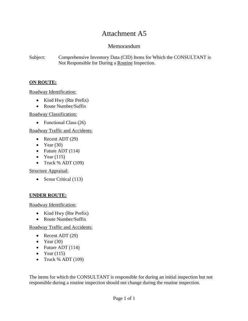
Page 1 of 1
Attachment A5
Memorandum
Subject: Comprehensive Inventory Data (CID) Items for Which the CONSULTANT is Not Responsible for During a Routine Inspection.
ON ROUTE:
Roadway Identification:
Kind Hwy (Rte Prefix) Route Number/Suffix
Roadway Classification:
Functional Class (26)
Roadway Traffic and Accidents:
Recent ADT (29) Year (30) Future ADT (114) Year (115) Truck % ADT (109)
Structure Appraisal:
Scour Critical (113)
UNDER ROUTE:
Roadway Identification:
Kind Hwy (Rte Prefix) Route Number/Suffix
Roadway Traffic and Accidents:
Recent ADT (29) Year (30) Future ADT (114) Year (115) Truck % ADT (109)
The items for which the CONSULTANT is responsible for during an initial inspection but not responsible during a routine inspection should not change during the routine inspection.