
EXECUTIVE SUMMARY - Ministry of Environment, Forest and ...
40
Executive Summary of EIA & EMP Report CISMHE EXECUTIVE SUMMARY Environmental Impact Assessment study of the proposed Tawang H.E. Project Stage-I (600 MW) was conducted in detail. This study was carried out according to the Terms of Reference (ToR) defined by the Expert Appraisal Committee (EAC) of MoEF, Government of India at the time of scoping of the said project. The entire report is compiled into two parts, Environmental Impact Assessment (EIA) and Environmental Management Plan (EMP). The first part i.e. EIA is comprised of base line information about the project, project area and project catchment. It is divided into 13 chapters which deal with environmental aspects like physiography, hydrology, land use/ land cover, air environment, terrestrial ecology, aquatic ecology, socio-economic status, etc. There is a separate chapter on envisaged impacts due to the proposed project on different aspects of environment and local population. The second part i.e. EMP, deals with various management plans and mitigation measures. There are 14 management plans including biodiversity management plan, catchment area treatment plan (for free draining catchment), dam break analysis and disaster management plan, etc. I. ENVIRONMENTAL IMPACT ASSESMENT (EIA) EIA comprises of the baseline information about the project and project area, collected from both primary and secondary sources. The study area is divided into two parts – first area of direct impact includes the project area in which different project components like dam, powerhouse, adits, quarry sites, muck disposal area etc. will be located. Area of indirect impact is the area within 10 km radius from dam and powerhouse etc. The collected information is compiled in the following 13 chapters. 1. INTRODUCTION The proposed Tawang H.E. Project Stage-I is proposed on the Tawang River near Power House of Nuranang Chhu Hydel Project in Tawang district of Arunachal Pradesh. The total catchment area measures approximately, 2937 sq km (27°30′00” – 28°24’00” N latitude and 91°47′00” – 92°28′00” E longitude. In Table 1 salient features of the Project are given. The Tawang H.E. Project Stage-I 1
-
Upload
khangminh22 -
Category
Documents
-
view
2 -
download
0
Transcript of EXECUTIVE SUMMARY - Ministry of Environment, Forest and ...
Executive Summary of EIA & EMP Report
CISMHE
EXECUTIVE SUMMARY
Environmental Impact Assessment study of the proposed Tawang H.E. Project Stage-I
(600 MW) was conducted in detail. This study was carried out according to the Terms of
Reference (ToR) defined by the Expert Appraisal Committee (EAC) of MoEF, Government of
India at the time of scoping of the said project. The entire report is compiled into two parts,
Environmental Impact Assessment (EIA) and Environmental Management Plan (EMP).
The first part i.e. EIA is comprised of base line information about the project, project area
and project catchment. It is divided into 13 chapters which deal with environmental aspects like
physiography, hydrology, land use/ land cover, air environment, terrestrial ecology, aquatic
ecology, socio-economic status, etc. There is a separate chapter on envisaged impacts due to the
proposed project on different aspects of environment and local population.
The second part i.e. EMP, deals with various management plans and mitigation measures.
There are 14 management plans including biodiversity management plan, catchment area
treatment plan (for free draining catchment), dam break analysis and disaster management plan,
etc.
I. ENVIRONMENTAL IMPACT ASSESMENT (EIA)
EIA comprises of the baseline information about the project and project area, collected
from both primary and secondary sources. The study area is divided into two parts – first area of
direct impact includes the project area in which different project components like dam,
powerhouse, adits, quarry sites, muck disposal area etc. will be located. Area of indirect impact is
the area within 10 km radius from dam and powerhouse etc. The collected information is
compiled in the following 13 chapters.
1. INTRODUCTION
The proposed Tawang H.E. Project Stage-I is proposed on the Tawang River near Power
House of Nuranang Chhu Hydel Project in Tawang district of Arunachal Pradesh. The total
catchment area measures approximately, 2937 sq km (27°30′00” – 28°24’00” N latitude and
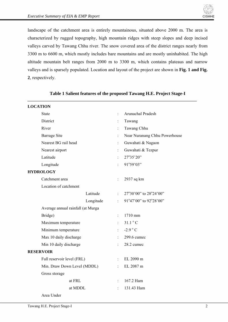
91°47′00” – 92°28′00” E longitude. In Table 1 salient features of the Project are given. The
Tawang H.E. Project Stage-I 1
Executive Summary of EIA & EMP Report
CISMHE
landscape of the catchment area is entirely mountainous, situated above 2000 m. The area is
characterized by rugged topography, high mountain ridges with steep slopes and deep incised
valleys carved by Tawang Chhu river. The snow covered area of the district ranges nearly from
3300 m to 6600 m, which mostly includes bare mountains and are mostly uninhabited. The high
altitude mountain belt ranges from 2000 m to 3300 m, which contains plateaus and narrow
valleys and is sparsely populated. Location and layout of the project are shown in Fig. 1 and Fig.
2, respectively.
Table 1 Salient features of the proposed Tawang H.E. Project Stage-I
LOCATION
State : Arunachal Pradesh
District : Tawang
River : Tawang Chhu
Barrage Site : Near Nuranang Chhu Powerhouse
Nearest BG rail head : Guwahati & Nagaon
Nearest airport : Guwahati & Tezpur
Latitude : 27o35’20”
Longitude : 91o59’03”
HYDROLOGY
Catchment area : 2937 sq km
Location of catchment
Latitude : 27o30’00” to 28o24’00”
Longitude : 91o47’00” to 92o28’00”
Average annual rainfall (at Murga
Bridge) : 1710 mm
Maximum temperature : 31.1 o C
Minimum temperature : -2.9 o C
Max 10 daily discharge : 299.6 cumec
Min 10 daily discharge : 28.2 cumec
RESERVOIR
Full reservoir level (FRL) : EL 2090 m
Min. Draw Down Level (MDDL) : EL 2087 m
Gross storage
at FRL : 167.2 Ham
at MDDL : 131.43 Ham
Area Under
Tawang H.E. Project Stage-I 2
Executive Summary of EIA & EMP Report
CISMHE
Submergence at FRL : 12.46 Ha
STAGE DIVERSION
Diversion Discharge : 624 cumec
No. of Stages : 2 No.
Length of Dyke
Stage-I : 370 m
Stage-II : 250 m
Top of Dyke : EL 2072 m
BARRAGE
Type : RCC RAFT WITH PIERS
Top elevation : EL 2092 m
Crest elevation : EL 2068 m
Downstream Floor Level : EL 2061 m
Length at top : 130.5 m
Thickness of d/s Raft : 5 m
Upstream Floor Level : EL 2066 m
Upstream Floor Thickness : 2 m
Thickness of Pier : 3.5 m
Height : 26 m
SPILLWAY
Design flood : 12680 cumec
Type : Orifice type
Crest elevation : EL 2068 m
Number (including one emergency bay) : 9
Size (W x H) : 9.5 x 14.75 m
Energy dissipation : Stilling Basin with End sill
INTAKE
Invert level : EL 2074 m
Number : 2
Size of gate opening (W x H) : 5.5 m x 5.5 m
Trash Rack : Inclined type
Size of Trash Rack (W x H) : 10 m x 10 m
DESILTING CHAMBERS
Type : Dufour
Number : 2
Size (W x H) : 14 m x 18 m
Length : 320 m
Design discharge per chamber : 81.00 cumec
Tawang H.E. Project Stage-I 3
Executive Summary of EIA & EMP Report
CISMHE
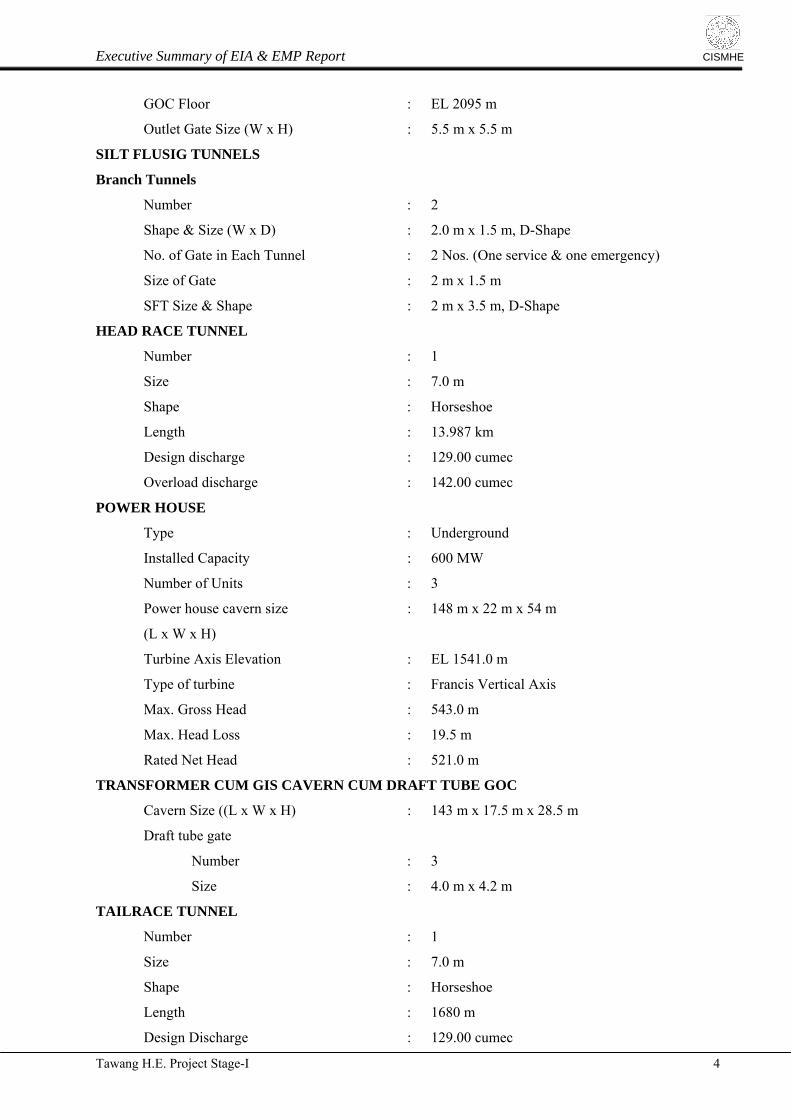
GOC Floor : EL 2095 m
Outlet Gate Size (W x H) : 5.5 m x 5.5 m
SILT FLUSIG TUNNELS
Branch Tunnels
Number : 2
Shape & Size (W x D) : 2.0 m x 1.5 m, D-Shape
No. of Gate in Each Tunnel : 2 Nos. (One service & one emergency)
Size of Gate : 2 m x 1.5 m
SFT Size & Shape : 2 m x 3.5 m, D-Shape
HEAD RACE TUNNEL
Number : 1
Size : 7.0 m
Shape : Horseshoe
Length : 13.987 km
Design discharge : 129.00 cumec
Overload discharge : 142.00 cumec
POWER HOUSE
Type : Underground
Installed Capacity : 600 MW
Number of Units : 3
Power house cavern size : 148 m x 22 m x 54 m
(L x W x H)
Turbine Axis Elevation : EL 1541.0 m
Type of turbine : Francis Vertical Axis
Max. Gross Head : 543.0 m
Max. Head Loss : 19.5 m
Rated Net Head : 521.0 m
TRANSFORMER CUM GIS CAVERN CUM DRAFT TUBE GOC
Cavern Size ((L x W x H) : 143 m x 17.5 m x 28.5 m
Draft tube gate
Number : 3
Size : 4.0 m x 4.2 m
TAILRACE TUNNEL
Number : 1
Size : 7.0 m
Shape : Horseshoe
Length : 1680 m
Design Discharge : 129.00 cumec
Tawang H.E. Project Stage-I 4

Executive Summary of EIA & EMP Report
CISMHE
Tailrace Surge Gallery : 7.0 m dia D-shaped, 530 m long
HFL at TRT outlet : EL 1554.20 m
Max. TWL : EL 1549.0 m
Min. TWL (one unit Running) : EL 1548.0 m
TRT outlet gate
Number : 2
Size : 3.5 m x 7.0 m
POTHEAD YARD
Size : 30 m x 190 m
POWER GENERATED
Installed capacity : 600 MW
Annual energy generation with : 2968.80 MU
2 METHODOLOGY
In the present study standard methods which were earlier developed at the Centre and
published elsewhere, were followed for Environment Impact Assessment of Tawang H.E. Project
Stage-I. Studies on water resource development projects by various authors were particularly
consulted in the present study as well. A brief account of the methodologies followed in the present
study of Tawang H.E. Project Stage-I is given below under different headings. All the methods
were structured for the identification, collection and organization of environmental impact data.
The information thus gathered has been analysed and presented in the form of a number of visual
formats for easy interpretation and decision-making.
Primary surveys were conducted in different seasons of the year (i.e. summer, monsoon
and winter) to collect data on geology, forest types, flora, fauna and various ecological
parameters including air, soil and water. During these survey, data and information were
collected on geophysical and biological attributes of the catchment area in brief, influence area
(10 km radius) and project areas in detail. In addition, comprehensive surveys and studies were
also conducted for understanding the aquatic ecology and fish life of Tawang river and its
tributaries. Primary surveys in the entire catchment area were also conducted for the purpose of
ground truthing and augmenting the remotely sensed data. For this purpose various attributes
such as land features, rivers, forests and vegetation types were recorded on the ground in the
catchment area. Survey on flora, fauna, air, water, fish, soil, geology etc. and ground truthing
were conducted during July 2007, December 2007 and April 2008. Catchment survey was done in
July 2008. Eventually in June, 2009 socio-economic survey was carried out.
Tawang H.E. Project Stage-I 5
Executive Summary of EIA & EMP Report
CISMHE
Spatial database on physiographic features were taken from various sources including the
Survey of India (SOI) toposheets and satellite data, which were analyzed with the help of
Geographic Information System (GIS). This data was collected, arranged and presented as
thematic maps according to the EIA methods used in the study. The thematic maps are presented
in the form of general drainage map of the catchment and its sub-watersheds, relief map, aspect
map, slope map etc. In addition, river gradient profile of the Tawang Chhu and its major
tributaries from its upper reaches to the proposed barrage site was plotted to understand the
degree of erodibility. Land use and land cover mapping was carried out by standard methods of
analysis of remotely sensed data followed by ground truthing, ground control point data
collection and interpretation of satellite data
Besides, the regional geology around the project area highlighting geomorphology,
stratigraphy and structural features was based on the existing information on these aspects
contained in Detailed Project Report (NHPC, 2010) of the project. In addition, the important
parameters of seismicity were assessed using published literature on seismic history and seismo-
tectonic nature of the regional rock types in the area. Seismotectonic setup of the region has also
been described with the help of published literatures (Kumar, 1997 besides referring to the
“Seismotectonic Catalogue of India and its Environments” published by Geological Survey of
India (GSI publication 2000) and the earthquake data given by the India Meteorological
Department (IMD).
In the Hydro-meteorology section, the rainfall data could be made available for three
stations in the catchment which lie in the vicinity of the proposed Tawang H.E. Project Stage-I.
Average annual rainfall i.e. 2053 mm has been calculated on the basis of three rain gauge stations
i.e. Murga bridge, Yusum and Tawang. At Murga bridge data was available for the period of
January 2000 to May 2005 at Yusum, it was also available from March 2003 to May 2005 and at
Tawang it was available from March 2004 to July 2008. The data of 10 daily water discharges
were also available at three gauge sites. This data set was utilized for calculating monthly and
annual water discharge of Tawang H.E. Project Stage-I. Variation pattern of annual flood peaks
and sediment load in the Tawang Chhu river were also studied.
Soil resource mapping of the Tawang H.E. Project Stage-I area was prepared from the basic
data / map of soil classification prepared by the National Bureau of Soil Survey and Land Use
Planning, (Indian Council of Agriculture Research), Regional Centre, New Delhi (NBSS Publ. 57b,
Tawang H.E. Project Stage-I 6

Executive Summary of EIA & EMP Report
CISMHE
1997). To assess the baseline soil quality in the region, soil samples were collected and analyzed
(Fig. 6). For this reason, samples were lifted from the 12 different locations extending from
Yusum Basti to Nuranang Fall. These locations were grouped into five sites viz., S1, S2, S3, S4
and S5 (Fig. 3). The soil samples were collected for three seasons and physical parameters such
as the nitrate, phosphate and organic matter (fungi, bacteria) of soil were analysed using the
standard methodology.
Forest types and various plant and tree species were recorded during the field visits in
2007 and 2008. Besides the primary surveys in the project areas, the floristic data for the
catchment was also procured from the published literature. To understand the community
structure, vegetation sampling was carried out at different locations in the project area (Fig. 3).
For sampling various strata of vegetation, the area was divided into three sites/stands viz.,
barrage site, powerhouse site upper reaches and powerhouse site lower reaches.
For faunal elements (mammals, birds, herpetofauna, butterflies) primary as well
secondary sources of information were utilized while collecting data. In addition a detailed
survey was carried out on the birds and butterflies of the region. We selected various sites which
would likely to be disturbed by the various activities of the project. The important sites were
proposed barrage site, proposed power house site, Jang village etc.
The water sampling was conducted at different locations in the 10 km river stretch of
Tawang river in order to collect the baseline data for Tawang H.E. Project stage-I. The sampling
was conducted for three seasons (pre-monsoon, monsoon and winter). Physico-chemical
parameters and biological parameters were studied to assess the water quality of the river. It was
carried out at 9 locations in 10 km river stretch of Tawang, which were grouped into 3 sites. The
study of fish species was also carried out in the Tawang. The various species of fish were
identified with the help of the literature. Conservation Assessment Management Plan of
Biodiversity - Conservation Prioritization Project Workshop (CAMP-BCPP, 1997), organized by
National Bureau of Fish Genetic Resources (NBFGR), Lucknow, was followed to know the
conservation status of the fish species found in river Tawang.
The ambient air characteristics (SPM, NOx and SO2) were recorded with the help of
Respirable Dust Sampler (Envirotech APM 460BL) with gaseous sampling attachment
(Envirotech APM 411TE). The machine was run at the NHPC Guest House, Tawang, proposed
Tawang H.E. Project Stage-I 7
Executive Summary of EIA & EMP Report
CISMHE
Power House site of Stage I and at Jang village near proposed barrage site. Traffic density was
recorded at the NHPC office at Tawang town and Jang village near barrage site. Noise levels
were recorded using the instrument D 2023 (Cygnet), TYPE 2 (as per IS 9779, 1981). The data
was recorded at different locations namely proposed power house site, proposed barrage site near
Jang village and Tawang town.
Socio-economic profile includes brief description of Arunachal Pradesh, Tawang district
and the circles in which project components are located. History, cultural aspects, ethnic values
and tribal life of Arunachal Pradesh and Tawang district are mentioned briefly. A detailed
account on the demography, education, occupation, and other amenities of the villages located in
10 km radius and project affected villages is discussed in EIA report. In order to collect the
baseline data for preparation of R & R plan a door to door survey for project affected families
was carried out for the proposed project. A detailed questionnaire was prepared for this purpose.
The vulnerability of an ecosystem to various impacts, resulting from an activity or
multiple activities, was identified and accordingly impacts were predicted.
3 PHYSIOGRAPHY
The physiographic condition of a region refers to the sculptures on the natural landscape
and ongoing changes by several geomorphic agents like water, glacier, wind etc. In the present
study, various physiographic parameters were analyzed through remote sensing and GIS
techniques. A database of different aspects was formulated for all constituent sub-watersheds of
Tawang Chhu catchment.
3.1 Drainage Network
Tawang Chhu and Nyamjang Chhu are the two main rivers in Tawang district. Tawang
Chhu emerges after the confluence of Mago Chhu and Nyukcharong Chhu rivers at an elevation of
2240 m. Nyukcharong Chhu originates from Tibet in the Eastern Himalayan ranges and flows
towards southern direction and joins Seti Chhu after 52 km of travel in Tibet. It further flows in
southward direction and enters India after Shoe/Tsona Chhu joins it from left side at 3060 m near
Shyamdling. Mago Chhu originates in India at an elevation of 3360 m. It traverses south-west and
joins Nyukcharong Chhu near Kyelatongbo and the river after confluence is known as Tawang
Chhu. Tawang Chhu flows towards Bhutan through a narrow valley in most part of its length and
Tawang H.E. Project Stage-I 8

Executive Summary of EIA & EMP Report
CISMHE
crosses international boundaries after cruising in India for a distance of 45 km. The overall
drainage network of the catchment area shows combination of dendritic, trellis and parallel
drainage patterns (Fig. 4). Several small and large lakes are located within the catchment area.
3.2 Gradient Profile
The longitudinal profile of the Tawang Chhu including its headwater, where the river is
known as Shoe Chhu in Tibet covers a distance of about 140 km between 4700 m elevation in the
north and 2060 m elevation at the proposed barrage site. The gradient profiles of major tributary
streams like Nyukcharong Chhu, Mago Chhu, Goshu Chhu and Nuranang Chhu are also
calculated. At the central part of the profile major tributary streams meet the main river. In this
stretch the river spans an elevation of 2000 m in 47 km travel. Thus, the gradient of Tawang
Chhu in this stretch is 1:23.5. The Mago Chhu travels for 45.65 km within the elevation range of
2400 to 5100 m. This channel has the gradient of 1:16.91. One of the prominent knick points
observed along Mago Chhu lies at 75 km from the headwater region. Here, the water elevation in
the river drops down from 3900 to 3500 m in a span of about one kilometer distance. Another
knick point was observed near the confluence of Tawang Chhu and Mago Chhu. The presence of
knick points indicates major structural discontinuity across the stream. Steep gradients are also
observed for Nuranang Chhu (1:7.34) and Nyukcharong Chhu (1:12.83).
3.3 Relief
The Tawang Chhu catchment area has been divided into 12 elevation bands. Among the
high elevation classes, there are four elevation classes above 4000 m (4000-4400 m, 4400-4800
m, 4800-5200 m and 5200-5600 m) which are widely spread in the entire catchment. Together
these elevation classes cover an area of 258424 ha i.e., 88% of the entire catchment. These
elevation classes are widely spread in the northern part of the catchment, moreover in the Tibet
part. Elevation classes above 5600-6000 m are spread on small area of 1.13% of the catchment,
spatially these classes are restricted to extreme north of the catchment and head water region.
Elevation class with 6000-6400 m is spread on a small area of 352.43 ha and elevation with
above 6400 m is spread only on a mere area of 1.25 ha. Lower elevation classes are limited along
the valleys of main channel of Mago Chhu, Tawang Chhu and Nyukcharong Chhu rivers.
3.4 Slope
The catchment has been divided into 6 slope categories. Out of these classes, moderately
sloping area has largest area coverage of 38.55% of the total catchment area. Strongly sloping is
Tawang H.E. Project Stage-I 9
Executive Summary of EIA & EMP Report
CISMHE
spatially spread on an area of 81678.73 ha of land i.e., 27.81% of the catchment area. Another
prominent slope class in the catchment is gently sloping class. It is widely distributed along the
northern part of the catchment. It covers an area of 27.11% of the total catchment area.
Moderately steep slope presents in an area of 6.17% of the total catchment area. This slope class
is more prominent in the southern part along Nyukcharong Chhu, Goshu Chhu and Dungma
Chhu valleys. Steep and very steep slope classes areas are present in 0.36% of the catchment area
(Fig. 5).
3.5 Aspect
The slope classes are proportionately distributed in the entire catchment, except of flat
area which covers the maximum area of 83554.15 ha of land. It accounts for 28.45% of the total
catchment area. Slopes with SW-W-NW direction occupy 19% of the total catchment area and it
is widespread throughout the catchment. The slopes with NW-N-NE aspect occupy 18.24% of
the catchment. Slopes having NE-E-SE facet occupy 17.82% of the total area. It is distributed
throughout the catchment. Eventually, slopes with SE-S-SW facet are distributed on 16.39% of
the total land in the catchment area.
4 HYDROMETEOROLOGY
Various climatic variables such as rainfall, temperature, wind direction and evapo-
transpiration together with physiographic factors such as drainage pattern, slope and aspect
factors play significant role in the Hydrometeorology of a river basin. These hydro-
meteorological parameters represent and exhibit the nature of the environment of a river basin.
Additionally, it also determines the setting up and viability of any development project and its
management in such river basins. It is true in case of Himalayan mountainous regions. These
mountainous areas are of paramount importance for the regions downstream.
On the basis of the monsoon, the year can be divided into two seasons viz. monsoon
season (May to September) and non-monsoon (October to April). Monthly meteorological data is
available at Bomdila and Tawang stations in and around the basin. The annual average humidity
is 82.9% while month wise average ranges from 70.8% in the month of February to 87.8% in the
month of July. The project area is located in the valley, the humidity, therefore, is expected more
that the values under discussion. Winter months measure low humidity while monsoon months
record maximum humidity. Average minimum and maximum temperatures of Tawang are -2.9o
Tawang H.E. Project Stage-I 10
Executive Summary of EIA & EMP Report
CISMHE
C to 31.1o C, respectively. The month of January is coldest month, when average temperature
ranges from -0.1o C to 8.2o C while August is hottest month measuring annual temperature range
of 11.3o C to 20.9oC. Average annual rainfall calculated from three rain gauge stations at Murga
bridge, Yusum and Tawang is 2053 mm. At Yusum, maximum rainfall (569 mm) is received in
the month of July, at Tawang maximum (386 mm) is received in the month of July, while at
Murga bridge maximum (273.2 mm) is received in August. The annual precipitation received at
Yusum (2665 mm) is higher than at Murga Bridge (1710 mm) and Tawang (1784 mm).
Considerable portion of the basin receives precipitation in the form of snow. Snow accumulates
during October to March, and it melts during April to July. No detailed data on the wind aspects
are available, however, India Meteorological Department provided wind data for winter season.
Average wind speed was measured to 6.0 km/h while average wind direction was 228 deg.
The annual average of water discharge was recorded as 42.5 cumec at China Bridge
which increased to 89.0 cumec at barrage site in Tawang Chhu. For Mago Chhu the annual
average of water discharge was 40.8 cumec. For the period of 17 years (1992-2008) maximum
water discharge of 299.6 cumec was recorded in the month of August. The maximum and
minimum 10-daily average discharge corresponds to 299.6 cumec in the mid August, 2007 and
28.2 cumec in the beginning of February, 1998. The average run-off coefficient for Murga
bridge (nearby barrage site) for the period of 2000-2007 is computed to be 0.60, which measures
0.63 after deducing the snowmelt contribution. The rainfall–run off correlation has also been
carried out by taking into account the snowmelt contribution, which is deduced from the total
observed run off to compute the contribution of the rainfed catchment.
The suspended sediment data were observed at Yusum site from August 2002 to April
2007 and at Murga bridge site from May 2001 to May 2007. The average annual suspended
sediment load at Murga bridge site works out to be 0.121 Mtons / year, of which coarse, medium
and fine constitute 0.004 MTons (3.2%), 0.02 MTons (14.6%) and 0.10 MTons (82.2%),
respectively. Assuming 20% of the sediment load is transported as bed load, the total annual
sediment load (suspended + bed load) comes out to be 0.14 Mtons / year. On the basis of this
sediment load, the silt rate of Tawang H.E. Project Stage-I comes out to be 49.3 tons/sq. km/year.
5 GEOLOGY & SEISMICITY
The Sub-Himalaya mostly comprises sedimentaries known as Siwalik and are separated
Tawang H.E. Project Stage-I 11

Executive Summary of EIA & EMP Report
CISMHE
from the Brahmaputra plains by Foothill thrust (FHT). The Siwaliks extend up to Bhalukpong
which is about 280 km from Tawang. Towards north the Sub-Himalaya is thrusted over Lesser
Himalaya along Main Boundary Thrust. Lesser Himalaya is mainly formed by Upper Proterozoic
to Lower Cambrian detrital sediments from the passive Indian margin intercalated with some
granites and acid volcanics (1840 ± 70 Ma). The Lesser Himalaya in the region is represented by
Bhareli and Bichom formations both of Gondwana Group, Bomdila group and Dirang
Formations. The Lesser Himalaya is observed up to Dirang which is located about 143 km from
Tawang. The Lesser Himalaya towards the west abuts against Mishmi Hills while towards the
north it is bounded by the Main Central Thrust (MCT).
Further north, the Lesser Himalaya is overlain by Higher Himalaya and separated from it
by Main Central Thrust. The MCT appears between Dirang formation and the overlying Sela
Group of Higher Himalaya near Dirang. The Higher Himalaya is a 30 km thick medium to high
grade metamorphic sequence of meta sedimentary rocks which are intruded at many places by
granites of Ordovician (approx. 500 Ma) and early Miocene (approx. 22 Ma) age. Although most
of the meta-sediments forming the Higher Himalayan Crystalline Sequence (HHCS) are of late
Proterozoic to early Cambrian age, much younger meta-sediments can also be found in several
areas. The project area lies in Higher Himalaya belt and is located about 30 km north of MCT
and about 100 km south of Indus Tsangpo Suture Zone.
Further north, the Higher Himalaya is overlain by Tethys or Tibetan Himalaya which
comprises strongly folded and imbricated, weakly metamorphosed sedimentaries. Tethys
Himalaya is separated from overlying Trans Himalayan formations by Indus Tsangpo Suture
zone. The Indus Tsangpo Suture Zone (ISZ) defines the zone of collision between the Indian
plate and Eurasian plate. This suture zone is formed by the Ophiolite Mélanges, which are
composed of an intercalation of flysch and ophiolites from the Neotethys oceanic crust.
Lithostratigraphically, the rocks exposed in the area belong to Sela Group and Lumla
Formation. Das et al. (1975) introduced the term ‘Sela Group’ to include garnetiferrous biotite
gneiss, lit par lit gneiss/migmatite, calc gneiss, high grade gneiss and schist etc. exposed around
Sela pass and high grade gneiss, schist, amphibolite, calc-silicate and migmatite extending from
Tawang up to 40 km NW of Sela. Jain & Tiwari (1977) divided the rocks of the area into the Sela
Group, the Bomdila Group and the Gipsu Formation, each separated by a prominent thrust. The
rocks around Lumla were classified by them as Gipsu Formation belonging to Bomdila Group.
Tawang H.E. Project Stage-I 12
Executive Summary of EIA & EMP Report
CISMHE
Jain and Basu Roy (1978) classified the rock sequence exposed around Lumla into Lumla
Formation.
Sela Group of rocks is the oldest sequence consisting of polyphase deformed high grade
metasediments of green schist to amphibolite facies. The sequence corresponding to the Dirang
Formation in the Tethyan Himalaya is referred to as the Lumla Formation (Tripathi et al., 1979).
Resting over the Sela Group it is best exposed in Tawang-Woming La section (Singh, 1988). In
other areas it may include the Taksing Formation and the Monigong and Piddi Formation (Singh
and De, 1989). It is constituted of low grade meta-sedimentaries comprising schistose quartzite
with bands of biotite±garnet±staurolite schist, calc-silicate and marble (Kumar, 1997). It is
intruded by tourmaline granites of Tertiary age.
The project components are proposed to be constructed within rock types of Sela Group.
Gneisses with intrusive of leucogranite, pegmatite and amphibolites constituting Sela group of
rocks are disposed around the project area. Seismotectonically the area encompassing the
proposed project is located in Main Himalayan Belt in Arunachal Himalaya. Northern part of the
terrain is occupied by the Trans Himalayan Tectogen with late to post tectonic granitoid
batholiths. This pocket is followed to the south in the western part by the ophiolite and
accretionary complex of Tsangpo Suture Zone. However, along this tectono-stratigraphic level,
towards east only an incipient development of ophiolite is observed. Further south the Himalayan
Belt exposes Proterozoic crystallines, Proterozoic folded cover rocks, Palaeozoic sequence and
volcanics that have been tectonically reworked during Himalayan fold thrust movements. Within
the Siang window fossiliferous Cenozoic cover sequence along with basic volcanics is present.
Major structural elements of this region are Tsangpo Suture, the Main Central Thrust
(MCT), Main Boundary Thrust (MBT) and intermittently exposed Foot Hill Thrust (FHT) along
with some subsidiary thrusts and transverse faults (Narula et al., 2000). Different tectonic
domains in this area exhibit different seismicity clusters, trends and blocks.
6 SOIL
Total catchment area in the Tawang H.E. Project Stage-I is around 293700 ha. Only an
area of 125585 ha was considered for the preparation of soil resource mapping to describe
different types of soils because remaining area is the part of Tibet. The soils of proposed Tawang
Tawang H.E. Project Stage-I 13
Executive Summary of EIA & EMP Report
CISMHE
H.E Project Stage-I are comprised mainly of three soil families (Entic Haplumbrepts, Typic
Udorthents and Lithic Udorthents) having 5 soil units. The Entic Haplumbrepts-Typic Udorthents
and Lithic Udorthents-Typic Udorthents are predominant families in which units 2 and 1 covers
15.78% and 11.61% area of the project (Fig. 6). Majority of the soils of the catchment is
excessively drained, loamy skeletal and susceptible to severe to very severe erosion. Soil
association - Entic Haplumbrepts – Typic Udorthents is predominant group of influence zone,
accounts nearly for 51% of the total area. The predominant soils are moderately - deep,
excessively drained and loamy- skeletal on moderately steeply sloping summits having loamy
surface. The soils are susceptible to severe to very severe erosion.
The proposed barrage site and dumping areas of Tawang HEP Stage-I is covered by
Entic Haplumbrepts and Typic Udorthents soil associations, which are characterized by loamy-
skeletal and sandy-skeletal soils. The proposed power house site is covered with Lithic
Udorthents - Typic Udorthents soil association. The soils are characterized by deep to moderately
shallow, excessively drained, loamy-skeletal soils on very steeply sloping summits having loamy
surface with severe to very severe erosion hazard. The Head Race Tunnel passes through both
associations as mentioned above.
Soils texture influence the physical properties like porosity, permeability, water holding
capacity and nutrients. Gravels and pebbles constituted small portions of the soils collected from
the project areas. Very fine sand accounts for the major portion in the soils ranging from 24.06%
- 36.85%. Fine silt with clay, important reservoir of plant nutrient, ranged from 0.64% to 16.01%
with minimum at site 3. The soils recorded low moisture contents which can be attributed low
density of plant species in the region. Bulk density is correlated with proportions of clay in the
soils. The water holding capacity (WHC) was found to range from 43.32 to 85.26% with
maximum at proposed barrage site near Nuranang fall.
7 LAND USE/ LAND COVER
Land use and land cover mapping of the Tawang H.E. Project Stage-I was carried out by
standard methods like digital image processing (DIP) supported by ground truthing. The land use
and land cover of the Tawang Chhu catchment area includes dense forest, open forest, scrub,
degraded forest, alpine meadow, cultivation, moraines, barren / rocky land, river / nallahs, lakes,
and snow. Large area of the catchment (174741 ha) is prevalently covered by snow, which
Tawang H.E. Project Stage-I 14
Executive Summary of EIA & EMP Report
CISMHE
occupies 59.50% of the total area. It is prominently spread in the northern part of the catchment.
Dense, open and degraded forest lands together occupy 31617.80 ha, which is 10.7% of the total
area. Forest cover is spatially spread in the southern part of the catchment. However, degraded
forest is sparsely spread with area coverage of 84.96 ha. Alpine meadow occupies an area of
4874.25 ha, which forms only 1.66 % of the catchment area. Moraines occupy 38020.69 ha,
which is 12.95% of the catchment area. Significant area of 36161.92 ha is covered by barren /
rocky land, which is 12.31% of the total area. River / nallahs and lakes together occupy an area
of 4430.68 ha, which contributes 1.51% of the total catchment (Fig. 7).
The submergence area extends up to 1.15 km from the u/s of barrage site and it covers an
area of 12.46 ha. A total of 3.49 ha of scrubs will be submerged. In addition to it, 0.78 ha and
2.61 ha of open forest and dense forest, respectively would also be submerged due to the project.
However settlements and agricultural lands are not coming under submergence.
8 FLORISTICS AND FOREST TYPES
Arunachal Pradesh is reported to have 80.43 % of its total geographic area under forest
cover, which includes very dense, moderately dense and open forest (FSI, 2009). The catchment
of the proposed Tawang HE Project Stage-I covers 10 major representatives of forest types of the
Eastern Himalaya viz., Sub-tropical wet hill forests, Sub-tropical pine forests, Wet temperate
forests, Mixed coniferous forests, Alder forests, Low level blue pine forests, Sub-alpine
Rhododendron forests and Alpine Birch-Rhododendron forest, Dwarf Rhododendron scrubs and
Pastures. However, the project area covers East Himalayan sub-tropical forests comprising sub-
tropical wet hill and Himalayan pine forests.. The forests in the project area fall in Jung
subdivision of Tawang Forest division.
Sub-tropical wet hill and pine forests are found in the lower valleys of the project area.
Wet temperate and low level blue pine coniferous forests in the mid hills, while at higher
elevations mixed coniferous forests, sub-alpine rhododendron and alpine forests are found.
The ecological study in the project area of Tawang HE Project Stage-I was undertaken
with the objectives of preparing a checklist of flora in the submergence area and locations where
project components are proposed and its adjoining areas; listing of rare/endangered,
economically important and medicinal plant species; determination of frequency, density and
Tawang H.E. Project Stage-I 15
Executive Summary of EIA & EMP Report
CISMHE
basal cover of different vegetation components. A total of 103 species of plants were recorded
under the ecological investigation during sampling seasons. Out of which 23 were trees, 24
shrubs and 56 herbs. The ground vegetation comprised of ephemeral, annual and perennial
species of grasses, sedges, legumes and non legume forbs. Further in the study area (within 10
km radius), angiosperms are represented by 420 species belonging to 274 genera and 91 families,
out of which 315 species under 204 genera and 76 families belong to dicots while 105 species
under 70 genera and 15 families belong to monocots. Gymnosperms are represented by 5 species
under 4 genera and 3 families.
Asteraceae with 32 genera and 52 species and Poaceae with 33 genera and 43 species are
the largest families of dicots and monocots, respectively. Among Gymnosperms, Pinaceae is the
dominant family represented by 2 genera and 3 species. The dominant genera represented by 5 or
more species in the study area are Anaphalis (5 species), Arisaema (5 species), Berberis (5
species), Carex (6 species), Cyperus (6 species), Ficus (5 species), Persicaria (5 species),
Potentilla (6 species), Rhododendron (9 species) and Saussurea (5 species).
As per BSI Red Data Book, no rare and endemic plant species are reported from the
project area. However, the catchment area has pristine forests that contain some unique plant
species. Caltha palustris var. purpurea, Trollius farreri and Schisandra plena, etc. are some of
the reported endemic plants from high hills of Arunachal and adjacent Tibet Himalaya (Nayar,
1996). Since these plants are reported to occur in the high altitude areas, there is no possibility
that some of these plants may occur in the project area.
The diversity of vegetation in project area and adjacent areas was also assessed in terms
of the physiognomy of its floral elements. The herbaceous species (66.90%) constitute bulk of
the flora followed by shrubs (15.34%), trees (13.18%), climbers (4.55%) and parasitc plants
(0.47%). About 45% families of the flowering plants are comprised of only herbaceous species of
which Ranunculaceae, Asteraceae, Cyperaceae and Poaceae are the dominant ones, each
represented by more than 15 species. This region harbours a wide range of medicinal plants used
in Ayurvedic, Homoeopathic and Unani medicines also used by the local people. Some of the
medicinal plants like Achyranthes aspera, Acorus calamus, Artemisia nilagirica, Bergenia
ciliata, Cyperus rotundus, Houttuynia cordata, and Viola betonicifolia are quite common in the
sub-tropical parts of proposed project area. Berberis macrosepala, Clematis montana, Lyonia
Tawang H.E. Project Stage-I 16

Executive Summary of EIA & EMP Report
CISMHE
ovalifolia, Origanum vulgare, Zanthoxylum acanthopodium, etc. are important medicinal plants
occurring in the temperate areas.
The important crops of the region are finger millets, barley, maize, potato etc. Many wild
vegetables and fruits are also consumed locally. Among the wild edible plants consumed are the
leaves and young twigs of Amaranthus spinosus, Fagopyrum esculentum, Girardinia diversifolia,
Rumex nepalensis, etc. The tubers and rhizomes of Colocasia esculenta are commonly consumed
as vegetables. Fruits of Castanea sativa, Phyllanthus emblica, Prunus cerasoides, Rubus
ellipticus, etc. are eaten.
9 FAUNA
The fauna of the region has palaearctic and Indo-malayan affinities. The fauna of
palaearctic affinities includes Snow leopard (Uncia uncia), Serow (Capricornis sumatraensis),
Red Goral (Naemorhaedus baileyi), Musk Deer (Moschus chrysogaster), Bharal (Pseudois
nayaur), Black-necked crane (Grus nigricollis), Monal Pheasant (Lophophorus impejanus), etc.
The wild Yak (Bos grunniens) is found in the higher reaches of the region particularly areas
bordering Tibetan plateau. The animal species like Wild boar (Sus scrofa), Himalayan yellow-
throated marten (Martes flavigula) etc. inhabiting the valleys are close to the Indo-malayan
fauna. A few elements like Red Panda (Ailurus fulgens), Clouded leopard (Neofelis nebulosa) etc
show their affinities with the Indo-chinese and Indo-Malayan regions.
Mammalian fauna comprises 31 species belonging to 16 families. Of the 31 species 19
inhabit 10 km surrounding area of the proposed project sites. Artiodactyla comprise Deer,
Sambar, Goral, Takin, Serow, Bharal, Yaks and Wild boars coming from 4 families. Barking
deer and Hog deer are found at altitudes between 1500 – 2400 m in the region. These are the
common deer species of the influence zone of the proposed project, inhabiting dense bushy
forests. Both species are categorized under the Schedule III of WPA (1972). Musk deer and
Sambar occur between 3000 – 4000 m and 1200 – 2000 m. Musk deer inhabits upper reaches of
Nuranang Valley and Sela pass and Bumla region. Sambar occurs in the surrounding of project
areas. Musk deer is categorized under the ‘endangered’ category of IUCN and Schedule I of
WPA (1972). Goral and Serow are distributed between 2000 – 3000 m in the catchment area.
Sometimes Gorals descend up to 1200 m to forage food and water. Takin is less known species in
the area, known to occur between 2000 – 3000 m. Wild Yak is restricted to the high altitudes
Tawang H.E. Project Stage-I 17

Executive Summary of EIA & EMP Report
CISMHE
over 4000 m. Red goral is a wood dwelling animal inhabiting altitudes between 1500 to 4500 m.
Blue sheep and Argali are restricted in the upper reaches like Sela pass and Bumla areas. It is
found over 4000 m between tree line and trans-Himalayan tracts. Serow is described under the
‘vulnerable’ category of IUCN red list and Schedule I of WPA (1972). Wild boar is distributed
up to 1500 m. It inhabits open areas and raids agricultural fields. Wild boar has been placed
under the Schedule III category of WPA (1972).
Mammals were recorded from the project areas with the help of direct and indirect
evidences. Himalayan marten (Martes flavigula) was sighted near proposed power house
complex and Jang village. Himalayan marmot (Marmota himalayana) was spotted near Jaswant
Garh (within influence zone). Pellets of macaques and deer were observed at various spots
upstream of proposed barrage site. A skull, preserved as a trophy of Wild boar (Sus scrofa) was
seen at a household of Jang village near the barrage site. Local people were reported to observe
herd of Blue Sheep near Sela pass frequently.
The avian fauna of the catchment area comprises 104 species of birds belonging to 35
families. It includes sandpipers, swifts, crane, plover, vultures, eagles, pheasants, partridges,
woodpeckers, barbets, hoopoe, doves, pigeons, owls, tits, flycatchers, bulbuls, thrushes, laughing
thrushes, drongo, crows, magpies, shrikes, redstarts, finches, minivets, warblers, babblers,
wagtails etc. Timalidae is the largest family comprising 18 species. A total of 20 families viz.
Falconidae, Gruidae, Charadriidae, Scolopacidae, Strigidae, Apodidae, Upupidae,
Campephagidae, Prionopidae, Rhipiduridae, Cinclidae, Prunellidae, Cisticolidae, Aegithalidae,
Sittidae, Nectariniidae, Dicaeidae, Dicuridae, Emberizidae and Passeridae are monotypic in the
region. Sclater’s Monal, Blood pheasant, Satyr tragopan, Black-necked crane, Red-billed chough,
and Alpine Accentor inhabit high reaches over 3000 m in the catchment area. The remaining
species are well distributed in the surrounding areas within 10 km radius. Crested Serpent Eagle,
Golden Eagle, Himalayan Griffon, Eurasian Griffon, Oriental turtle Dove and Hill Pigeon are
widely distributed in the region. The species like Crimson-breasted Woodpecker, Darjeeling
Woodpecker, Golden-throated Barbet, Great barbet, Wedge-tailed Green pigeon, Mountain
imperial Pigeon etc. prefer to inhabit forests from 1700 to 2000 m in the catchment area of the
proposed project. The majority of the species of thrushes, warblers, laughing thrushes inhabit
bushes in the Tawang valley. Redstarts and wagtails are found in the open areas near water
bodies. Majority of the species in the catchment area are resident, in which sparse resident
accounts for 50% and widespread resident is 34% of the total species. Wood Sandpiper (Tringa
Tawang H.E. Project Stage-I 18
Executive Summary of EIA & EMP Report
CISMHE
glareola), Grey Wagtail (Motacilla cinerea) and Yellow Wagtail (M. flava) are widespread
winter visitors while Long-billed plover (Charadrius placidus) is a sparse winter visitor in the
surrounding and the catchment area.
The Avifauna from the proposed power house to the barrage sites and immediate
surrounding areas comprises 33 species belonging to families Charadridae, Picidae,
Megalaimidae, Columbidae, Pycnodidae, Laniidae, Muscicapidae, Sylviidae, Fringilliade,
Nectarniidae, and Passeridae. A total of 84 individuals were spotted from the project areas, of
which Eurasian Tree Sparrow accounts for maximum. Around 52% of the species are widespread
residents whereas nearly 31% are sparse residents. Charadrius placidus was only sparse winter
visitor species. No migrant and vagrant species were recorded from the project areas. Passer
montanus, Stigmatopelia chinensis, Myophonus caerulus, Dicrurus macrocercus and Yuhina
gularis were most abundant species of the region. None of the threatened and scheduled species
was recorded from the project areas.
Amphibian fauna comprises Bufo melanostictus, Bufo himalayana, Amolops afghanus,
Rana cyanophlyctis, R. tigerina, Polypedates maculates belonging to families Bufonidae and
Ranidae. None of the herpetofaunal species of the catchment area is locally and globally
threatened.
A total of 15 species of butterflies were recorded from the project sites and its close
vicinities belong to families Papilinidae, Pieridae, Lycaenidae, Riodinidae and Nymphalidae.
Most of the species were recorded from Jang village near settlement. Metallic Cerulean,
Punchinello, Indian Cabbage White and Common Sailer were most abundant species. None of
the recorded species were threatened or endemic to Arunachal Pradesh. Blue Baron and Common
Mime are categorized as Schedule I species while Metallic Cerulean is Schedule II species
(WPA, 1972).
10 AQUATIC ECOLOGY & WATER QUALITY
10.1 Water Quality, Physical and Biological properties
In this study water quality assessment of Tawang Chhu is discussed. Water samples were
taken during the three seasons i.e., winter, pre-monsoon and monsoon seasons from various
locations. The water samples were analyzed for various physical, chemical and biological
Tawang H.E. Project Stage-I 19

Executive Summary of EIA & EMP Report
Tawang H.E. Project Stage-I 20
CISMHE
parameters to get an overview of water quality. Table 2 gives details of physico-chemical
parameters of river water. Tawang river is rich in planktonic, benthic and macro-invertebrates
populations. The density of suspended algae increases gradually in downstream river stretches.
The plankton density was highest in the winter season
Highest water current velocity was recorded in monsoon season as the water discharge
was also higher. Water temperature is another physical factor which exerts direct as well as
indirect influences on abiotic and biotic characteristic of aquatic ecosystems. Water temperature
followed a seasonal pattern as the lowest temperature was recorded in winter season (6°C) and
highest in the monsoon season (15 to 17º C). River water at all the sites investigated was
relatively alkaline. The pH values ranged from 7.43 to 9.70 with highest pH being recorded in
monsoon season and the lowest in winter season. Dissolved oxygen concentrations were high
except in Monsoon season, where the concentrations fell down to 5.53 mg/l as the turbidity is
generally high which prevents photosynthetic activities of aquatic organisms. The high Dissolved
oxygen contents in winter are due to low water temperature and less turbidity. All these factors
together contribute in increased dissolved oxygen content in winter season. Total dissolved
solids (TDS) and electrical conductivity of water ranged from 15 to 147 mg/l and 24 µS/cm to
240 µS/cm, respectively.
The biological community in a river is a product of the various physical and
geomorphologic forms and processes of the river. Total coliform test, which indicates the
contamination of water due to sewage outfalls, indicated no such contamination from the study
area. The density of zooplankton ranged from 12 to 54 individuals/ lit. Phytoplankton or suspended
algae formed an important component of aquatic flora as they are the primary producers in aquatic
ecosystem. The density of suspended algae ranged from 918 to 15940 cells/lit. Maximum density
was found in winter season due to low temperature conditions, high dissolved oxygen content and
increased transparency. Diatoms formed the major component of suspended algae as well as of
Phytobenthos. The density of Phytobenthos ranged from 6194 - 27239 cells/ lit. Details of various
biotic components are given in Table 3.
A total of 63 species of diatoms were identified in Tawang River. Out of 63 species, 23
species were common to both benthic as well as planktonic diatoms. Benthic diatoms showed more
species richness (53 species) than the planktonic forms (33 species). There were 30 species which
were found exclusively in benthic forms, while, number of species found exclusively in planktonic
form were 10.

Executive Summary of EIA & EMP Report
CISMHE
Table 2 Physico-chemical characteristics of water of Tawang Chhu River
Pre- Monsoon Monsoon Winter Season Site W1 W2 W3 W1 W2 W3 W1 W2 W3
Water current velocity (m/s) 2.00 1.54 1.30 3.05 3.53 3.17 1.21 1.45 1.30
Water Temperature (ºC) 9.00 8.00 9.00 15.00 17.00 17.00 6.00 7.00 8.00
pH 8.16 8.10 8.70 9.21 9.70 8.75 8.69 7.43 8.70
Dissolved Oxygen (mg/l) 9.53 11.66 10.53 5.53 8.80 6.05 13.19 12.60 12.24
Electrical Conductivity (µS/cm) 116.66 120.66 86.00 50.66 116.00 117.00 240.00 24.00 204.6
Total dissolved Solids (mg/l) 70.00 70.00 50.00 30.00 80.00 80.00 147.00 15.00 130.00
BOD (mg/l) ND ND ND ND ND ND ND ND ND
COD (mg/l) 0.50 0.45 0.55 0.65 0.61 0.67 0.34 0.33 0.36
Total alkalinity (mg/l) 40.00 44.00 34.00 20.00 38.00 38.00 56.00 52.00 52.00
Salinity (ppt) ND ND ND ND ND ND ND ND ND
Total hardness (mg/l) 68.00 48.00 36.00 48.00 96.00 96.00 84.00 12.00 72.00
Calcium Hardness (mg/l) 32.00 36.00 30.00 36.00 80.00 76.00 67.50 8.40 63.00
Calcium ion (mg/l) 12.80 14.40 12.00 14.40 32.00 30.40 26.91 3.36 25.23
Magnesium Hardness (mg/l) 36.00 12.00 6.00 12.00 16.00 20.00 16.50 3.60 9.00
Magnesium ion (mg/l) 8.74 2.91 1.45 2.91 3.88 4.86 4.00 0.87 2.18
Chloride (mg/l) 7.99 6.99 8.99 5.99 5.99 6.99 9.99 7.99 7.99
Nitrate (mg/l) 0.67 0.52 0.74 ND ND ND 0.42 0.32 0.21
Phosphate (mg/l) ND 0.12 ND 0 0.03 ND ND ND ND
Iron (mg/l) ND ND ND ND ND ND ND ND ND
Manganese (mg/l) ND ND ND ND ND ND ND ND ND
W1: Barrage site; W2: Power House site, W3: Downstream Power house site, ND: Not detected
Tawang H.E. Project Stage-I 21
Executive Summary of EIA & EMP Report
CISMHE
Table 3 Densities of different biotic communities in Tawang Chhu River Pre-Monsoon Monsoon Winter
Biotic communities W1 W2 W3 W1 W2 W3 W1 W2 W3
E. coli (A/P) A A A A A A A A A
Coliforms (A/P) A A A A A A A A A
Zooplankton (indiv./lit) 23 24 53 24 21 12 54 35 21
Suspended algae (cells/lit) 4086 8722 9765 918 1102 1097 6634 15940 14380
Phytobenthos (cell/mm2) 11489 19962 14247 7904 8060 6194 15327 18831 27239
Macro-invertebrates (indiv./m2 121 55 154 311 532 400 945 66 522
A: Absent P : Present
Tawang H.E. Project Stage-I 22

Executive Summary of EIA & EMP Report
CISMHE
The diatom species which were abundant in both benthic as well as planktonic forms were
Achnanthidium minutissima, Achnanthidium microcephala, and Achnanthidium linearis followed by
Hannaea arcus, Synedra ulna var. oxyrhynchus, and Fragilaria construens. The diatom assemblage
composition was characteristic of Diatoms occurring at kryal sites which are generally nonmotile
with strong attachment abilities that can resist high discharge and abrasion by glacial flour,
belonging to the so-called pioneer species with high resilience (e.g., Achnanthidium spp., Diatoma
spp., Fragilaria spp., and Hannaea arcus) (Hieber, 2001). Synedra vaucheriae, Achnanthidium
austriaca and Cyclotella sp. dominated the species occurring exclusively in benthic forms, while
Achnanthidium exilis, Fragilaria vaucheria and Reimeria sinuata dominated the planktonic forms.
10.2 Fish & Fisheries
Ichthyofauna of Tawang river (Arunachal Pradesh) comprises about 12 species belonging to
families Cyprinidae, Salmonidae, Cobitidae, Bagridae, Amblycipitidae and Sisoridae.
Snow trout comprises Schizothorax richardsonii and Schizothoraichthys progastus. These are
widely distributed in the Himalayan rivers up to 2000 m. These fish are column feeders with
powerful muscular streamlined body. Snow trouts are herbivores, feed on benthic algae and account
for major and important part of the capture fishery in the region. Both these species are endemic to
Himalaya. Schizothorax richardsonii is considered as ‘vulnerable’ species (CAMP-BCPP, 1997).
Salmo trutta fario (Brown trout) is an exotic fish species, introduced in Tawang Chhu from a
hatchery established by State Fishery Department at Nuranang Chhu. Fry of brown trout are directly
stocked in Tawang Chhu, however, a self sustainable population of brown trout could not be
established in the river so far. They come rarely in the fish catch. Botia berdmorei (Blyth’s loach)
and B. rostrata (Gangetic loach) are bottom dweller fish and are carnivorous. They get shelter
among the pebbles and shingles in shallow waters. They are not of any commercial fishery interest
due to their small size but are considered as aquarium fish. Botia berdmorei is designated as
‘endangered’ species. Generally, these species do not come in the catch, particularly by the caste net
and hooks. Cat fish group comprises Mystus vittatus and Amblyceps mangois, which belong to
families Bagridae and Amblycipitidae, respectively. Mystus vittatus prefers to inhabit muddy
bottom, therefore, very rarely comes in the catch. Amblyceps mangois is a bentho-pelagic freshwater
species which clings to the stones/pebbles in the rapid water current. Both species are not of any
commercial fishery interest. Sisorid group of fish comprises Erethistoides montana, Euchiloglanis
Tawang H.E. Project Stage-I 23
Executive Summary of EIA & EMP Report
CISMHE
hodgarti, Exostoma berdmorei, Gagata cenia and Pseudechneis sulcatus. None of these species is of
commercial interest and all are rheophilic and bottom feeders. Erethistoides montana has been
categorized as ‘critically endangered’ fish, whereas Euchiloglanis hodgarti and Pseudecheneis
sulcatus are designated as ‘vulnerable’.
Average catch per unit effort (CPUE) was recorded to be 0.04 kg/per day and 0.054 kg/day in
winter and pre-monsoon seasons, respectively. In addition, hook and line methods were also used to
land the fish. The capture fishery depends mainly on the snow trout (Schizothorax richardsonii and
Schizothoraicthys progastus). The low CPUE and scanty population indicated by the low density of
fish in the upper reaches which may be due to passage of river through deep and narrow gorges, and
presence of cold glacier and snow-melt water, which is not conducive for much fish diversity at
these altitudes.
11 AIR ENVIRONMENT
In the entire Tawang district point source pollution is absent. The diffuse source comprises
fuel wood, traffic fuel and forest fire, etc. The traffic density in the project area was recorded during
April, December and July months at Tawang town and Jang village near proposed project. Vehicular
density in Tawang accounts for more than 60% as compared with Jang village. Light vehicles are
important means of public transport in the region whereas two wheelers are highest in private
transport. Notably, defence vehicles contributed considerable number of heavy and light vehicles at
Jang (National Highway). Maximum level of SO2 was recorded at Tawang town during the month of
December which may be due to relatively heavier traffic flow in the region as it is relatively larger
settlement. The only source of NOx emissions in the region is vehicles. Maximum levels of NOx were
observed at Tawang town (3.60 µg/m3) in the monsoon season. At Tawang-I power house site, the
levels of NOx recorded were 2.39 µg/m3 during the winter season.
The Ambient levels of RSPM and NRSPM have been measured at different locations in the
project area. At proposed power house site, the TSPM levels were the highest (465.64 µg/m3) in the
pre-monsoon period. NRSPM was the major component of TSPM during all seasons. In this region
the main sources of SPM are vehicles, open degraded land areas, road construction and landslides. In
Tawang H.E. Project Stage-I 24
Executive Summary of EIA & EMP Report
CISMHE
the monsoon season TSPM concentrations were lower due to settling down of dust and other
particles with rains.
The adverse impacts of noise also depend on time and seasons, particularly in case of animals
and birds. Tawang I power house site is away from road head and settlements, therefore, sound level
was measured to be as low as 56 dB. The highest sound level (78.50 dB) was recorded at Tawang
town in month of April. Proposed Power house site recorded 55.12 – 59.24 dB of sound level.
12 SOCIO-CULTURAL ECONOMIC PROFILE
Arunachal Pradesh covers an area of 83,743 sq. km and lies between latitudes 260 28’ to 290
30’ N and longitudes 910 30’ to 970 30’ E. Arunachal Pradesh is bordered by Bhutan in the west,
Myanmar in the southeast, Tibet in the north and the Indian State of Assam in the south. Itanagar is
the capital of Arunachal Pradesh, which is located in Papum Pare district. The total population of
Arunachal Pradesh is 10,91,117 with a sex ratio of 893 (Census, 2001). The average population
density is 13 persons per sq. km. About 64% of the total population of the state belongs to the
Scheduled tribe with maximum in Kurung Kumey district and minimum in Lohit district. Average
literacy rate in Arunachal Pradesh is 54.74% with maximum in males (64.07%). Administratively,
Arunachal Pradesh is divided into 16 districts, Tawang is one of the district bordered with Bhutan in
the west and south-west, Tibet in the north and north-east, West Kameng District in the south and
south-east.
Project components of Tawang H.E. Project Stage-I falls in 5 administrative circles viz.,
Tawang, Jang, Mukto, Thingbu and Kitpi circles. Kitpi circle was separated from Tawang Circle
after Census of India 2001. Total population of these circles is 28458 come from 5858 households.
The average sex ratio of circles is 711 with maximum in Mukto circle. The population of Scheduled
Castes (SC) and Scheduled Tribes (ST) account for 0.45% and 69% of the total population,
respectively. The age class 0-6 year shares 14.6% of total population as per the Census 2001.
Average literacy rate in the circles under discussion is 46.2% with considerably high in males. Most
of the tribes depend on agriculture. Main crops in the region are Paddy, wheat, millets and maize.
Peoples are employed in tourism industry, constructions, government jobs, agriculture and
household activities.
Tawang H.E. Project Stage-I 25

Executive Summary of EIA & EMP Report
CISMHE
A total of 25 villages belonging to 5 circles are directly affected due to acquisition of
community land for the proposed Tawang H.E. Project Stage I. Socio-economic data of affected
villages is based on the Census 2001. Total population of affected villages is 8335 come from 1817
households. Average sex ratio in these villages is 901. Scheduled tribe population accounts for
83.2% of the total population. Scheduled castes mainly reside in Jang and Teli villages. Literacy
rate (33.6 %) in affected villages is lower than that of administrative circles of project area. The
literacy rate is considerably higher in male population (43.5 %) as compared with females (22.6 %).
Rice, maize, millets and pulses are main crops of the affected villages. Around 57.4% of the total
population is employed in various works, viz. agriculture, small scale business, house building,
labour work in road construction and government jobs. All affected villages of Jang and Tawang
circles are connected to the national highway and have electricity and tap water facilities. Majority
of the affected villages have nearby centres of primary and secondary education. None of the
affected villages has senior secondary education, post office, banking and primary health care
facilities. Only Gomkelleng village of Mukto circle avail all above facilities from the nearest place.
No family is getting displaced due to construction of project. A total of 292
households/khatedars of 18 villages will be affected due to the acquisition of 113.8 ha private land for
Tawang H.E. Project Stage-I. Total population of affected families is 1420 of which age group 0-6
years accounts for 11.4% of the total population. Sex ratio in affected families is 1076, which is
considerably higher than that of affected villages. All affected families belong to Scheduled Tribe.
Jang is largest village, from where maximum households are affected. Literacy rate in the affected
families is 43.0%. Only 3.7 % of the total population has got or getting higher education (graduate or
post-graduate). In addition to the formal education, nearly 2.8 % of the total population has got
monastic education (Lamaism) of buddhist ideal. Around 41.8% of total population of affected
families is involved in various occupation. The majority of working persons of affected families are
engaged in agriculture (83.7 %) while only 6.2 % are employed in government services. Other
occupations in the affected families are small scale business, non government services and labour works.
Livestock of affected families comprises cows, buffaloes, oxen, goats, sheep, mules, yak and
poultry. About 47.9 % of the affected families are categorized under the ‘below poverty line’. Other
categories of vulnerable persons among project affected families are widows (2.6%) and
handicapped (0.5 %). Most of the affected villages of Tawang H.E. Project Stage-I are connected
Tawang H.E. Project Stage-I 26
Executive Summary of EIA & EMP Report
CISMHE
either to National Highway or link roads. Transportation facilities are not adequate and density of
vehicular movement is very low. All villages have electricity and tap water facilities. All affected
families have pucca houses, made of concrete or stone masonry. The villages inhabited by affected
families are poor in health facilities and some of the villagers have to travel for 40 km to access
hospital facility. The consumption of energy is based on the fuel wood, kerosene and LPG.
Effect of the project on various socio-economic aspects is summarized below in Table 4:
Table 4 Socio-economic Aspects
S. No. Aspects Number/Area (ha)
1 Private land affected 113.8 ha
2 Community forest land affected 125.3 ha
3 Unclassed State Forest affected 66.5 ha
4 Villages affected 25 nos.
5 Households/ Khatedars affected 292 nos.
Land requirement for the project is presented below in Table 5:
Table 5 Land requirement for the project
S. No.
Components Forest Land
USF* Community Forest Land
Private Land
Total
1 Reservoir Area - 5.00 7.50 - 12.50
2 Barrage complex and colony site including TW1-G2, TW1-G3, TW1-R1, MDA 1, Adit 1 CFA
- 25.00 30.00 20.00 75.00
3 Muck dumping area MDA 2, 3, 4, 5
- 3.00 16.20 4.80 24.00
4 Adits 2, 3, 4, 5 CFA including TW1-R4
- 14.50 14.50 36.00 65.00
5 Main office & colony site
- - 17.00 - 17.00
6 TW1-G1, TW1-C1, TW1-C2, TW1-R3, TW1-R6, TW1-R7
- 3.00 7.10 - 10.10
7 Power house complex & Colony site including MDA-6, TW1-R2
- 8.00 32.00 38.00 78.00
8 New roads - 8.00 1.00 15.00 24.00
Total - 66.50 125.30 113.80 305.60
* Unclassed State Forest
Tawang H.E. Project Stage-I 27

Executive Summary of EIA & EMP Report
CISMHE
In order to know the public opinion on Tawang H.E. Project Stage-I, the people of the area
was interviewed during the socio-economic survey. Affected families belong to Monpa tribe, which
is unique in tradition, culture and customs. The land of majority of the affected families is associated
with Tawang Monastery.
13 IMPACT ASSESSMENT
The impacts were identified on the basis of their nature, magnitude and potential. The
impacts may be major (land use changes, barrage structure, submergence, habitat destruction, etc.)
and minor (pressure on wildlife, deterioration of water quality, etc.), positive (infrastructure
development, work opportunity for local, fisheries development, etc.) and negative, direct
(submergence of vegetation, obstacles in the way of fish migration, local economy), indirect
(cultural and social resources, forest resources, etc.), local (most of the impacts are confined to the
project areas) and strategic (a few impacts have strategic importance like local area development).
The impacts of the project are summarized below:
i) Proposed barrage would inundate a small area of 12.46 ha alongside Tawang river. The
submergence area is covered with dense/open forests. None of the plant species in
submergence area is threatened and endemic to Tawang.
ii) Around 24 ha of land will be disturbed due to construction of new roads passing through
Berghar, Paidhar, Teli, Upper Seru and Lower Seru villages. However, the construction of
roads may also trigger minor slips and downfall movement of soil aggregates.
iii) Influx of labourers may exert additional pressures on the natural resources. However, this
impact is temporary in nature.
iv) No family is getting displaced due to the construction of the project. However, 125.3 ha
community forest land belonging to 25 villages and 66.5 ha unclassed state forest will be
acquired for the construction of project. In addition, 113.8 ha land belonging to 292
households/khatedars will also be acquired for the project.
v) Nearly 75 ha of land is required for barrage complex and colony site (including TW1-G2,
TW1-G3, TW1-R1, MDA 1 and Adit 1 CFA). The area has degraded forests. Thus, heavy
felling of trees is not anticipated in this region.
Tawang H.E. Project Stage-I 28

Executive Summary of EIA & EMP Report
CISMHE
vi) The proposed barrage would lead to habitat fragmentation, which directly affects fish
migration. Major impacts are not anticipated due to fragmentation as river water harbours
very low species of fish. Snow trout, however are important species which undertake
downstream/upstream migration for the breeding purpose during the monsoon season.
vii) Loose soils as a result of excavation would increase the SPM level in the air. However, this
activity would occur only during construction phase.
viii) The noise generated by various machinery works, tunneling and blasting would lead to
adverse impact on wildlife. Such types of activities are limited in construction phase.
ix) Entire stretch of HRT from intake to powerhouse shall be housed within rock formations of
Sela Group. The rock types of Sela Group consist of gneisses which are intruded by
leucogranites, pegmatites and amphibolites. They are expected to provide fair to good
tunneling media.
x) The expected number of labourers and technical staff coming from outside for the
construction of the project would be nearly 1000 and 500, respectively. The migrant workers
lead to other impacts like cultural invasion and social conflicts, act as carriers of various
diseases like AIDS, VDS, gastro-enteritis, etc. However, this impact is temporary in nature as
migrant workers would vacate the area after construction of the project.
xi) Local people would be beneficiaries of work opportunities due to the project and
infrastructure like schools, hospitals, roads, free electricity, buses, etc.
xii) Project would play a vital role in development of Tawang and contribute to revenue of state.
xiii) A stretch of river Tawang in the downstream would undergo scarcity of water. However, 3.5
cumecs of water would be released from the barrage in lean season. None of the families in
downstream section depends on the river water.
xiv) No encroachment on historical or cultural sites would take place according to the available
documents and current studies.
xv) As per the current study, no inundation of mineral resources or loss of mineral resource
development potential shall take place due to the project.
xvi) Air pollution may occur during construction phase due to vehicular movement and due to
drilling, blasting and other construction activities. However, this is temporary and lasts for
construction period only.
Tawang H.E. Project Stage-I 29

Executive Summary of EIA & EMP Report
CISMHE
II ENVIRONMENTAL MANAGEMENT PLAN
Environmental Management Plans deal with the management and mitigation measures of the
impacts discussed in part one (EIA). Various management plans on different aspects of Environment have
been discussed below. Total cost of the management plan is summarized in last chapter of EMP report.
1. BIODIVERSITY MANAGEMENT AND CONSERVATION PLAN
The present biodiversity conservation and management plan for Tawang H.E. Project Stage-I
in Arunachal Pradesh is aimed to the conservation of natural resources and to circumvent the stress
on biodiversity. Arunachal Pradesh is an abode of a large number of tribes, which are closely
associated with nature and natural resources. Considering the customs, culture and socio-economic
conditions of the local tribes the following issues were taken into account in formulating the
biodiversity management and conservation plan:
(i) To maintain a sustainable approach between customs and culture of the local communities
and biodiversity conservation,
(ii) Conservation of threatened, endemic and newly recorded species,
(iii) Special efforts for in situ or ex situ conservation of critical / important plant / animal
species, if any, affected by the project,
(iv) To protect the traditional knowledge of the local people,
(v) To provide incentives for research, training and public education to increase awareness
with respect to biodiversity.
For the implementation of the above action plans, the project authorities will provide the
funds for Biodiversity Conservation and Management Plan. Total financial budget would be Rs.
540.00 lakhs. Out of which maximum funds were allocated for protection of vulnerable area and
establishment of botanical garden.
2 CATCHEMENT AREA TREATMENT PLAN
To minimize the soil erosion and its impact on the reservoir and as a part of Environmental
Management Plan study for the proposed Tawang H.E. Project Stage I, a Catchment Area Treatment
Tawang H.E. Project Stage-I 30

Executive Summary of EIA & EMP Report
CISMHE
(CAT) plan for the free draining area has been prepared for area with high soil erosion rates. The
CAT plan targets towards the improvement of the environmental condition of the project area. All
the measures that will be undertaken aim at treating the degraded and potential areas of severe soil
erosion and very severe soil erosion. CAT plan provides benefits due to biological and engineering
measures, and its utility in maintaining the ecosystem health. The main aim of the CAT is to
rejuvenate various potential and degraded ecosystems in the catchment area for the longevity of the
reservoir storage capacity.
Free draining catchment is identified for the study of soil erosion susceptibility and it is
divided into 28 sub-watersheds (7 in Nyukcharong Chhu watershed and 21 in Mago Chhu
watershed). Area indentified for soil erosion treatment is 840.96 ha. Out of this, 836.56 ha are
classified under severe erosion intensity category and 4.40 ha under very severe erosion intensity
category. The total area earmarked for the treatment comprises more than 0.67% of the free-draining
catchment area, and about 4% of the total area under very severe and severe erosion intensity
categories requiring treatment measures. For undertaking soil conservation measures various indirect
or preventive measures like biological measures and direct or remedial measures like engineering
measures are proposed. Use of techniques like geo-textiles and preference to the local material has
been suggested for the treatment. In the free draining area total area for erosion-treatment will be
840.96 ha. Among the Engineering measures, 67 numbers of brushwood check dams and 81
numbers of DRSM check dams will be set-up. A total area of 110.77 ha, 152.22 ha and 116.85 ha
will be treated by mulching, contour bunding and bench terracing, respectively. In the biological
measures afforestation will be done in an area of 193.20 ha. NTFP Regeneration / Medicinal plants
cultivation will be done in an area of 93.48 ha, Assisted natural regeneration in an area of 107.67 ha
of land and finally pasture improvement in an area of 66.68 ha. The total cost of the Catchment Area
Treament Plan will be Rs. 435.50 lakhs.
3 FISHERIES DEVELOPMENT PLAN
In Tawang Chhu river and its tributaries; Schizothorax richardsonii, Botia berdmorei,
Erethistoides montana, Euchiloglanis hodgarti and Pseudecheneis sulcatus are threatened species, in
which E. montana is ‘critically endangered’ and B. berdmorei is ‘endangered’ (CAMP-BCPP, 1997).
Tawang H.E. Project Stage-I 31
Executive Summary of EIA & EMP Report
CISMHE
The proposed plan of fishery development is aimed towards conservation of indigenous species of
Tawang Chhu river and its tributaries. Some of the plans are listed below.
i. Hatchery Unit
ii. Reservoir Fishery and its Management
iii. Fish pass/ways
iv. Habitat improvement
This plan shall be executed by the Fishery Department of Arunachal Pradesh. The total
financial outlay for the fisheries development would be Rs. 100 lakhs.
4 HEALTH MANAGEMENT
The proposed plan of health management was prepared considering the population density of
surrounding villages and their accessibility. In order to provide adequate medical facilities in the
region, the project authorities are suggested to strengthen existing medical facilities in the area.
A project hospital is proposed in the colony area of the proposed project. In addition to the
project staff, the services of this hospital would be extended to the PAFs / local people of the region.
The project authorities would take care of the hospital permanently. There is no budgetary allocation
for the hospital because the expenditure for the project hospital has been earmarked in DPR under
the project construction cost. In addition to it, a primary health centre is proposed at Shyaro village
of Thingbu circles. The project authorities would provide funds to the sub-centre for 7 years. After 7
years the sub-centre would be handed over to State Government.
Strengthening the medical infrastructure would be also undertaken in which immunization
programme, distribution of first aid boxes, organizing free medical camps, establishment of first aid
posts and mobile medical vans will be covered. Total financial package for health management for
the proposed Tawang H.E Project Stage I would be Rs. 326 lakhs.
5 WASTE MANAGEMENT
The construction of the Tawang H.E. Project Stage I would take about 7 years. The
requirement of labourers and the technical staff would vary each year according to the construction
Tawang H.E. Project Stage-I 32
Executive Summary of EIA & EMP Report
CISMHE
phases. The peak time migrant population would be 4816 (say 5000) persons (including family
members). The solid waste expected to be generated annually would be approximately 854 tonnes.
The proper collection and disposal of this waste, besides providing proper sanitary facilities to the
labour colonies in the project area would be ensured by the project authorities in this plan. Integrated
waste management system has been proposed for waste management and disposal. Integrated waste
management includes source reduction, refuse, recycling, composting landfill and incineration.
Physical, chemical and biological processes are used for various recovery methods. In order to
manage the solid waste, dumpers and wheel barrows, sanitary facilities, restroom facilities, septic
tanks, community toilets, bathrooms and washing places, sewage treatment plant and incinerators are
suggested at various places in the project area. The total budget for the execution of the waste
management plan would be Rs. 362 lakhs.
6
PROVISION OF FUEL
Primary objective of the energy conservation in the project areas is to protect the forest
resources as people use fuel wood for various purposes. The proposed plan is formulated considering
not only the project workers but also project affected families. These facilities can be extended to the
direct impact and influence zone. For saving the fuel, proper housing designs are suggested. The
house construction is part of infrastructure development so that no additional budget is allocated for
housing design. In addition installation of solar panels, establishing LPG depots, Kerosene depots,
setting up community kitchen / canteen, distribution of improved Chullahs, solar cookers and
pressure cookers are also proposed. Total financial outlay for the provision of fuel would be Rs.
134.00 lakhs.
7 MUCK DISPOSAL & REJUVENATION OF MUCK DISPOSAL SITES
The loosely held muck can lead to the rise in SPM level, sedimentation load in Tawang Chhu
river and phytoretardation of nearby vegetation. Therefore, it requires stability with appropriate
methods to avoid the subsequent ecological problem. The muck disposal and rejuvenation of muck
disposal sites involve both engineering and biological measures that depend on the eco-climatic
conditions. The proposed Tawang H.E Project Stage I is likely to generate 26.16 lakh cum of
disposable rock muck (after swelling) and 7.44 lakh cum of disposable common muck (after
Tawang H.E. Project Stage-I 33
Executive Summary of EIA & EMP Report
CISMHE
swelling). Therefore, the total amount of muck to be disposed of will be about 34 lakh cum. Six
dumping sites have been selected along side the Tawang Chhu river. To reduce the impact of muck
several biological and engineering measures are proposed. Engineering measures to be used along
the dumping sites are construction of retaining walls and compaction of muck. Biological measures
include plantation and fencing. Total budget for the disposal and rehabilitation of muck would be
Rs. 4963.25 lakhs.
8 RESTORATION OF QUARRY SITES
For the construction of different components of Tawang H.E. Project Stage-I, substantial
excavation in rock and soil would be required. This would lead to formation of depression and craters.
The quarrying for rock material and impervious soil would lead to removal of vegetation cover, top
soil and leave the area barren. A total of 62.04 ha land would be affected due to quarry operations.
Various biological, bio-engineering and engineering measures are proposed for the restoration of the
quarry sites. Engineering measures include removal of top soil, filling of depressions, diversion of
run-off and construction of retaining walls. Bio-engineering measures are carpeting with geo-textiles
and mulching. Biological measures include soil reclamation through VAM and revegetation. The
estimated cost for restoration of quarry sites including engineering, bio-engineering, biological
measures and maintenance is Rs 389.60 lakhs.
9 RESTORATION OF CONSTRUCTION AREAS AND LANDSCAPING
Tawang H.E. Project Stage-I would involve construction of colonies for staff and laborers,
roads linking to various components of project, offices, workshops, etc. A total area of 305.60 ha land
in the region will be directly disturbed due to various construction activities of the proposed project,
like submergence, barrage complex, roads, muck dumping sites, quarry sites, colonies, offices, etc.
which will change the existing land use/land cover in the region. After completion of the construction
work, it is required to restore the disturbed area to its original condition. Various engineering and
biological measures have been suggested for restoration of these areas. Proposed mitigation measures
will also help to arrest soil erosion in the region. During the construction phase, some localities in the
area are likely to be prone to soil erosion. Construction of retaining walls would be necessary to
stabilize the slopes in these areas. Biological measures would involve plantation of tree species and
Tawang H.E. Project Stage-I 34

Executive Summary of EIA & EMP Report
CISMHE
shrubs in the colony area. Local plant species should be preferred for plantations. Road construction in
the proposed project will also disturb the hill slopes and result in excavated material (muck). Retaining
walls are proposed in the region to avoid slippage and land slides. Biological measures would involve
plantation of saplings of various tree and shrub species along the road sides. Cost estimate for different
components of landscaping and restoration is Rs.143.00 lakhs.
10 CREATION OF GREEN BELT AROUND THE RESERVOIR
Establishment of a green belt around the reservoir of Tawang H.E. Project Stage-I has been
proposed to reduce silt flow in the reservoir and thus increase its life. Main objectives of creating a
green belt around a reservoir are to i) check soil erosion around a reservoir, ii) check landslides or
slips around the reservoir, and iii) develop the habitat for wildlife particularly birds and butterflies.
Development of green belt around the reservoir will also improve the habitat of birds and other wild
animals around the region. In the proposed green belt plan, area has been divided into two layers for
plantation of plant species depending upon the microclimatic condition that will develop after
establishment of the reservoir in the region. The bottom layer (G1), which starts from the water
level (at 2120 m contour line) and considered up to 2160 m contour line is around 16.39 ha in area.
The upper layer (G2) is considered between contour lines 2160-2200 m with total area 16.99 ha. The
micro climate of the layer G1 will be humid, and therefore, water loving plant species like Alnus
nepalensis, Macaranga pustulata, Rhus succadanea, etc. are suggested for plantation. G2 layer will
be slightly different than the G1 layer. The plants suggested for plantation in the region are Carpinus
viminea, Lyonia ovalifolia, Pinus wallichiana, Quercus griffithii, etc. The budget allocated for
different components of green belt like preparation of pits, manure, raising saplings, etc. is around
Rs. 15.73 lakhs. The budget also includes maintenance of the executed work
11 MAINTENANCE OF AIR & WATER QUALITY AND NOISE LEVEL
During the construction phase of the Project, activities like site preparation, approach roads,
excavation, drilling, blasting, foundation, tunneling, deployment of machinery, erection, transportation,
dumping will be taken up. All these activities would affect the environment by increased noise levels
and deteriorated water and air qualities. Suspended Particulate Matter (SPM) is the main air pollutant
during construction. Large quantities of dust become wind borne and are carried away from
Tawang H.E. Project Stage-I 35

Executive Summary of EIA & EMP Report
CISMHE
overburden dumps. The major pollutants, which get emitted from diesel vehicles, are hydrocarbons
and SO2. Noise would be generated at the time of construction of powerhouse, tunnel boring, machine
operations, running of pumps, drilling machines, blasting, plying of dumpers etc. Continuous exposure
of workers to high level of noise may result in annoyance, fatigue, and may cause temporary shift of
threshold limit of hearing and even permanent loss of hearing. During the construction of tunnels, shaft
and power house installations, surface water (river/ stream water) may get polluted due to the
generation of large quantities of suspended particulate matter. In order to minimize the level of
pollution in and around the construction sites a suitable strategy for the mitigation of pollutants is
warranted. A part of mitigation measure is included in the Waste Management Plan. Most of the
measures are precautionary while a few like wind barriers, masks, removal of weeds from reservoir
and channelization of surface runoff would require budget. Total financial outlay for the maintenance
of water, air quality and noise level would be Rs. 50.00 lakhs only.
12 REHABILITATION & RESETTLEMENT PLAN
The aim of any rehabilitation and resettlement (R & R) plan is to mitigate all unavoidable
negative impacts caused due to the project and to resettle the affected persons and restore their
livelihoods. The R & R Plan of Tawang HE Project Stage I has been prepared based on socio-
economic survey of the affected population and in consultation with various stakeholders. The State
Rehabilitation and Resettlement Policy 2008 of Arunachal Pradesh has been adopted for framing the
R&R plan.
A total 305.60 ha of land would be required for various components of the proposed project.
The maximum share of the land to be acquired is community forest land belonging to 25 villages.
The villages come from five administrative circles. The private land to be acquired is 113.80 ha
belonging to 292 households/khatedars of 18 villages. No family is getting displaced due to
construction of the project.
12.1 Grants
12.1.1 Rights and privileges
The process of land acquisition will be dealt by NHPC with affected families and
Government of Arunachal Pradesh. Land for various components involves community forest land,
Tawang H.E. Project Stage-I 36
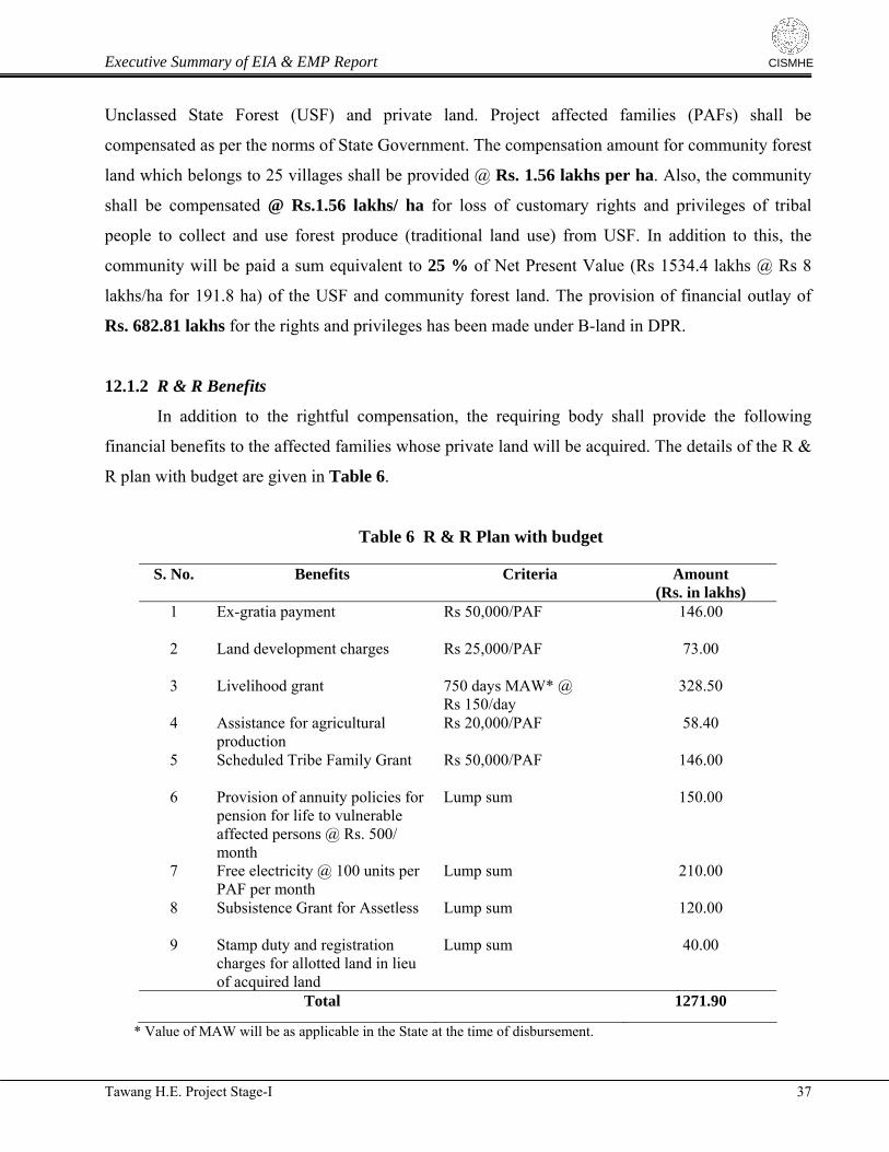
Executive Summary of EIA & EMP Report
CISMHE
Unclassed State Forest (USF) and private land. Project affected families (PAFs) shall be
compensated as per the norms of State Government. The compensation amount for community forest
land which belongs to 25 villages shall be provided @ Rs. 1.56 lakhs per ha. Also, the community
shall be compensated @ Rs.1.56 lakhs/ ha for loss of customary rights and privileges of tribal
people to collect and use forest produce (traditional land use) from USF. In addition to this, the
community will be paid a sum equivalent to 25 % of Net Present Value (Rs 1534.4 lakhs @ Rs 8
lakhs/ha for 191.8 ha) of the USF and community forest land. The provision of financial outlay of
Rs. 682.81 lakhs for the rights and privileges has been made under B-land in DPR.
12.1.2 R & R Benefits
In addition to the rightful compensation, the requiring body shall provide the following
financial benefits to the affected families whose private land will be acquired. The details of the R &
R plan with budget are given in Table 6.
Table 6 R & R Plan with budget
S. No. Benefits Criteria Amount (Rs. in lakhs)
1 Ex-gratia payment Rs 50,000/PAF 146.00
2 Land development charges Rs 25,000/PAF 73.00
3 Livelihood grant 750 days MAW* @ Rs 150/day
328.50
4 Assistance for agricultural production
Rs 20,000/PAF 58.40
5 Scheduled Tribe Family Grant Rs 50,000/PAF 146.00
6 Provision of annuity policies for pension for life to vulnerable affected persons @ Rs. 500/ month
Lump sum 150.00
7 Free electricity @ 100 units per PAF per month
Lump sum 210.00
8 Subsistence Grant for Assetless Lump sum 120.00
9 Stamp duty and registration charges for allotted land in lieu of acquired land
Lump sum 40.00
Total 1271.90
* Value of MAW will be as applicable in the State at the time of disbursement.
Tawang H.E. Project Stage-I 37
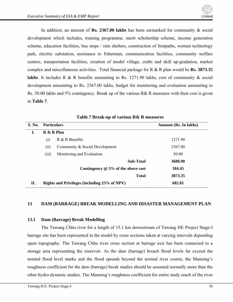
Executive Summary of EIA & EMP Report
CISMHE
In addition, an amount of Rs. 2367.00 lakhs has been earmarked for community & social
development which includes, training programme, merit scholarship scheme, income generation
scheme, education facilities, bus stops / rain shelters, construction of footpaths, women technology
park, electric substation, assistance to fisherman, communication facilities, community welfare
centres, transportation facilities, creation of model village, crafts and skill up-gradation, market
complex and miscellaneous activities. Total financial package for R & R plan would be Rs. 3873.35
lakhs. It includes R & R benefits amounting to Rs. 1271.90 lakhs, cost of community & social
development amounting to Rs. 2367.00 lakhs, budget for monitoring and evaluation amounting to
Rs. 50.00 lakhs and 5% contingency. Break up of the various R& R measures with their cost is given
in Table 7.
Table 7 Break-up of various R& R measures
S. No. Particulars Amount (Rs. In lakhs)
I. R & R Plan
(i) R & R Benefits 1271.90
(ii) Community & Social Development 2367.00
(iii) Monitoring and Evaluation 50.00
Sub-Total 3688.90
Contingency @ 5% of the above cost 184.45
Total 3873.35
II. Rights and Privileges (including 25% of NPV) 682.81
13 DAM (BARRAGE) BREAK MODELLING AND DISASTER MANAGEMENT PLAN
13.1 Dam (Barrage) Break Modelling
The Tawang Chhu river for a length of 15.1 km downstream of Tawang HE Project Stage-I
barrage site has been represented in the model by cross sections taken at varying intervals depending
upon topography. The Tawang Chhu river cross section at barrage axis has been connected to a
storage area representing the reservoir. As the dam (barrage) breach flood levels far exceed the
normal flood level marks and the flood spreads beyond the normal river course, the Manning’s
roughness coefficient for the dam (barrage) break studies should be assumed normally more than the
other hydro-dynamic studies. The Manning’s roughness coefficient for entire study reach of the river
Tawang H.E. Project Stage-I 38
Executive Summary of EIA & EMP Report
CISMHE
has been taken as 0.040 considering the boulder river beds with grassy banks of hilly terrain. In the
present study HEC-RAS Model has being used.
13.2 Disaster Management Plan
Dam (barrage) failure, though unlikely to happen, poses serious threat to human lives,
property and infrastructures located downstream from the dam (barrage). In order to save a large
numbers of injuries and huge damage to property, an integrated disaster management approach is
essential. This approach includes disaster prevention, mitigation, and preparedness. However, failure
of dam (barrage) is a low risk but high impact hazard as they do not occur often but can be extremely
catastrophic. An inundation map depicting the downstream areas likely to be inundated by the dam
(barrage) break flood is prepared. In the event of the barrage break, none of the village / settlement
will be affected because they fall out of the inundation zone. However, infrastructure assets like
short length of road and existing bridge are located on the margins of the likely flooded area. In such
a scenario loss of property could be anticipated in the downstream due to barrage break. From the
result it is evident that up to about 15 km D/S of the Tawang H.E. Stage I barrage, time required in
reaching the flood wave elevation to the maximum is of the order of few minutes. It hardly leaves
any possibility of any rescue or evacuation. Since the time available is very short, therefore Disaster
Management Plan should concentrate on preventive actions. Preventive measures are Surveillance,
Infrastructural Development, Emergency Action and Preparedness Plan. Communication System
will be established and it is absolutely essential for the success of an emergency plan especially
when time is of great essence. Beside Evacuation Plan and Evacuation Team, Medical Team is also
needed. At last Mitigation and Rehabilitation plan is needed. The estimated total cost of execution of
disaster management plan including the communication equipments would be Rs. 740.00 lakhs
14 ENVIRONMENTAL MONITORING PROGRAMME & STUDIES
Most adverse impacts are foreseen for the river water quality, fish, air quality, noise quality and
vegetation of the construction sites. These issues are well addressed in the EMP report, however, they
would require monitoring and surveillance at regular interval. Project developers are suggested to monitor
these parameters through various agencies. These agencies shall conduct the survey and sampling of these
parameters at regular interval for 7 years (for the period of construction). There is provision of funds to
implement various plans by concerned agencies like State Pollution Control Board, State Forest
Tawang H.E. Project Stage-I 39
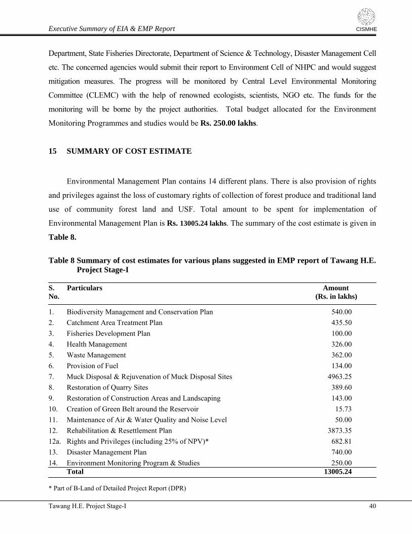
Executive Summary of EIA & EMP Report
Tawang H.E. Project Stage-I 40
CISMHE
Department, State Fisheries Directorate, Department of Science & Technology, Disaster Management Cell
etc. The concerned agencies would submit their report to Environment Cell of NHPC and would suggest
mitigation measures. The progress will be monitored by Central Level Environmental Monitoring
Committee (CLEMC) with the help of renowned ecologists, scientists, NGO etc. The funds for the
monitoring will be borne by the project authorities. Total budget allocated for the Environment
Monitoring Programmes and studies would be Rs. 250.00 lakhs.
15 SUMMARY OF COST ESTIMATE
Environmental Management Plan contains 14 different plans. There is also provision of rights
and privileges against the loss of customary rights of collection of forest produce and traditional land
use of community forest land and USF. Total amount to be spent for implementation of
Environmental Management Plan is Rs. 13005.24 lakhs. The summary of the cost estimate is given in
Table 8.
Table 8 Summary of cost estimates for various plans suggested in EMP report of Tawang H.E.
Project Stage-I S. Particulars Amount No. (Rs. in lakhs)
1. Biodiversity Management and Conservation Plan 540.00
2. Catchment Area Treatment Plan 435.50
3. Fisheries Development Plan 100.00
4. Health Management 326.00
5. Waste Management 362.00
6. Provision of Fuel 134.00
7. Muck Disposal & Rejuvenation of Muck Disposal Sites 4963.25
8. Restoration of Quarry Sites 389.60
9. Restoration of Construction Areas and Landscaping 143.00
10. Creation of Green Belt around the Reservoir 15.73
11. Maintenance of Air & Water Quality and Noise Level 50.00
12. Rehabilitation & Resettlement Plan 3873.35
12a. Rights and Privileges (including 25% of NPV)* 682.81
13. Disaster Management Plan 740.00
14. Environment Monitoring Program & Studies 250.00 Total 13005.24
* Part of B-Land of Detailed Project Report (DPR)