EXADWATER REGIONS OF GULKA.NA AND SUSITXA RIVERS
89
Dm- OF THE INTERTOR . UNITED STATES GE0UH;ICA.L SURVEY ammE m10 SYm. Ih-a EXADWATER REGIONS OF GULKA.NA AND SUSITXA RIVERS WITH ACCOUNTS OF TEE VALDFJ CREEK AND CEISTOCBINA PLACER DISTRKTS WASHfNOTON GOVERNMENT PRINTINO OFF306 1912
-
Upload
khangminh22 -
Category
Documents
-
view
0 -
download
0
Transcript of EXADWATER REGIONS OF GULKA.NA AND SUSITXA RIVERS

Dm- OF THE INTERTOR . UNITED STATES GE0UH;ICA.L SURVEY
ammE m10 S Y m . Ih-a
EXADWATER REGIONS OF GULKA.NA AND SUSITXA RIVERS
WITH ACCOUNTS OF TEE VALDFJ CREEK AND CEISTOCBINA PLACER DISTRKTS
WASHfNOTON GOVERNMENT PRINTINO OFF306
1912


m h m by Alfred H, nmk8--*-h-dd------------d---++------------A Introducti~n-,-,,,--,,,----,,,-,,---------------,+++---~------------ Geographg-----,l,,,h-----------,----dh--d---------44-----+-----4---
r Lacation and arm ,,,-,,,,-,,,-,-,--,--------,---------
T~pograpny,,--,,,-,--------,-----~----------------------------- Retlef----,--,-,+,--------------*~-d-------+--~-~----------
a Drainage-,---,-,-----.------,--,---,-,----------------e-+ Clhab--+------------------------------------------------------- Vegetati~n--,-,--------------~--------+-------------------------- fopulation----------+------------,---,-,--,,---,------+---------- Trails and tmnmrtntjon---_,----- -----------,-+-+---------+---
General $eolo$s -------,--------------------------*------------------- 8tratig~ap~--,-----,,--------~--------------------*---------------
Introductim-,,,----------------------,---,--,,,,--,,,,,,--, Gutkana and Snsltna rlrer redon +----,------,,---- ,,-,--,
Chiutocbina dlstrl&-----,,+--,-------+-------~----------- Pre-Ord~~lcian t ? ) w k s ----------- ,------- ----- -+,-
Birch Cr& 8chlst ,,-,,------- - y- ---..-d------**---.-
@---+---------------------------------"*---------" Probable ~ r b o n L i e n m ~ wdtrueetarg racks -----,, ,--, ,-,,--
Distrlbntian and character -----,----+----*--,-,,- *----------,--------,-------------------+***-----*-+---
Carbo~~iierons rocks-----,-----------------------------*----- Bmilmentarg d-ts -------------------------+--,--------
Cbaractw and dlstrlbation -------------A- ---- --------- Age and ~rrelatiou----------------------------------
Bndc lavss and tuffs ---,-----------------------------+--
Character and distributloll ------A_--------------------- Age-,--,,-+,,-----,-,-------------------------------
RPaeeic mks-,,---,----------------------------,----------- Character nnd dkrtributlm ---------I-^----------------------
Age and currel~tion --,,--,--------------------------,---- Jurassic I?) mke,,-,---,,----------------------------------
Character ant1 distribution --------------------,----------- Age of the dlorike Intnl@ives
Tertiav rocki Character and dlstrlhutlo~~ ,,-----+----+------------------
Age nnd cornlation Quaternary depotilts --,,,,,,,,-"+-----------------------------
DepOl4iti0n --,,,,-,-,,,*,,,,,,--*----------------------- Glnclul depo~lts -,,,-,,-,,,------+-------- ---------------- Wtrearn ~ndlake grarelu---,-,----,-,,--------+-------------
B t p a c t u m - - - - ~ ~ ~ , ~ - ~ ~ - ~ ~ - ~ ~ - ~ ~ ~ ~ - - - , - ~ ~ ~ ~ - - ~ ~ ~ - ~ - ~ ~ - - - ~ a
CONTENTS.

Wlmdcal aeolorrj-,-,--,----,---------------------------------------- Early mlw bifit~tg------,,,-,,+-------------------,---~----- Later geologic hi story---,----,-,-^^--,-------,----,--,-----
Topogmpbic devel~prnent----------~--+----------------,*----- GIaciatlon a,,,-,+---,-,----, -----,-,---------,----, ,,-,,-,-
~ o m f c wlom--",,-------,_------------*-,,,-------------,,,---~--~ Gold -,------,----,-,-,-,-------------------+---+--------*-
V a l d ~ Orwk dftpMFt_ ,---------- k---kkkk-kk-k-k------ ------ Hirrbory and prodnctlon ------,----------,---------------,- -- S O U ~ ~ of the @ld--, ---- -+-+,,-,+------- ----------dm----
M e depmIts PIacer depo~ltk-,,,,-,-~-~__-------------------------------
M&rtrlbnlion ,-,,,, Valdez Creek pmper,,,,,---------------------------- Lucky Gulch,,,,,,-,-,--,,-------------+----------- Whtte and Rngty creeke-,,,---------------------+---- Tlmberlins
DeIh River districL -------,,,,----d----------------*--------- Condltlona nffcctlng ruining --------,,---------_-I-----,-- --,-,,,
Snggestioea coal -------------------------------I----------+-+-------------w-*
Cblatoctdna Wct------------------+-------I-t----------------4-- I n t ~ u c t i m -,--,---------------------------------------------- G-plw am3 dralxiage ,,,,,,------------------- ,- ---------+------
Hl~tam ---,----r-.--r-e------------t--------l--r----------------
Trails ---,,,--,-----------------------+--------ll-r-rl--------
tel-ph fadlltlea ,,,,,---,----------,-,- ,- ---------+----
Gold pla- -------.-------,--------------------I----------
Ontput ,,,,-,,,--------------.------------------*-*-------- rnhikled Mflma--#-------,----+-----+----------,---++--
M H M Gul&,,-------,----,----------------------------- S l a t e C~eek,----~-,-,,-,--~---------------------------- Rig Four claims- -,,------,--------*-----I-r-------- Bitby C~k--,,------,-----------I-----------+---------- Chlmn River,-,,,----------------*----+----------------- Lime Cre~k-,,,-------,,-----~------------------------
Orldn of tl~e old ,,,,-,,,,-,----- --r-I ---------+------------ - Influence of gladatton ,,,,----------I---4---------+------
aonomlc condltton~ ,,,,,,, -, -- Ind~,,-,,,--I-l----.--L--"--I----+--rl----------------------
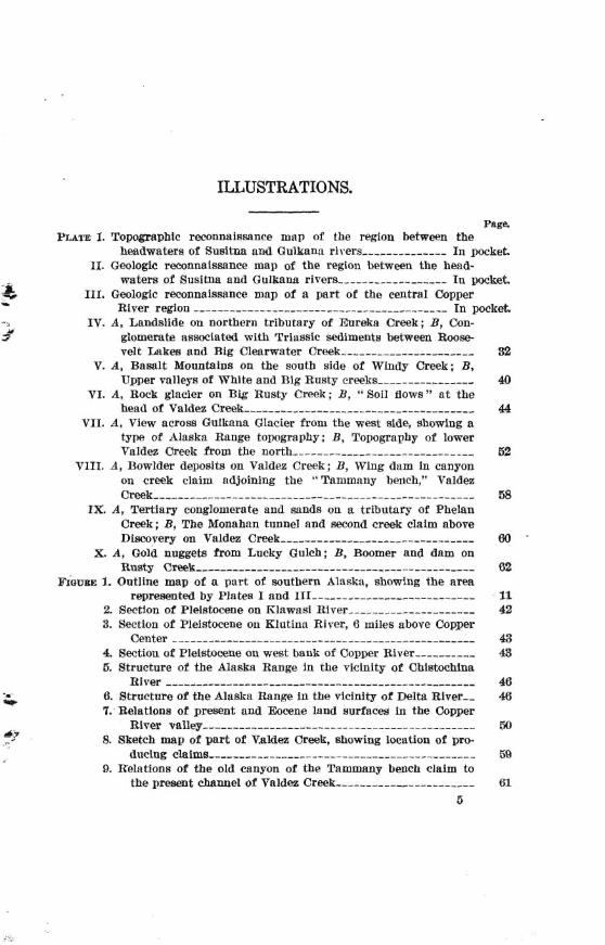
page. PLnm I. Topsgraphlc re~nnaisaance map of the region hiween the
hadwaters of Snltna and Gulkana rivers ,--,---------- In pocket. 11. Geologic reconnaissance tuap of the regton between the hea8-
waters of Susltna ond Gnlkana river% ---------,-,,--A In packet 111. Geologic reconnalemm map of a part of tbe c a h 1 Copper
River reglon ------+----------,----,-----------,-----,- In pocket W. A, Landslide on northern tributary of Eureka Creek; B, Con-
glomerate nsaociated wlth Triassic d l m e n t s between Roo%% velt Lakes and Big Clearwater Creek ------,,,------------- 82
Y. A, Basalt MounCalns on the south side of Wlndy Creek; B, Upper vallep of White and Big Rusty c w k s ------,-,,,-,--, &I
TI. A, Rwk glacier on Rlg Rusty C w k ; B, "Pail flowa" a t the h d of Paldm Creek -,,,-,,---,,-,-----------~--------- 44
VII. A, V i m acroas Gulkana Qhcie~ from the we& rrIde, showing a type af Alaska Range topography; B, Topography af lower Valdex Creek from the north ,--,-,--,-,,----- ,I-, ------, 62
YIII. A, Rowlder d e w i t s on Vald~a Creek ; 3, Wing dam fn canyon w creek claim adjoining the "Tammany hen&," Valdw Creek -,-,---,+,,-------------- - - - 58
IIL A, W a r y conglomerate and mnds on a tributary of Phelan Creek; R, Tbe Monahnn tllnnel md second creek ckim above DirrroveQ w Valdm Creek ,,-,----,---,,-*-+-~------- 80
X A, Gold nuggets from Lncky Gulch: B, Boomer and dam on Rn%tg Crn~,,------,--------------------~++----------+- 62
F~QURE I. Outline map af n pnrt of southern Alnska, ~bowfng tbe area repceswted by Plnta I and If1 ---d+-,,-,,,,-,,CesW-CesWCesWCesWLCesW-CesWCesW 11
2. section of Pleistocene on glawnsi River 42 3. 8ei3lon of Pleiatmne on Klntiua River, ti miles a b v e Copper
Center -------,,-,,-,-,--,--,I- - - - - , - - - d - - - - - - - - + - - 43 4. Section of Pleistocene on wwt bank of Copper River ,,--+,-,,- 43 B. Structure of the Ma& Bange jn the vklnitg of ChMwhina
River - , - , , - , - - - - - - , - - - , - - - - - - - - - - - - , - _ , - - - 46 8. 8tructni-e of the Ala&a Range in the vlclnitg of DeIta R l v e ~ , 46 1. Relations of present and Eocene land slurfacea In the Copper
River wlIey-,-----,,---------------------------- 50 8. Bketch map of part of Valdera Creek, &owing location of pro-
duclng c l n I m L 59 9. Rdations of tbe old canyon of the Tammany beach claim to
the present channel ol Valdez Creek ,,-,------,,-,---- - - 61


PREFACE.
4 Systematic geologic end topographic reconnaissance survep 04 .& M m k ~ were begun in 1898 and have now (1911) been wr ied over T' about one-fifth of the Territory. Tbe first few years were largely
devoted to expbration, the areal surveys being limitad tb the regions adjacent to the routas of tmvel. Later, area1 surveys were made of the mom important mining districts, and by 1910 geologic and topo- graphic reconnakce maps had been completd of most of the districts that had made any considerable contribution to the annual m i n e d output of Alaska. In addition to this, detailed maps had k n made of sevml of the besbdeveloped mining camps, such as Juneau, Fairbanks, and Nome. This progress made it pomible in 1910 to extend the snrveys into new fields and thus to cover some of the less important mining districte. As a, result, the ~lusvey was ~mdertaken of the area here described,
which, prior to 1910, had been known only through the journeys of the indefatigable prospectors. One af the chief purposes of this survey was to map and investigah the Valdes Creek plaoer district, which has k n producing gold for tt number of years.
The geologists, F. H, Moffit and B. L. Johnson, and the topog- raphers, D. C. T"lritherspmn and C. E. Giffi, results of whose surveys are here published, deserve p t credit for the work accomplished. In a season comprising only 74 days the two topographers surveyed an area of 4,980 square miles and the two geologists mapped about
7- - 2,000 square milas b i d e s making a samewhat detailed study of the Chistmhina and Valdez Creek placers. The geology of the Chisto-
-b: chine region was investigated by W. C. Mendenhall in 1 W , rind the results of his investigations were published; but as a part of that district lies in the same geologic province with Valdez Creek end was reexamined by the Moffit party it was decided to indude a sum- mary af Mendenhall's report. in this voluma
.-.
1Meudmball. W. C., Qmlolfj of the central Copper Rlver ngloa. Alaska: Prof. Pnper a, a, awl. e w NO. 11, low.

Amng the important geologic discoveries here set forth is the occurrence of Triassic d imsn t s in this part of Alaska. They are locally metamorphosed by the great belt of intrusive rocks that bound them on the north. The auriferous gravels of Valdez Creek are derived from Triassic sediments, and those of the Chishhha region from Carbonifemus sediments. In both districts the min- ernlization is genetically related to granitic htrusives, and, as in other pa& of Alaska, the gold-bearing veins seem to m r chiefly outaide the zone metamorphosed by the intrusive% Igneous intrusion is common in tKi province, and it seems probable that the conditions favorable to the occurrence. of gold may be repeated elsewhere than in the districts in which placers have already been developed.
READWATER REGIONS OF G m A AND SUSmA RIVERS, ALASKA, WITH ACCOUNTS OF THE VALDEZ CREEK MD CHISTOCHINA PLACER DISTRICTS.
5 INTRODPCTf ON.
-* .' The pnrposs of this paper is to d d b e the geology and mineral re-
murw of an area between the upper parts of Susitma and Gukana rivera me work on which the description is b a d was wholly recon- naimance in character and was not sufficiently careful or extensive to permit ar?rmmte mapping of formtion boundaries in many places nor to debmine fully the structural and strrttigraphie relationships
. between the various rock masses referred to here. The lateness of the spring and the time consumed in trrr~eling to and
fmm the field of work at the hgmning and the end of the summer d u d the time available for geologic work during the o p n seaeon of 3910 to 59 days, of which a week was spent in visiting t h e Chisto- chinra, $old-placer district, leaving only 62 days for studying the region west of the Gulkama The geologic work was part of a larger plm that included topographic a? well as gmlogic mapping, with the object of extending westward the su&eys hgun by T. G. Qerdine and W, C. Mendenhsll in the upper Copper River valley in 1902. This work, the first done by the United States Geological Survey in the headwater region of Susitna River, was undertaken primarily h u s e of the importance of the Valdez Creek gold-placer district and the numerous requests that have been made for information abut it.
r_ The topographic mmapping was in charge of D. C. Withempcan, - who was assist& by C. E. G i h . Their surveys am embodied in the bpogmphic map publidled with this mprt (PL I, in pocket) and
2, form the base for the geologic map that ampanics iL !t'hi geologic map (PI. 11, in pwket) represents the work of B. L Johnson and the writer. Mr. Johnson was d a t e d with the writer in the field studies and prepared the office drawings of the gealogic map. Tl~esa maps, together with those sumeyed by 6. W. Bagley and S. R. Cappsl
1 Capp~, R. R., The Bonnldeld regloa : Bull. U. 8, &I. Sumey No. 501, 1912.
9

in this same year (1910), give a complete section mmm the Alaska Range.
Although the investigations were mrrid on ia a district that had not k n previously descrikd, referawe &mld be made to earlier work in adjacent districts both to the east and to the west. The earlier investigations were begun in 1898, when G. H. Eldridge and Robert Muldrow, of the United States Cko1ogial Survey, ascended the Susitna to Indian Creek, where they left the main river and made their way north into the Alaska Range as far as Ymert Fork of N e n m River. 'Sheir tmil along J ~ c k River brought them to a p i n t within 30 miles of the head of Susitna River and directly we& of it This trip was made under great difficulties, owing to unfavorable weather conditions, failure of supplies, and inexperience in Alwka 1. work, but it yielded the only information yet secured concerning the geology of the disQict between Strsitna River and the Nenana. \ * - z
In the same year (1898) F. C. Mendenhall," of the 'United States Geological Sumy, who was attached to a military expedition, under Capt. Qlenn, rrossed the Copper River lowlands from IMP.tanuska River to Delta River and descended the latter &ream to a point less than 10 miles from Tanana. River. The mute followed by this sxpe- dition wns from Matanash-River, at Hicks Creek, in n general north-
, eashrnlg direction past the e& end of Lake Louiw, one of the larga Susitnn lakes, to the Tangle Lakes. Two large branches of Oulkana River were crossed between Jake h i s e and the Tangle Lakes and nTere mpposed a t that time to be the Qakona and Chistochina rivers represented on Lieut. Allen" sap From the Tangle Lakes country the route led down the east bank of &1tn River as far as Jervis Creek, nt which point the greater part of the expedition turned back b u s e of failing supplies. The sumeys of 1902 differed in charader from two explora-
tory expeditions just d e m d to. In that year T. G. Gerdine and W. C. Mendenhall a made n mconnoimanca topographic and gsologic. map of n large area, including the central. Coppr River district and the south slope of the Alaska Range from Delta River to a point within a few milea of Menfasta Pass. Their work will be r e f e d to later in this xspart* e
Reports of minor scouting tr ip made ta their superior &m by @
members of the two milikarg expeditions in charge of Capts. Glenn and Abercrombia, in 1898, are contained in the reports of thme two b
officem to the War Department.
1 Eldrldge, G. H., A reconnnlaaaace in BaHtna W n md adja-t tmtory, Alaah , ln 1898: Twentieth Ann Re~t, U. R. Geol. B o r v ~ ~ , pt. 7, lBOb, pp. 7-29.
Menaenhall, W. C., A reconmlrnmre from R m m t l o n Bag bo Tanma Bt~er, Almkn, In X R g s : Twentieth h. Rep& E, 8. Gml. Sunreg, pt 7. 1900, pp. 2 7 1 m -
.Mendenball, W. C., and IJehrader, Frank 6, The rnlner~l resaurm of thcl Mount Wrangell dtatdct, Alanka: mf. P ~ p r U. 8. Owl. R u w e y NO. 16. 1903, Mendenball, W. r., fleo~ogy of the central Capper Bher man, All*: Pro& P a p r U. awl. Bur- W p NO. 41. 1906.

Tba writer wishes to express his appreciation of the kindusas shown to himself and ta members of his party by the miners of Vddez C d They are too many to mention individually, but he iEl particularly indebted to Mr. Peter Monahan, Mr. William Grogg, and Mr. Clark Duff for information about the history of mining on Vddez Creek and for many facts concerning its gold p l m that he would not h a w obtained except for their interest in the work. The writer is also greatly indebted to Mr. B. L. Johnwn for many sug- gestions and for much valuable aid in the preparation of this paper.
fiatrI%B 1.-4atllae map of n part of sauth~rn blnako, 8howinp the area reprerreated by Platpa I nn& TI1 (In pocket).
LOCATION AND .* - k The district mder consideration lies south of the Alaska Range
and incTrudes parts of the drainage b ~ i n s of Copper River, Susitna River, and Tanana River. It is included within mefidians 1 4 5 O 20' and 147' M%west tongitade and parallels 6 8 O 20' snd 63" 40' north latitude. Approximately 5,000 square miles of the q u a h g 1 e thm dehed was surveyed in 1910 and is represented on the topographic map (PI. I, in pocket). The location of this quadrangle is shown on the outline mrtp of southern Alaska (fig. 1).

12 HEADWATEBS OF 0-A AND L3uslTNA RIVZI?@.
' rj,ulk&, on. the milittq road from Veldea to Fairbanks, is jmt within the southern hundtlrg of the ares mapped, and at the present time is the point of entrg for .the district. The mapped ama areaex- b d s from the latitude of adkana north to the summit of the Alaska Range. GulEtan~ River and Susitnr River mark its eastern and ita western limits.
T O P O C t m .
RELIEF.
The topographic map represents a district whose northern border is made up of high, rugged rno~~ntains (1'1. VII, A, p. 62), most of which are well above mow line, and c o ~ u e n t I y form a gathering place for snows and ice that supply scores of glaciers and give rise L to hundreds of &reams. Thc! axis of thc Alaska, Range, within the limits of the mhp, runs west-northwmt frmb the mountains nt the \
&
head of Gulkma Glacier through Mount 'Hayes to Cathedral Mom- tain, near the western border of the map, whem it swings to the west, and finally to the southwest, beyond Nenana River, hward Mount McKinlay.
South of the high, mowy mountaim that here form the backbone of the Alaska Range is s paraIIel range, scttrcely separated from the main ran@ west of Maclaren River, but entirely distinct to the east. The mountains oompo~ing thicr parallel range are also rugged, but their peaks are not so high as those on the north, and the snow fie1& and glaciers are absent or am too small to IM considered. Like the main range 'on the north, the trend of these mountains changes frm w&nor&west to west from Delta River snd becomes south- west hyond Susitna River. Still far.ther south is ss third psrallel ridge with an east-west trend, made up of low rounded hi& This ridge is separated from the higher one on the north by a broad de pression and merges on the south into the lake-dotted flats of the Copper River lowlmd. Thus, within s distance of 50 miles from north t o south, the remarkably rugged topographic forms of the mow-covered h k a Range change to the monotonous leveI of the great jntarior basin of Copper River and the upper Susitna.
The difference in relief between the highest and the lowest phta e within the district is approximately 12,000 feet; GuIkana is, 1,300 4.
feet above the sea ; and Mwnt H a p , the high& peak in this part of b
the Alaska Range, is aIm& 14,000 feet abow s e ~ I a d . Susitna %
River, at the mouth sf the Madamn, is appmximak1y 2,440 feet above the sea. In a very enem1 way it may be said that the eleva- tion of the main part of the Al& Range from Delta River to Mount Hayes rsnges from 7,000 to nearly 14,000 fet above sea level ; the average elevation of the next raw to the sonth is sbnt 6,000 feet; and that of the third a d Iowest range about 5,000 feet abow

w l e d , or only 3,000 feet above the lowlands of the Copper and the Susitna. Such figures, of course, are not intended to be accurate, but they m e to give a better idea of the relief of the region than would be gained without careful study of the topojpphic map-
The topography of the northern half of the mapped a~ea ev~ry- where gives evidenm of the effects of intense md nxent glacial ac- tivity. This is shown most plainly in the mggd momtain areas by fie forms of the vaUeys and in the more open muntry flankig the mountains by morainic deposits. Farther south the evidences of glaciation are not so marked, but the broad gravel plains with their h u n d d s of lakelets and their acres of marshy ground are doubtless cloeely connected in origin with the invasion and r e t ~ a t of the iea
3 Topographic f o m in the southern half of the mapped area present a marked contrast to those of the northern half. The hills
.d and monntaias riss fromm a basement lowland where flat or rolling country p d o m i n a k A few prominent isulsted mountains, like the one north of the lower park 02 Maclaren River, together with the ridge swth of it, appear to belong to sn older topography than the high countrg to the north. Angclar outlines have been repIacd by mwth, romdd contours, and in many places flabtopped and tm- raced hills are prominent featam of the sky Iine.
The lowland area p- little relief. Low gravel ridges are scathmd over it and the streams h~ve intrenched then&Ives in its surface,but~esefeaturesaresos~ightastoattractlittleattention '
when seen from the bordering hi5 From the vicinity of Lake Louise the lowland slopes gently toward Snsitna River on the west and taward Copper River on the east. Capper River and the lower parts of its tributary streams have incised their channels several hundred f d below the general surface. Susitna River, on the ather hand, in that part of its course represented on the map, has not been able to d o p m its channel much below the level of the adjacent gravel plains and shows no such gravel bluffs as those present along Coppeer River. The central part of the lowland seems as yet scemly to have been affeded by stmtrm erosion.
D W A C E E .
f The district extending west from Gnlkans River to Susitna River
on the south side of the Alaska Range belongs to three main drainage sgstemsthosa of Capper, Susitna, and Tamma river& The wstern half of the district is drained by Delta and Gulksna rivers gnd the western half by Susitna snd Nenana ri~ers and their tributaries. Bath Delta River and Nenans River blong to the Tanana drainage basin, for although they originate on the south side of the Alaska Range, t h q cut through it and flow into Tanana River. Delta River draina approximately one-fifth of tbe eastern half of the district;

14 HEADWATERS OF GULKABA AND SDSXTITA BIVEBS.
Nenana River only a few aqua= miles in the northwe& comer of the wastern half. Mast of the Su&tna hainage is from the glaciers and snow fields of the high mountains ; most of the G h a drainage k from the lowhrrds ; but that of the Delta, is derived in about equal amounts from the glacier waters of Eureka and Phelan creeks and
, the clear-wah- streams of the intermediata mnge and the Tangle Lakes region.
Gulkana River heads in Gulkana Glacier, but receives most af ita water f om two branches that rise in the lake country on the west. It is a clear-watm stream below G h s M e , b u m Summit Ltlke and Gulkana M e act as set- tanks for the silt-laden water from the glacier. Moreover, for a year or two mbst of the glacier water has been diverted to Phelan Creek and thence to Delta River, so that &
only a vary smdl part reaches the Gulkana. These conditions were re~ersed a few gettrs ttgo, and dwbtlm will be again, for the rive^ . - swings back and forth acrom the gravel bars as the dhbris from the gIacier ammulates along the channsI.
'Shree streams, fed by the melting ice of three large glaciers, unite to form the had of Susitna River. The water from this sonm is augmented by a, number of malter clear-water streams, including Boulder Creek, VaIdez Creek, Windy Crsek, and Charwater Creek, and by rt Iarge glacial stream, Maclaren River. me part of Susitnn River shown on the map flows over a broad gravel plain, but just west of the mapped area it makes a great bend to the right and flows westward for n a l y 'T5 miles in a, succession of rapids and smooth- water stmtch~s through a narroww, mountain-inclosed valley.
The northern or high-mountain part of the district under con- sideration has a well-developed drainage s y h . Laks am few, but streams are many and vigorous. The quantity of water in tha run-off, Iike that of a11 glacier districts, depends on the settson of th? year, local wehther conditions, and the time of day; in other words, it depends largely on the amount of glacier im melting, as well as on the rainfall.
The southern lowland diistrict, on khe other hand, induding most of the Gulkana drainage and a part of the Susitna dminage not represented on the map, is poorly drained. It is a lake country with 4 a great area of marshy land, crossed by a few dwp, sluggish streams. From any elevated point around its border hundreds of small lakes a n be %en, and a journey across the lowland in sunrner involves continuous && to avoid wet ground. AII these small lakes, as well as the S m i h lakes, inchding Lake Louise, which is drained by n o n e Creek, rend the Iarge m m e d lakes between Idre Louise and Gdkana River, owe their existence to the lack of a well- developed drainage system The streams have not yet intrenched themwlves deeply enough into the gravel plain to b i n away the water that acmulstes on its surface.

The climatic conditions of the .upper Susitna snd Copper River +om that are of most interest to miners and pmpectors have to do with the length of the summer and winter seasons, the varia- tions of temperature, the amount. of pmipitation, and the propor- tion of fair or stormy days. These conditions can be d&kd hem
. ody inagenera lway ,~ausenow~thermrdsareava i lab la for more comprehensive discussion.
For practical purposes the year may be regarded as made up of an open sewn-summer, and a c l d season-winter. The length of these w n s diffem, aIightly in the mountain and lowland districts,
& the surnmer bing a little shorter and the winter a little longer in the mountains t h in the open country. Mining is befr;un on the placer claims dong Valda Cnxk early in June. Those who have
C
1 1 0 ~ ~ leave the creek by September 10, in order that they may reach the mast before p s s fails. Others stay a few weeks longer and g~ out with dog teams on the first ice of November. From 00 to 100 days, therefore, are available for mining operations and the rest of the ymr may be said to be winter. Underground mining, of L
cmme, m be carried on through the whola year. Ranges of temperature in this interior ragion am great. T%e
mercury sometimes fa% to 40" or 50" below zero on the m l d ~ t winter days and sometirnw rises to 85" or more in summer. h tern- peraturn of 94" has been known at Coppw Center. Mast of the sum- mer days, however, are comfortably cool, and many of the nights .
are d d . Snow may fdl on the highe~ mountain top at any time of the
yaar, but in summer precipitation in the valleys is in tha form of - min. During She months of August and September rain in the
valleyn is nearly always accompanied by snow on the mountain tops, but such snow usually disappears within a few hourrs. A few inches of snow cavered the valley of VeIdez Creek on September 1, 1910, but doubtless soon melted. A heavy snow that remained till the folIowing spring fell tat P a m n an September 17,1909. These mdy snows afford good traveling, because they am not deep enough to
* ;i make trail breaking difficult.
The amount of rah and mow that faUs on the sonth slope of the Mask Range Is considerable, yet much less than that along the Pn-
w cific, Caast of Alaskn. Valdez Creek is regaded as bs sing district by the miners, although the precipitatim there is pmhbly .less than it is farther east. Rainfell e m s to vary much with local conditions, so that marked difference3 are noticed in l d i t i e s only short dis- tances apaA; for example, it was said that the number of cold wet days in the summer of 1910 was greater at P~RSOR, on the military road, than at Myers, only 16 miles muth at the dgs of the fmthiIls.

16 EEADWATBR8 OF -KANA AND BUFFCI"RA RITEES.
The rainfall: at Gnlgans and other points in the Iowlmd dong the military mad i decidedly led than in the mountains; the grass on the benches d r k before the end of aummmerr, and it is nsoessaq to pmyide mme m- to irrigate gxrdens. Tbs snowfall of the low- land is also light. Snows mme first in the latter part of September or early in Oehbr rand remain till May, depending on the de~ation almae sea level md the: character of the season. The heavg snows come late in the winter, and tha miners endeavor to land supplies and other freight at the mining camps before the lam gets deep enough to be a serioas obstacle ta tm~el .
A record of the weather conditions, kept by the wrirter in the mmmer of 1910, covers T2 days, from June 28 to ??eptembar 7, in- clusive, and shows 28 days that wem d e d he, 16 that were fair, 25
7 that were cloudy all day, and 21 on which it rained part or nll of the day. Ths gulnmer af 1910 was regarded by the miners of the '*
district as an unusually f avorablo smmn in m q m t ta weather con- ditions.
~ R T A T I O ~ .
It is not the purpose elf this report to describe the mgxhtion of this district further than to give the mum general facts concerning the disbibdion of timber and the supply of gram for stock.
Sprnm is the onlg wood of particular value in the a m visited. Cot t o n w d s grow along th~ lowlmd streams, and willows along the dreams t h t e x h d above the limits o f spruce in the mountain areas, especially along the bars of the creeks; but spruce ja the important timber, h t h in mspect to economic value and tb didributim. Tim- b e d areas as de-ribed here are in general, therefore, g~eaa of spruce, and the t i m h r line is the upper limit of spruce.
If a. line is dmwn across the map (PL I, in pmket) in rn @west d i d i o n through the middle of Gulkanr Lake, it will repment approximately the northern boundary of the timbered coun trp. Nearly all the mlintry to the eouth is timbered Iand, a d most of the country to the north is without timber, but them are a number af important exceptions to this general condition. Spruce p w b scat- teringly along the Susitnn River as far north as the glaciers at its head, and smell1 areas along the river are heavily thhred. Small 3 patches of spraoe are found, too, oa the upper part of Cleamater Creek, on Maelaren Riper, to a pint a few miles above the mouth of the west fork, and a m d the TawIe h k e a Timber is present on DeIh River at GamttTs cabin, on Phdan Creek, on Delta River northward from Phelan Cmk, and north along Gulkana Riwr to within a mile or two of Summit h k e .
771% timber line rmes fmm 8,500 to 3,000 feet above sea level. It is i s d y not higher than 2,500 f& in the lower cc)untry mth

of the middle range of mountains, but it reaches 8,000 feet at the h d of Susitma River. Spruce limber is heavy an the muth dope of the mountains between the two big glacim at the head of Snaitns River up ;to sn elevation of 3,000 feet above the saa. W tirnbr also grows about the lower end of Valdes Cmak,, extending south along tha lower hill slopes beyond Windy Creek. Thia is a fortu- nate circumstance for the miners, for it furnishes them with lumber and firewood almost at their does Timberline Creek, which enters Vatdez Creek from the muth a b u t 2 miles above 'the mouth of Val- dez Cmk, was ss named bemu* i t marks the eastern limit of ~pruce timber in the Valdez Cmek valley.
Most of the &reams are h r d e d with willows tb an elemtion con- & siderably above the timber l i n s Tbw aillows are of great value
to the tmvele~, for they pm~ida tbe only firewmd available in mmy ., places within the mountain area. Small willows and a dwarf birch,
usu~l ly called '' buck brush " in this region, grow on tbe lower moun- tain s1opea and on the tops of the lower hills; but they are of no value to t,he miner and in many places are a serious obstacle to travel. The birch is especially troublesome becsuse it grows so thickly aa so form a hngle hard to pen~trate; its stems, rwgh and crooked, hang togather so that a pedestrian must exmi- grest axm to prevent them tripping him or tearing his clothes, and at best make tra-sel exceedingly tiresome, Alder is not so plentifnI in thia district BS it is on the coast or in rhmy parts of the Copper River and Susitna regions, yet there is s considerable growth in the vicinity of the Delta River forks and in a number of other places.
In the lowland areas spruce trees are intemhgId with large cot- tonwoods along the strmms and with p v e s af poplar or aspen on the lugher land. The spruce does not attain as great n size on the open higher ground as alang the stream channels, and tho timber seen along the military road or in crossing the lowlands at other places is small. Many acres of it have been bnrnd ymrs a%o, laving the country covered with a forest of bare pol& that fan tls the roots decay and the wind overturns them. Extengi~e fires in the timber of the lowland area in the fall of 1910 destroyd many of the new
* b r i d p and culverts along tho military road. Soma of these fires were pmhbly eet deliberntalg, either to see them burn or to get rid of the m q u i h s , but probnbly'moat of them wew due to areless-
a nsse in one form or another on the part of travelers. Settlers nw the dry poles of the burned districts for firewood and for fencing, but most of it is practically valuelw. In fact, it may be mid of most of the lowland timber away from the stream murrrss that i t is either of inferior quality or entirely unfit for lumber. No attempt was made to called or study the numeroas of
the district behem Gulkana and Susitna, rivers. Tha supply and 18824"-Bnll. 498---2

diehribution of the g r ~ , however, are sf great imporhoe to the traveler with h m . Fomge is scarce in the lowland district, al- though grass grows wund some of the lakes and in placw along the streams. Only a few places n3ong the militag rod btwsen Gulkana and Summit Lake afford enaugh grsss for horses, so that travelers d e p d e n t on the countv fur supplies for their animals ttre obliged to make their camps according to the distribution of the grass and not by the length of day or the strength of the stock. On the other hand, p s s is plentiful about th timber line in the mountain region, both in t.he strmm vallqa and on the hill dopes. In places the growth is luxuriant. Gram as high es a man's shoulder was seen on Taldez Creek where the brush hed been burned off sevml years ago*
The end of the worlring seamn for many of the minem who ti= 4
horses is detesrmined by the wvere frosts, because the hcrraa are obliged to leave for the coast before the feed giva out. Most of the - p . w loses its vslue for forage as saan as frost strikes it, Although it appears to be good, horses eating it lose strength rapidly unless grain can be fed a t the same time. Amrding to Xr. A. J. Paxgon, native grass for born feed can not be depended on earlier than dune 15 or later &an September 5 in t h e vicinity of Gnlkana and Summit l a k a In some yeam it nay start earlier in the spring or live longer in the fall, but these dates define the limit of mfetg in tht locality. The growing season is shorter thm in the Iowland, whem comes up a week or two earlier and lasts abont as mn6h longer. 'She supply of n d v e feed dong the military road is less imp0rhn-t now than formerly, for p i n can 6e purchad at nearly a21 the d houw.
r n & T I O J .
me population of the didrict is small. The whih population is confined to Valda Creek and to a few localities along or near the military road. There are three military telegraph stations and nine mad houses between Gnlkans River and Canwell Glacier. At the three telegraph offices there are in all about a dozen soldiers, indud- ing operators and linemen belonging to the Signal Corps. The num- ber of people, exclusive, of transients, who live at each of the road houses ranges fwm two to six in summer, but is perhlap a little 4 greater in minter. Bdween 80 and 25 men were mining on Valdea Creek in 1910, snd about 10 mom were either pm~pecting or mining in other loealitia Thus it appears that the white poplrllation in the *
mlnmer of 1910 was abont 60 or 65 in all. The: district has a small native population, but no estimate of ik
number was attempted. Severs1 of the Indian f a m i l i ~ h v e their winter quarters at Gdkana and athem near Snsitna River and the Susitna L&B& One family lives on Valdez Creek. 231- families am ede ly s a t h m d in the eammer at the fishing datiow along the

rivers and later in the m w n in the hunting grounds. It. is there- fore diffieu~t to get & correct idea of their number at these times, whan li ttPe is seen of them on the regular Zim of travel.
Transpartstion in this district, as in almost every other part of Alaska, is one af the ma& serious dilliculties connected with mining. In the esrly days gapplies for use on Valdez Creek were freighted
Valdez GIltcier to Klutina. Lake and fwm them to Susitne, River at the mouth of Tyone Creak, from which place they were taken over the river ice to their destination without ~ r i o u s dif8-
I w culties. The most objectionable part of this mute is Valdez Glacier, where the obstacles to h overcome are so serious that the mute was given up as soon as the military trail was well eshblished. The
Y trail wended St A ~ I River, on the north side of Klutina Lake, crowed Lake Rudson, Taslina Lake, and the Sositna Lakes, and then descended p o n e C m k to Susitnn. River. The grades after cross- ing Valdez GIacier sse not heavy.
Nerdy a11 the supplies used on Valdez Creek fur tho I& five or six gears hsve been freighted over the military trail from Valdez to Gulkana, and thence to Valdez Creelc by wny of the w d fork of Gulkana River and Maclaren and Susitna rivers. Tho difficulty of cmssing the coast range by this route, as by the other, is serious and is one of the principal mum of the high cost of freighting into the Copper River basin, but improvements made from year to year on the military trail, which was at first suitable only for pack h o r n and narrow deda, hsve hrrtnsformed it inta a road, which is pmcticalfy ready for travel with wagona throughout its full length from VaIdez to Fairbanks. A few large bridges and a number of culverts stiH remain to be completed, but doubtless most of them will be in place before the end of 1911. Ditching and grading will also be required on mme stretches, but even in its present condition the r o d represents a great improvement over the old trail and reflects much credit on Col. Richardson and his assmiatas of the Alaska Road Cornmiwion. During the summer of 1810 a new road was cut
k through from the military rond to Chitina, the new town on the Copger River & Northwestern Railway, on the west side of Copper River, opposite the mouth of Chitina River. The new road branchea off the old road at Willow Creek, about halfway betwean Tonsins and Copper Center. It rum east-southeast to Copper River and fol- lows its wast bank to the railroad. A bridge over Tonsina River, which was necessary to make this mad availnble for general use, was completed in tho winter of 1910-11. The winter trail from Gulkana to Valdez Creek, a.9 previously
dated, fdlowa Oulkana River ta the head of its west fork, then

pa- the mnd-topped hill w the north by way of a low divide and comes out on Maelawn River about 7 mi la from Ithe Susitna- the mouth of Maclaren River it follow the Susitna to Valdez Cmek. The distance from VaIdez to Grrlkana is 128 miles, and from Gnlkam to Valdez Creek a~psoximately 125 milea This trail, after the -st mp is passad, offers very favorable p d s s far freighting. From Gnlksna travel is almost continuously on the river im, snowplows being used to break the trail ahead of the sleds. In favorable 9easons travel is attended with little dificultg, but no effort is alw8-p made to reach Valdez Greek before the heavy snows of the l a b winter. This is accompIished more easily now than in former yeam, becauw the road through Keystone Canyon make4 it possible to start fmm Valdsz with freight before the river Ereems in the canyon, thus saving a month or mom lat the beginning of the trip. The mt of f rtrighting from Valdez to Valdez C& a- ahat 1
80 oents per pound. Under the most favorable cifeumatanm it might he reduced to 20 centa, but the exp&ana of several yefirs hgs shown that 80 cents is not far from the average c o d It seema likdy that the cost of freighting may be mmewhat, reduced with the opening for business of the Copper River & Xorthw&ern Railway, but this will depend, of course, on the rates established.
Summer tmvel between Valdez Creek and the d i t q rod is over a somewhat different m t e from that followd in winter. The tmil leave^ the mad at Bear Creek, a b u t 1 mile south of Gnlkana, and runs nodhwast to Maclaren River. It keep to the enst of the round-toppi mountain ItKtweea MacIamn River and Clearwater Creek, and leads to Valda Creek by way of the Rmsevelt bkeg pass, This trail is indicakd on the map (Pl. I, pock~t) . Much of it is over wet pound, and travel with horses is so difficult that them haa been a desire since the military road was put through h m Guhma to Fairbanks to find some shorter nnd better route connecting with it.
Two other routes have, been tried. The more northern one i~ by way of Eureka Creek to the east fork of Maclaren River and thence across M a d a m River and its west fork to Emmelt Lakes, west of Clearwater CmB. The other trail shrh at Pa- and passes through the northern part of the Tangle Lakes district to the west fork + of Maclamn River, from which point the trail is practidy the same as the one just described, The distance i s about 65 mile . The E&s Creek trail is slightly shorter and c r m fewer ridges thm that from Paxson; but it has the disadvantage of considerably increasing the total distanm bebeen Gulkana and Valdee Creek. Both trails are above timber line and the upp ply of firemod is limited to willows, so that neither route would be practicable for winter travel under p w n t conditions, ev8n if they afforded as favorable grades as the one now d. Either, however, would ba 8 pradicsble ~ammw mail route.
Ab a h p t was made seved yeam ago tO establish a winter freight - h g route between Valdez Cseek and Indian Cmk, on Susitna River, but it was not found practicable at t.hat t h e and them has bwn no ahtempt since then ta renew it. A m a l I amount of freight is brought from Fairbanks e d ~ minter by way of h'enana Riwr.
The hard-rock formations of the region under discussion are mm- pEcahd in stmcturtl and n clear undemtanding of their strati- graphic relations and sred distribution wltcl not gained in the short time available for study in the fidd. Thq include both sedimentary and igneous m l r u , and rnnge in age from pwOrdovician ( a ) Birch Creek schist, througll Carbonifero~~s or pmihly earlier to uppr Eocene.
RDLRANA AHn WlRtTNA RIVER EEOIOB.
In summariehg the generill geology represented on the map (PI. a, in pwket) it may tm said that, aside fmm t h ~ Birch Creek .schist, the racks of t h i ~ region which are thought to be oldest consist of peenstones, slak, tuffs, conglomerates, and quartzitic beds, to- gether with a minor amount of limestone, all metamorphosed to a greater or 1- degree and locnlly changed inta sehiis. These d i - mentq which are probably of Carbniferous age, form a belt extend- ing east and west dong the south flnnk of the high central part of the Alaska Range. (See PI. IT.) They were not hIIy differ- entiated from the masive rocks to be mentioned Errter. South of these sediments is a belt of heavy dark-colored, ignmus rocks, con- sisting largeIy of amygdalaidal lava ff ows, wit11 which ia amitlted ra minor amount of tuffs and tuffaceous oonglomerntes. The age of this snmssion of flows and Suffs is in doubt, but they am thought to be younger than the Carboniferous rocks previously r e f d to and older than the Upper Triasic rocks Somewhat Inter than the sxtru- sion of the Iavas there was Inid down a s u m i o n of slates, &sandy shales, and limestone that cantain fossils and are definitely detar- mined tbb of Upper Triasic nge. Their di~t~ribution is only paptly known.
The formations enumerated, which include everything in the regian older than h e , m cut by grnnulnr intnuives, which are believed to km of Jurassic or later age. The moat common and notable of these am diorites or quartz diorites and related gr~nular and pwpl~yritic rocks. They occupy a considerable proportion of the mapped area and are especially abundant in the vlcinity of upper Busitna. River.


The basal member L a thoronghly indumted coarse mngIornemte, not less thnn 600 feet thick, underlying compact and fissile shales, ahve which are slightly iudnrated days and sands topped by an iron- stained pebble bed or cemented gravel, the highest member recomized by Mendenhall. The t ~ h l thicknm of the beds included in the Gakona formation is estimated at not I= than 2,000 feet. Fmsil plants coElect-ed from these beds were pronounced by Dr. F. H. Knowlton t o be typical of the Kenai formation (upper Eocene), which is of fresh-water origin.
Qnaternaq gra~els and glacial deposits are widely distributed md aomplet~ the geologic section of sedimentary deposits in this district. In addition to the numerous dikes m d silk intruded into the Car-
boniferous sediments, two formations wholly of igneons origin am represented 0x1 Mendenhall's map of the Chistochina district. They are the T e t e h volcanics and the Ahtell diorite, regarded by Men- denhall as of upper Paleozoic nge. The Tetelnrt volcanics consist lnrgely ,of altered andesites intruded by basic dikes: for the most part of diabase, but in some places of diorite. The Ahtell diorite is a massive quartz didrite, pink or brownish red in color, and was con- sidered by Mendenhall to be older than the Mankornen formatioe Pmibly, however, the diorite may belong ta the period of 1M-ic intrusion, to IM described later.
StructuraIly the M a b e n formation Jim between the Birch Cmk d i s t and the Chisna formation. It is sep~rated f m the Birch &k schist by a great fault which finds expression in s prominent topographic depression, and from the Chisna format.ion by another f a d t , making it appear to have. been M p d below its proper strati- graphic position, The displacement between the Mankomen forma- tion and the Birch Creek schist is eonsidered by Mendenhall to be not Iess than 10,000 fee.t. In general the beds of the Chisna forma- tion dip southward, and t h m of the W o m e n dip to the n d h . A general southward dip is chamctmistic of the beds of the Gakona fomtion in their expclsum &ween West Fork Glacier and Grtkona Glacier, where they cap a high ridge and form the southern slope of the mountain.
These fow fonnat5ons include the most important roch of the ~ i s t m b i n a district; all but the M~nkomen ere also rep-tad in the district west of GuIkana River.
A ems11 am& of Birch Creek schist along Delta River is m p m t e d on the geologic map (PI. 11, in pocket). It, however, is outaide the district vieited by the writer, and the description of the mks fwnd

them ia b a d ch idy on that of Mi. Capps: who studied the geologic formgtim on the north slop of the Alaska Range between Delta River and the Nenrrns in this same gear (1910).
A more general description of the Birch Creek schist is given by Bmks: who describes it on his geologic map as consisting of " Micsceous, graphitic, garnetifemus quartz schists, and schistma quartzites with m e limestones, also including some greenstones and other igneous mks, locally mineralized and auriferow"
The known arms oi Birch Creek schist extend eastward in the +on no& of the Alaska Ran@ from the vicinity of Mount Mc- Kinley into Yukon Territory. Capps describes the formation where studied by him aa showing much variation in the character of its component members, yet distinctive as n whole and easily recognized. Highly contorted irnd fimile mica and qua* sch* and phyllites, - green, red, brown, or grny in color, am the predominant rocks, In il few localities the fresh unaltered rocks are comparatively massive and mica is inconspicuouq but in weathered oukmps the fissility is made prominent and the large amount of mia present gives the surfam a glistening silvery luster, Oxidation of the iron pyrih changes the prevailing green color of ths original rock to red or brown in w m t h e d expwuras. Varihon in the dqyw of didazity I s ,k?~;he rule rather than the amption, mme of the d, as previously stated, being massive and without well-developed cleavage, wtde others split readily owing ta the large amount of mica present. B d s of metamorphosed quartzite sre interbedded with the mica schists, in pJacea ahowing an imperfect cleavage due to the deveIopmenL of mica d e e . Dense beds of graywacke and fine bIack slate or slaty schist are also ussociated with them. Qusdz-mimschist, predomi- nates In the district west of Little Delta Rivsr, but in the vicinity of -Mount H a p the l~ metamorphic q~znrtzitic and slaty whisks be- come important, FO that the whole s u m i o n more nearIy resemblas that of the type locality north of Fnirbnnks. On Delta River gush-mica schist $oms an irnport~nt part of the stream wash and is beljeaed to be well developed, altl~ough Capps was unable to study the area ~8refully.
G The Birch Creek schist is intruded by a variety of igneous rocks ranging h m gmembnes and bomblends rocks to more acidic varie- ties and varying in textur'e fmm fine-grained cherty types to p n i t e porphyries. These intrasivea differ widely in metamorphism also, for some are entirely fresh, while others show drnost as great altertt- tion as the inclo&g schist. Capps blieves that the Birch Creek schist in this area is derived chiefly from dnstio sediments, but shows that igneous members were amociaed with them also,
l c g p p , IJ. a. jr., The Bondfield region: BuIl. U, S. Geol. Burveg Ne. 601, IBLB. p. 20. Brooko, Alfred H., The Mount McKinley region, Alamb: PmC. Pnbx U. & Qwl. Bur-
pel NO. '14 1a11, pp. 5840.
26 HEADWATERS OF ~KCXAHA AND BUSIXNA E~VERS.
The members of the Birch Creek have been closely folded and i n t e d y xsetamorphosed, ssr that the structure is intricate and difficult to d&rmina In meet places the bedding is obscured by the mhistosity, yet the major structural feahms may te made out from
- a study of large masses of the rocks, and it is seen t ha t the strike of the U s is rou&ly parallel to trend of the Alaska Range, while the dips of the beds range frmn 15" to 60".
The age of the Birch Creak d i s h has not been determined. No f d s have been found in it. It appears to be overlain unconfolmm- ably by a m d o n of quartz fddspar schists containing d3es and a little limestone that is considered by BrooksB to be of Silurian or Devonian age, He regards the Birch C m k schist, therefore, as prohbly pre-Ordovician, 't
DIFITRIBUTIOIP A I D CHAEA-
About a mile north of Myers road house on the m i l i b y road there is an area of w n i s h mica schist mt by light-mlored granitic intru- ~ives and by d h of dark, heavy, basic rock The granitic intm- shes are ~hmred and have a definite cleavage, but the dark-colorid dikes are fmher and apparently younger. The exposures axe too poor and the examination was too brief to yield d&te information, but the schish' show much greater metamorphism than the near& Carbonifercrus dimanta toward the north nearer the zone of more intense folding in the Alaska Range. In the vicinity of the Tangle Lakes similar &ish are intruded by
d i k ~ of light-colored, fine-grained mk, containing small hornblende phenocrysts, probabIy related to the diorite. The schists of these two areas lie south of the principal zone of
lava flows and me thought to lw. part of a fargar area of schisb and m i r t t e d igneous rocks, chiefly greenstone and diorite, that form the low rounded hills at the no*ern barder of the Copper Xver Iow- land 9
mlL
Any astimate of the age of the %hi& would be little more than @ation. So hr as the degree of metamorphism is of d u e in de- -
iermining age it indicates that the mhists are older than the nearest ~arboniferohs sedimentary formations toward the north (at the head of G u h a River), &ch are so situated with reference to the
*Broolra, k a, The Momt McKltlley region: Pmi. Paper V. 8. M. 8urrrey No. 70, 1911, g. 69.

CARBONIFEROUS ROCKS. 27
axis of the Alaska R s n p that a greater degree of folding and mare pronounced schistosi ty would be expected in them than in the whists if the disturbances that produced the range accounted alone far the alteration in both. LocaI schistosity, however, is not uncommon in the CarGoniferons deposits.
Under the heading " Carboniferous rocks " are grouped a number of formations of widely different character, They consist of s d i - mentary deposits, such as conglomerates, limestones, quartzites, vol- canic tuffs laid dawn in wntcr, and intercaFatd lava flows or
s intrusive shets. The age of the scdimenta may be referred to Car- - bonifemus time with considerable, but not absolute, certainty- The massive Carboniferous Iirnestonea hare been distinguishetl from as-
- m i a M racks on the geologic map ( PI. IT, in pocket), although they are not treated as n distinct formation in the tex t . The basic lavas and tuffs are r e femd t o UEC C~rl~oniferous with less certainty, and they may prove to be of Triassic age.
East of phelan Creek and apest of DeIta River northwan1 from Eureka Creelc to Canwell Glacier, the high ~nountains consist of dates, h f f w n s W, qnrtrtzitic sediments, and local limestone beds associated with diabasic dows or intrasions and with light p y or greenish wises that probably represent rnetmnorphomd diorite i~ltrusjons These M s are much foIded and in laces a whistom structure has been developad. The weathered surfnws of many of them hare a rusty red color that renders them particularl~ con- spicuous and makes them recognizable at long distanms. The same rocks extend eastward to the Chistochinn River region, wllero ihey were named the Chima formation by Mendenhall, nnd westward on the north side of Eureka Creek to at l a s t as far as the glacier at the head of the main fork of Madaren River. Whether they continue west to Susitna River was not determined, but it is thaught probable that 'they may extend even farther westward into tho heradwater region of Nenana River.
- In the vicinity of CanweIl Glacier and eastward the Carhniferoua deposits abut against the Birch Creek schist on the north, this p s i - . tion being due to a profound fault whom extension and Iocation west of Delta River is not known. The possibility that the rocks de- scribed as Carboniferous include some infolded Mesozoic sediments will be discwed in the description of the Triassic deposits.

The evidenw for the of the Carboniferous sediments is not sufficient to determine definitely the time at which they were de- posibd. The only fossils co1Iected are crinoid stems from the magsive limestone beds outcropping east of Gulkana Glacier and on El~reka C d , and the evidence they affofd is merely presumptive, S o fossils were obtained from the 0 t h sedimentary M s here referred to the Cerboniferous.
Some light is thrown w the problem by the relatiom existing in the region immediately east of that under consideration. Bfenden- hall ' found a great thickness of Carboniferous strata in the head- water region of Chistochina River and divided them into the two 5 formations which he nsmd Chima and Mankomen.
Parts of the Mankomen formation am abundantly fo&liferous, and on the basis of the fossil determinations the formation w ~ a - originally referred by Sehchert to the Pennsylvanian and then to the Permian, but was Iater reassigned to the Pennsylvanian by Girtv md is correlated with the Pmnsyl~anian of the White Rimr regians and with the Nation River formation a of the Yukon. Girty's deter- minations show the fauna of these Imlities to b unlike t h ~ t of central and eastern North America and to represent the Russian GscheIian of the Ural Mountains.
Mendenhall correlated the tuffmus beds of Phelm Cnaek with the Chisna fomat.ion, and there can be little doubt that the correln- tion is correct. The Mankomen formation, however, appears to have him faultd out, for no'evidence of it has been m@d west of Gulkana Glacier. Minkomen fmils abound in the high mounhin east, of the lower end of Oulkana Glacier some distance above the massiw limestone bed there exposed, bnt all collected mere from loose material on the mountain slopes, and i t was considered quite possible in the fidd that the material was not in place, but came from somewhere nearsr the head of the glacier. No similar fmils were found west of Delta River. The best available evidence for the age of the m k s north of Eureh Creek, here correlated with Menden- hall's Chisna formation and referred to the Citrbdfemus, indi- cates that they are older than the Mmkomen formation, It is en- d tirely possiMy, however, that more field work would h sve shown that they indude Mesozoic sediments, such as were found farther west in the neighborhood of Valdez Creek but were not recognized east
- of Maclamn Glacier,
Hendenhall, W. C, Wlopg d ths ceattal Coppr BIwr reglw, Ahnkn : Srof. Paper u. B. am!. survey No. 41, 1006, p. 83 and following.
*Ifonit, F. R., and Knopi, Adelpb. Mlneml resoum%-s of the Nabma-Whlte Rlrer dlb tact, Alanka: Ru11. U. 8, Qd. 8amq No. 417, 1010, p 1%'.
*Brooke, A. H., and Kindle, m. M.. hlmwlc and -latd cab of the upper Yukon, AILla~ta: Bull. -1. 80c. Amedea, ~01 . 10. 190&, pp. 291-804.

In s lbmder way Brook has comlatcd the Cbma formation with the Cantwell formation at the head of Nenana River, the We1le~- ley formation on White River, and the Nation River formation af the Irukon, The Cantwell formation, as described by Brooks, is a maesive quartz and &el+ wng1omerata, with brown sandstone inter- bedded with black clay shale and volcanic mch. It has a th iekne~ of more than 3,000 feet md is pmvisiona21y sssigned to the Carbon- iferous on stratigraphic and not on fowil evidence. If this assign- ment proves correct, Carboniferous sediments form rm important pad of the AIeske Range, at least from Mentasta Pas to Wenan~ River.
B m a UVM m~ TO=
Z a n m c m u AND m~mmmon.
The belt of heavy, dark-dored, volcanic rocks extends from tha * viciaitg. of Summit and Gulkana lakes westward beyond Susitna
River. the^ pocks consist largely of diabaso and locally are amygda- loida1, showing that in pad, at least, they ara surfam lava flnws. They are aswciated with argillitw, tuff 8, nnd tuff m u s conglomer- ates in a number of places and ara intruded by diabaw and by dikes of legs bnsic, hght-colored porphyritic rock. Intrusions of perido- tite have taken place in the Tangle Lakes vicinity and probably aha in other places, for bowlders of this charncter were found in some of the yoanger cmglomemtm near the glncier ~t the head of the east fork of B1aclaren River. The lava flows have been deformed in the general folding of the region sa that steep dips are common, and s c h M t p is occasionally developed. These flows form a prominent mnge of mountains parallel with the axis of the Naska Range and not sharply separated from it in the vicinity of Madamn River. This m n d a r y range is chnmcterized by sharp angular outlines, due chiefly to recent glaciation but probnbly dependent aIso on the nature of the m k forming it (PI. V, A, p. 40). The main Mt of these v o l d a is at least 15 miles wide on the east aide of hlaelam River, and isdated hills and another lower range made up in large 6ad of ~imiPar rocks lie to the muth and are perhaps a part of thw sarne m d o n of flows. A great difference in the appearance and amount
Is; of altaration at different ImIities suggests that the ~ o l ~ a s i c out- bursts W B ~ intermittent during a long period, but the field shdies were not sufficient to prove that ~uch differences exist within the main belt of volcanim.
h Q L
The evidence available as to the ago of the basaltic lavas is not dcimt definitely to determine the geologic time in which the flows
XBrmbs, A. H, The Mount MeRinler redon, Aid: Proi. Pam U. 8. UeoI. Burner Na 10. 1811. p. 83.

80 HEADW~~TEM OF QULKANA AND SUMTNA RTVERS.
took place and pmibly not even the relative age of the flows d of the dimmtary formations with which they are associated. The cir- oum&nm from which the conclusions of the report are d d u d are as follows : New the mouth of Eureka Creek amsaion of limestone beds,
Hack and gray shies, and associated ditbbaas, dipping 40° to 50" S., appear Go pass beneath lava flows and are, therefom, ~uppmd to be older. A p i b i l i t y of error, however, lies in the fact that the exact relation between the mdimenb and the lava flows is not known and f i a t faulting or nn overturned fold may have ohcured the facts. Southern dips of the lava flows were observed at other localities, par- ticularly on Madamn River, but in none of these plam were condi- tions for obsemtisn so favorable as on Eureka Cmk.
The mountains west of Clearwater Creek and swth of the pass to Valdez Creek are made up in part of lava flows and in part of ssdi- mentary deposits which include a nnnber of s d l limestone beds mntaining Upper Triassic fosds. In several p l m these limesEma beds overlie the basic eruptive rocks and both exuptiyes and sedi- mentary beds dip, t;o the north. Here again the exact nature af the contact relation Imfween the two fornations is in doubt, but the evidence at Band seems im indicate that the sediments are younger than the volcsania It therefore appears probable that the lavas were poured out either in late Carboniferous tima or during emly or Middle Trimic time.
In this connection it may IH stated that the massive Carbonifwow limestone of t h upper White River wmponding to the W o m e n formation is underlain by Carboniferous &alas, tuffs, and Ism flows and is overlain by similar rocks in which the lava flows predominate gmtly. In the Cbitina Valley the Upper Triassic Chitistone lime- stone rests on several thousand feet of diabasic lava flows known as the Nikolai greenstone. ?'he Iava flows of Eureka and Windy creeks resemble the Nigolrsi greenstone both in character and in their rela- tion to the associated Triawic sediments and s u m a strong prob- ability that their extrusion was approximately synchmous. On the other hand, a large area of Middle Jurassic volcanic rocks
in the Talkeetm Mountains just w t h of Susitna River and much nearer the region under considemtion than the Wmngel1 Monnbins, differ from the volcanic m k s along Windy Creek and south of Eureka Creek in the important mpect that they consist of- less basic meterials, being made up of mdesih greenstones, dacites, rhyolites, and a m i a t e d tuffs. For t h i ~ reamn and for the stmtipphic nw- sons s l d y given it is thought that the Iavas of Windy C m k are not equivalent to thw of the Talkwtna Mo~~~trlEns.

~ W A I C E l l E OF GULKANA A N D SUSITNA BTVERg
On the muth side of Cod Creek, a tributary of the Cleamwtar, several hundred feet of horizontal, thin-bedded, shrly limestone and calcsreous mndstone ere exposed, extending Erom the creek nearly a third of the way up the mountain. The main mags of the mountain consists of basalt, against which the sediments abut in such a way asr to suggest that the contact relation is due either to faulting or to unconformity of deposition. The lim&ne frag- menB show numerous Upper Triassic fossik Many bowIdem of
1 r
black fossilifemus 3imestone are found in the crealr bed and are probably derived from a, bluish-gray limeetone, not less than FO feet thick, overlain by md weathering shaly or tultFacews mks,
a which appears in the lower part of the mountain on the north. West of Clearwater Creek and muth of its tributary which heads
near the Iloosevelt Lakes bluish-gay limestone beds yielding Upper Triassic fossils were found in several pIaces resting on the volcanic rocks, They a m littls metamorphosed and are s d a t e d with banded slates, black slates, red weathering datm or shies, gray- wackes or fine tuBs, tuffaceous conglomerates, and diabam flows or intrusions. In general the beds dip north. They are intruded by diorite and related hornblende porphyries and feldspar porphyries. Fossilifemus limestone is exposed in m a of the gulches an the north aid0 of the creek heading near the Roosevelt Lakm, and, although the fossils collected yielded no evidence as to the age of the lime- stone this is thonght to belong with the Triassic sediments to the mtk It appears, themfore, that except for this one undetermined outrrop the h o w n ffossiiliferous Triassic sediments are near the boun- dary of the belt of lava flows. A number of limestone outcrops near this boundary, north and northeast of the head of Windy Creek, difler slightly in appearance from the lseds previousIy mentioned and may pcmibly be of different age, although the only masons for such an assumption at present would be that the limestone is crys- talline in character and apparently contains no fogsils. The pres-
'L enm of intruded igneoas rocIrs in the vicinity, however, is hlieved to explain susciently the alteration of the, limestone and the absence
- of fmds, for the recystallixation of the limestone would tend to d&oy any animal mmains that might have been present.
, The heterogeneous character of the m k s associated with the Triassic l imeshes m d the mks immediately north of the lime- stones and apparently overlying them, especially a massive con- glomemb a mile or mare aontheast of thezRamvelt Lakes, suggests the pmence of younger Mesozoic or pwibly Tertiary sediments in this regim, but no fossils were found to support this pmibility. The

best exposurm of this conglomerate is in the mountain between tha branch of the tributary of Clearwater C m k heading against Winsy Creek md the branch heading toward h m l t Creek. The wedern face of this mountain is a mrassive conglomerate made up almost entirely of igneous rocks, chiefly dark, basic voleanica, but with a considerable amount of gmnitic m k in e groundmass of tuffaceous material. The pebbles and cobbles are well rounded and many of them are a foot or more in diameter (Fl. W, B) . This conglom- erate, afthongh it forms a Iarp part of the mountsin, is restricted to a small area, probably less than 2 square milea No similar con- glomerate was seen at any other locality during the summer.
The belt of A s included between Valdez and Windy creeks on the w s t and errfending eastward along the boundary of tha lava flows to Maclaren GIacier includes an assortment of rock types that con- fww and hides the main plogic f a d This belt includes the - Triassic limestone beds and the cong1omerate just d&M, but con- sists largely of datm and intercalated basic igneous flows or intru- s ive~ , all of which anre cut by p n n l a r intrusives of dioritic or related characters. They differ from the rmks bounding them on the north in that they show less metamorphism, the sediments being changed to elates rather than schists and the diorites being little altered, thus pm- ~ n t i n g a strong controst to the schistose and gneissic diorite north of Valden Creek. These differrnces are brought out in the area nortl~ and west of the head of Clearwater Creek, where the slightly altered graywackes and shales or dates are in contact with schistme diorite, a relation which 'may be due either to faulting or to depositionaI uncon- formity, but which, from the seeming absence of cong~m8mh or sandstone, is probabIy due to faulting rather than to deposition. Unmnformity of depasition or faulting would also account for lehe difference of metamorphism in the slates south of Valdez Creek and the mhists north of it. The hills immediately north of Valdez Creak consist of sehishe
sedimentary m k s and much-altered diorite intrusives. Schistositp is p a t e s t in the vicinity of the diorite, particularly mound the bor- ders, where thin dikm or d b b v e been forced into the sadbents along the bedding ar cleavage planes, and is a m m p i e d by the, 3 formation of ~ e t and kyanite. Kysnite is a mineral charactsr- istic of the highly metamorphic sedimmts and is believed to be formed ilnder deep-seas conditions of high p m u r e and temperaturn. At - the time this lmlity was visited it was supposed that the s&i& represented a 1-1 advanced state of metamorphism in tha general d a b area of VaIdez Cmek, due to the intrusion and immediate p r e enm of the diorite, bat the possible existence of the fault previously mentioned the supposition in doubt and makes it &bla that the schists north of VaIdez Creek and the s l a b south of it are not equivalent. With the evidence now at hand it is impmible to

I ~ -
.4- . - 2 - - T w i t ' . >
T i - . - Pl
. -

dletxmine whether the schist a m should be mapped as part of the Carhmferous rocks to the east, as part of the Triaseie diments, or as differing frcHn both.
A(IE AFU CORBEGATIOA.
The age of the Diassic rocks wsa determined on the evidence of the fossils collected from them and submitted to Dr. T. W. Shnton for identifiation. The substance of his report follows, the numbers given to the three lots being thom of the Xatianal Museum:
Na8570.-LLme&one area on n amnlf western trIbntarg of Cleamater m k .
Ehlobta m. related to H, eui~erba M u j s l m l a Traplta sp. Diwotropftea? &D. hlK!@St~ Fp.
!#e$e fmnllu belong ta the Upper Trlasslc fauna. No.65?l.--Cool C m k , n trlbt~tnry of Clcarwater CrwIr, It5 mLlm east
of 8urrIm Rlrer. Pseudomonotiu uuklrcnlarl~ (Gahb) .
Tbls is.n chmcterlatlc I'ppe~ TrinwIc spPdea. No.8512.-Wmt of Clenrwater C w k , about 2 mllea n o r t h w ~ t of the
loeallty from whlch Ro. 6570 Was taken. Serpula sp.
Horlwri not Uctermlnable from this fossil.
The first two lots of fossils show that the Triassic limestones of this region axe eqnivnlent in agpr to t.he Chitistone limestone and the McCarthy shnle of the Chitins Valley and with the Triassic limeetona of the N a h n a River region. Gpper Triassic sediments in Ckitinrs Valley &tab a thickness of not less than 6,000 feet, of which the lower part, known as the Chitistone lim~stone, comprises 8,000 feet. The thickness and areal exlent of the Triassic =dimen@ in the Nabema region is unknown.
Upper Triassic deposits are also jound in the Cook Inlet and Alaska Peninsula regions."ey cunsist of thin-bedded cherts, Iimestonw, and shales generally much contorted and containing many intrusive masses. The base of the s~~ccession 11m not been obwved.
A large proportion of the known Triassic deposits of Alaska lio
P south of the AIa& Range, and future work will probably show that they have considerable deveIopment in the upper Sasitns region, as well as the Cook Inlet and Chitinn River regions.
The Jurassic, if present in this part of the Alaska Range, is rep- rewnted by i-us mcks. No dimentery deposits are known here
"hton. T. W., and Martla. G. C., Mcaoeolc metIon on Cook Inlet and Alaeka Penfn- wta: Bnlt Gaol. ebe. Amerlca. vol. 3% 1906, p 410.
IgS24'-B~ll. 49&12----5

34 READWATERS OF OULXANA AND SUBITNA BTVEBS.
that can with much certainty be referred to the Jurassic period, not- withstanding the fact that both dimentary and igneous rocks of this age are widespread in the Talkeetm Mountains, only a short distance southwest, and am. found in other parts of the range.
The rocks tentatively referred ta the Jurassic, chidy quartz di- orites and related p n n l a r intrusives, occur as dikes, sills, rand large masses of irregular form i n h d e d into the older sedimentary and igneous rocks. Tme p n i t e s were not found in the region studied.
The diorites are prevailingly gray in color and differ considerably in alteration. In some exposures they appear ta be perfectly fresh, but in others they show well-developed cleavage and are schistose. Examination with the microscope shows that the typical diorite of the region is m m p d essentialIy of soda-lime feldspar, hornblende, C
biotite, and quartz. Hornblende is more plentiful than biotite in marly all the specimens examined. Pyroxene is generally prasent a
mnd alters to hornblende. Both hornblende and biotite alter to chlo- ritic material. Other secondaq minerals are epidote and zoisjte. Titanitcl, apatite, mrtgnetite, and ppite aro accessory minerals. Such jntmsives are widely distributed near the head of Susitna Rivar, and am believed to be wnftedd with the source of the gold on Valdez Creek.
Most of the smdIer ma=, such as dikeg 8nd sill^, have a porphy- ritic structure. A few of the dikes show large phenuqsh of feld- spar, but hornbIende are far more common, Thm seem to be al l gradations between qud-hornblende, diorite, and rocks consisting almost entirely of hornblende. A specimen of this last type, found in the mountsins between Roosevelt and Windy creeks, c m ~ i s t of large blade-like crystals of hornblende in which am scat- . t e d p i n s of feldspar, apatite, and magnetite. A little vein of epidote cuts the hornblende in one specimen. This dark hornblende rock i s present a t many localities in the Alaska Range between Susiha River and Chistochina Glacier.
Diorite intrasives are common at many places in the district, as ia shown by t.he geologic map (Pl. lT, in pocket). They cut the Trias~ic dirnents, and are, therefore, younger, bnt they do not appear in the Tertiaw deposits. OR the north side of VaIdsz Creek they in- trude slates and show a great numnber of apephyses ehnding as aills
C
nnd dikes from the main mass of the intrusive into the sediments. Both the intrusive snd the host have since undergone ftidher altsra- L
tion, for the diarito is schiatose, but them may have been consid- erable conta&rnetarnorphic action at the time of intrusion. The slates in the vicinity of the contact are. much ahxed and have de- veloped in them a great deal of grlrnet and kyanite. Kyanite, though it is generally a product of dynamic metamorphism lrnd is ususlly found in the crgst~lline schisti3, occurs lmI1y in ~)ntact-rn~morpl~ic zones.

The principal evidence as to the age of the diorite found in this regian is tbe fact t h a t it intrudes t.he Upper Triassic sediments, but has not invaded the upper h n e deposits. On this evidence, there-
. fore, it is younger than Uppea Triassic and older than upper Eocene. Paige and G o p f have presented evidence to show that the quartz diorite intrusions of the TaIkeetna Mountains are younger than Mid- dle Jurassic and are contemporaneous in R general way with the great series of intrusions that affected h s whoIe cordilleran region of North and South rlmerica. Brooks and Prind1e2 consider the period of intrusion to have been post-Middle Jurassic and to h8ve
t I extended into the Cretaceous. The didrite intmsions of the Chitina
Valley are younger than Upper Jurassic, for they cut the h n i c o t t formation, which is probably of Upper Jurassic age, md possibly - extend into the Cmtaceouwn
It appenrs probable t h d the dioritic intrusions of the upper Sn- sitna region may have extended over a considerabIe length of t h e , as is suggested by the diflererlt degrees of alterstion which the in- truding rocks present, ancl tllnt they are to lm referred ta the lata Jurassic rand early Cretacmus epochs.
TERTIARY ROCKB.
CHABACI'M AND DIBTPIBFI'IO~.
A mall creek that comes down from the mounbh an the east and joins the Gulkana Glacier stream a short dishnee below the south end of the gluier has cut its channel in a succemion of folded mu- glomerates and prtly indurated clays with which are interbedded thin seams of cml ranging in thickness from a fraction of an inch to 3 inches, The clays are banded and show fragments of plants. This succession of seclimentarg beds strikes east and w e d and dips steeply to the north. With it: am associated soft, highlya1ored clays, yel- low, white, and bluish gray, which exhnd up the hill on the north to a point several hundred feet above the meek.
The bills sast af the part of Gulkana River between Summit L a k e X. and tha glacier show bluish-gnty clays in some of the s tmm cuttings,
but are made up in Jarge part of m~wllidrated sands and gravels, tilted tlt angles as great as 45O to the horizontal. In many places
I
they contain bds of carbonized wood or lignite. Gravels of this character are exposed on both sides of Isabel Pass and seem to extend
llWgef Bithey, and Enopf, Adolph. &lWe recOUnSisnnncc In the Matanaeka end Tal- heeta* baalne. Maaka : Bull. U. 8. Gml. Survey No. 327. 1907. p 20.
* R r w a k H., m d Prlrtdle. L M., The Mount YcKtnlcr region, hlaata: Ptoi, h w r U. a. GmE. 8 m e y No. TO. Igll, pp. 117 md 153.
~YofflfRt, F. H., and Cappsi, R R., The polom and mineral m u r e e n of the Nlslrim die- trlct. Alaska: Ball. U, J. Gml. 8 m e y h'e. 448, 1911, p 38.

up the mountain on the north side to an altitude of nearly 2,000 feet above the mek, or elmost to the summit. The high mountain east of the south end of GuIkana Glacier appears to b made up of a mamive but poorly consolidated conglomerate containing a great many fogsiliferous fragments from the Manhornen formation. The tributary of Pllelan C m k on which the road house and the
militaq telegraph station are located cuts a, deep canyon in a high bench flanking the mountaingl on the east. In thc lower part of this canyon the wall'rock consists of brownish-yellow conglomerate inter- stratified with thin sandstone beds (PI. IX, A, p. 60). The mnglom- emte is firmly cemented and confines; the creek Getween vertical mnlls, but it can be readily broken down with the pick. It strikes N. 6 5 O
*I W. and dips 20" to 30" NE., in cmtrast to the gravel and sand be& - ~outh of Isabel Pass, which dip 45O S. k i a t d nj th the conglom- erate and s a n h n e are several h u n d d feet of unconsolidrtted sands and gravels, separated from the congIomerata by a north-south fault. Apparently the unconsolidated material, which is composed of p a y clays, pure white quartz sands of exceedingly fine grain, end beds of lignite up to 2 and 3 feet in thichm, is the Iawer parf of the euccamion of beds to which the conglomerate belongs. The lignite beds are filled with sand and resernE-he broken driftwood nmmula- tions on a beach. Carbonization of the wood has advanced only a libt]@ WRY md the w d y structure is distinctly visible, so that the pieces resembIe charcoal rather than coal. A11 these deposits are overlain unconfarmably by glacial till and grsveh.
4
lTellow congIomeratea like those described nre exposed on Delta River bellow Wild Horse Creek and in the hi11 between Phelan Creek mtnd Delta River. In fact this hill appears to bc almost made up of Tertiary deposits, covered by a thin veneer of glacial till.
, Rocks referred to tho Tertiary were found a t two localities west of this point, The first of these is north of the head of Eureka Creek. On a mall tributary heading in the mountain east of the glacier from which Eureka Creek flows yellow iron-stained con- glomerate and sandstone like those previously d m i b e d are exposed. This outcrop appears b be mall, but on the west sida of the mme stream near its head aro otber mks of very different appeamnce that
7 are probably of eqnivalent age. The south end of the mountain be- tween this stream and the glacier is wpped by a massive, Iocuelg cemented conglomerate made up almwt entirely of igneous mh, - m& of which are derived from the basaltic hills to the south. There is, however, n mall proportion of granitic material. Many bowlders in the: conglomerah reach rt diameter of several feet. The whole deposit weathem to rusty red and show an abundance of iron oxide. Apparently a landslide has tnltrn place here, or p i b l y from time to time the mngI~memb has broken off in large m a s s from the
- . . - . . TERTIARY BOCKS. 37
mountain top and rolled down the eastern slope, for an area of perhaps 20 acres is covered with immense blocks of conglomerate, sam of which are 30 or 40 feet long (Pl. IV, A, p. 32). They b m k down rapidly under the influence of the weather and form immense heaps of loose bowlders and iron-stained gravel.
The second western locality is on the south side of Coal Creek near its head, where an exposure of coal 5 or 6 feet thick, associated with ello ow shales, stands ve&ialIy. The coal and shales are so folded, crushed, and faulted that it is difficult to find a p d firm piece of either. A fault on the north side of the coal, running N; 65' W., mgrh the cburse of the bed The exposure is not more than lOQ feet
t long, but the d bl-m is seen along the creek for at feast half a f mile farther east and is nearly everywhere associatd with yellow
and white clays like those found on Gulkana River. The ml of this Iwalitj is entirely diffemnt Erorn any previously mentioned; it does not have the woody character and contains no sand. Appar- ently the W was originally a clmn deposit that has since been much folded and broken. It is similar to th6 coal described by Mendenhall as occnrring in the bed of Slate Creek: and like that seems to be a remnant of the Tertiary folded into the older rocks.
These areas include all the observed deposits thought to belong in the Tertiary, but it is highIy probable that such deposithl ere more extensively developed in this region. The largest area is that around the heads of Delta and Gulkana rivers, which comprises the western extansion of Mendenhall's Gakona formation.
One of the important featam of the Tertiary deposits as desriked is their separation into sn underlying succession of fairly we11 con- didated material and an overlying succession of uncwsolidatd material. Firm beds of conglomerate may be locally interbedded with unconsolidated sands and gravels, but the distinction indicated seems to b well founded. Both conmlidrtted and unconsolidated beds are much folded, but if a genernlization can be made from the examination of so few lmalities it nppoars that tho consolidated ma- terial has suffered most. Detailed work on the Tertiary depmik of the mgion would doubtlass result in a distinction being msde betwwn
* -P
the two divisions here considared together. The chsracter of the unoonsoIidrrted upper part of the Tertiary
deposits make it impmible in mnnaissance work of this n a t n ~ to - diffehntiate them from the younger sands and p v e l s produced and Iaid down during the time of glaciation. In mapping areas of this kind, therefore, uncertainty exists as to whether gravels such, for example, as those at Paxson should be nssigned to the we formation or to the ot,ker. Part of these bench gravels are undoubtedly of
1Mendenba31, W. C. Geology of the centrnl Copger R ~ I T ~ redou. Ala~ka: Prof. Paper W. & Wl. m e y No. 11. 1906, p. 63.

glacial origin, but it is possible that the remainder belong among the unmmolidated Tertiary deposits. .
No fossils were colIected for determination from the sedimentary deposits ~eferred b the Tertinry, Fragmentary plant remains were found at a number of places end lignitic coal is m m m . The litho- l e e similarity of these deposits with the .coal-bearing beds of the Kenai formation of the Cook Inlet, Susitna River, and Copper Ever basins, and of the north side of the Alaska Range is the principal reason for referring them to the Tertiav.
MendenhnIl found sdimentary deposits of this age well denloped - 9
on the east side of Gulhna Glacier and called them the Gnkona formation.l The Gakona formation cunsists of a g u m i o n of fresh- water deposits, including a msssi~e cong1omemt.e which appears ta *
be overlain by mft, p y , or buffalored shales associated with beds of gravel, sand, and lignite. {See p. 23.) 32endenhaPl found marked rlifferences in the degree of cons0Ijdation of the material making up the formation. The basal conglomerate and the shnles mting on it are indurated; the higher beds, however, are onIy slightly indurated, and he descrih the highest recognized member of the formation as a mmentd gravel.
Thwe m k s extend west along the flank of the Alaska Range at least to Delta River and mupy an ama much greater than in the Gakma type l d i t y . Careful work would probably show that they are mom widely developed in the valley of Eumka Creek than they am now h o w n to be. The soft yellow mnglomerate and sandstone demibed as d n g at the head of Eureka Creek ia similar to that of Delta Riwr and Phelan Creek, but the beds on Coal Creek proh- ably belong among the bass1 beds if they are correctIy referred to the Tertiary. Coal alone does not afford mndusive evidence of the age of the I d s , for coal occurs in the Jurassic deposits at the head of Bfatanuh River; ' but in this psrtida r locality it appears probable that a remnant of Tertiq M s has ken caught end presemd in the folds of oIder mks.
The Kenai fornation (upper k n e ) has wide dsvelopment on Y
Cook Tnlet, in the Matanuska valley, and in the w1Tq of the Snsitna, in all of which plsces it includes extensive coal deposits, It has also been reaognid on the north side of the Alaskst Range between
I
Nenana and Ddta rivers and in many other pa* of Masks. * Mendenhall. W. C., Qeologs of tbe ccntrnl Copmr Rlrer mglon, Almka: Pmi. Paper
U. 8, Oeot. Survey No. 41, 1908, p. B2, PaIge, Sidney, and Knopf, Adolph, Ckologb mennal~nnce la the Hatannab mh
Talkeetna bsstw, Masks : Bulf. R 8. Qtol, lm Zua 327, p. 6&

HEdDWATEBEI OF GULEAKA AND GUSITNA BIVEW. $9
% Qaatermq depositas include unconsolidated materials laid down by ice and water during the glacial epoch and those since depoosited by the streams. They include also uncollsolidatad mate- rial, such as talus slopes and mantles of rock waste on the hillsidaq that has never been subjected to the action of glaciers, lakes, or streams; these, however, do not call for extended dewription here. In a region like this, where considerable &acid activity still pre- vails, a time distinction between glacial and stream deposits can not be hm, for the im still transports and deposits morainic matter
t - just as it; did when the glaciers were hr more extensive, and the glacial d a r k is being wted and resorted by the glacial strerams - just as it has been during all the time the ice has been gresenL The two pr- of transportation and deposition by ice and by water have gone on side by side, and the grcducts can not be ~bbsolutdy distinguished k
OLACLAL DEPOBITS.
Two types of glacial d6psits are easily distinguiihed in this region by those familiar with the character or topographic forms shown by glacial dark. The fist is the p u n d moraine or till sheet, which forms w thin venwr over the underlying formations and is widdy distributed in the ~lorthern part of the area, ptrrticuIarly over the mare level parts, such as that of the Tertiary formations at the head of Delta and Gulkana rivers Such d e p d b do not always emme conspicuous topographic forms but may o h be recopiaed by the erratic bowlders on the surf- The best method of detect- ing them is undoubtedly from sections expowd in stream cuttings, w h m the peculiar characteristia of unsorted glacial d4bris may be recognized with little difficulty and the features distinguishing it from water-mrtd rand water-laid material may be made out. The tiU sheet is wily recognizable in many gravel sections about Sum- mit me, on the broad, round-topped hills from Q&ona Glltcisr to Delta River, and in the broader mlleys, such as those of Eureka
c .I Chek, Valdez Cmk, Maclaren River, and Susitn~ River. In the
Summit Lake region the ground moraine r & ~ uneonformably on the 0
tilted beds of the unconsolidated gravel and sand referred to the Tertiary, and in many places is only a few feet thick. Probably all the area in this region formerly occupied by ice wm covered at one time by a veneer of till, much of which has since been removed by erasion.
A more notitxable form of glacial deposit is the moraine materid dep0Sik.d along the front and sides of the ice during timw of

relatively smdl movement in the margin. Many conspim~ous ex- amples of su& moraine& afipear hi this region. One of the best is on M a d a m River-below the mouth of the mest fork mil in the valley to the west between Madamn River and Little Claarwder C w k The ice front faced the south and left u conspicnoua terminel moraine s e v d miIes long dending over the ridge weat of the river and across the valley that suct;eoda it to the next ridge beyond. This moraine has a height of 50 feet in places, but is d y rs part of a great mass of deposits of similar nature in the vicinity. Another god iIlustratiw of such moraina1 topography is furnished by the didrict about the head of Delta River in the vi&ity of the Tangle Lake%
Practically all the present-day glaciers in this part of khe Alaska Range hhve small terminal moraines, some of which show very die- tinct2y the form and recent position of the ice front and the r m ~ - sion that has taken plm. An excellent illustration is furnished by the glacier in which Eureka Creek and the ead fork of Macclarsn River head. Two concentric morttines several hundred yards apart c m the valley half a mile or more from the ice front and form d a m which hold back the water in a number of small Iakea Termi- nal moraines of this kind r a d y emape destruction for any great length of time unless they are situated at the side of the stream above the flood plain. They am nearly always undermined by water from the glacier and are carried away and deposited as stream graveI9. Only in raw iinstances am their remnants found in the gravel-flood valleys of glkial streams, although it is evident that they must have once existed there, unless the former action of the glaciers was entirely different from what it is at prewnt.
lateral moraines border the present glaciers and appear as bench# along the sides of valleys from which ice has long been absent. They are especially conspicuous in valleys with steep high maIls, such as the upper part of Maclaren River and its west fork, and it is Brier- d y possible to find them in any of the smaller valleys. They mark positions at which the ice level on the valley walls mas relatively stable for a the, and are much more apt to be pmrved than termi- nal moraines of valley gl~cisrs, inasmuch as they are &way from the influence of the streams. The southwad extent of unmodified glacial deposita in the upper
S d h a River region is not known, but it is highly probable that all the region under consideration has been covered by ice at one time or another ; and it is themfore possible that the till sheet may also have wvemd the entire a m . This, however, does not mean that the till i~ present everywhere in the area now, for part of the material that famed it may have been sorted and redeposited by streams since it was hid down by the im The lowlands atanding west

U. I. G ~ D L ~ I C A L -l~ltvN PULLET,. (fa P U I L v'

horn the south end of Galkana Lake to S~~sitnr River were not vis- ited by the geologic party, and it mas not learned whether the morsinic topography such as that described on the upper part of Maclam River nnd in the northern part of the Tangle h k ~ dis- tr ict is developed there,
Another peculiar topogmphic feature either p r d n d directly by glaciation or clmly as~oeiated with it is describd by S. R Cappsl under the name of rock glacier. Several excellent examples of loose- rwk accumulations of this type wem seen during the coarse of the field work. The b e t of these (Fls. V, B, and VI, A ) is I& the head of Rig Rusty Creek, a tributary of White Creek, which, in turn, is a t r ibu ta~ of Valdez Crwk. This mass of loose-rock material is more than R mile long and is fully 5Q feet high at its lowm end. It hmds in two ciques from which glaciem formerly issued, and has the appearance of a glmier, except that it ix made of rock fragments instead of ica and is narrower than most g l a c i e ~ v e n than those commonly found in valleys so comparatively mall as this one. Deep depressions like those htwmn a valley glacier and its confining walls intervene between it and the valley ma113 on either side, so that
+ its d m msernblsnca ta a glacier in form at least i s immediately evi-. dent to one who bas had an apporkunity to see both.. W o ice is visible in the sides or b p of this particular example, but it shows the long- t u h a l markinp described by Capps as characteristic of the much better developed rock glaciers in the Chitina Valley. Another rock glacier, not FIO well developed, howe~er, as that on Rudy Creek, was found on the mu& side of the branch of Valdez Creek called Gmgg Creek.
BTREAM AAD LAXE ORhVEX8.
A detailed description of the present-drry stmm gravels in this region would not be of great inter& even if t,he charactm of the field work and the oppostr~nitiea for observation were such as to mnlte close account possible. Gravels, important becauw of the gold contained in them are, however, d ~ c r i b e d under "'Ecnomic gml- om" (pp. 6842). Some of tho strenm gravels were producad by ordinary pmames of emion witl~out the aid of glacial im, but most of them in this region m e reworked deposits of former and present gleciem, Practiaallg all the larger streams, except Delta River, within the northern half of the mapped area, head in glaciers that are actively sn-d in transporting rock waste from the high mom- t i n s to the valleys. All this material sooner or later is taken up by the &reams, the fine and coarse. fragments are sparated, and the whale is redeposited and reworkad time after time till no semblance of ilts original glacial character remains. The brond flood plains of
1 Cappm, 8. R., Rock glnclem In Alankn : JQIIP. Ode#, aol. 18. No. 4, 1910, pp. 369-375.

42 HEADWATERS OF O ~ K A N A AND S ~ A B*. !
the &wid atmms are not fixed and unchangeable, but are h i l t up or cut d a m as the channels f i f t from side to side a c m theis surfam.
Tha nneonsaIidakd deposits of the mthern or lowland area differ from t h e just described. They am believed to bo closely oonneckl in their origin with the more intense gIaciation of the region and to have been deposited when &e ice extended hr southward f m the Alaska R a n p Them gravels me seen in the high bsnkts bordering Copper River, Gulhna River, and all the streams &at ham incised their channels in the lowlmd. No opportunities for detailed study of &ions of tha pmTs were p m t e d , but certain general state- ments can be made, The unmmolidated deposits exposed in tba river banks d s t of water-laid deposits amiiated with s smaller .
t amount of glaciel material. Glacial till and bowlder beds inter-
Feet. bedded with the w~ter-
320 wind-blown ~ n d . laid p v e l s are less evi- L
Send. 9M3 Bowlder clay.
dent in the northern than I rregurar band 61 gtgns~ w ~ ~ a u t c b y . in the S O U ~ ~ M T I p& of Bowlder clay. the area and very much
less evident than in the 260 chlef~y sand w~m I IM~ ~ ~ V O I ; not part of the &pper River . , nrel l exposed. lowland south of the part
Flne blulah day with some annd. now under consideration. As bas been stated, the
Beds cd blulsh eroS8-bedded nand. pund moraine overlies 100 Extr%msIy flne compct blue clay, wlth
few bowlders, often angular. the p v e l deposits on Ffns-bedded sand. Gravel bed.
the northern border of the lowland, but similar
ConMllsd. 0
beds were not observed FIOEUE 2.--kiw oi PletPtcqna on Rlnwnai BIver, intemtratifiad with them.,
The ~ o i n t which it is desired to bring out will appear m m clearly if a ~ m p m i m n is made with some of the localities etadied by MendenhdL1
Three of Mendenhall's sections are of particular interest h u m they throw light on the manner in which the deposit8 wem made and lnmxuss they bring out diffemnces already noted between the de- posits in d i f fe~nt parts of the lowland. The I d t i e s am all near *
Copper Center, the most distant being a little mom than 20 miles mz~th of Gulkane. Mendenhall d d k them as follows:
One an& one-half miles abave the month of the Etawad. whlch flm into Copper Rlvef oppoarite and a short d l s t a m above GopW Centm, ia a &Ion of 320 feet (fig. 21, of whlch all but the basal 40 feet are aufeciently well ex- poaerl. for examinatLou. * * * Above tbe 44l feet at the baw, which are con- waled, ia a 10-foot bed of rounded gravel. over which are 20 fpet of m d e d ~sanm underlying a0 feet of blue bowldm clay. The mcceeding 100 feet con-
~ H n U ~ a l l , W- C., G e o l m of the wuttal Copper R l m regIq Alsrrbtl: Prof, Paper V. 8. WI, h w e y No. d l , 3M5, p 62 et m.

stab of Interbeddm3 ib clays and sand& Above this member are a bed of bowlder clay and some ~tratlfled pebble-bearing clay# almilar to those at Tonslna bridge. The top of the section i e a w ~ - b l o m s a d d ~ t . T M ~ me- yiKk- tlm mercls a, mumwion of mgddlyaepos- Ited water-lad bed4 wlth at Ieaet two
35 clays with Iensce Rhort e p ~ c h s of ice invasion represgt~twl drivercobblo*
hg the sheets of till nmr the top and bot- tom of the hlnff. The water-laid deput4t.s a nre vmally nandfl or gravels, a d mny well have amumnlated just beyond an Ice fmnt 118 a #and or m v e l plain. *
On the north bank d the Iflutina, about 6 mllm above Ooppw Center, is n blur 40(1 feet hkgh, the beda of the npper S0(1 feet being hlrly well expoad Tbe lower 100 feet of this expornre consists of mm- pnct, &-nctnrelese, pebbleb~mrl i~~ day& '00
without lamhation. The vebble~ nre well rounded, are aparinds tli~tr1blltPd through the clap, and represent n varl- ety of m k typa * * Overlying it are abut 83 feet of well-laminate8 heda ,, entirely free from ccurse material. They are beliered to indicate lacnfltrine mndl- tima Above these Ia a b d uf tgplml tlll Peaone
of Plelstmene rm 40 In thickness, full .of .drif i td rind Klatina River, above Copper mnndd bowlders. This I s mereeded, In r,ter. turn, by Tenses o t r l ~ e r cobble8 overlain by more clay6 with embedded pebbles The hlghest member of this section,+as of mo& is a bed of cobblea immdlately nuder the pat and moss of the wrfaca
This d o n is illnstratd in fiete b Mendenhall regmrds the pebble-hearing clays at the base as having
h e n p d n d bp rapid depo- Feet.
TOP of bluff. sitiw in quiet water, and k- ~ a l r r v e tt~aeic clayl w~ttt few lierm the pebbJe~ to
pebbfea. 200 scattered through the days by
Clays nnd sandy ~ ~ U Y S O some* file agency of ftonting ice. tames rudely strat~tled.
Wall-roundadgrovelsupto3" JQ& below the m u & of the or 4" In dramster.
flnnly atntltled clays wlthfew ndina fag. 4) , Ln a bluff on the
pebblea. west mlde of the Copper, is nn 1M) Bowlder clay. excel~e~t e ~ p o ~ r e of 250 fee5
2' bed ol clay partly atratlflsd. Bedded flne sands with soma whfCh ant!
pcbbles, gravels, laminated clap. pebble Finely atratlflsd clays with ~ l t t y ~ and one 10-fmt bed of bwl- sand at bale, 3w bod of gravel. der clay about 100 feet above the River Iavel. baae of the d o n .
Fmam 4.-Rpctloa of f lelaloeene on went bank ot COVPT River. These sections are seen to be
made ua of framenhl mab- A <>
rial deposited mder varying conditions. Some of it was laid d m n in quiet water, some in nmning water, and some was depdhd by ice.

44 IXEADWATERS OF UUZKANA A m SUSITNA RIVERS.
The cha.nges followed m e another abruptly, and any given condition was perhaps repeated a number of times in the same &ion, nq lor example, the two ice advance indicated by the bowlder clay beds in the section shown in figurn 2. In comparing these &ions with those exposed f h e r north on
Copper River, Gnlkena River, and elmwhere the imporbt differ- ence to be n o t i d is that the northern deposits are composed more largely of bke and stream p v e l s and, except on the surfrace, show less glacial material. The explanation probably lies in tho fact, that the sections of the p v e l s exposed along the streams from GuEkana northward am not so thick as in the region of Copper Centsr. The streams have not cut so deeply into the gravel nnnd have not yet
*I
reached the lower till be&, if mcl~ beds are preseat. The river bnnks ~t Owlkana show distinctly stratified clays and gravel. The clays or silts am ~mbably due to glacial erosion, but were dttposihd in quiet water. Mendenhall l makes the following comment :
Tbe sflt bluffs at the mouth of the Wkma, about 300 feet high, conlsIlrl gen- eraIly of tine, magafve dam, through whicl~ pebbles are *tittered. A P e w of the beda are lamhated, and the general effect glven a t a distance 18 one o f stratlflcatton in broad units.
These deposite are interpreted as the outwah gavels fram e,
glaciep front. It is probable that the whole of the Copper rive^ basin has baen invaded by ice that flowed inta it from the mountain areas on every side. After the time of maximum extension the ice doubtless disappmred from the centmil region, but tha high moun- tains continued to be a feeding p u n d of glaciem that moved down to the lowland and contributed an enormolls quantity of rock wade to the streams produced by their own melting. This dkbris was spread out Mom the glacier f rout. Some of it came to rest in lakes or ponds m d m e was deposited by swiftly flowing strenms. The retreat of the ice was not continuous, but was interrupted by nd- vances that. carried the marg2n out O V ~ F the water-lnjd depwits und gave rise Eo the bowlder beds or till sheets interstratifiwl with the gravels and clap. I f this interpretation of the-origin of these de- posits is true it s m s gmbable that the centrnl part of the Copper River lowland will show the g m n d moraine only locally, for e large ., part of it must have been covered by the later outmash gravels or have &n subjected to transportation find redepition by strenrna
One of t.he forms assumed by suficial deposits not due Za the .. agency of glacial ice or to depmition in water dew- special men- tion because of its fine development in parts of this region. This form, which is that taken under certain conditions by rock wade on the hill slopes, wilI for cwveniencs of description he referred to here as '"oil flo\pgn inasmuch as no better name m m s ~vaifabEe, though
1 lop. dt. p 70.


STRUCTURE, 45
the number in use is great. The ilIustration (PI. TI, B ) represents some <' soil flows" at the head of VaIdez Creek. They are produced by a gradual downward mottement of the soil on hill slopes, and may be ampared to the flow of a viscous substance, such as thick tar, on an inclined g4sne. The movement, considered with reference to the total distance traveled down a hi11 slope, is exceedingly slow, so that years might be required to show any notable advance, although prog- ress at n articular time may perhaps be rapid. The parts of the lobes in the example shown in the illustration are several feet high and are covered with mow- and grass. The tops of the flows have a distinct radial atriation and are also covered with vegetation. The presence of water in the soil, perhaps to the point of ssturation, is necessary for such movements, but it is believed by the writer that one of the important causes for the "flowing" of the soil in the manner shown arises from repeated f =zing and thawing of the water contained in the loox rmk waste, for it seems doubtful that the pres- ence of water alone is sufficient to produce the movement. " Soil flows " of this kind a m very common on hill slopes in the more north- ern parts of Alaska, but are not frequently seen in the Goppr Rivar basin. The distinct radial marltings shown on the '' soil flows " of VaIdez Creek are not common in such flows, at least in the experienca of the writer, although hhey are very general in 1- material on steep bare slopes and in rock glaciers. DoubtEess in all t h w forms they result in part from a downhill rnovment of the material.
The structure of the Alssktt Range is highly complicated, and it i s scarceIy possible to lunderstnnd it until more accurate knowledge of the stratigraphy is gained. Increased knowledge of the region in- dicates, however, that faulting plays a far more important r6Ie in the struchural relations of the different rock masses than at first sight appeared. The range itself is one of the dormna-nt struc- tural features of Alaska, represented further by the Pacific coast line, the p a t inbriar valley, and the Endicott Mountain range. It is betiwed to represent a zone of weakness and adjustment; that d a b back loeyond the present range and may, perhaps, have been the site of older ranges that Iong since disappeared.
It is not to be expected that all parts of the Alaska R a w will &ow identical structure; because the forces acting to produce defor- mation could scarcely have been of equal intensity or quality in a11 places, and because the rocks involved differ greatly. Brooks' de- s c r i k the Mrtska Range southwest of Mount McKinley as x broad syndinorium m d e up of closely folded rocks in which minor
1 Brook& A. H.. The Mount McKinley wglon, .-llaakn: Prof. Paper U. S. Qeol. Bnm'ey No. 10, 101Z, g. 111.

46 EEADWATEBS OF OUXIKAHA AND SUSITNA ~ m .
anticlinm and syndinea are racogniztabl& The m d o n of beds, however, on the inland slope of the mountains has been disturbed by extensive thrust fau lk Mendenhall,' on the other hand, describes the range in Z.he vicinity of Chistochina River as carved by erosional agents from a nmber of tilted fault blocks and shows that even 011
the southern or downthrow side the Tertiary beds dip gently awny from the axis of the raw and have a p i t i o n reIatively higher than their original one.
FlGWuE 5.-Eltructura of the Alafika Rnnpe in thc rlclnlty of Cbtstochlna River.
These relations3 are better understd from the diagram (fig. 5 ) , wbich is based on Mendenballb description of tho structure. The Mankomen formation abuts against the Birch C& (" Tanantl'') whist on the north. The dip of the Mankomen is northward and increases in that direction ao that it is great& in the vicinity of the greet fault between the Pennsylvanian slates and limestones and the schist. On the other hand, the underlying Chisna formation, which is separated .from the Mankomen by a second great fault. dips to
FIousa 0.-f3tmctare at the Alaelra Ran= in the dcinlty of Delta Rtver
the south, and in places, aa in the area about M o n a Glacier, is over- la in by southward-dipping Tertiary sediments. In the region just west of Delta River still other cunditiom pre-
mil which more nearly resemble those in the Chistochina district than in the McKinley region. The structure is shown diapmmati - a l l y in *re 6, which indicates that the high, axiel pnrt qf the range is made up of the Birch Creek schist on the north, sapamted hy the great fault from thp: Carboniferous roclrs on the south. The=
lMenUenhll, W. C.. Gwlom oC the centrnl Copper Rlvtr redon. Ala~ka : Prof. Paper V. 8. Qml. 8 u m ~ No. 41, 1805, pp. 82-84.

EdaLY GEOLQGIC HISTOBY. 47 I
Cdmnifmw be&, which sm mtade up of interahted sedimentaly and igneous POCkEJ, dip to the south beneath the lava flows of the ridge south of E d a Creek The lava flows are represents8 as foEded into a bmd syncline, but it; is not intended to imply that the schists of the Tangle Lake district am to be correlated with the beds north of the pc l ine , although this may possibly be true. Diorite intor usions are common in &e vicinity of the great fault, and, as sug- gested by Mendenhall, probably account for several of the high peaks, such as Mount Hayes, Cathedral Mountain, and Mount Kim- ball, in khe axis of the rangenge
The dructure of the Alaska Range at the head of Susitna River is mom c o m p ~ i c a ~ than it is near Delta Pass and is not' well
- enough understood to warrant the drawing of a &.ion to represent it. In the vicinity of Vddez Creek the lava flows errpwd south of
f Windy Cm& appear ta dip beneath the Triawic sediments, and these, in turn, to pass beneath the schistg and the great diorite mass between Valdez and Bowlder creeks, but it has already been pointed out that a fatilt may exist between the slates and schists, The region between Vnldez Creek and Mount 13~yes is occupied, so far ss known, by slates or schists and diorite, and it would wan, from the ap- pearance of the lower hiIb on the flanks of Mount Hayes and Cathe- dral Mountain, that diorite forms a large pert of the mass. Photo- graphs of Mount Hayes show the beds at the bit* of the mountain dipping toward the north, but it is unsafe to base pnemlizatione concerning structure on the meager evidenm obtainable regarding this vicinity.
In summarizing thee conclusions in regpect to structure, it may be mid that in the Alaska Range in the vicinity of Delta Pass and eastward toward Menhata Pass n belt of Chniferous and post- Carbonifems sedimentary and igneous rocks lies between schists on the north that are much older and others on the south that may be older. This belt of sedimentarg and igneous rmks can not be inter- preted as a simple syneIinorium because the structure is complicated by profound faulting that bss brought about relationships b t w m the sewed formations entirely diffewnt from t h w that would have
t multed from folding done.
i EARLY QrEOLOCbIC HXSTOBY.
lh this d o n it is intended to outline in a very general way the 'mod important geologic e~ents indicated by the m k s of the region. Tbe earlier events are obscure, but n s the present is neared it is poa- sibla to recognize more nnd mom distinctly the chanps that took PL*,

48 BEADIVATEREL OF QULKANA AFID SUSITNA RIVERS.
The first geologic records found in this region are contained in . the Birch Creek (" Tanana ") whist, a wries of sedimentary Ws considered by Bmks to have been deposited in pre-Ordovician time; which forms the north side of the Alaska Range from Nenana River to Mentast~ Pas& They are int'ruded by igneous rmks, and because of the high dagree of metaworphim which b t h sediments and intrusives show it is inferred that they werc extensively folded, ele- vated above the ma, and subjected to erosion before the next younger sediments were dsposited on them.
If the scbi~ts of very doubtful Rge near Myer's mnd house and a t the Tangle Lakes be neglected, the next period of deposition can- cerning which howledge exists took place in Carboniferous time and is represented by the rocks which are correlated with the Chisna formation. These were laid down in n lime of volcanjc activity, as is proved by the tuff beds and lava flows intercalnted with the quartzites, slrttes, ltnd other sadirnents of this epoch. The Carboniferous sea m ~ s
1*
an extended one, but changes took $ace in t h ~ retation of sea to land from time to time, and deposition in this mgion w88 not continu~us, The best evidenoe st hrtnd seernR to indicate that there mas. nn inter- ruption in sedimentation between the part of Carboniferous time repmxnted by the Chisna formation and that represented by t l a Mankornen fornation of the Chistachins district. Probably the older Carboniferous formation was elevated above sea level with lit- tle deformatinn snd waa subjected to a period of emion before the later sediments were laid down. Depression below the sea was fol- lowed by deposition of the Tat& Carboniferous rocb, the Mankomen formation. The Blankomen mas also a period of volcanic activity, the outbursts b e i q most pronounced while the lower beds were being deposited and diminishing toward the e l m of the period, for &a upper beds in the Chistmhina district appear to be free from volcanic deposits.
There is doubt concerning the time in which the great outpour& of Iavas south of Eureka Creek and Wmdy Creek took plam, but it is assumed bht . ivelp that it was Iakr than the Markomen epoch. It is known definitely that the upper Carboniferous limestone at the head of IThite River, which is equivalmt in age to the Mankomen fornation of the ChisEaFhina district, is succeeded by a great tKlck- r
ness of basaltic llrvns and tufls older than the Tertiary lavas which nlnke up most of the WTntngell Bfomkin mass. Furthermom, the
t
Nikolai pens tone of the Chitina Valley, consisting of at least 4,000 feet of lnva Aom, underlies the massive Chitistone limestone (Upper Triassic), md although i t has not been proved that the Nikolai greenstone r e p m n t s the upper part of the Inva flows overlying the
-
1 B m 4 k U., The Mount M c X i n l q wrfoa. Alaeka: Prot Paper U. .;S. Efpol. Bumey m 74 1011. p. m.

UTEB GEOLOGIC HISTORY. 49
Casboniferous limestone of White River there is a presumption that this is tme.
The lava flows of Eureka, and Windy creeks, in ths a h m of pwof to the contray, are thought to occupy a similar position rela- tive to the Carboniferous and the Upper Triamic sediments and to have bean erupted at the end of the Carboniferous period or during the early or middle part of tha Triassic. Some of the l a w may h ~ v e h e n poured out under water, for they are interstratilied with tuff beds and slats , but many amggdilloidal flows among them suggest &nw mnditi~ns. In any went the absence of Lower and Middle Triasic gsdiments indicab that the region was probably a land mass dnring part of that time. In Upper Triassic time the land mas again submerged, and limestonw, slates, and amiated tuffa- mom sediments were deposited. KO canelusive evidence is at hand to show that any other Mesozoic sediments are present in tlig region under discussion, although sedimentary Jurassic rmks are widely distributed in the neighboring Talkeetna Mountains. The Jurassic period, however, was one of widespread intrusion throughout the Alaska Range and is represented by the great masses of diorite injected into the sedimentary deposits of this region.
It ~ppmra that after the Triassic beds were deP0e;tsd the region became a land mass and continued as such t,hrough late Mesozoio and early Tertisry tim& It was deformed to some extent, although the folding daes not appear to have been great, and other changes took place that am indicated by the difference in metamorphism between the Triamic and the younger rocks. Erosion finally reduced the area to a lowland on which the fresh-water sediments of upper
. Eooene (Keaei) time were laid dorm.
Ikpsitiorn of the W - w a t e r Tertiary gedimenb may appro- priately be considered as beginning the Inter gedogic history of this @on. The Tertiary sedimeets were laid down in fresh inland waters and a1 thwgh widespread ' probably never formed a m t i n - uous deposit over all t.he region where their isolated rrmsws now occur. They were deposited in an area of low or rnderete relief, but were dmly f o l d d in the mountain-building movements that originated the present Alaska Range. These movements began smn aftor the Tertiarg sediments were deposited and slowly raised the mauntain area- above the bordering low country, giving the streams Rn opportunity to attack arid dissect it. The p m n t drainam l i n ~ were ~stablished, but the topographic forms hnre since been greatly modified by glaciation. Profound f aultjng accompanied the folding,
18824'-Bull. 498-1-

as is shown by the attitude of the Chkm formation to the 3 h h Creek whist and to the Mankomea formation. The origin of the Alaska Range: m d its relation to the Capper '
River platean km been dimmed by Nendenhall: who regards the hgh mountains as having been cuwed from elevated fault M o e b and the lowland- as a ~urken area separated h m the Alaska Range
on the north by a p a t fault and from the Chugnch Mountains on the mth by a p t fault or a flexure (fig* 7) . Less evidence in f up part of this proposition was seen in the
2 2 reg-ion between Gulkana River and Snsitna x ' River than was found by Mendenhall in the -
region e& of Gulkana River, but it is the i! most plausible explanstion yet offered and ' can not be discarcled unless it is disproved
or a mom astisfactorp one pmped. The qnestions invol red are not local ones peculiar to this area, but am concerned with the later history of all southern Alaska, end will probably not be Wly snswemd till much more extended work is dona.
A problem of special in- is that con- cerned with the origin of Delta Paea ihrough the Alaska Range and the similar p a s to the wesE through which Xnana River flow. Delta River receives most of its wabr from the glaciers that feed Eureka Creek, from the Tangle LBkeq and from Gulkans Glacier, all south of the =is of the range, but it flows northward kthrough the range and joina the Tanana instend of becoming psrt of the Pa- c%o drainage, as wouId be expected. The mme glaciers that f e d Phelaa and Eureka, creeks also contribute water to G-a snd
5 Maclsren rivers. Almost the same m d i - tions am h e of Nenana -R im, which riseg c south of the Alaska Range, flows westward through thewutIlern foothillsfmacon-
sidemble distance, and then cub directly through it+ E, expla- 3
nationg mg@ ~ ~ 1 ~ s for this peculiar drainage fmtu&.he Delta may be older than the Alaska Ran@ and may have deepened ik channel as fasf, as the mountains m; i t may have cut ih way through from the north aide by hedward emion; or it may owe its peculiar position p d y to conditions that a r m during glacial
*Menrl~nbnlt, W. C, G e o I w of the ceatrnl Copmt R l W maon, U l a : Proi. Pager E. B. Gml. Survey Ha 41, 19% pp. 82-88.

tima A low pregla&I saddIe, such as map probably have existed whem the DeIh Valley now cute the rrtnge, would almost mrLainly ham been taken advantage of bg the ice as a nodem outlet from the a m .south of the pass. It seems to be well established that the accumulation of ica on the south side of the range was greakr than that an the north, and it is blieved that some of this ice, instead of moving muth, moved north through the gap and, partly by glacial erosion and pltftIp by damming back the a a t m bn the south, enabled the DeIta to establish i h l f t h e n .
It is difficult to we how the river could have maintained ib course a m the Alaska ran^ while the latter was being elevated d e s s some apecia1 cause intervened, since it appwrs as if opportunity fo r drab@ to the .south was as good, if not better, than to the north. The sm-19 objection applies to headward emion. The dista-nce to the sea is 1- and the grade is greater on the muth side than on the north aide a€ the ran-
The pmblem that the Delta prasente is similar to that raised by Copper River in i h course through the Chupch Mountains and it is not st all unlikely that the solution of one will contribute to tha dution of the other.
OLACIATfON,
Glaciation wss one of the important agents in giving the m a n - tains of the Alaska Range the form they h ~ v e b d a p . No doubt the drainage sysltem was well established before the ice invasion tmk place, but the valleys owe their present form in l s r p masure to ica erosion and to the deposition of rock waste that accompenied it, The p-nt glaciers affod little idea of tho dormer ice sheet in this region and in determining its extent dependence must be placed on other features, such as glacial depmib and s t r i ~ .
Mach has already k . n said about the work of i q especially in regard to the material laid dovn by it and the part svch depasits have in the topography. The till sheets in the Fle i shne deposits of the Copper River lowland testify that the whole interior basin of Copper River, bounded by the AIaska Range, the Wmngell, the Chugach, and the Talkeetna mountains, was a t one time or another buried by ioa Ice streams are known to have moved fFwn all these high mountain areas to the lower country. The AIaska R a n p wns an important place of ice m u l a t i o n ; not only was the high central part of the range a gathering place for snow and im, but the Iowet range to the south also contribatd. Most of the ice moved south- ward, directed in part by the larger stream courses, such as Susitna, Maclmn, and Gnlkam rivers, but it spread out as i t left the con- h i n g valleys and probably cove& many or pmibly all of the low b i b on the borders of the lowland The round-topped hills near

Myer's madhouse are glaciated, 8s wouId be expected since they lie in the path of one of the larger iw strsams which moved down the valley of Gulkane Lake from the north, Hills of similar form west of Gulknna River may also have been covered.
It is fnirly certain, however, that in an area including much of Phelsn and Eurekn cmks and part of Delta River the im move- ment was north through Delta Pnss instead of south, for the basalt mountains west of Summit Lake obstiucted in considembla degree movement in that direction. Another reamn why the movemenfa here should have been northward is thtlt the evidence, as previously stated, points to a much greater aacumul~tion of ice on the south side of the axis of the range than on the north side. The tendency of the ice wmld have b n to move h the direction of lmst mistance, and 1
any Lrge mass in the area south of D e l t ~ ~ Paw to the b w l t moun- bins would have sought relief from p m r e by moment. north- * w a d through the pass as well as southward through the few avail- able gaps unlm it were o p p d by some larger mmss af ice in that direction. This small area shows evidence of severe gIwiation throughout its extent. Tho rocka where cxpmd, in such places as the low basalt; hiIls bordering Eureka C m k on the swth or on the lower slopes of the basslt ridge south of Garrett's cabin, L p v e d and worn by moving ice.
It is impossible to say how thick the im covering ww, but it must have been meas& in hundreds and perhaps thousands of feet. The mountain sides east and north of the upper branchea of Susitna River show that where codned in the valleys it BIIed them to a height more than 2,000 feet a b v e the present streams. The ice crowd the broad divide between Bowlder and Valdez creeks from the north a t an elevation more than 1,500 feet she Susitna Valley, and it is p r h b l e that only the trip of the neighbaring mountains wem above it
The easbwest ride north of West Fork of Qulkana River would present a serions bnrrier to ice moving from the north, because it stands from 1,000 to 3,000 feet above the lowland on that side and it seams doubtful whether it would have been overridden by glwiem from the north. These hills, however, may themselves have been a ptllering ground for enow and ice. Such Rn obstruction, further-
8
more, wnuld not have prevented the glaciation of the murim south of the ridge for the WmngelE and Talkeetna mountains sent oat n
streams of ice w h m movements were unopposed by any mch barrier. The topographic map (Pl, I, in pocket) show how numerous the
present-day glrtciem are in the high part of the mombin ama and what ttll important element they are in the drainaffe. All the st.reams of consequence derive a l n r p part of their water from rneJting glacier ice and flow through valleys floored with glacial gravels.
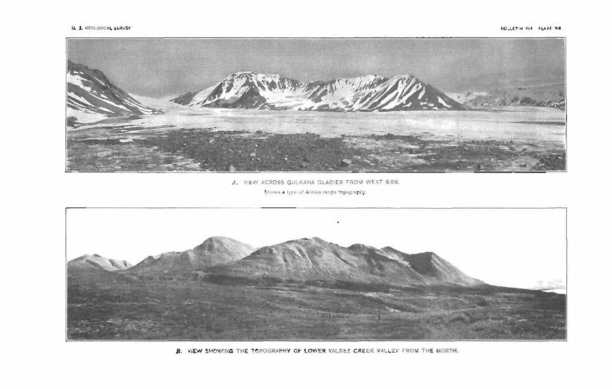
u. 3. OLOLOOICAL SURYW BULLFTIU 4"il PLATE V I I
1 v* 7--. - - - . ,-m*m-*--.- , ,r-- -- v- ,---.- I--- ---v-- - - ' -=- -
B. VIEW EHOWlP!G TrlE TOPOGRPPHY OF LOWER VhLrcE7 C R E C K VALLEI T P l l i i l 1 HE i l ~ u T H

The most conspicuous of these gl~ciers are Gulkana Glacier (PI. VTI, A), the gIacier in which Eureka C m k and East Fork of Maclaren River head, Maclaren Glacier, and the two Inrge ghciers at the head of Susitna River. The last two' am moch 1mrp;er thnn sny 0khet-s in this region. They are fed by the snow fields in the high rugged country south of Mount Hayes and Cathedral Mountain nnd am the principal s o u m of the Susitna, although the glsciem tr, the east aIm contribute much water. The westernost of the two large glaciers is about 25 miles long and more than 14 miles wide throughout its whole length. The eastern glacier is about 2 miles w-ide, but is not so long as the first. Maclaren River Glacier ia much smaller than either of these, being a Iittle more than 10 mila long and not mom than a mile wide a t its lower end. Gulltana Glacier and Cnnwell Glacier, near the northwest comer of the area, mapped (Pl. I, in pocket), am remarkable, as has b n stated, in that they eontribute water to both Bering Sea and Pacific Ocean dramage.
Most of these glaciers appear to be retreating. Their surfaces are smooth, they end in smooth slopes at her than ice cliffs, and most of them show by the position of terminal moraines that they have d e d clonaiderably in recent time.
Glaciation is the last of the great events that took p~~ in the goologic history of this region, and it is still in p m p m Its effecta are for the most part concerned with topography, and are seen in the form of the mountains, the slopes of tile valleys, the moraines, ~ n d the broad ontwash plains of glacial gravel. These features have all been modified to some extent by postglacia1 erosion, but they are nevertheless the chief elements of the present-day topography,
ECONOMIC CJEOJtrOGtP.
WLD.
The histary of m i n t in the region between Gulkana sad Susiina rim is concerned chiefly with Valdez Creek. A few of the pros- -= who came into the G h i h h i n n River region in 1898 found their way to Delta River and its western headwater tributaries, but they were unsuccessful in their aearch for placer gold and did not make any important discoveries.
Gold was discovered on Valdez Creek on August 15, 1903, by a p r t y including Peter Monahan, J. S. Smith, J. I+%. Johnson, and J. C. Clarkson, who, wit.h several others, Ieft Valdez with dog teams in February of that year and crossed the Valdez Glacier tp Klutina

54 BEADWATERS OF QULKAXA A N D BUSTTNA RIVXRG.
River. They made their way to Susitna, River by following IUutinra River, St. Ann Ri~er, and n o n e Creek, crossing Klutina, Hudson, and T m h a lakes and the Sr~sitna Lakes on the ica Their first h e camp was near the " stick houses " at the mouth of Tyone Creek, fmm which they began their search for p l d by prqecting the streams tributary to Snsitna River beIow Tyone Cmk. They found fine gold on the bars of a stream which they called Gmm Cmk (a creek rising in the Talkeetna Mount~ins and corresponding to the one named Qshetna River on later maps), but not satisfied with the results of their Iabur they left this region for the upper Susitna. At Machren River the company separated into two parties, one of which ascended that &earn, and the other, known aa the Monahan party and including the men named, made its way up the Snsitna, prosp&g the different tributar~r creeks as it went. Gold was found on Butte Creek and on its tributaries, Gold and Wickersham creeks, but not in sufficient amount to satisfy the prospectors. They then c m e d Susitna River from the wesh side to n stream which the natives d e d GaLina, and made their fir& important gold discovery blow the mouth of a namw rmk-walled canyon on Discovery Bar. They renamed the stream Valdez Creek and spent the few remaining days of Ithe wason before going back to Valde~ in getting out a ts grubstake.""
The following spring tbey returned w;th supplies and eqnipment, coming in over the Valdez Glacier as in the previous year, md accompanied by other prospectors anxious to secure claim on Valdez Creek or to d b v e r gold in new placer districts.
The rich gravels of the old canyon on " No. 2 abov~" and the Trammany bench '' claims w a x found in the fall of 1904 in an at-
tempt to learn why the gold conhnt of the cmek gravels snddenly fall at a particular point in axending the &earn. Panning in the talus on the north side of the m k led to the source of the gold in the earlier cmoentraticln of the old canyon, and the most important discovery of the district' was made. Not much work was done in the old canyon, however, till the following year. 51 the fall of 1904 the miners of V d d a Creek, undsr guidance of a native, went out over the Gulhna tmil for the first time, and the Vddez Glaaier mute WEB
given up. The value of total gold prod~ction of %Idex Creek, includ-
ing that of the mmmw of 1910, is estimated to be about $275,000. Th- has been a frtIling off for the last two yeam, owing to the decrease in yield of the creek gravels, but the reduction will prob- ably not be mu& gmater for some tima to come, for there remains gold-bming grmve1 that has not been hnched, end the p r o s p a for an incmased yield from other cmks are @.

A nuder of conditions make it possible to tram the gold of Valdez && h iitdl principal bedrock h:m and to be fairly coddent that the eoplma is within an m a of comparatively n a m w boundaries. The m& important of these is the distribution of gold in the creelr gravels. Prqecting has shown that the tributaries of Vtlldez Creek that flow inb it from the hills on the north yield pmctically no gold. On the other hand, tribnhrim such as Timberline Creek, White Cmk, and Lucb Gulch, that rise in the mountains ta the south, carry important gold-bearing gravels. The north side of Vddez C m k valley is a region of schist and altered intrusive diorite; the mountgins on the math side of the valley am slate, lmmlly mfistose, intmded by 4diorits and related porphyritic rock. htrusivas are much l a wbnndmt than on the north side and are also l a a l W ; in faot, many of then am pmticalIy undtered. The dates therefore appear to be the rocks in which the principal minerdfeation took p3aca Prospecting has not yet shown the presnce of gold in corn- rnereial quantities in the tributary streams east of Lucky Gulch or west Of Rusty Cmk, although fair prospects have hen fonnd on TimbePIine C h k IIt* should lx kept in mind, however, that all the grapela of these muthem tributaries contain small amounts of gold. !h hill between White C r d and Lucky Gulch, known locally as
W d EIill, is of special i n t e s t in connection with the bedrock sot~~ce of gold, This hill is composed of slnt~s, dipping north and intruded in pI- by a I~htccolored h e - p i n e d igneous rock. The de- cam@ matmid on the hill slope yields fine gold on panning, as a d t of which the gold has been traoed to m u m in bedrock a t severs1 placa that have been staked as lode claims. None of these plsw have h e n opened up in rt way to give mtisfadry eqmmres of the gold-baring maks, but they show that some of the gold is as%oche$ with iron-stained siliceous veins containing pyrite, sphal- er ih, md plena ?he d m p s e d material from thew veins in p k yields as much as $1 in fine gold to the pan. In nesrly all the exposureus axgmined it was found that the gold-baring rocks were as80ciatd with hegrained light-colored siliceous intrusives,
t w h m presence h d s to the belief that they are a fa&r in the origin of the gold. Lmge quartz veins containing scatkered crystals of pyrite? but withwt visible free gold ware BWII in semral places on
* Gold Rill, and in one locality veins of calcite amciatad with a little quPFtE and masws of fme, scaly biotite were found.
The p l m g d d from LuGky Gulch is of interest in this connection. I t is mmmkably mame and contains many Iarp nugget^, some of which are smooth but most of which am rough, with spines and protuberancw. Sugary quartz is of mmmon occurrence in the gold It appeam certain from the chanctm of the nuggvts and the narrow

gulch in which they lie that the gold has trareled but n short distance from ita mum in the d a t a Gold Hill is without much doubt one of the lo& cmfers of mineraIhation, but them is no reason to believe that thew may not be other canters in the district. Zn fmt it seems that there may be a, nearer source than Qold Hill for some of the placer gold on the lower part of Valdea Creek.
The gold in the creek gravels is a concentration from the product of weathering like t h ~ t on the slopes of Gold Hill. gome of it is a reconcentration from previous concentmtion in the p v e l . The gold-bearing gravels of Valdea Cmk blow the Manahan Tunnel are of this kind. They derive their gold in l a r e part from pre- riow deposits ,8 the old canyon. When the mnyon of tha pment . &.ream was b e i cut down through the old gravel-fiUd crcnyan formerly occupied by Valdez Creek the old gravels were reworked by the stream and their gold content w m xeeconcentmted in the form they bsd when mining b e p n there.
There are points of similarity between the occurrence of gold on Valdez Creek and in the Chistochina district. From the distribution of gold in the gravel Mendenhnll reached the mnclusion that the plscer gold of Miller Gulch, Slate W k , and Chisns River is de- - rived from en area of loen1 metamorphism within the &dw of the Mankomen formation. The mineraIization, momover, k d c t d to an area of rnetnmorphod rocks which forms only a mall part of the Menkoman formation as he rn~pped it, The slates are rmt by lighboolored granular i n t r u ~ i v ~ , but the amount of these intrusive% is much less than on %ldez Cmk. The two districts reeemble each other in that both ttm chnrscterized by slightly altered dates intruded by granular igneous rocks.
LUDE DEFOm!%
Little attention has been given to the mrdh for gold idea in thm Valdm Creek district and on1 y a slight amount of work has been done to the p m n t time (1910) toward proving the value of mch gold- bearing veins aa have been found. h'a gold b ~ 0 Es produd fmm this mu~oa
l b o OT three pmepects on the n o d d o p of &ld =dl wem ex- I
ltmined and Borne of the ! m e , decomposed vein m a t e d was panned, -
proving the ppegenca of gold in each instanca. At the Yellowhorn claim a small open eut had -been mads in 1- talus material con- sisting of decumpossd slate or schist snd m t y quadz, No k&mk I '
wns in sight but the cut was partIy Ued with l m material that hnd slid down into it. Two pans of the wade rnatsriaI from the dump yielded about 10 or 15 cents w&h of wfy h e gold. Much betkr
Have be%n obtained from this placa.
Wm&nhltll, W. C, G e n I n ~ of the mhal Copper Blmr rebrm, Alaslr: her. Paper a a B U ~ W ~ NO. 41.1m p U& .

, The discovery ledge of tha Accident claim is a small exposure of d a m p o d slate6 and dimus fine-grained intrusive rock. The i p u s rmk is light gray in color and contains considerable p e t e . Them b also some rusty vein quartz containing sphlerik and galena. Rne gold is present in the d m m p m d vein mrtttm. About 300 or 4.00 feet abwe the Accident bdge and in the same steep gulch s little stream of water runs down over anguIsr wash made up of slate ~ n d rusty quartz. A d e r had been set up at this point and v e q gmd prospts were obtained from the vavel. The he-grained intru- sive roek was exp& in the gulch just below it.
These pmqmta.have nrvt yet; been shown to be of clommerci~l value, -t but they are of importance in indicating h m the gold occurs and
offer enmuraganent for further search
M& of the placer gold pdueed in the Valdez Creek district has been taken fm tt few claims at the wwtern end of Valdez Creek just above the p l w where the canyon opens out into tha flab of Susitna. River, and from Lucky Gulch. 'It is probable that the gravels of V~ldez Cmlr from the canyon to IRcias8velt Creek contain a large quantity of gold, although the concentration may not be d- cient to msko them of commercial imporhnrn with the methods of mining in use on the creek. The difficulties arising frwn the low @e of the creek, the depth of thc ground, and the I srp amount of water have prevented careful pmpeking to this time.
The three principal tributaries that join Valdez Creek £ram the sonth, h e v e l t , White, and Timberline creeks, have not contributed any mnsidmbb amount of goEd to the Wal output, 'White Creek and ih largest branch, Rusty Creek, have rewived more attmtion than either Slmevelt or Timberline Creek, and this attwtion ap- pears to be justified by the resulh of prospecting m Rusty Creek during the k t year. The streams heading in the Alaska Range east of Valdez Creek
have m i v e d some attenhian from prospectors, with tb m 1 t that practically all of them are known to carry small amounts of gdd,
, yet not enough to encourage mining except on Eureka and Windy creeks and near Delta River, A few men were st work on these two
* ' streams in 1910. v w m cmlm PBOmR
Geolagy.-Val& Creek is approximately 14 miles long. It flows almost directly west from its source for 10 miles over the gravel floor
. of a broad, glaciated valley, then enters a canyon about 2 miles long, md hwEly emerges on the Susitna lowlands. The part above

58 HEADWATERS OF UTJLJKANA AND SUSITNA RIPER$.
the mouth of Roosevelt Creek is a b u t equal in length to h m l t Creek and carnie approximately the same amount of water. %Idez Creek has a fall of 1,000 feet in the first 10 miles above the western end of the canyon, ar an average h l l of 100 feet per mile, but since the p d e of the creek is 175 feet per mile through the canyon, the grade above the latter is slightly less &an 53 feet.
The mountah about Valdez Creek rise more than 6,000 feet above sea level, or more than 3,000 feet above Susitna River. At the head of the creek they are made up of schist and slate on the south side and altered diorite on the north, but from RooseveIt C& westward they consist of slate with diorite intrusiv~ on the south side and =hifit with altered diorite intrusive8 on the north. The ro& exposed
Ir
in the canyon are slates, intruded by dikes and d l s of he-grained diorite, which is porphyritic in @am.
The valley ?a much glaciated, and in the lower broader psrt' has a ir
conspicuous rnorainsl topography characterized by munded bol l s and swampy depressions. This is its chttmcter on both sides of the canyon where the onlley begins to open ont into that of Susitna River. The unconsolidated glacial. deposits are spread over an un- even rock floor (PI. 'VIX, B, p. 621, which, though it dmbtlm owes its form in pert to ice action, had a drainage system developed on it before the glacial gravels were laid down and the present ohanriel of Valdez Creek was formed. I Valdez Creek has cut its canyon through the overlying gravela into the slates beneath to a depth of over 175 feet, and in so doing has intersectd an older gravel-filled canyon whose bottom is 00 feet higher than the present creek l a d . The depth of the new m y o n is greatest below t h ~ f d s , a short distance do* from the old canyon, at a point where the overlying gravels axe shallow and almost the entire cut is in dates. Above m d blew, the depth of the canyon decreases.
Mddng deve1$pmd.-Bljning development on Valdez Creek has been concentrated on four or five creak claims and two hnch claim& The creek claims are Dhoovery, No, 1 below, No. 2 below, No. 9 above, and No. 3 above; the bench claims are Tamm~ny bench and the claim adjoining No. 1 Mow on the muth. Their location is - shown in figme 8. Djscovery, No, 1 below, and the Jawer half of No. 2 above were
the richest of the cmk claims, but none of them haw equaled in value w
the Tammay bench claim. The first claim above Discovery includes the narrowest and deepest part of the canyon, where the stream is confined betwmn date walls, and no m i n i in car- ried on.
C ~ e b grawb.-It is amecessar~ to describe the gravel [email protected] of each m k claim in detail, h w the vsriation in charachr is not

U. I. RP0:OGICAL U U n Y t * B u r ~ E t 3 *,a9 PLATE ';Ill

CKlLD IN VAIDEZ CREEK MBTRTCT, 59
great. In general the gravels range in thickness from 3 to 8 fcct on the three most productive claims and consist of alah, schist, and diorih, with which is associated a small amount of light-colored porphyritic intrusives and dark basic and tuffsceous material. An important and unfortunate characteristic of the gravel is its large content of bwlders (Pl. VIII, A ) .
At the upper end of claim No. 3 above, the grgvel deposit reaches a thicknew of 10 t o 12 feet. The upper G feet contains many diorite bowlders and overlies finer gravel consisting of slate nnd diorite cob- bias. Such a bowlder bed might indicate either a change in glacial conditions or shply a conwntra tion of bowlders from deposih whose
Paem % a t & m p of part of V*ldes Cmk clhorrhg locatlon ot pmdaeiep clnlmn.
finer material has been carried away, but the absence of large bowl- ders in the underIying material suggests some diffemt condition of deposition.
L: Much the l a w proport.ion of the bowlders am diorite. n e y reach diameters of 5 or 6 feet end are a m u m of much expnse to tbe rainerg for they can be moved only a t great expense and then only for short distances. It is customary when possible to under- mine them on one side and muse them to roll over, thus permitting the e v e 1 'beneath to be taken away.
Gold from the creek claims shows variation in its form snd a p pesranca Borne of it is Rat and well worn, but other specimens are

60 HEADWATEBS OF OWLKANA AND 6TJSITNA RIVERS.
r o w and show little effects of wear, Gold from the claims above the Monahan t&nel is h e r and l~,ga worn than that below, but a small proportion of smooth flat gold is present. The decmse in c o a m e s ~ is moie marked downstream from the tunnel thsn in the o p p i t e direction, so that there seesee to be b e 0 doubt that the old canyon gravels are mponsible for the richness of Valdez Creek down- stream fm claim No. 2 above. The gold is associated with a large amount of red gamet or &'ruby sand," and a little magnetite or ' L black ck~nd." Magnetite is less abtmdant thnn might be expected from the qntantiQ of igneuus material in the gravel. An idea of the coameness of the gold on claim Eo. 1 below may be #pined from the statement tR$t the largest piece fomd there in 1910 was worth $1,?5 rn
and the next largest $1.25. The richest claim on the d was Discovery cIaim, but the rich:
& spat waa on claim No. I below, s short distance downstream from the sawmill dam. A Eittle more than one-tbid of the total gold production of Valdea G m k from 1903 to 1910 came from the creek claims, but so much of the rich ground has been mined out in that time that a falling off in production hes taken place.
All the work on the claim abere Eo. 2 below has been done with pick and shovel. The creek water is diverted by wing dams (PI. VIII, H ) or ditch-, and the gravel is shoveled into the sluice boxes without the use of special mining applknces Hydraulic mining was conducted on claim So. 2 blow in 1909, and a Ruble elevator was used in disposing of the cobbles and bowlders; but the rmlb were probably unsatisfactory, for the work was not continued in 1910.
B m h gmmi%-Tammmy bench and the d a b adjoining No. I M o w on the sontheast are the only bench claims on the creek that have bean much developed. T h e Tammany bench is of particular intemt both because of its
unusual characte~ and bemuse it baa yielded a hrge part of hhe gold produced in this district, The gold-bring gravels are worked through a tunnel that follows the bottom of an old mnyon in the slates now filled with gravel so that no trace of ita p m n m is at the surface. The general mum of the canyon so far as it has C
k n traced is 'N. 1 5 O E. It thus rnakea an angle of about 48" with the pmwnt c o r n of Valdez Creek. (See fig. 8.)
The tunnel &arts on the north side of claim No. 2 a m , at en f
elevation approximately 00 feat above the present m k W, and is driven across the north sida of the m k claim into the adjoining Tammany bench (Pl. IX, B, p. 62, and k. 9). Its length in Augagt, 1810, wns about 700 feet.
From the tunnel flmr to the surface of the bench is s distance of 110 feet, which is the thi- of p w 1 filling in the old canyon,

A . TERTIARY CO>!GLOlLERATE AKD S h k D S OfN A TRlBUT,IRY OF PHELAN CREEK.
E. TIiE XONPHAN TUNKEL A N D SECOII'D CREE& CLAIM ABOVE DISCOVERY, 01: YALCIE.? CRLEK.

for on either side of the tunnel bedrock outcrops within a few feet of the surf- of the bench. Vsriations in the mum of the tunnel are slight and of no importance, unless the abrupt &ward turn at its end marks the beginning of a new mum. Abmpts to deter- mine the position of the old canyon on the opp&te side of Valdez Creek have hen made, but without conclusive results.
The racks of tbe canyon waUs exposed in the tunnel are slate or schist. In pI-s the walls am wahmorn, and wherever exp& they rise deeply on either side. Two crmuts were driven from different points in the tunnel, one about 100 feet to the we&, the 'other 80 feet to the aast, but the sum of these memmm~nts exceeds
'
the width of the canyon. The tunnel, king more nearly straight than the canyon, mmes h m one wall to the other, so that the cross- cuts exaggerate the width. The magimum wid& is probably &out 100 feet.
Y No diffemnce exists between the rock material in the grovel of the old myon and that of the creek, but variations occur in the charac- ter of - tlm deposit. The lower 50 feet of gravel in the canyon contains %at diorite bowlders w i t h rounded edges, rounded slake md schist fragmenb, and b e black clav. The
prewnts a -tef appew- Tarnmaw bench dalm to the present chmnel at VaIdes Creek.
ance of disorder, and con- tains a larger p&portion of diorite bowlders, which are round rather than flak T h e gravel, too, is not m clean, Probably thb upper de- posit is due either to a mvival of glacial activity before the canyon was filled or repmmta the last bowlder material laid down 8% the ice mtreated.
Gold is found chiefly in the lower 6 feet of the gravel, although h e gold occurs in all the canyon filling. Most of it comes from the hard b h k day and fine rounded slate gavel. It is c w , flathned, and smooth for the most part, though rough p i e m am ppesent. Kug-
I
gets worth several dollars are c~mmon. As has been &bd, the @Id from the tunnel closely resembles that from the creek, the chief
'x difference being a decrease in coarseness of the creek gold h t be- comes more pronounced downstream.
The tunnel is timbered with strong squam wts and is lwged over- head but not m the eides. Great care is taken in framing the tim- bers add in fitting them together so that they d remain in place. Squam sets rtre also used in the stopes but are not made of selected timber as are those in the tunnel. The stop" are genemlly from ftT,

62 HEADWATERB OF GULKANA AND B ~ I T N A RIVERS.
to 85 feet wide, but reach 770 feet where the width of the gold-bearing gmve3 dep&-ms -test.
The old canyon p v e l s are favorably situated for the application of hydraulic mining methods. Valdez Creek will supply wrrter for moving the p v e l without gmat expense, and itsl canyon provides an exdlent dump for the disp-1 of tailings. A rough measure- ment, made n short distance above the Valdez Creek canyon at the end of h~rguat shortly after a rain, showed a flow of more than 150 cnbic feet per m n d . This figure, however, is not intended t;d be nsed in calculstions for the instdlation of hy dfanlic mining rnachin- ery. Measumnents for that purpose shodd extend over a consider- able period of h a .
Steps have alresdy been taken tmard making the water available ' for mining purposes. A ditch, b w n severnl years ago on the eleventh claim above Discmtrery, has ken added to each year, ti8 it now has a length of a little more than 4,000 feet nnd haa d e d a point 4,600 feet from the cabiins on the Tammany bench. It nvns mmtmcted as part of the assessment work on the claim which it mms. The intake of the ditch is 523 feet higher than the creek at the sawmill dam on claim 30. I below. The ditch rues over pnnd favomble for m& construction end can be compIeted with- out unwual Cogt m as to furnish water for any of the claims b l o w Timberline Creek
The bench g r a v d ~ east of dsim No. 1 blow &re of entinely dif- ferent character from t h m of the Tammany bench. They are in part bha deposit of ct small stream that joins Valdea Cmek near the upper end of claim No. 2 below. This little stream drains a slight dapression southeast of the creek heading near the anyon on claim No, 1 above, and nt its lower end drops over the rock wall to the head of the main stream The bedrock is date and pywacke or h e slate grit. On the point btween the little &am and Valdez C m k there are 15 to 20 feet of well-rounded gravel with a few bwldlders, none of which am more than 12 to 16 inches in diameter nrnd most of which measure not more than 10 inches. Many of the diorite pebbleus are demmpmd and can easily be broken with the pick, but s few are fresh and hard, In the cut from which the p v e l has been @ned, however, larga diarite bowlders am ~bundant. ma a r t m p v e I carrim gold which is Mieved to be a concentration from gravel like that on the point. Mining apefations were carried on hem in 1909. ITater was brought from Timberline Creek, a distance of 14 miles, by a ditch and short pipe line, and two hydraulic giants were used to move the gravel. The work was probably nat
+ t ~ r y profitable, howover, for it was not continued in 1920.


GOLD IN v m m CREEK DISTRICT, 63
LUCFP GULCH.
h G k g Gulch is abut 6 miles east of the main camp on Vsldez C m k . It is a steep gulch a little rnoE than a mile long on the north side of GoId Hill, and was formed by a little stream whose ~rincipal eoum of supply is melting snow, The stream has cut a m m w V-shaped channel in slates that dip 20' N., about the same m the grade of the stream. The gulch is on the north side of the hill, and as a oonquenca the snow that drifts into it in winter malts slowly in summer, so t.hnt although it prevents the minem from bginning work early in the spring it provides the chief soum of water later in the summer.
The gulch is ta, Bteep.and narrow to permit the accumulation of 8 a large body of gravel, but the depth of t.he deposits counterbalsnees
in a measure their lack of breadth, The gravel is made up of angular f rngments and slab sf slate like the bedrock, with verg little well-washed and rounded material. A ma11 mount of fiw-pined diorite rock is present, rn well as mme quartz, hut slate is the chief constituent. The ~ l a ~ t s bdrock has a well-developed cleavage and its surface in places is cavered with sm~l l crystals af ottrelite.
Lucky Gulch gold is coalser than that from any other part of the Valdm Creek district. h pneral i t is rough and many pieces con- tsin fragments of granular quartz, although some of the gold is flattened and weIl worn Tl& diflewmce in surface character prob- abIy indicates nothing mom than a variation in the arnonnt of rub bing and pounding the p i a s have undergone in traveling down the gulch? for there is little doubt that the gold is derived from a small a m and has not moved far from its mum. Large nuggets form an Em portant part of the gold product of this stream. One found in 1910 weighed 32 ounces (PI. X, A ) , and R larger one weighing 5% ounces was taken from the gulch two or three years previously. Hug@ like these, which evidently are not far from their lxdrock source, offer much encouragement to the prospector f o ~ gold lodes.
Lucky Gal& is free from the big diorib bowlders that ,give so much txrruble on Valdez Creek. T t mtains rt gre~t many slabs of slate that must be. moved, but most of them can be broken with a . sledge ox dispaeed of by aid of a little powder. A short season and w t y water supply counterbalance this advantage in a measure, howewr. Tbe most effective method used for moving gravel in
F Lucky W h is by booming (see p. 641, but a m l l hydraulic nozzle and c m h s h- is employed at t h w . Mo& of t le gold lies on bedrock in the bottom af the gulch, and i t is mined from a deep cut witbout disturbing the wad1 on either ~ i d e , so that no more pave1 is moved than is necssary. The wnlls of this cut nre 23 feet high in places, Bart of the gulch hag bwn worked out, but a large amount of untouched grave1 still sernains.

, W R m ARD B u m CBE6KE.
White Creek joins VaIdez Creek 43 miles east of the main Valdez Creek amp. It haa three branches, known as Big Rust?, Little Rusty, and Rnsky creeks. The= dreams h a d in the complex of slates, tuffs, and basalt of the mountains htween Valdez and Windy creeks, but their lower courses are in slatas. Some p-ting has been done on White Cmk, but it did not yield much: encouragement, bemuse it was carried an under great diffirmlQ md expense, due in part to the high cost of supplies and lumber but chiefly to troublm arising from deep pawls and much water.
Prospecting on Rusty (=reek has a h been carried on in the face of many difficulties ~ n d great expense, During the years from 1008 to 1010, incl~zsive, a cut severs1 hundred feet long and more than 25 feet deep in plam (PI. BE was made in the cIiannel of the creek a short distance a h its month. This cut follows the east aids of what appeass h 'be an old d - w a l l e d channel or canyon whem the northerly dipping slstes of the bedrock npe e m , but i~ not wide enough to uncover the w W m wJI if i t is g m n t . The p v ~ l s filling the c b e l include an upper deposit of rmmrted glacial dhbris from 10 to 20 feet thick consisting of slate and basalt. U n d e ~ this is n deposit of fairly well-sorted gravel and coarse mnd showing ts distinct eras-kdding dipping to the north. Many large hmlders on the bottom of the cut am derived from the upper hd
. of gkcial material ; most of them are besrr,lt and come from the head of the creek, but a few of them are diorite, probably derived from fhe valley of Valdez Creek. E n m r ~ g i n g gold prospects were oh- taind fmm the projections of the rock wall on the east side of the cut and especially from the bottom of the eut where work ended in' 1910. T h e gold is v e v m g h and bright. Few pieces of p t e r value than 10 tn 26 cents were found in the uppr part@ of the cut but the mwencea increases townrd the bottom, and the deepest gold so fnr obtained was of such a chasactm as to encourage the owners in the belief that they were n a r Mr&
Booming has been adopted on Rusty && mr% weU. as on Lucky Gulch, and has made possible the 1s- cut jnat described, The boomer consists of a dam with rl. gate (PI, X, B) that opens auto- maticnlly when the water level reaches a determined height and sitrl- denly releases a large volume of waterq which mshes through the cut, fenring up tho gravel and csrrping it away. The effectiveness of such rr contriv~nca is hardly mlbd until the d t s of its operation have h e n wen.
Rusty and White creeks give more promise than any of the other tribntaries of Valdez Creek for extending bhe known area of gold- bearing gravelq for they cut s1ak.s that have been S ~ O ' W ~ to he auriferous. Undoubtedly Borne concentmtion of gold has taken place

GOLD r a DELTA RlVEB DISTRICT. -66
daring the time the slates have k e n subjected to erosion, but only p~aspecting can determine whether the concentration has been suffi- cient to prodnce placer-gold deposits of commercial imprtance.
' Timberline Creek joins Valdez Creek near the boundary between the fourth and fifth claims above Discovery. It is a little more than 2 miles long and flows through an a m of slates into which a small body of diarite hrts been intruded. Its position with referen@ to Valdez Creek and its relation to Rusty and White creeks are such Ithat it is doubtful whether it has invaded the a m of mineralization
* from which them other streams derived much of their gold, and pmpecting has yielded so little encouragement to the miners that no important amount of work has k n done on the stream for several
.c vmm IIFLW RIPER DJBTRTCT.
The gravel bars of Deltn River contain R small amount of fine gold, but not enough of the metal hap been found to malre &em of importance commercially. Gold was panned by rnembem of the writer% paw from the gravels of Delta River near Gafiettys cabin, 3 milw above the month of Eureka Creek, in 1910, and the prsenm of gold-bring gavels in the river has been k n m since 1900 a t least. Rronks mentions a rumor of gold on Deltn River n s early as 1898, h t was unable ta verify the report. Eureka and Rainy cweks however, have prodaced m small nmo~mt of gold for a number of years. Mendenhall ststah that the first prospectors on Delta River, who made their way there from Chisnn River in 1900, " found colors gy-~ern!ly on the dream b ~ m , snd whst they regarded ns fair p m - pets on Wilder Creek, or, as they caIIed it, Rainy Creek. After the return of these: men to the Cbisnn, a l a w s pnrty was outfitted, and, returning to the region, organi7Rd the Eurcka mining district. In the following spring (1901) from 200 to 250 people entered the new district and 20 or 30 of them began sluicing, but the reaults being unsatisfactory the field was: abandoned."
s The district was not entidy abandoned, however, for a few men b a ~ e continued to pmpect on Eureka and Rainy cmks and have taken out enough gold to gim them some enmurapment in the hope
a. of final m c e s in their effort to del*elop a producing district. Seven men were eqagwi on the two creeks in 1 9 l G t w o on Eurelra and the & on Rsiny b k . They were visited by membrs of the top* graphic party at the beginning of the season, but not by members of
.-
r 8mkq k A., A reconnalssaace of the Tanaaa and Wblte Rlaer bparlns, A lauh , In lB8: Twentieth Ann. Rept. U. $. Oml. Survey. pt. 1, 19@0* p. 484.
rhfeadenhall, W. C.. rd logy of the centml Copper Rlver -Ion, Alaska: Prof. Paper U. 8. Qm1. Survey No. 41, 1906, p. 117.
38824 O-Boll. 498-32-4
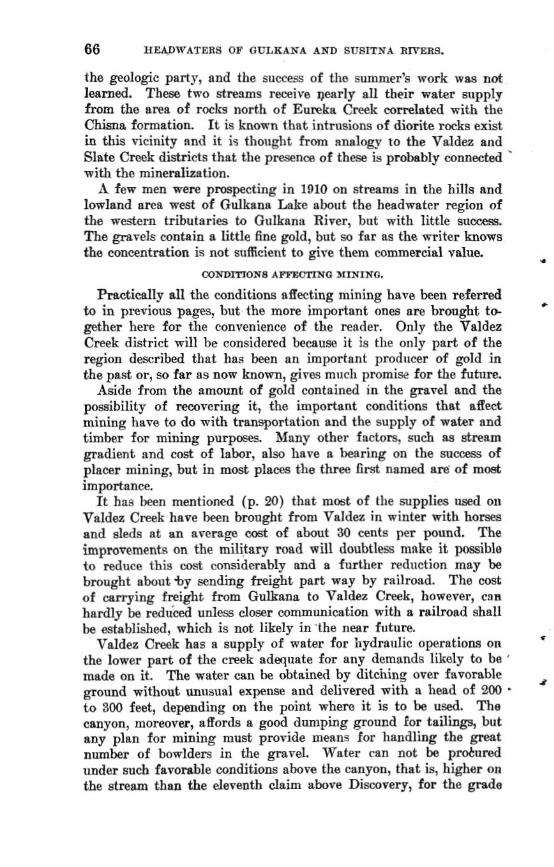
the geologic party, and the success of the summer's work wss n d learned. These two streams receive w r l y all their water supply from the area of rmIm north of Eureka Creek com1atd with the C~~ formation It is known thnt intrusions of diorite rocks exist in tlJs vicinity nnd it i4 thought from rtnalrg to the Valdez and Slate Creek districts that the presence sf these is probably mnnded ' mith the rninemlimtion.
few men were prospecting in 1910 on streams in the hifls and lamland area west of Gulksna h k e about the headwater region of the western tributaries to Gt~lkana River, bnt with Iittle s a m . !I'he g m v e l ~ contain a little fine gold, but m fnr as the writer knows the concentration is not suficient to gire them commercial P ~ U E L ..
FXIE'DITTQNI A-O JIIITIRO.
Practically all the conditions sffecting mining ham bean r e f d +
to in previous pages, but the more important ones are brought ts gether here for the convenience of the reader. Only the Valdez Creek district will be considered becauae it is the only part of the region described that has been an important prodncer of gold in the past or, so far as now hm, gives rn~rcll promise for the futnre.
Aside from the amount of gold contained in the p v e l and the posaibilitp of reoovering it, the important conditions that affect mining have to do mith transportation and the supply of water and timber for mining purposes Many other factors: such as stream gradient and cost of labar, also have a bearing on the suocass of placer mining, but in most places the three first named are' of m& importance.
It has been mentioned (p. 20) that most of the supplies wed o l ~
Valdez Creek have been brought from Valdez in winter with horses and sleds at an average wst of abvut 30 cents per pound. The improwments on the military mad will doubtless make it possible to reduce this a& considerably and a further mdnction may be brought about %y ending freight pa* way by railroad. The mst; of carrying freight from Gulkana to Valdez Creek, haws~er, csn hardly be red&ced unless closer mmmnnication with a milroad shall be established, which is not. likely in 'the near hture.
VrtZdez Creek has a supply of wster for Elydra~~lic operations an *
the lower part of the creek adequate far any demands likely to be ' made on it. The water csn be obtdned by ditching over favorable ground without unusual expense and delbered with a head of 200 - to 300 feet, depending on the point whem it is to be used. "She canyon, moreover, affords a g o d dumping pronnd for t~ilings, but any plan for mining musk gmvide means for handling the p ~ t number of bowlders in the gravel. Water can not 'be pdured under such favorable conditions above the canyon, that is, higher on the stream than the eleventh claim above D h v e r y , for the p d e
CONDITIONPI AFFECTING MINING. 67
is lower lrnd the ditches would, therefore, have to be longer. For ' the same reamn the moan1 of tailinga would be more difficult.
A supply of timber for use in mining and for fuel when coal is not available is gsential to the s u m of any mining operation The most pductive part of Valdez Creek is situated at the upper limit of spruce timber, but the hill slopes bordering the flats of Suaitna River prwide tt supply sufficient for many years to come. Most of the larger end better trees within several miles of the sawmiU on . claim No. 1 below have been cut since 1903, a 0 that it is necessary to haul Iogs for lumber a considerable distance. Firewood may h ob- tained more easily. All the logs for sawing and for fuel and all the timbm used for square sets in the tunnel are hauled to the sawmill or to the place where they are to be used hfore the mow melts in the spring, Cutting the timber and bringing it in is the fist work that
4. rsaeives attention after supplies for the summer am landed on the creek.
The cost of labor is $10 a day, without h r d , for work during the mining mason. It is, therefore, evident that this item of cost is higher than in placer-mining districts where mtnmunication with a labor marlret is easier. It is possible that this expewe may be re- duced when the line of travel over the military road bmmes better established, thus making it easier for men to move about from pIam to place ; but Valdez Creek is 65 miles from the mad and is not con- nected with it by a trail suBciently well m~rked to enable a stranger
fo4low it. Furthermore, there are no camps or road houses along the way where men could get food or rest.
At p r e n t there is no mail mwim to Valdez Creek, dthwgh mail was brought from Gulkanrt by private carrier during the m m r of 1910. The military telegraph line which foZlows the road h m Valdez to Fairbanks does not connect with Valdez Creek. The miners of Valdez Creek are dependent on game for fresh meat.
Most of it is obtained from the natives by trading tea, sugar, flour, tubacco, and clothing. Caribou and moow are the most important game animals, but nll game is much less plentiful than when the minem first entered the region, and sheep have practically disap- peared from the soath side of the Alaska Range fmm Susitna to Delta rivers. None were seen by members of tho writer's party in 1910, and the miners report that there are none. Caribou, however, " are still dicienfly plentiful to provide the chief soum of meat. During the summer they seek the higher parts of the Alaska Range, and their tracks are often seen along the glaciers and on the taps of high ridges where one would ordinarily expect to find sheep. Pos- gibly they go there to seek relief from flies and mosquittm. Toward the end of summer they come down to lower ground and often can be taken with littJe diflicdty.

68 SEEADWATERS OF GULXANA AFT) SUSITNA RSVERS.
Moose, on the other hand, seek the thickets along the mountain streams in winter or wrIy spring snd return to the lowland areas in wrnrner. They are fsr more difficult to find than cari boll and mare skill is required to shoot them after they are, found. The swampy lamland between the Copper and the Snsitna is an excellent country for m m e .
Fish are abundant in many of the lakes and in some of t h ~ clear- water streams. Grayling am plentifal in Ddts River above Eureka Creek, 'but, except for the salmon, the fin& and la~gest fish in the region is a, trout found in some of the lakes, such as Summit Lake and the two lakes s t the head of M v e l t Creek.
A few suggestions mny be of aid to the prospector. The h o w n t
areas of mineralization in the headwater region of Copper and Sn&na rivers are areas of slates intruded by diorite. It is beLieved that s genetic relation exists between the presence of gold in the dates and their intrusion by the diorites and the related porphyritic dikes and sille. It is, therefore, adviable to give attantion to gmv- els derived fmn such mu- for although they a n not be pre- dicted with mrtainty to carry gold they are at least more favorable placm for search than nreas where only one of these rocks is present. Fairurn to find minemlized zones at the contacts of the diorita and the slate is not evidence against the influence of the igneous rmks ap3 a f~ctor in the deposition of gold in the slates, for the physical or chemical conditions may have been such that the influence was ef- fective odp st some distance from the intrusive maas. Gold depos- its of the contact-rnehmorpbic type are known at the head of Nabesna River but have not yet been recognized either in the Slate Creek or the Valdez Creek districts.
Thm parts of the region occupied by basaltic lava? ~uch as the m t h side of Windy Creek and the area south of Eureka Creek, do not offer much encouragement for prospecting, for although some of tlm stream3 in th- areas have gravels that contain fine gold it is probable that the gold has bemi transported there from other
I sources. So far as now known the same statement is true of the diorite areaa
Another characteristic which the Valdez Creek @Id placers p m sew in common with the placers of Chititu and Dan creeks in the Uizina districk and perhaps also with part of those in the Slate Creek district i~ thut the richest of them are reeoncentrations from p m ~ o u s mncentmtions in older grarel deposit& It is, therefore, jmportant to exsmine the gravels of those strertms in mineralized areas where the w ~ f e r is now cutting away and re-sorting the bench gravel- gmeralization the truth of which was at once recognized

COAL. 69
by those who fir& discovered that the rich gravels of Valdez Creek blow the &Inahan tw~nel owed their value to the fact that t'sldez Creek, in cutting its present canyon, had tapped the previous con- centration of gold in the older canyon. Although this instance is exmgtianaI and should not be expected to be commonly duplicated, it is probably true that a very large number of rich placer deposits owe their existence to reconcenhtion from previous concentrations of gold in alder p v e l deposits and that this reconcentration may have been repeated many times.
A small outcrop of coal occurs on Coal Creelz, a tributary of Clear- t water Creek, near the boundary between the slate and the basalt areas.
Tt is on the muth side of the creek a b u t halfway fim the mouth to
* the head and is expowd in a bed who= thickness is uncertain but is probably at Imst 6 or 8 feet. The coal, which is much faulted and crushed, stands rn edge between walls of yellow shale that break down in nngular fragments and show evidence of p e n t disturbance. The contact between the coal and the shale on one side is a vertical fault contact, which strikes N. 65' Wm Coal dust and mall frag- ments of coal, such as coal miners call Mossom, are e x p o d about this outcrop north of the creek for nearly hnlf a mile, but it is doubtful whether the bed persists so far with equal thickness,
The coal is a lignite. It has been tried for Madmmith's nse but proved l a satisfactory than charcoal. It wodd be of some local value for cooking and heating if it could be conveniently camid to Valdez Creek, but it probably has no other value.
The term Chistochina district is here used to include the gold- producing stmaras at the head of Chistochina River (PIS. m and Xf), of which the rnmt important am Slnte Cmk, its tributary, Miller Ouldl, Chisna River, and Ruby G m k . Lime Creek or lake Creek and the Big Four claims north of Slate Creek, on the moun- tRin dope facing Chistmhina Glncier, complete Che list of Idealities whose gold prduction in 1910 contributd more khan s ncrminal amount to the total output of tho district.
The Chistochina gold pincers were visited by Mendenhall in 1902, - h e pars after the k t mining locations vere rnnde .The present dascription is b a d very largely on his report and contribuk little to it further than to bring the account of the development up to date. The sections on " geography and drainap" and " history " am quoted from Mendenhall without change.
The gold field do- not lie in the klasaa Range propet, bat in a group of S&Rs that are wparatd from the main cbaln b~ a meplmoas pfdmont ~allcy, which exteada 20 or 30 mlEm =at of the bead of Chlstoehlna River and j8 occnpled by Gblstochfnn GIacIer and the upper conm of Mldme Fork, the Slana, and the Tok, nnd the varloufi ~ 8 a e s whlcb connect tbme streama.
North of thin feature the peeks of the great moge rlae abruptly to devationa of 8,000 or 9,000 feet. South of I t the nearest iootbills are t1,W or 8,500 feet In height, but dmeaw Ln altitude as thlr dIetanre from the axis of the mnue Increaw8. These foothills are In detached gronps. whlck near the msln range, occupy, relatively a m s , the valley Iowlands separating them occnpylng relativeb mall a m a This relalnm is in a measaw reversed along the lower Ohfstoehlna near the apper. where the fmthilla are often small lrtlande rlslng above the general gravel pkln of the Copper Valley.
The particnIar foothi11 gronp Ln wblch are found all of the prodnctng claima of the didrlct Ilw betweefl Chislachina and Middle Fork and mnth of tbe wew- ern end of tbe piedmcmt alley that has been describPd. It ia drained by tribu- taries of one or the other fork of the Chlstoeblna, the lamst of tbme tribn- tarlee being the Chlaut. m a amall rlver r h in a clrqae 3 or 4 m l l a m t h of the =Pt end of Cbiatwhina Glacler. It dowa norm of w& for 2 mIles or more, d I r d y toward a low pa= leadtng to Slate -Cceek, then turns abruptlj southward and join8 the.(=$istcwhlna 7 or 8 mil- below the month of Wertt Fork. Its total length ts onlj 32 or 13 m i l a Slate Creek Ilw w& of tbt?
1 Mm&dmll, W. C,, The central CoppPr Biver mglon. Alaska: Prof. Papr U. S. Oeol. Barney KO, 41. 1806. pp. 107-117.
70

upper .Cblma, 1ta lower c o n r e ompying the western end of the same dep- 8lon wblch hrr controlled the upper cwr%e o f the larger ntream. Before enter- ing a18 crow valley !t Rows southward for n little more tban 13 mHesr from the two mal l glacial remnants In whlch i t rim?& and after entering It iollowsl I t weetward for 2 mllea to the r,b:hlstwbina, which it joins jnst at the foot of the glacler. Itm total length, therefore, le not arer 4 mLlea Miller Gulch, the mout important pmucer of the dletrlct, I s a m l I northern tributary of Slate m k , leea tbna a mile long.
RISTOEY.
The Brst locallone h the Chl~twhlnn gol& field were made by Hadet and Meel& In the eammer of 1899. Them gentlemen were amonR fhe army of a m
'
nauts who cm& the FRII~CZ Olncier in the qrlng of 189& with the idea of prospecting within the Copper River bnsin. Building a boat on the Kluttna,
.? they demnded that stream and necendd the Coppet and the Chrfatocblna, reachlng the present locntlon of Chl~nn ~ m s t .office in early July. They found mmornglng pmpecM here, bat thelr provisions becornlag exhausted, they re-
1. turned to Copper Center for a Irrm ~upplg, racblnl: the Chima again In Angust of the =me g e m , In deptember tbep returned to a p p e r h t e r and during the following winter sledded supplies to a p i n t on the Chlstochha near tbe month of the East Fork, and from t h l ~ hfttie contlnacd their work on the lower Chlma throughout the summer of 1 W . Clonrae gold wag dlwvered a t thla time, and mvernl locntlws were made. In the gpr ig of 1540 these operatom, to&her with a namber of tbe pmwmt
Miller Gulch and Slate Crwk claim m e r s . retorntxl to the Chisbochlna with a goDd stmk of rmppllem, a a n m i l l , and Borne h~dranllc maahmy. Dnslng thls Bummer gold was dIscover& on Slntc Crwk and Miller Gulch by alee, Jacob- mn. Kramer. and Levell, the ground s t a k d at that tlme hnrlng arnce pro~ed to b? much the richeat in the dtntrlct.
The rqp1arIy used winter trnil from Gutkana to Chisna Rinr and Slate Creek follows Copper River to Chistochina and ascends the stream of that name. All freight is taken in during the winter months by this ronte, and until recently most of the s&mer travel fallowed it. also, Since the military tmil was turned into a m d there has been a tendency to make use of it in the summer months and thus avoid the e x d m g 1 p bad, swampy tmil along Copper Riwr. It is appmximatelr 05 miles from Paxson on the military road to Slate Creek. The h i 1 offers good footing for homes most
s af the way and prwmts no serious obstacles to trat~e1, its most objec- tionable points h i n g at two crossings of West Fork of Chistochina River in the canyon, where the water is confined to a single channel.
e Like all glacial shams, this one is subject to quick changes in the amount of water discharged from the glacier and may be impassable to-day where yesterday it afforded an easy crossing. The stream is a mall one and is not hard to m s s where it spreads out, but when co&ed to one channel it often presents difficulties. Doubtless these can be avoided when better trails rtre made and more favorable cross- ings am chosen.

12 CHTBMCHITPA DISTRICT.
A post office sstablished at Dernhy, on the west side of Chisto- china River near the mouth of the Chisna, llas a regular bimonthly service in summer and a monthly =mice in winter. The mail rouh follows Copper and Chistochina rivers, thus serving Gakona and the telegraph station at Chistochina as wdl as b p w y .
The militsry telegraph station at Chistochina is 35 miles from Dcmpsey and 45 from Slate Creek. Slnte Creek, as already indi- cated, is &bout 25 miles from Palson, the nearest telegraph station on h e military mnd.
QULD PLACEBB.
Mining began in the Chistochina distrfct in 1899 and continued witL a steadily increasing gold production for several years until, as in all placer distric8, the richest and more easily mined p v e l s approached exhaustion. It is estimated that the total gold prduc- tion of the Chistochina district, including the year 1910, has been a little more than $1,500,000, of which Wier Gulch hm produced a large pmprtiw.
Between 40 and 60 men, ware employed in the Chistochina district in 1914 m& of them on Slate Creek. T h e population is much less than it was two or three years ago, the decrease airresponding sp- proximately to the fnlling ofl in goId production.
Miller Gulch is a deep, namm depression cut in the slatea north of Slate Creek by a. little stream less thnn n milo long, The p u n d was not ~taked till after Slate Creek mas taken up, for no one suspected that its gold-bearing gmveIs mere more valuable thnn those of the main stream, as later tuned out tb be true. There were orig- inally cight foot claims rn the stream, but only seven are now held. As described by Nendenhall :
The bedrock floor of the gulch is ah- nlth coarae gmrel to a depth mC from 4 to S feet. Tbls grnvel I s derlvd prlnelpally from the mlnte coun.trg rc& and fts diahslc nnd " blrd'wye porphm" intmdverr, but m t a l n s RISO notfe- able percentam of gsanltic cobbles derlved from the " mund w n ~ b '"which caress the snrromdlng hlllw The gold B reputed to be generally di&ibuted hortzontalIy acroas the gulch, wltbout d W t e pay m k a , but vertically it exhibite the umal, concentmtlon nenr bedm?k. RIdefind b e n c h exIa t on either slde d Mfller Gt~lcb at 100 or XMl i ~ e t abare trek level. They are reported to prospett well, but sre not now (1WZ) worked for lack of water. Their orlgio Is probably mnn&& wlth the glacial bistom 011 the regla.

O O W PLbCBBS. 73
The goid of tbe galch Is urnally flat and gmooEb and b rerg rarely fouM attach& to qi~artz or country mc8. It m u m as rnther mrae dust and mnll nuggets, the largsst of these reported sa fnr welgbit~g about 4 oancerr. O n e ounce nuggets ate not at all rare. The gold Incre41Rea In nverage mawnew towad the head of the gulch. whence most or the finer dust ha^ been remord. Its assay value is ~ n l d to be $bout $IS per O U U C ~ .
Small copper nuggeb bits of cinn:lbnr, magnettte grains. and an muaEilonal allver-white Erawent of osmirldium are found nssocioted wlth tbe gold in the ~lulce boxea
Less mining was carried on in Miller Gulch in 1910 than in any previous year since work been there. This was not due to the exhaustion of gold-bearing gravels, but to a temporary s~ispension of work in order to avoid covering unworked gravels in Slate C m ~ k
? with tailings. The wnter supply of Miller Gulch available for min- ing operations is small, so that it has been the custom of tho two principal claim ownem fa use it in alternate years. Tn this wny all
s the bed of the gulch has been worked out, but there still remain bench gravels that will be! exploited as soon as the ground below am ba umd for dumping.
Slate Creek, as previously stated, joins Chistochina River a && disbnce below the glacier and is ilpproximatelp 4 miles long. Its channel marks tht: boundary between the Ghisna and the'hlankomen formations, but tho bedroclt also incll~des some infolded T e r t i n ~ beds with which cml is associnted. T h e gravel deposite of Slnte Creek nre to a considerable extent intimately mnneded with the glaciatian ta which the region has k e n subjected. Mendenhall ssys :
Dnrlng the nmmt glaclatlon of the mlon the drainage llnn been mnddembly datnrbd, ~ n d In Ulla BFstarbnnce the chnnnel of Slnte Creek baa been much modi8d. Two shahs mlnk dllrlng the In-t two genrs jhst past of the bed of Slate Creek, ap,poslte Chima Prim, renchwl rwk at 75 and IfO feet. m m i v e f y ; that 18, a t from 10 ta 5 5 feet bbrlow hPdrocb lerrl In Slnte Creek, less than 100 mnds a w ~ y , n dtfference probnbly attrlhutsbla to tlw ~hlft lng of the channel of the creek during the late occupancy of the I alley by ice.
It is to br! n o t d in Ibis ronnecttnn that if Chlrt*ehlno nlacier wem to gdvance &lghtly the waters of A l n t ~ C'rwk would he clnmmed and forced ont mw the Chi= dirlde, thna reproducltlg o condltlon whlch has probabIy pr+ r a l l ~ d In the recent geOlogIc pnst.
1 Di&nliy Is n1w enmvnteretl In tl~e nttempt to reach bedrack on the claims b e d l a t e l ~ r above the mouth of Miller Gulch. Tbe d 1 ~ u l t y here ia mbably due more to the fllllng from a tributnry strenm who= inn ham spread out orer
cr. the Slate Creek bottoms than to any extmslve e x c n ~ n l l w bwnum of glacfal actlon
In that part of the upper Blate Creek channel where any ribblng has b e w done the gravels are h m 4 to 10 r e t In derlth ~ n d the yldd hnn been p~rtc- tlcalrg the wage of the district $10 to $IS per dag per man. As hn~l bew stat@& one or mo of the claims fuhtt beIow Miller Gulcli nre rIr1i. nnd are betng exten- s l v e b worked at A profit, but the other wrklem on the lower pnrt of the creek, Iike thorn on the upper, are emtlc. *

k narrow bench 10 or 1fi feet above the level of the bed of Slate Ckeek, @h tba month of AMlller Gnlch, was one cif the d m arear !II the dlatrtct work&. Severnl thousnnd cTo1lars were sluiced hem from a apace coverlng a few hundred quare feet. The bench pmrrmbly repr-tP a mrtion of the old ML1Ier Gulch f nn. nnd the gold 18 regarded as derived fmm the gulch.
The Slats C r e k mld la slmllar In form, color, and purity to thnt of Mlller Gulch, but is nut qolte r?o mame.
About 20 claims on the channel of Hate Cmk and a number of bench claims adjoining them have been h a t e d . The first three claims abme the mouth of Slate Creek are virgin p n d , but am difficult to work becnuse of the depth of gravel and the larp amount of water. A hole 21 feet deep near the m t h side of the gravel f l o d plain did not reech bedmk. Tailings fran above are another source
F of trouble on the lower claims. A dam was built near the mouth of the creek in 1910 to furnish water for booming a low bench on the north @side, but waa not completed in July wben the district was a visited,
On the fourth, eighth, and ninth claims above the month mining was confined to the bank on tht south side of the ~tream. A heavy depmit of glacial materinl, consisting of blue clny or glacier mud and large bowlders, is expmd there. It is overlain by n deposit of frozen yellow talus or '' slide '' rock from 5 to 25 feet thick, derived from the mountain slope on the south. The glacial m~terinl contains
' gold and is exploited by undermining and caving. Bowlders are piled back from the cut to form a channel along the f d of the bank, and then the water is turned in to undermine the hank nnd wash away the fine gravel. ,kfterward the =mining gravel and gold is shclveld into the sluice boxes, This work is slow and dangvrous, bwause the high bank of frozen gravel above sloughs off continually as it thaws and at. times breaks down in larp m a w , SO that men must be constantly on the alert and m d y to jump to R place of safety.
T h e largest force of men at work on the cmk in 1910 was near the mouth of Miller Gulch on ground that has been the richest in the dE5 trict and still gold. This T~coma claim, ae it is called, together with the lower part of MiIler Gulch, has yielded more gold than all the other claims of the district. The p v e l s of Slate Creek nbove Miller Gdch are of lower grade, and only a few men were P employed there, but their contribution to the gold praduction of the c m k is important.
BIO FOW m. 4
The Big Four claims are on a little stre~m that heads against Mil- ler Gdch and flows down to Chidochina Glacier on the north side of the mountain between the glacier and Slate Creek. It has not been an important contributor to the gold output of fha district, but has given employment to a few men for a number of years. It is

of importance in s geologic may as giving some additional support to the W e f that the slates north of Slate Creek are the mum of the @Id in Miller Gzllch and Slab Creek rather than, as is held by m e , that it came from a distant foreign mume, The gold is finer than that from Miller Gulch.
'Rid most important gold-producing stream in this district, after Slate Creek and Miller Gulch, is Ruby Creelr, o tributary of Chisna River, which lies just east of Slate Creek and is sepamhd h t n it by a b m d low divide. Ruby Creek has thrown out s wide fan of gravel extending in a semicircle from the point where the creak leaves a narrow gulch in the mountains at the head of Ghisna River, thus forming a 101lg smooth slope to the west, south, and east. The
q creek has cut rt channel rsnllging from 15 to 20 feet in depth in this gravel fan, The gravels are gold bearing, end mining is carrid on in them and also in a short bend of filled and abandoned channel at the head of the fan just within the y lch , where for soma reason the cmek cut a new rock-walled channel within a few feet of ib former position. So far as now known the gold content of the p v e l s that filled the old channel -is low, though great enough to encourage prospecting and to pay its 6 The old channel is adja- cent fib m e of the richest ground disco~emd on Ruby Creek. Work is hindered by snow and ice, which do not always melt in summer, so that even the water for sluicing is brought through a tunnel in the ice. Bed& haa not h n exposed, in Ruby C ~ e k where it c r m s the
gravel fan. The false bedrock which holds the gold is a thin gravelly clay bed only a few inches thick. In cutking its p m n t chamel Ruby C m k concentrated the gold contained in the gavel removed and left it an these clay M s or lenses. Only a few feet of gravel am shoveled into the sluice boxes and care is taken not to go below t.he false bedrock into the barren lqrnvel beneath. Thwe gravels are the source from which most of the gold from IEuby Cre& is derived. Mendenhdl stam that the plcl of Ruby Creek is " similar to that
9 of Miller Gulch, bright yellow, smooth, and flat, only oocasionally rough or in rounded pellets, A number of m a l l nuggets have h e n found, the largest of which ia worth $12.75, The assay value of this
lr gold is reported to be $1 8 or $18.50."
CrnEIHA m.
Chisns River occupies an intermediete position &ween the main amam of Chistochina River on the west and its middle fork on the east. Its valley is separated from Slate Creek by a broad low.divide4 and from Middle Fork by another slightly higher divide. Between
the gtmm and Chistochina Glacier is a rough, high ri@ of lime-. stone and slates belonging ta the Mankomen formation, hut it £tows far most of ita length in rocks of the Chisna formation.
Chisna River, as is w n from the description g.i~e.en, is separaEed from the area of most intense daciatjon on the north, but it8 own valley was formerly mupied by glacial ice, and much of the un- cowlidated deposits are the products of glaciation. It is evident, however, that these deposits are not entirely derived from within the valley, but were in part poured into i t from east and west when the vallep of the two branches of Chi*ochina River were filled with ice snd part of their water and d6bris WBS discharged over the two low divides previously mentioned inb the valley of Chbna River.
When MendenhttII visited the district in 1902 he found that mining T. developments were confhed to the upper and lower parts of the river. He gives the following description of the stream :
rn Tn both of these reglong bedrock had been rmcbd on same of tbe claim6 at
varyIng and uaurtlly not excwlae depth% and wherever f011rrd it carried . &clent gold to enable the operators to wash tbe grnvcl at a profit,
Throughout the intermediate portion of the rlvcr the bedrwk lies at un- mown depth8 beneath o mantle of gladat rnatcrlat. In one place, onehalf mile above the mouth of Powell Gulch, a Bhaft r n s sunk from creek level through 2 l feet oP compact till intn an underlying bed of mad, which admitted water and f o m a suspem~oa of owratlonn. It fa Improbnble that the norting and concentrating eiIect of wnter throo~hont this rnlrldle portion of the Chima Vnlley has a l nuF pmtgllaclttl tlme hem operative dowit ta W r w k , m that, even maid the latter be rmched, it Is unllkely that gold In sut€lctent qnantlttes for profitable exploitntlon would be found. The clny lagers wlthln the glaclal deposits which am renchd in p r o s ~ t l n g cnny colors, bnt are not wflciently clch to invite mtenslre opemtlons.
* * &
Th agerations along tbla [the lower] portion of the mlshlilnn Valley are con- fhed to a group or prgertles wltbtn 2 or 3 mtlee of the month of tbe doer. They atend through the cnnyon and for ehort distances a b w and below ft, where alone bedrock fs nccpa~lble. * *
Bedrock la easlly accessible t h m g h the mnson, but the latter In so n L m Wr the barn not swept by the swlft current nre erg mnll and probably carry but little gold. A t the mouth of the anyon bedrock Is enullp reached, but Imrlng n wmewbnt greater dope downstwnm thnn the! fiver It m n pa- blow n polat where I t Is at p m ~ t prncticnble to reach I t In Blutcing. It is neprted that bedrock Ilea only from 4 to 8 feet below tbe surface of the flood plain for a rclnsfderabl~ dlntance atme the canyon, but ~ I n c e them C
are many coarse bowlders in the flood-pla.Ea mtlterfal Et a#n not lw hndled to advantage by ordinary dntctng methods. It la bl le~ed t h t hydraulic work at t h l ~ point will prove profitable. J
The gravela wnta1n n conafderable vsdety d rock conttastIng &rongly in this re- with thorn of Blate Greek Hiller Gulch. and the upper #ism. Such n contrast Is of coum to he expemed, because tb? gmvels of tbe latter strmm5 are derived from llmited area8 wlthln the small drainage baalog d the cmks themwl~es, where fern rock varletles are know& wW1e the mavela of the Iomr C h l m are of all the vadoue types le the mnch krger Chlwa

GOID PLACERS. 77
bnsin, ans probably also of material brought from outside m u r c ~ by glaclbl a c t l a The gold h m me lower Chlwa is much like that from Slate Creek and
Miller Gulch In general appesmnce, bunt 18 flner and Eomewbat more uniform In grain. Xnggets are rare, but flak- onpelgbth inch or more fn diameter are abmthnt. An aaaaj valae of $18.72 per ounce Is reprted. The developments not yet determinM tnrly the valawr to be won.
but the mvele belaw the cmyon are sald to run from 1.7 to 6.5 cents per me, wltb a maximum of $1 011 bebeock. A small corner of Plwverp clnirn. jtmt at the bead of the cnnyon, ta reported te have yieIded $l,.000 as the m u l t of a few week^' work with a ahort t3trlng of slnlcea, so tbat the nvailable gnvele here, lf mrefuZlg bandled by hydraulic methods, shoald field good pmnts.
? In 1910 the work done on Chima River was in the nat.ure of a w e n t work and was confined to the lower part of the stream,
+ Considemble p u n d is held there by different persons, who are awaiting the time when the intrduction of hydraulic machinery or other economical methods shall make mining more profitabIe. At present the pice of lnbor and supplies prevents de~elopment of much of the gold-bearing gravels, for with wqya at $10 per day and the cost of freighting st 20 tb 25 cents per pound none but the rich& gravels can be exploited a t a pmfit.
At Dempq, an the west side of the Chistochina, near the mouth of CPlisns River, are deposits of bench p v e l s that -my Bne gold. Prbspecting has been conduct& there for a number of y a m in the expectation of discovering IL definite pay dmk, but without much suroess as yet. The principal work done is repmentad by a tunnel driven into the gravel bench.
That the gold of Chisna River is chiefly derived from the Manko- men formation is indicated by the fact that, so far as the writer knows, those streams cutting rocks of the Chiana formation are not gold-bearing except where they have received s m e contribution of foreign gravel from the north. Rich pay stresks with conm gold should themfore nat be expected on the lower Chisna and Chistrr- china except where glaciation has brought about unusual conditions of hansportation, for the common experience in gold-placer district9 is that the gold becomes h e r and more widely distributed in the
,r p v d RS it travels farther horn its source. When the high-bench @vela are known to carry gold, particular attention should he fiven to dmams that am cutting channels through them or under- mining their banks, for in such places a reconcentration is going on that may giva a deposit of economic importance whem it would not. otherwise exist. IVhhsre there is no reconcentration of this k n d the best hope of the prospectar is in the discovery of Iarge supplies of low-grade gravels that may be exploited in an extensive way by scmomieal methods

m l a CEIE$E,
h e Cmk is a. tributary of the middle fork of Chistochima River heading against Chisna River; it appears on the older maps under the name of Lake C m k . Morainal topogmphy chracterizes much of the valley of Lime Creek from its head to the main river valley and affords abundant evidence that this region ww at m e time thickly covered by im,
Placer-mining opemtims are conducted oh a bench on the north sido of Lime CTeelr, well above the stmm and abut I+ or 2 miles east of the divide between Lime Creek and Chi- River. Tho p v e l s here are evidently largely of glacial origin. The section expomd in mining shows about 6 feet of lresvy bowlder wash resting 5 on blue glacier clay or mud containing srnnli angular m k fragments, which is in turn overlain by more of the, h e a q bowlder wash, the whole section having a thichms of 30 to 40 feet A large amount of 1F
pnstone , w i a t a d with slate, 1 impstone, conglomerate, and granite, is p m n t in the deposit. The richest gold deposit is cm- tained in s m9ty gavel -am on the blue-clay bedrock. Copper nuggets ranging in size from shot to piece of seveml pounds are caught in the sluice born They resemble those of Chititu and Dan weeks in the Nizina distfict and like them am probably derived h m copper deposits in basalts or p n s t o n e s , such as sw e x p d in the mountain northwest of Lime Cmk,
From his study of the pl~cer depposils of the chi do chin^ dishid, Mendenhall reached the mdusion that the gold was derived from an a m of local metamorphism in the slates of the Mankornen formation, and gave the following account of its origin and the conditions go^- e m its disposition :
The coarsest gold of the C h i b h h a field fa found In Miller Gulch, In 81ate Creek, find at the bead of tbe m m a That taken from the Iower O h i w Is finer in grab aad bas a hlaer afmy value, i~ltaough In other reapecb It nsembleer tbe prdnct of the headwaters. It ia therefore cdnsldeeed probable tbat all of the goM of the fleld haa been distributed from the regton about tbe m a n of the prodncfng s t m m s , bat there is a lack of unanimity ae to C tbe manner of its mrrenm there.
bfany operatom planfifblg rmtintafn that It Is derived from the "round meh," whIch la partlcnletrly heavy aboat the head of hilner Gulch and Slate Creek. 4 This depnslt of cobblm is alm preaent on the dlvide between Ruby Qulch nnd the Rtrefirn next m tbat the advocate8 of this theory are able to prove that mch xtmam at prment worked to a profit drains an area in which the " mund waah " is found. They likewise regard the amootb earface of the gold as &deuce that it is water worn and haa therefore been brought, llke the '' mtmd wash," from some extraaeons mnrca
Some facts, however, are dIMnctly o p p o w to this bgpothealk m e r n seem to admit of as wndg emlanation on amtber basria

ECONOMIC CONDTTIDNS. 79
A mall strcsirn on which a group of clnlms known ns the "Big Fourn has been staked hsads o-te YIIler Gulch and flows down to Chlatochlnn Glacier, Tbe h p l & d w t of the " round w a ~ h " known In the w o n m r a on tbe olopeer drained by this brook, which geeme, therefore, to be more famrabl~ ~itnated than Miller Gulch relatlve to this deposlt as a % o m of gold; but the Big Four clalme Held. me gold In lnoderste amomt and are not to be com- pared in richness to Miller Gulch Furthemore, Ruby Gulch and the creek wxt east of it seem to be equally favorably sltuated*in relation to the d v 1 t n? the " m ~ h , " which occuplm the dErlde between thm, yet one bas sieIded operatore a hndmme return and tbe other Is not yrofitnble.
It le even more slgoificant that the soomea of the @Id-bBarlng creeks are all within an area whose extwt mlncldm wlth a e o n of local metamorphism En the Permian shale^, and that no other metamorphosed areae of these beds and no other gold di5i.rlcta wltbln them nre known. Wkere they have been
k metamorphosed an incipient cleavrrge 18 derelgwd and the s h a h any a few narrow qoarh &Ingem. It is believed tbat the flat, smooth character of much d the gold ia wfsclentlp accounted for by its orlHn In thew shale^ and br
4 I t s pnrlty and conseguent mftnm, wbleh lead to a rapid smdhlng and pol- hhlng wlth but little tmneportatlon.
It is therefore concludml thnt tho gold is derirml &m these Permkn w k s and that in itfl genesia It la rclatel to the 1ocaI metamorphim which they bar* suffered. I t Is evidently post-Permfan In age, and &re Eocene beds d+ malted nnconformabIy upon the Permian nre but little folded sad wholl~ nnnoetamorphom3, I t I8 probnblg nlm p r p F m e .
Ice han b e w an important and often disturbing n m t In the dtsttlbatlan of the gold wItbln the dIstrlct. To thla a m t must k attributed the irregulnrltles In depth of bedrock, the m v l e e wblch occrasionally exIst In the atrerlm M, a d tbe changes in drainage which are to be Inferred in many instances. The cmrseneas of the @Id new found In the lower Chfsns. if, a8 believed, It baa been derived from the dlstrlct at the b d s of the Ghl- and of Slat(! Creek, Is probably due In part to the action of tbe I c e as a carrfer. Further- more, the canyon on the lower Cblsna, with the short Btretches above and below I t within whlch bedrock in acm?fdble, ia no doubt due to the mperp~sl- tion of the mtrearn, l o the prm?an of ~ Q i u s t m e n t during the withdrawal of the b e from tile loweF Cbiwa Valley, u p n the granite ridge through which the carrgon Is c u t To thls ngent, agah must be attributed the hcterogpnmlls filling of the mlddle Chl~nn Valley and the burial of M r w k there beyond the reach of the miner. .
i The high c& of labor and supplies, due to the remoteness of the dis- s trict from the coast and to the difficulties of freighting, has already
k e n spoken of and need not be repeated, but it should be mid that $ there has been improvement in these respects since the early days of
mining hem. The other important conditions affecting mining are t bus summarized by Mendenhall :
Antitbe? condition whtch tends to raise the a& of prductlon In the mglm k tbe a b m . ~ e of wood on the ripper C h h a and on Slate Creek and Miller Oalcb These Wreams lie well above thkr line, and w d , for whatever pur- pose -red. m m be had4 from the neumst tlmber, Cr or 10 mllm dietant.

Tbl6 work Ia accompllshed In tbe eady spring wer the mow, before I t ia poaalble to begln minlng apmtlons, bat Mth the high wages thnt preyail thla inrrreesee consrderablly the cmt of Ilvfng: On the lower Chima them fa auf53eat tlmber for nll present neede.
The length of the working ~ n o n la rather ~hort w the upper d s , where the weter freezee in the slniee boxes uuually by Fqtem'bet 15 or 20. and I t Is aometlmm ns late ars July More the maw ia melted fmm tbe upper pofiIons of gulches, m tbnt a workln~ perid of not more thnn three months I8 to be rountd umn for tbls part of the diertrid Here agaln the lower Chiwa I e more favorably nltuatecl. since the fn11 *lug Is delaged for twO or t h m weem and the mow melts away earlier In the spring.

A. I E. Psp*. 1 psga
A ~ ~ ~ e m t r t o t h m s i d I n & J . . * , . ....*... o,u - ~ , u w n U t d ............... 57661 b l a s l r a , m t h C + I I ~ ~ t , o u t l ~ ~ m a p o f ..... 11 , & a * w ~ a v l a c % ~ s h o l a $ l b ......... 50
..... A h h R a o g e , structum of, fentimot. . .... 45-47 . Eumk Cmk, hddid~on ltrlbukupf. 32 ............. b S ~ N & U ~ 01, [lRur~ ah0WlIlg 6 EQl-thSS. in ell-- m,
....................... lopogmphy of, plate a h o w i ~ ............ 52 1 8mrrrmtof %lo
4 Bmlt Wmstf~. W ~ Y h k , j m, 01.. ........................ m ahowlug.. ....................... I Fossils, TrtsrJlc, i d m f l f h k d ........... 33
B&sia tam and t111Ts. charseter, we, an11 rll+ . Frelghiing, cgst of. .......................... #) trlh tim of.. ....................
C. Rig Faurclsims, gold placersot.. ............ Big nusty Cnuk, m k gIaeIer on, plnte ahm-
b,l?. ............................. ........... 11- vnhy af, plum aowlng
Rlrcb C& d t , chsrecter and d M b u - tIon d.. .........................
................. Broolrs, h. El., p r e h by..
Came, abundmca of. ........................ G m p h y , of *,
lea- of.. .--...........-..-.-. of Gukm&3&tm genaal-
him Dl.. ........................ Geo- work, in G u l ~ ~ ~ region,
acwunt oi ....................... C. GeoIagy. Bee Stmttgrnfly; Etmctum Eis-
CnrbonUrmua chamter and diatribn- torlcal ge01QgF; Emmmic mi- t t ~ a or.. =a ogy: a h priicalm pcrloda and .........................
ChlmaRivet, go~a pi- dad. 7%? ( 0 d i O M . .............. ........................ Chistochina dIstrIct, drsinage, to~ography, Ciffin. C. E., wnrk of W
mcl Id.?- of.. .............. i 1 G~wWd~lU~EhUaMmddwriMtloaoi~ wmomb condltlons in. ................. W Claf'th~inmLnochimdistrlct,effectOr.-- 79 g ~ t i o n in.. ........................... 79 1 " Q"-Susitna@nn**ir~tor....... $ 1 4 . ........ gold ptaocrs of. .......................... 72-79 mrlitionsnff~tin~midn~Of- !IM@ t rsasporte t~m~mrmnaniC8t~~.+- -
Chbtmhh River, stractvR or Alaska r&nge near, Qurm sholahg. ............ 46
In VnldRe C m k district, distributhn and ..................... values of . . 63-66
.......... history and pPoamAion of.. 5 U d CMmste, mera l imtwm of.. ....-----....... 13-16 lorla deposits or, chamter and distri-
........................ W, m u m n c e and d u e oL. ............... brltion 01 M-61 i Conglmemre with Tris9sIc sadtments. plate plwer d a ~ t s of, character m d d k ................... Bhowlng ......................... 22 Lribution of... 57-85
......................... River, ssctim of Pleistowms on.. .... ! gource of- . . W . ....... Coppa Rimr mion, em-1 part of, g s o m m~lldfom- mfnink d... r-8 map of.. ................... h ma;et. I ~ b m , of C h h b h s distwt, char-
........... ? C w Rira d k y , lormw md p m t land ter sad dlstrihtation 01 7?-7@ ........................ ....... - I s u r [ - ~ , figae sy,o*- w o d d el gold of.. 79
w p p e k ~~~d~ craeg. c m t e r o r . ... w wtwt or.. .............................. 72 - Q m w , c b ~ ~ d t s t r I b u t l o n o t .......... 17-18
$- D. G n l U Glacier, pbts &oulq.. ............ 52 ~ ~ - a ~ f v s r , s t r o c t u r e o ~ ~ ~ m ~ a n g e n e a r , GnlkansSusltna @on, $wIc@cmap of. In * k t . -. ............--... 4 . l e t i o n of.. ............................. 11-12
................. ~RfvwdistrIct.goFdp~of ........... FW ' QureshOwing...... 11 .... ~ ~ ~ ~ m , ~ ~ o - ~ ~ a g e d d 95 t q m p p h i c m s ~ o f ................ Inpocket.
D r a m , of Chktmhins d M c t , gmem1 lea- tnreS 01.. 7&71 H. ........................
of G a t L a n W t n s rep(w, geacral fps- Rlstwlml geulcgy, -nt of.. .............. 4 7 4 8 of. ......................... 13-14 . Ristorg. 01 ChistochImdi~rlet,-nt of. .. 71
1S324°-B~ll. 4%12;--6 81
INDEX.
1. Psas. Jo-, B. L., work M... .................. B J-ic mcke, &nrectcr m d dlsWbullon of.. 23-S
K. Klawosl Rivcr, mthn 06 Plclstmtns on.. ... 42 K l u W Rlver, W o a of Yleislownt on.. ... 43
L. -r, w3td ............................... 61 Lakc gravels, dmwtmd dhtrlbutlon al.. 41-45 Lmdsllde, plaie sbowhg.. .................. .32 I m d atlrfwe, condltlon 01, in Eocene e w h
and nt prr.wnt, R p r e ahmlng ... W Law, ohsractmand dbtdbutfan ol ......... M Lime C w k , gold plwen of.. ................ 78-79 Lode depxht.7, otgolcl, on Valder m k , chrrr-
actcr on& dhtrlbutlm or ......... 5 M 7 Lucb Oukgi, goltI o i l ~ t s horn, plskshm-
In$ .............................. 62 fld pwcn of ........................... R3
Y. Marl fwllitim, of chtptochina BIstrlct, ohm
=Wet.. ........................ 72 of Valdee Creek dlstrlct, character of.. ... 67
Mendmbdl, W. O., on Chktochlnsdlstrbl.. 70-71, 7 2 - 7 4 , 7 m
on s b w u sod U gremla.. ............ 42-43 MIller Qr~lch, gold l- or.. ............... 72-73 Mtnlng, condlfim attcctfng. ................ sics8
su~gEstIonv rcgwdhg .................... M Mlnlng Jcv~lupmmt, on Vnldez Creek, data
on ............................ ... 6% Moaahon tunnel, pbta ahowing.. ........... so
. Yomiam, charscwr nod distrlbutl~n of..... 39-41
P. P h t h -it, Tcrllary mrtglumemts on t r b
utsq or. plate shoring.. .... .... Bo F'lawrdepmin.cturraEter mddlstribntlw uf- 67-65 Plaistme deposlu, aecthn.9 of, figares show-
ing .............................. ra,a F6phtlon, estimaU ol... ............ -:-. . 18-19 ~ b n i l e m a s (t) mks, dlsbibutiaa,
chmter, gld BE or.. .......... ss mW&an (:) mb, charrrter, mge, and
d~strlhation of.. ................. 24-26
e Q m m d m , dcpslttm, -, ............. snd dbMbnthn of. M
R. ........................ RtIW, d.. lZl3 ....... R w k & i a , a c x w ~ d m t r u e d 41
Ruby Creek, gold - 0 1 ................. 75 Rusty Cnck,bwmtranddamon,pta%?h-
........................................ Ing B gold pwemal ........................... WF.5
8. .................. %Me Creek, @Id pbcm or 72-73 .... emtoll, T. H'., f&I detnmInathm by a3
general m U i w d, in ChiotmWm M. 23-24 in GulkanaSusltna -011. ......... 21-22 .......... mhdc mrumn represm~p..
Wbcem WF&, character rind d ~ s t r f b n t i d . U 4 a,w*s showing sections of.. ............. 43
SWrure, p o d feat- of ................ -7
Ol Alaska Ilmg, Y3pur.c~ ~ b o ~ i n ~ ........ 48 &~pplk, SW~CPS 01 .......................... G7 BWvefl, In C: ulkana4wi€ue region, a u a n t
01 ............................... %lo Bustha Rircr, h e 4 - Ha Co-phjc
map 01 .................... I n mt. re* new h d w n t c ~ ~ M, &pwl map
of . . ........................ In pocket.
T.
Tammaup be& W, relation of to Valdea a
creeIr,figaraswing ......... W ........ T e r k J cmglomerate, plate showing a3 Tertiarp mb, character, dhibutfw, nge,
and conelstion of. 3 M S C
............... ......... Wmmber, avslLbWtg 01, fm r n i ~ g . 61 ........... chamcter and distribution d. 1&17 ............ Tlmberlinc Creek, gold placers of C* ..... Topogmphio development, amount 01.. 49-91 ........... T o ~ ~ a p h y , gmerai lent- of., 12-14
Trsilq, in Chi4tmbina district, characteroi.. . 71 Irr Gulkmafiusltns region, ch- and
olmlwr of.. ..................... 1 M 1 ............... Tmlqmrktion, faclllties lor.. Is21 Mawr le mch, character, dtsbIbatlon, age,
~ndcomlstionof ............... 3144 Ttlwgta sediments, conglomerate asswiated
with, plate showing ............. 32 ........ lW8, chrmter and distribution of.. Z9-80
v. W d e r Creek, bowlder deposits on, ate
showing ............ ... ........- 58 ........... clsbm along, figme showing.. 5Q . g@oiogy dand m3niug ~ c v e l o p e n t w.. 57-62
............. lower d, p\ata showing 52 relation of, to Tammany bench claim,
................ figare showing.. 61 "mSBows"nenrhesrlof,pIatesholptng.. 44 .... t-I sad claim on, phte ahowhg.. ra
... wing dam In capon of, plats showing bS V&es Creek district, eoadItlotrs aflwthg
miItinu in ....................... m gola phxr3 Of .......................... 57- .. Vtge-tioa, chmfer d d l r t r d b h of.. 1M8
F - w. x-.
........... Water, awdabdltJN, I. dttktg M S White Cresk, gOId p m Of.. ............... 6C85
upper mihy or. plsk 8howkg.. ......... 47 * Windy Greek, Wt momtains on, p M
s h d g ......................... b Wing- in ararw of Vdder Cm?&, plab
showing ......................... El3 ............... W i k p o o o , D. C., awkak.. P