Evolution of the conjugate East African - Madagascan margins and the western Somali Basin
89
Evolution of the conjugate East African - Madagascar! margins and the western Somali Basin Millard F. Coffin and Philip D. Rabinowitz 226
Transcript of Evolution of the conjugate East African - Madagascan margins and the western Somali Basin

Evolution of the conjugate East African - Madagascar!
margins and the western Somali Basin
Millard F. Coffin and
Philip D. Rabinowitz
226

G. S. A. ARCHIVES
Evolution of the conjugate East African-Madagascan margins
and the western Somali Basin
Millard F. Coffin* Lamont-Doherty Geological Observatory
of Columbia University
Palisades, New York 10964
Philip D. Rabinowitz Ocean Drilling Program
Texas A&M University
College Station, Texas 77843
SPECMJWLPAPEP 226
•Present address: Bureau of Mineral Resources, Geology and Geophysics,
G.P.O. Box 387, Canberra, ACT 2601, Australia.

© 1988 The Geological Society of America, Inc.
All rights reserved.
Copyright is not claimed on any material prepared
by government employees within the scope of their
employment.
All materials subject to this copyright and included
in this volume may be photocopied for the noncommercial
purpose of scientific or educational advancement.
Published by The Geological Society of America, Inc.
3300 Penrose Place, P.O. Box 9140, Boulder, Colorado 80301
GSA Books Science Editor Campbell Craddock
Printed in U.S.A.
Library of Congress Cataloging-in-Publication Data Coffin, Millard F., 1955-
Evolution of the conjugate East African-Madagascan margins and the
Western Somali Basin / Millard F. Coffin, Philip D. Rabinowitz.
p. cm. — (Special paper; 226)
Bibliography: p.
ISBN 0-8137-2226-8
1. Geology—Indian Coast (Africa) 2. Continental margins—Indian
Coast (Africa) 3. Submarine geology—Indian Ocean. I. Rabinowitz,
Philip D. II. Title. I I I . Series: Special papers (Geological
Society of America); 226.
QE326.C64 1988
556—del 9 88-24588
CIP
10 9 8 7 6 5 4 3 2
ii

Contents
Acknowledgments v
Abstract 1 Introduction 1 Stratigraphy and structure; Surface geology and borehole results 2
Pre-Jurassic 12
Diego Basin 12
Majunga Basin 12
Somali Coastal Basin 12
Lamu Embayment 12
Tanzanian coastal basins 12
Morondava Basin 15
Western Somali Basin 15
Summary 15
Lower Jurassic 15
Diego Basin 15
Majunga Basin 15
Somali Coastal Basin 18
Lamu Embayment 18
Tanzanian coastal basins 18
Monrondava Basin 18
Western Somali Basin 18
Summary 18
Middle Jurassic 18
Diego Basin 18
Majunga Basin 18
Somali Coastal Basin 20
Lamu Embayment 20
Tanzanian coastal basins 20
Morondava Basin 20
iii

IV Contents Western Somali Basin 21
Summary 21
Upper Jurassic/Lower Cretaceous 21
Diego Basin 21
Majunga Basin 21
Somali Coastal Basin 21
Lamu Embayment 21
Tanzanian coastal basins 23
Morondava Basin 23
Western Somali Basin 23
Summary 24
Upper Cretaceous 24
Diego Basin 24
Majunga Basin 24
Somali Coastal Basin 24
Lamu Embayment 24
Tanzanian coastal basins 24
Morondava Basin 26
Western Somali Basin 26
Summary 26
Paleocene 26
Diego Basin 26
Majunga Basin 26
Somali Coastal Basin 26
Lamu Embayment 26
Tanzanian coastal basins 28
Morondava Basin 28
Western Somali Basin 28
Summary 28
Eocene 28
Diego Basin 28
Majunga Basin 28
Somali Coastal Basin 28
Lamu Embayment 28
Tanzanian coastal basins 30
Morondava Basin 30
Western Somali Basin 30
Summary 30
Oligocene 30
Diego Basin 30
Majunga Basin 30
Somali Coastal Basin 30
Lamu Embayment 32
Tanzanian coastal basins 32
Morondava Basin 32
Western Somali Basin 32
Summary 32
Miocene 32
Diego Basin 32
Majunga Basin 32

Contents v
Somali Coastal Basin 32
Lamu Embayment 32
Tanzanian coastal basins 32
Morondava Basin 34
Western Somali Basin 34
Summary 34
Pliocene 34
Diego Basin 34
Majunga Basin 34
Somali Coastal Basin 34
Lamu Embayment 34
Tanzanian coastal basins 34
Morondava Basin 36
Western Somali Basin 36
Summary 36
Quaternary 36
Diego Basin 36
Majunga Basin 36
Somali Coastal Basin 36
Lamu Embayment 36
Tanzanian coastal basins 36
Morondava Basin 36
Western Somali Basin 36
Summary 36
Stratigraphy and structure; Offshore acoustic stratigraphy studies 36
Correlation with DSDP results with multichannel seismic data 36
Margins bordering the Western Somali Basin 43
Acoustic stratigraphy 43
Depth to basement 43
Jurassic Sediment 44
Jurassic through mid-Cretaceous sediments 49
Mid-Cretaceous through upper Oligocene sediment 52
Upper Oligocene through Quaternary sediments 57
Total sediment thickness 64
Concluding Discussion 73 Conceptual and global implications 75
References 76

Acknowledgments
We thank the officers, crew, and scientists aboard the research vessel Vema for their
support and cooperation in gathering the multichannel seismic data employed in this study.
We are grateful to James Hays, the late Brian Baker, Campbell Craddock, James Cochran,
and Dennis Hayes for reviews. Joyce Alsop, Peter Buhl, and John Mutter were invaluable in
helping process those data, and Greg Mountain and Peter Naumoff played vital roles in
digitizing the seismic data. E. T. Bunce, L. Little, W. Okoth, and the late E.S.W. Simpson
graciously provided additional seismic data, and O. Fox (Esso), C. Gaynor (Mobil), B. Katz
(Texaco), F. Keith (Occidental), L. Luebke (Amoco), A Boxall (Marathon), and H. Wories
(Union) generously supplied industrial data. M.F.C. thanks G. Flores, K. Kelts, M. Esteban,
and the late P. Kent for fruitful discussions, and M. de Buyl (Western Geophysical) and
W.B.F. Ryan for arranging and providing funding for a productive seminar addressing East
African margin development. A. M. Alvarez, C. Brenner, the late M. Braun, M. Giarratano, J.
Kovacs, and M. A. Stage ably supplied technical services. This work was supported by
National Science Foundation Grant OCE-79-19389. Lamont-Doherty contribution #4266.
vii


Geological Society of America
Special Paper 226
1988
ABSTRACT The geologic evolution of the conjugate sedimentary basins and margins produced
during the early breakup of Gondwanaland by the relative motion between Madagascar and Africa is reconstructed utilizing interpretations drawn from outcrop, industrial onshore drilling, Deep Sea Drilling Project (DSDP) offshore drilling, Lamont-Doherty multichannel seismic (MCS) data, and single-channel seismic data. Herein we present (1) maps displaying lithological columnar sections for Karroo (Permo-Carboniferous through Early Jurassic) to Quaternary time slices, (2) depth-to-basement and sediment isopach maps, and (3) acoustic stratigraphy studies based on MCS data. Formation of the conjugate sedimentary basins began in Permo-Carboniferous time, and extension recurred intermittently over a 150-m.y. span until the initiation of sea-floor spreading between Madagascar and Africa in Middle Jurassic time. Occasional marine incursions and the resulting deposition of salt in isolated Tanzanian grabens, and in the conjugate Somali Coastal and Majunga basins, highlight the pre-breakup stratigraphy.
At the initiation of sea-floor spreading, facies changed throughout the basins from dominantly continental to overwhelmingly marine, and volcanic activity and faulting occurred. The mid-Cretaceous was marked by the beginning of vigorous abyssal circu-lation in the Western Somali Basin, and the Late Cretaceous was a time of widespread regional volcanism. During the Paleogene, rifting was renewed in the Tanzanian Coastal Basins, extending to the Davie Fracture Zone, and all of the basins record numerous hiatuses in the Paleocene and Oligocene sections. A vast sediment slide offshore Somalia and Kenya occurred in mid-Tertiary time, demonstrating that the formation of olisto-stromes characterized by significant internal deformation (including thrust faults) may occur in passive margin settings. An intense erosional event in the Western Somali Basin marked the end of Paleogene time. Frequent volcanism affected the Diego Basin throughout the Cenozoic Era and the Comoros Islands during Neogene and Quaternary time. Folding and faulting of onshore and offshore strata of the Tanzanian margin continued through Neogene and Quaternary time to the present. We observed a major network of late Cenozoic canyons and channels on both the East African and Mada-gascan margins and in the Western Somali Basin. Accumulations of sediment on the Madagascan and East African margins total 5+ and 8+ km, respectively, for Middle Jurassic to Holocene time.
INTRODUCTION The passive rifted and transform margins created by the
separation of Madagascar and Africa (Fig. 1) offer an opportu-
nity to investigate the geologic development and evolution of
conjugate margins. Until the recent identification of marine mag-
netic anomalies in the Western Somali Basin (Ségoufin and Pa-
triat, 1980; Parson and others, 1981; Rabinowitz and others,
1983), considerable controversy had arisen concerning the tec-
tonic relations of East Africa and Madagascar. The pioneering
geological research in this region of (primarily) Kent (1971,
1972, 1973Ab, 1974, 1977, 1982) and Besairie (1971, 1972),
among others, was largely completed prior to the general accep-
tance of the plate tectonic model by about 1970.
M a n y new data involv ing the stratigraphie and structural
development of the continental margins bordering the Western
Somali and Comoros Basins have become available in the past 15
years; the aim of this study is to synthesize these new data with
previous results and document the geologic evolution of the con-
jugate East African and Madagascan margins. To this end we
have assembled available stratigraphy and structure studies, drill-
ing results both onshore and offshore, and geophysical (seismic,
magnetic, gravity) data for the region. We first summarize the
drilling results and plot lithological columnar sections from avail-
able wells on geographic base maps for time intervals encompass-
ing the entire sedimentary history of the region (Permo-Carbon-
iferous through Quaternary). Then, for intervals following the
breakup of East and West Gondwanaland (presumably Early to
1
2 Coffin and Rabino witz Middle Jurassic), we report on the results of acoustic stratigraphy
studies by presenting depth-to-basement and sediment isopach
maps, and also some of the offshore seismic data from which they
were compiled. Through our analysis we hope to establish a
regional stratigraphic framework, document and highlight impor-
tant events in the region's geologic evolution, foster ideas for
more detailed studies, and draw conclusions applicable to passive
rifted and transform margins in general.
The area of study encompassing portions of the western
Indian Ocean and East Africa is displayed in Figure 2, a free-air
gravity map of the oceanic domain derived from SEASAT radar
altimetry data (Haxby and others, 1983). Magnetic anomalies of
the Mesozoic sequence identified in the Western Somali Basin
appear in Figure 3 (Rabinowitz and others, 1983); these anoma-
lies led to the tectonic scenario (Fig. 4) developed for the region
(Coffin and Rabinowitz, 1987). Sea-floor spreading evidently
commenced between Madagascar and Africa sometime during
the time of the Jurassic Magnetic Quiet Zone; if we assume a
constant spreading rate for the entire phase of opening, then drift
was initiated at -165 Ma. Relative motion between Madagascar
and Africa ceased by the time of anomaly M9 (Rabinowitz and
others, 1983), or -130 Ma (Kent and Gradstein, 1985). Two
types of conjugate passive margins, evolved from sedimentary
basins, thus exist on Madagascar and East Africa as manifesta-
tions of this relative motion.
Southeastern Somalia (Somali Coastal Basin) and northern
Madagascar (Majunga and Diego Basins) are conjugate rifted
margins, and eastern Tanzania (Tanzanian coastal basins) and
western Madagascar (Morondava Basin) are conjugate sheared
margins (Fig. 1). Note that the Madagascan basins are named
after major cities situated within those basins, as indicated in
Figure 1. The transition between the two types of margins occurs
in the Lamu Embayment in Kenya (considered an aulacogen by
Cannon and others, 1981, and Reeves and others, 1987), and at
the northwestern corner of Madagascar, the St. Andre arch (Fig.
1). Precambrian basement outcrops define the landward edge of
the sedimentary basins fairly well except in the case of the Lamu
Embayment (Fig. 1). Notable is the fact that each of the major
basins on both the African and Madagascan margins has been
subjected to significant tectonic deformation subsequent to the
cessation of relative motion between Madagascar and Africa.
Volcanism, minor faulting, and diapirism have affected Madagas-
car, whereas severe faulting and diapirism are documented on the
East African margin. The margins have not evolved passively
since drift ended, but have subsequently been tectonically
rejuvenated.
STRATIGRAPHY AND STRUCTURE; SURFACE GEOLOGY AND BOREHOLE RESULTS
A comparison of the stratigraphy and structure of the conju-
gate basins of Madagascar and East Africa leads to a better un-
derstanding of the development of the rift processes that
culminated in their separation, and of the postrift evolution of
conjugate rift and transform margins. In examining the onshore
geology of the region, we employed the following references,
listed in order of importance, for each country: Kenya: Walters
and Linton (1973), Cannon and others (1981); Madagascar: Be-
sairie (1971), Boast and Nairn (1982), Radelli (1975); Somalia:
Barnes (1976), Beltrandi and Pyre (1973); Tanzania: Kent and
others (1971), Kent and Perry (1973), Kajato (1982). For sum-
maries of the regional geology, we utilized the data and interpre-
tations of Kamen-Kaye (1978, 1982, 1983), Kamen-Kaye and
Barnes (1978, 1979), Kent (1972, 1973a,b, 1974, 1977, 1982),
Blant (1973), Forster (1975), and Pallister (1971). Well informa-
tion was provided by McGrew (1983), Hartman (1987), Petracca
(1985), and by Petroconsultants L. Luebke of Amoco, O. Fox of
Esso, A. Boxall of Marathon, F. Keith of Occidental, and B. Katz
of Texaco. B. Okoth of Kenya and C. Gaynor of Mobil provided
multichannel seismic as well as borehole data.
Before we examine the geology of the basins, in which sedi-
ments prograde oceanward, a description of their setting is in
order. The Diego Basin is situated on the northern tip of Mada-
gascar, extending as far south as the Ampasindava Peninsula at
~13.5°S (Fig. 1), where it borders the Majunga Basin. To the
west, north, and east is the Indian Ocean, and to the southeast are
Precambrian basement rocks. Sedimentary rocks become
younger and thicken to the northwest away from basement out-
crop. The only deep borehole in the Diego Basin is Ambilobe 1
(Ml in Fig. 1). The Majunga Basin extends from the Ampasin-
dava Peninsula to the St. Andre arch (just to the east of a line
between wells M6 and M9, Fig. 1), a structural feature dating
from at least Early Jurassic time. Its shape is triangular, widening
from 50 km in the north to 200 km at Cap St. Andre. As in the
Diego Basin, the sedimentary strata dip seaward, and also thicken
and become younger away from basement outcrop marking the
southern and eastern boundary of the basin.
The Somali Coastal Basin lies to the southeast of the "Bur"
basement outcrop in Somalia (Fig. 1), away from which sedi-
ments young and thicken. Its southeastern boundary with the
Lamu Embayment is ill-defined, although a dramatic increase in
Cenozoic sediment thickness toward the south of Somalia near
the Oddo Alimo well (SI7 in Fig. 1) may be taken for the
transition. The Lamu Embayment proper extends from Oddo
Alimo south through Kenya to the Tanzanian border, and inland
from the Kenyan coast to Precambrian basement outcrop.
The Tanzanian coast basins are situated landward of the
Davie Fracture Zone (Figs. 1, 3, 5), bounded to the north by the
Lamu Embayment, to the south by the eastern basement promon-
tory of Mozambique, and to the west by the Precambrian base-
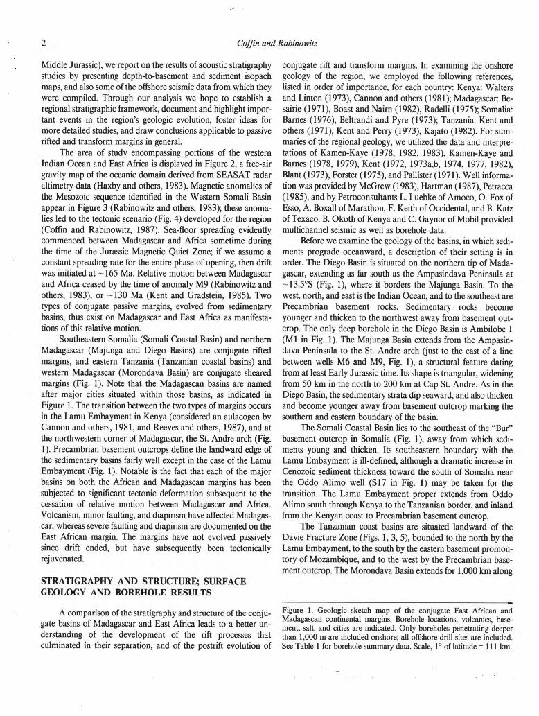
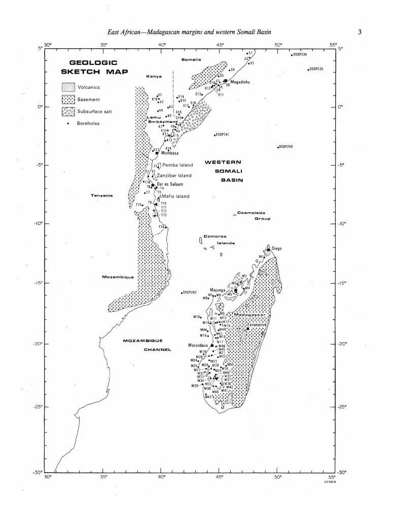
ment outcrop. The Morondava Basin extends for 1,000 km along
Figure 1. Geologic sketch map of the conjugate East African and
Madagascan continental margins. Borehole locations, volcanics, base-
ment, salt, and cities are indicated. Only boreholes penetrating deeper
than 1,000 m are included onshore; all offshore drill sites are included.
See Table 1 for borehole summary data. Scale, 1° of latitude =111 km.
East African—Madagascan margins and western Somali Basin
v" , ) Ml7
Moiondava ¿m »-M46 1 M̂45 I M21
.M22f •M23
' M26, .M28
M39-
\M43 J
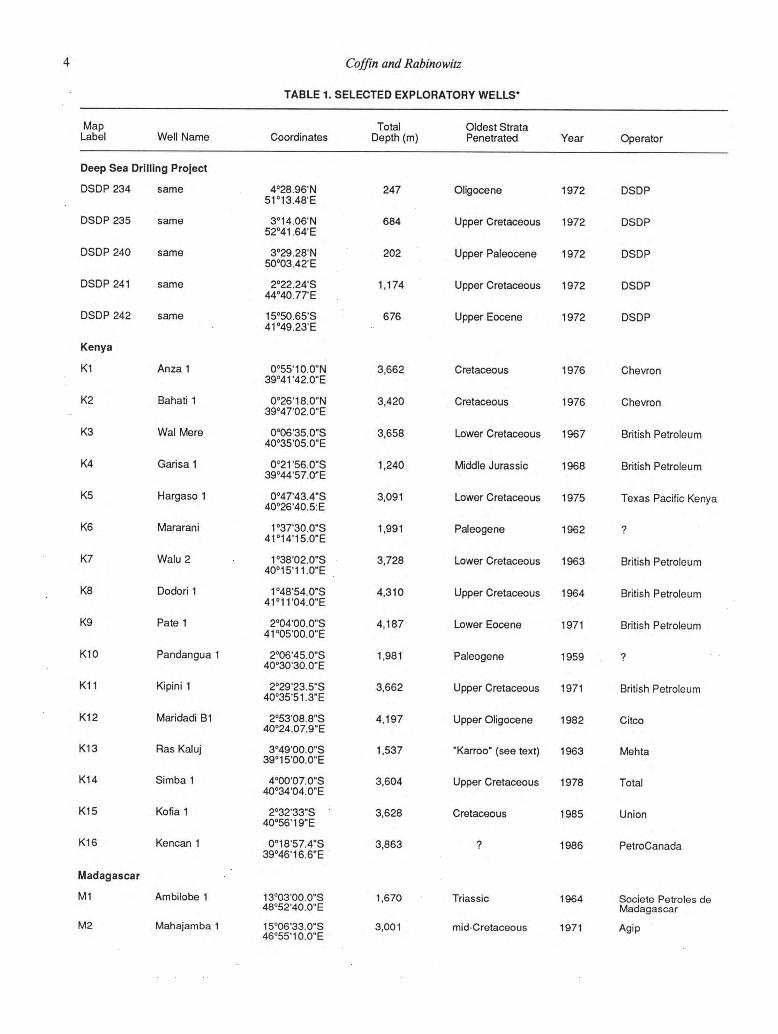
Coffin and Rabinowitz TABLE 1. SELECTED EXPLORATORY WELLS*
Map Label Well Name Coordinates
Total Depth (m)
Oldest Strata Penetrated Year Operator
Deep Sea Dril l ing Project
DSDP234 same
DSDP235 same
DSDP 240 same
DSDP 241 same
DSDP 242 same
Kenya
K1
K2
K3
K4
K5
K6
K7
K8
K9
K10
K11
K12
K13
K14
K15
K16
An za 1
Bahati 1
Wal Mere
Garisa 1
Hargaso 1
Mararani
Walu 2
Dodori 1
Pate 1
Pandangua 1
Kipini 1
Maridadi B1
Ras Kaluj
Simba 1
Kofia 1
Kencan 1
Madagascar
M1 Ambilobe 1
M2 Mahajamba 1
4°28.96'N 51°13.48'E
3°14.06'N 52°41,64'E
3°29.28'N 50°03.42'E
2°22.24'S 44°40.77'E
15°50.65'S 41°49.23'E
0°55'10.0"N 39°41 '42.0"E
0°26'18.0"N 39°47'02.0"E
0°06'35.0"S 40°35'05.0"E
0°21'56.0"S 39°44'57.0"E
0°47'43.4"S 40°26'40.5:E
1 °37'30.0"S 41°14'15.0"E
1°38'02.0"S 40°15'11,0"E
1°48'54.0"S 41°11'04.0"E
2°04'00.0"S 41°05'00.0"E
2°06'45.0"S 40°30'30.0"E
2°29'23.5"S 40°35'51.3"E
2°53'08.8"S 40°24.07.9"E
3°49'00.0"S S g ^ ' O O ^ ' E
4°00'07.0"S 40°34'04.0"E
2°32'33"S 40°56'19"E
0°18'57.4"S 39°46'16.6"E
13°03'00.0"S 48°52'40.0"E
15°06'33.0"S 46°55'10.0"E
247
684
202
1,174
676
3,662
3,420
3,658
1,240
3,091
1,991
3,728
4,310
4,187
1,981
3,662
4,197
1,537
3,604
3,628
3,863
1,670
3,001
Oligocene 1972
Upper Cretaceous 1972
Upper Paleocene 1972
Upper Cretaceous 1972
Upper Eocene 1972
Cretaceous
Cretaceous
Lower Cretaceous
Middle Jurassic
Lower Cretaceous
Paleogene
Lower Cretaceous
Upper Cretaceous
Lower Eocene
Paleogene
Upper Cretaceous
Upper Oligocene
"Karroo" (see text)
Upper Cretaceous
Cretaceous
1976
1976
1967
1968
1975
1962
1963
1964
1971
1959
1971
1982
1963
1978
1985
1986
Triassic 1964
mid-Cretaceous 1971
DSDP
DSDP
DSDP
DSDP
DSDP
Chevron
Chevron
British Petroleum
British Petroleum
Texas Pacific Kenya
?
British Petroleum
British Petroleum
British Petroleum
?
British Petroleum
Citco
Mehta
Total
Union
PetroCanada
Société Petroles de Madagascar
Agip
East African—Madagascan margins and western Somali Basin
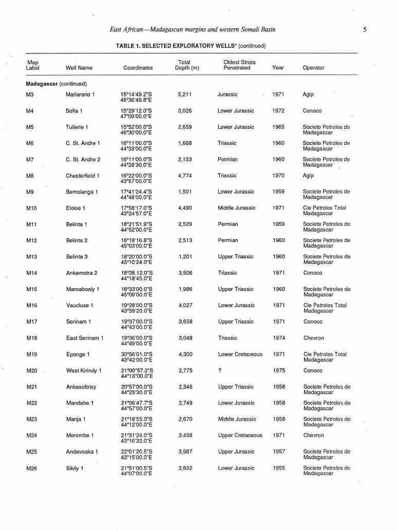
TABLE 1. SELECTED EXPLORATORY WELLS* (continued)
5
Map Label Well Name Coordinates
Total Depth (m)
Oldest Strata Penetrated Year Operator
Madagascar (continued)
M3 Mariarano 1
M4
M5
M6
M7
M8
M9
M10
M11
M12
M13
M14
M15
M16
M17
M18
M19
M 20
M21
M22
M 23
M24
M25
M 26
Sofia 1
Tuilerie 1
C. St. Andre 1
C. St. Andre 2
Chesterfield 1
Bemolanga 1
Eloise 1
Belinta 1
Belinta 2
Belinta 3
Ankamotra 2
Maroaboaly 1
Vaucluse 1
Serinam 1
East Serinam 1
Eponge 1
West Kirindy 1
Ankasofotsy
Mandabe 1
Manja 1
Morombe 1
Andavoaka 1
Stkily 1
15°14'49.2"S 46°36'49.8"E
15°29'12.0"S 47°09'00.0"E
15°52'00.0"S 46°30'00.0"E
16°ir00.0"S 44°33'00.0"E
16°11'00.0"S 44°28'30.0"E
16°22'00.0"S 43°57'00.0"E
17°41'24.4"S 44°48'00.0"E
17°58'17.0HS 43°24'57.0"E
18°21'51.9"S 44°52'00.0"E
18°18'16.8"S 45°03'00.0"E
18°20'00.0"S 45°10'24.0"E
18°28.12.0"S 44°18'45.0"E
18°33'00.0"S 45°09'00.0"E
19°28'00.0"S 43°59'20.0"E
19°37'00.0"S 44°43'00.0"E
19°36'00.0"S 44°49'00.0"E
30°56'01.0"S 43°42'00.0"E
21°00"57.2"S 44°13"00.0"E
20°57'00.0"S 44°25'30.0"E
21°06'47.7"S 44°57'00.0"E
21°18'55.0"S 44°12'00.0"E
21°31'24.0"S 43°16'32.0"E
22°01'20.5"S 43°15'00.0"E
21°51'00.5"S 44°07'00.0"E
5,211 Jurassic 1971
3.026 Lower Jurassic 1972
2,659 Lower Jurassic 1965
1,668 Triassic 1960
2,153 Permian 1960
4.774 Triassic 1970
1,501 Lower Jurassic 1959
4,490 Middle Jurassic 1971
2,529 Permian 1959
2,513 Permian 1960
1,201 Upper Triassic 1960
3,506 Triassic 1971
1.986 Upper Triassic 1960
4.027 Lower Jurassic 1971
3,658 Upper Triassic 1971
3,048 Triassic 1974
4,300 Lower Cretaceous 1971
2.775 ? 1975
2,346 Upper Triassic 1958
2,749 Lower Jurassic 1958
2,670 Middle Jurassic 1958
3,458 Upper Cretaceous 1971
3.987 Upper Jurassic 1957
2,832 Lower Jurassic 1955
Agip
Conoco
Société Petroles de Madagascar
Société Petroles de Madagascar
Société Petroles de Madagascar
Agip
Société Petroles de Madagascar
Cie Petroles Total Madagascar
Société Petroles de Madagascar
Société Petroles de Madagascar
Société Petroles de Madagascar
Conoco
Société Petroles de Madagascar
Cie Petroles Total Madagascar
Conoco
Chevron
Cie Petroles Total Madagascar
Conoco
Société Petroles de Madagascar
Société Petroles de Madagascar
Société Petroles de Madagascar
Chevron
Société Petroles de Madagascar
Société Petroles de Madagascar
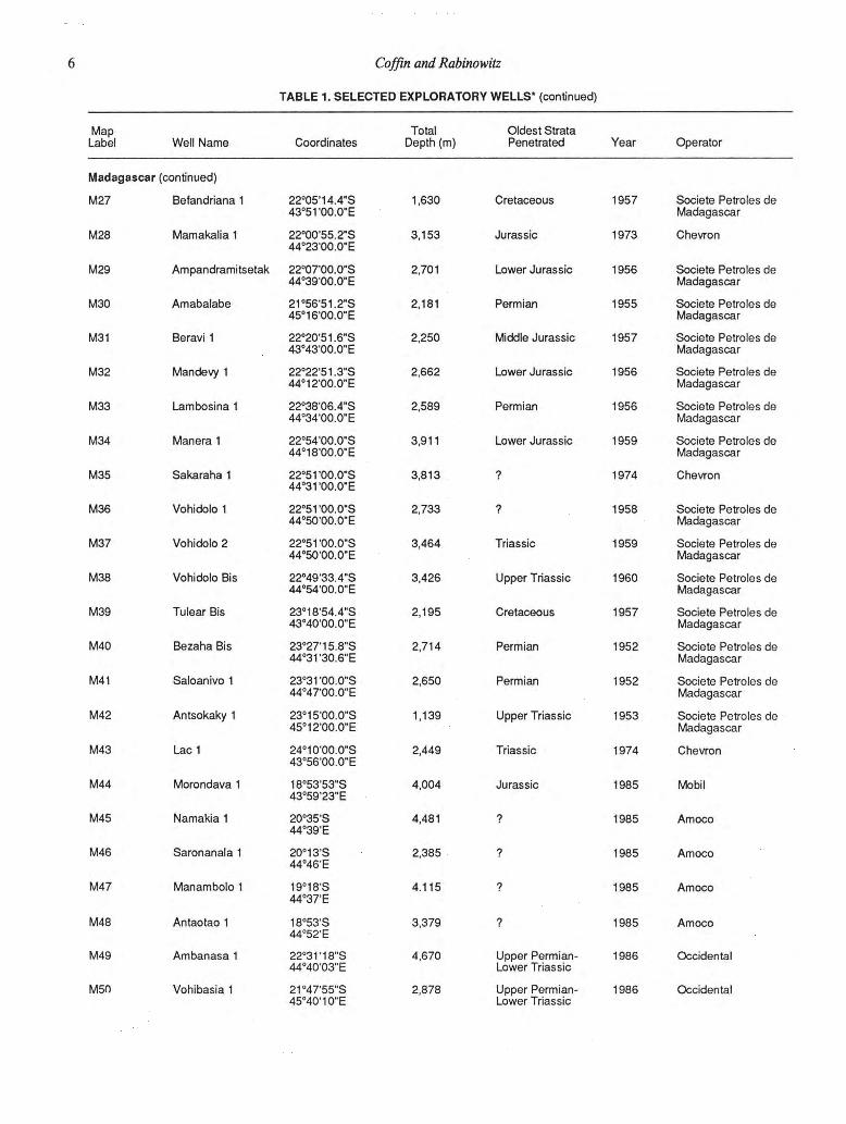
6 Coffin and Rabinowitz TABLE 1. SELECTED EXPLORATORY WELLS* (continued)
Map Label Well Name Coordinates
Total Depth (m)
Oldest Strata Penetrated Year Operator
Madagascar (continued)
M27 Befandriana 1
M 28
M29
M30
M31
M32
M33
M34
M35
M36
M37
M38
M39
M40
M41
M42
M43
M44
M45
M46
M47
M48
M49
M 50
Mamakalia 1
Ampandramitsetak
Amabalabe
Be ravi 1
Mandevy 1
Lambosina 1
Manera 1
Sakaraha 1
Vohidolo 1
Vohidolo 2
Vohidolo Bis
Tulear Bis
Bezaha Bis
Saloanivo 1
Antsokaky 1
Lac 1
Morondava 1
Namakia 1
Saronanala 1
Manambolo 1
Antaotao 1
Ambanasa 1
Vohibasia 1
22°05'14.4"S 43°51'00.0"E
22°00'55.2"S 44°23'00.0"E
22°07'00.0"S 44°39'00.0"E
21°56'51.2"S 45°16'00.0"E
22°20'51.6"S 43°43'00.0"E
22°22'51.3"S 44°12'00.0"E
22°38'06.4"S 44°34'00.0"E
22°54'00.0"S 44°18'00.0"E
22°51'00.0"S 44°31'00.0"E
22°51'00.0"S 44°50'00.0"E
22°51'00.0"S 44°50'00.0"E
22°49'33.4"S 44°54'00.0"E
23°18'54.4"S 43°40'00.0"E
23°27'15.8"S 44°31'30.6"E
23°3r00.0"S 44°47'00.0"E
23°15'00.0"S 45°12'00.0"E
24°10'00.0"S 43°56'00.0"E
18°53'53"S 43°59'23"E
20°35'S 44°39'E
20°13'S 44°46'E
19°18'S 44°37'E
18°53'S 44°52'E
22°31'18"S 44°40'03"E
21°47'55"S 45°40'10"E
1,630
3,153
2,701
2,181
2,250
2,662
2,589
3,911
3,813
2,733
3,464
3,426
2,195
2,714
2,650
1,139
2,449
4,004
4,481
2,385
4.115
3,379
4,670
2,878
Cretaceous
Jurassic
Lower Jurassic
Permian
Middle Jurassic
Lower Jurassic
Permian
Lower Jurassic
Triassic
Upper Triassic
Cretaceous
Permian
Permian
Upper Triassic
Triassic
Jurassic
Upper Permian-Lower Triassic
Upper Permian-Lower Triassic
1957 Société Petroles de Madagascar
1973 Chevron
1956 Société Petroles de Madagascar
1955 Société Petroles de Madagascar
1957 Société Petroles de Madagascar
1956 Société Petroles de Madagascar
1956 Société Petroles de Madagascar
1959 Société Petroles de Madagascar
1974 Chevron
1958 Société Petroles de Madagascar
1959 Société Petroles de Madagascar
1960 Société Petroles de Madagascar
1957 Société Petroles de Madagascar
1952 Société Petroles de Madagascar
1952 Société Petroles de Madagascar
1953 Société Petroles de Madagascar
1974 Chevron
1985 Mobil
1985 Amoco
1985 Amoco
1985 Amoco
1985 Amoco
1986 Occidental
1986 Occidental

East African—Madagascan margins and western Somali Basin
TABLE 1. SELECTED EXPLORATORY WELLS* (continued)
Map Label Well Name Coordinates
Total Depth (m)
Oldest Strata Penetrated Year Operator
Somalia
51
52
53
54
55
56
57
58
59
510
511
512
513
514
515
516
517
518
519
520
521
Marai Ascia 1
El Cabobe 1
Mereghl
Gal Tardo 1
Duddumai 1
Uarsceik 1
Afgoi 1
Merca 1
Coriole 1
Coriole 2
Dobei 1
Dobei 2
Brava 1
Lach Bissigh 1
Lach Dera 1
Giamma 1
Oddo Alimo
Obbe 1
Kudha 1
Agfoi 2
Agfoi 3
4°31'00.0"N 47°26'00.0"E
4°14'48.0"N 47°40'42.0"E
3°43'11.6"N 47°32'05.4"E
3°10'00.0"N 45°50'50.0"E
2°37'14.0"N 44°53'57.0"E
2°14'00.0"N 45°30'00.0"E
2°06'52.0"N 45°04'10.0"E
1°52'21.0"N 44°53'28.0"E
1°50'39.0"N 44°33'16.0"E
1°49'43.0"N 44°33'52.0"E
1°48'31.0"N 44°31'29.0"E
2°42'44.0"N 44°28'25.0"E
1°04'00.0"N 43°31'00.0"E
0°49.54.0"N 41°21 '07.0"E
0°29'48.0"N 41°35'34.0"E
0°06'09.0"N 42°49'13.0"E
0°04'16.0"N 42°25'08.0"E
0°39'11.0"S 41°31'07.0"E
0°56'27.5"S 41°53'00.8"E
2°05'20"N 45°04'52"E
Vicinity ot Agfoi 1 and 2
4,115
4,428
4,303
2,438
3,380
4,101
4,164
3,998
3,518
4,069
2,122
3,830
3,810
3,086
2,867
4.126
4,465
4,865
4,972
3,353
4,359
Middle Jurassic
Upper Triassic
Middle Jurassic
Jurassic
Jurassic ?
Jurassic
Upper Cretaceous
Lower Jurassic (?)
Triassic (?)
Tertiary
Tertiary
?
Tertiary
Upper Jurassic
Upper Cretaceous
1958
1980
1982
1967
1960
1968
1966
1959
1961
1965
1961
1961
1963
1965
1965
1965
1964
1982
1982
1985
1985
Sinclair
Arco
Esso
Sinclair
Sinclair
Sinclair
Sinclair
Sinclair
Sinclair
Sinclair
Sinclair
Sinclair
Sinclair
Gulf
Gulf
Sinclair
Sinclair
Deutsche Texaco
Deutsche Texaco
Government of Somalia
Government of Somalia

8 Coffin and Rabino witz
TABLE 1. SELECTED EXPLORATORY WELLS* (continued)
Map Label Well Name Coordinates
Total Depth (m)
Oldest Strata Penetrated Year Operator
Tanzania
T1
T2
T3
T4
T5
T6
T7
T8
T9
T10
T11
T12
T13
T14
T15
T16
Pemba 5
Ras Machiusi
Zanzibar 1
Tancan 1
Kimbiji 1
Kisarawe 1
Kisangare 1
Mafia 1
Songo Songo 1
Songa Songa 1
Songa Songa 2
Kizimbani 1
Mandawa 7
M'Nazi Bay 1
Lukuliro 1
Kiwangwa
5°16'00.0"S 39°42'00.0"E
6°00'55.0"S 38°51'19.0"E
6°03'00.0"S 39°13'00.0"E
6°56'58.1"S 39°36'39.4"E
6°59'20.0"S 39°32'18.0"E
7°00'18.0"S 39°05'31,0"E
7°29'09.0"S 38°32'42.0"E
7°53'00.0"S 39°45'00.0"E
8°28'37.0"S 39°28'33.0"E
8°30'00.0"S 39°32'00.0"E
8°30'00.0"S 39°32'00.0"E
9°02'30.0"S 39°22'32.0"E
9°25'00.0"S 39°25'00.0"E
10°19'45.2"S 40°23'27.5"E
8°21'31"S 38°25'4rE
6°21'43"S 38°32'56"E
3,886 Upper Cretaceous 1962
3,370 Upper Cretaceous (?) 1974
4,353 Upper Cretaceous 1957
4,685 Tertiary 1985
4,326 Tertiary (?) 1982
4,002 Middle Jurassic (?) 1976
3,296 Middle Jurassic (?) 1976
3,368 Upper Cretaceous 1956
4,426 Middle-Upper 1974 Jurassic (?)
1,006 ? 1976
1,829 ? 1977
2,697 Middle Jurassic 1979
4,065 Permian ?
3,489 ? 1982
2,367 "Karroo" (see text) 1985
3,860 Jurassic 1985
British Petroleum
Agip
British Petroleum
Petrocanada
Sonatrach
Agip
Agip
British Petroleum
Agip
Tanzanian Petroleum Development Corp.
Tanzanian Petroleum Development Corp.
Agip
British Petroleum
Agip
Shell
International Energy Development Corporation
'Including all DSDP wells, and onshore wells deeper than 1,000 m.

East African—Madagascan margins and western Somali Basin 30° 35° 40° 45° 50° 55°
Figure 2. Seasat-derived free-air gravity map of the western Indian Ocean. The contour interval is 5
mGal with major shade changes every 10 mGal; black <-50 mGal; white, >50 mGal. Map, courtesy of
W . F. Haxby. Scale, 1° of latitude = 111 km.

10 Coffin and Rabinowitz
4 0 4 5 5 0
Figure 3. Magnetic anomaly identifications and tectonic elements in the Western Somali and Comoros
Basins (Rabinowitz and others, 1983). D H O W , VLCC and ARS are fracture zones defined by Bunce
and Molnar (1981). Scale, 1° of latitude = 111 km.
20 55

East African—Madagascan margins and western Somali Basin 41 42 43 44 45
Figure 4. Reconstruction of Madagascar to Africa employing a pole at 10°N, 150°E (Coffin and
Rabinowitz, 1987). The intermediate position (Jurassic-Cretaceous boundary, marine magnetic
anomaly M17) involves a rotation of 4.6°; the pre-drift configuration, a rotation of 14.2°. Scale, 1° of
latitude =111 km.
12 Coffin and Rabino witz the west coast of Madagascar landward of the Davie Fracture
Zone (Fig. 5), and exhibits a horst and graben structure created
by faults trending N20°W or N20°E. The northern terminus of
the basin occurs at the St. Andre arch, its eastern boundary is
marked by Precambrian basement outcrop, and its southern
boundary is in the vicinity of the Lac 1 well (M43 in Fig. 1).
All of the onshore basins are mature, and geophysical inves-
tigations have indicated a total sediment accumulation in excess
of 10 km. The Western Somali Basin is the ocean basin created
by the separation of Madagascar and Africa (Fig. 4); its bathy-
metry appears in Figure 6. The Davie Fracture Zone marks its
western boundary, and geophysical parameters (gravity and
magnetics) help define the continent-ocean boundary (Rabino-
witz and LaBrecque, 1977) on the rifted East African and Mad-
agascan margins (Fig. 5).
Pre-Jurassic (Fig. 7) Diego Basin. The oldest sedimentary rocks found in the
Diego Basin are Middle Permian marine beds; marine conditions
persisted into the earliest Triassic. The three major subbasins of
the Diego Basin each record different stratigraphic sequences for
the interval basement through Upper Triassic, although all are
similar to the Sakamena facies of the Majunga Basin. The stratig-
raphy of the best known subbasin includes (from base to Upper
Permian and dated by microfossils): tectonic breccia overlying
basement; massive coarse-grained, dolomite-cemented sandstone
(to 500 m thick), containing coral and other fossils, with angular
conglomerate bands at the base; gray, yellow, or black fossil-
bearing shale (100 to 250 m thick) with dolomitic or quartzite
bands; green sandstone (50 to 100 m thick); interbedded sandy
and massive shale (120 to 150 m thick). Vertical crustal move-
ment during the Late Permian and Early Triassic is recorded as a
discordance between Permian and Triassic strata, and it preserved
Permian sediments in grabens. The Early Triassic was dominated
by the deposition of marine shale (20 to 100 m thick). This shale
is separated by an angular unconformity from overlying continen-
tal sandstone (>2,000 m thick) correlative with the Isalo facies of
the Morondava Basin. The sandstone varies greatly in grain size,
contains a few conglomerate bands and sandy shale horizons, and
continues into the upper Lower Jurassic. Ammonites, fish, am-
phibians, and lamellibranches have been used to date the pre-
Jurassic sediment.
Majunga Basin. Three hundred meters of Upper Permian
through Lower Triassic sedimentary rock, consisting of two prin-
cipal sandstone layers separated by shale, are found in the Ma-
junga Basin. The lower arkose contains large pebbles of granite.
The fossil-bearing shale is fissile, locally sandy, and contains fos-
siliferous carbonate lenses and nodules. The upper sandstone is
fine grained, micaceous, and argillaceous, with nodules of
carbonate-cemented sandstone. Disconformably overlying the
previous sequence is continental sandstone of the Isalo group, the
deposition of which probably commenced in the Middle Triassic
and continued through Late Triassic time. This fossil-poor sand-
stone is generally coarse grained, cross-bedded, mineralogically
homogeneous, and poor in argillaceous material; it attains a
thickness of several hundred meters.
Somali Coastal Basin. No pre-Jurassic sedimentary rock
has been reported from outcrop in the Somali Coastal Basin.
However, the Brava 1 well (SI3 in Fig. 1) bottomed in quartz
sandstone 120 m thick, which bears resemblance to the continen-
tal Triassic-Lower Jurassic Adigrat Formation described in other
wells. Both Kamen-Kaye (1978) and Kamen-Kaye and Barnes
(1978) noted that palynomorphs of Permo-Triassic age were
found in the shale overlying the quartz sandstone in the Brava 1
well. Nevertheless, Beltrandi and Pyre (1973) considered both
units to be Jurassic in age. Until more documentation becomes
available, we consider the basal sandstone to be the top of the
Adigrat Formation, the lower part of which is Triassic in age.
Lamu Embayment. The Karroo makes up the oldest sed-
imentary unit in the Lamu Embayment. At the bottom of the
Karroo sequence are the Taru Grits, fluviatile (with possible ma-
rine horizons), "fresh" feldspathic grit and sandstone derived
from basement to the west. Deposition of the Karroo beds was
initiated by major faulting in Late Carboniferous or Early Per-
mian time. The Taru Grits are Late Carboniferous to Late Per-
mian in age (dated by a fresh-water bivalve) and attain a
thickness of 2,700 m. At the very base of the Taru Grits are
tilloids comparable in age to tillites found in the Morondava
Basin. Overlying the Taru Grits are the Maji-ya-Chumvi beds,
which represent a change from fluviatile to lacustrine conditions.
These beds, totaling 1,200 m in thickness, consist of silty shale,
siltstone, and flaggy sandstone that commonly exhibit ripple
marks, cross-bedding, sun cracks, and rain pits. The lower half
(550 m) of the beds is continental, containing plant fossils, and is
overlain by a thin sequence of Lower Triassic marine shale con-
taining fish fossils. The upper part (650 m) of the unit indicates by
the presence of a fresh-water brachiopod—a fresh or possibly
brackish lacustrine environment. The Mariakani Sandstone suc-
ceeds the Maji-ya-Chumvi beds, and represents a fresh cycle of
coarse deposition. The sandstone, containing local micaceous silt-
stone, silty shale, and plant remains, is clean, fine grained, and
flaggy. The environment of deposition was deltaic, indicated by
current beds and ripple marks. The sandstone totals 2,900 to
3,400 m in thickness, and is assumed to be Middle and Late
Triassic in age. Significant faulting occurred between deposition
of the Mariakani and the overlying Mazeras Sandstone, which
tops the Karroo sequence. This unit ranges in age from Late
Triassic through Early Jurassic, and consists of 450 m of clean,
coarse-grained, cross-bedded deltaic sandstone and grit with in-
terbedded siltstone and silicified wood fragments.
Tanzanian coastal basins. The onset of Karroo (Permo-
Carboniferous to Early Jurassic) deposition was marked by the
Carboniferous activation of systems of faults trending north-
northeast, north-northwest, and one trending east-west; major
faulting continued intermittently into Jurassic time. Karroo sand-
stone, siltstone, and conglomeratic arkose overlying a basal con-
glomerate (resting on basement) attain thicknesses of 400 to

East African—Madagascan margins and western Somali Basin 41 42 43 44 45
Figure 5. Tectonic elements of the East African-Madagascan margins and Western Somali Basin,
including fracture zones, region of steep gradient in the free-air gravity anomaly field and axis of positive
magnetic anomaly, and the seaward limit of diapirs. The location of magnetic anomaly M17 on both the
north and south flanks of the paleo-spreading ridge are plotted. Scale, 1 ° of latitude =111 km.

14 Coffin and Rabino witz
C o n t o u r s in m e t e r s
Somalia
L I B A S I N
Tanzania
isjnoledo —¿»roup 1
Comoros Islands
Mozambique C O M O R O S BAS>**I
Madagascar
East African—Madagascan margins and western Somali Basin 41
42 43 44 45
2,200 m in northern Tanzania; as much as 3,000 m of limestone,
sandstone, and mudstone are preserved in the south. The Man-
da wa 7 borehole (T13 in Fig. 1) penetrated 3,000 to 4,000 m of
predominantly Triassic (dated by fossils, including a fish) evapo-
rites in a Karroo rift graben. No pre-Jurassic sediment has been
encountered in outcrop or by drilling in central Tanzania or
offshore.
Morondava Basin. Rocks of the Sakoa Group, consisting
of four divisions, unconformably overlie faulted, horst-and-
graben Precambrian basement terrain. Thicknesses vary dramati-
cally from subbasin to subbasin, and also from north to south.
The Sakoa is 2,000 m thick in the southern Morondava Basin,
and thins gradually to Cap St. Andre where none is preserved.
The lowest unit of the Sakoa is a 50- to 450-m-thick glacial
sequence of tillite and black, locally varved shale; it is of Late
Carboniferous age. Immediately overlying the glacial sediment is
a coal-bearing sequence, 100 to 150 m thick, that begins with
coarse, cross-bedded sandstone and conglomeratic horizons. Rare
shale is associated with coal horizons, and the entire sequence is
Early Permian in age. Significant occurrences of the tillite and
coal-bearing sequences are limited to the southern portion of the
Morondava Basin, whereas the two younger sequences of the
Sakoa Group extend into the central and northern portions.
Above the coal sequence are the Lower Red Beds, from 20 to 400
m thick. Sand and shale dominate this sequence, and the sand
becomes coarser and conglomeratic toward the top of the section.
Two weak marine episodes are recorded in the sequence. The top
of the Sakoa Group is marked by the Middle Permian Vohitolia
marine limestone, 20 to 30 m thick. The limestone may be oolitic,
reefal, or brecciated, and the sequence was strongly eroded prior
to the deposition of younger rock preserved in the Sakamena
Group.
The Sakamena Group rests with a 12° unconformity on
either basement or the Sakoa Group, and is more widely distrib-
uted than the Sakoa. The Sakamena thins from greater than
4,000 m in the south to 20 m in the north, and is divided into
three units. The basal conglomerate of the lower unit, totaling
several tens of meters, is a torrential deposit of rounded boulders
derived from either basement or the Vohitolia Limestone. A
shale-sandstone succession overlies the conglomerate; the sand-
stone is hard and siliceous, cross-bedded at certain horizons, and
locally conglomeratic. There are some marine limestone intervals,
but the Lower Sakamena (Upper Permian), 2,000 to 3,000 m
thick, is a dominantly continental section. The Middle Sakamena,
Figure 6. Bathymetry of the East African continental margin, Mada-
gascan insular margin, Western Somali Basin, and Comoros Basin. Con-
tour interval, 500 m. Primary data sources for the compilation are
Hydrographie Office (South Africa), Hydrographie Office (United
Kingdom), Lamont-Doherty Geological Observatory, Scripps Institution
of Oceanography, U.S. Naval Oceanographic Office, University of Cape
Town, and Woods Hole Oceanographic institution. Scale, 1° of latitude
= 111 km. From Coffin (1985).
-200 m thick, is a nodular, septarian shale sequence regarded as
lagoonal or marine, which correlates with the Lower Triassic of
the Diego Basin. The 500-m-thick Upper Sakamena is an alterna-
tion of white, cross-bedded sandstone and red shale, representing
mixed continental and marine conditions.
The Sakamena Group is separated by a weak angular dis-
cordance from the overlying Isalo Group, which attains a thick-
ness of 5,000 to 6,000 m in the south and 1,700 m in the north.
The Isalo ranges in age from Middle Triassic through Early Ju-
rassic, and consists of a fine-grained, poorly consolidated,
argillaceous-cemented, ocherous sandstone containing feldspar,
mica, lenses of variegated shale and coal, and tar sands.
Western Somali Basin. No pre-Jurassic rock has been
recovered from the Western Somali Basin, nor is it suspected that
there is any rock of that age, according to the tectonic scenario
(e.g., Coffin and Rabinowitz, 1987) developed for the region.
Summary. Mixed-facies rock sediments of the Diego and
Majunga Basins demonstrate subsidence occurring from Permo-
Carboniferous time through the Late Triassic in grabens striking
northeast. The conjugate Somali Coastal Basin has no well-
documented rock for this time interval, but the "Bur" basement
outcrop strikes northeast as well. Mixed-facies rocks, including
tilloid and salt, of the Lamu Embayment, Tanzanian Coastal
Basins, and Morondava Basin, document subsidence in the Car-
boniferous through Late Triassic interval along faults trending
generally north-northeast or north-northwest. A major problem
with Karroo-age rocks of East Africa and Madagascar is the lack
of paleontologic and other information to determine facies and
age.
Lower Jurassic (Fig. 8) Diego Basin. The thick (>2,000 m) continental Isalo
Sandstones with conglomeratic beds and thin, sandy shale hori-
zons extend upward into the Lower Jurassic. By the end of Early
Jurassic time, however, the facies changed dramatically. North of
the Ambilobe 1 well (Ml in Fig. 1), marine marl and limestone
(—50 m thick) of Toarcian and Aalenian age are present as the
fossiliferous Marivorahana Series. To the southwest a mixed fa-
cies represents this time interval, and the stratigraphic succession
is as follows: gray limestone with some shale and sandstone inter-
calations overlying the Isalo Sandstones; mixed facies of inter-
bedded marine and continental shale, limestone, siltstone, and
sandstone. Interestingly, an island offshore the Diego Basin,
Nosy Be, exposes 3,000 m of Lower Jurassic sandstone and
arkose.
Majunga Basin. Deposition of the fossil-poor Isalo conti-
nental cross-bedded sandstone, described above with pre-Jurassic
rock, continued from the Triassic into the Early Jurassic. The
total thickness of the Middle Triassic through Pliensbachian sec-
tion, which is cemented by carbonate in its upper portion, is 500
to 600 m in the southern Majunga Basin. At the end of Early
Jurassic time, the Sahondralava-Ihopy horst became emergent
and resulted in differing sedimentary histories to its north and

16 Coffin and Rabino witz
Unconformity
Figure 7. Pre-Jurassic plate tectonic reconstructon and stratigraphie sections. Scale, 1° of latitude =
111 km; both key and scale apply to this and subsequent maps.

East African—Madagascan margins and western Somali Basin 41
42 43 44 45
18 Coffin and Rabino witz
south. In the northern Majunga Basin, the Middle Triassic
through Bajocan interval is -200 m thick. The Toarcian, identi-
fied only in the southern part of the basin, is represented by a
distinctive unit of interbedded marly limestone and shale. Toward
the end of Early Jurassic time, lateral facies changes became
significant, as did the development of structural highs and flexures
within the Majunga Basin. Marine conditions gradually became
established from south to north during Early and Middle Jurassic
time.
Somali Coastal Basin. Deposition of the Adigrat Forma-
tion continued uninterrupted from Triassic through Pliensbachian
time. The formation consists of as much as 130 m of quartz
sandstone with intercalations of gypsum and dark shale. Interest-
ingly, the Coriole 1 well (S9 in Fig. 1) bottomed in extrusive
igneous rock after penetrating at least part of the Adigrat Forma-
tion. This rock may be a manifestation of the rifting process that
ultimately led to the separation of Madagascar and Africa in
Middle Jurassic time (Segoufin and Patriat, 1980; Parson and
others, 1981; Rabinowitz and others, 1983). Overlying this sand-
stone and extending to the top of the Middle Jurassic are basinal
dark gray shale and dark gray argillaceous fossiliferous limestone
that grade to pure limestone seaward. At the Marai Ascia well
(SI in Fig. 1), this section—the Hamanlei Formation—is at least
1,525 m thick; just to the north at the Obbia well (not on map),
the thickness is at least 2,175 m.
Lamu Embayment. Deposition of the Mazeras Sandstone
probably continued from Late Triassic through Early Jurassic
time. These beds consist of 450 m of clean, coarse-grained, cross-
bedded deltaic sandstone and grit containing interbedded siltstone
and silicified wood. At the end of the Early Jurassic, a major
episode of faulting accompanied the end of the predominantly
continental Karroo deposition.
Tanzanian coastal basins. The deposition of Karroo
conglomerate and sandstone, siltstone, shale, and evaporites lo-
cally (Mandawa) continued unimpeded from Triassic through
Toarcian time. Similarly, faulting of the region continued through
the Early Jurassic to the end of Middle Jurassic time. The total
thickness of Karroo sediment ranges from 400 to 2,200 m in the
north, and to as much as 3,000 m in the south. Evaporites en-
countered in the Mandawa 7 drillhole (T13 in Fig. 1) extend
through the Toarcian, although most of the 3,000- to 4,000-m-
thick section is of Triassic age. The transitional Ngerengere and
correlative rock, consisting of bedded feldspathic calcareous
sandstone with local limesoone beds (some oolitic) and shale, and
appearing to be reworked Karroo sediment, are sandwiched be-
tween the Karroo and Middle Jurassic rock and are thus presum-
ably of Toarcian and Aalenian age. The total thickness of the
Ngerengere sequence ranges from 300 to 760 m in the north, to
230 m in the south. No Lower Jurassic sedimentary beds have
been sampled in outcrop or by drilling in central Tanzania or
offshore. The Jurassic section thins inland.
Morondava Basin. Deposition of the undifferentiated
Isalo continental sandstone continued from Middle Triassic
through Early Jurassic time, attaining a total thickness of 5,000 to
6,000 m in the south, and 1,700 m in the north of the Morondava
Basin. A slight exception to this is in the extreme north, where a
marine Toarican limestone horizon was deposited synchronous
with a change to marine facies in the Majunga Basin. The Isalo
Group is a fine-grained, poorly consolidated, argillaceous-
cemented ocherous sandstone containing feldspar, mica, lenses of
variegated shales, and coal. At the Chesterfield 1 well (M8 in Fig.
1), 1,670 m of Lower Jurassic interbedded limestone and shale,
with basalt flows near the base, were recovered. The East Seri-
nam 1 well (Ml8 in Fig. 1) recovered 330 m of massive shelf
limestone, and to the south the Mamakiala 1 borehole (M28 in
Fig. 1) recovered 621 m of Lower Jurassic thin limestone, shale,
and minor sandstone.
Western Somali Basin. No rock of Early Jurassic age has
been recovered from the Western Somali Basin. The tectonic
scenario developed for the region (Coffin and Rabinowitz, 1987)
argues against the existence of rock of that age in the basin.
Summary. The conjugate rifted basins—Diego, Majunga,
and Somali—along with the extreme northern part of the Mo-
rondava Basin, all show a major facies change from continental to
marine near the end of Early Jurassic time. In the Majunga Basin
the marine conditions proceeded from south to north during
Early and Middle Jurassic time. Extrusive igneous rock, possibly
rift volcanics, has been found in the Somali Coastal Basin, as well
as in the northern portion of the Morondava Basin. Continental
facies dominated the Lamu Embayment until a major episode of
faulting at the end of the Early Jurassic Epoch. Mixed facies
prevailed in the conjugate Tanzanian and Morondava Basins,
including evaporites at Mandawa, and faulting was intense in
Tanzania.
Middle Jurassic (Fig. 9) Diego Basin. The Diego Basin must be divided into two
contrasting provinces for the Middle (and Upper) Jurassic. The
extreme westernmost section of the basin, including the island of
Nosy Be and the peninsula extending from Madagascar toward it,
subsided rapidly during this time. Thick (3,000 to 6,000 m) de-
posits of paralic, silty, fossiliferous sediment, commonly calcare-
ous, record episodes of coarse-grained and calcareous sediment
deposition, and rapid vertical and horizontal facies changes. The
region to the east contains epicontinental, fauna-rich, sandy marl
and limestone ranging from 400 to 550 m thick.
Majunga Basin. In the northern Majunga Basin, deposi-
tion of the Isalo continental cross-bedded sandstone continued
until Bajocian time; the total Middle Triassic through Aalenian
interval is -200 m thick. The Lower Calcareous Sandstone series,
consisting of fine-grained, carbonate-cemented sandstone inter-
calated with shale and local Isalo-type sandstone, is assigned to
the Bajocian from its stratigraphic position (no paleontologic
markers are present). The Upper Calcareous Sandstone of Batho-
nian age succeeds the Lower series; it comprises 450 m of Isalo-
type cross-bedded fossiliferous (including dinosaur remains)
sandstone with intercalations of calcareous sandstone and lime-
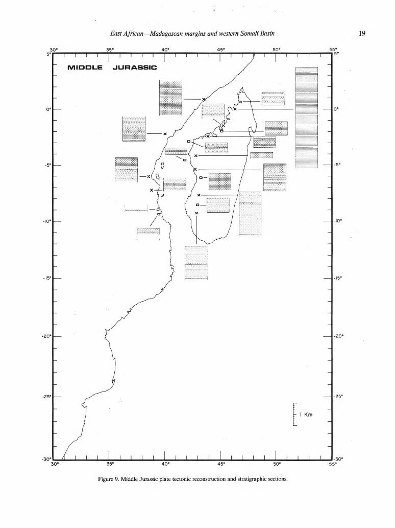
East African—Madagascan margins and western Somali Basin 41 42 43 44 45
35° 40" 45° 50°
Figure 9. Middle Jurassic plate tectonic reconstruction and stratigraphie sections.
20 Coffin and Rabino witz stone. Alternating marine and nonmarine phases dominated the
Bajocian and Bathonian in the northern Majunga Basin, and
marine conditions became firmly established in the Callovian,
from which are preserved 100 m of fossiliferous clay, marl, sand-
stone, and limestone. At the Sofia 1 borehole (M4 in Fig. 1),
590 m of Middle Jurassic limestone and shale were encountered.
In the southern portion of the Majunga Basin, the Aalenian con-
sists of 60 m of fine-grained fossiliferous shale with continental
sandstone layers and local lignite horizons. Marking the onset of
marine conditions above are 250 m of fossiliferous Bajocian sed-
iment, primarily massive and oolitic limestone, but including sev-
eral shale horizons. The Bathonian is represented by 150 m of
interbedded limestone and shale. Finally, 60 m of fossiliferous
Callovian marl, with limestone bands, are preserved. Stratigraph-
ic evidence from the northern and southern portions of the
Majunga Basin thus indicate a northward migration of marine
facies during Middle Jurassic time.
Somali Coastal Basin. Deposition of the undifferentiated
Hamanlei Formation, consisting of basinal dark gray shale and
dark gray argillaceous fossiliferous limestone that grades to pure
limestone seaward, continued through the end of Callovian time.
At the Marai Ascia well (SI in Fig. 1), the Hamanlei is at least
1,525 m thick, and a minimum thickness of 2,175 m has been
reported just to the north. Major normal faults trending northeast
in the Somali Coastal Basin were active during Middle Jurassic
time, and these faults step down to the southeast.
Lamu Embayment. Marine conditions became established
in the Lamu Embayment during Middle Jurassic time. The Bajo-
cian and Bathonian are represented by 150 to 600 m of the
Kambe Formation, a dark gray oolitic limestone with abundant
fauna, especially coral and ammonoids (Westermann, 1975) and
interbedded shale. A deep-water facies is present in the south, and
a shallow-water environment is indicated to the north. The
Kambe limestone is succeeded by 180 m of sandy micaceous
shale with thin, fine-grained sandstone. These Kibiongoni beds
rest conformably on the Kambe, and represent a continuation of
shallow-water deposition. The beds grade into the "Upper" Ju-
rassic shale. The lower shale is Callovian in age, and is probably
deltaic. It contains numerous ammonites, often in septarian nod-
ules. The total thickness of the "Upper" Jurassic shale is 1,700 m,
most of which is Late Jurassic in age.
Tanzanian coastal basins. Deposition of the transitional
Ngerengere (north), Pindiro (south), and correlative units, appar-
ently reworked Karroo sediment, continued from the Early Ju-
rassic through the Aalenian in northern and central Tanzania, and
through the Bajocian in the south. The Ngerengere consists of 300
to 760 m of bedded feldspathic calcareous sandstone with local
limestone beds (some oolitic) and shale, whereas the Pindiro
comprises as much as 230 m of shale with local coarse, con-
glomeratic feldspathic sandstone, red mudstone, and thin oolitic
limestone. At the Mandawa 7 borehole (T13 in Fig. 1), the thick
evaporite sequence continues to the end of the Aalenian. The
transitional units are overlain unconformably in all locations ex-
cept the Mandawa borehole by marine limestone of Bajocian or
Bathonian through Callovian age. (At Mandawa the Aalenian
evaporites pass conformably upward to shale and limestone of
Bajocian and Bathonian age, respectively.)
In the north the Amboni Limestone, a dense, well-bedded
rock, commonly sandy, partly oolitic or pisolitic, attains a maxi-
mum thickness of 340 m. The limestone is poorly fossiliferous,
and is dated as Bajocian and Bathonian (and sometimes Callo-
vian) based on limited molluscs and the presence of well-dated
(ammonites) overlying Callovian shale in certain sections. In cen-
tral Tanzania, the correlative Lugoba, Kidugallo, and Kidunda
limestones of Bajocian through Callovian age are preserved. In-
terfingered with these limestones are the Posidonia Shales of the
same age. To the south, the Bathonian Mtumbei Limestone—a
massive sequence of oolitic sandy limestone and calcareous sand-
stone containing a varied fauna of bivalves, gastropods, brachio-
pods, corals, and algae—attains a thickness of 150 m. In the
south, in outcrop and at the Kisarawe and Kisangare boreholes
(T6 and T7, respectively, in Fig. 1), the Callovian is represented
by the bottom of the Mandawa Series, which extends into the
Upper Jurassic. The entire series consists of -600 m of inter-
layered buff sandstone and red clay with marine fossils. Finally, at
the Kizimbani borehole (T12 in Fig. 1), evaporites of Callovian
age were recovered above Bathonian limestone, but no thick-
nesses have been reported. The Jurassic section thins inland. The
basal transgressive limestone coincides with the phase of major
faulting that defined the inland margins of Tanzania's coastal
basins.
Morondava Basin. The Aalenian beds in the Morondava
Basin are a continental facies, undifferentiated from the Middle
Triassic to Lower Jurassic Isalo Sandstone. Marine conditions
developed during Bajocian and Bathonian time, and dominated
the northern part of the basin, whereas in the central and southern
portions, mixed facies with localized marine incursions were the
rule. Facies varied markedly in Middle Jurassic time, as did basin
geometry, and there were important periods of nondeposition.
To document these variations, we examine five sections de-
rived from outcrops in a north-south orientation along the axis of
the Morondava Basin. In the north the Bajocian through Callo-
vian interval is represented by -300 m of limestone. In the north-
central portion of the basin is -1,200 m of this interval, consisting
of three units approximately equal in thickness.
The lower unit consists of interbedded limestone and shale,
the middle unit of interbedded shale and limestone with common
sandstone horizons, and the upper unit of limestone. The central
basin displays 2,000 m of Bajocian through Callovian strata. At
the base of the section are -100 m of limestone, succeeded by
1,900 m of sandstone with some shale horizons in the middle, and
rare limestone horizons in its upper section. The East Serinam 1
well (Ml8 in Fig. 1) documents 732 m of Middle Jurassic mas-
sive shelf limestone. In the south-central portion of the basin lies
1,500 m of the interval, with limestone and shale (100 m) at the
base of the column succeeded by 1,400 m of sandstone with
oolitic limestone in the center of the section and some marl and
shale stringers near the top. At the Mamakiala 1 borehole (M28

East African—Madagascan margins and western Somali Basin 41
42 43 44 45
in Fig. 1), 625 m of deltaic shale, siltstone, and thin sandstone
were recovered. No Middle Jurassic sedimentary rock is pre-
served in the southernmost part of the Morondava Basin. Off-
shore, the Chesterfield 1 well (M8 in Fig. 1) records 414 m of
Middle Jurassic basalt flows interbedded with limestone and
sandstone. The Eloise 1 well (M10 in Fig. 1) recovered 244 m of
calcareous shale and thin limestone stringers.
Western Somali Basin. The rift/drift transition marking
the initiation of sea-floor spreading between Madagascar and
Africa occurred during Callovian time, so a small section of
Middle Jurassic age should be present. None, however, has been
recovered from the Western Somali Basin to date.
Summary. Both the Diego and Somali Coastal Basins re-
cord active faulting and subsidence during Middle Jurassic time.
In the Majunga Basin the migration of marine facies from south
to north continued from Early Jurassic time. Marine conditions
were established in the Lamu Embayment, as well as in the
conjugate Tanzanian Coastal and Morondava Basins. Major
faulting and subsidence (and the continuation of evaporite depo-
sition) are recorded in Tanzania, and changing subbasin geome-
tries and basalt flows highlighted the Middle Jurassic Epoch in
the Morondava Basin.
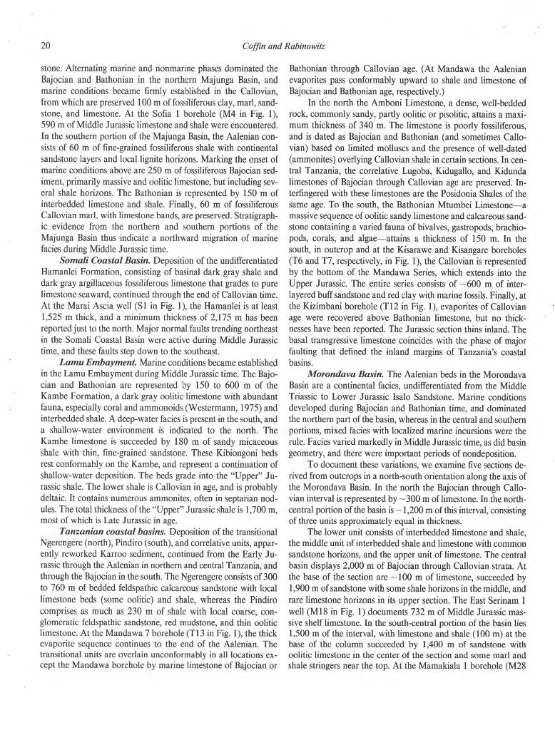
Upper Jurassic/Lower Cretaceous (Fig. 10) Diego Basin. The Upper Jurassic stratigraphy of the Diego
Basin is not differentiated from the Middle Jurassic section. As
previously discussed, the two subbasins of the Diego Basin dis-
play very different stratigraphies. The Nosy Be and peninsular
province is characterized by paralic, silty, commonly calcareous,
fossiliferous sediment (3,000 to 6,000 m thick), recording influxes
of coarse-grained sediment, calcareous intervals, and sudden fa-
cies changes. To the west are epicontinental, marine, fauna-rich,
sandy marl and limestone ranging from 400 to 550 m in
thickness.
The Lower Cretaceous is represented by fossiliferous marl,
sandstone, and shale. The entire stratigraphie sequence consists of
-250 m of Upper Valanginian through Upper Hauterivian marl
and shale separated by an angular unconformity from 600 m of
overlying sandstone, which is overlain in turn by 190 to 250 m of
Lower Albian shale and Middle and Upper Albian marl.
Majunga Basin. Sedimentation in the Majunga Basin from
Callovian through the end of Valanginian time was, with minor
exceptions, predominantly marine. In both the northern and
southern portions of the basin, 10 m of fauna-rich Lower Oxford-
ian marl and limestone are present, succeeded by 30 m of
Kimmeridgian marl, glauconitic or gypsiferous, and clay. In the
north the Tithonian consists of 70 m of marl and gypsiferous clay,
whereas in the south this interval is represented by 25 m of
glauconitic marl. Upper Jurassic shale totaling 333 m in thickness
was recovered from the Sofia 1 (M4 in Fig. 1) borehole.
Berriasian (containing ammonites) and Valanginian (con-
taining belemnites and oysters) strata consist, respectively, of
150 m of clay with gypsum, and 100 m of shale and marl, in the
northern portion of the basin. The south records 180 m of marly
limestone and marl for the interval. Hauterivian and Aptian time
is marked by a change to predominantly continental conditions.
To the north the Hauterivian is a marine epicontinental facies 400
m thick consisting of shale (yielding indeterminable fauna),
commonly containing ferruginous nodules or pellets, and rare
glauconitic sand with some lignite horizons. The Hauterivian
comprises 250 m of continental cross-bedded sandstone in the
south. The Aptian records several marine horizons (faunally) in a
predominantly continental section. To the north, 25 m of glauco-
nitic sandstone are found beneath 340 m of poorly consolidated,
continental cross-bedded sandstone. The Aptian interval in the
south, from bottom to top, consists of 110 m of continental
lignitic sandstone, 55 m of continental sandstone, 20 m of glau-
conitic sandstone, and 30 m of gypsiferous marl. The Albian is an
entirely marine facies, rich in fossils, made up of 150 to 250 m of
shale and marl with calcareous or ferruginous nodules and com-
monly glauconite in the north, and 50 to 100 m of marl in the
south. The Sofia 1 well (M4 in Fig. 1) recovered 1,165 m of
Lower Cretaceous massive shale with thin sandstone beds.
Somali Coastal Basin. The Oxfordian-Kimmeridgian Ua-
randab Formation consists of yellowish, marly limestone contain-
ing belemnites and ammonites in southern Somalia. The
formation is represented in boreholes by basinal dark gray shale
and gray marly limestone stringers, and in the Marai Ascia well
(SI in Fig. 1) a total thickness of 538 m was recorded. The
remainder of the Upper Jurassic (late Kimmeridgian-Tithonian)
section is expressed as basinal dark gray and dark brown shale,
with some gray, finely crystalline foraminifera-bearing limestone,
of the Gabredarre Formation, which attains a maximum thick-
ness of 350 m.
In south-central Somalia the Lower Cretaceous crops out as
a series of gypsum and limestone with interbedded shale. In the
subsurface a fore-reef limestone and medium-depth neritic shale
make up the Cotton Formation, which is entirely of Early Cre-
taceous age (dated by foraminifera). At Marai Ascia (SI in
Fig. 1), the section is 130 m thick and is in unconformable
contact with both Upper Jurassic and Upper Cretaceous rock.
Lamu Embayment. The deposition of the Upper Jurassic
shale continued from Callovian into Neocomian time, and 1,700
m of dark gray or brown shale, silty to sandy, with ammonites
and thin lenticular beds of gray limestone, are preserved. A 100-
m-thick Oxfordian limestone layer contains brachiopods. The
Garissa 1 borehole (K4 in Fig. 1) bottomed in 205 m of Jurassic
mudstone, shale, siltstone, and sandstone.
The uppermost 30 m of shale lacks concretions and is Neo-
comian in age, as dated by ammonites. More than 1,500 m of
Neocomian and 250 m of Aptian sediment are preserved in the
Lamu Embayment proper. The Neocomian consists of quartzite,
sandstone, siltstone, and dark gray shale, and the Aptian is mostly
sandstone and siltstone. These clastic rocks grade to shallow-
water limestone and mudstone near the edge of the embayment.
The thick clastic section is succeeded by more than 1,000 m of
Albian dark gray shale, generally calcareous, in which planktonic
22 Coffin and Rabino witz
Figure 10. Plate tectonic reconstruction for the Jurassic-Cretaceous boundary (magnetic anomaly M17),
and stratigraphie sections for Late Jurassic-Early Cretaceous time (black bars across the columns
indicate the Jurassic-Cretaceous boundary).

East African—Madagascan margins and western Somali Basin 41
42 43 44 45
foraminifera and ammonite fragments are abundant. Near the
margin of the embayment, the rock types are the same, but thick-
nesses are drastically reduced to several tens of meters. At the
Wal Merer borehole (K3 in Fig. 1), the Neocomian consists of
1,445 m of interbedded sandstone (commonly orthoquartzitic)
and shale of shallow-marine facies. The overlying Aptian, of
similar lithology and facies, is 250 m thick, and the Albian is a
marine limestone with varying amounts of interbedded shale. At
Walu 2 (K7 in Fig. 1), the Aptian-Albian interval is represented
by 110 m of dense argillaceous and calcareous siltstone.
Tanzanian coastal basins. In the north the Oxfordian
beds represent a marked facies change from underlying massive
limestone. Between 700 and 1,050 m of Oxfordian and Kimmer-
idgian sandstone, mudstone, marl, and limestone are preserved,
and Tithonian rock is absent. A similar transition from Middle to
Upper Jurassic is recorded in central Tanzania. To the south, the
Mandawa Series continues uninterrupted from the Callovian, and
the Upper Jurassic marine sequence is as follows: fossiliferous
sandstone and nerinella beds (Bathonian to Oxfordian), 170 to
480 m thick; septarian marl (lower Kimmeridgian), 200 to 310 m
thick; sandstone (middle-upper Kimmeridgian), 225 to 250 m
thick; oolite (upper Kimmeridgian to lower Tithonian), 105 to
115 m thick; and sandstone and grit (upper Kimmeridgian to
lower Tithonian), 225 to 300 m thick. The Upper Jurassic section
thins rapidly landward.
The Upper Cretaceous is notable for rapidly changing rock
types and regressive facies throughout Tanzania. In northern
Tanzania, every age of the epoch is represented, and the section
consists of sandstone, in places conglomeratic with interbedded
limestone. The only exception is the upper Albian, which is shale.
In central Tanzania, the Neocomian consists of 145 to 210 m of
mauve, red, and green variegated fossiliferous shale, commonly
silty and slightly calcareous with cross-bedded, friable, fine-
grained sandstone beds in places. This facies is estuarine with
marine intercalations. The Aptian section comprises a 9-m-thick
basal sandstone (brown, conglomeratic, fine to medium-grained,
with boulders) overlain by 27 m of a gray silty mudstone with
thin sandstone bands. At the top of the Aptian are 25 m of
brown, fine-grained sandstone. The lower Albian consists of a
lower shale unit and an upper sandstone section. The shale, 70 m
thick, is a gray calcareous mudstone with a reddish sandstone
band. Toward the west the shale is red and green. The 90-m-thick
sandstone is brown, massive, fine- to medium-grained, and peb-
bly near its base, with flaggy sandstone and calcareous shale in
the east. Finally, 275 m of blue-gray calcareous shale, and some
calcareous sandstone and grit, compose the middle and upper
Albian.
To the south the Jurassic cycle of sedimentation persisted
into Berriasian time, as represented by 110 m of white coralline
limestone spanning the Jurassic-Cretaceous boundary; in some
areas, sandstone with local ammonite-bearing limestone spans the
boundary. The middle of the Berriasian shows a break in sedi-
mentation; subsequent Neocomian rocks—predominantly sand-
stone, siltstone, and in places limestone grading to mudstone
eastward—were deposited only locally during a general regres-
sion. By the end of Aptian time, another phase of sedimentation
commenced, beginning with sandstone, conglomerate, and silt-
stone fining eastward. By latest Aptian time, reef limestone,
changing laterally to marl with thin detrital limestone in places,
was deposited, and Aptian-Albian thicknesses range from 150 to
360 m.
Morondava Basin. The Late Jurassic was an epoch of
extreme facies variation in the Morondava Basin. Marine condi-
tions prevailed in the north, whereas mixed environments domi-
nated the central and southern portions of the basin. Significantly,
periods of nondeposition occurred during Late Jurassic time.
Generally, the northern regions experienced no sedimentation
during Oxfordian time, whereas in the south the lower Oxfordian
is represented by a 30-m-thick marine limestone, and the middle
Oxfordian by a mixed facies variable in thickness. In the north
the Kimmeridgian and Tithonian consist of marine deposits,
which are absent in the south. Generalized sections from the basin
for the Upper Jurassic are as follows: in the north, -200 m of
limestone were deposited during the epoch, while in the north-
central portion of the basin a 200-m-succession (bottom to top)
of limestone, marl, and sandstone was preserved, in the center of
the basin, a dominantly sandstone section 500 m thick with some
shale and marl near its base represents the Upper Jurassic, and the
East Serinam 1 well (Ml8 in Fig. 1) records 100 m of Upper
Jurassic calcareous shale. In the south-central segment of the
basin, a 330-m-thick sequence (bottom to top) of shale and marl,
limestone, sandstone, shale and marl, and limestone with shale
horizons is recorded. At the Mamakiala 1 borehole (M28 in
Fig. 1), 924 m of paralic Upper Jurassic interbedded limestone,
sandstone, siltstone, and shale were recovered. Finally, in the
extreme south, no sediment of Late Jurassic age is present. Off-
shore, the Chesterfield 1 well (M8 in Fig. 1) recovered 218 m of
Upper Jurassic limestone and rhyolite. The Eloise 1 borehole
(M10 in Fig. 1) penetrated 556 m of calcareous shale and thin
limestone stringers, with volcanics near the top of the section.
In the northern Morondava Basin, Valanginian through Al-
bian strata —150 m thick consist of dark marine shale (Duvalia)
and/or continental sandstone (Sitampiky Formation) overlain by
marine shale. In the central basin, the East Serinam 1 well (Ml8
in Fig. 1) recovered 538 m of Lower Cretaceous calcareous shale
with thin sand stringers. No rocks of Valanginian through middle
Albian age have been found in the south of the basin, although a
thin sequence of upper Albian shaly sandstone continues in the
Upper Cretaceous. Offshore, the Chesterfield 1 well (M8 in
Fig. 1) records 740 m of Lower Cretaceous interbedded sand and
shale, with basaltic flows. The Eloise 1 well (M10 in Fig. 1)
penetrated 978 m of shale, silty shale, and volcanics. The Vau-
cluse 1 borehole (Ml6 in Fig. 1) recovered 2,094 m of undiffer-
entiated pyroclastics, tuffs, and ignimbrites. The Eponge 1 well
(Ml9 in Fig. 1) encountered 826 m of Lower Cretaceous shale
and siltstone.
Western Somali Basin. No rock of Late Jurassic or Early
Cretaceous age has been sampled in the Western Somali Basin.

24 Coffin and Rabino witz
Summary. The Diego and Majunga Basins record alternat-
ing marine and nonmarine periods during Late Jurassic and Early
Cretaceous time, whereas the conjugate Somali Coastal Basin is
wholly marine for the entire interval. In the Lamu Embayment,
mixed facies predominate inland of the present coastline, whereas
marine facies are found in the offshore wells. The conjugate
Tanzanian coastal basin and Morondava Basin show mixed facies
for the two epochs, and volcanics are present in the latter. Off-
shore marine facies predominate in each basin.
Upper Cretaceous (Fig. 11) Diego Basin. The Upper Cretaceous is well represented in
the Diego Basin. Cenomanian strata include 100 to 150 m of
marl rich in microfauna, and the lower Turanian is marked by a
sudden change to fossiliferous continental sandstone (60 m thick).
Furthermore, the presence of trachyte in conglomerates marks an
important episode of volcanism commencing in early Turonian
time. A return to marine conditions in late Turonian time is
indicated by sandstone succeeded by shaly limestone, with a total
thickness of 10 to 20 m. The Senonian section (dated by lamelli-
branches and echinoids) consists of sandstone and sandy marl
with some limestone bands; the entire section is 150 to 180 m
thick. Finally, the Maastrichtian is represented by 40 to 80 m of
unfossiliferous sand and sandstone.
Majunga Basin. The Cenomanian was an age of transition
(although not synchronous basin-wide) from marine to continen-
tal facies. As much as 100 to 120 m of shale with limestone
horizons underlies as much as 370 m of coarse, cross-bedded
pebbly sandstone. By the end of Cenomanian time, the
Sahondralava-Ihopy horst's role as a north-south partition be-
tween subbasins ceased. The Turonian is marked by extensive
lava flows, averaging 50 m but ranging to as much as 200 m in
thickness. Most of the flows are subaerial, although some were
extruded in lacustrine and marine environments. In the southern
Majunga Basin, the flows are underlain by 20 m of coarse-
grained, unfossiliferous sandstone, and overlain by 5 m of fossilif-
erous clay, marl, and limestone. The Senonian is predominantly
continental, but it does contain thin, well-defined marine inter-
vals. Lagoonal-continental beds, consisting (bottom to top) of
limestone, sandy clay, argillaceous limestone, and cross-bedded
sandstone with some marine intervals, compose the 180-m-thick
Coniacian section. The Santonian is represented by cross-bedded
sandstone overlain by lagoonal conglomerates and argillaceous
sandstone (containing dinosaur remains), which in turn are over-
lain by well-dated sandy limestone and gray shale; it totals 170 m
in thickness. Continental cross-bedded sandstone with some cal-
careous horizons records the Campanian. Offshore, the interval
Coniacian through Campanian is represented by 220 m of marl
and sandy marl, and is unconformably overlain by middle and
upper Eocene marine sediments. Finally, the Maastrichtian, a 50-
to 70-m-thick unit of very fossiliferous marly limestone or chalky
marl, in places dolomitic toward its base, marks a change to
marine conditions that persisted through Eocene time. Offshore,
the Maastrichtian is usually absent. At the Sofia 1 (M4 in Fig. 1)
borehole, 875 m of Upper Cretaceous thick sandstone with inter-
bedded shale were recovered.
Somali Coastal Basin. At Marai Ascia (SI in Fig. 1), the
Upper Cretaceous is represented by 1,025 m of deep-water gray
shale and marl (Sagaleh Formation), and the section thins sea-
ward. Farther to the south, at the Merca well (S8 in Fig. 1), the
entire Upper Cretaceous column was not penetrated, but 360 m
of dark gray shale of that age with interbedded spilitic basalt
flows were recovered. In southeastern Somalia, the Upper Cre-
taceous section is approximately the same thickness as at Marai
Ascia, but consists of open marine sandstone and siltstone with
shale intercalations. The Sagaleh Formation is rich in
foraminifera.
Lamu Embayment. Deposition of deep-water marine
shale (-1,200 m) containing planktonic foraminifera persisted
from Early Cretaceous to the beginning of Cenozoic time. The
sequence comprises gray to gray-green calcareous mudstone with
thin bands of fine-grained argillaceous sandstone and micritic
limestone. At the Walu 2 well (K7 in Fig. 1), 967 m of Cenoman-
ian through Campanian gray and gray-green calcareous mud-
stone and shale with thin bands of dense micritic limestone
were recovered. The lower section is of deep-water facies; the
upper, of shallow-water facies. The Dodori 1 well (K8 in Fig. 1)
bottomed in 210 m of Upper Cretaceous silty shale, gray-black
bituminous coal, and carbonaceous interbedded sandstone and
siltstone, all of shallow-water marine facies. The Kipini 1 well
(K l l in Fig. 1) bottomed in 580 m of Upper Cretaceous silty
shale and mudstone, with some sandstone, of shallow-water ma-
rine facies. These rocks are unconformably overlain by middle
Eocene strata. Offshore, the Simba 1 borehole (K14 in Fig. 1)
bottomed in 852 m of Upper Cretaceous dark gray to dark brown
shale and light gray to dark gray sandstone, with a band of dense
limestone. Microfossils suggest a deep-water environment of dep-
osition, and the Upper Cretaceous rock is separated from
Paleocene strata by an unconformity.
Tanzanian coastal basins. The Upper Cretaceous sedi-
mentary record in Tanzania is dominated, with minor exceptions,
by transgressive marine clay. Sandstone and limestone totaling
900 m comprise the Cenomanian, Coniacian, and Maastrichtian
in northern Tanzania. Central Tanzania records 2,000 m or more
of silty shale and marl, rich in microfauna, which were deposited
in a subparalic environment. The Cenomanian is 625 m thick; the
Turonian, 10 to 170 m; the Coniacian, 60 m; the Santonian,
undetermined; the Campanian, 635 to 705 m; and the Maastrich-
tian, 30 m. A representative Upper Cretaceous section from the
south includes 90 m of Cenomanian gray silty shale with thin,
hard, calcareous sandstone bands; Turonian black silty claystone
and shale with calcareous sandstone beds, totaling 190 m; 90 m
of Coniacian gray to black silty clay sandstone and some septaria,
unconformably overlain by 105 m of Santonian-Campanian
gray silty clay and thin sand; and Maastrichtian gray silty clay
and thin sand totaling 380 m. Deep wells on the offshore islands
all bottom in Upper Cretaceous rock.

Figure 11. Stratigraphic sections of Late Cretaceous age.

2 6 Coffin and Rabino witz
On Pemba Island (T1 in Fig. 1), 816 m of Upper Senonian
interbedded gray and gray-brown mudstone, containing forami-
nifera, with thin bands of gray calcareous clay were recovered.
The mudstone is hard, pyritic, micaceous, silty, and commonly
contains fine lignite fragments; rare thin bands of white silty marl
and finely granular limestone also occur. On Zanzibar Island (T3
in Fig. 1), 150 m of Maastrichtian rock were penetrated, consist-
ing of black shale and claystone with some siltstone and a few
fine calcareous sandstone beds. To the south, the Mafia Island
deep borehole (T8 in Fig. 1) encountered 590 m of Danian and
older rock. The Campanian, from bottom to top, consists of 1 m
of white, pyritiferous quartzite; 22 m of green igneous dike or sill
rock (trachyte or phonolite) of undetermined age; 3 m of veined
sedimentary rock and hornfels; 16 m of green igneous dike or sill
rock (trachyte or phonolite) of undetermined age; 258 m of hard
quartz sandstone overlying sandstone with some black mudstone,
purple marlstone, and red-brown beds, grading into predomi-
nantly dark gray less-calcareous mudstone and rare red mud-
stone. The Maastrichtian-Danian is represented by silty gray and
some red-brown claystone (187 m) with common sandstone but
no limestone, underlain by 40 m of pale gray marlstone and red
mudstone with foraminifera.
Morondava Basin. The Cenomanian and Turonian sec-
tion ranges in thickness from 100 to 500 m, and in southern and
central Morondava is represented by thick continental to marine
sand grading rapidly offshore to shale. Marine conditions domi-
nated the northern Morondava Basin by the end of Turonian
time. Prominent igneous activity continued from the Aptian and
peaked during late Turonian time. Basaltic lava flows, microgab-
broic intrusions, and dolerite dikes are found throughout the
basin. The flows are as much as 100 m thick, but average 30 m,
and are interbedded with sediment. Coniacian through Maas-
trichtian strata, dominantly marine shale with sandstone, silt-
stone, limestone, and marl, but in places becoming continental in
origin higher in the section, total 150 to 200 m. Volcanic and
sedimentary rocks are interbedded within the Santonian and
Campanian interval. At the East Serinam 1 well (Ml8 in Fig. 1),
1,069 m of Upper Cretaceous thick deltaic sand with interbedded
shale were recovered.
Offshore, Upper Cretaceous shale and marl with inter-
bedded volcanic rocks may attain several thousand meters in
thickness, but are usually on the order of several hundred meters.
The Chesterfield 1 borehole (M8 in Fig. 1) penetrated 710 m of
interbedded shale, sand, and basalt flows. Eloise 1 (M10 in Fig.
1) recovered 1,128 m of volcanics, pyroclastics, shale and silty
shale. Vaucluse 1 (Ml6 in Fig. 1) encountered 2,094 m of undif-
ferentiated Cretaceous pyroclastics, tuffs, and ignimbrites overlain
by 183 m of Upper Cretaceous marl, and Eponge 1 (Ml9 in Fig.
1) 1,166 m of shale with thin siltstone and sandstone beds.
Western Somali Basin. The oldest rock encountered by
drilling and coring in the Western Somali Basin is Senonian and
Maastrichtian in age, respectively. DSDP Site 241 (Fig. 1) pene-
trated at least 450 m of foram- and nanno-bearing Senonian
claystone and silt-rich claystone, and piston coring on the Davie
Fracture Zone—reported by Segoufin and others (1978) and
Segoufin (1981)—encountered several meters of Campanian-
Maastrichtian nanno and foram chalk. DSDP 235 yielded 38 m
of upper Maastriachtian basalt with sediment intercalations.
Summary. Late Cretaceous volcanism occurred in all of the
sedimentary basins except the Lamu Embayment. The Diego and
Majunga Basins contain rocks of marine, nonmarine, and mixed
facies, whereas each of the remaining basins was dominantly
marine for the epoch.
Paleocene (Fig. 12)
Diego Basin. There is no sedimentary rock in the Diego
Basin that has been unambiguously identified as Paleocene in age.
However, dolomite found at the base of the Eocene could be
Paleocene in age.
Majunga Basin. Marine conditions continued from Maas-
trichtian through Paleocene time in the Majunga Basin. The
microfauna-rich Paleocene section (bottom to top) consists of 60
m of chalky marl and marly limestone, 80 m of argillaceous
sandstone, and 120 m of dolomite and dolomitic limestone com-
monly covered by red clay. Offshore, the Mahajamba 1 well (M2
in Fig. 1) recovered 287 m of calcareous shale.
Somali Coastal Basin. Paleocene rock is abundant in
boreholes of the Somali Coastal Basin. In the Marai Ascia well
(SI in Fig. 1), the Sagaleh Formation—a foraminifera-bearing
deep-water gray shale and marl—continues into the Paleocene
from the Upper Cretaceous; Paleocene thickness of the unit is
~ 100 m. Overlying the shale is a 200-m-thick transitional zone,
the fossiliferous (foraminifera) Marai Ascia Formation, between
the shale and the overlying Auradu Limestone. The Auradu
Formation, 320 m thick in the Marai Ascia borehole, is a finely
crystalline, compact, hard, tan to light brown limestone with
local, thin, gray shale; the unit grades to a deeper water facies
toward the Somali continental margin. Rich in foraminifera, the
formation continues into the Eocene. At the Merca 1 well (S8 in
Fig. 1), the Paleocene section consists of 960 m of dark gray to
brown shale with local dark gray to brown limestone layers, and
some light gray to brown, fine- to medium-grained, calcareous,
well-cemented quartz sandstone beds. Sills of spilitic basalt in-
trude this section. Farther to the south, the epoch (plus the early
Eocene) is represented by 2,745 m (Oddo Alimo, S17 in Fig. 1)
of predominantly terrigenous quartz sandstone interbedded with
shale, mudstone, and some anhydrite.
Lamu Embayment. Dense, micritic limestone interbedded
with dark, gray-brown shale and fine-grained sandstone makes
up the ~ 200-m-thick Paleocene section. The environment of
deposition was shallow water. The Dodori well (K8 in Fig. 1)
bottomed in 1,200 m of Paleocene limestone, sandstone, and
shale, all of marine facies. At the Kipini 1 borehole (Kl l in
Fig. 1), the epoch is represented by an unconformity. Offshore,
the Simba 1 well (K14 in Fig. 1) recovered 295 m of shale and
sandstone unconformably overlying Upper Cretaceous rock.
Figure 12. Paleocene stratigraphic sections.
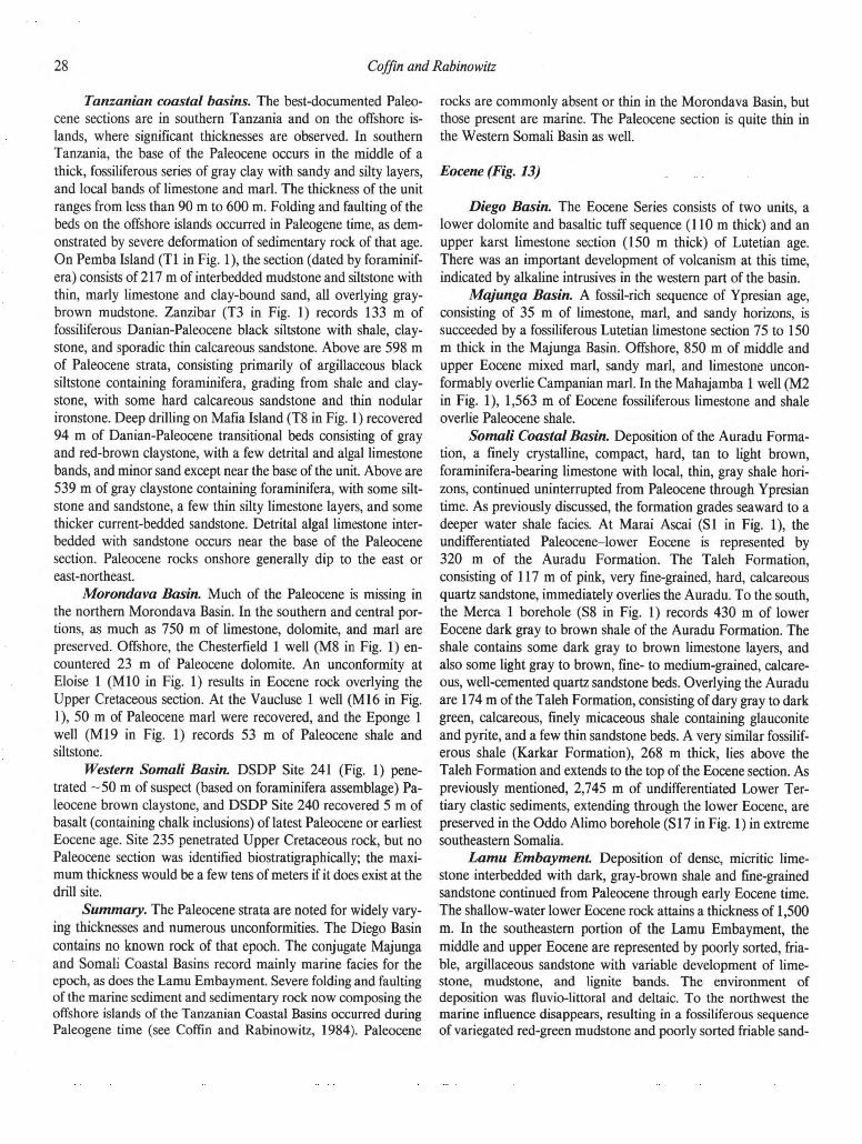
28 Coffin and Rabino witz Tanzanian coastal basins. The best-documented Paleo-
cene sections are in southern Tanzania and on the offshore is-
lands, where significant thicknesses are observed. In southern
Tanzania, the base of the Paleocene occurs in the middle of a
thick, fossiliferous series of gray clay with sandy and silty layers,
and local bands of limestone and marl. The thickness of the unit
ranges from less than 90 m to 600 m. Folding and faulting of the
beds on the offshore islands occurred in Paleogene time, as dem-
onstrated by severe deformation of sedimentary rock of that age.
On Pemba Island (T1 in Fig. 1), the section (dated by foraminif-
era) consists of 217 m of interbedded mudstone and siltstone with
thin, marly limestone and clay-bound sand, all overlying gray-
brown mudstone. Zanzibar (T3 in Fig. 1) records 133 m of
fossiliferous Danian-Paleocene black siltstone with shale, clay-
stone, and sporadic thin calcareous sandstone. Above are 598 m
of Paleocene strata, consisting primarily of argillaceous black
siltstone containing foraminifera, grading from shale and clay-
stone, with some hard calcareous sandstone and thin nodular
ironstone. Deep drilling on Mafia Island (T8 in Fig. 1) recovered
94 m of Danian-Paleocene transitional beds consisting of gray
and red-brown claystone, with a few detrital and algal limestone
bands, and minor sand except near the base of the unit. Above are
539 m of gray claystone containing foraminifera, with some silt-
stone and sandstone, a few thin silty limestone layers, and some
thicker current-bedded sandstone. Detrital algal limestone inter-
bedded with sandstone occurs near the base of the Paleocene
section. Paleocene rocks onshore generally dip to the east or
east-northeast.
Morondava Basin. Much of the Paleocene is missing in
the northern Morondava Basin. In the southern and central por-
tions, as much as 750 m of limestone, dolomite, and marl are
preserved. Offshore, the Chesterfield 1 well (M8 in Fig. 1) en-
countered 23 m of Paleocene dolomite. An unconformity at
Eloise 1 (M10 in Fig. 1) results in Eocene rock overlying the
Upper Cretaceous section. At the Vaucluse 1 well (M16 in Fig.
1), 50 m of Paleocene marl were recovered, and the Eponge 1
well (Ml9 in Fig. 1) records 53 m of Paleocene shale and
siltstone.
Western Somali Basin. DSDP Site 241 (Fig. 1) pene-
trated -50 m of suspect (based on foraminifera assemblage) Pa-
leocene brown claystone, and DSDP Site 240 recovered 5 m of
basalt (containing chalk inclusions) of latest Paleocene or earliest
Eocene age. Site 235 penetrated Upper Cretaceous rock, but no
Paleocene section was identified biostratigraphically; the maxi-
mum thickness would be a few tens of meters if it does exist at the
drill site.
Summary. The Paleocene strata are noted for widely vary-
ing thicknesses and numerous unconformities. The Diego Basin
contains no known rock of that epoch. The conjugate Majunga
and Somali Coastal Basins record mainly marine facies for the
epoch, as does the Lamu Embayment. Severe folding and faulting
of the marine sediment and sedimentary rock now composing the
offshore islands of the Tanzanian Coastal Basins occurred during
Paleogene time (see Coffin and Rabinowitz, 1984). Paleocene
rocks are commonly absent or thin in the Morondava Basin, but
those present are marine. The Paleocene section is quite thin in
the Western Somali Basin as well.
Eocene (Fig. 13) Diego Basin. The Eocene Series consists of two units, a
lower dolomite and basaltic tuff sequence (110m thick) and an
upper karst limestone section (150 m thick) of Lutetian age.
There was an important development of volcanism at this time,
indicated by alkaline intrusives in the western part of the basin.
Majunga Basin. A fossil-rich sequence of Ypresian age,
consisting of 35 m of limestone, marl, and sandy horizons, is
succeeded by a fossiliferous Lutetian limestone section 75 to 150
m thick in the Majunga Basin. Offshore, 850 m of middle and
upper Eocene mixed marl, sandy marl, and limestone uncon-
formably overlie Campanian marl. In the Mahajamba 1 well (M2
in Fig. 1), 1,563 m of Eocene fossiliferous limestone and shale
overlie Paleocene shale.
Somali Coastal Basin. Deposition of the Auradu Forma-
tion, a finely crystalline, compact, hard, tan to light brown,
foraminifera-bearing limestone with local, thin, gray shale hori-
zons, continued uninterrupted from Paleocene through Ypresian
time. As previously discussed, the formation grades seaward to a
deeper water shale facies. At Marai Ascai (SI in Fig. 1), the
undifferentiated Paleocene-lower Eocene is represented by
320 m of the Auradu Formation. The Taleh Formation,
consisting of 117 m of pink, very fine-grained, hard, calcareous
quartz sandstone, immediately overlies the Auradu. To the south,
the Merca 1 borehole (S8 in Fig. 1) records 430 m of lower
Eocene dark gray to brown shale of the Auradu Formation. The
shale contains some dark gray to brown limestone layers, and
also some light gray to brown, fine- to medium-grained, calcare-
ous, well-cemented quartz sandstone beds. Overlying the Auradu
are 174 m of the Taleh Formation, consisting of dary gray to dark
green, calcareous, finely micaceous shale containing glauconite
and pyrite, and a few thin sandstone beds. A very similar fossilif-
erous shale (Karkar Formation), 268 m thick, lies above the
Taleh Formation and extends to the top of the Eocene section. As
previously mentioned, 2,745 m of undifferentiated Lower Ter-
tiary clastic sediments, extending through the lower Eocene, are
preserved in the Oddo Alimo borehole (SI7 in Fig. 1) in extreme
southeastern Somalia.
Lamu Embayment. Deposition of dense, micritic lime-
stone interbedded with dark, gray-brown shale and fine-grained
sandstone continued from Paleocene through early Eocene time.
The shallow-water lower Eocene rock attains a thickness of 1,500
m. In the southeastern portion of the Lamu Embayment, the
middle and upper Eocene are represented by poorly sorted, fria-
ble, argillaceous sandstone with variable development of lime-
stone, mudstone, and lignite bands. The environment of
deposition was fluvio-littoral and deltaic. To the northwest the
marine influence disappears, resulting in a fossiliferous sequence
of variegated red-green mudstone and poorly sorted friable sand-

East African—Madagascan margins and western Somali Basin 38
Figure 17. Quaternary stratigraphie sections

30 Coffin and Rabino witz
stone. The total thickness of the middle and upper Eocene section
is —1,000 m. The Mararani 1 borehole (K6 in Fig. 1) bottomed
in 677 m of middle Eocene limestone and mudstone, which were
overlain by 140 m of upper Eocene sandstone. Just to the south,
the Dodori 1 well (K8 in Fig. 1) penetrated a thick Eocene
section composed of 600 m of lower Eocene limestone, sand-
stone, and shale of shallow-marine facies; 1,260 m of similar
middle Eocene sediment; and 140 m of upper Eocene limestone
and sandstone. A similar sequence was recorded at the nearby
Pate 1 well (K9 in Fig. 1); the well bottomed in 1,070 m of lower
Eocene shale and limestone, and the middle and upper Eocene
are represented by 1,660 and 200 m, respectively, of limestone
and sandstone. At the Kipini 1 well (K11 in Fig. 1), 1,020 m of
middle Eocene sandstone and limestone unconformably overlie
Upper Cretaceous sediment, and underlie 310 m of similar upper
Eocene sediment. Offshore the Simba 1 well (K14 in Fig. 1)
records 495 m of lower Eocene deep-water shale with sandstone
beds; 392 m of middle Eocene deep-water clay, marl, and sand;
and 62 m of upper Eocene deep-water marl, clay, and sand.
Tanzanian coastal basins. Southern Tanzania and the
offshore islands record the most complete Eocene sections in
Tanzania, and in all locations the lower Eocene is absent. On-
shore the middle Eocene consists of less than 90 to 1,000 m of
fossiliferous green clay or marl with subordinate limestone and
thin sandstone beds topped by a possible angular unconformity.
The upper Eocene consists of 65 to 1,140 m of fossiliferous green,
gray, and brown clay, coarse-grained and reefal limestone, and
siltstone. Severe deformation of Paleogene rocks on the offshore
islands, contrasted with the relatively undeformed Neogene and
Quaternary rocks, points toward significant tectonic activity prior
to the Neogene. On Pemba Island (T1 in Fig. 1), 1,821 m of
fossil-bearing middle Eocene littoral to deltaic coarse sand, silt,
mudstone, and thin limestone overlying more argillaceous and
silty beds are present; the unit becomes increasingly neritic
downward.
The upper Eocene consists of 132 m of fossiliferous shallow-
shelf limestone with a few shaly partings, underlain by sand with
some mudstone and thin limestone beds. The Zanzibar borehole
(T3 in Fig. 1) contains 907 m of fossil-bearing middle Eocene
rock, comprising (bottom to top) 314 m of black siltstone and
shale with rare thin calcareous sandstone, a gray marly limestone
horizon, a glauconitic sandy algal limestone bed, and thin red-
brown claystone; 151 m of black shaly siltstone and silty marl
interbedded with calcareous sandstone and black silty shale; 300
m of massive detrital limestone underlain by sandy and silty
limestone, with some thin black siltstone near its base; 143 m of
black silty shale and marl, with some sandy limestone and sand
interbedded as thin stringers in the upper part of the section, and
deeper as thicker limestone horizons in the shale.
Finally, on Mafia Island (T8 in Fig. 1) the fossiliferous
middle Eocene is 994 m thick. The unit is primarily claystone; the
basal 180 m contains some sandstone and conglomerate; detrital
and algal limestone bands increase upward, and silty claystone
grades upward into gray-green argillaceous marlstone. The upper
Eocene rock is 394 m thick. The base of the section consists of
shallow-water marly siltstone with thin limestone bands, plant
fragments, and fine pyrite, and passes upward into green marl-
stone interbedded with silty (lower section) and sandy (upper
section) limestone. Above the marlstone is coral and sugary fossil-
iferous limestone, and topping the sequence is hard, gray
cavernous dolomite. Eocene rock onshore generally dips to the
east or east-northeast.
Morondava Basin. The Eocene marine carbonate se-
quence, with interbedded shale, thins from 400 to 450 m in the
south to 10 to 15 m in the north, where it also loses its marine
character. There was minor volcanic activity during the epoch.
The Chesterfield 1 well (M8 in Fig. 1) recovered 345 m of
Eocene shelf limestone and dolomite. Eocene calcareous shale
with thin limestone stringers totals 434 m at the Eloise 1 well
(M10 in Fig. 1), and unconformably overlies Upper Cretaceous
rock. At Vaucluse 1 (Ml6 in Fig. 1), 188 m of Eocene shallow-
water marl was penetrated, and farther to the south at Eponge 1
(Ml9 in Fig. 1), 1,169 m of Eocene marl and limestone were
recovered.
Western Somali Basin. DSDP Site 241 encountered 150
m of lower and middle Eocene clay and silty clay. Middle Eocene
sediment is unconformably overlain by upper Oligocene sedi-
ment. DSDP Site 240 penetrated 5 m of basalt with chalk inclu-
sions, of latest Paleocene or Eocene age, overlain by a few tens of
meters (at most) of lower Eocene nanno ooze, silty clay, sandy
silt, and sand. The middle and upper Eocene are absent. Sim-
ilarly, Site 235 penetrated, at most, a few tens of meters of clay.
Summary. All of the basins contain marine Eocene sedi-
ment; in addition, mixed facies are found in the Somali Coastal
Basin and Lamu Embayment. Volcanic episodes are recorded as
tuff in the Diego and Morondava Basins. The Paleogene rock of
the offshore islands of the Tanzanian Coastal Basins is strongly
deformed.
Oligocene (Fig. 14) Diego Basin. No Oligocene sedimentary rock has been
documented in the Diego Basin, although there are indications of
volcanic activity continuing from Eocene time.
Majunga Basin. On an island (Nosy Kalakajava), lime-
stone followed by fossiliferous marl, both beneath a trachyte
flow, make up the Oligocene section. As elsewhere in Madagas-
car, this epoch was marked by volcanic activity. The lower and
mid-Oligocene is represented offshore by 660 m of limestone,
with some marl near the base of the section. An unconformity
separates mid-Oligocene rock from the lower Miocene section.
At the Mahajamba 1 well (M2 in Fig. 1), 583 m of Oligocene
sandstone and thin dolomite were recovered.
Somali Coastal Basin. Oligocene rock totaling 936 m in
thickness was encountered at the Merca 1 well (S8 in Fig. 1). A
gray, silty, pyritic, calcareous, and partly glauconitic fossiliferous
shale 122 m thick forms the lowest portion of the section. Overly-
ing the shale are 814 m of white to gray, granular fossiliferous
limestone, bearing gypsum and anhydrite in the lower 457 m. In

East African—Madagascan margins and western Somali Basin 31
Figure 17. Quaternary stratigraphie sections

32 Coffin and Rabino witz southeastern Somalia the Oligocene is represented by several
hundred meters of neritic/deltaic sandstone with shale and lime-
stone horizons.
Lamu Embayment. The Oligocene section is extremely
thin in the Lamu Embayment. Some rock of this epoch may be
present in the unfossiliferous, variegated, red-green mudstone and
poorly sorted friable sandstone of the northwestern Lamu Em-
bayment. To the southeast, an Oligocene shallow-water marine
limestone section some tens of m thick exists, representing a
complete change of environment from the underlying fluvio-
littoral and deltaic sediment. This limestone continues upward
into Miocene rock. The Mararani 1 well (K6 in Fig. 1) penetrated
30 m of Oligocene gray sandstone, locally argillaceous. Dodori 1
(K8 in Fig. 1) records 80 m of limestone, and the epoch is
represented by a few tens of meters of argillaceous sand and
sandstone in the Pate 1 borehole (K9 in Fig. 1). The Kipini 1 well
(K l l in Fig. 1) encountered 100 m of Oligocene calcareous
shale, and offshore the Simba 1 well (K14 in Fig. 1) encountered
no Oligocene beds.
Tanzanian coastal basins. The Oligocene Series is best-
preserved in southern Tanzania, and on the offshore islands. To
the south the Oligocene consists of 70 to 90 m of algal-detrital
limestone and fossiliferous buff-gray to brown-gray silty clay. On
Pemba Island (T1 in Fig. 1), 425 m of shallow marine, claybound
sand with some shale, calcareous sandstone, and thin detrital
limestone were penetrated. Deep drilling on Zanzibar (T3 in Fig.
1) recovered no rocks of Oligocene age, but the Oligocene section
on Mafia Island (T8 in Fig. 1) consists of 129 m of fossiliferous
detrital limestone commonly with coral and algae, and very little
sand, succeeded by saccharoidal dolomite, and topped by fossilif-
erous sandy detrital limestone. Oligocene strata onshore generally
dip to the east or east-northeast.
Morondava Basin. The Oligocene is absent from the
northern Morondava Basin, but as much as 400 m of marl and
limestone are present in the south. Offshore, the Series is missing
at the Chesterfield 1 well (M8 in Fig. 1). At the Eloise 1 borehole
(M10 in Fig. 1), 379 m of calcareous shale and limestone were
recovered, and the Vaucluse 1 well (Ml6 in Fig. 1) penetrated
69 m of Oligocene sand and calcareous shale. The Eponge 1 well
(Ml9 in Fig. 1) encountered 210 m of Oligocene limestone and
marl.
Western Somali Basin. At DSDP Site 241 (Fig. 1), an
extremely thin Oligocene section totaling less than 10 m of clay-
rich nanno ooze, foram nanno chalk, and nanno clay was drilled.
DSDP Site 240 (Fig. 1) demonstrated a hiatus between early
Eocene and Miocene sediments. Site 234 (Fig. 1) yielded 53 m of
lower Oligocene dark clay and nanno ooze and 32 m of upper
Oligocene blue, green, and gray clay. Site 235 (Fig. 1) recovered
no definitely Oligocene sediment; at most, a few tens of meters
could be present. Finally, Site 242 (Fig. 1) penetrated -45 m of
lower Oligocene, brown, clayey nanno chalk, and 120 m of
upper Oligocene, brown, clayey nanno chalk.
Summary. The Oligocene Series varies widely throughout
the study area; commonly it is absent or contains unconformities.
The Diego and Majunga Basins contain Oligocene volcanic rock,
and the latter marine strata as well. The other basins contain
marine Oligocene sections of varying thicknesses. The Paleogene
of the offshore islands of the Tanzanian Coastal Basins is highly
deformed.
Miocene (Fig. 15) Diego Basin. A sequence (50 to 200 m thick) of inter-
layered limestone, sandstone, and basaltic tuff composes the Mio-
cene (Aquitanian to Burdigalian) section. Lava flows on top of
this rock are considered late Miocene in age.
Majunga Basin. The Miocene in the Majunga Basin con-
sists of a richly fossiliferous marine marl and limestone interval in
excess of 200 m thick. Offshore, 350 m of lower Miocene dolo-
mite and limestone unconformably overlie mid-Oligocene rock.
At the Mahajamba 1 borehole (M2 in Fig. 1), 274 m of Miocene
dolomite and thin sandstone are preserved.
Somali Coastal Basin. The undifferentiated Miocene sec-
tion recovered from the Merca 1 well (S8 in Fig. 1) is 837 m
thick. At the base are 91 m of multicolored shale, overlain by
213 m of sandstone. Red, green, and gray silty shale totaling 107
m succeeds the sandstone, and at the top of the section are 426 m
of white to gray, hard, fine- to medium-grained, calcareous sand-
stone with some gray-green and brown soft clay layers in the
lower 91 m, along with one cream to white, finely crystalline,
gypsum-bearing fossiliferous limestone bed. At Brava 1 (SI3 in
Fig. 1), 914 m of Miocene marly limestone interbedded with
calcareous shale, and a few sandstone beds were encountered,
unconformably overlying Lower Cretaceous rock. The Oddo
Alimo (SI7 in Fig. 1) borehole records Miocene calcareous shale;
farther to the south, the facies changes to marine limestone sev-
eral hundred meters thick.
Lamu Embayment. The Miocene Series is dominated by a
shallow-water limestone sequence -1,400 m thick. This lime-
stone is locally dolomitic with veins of anhydrite. At the margin
of the embayment, the limestone becomes sandy, and to the
northwest it grades to unfossiliferous red-green variegated mud-
stone with interbedded argillaceous sandstone. The Mararani 1
borehole (K6 in Fig. 1) penetrated 893 m of lower and middle
Miocene dense limestone overlain by 175 m of upper Miocene
sandy limestone. At Dodori 1 (K8 in Fig. 1), the lower Miocene
consists of 340 m of limestone with thin dolomite; the middle
Miocene, 490 m of dolomite and limestone; and the upper Mio-
cene, 160 m of limestone. The Pate 1 well (K9 in Fig. 1) pene-
trated a similar section consisting of 380 m of lower Miocene
limestone, 460 m of middle Miocene limestone and shale, and
220 m of upper Miocene limestone. At Kipini 1 (Kl l in Fig. 1),
590 m of lower Miocene limestone and shale, 710 m of middle
Miocene shale and limestone, and 160 m of upper Miocene lime-
stone were encountered. Offshore, the Simba 1 well (K14 in
Fig. 4) contains an unconformity for the entire epoch.
Tanzanian coastal basins. All Tertiary geology of north-
ern Tanzania is very poorly known. In central Tanzania the Mio-
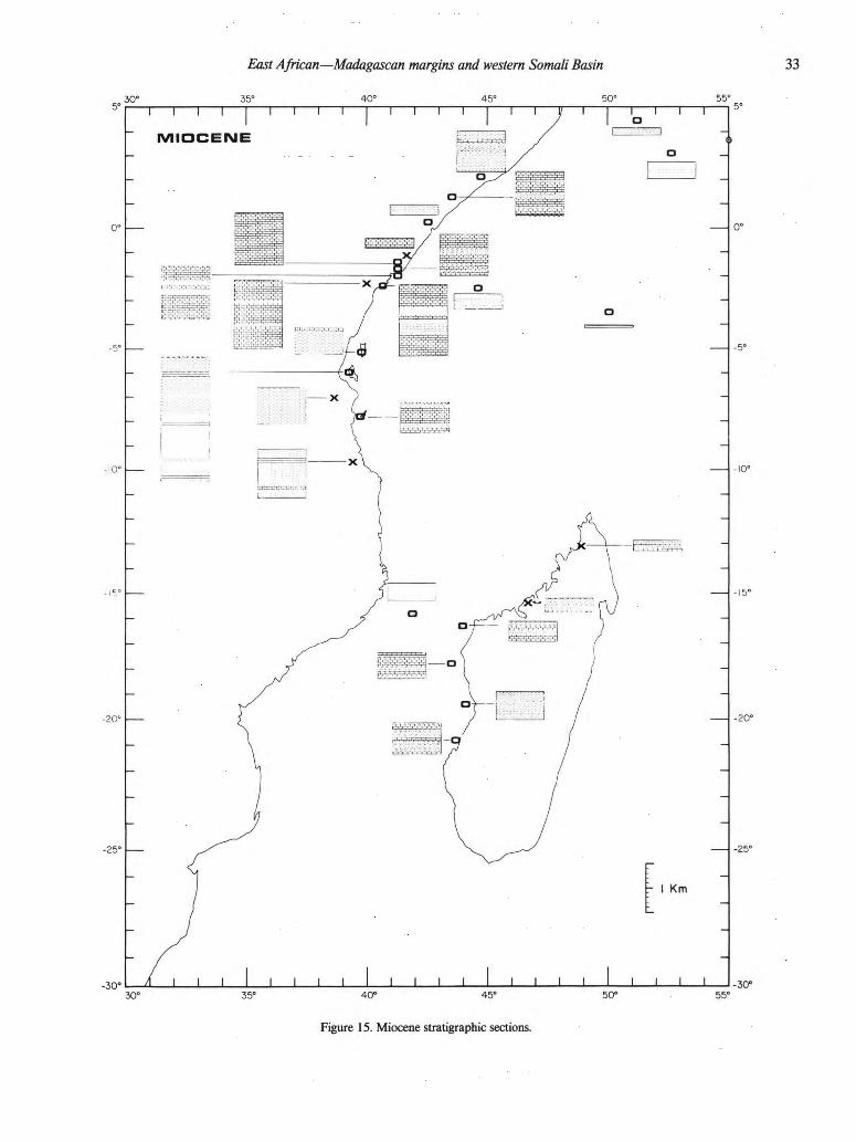

3 4 Coffin and Rabino witz cene Series consists of quartz sand and sandstone. These rocks are
soft, richly kaolinitic, and locally feldspathic, and are locally
current-bedded with red and green clay partings. The Miocene
rocks are commonly faulted and dip gently; they range in thick-
ness from 300 to 750 m. Miocene rock in southern Tanzania is of
shallow-water facies, and commonly shows evidence of contem-
poraneous faulting. The section consists of 55 to 1,000 m of gray
and brown clay; coral, detrital, chalky, or sandy limestone; and
silt. The lower Miocene section on Pemba Island (T1 in Fig. 1)
begins with 382 m of deltaic sandy and detrital limestone, clay-
bound sand, calcareous sandstone, marl, and lignite, with some
pebbles near its base. Overlying that is marine limestone with
sand and marl bands. Above the lower Miocene are 66 m of
middle Miocene (Langhian) calcareous silty mudstone, detrital
limestone, and sand, with traces of lignite. Because the well was
drilled on a horst, no dated younger rocks were penetrated. An
extremely thick Miocene section, totaling 2,546 m, was drilled on
Zanzibar (T3 in Fig. 1).
At the base of the lower Miocene are 265 m of black pyritic
shale interbedded with unsorted coarse or pebbly sand, kaolinitic
sandstone, and siltstone, all of paralic facies. Next are 1,165 m of
claystone and siltstone interbedded with claybound (kaolinitic)
sand, the upper 268 m of which are partially of lagoonal facies.
Deltaic claybound sand with some thin lignite beds, together with
variable amounts of thin, sandy limestone, clay, and siltstone,
make up the upper 1,116 m of the Miocene section; this includes
124 m more of lower Miocene strata and 992 m of middle
Miocene rock. No upper Miocene section was recovered from
this horst setting. The lower Miocene on Mafia Island (T8 in
Fig. 1) is represented by 205 m of detrital sugary limestone, with
sandy intervals near its base and some greenish marl. The middle
Miocene section is 386 m thick; massive detrital limestone with
an interbedded black calcareous marlstone composes the lower
301 m, and the upper 85 m consist of algal detrital sandy lime-
stone, sandy clay, and quartz sand. No upper Miocene rock was
recovered, presumably because the drill site is situated on a horst.
Miocene faulting is evident throughout Tanzania and on the off-
shore islands.
Morondava Basin. The Miocene Series is present as car-
bonate rock in small embayments in southern and northern Mor-
ondava, where it attains thicknesses of 275 m. Offshore, the
Chesterfield 1 well (M8 in Fig. 1) recovered 395 m of shallow-
water limestone and dolomite; Eloise 1 (M10 in Fig. 1) recovered
529 m of similar rock. The Vaucluse 1 borehole (Ml6 in Fig. 1)
penetrated 579 m of Miocene shale and thin sand; Eponge 1
(Ml9 in Fig. 1) encountered 628 m of dolomite, limestone, and
thin sandstone.
Western Somali Basin. All of the DSDP sites (Fig. 1) in
the Western Somali Basin and vicinity recovered sediment of
Miocene age. At DSDP Site 241, 65 m of lower Miocene clayey
nanno ooze, silty clay, and nanno clay were recovered. The mid-
dle Miocene consists of 115 m of clay, locally nanno-rich, and
clayey nanno ooze. The upper Miocene records 120 m of clayey
and clay-rich nanno ooze. Site 240 records more than 150 m of
undifferentiated Miocene through Quaternary silt, clay, and
nanno ooze. At Site 234, 91 m of lower Miocene green clay and
nanno clay, 60 m of middle Miocene green clay, and 11 m of
upper Miocene-Pliocene nanno clay and nanno ooze were pene-
trated. Site 235 recovered no lower Miocene sediment; a few tens
of meters could be present. The middle Miocene, 148 m thick,
and the upper Miocene, 161m thick, consist of dark nanno ooze
and nanno clay. At Site 242, the lower Miocene consists of 75 m
of brown clayey chalk, the middle Miocene 95 m of clayey nanno
chalk, and the upper Miocene -170 m of foram-bearing clayey
nanno ooze.
Summary. The basins record dominantly marine facies
within the Miocene Series, save for local continental facies in the
Diego, Somali Coastal, and Tanzanian coastal basins. Volcanic
rock is preserved in the Diego Basin, and extremely thick Mio-
cene sections are found on the Tanzanian islands.
Pliocene (Fig. 16)
Diego Basin. No Pliocene sedimentary rock has been re-
ported in the Diego Basin, although volcanism probably con-
tinued from Miocene time if one assumes the hot-spot model of
Emerick and Duncan (1982) to be true.
Majunga Basin. Cross- or irregularly bedded gray or red
sand and sandstone, intercalated with silty clay or rare sandy
lacustrine limestone, compose a Pliocene section 50 to 150 m
thick in the Majunga Basin.
Somali Coastal Basin. At the Merca 1 well (S8 in Fig. 1),
11 m of Pliocene clastic and carbonate deposits were recovered.
In the south, more than 500 m of limestone, clay, and sandstone
are present just to the north of the Lamu Embayment.
Lamu Embayment. The thin, undifferentiated Pliocene/
Quaternary section consists of unfossiliferous red-brown, argil-
laceous sand, and subordinate clay with limestone stringers. Dep-
ositional environments range from fluviatile and aeolian inland to
partly marine near the coast. The Mararani 1 borehole (K6 in
Fig. 1) recovered 76 m of undifferentiated Pliocene-Quaternary
gray sandstone. At Dodori 1 (K8 in Fig. 1), 160 m of Pliocene
limestone with subordinate clay and marl were encountered. At
Pate 1 (K9 in Fig. 1), sand totaling several tens of meters predom-
inates, with local fine-grained limestone. The Kipini 1 borehole
(K11 in Fig. 1) recovered several tens of meters of Pliocene sand.
Tanzanian coastal basins. In northern Tanzania, thin
marine Pliocene sediment, consisting of sandy clay, marl, marly
limestone, and sand, flanks the coast. Estuarine and fluviatile
conglomerate, sand, clay, silt, and gravel attaining thicknesses of
more than 100 m are present in central Tanzania. Both marine
and continental Pliocene deposits are present in southern Tanza-
nia; reefal limestone, rubbly sandstone, clay, and gravel as thick
as 30 m are preserved. No unambiguous Pliocene sediment was
found by drilling the offshore island horst blocks, although ex-
posed limestone beds totaling less than a few tens of meters on
Zanzibar and Mafia Islands have been dated as Pliocene.
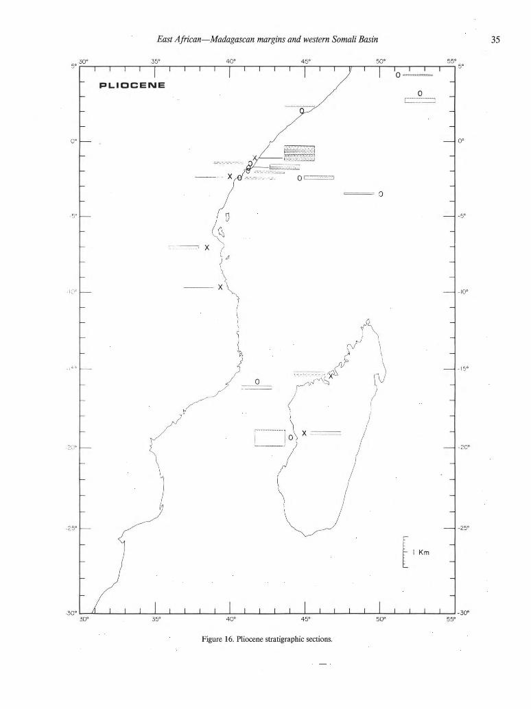
East African—Madagascan margins and western Somali Basin 44 40°
Figure 17. Quaternary stratigraphie sections
36 Coffin and Rabino witz Morondava Basin. Red continental sandstone masking the
coastal lowlands attains a thickness of 50 to 100 m. The Vaucluse
1 well (Ml6 in Fig. 1) offshore recovered 526 m of Pliocene
shale.
Western Somali Basin. Every DSDP site in the Western
Somali Basin (Fig. 1) recovered Pliocene sediment. Site 241
penetrated 90 m of nanno-rich clay and clay-rich nanno ooze;
Site 240, 150 m of undifferentiated Miocene through Quaternary
silt, clay, and nanno ooze; Site 234, 11 m of upper Miocene-
Pliocene nanno clay and nanno ooze; Site 235, 72 m of lower
Pliocene and 79 m of upper Pliocene nanno ooze and nanno clay;
and Site 242, 60 m of lower Pliocene and 40 m of upper Pliocene
foram-bearing nanno ooze.
Summary. Thin sediment or sedimentary rock of both ma-
rine and nonmarine facies are found in all of the basins except the
Diego, where no Pliocene sediment has been identified. However,
some Pliocene volcanic rock is preserved in the Diego Basin.
Quaternary (Fig. 17)
Diego Basin. This period is dominated by coastal dune and
reef development, along with volcanism (basalt flows) that is
probably continuous since Eocene time.
Majunga Basin. Quaternary strata consist of vast alluvial
deposits in estuaries and in valleys strongly affected by Pleisto-
cene sea-level changes.
Somali Coastal Basin. The Quaternary Period is marked
by reef development and clastic deposition in the Somali Coastal
Basin.
Lamu Embayment. Unfossiliferous red-brown argilla-
ceous sand and subordinate clay, with limestone stringers, com-
pose the thin, undifferentiated Pliocene-Quaternary section. The
environments of deposition range from fluviatile and aeolian in-
land to partly marine near the coast. Thicknesses are several tens
of meters at maximum.
Tanzanian coastal basins. Thin marine sand, well-
developed limestone, and clay, totaling less than 100 m in thick-
ness, are found along the coast and on the offshore islands.
Morondava Basin. The deposition of continental sand-
stone continued from the Pliocene Epoch, and thicknesses locally
may attain several tens of meters. In the offshore area, shale
predominates.
Western Somali Basin. Quaternary beds are present at
most of the DSDP sites (Fig. 1) in the Western Somali Basin. Site
241 encountered 75 m of clayey nanno ooze, nanno ooze, and
minor sand-silt-clay; Site 240,10 m of silt-, clay-, and nanno-rich
radiolarian ooze and diatom-bearing, radiolaria-rich detrital silty
clay; Site 234, no Quaternary; Site 235,45 m of nanno ooze; and
Site 242, 40 m of foram-rich clayey nanno ooze.
Summary. Pliocene marine, nonmarine, and mixed facies
depositional conditions generally continued into Quaternary
time.
STRATIGRAPHY AND STRUCTURE; OFFSHORE ACOUSTIC STRATIGRAPHY STUDIES
The preliminary acoustic stratigraphic framework for the
Western Somali Basin and East African continental margin has
been established by Coffin and Rabinowitz (1982, 1983). These
studies have documented four major reflecting horizons, one of
which was penetrated by drilling at DDSP Site 241 (Fig. 1), the
only deep well useful for seismic correlation in the Western So-
mali Basin. The studies also displayed seismic evidence for major
events in the sedimentary history of the East African continental
margin: salt diapirs, a massive sediment slide, and an abyssal
channel system. Results of further investigations into the acoustic
stratigraphy of the region based on analysis of additional seismic
data (Fig. 18) are considered below.
The primary data base for our studies is the -6,000 km of
12-fold multichannel seismic (MCS) data collected aboard R.V.
Vema and processed at Lamont-Doherty Geological Observa-
tory, indicated by dotted lines in Figure 18; the ship's navigation
data appear in Figure 19. The data consist of 10 East African
margin transects, spaced roughly every 100 km, three across the
rifted segment (Fig. 20a) and seven across the transform portion
(Fig. 20b), and of one long tie line connecting five of the transects
(Figs. 18, 19). These high-quality data cover slightly more than
1,000 km of the -3,500 km of conjugate East African and Mad-
agascan margins. The various reflectors, described below, were
digitized using the techniques of Mountain (1981). Secondary
data, displayed in solid black lines in Figure 18, consist of single-
channel seismic data collected by the Lamont-Doherty Geologi-
cal Observatory, Woods Hole Oceanographic Institution, Deep
Sea Drilling Project, Scripps Institution of Oceanography, and
the United States Navy. Supplementary proprietary data not
shown in Figure 18 include MCS data collected by Total offshore
Kenya (-3,500 km) and by Mobil offshore Madagascar
(-10,000 km).
Correlation of DSDP results with multichannel seismic data
The stratigraphic sequence derived from correlating MCS
data with drilling results from DSDP Site 241 appears in Figure
21 (see Fig. 19 for the location). DSDP Site 241, as previously
mentioned, is the only regionally useful stratigraphic well offshore
East Africa. The well was drilled in a water depth of 4,054 m,
penetrated 1,174 m sub-bottom, and recovered 137 m of sedi-
ment, or 12 percent (Schlich, Simpson and others, 1974). The
principal drilling objective was to establish the bio- and lithostrat-
igraphic sequence with particular emphasis on (1) the post-
Karroo epeirogenic movement of East Africa; and (2) seismic
horizon identification, composition, and age. Four major reflec-
tors, the "green," "purple," "red," and "blue" horizons, are ob-
served and traced in the Western Somali Basin. The top of
oceanic basement is indicated by the blue horizon; because the
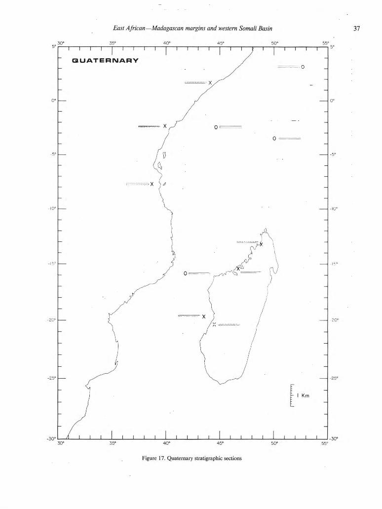
East African—Madagascan margins and western Somali Basin 3 7
Figure 17. Quaternary stratigraphie sections
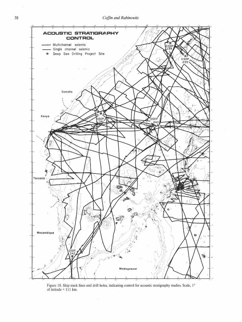
47 Coffin and Rabino witz 54" 55*
Figure 18. Ship track lines and drill holes, indicating control for acoustic stratigraphy studies. Scale, 1°
of latitude =111 km.
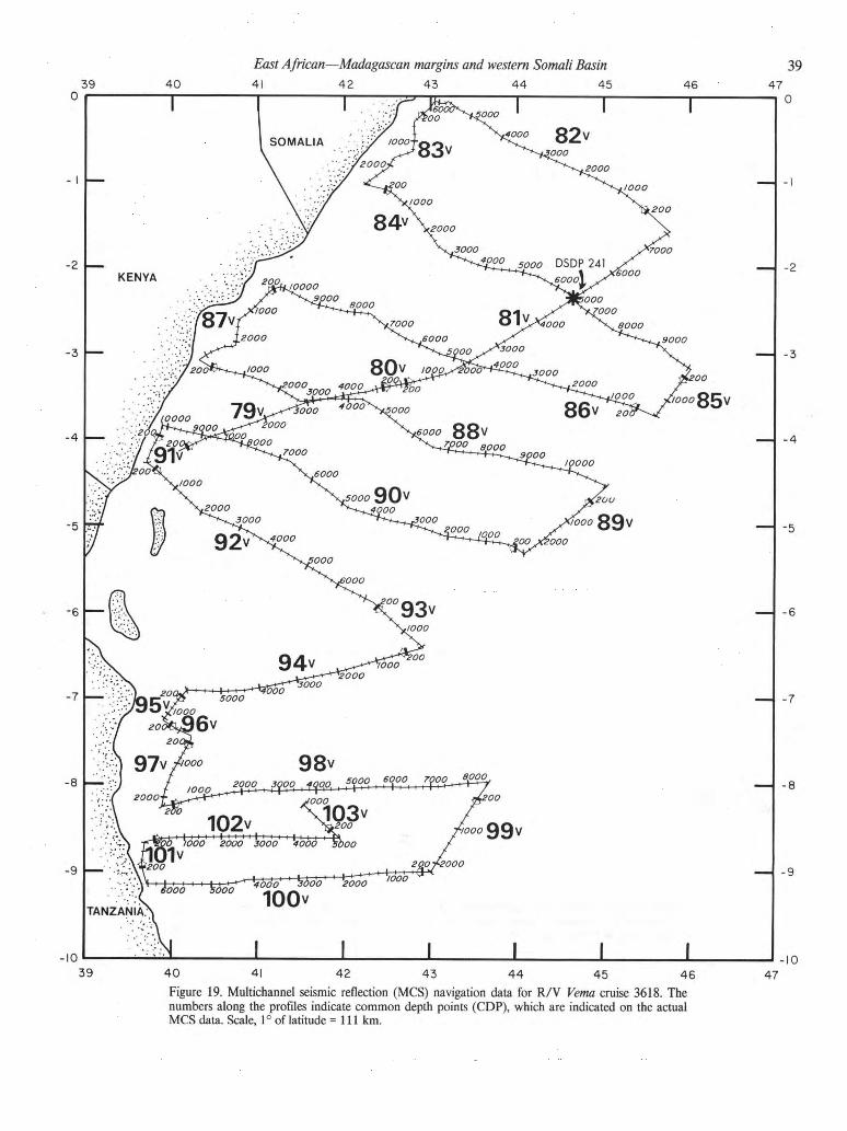
East African—Madagascan margins and western Somali Basin 41 42 43 44 45
41 42 43 4 4 4 5 4 6
Figure 19. Multichannel seismic reflection (MCS) navigation data for R / V Verna cruise 3618. The
numbers along the profiles indicate common depth points (CDP), which are indicated on the actual
MCS data. Scale, 1° of latitude = 111 km.
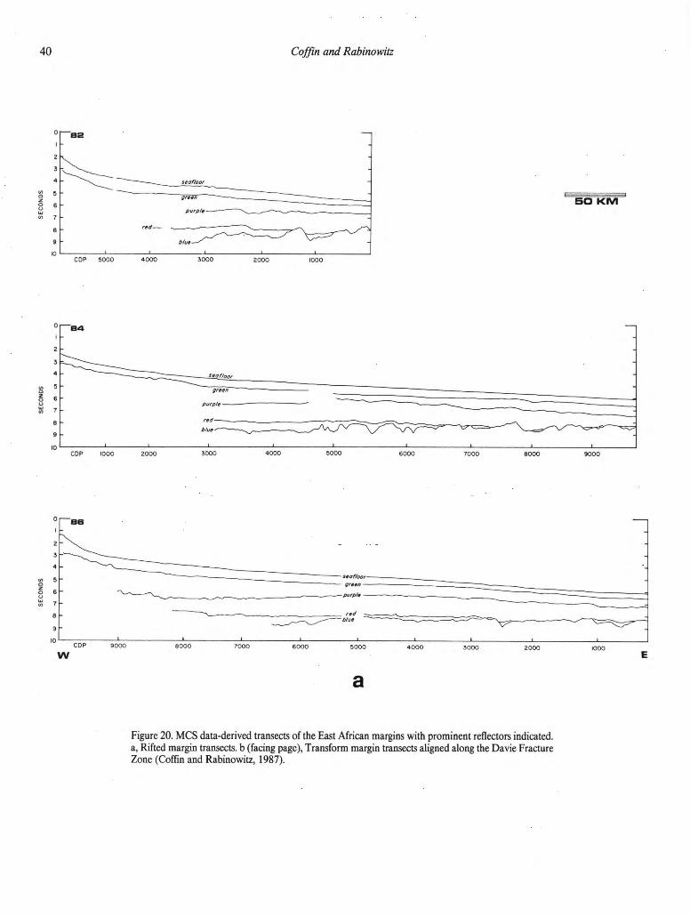
49 Coffin and Rabino witz
as
a
Figure 20. MCS data-derived transects of the East African margins with prominent reflectors indicated,
a, Rifted margin transects, b (facing page), Transform margin transects aligned along the Davie Fracture
Zone (Coffin and Rabinowitz, 1987).

East African—Madagascan margins and western Somali Basin 41
42 43 44 45
W E
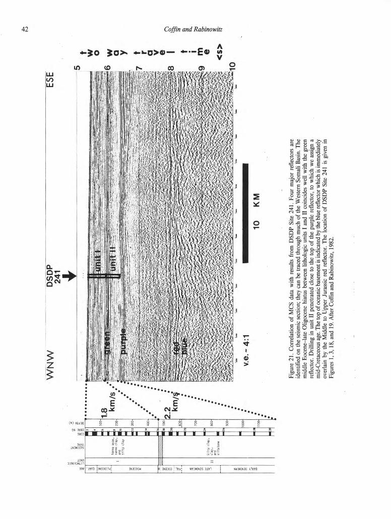
to
WN
W
DS
DP
24
1 ES
E
<s>
I »
s a.
ft
S"
a" ©
5
Fig
ure
21.
Corr
ela
tion of
MC
S
data
w
ith
resu
lts fr
om
D
SD
P
Sit
e 241.
Four
majo
r re
flecto
rs are
identi
fied o
n th
e s
eis
mic
secti
on;
they c
an b
e t
raced t
hro
ugh m
uch of
the W
este
rn S
om
ali B
asin
. T
he
mid
dle
E
ocene-la
te O
ligocene hia
tus b
etw
een lith
olo
gic
unit
s I
and II
coin
cid
es w
ell w
ith th
e g
reen
reflecto
r. D
rill
ing in
unit
II
penetr
ate
d clo
se t
o t
he t
op o
f th
e p
urp
le re
flecto
r, t
o w
hic
h w
e a
ssig
n a
mid
-C
reta
ceous a
ge. T
he t
op o
f oceanic
basem
ent
is indic
ate
d b
y t
he b
lue r
eflecto
r w
hic
h i
s i
mm
edia
tely
overl
ain
by th
e M
iddle
to
U
pper
Jura
ssic
re
d re
flecto
r. T
he lo
cati
on of
DS
DP
Sit
e 241 is
giv
en in
Fig
ure
s 1, 3,
18, and 19.
Aft
er
Coff
in a
nd R
abin
ow
itz,
1982.
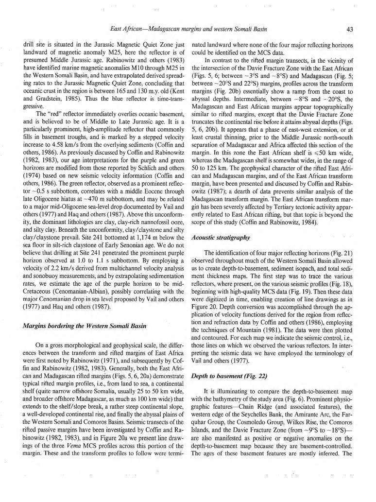
East African—Madagascan margins and western Somali Basin 41
42 43 44 45
drill site is situated in the Jurassic Magnetic Quiet Zone just
landward of magnetic anomaly M25, here the reflector is of
presumed Middle Jurassic age. Rabinowitz and others (1983)
have identified marine magnetic anomalies M10 through M25 in
the Western Somali Basin, and have extrapolated derived spread-
ing rates to the Jurassic Magnetic Quiet Zone, concluding that
oceanic crust in the region is between 165 and 130 m.y. old (Kent
and Gradstein, 1985). Thus the blue reflector is time-trans-
gressive.
The "red" reflector immediately overlies oceanic basement,
and is believed to be of Middle to Late Jurassic age. It is a
particularly prominent, high-amplitude reflector that commonly
fills in basement troughs, and is marked by a stepped velocity
increase to 4.58 km/s from the overlying sediments (Coffin and
others, 1986). As previously discussed by Coffin and Rabinowitz
(1982, 1983), our age interpretations for the purple and green
horizons are modified from those reported by Schlich and others
(1974) based on new seismic velocity information (Coffin and
others, 1986). The green reflector, observed as a prominent reflec-
tor ~0.5 s subbottom, correlates with a middle Eocene through
late Oligocene hiatus at -470 m subbottom, and may be related
to a major mid-Oligocene sea-level drop documented by Vail and
others (1977) and Haq and others (1987). Above this unconform-
ity, the dominant lithologies are clay, clay-rich nannofossil ooze,
and silty clay. Beneath the unconformity, clay/claystone and silty
clay/claystone prevail. Site 241 bottomed at 1,174 m below the
sea floor in silt-rich claystone of Early Senonian age. We do not
believe that drilling at Site 241 penetrated the prominent purple
horizon observed at 1.0 to 1.1 s subbottom. By employing a
velocity of 2.2 km/s derived from multichannel velocity analysis
and sonobuoy measurements, and by extrapolating sedimentation
rates, we estimate the age of the purple horizon to be mid-
Cretaceous (Cenomanian-Albian), possibly correlating with the
major Cenomanian drop in sea level proposed by Vail and others
(1977) and Haq and others (1987).
Margins bordering the Western Somali Basin
On a gross morphological and geophysical scale, the differ-
ences between the transform and rifted margins of East Africa
were first noted by Rabinowitz (1971), and subsequently by Cof-
fin and Rabinowitz (1982, 1983). Generally, both the East Afri-
can and Madagascan rifted margins (Figs. 5,6,20a) demonstrate
typical rifted margin profiles, i.e., from land to sea, a continental
shelf (quite narrow offshore Somalia, usually 25 to 50 km wide,
and broader offshore Madagascar, as much as 100 km wide) that
extends to the shelf/slope break, a rather steep continental slope,
a well-developed continental rise, and finally the abyssal plains of
the Western Somali and Comoros Basins. Seismic transects of the
rifted passive margins have been investigated by Coffin and Ra-
binowitz (1982,1983), and in Figure 20a we present line draw-
ings of the three Vema MCS profiles across this portion of the
margin. These and the transform profiles to follow were termi-
nated landward where none of the four major reflecting horizons
could be identified on the MCS data.
In contrast to the rifted margin transects, in the vicinity of
the intersection of the Davie Fracture Zone with the East African
(Figs. 5, 6; between ~3°S and ~8°S) and Madagascan (Fig. 5;
between ~20°S and 22°S) margins, profiles across the transform
margins (Fig. 20b) essentially show a ramp from the coast to
abyssal depths. Intermediate, between ~8°S and ~20°S, the
Madagascan and East African margins appear topographically
similar to rifted margins, except that the Davie Fracture Zone
truncates the continental rise before it attains abyssal depths (Figs.
5, 6, 20b). It appears that a phase of east-west extension, or at
least crustal thinning, prior to the Middle Jurassic north-south
separation of Madagascar and Africa affected this section of the
margin. In this zone the East African shelf is <50 km wide,
whereas the Madagascan shelf is somewhat wider, in the range of
50 to 125 km. The geophysical character of the rifted East Afri-
can and Madagascan margins, and of the East African transform
margin, have been presented and discussed by Coffin and Rabin-
owitz (1987); a dearth of data prevents similar analysis of the
Madagascan transform margin. The East African transform mar-
gin has been severely affected by Tertiary tectonic activity appar-
ently related to East African rifting, but that topic is beyond the
scope of this study (Coffin and Rabinowitz, 1984).
Acoustic stratigraphy The identification of four major reflecting horizons (Fig. 21)
observed throughout much of the Western Somali Basin allowed
us to create depth-to-basement, sediment isopach, and total sedi-
ment thickness maps. The first step was to trace the various
reflectors, where present, on the various seismic profiles (Fig. 18),
beginning with high-quality MCS data (Fig. 19). Then these data
were digitized in time, enabling creation of line drawings as in
Figure 20. Depth conversion was accomplished through the ap-
plication of velocity functions derived for the region from reflec-
tion and refraction data by Coffin and others (1986), employing
the techniques of Mountain (1981). The data were then plotted
and contoured. For each map we indicate the seismic control, i.e.,
those lines on which we observed the various reflectors. In inter-
preting the seismic data we have employed the terminology of
Vail and others (1977).
Depth to basement (Fig. 22) It is illuminating to compare the depth-to-basement map
with the bathymetry of the study area (Fig. 6). Prominent physio-
graphic features—Chain Ridge (and associated features), the
western edge of the Seychelles Bank, the Amirante Arc, the Far-
quhar Group, the Cosmoledo Group, Wilkes Rise, the Comoros
Islands, and the Davie Fracture Zone (from ~9°S to ~18°S)—
are also manifested as positive or negative anomalies on the
depth-to-basement map because they are basement-controlled.
The ages of these basement features are mostly inferred. The

4 4 Coffin and Rabino witz
Chain Ridge and associated lineaments were created by relative
motion commencing ~80 Ma (McKenzie and Sclater, 1971) be-
tween the Indian and African plates. Bunce and others (1967)
reported a Cretaceous date (K-Ar) from a rock dredged from the
flank of the Chain Ridge, and DSDP Site 235 (Fisher and others,
1974) bottomed in basalt overlain by Upper Cretaceous sedi-
ment. The Seychelles are continental in origin; Proterozoic gran-
ites are common (Baker, 1963). Igneous and sedimentary rock
samples from the Amirante Ridge (Fisher and others, 1968) and
nearby sea floor (Johnson and others, 1982; Masson and others,
1982) have yielded Late Cretaceous dates, supporting recent tec-
tonic models (Masson, 1984). Basement underlying the atolls and
islands of the Farquhar and Cosmoledo groups has yet to be
sampled.
The age of the Wilkes Rise, as discussed by Coffin and
Rabinowitz (1987), is probably not significantly younger than the
oceanic crust on which it lies, although it has not been geologi-
cally sampled. A comprehensive study of the Comoros Islands
(Emerick and Duncan, 1982) concluded that the chain, along
with the Tertiary volcanic province of northern Madagascar,
make up a hotspot trace active over the past 10 million years.
Finally, Rabinowitz and others (1983) have dated the creation of
the Davie Fracture Zone as being between 165 and 130 Ma,
although analysis of seismic data in a later section documents
continuing deformation along and landward of the fracture zone
near East Africa.
The features that become more vivid on the depth-to-
basement map are those masked by sediment. Proximal to the
East African margin we observe a continuation of the Davie
Fracture Zone north of ~9°S, represented by a series of basement
ridges, peaks, troughs, and deeps parallel to the margin. This
northern extension, indicated in Figure 20 by a dotted line usually
connecting basement anomalies, is also observed on magnetic and
gravity data, and is more fully documented by Coffin and Rabin-
owitz (1987). In some of the troughs and deeps along the frac-
ture zone, the basement descends to depths greater than 10 km
below sea level. Also apparent just to the west of the southwest-
ern terminus of the Chain Ridge is a series of roughly north-
south-trending basement ridges and troughs, presumably related
to the separation of Africa and Greater India (Coffin and Rabin-
owitz, 1987). The great thicknesses of sediment on both the East
African and Madagascan margins unfortunately precludes any
discrimination of the continent-ocean boundary based on MCS
data.
Acoustic, or igneous, basement is difficult to clearly discern
on MCS data at DSDP Site 241 (Fig. 21); farther into the West-
ern Somali Basin it becomes much easier to identify it unambigu-
ously. In Figure 23a, we show a segment of line 85 (Fig. 19) on
which basement is manifested as a typical package of hyperbo-
lated reflectors. The relief of the basement surface on line 85 is
typical of the study area, with that surface usually varying be-
tween 8 and 9 s of two-way travel time. The line drawings of
margin transects (Fig. 20) corroborate this observation. Where
basement was difficult or impossible to identify by reflection
character, we used the results of 118 sonobuoy wide-angle reflec-
tion and refraction experiments to locate the sediment-igneous
crust interface by the velocity of the top of layer 2,5.4 ± 0.4 km/s
(Coffin and others, 1986). These particular velocity data were
especially important in identifying basement south of line 88 (Fig.
19), e.g., on the seaward end of line 94 (Fig. 23b). Figure 20
summarizes the landward extent of identified basement (blue) for
the MCS data.
Evidence of igneous activity is present on two of the MCS
lines proximal to the margin, as well as on single-channel seismic
data in the Western Somali Basin. The features display strong
positive magnetic signatures, and are probably basaltic. Line 90
(see Fig. 19 for the location) transected the edge of a probable
volcanic structure that rises from typical basement depths of ~8
to ~9 s of two-way travel time to just pierce the sea floor (Fig.
24a). Line 100 (Fig. 19) crossed an igneous intrusion that de-
formed sediments during its emplacement (Fig. 24b). Some indi-
cation of the age of the feature comes from the observation that
deeper reflectors show far more deformation than shallower re-
flectors. Unfortunately, the intrusion is -800 km from DSDP
241, and stratigraphic correlations proved impossible.
Jurassic Sediment (Fig. 25) The high-amplitude red reflector is most prominent prox-
imal to the East African margin, and lies so deeply buried as to be
discernible only on MCS data (see Fig. 20 for its distribution
along MCS transects). It is commonly flat-lying, although faulted
in places (Fig. 38b), and conformable with sediment below and
above; thus it probably represents a lithologic boundary as op-
posed to an unconformity (Fig. 26). As noted by Coffin and
others (1986), the red reflector correlates with the top of a high-
velocity (4.6 ± 0.3 km/s) layer overlying acoustic basement.
Offshore drilling has not yet penetrated the red reflector, so we
cannot absolutely identify the cause of the velocity discontinuity.
This high velocity, however, is not diagnostic for any particular
rock type. Keen and Cordsen (1981), for example, reported ve-
locities in that range for sandstone, shale, dolomite, and salt on
the Nova Scotian margin at depths of burial and ages similar to
those encountered for the layer on the East African margin.
However, we have tentatively identified the layer as the offshore
equivalent of a massive Middle to Upper Jurassic limestone en-
countered by drilling onshore in both East Africa and Madagas-
car (see the section on Stratigraphy and structure).
The red-blue interval consists of a regular series of low-
frequency parallel reflections, and thins from a value far in excess
of 1,000 m beneath the rise, where both reflectors disappear
beneath thick sediment, to zero thickness in the basin. The data
for this interval are probably too sparse to enable drawing signifi-
cant conclusions from the isopach map other than landward
thickening; however, as previously mentioned, the unit fills in
basement troughs, and its narrow, linear distribution may high-
light the importance of basement-controlled, margin-parallel sed-
imentation processes in the early phases of continental separation.
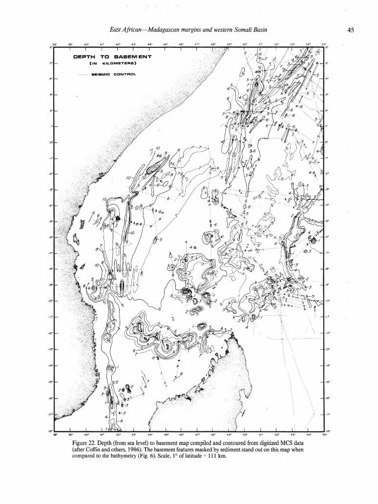
East African—Madagascan margins and western Somali Basin 41
42 43 44 45
Figure 22. Depth (from sea level) to basement map compiled and contoured from digitized MCS data
(after Coffin and others, 1986). The basement features masked by sediment stand out on this map when
compared to the bathymetry (Fig. 6). Scale, 1° of latitude =111 km.

46 Coffin and Rabinowitz
102
sw n e 6
Figure 23. a, Typical oceanic basement, displaying numerous diffractions, on MCS line 85. See Figure
19 for location of profile, b, Example from MCS line 94 on which igneous basement is not readily
observed; velocities derived from sonobuoy data were used to determine the location of basement (blue
horizon). See Figure 19 for location of profile.

East African—Madagascan margins and western Somali Basin 41
42 43 44 45
C D P 5 0 0 0 4 5 0 0
10 K M
Figure 24. a, Igneous emplacement, probably volcanic, on M C S line 90. See Figure 19 for location of
profile, b, Igneous intrusion, indicated by seismic, gravity, and magnetic data, on M C S line 100. See
Figure 19 for location of profile.
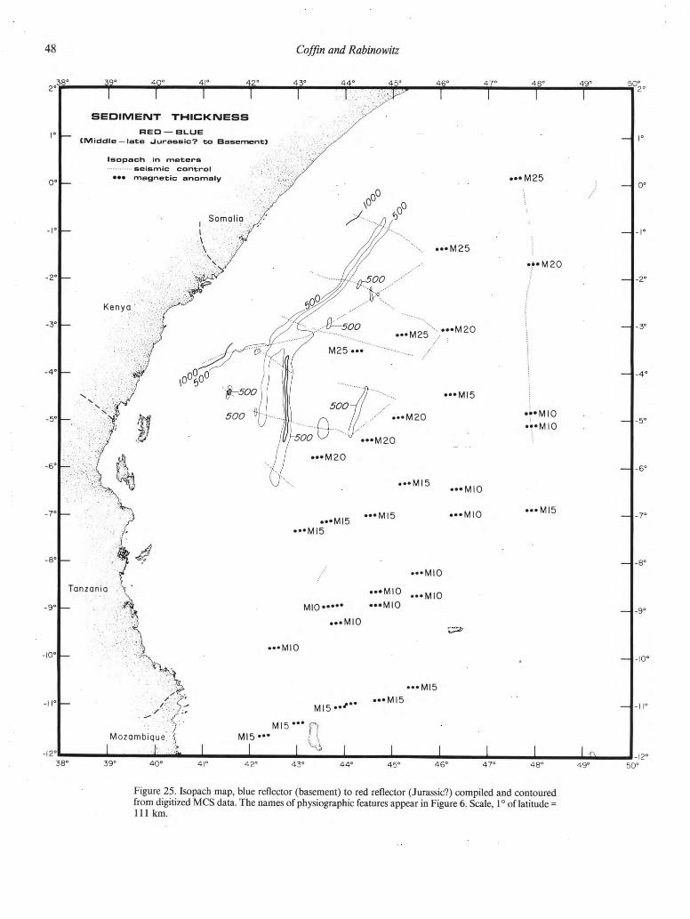
48 Coffin and Rabino witz
Figure 25. Isopach map, blue reflector (basement) to red reflector (Jurassic?) compiled and contoured
from digitized MCS data. The names of physiographic features appear in Figure 6. Scale, 1° of latitude =
111 km.

Figure 26. Typical red (Jurassic?) reflector character, usually flat-lying or draping basement topography,
on line 88. See Figure 19 for location of profile.
East African—Madagascan margins and western Somali Basin 41 42 43 44 45
Presumably somewhere in the red-blue interval lies the salt,
which is manifested as diapirs on the East African rifted margin
(Coffin and Rabinowitz, 1982; Rabinowitz and others, 1982).
We document the probable existence of salt on the conjugate
Madagascan rifted margin, as well as provide additional data
supporting the presence of salt on the East African rifted margin.
Figures 27a and b display Mobil MCS data in the subsurface salt
zone (near the Mahajamba 1 well, M2 in Fig. 1) offshore north-
ern Madagascar. A deformation front and scarp reminiscent of
the Sigsbee Scarp (Buffler and others, 1978; Buffler, 1983) are
striking in Figure 27a. By analogy with the Sigsbee Scarp, the
front represents the seaward limit of halokinetic deformation on
the Madagascan margin; very few coherent reflections are present
landward (southeast) of the front. A parallel profile a few tens of
kilometers to the southwest shows diapir and pillow structures
similar to those observed on the East African margin (Fig. 27b).
The diapir in the center of the figure demonstrates increasing
deformation downward in the sediment, although the salt layer is
not apparent. To the northwest (downslope) of the diapir is a
probable salt pillow similar to those observed in the North Sea
(Owen and Taylor, 1983). In Figure 28, we display an industrial
MCS profile located a few tens of kilometers northeast of line 86
(Fig. 19) on which prominent salt pillows appear seaward of the
diapirs. On additional closely spaced industrial profiles individual
diapir ridges can be traced for many tens of kilometers. The
similarities between the diapir and pillow structures, occurring at
comparable depths on the conjugate rifted margins separated by
-1,500 km, are truly remarkable.
Jurassic through mid-Cretaceous sediments (Fig. 29) Our data for the purple-red interval lie primarily along the
rifted portion of the East African continental margin. The unit
generally thickens landward, with two exceptions: a plume ex-
tends offshore from Kenya at ~4°S (possibly a Mesozoic fan
deposit), and a thick, linear trend of the interval parallels the
Somali margin between ~1°S and ~3°S (perhaps representing a
Mesozoic sedimentary ridge. These anomalies are visible in the
line drawings of Figure 20. The reflection character of the purple
reflector varies considerably throughout the study area, lending
mystery to its regional significance. A few kilometers to the
southeast of DSDP Site 241 (Fig. 21), the reflector forms a sharp,
angular unconformity with overlying sediment that demonstrates
onlap. A few kilometers to the northwest of the drill site (Fig. 21),

50 Coffin and Rabino witz
10 k m
Figure 27. a, Mobile MCS data from offshore northern Madagascar, showing a deformation front at the
northwest end of the line similar to the edge of the salt deformation zone (Sigsbee Scarp) observed in the
Gulf of Mexico (Buffler and others, 1978; Buffler, 1983). b, Mobil MCS data from offshore northern
Madagascar showing folding of the sedimentary section, which may be attributed to salt diapirs and
pillows.

II
11
f>
KU
1', :
1 ' 'I;
', ' I:,;,
I rr
ra
DM
DM
1 1
1
1 E
'.l"
1
1
W
B
il
l!
<M
IM
I i
i i
r IM
IM
i
"i
r i
-|
ru
m
!'.: i,.'
t r
1 i
i i
ll
•1
i! ••
(- —
ii
»»
5>
t
Fig
ure
28.
Tota
l M
CS data
fro
m o
ffshore
Kenya s
how
ing d
efo
rmati
on o
f th
e s
edim
ent
att
ribute
d t
o s
alt
dia
pir
s a
nd pil
low
s.
These d
ata
are
fro
m th
e c
onju
gate
ri
fted m
arg
in to
Fig
ure
27.

52 Coffin and Rabino witz
the horizon is conformable with the sedimentary sequence, al-
though it serves as a boundary between sequences with distinctive
reflection characters. The purple-red interval in the vicinity of the
drill site (Fig. 21) gives little hint as to its nature; the reflection
character is disrupted with a few intermittent reflections. Along
line 81 (Fig. 30a), the "purple" reflector may be seen as a hum-
mocky, rough, locally hyperbolated horizon; it probably repre-
sents an unconformity, but yet it is difficult to identify positively
as such because of the regular underlying reflection section. In
places the purple reflector appears to be an erosional unconform-
ity, as the small channel feature with onlap fill at ~6.5 s two-way
travel time demonstrates in Figure 30b. Just beneath 7 s two-way
travel time in the purple-blue interval (Fig. 30b) is a lenticular
reflection configuration, presumably representing a time of vigor-
ous bottom circulation. Farther to the south, the purple reflector
loses any character that would cause it to be identified as an
unconformity (Fig. 30c); in fact, identification of it as a unique
horizon proves impossible south of ~6.5°S. As observed in Fig-
ures 21 and 30, the reflector typically separates overlying sedi-
ment displaying even, parallel, closely spaced, fairly continuous
reflection character. Like the red-blue interval, the purple-red (or
blue) interval reveals few clues from its reflection character about
sedimentary processes, although in the former unit normal pelagic
sedimentation may be indicated. The dominantly reflection-free
character of the unit, especially in the south, suggests a uniform
shale lithology. The possible Mesozoic fan and sedimentary ridge
both trend to the northeast toward the major ocean basin of the
time, the Tethys (Norton and Sclater, 1979), and thus may be
used to infer paleocirculation patterns. This circulation probably
intensified with proximity to Tethys, and may account for the
conformity of the purple horizon in the south and its more uncon-
formable nature in the north.
Mid-Cretaceous through upper Oligocene sediment (Fig. 31) The mid-Cretaceous to late Oligocene section shows a
general increase in thickness toward the margin, attaining a max-
imum observable thickness in excess of 2,000 m offshore the
Kenya-Somalia border (see MCS data line drawings in Fig. 20).
Its distribution is most interesting in the vicinity of the intersec-
tion of the Davie Fracture Zone, with the Kenyan margin be-
tween ~3°S and ~5°S; the well data discussed in the previous
section indicate renewed subsidence landward of the Davie Frac-
ture Zone during the green-purple interval, which is corroborated
by the isopach map. In contrast to the underlying purple-red
interval, the reflection character of the unit indicates an energetic
sedimentation regime. The purple reflector, as previously noted
and here more fully documented, becomes unconformable with
overlying sediment toward the north of the study area, i.e., along
the rifted portion of the East African margin. A prime example of
this unconformable nature is displayed in Figure 32, in which
parallel, even reflectors (perhaps turbidites) onlap the purple ho-
rizon to the southeast of DSDP Site 241. The green reflector most
often forms an unconformity with overlying sediment on the
continental rise, but with increasing water depth it becomes con-
formable with sediment both above and below.
Along the East African rifted margin, the purple horizon
acted as a décollement surface for a major sedimentary event, a
huge (-20,000 km2) sediment slide discussed by Coffin and Ra-
binowitz (1982,1983). In Fig. 33 (a and b), we further document
this olistostrome that involves sediment of practically the entire
green-purple interval. Farther to the south, sliding on a smaller
scale (observed only on line 88) involved the purple horizon and
underlying sediment as well (Fig. 33c). The faulting within the
slides is thrusting of upslope sediment over downslope, with in-
tensity of deformation decreasing downslope. The major sedi-
ment slide (Fig. 33, a and b) merges upslope with the diapir
province, with no clear demarcation between the two styles of
deformation. On both lines 82 and 84, the toe of the olistostrome
is marked by a clear transition from a chaotic and contorted
reflection configuration within the slide to a parallel or subparal-
lel, even configuration seaward of the slide. The red and blue
reflectors cannot be traced for more than a few tens of kilometers
landward of the toe of the slide. On line 84 (Fig. 33b), some
faulting of the red reflector is observed circa CDP 3600, although
the reflection-free and chaotic reflection zones above allow dating
of this faulting only as definitely pre-late Oligocene (green) and
probably pre-mid-Cretaceous (purple).
The upper surface of the olistostromes on all three of the
seismic lines (Fig. 33) lies either at or just beneath the green
reflector that forms a prominent unconformity with sediment
both above (onlapping) and below (truncated). It appears that
sediment filled in depressions in the irregular upper surface of the
olistostromes following gravity sliding; then, some of these
deposits—and in places the olistostrome itself—were truncated
by a major erosional event that resulted in the green reflector,
perhaps correlating with a proposed major mid-Oligocene sea-
level drop (Vail and others, 1977; Haq and others, 1987). As
discussed by Coffin and Rabinowitz (1983), the age and cause of
the sliding is problematic. The best determination for the age is
middle Eocene to early Oligocene, and the two most probable
causes are halokinesis and tectonic activity in East Africa associ-
ated with initiation of the present phase of rifting. We consider it
important to note that olistostromes marked by severe internal
deformation, including thrust faults, may form on passive conti-
nental margins.
The conformity of the green reflector with sediment beneath
and above in deeper portions of the Western Somali Basin is
demonstrated in Figure 34a. The green-purple interval consists of
parallel, low-amplitude, even reflections. However, at continental
rise depths (Fig. 34b), the reflector becomes a striking unconfor-
mity. In the center of Figure 34b, the green-purple interval thins
to essentially zero thickness; the evidence for vigorous sedimenta-
tion and sediment transport (bedforms and wavy and lenticular
reflection configurations), as well as erosional (canyons and
channels) regimes, within the unit is overwhelming. At similar
water depths on a profile —100 km to the north (Fig. 34c), the
unconformities are not as marked, yet there is a wide variety of
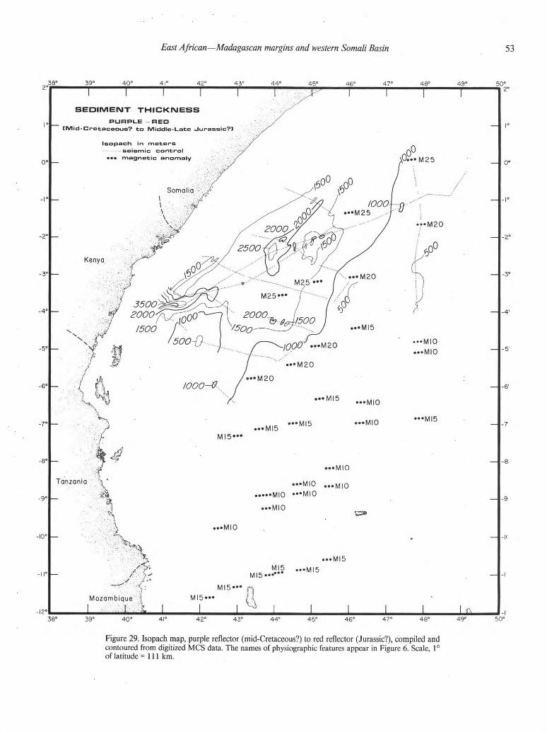
East African—Madagascan margins and western Somali Basin 41 42 43 44 45
Figure 29. Isopach map, purple reflector (mid-Cretaceous?) to red reflector (Jurassic?), compiled and
contoured from digitized MCS data. The names of physiographic features appear in Figure 6. Scale, 1°
of latitude =111 km.

54 Coffin and Rabino witz
Figure 30. a, The purple reflector, a hummocky, rough, locally hyperbolated horizon, is probably an
unconformity on MCS line 81. See Figure 19 for location of profile, b, A small channel (CDP-8750) on
the purple reflector, representing an erosional unconformity, appears on MCS line 88. See Figure 19 for
location of profile, c, In the south, on MCS line 90, the purple reflector is conformable. See Figure 19 for
location of profile.

East African—Madagascan margins and western Somali Basin 41
42 43 44 45
88 NW SE
10 K M
2700 C D P 3 2 0 0
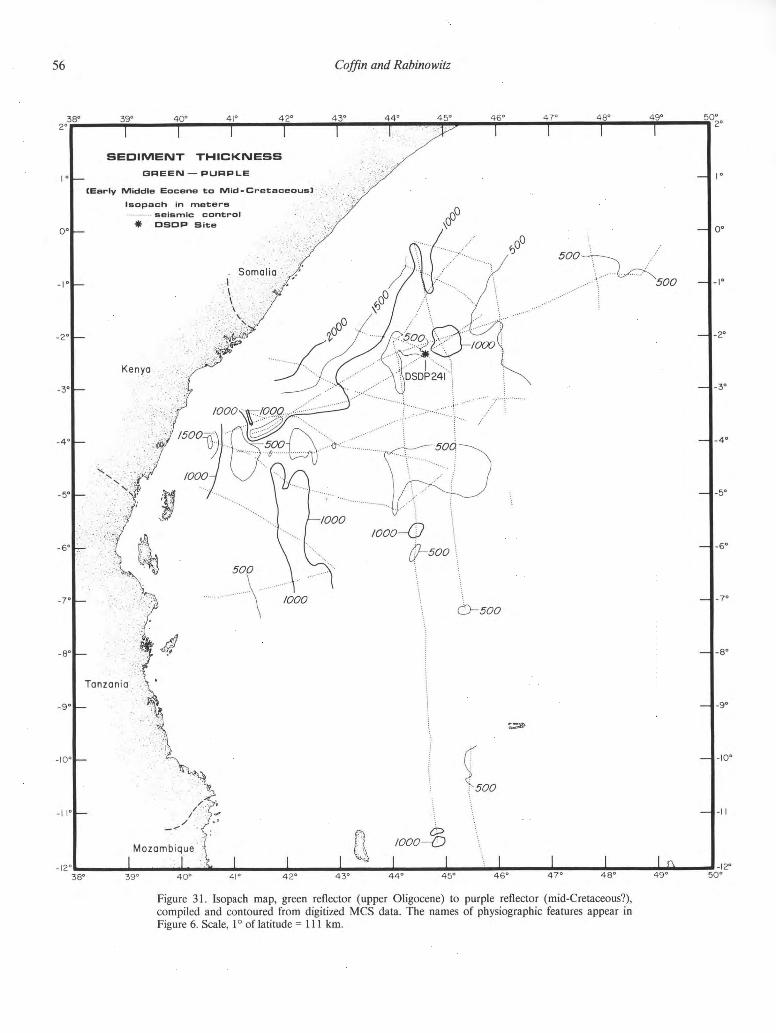
56 Coffin and Rabino witz
Figure 31. Isopach map, green reflector (upper Oligocene) to purple reflector (mid-Cretaceous?),
compiled and contoured from digitized MCS data. The names of physiographic features appear in
Figure 6. Scale, 1° of latitude =111 km.

East African—Madagascan margins and western Somali Basin 57
84 DSDP 241
N W ^ E 5
1 0 K M
Figure 32. Sediments of the green-purple interval lapping onto the purple horizon. See Figure 19 for
location of MCS profile 84.
reflection configurations within the purple-green interval, indica-
tive of high-energy sedimentary processes. Contorted, chaotic,
hummocky, wavy, and shingled clinoforms are apparent. Similar
reflection configurations are observed in places at slightly greater
depths (Fig. 34d) within the interval, again indicating an ener-
getic bottom environment during Late Cretaceous and Paleogene
time.
Upper Oligocene through Quaternary sediments (Fig. 35) The upper Oligocene sea-floor sediment package attains a
maximum thickness of 2,000 m landward of the Davie Fracture
Zone, a region of active Tertiary and Quaternary subsidence. The
overall distribution of the interval reflects a combination of fairly
well-known basement structure (see Figs. 20,22) and much more
poorly known abyssal circulation. Piston cores document nonde-
position and/or severe erosion, and hence an extremely vigorous
physical oceanographic regime, by recovering Cretaceous sedi-
ment exposed on the Davie Fracture Zone ridge (Segoufin and
others, 1978; Segoufin, 1981). Upper Miocene and upper Plio-
cene sediment has been recovered in piston cores from the floor
of the Western Somali Basin (L-DGO unpublished data). Upper
Cretaceous sediment has been sampled from the floor of the
Amirante Passage (Johnson and others, 1982; Masson and oth-
ers, 1982; Masson, 1984). Thick deposits of the unit in the south
(Fig. 25) may represent material carried through the Amirante
Passage into the Western Somali Basin. Seismic reflection data
also indicate that the Neogene and Quaternary have been periods
of energetic circulation in the Western Somali Basin.
The continental shelves of Somalia, Kenya, Tanzania, and
Madagascar are incised by deep (as much as 700 m) canyons
presumably eroded severely during glacial epochs, and remaining
relatively quiescent during interglacial times. In Figure 36 (a and
b), we display two strike profiles offshore Somalia and Tanzania,
respectively, documenting these canyons. Lack dense seismic cov-
erage, especially strike lines, prevents us from tracing the canyons
onto the slope, rise, and abyssal plain provinces. We do, however,
observe broad channels on the lower rise and abyssal plain (Fig.
37, a and b), which are in all probability related to sediment
erosion and transport from shallower depths. In Figure 37a, the
wavy and subparallel reflections and hummocky clinoforms be-
tween the sea-floor channel and the green reflector point to an
active Neogene and Quaternary depositional environment.
Farther to the south, along line 99 (Fig. 37b), the entire sea

58 Coffin and Rabino witz
5 « j > i *->-ro>Q)— Eo ) « 3ro>< ->-"-ro>a»— —• — E® 3
Hi CO
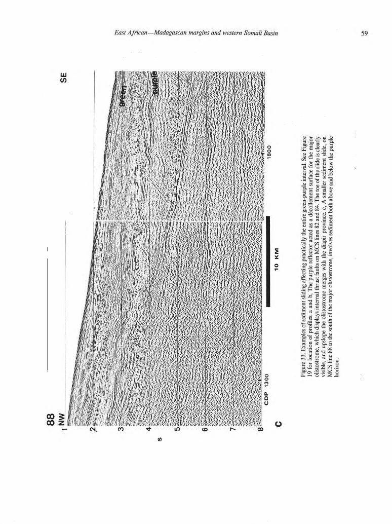
Fig
ure
33.
Exam
ple
s o
f sedim
ent
slidin
g a
ffecti
ng p
racti
cally t
he e
nti
re g
reen-purp
le i
nte
rval. S
ee F
igure
19 f
or
locati
on of
pro
file
s,
a a
nd b
, T
he p
urp
le r
eflecto
r acte
d a
s a
décollem
ent
surf
ace f
or
the m
ajo
r
olisto
str
om
e,
whic
h d
ispla
ys i
nte
rnal
thru
st
faults o
n M
CS l
ines 8
2 a
nd 8
4. T
he t
oe o
f th
e s
lide is c
learl
y
vis
ible
, and upslo
pe t
he o
listo
str
om
e m
erg
es w
ith th
e d
iapir
pro
vin
ce,
c,
A sm
aller
sedim
ent
slide,
on
MC
S l
ine 8
8 t
o t
he s
outh
of
the m
ajo
r olisto
str
om
e,
involv
es s
edim
ent
both
above a
nd b
elo
w t
he p
urp
le
hori
zon.
vo
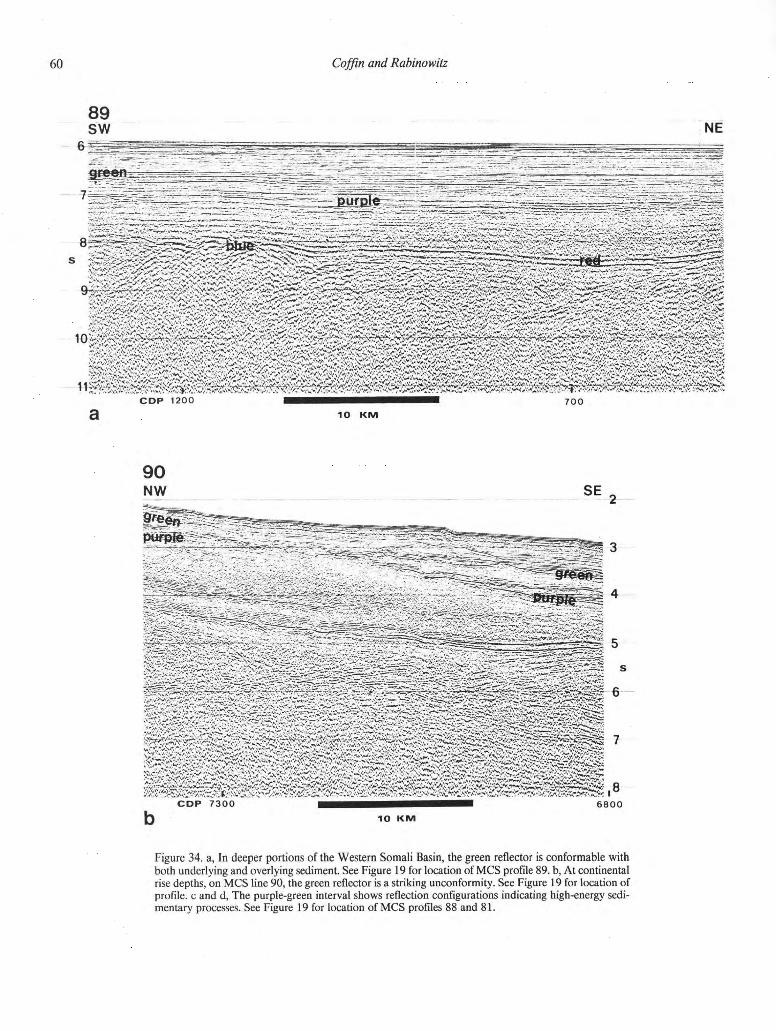
6 0 Coffin and Rabino witz
89 sw NE
M.*" V";. n!.
C O P 7300 ^ • 6800
10 K M
Figure 34. a, In deeper portions of the Western Somali Basin, the green reflector is conformable with
both underlying and overlying sediment. See Figure 19 for location of M C S profile 89. b, At continental
rise depths, on M C S line 90, the green reflector is a striking unconformity. See Figure 19 for location of
profile, c and d, The purple-green interval shows reflection configurations indicating high-energy sedi-
mentary processes. See Figure 19 for location of M C S profiles 88 and 81.
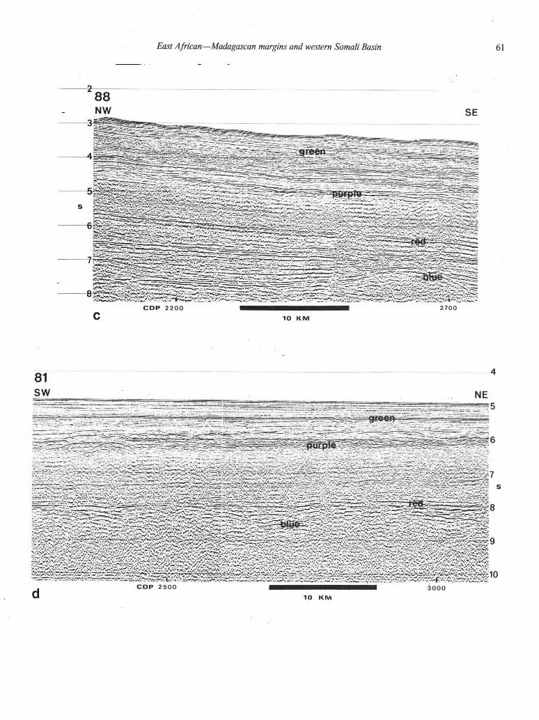
East African—Madagascan margins and western Somali Basin 41
42 43 44 45
rWr^SBfS
N'ivf.s.'ss«;.-:
3000
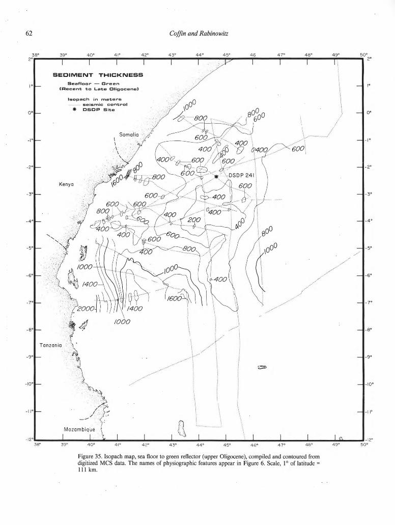
Figure 35. Isopach map, sea floor to green reflector (upper Oligocene), compiled and contoured from
digitized MCS data. The names of physiographic features appear in Figure 6. Scale, 1° of latitude =
111 km.

East African—Madagascan margins and western Somali Basin 41
42 43 44 45
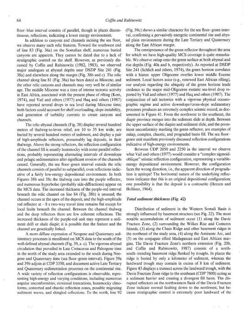
6 4 Coffin and Rabino witz
floor-blue interval consists of parallel, though in places discon-
tinuous, reflections, indicating a lower energy environment.
In addition to canyons and channels incising the sea floor,
we observe many such relic features. Toward the southwest end
of line 83 (Fig. 36a) on the Somalian shelf, numerous buried
canyons are apparent. They cannot be dated due to a lack of
stratigraphic control on the shelf. However, as previously dis-
cussed by Coffin and Rabinowitz (1982, 1983), we observed
major analogues at abyssal depths near DSDP Site 241 (Fig.
38a) and elsewhere along the margin (Fig. 38b and c). The relic
channel along line 81 (Fig. 38a) has been dated as Miocene, and
the other relic canyons and channels may very well be of similar
age. The middle Miocene was a time of intense tectonic activity
in East Africa, associated with the present phase of rifting (Kent,
1974), and Vail and others (1977) and Haq and others (1987)
have reported several drops in sea level during Miocene time;
both factors could account for shelf overloading, slope instability,
and generation of turbidity currents to create canyons and
channels.
The relic abyssal channels (Fig. 38) display several hundred
meters of thalweg-to-levee relief, are 10 to 35 km wide, are
buried by several hundred meters of sediment, and display a pair
of high-amplitude reflectors, presumably lag deposits, in their
thalwegs. Above the strong reflectors, the reflection configuration
of the channel fill is usually hummocky with some parallel reflec-
tions, probably representing alternating intervals of downslope
and pelagic sedimentation after significant erosion of the channels
ceased. Generally, the sea floor-green interval outside the relic
channels consists of parallel to subparallel, even reflections indic-
ative of a fairly low-energy depositional environment. In both
Figures 38b and 38c the thalweg cuts into the purple reflector,
and numerous hyperbolae (probably side-diffractions) appear on
the MCS data. The increased thickness of the purple-red interval
beneath the relic channel on line 84 (Fig. 38b) is unusual; the
channel occurs at the apex of the deposit, and the high-amplitude
red reflector at ~8 s two-way travel time remains flat except for
local faults beneath the channel. Between the channel thalweg
and the deep reflectors there are few coherent reflections. The
increased thickness of the purple-red unit may represent a sedi-
ment drift or shale diapir; it is possible that the feature and the
channel are genetically linked.
A more diffuse expression of Neogene and Quaternary sed-
imentary processes is manifested on MCS data to the south of the
well-defined abyssal channels (Fig. 39, a-c). The vigorous abyssal
circulation that prevailed in Late Cretaceous and Paleogene time
in the north of the study area extended to the south during Neo-
gene and Quaternary time (sea floor-green interval). Figure 39a
and 39b adjoin at CDP 3350, and document active Late Tertiary
and Quaternary sedimentation processes on the continental rise.
A wide variety of reflection configurations is observable, repre-
senting high-energy and varying conditions, including numerous
angular unconformities, erosional truncations, hummocky clino-
forms, contorted and chaotic reflection zones, possible migrating
sediment waves, and shingled reflections. To the north, line 92
(Fig. 39c) shows a similar character for the sea floor-green inter-
val, confirming a pervasively energetic continental rise and abys-
sal plain environment during the Late Tertiary and Quaternary
along the East African margin.
The omnipresence of the green reflector throughout the area
for which we have high-quality MCS coverage is quite remarka-
ble. We observe onlap onto the green surface at both abyssal and
rise depths (Fig. 40a and b, respectively). As reported at DSDP
Site 241 (Schlich and others, 1974), the green horizon correlates
with a hiatus: upper Oligocene overlies lower middle Eocene
sediment. Local factors asice (e.g., renewed East African rifting),
our analysis regarding the ubiquity of the green horizon lends
credence to the major mid-Oligocene eustatic sea-level drop re-
ported by Vail and others (1977) and Haq and others (1987). The
conjunction of salt tectonics with a vigorous physical oceano-
graphic regime and active downslope/cross-slope sedimentary
processes produces an extremely complex seismic record, as doc-
umented in Figure 41. From the northwest to the southeast, the
diapir province merges into the sediment slide at depth. Between
the upper surface of the diapirs and sediment slide, and the prom-
inent unconformity marking the green reflector, are examples of
onlap, complex, chaotic, and prograded basin fill. The sea floor-
green unit manifests previously discussed reflection configurations
indicative of high-energy environments.
Between CDP 2050 and 2250 in the interval we observe
what Vail and others (1977) would consider a "complex sigmoid-
oblique" seismic reflection configuration, representing a variable-
energy depositional environment. However, the configuration
faces the wrong direction, i.e., the apparent direction of prograda-
tion is upslope! The horizontal nature of the underlying reflec-
tions indicates that this is an original depositional configuration;
one possibility is that the deposit is a contourite (Heezen and
Hollister, 1964).
Total sediment thickness (Fig. 42) Distribution of sediment in the Western Somali Basin is
strongly influenced by basement structure (see Fig. 22). The most
notable accumulations of sediment occur (1) along the Davie
Fracture Zone, (2) surrounding the Wilkes Rise and Comoros
Islands, (3) along the Chain Ridge and other basement ridges in
the northeast of the study area, (4) along the Amirante Arc, and
(5) on the conjugate rifted Madagascan and East African mar-
gins. The Davie Fracture Zone's northern extension (Fig. 20b,
and Coffin and Rabinowitz, 1987) consists of a north-
south-trending basement ridge flanked by troughs. In places the
ridge is buried by only a kilometer of sediment, whereas the
landward trough may contain in excess of 8 km of sediment.
Figure 43 displays a transect across the landward trough, with the
Davie Fracture Zone ridge to the southeast (CDP 7800) acting as
a sediment barrier and creating a divergent fill basin. The dis-
rupted reflectors on the northwestern flank of the Davie Fracture
Zone indicate normal faulting down to the northwest, but be-
cause stratigraphic control is extremely poor landward of the
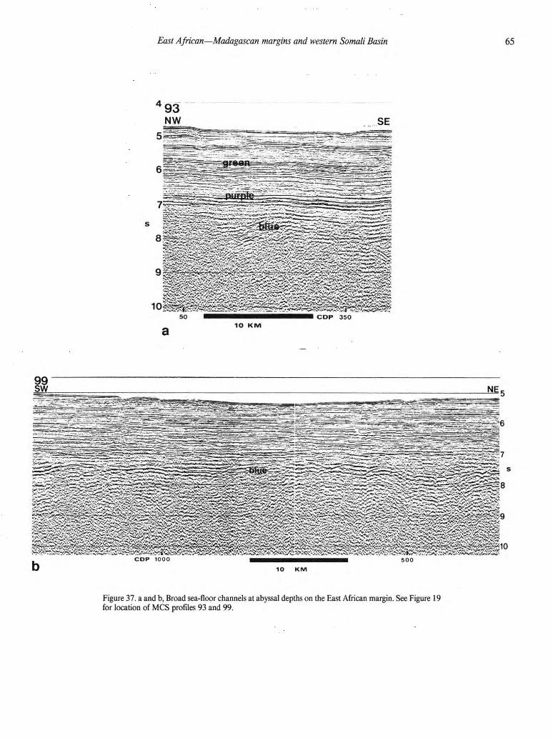
East African—Madagascan margins and western Somali Basin 41
42 43 44 45
Figure 37. a and b, Broad sea-floor channels at abyssal depths on the East African margin. See Figure 19
for location of MCS profiles 93 and 99.
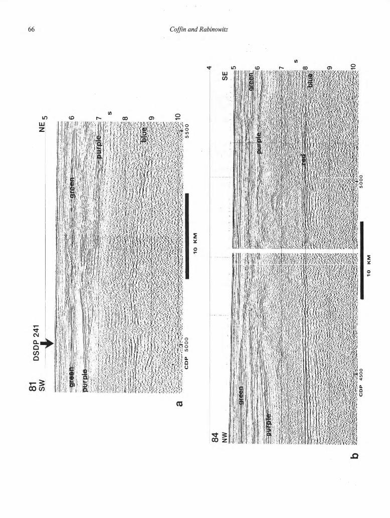
66 Coffin and Rabino witz

East African—Madagascan margins and western Somali Basin 41
42 43 44 45
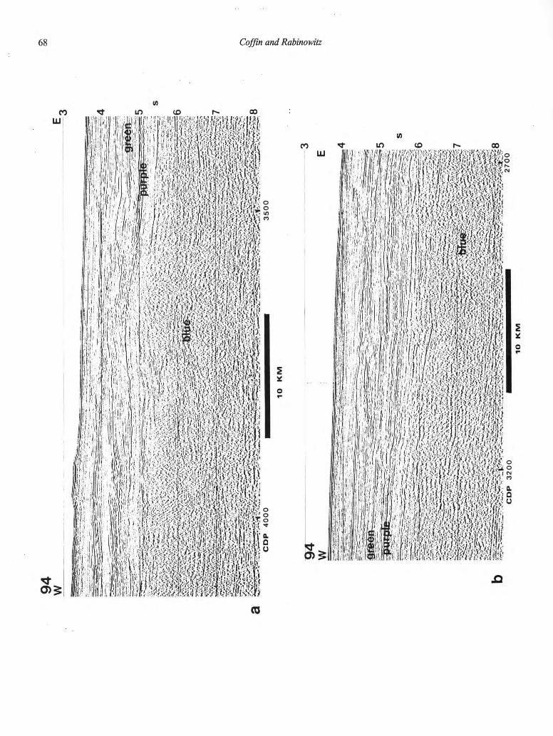
6 8 Coffin and Rabinowitz
<0

92
NW
S
E4
a'
Fig
ure
39.
a,
b,
and
c.
Refl
ecti
on
confi
gura
tions
in th
e se
a floor—
gre
en
inte
rval
indic
ate
energ
etic
sedim
enta
ry pro
cess
es o
ccurr
ing i
n N
eogene a
nd Q
uate
rnary
ti
me.
See F
igure
19 f
or
locati
on o
f M
CS
pro
file
s 9
4 a
nd 9
2.
ON
vo
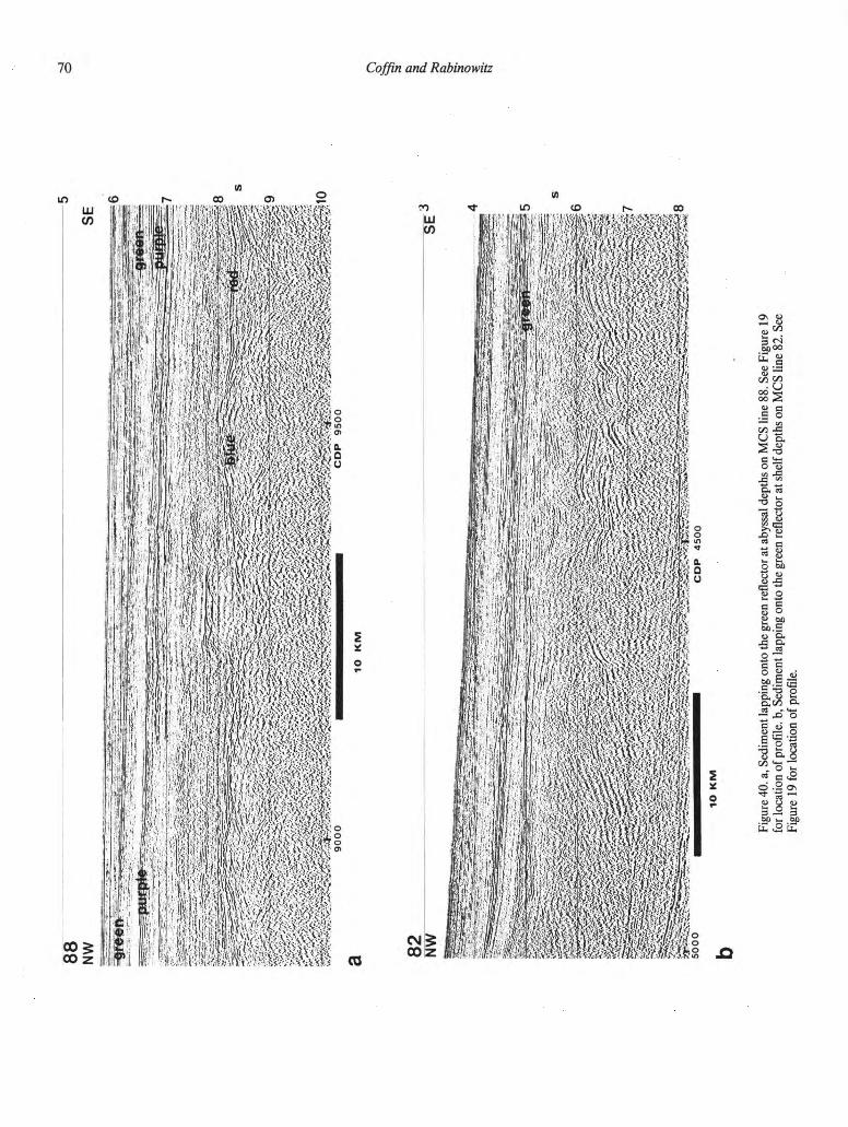
NW
S
E
Fig
ure
40. a, Sedim
ent
lappin
g o
nto
the g
reen r
eflecto
r at
abyssal depth
s o
n M
CS line 8
8. See F
igure
19
for
locati
on o
f pro
file
, b, Sedim
ent
lappin
g o
nto
the g
reen r
eflecto
r at
shelf
depth
s o
n M
CS line 8
2. See
Fig
ure
19 f
or
locati
on o
f pro
file
.

3 84
NW
S
E I
lO
KM
Fig
ure
41.
Com
ple
x M
CS re
cord
result
ing f
rom
salt t
ecto
nic
s,
sedim
ent
slidin
g,
ero
sio
n,
and sedim
ent
deposit
ion.
See F
igure
19 f
or
locati
on o
f pro
file
84.

81 Coffin and Rabino witz
Figure 42. Total sediment thickens map compiled and contoured from digitized MCS data (after Coffin
and others, 1986). Maximum sediment thickness exceeds 8 km on the East African margin and 5 km on
the Madagascan margin. Scale, 1° of latitude =111 km.
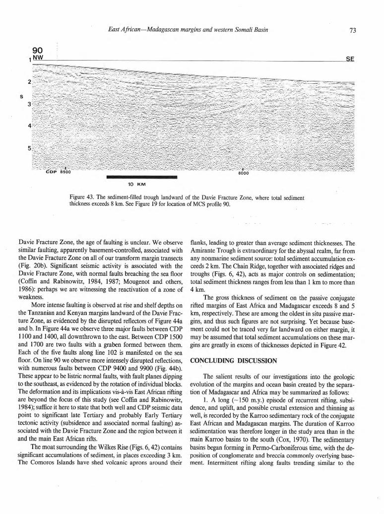
East African—Madagascan margins and western Somali Basin 41
42 43 44 45
90 1 NW SE
10 K M
Figure 43. The sediment-filled trough landward of the Davie Fracture Zone, where total sediment
thickness exceeds 8 km. See Figure 19 for location of MCS profile 90.
Davie Fracture Zone, the age of faulting is unclear. We observe
similar faulting, apparently basement-controlled, associated with
the Davie Fracture Zone on all of our transform margin transects
(Fig. 20b). Significant seismic activity is associated with the
Davie Fracture Zone, with normal faults breaching the sea floor
(Coffin and Rabinowitz, 1984, 1987; Mougenot and others,
1986): perhaps we are witnessing the reactivation of a zone of
weakness.
More intense faulting is observed at rise and shelf depths on
the Tanzanian and Kenyan margins landward of the Davie Frac-
ture Zone, as evidenced by the disrupted reflectors of Figure 44a
and b. In Figure 44a we observe three major faults between CDP
1100 and 1400, all downthrown to the east. Between CDP 1500
and 1700 are two faults with a graben formed between them.
Each of the five faults along line 102 is manifested on the sea
floor. On line 90 we observe more intensely disrupted reflections,
with numerous faults between CDP 9400 and 9900 (Fig. 44b).
These appear to be listric normal faults, with fault planes dipping
to the southeast, as evidenced by the rotation of individual blocks.
The deformation and its implications vis-à-vis East African rifting
are beyond the focus of this study (see Coffin and Rabinowitz,
1984); suffice it here to state that both well and CDP seismic data
point to significant late Tertiary and probably Early Tertiary
tectonic activity (subsidence and associated normal faulting) as-
sociated with the Davie Fracture Zone and the region between it
and the main East African rifts.
The moat surrounding the Wilkes Rise (Figs. 6,42) contains
significant accumulations of sediment, in places exceeding 3 km.
The Comoros Islands have shed volcanic aprons around their
flanks, leading to greater than average sediment thicknesses. The
Amirante Trough is extraordinary for the abyssal realm, far from
any nonmarine sediment source: total sediment accumulation ex-
ceeds 2 km. The Chain Ridge, together with associated ridges and
troughs (Figs. 6, 42), acts as major controls on sedimentation;
total sediment thickness ranges from less than 1 km to more than
4 km.
The gross thickness of sediment on the passive conjugate
rifted margins of East Africa and Madagascar exceeds 8 and 5
km, respectively. These are among the oldest in situ passive mar-
gins, and thus such figures are not surprising. Yet because base-
ment could not be traced very far landward on either margin, it
may be assumed that total sediment accumulations on these mar-
gins are greatly in excess of thicknesses depicted in Figure 42.
CONCLUDING DISCUSSION The salient results of our investigations into the geologic
evolution of the margins and ocean basin created by the separa-
tion of Madagascar and Africa may be summarized as follows:
1. A long (-150 m.y.) episode of recurrent rifting, subsi-
dence, and uplift, and possible crustal extension and thinning as
well, is recorded by the Karroo sedimentary rock of the conjugate
East African and Madagascan margins. The duration of Karroo
sedimentation was therefore longer in the study area than in the
main Karroo basins to the south (Cox, 1970). The sedimentary
basins began forming in Permo-Carboniferous time, with the de-
position of conglomerate and breccia commonly overlying base-
ment. Intermittent rifting along faults trending similar to the

74 Coffin and Rabinowitz
102
g 10 K M
Figure 44. Major faults demonstrating Tertiary and Quaternary extension of the East African continen-
tal margin, a, Faults on continental rise. See Figure 19 for location of MCS profile 102. b, Faults on
continental shelf. See Figure 19 for location of MCS profile 90.
East African—Madagascan margins and western Somali Basin 41
42 43 44 45
earliest observed orientations (northeast in the conjugate Majun-
ga/Diego and Somali Coastal Basins, and north-northwest and
north-northeast in the Lamu Embayment and conjugate Tanzan-
ian Coastal and Morondava Basins) continued until the initiation
of sea-floor spreading between Madagascar and Africa in Middle
Jurassic time.
2. The Karroo sedimentary rock, although predominantly
continental, contains many marine units. Most notable of these
are (1) salt deposits in Tanzania (Permian through Bajocian) and
in what are now the conjugate rift basins of Majunga/Diego and
Somalia (with diapirism continuing to the present day), and (2)
the marine strata of Middle Permian through earliest Triassic age
in the Diego Basin.
3. During latest Early Jurassic and Middle Jurassic time, all
of the basins record a major facies change from dominantly con-
tinental to overwhelmingly marine. Extrusive igneous rocks of
those series have been identified in the Somali Coastal Basin and
in the northern reaches of the Morondava Basin, and intense
faulting has been recorded in all of the basins for that time
interval.
4. From Late Jurassic through the end of Mesozoic time,
mixed facies are encountered in all of the onshore basins. The
Late Cretaceous marked an episode of widespread volcanism in
the region; igneous rocks have been encountered in all basins
except the Lamu Embayment. Offshore on MCS data we observe
two strong reflecting horizons (red and purple), which are judged
to be Mesozoic in age. The former is probably a lithologic boun-
dary; the latter, a major erosional event and/or hiatus that
marked the beginning of vigorous abyssal circulation in the
Western Somali Basin.
5. The hallmarks of the Tertiary System are (1) numerous
unconformities and hiatuses, especially in the Paleocene and
Oligocene series; (2) volcanism in the Diego Basin and the Co-
moros Archipelago; and (3) intense tectonism on the islands and
subbasins offshore Tanzania and Kenya, and on the Davie Frac-
ture Zone ridge. A major sediment slide occurred offshore Soma-
lia and Kenya during mid-Tertiary time; we observe a major
unconformity (green reflector), generally at slope and rise depths.
In Neogene and Quaternary deposits, offshore MCS data reveal a
major network of canyons and channels. An energetic physical
oceanographic regime persisted in the Western Somali Basin
from mid-Cretaceous through much of Cenozoic time.
6. Depth-to-basement and sediment isopach maps reveal
the importance of the Davie Fracture Zone as a barrier to sedi-
ment shed from the transform margin of East Africa; they high-
light the thick stratigraphic sections encountered on the East
African and Madagascan margins (8+ and 5+ km, respectively).
Conceptual and global implications
While the general intent of this study has been to detail the
geologic evolution of the conjugate East African-Madagascan
margins and Western Somali Basin, our results have implications
for more global and conceptual topics, including plate tectonics,
rifting, basin formation and subsidence, sea-level change, and
paleoceanography. The discussion that follows is a qualitative
attempt to place our results in a broader perspective and contri-
bute to an understanding of these subjects.
Geologic data and inferences from both onshore (outcrop
and wells) and Deep Sea Drilling Project sites, until the identifi-
cation of marine magnetic anomalies in the Western Somali
Basin (Ségoufin and Patriat, 1980; Parson and others, 1981; Ra-
binowitz and others, 1983), have been used to support a variety
of paleopositions for Madagascar in Gondwanaland, e.g., north:
du Toit (1937), Smith and Hallam (1970), Craddock (1979),
Cannon and others (1981); autochthonous: Dixey (1960),
Flower and Strong (1969), Darracott (1974), Kamen-Kaye
(1978, 1983), Tarling (1981); and south: Flores (1970, 1984),
Wright and McCurry (1970), Green (1972), Kent (1972, 1973),
Tarling (1972), and Burke and Whiteman (1973). In reviewing
the stratigraphic evidence, we are struck by its ambiguity vis-à-vis
the paleoposition of Madagascar in Gondwanaland (with the
exception of conjugate diapir provinces on the rifted Madagascan
and East African margins); the constancy of structural trends in
the conjugate basins seems far more consistent and reliable. Given
the incompleteness of the geologic record (Ager, 1980) and the
lateral geologic variations along present-day rifts (Mohr, 1982),
we conclude that extreme caution must be exercised in construct-
ing or even fine-tuning a plate tectonic model from stratigraphic
data alone.
The seismic reflection data across the conjugate rifted mar-
gins of East Africa and Madagascar do not provide enough in-
formation at depth to distinguish between pure shear (McKenzie,
1978) and simple shear (Wernicke, 1981) modes of extension.
However, the geological and geophysical data do provide some
constraints for such models. One remarkable aspect of basin de-
velopment recorded by the sediment of the conjugate East Afri-
can and Madagascan margins is its duration of ~ 150 m.y. prior to
obvious sea-floor spreading. Although the rifting accompanying
basin development may not have been continuous throughout the
pre-breakup interval, such a long history could imply significant
weakening, thinning, and stretching of the East African/Mada-
gascan continental crust. Substantial east-west stretching between
Madagascar and Africa prior to breakup is indicated (although
undated) by anomalous crust landward of the Davie Fracture
Zone on both margins and by onshore geophysical data in Kenya
(Reeves and others, 1987). Limited pre-breakup volcanic activity
is recorded in the sedimentary record. Following breakup, the
marginal basins underwent a large amount of subsidence. The
conjugate margins' subsidence history and geologic record are
complicated by widespread regional volcanism (Late Cretaceous)
and tectonism (Tertiary/Quaternary in Tanzania landward of the
Davie Fracture Zone) following breakup.
The East African margin has long been a region of tectonic
instability, as previously discussed. Another interesting aspect of
the margin involving rifting concerns the extensional orientation
and history of the conjugate Morondava and Tanzanian Coastal
76 Coffin and Rabino witz
Basins. Both experienced recurrent east-west extension from
Permo-Carboniferous through Middle Nurassic time. All such
activity ceased as Madagascar and Africa separated by north-
south drift from Middle Jurassic through Early Cretaceous time.
In the Tertiary Period, east-west extension resumed (after a 100-
m.y. hiatus) in the Tanzanian Coastal Basins, while the Moron-
dava Basin remained quiescent. This long-term instability at the
eastern edge of the present African craton (qualifying as a "zone
of weakness"), and its ability to change orientation and intensity,
hints at a durable underlying mantle process most definitely de-
serving investigation.
Our investigations into the stratigraphy of the margins and
the Western Somali Basin provide several clues about the Paleo-
zoic and Mesozoic Tethys Ocean. The deposition of marine sed-
iment in the Diego Basin from Middle Permian through earliest
Triassic time may indicate an arm of the Tethys extending to the
south during that time. The source of repeated marine incursions
during Karroo time in all of the sampled basins, depositing, for
example, salt in Tanzania, may also have been the Tethys. How-
ever, the Early and Middle Jurassic migration of marine facies
northward across the Majunga Basin from the northern Moron-
dava Basin hints at a southern ocean source during that time.
The tectonic model for the area beginning in Middle Jurassic time
(McKenzie and Sclater, 1971; Norton and Sclater, 1979) allows
for a northern derivation of the sea following the breakup of
Madagascar and Africa.
The major sediment slide that probably occurred in mid-
Tertiary time serves to emphasize that the formation of olisto-
REFERENCES
Ager, D. V., 1981, The nature of the stratigraphical record: New York, Halsted,
122 p.
Baker, B. H., 1963, Geology and mineral resources of the Seychelles Archipelago:
Geological Survey of Kenya Memoir 3, 140 p.
Barnes, S. U., 1976, Geology and oil prospects of Somali, East Africa: American
Association of Petroleum Geologists Bulletin, v.60, p. 389-413.
Beltrandi, M. D., and Pyre, A., 1973, Geological evolution of southwest Somali,
in Blant, G., ed., Sedimentary basins of the African coasts; Part 2, South and
East Coast: Paris, Association of African Geological Surveys, p. 159-178.
Besairie, H., 1971, Madagascar, in Tectonics of Africa: Paris, UNESCO,
p. 549-558.
Besairie, H., and Collignon, M., 1972, Geologie de Madagascar; I, Les terrains
sedimentaires: Annates Geologique de Madagascar, v. 35, 463 p.
Blant, G., 1973, Structure et paleogeographie du littoral, meridonal, et oriental de
l'Afrique, in Blant, G., ed., Sedimentary basins of the African coasts; Part 2,
South and East Coast: Paris, Association of African Geological Surveys,
p. 193-231.
Boast, J., and Nairn, A., 1982, An outline of the geology of Madagascar, in Nairn,
A., and Stehli, F., eds., The ocean basins and margins; Volume 6, The Indian
Ocean: New York, Plenum Press, p. 649-696.
Buffler, R. T., 1983, Structure of the Sigsbee Scarp, Gulf of Mexico, in Bally,
A. W., ed., Seismic expression of structural styles: American Association of
Petroleum Geologists Studies in Geology, v. 15, p. 2.3.2-50-2.3.2-55.
Buffler, R. T., Worzel, J., and Watkins, J. S., 1978, Deformation and origin of the
Sigsbee Scarp-lower continental slope, northern Gulf of Mexico: Proceed-
ings 1978 Offshore Technological Conference, v. 3, p. 1425-1433.
stromes characterized by severe internal deformation, including
thrust faults, does not occur exclusively in close proximity to
compressional plate boundaries. This is an especially important
point for investigators working in regions that have undergone
multiple deformations, e.g., the Alps. What appear to be nappes
and olistostromes intimately related to active margin tectonics,
including mountain building, may in fact be attributed to a pas-
sive margin setting predating collision of that margin with
another plate.
The acoustic stratigraphy studies of the margins and West-
ern Somali Basin that we have described point to two major
episodes in the paleoceanographic (and possibly sea-level) history
of the region. The first event, assigned to mid-Cretaceous time,
involves a transition from a relatively low-energy to a fairly high-
energy abyssal and rise environment. This event may very well
correlate with the establishment of north-south circulation from
the Tethys through the Western Somali Basin into the juvenile
Mozambique Basin (Segoufin and others, 1978; Simpson and
others, 1979), as well as with a major Cenomanian drop in sea
level (Vail and others, 1977, 1980; Haq and others, 1987). Be-
cause the reflecting horizon is unsampled, such a correlation may
be tenuous. The second event was an intense erosional event from
middle Eocene through mid-Oligocene time. We attribute it to
the onset of higher energy ocean circulation, documented on both
global (Moore and others, 1978) and regional (Tucholke and
Embley, 1984) scales. The event also correlates with a major
eustatic sea-level fall in mid-Oligocene time (Vail and others,
1977, 1980; Haq and others, 1987).
Bunce, E. T., and Molnar, P., 1977, Seismic reflection profiling and basement
topography in the Somali Basin; Possible fracture zones between Madagascar
and Africa: Journal of Geophysical Research, v. 82, p. 5305-5311.
Bunce, E. T., Langseth, M. G., Chase, R. L., and Ewing, M., 1967, Structure of
the western Somali Basin: Journal of Geophysical Research, v. 72,
p. 2547-2555.
Burke, K., and Whiteman, A. J., 1973, Uplift, rifting, and break-up of Africa, in Tarline, D. H., and Runcorn, S. K., eds., Implications of continental drift to
the earth sciences: New York, Academic Press, p. 735-755.
Cannon, R. T„ Siambi, W. M. N. S., and Karanja, F. M., 1981, The proto-Indian
Ocean as a probable Paleozoic/Mesozoic triradial rift system in East Africa:
Earth and Planetary Science Letters, v. 52, p. 419-426.
Coffin, M. F., 1985, Evolution of the conjugate East African-Madagascan mar-
gins and the western Somali Basin [Ph.D. thesis]: New York, Columbia
University, 336 p.
Coffin, M. F., and Rabinowitz, P. D., 1982, A multichannel seismic transect of the
Somalian continental margin: Proceedings 1982 Offshore Technological
Conference, v. 2, p. 421-430.
, 1983, East African continental margin transect, in Bally, A. W., ed.,
Seismic expression of structural styles: American Association of Petroleum
Geologists Studies in Geology, v. 15, p. 2.3.3-22-2.3.3-30.
, 1984, Rifting of the East African continental margin: EOS Transactions of
the American Geophysical Union, v. 65, p. 900.
, 1987, Reconstruction of Madagascar and Africa; Evidence from the Davie
Fracture Zone and western Somali Basin: Journal of Geophysical Research,
v. 92, p. 9385-9406.

East African—Madagascan margins and western Somali Basin 41
42 43 44 45
Coffin, M. F., Rabinowitz, P. D., and Houtz, R. E., 1986, Crustal structure in the
western Somali Basin: Geophysical Journal of the Royal Astronomical So-
ciety, v. 86, p. 331-369.
Cox, K. G., 1970, Tectonics and vulcanism of the Karroo Period and their bearing
on the postulated fragmentation of Gondwanaland, in Clifford, T. N., and
Gass, I. G., eds., African magmatism and tectonics: Edinburgh, Oliver &
Boyd, p. 211-235.
Craddock, C., 1979, The evolution and fragmentation of Gondwanaland: Interna-
tional Gondwana Symposium, no. 4, v. 2, p. 711-719.
Darracott, B. W., 1974, On the crustal structure and evolution of southeastern
Africa and the adjacent Indian Ocean: Earth and Planetary Science Letters,
v. 24, p. 282-290.
Dixey, F., 1960, The geology and geomorphology of Madagascar, and a compari-
son with East Africa: Quarterly Journal of the Geological Society of Lon-
don, v. 116, p. 255-268.
Du Toit, A. L., 1937, Our wandering continents: An hypothesis of continental
drifting: Edinburgh, Oliver & Boyd, 366 p.
Emerick, C. M., and Duncan, R. A., 1982, Age progressive volcanism in the
Comores Archipelago, western Indian Ocean and implications for Somali
plate tectonics: Earth and Planetary Science Letters, v. 60, p. 415-428.
Fischer, R. L., Engel, C. G., and Hilden, T. W. C., 1968, Basalts dredged from the
Amirante Ridge, western Indian Ocean: Deep Sea Research, v. 15,
p. 521-534.
Fisher, R. L., Bunce, E. T., and others, 1974, Initial reports of the Deep Sea
Drilling Project: Washington, D.C., U.S. Government Printing Office, v. 24,
587 p.
Flores, G., 1970, Suggested origin of the Mozambique Channel: Transactions of
the Geological Society of South Africa, v. 73, p. 1-16.
, 1984, The S.E. Africa triple junction and the drift of Madagascar: Journal
of Petroleum Geology, v. 7, p. 403.
Flower, M. J. F., and Strong, D. F., 1969, The significance of sandstone inclusions
in lavas of the Comores Archipelago: Earth and Planetary Science Letters,
v. 7, p. 47-50.
Forster, R., 1975, The geological history of the sedimentary basin of southern
Mozambique, and some aspects of the origin of the Mozambique Channel:
Palaeogeography, Palaeoclimatology, Palaeoecology, v. 17, p. 267-287.
Green, A. G., 1972, Seafloor spreading in the Mozambique Channel: Nature;
Physical Science, v. 236, p. 19-32.
Haq, B. U., Hardenbol, J., and Vail, P. R., 1987, Chronology of fluctuating sea
levels since the Triassic: Science, v. 235, p. 1156-1167.
Hartman, J. B., 1987. Oil and gas developments in central and southern Africa in
1986, American Association of Petroleum Geologists Bulletin, v. 71,
p. 190-225.
Haxby, W. F., Karner, G. D., LaBrecque, J. L., and Weissel, J. K., 1983, Digital
images of combined oceanic and continental data sets and their use in
tectonic studies: EOS Transactions of the American Geophysical Union,
v. 64, p. 995-1004.
Johnson, D. A., Berggren, W. A., and Damuth, J. E., 1982, Cretaceous ocean
floor in the Amirante Passage; Tectonic and oceanographic implications:
Marine Geology, v. 47, p. 331-343.
Kajato, H. K., 1982, Gas strike spurs search for oil in Tanzania: Oil and Gas
Journal, March 15, 1982, p. 123-131.
Kamen-Kaye, M., 1978, Permian to Tertiary faunas and paleogeography; Somali,
Kenya, Tanzania, Mozambique, Madagascar, South Africa: Journal of
Petroleum Geology, v. 1, no. 1, p. 79-101.
, 1982, Mozambique-Madagascar geosyncline; I, Deposition and architec-
ture: Journal of Petroleum Geology, v. 5, no. 1, p. 3-30.
, 1983, Mozambique-Madagascar geosyncline; II, Petroleum geology: Jour-
nal of Petroleum Geology, v. 5, no. 3, p. 287-308.
Kamen-Kaye, M., and Barnes, S. U., 1978, Exploration outlook for Somalia,
coastal Kenya and Tanzania: Oil and Gas Journal, July 24,1978, p. 80-246.
, 1979, Exploration geology of northeastern Africa-Seychelles Basin: Jour-
nal of Petroleum Geology, v. 2, no. 1, p. 23-45.
Keen, C. E., and Cordsen, A., 1981, Crustal structure, seismic stratigraphy, and
rift processes of the continental margin off western Canada; Ocean bottom
seismic refraction results off Nova Scotia: Canadian Journal of Earth
Sciences, v. 18, p. 1523-1538.
Kent, D. V., and Gradstein, F. M., 1985, A Cretaceous and Jurassic geochronol-
ogy: Geological Society of America Bulletin, v. 96, p. 1419-1427.
Kent, P. E., 1972, Mesozoic history of the East Coast of Africa: Nature, v. 238,
p. 147-148.
, 1973a, East African evidence of the palaeoposition of Madagascar, in Tarling, D. H., and Runcorn, S. K., Implications of continental drift to the
earth sciences: London, Academic Press, p. 873-878.
, 1973b, The continental margin of Tanzania, in Tarling, D. J., and Run-
corn, S. K., Implications of continental drift to the earth sciences: London,
Academic Press, p. 949-952.
, 1974, Continental margins of East Africa; A region of vertical movements,
in Schlich, R., Simpson, E. S. W., and others, Initial reports of the Deep Sea
Drilling Project: Washington, D.C., U.S. Government Printing Office, v. 25,
p. 313-320.
, 1977, The Mesozoic development of aseismic continental margins: Journal
of the Geological Society of London, v. 134, p. 1-18.
, 1982, The Somali ocean basin and the continental margin of East Africa,
in Nairn, A., and Stehli, F., eds., The ocean basins and margins; Volume 6,
The Indian Ocean: New York, Plenum Press, p. 185-204.
Kent, P. E., and Perry, J. T. O'B., 1973, The development of the Indian Ocean
margin in Tanzania, in Blant, G., ed., Sedimentary basins of the African
coasts; Part 2, South and East Coast: Paris, Association of African Geologi-
cal Surveys, p. 113-131.
Kent, P. E., Hunt, J. A., and Jonnstone, D. W., 1971, The geology and geophysics
of coastal Tanzania: London, Her Majesty's Stationery Office, 101 p.
Masson, D. G., 1985, Evolution of the Mascarene Basin, western Indian Ocean,
and the significance of the Amirante Arc: Marine Geophysical Research, v. 6,
p. 365-382.
Masson, D. G., Kidd, R. B., and Roberts, D. G., 1982, Late Cretaceous sediment
sample from the Amirante Passage, western Indian Ocean: Geology, v. 10,
p. 264-266.
McGrew, H. J., 1983, Oil and gas developments in central and southern Africa in
1982: American Association of Petroleum Geologists Bulletin, v. 67,
p. 1723-1794.
McKenzie, D. P., 1978, Some remarks on the development of sedimentary basins:
Earth and Planetary Science Letters, v. 40, p. 25-32.
McKenzie, D. P., and Sclater, J. G., 1971, The evolution of the Indian Ocean
since the late Cretaceous: Geophysical Journal of the Royal Astronomical
Society, v. 24, p. 437-528.
Mohr, P., 1982, Musings on continental rifts, in Palmason, G., ed., Continental
and oceanic rifts: American Geophysical Union Geodynamics Series, v. 8,
p. 298-309.
Moore, T. C., and others, 1978, Cenozoic hiatuses in pelagic sediments: Micro-
paleontology, v. 24, p. 113-138.
Mougenot, D., Recq, M., Virologeux, P., and Lepvrier, C., 1986, Seaward exten-
sion of the East African Rift: Nature, v. 321, p. 599-603.
Mountain, G. S., 1981, Stratigraphy of the western North Atlantic based on the
study of reflection profiles and DSDP results [Ph.D. thesis]: New York,
Columbia University, 317 p.
Norton, I. O., and Sclater, J. G., 1979, A model for the evolution of the Indian
Ocean and the breakup of Gondwanaland: Journal of Geophysical Re-
search, v. 84, p. 6803-6830.
Okoth, W. S., 1981, Evaluation of hydrocarbon potential of the Kenyan margin
on the basis of structure and stratigraphy [M.S. thesis]: Halifax, Nova Scotia,
Dalhousie University, 115 p.
Owen, P. F., and Taylor, N. G., 1983, A salt pillow structure in the southern
North Sea, in Bally, A. W., ed., Seismic expression of structural styles:
American Association of Petroleum Geologists Studies in Geology, v. 15,
p. 2.3.2-7-2.3.2-10.
Pallister, J. W., 1971, The tectonics of East Africa, in Tectonics of Africa: Paris,
UNESCO, p. 511-542.

78 Coffin and Rabino witz
Parson, L. M., Roberts, D. G., and Miles, P. R., 1981, Magnetic anomalies in the
Somali Basin, northwest Indian Ocean [abs.]: Geophysical Journal of the
Royal Astronomical Society, v. 65, p. 260.
Petracca, A. N., 1986, Oil and gas developments in central and southern Africa in
1985: American Association of Petroleum Geologists Bulletin, v. 70,
p. 1412-1457.
Rabinowitz, P. D., 1971, Gravity anomalies across the East African continental
margin: Journal of Geophysical Research, v. 76, p. 7107-7117.
Rabinowitz, P. D., and LaBrecque, J. L., 1977, The isostatic gravity anomaly;
Key to the evolution of the ocean-continent boundary at passive continental
margins: Earth and Planetary Science Letters, v. 35, p. 145-150.
Rabinowitz, P. D., Coffin, M. F., and Falvey, D. A., 1983, Salt diapirs bordering
the continental margin of northern Kenya and southern Somalia: Science,
v. 215, p. 663-665.
, 1983, The separation of Madagascar and Africa: Science, v. 220, p. 67-69.
Radelli, L., 1975, Geology and oil of Sakamena Basin, Malagasy Republic
(Madagascar): American Association of Petroleum Geologists Bulletin,
v. 59, p. 97-114.
Reeves, C. V., Karanja, F. M., and MacLeod, I. N., 1987, Geophysical evidence
for a failed Jurassic rift and triple junction in Kenya: Earth and Planetary
Science Letters, v. 81, p. 299-311.
Schlich, R., Simpson, E. S. W., and others, 1974, Initial reports of the Deep Sea
Drilling Project: Washington, D.C., U.S. Government Printing Office, v. 25,
xxxx p.
Ségoufin, J., 1981, Morphologie et structure du canal de Mozambique [Ph.D.
thesis]: 'Universite Louis Pasteur de Strasbourg, 236 p.
Ségoufin, J., and Patriat, P., 1980, Existence d'anomalies mosozoiques dans le
bassin de Somalie; Implications pour les relations Afrique-Antarctique-
Madagascar: Paris, Comptes Rendus Hebdomadaires des Seances de
l'Academie des Sciences, v. 291, p. 85-88.
Ségoufin, J., Leclaire, L., and Clocchiatti, M., 1978, Les structures du canal de
Mozambique; Le problème de la ride de Davie: Société Géologique du Nord
Annales, v. 97, p. 309-314.
Simpson, E. S. W., Sclater, J. G., Parsons, B., Norton, I., and Meinke, L., 1979,
Mesozoic magnetic lineations in the Mozambique Basin: Earth and Planetary
Science Letters, v. 43, p. 260-264.
Smith, A. G., and Hallam, A., 1970, The fit of the southern continents: Nature,
v. 225, p. 139-144.
Tarling, D. H., 1972, Another Gondwanaland: Nature, v. 238, p. 92-93.
, 1981, Models for the fragmentation of Gondwana, in Cresswell, M. M.,
and Vella, P., eds., Gondwana five: Rotterdam, Balkema, p. 261-266.
Tucholke, B. E., and Embley, R. W., 1984, Cenozoic regional erosion of the
abyssal sea floor off South Africa, in Schlee, J. S., ed., Interregional uncon-
formities and hydrocarbon accumulation: American Association of Petro-
leum Geologists Memoir 36, p. 129-144.
Vail, P. R., Mitchum, R. M , Jr., Todd, R. G., Widmier, J. M , Thompson, S., Ill,
Sangree, J. B., Bubb, J. N., and Hatlelid, W. G., 1977, Seismic stratigraphy
and global changes of sea level, in Payton, C. E., ed., Seismic stratigraphy;
Applications to hydrocarbon exploration: American Association of Petro-
leum Geologists Memoir 26, p. 49-212.
Vail, P. R., Mitchum, R. M., Jr., Shipley, T. H , and Buffler, R. T., 1980,
Unconformities of the North Atlantic: Philosophical Transactions of the
Royal Society of London, series A, v. 294, p. 137-155.
Walters, R., and Linton, R. E., 1983, The sedimentary basin of coastal Kenya, in Blant, G., eds., Sedimentary basins of the African coasts; Part 2, South and
East Coast: Paris, Association of African Geological Surveys, p. 133-158.
Wernicke, B., 1981, Low-angle normal faults in the Basin and Range Province;
Nappe tectonics in an extending orogen: Nature, v. 291, p. 645-648.
Westermann, G. E. G., 1975, Bajocian ammonoid fauna of Tethyan affinities
from the Kambe limestone series of Kenya and implication to plate tectonics:
Newsletters on Stratigraphy, v. 4, no. 1, p. 23-48.
Wright, J. B., and McCurry, P., 1970, The significance of sandstone inclusions in
lavas of the Comoros Archipelago; A comment: Earth and Planetary Science
Letters, v. 8, p. 267-268.
MANUSCRIPT ACCEPTED BY THE SOCIETY JANUARY 2 5 , 1 9 8 8
Typeset by WESType Publishers Service, Inc., Boulder, Colorado Printed in U.S.A. by Imperial Printing Co., St. Joseph, Michigan

P Q A ADPU'*-"""̂ u . O . n » n l \ u n E , . . .
THE GEOLOGICAL SOCIETY OF AMERICA 3300 Penrose Place, P.O. Box 9140 Boulder, Colorado 80301
Contents Acknowledgments v
Abstract 1
Introduction
Stratigraphy and structure; Surface geology and borehole results 2 Pre-Jurassic 12 Lower Jurassic 15 Middle Jurassic 18 Upper Jurassic/Lower Cretaceous 21 Upper Cretaceous 24 Paleocene 26 Eocene 28 Ollgocene 30 Miocene 32 Pliocene 34 Quaternary 36
Stratigraphy and structure: Offshore acoustic stratigraphy studies 36 Correlation with DSDP results with multichannel seismic data 36 Margins bordering the Western Somali Basin 43 Acoustic stratigraphy 43 Depth to basement 43 Jurassic Sediment 44 Jurassic through mid-Cretaceous sediments 49 Mid-Cretaceous through upper Oligocene sediment 52 Upper Oligocene through Quaternary sediments 57 Total sediment thickness 64
Concluding Discussion 73 Conceptual and global implications 75
References 76
ISBN 0 - 8 1 3 7 - 2 2 2 3 - 8