EUROPEAN UNION MINISTRY OF FORESTRY AND ESTATE CROPS
28
EUROPEAN UNION M INISTRY OF FORESTRY AND ESTATE CROPS FOREST FIRE PREVENTION AND CONTROL PROJECT Ivan P. Anderson, Ifran D. Imanda and M uhnandar Balai Inventarisasi dan Perpetaan Hutan W ilayah II and Kanwil Kehutanan dan Perkebunan, Palembang January 1999
-
Upload
independent -
Category
Documents
-
view
0 -
download
0
Transcript of EUROPEAN UNION MINISTRY OF FORESTRY AND ESTATE CROPS

E U R O P E A N U N IO NM IN IS T R Y O F F O R E S T R Y A N D E S T A T E C R O P S
F O R E S T F IR E P R E V E N T IO N A N D C O N T R O LP R O J E C T
Iv a n P . A n d e r s o n , If ran D . Im a n d a a n d M u h n a n d a r
B a la i In v e n t a r i s a s i d a n P e r p e t a a n H u t a n W i l a y a h IIa n d
K a n w i l K e h u t a n a n d a n P e r k e b u n a n , P a l e m b a n g
J a n u a ry 1 9 9 9

Cover: Map of Sumatra showing the location of vegetation fires in late 1997 at the
height of the smoke haze crisis.
Produced through bilateral co-operation between
GOVERNMENT OF INDONESIA EUROPEAN UNION MINISTRY OF FORESTRY AND ESTATE CROPS EUROPEAN COMMISSION
Natural Resources International Limited BCEOM
CIRAD-Foret Scot Conseil
Financing Memorandum B7-5041/1/1992/12 (ALA/92/42) Contract Number IDN/B7-5041/92/644-01
This report was prepared with financial assistance from the Commission of the European Communities. The views expressed herein are those of the project and do not represent any official view of the Commission.

i
This is one of a series of reports prepared during 1999 by the Forest Fire Prevention and Control Project. Together these reports cover the field-level prevention, detection and control of vegetation fires in Sumatra. Titles are: Vegetation fires in Indonesia: operating procedures for the NOAA-GIS station in Palembang, Sumatra. I.P. Anderson I.D. Imanda and Muhnandar.
Vegetation fires in Sumatra, Indonesia: the presentation and distribution of NOAA-derived data. I.P. Anderson, I.D. Imanda and Muhnandar.
Vegetation fires in Indonesia: the interpretation of NOAA-derived hot-spot-data. I.P. Anderson, I.D. Imanda and Muhnandar.
Vegetation fires in Indonesia: the fire history of the Sumatra provinces 1996-1998 as a predictor of future areas at risk. I.P. Anderson, M.R. Bowen, I.D. Imanda and Muhnadar.
Vegetation fires in Sumatra, Indonesia: a first look at vegetation indices and fire danger in relation to fire occurrence. I.P. Anderson, I.D. Imanda and Muhnandar. The training of forest firefighters in Indonesia. M.V.J. Nicolas, G.S. Beebe and Z. Ibnu (Joint publication with GTZ). The management of forest fires in the timber concessions of Indonesia. M.V.J. Nicolas and G.S. Beebe (Joint publication with GTZ).
A field-level approach to coastal peat and coal-seam fires in South Sumatra province, Indonesia. M.V.J. Nicolas and M.R. Bowen.
A fire danger rating system for South Sumatra province, Indonesia. M.V.J. Nicolas, I.P, Anderson and H. Pahsah.
FFPCP will also publish reports on; - the policy, planning and implementation aspects of natural resource management in the
province South Sumatra, - the role of local communities in fire prevention, and - environmental education in primary schools. Copies of these reports are also available in Bahasa Indonesia, and can be obtained from; The Project Leader, FFPCP, PO Box 1229, Palembang 30000, Indonesia Fax number: +62 711 417 137 – Homepage: http://www.mdp.co.id/ffpcp.htm or Counsellor (Development), Representation of the European Commission, PO. Box 6465 JKPDS, Jakarta 10220, Indonesia Fax number: +62 21 570 6075

ii
FOREWORD
EC Representation Tropical rain forests cover less than six percent of the surface of the earth, but contain more than 50 percent of the world’s biodiversity. Indonesia’s forests are considered to be one of the biodiversity centres of the world. However, these vital areas are under threat from over-exploitation, encroachment and destruction because of fire. The seriousness of the threat to Indonesia’s forests has prompted the European Commission to reorient its development co-operation with Indonesia to focus on the sustainable management of forest resources. Based on the Agreed Minutes of a meeting between the Government of Indonesia and the Commission, which were signed in May 1993, the Commission supports a range of projects in the field of conservation and sustainable forest management. The funds for this support have been donated in the form of grants. The importance of the fire issue cannot be over-emphasised. Estimates have set the economic loss caused by the haze that blanketed the region in 1997 at around Euro 1.4 billion. The loss of wildlife habitat, which will take decades to regenerate or the soil erosion, which is the inevitable result of heavy burning, is too great to be expressed in financial terms. Because fire prevention and control is such an important issue, the Commission has been willing to support the Forest Fire Prevention and Control Project, which started in April 1995, with a grant of Euro 4.05 million. The long-term objective of the project was to, “Furnish support, guidance and technical capability at provincial level for the rational and sustainable management of Indonesia’s forest resources.” Its immediate purposes were to evaluate the occurrences of fire and its means of control, to ensure that a NOAA-based fire early warning system would be operational in South Sumatra, and that a forest fire protection, prevention and control system would be operational in five Districts within the province. In co-operation with local government, representatives of the Ministry of Forestry and Estate Crops and the private sector, the project set out to implement a series of activities that would support the achievement of these purposes. The results of these activities are now made available in a series of technical reports of which this is one. We believe that these professional publications will be of considerable value to those concerned in the forestry, agriculture and land-use planning sectors. Klauspeter Schmallenbach Head of the Representation of the European Commission in Indonesia

iii
Kanwil Kehutanan dan Perkebunan Vegetation fires have undoubtedly become a more urgent focus of concern to the regional office of the Ministry of Forestry and Estate Crops in South Sumatra after the widespread smoke haze pollution of 1997. As part of our commitment to sustainable forest management, considerable efforts have been made to prevent fires happening again on such a scale. We hope that in the new spirit of reform the people of South Sumatra will play a greater role in protecting and managing the forests and their resources. I warmly welcome the FFPCP series of reports on their work from 1995 to 1999. These reports examine in detail the underlying causes of vegetation fires in the province, and this understanding allows us to suggest how numbers may be reduced. The reports also set out ways to prevent, detect and control fires. These are based on methods that have been shown to work under field conditions and when fully introduced will bring practical benefits to us all. I also hope that the work will serve as a reminder that we need to keep improving our capability to deal with future fires. While good progress has been made, much work still remains to be done before damaging vegetation fires are a thing of the past. Ir. Engkos Kosasih Head of the Provincial Forestry and Estate Crops Office of South Sumatra

iv
SUMMARY
The European Union funded Forest Fire Prevention and Control Project, based in Palembang, South Sumatra, receives data from the NOAA series of satellites and processes this information to locate vegetation fires in Indonesia. The information on fire location can be presented in a variety of formats tailored to individual needs. A Geographic Information System (ArcView) is used to analyze and produce maps from NOAA derived data. Latitude and longitude of detected fires, in decimal degrees, are generated from the processed NOAA data as text files. These files are saved as a history of fire events and input to the GIS for spatial analysis and map production. Small-scale maps serve as a visual, easily interpreted guide to the distribution of hot-spots which can be used to help allocate fire fighting priorities. They also provide the user with a convenient time series to interpret trends in fire occurrence. Large-scale maps are used to focus attention on particular areas of interest, such as specified timber and plantation concessions and peatland areas that are susceptible to fire in dry years. Examples of overview fire-maps of Sumatra and Kalimantan, and province maps, district maps and special purpose large-scale maps are shown, as are examples of tabulated and graphed data.
Data in tabular and map format are passed to users as e-mail attachments. Maps are converted to Windows Bitmap format before transmission.

v
DEFINITIONS
Vegetation Fires, Hot-spots, Wildfires and Smoke Haze The term ‘forest fire’ is widely used - it occurs in the title of FFPCP – but when referring to Indonesia, is often misleading. Fires on land within the natural forest estate - in legal terms ‘forest’ - often burn little except grassland and scrub. In areas outside forest-land, it is again agricultural waste, land-clearance and low-value vegetation that are most vulnerable to fire. Fires in these non-forested areas are sometimes referred to as land fires. This term can also be misleading if confused with ground fires that burn organic material (e.g. peat) beneath surface fires. NOAA satellite imagery is incapable of distinguishing fires that burn trees from those which do not. The term vegetation fire is thus preferred, and is used throughout the five reports which cover the capture, processing, interpretation and presentation of NOAA-derived fire data. Wildfire is used for a vegetation fire that is out of control. It does not suggest that the fire was ignited by lightning or other natural means - only a fraction of a percent is. Hot-spots indicate the location of vegetation fires as seen on a computer monitor or printed map, or when referred to by their co-ordinates. It is a populist term introduced early in the use of NOAA imagery to detect vegetation fires, and is now well understood by all. Acceptance of the more obvious term ‘fire-spot’ has been resisted, as its introduction has inevitably been proposed by interests wishing to suggest that many hot-spots do not indicate fires. In this they are mistaken. For all practical purposes a hot-spot is synonymous with a fire-spot. Hot-spot is thus used throughout all FFPCP reports. Smoke is defined by the Deutsches Institut fur Normung (DIN) as, ‘A visible aerosol resulting from combustion’; haze, by the World Meteorological Organisation, as ‘Where the visibility is reduced owing to dry particles’. Neither term is used uniformly in the literature on vegetation fires in Indonesia and FFPCP has thus chosen to use the general phrase ‘smoke haze’ throughout its reports.

vi
TABLE OF CONTENTS Foreword ii Summary iv Definitions v Table of contents vi 1. Introduction 1 2. The Presentation of Fire Location Data 3
Tabulated fire co-ordinate data 3 Map products 3
Overview fire-maps of Sumatra and Kalimantan 5 Sumatra fire-maps 5 Provincial maps 6 District fire-maps 6 Special-purpose large-scale maps 6
3. The Use of Maps to Locate Fires in the Field 7 4. Recipients of Fire Data 8 5. Transmission of Data 10 References 11 Abbreviations and Acronyms 12

1
1. INTRODUCTION The European Commission funded Forest Fire Prevention and Control Project (FFPCP) is based in Palembang, South Sumatra Province, where it works in collaboration with the Ministry of Forestry and Estate Crops (MoFEC). FFPCP receives data from the NOAA series of satellites - currently numbers 12 and 14 - and processes the data to locate vegetation fires in Indonesia. The NOAA receiver is located in the Regional Office (BIPHUT) of the Directorate General of Forest Inventory and Land Use (INTAG), which is part of MoFEC. The station has been in operation since January 1996. Step-by-step procedures used to capture and process the raw data to create vegetation fire co-ordinates, and methods to integrate these co-ordinates with the Geographic Information System (GIS) operated by BIPHUT and FFPCP are given by Anderson, Imanda and Muhnandar (1999). The interpretation of such data is described by Anderson, Imanda and Muhnandar (1999a). The terminology used to describe maps that illustrate the distribution of vegetation fires is often confusing as different organisations use various names for maps that essentially show similar data and which have a similar intent. FFPCP produces a range of mapped and statistical data that relate to (i) current fire distribution, (ii) fire history, (iii) fire danger and (iv) fire risk. These terms are in agreement with those proposed by MoE/UNDP (1998). Fire Distribution Maps and Tabulated Fire Co-ordinates are a direct and immediate output of NOAA fire detection. They are available on at least a daily basis and assist early fire-control and law-enforcement action at national, provincial and district levels. Fire History Maps are compilations of fire distribution maps. Composite maps can be prepared from any number of NOAA images to show the accumulated locations of fires over periods from one day to one year. Shorter-term composites are used to draw the attention of planners to ‘trouble-spots’ that have an unusually high number of persistent fires. Based on the maxim, ‘The only basis for future performance is past performance’, long-term maps of fire history are useful indicators of where fires are likely to appear by area and time in future years. Fire history maps also contribute to the next generation of fire risk and fire danger maps. Fire Danger Statistics are based on daily rainfall and daily maximum temperature data obtained from BMG meteorological stations: these data are used to calculate a drought index which provides a good indication of vulnerability of vegetation to fire. Anderson, Imanda and Muhanandar (1999b) describe the methods used by FFPCP.

2
Drought indices are a useful predictor of fires to come, and thus an alert to planners to mobilise fire control resources. An area within which the fire danger can be assumed to be uniform is one that is relatively homogeneous in climate, vegetation type and topography. In Sumatra areas with uniform fire danger are mainly determined by the homogeneity of vegetation type, at least in the lowlands. The relationship of vegetation type to fire hazard is shown in Table 1. Table 1. Degree of fire hazard in relation to vegetation type (Source; FFPCP, 1996)
Vegetation type Fire hazard Closed canopy natural and manmade
forest Low
Poorly managed logged forest Moderate to high Fallow regrowth and immature plantation High to extreme
Grassland with scrub Extreme
Wetland with variable tree cover High in drought year.*
Low in year with normal to high rainfall
* Possibility of ground fires as well as intense surface fires. Mapping of fire danger requires, in addition to information on vegetation/fuel types, sufficient meteorological data to characterize regional differences in climate and seasonal weather patterns. A first step in this direction has been taken by setting up meteorological stations in five of the eight Districts in South Sumatra Province (Nicolas et al., 1999). Monitoring of vegetation dryness (NDVI) derived from NOAA data provides an additional guide to regional fire danger (Anderson, Imanda and Muhnandar, 1999b). Fire Risk Maps take into account land-use and land-type. They can thus be used to predict fire caused by human activities. A lack of accurate information on current land-use and insufficiently detailed land-type maps, severely restrict the accuracy of fire risk maps for Sumatra. Research into the development of methods to assess fire risk are described in FFPCP (1998). Information on ways to present and transmit the processed fire location data in readily understood co-ordinate and map forms tailored to the needs of the various users is given in this report. Examples prepared by GIS-ArcView illustrate a number of options.

3
2. THE PRESENTATION OF FIRE LOCATION DATA
Information on the location of vegetation fires can be presented in either tabular or map format. Tables provide a list of hot-spot co-ordinates which can be saved on computers as a text file and archived on disk as a record of fire history. The tables can also be input to a spreadsheet for analyses and compilation into different time periods. Maps provide an overview of the distribution of hot-spots.
Tabulated Fire Co-ordinate Data Text files of fire co-ordinates are in x (longitude) y (latitude) format and can be examined in a spreadsheet such a Microsoft Excel. The file includes date and time of acquisition of the NOAA image, and the threshold temperature used for fire detection. The locations of fires generated by the NOAA data processing software are given in decimal degrees, rather than the more widely used and understood convention of degrees, minutes and seconds. FFPCP issues fire co-ordinates to two decimal places. One hundredth of a degree longitude and latitude at and near the equator approximates to 1 km; 1° ≅ 111 km. This is of a similar order of accuracy to the spatial resolution of the NOAA data. The calculation and presentation of location information to three or more decimal degrees thus only results in spurious precision. An example of a listing of fire co-ordinates is shown in Table 2. These co-ordinates are used by FFPCP as input to the GIS to prepare small-scale hot-spot maps. They are also e-mailed as text files to data users for GIS input or plotting onto large-scale maps to facilitate the locating of fires in the field.
Map Products GIS (ArcView) is used to produce maps at various scales and for different geographic areas, dependent on the needs of the recipient. Maps that show the distribution of vegetation fires can be prepared from one pass of the NOAA satellite (Map 1) or for periods that use data from any number of passes. Composite plots are used to illustrate the pattern of fires over weekly or monthly periods (Map 2). Composite plotting also allows statistical information to be extracted from the mapped data. Examples of extracted data are:

4
• the number of the vegetation fires detected in forest and non-forest areas in South Sumatra between February 1996 and February 1997 (Figure 1), and

5

6
• the percentage of fires detected in Riau Province less than five, three and one kilometre from roads in February 1998 (Table 3).
Table 2. Example of hot-spots detected in South Sumatra forest concessions and
industrial estates on 23 October 1998 (latitude and longitude in decimal degrees; negative latitudes denote degrees South)
Longitude Latitude HPH or HPHTI Date Time
105.47 -3.00 PT. Daya Penca 23-Oct-98 14:42
105.76 -3.76 PT. Fatma Bersaudara 23-Oct-98 14:42 105.76 -3.77 PT. Fatma Bersaudara 23-Oct-98 14:42 105.73 -3.79 PT. Fatma Bersaudara 23-Oct-98 14:42
103.24 -2.39 PT. Musi Hutan Persada 23-Oct-98 14:42 103.14 -2.42 PT. Musi Hutan Persada 23-Oct-98 14:42 103.21 -2.41 PT. Musi Hutan Persada 23-Oct-98 14:42 103.14 -2.43 PT. Musi Hutan Persada 23-Oct-98 14:42
103.25 -2.54 PT. Pakerin 23-Oct-98 14:42 103.34 -2.55 PT. Pakerin 23-Oct-98 14:42 103.59 -2.64 PT. Pakerin 23-Oct-98 14:42
105.87 -2.99 PT. SBA Wood 23-Oct-98 14:42 105.82 -3.02 PT. SBA Wood 23-Oct-98 14:42 105.86 -3.02 PT. SBA Wood 23-Oct-98 14:42 105.79 -3.04 PT. SBA Wood 23-Oct-98 14:42
0
1 0 0
2 0 0
3 0 0
4 0 0
5 0 0
6 0 0
7 0 0
8 0 0
9 0 0
Febru
ary
Marc
hM
ayJu
ne July
Augus
t
Septem
ber
Octobe
r
Novem
ber
Decem
ber
Janu
ary
Febru
ary
Figure 1. South Sumatra province; number of hot-spots recorded by month in forest (green) and non-forest areas (red) from February 1996 to February 1997. (April 1996 data unavailable)
Num
ber
of H
ot-s
pots
M o n t h

7
Table 3. Number of fires detected within specified distances from roads – Riau province, February 1998
Distance from road Number of hot-spots detected
Day Night Less than 1 km 420 (14%) 68 (10%) Less than 3 km 1064 (36%) 184 (26%) Less than 5 km 1526 (52%) 284 (40%) More than 5 km 1405 (48%) 427 (60%)
Total number of hot-spots detected
2931 711
Fire-maps are supplied to users at the time they receive a list of fire co-ordinates. These maps: • serve as a ready guide to the distribution of fires listed in the co-ordinate file, • assist in the allocation of priorities to fires in the user’s area of interest (and the
re-plotting of these fires on large-scale maps which can be used for field checking), and
• provide the user with a convenient time series (daily, weekly or monthly) of fire-
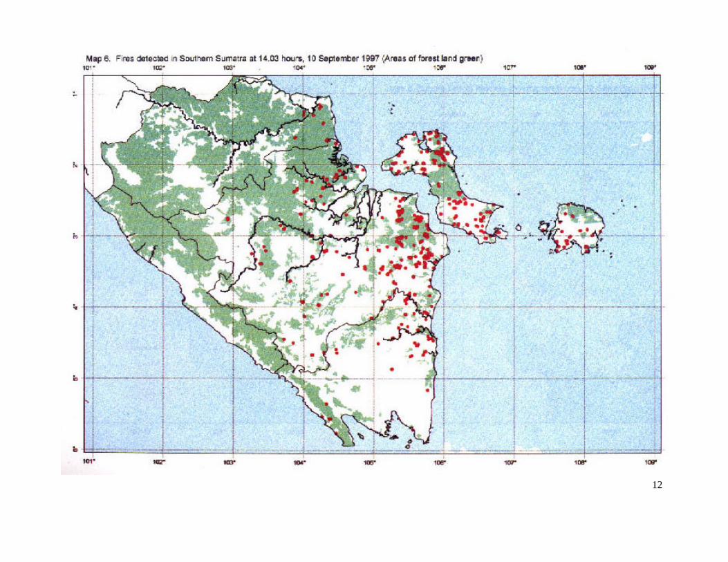
maps to help elucidate trends in fire occurrence. Overview fire-maps of Sumatra and Kalimantan Both islands have a long history of severe fires. The overview maps at a scale of approximately 1:12 000 000, show province and national boundaries and the location of fires displayed as hot-spots. The maps are intended for organisations with an interest in the general fire situation in Indonesia, e.g. PHPA Bogor and FLB Jakarta. An example is shown in Map 3. The use of very small-scale maps can, however, be misleading; symbols used to denote fires become over-large in the interest of legibility and fires appear to be present where in reality they are not. One example, amongst many, is the UNEP map reproduced by MoE/UNDP (1998) where vegetation fires seem to be concentrated in the Sumatra provinces of Bengkulu and West Sumatra – two areas in Sumatra that were in reality the least affected by fires. Sumatra fire-map Produced at a scale of approximately 1:8 000 000, the Sumatra map shows province boundaries and rivers and other thematic information - roads, towns and forest concessions, etc. - as required. Daily, weekly and monthly hot-spot composite maps for 1996 - 1998 have been prepared to examine regional trends in fire occurrence. A map of this type (Map 4) is regularly updated at the FFPCP web-site (http://www.mdp.co.id/ffpcp.htm) to show the daily vegetation fire situation in southern and central Sumatra. Aceh is outside the area usually planned for NOAA coverage (because of image size limitations), but occasional monitoring shows the province to have few fires compared with the rest of Sumatra.

8

9

10
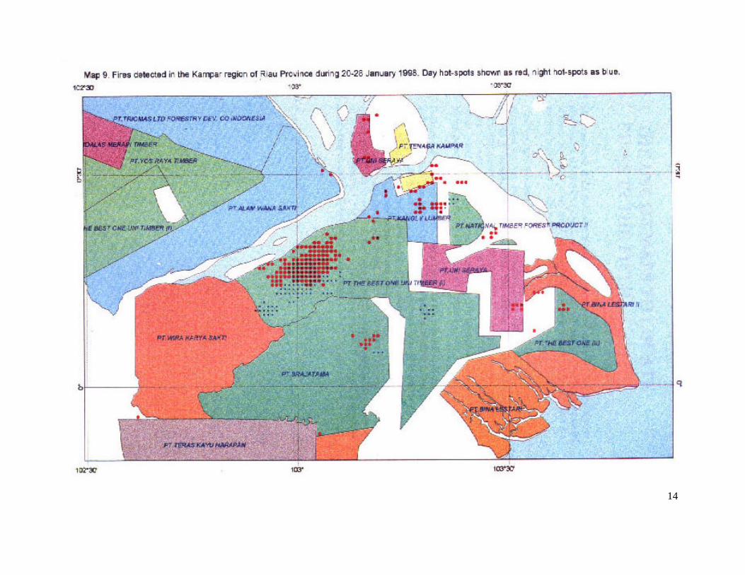
Province fire-maps Maps that show the location of vegetation fires in relation to different themes are routinely produced for the provinces of Riau, Jambi, South Sumatra, Bengkulu and Lampung. Two theme maps are printed for general distribution, in particular to the provincial offices of Kanwil and Dinas Kehutanan dan Perkebunan. The first, at 1: 1 600 000 scale, shows the location of vegetation fires in relation to forest concessions (HPH) and industrial timber plantations (HPHTI); roads, administrative boundaries and the national 1:250 000 scale map-sheet grid are also shown. Map 5 is an example. Hot-spots have been ‘clustered’ - a useful method to highlight the main areas affected by fire. The second map that is distributed regularly covers the four southern provinces at 1: 2 800 000 scale (Map 6) and shows fires in relation to the natural forest areas as taken from the National Forest Inventory maps. District fire-maps are produced specifically for the five Districts (Kabupaten) in South Sumatra Province in which FFPCP has helped establish District Fire Centres (Maps 7 and 8). Land-use and land cover information held in the FFPCP GIS will be updated by June 1999 using data derived from recent Landsat imagery supplied by BPN Palembang. The accuracy and hence relevance of the District fire-maps will increase accordingly. Special-purpose large-scale maps Large-scale maps (Map 9) are produced to focus attention on areas where fires have been detected on both day and night NOAA images and over several days. HPH / HPHTI boundaries and company names can be added. The information is passed to the provincial authorities for follow-up action in the field.

11
12

13
14

15
3. THE USE OF MAPS TO LOCATE FIRES IN THE FIELD
Fires are found in the field with the help of the national series of topographic maps produced by BAKOSURTANAL at scales of 1: 250 000 and 1: 50 000. Neither scale is ideal: the former is too small, and the latter too large for convenience. There are security restrictions on the availability of some sheets. Users also find that there is difficulty in locating the position of fires - given in NOAA generated decimal degrees - on the national maps that use the conventional grid notation of degrees, minutes and seconds. This obstacle is overcome when using the 1: 250 000 maps by the preparation of a transparent overlay in decimal degrees. The overlay is matched with lines of latitude and longitude on the map to correspond with whole or half degree values (30 minutes = 0.5°). The location of the fire can then be plotted by estimating the second decimal place by eye. Decimal degree overlay grids can also prepared for the 1:50 000 scale maps. However, a more suitable format and procedure has been used to interpret data transmitted to the trial fire management centre at Pendopo, Muaraenim District. Maps, based on the 1: 50 000 scale (old series) sheets showing the Musi Hutan Persada Acacia mangium planting blocks, have been compiled and reduced to 1:100 000 scale. These new composite maps were then overprinted with the Universal Transverse Mercator (UTM) grid of 1 km squares. Fire co-ordinates are then easily located. The conversion of decimal degrees to UTM fire-spots is laborious using a GPS receiver; a computer programme on-order will facilitate the conversion.

16
4. RECIPIENTS OF FIRE DATA The capture, processing and mapping of fire co-ordinates are first steps. The information then needs to be transmitted in readily understandable forms to the government organisations directly concerned with fire protection. Transmission has to be prompt if it is to reach fire-fighters before the fire becomes too large to control. FFPCP / BIPHUT staff can forward information on the location of all fires in co-ordinate and map form within 45 minutes of a NOAA satellite pass. Dinas Perkebunan and Kanwil Kehutanan dan Perkebunan and PHPA are regular recipients of fire data. PEMDA Palembang, received data through Kanwil Kehutanan during the Sumatra fire crisis in 1997. Organisations that receive information on a request or ‘need to know’ basis are; • Indonesia Forest Fire Management Project (GTZ), Samarinda • BAPEDAL, Jakarta • BAPEDAL, Pekanbaru, Riau Province • Ministry of Environment, Jakarta (Hot-spot collator) • ICRAF, Bogor • INTAG, Jakarta • Kanwil Kehutanan, Palangkaraya, Kalimantan • KODAM, Palembang • ITFMP, Jakarta • POSKO, Jakarta • The provincial headquarters of Kanwil Kehutanan in Lampung, Bengkulu,
Jambi, Riau, West Sumatra and North Sumatra • Leuser Development Programme, Aceh. and • FLB, Jakarta FFPCP captured and processed NOAA fire data has also been supplied to a number of other organisations to aid them in specific tasks. • EUFREG received data in September 1997 to assist an investigation of the fire
situation in Sumatra. Additional images were provided for a study on the feasibility of detecting vegetation fire-scars in southern Sumatra and Riau (final reports in preparation).
• The UK-based Natural Resources Institute used FFPCP-supplied NOAA and
GIS data to develop methods to assess fire-risk and fire-danger in Indonesia (FFPCP, 1998).
• BAPEDAL was provided with NOAA fire co-ordinates in July and August, and
again in November 1998 to plot aerial surveillance routes to ground-check hot-spots in Riau Province. The work is a RETA component concerned with the prevention and mitigation of trans-boundary atmospheric pollution.

17
• NOAA fire data for the IUCN protected Berbak National Park, Jambi, was
supplied to the University of Wales, UK, in support of a conservation research project.

18
5. TRANSMISSION OF DATA The quickest, and cheapest, method to pass-on vegetation fire co-ordinate and fire-map data is by e-mail. This form of transmission is used for clients outside Palembang, including the five District Fire Centres in Bangka, OKI, MUBA, Muaraenim and Lahat. The GIS generated fire-maps can be transmitted by fax modem, although the data content of the map requires simplification if map details are to remain legible. The preferred system of map transmission, adopted by FFPCP, is conversion of the GIS fire-map to Windows bitmap format and dispatch of this file, and the corresponding fire co-ordinates (text file), as an e-mail attachment.

19
REFERENCES Anderson, I.P., Imanda, I.D. and Muhnandar. (1999). Vegetation fires in Indonesia: operating procedures for the NOAA-GIS station in Palembang. Forest Fire Prevention and Control Project, Palembang. Ministry of Forestry and Estate Crops and European Union, Jakarta. Anderson, I.P., Imanda, I.D. and Muhnandar (1999a). Vegetation fires in Indonesia: the interpretation of NOAA-derived hot-spot data. Forest Fire Prevention and Control Project, Palembang. Ministry of Forestry and Estate Crops and European Union, Jakarta. Anderson, I.P., Imanda, I.D. and Muhnandar (1999b). Vegetation fires in Sumatra, Indonesia: a first look at vegetation indices and fire danger in relation to fire occurrence. Forest Fire Prevention and Control Project, Palembang. Ministry of Forestry and Estate Crops and European Union, Jakarta. FFPCP (1996). Status and aspects of fire danger rating in South Sumatra. Project report number 1. Forest Fire Prevention and Control Project and Kanwil Kehutanan, Palembang, South Sumatra. FFPCP (1998). Development of fire risk and fire danger assessment for Indonesia. Project report number 34. Forest Fire Prevention and Control Project and Kanwil Kehutanan, Palembang, South Sumatra. MoE / UNDP. (1998). Forest and Land Fires in Indonesia. Volume 1, Impacts, Factors and Evaluation. 185 pp. Volume 2. Plan of Action for Fire Disaster Management. 119 pp. The State Ministry for Environment Republic of Indonesia, and United Nations Development Programme, Jakarta.
20
ABBREVIATIONS AND ACRONYMS BAKOSURTANAL Badan Koordinasi Survai Tanah Nasional (National Coordination Agency for
Surveys and Mapping) BAPEDAL Badan Pengendalian Dampak Lingkungan (Environmental Impact Management
Agency, Ministry of Environment) BIPHUT Balai Inventarisasi dan Pemetaan Hutan (INTAG Regional Office, Ministry of
Forestry and Estate Crops) BMG Badan Meteorologi dan Giofisika (Agency for Meteorology and Geophysics) BPN Badan Pertanahan Nasional (National Land Agency) EC European Commission FFPCP Forest Fire Prevention and Control Project (EC) FLB Forest Liaison Bureau (EC) GIS Geographic Information System GPS Global Positioning System HPH Hak Pengusahaan Hutan (Forest Concession Right) HPHTI Hak Pengusahaan Hutan Tanaman Industri (Forest Concession Right and Industrial
Tree Estate) ICRAF International Centre for Research in Agro-Forestry IFFMP Integrated Forest Fire Management Project (GTZ) INTAG Inventarisasi dan Tata Guna Hutan (Directorate General of Forest Inventory and
Land-Use (MoFEC) ITFMP Indonesia Tropical Forest Management Programme KODAM Komando Daerah Militer (Military District Command) MoE Ministry of Environment MoFEC Ministry of Forestry and Estate Crops MUBA Musi Banyu Asin (name of a District in South Sumatra Province) NDVI Normalised Difference Vegetation Index NOAA National Oceanic and Atmospheric Administration OKI Ogan Komering Ilir (name of a District in South Sumatra Province) PEMDA Pemerintah Daerah (Regional Governmental) PHPA Perlindungan Hutan dan Pelestarian Alam (Forest Protection and Nature
Conservation) POSKO Pos Komando (Command Guard Post) UNDP United Nations Development Programme UNEP United Nations Environment Programme
UTM Universal Transverse Mercator (map projection)