The History of Freemasonry Its Legends and Traditions Its ...
Häfen und Hafenstädte im östlichen Mittelmeerraum von der Antike bis
in byzantinische Zeit. Neue Entdeckungen und aktuelle
Forschungsansätze
Harbors and Harbor Cities in the Eastern Mediterranean from Antiquity
to the Byzantine Period: Recent Discoveries and Current Approaches
Band 1
OFFPRINT / AYRIBASIM
DEUTSCHES ARCHAOLOGISCHES INSTITUTABTEILUNG ISTANBUL
BYZAS 19Veröffentlichungen des Deutschen Archäologischen Instituts Istanbul
Österreichisches Archäologisches Institut Sonderschriften 52
Häfen und Hafenstädte im östlichen Mittelmeerraum von der Antike bis
in byzantinische Zeit. Neue Entdeckungen und aktuelle
Forschungsansätze
Harbors and Harbor Cities in the Eastern Mediterranean from Antiquity
to the Byzantine Period: Recent Discoveries and Current Approaches
Hrsg. vonSabine Ladstätter – Felix Pirson – Thomas Schmidts
Istanbul, 30.05.-01.06.2011
Häfen und Hafenstädte im östlichen Mittelmeerraum von der Antike bis in byzantinische Zeit.
Neue Entdeckungen und aktuelle Forschungsansätze
Harbors and Harbor Cities in the Eastern Mediterranean from Antiquity to the Byzantine Period: Recent Discoveries and Current Approaches
Band 1
Herausgegeben von
Sabine Ladstätter – Felix Pirson – Thomas Schmidts
BYZAS 19
Veröffentlichungen des Deutschen Archäologischen Instituts Istanbul
Österreichisches Archäologisches Institut Sonderschriften 52
© 2014 Ege Yay›nlar›
Set ISBN 978-605-4701-60-5
Band 1 ISBN 978-605-4701-61-2
Publishers Zertifikat-Nr.: 14641
Umschlaggestaltung
Kelenderis Mosaic (K. L. Zoroğlu)
Redaktion
Barbara Beck-Brandt, Dominique Krüger, Angela Schwab
DruckOksijen Basım ve Matbaacılık San. Tic. Ltd. Şti.
100. Yıl Mah. Matbaacılar Sit. 2. Cad. No: 202/A Bağcılar - İstanbulTel: +90 (212) 325 71 25 Fax: +90 (212) 325 61 99
Zertifikat-Nr.: 29487
Produktion und VertriebZero Prod. Ltd.
Abdullah Sokak. No: 17 Taksim 34433 Istanbul-TurkeyTel: +90 (212) 244 75 21 Fax: +90 (212) 244 32 09
[email protected]/eng/
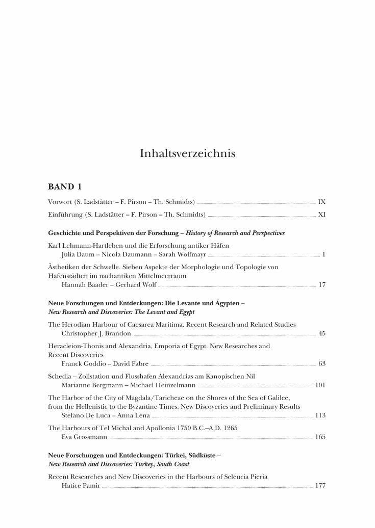
Inhaltsverzeichnis
BAND 1
Vorwort (S. Ladstätter – F. Pirson – Th. Schmidts) ................................................................................................................ IX
Einführung (S. Ladstätter – F. Pirson – Th. Schmidts) ...................................................................................................... XI
Geschichte und Perspektiven der Forschung – History of Research and Perspectives
Karl Lehmann-Hartleben und die Erforschung antiker HäfenJulia Daum – Nicola Daumann – Sarah Wolfmayr .......................................................................................................... 1
Ästhetiken der Schwelle. Sieben Aspekte der Morphologie und Topologie von Hafenstädten im nachantiken Mittelmeerraum
Hannah Baader – Gerhard Wolf ..................................................................................................................................................... 17
Neue Forschungen und Entdeckungen: Die Levante und Ägypten – New Research and Discoveries: The Levant and Egypt
The Herodian Harbour of Caesarea Maritima. Recent Research and Related StudiesChristopher J. Brandon ............................................................................................................................................................................ 45
Heracleion-Thonis and Alexandria, Emporia of Egypt. New Researches and Recent Discoveries
Franck Goddio – David Fabre ............................................................................................................................................................ 63
Schedia – Zollstation und Flusshafen Alexandrias am Kanopischen Nil Marianne Bergmann – Michael Heinzelmann ............................................................................................................ 101
The Harbor of the City of Magdala/Taricheae on the Shores of the Sea of Galilee, from the Hellenistic to the Byzantine Times. New Discoveries and Preliminary Results
Stefano De Luca – Anna Lena ........................................................................................................................................................ 113
The Harbours of Tel Michal and Apollonia 1750 B.C.–A.D. 1265Eva Grossmann ................................................................................................................................................................................................ 165
Neue Forschungen und Entdeckungen: Türkei, Südküste – New Research and Discoveries: Turkey, South Coast
Recent Researches and New Discoveries in the Harbours of Seleucia PieriaHatice Pamir ....................................................................................................................................................................................................... 177
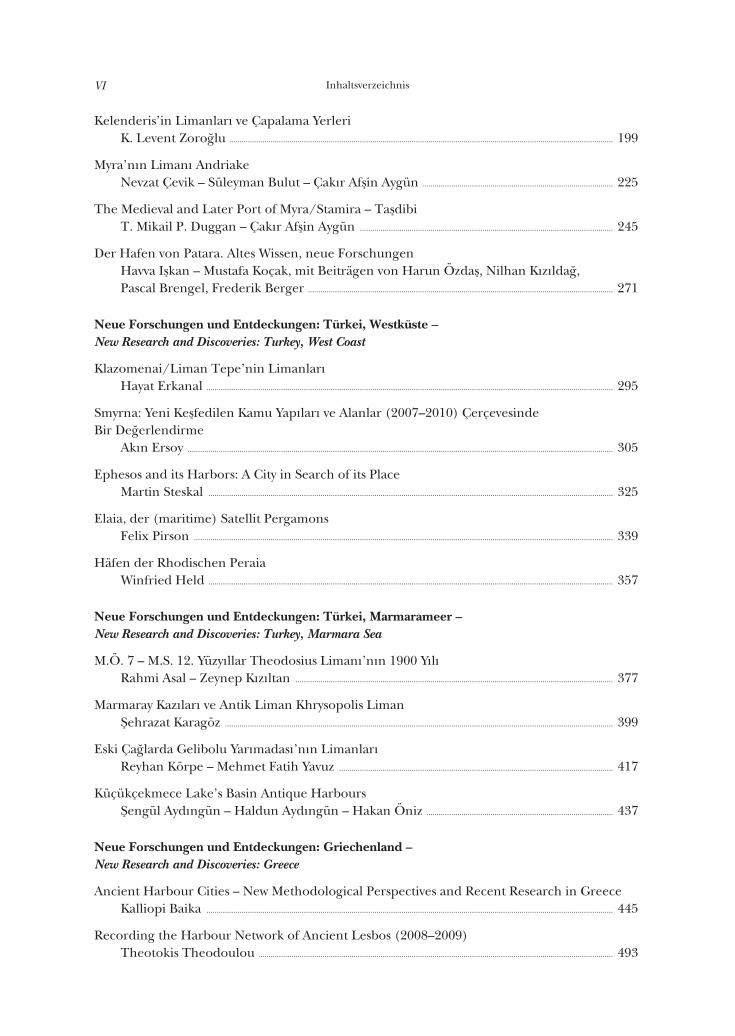
InhaltsverzeichnisVI
Kelenderis’in Limanları ve Çapalama YerleriK. Levent Zoroğlu ......................................................................................................................................................................................... 199
Myra’nın Limanı AndriakeNevzat Çevik – Süleyman Bulut – Çakır Afşin Aygün ............................................................................................ 225
The Medieval and Later Port of Myra/Stamira – TaşdibiT. Mikail P. Duggan – Çakır Afşin Aygün .......................................................................................................................... 245
Der Hafen von Patara. Altes Wissen, neue ForschungenHavva Işkan – Mustafa Koçak, mit Beiträgen von Harun Özdaş, Nilhan Kızıldağ, Pascal Brengel, Frederik Berger ................................................................................................................................................... 271
Neue Forschungen und Entdeckungen: Türkei, Westküste – New Research and Discoveries: Turkey, West Coast
Klazomenai/Liman Tepe’nin LimanlarıHayat Erkanal .................................................................................................................................................................................................... 295
Smyrna: Yeni Keşfedilen Kamu Yapıları ve Alanlar (2007–2010) Çerçevesinde Bir Değerlendirme
Akın Ersoy ............................................................................................................................................................................................................. 305
Ephesos and its Harbors: A City in Search of its PlaceMartin Steskal ................................................................................................................................................................................................... 325
Elaia, der (maritime) Satellit PergamonsFelix Pirson .......................................................................................................................................................................................................... 339
Häfen der Rhodischen PeraiaWinfried Held ................................................................................................................................................................................................... 357
Neue Forschungen und Entdeckungen: Türkei, Marmarameer – New Research and Discoveries: Turkey, Marmara Sea
M.Ö. 7 – M.S. 12. Yüzyıllar Theodosius Limanı’nın 1900 YılıRahmi Asal – Zeynep Kızıltan ......................................................................................................................................................... 377
Marmaray Kazıları ve Antik Liman Khrysopolis LimanŞehrazat Karagöz ........................................................................................................................................................................................... 399
Eski Çağlarda Gelibolu Yarımadası’nın LimanlarıReyhan Körpe – Mehmet Fatih Yavuz .................................................................................................................................... 417
Küçükçekmece Lake’s Basin Antique HarboursŞengül Aydıngün – Haldun Aydıngün – Hakan Öniz .......................................................................................... 437
Neue Forschungen und Entdeckungen: Griechenland – New Research and Discoveries: Greece
Ancient Harbour Cities – New Methodological Perspectives and Recent Research in GreeceKalliopi Baika .................................................................................................................................................................................................... 445
Recording the Harbour Network of Ancient Lesbos (2008–2009)Theotokis Theodoulou ........................................................................................................................................................................... 493
Inhaltsverzeichnis VII
BAND 2Hafenbauten und Bautechnik – Harbour Installations and Building Techniques
The Evolution of Harbour Engineering in the Ancient Mediterranean WorldJohn Peter Oleson ........................................................................................................................................................................................ 509
Ancient ShipshedsDavid J. Blackman ........................................................................................................................................................................................ 523
Medieval Anatolian Arsenals at Sinop and AlanyaScott Redford .................................................................................................................................................................................................... 543
Wirtschaft und Politik – Economy and Politics
Die Hafenstadt DelosMantha Zarmakoupi .................................................................................................................................................................................. 553
Der Einfluss der römischen Administration auf die Entwicklung der Hafenstädte im östlichen Mittelmeerraum
Thomas Schmidts ......................................................................................................................................................................................... 571
The Trading Networks of Ancient Rough CiliciaCaroline Autret – Matthew Dillon – John Lund – Nicholas Rauh – Levent Zoroğlu ........ 593
Hafenstädte: Städtebau und Wahrnehmung – Harbour Cities: City Planning and Perception
Antike Hafenstädte – Gestaltung, Funktion, WahrnehmungFelix Pirson .......................................................................................................................................................................................................... 619
Caput Ioniae. Zur Untersuchung römischer Hafenfassaden am Beispiel von MiletMartina Schupp .............................................................................................................................................................................................. 645
On the Urbanism of Roman Harbours: the Evolution of Space Organization in Harbours of the Aegean Sea
Catherine Bouras .......................................................................................................................................................................................... 669
Torbauten und Bogenmonumente in römischen HafenstädtenStefan Feuser ..................................................................................................................................................................................................... 683
Geowissenschaften und die Erforschung antiker Häfen – Geo-Sciences and the Exploration of Ancient Harbours
Coastal Geoarchaeology and Neocatastrophism: a Dangerous Liaison?Christophe Morhange – Nick Marriner – Guénaelle Bony – Nicolas Carayon – Clément Flaux – Majid Shah-Hosseini .................................................................................................................................. 705
Geoarchaeology of Alexandria (Egypt): 8,000 Years of Coastal EvolutionJean-Philippe Goiran – Nick Marriner – Christophe Morhange – Julien Cavero – Christine Oberlin – Jean-Yves Empereur ............................................................................... 727
Ancient Harbours Used as Tsunami Sediment Traps – the Case Study of Krane (Cefalonia Island, Greece)
Andreas Vött – Hanna Hadler – Timo Willershäuser – Konstantin Ntageretzis – Helmut Brückner – Heinz Warnecke – Pieter M. Grootes – Franziska Lang – Oliver Nelle – Dimitris Sakellariou ........................................................................................................................................... 743

InhaltsverzeichnisVIII
Der Löwenhafen von Milet – eine geoarchäologische FallstudieHelmut Brückner – Alexander Herda – Marc Müllenhoff – Wolfgang Rabbel – Harald Stümpel ........................................................................................................................................ 773
S. Ladstätter – F. Pirson – T. Schmidts (Hrsg.), Harbors and Harbor Cities in the Eastern Mediterranean, BYZAS 19 (2014) 325–338
Ephesos and its Harbors: A City in Search of its Place*
Martin STESKAL
AbstractThe development of the Ephesian landscape is marked by constant geomorpho-logical and ecological changes. Amidst the constant and at times abrupt changes of the landscape a city like Ephesos was continually in search of the ›right‹ place. As a city of trade the Ephesian harbors were the pivotal commercial centers. There-fore the settlement history of Ephesos was always closely connected to the location of its harbors. The settlements had to frequently change their location to avoid
* The author would like to thank the organizers of this symposium as well as the director of the excavations at Ephesos, Sabine Ladstätter. Numerous helpful suggestions were made by Yaman Dalanay, Helmut Brückner, Ralf Urz, Friederike Stock and Michael Kerschner. I am grateful to them as well as Christian Kurtze for the produc-tion of the maps and Nicole M. High-Steskal for the revision of the English manuscript.
Abbreviations: Friesinger – Krinzinger 1999 H. Friesinger – F. Krinzinger (eds.), 100 Jahre Österreichische Forschungen in Ephesos.
Akten des Symposions Wien 1995, Archäologische Forschungen 1 = DenkschrWien 260 (Wien 1999).
Groh 2006 S. Groh unter Mitarbeit von V. Lindinger – K. Löcker – W. Neubauer – S. S. Seren, Neue Forschungen zur Stadtplanung in Ephesos, ÖJh 75, 2006, 47–116.
IvE Inschriften griechischer Städte aus Kleinasien 1–68 (Bonn 1972–2010): Ephesos (IvE I a–VII 2) Bd. 11, 1 (1979) – 17, 4 (1984).
Kraft et al. 2000 J. C. Kraft – İ. Kayan – H. Brückner – G. (Rip) Rapp Jr., A Geologic Analysis of Ancient Landscapes and the Harbors of Ephesos and the Artemision in Anatolia, ÖJh 69, 2000, 175–233.
Meriç 1985 R. Meriç, Zur Lage des ephesischen Außenhafens Panormos, in: Lebendige Altertumswissen- schaft. Festschrift Hermann Vetters (Wien 1985) 30–32.
Scherrer 2007 P. Scherrer, Von Apaša nach Hagios Theologos. Die Siedlungsgeschichte des Raumes Ephesos von prähistorischer bis in byzantinische Zeit unter dem Aspekt der maritimen und fluvialen Bedingungen, ÖJh 76, 2007, 321–351.
Stock et al. 2014 F. Stock – M. Kerschner – J. C. Kraft – A. Pint – P. Frenzel – H. Brückner, The Palaeogeo- graphies of Ephesos (Turkey), its Harbours, and the Artemision – a Geoarchaeological Reconstruction for the Timespan 1500–300 BC, Zeitschrift für Geomorphologie 58, 2, 2014, 33–66.
Zabehlicky 1995 H. Zabehlicky, Preliminary Views of the Ephesian Harbor, in: H. Koester (ed.), Ephesos. Metropolis of Asia. An Interdisciplinary Approach to its Archaeology, Religion, and Culture, Harvard Theological Studies 41 (Valley Forge 1995) 201–215.
Zabehlicky 1999 H. Zabehlicky, Die Grabungen im Hafen von Ephesos 1987–1989, in: Friesinger – Krinzinger 1999, 479–484.
Martin Steskal326
losing access to the sea. A general tendency of a slow shift to the west has been documented. Although the harbors of Ephesos evoke only a rudimentary image in the minds of scholars’ current geoarchaeological, geophysical and archaeological research has led to numerous new ideas that expand our knowledge. This paper addresses these new approaches to research.
ÖzetJeomorfolojik ve ekolojik değişimler, Ephesos ve çevresinin gelişiminde mütemadi-yen etkili olmuştur. Sürekli ve kimi zaman ani bir biçimde meydana gelen bu deği-şikliklerin ortasında, Ephesos gibi bir kent devamlı gerçek bir yer bulma arayışın-daydı. Bir ticaret kenti olarak Ephesos’un limanları ticaret merkeziydi. Bu nedenle Ephesos’un yerleşim tarihi ve limanlarının yeri birbirine sıkı sıkıya bağlıdır. Deniz ile bağlantısını kaybetmemek için yerini sürekli değiştirmiş olan yerleşimin yavaş ya-vaş batıya kaydığı saptanmıştır. Ephesos’un limanları, bilim adamları üzerinde her ne kadar gelişmemiş bir imaj yaratıyorsa da, son jeoarkeolojik, jeofizik ve arkeolojik araştırmaları, bilgilerimizi genişletecek çok sayıda yeni fikir ortaya çıkarmıştır.
Bu yazı, sözkonusu araştırmalardaki yaklaşımları içermektedir.
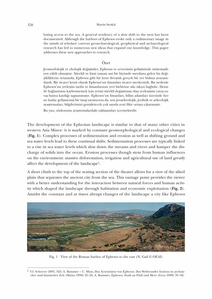
The development of the Ephesian landscape is similar to that of many other cities in western Asia Minor: it is marked by constant geomorphological and ecological changes (Fig. 1). Complex processes of sedimentation and erosion as well as shifting ground and sea water levels lead to these continual shifts. Sedimentation processes are typically linked to a rise in sea water levels which slow down the streams and rivers and hamper the dis-charge of solids into the ocean. Erosion processes though stem from human influences on the environment: massive deforestation, irrigation and agricultural use of land greatly affect the development of the landscape1.
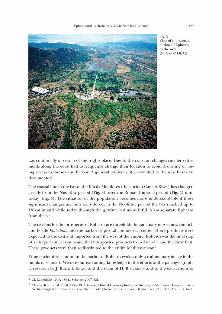
A short climb to the top of the seating section of the theater allows for a view of the silted plain that separates the ancient city from the sea. This vantage point provides the viewer with a better understanding for the interaction between natural forces and human activ-ity which shaped the landscape through habitation and economic exploitation (Fig. 2). Amidst the constant and at times abrupt changes of the landscape a city like Ephesos
1 Cf. Scherrer 2007, 323; A. Bammer – U. Muss, Das Artemision von Ephesos. Das Weltwunder Ioniens in archais-cher und klassischer Zeit (Mainz 1996) 21–24; A. Bammer, Ephesos. Stadt an Fluß und Meer (Graz 1988) 76–82.
Fig. 1 View of the Roman harbor of Ephesos to the east (N. Gail © OEAI)
Ephesos and its Harbors: A City in Search of its Place 327
was continually in search of the ›right‹ place. Due to the constant changes smaller settle-ments along the coast had to frequently change their location to avoid drowning or los-ing access to the sea and harbor. A general tendency of a slow shift to the west has been documented.
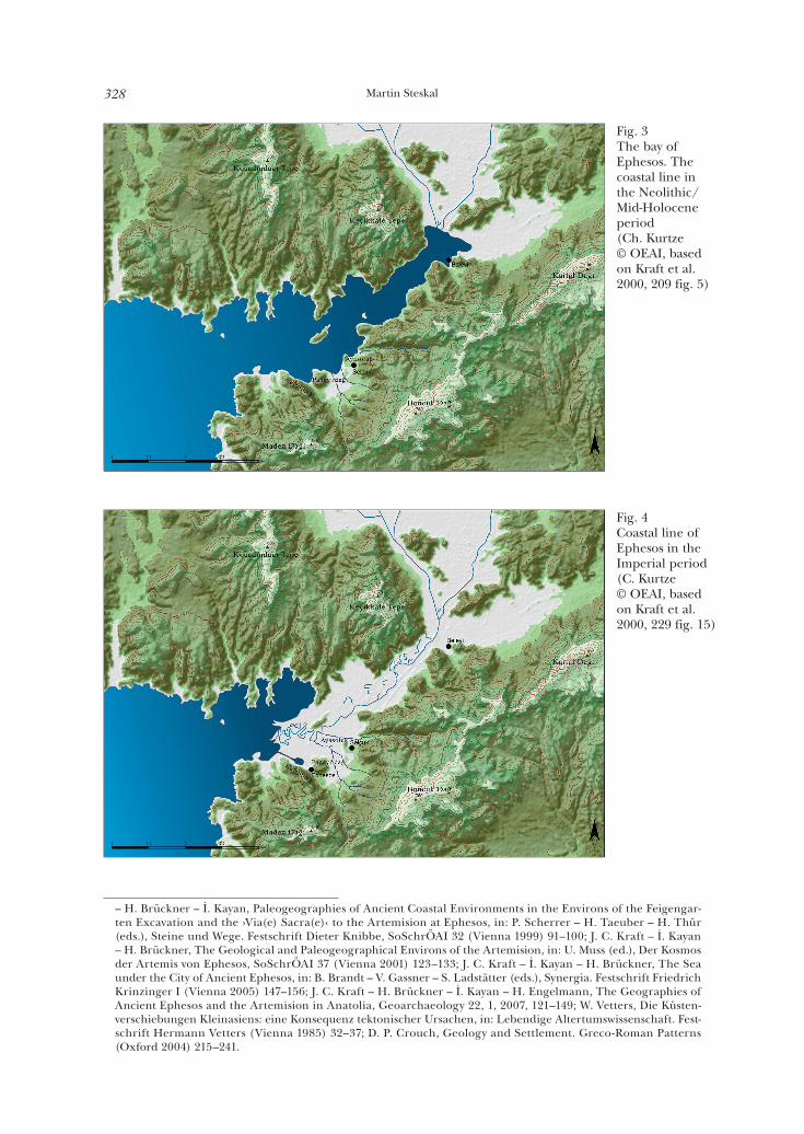
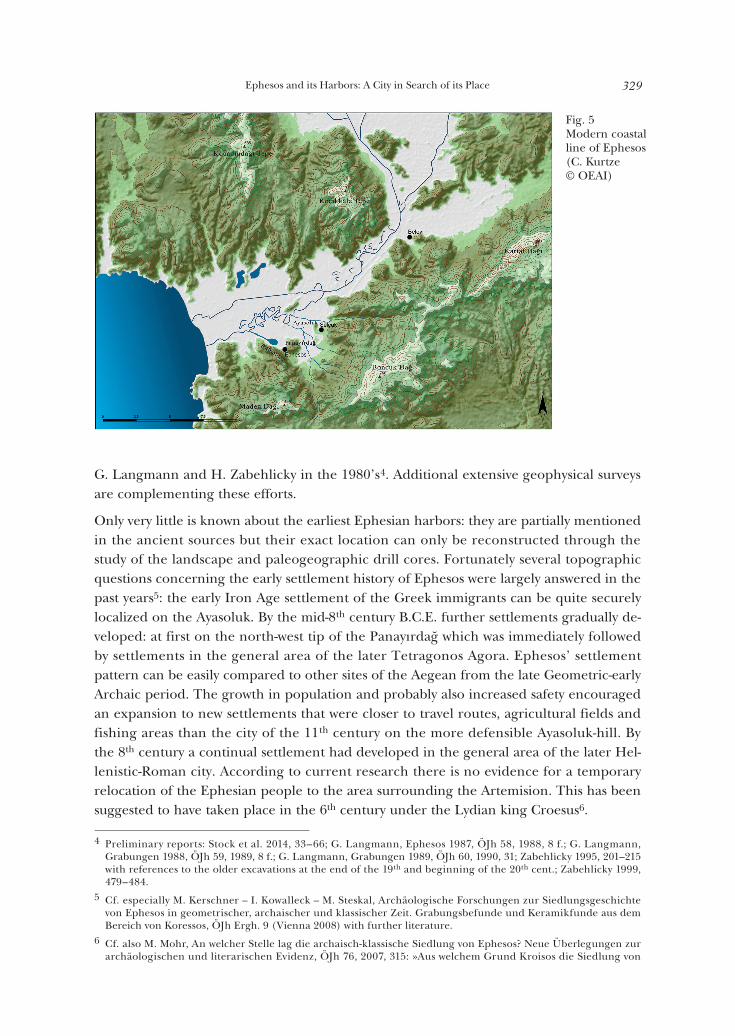
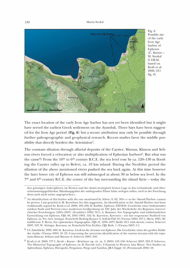
The coastal line in the bay of the Küçük Menderes (the ancient Cayster River) has changed greatly from the Neolithic period (Fig. 3), over the Roman Imperial period (Fig. 4) until today (Fig. 5). The situation of the population becomes more understandable if these significant changes are fully considered: in the Neolithic period the bay reached up to 18 km inland while today through the gradual sediment infill, 5 km separate Ephesos from the sea.
The reasons for the prosperity of Ephesos are threefold: the sanctuary of Artemis, the rich and fertile hinterland and the harbor as pivotal commercial center where products were exported to the east and imported from the west of the empire. Ephesos was the final stop of an important caravan route that transported products from Anatolia and the Near East. These products were then redistributed to the entire Mediterranean2.
From a scientific standpoint the harbor of Ephesos evokes only a rudimentary image in the minds of scholars. We owe our expanding knowledge to the efforts of the paleogeograph-ic research by J. Kraft, İ. Kayan and the team of H. Brückner3 and to the excavations of
2 Cf. Zabehlicky 1999, 480 f.; Scherrer 2007, 321.3 Cf. e. g. Kraft et al. 2000, 175–233; İ. Kayan, Alluvial Geomorphology of the Küçük Menderes Plains and Geo-
Archaeological Interpretations on the Site of Ephesos, in: Friesinger – Krinzinger 1999, 373–377; J. C. Kraft
Fig. 2View of the Roman harbor of Ephesos to the west (N. Gail © OEAI)
Martin Steskal328
– H. Brückner – İ. Kayan, Paleogeographies of Ancient Coastal Environments in the Environs of the Feigengar-ten Excavation and the ›Via(e) Sacra(e)‹ to the Artemision at Ephesos, in: P. Scherrer – H. Taeuber – H. Thür (eds.), Steine und Wege. Festschrift Dieter Knibbe, SoSchrÖAI 32 (Vienna 1999) 91–100; J. C. Kraft – İ. Kayan – H. Brückner, The Geological and Paleogeographical Environs of the Artemision, in: U. Muss (ed.), Der Kosmos der Artemis von Ephesos, SoSchrÖAI 37 (Vienna 2001) 123–133; J. C. Kraft – İ. Kayan – H. Brückner, The Sea under the City of Ancient Ephesos, in: B. Brandt – V. Gassner – S. Ladstätter (eds.), Synergia. Festschrift Friedrich Krinzinger I (Vienna 2005) 147–156; J. C. Kraft – H. Brückner – İ. Kayan – H. Engelmann, The Geographies of Ancient Ephesos and the Artemision in Anatolia, Geoarchaeology 22, 1, 2007, 121–149; W. Vetters, Die Küsten-verschiebungen Kleinasiens: eine Konsequenz tektonischer Ursachen, in: Lebendige Altertumswissenschaft. Fest-schrift Hermann Vetters (Vienna 1985) 32–37; D. P. Crouch, Geology and Settlement. Greco-Roman Patterns (Oxford 2004) 215–241.
Fig. 3The bay of Ephesos. The coastal line in the Neolithic/Mid-Holocene period (Ch. Kurtze © OEAI, based on Kraft et al. 2000, 209 fig. 5)
Fig. 4Coastal line of Ephesos in the Imperial period (C. Kurtze © OEAI, based on Kraft et al. 2000, 229 fig. 15)
Ephesos and its Harbors: A City in Search of its Place 329
G. Langmann and H. Zabehlicky in the 1980’s4. Additional extensive geophysical surveys are complementing these efforts.
Only very little is known about the earliest Ephesian harbors: they are partially mentioned in the ancient sources but their exact location can only be reconstructed through the study of the landscape and paleogeographic drill cores. Fortunately several topographic questions concerning the early settlement history of Ephesos were largely answered in the past years5: the early Iron Age settlement of the Greek immigrants can be quite securely localized on the Ayasoluk. By the mid-8th century B.C.E. further settlements gradually de-veloped: at first on the north-west tip of the Panayırdağ which was immediately followed by settlements in the general area of the later Tetragonos Agora. Ephesos’ settlement pattern can be easily compared to other sites of the Aegean from the late Geometric-early Archaic period. The growth in population and probably also increased safety encouraged an expansion to new settlements that were closer to travel routes, agricultural fields and fishing areas than the city of the 11th century on the more defensible Ayasoluk-hill. By the 8th century a continual settlement had developed in the general area of the later Hel-lenistic-Roman city. According to current research there is no evidence for a temporary relocation of the Ephesian people to the area surrounding the Artemision. This has been suggested to have taken place in the 6th century under the Lydian king Croesus6.
4 Preliminary reports: Stock et al. 2014, 33–66; G. Langmann, Ephesos 1987, ÖJh 58, 1988, 8 f.; G. Langmann, Grabungen 1988, ÖJh 59, 1989, 8 f.; G. Langmann, Grabungen 1989, ÖJh 60, 1990, 31; Zabehlicky 1995, 201–215 with references to the older excavations at the end of the 19th and beginning of the 20th cent.; Zabehlicky 1999, 479–484.
5 Cf. especially M. Kerschner – I. Kowalleck – M. Steskal, Archäologische Forschungen zur Siedlungsgeschichte von Ephesos in geometrischer, archaischer und klassischer Zeit. Grabungsbefunde und Keramikfunde aus dem Bereich von Koressos, ÖJh Ergh. 9 (Vienna 2008) with further literature.
6 Cf. also M. Mohr, An welcher Stelle lag die archaisch-klassische Siedlung von Ephesos? Neue Überlegungen zur archäologischen und literarischen Evidenz, ÖJh 76, 2007, 315: »Aus welchem Grund Kroisos die Siedlung von
Fig. 5Modern coastal line of Ephesos (C. Kurtze © OEAI)
Martin Steskal330
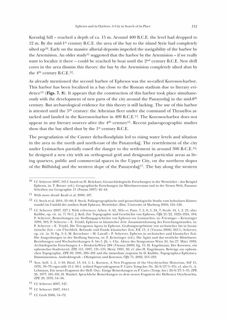
The exact location of the early Iron Age harbor has not yet been identified but it might have served the earliest Greek settlement on the Ayasoluk. Three bays have been suggest-ed for the Iron Age period (Fig. 6) but a secure attribution may only be possible through further paleogeographic and geophysical research. Recent studies favor the middle pos-sibility that directly borders the Artemision7.
The constant siltation through alluvial deposits of the Cayster, Marnas, Klaseas and Seli-nus rivers forced a relocation or also multiplication of Ephesian harbors8. But what was the cause9? From the 16th to 6th century B.C.E. the sea level rose by ca. 120–130 m flood-ing the Cayster valley up to Belevi, ca. 19 km inland. During the Neolithic period the siltation of the above mentioned rivers pushed the sea back again. At this time however the later lower city of Ephesos was still submerged at about 30 m below sea level. In the 7th and 6th century B.C.E. the center of the bay surrounding the island Syrie – today the
den günstigen Ankerplätzen im Westen und der damit strategisch besten Lage in das verlandende und über-schwemmungsgefährdete Mündungsgebiet der umliegenden Flüsse hätte verlegen sollen, wird in der Forschung denn auch nicht weiter angesprochen.«
7 An identification of this harbor with the one mentioned by Athen. 8, 62, 361c–e as the ›Sacred Harbor‹ cannot be proven. I am grateful to M. Kerschner for this suggestion. An identification as the ›Sacred Harbor‹ has been traditionally argued by: Kraft et al. 2000, 182–186; D. Knibbe, Ephesos. EFESOS. Geschichte einer bedeutenden antiken Stadt und Portrait einer modernen Großgrabung im 102. Jahr der Wiederkehr des Beginnes österrei-chischer Forschungen (1895–1997) (Frankfurt 1998) 76 f.; A. Bammer, Zur Topographie und städtebaulichen Entwicklung von Ephesos, ÖJh 46, 1961–1963, 142; St. Karwiese, Koressos – ein fast vergessener Stadtteil von Ephesos, in: Pro Arte Antiqua. Festschrift Hedwig Kenner 2, SoSchrÖAI 18 (Vienna 1985) 217 f.; Meriç 1985, 30; indifferent: F. Brein, Zur ephesischen Topographie, ÖJh 51, 1976–1977, Beibl. 69 f. with sketch; contra: Scherrer 2007, 347; W. Alzinger, Koressos, in: Festschrift Fritz Eichler, ÖJh Beih. 1 (Vienna 1967) 5 f.
8 Cf. Zabehlicky 1999, 480; St. Karwiese, Groß ist die Artemis von Ephesos. Die Geschichte einer der großen Städte der Antike (Vienna 1995) 19. 22. Concerning the uncertain identification of the various streams with the topo-nyms Klaseas, Selinus and Marnas cf. Scherrer 2007, 348.
9 Kraft et al. 2000, 177 f.; Kraft – Kayan – Brückner op. cit. (n. 3: 2005) 147–156; Scherrer 2007, 323; P. Scherrer, The Historical Topography of Ephesos, in: D. Parrish (ed.), Urbanism in Western Asia Minor. New Studies on Aphrodisias, Ephesos, Hierapolis, Pergamon, Perge and Xanthos, JRA Suppl. 45 (Portsmouth 2001) 58.
Fig. 6Possible site of the early Iron Age harbor of Ephesos (C. Kurtze – M. Steskal © OEAI, based on Kraft et al. 2000, 211 fig. 6)
Ephesos and its Harbors: A City in Search of its Place 331
Korudağ hill – reached a depth of ca. 15 m. Around 400 B.C.E. the level had dropped to 12 m. By the mid-1st century B.C.E. the area of the bay to the island Syrie had completely silted up10. Early on the massive alluvial deposits impeded the navigability of the harbor by the Artemision. An older study11 suggested that the harbor by the Artemision – if we really want to localize it there – could be reached by boat until the 2nd century B.C.E. New drill cores in the area dismiss this theory: the bay by the Artemision completely silted shut by the 4th century B.C.E.12.
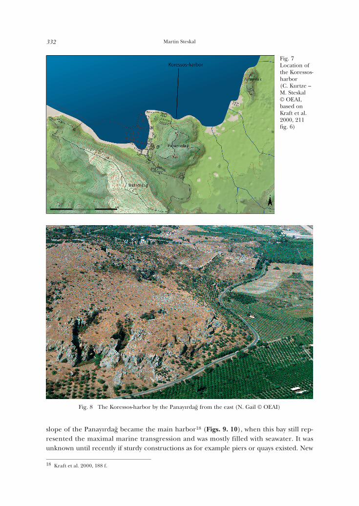
As already mentioned the second harbor of Ephesos was the so-called Koressos-harbor. This harbor has been localized in a bay close to the Roman stadium due to literary evi-dence13 (Figs. 7. 8). It appears that the construction of this harbor took place simultane-ously with the development of new parts of the city around the Panayırdağ in the mid-8th century. But archaeological evidence for this theory is still lacking. The use of this harbor is attested until the 5th century: the Athenian fleet under the command of Thrasyllos at-tacked and landed in the Koressos-harbor in 409 B.C.E.14. The Koressos-harbor does not appear in any literary sources after the 4th century15. Recent palaeogeographic studies show that the bay silted shut by the 1st century B.C.E.
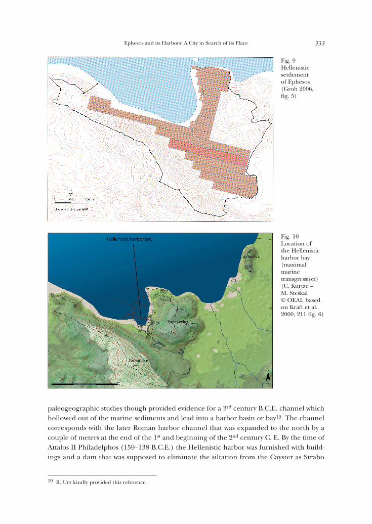
The progradation of the Cayster delta-floodplain led to rising water levels and siltation in the area to the north and north-east of the Panayırdağ. The resettlement of the city under Lysimachos partially eased the danger to the settlement in around 300 B.C.E.16: he designed a new city with an orthogonal grid and designated particular areas as liv-ing quarters, public and commercial spaces in the Upper City, on the northern slopes of the Bülbüdağ and the western slope of the Panayırdağ17. The bay along the western
10 Cf. Scherrer 2007, 345 f. based on H. Brückner, Geoarchäologische Forschungen in der Westtürkei – das Beispiel Ephesos, in: T. Breuer (ed.), Geographische Forschungen im Mittelmeerraum und in der Neuen Welt, Passauer Schriften zur Geographie 15 (Passau 1997) 42–44.
11 With more detail: Kraft et al. 2000, 187.12 Cf. Stock et al. 2014, 33–66; F. Stock, Paläogeographische und geoarchäologische Studie zum holozänen Küsten-
wandel im Umfeld der antiken Stadt Ephesos, Westtürkei (Diss. University of Marburg 2010) 124–126.13 Cf. Scherrer 2007, 327 f. With references: Athen. 8, 62, 361c–e; Paus. 7, 2, 6; 5, 24, 7; Strab. 14, 1, 2. 21; also:
Knibbe, op. cit. (n. 7) 76 f.; J. Keil, Zur Topographie und Geschichte von Ephesos, ÖJh 21/22, 1922–1924, 104; P. Scherrer, Bemerkungen zur Siedlungsgeschichte von Ephesos vor Lysimachos, in: Friesinger – Krinzinger 1999, 383; P. Scherrer – E. Trinkl, Ephesos in klassischer Zeit: Zusammenfassung des Forschungsstandes, in: P. Scherrer – E. Trinkl, Die Tetragonos Agora in Ephesos. Grabungsergebnisse von archaischer bis in byzan-tinische Zeit – ein Überblick. Befunde und Funde klassischer Zeit, FiE 13, 2 (Vienna 2006) 263 f.; Scherrer, op. cit. (n. 9) fig. 3–1; M. Kerschner – M. Lawall – P. Scherrer, Ephesos in archaischer und klassischer Zeit. Die Ausgrabungen in der Siedlung Smyrna, in: F. Krinzinger (ed.), Die Ägäis und das westliche Mittelmeer. Beziehungen und Wechselwirkungen 8. bis 5. Jh. v. Chr. Akten des Symposions Wien 24. bis 27. März 1999, Archäologische Forschungen 4 = DenkschrWien 288 (Vienna 2000) fig. 15; H. Engelmann, Der Koressos, ein ephesisches Stadtviertel, ZPE 115, 1997, 131–135; Meriç 1985, 30; cf. also H. Engelmann, Beiträge zur ephesis-chen Topographie, ZPE 89, 1991, 286–291 and the immediate response by D. Knibbe, Topographica Ephesiaca. Damnianosstoa, Androklosgrab – Olympieion und Koressos, ÖJh 71, 2002, 213–219.
14 Xen. hell. 1, 2, 1–10; Diod. 13, 64, 1; L. Koenen, A New Fragment of the Oxyrhynchite Historian, StP 15, 1976, 39–79 especially 55 f. 69 f. (edited Papyrusfragment P. Cairo Temp.Inv.-Nr. 26/6/27/1–35); cf. also G. A. Lehmann, Ein neues Fragment der Hell. Oxy.: Einige Bemerkungen zu P. Cairo (Temp. Inv.) 26/6/27/1–35, ZPE 26, 1977, 181–191; H. Wankel, Sprachliche Bemerkungen zu dem neuen Fragment der Hellenica Oxyrhynchia, ZPE 29, 1978, 54–56.
15 Cf. Scherrer 2007, 347.16 Cf. Scherrer 2007, 344 f.17 Cf. Groh 2006, 54–72.
Martin Steskal332
slope of the Panayırdağ became the main harbor18 (Figs. 9. 10), when this bay still rep-resented the maximal marine transgression and was mostly filled with seawater. It was unknown until recently if sturdy constructions as for example piers or quays existed. New
18 Kraft et al. 2000, 188 f.
Fig. 7Location of the Koressos-harbor (C. Kurtze – M. Steskal © OEAI, based on Kraft et al. 2000, 211 fig. 6)
Fig. 8 The Koressos-harbor by the Panayırdağ from the east (N. Gail © OEAI)
Ephesos and its Harbors: A City in Search of its Place 333
paleogeographic studies though provided evidence for a 3rd century B.C.E. channel which hollowed out of the marine sediments and lead into a harbor basin or bay19. The channel corresponds with the later Roman harbor channel that was expanded to the north by a couple of meters at the end of the 1st and beginning of the 2nd century C. E. By the time of Attalos II Philadelphos (159–138 B.C.E.) the Hellenistic harbor was furnished with build-ings and a dam that was supposed to eliminate the siltation from the Cayster as Strabo
19 R. Urz kindly provided this reference.
Fig. 9Hellenistic settlement of Ephesos (Groh 2006, fig. 5)
Fig. 10Location of the Hellenistic harbor bay (maximal marine transgression) (C. Kurtze – M. Steskal © OEAI, based on Kraft et al. 2000, 211 fig. 6)
Martin Steskal334
reports20. This was necessary, Livy describes, since already in 190 B.C.E. the channel was only wide enough to fit one ship21. The project of the Pergamene king Attalos though had the opposite effect since the silt of the river could no longer be removed through the ebb and flow of the sea.
In the course of the 1st and early 2nd century C. E. the bay was artificially filled up and terraced due to the continual siltation of the bay22. The newly acquired land was used for large scale building projects, e. g. the Harbor Baths and the Olympieion, allowing for a further expansion to the west. This though required a new harbor.
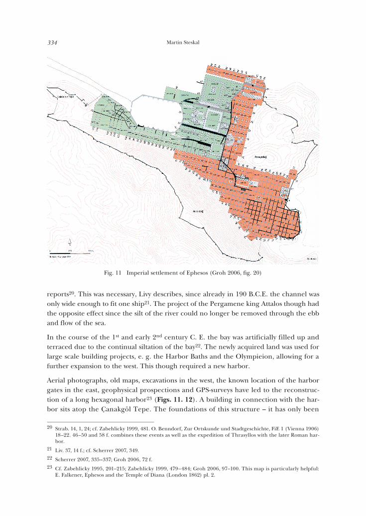
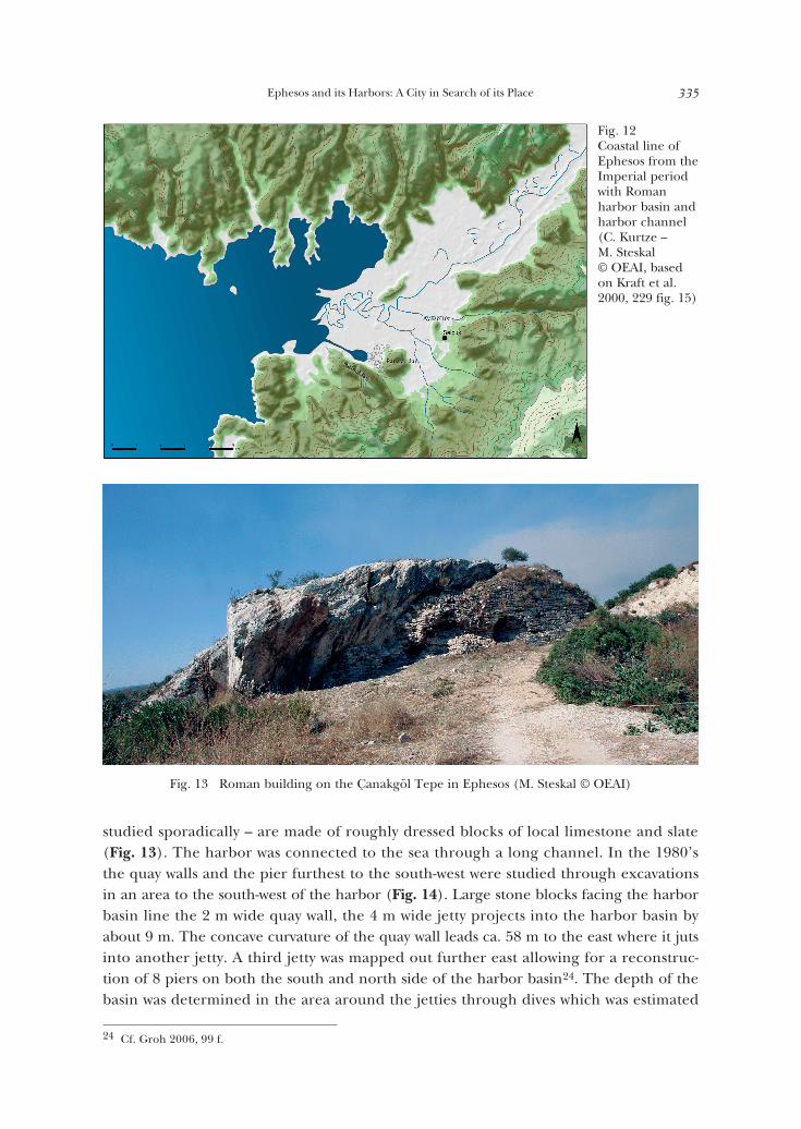
Aerial photographs, old maps, excavations in the west, the known location of the harbor gates in the east, geophysical prospections and GPS-surveys have led to the reconstruc-tion of a long hexagonal harbor23 (Figs. 11. 12). A building in connection with the har-bor sits atop the Çanakgöl Tepe. The foundations of this structure – it has only been
20 Strab. 14, 1, 24; cf. Zabehlicky 1999, 481. O. Benndorf, Zur Ortskunde und Stadtgeschichte, FiE 1 (Vienna 1906) 18–22. 46–50 and 58 f. combines these events as well as the expedition of Thrasyllos with the later Roman har-bor.
21 Liv. 37, 14 f.; cf. Scherrer 2007, 349.22 Scherrer 2007, 335–337; Groh 2006, 72 f.23 Cf. Zabehlicky 1995, 201–215; Zabehlicky 1999, 479–484; Groh 2006, 97–100. This map is particularly helpful:
E. Falkener, Ephesos and the Temple of Diana (London 1862) pl. 2.
Fig. 11 Imperial settlement of Ephesos (Groh 2006, fig. 20)
Ephesos and its Harbors: A City in Search of its Place 335
studied sporadically – are made of roughly dressed blocks of local limestone and slate (Fig. 13). The harbor was connected to the sea through a long channel. In the 1980’s the quay walls and the pier furthest to the south-west were studied through excavations in an area to the south-west of the harbor (Fig. 14). Large stone blocks facing the harbor basin line the 2 m wide quay wall, the 4 m wide jetty projects into the harbor basin by about 9 m. The concave curvature of the quay wall leads ca. 58 m to the east where it juts into another jetty. A third jetty was mapped out further east allowing for a reconstruc-tion of 8 piers on both the south and north side of the harbor basin24. The depth of the basin was determined in the area around the jetties through dives which was estimated
24 Cf. Groh 2006, 99 f.
Fig. 13 Roman building on the Çanakgöl Tepe in Ephesos (M. Steskal © OEAI)
Fig. 12Coastal line of Ephesos from the Imperial period with Roman harbor basin and harbor channel (C. Kurtze – M. Steskal © OEAI, based on Kraft et al. 2000, 229 fig. 15)

Martin Steskal336
at 4 m under the ancient water level; the harbor basin itself would have been slightly deeper25. The size of the harbor basin was ca. 390 × 650 m and covered 21 ha. The exit to the channel in the west was only 23 m wide – if the old maps can be trusted; the chan-nel itself was 60 m wide. The excavations and epigraphic sources suggest that the harbor construction took place under Trajan or Hadrian26. The contemporary harbor of Rome in Portus had a similarly hexagonal harbor basin. In comparison, the Ephesian harbor was one third smaller than the harbor in Portus27. The harbor exit in Portus measures 100 m and was therefore more spacious than in Ephesos. The minimal depth and the nar-row channel arouse suspicion if the harbor and passageway were intended for large cargo ships with deep draughts. Moorings along the coast support this suspicion. The moorings were constructed in the late 2nd century by Titus Flavius Damianus and probably were used for the reloading of cargo onto smaller ships28. Moreover Strabo describes outer har-bors for Ephesos, e. g. the Panormos-harbor29.
25 Zabehlicky 1999, 480; Zabehlicky 1995, 209.26 Cf. Zabehlicky 1999, 481; Scherrer 2007, 349; IvE 2061 (Flavius Montanus). 3066 (C. Licinius Maximus Iulianus)
with a report of rich foundations for the amenities of the harbor; IvE 274 with an honor for the emperor Had-rian for making the Cayster navigable and the constructing a dam. In the mid-2nd c. parts of the quay had to be protected due to the storage of wood and dressing of stones (IvE 23). A compilation of the sources can be found in: Zabehlicky 1995, 204–206.
27 Groh 2006, 99 f.; S. Keay – M. Millett – L. Paroli – K. Strutt, Portus. An Archaeological Survey of the Port of Imperial Rome, Archaeological Monographs of the British School at Rome 15 (London 2005); Zabehlicky 1999, 481; Zabehlicky 1995, 210 f.
28 Philostr. soph. 2, 23.29 Strab. 14, 1, 20.
Fig. 14 Quay walls of the Imperial harbor of Ephesos in the area of the jetty to the south-west (J. Reiter © OEAI)
Ephesos and its Harbors: A City in Search of its Place 337
We know only very little about the constructions in the area around the harbor. Presum-ably magazines and warehouses, stockyards and markets as well as ship houses and ship yards filled the space but these have not yet been discovered. The foundations of two buildings with three naves were found to the east of the harbor basin. The structures are 25 m wide with a length of 60 as well as 120 m. They are currently interpreted as open por-ticos that were used for the trade and sale of items30. A densely populated workshop quar-ter has been localized within the city limits along the harbor channel. The development of a far-flung necropolis outside of the city gates began in the Middle Imperial period to both sides of the harbor channel. The harbor channel received the additional meaning of a burial procession or ›Gräberstraße‹.
Another monumental building project surrounding the harbor took place at the end of the 2nd or early 3rd century C. E. when a southern and northern harbor gate was erected31. In this period or a little later, special endowments were made available for the harbor32. The fight against silting in the harbor began in the early construction phase. This re-sulted in the continual dredging of the harbor and the permanent lengthening of the channel by 1.2 km33. Through the integration of the channel into the Cayster River the now 4 km long channel ended only a few hundred meters east of the modern beach at Pamucak34.
The Roman harbor was used for a long time despite its many problems: in 431 C. E. Cyril, the patriarch of Alexandria arrived in the Roman harbor on his visit to the council. He had to transfer into a smaller boat in an outer harbor; in 723 Saint Willibald arrived in the Roman harbor35. Later medieval pilgrims sadly did not report precise locations detailing which harbor they used on their travels through Ephesos on their way to the Holy Land. Recent paleogeographic data36 suggests that the channel lost all access to the sea by about the 7th century C. E.; it silted shut and was covered by turf. Literary sources suggest that parts of the Roman harbor may have still been accessible in the 12th century. The sources mention a Russian abbot Daniel who ventured on a pilgrimage in 110637. This may be explained by the fact that heavy rains occasionally filled the channel with enough water
30 H. Thür, Marktbauten am Hafen, in: P. Scherrer (ed.), Ephesos. Der neue Führer. 100 Jahre österreichische Ausgrabungen 1895–1995 (Vienna 1995) 180 f.
31 W. Wilberg – G. Niemann, Der südliche Torbau, in: FiE 3 (Wien 1923) 172–188 as well as W. Wilberg, Der nörd-liche Torbau, in: FiE 3 (Vienna 1923) 214–217. The middle gate was possibly already built in the Hadrianic pe-riod, cf. W. Wilberg – G. Niemann, Der mittlere Torbau, in: FiE 3 (Vienna 1923) 189–213 also Zabehlicky 1999, 481 with reference to H. Thür und P. Scherrer; Zabehlicky 1995, 203. For the integration of the harbor gates into the city planning: Groh 2006, 98. I am grateful to G. A. Plattner for confirming the suggested datings.
32 D. Knibbe – B. İplikçioğlu, Neue Inschriften aus Ephesos IX, ÖJh 55, 1984, 130 f. (honor for Valerius Festus).33 Kraft et al. 2000, 191.34 Cf. Scherrer 2007, 349.35 Scherrer 2007, 349; H. Engelmann, Der ephesische Hafen in einer koptischen Erzählung, ZPE 112, 1996, 112.36 Reference from R. Urz.37 The areas excavated in the 1980’s on the southern edge of the harbor are too small to fully agree with the sug-
gestions of the excavator. According to him the area surrounding the Roman harbor was only used intensively until around 600 C.E. Cf. Zabehlicky 1999, 482; Zabehlicky 1995, 211; H. Zabehlicky, Ein spätantiker Bau im südlichen Hafenbereich von Ephesos (Vorbericht), in: H. Malay (ed.), Erol Atalay Memorial, ADerg 1, 1991, 197–205; similarly Scherrer 2007, 349.
Martin Steskal338
for the passage of boats into the harbor basin. Even today the channel still partially fills up with water.
Further medieval harbors will only be briefly mentioned in the following38: the harbor at Pamucak was in use up until the 16th century, or also a harbor by the village Kuştur slightly north of Kuşadası. The outer harbor Panormos was mentioned earlier. According to R. Meriç the Panormos-harbor was used up until the 14th century as the harbor of the Aydınoğulları-dynasty39. The actual site is not known: it has been speculated to be north of the Cayster in the so-called Alaman Gölü40, in the valley of Arvalya41 and the south end of the bay of Pamucak42. From a geoarchaeological standpoint the latter option appears to be the most plausible43.
After the 16th century Ottoman Ephesos – now known under the name Ayasoluk – does not appear to have had any harbor. The town lost much of its significance until the 20th century when it was revived by bands of archaeologists and masses of tourists. The result of living separated from the sea by a distance of 8 km has impacted modern day Selçuk: it is impossible to economically compete with other coastal towns as for example Kuşadası.
The importance of the harbors for the growth but also decline of the city emphasizes a need for further systematic research of the Ephesian harbors. The nature of the terrain and the ensuing technical challenges has been the main impediments to the study of the harbors. Current geoarchaeological and geophysical research has led to numerous new ideas that could function as the basis or groundwork for larger scale future field-archae-ological activities. A navigable entrance into the city from the sea and a functioning in-frastructure were key elements for the growth and prosperity of Ephesos as a commercial center. Understanding the harbor will considerably illuminate the fate of the city.
38 Cf. Kraft et al. 2000, 191 f.39 Meriç 1985, 30–32. 40 Meriç 1985, 30–32. This theory is viewed as plausible by Kraft et al. 2000, 191 f. 200.41 J. Keil, Ortygia, die Geburtsstätte der ephesischen Artemis, ÖJh 21/22, 1922–1924, 113–119; C. Foss, Ephesos af-
ter Antiquity: A Late Antique, Byzantine, and Turkish City (Cambridge 1979) 149; G. Hess, Die Entwicklung des Küçük-Menderes-Deltas in historischer Zeit, Essener Geographische Arbeiten 17, 1989, 1–12.
42 Scherrer 2007, 349.43 Thanks go to H. Brückner for this reference.
Copyright © 2022 FDOKUMEN